
camp grayling joint maneuver training center alpena combat ...
264
camp grayling joint maneuver training center alpena combat readiness training center final submittal | january 2019 joint land use study
-
Upload
khangminh22 -
Category
Documents
-
view
3 -
download
0
Transcript of camp grayling joint maneuver training center alpena combat ...

camp grayling joint maneuver training center alpena combat readiness training center
final submittal | january 2019
jo int land use study


camp grayling joint maneuver training center | alpena combat readiness training center
jo int land use studyfinal submittal | january 2019
acknowledgments and key partnersNortheast Michigan Council of GovernmentsMichigan DNR (Gaylord)Michigan Dept of Transportation (Gaylord)US Forest ServiceMichigan Dept of Environmental Quality (Gaylord)US Fish & Wildlife Service (Alpena)Headwaters Land ConservancyUSDA Natural Resource Conservation Service (Gaylord)Huron Pines (conservation) (Gaylord)Crawford County City of Grayling (Crawford Co)Grayling Twp (Crawford Co)Lovells Twp (Crawford Co)Maple Forest Twp (Crawford Co)Frederic Twp (Crawford Co)Beaver Creek Twp (Crawford Co)South Branch Twp (Crawford Co)Crawford County Road CommissionOtsego County Chester Twp (Otsego Co)Otsego Lake Twp (Otsego Co)Bagley Twp (Otsego Co)Hayes Twp (Otsego Co)Otsego County Economic AllianceBear Lake Twp (Kalkaska Co)Garfield Twp (Kalkaska Co)Au Sable River Property Owner’s AssociationAnglers of the Au SableMason-Griffith Founders Chapter of Trout UnlimitedUpper Manistee River AssociationMichigan Association of TimbermenWeyerhaeuserAraucoAJD Forest ProductsJays Sporting GoodsAlpena Regional AirportAlpena County
City of Alpena (Alpena Co)Alpena Twp (Alpena Co)Maple Ridge Twp (Alpena Co)Wilson Twp (Alpena Co)Green Twp (Alpena Co)Ossineke Twp (Alpena Co)Sanborn Twp (Alpena Co)Long Rapids Twp (Alpena Co)Village of HillmanTarget AlpenaAlpena Chamber of CommerceMichigan Sea Grant/MSU ExtensionNorthern MI Unmanned Aerial Systems ConsortiumThunder Bay National Marine SanctuaryUS Coast GuardThunder Bay Audubon SocietyNOAAMichigan United Conservation Club – Region 4Camp Grayling and Alpena CRTCMichigan Economic Development CorporationGrayling Chamber of CommerceMichigan Works!Briley Twp (Montmorency Co)Roscommon CountyLyon Twp (Roscommon Co)Posen Twp (Presque Isle Co)Krakow Twp (Presque Isle Co)Metz Twp (Presque Isle Co)Higgins Twp (Roscommon Co)Antrim County
This study was prepared under contract with the Northeast Michigan Council of Governments, with financial support from the Office of Economic Adjustment, Department of Defense. The content reflects the views of the Northeast Michigan Council of Governments and all of the JLUS project stakeholders and does not necessarily reflect the views of the Office of Economic Adjustment.


CAMP GRAYLING JMTC AND ALPENA CRTC JOINT LAND USE STUDY | TABLE OF CONTENTS i
table of contents
es executive summaryIntroduction ...................................................................................................................................................................... es-1
JLUS Implementation Team Action Plan ....................................................................................................................... es-1
Camp Grayling JMTC Brochure ...................................................................................................................................... es-3
Alpena CRTC Brochure .................................................................................................................................................... es-5
1 introduction1.1 What is a Joint Land Use Study? ............................................................................................................................ 1-1
1.1.1 JLUS Goals .................................................................................................................................................. 1-1
1.2 How to Use this Study ............................................................................................................................................ 1-1
1.3 Study Area Overview .............................................................................................................................................. 1-2
1.4 JLUS Organization and Public Process ................................................................................................................. 1-3
1.4.1 Committee Membership ......................................................................................................................... 1-4
1.5 Project Timeline ...................................................................................................................................................... 1-5
1.6 Next Steps: JLUS Implementation Team ..............................................................................................................1-5
2 camp grayling JMTC and community study area2.1 Camp Grayling JMTC Study Area Overview .......................................................................................................... 2-1
2.1.1 How to Read this Chapter ........................................................................................................................ 2-1
2.1.2 How Camp Grayling JMTC and its Surrounding Area Is Unique ..........................................................2-1
2.1.3 Setting ......................................................................................................................................................... 2-3
2.1.4 History ........................................................................................................................................................ 2-3
2.1.5 Mission/Operations................................................................................................................................... 2-3
2.1.6 Demographics............................................................................................................................................ 2-4
2.1.7 Land Use ..................................................................................................................................................... 2-5
2.1.8 Zoning ......................................................................................................................................................... 2-7
2.1.9 Incompatible Use ...................................................................................................................................... 2-9
2.2 Camp Grayling JMTC Public Participation ..........................................................................................................2-15
2.3 Camp Grayling JMTC Issues Overview ................................................................................................................2-16
2.3.1 IssueDefinitionProcess .........................................................................................................................2-16
2.3.2 Camp Grayling JMTC Noise and Military Operations Issues ..............................................................2-17
2.3.3 Camp Grayling JMTC Environmental Issues .........................................................................................2-22
2.3.4 Camp Grayling JMTC Transportation and Infrastructure Issues .......................................................2-26
2.3.5 Camp Grayling JMTC Community Partnerships Issues ......................................................................2-30
2.3.6 Camp Grayling JMTC Economic Development Issues .........................................................................2-31

ii TABLE OF CONTENTS | CAMP GRAYLING JMTC AND ALPENA CRTC JOINT LAND USE STUDY
3 alpena CRTC and community study area3.1 Alpena CRTC Study Area Overview ....................................................................................................................... 3-1
3.1.1 How to Read this Chapter ........................................................................................................................ 3-1
3.1.2 How Alpena CRTC and its Surrounding Area Is Unique........................................................................3-1
3.1.3 Setting ......................................................................................................................................................... 3-3
3.1.4 History ........................................................................................................................................................ 3-3
3.1.5 Mission/Operations................................................................................................................................... 3-3
3.1.6 Demographics............................................................................................................................................ 3-4
3.1.7 Land Use ..................................................................................................................................................... 3-5
3.1.8 Zoning ......................................................................................................................................................... 3-6
3.1.9 Incompatible Use ...................................................................................................................................... 3-6
3.2 Alpena CRTC Public Participation .......................................................................................................................... 3-7
3.3 Alpena CRTC Issues Overview ............................................................................................................................... 3-8
3.3.1 IssueDefinitionProcess ........................................................................................................................... 3-8
3.3.2 Alpena CRTC Noise and Military Operations Issues ..............................................................................3-9
3.3.3 Alpena CRTC Environmental Issues ......................................................................................................3-12
3.3.4 Alpena CRTC Transportation and Infrastructure Issues .....................................................................3-14
3.3.5 Alpena CRTC Community Partnerships Issues ....................................................................................3-17
3.3.6 Alpena CRTC Economic Development Issues ......................................................................................3-18
4 implementation plan4.1 Overview .................................................................................................................................................................. 4-1
4.1.1 JLUS Implementation Team ..................................................................................................................... 4-1
4.2 Compatibility Tools ................................................................................................................................................. 4-1
4.2.1 Federal ........................................................................................................................................................ 4-1
4.2.2 Military Installations .................................................................................................................................. 4-1
4.2.3 State ............................................................................................................................................................ 4-2
4.2.4 County ........................................................................................................................................................ 4-2
4.2.5 Township .................................................................................................................................................... 4-2
4.2.6 City/Village .................................................................................................................................................. 4-3
4.2.7 Other Tools and References .................................................................................................................... 4-3
4.3 Setting Priorities ...................................................................................................................................................... 4-3
4.4 JLUS Implementation Team Action Plan ..............................................................................................................4-4
4.5 JLUS Implementation Team Action Plan Details: Camp Grayling JMTC ............................................................4-5
4.5.1 Create Sensible Military Overlay Zones around Camp Grayling JMTC ...............................................4-5
4.5.2 Commission a Joint MDNR and Camp Grayling JMTC Landscape Plan ...............................................4-5
4.5.3 Conduct a Noise Study ............................................................................................................................. 4-5
4.5.4 Commission a Camp Grayling JMTC Installation Master Plan .............................................................4-5
4.5.5 Update Grayling Area Transportation Study .........................................................................................4-5
4.5.6 Camp Grayling JMTC Community Outreach and Camp Grayling Community Council .....................4-6
4.5.7 Commission a Water Resources Plan for Northeast Michigan ...........................................................4-6
4.5.8 Fire Protection Services Agreement ........................................................................................................ 4-6
4.5.9 Economic Impact, Tracking, and Incentives: Conduct an Economic Impact Study ...........................4-6
4.6 JLUS Implementation Team Action Plan Details: Alpena CRTC .........................................................................4-7
4.6.1 Create a Military Overlay Zone ............................................................................................................... 4-7
4.6.2 Conduct an AICUZ Study ......................................................................................................................... 4-7
4.6.3 Alpena CRTC Community Outreach and Alpena CRTC Community Council/Formalize Thunder Bay Interagency Cooperation ....................................................................................................................................... 4-7
4.6.4 Commission a Thunder Bay Environmental Impact Study/Commission a Joint NOAA/Alpena CRTC Bathymetric Survey ............................................................................................................................................... 4-8
4.6.5 Economic Impact, Tracking, and Incentives: Conduct an Economic Impact Study ...........................4-8
4.6.6 Update the Alpena Area-wide Comprehensive Transportation Plan ................................................................................................ 4-8
4.7 Implementation Plan Overview and Guidelines .................................................................................................4-9
appendicesa References ............................................................................................................................................................... a-1
b Public Participation Plan ........................................................................................................................................b-1
c SWOT Results .......................................................................................................................................................... c-1
d Strategy Index .........................................................................................................................................................d-1
e Report Comments and Resources ........................................................................................................................ e-1
f Overlay Zone Research and Analysis .................................................................................................................... f-1

CAMP GRAYLING JMTC AND ALPENA CRTC JOINT LAND USE STUDY | ACRONYMS AND ABBREVIATIONS iii
AAADT annualaveragedailytraffic
AAF ArmyAirfield
ADNL average day/night sound level
AFB air force base
AFFF aqueousfilmformingfoam
AFI Air Force Instruction
AGL above ground level
AICUZ Air Installation Compatible Use Zone
ANG Air National Guard
ANGH Air National Guard Handbook
APN Alpena County Regional Airport
APZ accident potential zone
AR Army Regulation
ARNG Army National Guard
ATCAA airtrafficcontrolledassignedairspace
ATFP antiterrorism force protection
CCAADT commercialannualaveragedailytraffic
CAB combat aviation brigade
CACTF Combined Arms Collective Training Facility
CAS close air support
CEO chiefexecutiveofficer
CTRC Combat Readiness Training Center
CZ clear zone
II Interstate
ICEMAP Installation Complex Encroachment Management Action Plans
ICRMP Integrated Cultural Resources Management Plan
IDP Installation Development Plan
IED improvised explosive device
IMP installation master plan
INRMP Integrated Natural Resources Management Plan
IRP installation restoration program
ISR intelligence, surveillance and reconnaissance
JJLUS joint land use study
JMTC Joint Maneuver Training Center
JTAC joint terminal attack controller
KK thousand
MM Michigan state highway designation
M million
MATES Maneuver Area Training Equipment Site
mbps megabytes per second
acronyms and abbreviations
DDA Department of the Army
DART Dial-A-Ride Transportation
DASR digital airport surveillance radar
dB decibel
DOD Department of Defense
DRMO Defense Reauthorization and Marketing Office
DSL digital subscriber line
EEA environmetnal assessment
ECP entry control point
EPA Environmental Protection Agency
FFAA Federal Aviation Administration
FAMCAMP Air Force family campground
FCC Federal Communications Commission
FMU Forest Management Unit
FS FIghter Squadron
FY fiscalyear
GGIS geographic information system
GSI groundwater-surface water interface
MDARD Michigan Department of Agriculture and Rural Development
MDEQ Michigan Department of Environmental Quality
MDHHS Michigan Department of Health and Human Services
MDNR Michigan Department of Natural Resources
MDMVA Michigan Department of Military and VeteransAffairs
MDOT Michigan Department of Transportation
MEDEVAC medical evacuation
MIANG Michigan Air National Guard
MIARNG Michigan Army National Guard
MiCorps Michigan Clean Water Corps
MMRP Military Munitions Response Program
MOA military operations area
MOUT military operations on urban terrain
MSA munitions storage area
MSL mean sea level
MTR military training route
MUASC Michigan Unmanned Aerial Systems Consortium
NNACo National Association of Counties
NATO North Atlantic Treaty Organization
NEMCOG Northeast Michigan Council of Governments
NGB National Guard Bureau
NGR National Guard Regulation

iv ACRONYMS AND ABBREVIATIONS | CAMP GRAYLING JMTC AND ALPENA CRTC JOINT LAND USE STUDY
NOAA National Oceanic and Atmospheric Administration
NPDES National Pollutant Discharge Elimination System
OOEA OfficeofEconomicAdjustment
ONMS OfficeofNationalMarineSanctuaries
ORV off-roadvehicles
OSD OfficeoftheSecretaryofDefense
PP3 public-private partnership
Pam pamphlet
PASER Pavement Surface Evaluation and Rating
PC policy committee
PEAS Pollution Emergency Alerting System
PFAs per-andpolyfluoroalkylsubstances
PFC perfluorinatedcompounds
PFOA perfluorooctanoicacid
PFOS perfluorooctanesulfonate
ppt part per trillion
RRA restricted airspace
RPDP Real Property Development Plan
RPX real property exchange
RPZ runway protection zone
SSME subject-matter expert
SOP standard operating procedure
STEM science, technology, engineering, and mathematics
SUA special use airspace
SWOT strengths, weaknesses, opportunities, and threats
TTAG The Adjutant General
TC technical committee
TMDL Total Maximum Daily Loads
UUAS unmanned aerial systems
UFC UnifiedFacilitiesCriteria
UO urban operations
USACE U.S. Army Corps of Engineers
UXO unexploded ordinance
VVFR visualflightrules

CAMP GRAYLING JMTC AND ALPENA CRTC JOINT LAND USE STUDY | EXECUTIVE SUMMARY es-1
IntroductionThe military and residents of Northeast Michigan have co-existed for a century. Collaboration among all groups call-ing the region home is critical to preserve the military mis-sion and the residents' quality of life. Camp Grayling Joint Maneuver Training Center (JMTC) and Alpena Combat Read-iness Training Center (CRTC) are home to one of the larg-est military training exercises in the country, bringing thou-sands of military personnel to the region each summer.
A joint land use study (JLUS) is intended to look at the ways the civilian and military life intersect and to help ensure an optimal experience for both sides. Safety for residents while ensuring the military can train soldiers and airmen is para-mount, but through the suggested strategies in this plan, partnerships can be forged to help all parties thrive. Incom-patible development across the study area is addressed to resolveexistingandfutureconflicts.
This study looks at the areas immediately surrounding the boundaries of Camp Grayling JMTC and Alpena CRTC. This area of Michigan is largely rural, with few urban centers and many large tracts of forest land. Natural resources, such as those forests and Lake Huron, are treasured and used often forrecreation.Althoughthereislittleriskofsignificantlanddevelopment near the installations due to the rural setting, encroachment can also take other forms in the sense of traffic,utilitycapacity,physicaltrespassing,andnaturalre-sources.
The JLUS process involves stakeholders from the military and the public from beginning to end. Public meetings iden-tified community concerns, informed stakeholders of theproject's progress, and provided an arena for them to share theirthoughts.Theresulting informationwasrefinedintoan "action plan" of suggested strategies. This JLUS is not a regulatory document, and thus it can't mandate action; it is meant to serve as a guide for local entities as a way to continue the positive relationship between the military and the local population going forward. Success in ensuring compatibility into the future depends on diligent and ongoing efforts from stakeholders in the form of the JLUS implementation team.
ThisplanwasfundedbytheOfficeofEconomicAdjustment(OEA), part of the Department of Defense (DOD), and the Northeast Michigan Council of Governments (NEMCOG) is the sponsoring agency. This summary is intended to pro-vide a broad overview of the study process and the local area for a wide variety of readers and users.
JLUS Implementation Team Action PlanThrough the public involvement process, compatibility is-sues were brought forth for consideration. The JLUS proj-ectteamrefinedadetailedsetofstrategiestosolvethoseissues, which are described in more detail in Section 4 and Appendix D of the document.
In order to ensure the strategies are tracked and imple-mented as it is possible, it is suggested that a JLUS Imple-mentation Team be convened, comprising members of the JLUS technical committee (TC), policy committee (PC), NEM-COG, local governments, other agencies, and the military.
For both installations covered by this JLUS and the sur-rounding communities, a series of key actions has been proposed as the JLUS Implementation Team Action Plan. Eachkeyactionintheplansatisfiesanumberofthestrate-gies. Members of the Implementation Team should be able to roll these actions into their existing programs as funding and resources dictate.
esexecutive summary
CAMP GRAYLING JMTC
Create Sensible Military Overlay Zones around Camp Grayling JMTC
Commission a Joint MDNR and Camp Grayling JMTC Landscape Plan
Conduct a Noise Study
Commission a Camp Grayling JMTC Installation Master Plan
Update Grayling Area Transportation Study
Camp Grayling JMTC Community Outreach and Camp Grayling Community Council
Commission a Water Resources Plan for Northeast Michigan
Fire Protection Services Agreement
Economic Impact, Tracking and Incentives: Conduct an Economic Impact Study
ALPENA CRTC
Create a Military Overlay Zone Conduct an Air Installation Compatible Use Zone (AICUZ) Study
Alpena CRTC Community Outreach and Alpena CRTC Community Council
Commission a Thunder Bay Environmental Impact Study Economic Impact, Tracking and Incentives: Conduct an Economic Impact Study
Commission a Joint NOAA/Alpena CRTC Bathymetric Survey
Formalize Thunder Bay Interagency Cooperation Update the Alpena Area-wide Comprehensive Transportation Plan
JLUS
Strategies
Implementation Team Action Plan Items
Figure ES.1 | JLUS "Toolbox"
Table ES.1 | JLUS Implementation Team Action Plan Items
Note: Pages ES-3 through ES-6 are meant to be used as two-page standalone brochures to summarize the project status and key recommendations for both military installations covered by this JLUS.

es-2 EXECUTIVE SUMMARY | CAMP GRAYLING JMTC AND ALPENA CRTC JOINT LAND USE STUDY
This page intentionally left blank.
Note: Pages ES-3 through ES-6 are meant to be used as two-page standalone brochures to summarize the project status and key recommendations for both military installations covered by this JLUS.

camp grayling joint maneuver training center alpena combat readiness training center
j o i n t l a n d u s e s t u d y
This document was funded by the Office of Economic Adjustment, part of the Department of Defense; the Northeast Michigan Council of Governments is the sponsoring agency.
final submittal | january 2019
what is the JLUS program?The Joint Land Use Study (JLUS) process promotes and enhances civil-ian and military communication and collaboration, serves as a catalyst to sustain the military mission, and promotes public health, safety, quality of life, and economic viability of a region. Source: Department of Defense (DOD)OfficeofEconomicAdjustment(OEA),http://oea.gov/what-we-do/ compatible-use
where are we in the process?The JLUS and the JLUS Public Participation Plan have been completed. Please consult the JLUS website at http://www.discovernortheast michigan.org/jlus.asp to view the report and associated information.
what happens next?NEMCOG will collaborate with JLUS Implementation Team members to begin working on compatibility strategies and action plan items.
JLUS implementation team
This is a critical piece of the success of this JLUS. The team should include membership from each participating agency, the project technical com-mittee (TC), the project policy committee (PC), and military personnel. The strategies developed throughout the JLUS process should allow local government leaders and military personnel to roll JLUS recommenda-tions into their existing programs.
A communications plan, zoning tools, and long-range planning are some cost-effectivesolutionsthatarepartoftheactionplanpresentedinSec-tion 4 of this JLUS. This is not a regulatory document and thus cannot mandate action, only propose solutions. Success in implementing the strategiesdescribedinthisplandependsondedicatedeffortsfromthestakeholders in the coming years.
This JLUS is meant to be a living document, so certain strategies may need to be revisited in the future as the local situation and applicable laws evolve.
contact information
NEMCOG | Denise Cline ([email protected]) Diane Rekowski ([email protected]) Nico Tucker ([email protected])
Camp Grayling JMTC | SFC Jeremie Mead ([email protected])
Alpena CRTC | Capt. Brian Blumline ([email protected])
Tetra Tech | Heather Mendenall ([email protected]) Matt Rathsack ([email protected])
more project information
Additional project information and the full JLUS report can be found at
http://www.discovernortheastmichigan.org/jlus.asp
camp grayling JMTC

about camp grayling JMTCCamp Grayling JMTC is the largest National Guard training center in the coun-try, encompassing 147,000 acres. It supports a wide cross-section of military personnel, including active-duty and National Guard forces. It provides a large ground training area, an air-to-ground range, and a large airspace all in the same complex. Nonmilitary organizations as well as international partners also use the ranges and other facilities there.
about the surrounding areaCamp Grayling JMTC is located in the largely rural north-central portion of Michi-gan's Lower Peninsula. This study focuses on the installation itself and a two-mile bufferaround theboundary.Compatible landuseanalysiswas limited to thestudy area. Though encroachment issues are few due to the low surrounding population, it is critical that the military and the public coexist.
top issuesPublic meetings, an online survey, and one-on-one interviews were some of the methods used to collect public input and determine the largest positive and neg-ative aspects of military operations in the area. The issues that repeatedly came up in the Camp Grayling JMTC area were:
� NOISE AND MILITARY OPERATIONS: Several residential areas are in or near noise contours from military operations, and most of the heart of the City of GraylingliesintheaccidentpotentialzonefromGraylingArmyAirfield.
� ROADS: Public perception links degraded roads with military activity, when weather,logging,andothertrafficmayhaveanimpactonroadcondition.
� WILDFIRE DANGER:Wildfiresoccurfrequentlyinthisheavilywoodedregion.Communicationaboutcontrolledburnsandfiremitigationactivitiesby theMichigan Department of Natural Resources doesn't always reach the public.
JLUS implementation team action planMany of the JLUS strategies have actions that overlap. To capture the best use of planimplementation,overarchingactionshavebeendefinedthatwillultimatelyserve more than one strategy. The JLUS Implementation Team would be charged with tracking these items. See Section 4 of the JLUS for more information.
of those surveyed are comfortable with military operations in their area
56% 62%of those surveyed are concerned about noise levels
ACTION STRATEGIES
Create Sensible Military Overlay Zones around Camp Grayling JMTC
1a.4, 1a.5, 2a.1, 2a.2, 2d.1, 2d.2, 5b.4, 6a.1
Commission a Joint MDNR and Camp Grayling JMTC Landscape Plan
1b.1, 1b.2, 1b.3, 4e.1
Conduct a Noise Study 1a.1, 1a.2, 1a.3, 2a.2, 2c.1, 2c.2, 2c.3
Commission a Camp Grayling JMTC Installation Master Plan
2c.2, 2c.3, 2d.1, 2d.2, 3d.1, 3f.2, 4a.1, 4a.2, 4c.1, 4d.1, 5b.5, 6b.4
Update Grayling Area Transportation Study
4d.1, 4d.2, 4d.3, 4d.4, 4e.1, 4f.1, 4f.2, 5b.5
Camp Grayling JMTC Community Outreach and Community Council
2b.1, 2c.1, 3a.1, 3b.1, 3e.1, 3f.1, 3f.2, 4e.1, 5a.1, 5a.2, 5a.3, 5a.4, 5b.1, 5b.2, 5b.3, 5b.4, 5b.5, 6a.1
Commission a Water Resources Plan for Northeast Michigan
3a.1, 3b.1, 3c.1, 3c.2, 3f.1, 3f.2
Fire Protection Services Agreement 3e.1, 6b.1
Conduct an Economic Impact Study
6a.1, 6b.1, 6b.2, 6b.3, 6b.4, 6c.1, 6c.2
Otsego County
Kalkaska C
ounty
Crawford County
Osc
oda
Cou
nty
§̈¦75
§̈¦75
ST93
ST72
GraylingLakeMargrethe
GuthrieLake
Love
lls R
d
SSt
e pha
nBr
idge
Rd
Chase
Brid
geRd
NMcm
asters Bridge Rd
N Down RiverRd W
SWakel ey
Brid
ge
R
d
E North Down River Rd
Twin LakeRd
M-9
3
Old U
s-27
W MillerRd
259
264
W Cr-612
CR-612 NE
N Down River Rd
E
E Cr-612N S
herm
an R
d
104 db
75db
87 db
104
db
104 db
104 db
104 db
104 db
75 db
87 db
104 db87
db
JLUS 2-Mile Study Area
Camp Grayling JMTC
City of Grayling
County Boundary
Noise Contours (75+ db)
Zoning
Agriculture
Commercial
Industrial
Military Operations
Natural Resources/Open Space
Residential
Water Body
!!
!!
!!
!!
!!
!!!!
!!
WI
MI
MI
LakeHuron
LakeMichigan
Alpena
Grayling
Engadine
Bay City
Reed City
Green BayTraverse
City
Z0 5
Miles

camp grayling joint maneuver training center alpena combat readiness training center
j o i n t l a n d u s e s t u d y
This document was funded by the Office of Economic Adjustment, part of the Department of Defense; the Northeast Michigan Council of Governments is the sponsoring agency.
what is the JLUS program?The Joint Land Use Study (JLUS) process promotes and enhances civil-ian and military communication and collaboration, serves as a catalyst to sustain the military mission, and promotes public health, safety, quality of life, and economic viability of a region. Source: Department of Defense (DOD)OfficeofEconomicAdjustment(OEA),http://oea.gov/what-we-do/ compatible-use
where are we in the process?The JLUS and the JLUS Public Participation Plan have been completed. Please consult the JLUS website at http://www.discovernortheast michigan.org/jlus.asp to view the report and associated information.
what happens next?NEMCOG will collaborate with JLUS Implementation Team members to begin working on compatibility strategies and action plan items.
JLUS implementation team
This is a critical piece of the success of this JLUS. The team should include membership from each participating agency, the project technical com-mittee (TC), the project policy committee (PC), and military personnel. The strategies developed throughout the JLUS process should allow local government leaders and military personnel to roll JLUS recommenda-tions into their existing programs.
A communications plan, zoning tools, and long-range planning are some cost-effectivesolutionsthatarepartoftheactionplanpresentedinSec-tion 4 of this JLUS. This is not a regulatory document and thus cannot mandate action, only propose solutions. Success in implementing the strategiesdescribedinthisplandependsondedicatedeffortsfromthestakeholders in the coming years.
This JLUS is meant to be a living document, so certain strategies may need to be revisited in the future as the local situation and applicable laws evolve.
more project information
Additional project information and the full JLUS report can be found at
http://www.discovernortheastmichigan.org/jlus.asp
alpena CRTC
contact information
NEMCOG | Denise Cline ([email protected]) Diane Rekowski ([email protected]) Nico Tucker ([email protected])
Camp Grayling JMTC | SFC Jeremie Mead ([email protected])
Alpena CRTC | Capt. Brian Blumline ([email protected])
Tetra Tech | Heather Mendenall ([email protected]) Matt Rathsack ([email protected])
final submittal | january 2019

about alpena CRTCAlpena CRTC manages the operational aspects of the joint-use airspace used by units training at Alpena CRTC and Camp Grayling JMTC. It is colocated with the Alpena County Regional Airport, sharing functional assets including two runways. Themajorityofairtrafficismilitaryrelated.Whiletheinstallationdoesnothaveanyflyingunitsofitsown,itsupportsorganizationsfromallbranchesofthemil-itary throughout the US and coalition partners.
about the surrounding areaAlpena CRTC is located west of the City of Alpena, which is situated on Lake Hu-ron's Thunder Bay in the northeastern part of Michigan's Lower Peninsula. This studyfocusesontheinstallationitselfandatwo-milebufferaroundthebound-ary. Compatible land use analysis was limited to the study area. The area directly surrounding the installation is largely rural.
!y
!y
!y
!y
!y
!l
ÆQ
ÆQ
Hub
bard
Lak
e R
d
Bolto n Rd
M-32
US-
23
UV32
Long Rapids Rd
US-
23
Werth Rd
UV23Alpena Township
Wilson Township
Maple Ridge Township
Alpena
Thunder BayThunder Bay National
Marine Sanctuary
LakeHuron
JLUS 2-Mile Study Area
Alpena CRTC
Township BoundaryÆQ State Forest Campground
!l Fishing Access
!y Public Boating Access
PFAS (PFC) Monitoring
State Forests
Wetlands
Thunder Bay National Marine Sanctuary
Restricted Airspace
Lake Huron National Wildlife Refuges
Alpena County Regional Airport
Envirnomental Restoration Area
Fuel Types/FBP System
C-3, Mature Jack or Lodgepole Pine
C-4, Immature Jack or Lodgepole Pine
O-1a, Matted Grass; O-1b, Standing GrassZ0 5
Miles
MI
MI
LakeHuron
LakeMichigan
Thunder BayNationalMarine Sanctuary
Alpena
Grayling
Engadine
Bay City
Reed City
TraverseCity
of those surveyed are comfortable with military operations in their area
83% 74%of those surveyed perceive Alpena CRTC’s relationship with surrounding property and business owners as positive
ACTION STRATEGIES
Create a Military Overlay Zone 1a.4, 1a.5, 1a.6, 2c.2, 4a.2, 5a.6
Conduct an AICUZ Study 1a.4, 1a.5, 1a.6, 2c.2
Alpena CRTC Community Outreach and Alpena CRTC Community Council
2b.1, 2c.3, 3a.1, 3c.1, 4b.1, 4c.1, 5a.1, 5a.2, 5a.3, 5a.4, 5a.5, 5b.2
Commission a Thunder Bay Environmental Impact Study
2a.1, 2c.3, 3a.1, 3b.a, 3b.2, 3c.1, 4e.1
Economic Impact, Tracking and Incentives: Conduct an Economic Impact Study
5a.3, 5a.4, 5b.1, 5b.2, 6a.1, 6c.1, 6d.1, 6d.2
Commission a Joint NOAA/Alpena CRTC Bathymetric Survey 2a.1, 2c.1
Formalize Thunder Bay Interagency Cooperation
2a.1, 2c.1, 2c.3, 3b.1, 3b.2, 4b.1, 5a.5, 5b.1, 6b.1
Update the Alpena Area-wide Comprehensive Transportation Plan 4c.1, 4d.1, 4e.1
top issuesPublic meetings, an online survey, and one-on-one interviews were some of the methods used to collect public input and determine the largest positive and neg-ative aspects of military operations in the area. The issues that repeatedly came up in the Alpena CRTC area were:
� IMPACTS AND EFFECTS ON SURFACE WATER SYSTEMS, GROUNDWATER, AND DRINKING WATER: PFOS/PFOA substances have been detected at low levels in the areas surrounding Alpena CRTC.
� TRAINING ACTIVITIES: Being one of the largest training areas in the US, the Alpena CRTC/Grayling JMTC complex is a national asset that easily attracts training events like that of the well know Northern Strike exercise. This can impact the community, to suddenly be inundated with thousands of visitors that need services, supplies, entertainment, vehicles, housing and the like. However, these events also bring a boost to the local economy
JLUS implementation team action planMany of the JLUS strategies have actions that overlap. To capture the best use of planimplementation,overarchingactionshavebeendefinedthatwillultimatelyserve more than one strategy. The JLUS Implementation Team would be charged with tracking these items. See Section 4 of the JLUS for more information.

CAMP GRAYLING JMTC AND ALPENA CRTC JOINT LAND USE STUDY | INTRODUCTION 1-1
chapter overviewA joint land use study (JLUS) is a collaborative effort between the military and surrounding local communities to protect both the long-term viability of the military mission and public health and safety, while also enhancing local economies and industries. This JLUS studies the areas around Camp Grayling Joint Maneuver Training Center (JMTC) and Alpena Combat Readiness Training Center (CRTC) in Northeast Michigan. The Northeast Michigan Council of Governments (NEMCOG) is the sponsoring agency of the study.
1.1 What is a Joint Land Use Study? ........1-1 1.1.1 JLUS Goals ..................................1-11.2 How to Use this Study .........................1-11.3 Study Area Overview ..........................1-21.4 JLUS Organization and Public Process ..................................................1-3 1.4.1 Committee Membership ..........1-41.5 Project Timeline ...................................1-51.6 Next Steps: JLUS Implementation Team .....................................................1-5
1.1 What is a Joint Land Use Study?
A JLUS is a collaborativeplanning effort betweenmilitaryinstallations and their surrounding communities. They are designed to address compatibility issues and foster a strong working relationship among the military, local gov-ernments, and members of the community.
This JLUS examines northeastern Michigan and the commu-nities surrounding Camp Grayling Joint Maneuver Training Center (JMTC), administered by the Michigan Army National Guard (MIARNG), and Alpena Combat Readiness Training Center (CRTC), administered by the Michigan Air National Guard (MIANG).
The JLUSeffort is communitydrivenand relieson strongmasterplanningandzoningtoensuretheaffectedentitiescancoexistinamutuallybeneficialmanner.Publicinputiscritical to ensure not only the success of the JLUS, but also the success of the relationship between the military and residents of the surrounding communities.
The Camp Grayling JMTC and Alpena CRTC JLUS is funded byagrantfromtheOfficeofEconomicAdjustment(OEA),Department of Defense (DOD). The local sponsor and grant administrator is the Northeast Michigan Council of Gov-ernments (NEMCOG), which oversees nine counties in the northeastern portion of Michigan's Lower Peninsula. A con-sultant team from Tetra Tech was contracted to complete the study.
1.1.1 JLUS Goals
SeveralgoalswereidentifiedforthisJLUSattheoutsetofthe project:
1. Promote land use compatibility between the installa-tions and surrounding communities.
2. Seek ways to manage development that is compatible with military training, testing, and operational missions.
3. Encourage cooperative action among military person-nel,localcommunityofficials,andcitizens.
4. Maintain and strengthen regional economic engines.
1.2 How to Use this StudyThe strategies presented in Chapter 4 should be implement-ed when possible to prevent encroachment or incompati-ble uses from developing, as well as to mediate any existing land use issues. Consider them to be part of a "toolbox" of planning options to ensure the relationship between the military and the surrounding communities remains strong andmutuallybeneficial.Eachstrategyislistedwithkeypar-ticipants and suggested timelines to aid the strategy lead in plan implementation. It is important to understand that the JLUS is a recommended set of strategies and tools, not an adopted plan. It is recommended that NEMCOG form a JLUS implementation team to monitor progress and main-tain momentum after the plan is published.
1introduction
purposeThisJLUSisacollaborativeplanningeffortamong the military, the surrounding communities, and stakeholders to create a plan to guide the future development of the lands around Camp Grayling JMTC and Alpena CRTC. It aims to enhance understanding of area issues, promote collaboration, and provide a set of tools for future planning.
The City of Alpena's municipal marina, which lies on Lake Huron's Thunder Bay, is owned and maintained by the city.

1-2 INTRODUCTION | CAMP GRAYLING JMTC AND ALPENA CRTC JOINT LAND USE STUDY
Figure 1.1 | Study Area
1.3 Study Area OverviewNEMCOG, established in 1968, is a multicounty organiza-tion formed to help municipalities in the northeastern part of the state with grant writing, planning, digital mapping, and other tasks that rural governments typically don't have personnel or funding to manage. It is based in Gaylord and covers Alcona, Alpena, Cheboygan, Crawford, Emmet, Montmorency, Oscoda, Otsego, and Presque Isle counties. NEMCOG'sboardofelectedofficials,businessleaders,andresidents is drawn from throughout the nine-county region.
The JLUS study area includes Camp Grayling JMTC, Alpena CRTC, and surrounding local jurisdictions within a 2-mile ra-dius of each installation.
� TheCampGraylingJMTCareaofinfluenceincludesCrawford County and portions of Oscoda County, Roscommon County, Kalkaska County, Otsego County, Antrim County, and Montmorency County, for a total of seven counties and 33 municipalities.
� TheAlpenaCRTCareaofinfluenceincludesAlpenaCounty and a small portion of Presque Isle County, as well as 13 municipalities.
Camp Grayling JMTC, the largest National Guard training center in the country, is a 147,000-acre training site, span-ning portions of Kalkaska, Crawford, and Otsego counties. The central cantonment area is located in Crawford County, southwest of Grayling Township, and the rest of the prop-erty is largely used as maneuver area and range land. Part of Camp Grayling JMTC is bounded by Lake Margrethe, a popularrecreationspotforfishing.
Alpena CRTC is located adjacent to the Alpena County Re-gional Airport in Alpena, Michigan. The city of Alpena is lo-cated in the northeast part of the Lower Peninsula on the edge of Lake Huron on Thunder Bay. Alpena CRTC is bound-ed by Lake Winyah to the north, the Lower South Branch of the Thunder Bay River to the west, and the Alpena County Regional Airport terminal and Michigan State Route 32 (M-32) to the south.
Camp Grayling JMTC and Alpena CRTC are situated in the largest airspace complex for military training east of the Mississippi River. The annual joint Northern Strike training exercise involves more than 5,000 Army, Navy, Marine, and Special Forces personnel from across the nation and six co-alition countries.
The wooded, rural surrounding region is sparsely populat-ed. Alpena is the biggest city and transportation hub. The area grew quickly in the mid-1800s due to extensive logging activities. Logs would be transported down the Thunder Bay River to sawmills in the city of Alpena and its port on Lake Huron.
The region surrounding Camp Grayling JMTC and Alpena CRTC is rich in natural resources, and recreational lands and waters are plentiful. The climate features mild sum-mers and cold winters with a large amount of snowfall. In spring, the freeze-thaw cycle is hard on roadways and other infrastructure. Despite that, military personnel are able to participate in year-round training at the installations.
More detailed information on the military missions and background on each site can be found in chapters 2 and 3, whicharespecifictoCampGraylingJMTCandAlpenaCRTC,respectively.
Camp Grayling JMTCCamp Grayling JMTC Cantonment Area
Alpena CRTC
Regional Overview

CAMP GRAYLING JMTC AND ALPENA CRTC JOINT LAND USE STUDY | INTRODUCTION 1-3
council of governmentscity/county planning committeesairport authority
city and county officialsbase leadershipprivate sector leadersstate officials
local and base plannerscommunity staffbusiness representativesresidents
participants
coordinationaccountability
grant management
policy directiondesign/oversightbudget approval
monitoringreport adoption
technical issuesalternatives
report developmentrecommendations
responsibilities
study sponsor: NEMCOG
policy committee
technical committee
working groups
working groups
working groups
policy committeeThe policy committee (PC) comprises city, township,andcountyofficials;installationleadership;stateofficials;andprivatesectorleaders. The PC meets on a quarterly basis and is charged with:
� providing overall project leadership to include policy direction and oversight, budget approval, project monitoring, and report adoption � participating in public outreach events
technical committeeThe technical committee (TC) comprises local and Installation community planners, communitystaff,businessrepresentatives,and residents. The TC meets on a monthly or quarterly basis and is responsible for:
� data collection � identifying and studying technical issues � recommending working groups (if needed)forspecificissues � evaluating alternatives � developing recommendations for the PC
Figure 1.2 | JLUS Project Organization 1.4 JLUS Organization and Public ProcessDevelopment and subsequent implementation of this JLUS relies on a community-driven, collaborative, strategic plan-ning process among the local governments, jurisdictions, and communities surrounding Camp Grayling JMTC and Al-penaCRTC.TheorganizationoftheJLUSprojectreflectsthisapproach, as shown in Figure 1.2. NEMCOG, as the spon-soring agency coordinating the development of this JLUS, oversees the overall process, schedule, and grant funding. To support the work of the JLUS, NEMCOG convened two stakeholder committees: a technical committee (TC) and a policy committee (PC). The TC focuses on a range of tech-nical activities, including data collection, identifying issues andtheneedforissue-specificworkinggroups,anddevel-oping recommendations for the PC. The PC focuses on pro-vidingoverall project leadership, projectmonitoring, finalreport adoption, and participating in public outreach activi-ties and events. Committee membership is provided on the following page.
Achieving the JLUS project goals requires strong public par-ticipation throughout the process. The JLUS project team developed and implemented a public participation plan to effectivelyengagestakeholders.Thefollowingtextpresentsa summary of the comprehensive JLUS public participation plan, which is available in Appendix B.
Thepublicparticipationplanincludesfivecomponents:
1. IDENTIFYING AND CHARACTERIZING KEY STAKEHOLD-ERS: Understanding stakeholders’ awareness, percep-tions, concerns, values, and priorities related to Camp Grayling JMTC and Alpena CRTC helps the JLUS project team develop targeted involvement opportunities and educational resources, as well as to understand stake-holders' communication channel preferences. Based on discussions with NEMCOG and the Camp Grayling JMTC community relations specialist, as well as other mem-bers of the PC and TC, the community residents rely on traditional sources of information, such as newspaper, radio, and word of mouth, to obtain information.
2. CREATING EFFECTIVE MESSAGES: Messaging to stake-holders evolves throughout the process. Initial messag-es for the discovery phase focused on raising awareness and promoting engagement. Highlighting stakeholder input on issues and concerns is important to identifying solutionsthatwillbenefitlocalcommunities.Messagesfor the strategy and planning phase focus on reporting interim findings of the identified issues/conflicts and
emphasizing the need for stakeholders to determine if the JLUS project team accurately captured stakeholders’ issues and concerns. Messages for the implementation phasefocusonpresentingthefinalreportfindingsandrecommendations in both the Grayling and Alpena ar-eas,statingtheneedtocollaborativelyimplementfinalrecommendations based on stakeholder input to bene-fitlocalcommunitiesandaddresspriorityissues.
3. IDENTIFYING AND CREATING EFFECTIVE STAKEHOLD-ER INVOLVEMENT OPPORTUNITIES AND EDUCATION-AL RESOURCES: The JLUS project team selected a suite of stakeholder involvement opportunities, including TC and PC meetings, Camp Grayling JMTC and Alpena CRTC PCand TCmember tours and issue identification ses-sions, community meetings and input sessions, project fact sheets, the JLUS project website, and project presen-tations. Community surveys and stakeholder interviews are essential involvement opportunities, providing the JLUS project team with insights on priority issues relat-ed to Camp Grayling JMTC and Alpena CRTC activities thatwouldrequireeffectivestrategies.Thecommunitymeetings and input sessions were also critical to iden-tifying issues, both positive and negative, that drive the overall JLUS process.
4. IDENTIFYING EFFECTIVE DISTRIBUTION CHANNELS AND MECHANISMS: Distribution of outreach relies on both a targeted approach to TC and PC members and a ripple approach that asks PC and TC members to use existing distribution mechanisms — such as newsletters, websites, email distribution lists, social media, meetings, and community bulletin boards — to reach their organi-zational members and constituents with information on involvement opportunities and educational materials. The JLUS project team also relies on local newspapers and radio to help reach stakeholders about the process, the survey, and other means of participation.
5. ASSESSING EFFECTIVENESS: Feedback from stakehold-ers on involvement activities help the JLUS project team determine if changes are necessary to improve effec-tiveness. The ultimate metric of public involvement ef-fectivenessissupportforthefinalJLUSandimplemen-tation of its recommendations over time.
Subsequent chapters of this report provide the outcomes ofthepublicparticipationprocessincludingspecificissuesand strategies for Camp Grayling JMTC and Alpena CRTC.
60 stakeholder interviews conducted 195 total online survey responses
22 local cities and townships involved 65 technical and policy committee members

1-4 INTRODUCTION | CAMP GRAYLING JMTC AND ALPENA CRTC JOINT LAND USE STUDY
1.4.1 Committee Membership
Table 1.1, JLUS Policy and Technical Committee Members and Organizations, contains a list of JLUS TC and PC mem-bers. These individuals played a key role in developing the JLUS, and their continued involvement is critical to imple-menting it by serving as the core group of stakeholders.
Table 1.1 | JLUS Policy and Technical Committee Members and Organizations
JLUS POLICY COMMITTEE JLUS POLICY COMMITTEE, CONTINUED
Name Representing/Title Name Representing/Title
Ken Glasser (JLUS Chairman) Otsego County Board George F. Banker Bear Lake Township Supervisor
Greg Sundin (JLUS Vice Chairman) City of Alpena Chris Peterson US Forest Service
Matt Waligora (JLUS Vice Chairman Alternate) City of Alpena Mayor Scott R. Koproski US Fish & Wildlife Service
Marc Dedenbach (JLUS Secretary) Grayling Township Edward A. Nellist Lyon Township Supervisor
SGM Kent Smith Camp Grayling JMTC James Zakshesky Posen Township Supervisor
SFC Jeremie Mead Camp Grayling JMTC Michael Grohowski Krakow Township Supervisor
LTC Brian Burrell Camp Grayling JMTC Nyle Wickersham Metz Township Supervisor
Lt Col Matthew Trumble Alpena CRTC William E. Curnalia Higgins Township Supervisor
Lt Col Michael Leski Alpena CRTC Gary Neumann Lovells Township Supervisor
Capt Brian Blumline Alpena CRTC Denise Matteini Otsego Lake Township
Jonathan Edgerly Michigan Army National Guard – Environmental Margaret Black, alternate Otsego Lake Township Clerk
Kim VanNuck Beaver Creek Township Supervisor Bonny Miller Chester Township Supervisor
Brandon Schroeder Michigan State University Extension/Michigan Sea Grant
Scott Kruger Antrim County Commissioner
Susan Thiel MDNR Brenda Fournier Alpena County Commissioner
JeffGray Thunder Bay National Marine Sanctuary, NOAA JLUS TECHNICAL COMMITTEE
Rob Pallarito Otsego County Board Name Representing/Title
Mark Ignash MEDC Adam Poll City of Alpena Planning & Development Director
Jim Klarich Target Alpena Erich Podjaske City of Grayling Zoning/Economic Development
Scott Thayer MDOT Lisa Kruse Alpena CRTC Environmental Specialist
Dave Stephenson Crawford County Board Chair Susan Thiel MDNR
Doug Baum Grayling City Manager Julie Lowe MDEQ
Steve Smigelski Alpena Airport Manager Alayne Hansen Michigan Works!
David Persons GarfieldTownshipSupervisor Patty O’Donnell MDOT
Cody Werth Wilson Township Board/Planning Commission Doug Baum City of Grayling
Julie Lowe MDEQ Denise Matteini Otsego Lake Township
Lisa McComb Otsego County Economic Alliance John Bailey Huron Pines
Bill Johnson Frederic Township Supervisor SMSgt Jerome Torres Alpena CRTC
Shelly Pinkelman, alternate Frederic Township Zoning SMSgt Damian Pappas, alternate Alpena CRTC
Ken Lobert Ossineke Township Supervisor
Nathan Skibbe Alpena Township Supervisor
Dave Post Village of Hillman
Myron McIntire, alternate Hillman Village President
Cam Habermehl Alpena County
Brian Goebel Bagley Township
Ken Arndt, alternate Bagley Township
Jodi Valentino Roscommon County Controller
Bruno Wojick Briley Township
Howard Lumsden Long Rapids Township Supervisor
Sharcy Ray USDA Natural Resource Conservation Service

CAMP GRAYLING JMTC AND ALPENA CRTC JOINT LAND USE STUDY | INTRODUCTION 1-5
1.5 Project TimelineStakeholders were engaged in this JLUS from an early phase through a variety of methods. Tours provided an opportu-nity for TC and PC members to become more familiar with the missions and operations of Camp Grayling JMTC and Al-pena CRTC. Public meetings gave local residents, not just TC and PC members, a chance to express their concerns and learn more about the JLUS process. Online surveys collect-ed data from an even wider pool of stakeholders across the study area. This project is divided into three phases:
� DISCOVERY PHASE (APRIL-SEPTEMBER 2017): During this phase, data collection began and the public par-ticipation plan was initiated (see Appendix B) and pub-lished in draft form. Initial public meetings were held in June 2017 to raise awareness of the JLUS process and to solicit input. A strengths, weaknesses, opportunities, and threats (SWOT) analysis was performed to begin the issues collection process. The JLUS project team began analyzing the results.
� STRATEGY AND PLANNING PHASE (SEPTEMBER 2017- MARCH 2018):Duringthisphase,theinterimfindingsontheidentifiedissuesandconflictswerereportedtothestakeholders and work began on the JLUS report. The publicparticipationplanwasfinalizedandpublished.
� IMPLEMENTATION PHASE (APRIL-DECEMBER 2018): During the final phase of the project, the final reportfindingsarepresentedtotheTCandPCaswellasthepublic. The draft JLUS is published, and the public is given a chance to weigh in on the strategies and recommenda-tions presented in the plan. The JLUS project team then refinestheplanbeforethefinalversionispublishedandtheresultspresentedat thefinalpublicmeetings.Theteam will help guide local governments on how to best implement the strategies presented in the JLUS.
1.6 Next Steps: JLUS Implementation Team
The JLUS Implementation Team should include representa-tion from each participating agency, the TC, and the PC. The strategies developed in the JLUS should allow local govern-ment leaders and the military to roll JLUS recommendations into their existing programs. A communication plan, proper zoning tools, and long-range planning are some of the most cost-effectiveways to ensure compatible development inthe long term. This JLUS is meant to be a living document, so certain strategies may need to be revisited as the local situation and applicable laws evolve. For more information on the Implementation Team Action Plan, see Section 4.
Figure 1.3 | Project Timeline
PUBLIC COMMENT WINDOW
PUBLIC COMMENT WINDOW
FINAL MEETING
approve final JLUS
TC
PC
PUBLIC MEETING 3
draft strategies
TC TC TC TC TC TC TC TC TC TC TC
PC PC PC PC
TC
PUBLIC MEETING 1
discussion meetings
PUBLIC MEETING 2
issues identification
ONLINE PARTICIPATION
present final JLUS
DELIVERABLE
draft public participation
plan
DELIVERABLE
final public participation
plan
DELIVERABLE
draft JLUS report
TC
DELIVERABLE
final JLUS report
DELIVERABLE
projectoverview
PC PC
TC
TC
PC
technical committee meeting
policy committee meeting
TC
PC
TC
PC
discovery phase strategy and planning phase implementation phase
April May June July Aug Sep Oct Nov Dec Jan Feb March
20182017
April May June July Aug Sep Oct Nov Dec Jan
2019

1-6 INTRODUCTION | CAMP GRAYLING JMTC AND ALPENA CRTC JOINT LAND USE STUDY
This page intentionally left blank.

CAMP GRAYLING JMTC AND ALPENA CRTC JOINT LAND USE STUDY | CAMP GRAYLING JMTC AND COMMUNITY STUDY AREA 2-1
2.1 Camp Grayling JMTC Study Area Overview
2.1.1 How to Read this Chapter
The following sections describe Camp Grayling JMTC and theareassurroundingit.Thefirstsectioncontainsastudyarea overview, which includes existing conditions informa-tion about the Camp Grayling JMTC area. A two-mile study areabufferwas created around theCampGrayling JMTCboundary to establish a focus area for this land use study. The next section has a description of the public participa-tionaspectofthisJLUSforCampGraylingJMTC,andfinally,the third section features a discussion of the JLUS issues broughtupby localstakeholdersandrefinedby the JLUSproject team.
2.1.2 How Camp Grayling JMTC
and its Surrounding Area Is
Unique
The region surrounding Camp Grayling JMTC is unique in that it provides a large training area, an air-to-ground range, and a large airspace for aerial training all in one complex. Military activity has been going on in the region for over 100 years. Camp Grayling JMTC is used by a cross-section of the U.S. military, including active-duty and National Guard forc-es, and as a result, the equipment used to train at the camp
2camp grayling JMTC and community study areachapter overview2.1 Camp Grayling JMTC Overview ..........2-1 2.1.1 How to Read this Chapter .........2-1 2.1.2 How Camp Grayling JMTC and its Surrounding Area Is Unique .....2-1 2.1.3 Setting..........................................2-3 2.1.4 History .........................................2-3 2.1.5 Mission/Operations ...................2-3 2.1.6 Demographics.............................2-4 2.1.7 Land Use ......................................2-5 2.1.8 Zoning ..........................................2-7 2.1.9 Incompatible Use .......................2-92.2 Camp Grayling JMTC Public
Participation ......................................2-152.3 Camp Grayling JMTC Issues Overview.............................................2-16 2.3.1 Issue Definition Process ..........2-16 2.3.2 Camp Grayling JMTC Noise and Military Operations Issues ......2-17 2.3.3 Camp Grayling JMTC Environmental Issues ..............2-22 2.3.4 Camp Grayling JMTC Transportation and Infrastructure Issues .........................................2-26 2.3.5 Camp Grayling JMTC Community Partnerships Issues .................2-30 2.3.6 Camp Grayling JMTC Economic Development Issues ................2-31
is also varied. Nonmilitary groups and agencies also use the ranges and other facilities, including Michigan state police, countysheriffdepartments,localclubs,andscouttroops.
The training area is also used by international partners such as Canada, Great Britain, Australia, and Latvia and Liberia (part of the National Guard's State Partnership Program that matches states with international security partners).
The surrounding communities and townships are small, and the area is mostly rural and wooded, with abundant recreational uses. Much of the land on and around Camp Grayling is managed by the Michigan Department of Natu-ral Resources (MDNR) and leased to the Michigan Depart-mentofMilitaryandVeteransAffairs(MDMVA).Theoriginal13,000-acre installation footprint was granted to the state of Michigan by lumber baron Rasmus Hanson to use as forest game preserve and military training. No hunting is allowed in the Hanson land grant area, and the public is allowed to access much of the large Camp Grayling JMTC footprint except during active military training.
Camp Grayling JMTC has a state-of-the-art Urban Opera-tions training site, used to train soldiers to handle combat in urban environments. It features a mock village, including subterranean tunnels, to simulate wartime settings. The Michigan Army National Guard (MIARNG) mixes live train-ing at the installation with virtual capabilities using state-of-the-art simulation software.
An impact range at Camp Grayling JMTC.
The Combined Arms Collective Training Facility (CACTF) at Camp Grayling JMTC consists of numerous structures to train soldiers in Urban Operations capabilities.

2-2 CAMP GRAYLING JMTC AND COMMUNITY STUDY AREA | CAMP GRAYLING JMTC AND ALPENA CRTC JOINT LAND USE STUDY
Figure 2.1 | Camp Grayling JMTC
Grayling
Ranges 16, 18, & 19
Ranges 8 & 10
Range 30Complex
Heavy Maneuver Area
Strafing AreaHartwick Pines
State Park
GuthrieLakes
Range 40ComplexAir-to-Ground
Range12
Access Control Point
Cantonment
Range 13
Ranges 20 & 21
LakeMargrethe
Fence
Camp Grayling JMTC
JLUS 2-Mile Study Area
County Boundary
Z0 10
Miles
WIMI
LakeHuron
MI
Camp Grayling JMTC is a key piece of the Michigan Army National Guard arsenal, providing top-of-the-line training land, airspace, and facilities. Surrounding communities value the installation for bringing new people and economic activity to the region, and most residents feel that the installation has a positive impact on quality of life. Some have concerns about noise levels, roads, and the impact of growth on infrastructure capacity.

CAMP GRAYLING JMTC AND ALPENA CRTC JOINT LAND USE STUDY | CAMP GRAYLING JMTC AND COMMUNITY STUDY AREA 2-3
An image of Camp Grayling in 1917. (Source: Library of Congress Prints and Photographs Division Online)
2.1.3 Setting
The Camp Grayling JMTC study area is located in the rural north-central portion of Michigan’s Lower Peninsula. The installation cantonment, adjacent to the City of Grayling, is approximately 50 miles east of Traverse City and 200 miles northwest of Detroit. Access to the area is generally via In-terstate 75 (I-75) and Michigan Highway 72 (M-72).
The abundance of public forest land and the locations of the Au Sable and Manistee rivers make the area popular with outdoorenthusiasts;activitiesincludehiking,fishing,golfing,canoeing, kayaking, skiing, snowmobiling, and biking.
Camp Grayling JMTC, the largest National Guard training center in the country, spans 147,000 acres in Crawford, Kalkaska, and Otsego counties and is split into North Camp and South Camp. The study area for this JLUS extends into Roscommon, Oscoda, and Montmorency counties.
The Camp Grayling JMTC main cantonment area, located in South Camp, is about 4 miles from the City of Grayling, the immediate area’s largest population center. Gaylord, a city of about 3,600, is a 35-minute drive to the north.
The Camp Grayling JMTC study area has a very short and highly variable growing season. Temperatures at Camp Grayling JMTC range from an average low of 16.7 degrees Fahrenheit in January to an average high of 79.6 degrees in July, according to the Midwestern Regional Climate Center. The area averages 33.61 inches of precipitation annually. The average snowfall is 93.1 inches.
2.1.4 History
The forested environment surrounding Camp Grayling JMTCplayedamajorroleinitshistory,asmanyofthefirstsettlements in the area were associated with the trapping and lumber industries, and railroad construction in the area beganinthe late1800s.ThefirstschoolhouseinGraylingopened in the 1870s, and a railroad depot was built there in 1882. In 1911, First Mercy Hospital opened in Grayling. Two
years later Rasmus Hanson, a local lumberman, donated 13,000 acres of land to the state for military training, which laterbecameCampGraylingJMTC.Thecamp'shistoricOffi-cer’s Club building was constructed in 1917.
In 1914, Hanson founded the Grayling Fish Hatchery, part-ly in an unsuccessful attempt to save the Michigan Grayling from extinction. The hatchery is now owned and operated by the Grayling Recreation Authority, and its preservation is part of a public-private partnership (P3) with Harrietta Hills Trout Farm. The area also had a DuPont Chemical Plant, as well as the Hanson and Salling Mill; both closed in 1925.
However, the area's military contingent was growing. Be-tween 1918 and 1921, the acquisition of 35,000 acres al-lowedforthefirstartilleryrange.TheGraylingairportwasdeveloped for the National Guard Air Squadron of Detroit. Featuring sand runways, it opened in 1929, and the run-wayswerepavedin1936.Anexchange,controltower,firedepartment, and barracks were added to the camp in 1942.
In 1948, the land area of Camp Grayling grew dramatical-ly when more than 53,000 acres were leased in perpetu-ity from the Michigan Conservation Department (now the MDNR). This allowed for tank training at the camp.
An additional 47,000 acres were leased from the MDNR in 1984. Among the numerous range and facility projects at Camp Grayling in that part since the 1960s, including the development of a logistical support facility, motor pools, and the Maneuver Area Training Equipment Site (MATES) facility, which was built in 1986. More recently, the waste-water treatment facility was added in 1991 and a multipur-pose range complex in Range 30 was built in 1997.
2.1.5 Mission/Operations
The Alpena CRTC and Camp Grayling JMTC are vital and irreplaceable components of the U.S. military. They are physically separated but operationally inseparable. Camp Grayling acts as the local garrison component of the range complex while Alpena CRTC oversees and controls training
operations and management of the entire complex stretch-ing from the eastern border with Canada to the western edge of the camp including the supporting special use air-space (SUA) complex. While Alpena CRTC is a Michigan Air National Guard installation, Camp Grayling JMTC is owned and operated by the MIARNG.
Camp Grayling JMTC is directly accessible from interstate highways and has its own railhead for equipment delivery. This training complex provides units from all branches of service under the DOD opportunities to train and qualify at nearly every activity necessary for national defense. It provides for joint, intra-service operational training, which isimperativeintoday’sasymmetricalbattlefield.Itsmassivefootprint is among only a small few in the nation that can support mission command across extended distances and the ability to synchronize joint attack maneuvers to max-imize themosteffectiveuseof thebattle spacewhile re-tainingfreedomandflexibilityofaction,protectingagainstfratricide, and integrating joint and multinational forces in a dynamic, decisive operating environment. It provides realis-tic and simulated environments and four-season capability to train for military operations in all conditions.
This includes simultaneous integration of ground forces (both on foot and vehicular), ground-to-air (including artil-lery,mortar,andsmallarmsfire),air(includingrotarywing,fixedwing,fighters,bombers,reconnaissance,communica-tions, and unmanned aerial systems [UAS]), air-to-ground (strafing,doorgunnery,aerialbombing,missiles,closeairsupport [CAS], medical evacuation [MEDEVAC], electronic detection and prevention, and laser targeting), and space assets (including intelligence, surveillance, and reconnais-sance [ISR], and communications satellites and receivers).
Camp Grayling JMTC comprises a few component features:
� RANGE 30 COMPLEX: Includes 65,000-acre heavy and lightmaneuverareas,smallarmsfiringrangesfortrain-ingandqualification,sniperranges,convoytraining,im-provised explosive device (IED) awareness training, mil-itary operations on urban terrain (MOUT) mock villages, a heavy multipurpose range complex, rocket launching
systems training, UAS launch and recovery and flightzone within restricted airspace (RA), and equipment storage and maintenance support facilities.
� RANGE 40 COMPLEX: Includes over 17,000-acres of ma-neuver area, 10,000 acresof live-fire areawith adud-edimpactzone,small-armsfirecapability,artilleryandmortardirectfire,mechanizedlivefire,combinedarmslivefire,rotary-wingandfixed-wingaerialgunnery,rota-ry-wing door gunnery, and aerial bombing from as high as 23,000 feet above mean sea level (MSL) within RA.
� SOUTH CAMP GRAYLING: Includes small-arms ranges for training and qualification on all current firearms,infantry squadron battle course, mortar and grenade ranges, light demolition range, fire movement range,and known distance ranges.
� OPERATIONAL READINESS TRAINING COMPLEX AT CAMP GRAYLING: Includes 8,000 transient bed spaces, 53officers'quarters,45messhalls,sevenmaintenancebuildings, seven classrooms, and two distance-learning centers. It has over 220,000 SF of warehouse storage space, bulk fuel storage for aircraft and ground equip-ment, munitions storage facilities, and a wide variety of recreational support facilities.
� GRAYLING ARMY AIRFIELD (AAF): Includes an area large enough to support up to a combat aviation brigade including 60 helicopter tie-downs, housing to support 300 troops plus an additional 300 person bivouac area, dining facilities, training and administrative facilities, ed-ucational and operations facilities, two paved runways (both 5,000 feet long by 150 feet wide) capable of landing a fully loaded C-17, a control tower overseeing Class-D controlled airspace, aircraft maintenance hangars, a launch and recovery runway for RQ-7B Shadow UAS, andShadowUASsimulators.Theairfieldisownedandoperated by the Army but is open to the public. Grayling AAF supports slightly more overall activity than Alpena CountyRegionalAirportbutfewermilitaryflights.
� SPECIAL USE AND PROTECTED AIRSPACE: One of the largest airspace complexes in North America, including approximately 18,000 square nautical miles of low-alti-tude (below 18,000 feet MSL) and high-altitude (above 18,000 MSL) SUA, some extending as high as 45,000 feet MSL and as low as 300 feet over Lake Huron. It includes approximately 935 square nautical miles of protected airspace fordangerousactivities like tacticalflightma-neuvering,airinterdiction,aerialdenial,chaffandflarerelease, aerial gunnery, and bombing designed to pro-tect nonparticipating aircraft.
The training activities at Camp Grayling JMTC bring as many as 250,000 personnel through the area per year. The instal-lation supports 44 Army National Guard personnel, 54 state employees, and 20 contract employees with an additional 56 temporary employees during training events.
Downtown Grayling in 2018.

2-4 CAMP GRAYLING JMTC AND COMMUNITY STUDY AREA | CAMP GRAYLING JMTC AND ALPENA CRTC JOINT LAND USE STUDY
2.1.6 Demographics
The Camp Grayling JMTC study area for this JLUS is set in a largely rural area in Michigan. As of 2017, data shows 1,820 people reside in the City of Grayling, with 5,705 residing in Grayling Township. In general, northern Michigan is much less urban than the rest of the state, and the study area is primarily rural.
Although there are only about 174 personnel housed at Camp Grayling JMTC annually, approximately 10,000 troops train there throughout the year. Camp Grayling JMTC is a continued source of economic activity for the local commu-nity. The federal funds that pay camp employee salaries are subsequently used to pay local taxes and to support schools, hospitals, churches, and local businesses.
Outside of the military, property tax is the primary genera-tor of revenue. The City of Grayling has a workforce popu-lation of 803 people. In 2017, the leading industries in Gray-ling were health care, social services, retail, accommodation and food services, and public administration.
Population Projections
Population in the area has slowly been declining since 2000. This could be due to the aging population of Grayling and high poverty rates. However, unemployment rates have de-creased significantly, dropping from15.3percent in2010to 5.6 percent in 2016. Also, the cost of living is very low compared to other rural areas in the region. The forecasted population looks to increase by the year 2022 due to key growth potential factors. See Figure 2.2, City of Grayling Population Trend, 1910-2020.
Growth Potential
There are several key growth potential factors and strate-gies that the Camp Grayling JMTC study area has planned to implement. These plans are in place to help boost the economic and population growth potential in the area.
Inanefforttoattractskilledtalenttotheareaandcurbadecreasing population, a 10-year talent plan was commis-sioned for the 11-county Northeast Michigan region. The
plan focuses on long-term growth, bringing to the region full-time, higher-wage positions in the highest growth in-dustries. The Northeast Michigan 10-year talent plan pro-vides a timeline, best practices, and recommendations for assessing and bringing in skilled employees to the region. Northeast Michigan is looking to adequately plan for long-term growth by anticipating industry trends and education-al needs. The vision for the future of Northeast Michigan istofill10,000jobsin10years.Fordetails,seeTable2.1,Northeast Michigan Industry Forecast.
Grayling will soon experience a resurgence in the forestry industry. A Chilean forestry company, Arauco, is opening a particle board factory in 2018. This is poised to bring in hundredsoflocaljobsandboosttheeconomysignificantly.Once the factory opens, it will become the second-largest county employer after Grayling’s hospital, dropping Camp Grayling JMTC to third largest.
The City of Grayling has recently prepared a thorough eco-nomic development strategy. The strategy specifies de-tailed steps, responsible parties, and timelines for imple-mentation to boost Grayling's economic growth. The steps focus on the key issues in the area, some of which include:
� Child care options � Better communication with Camp Grayling JMTC � Transportation � Housing options � Cell service and internet access � Diversity in dining options � Appearance improvement to the downtown area
Table 2.1 | Northeastern Michigan Industry Forecast
INDUSTRY EMPLOYMENT 2012 EMPLOYMENT 2022 PERCENT CHANGE (%)
Retail Trade 10,960 10,860 -0.9
Healthcare and Social Assistance 9,560 10,212 6.8
Transportation and Warehousing 1,460 1,630 11.6
Manufacturing 5,170 5,420 4.8
Construction 2,380 2,780 16.8
Agriculture, Forestry, Fishing, and Hunting 1,790 1,850 3.4
Professional and Business Services 2,320 2,620 12.9
Accommodation and Food Services 6,410 6,860 7.0
Leisure and Hospitality 7,530 8,040 6.8
Government 6,270 6,090 -2.9
Financial Activities 2,320 2,360 1.7
Source: http://www.discovernortheastmichigan.org/downloads/rpi_10_year_talent_plan.pdf
2,500
2,000
1,500
1,0001910 20201920 1930 1940 1950 1960 1970 1980 1990 2000 2010
Figure 2.2 | City of Grayling Population Trend, 1910-2020
Figure 2.3 | Camp Grayling JMTC Study Area
Figure 2.4 | Camp Grayling JMTC Study Area Demographics
2017 population
49.7
2017 median age
13,344
1. Esri2. 2010 US Census
education attainment
2% < 9th grade
35% high school diploma
27% some college/no degree
11% associates degree
16% bachelor's degree
8% grad/professional degree
2017 median home value
$119,549 $45,4002017 median household
yearly income1
number of family
households2
3,8872011-15 ACS
households below the poverty level
17.4%

CAMP GRAYLING JMTC AND ALPENA CRTC JOINT LAND USE STUDY | CAMP GRAYLING JMTC AND COMMUNITY STUDY AREA 2-5
Otsego County
Crawford County
Roscommon County
Kalkaska C
ounty
Antrim County
Missaukee CountyOgemaw County
Crawford County
Osc
oda
Cou
nty
Montmorency County
Old Us-2
7
Ingersoll Rd
Cr-
F01
Salling Ave
N Higgins Lake Dr
Boardman Rd
Plum Valley Rd NE
W Federal Hwy
N Down River Rd E
Fletcher Rd
N 1
3 M
ile R
d
Dee
ter R
d
Map
es R
d
W Sharon Rd SE
S M
cmas
ters
Brid
ge R
d
N S
herm
an R
d
W Cr-612
Hay
es T
ower
Rd
W Miller Rd
S S
teph
an B
ridge
Rd
Twin Lake Rd NE
W 4 Mile Rd
M-76
Nash Rd
CR-612 NE
Cha
se B
ridge
Rd
Mancelona Rd
Old State Rd
E Cr-612
Lovells Rd
N R
ed O
ak R
d
M-88
§̈¦75
§̈¦75
§̈¦75
£¤131
£¤131
£¤127
ST93
ST66
ST72
ST72
ST32
GraylingLake
Margrethe
GuthrieLake
Camp Grayling JMTC
JLUS 2-Mile Study Area
County Boundary
Existing Land Use
Residential
Commercial
Institutional/Service
Agricultural
Non-Forest Uplands
Upland Forest
Lowland Forest
Wetlands
Water
IndustrialWI
MI
MI
LakeHuron
Z0 4.5
Miles
Figure 2.5 | Camp Grayling JMTC Land Use 2.1.7 Land Use
The divisions of land use are categorized into natural areas and those created by human activity. They were organized inthismannertoreconcilethedifferingland-usecategoriesprovided by the counties within the study area. Man-made uses are concentrated along the roadways throughout the study area but primarily located in the City of Grayling. Ar-eas of man-made uses consist of commercial, industrial, recreational, and residential uses; the map only indicates the locations of the uses, not the density of these uses.
It should be noted that land use is a portrayal of the actu-al use of real property and, while it informs zoning, is not considered to be legally enforceable. It is generally used for reference and various data analytics. Many of these landusesmaybeinconflictwithcodifiedland-useregula-tions that are governed by the townships that fall within the study area boundaries. Often the land use map is used as the template for the creation of zoning laws that are com-patible with the current land uses, or in some cases to alter a certain use for desired future development.
The study area for the Camp Grayling JMTC consists of over 300,000 acres of various land uses. Included in the land-use analysis are Crawford, Kalkaska, and Missaukee coun-ties. A vast majority, approximately 96 percent, of the area are natural uses. These include lowland and upland forest, wetlands, water, and nonforested uplands. Among the land uses that are man-made, residential areas consist of 2 per-cent and are mainly located around Lake Margrethe and in the City of Grayling.
Figure 2.6 | Camp Grayling JMTC Study Area Land Use Distribution
74% upland forest
8% lowland forest
4% wetlands
2% residential
1% water body
1% institutional/service
1% industrial
<1% commercial
<1% agriculture
9% non-forest uplands

2-6 CAMP GRAYLING JMTC AND COMMUNITY STUDY AREA | CAMP GRAYLING JMTC AND ALPENA CRTC JOINT LAND USE STUDY
Figure 2.8 | City of Grayling Land Use
WIMI
LakeHuron
MI
GuthrieLakes
Otsego County
Crawford County
Briggs Rd
Kinney Rd
Lovells Rd
The Ford Rd
E Marlette Rd
Viki
ng C
lub
Rd
Sand Lake Trl
Mer
cury
Trl
Softwood Trl
Ram Net Rnch
W Babbitt Rd
Brig
gs R
d
N S
herm
an R
d
Calker Rd
Kinn
ey R
d
Sher
man
Rd
Salem Rd
Kinn
ey R
d
Z0 1
Miles
Camp Grayling JMTC
County Boundary
Existing Land Use
Residential
Institutional/Service
Agricultural
Non-Forest Uplands
Upland Forest
Lowland Forest
Wetlands
Water
IndustrialWI
MI
LakeHuron
MI
GraylingAirfield
Grayling
§̈¦75-B
§̈¦75
ST72
ST93
Z0 0.5
Miles
Camp Grayling JMTC
County Boundary
Existing Land Use
Residential
Commercial
Institutional/Service
Non-Forest Uplands
Upland Forest
Lowland Forest
Wetlands
Water
Industrial
Figure 2.7 | Guthrie Lakes Land Use

CAMP GRAYLING JMTC AND ALPENA CRTC JOINT LAND USE STUDY | CAMP GRAYLING JMTC AND COMMUNITY STUDY AREA 2-7
Figure 2.10 | Camp Grayling JMTC Zoning Distribution
2.1.8 Zoning
The Camp Grayling JMTC study area includes portions of six counties, each with their own zoning regulations and/or zoning controlled by the townships within. Endowed by the state of Michigan to enforce zoning, the townships in-cluded in the study area have created zoning for each of their respective jurisdictions. The zoning data analyzed for this section was taken from the townships and the City of Grayling that are within Crawford County, Kalkaska County, Otsego County, Oscoda County, and Roscommon County. Missaukee County is not zoned.
The varying zones have been grouped into eight catego-riesthatbestfittheoveralldescriptionofthezone.Whilethe categories do not take into account the intensity of the zone, they lay out the legal mechanisms available within the study areas that control the use of property.
Among the zoning categories, a natural resource (or open space type district) is the largest at 72 percent of the study area. This zone contains large portions of Camp Grayling JMTC that are inaccessible by nonmilitary personnel. Rec-reational areas accessible to the public at Camp Grayling JMTC area not included. The second-largest zoning catego-ry is residential, at varying levels of density. This category accounts for 16 percent of the study area. Although the zone category is located throughout the area, the highest densities are within the City of Grayling. Residentially zoned areas in the eastern portion of the study area are of very low density despite covering a large area. It should be not-ed that the military operations zone is a category assigned by only one of the townships within Crawford County and is not representative or inclusive of the entirety of Camp Grayling JMTC.
Otsego County
Crawford County
Roscommon County
Kalkaska C
ounty
Antrim County
Missaukee CountyOgemaw County
Crawford County
Osc
oda
Cou
nty
Montmorency County
Old Us-2
7
Ingersoll Rd
Cr-
F01
Salling Ave
N Higgins Lake Dr
Boardman Rd
Plum Valley Rd NE
W Federal Hwy
N Down River Rd E
Fletcher Rd
N 1
3 M
ile R
d
Dee
ter R
d
Map
es R
d
W Sharon Rd SE
S M
cmas
ters
Brid
ge R
d
N S
herm
an R
d
W Cr-612
Hay
es T
ower
Rd
W Miller Rd
S S
teph
an B
ridge
Rd
Twin Lake Rd NE
W 4 Mile Rd
M-76
Nash Rd
CR-612 NE
Cha
se B
ridge
Rd
Mancelona Rd
Old State Rd
E Cr-612
Lovells Rd
N R
ed O
ak R
d
M-88
§̈¦75
§̈¦75
§̈¦75
£¤131
£¤131
£¤127
ST93
ST66
ST72
ST72
ST32
GraylingLake
Margrethe
GuthrieLake
Camp Grayling JMTC
JLUS 2-Mile Study Area
City of Grayling
County Boundary
Zoning
Agriculture
Commercial
Industrial
Military Operations
Natural Resources/Open Space
Residential
Transportation
Water Body
WIMI
MI
LakeHuron
Z0 4.5
Miles
Figure 2.9 | Camp Grayling JMTC Zoning
72% natural resources
16% residential
4% military operations
3% agriculture
2% water body
1% industrial
1% commercial
<1% transportation

2-8 CAMP GRAYLING JMTC AND COMMUNITY STUDY AREA | CAMP GRAYLING JMTC AND ALPENA CRTC JOINT LAND USE STUDY
Figure 2.12 | City of Grayling Zoning
WIMI
LakeHuron
MI
GuthrieLakes
W Babbitt Rd
Calker Rd
Crawford County
Otsego County
Brig
gs R
d
Briggs Rd
Kinney Rd
Kinn
ey R
d
Sand Lake Trl
Lovells Rd
The Ford Rd
Ram Net Rnch
Viki
ng C
lub
Rd
Mer
cury
Trl
E Marlette Rd
Softwood Trl
Sher
man
Rd
Salem Rd
Z0 1
Miles
Camp Grayling JMTC
County Boundary
Zoning
Agriculture
Military Operations
Natural Resources/Open Space
Residential
Water BodyWI
MI
LakeHuron
MI
GraylingAirfield
Grayling
§̈¦75-B
§̈¦75
ST72
ST93
Z0 0.5
Miles
Camp Grayling JMTC
County Boundary
Zoning
Agriculture
Commercial
Industrial
Natural Resources/Open Space
Residential
Transportation
Water Body
Figure 2.11 | Guthrie Lakes Zoning

CAMP GRAYLING JMTC AND ALPENA CRTC JOINT LAND USE STUDY | CAMP GRAYLING JMTC AND COMMUNITY STUDY AREA 2-9
2.1.9 Incompatible Use
Land Use in APZs
Clear zones (CZ) and accident potential zones (APZs I and II) occur at the ends of runways and were established based on crash patterns. For an Army Class A runway – designed for small, light aircraft – the CZ starts at the end of the run-way and extends outward 3,000 feet at 1,000 feet wide. It has the highest accident potential of the three zones and has few uses that are compatible. APZ I extends from the CZ an additional 2,500 feet in an area of lower but still con-siderable accident potential, and APZ II extends out from APZ I an additional 2,500 feet, possessing less accident po-tential than APZ I but still enough to warrant land use re-striction recommendations.
The majority of the APZ for Grayling AAF falls within the jurisdiction of Gray ling Township and the City of Gray-ling. Within those areas that fall into the APZ, the majority is made up of natural uses at 56 percent. Residential use makes up 22 percent of the land within the APZs, followed by 17 percent industrial, 3 percent commercial, and less than 1 percent institutional.
Figure 2.13 | Camp Grayling JMTC Incompatible Use – Land Use in APZs
§̈¦75
Grayling
§̈¦75
§̈¦75
ST93
ST72
ST72
GraylingAirfield
Shellenbarger La
LakeMargrethe
Au SableRiver
APZ I
APZ II
CZ
CZ
CZ
CZ
APZ I
APZ I
APZ I
APZ II
APZ II
APZ II
Lake State RR
256
Old Us-27
N Down River Rd W
Camp Grayling JMTC
Grayling Airfield
City of Grayling
Air Accident Zones
APZ I
APZ II
Clear Zone (CZ)
Existing Land Use
Residential
Commercial
Institutional/Service
Non-Forest Uplands
Upland Forest
Lowland Forest
Wetlands
Water
Industrial
WIMI
MI
LakeHuron
Z0 3,000
Feet
Figure 2.14 | Camp Grayling JMTC Land Use Distribution in APZs
45% upland forest
17% industrial
4% lowland forest
4% wetlands
3% commercial
2% non-forest uplands
1% water body
<1% institutional/service
22% residential

2-10 CAMP GRAYLING JMTC AND COMMUNITY STUDY AREA | CAMP GRAYLING JMTC AND ALPENA CRTC JOINT LAND USE STUDY
Land Use in Noise Contours
Varying uses of the land within the 75+ dB noise contours highlights the many opportunities for harmful human ex-posure to increased sound levels. A vast portion of the landuseswithinthisareaareclassifiedaseitheraforestorwetland and thus the likelihood of human exposure is de-creased. However, 2 percent of the use is residential, which would have higher chances of exposure to higher sound levels.
Otsego County
Kalkaska C
ounty
Crawford County
Osc
oda
Cou
nty
§̈¦75
§̈¦75
ST93
ST72
ST72
GraylingLakeMargrethe
GuthrieLake
N S
herm
an R
d
CR-
612
E Cr-612
N Down River Rd
E
CR-612 NE
W Cr-612264
259
Marlette
Rd
W MillerRd
Old U
s-27 M-9
3
Twin LakeRd
E North Down River Rd
SWakel ey
Brid
ge
R
d
NMcm
aster s Bridge Rd
WBe
arLa
keRd
Chase
Brid
geRd S
Mcm
aste
rs B
ridge
Rd
SSt
epha
nBr
idge
Rd
Love
lls R
d
75dB
104
dB
104 dB
104 dB
104 dB
104 dB
75 dB
104 dB
104 dB
87 d
B
87 dB
87 d
B
JLUS 2-Mile Study Area
Camp Grayling JMTC
City of Grayling
County Boundary
Noise Contours (75+ dB)
Existing Land Use
Residential
Commercial
Industrial
Institutional/Service
Non-Forest Uplands
Upland Forest
Lowland Forest
Wetlands
WaterWI
MI
LakeHuron
MI
Z0 2.5
Miles
Figure 2.15 | Camp Grayling JMTC Incompatible Use – Land Use in Noise Contours
Figure 2.16 | Camp Grayling JMTC Land Use Distribution in Noise Contours
66% upland forest
12% lowland forest
3% wetlands
2% institutional/service
2% residential
1% water body
<1% industrial
<1% commercial
15% non-forest uplands

CAMP GRAYLING JMTC AND ALPENA CRTC JOINT LAND USE STUDY | CAMP GRAYLING JMTC AND COMMUNITY STUDY AREA 2-11
Figure 2.18 | Camp Grayling JMTC Cantonment/North Camp Land Use in Noise Contours
WIMI
LakeHuron
MI
GuthrieLakes
Otsego County
Crawford County
Briggs Rd
Kinney Rd
Lovells Rd
The Ford Rd
E Marlette Rd
Viki
ng C
lub
Rd
Sand Lake Trl
Mer
cury
Trl
Softwood Trl
Ram Net Rnch
W Babbitt Rd
Brig
gs R
d
N S
herm
an R
d
Calker Rd
Kinn
ey R
d
Sher
man
Rd
Salem Rd
Kinn
ey R
d
87 dB
104 dB
87 dB87 dB
104 d
B
Z0 1
Miles
Camp Grayling JMTC
County Boundary
Noise Contours (75+ dB)
Existing Land Use
Residential
Industrial
Non-Forest Uplands
Upland Forest
Lowland Forest
Wetlands
WaterWI
MI
LakeHuron
MI
§̈¦75-B
§̈¦75
§̈¦75
ST72
ST72
Grayling
87 dB
104
dB
75 dB
87 dB
75 dB
Z0 1
Miles
Camp Grayling JMTC
County Boundary
Noise Contours (75+ dB)
Existing Land Use
Residential
Commercial
Industrial
Institutional/Service
Non-Forest Uplands
Upland Forest
Lowland Forest
Wetlands
Water
Figure 2.17 | Guthrie Lakes Land Use in Noise Contours

2-12 CAMP GRAYLING JMTC AND COMMUNITY STUDY AREA | CAMP GRAYLING JMTC AND ALPENA CRTC JOINT LAND USE STUDY
Grayling
§̈¦75
§̈¦75
§̈¦75
ST93
ST72
ST72
GraylingAirfield
Shellenbarger La
LakeMargrethe
Au SableRiver
APZ I
APZ II
CZ
CZ
CZ
CZ
APZ I
APZ I
APZ I
APZ II
APZ II
APZ II
Lake State RR
Camp Grayling JMTC
Grayling Airfield
City of Grayling
Air Accident Zones
APZ I
APZ II
Clear Zone (CZ)
Zoning
Commercial
Industrial
Natural Resources/Open Space
Residential
Transportation
Water BodyWI
MI
LakeHuron
MI
Z0 3,000
Feet
Figure 2.19 | Camp Grayling JMTC Incompatible Use – Zoning in APZsZoning in APZsThe majority of the APZ for the Grayling AAF falls within the jurisdiction of the Grayling Township and the City of Gray-ling. Within those areas that fall into the APZs, 63 percent are categorized as natural resource/open space, and 31 percentareclassifiedassomeformofresidentialorcom-mercial. Residential zones make up 24 percent, or approx-imately 175 acres. The commercial and residential zones that fall within the APZ and CZ areas cover the densest area of the City of Grayling, meaning a large number of residents could potentially be exposed to a potential accident scenar-io.
Figure 2.20 | Camp Grayling JMTC Zoning Distribution in APZs
63% natural resources
24% residential
7% commercial
4% water body
2% transportation

CAMP GRAYLING JMTC AND ALPENA CRTC JOINT LAND USE STUDY | CAMP GRAYLING JMTC AND COMMUNITY STUDY AREA 2-13
Otsego County
Kalkaska C
ounty
Crawford County
Osc
oda
Cou
nty
§̈¦75
§̈¦75
ST93
ST72
ST72
GraylingLakeMargrethe
GuthrieLake
Love
lls R
d
SSt
epha
nBr
idge
Rd
S M
cmas
ters
Brid
ge R
d
Chase
Brid
geRd
WBe
a rLa
keRd
NMcm
asters Bridge Rd
SWakel ey
Brid
ge
R
d
E North Down River Rd
Twin LakeRd
M-9
3
Old U
s-27
W MillerRd
Marlette
Rd
259
W Cr-612
CR-612 NE
N Down River Rd
E
E Cr-612
CR-
612
N S
herm
an R
d
75dB
104
dB104 dB
104 dB
104 dB
104 dB
75 dB
104 dB
104 dB
87 d
B
87 dB
87 d
BJLUS 2-Mile Study Area
Camp Grayling JMTC
City of Grayling
County Boundary
Noise Contours (75+ dB)
Zoning
Agriculture
Commercial
Industrial
Military Operations
Natural Resources/Open Space
Residential
Water Body
WIMI
MI
LakeHuron
Z0 2.5
Miles
Figure 2.21 | Camp Grayling JMTC Incompatible Use – Zoning in Noise Contours
Zoning in Noise Contours
A large majority, 86 percent, of the areas that fall within the 75+ dB contours are zoned as natural resources/open space. Because of the limited development in this zone, hu-man exposure to unhealthy decibel levels is likewise lim-ited. Exceptions include the residential areas surrounding the Guthrie Lakes, residential zones in eastern Kalkaska County, and portions of the City of Grayling. While these areas comprise only 2 percent of the 75+ dB areas, there is potentialforthedetrimentaleffectsofthenoisetobefelt,and mitigation will need to occur in these areas.
In the worst case, residences are just 500 feet from the rangeboundary,2,800feetfromestablishedartilleryfiringpoints and approximately 1 mile from the impact area. That is too close for sound to dissipate to a reasonable level for a residential area.
Figure 2.22 | Camp Grayling JMTC Zoning Distribution in Noise Contours
86% natural resources
12% military operations
2% residential
<1% water body
<1% commercial
The Guthrie Lakes residential area lies inside the Range 40 noise contours.

2-14 CAMP GRAYLING JMTC AND COMMUNITY STUDY AREA | CAMP GRAYLING JMTC AND ALPENA CRTC JOINT LAND USE STUDY
Figure 2.24 | Camp Grayling JMTC Cantonment/North Camp Zoning in Noise Contours
WIMI
LakeHuron
MI
GuthrieLakes
Otsego County
Crawford County
Briggs Rd
Kinney Rd
Lovells Rd
The Ford Rd
E Marlette Rd
Viki
ng C
lub
Rd
Sand Lake Trl
Mer
cury
Trl
Softwood Trl
Ram Net Rnch
W Babbitt Rd
Brig
gs R
d
N S
herm
an R
d
Calker Rd
Kinn
ey R
d
Sher
man
Rd
Salem Rd
Kinn
ey R
d
87 dB
104 dB
87 dB87 dB
104 d
B
Z0 1
Miles
Camp Grayling JMTC
County Boundary
Noise Contours (75+ dB)
Zoning
Military Operations
Natural Resources/Open Space
Residential
Water Body
WIMI
LakeHuron
MI
§̈¦75-B
§̈¦75
§̈¦75
ST72
ST72
Grayling
87 dB
104
dB
75 dB
87 dB
75 dB
Z0 1
Miles
Camp Grayling JMTC
County Boundary
Noise Contours (75+ dB)
Zoning
Agriculture
Commercial
Industrial
Natural Resources/Open Space
Residential
Water Body
Figure 2.23 | Guthrie Lakes Zoning in Noise Contours

CAMP GRAYLING JMTC AND ALPENA CRTC JOINT LAND USE STUDY | CAMP GRAYLING JMTC AND COMMUNITY STUDY AREA 2-15
2.2 Camp Grayling JMTC Public ParticipationThe public participation process for Camp Grayling JMTC involved a suite of TC/PC meetings, stakeholder meetings, community survey, working group meetings, and one-on-one stakeholder interviews. The initial TC/PC meeting for Camp Grayling JMTC took place on April 24, 2017, at the University Center in Gaylord, Michigan. During this meeting, participants discussed expanding the TC list, approved the project work plan, and coordinated logistics for the tours.
The Camp Grayling JMTC installation tour for TC/PC mem-bers took place on June 5, 2017. The purpose of the tour was to provide TC and PC members with a more detailed understanding of the Camp Grayling JMTC operations, pro-cedures, and facilities.
On June 6, 2017, TC and PC members met at Grayling Town-ship Hall for a facilitated issues identification discussion.Throughthismeeting,TCandPCmembersidentifiedanini-tial list of strengths, weaknesses, opportunities, and threats (SWOT) related to the Camp Grayling JMTC. Community stakeholders met the evening of June 6, 2017, at the Kirt-land Health Sciences Center to engage in a similar issues identificationdiscussionusingtheSWOTmethod.TheJLUSproject team advertised for this meeting in the Crawford County Avalanche and local radio stations. In addition, TC and PC members used their internal outreach mechanisms, such as email distribution lists and websites, to promote the meeting. During the meeting, the JLUS project team presented the JLUS process and facilitated an issues identi-ficationdiscussion.Section2.3providesmoredetailonthisprocess and the results.
After the initial stakeholder meetings, the JLUS project team conducted a series of one-on-one interviews with key stake-holders. Sixty stakeholders participated in the interview process. In addition to interviews, the JLUS project team sought broader stakeholder input through a survey made available on the NEMCOG website for 3 months. A copy of the survey questions is available in Appendix B, as part of the Public Participation Plan. Members of the TC and PC used their existing outreach mechanisms, such as websites and newsletters, to help the JLUS project team promote participation in the survey. NEMCOG also provided infor-mation to the Crawford County Avalanche and local radio stations. Subsequent news articles and radio coverage pro-moted participation in the survey. Stakeholders submitted nearly 200 survey responses.
The survey results for Camp Grayling JMTC are presented in Figure 2.25. Overall, the survey responses indicate that a majority of stakeholders sharing their perspective are com-fortable with the operations at Camp Grayling JMTC and be-lieveitisasignificantcontributortothelocaleconomyandhas a positive impact on the quality of life of surrounding communities. Stakeholders responding to the survey have a greater concern about noise from Camp Grayling JMTC (62percent)thanrecreationalaccess(30percent)ortraffic(27 percent).
Stakeholder input from the SWOT analysis, the one-on-one interviews, and the survey helped the JLUS Project Team understand the comprehensive universe of issues and pri-oritize those issues for further strategy development. The second JLUS project stakeholder meeting for Camp Gray-ling JMTC took place October 10, 2017, at Camp Grayling JMTC. This community update and input meeting focused on reviewing the JLUS process steps, status, SWOT results, andidentificationofpossiblestrategiestodealwithpriorityissues identifiedbystakeholders.Additionalnewsarticlesand radio coverage discussed this meeting and continued to promote participation in the online community survey.
Additional TC and PC meetings took place in November and December 2017 and continued through the spring of 2018. During these meetings, TC and PC members discussed JLUS project status and action items, data needs, and next steps.
Additional stakeholder meetings and working group ses-sions, both in-person and via conference calls, took place during 2018 to address details of the recommended strate-gies for each of the priority issues. During these meetings, stakeholders provided feedback on the strategies, identify-ing key information that will assist with successful imple-mentation over time. The strategies and associated recom-mendationsand challenges identifiedby the JLUSprojectteam with input from stakeholders are described in more detail in Section 4.
of those surveyed are comfortable with military operations in their area56%
42% of those surveyed have no concerns about military operations with regard to public health, safety, housing, or general welfare
40% of those surveyed believe Camp Grayling JMTC has no impact on their property value;
50% believe it decreases the value;
10% believe it increases the value
62% of those surveyed believe that Camp Grayling JMTC has a positive impact on the surrounding communities’ quality of life
66% of those surveyed perceive Camp Grayling JMTC’s relationship with surrounding property and business owners as positive
Figure 2.25 | Survey Highlights
79% of those surveyed believe Camp Grayling JMTC is a significant contributor to the local economy
30% of those surveyed are concerned with recreational access
62% of those surveyed are concerned about
noise levels
27% of those surveyed are concerned about
traffic
49% believe potential growth of Camp Grayling JMTC will have a significant effect on
infrastructure capacity
61% believe renewable resources such as wind and solar are vital to the Camp
Grayling JMTC area
48% believe that coordination/communication with Camp Grayling facilitates
an efficient flow of traffic

2-16 CAMP GRAYLING JMTC AND COMMUNITY STUDY AREA | CAMP GRAYLING JMTC AND ALPENA CRTC JOINT LAND USE STUDY
2.3 Camp Grayling JMTC Issues Overview
2.3.1 Issue Definition Process
Thefirstopportunityforthepublicandprojectstakehold-ers to share thoughts on their proximity to Camp Grayling JMTC was at a series of discussion meetings on June 6, 2017. There, the consultant team led TC and PC members through an issues collection exercise to gather input. These issues could be positive or negative.
The issues were sorted into four categories: strengths, weaknesses, opportunities, and threats, and then meeting participants voted on which issues mattered the most to them. Later that same day, the consultant team led area residents through the same exercise at a public meeting. The results of that analysis can be seen in Figure 2.26, Camp Grayling JMTC SWOT Results. Larger font size indicates is-sues that received the most votes. Detailed results are provided in Appendix C. Additional notes and input were gathered during the meetings, as well as during individual interviews with stakeholders.
All of the input from stakeholders, the TC and PC, and the onlinesurveywasconsideredwhendraftingthefinallistof
issues. The survey was closed on November 30, 2017, with over 200 responses.
Along with stakeholder feedback, a large trove of data from NEMCOG and other local sources was considered, including demographic data, existing studies, and geographic infor-mation systems (GIS) data on land use and other facets of the region.
Six overarching categories emerged:
� Military Operations � Noise � Environmental � Transportation and Infrastructure � Community Partnerships � Economic Development
All of the issues raised fell into one of those categories, which are described in more detail on the following pages.
Figure 2.26 | Camp Grayling JMTC SWOT Results
Camp Grayling JMTC SWOT analysis results
S W O T
strengths weaknesses opportunities threats
PFCs
Road Conditions
Public Relations
Airport: Sound and View Buffer
Flight Path
Economic Impact
Sustainability/ Recycling
Noise: Camp Grayling Operations
Runway Expansion: Trees
Tax Burden
Internet AccessNoise: Aircraft
Noise: Impact on Communities
DNR Tree Cutting
Poor Cell Phone Reception
MATES
Communication with Areas Surrounding Camp Grayling
Economic Monitoring
Wildfires/ Fire Control
PA288 – Enforce Resources
Ground Water Contamination
PA288
Education
Road Conditions
Wildlife: Contiguous Habitat
Community Cooperation
Sights/Sounds of Freedom
Positive Community Interaction
Simulated Training
Positive Members of the Community
Historic Reputation
No Land Growth
Continuing Improvement of Public Relations
Camp Grayling Operations: Noise Improvement T&E Species Habitat
Wide Name Recognition
Best Group Ever
Multi-county Collaboration
Night Operations Impact on Communities
Camp Grayling Operations: Low Flying
Displaced Wildlife
Clear Cutting
Emergency Response: Summer Peak
New Gates
Infrastructure Disrepair
Emergency Response Notification
Communication about Operations
Camp Grayling 5-year Ex-pansion Plan
Future of Joint Recycling
Lake Recreation Effects
Summer Peak
Increase TanksTank Trails
Double Northern Strike
In Grants
Out Grant Disposal
ASP Protection
UXO
Fuel Point Protection
AT/FP
Airfield Water Contamination
Fire Impact to Training
Vertical Hazards
Public Safety
In Grants and Out Grants
PA288 ORV Trail Posting
Property Damage due to Wildfires
Social Media
Silent Sports
Forest HealthEnergy Efficiency
Stormwater Management
Interoperability
Facilities as a Community Resource
Airfield Expansion
Virtual Pipeline
Population Surge
COA 4 UAS to Restricted Airspace
Public Recreation
Public AccessNorth Down River I-75 Road
Disaster Communications
Water Quality
Four Mile/I-75
Siltation
InfrastructureSwimmers Itch
Shortage of Emergency Responders
Soil Erosion
BAPS
Fire Fighting Costs
Visitors TrailHigh Season Problem Intersections
Traffic Congestion
Social Media Perception
Vegetation Removal
Logistical Trail
Freeway Interchanges(Choke Points)
Emergency RespondersCommunity Support
Wildlife: Partnerships
147,000-acre Facility Air Space
Wildfires Required Burns
UAS
Grayling Army Airfield
State Partnerships
Research and Development
Positive Deterrent
Wildlife: T&E Research
Alpena-Grayling Partnership
Restricted Air Space
CG MATES PartnershipIncreased Throughput
Rising Tide
DSCA
Varieties of Land Ownership
Designated Natural Rivers
NWTF Cooperative WL Management
Facilities
Hanson Hills Recreation Area
Boundary Management
Frequency Capacity
(Items in the smallest font size received less than 5 votes.)
(Items in the smallest font size got less than 5 votes.)
Figure 2.27 | Camp Grayling JMTC Issues Analysis Process
inputTetra Tech solicits feedback via public
meetings, online surveys, and interviews with Camp Grayling JMTC and Alpena CRTC JLUS stakeholders.
data analysisTetra Tech considers the SWOT analysis, survey responses, and
previous studies, highlighting the most important issues.
outputTetra Tech presents the issues to
JLUS stakeholders, who vet them to make sure their interests are
captured. Tetra Tech then creates strategies based on these issues.
JLUS stakeholders participate in a SWOT analysis during the June discussion meetings.

CAMP GRAYLING JMTC AND ALPENA CRTC JOINT LAND USE STUDY | CAMP GRAYLING JMTC AND COMMUNITY STUDY AREA 2-17
2.3.2 Camp Grayling JMTC Noise
and Military Operations
Issues
Noise issues are generated by military operations includ-ing ground activities at the Camp Grayling JMTC ranges and air activities throughout the region stretching from the Ca-nadian border to the north, the middle of Lake Huron to the east, and to Camp Grayling JMTC to the west. This vast area supports all manner of military activities necessary for training military personnel in preparation for combat. There are primarily three types of military airspace:
� MILITARY OPERATIONS AREAS (MOAS): These lie in what is considered low-altitude airspace below 18,000 feet MSL. This type of airspace does not restrict commer-cialorprivateair trafficbutpilotsarewarnedthat thearea (when activated) can contain high-speed military aircraft conducting potentially dangerous tactical ma-neuvers that may endanger non-participating aircraft.
� AIR TRAFFIC CONTROLLED ASSIGNED AIRSPACE (AT-CAA):Thisisabove18,000feetMSL.AirtrafficinClass-AairspaceiscontrolledbyregionalAirRouteTrafficCon-trol Centers, preventing interaction between military aircraft performing potentially dangerous activities and non-participating aircraft.
� RESTRICTED AIRSPACE: This extends from the surface up through low-altitude airspace and often well into high-altitudeairspace.Airtrafficisrestrictedinthesear-eas to military aircraft under the control of a military or-ganization conducting separation services of the various ground-borne and air activities.
Infiscalyear(FY)2017,theMOAswereactivatedandusedin relatively small amounts of time. When not activated, they are considered open airspace for use by any and all commercial and private pilots. The annual hours recorded for those SUA are listed in Table 2.3, Airspace Use.
These hours are out of the total available hours in the year (24 hours per day, 365 days per year) of 8,760. Although military training operations must be conducted at all hours and in all conditions in order to properly train, these are considered low usage totals.
Issue 1a: Impact of Aircraft Noise on Communities
Low-level aircraft operations — ones that would create the greatest noise issues for residents — occur throughout the area, near launch and recovery sites like airports and air-fieldsandalongspeciallydesignatedaircraftroutescalledmilitary training routes (MTRs). Proximity to these locations increases the level of noise and subsequent disruption in-cluding shockwave vibrations.
These activities are inherent in military training and are a vital component to the U.S. defense, which is why these ac-tivities are typically established in locations far separated from residential neighborhoods. City and county zoning regulationsoftenestablishbufferzonessurroundingrang-esandairfieldsnotonlytoprovideasoundbarrierbutalsofor safety reasons.
Military ranges that have high concentrations of air activity andthosethatfirelivemunitionshaveaprotectedairspaceabove them referred to as an RA. These are established by the Federal Aviation Administration (FAA) to protect these activities from non-participating aircraft and to protect ground activities from falling debris, wayward munitions, or accidental aircraft failure. The RA over Camp Grayling JMTC contains two sections, referred to as R-4201A and R-4201B.
It is a condition of the establishment of these areas that they be over property owned by the military or the U.S. Government. Alternatively, small portions may be privately owned if a conditional use lease agreement has been es-tablished between the land owner and the government. The R-4201B, which overlies the impact area of the range, is over a large swath of land (approximately 24,000 acres) that is not owned by the government, including the housing community in Guthrie Lakes.
This has allowed for private residences to be built very close to the range and noise-causing military training activities; too close for any reasonable degree of noise dissipation from those activities with little terrain or vegetation in be-tween to dampen or reduce shockwave vibration.
Being within RA allows pilots to begin operations that are considered potentially hazardous to the public including armingweaponsforstrafingorbombingruns,flyingatalti-tudes very low to the ground, conducting tactical aerial ma-
Table 2.2 | Camp Grayling JMTC Issues
ISSUE ID DESCRIPTION SOURCE
Noise
1a Impact of Aircraft Noise on Communities SWOT
1b TreeCuttingReducesNoiseBuffer Survey
Military Operations
2a Flight Path over Homes SWOT
2b Noise and Vehicular Disruption from MATES SWOT
2c Noise and Vibration from Night Training Survey
2d Population Growth may Encroach on the Mission Survey
Environment
3a PFOS and PFOA Contamination of Groundwater SWOT
3b Impacts/EffectsonGroundwaterandDrinkingWater SWOT
3c Impacts/EffectsonSurfaceWaterSystems SWOT
3d BaseEffectsonHealthofWildlifePopulations SWOT
3e WildfireManagement SWOT
3f Resource Use and Sustainability SWOT
Transportation/Infrastructure
4a EffectsofGrowthonUtilities Survey
4b Improve Internet Access SWOT
4c Poor Cellular Reception SWOT
4d Traffic Survey
4e Recreational Access Survey
4f Poor Road Condition SWOT
Community Partnerships
5a Communications/Education SWOT
5b Public Relations/Community Involvement SWOT
Economic Development
6a EffectonPropertyValueMostlyPerceivedasNeutralorPositive Survey
6b SignificantContributortoLocalEconomy SWOT
6c Economic Incentivizing and Monitoring SWOT
For a complete list of issues, see Appendix C, SWOT Results.Table 2.3 | Airspace Use
AIRSPACE HOURS ACTIVE HOURS USED
Pike East MOA 129 104
Pike West MOA 242 189
Steelhead MOA 493 313
Lumberjack ATCAA 156 140
Garland ATCAA 211 181
Firebird ATCAA 156 140
Molson ATCAA 0 0
Steelhead ATCAA 228 193
Military per-sonnel train on many different types of air-craft, vehicles, and weapons systems at Camp Grayling JMTC.

2-18 CAMP GRAYLING JMTC AND COMMUNITY STUDY AREA | CAMP GRAYLING JMTC AND ALPENA CRTC JOINT LAND USE STUDY
neuvering such as aerial interdiction, dropping chaff andflares,lasertargeting,etc.Conductingtheseactivitiesoverpublic or private land is inconsistent with FAA criteria and military protocol.
Guthrie Lakes resides within the noise contour 70 dB day/night average sound level (ADNL). Housing is typically re-stricted to areas registering below 65 ADNL. The range and the impact areas are well-established, and necessary func-tions of the range and military training activities and are im-practical to relocate. It is unclear how these incompatible functions came to be located in such close proximity. Yet, both exist and both are likely to remain. The only solution to reduce the impact is sound mitigation. Residents can improve insulation values in their homes, and more veg-etative cover can be added around homes to reduce the shockwaveeffect.
Issue 1b: Tree Cutting Reduces Noise Buffer
Trees and thick vegetation are good tools to help reduce noise and shockwave vibrations emanating from the range. Mixed broadleaf plantings at least 25 feet thick can reduce noise levels by up to 10 dB. Conifers would be needed for thesameeffectinthewintermonths.
Theseassetsaremosteffectivewhen locatedaround thehome rather than nearer the noise source, as the noise fromabombblastorartilleryfiredoesnothugtheground;rather, it radiates up into and through the atmosphere. Cloud cover can even cause a perceived increase in noise level. Tobe effective, treeswouldneed tohug the struc-ture being protected from above as much as from the sides, which is not advised, as it leads to increased danger from firesandforroofdamage.
Otsego County
Crawford County
Roscommon County
Kalkaska C
ounty
Antrim County
Missaukee CountyOgemaw County
Crawford County
Osc
oda
Cou
nty
Montmorency County
Cantonment
Range 13
Ranges 8 & 10
Range 12
Ranges 20 & 21
Range 40 ComplexAir-to-Ground
Range 30 ComplexHeavy Maneuver Area
Wakeley LakeQuiet Area
Hartwick PinesState Park
GuthrieLakes
Ranges 16, 18, & 19
R-4202
Ranges20 & 21
GraylingAirfield
GraylingLake
Margrethe
HigginsLake
§̈¦75
§̈¦75
§̈¦75
§̈¦75
£¤131
£¤127
£¤131
ST93
ST72
ST66
ST72
ST32
ST72
ST72
M-88
N R
ed O
ak R
d
Lovells Rd
E Cr-612
Old State RdMancelona Rd
Cha
se B
ridge
Rd
CR-612 NE
Nash Rd
M-76
W 4 Mile Rd
Twin Lake Rd NE
S S
teph
an B
ridge
Rd
W Miller Rd
Hay
es T
ower
Rd
W Cr-612
N S
herm
an R
d
S M
cmas
ters
Brid
ge R
d
W Sharon Rd SE
Map
es R
d
Dee
ter R
d
N 1
3 M
ile R
d
Fletcher Rd
N Down River Rd E
W Federal Hwy
Plum Valley Rd NE
Boardman Rd
N Higgins Lake Dr
Salling Ave
Cr-
F01
Ingersoll Rd
Old Us-2
7
15K
M15
KM
8KM8KM
6KM
6KM
8KM8KM
57
62
87
75104
70
70
87
70
70
70
87
62
70
57
62
104
70
70
70
62
104
70
104
57
62
70
70
Fence
JLUS 2-Mile Study Area
Camp Grayling JMTC
County Boundary
!
! Home Station Training Lane
APZ I
APZ II
Clear Zone
No Overflight Areas
Small Arms Range Safety Area
Heavy Demolition Area
Impact Area Non-Dudded
Impact Area Dudded
Strafing Area
Noise Contours (dB)
Range 40 Complex
Grayling Airfield Noise Zones
Measurement Method (ADNL)
Zone I (60 - 65 dB)
Zone II (65 - 75 dB)
Zone III (> 70 dB)
WIMI
LakeHuron
MI
Z0 4.5
Miles
Figure 2.28 | Camp Grayling JMTC Noise
Logging activity in the area.

CAMP GRAYLING JMTC AND ALPENA CRTC JOINT LAND USE STUDY | CAMP GRAYLING JMTC AND COMMUNITY STUDY AREA 2-19
Figure 2.30 | City of Grayling Noise
WIMI
LakeHuron
MI
SteelgateDropZone
Range 40
Air-to-
Ground
GuthrieLakes
FARP
Otsego County
Crawford County
15K
M15
KM
70
62
87
104
57
104
70
104
Z0 1
Miles
Camp Grayling JMTC
County Boundary
Military Range Area
No Overflight Areas
Noise Contours (dB)
Fence
!
! Home Station Training Lane
Range 40
Building
Grayling Range Noise Zones
Measurement Method (dBP)
Zone II (87 dB)
Zone III (104 dB)
Measurement Method (CDNL)
Zone II (62 dB)
Zone III (70 dB) WIMI
LakeHuron
MI
GraylingAirfield
Grayling
§̈¦75-B
§̈¦75
ST72
ST93
6KM
6KM
8KM8KM
75
65
75
Z0 0.5
Miles
Fence
Camp Grayling JMTC
County Boundary
City of Grayling
!
! Home Station Training Lane
No Overflight Areas
Noise Contours (dB)
Air Accident Zones
APZ I
APZ II
Clear Zone
Grayling Airfield Noise Zones
Measurement Method (ADNL)
Zone I (60 - 65 dB)
Zone II (65 - 75 dB)
Zone III (> 70 dB)
Figure 2.29 | Guthrie Lakes Noise

2-20 CAMP GRAYLING JMTC AND COMMUNITY STUDY AREA | CAMP GRAYLING JMTC AND ALPENA CRTC JOINT LAND USE STUDY
Placing vegetation near the impact area is inconsistent with safe range management because of the high potential for wildfires ignitedfrommunitionblast. Italsodegradestheusefulness of the range in visual targeting and scoring. Veg-etationnearfiringpointscouldslightlyreducesoundvibra-tion at lower levels.
Issue 2a: Flight Paths Over Homes
Mostrotary-wingairtrafficintheareaisconductedoutofGrayling AAF. This is a necessary component of training in that equipment, and personnel arrive at Camp Grayling JMTC and are transported to and from the range for train-ing activities.
An unfortunate past development mishap was allowing pri-vate neighborhood housing to be built directly under the primary runway end of Grayling AAF (Runway 32), which is the primary egress point toward the range.
This neighborhood sits within the APZ. See Figure 2.33 for a more detailed view. APZs are delineated areas near civilian andmilitaryairportsthatdefinethehighestlevelofpoten-tial for aircraft-related accidents. Typically, these areas are zoned by cities to restrict use to agriculture, parking, or oth-er non-densely populated uses. Subsequently, these areas also typically have the highest noise levels, here above 65 dB ADNL. Housing is typically restricted to areas register-ingbelow65dBADNL.Although themajorityof traffic istransient general aviation, the airport is military owned and operated. As such, CZs, APZs, and other restrictions for this airportareestablishedby UnifiedFacilitiesCriteria (UFC)3-260-01,AirfieldandHeliportPlanningandDesign.
Evenmorealarming,firstrespondersandlawenforcementare located within the CZ. The CZ area is restricted from all objectsfixedormobile.Ifanaccidentoccurred,itcouldpo-tentially takeoutboththepolicedepartmentandthefiredepartment.
It ispossible thatflights couldbe redirected to theotherrunway (5-23), which does not have a similar land use con-dition at its runway ends. However, that runway is in poor condition and would need to be repaved at considerable expense. It also lies perpendicular to the prevailing winds,-making it more dangerous to use and potentially reducing its availability during certain climatic conditions.
Alternatively, operations requiring load transfers to the range could be conducted from the primary runway (14-32) heading northwest (from Runway 14) then circling around toward the range. Again, this is subject to prevailing winds and climatic conditions and also takes a longer route, which requires additional time and fuel.
Cantonment
Range 13
Ranges 8 & 10
Range 12
Ranges 20 & 21
Range 40 ComplexAir-to-Ground
Range 30 ComplexHeavy Maneuver Area
Wakeley LakeQuiet Area
Hartwick PinesState Park
GuthrieLakes
Ranges 16, 18, & 19
MATES
R-4201B
R-4201A
R-4202
Ranges20 & 21
GraylingLake
Margrethe
HigginsLake
§̈¦75
§̈¦75
§̈¦75
§̈¦75
£¤131
£¤127
£¤131
ST93
ST72
ST66
ST72
ST32
ST72
ST72
M-88
N R
ed O
ak R
d
Lovells Rd
E Cr-612
Old State RdMancelona Rd
Cha
se B
ridge
Rd
CR-612 NE
Nash Rd
M-76
W 4 Mile Rd
Twin Lake Rd NE
W Miller Rd
Hay
es T
ower
Rd
W Cr-612
N S
herm
an R
d
S M
cmas
ters
Brid
ge R
d
W Sharon Rd SE
Map
es R
d
Dee
ter R
d
N 1
3 M
ile R
d
Fletcher Rd
N Down River Rd E
W Federal Hwy
Plum Valley Rd NE
Boardman Rd
N Higgins Lake Dr
Salling Ave
Cr-
F01
Ingersoll Rd
Old Us-2
7
15K
M15
KM
8KM8KM
6KM
6KM
8KM8KM
JLUS 2-Mile Study Area
County Boundary
Fence
!
! Home Station Training Lane
APZ Category I
APZ Category II
Clear Zone Land Use Control
No Overflight Areas
Small Arms Range Safety Area
Heavy Demolition Area
Impact Area Non-Dudded
Impact Area Dudded
Strafing Area
Airspace
Class D & E2
Class E4
Class E5
Restricted Airspace
WIMI
LakeHuron
MI
Z0 4.5
Miles
Figure 2.31 | Camp Grayling JMTC Military Operations

CAMP GRAYLING JMTC AND ALPENA CRTC JOINT LAND USE STUDY | CAMP GRAYLING JMTC AND COMMUNITY STUDY AREA 2-21
Figure 2.33 | City of Grayling Military Operations
WIMI
LakeHuron
MI
Range 40
Air-to-
Ground
SteelgateDropZone
GuthrieLakes
Otsego County
Crawford County
15K
M15
KM
Z0 1
Miles
Camp Grayling JMTC
County Boundary
Military Range Area
No Overflight Areas
Restricted Airspace
Range 40
Fence
Military Training Routes (MTR)
!
! Home Station Training Lane
WIMI
LakeHuron
MI
GraylingAirfield
Grayling
§̈¦75-B
§̈¦75
ST72
ST93
6KM
6KM
8KM8KM
Z0 0.5
Miles
Camp Grayling JMTC
County Boundary
City of Grayling
No Overflight Areas
Fence
Air Accident Zone
APZ Category I
APZ Category II
Clear Zone Land Use Control
Figure 2.32 | Guthrie Lakes Military Operations

2-22 CAMP GRAYLING JMTC AND COMMUNITY STUDY AREA | CAMP GRAYLING JMTC AND ALPENA CRTC JOINT LAND USE STUDY
Issue 2b: Noise and Vehicular Disruption from MATES
The MATES is an activity that naturally generates noise, al-though significantly less thanmunitions firing or aircraftactivity noise generators. Current noise contour maps do not have any contours associated with the area surround-ing the MATES, with a minimal noise level registration of 60 ADNL. The Range 30 complex immediately adjacent is re-cordedat87ADNL,likelyassociatedwithfiringactivities.
The MATES is located in the southwestern corner of the northeastern portion of Camp Grayling, about 3 miles north-east of the City of Grayling. The public and private property surrounding the MATES is sparsely populated, being pri-marily forested land. The closest residence is one-third of a mile to the west along W. North Down River Road. There are additional houses in increasing density as one moves farther to the west toward the city of Grayling. The highest concentration of homes is at the intersection of W. North Down River Road and N. Wilcox Bridge Road. There are also a few homes approximately 0.75 mile away to the east at the corner of W. North Down River Road and S. Headquar-ters Road.
Vehicular activity is unavoidable in this area, as the purpose of the MATES is vehicle and equipment repair and storage. The road it resides on (W. North Down River Road) is the connector accessway between the facility and Camp Gray-ling JMTC to the southwest, where the majority of transient equipment comes into the area for training, either via the airfieldor the railhead. It unfortunately runs through thecity of Grayling. No other alternative routes of travel are feasible.
Issue 2c: Noise and Vibration from Night Training
Night time operations are crucial to successfully executing asymmetrical warfare, consistent with that being conducted in the Middle East. Training for those operations is, there-fore, highly important. Disruption to residents is related to the proximity of the residences to those activities.
Mitigation tactics for the noise caused by those activities is the same as described for daytime noise issues. Vegetative cover located close to the structure and increased insulation forsoundattenuationarethemosteffectivedeterrents.Itcould also be possible for military training schedules to be posted, which would give residents the opportunity to plan for the event, although that would not reduce the disrup-tion.
Issue 2d: Population Growth May Encroach on the Mission
Encroachment is a constant and pervasive issue with mili-tarytrainingrangesandairfields.Safetyandnoisebuffersshould be established through property acquisition sur-rounding these assets. In lieu of that and because fiscalconstraints make it unlikely to occur, cities, counties, and townships should establish zoning regulations that prevent the further development (allowance) of residential proper-ties installations.
Asafebufferzonedistance fromranges, installation,andairfield property boundaries is one consideration ad-dressed in this plan. This area could be used for agriculture or other non-populated functions. Industrial activities are a better choice than residential, community, institutional, or
educational activities. As military training requirements to provide for large force and multi-force exercises increase, it should be an accepted fact that all the land area within the boundary could be utilized for training activities.
2.3.3 Camp Grayling JMTC
Environmental Issues
Issue 3a: PFOS/PFOA Contamination of Groundwater
Contamination of groundwater and drinking water from wells from perfluoroalkyl and polyfluoroalkyl substances(PFAs, also known as PFCs), is the top environmental con-cern for both Camp Grayling JMTC and Alpena CRTC. The principal contamination source in the Camp Grayling JMTC areaisconsideredtobeperflourooctanoicacid(PFOA)andperfluorooctanesulfonate(PFOS)contaminationfromuseofnowdiscontinuedaqueousfilmformingfoam(AFFF)firesuppressants. On the national level, PFA/PFC compounds are emerging unregulated contaminants of concern with suspected but largely unknown negative human health effects.AsofNovember27,2017,eightof386areawellstested for PFOS-PFOA by the Michigan Department of En-vironmental Quality (MDEQ) exceeded the Environmental Protection Agency (EPA) concentration limit of 70 parts per trillion (ppt). Inaddition,filterswereprovided toapproxi-mately 90 nearby homes.
MIARNG, funded through the National Guard Bureau (NGB), is managing a monitoring and analysis program in collaboration with concurrent monitoring, control (includ-ingfilters),groundwatermodeling,andremediationeffortsby a number of state agencies. The MDEQ is conducting residential, business, school, and community water-supply well sampling. The MDEQ is also in the process of investi-gating the quality of groundwater beyond the perimeter of theCampGraylingJMTCairfieldbycollectinggroundwatersamples from borings conducted at several locations from a monitoring well network planned for the near future. In-formation about the contaminants, forms to request well testing, and options for homeowners whose wells have been found to contain the substances, may be found on the state web site: https://www.michigan.gov/pfasresponse.
Publicmeetingfeedbackindicatessomeresidentsarefind-ing it difficult to get clear and timely responses from theMDEQforwelltestingandforotherserviceslikefilterdis-tribution. The MDEQ plans to develop and publish a plume map once the investigation is further along to provide a more complete and accurate description of the situation.
Many residents do not use or have regular internet access, so nondigital forms of communication (mailers, hotline phone number) should continue to be emphasized to en-sure all residents are fully informed. During public com-ment, several residents requested more frequent use of lo-cal radio, television, and newspapers to not only advertise public meetings but also to convey basic information about thebaseandissuesaffectingthepublic.Thelatestcontentfrom monitoring and control programs should be updated forinformationalfliers.Concernoverhowwellsareselect-ed for testing was frequently raised at the public meetings.
Governor Rick Snyder issued Executive Directive No 2017-4 for a PFAS Action Team. In November 2017, the governor directed the leaders of the MDEQ, the Michigan Depart-ment of Health and Human Services (MDHHS), MDMVA, and the Michigan Department of Agriculture and Rural De-velopment (MDARD) to immediately establish a Michigan PFAS Action Response Team. The team has been assigned to direct the implementation for the state’s action strategy to research, identify, and establish PFAS response actions related to the discovery, communication, and migration of PFAS to the extent practicable.
U.S. Marines from Echo Company, 4th Reconnaissance Battalion, 4th Marine Division, Marines Forces Reserve, check their gear after conducting an exercise into Lake Margrethe at Camp Grayling JMTC. Source: Alpena CRTC Public Affairs
PFOS/PFOA InformationMore information is available at https://www.michigan.gov/pfasresponse
If any resident has additional questions regarding this issue, the MDEQ Environmental Assistance Center can be contacted at 1-800-662-9278 or email [email protected]. Representatives may be reached to assist with your questions Monday through Friday, 8:00 AM to 4:30 PM.

CAMP GRAYLING JMTC AND ALPENA CRTC JOINT LAND USE STUDY | CAMP GRAYLING JMTC AND COMMUNITY STUDY AREA 2-23
Issue 3b: Impacts and Effects on Groundwater and Drinking Water
The aquifers that provide potable water for residents near Camp Grayling JMTC are vulnerable to contamination. The depth to groundwater in some areas is as little as 9 feet. Re-mediationeffortshavebeenrequiredtotreatfuelspillsandother areas where groundwater was compromised, and a system to protect potable water in the cantonment area was put in place in 2001. In addition to fuels, oils, solvents, and hydraulic fluids are among the hazardous materialsgenerated at Camp Grayling JMTC, which are disposed by theDefenseReauthorizationandMarketingOffice(DRMO).Environmental managers could consider providing educa-tional materials on the newer Michigan Part 201 rules gov-ern criteria for the groundwater-surface water interface (GSI) in addition to standing rules on groundwater crite-ria. Spills and environmental emergencies are reported to the MDEQ using the 24-hour Pollution Emergency Alerting System (PEAS) Hotline (800) 292-4706 or by contacting the MDEQDistrictOffice(AlpenaandGraylingarea)at989-731-4920. The public can view spills on Michigan’s waterways using the Water Resources Division MiWaters Database: https://miwaters.deq.state.mi.us/nsite/.
Issue 3c: Impacts and Effects On Surface Water Systems
The negative effects of sediment and runoff on surfacewater quality within Camp Grayling JMTC watersheds are a high priority for the installation and surrounding commu-nities. Traffic frommilitary operations and industries cancontributetoerosionandrunoffatroad/streamcrossings.Regulation 200-1 prohibits military activity within 400 feet of streams and water bodies, with the exception of activities on established roads and trails, unless there is prior autho-rization.Anindustrialstormwaterpermitforrunoffisheldby Camp Grayling JMTC.
Public comment reveals potential for misperceptions that installation operations such as tank maneuvers are degrad-ing seasonal or secondary roads when in actuality roads are being degraded by commercial logging vehicles. Camp Grayling JMTC has funded several road/stream crossing im-provement projects led by Huron Pines and the Crawford County Road Commission to prevent excess sediment from entering the AuSable River watershed. Effects of erosionandrunoffcanbemeasuredthroughbioassessmentsam-pling around the installation. Formal bioassessments of Michigan rivers and streams are conducted by the MDEQ through the Surface Water Assessment Section Procedure 51 monitoring program that evaluates macroinvertebrate community, fish community, and habitat quality, and re-ports on trends in watershed health. MDEQ Procedure 51
R-4202
Ranges20 & 21
GraylingAirfield
Grayling
Hartwick PinesState Park
LakeMargrethe
HigginsLake
§̈¦75
§̈¦75
§̈¦75
§̈¦75
£¤131
£¤127
£¤131
ST93
ST72
ST66
ST72
ST32
ST72
ST72
M-88
N R
ed O
ak R
d
Lovells Rd
E Cr-612
Old State RdMancelona Rd
Cha
se B
ridge
Rd
CR-612 NE
Nash Rd
M-76
W 4 Mile Rd
Twin Lake Rd NE
S S
teph
an B
ridge
Rd
W Miller Rd
Hay
es T
ower
Rd
W Cr-612
N S
herm
an R
d
S M
cmas
ters
Brid
ge R
d
W Sharon Rd SE
Map
es R
d
Dee
ter R
d
N 1
3 M
ile R
d
Fletcher Rd
N Down River Rd E
W Federal Hwy
Plum Valley Rd NE
Boardman Rd
N Higgins Lake Dr
Salling Ave
Cr-
F01
Ingersoll Rd
Old Us-2
7
Z o n e 1Z o n e 1Z o n e 5Z o n e 5
Z o n e 7Z o n e 7
Z o n e 9 / E a s tZ o n e 9 / E a s tZ o n e 2Z o n e 2
Z o n e 9 / W e s tZ o n e 9 / W e s t
Z o n e 3Z o n e 3
Fence
JLUS 2-Mile Study Area
Camp Grayling JMTC
County BoundaryÆQ State Forest CampgroundÆQ State Park Campground
!l Fishing Access
!y Public Boating Access
Camp Grayling Rattlesnake Study Area
Current Kirtland's Warbler Habitat
Kirtlands Warbler Management AreaPFAS (PFC) Monitoring
Wetlands
State Forests
State Parks
Commercial Forest Act Lands
Fire Zone Boundaries
Fuel Types/FBP System
C-3, Mature Jack or Lodgepole Pine
C-4, Immature Jack or Lodgepole Pine
O-1a, Matted Grass; O-1b, Standing GrassWI
MI
LakeHuron
MI
Z0 4.5
Miles
Figure 2.34 | Camp Grayling JMTC Environmental

2-24 CAMP GRAYLING JMTC AND COMMUNITY STUDY AREA | CAMP GRAYLING JMTC AND ALPENA CRTC JOINT LAND USE STUDY
Figure 2.36 | City of Grayling Environmental
WIMI
LakeHuron
MI
Range 40
Air-to-
Ground
SteelgateDropZone
GuthrieLakes
Otsego County
Crawford County
Z0 1
Miles
Fence
Camp Grayling JMTC
County Boundary
!y Public Boating Access
Wetlands
State Forests
Fire Zone Boundaries
Fuel Types/FBP System
C-3, Mature Jack or Lodgepole Pine
C-4, Immature Jack or Lodgepole Pine
O-1a, Matted Grass; O-1b, Standing GrassWI
MI
LakeHuron
MI
GraylingAirfield
Grayling
§̈¦75-B
§̈¦75
ST72
ST93
Z0 0.5
Miles
Fence
Camp Grayling JMTC
County Boundary
City of Grayling
!l Fishing Access
PFAS (PFC) Monitoring
Wetlands
State Forests
Fire Zone Boundaries
Fuel Types/FBP System
C-4, Immature Jack or Lodgepole Pine
O-1a, Matted Grass; O-1b, Standing Grass
Figure 2.35 | Guthrie Lakes Environmental

CAMP GRAYLING JMTC AND ALPENA CRTC JOINT LAND USE STUDY | CAMP GRAYLING JMTC AND COMMUNITY STUDY AREA 2-25
data can supplement local and concentrated data generat-ed through citizen volunteer monitoring and conservation organization research.
The Michigan Clean Water Corps (MiCorps) is a network of volunteer water quality monitoring programs that supple-mentMDEQeffortsincollectingandsharingwaterqualitydata for use in water resources management and protec-tion programs. MiCorps is administered by the Great Lakes Commission under the direction of the MDEQ and in part-nership with the Huron River Watershed Council, Michigan Lake and Stream Associations, and Michigan State Univer-sity. MiCorps comprises the Volunteer Stream Monitoring Program and the Cooperative Lakes Monitoring Program, which provide training and support for quality assurance, reporting, and communications among member organiza-tions. The MiCorps website has an online searchable data-base with monitoring data for selected waterbodies. Aquat-ic macroinvertebrate survey data, an indicator of stream ecology health, are available for select streams in study area watersheds such as the AuSable River. Monitoring data for lakes includes basic water chemistry and indicators of nutrient pollution that cause eutrophication and algal blooms. The database also contains invasive species survey data and several technical studies and reports available for download on the MiCorps website.
Organizations such as the AuSable River Restoration Com-mittee, the Upper Manistee River Restoration Committee, and various Trout Unlimited Chapters, and Section 319 funded watershed management plans conducted by Hu-ron Pines have contributed to restoration of many erosion sites along area waterways. Camp Grayling JMTC maintains strong relationships with these and many other local groups to help watchdog and maintain water quality in the area.
Data on water quality and aquatic ecology in the area exist from many governmental and non-governmental organiza-tions.Questions about specific topics like fishpopulationhealth, site contamination, or trends in ecological health can often be addressed from multiple sources. Sources of existing and ongoing water quality and aquatic ecology sur-vey, assessment, and monitoring data in the area include MDEQ Procedure 51 biological and ecological trend mon-itoring; Part 201 contamination sites; MDEQ probabilistic water quality monitoring sites; Environmental Protection Agency (EPA) National Rivers and Streams and National Lakes Assessments survey sites; 303(d) Impaired Waters and Total Maximum Daily Loads (TMDL); National Pollutant Discharge Elimination System (NDPES) discharge permit lo-cations; and various data from conservation organizations, citizen-based monitoring studies and lake associations. Stakeholders, developers, planners, and citizens could ben-efitfromaclearinghousethatsummarizesconditionsand
provides links and references to various agencies and orga-nizations that conduct aquatic research. A webpage host-ed on the installation or collaborative organization website could consolidate multiple resources into a coherent story while providing links to further information.
Issue 3d: Effects on the Health of Wildlife Populations
Maintaining habitat for wildlife is important for retaining the environmental quality of the area. Surveys for wildlife have been conducted several times at Camp Grayling JMTC, including1993-1995and2004.Amongthefloraandfaunaidentified, one plant and two animal species are protect-ed by the Endangered Species Act of the State of Michigan (Public Act 203 of 1974 as amended) and/or the Federal En-dangered Species Act of 1973. In addition, the bald eagle is protected by the Bald and Golden Eagle Protection Act.
Camp Grayling serves as the breeding habitat for the Kirt-land’s warbler, an endangered bird, which nests in the jack pine forests in the area. Camp Grayling has a permanent Kirtland’s warbler management area, where suitable nest-ing habitat is maintained through planned rotation cuttings. Threatened species on the installation include Houghton’s goldenrod and the rarely seen Eastern Massasauga Rattle-snake, the only venomous snake in Michigan. Camp Gray-ling researchers have led detailed surveys of Massasauga populations for over 10 years.
There is also the Red Pines Natural Area on Camp Grayling where military activity is prohibited. The Grayling Forest Management Unit (FMU) currently has two areas designat-ed for Pine Barrens management, a rare ecosystem typical-ly inhabited by many threatened and endangered species, such as the Kirtland’s Warbler.
Maintainingunfragmentedhabitatisdifficultbecauseoftherequirements of operation. Research such as the Lake Mar-grethe watershed management plan (funded by the NGB) and planned cooperative research with the Michigan Natural Features Inventory to expand on biological survey data and mapping can contribute to sustainable land use planning de-cisionsthatbenefittheinstallationandthecommunity.Spon-soring and pursuing future grant-funded biological surveys and watershed management planning in cooperation with conservation organizations like Huron Pines can augment biological data maintained by state and federal agencies and support Camp Grayling JMTC’s environmental stewardship.
� PAST WILDLIFE WORK: � Radio-telemetry studies of federally listed Eastern Massasauga Rattlesnake movement (regular be-tween 2002-current)
� Monitoring of Kirtland’s Warblers and their habitat at specificsiteatNorthCamp
� Identificationandmonitoringofsnakefungaldiseasein Eastern Massasauga Rattlesnakes
� Flora/fauna surveys in 1990s and early 2000s for Land Condition Trend Analysis and Integrated Natu-
ral Resources Management Plan (INRMP) updates � Acoustic surveys for federally listed Northern Long-eared Bat
� Swimmer’s Itch risk in Lake Margrethe � CURRENT WILDLIFE WORK:
� Mitigating military and rattlesnake interactions using translocation(finishing2018)
� Snake fungal disease monitoring � Kirtland’s Warbler surveys � Targeted flora/fauna survey for INRMPupdate (fin-ishing 2018)
� Openings enhancement: firing point plantmanage-ment and food plots (multiyear)
� UPCOMING WILDLIFE WORK: � Weeklong spring surveys to estimate abundance/size of Eastern Massasauga Rattlesnake population (mul-tiyear study)
� Radio-telemetry study of Wood and Blanding’s Turtle habitat use (both under review for federal listing); be-ginning 2018
� COLLABORATIONS: � National Wild Turkey Federation and MDNR: Collabo-ratingwithMDMVAtomanagefiringpoints;plantingof plant species for game animals provides wildlife foodsourcewhich,mostly importantly, reducesfirerisk and improves vegetation growth management onmilitaryfiringpoints
� Kirtland’s Warbler Conservation Team: monitoring populations and habitat of Kirtland's Warbler
� Others: MDNR, Michigan Natural Features Inventory, U.S. Fish and Wildlife Service, Huron Pines, DLZ As-sociates, Purdue University, and many other groups and individuals
Issue 3e: Wildfire Management
WildfireshaveoccurredfairlyfrequentlywithinCampGray-ling JMTC boundaries and surrounding areas. According to the Adaptation Planning for Climate Resilience document published by the MIARNG in 2016, Camp Grayling JMTC av-eragesover100firesannually,causedinpartbythetrain-ing conducted there. Environmental managers at Camp Graylinganticipatethatcomingeffectsofclimatechangessuch as higher temperatures will contribute to increased wildfirerisk.
The devastation of forests by the emerald ash borer, oak wilt, and gypsy moths also adds to the risk of potentially cat-astrophicwildfires.Theareahasalargeamountofjackpineforest, which is a high-risk volatile fuel type contributing to ahistoryoffrequentsmallfiresandlargecatastrophicfires,suchas the1990StephanBridgefire thatburnedalmost6,000 acres in 5 hours and caused $5.5 million in damage. A handfulofwildfireshavejumpedtheinstallationboundar-ies in the Range 40 area in the past 10 years.
Hiking trail in the Red Pines Natural Area on Camp Grayling. (Source: MDNR)

2-26 CAMP GRAYLING JMTC AND COMMUNITY STUDY AREA | CAMP GRAYLING JMTC AND ALPENA CRTC JOINT LAND USE STUDY
2.3.4 Camp Grayling JMTC
Transportation and
Infrastructure Issues
Issue 4a: Effects of Growth on Utilities
Camp Grayling JMTC has a 5-year plan to become a self-suf-ficientinstallation,andthecamphasdiligentlyworkedto-ward net-zero status and sustainability goals. (See Issue 3f, Resource Use and Sustainability.) Future growth would be accommodated with adaptations, as necessary, to the ex-isting infrastructure. Wind electricity generation machines, also known as wind funnels, were installed starting in 2015 and are expected to power about half the buildings on the installation. Water is provided through wells of the City of Grayling; wastewater is treated on site.
The surrounding area is serviced by Consumer Energy and Great Lakes Energy as well as DTE Energy (formerly Mich-Con), which provides three-phase electrical service. Many homes in the area are serviced by private wells. Water and sewer utilities in the City of Grayling are managed by the City. In Crawford County, there is a permitting system for private wells and septic systems, which is regulated by the District Health Department.
Construction of water and wastewater infrastructure near 4 Mile Road is ongoing to support the construction of an Ar-auco North America particleboard plant, which is expected to begin production in late 2018. The infrastructure devel-opment is funded through a $3.1 million grant and $4.1 mil-lion in loans. In December 2017, the Beaver Creek-Grayling Townships Utility Authority and C2EA, Inc., received approv-al from the Grayling Charter Township Board of Trustees to partner for the planning and development of infrastructure in this area.
A motion to allow for construction of a wastewater treat-ment facility was also passed by the board.
The City of Grayling also recently received a $1.5 million grant to replace a sewer main, which was installed in the 1970s. Work is anticipated to begin in 2018.
Effortstofundandreplaceadditionalaginginfrastructureare ongoing.
Issue 4b: Improve Internet Access
Internet service is limited in and around Camp Grayling because of its rural location. Cable, digital subscriber line (DSL), and wired internet options are available for residents and businesses with speeds ranging from 5 megabytes per second (mbps) to 100 Mbps. Otsego County has a fiberinternet option through Winn Telecom, but the coverage area is small. Within the township of Grayling, the average download speed is only 16.53 mbps, according to data from broadbandnow.com. This is 66.5 percent slower than the average for Michigan and 156.8 percent slower than the na-tional average.
As a state, the Michigan 21st Century Infrastructure Com-mission has set the following goals for internet access:
� Allresidentsandbusinesseshaveaccesstoafixedbroadband connection with a download speed of at least 25 mbps and an upload speed of 3 mbps by 2020 and a download speed of at least 100 mbps by 2024.
� All areas of the state (geographic) have access to a mo-bile broadband connection with a download speed of at least 10 mbps by 2020 and at least 25 mbps by 2024.
� Internet service has become vital as commercial, edu-
cation, medical, and government activities occur more frequently online.
� All community anchor institutions (such as schools and libraries)haveaccesstoafixedbroadbandconnectionwith download and upload speeds that meet the mini-mum recommended speeds for their sector by 2024.
In other areas of the state, Great Lakes Energy is conduct-ingafeasibilitystudytodeployfiberinternetservice.Ifthestudy supports it, a pilot project is planned for the Petoskey district that could be rolled out to other areas in Michigan.
In Alpena, the city council approved a "Wired City" fund and has developed a successful campaign to improve internet infrastructureinthecity, includinginstallationoffiberop-tics cables. This model could be utilized in areas like the City of Grayling.
Issue 4c: Poor Cellular Reception
Cellular phone reception has increased in recent years, but the rural location of the Camp Grayling area poses a challenge. Although Federal Communications Commission (FCC) data shows 3G or better coverage availability by three providers as of 2016, users report many dead spots or weak signal locations throughout the area. Most recently, the SBA Communications Corporation constructed a cell phone tower on Camp Grayling in 2013. AT&T has shown interest in acquiring a lease for a tower in the area.
Issue 4d: Traffic
The most recent Grayling Area Transportation Study was published in 2008.
Michigan Department of Transportation (MDOT) data indi-catessmallincreasesinannualaveragedailytraffic(AADT)andcommercialannualaveragedailytraffic(CAADT)num-bers from 2015 to 2016 on the state and federal highways and interstates in the Camp Grayling area, with the excep-tion of a large increase in AADT in one section of the I-75 Business Loop south of the junction with M-72. That seg-ment also had the largest AADT of 24,849.
Summertouristtrafficisaconcernfor localresidents,es-pecially as popular events often overlap. Convoys related to trainingatCampGraylingcanalsocausetrafficissuesandmay increase if the mission and number of exercises at the camp increase. This is exacerbated by the existing partial diamond interchange at I-75 and North Down River Road, asitforcessometraffictotravelthroughthecityofGraylingto access the interstate.
TheMDNRGraylingFMUisresponsibleforwildfirecontroland management, including on lands leased by the NGB. A key forestry management tool is prescribed burns, which maycauseconcerniftheyareperceivedaswildfires.
Each year approximately 5,000 acres in Camp Grayling are subject to prescribed burns. The Grayling Unit has two ar-eas designated for Pine Barrens management. Pine Barrens is a rare ecosystem that is typically inhabited by threat-ened and endangered species within volatile stands of jack pine. The North Camp Grayling Pine Barrens Management Plan designed to restore 5,120 acres of pine barrens with-in Camp Grayling is awaiting approval from the NGB and MDNR Divisions before prescribed harvesting and burning practices are instituted.
MDNR is working with Camp Grayling JMTC to develop an integratedwildfiremanagementplanthatshouldbefinal-ized by 2020.
Facilitating public communications about management plans through open houses and outreach will help resi-dentsunderstandwildfireriskandMDNRandNGBforestrymanagement plans.
Issue 3f: Resource Use and Sustainability
Concepts and goals from Camp Grayling waste reduction strategies can be communicated to study area residents to convey Camp Grayling’s commitments to environmental stewardship and to demonstrate investments in protect-ing shared natural resources while maintaining energy and water security. Features of the U.S. Army Net Zero Initia-tive strategy narratives could be adapted to enhance the installation strategy message. A communications campaign facilitated through press releases posted to the installation website and directed to local media are facilitation options, along with potential broadcast news stories about the waste reduction program.
Sign welcoming visitors to the City of Grayling.

CAMP GRAYLING JMTC AND ALPENA CRTC JOINT LAND USE STUDY | CAMP GRAYLING JMTC AND COMMUNITY STUDY AREA 2-27
Thereisalsoconcernregardingincreasesintrafficconges-tionstemmingfromloggingtrucktrafficandtheestimated250 permanent jobs created by the new particleboard plant off4MileRoad,particularlybecausetheI-75exitat4MileRoad is considered problematic. However, improvements to the area that are ongoing for the industrial district devel-opment are anticipated to alleviate some of this.
In addition, legislation has recently raised speed limits on I-75 and US-127. Due to safety concerns, Crawford County officialsareseekingtoblockthespeedlimitincreaseto65miles per hour on M-72 East between Grayling and Mio.
The Crawford County Transportation Authority has 16 bus-es and three vans for public transport. There are seven routes that operate on a dial-a-ride service.
AtCampGrayling JMTC, reconfigurationof themain gatewas completed in 2017, allowing for better security and im-provedtrafficflow.Thegateismannedbyasheriff’sdeputypaid for by the MIARNG, which has been cited as an im-portant partnership between the military and community. However, it was noted that the Crawford County Road Com-mission or the greater community is not always informed regarding Camp Grayling JMTC transportation projects, whichcancausepotentialtrafficissues.
Identified Problem intersections
Inadditiontotheoveralltrafficandroadconditions,sever-al individualintersectionswereidentifiedastroublespotsforthecommunity.ProblemintersectionsidentifiedincludeOld US-27 and M-93, M-93 and I-75, M-72 and M-93, I-75 and 4 Mile Road, 4 Mile Road and Military Road, and Military Road and I-75. See Figures 2.38-40 for locations.
R-4201B
R-4201A
R-4202
Ranges20 & 21
GraylingLake
Margrethe
HigginsLake
M-88
N R
ed O
ak R
d
Lovells Rd
E Cr-612
Old State RdMancelona Rd
Cha
se B
ridge
Rd
CR-612 NE
Nash Rd
M-76
W 4 Mile Rd
Twin Lake Rd NE
S S
teph
an B
ridge
Rd
W Miller Rd
Hay
es T
ower
Rd
W Cr-612
N S
herm
an R
d
S M
cmas
ters
Brid
ge R
d
W Sharon Rd SE
Map
es R
d
Dee
ter R
d
N 1
3 M
ile R
d
Fletcher Rd
N Down River Rd E
W Federal Hwy
Plum Valley Rd NE
Boardman Rd
N Higgins Lake Dr
Salling Ave
Cr-
F01
Ingersoll Rd
Old Us-2
7
Bucks East & West Truck Trl
Eight Point Rd
!
U#Access Control Point
Fence
JLUS 2-Mile Study Area
Camp Grayling JMTC
County Boundary
Restricted Use Area
2016 Traffic Volumes
Annual Avg. Daily Traffic
753 - 2,486
2,487 - 4,838
4,839 - 8,814
8,815 - 15,439
15,440 - 24,849WI
MI
LakeHuron
MI
Z0 4.5
Miles
Figure 2.37 | Camp Grayling JMTC Transportation
Harsh winters and the spring freeze/thaw cycle cause wear and tear on local roadways.

2-28 CAMP GRAYLING JMTC AND COMMUNITY STUDY AREA | CAMP GRAYLING JMTC AND ALPENA CRTC JOINT LAND USE STUDY
Issue 4e: Recreational Access
The region is largely composed of forested land, making it an ideal location for outdoor recreation, including hiking, canoing,hunting,andfishing.MuchofCampGraylingJMTCis open to the public for recreational purposes when not in use for military training.
The MDNR maintains control of logging, mineral extraction, fishing,andhuntingon lands leasedtothemilitary.How-ever, there is a 14,000-acre area of Camp Grayling where hunting is not allowed, as the area is deemed a game ref-uge by the terms of the land grant. The MDVA controls rec-reation access in this area, which is referred to as the Han-son Reserve Lands. Hunting is also not allowed for safety reasons in some areas of Camp Grayling.
Public service announcements from Camp Grayling are re-leased on a weekly basis via the Grayling Regional Chamber of Commerce website and other venues with information regarding access and military operations.
Public Act 288, which was signed by Governor Rick Snyder in 2016, requires the inventory and mapping of all state forest
Otsego County
Crawford County
Roscommon County
Kalkaska C
ounty
Antrim County
Missaukee CountyOgemaw County
Crawford County
Osc
oda
Cou
nty
Montmorency County
!
U#
R-4202
Ranges20 & 21
GraylingLake
Margrethe
HigginsLake
§̈¦75
§̈¦75
§̈¦75
§̈¦75
£¤131
£¤127
£¤131
ST93
ST72
ST66
ST72
ST32
ST72
ST72
M-88
N R
ed O
ak R
d
Lovells Rd
E Cr-612
Old State RdMancelona Rd
Cha
se B
ridge
Rd
CR-612 NE
Nash Rd
M-76
W 4 Mile Rd
Twin Lake Rd NE
S S
teph
an B
ridge
Rd
W Miller Rd
Hay
es T
ower
Rd
W Cr-612
N S
herm
an R
d
S M
cmas
ters
Brid
ge R
d
W Sharon Rd SE
Map
es R
d
Dee
ter R
d
N 1
3 M
ile R
d
Fletcher Rd
N Down River Rd E
W Federal Hwy
Plum Valley Rd NE
Boardman Rd
N Higgins Lake Dr
Salling Ave
Cr-
F01
Ingersoll Rd
Old Us-2
7
Bucks East & West Truck Trl
Eight Point Rd I-75/W 4 Mile Rd
S Military Rd/W 4 Mile Rd
U.S. 27/N Higgins Lake Rd
I-75/I-75 Bypass
I-75/Grayling Highway
M-72/M-93
Marlette Rd
Jones Rd/Wilcox Rd
!
U#Access Control Point
Fence
JLUS 2-Mile Study Area
Camp Grayling JMTC
County Boundary
Restricted Use Area
Problem Intersection/Road
Crawford County
PASER Rating (2017)
1 - 4 Structural Improvements
5 - 7 Capital Preventive Maintenance
8 - 10 Routine Maintenance
WIMI
LakeHuron
MI
Z0 4.5
Miles
Figure 2.38 | Camp Grayling JMTC Road Conditions
Recreational pathway through the Grayling area.

CAMP GRAYLING JMTC AND ALPENA CRTC JOINT LAND USE STUDY | CAMP GRAYLING JMTC AND COMMUNITY STUDY AREA 2-29
Figure 2.40 | Camp Grayling JMTC Road Conditions – South
WIMI
LakeHuron
MI
GraylingAirfield
GuthrieLakes
§̈¦75-B
M-9
3
Briggs Rd
W Batterson Rd
Kinney Rd
N T
hend
ara
Rd
Post Rd
Rob
erts
Rd
Dew
ard
Rd
Twin Peaks Rd
N S
teph
an B
ridge
Rd
N M
anis
tee
Riv
er R
d
W J
ones
Lak
e R
d
W Cr-612
N K
olka Creek R
d
N S
herm
an R
d
Lynn Lake Rd
Wolf Rd
Bear
Lak
e R
d
W Townline Rd
Vista Dr
Rang
e 39
Trl
N R
ober
ts R
d
Ow
l Dr
Sand Hill R
d
E Marlette Rd
N Valley Rd
Orc
hard
Trl
M-72
Buck
Trl
Calker Rd
Parallel Trl
Army Tank Trl
Bruun Trl
Tow
er T
rl
Har
twic
k R
d
N P
eter
sen
Rd
Donata
River Park D
r
Au Sable Trl
W H
owes
Lak
e Rd
Pipe
line
Rd
Emer
son
Rd
W May Lake Rd
Mastej Dr
Doe Trl
E Cr-612
Bobc
at T
rl
Coot Trl
Haw
atha River R
d
Smor
e R
d
The Ford Rd
Sher
man
Rd
W Cameron Bridge Rd
W Babbitt Rd
Myrtle St
Alm
elo
Rd
W House Rd
Deward Trl
Forbu
sh Tr
l
N Lane D
r
Wood R
iver Rd
Hardw
ood Trl
Feldhauser Rd
Geronim
os Trl Sutters Mill R
d
Hayesego Trl
Donnybrook
Pedicel Trl
Bauman Rd
Wine Sap Trl
Pheasant Trl
Airp
ort R
d
Suttland Trl
Frederic St
N P
eter
son
Rd
Coyote R
un
E B
ranc
h R
d
Nicklaus Dr
Duck Trl
Jennifer Ln
Wap
ok T
rl
Mueller
Way
Tuck Trl
Martin Dr
Ramer Ct
Piehl Trl
N Old
Us-27
Sand
Hill
Rd
W Cr-612
Old U
s-27
N M
anis
tee
Riv
er R
d
Buck
Trl
M-93
Brig
gs R
d
Kinn
ey R
d
I-75
Dew
ard
Rd
Pack
er P
l
W Jones L
ake Rd
§̈¦75
§̈¦75
Jones Rd/Wilcox Rd
I-75/Marlette Rd
I-75/I-75 Bypass
I-75/Grayling Highway
Z0 2
Miles
Camp Grayling JMTC
County Boundary
Problem Intersection/Road
Crawford County
PASER Rating (2017)
1 - 4 Structural Improvements
5 - 7 Capital Preventive Maintenance
8 - 10 Routine MaintenanceWI
MI
LakeHuron
MI
Ole
Dam
Rd
GraylingST72
S M
ilita
ry R
d
Godfrey
W 5 Mile Rd
Howe Rd
Tarn
Trl
W 7 Mile Rd
Alic
e Tr
l
Mon
ty L
n
W 4 Mile Rd
Billm
an R
d
W Fletcher Rd
S Old
Us-27
S K
ing
Rd
S S
tale
y La
ke R
d
S Down River Rd W
S Barker Lake R
d
Mer
rio R
d
W Dort Rd
Marney Trl
Baldwin Rd
John
son
Rd
Qui
gley
S G
rayl
ing
Rd
Lake Rd
W Beaver Rd
11th St
Seel
ey
Wild
erne
ss T
rl
Tapi
r
Haz
el T
rl
Anni
s P
it R
d
W 3 Mile Rd
E Rail
road T
rl
S C
ovel
l Rd
Old Lake R
d
Beas
ley
Ave
W Federal Hwy
Mcauley Rd
Tang
elo
Rd
Che
sley
Dol
lar L
ake
Trl
W Four Mile Rd
Grayling Rd
4th St
Tower Hill Truck Trl
N Higgins Lake Dr
Elbow Trl
S Access Rd
Puffi
n R
d
Wilbur Ln
Indu
stria
l St
Cemetery Xing Trl
Baye
r Rd
S Th
enda
ra D
r
Old Stage Rd
Timber Trl
Lost 20 Rd W Pinewood Dr
254
Gab
erdi
el T
rlIv
y R
d
E Pere Cheney Rd
Mat
thes
Rd
N Higgins Lake Rd
Coyote R
d
Reg
ier R
d
Kitc
hen
Rd
Shepards Trl
Euclid Rd
Milliken Ln
Knig
ht R
d
Birchwood D
r
Fort Rd
Ionia
St
Gen
try T
rlR
ustic
Ln
Industrial Dr
Lafo
rge
Ln
Godfroy Rd
Will
iam
s Tr
l
Simpson Lake Rd
Autu
mn
Way
W Pioneer
Ironwood Rd
Alma Blvd
Maurer Dr
Clough Dr
Breakfast Pt
Parli
ne D
r
Mer
rio R
d
W 4 Mile Rd
S M
ilita
ry R
d
N Higgins Lake Dr
W 7 Mile Rd
Oak
Rd
W Beaver Rd
S K
ing
Rd
S G
rayl
ing
Rd
S King Rd
§̈¦75
§̈¦75
£¤127
ST72
ST93
I-75/W 4 Mile Rd
U.S. 27/N Higgins Lake Rd
S Military Rd/W 4 Mile Rd
M-72/M-93
Z0 2
Miles
Camp Grayling JMTC
County Boundary
City of Grayling
!
U#
Access Control Point
Problem Intersection/Road
Crawford County
PASER Rating (2017)
1 - 4 Structural Improvements
5 - 7 Capital Preventive Maintenance
8 - 10 Routine Maintenance
Figure 2.39 | Camp Grayling JMTC Road Conditions – North

2-30 CAMP GRAYLING JMTC AND COMMUNITY STUDY AREA | CAMP GRAYLING JMTC AND ALPENA CRTC JOINT LAND USE STUDY
Crawford County Proposed Projects
� 2018 Proposed Projects: � 4 Mile Road: from the west side of I-75, ease 1.34 miles ($1.2 million [M])
� Wakeley Bridge Road: from Wakeley Bridge, norther-ly to the intersection of North Down River road, 2.35 miles ($531,000 [K])
� South Grayling Road: from Dort Road, northerly to thefirstcurve,.50miles($135K)
� County Road 502: from the south county line, north 1.5 miles to Dry Lake Road ($130K)
� North Higgins Lake Drive: from Military Road to Old 27, 2,100 feet ($55K)
� County Road 612: County Road 612 over Big Creek, Bridge rehabilitation ($166K)
� 2019 Proposed Projects: � Old US 27 (Hulbert Road north 3.16 miles) � County Road 502: from Dry Lake Road, north to M-18, 1.55 miles
� South Grayling Road: from Fletcher Road to 7 Mile Road, 1.0 mile
� 2020 Proposed Projects: � Old US-27 (Otsego County Line south 3.16 miles) � 2021 Proposed Projects: � Twin Bridge Road: from County Road 612, north 4.01 miles
� 2022 Proposed Projects: � Military Road: Fletcher Road, north to 4 Mile Road, 3.7 miles
MDOT Proposed Projects
� Rehabilitate a 6.07-mile section of M-72 from the Kalkaska/Crawford County line to M-93 in 2019
Crawford County Recent Projects
� 2015 � Hartwick Pines Road from M-93 to County Road 612, completed with Millage Money
� North Down River Road from Stephen Bridge Road west 2.5 miles, completed with Millage Money
� 2016 � Sherman Road from County Road 612 North, approx-imately 1.4 miles
� County Road 612 between Petersen Road and Sher-man Road, approximately 1,800 feet
� County Road 612 from Jones Lake Road to K.P. Lake Road, 0.90 mile
� North Down River Road from MATES east, 1.7 miles � 2017
� Wakeley Bridge – culvert/bridge deck � 4 Mile Road (Oak Road to I-75 southbound ramp, 0.81
miles) � Sherman Road (Otsego County Line south 1 mile) � Wakeley Bridge Road – culvert/bridge deck � South Grayling Road – curves (between Fletcher Road and approximately Dort Road)
MDOT Recent Projects
� I-75 Business Loop bridge, 2016 � M-72 bridge, 2016
2.3.5 Camp Grayling JMTC
Community Partnerships
Issues
The JLUS process emphasizes the importance of a commu-nity-driven planning process which relies on partnerships among Camp Grayling JMTC, communities, and local stake-holders. The JLUS survey results indicated that 62 percent of those participating in the survey believe that Camp Gray-ling JMTC has a positive impact on the quality of life of sur-rounding community residents. However, the JLUS process did reveal that stakeholders see communications, public relations, and education as issues that could be improved and, possibly, increase the perspective that Camp Grayling JMTC has a positive impact on quality of life for surrounding community residents.
Issue 5a. Communications/Education
CampGraylingJMTChasanongoingpublicrelationseffort,implemented by a dedicated community relations special-ist. Communicating with stakeholders in surrounding com-munities, as well as to MIARNG leadership in Lansing and to other stakeholders throughout Michigan, is a critical func-tion of this position. The community relations specialist is one of the principal points of contact for inquiries about what happens at Camp Grayling JMTC when community members have questions or concerns. Although the role of community relations specialist is critical to community partnerships, comprehensive documentation about stan-dard operating procedures for this position has not histor-icallyexisted.Asaresult,changesinstaffinghaveaffectedthe efficacy of communication with community partners.Gaps in institutional knowledge about key communication channels, processes, and relationships with community and media partners, can create challenges for new community relationspecialistsastheyfilltheposition.
The current community relations specialist uses a variety of communication channels to share information with key
stakeholders. These communication channels used to dis-tribute information on Camp Grayling JMTC training oper-ations and other programs include email, Camp Grayling JMTC Facebook page, the quarterly Camp Grayling Impact newsletter distributed in both electronic and print, and, to a limited extent, the Camp Grayling JMTC webpage on the MIARNG website maintained in Lansing. When conducting an internet search for Camp Grayling JMTC information, the mainMIARNGwebsite is themostofficialwebsiteprovid-ed. However, the information provided on this website for Camp Grayling is limited. The community relations specialist is working with Lansing to update the website information to include new leadership. The process for updating web-site information is slow as a result of coordinating chang-es through Lansing. Communications requirements from Lansing may preclude a faster process, but it is imperative that the existing website provide key contact information and a link to more regularly updated information on Camp Grayling JMTC, such as the dedicated Camp Grayling JMTC Facebook page.
One issue stakeholders consistently raised during the one-on-one interviews and community meetings is a desire for improved communications with Camp Grayling JMTC. An importantcommunicationseffortistoupdatesurroundingcommunitiesabout theweekly rangefiringschedule.TheCamp Grayling JMTC community relations specialist sends out this weekly schedule via an email distribution list. The list includes homeowners and business associations, local electedofficials,residents,andmediacontacts.Theweeklyrangefiringscheduleisthensharedbythesestakeholderson various websites such as the Grayling Regional Cham-ber of Commerce, social media accounts such as the Twitter feed for UpNorthVoice, and email distribution lists such as those maintained by homeowners associations. However, many stakeholders are not aware that Camp Grayling JMTC has an email distribution list intended to distribute this in-formation; there is no information on the Camp Grayling JMTC website or social media accounts on how to request to be added to this email list. Individual residents who don’t belong to a homeowners association might not know the email distribution list exists and might not have the infor-mation necessary to get on the distribution list. The Camp Grayling JMTC community relations specialist is taking steps to ensure more stakeholders are made aware of this email distribution list and have the opportunity to request to be added to the list.
Inadditiontocirculatingthefiringrangescheduleviaemail,Camp Grayling JMTC has cultivated strong relationships with local media that help distribute this information. Blarney Stone Broadcasting operates radio station WQON Q100.3, covering central northern Michigan, and is partnering with Camp Grayling JMTC to provide listeners with regular up-
roads inadditiontochanges inrulesforoff-roadvehicles(ORVs). This process was completed in the northern Lower Peninsula in 2017, and maps of these roads, including des-ignations of those open and closed to ORVs, are available on the MDNR’s website and will be updated annually. Camp GraylingJMTCcollaboratedwiththeMDNRforthiseffort.
Among the land use objectives in the 2014 Grayling Charter Township Master Plan is maintaining road end access sites for public use on rivers and lakes. The master plan also out-lines a river protection land use category.
Issue 4f: Poor road condition
Increasesintrafficareexpectedtoacceleratethedeterio-ration of roads around Camp Grayling JMTC, and there is particular concern for side roads and dirt roads, which are susceptibletodamagefromheavytraffic.Maintenancefortrail roads, some of which will be newly opened to ORVs, is not funded.
On Camp Grayling JMTC, among those roads noted in need of repair is Headquarters Road. Most major roads around the installation, including Military Road, the western por-tion of 4 Mile Road, Old US-27, portions of Federal Highway, M-144, and East North Down River Road, are considered in poor condition, with Pavement Surface Evaluation and Rat-ing (PASER) marks of 1-4. Ratings of 1 and 2 indicate failed roads that require reconstruction, while ratings of 3 and 4 indicate that structural renewal is needed.
Traffictoandfromthecampcontributestoroadconditiondegradation. Much of the equipment brought in for train-ing exercises is transported by rail to Camp Grayling JMTC; however,equipmentbroughtinbytruckimpactstrafficinand around the installation.
Increasedloggingtrafficisexpectedtocontributetoroaddamage,as istrafficcreatedbynewcommercialdevelop-ment, particularly in the 4 Mile Road area. The logging in-dustry does provide funding to the state for road mainte-nance, which is passed down to the counties, though the amount has not increased in recent years.
Public comments collected through surveys and public meetings revealed a general lack of understanding of the amount of damage causedbymilitary and logging trafficthrough the area; a public education campaign may help.
Funding has been identified as the primary hindrance toroad improvement projects throughout the state. The Crawford County Road Commission’s 2017-18 budget iden-tifies$9,945,075inanticipatedrevenuesand$9,899,757inproposed expenditures.

CAMP GRAYLING JMTC AND ALPENA CRTC JOINT LAND USE STUDY | CAMP GRAYLING JMTC AND COMMUNITY STUDY AREA 2-31
dates about Camp Grayling operations. WQON recently in-vited the Camp Grayling community relations specialist and commander to provide daily updates on Northern Strike to listeners. The listener response to the updates was positive, leading WQON to suggest partnering with Camp Grayling JMTC to provide weekly updates throughout the year. The community relations specialist identified a challenge inhaving local print media, such as the Crawford County Av-alanche,includeCampGraylingweeklyfiringrangesched-ules and other information that would be of interest to local readers.
According to the community relations specialist, the job getseasierwith improvedstakeholdereducation. Identifi-cation and reporting of unexploded ordnance (UXO) is one area where Camp Grayling JMTC sees a need for develop-ment and implementation of an education program in part-nership with surrounding communities. A program on UXO would help community members know what to do if they come across historic UXO on public lands to ensure public safety.
Issue 5b. Public Relations and Community Engagement
Public relations and community engagement is another key component of the Camp Grayling JMTC community re-lations specialist’s role. This aspect of the position can be demanding, particularly with only one full-time community relations specialist. The recent groundwater contamination concerns have generated a need for increasing community
relations capacity, although these positions will not be per-manent.
Camp Grayling JMTC receives a variety of requests for group tours and involvement in community events, such as local parades. Information for stakeholders on how to make these requests is sparse. Often the requests are in the form of an email to the community relations specialist. Thecommunityrelationsspecialistattemptstofulfilltheserequests as much as possible, although there are instanc-eswherenotenoughleadtimeisprovidedtofulfillthere-quest. More comprehensive information on how to make these requests and the lead time necessary would possibly allow Camp Grayling JMTC to approve a greater number of requests and expedite the process.
Despite the existing level of community engagement, stake-holders interviewed for the JLUS project often mentioned a desire to have the Camp Grayling JMTC facilities more ac-cessible to the public. Camp Grayling JMTC has received in-quiries about opening a visitor interpretative center on-site that would allow the public to experience some of Camp Grayling JMTC without having to request a tour. At the pres-ent time, the Crawford County Historical Society Museum in Grayling has a photo display of the history of Camp Grayling in the museum annex.
The strategies to address the issues related to public rela-tions, communications, education, and community involve-ment are available in Section 4.
2.3.6 Camp Grayling JMTC
Economic Development
Issues
Issue 6a: Effect on Property Value Mostly Perceived as Neutral or Positive
A key economic development issue raised by stakeholders through the JLUS process focused on the impact of Camp Grayling JMTC on surrounding property values. Stakehold-ers participating in the survey are split on the perception ofhowCampGraylingaffectspropertyvalues:50percentof stakeholders participating in the survey feel that Camp Grayling JMTC decreases property values, 40 percent feel ithasnoeffect,and10percent feel it increasespropertyvalue. News articles covering town halls held by MDEQ and Camp Grayling JMTC on groundwater contamination from theCampGraylingJMTCairfieldindicateresidents’concernsabout declining property values. Through the community meetings, stakeholders shared stories with the JLUS proj-ect team of concerns about home sales due to noise from training operations and real estate agents not being fully transparent with prospective homebuyers about impacts from Camp Grayling. Increased transparency on potential issues related to Camp Grayling JMTC operations such as noiseandwildfirecouldhelpwithmanagingtheperceptionof the impact on property values.
Issue 6b: Significant Contributor to Local Economy
Improving economic development in the communities around Camp Grayling JMTC is a priority issue identifiedby stakeholders through the JLUS project, as well as Proj-ect Rising Tide – an initiative to provide at-risk communities with economic development tools. Of the stakeholders that participated in the JLUS project survey, 82 percent feel that CampGraylingJMTCisasignificantcontributortothelocaleconomy. This perception is validated by information pre-sented in the March 2017 Economic Development Study for the City of Grayling prepared through Project Rising Tide. According to the study, Camp Grayling directly spends $16 million annually in the City of Grayling and attracts over 10,000 soldiers and their families for training during sum-mer,whichrepresentssignificantmilitarytourism.
Locally contracted services represents a portion of the $16 million spent annually in the City of Grayling. Camp Gray-ling JMTC entered into a contract with the Grayling Fire De-partmenttoprovidefireservices.Throughtheone-on-oneinterviews during the JLUS process, stakeholders raised the issuethatthecurrent levelofserviceofferedthroughtheexistingcontractmightnotbeadequategivenwildfirethreats and increased population due to Camp Grayling JMTCtrainingoperations.Ifaneedforincreasedfireprotec-tionservicesduetoCampGraylingJMTCcanbequantifiedandverified,thedatawouldsupportincreasingcontractu-al services which would lead to additional jobs for Grayling Fire Department.
Stakeholders participate in a JLUS issue discovery meeting in June 2017. Museum in downtown Grayling.

2-32 CAMP GRAYLING JMTC AND COMMUNITY STUDY AREA | CAMP GRAYLING JMTC AND ALPENA CRTC JOINT LAND USE STUDY
Issue 6c: Economic Incentivizing and Monitoring
Commitment to spending Camp Grayling JMTC funding at locally owned businesses varies depends on leadership. There are no policy requirements or spending goals for locally-owned businesses for goods and services that are not subject to federal contracting requirements. Therefore, these decisions are subject to the commitment of the lead-ership at Camp Grayling JMTC, which changes on a regular basis.
Whileitisunderstoodthatmilitarytourism,definedassol-diers coming to Camp Grayling JMTC and the family mem-bers that visit surrounding communities to accompany themduringtraining,likelyhasasignificantpositiveimpacton the economy of Grayling and other surrounding com-munities, it is challenging to quantify the extent of the eco-nomic impact and share that information with the public. Through Project Rising Tide, the City of Grayling has iden-tified creating andmaintaining a relationship with CampGrayling JMTC as an economic imperative for the city and its businesses. A mechanism to track the impact of military tourism on the local economy would assist Grayling and other communities in better understanding: 1) how much soldiers and their families spend while training at Camp Graylingand2)factorsthataffecttrendsinmilitarytourismannually and over time.
Onefactorthatinfluencesmilitarytourismandintegrationof Camp Grayling JMTC trainees into surrounding commu-nities is adequate transportation. Soldiers training at Camp Grayling JMTC do not have access to private vehicles for transportation into Grayling and other communities. Camp Grayling JMTC often invites local food trucks to set up within the Camp Grayling JMTC, but for soldiers to leave, they must rely on public transportation provided by Crawford County Transportation Authority (Dial-A-Ride). Stakeholders partic-ipating in the JLUS process mentioned that the early closing hoursforDial-A-RidemakeitdifficultforsoldierstrainingatCamp Grayling JMTC to go into Grayling and other commu-nities.StakeholdersalsoidentifiedthechallengeoftheDi-al-A-Ride schedule in the Grayling Economic Development Study developed through Project Rising Tide; however, the studyofferednospecificrecommendationstoaddressthischallenge. Improved public transportation is key to improv-ing the integration of Camp Grayling JMTC into surrounding communities as a way to increase economic contributions from military tourism.
Top: Crawford County build-ing in Grayling.
Far Left: An overlook near Guthrie Lakes.
Left: Grayling City Hall and police department.

CAMP GRAYLING JMTC AND ALPENA CRTC JOINT LAND USE STUDY | ALPENA CRTC AND COMMUNITY STUDY AREA 3-1
3.1 Alpena CRTC Study Area Overview
3.1.1 How to Read this Chapter
This chapter describes Alpena CRTC and the areas sur-rounding it. The first section contains a study area over-view, which includes existing conditions information about the Alpena CRTC area. A two-mile study area bufferwascreated around the Alpena CRTC boundary to establish a focus area for this land use study. The next section has a description of the public participation for Alpena CRTC, and thenfinally, the thirdsection featuresadiscussionof theJLUSissuesbroughtupbylocalstakeholdersandrefinedbythe planning consultant team.
3.1.2 How Alpena CRTC and its
Surrounding Area Is Unique
Located adjacent to Lake Huron, Alpena CRTC has access to the largest training airspace east of the Mississippi River, making it an attractive destination for joint forces training. Although there are no assigned aircraft at the base itself, the parking ramp can accommodate F-15s, F-16s, A-10s, C-130s, C-5s, C-17s, KC-10s, KC-135s, and more. The air-space over Lake Huron includes supersonic permissions at altitudes above 30,000 feet above mean seal level (MSL).
Alpena CRTC is a certified Joint National Training Center,one of just four installations like it in the country. It hosts the fourth-largest National Guard Bureau (NGB) training operation, known as Northern Strike. The exercise, original-ly put on by Air National Guard (ANG), is now jointly host-ed with Army National Guard (ARNG) and Camp Grayling JMTC. It brings together about 6,000 service members from 13 states and coalition countries including Canada, Great Britain, Denmark, Latvia, and Poland. Also, a quarter of the joint terminal attack controllers (JTACs) in the Air Force are trained at Alpena CRTC.
The City of Alpena draws on a rich history as a hub of trans-portation at the intersection of the Thunder Bay River and Lake Huron. Forest and conservation lands surround the base, and recreation opportunities are plentiful. The pop-ulation is small and aging, as many retirees live in the area.
3alpena CRTC and community study area
Control tower.
Thunder Bay River.
Base operations building.
Troop camp quarters.
chapter overview3.1 Alpena CRTC Overview .......................3-1 3.1.1 How to Read this Chapter .........3-1 3.1.2 How Alpena CRTC and its Surrounding Area Is Unique .....3-1 3.1.3 Setting..........................................3-3 3.1.4 History .........................................3-3 3.1.5 Mission/Operations ...................3-3 3.1.6 Demographics.............................3-4 3.1.7 Land Use ......................................3-5 3.1.8 Zoning ..........................................3-6 3.1.9 Incompatible Use .......................3-63.2 Alpena CRTC Public Participation ......3-73.3 Alpena CRTC Issues Overview ............3-8 3.3.1 Issue Definition Process ............3-8 3.3.2 Alpena CRTC Noise and Military Operations Issues ........3-9 3.3.3 Alpena CRTC Environmental Issues .........................................3-12 3.3.4 Alpena CRTC Transportation and Infrastructure Issues ...............3-14 3.3.5 Alpena CRTC Community Partnerships Issues .................3-17 3.3.6 Alpena CRTC Economic Development Issues ................3-18

3-2 ALPENA CRTC AND COMMUNITY STUDY AREA | CAMP GRAYLING JMTC AND ALPENA CRTC JOINT LAND USE STUDY
Figure 3.1 | Alpena CRTC
MSA
MainBase
Drop Zone
Alpena
Entry Control Point
Thunder Bay River
Lake Winyah
ThunderBayRiver
Thunder Bay
FOURMILE DAM
NORWAY POINT DAM
JLUS 2-Mile Study Area
Alpena CRTC
Township Boundary
State ForestWI
MI
LakeHuron
MI
Z0 2
Miles
Alpena CRTC anchors the Michigan Air National Guard presence in the northern part of the state. Residents of the surrounding area have an overall positive view of the base, which is situated 7 miles west of downtown Alpena. Alpena is the largest city in region, and Alpena CRTC is colocated at the Alpena County Regional Airport. Encroachment is minimal and is unlikely to affect Alpena CRTC's mission in the foreseeable future.

CAMP GRAYLING JMTC AND ALPENA CRTC JOINT LAND USE STUDY | ALPENA CRTC AND COMMUNITY STUDY AREA 3-3
3.1.3 Setting
The Alpena CRTC study area is located in Alpena County in the northeast portion of Michigan’s Lower Peninsula, ap-proximately 130 miles east northeast of Traverse City and 250 miles north of Detroit. Alpena CRTC spans 630 acres leased from Alpena County; the ANG also utilizes facilities at the Alpena County Regional Airport. Alpena is the most populated city in the area and borders Thunder Bay on Lake Huron. Access to the area is typically via Michigan State Highway 32 (M-32) (east-west) and U.S. Highway 23 (US-23) (north-south). Interstate 75 (I-75) is the nearest interstate at 65 miles west.
The Grayling Air-to-Ground Range, located on Camp Gray-ling JMTC, is a training range for Alpena CRTC that is cov-ered in the Camp Grayling portion of this JLUS.
The Alpena area has mild summers, with an average daily temperature of 64.3 degrees, and very cold winters, with an average daily temperature of 19.9 degrees. The area aver-ages 29 inches of precipitation annually, with most falling in June, July, and August. The average annual snowfall is 87 inches.
3.1.4 History
CommercialfishingandassociatedsettlementintheAlpenaarea began around Thunder Bay in the 1830s, and 30 years later, logging began. The city of Alpena was incorporated in 1871, and Alpena Power, which is still in service today, was founded by George N. Fletcher in 1881. By 1900, the population of Alpena was more than 18,000, and railroad lines helped make the city a transportation and industry hub. Paper production and limestone quarrying were other primary economic drivers.
Alpena CRTC began as Captain Phelps Collins Field in 1931 andwasMichigan’sfirststate-ownedairport.Thefieldwasbuilt on land donated by the Alpena Power Company and brothers Harry and Phillip Fletcher. The first hangar wascompleted in 1937, around the same time that military per-sonnel from Selfridge Field began using the site.
DuringWorldWar II, thefieldwas takenoverby theWarAssets Administration in large part to provide air defense for the Soo Locks. Following the war, several facilities built in1942weresoldormovedandthefieldwasturnedoverto the county.
A joint use agreement with the National Guard was com-pleted in 1952 and the ANG constructed 62 concrete block buildings in the 1950s.
The site was renamed the Alpena CRTC in 1991. Radar ap-proach and control training, an ANG Medical Readiness Training School, and Air Combat Maneuver Instrumentation missionswereaddedintheearly1990s,andafiretrainingsite and military operations on urban terrain (MOUT) area in the early 2000s.
3.1.5 Mission/Operations
As mentioned in the description of the military and oper-ational section describing Grayling JMTC, these two enti-ties are inextricably linked around the training activities of the combined asset. The JMTC acts as the garrison sup-port function of the Grayling Range, while the Alpena CRTC manages operational aspects of the airspace and training requirements of the visiting units. Additionally, the JMTC naturally handles more of the Army-related activities and Alpena CRTC handles the Air Force-related functions.
The CRTC is collocated with the Alpena County Regional Airport, sharing functional assets including two runways, the primary being 9,000 feet long by 150 feet wide and the secondary crosswind recovery runway being just over 5,000 feet long by 150 feet wide. Taxiways and air naviga-tion equipment are also shared. The airport has a control tower and is owned and operated by Alpena County. It is a moderatelybusyairportwith themajorityof trafficbeingmilitary related.
Whilethe installationdoesnothaveanyflyingunitsof itsown, it supports organizations from all branches of the mil-itary throughout the U.S. and coalition partners. Regional
units supported on a regular basis by the CRTC include:
� 107th Fighter Squadron (FS) out of Selfridge Air Force Base(AFB),Michigan,flyingA-10fighterjets.
� 112thFSoutofToledo,Ohio,flyingF-16fighterjets. � 69th and 23rd Bomb Squadrons out of Minot AFB, NorthDakota,flyingB-52bomberjetaircraft.
� 171st Air Refueling Squadron out of Selfridge AFB, Michigan,flyingKC-135refuelerjetaircraft.
Command and control of airspace activities is coordinated through Black Talon Scheduling located on Alpena CRTC. They provide separation services for all aircraft within the SUA of the entire complex from the RA over Lake Huron to the military operations area (MOA) west of the Grayling Range. This is done in coordination with other entities in-cludingtheAlpenaCountyRegionalAirportairtrafficcon-trol tower, the Grayling Range air traffic control tower,Range Control at Grayling Range and the Minneapolis Air RouteTrafficControlCenter,whichhasultimateauthorityover the entire region and handles all aircraft in high-alti-tude airspace.
The CRTC and JMTC work in concert to promote and man-age operations throughout the entire complex. This in-cludes jointly funded projects and CRTC-funded projects ontherange(anArmyasset).SpecifictoAlpenaCRTCarefacilitiesforfirefightertraining,munitionsstorage,bulkjetfuel storage, Combat Aviation Patrol capable shelters and maintenance, Joint Terminal Attack Controllers to support range activities, a large aircraft parking apron, operations support facilities for transient units, aircraft maintenance hangars, billeting, dining, and recreational assets.
The installation employs 88 military personnel (ANG), 57 state employees, and 62 contractors with an additional 21 temporary employees during training events. Excluding air-men’s personal expenditures, these activities generate a local economic impact of well over $25 million dollars an-nually.
The installation plays host to many visitors throughout the year for individual and unit training events as well as annual large force exercises including Northern Strike, an NGB-sponsored exercise that involves 55 units from 21 states and as many as three coalition partners from around the world. This event brings as many as 5,500 personnel at onetimeandfliesmorethan1,120sortiesoutof theair-field.
Possessing the largest amount of military and restricted airspace east of the Mississippi River, and supported by ad-vanced digital airport surveillance radar (DASR) and track-ing systems technology, Alpena CRTC has the potential to become the unmanned aerial systems (UAS) destination of choice for the Department of Defense (DOD) and its con-tractors. The DASR and tracking systems are used by both Minneapolis and Cleveland centers to control and direct air-borne craft.
Alpena CRTC has developed a 1 square mile box of airspace specifically for smallmilitary UASmissions. This airspaceprovides a template for a proposed 4-square-mile civilian UAS area of operation. When completed, this area would be capable of supporting conventional, maritime, hand, and catapult launched aerial systems. Launch and recovery sup-port for military UAS is being actively pursued by the CRTC, whichmayeventuallyallowflightsystemstesting,missiontraining, and DOD validation testing. UAS can now also be flowninClassDairspacewhenthetowerisopen.
Based at the Alpena County Regional Airport in Alpena, Northern Michigan Unmanned Aerial Systems Consortium (MUASC)isaUASconsortiumandflighttestcenter.MUASCoffers11,000squaremilesofairspacededicatedtoresearchanddevelopment, certification,qualification, and systemstesting for commercial UAS. It includes an MOA that be-longs to ANG, with over 30 percent of airspace extending over Lake Huron. MUASC consists of UAS manufacturers, academia, research centers, military, government agencies, and private partners.
Characterized by a low population density with wide, unin-habited expanses, the area is ideal for UAS research, test-ing, and development. The grant is allowing Alpena to host no-cost training seminars. The seminars promote travel to Alpena, which translates into hotel stays and business for local restaurants. Growing this asset will continue to be an economicbenefittothearea.
Front entry of Alpena CRTC, which is collocated with Alpe-na County Regional Airport. (Source: Alpena CRTC Public Affairs)
Airmen listen to a mass air brief during Northern Strike, a large joint exercise hosted annually at Camp Grayling JMTC and Alpena CRTC. (Source: Alpena CRTC Public Affairs)

3-4 ALPENA CRTC AND COMMUNITY STUDY AREA | CAMP GRAYLING JMTC AND ALPENA CRTC JOINT LAND USE STUDY
3.1.6 Demographics
The Alpena CRTC study area for this JLUS is located in Alpe-na County, the most populated county in Northeast Mich-igan. Alpena County has a population of 28,599 residents and functions as Northeast Michigan's commercial and cul-tural center. As of 2017, data shows 10,054 people living in the City of Alpena, while 8,835 reside in the Township of Alpena.
Tourism plays an important role of the area's economy. Throughout the almost 9 square miles that make up the City of Alpena, an abundance of recreational activities are available for its residents and visitors to enjoy year-round.
Alpena also has roots in industrial companies that positively impact Alpena’s revenue. Alpena is home to LafargeHolcim cement plant, Besser Company, and a drywall board man-ufacturing facility owned by Decorative Panels Internation-al. In addition to its industrial base, Alpena is also home to many other small businesses along with a community col-lege and a regional medical center.
Alpena CRTC is located just outside of the city, and it is a continued source of economic activity for the local commu-nity. Every year the operation brings over 1,000 people to thearea.Duringtheirdaysoff,manytraineesspendmoneyat the local business in the Alpena area. Numerous busi-nessesoffer incentives for the troops includingamilitarydiscount. Alpena CRTC creates thousands of new custom-ers a year for the local economy and also energizes the local housingmarketwithnewfull-timeofficers/staffthatliveoffbase. Several times a year, the base will host students for atrainingprogramthatoffersthemanintroductiontothemilitary. People involved in the program often return to the areatohunt,fish,andtakeadvantageofAlpena'smanyrec-reational activities.
Population Projections
It isdifficult toprojectpopulation in theAlpenaareadueto tourism and those living in the area seasonally. Over-all population in the area has rapidly been declining since the 1960s. See Figure 3.2, City of Alpena Population Trend, 1900-2010. Alpena residents are aging with few new res-
idents moving in. The distribution is heavily weighted to those of retirement age. This, along with the downturn in the economy in 2009, may have played a role in the shift of the population. Poverty rates are also high in the Alpena area, possibly also contributing to a decline in population. A reliable measure of economic health is the median house-hold income. The median household income of the Alpena CRTC study area is $42,883, higher than the overall Alpena County median income, which is $35,710. Unemployment ratesin2010were15.5percentandhavefallensignificantlyto 7.4 percent in 2017. The City of Alpena is committed to enhancing and promoting its business-friendly climate and future job growth, which over the next 10 years is predicted to be 41.56 percent. The forecasted population of Alpena County looks to increase by the year 2020 from 28,599 to 35,220 residents.
Growth Potential
Inanefforttoattractskilledtalenttotheareaandcurbade-creasing population, Northeast Michigan has put together a 10-year talent plan. The plan focuses on long-term growth, bringing to the region full-time, higher-wage positions in the highest growth industries. The Northeast Michigan 10-year talent plan provides a timeline, best practices and recom-mendations for assessing and bringing in skilled employees to the region. Northeast Michigan is looking to adequately plan for long-term growth by anticipating industry trends and educational needs. The vision for the future of North-eastMichiganistofill10,000jobsin10years.Fordetails,see Table 3.1, Northeast Michigan Industry Forecast.
Table 3.1 | Northeast Michigan Industry Forecast
INDUSTRY EMPLOYMENT 2012 EMPLOYMENT 2022 PERCENT CHANGE (%)
Retail Trade 10,960 10,860 -0.9
Healthcare and Social Assistance 9,560 10,212 6.8
Transportation and Warehousing 1,460 1,630 11.6
Manufacturing 5,170 5,420 4.8
Construction 2,380 2,780 16.8
Agriculture, Forestry, Fishing and Hunting 1,790 1,850 3.4
Professional and Business Services 2,320 2,620 12.9
Accommodation and Food Services 6,410 6,860 7.0
Leisure and Hospitality 7,530 8,040 6.8
Government 6,270 6,090 -2.9
Financial Activities 2,320 2,360 1.7
Source: http://www.discovernortheastmichigan.org/downloads/rpi_10_year_talent_plan.pdf
Figure 3.3 | Alpena CRTC Study Area
Figure 3.4 | Alpena CRTC Study Area Demographics
15,000
13,000
11,000
9,00019101900 1920 1930 1940 1950 1960 1970 1980 1990 2000 2010
Figure 3.2 | City of Alpena Population Trend, 1900-2010
2017 population
46.5
2017 median age
643
1. Esri2. 2010 US Census
Education attainment
1% < 9th grade
31% high school diploma
32% some college/no degree
17% associates degree
12% bachelor's degree
6% grad/professional degree
2017 median home value
$98,171 $42,8832017 median household
yearly income1
number of family
households2
1942011-15 ACS
households below the poverty level
23%

CAMP GRAYLING JMTC AND ALPENA CRTC JOINT LAND USE STUDY | ALPENA CRTC AND COMMUNITY STUDY AREA 3-5
3.1.7 Land Use
Shown in this section are the various land uses as they exist within and around Alpena CRTC. The divisions of use are categorized into natural areas and those created by a hu-man presence. This manner of organization was used to reconcilethedifferingland-usecategoriesprovidedbythetownships. Throughout the Alpena CRTC study area, man-made uses are concentrated along major roadways, and in unincorporated portions on the north side of Lake Winyah. Areas of man-made uses consist of commercial, industrial, recreational, and residential uses. These land-use catego-ries do not portray the intensity of the land use in any given area.
The majority of the land use around Alpena CRTC, 87 per-cent of the total acreage, is natural areas. Natural areas in-clude a mix of forested uplands, lowlands, and wetlands. Among the man-made area, the highest percentage of land is the industrial, extractive, transportation and utility land-usecategory,inlargepartduetotheAlpenaairfield.Among the other land uses, there is a concentration of the Commercial and Residential land uses along thoroughfares in the areas. Agricultural uses are the least represented in the study area.
It should be noted that land use is a portrayal of the actual use of real property and, while it informs zoning, is not con-sidered to be legally enforceable.
The vast majority of the concentrated land uses of the City of Alpena are well to the northeast of this area.
RPZ
MSA
MainBase
Drop Zone
LiveLoad/
Hangers
Thunder Bay River
Lake Winyah
ThunderBayRiver
Long Rapids Rd
ST32
Wilson Township
Maple Ridge Township
Alp
ena
Tow
nshi
p
M-32
Her
ron
Rd
Long Rapids Rd
Witt Rd
Little Rd
Hak
en R
dShannon Rd
Sand
al
Lake
Win
yah
Rd
Gle
nnie
Rd
Winyah Lake Rd
Cat
hro
Rd
Burkholder Dr
Truckey Rd
Tamrack R
d
1st A
ve
Dai
sy L
n
King
Set
tlem
ent R
d
Macey Ln
2nd
Ave
Ger
onim
o R
d
Indi
an R
eser
ve R
d
Villeneuve RdSimmons Rd
3rd
Ave
S 3rd Ave
Forest Ln
Harrison Rd
Winyah Dr
East
on D
r
A St
Hayter Ln
Kline Rd
High Banks Dr
Kais
er R
d
Silver City Ln
S Black Bear Rd
Golf Course Rd
Hig
hlan
d C
t
Wal
ter S
t
Pebb
le S
t
4 M
ile R
d
Woodview Dr
Mira
cle
Dr
Bernice Ln
Penins
ula D
r
Eliz
abet
h S
t
Bren
twoo
d D
r
Kemnitz R
d
Riv
ervi
ew R
d
Riv
ers
Edge
Dr
Oak
ridge
Dr
JLUS 2-Mile Study Area
Township Boundary
Drop Zone
Runway Protection Zone
Existing Land Use
Residential
Commercial
Agricultural
Non-Forested Uplands
Upland Forest
Lowland Forest
Wetlands
Water
Institutional/Recreational
Industrial/Extractive/Transportation/Utility
Z0 4,000
Feet
WIMI
LakeHuron
MI
Figure 3.5 | Alpena CRTC Land Use
Figure 3.6 | Alpena CRTC Land Use Distribution
34% lowland forest
20% wetlands
8% water body
6% industrial
4% non-forest uplands
3% residential
3% institutional/service
<1% agriculture
<1% commercial
21% upland forest

3-6 ALPENA CRTC AND COMMUNITY STUDY AREA | CAMP GRAYLING JMTC AND ALPENA CRTC JOINT LAND USE STUDY
3.1.8 Zoning
Zoning can be enforced at the county, township, and city/vil-lage levels of government. As it applies to the Alpena study area, the zoning is enforced at the township level by the Ma-ple Ridge, Wilson, and Alpena Townships respectively. Each townshipappliesdifferentnamestotheirrespectivezoningdistricts. In order to organize these varying descriptions, the zoneshavebeengroupedintosevencategoriesthatbestfitthe overall description of the zone. While the categories do not take into account the intensity of the zone, it does lay out the legal mechanisms available within the Alpena study area that control the use of property. The largest zoned area within the Alpena area consists of Agricultural areas, totaling 62 percent of the total area. Commercial, Residen-tial, and Industrial areas consist of 14 percent of the study areaandnotablycovermoreareathantheidentifiedlanduse. These zones are of importance when considering noise and other disruptions concerning uses at the Alpena CRTC, as these zones will likely consist of the majority of occupied spaces.
3.1.9 Incompatible Use
NoisecontourswereprovidedatthetimeofthefinalizationofthisJLUSandtheFAAdefinestheAPZs.GISoftheAPZswill need to be obtained along with the GIS for the noise contours. A precise analysis of incompatible land use can be completed during the implementation phase of the JLUS when GIS data layers are made available. However, since the bulk of the land uses surrounding the regional airport and Alpena CRTC are agricultural or open space in nature and the City of Alpena is not directly adjacent to the instal-lation, there are fewer complaints related to military oper-ations in the area.
Figure 3.7 | Alpena CRTC Zoning
RPZ
MSA
MainBase
Drop Zone
LiveLoad/
Hangers
Thunder Bay River
Lake Winyah
ThunderBayRiver
Long Rapids Rd
ST32
Wilson Township
Maple Ridge Township
Alp
ena
Tow
nshi
p
M-32
Her
ron
Rd
Long Rapids Rd
Witt Rd
Little Rd
Hak
en R
dShannon Rd
Sand
al
Lake
Win
yah
Rd
Gle
nnie
Rd
Winyah Lake Rd
Cat
hro
Rd
Burkholder Dr
Truckey Rd
Tamrack R
d
1st A
ve
Dai
sy L
n
King
Set
tlem
ent R
d
Macey Ln
2nd
Ave
Ger
onim
o R
d
Indi
an R
eser
ve R
d
Villeneuve RdSimmons Rd
3rd
Ave
S 3rd Ave
Forest Ln
Harrison Rd
Winyah Dr
East
on D
r
A St
Hayter Ln
Kline Rd
High Banks Dr
Kais
er R
d
Silver City Ln
S Black Bear Rd
Golf Course Rd
Hig
hlan
d C
t
Wal
ter S
t
Pebb
le S
t
4 M
ile R
d
Woodview Dr
Mira
cle
Dr
Bernice Ln
Penins
ula D
r
Eliz
abet
h S
t
Bren
twoo
d D
r
Kemnitz R
d
Riv
ervi
ew R
d
Riv
ers
Edge
Dr
Oak
ridge
Dr
JLUS 2-Mile Study Area
Alpena CRTC
Township Boundary
Zoning
Agriculture
Airport
Commercial
Industrial
Natural Resources/Open Space
Residential
Water Body
Z0 4,000
Feet
WIMI
LakeHuron
MI
Figure 3.8 | Alpena CRTC Zoning Distribution
62% agriculture
18% natural resources
11% residential
6% airport
2% commercial
<1% industrial
<1% water body

CAMP GRAYLING JMTC AND ALPENA CRTC JOINT LAND USE STUDY | ALPENA CRTC AND COMMUNITY STUDY AREA 3-7
3.2 Alpena CRTC Public ParticipationThe public participation process for Alpena CRTC involved a suite of TC/PC meetings, stakeholder meetings, community survey, and one-on-one stakeholder interviews. The initial TC/PC meeting for Alpena CRTC took place on April 24, 2017, at the University Center in Gaylord, Michigan. During this meeting, participants discussed expanding the TC member list, approved the project work plan, and coordinated logis-tics for the tours.
The Alpena CRTC installation tour for TC/PC members took place on June 1, 2017. The purpose of the tour was to pro-vide TC and PC members with a more detailed understand-ing of the Alpena CRTC operations, procedures, and facili-ties.
On June 1, 2017, TC and PC members met at the Great Lakes Maritime Heritage Center, a visitor center for the Thun-der Bay National Marine Sanctuary, for a facilitated issues identificationdiscussion.Throughthismeeting,TCandPCmembersidentifiedaninitiallistofstrengths,weaknesses,opportunities, and threats (SWOT) related to Alpena CRTC. Community stakeholders met the evening of June 1, 2017, at the Maritime Heritage Center to engage in a similar is-suesidentificationdiscussionusingtheSWOTmethod.TheJLUS project team advertised for this meeting in the Alpena News and local radio stations. In addition, TC and PC mem-bers used their internal outreach mechanisms, such as email distribution lists and websites, to promote the meet-ing. During the meeting, the JLUS project team presented theJLUSprocessandfacilitatedanissuesidentificationdis-cussion. Section 3.3 provides more detail on this process and the results.
After the initial stakeholder meetings, the JLUS project team conducted a series of one-on-one interviews with key stake-holders. Sixty stakeholders participated in the interview pro-cess. In addition to interviews, the JLUS project team sought broader stakeholder input through a survey made available on the NEMCOG website for 3 months. A copy of the survey questions is available in Appendix B as part of the Public Participation Plan. Members of the TC and PC used their ex-isting outreach mechanisms, such as websites and newslet-ters, to help the JLUS project team promote participation in the survey. NEMCOG also provided information to the Alpe-na News and local radio stations. Subsequent news articles and radio coverage promoted participation in the survey. Stakeholders submitted a total of 137 survey responses.
The survey results for Alpena CRTC are presented in Figure 3.9. Overall, the survey responses indicate that a majority of stakeholders sharing their perspective are comfortable withtheoperationsatAlpenaCRTC,believeitisasignificantcontributor to the local economy, and has a positive impact on the quality of life of surrounding communities. Stake-holders responding to the survey have a slightly greater concern about noise from Camp Grayling JMTC (23 percent) thanrecreationalaccess(20percent)ortraffic(15percent).
Stakeholder input from the SWOT analysis, the one-on-one interviews, and the survey helped the JLUS Project Team understand the comprehensive universe of issues and pri-oritize those issues for further strategy development. The second JLUS project stakeholder meeting for Alpena CRTC took place October 11, 2017, at the Alpena County Library. This Alpena community update and input meeting focused on reviewing the JLUS process steps, status, SWOT results, andidentificationofpossiblestrategiestodealwithpriorityissues identifiedbystakeholders.Additionalnewsarticlesand radio coverage discussed this meeting and continued to promote participation in the online community survey.
Additional TC and PC meetings took place in November and December 2017 and continued through the spring of 2018. During these meetings, TC and PC members discussed JLUS project status and action items, data needs, and next steps.
Additional stakeholder meetings, both in-person and via conference calls, took place during 2018 to address details of the recommended strategies for each of the priority is-sues. During these meetings, stakeholders provided feed-back on the strategies, identifying key information that will assist with successful implementation over time. The strate-gies and associated recommendations and challenges iden-tifiedbytheJLUSprojectteamwithinputfromstakeholdersare described in more detail in Section 4.
of those surveyed are comfortable with military operations in their area83%
73% of those surveyed have no concerns about military operations with regard to public health, safety, housing, or general welfare
64% of those surveyed believe Alpena CRTC has no impact on their property value
86% of those surveyed believe that Alpena CRTC has a positive impact on the surrounding communities’ quality of life
74% of those surveyed perceive Alpena CRTC’s relationship with surrounding property and business owners as positive;
23% are unsure
91% of those surveyed believe Alpena CRTC is a significant contributor to the local economy
20% of those surveyed are concerned with recreational access
23% of those surveyed are concerned about
noise levels
15% of those surveyed are concerned about
traffic
52% believe potential growth of Alpena CRTC will have a significant effect on
infrastructure capacity
70% believe renewable resources such as wind and solar are vital to the Alpena
CRTC area
76% believe that coordination/communication
with Alpena CRTC facilitates an efficient flow of traffic
Figure 3.9 | Survey Highlights

3-8 ALPENA CRTC AND COMMUNITY STUDY AREA | CAMP GRAYLING JMTC AND ALPENA CRTC JOINT LAND USE STUDY
3.3 Alpena CRTC Issues Overview
3.3.1 Issue Definition Process
Thefirstopportunityforthepublicandprojectstakeholdersto share thoughts on their proximity to Alpena CRTC was at a series of discussion meetings on June 5, 2017. There, the JLUS project team led TC and PC members through an is-sues collection exercise to gather input. These issues could be positive or negative.
The issues were sorted into four categories: strengths, weaknesses, opportunities, and threats, and then meeting participants voted on which issues mattered the most to them. Later that same day, the JLUS project team led area residents through the same exercise at a public meeting. The results of that analysis can be seen in Figure 3.10, Al-pena CRTC SWOT Results. Larger font size indicates issues that received the most votes. Detailed results are provided in Appendix C. Additional notes and input were gathered during the meetings, as well as during individual interviews with stakeholders.
All of the input from stakeholders, the TC and PC, and the onlinesurveywasconsideredwhendraftingthefinallistofissues. The survey was closed on November 30, 2017, with
over 200 responses.
Along with stakeholder feedback, a large trove of data from NEMCOG and other local sources was considered, including demographic data, existing studies, and GIS data on land use and other facets of the region.
Six overarching categories emerged:
� Military Operations � Noise � Environmental � Transportation and Infrastructure � Community Partnerships � Economic Development
All of the issues raised fell into one of those categories, which are described in more detail on the following pages.
Figure 3.10 | Alpena CRTC SWOT Results
Alpena CRTC SWOT analysis results
S W O T
Alpena CRTClongevity
PFCs
Live Munition Impacts to Lake Huron
Base Community Council
Northern Strike
Sustainability
Attract Prime DOD Contractors
Increase Local Awareness of Alpena CTRC Economic Impact
Increase Community Involvement
Noise: Training/ Aircraft Operations (Too low and fast)
Northern Strike Activity
Commercial Partnership with the Sheriff ’s Department
Draws New People to Community
Base Population Economic Impact
Airport Viability
STARBASE
Joint Response Emergency Services
Members of the Community
New Hangar
Construction: Positive Economic Impact
Expansion Potential
Current Sonar Scan
Surge Capacity: Rental Vehicles
Surge Capacity: Hotels
Delayed Budget/ Congressional Approval
Flight Path
Training Accidents
Infrastructure Issue: Roads and Matching SRM
FAA Oversight
PT SES Trigger Northern Strike
Sling Load Training
Drop Zone Accidents
Identify the Carrying Capacity of Alpena
PSA
Parade
Public Air Show
Impact of Munitions on Ground Water Quality
UXO/Dummy Ordnance in Lake Huron
Impact on the Marine Sanctuary
Security Breach
Civilian IntrusionAlpena stakeholders participate in SWOT analysis
strengths weaknesses opportunities threats(Items in the smallest font size received less than 5 votes.)
(Items in the smallest font size got less than 5 votes.)
Figure 3.11 | Alpena CRTC Issues Analysis Process
inputTetra Tech solicits feedback via public
meetings, online surveys, and interviews with Camp Grayling JMTC and Alpena CRTC JLUS stakeholders.
data analysisTetra Tech considers the SWOT analysis, survey responses, and
previous studies, highlighting the most important issues.
outputTetra Tech presents the issues to
JLUS stakeholders, who vet them to make sure their interests are
captured. Tetra Tech then creates strategies based on these issues.
JLUS stakeholders participate in a SWOT analysis during the June discussion meetings.

CAMP GRAYLING JMTC AND ALPENA CRTC JOINT LAND USE STUDY | ALPENA CRTC AND COMMUNITY STUDY AREA 3-9
3.3.2 Alpena CRTC Noise and
Military Operations Issues
Issue 1a: Training/Aircraft Operations are too Low/Fast
The area surrounding the Alpena County Regional Airport ismuchbetterdefinedandcontrolledthanthatofGraylingArmyAirfield(AAF).Asinglesmallhousingcommunityoffthe end of Runway 01 contains less than 60 houses. The clear zone (CZ) of the runway end is clearly delineated on the ground.
The rest of the vast area around this airport is forested, un-populatedland.Theairfieldisfarenoughawayfromthede-veloped area of town that encroachment is not an issue. Cri-teria establishing protection areas for this airport is Federal Aviation Administration (FAA) Advisory Circular 150/5300-13becauseitisacounty-ownedandoperatedairfield,eventhoughthemajorityofairtrafficismilitaryrelated.
Training activities involving aircraft are low and fast when they involve jets engaged in launch or recovery operations. Once departed from the airfield and at a safe distanceaway, these aircraft typically ascend to above 6,000 feet MSL,whichisthefloorofthePikeWestMOAlocateddirect-ly above this area. The majority of operations are intended to be conducted within these designated airspaces, includ-ing transit to and from the ranges.
The Pike East MOA located over Lake Huron is established withafloordownto300feetabovegroundlevel(AGL).Itispossiblethataircraftmaytransitdirectly fromtheairfieldto this airspace at a lower altitude if going there for training purposes.Typically,theseoverflightswouldberestrictedtoflyingnolowerthan1,500feetMSLuntilsafelyintheMOA.Theywouldalsobedirectedtoavoidoverflightofpopulat-ed areas for safety and noise sensitivity reasons.
It is recommended that cities and counties restrict devel-opment of residential neighborhoods within 5 miles of all airports, ranges, or installations.
Issue 2a: Live Munition Impacts to Lake Huron
For several decades, Lake Huron has been a well-known location for the release of bombs, missiles, bullets, and all manner of munitions.
In more recent years this activity has been restricted in order to safely allow other uses of the resource. An area referred to as the R-4207 is restricted airspace (RA) (when activated) over restricted water for the purposes of military training. The lake-bed below is undoubtedly riddled with ages of shrapnel and unexploded ordnance (UXO).
In1991,aliveAIM-9BSidewindermissilewasidentifiedonthe shore of Lake Michigan near Cheboygan. It was later determinedthatitcamefromsimilarlive-firetrainingactiv-itiesconductedinthelake,thendredgedupbyfishermenand abandoned on the beach.
Table 3.2 | Alpena CRTC Issues
ISSUE ID DESCRIPTION SOURCE
Noise
1a Training/Aircraft Operations are too Low/Fast SWOT
Military Operations
2a Live Munition Impacts to Lake Huron SWOT
2b Northern Strike Activity SWOT
2c Marine Sanctuary Interview/Survey
Environment
3a PFOS/PFOA Contamination of Groundwater SWOT
3b Surface Water Quality (Lakes, Rivers, Streams, Wetlands) Survey
3c Groundwater Quality Survey
Transportation/Infrastructure
4a EffectsofGrowthonUtilities Survey
4b Airport Joint Ownership/Land Use Access Interview/Survey
4c Road Funding
4d Road Condition
4e Recreational Access Survey
Community Partnerships
5a Communications/Education
5b Public Relations/Community Involvement
Economic Development
6a SignificantContributortoLocalEconomyandMilitaryTourism Survey
6b Airport Viability: UAS, Freight, Customs Border Patrol SWOT
6c PartnershipwithSheriff’sDepartment SWOT
For a complete list of issues, see Appendix C, SWOT Results.
A MIARNG UH-72 Lakota helicopter takes off near a MIANG A-10 Thunderbolt II during Oper-ation North-ern Strike at Alpena CRTC. (Source: Alpena CRTC Public Affairs)
Alpena CRTC has an operations building on Camp Grayling JMTC.

3-10 ALPENA CRTC AND COMMUNITY STUDY AREA | CAMP GRAYLING JMTC AND ALPENA CRTC JOINT LAND USE STUDY
Alpena CRTC training includes exercises that employ air-to-surface weapons launching into the Lake Huron Overwa-ter Range, approximately 20miles offshore fromAlpena.The Thunder Bay National Marine Sanctuary was designat-ed in 2000 at 448 square miles and expanded in 2014 to 4,300 square miles. When the Thunder Bay National Marine Sanctuary boundary expansion was underway, the 2013 National Oceanic and Atmospheric Administration (NOAA) Condition Report noted that a 1,300-square-mile area has the potential for housing UXO and military-related debris. NOAA’s Lake Huron chart 14860 contains a note caution-ing mariners against “anchoring, dredging, or trawling in the area due to the possible existence of unexploded ord-nance.” MDEQ has requested assistance from the U.S. Army Corps of Engineers to evaluate the known munitions in the areaandpotentiallyaddresstheirfindingsviatheMilitaryMunitions Response Program.Maintaining effective com-munication between NOAA and Alpena CRTC is key to en-sure that Alpena CRTC operations co-exist with this unique freshwater sanctuary.
Issue 2b: Northern Strike Activity
Because it is one of the largest training areas in the United States, the Alpena CRTC/Grayling JMTC complex is a national asset that easily attracts training events like Northern Strike exercise. The inundation by thousands of visitors that need services, supplies, entertainment, vehicles, housing, and the like can impact the community. However, these events also bring a boost to the local economy.
To balance the positive and negative aspects of training exercises, towns should plan and prepare for events as thoroughly as the military does. They should disseminate information about events, shared activities, services of-fered,andhelpwanted.Theyshouldpreparebriefingsandinformational packages for military personnel to help them findwhattheyareafterandeducatethemonhowtoavoidareasthatshouldbeoff-limitstomilitarypersonnel.
The community-military partnership is key to a successful event of this magnitude. Getting the community involved and engaged will reduce the negative impacts while allow-ingresidentstomoredirectlyrealizethebenefits.
Figure 3.12 | Alpena CRTC Military Operations
RPZ
MSA
MainBase
Drop Zone
Lower SouthBranchThunder
Bay
ThunderBayRiver
Long Rapids Rd
ST32
Wilson Township
Maple Ridge Township
Alp
ena
Tow
nshi
p
M-32
Her
ron
Rd
Long Rapids Rd
Witt Rd
Little Rd
Hak
en R
dShannon Rd
Sand
al
Lake
Win
yah
Rd
Gle
nnie
Rd
Winyah Lake Rd
Airp
ort R
d
Cat
hro
Rd
Burkholder Dr
Truckey Rd
Spor
tsm
en D
r
Tamrack R
d
1st A
ve
Dai
sy L
n
King
Set
tlem
ent R
d
Macey Ln
2nd
Ave
Ger
onim
o R
d
Indi
an R
eser
ve R
d
Villeneuve RdSimmons Rd
3rd
Ave
S 3rd Ave
Forest Ln
Harrison Rd
Winyah Dr
East
on D
r
A St
Hayter Ln
Fern
Ln
Kline Rd
High Banks Dr
Kais
er R
d
N Black Bear Rd
Silver City Ln
S Black Bear Rd
Golf Course Rd
Hig
hlan
d C
t
Wal
ter S
t
Pebb
le S
t
4 M
ile R
d
Neumanns Rd
Woodview Dr
Mira
cle
Dr
Bernice Ln
Penins
ula D
r
Sitting Bull Rd
Eliz
abet
h S
t
Bren
twoo
d D
r
Kemnitz R
d
Mos
quito
Ln
Oak
ridge
Dr
Old
Mill
Rd
Spor
tsm
en D
r
JLUS 2-Mile Study Area
Alpena CRTC
Township Boundary
Building Restriction Line
Apron
Hot Cargo Pad
Runway
Taxiway
Runway End
Shoulder
Runway Protection Zone
Approach/Departure Zone
Primary Surface
7:1 Transitional Surface
Airspace/Military Aviation
Class D
Class E4
Class E5
Military Training Route (MTR)
Z0 4,000
Feet
WIMI
LakeHuron
MI

CAMP GRAYLING JMTC AND ALPENA CRTC JOINT LAND USE STUDY | ALPENA CRTC AND COMMUNITY STUDY AREA 3-11
ALPENA CRTC
PIKE WESTMOA
PIKE EASTMOA
REST
RIC
TED
STEELHEADMOA
RESTRICTED
Thunder BaySanctuary
GRAYLING JMTC
Military Training Route (MTR)
Study Area 2-mile Buffer
Thunder Bay Sanctuary
Military Operations Area (MOA)
Airspace
Class D and E2
Class E4
Class E5
Restricted Airspace
Z0 20
Miles
Figure 3.13 | Alpena CRTC Military Operations Overview

3-12 ALPENA CRTC AND COMMUNITY STUDY AREA | CAMP GRAYLING JMTC AND ALPENA CRTC JOINT LAND USE STUDY
RPZ
MSA
MainBase
Drop Zone
LiveLoad/
HangersHot Cargo Pad
Munitions Holding Area
Thunder Bay River
Lake Winyah
ThunderBayRiver
Long Rapids Rd
ST32
Wilson Township
Maple Ridge Township
Alp
ena
Tow
nshi
p
M-32
Her
ron
Rd
Long Rapids Rd
Witt Rd
Little Rd
Hak
en R
dShannon Rd
Sand
al
Lake
Win
yah
Rd
Gle
nnie
Rd
Winyah Lake Rd
Airp
ort R
d
Cat
hro
Rd
Burkholder Dr
Truckey Rd
Spor
tsm
en D
r
Tamrack R
d
1st A
ve
Dai
sy L
n
King
Set
tlem
ent R
d
Macey Ln
2nd
Ave
Ger
onim
o R
d
Indi
an R
eser
ve R
d
Villeneuve RdSimmons Rd
3rd
Ave
S 3rd Ave
Forest Ln
Harrison Rd
Winyah Dr
East
on D
r
A St
Hayter Ln
Fern
Ln
Kline Rd
High Banks Dr
Kais
er R
d
N Black Bear Rd
Silver City Ln
S Black Bear Rd
Golf Course Rd
Hig
hlan
d C
t
Wal
ter S
t
Pebb
le S
t
4 M
ile R
d
Neumanns Rd
Woodview Dr
Mira
cle
Dr
Bernice Ln
Penins
ula D
r
Sitting Bull Rd
Eliz
abet
h S
t
Bren
twoo
d D
r
Kemnitz R
d
Mos
quito
Ln
Oak
ridge
Dr
Old
Mill
Rd
Spor
tsm
en D
r
JLUS 2-Mile Study Area
Township Boundary
Drop Zone
Building Restriction Line
Intermittent Exposure
Constant Exposure
Restrictive Easement
Apron
Hot Cargo Pad
Runway
Taxiway
Runway Protection Zone
Alpena County Regional Airport
Z0 4,000
Feet
WIMI
LakeHuron
MI
Figure 3.14 | Alpena CRTC Noise
Issue 2c: Marine Sanctuary
The Pike East MOA airspace over a large portion of the Ma-rine Sanctuary extends down to just 300 feet AGL and is used for high-speed, low-altitude jet fighter training. Thesanctuary was created to protect the shipwrecks and unlike many other marine sanctuaries, the law for Thunder Bay National Marine Sanctuary does not directly protect marine life. There are no identifying notations on sectional charts limiting activities that can be potentially disruptive to ma-rine life.
The greatest asset of the sanctuary are shipwrecks littering thelakebed.Low-levelflightactivitiesdonotdisturbthoseassets or the divers investigating them. There is the poten-tial for munitions deployment in close proximity to the east-ern edge of the marine sanctuary, and aircraft traverse the area with live munitions departing from the Alpena Airport. UXO are known to exist in this area, and most have been identifiedandmarkedtopreventaccidentalcontact.How-ever, there is a possibility of otherwise unknown UXO that could be dangerous to divers, fishermen, or recreationalboaters.
3.3.3 Alpena CRTC Environmental
Issues
Issue 3a: PFOS/PFOA Contamination of Groundwater
Contamination of groundwater and drinking water from wells from perfluoroalkyl and polyfluoroalkyl substances(PFAs, also known as PFCs), is the top environmental con-cern for Alpena CRTC and Camp Grayling JMTC. The princi-pal contamination source at the Alpena CRTC is considered to be perflourooctanoic acid (PFOA) and perfluorooctanesulfonate (PFOS) contamination from use of now discontin-ued aqueous film forming foam (AFFF) fire suppressants.On the national level, PFA/PFC compounds are emerging
Great Lakes Maritime Heritage Center, the visitor center for the marine sanctu-ary.

CAMP GRAYLING JMTC AND ALPENA CRTC JOINT LAND USE STUDY | ALPENA CRTC AND COMMUNITY STUDY AREA 3-13
PFOS/PFOA InformationMore information is available at https://www.michigan.gov/pfasresponse
If any resident has additional questions regarding this issue, the MDEQ Environmental Assistance Center can be contacted at 1-800-662-9278 or email [email protected]. Representatives may be reached to assist with your questions Monday through Friday, 8:00 AM to 4:30 PM.
unregulated contaminants of concern with suspected but largely not understood negative human health effects. Amonitoring and analysis program is in place in collaboration with concurrent monitoring, control), groundwater model-ing,andremediationeffortsby theMichiganDepartmentof Environmental Quality (MDEQ), Michigan Department of Natural Resources (MDNR), Michigan Department of Health and Human Services (MDHHS), and the District 4 Health De-partment. Information about the contaminants, forms to request well testing, and options for homeowners whose wells have been found to contain the substances may be found on the state webpage dedicated to the PFA contam-ination issue: https://www.michigan.gov/pfasresponse. Publicmeeting inputs indicatesomeresidentsarefindingitdifficulttogetclearandtimelyresponsesfromtheMDEQfor well testing and for other agency services. Ongoing com-munications addressing the background, plume tracking, well-testing, and resident options will help residents navi-gate this issue and improve the resident-base relationship.
Many residents do not use or have regular internet access, so nondigital forms of communication (mailers, hotline phone number) should continue to be emphasized to en-sure all residents are fully informed. During public com-ment, several residents requested more frequent use of lo-cal radio, television, and newspapers to not only advertise public meetings but also to convey basic information about thebaseandissuesaffectingthepublic.Thelatestcontentfrom monitoring and control programs and legacy installa-tion restoration program (IRP) should be updated for infor-mationalfliersandpublicoutreachmaterials.
Concern over how wells are selected for testing was fre-quently raised at the public meetings. Governor Rick Sny-der issued Executive Directive No 2017-4 for a PFAS Action Team. In November 2017, the governor directed the leaders
!y
!y
!y
!y
!y
!l
ÆQ
ÆQ
Hub
bard
Lak
e R
d
Bo l ton
Rd
M-32
US-
23UV32
Long Rapids Rd
US-
23
Werth Rd
UV23Alpena Township
Wilson Township
Maple Ridge Township
Alpena
Thunder BayThunder Bay National
Marine Sanctuary
LakeHuron
JLUS 2-Mile Study Area
Alpena CRTC
Township BoundaryÆQ State Forest Campground
!l Fishing Access
!y Public Boating Access
PFAS (PFC) Monitoring
State Forests
WetlandsThunder Bay National Marine Sanctuary
Lake Huron National Wildlife Refuges
Alpena County Regional Airport
Envirnomental Restoration Area
Fuel Types/FBP SystemC-3, Mature Jack or Lodgepole Pine
C-4, Immature Jack or Lodgepole Pine
O-1a, Matted Grass; O-1b, Standing Grass
Thunder BayNational
Marine Sanctuary
Z0 2
Miles
WIMI
LakeHuron
MI
Figure 3.15 | Alpena CRTC Environmental

3-14 ALPENA CRTC AND COMMUNITY STUDY AREA | CAMP GRAYLING JMTC AND ALPENA CRTC JOINT LAND USE STUDY
of the MDEQ, MDHHS, Michigan Department of Military and VeteransAffairs(MDMVA),andMichiganDepartmentofAg-riculture and Rural Development (MDARD) to immediately establish a Michigan PFAS Action Response Team. The team has been assigned to direct the implementation for the state’s action strategy to research, identify, and establish PFAS response actions related to the discovery, communi-cation, and migration of PFAS to the extent practicable.
More information is available at the state web page: https://www.michigan.gov/pfasresponse.
Issue 3b: Surface Water Quality (Lakes, Rivers, Streams, Wetlands)
Alpena CRTC does not routinely test surface water quality. Data on water quality and aquatic ecology in the Alpena CRTC area exist from many governmental and non-gov-ernmental organizations. Questions about specific topicslike fish population health, site contamination, or trendsin ecological health can often be addressed from multiple sources. Sources of existing and ongoing water quality and aquatic ecology survey, assessment and monitoring data in the Alpena CRTC area include:
� MDEQ Procedure 51 biological and ecological trend monitoring
� Part 201 contamination sites � MDEQ probabilistic water quality monitoring sites � Environmental Protection Agency (EPA) National Rivers and Streams, National Lakes Assessments, and National Coastal Conditions survey sites
� 303(d) Total Maximum Daily Loads (TMDL) impaired waters
� National Pollutant Discharge Elimination System (NDPES) discharge permit locations (including Alpena County Regional Airport)
� Various data from conservation organizations, citi-zen-based monitoring studies, and lake associations.
The Michigan Clean Water Corps (MiCorps) is a network of volunteer water quality monitoring programs that supple-mentMDEQeffortsincollectingandsharingwaterqualitydata for use in water resources management and protec-tion programs. MiCorps is administered by the Great Lakes Commission under the direction of the MDEQ and in part-nership with the Huron River Watershed Council, Michigan Lake and Stream Associations, and Michigan State Univer-sity. MiCorps comprises the Volunteer Stream Monitoring Program and the Cooperative Lakes Monitoring Program, which provide training and support for quality assurance, reporting and communications among member organiza-tions. The MiCorps website has an online searchable data-base with monitoring data for selected waterbodies. Aquat-
ic macroinvertebrate survey data, an indicator of stream ecology health, are available for select streams in study area watersheds such as the AuSable River. Monitoring data for lakes includes basic water chemistry and indicators of nutrient pollution that cause eutrophication and algal blooms. The database also contains invasive species survey data and several technical studies and reports available for download on the MiCorps website at micorps.net/
Issue 3c: Groundwater Quality
Residents near Alpena CRTC are concerned about con-tamination. Alpena CRTC monitors the water quality at the small-arms range. Environmental managers could consider providing educational materials on area contaminated sites (e.g. MDEQ Part 201 sites). Spills and environmental emer-gencies are reported to the MDEQ using the 24-hour Pol-lution Emergency Alerting System (PEAS) Hotline at 1-800-292-4706orbycontactingtheMDEQDistrictOffice(Alpenaand Grayling area) at 989-731-4920. The public can view spills on Michigan’s waterways using the Water Resources Division MiWaters Database: https://miwaters.deq.state.mi.us/.
3.3.4 Alpena CRTC Transportation
and Infrastructure Issues
Issue 4a: Effects of Growth on Utilities
Alpena County’s population is decreasing overall, though some rural areas are growing and may require additional infrastructure.
Water
Water and wastewater for the area, including Alpena CRTC, are provided by the City of Alpena, which draws water from Thunder Bay.
The city’s water treatment plant has capacity of 6.0 million gallons per day, with a maximum daily demand of 3.04 mil-lion gallons per day. According to the City of Alpena Com-prehensive Plan, the average daily demand is 1.98 million gallons per day.
The 2015 Alpena CRTC Installation Development Plan (IDP) noted that the Alpena CRTC water system was in need of several upgrades, including eliminating dead ends, pursu-ing Military Construction Cooperative Agreement options with Alpena Township to address maintenance issues, and developing a cooperative agreement with the NGB to add
aboosterpumpsowaterflowcomplieswithUnifiedFacili-ties Criteria (UFC) 3-600-01, Fire Protection Engineering for Facilities. Additional missions at Alpena CRTC would further stress the water system.
Wastewater is treated at the city’s water recycling plant, which has a capacity of 5.5 million gallons per day. Capacity to support population and military mission growth is avail-able, as daily treatment averaged 2.3 million gallons per the 2013 Alpena County Master Plan. However, the 2013 IDP noted that Alpena CRTC needed to develop secondary con-tainment for fuels loading/unloading and correct cross-con-nection issues in the base’s wastewater system.
Electric and Gas
Alpena CRTC receives electricity from the Presque Isle Elec-tric and Gas Co-operative, while the City of Alpena is serviced by the Alpena Power Company, which purchases electricity from Consumers Energy Company. Alpena Power Compa-ny’s website states that its reliability in Northeast Michigan is 99.98 percent. The area receives natural gas from DTE En-ergy (formerly MichCon). According to the 2013 IDP, several elements of the on-base electrical system are nearing the end of their useful life and require replacement. They are also susceptible to the weather, which causes outages that canaffectoperations.
Natural gas usage is monitored on base via 30 individual building meters. Alpena CRTC also utilizes propane from Amerigas Propane and has implemented renewable energy sources into recent facility projects, including a geothermal systemat theaircraft rescueandfirefightingstationandsolar photovoltaic panels at Building 115.
For Alpena CRTC, an energy assessment was performed in 2009, which should be updated in the near future. In the surrounding area, Alpena CRTC also has a Green Procure-ment Program that addresses sustainability strategies.
Issue 4b: Airport joint ownership/land use access
The Alpena County Regional Airport (APN) is a publicly owned airport located 7 miles west of the City of Alpena. The county has leased 647 acres to the MIANG for exclusive use. The lease runs through June 2039. Additionally, a 210-acre area associated with the munitions storage area (MSA) is covered by a restrictive safety easement. The ANG has developed an IDP that details a 20-year plan for the base; the Airport Committee meets once per month.
The airport has two runways. Runway 1/19 is 9,001 feet by 150 feet and in good condition. Runway 7/25 is 5,028 feet by 100 feet and in fair condition.
According to the airport’s website, of the 20 aircraft based atthefield,12aresingle-engineairplanes,sixaremulti-en-gine airplanes, one is a helicopter, and one is a military air-craft. FAA data shows 10,409 enplanements at the Alpena County Regional Airport in 2015.
Delta is the only commercial airline that provides service to APN:21flightsperweektoandfromDetroitMetropolitanAirport and Pellston Regional Airport. Air freight service is provided by FedEx, UPS, and Airborne Express.
A new $11.9 million terminal building will be constructed in 2018 and 2019 with a combination of federal, state, and local funding. The existing terminal is beyond its useful life,
The current Alpena Coun-ty Regional Airport Termi-nal, which will be replaced in 2018-2019.

CAMP GRAYLING JMTC AND ALPENA CRTC JOINT LAND USE STUDY | ALPENA CRTC AND COMMUNITY STUDY AREA 3-15
is too small, and does not comply with building or air quality codes.
While the community supports expansion of the airport, few residents use the airport, and it is seen as demanding too many resources in terms of law enforcement. It should also be noted that APN no longer has a Homeland Security representative on site, which hinders the availability of in-ternationalflights,assecurityforsuchaflightneedstobearranged.
The airport has its own master plan, which was last updated in 2010.
Issue 4c: Road Funding
The Alpena County Road Commission generally shares costs for road projects with townships and other municipal-ities; however, this split has not always worked well and will bediscussedwithtownshipofficials.
While the military utilizes roads and public infrastructure, the military does not contribute any funds to the mainte-nance of these assets. Members of Alpena CRTC primarily use regular passenger vehicles, and use of military vehicles is minimal.
Issue 4d: Road condition
Poor road condition has been cited as an issue throughout the JLUS study area. This is due in large part to inadequate funding for maintenance, which is compounded by many roads reaching the end of their useful lives at the same time.
The Alpena County Road Commission’s Approved 2017 Budget, published in February 2017, indicates total revenue of $5,534,559 and total expenditures of $6,257,905.
Alpena CRTC is accessed primarily via M-32, which is a 5 (Fair) on the Pavement Surface Evaluation and Rating (PAS-ER) scale from the City of Alpena to Herron Road. M-32 is ranked a 4 (Poor) from Herron Road east to M-65. Within the City of Alpena, there are several road sections ranked 4, including portions of 11th Avenue, 9th Avenue, 3rd Avenue, 1st Avenue, Johnson Street, Miller Street, Wessel Road, Ford Avenue, Ripley Boulevard and Genschaw Road. Notably, several sections of US-23, a primary tourist route, are also ranked poorly both north and south of Alpena.
Road projects are prioritized based on the condition of the roadinquestion,aswellastheamountoftraffic.
Severalroadsegmentswereidentifiedinthe2013Alpena
!
U#RPZ
MSA
MainBase
Drop Zone
Entry Control Point
Thunder Bay River
Lake Winyah
ThunderBayRiver
Long Rapids Rd
ST32
Wilson Township
Maple Ridge Township
Alp
ena
Tow
nshi
p
M-32
Her
ron
Rd
Long Rapids Rd
Witt Rd
Little Rd
Hak
en R
dShannon Rd
Sand
al
Lake
Win
yah
Rd
Gle
nnie
Rd
Winyah Lake Rd
Airp
ort R
d
Cat
hro
Rd
Burkholder Dr
Truckey Rd
Spor
tsm
en D
r
Tamrack R
d
1st A
ve
Dai
sy L
n
King
Set
tlem
ent R
d
Macey Ln
2nd
Ave
Ger
onim
o R
d
Indi
an R
eser
ve R
d
Villeneuve RdSimmons Rd
3rd
Ave
S 3rd Ave
Forest Ln
Harrison Rd
Winyah Dr
East
on D
r
A St
Hayter Ln
Fern
Ln
Kline Rd
High Banks Dr
Kais
er R
d
N Black Bear Rd
Silver City Ln
S Black Bear Rd
Golf Course Rd
Hig
hlan
d C
t
Wal
ter S
t
Pebb
le S
t
4 M
ile R
d
Neumanns Rd
Woodview Dr
Mira
cle
Dr
Bernice Ln
Penins
ula D
r
Sitting Bull Rd
Eliz
abet
h S
t
Bren
twoo
d D
r
Kemnitz R
d
Mos
quito
Ln
Oak
ridge
Dr
Old
Mill
Rd
Spor
tsm
en D
r
JLUS 2-Mile Study Area
Alpena CRTC
Township Boundary
!
U#Entry Control Point
Drop Zone
Restrictive Easement
Runway Protection Zone! Trail
2016 Traffic Volumes
Annual Avg. Daily Traffic
4923
19133WI
MI
LakeHuron
MI
Z0 4,000
Feet
Figure 3.16 | Alpena CRTC Transportation

3-16 ALPENA CRTC AND COMMUNITY STUDY AREA | CAMP GRAYLING JMTC AND ALPENA CRTC JOINT LAND USE STUDY
County Master Plan as needing improvements:
� Wayne Road � Indian Reserve Road � Herron Road � All gravel roads � Long Lake Road � Weiss Road � Maple Grove Road � Grant Street � North Point Shores � Emerald Acres subdivision � Misery Bay Road � El Cajon Road � Werth Road � Hubert Road � Hamilton Road � Bare Point Road � Bean Creek Road � Boilore Road � Wessel Road � Pearl Road � Dietz Road � Lake Street � Beaver Lake Road � Woodward Avenue � Grover Road � Dawson Street � Gutchess Road � Bloom Road
Improvement work has occurred or is planned for many of these areas. For example, a survey and project design project for Bloom Road was approved by the Alpena County Road Commission in December. The project will be com-pleted in anticipation of future reconstruction. During 2017, the major road projects included Indian Road, Naylor Road, El Cajon Road, Gutchess Road and small portions of Gitchi Manitou Road, Murch Drive, and Chippewa Road.
Additional Alpena County projects include reconstruction of Indian Ranch Reserve Road (Werth South for 1.61 miles); resurfacing French Road (2.51 miles), Wolf Creek Road (Nich Hill south 2.1 miles), and Cathro Road (1.7 mils from Long Rapids to Boilore).
The Michigan Department of Transportation (MDOT) does not indicate any Alpena-area road or bridge projects in its 2018-2022 Five-year Transportation Program.
Access to the Alpena CRTC is via Airport Road from M-32. The entry control points (ECPs) do not comply with Air Na-tional Guard Handbook (ANGH) 32-1084, Facility Space Standards, or UFC 4-022-01, Entry Control Facilities Access
Figure 3.17 | Alpena CRTC Roads
!
!
!
!
!
!
!
!
!
!
!
!
!
!
!
!
!
! !
!
!
!
!
!
!
!
!
!
!
!
!
!
!
!
!
!
!
!
!
!
!
!
!
!
!
!
!
!
!
!
!
!
!
!
!
!
!
!
!
!
!
!
!
!
!
!
!
!
!
!
!
!
!
!
!
!
!
!
!
!
!
!
!
!
!
!
!
!
!
!
!
!
!
!
!
!
!
!
!
!
!
!
!
!
!
!
!
!
!
!
!
!
!
!
!
!
!
!
!
!
!
!
!
!
!
!
!
!
!
!
!
!
!
!
!
!
!
!
!
!
!
!
!
!
!
!
!
!
!
!
!!!!
!!!!!!
!
!
!
!
!
!
!
!
!
!
!
!
!!
!
!
!
!
!
!
!
!
!
!
!
!
!
!
!
!
!
!
!
!
!
!
!
!
!
!
!
!
!
!
!
!
!
!
!
!!
!! !
!!
!
!
!
!
!
!
!
!
!
!
!
!
!
!
!
!
!
!
!!
!!
!
!
!
!
!
!
!
!
!
!
!
!
!
!
!
!
!
!
!!
!
!!
!!
!!
!
!
!
!
!
!
!
!
!
!
!
!
!
!
!
!
!
!
!
!
! !!
!
!
!
!
!!
!!
!!
!!
!!
!!
!!
!!
!!
!
!
!
!
!
!
!
!
!
!
!
!
!
!
!
!
!!
!!!
!!!
!!
!
!
!
!
!
!
!
!
!
!
!
!
!
!
!
!
!
!
!
!
!
!
!
!
!
!
!
!
!
!
!
!
!
!
!
!
! ! ! !!
!!
!!
!!
! !!
!
!
!
!
!
!
!
!
!
!
!
!
!
!
!
!
!
!
!
!
!
!
!
!
!
!
!
!
!
!
!
!
!
!
!
!
!
!
!
!
!
!
!
!
!
!
!
!
!
!!
!
!
!
!
!
!
!
!
!
!
!
!
!
!
!
!
!
!
!!
!!
!!
!!
!!
!
!!
!
!
!
!!
!!
!!
!!
!!
!
!!
!!
!
!
!
!
!
!!
!!
!!
!!
!!
!!
!!
!!
!
!
!
!
!
!
!
!
!
!
!
!
!
!
!
!
!
!
!!
!
!!!!!
!!
!
!
!
!
!!
!!
!
!
!
!
!
!
!
!
!
!
!
!
!
!
!
!
!
!
!
!
!
! !!
!!
!
!
!
!
!
!
!!
!!
!
!
!
!
!
!
!
!
!
!
!
!
!
U#RPZ
MSA
MainBase
Drop Zone
Entry Control Point
Thunder Bay River
Lake Winyah
ThunderBayRiver
Long Rapids Rd
ST32
Wilson Township
Maple Ridge Township
Alp
ena
Tow
nshi
p
M-32
Her
ron
Rd
Long Rapids Rd
Witt Rd
Little Rd
Hak
en R
dShannon Rd
Sand
al
Lake
Win
yah
Rd
Gle
nnie
Rd
Winyah Lake Rd
Airp
ort R
d
Cat
hro
Rd
Burkholder Dr
Truckey Rd
Spor
tsm
en D
r
Tamrack R
d
1st A
ve
Dai
sy L
n
King
Set
tlem
ent R
d
Macey Ln
2nd
Ave
Ger
onim
o R
d
Indi
an R
eser
ve R
d
Villeneuve RdSimmons Rd
3rd
Ave
S 3rd Ave
Forest Ln
Harrison Rd
Winyah Dr
East
on D
r
A St
Hayter Ln
Fern
Ln
Kline Rd
High Banks Dr
Kais
er R
d
N Black Bear Rd
Silver City Ln
S Black Bear Rd
Golf Course Rd
Hig
hlan
d C
t
Wal
ter S
t
Pebb
le S
t
4 M
ile R
d
Neumanns Rd
Woodview Dr
Mira
cle
Dr
Bernice Ln
Penins
ula D
r
Sitting Bull Rd
Eliz
abet
h S
t
Bren
twoo
d D
r
Kemnitz R
d
Mos
quito
Ln
Oak
ridge
Dr
Old
Mill
Rd
Spor
tsm
en D
r
JLUS 2-Mile Study Area
Alpena CRTC
Jurisdiction
!
U#Entry Control Point
Alpena County Regional Airport
Drop Zone
Restrictive Easement
Runway Protection Zone
! Trail
Z0 4,000
Feet
WIMI
LakeHuron
MI

CAMP GRAYLING JMTC AND ALPENA CRTC JOINT LAND USE STUDY | ALPENA CRTC AND COMMUNITY STUDY AREA 3-17
Control Points. On base, Hangar Road needs to be resigned tomeetdesigncriteriaandallowforsafetwo-waytraffic.
Within the Alpena area, the Thunder Bay Transportation Authority operates public transportation, including a Dial-A -Ride Transportation (DART) system that will pick up pas-sengers at their home. The transportation authority also runs a hybrid electric trolley route that provides transporta-tion for tourists as well as locals.
Issue 4e: Recreational access
According to the 2013 Alpena County Master Plan, among the top most-liked aspects of living in the county are access to lakes and water resources, outdoors and the environ-ment(naturalresources,wildlife,hunting/fishing,etc.),andrecreation. Maintaining and providing access to recreation-al resources is important to many members of the commu-nity.
Alpena CRTC main base, located on the west side of the air-port, is bordered by Lake Winyah (also called Seven Mile Pond) to the north and the Lower South Branch Thunder Bay River and Thunder Bay River State Forest to the west.
There is no access to the lake from the south side. Public access is available on the north shore near Norway Dam, which is owned by North American Hydro. A small portion of the lake lies within Alpena CRTC's explosive safety quan-tity distance arcs. Part of the lake also lies in the airport's accident potential zone.
A family campground (FAMCAMP) at the Alpena CRTC is ac-cessible to anyone who can access the base.
3.3.5 Alpena CRTC Community
Partnerships Issues
The JLUS process emphasizes the importance of a commu-nity-driven planning process which relies on partnerships among Alpena CRTC, communities, and local stakehold-ers. The JLUS survey results indicated that 86 percent of those participating in the survey believe that Alpena CRTC has a positive impact on the quality of life of surrounding community residents. The JLUS process also revealed that stakeholdersrecognizethesignificanceofAlpenaCRTCtosurrounding communities, leading community partners to findways to strengthen existing community partnershipsand, to use the words of the Alpena Area Chamber of Com-mercePresidentandchiefexecutiveofficer's(CEO)words,“create an increasingly positive image of the CRTC among the general community, and prepare a much stronger net-work of support for the CRTC in case we should ever need todrawontheassistanceofthecommunitytofightonbe-half of this incredible asset to our region.”
Issue 5a. Communications/Education
Providing accurate and comprehensive information on Al-pena CRTC services, facilities, and processes is important not only to potential visiting units, but also surrounding
communities. Alpena CRTC does not have a dedicated com-munity relations specialist responsible for coordinating communications and education related to Alpena CRTC ac-tivities.
One mechanism for communicating this type of informa-tion is through the Alpena CRTC website, maintained by the MIANG. The Alpena CRTC website provides fact sheets on topics such as CRTC history, Alpena events, operations, fa-cilities, and leadership contacts. However, many of the fact sheets and the news provided on the Alpena CRTC website have not regularly been kept up to date. The process for updating website information may be slow as a result of coordinating changes through Lansing.
Communications requirements from Lansing may preclude a faster process, but it is imperative that the existing website provide key contact information for community members. More timely updates to the Alpena CRTC website are nec-essary to improve communications and education of sur-rounding residents and business owners, community part-ners, and potential visiting units. The Alpena CRTC website links to the Alpena CRTC Facebook page, a communication mechanism that provides more timely updates on issues related to Alpena CRTC operations and the surrounding communities. At the inception of the JLUS, the number of followers on the Alpena CRTC Facebook page was less than 200. Upon completion of the JLUS, there are 1.000, which in-dicates that Facebook is an optimal communication mecha-nism to reach community members.
Alpena CRTC has a variety of options for educating the lo-cal community through educational partners. STARBASE Alpena is located on Alpena CRTC and is an educational nonprofitfundedbytheDODprovidingscience,technolo-gy, engineering, and math (STEM) programs to local fourth- andfifth-gradestudents.AccordingtoSTARBASE,thegoalis to “expose youth to the technological environments and positive role models found on military bases and installa-tions.” During these education programs, students have the opportunity to tour Alpena CRTC. The relationship of STARBASE to Alpena CRTC and the connection to students, schools, and community provide a unique educational op-portunity. In addition to STARBASE, Alpena CRTC has had a strong relationship with Alpena Community College. In 2011, Alpena CRTC established a CRTC scholarship. An-nouncement of the scholarship highlighted the educational partnerships between Alpena CRTC and Alpena Community College.AlpenaCRTChasofferedcoursesandhashadAl-pena Community College nursing program students partic-ipate in patient exercises.
Alpena CRTC is located about 7 miles west of downtown Alpena, which is shown above.Great Lakes Maritime Heritage Trail near the waterfront.

3-18 ALPENA CRTC AND COMMUNITY STUDY AREA | CAMP GRAYLING JMTC AND ALPENA CRTC JOINT LAND USE STUDY
Another key educational partner in the Alpena area is the Thunder Bay National Marine Sanctuary, the only National Marine Sanctuary in the Great Lakes or in U.S. fresh wa-ter. The sanctuary is important to Alpena’s local economy, drawing tourists to the visit the shipwreck museum, take glass-bottomed boat tours of shallow-water shipwrecks, and dive to explore the shipwrecks. The sanctuary provides a staging area for scientists and researchers studying ecol-ogy, natural resources, and maritime archaeology.
Issue 5b. Public Relations and Community Engagement
Public relations and community engagement is another key issue for Alpena CRTC. Without a dedicated community re-lations specialist, Alpena CRTC must leverage existing com-munity partnerships to aid with public relations and com-munity engagement-related activities. The Alpena Regional Chamber of Commerce has played a role in connecting Al-pena CRTC with the community through the Alpena CRTC Community Council. Historically, this council has focused on planning and hosting social events to welcome visiting units to Alpena. In 2015, Alpena CRTC and the Alpena Re-gional Chamber of Commerce leadership met to discuss a concept of expanding the role of the Alpena CRTC Commu-nity Council beyond providing military support. Its more ro-bust role was to include collecting and sharing Alpena CRTC economic value information, public relations to inform community residents about activities taking place at Alpena CRTC, and connecting military families with local support services. While an organizational concept for the expanded role of the Alpena CRTC Community Council was developed, implementing this more robust partnership plan has not yet occurred.
While students participating in educational programs at Al-pena CRTC have the opportunity to tour the facilities, re-questing public tours requires coordination through the MIANGwebsiteandstaffinLansing.Amorelocalizedpro-
cesswithdedicatedcommunityrelationsstaffcouldexpe-dite this process. It is obvious that community residents are eager for more interaction with Alpena CRTC and that com-munity partners, such as the Alpena Area Chamber of Com-merce, are ready to collaborate to promote that interaction and engagement.
The strategies to address the issues related to public rela-tions, communications, education, and community involve-ment are available in Section 4 of this document.
3.3.6 Alpena CRTC Economic
Development Issues
Operations at Alpena CRTC influence economic develop-ment of Alpena and other surrounding communities in nu-merousandsignificantways.Thissectiondiscusseseachofthese economic development issues in greater detail.
Issue 6a: Significant contributor to local economy and Military Tourism
The Alpena area sits along the US-23 Heritage Route, which spans the length of the eastern coast of the Lower Peninsu-la from Standish to Mackinaw City.
While tourism is a critical element of the local economy, it also creates traffic throughout thearea.TheAlpenaAreaConvention and Visitors Bureau estimated that upwards of 550,000 people visit the county each year.
Of the stakeholders that participated in the JLUS project survey, 91 percent feel that Alpena CRTC is a significantcontributor to the local economy. While it is understood thatmilitarytourism,definedassoldierscomingtoAlpenaCRTC and the family members that visit surrounding com-munities to accompany them during training, likely has a significantpositiveimpactonAlpena’seconomy,itischal-lenging to quantify the extent of the economic impact. A need for mechanisms to quantify the economic impact of military tourism is an issue stakeholders raised during the JLUS process. A mechanism to track the impact of military tourism on the local economy would assist Alpena and oth-er local communities in better understanding: 1) how much soldiers and their families spend while training at Alpena CRTCand2) factors that affect trends inmilitary tourismannually and over time.
Commitment to spending Alpena CRTC funding at local-ly owned businesses is a priority by Alpena CRTC. Federal regulations are to be followed for approximately 99.9 per-cent of the base's purchases. Purchasing locally provides a
positive impact to the local economy. Additionally, the local purchases are more likely to be serviced in the future by lo-cal business, which is preferred by Alpena CRTC personnel.
Issue 6b: Airport Viability
As a rural airport, the Alpena County Regional Airport relies on subsidies from the FAA based on the number of enplane-ments. In 2016, the Alpena County Regional Airport failed to meet the 10,000 enplanements needed to qualify for the $1 million FAA subsidy, although a change in federal rules allowing for 2012 enplanement data to qualify allowed the airport to receive the subsidy. In 2017, the Alpena County Regional Airport achieved 10,849 enplanements. Promoting the use of the Alpena County Regional Airport by military families traveling to the area to visit soldiers training at Al-pena CRTC and Camp Grayling JMTC will assist with the vi-ability of the airport by increasing enplanements. Plans for a new terminal are in progress and are expected to receive FAA funding for construction, anticipated in 2019. Alpena County Regional Airport is extremely key to the economic development of Alpena and surrounding communities. En-suring the airport remains fully functioning and viable is a keyconcern.Oneissueaffectingthe localeconomyisthelack of a customs agent, allowing aircraft emanating from outside the United States to pass through an authorized customs processing facility at Alpena County Regional Air-port. Aircraft now must go through customs in Sault Ste. Marie. This results in a loss of revenue for the airport.
Issue 6c: Partnership with Sheriff's Department
The State of Michigan, contracting with the United States Air Force, awards bids for the security jobs at military instal-lations in the state. For over a decade, Alpena CRTC via the statehascontractedwith theAlpenaCountySheriff’sDe-partment for security services. This contract provides sala-riesandbenefitsfor25employees,paysbailiffstoprovidesecurity in the courts, and helps to pay for equipment and vehicles for the county, including patrol vehicles and dive equipment. Without this contract, Alpena County would struggletoaffordsomeofthisequipmentandservices.Thecontracthelpstoalleviateafinancialburdenonthecoun-ty’s general fund and local taxpayers. In addition, this con-tracthasinfluencedlong-termplanningdecisionsinAlpenaCounty,specifically thedecision to locateanew jail tobeconstructed near the airport to align with the location of security services. As of November 2017, Alpena CRTC and Alpena County reached a 1-year contract extension agree-ment, with the expectation that a longer contract will be in place before the extension expires. Contract agreements typically last for 5 years. The state serves as a pass-through for the federal dollars. A new contract must go through county attorney review and obtain approval from the coun-ty’sfinancecommitteeandfullboardofcommissioners.
Alpena Community College was named one of the top community college in the nation by the Aspen Institute.
Streetscape in downtown Alpena.

CAMP GRAYLING JMTC AND ALPENA CRTC JOINT LAND USE STUDY | IMPLEMENTATION PLAN 4-1
4implementation plan
chapter overview
4.1 Overview...............................................4-1 4.1.1 JLUS Implementation Team ......4-14.2 Compatibility Tools .............................4-1 4.2.1 Federal .........................................4-1 4.2.2 Military Installations ..................4-1 4.2.3 State .............................................4-2 4.2.4 County .........................................4-2 4.2.5 Township .....................................4-2 4.2.6 City/Village ..................................4-3 4.2.7 Other Tools and References .....4-34.3 Setting Priorities ..................................4-34.4 JLUS Implementation Team Action Plan .......................................................4-44.5 JLUS Implementation Team Action Plan Details: Camp Grayling JMTC .....4-54.6 JLUS Implementation Team Action Plan Details: Alpena CRTC ..................4-74.7 Implementation Plan Overview and Guidelines ............................................4-9
4.1 OverviewElements both physical and political exist that will need to be overcome to achieve the most optimal results of the rec-ommended strategies. Any changes that are undertaken willneedtobedoneunderthecurrentconfinesofthelegalsystem and be in compliance with all applicable laws. Un-derstandingtheseelementswithintheconfinesofthelaw,the needs of the military, and the concerns of citizens en-ables the creation of achievable strategies. To prevent the strategies fromconflictingand/or contradictingany givenlaw at any level of government, recognition of the hierarchy of laws that exist at various levels of government will be highlighted for proper implementation to occur.
Each of the stakeholders involved in this study is governed byadifferentsetofruleswithinthegovernmentalhierar-chy, with certain entities not subject to laws at a lower lev-el in the hierarchy. The recommendations laid out in this section of the report aspire to be implemented at every level, regardless of subjugation, in order to have all parties involved be willing participants in the ultimate goal of har-monious interaction. The analysis of the various levels of governance will be applied to both Camp Grayling JMTC and Alpena CRTC. Given the unique situations present in each installation, this chapter will separate each of the installa-tions and posit strategies that are unique to each site. Spe-cifically, these strategieswill includeelementsaddressingthe following:
� Noise � Military Operations � Environmental � Transportation and Infrastructure � Community Partnerships � Economic Development
Based on input during the public meetings, the strategies and recommendations outlined in this section will address the needs of both the communities and military installa-tions. Putting into place the recommendations will require diligent consideration of land owners in areas that abut or are within range of the installation. Land values near the installations are affected by not only themissions takingplace, but the interface of the installation with the sur-rounding properties.
4.1.1 JLUS Implementation Team
Implementation of the recommendations will take coopera-tion of land owners, local governments, and the installations in order to see positive physical results that will translate into better land value for residents and an overall operat-
ingequilibrium thatwillbenefitall stakeholders. It is rec-ommended that key community and military stakeholders convene a JLUS implementation team to ensure progress is being made on the strategies and recommendations. The team should be made up of local SMEs, members of the TC and PC, and members of NEMCOG. Every effort to implement the proposed actions should be taken so that existing and fu-ture conflicts can be resolved.
4.2 Compatibility ToolsThere are many existing laws, policies, and other tools in placetohelpensuremutuallybeneficialcoexistenceofmili-tary activities and civilian life. This chapter provides a broad overview of such tools used or applied in evaluating and addressing compatibility issues in the study area focused around Camp Grayling JMTC and Alpena CRTC. The tools listed below are broken up by level of government. This is intended to be a sampling of the tools that are available, not an all-encompassing list.
4.2.1 Federal
Federal lawandpoliciesaffectmanyaspectsof landuse.The following federal programs and policies were assessed to determine their applicability in this JLUS study area.
Federal Aviation Act
FAA Regulation Title 14 Part 77, commonly known as Part 77,definesverticalobstructioncompatibilityinthevicinityofairfields.Localjurisdictionscanassessheightrestrictionsusing a formula in this regulation and adjust their local zon-ing regulations accordingly.
Department of the Army Pamphlet (DA Pam) 385-63: Range Safety
This pamphlet establishes standards and procedures for thesafefiringofammunition,demolitions, lasers, guidedmissiles, and rockets, and the delivery of bombs for train-ing and target practice. It describes surface danger zones (SDZs) and the appropriate activities that can take place in and around them.
National Guard Regulation (NGR) 385-63: Army National Guard Range Safety Program, Policy, and Standards
This regulation is used in conjunction with DA Pam 385-63 and provides guidance for risk management in range op-erations. It also prescribes standards and procedures for
firing ammunition, explosives, and lasers. It prohibits theuse of areas known or suspected to contain UXO from be-ing used for recreational purposes. The ARNG Range Safety Program is established by The Adjutant General (TAG) at the state level. TAG approves SDZ placement.
Army Regulation (AR) 405-10: Acquisition of Real Property and Interests Therein
This regulation outlines the federal government's ability to acquire property, which is only allowed when expressly authorized by Congress, according to U.S. Code. New land can only be acquired if the activity to be accommodated is missioncritical,realpropertyalreadyheldisinsufficienttosatisfy mission requirements, and no land held by another military branch or federal agency can satisfy the require-ment.
Air Force Instruction (AFI) 90-2001
This document establishes the Air Force Encroachment Management Program with the goal of preventing or reduc-ing encroachment issues around any Air Force installation. ItdefinesresponsibilitiesatalllevelsfromHeadquartersAirForce down to the installation level, including the develop-ment of Installation Complex Encroachment Management Action Plans (ICEMAPs).
Air Installation Compatible Use Zone (AICUZ) Program
This program works to prevent incompatible development around air installations by promoting compatible land use practices inanefforttopreservepublichealthandsafetyand protect the military mission. It encourages a collabora-tive approach, working with local governments to achieve mission-compatible land development. AICUZ guidance re-flectslanduserecommendationsforclearzones,accidentpotential zones, and four noise zones.
4.2.2 Military Installations
Camp Grayling JMTC Real Property Development Plan (RPDP)
The most recent version of the Michigan Army Nation-al Guard RPDP, including a chapter containing the Camp Grayling JMTC Site Development Plan (SDP), was published in 2011. The SDP describes the existing conditions of the installation and also proposes recommendations for future development. An analysis of the existing conditions and mis-sion requirements led to the creation of a preferred plan-

4-2 IMPLEMENTATION PLAN | CAMP GRAYLING JMTC AND ALPENA CRTC JOINT LAND USE STUDY
4.2.3 State
Current statutes involving the regulation of land-use stem from the constitution of the state of Michigan. There have been four constitutions since the inception of the state in 1837. The current and fourth Constitution was adopted on August 1, 1962. Article VII of the document outlines the powers granted to the various geographical divisions of the state. This portion the Constitution permits the division of the state into three major governmental entities: counties, townships, and villages/cities. Each of these entities are giv-en their own level of power and ability to enforce such stat-utes they deem necessary.
Per Article VII of the Constitution dictates that these pow-ers "…shall be liberally construed in their favor." In Mich-igan, thestategovernment is specifically restrictedunderthe constitution as to how it may interact with local govern-ments and may not alter the boundaries of a local govern-mentwithoutavotebytheaffectedresidents.
4.2.4 County
Upon becoming a state, Michigan, like most other states, divided itself into county governments. Per Article VII of the Michigan Constitution, each county is bound by a charter and run by a Board of Commissioners elected by citizens in their respective counties.
A county in Michigan is endowed with the power to approve platting, levy taxes, and adopt ordinances as deemed nec-essaryforthebenefitofthepublic.Itisalsoabletoworkintandem with townships, cities, and villages in the formation of land-use regulations.
Thenine counties affectedby this studyhavebeenhigh-lighted in the lighter blue.
4.2.5 Township
Each county is divided into the townships that were created along with the counties when Michigan became a state. A charter township has been granted a charter, which allows it certain rights and responsibilities of home rule that fall between those of a city (a semi-autonomous jurisdiction in Michigan) and a village. (Unless it is a home-rule village, the latter falls under the authority of the township in which it is located.)
Townships generally are governed through rules outlined in Chapter 41 of Michigan Compiled Laws. Townships may enact and enforce ordinances for public health, safety and general welfare. Ordinances enacted by townships super-sede those created by the county, thus allowing for more local issues to be addressed.
Additionally, townships can construct any necessary infra-structure, including sound mitigation treatments and create improvement districts. If necessity requires, the township may acquire parkland and/or places of recreation trough a majority of voters. The 39 townships within the study area are shown in tan.
ningalternativeforthecantonment,airfield,andMATES.
Alpena CRTC IDP
An IDP presents a road map to guide growth and devel-opment at air installations for 20 years. The most recent AlpenaCRTCIDPwasfinalizedin2016.ItassistsANGlead-ership and base personnel in prioritizing projects, establish-ing proper facility siting, implementing functional land use patterns, and coordinating infrastructure improvements. The result should achieve the vision, goals, and objectives of the plan and align with the visions of Air Force higher headquarters.
Integrated Natural Resources Management Plan (INRMP)
An INRMP was published in 2013 for Alpena CRTC and serves as the primary guidance document and tool for managing natural resources on the installation. Alpena CRTC is comprised of approximately 630 acres over two parcels, all owned by the County of Alpena. Alpena CRTC contains myriad habitats and species requiring monitoring and management. An INRMP helps the installation serve as a steward for the resources they oversee while ensuring its capabilities to sustain its military mission. This document is required under the Sikes Act Improvement Act of 1997, along with DOD and Air Force policy.
Integrated Cultural Resources Management Plan (ICRMP)
An ICRMP covering Alpena CRTC and the Camp Grayling air-to-ground range was published in 2012. It is meant to be updated every 5 years, depending on available funding and staffingonthemilitaryside.Itservesasthelong-termplanto assign responsibility to manage any cultural resources present on the installations. An ICRMP is required by AFI 32-7065, Cultural Resources Management Program; DOD Instruction (DODI) 4710.02, Interactions with Federally-Rec-ognized Tribes; and DODI 4715.16: Cultural Resources Man-agement.
Note: A cultural resources survey was performed at the CampGraylingrange,andnoitemsofnotewereidentified.The buildings under ANG jurisdiction fall within the Alpena CRTC ICRMP. There is a lack of cultural resources and there-fore not extensively discussed in the ICRMP.
Figure 4.1 | Michigan Governmental Hierarchy
STATE
COUNTIES
TOWNSHIPS

CAMP GRAYLING JMTC AND ALPENA CRTC JOINT LAND USE STUDY | IMPLEMENTATION PLAN 4-3
4.2.7 Other Tools and References
The OEA and other public interest groups, such as the Na-tional Association of Counties (NACo), have prepared refer-ence materials for the public about encroachment issues or compatibility concerns. These include:
� ENCOURAGING COMPATIBLE LAND USE BETWEEN LO-CAL GOVERNMENTS AND MILITARY INSTALLATIONS: A guide published by NACo that lists a number of best practices for compatibility, including communication, regulatory approaches, and JLUSs.
� THE BASE NEXT DOOR: This video is available on the official OEA YouTube channel and describes the issueof encroachment near military installations when urban development increases, as well as tools that can be used to encourage compatible development.
� ADDRESSING PFOS AND PFOA: This presentation, pro-vided by the Deputy Assistant Secretary of Defense and updated in March 2018, provides background on the is-sue, updates on testing and sampling around the coun-try, various initiatives that have been implemented to protect health and welfare, and other data. It is available on www.oea.gov.
� READINESS AND ENVIRONMENTAL PROTECTION IN-TEGRATION (REPI) PROGRAM: This is a key encroach-
4.2.6 City/Village
Any area of a township or county may decide to incorpo-rate itself into either a village or a city, depending on the population. Both of these entities are permitted to enact and enforce land-use ordinances within their jurisdiction. These municipal entities are able to prescribe laws that can becustomizedtohighlyspecificareas inordertoachievecertain goals.
The Home Rule City Act resulted from the provisions of the 1908 state constitution, which called for home rule author-ity to be conferred upon the various local governments in the state. The 1963 state constitution retained these same home rule provisions.
Legal tools for land use available to a village or city can have greatereffectsonnewdevelopment,asoftentheseareaswill contain the highest concentration of retail and resi-dentialamenities.Thestudyareaincludesfivevillagesandcities, shown in red on the map above. In terms of land-use utilizations, this study primarily focuses on the cities of Grayling and Alpena due to their proximity to military in-stallations.
mentpreventiontooladministeredbytheOfficeoftheSecretary of Defense (OSD).
4.3 Setting PrioritiesThe JLUS project team compiled the issues collected for each installation and drafted strategies to address each one. These draft strategies were then presented to the TC and PC. Working groups, a subset of the TC, were formed to study the environmental and economic development is-sues in detail.
After incorporating comments from the TC and PC, the strategieswerefurtherrefinedandpresentedtothepub-lic in April 2018. Stakeholders were asked to vote on their priority strategies and provide comments and suggestions for anything the project team might have left out. Strategies wereclassified intohigh,medium,and lowprioritybasedon the input of the TC, working groups, and the public.
Out of the high-priority strategies, the JLUS Implementa-tion Team Action Plan was born. It is presented on the next page, and the individual strategies follow. The implemen-tation team should be made up of members of the TC, PC, and local government and military personnel.
25 Massachusetts Avenue, NW l Suite 500 l Washington, DC 20001202.393.6226 l fax 202.393.2630 l www.naco.org
A Best Practices Guide
EncouragingCompatible
Land UseBetween Local Governments and Military Installations
Top Left: The cover of the "Encouraging Compatible Land Use between Local Governments and Military Installations" document published by the National Association of Coun-ties.
Top: Stakeholders voted on the strategies at a public meet-ing held in Grayling in April 2018. Those votes helped the JLUS Project Team figure out which strategies were the most interesting and important to the public.
Above: The top vote-getting strategies for each installation were implemented into the JLUS Implementation Team Action Plan.
CITIES AND VILLAGES

4-4 IMPLEMENTATION PLAN | CAMP GRAYLING JMTC AND ALPENA CRTC JOINT LAND USE STUDY
4.4 JLUS Implementation Team Action Plan
Camp Grayling JMTC Alpena CRTC
ACTION STRATEGIES
Create Sensible Military Overlay Zones around Camp Grayling JMTC
1a.4, 1a.5, 2a.1, 2a.2, 2d.1, 2d.2, 5b.4, 6a.1
Commission a Joint MDNR and Camp Grayling JMTC Landscape Plan 1b.1, 1b.2, 1b.3, 4e.1
Conduct a Noise Study 1a.1, 1a.2, 1a.3, 2a.2, 2c.1, 2c.2, 2c.3
Commission a Camp Grayling JMTC Installation Master Plan
2c.2, 2c.3, 2d.1, 2d.2, 3d.1, 3f.2, 4a.1, 4a.2, 4c.1, 4d.1, 5b.5, 6b.4
Update Grayling Area Transportation Study
4d.1, 4d.2, 4d.3, 4d.4, 4e.1, 4f.1, 4f.2, 5b.5
Camp Grayling JMTC Community Outreach and Camp Grayling Community Council
2b.1, 2c.1, 3a.1, 3b.1, 3e.1, 3f.1, 3f.2, 4e.1, 5a.1, 5a.2, 5a.3, 5a.4, 5b.1, 5b.2, 5b.3, 5b.4, 5b.5, 6a.1
Commission a Water Resources Plan for Northeast Michigan 3a.1, 3b.1, 3c.1, 3c.2, 3f.1, 3f.2
Fire Protection Services Agreement 3e.1, 6b.1
Economic Impact, Tracking, and Incentives: Conduct an Economic Impact Study
6a.1, 6b.1, 6b.2, 6b.3, 6b.4, 6c.1, 6c.2
ACTION STRATEGIES
Create a Military Overlay Zone 1a.4, 1a.5, 1a.6, 2c.2, 4a.2, 5a.6
Conduct an AICUZ Study 1a.4, 1a.5, 1a.6, 2c.2
Alpena CRTC Community Outreach and Alpena CRTC Community Council
2b.1, 2c.3, 3a.1, 3c.1, 4b.1, 4c.1, 5a.1, 5a.2, 5a.3, 5a.4, 5a.5, 5b.2
Commission a Thunder Bay Environmental Impact Study
2a.1, 2c.3, 3a.1, 3b.a, 3b.2, 3c.1, 4e.1
Economic Impact, Tracking, and Incentives: Conduct an Economic Impact Study
5a.3, 5a.4, 5b.1, 5b.2, 6a.1, 6c.1, 6d.1, 6d.2
Commission a Joint NOAA/Alpena CRTC Bathymetric Survey1 2a.1, 2c.1
Formalize Thunder Bay Interagency Cooperation2
2a.1, 2c.1, 2c.3, 3b.1, 3b.2, 4b.1, 5a.5, 5b.1, 6b.1
Update the Alpena Area-wide Comprehensive Transportation Plan 4c.1, 4d.1, 4e.1
1. This action plan item is described jointly in the writeup for the Thunder Bay Environmental Impact Study.
2. This action plan item is described in the writeup about Alpena CRTC community outreach.
Many of the JLUS strategies have actions that overlap. To capture the best use of plan implementation, overarching actions have been defined that will ultimately serve more than one strategy. The JLUS Implementation Team would be charged with tracking these items.

CAMP GRAYLING JMTC AND ALPENA CRTC JOINT LAND USE STUDY | IMPLEMENTATION PLAN 4-5
4.5 JLUS Implementation Team Action Plan Details: Camp Grayling JMTC
4.5.1 Create Sensible Military
Overlay Zones around Camp
Grayling JMTC
The impact on communities from aircraft noise, noise and vibrations from training operations, and population growth in both recreational areas and the City of Grayling are the issues that drive the prioritization of this planning action.
Overlayzoneshavethepotentialtobeveryeffectivegov-ernmental regulatory tools. Since they tailor regulations to specificproperties,theycanbemorepoliticallyfeasibletoimplement than other measures and can help communities meetstatedgoalsoraddressspecificinequities.
For the City of Grayling, adding an overlay zone to limit de-velopment within the APZs at Grayling AAF is a challenge. This is because most of the area within the city limits of Grayling falls directly within an APZ. An overlay zone should be added to restrict development heights, but it is not fea-sible to restrict residential and commercial development altogether. Restricting development in APZs has a direct im-pact on improving safety for general public.
For areas in townships or counties, it is recommended that an overlay zone be added that conforms to the noise con-tours created by aircraft and training activity at the camp and that also protects the boundaries of the installation from encroachment of development. Although these areas are relatively undeveloped, it is good planning practice to plan for the future, and implementing an overlay zone in these areas now is more feasible than when the area de-velops more.
Implementing an overlay zone in these areas now will help avoid potential future conflicts between residential areasand noise from Camp Grayling JMTC. A safe distance from ranges,installation,andairfieldpropertyboundariesisoneconsideration. This area could be used for agriculture or other non-populated functions. Industrial activities are a better choice than residential, community, institutional, or educational activities. Language for this overlay zone should
be drafted by a legal team specializing in land use law and code development. The legal team will review the zoning for any potential regulatory takings, which can occur when a government regulation restricts the use of private property to the point that the property no longer has any real value. Ifatakingisidentified,fundsforreimbursementwouldbeestablished. See Appendix F for more information.
For the Guthrie Lakes area, it is not advisable to implement an overlay zone because the area is already developed, and an overlay zone would only be implementable on the groundsofreductionofnoiseconflicts.AdditionalJLUSim-plementation actions will address the Guthrie Lakes noise concerns.
4.5.2 Commission a Joint MDNR
and Camp Grayling JMTC
Landscape Plan
From the inception of this JLUS, noise from military opera-tions has been the predominant concern for residents who live, work, and play in the areas surrounding Camp Grayling JMTC. The abundance of public forest land and the locations of the Au Sable and Manistee rivers make the area popular with outdoor enthusiasts, retirees, and seasonal residents. This recommended landscape plan should consider areas suchasparks,beautificationoffencelines,andrecreationareas.
The MDNR is responsible for timber management and har-vest on Camp Grayling JMTC leased lands, though the camp is consulted for compatibility with military operations. MDNR is also responsible for the timber management in the residential areas surrounding Camp Grayling JMTC.
Camp Grayling JMTC and MDNR have worked closely for many years. However, a joint MDNR and Camp Grayling JMTClandscapeplanwouldlayoutwheretreebufferscouldbe planted near noise-generating activities. In addition, the planning process would assist with better communication about the reasoning behind and timing of timber harvests near residential areas, particularly in light of demands for
additional sound-attenuating tree cover.
Inadditiontonoiseconcerns,wildfirewasoneof thetopsafetyconcernsidentifiedbythecommunity.A landscapeplan can provide supporting information and outreach to help increase public awareness of ongoing wildfireman-agementefforts.
4.5.3 Conduct a Noise Study
Camp Grayling JMTC has existing noise contours that are presented in the JLUS. They were created in 2013 and have been updated over the years. Flight paths were not available at the time of this study. A formal AICUZ program would help achieve compatibility between air operations and the communities surrounding Camp Grayling JMTC. The study should include an analysis of major training events, such as NorthernStrike.Thestudywouldalsoincludeflightpaths,which would help the community understand impact areas whenairtrafficincreases.Additionally,anAICUZaddressesthe protection of health, safety, and the welfare of both the community and military personnel.
Until an AICUZ can be completed, it is recommended that Camp Grayling JMTC work with existing neighbors within thenoisecontourstoprovidenotificationsoftrainingtimes(see Section 4.5.6). The installation should also look at locat-ing training operations in more remote areas within Camp Grayling JMTC, away from the boundaries, in order to re-ducenoiseconflictsandasasignofbeingagoodneighbor.
Results of the AICUZ could be used in an overall noise study. Thenoiseissuesidentifiedbythepublicincluderangeop-erations,notjustaircraft.Thefinalrecommendationsfromboth studies could then be applied to local zoning. Cur-rently, the City of Grayling has general restrictions against noise that disturbs the peace. Zoning regulations could be updated to include allowed decibel levels and restrictions on the time of day. A variance could be put in place to allow Camp Grayling JMTC to host important training events such as Northern Strike.
The study should consider the collection and analysis of providingADNLcontoursfortheentireregion,specifically
including areas where community members have indicat-ed that training noise is disturbing. In addition the study should assess the environmental impact of noise.
4.5.4 Commission a Camp
Grayling JMTC Installation
Master Plan
The most recent RPDP produced for the MIARNG was pub-lished in 2011. Since then, a new UFC was published for DOD master planning, and the ARNG has begun to commis-sion installation master plans (IMPs) for each of its installa-tions. IMPs are presented in a graphic, easy-to-read format with maps and photos to help paint a picture of the present and future conditions of the site.
An updated IMP would lay out a new vision, goals, and ob-jectives for Camp Grayling JMTC planning, along with a pre-ferred development plan that looks 15 or more years into the future. It would document the existing conditions of the site and provide a planning framework and standards to help improve the installation for all who train at the site.
Specificplanningobjectivesabouttransportation,environ-mental considerations, surrounding land use, facility stan-dards,andconsolidationcouldaffecthowCampGraylingJMTC training activities impact the surrounding commu-nities. An IMP also examines on-base circulation and all access control points, which could be used to better un-derstandroadconditionissuesidentifiedinareassuchasMarlette Road (see Figures 2.38-40 in the JLUS).
4.5.5 Update Grayling Area
Transportation Study
The Grayling Area Transportation Study is now 10 years old. The goal of the study was to improve access between I-75 and the Grayling area to reduce travel time, reduce com-plexityofwayfinding,andpromoteeconomicvitality. Thestudy centered on Crawford and Roscommon counties.

4-6 IMPLEMENTATION PLAN | CAMP GRAYLING JMTC AND ALPENA CRTC JOINT LAND USE STUDY
Althoughthepopulationhasnotgrownsignificantlysincethe study was created, there has been new development and industry in the area in recent years, and MDOT data indicatesanincreaseinbothcivilianandcommercialtrafficin the area in the past 2 years.
Along with new industry, the stakeholders attending the JLUS public meetings helped identify several problem in-tersections (see Figures 2.38-40 for more detail). A new transportation study could help both Camp Grayling JMTC and the communities better understand the source of the issues and provide a path to resolution. An updated study should include Otsego County so all areas of concern iden-tifiedbytheJLUScommunityareaddressed.
Based on this combination of factors, an update to the Grayling Area Transportation Study is recommended. The plan should consider a wide range of transportation and include access to community recreation areas surrounding Camp Grayling JMTC.
4.5.6 Camp Grayling JMTC
Community Outreach and
Camp Grayling Community
Council
Camp Grayling JMTC has an active, dedicated community relationsstaffmember.However,whenthatstaffmemberisnotavailable, theflowofcommunicationtendstodropoff, as seen during theNorthern Strike exercise in 2018.Crosstrainingmorestaffmemberstofillinduringgapsaswell as codifying and standardizing communication oper-ating procedures could help with continuity and consistent communication from the camp to the surrounding commu-nities.
A Camp Grayling Community Council should be formalized. This group would leverage community partnerships to sup-port Camp Grayling JMTC with public relations, economic valuation, visiting unit support services, and military family support services. It can capitalize on the work done by Proj-ect Rising Tide in the area and use the nearby Alpena CRTC Community Council as an example.
Camp Grayling JMTC Community Council Goals:
� Community Education and Outreach � Serve as a communication forum Between Camp Gray-
ling and Communities � Implementation of a formalized written agreement, such as a charter, between Camp Grayling and the surround-ing communities
� The charter should include language that a primary ob-jectives of the Community Council is to work together to resolve the noise and transportation issues.
� NEMCOG should provide a document library for all JLUS and Implementation files to include supporting docu-mentation that has been collected as part of this pro-cess.
� Develop a 5-year plan to achieve the top JLUS Implemen-tationrecommendations(tobeidentifiedbytheTC/PC).
For Camp Grayling JMTC, a formalized communication plan should include standard operating procedures and be shared with the Community Council to help improve public outreach and access to information. Communication plan items include:
� Educating and informing the public on training trafficroutes and operational needs
� Educating and informing the public on upcoming train-ing events that could affect recreation or neighboringcommunities
� Contact information regarding PFOS/PFOA groundwater contamination
� Public awareness action plan that supports applicable planningefforts,suchasthewildfiremanagementplan,transportation plans, Camp Grayling sustainability, etc.
� Public education procedures, outreach mechanisms, and an information repository
4.5.7 Commission a Water
Resources Plan for
Northeast Michigan
Water quality, impacts on surface water systems, and the protection of groundwater resources were ranked as high priority concerns by the Grayling area communities. There is a wide range of research describing water quality, sedi-ment quality, and the health of aquatic environments and species, but it can be challenging for members of the com-munity to identify and access appropriate and accurate in-formation to satisfy their concerns.
Camp Grayling has a robust environmental team that works with MDEQ to manage and monitor groundwater contam-inationaswellasremediationefforts.However,thereare
numerous community concerns about the impacts of con-taminationandsedimentrunofffromCampGraylingJMTCfor both residents and wildlife habitats.
Improvements coming to the Grayling area, such as the new particleboard plant and a potential new wastewater treatment facility, could create changes in demand for the region’s water supply. A water resources plan for Northeast Michigan could ensure supply for the region into the future, protect and conserve water resources, encourage coordi-nation of infrastructure needs, and create a holistic water management approach. A plan will also ensure aging infra-structure is replaced in a reasonable timeframe in order to reduce maintenance costs. The plan should include a sup-plemental action plan with tools for local governments to help implement the water plan.
4.5.8 Fire Protection Services
Agreement
WildfireshaveoccurredfairlyfrequentlywithinCampGray-ling JMTC boundaries and surrounding areas. According to the Adaptation Planning for Climate Resilience document published by the MIARNG in 2016, each year Camp Grayling JMTCaveragesover100fires,someofwhicharecausedbythe training conducted there. Environmental managers at CampGrayling JMTCanticipate that theeffectsof climatechange, such as higher global temperatures, will contribute toincreasedwildfirerisk.
Camp Grayling JMTC entered into a contract with the Gray-lingFireDepartmenttoprovidefireservices,whichexpiredin mid-2018. Through the one-on-one interviews conduct-ed during the JLUS process, stakeholders raised the issue thatthecurrentlevelofserviceofferedthroughtheexpiredcontractmightnotbeadequategivenwildfirethreatsandincreased population due to Camp Grayling JMTC training operations.IfaneedforincreasedfireprotectionservicesforCampGraylingJMTCcanbequantifiedandverifiedbythis proposed study, the data would support increasing contractual services, which would lead to additional jobs for Grayling Fire Department.
The recommendation of the JLUS is that upon formalization oftheCampGraylingCommunityCouncil,thefireservicesagreement be revisited. As part of that process, the coun-cil should review the Adaptation Planning for Climate Re-silience report and implement recommendations related tosupportingcommunity-widecooperativefireprotectionefforts,especiallyinareaswherewildfireriskmaybeexac-
erbatedbyclimatechange.Thisspecificallyincludeswork-ing with the City of Grayling to secure funding for long-term structural fire protection, including personnel and equip-ment.
4.5.9 Economic Impact, Tracking,
and Incentives: Conduct an
Economic Impact Study
Project Rising Tide published an Economic Development StrategyfortheGraylingareain2017.Itquantifiestheim-pact of Camp Grayling JMTC on the surrounding area as $16 millionannually,butmoredetailwouldbehelpful tocreate detailed plans to enhance the local partnership in a mutuallybeneficialway.Aneconomic impact studycouldalso build on the economic goals presented in the strategy.
Quantifiableeconomicdataonhowdollarsflowfromsol-diers training at Camp Grayling JMTC into surrounding com-munities would help communicate the contributions Camp Grayling JMTC makes to the local economy. As part of the study,examinethepotentialbenefitto localbusinesses ifsurrounding tourism bureaus work to create incentives for soldiers’ families to extend their stay in the area before or after training.
With quantifiable information, local purchasing goals forCamp Grayling JMTC could be established to help create an operating norm that acknowledges the importance of Camp Grayling JMTC on the surrounding economies regard-less of changes in Camp Grayling leadership. In addition, the The Economic Impact Study should include an analysis Camp Grayling's direct and indirect costs to other interests in the area.

CAMP GRAYLING JMTC AND ALPENA CRTC JOINT LAND USE STUDY | IMPLEMENTATION PLAN 4-7
4.6 JLUS Implementation Team Action Plan Details: Alpena CRTC
4.6.1 Create a Military Overlay
Zone
Residential development around airports and military trainingareas frequently leads toconflictsbetweentheseincompatible land uses. The Alpena area has the opportu-nity to plan for the future and create zoning to avoid future conflict. This JLUS recommends applying an overlay zonethat does not allow for new residential or commercial de-velopment in the APZ associated with the Alpena County Regional Airport and Alpena CRTC.
Creation of an overlay zone will help protect the residents
and businesses already in the area, and it will help limit the amount of new development that could encroach on Alpe-na CRTC in the next 5 to 30 years.
Language for this overlay zone should be drafted by a legal team specializing in land use law and code development. The legal team will review the zoning for any potential reg-ulatory takings, which can occur when a government reg-ulation restricts the use of private property to the point that the property no longer has any real value. If a taking is identified,fundsforreimbursementwouldbeestablished.
The overlay zone should restrict all residential and com-mercial development within the APZ. Further study should be completed to determine the intensity of uses allowed in
the overlay zone. For example, the study should examine whether light industrial uses such as a personal storage fa-cility could be allowed or if the zone should be more restric-tive and only allow for agricultural uses.
4.6.2 Conduct an AICUZ Study
Noisecontourswereprovidedatthetimeofthefinalizationof this JLUS. GIS of the APZs will need to be obtained along with the GIS for the noise contours. A precise analysis of incompatible land use can be completed during the imple-mentation phase of the JLUS when GIS data layers are made available.
The noise analysis provided by Alpena CRTC in support of the JLUS is part of the Alpena CRTC 2016 IDP Environmen-tal Assessment (EA). "NoiseMap" is the name of the model within the Air Force that generated the noise contours. An AICUZ study will need to contain noise compatibility and CZ analysis. The assessment from the EA provides a basis for assessing noise and land use impacts from noise at the air-port form the IDP projects. It is not an AICUZ but is a good starting point for a plan. The EA noise assessment could be combined with an APZ assessment as shown for Camp Grayling. That information along with land use parcel data can be used to develop an AICUZ study since the data is, the timeofpublicationofthefinalJLUS,lessthan5yearsold.
A formal AICUZ program would help achieve and maintain compatibility between air operations and the communities surrounding Alpena CRTC. The study should include an analysis of major training events, such as Northern Strike. Thestudywouldalsoincludeflightpaths,whichwouldhelpthecommunityunderstandimpactareaswhenairtrafficin-creases. Additionally, an AICUZ addresses the protection of health, safety, and the welfare of both the community and military personnel.
The AICUZ study could be used to inform and direct guid-ance for changes to military and installation operations or to create zoning regulations to prevent encroachment.
The study should consider the collection and analysis of
providingADNLcontoursfortheentireregion,specificallyincludingareasthathavebeenidentifiedasbothersometocommunity members.
4.6.3 Alpena CRTC Community
Outreach and Alpena
CRTC Community Council/
Formalize Thunder Bay
Interagency Cooperation
Comprehensive and timely communication with area resi-dents and other key stakeholders is a challenge without a dedicated community relations specialist for Alpena CRTC. Based on the base's current mission size, a full-time com-munityrelationsspecialistpositionisnotlikelytobestaffed.
The many community partnerships between Alpena CRTC and the community include close cooperation with Thunder Bay Marine Sanctuary personnel to maintain the integrity of preserved sites and the ecology within the sanctuary. How-ever, formalizing communications to assist with achieving common goals is needed.
This JLUS recommends that Alpena CRTC leverage any com-munication standard operating procedures that are devel-oped by Camp Grayling JMTC. In addition, the installation and local leaders should convene an expanded Alpena CRTC Community Council with the Alpena Area Chamber of Commerce. Goals of the Alpena CRTC Community Council include:
� Formalizing communications with NOAA regarding oper-ations over Thunder Bay National Marine Sanctuary
� Author and promote a cooperation story with Thunder Bay National Marine Sanctuary
� Strengthen the existing partnership with Alpena Com-munity College
� Promote STARBASE as an asset connected to Alpena CRTC
The figure at left, from the 2016 Alpena CRTC IDP Environmental Assessment (EA), shows existing condition DNL contours at Alpena Regional Airport. The inset table lists the area within the existing daily-av-erage DNL con-tours.

4-8 IMPLEMENTATION PLAN | CAMP GRAYLING JMTC AND ALPENA CRTC JOINT LAND USE STUDY
4.6.4 Commission a Thunder
Bay Environmental Impact
Study/Commission a
Joint NOAA/Alpena CRTC
Bathymetric Survey
In 2002, NEMCOG prepared the Thunder Bay Watershed Initiative. Phase II of the plan was released in 2004. Since that time, the Thunder Bay National Marine Sanctuary has expanded from 448 square miles to 4,300 square miles. When the Thunder Bay National Marine Sanctuary bound-ary expansion was underway, the 2013 NOAA Condition Re-port noted that a 1,300-square-mile area has the potential for housing UXO and military-related debris. This is both an environmental and safety concern.
MDEQ has requested assistance from the U.S. Army Corps of Engineers (USACE) to evaluate the known munitions in theareaandpotentiallyaddresstheirfindingsviatheMili-tary Munitions Response Program (MMRP); however, it re-mains unfunded.
The sanctuary extends down to just 300 feet AGL and is usedforhigh-speed,low-altitudejetfightertraining.Thereare no identifying notations on sectional charts limiting ac-tivities that can be potentially disruptive to marine life.
The JLUS recommends that MDEQ, Alpena CRTC, USACE, NOAAOfficeofNationalMarineSanctuaries(ONMS),Thun-der Bay National Marine Sanctuary, the EPA, and the State of Michigan should all be stakeholders in the study.
Outcomes of the Thunder Bay Environmental Impact Study should address the impact of military training activities over and within the R-4207 range on wildlife, historic and archae-ological preservation, recreation, commercial uses of the lake, and military training requirements.
In addition, Alpena CRTC, in conjunction with the U.S. Navy and U.S. Coast Guard, should conduct a survey of the wa-ters in and surrounding the range to determine if any UXO or dangerous conditions exist. These areas at the very least shouldbeidentifiedandprotectedfromaccidentalorinten-tionalintrusionwithspecificfocusontheadjacentmarinesanctuary, where a great deal of underwater activity occurs.
4.6.5 Economic Impact, Tracking,
and Incentives: Conduct an
Economic Impact Study
Quantifiableeconomicdataonhowdollarsflowfromsol-diers training at Alpena CRTC into surrounding communities would help communicate the co to ntributions Alpena CRTC makes to the local economy. As part of the study, exam-inethepotentialbenefittolocalbusinessesifsurroundingtourism bureaus work to create incentives for soldiers’ fam-ilies to extend their stay in the area before or after training.
Withquantifiableinformation,localpurchasinggoalsforAl-pena CRTC could be established to help create an operating norm that acknowledges the importance of Alpena CRTC on the surrounding economies regardless of changes in Alpe-na CRTC leadership.
4.6.6 Update the Alpena
Area-wide Comprehensive
Transportation Plan
Poor road condition has been cited as an issue throughout the JLUS study area. Road projects are prioritized based on the condition of the road in question, as well as the amount oftraffic.TheAlpenaArea-wideComprehensiveTranspor-tation Plan was completed in 2003. It was prepared for Al-pena County, the City of Alpena, Alpena Township, Alpena Public Schools, the Alpena County Road Commission, and MDOT.
There have been road improvements since that time; how-ever, several road segments were identified in the 2013Alpena County Master Plan as needing improvements. An updated transportation plan could help both Alpena CRTC and the surrounding community better understand the source of any issues and provide a path to resolution. The plan should consider a wide range of transportation and include access to community recreation areas surrounding Alpena CRTC.
Top: Downtown Alpena.
Bottom Left: Alpena City Hall.
Bottom Right: The shore of Lake Huron.

CAMP GRAYLING JMTC AND ALPENA CRTC JOINT LAND USE STUDY | IMPLEMENTATION PLAN 4-9
4.7 Implementation Plan Overview and GuidelinesThe following pages present the proposed compatibility strategies for the JLUS. A summary table presenting the strategy information for each base is provided in Appendix D. The strategies are presented here in a more graphic for-mat, which includes the following elements:
� 1. CATEGORY: This refers to the six primary categories that issues were sorted into: noise, military operations, environmental, transportation and infrastructure, com-munity partnerships, and economic development. Each category is numbered and has a corresponding icon, which are visible along the very top of each page. The icon that corresponds with the category being discussed on that page is dark blue.
� 2. PRIORITY: The letters H (high), M (medium), and L (low) appear here. The priorities are described in more detail in Section 4.3.
� 3. TIMELINE: A shaded bar indicates the suggested time-line for the strategy in years. The timeline starts at 0, for strategies that can be implemented right away, and ends at 5+, for strategies that are projected to take more time.
� 4. STRATEGY TYPE: This is another way of classifying the strategies to indicate the type of action that might be required to implement it. Choices include research, suchasanewstudy;outreach,orfindingnewwaysto
engagethepublic;funding,orfindingnewwaystopayfor improvements; partnership, or forming new groups and alliances; and regulatory, or changing laws or other rules to improve encroachment issues.
� 5. STRATEGY LEAD: This is the group or groups that would logically spearhead each strategy. The JLUS im-plementation team would need to follow up periodically with each group on the status of their actions.
� 6. STAKEHOLDERS: This list includes any entities that couldbeaffectedorwhomayhelpimplementit.
� 7. IMPLEMENTATION TEAM ACTION PLAN ITEM: This bar indicates which key action in the Implementation Team Action Plan the strategy supports.
� 8. SUMMARY: This provides a broad overview of the strategy, the underlying issue, and why it needs to be implemented.
� 9. RECOMMENDATIONS: These are the concrete steps that will need to be taken by the strategy lead(s) to im-plement the strategy.
� 10. CHALLENGES: Significant known roadblocks thatcouldaffectthestrategy's implementationare listedinthis section.
� 11. ADDITIONAL INFORMATION: This covers anything else that relates to the strategy in question that is im-portant for the public and other stakeholders to know.
4-8 IMPLEMENTATION PLAN | CAMP GRAYLING JMTC AND ALPENA CRTC JOINT LAND USE STUDY
Issue 1b continued:Tree cutting reduces noise buffer
Camp Grayling JMTC key issues
noise1
Summary
Timber harvest during DNR forest management of areas on/surrounding Camp Grayling may lead to temporary noise pollution for neighborhoods close to the cut. Cloud cover has more of an effect on noise projection than tree cover does, though the public is not always aware of this fact. Noise circulation is a complex phenomenon that can be influenced by wind, temperature, cloud cover, fog, to-pography, and man-made barriers such as homes and oth-er buildings.
Recommendations
� Although there is no evidence to suggest that tree den-sity affects how far the noise associated with bombing and target practice may travel, the effect of tree removal on the attenuation of overall noise coming from Camp Grayling from vehicles and other operations and/or re-search to prove that tree density does not affect noise attenuation might be useful to support land use plan-ning decisions and SWOT analyses.
� Spread news of timber harvest via multiple channels, in-cluding open houses, social media, and traditional me-dia when appropriate.
� Educate the public about the role of tree cover in sound attenuation.
� Consider partnerships to help spread the message via more channels.
Strategy 1b.2: Assess and publicize timber harvest effects on noise attenuation
Challenges
� A scientifically valid noise study would require significant funding.
� Public opinion that trees block noise may be difficult to change.
� Open houses, traditionally used by the DNR to spread information, are not typically well attended. Other ways of spreading information should be explored.
Additional Information
An MDNR clearcut in the Guthrie Lakes area in 2016 sparked concern among residents who say the trees buffered the noise of military operations.
strategy type strategy lead stakeholders
Outreach/Research Camp Grayling
Residents MDNRM
prioritycategory timeframe0 1 2 3 4 5 +
Strategy 1b.3: Enhance public awareness of forestry management plans, operations, and impactsSummary
MDNR management of state lands is not well understood by the residents surrounding the area. Harvesting plans are available online, but information is not reaching many citi-zens potentially affected. Better communication about the reasoning behind and timing of timber harvests near resi-dential areas is warranted, particularly in light of demands for additional sound-attenuating tree cover.
Recommendations
� Provide web links to MDNR Grayling FMU information pages on unit management plans and upcoming com-partment reviews.
� Consider providing an information sheet, in print and electronic format, explaining the management and se-lection process, how it is influenced by installation op-erations, and the range of time in which a cut may be completed. Provide press releases for local newspapers, radio, and TV stations.
� Consider publishing information in utilities publications such as County Lines magazine about planned cuts after the planning decision has been made.
� Conduct public outreach activities such as presentations at local educational and non-profit meetings concerned with sustainability and environmental stewardship.
Challenges
� Personnel time to organize information campaign, cre-ate content and coordinate meetings. Requires close co-ordination with MDNR staff.
Additional Information
The MDNR is responsible for timber management and har-vest on Camp Grayling leased lands, though the camp is consulted for compatibility with military operations. In ac-cordance with Camp Grayling Regulation 200-1, trees larger than 1 inch in diameter may not be cut or damaged without permission from the Department of Facility Engineering.
strategy type strategy lead stakeholdersOutreach MDNR
Camp Grayling JMTC
ResidentsMprioritycategory timeframe
0 1 2 3 4 5 +
ACTION PLAN: LANDSCAPE PLAN ACTION PLAN: LANDSCAPE PLAN
1
1
1
23 45 6
8
911
10
Figure 4.3 | Strategy Page Legend
7
Members of the TC and PC were involved with the project from the start. See Appendix B, Public Participation Plan, for more information on how stakeholders were engaged throughout the JLUS process.
JLUS StrategiesImplementation Team Action Plan Items
Figure 4.2 | JLUS "Toolbox"

4-10 IMPLEMENTATION PLAN | CAMP GRAYLING JMTC AND ALPENA CRTC JOINT LAND USE STUDY
Camp Grayling JMTC key issues
noise1
Mprioritycategory timeframe
strategy type strategy lead stakeholders
NEMCOG
Camp Grayling JMTC/ Alpena CRTC
NEMCOG
Residents
0 1 2 3 4 5 ++
Issue 1a:Impact of aircraft noise on communities
Outreach
Summary
For certain, high-disturbance areas where sensitive func-tionsalreadyexist,no-flyzonescansometimesbeestab-lished on a temporary basis. Sensitive areas could include dense residential areas, critical wildlife habitats or areas of environmentalinterest.Theseno-flyzonesaretypicallysetat 1,500 feet above ground level for a distance of approxi-mately 1,000 feet from the subject function. This applies to bothfixed-wingandrotary-wingaircraft.
Recommendations
� Specifically identify sensitive functions and their loca-tions that require reduced noise vibration. Conduct analysis to determine the source and frequency of the disturbance. Evaluate other noise reduction techniques firsttoseeifthedisturbancecanbemitigatedasidenti-fiedinStrategy1a.2.
� WorkwithofficialsfromGraylingJMTCandAlpenaCRTCto evaluate their operations to see if changes can be madethatwouldallowforahigherfloorlevelovertheidentifiedlocation.Ifdeterminedtobeacceptable,workwith installations, airspace managers, and the FAA to al-ter navigational charts and procedures to establish the no-flyzones.
� Ifoperationscannotbealteredefficientlyoreconomical-ly, identify locations and means for relocating the func-tion away from the disturbance.
Strategy 1a.3: Establish no-fly zones over sensitive areas
Summary
Noise at military ranges is inherent in their function, and for residents that live near these activities, adjustments to their existing environment may be the only reasonable solution. Sound attenuating strategies can be applied to existing structures and environments to help reduce sound vibra-tions.Itshouldbenoted,however,thatthemosteffectivestrategy to combat noise disruption is distance separation.
Recommendations
� Provide workshops that educate the community on what causes sound vibrations, how they travel, how they can bereduced,andwhat levelsare tolerable fordifferentfunctions. Provide visual aids depicting the noise con-tours measured through the activities detailed in Strat-egy 1a.1.
� Create information to be posted on publicly accessible websites providing this same information, with contact numbers for questions, comments, and additional infor-mation.
� Make specialists available to residents for one-on-one consultation or evaluation of specific structures, withrecommendations for implementation of sound attenu-ating systems or strategies.
Summary
Current and accurate information with ADNL contours is needed in order to assess the impacts to surrounding com-munity functions. This data could be used to inform and direct guidance for changes to military and installation op-erations or to create zoning to prevent encroachment.
Recommendations
� Contract the collection and analysis of providing ADNL contoursfortheentireregion,specifically includingar-easthathavebeenidentifiedasbothersometocommu-nity members.
� Use that information when making zoning regulation changes to prevent residential, commercial, or service functions from being sited within the 65 ADNL contour.
� Work with the military to alter training activities to re-duce the noise impact to existing sensitive areas where possible. (Note: In many cases, existing ranges cannot be relocated or inactivated because of economic and lo-gistical reasons.)
� AICUZrecommendationsshouldspecificallyaddressar-eas where the 65 ADNL noise contours extend past the installation boundary.
� Provide residents already living within the 65 ADNL con-tour with information about how to mitigate noise (see Strategy 1a.2).
Strategy 1a.2: Educate the public on residential sound attenuation
Strategy 1a.1: Conduct a noise study
Mprioritycategory strategy type strategy lead stakeholders
Regulatory
NEMCOG
Residentstimeframe
0 1 2 3 4 5 +
Additional Information
Certain training or operational functions may require use of this airspace and may not be relocatable for economic or logistical reasons. If this is the case, it would be more appro-priate to relocate the subject function to an area that meets the newly established zoning criteria, placing it farther from thenoise-generatingactivityasidentifiedinStrategy1a.4.
NEMCOG
Camp Grayling JMTC/ Alpena CRTCH
prioritycategory timeframe
strategy type strategy lead stakeholders
Camp Grayling JMTC/ Alpena CRTC
NEMCOG
Community
0 1 2 3 4 5 ++
Research
ACTION PLAN: NOISE STUDY ACTION PLAN: NOISE STUDY
ACTION PLAN: NOISE STUDY

CAMP GRAYLING JMTC AND ALPENA CRTC JOINT LAND USE STUDY | IMPLEMENTATION PLAN 4-11
Camp Grayling JMTC key issues
noise 1Issue 1a continued: Impact of aircraft noise on communities
Mprioritycategory strategy type
Regulatorytimeframe
0 1 2 3 4 5 +
Strategy 1a.4: Conduct an analysis of property ownership under the restricted airspace and near the airfield.
strategy lead stakeholders
NEMCOG
ResidentsCamp Grayling JMTC/ Alpena CRTC
Summary
In Grayling Township, approximately 82 percent of land is federal, military, and state land. Many homes, some in res-idential neighborhoods, are very close to airport runways, ranges,artilleryfiringpositions,bombingranges,andvehi-cle maintenance facilities. All of these activities, and others, are consistent with the training that is regularly conducted at Camp Grayling, the Grayling Range, and the airspace sur-rounding them. In one instance, portions of restricted air-space for Grayling Range resides over property that is not owned by the government. Subsequently, residential prop-erties are under an area where unrestricted air activities are conducted, including many that are deemed hazardous to the public. It is current FAA and DOD policy that all property under restricted airspace be owned by the government or subject to a conditional use agreement with the land owner that there will be no domestic use of the property. In anoth-er instance, residential neighborhoods exist within one of GraylingArmyAirfield'sclearzonesandAPZs.
Recommendations – Grayling Range
� Conduct an analysis of property ownership under the R-4201A and B restricted airspace to determine the sta-tus of ownership or lease agreement. Provide mapping of boundaries and data including owner's name, loca-tion, contact information, valuation of property, and cur-rent use of property.
� Conduct an Environmental Assessment to determine the feasibility of proposed acquisition of the property.
� Properties that cannot be acquired should seek estab-
lishment of conditional use lease agreements with prop-erty owners.
� If large portions of property are found to be unattain-able,workwiththeFAAtoredefinerestrictedairspaceboundaries to exclude those areas. This may severely impact operational capabilities at the range.
� A noise study should also include an analysis of the envi-ronmental impact of noise.
Recommendations – Grayling Army Airfield
� Conduct an analysis of the airfield and surroundingproperties to identify potential for displacing Runway 32 to the northwest or creating a new runway with an orientation generally north-south. This would allow for the existing residential neighborhoods to remain with-outendangeringresidents'safetyornegativelyaffectingmission objectives.
Hprioritycategory timeframe
strategy type strategy lead stakeholders
Grayling Alpena Crawford County
NEMCOG
Community
0 1 2 3 4 5 ++
Regulatory
Summary
Camp Grayling should consider construction of noise bar-riers in areas where noise extends into local communi-ties. Noise barriers similar to the solid obstructions built between the highway and neighborhoods. While, they do not completely block noise, the barriers can reduce overall noise levels. According to the Federal Highway Administra-tion,effectivenoisebarrierstypicallyreducenoiselevelsby5 to 10 dB.
Recommendations
� Update building codes for all applicable governing enti-ties.
� Create incentives for existing buildings to update their soundproofing.
� Explore available federal funding for sound abatement.
Challenges
� Requiring increased soundproofing could cause an in-crease in price for new structures.
� Monetary aid for existing residents to upgrade their structures could be limited and may not be enough to cover the full costs.
Strategy 1a.5: Noise reduction for buildings within 65 ADNL noise area
Issue 1b: Tree cutting reduces noise buffer
Hprioritycategory timeframe
strategy type strategy lead stakeholders
Regulatory Camp Grayling JMTC
MDNR
NEMCOG Residents U.S. Forest Service
0 1 2 3 4 5 +
Summary
Selective tree planting could potentially alleviate some of the disruption caused by military training. It has been de-terminedthatthesewillhavethegreatesteffectifnearthesource or near the receiver. Most military training activities would not allow the existence of tree stands near those ac-tivities for operational or safety reasons. This suggests that the most appropriate location for adding trees to help at-tenuate noise would be at the receiving end, or very near the homes being disturbed.
Recommendations
� Work with military training proponents to determine if anytreebufferscouldbeplantednearnoise-generatingactivitiesandidentifythoselocationsspecifically.Then,work with the installation and the US Forest Service to determine the proper species and placement of tree standsforgreatesteffect.
� Establish funding streams and a volunteer work force from the community and the military to hold a planting day activity. Ensure the event and activities are well pub-licized.
� Work with residents to understand how best to repair their own environment to reduce sound vibration im-pacttotheirhomesasdefinedinStrategy1a.2.
Strategy 1b.1: Plant trees in areas where it is appropriate and allowed
ACTION PLAN: MILITARY OVERLAY ZONE
ACTION PLAN: MILITARY OVERLAY ZONE ACTION PLAN: LANDSCAPE PLAN

4-12 IMPLEMENTATION PLAN | CAMP GRAYLING JMTC AND ALPENA CRTC JOINT LAND USE STUDY
Issue 1b continued:Tree cutting reduces noise buffer
Camp Grayling JMTC key issues
noise1
Summary
Timber harvest during DNR forest management of areas on/surrounding Camp Grayling may lead to temporary noise pollution for neighborhoods close to the cut. Cloud coverhasmoreofaneffectonnoiseprojectionthantreecover does, though the public is not always aware of this fact. Noise circulation is a complex phenomenon that can be influencedbywind, temperature, cloud cover, fog, to-pography, and man-made barriers such as homes and oth-er buildings.
Recommendations
� Although there is no evidence to suggest that tree den-sityaffectshowfarthenoiseassociatedwithbombingandtargetpracticemaytravel,theeffectoftreeremovalon the attenuation of overall noise coming from Camp Grayling from vehicles and other operations and/or re-searchtoprovethattreedensitydoesnotaffectnoiseattenuation might be useful to support land use plan-ning decisions and SWOT analyses.
� Spread news of timber harvest via multiple channels, in-cluding open houses, social media, and traditional me-dia when appropriate.
� Educate the public about the role of tree cover in sound attenuation.
� Consider partnerships to help spread the message via more channels.
Strategy 1b.2: Assess and publicize timber harvest effects on noise attenuation
Challenges
� Ascientificallyvalidnoisestudywouldrequiresignificantfunding.
� Publicopinionthattreesblocknoisemaybedifficulttochange.
� Open houses, traditionally used by the DNR to spread information, are not typically well attended. Other ways of spreading information should be explored.
Additional Information
An MDNR clearcut in the Guthrie Lakes area in 2016 sparked concernamong residentswhosay the treesbuffered thenoise of military operations.
strategy type strategy lead stakeholders
Outreach/Research Camp Grayling
Residents MDNRM
prioritycategory timeframe0 1 2 3 4 5 +
Strategy 1b.3: Enhance public awareness of forestry management plans, operations, and impactsSummary
MDNR management of state lands is not well understood by the residents surrounding the area. Harvesting plans are available online, but information is not reaching many citi-zenspotentiallyaffected.Bettercommunicationaboutthereasoning behind and timing of timber harvests near resi-dential areas is warranted, particularly in light of demands for additional sound-attenuating tree cover.
Recommendations
� Provide web links to MDNR Grayling FMU information pages on unit management plans and upcoming com-partment reviews.
� Consider providing an information sheet, in print and electronic format, explaining the management and se-lectionprocess,how it is influencedby installationop-erations, and the range of time in which a cut may be completed. Provide press releases for local newspapers, radio, and TV stations.
� Consider publishing information in utilities publications such as County Lines magazine about planned cuts after the planning decision has been made.
� Conduct public outreach activities such as presentations atlocaleducationalandnon-profitmeetingsconcernedwith sustainability and environmental stewardship.
Challenges
� Personnel time to organize information campaign, cre-ate content and coordinate meetings. Requires close co-ordinationwithMDNRstaff.
Additional Information
The MDNR is responsible for timber management and har-vest on Camp Grayling leased lands, though the camp is consulted for compatibility with military operations. In ac-cordance with Camp Grayling Regulation 200-1, trees larger than 1 inch in diameter may not be cut or damaged without permission from the Department of Facility Engineering.
strategy type strategy lead stakeholdersOutreach MDNR
Camp Grayling JMTC
ResidentsMprioritycategory timeframe
0 1 2 3 4 5 +
ACTION PLAN: LANDSCAPE PLAN ACTION PLAN: LANDSCAPE PLAN

CAMP GRAYLING JMTC AND ALPENA CRTC JOINT LAND USE STUDY | IMPLEMENTATION PLAN 4-13
Camp Grayling JMTC key issues
military operations 2Issue 2a:Flight paths over homes
Strategy 2a.1: Create sensible military overlay zones around Camp Grayling JMTCSummary
Communities and residential areas surrounding Camp Grayling JMTC have grown since the inception of the camp. This has created issues regarding noise, disruption or the possibility of accident. While the land use surrounding the camp is regulated, it does not adequately address the many affectsofthecamponresidencesandbusinesses.Itisrec-ommended that the base work with existing neighbors within the noise contours to notify neighbors of training times. The installation should also look at locating training operations in more remote areas within Camp Grayling in ordertoreducenoiseconflictsandasasignofbeingagoodneighbor.
For the City of Grayling, adding an overlay zone to limit de-velopmentwithintheAPZsatGraylingAAFismoredifficultto implement than in the Alpena area. This is because much of the limits of Grayling are directly within an APZ. An over-lay zone should be added to restrict development heights, but it is not feasible to restrict residential and commercial development altogether.
For areas in townships or counties, it is recommended that an overlay zone be added that conforms to the noise con-tours and that protects the boundaries of the installation from encroachment of development. Although these areas are relatively undeveloped, it is good planning practice to plan for the future, and implementing an overlay zone in these areas now is more feasible than when the area de-velops more. Implementing an overlay zone in these areas nowwillhelpavoidanypotentialfutureconflictsbetweenresidential areas and noise from Camp Grayling JMTC.
Recommendations
� Language for this overlay zone should be drafted by a legal team specializing in land use law and code devel-opment. The legal team will review the zoning for any potentialtakings.Ifatakingisidentified,fundsforreim-bursement would be established.
� Work with community leaders such as city and coun-ty planning departments to change zoning maps and codes to identify the areas around military installations and ranges as military overlay zones. Use noise contour mapping as defined in Strategy 1a.1, or newer noisedataasitbecomesavailable,todefinetheextentoftheoverlay zone following guidance for acceptable noise levels per function. Establish restrictions that only allow compatible land uses in these zones.
� Include a reference to Camp Grayling JMTC in site plan review standards in local zoning ordinances.
� Consider establishing similar restrictions under known flight paths (see Strategy 2a.2), keeping in mind thatflightpathsmaychangetosuitdifferenttypesofmilitarytraining in the future.
� Establish height restriction zoning overlays for airport runway clear zones that extend beyond the border of the installation. These should restrict all development so astoadheretotheapplicableairfieldcriteria.
Hprioritycategory strategy type strategy lead stakeholders
RegulatoryNEMCOG Planners
NEMCOG
Residentstimeframe
0 1 2 3 4 5 +
ACTION PLAN: MILITARY OVERLAY ZONE
Wakeley LakeQuiet Area
Hartwick PinesState Park
GuthrieLakes
R-4201B
R-4201A
R-4202
GraylingLake
Margrethe
§̈¦75
§̈¦75
§̈¦75
ST93
ST72
ST72
Lovells Rd
E Cr-612
Old State Rd
Cha
se B
ridge
Rd
CR-612 NE
W 4 Mile Rd
S St
epha
n Br
idge
Rd
W Cr-612
N S
herm
an R
d
S M
cmas
ters
Brid
ge R
d
N Down River Rd E
Salling Ave
Cr-F
01
Old Us-2
7
JLUS 2-Mile Study Area
Camp Grayling JMTC
County Boundary
Height Restriction Zone
Possible Military Overlay Zone
APZ Category I
APZ Category II
Clear Zone Land Use Control
Restricted Airspace
Grayling Airfield Noise Zones
Measurement Method (ADNL)
Zone II (65 - 75 dB)
Measurement Method (dBP)
Zone II (87 dB)
Measurement Method (CDNL)
Zone II (62 dB)
WIMI
LakeHuron
MI
Z0 5
Miles
Zoning
Agriculture
Commercial
Industrial
Military Operations
Natural Resources/Open Space
Residential
Transportation
Water Body
Figure 4.4 | Sample Military Overlay Zone

4-14 IMPLEMENTATION PLAN | CAMP GRAYLING JMTC AND ALPENA CRTC JOINT LAND USE STUDY
Issue 2b: Noise and vehicu-lar disruption from MATES
Strategy 2b.1: Educate the public on traffic routes and needsSummary
Concernswerevoicedregarding thenoiseand trafficdis-ruption caused by the MATES. This facility is used to repair and store equipment used at the training range and instal-lation. It is located near the range because the majority of trafficflowsbetween those locations.Also, thenoiseanddisruption inherent in the activity is in keeping with that land use type. Unfortunately, logistics requires movement of vehicles among the arrival/departure location (Grayling AAF), the installations, and the MATES. The most direct route travels through the city of Grayling, which can at times be disruptive.
Recommendations
� Community leaders should work with military leaders to develop educational materials that explain operational needs, locations of travel, times, and types of equip-ment being transported. These should be disseminated through public means such as public service announce-ments and local newspapers, and through community forums like town hall meetings, where questions can be asked and concerns addressed directly.
� Noise disturbance should be addressed with a military overlay zoning action as addressed in Strategy 2a.1.
� Consider adding an interchange at North Down River Road as described in Strategies 4d.1 and 4d.3.
Camp Grayling JMTC key issues
military operations2
Strategy 2c.1: Educate and inform the public about night trainingSummary
Because war is not a 9-5 job, training for night-time opera-tions is as essential as daylight training. It is, however, inten-tionally conducted with lesser frequency for sake of adja-cent communities. And yet, it inevitably causes disturbance to slumbering residents. Those most impacted live closest to the range, but the noise vibrations carry an impact for all in the region by comparison to daytime activities simply due to a lack of competing disturbances. Foreknowledge of the event won’t make it any less disturbing, but it may help the community better cope.
Recommendations
� Affected community leaders shouldworkwithmilitaryleaders to identify and publish schedules of night-time training events. These should be provided to the pub-lic in a variety of delivery methods including print and electronic formats. They should identify locations, start times, and duration.
� Community and military leaders should work together to present information about the need for and types of military training conducted in the region. This should be presented in a town hall format, allowing citizens to ask questions and freely comment on their issues.
Issue 2c: Noise and vibration from night training
Mprioritycategory timeframe
strategy type strategy lead stakeholders
DOD, NGB Camp Grayling JMTC/ Alpena CRTC
NEMCOG Residents
0 1 2 3 4 5 ++
Outreach
ACTION PLAN: NOISE STUDYCOMMUNITY OUTREACH
Mprioritycategory strategy type
Outreachtimeframe (recurring)
0 1 2 3 4 5 +strategy lead stakeholders
NEMCOG
Residents
Camp Grayling JMTC/Alpena CRTC
NEMCOG
Summary
Well-establishedflightpathshelpthemilitaryreduceconfu-sion between pilots and controllers, and they also stream-line training activities, which improves safety, economy, and efficiency.TheJMTC/CRTCtrainingareaencompassesavastairspace both horizontally and vertically, which is utilized by a number of entities including governmental, commercial, and private users. It also has an impact on land owners at loweraltitudes.Establishedtrafficroutesfortrainingactiv-itiesarecarefullydelineatedwhere theyaffect the lowestnumber of these individuals. Yet, certain activities at certain times do have a negative impact on some residents. This is unavoidable within the requirements of the training curric-ulum. However, educating the public can help alleviate the stress caused by these occurrences. This is already occur-ring, but it should be encouraged and continued.
Recommendations
� Work with military and community leaders to put to-gethereducationalbriefingsontrainingactivitiesalongestablishedflightpaths. Explain the typesof activities,altitudes, aircraft utilized, times, and purpose so the community understands the need and importance of the activity as well as where and when they will occur. Thistypeofbriefingshouldbeconductedonarecurringbasis in order to maintain positive community outreach. It could be tailored to communities where noise is more of an issue, such as Guthrie Lakes, and repeated more often in these areas.
Strategy 2a.2: Educate the public on existing established flight paths
� Establishawebsitethatidentifiestrainingschedulesthatthe public can use to educate themselves about these activities. Include call-in numbers or email addresses for them to submit comments about issues. Note: Antiter-rorism force protection (ATFP) protocols may prevent the public release of this type of information.
� Continue to hold outreach events like air shows that serve to inspire, educate and inform the community about military training activities at the installations.
ACTION PLAN: NOISE STUDYMILITARY OVERLAY ZONE
Issue 2a continued:Flight paths over homes
Mprioritycategory timeframe
strategy type strategy lead stakeholders
Camp Grayling JMTC Public Affairs NEMCOG
NEMCOG Residents
0 1 2 3 4 5 ++
Outreach
ACTION PLAN: COMMUNITY OUTREACH

CAMP GRAYLING JMTC AND ALPENA CRTC JOINT LAND USE STUDY | IMPLEMENTATION PLAN 4-15
Camp Grayling JMTC key issues
military operations 2Issue 2c continued: Noise and vibration from night training
Strategy 2c.2: Identify specific locations where night training is particularly disruptive and identify alternativesSummary
Differenttypesoftrainingareconductedindifferentloca-tions on the range. Identifying those locations and associ-ating them with the various training activities can help the community and the military better understand how, where, and why certain training activities are more or less disrup-tive. These data points can then be used to determine if changes can be made to alleviate community unrest.
Recommendations
� A study should be prepared that creates a database comparing night-time training activities and reports of disruption from citizens by location, time, level of dis-ruption, extent of disruption, etc. This could be an on-going exercise allowing a greater understanding of the impact of training activities on residents by a multitude of factors including but not limited to proximity, types of training events, attenuation efforts, and disruptionspread mapping.
Strategy 2c.3: Confine military arms testing and range use to areas adjacent to state-owned lands
Summary
Restriction of arms testing to areas adjacent to state-owned lands has the opportunity to bring the arms testing away from highly populated areas.
Recommendations
� Create buffer zones that emanate from the adjacentlands into Camp Grayling where arms testing will occur.
Mprioritycategory timeframe (recurring)
0 1 2 3 4 5 + Mprioritycategory timeframe
strategy type strategy lead stakeholders
Regulatory
0 1 2 3 4 5
strategy type strategy lead stakeholders
Regulatory DOD
NGB
Camp Grayling JMTC/ Alpena CRTC
NEMCOG
+
� Designatebufferzonesandfuturegrowthareasforthecommunity and military installations based on current and future planning documents.
� Engage military subject matter experts (SMEs) to review plans for residential development that is to be located near installations as a condition of approval.
Strategy 2d.1:Establish zoning regulations that prevent encroachment, particularly near potentially dangerous and noise-generating activitiesSummary
Military overlay zoning to help alleviate noise disturbanc-es is the same action needed to help prevent dangerous or incompatible adjacencies. The most prominent example of incompatible encroachment on military activities is the town of Grayling residential neighborhoods lying within the airport runway clear zone and accident potential zones. Zoningregulationswouldidentifyareasfordifferenttypesof development that are in keeping with the known and planned activities of the community.
As towns and installations grow to meet new demands, these two entities will inevitably come together in un-healthy or unsafe ways. Military overlay zoning can serve to eliminate this type of incompatible encroachment by main-tainingabufferzonesurroundingmilitaryinstallations.Thedesignation of growth areas for both the community and themilitarywillalsobenefitbothinpredeterminingthedi-rection that best suits those activities.
Recommendations
� Community leaders strive to understand the issues af-fecting health, safety, and livability of their communities and create regulating criteria that provides for compat-ible land use supporting both community needs as well as those of military operations that are integral to the area.
Hprioritycategory timeframe strategy type strategy lead stakeholders
Regulatory NEMCOG
NEMCOG
Residents
Camp Grayling JMTC0 1 2 3 4 5 +
Issue 2d:Population growth may encroach on the mission
ACTION PLAN: NOISE STUDYINSTALLATION MASTER PLAN
DOD, NGB Camp Grayling JMTC/ Alpena CRTC
NEMCOG Residents
ACTION PLAN: NOISE STUDYINSTALLATION MASTER PLAN
ACTION PLAN: NOISE STUDYMILITARY OVERLAY ZONE

4-16 IMPLEMENTATION PLAN | CAMP GRAYLING JMTC AND ALPENA CRTC JOINT LAND USE STUDY
Lprioritycategory timeframe (recurring)
0 1 2 3 4 5 +
strategy type strategy lead stakeholders
Outreach Camp Grayling JMTC MDEQ
Residents MDNR
Issue 3a:PFOS and PFOA contamination of groundwater
Strategy 3a.1: Improve public outreach and access to information
Summary
Residents using the breached aquifer are concerned about the safety of their drinkingwater. Thehealth effects andextent of contamination are still being researched and are not completely understood, which contributes to citizen concern about health and economic impacts. Continuing and improving ongoing communications between Camp Grayling/MDEQ and surrounding residents through public meetings, print and electronic media, and call center assis-tance will help provide updated information, mitigate un-certainties,ensurethatthoseaffectedhaveaccesstoexpo-sure mitigation options, while enhancing public relations.
Recommendations
� Provide easy-to-find links on the Camp Grayling JMTCwebsite home page to information pages on Michigan.gov and the EPA website. Include an up-to-date summa-ry of the MDEQ monitoring program status along with links. Consider adding maps, graphics, or interactive content to provide a clear message.
� Increase non-web-based outreach to residents. � Continue to hold frequent town hall public meetings. � Increase transparency about how wells are selected for testing.
� Consider providing a clearer explanation of why some wells are not accepted for testing, including a visual representingtheunderstoodriskassociatedwithdiffer-ent neighborhoods around the base, including maps of known contamination sites, monitoring wells and any plume models as they become available.
Challenges
� Effortwould require dedicating personnel time to up-date the base website content, create information sheets, and coordinate print campaigns.
strategy type strategy lead stakeholdersOutreach
Camp Grayling JMTC NGB MDEQ
NEMCOG Residents MDNRH
prioritycategory timeframe0 1 2 3 4 5 +
Strategy 3b.1: Provide information to the public on groundwater contamination
Summary
Groundwater contamination in the Camp Grayling area re-sults from exposure to a wide range of toxic compounds, chemicals, metals, and petroleum byproducts that are in-troduced into soils and groundwater from industrial, man-ufacturing, and transportation activities. While the PFA con-tamination issue receives the most attention, the public is also concerned with groundwater contamination from oth-ersourcesandhowitmayeffectdrinkingwaterfromwellsand the general environment.
Recommendations
� Provide a base webpage link to MDEQ information re-garding groundwater contamination – this should in-clude the link to DEQ Online Services, which includes their Environmental Mapper utility.
� Provide current bulletins on spills and plume status (as available) for any sites on the installation in a bulleting format via website and as a script for public inquiries.
Challenges
� Requires personnel time to maintain bulletins and web-page.
Issue 3b: Impacts on ground-water/drinking water
Camp Grayling JMTC key issues
military operations/environmental2/3
ACTION PLAN: COMMUNITY OUTREACHWATER MASTER PLAN
ACTION PLAN: COMMUNITY OUTREACHWATER RESOURCES PLAN
Strategy 2d.2: Purchase land around installations to control growth
Summary
As a means to combat encroachment beyond regulation, landpurchasewouldensureadequatebufferzonesandse-cure growth areas.
Recommendations
� Military and civic organizations should independently establish land purchase programs or foundations that define the need for land purchase, identify areas ofgreatest priority, work through regulatory and entitle-ment issues, raise funding, and purchase or receive the grant of properties.
� Research real property exchange (RPX) program used by the Army Guard to see if something comparable can be done here.
Lprioritycategory timeframe
strategy type strategy lead stakeholders
Regulatory NEMCOG
Camp Grayling JMTC
Landowners
0 1 2 3 4 5 +
ACTION PLAN: MILITARY OVERLAY ZONEINSTALLATION MASTER PLAN
Issue 2d: Population growth and mission encroachment
PFOS/PFOA InformationMore information is available at https://www.michigan.gov/pfasresponse
If any resident has additional questions regarding this issue, the MDEQ Environmental Assistance Center can be contacted at 1-800-662-9278 or email [email protected]. Representatives may be reached to assist with your questions Monday through Friday, 8:00 AM to 4:30 PM.

CAMP GRAYLING JMTC AND ALPENA CRTC JOINT LAND USE STUDY | IMPLEMENTATION PLAN 4-17
3Camp Grayling JMTC key issues
environmentalIssue 3c: Impacts and effects on surface water systems: lakes, rivers and streams, and wetlands
Strategy 3c.1: Control runoff and support bioassessment surveys to monitor ecological and aquatic community healthSummary
Runoffofcontaminantsandsedimentintosurfacewatersis an ongoing threat to water quality and aquatic communi-ty health. Best management practices such as establishing riparianbuffer zones andongoingmonitoring andbioas-sessments of important water bodies like Lake Margrethe and reaches of the Upper Manistee and AuSable rivers will helpmitigateandcontroltheeffectsoferosionandrunoff.
Recommendations
� Review existing watershed management plans that over-lay installation properties for assessment data and best management practices.
� Promote ongoing grant-funded watershed level re-search and planning concerned with non-point source pollution,erosion,andrunoff.
� Continue to identify and assess areas at risk for non-point source contaminant/sediment runoff and applybest management practices to control erosion and run-off.
� Communicate plans and progress to the public, include actualvs.perceivedeffectsofinstallationoperationsonroads and erosion sites.
Challenges
� Maintaining the survey actions from year to year may be difficultwithaturnoverofvolunteers.
� Outside funding sources or volunteer expertise will be re-quired to assess the samples taken by citizen volunteers.
strategy type strategy lead stakeholdersRegulatory
MDEQ NEMCOG ResidentsM
prioritycategory timeframe0 1 2 3 4 5 +
Strategy 3c.2: Support water quality and aquatic ecology communications
Summary
Public interest in water quality and aquatic ecological health isspurredbytopicssuchaschemicalcontamination,fishad-visories, nutrient pollution, sedimentation, climate change, habitat loss, and invasive species. There is a wide range of research describing water quality, sediment quality, and the health of aquatic environments and species, but it can be challenging for citizens to identify and access appropriate and accurate information to satisfy their concerns. Some-times there are public misperceptions about the location and sources of contamination, including incorrectly attrib-uting causes to installation operations. In its role as a key community stakeholder and environmental steward, Camp Grayling could host or sponsor development of a central-ized clearinghouse of information resources that includes mapsandnarrativesummarizingscientificfacts.
Recommendations
� Develop or sponsor development of a web-based clear-inghouse that summarizes facts and organizes resource links concerning surface water quality and aquatic eco-logical health in Camp Grayling watersheds.
� Consider developing or sponsoring development of a Story Map presentation describing surface water qual-ity, aquatic biology, and aquatic ecological health in the Camp Grayling area hosted on the installation website or collaborative organization website (i.e. Huron Pines).
� Conduct public outreach activities such as presentations atlocaleducationalandnon-profitmeetingsconcernedwith sustainability and environmental stewardship.
Challenges
� Requiresprofessionalstaffcommitment/graduatelevelexpertise to organize and edit research information and resources. Probably would require participation of part-nering conservation organization and funding.
strategy type strategy lead stakeholdersOutreach NEMCOG
Residents MDNRM
prioritycategory timeframe0 1 2 3 4 5 +
ACTION PLAN: COMMUNITY OUTREACHWATER RESOURCES PLAN
ACTION PLAN: COMMUNITY OUTREACHWATER RESOURCES PLAN

4-18 IMPLEMENTATION PLAN | CAMP GRAYLING JMTC AND ALPENA CRTC JOINT LAND USE STUDY
Camp Grayling JMTC key issues
environmental3
Strategy 3d.1: Ongoing ecological assessment and community outreach and engagementSummary
Many citizens are not aware that the DNR is ultimately re-sponsible for management of the land (surface resources) on which Camp Grayling operates. Educating the public about this cooperative relationship and the commitment to habitat and wildlife preservation would be beneficial.Frequent communicationofwildlife surveys (e.g.fishandbenthic community health) and promoting new surveys of wildlife populations would increase public trust and alert installationandDNRstafftoperceivedoractualproblems.
Recommendations
� Public outreach concerning current environmental man-agement that is done on the installation to meet DNR land use requirements and beyond.
� Publicize results of upcoming comprehensive species survey being done in conjunction with a Camp Grayling JMTC INRMP update.
� Expand and maintain species habitat map layers on in-stallation property that describe connectivity and moni-tor habitat fragmentation trends.
� Distribute an ongoing newsletter about the environmen-tal management and monitoring on the installation, such as the Lake Margrethe Watershed Management Plan.
� Organize public tours of the protected and managed ar-eas.
� Conduct public outreach activities such as presentations atlocaleducationalandnon-profitmeetingsconcernedwith sustainability and environmental stewardship.
� Use citizen volunteers as appropriate and involve them in species protection as possible.
Challenges
� Maintaining the survey actions from year to year may be difficultwithturnoverofvolunteers.
� Outside funding sources may be required to pay for the officialsurveys.
Issue 3d:Effects on the health of wildlife populations
strategy type strategy lead stakeholders
Research Outreach
Camp Grayling
MDNR ResidentsMprioritycategory timeframe
0 1 2 3 4 5 +
Issue 3e:Wildfire management
Strategy 3e.1: Increase public awareness of ongoing wildfire management efforts and gather public inputSummary
Wildfireswithinthebaseandsurroundingareasremainanongoing public concern. The MDNR is responsible for wild-firecontrolonstateandleasedlands,includinglargeareasof volatile jack pine forest. Prescribed burns are a common management tool that may cause alarm when perceived as wildfires.
Recommendations
� Conduct open houses in conjunction with MDNR to ex-plainwildfiremanagementplansandcooperativeprac-tices. Invite Camp Grayling personnel to participate.
� Capture public comments and concerns for future wild-fireandforestrymanagementstrategies.
� Provide information and links on the installation website and social media to MDNR information on MDNR open houses, forestry management plans, and prescribed burn processes, risks, and schedules.
� Set up a hotline that could inform area residents via re-cording on prescribed burns or other activity.
� Provide emergency response protocol education.
Challenges
� Effortwould require dedicating personnel time to up-date the installation and MDNR website content, create information sheets, and coordinate mailers.
� Consistent language across platforms and agencies is essential to spreading a clear message to residents.
strategy type strategy lead stakeholdersOutreach
Camp Grayling JMTC MDNR
Residents MDNRM
prioritycategory timeframe0 1 2 3 4 5 +
ACTION PLAN: COMMUNITY OUTREACH INSTALLATION MASTER PLAN
ACTION PLAN: COMMUNITY OUTREACHFIRE PROTECTION AGREEMENT

CAMP GRAYLING JMTC AND ALPENA CRTC JOINT LAND USE STUDY | IMPLEMENTATION PLAN 4-19
3Camp Grayling JMTC key issues
environmentalIssue 3f:Resource use and sustainability
Strategy 3f.1: Public outreach to increase awareness of sustainability measures at Camp Grayling JMTCSummary
Camp Grayling has a comprehensive waste-reduction pro-gramandisontracktobecomethefirstDODtriple-net-zeroinstallation, whereby the installation’s net energy use, water use,andwasteoutputwouldeffectivelybezero.Thecamphas also implemented renewable energy measures and a lead/metals/munition removal program. The base has won awards for its sustainability actions. Public outreach detail-ing theseefforts shouldalleviatepublic concernswith in-stallation impacts on local resources and environment and promote public perceptions of environmental stewardship.
Recommendations
� Provide detailed information on the installation website about the waste reduction program.
� Consider a public broadcast, newspaper article, or letter to the editor describing the installation waste reduction program. Distribute a press release to local print and television media.
� Conduct public outreach activities such as presentations atlocaleducationalandnonprofitmeetingsconcernedwith sustainability and environmental stewardship.
Challenges
� Effortwould requirededicatingpersonnel time to cre-ateandupdateinformationalfliersandpressreleases,update the installation website content, and coordinate publicityeffortswithmediaoutlets.
Strategy 3f.2: Consider the creation of a recycling/sorting stationSummary
In addition to communicating the installation's commit-ment to waste reduction, providing recycling space on or near the installation or contributing to the county recycling program would encourage municipal waste reduction and create interaction between the installation and residents.
Recommendations
� Assess the feasibility of a combined use recycling drop-off/sorting/transferstationonoradjacenttotheinstal-lation, utilizing the Grayling Charter Township Recycling Center as the endpoint.
� Consider partnering with environmental organizations and using volunteers to coordinate facility upkeep.
� Consider use of installation vehicles/equipment as an in-kind contribution to facilitate recycling and community access to waste management programs.
� Organize a partnership to work on developing collabo-rative recycling and renewable energy programs. This could be lead by NEMCOG, the region's designated plan-ning agency for solid waste management.
Challenges
� Coordinating transportation of materials to the center. � Funding for program initiation and ongoing operation.
Lprioritycategory timeframe strategy type strategy lead stakeholders
Outreach Camp Grayling JMTC Residents0 1 2 3 4 5 + Lprioritycategory timeframe
strategy type strategy lead stakeholders
Regulatory Camp Grayling JMTC NEMCOG
Residents
0 1 2 3 4 5 +
ACTION PLAN: INSTALLATION MASTER PLAN
ACTION PLAN: COMMUNITY OUTREACHWATER RESOURCES PLAN

4-20 IMPLEMENTATION PLAN | CAMP GRAYLING JMTC AND ALPENA CRTC JOINT LAND USE STUDY
Issue 4a:Effects of growth on utilities
Strategy 4a.1: Continue to monitor capacity and community growth
Lprioritycategory timeframe
strategy type strategy lead stakeholders
Regulatory Grayling Charter Township
Residents
MDNR
Summary
The Grayling Charter Township Master Plan requires the monitoring of water, sewer, septage disposal/treatment, and natural gas services and the need for expansion, such as that caused by the development of the Arauco North America particleboard plant, particularly as existing sys-tems age. A feasibility study was completed in 1999 for ex-panding the sewer system in Crawford County.
Recommendations
� Investigate ways to share military and civilian assets or energy strategies.
� Explore public-private partnership opportunities for fu-ture development of water and wastewater treatment.
� Pursue state grants to fund replacement projects. � Update feasibility study on sewer system.
Challenges
� Energy improvements and ensuring service may be de-pendent on private companies in some cases.
� Funding is inadequate to replace infrastructure.
0 1 2 3 4 5 +
Strategy 4a.2: Plan for possible mission expansion
Summary
The utility requirements of additions to or expansion of training missions should be investigated and integrated into existing installation plans.
Recommendations
� Develop an Installation Capacity Analysis to determine existing capacities and requirements.
� Align growth with existing sustainability and net-zero plans, which may include implementation of new sourc-es of renewable energy.
Challenges
� Energy improvements and ensuring service may be de-pendent on private companies in some cases.
� Turnover at the installation can be problematic for long-termplanningefforts.
Mprioritycategory timeframe
strategy type strategy lead stakeholders
Regulatory Camp Grayling City of Grayling
Residents
0 1 2 3 4 5 +
Issue 4b:Improve internet access
Strategy 4b.1: Encourage the growth and use of high-speed internet servicesSummary
The internet has become so widely used within modern so-ciety that a lack of high-speed internet service can be det-rimental to a community, diminishing educational and ca-reer development opportunities for residents; commercial, healthcare, and governmental functions; and social interac-tion and community support.
Recommendations
� Contributetostate-wideeffortstoplandigitalandcom-munications growth, such as through the Building of the 21st Century Commission and Michigan Infrastructure Council.
� Develop a “wired city” vision similar to that of the City of Alpena; consult the North East Michigan Fiber Consor-tium for guidance.
� Prioritize high-speed internet for schools to enhance ed-ucational and career development opportunities.
� Develop and conduct digital literacy and technical skills programs for the public.
� Consider a financing program to allow consumers tofund internet infrastructure.
� Collaborate with Camp Grayling to expand service north of the city.
Challenges
� Demand may not warrant additional infrastructure. � Private companies, rather than government bodies, de-termine service availability.
� The low density of the population means a low return on investment for service installation.
� Installingcommunicationsinfrastructureisdifficultandcostly.
� Set-up costs for broadband connections may be prohib-itive for rural residents and small businesses.
� Monthly rates for high-speed service or costs of new technology may be too expensive for residents.
� There may be a lack of interest in, of knowledge of, var-ious internet services and capabilities and the potential positiveeffectsonqualityoflife.
Lprioritycategory strategy type strategy lead stakeholders
RegulatoryCity of Grayling
Residents County Military
Camp Grayling JMTC key issues
transportation and infrastructure4
timeframe0 1 2 3 4 5 +
ACTION PLAN: INSTALLATION MASTER PLAN ACTION PLAN: INSTALLATION MASTER PLAN

CAMP GRAYLING JMTC AND ALPENA CRTC JOINT LAND USE STUDY | IMPLEMENTATION PLAN 4-21
4Camp Grayling JMTC key issues
transportation and infrastructureIssue 4c:Poor cellular reception
Strategy 4c.1: Grow cellular servicesSummary
Developing a stronger cellular communications network would enhance quality of life for residents and increase the ability to utilize cellular service for necessary functions such asemergencynotifications,etc.
Recommendations
� Map existing cellular towers by carrier and identify any areas where coverage is poor.
� Engage service providers regarding the implementation of a new cell tower.
� Lease military land for an additional cell tower. � Considercommunity-widewifiasanalternativeinareaswherethatoptionismorecost-effective.
Challenges
� Demand may not warrant additional infrastructure. � The cost-benefit ratio for investing in technology up-grades may be low for cellular service providers.
� If the number of providers is limited, there is less incen-tive to provide competitive pricing for consumers.
Lprioritycategory timeframe
strategy type strategy lead stakeholders
Regulatory Camp Grayling JMTC Surrounding Communities
Residents MDNR
0 1 2 3 4 5 +
Strategy 4d.1: Streamline Camp Grayling trafficSummary
While recent construction to the main gate improves access to the installation, the transportation network within the in-stallation boundaries requires attention.
Recommendations
� Update the transportation plan for Camp Grayling. � Communicate plans with the county road commissions and MDOT.
� Adjusttheconvoyscheduletoavoidhigh-traffictimes. � Publicize the convoy schedule. � Work with city, county, and state law enforcement to as-sistmilitaryconvoystoflowthroughthecity.
� Consider joint funding for transportation projects that may benefit access to and from Camp Grayling, suchas a project at I-75 and North Down River Road; coun-ty road improvements; Industrial Road connection from Four Mile Road north to M-72.
Challenges
� Resources for a transportation plan may be limited. � Publishing convoy movements may pose a security risk. � Local law enforcement may not have availability to es-cort convoys.
Mprioritycategory timeframe
strategy type strategy lead stakeholders
Regulatory Residents MDNR
0 1 2 3 4 5 +
Issue 4d:Traffic and road network
Strategy 4d.2: Improve traffic flow and safety throughout the Grayling areaSummary
Inefficient trafficpatterns create safetyandqualityof lifeissues. Identifying and addressing problem areas will en-hance the community for residents, businesses, visitors, and Camp Grayling JMTC. Growth (including the Arauco North America particleboard plant), ongoing and planned road projects, and increased speed limits on highways and interstates may lead to more accidents or other vehicle is-sues in the coming years.
Recommendations
� Update the Grayling Area Transportation Study, which was last published in 2008.
� Focuson themajor intersections identifiedandde-veloping solutions to improve circulation and safety.
� Include planned and ongoing improvements to the industrial area around Four Mile Road.
� AdjusttimingoftrafficlightswithintheCityofGray-lingformoreefficienttrafficflowfollowingtheresultsofthetrafficpatternstudy.
� Encouragepedestrian traffic and alternativemodesoftransportation in downtown Grayling to reduce conges-tion, particularly during the summer tourist season.
� Develop a bike share program at Camp Grayling that allows soldiers and visitors to borrow bicycles, allow-ing them to travel downtown and within the area.
� Install bicycle racks in conjunction with the Grayling Trail Town Master Plan.
� Lighting, benches, street art, and trash receptacles can enhance the walkability of the area.
� Monitor proposed development or land transactions, such as the Kirtland Community College Health Scienc-es Campus and nearby business development proposed in the Grayling Charter Township Master Plan near the FourMileRoad/I-75interchange,forpotentialeffectsoncirculation and other locations regarding Camp Grayling use.
� Increase the local law enforcement presence to help with safety and security issues arising from increases in trafficandspeedlimits.
� ContinuestaffingtheCampGraylingmaingate. � Monitortheidentifiedproblemintersections. � Partner with the military and law enforcement to escort convoys.
� Improve I-75/North Down River Road interchange to im-proveconfusionandtrafficcongestionissues.
Challenges
� Lack of funding for road maintenance and improvement is a state-wide issue.
� The rural environment does not easily support carpool, bus, or alternative transportation forms on a day-to-day basis.
� LocaleffortstoretainpostedspeedlimitsonM-72with-in Crawford County may be unsuccessful.
� Commercial and military growth is anticipated.
Hprioritycategory strategy type strategy lead stakeholders
RegulatoryNEMCOG City of Grayling
Residents County Military
Camp Grayling JMTC Surrounding Communities
timeframe0 1 2 3 4 5 +
ACTION PLAN: INSTALLATION MASTER PLANTRANSPORTATION STUDY
ACTION PLAN: INSTALLATION MASTER PLANTRANSPORTATION STUDY

4-22 IMPLEMENTATION PLAN | CAMP GRAYLING JMTC AND ALPENA CRTC JOINT LAND USE STUDY
Camp Grayling JMTC key issues
transportation and infrastructure4Issue 4d continued:Traffic and road network
Strategy 4d.3: Improve the I-75/ North Down River Road interchangeSummary
The existing I-75/North Down River Road interchange caus-es confusionand traffic congestion issues. Improving theintersectionwould create amore efficient traffic pattern,particularlyfortraffictoandfromCampGrayling,aswellascreate an opportunity for a commercial development.
Recommendations
� Develop and analyze multiple courses of action to ad-dress the intersection.
� Develop a full interchanges by adding southbound ramps to I-75.
� Ifgrantopportunitiesareidentified,solicitassistanceforgrant writing to fund the project.
� Consider joint or military funding for the project.
Challenges
� The I-75/North Down River Road issue is a community priority, but efforts to obtain funding for this projecthave not yet been successful. The project cost was es-timated at $1.64 million in 2008. This is not a state or federal priority.
� Private residences and the Au Sable River along the west side of I-75 may limit options for development.
Hprioritycategory timeframe
strategy type strategy lead stakeholders
Develop-ment
Crawford County Road Commission
NEMCOG
Camp Grayling
City of Grayling
0 1 2 3 4 5 +
Strategy 4d.4: Create a landmark and a symbolic entrance to Camp Grayling JMTC
Summary
Create a landmark structure at the entrance to Camp Gray-ling.
Recommendations
� Build an iconic entrance to Camp Grayling to create a better sense of place and connection to the surrounding environs.
Challenges
� Funding for construction.
Lprioritycategory timeframe
strategy type strategy lead stakeholders
Regulatory Grayling Township
City of Grayling
Camp Grayling
Grayling Township
0 1 2 3 4 5 +
Issue 4e:Recreational access
Strategy 4e.1: Ensure appropriate recreational access and increase public outreach
Recommendations
� MaintainthejointMDNR/CampGraylingmappingeffortinstituted by Public Act 288 and publicize the results.
� Open the camp to the public for recreation on set days. � Consider a land swap to provide public access to rich recreational areas in exchange for other lands more suitable to military training.
� Update the City of Grayling recreation plan in order to support applications for MDNR recreation grants.
� Increase situation awareness at the installation bound-arybyaddingsignage,ared-flagsystemtodenotetrain-ing exercises are ongoing, etc., to mitigate safety issues.
� Communicate public service announcements and clo-sures via various methods, including social media or text updates for interested parties.
Challenges
� Ensuring safety for both military personnel and civil-ians is critical when the public is allowed access to areas where military operations take place.
� Locked gates are sometimes ignored by the public.
Hprioritycategory timeframe
strategy type strategy lead stakeholders
Outreach Residents
MDNR
0 1 2 3 4 5 +
Camp Grayling JMTC Surrounding Communities MDNR
Issue 4f:Poor road condition
Strategy 4f.1: Improve road network
Summary
Although road planning and improvements are continually ongoing, overall road condition in the area needs improve-ment. The poor condition of roads and bridges creates safe-ty hazards for local residents and service members as well as added vehicle maintenance costs.
Recommendations
� UtilizePASER,trafficcounts,andtrafficcrashdatatopri-oritize projects.
� Develop options for an alternate truck route (Four Mile RoadtoMilitaryRoad)inacoordinatedeffortbetweenGrayling Charter Township and the Crawford County Road Commission.
Challenges
� Funding for road improvements and maintenance is a state-wide and national issue.
� Military, commercial, and tourism growth support eco-nomic growth but increase road deterioration.
� Projects may not take place for several years.
Mprioritycategory timeframe
strategy type strategy lead stakeholders
Regulatory Multiple Residents
Camp Grayling
0 1 2 3 4 5 ++
ACTION PLAN: TRANSPORTATION STUDY ACTION PLAN: TRANSPORTATION STUDY ACTION PLAN: COMMUNITY OUTREACHTRANSPORTATION STUDYINSTALLATION MASTER PLANLANDSCAPE PLAN
ACTION PLAN: TRANSPORTATION STUDY

CAMP GRAYLING JMTC AND ALPENA CRTC JOINT LAND USE STUDY | IMPLEMENTATION PLAN 4-23
4/5Camp Grayling JMTC key issues
transportation and infrastructure/community partnerships
strategy type strategy lead stakeholdersFunding Multiple
Residents Camp GraylingH
priority timeframe
0 1 2 3 4 5 +
Issue 4f:Poor road condition
Strategy 4f.2: Increase funding for road projects and maintenance
Summary
Road projects are costly, and aging roads, culverts, and bridgesposesignificantmaintenanceproblemsthroughoutthe area that cannot all be addressed through the current limited funding availability and streams.
Recommendations
� Align road and infrastructure projects and schedules to save costs.
� Explore ways to monetize summer tourism for road re-pair projects, such as through a paid parking system in downtown Grayling.
� Pursue a public-private partnership (P3), particularly for areas of new development.
� Investigate funding agreements with the military for county roadway maintenance, such as the Defense Ac-cess Road Program.
� Investigate partnerships with major players in the log-ging industry and wood products industry.
Challenges
� Most of the land (82 percent) in Crawford County is state or federally owned, so funding is hard to come by. Each county receives a uniform amount of money to maintain dirt roads through state lands.
� Taxes or public funding sources are unpopular, and pub-lic perception of the causes of road damage may not be conducive to getting people to vote for increased taxes.
� The military and private companies may not be interest-ed in partnerships.
category
Strategy 5a.1: Document a comprehensive standard operating procedure (SOP) for communications/community relations at Camp Grayling JMTCSummary
The person in the position of community relations special-istdevelopsasignificantamountofinstitutionalknowledgeabouteffective communications.Changes in staffingovertime could result in a loss of that institutional knowledge without comprehensive documentation of communications and engagement processes and procedures. Creating an SOP for communications and community relations at Camp GraylingJMTCwillensurestaffingchangesdon’tresultinaloss of knowledge or a gap in outreach activities, as well as documentation of the history of existing community part-nerships and relationships.
Recommendations
� Draft a comprehensive SOP for communications and community relations at Camp Grayling JMTC, including processes, procedures, key dates, lessons learned, ex-isting community partnerships, evaluation metrics, and future communication goals.
� Share portions of the SOP with important community partners for feedback.
� Submit SOP to Camp Grayling JMTC leadership for re-view and feedback.
� Establish schedule for regular review and update of the SOP.
� Provide a regular report of communications and educa-tional activities to Camp Grayling JMTC leadership and key community partners, allowing participants to pro-vide recommendations for continuous improvement and expansion of successful activities.
Challenges
� Funding and time limitations to support development of the SOP while meeting the demands of day-to-day com-munication responsibilities.
� Only one dedicated community relations specialist to meet the communication needs of Camp Grayling JMTC.
Issue 5a: Communications/education
strategy type strategy lead stakeholdersOutreach Camp Grayling JMTC ResidentsM
prioritycategory timeframe0 1 2 3 4 5 +
ACTION PLAN: TRANSPORTATION STUDY ACTION PLAN: COMMUNITY OUTREACH

4-24 IMPLEMENTATION PLAN | CAMP GRAYLING JMTC AND ALPENA CRTC JOINT LAND USE STUDY
Strategy 5a.2: Use relationship with Blarney Broadcasting as a model for expanding media reach
Summary
BlarneyBroadcasting recognizedabenefit to listenersbyinvitingCampGraylingJMTCstafftoprovidedailyupdateson Northern Strike activities and extended this invitation to a year-round weekly update for listeners at no cost to Camp Grayling JMTC. This type of community partnership with lo-cal media has the potential to serve as a model for other media partners by providing consumers with information.
Recommendations
� Craft a strategy for improving Camp Grayling JMTC reach into local media, including coordinating one-on-one meetings to discuss how to improve the installation's reach and potential partnerships.
� Develop a case study using the partnership with Blarney Broadcasting to share with other local media.
� Connect with local freelance writers to pitch Camp Gray-ling JMTC stories.
Challenges
� Localmediastaffingandbudgetconstraintsmayaffectinterest and ability to craft partnerships based on the Blarney Broadcasting model.
Lprioritycategory timeframe
strategy type strategy lead stakeholdersOutreach Camp Grayling JMTC Residents
Local Media
0 1 2 3 4 5 + Mprioritycategory timeframe
strategy type strategy lead stakeholdersOutreach Camp Grayling JMTC Residents
0 1 2 3 4 5 ++
Strategy 5a.3: Develop a public education program on UXOSummary
StakeholderscouldfindhistoricUXOonpublicpropertyad-jacent to Camp Grayling JMTC from the past 100 years of operation. A public education program focused on identi-fying UXO, who to contact if it is found, and the historic op-erations of Camp Grayling would address public safety con-cerns and inform local residents about the history of Camp Grayling. The program could be developed and implement-ed in partnership with local organizations, including school districts, Hanson Hills Recreation Area, and businesses.
Recommendations
� Convene a working group to discuss a public education program and possible delivery opportunities, including school, recreation, and business representatives.
� Create educational materials based on format recom-mendations provided by working group.
� Conduct a pilot educational program to obtain feedback and make adjustments to content as necessary.
� Train key community partners on educational program. � Distribute materials to key community partners. � Publicize via Facebook and other media outlets.
Challenges
� Limited time and resources for Camp Grayling JMTC community relations specialist to engage in program de-velopmentwithoutsupplementalstaffmembers.
Camp Grayling JMTC key issues
community partnerships5
Strategy 5a.4: Ensure web resources include access to Camp Grayling contact information and resourcesSummary
Updates to the Camp Grayling JMTC webpage on the Michi-gan Army National Guard website involve a centralized pro-cess coordinated through Lansing. This process hampers the ability to keep the webpage up-to-date. Adding links to Camp Grayling JMTC’s Facebook page, editions of Camp Grayling Impact newsletter, and listing the contact informa-tion for the Camp Grayling community relations specialist on this webpage will allow stakeholders seeking more in-depth information a way to obtain those resources from the Michigan Army National Guard website.
Recommendations
� Provide Lansing with a request to add links to Camp Grayling Facebook page, as well as editions of Camp Grayling Impact newsletter.
� Engage in a discussion with Michigan Army National Guard Public Affairs staff in Lansing for ideas on howto keep the Camp Grayling JMTC webpage relevant with new educational content and expedite the process for webpage updates.
� Implement strategy to ensure Michigan Army National GuardwebsitereflectsbroadersuiteofCampGraylingJMTC educational resources, including who to contact withquestionsonspecifictopics.
strategy type strategy leadResearch Camp Grayling JMTCL
prioritycategory timeframe0 1 2 3 4 5 +
Challenges
� Limited Michigan Army National Guard Public Affairsstaff inLansingto implementchanges inanexpeditedmanner.
� Limitations on the type of information Michigan Army National Guard is able to post on existing website.
stakeholdersResidents
Issue 5a continued: Communications/education
ACTION PLAN: COMMUNITY OUTREACHACTION PLAN: COMMUNITY OUTREACH
ACTION PLAN: COMMUNITY OUTREACH

CAMP GRAYLING JMTC AND ALPENA CRTC JOINT LAND USE STUDY | IMPLEMENTATION PLAN 4-25
5Camp Grayling JMTC key issues
community partnershipsIssue 5b:Public relations/community involvement
strategy type strategy leadResearch Camp Grayling JMTCM
prioritycategory timeframe0 1 2 3 4 5 +
stakeholdersResidents
Strategy 5b.1: Inform community partners on process to request Camp Grayling JMTC tours and participation in community eventsSummary
The process for requesting Camp Grayling JMTC group tours and involvement in community events is not public-lyavailableinaclear,comprehensivemanner.Anefforttomake the process and criteria available electronically and in print would help community partners go through the prop-er channels for these requests and reduce the number of questions that the community relations specialist needs to answer on this topic. Also, look for more ways to let the public view training or arms testing from a safe distance.
Recommendations
� Develop a concise document on the availability of group tours, the tour timeframe and content, and the process for requesting, including lead time necessary to sched-ule a tour and the necessary request forms.
� Develop a concise document on the availability of Camp Grayling JMTC to participate in community events such as parades and festivals. Include the criteria for events, options forparticipation (e.g., colorguard, speaker,flyover), and provide the necessary request forms.
� Provide overview of the process on Michigan Army Na-tional Guard website, Camp Grayling Facebook page, and in the Camp Grayling Impact newsletter.
� Establish a process for emailing or mailing forms and re-sponding to requests.
� Document in an overall SOP for future reference.
Challenges
� Limited time and resources for Camp Grayling JMTC community relations specialist to develop materials withoutsupplementalcommunityrelationsstaff.
� Possible need for review of processes by Michigan Army NationalGuardPublicAffairsstaff.
Strategy 5b.2: Expand Camp Grayling JMTC community relations staffSummary
Thecurrentlevelofstaffingforcommunityrelationsactiv-ities may not be sustainable to support the need for more robust public relations and community engagement activi-ties,aswellastheneedforadditionalstafftomanageun-expected issuesthataffect thesurroundingcommunities.This has been demonstrated through the need to increase currentcommunityrelationssupportwithtemporarystaff-ing to handle public relations surrounding the groundwater PFAS issue at Camp Grayling JMTC.
Recommendations
� Reviewcommunityrelationsstaffinginlightofcommu-nity relations needs and goals for Camp Grayling JMTC to identifyincreasedstaffingneeds.
� PresentstaffinganalysistoCampGraylingJMTCleader-ship and Michigan Army National Guard.
� Create alternative staffing plan that identifies how tomaximize existing resources and leverage community partnerships to assist in achieving community relations and engagement goals if additional budget is not avail-abletoincreasecommunityrelationsstaffinglevels.
Challenges
� Federal budget limitations to hire additional community relations specialists.
Hprioritycategory timeframe
strategy type strategy lead stakeholdersStaffing Camp Grayling JMTC Residents
0 1 2 3 4 5 ++
Strategy 5b.3: Develop an interpretative visitors’ center/history center at Camp Grayling JMTC
Summary
Community residents and tourists have voiced an interest in a facility near Camp Grayling JMTC that would provide an educational opportunity and some access to Camp Grayling JMTC facilities. A visitors’ center would provide taxpayers with an on-site educational opportunity at a location that would not interfere with training operations or security pro-tocols.
Recommendations
� Develop a visitors’ center concept and proposal with Camp Grayling JMTC leadership to present to Michigan Army National Guard leadership for consideration.
� Explore possibility for public-private partnerships and resources to fund a Camp Grayling JMTC visitors’ center that would serve as another local tourist attraction.
� Convene local committee to participate in design and development of visitors’ center if MIARNG leadership provides preliminary approval to pursue the project.
� Consider involving Camp Grayling JMTC in current muse-um revitalization project.
Challenges
� Federal and prviate budget limitations to invest in facility development.
Lprioritycategory timeframe
strategy type strategy lead stakeholdersOutreach Camp Grayling
JMTCResidents Chambers of Commerce
0 1 2 3 4 5 ++
ACTION PLAN: COMMUNITY OUTREACH
ACTION PLAN: COMMUNITY OUTREACH ACTION PLAN: COMMUNITY OUTREACH

4-26 IMPLEMENTATION PLAN | CAMP GRAYLING JMTC AND ALPENA CRTC JOINT LAND USE STUDY
Camp Grayling JMTC key issues
community partnerships5
Strategy 5b.4: Revise respective zoning ordinances for governmental entities within the APZ Summary
Local zoning codes should be updated to restrict height of new structures within the APZs.
Recommendations
� Update zoning codes in all applicable governmental en-tities.
� Zoning code update will also include a site review com-ponent for new structures in the APZ.
� Codify site plan review process, including timeframes. � Include a reference to Camp Grayling JMTC in site plan review standards in local zoning ordinances.
� Any new structure must undergo review to ensure com-pliance with new zoning codes.
� Require new facilities to match height limits mandat-ed by the APZ and require site plan review for any new structure built on a property within the APZ.
� Create a survey and registry of any current building that does not meet the new requirements.
Challenges
� Increase of regulatory requirements for residents and businesses.
Hprioritycategory timeframe
strategy type strategy lead stakeholdersRegulatory Developers
Residents Local Governments
0 1 2 3 4 5
Grayling Township
City of Grayling
Issue 5b continued:Public relations/community involvement
Strategy 5b.5: Collaborate on joint-use conference/community centerSummary
Camp Grayling JMTC lacks a conference center on base. The City of Grayling has taken on a feasibility study to look into adding a 500-1,000-person center. The city plans to buy land near the city center and will propose it for the location of the new facility if the feasibility study is favorable.
Recommendations
� Increase local and regional multimodal transportation to allow soldiers on Camp Grayling JMTC to access the new center.
� PartnerwithCampGraylingJMTCstafftodiscusspoten-tialeventstohostatthecenterthatwouldbenefitresi-dentson-andoff-post.
Challenges
� Fundingnewconstructionmaybedifficult.
Mprioritycategory timeframe
strategy type strategy lead stakeholdersPartnership Residents
Local Governments
0 1 2 3 4 5
Camp Grayling JMTC City of Grayling
+ +
Strategy 5b.6: Convene a Camp Grayling JMTC Community Council
Summary
Camp Grayling JMTC can assist in convening the Camp Grayling JMTC Community Council. This group would lever-age community partnerships to support Camp Grayling JMTC with public relations, economic valuation, visiting unit support services, and military family support services. It can capitalize on the work already done by Project Rising Tide in the area and also use the nearby Alpena CRTC Community Council as an example.
Recommendations
� Discuss group membership with Camp Grayling JMTC leadership and key community partners.
� Create a proposal for the formation of the group. � Convene a planning session to develop a formal strategy for the Camp Grayling JMTC Community Council, includ-ing membership, goals, meeting schedule, and priority activities.
� Implementthestrategyandevaluateeffectivenessovertime.
� Report on Camp Grayling JMTC Community Council suc-cesses to Camp Grayling JMTC leadership and key com-munity partners.
Challenges
� Existing time demands on Camp Grayling JMTC commu-nity relations specialist are many.
� Potential requirements for Michigan Army National Guard to review communications materials developed in conjunction with community partners prior to distri-bution.
strategy type strategy lead stakeholdersOutreach
Project Rising Tide
Camp Grayling JMTC
Residents
NEMCOGMprioritycategory timeframe
0 1 2 3 4 5 +
ACTION PLAN: COMMUNITY OUTREACHINSTALLATION MASTER PLANTRANSPORTATION STUDY
ACTION PLAN: MILITARY OVERLAY ZONECOMMUNITY OUTREACH
ACTION PLAN: COMMUNITY OUTREACH
Grayling Township offices.

CAMP GRAYLING JMTC AND ALPENA CRTC JOINT LAND USE STUDY | IMPLEMENTATION PLAN 4-27
Camp Grayling JMTC key issues
economic development 6Issue 6a: Effect on property value mostly perceived as neutral or positive
Strategy 6a.1: Develop communication materials that highlight the potential impacts from Camp Grayling JMTC for future home buyersSummary
Creating print and online communication materials that local communities and Realtors can provide to prospective home buyers would address stakeholders’ concerns about a lack of transparent information about the potential im-pacts from Camp Grayling JMTC that local homeowners might experience due to training operations. In addition to communicating about potential negative impacts such as noise and wildfire, communication materials should alsohighlight the positive impacts of Camp Grayling on property values,suchasbenefitstothelocaleconomy.
Recommendations
� The JLUS Implementation Committee (made up of members from Camp Grayling JMTC, property owners, Project Rising Tide, Gaylord and Grayling Chambers of Commerce) and Realtors will work together to craft in-formation for electronic and printed formats that high-lights potential impacts of living near Camp Grayling JMTC.
� Tailormaterialstohighlightimpactsspecifictodifferentcommunitiesbecauseofthevariationsineffects.
� Distribute draft informational materials to local stake-holders for review and comment.
� Distribute final informational materials to Realtors,Chambers of Commerce, homeowners associations, li-braries, and other community organizations for distribu-tion to residents and prospective home buyers.
Challenges
� Implementation requires stakeholder buy-in; there may bedifferences inopinionabout levelof informationtoprovide about Camp Grayling JMTC operations in mate-rials.
� Distribution would be voluntary, and stakeholders may choose not to share information, depending on level of support for the project.
Mprioritycategory strategy type strategy lead stakeholders
Outreach
JLUS Implementation Committee Rising Tide Initiative
Camp Grayling County Econ. Dev. Lead Local Realtors
Issue 6b:Significant contributor to local economy
Strategy 6b.1: Fire protection services needs study
Summary
Camp Grayling JMTC has contracted with the Grayling Fire Department for structural fire suppression. Local stake-holders feel there is a need to reassess the current levels of contracted services given the changes in Camp Grayling JMTC.Conductingafireprotectionservicesneedsstudywilldetermine if the current levels of service are adequate.
Recommendations
� Review Adaptation Planning for Climate Resilience report and implement recommendations related to supporting community-widecooperativefireprotectionefforts,es-peciallyinareaswherewildfireriskmaybeexacerbatedbyclimatechange,specificallyworkingwiththeCityofGraylingtosecurefundingfor long-termstructuralfireprotection, including personnel and equipment. (http://www.resilientmichigan.org/downloads/final_report_miang_web.pdf)
� Address additional Grayling Fire Department person-nelforstructuralfiresuppressionaspartofthe5-yearupdate to the 2014 Crawford County Hazard Mitigation Plan and incorporate Camp Grayling JMTC seasonal de-mographic information under economic impact, as well as include Camp Grayling JMTC as a partner in develop-ing and implementing this plan. (http://www.discover-northeastmichigan.org/docview.asp?did=430)
� Contract for an independent fire services needs studyusing local and Camp Grayling JMTC resources.
� Seek grants to fund study via NEMCOG and/or coordi-nate with Camp Grayling-funded study.
� Reevaluate the current contract and, if necessary, modi-fythecontractbasedonthefindingsofthestudy.
Challenges
� IfCampGraylingJMTCincreasesitsownfireprotectionservices or there are budget cuts from Lansing, there could be a loss of fire protection jobs inGrayling FireDepartment.
Hprioritycategory strategy type strategy lead stakeholders
Research Camp Grayling JMTC
Residents Grayling Fire Dept County Econ. Dev. Lead
timeframe0 1 2 3 4 5 +
timeframe0 1 2 3 4 5 +
ACTION PLAN: FIRE PROTECTION AGREEMENTECONOMIC IMPACT STUDY
ACTION PLAN: MILITARY OVERLAY ZONECOMMUNITY OUTREACHECONOMIC IMPACT STUDY
Grayling Fire Department.

4-28 IMPLEMENTATION PLAN | CAMP GRAYLING JMTC AND ALPENA CRTC JOINT LAND USE STUDY
Camp Grayling JMTC key issues
economic development6
Challenges
� LimitedstaffingresourcesatCrawfordCountyTranspor-tation Authority Dial-A-Ride may limit ability to expand schedule.
� Limited funding resources to implement Project Rising Tide economic development strategy.
� Soldiers have limited free time during training.
Strategy 6b.2: Local purchasing goal for Camp Grayling JMTCSummary
Local purchasing goals for Camp Grayling JMTC would help establish an operating norm that acknowledges the impor-tance of Camp Grayling JMTC on the surrounding econo-mies regardless of changes in Camp Grayling leadership.
Recommendations
� Work with MIARNG leadership in Lansing to identify and set local purchasing goals for Camp Grayling JMTC for goods and services not subject to federal and state con-tracting laws to demonstrate commitment to economic development of surrounding communities.
� Track and report progress toward local purchasing goal for goods and services that are not subject to federal and state contracting laws to help quantify annual im-pact on local economy.
� As possible, inform chambers of commerce and local businesses know when troops will be in the local area.
Challenges
� Federal law controls contracting requirements, which of-ten awards contracts to the lowest bidder.
� Maybedifficultduetothecontractingrequirementsforgoods and services over a certain dollar amount.
Strategy 6b.3: Expanded public transportation from Camp Grayling JMTC to surrounding communities to support military tourismSummary
Additional public transportation options, such as a part-nership with Gaylord public transportation services, or an extended schedule for Crawford County Transportation Authority Dial-A-Ride could allow trainees to shop, eat, and use local services within communities surrounding Camp Grayling JMTC. This would promote military tourism and in-crease the economic contributions of Camp Grayling JMTC to local communities.
Recommendations
� Survey Camp Grayling JMTC about public transportation needs and share results with Gaylord public transporta-tion providers and Crawford County Transportation Au-thority Dial-A-Ride. Continue partnerships and conversa-tions already in progress.
� Coordinate a discussion session to identify challenges with expanding Dial-A-Ride services and identify other possible options for expanding public transportation services from Camp Grayling JMTC to local communities.
� Participate in larger community-wide discussions about expanded Dial-A-Ride and other public transportation services through implementation of Project Rising Tide economic development strategy.
� Consider a pilot program with expanded Dial-A-Ride or other public transportation service and track both usage and economic impact.
Issue 6b continued:Significant contributor to local economy
Mprioritycategory timeframe
strategy type strategy lead stakeholdersOutreach Camp Grayling
JMTCGrayling Business Owners County Econ. Dev. Lead
0 1 2 3 4 5 +
Mprioritycategory timeframe strategy type strategy lead stakeholders
Outreach City of GraylingGrayling Business Owners County Econ. Dev. Lead
Gaylord Michigan Works!
0 1 2
345+
Strategy 6b.4: Increase public use of the Grayling AAF
Summary
Expand commercial and/or general aviation uses at the Grayling AAF.
Recommendations
� FosterongoingdialogwithCampGraylingJMTCairfieldmanager.
� Utilize the current remediation of runways as a way to promote an increase in both general and commercial aviation use.
� Reach out to airlines about the addition of commercial flightstotheairfield.
Challenges
� Convincing an airline that commercial flights are eco-nomically viable.
� Coordinating nonmilitary aviation with military op-erations and security issues associated with a mili-tary-ownedand-operatedairfield.
Lprioritycategory timeframe
strategy type strategy lead stakeholdersDevelop-ment
Camp Grayling JMTC
Grayling Township Camp Grayling FAA, MDOT County Econ. Dev. Lead
0 1 2 3 4 5 +
ACTION PLAN: ECONOMIC IMPACT STUDY
ACTION PLAN: TRANSPORTATION STUDYECONOMIC IMPACT STUDY
ACTION PLAN: INSTALLATION MASTER PLANECONOMIC IMPACT STUDY

CAMP GRAYLING JMTC AND ALPENA CRTC JOINT LAND USE STUDY | IMPLEMENTATION PLAN 4-29
Camp Grayling JMTC key issues
economic development 6Issue 6c: Economic incentivizing and monitoring
Strategy 6c.1: Economic tracking and reporting mechanisms to quantify annual military tourism impactSummary
Quantifiableeconomicdataonhowdollarsflowfromsol-diers training at Camp Grayling JMTC into surrounding communities would help communicate the contributions Camp Grayling JMTC makes to the local economy. This type ofinformationwouldassistincommunicatingthebenefitsof Camp Grayling JMTC to current residents, prospective home buyers, and decision makers at the local, state, and federal levels.
Recommendations
� Conduct benchmarking research on other Army Nation-alGuardandtraininginstallations’effortstotrackeco-nomic impact of operations on local communities.
� Convene a brainstorming session to share benchmark-ing results and identify potential economic tracking mechanismstomonitor thespendingflowfromCampGrayling JMTC trainees in local communities. Mecha-nisms discussed during the JLUS process include a sur-vey of Camp Grayling JMTC soldiers during their stay with an incentive to participate or a Camp Grayling JMTC discount card accepted at local businesses.
� Identify the most feasible tracking mechanisms from the brainstorming session and develop a monitoring plan and reporting schedule.
� Share information about the economic monitoring ini-tiative with Camp Grayling JMTC soldiers and families.
� Collectdataandanalyzefindings. � Report to key stakeholders participating in brainstorm-ing session.
� Identify next steps to adapt the monitoring approach basedonfindings.
� Prepare informationalmaterials to sharefindingswithmedia, decision makers, and other key stakeholders.
� Consider forming a group like Target Alpena Economic Development Corp. to handle this strategy and involve community partners.
Challenges
� Resource limitations to support economic monitoring mechanism development and implementation over time.
� Potential lack of widespread participation in tracking that will limit the ability to comprehensively quantify mil-itarytourismspendingflow.
Mprioritycategory strategy type strategy lead stakeholders
OutreachCity of Grayling
Camp Grayling County Econ. Dev. Lead Michigan Works!
Strategy 6c.2: Economic incentives to generate military tourismSummary
Soldiers at Camp Grayling JMTC often bring family members into the area during training exercises. Local businesses willbenefitifsurroundingtourismbureausworktocreateincentives for soldiers’ families to extend their stay in the area before or after training. Discounts or vacation pack-ages could create incentives that expand military tourism associated with Camp Grayling JMTC.
Recommendations
� Convene a working session among tourism bureaus and local business representatives to identify possible incen-tives for trainees and their families
� Identify and develop most feasible incentives. � Create marketing campaign to promote incentives in partnership with Camp Grayling JMTC.
� Createanidentifierforbusinessesthatgivemilitarydis-counts, such as a window sticker with a logo.
� Monitorincentiveeffectiveness. � Reportfindingstoworkgroup. � Adaptincentivesbasedonfindings.
Challenges
� Resource limitations to supportworking group effortsand campaign to market incentives.
Mprioritycategory timeframe
strategy type strategy lead stakeholders
RegulatoryCamp Grayling City of Grayling Grayling Township
Chamber of Commerce County Econ. Dev. Lead
0 1 2 3 4 5 +timeframe0 1 2 3 4 5 +
ACTION PLAN: ECONOMIC IMPACT STUDY
ACTION PLAN: ECONOMIC IMPACT STUDY

4-30 IMPLEMENTATION PLAN | CAMP GRAYLING JMTC AND ALPENA CRTC JOINT LAND USE STUDY
Mprioritycategory strategy type strategy lead stakeholders
Alpena CRTC NEMCOG
NEMCOG Residents
timeframe
0 1 2 3 4 5 +
Mprioritycategory timeframe
strategy type strategy lead stakeholders
Regulatory NEMCOG NEMCOG Alpena Regional Airport
0 1 2 3 4 5 +
Summary
Residential encroachment around airports and other mili-tarytrainingareas,ensuresconflictbetweentheseincom-patiblelanduses.Establishingmilitaryandairfieldoverlayzone regulations will help reduce encroachment of incom-patiblelandusesneartheseactivities,identifiedasdisturb-ing to residents.
Recommendations
� Community leaders should review existing zoning regu-lationsandestablishorbolstermilitaryandairfieldover-layzonesdesignedtopreventconflictbetween incom-patible land uses. These zones should restrict land use around airports and military installations to industrial or agricultural uses and strictly disallow residential, com-mercial, or community functions.
Additional Information
Noisecontoursandairfieldimaginarysurfacemapsshouldbe used when establishing the boundaries of these restric-tive overlay zones. The 65 ADNL noise contour should es-tablish the closest proximity that residential neighborhoods should be allowed near airports. Also, no residences should be allowed within clear zones or accident potential zones or within the approach departure corridors of the major run-ways.
Summary
Training for fighter jet aircraft is often conductedat highspeeds and low altitudes due to the necessity of pilots be-ing able to operate under those conditions when in war-time situations that require detection avoidance for close air support activities. These activities, that are often consid-ered dangerous to non-participating aircraft, are directed by criteria to be conducted within SUA like designated and activated MOAs. The MOA over Alpena and the surround-ing area is called the Pike West MOA and it is established betweenafloorof6,000 feetaboveMSLanda ceilingof18,000 feet above MSL. Over Lake Huron exists the Pike East MOA, which is established with a floor of 300 feetabove ground level (or surface of the water) and a ceiling equal to the Pike West MOA. This suggests that low altitude training is conducted over Lake Huron or at altitudes well above disturbing levels.
Thisdoesnothowever, include theneed for take-offandlanding from Alpena County Regional Airport, which by its naturerequires lowaltitudeflightnear theairfield.Theseactivities are typically conducted at the slowest speeds pos-sible.JettrafficalsooccursalongwhatareknowasMTRs,when pilots need to transit from one place to another. These routes exist at 500 feet AGL for slow speed visual flightrules(VFR)flightandbetween1,500feetaboveMSLto 18,000 feet above MSL for fast movers. That altitude is highenoughtoeffectivelyeliminatethedisruption.
Outreach
Strategy 1a.2: Discourage residential uses via zoning
Strategy 1a.1: Educate the public on the flight paths used for military aircraft
Issue 1a:Training/aircraft operations are too low/fast
Recommendations
� Identify specific locations of stated disruption and de-termine the reason for those flights, what altitudes,velocitiesand typesofaircraftareflying.Acquiring tailidentificationoftheaircraft,aircrafttype,dateandtimeoftheincidentwillallowformorespecificidentificationinordertodeterminethepurposeofthoseflights.Thisdata can then be used to evaluate the need for changes tooperatingproceduresortheneedforchangeofflightpaths.
� Completion of a noise study as described in Camp Gray-ling JMTC Strategy 1a.1 will also help determine trouble spots and potential encroachments on military training areas.
Alpena CRTC key issues
noise1
Mprioritycategory timeframe
strategy type strategy lead stakeholders
NEMCOG Alpena Regional Airport Alpena CRTC
0 1 2 3 4 5 +
Summary
TheFAA,airportair trafficcontrollers,andmilitaryopera-tionspersonnelregularlyworktodefineflightpathsofairtrafficasameanstodeconflictdisturbancetocitizens liv-ing near areas of operation. Input from residents on known disturbance areas, types of disruption, times, altitudes, etc. can help them better adjust to the needs of the community.
Recommendations
� Community leaders working with the controlling entities should hold regular townhall-style meetings to discuss air trafficas it relates todisturbances identified in thecommunity. This will give valuable data to controllers and give residents an opportunity to air their grievances.
� Airport noise abatement procedures (NAPs) should be reviewed and adjusted to reduce disturbances.
� Completion of the noise study recommended in Alpena CRTC Strategy 1a.6 will provide necessary information for decision making and evaluation of complaints.
� Forspecificallyidentifiedsensitiveareas,workwithoffi-cials from Alpena CRTC to evaluate operations to see if changescanbemadethatwouldallowforahigherfloorlevelovertheidentifiedlocation.Ifacceptable,workwithinstallations, airspace managers, and the FAA to alter navigational charts and procedures to establish no-flyzoneswithafloorof1,500feetaboveMSLorhigher.
Outreach
Strategy 1a.3: Work with FAA and Alpena Regional Airport to control aircraft flight paths

1Alpena CRTC key issues
noiseIssue 1a continued:Training/aircraft operations are too low/fast
Strategy 1a.4: Create a military overlay zone for Alpena CRTC
Summary
Given the relative distance between the City of Alpena and the Alpena CRTC, operational interaction between the two has been limited. There are, however, still areas of low-den-sity development that surround the Alpena CRTC that could beaffectedbyitsoperations.
Applying an overlay zone that does not allow for new res-idential or commercial development in the APZ associated with the Alpena County Regional Airport and Alpena CRTC is recommended. The overlay zone should restrict all residen-tial and commercial development within the APZ. Further study should be completed to determine the intensity of uses allowed in the overlay zone. For example, the study should examine whether light industrial uses such as a per-sonal storage facility could be allowed or if the zone should be more restrictive and only allow for agricultural uses.
Creation of an overlay zone will help protect the residents and business already in the area, and it will help limit the amount of new development that could encroach on Alpe-na CRTC in the next 5 to 30 years. The new Alpena overlay zone will be created with the following elements:
� ACCIDENT POTENTIAL ZONES (APZS): Currently the APZs have minimal amounts of development, however, future denser development that could occur will need to be addressed with additional regulation that match FAA height restrictions.
� MUNITIONS STORAGE AREA (MSA): Given the highly explosive and volatile nature of munitions the overlay zonewillincludeaone-milebufferthatwillsurroundtheMSA. This portion of the overlay zone will likely include use restrictions due to the nature of the storage area.
� DROP ZONE/NOISE: Operations in this area could be of issueandnecessitatethecreationofaone-milebufferin this area. The main issue will be noise not only in the drop zone area, but throughout the other parts of the CRTC. A noise study will need to be conducted in the futuretohelprefinetheboundariesofthispartoftheoverlay.
Recommendations
� Language for the overlay zone should be drafted by a legal team specializing in land use law and code devel-opment. The legal team will review the zoning for any potentialtakings.Ifatakingisidentified,fundsforreim-bursement would be established.
� Work with community leaders such as city and coun-ty planning departments to change zoning maps and codes to identify the areas around military installations and ranges as military overlay zones. Use noise contour dataasdefinedinStrategy1a.5andnewdataoncenoisestudy is complete to define the extent of the overlayzone following guidance for acceptable noise levels per function. Establish restrictions that only allow compati-ble land uses in these zones.
� Include a reference to Alpena CRTC in site plan review standards in local zoning ordinances.
� Consider establishing similar restrictions under known flight paths (see Strategy 1a.3), keeping in mind thatflightpathsmaychangetosuitdifferenttypesofmilitarytraining in the future.
� Establish zoning overlays for airport runway clear zones that extend beyond the border of the installation. These should restrict all development so as to adhere to the applicableairfieldcriteria.
Hprioritycategory strategy type strategy lead stakeholders
RegulatoryNEMCOG Planners Residents
timeframe0 1 2 3 4 5 +
ACTION PLAN: MILITARY OVERLAY ZONE
RPZ
MSA
MainBase
Drop Zone
Lower SouthBranchThunder
Bay
ThunderBayRiver
Long Rapids Rd
ST32
Maple Ridge Township
Alp
ena
Tow
nshi
p
Long Rapids Rd
Hak
en R
d
Sand
al
Lake
Win
yah
Rd
Gle
nnie
Rd
Winyah Lake Rd
Cat
hro
Rd
Spor
tsm
en D
r
1st A
ve
Dai
sy L
n
King
Set
tlem
ent R
d
2nd
Ave
Ger
onim
o R
d
Indi
an R
eser
ve R
d
3rd
Ave
Winyah Dr
A St
Hayter Ln
Fern
Ln
High Banks Dr
Hig
hlan
d C
t
4 M
ile R
d
Penins
ula D
r
Sitting Bull Rd
Eliz
abet
h S
t
Kemnitz R
d
Mos
quito
Ln
Oak
ridge
Dr
Old
Mill
Rd
JLUS 2-Mile Study Area
Alpena CRTC
Township Boundary
Possible Military Overlay Zone
Runway Protection Zone
Approach/Departure Zone
Primary Surface
7:1 Transitional SurfaceWI
MI
LakeHuron
MI
Z0 1
Miles
Zoning
Agriculture
Airport
Commercial
Industrial
Natural Resources/Open Space
Residential
Water Body
Figure 4.5 | Sample Military Overlay Zone
CAMP GRAYLING JMTC AND ALPENA CRTC JOINT LAND USE STUDY | IMPLEMENTATION PLAN 4-31

4-32 IMPLEMENTATION PLAN | CAMP GRAYLING JMTC AND ALPENA CRTC JOINT LAND USE STUDY
strategy type strategy lead stakeholdersResearch Alpena CRTC
NEMCOG ResidentsH
prioritycategory timeframe0 1 2 3 4 5 +
Alpena CRTC key issues
noise/military operations1/2
Mprioritycategory timeframe
strategy type strategy lead stakeholders
Regulatory City/county Residents Alpena CRTC
0 1 2 3 4 5 +
Summary
Update local building codes so that the noise level within structures that exist within the 65 ADNL area can be re-duced to optimal noise levels.
Recommendations
� Update building codes for applicable governing entities. � Create incentives for existing buildings to update their soundproofing.
� Optimize available federal funding for sound abatement.
Challenges
� Creating increased soundproofing could cause an in-crease in price for new structures.
� Developers may be unwilling to build in areas where soundproofingisrequiredasaresponsetotheincreasein regulations.
� Monetary aid for existing residents to upgrade their structures could be limited and may not be enough to cover the full costs.
Strategy 1a.5: Update building codes to include better sound proofing for buildings built within the 65 ADNL noise area
Issue 1a continued:
Training/aircraft operations are too low/fast
Summary
The noise analysis provided by Alpena CRTC in support of the JLUS is part of the Alpena CRTC 2016 IDP EA. "NoiseMap" is the name of the model within the Air Force that generat-ed the noise contours. An AICUZ study will need to contain noise compatibility and CZ analysis. The assessment from the EA provides a basis for assessing noise and land use impacts from noise at the airport form the IDP projects. It is not an AICUZ but is a good starting point for a plan. The EA noise assessment could be combined with an APZ assess-ment as shown for Camp Grayling. That information along with land use parcel data can be used to develop an AICUZ plansince thedata is, the timeofpublicationof thefinalJLUS, less than 5 years old.
This data could be used to inform and direct guidance for changes to military and installation operations or to create zoning regulations to prevent encroachment.
Recommendations
� Contract the collection and analysis of providing ADNL contoursfortheentireregion,specifically includingar-easthathavebeenidentifiedasbothersometocommu-nity members.
� Use that information when making zoning regulation changes to eliminate residential, commercial or service functions from being sited within the 65 ADNL contour.
� Work with the military to alter training activities so as to reduce the noise impact to existing sensitive areas
Strategy 1a.6: Conduct an AICUZ study
Summary
For many years, possibly as early as WWI or prior, live mu-nitions have been hurled into Lake Huron. Through the es-tablishment of the Lake Huron Marine Sanctuary and sub-sequent research and investigation, many shipwrecks and debrisfrommilitaryactivitieshavebeenidentified.Thisin-cludes recent finds of unexplodedmunitions on the lakebed. The activity of firingmunitions, albeit necessary fortraining, will result in changes to the environment.
Recommendations
� Work with the NOAA ONMS, Thunder Bay National Ma-rine Sanctuary, the EPA, and the State of Michigan to contract a study of the environmental impact of military training activities over and within the R-4207 range on wildlife, historic and archaeological preservation, recre-ation, commercial uses of the lake, and military training requirements.
� The CRTC in conjunction with the US Navy and US Coast Guard should conduct a survey of the waters in and sur-rounding the range to determine if any UXO or danger-ous conditions exist. These areas at the very least should beidentifiedandprotectedfromaccidentalorintention-al intrusion with focus on the adjacent Marine Sanctu-ary, where a great deal of underwater activity occurs.
Strategy 2a.1: Identify impacts to the environment
Issue 2a: Live munition impacts to Lake Huron
ACTION PLAN: MILITARY OVERLAY ZONENOISE STUDY
ACTION PLAN: MILITARY OVERLAY ZONE NOISE STUDY
where possible. Note: In many cases, existing ranges cannot be relocated or inactivated because of economic and logistical reasons.
� Provide residents already living within the 65 ADNL con-tour with information about how to mitigate noise (see Strategy 1a.2).
� GIS of the APZs will need to be obtained along with the GIS for the noise contours. A precise analysis of incom-patible land use can be completed during the implemen-tation phase of the JLUS when GIS data layers are made available
Hprioritycategory timeframe
strategy type strategy lead stakeholders
Research NEMCOGAlpena CRTC NEMCOG Community NOAA
0 1 2 3 4 5 +
ACTION PLAN: BATHYMETRIC SURVEY ENVIRONMENTAL IMPACT STUDY INTERAGENCY COORDINATION
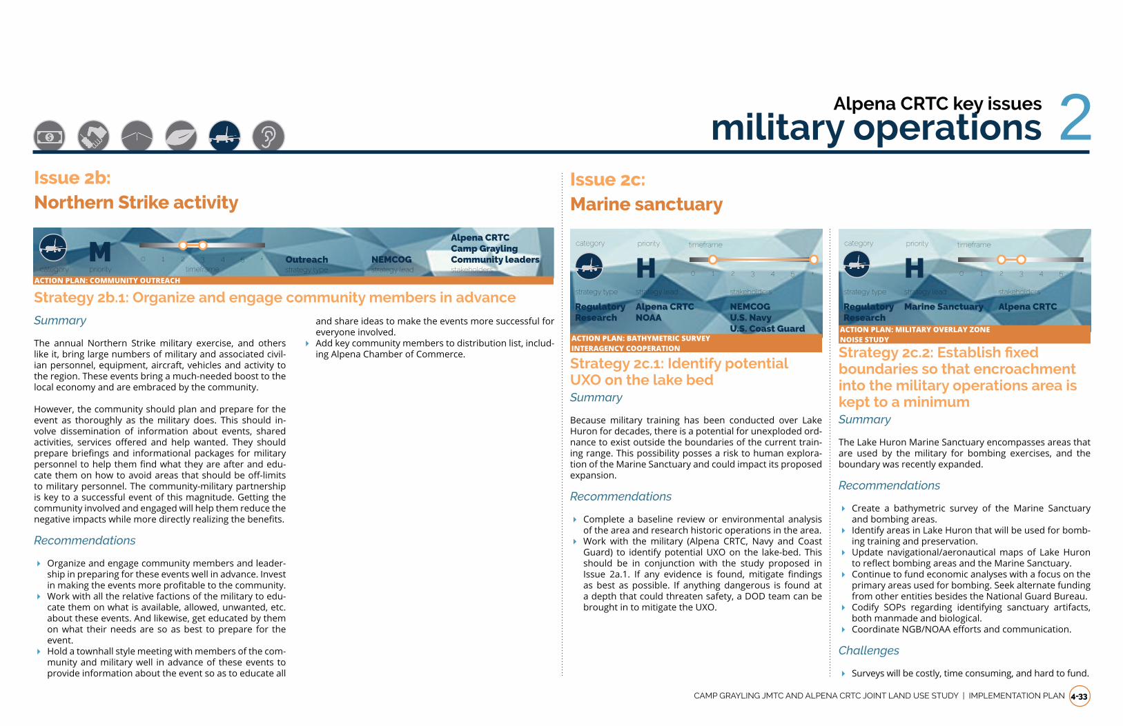
CAMP GRAYLING JMTC AND ALPENA CRTC JOINT LAND USE STUDY | IMPLEMENTATION PLAN 4-33
Summary
The annual Northern Strike military exercise, and others like it, bring large numbers of military and associated civil-ian personnel, equipment, aircraft, vehicles and activity to the region. These events bring a much-needed boost to the local economy and are embraced by the community.
However, the community should plan and prepare for the event as thoroughly as the military does. This should in-volve dissemination of information about events, shared activities, services offered and help wanted. They shouldpreparebriefingsand informationalpackages formilitarypersonneltohelpthemfindwhattheyareafterandedu-catethemonhowtoavoidareasthatshouldbeoff-limitsto military personnel. The community-military partnership is key to a successful event of this magnitude. Getting the community involved and engaged will help them reduce the negativeimpactswhilemoredirectlyrealizingthebenefits.
Recommendations
� Organize and engage community members and leader-ship in preparing for these events well in advance. Invest inmakingtheeventsmoreprofitabletothecommunity.
� Work with all the relative factions of the military to edu-cate them on what is available, allowed, unwanted, etc. about these events. And likewise, get educated by them on what their needs are so as best to prepare for the event.
� Hold a townhall style meeting with members of the com-munity and military well in advance of these events to provide information about the event so as to educate all
Strategy 2b.1: Organize and engage community members in advance
Issue 2b:Northern Strike activity
and share ideas to make the events more successful for everyone involved.
� Add key community members to distribution list, includ-ing Alpena Chamber of Commerce.
2Issue 2c:Marine sanctuary
Strategy 2c.1: Identify potential UXO on the lake bedSummary
Because military training has been conducted over Lake Huron for decades, there is a potential for unexploded ord-nance to exist outside the boundaries of the current train-ing range. This possibility posses a risk to human explora-tion of the Marine Sanctuary and could impact its proposed expansion.
Recommendations
� Complete a baseline review or environmental analysis of the area and research historic operations in the area.
� Work with the military (Alpena CRTC, Navy and Coast Guard) to identify potential UXO on the lake-bed. This should be in conjunction with the study proposed in Issue 2a.1. If any evidence is found, mitigate findingsas best as possible. If anything dangerous is found at a depth that could threaten safety, a DOD team can be brought in to mitigate the UXO.
Hprioritycategory timeframe
strategy type strategy lead stakeholders
Regulatory Research
Alpena CRTC NOAA
NEMCOG U.S. Navy U.S. Coast Guard
0 1 2 3 4 5 +
Strategy 2c.2: Establish fixed boundaries so that encroachment into the military operations area is kept to a minimumSummary
The Lake Huron Marine Sanctuary encompasses areas that are used by the military for bombing exercises, and the boundary was recently expanded.
Recommendations
� Create a bathymetric survey of the Marine Sanctuary and bombing areas.
� Identify areas in Lake Huron that will be used for bomb-ing training and preservation.
� Update navigational/aeronautical maps of Lake Huron toreflectbombingareasandtheMarineSanctuary.
� Continue to fund economic analyses with a focus on the primary areas used for bombing. Seek alternate funding from other entities besides the National Guard Bureau.
� Codify SOPs regarding identifying sanctuary artifacts, both manmade and biological.
� CoordinateNGB/NOAAeffortsandcommunication.
Challenges
� Surveys will be costly, time consuming, and hard to fund.
Hprioritycategory timeframe
strategy type strategy lead stakeholders
Regulatory Research
Marine Sanctuary Alpena CRTC
0 1 2 3 4 5 +
Alpena CRTC key issues
military operations
strategy type strategy lead stakeholdersOutreach NEMCOG
Alpena CRTC Camp Grayling Community leadersM
prioritycategory timeframe0 1 2 3 4 5 +
ACTION PLAN: COMMUNITY OUTREACH
ACTION PLAN: BATHYMETRIC SURVEYINTERAGENCY COOPERATION
ACTION PLAN: MILITARY OVERLAY ZONENOISE STUDY

4-34 IMPLEMENTATION PLAN | CAMP GRAYLING JMTC AND ALPENA CRTC JOINT LAND USE STUDY
Alpena CRTC key issues
military operations/environmental2/3
Strategy 3a.1: Improve public outreach and access to information
Summary
Residents near the Alpena CRTC are concerned about the safety of their drinking water since the detection announce-mentsin2017.Thehealtheffectsandextentofcontamina-tion are still being researched and are not completely un-derstood, which contributes to citizen concern about health and economic impacts. Continuing and improving ongoing communications between Alpena CRTC and surrounding residents through public meetings, print and electronic me-dia, and MDEQ call center assistance will help provide up-dated information, mitigate uncertainties, and ensure that thoseaffectedhaveaccesstoexposuremitigationoptionswhile enhancing public relations.
Recommendations
� Maintain the links on the Alpena CRTC home page to Michigan.gov PFAs contamination information pages and EPA PFA/PFC information pages, and consider add-ing some summary status information associated with the link.
� Increase non web-based outreach to residents. � Continue to hold frequent town hall public meetings during the monitoring project.
� Increase transparency about how wells are selected for testing.
� ConsiderstaffincreasesatAlpenaCRTCtohelpwithout-reach.
� Leverage existing water quality program and publicize itsbenefits.
Challenges
� Effortsmayrequirededicatingadditionalpersonneltimeto update the base website content, create information sheets, and coordinate print campaigns.
Issue 3a: PFOS and PFOA contamination of groundwater
strategy type strategy lead stakeholdersOutreach Alpena CRTC
MDEQ
ResidentsMprioritycategory timeframe
0 1 2 3 4 5 +
Strategy 2c.3: Author and promote cooperation story with Thunder Bay National Marine SanctuarySummary
The DOD Alpena CRTC practice bombing range lies just east of the 4,300 square mile NOAA – State of Michigan Thunder May National Marine Sanctuary. Interagency cooperation has developed since the 2014 Sanctuary expansion and includes sharing vessels for dive platforms and other co-operative activities. The Air Force/Air National Guard work in close cooperation with Sanctuary personnel to maintain the integrity of preserved sites and the ecology within the Sanctuary. The public has expressed concerns about the ef-fects of UXO on both water quality/ecological health of Lake Huronandtheeffectsofpracticebombingonthearchaeo-logical sites in the Sanctuary.
Recommendations
� Create story content on interagency cooperation, includ-ing maps and anecdotes about actual activities such as sharing vessels for towing targets and as dive platforms. Also, explain safety and environmental health risks as-sociated with munitions use in the lake to educate the public.
� Provide a base webpage link to MDEQ. Distribute sto-ry via web link on base home page and have available script for public meetings and outreach.
� WorkwithMIANGpublicaffairstofurtherpublicizeworkbeing doing at the sanctuary.
Challenges
� Requires personnel time to create narrative.
Additional Information
The Sanctuary works with community partners including the CRTC to improve public safety on and below the water. The Sanctuary has participated in diving and boating accident drills designed to test emergency responses from several agencies, including the U.S. Coast Guard, Alpena Combat Readiness Training Center, Alpena Central Dispatch, Alpena CountySheriff’sDepartment,MichiganDepartmentofNat-ural Resources, Mid-Michigan Medical Center-Alpena, and Alpena Fire Department. NOAA personnel who can help de-velop the cooperative story.
NOAA also produces joint education programs and other activities that could be promoted more widely.
strategy type strategy lead stakeholders
Research Outreach
NEMCOG NOAA
Marine Sanctuary
MDEQMprioritycategory timeframe
0 1 2 3 4 5 +
Issue 2c continued:Marine sanctuary
ACTION PLAN: COMMUNITY OUTREACHENVIRONMENTAL IMPACT STUDYINTERAGENCY COOPERATION
ACTION PLAN: COMMUNITY OUTREACHENVIRONMENTAL IMPACT STUDY
PFOS/PFOA InformationMore information is available at https://www.michigan.gov/pfasresponse
If any resident has additional questions regarding this issue, the MDEQ Environmental Assistance Center can be contacted at 1-800-662-9278 or email [email protected]. Representatives may be reached to assist with your questions Monday through Friday, 8:00 AM to 4:30 PM.

CAMP GRAYLING JMTC AND ALPENA CRTC JOINT LAND USE STUDY | IMPLEMENTATION PLAN 4-35
3Alpena CRTC key issues
environmental
Strategy 3b.1: Support water quality and aquatic ecology scientific communications Summary
Public interest in water quality and aquatic ecological health is spurred by topics such as chemical contamina-tion,fishadvisories,nutrientpollution,sedimentation, cli-mate change, habitat loss, and invasive species. There is a wide range of research and data available describing water quality, sediment quality, and the health of aquatic environ-ments and species, but it can be challenging for citizens to identify and access appropriate and accurate information to satisfy questions and concerns. Sometimes there are public misperceptions about the location and sources of contamination, including incorrectly attributing causes to base operations.
Recommendations
� Develop an information link on the base home page that summarizes facts and organizes resource links concern-ing surface water quality and aquatic ecological health in Alpena CRTC watersheds.
� Include a narrative on overall water quality and aquatic ecological health as prepared response for public meet-ings concerned with PFOS groundwater contamination.
� Reconvene the 2004 Thunder Bay Watershed Initiative to develop a Thunder Bay Regional Water Master Plan.
Issue 3b: Surface water quality (lakes, rivers, streams, wetlands)
Strategy 3c.1: Provide information to the public on groundwater contamination in the Alpena CRTC area
Summary
Groundwater contamination in the Alpena CRTC area re-sults from exposure to a wide range of toxic compounds, chemicals, metals, and petroleum byproducts that are intro-duced into soils and groundwater from industrial, manufac-turing, and transportation activities. While the PFA contam-ination issue receives the most attention, public comments from town hall meetings have demonstrated concern with groundwater contamination from other sources, with spe-cificconcernsexpressedaboutcontaminationfrommuni-tions. Munitions are expended at the small arms range fa-cility at Alpena CRTC; however the primary training is done at the ranges at Camp Grayling JMTC and over Lake Huron.
Recommendations
� Provide a base webpage link to MDEQ information re-garding groundwater contamination – this should in-clude the link to DEQ Online Services, which includes their Environmental Mapper utility.
� Provide current bulletins on spills and plume status (as available) for any sites on base in a bulleted format via website and as a script for public inquiries.
� Createachartofknownsitesforspecificpollutants,po-tential pollution sites, and steps the base takes to miti-gate hazards.
Challenges
� Requires personnel time to maintain bulletins and web-page.
Issue 3c: Groundwater quality
strategy type strategy lead stakeholdersOutreach Alpena CRTC
Residents MDNRM
prioritycategory timeframe0 1 2 3 4 5 +
Strategy 3b.2: Use biodegradable targets for lake trainingSummary
Alpena CRTC operations have begun using biodegradable targets for munitions operations over Lake Huron. In 2017, they also began retrieving the targets that were not de-stroyed or sunk.
Recommendations
� Continue current practices and research ways to im-prove.
� Consult with NOAA for more ideas on how to increase sustainability.
Hprioritycategory timeframe
strategy type strategy lead stakeholders
Regulatory Research
Alpena CRTC NOAA
0 1 2 3 4 5 +
ACTION PLAN: ENVIRONMENTAL IMPACT STUDYINTERAGENCY COOPERATION
Hprioritycategory timeframe
strategy type strategy lead stakeholders
Outreach Alpena CRTC MDEQ Residents
0 1 2 3 4 5 +
ACTION PLAN: ENVIRONMENTAL IMPACT STUDYINTERAGENCY COOPERATION
ACTION PLAN: COMMUNITY OUTREACHENVIRONMENTAL IMPACT STUDY

4-36 IMPLEMENTATION PLAN | CAMP GRAYLING JMTC AND ALPENA CRTC JOINT LAND USE STUDY
Issue 4b: Airport joint ownership/land use access
Strategy 4b.1: Continue positive coordination
Hprioritycategory timeframe
strategy type strategy lead stakeholders
Outreach Alpena CRTC/ Alpena Airport
N/A
Summary
A long-term lease is in place for the National Guard use of the Alpena Regional Airport. Collaboration between the en-tities ensures strong relationships and coordinated plan-ningeffortsinthefuture.
Recommendations
� Continue Airport Committee monthly meetings. � Coordinate regular updates with the military and public regarding the terminal construction.
� Continuetoweigheffectsonmilitaryoperationswhenconsidering economic development opportunities relat-ed to the airport and nearby land uses.
� Consider updating the airport master plan.
0 1 2 3 4 5 +
Issue 4c:Road funding
Strategy 4c.1: Continue discussion between county and military officials
Mprioritycategory timeframe
strategy type strategy lead stakeholders
Research Outreach
Alpena CRTC Alpena City, Township, County
Summary
Roadconditioninthesurroundingcommunityaffectsmili-tary residents traveling to and from Alpena CRTC on M-32. Funding solutions that support Alpena CRTC and the com-munity should be studied. While the military is unlikely to be able to fund road improvements, Alpena CRTC could provide publicity for the issue and potentially speak to the governor'sofficeabouttheissue.
Recommendations
� Investigate funding options for improvements. � Develop materials for public outreach campaign. � Set regular meetings with the governor's office andMIANG personnel to discuss such issues.
� Communicate military transportation projects with local officials.
Challenges
� Funding for road improvements and maintenance is a state-wide issue.
0 1 2 3 4 5 +
Alpena CRTC key issues
transportation and infrastructure4Issue 4a:Effects of growth on utilities
Strategy 4a.1: Address utilities issues at Alpena CRTC
Lprioritycategory timeframe
strategy type strategy lead stakeholders
Regulatory Alpena CRTC Alpena City, Township, County
Summary
In accordance with the Alpena CRTC Installation Develop-mentPlan,projects toaddressagingand insufficientsys-tems in order to accommodate current and possible future missions should be funded and executed.
Recommendations
� Upgrade the water distribution system and add a boost-er pump.
� Develop an agreement with Alpena Township to address maintenance issues.
Challenges
� Energy improvements and ensuring service may be de-pendent on private companies in some cases.
� Funding is inadequate to replace infrastructure.
0 1 2 3 4 5 +
Strategy 4a.2: Plan for possible mission expansionSummary
The utility requirements of additions to or expansion of training missions should be investigated and integrated into existing installation plans.
Recommendations
� Update the existing energy assessment. � Align growth with existing sustainability and net-zero plans, which may include implementation of new sourc-es of renewable energy.
� Educate public on potential for mission expansion and share NGB vision for the future of Alpena CRTC.
Challenges
� Energy improvements and ensuring service may be de-pendent on private companies in some cases.
� Turnover at the installation can be problematic for long-termplanningefforts.
Mprioritycategory timeframe
strategy type strategy lead stakeholders
Regulatory Alpena CRTC Alpena County
Residents
0 1 2 3 4 5 +
ACTION PLAN: MILITARY OVERLAY ZONE ACTION PLAN: COMMUNITY OUTREACHINTERAGENCY COOPERATION
ACTION PLAN: COMMUNITY OUTREACHTRANSPORTATION PLAN

CAMP GRAYLING JMTC AND ALPENA CRTC JOINT LAND USE STUDY | IMPLEMENTATION PLAN 4-37
Issue 4d:Road condition
Strategy 4d.1: Increase funding for road projects and maintenanceSummary
Road projects are costly, and aging roads and bridges pose significantmaintenanceproblemsthroughouttheareathatcannot all be addressed through the current limited fund-ing availability and streams.
Recommendations
� Align road and infrastructure projects and schedules to save costs.
� Update the Alpena Area-Wide Transportation Plan. � Utilize PASER, traffic counts, and historical traffic acci-dent data to prioritize projects.
� Pursue a public-private partnership (P3), particularly for areas of new development.
� Investigate funding agreements with the military for county roadway maintenance.
Challenges
� Grant proposals take time and money to develop and do not always yield funding.
� The military and private companies may not be interest-ed in partnerships.
Hprioritycategory timeframe
strategy type strategy lead stakeholders
Funding County/City/Township
Residents
0 1 2 3 4 5 +
Strategy 4e.1: Determine whether allowing lake access is viableSummary
Allowing public access to Lake Winyah's southern side would increase opportunities for local and tourist recre-ationalactivitiessuchaskayakingandfishing.
Recommendations
� Determine whether there are any security or ATFP is-sues associated with allowing access near Alpena CRTC.
� Invite public participation in the process to ensure voic-es are heard and all issues are communicated.
� Publicize any future access to draw tourists and base personnel to increased recreational opportunities.
Challenges
� Any potential development must be coordinated with ATFPandsecurityofficialsaswellasairportofficials.
Lprioritycategory timeframe
strategy type strategy lead stakeholders
Regulatory Research
Alpena CRTC/ Alpena Airport
Residents
MDNR
0 1 2 3 4 5 +
Issue 4e:Recreational access
Alpena CRTC key issues
transportation/community partnerships 4/5Issue 5a:Communications/education
Strategy 5a.1: Hire a dedicated community relations specialist for Alpena CRTC
Hprioritycategory timeframe
strategy type strategy lead stakeholders
Outreach Alpena CRTC MIANG
Residents
Summary
Comprehensive and timely communication with commu-nity residents and other key stakeholders is a challenge without a dedicated community relations specialist for Al-pena CRTC. Communicating controversial issues, such as concernsaboutgroundwatercontamination,magnifiesthischallenge. A dedicated community relations specialist will allow Alpena CRTC to create and implement a robust com-munications and public relations strategy.
Recommendations
� Review community relations and communication needs for Alpena CRTC. Discuss with community relations spe-cialist at Camp Grayling JMTC for benchmarking and planning insight.
� Present communications and community relations needs to Michigan Air National Guard in Lansing for con-sideration.
� Once a specialist is in place, develop and implement a multifaceted communications strategy for Alpena CRTC.
Challenges
� Federal budget limitations to hire a community relations specialisttosupportmorerobustefforts.
0 1 2 3 4 5 +
Strategy 5a.2: Improve the update process for Alpena CRTC website
Mprioritycategory timeframe
strategy type strategy lead stakeholders
Outreach Alpena CRTC MIANG
Residents
Summary
Updates to the Alpena CRTC website are centralized through the Michigan Air National Guard website and involve a cen-tralized process coordinated through Lansing. This process can hamper the ability to keep the webpage up to date. Al-penaCRTC staff canworkwith theMichiganAirNationalGuard to explore ideas for expediting and streamlining the process for website updates.
Recommendations
� Engage in a discussion with Michigan Air National Guard PublicAffairsstaffinLansingforideasonhowtokeepthe Alpena CRTC webpage relevant with new educational content and expedite the process for webpage updates.
� EnsuretheAlpenaCRTCwebsitereflectsabroadersuiteof informational and educational resources for a com-munity audience, rather than just potential visiting units.
Challenges
� LimitedMichiganAirNationalGuardPublicAffairsstaffin Lansing to implement changes in an expedited man-ner.
� Michigan Air National Guard social media and website requirements that preclude an expedited process to up-date the Alpena CRTC website.
0 1 2 3 4 5 +
ACTION PLAN: TRANSPORTATION PLAN ACTION PLAN: ENVIRONMENTAL IMPACT STUDYTRANSPORTATION PLAN
ACTION PLAN: COMMUNITY OUTREACH ACTION PLAN: COMMUNITY OUTREACH

4-38 IMPLEMENTATION PLAN | CAMP GRAYLING JMTC AND ALPENA CRTC JOINT LAND USE STUDY
Strategy 5a.6: Revise respective zoning ordinances for government entities within the APZ
Summary
Update local zoning codes to restrict height of new struc-tures within the APZs. Any new structure must undergo a review to ensure compliance with new zoning codes. Re-quire new facilities to match height limits mandated by the APZ and require site plan review for any new structure built on a property within the APZ.
Recommendations
� Update zoning codes in all applicable governmental en-tities.
� Zoning code update will also include a site review com-ponent for new structures in the APZ.
� Create a survey and registry of any current building that does not meet the new requirements.
Challenges
� Increase of regulatory requirements for residents and businesses.
� Restricts landowners’ use of their property. � Maydissuadeeconomicdevelopmentinaffectedareas.
Hprioritycategory timeframe
strategy type strategy lead stakeholdersRegulatory Developers
Residents
Local Governments
0 1 2 3 4 5
Alpena Townships NEMCOG
5 Alpena CRTC key issues
community partnershipsIssue 5a continued:Communications/education
Strategy 5a.5: Formalize communications with NOAA regarding operations over Thunder Bay National Marine Sanctuary
Mprioritycategory timeframe
strategy type strategy lead stakeholders
Outreach Alpena CRTC Residents
Summary
Alpena CRTC operations take place over Thunder Bay Na-tional Marine Sanctuary, requiring regular communication with NOAA to ensure continued protection of the sanctu-ary. Formalizing the communication mechanisms between Alpena CRTC and NOAA will promote better information ex-change and identify coordinated educational opportunities.
Recommendations
� Schedule an initial discussion session between Alpe-na CRTC, NOAA, and other key community partners to identify communication needs related to Alpena CRTC operations and Thunder Bay National Marine Sanctuary protection and promotion.
� Develop communication strategy and schedule based on issues raised during discussion session.
� Implement and formalize a mechanism for regular com-munication between NOAA and Alpena CRTC.
Challenges
� Lack of community relations personnel at Alpena CRTC makes it hard for the base and NOAA to engage in com-munications strategy development and implementation.
0 1 2 3 4 5 +
Strategy 5a.3: Promote STARBASE as an asset connected to Alpena CRTC
Mprioritycategory timeframe
strategy type strategy lead stakeholders
Outreach Alpena CRTC Residents
Summary
Students attending classes at STARBASE have the oppor-tunity to tour Alpena CRTC facilities. Educational materials about Alpena CRTC appropriate for students could be dis-tributed through STARBASE to be shared with families. This would help educate more community residents about the operationsandeconomicbenefitsofAlpenaCRTC.
Recommendations
� Work with Michigan Air National Guard, Alpena CRTC staff,andcommunitypartnerstocreateeducationalma-terials about Alpena CRTC that address unique functions andeconomicbenefits,aswellascareeropportunities.
� Distribute materials to community partners, including local educators, for feedback.
� Revise as necessary. � Distribute educational materials to STARBASE students and families.
Challenges
� Limited time and resources for Alpena CRTC to develop educational materials without dedicated community re-lationsstaff.
0 1 2 3 4 5 +
Strategy 5a.4: Strengthen existing partnership with Alpena Community College
Mprioritycategory timeframe
strategy type strategy lead stakeholders
Outreach Alpena CRTC Residents
Summary
Previous educational collaboration can serve as a founda-tion to reevaluate and strengthen the partnership between Alpena CRTC and Alpena Community College to provide more courses, training opportunities, and scholarships.
Recommendations
� Convene a working group between current Alpena CRTC leadership and Alpena Community College to discuss past educational collaboration successes and brain-storm potential new partnerships.
� Develop implementation strategy for working group rec-ommendations, including activities, responsible parties, schedule, and resource needs.
� Implement priority educational collaborations. � Announce new opportunities to the community, leverag-ing community partnerships to distribute information.
� Involve Alpena Community College in military affairscouncil via Chamber of Commerce.
� Look into job shadowing opportunities.
Challenges
� Limited time and resources for Alpena CRTC to provide on-site training, offer courses, provide equipment, orcontribute to scholarship funds.
0 1 2 3 4 5 +
ACTION PLAN: COMMUNITY OUTREACHECONOMIC IMPACT STUDY
ACTION PLAN: COMMUNITY OUTREACHECONOMIC IMPACT STUDY
ACTION PLAN: COMMUNITY OUTREACHINTERAGENCY COOPERATION
ACTION PLAN: MILITARY OVERLAY ZONE

CAMP GRAYLING JMTC AND ALPENA CRTC JOINT LAND USE STUDY | IMPLEMENTATION PLAN 4-39
Strategy 5b.2: Inform community on process to request tours and participation in community events
Mprioritycategory timeframe
strategy type strategy lead stakeholders
Outreach Alpena CRTC Residents
Summary
The process for requesting tours and involvement in events is not readily available to the public. Making the process and criteria available in several forms would help local partners.
Recommendations
� Develop a concise document on the availability of group tours, the tour timeframe and content, and the process for requesting, including lead time necessary to sched-ule a tour and the necessary request forms.
� Develop a document on the availability of Alpena CRTC to participate in community events. Include the criteria for events, options for participation (e.g., color guard, speaker,flyover),andprovidethenecessaryforms.
� Provide overview of the process on Michigan Air National Guard website, Alpena CRTC Facebook page, and other tools possibly developed in near term (e.g., newsletter).
� Establish a process for responding to requests. � Document in an overall SOP for future reference.
Challenges
� Limited time and resources for Alpena CRTC without dedicated community relations specialist.
� Possible need for review of processes by MIANG public affairsstaff.
0 1 2 3 4 5 +
Issue 5b:Public relations/community involvement
Strategy 5b.1: Convene expanded Alpena CRTC Community Council with Alpena Area Chamber of CommerceSummary
Using the organizational model suggested by the Alpena Area Chamber of Commerce (see Appendix A), Alpena CRTC can assist in convening the Alpena CRTC Community Coun-cil. This group would leverage community partnerships to support Alpena CRTC with public relations, economic valu-ation, visiting unit support services, and military family sup-port services.
Recommendations
� Review Alpena Area Chamber of Commerce proposal to expand the Alpena CRTC Community Council with Alpe-na CRTC leadership.
� Convene a planning session to develop a formal strat-egy for the Alpena CRTC Community Council, including membership, goals, schedule, and priority activities.
� Evaluatecouncil'seffectivenessovertime. � Report on Alpena CRTC Community Council successes to Alpena CRTC leadership and key community partners.
Challenges
� Alpena CRTC resource limitations to participate, particu-larly without a dedicated community relations specialist.
� Potential requirements for MIANG to review communi-cations materials prior to distribution.
Mprioritycategory timeframe
strategy type strategy lead stakeholders
Outreach Alpena CRTC Residents
0 1 2 3 4 5 +
5/6Alpena CRTC key issues
community partnerships/economic development
Issue 6a: Significant contributor to local economy
Strategy 6a.1: Local purchasing goal for Alpena CRTC
Summary
Commitment to spending Alpena CRTC funding at locally owned businesses is a priority by Alpena CRTC. Local pur-chasing goals for Alpena CRTC would help establish an op-erating norm that acknowledges the importance of Alpena CRTC on the surrounding local economies and would be less likely to change with changes in Alpena CRTC leader-ship over time.
MIANG has been consolidated and all but two contracting officersintheStatearelocatedatSelfridgeANGB.Contract-ing has set-aside goals for each year for HUBZone, 8a, and Small Business companies.
While Alpena CRTC personnel prefer to award work to NEMI contractors, the decisions are made at Selfridge ANGB and they consistently award Alpena CRTC work to SEMI contrac-tors.
Recommendations
� Work with leadership in Michigan Air National Guard to identify and set local purchasing goals for Alpena CRTC for goods and services not subject to federal and state contracting laws to demonstrate commitment to eco-nomic development of surrounding communities.
� Track and report progress toward local purchasing goal for goods and services that are not subject to federal and state contracting laws to help quantify annual im-pact on local economy.
� As possible, inform chambers of commerce and local
ACTION PLAN: INTERAGENCY COOPERATIONECONOMIC IMPACT STUDY
ACTION PLAN: COMMUNITY OUTREACHECONOMIC IMPACT STUDY
businesses when troops will be in the local area. � Chamber of Commerce should work with Alpena CRTC Contracting Office tomake sure our local contractorsare aware and understand the set-aside goals of MIANG.
� Chamber of Commerce should contact the Alpena CRTC ContractingOfficeandformallyprotestthattherecentset-aside contracts have consistently excluded NEMI contractors.
Lprioritycategory timeframe strategy type strategy lead stakeholders
Outreach Research Alpena CRTC
Business owners Target Alpena
ACTION PLAN: ECONOMIC IMPACT STUDY
0 1 2 3 4 5 +

4-40 IMPLEMENTATION PLAN | CAMP GRAYLING JMTC AND ALPENA CRTC JOINT LAND USE STUDY
Alpena CRTC key issues
economic development6
Strategy 6c.1: Maintain relationship with CRTC and advocate for longer-term contract
Summary
Current contract extension will require Alpena County Sher-iff’s Department to compete for longer-term contract toprovide services.
Recommendations
� Continue to provide excellent security services during contract extension period.
Challenges
� State of Michigan requires competitive bid for award of contract to provide services
Mprioritycategory timeframe
strategy type strategy lead stakeholders
Regulatory Alpena CRTC
0 1 2 3 4 5 +
Issue 6c:Partnership with sheriff
Strategy 6d.1: Economic incentives to generate military tourism
Summary
Soldiers often bring family members into the area during trainingexercises.Localbusinesseswillbenefitifsurround-ing tourism bureaus work to create incentives for families to extend their stay in the area. Discounts or vacation pack-ages could create incentives that expand military tourism associated with Alpena CRTC.
Recommendations
� Convene a working session among tourism bureaus, lo-cal business representatives, and government entities such as NOAA to identify possible incentives for Alpena CRTC trainees and their families to extend their visit and expand military tourism.
� Identify and develop most feasible incentives. � Create marketing campaign to promote incentives in partnership with Alpena CRTC.
� Monitorincentiveeffectiveness. � Reportfindingstoworkinggroup. � Adaptincentivesbasedonfindings.
Challenges
� Resource limitations to supportworking group effortsand campaign to market incentives.
ACTION PLAN: ECONOMIC IMPACT STUDY
Issue 6b:Airport viability
Strategy 6b1: Leverage relationships to replace customs agent
Summary
Loss of the part-time local customs agent has had a nega-tive economic impact on the Alpena County Regional Air-port, requiring aircraft emanating from foreign locations to route to other Northern Michigan locations. Stakeholders in Alpena have been actively seeking viable options to replace the customs agent, but have had no success.
Recommendations
� Engage Alpena CRTC and Michigan Air National Guard in discussions on potentially helping to publicize the issue.
� Identify updated options that build on previous discus-sions with Congressional delegation.
Challenges
� Replacement of customs agent currently an issue raised by Congressional delegation without results to date.
� Alpena CRTC has a customs agent on an as-needed basis only and cannot provide resources.
Mprioritycategory timeframe
strategy type strategy lead stakeholders
Regulatory Chamber of Commerce Alpena CRTC Residents
0 1 2 3 4 5 +
ACTION PLAN: INTERAGENCY COOPERATION
Issue 6d:Military tourism
Mprioritycategory timeframe strategy type strategy lead stakeholders
Outreach Research Alpena County
Local businesses Tourism bureaus Target Alpena
ACTION PLAN: ECONOMIC IMPACT STUDY
0 1 2 3 4 5 +

CAMP GRAYLING JMTC AND ALPENA CRTC JOINT LAND USE STUDY | IMPLEMENTATION PLAN 4-41
Strategy 6d.2: Economic tracking and reporting mechanisms to quantify annual military tourism impactSummary
Quantifiableeconomicdataonhowdollarsflowfromsol-diers training at Alpena CRTC into surrounding commu-nities would help communicate the contributions Alpena CRTC makes to the local economy. This type of information wouldassistincommunicatingthebenefitsofAlpenaCRTCto current residents, prospective home buyers, and deci-sion makers at the local, state, and federal levels.
Recommendations
� Conduct benchmarking research on other military train-inginstallations’effortstotrackeconomicimpactofop-erations on local communities.
� Convene a brainstorming session among key stakehold-ers to share benchmarking results and identify potential economic tracking mechanisms to monitor the spending flow fromAlpena CRTC trainees in local communities.Mechanisms discussed during the JLUS process include a survey of Alpena CRTC soldiers during their stay with an incentive to participate or an Alpena CRTC discount card accepted at local businesses. Consider coordinating with Camp Grayling JMTC for this activity.
� Identify most feasible tracking mechanisms from brain-storming session and develop a monitoring plan and re-porting schedule.
� Share information about the economic monitoring ini-tiative with Alpena CRTC soldiers and families.
� Collectdataandanalyzefindings. � Report to key stakeholders participating in brainstorm-ing session.
� Identify next steps to adapt monitoring approach based onfindings.
� Prepare informational collateral to sharefindingswithmedia, decision makers, and other key stakeholders.
Challenges
� Resource limitations to support economic monitoring mechanism development and implementation over time.
� Potential lack of widespread participation in tracking that will limit the ability to comprehensively quantify mil-itarytourismspendingflow.
Issue 6d: continuedMilitary tourism
Mprioritycategory timeframe strategy type strategy lead stakeholders
Outreach Research
Chamber of Commerce
Alpena CRTC Local businesses Target Alpena
ACTION PLAN: ECONOMIC IMPACT STUDY
0 1 2 3 4 5 +
6Alpena CRTC key issues
economic development

4-42 IMPLEMENTATION PLAN | CAMP GRAYLING JMTC AND ALPENA CRTC JOINT LAND USE STUDY
This page intentionally left blank.

CAMP GRAYLING JMTC AND ALPENA CRTC JOINT LAND USE STUDY | APPENDIX a-1
2010 US Census data
Adaptatation Planning for Climate Resilience, MIARNG, 2016
Air Force Instruction 32-7063, Air Installations Compatible Use Zones Program
Air Force Instruction 90-2001, Encroachment Management
Air Installation Compatible Use Zone Program
Alpena CRTC Installation Development Plan, April 2015
Alpena CRTC Installation Development Plan Environmental Assessment
Alpena County Master Plan, NEMCOG, 2013
Anderson, B. (n.d.). DECOOK v. ROCHESTER INTERNA-TIONAL AIRPORT JOINT ZONING BOARD. Retrieved July 12, 2018, from https://caselaw.findlaw.com/mn-supreme-court/1597248.html
Army Regulation 405-10: Acquisition of Real Property and Interests Therein
City of Grayling Economic Development Strategy, Place and Main Advisors LLC, March 2017
Crawford County Land Act 172 of 1913
Department of the Army Pamphlet 385-63: Range Safety
Economic Development Study for the City of Grayling, Proj-ect Rising Tide, March 2017
Esri data
Federal Aviation Act
Grayling Area Transportation Study, 2008
Hogan, S. H., & LaVille, J. C. (2015, March 06). Zoning and the Fifth Amendment: When do Zoning Regulations "Go Too Far"? Retrieved July 12, 2018, from https://www.fosterswift.com/communications-Zoning-Fifth-Amendment-Regula-tions.html
Integrated Cultural Resources Management Plan for Alpena CRTC and Camp Grayling JMTC, 2012
Integrated Natural Resources Management Plan for Alpena CRTC, 2013
areferences
Letter from Kamperman Associates Inc. in reference to In-stallation Environmental Noise Management Plan for Camp Grayling JMTC; February 25, 2002
Long-term management agreement between the Depart-ment of Natural Resources and the Department of Military Affairs;November26,1984
Michigan Army National Guard Real Property Development Plan, May 2011
National Guard Regulation (NGR) 385-63: Army National Guard Range Safety Program, Policy, and Standards
NEMCOG-provided zoning data
NOAA Condition Report, 2013
"Northern Michigan Property Values: The Significance ofRiverfront Properties," prepared by Public Sector Consul-tants Inc. for Anglers of the Au Sable; August 2013
"Penn Central Transportation Company v. New York City." Oyez, 13 Jul. 2018, www.oyez.org/cases/1977/77-444.
Property Topics and Concepts. (2018). Retrieved July 12, 2018, from https://www.planning.org/divisions/plannin-gandlaw/propertytopics.htm
Public Act 288 of 2016
Public Hearing Record, Bernard J. Fowler to Camp Grayling Management Advisory Committee; August 30, 1988, and additional information provided September 21, 1988
Sierra Club and Anglers of the Au Sable on NPDES permit No. MI0059209, Exhibit 242, Assessment of Economic Ef-fects of Increased Production at the Grayling Trout Hatch-ery; November 23, 2015
Unified Facilities Criteria 3-260-01, Airfield and HeliportPlanning and Design
http://grayling.minationalguard.com/
http://ns.minationalguard.com/exercise-northern-strike-2017-is-closing-in/
http://www.alpenacrtc.ang.af.mil/
http://www.discovernortheastmichigan.org
http://www.loc.gov/pictures/resource/pan.6a30457/
http://www.michigandnr.com
https://www.michigan.gov/pfasresponse

a-2 APPENDIX | CAMP GRAYLING JMTC AND ALPENA CRTC JOINT LAND USE STUDY
A.1 Alpena CRTC Community Council Background Information
Representatives from the Alpena Chamber of Commerce firstmetwith representatives fromAlpenaCRTC in2013in the interest of convening a council that would focus and help foster civilian interaction with the installation. The re-lationship between the base and the community was rec-ognized as positive, but all parties wanted to ensure things continued in that vein into the future.
Other areas in the state with a heavy military presence (e.g., Battle Creek and Selfridge) already had similar programs in place,andtheyhadreportedpositiveeffects.
At right, the graphic shows some details for the proposed council, as well as the areas it would focus on. The council would be part of the Chamber of Commerce if approved by the chamber's board.
This JLUS recommends that the council be convened as described in Strategy 5b.1 for Alpena CRTC, presented on page 4-35 of this document.
bFigure A.1 | Alpena CRTC Community Council
alpena CRTC community council
The Council utilizes communication, events, and other
support strategies to enhance support for Alpena CRTC. The
council will meet quarterly, and meetings will be open to the
general public.
support services
provides services or connects military and
military families to services
economic value
measures/shares the economic impact of Alpena CRTC on the
community
public relations
shares information with the community
about upcoming events at Alpena
CRTC
military support
hosts receptions for visiting units to Alpena CRTC

CAMP GRAYLING JMTC AND ALPENA CRTC JOINT LAND USE STUDY | APPENDIX b-1
Please see the following pages.bpublic participation plan

This page intentionally left blank.
b-2 INTRODUCTION | CAMP GRAYLING JMTC AND ALPENA CRTC JOINT LAND USE STUDY

CAMP GRAYLING JMTC AND ALPENA CRTC JOINT LAND USE STUDY | APPENDIX b-3
final | april 2018
camp grayling joint maneuver training center | alpena combat readiness training center
jo int land use studypublic participation plan

b-4 APPENDIX | CAMP GRAYLING JMTC AND ALPENA CRTC JOINT LAND USE STUDY
camp grayling joint maneuver training center | alpena combat readiness training center
jo int land use studypublic participation plan | final | april 2018
acknowledgments and key partnersNortheast Michigan Council of GovernmentsMichigan DNR (Gaylord)Michigan Dept of Transportation (Gaylord)US Forest ServiceMichigan Dept of Environmental Quality (Gaylord)US Fish & Wildlife Service (Alpena)Headwaters Land ConservancyUSDA Natural Resource Conservation Service (Gaylord)Huron Pines (conservation) (Gaylord)Crawford County City of Grayling (Crawford Co)Grayling Twp (Crawford Co)Lovells Twp (Crawford Co)Maple Forest Twp (Crawford Co)Frederic Twp (Crawford Co)Beaver Creek Twp (Crawford Co)South Branch Twp (Crawford Co)Crawford County Road CommissionOtsego County Chester Twp (Otsego Co)Otsego Lake Twp (Otsego Co)Bagley Twp (Otsego Co)Hayes Twp (Otsego Co)Otsego County Economic AllianceBear Lake Twp (Kalkaska Co)Garfield Twp (Kalkaska Co)Au Sable River Property Owner’s AssociationAnglers of the Au SableMason-Griffith Founders Chapter of Trout UnlimitedUpper Manistee River AssociationMichigan Association of TimbermenWeyerhaeuserAraucoAJD Forest ProductsJays Sporting GoodsAlpena Regional AirportAlpena County
City of Alpena (Alpena Co)Alpena Twp (Alpena Co)Maple Ridge Twp (Alpena Co)Wilson Twp (Alpena Co)Green Twp (Alpena Co)Ossineke Twp (Alpena Co)Sanborn Twp (Alpena Co)Long Rapids Twp (Alpena Co)Village of HillmanTarget AlpenaAlpena Chamber of CommerceMichigan Sea Grant/MSU ExtensionNorthern MI Unmanned Aerial Systems ConsortiumThunder Bay National Marine SanctuaryUS Coast GuardThunder Bay Audubon SocietyNOAAMichigan United Conservation Club – Region 4Camp Grayling and Alpena CRTCMichigan Economic Development CorporationGrayling Chamber of CommerceMichigan Works!Briley Twp (Montmorency Co)Roscommon CountyLyon Twp (Roscommon Co)Posen Twp (Presque Isle Co)Krakow Twp (Presque Isle Co)Metz Twp (Presque Isle Co)Higgins Twp (Roscommon Co)Antrim County
This study was prepared under contract with the Northeast Michigan Council of Governments, with financial support from the Office of Economic Adjustment, Department of Defense. The content reflects the views of the Northeast Michigan Council of Governments and all of the JLUS project stakeholders and does not necessarily reflect the views of the Office of Economic Adjustment.

CAMP GRAYLING JMTC AND ALPENA CRTC JOINT LAND USE STUDY | APPENDIX b-5
CAMP GRAYLING JMTC AND ALPENA CRTC JOINT LAND USE STUDY – PUBLIC PARTICIPATION PLAN | TABLE OF CONTENTS i
Table of Contents
1 JLUS public participation plan background and goals
1.1 Introduction ............................................................................................................................................................................. 1
1.2 Goals....... .................................................................................................................................................................................. 2
2 public participation plan components2.1 PPP Component 1: Identifying and Characterizing Key Stakeholders .............................................................................. 3
2.1.1 Key Stakeholder List ................................................................................................................................................. 3
2.1.2 Committee. ................................................................................................................................................................ 4
2.1.3 Stakeholder Characterization ................................................................................................................................... 5
2.2 PPPComponent2:CreatingEffectiveMessages ................................................................................................................. 5
2.3 PPPComponent3:IdentifyingandCreatingEffectiveStakeholderInvolvementOpportunitiesandEducationalResources ................................................................................................................................................................................. 5
2.3.1 Meetings,Tours,andSurveys .................................................................................................................................. 5
2.3.2 JLUS Educational Resources ..................................................................................................................................... 6
2.4 PPPComponent4:IdentifyingEffectiveDistributionChannelsandMechanisms ......................................................... 6
2.5 PPPComponent5:AssessingEffectiveness ......................................................................................................................... 8
2.5.1 PPPActivitiesandSchedule ...................................................................................................................................... 8
appendixa meeting participants ................................................................................................................................................... 11
b surveys .......................................................................................................................................................................... 15
c project fact sheet/announcements ........................................................................................................................... 21
d surveyannouncement ................................................................................................................................................ 23

b-6 APPENDIX | CAMP GRAYLING JMTC AND ALPENA CRTC JOINT LAND USE STUDY
ii TABLE OF CONTENTS | CAMP GRAYLING JMTC AND ALPENA CRTC JOINT LAND USE STUDY – PUBLIC PARTICIPATION PLAN
This page intentionally left blank.

CAMP GRAYLING JMTC AND ALPENA CRTC JOINT LAND USE STUDY | APPENDIX b-7
CAMP GRAYLING JMTC AND ALPENA CRTC JOINT LAND USE STUDY – PUBLIC PARTICIPATION PLAN | JLUS PUBLIC PARTICIPATION PLAN BACKGROUND AND GOALS 1
1.1 IntroductionTheJointLandUseStudy(JLUS)isacommunitydriven,col-laborative, strategicplanningprocessamongCampGray-ling Joint Maneuver Training Center (JMTC) and AlpenaCombatReadinessTrainingCenter(CRTC),surroundinglo-calgovernments,jurisdictions,andotherkeystakeholderswithin an approximately 20 mile radius to:
1. Promote community development that is compatiblewithmilitarytraining,testing,andoperationalmissions;
2. Seek ways to manage operational impacts on adjacent lands;and
3. Optimizetheuseofprivateandcommunityinvolvementand support.
The Northeast Michigan Council of Governments (NEM-COG)receivedagrantfromtheU.S.DepartmentofDefense(DOD)OfficeofEconomicAdjustment(OEA)andisthespon-soringagencycoordinatingthedevelopmentofthisJLUS.
See Figure 1.1 on the following page for a map of the JLUS areas of interest
JLUS public participation plan background and goals
1
Above, stakeholders participate in Camp Grayling JMTC and Alpena CRTC public meetings.

b-8 APPENDIX | CAMP GRAYLING JMTC AND ALPENA CRTC JOINT LAND USE STUDY
2 JLUS PUBLIC PARTICIPATION PLAN BACKGROUND AND GOALS | CAMP GRAYLING JMTC AND ALPENA CRTC JOINT LAND USE STUDY – PUBLIC PARTICIPATION PLAN
1.2 GoalsTheJLUSprojectgoalsareto:
� Promote land use compatibility between the installa-tionsandsurroundingcommunities;
� Seekways tomanagedevelopment that is compatiblewithmilitarytraining,testing,andoperationalmissions;
� Encourage cooperative action among military person-nel,localcommunityofficials,andcitizens;
� Maintainandstrengthenregionaleconomicengines; � Convenebothatechnicaladvisoryandpolicycommitteecomprised of people drawn from the surrounding areas affectedbythetwotrainingcenters;
� Engagethepublic(whichincludesthetechnicalandpol-icycommittees)toidentifycurrentandfuturelanduseincompatibilityissues;
� Map the identified compatibility issues and communi-catethemtothepublic;
� Solicitinputfromstakeholdersaboutpotentialsolutionstotheidentifiedincompatibilities;
� Gainagreement from the various stakeholderson therecommendedfuturemanagementactions;
� Educate the surrounding municipalities on the process and report to promote adoption and implementation of recommendationsidentifiedinthefinalreport.
Achieving the JLUS project goals requires developing andimplementingaPublicParticipationPlan(PPP)thatwillef-fectivelyengagestakeholdersintheJLUSprojectarea.ThecoreJLUSProjectTeam,NEMCOGandTetraTech,hasde-veloped,implemented,andwillcontinuetoimplementthestakeholder engagement activities described in this PPPthroughout the duration of the JLUS project.
Figure ES.1 | JLUS Areas of Interest
Grayling
Alpena
Big Creek
Lovells
Garfield
Green
Elmer
Charlton
Wilson
Albert Ossineke
Hayes Chester
Frederic
Krakow
Kalkaska
Metz
South Branch
Bear Lake
Greenwood
Oliver
Dover
Posen
Beaver Creek
Sanborn
Wellington
Orange
Bagley
Belknap
Maple RidgeLong Rapids
Pulawski
Excelsior
Presque Isle
Blue Lake
Livingston
Rapid River
Otsego Lake
Cold Springs Maple Forest
Alpena
Rogers
Gaylord
Grayling
Gaylord
Gaylord
M 32
M 72
M 3
3
US 1
31
M 68
M 66
M 65
M 18
Miller
US 23
M 88
Abbe
M 93
Park
US 31
M 75
Mou
nt T
om
Ryno
Charlevoix
8thCr
ipps
Ots
ego
Lake
Mor
enci
Federal Bake
r
Wea
ver
Mile
State
Map
le
Boyne
Ceda
r
M 2
11
Turtl
e La
ke
Willi
ams
Main
Dunham
Div
isio
n
Sprin
g
Corey Lake
Pric
e
Post
Harvey
Water
Pion
eer I 75 BL
Main
M 32
M 3
3
M 66
M 33
M 65
State
US
23
US 13
1
M 6
5
M 3
3
M 75
Mou
nt T
om
Stat
e
M 33
M 72
M 72
M 6
5
M 32
US 23
US
131
M 68
M 93
M 6
6
M 65
M 32
M 72
State
USGS The National Map: National Boundaries Dataset, National Elevation Dataset, Geographic Names Information System, National Hydrography Dataset, National Land Cover Database, National Structures Dataset, and NationalTransportation Dataset; U.S. Census Bureau - TIGER/Line; HERE Road Data
LegendProposed Scope Areas
Townships
Cities
School districts
Counties
Camp Grayling Area of Interest
AlpenaArea of Interest
¯

CAMP GRAYLING JMTC AND ALPENA CRTC JOINT LAND USE STUDY | APPENDIX b-9
CAMP GRAYLING JMTC AND ALPENA CRTC JOINT LAND USE STUDY – PUBLIC PARTICIPATION PLAN | PUBLIC PARTICIPATION PLAN COMPONENTS 3
The five components of the PPP include:
1. Identifying and characterizing key stakeholders;2. Creating effective messages;3. Identifying and creating effective stakeholder involve-
ment opportunities and educational resources;4. Identifying effective distribution channels and mecha-
nisms; and5. Assessing effectiveness.
Each of these PPP components will be discussed in detail on the following pages.
2.1 PPP Component 1: Identifying and Characterizing Key Stakeholders
Stakeholders include individuals, groups, organizations, and governmental entities interested in, affected by, or af-fecting the outcome of the JLUS project. The foundational component of the PPP activities is identifying and character-izing stakeholders, with emphasis on the characterization. The goals of the JLUS project include engaging, educating, obtaining input, and seeking agreement from stakehold-ers. Therefore, it is imperative to tailor the engagement and education messages, formats, and distribution chan-nels based on the stakeholders’ perceptions, interests, and communication preferences. In addition to creating a comprehensive list of stakeholders for the JLUS project, it is important for the JLUS Project Team to document charac-terization information to inform the other PPP components and future JLUS actions.
2.1.1 Key Stakeholder List Stakeholders identified for the JLUS project include individ-uals, groups, organizations, and governmental entities lo-cated within the JLUS project area.
The Camp Grayling JMTC area of influence includes the whole of Crawford County and portions of Crawford Coun-ty’s border counties: to the east, Oscoda County; to the south, Roscommon County; to the west, Kalkaska County and to the north, Otsego County. Also included in the study areas are the southeast portions of Antrim County and the southwest portion of Montmorency County for a total of 7 counties and 33 municipalities.
The Alpena CRTC area of influence includes Alpena County and a small portion of Presque Isle County, as well as 13 municipalities.
Key stakeholders within the two primary JLUS project areas will represent the following:
� Camp Grayling JMTC staff � Alpena CRTC staff � Federal agency staff
� Thunder Bay National Marine Sanctuary, National Oceanic and Atmospheric Administration
� U.S. Forest Service � U.S. Fish and Wildlife Service � U.S. Department of Agriculture Natural Resources Conservation Service
� U.S. Coast Guard � State agency staff
� Michigan Department of Environmental Quality � Michigan Department of Natural Resources � Michigan Department of Transportation � Michigan Economic Development Corporation
� Michigan Sea Grant/Michigan State University Extension � Elected officials and municipal staff � Community residents within the project area � Local organizations
� HOMEOWNERS ASSOCIATIONS: the AuSable River Property Owners’ Association, Lake Margrethe Prop-erty Owners’ Association, Enchanted Forest Property Owners’ Association
� ECONOMIC DEVELOPMENT GROUPS: Grayling Re-gional Chamber of Commerce and the Alpena Area Chamber of Commerce
� LOCAL EMPLOYERS: Weyerhaeuser, AJD Forest Prod-ucts, Jays Sporting Goods
� RECREATION ORGANIZATIONS: Anglers of the AuS-able and Trout Unlimited
� ENVIRONMENTAL ORGANIZATIONS: Headwaters Land Conservancy, Upper Manistee River Associa-tion, Thunder Bay Audubon Society, Michigan United Conservation Club
� ACADEMIA: Kirtland Community College and Alpena Community College
� Media � The Alpena News � Crawford County Avalanche � WQON-FM 100.3 � WATZ-FM 99.3
Many of the key stakeholders within the JLUS Project Area have been asked to serve on the project’s policy committee (PC) and technical committee (TC). The PC is primarily com-
public participation plan components
2
Camp Grayling Policy Committee Meeting

b-10 APPENDIX | CAMP GRAYLING JMTC AND ALPENA CRTC JOINT LAND USE STUDY
4 PUBLIC PARTICIPATION PLAN COMPONENTS | CAMP GRAYLING JMTC AND ALPENA CRTC JOINT LAND USE STUDY – PUBLIC PARTICIPATION PLAN
posed of city, township, and county officials; military instal-lation leadership; state officials; and private sector leaders. The PC meets on a quarterly basis and is charged with:
� providing overall project leadership to include policy di-rection and oversight, budget approval, project monitor-ing, and report adoption; and
� participating in public outreach events.
The TC comprises local and installation community plan-ners, community staff, business representatives, and resi-dents. The TC meets on a monthly basis and is responsible for:
� data collection � identifying and studying technical issues � recommending working groups (if needed) for specific issues
� evaluating alternatives � developing recommendations for the PC
2.1.2 Committee Membership Table 2.1, JLUS Policy and Technical Committee Members and Organizations, contains a list of JLUS TC and PC mem-bers. These individuals will play a key role in both develop-ing and implementing the PPP by serving as the core group of stakeholders that help disseminate information and promote engagement in the JLUS process among their key stakeholder groups.
Table 2.1 | JLUS Policy and Technical Committee Members and Organizations
JLUS POLICY COMMITTEE JLUS POLICY COMMITTEE, CONTINUED
Name Representing/Title Name Representing/Title
Ken Glasser (JLUS Chairman) Otsego County Board George F. Banker Bear Lake Township Supervisor
Greg Sundin (JLUS Vice Chairman) City of Alpena Chris Peterson US Forest Service
Matt Waligora (JLUS Vice Chairman Alternate) City of Alpena Mayor Scott R. Koproski US Fish & Wildlife Service
Marc Dedenbach (JLUS Secretary) Grayling Township Edward A. Nellist Lyon Township Supervisor
SGM Kent Smith Camp Grayling JMTC James Zakshesky Posen Township Supervisor
SFC Jeremie Mead Camp Grayling JMTC Michael Grohowski Krakow Township Supervisor
LTC Brian Burrell Camp Grayling JMTC Nyle Wickersham Metz Township Supervisor
Lt Col Matthew Trumble Alpena CRTC William E. Curnalia Higgins Township Supervisor
Lt Col Michael Leski Alpena CRTC Gary Neumann Lovells Township Supervisor
Capt Brian Blumline Alpena CRTC Denise Matteini Otsego Lake Township
Jonathan Edgerly Michigan Army National Guard – Environmental Margaret Black, alternate Otsego Lake Township Clerk
Kim VanNuck Beaver Creek Township Supervisor Bonny Miller Chester Township Supervisor
Brandon Schroeder Michigan State University Extension/Michigan Sea Grant
Scott Kruger Antrim County Commissioner
Susan Thiel MDNR Brenda Fournier Alpena County Commissioner
Jeff Gray Thunder Bay National Marine Sanctuary, NOAA JLUS TECHNICAL COMMITTEE
Rob Pallarito Otsego County Board Name Representing/Title
Mark Ignash MEDC Adam Poll City of Alpena Planning & Development Director
Jim Klarich Target Alpena Erich Podjaske City of Grayling Zoning/Economic Development
Scott Thayer MDOT Lisa Kruse Alpena CRTC Environmental Specialist
Dave Stephenson Crawford County Board Chair Susan Thiel MDNR
Doug Baum Grayling City Manager Julie Lowe MDEQ
Steve Smigelski Alpena Airport Manager Alayne Hansen Michigan Works!
David Persons Garfield Township Supervisor Patty O’Donnell MDOT
Cody Werth Wilson Township Board/Planning Commission Doug Baum City of Grayling
Julie Lowe MDEQ Denise Mattieni Otsego Lake Township
Lisa McComb Otsego County Economic Alliance John Bailey Huron Pines
Bill Johnson Frederic Township Supervisor SMSgt Jerome Torres Alpena CRTC
Shelly Pinkelman, alternate Frederic Township Zoning SMSgt Damian Pappas, alternate Alpena CRTC
Ken Lobert Ossineke Township Supervisor
Nathan Skibbe Alpena Township Supervisor
Dave Post Village of Hillman
Myron McIntire, alternate Hillman Village President
Cam Habermehl Alpena County
Brian Goebel Bagley Township
Ken Arndt, alternate Bagley Township
Jodi Valentino Roscommon County Controller
Bruno Wojick Briley Township
Howard Lumsden Long Rapids Township Supervisor
Sharcy Ray USDA Natural Resource Conservation Service

CAMP GRAYLING JMTC AND ALPENA CRTC JOINT LAND USE STUDY | APPENDIX b-11
CAMP GRAYLING JMTC AND ALPENA CRTC JOINT LAND USE STUDY – PUBLIC PARTICIPATION PLAN | PUBLIC PARTICIPATION PLAN COMPONENTS 5
2.1.3 Stakeholder Characterization
Understanding stakeholders’ existing awareness, percep-tions, concerns, values, and priorities related to Camp Grayling JMTC and Alpena CRTC will help the JLUS Project Team develop and implement involvement opportunities and educational resources. Characterization information can influence the level of detail in educational materials and highlight where issues might serve as potential roadblocks to participation or agreement on strategies.
Compiling characterization information for each stakehold-er group is an iterative process that starts with a core group of key stakeholders and, over the course of the project, be-comes more specific. Stakeholder characterization informa-tion evolves over time and could augment approaches for initiating and sustaining stakeholder involvement and ed-ucating stakeholders on the JLUS project. The JLUS survey process, as well as public meetings, aided in characterizing stakeholders’ perspectives of Camp Grayling JMTC and Al-pena CRTC.
The June 2017 PC and TC discussion sessions and the public meetings offered early insights into stakeholders’ perspec-tives of and concerns about Camp Grayling and the Alpena CRTC. Stakeholders in the project area have a broad array of challenges, including noise, water quality, wildfire, traffic, property value, military operations, and public safety con-cerns, that are more prevalent and will promote increased levels of stakeholder participation.
Another key aspect of stakeholder characterization is un-derstanding communication channel preferences. Based on discussions with NEMCOG and the Camp Grayling com-munity relations specialist, as well as other members of the PC and TC, the community residents rely on tradition-al sources of information, such as newspaper, radio, and word-of-mouth, to obtain information. Social media is more limited in use, particularly for the older demographic in the study area.
JLUS June 2017 Community Survey AnnouncementAlpena CRTC community land use strengths identified during June 2017 discussion and public meetings.
2.2 PPP Component 2: Creating Effective Messages
Raising stakeholder awareness and motivating participation in the JLUS process are key to achieving project goals. Doing so successfully requires effective messaging for education-al materials and announcements for public involvement opportunities. Stakeholder characterization information on perceptions, concerns, and interests related to Camp Grayling JMTC and Alpena CRTC installation complexes and mission footprints aid in crafting effective messages for ed-ucation and engagement collateral. The messages change with each phase of the project and as stakeholder charac-terization is further refined. Messages for each phase of the project are presented below.
� DISCOVERY PHASE (APRIL 2017 – JULY 2017): Ini-tial messages for the discovery phase focus on raising awareness and promoting engagement. Messages raise stakeholder awareness about the JLUS project and their proximity to the JLUS project area, addressing their po-tential curiosity and concerns about the activities taking place at Camp Grayling and Alpena CRTC, and promoting the unique opportunity to share their concerns through the JLUS process. Message: Your input on issues and concerns is important to identifying solutions that will benefit your community.
� STRATEGY AND PLANNING PHASE (AUGUST 2017 – MARCH 2018): Messages for the strategy and planning phase focus on reporting out the interim findings for the identified issues/conflicts uncovered in the discov-ery stage. Messages focus on validating issues identified in the discovery phase and providing input on potential solutions. Message: Please tell the JLUS Project Team if we accurately captured your issues and concerns and contribute to developing possible solutions.
� IMPLEMENTATION PHASE (APRIL 2018 – ONGOING): Messages for the implementation phase focus on pre-senting the final report findings and recommendations in both the Grayling and Alpena areas. This phase focus-es on initiating the process of local municipal adoption of the JLUS report in effected communities. Message: The JLUS Project Team heard and incorporated your input throughout the JLUS process, and your views are reflected in the final recommendations. It is now time to implement these recommendations, which require con-tinuous support to help execute the necessary actions to benefit the community.
A subset of the PC and TC members with experience in lo-cal communications will have the opportunity to review and comment on project-related messaging. This subset of PC and TC members will include the JLUS project officers, the Camp Grayling community relations specialist, NEMCOG staff, and local economic directors, as well as other PC and TC members that have an interest in providing constructive feedback on messaging.
2.3 PPP Component 3: Identifying and Creating Effective Stakeholder Involvement Opportunities and Educational Resources
This component of the PPP focuses on identifying and cre-ating effective stakeholder involvement opportunities and educational resources.
2.3.1 Meetings, Tours, and Surveys
Stakeholder involvement opportunities include meetings, tours, interviews, and surveys. The JLUS Project Team se-lected this suite of stakeholder involvement opportunities to allow stakeholders a variety of options based on sched-ule constraints, communication preferences, and project needs. Each opportunity is described below in greater de-tail.
� TC AND PC MEETINGS: These meetings are coordi-nated and facilitated by NEMCOG staff throughout the JLUS project. They serve as working forums for these key stakeholders to provide input on JLUS project infor-mation and developing recommendations to address issues and concerns. The project website will include a project schedule and calendar of events for the TC and PC meetings.
� CAMP GRAYLING JMTC AND ALPENA CRTC PC AND TC MEMBER TOURS AND ISSUE IDENTIFICATION SES-SIONS: The tours provide an opportunity for PC and TC members to better understand the mission and oper-ations of Camp Grayling JMTC and Alpena CRTC during

b-12 APPENDIX | CAMP GRAYLING JMTC AND ALPENA CRTC JOINT LAND USE STUDY
6 PUBLIC PARTICIPATION PLAN COMPONENTS | CAMP GRAYLING JMTC AND ALPENA CRTC JOINT LAND USE STUDY – PUBLIC PARTICIPATION PLAN
JLUS Policy and Technical Committee Members touring Camp Grayling JMTC and Alpena CRTC
� JLUS PROJECT FACT SHEETS/MEETING ANNOUNCE-MENTS: This educational resource provides an easy-to-read summary of the JLUS project, including an overview of the project purpose, expected outcomes, involvement opportunities during the process, and where to obtain additional information. For each of the community meetings described above, the JLUS Project Team uses the project fact sheet as a meeting announcement. The project fact sheet will be updated with new project infor-mation (e.g., identified issues) and updated meeting in-formation. Appendix C provides examples of the project fact sheet/initial meeting announcements.
� JLUS PROJECT SURVEY ANNOUNCEMENT: This re-source announces the availability of the community sur-vey to stakeholders in the JLUS project area and provide a link to the survey on the JLUS Project web page hosted by NEMCOG. Appendix D contains the project survey an-nouncement.
� JLUS PRESENTATIONS: For each community meeting, the JLUS Project Team develops a presentation that provides context for the JLUS project, a review of the process and the current process status, as well as infor-mation related to the current phase of the project. The presentations are made available on the project website after each meeting.
� JLUS PRESS RELEASES: The JLUS Project Team develops press releases announcing stakeholder involvement ac-tivities related to the JLUS project. This is done in coordi-nation with the community relations staff at Camp Gray-ling JMTC and Alpena CRTC to ensure a consistent JLUS project message. The press releases target print media and offer educational background on the JLUS project goals and process, including the link to the JLUS project web pages, to promote comprehensive news stories on the process.
2.4 PPP Component 4: Identifying Effective Distribution Channels and Mechanisms
This component of the PPP focuses on effective distribution channels and mechanisms in the JLUS project area. Ensur-ing meaningful participation in stakeholder involvement opportunities and effective delivery of educational resourc-es requires that information successfully reaches targeted stakeholders. For purposes of the JLUS project, the JLUS Project Team employs both a targeted and ripple approach to distribute information. Both of these approaches are de-scribed below.
Stakeholder interviews are critical to gaining an under-standing of existing issues or situations that will con-tribute to the conflict/compatibility analysis of the JLUS project. Interviews also provide an opportunity to gain a deeper understanding pf stakeholder perceptions and opinions about compatibility and conflicts, as well as de-tails on sensitive topics that stakeholders may feel un-comfortable discussing in a group setting. This informa-tion will not only feed into development of management strategies, but will also assist in refining stakeholder characterization for the PPP and future stakeholder in-volvement and education activities in the latter stages of the JLUS process. Appendix B contains the survey ques-tions developed for the JLUS project administered both in-person and via telephone.
� COMMUNITY SURVEYS: The community surveys are another stakeholder involvement mechanism to allow a wider range of stakeholders in the JLUS project area to share their opinions. The community survey questions are the same as those found in Appendix B, but the re-sponses are self-entered without assistance from JLUS Project Team members. Ensuring widespread partici-pation in the community survey is a potential challenge that will likely require an iterative approach to make stakeholders aware of the survey, educate stakeholders on the benefits of participating in the survey, and mo-tivate participation. As such, a multi-pronged approach that capitalizes on opportunities as they arise to com-municate the survey with the public.
2.3.2 JLUS Educational Resources
Stakeholder educational resources include meeting an-nouncements, fact sheets, presentations, project website, and press releases. The JLUS Project Team selected this suite of stakeholder educational resources to provide stake-holders with a variety of formats based on communication preferences and project needs. Each educational resource is described below in greater detail.
� JLUS PROJECT WEBSITE: NEMCOG staff created a JLUS project web page within the current NEMCOG website that provides comprehensive project information. The project website is available at http://www.discover-northeastmichigan.org/jlus.asp. The JLUS Project Team will update the project web pages throughout the JLUS process. It is the primary source of educational informa-tion on the JLUS project. All stakeholder involvement op-portunities and educational resources will be available to stakeholders, including the link to the community sur-veys.
the discovery phase of the JLUS project. The tours also provide PC and TC members with an additional oppor-tunity to discuss the JLUS project, goals, and objectives. An added benefit is promoting PC and TC team building, communication, and cooperation to benefit the overall JLUS process. The tours for Camp Grayling JMTC and Al-pena CRTC took place on June 1 and June 5, 2017.
� COMMUNITY MEETINGS AND INPUT SESSIONS: The JLUS process provides broader stakeholder involvement opportunities using a series of community meetings and input sessions at each phase.
� ISSUE IDENTIFICATION COMMUNITY MEETINGS (DISCOVERY PHASE): The purpose of these meetings is to raise stakeholder awareness of the JLUS project and identify issues and concerns related to Camp Grayling JMTC and Alpena CRTC from local stakehold-ers. The initial community meetings and input ses-sions took place on June 1, 2017, for Alpena CRTC and June 6, 2017, for Camp Grayling. Appendix A contains agendas and a list of participants for these meetings.
� ISSUE REPORT OUT COMMUNITY MEETINGS (STRATEGY AND PLANNING PHASE): During these meetings, the JLUS Project Team will report out the issues and conflicts identified during the discovery phase of the JLUS process. These meetings will give local stakeholders the opportunity to validate the interim findings of the discovery phase, clarify any issues, and identify additional issues that were not adequately captured during the discovery phase. The PC meeting is ideally held on the same day as the community meeting and also open to the public.
� PRELIMINARY RECOMMENDATIONS COMMUNITY MEETINGS (STRATEGY AND PLANNING PHASE): These community meetings will provide stakeholders with the opportunity to voice their opinions and ideas on preliminary recommendations crafted to address issues and concerns. The JLUS Project Team docu-ments stakeholder feedback on the preliminary rec-ommendations and finalizes the recommendations, considering that feedback. The PC meeting is ideally held on the same day as the community meeting and also open to the public.
� FINAL RECOMMENDATIONS AND IMPLEMENTA-TION COMMUNITY MEETINGS (IMPLEMENTATION PHASE): The purpose of these final community meet-ings is to present the final report findings and rec-ommendations to stakeholders, as well as initiate the early stages of the implementation process. This could include identifying steps needed for local mu-nicipal adoption of the JLUS report in affected com-munities.
� STAKEHOLDER INTERVIEWS: This stakeholder involve-ment strategy involves conducting one-on-one inter-views with key stakeholders in the JLUS project area.

CAMP GRAYLING JMTC AND ALPENA CRTC JOINT LAND USE STUDY | APPENDIX b-13
CAMP GRAYLING JMTC AND ALPENA CRTC JOINT LAND USE STUDY – PUBLIC PARTICIPATION PLAN | PUBLIC PARTICIPATION PLAN COMPONENTS 7
minimal project investment. Another advantage of this ap-proach is the familiarity local stakeholders have with these local organizations and elected officials; trust and familiar-ity with the messenger can help to increase participation.
Each approach described above rely on specific distribu-tion mechanisms. Each distribution mechanism will reach different stakeholder subgroups. The suite of distribution mechanisms will expand over time as the JLUS Project Team develops a more refined understanding of stakeholder communication preferences and most effective distribu-tion channels. Key distribution mechanisms are described in more detail below.
� EMAIL DISTRIBUTION LISTS: NEMCOG and the JLUS PC and TC email distribution lists are the primary dis-tribution mechanisms to engage these stakeholders in committee activities. The JLUS Project Team asks mem-bers on this email distribution list to forward community information to relevant stakeholders using their email distribution lists.
� NEWSLETTERS: NEMCOG and many of the JLUS PC and TC members, as well as other stakeholder organizations, develop and distribute regular newsletters for both mail and electronic distribution. For example, the Grayling Regional Chamber of Commerce develops and posts a weekly newsletter and included information about the JLUS survey in the June 29 newsletter.
� WEBSITES: As discussed, the primary project informa-tion distribution channel is the JLUS project web pages hosted on the NEMCOG website. Using the ripple ap-
proach, the JLUS Project Team is encouraging PC and TC members to post links to the JLUS Project web pages on their own organizational websites and encourage other stakeholders to do the same. For example, the Enchant-ed Forest Property Owners’ Association posted JLUS sur-vey information and a link to the JLUS web page on the association’s main website, as well as Alpena Township and Otsego Lake Township, as shown above. The JLUS Project Team will encourage PC and TC members to con-tinually post information on their websites to help dis-seminate information throughout the JLUS project.
� LOCAL MEDIA: Both newspaper and radio are key distri-bution mechanisms in the JLUS project area. Experience shared by NEMCOG staff and the Camp Grayling JMTC community relations specialist indicate that local resi-dents rely heavily on local newspapers (Crawford County Avalanche and the Alpena News). Stakeholders attend-ing the initial community meeting for Camp Grayling on June 6 indicated that the primary source of meeting information was the Crawford County Avalanche. The Houghton Lake Resorter also included information on their website about the JLUS community survey. Radio is another popular distribution mechanism in the JLUS project area; in addition to airing news stories, radio sta-tions often have websites that also post news. For ex-ample, WATZ aired a story about the JLUS community survey and posted a story on their website. The Camp Grayling Community Relations Specialist has an existing relationship with local newspapers and radio; therefore, promotion of the JLUS related events and surveys can come from Camp Grayling, particularly in conjunction
TARGETED APPROACH: This approach ensures delivery of information directly to the intended targeted stakehold-ers. Members of the PC and the TC are key stakeholders in the JLUS Project. When the JLUS Project Team distributes stakeholder involvement opportunity information and proj-ect educational resources to the PC and TC members, key stakeholders directly receive that information. The targeted approach involves email as the primary distribution chan-nel to PC and TC members, as well as PC and TC meetings.
RIPPLE APPROACH: This approach focuses on enlisting the help of NEMCOG and the JLUS PC and TC members to use their existing distribution mechanisms, such as newsletters, websites, email distribution lists, social media sites, meet-ings, and community bulletin boards to further dissemi-nate information on JLUS project stakeholder involvement opportunities and educational resources to their organiza-tional members and constituents. For example, the Camp Grayling JMTC community relations specialist distributes notification of range activities on a regular basis to local property owners’ associations and maintains a Camp Gray-ling JMTC Facebook page. The JLUS Project Team requested that the Camp Grayling JMTC community relations specialist post information about the community survey on the Camp Grayling JMTC Facebook page where this information has been shared. In addition, the JLUS Project Team will email in-formation about stakeholder involvement opportunities to individuals who attend community meetings with a request to help share the information with neighbors. Given the size of the JLUS project area, as well as resource constraints, the ripple approach leverages existing stakeholder contacts for
with media coverage related to key activities, such as Northern Strike, scheduled for July 29 through August 12, 2017.
� SOCIAL MEDIA: This distribution mechanism reaches a younger demographic within the JLUS project area, but is assumed to be less effective than newspaper and ra-dio. Grayling Visitors Bureau posted information on the initial community meetings on the bureau’s Facebook page, resulting in 31 shares. The Camp Grayling commu-nity relations specialist updates the Camp Grayling Face-book page on a regular basis and included information on the JLUS community survey, which was then further shared. It is possible search Facebook to identify groups discussing Alpena CRTC and Camp Grayling issues and then request that they post JLUS project information. The JLUS Project Team found a Crawford County Wild-fire group that has over 1,000 members that posts infor-mation on Camp Grayling’s controlled burns. A simple message request led to the posting of the survey infor-mation on the group’s Facebook page.
� FLIER DROPS AND POSTING: Through the ripple ap-proach, PC/TC members are encouraged to print and drop JLUS project fliers that announce community meet-ings and survey availability at local businesses, chambers of commerce, libraries, and other locations frequented by local stakeholders. The Camp Grayling community relations specialist uses this approach to post range ac-tivities at a local bakery, barbershop, restaurants, and grocery stores. NEMCOG staff members have dropped fliers at visitor centers.
� DIRECT MAILINGS: This is a distribution mechanism
Otsego Lake Township website promoting the JLUS community survey. JLUS survey news story on WATZ website.JLUS Survey postings on Camp Grayling and Crawford County Wildfire Facebook pages.

b-14 APPENDIX | CAMP GRAYLING JMTC AND ALPENA CRTC JOINT LAND USE STUDY
8 PUBLIC PARTICIPATION PLAN COMPONENTS | CAMP GRAYLING JMTC AND ALPENA CRTC JOINT LAND USE STUDY – PUBLIC PARTICIPATION PLAN
Table 2.2 | JLUS Project Public Participation Plan Activities and Effectiveness Metrics
INVOLVEMENT AND OUTREACH FORMAT TARGET AUDIENCES DISTRIBUTION CHANNELS AND DATES
JLUS PROJECT TEAM LEAD
EFFECTIVENESS METRICS
Discovery Phase: Objectives: Increase awareness of JLUS process and motivate participation in meetings and survey. Messaging: Your input on issues and concerns is important to identifying solutions that will benefit your community.
JLUS Website (Status: Complete) All stakeholders in proj-ect area
Link provided on all communications; updates oc-cur throughout project
NEMCOG (web page update)
Tetra Tech (content)
# of views and page visits
PC/TC Tour and Issue Identification Session invitation in electronic one-page PDF or hard copy flier (Status: Com-plete)
PC and TC members Emailed to all PC/TC members; two weeks prior to meeting
JLUS Project Team # of RSVPs
PC/TC Tour and Issue Identification Session (Status: Com-plete)
PC and TC members Alpena CRTC and Camp Grayling facilities JLUS Project Team
Camp Grayling staff
Alpena CRTC staff
# of participants
Initial project fact sheet/community meeting announce-ment electronic one-page PDF or hard copy as flier (Status: Complete)
All stakeholders in proj-ect area
PC/TC targeted email
PC/TC ripple (email, social media, websites); two weeks prior to meeting
JLUS Project Team
PC/TC members
# of postings; # of meeting partic-ipants
Initial community meetings (Status: Complete) All stakeholders in proj-ect area
NOAA Maritime Heritage Center (Alpena CRTC)
Kirtland Health Sciences Center (Camp Grayling)
JLUS Project Team # of meeting participants; meeting evaluation responses
Community survey announcement electronic one-page PDF or hard copy flier (Status: Complete)
All stakeholders in proj-ect area
PC/TC targeted email
PC/TC ripple (email, social media, websites)
JLUS Project Team
PC/TC members
# of postings; # of survey partici-pants
Community survey (Status: Ongoing) All stakeholders in proj-ect area
PC/TC targeted email
PC/TC ripple (email, social media, websites)
Specific help requested from Camp Grayling Com-munity Relations Specialist to include in Northern Strike related press releases and open houses (prior to July 29)
JLUS Project Team
PC/TC members
# of online search results for survey mentions; # of completed surveys
Stakeholder interviews (Status: Ongoing) Key stakeholders iden-tified by JLUS Project Team
JLUS Project Team one-on-one discussions coordi-nated during initial meetings; follow-up phone calls
JLUS Project Team # of completed interviews
JLUS project fact sheet with opportunities for participation (Status: In development once new PC/TC dates estab-lished)
All stakeholders JLUS website for easy downloading and printing JLUS Project Team # of fact sheets distributed; # of meeting participants
Strategy and Planning Phase: Objective: Increase and sustain participation in the JLUS process and verify the issues and concerns compiled during the Discovery Phase, while seeking input on possible solu-tions and recommendations to generate early buy-in for implementation.
Messaging: Please tell the JLUS Project Team if we accurately captured your issues and concerns and contribute to developing possible solutions.
JLUS Website All stakeholders in proj-ect area
Link provided on all communications; updates occur throughout project
NEMCOG (web page update)
Tetra Tech (content)
# of views and page visits
Issue report out community meeting announcements (electronic one-page PDF or hard copy as flier)
All stakeholders in proj-ect area
PC/TC targeted email
PC/TC ripple (email, social media, websites); two weeks prior to meeting
Follow up with targeted outreach to property own-ers’ associations, local businesses
JLUS Project Team
PC/TC members
# of meeting participants
that would reach local residents in a very direct manner. However, this distribution mechanism is both time-con-suming and more expensive than other distribution mechanisms. It could, however, be useful in targeted ar-eas within the JLUS project area where the JLUS Project Team feels more engagement from stakeholders is nec-essary. It could be beneficial to consider if online survey numbers remain low as the project moves out of the Dis-covery Phase and more data are needed to characterize issues and concerns.
2.5 PPP Component 5: Assessing Effectiveness
This PPP component focuses on assessing the effectiveness of stakeholder involvement activities and educational ef-forts. Feedback from stakeholders on involvement activities helps the JLUS Project Team determine if there are chang-es necessary for subsequent activities to improve effec-tiveness. This information can help to sustain stakeholder participation in the process over time. Mechanisms include workshop evaluation forms, interview questions, and track-ing participation rates over the course of the project.
2.5.1 PPP Activities and Schedule
Table 2.2, JLUS Project Public Participation Plan Activities and Effectiveness Metrics, presents the PPP schedule. This schedule is likely to evolve over time, depending on the overall JLUS project schedule, as well as factors such as stakeholder availability, facility availability, and other planned activities scheduled at Camp Grayling JMTC and Al-pena CRTC. Table 2.2 also identifies PPP roles and responsi-bilities for PPP activities under each component.

CAMP GRAYLING JMTC AND ALPENA CRTC JOINT LAND USE STUDY | APPENDIX b-15
CAMP GRAYLING JMTC AND ALPENA CRTC JOINT LAND USE STUDY – PUBLIC PARTICIPATION PLAN | PUBLIC PARTICIPATION PLAN COMPONENTS 9
INVOLVEMENT AND OUTREACH FORMAT TARGET AUDIENCES DISTRIBUTION CHANNELS AND DATES
JLUS PROJECT TEAM LEAD
EFFECTIVENESS METRICS
Issue report out community meetings All stakeholders in proj-ect area
Select facilities in project area; possibly varied from initial community meeting locations based on stake-holder feedback
JLUS Project Team # of meeting participants; meeting evaluation responses
Preliminary recommendation community meeting an-nouncements (electronic one-page PDF or hard copy as flier)
All stakeholders in proj-ect area
PC/TC targeted email
PC/TC ripple (email, social media, websites); two weeks prior to meeting
Follow up with targeted outreach to property owners’ associations, local businesses, chambers of commerce
JLUS Project Team
PC/TC members
# of participants
Preliminary recommendation community meeting All stakeholders in proj-ect area
Select facilities in project area; possibly varied from initial community meeting locations based on stake-holder feedback
JLUS Project Team # of meeting participants; meeting evaluation responses
Implementation Phase: Objective: Solidify support for final JLUS recommendations and transform sustained participation into meaningful implementation. Messaging: The JLUS Project Team heard and incor-porated your input throughout the JLUS process into the final recommendations that now require your support and action to benefit the community.
JLUS Website All stakeholders in proj-ect area
Link provided on all communications; updates occur throughout project
NEMCOG (web page update)
Tetra Tech (content)
# of views and page visits
Final recommendations and implementation community meetings announcements (electronic one-page PDF or hard copy as flier)
All stakeholders in proj-ect area
PC/TC targeted email
PC/TC ripple (email, social media, websites); two weeks prior to meeting
Follow up with targeted outreach to property own-ers’ associations, local businesses
JLUS Project Team
PC/TC members
# of meeting participants
Final recommendations and implementation community meetings
All stakeholders in proj-ect area
Select facilities in project area; possibly varied from initial community meeting locations based on stake-holder feedback
JLUS Project Team # of meeting participants; meeting evaluation responses
Table 2.2 Continued | JLUS Project Public Participation Plan Activities, Audiences, Distribution Channels, Roles, and Effectiveness Metrics

b-16 APPENDIX | CAMP GRAYLING JMTC AND ALPENA CRTC JOINT LAND USE STUDY
10 PUBLIC PARTICIPATION PLAN COMPONENTS | CAMP GRAYLING JMTC AND ALPENA CRTC JOINT LAND USE STUDY – PUBLIC PARTICIPATION PLAN
This page intentionally left blank.

CAMP GRAYLING JMTC AND ALPENA CRTC JOINT LAND USE STUDY | APPENDIX b-17
CAMP GRAYLING JMTC AND ALPENA CRTC JOINT LAND USE STUDY – PUBLIC PARTICIPATION PLAN | APPENDIX 11
Please see the following pages.
meeting participants
a

b-18 APPENDIX | CAMP GRAYLING JMTC AND ALPENA CRTC JOINT LAND USE STUDY
12 APPENDIX | CAMP GRAYLING JMTC AND ALPENA CRTC JOINT LAND USE STUDY – PUBLIC PARTICIPATION PLAN

CAMP GRAYLING JMTC AND ALPENA CRTC JOINT LAND USE STUDY | APPENDIX b-19
CAMP GRAYLING JMTC AND ALPENA CRTC JOINT LAND USE STUDY – PUBLIC PARTICIPATION PLAN | APPENDIX 13

b-20 APPENDIX | CAMP GRAYLING JMTC AND ALPENA CRTC JOINT LAND USE STUDY
14 APPENDIX | CAMP GRAYLING JMTC AND ALPENA CRTC JOINT LAND USE STUDY – PUBLIC PARTICIPATION PLAN
b

CAMP GRAYLING JMTC AND ALPENA CRTC JOINT LAND USE STUDY | APPENDIX b-21
CAMP GRAYLING JMTC AND ALPENA CRTC JOINT LAND USE STUDY – PUBLIC PARTICIPATION PLAN | APPENDIX 15
surveys
b Please see the following pages.

b-22 APPENDIX | CAMP GRAYLING JMTC AND ALPENA CRTC JOINT LAND USE STUDY
16 APPENDIX | CAMP GRAYLING JMTC AND ALPENA CRTC JOINT LAND USE STUDY – PUBLIC PARTICIPATION PLAN
Joint Land Use Study Camp Grayling Joint Military Training Center (JMTC) and Alpena Combat Readiness Training Center (CRTC)
1 Resident Survey for Alpena Area
Resident Survey for Areas Surrounding Alpena Combat Readiness Training Center (CRTC) 1. In what City, Village, or Township do you reside? ___________________________
2. Are you (Please check one):
□ On the Planning Commission for your area
□ A Municipal staff member
□ An Elected official
□ A Resident
3. What is you gender? Male Female
4. What range does your age fall into?
□ 18 an under
□ 19 - 30
□ 31 - 50
□ 51 – 64
□ 65 plus
Questions relating to your perceptions of Alpena CRTC. 5. How familiar are you with Alpena CRTC and the military operations that take place there?
Unfamiliar Somewhat Familiar Familiar Very familiar
6. Are you comfortable with military operations at Alpena CRTC?
Not Comfortable Somewhat Comfortable Comfortable
Comments: ___________________________________________________________________________
__________________________________________________________________________________________________________________________________________________________________________
Joint Land Use Study Camp Grayling Joint Military Training Center (JMTC) and Alpena Combat Readiness Training Center (CRTC)
2 Resident Survey for Alpena Area
7. Do you have any concerns about military installation operations with regard to noise, traffic, or other issues around Alpena CRTC? Please select all that apply?
□ Noise
□ Traffic
□ Recreational Access
□ Other
Comments: ___________________________________________________________________________
__________________________________________________________________________________________________________________________________________________________________________
8. Do you have concerns about military installation operations with regard to public health, safety, housing, or general welfare around Alpena CRTC? Please select all that apply.
□ Public health
□ Safety, housing
□ General welfare
□ All of the above
□ None of the above
Comments: ___________________________________________________________________________
__________________________________________________________________________________________________________________________________________________________________________
9. Do you believe that current or future missions of Alpena CRTC effect your property value?
□ Increases the value (>10% than if the Base wasn’t there)
□ Decreases the value (>10% than if the Base wasn’t there)
□ Has no effect on the value
Comments: ___________________________________________________________________________
__________________________________________________________________________________________________________________________________________________________________________
10. Have you ever participated in a military sponsored community event? Circle one
Yes - Which one(s)? No
Comments:___________________________________________________________________________
_____________________________________________________________________________________

CAMP GRAYLING JMTC AND ALPENA CRTC JOINT LAND USE STUDY | APPENDIX b-23
CAMP GRAYLING JMTC AND ALPENA CRTC JOINT LAND USE STUDY – PUBLIC PARTICIPATION PLAN | APPENDIX 17
Joint Land Use Study Camp Grayling Joint Military Training Center (JMTC) and Alpena Combat Readiness Training Center (CRTC)
3 Resident Survey for Alpena Area
Questions relating to the local economy. 11. Do you believe that Alpena CRTC has a positive impact on the surrounding communities’ quality of life?
□ Yes
□ No
□ Unsure
Comments: ________________________________________________________________________________
____________________________________________________________________________________________________________________________________________________________________________________
12. How would you rate your agreement with this statement:
Alpena CRTC is a significant contributor to the local economy?
Strongly Disagree Disagree Agree Strongly Agree
If you answered Strongly Disagree or Disagree, then please describe what is: ____________________________________________________________________________________________________________________________________________________________________________________
13. Alpena CRTC’s significant economic contributions have been (check up to 2)
□ Jobs
□ Local Attraction
□ Construction
□ Other _______________________________________________
□ Unsure
14. What is your impression of Alpena CRTC’s relationship with surrounding property and business owners?
Negative Somewhat positive Positive Very positive Unsure
Comments: ___________________________________________________________________________
__________________________________________________________________________________________________________________________________________________________________________
15. How would you rate your agreement with this statement:
Our local businesses find it easy to conduct business with Alpena CRTC?
Strongly Disagree Disagree Agree Strongly Agree Unsure
Joint Land Use Study Camp Grayling Joint Military Training Center (JMTC) and Alpena Combat Readiness Training Center (CRTC)
4 Resident Survey for Alpena Area
Questions relating to local planning. 16. Are you familiar with NEMCOG? Yes No
17. Are you familiar with any of the comprehensive plans for your area?
□ Yes
□ No
□ Unsure
18. Our Comprehensive Plan recognizes Alpena CRTC as a significant local resource?
Strongly Disagree Disagree Agree Strongly Agree Unsure
19. Do you believe that future missions and potential growth of Alpena CRTC will have a significant effect on the following infrastructure capacity? Please check all that apply.
□ Water
□ Sewer
□ Electricity
□ All of the above
□ None of the above
Comments: ___________________________________________________________________________
__________________________________________________________________________________________________________________________________________________________________________
20. Do you believe renewable resources such as wind and solar energy are vital to the area?
□ Yes
□ No
□ Unsure
21. Do you see current and/or future land use conflicts occurring around Alpena CRTC?
Comments: ___________________________________________________________________________
__________________________________________________________________________________________________________________________________________________________________________

b-24 APPENDIX | CAMP GRAYLING JMTC AND ALPENA CRTC JOINT LAND USE STUDY
18 APPENDIX | CAMP GRAYLING JMTC AND ALPENA CRTC JOINT LAND USE STUDY – PUBLIC PARTICIPATION PLAN
Joint Land Use Study Camp Grayling Joint Military Training Center (JMTC) and Alpena Combat Readiness Training Center (CRTC)
5 Resident Survey for Alpena Area
22. There is sufficient control over development in my community.
Strongly Disagree Disagree Agree Strongly Agree Unsure
23. The local zoning ordinances, currently in place, protect residents from adverse impacts from military training initiatives at the local installation.
Strongly Disagree Disagree Agree Strongly Agree Unsure
24. I feel it would be more helpful to have more zoning in effect.
Strongly Disagree Disagree Agree Strongly Agree Unsure
25. I am in support of development controls.
Strongly Disagree Disagree Agree Strongly Agree Unsure
Questions relating to transportation planning. 26. Municipal transportation plans for Alpena CRTC are reasonable? (i.e. the transportation system can adequately accommodate the current volume of traffic, the quality of the roads support the volume)
Strongly Disagree Disagree Agree Strongly Agree Unsure
Comments: ___________________________________________________________________________
__________________________________________________________________________________________________________________________________________________________________________
27. How would you rate your agreement with this statement:
Coordination/communication between Alpena CRTC and local communities facilitates an efficient flow of traffic.
Strongly Disagree Disagree Agree Strongly Agree Unsure
Other
Would you like to receive updates on the JLUS process? If so please leave us your name, email or address.
_____________________________________________________________________________________
__________________________________________________________________________________________________________________________________________________________________________
Joint Land Use Study Camp Grayling Joint Military Training Center (JMTC) and Alpena Combat Readiness Training Center (CRTC)
1 Resident Survey for Camp Grayling Area
Resident Survey for Areas Surrounding Camp Grayling Joint Military Training Center (JMTC) 1. In what City, Village, or Township do you reside? ___________________________
2. Are you (Please check one):
□ On the Planning Commission for your area
□ A Municipal staff member
□ An Elected official
□ A Resident
3. What is you gender? Male Female
4. What range does your age fall into?
□ 18 an under
□ 19 - 30
□ 31 - 50
□ 51 – 64
□ 65 plus
Questions relating to your perceptions of Camp Grayling. 5. How familiar are you with Camp Grayling and the military operations that take place there?
Unfamiliar Somewhat Familiar Familiar Very familiar
6. Are you comfortable with military operations at Camp Grayling?
Not Comfortable Somewhat Comfortable Comfortable
Comments: ___________________________________________________________________________
__________________________________________________________________________________________________________________________________________________________________________

CAMP GRAYLING JMTC AND ALPENA CRTC JOINT LAND USE STUDY | APPENDIX b-25
CAMP GRAYLING JMTC AND ALPENA CRTC JOINT LAND USE STUDY – PUBLIC PARTICIPATION PLAN | APPENDIX 19
Joint Land Use Study Camp Grayling Joint Military Training Center (JMTC) and Alpena Combat Readiness Training Center (CRTC)
2 Resident Survey for Camp Grayling Area
7. Do you have any concerns about military installation operations with regard to noise, traffic, or other issues around Camp Grayling? Please select all that apply?
□ Noise
□ Traffic
□ Recreational Access
□ Other
Comments: ___________________________________________________________________________
__________________________________________________________________________________________________________________________________________________________________________
8. Do you have concerns about military installation operations with regard to public health, safety, housing, or general welfare around Camp Grayling? Please select all that apply.
□ Public health
□ Safety, housing
□ General welfare
□ All of the above
□ None of the above
Comments: ___________________________________________________________________________
__________________________________________________________________________________________________________________________________________________________________________
9. Do you believe that current or future missions of Camp Grayling effect your property value?
□ Increases the value (>10% than if the Base wasn’t there)
□ Decreases the value (>10% than if the Base wasn’t there)
□ Has no effect on the value
Comments: ___________________________________________________________________________
__________________________________________________________________________________________________________________________________________________________________________
10. Have you ever participated in a military sponsored community event? Circle one
Yes - Which one(s)? No
Comments:___________________________________________________________________________
_____________________________________________________________________________________
Joint Land Use Study Camp Grayling Joint Military Training Center (JMTC) and Alpena Combat Readiness Training Center (CRTC)
3 Resident Survey for Camp Grayling Area
Questions relating to the local economy. 11. Do you believe that Camp Grayling has a positive impact on the surrounding communities’ quality of life?
□ Yes
□ No
□ Unsure
Comments: ________________________________________________________________________________
____________________________________________________________________________________________________________________________________________________________________________________
12. How would you rate your agreement with this statement:
Camp Grayling is a significant contributor to the local economy?
Strongly Disagree Disagree Agree Strongly Agree
If you answered Strongly Disagree or Disagree, then please describe what is: ____________________________________________________________________________________________________________________________________________________________________________________
13. Camp Grayling’s significant economic contributions have been (check up to 2)
□ Jobs
□ Local Attraction
□ Construction
□ Other _______________________________________________
□ Unsure
14. What is your impression of Camp Grayling’s relationship with surrounding property and business owners?
Negative Somewhat positive Positive Very positive Unsure
Comments: ___________________________________________________________________________
__________________________________________________________________________________________________________________________________________________________________________
15. How would you rate your agreement with this statement:
Our local businesses find it easy to conduct business with Camp Grayling?
Strongly Disagree Disagree Agree Strongly Agree Unsure

b-26 APPENDIX | CAMP GRAYLING JMTC AND ALPENA CRTC JOINT LAND USE STUDY
20 APPENDIX | CAMP GRAYLING JMTC AND ALPENA CRTC JOINT LAND USE STUDY – PUBLIC PARTICIPATION PLAN
cJoint Land Use Study Camp Grayling Joint Military Training Center (JMTC) and Alpena Combat Readiness Training Center (CRTC)
4 Resident Survey for Camp Grayling Area
Questions relating to local planning. 16. Are you familiar with NEMCOG? Yes No
17. Are you familiar with any of the comprehensive plans for your area?
□ Yes
□ No
□ Unsure
18. Our Comprehensive Plan recognizes Camp Grayling as a significant local resource?
Strongly Disagree Disagree Agree Strongly Agree Unsure
19. Do you believe that future missions and potential growth of Camp Grayling will have a significant effect on the following infrastructure capacity? Please check all that apply.
□ Water
□ Sewer
□ Electricity
□ All of the above
□ None of the above
Comments: ___________________________________________________________________________
__________________________________________________________________________________________________________________________________________________________________________
20. Do you believe renewable resources such as wind and solar energy are vital to the area?
□ Yes
□ No
□ Unsure
21. Do you see current and/or future land use conflicts occurring around Camp Grayling?
Comments: ___________________________________________________________________________
__________________________________________________________________________________________________________________________________________________________________________
Joint Land Use Study Camp Grayling Joint Military Training Center (JMTC) and Alpena Combat Readiness Training Center (CRTC)
5 Resident Survey for Camp Grayling Area
22. There is sufficient control over development in my community.
Strongly Disagree Disagree Agree Strongly Agree Unsure
23. The local zoning ordinances, currently in place, protect residents from adverse impacts from military training initiatives at the local installation.
Strongly Disagree Disagree Agree Strongly Agree Unsure
24. I feel it would be more helpful to have more zoning in effect.
Strongly Disagree Disagree Agree Strongly Agree Unsure
25. I am in support of development controls.
Strongly Disagree Disagree Agree Strongly Agree Unsure
Questions relating to transportation planning. 26. Municipal transportation plans for Camp Grayling are reasonable? (i.e. the transportation system can adequately accommodate the current volume of traffic, the quality of the roads support the volume)
Strongly Disagree Disagree Agree Strongly Agree Unsure
Comments: ___________________________________________________________________________
__________________________________________________________________________________________________________________________________________________________________________
27. How would you rate your agreement with this statement:
Coordination/communication between Camp Grayling and local communities facilitates an efficient flow of traffic.
Strongly Disagree Disagree Agree Strongly Agree Unsure
Other
Would you like to receive updates on the JLUS process? If so please leave us your name, email or address.
_____________________________________________________________________________________
__________________________________________________________________________________________________________________________________________________________________________

CAMP GRAYLING JMTC AND ALPENA CRTC JOINT LAND USE STUDY | APPENDIX b-27
CAMP GRAYLING JMTC AND ALPENA CRTC JOINT LAND USE STUDY – PUBLIC PARTICIPATION PLAN | APPENDIX 21
project fact sheet/announcements
c Please see the following pages.

b-28 APPENDIX | CAMP GRAYLING JMTC AND ALPENA CRTC JOINT LAND USE STUDY
22 APPENDIX | CAMP GRAYLING JMTC AND ALPENA CRTC JOINT LAND USE STUDY – PUBLIC PARTICIPATION PLAN
dWorking Together to Build Stronger Local Communities
The Camp Grayling and Alpena Combat Readiness Training Center Joint Land Use Study (JLUS) Community Meetings
Northeast Michigan Council of Governments invites you to participate in upcoming public meetings for the
JLUS project that will address the issues related to military installations in our communities. Join staff from
Camp Grayling and the Alpena Combat Readiness Training Center, local community officials, and other
interested residents and business owners to hear a presentation about the military installations, learn
about the JLUS project, and share your issues, concerns, and questions. Light snacks will be provided.
Alpena Combat Readiness Training Center Public MeetingThursday, June 1, 2017 | 7:00 pm – 9:00 pm
Maritime Heritage Center (NOAA) Sanctuary Theater, 500 W. Fletcher Street, Alpena, MI
Camp Grayling Public MeetingTuesday, June 6, 2017 | 7:00 pm – 9:00 pm
Kirtland Health Sciences Center, Community Room B, 4800 W. 4 Mile Road, Grayling, MI
Do you live, work, or recreate near the
Alpena Combat Readiness Training
Center or Camp Grayling?
Have you wondered about the military
installations and how they contribute to
our economy?
What are the issues, concerns,
and questions you have about the
compatibility of the military missions with
the surrounding communities?
Read more about the JLUS project at NEMCOG’s website http://www.discovernortheastmichigan.org/jlus.asp
The Northeast Michigan Council of Governments invites Joint Land Use Study (JLUS) Policy and Technical Committee members
to participate in the
Camp Grayling and the Alpena Combat Readiness Training Center JLUS Installation Tours
and Issues Identification Discussion
Alpena Joint Training Center Installation Tour and Issues Identification DiscussionThursday, June 1, 2017
9:00 am – 12:00 pm Installation Tour and Lunch (details provided upon receiving RSVP)
1:30 pm – 4:00 pm Issues Identification Discussion at the Maritime Heritage Center (NOAA) Education Room, 500 W. Fletcher Street, Alpena, MI
(Please consider staying for the JLUS Public Meeting from 7:00 pm – 9:00 pm
in the Maritime Heritage Center Sanctuary Theater)
Camp Grayling Joint Maneuver Training Center Installation Tour and Issues Identification Discussion
Monday June 5, 2017
9:00 am – 4:00 pm Installation Tour and Lunch (details provided upon receiving RSVP)
Tuesday, June 6, 2017
9:00 am – 11:30 am Issues Identification Discussion at the Grayling Township Hall, 2090 Viking Way, Grayling, MI
(Please consider attending the JLUS Public Meeting from 7:00 pm – 9:00 pm
Kirtland Health Sciences Center, Community Room B, 4800 W. 4 Mile Road, Grayling, MI)
RSVPs are required to participate in the installation tours.
All Policy Committee and Technical Committee members should RSVP for the installation tours to
Denise Cline, Deputy Director/Chief Planner, Northeast Michigan Council of Governments
(734) 648-9295 (direct phone line), (989) 705-3730 (main office), (989) 705-3729 (fax) or [email protected].
RSVPs due no later than 12:00 pm Friday, May 26. Anyone who has not provided an RSVP will not appear on
the installation security list and will not be able to participate in the tour. You will receive additional details
about the tour logistics upon submitting your RSVP.

CAMP GRAYLING JMTC AND ALPENA CRTC JOINT LAND USE STUDY | APPENDIX b-29
CAMP GRAYLING JMTC AND ALPENA CRTC JOINT LAND USE STUDY – PUBLIC PARTICIPATION PLAN | APPENDIX 23
surveys announcement
dWorking Together to Build Stronger Local Communities
The Camp Grayling and Alpena Combat Readiness Training Center Joint Land Use Study (JLUS) COMMUNITY SURVEY
Northeast Michigan Council of Governments invites you to share your opinion and
concerns through a community survey. Your input will help the Joint Land Use Study
(JLUS) team identify problems and solutions.
If you would like a paper copy of the survey, please call NEMCOG at 989-705-3730 or email [email protected]
Do you live, work, or recreate near the
Alpena Combat Readiness Training
Center or Camp Grayling?
How do you feel these military
installations affect your quality of life
and the local economy?
What are the issues, concerns,
and questions you have about the
compatibility of the military missions with
the surrounding communities?
Read more about the JLUS project at NEMCOG’s website http://www.discovernortheastmichigan.org/jlus.asp
Go to the NEMCOG Joint Land Use Study project website
and take the survey that’s right for you. http://www.discovernortheastmichigan.org/jlus.asp

b-30 APPENDIX | CAMP GRAYLING JMTC AND ALPENA CRTC JOINT LAND USE STUDY
24 APPENDIX | CAMP GRAYLING JMTC AND ALPENA CRTC JOINT LAND USE STUDY – PUBLIC PARTICIPATION PLAN
This page intentionally left blank.
C

CAMP GRAYLING JMTC AND ALPENA CRTC JOINT LAND USE STUDY | APPENDIX c-1
During the June 2017 public meetings for the Camp Grayling JMTC and Alpena CRTC JLUS, the JLUS project team conduct-ed a SWOT analysis with project stakeholders. Stakeholders included members of the TC and PC as well as the public.
A SWOT analysis is a consensus-building exercise to sort previouslyidentifiedissuesintothecategoriesofstrengths,weaknesses, opportunities, and threats so that individuals can vote to share their preferences.
This voting it turn leads to the creation of a weighted ma-trix, which reveals the issues that stakeholders consider most important to their daily lives.
Some questions to consider while placing issues in the var-ious categories include:
� STRENGTH: � What is working or has worked? � What are the technologies, programs, policies, or re-sources to build on?
� WEAKNESS: � Whatisnotworkingandrequiresmodificationorabandonment?
� What has been unsuccessful in the past and why? � OPPORTUNITY:
� What could work? � Are there untapped resources available? � Are there assets, like geographic location, that are not being maximized?
� THREAT: � What will work against the program if there is no charge?
� What needs to be planned for now to prevent failure?
Results of the analysis performed at the NEMCOG public meetings is provided in the following tables and graphics. Theseweightedissueswereusedtodeveloptherefinedlistof issues that was later presented to the public in October 2017.
SWOT results
C
Above: The SWOT exercise facilitator collects issues, which can be positive or negative, on sticky notes. Then, the facilitator encourages participants to answer "in one voice" as they sort the issues into the four categories.
Once all the issues have been catego-rized, participants in Alpena (top left) and Grayling (below left) are given a number of stickers and in-structions about how to use them. They can place their stick-ers as they see fit, selecting the issues that matter the most to them and their communities.

c-2 APPENDIX | CAMP GRAYLING JMTC AND ALPENA CRTC JOINT LAND USE STUDY
Table C.1 | Camp Grayling JMTC SWOT Results – TC and PC Members
STRENGTHS WEAKNESSES OPPORTUNITIES THREATS
Issue Votes Issue Votes Issue Votes Issue Votes
Economic Impact 9 Camp Grayling Operations: Noise
11 Airport: Sound and ViewBuffer
6 PFCs 19
Sustainability and Recycling
5 Tax Burden 7 MATES 6 Road Conditions 16
Community Cooperation
3 Internet Access 7 Communication with Area Surrounding Camp Grayling
5 Wildfires 12
Sounds and Sights of Freedom
3 Noise: Aircraft 7 Emergency Response Notification
4 Runway Expansion: Trees
8
Positive Community Interaction
3 Noise: Impact on Communities
6 Communication about Operations
3 ASP Protection 3
Simulated Training 2 DNR Tree Cutting 6 Camp Grayling 5 Year Expansion Plan
3 Unexploded Ordinance 2
Positive Members of the Community
2 Poor Cell Phone Reception
6 Future of Joint Recycling
1 Fuel Point Protection 2
Historic Reputation 2 Flight Path 5 LakeRecreationEffects 1 Anti-Terrorism/Force Protection
0
No Land Growth 1 Night Operations Impact on Communities
4 Summer Peak 1
Continuing Improvement with Public Relations
1 Camp Grayling Operations: Low Flying
4 Increase Tanks 1
Camp Grayling Operations: Noise Improvement
1 Displaced Wildlife 3 Tank Trails 0
Threatened and Endangered Species Habitat
1 Clear Cutting 3 Double Northern Strike 0
Wide Name Recognition 1 Emergency Response: Summer Peak
2 In Grants 0
Best Group EVER 1 New Gates 1 Out Grant Disposal 0
Multi-County Collaboration
0 Infrastructure Disrepair 0
Table C.2 | Camp Grayling JMTC SWOT Results – Public
STRENGTHS WEAKNESSES OPPORTUNITIES THREATS
Issue Votes Issue Votes Issue Votes Issue Votes
Wildlife: Contiguous Habitat
4 PA288 Enforce Resources
6 Public Relations 9 Fire Control 7
Community Support 3 Camp Grayling Operations: Noise
5 Economic Monitoring 7 Ground Water Contamination
6
Economic Impact 3 Problem Intersections 4 PA 288 5 AirfieldWaterContamination
3
Wildlife: Partnerships 3 Cell Coverage 4 Education 5 Fire Impact to Local Training
2
Emergency Responders 2 Road Conditions 4 Social Media 2 Vertical Hazards 2
147,000 Acre Facility 2 North Down River I-75 Road
3 Silent Sports 2 PFCs 2
Maintaining Protected Habitat
1 Disaster Communications
3 Forest Health 2 Public Safety 1
Air Space 1 Water Quality 3 EnergyEfficiency 1 In Grants and Out Grants
1
WildfiresRequiredBurns
1 Four Mile/I-75 2 Stormwater Management
1 PA288 ORV Trail Posting
1
UASs 1 Siltation 2 Interoperability 1 Property Damage due toWildfires
0
GraylingArmyAirfield 1 Infrastructure 2 Facilities as a Community Resource
1 UXOs 0
Wildlife: T&E Species 1 Shortage of Emergency Responders
1 AirfieldExpansionOpportunities
1
State Partnerships 1 Swimmers Itch 1 Virtual Pipe Line 1
Research and Development
1 Soil Erosion 1 Population Surge (Carrying Capacity)
1
Wildlife: T&E Research 1 BAPs 1 COA 4 UAS to Restricted Airspace
0
Positive Deterrent 0 Fire Fighting Costs 1 Public Recreation 0
Alpena-Grayling Partnership
0 Visitors Tail 1 Public Access 0
Restricted Air Space 0 High Season Problem Intersections
1
CG MATES Partnership 0 TrafficCongestion 1
Increased Throughput 0 Social Media Perception 0
Rising Tide 0 Removal of Vegetation 0
DSCA 0 Logistical Trail 0
Varieties of Land Ownership
0 Freeway Interchanges (choke points)
0
Designated Natural Rivers
0
NWTF Cooperative WL Management
0
Facilities 0
Hanson Hills Rec Area 0
Boundary Management 0
Frequency Capacity 0

CAMP GRAYLING JMTC AND ALPENA CRTC JOINT LAND USE STUDY | APPENDIX c-3
Table C.3 | Alpena CRTC SWOT Results – TC, PC, and Public
STRENGTHS WEAKNESSES OPPORTUNITIES THREATS
Issue Votes Issue Votes Issue Votes Issue Votes
Northern Strike Activity 9 Noise: Training/Aircraft Operations (Too low and fast)
5 Base Community Council
9 Closing Alpena CRTC 10
Commercial Partnership with Sheriff'sDepartment
7 Delayed Budget/Congressional Approval
3 Northern Strike 7 Live Munition Impacts to Lake Huron
7
Draws New People/Tourist to Community
6 Flight Path 2 Increase Local Awareness of Alpena CRTC Economic Impact
6 PFCs 5
Base Population Economic Impact
6 Training Accidents 2 Increase Community Involvement
6 Impact of Munitions on Groundwater Quality
4
Airport Viability 5 Infrastructure Issue – Roads and Matching SRM
2 Sustainability 5 Unexploded (UXO)/Dummy Ordinance in Lake Huron
1
Joint Response Emergency Services
5 FAA Oversight 1 Attract DOD Prime Contractors
5 Impact on the Marine Sanctuary
1
Star Base 5 PT SES Trigger Northern Strike
0 Identify the Carrying Capacity of Alpena
3 Security Breach 0
Members of the Community
4 Sling Load Training 0 PSA 2 Civilian Intrusion 0
New Hangar 3 Drop Zone Accidents 0 Parade 1
Construction is a positive Economic Impact
3 Public Air Show 0
Expansion Potential 3
Northern Strike and Economic Assess
2
Current Sonar Scan 2
Surge Capacity - Rental Vehicle
0
Figure C.1 | Camp Grayling JMTC SWOT Results
Camp Grayling JMTC SWOT analysis results
S W O T
strengths weaknesses opportunities threats
PFCs
Road Conditions
Public Relations
Airport: Sound and View Buffer
Flight Path
Economic Impact
Sustainability/ Recycling
Noise: Camp Grayling Operations
Runway Expansion: Trees
Tax Burden
Internet AccessNoise: Aircraft
Noise: Impact on Communities
DNR Tree Cutting
Poor Cell Phone Reception
MATES
Communication with Areas Surrounding Camp Grayling
Economic Monitoring
Wildfires/ Fire Control
PA288 – Enforce Resources
Ground Water Contamination
PA288
Education
Road Conditions
Wildlife: Contiguous Habitat
Community Cooperation
Sights/Sounds of Freedom
Positive Community Interaction
Simulated Training
Positive Members of the Community
Historic Reputation
No Land Growth
Continuing Improvement of Public Relations
Camp Grayling Operations: Noise Improvement T&E Species Habitat
Wide Name Recognition
Best Group Ever
Multi-county Collaboration
Night Operations Impact on Communities
Camp Grayling Operations: Low Flying
Displaced Wildlife
Clear Cutting
Emergency Response: Summer Peak
New Gates
Infrastructure Disrepair
Emergency Response Notification
Communication about Operations
Camp Grayling 5-year Ex-pansion Plan
Future of Joint Recycling
Lake Recreation Effects
Summer Peak
Increase TanksTank Trails
Double Northern Strike
In Grants
Out Grant Disposal
ASP Protection
UXO
Fuel Point Protection
AT/FP
Airfield Water Contamination
Fire Impact to Training
Vertical Hazards
Public Safety
In Grants and Out Grants
PA288 ORV Trail Posting
Property Damage due to Wildfires
Social Media
Silent Sports
Forest HealthEnergy Efficiency
Stormwater Management
Interoperability
Facilities as a Community Resource
Airfield Expansion
Virtual Pipeline
Population Surge
COA 4 UAS to Restricted Airspace
Public Recreation
Public AccessNorth Down River I-75 Road
Disaster Communications
Water Quality
Four Mile/I-75
Siltation
InfrastructureSwimmers Itch
Shortage of Emergency Responders
Soil Erosion
BAPS
Fire Fighting Costs
Visitors TrailHigh Season Problem Intersections
Traffic Congestion
Social Media Perception
Vegetation Removal
Logistical Trail
Freeway Interchanges(Choke Points)
Emergency RespondersCommunity Support
Wildlife: Partnerships
147,000-acre Facility Air Space
Wildfires Required Burns
UAS
Grayling Army Airfield
State Partnerships
Research and Development
Positive Deterrent
Wildlife: T&E Research
Alpena-Grayling Partnership
Restricted Air Space
CG MATES PartnershipIncreased Throughput
Rising Tide
DSCA
Varieties of Land Ownership
Designated Natural Rivers
NWTF Cooperative WL Management
Facilities
Hanson Hills Recreation Area
Boundary Management
Frequency Capacity
(Items in the smallest font size received less than 5 votes.)
(Items in the smallest font size got less than 5 votes.)
Figure C.2 | Alpena CRTC SWOT Results
Alpena CRTC SWOT analysis results
S W O T
Alpena CRTClongevity
PFCs
Live Munition Impacts to Lake Huron
Base Community Council
Northern Strike
Sustainability
Attract Prime DOD Contractors
Increase Local Awareness of Alpena CTRC Economic Impact
Increase Community Involvement
Noise: Training/ Aircraft Operations (Too low and fast)
Northern Strike Activity
Commercial Partnership with the Sheriff ’s Department
Draws New People to Community
Base Population Economic Impact
Airport Viability
STARBASE
Joint Response Emergency Services
Members of the Community
New Hangar
Construction: Positive Economic Impact
Expansion Potential
Current Sonar Scan
Surge Capacity: Rental Vehicles
Surge Capacity: Hotels
Delayed Budget/ Congressional Approval
Flight Path
Training Accidents
Infrastructure Issue: Roads and Matching SRM
FAA Oversight
PT SES Trigger Northern Strike
Sling Load Training
Drop Zone Accidents
Identify the Carrying Capacity of Alpena
PSA
Parade
Public Air Show
Impact of Munitions on Ground Water Quality
UXO/Dummy Ordnance in Lake Huron
Impact on the Marine Sanctuary
Security Breach
Civilian IntrusionAlpena stakeholders participate in SWOT analysis
strengths weaknesses opportunities threats(Items in the smallest font size received less than 5 votes.)

c-4 INTRODUCTION | CAMP GRAYLING JMTC AND ALPENA CRTC JOINT LAND USE STUDY
d
This page intentionally left blank.

CAMP GRAYLING JMTC AND ALPENA CRTC JOINT LAND USE STUDY | APPENDIX d-1
Please see the following pages.
strategy index
d

d-2 APPENDIX | CAMP GRAYLING JMTC AND ALPENA CRTC JOINT LAND USE STUDY
Table D.1 | Camp Grayling JMTC Strategies
JLUS IMPLEMENTATION TEAM ACTION PLAN ITEMS
ID ISSUE/STRATEGY PRIORITY TIME TYPE STRATEGY LEAD STAKEHOLDERS
Category 1: Noise
Issue 1a Impact of Aircraft Noise on Communities
Noise Study 1a.1 Conduct a noise study H 0-3 Research Camp Grayling JMTC/Alpena CRTC NEMCOG, Residents
Noise Study 1a.2 Educate the public on residential sound attenuation M 0-1 Outreach NEMCOG, Camp Grayling JMTC/Alpena CRTC
NEMCOG, Residents
Noise Study 1a.3 Establishno-flyzonesoversensitiveareas M 0-4 Regulatory NEMCOG, Camp Grayling JMTC/Alpena CRTC
NEMCOG, Residents
Military Overlay Zone 1a.4 Conductananalysisofpropertyownershipundertherestrictedairspaceandneartheairfield M 0-5+ Regulatory Camp Grayling JMTC/Alpena CRTC NEMCOG, Residents
Military Overlay Zone 1a.5 Noise reduction for buildings within 65 ADNL noise area H 0-1 Regulatory Grayling, Alpena, Crawford County NEMCOG, Residents
Issue 1b Tree Cutting Reduces Noise Buffer
Landscape Plan 1b.1 Plant trees in areas where it is appropriate and allowed H 2-5+ Regulatory Camp Grayling JMTC, MDNR NEMCOG, Residents, U.S. Forest Service
Landscape Plan 1b.2 Assesstimberharvesteffectsonnoiseattenuation M 2-3 Outreach Camp Grayling JMTC Residents, MDNR
Landscape Plan 1b.3 Enhance public awareness of forestry management plans, operations, and impacts M 2-3 Outreach MDNR Camp Grayling JMTC, Residents
Category 2: Military Operations
Issue 2a Flight Paths over Homes
Military Overlay Zone 2a.1 Create sensible military overlay zones around Camp Grayling JMTC H 0-4 Regulatory NEMCOG Planners NEMCOG, Residents
Noise Study Military Overlay Zone
2a.2 Educatethepubliconexistingestablishedflightpaths M 0-5+ Outreach Camp Grayling JMTC/Alpena CRTC, NEMCOG
NEMCOG, Residents
Issue 2b Noise and Vehicular Disruption from MATES
CommunityRelationsStaff 2b.1 Educatethepublicontrafficroutesandneeds M 0-2 Outreach CampGraylingJMTCPublicAffairs,NEMCOG
NEMCOG, Residents
Issue 2c Noise and Vibration from Night Training
Noise Study CommunityRelationsStaff
2c.1 Educate and inform the public on night training M 3-5 Regulatory DOD, NGB, Camp Grayling JMTC/Alpena CRTC
NEMCOG, Residents
Noise Study Installation Master Plan
2c.2 Identifyspecificlocationswherenighttrainingisparticularlydisruptiveandidentifyalternatives M 0-2 Regulatory DOD, NGB NEMCOG, Camp Grayling JMTC/Alpena CRTC
Noise Study Installation Master Plan
2c.3 Confinemilitaryarmstestingandrangeusetoareasadjacenttostate-ownedlands M 0-2 Regulatory DOD, NGB, Camp Grayling JMTC/Alpena CRTC
NEMCOG, Residents
Issue 2d Population Growth may Encroach on the Mission
Military Overlay Zone Installation Master Plan
2d.1 Establish zoning regulations that prevent encroachment, particularly near potentially dangerous and noise-generating activities
H 1-2 Regulatory NEMCOG NEMCOG, Residents, Camp Grayling JMTC
Military Overlay Zone Installation Master Plan
2d.2 Purchase land around installations to control growth L 2-5+ Regulatory NEMCOG, Camp Grayling JMTC Landowners
Category 3: Environmental
Issue 3a PFOS and PFOA Contamination of Groundwater
CommunityRelationsStaff Water Master Plan
3a.1 Improve public outreach and access to information M 1-5+ Outreach Camp Grayling JMTC, NGB NEMCOG, Residents, MDNR
Issue 3b Impacts/Effects on Groundwater and Drinking Water
CommunityRelationsStaff Water Master Plan
3b.1 Provide information to the public on groundwater contamination in the Camp Grayling area M 2-3 Research Camp Grayling JMTC, MDEQ NEMCOG, Residents, MDNR

CAMP GRAYLING JMTC AND ALPENA CRTC JOINT LAND USE STUDY | APPENDIX d-3
JLUS IMPLEMENTATION TEAM ACTION PLAN ITEMS
ID ISSUE/STRATEGY PRIORITY TIME TYPE STRATEGY LEAD STAKEHOLDERS
Issue 3c Impacts/Effects on Surface Water Systems
CommunityRelationsStaff Water Master Plan
3c.1 Controlrunoffandsupportbioassessmentsurveystomonitorecologicalandaquaticcommunityhealth H 2-3 Regulatory NEMCOG, MDEQ Residents
CommunityRelationsStaff Water Master Plan
3c.2 Support water quality and aquatic ecology communications L 2-3 Outreach NEMCOG Residents, MDNR
Issue 3d Effects on Health of Wildlife Populations
Installation Master Plan CommunityRelationsStaff
3d.1 Ongoing ecological assessment and community outreach and engagement M 3-5+ Research/Outreach
Camp Grayling JMTC, MDNR Residents
Issue 3e Wildfire Management
CommunityRelationsStaff Fire Study
3e.1 Increasepublicawarenessofongoingwildfiremanagementeffortsandgatherpublicinput M 0-5+ Outreach Camp Grayling JMTC, MDNR Residents, MDNR
Issue 3f Resource Use and Sustainability
CommunityRelationsStaff Water Master Plan
3f.1 Public outreach to increase awareness of sustainability measures at Camp Grayling JMTC L 0-5+ Outreach CampGraylingJMTCPublicAffairs Residents
Installation Master Plan 3f.2 Consider the creation of joint recycling/sorting station L 2-3 Regulatory Camp Grayling JMTC, NEMCOG Residents
Category 4: Transportation and Infrastructure
Issue 4a Effects of Growth on Utilities
Installation Master Plan 4a.1 Continue to monitor capacity and community growth L 0-5+ Regulatory Grayling Township Residents, MDNR
Installation Master Plan 4a.2 Plan for possible mission expansion M 0-5+ Planning Camp Grayling JMTC City of Grayling, Residents
Issue 4b Improve Internet Access
4b.1 Encourage the growth and use of high-speed internet services L 0-3 Regulatory City of Grayling Residents, County, Military
Issue 4c Poor Cellular Reception
4c.1 Grow cellular services L 2-3 Regulatory Camp Grayling JMTC, Local Communities
Residents, MDNR
Issue 4d Traffic
Installation Master Plan Transportation Study
4d.1 StreamlineCampGraylingJMTCtraffic M 2-3 Regulatory Camp Grayling JMTC, Local Communities
Residents
Installation Master Plan Transportation Study
4d.2 ImprovetrafficflowandsafetythroughouttheGraylingarea H 2-3 Regulatory NEMCOG/City of Grayling Residents, County, Military
Transportation Study 4d.3 Improve the I-75/North Down River Road interchange H 2-3 Development Crawford County Road Commission NEMCOG, Camp Grayling JMTC, City of Grayling
Transportation Study 4d.4 Create a landmark and symbolic entrance to Camp Grayling JMTC L 3-5 Regulatory Grayling Township, City of Grayling Camp Grayling JMTC, Grayling Township
Issue 4e Recreational Access
CommunityRelationsStaff Transportation Study Installation Master Plan Landscape Plan
4e.1 Ensure appropriate recreational access and increase public outreach M 2-3 Regulatory Camp Grayling JMTC, Local Communities, MDNR
Residents, MDNR
Issue 4f Poor Road Condition
Transportation Study 4f.1 Improve road network M 0-5+ Regulatory Multiple Residents, Camp Grayling JMTC
Transportation Study 4f.2 Increase funding for road projects and maintenance H 0-5+ Funding Multiple Residents, Camp Grayling JMTC

d-4 APPENDIX | CAMP GRAYLING JMTC AND ALPENA CRTC JOINT LAND USE STUDY
JLUS IMPLEMENTATION TEAM ACTION PLAN ITEMS
ID ISSUE/STRATEGY PRIORITY TIME TYPE STRATEGY LEAD STAKEHOLDERS
Category 5: Community Partnerships
Issue 5a Communications/Education
CommunityRelationsStaff 5a.1 Document a comprehensive SOP for communications and community relations at Camp Grayling JMTC M 1-2 Outreach Camp Grayling JMTC Residents
CommunityRelationsStaff 5a.2 Use relationship with Blarney Broadcasting as a model for expanding media reach L 1-3 Outreach Camp Grayling JMTC Residents, Local Media
CommunityRelationsStaff 5a.3 Develop a public education program on UXO M 1-2 Outreach Camp Grayling JMTC Residents
CommunityRelationsStaff 5a.4 Ensure web resources include access to Camp Grayling contact information and resources L 0-1 Outreach Camp Grayling JMTC Residents
Issue 5b Public Relations/Community Involvement
CommunityRelationsStaff 5b.1 Inform community partners on process to request Camp Grayling JMTC tours and participation in community events
M 0-1 Outreach Camp Grayling JMTC Residents
CommunityRelationsStaff 5b.2 ExpandCampGraylingJMTCcommunityrelationsstaff H 3-5 Staffing Camp Grayling JMTC Residents
CommunityRelationsStaff 5b.3 Develop an interpretive visitors' center/history center at Camp Grayling JMTC L 3-5 Outreach Camp Grayling JMTC Residents, Chambers of Commerce
Military Overlay Zone CommunityRelationsStaff
5b.4 Revise respective zoning ordinances for governmental entities within the APZ H 1-2 Regulatory Grayling Township, City of Grayling Developers, Residents, Local Governments
CommunityRelationsStaff Installation Master Plan Transportation Study
5b.5 Collaborate on joint-use conference/community center M 4-5 Partnership Camp Grayling JMTC, City of Grayling Residents, Local Governments
CommunityRelationsStaff 5b.6 Convene a Camp Grayling JMTC Community Council M 2-3 Outreach Project Rising Tide, Camp Grayling JMTC Residents, NEMCOG
Category 6: Economic Development
Issue 6a Effect on Property Value Mostly Perceived as Neutral or Positive
Military Overlay Zone CommunityRelationsStaff Economic Impact Study
6a.1 Develop communication materials that highlight the potential impacts from Camp Grayling JMTC for future homebuyers
M 0-1 Outreach JLUS Implementation Committee, Rising Tide Initiative
Camp Grayling, County Economic Development Leads, Local Real Estate Agents
Issue 6b Significant Contributor to Local Economy
Fire Study Economic Impact Study
6b.1 Fire protection services needs study H 0-1 Research Camp Grayling JMTC Residents, Grayling Fire Department, County Economic Development Leads
Economic Impact Study 6b.2 Local purchasing goal for Camp Grayling JMTC M 2-3 Outreach Camp Grayling JMTC Grayling Business Owners, County Economic Development Leads
Transportation Study Economic Impact Study
6b.3 Expanded public transportation from Camp Grayling JMTC to surrounding communities to support military tourism
M 0-1 Outreach City of Grayling Grayling Business Owners, County Economic Development Leads, Gaylord, Michigan Works!
Installation Master Plan Economic Impact Study
6b.4 IncreasepublicuseofGraylingAirfield L 4-5 Development Camp Grayling JMTC Grayling Township, Camp Grayling, FAA, MDOT, County Economic Development Leads
Issue 6c Economic Incentivizing and Monitoring
Economic Impact Study 6c.1 Economic tracking and reporting mechanisms to quantify annual military tourism M 0-1 Outreach City of Grayling Camp Grayling JMTC, County Economic Development Leads, Michigan Works!
Economic Impact Study 6c.2 Economic incentives to generate military tourism M 2-3 Regulatory Camp Grayling JMTC, City of Grayling, Grayling Township
Chambers of Commerce, County Economic Development Leads

CAMP GRAYLING JMTC AND ALPENA CRTC JOINT LAND USE STUDY | APPENDIX d-5
Table D.2 | Alpena CRTC Strategies
JLUS IMPLEMENTATION TEAM ACTION PLAN ITEMS
ID ISSUE/STRATEGY PRIORITY TIME TYPE STRATEGY LEAD STAKEHOLDERS
Category 1: Noise
Issue 1a Training/Aircraft Operations are Too Low/Fast
1a.1 Educatethepublicontheflightpathsusedformilitaryaircraft M 0-2 Outreach Alpena CRTC, NEMCOG NEMCOG, Residents
1a.2 Discourage residential uses via zoning M 2-4 Regulatory NEMCOG NEMCOG, Alpena Regional Airport
1a.3 WorkwithFAAandAlpenaRegionalAirporttocontrolaircraftflightpaths M 0-2 Outreach NEMCOG Alpena Regional Airport, Alpena CRTC
Military Overlay Zone 1a.4 Create a Military Overlay Zone H 0-4 Regulatory NEMCOG Planners Residents
Military Overlay Zone Noise Study
1a.5 UpdatebuildingcodesAlpenaCRTCtoincludebettersoundproofingforbuildingsbuiltwithinthe65ADNLnoise area
M 1-3 Regulatory City of Alpena, Alpena County Residents, Alpena CRTC
Military Overlay Zone Noise Study
1a.6 Conduct a noise study H 0-3 Research Camp Grayling JMTC/Alpena CRTC NEMCOG, Residents
Category 2: Military Operations
Issue 2a Live munition impacts to Lake Huron
Bathymetric Survey Water Master Plan Interagency Cooperation
2a.1 Identify impacts to the environment H 2-5+ Research NEMCOG, MDNR, MDEQ NEMCOG, Residents, NOAA, Alpena CRTC
Issue 2b Northern Strike Activity
CommunityRelationsStaff 2b.1 Organize and engage community members in advance M 2-3 Outreach NEMCOG Alpena CRTC, Camp Grayling JMTC, Community Leaders
Issue 2c Marine Sanctuary
Bathymetric Survey Interagency Cooperation
2c.1 Identify potential UXO on the lake bed H 1-5+ Regulatory/Research
Alpena CRTC, NOAA NEMCOG, U.S. Navy, U.S. Coast Guard
Military Overlay Zone Noise Study
2c.2 Establishfixedboundariessothatencroachmentintothemilitaryoperationsareaiskepttoaminimum H 2-3 Regulatory/Research
Thunder Bay National Marine Sanctuary
Alpena CRTC
CommunityRelationsStaff Interagency Cooperation Water Master Plan
2c.3 Author and promote cooperation story with Thunder Bay National Marine Sanctuary M 2-3 Research/Outreach
NEMCOG, NOAA Thunder Bay National Marine Sanctuary, MDEQ
Category 3: Environmental
Issue 3a PFOS and PFOA Contamination of Groundwater
CommunityRelationsStaff Water Master Plan
3a.1 Improve public outreach and access to information H 1-3 Outreach Alpena CRTC MDEQ, Residents
Issue 3b Surface Water Quality (Lakes, Rivers, Streams, Wetlands)
Water Master Plan Interagency Cooperation
3b.1 Supportwaterqualityandaquaticecologyscientificcommunications M 2-3 Outreach Alpena CRTC MDEQ, Residents
Water Master Plan Interagency Cooperation
3b.2 Use biodegradable targets for lake training H 2-3 Regulatory Alpena CRTC NOAA
Issue 3c Groundwater Quality
CommunityRelationsStaff Water Master Plan
3c.1 Provide information to the public on groundwater contamination in the Alpena CRTC area M 2-3 Outreach Alpena CRTC Residents, MDNR

d-6 APPENDIX | CAMP GRAYLING JMTC AND ALPENA CRTC JOINT LAND USE STUDY
JLUS IMPLEMENTATION TEAM ACTION PLAN ITEMS
ID ISSUE/STRATEGY PRIORITY TIME TYPE STRATEGY LEAD STAKEHOLDERS
Category 4: Transportation and Infrastructure
Issue 4a Effects of Growth on Utilities
4a.1 Address utilities issues at Alpena CRTC L 1-4 Regulatory Alpena CRTC City of Alpena, Alpena County Townships, Alpena County
4a.2 Plan for possible mission expansion M 0-5+ Regulatory Alpena CRTC Alpena County, Residents
Issue 4b Airport Joint Ownership/Land Use Access
Interagency Cooperation CommunityRelationsStaff
4b.1 Continue positive coordination H 0-5+ Outreach Alpena CRTC, Alpena Regional Airport
Issue 4c Road Funding
Transportation Plan CommunityRelationsStaff
4c.1 Continuediscussionbetweencountyandmilitaryofficials M 0-1 Research/Outreach
Alpena CRTC City of Alpena, Alpena County Townships, Alpena County
Issue 4d Road Condition
4d.1 Increase funding for road projects and maintenance H 0-5+ Funding City of Alpena, Alpena County Townships, Alpena County
Residents
Issue 4e Recreational Access
4e.1 Determine whether allowing lake access is viable L 0-1 Regulatory/Research
Alpena CRTC, Alpena Regional Airport
Residents, MDNR
Category 5: Community Partnerships
Issue 5a Communications/Education
CommunityRelationsStaff 5a.1 Hire a dedicated community relations specialist for Alpena CRTC H 2-3 Regulatory Alpena CRTC, MIANG Residents
CommunityRelationsStaff 5a.2 Improve update process to Alpena CRTC website M 2-3 Outreach Alpena CRTC, MIANG Residents
CommunityRelationsStaff Economic Impact Study
5a.3 Promote STARBASE as an asset connected to Alpena CRTC M 2-3 Outreach Alpena CRTC Residents
CommunityRelationsStaff Economic Impact Study
5a.4 Strengthen existing partnership with Alpena Community College M 2-3 Partnership Alpena CRTC Residents
Interagency Cooperation CommunityRelationsStaff
5a.5 Formalize communications with NOAA regarding operations over Thunder Bay National Marine Sanctuary M 0-3 Outreach Alpena CRTC Residents
Military Overlay Zone 5a.6 Revise respective zoning ordinances for governmental entities within the APZ H 1-2 Regulatory Alpena County Townships, NEMCOG Developers, Residents, Local Governments
Issue 5b Public Relations/Community Involvement
Interagency Cooperation Economic Impact Study
5b.1 Convene expanded Alpena CRTC Community Council with Alpena Area Chamber of Commerce M 2-3 Outreach Alpena CRTC, JLUS Implementation Committee
Residents
CommunityRelationsStaff Economic Impact Study
5b.2 Inform community on process to request tours and participation in community events M 2-3 Outreach Alpena CRTC Residents
Category 6: Economic Development
Issue 6a Significant Contributor to Local Economy
Economic Impact Study 6a.1 Local purchasing goal for Alpena CRTC M 2-3 Outreach/Research
Alpena CRTC Business Owners, Target Alpena
Issue 6b Airport Viability
Interagency Cooperation 6b.1 Leverage relationships to replace customs agent M 2-3 Regulatory Alpena Regional Airport Residents

CAMP GRAYLING JMTC AND ALPENA CRTC JOINT LAND USE STUDY | APPENDIX d-7
JLUS IMPLEMENTATION TEAM ACTION PLAN ITEMS
ID ISSUE/STRATEGY PRIORITY TIME TYPE STRATEGY LEAD STAKEHOLDERS
Issue 6c Partnership with Sheriff
Economic Impact Study 6c.1 MaintainrelationshipbetweensheriffandAlpenaCRTCandadvocateforlonger-termcontract M 2-3 Regulatory AlpenaCRTC/AlpenaCountySheriff
Issue 6d Military Tourism
Economic Impact Study 6d.1 Economic incentives to generate military tourism M 2-3 Outreach/Research
Alpena County Local Businesses, Tourism Bureaus, Target Alpena
Economic Impact Study 6d.2 Economic tracking and reporting mechanisms M 2-3 Outreach/Research
Chamber of Commerce Alpena CRTC, Local Businesses, Target Alpena

d-8 APPENDIX | CAMP GRAYLING JMTC AND ALPENA CRTC JOINT LAND USE STUDY
e
This page intentionally left blank.

CAMP GRAYLING JMTC AND ALPENA CRTC JOINT LAND USE STUDY | APPENDIX e-1
E.1 Official Stakeholder Comments
See the following pages for comments received from key stakeholdersonthedraftandcheckfinalsubmittals.
report comments and resources
e

e-2 APPENDIX | CAMP GRAYLING JMTC AND ALPENA CRTC JOINT LAND USE STUDY
Camp Grayling JMTC and Alpena CRTC JLUS Comment MatrixDraft Submittal, May 2018
Comment Number Reviewer
Page Number
Heading Number Comment Contractor Response Contractor Resolution
1 Denise Cline 2-6 2.1.8 Missaukee County is unzoned (text says zoning information was unavailable) Concur Text corrected2 Denise Cline 2-7 2.1.9 Could we include a description of what APZ I and II mean? How are they different? Concur Text adjusted
3 Denise Cline 2-13 2.3.2
Text says that small portions of the RA may be privately owned if they have a conditional use lease agreement between the land owner and the US Government. Does this exist at Guthrie Lakes? I'm assuming not since the text also says it is unclear how they came to be in such close proximity. Issue 1b talks about trees needing to hug the structure to be effective, but this is in conflict with wildfire prevention strategies. Concur
Additional research is needed to better understand what
agreements were in place when the Guthrie Lakes
development was approved. Tetra Tech will
resolve this comment before the Final Submittal.
Regarding wildfire, the narrative has been
adjusted.
4 Denise Cline 2-16 2.3.2
Issue 2.d - add "township" to zoning recommendations. "Cities, counties, and townships….". Also - report recommends preventing future development to limit future encroachment, etc. However, it's already been stated that this large amount of private property and development was allowed to exist/develop (without reallly knowing why). Questions that the communities will likely ask when the implementation committee starts working on this are: How do you limit someone's ability to use their property without it being considered a taking? Or maybe a taking is justified in these cases due to safety concerns? Could the property owner demand just compensation? Concur
Added "townships." See updated language on page 4-9, 4-27, and Appendix F.
5 Denise Cline 2-16 2.3.3Change the "More Information" box to include the new consolidated website: https://www.michigan.gov/pfasresponse Concur Text adjusted
6 Denise Cline 3-3 3.1.5 Typo - Top paragraph on right-hand column. "The installation employees 88 military personnel…" Concur Text corrected
7 Denise Cline 3-13 3.3.3Change the "More Information" box to include the new consolidated website: https://www.michigan.gov/pfasresponse Concur Text adjusted
8 Denise Cline 3-14 3.3.43rd column - 2nd paragraph - reference for the wastewater treatment numbers were probably from the City of Alpena Comprehensive Plan, not the Alpena County Master Plan. Concur Text corrected
9 Denise Cline 4-12 2.d.2No real comment here - I just wanted to say that this is a very interesting strategy. I'm very interested in learning more about the RPX program mentioned. Concur Thanks! No action
10 Denise Cline 4-22 5.b.4
I’m thinking that communities should be coordinating with Camp Grayling/Alpena CRTC for their site plan reviews - especially if there isn't a military overlay zone in place. Camp Grayling/Alpena CRTC should at least be on the list of potential entities that site plans are distributed to in order to obtain feedback. This comment would apply to all strategies concerning the military overlay zone. Should add reference to Camp Grayling/Alpena CRTC in site plan review standards in local zoning ordinances. Concur
Text adjusted - pages 4-9, 4-22, 4-27
11 Denise Cline b-9 2.1.1 Add Michigan Sea Grant/Michigan State University Extension to list of stakeholders Concur Text adjusted
12 Denise Cline b-10 2.1.2Update list of committee members (attached) - delete Mary Sanders, add Brenda Fournier. Check for other changes (changes within Camp Grayling as well). Concur
Text adjusted per Word document
Camp Grayling JMTC and Alpena CRTC Joint Land Use Study Tetra Tech | 7222 Commerce Center Drive, Suite 150 | Colorado Springs, CO 80919 719-260-1700

CAMP GRAYLING JMTC AND ALPENA CRTC JOINT LAND USE STUDY | APPENDIX e-3
Comment Number Reviewer
Page Number
Heading Number Comment Contractor Response Contractor Resolution
13 Denise Cline
General Comment - NEMCOG should continue developing the JLUS web presence. Each issue could have a separate page with the recommended strategies and also other resources which address that strategy. Then, as new developments occur, this additional information could be added. Concur This is a great idea!
14Steven P. Smigelski, Airport Manager 3-3 3.1.5 Drones can now be flown in the Class D airspace when the tower is open. Concur Text adjusted
15G. Sundin, Alpena City Manager
Pg. before 1-1
Surround Area CRTC located west of Alpena, not northwest Concur Corrected
16
G. Sundin, Alpena City Manager
Same as Above
Top Issues 2nd arrow - I do not believe that events like Northern Strike are a burden to the community. Where does this come from?
Concur - We heard from some that the activity is a burden while others see it as a boon.
Changed to "impact the community"
17
G. Sundin, Alpena City Manager
Pg. 1-2 1.32nd column, 2nd paragraph, 4th line - "bound" should be "bounded". Later in paragraph, does not say what it is bounded by to the east. Concur
Changed to "bounded." No major
constraints/boundaries to the east except wetlands.
18
G. Sundin, Alpena City Manager
Pg. 3-4 3.1.6 Population projection for Alpena County is unrealistically high. Where did you get your data? Discuss
Our source is Esri community analyst, which
pulls Census data. The population graph is for the
city of Alpena, not the study area.
19
G. Sundin, Alpena City Manager Pg. 3-10 3.3.2 Issue 2b - I have never heard that Northern Strike and other events are a burden to the community.
Concur - We heard from some that the activity is a burden while others see it as a boon.
Changed "burden" to "impact" like in comment
above.
20G. Sundin, Alpena City Manager Pg. 3-17 3.3.5 3rd column, 2nd paragraph, 3rd line from bottom - Add the word "been" after "regularly". Concur Changed
21G. Sundin, Alpena City Manager Pg. 3-17 3.3.5
4th column, last paragraph - need an explanationas to why visits through STARBASE are not providing information that can be shared with family members. This is a generic statement as currently written. Concur Removed sentence
22G. Sundin, Alpena City Manager Pg. 3-18 3.3.6
Issue 6.a, 2nd column, 2nd paragraph - Statement that summer tourism adds more than 4,000 people to the area seems outdated. Number seems low. Check with CVB. Concur Figure revised
23G. Sundin, Alpena City Manager Pg. 3-18 3.3.6 Issue 6.b., 3rd column, 15th line - change "Airfield" to "Airport". Concur Corrected
24
G. Sundin, Alpena City Manager Pg. 4-2
1st column, ICRMP Heading - paragraph states that last ICRMP expired in 2017. Has a new one been completed or is it at least planned for? Concur
Added language about the ICRMP update process
25G. Sundin, Alpena City Manager Pg. 4-30 Issue 2c 1st column, 3rd arrow - need a period after MDEQ. Change "has" to "have". Concur Corrected
26G. Sundin, Alpena City Manager Pg. 4-30 Issue 2c
2nd column under "Additional Information" - Change "Alpena Regional Medical Center" to "Mid-Michigan Medical Center - Alpena". Concur Corrected
27
G. Sundin, Alpena City Manager
Pg. 4-32 Issue 4b3rd column, last arrow under Recommendations - Wasn't the airport master plan recently updated as part of the terminal project? I could be wrong. Concur
Design plans for the new terminal were released, but that's different from
the master plan.
Camp Grayling JMTC and Alpena CRTC Joint Land Use Study Tetra Tech | 7222 Commerce Center Drive, Suite 150 | Colorado Springs, CO 80919 719-260-1700

e-4 APPENDIX | CAMP GRAYLING JMTC AND ALPENA CRTC JOINT LAND USE STUDY
Comment Number Reviewer
Page Number
Heading Number Comment Contractor Response Contractor Resolution
28
G. Sundin, Alpena City Manager Pg. 4-33 Issue 4d
1st column under Recommendations - I strongly disagree with using trolley fares or possible future downtown paid parking to subsidize road repairs. These funds help pay trolley expenses and any future paid parking would offset equipment and maintenance costs. Concur Removed recommendation
29
G. Sundin, Alpena City Manager Pg. 4-35 Issue 5b
1st column under "Summary" - a Copy of the Chamber's organizational model should be included in the Appendix. If not to be included, it should not be mentioned. Concur
Will include graphic in references appendix (A).
30G. Sundin, Alpena City Manager Pg. 4-35 Issue 6a 3rd column,last recommendation - Eliminate the word "know" in the 2nd line Concur Corrected
32
G. Sundin, Alpena City Manager
Throughout
When recommendations are made, such as improving direct lines of communication between the CRTC and the community; need for a dedicated community relations specialist; improving the CRTC's webpage; and other digital outreach, etc., the challenges listed seem to be ready made excuses for nothing actually being done (the unlikelihood of the base getting a dedicated community relations specialist, even though Camp Grayling has one; problems with having to have any changes to the base's website or other digital communications needing ANG headquarters review and approval, etc.). The report needs to be more forceful in saying certain recommendations need to be taken seriously and every effort made to make them happen. This is especially true of the community relations specialist position, which is at the center of many of the needs and recommendations. Otherwise this is nothing more than an academic exercise.
Unfortunately, this is not a regulatory document. The most forceful we can get is to recommend actions.
Narrative updated in section 4.1.1.
33 Julie Lowe, MDEQ Throughout Incorporate metion of new PFAS website: https://www.michigan.gov/pfasresponse ConcurReferences adjusted -
pages 2-16, 3-13
34Rob Pallarito, Otsego County Commissioner Throughout
I like the study as presented. I do wish it included a recommendation to correct for zoning/planning mistakes from the past.... possibly an avenue to acquire land now occupied and creating a "buffer area". Concur
Zoning recommendations have been revised in
Section 4
35 Ken Glasser Pg. 2-14 Issue 1b Trees hugging a home is a fire, roof damage issue. An insurer may cancel a policy due to the increased hazard! Concur Text ajusted
36 Ken Glasser Pg. 2-16 Issue 2dA 5-mile setback is economically devastating to the townships and counties which rely on property taxes to operate. Private individuals are also detrimetnally affected. Concur
Recommendation for a 5-mile buffer revised.
37 Ken Glasser Pg. 4-7 Same comment as above ConcurRecommendation for a 5-
mile buffer revised.
38 Ken Glasser Pg. 4-9Building code changes create consequences of higher building cost and potential out-of-pocket expense in an isurance claim due to costs to retrofit home. Concur
Recommendation rephrased to only include
new construction
39 Patty O'Donnell Entire The Study should be in a format that is practical to read and to print such as 8.5x11 Do not concurThe format was chosen to better represent the maps.
40 Patty O'Donnell Page 4-17 4d.2Challenges: What does this bullet point mean: "Local efforts to retain posted speed limits on M-72 may be unsuccessful" I think I know what this means but where on M-72 or would they like it throughout the County? Discuss
Text adjusted to say within Crawford county
41 Patty O'Donnell Page 4-18 4d.3Recommentations: first arrow: combine the two sub-bullits to - Develop a full interchanges by adding southbound ramps to I-75. Challenges: first bullet, last sentence - This is not a State or federal priority Concur Text adjusted
42 Patty O'Donnell Page 4-18 4f
Make Issue 4f Poor road condition that includes 4f.1 Improve Road network and 4f.2: Increase funding for road projects and maintenance, to 4e for better flow instead of after Recreational Access. Recreational access would be 4f. Discuss
This adjustment would affect the layout in multiple locations.
Camp Grayling JMTC and Alpena CRTC Joint Land Use Study Tetra Tech | 7222 Commerce Center Drive, Suite 150 | Colorado Springs, CO 80919 719-260-1700

Comment Number Reviewer
Page Number
Heading Number Comment Contractor Response Contractor Resolution
43 Patty O'Donnell Page 4-19 4f (4e)
(Please note that the State, County Road Commission, and the City of Grayling have started to receive increased funding from the increased gas tax and registration fees that begain January 2017) 4e.2 Recommendations: add at the end of the last bullet: and wood products industry. Concur Text adjusted
44454647
Camp Grayling JMTC and Alpena CRTC Joint Land Use Study Tetra Tech | 7222 Commerce Center Drive, Suite 150 | Colorado Springs, CO 80919 719-260-1700

e-6 APPENDIX | CAMP GRAYLING JMTC AND ALPENA CRTC JOINT LAND USE STUDY
Camp Grayling JMTC and Alpena CRTC JLUS Comment MatrixCk Final Submittal, October 2018
Comment Number Reviewer
Page Number
Heading Number Comment Contractor Response Contractor Resolution
1 Kruse L 3 dash 6Incompatible Use
Noise study completed in IDP EA in 2016. Noise study is attached in email with this comment matrix please update language to reflect. Language has been updated.
Narrative updated: Noise contours were provided at the time of the finalization of this JLUS. GIS of the APZs will need to be obtained along with the GIS for the noise contours. A precise analysis of incompatible land use can be completed during the implementation phase of the JLUS when GIS data layers are made available.
2 Kruse L 3 dash 9 Issue 1a:
"It is recommended that cities and counties restrict development of residential neighborhoods within 5 miles of all airports, ranges, or installations." who (agency) is recommending that?
It is a general planning recommendation to help limit encroachment and/or incompatible uses around air bases. No change
3 Kruse L 3 dash 9 Issue 2a: "Sheboygan" please change to "Cheboygan" Concur Changed to Cheboygan
4 Kruse L 3 dash 12 Issue 3a:
Instead of listing the results (As of January 1, 2018, 80 private wells had been tested for PFOSPFOA with 17...) I would refer to the MDEQ website Michigan.gov/AlpenaPFASresponse Concur Deleted the reference to January 2018 results.
5 Kruse L 3 dash 14 Issue 3b: ...remove "on or" the base, as it is public property. Concur Language removed from the JLUS
6 Kruse L 3 dash 14 Issue 4a:IDP date should be 2016 not 2013 (noted several times throughout section and document) Concur updated to 2015
7 Kruse L 3 dash 14 Issue 4a:There is a more recent energy audit than 2009 (2017). Please get with Capt Blumline to obtain report. See Capt Blumline comment 1 No change
8 Kruse L 3 dash 17 Issue 5a:"With less than 200 followers…". Currently the FB pages has 1,000 followers. Concur
Narrative updated: At the inception of the JLUS, the number of followers on facebook was less than 200. Upon completion of the JLUS, there are 1.000, which indicates that the Alpena is an optimal communication mechanism to reach community
members.
9 Kruse L 3 dash 17 Issue 5a:"Alpena CRTC is located near STARBASE Alpena…" consider reversing "STAREBASE Alpena is located on Alpena CRTC…" Concur Narrative updated
10 Kruse L 4 dash 2Alpence CRTC IDP IDP was finalized in 2016 not 2015 See Capt Blumline comment 2 NC
11 Kruse L 4 dash 2 INRMP Define INRMP in title similar to ICRMP in the following section Concur Defined
12 Kruse L 4 dash2 ICRMP
In the note it states that the Grayling Range obtained a wavier for ICRMP. That is not true, they fall within the Alpena CRTC ICRMP jurisdiction where is explains lack of cultural resources and therefore not extensively discussed in the plan. Concur
Narrative updated: Note: A cultural resources survey was performed at the Camp Grayling range, and no items of note were identified. The buildings under ANG jurisdiction fall within the Alpena CRTC ICRMP. There is a lack of cultural resources and therefore not extensively discussed in the
ICRMP.
Camp Grayling JMTC and Alpena CRTC Joint Land Use Study Tetra Tech | 7222 Commerce Center Drive, Suite 150 | Colorado Springs, CO 80919 719-260-1700

CAMP GRAYLING JMTC AND ALPENA CRTC JOINT LAND USE STUDY | APPENDIX e-7
Camp Grayling JMTC and Alpena CRTC JLUS Comment MatrixCk Final Submittal, October 2018
Comment Number Reviewer
Page Number
Heading Number Comment Contractor Response Contractor Resolution
1 Kruse L 3 dash 6Incompatible Use
Noise study completed in IDP EA in 2016. Noise study is attached in email with this comment matrix please update language to reflect. Language has been updated.
Narrative updated: Noise contours were provided at the time of the finalization of this JLUS. GIS of the APZs will need to be obtained along with the GIS for the noise contours. A precise analysis of incompatible land use can be completed during the implementation phase of the JLUS when GIS data layers are made available.
2 Kruse L 3 dash 9 Issue 1a:
"It is recommended that cities and counties restrict development of residential neighborhoods within 5 miles of all airports, ranges, or installations." who (agency) is recommending that?
It is a general planning recommendation to help limit encroachment and/or incompatible uses around air bases. No change
3 Kruse L 3 dash 9 Issue 2a: "Sheboygan" please change to "Cheboygan" Concur Changed to Cheboygan
4 Kruse L 3 dash 12 Issue 3a:
Instead of listing the results (As of January 1, 2018, 80 private wells had been tested for PFOSPFOA with 17...) I would refer to the MDEQ website Michigan.gov/AlpenaPFASresponse Concur Deleted the reference to January 2018 results.
5 Kruse L 3 dash 14 Issue 3b: ...remove "on or" the base, as it is public property. Concur Language removed from the JLUS
6 Kruse L 3 dash 14 Issue 4a:IDP date should be 2016 not 2013 (noted several times throughout section and document) Concur updated to 2015
7 Kruse L 3 dash 14 Issue 4a:There is a more recent energy audit than 2009 (2017). Please get with Capt Blumline to obtain report. See Capt Blumline comment 1 No change
8 Kruse L 3 dash 17 Issue 5a:"With less than 200 followers…". Currently the FB pages has 1,000 followers. Concur
Narrative updated: At the inception of the JLUS, the number of followers on facebook was less than 200. Upon completion of the JLUS, there are 1.000, which indicates that the Alpena is an optimal communication mechanism to reach community
members.
9 Kruse L 3 dash 17 Issue 5a:"Alpena CRTC is located near STARBASE Alpena…" consider reversing "STAREBASE Alpena is located on Alpena CRTC…" Concur Narrative updated
10 Kruse L 4 dash 2Alpence CRTC IDP IDP was finalized in 2016 not 2015 See Capt Blumline comment 2 NC
11 Kruse L 4 dash 2 INRMP Define INRMP in title similar to ICRMP in the following section Concur Defined
12 Kruse L 4 dash2 ICRMP
In the note it states that the Grayling Range obtained a wavier for ICRMP. That is not true, they fall within the Alpena CRTC ICRMP jurisdiction where is explains lack of cultural resources and therefore not extensively discussed in the plan. Concur
Narrative updated: Note: A cultural resources survey was performed at the Camp Grayling range, and no items of note were identified. The buildings under ANG jurisdiction fall within the Alpena CRTC ICRMP. There is a lack of cultural resources and therefore not extensively discussed in the
ICRMP.
Camp Grayling JMTC and Alpena CRTC Joint Land Use Study Tetra Tech | 7222 Commerce Center Drive, Suite 150 | Colorado Springs, CO 80919 719-260-1700

e-8 APPENDIX | CAMP GRAYLING JMTC AND ALPENA CRTC JOINT LAND USE STUDY
Camp Grayling JMTC and Alpena CRTC JLUS Comment MatrixCk Final Submittal, October 2018
Comment Number Reviewer
Page Number
Heading Number Comment Contractor Response Contractor Resolution
1 Blumline NA NATo Lisa's comment #7, I'm not aware of the last official energy audit on base. We have a Regional Energy Manager that keeps tabs on our energy usage and equipment continuously. He is not from our base, but he contacts us periodically to perform small studies. Thank you. NA
2 Blumline NA NA Regarding Lisa's comment #10, use 2015 for the last IDP. Concur Updated to 2015
3 Blumline 3-6 3.1.9You mention (or it appears you mention) that there is no APZ? The APZ is defined by the FAA in Part 107 or 109 (the number slips my memory). I don't have this on a digital map, but we do have defined APZs. This also conflicts with statements on 3-17. Concur
Narrative updated as follows: Noise contours were provided at the time of the finalization of this JLUS and the FAA defines the accident potential zones (APZs). GIS of the APZs will need
to be obtained along with the GIS for the noise contours. A precise analysis of incompatible land use can be completed
during the implementation phase of the JLUS when GIS data layers are made available.
4 Blumline 3-12 3.3.2In terms of the NMS, the sanctuary was created to protect the shipwrecks. Unlike many other marine sanctuaries, the law for Thunder Bay NMS doesn't directly protect marine life. Concur
Added the following sentence: The sanctuary was created to protect the shipwrecks and unlike many other marine sanctuaries, the law for Thunder Bay National Marine Sanctuary (NMS) doesn't directly protect marine life.
5 Blumline 3-15 3.3.4, 4c
The amount of passes of military vehicles on public roads for this base is not significant. I would make an educated guess that there are only hundreds to thousands of passes each year. Since roads are designed to have hundreds of thousands to hundreds of millions of passes, i don't think it is significant. Also, we primarily use regular passenger vehicles. Grayling is a completly differnt animal becuase of convoys and the weight of their vehicles, but we primarily transport heavy things through the air. I would suggest that the JLUS report suggests a study before any actions are taken.
Concur; because this was public comment, we will need to keep it as an issue, however we will clarify that Alpena CRTC has minimal impact on roads. We also have a suggestion to update the Alpena Area-wide Comprehensive Transportation Plan
added the following to 3.3.4, Issue 4c: Members of Alpena CRTC primarily use regular passenger vehicles and use of
military vehicles is minimum.
6 Blumline 3-16 3.3.4, 4d Can you please be specific as to what is out of compliance with the 32-1084? If it is a possible security vulnerability, we should not make that public. Concur Statement removed
7 Blumline3-18 and 4-35 3.3.6, 6a
Something I believe could have a MUCH greater impact involves procurement of Construction (which is the lionshare of the base's budget). Contracting in Michigan has been consolidated, and all but two Contracting Officers in the State are located at Selfridge ANGB. Contracting has set-aside goals for each year (HUBZone, 8a, Small Biz, etc). I believe that Alpena has GREAT contractors and subcontractors. They are much better than the contractors from Southeast Michigan. However, because the State contracting office is located in Southeast Michigan, the majority of our contracts are given direct awards to 8a/Small Biz/HUBZone contractors from Southeast Michigan. Remedying this would would have to be a multi-directional approach. First, the Chamber of Commerce should work with our Contracting Office to make sure our local contractors qualify for these set asides. Second, whoever does HUBZone district lines recently split the City of Alpena into two. I'm not sure why one half of Alpena would be a HUBZone and the other would not. I would suggest we get with whoever defines a HUBZone to include all of Alpena County in the HUBZone. This may require work with lawmakers? Concur Numerous changes made to page 4-39, strategy 6a.1
Camp Grayling JMTC and Alpena CRTC Joint Land Use Study Tetra Tech | 7222 Commerce Center Drive, Suite 150 | Colorado Springs, CO 80919 719-260-1700

CAMP GRAYLING JMTC AND ALPENA CRTC JOINT LAND USE STUDY | APPENDIX e-9
E.2 Public CommentsSee the following pages for comments received from the public during the JLUS process.
1. Al Miller CMSGT USAF RET
I’ve read the Joint Land Use Study and I see no where where past practices polluting ground water will be corrected. Before planning for the future let’s clean up the past. Recommend all future plans and modification to this lad be put on hold until the water contamination is fully identified and cleaned up.
2. Don and Tammy Mullett
Im not sure where to begin. We bought in Gutherie Lakes/Enchanted Forest Sub a year ago. Yes we knew there was military practice here and the box was checked off on the house purchase papers. But until we lived it..we had no idea. Guess we should've wondered why the house was on the market for 4 years. We understand they need to practice and this is where its done but there needs to be balance with the people that live here. We are full timers. My husband drives a semi and is home every night. The nights that the house is shaking and you can't sleep during the night is dangerous for his job. He shouldn't have to call in to work because he can't sleep in his own home for a week. Maybe bombing with duds or a restricted time..just before or after dawn...for the dark practice...or fly to the U.P. At times its ridiculous. We spent hundreds of dollars on our pet too..to comfort him...crate, thunder coat, meds...before having to put him down. Broke my heart. Again I had no idea when I moved here what this new life would be. He was a family member. These troups come and go and here we..going to work tired...crying over my doggie, Carl! We probably wouldn't of bought here, had we really known.
3. Jim and Lorrie Johnson
We have just seen the Gaylord Herald‐Times article on Facebook. We have not been made aware of any study regarding the impact of Camp Grayling and National Guard maneuvers, except the meetings about water quality. All notices about those public meetings were about water quality only; many other facets of their maneuvers are affecting our family, our property value, and nature around us. We have seen nothing in the Avalanche about a study regarding impact of noise and other concerns. We are residents and property owners and would very much like to voice our concern over the major impact on our AuSable River area and on our family's well‐being. If there is a survey available, may we ask to be included? We would appreciate notification of activities, surveys, and meetings so that we may participate. Thank you.
4. Barb Herman
I live in Guthrie Lakes and was reading the Gaylord Herald Times where I noticed you want feedback on the survey results from last year. As soon as I finish writing you this message I will look at the results you have posted on your website, but first, I want to tell you how TERRIBLE the noise was from Range 40 the past couple of weeks during Northern Strike. This was the worst noise level I have EVER experienced ...and I thought 2017 was bad!!! My first time visiting Guthrie Lakes located in southern Otsego County was when I was 28 years old. It was 1976 and my parents were building a house just off the lake. The EFPOA (Enchanted Forest Property Owners Association) was just being formed, and the earlier residents were already forming a committee to band with neighboring communities to open communication with the military. We had a good relationship with the top brass at Camp Grayling and had rules we could

e-10 APPENDIX | CAMP GRAYLING JMTC AND ALPENA CRTC JOINT LAND USE STUDY
live by. The military agreed to NOT fly over our lakes. They limited nighttime strafing and bombing to 2 hours after dark. They did NOT allow planes to shoot rockets from right over our lakes/houses and required pilots to stay at least 1500 feet from the ground. They did not allow helicopters to hover over our homes just above the treetops. And certainly, helicopters did not have nets filled with machinery/weapons dangling above our houses. Today, there are no rules. Ten days ago, I saw planes criss‐crossing over Guthrie Lake, I saw a rocket shot off about 3/4 of the way down the lengthwise part of our lake from an A‐10. I was awakened at all hours of the night to the sound of heavy artillery. Even if the sound didn’t wake me, the concussions shook my bed causing me to startle awake at 2 or 4 AM. Calls to the Tower or to the main Camp Grayling line resulted in some sergeants asking me to repeat my message because of the noise in the background. In fact, one guy asked my husband what that loud noise was while my husband was trying to complain about the A‐10 planes right overhead. When my husband said the noise was one of his planes, the sergeant asked him to repeat himself. Some people think the residents of Guthrie Lakes are crazy for living here because the military was here first. However, in the years since 1976 the military has gotten closer and closer by leasing more land, has more sophisticated weaponry and planes, has invited other states and countries to train here, and has forgotten we are here. There has been a resort here on this lake since the 1930s. After spending a year or two researching the history of this lake I wrote a short book in 2008 on what was here before Guthrie Lakes Enchanted Forests was established in 1969. I donated a copy to the Otsego County Library and one to the historical society in Gaylord. The information goes back to the late 1800s when logging ruled the area. I’m sorry I missed all the meetings you held on the JLUS this past year. Most meetings were in Grayling in the evening and often during the winter/snowy months. I would have liked giving my 2‐cents at those meetings, but I’m not inclined to drive at night, especially in cold weather. As soon as I read the results of the survey, I will let you know my thoughts. Many people here at Guthrie Lakes do not use/have the internet so lots of people who would agree with me that the noise from the military is becoming unbearable just haven’t/won’t be heard.
5. Denise Matteini
I do have a comment about Northern Strike, this year has been exceptionally Bad. Why do we have to put up with this. Major disregard for the community when with a little common courtesy can help us all get though these maneuvers. I thought Camp Grayling was willing to work with us? Dropping 500lb bombs or larger at 4 am is unexceptionable, people have to go to work in the morning. Children are woken up frightened and crying not to mention pets in a panic. This needs to be addressed, this is affecting our quality of life.
6. Glen A. Eberly
Hello Denise,
I recently learned a bout the subject study. I am a resident of Bloomfield Hills,MI and have a cottage on Shupac Lake in Lovells, just north east of Grayling. I will not be able to read the entire study as will be traveling soon. I wanted to get my comments to you before the Sept.16th deadline.
We are not against the military and support training operations including small arms fire. We have a grandson who is an officer in the Guard and are proud of him!
1. BUT, we are very much opposed to having our cottage shaken by heavy ordnance which lasts late into the wee hours of the morning. In discussions with MI National Guard representatives regarding noise complaints in the early 2000s, they stated that the Guard agreed to suspend shelling 2 hours after sunset. What happened to that agreement?
2. During that meeting I asked if the heavy artillery shelling was to evaluate destruction value of the shells or was for accuracy training. They stated it was solely for accuracy training. I asked if they could use shells with low powder charges as the shell landings could be readily seen from the observation posts. (They could probably use flour and still check accuracy!!) This would save money and resolve the heavy ordnance disturbance which upsets many residents. Obviously nothing happened to my suggestion. The firing of heavy ordnance shells is not too bad, it is the concussion waves and noise at impact that shakes the house, knocks pictures off the walls, and scares grandkids and pets.
3. There is no need of shelling after dark! The army should be fully capable of simulating dark conditions in which the artillery teams
could carry out their training during daylight hours. If the Air Force can simulate jets, you certainly should be able to simulate darkness!!!
4. The National Guard is cutting "Firing Positions" all through our north woods. Enough! You don't need more firing positions. These woods are multipurpose forests and more firing positions are simply destruction of our forests. I see firing positions numbered 125! Does that mean there are at least another 124 firing positions?
5. One last item. Loons nest on our lake and during the nesting period we have mitary jets flying very low over Shupac Lake. The loons go crazy with panic calls and alert calls. It is a federal offense to harass loons and they sure are harassed by the low flying jets. How do we get our lake on the "no fly zone list" from mid April until late June?
We love our north woods and built up here because of the beauty of the forests, streams and lakes and to enjoy the peace and quiet of northern Michigan. The National Guard can change its ways to let us enjoy what we have when you are not shaking our house.
Regards,
Glen A. Eberly

CAMP GRAYLING JMTC AND ALPENA CRTC JOINT LAND USE STUDY | APPENDIX e-11
Founded 1987
ANGLERS OF THE
AU SABLE
An affiliated member of the Federation of Fly Fishers
Organization Headquarters PO Box 200
Grayling, MI 49738 Telephone: (989) 348-8462
Fax: (989) 348-2541 www.AuSableAnglers.org
September 16, 2018 Ms. Denise Cline (via email) 80 Livingston Blvd, Suite U-108 PO Box 457 Gaylord, MI 49734
Re: Comments on Camp Grayling Joint Land Use Study
Dear Ms. Cline: These are the comments on the draft Joint Land Use Study for Camp Grayling submitted by the Anglers of the Au Sable. We are a nonprofit organization of over 1,000 members whose goal is to preserve, protect and enhance the Au Sable River System for future generations of fly fishers. We have interacted with the National Guard in Grayling on several occasions. The comments below are colored by this experience as well as our review of the JLUS. The JLUS clearly anticipates substantial expansion of Camp Grayling, both geographically and in terms of training levels. We believe that the facility has already reached its limits. Thus, we oppose further expansion of Camp Grayling and any recommendations in the study that would accomplish such an expansion. Basic Assumptions A basic flaw in the study is a bias toward military interests, including inflated and poorly supported assertions regarding the economic contribution of Camp Grayling to the region, failure to recognize its costs, and a tendency to ignore the contributions of other competing interests. There is an unstated assumption that expanded military training is superior to other uses, and must simply be tolerated by residents and visitors to the area. For example, the JLUS calls for economic “tracking and reporting” of “military tourism” to “assist in communicating the benefits of Camp Grayling.” There is no recommendation, however, for a real economic study, which would assess the true costs and benefits of the facility. We refer your attention to two economic studies prepared for the Anglers of the Au Sable. The first is Northern Michigan Property Values: the Significance of Riverfront Property (Public Sector Consultants, August 2013). It shows that riverfront property in Crawford County, including cottages and fishing cabins, contributes much more in
Page 2 property values and taxes than other properties, far out of proportion to their relative land area. The second is Assessment of Economic Effects of Increased Production at the Grayling Trout Hatchery (Lupi, November 2015). It assesses the adverse economic effects of reduced fishing visits to the Au Sable River. Recreation is a significant economic driver in the region. Reduced fishing tourism – which will result from expanded activities at Camp Grayling – will have a significant negative effect on revenue from tourism and the jobs it creates. Copies of these studies are attached. Any study of the economic benefits of Camp Grayling should also include an assessment of its direct and indirect costs to other interests in the area. Expansion of Camp Grayling’s Boundaries Once again, proposals for expansion of the geographic scope of Camp Grayling are emerging. These include suggestions for the lease of additional lands and the purchase of contiguous properties. We dealt with a similar proposal in 2014. The Department of Military and Veteran’s Affairs and the Department of Natural of Natural Resources had been engaged in secret discussions for the purpose of leasing 54,000 additional acres of state land to Camp Grayling. This included more than 30,000 acres along both sides of the Manistee River from M-72 to CCC Bridge, large tracts on both sides of the Manistee River in Frederick Township near the Deward area, and a large tract near the Kellogg’s Bridge area of the North Branch of the Au Sable River. When this was leaked the outcry was tremendous, and these parcels were “taken off the table” by the administration. We submit that it is time to recognize that Camp Grayling has reached the limits of its growth, and that efforts must be made to tailor activities at the Camp to these limits. Military Overlay Zones The most “creative” proposal for expansion of the facility is for a “military overlay zone.” Local municipalities are asked to voluntarily “downzone” in areas near Camp Grayling, limiting otherwise permissible use, growth and development “in order to protect the boundaries of the installation from encroachment.” In essence, local zoning authorities are being asked to voluntarily limit their citizen’s lawful use of their land to serve the military’s interests. This will reduce property values and related taxes. Local governments will take the brunt of the criticism. And the military will achieve a de facto expansion of the base free of charge.

e-12 APPENDIX | CAMP GRAYLING JMTC AND ALPENA CRTC JOINT LAND USE STUDY
Page 3 We recognize the need to train our military. But the interest in training does not outweigh the interests of local residents, businesses and industry. A balance must be reached. It bears repeating: Camp Grayling has reached its limits of growth. A History of Concerns, Broken Promises and Ongoing Problems Complaints involving the military’s activities at Camp Grayling go back for decades. In the 1950’s it was agreed that all activity would be kept ½ mile north of North Down River Road. Less than two years later that agreement was violated. Other early complaints included noise, low flying aircraft, fires, land closures, road damage, trespass and uncontrolled expansion. In the 1980’s, things came to a head again. This was the result of numerous factors, including those mentioned above plus troop maneuvers on public roads and bridges, extreme bombing and canon fire (including at night), lease violations and numerous environmental concerns. This led to litigation and resulted in agreements that the Guard would improve. Among other things, heavy weapons fire was curtailed, aircraft were supposedly rerouted to higher altitudes, excess propellant was no longer to be burned, white phosphorus was banned, and an environmental office was created. The 2014 secret expansion proposal was discussed above. For obvious reasons, this was viewed as a major breach of faith. In the meantime, in 2012 the Michigan Department of Environmental Quality, and presumably the Department of Military and Veterans Affairs and the US Department of Defense, were made aware of PFAS pollution on military bases due to the use of certain fire suppressants and related public health threats. For six years the public was kept in the dark. Now that the situation has been exposed, the military – including those handling the situation at Camp Grayling – have failed to exhibit the transparency necessary to fully inform those affected. The EPA blocked release of a health study for months because it would be a “public relations nightmare.” The state continues to use outdated water standards which do not adequately protect human health. This series of events has not enhanced trust, nor has it improved relations with the public, which have been rocky for decades. Rather than propose additional expansions, Camp Grayling should resolve these lingering problems and adhere to the promises it made in the past. Conclusion The JLUS states: “as military training requirements . . . increase it should be an accepted fact that all the land area within the boundary could be used for training activities.” We disagree.
Page 4 Camp Grayling has reached its limits. Increased training levels, physical expansion of activities within the camp, further land acquisitions, reduced buffer zones, and “military overlay zones” are incompatible with use of the region by others. The military’s efforts should be guided by this knowledge, and efforts made to live within current limits. We understand the need to train our nation’s military forces. And we agree there is some economic benefit to having Camp Grayling in Crawford County, but there are also costs associated with its presence. Simply saying that we need to train does not justify continued expansion of Camp Grayling. There is simply no further room to grow without significant adverse effects on other legitimate interests in the region. Thank you for considering our comments. Sincerely, Thomas A Baird, Chair Anglers of the Au Sable Legal and Government Affairs Committees c/ via email: Jeremie Mead Leatha Mendenhall

CAMP GRAYLING JMTC AND ALPENA CRTC JOINT LAND USE STUDY | APPENDIX e-13
October 25, 2018 The comments listed in this document were provided by Grayling Township, Rick Harland, Lacey Stephan, and Marc Dedenbach, October 7, 2018. Reponses to comments are in purple text. A conference call to review comments and responses was held October 19, 2018. ______________________________________________________________________________ 1a.1
(ADVERSE ENVIRONMENTAL IMPACT OF NOISE HAS TO BE INVESTIGATED. THIS SHOULD BE A TOP PRIORITY OF THE IMPLEMENTATION COMMITTEE.) We will add this statement to the overall recommendation, 4.5.3 and in 1a.1 1a.4
Military owns majority of land in our township. Any buffering from military training should involve range land and not township land. 82%+- is federal, military and state land so even small portion of private property in the township absorbed by the military make no sense. We will add a comment to 1a.4 about the percentage of land that is currently owned by the military 1a.5
Passing on costs to upgrade residential building codes vs increasing buffer at no cost to military is unacceptable as 82% +- is already state or military controlled land. Military can and should be able to add mile for buffering if not more and still have enough land for training our nation’s finest. It should be noted that this recommendation and all recommendations of the JLUS are an option to consider, but not a requirement. This recommendation was a suggestion by members of the community, so I think we should leave as is knowing that it is an optional strategy and not required. (SOME STATS ABOUT THE INCOME LEVELS OF THE COUNTY OR TOWNSHIP COULD BE HELPFUL AND ARE READILY AVAILABLE. WE ARE IN AN ECONOMICALLY DEPRESSED AREA IN WHICH MORE EXPENSIVE BUILDING CODES WOULD BE AN UNFAIR BURDEN TO OUR CITIZENS. Page 2-4, section 2.16 does have this information for the study area.
2a.1 We already have airport zoning approval requirements you must turn in with building permit application. Cranes used 5 miles from airfield have to apply and pass airport zoning. Any towers erected must have airport zoning approval. 2a.2
Issue with flight paths in Grayling Township is mostly from helicopters flying from Camp to Airfield. Low flying over residential neighborhoods for no reason other than to straighten out flight path. Flying higher and over state land with no private property is easy and adds very little to know burden on equipment and pilots. Safety in case of mechanical malfunctions while flying over unoccupied areas should be the main reason for not flying over residential property not the disturbance to residents. Please see figure 2.31. The restricted airspace is monitored by Camp Grayling, however all other surrounding air space is under FAA jurisdiction. The different classes of airspace have different flying heights regulations. (ESTABLISH NO FLY ZONES OVER SENSITIVE AREAS SUCH AS RESIDENTIAL, TOURIST, AND ENVIRONMENTALLY SENSITIVE AREAS. SURELY THERE HAS TO BE AIR TRAFFIC CONTROL REGULATING BOTH GRAYLING AND ALPENA AIRFIELDS. RATHER THAN HAVE CITIZENS CALL IN A COMPLAINT – WHETHER WE CAN SEE A NUMBER ON THE AIRCRAFT OR NOT – THE MILITARY SHOULD TAKE RESPONSIBILITY FOR POLICING THEIR OWN AND ENFORCING ALL FAA REQUIREMENTS. THEY SHOULD DO THIS ON THEIR OWN RATHER THAN INSISTING THAT THE PUBLIC POLICE THE MILITARY. CREATE A JOINT MILITARY/CITIZENS COMMITTEE TO STUDY SOUND ATTENUATION TECHNIQUES. EDUCATE THE GENERAL PUBLIC ON RESIDENTIAL AND TOURIST AREA SOUND ATTENUATION STRATEGIES. SET UP A MILITARY/CITIZENS COMMITTEE TO STUDY AND IMPLEMENT SOUND ATTENUATION MEASURES.)
Establishing No Fly Zones/Restricted Airspace is a process that can take many years. An important first step in this process is completing the AICUZ/Noise Study. However, the JLUS does include a recommendation to establish no fly zones over sensitive areas, 1a.3) A noise study to examine sound attenuation is a recommendation of the JLUS. Educating the public is also a recommendation of the JLUS and can be added as a standard topic for the Camp Grayling JMTC Community Council (5b.6)

e-14 APPENDIX | CAMP GRAYLING JMTC AND ALPENA CRTC JOINT LAND USE STUDY
2b.1
Sheriff and city police would be willing to coordinate traffic control with little advance notice at traffic lights on M72 and stop signs on North Down River road to let convoys pass without stopping and waiting for traffic. This would help our residents and the military cut down on congestion affecting timing arriving for work and military prepare schedule and saving stop and go wear and tear on their vehicles. This is great discussion that should be brought up as part of the Camp Grayling Community Council. (The use of existing tank trails and roads on military land could eliminate most of the military traffic through on paved local roads. This would save wear and tear on our roads and eliminate much of the traffic congestion.) The JLUS recommends a Transportation Plan to document all traffic and make recommendations to lessen traffic congestion and wear and tear on roads. (AVOIDING MAJOR TRAINING CAMPAIGNS DURING MAJOR HOLIDAYS, INCLUDING THE CANOE MARATHON, IS A MUST.) Per TC/PC meeting on Oct 10, 2018: Training activities are publicized by Public Service Announcements; however they are looking to increase their staff and communication channels. The CGCC will help with coordination of training activities and important community events. 2c.1
Use of social media, municipal, school websites would get the word out and create word of mouth from local citizens to accomplish times of excessive night noise and disturbance from training. Social media would require 7 to 10 days’ notice to be affective. PFAS contamination by the military has already taught your environmental office where and what social media sites are viable. Camp Grayling Public Relations is planning on expanding their use of Social Media. This recommendation is included in JLUS strategies in 5, Community Partnerships.
2d.1
Grayling Township has Airport zoning requirements that must be met before any new construction permits can be issued. Trading land in areas of concern for safe areas of development for both residential and commercial building would be advantageous to both the township and the military. Municipal leaders and generational resident’s input on where land could be affected would be helpful in deciding what land would be feasible for trade and or development. Consideration should lean towards the township as military already owns super majority of land in our township. (ANY FURTHER AIRPORT OR CAMP EXPANSION SHOULD BE DONE ONLY AFTER PUBLIC NOTICE AND PUBLIC HEARING WHICH MUST TAKE INTO CONSIDERATION ALL PUBLIC COMMENTS.) The strategy doesn’t discuss land exchanges, trade, or expansion. Any zoning or land use changes are expected to go through the standard, required public notification process. 3e.1
Crawford County has been very active in fire wise program and is well ahead of the curve notifying our public. Military fire protection has historically been undertrained and unable to protect our land from fires. Local funding for full time fire department would increase level of safety significantly. Military has decided recently funding for local fire protection is not justified in there budget. Historical wildfire data shows during times of municipal funding for fire safety vs military providing fire protection. (Studies done by the military, support contracting fire protection vs building their own fire department. One of few benefits the City of Grayling and Grayling Township received was better fire service due to full time paid fire service.)
(MILITARY NEEDS TO PAY SOME “ON CALL”COSTS FOR OUR FOLKS TO BE AVAILABLE TO FIGHT THEIR FIRES. THEY SHOULD ALSO PAY FOR TIME AND MATERIALS USED IN FIGHTING THEIR FIRES.)
This was an issue identified by the public as a concern. We do have an Implementation Team Action to put the Fire Protection Services Agreement back in place. The JLUS recommends that the Fire Services agreement. That process should include discussion to make sure that the City and Township of Grayling and Camp Grayling agree on all costs and services.

CAMP GRAYLING JMTC AND ALPENA CRTC JOINT LAND USE STUDY | APPENDIX e-15
Regarding Military Payments, this should be part of the discussion of an updated Fire Services Protection Agreement. 4f.2 Some of our county roads class rating cannot carry overweight military vehicles use. Class of road is causing asphalt failure quicker than normal lifetime for these roads creating safety issues for both military and civilians. Example: Jones Lake Road is not designed to handle weight of vehicles regularly used by military. (Again the use of existing tank trails and roads on military land could eliminate most of the military traffic through on paved local roads. This would save wear and tear on our roads and eliminate much of the traffic congestion.) Further MDOT does not have funding available for most of our residential areas. Citizens would agree to SAD district with some form of Military participation (40% military 40% residents 20% municipal) to fund road replacement with upgrade to higher class road. Where overweight of military vehicles use primarily residential roads. Fire, police and ambulance service time is unnecessarily extended do to road degradation from overweight military vehicles. The JLUS recommends that Camp Grayling complete an Installation Master Plan (IMP). The IMP should evaluate existing and future circulation on the Camp.
The completion of a transportation study should provide the necessary information to include in the SAD/SID definition. An Impact Analysis of all traffic would be needed. They study should also evaluate road weight class are allowed.
It is my understanding that the DOD does not pay taxes on the land. I am researching this; however it may take congressional approval to fund/have the military participate. As that the SID would span years, it may take ongoing congressional approval. Perhaps a discussion of Impact Funds based on the results of the Transportation study is a scenario more likely to bear fruit. 5b.4
Military and state control 82% of land in Grayling Township. Consideration for buffering should be encroaching on state and military land not private. Increasing the cost of construction is not the responsibility of our citizens when state and military controlled land is such a large %.
My understanding is that the City of Grayling is already updating the zoning code for height restrictions.
Building within APZs and the Clear Zone is a safety issue. 5b.6
Grayling Township would welcome monthly joint meeting with camp assistant commander. (THERE SHOULD BE AN ONGOING COMMUNITY COUNCIL COMPRISED OF MILITARY, LOCAL GOVERNMENT, AND CITIZENS GROUPS TO MONITOR PROGRESS, ENFORCE AGREEMENTS AND DEVELOP FUTURE STRATEGIES TO BE STUDIED AND IMPLEMENTED.) Agreed. That is a recommendation of the JLUS: Camp Grayling JMTC Community Council 6a; Military support for quality of life in our community would be welcome change. Until recently military was involved in many areas of our community. Recently military for whatever reason has isolated themselves from our community. 6b.4
Nowhere in this study does it talk about the financial burden all local government has because of the excessive amount of state and federal land, much of it used by the military. We would like to task Camp Grayling with researching a way to properly compensate our community for the use of this land. Many of the issues with infrastructure, fire protection and quality of life are due to over use and lack of any kind of compensation from the military. The Military should expect to provide financial support in the way of payment for use of the vast majority of property in Crawford and surrounding Counties.) We do recommend an Economic Impact Study that should look at Camp Graylings direct and indirect costs to other interests in the area. (OTHER ISSUES TO CONSIDER: GET A WRITTEN AGREEMENT THAT CAN BE ENFORCED, HAVE A CENTRAL DEPOSITORY FOR ALL DOCUMENTS (NEMCOG?), HAVE AN ONGOING ORGANIZATION TO MONITOR COMPLIANCE OF ALL PARTIES, MILITARY MUST MONITOR AND ENFORCE THEIR OWN OBLIGATIONS, IE. NOISE, FLIGHT ALTITUDES, FLIGHT PATHS, ETC., DEVELOP A 5 YEAR PLAN.)

e-16 APPENDIX | CAMP GRAYLING JMTC AND ALPENA CRTC JOINT LAND USE STUDY
These are good suggestions and can be included as Camp Grayling Community Council is formed. Some of these items could be included in the charter of the Council.
Camp Grayling JMTC Community Council Goals:
• Community Education and Outreach • Communication Forum Between Camp Grayling and Communities
o Transportation o Noise/Training Activities
• Consider and implement a formalized written agreement, such as a charter, between Camp Grayling and the surrounding communities as an outcome of the Community Council
• The charter should include language that a primary objective of the Community Council is to work together to resolve the noise issues.
• Have NEMCOG provide a document library for all JLUS and Implementation files to include supporting documentation that has been collected as part of this process.
• Develop a five-year plan to achieve the top JLUS Implementation recommendations (to be identified by the TC/PC).
Glen A. Eberly 9699 Shupac Lake Road
Grayling, Michigan 49738
October 15, 2018 Ms. Denise M. Cline, NEMCOG Deputy Director 80 Livingston Blvd., Suite U-108 PO Box 457 Gaylord, MI 49734 Dear Ms Cline: I am responding again with public comment regarding the Camp Grayling JLUS currently being developed. I attended the October 10th meeting and was very disappointed by the National Guard representatives’ disregard to address the NOISE PROBLEM. Col. Burrell seemed pleased with the Guard’s “transparency” in notifying the public when heavy artillery activity will occur. Notification alone is unacceptable! Our Lovells Township Supervisor, Gary Neumann, properly identified day and night blast noises from large guns and bombing, that extend beyond camp boundaries, as the major issue concerning surrounding residents. The National Guard can resolve this problem! NOISE PROBLEM: In answer to a question at a meeting with annoyed Lovells homeowners in 2002 a Camp Grayling National Guard representative, I believe it was LTC Thomas F. Lamie, stated that the purpose of artillery and bombing training is not to evaluate the destructive force of ordnance explosions but to develop accuracy skills. It is not the detonation of an outgoing shell that is the problem. Its is the concussion, noise and shock waves of the round exploding at landing! Suggested Solution: The military uses blank machine gun ammunition for training to prevent harm to the soldiers on maneuvers. I know because, while bird hunting, I have picked up belts of such ammo left in the woods by the Guard. I have pictures of such abandoned training ordnance. I suggest that the Guard have all Camp Grayling training rounds for 105 and 155mm Howitzers and 120mm tank guns loaded with low charges: just enough powder to determine accuracy upon detonation. Such a reduction in explosive power would very likely eliminate the serious resident disturbance and make progress in returning the National Guard to Good Neighbor status from their present Bad Neighbor status. This action would even save money and reduce chemicals inload to the environment. Please take this suggestion seriously!!! Concerned citizen, Glen A. Eberly

CAMP GRAYLING JMTC AND ALPENA CRTC JOINT LAND USE STUDY | APPENDIX e-17
October 1, 2018
Ms. Denise Cline, (by email) 80 Livingston BLVD, Suite U-108 PO Box 457 Gaylord, MI 49734
Dear Ms. Cline,
I am writing to you on behalf of the Au Sable North Branch Area Foundation (ASNBAF), to express our concerns and opposition to the recommendations for land expansion and increased training activities made in the Joint Land Use Study (JLUS) for Camp Grayling. We are a non-profit organization established in 1943 to preserve, protect and enhance the natural endowments of the watershed of the North Branch of the Au Sable River. The current JLUS indicates that Camp Grayling intends to expand its geographic footprint and increase training level usage. We strongly oppose any further expansion and increased use of Camp Grayling.
At the outset let me state that we support our troops and recognize the need to train our military forces. But we also support the proposition that we as residents and land owners living next to the military training areas have a right to the quiet enjoyment of our property. So too, do the tourists who travel to this area seeking to enjoy the peace and quiet of the forests, trails, camp grounds, lakes and rivers in the greater Camp Grayling area. The noise levels that we are all now experiencing are unacceptable. Night time shelling is particularly disturbing. This activity appears to have increased over the years despite a prior agreement by Camp Grayling representatives to discontinue shelling two hours after sunset.
We do not doubt that there is some economic benefit accruing to the county because of Camp Grayling. Although it is asserted in the JLUS that there is a compelling economic benefit to the area because of the military’s presence, no recommendation has been made for an independent objective study to determine the accurate costs and benefits of Camp Grayling. In his September 16, 2018 letter to you, Tom Baird of the Anglers of the Au Sable, points to two economic studies showing the economic benefit to our area in terms of increased property values and property taxes paid by river front property owners. People purchase property in the area to enjoy the quiet solitude of the outdoors. Tourists, those looking to enjoy their cabins and cottages and those looking to purchase property won’t come, won’t remain and won’t purchase properties if the activity and noise levels at Camp Grayling continue to increase. Reduced tourism and reduced property tax revenues most surely will have an adverse impact on the viability of the areas near the camp.
It appears that the military plans include geographic expansion by leasing additional land and purchasing contiguous properties. In 2014 efforts by the military to expand were met with protests and the expansion proposals were withdrawn. People do not want further expansion.
In closing, we oppose any further land expansion of Camp Grayling. We oppose increased usage of the current sites and facilities. We believe that we are at a point where the current activities are causing a negative impact on the rights of property owners, residents and tourists to the quiet enjoyment of their
property and the area. We believe it is time for the military to acknowledge our rights and not pursue further expansion of Camp Grayling
Respectfully submitted,
Michael Inman – Chairman
Au Sable North Branch Foundation

e-18 APPENDIX | CAMP GRAYLING JMTC AND ALPENA CRTC JOINT LAND USE STUDY
E.3 ResourcesResources and reference information received during the JLUS process are provided on the following pages in elec-tronic versions of this document.
Resources:
� Crawford County Land Act 172 of 1913 � Letter from Kamperman Associates Inc. in reference to Installation Environmental Noise Management Plan for Camp Grayling JMTC; February 25, 2002
� August 30, 1988, Public Hearing record, Bernard J. Fowl-er to Camp Grayling Management Advisory Committee
� An additional letter from Mr. Fowler to the committee dated September 21, 1988
� Long-term management agreement between the De-partment of Natural Resources and the Department of MilitaryAffairs;November26,1984
� Sierra Club and Anglers of the Au Sable on NPDES permit No. MI0059209, Exhibit 242, Assessment of Eco-nomicEffectsofINcreasedProductionattheGraylingTrout Hatchery; November 23, 2015
� NorthernMichiganPropertyValues:TheSignificanceofRiverfront Properties, prepared by Public Sector Con-sultants Inc. for Anglers of the Au Sable; August 2013
� Public Act 288 of 2016, which amends a 1994 act to pro-tect the environment and natural resources of the state
f


In the matter of:
Sierra Club and Anglers of the Au Sable
on the permit issued to Harrietta-Grayling
Fish Hatch (Consolidated Cases)
NPDES Permit No. MI0059209
Petitioner Anglers of the Au Sable
Exhibit 242

1
AssessmentofEconomicEffectsofIncreasedProductionattheGraylingTroutHatcheryNovember23,2015Preparedby FrankLupi,Ph.D.
1045WhittierDr.EastLansing,MI48823

2
IntroductionTherearemanyeffectsthatconductundertheNPDESpermitissuedtoHarriettaHillsTroutFarmcouldhaveonthelocaleconomyandonthepeoplethatbenefitfromunimpairedqualityoftheAuSableRiver.Forexample,increasedphosphorusandpossibleincreasesinwhirlingdiseasethreatentodecreasetheamountoffishintheriver.Thedegradationstowaterqualityarealsoexpectedtoincreasealgae.Thepublicinterest:Fromaneconomicperspective,thepublichasaninterestinnaturalresourcesbecausetheyprovidepeoplewithwell‐beingandhenceprovideeconomicvaluesandsupportbusinessactivities.Someoftheseeconomicvaluesarereflectedinmarkettransactions.Thesearecalledmarketvalues.Othervaluesfornaturalresourcesarereferredtoasnon‐marketvaluesbecausetheyareforenvironmentalgoodsorservicesnotdirectlytradedinmarkets.Thereisalsoapublicandprivatedistinctiontobemade.Forexample,considergrowingfishinariverforlatersale.Thevalueofthefishthataresoldwouldbeaprivatelycapturedmarketvaluewhereasthevalueofpublicrecreationalusesoftheriverwouldbeanonmarketgood(riveruseisnotdirectlysoldinamarketanddoesnothaveareadilyobservedprice).Economistsandthepublicarefamiliarwiththeideaofvaluesformarketgoods.Thefieldofenvironmentalandnaturalresourceeconomicshasdevelopedwell‐establishedtechniquesforvaluingnon‐marketvaluesfornaturalresources.Typesofeconomicvaluesandimpacts:ThissummarypresentstwodistincteconomicconceptsthatrelatetotheissueofimpairmentstotheAuSable:(1)economicimpactsand(2)economicvalues.Economicimpactsmeasurechangesinregionaleconomicactivitysuchaseconomicoutput(e.g.,sales),incomes,andjobs(Watsonetal.,2007).Broadlyspeaking,economicvaluesaccruetopeopleandbusinessesandreflecttheirwell‐beingnetoftheircosts,whereaseconomicimpactsarethetotaleffectsontheeconomy.Notably,thetwotypesofeconomicmeasuresarenotalwaysdirectlycomparable(i.e.,careisrequiredifbothtypesofmeasuresaretobeusedinabenefit‐costanalysisthatisconductedfollowingeconomicstandards).However,bothtypesaredirectlyrelevanttothepermitatissuesincetheyarestandardapproachesformeasuringchangesinpublicwell‐being(i.e.,people’swelfare)andmeasuringeconomicimportance.

3
1. Propertyvalues:BasedonaPublicSectorConsultantsreport(PSC,2013),therearealargenumberofpropertiesalongtheriver(11%)andthesepropertiesholdadisproportionatelylargeshareofthetotalvalueofpropertyinCrawfordCounty(26%).Consequently,thepropertiespayalargerelativeshareofpropertytax(11%ofparcelspay23%ofpropertytaxes).Itiswellestablishedintherealestateandeconomicsliteraturethatproximitytoamenities,especiallywater,increasespropertyvalues.AlthoughnospecificstudyisavailabletolinkwaterqualityandfishingqualitytopropertyvaluessurroundingtheAuSableRiver,suchrelationshipsarewellknownintheliterature.Forexample,theliteratureonfactorsaffectingpropertyvaluesroutinelydemonstratestheincreasedpropertyvaluesassociatedwithproximitytolakesandrivers(Olmstead2010;Muller2009).Therelationshipbetweenpropertyvaluesandwaterqualityhasalsobeenwidelydocumented(Leggett&Bockstael2000;Michaeletal,2000;EppandAl‐Ani,1979;Pooretal.2007).Asapremiertroutstream,theliteraturesuggeststhatproximityandaccesstotheriverwouldinfluencepropertyvalues,andhenceanychangesinthequalityofthefisherywouldaffectpropertyvalues.Anecdotally,asearchofrentalpropertiesalongtheriverrevealsthatseveraldozenadvertisetheirproximitytotheAuSableforitsfishing,floating,andaestheticofferings.Insum,thepublishedliteratureshowsarangeofimpactsthatwaterqualitycanhaveonpropertyvalues,butitconsistentlyshowsthatlowerwaterqualityadverselyaffectspropertyvalues.ConsideringthevalueandeconomicsignificanceofriparianpropertyinCrawfordCounty,takingpercentagedeclinesinpropertyvaluefromtheexistingliteraturethatareonthelowendofthepublishedamountsandapplyingthesepercentagedeclinestoaffectedpropertieswouldgeneratesignificanttotalreductionsinpropertyvaluesduetolowerwaterquality.Correspondingly,reductionsinpropertyvaluewillreducepropertytaxreceipts.

4
2. Recreation:Theincreasedpollutionassociatedwiththeloweringofwaterqualityisexpectedtohaveseveraleffects,includingincreasedphosphorus,increaseddissolvedsolids,increasedorganicmatter,increasesinalgae,andpotentialincreasesinwhirlingdisease,amongothers.Anyofthesecouldhavedeleteriouseffectsonwater‐basedrecreation.IfocusinthissectionontheimpactsofincreasedPonfishingfollowedbyadiscussionoftheimpactsofdegradedwaterqualityonwatersports(canoeing,kayaking,andfloating).2.1 RecreationalFishingTheAuSableRiverisapremiertroutfishingdestinationandnumerousbusinessessupportthefishing‐relatedactivities.Adecreaseinwaterqualityisexpectedtoresultinfewertrips,andhencealossineconomicvaluetotherecreationalanglersandacorrespondinglossineconomicimpactstotheregion.Table1summarizesmyestimatedlossesforrecreationalfishing.Thetextthatfollowsprovidesdetailsofthederivations.Table1.Estimatedhighandlowrangeoflossesofrecreationalfishingdays,lostvaluetoanglers,andlosteconomicimpactsassociatedwithincreasedphosphorousintheAuSableRiver. Fishing
Low* High**
Days 17,425 45,291
Effectofpollution(%tripdecline) 69% 69%
Lostdays 11,981 31,142
Valueperlostday $20.70 $20.70
Lostvaluetorecreationusers $248,022 $644,660
Spendingperday $82.75 $82.75
LostSpending(direct) $991,452 $2,576,988
Multiplier 1.78 1.78
LostEconomicImpact $1,764,537 $4,586,397
Annualfull‐timejobslost 14.6 37.9*extrapolatedfromcreelstudies**derivedfromNSFHWARMI(2011)datacombinedwithKlatt(2014)

5
EffectofPhosphorusonFish:Thefirststepinconnectingrecreationalfishingtophosphorus(P)istorelatefishabundancetoPlevels.KeysportfishintheEastBranchandintheAuSableRiverareBrookTroutandBrownTrout.TroutareknownfromtheliteratureandfromnutrientcriteriaforMichigantobesensitivetohighPlevels(Stevensonetal,2006).Arecentpeer‐reviewedpublicationutilizesavailabledatafromtheMichiganDNR’sfishsamplingstreamsurveystodevelopstatisticalmodelsoffishbiomassinMichiganrivers.TheamountsoffisharerelatedtosummerbaseflowPloading.ModelsforbrookandforbrowntroutconfirmthesespeciesareparticularlysensitivetosmallincreasesinP.Figure1showsgraphsoftheresponseoftroutbiomasstolevelsofP.AsEsselmanetal(2015)note,thedecreaseinbrooktroutbiomasswhenμg/lTPincreasesfrom13to20wassharpandstatisticallysignificant(P<0.05).Similarly,browntrouthadastressresponsetoincreasedTPconcentrations,withbiomassshowingadecliningtrendasTPconcentrationsincreased.Notefromfigure1thepronouncedpredicteddecreaseinbothspecies’biomassasTPincreasesfrom13to25mg/l.
Figure 1. Plots showing the predicted response (black line) of target fisheries to total phosphorus concentrations with 95%
confidence interval (gray lines). [Excerpt from author’s pre‐publication copy of Figure 4, Esselman et al, 2015].

6
LinkingFishingTripsandValuestoFishBiomass:Thenextstepinconnectingrecreationalfishingtophosphorus(P)istorelatefishbiomasstothelocationswhererecreationalanglerschoosetogofishing.Thisisdoneusinganeconomicdemandmodel.Suchmodelsarewell‐establishedmethodsforestimatingtheeconomicdemandandvaluesofusers,andcanrelatebothofthesetothefeaturesofasitesuchasfishbiomass.Arecentpeer‐reviewedpublicationpresentssuchamodelforriverfishinginMichigan(Melstrometal,2015).Themodelshowsthatbiomassofbrookandbrowntrout(asestimatedbytheEsselmanetalbiomassmodels)aresignificantpredictorsofwhereanglersgofishing(i.e.,anglerdemandforfishingsites).Thus,reductionsinfishbiomassatasitewillreducetripstothesiteandwillreducetheeconomicvalueanglersreceivefromfishing.Toproceedwiththeestimationoflosses,weneedestimatesofthenumberoffishingtripsinthebaselinewithoutanyincreaseinP.Twoseparateestimatesarederivedtogiveanideaoftherangeofresults.ThefirstisderivedfrominformationinTable27ofZornetal(2001),whichreportsaverageresultsfrompastcreelstudiesoftheAuSableRiverfromGraylingtoWakeleyBridge.Forfishing,theyreportanaverageof3290hoursperrivermile.Thiscanbeexpandedtodaysfortheriversegmentbymultiplyingbythe14.3milesofriverinthissegmentanddividingbyanestimateofhoursfishedperday.Studiesofanglingonothertroutriversreportvaluesof1.7hoursperdayinWisconsinand2.7hourspertripinPennsylvania.IalsomadecalculationsforhourspertripsusingMichiganDNRCreeldatafortheAuSablejustdownstreamofMio(DNR2015).Sincethatsegmentoftheriverislargerandincludesasignificantboatfishery,Iusedtheshorefishingdata,whichacrossthefourzonessampledaveraged2.68hourspertrip.Thus,toconvertthehourstotripsIused2.7hoursperday.Thistranslatesintoanestimated17,425daysfishedperyear.Forcomparison,Iprovideanotherapproachtoestimatingthebaselinenumberoftrips.TheU.S.Censusprovidesbi‐decadalsurveysthatestimatefishingineachstate(NSFHWARMI2011).Thedatarevealsanestimated23.37millionfishingdaysinMichigan.UsingdatafromKlatt(2104),25%offishinginMichiganisatrivers,andusingdatafromMelstrometal,0.78%ofriverfishinginMichiganistotheaffectedstretchoftheAuSable.Combiningtheseyieldsanestimated45,291daysfishedperyear.TheMelstrometalmodelisusedtomapchangesinfishbiomassintoestimatesofthelostnumberoffishingtrips.UsingthepercentagechangesinbiomassderivedfromFigure1forachangeinTPfrom13mg/lto25mg/lTPresultsinapredicteddeclineintripstotheupperportionsoftheAuSableRiverandEastBranchof69%.TheMelstrometalmodelisalsousedtoderivetheeconomicvaluetoanglersoftheselosttrips.Theestimateisthatlosttripswereworth$20.70inneteconomicvaluetotheanglers.Sincethisvalueissmallerthanthevaluesestimatedinmanyotherriverfishingstudiesofeconomicvalue,thevaluecanbeconsideredconservativerelativetotheuseofotherstudies.

7
Combiningthelosttripswiththevalueperdayyieldsatotallostvaluetoanglersof$248,022to$644,660dependingonwhichestimateofbaselinetripsisused.Eitherwaythelossesaresignificantandarelikelyconservativesincesingledaytripvaluesareusedinplaceofmultipledaytripvalues.LostEconomicImpacts:Inadditiontothelossesineconomicvaluestotherecreationalanglers,thereductioninbiomasshasanassociatedlossofeconomicimpactsduetothelosttrips.Toderivethis,spendingdatafortroutfishinginriverscomesfromasurveyconductedbyKnoche(2014),whichgivesspendingontroutfishingtripstoriversof$70onsingledaytripsand$278onmultipledaytrips.Theseareconvertedtoadayequivalentof$82.75usinginformationfromKlatt(2014)onthestatewideshareofsingleandmultipledaytripsinMichigan.Notethatthisspendingfigureisfortheportionoftripexpendituresthatoccurswithin35milesofthefishingsitesoitisacontributiontothelocaleconomyanddoesnotincludemoneyspendoutsidetheregion.Theestimatesoflostfishingdaysarecombinedwiththespendingperdaytodeveloparangeoflostspending.Theliteratureprovidesamultiplieronfishingtripexpendituresof1.78(Southwick2007).Combiningthelostspendingwiththemultiplieryieldsarangeofestimatedeconomicimpactsontheeconomyofabout$1.7to$4.6millionperyear,dependingonthebaselineestimateoftrips.Notetoothattheseareforimpactsfromtourists.Ninety‐fourpercentoftheanglersfishingthisreacharefromoutsideofCrawfordCounty,with74%beingfromothercountiesinMichigan,and20%fromotherstatesandCanada(author’scalculationsfromdatainGigliottiandPeyton,1993).Moreover,mostriverfishingtripscomefromoutsidethelocalareaofafishingsite;evenfordaytrips95%arefromgreaterthan35milesawayfromthefishinglocations(author’scalculationsfromdatainMelstrometal,2015).TheeconomicmodelinMelstrometal(2015)doesnotincludemultipledaytripsanddoesnotincludetripsbynon‐residents.Thus,forvisitorsthatarenotMichiganresidents,Iassumedtheirtriplengthsandspendingperdayisthesameasforresidents.Thisalmostcertainlyunderestimatesspendingandassociatedeconomicimpactsgiventhegreaterdistancesthesepeoplewouldneedtotravelandtheusualobservationthatpeoplethattravelfartherdistancestendtospendmoretimeon‐siteandspendmore;datasuggeststhat20%ofthefishingtripstothispartoftheriveraremadebynon‐residents(author’scalculationsfromdataonpage494,GigliottiandPeyton,1993).Thusfailingtoaccountfortheseaddedon‐residentexpendituresleadstosmallerestimatedeconomicimpacts.Insummary,recreationalfishingisexpectedtobeaffectedbydegradationinwaterqualitywithincreasedPandtherebydecreasedbrookandbrowntroutbiomass.TwoestimatesofbaselinetripsfortheAuSablewereusedtoderiveestimatesoflossesineconomicvaluetorecreationalanglersofabout$250,000to$645,000peryearandlostimpactstotheregionaleconomyofabout$1.77to$4.6millionperyear.

8
2.2 WaterSports:Canoeing,Kayaking,FloatingTheAuSableRiverisadesireddestinationforwatersportsandnumerousbusinessessupporttheseactivities.Adecreaseinwaterqualityisexpectedtoresultinfewertripsandhencealossineconomicvaluetotherecreationalusersandacorrespondinglossineconomicimpactstotheregion.Table2summarizesmyestimatedlossesforwatersports.Thetextthatfollowsprovesdetailsofthederivations.Table2.Estimatedlossesofrecreationalwatersportsdays,lostvaluetorecreationalusers,andlosteconomicimpactsassociatedwithdecreasedwaterqualityintheAuSableRiver.
Watersports
Days 31,460
Effectofpollution(%tripdecline) 50%
Lostdays 16,359
Valueperlostday $25.81
Lostvaluetorecreationusers $422,173
Spendingperday $37.87
LostSpending(direct) $619,481
Multiplier 1.42
LostEconomicImpact $879,664
Annualfull‐timejobslost 12.1ThissectionprovidesthedetailsofthederivationsinTable2forwatersports.LostValuefortheUsers:Theliteraturereportsvaluespertripforcanoeingof$20to$50dollarsperdayin2015dollars(Boxalletal1996;Englinetal,1996).Anotherstudyyieldsvaluespertripof$25.81in2015dollarsforboatingactivitiesthatincludecanoeing,kayaking,floatingandtubing(Parsonsetal,2004).ThelatterstudyismostappropriateforourapplicationsinceitbettermatchestherangeofactivitiesontheAuSableanditalsorelatestripstolevelsofwaterquality.Thestudyusedthreewaterqualitylevels:high,mediumandlow,wherehighwaterqualitywascharacterizedbyhighlevelsofdissolvedoxygenandlowlevelsofsuspendedsolids.Intheirstudy,achangeinwaterqualityreducesthevalueofatripbyabout50%.Theydonotreportdemandelasticities(i.e.,howtripsrespondtoqualitychanges),butinmyexperiencetheytendtobeproportionaltovaluechanges.Thus,thetripchangethatcorrespondswiththischangeinvalueisa50%reductionintrips.Table1usestheParsons

9
etal(2004)valueperdayandtripresponse.Thisisthebestmatchingestimatefromtheliteratureonhowwater‐sportswouldchangeinresponsetoachangeinwaterqualitysimilartothatexpectedintheAuSable.ThebaselinetripsinTable1arederivedfrominformationinTable27ofZornetal(2001),whichreportsaverageresultsfrompastcreelstudiesoftheAuSableRiverfromGraylingtoWakeleyBridge.Forpleasureboating(canoeing,kayaking,andfloating),theyreportanaverageof8800hourspermile.Thiscanbeexpandedtodaysfortheriversegmentbymultiplyingbythe14.3milesofriverinthissegmentandassuming4hoursperday.Theresultisanestimated31,460days.Combiningtheestimatedbaselinedaysforwatersportswiththe50%reductionintripsyields16,359losttrips.Theresultinglostbenefitstorecreationalusersareabout$422,000.ThisismybestestimateoftheeconomiccostsincurredbythoseengaginginwatersportsduetoareductionofwaterqualityonthissegmentoftheAuSableRiverfromahighleveltoamediumlevelofwaterquality.LostEconomicImpacts:Inadditiontothelossesineconomicvaluestotherecreationalusers,thereductioninwaterqualityhasanassociatedlossofeconomicimpactsduetothelosttrips.Toderivethis,estimatesofspendingperdayarecomputedfromavailableliterature.UsingdatafromStynesforcanoeinginMichigan,Ideriveaspendingperdayof$37.87.ThisiscomputedbyconvertingStynes’estimateforspendingperpartypertripintoaspendingperdayandapplyinghisreductionfortripsthatarenotfortheprimarypurposeofcanoeingandexcludingtheportionofspendingthatisnotintheareaofthesite.Thisresultisintherangeofestimatesfromotherstates,ifnotlower.Inamulti‐statestudy,SouthwickandBergstrom(2007)reportpaddle‐sportspendingof$60perpersonperdaytrip,andPollocketal(2007)reportexpendituresof$25fordayvisitorsand$186forovernightvisitors.Togettherelevantmultipliertoconvertspendingchangesintototalchangesineconomicimpact,IalsorelyonStynes,whoseresultsimplyamultiplierof1.42,whichisconsistentwiththemultiplierforcanoeingof1.5thatcanbederivedfromSouthwick(2012).Notetoothatforthewatersportrecreationalusesoftheriver,wecaninferthat,likefishing,thevastmajorityofvisitorsarenon‐locals.InastudyontheManisteeRiver,MI,NelsonandValentine(2002)foundabout93%ofthosecampingand86%ofothersvisitingtheriverwerefromoutsidetheir3‐countystudyarea.Similarly,datafromanationalstudyofriverrecreationshowsthatfor75%oftripstheprimarypurposeforvisitingwasusingtheriverandthat85%ofvisitswerefrom35milesawayormore(Cole2014).Insummary,watersportsofcanoeing,kayakingandfloatingareexpectedtobeaffectedbydegradationinwaterquality.ThebestmatchingstudyfromtheliteraturewasappliedtotripinformationfortheAuSabletoderiveestimatesoflossesineconomicvaluetowatersportrecreationusersofabout$422,000peryearandlostimpactstotheregionaleconomyofabout$880,000peryear.Alternativewaysoflinkingalgaeorotherwaterqualitydeclinestothisrecreationalactivitymightyielddifferentresultsforpredictedlost

10
trips,butthevaluesatriskarewellalignedwithwhatisfoundintheliteratureonrecreationalvaluesandimpacts.2.3. OtherpathwaysofeffectsonrecreationAbove,evidencewaspresentedonlikelyeffectsdecreasedwaterqualitywouldhaveonrecreationalfishingandonwatersports.Thereareotherpathwaysofpossibleeffectsthathavenotyetbeenquantified.Forexample,theincreasedpollutioncouldleadtoincreasedwhirlingdiseaseintrout,whichisknowntoadverselyaffecttroutpopulations.Itwasestablishedabovethatdecreasedtroutbiomasscanhavesignificantaffectsontrips,anglerwellbeing,andthelocaleconomy.Whilethispotentialalsoexistsviawhirlingdisease,estimatesofeconomiceffectswouldrequirelinkingtheincreasedriskofdiseasetorisksofbiomassdeclines.Thoughnotquantified,theriskremains.3. OthereconomiceffectsThereareavarietyofotherwaysthatreducedwaterqualityintheAuSableRivercanharmthepublicinterestandaffectwell‐being.Betterdocumentationoftheseisanareaofongoinginvestigation.AnexampleofasyetundocumentedharmswouldbetrailusesandcampingalongtheAuSable.Notallvisitorsengageintherecreationactivatesexaminedabove.Someofthesevisitorswouldbeadverselyaffectedbyreductionsinwaterqualityandincreasesinalgae.Anotherareaofpossibleharmthatthisreporthasnotattemptedtoquantifyarethenon‐usevaluesMichigancitizensmighthavefornaturalresourcequalityoftheAuSable.Forexample,membersofthepublicthatwilllikelynevermakeuseoftheresourcemightstillhaveawillingnesstopaytoavoidanydegradationinarenownedpristineriver.Suchnonusevaluesarevalidfornaturalresourcedamageassessmentcases(e.g.,inoilspilldamagerecoveries)andarerecognizedasappropriateforinclusioninFederalbenefit‐costanalyses(BCA)thatfollowOfficeofManagementandBudgeteconomicguidelinesforBCA.

11
4. Anti‐degradation:TheAntidegradationDemonstrationofthepermitteeandtheassociatedResponsivenessSummaryclaimthataloweringofwaterqualityisnecessarytosupportimportantsocialandeconomicdevelopmentinthearea.ThedocumentsmentiontypesofbenefitswhichIparaphraseandregroupasfollows:
A. Economiccontributionsfromfishproduction:Preservecurrentemploymentandeconomicactivityandallowincreases(possibly2fulltimeandtwoparttimepositions),allowforincreasesinrelatedbusinesses,andhelpsupplydemandsofMichiganfoodindustryforMichigan‐brandedproduct.
B. Hatcherytourism:Maintainingthesummertourismandinterpretationcenter,increasedrateoftourismsincepermitteebeganmanagingthefacility,preservingtheassociatedlocalexpendituresoftourismvisits.
C. Youthexposuretofishing:Introducingchildrentofishingwhichmightultimatelyincreaselicensesalesandcontributetothefishingindustry.
D. Abandonmentandpreservation:Preventthefacilityfrombeingabandonedandpreservetheimprovementsthatweremade.
Iwilldiscusstheseitemsinturn.
A. Economiccontributionsfromfishproduction:Theeconomiccontributionslikelytostemfromproductionexpansionareuncertainandlikelytobesmallformanyreasons.First,asnotedintheantidegradationdocumentation,theexpansionwilladdfewjobstotheregionaleconomyandthebulkoftheeconomicgainsfromtheuseofthepublicresourcewillaccruetoahandfulofprivateindividuals.Second,thesizeofthelikelyamountofeconomicactivityrelatedtotheexpandedfacilitywilldependinpartonitsprofitability,whichdependsinturnonthepricesitcanreceivefortrout.Itappearsfromthecompany’swebsiteandsalesoffishcaughtonsitethatthepricescurrentlyreceivedfortheirtroutaresignificantlyabovethenationalprices.Thislikelyreflectsthenichemarketsinwhichtheproductsarebeingsold,butsuchpricesaremoredifficulttosustainwithlargerproductionvolumesbecausethenationalpricesfortroutfiletsarelow.Forexample,theNationalAgriculturalStatisticsServiceofUSDAmaintainsawell‐regradedandreliabledatabaseonregionalandnationalagriculturalproductionandprices.Theaveragenationalaveragepricesfortroutwere$1.08in2005and$1.63inthe2013(NASS2015).However,theNASSdatabasealsoreportsalonepriceof$3.39specifictoMichiganfor2013.ItispossiblethatMichiganpricesinNASSreflectnichemarkets(otherwisewewouldexpectthemtoconvergeonthenationalpricelevels)andbecausethe

12
2013NASSdataindicateonly13Michiganproducersreportingsalesoftroutforfoodfish(only171,000poundswerereportedsoldbyMichiganproducersoutof58millionpoundsnationally).Onepossibilityisthatthetrendsinconsumerpreferencesforlocalfoodscouldbeexploitedtomaintainpricesabovethenationalaverage(asalludedtointheResponsivenessSummary),butthepossibilityofcapturingapricepremiumforbeinglocallygrownmustbeweighedagainstriskstothisbrandingandpricingstrategythatresultfromconsumerawarenessoftheharmsfromexpandedoperations.Thus,itisunlikelyhigherpricescanbesustainedthataresignificantlyabovethenationalaverageatdramaticallylargerproductionvolumes,especiallyinlightofthesmallroleMichigansuppliersplayinthisfoodchain.Lowerretailpricesfortheincreasedproductionwilldampenprofitabilityandreduceanyimpactsonthebroaderregionaleconomy.Third,arecentpeer‐reviewedstudyhasshownalimitedmarketforfreshtroutgrownintheMidwest.Specifically,thepublishedstudyshowslimitedlocalretailerwillingnesstopayanypricepremiumforMidwestern(freshonice)fish,furthersuggestingthemarketmaynotsupportapricewellabovethenationalaverage.Thestudyfound57%ofretailerswouldnotpayapricepremiumforfreshtroutandtheresultingoverallmeanpricepremiumforwas$0.29forMidwestern‐grownfreshtrout.Thestudyconcludesthere“isnoroom”tocapturepricepremiumsfromretailersforfreshtroutfromMidwesternproducers(Gvilloetal.2013).Thus,expandedproductionislikelytobebeneficialforafewpeopleandseveralconnectedbusinesses,buttheabovefactorssuggesttheoveralleconomicimpactsforthebroadercommunityarelikelylimited.B. Hatcherytourism:Thetourismimpactofhatcheryislikelylimited.Why?Regardingtheabovementionedbenefitsofpreservingthebenefitsoftourismvisits,Ibeginbysettingasidequestionsaboutthesizeofthesebenefitsandconsiderthefollowingquestion:Isanincreaseinproduction(aloweringinwaterquality)necessarytosupportthesebenefits?Theantidegradationargumentsuggeststhattheonlywaytomaintainanysuchbenefitsistoincreaseproduction(lowerwaterquality).Totheextenttherearesometourismbenefitstothelocaleconomy(andsomebenefitsfromintroducingyouthtoangling),thesebenefitsexistequallyatthecurrentproductionlevelsandattheproposedhigherproductionslevels.Providingthesebenefitsdoesnotrequireexpandedproductionandtheaccompanyingpollution.Second,publicrepresentativeshavedeterminedthesetourismbenefitsarenotworthit.Newsreportssuggestthecountywaslosingmoneyoperatingthefacilitytoproducethesebenefits,therebysuggestingthatfromtheperspectiveofCrawfordCountyadministrators,thecontributionsthefacilitymakestoCrawfordCountyarenotworththecostsofoperatingthefacility.Regardless,ifthesebenefitsweredeemedtobesignificantenoughtowarrantsustainingthem,thenthereshouldbeawillingnesstopaytoprovidethemfromsomesource,andtheycanbeprovidedwithoutaddedpollution.

13
Third,theeconomicimpactofthehatchery“tourism”islikelysmall.Allelsebeingequal,economicimpactsfromtourismwillbelargerforactivitiesthatattractnon‐localvisitorswhobring“outside”dollarsintothecommunity.Tofullyassessthiswouldrequiredataontheoriginsoftheclienteleofthefishfarm,anddataforthenon‐localvisitorsontheirspendingpatterns,lengthofstayinthecommunity,andprimarypurposefortheirvisits.However,givenexperienceswithothertypesforrecreation,Iexpectthatforhatcheryanontrivialportionofvisitsarefromlocalresidents,andexpertsagreethatlocalresidentsshouldbeexcludedfromproperlyconductedeconomicimpactanalysesoftourismastheirvisitsdonotbringingnewmoneyintotheregion.Moreover,theactivitiesatthehatchery,e.g.,fishfeedingorcatchingfishatthehatchery,areunlikelytobetheprimarypurposeforalargenumberofvisitorsfromoutsideoftheGraylingarea.Forexample,thedowntownmarketplannotesthatmanyvisitorstoGrayling“usuallycontinueontootherattractionsinTraverseCity,MackinacIsland,ortheUpperPeninsula”(p48,Vokesetal,2004).Similarly,mostofthevisitstothehatcherylikelyconstitutewhattourismeconomistssometimesconsider“stopover”or“side‐trip”visits,thatis,visitsthatare“alongtheway”orarepartofatripwithanotherprimarypurpose.Assuch,onlyasmallportionofthespendingforthesetripscountsasaneteconomicimpacttothearea.(Alternatively,fishingandcanoeing/floatingarealmostallnon‐localvisitorsandmainlyfortheprimarypurposeofthatactivity,somostofthespendingfactorsintoneteconomicimpacts.)C. Youthexposuretofishing:Theargumentinthedocumentswasthatthehatcheryintroduceschildrentofishing,whichmightultimatelyincreaselicensesalesandcontributetothefishingindustry.Asabove,thismaywellbeabenefitofhatcheryvisitation,butthisbenefitcanbeprovidedwithoutexpandingproductionanddegradingwaterquality.
Notetoothatonecouldmakeacomparableargumentassociatedwithimpairmentstothefishery.Thatis,duetothedegradationofwaterqualitywhichaffectsfishingsuccessandresultsinfewertrips,therewilllikelybe(1)reducedpurchasesoffishinggearandreducedlicensesalesfromsomecurrentanglers,and(2)reducedexposureofyouthtoanglingtherebyreducingfuturelicensesalesandfishingexpenditures.Intheabovedocumentedpotentialeconomicimpactsduetodecreasedfishing,suchimpactswerenotincluded(onlythetrip‐spendinginthevicinityoffishingsiteswasusedtodetermineimpacts).Thus,whilethistypeoffuturebeneficialeffectofexposingyouthtofishingispossibleasanoutcomeofhatcheryvisitation,Iexpectitiseasilyoutweighedbytheeffectdecreasedwaterqualityhasondrop‐offofcurrentanglers(1above)orfutureanglers(2above).D. Abandonmentandpreservation:Thepointthatwasmadeherewasthatincreasedproductionwouldpreventthefacilityfrombeingabandonedandpreservetheimprovementsthatweremade.Aswithsomeoftheotheranti‐degradationarguments,therewouldbeotherwaystoaccomplishthis.Regarding

14
thepreservationofimprovements,whileunderstandable,economiststypicallycalculatebenefitsandcostswithrespecttocurrentandfutureactions.Effortandmoneyspenttomaketheseimprovementsarenotirrelevant,buttheyareconsideredsunkcosts(coststhatwerealreadyincurred).Fromthestandpointofmakingmoreefficientcurrentandfuturedecisions,sunkcostsaretypicallyexcluded.5. ConclusionsTheavailableevidenceandrelatedeconomicsliteraturesuggeststhatwithincreasedproductionbythepermitteethereisthepotentialforsignificantlossestorecreationalanglers,tothoseengagedinrecreationalwatersports,andtoriparianandnearbypropertyowners.Inaddition,associatedreductionsintripswouldsignificantlyaffectthelocaleconomy.Alternatively,thelikelyeconomicimpactsofthefishfarmaremodestrelativetothelikelycosts.Manyofthebenefitslaidoutintheantidegradationdocumentscanbesustainedwithoutalteringtheproductionamountsorincreasingpollution.Assuch,thebenefitsofincreasedproductionaccruetoafewpeopleandbusinesses,whereasacomparativelylargeanddispersednumberofotherswillbearthecostsofreducedwaterquality.Ireservetherighttorevisethisreport.
_______________________________________FrankLupi,Ph.D.

15
References
Boxall,PeterC.,DavidO.Watson,JeffreyEnglin,Backcountryrecreationists'valuationofforestandparkmanagementfeaturesinwildernessparksofthewesternCanadianShield,CanadianJournalofForestResearch,1996,26(6):982‐990.
Cole,DavidN.2014.Nationalriverrecreationstudydata:anationwidesurveyofriverrecreationusefrom1977‐1984.FortCollins,CO:ForestServiceResearchDataArchive.http://dx.doi.org/10.2737/RDS‐2014‐0007
DNR2015,SurveyReportforAuSable,,Summer,2009,AccessedNov8,2015.http://www.michigan.gov/documents/dnr/AuSable_455438_7.pdf.
Englin,J.andP.Boxall,K.Chakraborty,andD.Watson.1996."ValuingtheImpactsofForestFiresonBackcountryForestRecreation."ForestScience.42:450‐455
Epp,D.J.,andKSAl‐Ani,1979.Theeffectofwaterqualityonruralnonfarmresidentialpropertyvalues.AmericanJournalofAgriculturalEconomics.
Esselman,P.,R.Stevenson,F.Lupi,C.Riseng,MWiley.2015.Landscapepredictionandmappingofgamefishbiomass,anecosystemserviceofMichiganrivers.N.Amer.J.ofFish.Mgmt.35:302‐320
Gvillo,R.,K.Quagrainie,N.Olynk,andJ.Dennis.2013.AreMidwesternfishretailerswillingtopaymoreforregionallygrownfresh‐on‐icefish?AgriculturalSciences4(6A):39‐45.
Klatt,Jessica,2014.LinkedParticipation‐SiteChoiceModelsofRecreationalFishing,M.S.Thesis,MSU.EastLansing,MI.
Knoche,Scott,2014.DiscreteChoiceModelsofHuntingandFishinginMichigan,Ph.D.Dissertaiton,MSU.EastLansing,MI.
Leggett,C.,andN.Bockstael.2000.Evidenceoftheeffectsofwaterqualityonresidentiallandprices.JournalofEnvironmentalEconomicsandManagement39:121–44.
Melstrom,R.,F.Lupi,P.Esselman,R.J.Stevenson.2015.Valuingrecreationalfishingqualityatriversandstreams.WaterResourcesResearch,51,140–150.
Michael,H.J.,K.J.Boyle,andR.Bouchard.2000.DoestheMeasurementofEnvironmentalQualityAffectImplicitPricesEstimatedfromHedonicModels?LandEconomics76:283‐298.
Nelson,C.,andB.Valentine,2002.AssessingRiverRecreationUseandPerceptionsofEnvironmentalQualityTrendsonMichigan'sUpperManisteeRiver,Proceedingsofthe2002NortheasternRecreationResearchSymposium,GTR‐NE‐302.Pages286‐290.
NSFHWARMI2011,U.S.DepartmentoftheInterior,U.S.FishandWildlifeService,andU.S.DepartmentofCommerce,U.S.CensusBureau.2011NationalSurveyofFishing,Hunting,andWildlife‐AssociatedRecreation.

16
Parsons,GeorgeR.,EricC.Helm,andTimBondelid.2003."MeasuringtheEconomicBenefitsofWaterQualityImprovementstoRecreationalUsersinSixNortheasternStates:AnApplicationoftheRandomUtilityMaximizationModel"UniversityofDelawareManuscript.https://rti.org/pubs/Parsons_12_02.pdf
Pollocketal,2007.TheNorthernForestCanoeTrail:EconomicImpactsandImplicationsforSustainableCommunityDevelopment.
Poor,J.,K.L.Pessagno,andR.W.Paul.2007.Exploringthehedonicvalueofambientwaterquality:Alocalwatershed‐basedstudy,EcologicalEconomics,60:797‐806.
PSC.2013.NorthernMichiganPropertyValues:TheSignificanceofRiverfrontProperties.PreparedbyPublicSectorConsultants,LansingMI.
SouthwickAssociates.2007.SportfishinginAmerica:AnEconomicEngineandConservationPowerhouse(AmericanSportfishingAssociation).Availableathttp://www.southwickassociates.com/wp‐content/uploads/2011/10/sportfishiginamerica_2007.pdf.
Southwick,R.andJ.Bergstrom,2007.State‐LevelEconomicContributionsofActiveOutdoorRecreation–TechnicalReportonMethodsandFindings,PreparedbySouthwickAssociates,Inc.FernandoBeach,FL.
Southwick,R.,2012.EconomicContributionsofOutdoorRecreationontheColoradoRiver&ItsTributaries,PreparedbySouthwickAssociates,Inc.FernandoBeach,FL.http://protectflows.com/wp‐content/uploads/2013/09/Colorado‐River‐Recreational‐Economic‐Impacts‐Southwick‐Associates‐5‐3‐12_2.pdf
Stevensonetal,2006.Chart,TotalPhosphorusThresholds(ResponseFactors)SummaryforMichigan.Annex1below.
Vokes,SharonM.,ChristineA.LeNet,andVladimirHlasny.2004.DowntownMarketStudy.AndersonEconomicGroup,Lansing,MI.
Watsonetal.,2007.DeterminingEconomicContributionsandImpacts:Whatisthedifferenceandwhydowecare?JRAP37(2):1‐15.
Zorn,T.G.,andS.P.Sendek.2001.AuSableRiverAssessment.MichiganDepartmentofNaturalResources,FisheriesDivision,SpecialReport26,AnnArbor,Michigan

17
Annex1.Stevensonetal,2006Annex2.Esselmanetal.2015Annex3.Melstrometal.2015

Total Phosphorus Thresholds (Response Factors) Summary for Michigan [Stevenson et al. (1119/2006)]
Database Parameter TP (ug/I) Threshold
SAIN-Ml Diatom similarity to reference decreases 10 Low
SAIN-Ml Invert# Tolerant Taxa Increases 10 Low SAIN-Ml % Sensitive Diatom Indicator drops 15 Low SAIN-Ml Chllorophyll a increases 15 Low
MRI Data Trout and cold water fish diversity decreases 15 Low SAIN-Ml Non-native algal (individuals and taxa) increase 15 Low SAIN-Ml Invertebrate similarity to reference decreases 15 Low SAIN-Ml Cladophera cover increases 20 Low
MRI Data Many fish metrics decrease 20 Low
MRI Data Sculpin taxa decrease 20 Low SAIN-Ml Cladophera cover jumps (increases) 30 Medium SAIN-Ml Sensitive algal taxa drop 30 Medium
SAIN-Ml Invert# Sensitive Taxa decrease 30 Medium MRI Data Intolerant fish taxa decrease 30 Medium
MRI Data Darter taxa decrease 30 Medium
SAIN-Ml Diatoms escape grazing 40 Medium
MRI Data All and native fish taxa decrease 40 Medium MRI Data Moderately tolerant fish taxa decrease 40 Medium MRI Data Fish IBI I and II decrease 40 Medium
ILWIMI Dissolve oxygen decreases 40 Medium
STORET Water column chlorophyll a increases 45 Medium STORET Invertebrate EPT metrics and PSl decrease >SO High
MRI Data Cool/Warm Water fish taxa decrease 60 High MRI Data Increasing loss of many fish 60 High
MRI Data Minimum restoration target for fish 80 High
000686

RESEARCH ARTICLE10.1002/2014WR016152
Valuing recreational fishing quality at rivers and streams
Richard T. Melstrom1, Frank Lupi2, Peter C. Esselman3, and R. Jan Stevenson3
1Department of Agricultural Economics, Oklahoma State University, Stillwater, Oklahoma, USA, 2Department ofAgricultural, Food and Resource Economics, Michigan State University, East Lansing, Michigan, USA, 3Department ofZoology, Michigan State University, East Lansing, Michigan, USA
Abstract This paper describes an economic model that links the demand for recreational stream fishingto fish biomass. Useful measures of fishing quality are often difficult to obtain. In the past, economists havelinked the demand for fishing sites to species presence-absence indicators or average self-reported catchrates. The demand model presented here takes advantage of a unique data set of statewide biomass esti-mates for several popular game fish species in Michigan, including trout, bass and walleye. These data arecombined with fishing trip information from a 2008–2010 survey of Michigan anglers in order to estimate ademand model. Fishing sites are defined by hydrologic unit boundaries and information on fish assemb-lages so that each site corresponds to the area of a small subwatershed, about 100–200 square miles in size.The random utility model choice set includes nearly all fishable streams in the state. The results indicate asignificant relationship between the site choice behavior of anglers and the biomass of certain species.Anglers are more likely to visit streams in watersheds high in fish abundance, particularly for brook troutand walleye. The paper includes estimates of the economic value of several quality change and site lossscenarios.
1. Introduction
Fishing at rivers and streams is a major recreational activity in the United States, with nearly 12 million par-ticipants in 2011 [U.S. Fish and Wildlife Service (USFWS), 2012]. Rivers also support swimming, paddling andboating activities, provide ecosystem services such as spawning habitat for marine fishes, and are a sourceof substantial nonuse value [Sanders et al., 1990; Loomis, 2003; Debnath et al., 2014]. However, rivers andstreams are susceptible to landscape and climate change, and the value of these resources is frequentlyimpaired by human activity [Allan, 2004; Suplee et al., 2012; Ficklin et al., 2013]. A comparison of water qualityindicators in the United States over the past decade indicates a significant decline in stream condition, pre-dominantly in the Midwest and Plains regions [U.S. Environmental Protection Agency (USEPA), 2013]. Streamanglers in particular will be sensitive to these changes, which directly affect valuable stream characteristicssuch as the biomass of game fish species.
The economic effects of watershed changes on stream anglers and other users can be measured with non-market valuation techniques. The random utility maximization (RUM) model is now a common means ofestimating values for the recreational use of natural resources. In a recreational angling context, the RUMmodel explains the choice of fishing trip to a site among a set of many possible alternatives. By describingchoice as a function of site characteristics, a RUM model is capable of predicting the monetary benefits ordamages that will arise from changes in the environmental quality of sites [Haab and McConnell, 2003].Below, we describe a RUM model of recreational fishing that can be used to value detailed changes in fishabundance and stream quality.
Identifying the influence of fishing quality on site choice can be challenging. Data on appropriate measures(e.g., fish abundance, catch and harvest) are often not available or are difficult to obtain for most sites. Sev-eral prior studies of stream fishing have addressed this problem by using proxies for fishing quality [Jonesand Lupi, 2000] and presence-absence indicators [Hunt et al., 2007]. Many others have elected to useanglers’ self-reported catch rates, averaged by site (Table 1). These methods are less than ideal: proxies pro-vide few insights into fishing quality, presence-absence indicators only capture discrete changes and sometypes of catch rate measures are prone to measurement error and estimation bias in the demand model
Key Points:� Demand was modeled for
recreational fishing to rivers andstreams� Fishing site qualities were measured
by biomass of five game fish species� Fishing sites were defined by
hydrological boundaries and streamtype
Correspondence to:R. T. Melstrom,[email protected]
Citation:Melstrom, R. T., F. Lupi, P. C. Esselman,and R. J. Stevenson (2015), Valuingrecreational fishing quality at riversand streams, Water Resour. Res., 51,140–150, doi:10.1002/2014WR016152.
Received 18 JUL 2014
Accepted 19 NOV 2014
Accepted article online 27 NOV 2014
Published online 8 JAN 2015
MELSTROM ET AL. VC 2014. American Geophysical Union. All Rights Reserved. 140
Water Resources Research
PUBLICATIONS

[Morey and Waldman, 1998; Train and McFadden, 2000]. Furthermore, many of the catch rate measuresemployed in the literature are not designed to distinguish between fish species, although there is evidencethat the impact of fishing quality on site choice is species-specific [Peters et al., 1995; Murdock, 2006].
Another challenge in modeling the demand for stream fishing is determining what constitutes a fishingsite. There is not yet a consensus in the literature on the site definition for stream fishing (Table 1), althoughit is generally recognized that large individual sites tend to be heterogeneous in site quality, suggestingthat using small sites will result in a better model [Lupi and Feather, 1998]. Indeed, there does appear to bea trend toward more refined site definitions. For example, Morey et al. [1993] used rivers, Parsons andHauber [1998] used river segments and Hunt et al. [2007] used river access points as sites. Several papershave also used hydrological boundaries to assist in defining sites [Phaneuf, 2002; Von Haefen, 2003].
This paper presents a site choice model of stream fishing using species-specific biomasses as measures offishing quality. The biomass data come from biological stream surveys, i.e., a form of fisheries-independentdata, which are generally preferred to self-reported angler catch rates, a form of fisheries-dependent datawhich can vary based on angler skill and gear [Maunder and Punt, 2004]. Fishery-independent biomass esti-mates are well suited to capturing relative differences in abundance across freshwater streams [Hayes et al.,2007]. To date, biomass measures are rarely employed in models of stream fishing (Train [1998] is an excep-tion), even though catch rates directly relate to biomass [Clark, 1990]. Our data are also unique in that theyinclude several different species-specific measures of biomass rather than a single composite measure.
Valuation of recreational fishing is a key component in the science of river restoration. By including species-specific biomass, the site choice model can be used to value detailed and diverse changes in fishing qual-ity—e.g., abundance increases for some species but decreases for others, as might be expected under a cli-mate change scenario, under management changes that alter hydrology, or as a consequence of ecosystemrestoration [Meyer et al., 1999; Bond and Lake, 2003; Palmer and Bernhardt, 2006]. Communicating the rolethat restored ecosystem services have on individual and social benefits can have a significant impact onecosystem management decisions, especially when there is conflict over which services a river system orwatershed should support [Wohl et al., 2005]. Valuation is especially useful if benefits can be measurablyrelated to riparian landscape and habitat conditions that drive fishing quality, which is a major motivationfor the fish biomass data used in the angler model below.
Table 1. Stream Angling RUM Model Studies
Authors and Year Study Area Site Definition Selected Site Quality Variables
Hunt et al. [2007] Ontario lakes and rivers Known accesspoints
Species-specific presence-absence indicator, walleyeand trout catch rates (from observed trips)
Ji et al. [2014] Iowa rivers River segments Fish presence index, water quality index, land usemeasures
Jakus et al. [1998] Tennessee reservoirs Reservoirs Total catch rate (from observed trips) fish advisoryindicator
Jones and Lupi [2000] Michigan lakes and rivers Counties Species-specific catch rates at Great Lakes (from creeldata), stream type indicators, landscapecharacteristics
Lin et al. [1996] Willamette River basin Four river segments Fishing quality index, congestionMacNair and Cox [2000] Montana lakes and rivers River segments and
lakesTotal species biomass, restricted species, site size
Morey et al. [1993] North Atlantic salmon rivers Maine rivers andCanadianprovinces
Total catch rate (from observed trips)
Morey and Waldman [1998] Montana rivers River segments Total catch rate (from observed trips)Morey et al. [2002] Clark Fork River basin River segments Total catch rate (from observed trips), site sizeMurdock [2006] Wisconsin lakes and rivers Rivers grouped by
quadrangles andlakes
Species-specific catch rates (from observed trips),boating facilities, landscape characteristics
Parsons and Hauber [1998] Maine lakes and rivers River segments andlakes
Salmon presence-absence indicator, water toxicity
Peters et al. [1995] Alberta lakes and rivers River segments andlakes
Total and trout-specific catch rates (from observedtrips), water quality index, site size
Phaneuf [2002] North Carolina lakes and rivers Subbasinwatersheds
Phosphorous, dissolved oxygen, ammonia, acidityindexes
Train [1998] Montana rivers River segments Total species biomass, restrictedspecies, site sizeVon Haefen [2003] Susquehanna River basin Sub-subbasin
watershedsTrophic state index, dissolved oxygen index
Water Resources Research 10.1002/2014WR016152
MELSTROM ET AL. VC 2014. American Geophysical Union. All Rights Reserved. 141

Our model makes several further contributions to the litera-ture. Hydrological boundaries are used to construct the choiceset in which fishing sites are classified at the subwatershedlevel. Additionally, many of the largest subwatersheds are bro-ken down into two sites using information on site characteris-tics that relate to fish assemblages. This advances the trend inthe literature to further refine fishing site definitions. Toaccount for the role of latent fishing site characteristics, thevariant of the model presented here includes site fixed effects(sometimes referred to as alternative specific constants). Themodel is applied to stream fishing in Michigan and the resultsare used to estimate the economic benefits of several hypo-thetical improvements in fishing quality.
2. Methods
2.1. Fishing Trip DataWe use data from the Michigan Recreational Angler Survey(MRAS), a mail survey that has been administered monthlyto a random sample of Michigan fishing license holderssince July 2008. The survey questionnaire inquires aboutthe two most recent fishing trips and the household char-
acteristics of anglers. The response rate is approximately 47%. Details of the MRAS survey instrumentcan be found in Simoes [2009]. The questionnaire includes the usual questions about demographicsand economic status, including household income. Data from the MRAS available for our analysisinclude the responses from 2008 through the 2010 survey period. We focus on the subsample of daytrips that respondents reported were for the purpose of fishing a river or stream and were within 200miles of an angler’s home. We dropped trips taken in December–February because these would havevisited a distinct subgroup of sites, e.g., frozen impoundments. These refinements yielded a total of2064 trips taken by 1591 anglers (some anglers reported only their most recent trip or a second tripthat did not fall into the defined subsample). Relevant descriptive statistics of this sample are consist-ent with our expectations (Table 2), in that the most popular months for fishing are in the summerand fall. Approximately 40% of the stream trips are taken by anglers with a restricted license (whichmeans they are not allowed to fish for trout). About 60% of the licenses sold in the state are restricted,so the data for stream fishing trips reflect the increased emphasis stream anglers place on trout.
We use hydrologic units to define the set of possible fishing destinations. A hydrologic unit defines an areaof land with a common drainage outlet point (e.g., a river mouth). The U.S. Geological Survey and U.S.Department of Agriculture has divided the United States into nested hydrologic units that are classifiedwithin a six-level hierarchy, where each unit is identified by a ‘‘HUC’’ code consisting of two to twelve digitsbased on the position of a unit within the system [U.S. Geological Survey (USGS) and U.S. Department of Agri-culture, Natural Resources Conservation Service (USDA-NRCS), 2012]. At the top level of classification are 2-digit HUCs representing the major national river drainage regions, such as the Great Lakes. Each regionthen consists of several subregions (HUC4) that nest perfectly within them, with additional 6, 8, 10, and 12-digit nested units defined at progressively finer spatial resolutions. We initially distinguished fishing destina-tions at the level of the 10-digit HUC, which produced a tentative choice set of 258 watershed units (Figure1). Fishable river reaches were defined within these units so that reach-level summaries of fisheries biomassand other covariates (described below) could be summarized without accounting for unfished headwaterstreams. A fishable reach was defined as a stream segment in the 1:100,000-scale National HydrographyDataset (NHD) [US Environmental Protection Agency (USEPA) and US Geological Survey (USGS), 2005] with anupstream catchment area greater than or equal to 50 km2. Ninety seven percent of reported river fishingsites in the MRAS that could be matched to a specific reach fall within this cutoff.
A further refinement of the site definition was made to reduce heterogeneity of stream types within awatershed. Distinctive fish assemblages are associated with warm water and cold water habitats in Michi-gan on the basis of the fisheries they support [Wehrly et al., 2006; Zorn et al., 2011]. The NHD stream reaches
Table 2. Fishing Trip Characteristics
Characteristic Mean
Restricted licensea 0.397Fished in springb 0.292Fished in summer 0.321Fished in fall 0.341Targeted troutc 0.395Targeted bass 0.314Targeted panfishes 0.272Targeted walleye 0.176Targeted other fishes 0.267Did not target particular species 0.179
aAnglers have about a dozen different fishinglicense options in Michigan but there are two basictypes: restricted licenses and all-species licenses.Restricted licenses permit fishing for all speciesexcept trout, salmon, lake sturgeon, lake herring,amphibians, reptiles and crustaceans. Typical salesconsist of about 60% restricted and 40% all-species licenses.
bSpring: March–May. Summer: June–August.Fall: September–November. Approximately 4% ofsample trips were taken in an unspecified month.
cA trip could have targeted more than one spe-cies group.
Water Resources Research 10.1002/2014WR016152
MELSTROM ET AL. VC 2014. American Geophysical Union. All Rights Reserved. 142

within each watershed were classified as cold water or warm water using a July mean temperature of 19.5�
C as a cutoff [Zorn et al., 2009]. A small watershed might only contain warm water streams and would there-fore consist of a single, warm water fishable alternative, while a large watershed might contain both warmwater (e.g., downstream) and cold water (e.g., upstream) reaches and would consist of two alternatives ineach stream class. This refinement resulted in 408 fishable alternatives—the sites in the RUM model. Tripdestinations were matched to sites based on the stream name, county and/or nearest city reported by theangler.
Although our river fishing model has a very large choice set with a broad range of fishing options, it doesnot include fishing at other waters such as the Great Lakes and inland lakes. This decision was made tomaintain a tractable model but also because we know that for certain anglers (e.g., brook trout anglers)there are no feasible alternative water body types in Michigan. Moreover, prior research with models cover-ing a statewide scale has demonstrated that for many changes in quality of site access there is a relativelysmall degree of substitution between fishing in different water body types in Michigan [Jones and Lupi,2000; Kotchen et al., 2006]. Thus, the insights from our model are likely to be accurate as long as they areinterpreted in the context of the relevant population (in this case, only stream anglers) [Jones and Lupi,2000; Parsons et al., 2000].
Travel costs were calculated from travel distances, angler characteristics and gasoline prices. Travel distan-ces from the centroid of an angler’s home zip code to the centroid of each fishable alternative were esti-mated using the PC*Miler program [ALK]. The midpoint of an angler’s income category from one of sixpossible categories on the questionnaire or, for anglers who omitted a response, the census-reported zipcode median income was used as a measure of income. We then used one third of an angler’s incomedivided by 2000 to proxy for the opportunity cost of travel time [Parsons, 2003]. Per-mile driving costs werecomputed from Michigan monthly retail gasoline prices (per gallon) [see US Energy Information Administra-tion (EIA), 2012] divided by the average per-gallon fuel economy for light vehicles in the year of the trip,plus per-mile maintenance and depreciation costs gathered from AAA reports. For undated trips we usedthe 2007–2010 average gasoline price and fuel economy. This yielded an average per-mile cost of fuel,
Figure 1. Fishable rivers and streams in Michigan with hydrological boundaries.
Water Resources Research 10.1002/2014WR016152
MELSTROM ET AL. VC 2014. American Geophysical Union. All Rights Reserved. 143

maintenance and depreciation of $0.40. Finally, travel costs were calculated as round-trip distance in milestimes per mile fuel, maintenance and depreciation costs plus the opportunity cost of travel assuming anaverage driving speed of 45 miles per hour.
2.2. Fish Biomass DataThe fish biomass estimates for each HUC come from a series of models developed by Esselman et al.[2014]. To summarize, fish biomass for commonly targeted sport fisheries was modeled using biomassmeasures compiled in the Michigan Rivers Inventory (MRI) [Seelbach and Wiley, 1997]. The MRI data setcontains biomass (kg ha21) by species measurements for 675 sites in Michigan cold and warm waterrivers. Modeled fish species include brook trout, brown trout, walleye, smallmouth bass, and a com-bined group of panfishes that are targeted more generally with hook and line (including black crappie,white crappie, bluegill, green sunfish, hybrid sunfish, pumpkin seed sunfish, redear sunfish and rock-bass). For each species or species group, a boosted regression tree model was trained and optimizedon the MRI data. Predictors in the models were drawn from databases developed in the Great LakesAquatic Gap Analysis Program [US Geological Survey Great Lakes Science Center (GLSC), 2006] and theClassification and Impairment Assessment of Upper Midwest Rivers project [Brenden et al., 2006; Univer-sity of Michigan (UM), 2006]. The regression tree models predicted fish biomass to all confluence-to-confluence river reaches in fishable rivers predicted to be occupied by each species based on Steenet al. [2008]. Fish biomass was then summarized to the angler choice set as the length-weighted meanvalue of all warm or cold water reaches in each fishable alternative (Table 3). The predictions indicatethat fish biomass for a particular species or species group is characterized by little-or-no abundance atmost of our sites and high abundance at some sites. Among the species, brook trout are least likely tobe found at our sites, which is not surprising given their habitat requirements. On the other hand,some kind of panfish can be expected at most sites, which is consistent with the variety of fishincluded in this species group.
The biomass measures enter the RUM model as individual (angler)-specific variables. The MRAS databaseincludes information on the particular species targeted, if any, by anglers during a fishing trip. Five indica-tors classify anglers as targeting some combination of trout, bass, panfishes, walleye or other species, whilea sixth indicator accounts for anglers who did not target a particular species on a trip (Table 4). Interactingthese indicators with the species biomass predictions from Esselman et al. creates targeted biomass varia-bles. This adjustment allows us to focus on the desirability of biomass for site choice taking fish preferencesas given [Scrogin et al., 2004]. The resulting biomass variables are used as individual-specific explanatory var-iables in the recreational fishing site choice model.
2.3. Site Choice ModelWe use a RUM model to test and measure the importance of the site characteristics travel cost and fish bio-mass on stream choice. In general, recreational demand RUM models explain observed trip patterns interms of the characteristics a trip-taker would experience at different alternatives. Each angler i has thechoice to visit Ni sites, while each site j � 1,. . .,Ni is associated with a utility level of Uij. The indirect utilitylevel measures the benefits an angler enjoys on a trip occasion to alternative j and is expressible as:
Uij5U yi2pij; bij; qj; eij� �
(1)
where yi is the angler’s income, pij is the travel cost, bij is the targeted species biomass, qj is a vector of site-specific quality measures and eij is the part of utility determined by factors unobserved by the researcher.
Table 3. Fish Biomass Estimates Across Fishable Alternativesa
Species Min Median Mean Max % Occupiedb
Brook trout 0.00 0.00 0.48 6.78 39Brown trout 0.00 0.05 2.38 32.42 54Smallmouth bass 0.00 0.00 0.62 9.60 49Panfishes 0.00 1.98 3.67 292.66 83Walleye 0.00 0.00 0.09 1.59 46
aThese refer to the untargeted biomass estimated from Esselman et al. [2014].bThis is the percentage of sites that are predicted to have a positive amount of biomass for each species.
Water Resources Research 10.1002/2014WR016152
MELSTROM ET AL. VC 2014. American Geophysical Union. All Rights Reserved. 144

Assuming utility is linear and additively separable inthe observed and unobserved components, we canrewrite equation (1) as
Uij5Vij1eij where Vij5a yi2pij� �
1bbij1cqj: (2)
Trips are taken to the alternative that yields the high-est utility among all possible choices, implying thatsite j is chosen when Uij>Uik, although theresearcher only observes the portion Vij and cannotpredict with certainty the preferred fishing alterna-tive for any given trip. However, by specifying a dis-tribution for eij the probability that the site visited isbest can be formed:
probi choose jð Þ5prob Uij > Uik� �
8 j 6¼ k
5prob Vij1eij > Vik1eik� �
8 j 6¼ k
5prob Vij2Vik > eik2eij� �
8 j 6¼ k
(3)
Note that in the probability only differences in utilitymatter so that with equation (2) angler-specific char-acteristics such as income are differenced away andhave no role in the model. Following one commonapproach in the recreation demand literature, we
assume eij is distributed generalized extreme value. This yields the nested logit site choice model, whichallows alternatives to be placed in groups to account for unobserved similarities between grouped alterna-tives. Within a group the alternatives are assumed to share common but unobserved characteristics thatdrive correlation between choices. We adopt a two-level model, where the upper level consists of thechoice of group and the lower level consists of the choice of alternatives within the preferred group. We dis-tinguish the alternatives by their cold water and warm water classification so the nested model consists oftwo groups. The probability of visiting a particular site j is therefore
probiðchoose jÞ5eVij=h3XNg
k51
eVik=h
" #h21,XG
g51
XNg
k51
eVik=h
" #h
(4)
where Ng is the number of sites in group g (in our particular case g 5 cold water, warm water) and h is a‘‘dissimilarity’’ parameter that captures the degree of correlation between alternatives within a group.
There are several types of variables used in the RUM model. Of primary interest are the targeted biomassvariables, brook trout, brown trout, smallmouth bass, panfishes and walleye, measuring the fishing quality ateach site. Although one could argue that biomass does not directly enter into an angler’s utility function,using it as a measure of fishing quality has several advantages over catch rates: First, catch data gatheredfrom surveys where the anglers are sampled rather than the sites tend to produce expected catch rateswith measurement error, particularly for the least visited sites, and therefore biased demand model parame-ters [Morey and Waldman, 1998; Train and McFadden, 2000]. Second, catch is a function of biomass and fish-ing effort, which is endogenous [Clark, 1990; Harley et al., 2001], so using biomass can be viewed as a sort ofreduced-form approach to measuring site quality independent of effort. Third, fisheries managers in Michi-gan tend to stock streams based on added fish per unit area, which is akin to our biomass formulation [Dex-ter and O’Neal, 2004]. Of course, anglers might care about other factors such as fish sizes, but size-specificmeasures are generally unavailable for both biomass and catch rates.
Next, we include the variable travel cost to account for the individual-specific price of taking a fishing trip.The coefficient on this variable reflects the change in utility from a small increase in the cost of visiting asite.
The final set of variables controls for the influence of site-specific features on site choice, including land-scape characteristics and built amenities. In the version of the model reported here we use site fixed effects
Table 4. Stream Fishing RUM Model Resultsa
Parameter CoefficientClustered
Standard Error
Targeted Fish BiomassBrook trout 0.400 0.180Brown trout 0.132 0.057Smallmouth bass 0.098 0.031Panfishes 0.109 0.023Walleye 0.364 0.084
Price MeasureTravel cost 20.031 0.003
LandscapeNWSRb 0.563 0.236Forestb 21.540 0.491Agricultureb 22.325 0.745Urbanb 23.165 1.279Lengthb 0.181 0.073
Group ClassCold waterb 20.495 0.194Dissimilarity, h 0.582 0.065Trips 2064Rows of data 273,378
aAll reported estimates are significant at the 5% level. Theresults for the site fixed effects are withheld for brevity.
bIdentified via a regression of the site fixed effects onthese variables (N5232; R250.552), which included 12 basin-level fixed effects withheld for brevity.
Water Resources Research 10.1002/2014WR016152
MELSTROM ET AL. VC 2014. American Geophysical Union. All Rights Reserved. 145

– that is, a full set of alternative specific constants – to avoid problems with omitted variables bias in thebiomass and travel cost parameter estimates [Moeltner and von Haefen, 2011; Weber et al., 2012]. We consid-ered alternative specifications that combined observable landscape variables with more aggregated fixedeffects but the results suggested that controlling for site-specific omitted characteristics was critical. To iden-tify the importance of observed site-specific factors on site choice the estimated fixed effects were regressedon several landscape variables [Murdock, 2006], including: NWSR, a proxy for the remote and scenic settingaround stream segments protected under the National Wild and Scenic Rivers Act of 1968 [Sanders et al.,1990]; forest, agriculture, and urban, the percentages of the riparian landscape in different land uses (the omit-ted category is composed of scrub/shrub, grass and bare land); length, the natural logarithm of the aggregatestream lengths in the site (in km); and, finally, cold water, an indicator to capture the share of trips taken tocold water sites relative to warm water sites that remains unexplained by the other variables.
The RUM model is parameterized on the Michigan stream angler and biomass data. We use equation (4) tocreate a likelihood function across the possible choice alternatives for all trips and estimate the parametersby maximum likelihood. To control for monthly changes in MRAS surveying intensity, each trip is weightedby the inverse of the probability that it was collected from a survey in a particular month. Trips are also clus-tered by angler to account for individuals who have multiple trips in the sample. Due to the use of site fixedeffects, the 176 of 408 fishable alternatives that did not receive any visits in the sample could not beincluded in the final RUM model choice set. We estimated variations of the model without site fixed effectsthat did and did not include unvisited sites and found few significant changes between the variants, sug-gesting that this decision has little bearing on the results.
2.4. Value MeasurementChanges in the characteristics and quality of the choice alternatives can be valued using the estimates ofthe RUM model. Monetary values are computed as anglers’ willingness to pay (WTP) to forgo a qualitychange on a choice occasion [Haab and McConnell, 2003]. Following a quality change, WTP is the amountthat leaves the angler no better or worse off than before the quality change. Let Vj and V�j refer to measura-ble utility before and after a quality change, respectively. In the context of the RUM model estimated as anested logit it can be shown that
WTPi521q
lnXG
g51
XNg
j51
eVij=h
" #h
2lnXG
g51
XNg
j51
eV�ij =h
" #h24
35 (5)
per choice occasion. Equation (5) can also be used to estimate the monetary damage of site loss, where theaffected alternative is removed from the summation of V�j in the right hand side of the equation.
Following estimation of the RUM model, WTP is computed using the estimated parameters and theobserved quality measures for Vj and quality measures for V�j . In our applications, we report WTP for severalquality change scenarios. The first set of scenarios measure the benefits arising from a 50% increase in bio-mass for each species at all sites. The second set of scenarios evaluates the benefits arising from a 1 kg perha increase in biomass at all sites. Each of these WTP estimates is a type of per-trip gain, and should beinterpreted as the expected monetary benefit across day trips to every fishing site in the model.
We also examine the monetary damages from closing some of the fishable alternatives. These damages arecalculated as loss-to-trip ratios by evaluating equation (5) and dividing by the average probability that a tripwas taken to the affected (closed) site [Parsons et al., 2009]. Loss-to-trip ratios are interpreted as the mone-tary damage to those fishing trips taken specifically to the lost site. Whether expressed as values across alltrips in the choice set as in equation (5) or as loss-to-trip ratios, the measures are highly nonlinear in theestimated parameters. Thus, confidence intervals were computed by bootstapping the estimation of themodel parameters 200 times.
3. Results and Discussion
3.1. RUM Model EstimatesTable 4 presents the estimated parameters of the RUM model. The travel cost parameter has the expectednegative sign and is statistically significant at the 0.01 level, indicating that the probability of a trip to a site
Water Resources Research 10.1002/2014WR016152
MELSTROM ET AL. VC 2014. American Geophysical Union. All Rights Reserved. 146

is decreasing in the trip price. Overall, the RUM model predicts a strong targeted biomass effect. The bio-mass parameters are positive and significant at traditional confidence levels for all five species. These esti-mates show that Michigan stream anglers respond to differences in fish abundance between sites and,specifically, that the probability of visiting a site increases with targeted biomass.
The estimates demonstrate that anglers do not react equivalently to changes in fish biomass across species.The hypothesis that the effect of targeted biomass on site choice is the same for all species is rejected at ahigh confidence level. Of the biomass parameters, the point estimates are greatest for brook trout and wal-leye, implying that anglers’ site preferences are particularly sensitive to the biomass of these two species.
The fixed effects add significantly to the model based on the Akaike information criterion goodness-of-fitmeasure. For brevity the 232 estimates for these parameters are not reported but, in general, the fixedeffects suggest that unmeasured site attributes enjoyed by all anglers tend to be important components ofutility. The role of observed site attributes on site choice can be gauged through an auxiliary regression ofthe estimated fixed effects on site-specific variables [Murdock, 2006]. The results of this procedure in thepresent case are reported in Table 4 (that auxiliary regression also included 12 basin fixed effects which areomitted for brevity). The landscape variable estimates indicate that anglers tend to fish at sites with theNational Wild and Scenic Rivers designation but avoid sites with a high proportion of urban or agriculturaldevelopment in the riparian area, other things being equal.
The results further suggest that there are unobserved characteristics that are correlated within the nestedgroups. The dissimilarity parameter, which was constrained to be equal across groups, is significantly differ-ent from 1, suggesting that alternatives within the cold water or warm water group exhibit more similaritieswith alternatives in their own group than with alternatives in the other group. Though not reported here,we also considered a specification with different dissimilarity parameters by nests; we found this had a neg-ligible effect on the estimated effects, although it did suggest that cold water alternatives were less corre-lated with one another than warm water alternatives.
3.2. Benefit EstimatesWelfare estimates are calculated for a 50% and for a one kilogram per hectare increase in biomass at all sitesfor each species (Table 5). Although these scenarios are for illustration of the model, in practice managersdo adopt stocking strategies based on the added weight of a particular species per unit area [Dexter andO’Neal, 2004]. As discussed above, in these scenarios WTP is expressed in terms of a trip taken to any riveror stream in Michigan.
WTP varies between the two welfare scenarios largely due to differences in the estimated parameters onthe targeted biomass levels and differences in the mean targeted biomasses (see last column, Table 5). Forexample, the value of changing walleye biomass is less than that for panfishes for an equivalent percentageincrease in in situ biomass, though walleye is more valuable per unit biomass. A 50% increase in walleye isworth about $1.1/trip while a 50% increase in panfishes is worth about $3.7/trip, but this equi-proportionalincrease in targeted biomass leads to a much greater total increase in panfishes (about 0.897 kg ha21) thanin walleye (about 0.028 kg ha21). The WTP for walleye is greater for an equal increase in biomass: a 1 kgha21 increase is worth about $4.0/trip for walleye versus $1.5/trip for panfishes.
Overall, these estimates imply that increasing brook trout and walleye abundance would return the mostvalue to Michigan’s stream fisheries. These two game fish species also happen to have the least in situ bio-mass of the species considered in the model (Table 3 and last column of Table 5).
Comparing the WTP estimates from our quality change scenarios with those reported in the literature is dif-ficult because our measures of fishing quality are distinct from prior studies. The ranking of values we iden-tify is similar to Murdock’s [2006] results for a RUM model of Wisconsin fishing; both indicate that anglersare willing to pay significantly for increases in walleye and trout abundance. Melstrom and Lupi [2013] findthat on average Great Lakes anglers are willing to pay $4–6 per trip to avoid a 50% decline in walleye catchrates, which is more than our own willingness to pay estimate of about $1 to obtain a 50% increase in wal-leye biomass in rivers (that could be expected to have a proportional impact on walleye catch); however,this difference may be attributable to the larger share of anglers who target walleye in the Great Lakes.
The average loss-to-trip ratio ranges from about $19–23 depending on the closed site. For example, we findthat, on average, trips to the warm water portion (i.e., the main stem) of the Muskegon River below Hardy
Water Resources Research 10.1002/2014WR016152
MELSTROM ET AL. VC 2014. American Geophysical Union. All Rights Reserved. 147

Dam, the most popular fishing alternative in the sample (receiving about 6% of sample trips), are worth $23(95% confidence interval: $21–$24). For trips to the southern watershed of the Au Sable River, a more typi-cal sportfishing site (receiving less than 1% of sample trips), we estimate an average value of $19 ($17–$21).Jointly closing groups of alternatives or entire river systems will produce higher damages on a per-trip basis:we find that access to the Au Sable River system subbasin has a mean estimated value of $26 ($23–$28).Furthermore, we estimate that access to the northwestern Lake Huron basin, which includes the Au SableRiver subbasin, has a mean value of $45 ($40–$51).
The damages of lost access that we estimate, about $20 per trip, are somewhat smaller than those reportedin the literature due in part to the comparatively fine scale of our site definitions. Not surprisingly, our dam-age estimates grow closer to these other estimates after conditioning on the scale of lost access. For exam-ple, Train [1998] estimates that the Madison River in Montana is worth around $40 per trip and Von Haefen[2003] estimates that the lower Susquehanna River is worth about $30 per trip, after adjusting for inflation.Both of these sites are on the scale of a subbasin, which makes the Train and the von Haefen estimates verysimilar to our own for access to subbasins in Michigan.
4. Conclusion
This paper developed a site choice model capable of valuing recreational fishing quality at Michigan riv-ers and streams. The objective was to identify angler preferences for various fish—trout, bass, panfishesand walleye—using species-specific biomass as an exogenous measure of fish abundance. Prior researchhas largely relied on presence-absence indicators or average catch rates to characterize fishing qualityand was not designed to value a variety of individual fish species or biomass. Our model took advantageof species-specific biomass measures in order to derive anglers’ willingness-to-pay for improvements inthe quality of fishing for individual species. Our estimates indicate that anglers, conditional on the speciesor species groups they are targeting, tend to visit sites that are high in fish biomass. In particular, wefound that brook trout followed by walleye had the most valuable biomasses for stream fishes inMichigan.
The set of fishable alternatives used in the model was characterized by watershed boundaries. These boun-daries resulted in watershed areas that were generally 100–200 square miles (260–520 km2) in size with thesite containing a short river reach and its fishable tributaries. This site definition is useful because, first, itallows the researcher to value changes in the quality at a variety of watershed levels and, second, it wasbased on both stream temperatures and USGS hydrologic units (10-digit HUC), so the classification couldbe applied to any US state or region.
There are some caveats to this analysis that could be addressed by future research. The model only includedsingle-day trips, and thus may not capture values and substitution in the same manner as a model that incorpo-rates the behavior of anglers who take multiple-day trips. Furthermore, while angler heterogeneity was partiallyembedded into the model via targeted-species preferences, further insight may be gained by exploring the influ-ence of other observable and unobservable angler characteristics on site choice. In terms of the species-specificbiomass measures, our sites include tributaries considered fishable, but smallmouth bass were predicted by Essel-man et al. [2014] to be limited to larger rivers, which might be taken into account in future site definitions focusedon bass angling. Finally, angler welfare may be influenced by both the rate and size of catch, which biomass can-not distinguish between. The willingness of anglers to tradeoff catch rate for catch size needs further study.
Managing aquatic ecosystem services requires knowledge about the benefits that users gain from theresource. This paper provided benefit estimates that can be easily used in cost-benefit analysis. Although
Table 5. Average per Trip WTP ($) for Increase in Targeted Biomassa
Species 50% Increase 1 kg ha21 IncreaseRUM Model Mean
Targeted Biomass (kg ha21)
Brook trout 2.372 (0.773–6.971) 7.104 (2.655–14.670) 0.249Brown trout 3.370 (1.605–7.931) 2.346 (1.275–4.523) 1.198Smallmouth bass 1.707 (0.836–2.571) 1.567 (0.836–2.216) 0.531Panfishes 3.692 (2.531–4.836) 1.549 (1.073–1.984) 1.793Walleye 1.149 (0.704–1.771) 4.032 (2.649–5.792) 0.055
aWTP 95% confidence intervals in parentheses below estimates computed by bootstrapping the model 200 times.
Water Resources Research 10.1002/2014WR016152
MELSTROM ET AL. VC 2014. American Geophysical Union. All Rights Reserved. 148

the model was applied to stream anglers taking single-day trips in Michigan, we expect that the reportedWTP estimates are suitable for benefits transfer to streams around the Midwest and the Great Lakes region.
ReferencesALK. PC Miler, (2012), Version 26, ALK Technologies, Inc., Princeton, N. J.Allan, J. D. (2004), Landscapes and riverscapes: The influence of land use on stream ecosystems, Annu. Rev. Ecol. Evol. Syst., 35, 257–284.Bond, N. R., and P. S. Lake (2003), Characterizing fish–habitat associations in streams as the first step in ecological restoration, Austral Ecol.,
28, 611–621.Brenden, T., R. Clark, A. Cooper, P. Seelbach, L. Z. Wang, S. S. Aichele, E. G. Bissell, and J. S. Stewart (2006), A GIS framework for collecting,
managing, and analyzing multiscale landscape variables across large regions for river conservation and management, Am. Fish. Soc.Symp., 48, 49–74.
Clark, C. W. (1990), Mathematical Bioeconomics: The Optimal Management of Renewable Resources, John Wiley, N. Y.Debnath, D., T. Boyer, A. Stoecker, and L. Sanders (2014), Nonlinear reservoir optimization model with stochastic inflows: Case study of
Lake Tenkiller, J. Water Resour. Plann. Manage., 04014046.Dexter, J. L., Jr., and R. P. O’Neal, editors (2004), Michigan fish stocking guidelines II: With periodic updates, Fish. Spec. Rep. 32, Mich. Dep. of
Nat. Resour., Ann Arbor.Esselman, P., R. J. Stevenson, F. Lupi, M. J. Wiley and C. M. Riseng (2014), Landscape prediction and mapping of game fish standing
crops—A highly-valued ecosystem service of Michigan rivers, working paper.Ficklin, D. L., I. T. Stewart and E. P. Maurer (2013), Effects of climate change on stream temperature, dissolved oxygen, and sediment con-
centration in the Sierra Nevada in California, Water Resour. Res., 49, 2765–2782, doi:10.1002/wrcr.20248.Haab, T. C., and K. E. McConnell (2003), Valuing Environmental and Natural Resources, Edward Elgar, Northampton, Mass.Harley, S. J., R. A. Myers, and A. Dunn (2001), Is catch-per-unit-effort proportional to abundance?, Can. J. Fish. Aquat. Sci., 58, 1760–1772.Hayes, D. B., J. R. Bence, T. J. Kwak, and B.E. Thompson (2007), Abundance, biomass, and production, in Analysis and Interpretation of Fresh-
water Fisheries Data, edited by C. S. Guy and M. L. Brown, pp. 327–374, Am. Fish. Soc., Bethesda, Md.Hunt, L. E., P. E. Boxall, and B. Boots (2007), Accommodating complex substitution patterns in a random utility model of recreational fish-
ing, Mar. Resour. Econ., 22, 155–172.Jakus, P. M., D. Dadakas and J. M. Fly (1998), Fishing consumption advisories: Incorporating angler-specific knowledge, habits, and catch
rates in a site choice model, Am. J. Agric. Econ., 80, 1019–1024.Ji, Y., J. Herriges, and C. Kling (2014), Modeling recreation demand when the access point is unknown. Working paper.Jones, C. A., and F. Lupi (2000), The effect of modeling substitute activities on recreational benefit estimates, Mar. Resour. Econ., 14,
257–274.Kotchen, M., M. Moore, F. Lupi, and E. Rutherford (2006), Environmental constraints on hydropower: An ex-post benefit-cost analysis of
dam relicensing in Michigan, Land Econ., 82, 384–403.Lin, P., R. M. Adams, and R. P. Berrens (1996), Welfare effects of fishery policies: Native American treaty rights and recreational salmon fish-
ing, J. Agric. Resour. Econ., 21, 263–276.Loomis, J. (2003), Travel cost demand model based river recreation benefit estimates with on-site and household surveys: Comparative
results and a correction procedure, Water Resour. Res., 39(4), 1105, doi:10.1029/2002WR001832.Lupi, F., and P. M. Feather (1998), Using partial site aggregation to reduce bias in random utility travel cost models, Water Resour. Res., 34,
3595–3603.MacNair, D. J., and S. D. Cox (2000), A heteroskedastic nested RUM of freshwater fishing, Mar. Resour. Econ., 14, 333–341.Maunder, M. N., and A. E. Punt (2004), Standardizing catch and effort data: A review of recent approaches, Fish. Res., 70, 141–159.Melstrom, R. T., and F. Lupi (2013), Valuing recreational fishing in the Great Lakes, North Am. J. Fish. Manage., 33, 1184–1193.Meyer, J. L., M. J. Sale, P. J. Mulholland and N. L. Poff (1999), Impacts of climate change on aquatic ecosystem functioning and health, J.
Am. Water Resour. Assoc., 35, 1373–1386.Moeltner, K., and R. von Haefen (2011), Microeconometric strategies for dealing with unobservables and endogenous variables in recrea-
tion demand models, Annu. Rev. Resour. Econ., 3, 375–296.Morey, E. R., and D. M. Waldman (1998), Measurement error in recreation demand models: The joint estimation of participation, site choice,
and site characteristics, J. Environ. Econ. Manage., 35, 262–272.Morey, E. R., R. D. Rowe, and M. Watson (1993), A repeated nested-logit model of Atlantic salmon fishing, Am. J. Agric. Econ., 75, 578–592.Morey, E. R., W. S. Breffle, R. D. Rowe and D. M. Waldman (2002), Estimating recreational trout fishing damages in Montana’s Clark Fork
River basin: Summary of a natural resource damage assessment, J. Environ. Manage., 66, 159–170.Murdock, J. (2006), Handling unobserved site characteristics in random utility models of recreation demand, J. Environ. Econ. Manage., 51,
1–25.Palmer, M. A., and E. S. Bernhardt (2006), Hydroecology and river restoration: Ripe for research and synthesis, Water Resour. Res., 42,
W03S07, doi:10.1029/2005WR004354.Parsons, G. R. (2003), The travel cost model, in A Primer for Nonmarket Valuation, edited by P. A. Champ, K. J. Boyle, and T. C. Brown, chap.
9, pp. 269–329, Springer Sci., N. Y.Parsons, G. R., and A. B. Hauber (1998), Spatial boundaries and choice set definition in a random utility model of recreational demand,
Land Econ., 74, 32–48.Parsons, G. R., A. J. Plantinga, and K. J. Boyle (2000), Narrow choice sets in a random utility model of recreation demand, Land Econ., 76, 86–99.Parsons, G. R., A. K. Kang, C. G. Leggett, and K. J. Boyle (2009), Valuing beach closures on the Padre Island National Seashore, Mar. Resour.
Econ., 24, 213–235.Peters, T., W. L. Adamowicz, and P. C. Boxall (1995), Influence of choice set considerations in modeling the benefits from improved water
quality, Water Resour. Res., 31, 1781–1787.Phaneuf, D. J. (2002), A random utility model for total maximum daily loads: Estimating the benefits of watershed-based ambient water
quality improvements, Water Resour. Res., 38(11), 1254, doi:10.1029/2001WR000959.Sanders, L. D., R. G. Walsh, and J. B. Loomis (1990), Empirical estimation of the total value of protecting rivers, Water Resour. Res., 26,
1345–1357.Scrogin, D., K. Boyle, G. Parsons, and A. J. Plantinga (2004), Effects of regulations on expected catch, expected harvest, and site choice of
recreational anglers, Am. J. Agric. Econ., 86, 963–974.
AcknowledgmentsFunding for this research came fromthe US Environmental ProtectionAgency, the Michigan Department ofNatural Resources, Great LakesFisheries Trust and NOAA. Theeconomic analysis was conducted inSTATA and the data are available fromthe authors upon request.
Water Resources Research 10.1002/2014WR016152
MELSTROM ET AL. VC 2014. American Geophysical Union. All Rights Reserved. 149

Seelbach, P. W., and M. J. Wiley (1997), Overview of the Michigan Rivers Inventory project, Fish. Tech. Rep. 97-3, Mich. Dep. of Nat. Resour.,Ann Arbor.
Simoes, J. C. (2009), Recreational angler surveys: Their role and importance nationally and the 2008 Michigan Angler Survey, Master’s the-sis, Mich. State Univ., East Lansing, Mich.
Steen, P. J., T. G. Zorn, P. W. Seelbach, and J. S. Schaeffer (2008), Classification tree models for predicting distributions of Michigan streamfish from landscape variables, Trans. Am. Fish. Soc., 137, 976–996.
Suplee, M. W., V. Watson, W. K. Dodds, and C. Shirtley (2012), Response of algal biomass to large-scale nutrient controls in the Clark ForkRiver, Montana, United States, J. Am. Water Resour. Assoc., 48, 1008–1021.
Train, K. E. (1998), Recreation demand models with taste differences over people, Land Econ., 74, 230–239.Train, K. E., and D. McFadden (2000), Discussion of Morey and Waldman’s ‘‘measurement error in recreation demand models,’’ J. Environ.
Econ. Manage., 40, 76–81.University of Michigan (UM) (2006), Ecological classification of rivers for environmental assessment. Department of Natural Resources and
Environment; Ann Arbor, Mich. [Available at http://sitemaker.umich.edu/riverclassproject/home.]US Energy Information Administration (EIA) (2012), Michigan Total Gasoline Through Company Outlets Price by All Sellers (Dollars per Gallon).
U. S. Energy Information Administration, Washington, D. C. [Available at http://www.eia.gov/dnav/pet/hist/LeafHandler.ashx?n5PET&s5EMA_EPM0_PTC_SMI_DPG&f5M.]
U.S. Environmental Protection Agency (USEPA) (2013), National Rivers and Streams Assessment 2008–2009—A Collaborative Survey, Off. ofWetlands, Oceans and Watersheds, Off. of Res. and Dev., Washington, D. C.
US Environmental Protection Agency (USEPA) and US Geological Survey (USGS) (2005), National Hydrography Dataset Plus—NHDPlus Ver-sion 1.0., Horizon Systems Corporation, Herndon, Va. [Available at http://www.horizon-systems.com/nhdplus/.]
U.S. Fish and Wildlife Service (USFWS) (2012), 2011 National Survey of Fishing, Hunting, and Wildlife-Associated Recreation, U.S. Dep. of theInterior., Washington, D. C.
US Geological Survey Great Lakes Science Center (GLSC) (2006), The Great Lakes Aquatic GAP Project., U.S. Geological Survey; Ann Arbor,Mich. [Available at http://www.glsc.usgs.gov/.]
U.S. Geological Survey (USGS) and U.S. Department of Agriculture, Natural Resources Conservation Service (USDA-NRCS), (2012), 2012 Fed-eral Standards and Procedures for the National Watershed Boundary Dataset (WBD), U.S. Geol. Surv. Tech. Methods 11–A3, 3rd ed., 63 pp.U.S. Geological Survey and U.S. Department of Agriculture, Natural Resource Conservation Service, Washington, D. C.
Von Haefen, R. H. (2003), Incorporating observed choice into the construction of welfare measures from random utility models, J. Environ.Econ. Manage., 45, 145–165.
Weber, M. A., P. Mozumder, and R. P. Berrens (2012), Accounting for unobserved time-varying quality in recreation demand: An applicationto a Sonoran Desert wilderness, Water Resour. Res., 48, W05515, doi:10.1029/2010WR010237.
Wehrly, K. E., M. J. Wiley, and P. W. Seelbach (2006), Influence of landscape features on summer water temperatures in lower Michiganstreams, Am. Fish. Soc. Symp., 48, 113–127.
Wohl, E., P. L. Angermeier, B. Bledsoe, G. M. Kondolf, L. MacDonnell, D. M. Merritt, M. A. Palmer, N. L. Poff, and D. Tarboton (2005), River res-toration, Water Resour. Res., 41, W10301, doi:10.1029/2005WR003985.
Zorn, T. G., P. W. Seelbach, and M. J. Wiley (2009), Relationships between habitat and fish density in Michigan streams, Fish. Res. Rep. 2091,Mich. Dep. of Nat. Resour., Ann Arbor.
Zorn, T. G., P. W. Seelbach, and M. J. Wiley (2011), Developing user-friendly habitat suitability tools from regional stream fish survey data,North Am. J. Fish. Manage., 31, 41–55.
Water Resources Research 10.1002/2014WR016152
MELSTROM ET AL. VC 2014. American Geophysical Union. All Rights Reserved. 150

This article was downloaded by: [Michigan State University]On: 22 April 2015, At: 18:28Publisher: Taylor & FrancisInforma Ltd Registered in England and Wales Registered Number: 1072954 Registered office: Mortimer House,37-41 Mortimer Street, London W1T 3JH, UK
Click for updates
North American Journal of Fisheries ManagementPublication details, including instructions for authors and subscription information:http://www.tandfonline.com/loi/ujfm20
Landscape Prediction and Mapping of Game FishBiomass, an Ecosystem Service of Michigan RiversPeter C. Esselmanae, R. Jan Stevensona, Frank Lupibc, Catherine M. Risengd & Michael J.Wileyd
a Department of Zoology, Michigan State University, 288 Farm Lane, Room 203, East Lansing,Michigan 48824, USAb Department of Agricultural, Food, and Resource Economics, Michigan State University, 446West Circle Drive, Room 202, East Lansing, Michigan 48824, USAc Department of Fisheries and Wildlife, Michigan State University, 480 Wilson Road, Room 13,East Lansing, Michigan 48824, USAd School of Natural Resources and Environment, University of Michigan, 440 Church Street,Ann Arbor, Michigan 48109, USAe Present address: U.S. Geological Survey, Great Lakes Science Center, 1451 Green Road,Ann Arbor, Michigan 48105, USA.Published online: 07 Apr 2015.
To cite this article: Peter C. Esselman, R. Jan Stevenson, Frank Lupi, Catherine M. Riseng & Michael J. Wiley (2015)Landscape Prediction and Mapping of Game Fish Biomass, an Ecosystem Service of Michigan Rivers, North American Journal ofFisheries Management, 35:2, 302-320, DOI: 10.1080/02755947.2014.987887
To link to this article: http://dx.doi.org/10.1080/02755947.2014.987887
PLEASE SCROLL DOWN FOR ARTICLE
Taylor & Francis makes every effort to ensure the accuracy of all the information (the “Content”) containedin the publications on our platform. However, Taylor & Francis, our agents, and our licensors make norepresentations or warranties whatsoever as to the accuracy, completeness, or suitability for any purpose of theContent. Any opinions and views expressed in this publication are the opinions and views of the authors, andare not the views of or endorsed by Taylor & Francis. The accuracy of the Content should not be relied upon andshould be independently verified with primary sources of information. Taylor and Francis shall not be liable forany losses, actions, claims, proceedings, demands, costs, expenses, damages, and other liabilities whatsoeveror howsoever caused arising directly or indirectly in connection with, in relation to or arising out of the use ofthe Content.
This article may be used for research, teaching, and private study purposes. Any substantial or systematicreproduction, redistribution, reselling, loan, sub-licensing, systematic supply, or distribution in anyform to anyone is expressly forbidden. Terms & Conditions of access and use can be found at http://www.tandfonline.com/page/terms-and-conditions

ARTICLE
Landscape Prediction and Mapping of Game Fish Biomass,an Ecosystem Service of Michigan Rivers
Peter C. Esselman*1 and R. Jan StevensonDepartment of Zoology, Michigan State University, 288 Farm Lane, Room 203, East Lansing,
Michigan 48824, USA
Frank LupiDepartment of Agricultural, Food, and Resource Economics, Michigan State University,
446 West Circle Drive, Room 202, East Lansing, Michigan 48824, USA;
and Department of Fisheries and Wildlife, Michigan State University, 480 Wilson Road,
Room 13, East Lansing, Michigan 48824, USA
Catherine M. Riseng and Michael J. WileySchool of Natural Resources and Environment, University of Michigan, 440 Church Street, Ann Arbor,
Michigan 48109, USA
AbstractThe increased integration of ecosystem service concepts into natural resource management places renewed
emphasis on prediction and mapping of fish biomass as a major provisioning service of rivers. The goals of thisstudy were to predict and map patterns of fish biomass as a proxy for the availability of catchable fish for anglers inrivers and to identify the strongest landscape constraints on fish productivity. We examined hypotheses about fishresponses to total phosphorus (TP), as TP is a growth-limiting nutrient known to cause increases (subsidy response)and/or decreases (stress response) in fish biomass depending on its concentration and the species being considered.Boosted regression trees were used to define nonlinear functions that predicted the standing crops of Brook TroutSalvelinus fontinalis, Brown Trout Salmo trutta, Smallmouth Bass Micropterus dolomieu, panfishes (sevencentrarchid species), and Walleye Sander vitreus by using landscape and modeled local-scale predictors. Fittedmodels were highly significant and explained 22–56% of the variation in validation data sets. Nonlinear andthreshold responses were apparent for numerous predictors, including TP concentration, which had significanteffects on all except the Walleye fishery. Brook Trout and Smallmouth Bass exhibited both subsidy and stressresponses, panfish biomass exhibited a subsidy response only, and Brown Trout exhibited a stress response. Maps ofreach-specific standing crop predictions showed patterns of predicted fish biomass that corresponded to spatialpatterns in catchment area, water temperature, land cover, and nutrient availability. Maps illustrated predictionsof higher trout biomass in coldwater streams draining glacial till in northern Michigan, higher Smallmouth Bassand panfish biomasses in warmwater systems of southern Michigan, and high Walleye biomass in large main-stemrivers throughout the state. Our results allow fisheries managers to examine the biomass potential of streams,describe geographic patterns of fisheries, explore possible nutrient management targets, and identify habitats thatare candidates for species management.
The increasing integration of ecosystem service concepts
into environmental management places a new emphasis on
research addressing the ecological drivers of fish productivity.
Ecosystem services are defined as components of nature that
are directly enjoyed or consumed by humans or that are used
to yield human well-being (Boyd and Banzhaf 2007). Biomass
of target fish populations is a crucial “provisioning service” of
ecosystems that has a high economic and cultural value to
*Corresponding author: [email protected] address: U.S. Geological Survey, Great Lakes Science Center, 1451 Green Road, Ann Arbor, Michigan 48105, USA.Received May 20, 2014; accepted November 6, 2014
302
North American Journal of Fisheries Management 35:302–320, 2015
� American Fisheries Society 2015
ISSN: 0275-5947 print / 1548-8675 online
DOI: 10.1080/02755947.2014.987887
Dow
nloa
ded
by [
Mic
higa
n St
ate
Uni
vers
ity]
at 1
8:28
22
Apr
il 20
15

society (Millennium Ecosystem Assessment 2005). In Michi-
gan alone, total expenditures by recreational anglers are esti-
mated at more than $2.4 billion annually (Southwick
Associates 2007). Although the economic service values of
Michigan’s Great Lakes fisheries have been linked to fish
catch rates (Melstrom and Lupi 2013) and fish productivity
(Kotchen et al. 2006), the connection between ecosystem ser-
vice values and fish productivity in rivers is poorly understood.
An understanding of this connection is complicated because
the species targeted by river and stream anglers are spread
across heterogeneous landscapes with different capacities to
provide fish to anglers and, by extension, differing capacities
to accrue economic benefits to society. An understanding of
which landscape conditions have the greatest potential to pro-
vide fish to anglers is a precursor to economic valuation and
could facilitate strategies for maximizing this provisioning ser-
vice of rivers. Maps of productive fish provisioning areas
could be particularly useful to decision makers.
An important research question underlies the ability to map
spatial variability in game fish availability to anglers: what
factors constrain fish productivity at the landscape scale? If
the constraints on measures of fish productivity (e.g., biomass)
can be mapped continuously across the landscape, then it
should also be feasible to model and continuously map the
productivity of habitats. Previous work in rivers has identified
a suite of local factors that are thought to constrain fish pro-
duction. For instance, fishes in Michigan are strongly influ-
enced by water temperature (Wiley et al. 1997; Wehrly et al.
2003; Zorn and Wiley 2006), which affects their metabolism
and growth (Diana 2004) and has been correlated with fish
presence and standing crops (Steen et al. 2008; Zorn et al.
2009). Other habitat characteristics that have been commonly
associated with fish abundance or biomass are species depen-
dent but include river depth, substrate, fish cover availability,
and bank and riparian conditions (Jones et al. 1974; Hokanson
1977; Stuber et al. 1982a, 1982b; Johnson et al. 1988; Page
and Burr 1991; Zorn and Wiley 2004).
Fish biomass has also been linked to concentrations of lim-
iting nutrients, which are thought to act indirectly via a bot-
tom-up trophic cascade to influence game fishes at higher
trophic levels. For instance, Askey et al. (2007) found fivefold
and 25-fold increases in biomass of Brown Trout Salmo trutta
and Rainbow Trout Oncorhynchus mykiss, respectively, down-
stream from a municipal effluent source near Calgary, Alberta,
and these increases were also accompanied by increases in
invertebrate, macrophyte, and phytoplankton biomass. An 11-
fold to 73-fold increase in piscivore biomass was found below
sewage effluents in a river near Montreal, Quebec, with Small-
mouth Bass Micropterus dolomieu being among the greatest
beneficiaries in terms of increased daily production (deBruyn
et al. 2003). In experimental settings, bottom-up trophic cas-
cades in response to phosphorus enrichment have been demon-
strated to increase production at all trophic levels (Slavik et al.
2004), and salmonids have been shown to attain greater
lengths and biomasses in response to nutrient additions (John-
ston et al. 1990; Peterson et al. 1993; Slaney et al. 2003).
Thus, in addition to temperature and other local habitat factors,
nutrients are an important mediator of rivers’ ability to provide
fish to anglers.
The local habitat constraints on fishes are in turn con-
strained by landscape factors occurring at coarser spatial
scales (Frissell et al. 1986). For instance, channel depth,
velocity, substrate, and food availability are all strongly linked
to upstream catchment area or longitudinal position within the
river continuum (Vannote et al. 1980; Wiley et al. 1990;
Rahel and Hubert 1991; Poff 1997; Slaney et al. 2003). Land-
scape factors have been used previously to predict the produc-
tivity of river fishes, thereby creating the potential to map fish
biomass continually as an index of fish availability to anglers.
Zorn et al. (2004) used multiple linear regression to model
standing crops of 63 Michigan fish species, and their models
generally explained between 10% and 50% of the variance for
game species. Steen et al. (2008) used classification tree mod-
els to predict and map abundance categories (low, medium,
and high) of 93 fish species in Michigan rivers and obtained
good classification accuracy (average of 76% correct classifi-
cation across species). Species–habitat models using as many
as 25 habitat variables explained between 35% and 91% of the
variation in abundances of 11 fish species in the Genesee River
basin, New York (McKenna et al. 2006), and other workers
have also successfully modeled fish abundances by using land-
scape and local factors (e.g., Gido et al. 2006; Stanfield et al.
2006). Synthesis of prior work suggests that nonparametric
machine learning modeling approaches perform favorably in
comparison with linear models (McKenna et al. 2006) and
that the inclusion of modeled local conditions (e.g., hydrology,
nutrients, and temperature) with landscape variables can lead
to greater predictive power (Zorn et al. 2004).
The primary goals of the current study were to (1) use models
to predict game fish standing crops continuously across the entire
state of Michigan by using landscape and modeled local habitat
variables and (2) identify the strongest landscape constraints on
the standing crops of economically important game fishes. Stand-
ing crops were thus treated as an indicator of a river’s capacity to
produce fish for anglers as an important provisioning service of
waterways that yields benefits in the form of recreational and
subsistence harvest (Boyd and Banzhaf 2007). We modeled
standing crop (i.e., biomass density) rather than numerical den-
sity because standing crop is less affected by interannual varia-
tion in year-class strength (Zorn et al. 2004) and is a
recommended indicator for ecosystem services (e.g., how much
of the service is present; de Groot et al. 2010). Although biomass
may be an imperfect measure of the availability of catchable fish
to anglers, measures of catchable fish were not available for
modeling. Furthermore, high biomass values in the Michigan
Rivers Inventory data set were generally driven by the presence
of large fish in a given sample (T. Zorn, Michigan Department of
Natural Resources, personal communication), and a companion
MAPPING OF MICHIGAN GAME FISH BIOMASS 303
Dow
nloa
ded
by [
Mic
higa
n St
ate
Uni
vers
ity]
at 1
8:28
22
Apr
il 20
15

paper (Melstrom et al. 2015) demonstrated that fish biomass pre-
dictions across the landscape as generated by the current study
were significantly correlated with angler choices about where to
fish.
We were secondarily interested in testing hypotheses about
game fish responses to total phosphorus (TP) concentrations.
We focused on TP because (1) streams in Michigan tend to be
phosphorus limited (Hart and Robinson 1990); (2) TP concen-
trations in water are significantly correlated with total fish
standing crop (Hoyer and Canfield 1991; Randall et al. 1995);
and (3) TP has been shown to drive positive (subsidy)
responses in trout and bass fisheries (reviewed above). Thus,
TP has the potential to increase the provision of fish to anglers.
However, phosphorus is also a pervasive pollutant that can act
as a stressor on stream ecosystems at higher concentrations
(Miltner and Rankin 1998). Phosphorus-enriched streams sup-
port greater biomasses of benthic algae, macrophytes, and phy-
toplankton, which can lead to alterations in near-substrate flow
velocities, dissolved oxygen, and pH dynamics (Welch et al.
1992; Dodds and Biggs 2002). These changes can be detrimen-
tal to sensitive species (Miltner and Rankin 1998), such as
Brook Trout and Smallmouth Bass, leading us to hypothesize
that these two species would respond positively to TP at low
concentrations (a subsidy response) and negatively at higher
concentrations (a stress response). More tolerant species, such
as many sunfishes and Brown Trout, were expected to show
only a subsidy response. Because Walleyes Sander vitreus
make long in-channel migrations for spawning and are often
sampled during their migration, we hypothesized that Walleyes
would exhibit no response to nutrient levels at their place of
capture. Below, we describe our approach to modeling and test-
ing our nutrient effect hypotheses, present our model results,
and describe our predictions of fish biomass as an indicator of
Michigan rivers’ potential to provide fish to anglers.
METHODS
Study site.—Michigan is divided geographically into the
Upper Peninsula (UP) and Lower Peninsula (LP) at the point
where Lake Michigan meets Lake Huron (Figure 1). The state
is drained by approximately 85,000 km of streams that dis-
charge into Lakes Erie, Huron, Michigan, and Superior. There
are few high-gradient streams in the state, which has a low ele-
vational range (174–603 m above sea level) and many wet-
lands. The surficial geology in much of the LP is dominated
by glacial till and outwash deposits, the presence of which
lead to high infiltration rates, high groundwater discharge,
stable hydrology, cold water temperatures, and generally low
nutrient concentrations (Olcott 1992; Wiley et al. 1997; Zorn
et al. 2009). Cold water temperatures in the UP also result
from the colder air temperatures at these northern latitudes
and from the higher amounts of forest cover. The southeastern
portion of the LP (i.e., from Saginaw Bay to the southern bor-
der of the state) deviates from the general pattern of till and
outwash geology and is characterized by fine-textured lake
plain deposits or postglacial alluvium. Streams in this area
have lower infiltration rates, cool and warm surface waters,
more flashy flow regimes, and higher natural nutrient concen-
trations. Distinctive fish communities are associated with cold-
water and warmwater streams (Wiley et al. 1997; Zorn et al.
2002; Wehrly et al. 2003). Streams in the southern LP and
main-stem rivers of the UP have summer temperatures that
exceed 19�C, a threshold above which warmwater communi-
ties are found in Michigan (Wehrly et al. 2003).
Data sources.—The fish data used in this study came from
the Michigan Rivers Inventory database (Seelbach and Wiley
1997). Between 1982 and 1995, fish populations were sampled
at 675 sites in the LP by using rotenone, electrofishing deple-
tion, or mark–recapture techniques (methods are described in
more detail by Seelbach and Wiley 1997 and Zorn et al.
1998). Rotenone samples were collected mostly in third- to
fifth-order warmwater streams, and the weights of species cap-
tured and area sampled were recorded. Multiple-pass depletion
sampling with electrofishing was conducted mostly in small
(first- or second-order) streams by using two to five passes
with block nets set at the upper and lower extents of most
reaches. The biomass of each sample was estimated by using
the following equation: Ni D (Nt/Ct) £ C, where Ni is the esti-
mated weight of species i; Nt is the total weight captured of
species i; C is the estimated weight of all species combined
(after Zippin 1958); and Ct is the combined weight of all spe-
cies captured. Mark–recapture population estimates were
made primarily for salmonids by using the Bailey modification
(Cooper and Ryckman 1981). Our response variable was the
estimated total biomass density (kg/ha; standing crop) of dif-
ferent target species at a sampling site. Because some targeted
sampling occurred, the number of sites available for model
training varied among species from 335 to 397 sites spread
across the LP (Figure 1). Targeted collection samples were
only used in models of the species targeted.
The following fisheries were modeled: Brook Trout Salveli-
nus fontinalis, Brown Trout, Smallmouth Bass, Walleye, and
panfishes as a group (Bluegill Lepomis macrochirus, Green
Sunfish L. cyanellus, Pumpkinseed L. gibbosus, Redear Sun-
fish L. microlophus, White Crappie Pomoxis annularis, Black
Crappie Pomoxis nigromaculatus, and Rock Bass Ambloplites
rupestris). Standing crop values were loge(x C 1) transformed
to improve normality and reduce the leverage of high
observations.
Landscape environmental predictor variables (Table 1)
were obtained from the Great Lakes Aquatic Gap Analysis
Program (GLSC 2006) and the Classification and Impairment
Assessment of Upper Midwest Rivers (Brenden et al. 2006).
These databases contain GIS-linked databases with catchment,
riparian, and channel data attributed to interconfluence stream
reaches. The river line geometry was taken from the
1:100,000-scale National Hydrography Dataset (USEPA and
USGS 2005) with modifications to provide a more accurate
304 ESSELMAN ET AL.
Dow
nloa
ded
by [
Mic
higa
n St
ate
Uni
vers
ity]
at 1
8:28
22
Apr
il 20
15

representation of Michigan rivers (Brenden et al. 2006). The
databases contain approximately 320 variables for 31,817
stream reaches, including information about soil permeability,
1998 land cover, stream position, bedrock and surficial geol-
ogy, climate, modeled hydrology, and modeled July mean
stream temperatures (Brenden et al. 2006). Modeled summer
TP concentrations (P. Esselman and R. J. Stevenson, unpub-
lished data) were used to represent local nutrient conditions.
The TP model explained more than 50% of the variation in a
test data set of base flow TP concentrations and was used
because it is superior to other TP estimates available for Mich-
igan (Kleiman 1995). Reaches that had no upstream dams
were attributed with an arbitrarily high value of 100,000 m for
the “distance to upstream dams” variable to avoid missing
values.
Fish standing crop models.—A boosted regression tree
(BRT) model (Friedman 2001; Elith et al. 2008) was trained
for each fishery considered. Boosted regression trees are good
for the modeling problem at hand because they have generally
high predictive performance and offer a clear way to describe
potentially nonlinear statistical relationships between indepen-
dent variables and a response. The latter characteristic of these
models was necessary to test our hypotheses about subsidy
and stress responses to TP concentration. We trained a model
for each of the fish species by using the gbm.step algorithm of
Elith et al. (2008) for the gbm package in R (R Development
Core Team 2013). The algorithm progressively reduces pre-
dictive deviance until a stopping point is reached; the stopping
point used was the point at which the average cross-validation
deviation ceased to improve. Cross validation was performed
after the addition of each set of 50 trees by dividing the data
into 10 equal-sized subsets (“folds”), iteratively training the
model with nine folds combined, and then calculating the
deviation of predictions versus the held-out “test set” until all
FIGURE 1. Locations of Michigan Rivers Inventory (MRI) sampling points for game fish standing crops. Not all points were sampled for all species. For the
sake of clarity, only rivers with catchment areas greater than 50 km2 are shown.
MAPPING OF MICHIGAN GAME FISH BIOMASS 305
Dow
nloa
ded
by [
Mic
higa
n St
ate
Uni
vers
ity]
at 1
8:28
22
Apr
il 20
15

folds were used as test sets. The learning rate of each model
was adjusted so that the cross-validation predictive deviance
was minimized at between 1,500 and 3,500 trees.
A nonparametric permutation test was used to assess over-
all model significance. To implement this test, 1,000 data sets
were created by randomizing the measured values of response
variables. One-thousand models were run by using these data
sets, and the cross-validation deviance of each model was
recorded. The distribution of null deviance values was then
compared to the model. The significance value (P) was calcu-
lated as the probability that the nonrandomized cross-valida-
tion deviance measured in the actual fishery was less than or
equal to the mean of deviance values of all permutations
assuming a standard normal distribution. After significance
testing, the cross-validation results were used to examine (1)
the precision of each fishery model based on the coefficient of
determination (R2); and (2) each model’s accuracy based on
the root mean square error (RMSE). The R2 value was adjusted
for the number of variables in each model relative to the num-
ber of observations (Theil 1961). The slope of the best-fit line
between observed and predicted standing crop values was
interpreted as a measure of model bias; residuals from the
cross-validation calculations were plotted and examined for
nonrandom structure and correlations with predictors to deter-
mine unmodeled input–output behavior.
A unique set of predictor variables was used to model each
fishery based on a literature review of local habitat constraints
on the species of interest (Supplementary Table S.1 available
in the online version of this article). These constraining varia-
bles were then matched to our data set. In some cases, the hab-
itat constraints could be represented directly from our data set
by using modeled variables (e.g., temperature, phosphorus,
and hydrology) or GIS-derived variables (e.g., sinuosity and
channel gradient). In cases where local habitat constraints
could not be represented directly, we attempted to identify
suitable landscape proxies for the variable. Landscape proxies
were established either as those with significant support from
the analysis by Zorn and Wiley (2004) or as those with high
correlation strengths to the corresponding local habitat vari-
able in the Michigan Rivers Inventory (Table S.1).
Each predictor’s relative importance for a model was
expressed as the percentage of the total squared error improve-
ment that could be attributed to that variable (Friedman 2001).
We tested for the statistical significance of a TP effect by using
a nonparametric permutation test in which 1,000 models were
run with randomly reordered TP values while holding all other
variables constant. Significance (P) was calculated as the prob-
ability that the relative importance of TP was greater than or
equal to the mean relative importance value of all permuta-
tions assuming a standard normal distribution.
We interpreted partial dependence plots for each model to
assess our hypotheses about the influence of TP concentration
and the general effects of other variables. Partial dependence
plots show the mean response of fish standing crops to a pre-
dictor after accounting for the average effects of all other pre-
dictors in the model (see Friedman and Meulman 2003). The
y-axis of a partial dependence plot retains the original units of
the response variable; thus, we were able to obtain insight into
the magnitude of response that could be attributed to TP after
controlling for the mean effects of other variables in the
model. We used a bootstrap procedure whereby 1,000 models
were run with a random selection of 75% of the data points to
TABLE 1. Predictors used to model game fish standing crops in Michigan, including summary statistics for measured values of predictors across all sampling
sites (Min D minimum; Q25D 25th percentile; Q75 D 75th percentile; Max D maximum).
Predictor variable Min Q25 Median Mean Q75 Max
Upstream catchment area (km2) 1.3 37.7 189.5 712.3 636.1 14,103.5
Channel gradient (� £ 1,000) 0.0 0.7 1.2 2.5 2.6 27.5
Water temperature (�C), predicted July mean 12.3 17.5 20.3 19.9 22.2 26.2
90% exceedance flow yield (m3¢s¡1¢km¡2 £ 1,000) 0.1 1.2 2.7 3.4 4.9 13.5
50% annual exceedance flow (m3/s) 0.0 0.2 1.0 5.5 4.6 110.8
50% exceedance flow in April (m3/s) 0.0 0.7 3.2 12.4 11.6 215.6
10% annual exceedance flow (m3/s) 0.0 0.9 5.4 18.7 15.8 290.3
Predicted base flow total phosphorus (mg/L) 8.4 14.9 28.9 37.8 51.5 165.7
Medium-grain surficial geology in the upstream riparian buffer (%) 0.0 0.0 0.0 15.0 25.6 100.0
Coarse and outwash geology in the upstream catchment (%) 0.0 37.5 81.4 67.5 99.0 100.0
Forest land cover in the local riparian zone (%) 1.7 54.7 70.8 65.8 82.7 99.1
Nonforested wetlands in the local riparian zone (%) 0.0 3.2 6.7 8.8 12.1 46.7
Upland forest cover in the local riparian zone (%) 0.0 14.1 24.0 28.2 39.1 85.3
Presence or absence of a dam downstream (0 or 1) 0.0 1.0 1.0 0.8 1.0 1.0
Distance to the nearest upstream dam (m/1,000) 0.1 7.7 25.7 52.1 100.0 100.0
Presence or absence of a dam upstream (0 or 1) 0.0 0.0 1.0 0.7 1.0 1.0
306 ESSELMAN ET AL.
Dow
nloa
ded
by [
Mic
higa
n St
ate
Uni
vers
ity]
at 1
8:28
22
Apr
il 20
15

establish the 95% confidence interval (CI) around each mean
predicted partial dependence curve.
Standing crops were predicted to stream reaches and were
mapped on a continuous scale. Although we did not train our
models with samples collected in the UP, our LP samples
encompassed a range of habitats similar to those found in the
UP, so we felt justified in predicting fishery responses to land-
scape conditions there. We examined the precision of our
reach-specific standing crop predictions by mapping the SD
around the mean prediction from the bootstrap procedure
described above.
RESULTS
Model Performance
All models were highly significant (P< 0.0001) when com-
pared with a null distribution of predictive deviance values
from the permutation test on randomized response variables.
The BRT models explained between 50% and 87% of the vari-
ation in training data and between 22% and 56% of the varia-
tion in cross-validation data for the fisheries considered; on
average, the models had relatively low RMSE values
(Table 2). The strongest model was for panfishes, followed
by Brook Trout and Smallmouth Bass, Brown Trout, and
Walleye. Scatter plots of observed versus predicted standing
crops showed that the pattern of zero-value observations had a
strong influence on the slope of the best-fit line (Figure 2),
thus leading to slightly negative intercepts and to characteristic
patterns of residual distributions (Figure 3). Brook Trout and
panfish models tended to overpredict the zero and low values
of standing crop while underpredicting the higher standing
crop observations (Figure 2), although slopes were close to
1.0 (Table 2). For the Brown Trout and Walleye models, the
zero values were overpredicted, whereas many of the positive
standing crop observations were underestimated. The Small-
mouth Bass model did a better job at predicting zero-value
observations than the Brook Trout and panfish models, and the
best-fit line was well centered through the cloud of positive
standing crop observations. Significant correlations between
residuals and model predictors were not observed (at the P <
0.05 level), suggesting that little to no additional variation in
standing crop could be accounted for by our predictor set.
The overprediction of zero values resulted in residual plots
with a characteristic pattern of negative residuals for zero-
value observations, leading to a decreasing linear pattern
of negative residuals in the lower left quadrant of each plot
(Figure 3). This pattern indicates that our models tended to
overpredict standing crops at sites where game fishes were not
detected during sampling. Such a pattern may have resulted
from including sites outside of the occupied range of each spe-
cies, which would lead to overprediction of biomass values in
potentially productive habitats that were unoccupied. Overpre-
diction of biomass at sites with observed zero values may have
also resulted from prediction to habitat conditions that are
degraded by unmeasured variables. In our study, the primary
anthropogenically influenced variable considered was TP, but
some factors that are known to degrade fisheries potential
(e.g., substrate embeddedness from fine sediments) could not
be modeled. Thus, it is possible that observed zero-biomass
values resulted from prediction outside of range boundaries,
unmeasured stressors, or inefficient sampling. We believe that
inefficient sampling was least likely to have been a factor, as
intense sampling methods were used. To ameliorate inaccura-
cies associated with prediction outside of range limits, prior to
mapping we masked our model predictions to only those river
habitats that were predicted to be within the occupied range of
each fishery as reported by Steen et al. (2008).
Relative Importance of Predictors
The predicted relative importance of variables was consis-
tent with our understanding of controls on fish productivity in
rivers. For instance, water temperature was the strongest pre-
dictor for all but the Walleye model, accounting for between
26% and 59% of the mean square error reduction in models of
Brook Trout, Brown Trout, panfishes, and Smallmouth Bass
(Table 3). Other variables with relatively high effect sizes
included upstream catchment area, river flow, and TP concen-
tration (Table 3). Total phosphorus concentrations had statisti-
cally significant effects for all models except the Walleye
model (Table 2). The modeled relative importance of TP
TABLE 2. Model performance and results of significance tests (N D number of sampling sites used; % occupied D percentage of sampled sites with positive
abundance; RMSE D root mean square error; training R2 D adjusted R2 for observed versus predicted values for training data; cross-val. R2 D adjusted cross-val-
idation R2; % TP import D relative importance of total phosphorus [TP] in each model, expressed as a percentage; TP significance D statistical significance
[P-values] of TP importance in the model as judged from a permutation test; NS D not significant).
Model N % occupied RMSE Training R2 Cross-val. R2 Slope % TP import TP significance
Brook Trout 335 61 0.82 0.69 0.43 1.20 18.70 <0.0001
Brown Trout 388 46 1.37 0.58 0.30 1.33 9.20 <0.05
Panfishes 397 17 0.89 0.76 0.55 1.16 9.00 <0.05
Smallmouth Bass 367 51 0.75 0.87 0.43 1.18 14.90 <0.001
Walleye 392 54 0.43 0.49 0.20 1.66 3.80 NS
MAPPING OF MICHIGAN GAME FISH BIOMASS 307
Dow
nloa
ded
by [
Mic
higa
n St
ate
Uni
vers
ity]
at 1
8:28
22
Apr
il 20
15

FIGURE 2. Observed versus predicted standing crops of Michigan game fishes for all sample data.
308 ESSELMAN ET AL.
Dow
nloa
ded
by [
Mic
higa
n St
ate
Uni
vers
ity]
at 1
8:28
22
Apr
il 20
15

FIGURE 3. Residuals versus fitted values for predicted standing crops of game fishes in Michigan.
MAPPING OF MICHIGAN GAME FISH BIOMASS 309
Dow
nloa
ded
by [
Mic
higa
n St
ate
Uni
vers
ity]
at 1
8:28
22
Apr
il 20
15

ranged from 9% to 19% for all fishes except Walleyes (relative
importance of TP D 3.8%). Relative importance values of TP
were significantly greater than the null distribution for Brook
Trout (P < 0.0001), Smallmouth Bass (P < 0.001), panfishes
(P < 0.05), and Brown Trout (P < 0.05) according to the
results of the permutation test on TP only.
Modeled Fish Responses to Predictors
Partial dependence plots illustrated the modeled influence
of TP concentration (Figure 4) and the other predictors
(Figure S.1) on the mean responses of fish standing crops and
allowed us to examine our subsidy and stress hypotheses. Fish
responses to TP agreed with our hypotheses for Brook Trout
and Smallmouth Bass (predicted subsidy and stress responses),
panfishes (subsidy responses only), and Walleyes (no
response). In addition, the TP concentrations at which subsidy
and stress responses occurred varied depending on the fishery.
As hypothesized, the mean response of Brook Trout and
Smallmouth Bass biomass increased to a peak at low TP con-
centrations and then declined to relatively low levels as TP
increased. However, the subsidy effect was not statistically
significant for Brook Trout because mean biomass at a TP con-
centration of 13 mg/L did not exceed the 95% CI for mean bio-
mass at 8 mg TP/L (Figure 4). The decrease in Brook Trout
biomass at TP values of 13 to 20 mg/L was statistically signifi-
cant (P < 0.05). Smallmouth Bass biomass increased signifi-
cantly between TP concentrations of 13 and 34 mg/L (P <
0.05) and decreased significantly at TP levels from 34 to
50 mg/L (P < 0.05), indicating that Smallmouth Bass are
potentially less sensitive to the stressful effects of TP than
are Brook Trout. The partial dependence plot for Smallmouth
Bass (Figure 4) suggested that biomass increased at TP
concentrations greater than 50 mg/L, but due to the wide 95%
CI, the pattern was not significant relative to the minimum
value.
Consistent with our hypothesis, panfish standing crops
increased with increasing TP concentrations between 12 and
38 mg/L and thereafter remained at high levels (i.e., there was
no obvious stress response across the range of TP concentra-
tions studied). Contrary to expectations, Brown Trout exhib-
ited a stress response to increased TP concentrations, as
maximal biomass occurred at minimum TP concentrations and
showed a declining trend as the TP level increased. Consistent
with expectations, Walleye showed little response to TP, and
95% CIs were wide.
Partial responses to other variables revealed sometimes
strongly nonlinear patterns of fish standing crops in relation to
landscape constraints. For instance, fishery responses to tem-
perature were strongly nonlinear: the two trout species pre-
sented distinct associations with streams having colder
July mean temperatures (<18�C), while panfishes and Small-
mouth Bass were associated with warmer waters (>22�C;Figure S.1). Brook Trout tended to occur in streams with small
upstream drainage areas and benefited from local riparian for-
est cover that was greater than 90%. Brown Trout were pre-
dicted to benefit strongly from conditions with high discharge
per unit area and higher channel gradients. Panfish biomass
TABLE 3. Relative importance values of each predictor included in each species model expressed as a percentage of the total squared error improvement over
all models. See Table S.1 for details about predictor selection for each model. A dash indicates that the predictor was not utilized for the model.
Model
Predictor variable Brook Trout Brown Trout Panfishes Smallmouth Bass Walleye
Water temperature (�C), predicted July mean 58.7 29.6 55 26.1 10.4
Upstream catchment area (km2) 8.7 7.6 4.7 23.8 30.4
Predicted base flow total phosphorus (mg/L) 18.7 9.2 9.0 14.9 3.8
90% exceedance flow yield (m3¢s¡1¢km¡2) 6.4 21.4 3.8 10.9 —
Channel gradient (�) — 13.5 4.1 — 10.0
Forest land cover in the local riparian zone (%) 7.5 8.7 5.4 — —
Medium-grain surficial geology in the upstream riparian
buffer (%)
— — 3.6 13.2 —
Nonforested wetlands in the local riparian zone (%) — — 6.1 — 7.3
50% exceedance flow in April (m3/s) — — — — 29
Upland forest cover in the local riparian zone (%) — — — 11.1 —
10% annual exceedance flow (m3/s) — 10.0 — — —
50% annual exceedance flow (m3/s) — — 8.3 — —
Distance to the nearest upstream dam (m) — — — — 4.7
Coarse and outwash geology in the upstream catchment (%) — — — — 3.3
Presence or absence of a dam downstream (0 or 1) — — — — 1.0
Presence or absence of a dam upstream (0 or 1) — — — — 1.0
310 ESSELMAN ET AL.
Dow
nloa
ded
by [
Mic
higa
n St
ate
Uni
vers
ity]
at 1
8:28
22
Apr
il 20
15

FIGURE 4. Partial dependence plots showing the predicted median response (black line) of target fisheries to predicted total phosphorus concentrations; the
upper and lower boundaries of the 95% confidence interval (gray lines) are also shown. Small vertical lines at the top of each plot show the frequency distribution
of sites (in deciles). The bottom right plot depicts the median responses for all fisheries on the same response scale.
MAPPING OF MICHIGAN GAME FISH BIOMASS 311
Dow
nloa
ded
by [
Mic
higa
n St
ate
Uni
vers
ity]
at 1
8:28
22
Apr
il 20
15

was greatest in habitats with low median annual discharge
magnitudes, higher proportions of nonforested wetland, and
less forest cover within the local riparian buffer. Smallmouth
Bass were constrained to warmwater streams with drainage
areas greater than about 3,500 km2 and higher proportions of
medium-textured surface geology in the upstream riparian cor-
ridor. Medium-textured geology in the upstream landscape
may translate to greater availability of cobble substrates in
local habitats, which has been positively associated with
Smallmouth Bass biomass (Zorn et al. 2004). Walleye bio-
mass was predicted to be greatest in streams with large
upstream catchments (>4,000 km2) and high April flow
volumes.
Maps of Results
Brown Trout were predicted to have the highest maximum
biomass, followed by panfishes, Smallmouth Bass, Brook
Trout, and Walleyes. However, predicted biomasses of pan-
fishes and Brook Trout measured across their entire range in
Michigan had higher means and medians than the biomasses
of the other fisheries, including Brown Trout (Table 4). Brook
Trout biomass was predicted to be greatest in the coldwater
streams and rivers of the northern LP and streams draining
north to Lake Superior in the UP (Figure 5). Streams with
higher standing crop predictions corresponded well to those
listed as “trout streams” and “Blue Ribbon trout streams”
(www.trailstotrout.com/blueribbon.html) by the Michigan
Department of Natural Resources (MDNR 2010). Brown Trout
were predicted to occur at low relative biomass in streams
throughout most of the LP, with patchy areas of higher bio-
mass. Panfishes, a warmwater group, were predicted to be
most abundant in small and large streams across the southern
portion of LP, particularly in the southeast. Smallmouth Bass
were predicted to be limited to main-stem habitats in larger
rivers of the state, where warmer waters predominate. Walleye
were predicted to occur at low biomass relative to the other
species and to be limited primarily to main-stem rivers of the
UP and western LP, but to inhabit smaller tributary systems
bordering Saginaw Bay, Lake St. Clair, and Lake Erie.
Maps showing the uncertainty of our predictions enabled us
to determine the streams and landscape contexts for which our
predictions were least and most precise (Figure 6). The SDs of
Brook Trout and Brown Trout biomass estimates were rela-
tively low (<0.5 kg/ha) for coldwater habitats of the northern
LP and parts of the UP, whereas SDs were higher in the south-
ern portion of the LP, where trout are generally known to be
scarce. The majority of panfish standing crop estimates fell
within §0.25 kg/ha of the predicted value, particularly within
main-stem rivers. Smallmouth Bass standing crop estimates
tended to have SDs less than 0.5 kg/ha, except for small tribu-
tary streams at the margins of their occupied habitats. There
was slightly greater variation around the mean predictions of
Walleye standing crop, which was expected because the Wall-
eye model was the least precise of the models we examined
(Table 2). The low precision of the Walleye model may result
from the fact that Walleyes are sampled when they migrate
into river habitats to spawn, so their abundances in resident
and migratory habitats have a high degree of spatiotemporal
variability (Pritt et al. 2013).
DISCUSSION
We used statistical models to map the capacity of riverine
habitats in Michigan to support fish biomass. Our models
explained a relatively high proportion of variation in training
(50–87%) and test (22–56%) data sets; despite their limitations
(discussed below), the models may provide a useful tool for
spatially extensive fisheries valuation, management planning,
or other applications. Maps of reach-specific standing crop
predictions for Michigan showed spatially structured patterns
of predicted fish biomass that corresponded to spatial patterns
in water temperature, land cover, and nutrient availability.
Water temperatures are colder in the UP and northern LP,
where trout were predicted to have higher standing crops,
whereas temperatures are warmer in the southern LP, where
Smallmouth Bass and panfishes occurred at high biomass
densities.
Our results corroborate the findings of other studies that
have examined ecological controls on fishes. Those studies
established that stream temperature and hydrology (Fausch
TABLE 4. Summary statistics for the predicted standing crop of game fishes across all stream reaches in Michigan (Min D minimum; Q25 D 25th percentile;
Q75 D 75th percentile; Max D maximum). Percentage occupancy is given in parentheses.
Predicted standing crop (kg/ha)
Fishery Occupancy (km) Min Q25 Median Mean Q75 Max
Brook Trout 30,321 (31) 0.00 0.73 3.25 4.40 6.95 25.42
Brown Trout 39,488 (43) 0.00 0.31 0.73 2.47 2.47 53.91
Panfishes 39,943 (44) 0.03 2.30 5.92 6.28 8.52 30.18
Smallmouth Bass 6,022 (7) 0.00 1.06 2.41 3.34 4.77 25.87
Walleye 10,694 (12) 0.01 0.16 0.22 0.34 0.283 2.22
312 ESSELMAN ET AL.
Dow
nloa
ded
by [
Mic
higa
n St
ate
Uni
vers
ity]
at 1
8:28
22
Apr
il 20
15

FIGURE 5. Spatial expression of model predictions mapped to individual stream segments in Michigan. Standing crops for each game fish are displayed on a
common scale to allow direct comparison of biomass estimates. Reaches with zero predicted biomass and those predicted to be unoccupied by Steen et al. (2008)
are not shown.
MAPPING OF MICHIGAN GAME FISH BIOMASS 313
Dow
nloa
ded
by [
Mic
higa
n St
ate
Uni
vers
ity]
at 1
8:28
22
Apr
il 20
15

FIGURE 6. Estimated precision of game fish standing crop predictions for individual stream segments in Michigan, calculated as the SD around the mean pre-
dicted standing crop from 1,000 bootstrap samples of the training data. Reaches with zero predicted biomass and those predicted to be unoccupied by Steen et al.
(2008) are not shown.
314 ESSELMAN ET AL.
Dow
nloa
ded
by [
Mic
higa
n St
ate
Uni
vers
ity]
at 1
8:28
22
Apr
il 20
15

et al. 1988; Lyons et al. 1996; Peterson and Kwak 1999;
Stoneman and Jones 2000; Zorn et al. 2002; Creque et al.
2005; McRae and Diana 2005; Steen et al. 2008; Brewer and
Rabeni 2011) as well as concentrations of limiting nutrients
(Johnston et al. 1990; Hoyer and Canfield 1991; Waite and
Carpenter 2000) are important influences on fish distributions
and biomass across broad spatial extents. The fact that stream
temperatures, hydrology, and nutrient concentrations were all
modeled as local-scale variables emphasizes an important
point made by de Groot et al. (2010): that the supply and man-
agement of ecosystem services must be approached as a prob-
lem that incorporates drivers across a range of scales. Our
results suggest that incorporating reach-specific information—
even if the information is modeled—can be advantageous for
the accuracy and ecological realism of predictive models.
Modeled fish responses to TP and other predictors (water
temperature, hydrology, drainage area, and riparian land
cover) were frequently nonlinear, exhibiting threshold,
asymptotic, and hump-shaped responses (Figures 4, S.1). For
instance, hump-shaped responses to TP concentration were
evident for both Brook Trout and Smallmouth Bass, suggest-
ing that TP subsidizes productivity to an optimum level after
which stress effects become evident. A positive asymptotic
relationship between panfishes and nutrient concentrations
was apparent, suggesting subsidy effects only and a tolerance
of high nutrient conditions (Figure 4). Previous studies have
documented significant subsidy effects of growth-limiting
nutrients on fishes, but few studies have documented stress
effects. Strong experimental (Johnston et al. 1990; Peterson
et al. 1993; Slaney et al. 2003), isotopic (deBruyn et al.
2003), and observational (Merron 1982; Askey et al. 2007)
evidence supports bottom-up energetic subsidies as the likely
mechanism by which nutrient enrichment benefits fish in rivers
by increasing available food resources. In a study of Ohio
streams, Miltner and Rankin (1998) observed the highest fish
abundances at intermediate nutrient concentrations, whereas
abundances of sensitive species were reduced at higher con-
centrations. Smallmouth Bass and Brook Trout have both been
shown to be sensitive to habitat degradation (Sowa and Rabeni
1995; Argent and Flebbe 1999; Curry and MacNeill 2004;
Stranko et al. 2008; Brewer and Rabeni 2011; Brewer 2013),
pointing to one mechanism by which nutrient enrichment
could be a stressor on fish. High concentrations of growth-lim-
iting plant nutrients have been linked to an excessive growth
of algae, macrophytes, and phytoplankton, which in turn can
change habitat structure, flow velocities, dissolved oxygen
concentration, and pH (Welch et al. 1992; Dodds and Biggs
2002). Other possible mechanisms for stress responses in
Brook Trout and Smallmouth Bass include changes in insect
prey availability (Miltner and Rankin 1998) and/or increased
abundances of fish pathogens (e.g., Pseudomonas, Aeromonas,
and myxobacteria) in eutrophic waters (Snieszko 1974).
Although plausible mechanisms exist to support the subsidy
stress responses observed, our findings were not derived from
a controlled study but from an observational study, so they
must be interpreted with caution due to our inability to account
for potentially confounding stressors (e.g., fine sediment and
habitat simplification) that co-occur with elevated nutrient
concentrations (Carpenter et al. 1998; Smith et al. 2003).
Although not framed from an ecosystem services perspec-
tive per se, several other studies have modeled game fish abun-
dances or biomass by using landscape-scale data (Sowa and
Rabeni 1995; Zorn et al. 2004; Creque et al. 2005; McKenna
et al. 2006; Stanfield et al. 2006; Steen et al. 2008; McKenna
and Johnson 2011). Our study differed from these prior studies
in terms of methods and response variables as well as the
modeling approaches used. Choices of sampling methods and
response variables are potentially important because not all
methods for quantifying fishes are equally well suited to mea-
sure fish productivity as a provisioning service of ecosystems.
For instance, Stanfield et al. (2006) used fish numeric densities
(number per unit area) from single-pass electrofishing without
any corrections for inefficient sampling. Numeric density is
known to have higher interannual variation than biomass, and
single-pass electrofishing provides a minimal estimate of the
total abundance of each species at a site. Incomplete abun-
dance estimates add an element of uncertainty to predictions
of fish as a provisioning service and therefore would make
maps less reliable. The depletion estimates, mark–recapture,
and rotenone sampling used for this study and other studies
(Sowa and Rabeni 1995; Zorn et al. 2004; Creque et al. 2005;
Steen et al. 2008) provide estimates of total numeric abun-
dance or biomass of the sampled population and thus offer a
more objective basis for drawing conclusions about fish avail-
ability to anglers. Several authors (Steen et al. 2008; McKenna
and Johnson 2011) chose to discretize continuous fish densities
into log-scale abundance categories (0, 1–10, 10–100, and
>100 fish/unit area). Although this approach may lead to
improved goodness of fit by reducing variation in the response
variable, modeling of continuous responses provides the
potential for a better contrast in biomass between segments
(Stanfield et al. 2006).
Our models performed favorably in comparison with other
landscape models of abundances for the same game fish spe-
cies (Sowa and Rabeni 1995; Zorn et al. 2004; Creque et al.
2005; Stanfield et al. 2006). Our Brook Trout model (training
R2 D 0.68; cross-validation R2 D 0.43) explained more varia-
tion than the models of Creque et al. (2005; adjusted R2 D0.23) and Stanfield et al. (2006; adjusted R2 D 0.30) and was
comparable to the model of Zorn et al. (2004; R2 D 0.47).
Like other investigators, we found that Brown Trout were
more difficult to model using landscape data than were Brook
Trout. The performance of our Brown Trout model (training
R2 D 0.58; cross-validation R2 D 0.30) and those of Stanfield
et al. (2006; adjusted R2 D 0.12) and Zorn et al. (2004; R2 D0.36) was low relative to the performance of the other models
tested in each of the studies. Brown Trout may be challenging
to model because they are nonindigenous fish that are actively
MAPPING OF MICHIGAN GAME FISH BIOMASS 315
Dow
nloa
ded
by [
Mic
higa
n St
ate
Uni
vers
ity]
at 1
8:28
22
Apr
il 20
15

stocked in some, but not all, places. Stocking of Brown Trout
could lead to inflated standing crop estimates in some loca-
tions and therefore could increase the error variance for land-
scape models of trout productivity. Without spatially explicit
information about where and how many Brown Trout were
stocked, it was not possible for us to accommodate this aspect
of their distribution and biomass. In contrast to our Brown
Trout model, relatively strong Smallmouth Bass models were
specified in our study (training R2 D 0.87; cross-validation
R2 D 0.43) and in the studies by Zorn et al. (2004; R2 D 0.51)
and Sowa and Rabeni (1995; adjusted R2 D 0.49). Neither our
study nor the Zorn et al. (2004) study was able to specify a
strong model for Walleye distributions.
Although our models compared favorably with other pub-
lished models, they have several notable biases and weak-
nesses. For instance, our models tended to overpredict
standing crops at sites where sampling yielded zero biomass
of game fishes (Figures 2, 3). This problem was also experi-
enced by Zorn et al. (2004), who used a similar response data
set. To avoid mapping biomass to unoccupied areas, we
masked our predictions to only those reaches predicted to be
occupied based on the work of Steen et al. (2008). It is possi-
ble that the inclusion of additional fish population stressors in
future models could account for some of the observed zero
values in the data set. Other models specifically formulated for
such zero-inflated data (e.g., zero-inflated Poisson models;
Lambert 1992; Wenger and Freeman 2008) may also be use-
ful. However, zero-inflated Poisson models were not appropri-
ate for the current study because of our interest in exploring
possible nonlinear subsidy and stress responses to which
BRTs are very well suited. For interpretation of our maps, the
implication of overpredicting zero values is that low biomass
values may in reality represent zero-biomass values and thus
should be interpreted conservatively. In contrast, intermediate
and high biomass values were relatively accurate for panfishes
and Smallmouth Bass and were generally conservative for
Brook Trout and Brown Trout. Therefore, intermediate and
high values on our maps can be interpreted more reliably as
average or conservative estimates of biomass density.
Two issues associated with our predictor and response data
sets have implications for model accuracy. First, our response
data were collected over a 13-year time span and thus give
only a general picture of the capacity of habitats to support
fish biomass that is not referenced to a specific time or popula-
tion year-class. In reality, cohort density of some species (e.g.,
Smallmouth Bass) can fluctuate as much as 500% between
years in relation to environmental conditions during the first
year of life (Coble 1975). The fish biomass density in a spe-
cific river reach on a specific day may not correspond to our
prediction because we could not account for year-class varia-
tion or other temporal effects. Second, our use of modeled pre-
dictor variables (water temperature, hydrology, and TP)
introduces an additional source of error and unexplained vari-
ance. For instance, temperature model predictions were
generally within 1�C or 2�C of actual weekly mean tempera-
tures (Wehrly et al. 2003), but given the strong nonlinearities
observed in response to temperature and several other varia-
bles, this amount of error could affect the accuracy of our
mapped model predictions.
In addition to issues associated with model specification
and data sets, fish life histories and interspecific interactions
can create challenges for modeling fish biomass with high pre-
cision and accuracy. For example, Brook Trout and Brown
Trout are known to make long-distance movements from the
Great Lakes to river habitats to spawn in the fall (Horrall
1981). Migratory Brook Trout were likely absent from our
samples because their remnant populations are primarily found
in Lake Superior, where no samples were gathered. Migratory
behavior by Brown Trout would tend to decrease the accuracy
of our models, which assume that the fish reside (and are thus
available to anglers) at the location where they were sampled.
Interspecific competition is potentially important for models
of Brook Trout and Brown Trout because competition for
space and food between these species has been documented
(Fausch and White 1981; McKenna et al. 2013). We did not
model this potential biotic interaction for three reasons. First,
in order to generalize from a model with biotic interactions
included, we would have had to use modeled Brook Trout and
Brown Trout abundances, both of which had substantial pre-
diction error. Second, Zorn et al. (2004) found that incorporat-
ing Brook Trout into a Brown Trout model or vice versa
explained little additional variability in standing stocks. Third,
landscape-scale abundances are largely controlled by abiotic
gradients that limit the fitness of populations. Incorporating a
competitor with a similar niche would have obscured these
important relationships and our ability to learn from them.
One implication of not accounting for potential competitors is
that trout biomass may be overestimated in areas where the
species co-occur. The nonuniform distribution of Brown Trout
relative to Brook Trout (i.e., due to stocking) may also contrib-
ute to model inaccuracies.
Although there has been much focus on mapping the bio-
physical supply of ecosystem services (Chan et al. 2006;
Gimona and van der Horst 2007; Egoh et al. 2008; Meyer and
Grabaum 2008; Kienast et al. 2009) and/or service value (Nai-
doo and Ricketts 2006; Nelson et al. 2009), relatively few stud-
ies in the ecosystem services literature have used robust field
data, subjected their models to validation, quantified the uncer-
tainty in their biophysical or ecosystem service estimates, or
provided “a sound basis for the conclusions they draw” (Seppelt
et al. 2011). Our study did use robust field data with reliable
population estimates, thus providing a snapshot of the system
over time. We mapped model uncertainty in a spatially explicit
way (Figure 6) that can help managers to determine where our
model predictions are highly precise and where additional
sampling may be needed to strengthen the model results. Maps
of uncertainty suggested that our model predictions were
most precise for habitats that were most suitable to fisheries.
316 ESSELMAN ET AL.
Dow
nloa
ded
by [
Mic
higa
n St
ate
Uni
vers
ity]
at 1
8:28
22
Apr
il 20
15

This result further reinforces the notion that our moderate to
high biomass estimates are reliable, whereas our low estimates
should be interpreted conservatively, particularly for the trout
species. The internal cross-validation procedure that we used
could be improved (1) if independent field data become avail-
able or (2) through targeted sampling for the express purpose of
model validation (sensu McKenna and Johnson 2011). Not-
withstanding future improvements, our models are transparent
and, more importantly, do not rely on overly simplified relation-
ships, assumed production functions, or indirect proxies for the
service of interest, as is common in the ecosystem services liter-
ature (Chan et al. 2006; Naidoo and Ricketts 2006; Troy and
Wilson 2006; Egoh et al. 2008).
Our models and maps have numerous potential uses for
fisheries managers to examine the productive potential of
streams, describe geographic patterns of fisheries, and identify
habitats that are candidates for stocking or restoration of
locally extirpated stocks (Brewer et al. 2007). Our models
also have utility for landscape nutrient management. Exces-
sive anthropogenic nutrients in surface waters are a water
quality management priority throughout the world because
they are a primary source of impairment to freshwater ecosys-
tems (Plessis and Veelen 1991; USEPA 1996; Smith et al.
1999; Davies and Jackson 2006). In North America, nutrient
levels are regulated under the Clean Water Act of 1972 to be
protective of designated stream uses such as “fish, shellfish,
and wildlife” (USEPA 2000). Nutrient management targets
are often set for streams according to the effects they have on
aquatic life, and these targets must be quantitatively justified
(Dodds and Welch 2000; USEPA 2000). Our results suggest
that the biomasses of Brook Trout and Smallmouth Bass in
Michigan streams may be maximized at TP concentrations of
13 and 34 mg/L, respectively, and that higher concentrations
may have detrimental effects on biomass. Our models also
suggest that panfish biomass is maximized at about 45 mg/L,whereas higher concentrations confer no additional production
benefit upon the fishery. These concentrations could poten-
tially serve as benchmarks that provide some level of desired
protection to streams in support of fisheries management and
management for ecosystem services (Davies and Jackson
2006; Stevenson et al. 2008). Future efforts will be necessary
to distinguish among the indirect effects of phosphorus and
covarying factors (e.g., fine sediment) as causal mechanisms
for the game fish declines associated with higher nutrient con-
centrations in our study.
Developing a predictive understanding of landscape con-
trols on spatial variability in game fish productivity is a critical
research endeavor that can support economic valuation, exam-
ination of tradeoffs between ecosystem services, and spatial
planning for efficient species conservation and exploitation
(Heal et al. 2005). We trained BRT models for defining eco-
logical production functions that predict an output of ecosys-
tem services produced by Michigan rivers. However, societal
benefits of fish biomass availability in Michigan rivers can
only be determined by considering human demand for the ser-
vice (Tallis and Polasky 2009). Until our fish standing crop
estimates are connected to beneficiaries, we cannot draw
detailed conclusions about the benefit or value of this ecosys-
tem service to society. Thus, the essential next step for this
research is to quantify angler behaviors relative to fish biomass
availability and to assign values to biomass in the rivers where
it is produced (see companion paper by Melstrom et al. 2015).
With biophysical and economic information in hand, sport fish-
ery managers should be able to utilize new spatial knowledge
to improve fisheries management to the benefit of anglers.
ACKNOWLEDGMENTS
Funding for this research was provided by the U.S. Envi-
ronmental Protection Agency, Western Ecology Division, to
R.J.S. and F.L. We thank Zhen Zhang (Center for Statistical
Training and Consulting, Michigan State University), Glenn
De’ath, and Jane Elith for assistance in implementing models
within R. We also acknowledge Paul Steen for sharing the
results of his research, and we are grateful to Troy Zorn, Jeff
Schaeffer, Richard Melstrom, Jim McKenna, Chris Holbrook,
and an anonymous reviewer for providing valuable input to
the manuscript. This article is contribution 1917 of the U.S.
Geological Survey Great Lakes Science Center.
REFERENCESArgent, D. G., and P. A. Flebbe. 1999. Fine sediment effects on Brook Trout
eggs in laboratory streams. Fisheries Research 39:253–262.
Askey, P. J., L. K. Hogberg, J. R. Post, L. J. Jackson, T. Rhodes, and M. S.
Thompson. 2007. Spatial patterns in fish biomass and relative trophic level
abundance in a wastewater enriched river. Ecology of Freshwater Fish
16:343–353.
Boyd, J., and S. Banzhaf. 2007. What are ecosystem services? The need for
standardized environmental accounting units. Ecological Economics
63:616–626.
Brenden, T., and coauthors. 2006. A GIS framework for collecting, managing,
and analyzing multiscale landscape variables across large regions for river
conservation and management. Pages 49–74 in R. M. Hughes, L. Wang, and
P. W. Seelbach, editors. Landscape influences on stream habitats and bio-
logical assemblages. American Fisheries Society, Symposium 48, Bethesda,
Maryland.
Brewer, S. K. 2013. Channel unit use by Smallmouth Bass: do land-use con-
straints or quantity of habitat matter? North American Journal of Fisheries
Management 33:351–358.
Brewer, S. K., and C. F. Rabeni. 2011. Interactions between natural-occurring
landscape conditions and land use influencing the abundance of riverine
Smallmouth Bass,Micropterus dolomieu. Canadian Journal of Fisheries and
Aquatic Sciences 68:1922–1933.
Brewer, S. K., C. F. Rabeni, S. P. Sowa, and G. Annis. 2007. Natural landscape
and stream segment attributes influencing the distribution and relative abun-
dance of riverine Smallmouth Bass in Missouri. North American Journal of
Fisheries Management 27:326–341.
Carpenter, S. R., N. F. Caraco, D. L. Correll, R. W. Howarth, A. N. Sharpley,
and V. H. Smith. 1998. Nonpoint pollution of surface waters with phospho-
rus and nitrogen. Ecological Applications 8:559–568.
Chan, K. M. A., M. R. Shaw, D. R. Cameron, E. C. Underwood, and G. C.
Daily. 2006. Conservation planning for ecosystem services. PloS (Public
Library of Science) Biology [online serial] 4(11):2138–2152.
MAPPING OF MICHIGAN GAME FISH BIOMASS 317
Dow
nloa
ded
by [
Mic
higa
n St
ate
Uni
vers
ity]
at 1
8:28
22
Apr
il 20
15

Coble, D. W. 1975. Smallmouth Bass. Pages 21–33 in H. Clepper, editor.
Black bass biology and management. Sport Fishing Institute, Washington,
D.C.
Cooper, G. P., and J. R. Ryckman. 1981. Population estimates by mark-and-
recapture. Appendix in J. W. Merna, J. C. Schneider, G. R. Alexander, W.
D. Alward, and R. L. Eshenroder, editors. Manual of fisheries survey meth-
ods. Michigan Department of Natural Resources, Fisheries Management
Report 9, Ann Arbor.
Creque, S. M., E. S. Rutherford, and T. G. Zorn. 2005. Use of GIS-derived
landscape-scale habitat features to explain spatial patterns of fish density in
Michigan rivers. North American Journal of Fisheries Management
25:1411–1425.
Curry, R. A., and W. S. MacNeill. 2004. Population-level responses to sedi-
ment during early life in Brook Trout. Journal of the North American Ben-
thological Society 23:140–150.
Davies, S. P., and S. K. Jackson. 2006. The biological condition gradient: a
descriptive model for interpreting change in aquatic ecosystems. Ecological
Applications 16:1251–1266.
de Groot, R. S., R. Alkemade, L. Braat, L. Hein, and L. Willemen. 2010. Chal-
lenges in integrating the concept of ecosystem services and values in land-
scape planning, management and decision making. Ecological Complexity
7:260–272.
deBruyn, A. M. H., D. J. Marcogliese, and J. B. Rasmussen. 2003. The role of
sewage in a large river food web. Canadian Journal of Fisheries and Aquatic
Sciences 60:1332–1344.
Diana, J. S. 2004. Biology and ecology of fishes, 2nd edition. Cooper Publish-
ing Group, Traverse City, Michigan.
Dodds, W. K., and B. J. F. Biggs. 2002. Water velocity attenuation by stream
periphyton and macrophytes in relatino to growth form and architecture.
Journal of the North American Benthological Society 21:2–15.
Dodds, W. K., and E. B. Welch. 2000. Establishing nutrient criteria in streams.
Journal of the North American Benthological Society 19:186–196.
Egoh, B., B. Reyers, M. Rouget, D. M. Richardson, D. C. Le Maitre, and A. S.
van Jaarsveld. 2008. Mapping ecosystem services for planning and manage-
ment. Agriculture Ecosystems and Environment 127:135–140.
Elith, J., J. R. Leathwick, and T. Hastie. 2008. A working guide to boosted
regression trees. Journal of Animal Ecology 77:802–813.
Fausch, K. D., C. L. Hawkes, and M. G. Parsons. 1988. Models that predict
standing crop of stream fish from habitat variables: 1950-85. U.S. Forest
Service General Technical Report PNW-GTR-213.
Fausch, K. D., and R. J. White. 1981. Competition between Brook Trout (Sal-
velinus fontinalis) and Brown Trout (Salmo trutta) for positions in a Michi-
gan stream. Canadian Journal of Fisheries and Aquatic Sciences 38:1220–
1227.
Friedman, J. H. 2001. Greedy function approximation: a gradient boosting
machine. Annals of Statistics 29:1189–1232.
Friedman, J. H., and J. J. Meulman. 2003. Multiple additive regression trees
with application in epidemiology. Statistics in Medicine 22:1365–1381.
Frissell, C. A., W. J. Liss, C. E. Warren, and M. D. Hurley. 1986. A hierarchi-
cal framework for stream habitat classification: viewing streams in a water-
shed context. Environmental Management 10:199–214.
Gido, K. B., J. A. Falke, R. M. Oakes, and K. J. Hase. 2006. Fish-habitat rela-
tions across spatial scales in prairie streams. Pages 265–285 in R. M.
Hughes, L. Wang, and P. W. Seelbach, editors. Landscape influences on
stream habitats and biological assemblages. American Fisheries Society,
Symposium 48, Bethesda, Maryland.
Gimona, A., and D. van der Horst. 2007. Mapping hotspots of multiple land-
scape functions: a case study on farmland afforestation in Scotland. Land-
scape Ecology 22:1255–1264.
GLSC (Great Lakes Science Center). 2006. The Great Lakes aquatic GAP
project. U.S. Geological Survey, Ann Arbor, Michigan.
Hart, D. D., and C. T. Robinson. 1990. Resource limitation in a stream com-
munity: phosphorus enrichment effects on periphyton and grazers. Ecology
71:1494–1502.
Heal, G. M., E. B. Barbier, K. J. Boyle, A. P. Covich, S. P. Gloss, C. H. Hershner,
J. P. Hoehn, C. P. Pringle, S. Polasky, and K. Segerson. 2005. Valuing ecosys-
tem services: toward better environmental decision-making. National Acade-
mies Press,Washington, D.C.
Hokanson, K. E. F. 1977. Temperature requirements of some percids and
adaptations to seasonal temperature cycle. Journal of the Fisheries Research
Board of Canada 34:1524–1550.
Horrall, R. M. 1981. Behavioral stock-isolating mechanisms in Great Lakes
fishes with special reference to homing and site imprinting. Canadian Jour-
nal of Fisheries and Aquatic Sciences 38:1481–1496.
Hoyer, M. V., and D. E. Canfield Jr. 1991. A phosphorus-fish standing crop
relationship for streams? Lake and Reservoir Management 7:25–32.
Johnson, B. L., D. L. Smith, and F. R. Carline. 1988. Habitat preferences, sur-
vival, growth, foods, and harvests of Walleye and Walleye £ Sauger
hybrids. North American Journal of Fisheries Management 8:292–304.
Johnston, N. T., C. J. Perrin, P. A. Slaney, and B. R. Ward. 1990. Increased
juvenile salmonid growth by whole-river fertilization. Canadian Journal of
Fisheries and Aquatic Sciences 47:862–872.
Jones, D. R., J. W. Kiceniuk, and O. S. Bamford. 1974. Evaluation of swim-
ming performance of several fish species from Mackenzie River. Journal of
the Fisheries Research Board of Canada 31:1641–1647.
Kienast, F., J. Bolliger, M. Potschin, R. S. de Groot, P. H. Verburg, I. Heller,
D. Wascher, and R. Haines-Young. 2009. Assessing landscape functions
with broad-scale environmental data: insights gained from a prototype
development for Europe. Environmental Management 44:1099–1120.
Kleiman, R. 1995. Modeling water quality in Michigan rivers from landscape
variables. Master’s thesis. University of Michigan, Ann Arbor.
Kotchen, M., M. Moore, F. Lupi, and E. Rutherford. 2006. Environmental con-
straints on hydropower: an ex-post benefit-cost analysis of dam relicensing
in Michigan. Land Economics 82:384–403.
Lambert, D. 1992. Zero-inflated poisson regression, with an application to
defects in manufacturing. Technometrics 34:1–14.
Lyons, J., L. Wang, and T. D. Simonson. 1996. Development and validation of
an index of biotic integrity for coldwater streams in Wisconsin. North
American Journal of Fisheries Management 16:241–256.
McKenna, J. E. Jr., and J. H. Johnson. 2011. Landscape models of Brook Trout
abundance and distribution in lotic habitat with field validation. North
American Journal of Fisheries Management 31:742–756.
McKenna, J. E. Jr., R. P. McDonald, C. Castiglione, S. S. Morrison, K. P.
Kowalski, and D. R. Passino-Reader. 2006. A broadscale fish–habitat model
development process: Genesee basin, New York. Pages 533–554 in R. M.
Hughes, L. Wang, and P. W. Seelbach, editors. Landscape influences on
stream habitats and biological assemblages. American Fisheries Society,
Symposium 48, Bethesda, Maryland.
McKenna, J. E. Jr., M. T. Slattery, and K. M. Clifford. 2013. Broad-scale pat-
terns of Brook Trout responses to introduced Brown Trout in New York.
North American Journal of Fisheries Management 33:1221–1235.
McRae, B. J., and J. S. Diana. 2005. Factors influencing density of age-0
Brown Trout and Brook Trout in the Au Sable River, Michigan. Transac-
tions of the American Fisheries Society 134:132–140.
MDNR (Michigan Department of Natural Resources). 2010. Michigan trout lakes
and streams 2008. MDNR, Institute for Fisheries Research, Ann Arbor.
Melstrom, R. T., and F. Lupi. 2013. Valuing recreational fishing in the Great
Lakes. North American Journal of Fisheries Management 33:1184–1193.
Melstrom, R. T., F. Lupi, P. C. Esselman, and R. J. Stevenson. 2015. Valuing
recreational fishing quality at rivers and streams. Water Resources Research
51:140–150.
Merron, G. S. 1982. Growth rate of Brown Trout (Salmo trutta) in areas of the
Au Sable River, Michigan, before and after domestic sewage diversion.
Michigan Department of Natural Resources, Fisheries Research Report
1900, Ann Arbor.
Meyer, B. C., and R. Grabaum. 2008. MULBO: model framework for multicri-
teria landscape assessment and optimisation, a support system for spatial
land use decisions. Landscape Research 33:155–179.
318 ESSELMAN ET AL.
Dow
nloa
ded
by [
Mic
higa
n St
ate
Uni
vers
ity]
at 1
8:28
22
Apr
il 20
15

Millennium Ecosystem Assessment. 2005. Ecosystems and human well-being:
synthesis. Island Press, Washington, D.C.
Miltner, R. J., and E. T. Rankin. 1998. Primary nutrients and the biotic integ-
rity of rivers and streams. Freshwater Biology 40:145–158.
Naidoo, R., and T. H. Ricketts. 2006. Mapping the economic costs and benefits
of conservation. PloS (Public Library of Science) Biology [online serial] 4
(11):2153–2164.
Nelson, E., G. Mendoza, J. Regetz, S. Polasky, H. Tallis, D. R. Cameron, K.
M. A. Chan, G. C. Daily, J. Goldstein, P. M. Kareiva, E. Lonsdorf, R. Nai-
doo, T. H. Ricketts, and M. R. Shaw. 2009. Modeling multiple ecosystem
services, biodiversity conservation, commodity production, and tradeoffs at
landscape scales. Frontiers in Ecology and the Environment 7:4–11.
Olcott, P. G. 1992. Groundwater atlas of the United States: Iowa, Michigan,
Minnesota, Wisconsin. U.S. Geological Survey, Reston, Virginia.
Page, L. M., and B. M. Burr. 1991. A field guide to freshwater fishes: North
America north of Mexico. Houghton Mifflin, New York.
Peterson, B. J., L Deegan, J. Helfrich, J. E. Hobbie, M. Hullar, B. Moller, T. E.
Ford, A. Hershey, A. Hiltner, G. Kipphut, M. A. Lock, D. M. Fiebig, V.
McKinley, M. C. Miller, J. R. Vestal, R. Ventullo, and G. Volk. 1993. Bio-
logical responses of a tundra river to fertilization. Ecology 74:653–672.
Peterson, J. T., and T. J. Kwak. 1999. Modeling the effects of land use and cli-
mate change on riverine Smallmouth Bass. Ecological Applications
9:1391–1404.
Plessis, H., and M. Veelen. 1991. Water quality: salinization and eutrophica-
tion time series trends in South Africa. South African Journal of Science
87:11–16.
Poff, N. L. 1997. Landscape filters and species traits: towards mechanistic
understanding and prediction in stream ecology. Journal of the North Amer-
ican Benthological Society 16:391–409.
Pritt, J. J., M. R. DuFour, C. M. Mayer, P. M. Kocovsky, J. T. Tyson, E. J.
Weimer, C. S. Vandergoot. 2013. Including independent estimates and
uncertainty to quantify total abundance of fish migrating in a large river sys-
tem: Walleye (Sander vitreus) in the Maumee River, Ohio. Canadian Jour-
nal of Fisheries and Aquatic Sciences 70:803–814.
R Development Core Team. 2013. R: a language and environment for statisti-
cal computing. R Foundation for Statistical Computing, Vienna.
Rahel, F. J., and W. A. Hubert. 1991. Fish assemblages and habitat gradients in
a RockyMountain–Great Plains stream: biotic zonation and additive patterns
of community change. Transactions of the American Fisheries Society
120:319–332.
Randall, R. G., J. R. M. Kelso, and C. K. Minns. 1995. Fish production in fresh
waters: are rivers more productive than lakes? Canadian Journal of Fisheries
and Aquatic Sciences 52:631–643.
Seelbach, P. W., and M. J. Wiley. 1997. Overview of the Michigan rivers
inventory (MRI) project. Michigan Department of Natural Resources, Fish-
eries Technical Report 97-3, Ann Arbor.
Seppelt, R., C. F. Dormann, F. V. Eppink, S. Lautenbach, and S. Schmidt.
2011. A quantitative review of ecosystem service studies: approaches, short-
comings and the road ahead. Journal of Applied Ecology 48:630–636.
Slaney, P. A., B. R. Ward, and J. C. Wightman. 2003. Experimental nutrient
addition to the Keogh River and application to the Salmon River in coastal
British Columbia. Pages 111–126 in J. G. Stockner, editor. Nutrients in sal-
monid ecosystems: sustaining production and biodiversity. American Fish-
eries Society, Symposium 34, Bethesda, Maryland.
Slavik, K., B. J. Peterson, L. A. Deegan, W. B. Bowden, A. E. Hershey, and J.
E. Hobbie. 2004. Long-term responses of the Kuparuk River ecosystem to
phosphorus fertilization. Ecology 85:939–954.
Smith, R. A., R. B. Alexander, and G. E. Schwarz. 2003. Natural background
concentrations of nutrients in streams and rivers of the conterminous United
States. Environmental Science and Technology 37:3039–3047.
Smith, V. H., G. D. Tilman, and J. C. Nekola. 1999. Eutrophication: impacts of
excess nutrient inputs on freshwater, marine, and terrestrial ecosystems.
Environmental Pollution 100:179–196.
Snieszko, S. F. 1974. Effects of environmental stress on outbreaks of infec-
tious diseases of fishes. Journal of Fish Biology 6:197–208.
Southwick Associates. 2007. Sportfishing in America: an economic engine and
conservation powerhouse. American Sportfishing Association, Alexandria,
Virginia.
Sowa, S. P., and C. F. Rabeni. 1995. Regional evaluation of the relation of hab-
itat to distribution and abundance of Smallmouth Bass in Missouri streams.
Transactions of the American Fisheries Society 124:240–251.
Stanfield, L. W., S. F. Gibson, and J. A. Borwick. 2006. Using a landscape
approach to identify the distribution and density patterns of salmonids in
Lake Ontario tributaries. Pages 601–621 in R. M. Hughes, L. Wang, and P.
W. Seelbach, editors. Landscape influences on stream habitats and biologi-
cal assemblages. American Fisheries Society, Symposium 48, Bethesda,
Maryland.
Steen, P. J., T. G. Zorn, P. W. Seelbach, and J. S. Schaeffer. 2008. Classifica-
tion tree models for predicting distributions of Michigan stream fish from
landscape variables. Transactions of the American Fisheries Society
137:976–996.
Stevenson, R. J., B. H. Hill, A. T. Herlihy, L. L. Yuan, and S. B. Norton. 2008.
Algae-P relationships, thresholds, and frequency distributions guide nutrient
criterion development. Journal of the North American Benthological Soci-
ety 27:783–799.
Stoneman, C. L., and M. L. Jones. 2000. The influence of habitat features on
the biomass and distribution of three species of southern Ontario stream sal-
monines. Transactions of the American Fisheries Society 129:639–657.
Stranko, S. A., R. H. Hilderbrand, R. P. Morgan II, M. W. Staley, A. J. Becker,
A. Roseberry-Lincoln, E. S. Perry, and P. T. Jacobson. 2008. Brook Trout
declines with land cover and temperature changes in Maryland. North
American Journal of Fisheries Management 28:1223–1232.
Stuber, R. J., G. Gebhart, and O. E. Maughan. 1982a. Habitat suitability index
models: Bluegill. U.S. Fish and Wildlife Service FWS/OBS-82/10.8.
Stuber, R. J., G. Gebhart, and O. E. Maughan. 1982b. Habitat suitability index
models: Largemouth Bass. U.S. Fish and Wildlife Service FWS/OBS-82/
10.16.
Tallis, H., and S. Polasky. 2009. Mapping and valuing ecosystem services as
an approach for conservation and natural resource management. Annals of
the New York Academy of Sciences 1162:265–283.
Theil, H. 1961. Economic forecasts and policy. North-Holland, Amsterdam.
Troy, A., and M. A. Wilson. 2006. Mapping ecosystem services: practical
challenges and opportunities in linking GIS and value transfer. Ecological
Economics 60:435–449.
USEPA (U.S. Environmental Protection Agency). 1996. National nutrient
assessment workshop proceedings. USEPA, Office of Water, Washington,
D.C.
USEPA (U.S. Environmental Protection Agency). 2000. Nutrient criteria tech-
nical guidance manual: rivers and streams. USEPA, Office of Water, Wash-
ington, D.C.
USEPA (U.S. Environmental Protection Agency) and USGS (U.S. Geological
Survey). 2005. National Hydrography Dataset Plus (NHDPlus) version 1.0.
USEPA, Washington, D.C. Available: http://www.horizon-systems.com/
nhdplus/. (February 2015).
Vannote, R. L., G. W. Minshall, K. W. Cummins, J. R. Sedell, and C. E. Cush-
ing. 1980. River continuum concept. Canadian Journal of Fisheries and
Aquatic Sciences 37:130–137.
Waite, I. R., and K. D. Carpenter. 2000. Associations among fish assemblage
structure and environmental variables in Willamette basin streams, Oregon.
Transactions of the American Fisheries Society 129:754–770.
Wehrly, K. E., M. J. Wiley, and P. W. Seelbach. 2003. Classifying regional
variation in thermal regime based on stream fish community patterns. Trans-
actions of the American Fisheries Society 132:18–38.
Welch, E. B., J. M. Quinn, and C. W. Hickey. 1992. Periphyton biomass
related to point-source nutrient enrichment in seven New Zealand streams.
Water Resources 26:669–675.
MAPPING OF MICHIGAN GAME FISH BIOMASS 319
Dow
nloa
ded
by [
Mic
higa
n St
ate
Uni
vers
ity]
at 1
8:28
22
Apr
il 20
15

Wenger, S. J., and M. C. Freeman. 2008. Estimating species occurrence, abun-
dance, and detection probability using zero-inflated distributions. Ecology
89:2953–2959.
Wiley, M. J., S. L. Kohler, and P. W. Seelbach. 1997. Reconciling landscape
and local views of aquatic communities: lessons from Michigan trout
streams. Freshwater Biology 37:133–148.
Wiley, M. J., L. L. Osborne, and R. W. Larimore. 1990. Longitudinal structure
of an agricultural prairie river system and its relationship to current stream
ecosystem theory. Canadian Journal of Fisheries and Aquatic Sciences
47:373–384.
Zippin, C. 1958. The removal method of population estimation. Journal of
Wildlife Management 22:82–90.
Zorn, T., P. W. Seelbach, and M. J. Wiley. 1998. Patterns in the distribu-
tions of stream fishes in Michigan’s Lower Peninsula. Michigan Depart-
ment of Natural Resources, Fisheries Research Report 2035, Ann
Arbor.
Zorn, T., and M. J. Wiley. 2004. Untangling relationships between river habi-
tat and fishes in Michigan’s Lower Peninsula with covariance structure
analysis. Michigan Department of Natural Resources, Fisheries Research
Report 2073, Ann Arbor.
Zorn, T. G., P. W. Seelbach, and M. J. Wiley. 2002. Distributions of stream
fishes and their relationship to stream size and hydrology in Michigan’s
Lower Peninsula. Transactions of the American Fisheries Society 131:
70–85.
Zorn, T. G., P. W. Seelbach, and M. J. Wiley. 2004. Utility of species-specific,
multiple linear regression models for prediction of fish assemblages in rivers
of Michigan’s Lower Peninsula. Michigan Department of Natural Resour-
ces, Fisheries Division, Research Report 2072, Lansing.
Zorn, T. G., P. W. Seelbach, and M. J. Wiley. 2009. Relationships between
habitat and fish density in Michigan streams. Michigan Department of Natu-
ral Resources, Fisheries Research Report 2091, Ann Arbor.
Zorn, T. G., and M. J. Wiley. 2006. Influence of landscape characteristics on
local habitat and fish biomass in streams of Michigan’s Lower Peninsula.
Pages 375–393 in R. M. Hughes, L. Wang, and P. W. Seelbach, editors.
Landscap influences on stream habitats and biological assemblages. Ameri-
can Fisheries Society, Symposium 48, Bethesda, Maryland.
320 ESSELMAN ET AL.
Dow
nloa
ded
by [
Mic
higa
n St
ate
Uni
vers
ity]
at 1
8:28
22
Apr
il 20
15

Northern Michigan Property Values: The Significance of Riverfront Properties
August 2013
Prepared for Anglers of the Au Sable
Grayling, Michigan
Prepared by
Public Sector Consultants Inc. Lansing, Michigan
www.pscinc.com

Acknowledgements
Public Sector Consultants and Anglers of the Au Sable would like to recognize and thank the representatives of Crawford, Kalkaska, Lake, Manistee, Roscommon, and Otsego counties who provided data and information used to complete this analysis.

Northern Michigan Property Values: The Significance of Riverfront Properties 1
Introduction and Background
Given the number of lakes and rivers and the expansive Great Lakes shoreline in Michigan, waterfront property is abundant throughout the state and region. The property values of these waterfront parcels are often higher than similar non-waterfront properties in the same region, and the location, availability, and quality of the waterbody associated with the property greatly affects its value. Contrary to popular belief, waterfront properties are assessed at the same level as every other type of property located within a municipality. In spite of a dip during the housing crisis that began in 2008, waterfront property values in Michigan have increased at a significantly higher rate than properties in other local city and town locations over the last 15 to 20 years, due to a relatively smaller supply and an ever-increasing demand. This increase in market value comes about as a result of a higher assessed value. In Michigan, taxing authorities capture additional tax revenue based on these increased valuations when a parcel is sold and changes hands. Otherwise, there is a limit on annual tax increases in Michigan because of Proposal A that passed in 1994.
The Anglers of the Au Sable, a 600-member, 501(c)(3) environmental conservation organization, hired Public Sector Consultants (PSC) to conduct an analysis of the local tax revenue and significance of riverfront parcels in the northern Michigan counties of Crawford, Kalkaska, Lake, Manistee, Roscommon, Ogemaw and Otsego. These counties were selected primarily because of high-quality angling and other water recreation activities (e.g., canoeing) on rivers within those counties.
The Anglers club is interested in determining the equalized property value and the property taxes levied on riverfront properties compared to all properties within each of the respective counties in order to highlight the significance of riverfront property tax revenue to local government operations.
Crawford, Kalkaska, Lake, Manistee, and Roscommon counties were able to provide necessary data to complete the analysis. Otsego County was able to provide limited information. Ogemaw County does not have parcel data available in an electronic format that would enable the analysis to be conducted.
Methodology
PSC coordinated with staff from each of the counties included in the analysis to collect relevant data. Each county maintains property information slightly differently but the following process was generally applied in each county:
1. Riverfront parcels were identified by the county equalization or GIS department. 2. The State Equalized Value (SEV) was identified by the equalization department for each parcel in the
county. Some of the county equalization departments were able to parse out the SEV for riverfront parcels and non-riverfront parcels. The SEV was selected for use in this analysis rather than Taxable Value or Assessed Value because the SEV is more standardized among counties to allow for better comparison.
3. Levied taxes were identified by the treasurer’s office or the equalization department. 4. Some counties provided separate datasets for riverfront properties, SEV for all parcels, and the levied
taxes for all parcels. For these counties PSC compiled the information using database software to synthesize the figures for each parcel based on the parcel identification number, which is unique to each property.
5. The SEV and levied taxes for riverfront properties and all properties within each county were totaled and compared.
Results
Riverfront property information provided by Crawford, Kalkaska, Lake, Manistee, Otsego, and Roscommon counties is summarized in Exhibits 1 and 2.

Northern Michigan Property Values: The Significance of Riverfront Properties 2
EXHIBIT 1. Riverfront Property Information, by County
Riverfront Properties County Wide (all parcels) Riverfront/County (%)
County Parcels Total SEV Taxes (2012) Parcels SEV Taxes (2012) Parcels along
a river
SEV from riverfront properties
Taxes from riverfront properties
Crawford 1,926 $137,421,300 $3,332,256 17,145 $535,296,087 $14,828,850 11.2% 25.7% 22.5%
Kalkaska 555 $37,524,275 $907,061 20,310 $841,476,315 $24,921,426 2.7% 4.5% 3.6%
Lake 1,330 $82,529,050 $2,076,249 32,949 $720,586,056 $24,136,783 4.0% 11.5% 8.6%
Manistee 492 $31,898,000 $789,523 25,383 $1,292,570,037 $37,539,629 1.9% 2.5% 2.1%
Otsego 225 $28,585,500 NA NA $1,315,512,485 NA NA 2.2% NA
Roscommon 266 $10,856,800 $280,021 35,751 $1,368,730,016 $40,813,572 0.7% 0.8% 0.7%
NOTE: All figures are rounded to the nearest dollar. NA = Not Available SOURCE: PSC using data from Crawford, Kalkaska, Lake, Manistee, Otsego, and Roscommon Counties.
About the Analysis
A few factors should be considered when interpreting this analysis:
The percentage of riverfront parcels represents the total number of riverfront parcels as a proportion of all parcels within each county and does not consider the length of frontage along a river or the acreage of the parcel.
The analysis is focused on the main stems of rivers within the counties and only includes real property. Personal property was excluded from the analysis.
Many of the counties included in this analysis have a relatively high proportion of properties held in public ownership by the state and federal government. These parcels are not subject to local property taxes, which may affect the results.
The analysis does not draw a distinction between lakefront properties and other non-riverfront parcels. The analysis compares riverfront parcels to all parcels within the county. The figures could change somewhat if riverfront parcels were
compared to non-riverfront parcels. The analysis is based on parcel data provided by the counties. If there were errors in this data or missing information it may be reflected in this
analysis.

Northern Michigan Property Values: The Significance of Riverfront Properties 3
EXHIBIT 2. Riverfront Property Value Proportions, by County
*Otsego County was unable to provide all requested information necessary to calculate the percentage of riverfront properties and percentage of levied taxies on riverfront properties. SOURCE: PSC using data from Crawford, Kalkaska, Lake, Manistee, Otsego, and Roscommon counties.
0%
5%
10%
15%
20%
25%
30%
Crawford Kalkaska Lake Manistee Otsego* Roscommon
% of Parcels Along a River % of SEV from Riverfront Properties % of Taxes from Riverfront Properties

Northern Michigan Property Values: The Significance of Riverfront Properties 4
Northern Michigan County Property Information
The counties included in this study provided property information that enabled PSC to determine the relative significance of riverfront properties to the local tax base and total equalized property value in the counties. Property value information for Crawford, Kalkaska, Lake, Manistee, Otsego, and Roscommon counties is summarized by county below.
Crawford County
Located in the central northern Lower Peninsula, Crawford County contains the headwaters to the Au Sable River and portions of the headwaters to the Big Manistee River.
Information provided by the county indicates that of the 17,145 parcels within the entire county, about 11 percent (1,926) are along a river. The property taxes levied on riverfront parcels in 2012 total $3,332,256 which represents approximately 23 percent of the $14,828,850 of total property taxes levied within the county. Similarly, the SEV of riverfront parcels totals $137,421,300, or 26 percent of the $535,296,087 SEV of all parcels in the county (see Exhibit 3).
EXHIBIT 3. Crawford County Equalized Property Values
Parcels Riverfront 1,926
All 17,145
Percentage riverfront 11.2%
Taxes Riverfront property (2012) $3,332,256
All property (2012) $14,828,850
Percentage riverfront 22.5%
SEV Riverfront $137,421,300
All parcels $535,296,087
Percentage riverfront 25.7%
SOURCE: PSC using data from Crawford County.
Kalkaska County
Located in the northwestern Lower Peninsula, Kalkaska County contains the headwaters of the Boardman River and a portion of the Big Manistee River.
Information provided by the county indicates that of the 20,310 parcels within the entire county, about 3 percent (555) are along a river. The property taxes levied on riverfront parcels in 2012 total $907,061 which represents approximately 4 percent of the $24,921,426 of total property tax-es levied within the county. Similarly, the SEV of riverfront parcels totals $37,524,275, or 5 percent of the $841,476,315 SEV of all parcels in the county (see Exhibit 4).
EXHIBIT 4. Kalkaska County Equalized Property Values
Parcels Riverfront 555
All 20,310
Percentage riverfront 2.7%
Taxes Riverfront property (2012) $907,061
All property (2012) $24,921,426
Percentage riverfront 3.6%
SEV Riverfront $37,524,275
All parcels $841,476,315
Percentage riverfront 4.5%
SOURCE: PSC using data from Kalkaska County.

Northern Michigan Property Values: The Significance of Riverfront Properties 5
Lake County
Located in the northwest portion of Michigan’s Lower Peninsula, Lake County contains portions of the Pere Marquette River, Little Manistee River, the Pine River, and the Baldwin River.
Information provided by the county indicates that of the 32,949 parcels within the entire county, 4 percent (1,330) are along a river. The property taxes levied on riverfront parcels in 2012 total $2,076,249 which represents about 9 percent of the $24,136,783 of total property taxes levied within the county. Similarly, the SEV of riverfront parcels totals $82,529,050, or 12 percent of the $720,586,056 SEV of all parcels in the county (see Exhibit 5).
EXHIBIT 5. Lake County Equalized Property Values
Parcels Riverfront 1,330
All 32,949
Percentage riverfront 4.0%
Taxes Riverfront property (2012) $2,076,249
All property (2012) $24,136,783
Percentage riverfront 8.6%
SEV Riverfront $82,529,050
All parcels $720,586,056
Percentage riverfront 11.5%
SOURCE: PSC using data from Lake County.
Manistee County
Located in the northwestern portion of Michigan’s Lower Peninsula, Manistee County contains portions of the Pine River, the Big Manistee, the Little Manistee, and the entirety of Bear Creek.
Information provided by the county indicates that of the 25,383 parcels within the entire county, about 2 percent (492) are along a river. The property taxes levied on riverfront parcels in 2012 total $789,523 which represents approximately 2 percent of the $37,539,629 of total property taxes levied within the county. Similarly, the SEV of riverfront parcels totals $31,898,000, or about 3 percent of the $1,292,570,037 SEV of all parcels in the county (see Exhibit 6).
EXHIBIT 6. Manistee County Equalized Property Values
Parcels Riverfront 492
All 25,383
Percentage riverfront 1.9%
Taxes Riverfront property (2012) $789,523
All property (2012) $37,539,629
Percentage riverfront 2.1%
SEV Riverfront $31,898,000
All parcels $1,292,570,037
Percentage riverfront 2.5%
SOURCE: PSC using data from Manistee County.

Northern Michigan Property Values: The Significance of Riverfront Properties 6
Otsego County
Located in the central northern Lower Peninsula, Otsego County contains portions of the Au Sable, Black, Sturgeon, and Pigeon rivers.
Partial information was provided by the county regarding property values. Information provided indicates that there are 225 riverfront parcels which have an SEV of $28,585,500, which represents about 2 percent of the SEV of all parcels in the county which totaled $1,315,512,485 (see Exhibit 7). The county was unable to provide requested property tax information or the total number of parcels at the time of this writing.
EXHIBIT 7. Otsego County Equalized Property Values
Parcels Riverfront 225
All NA
Percentage riverfront NA
Taxes Riverfront property (2012) NA
All property (2012) NA
Percentage riverfront NA
SEV Riverfront $28,585,500
All parcels $1,315,512,485
Percentage riverfront 2.2%
SOURCE: PSC using data from Otsego County.
Roscommon County
Located in the central portion of the northern Lower Peninsula, Roscommon County contains portions of the South Branch of the Au Sable River.
Information provided by the county indicates that of the 35,751 parcels within the entire county, less than 1 percent (266) are along a river. The property taxes levied on riverfront parcels in 2012 total $280,021 which represents less than 1 percent of the $40,813,572 of total property taxes levied within the county. Similarly, the SEV of riverfront parcels totals $10,856,800, or less than 1 percent of the $1,368,730,016 SEV of all parcels in the county (see Exhibit 8).
EXHIBIT 8. Roscommon County Equalized Property Values
Parcels Riverfront 266
All 35,751
Percentage riverfront 0.7%
Taxes Riverfront property (2012) $280,021
All property (2012) $40,813,572
Percentage riverfront 0.7%
SEV Riverfront $10,856,800
All parcels $1,368,730,016
Percentage riverfront 0.8%
SOURCE: PSC using data from Roscommon County.

Northern Michigan Property Values: The Significance of Riverfront Properties 7
Summary of Results
Perhaps not surprisingly, this analysis confirms that riverfront properties, on a relative basis, are valued higher than non-riverfront parcels and pay a proportionally higher amount of taxes than non-riverfront parcels. In addition, in four of five counties included in the analysis (Crawford, Kalkaska, Lake, and Manistee) riverfront parcels contribute a higher proportion to the tax base with fewer parcels than non-riverfront parcels.
The relative difference is most pronounced in the two counties with the lowest total SEV (Crawford and Lake). In Crawford County riverfront parcels comprise about 11 percent of all parcels but contribute approximately 23 percent of property taxes and 26 percent of the SEV for the entire county. In Lake County riverfront parcels comprise about 4 percent of all parcels but contribute approximately 9 percent of the property taxes and 12 percent of the SEV for the entire county. The relative difference is least pronounced in the two counties with the highest total SEV. In Roscommon County riverfront parcels comprise less than 1 percent of the parcels within the county and contribute less than 1 percent of property taxes and less than 1 percent of the SEV for the entire county. In Manistee County riverfront parcels comprise about 2 percent of parcels within the county and contribute approximately 2 percent of property taxes and 3 percent of the SEV for the entire county. This analysis confirms the importance of riverfront parcels and their relative contribution to the local tax base compared to non-riverfront parcels.

EHB 5275
STATE OF MICHIGAN
98TH LEGISLATURE
REGULAR SESSION OF 2016
Introduced by Reps. Cole, Glenn, Chatfield, Aaron Miller, Kelly, Canfield, Smiley, Pettalia, Hughes and McBroom
ENROLLED HOUSE BILL No. 5275AN ACT to amend 1994 PA 451, entitled “An act to protect the environment and natural resources of the state; to
codify, revise, consolidate, and classify laws relating to the environment and natural resources of the state; to regulate the discharge of certain substances into the environment; to regulate the use of certain lands, waters, and other natural resources of the state; to protect the people’s right to hunt and fish; to prescribe the powers and duties of certain state and local agencies and officials; to provide for certain charges, fees, assessments, and donations; to provide certain appropriations; to prescribe penalties and provide remedies; and to repeal acts and parts of acts,” by amending sections 72101, 72115, 81127, and 81133 (MCL 324.72101, 324.72115, 324.81127, and 324.81133), section 72101 as amended by 2014 PA 211, section 72115 as amended by 2014 PA 213, section 81127 as amended by 1998 PA 86, and section 81133 as amended by 2014 PA 147, and by adding section 72118; and to repeal acts and parts of acts.
The People of the State of Michigan enact:
Sec. 72101. As used in this part:
(a) “Advisory council” means the Michigan trails advisory council created in section 72110.
(b) “Council” means a trail management council established pursuant to section 72106.
(c) “Department” means the department of natural resources.
(d) “Director” means the director of the department or his or her designee.
(e) “Equine access locations” means open access roads, management roads, forestry access roads, 2-track and single-track trails that are not wildlife paths, staging areas for pack and saddle animals to be dropped off or picked up, and associated wilderness campsites.
(f) “Forest road” means that term as defined in section 81101.
(g) “Fund” means the Pure Michigan Trails fund created in section 72109.
(h) “Governmental agency” means the federal government, a county, city, village, or township, or a combination of any of these entities.
(i) “Pack and saddle trails” means trails and equine access locations that may be used by pack and saddle animals.
(j) “Pure Michigan Trail” means a trail designated as a “Pure Michigan Trail” under section 72103.
(k) “Pure Michigan Water Trail” means a water trail designated as a “Pure Michigan Water Trail” under section 72103.
(l) “Pure Michigan Trail Town” means a “Pure Michigan Trail Town” designated under section 72104.
(m) “Rail-trail” means a former railroad bed that is in public ownership and used as a trail.
(n) “Statewide trail network” means the statewide trail network established in section 72114.
(174)
Act No. 288Public Acts of 2016
Approved by the GovernorSeptember 28, 2016
Filed with the Secretary of StateSeptember 28, 2016
EFFECTIVE DATE: September 28, 2016

2EHB 5275
(o) “Trail” means a right-of-way adapted to foot, horseback, motorized, or other nonmotorized travel. Trail also includes a water trail.
(p) “Water trail” means a designated route on a body of water.
Sec. 72115. (1) Subject to subsections (2) and (3), pack and saddle animals shall be allowed to access pack and saddle trails on public land managed by the department as follows:
(a) Access on land of the state forest system is allowed unless restricted by statute, deed restriction, land use order, or other legal mechanism, in effect on April 2, 2010.
(b) Access on land of the state park system or state game area system is prohibited unless authorized by land use order or other legal mechanism in effect on April 2, 2010.
(c) Access on other land managed by the department is allowed according to the specific authorization or restriction applicable to the land.
(2) Access by pack and saddle animals may only be restricted on lands described in subsection (1) after April 2, 2010 if conditions are not suitable for pack and saddle animals because of public safety concerns, necessary maintenance, or for reasons related to the mission of the department. Restrictions related to the mission of the department shall be supported, to the greatest extent practicable, by a written science-based rationale that is supported with documentation that is made available to the public. Prior to determining that access by pack and saddle animals be restricted, the department shall make every effort to resolve any public safety or maintenance concerns. Subject to subsection (3), the department shall not restrict pack and saddle animals from lands described in subsection (1) unless all of the following conditions are met:
(a) The department holds a public meeting on a proposal to restrict access by pack and saddle animals on pack and saddle trails to receive testimony from the general public. The department shall invite the advisory council and the equine trails subcommittee created in section 72110a to attend the meeting.
(b) The department, after considering testimony at the meeting under subdivision (a), provides a specific rationale for its determination to restrict access by pack and saddle animals.
(c) Any decision by the department to restrict access by pack and saddle animals shall not take effect for a period of time set by the department, but not less than 60 days. However, if the director determines that a restriction must be imposed because of user conflicts or due to an imminent threat to public health, safety, welfare, or to natural resources or the environment, the director may issue a temporary order restricting access by pack and saddle animals for 30 days or until the threat or user conflict is abated. A temporary order under this subdivision may be reissued if the threat or user conflict persists.
(d) A written statement shall be posted at the trailhead in which the restriction is imposed stating the cause and estimated duration of the closure.
(e) A list of pack and saddle trails on which the department has restricted access for pack and saddle animals, including temporary orders, shall be posted on the department’s website and notification shall be provided to the equine trails subcommittee created in section 72110a.
(3) Any restrictions described in subsection (1) on access by pack and saddle animals that were in effect on April 2, 2010 shall remain in effect until those restrictions are reviewed using the process under subsection (2).
(4) An individual shall not use pack and saddle animals on state-owned land except on pack and saddle trails that are open for access by pack and saddle animals. However, an individual may use a pack and saddle animal in an area in which public hunting is permitted to retrieve legally harvested deer, bear, or elk using the most direct route that does not enter a stream, river, or wetland except over a bridge, culvert, or similar structure.
Sec. 72118. (1) The department shall make a comprehensive inventory of forest roads that are state roads. The department shall divide the state into 5 regions and complete the inventory in regional phases. The Upper Peninsula shall be a separate region or regions. The department shall inventory the 2 most northerly regions in the Lower Peninsula by December 31, 2017. The department shall inventory the remaining regions by December 31, 2018. The inventory shall meet both of the following requirements:
(a) Identify the location, condition, and development level of the forest roads.
(b) Determine types of motorized and nonmotorized use currently restricted on each forest road segment and the seasons during which those uses are currently restricted.
(2) Beginning when the inventory for a region is completed or required to be completed, whichever occurs first, all of the following apply:
(a) The forest roads within that region shall be open to motorized use by the public unless designated otherwise by the department pursuant to section 504(7). However, beginning on the effective date of the amendatory act that added this section, forest roads in the Upper Peninsula shall be open to motorized use by the public unless designated otherwise pursuant to section 504(7).

3EHB 5275
(b) If a timber harvest is planned for a particular area in that region, the department shall evaluate whether the timber harvest activity offers the opportunity to connect existing forest roads and trails in that area.
(c) The department shall not newly restrict a road or trail in that region from being used to access public land unless the department has provided each local unit of government in which the public land is located written notice that includes the reason for the restriction. This subdivision does not apply to a restriction imposed to protect public health or safety in an emergency situation.
(3) The department shall annually post to its website the total miles of forest roads open to motorized use in all inventoried regions and a map or maps of those forest roads.
Sec. 81127. (1) Under the comprehensive system previously approved and implemented under former section 16d of 1975 PA 319, all forest roads shall be open to ORV use as provided in section 72118. All other state owned land under the jurisdiction of the department shall be closed to ORV use except the following:
(a) Designated roads that are not forest roads.
(b) Designated trails.
(c) Designated areas.
(2) The commission shall approve any subsequent revisions to the system and shall establish an effective date for the revisions. The department shall submit the revisions approved by the commission to the secretary of the senate and the clerk of the house of representatives at least 20 session days before the effective date determined by the commission.
(3) In developing the system, the department shall consider the needs of hunters, senior citizens, and individuals with disabilities.
Sec. 81133. (1) An individual shall not operate an ORV:
(a) At a rate of speed greater than is reasonable and proper, or in a careless manner, having due regard for conditions then existing.
(b) During the hours of 1/2 hour after sunset to 1/2 hour before sunrise without displaying a lighted headlight and lighted taillight. The requirements of this subdivision are in addition to any applicable requirements of section 81131(12).
(c) Unless the vehicle is equipped with a braking system that may be operated by hand or foot, capable of producing deceleration at 14 feet per second on level ground at a speed of 20 miles per hour; a brake light, brighter than the taillight, visible from behind the vehicle when the brake is activated, if the vehicle is operated during the hours of 1/2 hour after sunset and 1/2 hour before sunrise; and a throttle so designed that when the pressure used to advance the throttle is removed, the engine speed will immediately and automatically return to idle.
(d) In a state game area or state park or recreation area, except on roads, trails, or areas designated for this purpose, notwithstanding section 72118; on other state-owned lands under the control of the department where the operation would be in violation of rules promulgated by the department; in a forest nursery or planting area; on public lands posted or reasonably identifiable as an area of forest reproduction, and when growing stock may be damaged; in a dedicated natural area of the department; or in any area in such a manner as to create an erosive condition, or to injure, damage, or destroy trees or growing crops. However, the department may permit an owner and guests of the owner to use an ORV within the boundaries of a state forest in order to access the owner’s property.
(e) On the frozen surface of public waters within 100 feet of an individual not in or upon a vehicle, or within 100 feet of a fishing shanty or shelter or an area that is cleared of snow for skating purposes, except at the minimum speed required to maintain controlled forward movement of the vehicle, or as may be authorized by permit in special events.
(f) Unless the vehicle is equipped with a spark arrester type United States Forest Service approved muffler, in good working order and in constant operation. Exhaust noise emission shall not exceed 86 Db(A) or 82 Db(A) on a vehicle manufactured after January 1, 1986, when the vehicle is under full throttle, traveling in second gear, and measured 50 feet at right angles from the vehicle path with a sound level meter that meets the requirement of ANSI S1.4 1983, using procedure and ancillary equipment therein described; or 99 Db(A) or 94 Db(A) on a vehicle manufactured after January 1, 1986, or that level comparable to the current sound level as provided for by the United States Environmental Protection Agency when tested according to the provisions of the current SAE J1287, June 86 test procedure for exhaust levels of stationary motorcycles, using sound level meters and ancillary equipment therein described. A vehicle subject to this part, manufactured or assembled after December 31, 1972 and used, sold, or offered for sale in this state, shall conform to the noise emission levels established by the United States Environmental Protection Agency under the noise control act of 1972, 42 USC 4901 to 4918.
(g) Within 100 feet of a dwelling at a speed greater than the minimum required to maintain controlled forward movement of the vehicle, except under any of the following circumstances:
(i) On property owned by or under the operator’s control or on which the operator is an invited guest.
(ii) On a forest road or forest trail if the forest road or forest trail is maintained by or under the jurisdiction of the department.

4EHB 5275
(iii) On a street, county road, or highway on which ORV use is authorized pursuant to section 81131(2), (3), (5), or (6).
(h) In or upon the lands of another without the written consent of the owner, the owner’s agent, or a lessee, when required by part 731. The operator of the vehicle is liable for damage to private property caused by operation of the vehicle, including, but not limited to, damage to trees, shrubs, or growing crops, injury to other living creatures, or erosive or other ecological damage. The owner of the private property may recover from the individual responsible nominal damages of not less than the amount of damage or injury. Failure to post private property or fence or otherwise enclose in a manner to exclude intruders or of the private property owner or other authorized person to personally communicate against trespass does not imply consent to ORV use.
(i) In an area on which public hunting is permitted during the regular November firearm deer season, from 7 a.m. to 11 a.m. and from 2 p.m. to 5 p.m., except as follows:
(i) During an emergency.
(ii) For law enforcement purposes.
(iii) To go to and from a permanent residence or a hunting camp otherwise inaccessible by a conventional wheeled vehicle.
(iv) To remove legally harvested deer, bear, or elk from public land. An individual shall operate an ORV under this subparagraph at a speed not exceeding 5 miles per hour, using the most direct route that complies with subdivision (n).
(v) To conduct necessary work functions involving land and timber survey, communication and transmission line patrol, or timber harvest operations.
(vi) On property owned or under control of the operator or on which the operator is an invited guest.
(vii) While operating a vehicle registered under the code on a private road capable of sustaining automobile traffic or a street, county road, or highway.
(viii) If the individual holds a valid permit to hunt from a standing vehicle issued under part 401 or is a person with a disability using an ORV to access public lands for purposes of hunting or fishing through use of a designated trail or forest road. An individual holding a valid permit to hunt from a standing vehicle issued under part 401, or a person with a disability using an ORV to access public lands for purposes of hunting or fishing, may display a flag, the color of which the department shall determine, to identify himself or herself as a person with a disability or an individual holding a permit to hunt from a standing vehicle under part 401.
(j) Except as otherwise provided in section 40111, while transporting on the vehicle a bow unless unstrung or encased, or a firearm unless unloaded and securely encased, or equipped with and made inoperative by a manufactured keylocked trigger housing mechanism.
(k) On or across a cemetery or burial ground, or land used as an airport.
(l) Within 100 feet of a slide, ski, or skating area, unless the vehicle is being used for the purpose of servicing the area or is being operated pursuant to section 81131(2), (3), (5), or (6).
(m) On an operating or nonabandoned railroad or railroad right-of-way, or public utility right-of-way, other than for the purpose of crossing at a clearly established site intended for vehicular traffic, except railroad, public utility, or law enforcement personnel while in performance of their duties, and except if the right-of-way is designated as provided for in section 81127.
(n) In or upon the waters of any stream, river, bog, wetland, swamp, marsh, or quagmire except over a bridge, culvert, or similar structure.
(o) To hunt, pursue, worry, kill, or attempt to hunt, pursue, worry, or kill an animal, whether wild or domesticated.
(p) In a manner so as to leave behind litter or other debris.
(q) On public land, in a manner contrary to operating regulations.
(r) While transporting or possessing, in or on the vehicle, alcoholic liquor in a container that is open or uncapped or upon which the seal is broken, except under either of the following circumstances:
(i) The container is in a trunk or compartment separate from the passenger compartment of the vehicle.
(ii) If the vehicle does not have a trunk or compartment separate from the passenger compartment, the container is encased or enclosed.
(s) While transporting any passenger in or upon an ORV unless the manufacturing standards for the vehicle make provisions for transporting passengers.
(t) On adjacent private land, in an area zoned residential, within 300 feet of a dwelling at a speed greater than the minimum required to maintain controlled forward movement of the vehicle except under any of the following circumstances:
(i) On a forest road or forest trail if the forest road or forest trail is maintained by or under the jurisdiction of the department.
(ii) On a street, county road, or highway on which ORV use is authorized under section 81131(2), (3), (5), or (6).

5EHB 5275
(u) On a forest trail if the ORV is greater than 50 inches in width.
(2) An individual who is operating or is a passenger on an ORV shall wear a crash helmet and protective eyewear that are approved by the United States Department of Transportation. This subsection does not apply to any of the following:
(a) An individual who owns the property on which the ORV is operating, is a family member of the owner and resides at that property, or is an invited guest of an individual who owns the property. An exception under this subdivision does not apply to any of the following:
(i) An individual less than 16 years of age.
(ii) An individual 16 or 17 years of age, unless the individual has consent from his or her parent or guardian to ride without a crash helmet.
(iii) An individual participating in an organized ORV riding or racing event if an individual who owns the property receives consideration for use of the property for operating ORVs.
(b) An individual wearing a properly adjusted and fastened safety belt if the ORV is equipped with a roof that meets or exceeds United States Department of Transportation standards for a crash helmet.
(c) An ORV operated on a state-licensed game bird hunting preserve at a speed of not greater than 10 miles per hour.
(3) Each person who participates in the sport of ORV riding accepts the risks associated with that sport insofar as the dangers are inherent. Those risks include, but are not limited to, injuries to persons or property that can result from variations in terrain; defects in traffic lanes; surface or subsurface snow or ice conditions; bare spots; rocks, trees, and other forms of natural growth or debris; and collisions with fill material, decks, bridges, signs, fences, trail maintenance equipment, or other ORVs. Those risks do not include injuries to persons or property that result from the use of an ORV by another person in a careless or negligent manner likely to endanger person or property. When an ORV is operated in the vicinity of a railroad right-of-way, each person who participates in the sport of ORV riding additionally assumes risks including, but not limited to, entanglement with railroad tracks, switches, and ties and collisions with trains and train-related equipment and facilities.
Enacting section 1. Section 81126 of the natural resources and environmental protection act, 1994 PA 451, MCL 324.81126, is repealed.
This act is ordered to take immediate effect.
Clerk of the House of Representatives
Secretary of the Senate
Approved
Governor


CAMP GRAYLING JMTC AND ALPENA CRTC JOINT LAND USE STUDY | APPENDIX f-1
F.1 Down ZoningHow do you limit someone’s ability to use their property without it being considered a taking? Is a taking justified in these cases due to safety concerns? Could the property owner demand just compensation?
At the core of these questions is the question of legality as it relates to down zoning a property without it being con-sidered a taking. In the situation of the JLUS, it is recom-mended to limit development in areas within APZs/airport approach areas and within noise contours near the military installations. Ideally, the mechanism to achieve this goal would be to implement a zone that limits development in theseareasofconflictorpotentialconflict.Providedbelowis background on case law regarding to down zoning and the possible repercussions.
Both the United States Constitution and the Michigan Con-stitution prohibit the government from taking private land for public use without providing just compensation to the landowner. A taking can be either the physical taking of a landowner’s property by the government or it can be a reg-ulatory taking. A regulatory taking is when a government regulation restricts the use of private property to the point that the property no longer has any real value.
There are two situations in which a regulatory taking can occur:
� when a regulation leaves the landowner with no eco-nomically viable use of the land, known as a categorical taking
� based on the balancing test established in Penn Central Transportation Co. v. New York City, 438 U.S. 104 (1978)
Forthefirstsituation,acategoricaltakingonlyoccurswhena regulation abnegates land of all economic vitality. For ex-ample, the Supreme Court held that a law in South Carolina prohibiting beachfront landowners from erecting any per-manent structures on their property rendered the proper-ty valueless, and therefore constituted a categorical taking under the Fifth Amendment. The court recognized that law restricted all viable economic uses of the land and rendered the land valueless, thus the court decided a categorical tak-ing had occurred. With this ruling in place, the state ulti-mately ended up purchasing the land to enable the plans for the coastal area to move forward.
For the second situation, if the regulation does not deny the property of all economic value, courts will utilize the Penn Central balancing test to determine if a regulatory taking has occurred. Penn Central involved a challenge to New
York City’s Landmark Preservations Law, which prevented the Penn Central Transportation Company from construct-ing a skyscraper on top of Grand Central Station. The court held that the application of the law did not constitute a tak-ing based on a three-part balancing test. This test requires courts to consider the character of the state action, the eco-nomic impact of the regulation, and the extent to which the regulation has interfered with a distinct investment-backed expectation.
The three-part test has some weak points. For example, it was not established by the courts how many prongs need toberuledinfavoroftheplaintiff(thepropertyowner)inorder to establish a taking. Each of the three parts is ex-plained in more detail below.
1. CHARACTER OF THE STATE ACTION:Theplaintiffneedsto argue that the there is no legitimate government in-terestbeingadvancedbythezoningclassification.Thisis difficult for the plaintiff because courts have statedthat zoning ordinances are generally permissible and that local governments may enact zoning restrictions to promote the general welfare, even if they adversely af-fect a landowner’s property interests.
2. ECONOMIC IMPACT OF THE REGULATION: The plain-tiffneedstoshowthattheregulationdeprivesthelandof all economically beneficial uses. There is significantnuance to this piece, as the splitting of property rights makesthispotentiallycomplicatedfortheplaintiff.Justbecause surface rights may be limited by a regulation (e.g., building a house when zoned residential but not being allowed to in a lower intensity zone) does not mean that the property is diminished of its value. Sub-surface, mining, or water rights, or any other property rights may still be viable.
3. THE EXTENT TO WHICH THE REGULATION HAS IN-TERFERED WITH DISTINCT INVESTMENT-BACKED EX-PECTATIONS: Theplaintiffneeds toprove that invest-ment-backed expectations has occurred on the property and that further investment is no longer legal because of the regulation. For example, the property owner bought land and planned to build 200 homes. They build and then sell them in increments of 25. After building 50 homes, the property is down zoned to no longer allow residential development. The plaintiff in this scenariocould make the argument that the regulation interfered with distinct investment-backed expectations. This part of the test veers into the world of vested rights, as well.
Applying a zone for the sake of contributing to the health, safety and general welfare of the population is generally al-lowable. Anoverlay zone canbe amore effectiveway toachieve this than simply changing zoning.
F.2 Overlay ZonesInformation about overlay zones from the American Plan-ning Association is presented below, followed by recom-mendationsforthisspecificarea.
BASICS: An overlay zone is a zoning district that is applied over one or more previously established zoning districts, establishing additional or stricter standards and criteria for covered properties in addition to the standards and crite-ria of the underlying zoning district. Communities often use overlayzones toprotectspecific featuressuchashistoricbuildings, wetlands, steep slopes, and waterfronts. Overlay zonescanalsobeused topromotespecificdevelopmentprojects, such as mixed-used developments, waterfront de-velopments,housingalongtransitcorridors,oraffordablehousing.
HISTORICAL AND LEGAL IMPLICATIONS: As with tradition-alzoning,usesthatcanbejustifiedascontributingtothehealth, safety, and welfare of the population are generally allowed to be regulated via overlay zoning. Common regu-lations include those for historic districts, natural resource protection, and economic development, though local gov-ernments are given broad authority to determine what reg-ulation is in their community's best interest. As with zoning, however, communities must be careful not to violate the "uniformity clause" of the Standard State Zoning Enabling Act by ensuring that all comparable properties are treated similarly. For further court opinions on the legality of over-lay zoning, see Jachimek v. Superior Court, 169 Ariz. 317 and A-S-P Associates v. City of Raleigh, 258 S.E.2d 444.
F.2.1 Discussion
Overlayzoneshavethepotentialtobeveryeffectivegov-ernmental regulatory tools. Since they tailor regulations to specificpropertiesanddistrictstomeetspecificcommuni-ty goals, they can be more politically feasible to implement and can help communities meet stated goals or address specific inequities.Ontheotherhand, theycancreate in-efficienciesand inequitiesbyapplyingregulationsandre-strictions to some properties and not others. Moreover, additional regulations may increase time and expense both for developers and for the public bodies involved in the de-velopment approval process.
F.2.2 Recommendations
SeeChapter4forfinalJLUSstrategiesrelatedtozoning.
overlay zone research and analysis
f

f-2 APPENDIX | CAMP GRAYLING JMTC AND ALPENA CRTC JOINT LAND USE STUDY
This page intentionally left blank.


1005 River StreetPort Huron, MI 48060810.956.9301