Burleigh Local Area Plan - City of Gold Coast
22
Ver.1.2 Burleigh 1 of 22 Part 6 Local Area Plans Division 2 Local Area Plans Chapter 5 Burleigh 1.0 Intent The purpose of this Local Area Plan (LAP) is to provide for the integrated planning of development within the Burleigh commercial area, an area which incorporates the traditional village centre of Burleigh Heads, the freestanding Burleigh Town Marketplace retail centre at West Burleigh, and a corridor of commercial and industrial development, of approximately 800 metres length which links these two nodes. Burleigh Heads and West Burleigh are jointly recognised as a Sub Regional Activity Centre within the Gold Coast City system of Activity Centres. These two commercial nodes perform a complementary function and, together, contain a range of facilities and serve a residential population catchment which is consistent with this sub regional designation. It is envisaged that the continued development of both nodes will result in a wider mix of activities and services being made available to their joint residential catchment. This LAP aims to provide for the sympathetic development of Burleigh Heads through, a diverse range of urban services and functions consistent with the hierarchy of the centre, to encourage residential development above ground level within the commercial core, and to promote development which is consistent with its seaside village theme. This LAP also aims to cater for a mix of tourist accommodation and service uses which are consistent with the scale of the Burleigh Heads centre. The West Burleigh node is centred on the Burleigh Town Marketplace shopping centre, which is the major service node in this area, for retailing activities and a range of community service functions. Further development is envisaged, consistent with the scale of the centre and its overall position in the centre hierarchy of the City. Development of an increased diversity of activities, including residential use is expected in this centre. Both Burleigh Heads and the Burleigh Town Marketplace nodes have capacity for redevelopment. No further land is to be converted to commercial purposes in this area. The Burleigh commercial corridor, linking the two nodes, is intended to function as a location for complementary support services for the two major commercial nodes. 2.0 Application 2.1 This LAP applies to all development subject to the Planning Scheme and located within the LAP area, as indicated in the Burleigh LAP Map 5.1 – Boundary. 2.2 The Table of Development indicated in Clause 6.0 identifies the level of assessment for development occurring within this LAP area. 2.3 The codes that may be relevant to the assessment of development in this LAP area are listed in Clause 7.0. 2.4 It should be noted that self assessable development is consistent with the intent and Desired Environmental Outcomes (DEOs) of this LAP, and therefore need only comply with the acceptable solutions of the Burleigh LAP Place Code contained in Clause 8.0 and any other acceptable solutions identified in the relevant codes explicitly referred to in Subclause 7.1. 3.0 Desired Environmental Outcomes 3.1 To consolidate services and employment generating activities in Burleigh, to a scale and intensity which is consistent with its Sub Regional Activity Centre status, including the achievement of an increase in the range and number of jobs and services within the Burleigh commercial areas, consistent with their designated Sub Regional Activity Centre status (refer DEO Econ.3). 3.2 To enhance the human scale, village character of Burleigh Heads, by development and redevelopment that is sympathetic to its traditional layout and design features (refer DEO Soc.1).
-
Upload
khangminh22 -
Category
Documents
-
view
1 -
download
0
Transcript of Burleigh Local Area Plan - City of Gold Coast
Ver.1.2 Burleigh 1 of 22
Part 6 Local Area Plans Division 2 Local Area Plans Chapter 5 Burleigh
1.0 Intent The purpose of this Local Area Plan (LAP) is to provide for the integrated planning of development within the Burleigh commercial area, an area which incorporates the traditional village centre of Burleigh Heads, the freestanding Burleigh Town Marketplace retail centre at West Burleigh, and a corridor of commercial and industrial development, of approximately 800 metres length which links these two nodes.
Burleigh Heads and West Burleigh are jointly recognised as a Sub Regional Activity Centre within the Gold Coast City system of Activity Centres. These two commercial nodes perform a complementary function and, together, contain a range of facilities and serve a residential population catchment which is consistent with this sub regional designation. It is envisaged that the continued development of both nodes will result in a wider mix of activities and services being made available to their joint residential catchment.
This LAP aims to provide for the sympathetic development of Burleigh Heads through, a diverse range of urban services and functions consistent with the hierarchy of the centre, to encourage residential development above ground level within the commercial core, and to promote development which is consistent with its seaside village theme. This LAP also aims to cater for a mix of tourist accommodation and service uses which are consistent with the scale of the Burleigh Heads centre.
The West Burleigh node is centred on the Burleigh Town Marketplace shopping centre, which is the major service node in this area, for retailing activities and a range of community service functions. Further development is envisaged, consistent with the scale of the centre and its overall position in the centre hierarchy of the City. Development of an increased diversity of activities, including residential use is expected in this centre.
Both Burleigh Heads and the Burleigh Town Marketplace nodes have capacity for redevelopment. No further land is to be converted to commercial purposes in this area. The Burleigh commercial corridor, linking the two nodes, is intended to function as a location for complementary support services for the two major commercial nodes.
2.0 Application 2.1 This LAP applies to all development subject to the Planning Scheme and located within the LAP
area, as indicated in the Burleigh LAP Map 5.1 – Boundary.
2.2 The Table of Development indicated in Clause 6.0 identifies the level of assessment for development occurring within this LAP area.
2.3 The codes that may be relevant to the assessment of development in this LAP area are listed in Clause 7.0.
2.4 It should be noted that self assessable development is consistent with the intent and Desired Environmental Outcomes (DEOs) of this LAP, and therefore need only comply with the acceptable solutions of the Burleigh LAP Place Code contained in Clause 8.0 and any other acceptable solutions identified in the relevant codes explicitly referred to in Subclause 7.1.
3.0 Desired Environmental Outcomes 3.1 To consolidate services and employment generating activities in Burleigh, to a scale and
intensity which is consistent with its Sub Regional Activity Centre status, including the achievement of an increase in the range and number of jobs and services within the Burleigh commercial areas, consistent with their designated Sub Regional Activity Centre status (refer DEO Econ.3).
3.2 To enhance the human scale, village character of Burleigh Heads, by development and redevelopment that is sympathetic to its traditional layout and design features (refer DEO Soc.1).
2 of 22 Burleigh Ver.1.2
3.3 To introduce compatible residential development above street level within Burleigh's commercial areas to encourage street activity, improve surveillance of business premises, improve commercial viability and to expand the range of convenient and attractive residential living choices in the local area (refer DEO Econ.2).
3.4 To maintain and enhance of Burleigh Heads' traditional tourist identity as a tourist destination, with continued improvement of its tourist attractions, facilities and services, in particular the maintenance of the characteristic Burleigh Heads foreshore area (refer DEO Econ.4).
4.0 Local Area Features Burleigh Heads is one of the original European settlements on the Gold Coast. It has retained a strong sense of local identity, and many elements of its built form and layout reflect its origins. Burleigh Heads has a village atmosphere that is enhanced by its grid pattern streets in the commercial areas and its outstanding natural setting on the coastline below the profile of the Burleigh Headland. Burleigh Heads is a popular tourist destination, especially for families. It is situated on one of the most attractive beaches on the Gold Coast. The Burleigh Headland, protected by National Park designation and the impressive backdrop of the Burleigh Ridge, with its natural vegetation, provides Burleigh Heads with a unique setting of high landscape value.
Like other established centres within the City, Burleigh Heads underwent a significant economic change when a freestanding retail shopping centre was built outside the boundaries of its traditional commercial core. The Burleigh Town Marketplace shopping centre has had a significant impact on the nature of commercial activity within Burleigh Heads. Activity has now polarised between the two main commercial nodes, with Burleigh Heads retaining a tourist and recreational function, with many well established community services. The Burleigh Town Marketplace centre and its surrounding commercial areas have been the focus of large scale retailing activity, with many support services also locating there to take advantage of the larger development sites available.
Burleigh Market Place has recently been strengthened its role as a major retail centre, and a number of retail showroom and bulk retailing developments have taken place to the west of this node. Considerable scope exists, within the Burleigh Town Marketplace centre, and its surrounds for increased development. To further strengthen the centre, a greater variety of uses are encouraged. The introduction of recreational, residential and other non-retail commercial uses into the Burleigh Town Marketplace development are all supported by this LAP.
The commercial corridor that links the two nodes along West Burleigh Road is characterised by showrooms and light industrial activities on the northern side and residential uses on its southern side. While the distance between the two major nodes of commercial activity is not great, the commercial corridor marks a major transition in character and style of development between Burleigh Heads and the Burleigh Town Marketplace centre.
The entire Burleigh commercial area shares the unique backdrop of the Burleigh Ridge. The urban landscape here is given dramatic effect by the proximity of the steep slopes and dense vegetation of the Burleigh Ridge and the closeness of the coastline. It is vitally important that the green backdrop to the Burleigh commercial areas is preserved and that any development is complementary to this scenic backdrop. Building heights within the LAP area will be restricted with this aim in mind.
The Burleigh commercial areas perform an important gateway function for visitors and residents. Burleigh is located on the southern portion of the coastal strip, at the intersection of the north/south Gold Coast Highway and the West Burleigh Road/Reedy Creek Road which provides road access to the Pacific Motorway corridor to the west. Accordingly, Burleigh is both an important destination on the coast and an arrival point for persons travelling towards the coast from the hinterland areas. The urban design of the Burleigh area needs to reflect these multiple roles, while complementing its attractive and unique topography and landscape.
This LAP aims to strengthen and diversify the economic role of Burleigh, consistent with its centre hierarchy position. The consolidation of commercial activity in the existing Burleigh Heads and Burleigh Town Marketplace nodes is promoted. The historic character of Burleigh Heads is to be retained, with an emphasis on its human scale and village atmosphere. The modern and functional appearance of the Burleigh Town Marketplace development is to be enhanced with innovative redevelopment and the introduction of improved pedestrian and transport linkages. Further diversity in the range of services, recreational opportunities and employment opportunities within the two nodes is promoted, and residential development, particularly mixed use development above commercial premises, is strongly supported.

Ver.1.2 Burleigh 3 of 22
The Burleigh commercial corridor along West Burleigh Road/Reedy Creek Road is to be retained as a location for support services and light industrial uses. The southern part of this corridor, which is currently used for residential purposes, includes properties with good highway exposure and potential for commercial uses. In recognition of the importance of protecting the scenic character of the Burleigh Ridge area, it is intended that the form of development for land on the south side of West Burleigh Road remain at a residential scale. It is proposed that home office and home occupation uses be encouraged to take advantage of the commercial opportunities offered by this location.
5.0 Precincts The Burleigh LAP area has been divided into seven precincts. These precincts have distinctive characteristics distinct and are a reflection of existing land use patterns and the preferred future development pattern for this local area. Accordingly, the planning requirements within each precinct vary.
The precincts are shown on Burleigh LAP Map 5.2 – Precincts:
Precinct 1 Burleigh Heads Commercial Core
Precinct 2 Burleigh Town Marketplace
Precinct 3 Tourist and Residential
Precinct 4 Fringe Business
Precinct 5 Home Business
Precinct 6 Public Open Space
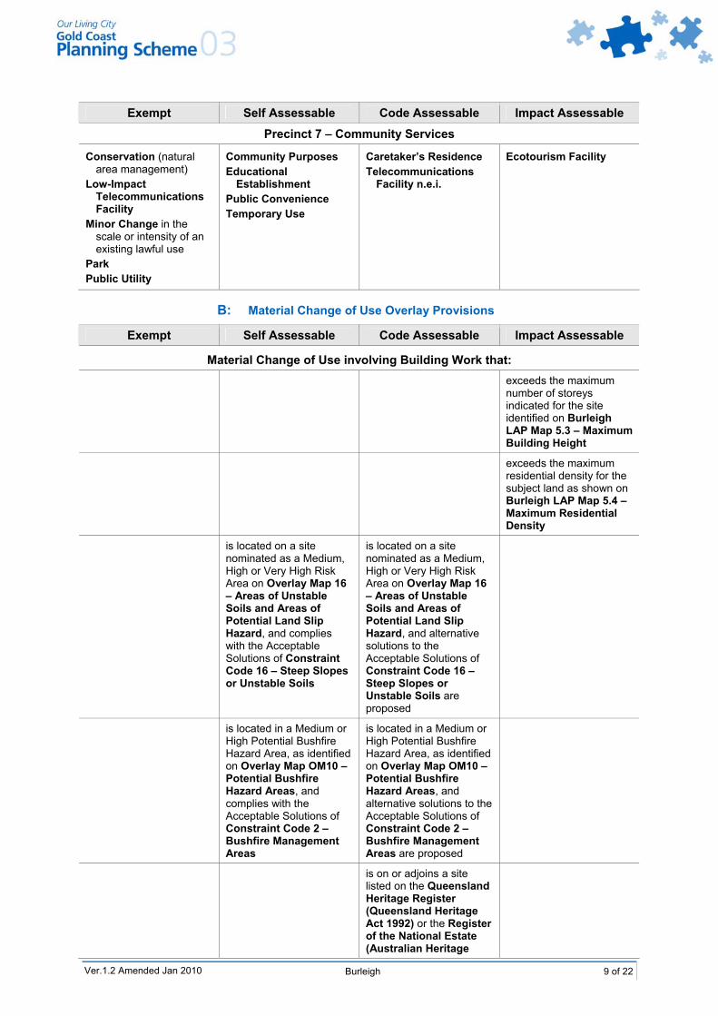
Precinct 7 Community Facilities
5.1 Precinct 1 Intent for Burleigh Heads Commercial Core
This precinct incorporates the traditional Burleigh Heads shopping and commercial precinct, bounded by the Gold Coast City Highway to the north, Connor Street to the east, Park Avenue to the south and West Street to the west. James Street which acts as the focus of most commercial activity, is in the middle of this precinct.
This LAP promotes and encourages the development of this precinct into a lively, mixed use commercial and residential area. Encouragement will be given to night time activities which do not compromise the ability to cater for permanent residential development in the precinct. This LAP envisages intensive retail, dining and service activities at street level, with office based commercial activities and residential apartments above street level. The preferred urban form is intended to ensure high levels of residential amenity, without compromising the function of business activity.
Intensive redevelopment of this precinct is expected to occur in keeping with the village atmosphere of this node. All development will be required to address the street, with a minimal setback area which continues the existing pattern of development in this precinct. Above ground storey residential and commercial uses will be required to minimise shadow impact onto public streets, particularly James Street and Park Avenue, and will be required to be set back from the street above two storeys. High site coverage and zero side setbacks will be permitted, provided new development is sympathetic to existing development and adverse impacts are minimised.
This precinct is seen as a compact mixed-use area which has good access to recreational facilities (including the beach), public transport facilities and a wide range of employment opportunities. Emphasis will be placed on the creation of high quality pedestrian corridors and linkages. Improvements to pedestrian facilities, particularly street crossings and the provision of inter block pedestrian arcades, will help to reduce vehicle use and promote pedestrian activity. Vehicular access for parking and servicing is to be obtained through the utilisation of rear lanes, wherever possible.
Preservation of a village atmosphere is of paramount importance in this precinct. Accordingly, building heights will be restricted to two storeys for commercial development, with a further two storeys allowed, where these are used for residential purposes. A residential dwelling density of RD6 is applicable in this precinct. The maximum height allowed will provide economic incentives to facilitate mixed-use redevelopment, while also preserving views to and from the Burleigh Ridge and the surrounding residential areas. A variety of building facade treatments, colours and materials will be promoted to create a diverse and visually interesting streetscape.

4 of 22 Burleigh Ver.1.2
5.2 Precinct 2 Intent for Burleigh Town Marketplace
This precinct incorporates the Burleigh Town Marketplace freestanding shopping centre complex, located on Reedy Creek/West Burleigh Roads.
The Burleigh Town Marketplace complex currently contains supermarkets, a discount department store, a large hardware store and a number of specialty stores, fast food restaurants and other services. Large areas of ground level asphalt car parking surround the centre.
This LAP aims to facilitate retail consolidation to a level, which is consistent with Burleigh's Sub Regional designation, while also encouraging the diversification of uses in this precinct. There are opportunities for consolidation and infill within the precinct, through the redevelopment of land which is currently occupied by ground level car parking. Proposals for the development of uses which significantly diversify the range of activities and functions within this precinct will be encouraged. Desirable uses will include residential, entertainment and small scale office and restaurant facilities. Provision of car parking in a decked or underground format may be necessary to allow such redevelopment to occur.
Any development in this precinct will be required to minimise adverse impacts on neighbouring residential areas to the north and east. Fortunately, the precinct is well-buffered by established buffer strips and road corridors. Improvements to pedestrian and cycle facilities are encouraged in and around this precinct to ensure that good connectivity is provided. Improved linkages between this centre and the surrounding residential and industrial areas are desired, as well as connections through to Burleigh Heads and the foreshore.
5.3 Precinct 3 Intent for Tourist and Residential
This precinct comprises a number of individual areas surrounding the Burleigh Heads commercial core. These are: the Gold Coast Hotel site, located between Ocean and Tweed Streets (Gold Coast City
Highway); land bounded by Tweed Street, Ocean Street, Goodwin Terrace and the Burleigh Heads
Caravan Park; land bounded by the Gold Coast Highway, the Esplanade and First Avenue; land bounded by West Burleigh Road and West Street; and land bounded by West Street, Park Avenue and Connor Street, excluding those parcels with a
frontage to Ewart Street.
The land located within this precinct is intended to be developed for a mix of tourist and residential uses and a range of compatible and complementary non-residential functions that provide a service to residents and tourists. Such non-residential uses will be required to demonstrate that amenity conflicts with residential development are minimised.
This precinct is considered to be a highly desirable location for high density residential and tourist accommodation, due to its convenient position relative to high quality tourist facilities, urban services and good transport opportunities.
The land within this precinct is to be developed with commercial activities that promote street activity at ground level, with upper levels being utilised for residential development. Land within this precinct is not intended to be developed for intensive commercial functions that would otherwise be developed in Precincts 1 and 2.
A high standard of urban design and built form is desirable in this precinct, reflecting its proximity to the Burleigh Heads village centre and the precinct's visual prominence when viewed from the Gold Coast Highway corridor and the Burleigh Ridge area.
All new development should address all street frontages (particularly the Gold Coast Highway) with minimal frontage setbacks to major roads. Street activity, such as outdoor dining, will be encouraged on these street frontages.
Residential or tourist accommodation above the second floor should be set back from frontages with a narrow tower format preferred, to preserve views to and from the Coast and the Burleigh Ridge.
Ver.1.2 Burleigh 5 of 22
Pedestrian activity will be encouraged within this precinct, with the provision of linkages to and from the beach and the Burleigh Heads commercial core. New development will be required to contribute to the improvement of pedestrian facilities within the public realm, and to provide connectivity between sites and along major pedestrian desire lines in the form of arcades. Council will endeavour, in partnership with the Department of Main Roads, to improve the convenience and safety of pedestrian crossing points across the Gold Coast Highway. The possibility of grade separated pedestrian crossings between future developments may be investigated. Facilities to promote public transport patronage, particularly bus shelter facilities, will be encouraged for incorporation into development plans wherever possible.
The Burleigh Arcade development on Goodwin Terrace is considered to be an important character element of Burleigh Heads which must be retained. The community facilities located in Park Avenue, including the churches and their associated services, are considered to be contributory to the established character of Burleigh Heads and are to be retained, wherever possible.
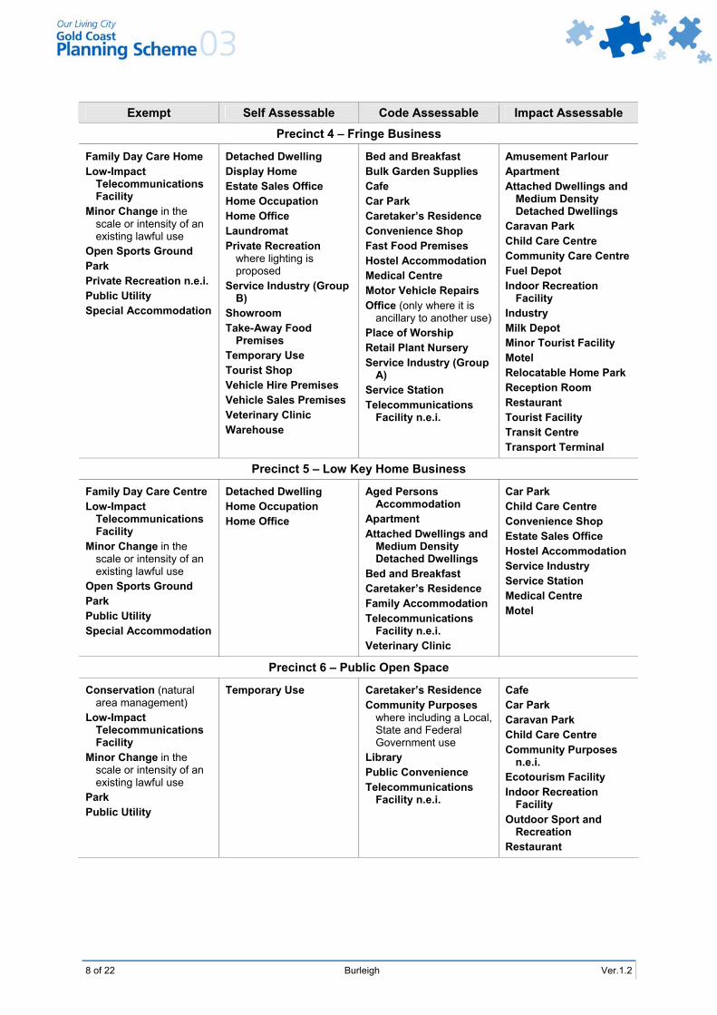
5.4 Precinct 4 Intent for Fringe Business
This precinct comprises three separate Fringe Business areas located along the West Burleigh Road/Reedy Creek Road corridor, surrounding and linking the major commercial core areas of the LAP. This precinct is shown on Burleigh LAP Map 5.2 – Precincts.
This precinct currently accommodates a range of light industrial and bulk retailing activities. The intent of this LAP is to allow this precinct to continue to be used for such purposes. It is also envisaged that this precinct will provide a location for support services for the activities located in Precincts 1 and 2. It is not intended to accommodate high intensity commercial activities in Precinct 4.
This precinct is to be further developed for high quality showroom, bulk retailing and light industrial developments which are visually attractive, utilise a distinctive urban design and clearly address streets and public areas. New developments will not be dominated by ground level parking areas or unsympathetic advertising devices. Vehicle parking areas will be placed either behind or beside building structures, with buildings placed close to street frontages. High quality landscaping, including regularly spaced shade trees, will be required within car park areas so as to present an attractive street aspect and to ensure that car parking areas remain attractive and functional.
Provision for advertising devices will be incorporated into building designs so as to minimise the need for unsympathetic signage. Freestanding signs will be required to be of a size, scale and design which is sympathetic to the building to which it relates. Multi-tenant signs will be required for developments consisting of more than one business premises to avoid a proliferation of freestanding signs.
Connectivity between individual sites will be encouraged through the use of attractive pedestrian and cycle paths.
Residential development in a mixed use format is acceptable within this precinct, where it can be clearly demonstrated that reasonable levels of residential amenity can be achieved and such development will not jeopardise the ability to conduct legitimate light industrial activities on adjacent sites.
5.5 Precinct 5 Intent for Home Business
This precinct comprises all properties with a frontage to the southern side of West Burleigh Road, between Matilda and Tabilban Streets.
This precinct comprises mainly residential activities, with some home office and home occupation uses. The areas immediately behind are used for residential purposes. The intent for this precinct is to retain the existing residential scale and built form, with very limited extension of commercial activity into the area. It is desirable that the precinct be utilised to its advantage, due to its high exposure to West Burleigh Road and its location in the corridor between Burleigh Heads and Burleigh Town Marketplace. For this purpose, home office and home occupation activities are welcomed. Large scale commercial activity is discouraged, as this is better located in one of the other precincts and would impact adversely on the residential amenity of nearby properties. Amalgamation of properties will be encouraged where this can achieve a rationalisation of access points while maintaining a residential scale built form. Continuing residential activity in this precinct is considered essential.
All buildings are to retain a residential appearance and are to utilise design features that are typical of residential development in this area. These features include use of a pitched roof with eaves, brick, tile or fibro sheeting for walls, and the use of awnings and verandas, where possible. Colour schemes should utilise materials and paints that blend in with the backdrop of Burleigh Ridge.
6 of 22 Burleigh Ver.1.2
Signage and vehicle parking areas will not be permitted to dominate the frontage of any development, with signs to remain low key and complementary to the dwelling to which they relate, and vehicle parking areas to be placed behind the building frontage. Significant trees are to be retained within this precinct, and Council will consider the relaxation of car parking requirements in order to ensure that vegetation is preserved, where design flexibility is limited. New building work should avoid disturbing established vegetation, where possible.
5.6 Precinct 6 Intent for Public Open Space
This precinct comprises all public land in the LAP which is used for recreational purposes, including the foreshore reserve, the Burleigh Heads' Caravan Park and the Burleigh Heads' Bowls Club. The general aim of this LAP is to integrate these portions of land to serve as a vibrant and unique open space frame for the Burleigh area, and also to serve as a high quality regional park area for tourists and residents of the City. At present, the land within this precinct is used for a variety of purposes, some of which are not typically associated with public open space activities. Such uses include a camping ground, car parking areas serving the Commercial Precinct, a bowling club, a child care centre, a surf club, restaurants, an indoor swimming pool and a local government sub office. The remainder of the precinct is utilised for a combination of passive and active recreational purposes, incorporating a war memorial, walking and cycling paths, a bandstand, groves of significant trees (including a beachfront grove of Norfolk Island Pines), children's play areas and car parking associated with the above mentioned land uses. This LAP aims to ensure that land within this precinct continues to be used for public recreation and community purposes, and that any built elements within the precinct complement the character of the area in terms of scale, style and height. Over time, it is expected that some of the non-recreational uses located within this precinct, will be ultimately relocated, and replaced by suitable passive recreation uses. Redevelopment of buildings within the precinct will also offer an opportunity to improve building aesthetics and ensure compatibility with the character of the area. A strong emphasis will be placed on landscaping within this precinct, in order to consolidate the existing landscape theme that is dominated by Norfolk Island Pines and native coastal species. Council will not favourably consider the removal of any significant vegetation within this precinct. Additional cafe/kiosk facilities will be considered for approval by Council where such facilities can demonstrate compatibility with the open space theme of the area, will be of a minor scale and will be complementary to the public's utilisation of the recreational facilities. Additional car parking facilities are not considered to be warranted within any part of this precinct, and Council will encourage the aesthetic improvement of existing car parking areas, through the provision of landscaped bays and shade trees. The intent for these areas in public ownership is to maintain and enhance the existing recreational, environmental and community service uses accommodated in these reserves. It is intended to better integrate the public reserves with surrounding areas in terms of landscaping and built form. However, no further intrusion of commercial uses into this precinct will be supported. Existing community services and recreational uses may be redeveloped, within strict limits. Any new buildings must replace existing buildings so that there is no net increase in site coverage on any land within this precinct. Building heights are not to exceed two storeys so as not to dominate the open space nature of the precinct. Preferred enhancements include the upgrading of pedestrian and cycle facilities, with improved connections through the precinct and to adjoining precincts and to the Burleigh Ridge area.
5.7 Precinct 7 Intent for Community Services
This precinct incorporates several parcels of land located between Matilda Street and Fleay Court, and used primarily for community services. The precinct currently contains a number of Queensland government facilities including a police station, ambulance station and fire station. This LAP aims to recognise and cater for the future expansion of the land uses that are concentrated in this node. While this precinct is fully developed, there may be opportunities for future expansion of existing facilities or the addition of other emergency services functions. Council will favourably consider the introduction of caretaker’s residences and other residential dwellings this precinct, as ancillary land uses.

Ver.1.2 Burleigh 7 of 22
6.0 Burleigh Local Area Plan Table of Development Note: This table must be read in conjunction with the explanation provided in Part 6,
Division 1, Chapter 2 – Using Local Area Plans. A: Material Change of Use
Exempt Self Assessable Code Assessable Impact Assessable
Precinct 1 – Burleigh Heads Commercial Core and Precinct 2 – Burleigh Market Town Family Day Care Home Home Office Low-Impact
Telecommunications Facility
Minor Change in the scale or intensity of an existing lawful use
Park Public Utility
Cafe Commercial Services Convenience Shop Home Occupation Laundromat Office with a floor area up
to 500m2 GFA Restaurant Shop Take-Away Food
Premises Temporary Use Tourist Shop
Apartment when located above ground storey level
Bed and Breakfast Car Park Caretaker’s Residence Child Care Centre Community Purposes
excluding Corrective Institution
Fast Food Premises Medical Centre Office with a floor area
greater than 500m2 GFA
Place of Worship Retail Nursery Service Industry (Group
B) Service Station Showroom Telecommunications
Facility n.e.i. Veterinary Clinic
Amusement Parlour Apartment n.e.i. Cinema Community Care Centre Educational
Establishment Hostel Accommodation Indoor Recreation
Facility Market Minor Tourist Facility Motel Nightclub Reception Room Shopping Centre
Development Tavern Theatre
Precinct 3 – Tourist/Residential Family Day Care Home Low-Impact
Telecommunications Facility
Minor Change in the scale or intensity of an existing lawful use
Open Sports Ground Park Public Utility Special Accommodation
Display Home Estate Sales Office Home Office Detached Dwelling Tourist Shop
Apartment Attached Dwellings and
Medium Density Detached Dwellings
Bed and Breakfast Caretaker’s Residence Home Occupation Hostel Accommodation Medical Centre Motel Place of Worship Telecommunications
Facility n.e.i. Veterinary Clinic The following
commercial uses only when located at ground floor level: Cafe Commercial Services
Convenience Shop Fast Food Premises Laundromat Office with a floor
area up to 200m2 GFA Restaurant Service Industry Shop Showroom Take-Away Food Premises
Amusement Parlour Car Park Child Care Centre Community Care Centre Educational
Establishment Indoor Recreation
Facility Minor Tourist Facility Resort Hotel Service Station Tavern
Ver.1.2 Amended Jan 2010
8 of 22 Burleigh Ver.1.2
Exempt Self Assessable Code Assessable Impact Assessable
Precinct 4 – Fringe Business
Family Day Care Home Low-Impact
Telecommunications Facility
Minor Change in the scale or intensity of an existing lawful use
Open Sports Ground Park Private Recreation n.e.i. Public Utility Special Accommodation
Detached Dwelling Display Home Estate Sales Office Home Occupation Home Office Laundromat Private Recreation
where lighting is proposed
Service Industry (Group B)
Showroom Take-Away Food
Premises Temporary Use Tourist Shop Vehicle Hire Premises Vehicle Sales Premises Veterinary Clinic Warehouse
Bed and Breakfast Bulk Garden Supplies Cafe Car Park Caretaker’s Residence Convenience Shop Fast Food Premises Hostel Accommodation Medical Centre Motor Vehicle Repairs Office (only where it is
ancillary to another use) Place of Worship Retail Plant Nursery Service Industry (Group
A) Service Station Telecommunications
Facility n.e.i.
Amusement Parlour Apartment Attached Dwellings and
Medium Density Detached Dwellings
Caravan Park Child Care Centre Community Care Centre Fuel Depot Indoor Recreation
Facility Industry Milk Depot Minor Tourist Facility Motel Relocatable Home Park Reception Room Restaurant Tourist Facility Transit Centre Transport Terminal
Precinct 5 – Low Key Home Business
Family Day Care Centre Low-Impact
Telecommunications Facility
Minor Change in the scale or intensity of an existing lawful use
Open Sports Ground Park Public Utility Special Accommodation
Detached Dwelling Home Occupation Home Office
Aged Persons Accommodation
Apartment Attached Dwellings and
Medium Density Detached Dwellings
Bed and Breakfast Caretaker’s Residence Family Accommodation Telecommunications
Facility n.e.i. Veterinary Clinic
Car Park Child Care Centre Convenience Shop Estate Sales Office Hostel Accommodation Service Industry Service Station Medical Centre Motel
Precinct 6 – Public Open Space
Conservation (natural area management)
Low-Impact Telecommunications Facility
Minor Change in the scale or intensity of an existing lawful use
Park Public Utility
Temporary Use Caretaker’s Residence Community Purposes
where including a Local, State and Federal Government use
Library Public Convenience Telecommunications
Facility n.e.i.
Cafe Car Park Caravan Park Child Care Centre Community Purposes
n.e.i. Ecotourism Facility Indoor Recreation
Facility Outdoor Sport and
Recreation Restaurant
Ver.1.2 Burleigh 9 of 22
Exempt Self Assessable Code Assessable Impact Assessable
Precinct 7 – Community Services
Conservation (natural area management)
Low-Impact Telecommunications Facility
Minor Change in the scale or intensity of an existing lawful use
Park Public Utility
Community Purposes Educational
Establishment Public Convenience Temporary Use
Caretaker’s Residence Telecommunications
Facility n.e.i.
Ecotourism Facility
B: Material Change of Use Overlay Provisions
Exempt Self Assessable Code Assessable Impact Assessable
Material Change of Use involving Building Work that: exceeds the maximum
number of storeys indicated for the site identified on Burleigh LAP Map 5.3 – Maximum Building Height
exceeds the maximum residential density for the subject land as shown on Burleigh LAP Map 5.4 – Maximum Residential Density
is located on a site nominated as a Medium, High or Very High Risk Area on Overlay Map 16 – Areas of Unstable Soils and Areas of Potential Land Slip Hazard, and complies with the Acceptable Solutions of Constraint Code 16 – Steep Slopes or Unstable Soils
is located on a site nominated as a Medium, High or Very High Risk Area on Overlay Map 16 – Areas of Unstable Soils and Areas of Potential Land Slip Hazard, and alternative solutions to the Acceptable Solutions of Constraint Code 16 – Steep Slopes or Unstable Soils are proposed
is located in a Medium or High Potential Bushfire Hazard Area, as identified on Overlay Map OM10 – Potential Bushfire Hazard Areas, and complies with the Acceptable Solutions of Constraint Code 2 – Bushfire Management Areas
is located in a Medium or High Potential Bushfire Hazard Area, as identified on Overlay Map OM10 – Potential Bushfire Hazard Areas, and alternative solutions to the Acceptable Solutions of Constraint Code 2 – Bushfire Management Areas are proposed
is on or adjoins a site listed on the Queensland Heritage Register (Queensland Heritage Act 1992) or the Register of the National Estate (Australian Heritage
Ver.1.2 Amended Jan 2010

10 of 22 Burleigh Ver.1.2
Exempt Self Assessable Code Assessable Impact Assessable Commission Act 1975) or the National Trust of Queensland list
is within or adjoins an allotment containing places, sites, or landscapes of indigenous cultural heritage significance listed on the Queensland Heritage Register – Cultural Records (Landscapes Queensland and Queensland Estate) Act 1987; OR is located on land which is the subject of a native title claim; OR is located on land that is known to the owner and/or the developer to be of indigenous cultural heritage value
would result in a residential dwelling being located within 500 metres of a lot containing an extractive industry operation or resource (hard rock quarrying) or within 200 metres of a lot containing an extractive industry operation or resource (sand and gravel operations), as defined on Overlay Map OM23 – Extractive Resources
is on a site identified on the Domain Maps as being affected by Future Road Requirement and complies with the Acceptable Solutions of Constraint Code 4 – Car Parking, Access and Transport Integration
is on a site identified on the Domain Maps as being affected by Future Road Requirement and alternative solutions to the Acceptable Solutions of Constraint Code 4 – Car Parking, Access and Transport Integration are proposed
exceeds one dwelling per lot
C: Operational Work – Changes to Ground Level
Exempt Self Assessable Code Assessable Impact Assessable
Operational Work that involves extraction, excavation or fill that: Precincts 1, 2, 3 and 4
exceeds a volume of 20 cubic metres of fill or excavation or is closer than two metres from the allotment boundary
Ver.1.2 Amended Jan 2010
Ver.1.2 Burleigh 11 of 22
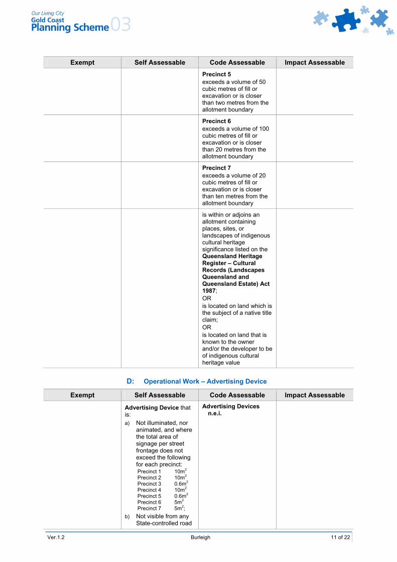
Exempt Self Assessable Code Assessable Impact Assessable
Precinct 5 exceeds a volume of 50 cubic metres of fill or excavation or is closer than two metres from the allotment boundary
Precinct 6 exceeds a volume of 100 cubic metres of fill or excavation or is closer than 20 metres from the allotment boundary
Precinct 7 exceeds a volume of 20 cubic metres of fill or excavation or is closer than ten metres from the allotment boundary
is within or adjoins an allotment containing places, sites, or landscapes of indigenous cultural heritage significance listed on the Queensland Heritage Register – Cultural Records (Landscapes Queensland and Queensland Estate) Act 1987; OR is located on land which is the subject of a native title claim; OR is located on land that is known to the owner and/or the developer to be of indigenous cultural heritage value
D: Operational Work – Advertising Device
Exempt Self Assessable Code Assessable Impact Assessable
Advertising Device that is: a) Not illuminated, nor
animated, and where the total area of signage per street frontage does not exceed the following for each precinct: Precinct 1 10m2 Precinct 2 10m2 Precinct 3 0.6m2 Precinct 4 10m2 Precinct 5 0.6m2 Precinct 6 5m2 Precinct 7 5m2;
b) Not visible from any State-controlled road
Advertising Devices n.e.i.
12 of 22 Burleigh Ver.1.2
E: Operational Work – Infrastructure and Landscape Work
Exempt Self Assessable Code Assessable Impact Assessable
Minor Landscape Work Landscape Work n.e.i.
Landscape Work associated with a Detached Dwelling or a Caretaker’s Residence
Works for Infrastructure
F: Operational Work – Vegetation Clearing
Exempt Self Assessable Code Assessable Impact Assessable
Vegetation Clearing that:
results in the removal of, or damage to, vegetation that is equal to, or in excess of, 40 centimetres in girth (circumference) measured at 1.3 metres above average ground level, and complies with the Acceptable Solutions of Specific Development Code 36 – Vegetation Management
results in the removal of, or damage to, vegetation that is equal to, or in excess of, 40 centimetres in girth (circumference) measured at 1.3 metres above average ground level, and alternate solutions to the Acceptable Solutions of Specific Development Code 36 – Vegetation Management are proposed
results in the removal of, or damage to, vegetation over which a Vegetation Protection Order has been made by Council
G: Reconfiguring a Lot
Exempt Self Assessable Code Assessable Impact Assessable
Reconfiguring a Lot that:
results in no lots with an area less than 1,000m2; OR entails only a Community Title Subdivision (including Standard Format Plans and/or Volumetric Lots), or a Volumetric Lot within a building, or a leasehold subdivision of an existing or approved development
results in one or more lots with an area less than 1,000m2
would create the potential for a residential dwelling to be located within 500 metres of a lot containing an extractive industry operation (hard rock quarrying) or within 200 metres of a lot containing an extractive industry operation (sand and gravel operations), as defined on Overlay Map OM23 – Extractive Resources
Ver.1.2 Amended Jan 2010

Ver.1.2 Burleigh 13 of 22
7.0 Relevant Codes Codes relevant for development assessment in the Burleigh LAP are listed below. The Place Code applies in all cases. A Specific Development Code will only apply if that specific development is proposed. A Constraint Code will only apply where the proposed development is directly impacted by the constraint that is the subject of that code.
7.1 Self Assessable Development
The following codes apply to development that is self assessable in the Burleigh LAP area.
Place Code Specific Development Codes Constraint Codes
Burleigh LAP Place Code 2 Advertising Devices 10 Caretaker’s Residence 13 Detached Dwellings 14 Display Homes and Estate
Sales Office 25 Private Recreation 24 Office 27 Retail and Related
Establishments 34 Temporary Use 36 Vegetation Management 38 Working From Home
2 Bushfire Management Areas 4 Car Parking, Access and
Transport Integration 8 Flood Affected Areas 10 Nature Conservation 16 Steep Slopes or Unstable Soils
7.2 Material Change of Use
The following codes apply to development that is code or impact assessable Material Change of Use in the Burleigh LAP area.
Place Code Specific Development Codes Constraint Codes
Burleigh LAP Place Code 3 Aged Persons Accommodation 6 Attached Dwellings and
Medium Density Detached Dwellings
7 Bed and Breakfast Tourist Accommodation
9 Caravan Parks 10 Caretaker’s Residence 12 Child Care Centres 13 Detached Dwellings 14 Display Homes and Estate
Sales Offices 15 Ecotourism Facility 16 Family Accommodation 19 High Rise Residential and
Tourist Accommodation 21 Landscape Work 22 Low Rise Apartment Building 23 Low Rise Commercial Tourist
Accommodation 24 Office 25 Private Recreation 26 Relocatable Home Parks 27 Retail and Related
Establishments 30 Salvage Yards 31 Service Stations 33 Telecommunications Facilities 37 Vehicle Sales 38 Working From Home 39 Works for Infrastructure
1 Gold Coast Airport and Aviation Facilities
2 Bushfire Management Areas 4 Car Parking, Access and
Transport Integration 5 Cultural Heritage (Historic) 6 Cultural Heritage (Indigenous) 8 Flood Affected Areas 10 Nature Conservation 13 Road Traffic Noise
Management 14 Sediment and Erosion Control 16 Steep Slopes or Unstable Soils

14 of 22 Burleigh Ver.1.2
7.3 Operational Work – Changes to Ground Level
The following codes apply to development that is code or impact assessable Operational Work – Changes to Ground Level (extracting gravel, rock, sand or soil from the place where it occurs naturally, or excavating or filling that materially affects premises or their use) in the Burleigh LAP area.
Place Code Specific Development Codes Constraint Codes
Burleigh LAP Place Code 11 Changes to Ground Level and Creation of New Waterbodies
2 Bushfire Management Areas 4 Car Parking, Access and
Transport Integration 6 Cultural Heritage (Indigenous) 8 Flood Affected Areas 10 Nature Conservation 14 Sediment and Erosion Control 16 Steep Slopes or Unstable Soils
7.4 Operational Work – Advertising Devices, Landscape Work and Infrastructure
The following codes apply to development that is code or impact assessable Operational Work – Advertising Devices (placing an Advertising Device on premises), Landscape Work (undertaking Landscape Work in, on, over or under premises that materially affects premises or their use) or Infrastructure (undertaking Works for Infrastructure) in the Burleigh LAP area.
Place Code Specific Development Codes Constraint Codes
Burleigh LAP Place Code 2 Advertising Devices 21 Landscape Work 39 Works for Infrastructure
2 Bushfire Management Areas 5 Cultural Heritage (Historic) 6 Cultural Heritage (Indigenous) 8 Flood Affected Areas 10 Nature Conservation 14 Sediment and Erosion Control 16 Steep Slopes or Unstable Soils
7.5 Operational Work – Vegetation Clearing
The following codes apply to development that is code or impact assessable Operational Work – Vegetation Clearing in the Burleigh LAP area.
Place Code Specific Development Codes Constraint Codes
Burleigh LAP Place Code 36 Vegetation Management 2 Bushfire Management Areas 5 Cultural Heritage (Historic) 6 Cultural Heritage (Indigenous) 10 Nature Conservation 14 Sediment and Erosion Control 16 Steep Slopes or Unstable Soils
7.6 Reconfiguring a Lot
The following codes apply to development that is code or impact assessable Reconfiguring a Lot in the Burleigh LAP area.
Place Code Specific Development Codes Constraint Codes
Burleigh LAP Place Code 11 Changes to Ground Level and Creation of New Waterbodies
21 Landscape Work 28 Reconfiguring a Lot 36 Vegetation Management 39 Works for Infrastructure
2 Bushfire Management Areas 4 Car Parking, Access and
Transport Integration 5 Cultural Heritage (Historic) 6 Cultural Heritage (Indigenous) 8 Flood Affected Areas 10 Nature Conservation 13 Road Traffic Noise
Management 14 Sediment and Erosion Control 16 Steep Slopes or Unstable Soils

Ver.1.2 Burleigh 15 of 22
8.0 Burleigh LAP Place Code 8.1 Purpose
This Place Code seeks to ensure that the scale, density, building height, layout and aesthetic appearance and function of all development is consistent with the seaside village theme of Burleigh Heads and the role of Burleigh as a Sub Regional Activity Centre. These provisions also aim to ensure that Burleigh Heads remains a distinctive and recognisable location within the City, where high standards of urban design, architecture and landscaping are promoted and achieved.
This code sets out design criteria that must be addressed as part of any development proposal within the Burleigh LAP area. The acceptable solutions set out the preferred method of satisfying the listed performance criteria.
8.2 Application
8.2.1 The Burleigh LAP Place Code applies to development indicated as self, code or impact assessable in the Burleigh LAP Table of Development at Clause 6.0 of this LAP.
8.2.2 Performance Criteria PC1-PC30 apply to all code or impact assessable development in this LAP. For development identified as self assessable in Clause 6.0, only the Acceptable Solutions to Performance Criteria PC1-PC9 apply.
8.3 Development Requirements
Performance Criteria Acceptable Solutions
Development that is Self Assessable, Code Assessable or Impact Assessable
Building Height
PC1 The height of buildings must be consistent with the scale of existing buildings and the role of Burleigh as a Sub Regional Activity Centre. Building heights must respect the principle of preserving views to and from the Burleigh Ridge and the Pacific Ocean.
AS1.1 The building is not more than 8.5 metres in height and has a maximum of two storeys. OR AS1.2 The height of buildings in each precinct does not exceed the maximums shown on Burleigh LAP Map 5.3 – Maximum Building Height.
PC2 The height of the buildings must not cause adverse impact on neighbouring sites. The development opportunities of the neighbouring sites are considered when assessing impacts of development.
AS2 All buildings exceeding two storeys in height have their upper storeys set back from the lot boundaries, consistent with the following distances: a) a minimum of six metres from the frontage in
respect of that part of the building which exceeds two storeys in height;
b) for side and rear boundary setbacks, two metres for that part of the building which is above the second storey, but which does not exceed 7.5 metres above that storey; and
c) for side and rear boundary setbacks, two metres plus 0.5 metres for every three metres (or part thereof) of that part of the building which is greater than 7.5 metres above the second storey.
Accommodation Density
PC3 Accommodation density must be consistent with the Sub Regional Activity Centre character of Burleigh. Accordingly, medium to high density development that can be comfortably accommodated on the development site and supports mixed uses in the town centre is appropriate.
AS3.1.1 The dwelling density is one dwelling per lot. OR AS3.1.2 The maximum dwelling density in any precinct does not exceed the relevant accommodation density (RD number) shown for that precinct on Burleigh LAP Map 5.4 – Maximum Residential Density.

16 of 22 Burleigh Ver.1.2
Performance Criteria Acceptable Solutions Site Coverage
All Precincts PC4 The site coverage of development must be in accordance with the function of the precinct and its relationship with surrounding precincts. The building bulk of individual developments must be consistent with the desired built form theme for each precinct. Building bulk will generally be greater within core commercial precincts, with a lesser building bulk being permitted in peripheral commercial and tourist accommodation precincts where development is intended to be less intensive.
AS4 The maximum site coverage for development sites within each precinct is as follows: Precinct 1 90% Precincts 2 and 3 60% Precincts 4 and 7 50% Precinct 5 40% Precinct 6 no more than existing
Building Setback
Mixed Use or Commercial Buildings, all Precincts PC5 Building setbacks must contribute to an interesting street perspective and to the visual amenity of Burleigh.
All Precincts AS5.1.1 The building setback is equal to that used by more than 50% of the other buildings in the street. OR Precinct 1 AS5.1.2 The building has: a) 3 storeys, with a three metre frontage setback for
any storey above the third storey; b) zero side or rear setbacks to a height of three
storeys. A side or rear setback of 2 metres, plus 0.5 metres for every 3 metres in height, applies to the portion of any building above the top of the third storey.
OR Precincts 2 and 3 AS5.1.3 The building has: a) a 3 metre setback for the first 2 storeys, with a six
metre setback for any storey above the second storey;
b) from the side and rear boundaries, a setback of 1.5 metres to that part of a building which is less than 2 storeys in height, 2 metres for the third storey of any building and an additional 0.5 metres for every storey above the third storey.
OR Precincts 4, 5, 6 and 7 AS5.1.4 The building has: a) a six metre setback from the frontage; b) from the side and rear boundaries, a setback of 1.5
metres to that part of a building which is less than two storeys in height, two metres for the third storey of any building, and an additional 0.5 metres for every storey above the third storey.
Ver.1.2 Burleigh 17 of 22
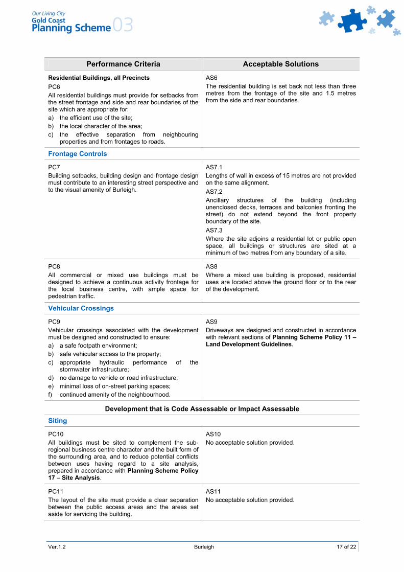
Performance Criteria Acceptable Solutions
Residential Buildings, all Precincts PC6 All residential buildings must provide for setbacks from the street frontage and side and rear boundaries of the site which are appropriate for: a) the efficient use of the site; b) the local character of the area; c) the effective separation from neighbouring
properties and from frontages to roads.
AS6 The residential building is set back not less than three metres from the frontage of the site and 1.5 metres from the side and rear boundaries.
Frontage Controls
PC7 Building setbacks, building design and frontage design must contribute to an interesting street perspective and to the visual amenity of Burleigh.
AS7.1 Lengths of wall in excess of 15 metres are not provided on the same alignment. AS7.2 Ancillary structures of the building (including unenclosed decks, terraces and balconies fronting the street) do not extend beyond the front property boundary of the site. AS7.3 Where the site adjoins a residential lot or public open space, all buildings or structures are sited at a minimum of two metres from any boundary of a site.
PC8 All commercial or mixed use buildings must be designed to achieve a continuous activity frontage for the local business centre, with ample space for pedestrian traffic.
AS8 Where a mixed use building is proposed, residential uses are located above the ground floor or to the rear of the development.
Vehicular Crossings
PC9 Vehicular crossings associated with the development must be designed and constructed to ensure: a) a safe footpath environment; b) safe vehicular access to the property; c) appropriate hydraulic performance of the
stormwater infrastructure; d) no damage to vehicle or road infrastructure; e) minimal loss of on-street parking spaces; f) continued amenity of the neighbourhood.
AS9 Driveways are designed and constructed in accordance with relevant sections of Planning Scheme Policy 11 – Land Development Guidelines.
Development that is Code Assessable or Impact Assessable
Siting
PC10 All buildings must be sited to complement the sub-regional business centre character and the built form of the surrounding area, and to reduce potential conflicts between uses having regard to a site analysis, prepared in accordance with Planning Scheme Policy 17 – Site Analysis.
AS10 No acceptable solution provided.
PC11 The layout of the site must provide a clear separation between the public access areas and the areas set aside for servicing the building.
AS11 No acceptable solution provided.
18 of 22 Burleigh Ver.1.2
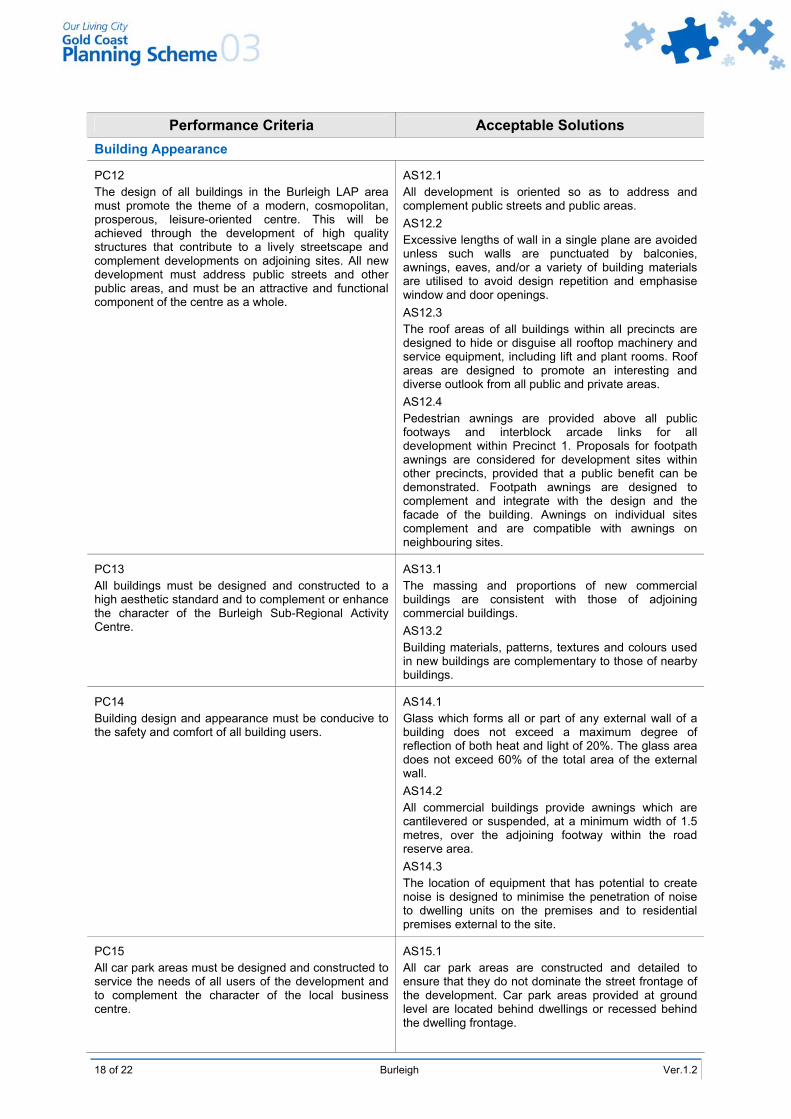
Performance Criteria Acceptable Solutions Building Appearance
PC12 The design of all buildings in the Burleigh LAP area must promote the theme of a modern, cosmopolitan, prosperous, leisure-oriented centre. This will be achieved through the development of high quality structures that contribute to a lively streetscape and complement developments on adjoining sites. All new development must address public streets and other public areas, and must be an attractive and functional component of the centre as a whole.
AS12.1 All development is oriented so as to address and complement public streets and public areas. AS12.2 Excessive lengths of wall in a single plane are avoided unless such walls are punctuated by balconies, awnings, eaves, and/or a variety of building materials are utilised to avoid design repetition and emphasise window and door openings. AS12.3 The roof areas of all buildings within all precincts are designed to hide or disguise all rooftop machinery and service equipment, including lift and plant rooms. Roof areas are designed to promote an interesting and diverse outlook from all public and private areas. AS12.4 Pedestrian awnings are provided above all public footways and interblock arcade links for all development within Precinct 1. Proposals for footpath awnings are considered for development sites within other precincts, provided that a public benefit can be demonstrated. Footpath awnings are designed to complement and integrate with the design and the facade of the building. Awnings on individual sites complement and are compatible with awnings on neighbouring sites.
PC13 All buildings must be designed and constructed to a high aesthetic standard and to complement or enhance the character of the Burleigh Sub-Regional Activity Centre.
AS13.1 The massing and proportions of new commercial buildings are consistent with those of adjoining commercial buildings. AS13.2 Building materials, patterns, textures and colours used in new buildings are complementary to those of nearby buildings.
PC14 Building design and appearance must be conducive to the safety and comfort of all building users.
AS14.1 Glass which forms all or part of any external wall of a building does not exceed a maximum degree of reflection of both heat and light of 20%. The glass area does not exceed 60% of the total area of the external wall. AS14.2 All commercial buildings provide awnings which are cantilevered or suspended, at a minimum width of 1.5 metres, over the adjoining footway within the road reserve area. AS14.3 The location of equipment that has potential to create noise is designed to minimise the penetration of noise to dwelling units on the premises and to residential premises external to the site.
PC15 All car park areas must be designed and constructed to service the needs of all users of the development and to complement the character of the local business centre.
AS15.1 All car park areas are constructed and detailed to ensure that they do not dominate the street frontage of the development. Car park areas provided at ground level are located behind dwellings or recessed behind the dwelling frontage.

Ver.1.2 Burleigh 19 of 22
Performance Criteria Acceptable Solutions AS15.2 Building materials, patterns, textures and colours, used in garage and carport structures, are complementary to those of the principal building on the site.
Precincts 1 and 3 PC16 The volume of ground level car parking must be minimised with underground car parking facilities to be used, where possible.
Precincts 1 and 3 AS16 The majority of car spaces (with the exception of visitor and service delivery parking) is provided underground in a basement podium.
Advertising Devices
PC17 All signage must be complementary to the design and style of the buildings on the site on which it is located, and to signs and development on adjoining sites. All buildings must be designed with the signage requirements of the end user in mind, to avoid the need for ad hoc additions to business signage. Signage must not dominate the frontages of major roads in the Burleigh LAP area, as the maintenance of an attractive and cohesive entrance to the City is of paramount importance. The development of innovative and distinctive signs, which clearly identify the service or business being promoted, is encouraged.
AS17.1 All buildings containing a commercial use contain signage envelopes on the exterior of the frontages of the building structure to enable the signage requirements of the end use business operation to be satisfied. Such signage envelopes allow for signage which does not dominate the facade and which complements the design of the building. AS17.2 Freestanding signs, within all precincts, complement the design of the buildings to which they relate, do not dominate the streetscape of a locality, are compatible with signage on adjoining sites, and clearly identify the product or business being promoted. AS17.3 Where a site contains more than one business premises, only one freestanding multi-tenant sign is utilised per street frontage. The placement of more than one freestanding sign on any frontage of a site is avoided. Precincts 1 and 2 AS17.4 All signs are consistent with the provisions for the Integrated Business Domain set out in Specific Development Code 2 – Advertising Devices. Precinct 3 AS17.5 All signs are consistent with the provisions for the Tourist and Residential Domain set out in Specific Development Code 2 – Advertising Devices. Precinct 4 AS17.6 All signs are consistent with the provisions for the Fringe Business Domain set out in Specific Development Code 2 – Advertising Devices. Precinct 6 AS17.7 All signs are consistent with the provisions for the Public Open Space Domain set out in Specific Development Code 2 – Advertising Devices. Precinct 7 AS17.8 All signs are consistent with the provisions for the Community Purposes Domain set out in Specific Development Code 2 – Advertising Devices.

20 of 22 Burleigh Ver.1.2
Performance Criteria Acceptable Solutions Landscape Work
PC18 Extensive areas of visible ground level landscaping must be provided to a standard that promotes a pleasant, attractive and functional pedestrian environment with a sub-tropical character.
AS18.1 Landscape work includes features where the vegetation component is located at street level, on top of the podium levels or on terraces, balconies and decks. Local native coastal species and/or vegetation with climbing/trailing characteristics are used. AS18.2 Footpath paving treatments and street furniture integrate with adjoining development, and setback areas are integrated with public footpaths.
PC19 All ground level parking must be suitably landscaped to provide an attractive and pleasant outlook, provide shade for parked vehicles, and contribute towards the quality presentation of new developments.
AS19.1 Significant trees are preserved and incorporated into car parking designs, where reasonably possible. AS19.2 Landscaped bays for the planting of shade trees are provided at regular intervals throughout car parking areas, at the rate of one landscaped bay per 40 vehicle parking bays. Landscape bays have the same dimensions as a vehicle parking space. Any portion of a car parking area that is not utilised for parking bays, access aisles or any other essential purpose is utilised for landscaping.
Lot Size (For Subdivision Only)
PC20 All allotments must be of sufficient area and dimensions to accommodate buildings designed to the criteria in this LAP.
AS20.1 The minimum allotment size is 1,000m2. AS20.2 The minimum frontage of land proposed to be used for non-residential or commercial purposes in this LAP is 15 metres.
Amenity Protection
PC21 The proposed use must not detract from the amenity of the local area, having regard, but not limited, to the impact of: a) noise; b) hours of operation; c) traffic; d) lighting; e) signage; f) visual amenity; g) privacy; h) odour and emissions.
AS21 No acceptable solution provided.
PC22 The proposed development must take into account and seek to ameliorate any negative aspects of the existing amenity of the local area, having regard, but not limited, to the existing impact of: a) noise; b) hours of operation; c) traffic; d) lighting; e) signage; f) visual amenity; g) privacy; h) odour and emissions.
AS22 No acceptable solution provided.
Ver.1.2 Burleigh 21 of 22
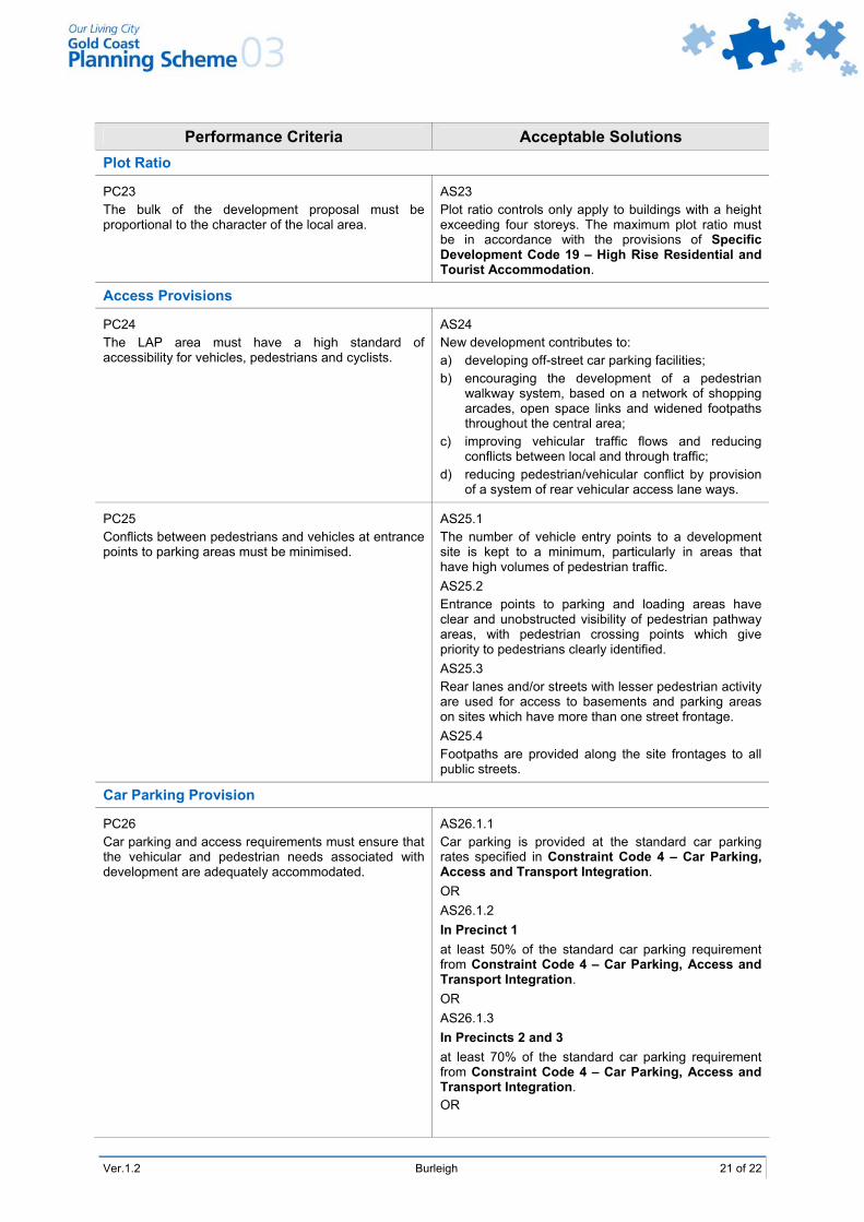
Performance Criteria Acceptable Solutions Plot Ratio
PC23 The bulk of the development proposal must be proportional to the character of the local area.
AS23 Plot ratio controls only apply to buildings with a height exceeding four storeys. The maximum plot ratio must be in accordance with the provisions of Specific Development Code 19 – High Rise Residential and Tourist Accommodation.
Access Provisions
PC24 The LAP area must have a high standard of accessibility for vehicles, pedestrians and cyclists.
AS24 New development contributes to: a) developing off-street car parking facilities; b) encouraging the development of a pedestrian
walkway system, based on a network of shopping arcades, open space links and widened footpaths throughout the central area;
c) improving vehicular traffic flows and reducing conflicts between local and through traffic;
d) reducing pedestrian/vehicular conflict by provision of a system of rear vehicular access lane ways.
PC25 Conflicts between pedestrians and vehicles at entrance points to parking areas must be minimised.
AS25.1 The number of vehicle entry points to a development site is kept to a minimum, particularly in areas that have high volumes of pedestrian traffic. AS25.2 Entrance points to parking and loading areas have clear and unobstructed visibility of pedestrian pathway areas, with pedestrian crossing points which give priority to pedestrians clearly identified. AS25.3 Rear lanes and/or streets with lesser pedestrian activity are used for access to basements and parking areas on sites which have more than one street frontage. AS25.4 Footpaths are provided along the site frontages to all public streets.
Car Parking Provision
PC26 Car parking and access requirements must ensure that the vehicular and pedestrian needs associated with development are adequately accommodated.
AS26.1.1 Car parking is provided at the standard car parking rates specified in Constraint Code 4 – Car Parking, Access and Transport Integration. OR AS26.1.2 In Precinct 1 at least 50% of the standard car parking requirement from Constraint Code 4 – Car Parking, Access and Transport Integration. OR AS26.1.3 In Precincts 2 and 3 at least 70% of the standard car parking requirement from Constraint Code 4 – Car Parking, Access and Transport Integration. OR

22 of 22 Burleigh Ver.1.2
Performance Criteria Acceptable Solutions AS26.1.4 In Precincts 4, 5, 6 and 7 at least 80% of the standard car parking requirement from Constraint Code 4 – Car Parking, Access and Transport Integration. AS26.2 For non-residential development, at least 80% of the required car parking is provided on site, and Council is given cash in lieu of the car parking not provided on site. Residential development will provide the required amount of car parking on the site of the development. AS26.3 Where this LAP does not permit vehicular access to a site, cash in lieu of car parking is an acceptable alternative.
Bicycle Parking
PC27 Bicycle parking and storage facilities must be provided within all developments which either accommodate large numbers of residents or tourists or provide a significant number of employment opportunities.
AS27 Facilities for the parking and securing of bicycles are provided for every development that consists of ten or more dwelling units and/or employs more than ten persons. Facilities are provided at a rate of one bicycle parking space for every two dwellings and one bicycle parking space per every three employees. Such facilities are provided undercover in a secure and convenient location.
Public Convenience Facilities Within Buildings
PC28 Commercial developments must include public convenience facilities, where there is a need for their provision.
AS28 Where provided, public toilet facilities are open and readily accessible to the general public during retail trading hours or other trading hours relevant to the development.
Building Services
PC29 Adequate facilities for the loading and unloading of goods must be provided to meet the needs of the development.
AS29 A loading area is provided on site that is separated from the public access areas and readily accessible from all commercial tenancies on the site.
PC30 Adequate facilities to service the development with a refuse disposal service must be provided to meet the needs of the development.
AS30.1 Provision is made for the storage of refuse on site and suitable access for the removal of refuse. AS30.2 All outdoor storage or refuse disposal areas are screened from public view.