Bureau of Economic Geology - The University of Texas at Austin
116
List of Publications Scott W. Tinker, Director Jackson School of Geosciences The University of Texas at Austin Austin, Texas 78713-8924 http://www.beg.utexas.edu/ Bureau of Economic Geology
-
Upload
khangminh22 -
Category
Documents
-
view
1 -
download
0
Transcript of Bureau of Economic Geology - The University of Texas at Austin

List of Publications
http://begstore.beg.utexas.edu/store/
Scott W. Tinker, DirectorJackson School of Geosciences The University of Texas at Austin Austin, Texas 78713-8924
http://www.beg.utexas.edu/
Bureau ofEconomicGeology

ii 11/30/2015
Credits
Information Geologist and Resource Center Manager: Linda Ruiz McCall
Bookstore Manager and List of Publications Compiler: Amanda R. Masterson
Media Manager: Cathy J. Brown
Senior Graphics Designer: Jamie H. Coggin
Webmaster: Scott D. Rodgers
E-commerce Programmer: Adam Kirk
We thank Dennis R. Trombatore, Librarian, of UT’s Walter Geology Library, for his assistance and reviews of this List of Publications, and Patricia W. Dickerson, for her aid with indexing our maps and publications.
About the Bureau
The Bureau of Economic Geology, established in
1909, is the oldest research unit at The University
of Texas at Austin. The Bureau functions as the
state geological survey of Texas, and Director
Scott W. Tinker is the State Geologist. The Bureau
conducts basic and applied research programs
in energy resources and economics, coastal and
environmental studies, land resources and use,
geologic and mineral mapping, hydrogeology,
geochemistry, and subsurface nanotechnology.
Bureau of Economic GeologyThe University of Texas at Austin
PO Box X, University StationAttention: The Bureau Store
Austin, Texas 78713-8924 USAPhone: 512-471-7144
Fax: 512-471-0140

iii 11/30/2015
List
of Publications
Scott W. Tinker, DirectorJackson School of Geosciences
The University of Texas at AustinAustin, Texas 78713-8924
Bureau ofEconomicGeology

iv 11/30/2015 iv
The Bureau Store
Order online http://begstore.beg.utexas.edu/store/
List of Publications http://www.beg.utexas.edu/pubs/LOP.pdf
Phone: 512- 471-7144Fax: 512-471-0140
E-mail: [email protected]: http://www.beg.utexas.edu/pubs/pubsales.php
Mailing Address
The Bureau StoreThe University of Texas at Austin
PO Box X, University StationAustin, Texas 78713-8924

v 11/30/2015
The Bureau maintains both a physical store and The Bureau Store online, http://begstore.beg.utexas.edu, in Austin, Texas. Our store serves the geoscience community, educators, and the general public with more than 2,000 books, maps, and digital media produced by members of the Bureau’s research staff. We also sell the publications of UT’s Texas Memorial Museum and selected Gulf Coast geological societies.
If you would like to have your name added to our mailing list to receive updates about new Bureau publications, please send an e-mail containing your postal and e-mail addresses to [email protected] or call us at 512-471-7144.
Hours
Our physical store is open on weekdays only, from 8 a.m. to noon and from 1 to 5 p.m. CST. The online store is always available, and orders are shipped during weekday business hours.
Location
We are located on the first floor of the Bureau of Economic Geology, within UT’s J. J. Pickle Research Campus in north Austin, at 10100 Burnet Road, Building 130, Room 1.104. Because parking is limited, please let us know when you are coming so that we may reserve a parking space for you; a visitor’s parking permit, obtainable at our reception desk, is required. The direct phone line to the bookstore is 512-471-7144. Please see the How to Find Us map (p. 105).
About Our PublicationsOur current publications are books, maps, and digital products grouped within various series (including Down to Earth guides, Geological Circulars, Guidebooks, Handbooks, Mineral Resource Circulars, Reports of Investigations, Symposia, the Udden Series, and Seminar and Workshop Presentations). Some of our publications are available for downloading (as PDFs), some are available only in book or CD format, and some are available in both book and digital format. Most publications are too large for transmission by e-mail.Each title has a publication code consisting of the Bureau series designation (DE, GC, GB, MC, RI, etc.) and a sequential number. Please cite the publication code when ordering. Geological society and Texas Memorial Museum codes are preceded by “GS” and “TMM,” respectively; at present these items are not available as downloads.
Pricing and Payment
Revenue from sales of publications allows in part for publishing new products and reprinting older ones. Our prices are based on cost recovery for creating, scanning, online posting, printing, packaging, and shipping our products. Prices change periodically and are posted online and in online updates of this list. The only discount available is a 15% discount on orders of 100 or more copies of a single title, exclusive of Rock Kits. Please see our Order Form (p. 106) for handling charges.All orders for geological society products must be prepaid by card or check payable to UTBEG.We accept credit and debit cards, checks, and purchase orders, and visitors to our Austin store may pay by card, check, or cash. Libraries and other institutions may place standing orders.Please order carefully; we cannot process returns or refunds.

11/30/2015 vi
Shipping and Delivery
We ship orders by U.S. Postal Service Media Mail rate; expedited postal (First Class or Priority Mail) or courier (FedEx, UPS) delivery may be requested at the customer’s expense. Some of our longer, older, and more complex publications are no longer available in paper format; they have been scanned and are available online, as downloadable PDFs from The Bureau Store. This will be indicated in the Store and in this List of Publications by the publication code, and the word "download PDF.”
Copyright and Permissions
All items sold by the Bureau of Economic Geology, The University of Texas at Austin, are protected by copyright, and all rights are reserved. Purchase of items through this store constitutes acknowledgment of and consent to observance of all conditions, both express and implied, under international copyright law. Requests for permission to reprint, quote, modify, or otherwise use text or graphics in Bureau publications should be sent by e-mail to Amanda Masterson at [email protected] requests to use materials in TMM or geological society publications should also be sent to Amanda Masterson, bookstore manager, at [email protected].

vii 11/30/2015
Contents
Bureau Products
Resources for Teachers and the PublicDown to Earth (DE) ...................................................................1Educational Materials (EM) ....................................................1Guidebooks (GB) ........................................................................1Color, Poster-Sized Maps (BX, MM) .....................................2Color Lidar Poster (EM) ............................................................2Color, Wall-Sized Texas Maps (SM) .......................................2Mineral Resource Circular (MC) ............................................2Postcard (MM) .............................................................................2Rock Kit (RK) ................................................................................2State Maps (SM) and Posters (SMP) ....................................3
Books and ReportsAnnual Reports (AR) .................................................................4Atlas of Major Oil and Gas Reservoirs (AT) .......................4Down to Earth Series (DE) ......................................................4Environmental Geologic Atlas of the Texas Coastal Zone (EA) ..........................................................4Guidebooks (GB) ........................................................................5Geological Circulars (GC) ........................................................6Handbooks (HB) ...................................................................... 12Mineral Resource Circulars (MC) ....................................... 12Reports of Investigations (RI) ............................................. 14Submerged Lands of Texas (SL) ......................................... 26Symposia (SP) .......................................................................... 26Selected Reports (SR) ............................................................ 26Udden Series (US) ................................................................... 27
Maps, Cross Sections, and Posters Bouguer Gravity Atlas of Texas (BA) ................................. 28Highway Geology Map (BX) ................................................ 28Cross Sections (CS) ................................................................. 28Energy and Mineral Resources Maps (ER) ...................... 28Geologic Atlas of Texas (GA) ............................................... 30Geological and Hydrological Folios, Wilcox Group, East Texas (GF) ............................................ 31Geologic Quadrangle Maps (GQ) ...................................... 31Miscellaneous Maps, Charts, and Sections (MM) ........ 33 River Basins Regional Studies (RB) ................................... 35State Maps (SM) ...................................................................... 36Shoreline Change Posters (PS) ........................................... 36Seminar and Workshop Presentations (SW) ................. 37
Open-File Reports, Maps and Data SetsSTATEMAP Open-File Geologic Maps (OFM) ................. 38Data Sets .................................................................................... 44
Historic SeriesUT Bulletins (BL) ...................................................................... 45Index Series (IS) ....................................................................... 48Mineral Resource Pamphlets (MR) ................................... 48Mineral Resource Survey Circulars (MS) ......................... 49UT Publications (PB) ............................................................. 50Research Notes (RN) .............................................................. 52Well Record Circulars (WR) .................................................. 52

viii 11/30/2015
Geological Society and TMM Products
Geological Society PublicationsGulf Coast Association of Geological Societies (GCAGS) .......................................... 54
Bibliography of Gulf Coast Geology .............................54 Journals ................................................................................54 Maps ......................................................................................54 Publications Indexes .........................................................54 Readings in Gulf Coast Geology ....................................54 Special Publications ..........................................................55 Transactions ........................................................................55 Transactions Compiled on DVD .....................................56
Gulf Coast Section SEPM (GCSSEPM) .............................. 56Field Guides .........................................................................56 Proceedings Volumes .......................................................56 Special Publications ..........................................................56 Other GCSSEPM Publications .........................................58
Alabama Geological Society (ALGS) ................................ 58Austin Geological Society (AGS) ....................................... 58Corpus Christi Geological Society (CCGS)...................... 59
Field Trip Guidebooks .......................................................59 Symposia and Type Logs ..................................................59
Houston Geological Society (HGS) ................................... 59Applied Geoscience Conferences..................................59 CD-ROM Set .........................................................................60 Course Notes .......................................................................60 Directory of Oil Company Name Changes ..................60 Field Trip Guidebooks .......................................................60 Special Volumes .................................................................60
Lafayette Geological Society (LGS) .................................. 60Guidebook ...........................................................................60 Offshore Oil and Gas Fields .............................................60
Mississippi Geological Society (MGS) .............................. 60New Orleans Geological Society (NOGS) ....................... 61South Texas Geological Society (STGS) ........................... 61
Books .....................................................................................61 Special Publication ............................................................62 Well Correlation Cross Sections .....................................62
Texas Memorial Museum Publications Bulletins (TMM BL) ................................................................. 63Miscellaneous Papers (TMM MP) ...................................... 64Museum Notes (TMM MN) ................................................. 64Pearce-Sellards Series (TMM PSS) ..................................... 64Speleological Monographs (TMM SM) ........................... 65
Indexes to Bureau PublicationsAuthor Index ............................................................................ 66Subject Index ........................................................................... 81
Bureau Facilities and ResourcesFacilities ...................................................................................104Online Resources ..................................................................105How to Find Us ......................................................................106Publication Order Form ......................................................107

1 11/30/2015
Resources for Teachers and the Public
Down to Earth (DE)Down to Earth at McKinney Falls State Park, Texas, by J. A. Raney. 31 p., 23 figs., 1997. DE0001 $6.00
Down to Earth at Tuff Canyon, Big Bend National Park, Texas, by D. S. Barker. 40 p., 26 figs., 2000. DE0002 $9.00
Down to Earth at Big Bend Ranch State Park, Texas: Geologic Map and Trail-Side Geology, by C. D. Henry and J. A. Raney. Folded color map and text, scale 1:80,000, 2002. DE0003 $6.00
Down to Earth at Mustang Island, Texas, by J. A. Raney and W. A. White. 77 p., 103 figs., 2002. DE0004 $12.00
Down to Earth at Pedernales Falls State Park, Texas, by E. G. Wermund and V. E. Barnes. 48 p., 49 figs., 2003. DE0005 $9.00
Educational Materials (EM)Clastic Depositional Systems—A Genetic Approach to Facies Analysis, An Annotated Outline and Bibliography, by W. L. Fisher and L. F. Brown, Jr. 230 p., 1972. Revised and reprinted 1984. EM0001 $7.50
Delta Systems in the Exploration for Oil and Gas, by W. L. Fisher, L. F. Brown, Jr., A. J. Scott, and J. H. McGowen. Syllabus for a Research Colloquium held in Austin, Texas. August 27–29, 1969. 212 p., 168 figs., 1969. EM0002 $6.00
Depositional and Ground-Water Flow Systems in the Exploration for Uranium, by W. E. Galloway, C. W. Kreitler, and J. H. McGowen. Syllabus for a Research Colloquium held in Austin, Texas. September 1978. 267 p., 12 papers, 1979. EM0003 $6.00
A Resource Development Manual for Secondary Natural Gas Recovery in Conventional-Permeability Sandstone Reservoirs, by R. J. Finley, B. A. Hardage, and J. R. Ballard. Ring binder, 123 p., 23 figs., 2 tables, 1997. EM0005 $35.00
Digital Elevation Model, Austin, Texas, by J. C. Gibeaut, Christopher Hopkinson, Roberto Gutierrez, R. C. Smyth, J. R. Andrews, and D. M. Stephens. Oversize, color lidar poster (2.5 × 5.25 ft). Accompanied by About the Digital Elevation Model, Austin, Texas (1-p. text), by J. R. Andrews, D. M. Stephens, J. C. Gibeaut, Robert Gutierrez, and R. C. Smyth, 2001. EM0006 $16.00
Rock-Fabric/Petrophysical Classification of Carbonate Pore Space for Reservoir Characterization, by F. J. Lucia. Oversize, color poster (35 × 18 inches), 2003. EM0008 $8.00
Quick-Look Chart for Restoration of Salt Structures in Cross Section, by M. R. Hudec. Oversize, color poster (37 × 26 inches) with 10-page text booklet, 2003. EM0009 $9.00
Guidebooks (GB) Texas Fossils: An Amateur Collector’s Handbook, by W. H. Matthews III. 123 p., 26 figs., 49 plates in text, 1960. GB0002 $5.00
The Geologic Story of Longhorn Cavern, by W. H. Matthews III. 50 p., 41 figs., 1963. GB0004 $3.00
Texas Rocks and Minerals: An Amateur’s Guide, by R. M. Girard. 109 p., 74 figs., 1 table, 2 maps, 2 charts, index, 1964. GB0006 $5.00
The Big Bend of the Rio Grande, A Guide to the Rocks, Landscape, Geologic History, and Settlers of the Area of Big Bend National Park, by R. A. Maxwell. 138 p., 117 figs., 1 oversize color map, 1968. GB0007 $19.95
The Geologic Story of Palo Duro Canyon, by W. H. Matthews III. 51 p., 37 figs., 1969. GB0008 $3.00
Padre Island National Seashore—A Guide to the Geology, Natural Environments, and History of a Texas Barrier Island, by B. R. Weise and W. A. White. 94 p., 121 figs., 1 table, 1 plate, 1980. GB0017 $5.00
Geology of Monahans Sandhills State Park, Texas, by M. D. Machenberg. 39 p., 20 figs., 1 oversize black-and-white plate, 1984. GB0021 $5.00
Guide to the Permian Reef Geology Trail, McKittrick Canyon, Guadalupe Mountains National Park, West Texas, D. G. Bebout and Charles Kerans, eds. 48 p., 46 figs., 1993. GB0026 $8.50
Geology of Big Bend Ranch State Park, Texas, by C. D. Henry. 72 p., 81 figs., 1 table, 1 oversize color map, 1998. GB0027 $19.95
Genesis and Controls of Reservoir-Scale Carbonate Deformation, Monterrey Salient, Mexico, Randall Marrett, eds. 123 p., 63 figs., 5 tables, 1 oversize color plate, 2001. GB0028 $20.00
Please note that each product code is hyperlinked to the product online at The Bureau Store.

2 11/30/2015
Color, Poster-Sized Maps (BX, MM)Highway Geology of Texas, AAPG Map No. 7. Oversize, 2-sided color map sheet, 1973. BX3232 $10.00
Geologic Map of the New Braunfels, Texas, 30 × 60 Minute Quadrangle: Geologic Framework of an Urban-Growth Corridor along the Edwards Aquifer, South-Central Texas, by E. W. Collins. 1 oversize folded color map, 28-p. text, 2000. MM0039 $12.00
Geologic Map of West Hueco Bolson, El Paso Region, Texas, by E. W. Collins and J. A. Raney. 1:100,000-scale color map, 25-p. text, 2000. MM0040 $12.00
Geology and Land Use in the Western Part of the Gulf Coast Coal-Bearing Region, compiled by P. D. Warwick, C. E. Aubourg, R. W. Hook, and J. R. SanFilipo. Oversize color map (scale 1:500,000), 2 sheets, and CD, 2002. Copublished by the Bureau of Economic Geology and U.S. Geological Survey. MM0041 $14.00
Geologic Map of the Central Hueco Bolson, Acala–Fort Hancock–Esperanza Region, Texas, by E. W. Collins and J. A. Raney. Oversize color map (scale 1:100,000) and booklet (26 p., 6 figs.), 2002. MM0042 $12.00
Geologic Map of the West Half of the Taylor, Texas, 30 × 60 Minute Quadrangle: Central Texas Urban Corridor, Encompassing Round Rock, Georgetown, Salado, Briggs, Liberty Hill, and Leander, by E. W. Collins. Oversize color map (scale 1:100,000) and booklet (16 p., 5 figs.), 2005. MM0043 $12.00
Geologic Map of the Del Rio, Texas, area, by E. W. Collins. Oversize color map (scale 1:100,000), 2007. MM0045 $12.00
Geologic Map of the Glenn Spring Quadrangle, Big Bend National Park, Texas, by E. W. Collins, W. R. Muehlberger, and P. W. Dickerson. Oversize color map (scale 1:24,000), 2008. MM0046 $12.00
Geologic Map of the Southeast Part of the Austin, Texas, 30 × 60 Minute Quadrangle: Central Texas Population Corridor Encompassing Bastrop and Smithville, by E. W. Collins. Oversize color map (scale 1:100,000), 2008. MM0047 $12.00
Geologic Map of Mariscal Mountain, Big Bend National Park, Texas, by P. W. Dickerson, W. R. Muehlberger, and E. W. Collins. Oversize color map (scale 1:24,000), 2010. MM0048 $12.00
Geologic Map of the Southern Franklin Mountains with Focus on Collapse Breccia, by F. J. Lucia. Oversize color map (scale 1:100,000), 2010. MM0049 $12.00
Geologic Map of the Upper Cretaceous and Tertiary Strata, Big Bend National Park, Texas. R. W. Cooper, coordinator. Five oversize, color map sheets (scale 1:24,000), and one sheet of cross sections, 2011. MM0050 $30.00
Geologic Map of the East Part of Cleburne, Texas, 30 × 60 Minute Quadrangle: South Fort Worth –Interstate 35W Corridor, by E. W. Collins and R. W. Baumgardner, Jr. Oversize color map (scale 1:100,000), 2011. MM0051 $12.00
Color Lidar Poster (EM)Digital Elevation Model, Austin, Texas, by J. C. Gibeaut, Christopher Hopkinson, Roberto Gutierrez, R. C. Smyth, J. R. Andrews, and D. M. Stephens. Oversize, color lidar poster (2.5 × 5.25 ft) and 1-page text., 2001. EM0006 $16.00
Color, Wall-Sized Texas Maps (SM)Tectonic Map of Texas, compiled by T. E. Ewing. Scale 1:750,000, 4 sheets, each sheet is 3 ft × 3 ft, sold as a set, 1990 and The Tectonic Framework of Texas (text), by T. E. Ewing. 36 p., 1991. SM0001 $25.00
Geologic Map of Texas, compiled by V. E. Barnes. Scale 1:500,000, 4 sheets, each sheet is 4 ft × 3 ft, sold as a set, 1992. SM0003 $30.00
Mineral Resource Circular (MC)Gold and Silver in Texas, by T. J. Evans. 36 p., 14 figs., 5 tables, 1 appendix, 1975. MC0056 $4.00
Postcard (MM) Geology of Texas postcard, color, 4 × 6 inches, 1997. MM0015 $0.25
Rock Kit (RK) Eight samples of Central Texas rocks, 1 data card. RK0001 $2.00
Note: Rock Kits are shipped either First Class or Parcel Post rate, depending on urgency of customer order. The handling charge is based on actual postage costs. Please contact us at [email protected] or 512-471-7144 to place orders for Rock Kits; please allow 2 weeks for delivery of large orders.

3 11/30/2015
State Maps (SM)Except where noted, these are available as 2-sided page-sized maps, in paper or as a download PDF (“D”).
The poster-size version includes a “P” in the publication code (SM0002P, SM0004P, etc.), and the download PDFable version of posters is indicated by “PD,” (SM0002PD, SM0004PD, etc.)
Tectonic Map of Texas
Map compiled by T. E. Ewing. Scale 1:750,000, 4 oversize color sheets, 1990, and text, The Tectonic Framework of Texas, by T. E. Ewing, 36 p., 1991. Sold as a set. SM0001 $25.00
Geology of Texas
Page-sized map and text, scale: 1 inch = 100 miles, 1992. SM0002 $0.25 paper SM0002D free download PDF
Poster. Color, 35 × 45 inches, 1992. SM0002P $8.00 paper SM0002PD free download PDF
Geologic Map of Texas
Map compiled by V. E. Barnes. Scale 1:500,000, 4 oversize color sheets, each sheet 3.6 × 4.3 ft, 1992. Sold as a set. SM0003 $30.00
Tectonic Map of Texas
Page-sized map and text by S. E. Laubach. Color, scale: 1 inch = 100 miles, 1994. SM0004 $0.25 paper SM0004D free download PDF
Poster. Color, 35 × 45 inches, 1994. SM0004P $8.00 paper SM0004PD free download PDF
Physiographic Map of Texas
Page-sized map and text, by E. G. Wermund. Color, scale: 1 inch = 100 miles, 1996. SM0005 $0.25 paper SM0005D free download PDF
Poster. Color, 35 × 45 inches, 1996. SM0005P $8.00 paper SM0005PD free download PDF
River Basin Map of Texas
Page-sized map and text. Scale: 1 inch = 100 miles, 1996. SM0006 $0.25 paper SM0006D free download PDF
Poster. Color, 35 × 45 inches, 1996. SM0006P $8.00 paper SM0006PD free download PDF
Land Resources of Texas
Page-sized map and text, by E. G. Wermund. Color, scale: 1 inch = 100 miles, 1999. SM0007 $0.25 paper SM0007D $0.25 free download PDF
Poster. Color, 35 × 45 inches, 1999. SM0007P $8.00 paper SM0007PD free download PDF
Vegetation/Cover Types of Texas
Page-sized map and text, by R. G. Frye, K. L. Brown, and C. A. McMahan. Color, scale: 1 inch = 100 miles, 2000. SM0008 $0.25 paper SM0008D free download PDF
Poster. Color, 35 × 45 inches, 2000. SM0008P $8.00 paper SM0008PD free download PDF
Aquifers of Texas
Page-sized map and text, by S. D. Hovorka and A. R. Dutton. Color, scale: 1 inch = 100 miles, 2001. SM0009 $0.25 paper SM0009D free download PDF
Poster. Color, 35 × 45 inches, 2001. SM0009P $8.00 paper SM0009PD free download PDF
Oil and Gas Map of Texas
Page-sized color map and text, 2014. Original text by E. M. Kim and S. C. Ruppel, updated by David Smith, W. A. Ambrose, and E. C. Potter. Scale:1 inch=100 miles, 2014. SM0010 $0.25 paper SM0010D free download PDF
Poster. Color, 35 × 45 inches, 2014. SM0010P $8.00 paper SM0010PD free download PDF
Industrial Minerals of Texas
Page-sized color map and text, compiled by J. R. Kyle. Scale: 1 inch = 100 miles, 2008. SM0011 $0.25 paper SM0011D free download PDF
Poster. Color, 35 × 45 inches, 2008. SM0011P $8.00 paper SM0011PD free download PDF
General Soil Map of Texas
Page-sized color map and text, scale: 1 inch = 100 miles, 2008. SM0012 $0.25 paper SM0012D free download PDF
Poster. Color, 35 × 45 inches, 2008. SM0012P $8.00 paper SM0012PD free download PDF
Ecoregions of Texas Map
Page-sized color map and text, scale: 1 inch = 100 miles, 2010. SM0013 $0.25 paper SM0013D free download PDF
Poster. Color, 35 × 45 inches, 2010. SM0013P $8.00 paper SM0013PD free download PDF
4 11/30/2015
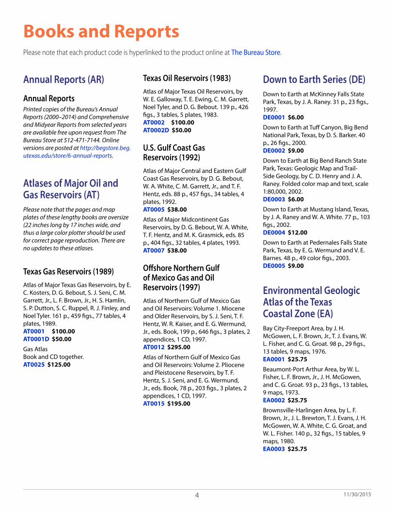
Books and ReportsPlease note that each product code is hyperlinked to the product online at The Bureau Store.
Annual Reports (AR)
Annual ReportsPrinted copies of the Bureau’s Annual Reports (2000–2014) and Comprehensive and Midyear Reports from selected years are available free upon request from The Bureau Store at 512-471-7144. Online versions are posted at http://begstore.beg.utexas.edu/store/6-annual-reports.
Atlases of Major Oil and Gas Reservoirs (AT)Please note that the pages and map plates of these lengthy books are oversize (22 inches long by 17 inches wide, and thus a large color plotter should be used for correct page reproduction. There are no updates to these atlases.
Texas Gas Reservoirs (1989)Atlas of Major Texas Gas Reservoirs, by E. C. Kosters, D. G. Bebout, S. J. Seni, C. M. Garrett, Jr., L. F. Brown, Jr., H. S. Hamlin, S. P. Dutton, S. C. Ruppel, R. J. Finley, and Noel Tyler. 161 p., 459 figs., 77 tables, 4 plates, 1989. AT0001 $100.00 AT0001D $50.00
Gas Atlas Book and CD together. AT0025 $125.00
Texas Oil Reservoirs (1983)Atlas of Major Texas Oil Reservoirs, by W. E. Galloway, T. E. Ewing, C. M. Garrett, Noel Tyler, and D. G. Bebout. 139 p., 426 figs., 3 tables, 5 plates, 1983. AT0002 $100.00 AT0002D $50.00
U.S. Gulf Coast Gas Reservoirs (1992)Atlas of Major Central and Eastern Gulf Coast Gas Reservoirs, by D. G. Bebout, W. A. White, C. M. Garrett, Jr., and T. F. Hentz, eds. 88 p., 457 figs., 34 tables, 4 plates, 1992. AT0005 $38.00
Atlas of Major Midcontinent Gas Reservoirs, by D. G. Bebout, W. A. White, T. F. Hentz, and M. K. Grasmick, eds. 85 p., 404 figs., 32 tables, 4 plates, 1993. AT0007 $38.00
Offshore Northern Gulf of Mexico Gas and Oil Reservoirs (1997)Atlas of Northern Gulf of Mexico Gas and Oil Reservoirs: Volume 1. Miocene and Older Reservoirs, by S. J. Seni, T. F. Hentz, W. R. Kaiser, and E. G. Wermund, Jr., eds. Book, 199 p., 646 figs., 3 plates, 2 appendices, 1 CD, 1997. AT0012 $295.00
Atlas of Northern Gulf of Mexico Gas and Oil Reservoirs: Volume 2. Pliocene and Pleistocene Reservoirs, by T. F. Hentz, S. J. Seni, and E. G. Wermund, Jr., eds. Book, 78 p., 203 figs., 3 plates, 2 appendices, 1 CD, 1997. AT0015 $195.00
Down to Earth Series (DE)Down to Earth at McKinney Falls State Park, Texas, by J. A. Raney. 31 p., 23 figs., 1997. DE0001 $6.00
Down to Earth at Tuff Canyon, Big Bend National Park, Texas, by D. S. Barker. 40 p., 26 figs., 2000. DE0002 $9.00
Down to Earth at Big Bend Ranch State Park, Texas: Geologic Map and Trail-Side Geology, by C. D. Henry and J. A. Raney. Folded color map and text, scale 1:80,000, 2002. DE0003 $6.00
Down to Earth at Mustang Island, Texas, by J. A. Raney and W. A. White. 77 p., 103 figs., 2002. DE0004 $12.00
Down to Earth at Pedernales Falls State Park, Texas, by E. G. Wermund and V. E. Barnes. 48 p., 49 color figs., 2003. DE0005 $9.00
Environmental Geologic Atlas of the Texas Coastal Zone (EA)
Bay City-Freeport Area, by J. H. McGowen, L. F. Brown, Jr., T. J. Evans, W. L. Fisher, and C. G. Groat. 98 p., 29 figs., 13 tables, 9 maps, 1976. EA0001 $25.75
Beaumont-Port Arthur Area, by W. L. Fisher, L. F. Brown, Jr., J. H. McGowen, and C. G. Groat. 93 p., 23 figs., 13 tables, 9 maps, 1973. EA0002 $25.75
Brownsville-Harlingen Area, by L. F. Brown, Jr., J. L. Brewton, T. J. Evans, J. H. McGowen, W. A. White, C. G. Groat, and W. L. Fisher. 140 p., 32 figs., 15 tables, 9 maps, 1980. EA0003 $25.75

5 11/30/2015
Corpus Christi Area, by L. F. Brown, Jr., J. L. Brewton, J. H. McGowen, T. J. Evans, W. L. Fisher, and C. G. Groat. 123 p., 32 figs., 13 tables, 9 maps, 1976. EA0004 $25.75
Galveston-Houston Area, by W. L. Fisher, J. H. McGowen, L. F. Brown, Jr., and C. G. Groat. 91 p., 22 figs., 7 tables, 9 maps, 1972. EA0005 $25.75
Kingsville Area, by L. F. Brown, Jr., J. H. McGowen, T. J. Evans, C. G. Groat, and W. L. Fisher. 131 p., 30 figs., 15 tables, 9 maps, 1977. EA0006 $15.00
Port Lavaca Area, by J. H. McGowen, C. V. Proctor, Jr., L. F. Brown, Jr., T. J. Evans, W. L. Fisher, and C. G. Groat. 107 p., 33 figs., 13 tables, 9 maps, 1976. EA0007 $15.00
Guidebooks (GB)
Field Excursion, Eastern Llano Region, by V. E. Barnes. 36 p., 12 figs., 1958. GB0001 $4.00
Texas Fossils: An Amateur Collector’s Handbook, by W. H. Matthews III. 123 p., 26 figs., 49 plates, 1960. GB0002 $5.00
Field Excursion, Central Texas: Tertiary Bentonites of Central Texas, by R. L. Folk, M. O. Hayes, and T. E. Brown, Uranium-Bearing Clays and Tuffs of South-Central Texas, by D. H. Eargle and A. D. Weeks, and Vermiculite Deposits Near Llano, by V. E. Barnes and S. E. Clabaugh. 53 p., 8 figs., 1961. GB0003 $6.00
The Geologic Story of Longhorn Cavern, by W. H. Matthews III. 50 p., 41 figs., 1963. GB0004 $3.00
Field Excursion: Geology of Llano Region and Austin Area, by V. E. Barnes, W. C. Bell, S. E. Clabaugh, P. E. Cloud, Jr., R. V. McGehee, and K. P. Young. 77 p., 16 figs., 3 tables, 1963. Reprint of Field Excursion No. 1, November 10–11, 1962, Houston Geological Society, for Geological Society of America Annual Meeting. GB0005 $8.00
Texas Rocks and Minerals: An Amateur’s Guide, by R. M. Girard. 109 p., 74 figs., 1 table, 2 maps, 2 charts, index, 1964. GB0006 $5.00
The Big Bend of the Rio Grande, A Guide to the Rocks, Landscape, Geologic History, and Settlers of the Area of Big Bend National Park, by R. A. Maxwell. 138 p., 117 figs., 1 oversize color map, scale 1:62,500, 1968. GB0007 $19.95 book MM0034 $15.00 map
The Geologic Story of Palo Duro Canyon, by W. H. Matthews III. 51 p., 37 figs., 1969. GB0008 $3.00
Field Excursion, East Texas: Clay, Glauconite, Ironstone Deposits, by T. E. Brown, L. E. Newland, D. H. Campbell, and A. J. Ehlmann. 48 p., 13 figs., 1969. GB0009 $5.00
Geologic and Historic Guide to the State Parks of Texas, by R. A. Maxwell, with contributions by L. F. Brown, Jr., G. K. Eifler, Jr., and L. E. Garner. 197 p., 98 figs., 2 tables, 1 plate, 1970. GB0010 $25.00
Recent Sediments of Southeast Texas—A Field Guide to the Brazos Alluvial and Deltaic Plains and the Galveston Barrier Island Complex, by H. A. Bernard, C. F. Major, Jr., B. S. Parrott, and R. J. LeBlanc, Sr. and [Appendix] Resume of the Quaternary Geology of the Northwestern Gulf of Mexico Province, by H. A. Bernard and R. J. LeBlanc, Sr. 132 p., 97 figs., 1970. Reprint of Field Guide prepared by Shell Development Company. GB0011 $7.00
Uranium Geology and Mines, South Texas, by D. H. Eargle, G. W. Hinds, and A.M.D. Weeks. 59 p., 21 figs., 2 plates, 1971. GB0012 $2.00
Geology of the Llano Region and Austin Area, by V. E. Barnes, W. C. Bell, S. E. Clabaugh, P. E. Cloud, Jr., R. V. McGehee, P. U. Rodda, and K. P. Young. 77 p. Revision of Guidebook 5 and Guidebook of 1971 Field Trip, Shreveport Geological Society, E. H. Morrow, ed. 1972 [1973]. GB0013 $8.00
Pennsylvanian Depositional Systems in North-Central Texas, A Guide for Interpreting Terrigenous Clastic Facies in a Cratonic Basin, by L. F. Brown, Jr., A. W. Cleaves II, and A. W. Erxleben. 122 p., 79 figs., 1 table, 1 plate, 1973. GB0014 $5.00
The Edwards Reef Complex and Associated Sedimentation in Central Texas, by H. F. Nelson. 34 p., 5 figs., 7 plates, 1973. GB0015 $3.50
Guide to Points of Geologic Interest in Austin, by A. R. Trippet and L. E. Garner. 38 p., 23 figs., 1 table, 2 color plates, 1976. GB0016 $10.00
Padre Island National Seashore—A Guide to the Geology, Natural Environments, and History of a Texas Barrier Island, by B. R. Weise and W. A. White. 94 p., 121 figs., 1 table, 1 plate, 1980. GB0017 $5.00
South Texas Uranium Province, Geologic Perspective, by W. E. Galloway, R. J. Finley, and C. D. Henry. 81 p., 54 figs., 2 tables, 1979. GB0018 $5.00
Cenozoic Geology of the Trans-Pecos Volcanic Field of Texas, by A. W. Walton and C. D. Henry, eds. 193 p., 1979. GB0019 $7.00
Modern Depositional Environments of the Texas Coast, by R. A. Morton and J. H. McGowen. 167 p., 104 figs., 2 tables, 1980. GB0020 $5.00
Geology of Monahans Sandhills State Park, Texas, by M. D. Machenberg. 39 p., 20 figs., 1 oversize black-and-white plate in pocket, 1984. GB0021 $5.00
Geomorphology and Quaternary Stratigraphy of the Rolling Plains, Texas Panhandle, T. C. Gustavson, eds. 97 p., 48 figs., 6 tables, 1 appendix, 1986. GB0022 $5.00
Igneous Geology of Trans-Pecos Texas—Field Trip Guide and Research Articles, J. G. Price, C. D. Henry, D. F. Parker, and D. S. Barker, field trip leaders and guidebook editors. 360 p., 188 figs., 57 tables, 1986. GB0023 $12.00

6 11/30/2015
Tertiary and Quaternary Stratigraphy and Vertebrate Paleontology of Parts of Northwestern Texas and Eastern New Mexico, T. C. Gustavson, ed. 128 p., 53 figs., 10 tables, 1990. GB0024 $13.50
Hydrogeology of Trans-Pecos Texas, C. W. Kreitler and J. M. Sharp, eds. 120 p., 30 figs., 1 table, 1990. GB0025 $8.00
Guide to the Permian Reef Geology Trail, McKittrick Canyon, Guadalupe Mountains National Park, West Texas, D. G. Bebout and Charles Kerans, eds. 48 p., 46 figs., 1993. GB0026 $8.50
Geology of Big Bend Ranch State Park, Texas, by C. D. Henry. 72 p., 81 figs., 1 table, 1 oversize color map in pocket, 1998. GB0027 $19.95
Genesis and Controls of Reservoir-Scale Carbonate Deformation, Monterrey Salient, Mexico, Randall Marrett, ed. 123 p., 63 figs., 5 tables, 1 oversize color plate in pocket, 2001. GB0028 $20.00
Geological Circulars (GC)Bloating Characteristics of East Texas Clays, by W. L. Fisher and L. E. Garner. 20 p., 12 figs., 1965. GC6501 $2.50
Texas Mineral Resources: Problems and Predictions, by P. T. Flawn. 17 p., 1 fig., 1965. GC6502 $2.00
A Revision of Taylor Nomenclature: Upper Cretaceous, Central Texas, by K. P. Young. 11 p., 3 figs., 1965. GC6503 $1.50
Texas Minerals: Trends in Production, by W. L. Fisher. 28 p., 34 charts, 1965. GC6504 $3.00
Geology in the State Government of Texas, by P. T. Flawn. 11 p., 1965. GC6505 $1.50
Uranium in Texas—1967, by P. T. Flawn. 16 p., 1967. GC6701 $2.00
Fluorspar in Brewster County, Texas, by W. N. McAnulty, Sr. 16 p., 3 figs., 1967. GC6702 $2.00
History of Geology at The University of Texas, by K. P. Young. 40 p., 4 figs., 1 text plate, frontispiece, 1967. GC6703 $5.00
Depositional Systems in the Wilcox Group of Texas and Their Relationship to Occurrence of Oil and Gas, by W. L. Fisher and J. H. McGowen. 21 p., 10 figs. Reprinted from Gulf Coast Association of Geological Societies Transactions, v. 17, p. 105–125, 1967. GC6704 $3.00
Glen Rose Cycles and Facies, Paluxy River Valley, Somervell County, Texas, by J. S. Nagle. 25 p., 7 figs., 1968. GC6801 $6.50
Edwards Formation (Lower Cretaceous), Texas: Dolomitization in a Carbonate Platform System, by W. L. Fisher and P. U. Rodda. 18 p., 14 figs., 1 table. Reprinted from AAPG Bulletin, v. 53, p. 55–71, 1969. GC6901 $2.00
Sulfur in West Texas: Its Geology and Economics, by J. B. Zimmerman and E. Thomas. 35 p., 9 figs., 1969. GC6902 $4.00
Virgil and Lower Wolfcamp Repetitive Environments and the Depositional Model, North-Central Texas, by L. F. Brown, Jr. 20 p., 8 figs. Reprinted from West Texas Geological Society Publication 69-56, p. 115–134, 1969. GC6903 $2.50
Geometry and Distribution of Fluvial and Deltaic Sandstones (Pennsylvanian and Permian), North-Central Texas, by L. F. Brown, Jr. 15 p., 22 figs. Reprinted from Gulf Coast Association of Geological Societies Transactions, v. 19, p. 23–47, 1969. GC6904 $2.50
Mineral Resources and Conservation in Texas, by P. T. Flawn. 20 p., 1 chart, 1970. GC7001 $2.00
Geological Considerations in Disposal of Solid Municipal Wastes in Texas, by P. T. Flawn, L. J. Turk, and C. H. Leach. 22 p., 1970. GC7002 $2.50
Effects of Hurricane Celia—A Focus on Environmental Geologic Problems of the Texas Coastal Zone, by J. H. McGowen, C. G. Groat, L. F. Brown, Jr., W. L. Fisher, and A. J. Scott. 35 p., 9 figs., 1970. GC7003 $4.00
Depositional Systems in the Jackson Group of Texas—Their Relationship to Oil, Gas, and Uranium, by W. L. Fisher, C. V. Proctor, Jr., W. E. Galloway, and J. S. Nagle. 28 p., 15 figs. Reprinted from Gulf Coast Association of Geological Societies Transactions, v. 20, p. 234–261, 1970. GC7004 $3.00
Resource Capability Units—Their Utility in Land- and Water-Use Management with Examples from the Texas Coastal Zone, by L. F. Brown, Jr., W. L. Fisher, A. W. Erxleben, and J. H. McGowen. 22 p., 4 figs., 1971. GC7101 $2.50
Mineral Deposits in the West Chinati Stock, Chinati Mountains, Presidio County, Texas, by W. N. McAnulty, Sr. 13 p., 7 figs., 1972. GC7201 $1.00
Cretaceous Paleogeography: Implications of Endemic Ammonite Faunas, by K. P. Young. 13 p., 4 figs., 3 tables, 1972. GC7202 $1.60
Evaluation of Sanitary Landfill Sites, Texas Coastal Zone—Geologic and Engineering Criteria, by L. F. Brown, Jr., W. L. Fisher, and J. F. Malina, Jr. 18 p., 3 figs., 4 tables, 1972. GC7203 $2.00
Depositional Systems and Oil-Gas Reservoirs in the Queen City Formation of Texas, by E. H. Guevara and R. Garcia. 22 p., 18 figs., 2 tables. Reprinted from Gulf Coast Association of Geological Societies Transactions, v. 22, p. 1–22, 1972. GC7204 $2.50
Asbestos in the Allamoore Talc District, Hudspeth and Culberson Counties, by R. G. Rohrbacher. 17 p., 2 figs., 1 table, 1973. GC7301 $2.00
Depositional-Episodes: Their Relationship to the Quaternary Stratigraphic Framework in the Northwestern Portion of the Gulf Basin, by D. E. Frazier. 28 p., 18 figs., 3 tables, 1974. GC7401 $2.25

7 11/30/2015
Shoreline Changes on Galveston Island (Bolivar Roads to San Luis Pass), An Analysis of Historical Changes of the Texas Gulf Shoreline, by R. A. Morton. 34 p., 12 figs., 3 appendices, 1974. GC7402 $2.50
A Numeric Code for Describing Rocks in Sedimentary Basins, by E. G. Wermund and C. A. Caughey. 28 p., 4 figs., 3 tables, 2 appendices, 1974. GC7403 $3.00
Potential Geothermal Resources of Texas, by M. H. Dorfman and R. O. Kehle. 33 p., 17 figs., 3 tables, 1974. GC7404 $2.00
Geothermal Resources—Frio Formation, South Texas, by D. G. Bebout, M. H. Dorfman, and O. K. Agagu. 36 p., 25 figs., 1975. GC7501 $4.00
Shoreline Changes on Brazos Island and South Padre Island (Mansfield Channel to Mouth of the Rio Grande), An Analysis of Historical Changes of the Texas Gulf Shoreline, by R. A. Morton and M. J. Pieper. 39 p., 12 figs., 1 table, 3 appendices, 1975. GC7502 $3.00
Upper Pennsylvanian Limestone Banks, North-Central Texas, by E. G. Wermund. 34 p., 14 figs., 2 tables, 1975. GC7503 $5.00
Shoreline Changes in the Vicinity of the Brazos River Delta (San Luis Pass to Brown Cedar Cut), An Analysis of Historical Changes of the Texas Gulf Shoreline, by R. A. Morton and M. J. Pieper. 47 p., 12 figs., 1 table, 1975. GC7504 $2.00
Flood Hazards along the Balcones Escarpment in Central Texas, Alternative Approaches to Their Recognition, Mapping, and Management, by V. R. Baker. 22 p., 12 figs., 2 tables, 1975. GC7505 $3.00
Shoreline Changes between Sabine Pass and Bolivar Roads, An Analysis of Historical Changes of the Texas Gulf Shoreline, by R. A. Morton. 43 p., 11 figs., 1 table, 1975. GC7506 $2.00
Microrelief (Gilgai) Structures on Expansive Clays of the Texas Coastal Plain—Their Recognition and Significance in Engineering Construction, by T. C. Gustavson. 18 p., 14 figs., 1 table, 1975. GC7507 $2.00
Geothermal Resources, Frio Formation, Middle Texas Gulf Coast, by D. G. Bebout, O. K. Agagu, and M. H. Dorfman. 43 p., 38 figs., 1975. GC7508 $2.00
Physiographic Features and Stratification Types of Coarse-Grained Point Bars: Modern and Ancient Examples, by J. H. McGowen and L. E. Garner. 27 p., 25 figs., 1 table, 1975. GC7509 $2.25
Hydrogeologic Significance of Depositional Systems and Facies in Lower Cretaceous Sandstones, North-Central Texas, by W. D. Hall. 29 p., 19 figs., 2 tables, 1976. GC7601 $2.00
Land Resources Inventory of Lignite Strip-Mining Areas, East Texas—An Application of Environmental Geology, by C. D. Henry. 28 p., 19 figs., 1 table, 1976. GC7602 $2.00
Geothermal Resources—Frio Formation, Upper Texas Gulf Coast, by D. G. Bebout, R. G. Loucks, S. C. Bosch, and M. H. Dorfman. 47 p., 52 figs., 1976. GC7603 $4.00
Shoreline Changes on Matagorda Island and San Jose Island (Pass Cavallo to Aransas Pass), An Analysis of Historical Changes of the Texas Gulf Shoreline, by R. A. Morton and M. J. Pieper. 42 p., 9 figs., 1 table, 3 appendices, 1976. GC7604 $2.00
Regional Tertiary Cross Sections—Texas Gulf Coast, by D. G. Bebout, P. E. Luttrell, and J. H. Seo. 10 p., 7 figs., 1 table, 1976. GC7605 $2.50
Shoreline Changes on Matagorda Peninsula (Brown Cedar Cut to Pass Cavallo), An Analysis of Historical Changes of the Texas Gulf Shoreline, by R. A. Morton, M. J. Pieper, and J. H. McGowen. 37 p., 9 figs., 1 table, 3 appendices, 1976. GC7606 $2.00
Geothermal Resources of the Texas Gulf Coast—Environmental Concerns Arising from the Production and Disposal of Geothermal Waters, by T. C. Gustavson and C. W. Kreitler. 35 p., 23 figs., 7 tables, 1976. GC7607 $2.50
Shoreline Changes on Mustang Island and North Padre Island (Aransas Pass to Yarborough Pass)—An Analysis of Historical Changes of the Texas Gulf Shoreline, by R. A. Morton and M. J. Pieper. 45 p., 9 figs., 3 tables, 3 appendices, 1977. GC7701 $2.25
Shoreline Changes on Central Padre Island (Yarborough Pass to Mansfield Channel)—An Analysis of Historical Changes of the Texas Gulf Shoreline, by R. A. Morton and M. J. Pieper. 35 p., 9 figs., 1 table, 3 appendices, 1977. GC7702 $2.50
The Gulf Shoreline of Texas: Processes, Characteristics, and Factors in Use, by J. H. McGowen, L. E. Garner, and B. H. Wilkinson. 27 p., 19 figs., 1977. GC7703 $3.00
Hydrogeology of Gulf Coast Aquifers, Houston-Galveston Area, Texas, by C. W. Kreitler, E. Guevara, G. Granata, and D. G. McKalips. 18 p., 16 figs., 1 table, 1977. GC7704 $2.00
Relationship of Porosity Formation and Preservation to Sandstone Consolidation History—Gulf Coast Lower Tertiary Frio Formation, by R. G. Loucks, D. G. Bebout, and W. E. Galloway. 12 p., 21 figs., 2 tables, 1977. GC7705 $2.00
Historical Shoreline Changes and Their Causes, Texas Gulf Coast, by R. A. Morton. 13 p., 5 figs., 2 tables, 1977. GC7706 $1.50
Depositional Systems in the Sparta Formation (Eocene), Gulf Coast Basin of Texas, by J. U. Ricoy and L. F. Brown, Jr. 16 p., 11 figs., 1977. GC7707 $2.00
Depositional Systems in the Paluxy Formation Lower Cretaceous), Northeast Texas—Oil, Gas, and Ground-Water Resources, by C. A. Caughey. 59 p., 27 figs., 4 tables, 1 appendix, 1977. GC7708 $2.50

8 11/30/2015
Mineral Lands in the City of Dallas, by A. E. St. Clair. 14 p., 15 figs., 3 tables, 1 oversize color plate in pocket, 1978. GC7801 $2.00
Regional Distribution of Fractures in the Southern Edwards Plateau and Their Relationship to Tectonics and Caves, by E. G. Wermund, J. C. Cepeda, and P. E. Luttrell. 14 p., 13 figs., 1978. GC7802 $1.75
Electric Power Generation from Texas Lignite, by W. R. Kaiser. 18 p., 8 figs., 12 tables, 1978. GC7803 $3.00
Sand-Body Geometry and the Occurrence of Lignite in the Eocene of Texas, by W. R. Kaiser, J. E. Johnston, and W. N. Bach. 19 p., 21 figs., 1978. GC7804 $2.00
Texas Energy Reserves and Resources, by W. L. Fisher. 30 p., 4 figs., 4 tables, 1978. GC7805 $3.50
Identification of Surface Faults by Horizontal Resistivity Profiles, by C. W. Kreitler and D. G. McKalips. 29 p., 17 figs., 1978. GC7806 $2.50
Geology and Geohydrology of the Palo Duro Basin, Texas Panhandle, A Report on the Progress of Nuclear Waste Isolation Feasibility Studies (1978), by S. P. Dutton, R. J. Finley, W. E. Galloway, T. C. Gustavson, C. R. Handford, and M. W. Presley. 99 p., 62 figs., 6 tables, 1979. GC7901 $3.50
Geochemistry of Bottom Sediments, Matagorda Bay System, Texas, by J. H. McGowen, J. R. Byrne, and B. H. Wilkinson. 64 p., 27 figs., 7 tables, 1979. GC7902 $2.50
Precambrian Rocks of the Southeastern Llano Region, Texas, by R. V. McGehee. 36 p., 5 plates, 1979. GC7903 $3.00
Sandstone Distribution and Potential for Geopressured Geothermal Energy Production in the Vicksburg Formation along the Texas Gulf Coast, by R. G. Loucks. 33 p., 35 figs., 1979. Reprinted from Gulf Coast Association of Geological Societies Transactions, v. 28, p. 239–271, 1978. GC7904 $4.50
Quaternary Faulting in East Texas, by E. W. Collins, D. K. Hobday, and C. W. Kreitler. 20 p., 13 figs., 1980. GC8001 $2.00
Importance of Secondary Leached Porosity in Lower Tertiary Sandstone Reservoirs along the Texas Gulf Coast, by R. G. Loucks, M. M. Dodge, and W. E. Galloway. 8 p., 17 figs., 1980. Reprinted from Gulf Coast Association of Geological Societies Transactions, v. 29, p. 164–171, 1979. GC8002 $2.00
Hydrology and Water Quality of the Eocene Wilcox Group: Significance for Lignite Development in East Texas, by C. D. Henry, J. M. Basciano, and T. W. Duex. 9 p., 8 figs., 1980. Reprinted from Gulf Coast Association of Geological Societies Transactions, v. 29, p. 127–135, 1979. GC8003 $1.00
The Queen City Formation in the East Texas Embayment: A Depositional Record of Riverine, Tidal and Wave Interaction, by D. K. Hobday, R. A. Morton, and E. W. Collins. 11 p., 11 figs., 1980. Reprinted from Gulf Coast Association of Geological Societies Transactions, v. 29, p. 136–146, 1979. GC8004 $1.50
Studies of the Suitability of Salt Domes in East Texas Basin for Geologic Isolation of Nuclear Wastes, by C. W. Kreitler. 7 p., 3 figs., 1980. Reprinted from Gulf Coast Association of Geological Societies Transactions, v. 29, p. 157–163, 1979. GC8005 $2.00
Distribution and Significance of Coarse Biogenic and Clastic Deposits on the Texas Inner Shelf, by R. A. Morton and C. D. Winker. 15 p., 7 figs., 2 tables, 1980. Reprinted from Gulf Coast Association of Geological Societies Transactions, v. 29, p. 352–364, 1979. GC8006 $2.00
Geology and Geohydrology of the Palo Duro Basin, Texas Panhandle, A Report on the Progress of Nuclear Waste Isolation Feasibility Studies (1979), by T. C. Gustavson, M. W. Presley, C. R. Handford, R. J. Finley, S. P. Dutton, R. W. Baumgardner, Jr., K. A. McGillis, and W. W. Simpkins. 99 p., 54 figs., 7 tables, 1 oversize black-and-white well log in pocket, 1980. GC8007 $4.00
Depositional Systems and Hydrocarbon Resource Potential of the Pennsylvanian System, Palo Duro and Dalhart Basins, Texas Panhandle, by S. P. Dutton. 49 p., 42 figs., 3 tables, 1980. GC8008 $3.00
Facies Patterns and Depositional History of a Permian Sabkha Complex: Red Cave Formation, Texas Panhandle, by C. R. Handford and P. E. Fredericks. 38 p., 19 figs., 2 appendices, 1980. GC8009 $3.00
Petroleum Source Rock Potential and Thermal Maturity, Palo Duro Basin, Texas, by S. P. Dutton. 48 p., 18 figs., 4 tables, 1980. GC8010 $3.00
Climatic Controls on Erosion in the Rolling Plains along the Caprock Escarpment of the Texas Panhandle, by R. J. Finley and T. C. Gustavson. 50 p., 24 figs., 8 tables, 1980. GC8011 $2.75
Geology and Geohydrology of the East Texas Basin, A Report on the Progress of Nuclear Waste Isolation Feasibility Studies (1979), by C. W. Kreitler, O. K. Agagu, J. M. Basciano, E. W. Collins, O. Dix, S. P. Dutton, G. E. Fogg, A. B. Giles, E. H. Guevara, D. W. Harris, D. K. Hobday, M. K. McGowen, D. Pass, and D. H. Wood. 112 p., 66 figs., 5 tables, 1980. GC8012 $4.00
Structure of the Presidio Bolson Area, Texas, Interpreted from Gravity Data, by J. R. Mraz and G. R. Keller. 20 p., 5 figs., 1 oversize black-and-white plate in pocket, 1980. GC8013 $2.50
The Mississippian and Pennsylvanian (Carboniferous) Systems in the United States—Texas, by R. S. Kier, L. F. Brown, Jr., and E. F. McBride. 45 p., 23 figs., 2 tables. Reprinted from USGS Professional Paper 1110-S, 1980. GC8014 $5.00
A Preliminary Assessment of the Geologic Setting, Hydrology, and Geochemistry of the Hueco Tanks Geothermal Area, Texas and New Mexico, by C. D. Henry and J. K. Gluck. 48 p., 9 figs., 2 tables, 1981. GC8101 $3.00
9 11/30/2015
Calderas and Mineralization: Volcanic Geology and Mineralization in the Chinati Caldera Complex, Trans-Pecos Texas, by T. W. Duex and C. D. Henry. 14 p., 6 figs., 1 table, 1981. GC8102 $2.50
Geology and Geohydrology of the Palo Duro Basin, Texas Panhandle, A Report on the Progress of Nuclear Waste Isolation Feasibility Studies (1980), by T. C. Gustavson, R. L. Bassett, R. J. Finley, A. G. Goldstein, C. R. Handford, J. H. McGowen, M. W. Presley, R. W. Baumgardner, Jr., M. E. Bentley, S. P. Dutton, J. A. Griffin, A. D. Hoadley, R. C. Howard, D. A. McGookey, K. A. McGillis, D. P. Palmer, P. J. Ramondetta, E. Roedder, W. W. Simpkins, and W. D. Wiggins. 173 p., 92 figs., 11 tables, 1 oversize black-and-white plate in pocket, 1981. GC8103 $5.50
Impact of Evaporite Dissolution and Collapse on Highways and Other Cultural Features in the Texas Panhandle and Eastern New Mexico, by W. W. Simpkins, T. C. Gustavson, A. B. Alhades, and A. D. Hoadley. 23 p., 10 figs., 1981. GC8104 $2.50
Lineament Analysis Based on Landsat Imagery, Texas Panhandle, by R. J. Finley and T. C. Gustavson. 37 p., 16 figs., 3 tables, 1 oversize black-and-white plate in pocket, 1981. GC8105 $3.50
Oakwood Salt Dome, East Texas: Surface Geology and Drainage Analysis, by E. W. Collins, O. R. Dix, and D. K. Hobday. 23 p., 26 figs., 3 tables, 1981. GC8106 $2.50
Geology and Geohydrology of the East Texas Basin, A Report on the Progress of Nuclear Waste Isolation Feasibility Studies (1980), by C. W. Kreitler, E. W. Collins, E. D. Davidson, Jr., O. R. Dix, G. A. Donaldson, S. P. Dutton, G. E. Fogg, A. B. Giles, D. W. Harris, M. P. A. Jackson, C. M. Lopez, M. K. McGowen, W. R. Muehlberger, W. D. Pennington, S. J. Seni, D. H. Wood, and H. V. Wuerch. 207 p., 119 figs., 15 tables, 1981. GC8107 $6.00
Tansill, Salado, and Alibates Formations: Upper Permian Evaporite/Carbonate Strata of the Texas Panhandle, by K. A. McGillis and M. W. Presley. 31 p., 15 figs., 2 tables, 1981. GC8108 $2.50
Lineament Analysis and Inference of Geologic Structure—Examples from the Balcones/Ouachita Trend of Texas, by S. C. Caran, C. M. Woodruff, Jr., and E. J. Thompson. 12 p., 4 figs., 3 tables, 1982. Reprinted from Gulf Coast Association of Geological Societies Transactions, v. 31, p. 59–69, 1981. GC8201 $2.50
Detailed Evaluation of Two Texas Lignite Deposits of Deltaic and Fluvial Origins, by S. J. Tewalt, M. A. Bauer, and D. Mathew. 12 p., 19 figs., 2 tables, 1982. Reprinted from Gulf Coast Association of Geological Societies Transactions, v. 31, p. 201–212, 1981. GC8202 $2.00
Surficial Evidence of Tectonic Activity and Erosion Rates, Palestine, Keechi, and Oakwood Salt Domes, East Texas, by E. W. Collins. 39 p., 24 figs., 2 tables, 1982. GC8203 $3.00
Fault Tectonics of the East Texas Basin, by M. P. A. Jackson. 31 p., 19 figs., 1982. GC8204 $3.50
Depositional Architecture of Cenozoic Gulf Coastal Plain Fluvial Systems, by W. E. Galloway. 29 p., 24 figs., 1 table, 1982. Reprinted from SEPM Special Publication No. 31, 1981. GC8205 $4.00
Hydrocarbon Accumulation Patterns in the East Texas Salt Dome Province, by D. H. Wood and A. B. Giles. 36 p., 18 figs., 4 tables, 1982. GC8206 $3.00
Geology and Geohydrology of the Palo Duro Basin, Texas Panhandle, A Report on the Progress of Nuclear Waste Isolation Feasibility Studies (1981), by T. C. Gustavson, R. L. Bassett, R. Budnik, R. J. Finley, A. G. Goldstein, J. H. McGowen, E. Roedder, S. C. Ruppel, R. W. Baumgardner, Jr., M. E. Bentley, S. P. Dutton, G. E. Fogg, S. D. Hovorka, and others. 212 p., 123 figs., 13 tables, 1982. GC8207 $8.50
Oakwood Salt Dome, East Texas: Geologic Framework, Growth History, and Hydrocarbon Production, by A. B. Giles and D. H. Wood. 55 p., 31 figs., 7 tables, 1 appendix, 1983. GC8301 $3.50
Potential for Additional Oil Recovery in Texas, by W. L. Fisher and W. E. Galloway. 20 p., 6 figs., 1 table, 1983. GC8302 $2.00
Regional Aquifer Characterization for Deep-Basin Lignite Mining, Sabine Uplift Area, Northeast Texas, by G. E. Fogg, W. R. Kaiser, M. L. Ambrose, and G. L. Macpherson. 30 p., 11 figs., 1983. GC8303 $4.00
Geology and Geohydrology of the Palo Duro Basin, Texas Panhandle, A Report on the Progress of Nuclear Waste Isolation Feasibility Studies (1982), by T. C. Gustavson, C. W. Kreitler, R. L. Bassett, R. T. Budnik, S. C. Ruppel, R. W. Baumgardner, Jr., S. C. Caran, E. W. Collins, A. R. Dutton, S. P. Dutton, R. S. Fisher, G. E. Fogg, S. D. Hovorka, and others. 156 p., 91 figs., 12 tables, 2 oversize black-and-white plates in pocket, 1983. GC8304 $5.50
Suitability of Salt Domes in the East Texas Basin for Nuclear Waste Isolation: Final Summary of Geologic and Hydrogeologic Research (1978–1983), by M.P.A. Jackson and S. J. Seni. 128 p., 61 figs., 8 tables, 1 appendix, 1984. GC8401 $4.00
Oil Accumulation, Production Characteristics, and Targets for Additional Recovery in Major Oil Reservoirs of Texas, by Noel Tyler, W. E. Galloway, C. M. Garrett, Jr., and T. E. Ewing. 31 p., 16 figs., 6 tables, 1 appendix, 1984. GC8402 $4.50
Observations from the East Texas Seismic Network (June 1981–August 1982), by W. D. Pennington and S. M. Carlson. 48 p., 33 figs., 3 tables, 1984. GC8403 $6.00
Styles of Deformation in Permian Strata, Texas Panhandle, by E. W. Collins. 32 p., 24 figs., 1984. GC8404 $4.50
Cotton Valley (Upper Jurassic) and Hosston (Lower Cretaceous) Depositional Systems and Their Influence on Salt Tectonics in the East Texas Basin, by M. K. McGowen and D. W. Harris. 41 p., 24 figs., 1 table, 2 appendices, 1984. GC8405 $7.50
Historical Shoreline Changes in Corpus Christi, Oso, and Nueces Bays, Texas Gulf Coast, by R. A. Morton and J. G. Paine. 66 p., 26 figs., 1 table, 3 appendices, 1984. GC8406 $6.00
10 11/30/2015
Depositional Systems and Structural Controls of Hackberry Sandstone Reservoirs in Southeast Texas, by T. E. Ewing and R. S. Reed. 48 p., 20 figs., 2 tables, 1984. GC8407 $6.00
Investigation of Underpressuring in the Deep-Basin Brine Aquifer, Palo Duro Basin, Texas, by E. D. Orr, C. W. Kreitler, and R. K. Senger. 44 p., 19 figs., 4 tables, 2 appendices, 1985. GC8501 $5.50
Depositional History, Facies Analysis, and Production Characteristics of Hydrocarbon-Bearing Sediments, Offshore Texas, by R. A. Morton, L. A. Jirik, and R. Q. Foote. 31 p., 17 figs., 1985. GC8502 $4.50
Abandoned Oil Fields of the Texas Gulf Coast and the East Texas Basin, by S. P. Dutton and C. M. Garrett, Jr. 47 p., 21 figs., 3 tables, 1 plate, 1 appendix, 1985. GC8503 $6.00
Amount and Nature of Occluded Water in Bedded Salt, Palo Duro Basin, Texas, by R. S. Fisher. 27 p., 9 figs., 7 tables, 3 appendices, 1985. GC8504 $4.00
Beach and Vegetation-Line Changes at Galveston Island, Texas: Erosion, Deposition, and Recovery from Hurricane Alicia, by R. A. Morton and J. G. Paine. 39 p., 24 figs., 5 tables, 3 appendices, 1985. GC8505 $5.00
Chemical Characterization of Texas Lignite, by S. J. Tewalt. 54 p., 21 figs., 22 tables, 2 appendices, 1986. GC8601 $6.50
Compilation of Potassium-Argon Ages of Tertiary Igneous Rocks, Trans-Pecos Texas, by C. D. Henry, F. W. McDowell, J. G. Price, and R. C. Smyth. 34 p., 1986. GC8602 $4.50
Historical Shoreline Changes in Trinity, Galveston, West, and East Bays, Texas Gulf Coast, by J. G. Paine and R. A. Morton. 58 p., 30 figs., 2 tables, 3 appendices, 1986. GC8603 $6.00
Recent Production Trends and Outlook for Future Oil and Gas Supplies in Texas, by W. L. Fisher and R. J. Finley. 31 p., 17 figs., 9 tables, 1 appendix, 1986. GC8604 $4.00
Organic Geochemistry of the Pennsylvanian and Lower Permian Palo Duro Basin, Texas, by S. P. Dutton. 28 p., 13 figs., 3 tables, 2 appendices, 1986. GC8605 $4.00
Fracture Analyses of the Palo Duro Basin Area, Texas Panhandle and Eastern New Mexico, by E. W. Collins and B. A. Luneau. 39 p., 34 figs., 1986. GC8606 $5.00
Mississippian Conodonts from the Southern Texas Panhandle, by S. C. Ruppel and T. M. Lemmer. 36 p., 13 figs., 4 tables, 2 black-and-white plates in text, 1986. GC8607 $5.00
Depositional and Structural Framework of the Distal Frio Formation, Texas Coastal Zone and Shelf, by W. E. Galloway. 16 p., 7 figs., 1 table, 3 oversize black-and-white plates in pocket, 1986. GC8608 $4.50
Historical Shoreline Changes in San Antonio, Espiritu Santo, and Mesquite Bays, Texas Gulf Coast, by W. A. White and R. A. Morton. 41 p., 31 figs., 1 table, 3 appendices, 1987. GC8701 $5.00
Hydrogeologic and Hydrochemical Properties of Salt-Dissolution Zones, Palo Duro Basin, Texas Panhandle—Preliminary Assessment, by A. R. Dutton. 32 p., 16 figs., 6 tables, 1 appendix, 1987. GC8702 $4.50
A Saponite and Chlorite-Rich Clay Assemblage in Permian Evaporite and Red-Bed Strata, Palo Duro Basin, Texas Panhandle, by D. P. Palmer. 21 p., 13 figs., 5 tables, 1 appendix, 1987. GC8703 $3.50
Can the U.S. Oil and Gas Resource Base Support Sustained Production?, by W. L. Fisher. 6 p., 6 figs., 1987. Reprinted from Science, v. 236, 1987. GC8704 $2.00
Rock Fabric, Permeability, and Log Relationships in an Upward-Shoaling, Vuggy Carbonate Sequence, by F. J. Lucia and R. D. Conti. 22 p., 26 figs., 4 tables, 4 appendices, 1987. GC8705 $3.50
Geology of Damon Mound Salt Dome, Texas: Evidence of Oligocene to Post-Pleistocene Episodic Diapir Growth, by E. W. Collins. 24 p., 19 figs, 1 appendix, 1988. GC8801 $3.50
Subsidence and Collapse at Texas Salt Domes, by W. F. Mullican III. 36 p., 25 figs., 3 tables, 2 appendices, 1988. GC8802 $5.00
Hydrogeology and Hydrochemistry of Cretaceous Aquifers, Texas Panhandle and Eastern New Mexico, by Ronit Nativ and G. N. Gutierrez. 32 p., 19 figs., 5 appendices, 1988. GC8803 $4.50
Shoreline and Vegetation-Line Movement, Texas Gulf Coast, 1974 to 1982, by J. G. Paine and R. A. Morton. 50 p., 15 figs., 5 tables, 3 appendices, 1989. GC8901 $6.00
Hydrocarbon Production and Exploration Potential of the Distal Frio Formation, Texas Gulf Coast and Offshore, by H. S. Hamlin. 47 p., 42 figs., 4 tables, 21 oversize black-and-white plates in pocket, 1989. GC8902 $6.00
A Compendium of Earthquake Activity in Texas, by S. D. Davis, W. D. Pennington, and S. M. Carlson. 27 p., 4 figs., 3 tables, 4 appendices., 1989. GC8903 $3.00
Oil and Gas Resources Remaining in the Permian Basin: Targets for Additional Hydrocarbon Recovery, by Noel Tyler and N. J. Banta. 20 p., 14 figs., 3 tables, 1989. GC8904 $3.00
Geologic Significance of Remotely Sensed Physiographic Features of the Texas Panhandle and Adjacent Regions, by E. W. Collins. 39 p., 15 figs., 2 tables, 4 appendices, 1990. GC9001 $4.00
Opportunities for Horizontal Drilling in Texas, by R. J. Finley, S. E. Laubach, Noel Tyler, and M. H. Holtz. 32 p., 14 figs., 2 tables, 1990. GC9002 $4.50
Field Extension in a Carbonate Reservoir: An Example from the Central Basin Platform, Permian Basin, West Texas, by R. P. Major. 28 p., 16 figs., 1 table, 1990. GC9003 $4.00

11 11/30/2015
Facies Heterogeneity and Brine-Disposal Potential of Miocene Barrier-Island, Fluvial, and Deltaic Systems: Examples from Northeast Hitchcock and Alta Loma Fields, Galveston County, Texas, by W. A. Ambrose. 35 p., 24 figs., 1 table, 1 appendix, 1990. GC9004 $4.50
Integration of Ground-Water and Vadose-Zone Geochemistry to Investigate Hydrochemical Evolution: A Case Study in Arid Lands of the Northern Chihuahuan Desert, Trans-Pecos Texas, by R. S. Fisher and W. F. Mullican III. 36 p., 11 figs., 7 tables, 3 appendices, 1990. GC9005 $5.00
Estimation of Lignite Resources in the Wilcox Group of Central and East Texas Using the National Coal Resources Data Systems, by S. J. Tewalt and M. L. W. Jackson. 44 p., 29 figs., 6 tables, 1 appendix, 1991. GC9101 $6.25
Tertiary and Quaternary Structure and Paleotectonics of the Hueco Basin, Trans-Pecos Texas and Chihuahua, Mexico, by E. W. Collins and J. A. Raney. 44 p., 17 figs., 1 appendix, 1991. GC9102 $5.50
Structural History and Origin of the Sabine Arch, East Texas and Northwest Louisiana, by M.L.W. Jackson and S. E. Laubach. 47 p., 26 figs., 2 tables, 1991. GC9103 $7.00
A Glossary of Salt Tectonics, by M. P. A. Jackson and C. J. Talbot. 44 p., 19 figs., 2 tables, 3 appendices, 1991. GC9104 $5.50
Core and Log Analyses of Depositional Systems and Reservoir Properties of Gulf Coast Natural Gas Reservoirs: An Integrated Approach to Infield Reserve Growth in Frio, Vicksburg, and Wilcox Sandstones, R. A. Levey, ed. 56 p., 52 figs., 3 tables, 1992. GC9201 $6.50
Surface Fissures in the Hueco Bolson and Adjacent Basins, West Texas, by R. W. Baumgardner, Jr., and B. R. Scanlon. 40 p., 19 figs., 2 tables, 1992. GC9202 $5.00
Historical Shoreline Changes in Copano, Aransas, and Redfish Bays, Texas Gulf Coast, by J. G. Paine and R. A. Morton. 66 p., 30 figs., 5 tables, 3 appendices, 1993. GC9301 $7.50
Gas Reservoir Quality Variations and Implications for Resource Development, Frio Formation, South Texas: Examples from Seeligson and Stratton Fields, by J. D. Grigsby and D. R. Kerr. 27 p., 19 figs., 3 tables, 1993. GC9302 $6.00
Geothermal and Heavy-Oil Resources in Texas: Direct Use of Geothermal Fluids to Enhance Recovery of Heavy Oil, by S. J. Seni and T. G. Walter. 52 p., 34 figs., 6 tables, 4 appendices, 1993. GC9303 $6.00
Comparison of Empirical Models for Calculating Vuggy Porosity and Cementation Exponent of Carbonates from Log Responses, by F. P. Wang and F. J. Lucia. 27 p., 17 figs., 1 table, 1 appendix, 1993. GC9304 $4.00
Use of Dipmeters in Stratigraphic and Depositional Interpretation of Natural Gas Reservoirs of the Oligocene Vicksburg Formation: An Example from McAllen Ranch Field, Hidalgo County, Texas, by R. P. Langford, J. D. Hall, and W. E. Howard. 39 p., 23 figs., 3 tables, 1994. GC9401 $6.50
Targeted Secondary Recovery of Hydrocarbons from Barrier-Bar and Tidal-Channel Facies, Jackson Group, Prado Field, South Texas, by S. J. Seni and S.-J. Choh. 47 p., 21 figs., 1 table, 2 appendices, 1994. GC9402 $6.00
A 3D Seismic Case History Evaluating Fluvially Deposited Thin-Bed Reservoirs in a Gas-Producing Property, by B. A. Hardage, R. A. Levey, Virginia Pendleton, James Simmons, and Rick Edson. 16 p., 22 figs. Reprinted from Geophysics, v. 59, no. 11, p. 1650–1665, 1995. GC9501 $6.50
Controls on Reservoir Heterogeneity in Permian Shallow-Water-Platform Carbonate Reservoirs, Permian Basin: Implications for Improved Recovery, by S. C. Ruppel, Charles Kerans, R. P. Major, and M. H. Holtz. 30 p., 25 figs., 1995. GC9502 $5.50
Naturally Occurring Radioactive Materials (NORM) in Produced Water and Scale from Texas Oil, Gas, and Geothermal Wells: Geographic, Geologic, and Geochemical Controls, by R. S. Fisher. 43 p., 12 figs., 7 tables, 1 appendix, 1995. GC9503 $7.50
Seismic Analysis of the Duval County Ranch Area, South Texas: Assessment of Exploration Potential in the Wilcox, Queen City, and Jackson-Yegua Plays, by J. C. Fiduk and D. S. Hamilton. 42 p., 29 figs., 1995. GC9504 $4.50
Facies Heterogeneity in a Modern Ooid Sand Shoal—An Analog for Hydrocarbon Reservoirs, by R. P. Major, D. G. Bebout, and P. M. Harris. 30 p., 19 figs., 1996. GC9601 $5.00
Extent, Mass, and Duration of Hydrocarbon Plumes from Leaking Petroleum Storage Tank Sites in Texas, by R. E. Mace, R. S. Fisher, D. M. Welch, and S. P. Parra. 52 p., 24 figs., 7 tables, 4 appendices, 1997. GC9701 $6.50
Electrical Imaging Catalog: Microresistivity Images and Core Photos from Fractured, Karsted, and Brecciated Carbonate Rocks, by Ursula Hammes. 40 p., 32 figs., 1997. GC9702 $10.00
Gulf Shoreline Movement between Sabine Pass and the Brazos River, Texas: 1974 to 1996, by R. A. Morton. 46 p., 10 figs., 4 tables, 3 appendices, 1997. GC9703 $8.00
A Practical Use of Vertical Seismic Profiles—Stratigraphic Calibration of 3D Seismic Data, by B. A. Hardage. 11 p., 5 figs., 1997. GC9704 $4.50
Principles of Onshore 3D Seismic Design, by B. A. Hardage. 23 p., 13 figs., 1997. GC9705 $5.00
Basin Morphological Controls on Submarine-Fan Depositional Trends: Spraberry Sandstone, Permian Basin, Texas, by Noel Tyler, J. C. Gholston, and E. H. Guevara. 43 p., 30 figs., 1997. GC9706 $6.00

12 11/30/2015
3D Seismic Stratal-Surface Concepts Applied to the Interpretation of a Fluvial Channel System Deposited in a High-Accommodation Environment, by B. A. Hardage and R. L. Remington. 15 p., 15 figs., 1998. GC9801 $4.00
Facies and Diagenesis of the Austin Chalk and Controls on Fracture Intensity—A Case Study from North-Central Texas, by S. D. Hovorka. 47 p., 34 figs., 6 tables, 1998. GC9802 $7.50
3D Seismic Interpretation of Deep, Complex Structures in the Delaware Basin, West Texas, by B. A. Hardage, V. M. Pendleton, and G. B. Asquith. 42 p., 31 figs., 1 table, 1999. GC9901 $13.00
Characterization of Bedded Salt for Storage Caverns—A Case Study from the Midland Basin, Texas, by S. D. Hovorka. 80 p., 33 figs., 1 appendix, 2000. GC0001 $8.00
Using 3D Seismic Coherency and Stratal Surfaces to Optimize Redevelopment of Waterflooded Reservoirs, Cut Bank Field, Montana, by M. V. DeAngelo and B. A. Hardage. 24 p., 17 figs., 2001. GC0101 $13.00
Estimating Transmissivity Using Specific-Capacity Data, by R. E. Mace. 44 p., 18 figs., 2 tables, 1 appendix, 2001. GC0102 $6.00
Play-Based Assessment of Hydrocarbon Resources in University Lands Reservoirs, Permian Basin, West Texas, by E. M. Kim and S. C. Ruppel. 24 p., 22 figs., 1 table, 2003. GC0301 $6.00
Handbooks (HB)Aids to Identification of Geological Formations, by J. A. Udden. 69 p., 1918. HB0001 $7.00
Sulfur in Texas, by S. P. Ellison, Jr., 48 p., 14 figs., 2 plates, 1971. HB0002 $5.00
Fluorspar in Texas, by W. N. McAnulty, Sr. 31 p., 19 figs., 1974. HB0003 $4.00
Bituminous Coal in Texas, by T. J. Evans. 65 p., 18 figs., 9 tables, 1 plate, 2 appendices, 1974. HB0004 $6.50
Handbook for Logging Carbonate Rocks, by D. G. Bebout and R. G. Loucks. 43 p., 21 figs., 1 full-scale logging form in pocket, 1984. HB0005 $5.00
Pad of 50 oversize logging forms (no text). HX0005 $15.00
Mineral Resource Circulars (MC)Graphite in Texas, by E. H. Sellards. 2 p., 1930. MC0001 $1.00
Volcanic Ash in Texas, by C. L. Baker. 2 p., 1931. MC0002 $1.00
Fuller’s Earth and Bentonite in Texas, by C. L. Baker. 4 p., 1932. MC0003 $1.00
Barite in Texas, by C. L. Baker. 3 p., 1932. MC0004 $1.00
Gold in Texas, by C. L. Baker. 6 p., 1932. MC0005 $1.50
Sulphur in Texas, by C. L. Baker. 3 p., 1935. MC0006 $1.00
Progress Report on the Examination of the Terlingua Quicksilver District, Brewster County, Texas, by C. P. Ross. 3 p., 1934. MC0007 $1.00
Progress Report on the Study of the Iron Ore Deposits of Northeast Texas, by E. B. Eckel. 2 p., 1935. MC0008 $1.00
Glass Sands in Leon County, Texas, by H. B. Stenzel. 1 p., 1938. MC0009 $0.10
High Magnesia Marble from Sharp Mountain Area of Llano County, Texas, by E. P. Schoch, V. E. Barnes, and G. A. Parkinson. 3 p., 1938. MC0010 $1.00
Additional Notes on Barite, by V. E. Barnes. 3 p., 1939. MC0011 $1.00
Preliminary Report on Gray Granites from Central Texas, by V. E. Barnes, G. A. Parkinson, and R. F. Dawson. 3 p., 1939. MC0012 $1.00
Summary of Progress on Geology and Oil Shale Investigation in San Saba County, by F. B. Plummer. 3 p., 1940. MC0013 $1.00
Serpentine and Associated Minerals of Gillespie and Blanco Counties, Texas, by V. E. Barnes. 4 p., 1940. MC0014 $1.00
Additional Notes on Graphite in Texas, by V. E. Barnes. 8 p., 1940. MC0015 $1.00
Peat Deposits in Texas, by F. B. Plummer. 5 p., 1941. MC0016 $1.00
Tungsten and Tungsten Minerals, by E. H. Sellards and J. A. Udden. 2 p., 1941. MC0017 $1.00
Bauxite and Aluminum, by R. C. Redfield. 10 p., 1942. MC0018 $1.00
Filtering Clays in Briscoe and Swisher Counties, Texas, by G. L. Evans. 2 p., 1942. MC0019 $1.00
Scheelite in Llano County, Texas, by V. E. Barnes, G. A. Parkinson, and L. E. Warren. 1 p., 1942. MC0020 $0.10
Principal War and Industrial Metals, Minerals, and Mineral Substances, by E. H. Sellards. 6 p., 1942. MC0021 $1.00
A New Quartz Sand Horizon in the Cambrian of Mason County, Texas, by F. B. Plummer. 2 p., 1942. MC0022 $1.00
Faulting in Northwestern Houston County, by H. B. Stenzel. 4 p., 1943. MC0023 $1.00
Progress Report on Copper Investigations, by G. L. Evans. 4 p., 1943. MC0024 $1.00
Analyses of Dolomites and Serpentine from Blanco and Gillespie Counties, Texas, by V. E. Barnes. 2 p., 1943. MC0025 $1.00
Fluorspar Deposits in the Eagle Mountains of Hudspeth County, Texas, by G. L. Evans. 10 p., 1943. MC0026 $1.00

13 11/30/2015
Preliminary Reconnaissance Report on Fluorite in the Spring Creek Area of Burnet County, Texas, by V. E. Barnes. 4 p., 1943. MC0027 $1.00
Tests on Molding Sands, 2 p., 1944. MC0028 $1.00
Index to Mineral Resources of Texas by Counties, by E. H. Sellards and G. L. Evans. 12 p., 28 plates, 1946. MC0029 $1.20
Activated Carbon from Texas Lignite, by G. L. Evans. 1 p., 1944. MC0030 $1.00
The Damon Mound Limestone, Brazoria County, Texas, by E. M. Hurlbut, Jr. 5 p., 1946. MC0031 $1.00
Diatomite in the High Plains Region of Texas, by G. L. Evans. 4 p., 1944. MC0032 $1.00
Limestones in Central Texas Suitable for the Manufacture of Rock Wool, by F. B. Plummer. 6 p., 1944. MC0033 $1.00
Representative Sections of the Ellenburger Group in Central Texas, by V. E. Barnes and P. E. Cloud, Jr. 22 p., 1945. MC0034 $2.50
Gypsum Mining near Hockley, Harris County, Texas, by H. B. Stenzel. 35 p., 1946. MC0035 $3.50
Progress Report on Peat Deposits in Texas, by F. B. Plummer. 11 p., 1945. MC0036 $1.10
Prospecting for Uranium in Texas, by P. T. Flawn and G. H. Anderson. Issued in cooperation with General Land Office, 12 p., 1955. MC0037 $1.20
Mineral Resources of the Texas Coastal Plain (Preliminary Report), by J. M. Perkins and J. T. Lonsdale. Report for U.S. Bureau of Reclamation, 23 p., 1955. MC0038 $2.30
A Review of Pennsylvanian Clay Mineral Industries, North-Central Texas, by L. F. Brown, Jr. 7 p., 1959. MC0039 $1.00
The Mineral Industry of Texas in 1958, by F. F. Netzeband and J. T. Lonsdale. In cooperation with the U.S. Bureau of Mines, 59 p., 1959. MC0040 $6.00
The Mineral Industry of Texas in 1959, by F. F. Netzeband and R. M. Girard. In cooperation with the U.S. Bureau of Mines, 51 p., 1960. MC0041 $5.10
The Mineral Industry of Texas in 1960, by F. F. Netzeband, T. R. Early, and R. M. Girard. In cooperation with the U.S. Bureau of Mines, 59 p., 1961. MC0042 $6.00
Reconnaissance of Trace Elements in Texas Coal and Lignite, by D. W. Kohls. 8 p., 1962. MC0043 $1.00
The Mineral Industry of Texas in 1961, by F. F. Netzeband, T. R. Early, and R. M. Girard. In cooperation with the U.S. Bureau of Mines, 55 p., 1962. MC0044 $5.50
The Mineral Industry of Texas in 1962, by F. F. Netzeband, T. R. Early, and R. M. Girard. In cooperation with the U.S. Bureau of Mines, 53 p., 1963. MC0045 $5.30
The Mineral Industry of Texas in 1963, by F. F. Netzeband and R. M. Girard. In cooperation with the U.S. Bureau of Mines, 63 p., 1964. MC0046 $6.30
The Mineral Industry of Texas in 1964, by F. F. Netzeband, H. F. Pierce, and R. M. Girard. In cooperation with the U.S. Bureau of Mines, 47 p., 1965. MC0047 $4.70
The Mineral Industry of Texas in 1965, by F. F. Netzeband and R. M. Girard. In cooperation with the U.S. Bureau of Mines, 40 p., 1966. MC0048 $4.00
The Mineral Industry of Texas in 1966, by F. F. Netzeband and R. M. Girard. In cooperation with the U.S. Bureau of Mines, 31 p., 1967. MC0049 $3.50
The Mineral Industry of Texas in 1967, by F. F. Netzeband and R. M. Girard. In cooperation with the U.S. Bureau of Mines, 39 p., 1968. MC0050 $4.00
The Mineral Industry of Texas in 1968, by F. F. Netzeband and R. M. Girard. In cooperation with the U.S. Bureau of Mines, 35 p., 1969. MC0051 $3.50
The Mineral Industry of Texas in 1969, by O. W. Jones, F. F. Netzeband, and R. M. Girard. In cooperation with the U.S. Bureau of Mines, 36 p., 1970. MC0052 $3.50
The Mineral Industry of Texas in 1970, by R. F. Zaffarano, R. M. Girard, and E. R. Slatick. In cooperation with the U.S. Bureau of Mines, 32 p., 1972. MC0053 $3.50
The Mineral Industry of Texas in 1971, by S. O. Wood, Jr., and R. M. Girard. In cooperation with the U.S. Bureau of Mines, 34 p., 1973. MC0054 $3.50
The Mineral Industry of Texas in 1972, by S. O. Wood, Jr., and R. M. Girard. In cooperation with the U.S. Bureau of Mines, 32 p., 1974. MC0055 $3.50
Gold and Silver in Texas, by T. J. Evans. 36 p., 14 figs., 5 tables, 1 app., 1975. MC0056 $4.00
Native Bituminous Materials in Texas, by T. J. Evans. 18 p., 6 figs., 3 tables, 1975. MC0057 $2.00
The Mineral Industry of Texas in 1973, by C. J. Jirik and R. M. Girard. In cooperation with the U.S. Bureau of Mines, 36 p., 1976. MC0058 $4.00
The Mineral Industry of Texas in 1974, by M. E. Hawkins and R. M. Girard. In cooperation with the U.S. Bureau of Mines, 37 p., 1 fig., 29 tables, 1977. MC0059 $4.00
The Mineral Industry of Texas in 1975, by M. E. Hawkins and T. J. Evans. In cooperation with the U.S. Bureau of Mines, 40 p., 1 fig., 28 tables, 1979. MC0060 $4.00
Coal Problems and Prospects, by W. C. J. van Rensburg, H. B. H. Cooper, Jr., W. R. Kaiser, and S. H. Spurr. 20 p. Reprinted from National Energy Policy Issues, June 1979, Council on Energy Resources, 1979. MC0061 $3.00
Coal Gasification and Liquefaction, by W. C. J. van Rensburg. 42 p., 8 figs., 5 tables. Reprinted from National Energy Policy Issues, June 1979, Council on Energy Resources, 1979. MC0062 $4.50

14 11/30/2015
The Future Utilization of Texas Lignites: A Review, by W. C. J. van Rensburg. 57 p., 10 figs., 2 tables, 1979. MC0063 $5.00
Development of the Mercury Mining Industry: Trans-Pecos Texas, by R. D. Sharpe. 32 p., 13 figs., 3 tables, 1980. MC0064 $4.50
The Classification of Coal Resources and Reserves, by W. C. J. van Rensburg. 36 p., 12 figs., 4 tables, 1980. MC0065 $3.50
The Mineral Industry of Texas in 1976, by M. E. Hawkins and T. J. Evans. In cooperation with the U.S. Bureau of Mines, 34 p., 1 fig., 25 tables, 1976. MC0066 $3.50
The Aluminum Industry of Texas, by T. Barron. 16 p., 5 figs., 16 tables, 1981. MC0067 $2.00
The Mineral Industry of Texas in 1977, by M. E. Hawkins and T. J. Evans. In cooperation with the U.S. Bureau of Mines, 20 p., 1 fig., 15 tables, 1981. MC0068 $1.00
The Mineral Industry of Texas in 1978–79, by M. E. Hawkins and L. E. Garner. In cooperation with the U.S. Bureau of Mines, 17 p., 1 fig., 13 tables, 1981. MC0069 $2.00
Geology of the Plata Verde Mine, Hudspeth County, Texas, by J. G. Price. 34 p., 13 figs., 4 tables, 1982. MC0070 $3.50
The Mineral Industry of Texas in 1980, by A. E. Ward. In cooperation with the U.S. Bureau of Mines, 19 p., 1 fig., 14 tables, 1982. MC0071 $2.00
The Mineral Industry of Texas in 1981, by A. E. Ward. In cooperation with the U.S. Bureau of Mines, 18 p., 1 fig., 13 tables, 1983. MC0072 $2.00
Annotated Bibliography of Mineral Deposits in Trans-Pecos Texas, by J. G. Price, C. D. Henry, and A. R. Standen. 108 p., 31 figs., 1 table, 1983. MC0073 $6.00
Nonpetroleum Mineral Producers in Texas—1983, by M. W. McBride and A. L. Dobbs. 94 p., 4 figs., 1983. MC0074 $3.50
The Mineral Industry of Texas in 1982, by A. E. Ward. In cooperation with the U.S. Bureau of Mines, 18 p., 1 fig., 13 tables, 1984. MC0075 $1.00
Texas Lignite Status and Outlook to 2000, by W. R. Kaiser. 17 p., 4 figs., 8 tables, 1985. MC0076 $2.00
The Mineral Industry of Texas in 1983, by J. P. Ohl and M. W. McBride. 20 p., 1 fig., 13 tables, 1985. MC0077 $1.00
The Mineral Industry of Texas in 1984, by J. P. Ohl and M. W. McBride. 24 p., 2 figs., 12 tables, 1986. MC0078 $1.50
The Mineral Industry of Texas in 1985, by J. P. Ohl and M. W. McBride. 20 p., 2 figs., 12 tables. Reprinted from U.S. Bureau of Mines Minerals Yearbook, 1987. MC0079 $1.00
The Mineral Industry of Texas in 1986, by J. P. Ohl and M. W. McBride. 15 p., 1 fig., 12 tables. Reprinted from U.S. Bureau of Mines Minerals Yearbook, 1988. MC0080 $1.00
The Mineral Industry of Texas in 1987, by J. P. Ohl and M. W. McBride. 12 p., 1 fig., 7 tables. Reprinted from U.S. Bureau of Mines Minerals Yearbook, 1989. MC0081 $1.00
The Dimension Stone Industry of Texas, by L. E. Garner. 16 p., 15 figs., 1992. MC0082 $4.00
Texas Portland Cement Industry and Cement Resources, by M. W. McBride, T. S. Patty, and R. D. Sharpe. 72 p., 42 figs., 14 tables, 4 appendices, 1992. MC0083 $8.00
Limestone Resources of Texas, by L. E. Garner. 16 p., 1 fig., 3 appendices, 1994. MC0084 $4.00
The Barite Industry and Resources of Texas, by J. R. Kyle. 86 p., 51 figs., 10 tables, 2 appendices, 1994. MC0085 $9.00
Reports of Investigations (RI)Rustler Springs Sulphur Deposits as a Source of Fertilizer, by G. L. Evans. 13 p., 3 figs., 1946. RI0001 $1.50
Ouachita Facies in Central Texas, by V. E. Barnes. 12 p., 2 figs., 1948. RI0002 $1.50
Successful Speciation in Paleontology: The Case of the Oysters of the Sellaeformis Stock, by H. B. Stenzel. 17 p., 8 figs. Reprinted from Evolution, v. 3, no. 1, March 1949. RI0003 $2.00
Correlation of Gravity Observations with the Geology of the Coal Creek Serpentine Mass, Blanco and Gillespie Counties, by F. Romberg and V. E. Barnes. 11 p., 4 figs. Reprinted from Geophysics, v. 14, no. 2, April 1949. RI0004 $1.50
Iron Ore in the Llano Region, Central Texas, by V. E. Barnes, S. S. Goldich, and F. Romberg. 50 p., 9 figs., 8 plates, 1949. RI0005 $6.00
Stratigraphy and Petrology of Buck Hill Quadrangle, Texas, by S. S. Goldich and M. A. Elms. 50 p., 6 figs., 6 plates. Reprinted from Geological Society of America Bulletin, v. 60, no. 7, July 1949. RI0006 $6.00
Subsurface Woodford Black Shale, West Texas and Southeast New Mexico, by S. P. Ellison, Jr. 20 p., 6 figs., 2 plates, 1950. RI0007 $4.50
Geology of Barrilla Mountains, Texas, by G. K. Eifler, Jr. 15 p., 1 fig., 2 plates. Reprinted from Geological Society of America Bulletin, v. 62, no. 4, 1951. RI0008 $3.00
Pegmatites of the Van Horn Mountains, Texas, by P. T. Flawn. 30 p., 14 figs. Reprinted from Economic Geology, v. 46, no. 2, 1951. RI0009 $3.50
Buried Hill at Wilcox-Carrizo Contact in East Texas, by H. B. Stenzel. 14 p., 7 figs. Reprinted from American Association of Petroleum Geologists Bulletin, v. 35, no. 8, 1951. RI0010 $1.50

15 11/30/2015
Correlation between Surface and Subsurface Sections of the Ellenburger Group of Texas, by L. Hendricks. 44 p., 1 fig., 6 plates, 1952. RI0011 $6.50
Geology of the Blacklands Experimental Watershed, Near Waco, Texas, by H. R. Blank, N. L. Stoltenberg, and H. H. Emmerich. 46 p., 1 fig., 4 plates, 1 map, 1952. RI0012 $2.00
Boundary of the Pennsylvanian and Permian(?) in the Subsurface Scurry Reef, Scurry County, Texas, by W. A. Heck, K. A. Yenne, and L. G. Henbest. 17 p., 5 figs., 1 plate, 1952. RI0013 $3.00
Recognition of Hipparions and Other Horses in the Middle Miocene Mammalian Faunas of the Texas Gulf Region, by J. H. Quinn, and New Paleocene and Lower Eocene Vertebrate Localities, Big Bend National Park, Texas, by J. A. Wilson, R. A. Maxwell, J. T. Lonsdale, and J. H. Quinn. 7 p., 1952. RI0014 $1.00
Geology of Agua Fria Quadrangle, Brewster County, Texas, by C. G. Moon. 45 p., 4 figs., 1 map, 5 plates. Reprinted from Geological Society of America Bulletin, v. 64, no. 2, 1953. RI0015 $7.00
The Hazel Copper-Silver Mine, Culberson County, Texas, by P. T. Flawn. 23 p., 4 figs., 7 plates, 1952. RI0016 $11.50
High Purity Marble Falls Limestone, Burnet County, Texas, by V. E. Barnes. 27 p., 3 figs., 1952. RI0017 $3.00
Stratigraphy and Petrology of the Tascotal Mesa Quadrangle, Texas, by R. L. Erickson. 34 p., 4 figs., 1 map, 4 plates. Reprinted from Geological Society of America Bulletin, v. 64, no. 12, 1953. RI0018 $7.00
Paleontology of the Rustler Formation, Culberson County, Texas, by J. C. Walter, Jr. 24 p., 3 figs., 4 plates. Reprinted from Journal of Paleontology, v. 27, no. 5, 1953. RI0019 $5.00
Cretaceous of Llano Estacado of Texas, by J. P. Brand. 59 p., 14 figs., 4 plates, 1953. RI0020 $8.00
Geology of Hood Spring Quadrangle, Brewster County, Texas, by R. W. Graves, Jr. 51 p., 4 figs., 1 map, 7 plates, 1954. RI0021 $3.50
Handbook of Cretaceous Foraminifera of Texas, by D. L. Frizzell. 232 p., 4 figs., 21 plates, 1954. RI0022 $22.50
Phosphorite in Eastern Llano Uplift of Central Texas, by V. E. Barnes. 9 p., 2 figs., 1954. RI0023 $1.00
The Faunas of the Riley Formation in Central Texas, by A. R. Palmer. 78 p., 6 figs., 17 plates. Reprinted from Journal of Paleontology, v. 28, no. 6, 1954. RI0024 $8.00
Geology of Cathedral Mountain Quadrangle, Brewster County, Texas, by W. N. McAnulty, Sr. 48 p., 3 figs., 1 map, 2 plates. Reprinted from Geological Society of America Bulletin, v. 66, no. 5, 1955. RI0025 $7.50
Lead Deposits in the Upper Cambrian of Central Texas, by V. E. Barnes. 69 p., 13 figs., 1956. RI0026 $9.00
Some Uranium Occurrences in West Texas, by D. H. Eargle. 23 p., 4 figs., 1956. Prepared in cooperation with the U.S. Geological Survey. RI0027 $2.50
Upper Albian (Cretaceous) Ammonoidea from Texas, by K. P. Young. 33 p., 1 fig., 10 plates. Reprinted from Journal of Paleontology, v. 31, no. 1, 1957. RI0028 $4.50
Ecological Interpretations of Pliocene and Pleistocene Stratigraphy in the Great Plains Region, by J. C. Frye and A. B. Leonard. 11 p., 3 figs. Reprinted from American Journal of Science, v. 255, no. 1, 1957. RI0029 $1.50
A Preliminary Report on the Stratigraphy of the Uranium-Bearing Rocks of the Karnes County Area, South-Central Texas, by D. H. Eargle and J. L. Snider. 30 p., 5 figs., 1957. Prepared in cooperation with the U.S. Geological Survey. RI0030 $3.00
Devonian-Mississippian Transition in Central Texas, by P. E. Cloud, Jr., V. E. Barnes, and W. H. Hass. 10 p., 1 fig., 5 plates Reprinted from Geological Society of America Bulletin, v. 68, no. 7, 1957. RI0031 $3.50
Studies of Cenozoic Geology along Eastern Margin of Texas High Plains, Armstrong to Howard Counties, by J. C. Frye and A. B. Leonard. 62 p., 10 figs., 5 plates, 1957. RI0032 $7.00
Pleistocene Equidae of Texas, by J. H. Quinn. 51 p., 1 fig., 7 plates, 1957. RI0033 $5.50
Comanchean Stratigraphy of Kent Quadrangle, Trans-Pecos Texas, by J. P. Brand and R. K. DeFord. 16 p., 2 figs. Reprinted from American Association of Petroleum Geologists Bulletin, v. 42, no. 1, 1958. RI0034 $2.00
Texas Miners Boost Talc Output, by P. T. Flawn. 4 p., 2 figs. Reprinted from Engineering and Mining Journal, v. 159, no. 1, 1958. RI0035 $1.00
Tertiary Formations of Rim Rock Country, Presidio County, Trans-Pecos Texas, by R. K. DeFord. 37 p., 4 figs. Reprinted from The Texas Journal of Science, v. 20, no. 1, 1958. RI0036 $4.00
Mineral Resources of the Colorado River Industrial Development Association Area, by J. W. Dietrich and J. T. Lonsdale. 84 p., 22 figs., 9 plates, 1958. RI0037 $20.00
Internal Structure of the Grand Saline Salt Dome, Van Zandt County, Texas, by W. R. Muehlberger. 24 p., 2 figs., 5 photos, 1 plate in pocket, 1959. RI0038 $3.50
Correlation of the Ogallala Formation (Neogene) in Western Texas with Type Localities in Nebraska, by J. C. Frye and A. B. Leonard. 46 p., 3 figs., 2 plates, 1959. RI0039 $5.00
Vermiculite in Central Texas, by S. E. Clabaugh and V. E. Barnes. 32 p., 6 figs., 1959. RI0040 $3.50

16 11/30/2015
Stratigraphy of the Blach Ranch—Crystal Falls Section (Upper Pennsylvanian), Northern Stephens County, Texas, by L. F. Brown, Jr. 45 p., 6 figs., 3 plates, 1960. RI0041 $12.00
Texas Gemstones, by E. A. King, Jr. 42 p., 20 figs., 6 plates, 1961. RI0042 $2.50
Mineral Resources of South Texas: Region Served through the Port of Corpus Christi, by R. A. Maxwell. 140 p., 7 figs., 5 plates, 1962. RI0043 $4.50
Stratigraphic Names in the Midway and Wilcox Groups of the Gulf Coastal Plain, by W. L. Fisher. 33 p., 1 fig.. Reprinted from Gulf Coast Association of Geological Societies Transactions, v. 11, 1961. RI0044 $3.50
Pleistocene Molluscan Faunas and Physiographic History of Pecos Valley in Texas, by A. B. Leonard and J. C. Frye. 42 p., 4 figs., 4 plates, 1962. RI0045 $4.50
A Stratigraphic Datum, Cisco Group (Upper Pennsylvanian), Brazos and Trinity Valleys, North-Central Texas, by L. F. Brown, Jr. 42 p., 3 figs., 8 plates, 1962. RI0046 $13.00
Upper Franconian and Lower Trempealeauan Cambrian Trilobites and Brachiopods, Wilberns Formation, Central Texas, by W. C. Bell and H. L. Ellinwood. 40 p., 14 plates. Reprinted from Journal of Paleontology, v. 36, no. 3, 1962. RI0047 $5.50
The Hill-Shuler Local Faunas of the Upper Trinity River, Dallas and Denton Counties, Texas, by B. H. Slaughter, W. W. Crook, Jr., R. K. Harris, D. C. Allen, and M. Seifert. 75 p., 17 figs., 1 plate, 1962. RI0048 $8.50
Pleistocene Geology of Red River Basin in Texas, by J. C. Frye and A. B. Leonard. 48 p., 3 figs., 3 plates, 1963. RI0049 $5.00
Lignites of the Texas Gulf Coastal Plain, by W. L. Fisher. Frontispiece, 164 p., 67 figs., 5 tables, 1963. RI0050 $8.00
Relation of Ogallala Formation to the Southern High Plains in Texas, by J. C. Frye and A. B. Leonard. 25 p., 3 figs., 1 plate, 1964. RI0051 $2.50
Stratigraphy of the Fredericksburg Division, South-Central Texas, by C. H. Moore, Jr. 48 p., 12 figs., 19 plates, 1964. RI0052 $20.00
Potential Low-Grade Iron Ore and Hydraulic-Fracturing Sand in Cambrian Sandstones, Northwestern Llano Region, Texas, by V. E. Barnes and D. A. Schofield. 58 p., 4 figs., 6 plates, 1964. RI0053 $8.00
Rock and Mineral Resources of East Texas, by W. L. Fisher, with contributions by C. R. Chelf, C. A. Shelby, L. E. Garner, D. E. Owen, and D. A. Schofield. 439 p., 71 figs., 6 plates, 1965. RI0054 $70.00
Heavy Minerals in the Wellborn Formation, Lee and Burleson Counties, Texas, by C. A. Shelby. 54 p., 4 figs., 1965. RI0055 $10.50
Limestone and Dolomite Resources, Lower Cretaceous Rocks, Texas, by P. U. Rodda, W. L. Fisher, W. R. Payne, and D. A. Schofield. 286 p., 22 figs., 4 plates, 1966. RI0056 $41.00
Sedimentary Petrology and History of the Haymond Formation (Pennsylvanian), Marathon Basin, Texas, by E. F. McBride. 101 p., 14 figs., 25 plates, 1966. RI0057 $11.00
Nomenclature Revision of Basal Cretaceous Rocks between the Colorado and Red Rivers, Texas, by W. L. Fisher and P. U. Rodda. 20 p., 8 figs., 1 geologic map, 1966. RI0058 $5.00
Lower Cretaceous Sands of Texas: Stratigraphy and Resources, by W. L. Fisher and P. U. Rodda. 116 p., 12 figs., 3 plates, including 1 map, 1967. RI0059 $25.00
Sand Resources of Texas Gulf Coast, by L. E. Garner. 85 p., 12 figs., 6 plates, including 1 map, 1967. RI0060 $9.50
Hurricanes as Geological Agents: Case Studies of Hurricanes Carla, 1961, and Cindy, 1963, by M. O. Hayes. 56 p., 30 figs., 1967. RI0061 $6.00
Late Cambrian and Early Ordovician Faunas from Wilberns Formation of Central Texas, by D. Winston and H. Nicholls. 31 p., 4 figs., 5 plates. Reprinted from Journal of Paleontology, v. 41, no. 1, 1967. RI0062 $4.00
Lithology and Petrology of the Gueydan (Catahoula) Formation in South Texas, by E. F. McBride, W. L. Lindemann, and P. S. Freeman. 122 p., 7 figs., 28 plates, 1968. RI0063 $13.00
Palynology of the Eddleman Coal (Pennsylvanian) of North-Central Texas, by J. F. Stone. 55 p., 5 figs., 6 plates, 1969. RI0064 $3.00
Lower Cretaceous Stratigraphy, Northern Coahuila, Mexico, by C. I. Smith. 101 p., 20 figs., 15 plates, 1970. RI0065 $6.00
Trilobites of the Upper Cambrian Ptychaspid Biomere, Wilberns Formation, Central Texas, by S. A. Longacre. 70 p., 8 figs., 6 plates. Reprint of Memoir 4, Supplement to Journal of Paleontology, v. 44, no. 1, 1970. RI0066 $10.00
Facies and Genesis of a Hurricane-Washover Fan, St. Joseph Island, Central Texas Coast, by P. B. Andrews. 147 p., 18 figs., 22 plates, 1970. RI0067 $6.00
Pre-Chappel Conodonts of the Llano Region, Texas, by G. Seddon. 130 p., 9 figs., 19 plates, 1970. RI0068 $8.50
Gum Hollow Fan Delta, Nueces Bay, Texas, by J. H. McGowen. 91 p., 35 figs., 8 plates, 1971. RI0069 $6.50
Correlation of Tertiary Rock Units, West Texas, by R. A. Maxwell and J. W. Dietrich. 34 p., 1 plate, 1971. RI0070 $7.25
Stratigraphy of Lower Cretaceous Trinity deposits of Central Texas, by F. L. Stricklin, Jr., C. I. Smith, and F. E. Lozo. 63 p., 3 oversize figs., 1971. RI0071 $8.00
Van Horn Sandstone, West Texas: An Alluvial Fan Model for Mineral Exploration, by J. H. McGowen and C. G. Groat. 57 p., 36 figs., 1971. RI0072 $4.00

17 11/30/2015
Depositional Systems in the Woodbine Formation (Upper Cretaceous), Northeast Texas, by W. B. Oliver. 28 p., 15 figs., 1971. RI0073 $8.00
Edwards Group, Surface and Subsurface, Central Texas, by P. R. Rose. 198 p., 35 figs., 19 plates, 1972. RI0074 $50.00
Depositional Systems and Shelf-Slope Relationships in Upper Pennsylvanian Rocks, North-Central Texas, by W. E. Galloway and L. F. Brown, Jr. 62 p., 31 figs., 5 plates, 1972. RI0075 $6.00
Presidio Bolson, Trans-Pecos Texas, and Adjacent Mexico: Geology of a Desert Basin Aquifer System, by C. G. Groat. 46 p., 21 figs., 1 plate, 1972. RI0076 $9.00
Fossil Vertebrates from the Late Pleistocene Ingleside Fauna, San Patricio County, Texas, by E. L. Lundelius, Jr. 74 p., 59 figs., 52 tables, 1 plate, 1972. RI0077 $8.00
Stuart City Trend, Lower Cretaceous, South Texas—A Carbonate Shelf-Margin Model for Hydrocarbon Exploration, by D. G. Bebout and R. G. Loucks. 80 p., 44 figs., 3 tables, 1974. RI0078 $10.00
Texas Lignite: Near-Surface and Deep-Basin Resources, by W. R. Kaiser. 70 p., 22 figs., 7 tables, 1 appendix, 1974. RI0079 $6.00
Depositional Systems, San Angelo Formation (Permian), North Texas—Facies Control of Red-Bed Copper Mineralization, by G. E. Smith. 74 p., 20 figs., 1 table, 9 plates, 9 appendices, 1974. RI0080 $6.00
Approaches to Environmental Geology: A Colloquium and Workshop, E. G. Wermund, ed. 268 p., 125 figs., 52 tables, 1974. RI0081 $7.00
Depositional Systems in the Canyon Group (Pennsylvanian System), North-Central Texas, by A. W. Erxleben. 76 p., 33 figs., 9 plates, 3 appendices, 1975. RI0082 $9.00
Determining the Source of Nitrate in Ground Water by Nitrogen Isotope Studies, by C. W. Kreitler. 57 p., 25 figs., 23 tables, 6 appendices, 1975. RI0083 $6.50
Land Capability in the Lake Travis Vicinity, Texas, A Practical Guide for the Use of Geologic and Engineering Data, by C. M. Woodruff, Jr. 37 p., 22 figs., 13 tables, 3 plates, 1 appendix, 1975. RI0084 $16.00
Lineations and Faults in the Texas Coastal Zone, by C. W. Kreitler. 32 p., 25 figs., 1976. RI0085 $4.50
Environmental Geology of the Austin Area: An Aid to Urban Planning, by L. E. Garner and K. P. Young. 39 p., 21 figs., 7 tables, 7 plates, including 3 in color, 1976. RI0086 $30.00
Catahoula Formation of the Texas Coastal Plain—Depositional Systems, Composition, Structural Development, Ground-Water Flow History, and Uranium Distribution, by W. E. Galloway. 59 p., 31 figs., 2 tables, 4 plates, 1977. RI0087 $7.00
The Moore Hollow Group of Central Texas, by V. E. Barnes and W. C. Bell. 169 p., 13 figs., 24 tables, 18 plates, 1977. RI0088 $25.00 RI0088D $25.00 download PDF
Cretaceous Carbonates of Texas and Mexico—Applications to Subsurface Exploration, D. G. Bebout and R. G. Loucks, eds. 25 papers, 322 p., 1977. RI0089 $16.00
Proceedings, Gulf Coast Lignite Conference: Geology, Utilization, and Environmental Aspects, W. R. Kaiser, ed. 28 papers, plus summary of workshops presented in Austin, Texas, on June 24, 1976. 276 p., 1978. RI0090 $16.00
Frio Sandstone Reservoirs in the Deep Subsurface along the Texas Gulf Coast, Their Potential for the Production of Geopressured Geothermal Energy, by D. G. Bebout, R. G. Loucks, and A. R. Gregory. 92 p., 106 figs., 1 table, 1978. RI0091 $8.50
Land and Water Resources, Historical Changes, and Dune Criticality, Mustang and North Padre Islands, Texas, by W. A. White, R. A. Morton, R. S. Kerr, W. D. Kuenzi, and W. B. Brogden. 46 p., 26 figs., 7 tables, 1 plate, 1978. RI0092 $6.00
Landsat Analysis of the Texas Coastal Zone, by R. J. Finley. 71 p., 29 figs., 12 tables, 5 maps, 1 plate, 1979. RI0093 $17.00
Epeiric Depositional Models for the Lower Cretaceous Washita Group, North-Central Texas, by R. W. Scott, D. Fee, R. Magee, and H. Laali. 23 p., 15 figs., 3 tables, 1978. RI0094 $3.00
Land and Water Resources of the Corpus Christi Area, Texas, by R. S. Kier and W. A. White. 22 p., 11 figs., 17 tables, 1 color plate, 1978. RI0095 $6.00
Geologic Setting and Geochemistry of Thermal Water and Geothermal Assessment, Trans-Pecos Texas, with Tectonic Map of the Rio Grande Area, Trans-Pecos Texas and Adjacent Mexico, by C. D. Henry. 48 p., 24 figs., 5 tables, 1 plate, 1979. RI0096 $6.00
Depositional Framework of the Lower Dockum Group (Triassic), Texas Panhandle, by J. H. McGowen, G. E. Granata, and S. J. Seni. 60 p., 43 figs., 2 tables, 1979. RI0097 $5.50
Environmental Geology of the Wilcox Group Lignite Belt, East Texas, by C. D. Henry and J. M. Basciano. 28 p., 9 figs., 3 tables, 7 maps (scale 1:125,000), 1979. RI0098 $50.00
Depositional Patterns of Miocene Facies, Middle Texas Coastal Plain, by J. D. Doyle. 28 p., 30 figs., 1 table, 1979. RI0099 $3.00
Catahoula Formation of the Texas Coastal Plain: Origin, Geochemical Evolution, and Characteristics of Uranium Deposits, by W. E. Galloway and W. R. Kaiser. 81 p., 56 figs., 8 tables, 2 appendices, 1980. RI0100 $6.00
18 11/30/2015
Trace Elements in Soils of the South Texas Uranium District: Concentrations, Origin, and Environmental Significance, by C. D. Henry and R. R. Kapadia. 52 p., 23 figs., 6 tables, 1980. RI0101 $5.00
Lower Permian Facies of the Palo Duro Basin, Texas: Depositional Systems, Shelf-Margin Evolution, Paleogeography, and Petroleum Potential, by C. R. Handford. 31 p., 26 figs., 2 tables, 1980. RI0102 $4.00 RI0102D $4.00 download PDF
Molluscan Distribution in Copano Bay, Texas, by T. R. Calnan. 71 p., 17 figs., 9 tables, 14 plates, 1980. RI0103 $6.00
Lignite Resources in Texas, by W. R. Kaiser, W. B. Ayers, Jr., and L. W. LaBrie. 52 p., 31 figs., 18 tables, 1980. RI0104 $7.00
Sand-Body Geometry and Depositional Systems, Ogallala Formation, Texas, by S. J. Seni. 36 p., 21 figs., 5 tables, 1980. RI0105 $5.00
Regional Dissolution of Permian Salt in the Anadarko, Dalhart, and Palo Duro Basins of the Texas Panhandle, by T. C. Gustavson, R. J. Finley, and K. A. McGillis. 40 p., 31 figs., 1 table, 1980. RI0106 $5.00
Wave-Dominated Delta Systems of the Upper Cretaceous San Miguel Formation, Maverick Basin, South Texas, by B. R. Weise. 39 p., 36 figs., 1 table, 9 plates, 1980. RI0107 $5.00
Upper Tertiary and Quaternary Depositional Systems, Central Coastal Plain, Texas—Regional Geology of the Coastal Aquifer and Potential Liquid-Waste Repositories, by R. F. Solis. 89 p., 41 figs., 12 tables, 1981. RI0108 $6.00
Depositional and Diagenetic History of the Sligo and Hosston Formations (Lower Cretaceous) in South Texas, by D. G. Bebout, D. A. Budd, and R. A. Schatzinger. 69 p., 55 figs., 4 tables, 1981. RI0109 $6.00
Statistical Analysis of Lineaments and Their Relation to Fracturing, Faulting, and Halokinesis in the East Texas Basin, by O. R. Dix and M. P. A. Jackson. 30 p., 27 figs., 4 tables, 1981. RI0110 $4.00
Factors Controlling Reservoir Quality in Tertiary Sandstones and Their Significance to Geopressured Geothermal Production, by R. G. Loucks, D. L. Richmann, and K. L. Milliken.41 p., 48 figs., 8 tables, 3 appendices, 1981. RI0111 $5.00
Smackover and Lower Buckner Formations, South Texas: Depositional Systems on a Jurassic Carbonate Ramp, by D. A. Budd and R. G. Loucks. 38 p., 26 figs., 3 tables, 1981. RI0112 $5.00
Depositional Framework, Hydrostratigraphy, and Uranium Mineralization of the Oakville Sandstone (Miocene), Texas Coastal Plain, by W. E. Galloway, C. D. Henry, and G. E. Smith. 51 p., 34 figs., 9 tables, 1982. RI0113 $5.00
Formation of the Wink Sink, A Salt Dissolution and Collapse Feature, Winkler County, Texas, by R. W. Baumgardner, Jr., A. D. Hoadley, and A. G. Goldstein. 38 p., 22 figs., 5 tables, 1982. RI0114 $4.00
Coastal Evaporite and Tidal-Flat Sediments of the Upper Clear Fork and Glorieta Formations, Texas Panhandle, by M. W. Presley and K. A. McGillis. 50 p., 38 figs., 5 tables, 1982. RI0115 $5.00
Genesis and Emplacement of Oil in the San Andres Formation, Northern Shelf of the Midland Basin, Texas, by P. J. Ramondetta. 39 p., 28 figs., 7 tables, 1982. RI0116 $5.00
Wilcox Sandstone Reservoirs in the Deep Subsurface along the Texas Gulf Coast, Their Potential for Production of Geopressured Geothermal Energy, by D. G. Bebout, B. R. Weise, A. R. Gregory, and M. B. Edwards. 125 p., 135 figs., 4 tables, 2 appendices, 1982. RI0117 $8.00
Geochemistry of Ground Water in the Miocene Oakville Sandstone—A Major Aquifer and Uranium Host of the Texas Coastal Plain, by C. D. Henry, W. E. Galloway, G. E. Smith, C. L. Ho, J. P. Morton, and J. K. Gluck. 63 p., 21 figs., 9 tables, 3 appendices, 1982. RI0118 $6.00
Epigenetic Zonation and Fluid Flow History of Uranium-Bearing Fluvial Aquifer Systems, South Texas Uranium Province, by W. E. Galloway. 31 p., 22 figs., 4 tables, 1982. RI0119 $4.00
Lithology, Microstructures, Fluid Inclusions, and Geochemistry of Rock Salt and of the Cap-Rock Contact in Oakwood Dome, East Texas: Significance for Nuclear Waste Storage, by O. R. Dix and M. P. A. Jackson. 59 p., 37 figs., 6 tables, 1 appendix, 1982. RI0120 $6.00
San Andres Carbonates in the Texas Panhandle: Sedimentation and Diagenesis Associated with Magnesium-Calcium-Chloride Brines, by Amos Bein and L. S. Land. 48 p., 27 figs., 9 tables, 2 appendices, 1982. RI0121 $5.00
Frio Formation of the Texas Gulf Coast Basin—Depositional Systems, Structural Framework, and Hydrocarbon Origin, Migration, Distribution, and Exploration Potential, by W. E. Galloway, D. K. Hobday, and K. Magara. 78 p., 76 figs., 15 tables, 19 plates, 1982. RI0122 $8.50
Petroleum Potential of the Palo Duro Basin, Texas Panhandle, by S. P. Dutton, A. G. Goldstein, and S. C. Ruppel. 87 p., 53 figs., 5 tables, 6 plates, 1 appendix, 1982. RI0123 $8.00
Regional Hydrodynamics and Hydrochemistry of the Uranium-Bearing Oakville Aquifer (Miocene) of South Texas, by G. E. Smith, W. E. Galloway, and C. D. Henry. 31 p., 26 figs., 1 table, 1 appendix, 1982. RI0124 $4.50

19 11/30/2015
Atoka Group (Lower-Middle Pennsylvanian), Northern Fort Worth Basin, Texas: Terrigenous Depositional Systems, Diagenesis, and Reservoir Distribution and Quality, by D. M. Thompson. 62 p., 27 figs., 5 tables, 19 plates, 1982. RI0125 $4.00 RI0125D $4.00 download PDF
Considerations in the Extraction of Uranium from a Fresh-Water Aquifer—Miocene Oakville Sandstone, South Texas, by C. D. Henry, W. E. Galloway, and G. E. Smith. 36 p., 12 figs., 4 tables, 1 appendix, 1982. RI0126 $4.50
Ground-Water Hydraulics and Hydrochemical Facies in Eocene Aquifers of the East Texas Basin, by G. E. Fogg and C. W. Kreitler. 75 p., 44 figs., 6 tables, 2 appendices, 1982. RI0127 $6.00
Facies and Stratigraphy of the San Andres Formation, Northern and Northwestern Shelves of the Midland Basin, Texas and New Mexico, by P. J. Ramondetta. 56 p., 41 figs., 3 tables, 1982. RI0128 $6.50
Environmental Geology of the Yegua-Jackson Lignite Belt, Southeast Texas, by M. L. W. Jackson and L. E. Garner. 36 p., 15 figs., 4 tables, 5 map sheets in folder, 1982. RI0129 $6.00
Deep Brine Aquifers in the Palo Duro Basin: Regional Flow and Geochemical Constraints, by R. L. Bassett and M. E. Bentley. 59 p., 42 figs., 7 tables, 3 appendices, 1983. RI0130 $6.50
Origin and Diagenesis of Cap Rock, Gyp Hill and Oakwood Salt Domes, Texas, by C. W. Kreitler and S. P. Dutton. 58 p., 52 figs., 9 tables, 1983. RI0131 $6.50
Continuity and Internal Properties of Gulf Coast Sandstones and Their Implications for Geopressured Fluid Production, by R. A. Morton, T. E. Ewing, and Noel Tyler. 70 p., 42 figs., 7 tables, 1983. RI0132 $6.00
Three-Dimensional Ground-Water Modeling in Depositional Systems, Wilcox Group, Oakwood Salt Dome Area, East Texas, by G. E. Fogg, S. J. Seni, and C. W. Kreitler. 55 p., 43 figs., 4 tables, 1983. RI0133 $5.50
Depositional Setting, Structural Style, and Sandstone Distribution in Three Geopressured Geothermal Areas, Texas Gulf Coast, by C. D. Winker, R. A. Morton, T. E. Ewing, and D. D. Garcia. 60 p., 49 figs., 8 tables, 1983. RI0134 $4.00
Oligocene Volcanism and Multiple Caldera Formation in the Chinati Mountains, Presidio County, Texas, by J. C. Cepeda and C. D. Henry. 32 p., 15 figs., 3 tables, 2 plates, 1983. RI0135 $4.50
Estimation of Coal Resources in Texas Gulf Coast, Ohio Northern Appalachian, and Wyoming Powder River Basins: A Comparison of Statistical Approaches, by S. J. Tewalt, M. A. Bauer, D. Mathew, M. P. Roberts, W. B. Ayers, Jr., J. W. Barnes, and W. R. Kaiser. 137 p., 124 figs., 29 tables, 1983. RI0136 $6.50
Depositional Systems in the Nacatoch Formation (Upper Cretaceous), Northeast Texas and Southwest Arkansas, by M. K. McGowen and C. M. Lopez. 59 p., 44 figs., 5 tables, 1983. RI0137 $5.00
Geology and Engineering Characteristics of Selected Low-Permeability Gas Sandstones: A National Survey, by R. J. Finley. 220 p., 91 figs., 110 tables, 1984. RI0138 $9.00
Sedimentary Record of Cretaceous and Tertiary Salt Movement, East Texas Basin: Times, Rates, and Volumes of Salt Flow and Their Implications for Nuclear Waste Isolation and Petroleum Exploration, by S. J. Seni and M. P. A. Jackson. 89 p., 57 figs., 7 tables, 1984. RI0139 $6.00
Atlas of Salt Domes in the East Texas Basin, by M. P. A. Jackson and S. J. Seni. 102 p., 79 figs., 1984. RI0140 $11.00 RI0140D $11.00 download PDF
Hydrogeology of the Edwards Aquifer, Austin Area, Central Texas, by R. K. Senger and C. W. Kreitler. 35 p., 29 figs., 5 tables, 1984. RI0141 $5.00
Enhanced Gas Recovery from Watered-Out Reservoirs—Port Arthur Field, Jefferson County, Texas, by A. R. Gregory, Z. S. Lin, R. S. Reed, R. A. Morton, and T. E. Ewing. 58 p., 45 figs., 7 tables, 2 appendices, 1984. RI0142 $3.50
Natural Strain in Diapiric and Glacial Rock Salt, with Emphasis on Oakwood Dome, East Texas, by M. P. A. Jackson. 74 p., 46 figs., 5 tables, 1985. RI0143 $4.50
Reservoir Facies Architecture in a Microtidal Barrier System—Frio Formation, Texas Gulf Coast, by W. E. Galloway and E. S. Cheng. 36 p., 30 figs., 1 table, 2 plates, 1 appendix, 1985. RI0144 $4.50
Origin of Silver-Copper-Lead Deposits in Red-Bed Sequences of Trans-Pecos Texas: Tertiary Mineralization in Precambrian, Permian, and Cretaceous Sandstones, by J. G. Price, C. D. Henry, A. R. Standen, and J. S. Posey. 65 p., 37 figs., 15 tables, 1 appendix, 1985. RI0145 $4.50
Facies Architecture and Production Characteristics of Strandplain Reservoirs in the Frio Formation, Texas, by Noel Tyler and W. A. Ambrose. 42 p., 29 figs., 1 table, 1985. RI0146 $5.50
Stratigraphy and Petroleum Potential of Pre-Pennsylvanian Rocks, Palo Duro Basin, Texas Panhandle, by S. C. Ruppel. 81 p., 64 figs., 5 tables, 4 appendices, 1985. RI0147 $5.50
Late Cenozoic Geomorphic Evolution of the Texas Panhandle and Northeastern New Mexico—Case Studies of Structural Controls on Regional Drainage Development, by T. C. Gustavson and R. J. Finley. 42 p., 20 figs., 1985. RI0148 $5.50

20 11/30/2015
Controls on Porosity and Permeability of Hydrocarbon Reservoirs in Lower Tertiary Sandstones along the Texas Gulf Coast, by R. G. Loucks, M. M. Dodge, and W. E. Galloway. 78 p., 71 figs., 3 tables, 5 plates, 1 appendix, 1986. RI0149 $6.00
Lower Miocene (Fleming) Depositional Episode of the Texas Coastal Plain and Continental Shelf: Structural Framework, Facies, and Hydrocarbon Resources, by W. E. Galloway, L. A. Jirik, R. A. Morton, and J. R. DuBar. 50 p., 20 figs., 4 tables, 1 appendix, 7 plates, 1986. RI0150 $6.50
The Van Horn Mountains Caldera, Trans-Pecos Texas: Geology and Development of a Small (10-km2) Ash-Flow Caldera, by C. D. Henry and J. G. Price. 46 p., 31 figs., 3 tables, 1 plate, 1 appendix, 1986. RI0151 $6.00
Depositional Systems and Oil and Gas Plays in the Cretaceous Olmos Formation, South Texas, by Noel Tyler and W. A. Ambrose. 42 p., 33 figs., 7 tables, 1 plate, 1986. RI0152 $5.50
Genetic Stratigraphy and Oil Recovery in an Upper Cretaceous Wave-Dominated Deltaic Reservoir, Big Wells (San Miguel) Field, South Texas, by Noel Tyler, J. C. Gholston, and W. A. Ambrose. 38 p., 33 figs., 1 table, 1986. RI0153 $4.00
Structural Styles of the Wilcox and Frio Growth-Fault Trends in Texas: Constraints on Geopressured Reservoirs, by T. E. Ewing. 86 p., 61 figs., 2 tables, 1986. RI0154 $5.00
Geochemistry of Salt-Spring and Shallow Subsurface Brines in the Rolling Plains of Texas and Southwestern Oklahoma, by B. C. Richter and C. W. Kreitler. 47 p., 25 figs., 6 tables, 1 appendix, 1986. RI0155 $4.00
Cyclicity in the Middle Permian San Andres Formation, Palo Duro Basin, Texas Panhandle, by M. A. Fracasso and S. D. Hovorka. 48 p., 40 figs., 4 plates, 1986. RI0156 $5.50
Hydrogeology and Hydrochemical Facies of the San Andres Formation in Eastern New Mexico and the Texas Panhandle, by A. R. Dutton and E. D. Orr. 58 p., 13 figs., 3 tables, 3 appendices, 1986. RI0157 $4.50
Hydrogeology of a Gypsum Playa, Northern Salt Basin, Texas, by F. M. Boyd and C. W. Kreitler. 37 p., 24 figs., 4 tables, 1 appendix, 1986. RI0158 $4.50
Numerical Modeling of Regional Ground-Water Flow in the Deep-Basin Brine Aquifer of the Palo Duro Basin, Texas Panhandle, by Prakob Wirojanagud, C. W. Kreitler, and D. A. Smith. 68 p., 46 figs., 6 tables, 3 appendices, 1986. RI0159 $4.50
Hydrogeochemistry of the Vadose Zone in Unmined and Reclaimed Deposits at Big Brown Lignite Mine, East Texas, by A. R. Dutton. 37 p., 23 figs., 7 tables, 1 appendix, 1986. RI0160 $4.00
Hydrogeochemistry and Water Resources of the Triassic Lower Dockum Group in the Texas Panhandle and Eastern New Mexico, by A. R. Dutton and W. W. Simpkins. 51 p., 19 figs., 4 tables, 2 appendices, 1986. RI0161 $4.00
Erosion Rates and Processes in Subhumid and Semiarid Climates, Texas Panhandle: Statistical Evaluation of Field Data, by W. W. Simpkins and T. C. Gustavson. 54 p., 40 figs., 18 tables, 1 plate, 1987. RI0162 $4.50
Morphometric Studies of Subhumid and Semiarid Drainage Basins, Texas Panhandle and Northeastern New Mexico, by R. W. Baumgardner, Jr. 68 p., 35 figs., 15 tables, 1 appendix, 1987. RI0163 $4.00
Diagenesis and Burial History of the Lower Cretaceous Travis Peak Formation, East Texas, by S. P. Dutton. 58 p., 43 figs., 11 tables, 1987. RI0164 $4.50
Effects of Hydrostratigraphy and Basin Development on Hydrodynamics of the Palo Duro Basin, Texas, by R. K. Senger, G. E. Fogg, and C. W. Kreitler. 48 p., 30 figs., 5 tables, 2 apps, 1987. RI0165 $4.00
Origin and Evolution of Deep-Basin Brines, Palo Duro Basin, Texas, by R. S. Fisher and C. W. Kreitler. 33 p., 25 figs., 3 tables, 2 appendices, 1987. RI0166 $4.00
Landsat-Based Lineament Analysis, East Texas Basin and Sabine Uplift Area, by R. W. Baumgardner, Jr. 26 p., 18 figs., 5 tables, 1987. RI0167 $4.00
Characterization of the Grayburg Reservoir, University Lands Dune Field, Crane County, Texas, by D. G. Bebout, F. J. Lucia, C. R. Hocott, G. E. Fogg, and G. W. Vander Stoep. 98 p., 85 figs., 9 tables, 4 plates, 1987. RI0168 $6.00
Stratigraphy and Influence of Effective Porosity on Ground-Water Flow in the Wolfcamp Brine Aquifer, Palo Duro Basin, Texas Panhandle, by R. D. Conti, M. J. Herron, R. K. Senger, and P. Wirojanagud. 44 p., 31 figs., 2 tables, 3 appendices, 1988. RI0169 $4.50
Lithostratigraphy and Paleoenvironments of Upper Paleozoic Continental Red Beds, North-Central Texas: Bowie (New) and Wichita (Revised) Groups, by T. F. Hentz. 55 p., 24 figs., 3 tables, 1 appendix, 1 plate, 1988. RI0170 $4.00
Heterogeneous Deep-Sea Fan Reservoirs, Shackelford and Preston Waterflood Units, Spraberry Trend, West Texas, by Noel Tyler and J. C. Gholston. 38 p., 29 figs., 3 tables, 1988. RI0171 $4.00
Geological Characterization of Permian Submarine Fan Reservoirs of the Driver Waterflood Unit, Spraberry Trend, Midland Basin, Texas, by E. H. Guevara. 44 p., 28 figs., 3 tables, 2 appendices, 1988. RI0172 $4.00
Centrifuge Modeling of the Effects of Aggradation and Progradation on Syndepositional Salt Structures, by M. P. A. Jackson, C. J. Talbot, and R. R. Cornelius. 93 p., 67 figs., 9 tables, 7 appendices, 1988. RI0173 $6.00

21 11/30/2015
Middle-Upper Miocene Depositional Sequences of the Texas Coastal Plain and Continental Shelf: Geologic Framework, Sedimentary Facies, and Hydrocarbon Plays, by R. A. Morton, L. A. Jirik, and W. E. Galloway. 40 p., 24 figs., 2 tables, 1 appendix, 7 plates, 1988. RI0174 $7.00
Depositional and Ground-Water Flow Systems of the Carrizo-Upper Wilcox, South Texas, by H. S. Hamlin. 61 p., 47 figs., 9 tables, 3 appendices, 1988. RI0175 $4.50
Hydrogeology of Barbers Hill Salt Dome, Texas Coastal Plain, by H. S. Hamlin, D. A. Smith, and M. S. Akhter. 41 p., 29 figs., 9 tables, 3 appendices, 1988. RI0176 $4.00
Hydrogeology and Hydrochemistry of the Ogallala Aquifer, Southern High Plains, Texas Panhandle and Eastern New Mexico, by Ronit Nativ. 64 p., 35 figs., 1 table, 1988. RI0177 $4.00
Effects of Facies and Diagenesis on Reservoir Heterogeneity: Emma San Andres Field, West Texas, by S. C. Ruppel and H. S. Cander. 67 p., 52 figs., 3 tables, 11 plates, 2 appendices, 1988. RI0178 $7.50
An Assessment of the Natural Gas Resource Base of the United States, by R. J. Finley, W. L. Fisher, S. J. Seni, S. C. Ruppel, W. G. White, W. B. Ayers, Jr., S. P. Dutton, M. L. W. Jackson, Nancy Banta, V. A. Kuuskraa, K. S. McFall, Michael Godec, and T. V. Jennings. 69 p., 34 figs., 27 tables, 5 appendices, 1988. RI0179 $8.00
Geomorphic Processes and Rates of Retreat Affecting the Caprock Escarpment, Texas Panhandle, by T. C. Gustavson and W. W. Simpkins. 49 p., 30 figs., 6 tables, 1989. RI0180 $6.00
Internal Structure of Mushroom-Shaped Salt Diapirs, by M. P. A. Jackson and C. J. Talbot. 35 p., 24 figs., 1989. RI0181 $4.50
Lithogenetic Stratigraphy of the Triassic Dockum Formation, Palo Duro Basin, Texas, by D. A. Johns. 71 p., 41 figs., 2 tables, 3 appendices, 1989. RI0182 $5.00
Geology and Tertiary Igneous Activity of the Hen Egg Mountain and Christmas Mountains Quadrangles, Big Bend Region, Trans-Pecos Texas, by C. D. Henry, J. G. Price, and D. E. Miser. 105 p., 35 figs., 6 tables, 1 appendix, 1989. RI0183 $13.50
Geologic Occurrence and Regional Assessment of Evaporite-Hosted Native Sulfur, Trans-Pecos Texas, by T. F. Hentz, J. G. Price, and G. N. Gutierrez. 70 p., 51 figs., 7 tables, 1 plate, 1989. RI0184 $7.00
Fracture Analysis of the Travis Peak Formation, Western Flank of the Sabine Arch, East Texas, by S. E. Laubach. 55 p., 41 figs., 6 tables, 1989. RI0185 $5.00
Karst-Controlled Reservoir Heterogeneity and an Example from the Ellenburger (Lower Ordovician) of West Texas, by Charles Kerans. 40 p., 25 figs., 1989. RI0186 $5.00 RI0186D $5.00 download PDF
Tectonic Structures of the Palo Duro Basin, Texas Panhandle, by R. T. Budnik. 43 p., 31 figs., 1 table, 1989. RI0187 $5.00
Organic Petrography and Organic Geochemistry of Texas Tertiary Coals in Relation to Depositional Environment and Hydrocarbon Generation, by P. K. Mukhopadhyay. 118 p., 36 figs., 14 tables, 1989. RI0188 $11.00
Stochastic Analysis of Aquifer Interconnectedness: Wilcox Group, Trawick Area, East Texas, by G. E. Fogg. 68 p., 41 figs., 4 tables, 5 appendices, 1989. RI0189 $7.50
Reservoir Modeling of Restricted Platform Carbonates: Geologic/Geostatistical Characterization of Interwell-Scale Reservoir Heterogeneity, Dune Field, Crane County, Texas, by G. E. Fogg and F. J. Lucia. 66 p., 58 figs., 4 tables, 2 appendices, 1990. RI0190 $7.50
Identification of Sources and Mechanisms of Salt-Water Pollution Affecting Ground-Water Quality: A Case Study, West Texas, by B. C. Richter, A. R. Dutton, and C. W. Kreitler. 43 p., 32 figs., 3 tables, 2 appendices, 1990. RI0191 $5.50
Hydrogeology of the Northern Segment of the Edwards Aquifer, Austin Region, by R. K. Senger, E. W. Collins, and C. W. Kreitler. 58 p., 34 figs., 2 tables, 1990. RI0192 $7.00
Depositional Systems and Karst Geology of the Ellenburger Group (Lower Ordovician), Subsurface West Texas, by Charles Kerans. 63 p., 37 figs., 2 tables, 1 appendix, 6 black-and-white plates, 1990. RI0193 $15.00
Delineation of Unrecovered Mobile Oil in a Mature Dolomite Reservoir: East Penwell San Andres Unit, University Lands, West Texas, by R. P. Major, G. W. Vander Stoep, and M. H. Holtz. 52 p., 51 figs., 2 tables, 1990. RI0194 $6.00
Deposition and Diagenesis in a Marine- to-Evaporite Sequence: Permian Upper Wolfcamp Formation and Lower Wichita Group, Palo Duro Basin, Texas Panhandle, by R. S. Fisher and H. H. Posey. 34 p., 22 figs., 3 tables, 1990. RI0195 $6.00
Neotectonic History and Structural Style of the Campo Grande Fault, Hueco Basin, Trans-Pecos Texas, by E. W. Collins and J. A. Raney. 39 p., 16 figs., 5 tables, 1 appendix, 1990. RI0196 $7.00
Regional Depositional Systems Tracts, Paleogeography, and Sequence Stratigraphy, Upper Pennsylvanian and Lower Permian Strata, North- and West-Central Texas, by L. F. Brown, Jr., R. F. Solís-Iriarte, and D. A. Johns. 16 p., 43 figs., 2 tables, 27 plates, 1990. Available only on CD-ROM or as a download. RI0197CD $26.00 RI0197D $26.00 download PDF
Arid Basin Depositional Systems and Paleosols: Fort Hancock and Camp Rice Formations (Pliocene–Pleistocene), Hueco Bolson, West Texas and Adjacent Mexico, by T. C. Gustavson. 49 p., 29 figs., 3 tables, 1 appendix, 1991. RI0198 $7.50
Field Studies and Numerical Modeling of Unsaturated Flow in the Chihuahuan Desert, Texas, by B. R. Scanlon, F. P. Wang, and B. C. Richter. 56 p., 37 figs., 6 tables, 2 appendices, 1991. RI0199 $8.00

22 11/30/2015
Plio-Pleistocene Depositional Sequences of the Southeastern Texas Continental Shelf and Slope: Geologic Framework, Sedimentary Facies, and Hydrocarbon Distribution, by R. A. Morton, R. H. Sams, and L. A. Jirik. 80 p., 40 figs., 1 table, 1 appendix, 3 plates, 1991. RI0200 $9.00 RI0200D $9.00 download PDF
Stratigraphic Analysis of the Upper Devonian Woodford Formation, Permian Basin, West Texas and Southeastern New Mexico, by J. B. Comer. 63 p., 12 figs., 4 appendices, 7 plates, 1991. RI0201 $45.00 RI0201D $45.00 download PDF
Regional Hydrodynamics of Variable-Density Flow Systems, Palo Duro Basin, Texas, by R. K. Senger. 54 p., 30 figs., 4 tables, 1991. RI0202 $6.50 RI0202D $6.50 download PDF
Integrated Characterization of Permian Basin Reservoirs, University Lands, West Texas: Targeting the Remaining Resource for Advanced Oil Recovery, by Noel Tyler, D. G. Bebout, C. M. Garrett, Jr., E. H. Guevara, C. R. Hocott, M. H. Holtz, S. D. Hovorka, Charles Kerans, F. J. Lucia, R. P. Major, S. C. Ruppel, and G. W. Vander Stoep. 136 p., 67 figs., 2 tables, 1991. RI0203 $7.00 RI0203D $7.00 download PDF
Geologic Characterization of Low-Permeability Gas Reservoirs, Travis Peak Formation, East Texas, by S. P. Dutton, S. E. Laubach, R. S. Tye, R. W. Baumgardner, Jr., and K. L. Herrington. 84 p., 71 figs., 5 tables, 1991. RI0204 $10.00 RI0204D $10.00 download PDF
Hydrogeologic Investigations of Deep Ground-Water Flow in the Chihuahuan Desert, Texas, by W. F. Mullican III and R. K. Senger. 60 p., 28 figs., 4 tables, 1992. RI0205 $7.00 RI0205D $7.00 download PDF
Geology of the Infiernito Caldera and Magmatic Evolution of the Chinati Mountains, Trans-Pecos Texas, by C. D. Henry, J. G. Price, T. W. Duex, and E. W. James. 56 p., 29 figs., 5 tables, 1 color plate in pocket, 1992. RI0206 $13.50 RI0206D $13.50 download PDF
Environmental and Applied Tracers as Indicators of Liquid and Vapor Transport in the Chihuahuan Desert, Texas, by B. R. Scanlon. 51 p., 27 figs., 5 tables, 1992. RI0207 $6.50 RI0207D $6.50 download PDF
Characterization of a Karsted, High-Energy, Ramp-Margin Carbonate Reservoir: Taylor-Link West San Andres Unit, Pecos County, Texas, by F. J. Lucia, Charles Kerans, and G. W. Vander Stoep. 46 p., 37 figs., 3 tables, 1992. RI0208 $5.50 RI0208D $5.50 download PDF
The Rise and Fall of Diapirs during Thin-Skinned Extension, by B. C. Vendeville and M. P. A. Jackson. 60 p., 51 figs., 1992. RI0209 $5.50 RI0209D $5.50 download PDF
Plio-Pleistocene Genetic Sequences of the Southwestern Louisiana Continental Shelf and Slope: Geologic Framework, Sedimentary Facies, and Hydrocarbon Distribution, by R. A. Morton and W. B. Ayers, Jr. 77 p., 1 table, 35 figs., 1 appendix, 1992. RI0210 $8.50 RI0210D $8.50 download PDF
Major Low-Permeability Sandstone Gas Reservoirs in the Continental United States, by S. P. Dutton, S. J. Clift, D. S. Hamilton, H. S. Hamlin, T. F. Hentz, W. E. Howard, M. S. Akhter, and S. E. Laubach. 221 p., 171 figs., 33 tables, 1993. RI0211 $20.00 RI0211D $20.00 download PDF
Salt Tectonics on the Continental Slope, Northeast Green Canyon Area, Northern Gulf of Mexico: Evolution of Stocks and Massifs from Reactivation of Salt Sheets, by S. J. Seni. 102 p., 59 figs., 4 tables, 1994. RI0212 $7.50 RI0212D $7.50 download PDF
Depositional, Structural, and Sequence Framework of the Gas-Bearing Cleveland Formation (Upper Pennsylvanian), Western Anadarko Basin, Texas Panhandle, by T. F. Hentz. 73 p., 34 figs., 9 tables, 1994. RI0213 $7.00 RI0213D $7.50 download PDF
Water-Level Controls on Halite Sedimentation: Permian Cyclic Evaporites of the Palo Duro Basin, by S. D. Hovorka. 51 p., 29 figs., 1 table, 2 oversized black-and-white plates in pocket, 1994. RI0214 $8.00 RI0214D $7.00 download PDF
Initiation of Salt Diapirism by Regional Extension: Global Setting, Structural Style, and Mechanical Models, by M. P. A. Jackson and B. C. Vendeville. 39 p., 21 figs., 1994. RI0215 $5.50 RI0215D $5.50 download PDF
Depositional and Diagenetic Facies Patterns and Reservoir Development in Silurian and Devonian Rocks of the Permian Basin, by S. C. Ruppel and M. H. Holtz. 89 p., 80 figs., 2 tables, 1 appendix, 1994. RI0216 $5.00 RI0216D $5.00 download PDF
Increased Oil Recovery Potential from Barrier/Strandplain Reservoirs, Jackson-Yegua Trend, by Geologically Targeted Infill Drilling: Examples from Seventy-Six West and Colmena-Cedro Hill Fields, South Texas, by D. S. Hamilton. 52 p., 45 figs., 1994. RI0217 $4.00 RI0217D $4.00 download PDF
Coalbed Methane in the Upper Cretaceous Fruitland Formation, San Juan Basin, New Mexico and Colorado, W. B. Ayers, Jr., and W. R. Kaiser, eds. Copublished with New Mexico Bureau of Mines and Mineral Resources and Colorado Geological Survey. 216 p., 168 figs., 14 tables, 1994. RI0218 $18.00 RI0218D $18.00 download PDF
Depositional Environments of Unstable Shelf-Margin Deltas of the Oligocene Vicksburg Formation, McAllen Ranch Field, South Texas, by R. P. Langford and J. M. Combes. 60 p., 27 figs., 3 tables, 1994. RI0219 $6.00 RI0219D $6.00 download PDF

23 11/30/2015
Geologic and Hydrologic Controls on Coalbed Methane: Sand Wash Basin, Colorado and Wyoming, by W. R. Kaiser, A. R. Scott, D. S. Hamilton, Roger Tyler, R. G. McMurry, Naijiang Zhou, and C. M. Tremain. Copublished with Colorado Geological Survey. 151 p., 85 figs., 9 tables, 1994. RI0220 $11.00 RI0220D $11.00 download PDF
Quantifying Secondary Gas Resources in Fluvial/Deltaic Reservoirs: A Case History from Stratton Field, South Texas, by R. A. Levey, R. J. Finley, and M. A. Sippel. 38 p., 41 figs., 3 tables, 2 appendices, 1994. RI0221 $5.00 RI0221D $5.00 download PDF
Reservoir Heterogeneity and Permeability Barriers in the Vicksburg S Reservoir, McAllen Ranch Gas Field, by R. P. Langford, J. D. Grigsby, R. E. Collins, M. A. Sippel, and E. G. Wermund. 64 p., 37 figs., 4 tables, 1994. RI0222 $8.00 RI0222D $8.00 download PDF
Impacts of Technology on the Global Gas Resource Base: Proceedings of the Global Gas Resources Workshop, C. L. Ruthven, ed. 217 p., 118 figs., 32 tables, 1 appendix, 1994. RI0223 $25.00 RI0223D $25.00 download PDF
Mechanics of Active Salt Diapirism, by D. D. Schultz-Ela, M. P. A. Jackson, and B. C. Vendeville. 56 p., 40 figs., 1994. RI0224 $12.50 RI0224D $12.50 download PDF
Geophysical and Geochemical Delineation of Sites of Saline-Water Inflow to the Canadian River, New Mexico and Texas, by J. G. Paine, A. J. Avakian, T. C. Gustavson, S. D. Hovorka, and B. C. Richter. 73 p., 58 figs., 4 tables, 1 appendix, 1994. RI0225 $8.00 RI0225D $8.00 download PDF
Production Optimization of Tide-Dominated Deltaic Reservoirs of the Lower Misoa Formation (Lower Eocene), LL-652 Area, Lagunillas Field, Lake Maracaibo, Venezuela, by W. A. Ambrose, E. R. Ferrer, S. P. Dutton, F. P. Wang, Antonio Padron, Williams Carrasquel, J. S. Yeh, and Noel Tyler. 46 p., 29 figs., 1995. RI0226 $6.00 RI0226D $6.00 download PDF
Identification and Assessment of Remaining Oil Resources in the Frio Fluvial-Deltaic Sandstone Play, South Texas, by M. H. Holtz and L. E. McRae. 46 p., 33 figs., 7 tables, 1995. RI0227 $6.00 RI0227D $6.00 download PDF
Geologic and Hydrologic Assessment of Natural Gas from Coal: Greater Green River, Piceance, Powder River, and Raton Basins, Western United States, by Roger Tyler, W. R. Kaiser, A. R. Scott, D. S. Hamilton, and W. A. Ambrose. 219 p., 131 figs, 4 tables, 4 appendices, 1995. RI0228 $26.00 RI0228D $26.00 download PDF
Origin and Development of Playa Basins, Sources of Recharge to the Ogallala Aquifer, Southern High Plains, Texas and New Mexico, by T. C. Gustavson, V. T. Holliday, and S. D. Hovorka. 44 p., 22 figs., 4 tables, 1995. RI0229 $7.00 RI0229D $7.00 download PDF
Chert Reservoir Development in the Devonian Thirtyone Formation: Three Bar Field, West Texas, by S. C. Ruppel and S. D. Hovorka. 50 p., 40 figs., 3 tables, 1995. RI0230 $8.50 RI0230D $8.50 download PDF
Flow-Unit Characterization and Recovery Optimization of a Braid-Delta Sandstone Reservoir, Tirrawarra Oil Field, South Australia, by H. S. Hamlin, S. P. Dutton, R. J. Seggie, Noel Tyler, and J. S. Yeh. 44 p., 49 figs., 6 tables, 1995. RI0231 $11.00 RI0231D $11.00 download PDF
Canyon Sandstones—A Geologically Complex Natural Gas Play in Slope and Basin Facies, Val Verde Basin, Southwest Texas, by H. S. Hamlin, S. J. Clift, S. P. Dutton, T. F. Hentz, and S. E. Laubach. 74 p., 68 figs., 7 tables, 3 appendices, 1995. RI0232 $7.50 RI0232D $7.50 download PDF
Shallow-Seismic Evidence for Playa Basin Development by Dissolution-Induced Subsidence on the Southern High Plains, Texas, by J. G. Paine. 47 p., 37 figs., 6 tables, 1995. RI0233 $8.00 RI0233D $8.00 download PDF
Geologic Controls on Reservoir Properties of Low-Permeability Sandstone, Frontier Formation, Moxa Arch, Southwestern Wyoming, by S. P. Dutton, H. S. Hamlin, and S. E. Laubach. 89 p., 72 figs., 8 tables, 1995. RI0234 $10.50 RI0234D $10.50 download PDF
Sequence Hierarchy and Facies Architecture of a Carbonate-Ramp System: San Andres Formation of Algerita Escarpment and Western Guadalupe Mountains, West Texas and New Mexico, by Charles Kerans and W. M. Fitchen. 86 p., 55 figs., 2 tables, 2 color plates in pocket, 1995. RI0235 $10.50 RI0235D $10.50 download PDF
Quaternary Evolution of Playa Lakes on the Southern High Plains—A Case Study from the Amarillo Area, Texas, by S. D. Hovorka. 52 p., 40 figs., 3 tables, 1995. RI0236 $8.50 RI0236D $8.50 download PDF
Combining P-Wave and S-Wave Seismic Data to Improve Prospect Evaluation, by B. A. Hardage. 47 p., 37 figs., 2 tables, 1996. RI0237 $5.50 RI0237D $5.50 download PDF
Edwards Aquifer Ground-Water Resources: Geologic Controls on Porosity Development in Platform Carbonates, South Texas, by S. D. Hovorka, A. R. Dutton, S. C. Ruppel, and J. S. Yeh. 75 p., 39 figs., 1996. RI0238 $11.50 RI0238D $11.50 download PDF
Fluvial and Eolian Depositional Systems, Paleosols, and Paleoclimate of the Upper Cenozoic Ogallala and Blackwater Draw Formations, Southern High Plains, Texas and New Mexico, by T. C. Gustavson. 62 p., 42 figs., 2 tables, 4 oversize black-and-white plates in pocket, 1996. RI0239 $11.50 RI0239D $11.50 download PDF
Geology of the Solitario Dome, Trans-Pecos Texas: Paleozoic, Mesozoic, and Cenozoic Sedimentation, Tectonism, and Magmatism, C. D. Henry and W. R. Muehlberger, eds. 182 p., 73 figs., 2 tables, 1 appendix, 2 oversize color plates in pocket, 1996. RI0240 $26.00 RI0240D $26.00 download PDF

24 11/30/2015
Oil and Gas on Texas State Lands: An Assessment of the Resource and Characterization of Type Reservoirs, by R. P. Major, ed. G. B. Asquith, R. J. Barnaby, K. T. Barrow, D. G. Bebout, G. L. Causey, J. C. Fiduk, W. M. Fitchen, M. H. Gardner, C. M. Garrett, Jr., D. S. Hamilton, M. H. Holtz, P. R. Knox, R. P. Major, D. R. Prezbindowski, J. U. Ricoy, Q. Ye, J. S. Yeh, and Hongliu Zeng (contributing authors). 166 p., 14 chapters, 114 figs., 9 tables, 1997. RI0241 $12.50 RI0241D $12.50 download PDF
Playas and Recharge of the Ogallala Aquifer on the Southern High Plains of Texas—An Examination Using Numerical Techniques, by W. F. Mullican III, N. D. Johns, and A. E. Fryar. 72 p., 29 figs., 9 tables, 1997. RI0242 $6.50 RI0242D $6.50 download PDF
Spatial Variability in Unsaturated Flow beneath Playa and Adjacent Interplaya Settings and Implications for Contaminant Transport, Southern High Plains, Texas, by B. R. Scanlon, R. S. Goldsmith, and W. F. Mullican III. 68 p., 27 figs., 7 tables, 5 appendices, 1997. RI0243 $6.50 RI0243D $6.50 download PDF
The Application of a Coalbed Methane Producibility Model in Defining Coalbed Methane Exploration Fairways and Sweet Spots: Examples from the San Juan, Sand Wash, and Piceance Basins, by Roger Tyler, A. R. Scott, W. R. Kaiser, and R. G. McMurry. 59 p., 37 figs., 1 table, 1997. RI0244 $8.50 RI0244D $8.50 download PDF
Quaternary Faults within Intermontane Basins of Northwest Trans-Pecos Texas and Chihuahua, Mexico, by E. W. Collins and J. A. Raney. 59 p., 31 figs., 2 tables, 1997. RI0245 $8.50 RI0245D $8.50 download PDF
Conceptual Breakthroughs in Salt Tectonics: A Historical Review, 1856-1993, by M. P. A. Jackson. 51 p., 41 figs., 1997. RI0246 $8.50 RI0246D $8.50 download PDF
Waterflood Performance Modeling for the South Cowden Grayburg Reservoir, Ector County, Texas, by J. W. Jennings, Jr., F. J. Lucia, and S. C. Ruppel. 46 p., 37 figs., 4 tables, 1998. RI0247 $6.50 RI0247D $6.50 download PDF
Resource Optimization through Geological and Petrophysical Characterization of Downdip Frio Shoreface/Shelf Sandstone Reservoirs: Red Fish Bay Field, South Texas, by R. J. Barnaby, R. Ramamoorthy, and M. H. Holtz. 61 p., 38 figs., 2 tables, 1998. RI0248 $7.00 RI0248D $7.00 download PDF
Comparison of the Recovery Behavior of Contrasting Reservoir Analogs in the Ferron Sandstone Using Outcrop Studies and Numerical Simulation, by C. D. White and M. D. Barton. 46 p., 40 figs., 4 tables, 1998. RI0249 $10.50 RI0249D $10.50 download PDF
Permeability Structure of the Edwards Aquifer, South Texas—Implications for Aquifer Management, by S. D. Hovorka, R. E. Mace, and E. W. Collins. 55 p., 30 figs., 12 tables, 1998. RI0250 $8.00 RI0250D $8.00 download PDF
Architecture and Permeability Structure of a Composite Valley Fill in the Cretaceous Fall River Formation of South Dakota, by B. J. Willis. 61 p., 41 figs., 2 tables, 2 plates, 1998. RI0251 $16.50 RI0251D $16.50 download PDF
Geologic Controls on Reservoir Architecture and Hydrocarbon Distribution in Miocene Shoreface, Fluvial, and Deltaic Deposits in the Mioceno Norte Area, Lake Maracaibo, Venezuela, by W. A. Ambrose, Milton Mendez, M. S. Akhter, R. S. Fisher, Regulo Alvarez, F. P. Wang, Jirapa Skolnakorn, and Nina Baghai. 61 p., 42 figs., 1 table, 1 plate in pocket, 1998. RI0252 $11.50 RI0252D $11.50 download PDF
Tertiary Volcanism of the Bofecill Mountains and Big Bend Ranch State Park, Texas: Revised Stratigraphy and 40Ar/39Ar Geochronology, by C. D. Henry, L. L. Davis, M. J. Kunk, and W. C. McIntosh. 74 p., 24 figs., 3 tables, 2 appendices, 1 oversize color map (2 sheets) in pocket, 1998. RI0253 $13.00 RI0253D $13.00 download PDF
Twin Vertical-Seismic-Profile (VSP) Simulation of Crosswell Seismic Tomography, by J. L. Simmons, Jr. 35 p., 19 figs., 1999. RI0254 $11.00 RI0254D $11.00 download PDF
Geologic and Engineering Characterization of Turbidite Reservoirs, Ford Geraldine Unit, Bell Canyon Formation, West Texas, by S. P. Dutton, M. D. Barton, G. B. Asquith, M. A. Malik, A. G. Cole, John Gogas, J. I. Guzman, and S. J. Clift. 88 p., 74 figs., 7 tables, 1999. RI0255 $10.00 RI0255D $10.00 download PDF
Groundwater Availability in the Carrizo-Wilcox Aquifer in Central Texas—Numerical Simulations of 2000 through 2050 Withdrawal Projections, by A. R. Dutton. 53 p., 23 figs., 5 tables, 2 appendices, 1999. RI0256 $6.00 RI0256D $6.00 download PDF
Using Airborne Geophysics to Identify Salinization in West Texas, by J. G. Paine, A. R. Dutton, and M. U. Blüm. 69 p., 59 figs., 2 tables, 3 appendices, 1999. RI0257 $11.00 RI0257D $11.00 download PDF
Spatial Statistics of Permeability Data from Carbonate Outcrops of West Texas and New Mexico: Implications for Improved Reservoir Modeling, by J. W. Jennings, Jr. 50 p., 31 figs., 9 tables, 2 appendices, 2000. RI0258 $11.00 RI0258D $11.00 download PDF
Pavement Deflection and Seismic Refraction for Determining Bedrock Type, Depth, and Physical Properties beneath Roads, by J. G. Paine and M. R. Murphy. 53 p., 45 figs., 3 tables, 1 appendix, 2000. RI0259 $12.00 RI0259D $12.00

25 11/30/2015
Petrophysical Characterization and Distribution of Remaining Mobile Oil: South Cowden Grayburg Reservoir, Ector County, Texas, by F. J. Lucia. 54 p., 53 figs., 6 tables, 2000. RI0260 $13.00 RI0260D $13.00 download PDF
Relationship between Arid Geomorphic Settings and Unsaturated Zone Flow: Case Study, Chihuahuan Desert, Texas, by B. R. Scanlon, R. S. Goldsmith, and R. P. Langford. 133 p., 48 figs., 8 tables, 10 appendices, 2000. RI0261 $15.00 RI0261D $15.00 download PDF
Structure and Evolution of Upheaval Dome: Pinched-Off Salt Diapir or Meteoritic Impact Structure?, by M. P. A. Jackson, D. D. Schultz-Ela, M. R. Hudec, I. A. Watson, and M. L. Porter. 93 p., 42 figs., 1 table, 1 appendix, 2001. RI0262 $16.00 RI0262D $16.00 download PDF
Competing Effects of Depositional Architecture and Diagenesis on Carbonate Reservoir Development: Grayburg Formation, South Cowden Field, West Texas, by S. C. Ruppel and D. G. Bebout. 62 p., 49 figs., 1 appendix, 2001. RI0263 $13.00 RI0263D $13.00 download PDF
Petrography and Diagenesis of a Half-Billion-Year-Old Cratonic Sandstone (Hickory), Llano Region, Texas, by E. F. McBride, A. A. Abdel-Wahab, and K. L. Milliken. 77 p., 66 figs., 7 tables, 1 appendix, 2002. RI0264 $12.00 RI0264D $12.00 download PDF
Seismic Sedimentology by Stratal Slicing—A Case History in the Mioceno Norte Area, Lake Maracaibo, Venezuela, by Hongliu Zeng, W. A. Ambrose, Edgar Villalta, and Roger Tyler. 41 p., 23 figs., 1 appendix, 2002. RI0265 $12.50 RI0265D $12.50 download PDF
Geological Controls on Reservoir Development in a Leonardian (Lower Permian) Carbonate Platform Reservoir, Monahans Field, West Texas, by S. C. Ruppel. 58 p., 39 figs., 2 tables, 2002. RI0266 $11.00 RI0266D $11.00 download PDF
Jurassic and Lower Cretaceous Stratigraphy and Tectonics of Northeast Mexico, by W. E. Humphrey and Teodoro Díaz, eds. J. L. Wilson and Clif Jordan. 152 p., 5 figs., 2 tables, 1 CD in pocket, 2003. RI0267 $35.00 RI0267D $35.00 download PDF
Salt-Related Fault Families and Fault Welds in the Northern Gulf of Mexico, by M.P.A. Jackson, M. G. Rowan, and B. D. Trudgill. 40 p., 37 figs., 1 appendix, 2003. RI0268 $11.00 RI0268D $11.00 download PDF
Hydraulic Properties of the Carrizo-Wilcox Aquifer in Texas: Information for Ground-water Modeling, Planning, and Management, by R. E. Mace and R. C. Smyth. 40 p., 23 figs., 12 tables, 1 CD in pocket, 2003. RI0269 $8.00 RI0269D $8.00 download PDF
Sandstone Architecture of Upper Miocene and Pliocene Shoreface, Deltaic, and Valley-fill Complexes, Macuspana Basin, Southeastern Mexico, by W. A. Ambrose, R. H. Jones, Khaled Fouad, T. F. Wawrzyniec, D. C. Jennette, Shinichi Sakurai, S. P. Dutton, D. B. Dunlap, M. H. Holtz, Luis Sánchez-Barreda, and E. H. Guevara (Bureau), and Javier Meneses-Rocha, Jorge Lugo, Leonardo Aguilera, José Berlanga, Lino Miranda, José Ruiz Morales, and Roberto Rojas (PEMEX). 37 p., 24 figs., 2004. RI0270 $17.50 RI0270D $17.50 download PDF
Play Analysis and Digital Portfolio of Major Oil Reservoirs in the Permian Basin, by S. P. Dutton, E. M. Kim, R. F. Broadhead, C. L. Breton, W. D. Raatz, S. C. Ruppel, and Charles Kerans. 2005. CD includes GIS shape files. RI0271 $25.00 CD & book RI0271CD $5.00 CD
Reservoir Geology, Structural Architecture, and Sequence Stratigraphy of a Growth-Faulted Subbasin: Oligocene Lower Frio Formation, Red Fish Bay Area, South Texas Gulf Coast, by Ursula Hammes, R. G. Loucks, L. F. Brown, Jr., R. H. Treviño, Patricia Montoya, and R. L. Remington. 28 p., 26 figs., 3 tables, 1 color plate in pocket, 2007. RI0272 $15.00 RI0272D $15.00 download PDF
Chronostratigraphy of Cenozoic Depositional Sequences and Systems Tracts: A Wheeler Chart of the Northwest Margin of the Gulf of Mexico Basin, by L. F. Brown, Jr., and R. G. Loucks. 28-p. text, 1 oversized color chart, 2009. RI0273 $15.00 RI0273D $15.00 download PDF
Sequence Stratigraphy, Depositional Facies, and Reservoir Attributes of the Upper Cretaceous Woodbine Group, East Texas Field, T. F. Hentz, editor. 4 chapters, 114 p., 2010. RI0274 $40.00 RI0274CD $40.00 RI0274D $40.00 download PDF
Sequence Stratigraphy, Depositional Systems, and Hydrocarbon Play Analysis of the Pennsylvanian Cleveland Formation and Marmaton Group, Anadarko Basin, North Texas and Western Oklahoma, W. A. Ambrose, ed. 3 chapters, 98 p., 2011. RI0275 $25.00 RI0275CD $25.00 RI0275D $25.00 download PDF
Anatomy of a Giant Carbonate Reservoir: Fullerton Clear Fork (Lower Permian) Field, Permian Basin, Texas, S. C. Ruppel, ed. Hardback copublished with AAPG as Bureau RI 276 and AAPG Studies in Geology 63. 6 chapters, 143 p., DVD in pocket, 2012. Book format only. ISBN: 97808910698. RI0276 $159.00
Wolfberry (Wolfcampian-Leonardian) Deep-Water Depositional Systems in the Midland Basin: Stratigraphy, Lithofacies, Reservoirs, and Source Rocks, by H. S. Hamlin and R. W. Baumgardner. 61 p., 38 figs., 2 tables, 4 oversized color plates in pocket, 2012. RI0277 $25.00 RI0277CD $25.00 RI0277D $25.00 download PDF
Depositional Systems and Controls on Reservoir Quality (Determined from Core Data) in Deeply Buried Tertiary Strata in the Texas-Louisiana Gulf of Mexico, by W. A. Ambrose, R. G. Loucks, and S. P. Dutton. 80 p., 64 figs., 1 table, 2013. RI0278 $25.00 RI0278CD $25.00 RI0278D $25.00 download PDF

26 11/30/2015
Tectonostratigraphy and Allochthonous Salt Tectonics of Axel Heiberg Island, Central Sverdrup Basin, Arctic Canada, by J. C. Harrison and M.P.A. Jackson. 124 p., 76 figs., 2014. Book format only. ISBN: 978-1-100-23499-1. RI0279 $50.00
Pennsylvanian Tidal Depositional Systems in the Anadarko Basin, Northeast Texas Panhandle and Northwest Oklahoma, by W. A. Ambrose, T. F. Hentz, and L. B. Tussey. 40 p., 12 figs., 2015. ISSN: 0888-6725 ISBN: 978-0-692-25229-1 Print RI0280 $10.00 RI0280CD $10.00 RI0280D $10.00 download PDF
Submerged Lands of Texas (SL)E. G. Wermund, Project Coordinator. A detailed inventory of the textural, geochemical, and macroinvertebrate composition of benthic sediments in bay-estuary-lagoon and inner continental shelf systems.
Submerged Lands of Texas, Bay City-Freeport Area: Sediments, Geochemistry, Benthic Macroinvertebrates, and Associated Wetlands, by W. A. White, T. R. Calnan, R. A. Morton, R. S. Kimble, T. G. Littleton, J. H. McGowen, H. S. Nance, and others. 130 p., 65 figs., 16 tables, 6 oversize color plates, 3 appendices, 1988. SL0001 $15.00
Submerged Lands of Texas, Beaumont-Port Arthur Area: Sediments, Geochemistry, Benthic Macroinvertebrates, and Associated Wetlands, by W. A. White, T. R. Calnan, R. A. Morton, R. S. Kimble, T. G. Littleton, J. H. McGowen, H. S. Nance, and others. 110 p., 67 figs., 16 tables, 6 oversize color plates, 3 appendices, 1987. SL0002 $15.00
Submerged Lands of Texas, Brownsville-Harlingen Area: Sediments, Geochemistry, Benthic Macroinvertebrates, and Associated Wetlands, by W. A. White, T. R. Calnan, R. A. Morton, R. S. Kimble, T. G. Littleton, J. H. McGowen, H. S. Nance, K. E. Schmedes, and others. 138 p., 60 figs., 16 tables, 6 oversize color plates, 3 appendices, 1986. SL0003 $15.00
Submerged Lands of Texas, Corpus Christi Area: Sediments, Geochemistry, Benthic Macroinvertebrates, and Associated Wetlands, by W. A. White, T. R. Calnan, R. A. Morton, R. S. Kimble, T. G. Littleton, J. H. McGowen, H. S. Nance, K. E. Schmedes, and others. 154 p., 60 figs., 21 tables, 6 oversize color plates, 4 appendices, 1983. SL0004 $15.00
Submerged Lands of Texas, Galveston-Houston Area: Sediments, Geochemistry, Benthic Macroinvertebrates, and Associated Wetlands, by W. A. White, T. R. Calnan, R. A. Morton, R. S. Kimble, T. G. Littleton, J. H. McGowen, H. S. Nance, K. E. Schmedes, and others. 145 p., 61 figs., 17 tables, 6 oversize color plates, 3 appendices, 1985. SL0005 $15.00
Submerged Lands of Texas, Kingsville Area: Sediments, Geochemistry, Benthic Macroinvertebrates, and Associated Wetlands, by W. A. White, T. R. Calnan, R. A. Morton, R. S. Kimble, T. G. Littleton, J. H. McGowen, H. S. Nance, and others. 137 p., 66 figs., 19 tables, 6 oversize color plates, 3 appendices, 1989. SL0006 $15.00
Submerged Lands of Texas, Port Lavaca Area: Sediments, Geochemistry, Benthic Macroinvertebrates, and Associated Wetlands, by W. A. White, T. R. Calnan, R. A. Morton, R. S. Kimble, T. G. Littleton, J. H. McGowen, H. S. Nance, and others. 165 p., 60 figs., 16 tables, 6 oversize color plates, 3 appendices, 1989. SL0007 $15.00
Symposia (SP)Limitations of the Earth: A Compelling Focus for Geology. Eleven papers presented at the dedication of UT’s Geology Building, Austin, Texas. 154 p, 1967. SP0001 $3.50
Oil and Water-Related Resource Problems of the Southwest. A Symposium. Eight papers presented at a meeting of the Southwestern Federation of Geological Societies, Austin, Texas. 64 p., 8 figs., 1965. SP0002 $8.00
Proceedings, Fourth Forum on Geology of Industrial Minerals, L. F. Brown, Jr., ed. Sixteen papers presented at 4th Forum, Austin, Texas, 1968. 174 p., 94 figs., 1969. SP0003 $5.00
Toward a National Policy on Energy Resources and Mineral Plant Foods, S. P. Ellison, Jr., ed. Seventeen papers and panel discussion summaries of the Forum on Energy Resources and Mineral Plant Foods, Austin, 1972. 128 p., 48 figs., 22 tables, 1973. SP0004 $5.00
Geologic and Engineering Approaches in Evaluation of San Andres/Grayburg Hydrocarbon Reservoirs—Permian Basin, D. G. Bebout and P. M. Harris, eds. 297 p., 271 figs., 8 text plates, 8 tables, 1 oversize black-and-white plate in pocket, 1990. SP0005 $20.00
Geologic Framework and Regional Hydrology: Upper Cenozoic Blackwater Draw and Ogallala Formations, Great Plains, T. C. Gustavson, ed. 244 p., 97 figs., 38 tables, 5 appendices, 1990. SP0006 $25.00
Selected Reports (SR)Inventory and Environmental Effects of Surface Mining in Texas: Preliminary Report, by C. G. Groat. 15 p., 1973. SR0001 $2.00
Natural Hazards of the Texas Coastal Zone, by L. F. Brown, Jr., R. A. Morton, J. H. McGowen, C. W. Kreitler, and W. L. Fisher. Oversized folio containing 13 p., 18 figs., 6 tables, 7 maps, 1974. SR0002 $5.00
Historical Changes and Related Coastal Processes, Gulf and Mainland Shorelines, Matagorda Bay Area, Texas, by J. H. McGowen and J. L. Brewton. 72 p., 27 figs., 4 tables, 16 maps, 1 oversized plate, 3 appendices, 1975. SR0003 $25.00
Land and Water Resources—Houston-Galveston Area Council, by A. E. St. Clair, C. V. Proctor, Jr., W. L. Fisher, C. W. Kreitler, and J. H. McGowen. 25 p., 5 figs., 11 tables, 4 maps, 1 plate, 1975. SR0004 $6.00

27 11/30/2015
Land Resources of Texas, by R. S. Kier, L. E. Garner, and L. F. Brown, Jr. Oversize folio containing 42 p., 4 figs., 18 tables, 1 map, 4 sheets, scale 1:500,000, 1977. SR0005 $8.00
National Energy Policy: A Continuing Assessment. Prepared by Council on Energy Resources. 395 p., 10 papers, 1978. SR0006 $5.00
Land Resource Overview of the Capital Area Planning Council Region, Texas—A Nontechnical Guide, by C. M. Woodruff, Jr. 29 p., 25 figs., 1 table, 1 map, 3 oversize plates in pocket, 1979. SR0007 $5.00
Sediment Distribution, Bathymetry, Faults, and Salt Diapirs on the Submerged Lands of Texas, by J. H. McGowen and R. A. Morton. Portfolio containing 31 p., 6 figs., 2 tables, 7 oversize maps, 1979. SR0008 $12.00
History of the Bureau of Economic Geology, 1909–1960, by W. K. Ferguson. 329 p., 1981. SR0009 $6.00 paperback SR0009HB $11.00 hardback
Geology and Ground-Water Hydrology of Deep-Basin Lignite in the Wilcox Group of East Texas, by W. R. Kaiser, M. L. Ambrose, W. B. Ayers, Jr., P. E. Blanchard, G. F. Collins, G. E. Fogg, D. L. Gower, C. L. Ho, C. S. Holland, M. L. W. Jackson, C. M. Jones, A. H. Lewis, G. L. Macpherson, C. A. Mahan, A. H. Mullin, D. A. Prouty, S. J. Tewalt, and S. W. Tweedy. 182 p., 80 figs., 29 tables, 2 appendices, 1986. SR0010 $8.00
Major Program Elements for an Advanced Geoscience Oil and Gas Recovery Research Institute. Prepared by Geoscience Institute for Oil and Gas Recovery Research, M. E. Milling, Director. 50 p., 17 figs., 8 tables, 1989. SR0011 $6.00
Technology Transfer Needs and Requirements for Independent Oil and Gas Producers. Prepared by the Texas Independent Producers and Royalty Owners Association and the Bureau of Economic Geology. 33 p., 11 figs., 1992. SR0012 $3.00
On Solid Ground: Memoirs of a Texas Geologist, by V. E. Barnes. 332 p., 17 photos, 1 appendix, 1995. SR0013 $40.00
[Note: Former SR publications 14–17 are now Udden Series 1–4; see next section.]
Submarine Mass Movements and Their Consequences. 4th International Symposium. D. C. Mosher, R. C. Shipp, Lorena Moscardelli, J. D. Chaytor, C. D. P. Baxter, H. J. Lee, and Roger Urgeles, eds. Springer. Advances in Natural and Technological Hazards Research, Vol. 28. Hardback, 786 p., CD in pocket, 2009. SR0018 $120.00
Udden Series (US)The Udden Book Series is aimed at a broad audience. The series comprises books that represent substantial contributions to science, address public policy, review or describe programs of national significance, or profile people who have led scientific and policy discourse. The series is named in honor of Johan A. Udden, eminent scientist and director of the Bureau of Economic Geology from 1915 through 1932.
Texas Geologist and the Bureau of Economic Geology, 1949–1970, by P. T. Flawn. 182 p., 23 photos, 2002. US0001 $10.00
The Story of the Texas National Research Laboratory Commission and the Superconducting Super Collider: How Texas Won… and Lost, by P. T. Flawn. 352 p., block diagram and photo in front matter, color map on outside back cover, 2003. US0002 $12.00
Leaning Forward: A Memoir, by W. L. Fisher. 424 p., 2008. Memoirs of former Bureau director and current Leonidas T. Barrow Centennial Chair in Mineral Resources at UT Austin. US0003 $15.00 paperback US0003HB $20.00 hardback
Earth’s Art—Celebrating the Centennial of the Bureau of Economic Geology 1909–2009. S. E. Laubach and S. W. Tinker, eds. With contributions by multiple authors. 142 illustrated color pages. Hardback, color book jacket, 2009. ISBN: 978-061530851-7. US0004 $50.00
The Salt Mine: A Digital Atlas of Salt Tectonics. M. R. Hudec and M.P.A. Jackson. 305 p., 400 images, 40 animations, DVD in back of book, 2011. US0005 $70.00

28 11/30/2015
Maps, Cross Sections, and PostersPlease note that each product code is hyperlinked to the product online at The Bureau Store.
Bouguer Gravity Atlas of Texas (BA)G. R. Keller and C. L. V. Aiken, Project Directors. Printed on transparent paper so that gravity information can be compared to surface geology on Geologic Atlas of Texas sheets. Scale 1:250,000.
Amarillo Sheet, 1986 BA0001 $2.00
Big Spring Sheet, 1986 BA0002 $2.00
Brownfield Sheet, 1986 BA0003 $2.00
Clovis Sheet, 1985 BA0004 $2.00
Dalhart Sheet, 1986 BA0005 $2.00
Hobbs Sheet, 1986 BA0006 $2.00
Lubbock Sheet, 1986 BA0007 $2.00
Perryton Sheet, 1986 BA0008 $2.00
Plainview Sheet, 1986 BA0009 $2.00
Tucumcari Sheet, 1986 BA0010 $2.00
Highway Geology Map (BX)Highway Geology of Texas, AAPG Map No. 7. One oversize, 2-sided color sheet, 1973. Paper format. BX3232 $10.00
Cross Sections (CS)Regional Cross Sections of the Texas Panhandle: Precambrian to Mid-Permian, by C. R. Handford, S. P. Dutton, and P. E. Fredericks. 8 p., 2 figs., 1 table, 7 oversize black-and-white plates, 1981. CS0001 $12.00
Structural Cross Sections, Tertiary Formations, Texas Gulf Coast, by M. M. Dodge and J. S. Posey. 6 p., 2 figs., 32 oversize black-and-white plates, 1981. CS0002 $12.00
Middle and Upper Permian Salt-Bearing Strata of the Texas Panhandle, Lithologic and Facies Cross Sections, by M. W. Presley. 10 p., 3 figs., 3 tables, 7 oversize black-and-white plates, 1981. CS0003 $12.00
Regional Structural Cross Sections and General Stratigraphy, East Texas Basin, by D. H. Wood and E. H. Guevara. 21 p., 9 figs., 1 table, 8 oversize black-and-white plates, 1981. CS0004 $12.00
Structural Cross Sections, Miocene Series, Texas Continental Shelf, by R. A. Morton, L. A. Jirik, and R. Q. Foote. 8 p., 3 figs., 17 oversize black-and-white plates, 1985. CS0005 $12.00
Regional Cross Sections—Central Basin Platform, West Texas, by D. G. Bebout and K. J. Meador. 4 p., 11 oversize black-and-white plates, 1985. CS0006 $12.00
Regional Stratigraphic Cross Sections, Upper Pennsylvanian and Lower Permian Strata (Virgilian and Wolfcampian Series), North-Central Texas, by L. F. Brown, Jr., R. F. Solis Iriarte, and D. A. Johns. 27 p., 9 figs., 1 table, 27 oversize black-and-white plates, 1 appendix on microfiche, 1987. CS0007 $12.00
Regional Structural Cross Sections, Mid-Permian to Quaternary Strata, Texas Panhandle and Eastern New Mexico: Distribution of Evaporites and Areas of Evaporite Dissolution and Collapse, by D. A. McGookey, T. C. Gustavson, and A. D. Hoadley. 17 p., 6 figs., 1 table, 12 oversize black-and-white plates, 1988. CS0008 $10.00
Structural Cross Sections, Plio-Pleistocene Series, Southeastern Texas Continental Shelf, by R. A. Morton and L. A. Jirik. 7 p., oversize black-and-white plates, 1989. CS0009 $10.00
Reference High-Resolution Correlation Cross Sections, Paleogene Section, Texas Coastal Plain, by W. E. Galloway, Xijin Liu, Deborah Travis-Neuberger, and Liangqing Xue. 19-p. text, 6 figs., 1 appendix, 5 oversize black-and-white cross sections, 1994. CS0010 $10.00
Regional Stratigraphic Cross Sections, Comanche Cretaceous (Fredericksburg-Lower Washita Division), Edwards and Stockton Plateaus, West Texas: Interpretation of Sedimentary Facies, Depositional Cycles, and Tectonics, by C. I. Smith, J. B. Brown, and F. E. Lozo. 39 p., 18 figs., 6 oversize black-and-white plates, 2 appendices, 2000. CS0011 $10.00
Energy and Mineral Resources Maps (ER)Energy Resources of Texas, compiled by A. E. St. Clair, T. J. Evans, and L. E. Garner, assisted by K. E. Nemeth and W. P. Bartow. Scale 1:1,000,000, color, 1976. ER0001 $6.50
Mineral Resources of Texas Map, compiled by L. E. Garner, A. E. St. Clair, and T. J. Evans. Scale 1:1,000,000, color, 1979. ER0002 $6.50
Geothermal Resources of Texas, 1982, by C. M. Woodruff, Jr. Scale 1:1,000,000, color, 1983. ER0003 $6.50

29 11/30/2015
Pub. Code Sheet DateGA0001 Abilene 1972
GA0002 Amarillo 1969
GA0003 Austin 1981
GA0004 Beaumont 1992
GA0005 Beeville–Bay City 1987
GA0006 Big Spring 1994
GA0007 Brownfield 1974
GA0008 Brownwood 1976
GA0009 Clovis 1977
GA0010 Corpus Christi 1975
GA0011 Crystal City–Eagle Pass 1976
GA0012 Dalhart 1984
GA0013 Dallas 1987
GA0014 Del Rio 1977
Pub. Code Sheet DateGA0014 Del Rio 1977
GA0015 Emory Peak–Presidio 1979
GA0016 Fort Stockton 1982
GA0017 Hobbs 1976
GA0018 Houston 1982
GA0019 Laredo 1976
GA0020 Llano 1981
GA0021 Lubbock 1993
GA0022 Marfa 1979
GA0023 McAllen–Brownsville 1976
GA0024 Palestine 1993
GA0025 Pecos 1976
GA0026 Perryton 1994
GA0027 Plainview 1992
Pub. Code Sheet DateGA0028 San Angelo 1975
GA0029 San Antonio 1983
GA0030 Seguin 1974
GA0031 Sherman 1991
GA0032 Sonora 1981
GA0033 Texarkana 1966
GA0034 Tucumcari 1983
GA0035 Tyler 1965
GA0036 Van Horn–El Paso 1983
GA0037 Waco 1970
GA0038 Wichita Falls–Lawton 1987
GA0039 All 38 maps (paper)
GA0040 All 38 maps (pdf on CD)
Geologic Atlas of TexasV. E. Barnes, Project DirectorScale 1:250,000.Multicolor geologic maps on a topographic base, available in print or as downloadable PDFs. All 38 GAT Sheets are available in pdf on a CD-ROM as GA0040 (see p. 31).

30 11/30/2015
Geologic Atlas of Texas (GA) V. E. Barnes, Project Director. Geologic maps, printed in color on a topographic base. Scale 1:250,000. Paper copies, approximately 2.5 × 2 ft wide, are folded and inserted in orange envelopes. Digital versions (download PDFs or the CD-ROM) are in pdf.
Abilene Sheet, by L. F. Brown, Jr., J. L. Goodson, P. Harwood, and V. E. Barnes. Frederick Byron Plummer Memorial Edition. 16-p. text. 1972. GA0001 $8.00 GA0001D $8.00 download PDF
Amarillo Sheet, by G. K. Eifler, Jr. and V. E. Barnes. Leroy Thompson Patton Memorial Edition. 1969. GA0002 $8.00 GA0002D $8.00 download PDF
Austin Sheet, by C. V. Proctor, Jr., T. E. Brown, J. H. McGowen, N. B. Waechter, and V. E. Barnes. Francis Luther Whitney Memorial Edition. 10-p. text. 1974; revised 1981. GA0003 $8.00 GA0003D $8.00 download PDF
Beaumont Sheet, by C. A. Shelby, M. K. Pieper, S. Aronow, and V. E. Barnes. Harold Norman Fisk Memorial Edition. 4-p. text. 1968; revised 1992. GA0004 $8.00 GA0004D $8.00 download PDF
Beeville–Bay City Sheet, by S. Aronow, T. E. Brown, J. L. Brewton, D. H. Eargle, and V. E. Barnes. Alexander Deussen Memorial Edition. 4-p. text. 1975; revised 1987. GA0005 $8.00 GA0005D $8.00 download PDF
Big Spring Sheet, by G. K. Eifler, Jr., J. C. Frye, A. B. Leonard, T. F. Hentz, and V. E. Barnes. Vincent Charles Perini, Jr., Memorial Edition. 6-p. text. 1974; revised 1994. GA0006 $8.00 GA0006D $8.00 download PDF
Brownfield Sheet, by G. K. Eifler, Jr., C. C. Reeves, Jr., and V. E. Barnes. Nelson Horatio Darton Memorial Edition. 1974. GA0007 $8.00 GA0007D $8.00 download PDF
Brownwood Sheet, by R. S. Kier, L. F. Brown, Jr., P. Harwood, and J. L. Goodson. Monroe George Cheney Memorial Edition. 21-p. text. 1976. GA0008 $8.00 GA0008D $8.00 download PDF
Clovis Sheet, by G. K. Eifler, Jr., C. C. Reeves, Jr., and V. E. Barnes. Edwin Theodore Dumble Memorial Edition. 1977. GA0009 $8.00 GA0009D $8.00 download PDF
Corpus Christi Sheet, by S. Aronow and V. E. Barnes. Alva Christine Ellisor Memorial Edition. 1975. GA0010 $8.00 GA0010D $8.00 download PDF
Crystal City–Eagle Pass Sheet, by T. E. Brown, N. B. Waechter, F. Owens, I. Howeth, and V. E. Barnes. Dolan Hoye Eargle Memorial Edition. 6-p. text. 1976. GA0011 $8.00 GA0011D $8.00 download PDF
Dalhart Sheet, by G. K. Eifler, Jr., R. O. Fay, F. D. Trauger, E. G. Lappala, and V. E. Barnes. John Emery Adams Memorial Edition. 6-p. text. 1984. GA0012 $8.00 GA0012D $8.00 download PDF
Dallas Sheet, by J. H. McGowen, C. V. Proctor, Jr., W. T. Haenggi, D. F. Reaser, and V. E. Barnes. Gayle Scott Memorial Edition. 9-p. text. 1972; revised 1987. GA0013 $8.00 GA0013D $8.00 download PDF
Del Rio Sheet, by N. B. Waechter and V. E. Barnes. Robert Thomas Hill Memorial Edition. 1977. GA0014 $8.00 GA0014D $8.00 download PDF
Emory Peak–Presidio Sheet, by J. B. Brown, J. C. Cepeda, F. W. Daugherty, C. D. Henry, and V. E. Barnes. Joshua William Beede Memorial Edition. 14-p. text. 1979. GA0015 $8.00 GA0015D $8.00 download PDF
Fort Stockton Sheet, by J. E. Anderson, Jr., J. B. Brown, J. C. Gries, E. M. P. Lovejoy, D. McKalips, and V. E. Barnes. Charles Laurence Baker Memorial Edition. 9-p. text. 1982; revised 1995. GA0016 $8.00 GA0016D $8.00 download PDF
Hobbs Sheet, by G. K. Eifler, Jr., C. C. Reeves, Jr., and V. E. Barnes. William Battle Phillips Memorial Edition. 5-p. text. 1976. GA0017 $8.00 GA0017D $8.00 download PDF
Houston Sheet, by S. Aronow and V. E. Barnes. Paul Weaver Memorial Edition. 1968; revised 1982. GA0018 $8.00 GA0018D $8.00 download PDF
Laredo Sheet, by J. L. Brewton, F. Owens, S. Aronow, and V. E. Barnes. Julia Gardner Memorial Edition. 1976. GA0019 $8.00 GA0019D $8.00 download PDF
Llano Sheet, by V. E. Barnes. Virgil Everett Barnes Edition. 15-p. text. 1981. GA0020 $8.00 GA0020D $8.00 download PDF
Lubbock Sheet, by G. K. Eifler, Jr., J. C. Frye, A. B. Leonard, T. F. Hentz, and V. E. Barnes. Halbert Pleasant Bybee Memorial Edition. 1967; revised 1993. GA0021 $8.00 GA0021D $8.00 download PDF
Marfa Sheet, by P. C. Twiss and V. E. Barnes. W. H. von Streeruwitz Memorial Edition. 12-p. text. 1979. GA0022 $8.00 GA0022D $8.00 download PDF
McAllen-Brownsville Sheet, by J. L. Brewton, F. Owen, S. Aronow, and V. E. Barnes. Arthur Carleton Trowbridge Memorial Edition. 1976. GA0023 $8.00 GA0023D $8.00 download PDF
Palestine Sheet, by C. A. Shelby, M. K. Pieper, A. C. Wright, D. H. Eargle, and V. E. Barnes. Sidney Powers Memorial Edition. 1968; revised 1993. GA0024 $8.00 GA0024D $8.00 download PDF
Pecos Sheet, by G. K. Eifler, Jr. and V. E. Barnes. Johan August Udden Memorial Edition. 5-p. text. 1976. GA0025 $8.00 GA0025D $8.00 download PDF
Perryton Sheet, by G. K. Eifler, Jr., R. O. Fay, and V. E. Barnes. Charles Newton Gould Memorial Edition. 1970; revised 1994. GA0026 $8.00 GA0026D $8.00 download PDF

31 11/30/2015
Plainview Sheet, by G. K. Eifler, Jr., J. C. Frye, A. B. Leonard, T. F. Hentz, and V. E. Barnes. William Fletcher Cummins Memorial Edition. 1968; revised 1992. GA0027 $8.00 GA0027D $8.00 download PDF
San Angelo Sheet, by G. K. Eifler, Jr., T. F. Hentz, and V. E. Barnes. Helen Jeanne Plummer Memorial Edition. 5-p. text. 1975. GA0028 $8.00 GA0028D $8.00 download PDF
San Antonio Sheet, by T. E. Brown, N. B. Waechter, and V. E. Barnes. Robert Hamilton Cuyler Memorial Edition. 9-p. text. 1974; revised 1983. GA0029 $8.00 GA0029D $8.00 download PDF
Seguin Sheet, by C. V. Proctor, Jr., T. E. Brown, N. B. Waechter, S. Aronow, and V. E. Barnes. Donald Clinton Barton Memorial Edition. 7-p. text. 1974. GA0030 $8.00 GA0030D $8.00 download PDF
Sherman Sheet, by J. H. McGowen, T. F. Hentz, D. E. Owen, M. K. Pieper, C. A. Shelby, and V. E. Barnes. Walter Scott Adkins Memorial Edition. 16-p. text. 1967; revised 1991. GA0031 $8.00 GA0031D $8.00 download PDF
Sonora Sheet, by D. McKalips and V. E. Barnes. Roy Thorpe Hazzard Memorial Edition. 1981. GA0032 $8.00 GA0032D $8.00 download PDF
Texarkana Sheet, by C. A. Shelby, M. K. Pieper, D. E. Owen, T. J. Freeman, A. C. Wright, and V. E. Barnes. Elias H. Sellards Memorial Edition. 6-p. text. 1966. GA0033 $8.00 GA0033D $8.00 download PDF
Tucumcari Sheet, by G. K. Eifler, Jr., F. D. Trauger, Z. Spiegel, J. W. Hawley, and V. E. Barnes. Henryk Bronislaw Stenzel Memorial Edition. 1983. GA0034 $8.00 GA0034D $8.00 download PDF
Tyler Sheet, by M. K. Pieper, C. A. Shelby, W. T. Haenggi, D. E. Owen, A. C. Wright, and V. E. Barnes. John Tipton Lonsdale Memorial Edition. 1965. GA0035 $8.00 GA0035D $8.00 download PDF
Van Horn–El Paso Sheet, by J. W. Dietrich, D. E. Owen, C. A. Shelby, and V. E. Barnes. E. Russell Lloyd Memorial Edition. 12-p. text. 1968; revised 1983. GA0036 $8.00 GA0036D $8.00 download PDF
Waco Sheet, by C. V. Proctor, Jr., J. H. McGowen, W. T. Haenggi, and V. E. Barnes. Lloyd William Stephenson Memorial Edition. 8-p. text. 1970. GA0037 $8.00 GA0037D $8.00 download PDF
Wichita Falls–Lawton Sheet, by T. F. Hentz and L. F. Brown, Jr. Alfred Sherwood Romer Memorial Edition. 20-p. text. 1987. GA0038 $8.00 GA0038D $8.00 download PDF
All 38 Geologic Atlas of Texas Sheets (1 copy each, with 23 texts for specific Sheets as cited above), paper. GA0039 $304
All 38 Geologic Atlas of Texas Sheets, plus 23 texts for specific Sheets as cited above, in pdf, on one CD-ROM. GA0040 $304
Our GAT Sheets are also available, gathered by quadrant, on CD. This dataset, designed for use with ArcView GIS 3.x and 9.x software products, consists of 1,133 georeferenced 15-minute GAT (Geologic Atlas of Texas) quadrangle tiff images, along with 1,357 scanned legend and formation description images. Produced by John Estepp in 2004.
DQ NE $10.00
DQ NW $10.00
DQ SE $10.00
DQ SW $10.00
DQAll4 $40.00
Geological and Hydrological Folios, Wilcox Group, East Texas (GF)The Wilcox Group and Carrizo Sand (Paleogene) in East-Central Texas: Depositional Systems and Deep-Basin Lignite, by W. B. Ayers, Jr. and A. H. Lewis. 19 p., 4 figs., 1 table, 30 oversize black-and-white plates, 1 appendix, 1985. GF0001 $15.00
The Wilcox Group (Paleocene-Eocene) in the Sabine Uplift Area, Texas: Depositional Systems and Deep-Basin Lignite, by W. R. Kaiser. 20 p., 11 figs., 2 tables, 16 oversize black-and-white plates, 1990. GF0002 $15.00
The Wilcox Group and Carrizo Sand (Paleogene) in the Sabine Uplift Area, Texas: Ground-water Hydraulics and Hydrochemistry, by G. E. Fogg, W. R. Kaiser, and M. L. Ambrose; assisted by D. A. Prouty and Susan Schultz. 70 p., 28 figs., 4 appendices, 19 oversize black-and-white plates, 1991. GF0003 $15.00
Geologic Quadrangle Maps (GQ)Geologic quadrangle maps, scale 1:31,680; 7.5-minute quadrangles in Gillespie, Blanco, and some adjoining counties, all by V. E. Barnes. 1952, 1954, 1955.
Geologic map of the Squaw Creek quadrangle, Gillespie and Mason Counties, Texas, 1952. GQ0001 $8.00
Geologic map of the Hilltop quadrangle, Gillespie, Llano, and Mason Counties, Texas, 1952. GQ0002 $8.00
Geologic map of the Crabapple Creek quadrangle, Gillespie and Llano Counties, Texas, 1952. GQ0003 $8.00

32 11/30/2015
Geologic map of the Willow City quadrangle, Gillespie and Llano Counties, Texas, 1952. GQ0004 $8.00
Geologic map of the Blowout quadrangle, Gillespie, Blanco, and Llano Counties, Texas, 1952. GQ0005 $8.00
Geologic map of the Spring Creek quadrangle, Gillespie County, Texas, 1952. GQ0006 $8.00
Geologic map of the Live Oak Creek quadrangle, Gillespie County, Texas, 1952. GQ0007 $8.00
Geologic map of the Palo Alto Creek quadrangle, Gillespie County, Texas, 1952. GQ0008 $8.00
Geologic map of the Gold quadrangle, Gillespie County, Texas, 1952. GQ0009 $8.00
Geologic map of the North Grape Creek quadrangle, Blanco and Gillespie Counties, Texas, 1952. GQ0010 $8.00
Geologic map of the Morris Ranch quadrangle, Gillespie and Kerr Counties, Texas, 1952. GQ0011 $8.00
Geologic map of the Bear Creek quadrangle, Gillespie, Kerr, and Kendall Counties, Texas, 1952. GQ0012 $8.00
Geologic map of the Cain City quadrangle, Gillespie and Kendall Counties, Texas, 1952. GQ0013 $8.00
Geologic map of the Stonewall quadrangle, Gillespie and Kendall Counties, Texas, 1952. GQ0014 $8.00
Geologic map of the Wendel quadrangle, Kimble, Kerr, and Gillespie Counties, Texas, 1954. GQ0015 $8.00
Geologic map of the Harper quadrangle, Gillespie County, Texas, 1954. GQ0016 $8.00
Geologic map of the Dry Branch quadrangle, Kerr and Gillespie Counties, Texas, 1954. GQ0017 $8.00
Geologic map of the Klein Branch quadrangle, Gillespie and Kerr Counties, Texas, 1954. GQ0018 $8.00
Geologic map of the Fall Prong quadrangle, Kimble, Gillespie, and Mason Counties, Texas, 1954. GQ0019 $8.00
Geologic map of the Threadgill Creek quadrangle, Gillespie and Mason Counties, Texas, 1956. GQ0020 $8.00
Color geologic quadrangle maps by various authors, at various scales, 1957–1988. Map titles, shown below, differ slightly from titles shown on the maps’ envelopes. For more geologic quadrangle maps, please see the Open-File STATEMAP map (OFM) list.
Geologic map of Wylie Mountains and vicinity, Culberson and Jeff Davis Counties, Texas, by H. Hay-Roe. Scale 1:63,360. 1957. GQ0021 $8.00
Geologic map of the Pinto Canyon area, Presidio County, Texas, by D. L. Amsbury. Scale 1:63,360. 1958 [1959]. GQ0022 $8.00
Geologic map of Van Horn Mountains, Texas, by P. C. Twiss. Scale 1:48,000. 1959. GQ0023 $8.00
Geologic map of Eastern Half of Kent quadrangle, Culberson, Reeves, and Jeff Davis Counties, Texas, by J. P. Brand and R. K. DeFord. Scale 1:63,360. 1962. GQ0024 $8.00
Geologic map of the Johnson City quadrangle, Blanco County, Texas, by V. E. Barnes. Scale 1:24,000; 12-p. text, 1963. GQ0025 $8.00
Geologic map of the Eagle Mountains and vicinity, Hudspeth County, Texas, by J. R. Underwood, Jr. Scale 1:48,000; 32-p. text, 1963. GQ0026 $8.50
Geologic map of the Hye quadrangle, Blanco, Gillespie, and Kendall Counties, Texas, by V. E. Barnes. Scale 1:24,000; 8-p. text, 1965. GQ0027 $8.00
Geologic map of Presidio area, Presidio County, Texas, by J. W. Dietrich. Scale 1:48,000; 45-p. text, 1966. GQ0028 $8.50
Geologic map of the Rocky Creek quadrangle, Blanco and Gillespie Counties, Texas, by V. E. Barnes. Scale 1:24,000; 12-p. text, 1965. GQ0029 $8.00
Geology of Black Gap area, Brewster County, Texas, by B. E. St. John. Scale 1:62,500; 18-p. text, 1966. GQ0030 $8.00
Geologic map of the Stonewall quadrangle, Gillespie and Kendall Counties, Texas, by V. E. Barnes. Scale 1:24,000; 10-p. text, 1966. GQ0031 $8.00
Geologic map of the Cave Creek School quadrangle, Gillespie County, Texas, by V. E. Barnes. Scale 1:24,000; 11-p. text, 1967. GQ0032 $8.00
Geologic map of the Monument Hill quadrangle, Blanco County, Texas, by V. E. Barnes. Scale 1:24,000; 7-p. text, 1967. GQ0033 $8.00
Geologic map of the Yeager Creek Quadrangle, Blanco and Hays Counties, Texas, by V. E. Barnes. Scale 1:24,000; 6-p. text, 1967. GQ0034 $8.00
Geologic map of Apache Mountains and vicinity, Culberson County, [Trans-Pecos] Texas, by J. W. Wood. Scale 1:63,360; 32-p. text, 1968. GQ0035 $8.00
Geologic map of central Davis Mountains, Jeff Davis County, Texas, by J. E. Anderson, Jr. Scale 1:62,500; 18-p. text, 1968. GQ0036 $8.00
Geologic map of Bofecillos Mountains Area, Trans-Pecos Texas, by J. F. McKnight. Scale 1:48,000; 36-p. text, 1970. GQ0037 $8.50
Geologic map of Austin West quadrangle, Travis County, Texas, by P. U. Rodda, L. E. Garner, and G. L. Dawe. Scale 1:24,000; 11-p. text, 1 chart, 1970. Map revised and reprinted in 1997. GQ0038 $9.00

33 11/30/2015
Geologic map of southern Quitman Mountains, and vicinity, Hudspeth County, Texas, by B. R. Jones and D. F. Reaser. Scale 1:48,000; 24-p. text, 1970. GQ0039 $8.00
Gravity, magnetic, and generalized geologic map of the Van Horn–Sierra Blanca Region, Trans-Pecos Texas, by M. A. Wiley. Scale 1:125,000; 26-p. text, 1972. GQ0040 $8.00
Geology of the Kingsland quadrangle, Llano and Burnet Counties, Texas, by V. E. Barnes. Scale 1:24,000; 25-p. text, 1976. GQ0041 $8.00
Geology of Midcities area, Tarrant, Dallas, and Denton Counties, Texas, by L. Hendricks, with contribution by H. H. Sampson, Jr. Scale 1:62,500; 20-p. text, 7 figs., 1 table, 1976. GQ0042 $8.00
Geologic map of the Click quadrangle, Llano and Blanco Counties, Texas, by V. E. Barnes. Scale 1:24,000; 23-p. text, 1978. GQ0043 $8.00
Geologic map of the Dunman Mountain quadrangle, Llano, Burnet, and Blanco Counties, Texas, by V. E. Barnes. Scale 1:24,000; 10-p. text, 1978. GQ0044 $8.00
Geology of the Cap Mountain quadrangle, Llano County, Texas, by V. E. Barnes. Scale 1:24,000; 24-p. text, 1978. GQ0045 $8.00
Geologic map of the Howell Mountain quadrangle, Blanco and Llano Counties, Texas, by V. E. Barnes. Scale 1:24,000; 24-p. text. GQ0046 $8.00
Geologic map of the Round Mountain quadrangle, Blanco, Burnet, and Llano Counties, Texas, by V. E. Barnes. Scale 1:24,000; 12-p. text, 1978. GQ0047 $8.00
Geologic map of the Marble Falls quadrangle, Burnet and Llano Counties, Texas, by V. E. Barnes. Scale 1:24,000; 15-p. text, 1982. GQ0048 $8.00
Geologic map of the Pedernales Falls quadrangle, Blanco County, Texas, by V. E. Barnes. Scale 1:24,000; 34-p. text, 1 appendix, 1982. GQ0049 $8.00
Geologic map of the Spicewood quadrangle, Blanco, Burnet, and Travis Counties, Texas, by V. E. Barnes. Scale 1:24,000; 15-p. text, 1 appendix, 1982. GQ0050 $8.00
Geologic map of the Hammetts Crossing quadrangle, Blanco, Hays, and Travis Counties, Texas, by V. E. Barnes. Scale 1:24,000; 11-p. text, 1 appendix, 1982. GQ0051 $8.00
Geologic map of the Purdy Hill quadrangle, Mason County, Texas, by E. Mutis-Duplat. Scale 1:24,000; 22-p. text, 5 figs., 1982. GQ0052 $8.00
Geologic map of the Carta Valley Fault Zone area, Edwards, Kinney, and Val Verde Counties, Texas, by R. E. Webster. Scale 1:96,000; 23-p. text, 13 figs., 1982. GQ0053 $8.00
Structural Geology of Sierra Del Carmen, Trans-Pecos Texas, by A. R. Moustafa. Scale 1:48,000; 28 p., 13 figs., 1 table, 1 oversize color plate, 6 oversize black-and-white plates, 1988. GQ0054 $8.00
Miscellaneous Maps, Charts, and Sections (MM)Agua Fria Quadrangle, Brewster County, by C. G. Moon, 1951. Manuscript geologic map, scale 1:62,500. MM0001 $5.00
Cambrian; Devonian; Upper, Middle, and Lower Ordovician; and Silurian Formations in Texas, by E. H. Sellards, 1938. Scale 1 inch = 40 miles. MM0002 $7.00
Cathedral Mountain Quadrangle, Brewster County, Texas, by W. N. McAnulty, Sr., 1955. Geologic map; scale 1:62,500. MM0003 $5.00
Chinati Peak Quadrangle, Presidio County, by C. C. Rix, 1953. Manuscript geologic map, scale 1:48,000. MM0004 $5.00
Christmas and Rosillos Mountains, Brewster County, by R. R. Bloomer, 1951. Manuscript geologic map, scale 1:49,600; drawn for reduction to 1:62,500. MM0005 $5.00
Correlation of Cambrian Rocks in Central Texas, by V. E. Barnes, 1963. Chart, preliminary edition. MM0006 $5.00
Correlation of Geologic, Gravity, and Magnetic Observations, Blanco and Gillespie Counties, Texas, by V. E. Barnes, F. E. Romberg, and W. A. Anderson, 1955. Scale 1 inch = 3 miles. MM0007 $5.00
County maps made in cooperation with the American Association of Petroleum Geologists and Society of Economic Paleontologists and Mineralogists; issued between 1929 and 1932, revised in 1937; show surface geology with columnar sections; no structure or oil field data. Scale 1 inch = 4,000 feet, except Brown County, which was revised in 1951 to scale 1 inch = 5 miles.
Baylor County
Bell County (see BL3016)
Brown County
Callahan County
Coleman County
Eastland County
Fisher County
Foard County
Jack County
Jones County
King County
Palo Pinto County
Parker County (see PB5724 and MM0024)
Shackelford County
Stephens County
Stonewall County (see BL3027)
Taylor County
Throckmorton County
Wichita County
Wise County (see BL3224)
Young County MM0008 $5.00
Geological Map of Denton County, by W. M. Winton. 1925. MM0009 $5.00

34 11/30/2015
Edwards Core Study, by D. E. Feray, Jr., 1952. Preliminary charts on the following wells: Magnolia No. 5 State of Texas, Guadalupe County; Swearingen Bros. No. 1 Wright, Caldwell County; Voyles and Byrd No. 1 Green, Milam County; Voyles and Byrd No. 1 Taylor, Caldwell County; Voyles and Southern Production No. 6 Jolley, Caldwell County. Set of 5 charts. MM0010 $8.00
Enchanted Rock Batholith, Llano and Gillespie Counties, Texas, by R. M. Hutchinson. Geologic map and structure sections, scale 2 inches = 1 mile. MM0011 $5.00
Geologic Map of Southeastern Llano Uplift, Llano, Burnet, Blanco, and Gillespie Counties, Texas, by R. V. McGehee, 1963. Preliminary edition. Scale 2 inches = 3,000 feet. MM0012 $5.00
Geological Map of Portion of West Texas, showing parts of Brewster, El Paso [Hudspeth], Jeff Davis, and Presidio Counties, and South of the Southern Pacific Railroad, by B. F. Hill and J. A. Udden, 1904. Scale 1 inch = 5 miles. MM0013 $5.50
Geologic Map of Texas. Scale 1:2,000,000 or 2 inches = 31.56 miles, 1932 reprinted 1958. Superseded by SM0003 (1992). MM0014 $5.00
Geologic Map of Texas. 4.25 × 6-inch color postcard based on the 1992 page-sized geologic map, scale: 1 inch = 175 miles, 1997. MM0015 $0.25
Geologic Quadrangle Maps, scale 1 inch = 1 mile. Geology by F. L. Whitney; K. P. Young, ed., 1957, 1959. From Department of Geological Sciences, University of Texas, Austin.
Austin, NE (Travis and Williamson Counties)
Austin, SW (Hays and Travis Counties)
Bastrop (Travis County section)
Blanco, SE (Hays County)
Blanco, SW (Hays County)
Boerne (Comal County section)
Bracken (Comal County)
Elgin (Travis and Williamson Counties)
Hunter (Comal and Hays Counties)
Leon Springs (Comal County section)
New Braunfels (Comal County)
San Marcos, NW (Hays County)
Smithson Valley (Comal County)
Spicewood (Hays and Travis Counties MM0016 $5.00
Hood Spring Quadrangle, Brewster County, Texas, by R. W. Graves, Jr., 1954. Geologic map, scale 1:62,500. Plate I of RI0021. MM0017 $5.00
Houston County Geologic Maps, by H. B. Stenzel. Surveyed 1943–44. Preliminary edition. Scale 8 inches = 1 mile.
Bluff City Sheet
Hall’s Bluff Area on Trinity River
Type Area of Weches Formation
Weches Sheet MM0018 $5.00
Leon County Geologic Map, by H. B. Stenzel, 1938. Scale 1 inch = 4,000 feet; preliminary edition. MM0019 $5.00
Mineral Locality Map of Texas, by E. H. Sellards, G. L. Evans, and L. Hendricks. Scale 1:1,000,000. Plate 1 of PB4301. 1944. MM0020 $6.00
Oil, Gas, and Distillate Field Map of Texas, July 1945. NW, NE, and SE quadrants, each approximately 42 × 54 inches; scale 1 inch = 8 miles. Preprinted from 3rd edition of Structural Map of Texas. MM0021 $5.00
Map of Oil, Gas, and Distillate Fields of Texas, December 1945, by Leo Hendricks and J. B. Sandidge. Oversize black-and-white plate, 1945. MM0022 $6.50
Paleozoic of Ouachita Facies in Texas, by E. H. Sellards, 1932. MM0023 $5.00
Parker County Geologic Map, by Leo Hendricks, 1957. Scale 1:62,500. Plate I of PB5724. MM0024 $5.00
Pennsylvanian and Permian Formations of North-Central Texas. Geologic section, 1929. Superseded by CS0007 (1987). MM0025 $5.00
Post-Ellenburger Beds, Brown, Coke, Coleman, and Runnels Counties, Texas, by P. S. Morey, 1955. Horizontal scale: 1 inch = 1 mile. Cross section, preliminary edition. MM0026 $5.00
Reynosa Escarpment in Parts of Jim Hogg, Starr, and Zapata Counties, Texas, by J. M. Wilson, 1932. Plane-table map; scale 1 inch = 4,000 feet. MM027 $5.00
San Saba County Geologic Map, South of 31°21´, by F. B. Plummer, 1940. Scale 1 inch = 1 mile. MM0028 $5.00
Solitario of Texas (Brewster and Presidio Counties), by E. H. Sellards, W. S. Adkins, and M. B. Arick, 1933. Geologic map. MM0029 $5.00
Structural Map of Texas., by E. H. Sellards and Leo Hendricks, 1948. Four sheets, black and white, each ~42 × 54 inches, scale 1:500,000. MM0030 $20.00
Tascotal Mesa Quadrangle, Brewster and Presidio Counties, by R. L. Erickson, 1953. Geologic map, scale 1:62,500. MM0031 $5.00
Upton County Topographic Maps. Surveyed 1919. SE, SW parts, each sheet. MM0032 $5.00
Texas Mining Laws Pertaining to State Public Lands. Chart compiled by C. H. Leach, 1969. Included in GC7001. MM0033 $5.00
Geologic Map of the Big Bend National Park, Brewster County, Texas, by R. A. Maxwell and J. T. Lonsdale, 1966. Plate II of GB0007. Oversize color map, scale 1:62,500. MM0034 $15.00
Tectonic Map of the Rio Grande Area, Trans-Pecos Texas and Adjacent Mexico, by C. D. Henry and N. T. Bockoven, 1977. Scale 1:500,000. Plate I of RI0096. MM0035 $5.00

35 11/30/2015
Summary of the Tectonic Development of Trans-Pecos Texas by C. D. Henry and J. G. Price, (8-p. text), and Tectonic Map of the Basin and Range Province of Texas and Adjacent Mexico, by C. D. Henry, J. K. Gluck, and N. T. Bockoven, (Two-color map, scale 1:500,000), 1985. MM0036 $5.00
Structure-Contour Map on the Lower Permian Red Cave Formation, Panhandle Field and Adjacent Areas of the Texas Panhandle, by R. T. Budnik, 8-p. text, 3 plates, 1987. MM0037 $12.00
Structure Map of the San Antonio Segment of the Edwards Aquifer and Balcones Fault Zone, South-Central Texas: Structural Framework of a Major Limestone Aquifer: Kinney, Uvalde, Medina, Comal, and Hays Counties, by E. W. Collins and S. D. Hovorka. Oversize color map (scale 1:250,000) and booklet (14 p., 6 figs.), 1997. MM0038 $12.00
Geologic Map of the New Braunfels, Texas, 30 × 60 Minute Quadrangle: Geologic Framework of an Urban-Growth Corridor along the Edwards Aquifer, South-Central Texas, by E. W. Collins. Oversize color map and booklet (28 p.), 2000. MM0039 $12.00
Geologic Map of West Hueco Bolson, El Paso Region, Texas, by E. W. Collins and J. A. Raney. Oversize color map and booklet (25 p.), 2000. MM0040 $12.00
Geology and Land Use in the Western Part of the Gulf Coast Coal-Bearing Region, compiled by P. D. Warwick, C. E. Aubourg, R. W. Hook, and J. R. SanFilipo. Oversize color map (scale 1:500,000), 2 sheets, and CD, 2002. Copublished by the Bureau of Economic Geology and U.S. Geological Survey. MM0041 $14.00
Geologic Map of the Central Hueco Bolson, Acala–Fort Hancock–Esperanza Region, Texas, by E. W. Collins and J. A. Raney. Oversize color map (scale 1:100,000) and booklet (26 p., 6 figs.), 2002. MM0042 $12.00
Geologic Map of the West Half of the Taylor, Texas, 30 × 60 Minute Quadrangle: Central Texas Urban Corridor, Encompassing Round Rock, Georgetown, Salado, Briggs, Liberty Hill, and Leander, by E. W. Collins. Oversize color map (scale 1:100,000) and booklet (16 p., 5 figs.), 2005. MM0043 $12.00
Oil and Gas of Texas postcard, color, 4 × 6 inches, 2005. MM0044 $0.25
Geologic Map of the Del Rio, Texas, area, by E. W. Collins. Oversize color map (scale 1:100,000), 2007. MM0045 $12.00
Geologic Map of the Glenn Spring Quadrangle, Big Bend National Park, Texas, by E. W. Collins, W. R. Muehlberger, and P. W. Dickerson. Oversize color map (scale 1:24,000), 2008. MM0046 $12.00
Geologic Map of the Southeast Part of the Austin, Texas, 30 × 60 Minute Quadrangle: Central Texas Population Corridor Encompassing Bastrop and Smithville, by E. W. Collins. Oversize color map (scale 1:100,000), 2008. MM0047 $12.00
Geologic Map of Mariscal Mountain, Big Bend National Park, Texas, by P. W. Dickerson, W. R. Muehlberger, and E. W. Collins. Oversize color map (scale 1:100,000), 2010. MM0048 $12.00
Geologic Map of the Southern Franklin Mountains with Focus on Collapse Breccia, by F. J. Lucia. Oversize color map (scale 1:100,000), 2010. MM0049 $12.00
Geologic Maps of the Upper Cretaceous and Tertiary Strata, Big Bend National Park, Texas. R. W. Cooper, Coordinator. 6 oversize color sheets by various authors, map scale 1:24,000, 2011. Sheet 1: Geology of the Boquillas Formation and Related Cretaceous Rocks in the Dagger Flat and Bone Spring Quadrangles, Big Bend National Park, Texas; Sheet 2: Geology of the McKinney Springs Quadrangle, Big Bend National Park, Texas; Sheet 3: Geology of the Roys Peak Quadrangle, Big Bend National Park, Texas; Sheet 4: Geology of the San Vicente Quadrangle and Part of the Rio Grande Village Quadrangle, Big Bend National Park, Texas; Sheet 5: Geology of the Solis Quadrangle, Big Bend National Park, Texas; Sheet 6: Cross Sections of Big Bend National Park, Texas. All are sold as a set only. MM0050 $30.00
Geologic Map of the East Part of Cleburne, Texas, 30 × 60 Minute Quadrangle: South Fort Worth—Interstate 35W Corridor, by E. W. Collins and R. W. Baumgardner, Jr. Oversize color map (scale 1:100,000), 2011. MM0051 $12.00
River Basins Regional Studies (RB)The Guadalupe-Lavaca-San Antonio-Nueces River Basins Regional Study, San Antonio East-Llano East Sheets, T. C. Gustavson and E. G. Wermund, project directors, 5 color plates, scale 1:250,000, 1985. RB0001 $5.00
The Guadalupe-Lavaca-San Antonio-Nueces River Basins Regional Study, Seguin West-Austin West Sheets, T. C. Gustavson and E. G. Wermund, project directors, 5 color plates, scale 1:250,000, 1985. RB0002 $5.00

36 11/30/2015
State Maps (SM)Except where noted, these are available as 2-sided page-sizeD maps, in paper or as a download PDF (“D”).
The poster-size version includes a “P” in the publication code (SM0002P, SM0004P, etc.), and the download PDFable version of posters is indicated by “PD,” (SM0002PD, SM0004PD, etc.)
Tectonic Map of Texas
Map compiled by T. E. Ewing. Scale 1:750,000, 4 oversize color sheets, 1990, and text, The Tectonic Framework of Texas, by T. E. Ewing, 36 p., 1991. Sold as a set. SM0001 $25.00
Geology of Texas
Page-sized map and text, scale: 1 inch = 100 miles, 1992. SM0002 $0.25 paper SM0002D free download PDF
Poster. Color, 35 × 45 inches, 1992. SM0002P $8.00 paper SM0002PD free download PDF
Geologic Map of Texas
Map compiled by V. E. Barnes. Scale 1:500,000, 4 oversize color sheets, each sheet 3.6 × 4.3 ft, 1992. Sold as a set. SM0003 $30.00
Tectonic Map of Texas
Page-sized map and text by S. E. Laubach. Color, scale: 1 inch = 100 miles, 1994. SM0004 $0.25 paper SM0004D free download PDF
Poster. Color, 35 × 45 inches, 1994. SM0004P $8.00 paper SM0004PD free download PDF
Physiographic Map of Texas
Page-sized map and text, by E. G. Wermund. Color, scale: 1 inch = 100 miles, 1996. SM0005 $0.25 paper SM0005D free download PDF
Poster. Color, 35 × 45 inches, 1996. SM0005P $8.00 paper SM0005PD free download PDF
River Basin Map of Texas
Page-sized map and text, inch = 100 miles, 1996. SM0006 $0.25 paper SM0006D free download PDF
Poster. Color, 35 × 45 inches, 1996. SM0006P $8.00 paper SM0006PD free download PDF
Land Resources of Texas
Page-sized map and text, by E. G. Wermund. Color, scale: 1 inch = 100 miles, 1999. SM0007 $0.25 paper SM0007D $0.25 free download PDF
Poster. Color, 35 × 45 inches, 1999. SM0007P $8.00 paper SM0007PD free download PDF
Vegetation/Cover Types of Texas
Page-sized map and text, by R. G. Frye, K. L. Brown, and C. A. McMahan. Color, scale: 1 inch = 100 miles, 2000. SM0008 $0.25 paper SM0008D free download PDF
Poster. Color, 35 × 45 inches, 2000. SM0008P $8.00 paper SM0008PD free download PDF
Aquifers of Texas
Page-sized map and text, by S. D. Hovorka and A. R. Dutton. Color, scale: 1 inch = 100 miles, 2001. SM0009 $0.25 paper SM0009D free download PDF
Poster. Color, 35 × 45 inches, 2001. SM0009P $8.00 paper SM0009PD free download PDF
Oil and Gas Map of Texas
Page-sized color map and text, 2014. Original text by E. M. Kim and S. C. Ruppel, updated by David Smith, W. A. Ambrose, and E. C. Potter. scale:1 inch=100 miles, 2014. SM0010 $0.25 paper SM0010D free download PDF
Poster. Color, 35 × 45 inches, 2014. SM0010P $8.00 paper SM0010PD free download PDF
Industrial Minerals of Texas
Page-sized color map and text, compiled by J. R. Kyle. Scale: 1 inch = 100 miles, 2008. SM0011 $0.25 paper SM0011D free download PDF
Poster. Color, 35 × 45 inches, 2008. SM0011P $8.00 paper SM0011PD free download PDF
General Soil Map of Texas
Page-sized color map and text. Scale: 1 inch = 100 miles, 2008. SM0012 $0.25 paper SM0012D free download PDF
Poster. Color, 35 × 45 inches, 2008. SM0012P $8.00 paper SM0012PD free download PDF
Ecoregions of Texas Map
Page-sized color map and text. Scale: 1 inch = 100 miles, 2010. SM0013 $0.25 paper SM0013D free download PDF
Poster. Color, 35 × 45 inches, 2010. SM0013P $8.00 paper SM0013PD free download PDF
Shoreline Change Posters (PS)These color posters are 5 feet long by 3 feet wide. Click here for the latest online maps.
Gulf of Mexico Shoreline Change, Eastern Matagorda Peninsula, Texas, Colorado River to Brazos River, by T. L. Caudle, J. G. Paine, J. R. Andrews, and J. R. Suarez. Oversize color poster, scale 1:24,000, 2014. PS0011 $15.00
Gulf of Mexico Shoreline Change, Bolivar Peninsula, Texas: Bolivar Roads to High Island, by T. L. Caudle, J. G. Paine, J. R. Andrews, and J. R. Suarez. Oversize color poster, scale 1:24,000, 2014. PS0012 $15.00

37 11/30/2015
Gulf of Mexico Shoreline Change, Mustang Island and North Padre Island, Texas: Northern Padre Island to Aransas Pass, by T. L. Caudle, J. G. Paine, J. R. Andrews, and J. R. Suarez. Oversize color poster, scale 1:24,000, 2014. PS0013 $15.00
Gulf of Mexico Shoreline Change, Galveston Island, Texas: San Luis Pass to Bolivar Roads, by T. L. Caudle, J. G. Paine, J. R. Andrews, and J. R. Suarez. Oversize color poster, scale 1:24,000, 2014. PS0014 $15.00
Gulf of Mexico Shoreline Change, Brazos River to San Luis Pass, Texas, by T. L. Caudle, J. G. Paine, J. R. Andrews, and J. R. Suarez. Oversize color poster, scale 1:24,000, 2014. PS0015 $15.00
Gulf of Mexico Shoreline Change, San Luis Pass to the Brazos River, Texas, by T. L. Caudle, J. G. Paine, J. R. Andrews, and J. R. Suarez. Oversize color poster, scale 1:24,000, 1999. PS0016 $15.00
Gulf of Mexico Shoreline Change, Western Matagorda Peninsula, Texas Pass Cavallo to Colorado River, by T. L. Caudle, J. G. Paine, J. R. Andrews, and J. R. Suarez. Oversize color poster, scale 1:24,000, 2014. PS0017 $15.00
Seminar and Workshop Presentations (SW) Collected East Texas Geology and Hydrogeology Studies, by the Bureau of Economic Geology in cooperation with the East Texas Geological Society. 1 CD, 2003. COMP0001 $19.95
Edwards Water Resources in Central Texas: Retrospective and Prospective, Proceedings of a Symposium cohosted by the South Texas Geological Society and Austin Geological Society. 23 papers and abstracts on 1 CD, 2004. STAB CD $16.00
3D Seismic and Well Log Data Set: Fluvial Reservoir Systems—Stratton Field, South Texas, compiled by R. A. Levey, B. A. Hardage, Rick Edson, and Virginia Pendleton. CD and 30-p. text booklet, 1994. SW0003 $40.00
Targeted Technology Applications for Infield Reserve Growth, by R. A. Levey, C. L. Ruthven, W. G. White, D. M. Spinney, and C. Phillips, 1994, CD. SW0004 $20.00
Boonsville 3D Seismic Data Set, by B. A. Hardage, J. L. Simmons, Jr., D. E. Lancaster, R. Y. Elphick, R. D. Edson, D. L. Carr, and Virginia Pendleton. 40 p., 9 figs., 5 tables, 1 appendix, well log and petrophysical data and 3D data in SEGY format on CD, 1996. SW0007 $145.00
West Waha and Worsham-Bayer Fields Data Set: 3D Seismic Data, Well Logs, and Production Records, by R. P. Major, B. A. Hardage, G. B. Asquith, D. E. Lancaster, V. M. Pendleton, and L. E. Remington. 10 figs., 2 tables, 3D data in SEGY format, on a CD, 1998. SW0008 $35.00
Ferron 2-Volume CD Set (SW): Volume 1. Architecture of Deltaic Reservoirs, Cretaceous Ferron Sandstone, Utah: Implications for Improved Oil and Gas Recovery, by M. D. Barton, Noel Tyler, and E. S. Angle. Volume 2. Facies Architecture and Permeability Structure, Cretaceous Ferron Sandstone, Utah: Implications for Improved Oil and Gas Recovery, by M. D. Barton, C. D. White, Noel Tyler, E. S. Angle, and S. P. Dutton, 2001. SW0011 $40.00
CD: Core Images of Mitchell Energy T.P. Sims #2 Well, Wise County, Texas. The images of core on this CD are scans of original, large-format photographic positives. The pictures were taken shortly after the core arrived at the Bureau’s Austin Core Research Center in 1991. The interval photographed was 7,639 ft–7,755 ft. CD. SW0014 $10.00
DVD: Petrographic Characterization of the Barnett Shale, Fort Worth Basin, Texas, by P. K. Papazis. The University of Texas at Austin, Master’s thesis, 2005. DVD. SW0015 $5.00
Barnett Shale-Gas Play of the Fort Worth Basin: Seminar Presentations. R. G. Loucks and S. C. Ruppel, project directors; Julia Gale, Dan Jarvie, Jeff Kane, Angela McDonnell, Eric Potter, Robert Reed, Fred Wang, Wayne Wright, and Hongliu Zeng, co-researchers. November 2006, CD. SW0016 $15.00
Pilot Study of East Texas Field: Geology, Engineering, and Potential Exploitation Workshop, by W. A. Ambrose, T. F. Hentz, F. P. Wang, Florence Bonnaffé, R. G. Loucks, E. C. Potter, and S. J. Clift. October 2007, CD. SW0017 $20.00
Sequence Stratigraphy and Depositional Systems of the Woodbine Group in East Texas Field: Core Workshop, by W. A. Ambrose, T. F. Hentz, Florence Bonnaffé, R. G. Loucks, E. C. Potter, and S. J. Clift. 2008, CD. SW0018 $20.00
Sequence Stratigraphy, Depositional Systems, and Production Trends in the Atoka Series and Mid-Pennsylvanian Cleveland and Marmaton Formations, Western Anadarko Basin, by D. L. Carr, T. F. Hentz, W. A. Ambrose, E. C. Potter, and S. J. Clift. November 2009, CD. SW0019 $20.00
Sequence Stratigraphy, Depositional Systems, and Facies Complexity of the Woodbine Group in the East Texas Field: Core Workshop, by W. A. Ambrose, T. F. Hentz, R. G. Loucks, Gregory Frébourg, and E. C. Potter. 2014, CD. SW0020 $20.00
Depositional Systems and Facies Variability in the Wilcox Group in Texas: Core Workshop, by M. I. Olariu, W. A. Ambrose, Sigrid Clift, David Conwell, Shunli Li, Cornel Olariu, Ronald Steel, Hongliu Zeng, and Jinya Zhang. 2015. Book, variously paginated, CD-ROM In back pocket.
SW0021 $20.00

38 11/30/2015
Open-File Reports, Maps, and Data SetsPlease note that each product code is hyperlinked to the product online at The Bureau Store.
The Bureau of Economic Geology main-tains on open file many of the original cross sections, maps, figures, and other work data used in preparing publications. These files, along with other unpublished and/or historic materials developed at the Bureau, may be examined at the Bureau and may be copied at the user’s expense for $5 for a CD, 10 cents per page of text, or $2.50 per foot of map.
STATEMAP Open-File Geologic Maps (OFM)The Bureau offers the following STATEMAP project’s oversize color geologic maps of Texas on a topographic base, map scale of 1:24,000. The maps are accompanied by a short printed explanatory text that pertains to each Study Area’s quadrangle.
Except where noted, the maps were prepared by Edward W. Collins in various years, 1991–2014. See the index map for locations of quadrangles.
Study Area 1: El Paso–Hueco BolsonAcala quadrangle (1996) OFM0042 $11.00 OFM0042D $11.00 download PDF
Campo Grande Mountain quadrangle (1994) OFM0043 $11.00 OFM0043D $11.00 download PDF
Canutillo quadrangle (1996) OFM0044 $11.00 OFM0044D $11.00 download PDF
Cavett Lake quadrangle (1994) OFM0045 $11.00 OFM0045D $11.00 download PDF
Clint quadrangle (1995) OFM0046 $11.00 OFM0046D $11.00 download PDF
Clint NE quadrangle (1995) OFM0047 $11.00 OFM0047D $11.00 download PDF
Clint NW quadrangle (1995) OFM0048 $11.00 OFM0048D $11.00 download PDF
Clint SE quadrangle (1995) OFM0049 $11.00 OFM0049D $11.00 download PDF
Diablo Canyon West quadrangle (1994) OFM0122 $11.00 OFM0122D $11.00 download PDF
El Paso quadrangle (1994) OFM0050 $11.00 OFM0050D $11.00 download PDF
Esperanza quadrangle (1996) OFM0051 $11.00 OFM0051D $11.00 download PDF

39 11/30/2015
Fort Bliss NE quadrangle (1995) OFM0052 $11.00 OFM0052D $11.00 download PDF
Fort Bliss SE quadrangle (1995) OFM0053 $11.00 OFM0053D $11.00 download PDF
Fort Hancock quadrangle (1994) OFM0054 $11.00 OFM0054D $11.00 download PDF
Fort Hancock NW quadrangle (1996) OFM0055 $11.00 OFM0055D $11.00 download PDF
Helms West Well quadrangle (1995) OFM0056 $11.00 OFM0056D $11.00 download PDF
Hueco Tanks quadrangle (1995) OFM0057 $11.00 OFM0057D $11.00 download PDF
Isla quadrangle (1996) OFM0058 $11.00 OFM0058D $11.00 download PDF
McNary quadrangle (1996) OFM0059 $11.00 OFM0059D $11.00 download PDF
Nations East Well quadrangle (1995) OFM0060 $11.00 OFM0060D $11.00 download PDF
Nations South Well quadrangle (1995) OFM0061 $11.00 OFM0061D $11.00 download PDF
North Franklin Mountain quadrangle (1994) OFM0062 $11.00 OFM0062D $11.00 download PDF
Padre Canyon quadrangle (1996) OFM0063 $11. OFM0063D $11.00 download PDF
San Elizario quadrangle (1995) OFM0064 $11.00 OFM0064D $11.00 download PDF
Smeltertown quadrangle (1996) OFM0065 $11.00 OFM0065D $11.00 download PDF
Tornillo quadrangle (1996) OFM0066 $11.00 OFM0066D $11.00 download PDF
TP Well quadrangle (1996) OFM0067 $11.00 OFM0067D $11.00 download PDF
Whiterock Hills quadrangle (1996) OFM0068 $11.00 OFM0068D $11.00 download PDF
Ysleta quadrangle (1995) OFM0069 $11.00 OFM0069D $11.00 download PDF
Study Area 2: Del Rio RegionDel Rio NE quadrangle (1998) OFM0070 $11.00 OFM0070D $11.00 download PDF
Del Rio NW quadrangle (1997) OFM0002 $11.00 OFM0002D $11.00 download PDF
Del Rio SE quadrangle (1998) OFM0071 $11.00 OFM0071D $11.00 download PDF
Del Rio SW quadrangle (1997) OFM0003 $11.00 OFM0003D $11.00 download PDF
Flat Rock Creek SW quadrangle (1999) OFM0072 $11.00 OFM0072D $11.00 download PDF
Mud Creek North quadrangle (1999) OFM0073 $11.00 OFM0073D $11.00 download PDF
Mud Creek South quadrangle (1999) OFM0074 $11.00 OFM0074D $11.00 download PDF
Rough Canyon quadrangle (1997) OFM0075 $11.00 OFM0075D $11.00 download PDF
Rough Canyon SE quadrangle (1998) OFM0039 $11.00 OFM0039D $11.00 download PDF
Study Area 3: Northeast Uvalde Area and Edwards Aquifer Recharge Zone, South-Central TexasBlanco Lake quadrangle (2000) OFM0123 $11.00 OFM0123D $11.00 download PDF
Circle Bluff quadrangle (2001) OFM0151 $11.00 OFM0151D $11.00 download PDF
Concan quadrangle (2001) OFM0126 $11.00 OFM0126D $11.00 download PDF
Knippa quadrangle (2001) OFM0152 $11.00 OFM0152D $11.00 download PDF
Magers Crossing quadrangle (1999) OFM0077 $11.00 OFM0077D $11.00 download PDF
Rio Frio quadrangle (2001) OFM0153 $11.00 OFM0153D $11.00 download PDF
Sabinal Canyon quadrangle (2000) OFM0078 $11.00 OFM0078D $11.00 download PDF
Trio quadrangle (2000) OFM0079 $11.00 OFM0079D $11.00 download PDF
Utopia quadrangle (2000) OFM0080 $11.00 OFM0080D $11.00 download PDF
Vanderpool quadrangle (2000) OFM0081 $11.00 OFM0081D $11.00 download PDF
Study Area 4: West San Antonio RegionBandera quadrangle (1997) OFM0001 $11.00 OFM0001D $11.00 download PDF
Castroville quadrangle (1998) OFM0082 $11.00 OFM0082D $11.00 download PDF
Comanche Waterhole quadrangle (1998) OFM0083 $11.00 OFM0083D $11.00 download PDF
D’Hanis quadrangle (1998) OFM0084 $11.00 OFM0084D $11.00 download PDF
Flat Rock Crossing quadrangle (1999) OFM0086 $11.00 OFM0086D $11.00 download PDF
Hondo quadrangle (1998) OFM0087 $11.00 OFM0087D $11.00 download PDF
Murphy School quadrangle (1998) OFM0088 $11.00 OFM0088D $11.00 download PDF
Mustang Valley quadrangle (1998) OFM0089 $11.00 OFM0089D $11.00 download PDF
Quihi quadrangle (1998) OFM0090 $11.00 OFM0090D $11.00 download PDF
Rio Medina quadrangle (1998) OFM0091 $11.00 OFM0091D $11.00 download PDF
Sabinal quadrangle (1999) OFM0092 $11.00 OFM0092D $11.00 download PDF
Sabinal NE quadrangle (1998) OFM0093 $11.00 OFM0093D $11.00 download PDF
Seco Pass quadrangle (1999) OFM0094 $11.00 OFM0094D $11.00 download PDF

40 11/30/2015
Tarpley quadrangle (1997) OFM0005 $11.00 OFM0005D $11.00 download PDF
Tarpley Pass quadrangle (1997) OFM0004 $11.00 OFM0004D $11.00 download PDF
Texas Mountain quadrangle (1997) OFM0006 $11.00 OFM0006D $11.00 download PDF
Timber Creek quadrangle (1998) OFM0007 $11.00 OFM0007D $11.00 download PDF
Twin Hollow quadrangle (1997) OFM0008 $11.00 OFM0008D $11.00 download PDF
Study Area 5: North San Antonio– New Braunfels RegionAnhalt quadrangle (1992) OFM0095 $11.00 OFM0095D $11.00 download PDF
Bat Cave quadrangle (1993) OFM0097 $11.00 OFM0097D $11.00 download PDF
Bergheim quadrangle (1994) OFM0025 $11.00 OFM0025D $11.00 download PDF
Boerne quadrangle (1994) OFM0026 $11.00 OFM0026D $11.00 download PDF
Bulverde quadrangle (1993) OFM0022 $11.00 OFM0022D $11.00 download PDF
Camp Bullis quadrangle (1994) OFM0021 $11.00 OFM0021D $11.00 download PDF
Castle Hills quadrangle (1994) OFM0017 $11.00 OFM0017D $11.00 download PDF
Comfort quadrangle (1995) OFM0098 $11.00 OFM0098D $11.00 download PDF
Devils Backbone quadrangle (1991) OFM0031 $11.00 OFM0031D $11.00 download PDF
Fischer quadrangle (1992) OFM0030 $11.00 OFM0030D $11.00 download PDF
Helotes quadrangle (1995) OFM0018 $11.00 OFM0018D $11.00 download PDF
Hunter quadrangle (1991) OFM0099 $11.00 OFM0099D $11.00 download PDF
Jack Mountain quadrangle (1995) OFM0100 $11.00 OFM0100D $11.00 download PDF
Kendalia quadrangle (1994) OFM0029 $11.00 OFM0029D $11.00 download PDF
Longhorn quadrangle (1994) OFM0016 $11.00 OFM0016D $11.00 download PDF
Marion quadrangle (1993) OFM0101 $11.00 OFM0101D $11.00 download PDF
McQueeney quadrangle (1993) OFM0102 $11.00 OFM0102D $11.00 download PDF
Medina Lake quadrangle (1995) OFM0103 $11.00 OFM0103D $11.00 download PDF
New Braunfels East quadrangle (1993) OFM0024 $11.00 OFM0024D $11.00 download PDF
New Braunfels West quadrangle (1993) OFM0023 $11.00 OFM0023D $11.00 download PDF
Pipe Creek quadrangle (1995) OFM0104 $11.00 OFM0104D $11.00 download PDF
Ranger Creek quadrangle (1995) OFM0027 $11.00 OFM0027D $11.00 download PDF
San Geronimo quadrangle (1995) OFM0019 $11.00 OFM0019D $11.00 download PDF
Sattler quadrangle (with Baumgardner, R. W., Jr., and Raney, J. A., 1991) OFM0105 $11.00 OFM0105D $11.00 download PDF
Schertz quadrangle (1993) OFM0015 $11.00 OFM0015D $11.00 download PDF
Sisterdale quadrangle (1994) OFM0028 $11.00 OFM0028D $11.00 download PDF
Smithson Valley quadrangle (1992) OFM0106 $11.00 OFM0106D $11.00 download PDF
Spring Branch quadrangle (1992) OFM0011 $11.00 OFM0011D $11.00 download PDF
Turkey Knob quadrangle (1995) OFM0012 $11.00 OFM0012D $11.00 download PDF
Van Raub quadrangle (1995) OFM0020 $11.00 OFM0020D $11.00 download PDF
Waring quadrangle (1995) OFM0107 $11.00 OFM0107D $11.00 download PDF
Wimberley quadrangle (with Baumgardner, R. W., Jr., and Raney, J. A., 1991) OFM0032 $11.00 OFM0032D $11.00 download PDF
Study Area 6: East Austin Urban CorridorBastrop quadrangle (2008) OFM0108 $11.00 OFM0108D $11.00 download PDF
Bastrop SW quadrangle (2000) OFM0109 $11.00 OFM0109D $11.00 download PDF
Beaukiss quadrangle (2001) OFM0131 $11.00 OFM0131D $11.00 download PDF
Coupland quadrangle (2000) OFM0110 $11.00 OFM0110D $11.00 download PDF
Elgin East quadrangle (2000) OFM0111 $11.00 OFM0111D $11.00 download PDF
Elgin West quadrangle (2000) OFM0112 $11.00 OFM0112D $11.00 download PDF
Fedor quadrangle (2001) OFM0132 $11.00 OFM0132D $11.00 download PDF
Lake Bastrop quadrangle (2000) OFM0113 $11.00 OFM0113D $11.00 download PDF
Lexington quadrangle (2001) OFM0133 $11.00 OFM0133D $11.00 download PDF
McDade quadrangle (2001) OFM0134 $11.00 OFM0134D $11.00 download PDF
Paige quadrangle (2001) OFM0125 $11.00 OFM0125D $11.00 download PDF
Smithville NW quadrangle (2001) OFM0128 $11.00 OFM0128D $11.00 download PDF
Smithville quadrangle (2001) OFM0127 $11.00 OFM0127D $11.00 download PDF

41 11/30/2015
Structure quadrangle (2000) OFM0114 $11.00 OFM0114D $11.00 download PDF
Utley quadrangle (2000) OFM0115 $11.00 OFM0115D $11.00 download PDF
Winchester quadrangle (2001) OFM0124 $11.00 OFM0124D $11.00 download PDF
Study Area 7: Georgetown RegionBriggs quadrangle (1999) OFM0116 $11.00 OFM0116D $11.00 download PDF
Cobbs Cavern quadrangle (1997) OFM0009 $11.00 OFM0009D $11.00 download PDF
Ding Dong quadrangle (1998) OFM0036 $11.00 OFM0036D $11.00 download PDF
Florence quadrangle (1998) OFM0035 $11.00 OFM0035D $11.00 download PDF
Georgetown quadrangle (1997) OFM0085 $11.00 OFM0085D $11.00 download PDF
Hutto quadrangle (1997) OFM0014 $11.00 OFM0014D $11.00 download PDF
Jarrell quadrangle (1997) OFM0010 $11.00 OFM0010D $11.00 download PDF
Leander quadrangle (1998) OFM0033 $11.00 OFM0033D $11.00 download PDF
Leander NE quadrangle (1998) OFM0034 $11.00 OFM0034D $11.00 download PDF
Liberty Hill quadrangle (1999) OFM0041 $11.00 OFM0041D $11.00 download PDF
Mahomet quadrangle (1999) OFM0040 $11.00 OFM0040D $11.00 download PDF
Nameless quadrangle (1999) OFM0117 $11.00 OFM0117D $11.00 download PDF
Round Rock quadrangle (1997) OFM0013 $11.00 OFM0013D $11.00 download PDF
Salado quadrangle (1998) OFM0038 $11.00 OFM0038D $11.00 download PDF
Weir quadrangle (1997). OFM0096 $11.00 OFM0096D $11.00 download PDF
Youngsport quadrangle (1998) OFM0037 $11.00 OFM0037D $11.00 download PDF
Study Area 8: Selected Individual AreasStudy Area 8a: Luling quadrangle (1999) OFM0118 $11.00 OFM0118D $11.00 download PDF
Study Area 8b: Prairie Valley School quadrangle, Montague County (1999) OFM0119 $11.00 OFM0119D $11.00 download PDF
Study Area 8c: Lake Theo quadrangle, Caprock Canyons State Park (1998) OFM0120 $11.00 OFM0120D $11.00 download PDF
Study Area 8d: Fortress Cliff quadrangle, Palo Duro Canyon State Park (1998) OFM0121 $11.00 OFM0121D $11.00 download PDF
Study Area 8e: Uhland quadrangle (2002) OFM0140 $11.00 OFM0140D $11.00 download PDF
Study Area 8f: Martindale quadrangle (2002) OFM0141 $11.00 OFM0041D $11.00 download PDF
Study Area 9: Pedernales River 30 × 60 Minute QuadrangleBlanco quadrangle (2002) OFM0137 $11.00 OFM0137D $11.00 download PDF
Crabapple Creek quadrangle (2002) OFM0076 $11.00 OFM0076D $11.00 download PDF
Cypress Creek quadrangle (2002) OFM0142 $11.00 OFM0142D $11.00 download PDF
Driftwood quadrangle (2002) OFM0144 $11.00 OFM0144D $11.00 download PDF
Dripping Springs quadrangle (2002) OFM0145 $11.00 OFM0145D $11.00 download PDF
Henly quadrangle (2002) OFM0138 $11.00 OFM0138D $11.00 download PDF
Pace Bend quadrangle (2002) OFM0146 $11.00 OFM0146D $11.00 download PDF
Payton quadrangle (2002) OFM0136 $11.00 OFM0136D $11.00 download PDF
Rafter Hollow quadrangle (2002) OFM0147 $11.00 OFM0147D $11.00 download PDF
Rough Hollow quadrangle (2002) OFM0148 $11.00 OFM0148D $11.00 download PDF
Shingle Hills quadrangle (2002) OFM0149 $11.00 OFM0149D $11.00 download PDF
Whitworth Ranch quadrangle (2002) OFM0150 $11.00 OFM0150D $11.00 download PDF
Study Area 10: Kerrville–Bandera regionA Bar A quadrangle (2004) OFM0155 $11.00 OFM0155D $11.00 download PDF
Bandera Pass quadrangle (2004) OFM0156 $11.00 OFM0156D $11.00 download PDF
Center Point quadrangle (2004) OFM0157 $11.00 OFM0157D $11.00 download PDF
Echo Hill Ranch quadrangle (2004) OFM0158 $11.00 OFM0158D $11.00 download PDF
Fall Creek quadrangle (2004) OFM0159 $11.00 OFM0159D $11.00 download PDF
Hunt quadrangle (2004) OFM0160 $11.00 OFM0160D $11.00 download PDF
Kerrville quadrangle (2004) OFM0161 $11.00 OFM0161D $11.00 download PDF
Legion quadrangle (2004) OFM0162 $11. OFM0162D $11.00 download PDF
Love Creek quadrangle (2004) OFM0163 $11.00 OFM0163D $11.00 download PDF
Rock Cliff Reservoir quadrangle (2004) OFM0164 $11.00 OFM0164D $11.00 download PDF

42 11/30/2015
Study Area 11: Seymour AquiferVernon, Texas, 30 × 60 quadrangle (2003), 1 map, scale 1:100,000 OFM0182 $11.00 OFM0182D $11.00 download PDF
Study Area 12: Brazos River ValleyBaileyville quadrangle (2006) OFM0166 $11.00 OFM0166D $11.00 download PDF
Bryan West quadrangle (2007) OFM0165 $11.00 OFM0165D $11.00 download PDF
Calvert quadrangle (2006) OFM0169 $11.00 OFM0169D $11.00 download PDF
Chances Store quadrangle (2007) OFM0178 $11.00 OFM0178D $11.00 download PDF
Gause quadrangle (2006) OFM0170 $11.00 OFM0170D $11.00 download PDF
Goodwill quadrangle (2007) OFM0179 $11.00 OFM0179D $11.00 download PDF
Hammond quadrangle (2006) OFM0167 $11.00 OFM0167D $11.00 download PDF
Hearne South quadrangle (2006) OFM0171 $11.00 OFM0171D $11.00 download PDF
Maysfield quadrangle (2006) OFM0168 $11.00 OFM0168D $11.00 download PDF
Mumford quadrangle (2007) OFM0180 $11.00 OFM0180D $11.00 download PDF
Tunis quadrangle (2007) OFM0181 $11.00 OFM0181D $11.00 download PDF
Study Area 13: Coastal Geoenvironmental Maps (map scale 1:24,000)
Study Area 13a: Galveston Island Geoenvironmental map of northeast Galveston Island, Galveston, Texas Gulf of Mexico Coast, by T. A. Tremblay, J. C. Gibeaut, W. A. White, R. L. Waldinger, and E. W. Collins. 2006. OFM0172 $11.00 paper OFM0172D $11.00 download PDF
Geoenvironmental map of central Galveston Island, Lake Como quadrangle, Texas Gulf of Mexico Coast, by T. A. Tremblay, J. C. Gibeaut, W. A. White, R. L. Waldinger, and E. W. Collins. 2006. OFM0173 $11.00 paper OFM0173D $11.00 download PDFGeoenvironmental map of southwest Galveston Island, Sea Isle and San Luis Pass quadrangle, Texas Gulf of Mexico Coast, by T. A. Tremblay, J. C. Gibeaut, W. A. White, R. L. Waldinger, and E. W. Collins. 2006. OFM0174 $11.00 paper OFM0174D $11.00 download PDF
Study Area 13b: Mustang IslandMustang Island, Port Aransas quadrangle, Texas Gulf of Mexico Coast, by T. A. Tremblay, W. A. White, and R. L. Waldinger. 2006. OFM0175 $11.00 paper OFM0175D $11.00 download PDFGeoenvironmental map of southern Mustang Island, Crane Island NW quadrangle, Texas Gulf of Mexico Coast, by T. A. Tremblay, W. A. White, and R. L. Waldinger. 2004. OFM0176 $11.00 paper OFM0176D $11.00 download PDF
Study Area 13c: Christmas Point quadrangleGeoenvironmental map of the Christmas Point quadrangle, Texas Gulf of Mexico Coast, by T. A. Tremblay, W. A. White, R. L. Waldinger, and E. W. Collins. 2004. OFM0154 $11.00 paper OFM0154D $11.00 download PDF
Study Area 13d: Southwest Bolivar PeninsulaGeoenvironmental map of southwest Bolivar Peninsula, Bolivar and Flake quadrangles, Texas Gulf of Mexico Coast, by T. A. Tremblay, W. A. White, R. L. Waldinger, and E. W. Collins. 2007. OFM0191 $11.00 paper OFM0191D $11.00 download PDF
Study Area 13e: Port Arthur-Sabine Pass area Geoenvironmental map of Big Hill Bayou quadrangle, Texas Gulf of Mexico Coast, by T. A. Tremblay, T. L. Caudle, and W. A. White. 2009. OFM0183 $11.00 paper OFM0183D $11.00 download PDF
Geoenvironmental map of Port Arthur South quadrangle, Texas Gulf of Mexico Coast, by T. A. Tremblay, T. L. Caudle, and W. A. White. 2009. OFM0184 $11.00 paper OFM0184D $11.00 download PDF
Geoenvironmental map of Clam Lake quadrangle, Texas Gulf of Mexico Coast, by T. A. Tremblay, W. A. White, and T. L. Caudle. 2009. OFM0185 $11.00 paper OFM0185D $11.00 download PDF
Geoenvironmental map of Sabine Pass and Texas Point quadrangles, Texas Gulf of Mexico Coast, by T. A. Tremblay, W. A. White, and T. L. Caudle. 2009. OFM0186 $11.00 paper OFM0186D $11.00 download PDF
Study Area 13f: Matagorda–Matagorda SW QuadranglesGeoenvironmental map of Matagorda–Matagorda SW quadrangles, Texas Gulf of Mexico, by T. A. Tremblay, E. W. Collins, and J. G. Paine. 2011. OFM0198 $11.00 paper OFM0198D $11.00 download PDF
Study Area 13g: Nueces DeltaGeologic map of the Nueces Delta— Annaville and Odem quadrangles, Texas Gulf Coast, by J. G. Paine and E. W. Collins. 2012. OFM0199 $11.00 paper OFM0199D $11.00 download PDF
Study Area 13h: Guadalupe DeltaGeologic map of the Guadalupe delta, Texas Gulf of Mexico Coast: Sheet 1: Austwell quadrangle, Annaville and Odem quadrangles, Texas Gulf Coast, by J. G. Paine and E. W. Collins. 2013. OFM0202 $11.00 paper OFM0202D $11.00 download PDF

43 11/30/2015
Geologic map of the Guadalupe delta, Texas Gulf of Mexico Coast: Sheet 2: Bloomington SW quadrangle, by E. W. Collins and J. G. Paine. 2013.
OFM0203 $11.00 paper OFM0203D $11.00 download PDF
Geologic map of the Guadalupe delta, Texas Gulf of Mexico Coast: Sheet 3: Green Lake quadrangle, by J. G. Paine and E. W. Collins. 2013. OFM0204 $11.00 paper OFM0204D $11.00 download PDF
Geologic map of the Guadalupe delta, Texas Gulf of Mexico Coast: Sheet 4: Seadrift quadrangle, by J. G. Paine and E. W. Collins. 2013. OFM0205 $11.00 paper OFM0205D $11.00 download PDF
Geologic map of the Guadalupe delta, Texas Gulf of Mexico Coast: Sheet 5: Tivoli quadrangle, by E. W. Collins and J. G. Paine. 2013. OFM0206 $11.00 paper OFM0206D $11.00 download PDF
Study Area 13i: Aransas Delta-Copano Bay Area and Mission Delta-Copano Bay Area Geologic map of the Bayside quadrangle, Aransas Delta–Copano Bay area, Texas Gulf of Mexico Coast, by J. G. Paine and E. W. Collins. 2014. OFM0214 $11.00 paper OFM0214D $11.00 download PDF
Geologic map of the Mission Bay quadrangle, Mission Delta–Copano Bay area, Texas Gulf of Mexico Coast, by J. G. Paine and E. W. Collins. 2014. OFM0215 $11.00 paper OFM0215D $11.00 download PDF
Geologic map of the Rincon Bend quadrangle, by J. G. Paine, E. W. Collins, and Lucie Costard. 2015. OFM0218 $11.00 paper OFM0218D $11.00 download PDF
Geologic map of the Woodsboro quadrangle, by J. G. Paine, E. W. Collins, and Lucie Costard. 2015. OFM0219 $11.00 paper OFM0219D $11.00 download PDF
Study Area 14: South Fort Worth IH 35 W Corridor Blanton quadrangle (2010) OFM0194 $11.00 paper OFM0194D $11.00 download PDF
Blum quadrangle ((2009) OFM0187 $11.00 paper OFM0187D $11.00 download PDF
Brazos Point quadrangle (2010) OFM0192 $11.00 paper OFM0192D $11.00 download PDF
Covington quadrangle (2009) OFM0188 $11.00 paper OFM0188D $11.00 download PDF
Files Valley quadrangle (2009) OFM0189 $11.00 paper OFM0189D $11.00 download PDF
Hillsboro West quadrangle (2010) OFM0195 $11.00 paper OFM0195D $11.00 download PDF
Itasca quadrangle (2009) OFM0190 $11.00 paper OFM0190D $11.00 download PDF
Keene quadrangle (2010) OFM0196 $11.00 paper OFM0196D $11.00 download PDF
Lakeside Village quadrangle (2010) OFM0193 $11.00 paper OFM0193D $11.00 download PDF
Morgan quadrangle (2010) OFM0197 $11.00 paper OFM0197D $11.00 download PDF
Study Area 15: North Fort Worth IH 35 Corridor Gainesville North quadrangle (2013) OFM0200 $11.00 paper OFM0200D $11.00 download PDF
Muenster East quadrangle (2013) OFM0201 $11.00 paper OFM0201D $11.00 download PDF
Hood quadrangle (2014) OFM0209 $11.00 paper OFM0209D $11.00 download PDF
Muenster West quadrangle (2015) OFM0220 $11.00 paper OFM0220D $11.00 download PDF
Gainesville South quadrangle (2015) OFM0217 $11.00 paper OFM0217D $11.00 download PDF
Study Area 16: Mineral/Earth Resources
Study Area 16a: Geologic map of the Poteet quadrangle, by B. A. Elliott. 2013. OFM0207 $11.00 paper OFM0207D $11.00 download PDF
Geologic map of the Thelma quadrangle, by B. A. Elliott. 2013. OFM0208 $11.00 paper OFM0208D $11.00 download PDF
Geologic map of the Losoya quadrangle, by B. A. Elliott. 2014. OFM0213 $11.00 paper OFM0213D $11.00 download PDF
Study Area 16b: Geologic map of the Silver King Canyon quadrangle, by B. A. Elliott. 2015. OFM0222 $11.00 paper OFM0222D $11.00 download PDF
Geologic map of the Gunsight Hills South quadrangle, by B. A. Elliott. 2014. OFM0211 $11.00 paper OFM0211D $11.00 download PDF
Geologic map of the Lasca quadrangle, by B. A. Elliott. 2014. OFM0212 $11.00 paper OFM0212D $11.00 download PDF
Study Area 16c: Geologic map of the Spice Rock quadrangle, by B. A. Elliott. 2015. OFM0223 $11.00 paper OFM0223D $11.00 download PDF
Study Area 17: Northwest Austin CorridorGeologic map of the Travis Peak quadrangle, by C. M. Woodruff, Jr. 2013. OFM0210 $11.00 paper OFM0210D $11.00 download PDF
Geologic map of the Smithwick quadrangle, by C. M. Woodruff, Jr. 2014. OFM0216 $11.00 paper OFM0216D $11.00 download PDF
Geologic map of the Pace Bend quadrangle, Texas, by C. M. Woodruff, Jr., and E. W. Collins. 2015. OFM0221 $11.00 paper OFM0221D $11.00 download PDF
http://begstore.beg.utexas.edu/store/statemap-project-geologic-maps/1939-ofm0203-bloomington-sw.html

44 11/30/2015
Data SetsPlay Analysis and Digital Portfolio of Major Oil Reservoirs in the Permian Basin, by S. P. Dutton, E. M. Kim, R. F. Broadhead, C. L. Breton, W. D. Raatz, S. C. Ruppel, and Charles Kerans. 2005, CD includes GIS shape files. RI0271 CD $5.00
Tectonic Map of Texas for GIS, by C. L. Breton. CD includes GIS shape files. GIS0001 $20.00
Entire holdings of BEG’s Core Research Center on CD. Updated periodically. CRC0028 $19.00

45 11/30/2015
Historic SeriesPlease note that each product code is hyperlinked to the product online at The Bureau Store.
This group comprises older publications of The University of Texas at Austin and the Bureau of Economic Geology that are no longer being published.
Some of these publications are available in pdf or photocopy format from the Bureau, at the price indicated.
Please note that some are very large publications with many oversized plates, which may be difficult to download PDF and print. Please click on the bolded publication-code link for further details.
UT Bulletins (BL) Potash in the Texas Permian, by J. A. Udden. 59 p., 1 fig., 1915. BL0017 $3.50
Origin of Texas Red Beds, by C. L. Baker. 8 p., 1916. BL0029 $1.00
Annual Report [of the Bureau of Economic Geology and Technology] for the Year Ending December 31, 1915, by M. E. Stiles, and [List of ] Geologic Maps in Texas, by J. A. Udden. 21 p., 2 plates, 1916. BL0035 $1.50
Review of the Geology of Texas, by J. A. Udden, C. L. Baker, and E. Böse. 167 p., 12 figs., 1 map, 1916; revised 1919. BL0044 $10.00
Contributions to the Knowledge of Richthofenia in the Permian of West Texas, by E. Böse. 54 p., 3 plates, 1916. BL0055 $5.50
Geology and Underground Waters of the Northern Llano Estacado, by C. L. Baker. 225 p., 1 fig., 3 maps, 10 plates, 1915. BL0057 $15.00
Road Materials of Texas, by J. P. Nash. 70 p., 19 plates, 1915 (see also BL1839). BL0062 $4.00
The Thrall Oil Field, by J. A. Udden and H. P. Bybee and Ozokerite from the Thrall Oil Field, by E. P. Schoch, and The Chemical Composition of the Petroleums Obtained at Thrall, Texas, by E. P. Schoch and W. T. Read. 93 p., 7 figs., 7 plates, 1916. BL0066 $6.00
The Composition of Texas Coals and Lignites, by W. B. Phillips and S. H. Worrell, and Use of Producer Gas in Texas, by D. M. Phillips. 134 p., 1911. (Scientific Series 19) BL0189 $16.00
A Reconnaissance Report on the Geology of the Oil and Gas Fields of Wichita and Clay Counties, by J. A. Udden, assisted by D. M. Phillips. 308 p., 8 figs., 26 plates, 1912. (Scientific Series 23) BL0246 $18.00
The Fuels Used in Texas, by W. B. Phillips and S. H. Worrell. 287 p., 25 plates, 1913. (Scientific Series 25) BL0307 $15.00
The Deep Boring at Spur [Dickens County, Texas], by J. A. Udden. 101 p., 18 figs., 15 plates, 1914. (Scientific Series 28) BL0363 $1.00
The Mineral Resources of Texas, by W. B. Phillips. 362 p., 36 plates, 1914. (Scientific Series 29) BL0365 $25.00
The Rustler Springs Sulphur Deposits, by E. L. Porch, Jr. 71 p., 1 fig., 9 plates, 1917. BL1722 $4.50
Texas Granites, by J. P. Nash. 8 p., 5 plates, 1917. BL1725 $2.50
The Geology of Camp Bowie and Vicinity, by E. W. Shuler. 14 p., 2 plates, 1917. BL1750 $2.50
Notes on the Geology of the Glass Mountains, by J. A. Udden, and Geologic Exploration of the Southeastern Front Range of Trans-Pecos Texas, by C. L. Baker and W. F. Bowman. 177 p., 1 map, 3 plates, 1917. BL1753 $12.50
Report on the Colorado Coal Field of Texas, by N. F. Drake. 75 p., 2 plates, 1917. BL1755 $5.50
Geological Conditions near Bridgeport and Chico, Wise County, by E. Böse. 31 p., 1 plate, 1917. BL1758 $2.00
The Permo-Carboniferous Ammonoids of the Glass Mountains, West Texas, and Their Stratigraphical Significance, and [Appendix] On Some New Ammonoids and the Succession of the Ammonoid-Bearing Horizons of the Permo-Carboniferous in Central Texas, by E. Böse. 241 p., 11 plates, 1917. BL1762 $30.00
The Geology of Val Verde County, by J. R. Roberts and J. P. Nash. 51 p., 1 map, 4 plates, 1918. BL1803 $3.50
Chemical Analyses of Texas Rocks and Minerals, by E. P. Schoch. 256 p., 1918. BL1814 $45.00
The Geology of Runnels County, by J. W. Beede. 64 p., 1 map, 3 plates, 1918. BL1816 $6.00
Comanchean and Cretaceous Pectinidae of Texas, by H. T. Kniker. 56 p., 3 tables, 10 plates, 1918. BL1817 $10.00
The Geology of Dallas County, by E. W. Shuler. 54 p., 1 map, 20 plates, 1918. BL1818 $5.00
The Geology of Terrell County, by D. D. Christner and O. C. Wheeler, and Roads of Terrell County, by O. C. Wheeler. 57 p., 1 map, 7 plates, 1918. BL1819 $4.00
Fossil Ice Crystals: An Instance of the Practical Value of “Pure Science,” by J. A. Udden. 8 p., 10 plates, 1918. BL1821 $1.50
The Anticlinal Theory as Applied to Some Quicksilver Deposits, by J. A. Udden. 30 p., 1918. BL1822 $2.00
46 11/30/2015
Road-Building Materials in Texas, by J. P. Nash, in cooperation with C. L. Baker, E. L. Porch, Jr., and R. G. Tyler. 159 p., 10 plates, 1918. BL1839 $16.00
Further Notes on the Structure near Robert Lee, Coke County, by J. W. Beede, and The Marathon Fold, by R. A. Liddle. 16 p., 1 plate, 1918. BL1847 $1.50
On the Underground Position of the Ellenburger Formation in North-Central Texas, with a Preliminary Contour Map, by E. H. Sellards. 32 p., 1918. BL1849 $3.50
The Geology of Coke County, by J. W. Beede and W. P. Bentley. 81 p., 3 figs., 17 plates, 1918. BL1850 $10.00
Notes on the Geology and Oil Possibilities of the Northern Diablo Plateau in Texas, by J. W. Beede. 40 p., 1 map, 7 plates, 1918. BL1852 $6.00
The Weno and Pawpaw Formations of the Texas Comanchean, by W. S. Adkins, and On a New Ammonite Fauna of the Lower Turonian of Mexico, by E. Böse. 172 p., 13 figs., 11 plates in text, 1918. BL1856 $30.00
Geology and Mineral Resources of Crockett County, with Notes on the Stratigraphy, Structure, and Oil Prospects of the Central Pecos Valley, by R. A. Liddle and T. M. Prettyman. 97 p., 6 figs., 1 map, 4 plates, 1918. BL1857 $10.50
The Geology and Mineral Resources of Medina County, by R. A. Liddle. 172 p., 9 figs., 1 map, 6 plates, 1918. BL1860 $20.00
The Geology of East Texas, by E. T. Dumble. 325 p., 1 map, 12 plates, 1918. BL1869 $20.50
On a New Exogyra from the Del Rio Clay and Some Observations on the Evolution of Exogyra in the Texas Cretaceous, by E. Böse. 22 p., 5 plates, 1919. BL1902 $3.50
The Geology of Tarrant County, by W. M. Winton and W. S. Adkins. 122 p., 1 map, 6 plates, 1919. BL1931 $2.00
The Geology and Mineral Resources of Bexar County, by E. H. Sellards. 202 p., 1 map, 1 plate, 1919. BL1932 $12.50
Paleontological Correlation of the Fredericksburg and Washita Formations in North Texas, by W. S. Adkins and W. M. Winton. 128 p., 22 plates, 1919. BL1945 $45.00
Stratigraphy of the Pennsylvanian Formations of North-Central Texas, by F. B. Plummer and R. C. Moore. 228 p., 18 figs., 27 plates, 1921. BL2132 $25.00
The Geology of Johnson County, by W. M. Winton and G. Scott. 68 p., 4 figs., 1 map, 4 plates, 1922. BL2229 $5.50
Notes on the Oil and Gas Fields of Webb and Zapata Counties. The Underground Position of the Austin Formation in the San Antonio Oil Fields [in Bexar and parts of Atascosa and Medina Counties], by E. H. Sellards. 40 p., 2 figs., 1922. BL2230 $4.00
Well Records in Panola County Including Structural Contour Map, by E. H. Sellards. 33 p., 2 plates, 1922. BL2232 $3.50
Report on Texas Alkali Lakes, by C. C. Meigs, H. P. Bassett, and G. B. Slaughter. 59 p., 9 figs., 9 plates, 1922. BL2234 $6.50
The Producing Horizon in the Rios Well in Caldwell County, by E. H. Sellards. 40 p., 1 fig., 1922. BL2239 $1.00
Investigations on the Red River Made in Connection with the Oklahoma-Texas Boundary Suit, by E. H. Sellards, B. C. Tharp, and R. T. Hill. 174 p., 2 figs., 6 maps, 9 plates, 1923. BL2327 $55.00
The Geology of Potter County, by L. T. Patton. 180 p., 4 figs., 1 map, 9 plates, 1923. BL2330 $1.00
The Geology and Natural Resources of Colorado County, by T. L. Bailey. 159 p., 7 figs., 1 map, 7 plates, 1923. BL2333 $15.50
Geology and Mineral Resources of McLennan County, by W. S. Adkins. 202 p., 10 figs., 1 map, 4 plates, 1923. BL2340 $20.50
Report on the Oil and Gas Possibilities of the University Block 46 in Culberson County, by J. W. Beede. 16 p., 2 plates, 1923. BL2346 $3.50
Species of the Genus Schwagerina and Their Stratigraphic Significance, by J. W. Beede and H. T. Kniker. 96 p., 1 map, 9 plates, 1924. BL2433 $6.50
Etched Potholes, by J. A. Udden. 9 p., 6 plates, 1925. BL2509 $1.00
The Lytton Springs Oil Field, by H. P. Bybee and R. T. Short. 71 p., 3 figs., 9 plates, 1925. BL2539 $10.50
The Geology of Denton County, by W. M. Winton. 86 p., 8 figs., 1 map, 1925. BL2544 $7.00
The San Angelo Formation, and The Geology of Foard County, by J. W. Beede and D. D. Christner. 57 p., 5 figs., 1 map, 1926. BL2607 $5.50
The Southwest Earthquake, by J. A. Udden. 32 p., 1 map, 1926. BL2609 $3.00
Foraminifera of the Cretaceous of Central Texas, by D. O. Carsey. 56 p., 8 plates, 1926. BL2612 $4.50
Foraminifera of the Midway Formation in Texas, by H. J. Plummer. 206 p., 1 map, 15 plates, 1926. BL2644 $15.50
The Gueydan, A New Middle Tertiary Formation from the Southwestern Coastal Plain of Texas, by T. L. Bailey. 187 p., 1 map, 11 plates, 1926. BL2645 $29.00
Some Microscopic Characteristics of the Bend and Ellenburger Limestones, by J. A. Udden and V. V. Waite. 8 p., 9 plates, 1927. BL2703 $1.00
The Geology of Cooke County, Texas, by H. P. Bybee and F. M. Bullard, and Petroleum Developments in Cooke County, by E. M. Hawtof. 170 p., 1 map, 10 plates, 1927. BL2710 $15.50
Geology and Mineral Resources of the Fort Stockton Quadrangle, by W. S. Adkins. 166 p., 1 map, 6 plates, 1927. BL2738 $16.50

47 11/30/2015
Igneous Rocks of the Balcones Fault Region of Texas, by J. T. Lonsdale. 178 p., 9 plates, 1927. BL2744 $25.00
Exploratory Geology of a Part of Southwestern Trans-Pecos Texas, by C. L. Baker. 70 p., 1 map, 1927. BL2745 $11.00
The Cretaceous and Tertiary of Southern Texas and Northern Mexico, by E. Böse and O. A. Cavins, and Cretaceous Ammonites from Texas and Northern Mexico, by E. Böse. 357 p., 1 map, 18 plates, 1927. BL2748 $50.00
Contributions to Geology, 1928. 202 p., 6 plates, 1928. Six papers: (a) The Economic Importance of Salt Domes, by D. C. Barton. (b) A Neglected Field in Stratigraphy, by J. A. Udden. (c) Vertebrate Faunal Horizons in the Texas Permo-Carboniferous Red Beds, by A. Romer. (d) The Pennsylvanian and Permian Stratigraphy of the Glass Mountains, by P. B. King and R. E. King. (e) Pseudo-Igneous Rock and Baked Shale from the Burning of Lignite, Freestone County, Texas, by J. T. Lonsdale and D. J. Crawford. (f ) Core Drill Tests for Potash in Midland County, Texas, by E. H. Sellards and E. P. Schoch. BL2801 $15.50
Geology of Tom Green County, by G. G. Henderson. 116 p., 1 map, 5 plates, 1928. BL2807 $8.00
Handbook of Texas Cretaceous Fossils, by W. S. Adkins. 385 p., 37 plates, 1928. BL2838 $40.00
Contributions to Geology, 1929. 226 p., 6 plates, 1929. Nine papers: (a) Depositional History of the Red Beds and Saline Residues of the Texas Permian. (b) Notes on the Permian Chinati Series of West Texas, by C. L. Baker. (c) The Texas Meteor of June 23, 1928, by E. H. Sellards. (d) The Paleozoic of the Pedernales River Valley in Gillespie and Blanco Counties. (e) The Pratt Well in Webb County, by R. A. Jones. (f ) The Pennsylvanian Ostracoda from Menard County, Texas, by B. H. Harlton. (g) A Yegua Eocene Delta in Brazos County, Texas, by L. C. Reed and O. M. Longnecker, Jr. (h) The University Deep Well in Reagan County, Texas, by E. H. Sellards and W. Williams. (i) Upper
Cretaceous Taylor Ammonites from Texas, by W. S. Adkins. BL2901 $3.00
Ostracoda of the Cretaceous of North Texas, by C. I. Alexander. 137 p., 10 plates, 1929. BL2907 $15.00
Stratigraphic and Structural Studies in North-Central Texas, by M. G. Cheney. 29 p., 8 plates, 1929. BL2913 $25.00
Contributions to Geology, 1930. 207 p., 28 figs., 11 plates, 1930. Eight papers: (a) Subsidence in Gulf Coastal Plains Salt Domes, by E. H. Sellards. (b) The Stratigraphy of the Trinity Division as Exhibited in Parker County, Texas. (c) Ripple Marks of Large Size in the Fredericksburg Rocks West of Fort Worth, Texas, by G. Scott. (d) A Preliminary Report on the Geology of Montague County, Texas, by F. M. Bullard and R. H. Cuyler. (e) New Rudistids from the Texas and Mexican Cretaceous. (f ) Texas Comanchean Echinoids of the Genus Macraster, by W. S. Adkins. (g) Correlation of Five Oil Wells in North-Central Texas, by H. L. Johnson. (h) Producing Horizons in the Big Lake Oil Field, Reagan County, Texas, by E. H. Sellards, H. P. Bybee, and H. A. Hemphill. Also contains a memorial to Paul Franklin Morse; published from the Paul Franklin Morse Memorial Publication Fund. BL3001 $3.00
Geology of Bell County, Texas, by W. S. Adkins and M. B. Arick. 92 p., 1 map, 1930. BL3016 $9.00
Calcareous Foraminifera in the Brownwood Shale near Bridgeport, Texas, by H. J. Plummer, and Foraminifera of the Cisco Group in Texas, by J. A. Cushman and J. A. Waters. 90 p., 12 plates, 1930. BL3019 $3.00
The Geology of Stonewall County, Texas, by L. T. Patton. 77 p., 1 map, 1930. BL3027 $1.00
The Geology of the Glass Mountains, Texas, Part I, Descriptive Geology, by P. B. King. 167 p., 43 figs., 1 color map, 15 plates, 1930. BL3038 $20.00
The Geology of the Glass Mountains, Texas, Part II, Faunal Summary and Correlation of the Permian Formations with Description of Brachiopoda, by R. E. King. 146 p., 5 figs., 44 plates, 1930. BL3042 $18.00
Contributions to Geology, 1931. 239 p., 12 figs., 15 plates, 1931. Six papers: (a) Erratics in the Pennsylvanian of Texas, by E. H. Sellards. (b) Some Major Structural Features of West Texas, by H. P. Bybee. (c) New Early Fusulinids from Texas, by N. L. Thomas. (d) Some Upper Cretaceous Ammonites in Western Texas, by W. S. Adkins. (e) The Lower Claiborne on the Brazos River, Texas, by B. C. Renick and H. B. Stenzel. (f ) Some Cretaceous Foraminifera in Texas, by H. J. Plummer. BL3101 $20.00
The Clays and Ceramic Industries of Texas, by A. D. Potter and D. McKnight, Jr. 228 p., 19 figs., 7 tables, 1931. BL3120 $20.00
The Geology of Grayson County, Texas, by F. M. Bullard. 72 p., 1 map, 1931. BL3125 $7.00
Underground Waters and Subsurface Temperatures of the Woodbine Sand in Northeast Texas, by F. B. Plummer and E. C. Sargent. 178 p., 56 figs., 1 map, 9 plates, 1931. BL3138 $5.00
Contributions to Geology, 1932. 216 p., 11 figs., 12 plates, 1932. Ten papers: (a) Texas Pennsylvanian Conodonts and Their Stratigraphic Relations, by C. R. Stauffer and H. J. Plummer. (b) Foraminiferal Evidence of the Midway-Wilcox Contact in Texas, by H. J. Plummer. (c) Fusulinids of the Big Lake Oil Field, Reagan County, Texas, by C. O. Dunbar. (d) A Pennsylvanian Sponge Fauna from Wise County, Texas, by R. H. King. (e) Xiphactinus audax, A Fish from the Cretaceous of Texas, by J. W. Stovall. (f ) Geologic Notes on the Lower Cretaceous of Eagle Mountain and Vicinity, Tarrant County, Texas, by J. B. Hawley and J. P. Smith. (g) The Wortham-Mexia, Texas, Earthquak, by E. H. Sellards. (h) The Valentine, Texas, Earthquake, by E. H. Sellards. (i) Sandstone Dikes near Rockwall, Texas, by M. Kelsey and H. Denton. (j) A Study of Certain Pennsylvanian

48 11/30/2015
Conglomerates of Texas, by H. X. Bay. Also contains a memorial to J. A. Udden; published as the Johan August Udden Memorial Volume. BL3201 $22.00
Some Texas Fusulinidae, by M. P. White. 106 p., 10 plates, 1932. BL3211 $11.00
The Geology of Wise County, Texas, by G. Scott and J. M. Armstrong. 77 p., 6 figs., 1 map, 2 plates, 1932. BL3224 $31.00
The Geology of Hemphill County, Texas, by L. C. Reed and O. M. Longnecker, Jr. 98 p., 9 figs., 1 map, 1932. BL3231 $1.50
The Geology of Texas, v. I, Stratigraphy, by E. H. Sellards, W. S. Adkins, and F. B. Plummer. 1007 p., 54 figs., 10 plates, including frontispiece, 1932 [1933]; (ninth printing 1990), accompanied by Geological Highway Map of Texas provided by American Association of Petroleum Geologists. BX3232 $10.00 map BL3232 $20.00 book & map
The Midway Group of Texas, by J. Gardner, and The Coral Fauna of the Midway Eocene of Texas, by T. W. Vaughn and W. P. Popenoe. 403 p., 28 plates, frontispiece, 1933. Large file. BL3301 $1.00 download PDF
The Geology of Texas, v. II, Structural and Economic Geology [exclusive of petroleum], by E. H. Sellards, C. L. Baker, and others. 884 p., 40 figs., including frontispiece, 1 structural map, scale 1:1,000,000, 7 plates, 1934 [1935]. Large file. BL3401 $1.00 download PDF
Quarter-Centennial Memorial Volume of the Division of Natural Resources. 298 p., 37 figs., 4 plates, 1935. Seventeen papers: (a) A History of the Division of Natural Resources, by E. P. Schoch. (b) Economic Aspects of Industrial Development in the State of Texas during the Past Twenty-Five Years, by W. B. Tuttle. (c) Thirty-Five Years of Progress in the Knowledge of the Geology of Texas, by A. Deussen. (d) The Alchlor Process, by A. M. McAfee. (e) Researches in Rock Wool Resources, by M. M. Leighton. (f ) Electrical Development in
Texas during the Past Twenty-Five Years, by S. M. Udden. (g) Some Problems in Foundation Design; the Soil Laboratory as an Aid in Their Solution, by W. E. Simpson. (h) Production and Utilization of Texas Bleaching Clays, by D. M. and L. V. Phillips. (i) Symposium on the Major Unconformities in the Texas Geologic Section, by C. L. Baker, H. B. Stenzel, M. B. Arick, M. G. Cheney, J. B. Carsey, P. B. King, W. S. Adkins, North Texas and Panhandle Geological Societies. (j) The Trend of Oil Production and Petroleum Engineering, by W. W. Scott. (k) Relation between Geology and Engineering in Water Conservation, by T. Bartlett. (l) A Model State Resource Survey, by M. M. Leighton. (m) Dimorphism in Permian Fusulines, by C. O. Dunbar, J. W. Skinner, and R. E. King. (n) The Upper Pennsylvanian and Lower Permian Section of the Colorado River Valley, Texas, by F. M. Bullard and R. H. Cuyler. (o) The Texas-Oklahoma Earthquake of April 11, 1934, by E. H. Sellards. (p) A New Formation of the Claiborne Group, by H. B. Stenzel. (q) Microscopical Evidence of the Navarro-Taylor Contact in Subsurface Sections in Central Texas, by H. J. Plummer. Also contains biographical sketch of William Battle Phillips. BL3501 $20.00
Geology of Palo Pinto County, Texas, by F. B. Plummer and J. Hornberger, Jr. 240 p., 28 figs., 1 map, 7 plates, 1935. BL3534 $20.00
The Van Oil Field, Van Zandt County, Texas, by R. A. Liddle. 79 p., 27 plates, 1936. BL3601 $30.50
The Jackson Group and the Catahoula and Oakville Formations in a Part of the Texas Gulf Coastal Plain, by B. C. Renick. 101 p., 10 plates, 1936. BL3619 $10.25
The Geology of Texas, v. III, Upper Paleozoic Ammonites and Fusulinids; Part 1, Upper Paleozoic Ammonites in Texas, by F. B. Plummer and G. Scott; Part 2, Permian Fusulinidae of Texas, by C. O. Dunbar and J. W. Skinner. 825 p., 97 figs., 81 plates, 1937. Large file. BL3701 $1.00 download PDF
Stratigraphic and Paleontologic Studies of the Pennsylvanian and Permian Rocks in North-Central Texas, by W. Lee, C. O. Nickell, J. S. Williams, and L. G. Henbest. 252 p., 9 figs., 11 plates, 1938 [1939]. Includes the following papers: Stratigraphy of the Cisco Group of the Brazos Basin, Texas, by W. Lee; Stratigraphy of the Canyon and Cisco Groups on Colorado River in Brown and Coleman Counties, Texas, by C. O. Nickell; Comparison of Brazos and Colorado River Sections, by W. Lee; Carboniferous Invertebrate Fossils (Except Fusulinids) from North-Central Texas, by J. S. Williams; Notes on the Ranges of Fusulinidae in the Cisco Group (Restricted) of the Brazos River Region, North-Central Texas, by L. G. Henbest. Large file. BL3801 $1.00 download PDF
Index Series (IS)
IndexesIndex to Areal Geologic Maps in Texas, 1891–1961, by T. E. Brown. 20-page text, 1 color map, scale 1:1,200,000, 1963. IS0001 $9.00
Core and Cuttings Inventory. 1 CD listing cores at the Bureau’s Austin and Midland Core Repositories. Updated periodically. IS0005 $10.00
Mineral Resource Pamphlets (MR)A List of the Common Minerals and Mineral Products of Texas with Notes on Occurrence and Use, 29 p., 1927. MR0001 $2.00
Mineral Resources of Bell County, by W. S. Adkins. P. 1–16, 1929 (see BL3016). MR0002 $2.00
Mineral Resources of Bastrop County, by E. H. Sellards. P. 17–40, 1929. MR0003 $2.00
Mineral Resources of Travis County, by E. H. Sellards. P. 41–69, 1930. MR0004 $2.00

49 11/30/2015
Mineral Resources of Williamson County, by E. H. Sellards. P. 70–92, 1930. MR0005 $2.20
Mineral Resources of Uvalde, Zavala, and Maverick Counties, by F. M. Getzendaner. P. 93–140, 1931. MR0006 $2.00
Mineral Resource Survey Circulars (MS)Printed materials based on results of work under W. P. A. projects sponsored by the Bureau of Economic Geology, 1936–1943.
Mineral Resource Survey of Texas (summary of progress). 1 p., 1936. MS0001 $1.00
Report on a Mineral Resource Survey of Bexar County, Texas, by R. A. Jones. 3 p., 1936. MS0002 $1.00
Mineral Resource Survey of Texas (summary of progress). 1 p., 1936. MS0003 $1.00
Report on a Shallow Water Investigation as Part of a Mineral Resource Survey in Clay County, Texas, by G. L. Evans. 2 p., 1936. MS0004 $1.00
Report on the Pavitte Silver-Copper Prospect in Burnet County, Texas, by V. E. Barnes. 3 p., 1936. MS0005 $1.00
Report on a River Terrace Investigation as a Part of a Mineral Resource Survey in Falls County, Texas, by J. Hatch. 2 p., 1936. MS0006 $1.00
Report on Road Metals Investigation as a Part of a Mineral Resource Survey in Limestone County, Texas, by I. J. Broman. 2 p., 1936. MS0007 $1.00
Report on Ceramic Products and Industries in Limestone County, by I. J. Broman. 3 p., 1936. MS0008 $1.00
Report on the Sheridan Copper Prospect in Burnet County, Texas, by V. E. Barnes. 1 p., 1936. MS0009 $1.00
Report on the Building Stone Deposits in Burnet County, Texas, by V. E. Barnes. 3 p., 1936. MS0010 $1.00
Report on Asphalt Deposits in Burnet County, by V. E. Barnes. 3 p., 1936. MS0011 $1.00
Report on River Terraces in Bell County, Texas, as a Part of a Mineral Resource Survey in Bell County, by C. O. Nickell. 3 p., 1936. MS0012 $1.00
Report on Stream Terraces with Special Reference to Sand and Gravel Deposits as a Part of the Mineral Resource Survey in Clay County, Texas, by G. L. Evans. 4 p., 1936. MS0013 $1.00
Report on Volcanic Ash, Building Stone, and Gravel Deposits of Grimes County as a Part of a Mineral Resource Survey of Grimes County, by G. D. Ramsey. 6 p., 1936. MS0014 $1.00
Report on Clay Deposits in Grimes County, by G. D. Ramsey. 3 p., 1936. MS0015 $1.00
Progress Report on the Works Progress Administration Mineral Resource Survey. 2 p., 1936. MS0016 $1.00
Report on Fuller’s Earth and Bentonite in Angelina and Cherokee Counties, by J. Johnson. 2 p., 1937. MS0017 $1.00
Report on Gravel in Williamson County, by D. Leedy. 2 p., 1937. MS0018 $1.00
Report on the O. L. Neyland Gypsum Mine in Gillespie County, Texas, by E. Shield, Sr. 1p., 1937. MS0019 $1.00
Report on the Mineral Resources of Bastrop County, Texas, by C. O. Nickell. 3 p., 1939. MS0020 $1.00
Preliminary Report on the Mineral Resources of Freestone County, Texas, by B. Whitcomb. 2 p., 1939. MS0021 $1.00
Report on the Mineral Resources of Anderson County, Texas, by B. Whitcomb. 2 p., 1939. MS0022 $1.00
Report on the Mineral Resources of Leon County, Texas, by D. Crow. 3 p., 1939. MS0023 $1.00
Report on the Gravel Resources of Henderson County, by G. L. Evans. 1 p., 1939. MS0024 $1.00
Report on the Mineral Resources of Houston County, Texas, by H. Harrington. 1 p., 1939. MS0025 $1.00
Report on the Mineral Resource Survey of Erath County, Texas, by C. O. Nickell. 2 p., 1939. MS0026 $1.00
Report on the Mineral Resources of Fayette County, Texas, by J. J. Sedlmayer. 2 p., 1939. MS0027 $1.00
Report on the Mineral Resources of Wichita County, Texas, by W. M. Lyle. 34 p., 1941. MS0028 $3.50
Report on the Mineral Resources of Collingsworth County, Texas, by B. F. Baldwin. 2 p., 1941. MS0029 $1.00
A Preliminary Report on an Occurrence of Bentonite in Houston County, Texas, by G. E. Meade. 1 p., 1941. MS0030 $1.00
Report on the Mineral Resources of Baylor County, Texas, by G. L. Evans. 7 p., 1941. MS0031 $1.00
Report on Tin and Magnesite Deposits in Mason County, Texas, by J. H. McCammon. 5 p., 1941. MS0032 $1.00
Report on the Geology of Lee County, Texas, by G. D. Harris. 17 p., 1941. MS0033 $2.00
Peat Bogs in Gonzales County, with Notes on Other Bogs, by C. R. Chelf. 10 p., 1941. MS0034 $1.00
Barite in Northern Llano County, by A. Zapp. 4 p., 1941. MS0035 $1.00
Poultry Grit from Granite, A New Industry in Texas, by C. R. Chelf. 1 p., 1941. MS0036 $1.00

50 11/30/2015
The Crushed Quartz Industry of Llano County, by C. R. Chelf. 1 p., 1941. MS0037 $1.00
Peat Deposits in Polk and San Jacinto Counties, Texas, by G. H. Shafer. 4 p., 1941. MS0038 $1.00
Report on the Mineral Resources of Travis County, Texas, by C. O. Nickell. 11 p., 1941. MS0039 $1.50
Magnesite Mining in Llano County, Texas, by C. R. Chelf. 4 p., 1941. MS0040 $1.00
Rice Sands in Polk and Adjoining Counties with Notes on Volcanic Ash and Bentonitic Clays, by G. H. Shafer. 7 p., 1942. MS0041 $1.00
Bentonite at Old Browndel Townsite, North Jasper County, Texas, by G. H. Shafer. 6 p., 1942. MS0042 $1.00
Bleaching Clay Deposits in Gonzales County, by C. R. Chelf. 16 p., 1942. MS0043 $2.00
Report on Fluxing Limestone at Palestine Salt Dome, Anderson County, Texas, by J. H. McCammon. 2 p., 1942. MS0044 $1.00
A New Feldspar Deposit in Llano County, Texas, by C. R. Chelf. 3 p., 1942. MS0045 $1.00
Strontium Minerals in Texas, by G. L. Evans, 20 p., 1942. MS0046 $2.00
Clays and Road Materials in Atascosa County, Texas, by J. H. McCammon. 7 p., 1942. MS0047 $1.00
An Occurrence of Bentonite in Houston County, by S. N. Webb. 11 p., 1942. MS0048 $1.50
Geologic Studies in Young County, Texas, by D. R. Criswell. 4 p., 1942. MS0049 $1.00
Texas Materials for Extinguishing Magnesium Incendiary Bombs, by R. C. Redfield. 2 p., 1942. MS0050 $1.00
Clays in Wilson County, Texas, by W. M. Cowan. 6 p., 1942. MS0051 $1.00
The Occurrence of Manganese on the Ingram-Howe Ranch, with Notes on Other Areas along Pecos River, Val Verde County, Texas, by L. E. Warren (see also PB4301-t) 4 p., 1942. MS0052 $1.00
Preliminary Report on the Rutile and Kaolin Deposits of the Medley District in Jeff Davis County, Texas, by F. A. Vogel, Jr. 5 p., 1942. MS0053 $1.00
Gypsum in Gillespie County, Texas, by V. E. Barnes. 4 p., 1942. MS0054 $1.00
Soapstone of Northeastern Gillespie County, Texas, by V. E. Barnes and R. W. Mathis. 11 p., 1942. MS0055 $1.10
Scheelite in Gillespie County, Texas, by R. W. Mathis. 4 p., 1942. MS0056 $1.00
Graphite in Llano County, Texas, by C. R. Chelf. 19 p., 1943. MS0057 $2.00
UT Publications (PB)The Yegua Problem, by H. B. Stenzel. Preprint release (mimeographed), 1938, included with revision in Publication 3945. PB3820 $3.50
Contributions to Geology, 1939. 1125 p., 179 figs., 68 plates, 1939. Twenty papers: (a) Crinoids from the Upper Carboniferous and Permian Strata in Texas, by R. C. Moore and F. B. Plummer. (b) North American Tektites. (c) Catalogue of Texas Meteorites and (d) The Stony Meteorite from Cuero, Texas. (e) The Stony Meteorite from Kimble County, Texas. (f ) The Iron Meteorite from Nordheim, Texas. (b-g) Pseudotachylite in Meteorites, by V. E. Barnes. (h) The Kendleton, Texas, Meteorite Fall of May 2, 1939, by F. F. Fouts and J. J. King. (i) Dreikanters from the Basal Hickory Sandstone of Central Texas, by V. E. Barnes and G. A. Parkinson. (j) A Pliocene Vertebrate Fauna from Higgins, Lipscomb County, Texas, by C. J. Hesse. (k) The Borger, Texas, Earthquake of June 19, 1936, by E. H. Sellards. (l) Gastropoda of the
Kiamichi Shale of the Texas Panhandle, by M. A. Stainbrook. (m) New Eocene Brachiopods from the Gulf and Atlantic Coastal Plain, H. B. Stenzel (n) Tertiary Nautiloids from the Gulf Coastal Plain, by H. B. Stenzel. (o) The Gastropod Genera Cryptochorda and Lapparia in the Eocene of Gulf Coastal Plain. (p) Turritellidae from the Paleocene and Eocene of the Gulf Coast, by H. B. Stenzel and F. E. Turner. (q) The Yegua Problem, by H. B. Stenzel. (r) A Bismuth-Molybdenum Prospect (Kiam Prospect) of Llano County, Texas, by H. B. Stenzel and V. E. Barnes. (s) Subsurface Division of the Ellenburger Formation in North-Central Texas, by L. Hendricks. (t) Cephalopods from the Cretaceous Trinity Group of the South-Central United States, by G. Scott. Large file. PB3945 $1.00 download PDF
The Larger Invertebrate Fossils of the Navarro Group of Texas (Exclusive of Corals and Crustaceans and Exclusive of the Fauna of the Escondido Formation), by L. W. Stephenson. 641 p., 13 figs., 93 plates, frontispiece, 1941. Prepared in cooperation with the U.S. Geological Survey. PB4101 $75.00
Building Stones of Central Texas, by V. E. Barnes, R. F. Dawson, and G. A. Parkinson. 198 p., 18 figs., 6 plates, including frontispiece, 1942 [1947]. Prepared in cooperation with the Bureau of Engineering Research, UT Austin. PB4246 $25.75
Texas Mineral Resources, 1943 [1946]. 390 p., 88 figs., 28 plates, including frontispiece. Twenty-seven papers: (a) Principal War and Industrial Metals, Minerals, and Mineral Substances, by E. H. Sellards. (b) Faulting in Northwestern Houston County, Texas, by H. B. Stenzel. (c) Mica in Texas. (d) Bird Lead-Silver Mine in Brewster County, Texas, by R. C. Redfield. (e) Gypsum in the Edwards Limestone of Central Texas, by V. E. Barnes. (f ) Grinding Pebble Deposits of Western Gulf Coastal Plain of Texas, by G. A. Parkinson and V. E. Barnes. (g) Soapstone and Serpentine in the Central Mineral Region of Texas. (h) Feldspar in the Central Mineral Region of Texas, by V. E. Barnes. (i) Barite Deposits in

51 11/30/2015
Texas. (j) Celestite Deposits in Texas, by G. L. Evans. (k) Stratigraphy of the Ellenburger Group in Central Texas, A Progress Report, by P. E. Cloud, Jr., V. E. Barnes, and J. Bridge. (l) The Devonian of Central Texas, by V. E. Barnes, P. E. Cloud, Jr., and L. E. Warren. (m) Occurrence of Oil and Gas in Texas, by E. H. Sellards and L. Hendricks. (n) Subdivisions of the Ellenburger Limestone in the Southwestern Part of the K.M.A. Oil Field, North-Central Texas, by A. J. Crowley. (o) Review of Coal Production in Texas. (p) Gypsum Resources and Mining on the Hockley Dome, Harris County, Texas, by H. B. Stenzel. (q) Fluorspar in Trans-Pecos Texas. I Diatomite in the High Plains Region of Texas. (s) Mineral Abrasive and Polishing Materials in Texas, by G. L. Evans. (t) Manganese Deposits of Texas. (u) Notes on Dolomite in Potter and Moore Counties, Texas, by L. E. Warren. (v) Limestone on Damon Mound, Brazoria County, Texas, by E. M. Hurlbut, Jr. (w) The Origin and Distribution of Spiculite near Lampasas, Lampasas County, Texas, by H. G. Damon. (x) Industrial Sand from the Eocene Rockdale Formation in Texas, by E. C. Hoeman and R. C. Redfield. (y) Texas Water Resources, by F. B. Plummer. (z) Earth Temperatures and Oil Field Waters of North-Central Texas, by V. E. Barnes. (aa) Index to Texas Mineral Resources, by E. H. Sellards and G. L. Evans. Mineral Locality Map of Texas, scale 1:1,000,000, showing location of mineral deposits including oil and gas fields, by E. H. Sellards, G. L. Evans, and L. Hendricks. Large file. PB4301 $47.50
The Carboniferous Rocks of the Llano Region of Central Texas, by F. B. Plummer. 170 p., 14 figs., 1 map, 23 plates, including frontispiece, 1943 [1950]. PB4329 $35.00
Contributions to Geology, 1944. 567 p., 288 figs., 55 plates, 1944 [1945]. Ten papers: (a) The Wilberns Upper Cambrian Graptolites from Mason, Texas, by C. E. Decker. (b) Stratigraphy of the Lower Pennsylvanian Coral-Bearing Strata of Texas, by F. B. Plummer. (c) Description of Lower Pennsylvanian Corals from Texas and Adjacent States, by R. C. Moore and R. M. Jeffords. (d) Smaller Foraminifera in the Marble Falls, Smithwick, and Lower Strawn around the Llano
Uplift in Texas, by H. J. Plummer. (e) Osteology and Relationships of Trilophosaurus, by J. T. Gregory. (f ) Amphibians from the Dockum Triassic of Howard County, Texas, by H. J. Sawin. (g) Decapod Crustaceans from the Cretaceous of Texas, by H. B. Stenzel. (h) An Ambelodon Jaw from the Texas Panhandle, by J. T. Gregory. (i) Quaternary of the Texas High Plains, by G. L. Evans and G. E. Meade. (j) The Blanco Fauna, by G. E. Meade. PB4401 $58.00
Solutions of Texas’ Gas and Industrialization Problems, by E. P. Schoch, F. K. Pence, andS. Williams. 50 p., 15 figs., 2 maps, 7 tables, 1945. PB4503 $3.00
Geological Resources of the Trinity River Tributary Area in Oklahoma and Texas, by H. B. Stenzel, A. E. Weissenborn, and others. 252 p., 33 figs., 1948. PB4824 $5.50
Index to Well Samples [to 1950], by D. E. Feray and J. L. Starnes. 148 p., 1950. PB5015 $3.00
Ball Clay of the Troup District, Texas, by H. B. Stenzel, and Characteristics of Texas Ball Clay near Troup, by F. K. Pence. 54 p., 23 figs., 1 map, 8 plates, 1950. PB5019 $6.00
Utilization of Texas Serpentine, by V. E. Barnes, D. A. Shock, and W. A. Cunningham. 52 p., 19 figs., 1 map, 1950. PB5020 $8.00
Geology and Mineral Deposits of Pre-Cambrian Rocks of the Van Horn Area, Texas, by P. B. King and P. T. Flawn. 218 p., 24 figs., 3 maps, 36 plates, 1953. Prepared in cooperation with the USGS. PB5301 $40.50
Miocene Equidae of the Texas Gulf Coastal Plain, by J. H. Quinn. 102 p., 5 figs., 14 plates, 1955. PB5516 $11.00
Basement Rocks of Texas and Southeast New Mexico, by P. T. Flawn. 261 p., 2 figs., 3 maps, 7 plates, 1956. PB5605 $21.00
Geology of the Late Paleozoic Horseshoe Atoll in West Texas, by D. A. Myers, P. T. Stafford, and R. J. Burnside. 113 p., 10 figs., 18 plates, 1956. Prepared in cooperation with the U.S. Geological Survey. PB5607 $5.00
Pelecypoda from the Type Locality of the Stone City Beds (Middle Eocene) of Texas, by H. B. Stenzel, E. K. Krause, and J. T. Twining. 237 p., 31 figs., 22 plates, 1957. PB5704 $25.50
Occurrence of Oil and Gas in West Texas, F. A. Herald, ed. 442 p., 3 maps, graphic type sections, electric logs, cross sections, 1957. Papers by 104 authors and supervisory committees on 112 fields in 34 counties. Large file. PB5716 $50.00
Geology of Parker County, Texas, by L. Hendricks. 67 p., 6 figs., 1 map, 7 plates, 1957. PB5724 $13.00
Symposium on Edwards Limestone in Central Texas: Stratigraphic Relations of the Edwards Limestone and Associated Formations in North-Central Texas, by F. E. Lozo; Deposition and Alteration of the Edwards Limestone, Central Texas, by H. F. Nelson; Edwards Fossils as Depth Indicators, by K. P. Young; A Stratigraphic Study of the Kiamichi Formation in Central Texas, by O. B. Shelburne; A Review of Edwards Limestone Production with Special Reference to South-Central Texas, by J. R. Sandidge. 235 p., 23 figs., 40 plates, 1959. Issued in cooperation with the East Texas Geological Society and published from the East Texas Geological Fund. Large file. PB5905 $1.00 download PDF
Bibliography and Index of Texas Geology, 1933–1950, by R. M. Girard. 238 p., 1959. PB5910 $5.50
Stratigraphy of the Pre-Simpson Paleozoic Subsurface Rocks of Texas and Southeast New Mexico, by V. E. Barnes and others. Two volumes, 836 p., 38 figs., 65 plates, 1959. Paper format only. PB5924 $15.00
Graptolite Faunas of the Marathon Region, West Texas, by W. B. N. Berry. 179 p., 3 figs., 17 plates, 1960. PB6005 $20.00
Aspects of the Geology of Texas, A Symposium: Pennsylvanian Reef Patterns in West-Central Texas, by F. B. Conselman; A Review of Paleomagnetic Studies of Some Texas Rocks, by J. D. Martinez, E. H. Statham, and L. G. Howell; Deposition and Alteration of the Edwards Limestone, Central Texas, by H.

52 11/30/2015
F. Nelson; see also PB5905]; Geology of the Texas Panhandle, by J. H. Nicholson; Conjectured Middle Paleozoic History of Central and West Texas, by J. L. Wilson and O. P. Majewske; Paleozoic History of the Fort Stockton - Del Rio Region, West Texas, by A. Young. 117 p., 66 figs., 6 plates, 1960. In cooperation with the Department of Geological Sciences, The University of Texas at Austin, as part of the 75th Year Celebration. PB6017 $15.00
The Ouachita System, by P. T. Flawn, A. Goldstein, Jr., P. B. King, and C. E. Weaver. 401 p., 13 figs., 2 color maps, 15 plates, 1961. PB6120 $24.00
Annotated Bibliography, and Index, of Conodonts, with two supplements, by S. P. Ellison, Jr. 128 p., 6 charts, 1962.
PB6210 $12.00
Upper Cretaceous Ammonites from the Gulf Coast of the United States, by K. P. Young. 373 p., 34 figs., 82 plates, 1963 Large file. PB6304 $1.00 download PDF
Evolution of Athleta petrosa Stock (Eocene, Gastropoda) of Texas, by W. L. Fisher, P. U. Rodda, and J. W. Dietrich. 117 p., 33 figs., 11 plates, 1964. PB6413 $11.00
Research Notes (RN)A Preliminary Study of Biologic Assemblages of East Texas Lignite Belt, by M. Holm. 23 p., 5 figs., 1975. RN0001 $2.50
Calvert Bluff (Wilcox Group) Sedimentation and the Occurrence of Lignite at Alcoa and Butler, Texas, by W. R. Kaiser. 10 p., 6 figs., 1976. RN0002 $1.50
Reclamation at Big Brown Steam Electric Station Near Fairfield, Texas: Geologic and Hydrologic Setting, by C. D. Henry, W. R. Kaiser, and C. G. Groat. 10 p., 4 figs., 1976. RN0003 $1.50
Aggregate Resource Conservation in Urban Areas, by L. E. Garner. Reprinted from 26th Annual Highway Geology Symposium held in August 1975. 12 p., 6 figs., 1 table, 1976. RN0004 $1.50
Fault Control of Subsidence, Houston–Galveston Area, Texas, by C. W. Kreitler. 17 p., 13 figs., 1976. RN0005 $2.00
South Texas Uranium Province: Geology and Extraction, by W. E. Galloway and C. G. Groat. 10 p., 4 figs., 1976. RN0006 $1.50
Guide to Modern Barrier Environments of Mustang and North Padre Islands and Jackson (Eocene) Barrier/Lagoon Facies of the South Texas Uranium District, by W. A. White and W. E. Galloway. 51 p., 19 figs., 2 tables, 1977 (see RI0092, GB0018). RN0007 $5.50
Faulting and Land Subsidence from Ground-Water and Hydrocarbon Production, Houston-Galveston, Texas, by C. W. Kreitler. 22 p., 10 figs., 1978. Reprinted from Symposium of Anaheim, 1977, Land Subsidence, IAHS Pub. No. 121. RN0008 $5.00
Engineering Properties of Land Resource Units in the Corpus Christi Area, by R. S. Kier, D. L. Bell, and P. C. Patton. 90 p., 17 figs., 26 tables, 1978. RN0009 $1.00
Lower Cretaceous Carbonate Tidal Facies of Central Texas, by R. G. Loucks, A. J. Scott, D. G. Bebout, and P. A. Mench. 45 p., illus., 1978. Reprint of a field trip guidebook prepared for Gulf Coast Association of Geological Societies, 27th Annual Meeting, 1977. RN0010 $5.00
Evaluating the Environmental Geology Map, Environmental Geologic Atlas of the Texas Coastal Zone, by R. J. Finley. 26 p., 10 figs., 8 tables, 1978. RN0011 $1.00
Hydrology of the Corpus Christi Area, Texas, by J. T. Woodman, R. S. Kier, and D. L. Bell. 56 p., 17 figs., 14 tables, 3 appendices, 1978. RN0012 $1.00
Well Record Circulars (WR)Descriptions of samples examined in the Bureau’s laboratory and/or driller’s logs; prepared from 1928 to 1932.
Atascosa (WRC 36), 5 p., 1929. WR0001 $1.00
Bandera (WRC 2), 4 p., 1928. WR0002 $1.00
Bell (WRC 6), 17 p., 1928. WR0003 $1.70
Brewster (WRC 1), 11 p., 1928. WR0004 $1.10
Caldwell (WRC 37), 5 p., 1929. WR0005 $1.00
Coke (WRC 14), 15 p., 1929. WR0006 $1.50
Concho (WRC 19), 5 p., 1929. WR0007 $1.00
Crockett (WRC 12), 26 p., 1929. WR0008 $3.00
Edwards (WRC 20), 6 p., 1929. WR0009 $1.00
Falls (WRC 28), 3 p., 1929. WR0010 $1.00
Fayette (WRC 27), 11 p., 1929. WR0011 $1.10
Freestone (WRC 29), 5 p., 1929. WR0012 $1.00
Garza (WRC 21), 3 p., 1929. WR0013 $1.00
Glasscock (WRC 17), 7 p., 1929. WR0014 $1.00
Gonzales (WRC 15), 9 p., 1929. WR0015 $1.00
Howard (WRC 18), 9 p., 1929. WR0016 $1.00
Karnes (WRC 5), 24 p., 1929. WR0017 $2.40
Kimble (WRC 3), 20 p., 1928. WR0018 $2.00
Loving (WRC 22), 17 p., 1929. WR0019 $1.70
McCulloch (WRC 25), 3 p., 1929. WR0020 $1.00
Milam (WRC 40), 2 p., 1932. WR0021 $1.00
Mitchell (WRC 24), 18 p., 1929. WR0023 $1.80
Nolan (WRC 23), 13 p., 1929. WR0024 $1.30
Nueces (WRC 10), 9 p., 1929. WR0025 $1.00
Panola (WRC 30), 3 p., 1929. WR0026 $1.00
Reagan (WRC 7), 18 p., 1928. WR0027 $1.80
Red River (WRC 31), 9 p., 1929. WR0028 $1.00

53 11/30/2015
Reeves (WRC 38), 6 p., 1931. WR0029 $1.00
Refugio (WRC 11), 5 p., 1929. WR0030 $1.00
Robertson (WRC 34), 2 p., 1929. WR0031 $1.00
San Patricio (WRC 9), 14 p., 1929. WR0032 $1.40
Smith (WRC 33), 2 p., 1929. WR0033 $1.00
Starr (WRC 39), 32 p., 1931. WR0034 $3.20
Sterling (WRC 8), 5 p., 1929. WR0035 $1.00
Sutton (WRC 13), 8 p., 1929. WR0036 $1.00
Terrell (WRC 26), 5 p., 1929. WR0037 $1.00
Tom Green (WRC 16), 14 p., 1929. WR0038 $1.40
Tyler (WRC 32), 5 p., 1929. WR0039 $1.00
Van Zandt (WRC 35), 6 p., 1929. WR0040 $1.00
Zavala (WRC 4), 11 p., 1928. WR0041 $1.10

54 11/30/2015
Geological Society PublicationsPlease note that each product code is hyperlinked to the product online at The Bureau Store.
The Bureau of Economic Geology sells selected publications of two major geological associations—the Gulf Coast Association of Geological Societies (GCAGS) and eight of its member societies—and the Gulf Coast Section SEPM (GCSSEPM).
This list thus represents the in-print publications of these 10 societies:
Gulf Coast Association of Geological Societies (GCAGS)
Gulf Coast Section SEPM (GCS)
Alabama Geological Society (ALGS)
Austin Geological Society (AGS)
Corpus Christi Geological Society (CCGS)
Houston Geological Society (HGS)
Lafayette Geological Society (LGS)
Mississippi Geological Society (MGS)
New Orleans Geological Society (NOGS)
South Texas Geological Society (STGS)
All orders for geological society publications must be prepaid by credit card or check payable to UTBEG. Please order carefully.
Items that go out of print and that will not be reprinted by the geological societies will be removed from future editions of our List of Publications.
Gulf Coast Association of Geological Societies (GCAGS)
GCAGS Bibliography of Gulf Coast GeologyVolumes 1 and 2 cover the literature from pre-1900 to 1968. Volume 1 is the bibliography; Volume 2 is the subject index. (1970). GCAGS 301B $5.00
Volume 3 covers the literature for 1969–1974. (1976). GCAGS 303B $4.00
Volume 4 covers the literature for 1975–1979. (1982) GCAGS 304B $4.00
Volume 5 covers the literature for 1980–1984. (1986). GCAGS 305B $5.00
Volume 6 covers the literature for 1985–1989. (1990). GCAGS 306B $5.00
Volume 7 covers the literature for 1990–1995, includes index. (1998). GCAGS 307B $30.00
GCAGS JournalsEstablished in 2012, the GCAGS Journal is an annual, mainstream, academic journal comprising peer-reviewed articles on geoscientific topics related to the Gulf of Mexico basin. For more information, please see http://www.gcags.org/Journal/GCAGS.Journal.html.
Volume 1, 2012. T. F. Hentz, ed.; J. J. Willis, managing ed. Hardcover, full color, 13 articles, 185 p. ISBN 978-0-0883883-1-4. GCAGS J01 $25.00
Volume 2, 2013. T. F. Hentz, ed.; J. J. Willis, managing ed. Hardcover, full color, 7 articles, 84 p. ISBN 978-0-9883883-2-1. GCAGS J02 $25.00
GCAGS Journal, Volume 3 (2014). A Publication of the Gulf Coast Association of Geological Societies. T. F. Hentz, ed.; J. J. Willis, managing ed. Howard Creasey, T. E. Ewing, A. M. Goodliffe, B. J. Katz, R. P. Major, M. J. Nault, and J-P Nicot, associate eds. Hardbound, full color, 10 articles, 134 p., 2014. GCAGS J03 $25.00
GCAGS Journal, Volume 4 (2015): A Publication of the Gulf Coast Association of Geological Societies. Hardbound, full color, 9 articles, 2015. GCAGS J04 $25.00
GCAGS Maps Faults of South and Central Texas, Map compiled by D. R. Tucker (1967). GCAGS 402M $2.00
of the Gulf of Mexico, Map [by] Elazar Uchupi (1967). GCAGS 403M $2.00
GCAGS Publications Indexes Volume I. Covers Transactions Volumes 1–15. Compiled by D. E. Masten and E. J. Prochasta. 84 p., 1966. GCAGS 101 $2.50
Volume II. Covers Transactions Volumes 16–Volume 31. Compiled by Jules Braunstein, 151 p., 1983. GCAGS 102 $2.50
Volume III. Covers Transactions Volumes 32–Volume 45 for the years 1982–1995. Compiled by the staff of Datapages, Inc., Tulsa, OK, and QSEP Publishing, Inc., Marlow, NH. 315 p., 1997. GCAGS 103 $20.00
GCAGS Readings in Gulf Coast GeologyVolume 2. Petroleum Geology of the Cenozoic of the Central Gulf Coast, with Special Emphasis on the Miocene. Compiled by R. W. Stephens. 10 papers from GCAGS Transactions. (1981). GCAGS 202R $15.00
Volume 3. Biostratigraphy and Paleoecology of Gulf Coast Cenozoic Foraminifera. Compiled by S. P. Ellison, Jr. 14 papers from GCAGS Transactions. (1982). GCAGS 203R $10.00
Volume 5. Holocene Sediments of the Gulf of Mexico. Compiled by E. C. Roy, Jr. 15 papers from GCAGS Transactions. (1984). GCAGS 205R $12.00
Volume 6. The Stratigraphic Factor in Hydrocarbon Reservoirs of the Gulf Coast. Compiled by L. H. Meltzer. 21 papers from GCAGS Transactions. (1985). GCAGS 206R $10.00

55 11/30/2015
Volume 7. Production and Reservoir Geology of Selected Gulf Coast Oil and Gas Fields. Compiled by J. A. Hartman. 16 papers from GCAGS Transactions. (1985). GCAGS 207R $10.00
Volume 8. Applications of Sequence Stratigraphy in the Gulf of Mexico Basin. Compiled by B. R. Weise. GCAGS Readings in Gulf Coast Geology, CD. (2000). GCAGS 208R $30.00
Volume 9. Applications of 3D Seismic Technology in the Gulf of Mexico Basin. Compiled by D. F. Balin. GCAGS Readings in Gulf Coast Geology, CD. (2000). GCAGS 209R $30.00
GCAGS Special PublicationsField Trip Guide. Guide to 4 field trips for the 36th Annual GCAGS Convention, Baton Rouge, Louisiana. 46 p., 1986. GCAGS 501SV $5.00
Montgomery Landing Site, Marine Eocene (Jackson) of Central Louisiana. Proceedings of a Symposium, 36th Annual GCAGS Convention, Baton Rouge, Louisiana. J. A. Schiebout and William van den Bold, eds. 238 p., 1986. GCAGS 502SV $5.00
Paleogene Stratigraphy and Biostratigraphy of Southern Alabama, by E. A. Mancini and B. H. Tew. Field Trip Guidebook for the GCAGS/GCS-SEPM 38th Annual Convention, New Orleans, Louisiana. 63 p., 1988. GCAGS 503SV $8.00
Geology of the Sierra Catorce Uplift, Kay Greier and Joseph Kowalski, eds. Field Trip Guidebook for the 39th Annual GCAGS Convention, Corpus Christi, Texas, 82 p., 1989. GCAGS 504SV $10.00
Structural Framework of the northern Gulf of Mexico. A Special Publication of the Gulf Coast Association of Geological Societies. J. O. Jones and R. l. Freed, eds. Variously paginated, 1996. Includes oversized map in pocket. GCAGS 507SV $20.00
Gulf Coast Association of Geological Societies (GCAGS) TransactionsEach October, at or after the GCAGS Convention, a new volume of the Transactions is released. CD versions are available for Volumes 1–63 as a set and for Volumes 50–63 as separate items.
Volume 1 (1951) New Orleans. GCAGS 001 $15.00
Volume 2 (1952) Corpus Christi. GCAGS 002 $15.00
Volume 3 (1953) Shreveport. GCAGS 003 $20.00
Volume 4 (1954) Houston. GCAGS 004 $10.00
Volume 5 (1955) Biloxi. GCAGS 005 $15.00
Volume 6 (1956) San Antonio. GCAGS 006 $20.00
Volume 7 (1957) New Orleans. GCAGS 007 $20.00
Volume 8 (1958) Corpus Christi. GCAGS 008 $20.00
Volume 9 (1959) Houston. GCAGS 009 $20.00
Volume 10 (1960) Biloxi. GCAGS 010 $15.00
Volume 11 (1961) San Antonio. GCAGS 011 $20.00
Volume 12 (1962) New Orleans. GCAGS 012 $15.00
Volume 13 (1963) Shreveport. GCAGS 013 $10.00
Volume 14 (1964) Corpus Christi. GCAGS 014 $10.00
Volume 15 (1965) Houston. GCAGS 015 $15.00
Volume 17 (1967) San Antonio. GCAGS 017 $10.00
Volume 18 (1968) Jackson. GCAGS 018 $10.00
Volume 19 (1969) Miami. GCAGS 019 $10.00
Volume 20 (1970) Shreveport. GCAGS 020 $10.00
Volume 21 (1971) New Orleans. GCAGS 021 $15.00
Volume 22 (1972) Corpus Christi. GCAGS 022 $15.00
Volume 23 (1973) Houston. GCAGS 023 $20.00
Volume 24 (1974) Lafayette. GCAGS 024 $20.00
Volume 25 (1975) Jackson. GCAGS 025 $15.00
Volume 27 (1977) Austin. GCAGS 027 $25.00
Volume 29 (1979) San Antonio. GCAGS 029 $25.00
Volume 30 (1980) Lafayette. GCAGS 030 $30.00
Volume 31 with Supplement (1981) Corpus Christi GCAGS 031 $10.00
Volume 32 (1982) Houston. GCAGS 032 $5.00
Volume 33 (1983) Jackson. GCAGS 033 $10.00
Volume 34 (1984) Shreveport. GCAGS 034 $10.00
Volume 35 (1985) Austin. GCAGS 035 $10.00
Volume 36 (1986) Baton Rouge. GCAGS 036 $5.00
Volume 37 (1987) San Antonio. GCAGS 037 $10.00
Volume 38 (1988) New Orleans. GCAGS 038 $30.00
Volume 39 (1989) Corpus Christi. GCAGS 039 $10.00
Volume 40 (1990) Lafayette. GCAGS 040 $40.00
Volume 41 (1991) Houston. GCAGS 041 $10.00
Volume 42 (1992) Jackson. GCAGS 042 $10.00
Volume 43 (1993) Shreveport. GCAGS 043 $10.00
Volume 44 (1994) Austin. GCAGS 044 $20.00
Volume 45 (1995) Baton Rouge. GCAGS 045 $40.00
Volume 46 (1996) San Antonio. GCAGS 046 $40.00
Volume 47 (1997) New Orleans. GCAGS 047 $40.00 Volume 48 (1998) Corpus Christi. GCAGS 048 $40.00
Volume 49 (1999) Lafayette. GCAGS 049 $60.00
Volume 50 (2000) Houston. GCAGS 050 $40.00 Book GCAGS 050CD $40.00 CD

56 11/30/2015
Volume 51 (2001) Shreveport. GCAGS 051 $40.00 Book GCAGS 051CD $40.00 CD
Volume 52 (2002) Austin. GCAGS 052 $80.00 Book GCAGS 052CD $40.00 CD
Volume 53 (2003) Baton Rouge. GCAGS 053 $40.00 Book GCAGS 053CD $40.00 CD
Volume 54 (2004) San Antonio. GCAGS 054 $40.00 Book GCAGS 054CD $40.00 CD
Volume 55 (2005) New Orleans. GCAGS 055 $40.00 Book GCAGS 055CD $40.00 CD
Volume 56 (2006) Lafayette. GCAGS 056 $50.00 Book GCAGS 056CD $50.00 CD
Volume 57 (2007) Corpus Christi. GCAGS 057 $50.00 Book GCAGS 057CD $50.00 CD
Volume 58 (2008) Houston. GCAGS 058 $50.00 Book GCAGS 058CD $50.00 CD
Volume 59 (2009) Shreveport. GCAGS 059 $50.00 Book GCAGS 059CD $50.00 CD
Volume 60 (2010) San Antonio. GCAGS 060 $50.00 Book GCAGS 060CD $50.00 CD
Volume 61 (2011) Veracruz. GCAGS 061 $60.00 Book GCAGS 061CD $60.00 CD
Volume 62 (2012) Austin. GCAGS 062 $60.00 Book GCAGS 062CD $60.00 CD
Volume 63 (2013) New Orleans. GCAGS 063 $70.00 Book GCAGS 063CD $70.00 CD
Volume 64 (2014) Lafayette. GCAGS 064 $70.00 Book GCAGS 064USB $70.00 USB
Volume 65 (2015) Houston. GCAGS 065 $70.00 Book GCAGS 065CD $70.00 CD GCAGS 065USB $70.00 USB
Transactions 1951–2013 on DVD. Contains all the papers and abstracts presented at the Annual Meetings of the Gulf Coast Association of Geological Societies (GCAGS) from its first Annual Meeting in 1951 through the 2013 Annual Meeting. ISBN: 9781588610775. GCAGS 996 $290.00
Gulf Coast Section of SEPM (GCSSEPM) The Bureau of Economic Geology handles the sales and distribution of many GCSSEPM publications. All orders must be prepaid by credit card or check payable to UTBEG.
Field GuidesMiddle Eocene Coastal Plain and Nearshore Deposits of East Texas: A Field Guide to the Queen City Formation and Related Papers. B. F. Perkins and D. K. Hobday, eds. 94 p., 1980. GCS 203 $10.00
Deltaic Sedimentation on the Louisiana Coast. Dag Nummedal, ed. 103 p., 1982. GCS 204 $5.00
Upper Cretaceous Lithostratigraphy and Biostratigraphy in Northeast Mississippi, Southwest Tennessee and Northwest Alabama, Shelf Chalks and Coastal Clastics, Field Trip, by E. E. Russell, D. M. Keady, E. A. Mancini and C. C. Smith. 72 p., 1983. GCS 205 $10.00
A Field Guide to Lower Cretaceous Carbonate Strata in the Moffatt Mound Area near Lake Belton, Bell County, Texas, by D. L. Amsbury, T. A. Bay, Jr., and F. E. Lozo. 19 p., 1984. GCS 206 $5.00
Middle Eocene of Houston Co., Texas. 45 p., 1961. GCS 207 $5.00
Structure and Stratigraphy of South Texas and Northeast Mexico: Applications to Exploration. Papers presented at a GCS-SEPM Foundation and South Texas Geological Society seminar, San Antonio, Texas, April 11, 2003. CD. GCS 210 $55.00
Cretaceous Stratigraphy and Paleoecology, Texas and Mexico: Perkins Memorial Volume. R. W. Scott, ed. GCSSEPM Foundation Special Publications in Geology No. 1, 2003. CD. GCS 211 $55.00
Sequence Stratigraphy and Cyclostratigraphy of the Mesozoic of the Sierra Madre Oriental, Northeast Mexico. GCSSEPM Foundation Special Publications in Geology No. 2, 2003. CD. GCS 212 $55.00
GCSSEPM Foundation Special Publication No. 3, Biostratigraphy and Chronostratigraphy of the Subsurface Cretaceous of the Gulf Coast Basin, Emphasizing the Woodbine-Tuscaloosa, by R. N. Rosen and N. C. Rosen. CD. 2008. GCS 213 $100.00
Special PublicationsCretaceous Stratigraphy and Paleoecology, Texas and Mexico: Perkins Memorial Volume. R. W. Scott, ed. GCSSEPM Foundation Special Publications in Geology No. 1, 2003. CD. GCS 211 $55.00
Sequence Stratigraphy and Cyclostratigraphy of the Mesozoic of the Sierra Madre Oriental, Northeast Mexico. GCSSEPM Foundation Special Publications in Geology No. 2, 2003. CD. GCS 212 $55.00
Biostratigraphy and Chronostratigraphy of the Subsurface Cretaceous of the Gulf Coast Basin, Emphasizing the Woodbine-Tuscaloosa, by R. N. Rosen and N. C. Rosen. GCSSEPM Foundation Special Publication No. 3, 2008. CD. GCS 213 $100.00
Proceedings VolumesRecognition of Shallow-Water Versus Deep-Water Sedimentary Facies in Growth-Structure Affected Formations of the Gulf Coast Basin. Program and expanded abstracts with illustrations, Second Annual Research Conference. 85 p., 1981. GCS 001 $5.00
Habitat of Oil and Gas in the Gulf Coast. Proceedings of the Fourth Annual Research Conference. B. F. Perkins and G. B. Martin, eds. 338 p., 274 illus., 1985. GCS 003 $5.00
Characteristics of Gulf Basin Deep-Water Sediments and Their Exploration Potential. Program and abstracts, Fifth Annual Research Conference. 120 p., 1984. GCS 004 $5.00
Timing of Siliciclastic Diagenesis: Relationship to Hydrocarbon Migration. Program and abstracts, Sixth Annual Research Conference. 36 p., 1985. GCS 005 $5.00

57 11/30/2015
Shelf Sedimentation, Shelf Sequences and Related Hydrocarbon Accumulation. Proceedings of the Seventh Annual Research Conference. R. A. Morton and Dag Nummedal, eds. 220 p., 165 illus., 1989. GCS 006 $5.00
Innovative Biostratigraphic Approaches to Sequence Analysis: New Exploration Opportunities. Selected Papers and Illustrated Abstracts, Eighth Annual Research Conference. 159 p., 118 illus., 1987. GCS 007 $15.00
Coastal Depositional Systems in the Gulf of Mexico: Quaternary Framework and Environmental Issues. Program and extended and illustrated abstracts, Twelfth Annual Research Conference. 284 p., 206 illus., 1991. GCS 009 $25.00
Salt, Sediment and Hydrocarbons. 31 articles and 7 abstracts presented at the Sixteenth Annual Research Conference of the Gulf Coast Section, SEPM. C. J. Travis et al., eds. 308 p., 212 illus. 1995. GCS 010 $70.00
Stratigraphic Analysis Utilizing Advanced Geophysical, Wireline and Borehole Technology for Petroleum Exploration and Production. Papers presented at the Seventeenth Annual GCSSEPM Foundation Research Conference. J. A. Pacht, R. E. Sheriff, and B. F. Perkins, eds. 1996. CD. GCS 011 $55.00
Shallow Marine and Nonmarine Reservoirs: Sequence Stratigraphy, Reservoir Architecture and Production Characteristics. Papers presented at the Eighteenth Annual GCSSEPM Foundation Research Conference. K. W. Shanley and B. F. Perkins, eds. 460 p., 367 illus. 1997. GCS 012 $65.00
Advanced Reservoir Characterization for the 21st Century. Papers presented at the Nineteenth Annual Bob F. Perkins GCSSEPM Foundation Research Conference. T. F. Hentz, ed., 1999. CD. GCS 014 $60.00
Deep-Water Reservoirs of the World. Papers presented at the Twentieth Annual GCSSEPM Bob F. Perkins Research Conference. P. Weimer et al., eds., 2000. CD. GCS 015 $55.00
Gulf of Mexico Salt Tectonics, Associated Processes and Exploration Potential. Program and extended and illustrated abstracts, Tenth Annual Research Conference. 165 p., 1989. GCS 016 $15.00
Submarine Fans and Turbidite Systems: Sequence Stratigraphy, Reservoir Architecture and Production Characteristics. 44 papers presented at the Fifteenth Annual Research Conference of the Gulf Coast Section, SEPM. Paul Weimer, A. H. Bouma, and B. F. Perkins, eds., 1994. CD. GCS 017 $55.00
Sequence Stratigraphy as an Exploration Tool: Concepts and Practices in the Gulf Coast. Program with Extended and Illustrated Abstracts, Eleventh Annual Research Conference. J. M. Armentrout and B. F. Perkins, eds., 1990. CD. GCS 018 $55.00
Mesozoic and Early Cenozoic Development of the Gulf of Mexico and Caribbean Region: A Context for Hydrocarbon Exploration. Selected papers, Thirteenth Annual Research Conference. J. L. Pindell and B. F. Perkins, eds. 282 p., 266 illus., 1992. CD. GCS 019 $55.00
Rates of Geologic Processes, Tectonics, Sedimentation, Eustasy and Climate; Implications for Hydrocarbon Exploration. Papers presented at the Fourteenth Annual Research Conference. J. M. Armentrout, Roger Bioch, H. C. Olson, and B. F. Perkins, eds., 316 p., 294 illus., 1993. CD. GCS 020 $55.00
Petroleum Systems of Deep-Water Basins: Global and Gulf of Mexico Experience. Papers and abstracts from the 21st GCSSEPM Bob F. Perkins Research Conference, 2001. CD. GCS 021 $55.00
Sequence Stratigraphic Models for Exploration and Production: Evolving Methodology, Emerging Models, and Application Histories. Proceedings of the 22nd Annual Bob F. Perkins Research Conference. John Armentrout, ed., 2002. CD. GCS 022 $55.00
Shelf Margin Deltas and Linked Down Slope Petroleum Systems: Global Significance and Future Exploration Potential. H. H. Roberts, N. C. Rosen, R. H. Fillon, and J. B. Anderson, eds. Proceedings of the 23rd Annual GCSSEPM Foundation Bob F. Perkins Research Conference. ISSN: 1544-2462, 2003. CD. GCS 023 $75.00
Salt-Sediment Interactions and Hydrocarbon Prospectivity: Concepts, Applications, and Case Studies for the 21st Century. P. J. Post, D. L. Olson, K. T. Lyons, S. L. Palmes, P. F. Harrison, and N. C. Rosen, eds. Proceedings of the 24th Annual GCSSEPM Foundation Bob F. Perkins Research Conference, 2004. CD. GCS 024 $75.00
Petroleum Systems od Divergent Continental Margin Basins, P. J. Post, N. C. Rosen, D. L. Olson, S. L. Palmes, K. T. Lyons, and G. B. Newton, eds. Proceedings of the 25th Annual GCSSEPM Foundation Bob F. Perkins Research Conference, 2005. CD. GCS 025 $75.00
Reservoir Characterization: Integrating Technology and Business Practices. R. M. Slatt, N. C. Rosen, Michael Bowman, John Castagna, Timothy Good, Robert Loucks, Rebecca Latimer, Mark Scheihing, and Ru Smith, eds. Proceedings of the 26th Annual GCSSEPM Foundation Bob F. Perkins Research Conference, 2006. CD. GCS 026 $75.00
The Paleogene of the Gulf of Mexico and Caribbean Basins: Processes, Events, and Petroleum Systems. Proceedings of the 27th Annual GCSSEPM Foundation Bob F. Perkins Research Conference, 2007. Lorcan Kennan, James Pindell, and N. C. Rosen, eds. CD. GCS 027 $75.00
Answering the Challenges of Production from Deep-Water Reservoirs: Analogues and Case Histories to Aid a New Generation. Proceedings of the 28th Annual GCSSEPM Foundation Bob F. Perkins Research Conference, 2008. Kevin Schofield, N. C. Rosen, D. Pfeiffer, and S. Johnson, eds. DVD. GCS 028 $75.00

58 11/30/2015
Unconventional Energy Resources: Making the Unconventional Conventional. Proceedings of the 29th Annual GCSSEPM Foundation Bob F. Perkins Research Conference, 2009. Tim Carr, Tony D’Agostino, William Ambrose, Jack Pashin, and Norman C. Rosen, eds. DVD. GCS 029 $75.00
Seismic Imaging of Depositional and Geomorphic Systems. Proceedings of the 30th Annual GCSSEPM Foundation Bob F. Perkins Research Conference. L. J. Wood, T. T. Simo, and N. C. Rosen, eds., 2010. CD. GCS 030CD $75.00
Attributes: New Views on Seismic—Their Use in Exploration and Production. Proceedings of the 31st Annual GCSSEPM Foundation Bob F. Perkins Research Conference, 2011. K. J. Marfurt, Denglian Gao, Art Barnes, Satinder Chopra, Antonio Corrao, Bruce Hart, Huw James, Jory Pacht, and N. C. Rosen, eds., 2011. CD. GCS 031 $75.00
New Understanding of the Petroleum Systems of Continental Margins of the World. Proceedings of the 32nd Annual GCSSEPM Foundation Bob F. Perkins Research Conference, N. C. Rosen, Paul Weimer, S. M. Coutes dos Anjos, Sverre Henrickson, Edmundo Maques, Mike Myall, Richard Fillon, Tony D’Agostino, Art Saller, Kurt Campion, Tim Huan, Rick Sarg, and Fred Schroeder, eds., 2012. CD. GCS 032 $75.00
Sedimentary Basins: Origin, Depositional Histories, and Petroleum Systems. James Pindell, Brian Horn, Norman Rosen, Paul Weimer, Menno Dinkleman, Allen Lowrie, Richard FIllon, James Granath, and Lorcan Kennan, eds., 2014. CD. GCS 033 $75.00
Other GCSSEPM PublicationsLower Cretaceous Depositional Environments from Shoreline to Slope; A Core Workshop. D. G. Bebout and Doug Ratcliff, eds. 145 p., 1985. GCS 406 $5.00
Late Cenozoic Chronostratigraphy of the Gulf of Mexico. Chart compiled by M. J. Styzen. Two sheets in color with explanatory text on back of Sheet One. 23 × 35 inches rolled, 1996. GCS 407 $15.00
Deep-Water Core Workshop, Northern Gulf of Mexico. P. Weimer, M. Sweet, M. Sullivan, J. Kendrick, D. Pyles, and A. Donovan, eds., 2002. CD. GCS 411 $55.00
Alabama Geological Society (ALGS) Contrasts in Tectonic Style between the Inner Piedmont Terrane and the Pine Mountain Window in Eastern Alabama and Adjacent Georgia. J. W. Sears, ed. 3 articles and road log with 17 stops. Guidebook 18, 61 p., 2 plates, 1981. ALGS GB 18 $5.00
Mississippian-Pennsylvanian Tectonic History of the Cahaba Synclinorium. W. A. Thomas and W. E. Osborne, eds. 8 articles and road log with 12 stops. Guidebook 28, 159 p., 1991. ALGS GB 28 $5.00
Paleogene Unconformity-Bounded Depositional Sequences of Southwest Alabama: Lithofacies, Systems Tracts, and Sequence Boundaries. E. A. Mancini and B. H. Tew, leaders. Road log with 10 stops. Guidebook 29, 72 p., 1992. ALGS GB 29 $5.00
The Harpersville Transverse Zone in the Appalachian Thrust Belt. W. A. Thomas and W. E. Osborne, eds. 5 articles and road log with 20 stops. Guidebook 31, 87 p., 1994. ALGS GB 31 $10.00
Austin Geological Society (AGS) Urban Flooding and Slope Stability in Austin, Texas. V. R. Baker, L. E. Garner, L. J. Turk, and Keith Young, leaders. 31 p., 1973. AGS 001 $7.50
Hydrogeology of the Edwards Aquifer—Barton Springs Segment, Travis and Hays Counties. C. M. Woodruff, Jr., and R. M. Slade, Jr., coordinators. 96 p., 1984. AGS 006 $15.00
Austin Chalk in its Type Area—Stratigraphy and Structure, by Keith Young and C. M. Woodruff, Jr. 88 p., 1985. AGS 007 $15.00
The Cityscape—Geology, Construction Materials, and Environment in Austin, Texas. F. R. Snyder, Laura De La Garza, and C. M. Woodruff, Jr., coordinators. 78 p., 1986. AGS 009 $12.00
Paleozoic Buildups and Associated Facies, Llano Uplift, Central Texas, by S. C. Ruppel and C. Kerans. 33 p., 1987. AGS 010 $10.00
Hydrogeology of the Edwards Aquifer—Northern Balcones and Washita Prairie Segments. J. C. Yelderman, Jr., coordinator. 91 p., 1987. AGS 011 $12.00
Congress Avenue, Austin, Texas—Lessons in Economic Geology, Architecture, and History. C. M. Woodruff, Jr., coordinator. Includes several articles and street log of Congress Avenue. 56 p., 1988. AGS 012 $10.00
Water Quality Issues for Barton Creek and Barton Springs, D. A. Johns, field trip leader. Includes road log of 8 stops, excerpts from the report of the Barton Springs Task Force to the Texas Water Commission, and 5 articles on Barton Creek and Barton Springs. 95 p., 1991. AGS 014 $15.00
A Look at the Hydrostratigraphic Members of the Edwards Aquifer in Travis and Hays Counties, Texas. N. M. Hauwert and J. A. Hanson, coordinators. 81 pages, 1995. AGS 019 $15.00
Urban Karst: Geological Excursions in Travis and Williamson Counties, Texas, by C. M. Woodruff, Jr. and C. L. Sherrod. 73 p., 1996. AGS 020 $16.00
Rocks, Resources, and Recollections: A Geologic Tour of the “Forty Acres”— The University of Texas at Austin Campus. C. W. Woodruff, Jr. and B. L. Kirkland, Coordinators. 62 p., 1999. AGS GB 19 $12.00
Geology and Historical Mining, Llano Uplift Region, Central Texas. Chris Caran, Mark Helper, and Richard Kyle, leaders. 111 p., 2000. AGS GB 20 $15.00
59 11/30/2015
Austin, Texas, and Beyond—Geology and Environment: A Field Excursion in Memory of L. Edwin Garner. C. M. Woodruff, Jr., and E. W. Collins, trip coordinators. 120 p., 2001. AGS GB 21 $15.00
Time, Land, and Barton Creek—An Excursion to Shield Ranch, Travis and Hays Counties, Texas. C. M. Woodruff, Jr., and E. W. Collins, trip coordinators. Guidebook 22, 71 p., 2003. AGS GB 22 $13.00
Lignite, Clay, and Water: The Wilcox Group in Central Texas. R. E. Mace and Berney Williams, trip coordinators. Guidebook 23, 96 p., 2004. AGS GB 23 $10.00
Tectonic History of Southern Laurentia: A Look at Mesoproterozoic, Late-Paleozoic, and Cenozoic Structures in Central Texas. April Hoh and Brian Hunt, trip coordinators. 90 p. plus 5-p. addendum, 2004. AGS GB 24 $18.00
The Hill Country Appellation--A Geologic Excursion to Selected Wineries of Central Texas, Revisited, by P. R. Rose and C. M. Woodruff, Jr. 51 p., 2012. AGS GB 25R $15.00
Volcanic Features of the Austin Area, Texas, by S. C. Caran, Todd Housh, and A. J. Cherepon. 110 p., 1 CD, Spring 2006. AGS GB 26 $20.00
Reimers Ranch and Westcave Preserve: Landscapes, Water, and Lower Cretaceous Stratigraphy of the Pedernales Watershed, Western Travis County, Texas. B. B. Hunt, C. M. Woodruff, Jr., and E. W. Collins, trip coordinators. Fall 2007.130 p., 2 color foldouts. AGS GB 28 $20.00
Canyon Dam Spillway Gorge, Comal County, Texas--Geologic and Hydrologic Issues. Guidebook dedicated to the memory of James Lee Wilson, by W. C. Ward, Ann Molineux, Shane Valentine, and C. M. Woodruff, Jr. 61 p., 2008. AGS GB 30 $13.00
Geology and Geomorphology of the Enchanted Rock State Natural Area, Central Texas. R. M. Reed, trip leader. 46 p., 2011. AGS GB 32 $10.00
Aspects of Tertiary Sedimentary Rocks (Paleocene-Miocene), Central Texas Gulf Coastal Plain, Revisited, by E. F. McBride and C. M. Woodruff, Jr., 57 p., 2014. AGS GB 34 $25.00
Corpus Christi Geological SocietyOil and Gas Guidebooks CCGS 003F. Typical Oil & Gas Fields of South Texas, Vol. I. Thirty-six field studies. 206 p., 1967, reprinted 1990. Ring binder format only. CCGS 003F $25.00
CCGS 004F. Typical Oil & Gas Fields of South Texas, Vol. II. Seventy-one field studies. 416 p., 1988. Ring binder format only. CCGS 004F $25.00
Field Trip Guidebooks South Texas Uranium. J. L. Cowdrey, ed. 62 p., 1968. CCGS 102G $12.00
Hidalgo Canyon and La Popa Valley, Nuevo Leon, Mexico. CCGS 1970 Spring Field Conference. 78 p., 1970. CCGS 103G $8.00
Padre Island National Seashore Field Guide. R. N. Tench and W. D. Hodgson, eds. 61 p., 1972. CCGS 104G $5.00
Triple Energy Field Trip, Uranium, Coal, Gas—Duval, Webb & Zapata Counties, Texas. George Faga, ed. 24 p., 1975. CCGS 105G $10.00
Minas de Golondrinas and Minas Rancherias, Mexico. Robert Manson and Barbara Beynon, eds. 48 p. plus illus., 1978. CCGS 106G $15.00
Portrero Garcia and Huasteca Canyon, Northeastern Mexico. Barbara Beynon and J. L. Russell, eds. 46 p., 1979. CCGS 107G $15.00
Modern Depositional Environments of Sands in South Texas. C. E. Stelting and J. L. Russell, eds. 64 p., 1981. CCGS 108G $15.00
Geology of Peregrina & Novillo Canyons, Ciudad Victoria, Mexico, J. L. Russell, ed., 23 p. plus geologic map and cross section, 1981. CCGS 109G $10.00
Geology of the Llano Uplift, Central Texas, and Geological Features in the Uvalde Area. Corpus Christi Geological Society Annual Spring Field Conference, May 7-9, 1982. Variously paginated. 115 p., 53 p. CCGS 110G $15.00
Structure and Mesozoic Stratigraphy of Northeast Mexico, prepared by numerous authors, variously paginated. 76 p., 38 p., 1984. CCGS 111G $15.00
Geology of the Big Bend National Park, Texas, by C. A. Berkebile. 26 p., 1984. CCGS 112G $12.00
CCAGS Symposium and Type Logs Cretaceous-Wilcox-Frio Symposia, D. B. Clutterbuck, ed., 41 p., 1962. CCGS 02S $15.00
Type Logs of South Texas Fields, Vol. I, Frio Trend. Compiled by Don Kling. Includes 134 fields, 158 p., 1972. Ring binder. CCGS 015TL $25.00
Type Logs of South Texas Fields, Vol. II, Wilcox (Eocene) Trend. Compiled by M. A. Wolbrink. 98 p., 1979. In ring binder. CCGS 016TL $25.00
Houston Geological Society (HGS)Applied Geoscience ConferencesInterdisciplinary Micro to Macroscale Geomechanics: Official Program. Coilbound book, 83 p., 2013. HGS AGC 2013 $70.00
Integrated Approaches of Unconventional Reservoir Assessment and Optimization. Coilbound book, 115 p., 2014. HGS AGC 2014 $70.00
Integrated Approaches of Unconventional Reservoir Assessment and Optimization. Coilbound book, 110 p., 2015. HGS AGC 2015 $70.00

60 11/30/2015
Course NotesDeepwater Gulf of Mexico Dry Hole Seminar. HGS in cooperation with the Houston Energy Council. Ring binder, unpaginated. November 2000. HGS 001CN $40.00
CD-ROM SetThe Downdip Yegua, State of the Fault, 1989. CD. HGS CD1 $20.00
Petroleum Reserves: Avoiding Write-Downs. HGS Short Course Series Digital Publication No. 1. 4-CD set, 2005. Part I: An Overview of Reserve Definitions and Reporting Requirements, by J. E. Hodgin and Thomas Wagenhofer. Part II: An Overview of Recommended Geological Practices, by D. J. Tearpock. Part III: An Overview of Recommended Engineering Practices, by W. M. Katzmann and E. P. Travis. Part IV: An Overview of Recommended Petrophysical Practices, by Bill Price, John Kulha, and Ted Griffin. HGS 001DP $120.00
Directory of Oil Company Name ChangesDirectory of Oil Company Name Changes, compiled by P. E. Babcock. 24th Edition. April 2014. HGS 002D $20.00
Field Trip Guidebooks Lignite Resources in East-Central Texas, by J. E. Johnston III and J. L. Jobling. 15 p., undated. HGS 102G $5.00
Lower Tertiary of the Brazos River Valley. D. G. Kersey, ed., 1979. HGS 202G $8.00
Oil Fields, Subsidence and Surface Faulting in the Houston Area, by M. M. Sheets, 1979. HGS 203G $3.00
Field Guide to Late Cretaceous Geology of the Big Bend Region: A Houston Geological Society Field Guidebook, by R. W. Cooper and D. A. Cooper, with contributions by T. M. Lehman. W. D. Rizer, ed. Coilbound, 94 p., 1 color foldout, 1 oversize color plate in pocket in text. ISBN 978-0-9915549-0-4. HGS 204G $45.00
HGS International ConferenceAfrica—Path to Discovery. HGS in cooperation with the Geological Society of Great Britain. 4th International Conference. 47-p. book and 1 CD, set. HGS 004IC $30.00
Africa: Opportunity from Coast to Coast. HGS/PESGB 7th International Symposium, Houston, 2008. CD-ROM. HGS 2008IC $20.00
Special Volumes Deltas in Their Geologic Framework. M. L. Shirley, ed., J. A. Ragsdale, asst. ed. 11 papers (Gulf Coast, Appalachians, Germany, etc.) plus appendix of delta maps. 252 p., 1966, 3rd printing 1981, hardbound book. HGS 102SV $5.00
Deltas—Models for Exploration, M. L. Broussard, ed. 23 papers (mostly U.S., including 6 general studies) plus appendix of delta maps. 555 p., 1975, 2nd printing 1981, hardbound book. HGS 103SV $5.00
Houston Area Environmental Geology: Surface Faulting, Ground Subsidence, Hazard Liability. E. M. Etter, ed. 6 papers plus extensive bibliography, 164 p., 1981. HGS 105SV $16.00
Finding Deep Sands in the Gulf Coast Tertiary, by D. M. Curtis. Short course notes, HGS Continuing Education Committee. 72 p., 1984. HGS 106SV $8.00
Typical Oil and Gas Fields of Southeast Texas, Volume II. G. K. Burns, ed. Ring binder, 400 p., 1987. HGS 107SV $20.00
The Downdip Yegua, State of the Fault, 1989. CD. HGS CD1 $20.00
Lafayette Geological Society (LGS)
Guidebook The Sedimentary Environments of the Louisiana Coastal Plain, by B. E. Lock, F. S. Vincent, C. A. Caughey, R. U. Birdseye, R. T. Kaczorowski,and R. E. Gernant. Guidebooks to 4 field trips, 30th Annual GCAGS Convention. 156 p., 1980. LGS 201G $7.00
Offshore Oil and Gas Fields Offshore Louisiana Oil and Gas Fields. 4 general papers on offshore Louisiana geology. 36 pages with stratigraphic sections, correlation charts, and other data. 17 block fields with brief descriptions, contour maps, type logs. Ring binder, 1973. LGS 104 $15.00
Mississippi Geological Society (MGS)Mesozoic-Paleozoic Producing Areas of Mississippi and Alabama, Volume II, 1963-1980. Ring binder. MGS 002SV $15.00
Mesozoic-Paleozoic Producing Areas of Mississippi and Alabama, Volume III. Data from 55 fields. Ring binder, 166 p., 1986. MGS 006SV $50.00
Supplement I for Volume III. Contains data, structure contour maps, and type logs on 19 fields—6 in Alabama, 2 in Florida, and 11 in Mississippi. 45 p., heavy stock, punched for 3-ring binder. MGS 007SV $25.00
Upper Cretaceous Outcrops, Northeast Mississippi and West Central Alabama, 14th Field Trip, 29 p., 1959. MGS 101G $4.00
Recent Sedimentation on Horn Island, Mississippi, and Stratigraphy of the Quaternary and Upper Tertiary of the Pascagoula Valley, Mississippi, 10th Annual GCAGS Meeting, 24 p., 1960. MGS 102G $2.50

61 11/30/2015
Mississippian Rocks of the Black Warrior Basin, 17th Field Trip, 79 p., 1978. MGS 104G $8.00
Tertiary and Upper Cretaceous Depositional Environments, Central Mississippi and West-Central Alabama, 33rd Annual GCAGS Meeting, 40 p., 1983. MGS 105G $7.50
The Cretaceous Chalk of the Starkville Area, Northeast Mississippi, by E. E. Russell and S. W. Welch. 18th Field Trip Guidebook, 69 p., 1991. MGS 106G $10.00
New Orleans Geological Society (NOGS)Productive Low Resistivity Well Logs of the Offshore Gulf of Mexico. Dwight “Clint” Moore, editor-in-chief. Variously paginated, ring-binder. 1993. NOGS 03 $25.00
Introduction to Central Gulf Coast Geology. Duncan Goldthwaite, editor. 232 p., 18 articles, 1991. NOGS 04 $20.00
Introduction to Ground-Water Hydrology, by D. H. Easley. 52 p., ring binder. 1993. NOGS 06 $10.00
Northeastern Gulf Coastal Plain Revisited: Neogene and Quaternary Units and Events: Old and New Concepts, by E. G. Otvos. Includes Guidebook, Louisiana to Northwest Florida Field Trip, Bryan Stephens and D. H. Easley, guidebook editors. 143 p., 1997. NOGS 08 $15.00
A Tour of Salt Dome Cap Rock Features, WinnRock Quarry, Winn Parish, Louisiana. J. R. Kyle and M. R. Ulrich, leaders. 48 p., 1993. NOGS 09 $10.00
Geological and Cultural Excursion, Jackson Mississippi, to Natchez, Mississippi, by M. K. Corcoran, D. Harrelson, P. Albertson, and R. T. Saucier. 61 p., 1993. NOGS 10 $10.00
Geology of the Ouachita Core Area, Vicinity of East Shore of Lake Ouachita, Garland County, Arkansas, by W. W. Craig, J. K. Bellis, D. A. Danielson, Jr., and J. Bessler. 39 p., 1993. NOGS 11 $10.00
Meander Belt Deposition, Plaquemine Point, Mississippi River, by J. M. Coleman and H. H. Roberts. 28 p., 1998. NOGS 12 $5.00
Tertiary and Upper Cretaceous Depositional Environments of Central Mississippi, by E. R. Adams. 31 p., road log, 1985. NOGS 14 $5.00
Offshore Louisiana Oil and Gas Fields, Vol. 2, 1988, 248 p., 23 fields. NOGS 16 $35.00
Oil and Gas Fields of Southeast Louisiana, Vol. 3 Supplement, 81 pages, 10 fields, 1987. NOGS 19 $15.00
Salt Domes of South Louisiana Vol. 2, 107 pp., 53 domes, 1962. NOGS 21 $18.00
Tuscaloosa Trend of South Louisiana, D. B. Steward, ed. 19 fields and other articles, 1981. NOGS 24 $23.00
Deltaic Sands and Sandstones, by R. J. LeBlanc, Sr. 50 p., 1987. NOGS 31 $5.00
Oil & Gas Fields of South Louisiana, 2010 Text, maps, charts, and logs from 26 fields, and an in-depth exploration-economic analysis of the area. Ring binder, black-and-white figs., 318 p. NOGS 32 $150.00
Oil & Gas Fields of South Louisiana, 2010 CD, color figs., 202 MB. NOGS 34 $85.00
South Texas Geological Society (STGS)BooksContributions to the Geology of South Texas, 1986. W. L. Stapp and others, eds. 487 p., 1986. STGS 102SV $25.00
Austin Chalk Symposium; Short Papers and Abstracts. Stewart Chuber, ed. 1991. STGS 103SV $20.00
Contributions to the Geology of South Texas 2010, John Long, ed. STGS 106SV $35.00 CD
Lower Claiborne of Southeastern Milam and Burleson Counties. F. Smith, leader. 7 p., 1956. STGS 201G $4.00
Eocene-Miocene, Oil-Uranium of Falls City-Tordilla Hill and Fashing Areas. D. Eargle, G. Pinkley, and P. deVergie, leaders, 71 p., 1958. STGS 203G $4.00
Economic Geology of South-Central Texas. Virgil Barnes, William Kaiser, Robert Maclay, and Keith Young, Field trip leaders, 104 p., 1976. (Reprinted 1987). STGS 204G $12.00
Texas Uranium Belt. A. Weinzapfel, Leader. 16 p., 1981. STGS 206G $10.00
Stratigraphy and Structure of the Maverick Basin and Devils River Trend, Lower Cretaceous, Southwest Texas. Includes a packet containing correlation diagrams, measured sections, and seismic sections, by C. I. Smith, B. C. Miller, P. R. Rose, and others. 128 p. 1984. STGS 207G $15.00
The Cretaceous-Tertiary Boundary and Lower Tertiary of the Brazos River Valley, by T. E. Yancey and K. J. Koenig. 137 p., 1984. STGS 208G $8.00
Meteor Impact Site, Anacacho Asphalt Deposits, by W. F. Wilson and D. H. Wilson. 98 p., 1984. STGS 209G $15.00
Middle and Upper Pennsylvanian Clastic-Carbonate Facies Models: North-Central Texas, by A. W. Erxleben, A. W. Cleaves, and T. C. Yancey. Field Trip Guidebook, 61 p., 1989. STGS 211G $6.00
Rocks, Landscapes, and Man: Urban Geology of the San Antonio Area. T. E. Ewing, ed. Summary of the geology of the San Antonio area and 7 articles about stratigraphic units, structures, and oil fields in the area. 133 p., second edition, 1996. STGS 213G $15.00

62 11/30/2015
Volcanoes, Asphalt, Tectonics and Groundwater in the Uvalde Area, Southwest Texas, T. E. Ewing, ed. and trip leader. Field Trip Guidebook for the GCAGS 54th Annual Convention, San Antonio, Texas. 81 p. October 2004. STGS GB 2004-1 $25.00
Landscapes, Water, and Man, by T. E. Ewing, P. R. Rose, and C. M. Woodruff, Jr. 110 p., 2008. STGS GB 2008-1 $20.00
Eagle Ford (Boquillas) Formation and Associated Strata in Val Verde County, Texas, by B. E. Lock, Lauren Peschier, Ashley Fife, and Barry Wawak. 82 p., 2010. STGS GB 2010-01 $30.00
Special PublicationEdwards Water Resources in Central Texas: Retrospective and Prospective, Proceedings of a Symposium cohosted by the South Texas Geological Society and Austin Geological Society. Produced by the Media and Information Technologies Group, Bureau of Economic Geology, 23 papers and abstracts, 2004. CD. STAB CD 0001 $16.00
Well Correlation Cross Sections Guadalupe River Cross Section, Guadalupe County to Calhoun County, 20 wells, 17 × 33 inches. STGS 250CS $5.00
Mesozoic Cross Section, Maverick County to Robertson County, 13 wells, 28 × 37 inches. STGS 251CS $5.00
Nueces River Cross Section, Maverick County to Kleberg County, 30 wells, 62 × 17 inches. STGS 252CS $5.00

63 11/30/2015
Texas Memorial Museum PublicationsPlease note that each product code is hyperlinked to the product online at The Bureau Store.
In 2006, the Bureau acquired selected publications issued by the Texas Memorial Museum (TMM) for distribution through our bookstore in Austin. Orders for TMM publications must be prepaid by credit card or check payable to UTBEG.
TMM BulletinsMylohyus nasutus; long-nosed peccary of the Texas Pleistocene, by E. L. Lundelius, Jr. 40 p., 8 figs., 6 tables, 1 appendix, 1960. TMM BL 001 $2.00
Part I. The Friesenhahn Cave, by G. L. Evans. 22 p., 4 figs., 10 plates, and Part II. The Saber-toothed Cat, Dinobastis serus, by G. E. Meade. 38 p., 10 plates, 1 fig., 1 table, 9 plates, 1961. TMM BL 002 $3.00
A bibliography of the Recent mammals of Texas, by G. G. Raun. 81 p., 1962. TMM BL 003 $4.05
Salvage archeology of Canyon Reservoir: the Wunderlich, Footbridge, and Oblate sites, by LeRoy Johnson, Jr., D. A. Suhm, and C. D. Tunnell. 125 p., 45 figs., 9 tables, 1962. TMM BL 005 $5.00
The ethnography and ethnology of Franz Boas, by L. A. White. 76 p., 12 figs., 1963. TMM BL 006 $3.80
Fossil vertebrates from Miller’s Cave, Llano County, Texas, by T. H. Patton. 41 p., 13 figs., 1963. TMM BL 007 $2.05
Interactions between a bisexual fish species and its gynogenetic sexual parasite, by Clark Hubbs. 72 p., 23 figs., 9 tables, 1964. TMM BL 008 $3.60
Oedaleops campi (Reptilia: Pelycosauria) new genus and species from the Lower Permian of New Mexico, and the family Eothrididae, by Wann Langston, Jr. 47 p., 6 figs., 1 plate, 1965. TMM BL 009 $2.35
Blancan mammalian fauna and Pleistocene formations, Hudspeth County, Texas, by W. S. Strain. 55 p., 8 figs., 13 plates, 5 tables, 1966. TMM BL 010 $2.75
A population of woodrats (Neotoma micropus) in southern Texas, by G. G. Raun. 62 p., 14 figs., 17 tables, 1966. TMM BL 011 $3.10
Toward a statistical overview of the archaic cultures of central and southwestern Texas, by LeRoy Johnson, Jr. 110 p., 18 figs., 4 tables, 3 appendices, 1967. TMM BL 012 $5.00
Geographic variations in survival of hybrids between etheostomatine fishes, by Clark Hubbs. 72 p., 23 tables, 1967. TMM BL 013 $3.60
Pliocene carnivores of the Coffee Ranch (type Hemphill) local fauna, by W. W. Dalquest. 44 p., 11 figs., 1 plate, 1 table, 1969. TMM BL 015 $2.20
Excavations at Baker Cave, Val Verde County, Texas, by J. H. Word and C. L. Douglas. 151 p., 42 figs., 1970. TMM BL 016 $5.00
Daveko; Kiowa-Apache medicine man. With Summary of Kiowa-Apache History and Culture, by J. G. McAllister. 61 p., 13 figs, 1970. TMM BL 017 $3.05
Early Tertiary vertebrate faunas, Vieja Group, Trans-Pecos Texas: Agriochoeridae and Merycoidodontidae, by J. A. Wilson and J. A. Schiebout. 83 p., 30 figs., 36 tables, 1971. TMM BL 018 $4.15
Competition and isolation mechanisms in the Gambusia affinis × G. heterochir hybrid swarm, by Clark Hubbs. 47 p., 43 figs., 4 tables, 1971. TMM BL 019 $2.35
Red Light local fauna (Blancan) of the Love Formation, southeastern Hudspeth County, Texas, by W. A. Akersten. 53 p., 16 figs., 21 tables, 1972. TMM BL 020 $2.65
Early Tertiary vertebrate faunas Vieja Group, Trans-Pecos Texas: Rodentia, by A. E. Wood. 112 p., 40 figs., 21 tables, 1974. TMM BL 021 $5.00
A systematic study of the neotropical vine snake Oxybelis aeneus (Wagler), by E. D. Keiser. 50 p., 15 figs., 3 tables, 1974. TMM BL022 $2.50
Early Tertiary vertebrate faunas, Vieja Group and Buck Hill Group, Trans-Pecos Texas: Protoceratidae, Camelidae, Hypertragulidae, by J. A. Wilson and J. A. Schiebout. 34 p., 36 figs., 22 tables, 1974. TMM BL 023 $1.70
Vertebrate paleontology and paleoecology of Paleocene Black Peaks Formation, Big Bend National Park, Texas, by J. A. Schiebout. 88 p., 36 ill., 27 tables, 1974. TMM BL 024 $4.40
Stratigraphic occurrence and correlation of early Tertiary vertebrate faunas, Trans-Pecos Texas, by J. A. Wilson and J. A. Schiebout. 42 p., 9 figs., 16 tables, 1978. TMM BL 025 $2.10
Lower Cenomanian and late Albian (Cretaceous) ammonites, especially Lyelliceridae, of Texas and Mexico, by Keith Young. 99 p., 24 figs., 2 tables, 9 plates, 1978. TMM BL 026 $4.95
A review of the cavernicole fauna of Mexico, Guatemala, and Belize, by J. R. Reddell. Hardbound, 327 p., 87 figs., 31 tables, 1981. TMM BL 027 $5.00
The Vale Formation (lower Permian): its vertebrates and paleoecology, by E. C. Olson and J. G. Mead. 46 p., 18 figs., 16 tables, 1982. TMM BL 029 $2.30
La Harpe’s 1719 post on Red River and nearby Caddo settlements, by M. M. Wedel. 20 p., 5 figs., 1982. TMM BL 030 $1.00
The spider family Nesticidae (Araneae) in North America, Central America, and the West Indies, by W. J. Gertsch. Hardcover, 91 p., 298 figs., 10 tables, 9 maps, 1984. TMM BL 031 $4.55
Carnivorous mammals of the late Eocene and early Oligocene of Trans-Pecos Texas, by E. P. Gustafson. 66 p., 36 figs., 16 tables, 1986. TMM BL 033 $3.30
64 11/30/2015
The Arroyo Formation (Leonardian, Lower Permian) and its vertebrate fossils, by E. C. Olson. 25 p., 13 figs., 3 tables, 1989. TMM BL 035 $1.25
TMM Miscellaneous PapersBonfire Shelter: a stratified bison kill site, Val Verde County, Texas, by D. S. Dibble and Dessamae Lorrain. 138 p., 64 figs., 24 tables, 1968. TMM MP 001 $5.00
Falcon Dam and the lost towns of Zapata, by P. J. Byfield. 69 p., 2 figs., 4 tables, 1 map, undated [1968?]. TMM MP 002 $3.45
Texas cities and the Great Depression, by R. C. Cotner, R. F. Colwell, Dorothy De Moss, M. M. M. Fisher, Merry Fitzpatrick, J. P. Griffin, L. G. Knippa, W. E. Montgomery, M. M. Nordeman, D. T. Ozment, Robert Ozment, B. R. Rice, and J. J. Turman. 207 p., 15 illus., 12 tables, 1973. Available in paperback or hardbound covers. TMM MP 003 $5.00
The terrestrial flora of South Padre Island, Texas, by R. I. Lonard and F. W. Judd. 74 p., 8 illustrated keys. 74 p., 1 fig., index, 1981. TMM MP 006 $5.00
Woody plants of the Lower Rio Grande Valley, by R. I. Lonard, J. H. Everitt, and F. W. Judd. 150 p., 60 illus. (11 figs. and unnumbered illustrations), 1991. TMM MP 007 $5.00
The Shokleng of Brazil: artistic expression in a changing forest, by E. B. Sullivan and S. K. Moore. 92 p., 66 illus., 1990. TMM MP 008 $4.60
TMM Museum NotesThe Onion Creek mosasaur, by Wann Langston, Jr. 24 p., 11 illus. (in 7 figs.), 1966. TMM MN 010 $1.20
Indian baskets of the Paul T. Seashore Collection, by G. L. Evans and T. N. Campbell. 65 p., 62 figs., 1970. TMM MN 011 $3.25
TMM Pearce-Sellards SeriesFossil bears from Texas, by Bjorn Kurten. 15 p., 6 figs., 5 tables, 1963. TMM PSS 01 $1.00
Post-Pleistocene raccoons from central Texas and their zoogeographic significance, by Thomas Wright. 21 p., 7 figs., 8 tables, 1963. TMM PSS 02 $1.05
A new fossil tortoise from the Texas Miocene, with remarks on the probable geologic history of tortoises in Eastern U.S., by Walter Auffenberg. 11 p., 2 figs., 1 table, 1964. TMM PSS 03 $1.00
The osteology and relationships of the Pliocene ground squirrel, Citellus dotti Hibbard, from the Ogallala Formation of Beaver County, Oklahoma, by M. S. Stevens. 24 p., 6 figs., 3 tables, 1966. TMM PSS 04 $1.20
The status of Bootherium brazosis, by C. E. Ray. 7 p., 2 figs., 1966. TMM PSS 05 $1.00
Mammalian remains from Rattlesnake Cave, Kinney County, Texas, by H. A. Semken. 11 p., 1 fig., 1 table, 1967. TMM PSS 07 $1.00
Development of terminal buds in pinyon pine and Douglas-fir trees, by C. L. Douglas and J. A. Erdman. 19 p., 5 figs., 1967. TMM PSS 08 $1.00
New Brazilian forms of Hyla, by Bertha Lutz. 18 p., 8 figs., 1968. TMM PSS 010 $1.00
Taxonomy of the neotropical Hylidae, by Bertha Lutz. 26 p., 4 figs., 1 table, 1968. TMM PSS 011 $1.30
Geographic variation in Brazilian species of Hyla, by Bertha Lutz. 14 p., 6 figs., 1968. TMM PSS 012 $1.00
Remarks on the geographical distribution and phyletic trends of South American toads, by J. M. Cei. 21 p., 6 figs., 1968. TMM PSS 013 $1.05
A new genus of eomyid rodent from the Oligocene Ash Spring local fauna of Trans-Pecos Texas, by J. M. Harris, Jr., and A. E. Wood. 7 p., 1 fig., 1969. TMM PSS 014 $1.00
New early Miocene formation and vertebrate local fauna, Big Bend National Park, Brewster County, Texas, by M. S. Stevens, J. B. Stevens, and M. R. Dawson. 53 p., 15 figs., 9 tables, 1969. TMM PSS 015 $2.65
New fossil rodents from the Early Oligocene Rancho Gaitan local fauna, northeastern Chihuahua, Mexico, by Ismael Ferrusquia-Villafranca and A. E. Wood. 13 p., 3 figs., 1969. TMM PSS 016 $2.00
Early Tertiary vertebrate faunas, Vieja Group, Trans-Pecos; Texas: Entelodontidae, by J. A. Wilson. 17 p., 6 figs., 1971. TMM PSS 017 $1.00
Early Tertiary vertebrate faunas, Vieja Group, Trans-Pecos Texas: Equidae: Part 1. Epihippus from the Vieja Group, Trans-Pecos Texas, by A. M. Forsten and P. O. McGrew. 16 p., 2 figs., 4 tables. Part 2. Mesohippus from the Vieja Group, Trans-Pecos Texas, by P. O. McGrew. 5 p., 2 figs., 2 tables. Part 3. Comparison of populations of Mesohippus from Trans-Pecos Texas and the Big Badlands, South Dakota, by A. M. Forsten. 5 p., 3 tables. TMM PSS 018 $1.00
The genus Dinofelis (Carnivora, Mammalia) in the Blancan of North America, by Bjorn Kurten. 7 p., 1 fig., 1 table, 1972. TMM PSS 019 $1.00
Eocene rodents, Pruett Formation, southwest Texas: their pertinence to the origin of the South American Caviomorpha, by A. E. Wood. 40 p., 8 figs., 8 tables, 1973. TMM PSS 020 $2.00
Miocene vertebrates from Aguascalientes, Mexico, by W. W. Dalquest and O. Mooser. 10 p., 5 figs., 1 table, 1974. TMM PSS 021 $1.00
The fossil horses of the Texas Gulf Coastal Plain: a revision, by A. M. Forsten. 86 p., 7 figs., 39 tables, 1975. TMM PSS 022 $4.00
Early Tertiary vertebrate faunas, Vieja Group, Trans-Pecos Texas: Insectivora, by M. J. Novacek. 18 p., 6 figs., 3 tables, 1976. TMM PSS 023 $1.00

65 11/30/2015
A new species of Bufo (Anura, Bufonidae) from Africa’s dry savannas, by Mills Tandy, Jocelyn Tandy, Ronalda Keith, and Alex Duff-MacKay. 20 p., 4 figs., 3 tables, 1976. TMM PSS 024 $1.00
Early Tertiary vertebrate faunas, Big Bend area, Trans-Pecos Texas: Brontotheriidae, by J. A. Wilson. 17 p., 5 figs., 4 tables, 1977. TMM PSS 025 $1.00
Ethnic identities of extinct Coahuiltecan populations: case of the Juanca Indians, by T. N. Campbell. 16 p., 1977. TMM PSS 026 $1.00
A new systematic arrangement for Philodryas serra (Schlegel) and Philodryas pseudoserra Amaral (Serpentes: Colubridae), by R. A. Thomas and J. R. Dixon. 20 p., 8 figs., 2 tables, 1977. TMM PSS 027 $1.00
A Dasyleptid from the Permian of Kansas, Lepidodasypus sharovi n. gen., n. sp. (Insecta: Thysanura: Monura), by C. J. Durden. 9 p., 3 figs., 1978. TMM PSS 030 $1.00
Early Tertiary vertebrate faunas: Big Bend Area, Trans-Pecos Texas: Simidectes (Mammalia, Insectivora), by E. P. Gustafson. 9 p., 3 figs., 1 table, 1979. TMM PSS 031 $1.00
Late Hemphillian mammals of the Ocote local fauna, Guanajuato, Mexico, by W. W. Dalquest and Oswaldo Mooser. 25 p., 5 tables, 5 figs., 1980. TMM PSS 032 $1.25
Early Tertiary vertebrate faunas, Trans-Pecos Texas: Amynodontidae, by J. A. Wilson and J. A. Schiebout. 62 p., 25 figs., 15 tables, 1981. TMM PSS 033 $1.25
First Cretaceous specimens of the Beryciform fish Hoplopteryx from North America and their bearing on Acanthopterygian evolution, by David Bardack and Susan Teller-Marshall. 13 p., 5 figs., 1 table, 1982. TMM PSS 034 $1.00
Fossil mammals from the lower Buck Hill Group, Eocene of Trans-Pecos Texas: Marsupicarnivora, Primates, Taeniodonta, Condylarthra, by R. M. West. 20 p., 7 figs., 8 tables, 1982. TMM PSS 035 $1.00
Occurrence of exotic fishes in Texas waters, by Clark Hubbs. 19 p., 1982. TMM PSS 036 $1.00
A checklist and bibliography of the Japygoidea (Insecta: Diplura) of North America, Central America, and the West Indies, by J. R. Reddell. 41 p., 1983 TMM PSS 037 $2.05
Mammals of the Coffee Ranch local fauna Hemphillian of Texas, by W. W. Dalquest. 41 p., 15 figs., 6 tables, 1983. TMM PSS 038 $2.05
The armor of fossil giant armadillos (Pampatheriidae, Xenarthra, Mammalia), by A. G. Edmund. 20 p., 13 figs., 1 table, 1985. TMM PSS 040 $1.00
Paleoecological implications of a Holocene fossil assemblage: lower Rio Grande, Cameron County, Texas, by R. W. Neck. 20 p., 4 figs., 1 table, 1985. TMM PSS 041 $1.00
A checklist and bibliography of the Iapygoidea (Insecta: Diplura) of South America, by J. R. Reddell. 34 p., 1985. TMM PSS 042 $1.70
Carrolla craddocki, a new genus and species of microsaur from the Lower Permian of Texas, by Wann Langston, Jr., and E. C. Olson. 20 p., 4 figs., 1 table, 1986. TMM PSS 043 $1.00
A Mid-Pleistocene (Irvingtonian) herpetofauna from a cave in south-central Texas, by J. A. Holman and A. J. Winkler. 17 p., 5 figs., 1 table, 1987. TMM PSS 044 $1.00
Evolution of the genus Holmesina (Pampatheriidae, Mammalia) in Florida, with remarks on taxonomy and distribution, by A. G. Edmund. 20 p., 4 figs., 8 tables, 1987. TMM PSS 045 $1.00
Coryphodon (Mammalia, Pantodonta) from the Hannold Hill Formation, Eocene of Trans-Pecos Texas, by S. G. Lucas. 16 p., 5 figs., 1989. TMM PSS 046 $1.00
Redescription of Schizomus crassicaudatus (Pickard-Cambridge) and diagnoses of Hubbardia cook, Stenochrus chamberlin, and Sotanostenoch new genus, by J. R. Reddell and J. C. Cokendolpher. 24 p., 26 figs., 3 tables, 1991. TMM PSS 047 $1.20
Prolapsus, a large Sciuravid rodent: and new Eomyids from the Late Eocene of Trans-Pecos Texas, by J. A. Wilson and A C. Runkel. 30 p., 7 figs., 9 tables, 1991. TMM PSS 048 $1.50
TMM Speleological MonographsStudies on the cave and endogean fauna of North America, J. R. Reddell, ed. 167 p., 238 figs., 14 tables, 9 maps, 1986. TMM SM001 $5.00
Studies on the cave and endogean fauna of North America II, J. R. Reddell, ed. 257 p., 548 figs., 6 tables, 6 maps, 1992. TMM SM003 $5.00
Catalogue, bibliography, and generic revision of the order Schizomida (Arachnida) J. R. Reddell and J. C. Cokendolpher, eds. 170 p., 89 figs., 4 tables, 1995. TMM SM004 $5.00
Studies on the cave and endogean fauna of North America III, J. R. Reddell and J. C. Cokendolpher, eds. 192 p., 178 figs., 5 tables, 2001. TMM SM005 $5.00
Studies on the cave and endogean fauna of North America IV, J. R. Reddell and J. C. Cokendolpher, eds. 200 p., 283 figs., 3 tables, 2004. TMM SM006 $5.00

66 11/30/2015
Author IndexPlease note that each product code is hyperlinked to the product online at The Bureau Store.
To provide additional information about current Bureau authors, this index offers hyperlinks from the author’s name to the author’s page on the Bureau website. Boldface type of the publication code indicates that the author was the first author of that publication. In the listing below, Bureau publications are listed first, then geological society and Texas Memorial Museum publications.
Publication Codes and Other AbbreviationsAR = Annual Report AT = Atlas BA = Bouguer Gravity Atlas BL = Bulletin (UT) BS = Bibliography Series
BX = Highway Geology Map of Texas CD = CD format COMP = Compilation CS = Cross Section DE = Down to Earth DQ = Digital Quadrangle EA = Environmental Geologic Atlas of Texas Coastal Zone EM = Educational Material Report ER = Energy Resources Map GA = Geologic Atlas of Texas Sheet GB = Guidebook GC = Geological Circular GF = Geological Folio GIS = Geographic Information System GQ = Geologic Quadrangle Map GS = Geological Society HB = Handbook HX = Logging forms IS = Index Series List or LOP = List of Publications
MC = Mineral Resource Circular MM = Miscellaneous Map MP = Mineral Producers List MR = Mineral Resource Pamphlet MS = Mineral Resource Survey Circular OF = Open File OFM = Open-File STATEMAP PB = Publication (UT) PS = Poster RB = River Basins RI = Report of Investigations RK = Rock Kit RN = Research Note SL = Submerged Lands SM = State Map SP = Symposia SR = Selected or Other Publication/Report SW = Digital Data TMM = Texas Memorial Museum US = Udden Series WR = Well Record Circular
AAbdel-Wahab, A. A. RI0264
Adams, E. R. NOGS 14
Adkins, W. S. BL1856, BL1931, BL1945, BL2340, BL2738, BL2838, BL2901i, BL3001e,f, BL3016, BL3101d, BL3232, BL3501i, MM0029, MR0002
Agagu, O. K. GC7501, GC7508, GC8012
Aguilera, L. RI0270
Aiken, C. L. V. BA0004
Akersten, W. A. TMM BL020
Akhter, M. S. RI0176, RI0211, RI0252
Albertson, P. NOGS 10
Alexander, C. I. BL2907
Alhades, A. B. GC8104
Allen, D. C. RI0048
Allen, J. L. GCAGS 508SV
Alvarez, R. RI0252
Ambrose, M. L. GC8303, SR0010
Ambrose, W. A. GC9004, RI0146, RI0152, RI0153, RI0226, RI0228, RI0252, RI0265, RI0270, RI0274, RI0275, RI0278, RI0280, SW0017, SW0018, SW0019, SW0020, SW0021, GCS 029
Amsbury, D. L. GQ0022; AGS 016, GCS 206
Anderson, G. H. MC0037
Anderson, J. B. GCS 023
Anderson, J. E., Jr. ER0001, GA0016, GQ0036
Anderson, W. A. MM0007
Andrews, J. R. PS00011–PS0017
Andrews, P. B. RI0067
Angle, E. S. SW0012b
Arick, M. B. BL3016, BL3501i, MM0029
Armentrout, John GCS022
Armstrong, J. M. BL3224
Aronow, S. GA0004, GA0005, GA0018, GA0019, GA0030
Asquith, G. B. GC9901, RI0255, SW0008
Aubourg, C. E. MM0041
Auffenberg, W. TMM PSS 03
Avakian, A. J. RI0225
Ayers, W. B., Jr. GF0001, RI0104, RI0136, RI0218, SR0010

67 11/30/2015
BBabcock, P. E. HGS 002D
Bach, W. N. GC7804
Baghai, N. RI0252
Bailey, T. L. BL2333, BL2645
Baker, C. L. BL0029, BL0044, BL0057, BL1753, BL1839, BL2745, BL2901a,b, BL3401, BL3501i, MC0002–MC0006
Baker, V. R. GC7505, AGS 0001
Baldwin, B. F. MS0029
Ballard, J. R. EM0005
Banta, N. AT0003, AT0004, GC8904, RI0179
Bardack, D. TMM PSS 033
Barker, D. S. DE0002, GB0023
Barnaby, R. J. RI0248
Barnes, J. W. RI0136, SR0013
Barnes, V. E. DE0005, GA0004, GA0005, GA0011, GA0013, GA0014, GA0016, GA0018, GA0019, GA0020, GA0029, GA0030, GA0033, GB0001, GB0003, GB0005, GB0013, GQ1-20 (GQ0002, GQ0008, GQ0009), GQ0025, GQ0027, GQ0029, GQ0031-34, GQ0041, GQ0043-51, MC0010, MC0011, MC0012, MC0014, MC0015, MC0020, MC0025, MC0027, MC0034, MS0005, MM0006, MM0007, MS0009, MS0010, MS0011, MS0054, MS0055, PB3945b-g, PB3945i, PB3945r, PB4246, PB4301e, PB4301f, PB4301g,h, PB4301k, PB4301l, PB4301z, PB4621, PB5020, PB5924, RI0002, RI0004, RI0005, RI0017, RI0023, RI0026, RI0031, RI0040, RI0053, RI0088, SR0013, STGS 204G
Barron, T. MC0067
Bartlett, T. BL3501k
Barton, D. C. BL2801a
Barton, M. D. RI0249, RI0255
Basciano, J. M. GC8003, GC80012, RI0098
Baskin, J. A. GCAGS 505SV
Bassett, H. P. BL2234
Bassett, R. L. GC8103, GC8207, GC8304, RI0130
Bauer, M. A. GC8202, RI0136
Baumgardner, R. W., Jr. GC8007, GC8103, GC8207, GC8304, GC9202, MM0051, RI0114, RI0163, RI0167, RI0204, RI0277
Baxter, C. D. P. SR0018
Bay, H. X. BL3201j
Bay, T. A., Jr. GCS 206
Bebout, D. G. AT0001, AT0002, AT0005, AT0006, AT0007, AT0008, CS0006, GB0026, GC7501, GC7508, GC7603, GC7605, GC7705, GC9601, HB0005, RI0078, RI0089, RI0091, RI0109, RI0117, RI0168, RI0203, RI0263, RN0010, SP0005; GCS 002, GCS 406
Beede, J. W. BL1816, BL1847, BL1850, BL1852, BL2346, BL2433, BL2607
Bein, A. RI0121
Bell, D. L. RN0009, RN0012
Bell, W. C. GB0005, GB0013, RI0047, RI0088
Bellis, J. K. NOGS 011
Bentley, M. E. GC8103, GC8207, RI0130
Bentley, W. P. BL1850
Berkebile, C. A. CCGS 112G
Berlanga, J. RI0270
Bernard, H. A. GB0011
Berry, W. B. N. PB6005
Beynon, B. CCGS 106G, CCGS 107G
Blanchard, P. E. SR0010
Blank, H. R. RI0012
Bloomer, R. R. MM0005
Blüm, M. U. RI0257
Bockoven, N. T. MM0035, MM0036
Bonnaffé, F. SW0017, SW0018, RI0274
Bosch, S. C. GC7603
Böse, E. BL0044, BL0055, BL1758, BL1762, BL1856, BL1902, BL2748
Bowman, W. F. BL1753
Boyd, F. M. RI0158
Bradley, H. B. PB4915
Brand, J. P. GQ0024, RI0020, RI0034
Braunstein, J. GCAGS 102
Breton, C. L. RI0271; GIS0001
Brewton, J. L. EA0003, EA0004, GA0005, GA0019, GA0023, SR0003
Bridge, J. PB4301k
Broadhead, R. F. RI0271
Brogden, W. B. RI0092
Broman, I. J. MS0007, MS0008
Broussard, M. L. HGS 103SV, HGS 104SV
Brown, J. B. CS0011, GA0015, GA0016
Brown, K. L. SM0008

68 11/30/2015
Brown, L. F., Jr. AT0001, CS0007, EA0001, EA0002, EA0003, EA0004, EA0005, EA0006, EA0007, EM0001, EM0002, GA0001, GA0008, GA0010, GA0023, GA0038, GB0010, GB0014, GC6903, GC6904, GC7003, GC7101, GC7203, GC7707, GC8014, MC0039, RI0041, RI0046, RI0075, RI0197, RI0272, RI0273, SP0003, SR0002, SR0005
Brown, M. D. BS0001
Brown, T. E. GA0003, GA0005, GA0011, GA0029, GA0030, GB0003, GB0009, IS0001
Brown, T. S. GCAGS 508SV
Budd, D. A. RI0109, RI0112
Budnik, R. T. GC8207, GC8304, MM0037, RI0187
Bullard, F. M. BL2710, BL3001d, BL3125, BL3501n
Burns, G. K. HGS 107SV
Burnside, R. J. PB5607
Butler, J. B. CCGS 103G
Bybee, H. P. BL0066, BL2539, BL2710, BL3001h, BL3101b
Byfield, P. J. TMM MP 022
Byrne, J. R. GC7902
CCalnan, T. R. RI0103, SL0001–SL0007
Campbell, D. H. GB0009
Campbell, T. N. TMM MN011, TMM PSS 026
Cander, H. S. RI0178
Caran, S. C. GC8201, GC8304, AGS 004, AGS GB 020
Carlson, S. M. GC8403, GC8903
Carr, D. L. SW0007, SW0019, RI0275
Carrasquel, W. RI0226
Carsey, D. O. BL2612
Carsey, J. B. BL3501i
Caudle, T. L. OFM0183–OFM0186, PS00011–PS0017
Caughey, C. A. GC7403, GC7708, LGS 201G
Cavins, O. A. BL2748
Cei, J. M. TMM PSS013
Cepeda, J. C. GA0015, GC7802, RI0135
Chaytor, J. D. SR0018
Chelf, C. R. MS0034, MS0036, MS0037, MS0040, MS0043, MS0045, MA0057, RI0054
Cheney, M. G. BL2913, BL3501i
Cheng, E. S. RI0144
Childs, C. RI0119
Choh, S.-J. GC9402
Christner, D. D. BL1819, BL2607
Clabaugh, S. E. GB0003, GB0005, GB0013, RI0040
Cleaves, A. W., II GB0014, STGS 211G
Clift, S. J. RI0211, RI0232, RI0255, SW0017, SW0018, SW0019, SW0021
Cloud, P. E., Jr. GB0005, GB0013, MC0034, PB4301l, PB4301k, PB4621, RI0031
Clutterbuck, D. B. CCGS 002S
Cokendolpher, J. C. TMM PSS 047, TMM SM 004–TMM SM 006
Cole, A. G. RI0255
Coleman, J. L., Jr. MGS 107G
Coleman, J. M. NOGS 12
Collins, E. W. GC8001, GC8004, GC8012, GC8106, GC8107, GC8203, GC8304, GC8404, GC8606, GC8801, GC9001, GC9102, MM0038–MM0040, MM0042, MM0043, MM0045, MM0046, MM0047, MM0048, MM0051, OFM Series, RI0192, RI0196, RI0245, RI0250, AGS 013, AGS GB021; AGS GB022
Collins, G. F. SR0010
Collins, R. E. RI0222
Colwell, R. F. TMM MP 003
Combes, J. M. RI0219
Comer, J. B. RI0201
Conselman, F. B. PB6017
Conti, R. D. GC8705, RI0169
Conwell, D. SW0021
Cooper, H. B. H., Jr. MC0061
Cooper, R. W. MM0050
Cornelius, R. R. RI0173
Costard, L. OFM0218, OFM0219
Cotner, R. C. TMM MP 003
Council on Energy Resources SR0006
Cowan, W. M. MS0051
Cowdrey, J. L. CCGS 102G
Craig, W. W. NOGS 11
Crawford, D. J. BL2801e
Criswell, D. R. MS0049
Crook, W. W., Jr. RI0048
Crow, D. MS0023
Crowley, A. J. PB4301n

69 11/30/2015
Cunningham, W. A. PB5020
Curtis, D. M. HGS 106SV
Cushman, J. A. BL3019
Cuyler, R. H. BL3001d, BL3501n
DDalquest, W. W. TMM BL 015, TMM PSS 021, TMM PSS 032, TMM PSS 038
Damon, H. G. PB4301w
Danielson, D. A., Jr. NOGS 11
Daugherty, F. W. GA0015
Davidson, E. D., Jr. GC8107
Davis, L. L. RI0253
Davis, S. D. GC8903
Dawe, G. L. GQ0038
Dawson, M. R. TMM PSS 015
Dawson, R. F. MC0012, PB4246
Decker, C. E. PB4401a
DeFord, R. K. GQ0024, RI0034, RI0036
De La Garza, L. AGS 008, AGS 009
DeMoss, D. TMM MP003
Denton, H. BL3201i
Deussen, A. BL3501c
DeVergie, P. MM0046, MM0048, STGS 203G
Diaz, T. RI0267
Dibble, D. S. TMM MP 001
Dickerson, P. W. STGS 210G; MM0048
Dietrich, J. W. GA0036, GQ0028, PB6413, RI0037, RI0070
Dix, O. R. GC8012, GC8106, GC8107, RI0110, RI0120
Dixon, J. R. TMM PSS 027
Dobbs, A. L. MC0074
Dodge, M. M. CS0002, GC8002, RI0149
Donaldson, G. A. GC8107
Dorfman, M. H. GC7404, GC7501, GC7508, GC7603
Douglas, C. L. TMM BL016
Doyle, J. D. RI0099
Drake, N. F. BL1755
DuBar, J. R. RI0150
Duex, T. W. GC8003, GC8102
Duff-MacKay, A. TMM PSS 024
Dumble, E. T. BL1869
Dunbar, C. O. BL3201c, BL3501m, BL3701
Duncan, E. A. GC8207
Dunlap, D. B. RI0270
Durden, C. J. TMM PSS 030
Dutton, A. R. GC8304, GC8702, RI0157, RI0160, RI0161, RI0191, RI0238, RI0256, RI0257
Dutton, S. P. AT0001, CS0001, GC7901, GC8007, GC8008, GC8010, GC8012, GC8103, GC8107, GC8207, GC8304, GC8503, GC8605, RI0123, RI0131, RI0164, RI0179, RI0204, RI0211, RI0226, RI0231, RI0232, RI0234, RI0255, RI0270, RI0271, RI0278
EEargle, D. H. GA0005, GB0003, GB0012, RI0027, RI0030, STGS 203GEarly, T. R. MC0042, MC0044, MC0045
Easley, D. H. NOGS 6East Texas Geological Society COMP 001
Eckel, E. B. MC0008Edmund, A. G. TMM PSS 040, TMM PSS 045Edson, R. GC9501, SW0003, SW0007
Edwards, M. B. RI0117
Ehlmann, A. J. GB0009
Eifler, G. K., Jr. GA0002, GA0006, GA0007, GA0009, GA0012, GA0017, GA0021, GA0025–GA0028, GA0034, GB0010, RI0008Ellinwood, H. L. RI0047
Elliott, B. A. OFM0207, OFM0208, OFM0211, OFM0212, OFM0213Ellis, W. STGS 101SVEllison, S. P., Jr. HB0002, PB6210, RI0007, SP0004, GCAGS 203R
Elms, M. A. RI0006
Elphick, R. Y. SW0007
Emmerich, H. H. RI0012
Erickson, R. L. MM0031, RI0018Erxleben, A. W. GB0014, GC7101, RI0082, STGS 211G
Etter, E. M. HGS 105SV
Evans, G. L. MC0004, MC0019, MC0024, MC0026, MC0029, MC0030, MC0032, MM0020, MS0013, MS0024, MS0031, MS0046, PB4301i,j, PB4301q,r,s, PB4301aa, PB4401i, RI0001, TMM BL002, TMM MN011

70 11/30/2015
Evans, T. J. EA0001, EA0003, EA0004, EA0006, EA0007, ER0001, ER0002, HB0004, MC0056, MC0057, MC0060, MC0066, MC0068
Ewing, T. E. AT0002, GC8402, GC8407, RI0132, RI0134, RI0142, RI0154, SM0001, AGS 004, STGS 213G, STGS GB2004-1, STGS GB 2008-1
FFay, R. O. GA0012, GA0026
Fee, D. RI0094
Feray, D. E., Jr. MM0010, PB5015
Ferguson, W. K. SR0009
Ferrer, E. R. RI0226
Ferrusquia-Villafranca, I. TMM PSS 016
Fiduk, J. C. GC9504
Fillon, R. H. GCS203
Finley, R. J. AT0001, EM0005, GB0018, GC7901, GC8007, GC8011, GC8103, GC8105, GC8207, GC8604, GC9002, RI0093, RI0106, RI0138, RI0148, RI0179, RI0221, RN0011
Fiorito, T. HGS 001D
Fisher, R. S. GC8304, GC8504, GC9005, GC9503, GC9701, RI0166, RI0195, RI0252
Fisher, W. L. EA0001, EA0002, EA0003, EA0004, EA0005, EA0006, EA0007, EM0001, EM0002, GA0004, GA0005, GA0018, GC6501, GC6504, GC6704, GC6901, GC7003, GC7004, GC7101, GC7203, GC7805, GC8302, GC8604, GC8704, PB6413, RI0044, RI0050, RI0054, RI0056, RI0058, RI0059, RI0179, SR0002, SR0004, US0003
Fitchen, W. M. RI0235
Flawn, P. T. GC6502, GC6505, GC6701, GC7001, GC7002, MC0037, PB5301, PB5605, PB6120, RI0009, RI0016, RI0035, US0001, US0002
Fogg, G. E. GC8012, GC8107, GC8207, GC8303, GC8304, GF0003, RI0127, RI0133, RI0165, RI0168, RI0189, RI0190, SR0010
Folk, R. L. GB0003
Foote, R. Q. CS0005, GC8502
Forsten, A. M. TMM PSS 018
Fouad, K. RI0270
Fouts, F. F. PB3945h
Fracasso, M. A. RI0156
Frazier, D. E. GC7401
Frébourg, G. SW0020
Fredericks, P. E. CS0001, GC8009
Freed, R. L. GCAGS 507SV
Freeman, P. S. RI0063
Freeman, T. J. GA0033
Frizzell, D. L. RI0022
Fryar, A. E. RI0242
Frye, J. C. GA0006, GA0021, GA0027, RI0029, RI0032, RI0039, RI0045, RI0049, RI0051
Frye, R. G. SM0008
GGaither, B. E. CCGS 017RW
Gale, J. SW0016
Galloway, W. E. AT0002, CS0010, EM0003, GB0018, GC7004, GC7705, GC7901, GC8002, GC8205, GC8302, GC8402, GC8608, RI0075, RI0087, RI0100, RI0113, RI0118, RI0119, RI0122, RI0124, RI0126, RI0144, RI0149, RI0150, RI0174, RN0006, RN0007, SR0007
Garcia, D. D. RI0134
Garcia, R. GC7204
Gardner, J. BL3301
Garner, L. E. ER0001, ER0002, GB0010, GB0016, GC6501, GC7509, GC7703, GQ0038, MC0069, MC0082, MC0084, MP0006, RI0054, RI0060, RI0086, RI0129, RN0004, SR0005, AGS 001
Garrett, C. M., Jr. AT0001, AT0002, AT0003, AT0004, AT0006, AT0008, GC8402, GC8503, RI0203
Garrison, J. R. AGS 005
Geoscience Institute for Oil and Gas Recovery Research SR0011
Gertsch, W. J TMM BL 031
Getzendaner, F. M. MR0006
Gholston, J. C. GC9706, RI0153, RI0171
Giles, A. B. GC8012, GC8107, GC8206, GC8301
Girard, R. M. GB0006, MC0041, MC0042, MC0044–MC0055, MC0058, MC0055, MC0059, MC0066, MP0002, MP0003, PB5910
Gluck, J. K. GC8101, MM0036, RI0118
Godec, M. RI0179
Gogas, J. RI0255
Goldich, S. S. RI0005, RI0006
Goldsmith, R. S. RI0243, RI0261
Goldstein, A. G. GC8103, GC8207, RI0114, RI0123

71 11/30/2015
Goldthwaite, D. NOGS 4
Goodson, J. L. GA0001
Gower, D. L. SR0010
Granata, G. E. GC7704, RI0097
Grasmick, M. K. AT0007
Graves, R. W., Jr. MM0017, RI0021
Gregory, A. R. RI0091, RI0117, RI0142
Gregory, J. T. PB4401e, PB4401h
Greier, K. GCAGS 504SV
Gries, J. C. GA0016
Griffin, J. A. GC8103, GC8207
Grigsby, J. D. GC9302, RI0222
Groat, C. G. EA0001–EA0007, GC7003, RI0072, RI0076, RN0003, RN0006, SR0001
Guevara, E. H. CS0004, GC7204, GC7704, GC8012, GC9706, RI0172, RI0203
Gustafson, E. P. TMM BL033, TMM PSS 031
Gustavson, T. C. CS0008, GB0022, GB0024, GC7507, GC7607, GC7901, GC8007, GC8011, GC8103, GC8104, GC8105, GC8207, GC8304, RB0001, RB0002, RI0106, RI0148, RI0162, RI0180, RI0198, RI0225, RI0229, RI0239, SP0006
Gutierrez, G. N. GC8803, RI0184
Guzman, J. I. RI0255
H Haenggi, W. T. GA0013, GA0035, GA0037, AGS 016
Hall, J. D. GC9401
Hall, W. D. GC7601
Hamilton, D. S. GC9504, RI0211, RI0217, RI0220, RI0228
Hamlin, H. S. AT0001, GC8902, RI0175, RI0176, RI0211, RI0231, RI0232, RI0234, RI0277
Hammes, U. GC9702, RI0272
Handford, C. R. CS0001, GC7901, GC8007, GC8009, GC8103, RI0102
Hanson, J. A. AGS 019
Hardage, B. A. EM0005, GC9501, GC9704, GC9705, GC9801, GC9901, RI0237, SW0003, SW0007, SW0008
Hardenbol, J. GCS 404
Harrelson, D. NOGS 10
Harrison, J. C. RI0279
Harlton, B. H. BL2901f
Harrington, H. MS0025
Harris, D. W. GC8012, GC8107, GC8405
Harris, G. D. MS0033
Harris, J. M., Jr. TMM PSS 014
Harris, P. M. GC9601, SP0005
Harris, R. K. RI0048
Hartman, J. A. GCAGS 207R, NOGS 1
Harwood, P. GA0001, GA0008
Hass, W. H. RI0031
Hatch, J. MS0006
Hauwert, N. M. AGS 019
Hawkins, M. E. MC0059, MC0060, MC0066, MC0068, MC0069
Hawley, J. B. BL3201f
Hawley, J. W. GA0034
Hawtof, E. M. BL2710
Hayes, M. O. GB0003, RI0061
Hay-Roe, H. GQ0021
Hazzard, R. T. PB6711
Heck, W. A. RI0013
Helper, M. AGS GB20
Hemphill, H. A. BL3001h
Henbest, L. G. PB3801, RI0013
Henderson, G. G. BL2807
Hendricks, L. GQ0042, MM0003, MM0020, MM0024, PB3945s, PB4301m, PB5724, RI0011
Henry, C. D. DE0003, GB0018, GB0019, GB0023, GB0027, GC7602, GC8003, GC8101, GC8102, GC8602, MM0035, MM0036, MC0073, RI0096, RI0098, RI0101, RI0113, RI0118, RI0124, RI0126, RI0135, RI0145, RI0151, RI0183, RI0240, RI0253, RN0003
Hentz, T. F. AT0005–AT0008, AT0012, AT0015, GA0027, GA0028, GA0031, GA0038, GCS 014, RI0170, RI0184, RI0211, RI0213, RI0232, RI0274, RI0275, RI0280, SW0017, SW0018, SW0019, SW0020
Herald, F. A. PB5116, PB5716
Herron, M. J. RI0169
Hesse, C. J. PB3945j
Hickerson, R. AGS 016
Hill, B. F. MM0013
Hill, R. T. BL2327
Hinds, G. W. GB0012
Ho, C. L. RI0118, SR0010
Hoadley, A. D. CS0008, GC8103, GC8104, RI0114

72 11/30/2015
Hobday, D. K. GC8001, GC8004, GC8012, GC8106, RI0122; GCS 203
Hocott, C. R. RI0168, RI0203
Hodgson, W. D. CCGS 104G
Hoeman, E. C. PB4301
Holland, C. S. SR0010
Holliday, V. T. RI0229
Holm, M. RN0001
Holman, J. A. TMM PSS 044
Holtz, M. H. AT0004, GC9002, GC9502, RI0194, RI0203, RI0216, RI0227, RI0248, RI0270, SW0010
Hook, R. W. MM0041
Hornberger, J., Jr. BL3534
Houston Geological Society HGS 001CN, HGS 002CN – see also all HGS items listed
Hovorka, S. D. GC8207, GC8304, GC9802, GC0001, MM0038, RI0156, RI0203, RI0214, RI0225, RI0229, RI0230, RI0236, RI0238, RI0250, SM0009
Howard, R. C. GC8103
Howard, W. E. GC9401, RI0211
Howell, L. G. PB6017
Howeth, I. GA0011
Hubbs, C. TMM BL008, TMM BL019, TMM PSS 036
Hudec, M. R. EM0009, US0005
Humphrey, W. E. RI0267
Hurlbut, E. M., Jr. MC0031, PB4301
Hutchinson, R. M. MM0011
JJackson, M. L. W. GC9101, GC9103, RI0129, RI0179, SR0010
Jackson, M. P. A. GC8107, GC8204, GC8401, GC9104, RI0110, RI0120, RI0139, RI0140, RI0143, RI0173, RI0181, RI0209, RI0215, RI0224, RI0246, RI0262, RI0268, RI0279, US0005
Jarvie, D. SW0016
Jeffords, R. M. PB4401c
Jennette, D. C. RI0270
Jennings, J. W., Jr. RI0247, RI0258
Jennings, T. V. RI0179
Jirik, C. J. MC0058
Jirik, L. A. CS0005, CS0009, GC8502, RI0150, RI0174, RI0200
John, C. J. GCAGS 508SV
Johns, D. A. CS0007, RI0182, RI0196, AGS 014, AGS 015
Johns, N. D. RI0242
Johnson, H. L. BL3001g
Johnson, J. MS0017
Johnson, L. TMM BL005
Johnston, J. E. GC7804
Jones, B. R. GQ0039
Jones, C. M. SR0010
Jones, J. O. GCAGS 507SV
Jones, O. W. MC0052
Jones, R. A. BL2901d,e, MS0002
Jones, R. H. RI0270
Jordan, C. RI0267
Judd, F. W. TMM MP 006, TMM MP 007
KKaiser, W. R. AT0012, GC7803, GC7804, GC8303, GF0002, GF0003, MC0061, MC0076, RI0079, RI0090, RI0100, RI0104, RI0136, RI0218, RI0220, RI0228, RI0244, RN0002, RN0003, SR0010, STGS 204G
Kane, J. SW0016
Kapadia, R. R. RI0101
Keady, D. M. GCS 205
Kehle, R. O. GC7404
Keiser, E. D. TMM BL022
Keith, R. TMM PSS 024
Keller, G. R. BA0004, GC8013
Kelsey, M. BL3201i
Kempter, K. SW0013
Kerans, C. GB0026, GC9502, RI0186, RI0193, RI0203, RI0235, RI0271, AGS 010
Kerr, D. R. GC9302
Kerr, R. S. RI0092
Kersey, D. G. HGS 202G
Kier, R. S. GA0008, GC8014, RI0095, RN0009, RN0012, SR0005
Kim, E. M. GC0301, RI0271
Kimble, R. S. SL0001–SL0007
King, E. A., Jr. RI0042, RI0095
King, J. J. PB3945h

73 11/30/2015
King, P. B. BL2801d, BL3038, BL3501i, PB5301, PB6120
King, R. E. BL2801d, BL3042, BL3501m
King, R. H. BL3201d
Kirkland, B. L. AGS GB019
Kniker, H. T. BL1817, BL2433
Knox, P. R. AGS 018
Koenig, K. J. STGS 208G
Kohls, D. W. MC0043
Kolker, A. GC8304
Kosters, E. C. AT0001, AT0003
Kowalski, J. GCAGS 504SV
Krause, E. K. PB5704
Kreitler, C. W. EM0003, GB0025, GC7607, GC7704, GC7806, GC8001, GC8005, GC8012, GC8107, GC8304, GC8501, RI0083, RI0085, RI0127, RI0131, RI0133, RI0141, RI0155, RI0158, RI0159, RI0165, RI0166, RI0191, RI0192, RN0005, RN0008, SR0002, SR0004
Kuenzi, W. D. RI0092
Kunk, M. J. RI0253
Kurten, B. TMM PSS 01, TMM PSS 019
Kuuskraa, V. A. RI0179
Kyle, J. R. MC0085, AGS GB 020, NOGS 09
L Laali, H. RI0094
La Brie, L. W. RI0104
Lancaster, D. E. SW0007
Land, L. S. RI0121
Langford, R. P. GC9401, RI0219, RI0222, RI0261
Langston, W., Jr. TMM BL009, TMM MN010, TMM PSS 043
Lappala, E. G. GA0012
Laubach, S. E. AGS 013, GC9002, GC9103, RI0185, RI0204, RI0211, RI0232, RI0234, US0004
Leach, C. H. GC7002, MM0033
Le Blanc, R. J., Sr. GB0011, NOGS 31
Lee, H. J. SR0018
Lee, W. PB3801
Leedy, D. MS0018
Leighton, M. M. BL3501e, BL3501l
Lemmer, T. M. GC8607
Leonard, A. B. GA0006, GA0021, GA0027, RI0029, RI0032, RI0039, RI0045, RI0049, RI0051
Levey, R. A. GC9201, GC9501, RI0221, SW0003, SW0004
Lewis, A. H. GF0001, SR0010
Li, S. SW00021
Liddle, R. A. BL1847, BL1857, BL1860, BL3601
Lin, Z. S. RI0142
Lindemann, W. L. RI0063
Littleton, T. G. SL0001–SL0007
Liu, X. CS0010
Lobo, C. F. GCAGS 508SV
Lock, B. E. LGS 201G
Lonard, R. I. TMM MP 006, MP0007
Longacre, S. A. RI0066
Longnecker, O. M., Jr. BL2901g, BL3231
Lonsdale, J. T. BL2744, BL2801e, MC0038, MC0040, PB6711, RI0014, RI0037
Lopez, C. M. GC8107, RI0137
Lorrain, D. TMM MP 001
Loucks, R. G. GC7603, GC7705, GC7904, GC8002, HB0005, RI0078, RI0089, RI0091, RI0111, RI0112, RI0149, RI0272, RI0273, RI0274, RN0010, SW0016, SW0017, SW0018, SW0020
Lovejoy, E. M. P. GA0016
Lozo, F. E. CS0011, GA0014, GA0032, PB5905, RI0071; GCS 206
Lucas, S. G. TMM PSS 046
Lucia, F. J. EM0008, GC8705, GC9304, MM0049, RI0168, RI0190, RI0203, RI0208, RI0247, RI0260
Lugo, J. RI0270
Lundelius, E. L., Jr. RI0077, TMM BL001
Luneau, B. A. GC8606
Luttrell, P. E. GC7605, GC7802
Lutz, B. TMM PSS 08, TMM PSS 010, TMM PSS 012
Lyle, W. M. MS0028
M Mace, R. E. GC9701, RI0250, RI0269
Machenberg, M. D. GB0021
Maclay, R. STGS 204G
Macpherson, G. L. GC8303, SR0010

74 11/30/2015
Magara, K. RI0122
Magee, R. RI0094
Mahan, C. A. SR0010
Majewske, O. P. PB6017
Major, C. F., Jr. GB0011
Major, R. P. GC9003, GC9502, GC9601, RI0194, RI0203, RI0241, SW0008
Malik, M. A. RI0255
Malina, J. F., Jr. GC7203
Mancini, E. A. GCAGS 503SV, ALGS GB 29, GCS 205
Manson, R. CCGS 106G
Martin, G. B. GCS 003
Martinez, J. D. PB6017
Masten, D. E. GCAGS 101
Mathew, D. GC8202, RI0136
Mathis, R. W. MS0055, MS0056
Matthews, W. H., III GB0002, GB0004, GB0008
Maxwell, R. A. GB0007, GB0010, MM0034, PB6711, RI0014, RI0043, RI0070
McAfee, A. M. BL3501d
McAllister, J. G. TMM BL017
McAnulty, W. N., Sr. GC6702, GC7201, HB0003, MM0003, RI0025
McBride, E. F. GC80014, RI0057, RI0063, RI0264, AGSGB034
McBride, M. W. MC0074, MC0077, MC0078, MC0079, MC0081, MP0004, MP0005
McCammon, J. H. MS0032, MS0044, MS0047
McDonnell, A. SW0016
McDowell, F. W. GC8602
McGehee, R. V. GB0005, GB0013, GC7903, MM0012
McGillis, K. A. GC8007, GC8103, GC8108, RI0106, RI0115
McGookey, D. A. CS0008, GC8103, GC8207, GC8304
McGowen, J. H. EA0001, EA0002–EA0006, EA0007, EM0002, EM0003, GA0003, GA0004, GA0005, GA0010, GA0013, GA0018, GA0023, GA0030, GA0031, GA0037, GB0020, GC6704, GC7003, GC7101, GC7509, GC7606, GC7703, GC7902, GC8103, GC8108, GC8207, RI0069, RI0072, RI0097, SL0001–SL0007, SR0002–SR0004, SR0008
McGowen, M. K. (see also Pieper, M. J.) GC8012, GC8107, GC8405, RI0137
McGrew, P. O. TMM PSS 018(2)
McIntosh, W. C. RI0253
McKalips, D. G. GA0016, GA0032, GC7704, GC7806
McKnight, D. BL3120
McKnight, J. F. GQ0037
McMahan, C.A. SM0008
McMurry, R. G. RI0220, RI0244
McRae, L. E. RI0227
Mead, J. G. TMM BL029
Meade, G. E. MS0030, PB4401i, PB4401j, TMM BL002
Meador, K. J. CS0006
Meigs, C. C. BL2234
Meltzer, L. H. GCAGS 206R
Mench, P. A. RN0010
Mendez, M. RI0252
Meneses-Rocha, J. RI0270
Merritt, R. M. GC8207
Miller, B. C. STGS 207G
Milliken, K. L. RI0111, RI0264
Milling, M. E. SR0011
Mirando, L. RI0270
Miser, D. E. RI0183
Mohr, D. AGS 005
Montoya, P. RI0272
Moon, C. G. MM0001, RI0015
Moore, C. H., Jr. RI0052; GCS 002
Moore, D. “Clint” NOGS 3
Moore, E. T. BS0001, BS0002, IS0003
Moore, R. C. BL2132, PB3945a, PB4401c
Moore, S. K. TMM MP 008
Mooser, O. TMM PSS 021, TMM PSS 032
Morales, J. R. RI0270
Morey, P. S. IS0002, MM0026
Morrow, M. L. IS0003
Morton, J. P. RI0118
Morton, R. A. CS0005, CS0009, GB0020, GC7402, GC7502, GC7504, GC7506, GC7604, GC7606, GC7701, GC7702, GC7706, GC8004, GC8006, GC8406, GC8502, GC8505, GC8603, GC8701, GC8901, GC9301, GC9703, RI0092, RI0132, RI0134, RI0142, RI0150, RI0174, RI0200, RI0210, SL0001–SL0007, SR0002, SR0008; GCS 006

75 11/30/2015
Moscardelli, L. SR0018
Mosher, D. C. SR0018
Moustafa, A. R. GQ0054
Mraz, J. R. GC8013
Muehlberger, W. R. GC8107, MM0046, MM0048, RI0038, RI0240
Mukhopadhyay, P. K. RI0188
Mullican, W. F., III GC8802, GC9005, RI0205, RI0242, RI0243
Mullin, A. H. SR0010
Murphy, M. R. RI0259
Mutis-Duplat, E. GQ0052
Myers, D. A. PB5607
N Nagle, J. S. GC6801, GC7004
Naiman, E. R. GC8207
Nance, H. S. SL0001–SL0007
Nash, J. P. BL0062, BL1725, BL1803, BL1839
Nativ, R. GC8803, RI0177
Nault, M. J. GCS 410
Neck, R. W. TMM PSS 041
Nelson, H. F. GB0015, PB5905, PB6017
Netzeband, F. F. MC0040–MC0042, MC0044, MC0051, MC0052
Newland, L. E. GB0009
Nicholls, H. RI0062
Nicholson, J. H. PB6017
Nickell, C. O. MS0012, MS0020, MS0026, MS0039, PB3801
Novacek, M. J. TMM PSS 023
Nummedal, Dag GCS 006; GCS 204
O O’Brien, G. D. NOGS 1
Ohl, J. P. MC0077–MC0079, MC0081
Oivanki, S. M. MGS 108G
Olariu, C. SW0021
Olariu, M. I. SW0021
Oliver, W. B. RI0073
Olson, E. C. TMM BL 029, TMM BL035, TMM PSS 043
Orr, E. D. GC8304, GC8501, RI0157
Osborne, W. E. ALGS GB 28, ALGS GB31
Otvos, E. G. NOGS 8
Owen, D. E. GA0031, GA0033, GA0035, GA0036, RI0054
Owens, F. GA0011, GA0019, GA0023
P Pacht, J. A. GCS 011
Padron, A. RI0226
Paine, J. G. GC8406, GC8505, OFM 198, OFM0199, OFM0202, OFM0203, OFM0204, OFM0205, OFM0206, OFM0214-OFM0215, OFM0218, OFM0219, PS0011-PS0017, GC8603, GC8901, GC9301, RI0225, RI0233, RI0257, RI0259
Palmer, D. P. GC8103, GC8703
Papazis, P. K. SW0015
Parker, D. F. GB0023
Parkinson, G. A. MC0010, MC0012, MC0020, PB3945i, PB4246, PB4301f
Parra, S. P. GC9701
Parrott, B. S. GB0011
Pass, D. GC8012
Patton, L. T. BL2330, BL3027
Patton, P. C. RN0009
Patton, T. H. TMM BL 007
Payne, W. R. RI0056
Pence, F. K. PB4503, PB4915, PB5019
Pendleton, V. GC9501, GC9901, SW0003
Pennington, W. D. GC8107, GC8403, GC8903
Perkins, B. F. GCS 002, GCS 003, GCS 008, GCS 011, GCS 203
Perkins, J. M. MC0038
Phillips, C. SW0004
Phillips, D. M. BL0189, BL0246, BL3501h
Phillips, L. V. BL3501h
Phillips, W. B. BL0189, BL0307, BL0365
Pickens, W. T. MP0005
Pieper, M. J. (see also McGowen, M. K.) GA0004, GA0024, GA0030, GA0031, GA0033, GA0035, GC7502, GC7504, GC7604, GC7606, GC7701, GC7702
Pierce, H. F. MC0047
Pinkley, G. STGS 203G

76 11/30/2015
Plummer, F. B. BL2132, BL3138, BL3232, BL3534, BL3701, MC0013, MC0016, MC0022, MC0033, MC0036, MM0028, PB3945a, PB4301y, PB4329, PB4401b, PB4915
Plummer, H. J. BL2644, BL3019, BL3101f, BL3201a,b, BL3501q, PB4401d
Popenoe, W. P. BL3301
Porch, E. L., Jr. BL1722, BL1839
Posey, H. H. RI0195
Posey, J. S. CS0002, RI0145
Potter, A. D. BL3120
Potter, E. C. SW0016–SW0020
Presley, M. W. CS0003, GC7901, GC8007, GC8103, GC8108, RI0115
Prettyman, T. M. BL1857, BL1860
Price, J. G. GB0023, GC8602, MC0070, MC0073, MM0036, RI0145, RI0151, RI0183, RI0184
Prochasta, E. J. GCAGS 101
Proctor, C. V., Jr. EA0007, GA0003, GA0005, GA0013, GA0030, GA0037, GC7004, SR0004
Prouty, D. A. SR0010
Prouty, J. S. GCAGS 505SV
Q Quinn, J. H. PB5516, RI0014, RI0033
R Raatz, W. D. RI0271
Ragsdale, J. A. HGS 102SV
Ramamoorthy, R. RI0248
Ramondetta, P. J. GC8103, GC8207, RI0116, RI0128
Ramsey, G. D. MS0014, MS0015
Raney, J. A. DE0001, DE0003, DE0004, GC9102, MM0040, MM0042, RI0196, RI0245
Ratcliff, D. GCS 406
Raun, G. G. TMM BL003
Ray, C. E. TMM PSS 05
Read, W. T. BL0066
Reaser, D. F. GA0013, GQ0039
Reddell, J. R. TMM BL027, TMM PSS 037, TMM PSS 042, TMM PSS 047, TMM SM 001–TMM SM 006
Redfield, R. C. MC0018, MS0050, PB4301c,d, PB4301x
Reed, L. C. BL2901g, BL3231
Reed, R. SW0016
Reed, R. S. GC8407, RI0142
Reeves, C. C., Jr. GA0007, GA0009, GA0017
Remington, R. L. GC9801, RI0272
Renick, B. C. BL3101e, BL3619
Richmann, D. L. RI0111
Richter, B. C. RI0155, RI0191, RI0199, RI0225
Ricoy, J. U. GC7707
Rix, C. C. MM0004
Roberts, H. H. GCS 023
Roberts, J. R. BL1803
Roberts, M. P. GC8304, RI0136
Rodda, P. U. GB0013, GC6901, GQ0038, PB6413, RI0056, RI0058, RI0059
Roedder, E. GC8103, GC8207
Rohrbacher, R. G. GC7301
Rojas, R. RI0270
Romberg, F. E. MM0007, RI0004, RI0005
Romer, A. BL2801c
Rose, P. R. GA0020, GA0029, GA0032, RI0074, AGS 017, AGS GB018, AGS GB029, STGS 207G
Rosen, N. C. GCS 023, GCS 408, GCS 410
Rosen, R. N. GCS 409, GCS 410
Ross, C. P. MC0007
Rowan, M. G. RI0268
Roy, E. C. GCAGS 201R, GCAGS 205R
Runkel, A. C. TMM PSS 048
Ruppel, S. C. AT0001, GC8207, GC8304, GC0301, GC8607, GC9502, RI0123, RI0147, RI0178, RI0203, RI0216, RI0230, RI0238, RI0247, RI0263, RI0266, RI0271, AGS 010
Russell, E. E. GCS 205, MGS 106G
Russell, J. L. CCGS 107G, CCGS 108G, CCGS 109G
Ruthven, C. L. RI0223, SW0004
S Sakurai, S. RI0270
Sampson, H. H., Jr. GQ0042
Sams, R. A. RI0200
Sánchez-Barreda, L. RI0270
Sandidge, J. R. PB5905

77 11/30/2015
SanFilipo, J. R. MM0041
Sansom, J. W., Jr. AGS GB018
Sargent, E. C. BL3138
Saucier, R. T. NOGS 15
Sawin, H. J. PB4401f
Scanlon, B. R. GC9202, RI0199, RI0207, RI0243, RI0261
Schatzinger, R. A. RI0109
Schiebout, J. A. GCAGS 502SV, TMM BL018, TMM BL023, TMM BL024, TMM BL025, TMM PSS 033
Schmedes, K. E. SL0003–SL0005
Schoch, E. P. BL0066, BL1814, BL2801f, BL3501a, MC0010, PB4503
Schofield, D. A. RI0053, RI0054, RI0056
Schultz-Ela, D. D. RI0224, RI0262
Schumacher, D. GCS 008
Scott, A. J. EM0002, GC7003, RN0010
Scott, A. R. RI0220, RI0228, RI0244
Scott, G. BL2229, BL3001b,c, BL3224, BL3701, PB3945t
Scott, R. W. GCS 211, RI0094
Scott, W. W. BL3501j
Sears, J. W. ALGS GB 18
Seddon, G. RI0068
Sedlmayer, J. J. MS0027
Seggie, R. J. RI0231
Seifert, M. RI0048
Sellards, E. H. BL1849, BL1932, BL2230, BL2232, BL2239, BL2327, BL2801f, BL2901c, BL2901h, BL3001a, BL3001h, BL3101a, BL3201g,h, BL3232, BL3401, BL3501o, MC0001, MC0017, MC0021, MC0029, MM0002, MM0020, MM0023, MM0029, MM0030, MR0003–MR0005, PB3945k, PB4301a, PB4301m, PB4301aa
Semken, H. A. TMM PSS 07
Senger, R. K. GC8304, GC8501, RI0141, RI0165, RI0169, RI0192, RI0202, RI0205
Seni, S. J. AT0001, AT0012, AT0015, GC8107, GC8401, GC9402, RI0097, RI0105, RI0133, RI0139, RI0140, RI0179, RI0212
Seo, J. H. GC7605
Shafer, G. H. MS0038, MS0041, MS0042
Sharp, J. M. GB0025
Sharpe, R. D. MC0064
Sheets, M. M. HGS 203G
Shelburne, O. B. PB5905
Shelby, C. A. GA0004, GA0024, GA0031, GA0033, GA0035, GA0036, RI0054, RI0055
Sheriff, R. E. GCS 011
Sherrod, C. L. AGS 020
Shield, E., Sr. MS0019
Shipp, R. C. SR0018
Shirley, M. L. HGS 102SV
Shock, D. A. PB5020
Short, R. T. BL2539
Shuler, E. W. BL1750, BL1818
Simmons, J. L., Jr. GC9501, RI0254, SW0007
Simpkins, W. W. GC8007, GC8103, GC8104, GC8207, RI0161, RI0162, RI0180
Simpson, W. E. BL3501g
Sippel, M. A. RI0221, RI0222
Skinner, J. W. BL3501m, BL3701
Skolnakorn, J. RI0253
Slade, R. M., Jr. AGS 006, AGS 008
Slagle, E. NOGS 25
Slatick, E. R. MC0053
Slaughter, B. H. RI0048
Slaughter, G. B. BL2234
Smith, C. C. GCS 205
Smith, C. I. CS0011, RI0065, RI0071
Smith, D. GC8207, GC8304
Smith, D. A. GC8207, GC8304, RI0159, RI0176
Smith, F. STGS 201G
Smith, G. E. RI0080, RI0113, RI0118, RI0123, RI0126
Smith, J. P. BL3201f
Smith, L. A. GCS 404
Smith, M. L. NOGS 15
Smyth, R. C. GC8602, RI0269
Snider, J. L. RI0030
Snyder, F. AGS 008, AGS 009
Solis Iriarte, R. F. CS0007, RI0108, RI0197
Spiegel, Z. GA0034
Spinney, D. SW0004

78 11/30/2015
Sprowl, J. RI0275
Spurr, S. H. MC0061
Stafford, P. T. PB5607
Stainbrook, M. A. PB3945l
Standen, A. R. MC0073, RI0119, RI0145
Starnes, J. L. PB5015
Statham, E. H. PB6017
Stauffer, C. R. BL3201a
St. Clair, A. E. ER0001, ER0002, GC7801, SR0004
Stelting, C. E. CCGS 108G
Stengl, B. MP0004
Stenzel, H. B. BL3101e, BL3501i, BL3501p, MC0009, MC0023, MC0035, MM0018, MM0019, PB3818, PB3820, PB3945m,n,o,p, PB3945q, PB3945r, PB4301b, PB4301o,p, PB4401g, PB4824, PB5019, PB5305, PB5704, RI0003, RI0010
Stephens, R. W. GCAGS 202R
Stephenson, L. W. PB4101
Stevens, J. B. STGS 210G, TMM PSS 015
Stevens, M. S. STGS 210G, TMM PSS 04, TMM PSS 015, TMM PSS 028
Steward, D. B. NOGS 24
Stiles, M. E. BL0035
St. John, B. E. GQ0030
Stoltenberg, N. L. RI0012
Stone, J. F. RI0064
Stovall, J. W. BL3201e
Strain, W. S. TMM BL010
Stricklin, F. L., Jr. RI0071
Styzen, M. J. GCS 407
Suarez, J. R. PS0011–PS0017
Suhm, D. A. TMM BL005
Sullivan, E. B. TMM MP008
Sullivan, M. GCS 411
Suter, J. RI0119
Swanson, D. C. LGS 202H
Sweet, M. GCS 411
T Talbot, C. J GC9104, RI0173, RI0181
Tandy, J. TMM PSS 024
Tandy, M TMM PSS 024
Teller-Marshall, S. TMM PSS 034
Tench, R. N. CCGS 104G
Tew, B. H. GCAGS 503SV
Tewalt, S. J. GC8202, GC8601, GC9101, RI0136, SR0010
Tharp, B. C. BL2327
Thomas, E. GC6902
Thomas, N. L. BL3101c
Thomas, R. A. TMM PSS 027
Thomas, W. A. ALGS GB 28, ALGS GB 31
Thompson, D. M. RI0125
Thompson, E. J. GC8201
Tinker, S.W. US0004
Trauger, F. D. GA0012, GA0034
Travis-Neuberger, D. CS0010
Tremain, C. M. RI0220
Tremblay, T. A. OFM0154, OFM0172, OFM0173, OFM0174, OFM 176, OFM0191, OFM0198
Treviño, R. H. RI0272
Trippet, A. R. GB0016
Trudgill, B. D. RI0268
Tucker, D. R. GCAGS 402M
Tunnell, C.D. TMM BL005
Turk, L. J. GC7002
Turner, F. E. PB3945o,p
Tussey, L. B RI0280
Tuttle, W. B. BL3501b
Tweedy, S. W. SR0010
Twining, J. T. PB5704
Twiss, P. C. GA0022, GQ0023
Tye, R. S. RI0204
Tyler, N. AT0001, AT0002, AT0004, GC8402, GC8904, GC9002, GC9706, RI0132, RI0146, RI0152, RI0153, RI0171, RI0203, RI0226, RI0231, SW0012
Tyler, R. RI0220, RI0228, RI0244, RI0265
Tyler, R. G. BL1839

79 11/30/2015
U Uchupi, E. GCAGS 403M
Udden, J. A. BL0017, BL0035, BL0044, BL0066, BL0246, BL0363, BL1753, BL1821, BL1822, BL2509, BL2609, BL2703, BL2801b, HB0001, MC0017, MM0013
Udden, S. M. BL3501f
Ulrich, M. R. NOGS 9
Underwood, J. R., Jr. GQ0026
Urgeles, R. SR0018
V Van de Bold, W. GCAGS 502SV
Vander Stoep, G. W. RI0168, RI0194, RI0203
van Rensburg, W. C. J. MC0061–MC0063, MC0065
Vaughn, T. W. BL3301
Vendeville, B. C. RI0209, RI0215, RI0224
Ventress, W. P. S. GCS 002
Villalta, E. RI0265
Vincent, F. S. LGS 201G
Vogel, F. A., Jr. MS0053
W Waechter, N. B. GA0003, GA0011, GA0014, GA0029, GA0030
Waite, V. V. BL2703
Walker, J. L. AGS 018
Wallace, W. E., Jr. GCAGS 401M
Walter, J. C., Jr. RI0019
Walton, A. W. GB0019
Wang, F. P. GC9304, RI0199, RI0226, RI0252, RI0274, SW0016, SW0017
Ward, A. E. MC0071, MC0072, MC0075
Warren, L. E. MC0020, MS0052, PB4301l, PB4301t,u
Warwick, P. D. MM0041
Waters, J. A. BL3019
Wawrzyniec, T. F. RI0270
Weaver, C. E. PB6120
Webb, S. N. MS0048
Webster, R. E. GQ0053
Wedel, M.M. TMM BL 029
Weeks, A. M. D. GB0003, GB0012
Weimar, P. GCS 015, GCS 411
Weinzapfel, A. STGS 206G
Weise, B. R. GB0017, RI0107, RI0117
Weissenborn, A. E. PB4824
Welch, D. M. GC9701
Welch, S. N. MGS 106G
Wermund, E. G. AT0012, AT0015, DE0005, GC7403, GC7503, GC7802, RB0001, RB0002, RI0081, RI0222, SM0005–SM0007
West, R. M. TMM PSS 035
Wheeler, O. C. BL1819
Whitcomb, B. MS0021, MS0022
White, C. D. RI0249, SW0011
White, L. A. TMM BL006
White, M. P. BL3211
White, W. A. AT0005–AT0008, DE0004, EA0003, GB0017, GC8701, RI0092, RI0095, RN0007, SL0001-SL0007
White, W. G. AT0003, AT0004, AT0006, AT0008, RI0179, SW0004
Whitney, F. L. MM0016
Wiggins, W. D. GC8103
Wiley, M. A. GQ0040
Wilkinson, B. H. GC7703, GC7902
Williams, J. S. PB3801
Williams, S. PB4503
Williams, W. BL2901h
Willis, B. J. RI0251
Wilson, D. H. STGS 209G
Wilson, J. A. PB6711, RI0014, TMM BL018, TMM BL023, TMMBL025, TMM PSS 017, TMM PSS 025, TMM PSS 033, TMM PSS 048
Wilson, J. L. PB6017, RI0267
Wilson, J. M. MM0027
Wilson, W. F. STGS 209G
Winker, C. D. GC8006, RI0134
Winkler, A. J. TMM PSS 044
Winston, D. RI0062
Winton, W. M. BL1931, BL1945, BL2229, BL2544
Wirojanagud, P. RI0159, RI0169
Wolbrink, M. A. CCGS 016TL

80 11/30/2015
Wood, A. E. TMM BL021, TMM PSS 014, TMM PSS016, TMM PSS 020
Wood, D. H. CS0004, GC8012, GC8107, GC8206, GC8301
Wood, J. W. GQ0035
Wood, L. J. GCS 030
Wood, S. O., Jr. MC0054, MC0055
Woodman, J. T. RN0012
Woodruff, C. M., Jr. ER0003, GC8201, RI0084, SR0007, AGS 006, AGS 007, AGS 008, AGS 009, AGS 012, AGS 015, AGS 020, AGS GB018, AGS GB019, AGS GB021, AGS GB022, AGS GB029, AGS GB030, AGS GB034 OFM0210, OFM0216
Word, J. H. TMM BL016
Worrell, S. H. BL0189, BL0307
Wright, C. A. GA0024, GA0033, GA0035
Wright, T. TMM PSS 02
Wright, W. SW0016
Wuerch, H. V. GC8107
X Xue, L. CS0010
Y Yancey, T. E. STGS 208G, STGS 211G
Yeh, J. S. RI0226, RI0231, RI0238
Yenne, K. A. RI0013
Young, A. PB6017
Young, K. P. GB0005, GB0013, GC6503, GC6703, GC7202, MM0016, PB5905, PB6304, RI0028, RI0086, AGS 004, AGS 007, STGS 204G, TMM BL026
Z Zachos, S. AGS 017
Zaffarano, R. F. MC0053
Zapp, A. MS0035
Zeng, H. RI0265, SW0016, SW0021
Zhang, J. SW0021
Zhou, N. RI0220
Zimmerman, J. B. GC6902

81 11/30/2015
Subject IndexPlease note that each product code is hyperlinked to the product online at The Bureau Store.
This index comprises keywords from Bureau and geological society publications. Individual sections of some of the older and longer publications are not indexed below but are attributed to their authors in the Author Index.
Online users may search the PDF by using the Find feature (CTRL+F) to look for keywords, and may also search The Bureau Store at http://begstore.beg.utexas.edu/store/ by entering keywords in the Search box at the top right of the page.
Publication Codes AR = Annual Report AT = Atlas BA = Bouguer Gravity Atlas
BL = Bulletin (UT) BX = Highway Geology Map of Texas COMP = Compilation CS = Cross Section DE = Down to Earth DQ = Digital Quadrangle EA = Environmental Geologic Atlas of the Texas Coastal Zone EM = Educational Material ER = Energy Resources Map GA = Geologic Atlas of Texas GB = Guidebook GC = Geological Circular GF = Geological Folio GIS = Geographic Information System data (shape files) GQ = Geologic Quadrangle Map HB = Handbook HX = Logging forms IS = Index Series List or LOP = List of Publications MC = Mineral Resource Circular
MM = Miscellaneous Map MP = Mineral Producers List MR = Mineral Resource Pamphlet MS = Mineral Resource Survey Circular OF = Open File OFM = Open-File STATEMAP (quadrangle map) PB = Publication (UT) PS = Poster RB = River Basins RI = Report of Investigations RK = Rock Kit RN = Research Note SL = Submerged Lands SM = State Map SP = Symposia SR = Selected or Other Publication/Report SW = Seminar or Workshop TMM = Texas Memorial Museum US = Udden Series WR = Well Record Circular
A abandoned oil fields, GC8503
A Bar A quadrangle, OFM0155
Abilene area, DQ NE, GA0001
Acala quadrangle, OFM0042
acoustic logs, GC8705
active piercement, RI0224
advection, RI0207
aggregate, MC0084, RN0004
Agua Dulce field, SW0003
Agua Fria quadrangle, MM0001, RI0015
airborne geophysics, RI0257
Alabama, ALGS GB 28, ALGS GB 29, ALGS GB 31
Alamo Creek Basalt, RI0240
Alaska, RI0179
Albian, RI0028
Algerita Escarpment, RI0235
Alibates Formation, GC8108
alkalic rocks, RI0183
alkali lakes, BL2234
Allamoore district, GC7301
alluvial fans, RI0198
Almond Formation, RI0138
Alta Loma field, GC9004
aluminum, MC0018, MC0067
Amarillo area, BA0001, DQ NW, GA0002
ammonites, ammonoids Cretaceous, BL2748, GC7202, RI0028 Paleozoic, BL3701 Permo-Carboniferous, BL1762 Turonian, BL1856, PB6304
Anacacho asphalt deposits, STGS 209G
Anadarko Basin, RI0106, RI0148, RI0213, SW0019, RI0275, RI0280
analog simulation, RI0215
Anderson County maps, DQ NE, GA0024, GA0035 minerals, MS0022, MS0044
Andrews County, DQ SW, GA0017
Angelina County, DQ NE, GA0034, MS0017
Anhalt quadrangle, OFM0095
anhydrite diagenesis, RI0195
Annaville quadrangle, OFM0199
anticlinal theory, BL1822
Apache Mountains, GQ0035
Appalachian Mountains (Alabama), ALGS GB 31
aquifers, MC0076, RI018 Carrizo-Wilcox, RI0256, SM0009 characteristics, GC8303, RI0205, SM0009 Edwards aquifer—see Edwards aquifer Gulf Coast aquifer, GC7704, RI0108, SM0009 management, RI0250, RI0256 maps, SM0009 Ogallala aquifer—see Ogallala aquifer
Aransas Bay, GC9301
Aransas County, DQ SE, GA0004, GA0010
archeology, GB0022
Archer County, DQ NW, GA0038
areal geologic map index, IS0001
arid-land hydrochemistry, GC9005, RI0261
Arkansas, AT0007, RI0137, NOGS 11
arkose, RI064
Armstrong County, DQ NW, GA0002, GA0027, RI0032
asbestos, GC7301
ash (volcanic), MS0002

82 11/30/2015
ash-flow tuffs Chinati Mountains, RI0206 Christmas Mountain quadrangle, RI0183 Big Bend Ranch State Park, RI0253 Hen Egg Mountain quadrangle, RI0183 Solitario Dome, RI0240 Trans-Pecos Texas, GB0023 Van Horn Mountains, RI0151
asphalt, MS0011, STGS 209G
Atascosa County maps, DQ SE, GA0011, GA0029 minerals, MS0047 well record, WR0001
atlases major gas reservoirs, AT0001, AT0005, AT0007 major oil reservoirs, AT0002 offshore oil and gas, AT0012, AT0015
Atoka Group, RI0125
Atoka Series, SW0019
atolls, PB5607
Austin area architecture, AGS 012, AGS GB019 Barton Springs, AGS 006, AGS 008, AGS 014, AGS 018 Congress Avenue, AGS 012 construction materials, AGS 009 digital elevation model, EM0006 economic geology, AGS 012 Edwards aquifer, RI0141, RI0192 environmental geology, RI0086 faults, AGS 013 flooding, AGS 001 fractures, AGS 013 guidebooks, DE0001, GB0005, GB0013, GB0016, AGS series hydrology, AGS GB 31 Lake Travis area, RI0084 maps, DQ SE, GA0003, GQ0038, MM0016, MM0047 slope stability, AGS 001 state parks, DE0001 UT campus area, AGS GB 19 volcanism, AGS 004, AGS GB 26
Austin Chalk, GC9002, GC9802, SR0015
Austin County, DQ SE, GA0003, GA0030
Austin Formation, BL2230
Austin Sheet, DQ SE, GA0003
Austin West quadrangle, GQ0038
Australia, RI0231
B “bad water” zones, RI0141
Bailey County, DQ NE, DQ NW, GA0007, GA0009
Baileyville quadrangle, OFM0166
Balcones Escarpment, GC7505
Balcones Fault Zone, BL2744, AGS GB 24 Austin area, RI0192, AGS 019 faults and fractures, AGS 013 Hays County, AGS019 maps, MM0038, MM0039, MM0043 Travis County, AGS 019
Balcones/Ouachita Trend, GC8201
ball clay, PB5019
Bandera County, DQ SE, GA0029, WR0002
Bandera Pass quadrangle, OFM0156
Bandera quadrangle, OFM0001
Barbers Hill salt dome, RI0176
barite, GC9503, MC0004, MC0011, MC0085, MS0035
barium, MC0085
Barnes, V. E., SR0013; see Author Index
Barnett Shale, SW0015, SW0016
barrier bars, GC9401, RI0144
barrier inlets, RI0144
barrier islands, GB0011, GB0017, GC8505, GC8901, GC9004
barrier/strandplain, GC9402, RI0152, RI0217
Barrilla Mountains, RI0008
Barton Creek, AGS 014
Barton Springs, RI0141, AGS 006, AGS 014, AGS 016
basement rocks, PB5605
basin and range, GB0027, MM0036, RI0240, RI0253
basins comparison, RI0228 evolution, RI0216 hydrodynamics, RI0165, RI0202 subsidence, RI0156
Bastrop County, DQ SE, GA0003, GA0030, MR0003, MS0020, OFM0109
Bastrop quadrangle, OFM0108
Bastrop SW quadrangle, OFM0109
Bat Cave quadrangle, OFM0097
bathymetry map, GCAGS 403M
bauxite, MC0018
Bay City area, EA0001, DQ SE, GA0005, SL0001
Baylor County, DQ NW, GA0038, MM0008, MS0031
Bayside quadrangle, OFM0214
beaches, GB0017, GC8505, GC9703; see also shoreline changes
Bear Creek quadrangle, GQ0012
Beaukiss quadrangle, OFM0131
Beaumont area, DQ SE, EA0002, GA0004
bedrock, RI0259
Bee County, DQ SE, GA0005, GA0011
Bee Mountain Basalt, RI0240
Beeville–Bay City area, DQ SE, GA0005
Bell Canyon Formation, RI0255
Bell County carbonate strata, GCS 206 countywide geology, BL3016 Edwards aquifer, RI0192, AGS 008 maps, DQ SE, GA0003, GA0037, MM0008 minerals, MS0012 well record, WR0003
Bend limestone, BL2703
benthic macroinvertebrates, SL0001–SL0007
bentonites, GB0003, MC0003, MS0017, MS0030, MS0041, MS0042, MS0048
benzene, GC9701
Berea Sandstone, RI0138
Bergheim quadrangle, OFM0025
Bexar County countywide geology, BL1932, maps, DQ SE, GA0029, MM0038 minerals, MS0002 San Antonio—see San Antonio
bibliographies and indexes clastic depositional systems, EM0001 Gulf Coast geology, GCAGS 113, GCAGS 317B Texas geology, BL3232, PB5015, PB5910 Trans-Pecos Texas minerals, MC0073 well data, IS0004, IS0005
Big Bend, Big Bend National Park fossils, RI0014 Glenn Spring quadrangle, MM0046 guidebooks, DE0002, GB0007, CCGS 112G, HGS 204G, STGS 210G igneous geology, RI0183 maps, MM0034, MM0046, MM0048, MM0050 Mariscal Mountain, MM0048 Solitario Dome, RI0240
Big Bend Ranch State Park, DE0003, GB0027, RI0253

83 11/30/2015
Big Brown Lignite Mine, RI0160
Big Hill Bayou quadrangle, OFM0183
Big Spring area, BA0002, DQ NW, GA0006
Big Wells (San Miguel) reservoir, RI0153
biostratigraphy, GCAGS 203R, GCS 408, GCS 409, GCS 410
bituminous coal—see coal
Blach Ranch–Crystal Falls, RI0041
Black Gap Area, GQ0030
Blacklands Experimental Watershed, RI0012
Black Mesa, RI0240
black shale, RI0201
Black Warrior Basin, ALGS GB 19
Blackwater Draw Formation, GB0024, RI0239, RI0242, SP0006
Blair Formation, RI0138
Blanco area (Hays County), MM0016
Blanco County dolomite, MC0025 groundwater, AGS GB33 maps, DQ NE, GA0020, GA0029, GQ0010, GQ0025, GQ0027, GQ0029, GQ0033, GQ0034, GQ0043, GQ0044, GQ0046, GQ0047, GQ0049–GQ0051, MM0007, MM0012 serpentine, MC0014, MC0025, RI0004
Blanco Lake quadrangle, OFM0123
Blanco quadrangle, OFM0137
Blanton quadrangle, OFM0194
bleaching clay— see clays
Blowout quadrangle, GQ0005
Blum quadrangle, OFM0187
Boerne quadrangle, OFM0026
Bofecillos Mountains, GB0027, GQ0037, RI0240, RI0253
Boling Dome, GC8802
Bolivar Peninsula, OFM0191, PS0003
Bolivar Roads, GC7402, GC7506
bomb 36Cl, RI0207
bomb 3H, RI0207
Boquillas Formation, RI0240, STGS GB 2010-1
Borden County, DQ NW, GA0006
borehole ellipticity, RI0204
Bosque County, DQ NE, GA0013, GA0037
Bowie County, DQ NE, GA0033
Bowie Group, RI0170
brachiopods, BL3042, RI0047
Bracken area, MM0016
braided streams, RI0231
Brazoria County, DQ SE, GA0005, GA0018, MC0031
Brazos County, DQ SE, GA0003
Brazos Island, GC7502
Brazos Point quadrangle, OFM0192
Brazos River area, GB0011, GC7504, GC9703, PB3801, RI0155
Brazos River valley, OFM Area 12, RI0046, STGS 208G, STGS 506SV
breccias, GC9702
Brewster County Agua Fria quadrangle, MM0001, RI0015 Big Bend —see Big Bend Black Gap Area, GQ0030 Cathedral Mountain quadrangle, MM0003, RI0025 fluorspar, GC6702 Hood Spring quadrangle, MM0017, RI002 maps, DQ SW, GA0015, MM0013, MM0029 Rosillos Mountains, MM0005 Solitario, MM0029 Terlingua quicksilver deposit, MC0007, MC0073 well logs, WR0004
Bridgeport area, BL1758, BL3019
Briggs quadrangle, OFM0116
bright spots, RI0237
brine, GC9004, RI0155, RI0157, RI0176
Briscoe County, DQ NW, GA0027, MC0019
bromide, RI0207
Brooks County, DQ SE, GA0019, GA0023
Brown County, DQ NE, GA0001, GA0008, MM0008, MM0026, PB3801
Brown Dolomite, RI0169
Brownfield area, BA0003, DQ NW, GA0007
Brownsville area, DQ SE, EA0003, GA0023
Brownwood area, DQ NE, GA0008
Brownwood Shale, BL3019
brucite, GC8703
Bryan West quadrangle, OFM0165
Buck Hill quadrangle, RI0006
Buckner Formation, RI0112
Buda Limestone, RI0240
building stones, MS0010, MS0014, PB4246
Bulverde quadrangle, OFM0022
Bureau of Economic Geology annual reports, AR series, BL0035 centennial publication (Earth’s Art), US0004 histories, SR0009, SR0013, SR0014 online store, http://begstore.beg.utexas.edu/store/ Research Colloquia, http://www.beg.utexas.edu/publications/beg_reports/BEG_RC_2014.pdf
Burleson County, DQ SE, GA0003, RI0055, STGS 201G
Burnet County asphalt, MS0011 building stone, MS0010 copper, MS0005, MS0009 fluorite, MC0027 maps, DQ NE, DQ SE, GA0003, GA0020, GQ0041, GQ0044, GQ0047, MM0012 minerals, MS0005, MS0009–MS0011
C Caballos Novaculite, RI0240
Cahaba Synclinorium, ALGS GB 28
Cain City quadrangle, GQ0013
calcification, RI0208
calcite cement, RI0264
calcrete, RI0239
calderas Big Bend area, RI0183 Bofecillos Mountains, RI0253 Chinati Mountains, GC 8102 Infiernito Caldera, RI0206 Solitario Dome, RI0240 Trans-Pecos, GB0023 Van Horn Mountains, RI0151
Caldwell County maps, DQ SE, GA0003, GA0030 oil wells, BL2239, WR0005
Calhoun County, DQ SE, GA0005
Callahan County, DQ NE, GA0001, MM0008
Calvert Bluff, RN0002
Calvert quadrangle, OFM0169
Cambrian Central Texas, RI0026, RI0053, RI0066 fossils, RI0062, RI0066 maps, MM0002, MM0006 minerals, MC0022, RI0026, RI0027, RI0053 West Texas, RI0027
Cameron County, DQ SE, GA0023
Camp Bowie, BL1750
Camp Bullis quadrangle, OFM0021

84 11/30/2015
Camp County, DQ NE, GA0033, GA0035
Campo Grande fault, RI0196
Campo Grande Mountain quadrangle, OFM0043
Camp Rice Formation, RI0198
Canadian River, RI0225
Canutillo quadrangle, OFM0044
Canyon Dam Spillway Gorge, AGS GB 30
Canyon Group sandstone, PB3801, RI0082, RI0232
Canyonlands National Park (Utah), RI0262
CAPCO, SR0007
capillary pressure, RI0260
Capital Area Planning Council—see CAPCO
Cap Mountain quadrangle, GQ0045
cap rock, GC8401, RI0140, RI0176
Caprock Canyons State Park, OFM0120
Caprock Escarpment, GC8011, RI0180
carbon, MC0030
carbonate diagenesis, RI0195, RI0238, RI0263
carbonate equilibria, RI0141
carbonate facies, GB0026, RI0168, RI0193
carbonate platforms, GB0026, GC6901, SW0013
carbonate ramps, RI0112, RI0235
carbonate reservoirs, EM0008, RI0263, RI0276
carbonates, GC8705, GC9304, GC9702 Bell County, GCS 206 Guadalupe Mountains, SW0013 Mexico, GB0028, RI0089 New Mexico, RI0258 North-Central Texas, STGS 211G Panhandle, GC8108 Permian Basin, GC9502 statewide, RI0089 West Texas, RI0258, RI0263
Carboniferous, GC8014, PB3801, PB4329
Carrizo (and Carrizo-Wilcox) aquifer, Formation, Sand, GF0001, GF0003, RI0175, RI0269, SM0009
Carson County, DQ NW, GA0002
Cass County, DQ NE, GA0033, GA0035
Castle Hills quadrangle, OFM0017
Castro County, DQ NE, GA0009
Castroville quadrangle, OFM0082
Catahoula Formation, BL3619, GB0018, RI0063, RI0087
Cathedral Mountain quadrangle, MM0003, RI0025
Cave Creek School quadrangle, GQ0032
caves, GC7802
Cavett Lake quadrangle, OFM0045
cement, MC0083
Cenomanian, RI0274
Cenozoic, GB0019, GC8205, RI0032, RI0148, RI0273
Center Point quadrangle, OFM0157
Central Basin Platform, CS0006, GC9003, RI0184, RI0247
Central Gulf Coast, GCAGS 202R, GCAGS 203R
Central Texas Ammonoids, BL1762 bentonites, GB0003 building stones, PB4246 Cambrian rocks, MM0006 Carboniferous rocks, PB4329 cement, MC0083 Devonian-Mississippian, RI0031 Edwards Group, GB0015, PB5905, RI0074 Ellenburger Group, MC0034, PB4621 Enchanted Rock, AGS GB 32 fault maps, GCAGS 402M foraminifers, BL2612 granites, MC0012, PB4246 guidebooks, GB0003, GB0015, AGS 010, AGS 013, AGS 016, AGS GB 20–AGS GB 32 limestones, MC0033 Llano Uplift, RI0023, RI0033, AGS 005, AGS 010, AGS 016, AGS GB 20 mining, AGS GB020 Moore Hollow Group, RI0088 Ouachita facies, PB6120, RI0002 phosphorite, RI0023 Riley Formation, RI0024 Taylor nomenclature, GC6503, MM0043 Taylor quadrangle, MM0043 Upper Cambrian, RI0026 vermiculite, RI0040 vineyards, AGS GB 25R Wilberns Formation, RI0047, RI0062, RI0066 wineries, AGS GB 25R
ceramic industry, BL3120, MS0008
Chambers County, DQ SE, GA0018
Chances Store quadrangle, OFM0178
Chappel Formation, RI0147
Charlotte Fault Zone, RI0152
chemical compositions, GC8601, RI0161, RI0188
chemical evolution, RI0166
chemical properties, MC0076
Cherokee County, DQ NE, GA0024, GA0035, MS0017, PB5305
chert, RI0230
Chico area, BL1758
Chicot aquifer, RI0176
Chihuahuan Desert, GC9005, RI0199, RI0205, RI0261
Childress County, DQ NW, GA0027
Chinati caldera, GC8102
Chinati Mountains, GC7201, RI0206
Chinati Peak quadrangle, MM0004
Chisos, RI0240
chloride mass balance, RI0207, RI0261
chlorine-36, RI0261
chlorite, GC8703
Christmas Mountain quadrangle, RI0183
Christmas Mountains, MM0005
Christmas Point quadrangle, OFM0154
chronostratigraphy, GCS 407
Cienega Mountains, GB0027
Circle Bluff quadrangle, OFM0151
Cisco Group, BL3019, PB3801, PB4915, RI0046
Claiborne Group, RI0188, STGS 201G
Clam Lake quadrangle, OFM0185
clastics, EM0001, GB0014, GC8006, RI0154, STGS 211G
Clay County maps, DQ NW, GA0038 minerals, MS0004, MS0013 oil and gas, BL0246
clays Atascosa County, MS0047 ball clay, PB4915 bentonitic, MS0041—see also bentonite bleaching clay, MS0043 Briscoe County, MC0019 Central Texas, GB0003, GB0005 Cisco Group, PB4915 Coastal Plain, GC7507 East Texas, GB0009, GC6501 Gonzales County, MS0043 Grimes County, MS0015 Houston County, MS0048 industrial, BL3120, SM0012 Jeff Davis County, MS0053 Panhandle, GC8703 Swisher County, MC0019 Wilson County, MS0051
Clear Fork Formation, Group, GC9502, RI0115
cleat, RI0218, RI0220
Cleburne area, MM0051
Cleveland Formation, RI0138, RI0213, SW0019, RI0275
Click quadrangle, GQ0043
Cliff House Sandstone, RI0138
climate, GC8011, RI0236

85 11/30/2015
Clint NE quadrangle, OFM0047
Clint NW quadrangle, OFM0048
“Clinton”-Medina Sandstone, RI0138
Clint quadrangle, OFM0046
Clint SE quadrangle, OFM0049
Clovis area, BA0004, DQ NW, GA0009
Coahuila (Mexico), RI0065
coal, BL0189, BL1755, GC8601, HB0004, MC0043
coalbed methane, RI0218, RI0220, RI0228, RI0244
Coal Creek area, RI0004
coastal geology Gulf Coast, AT0005, NOGS 04 Louisiana, LGS 201G Texas, GB0020, GC8406, GC8505, GC 8603, GC8701, GC8901, GC8902, GC9301, GC9703; EA series; SL series
Coastal Plain — see Texas Coastal Plain, Texas Coastal Zone
coastal processes, GC8406, GC8603, GC8701, GC8901
Coastal Zone — see Texas Coastal Plain, Texas Coastal Zone
Cobbs Cavern quadrangle, OFM0009
Cochran County, DQ NW, GA0007
cogeneration, MC0076
Coke County geology, BL1847, BL1850 maps, DQ NW, DQ SW, GA0006, GA0028 well record, WR0006
Coleman County, DQ NE, GA0001, GA0008, MM0008, PB3801
collapse, CS0008, GB0022, GC8802, RI0114
collapse breccia, MM0049
Collin County, DQ NE, GA0031
Collingsworth County, DQ NW, GA0002, GA0027, MS0029
Colorado coalfield, BL1755
Colorado County, BL2333, DQ SE, GA0030
Colorado River (Texas), GC7509
Colorado River area, PB3801, RI0037, RI0058
Colorado (state), RI0218, RI0220
Comal County, DQ SE, GA0029, MM0038, RI0250, AGS GB 30
Comanchean, BL1817, BL1856, RI0034
Comanche County, DQ NE, GA0001, GA0008
Comanche Series, CS0011
Comanche Waterhole quadrangle, OFM0083
Comfort quadrangle, OFM0098
compression, GC9103
computerized calculation, GC9101
Concan quadrangle, OFM0126
Concho County, DQ NE, DQ SW, GA0008, GA0028, WR0007
Concho River, RI0191
confining systems, RI0157
conodonts, GC8607, PB6210, RI0068
construction materials, MC0082, MC0084, AGS 009
contamination, RI0191
continental margin deposition, GC8608
continental rifting, GB0027
continental sedimentation, RI0170
continental shelf, CS0005, RI0174, RI0200, RI0210
continental slope, GC8608, RI0200, RI0210, RI0212
contour maps, BL1849
contraction, RI0246
Cooke County, BL2710, DQ NE, GA0031
Cooper Basin, RI0231
Copano Bay, GC9301, RI0103
copper, MC0024, MS0005, MS0009, RI0016, RI0080, RI0145
co-production, GC9004
Corcoran Sandstone, RI0138
cores, GC9702, RI0182
core workshops, SW0016, GCS 406, GCS 411 East Texas field, SW0017, SW0018, SW0020
coring-induced fractures, RI0204
Corpus Christi area, RI0095, RN0009 Bay, GC8406 maps, DQ SE, EA0004, GA0010, SL0004 port, RI0043
Coryell County, DQ NE, GA0008, GA0037
Cottle County, DQ NW, GA0021, GA0027
Cotton Valley, GC8405, RI0138
Coupland quadrangle, OFM0110
Covington quadrangle, OFM0188
Cowden field, South, RI0247, RI0260
Coyanosa field, GC9901
Cozzette Sandstone, RI0138
Crabapple Creek quadrangle, GQ0003, OFM0076
Crane County, DQ SW, GA0025, RI0168, RI0190
Crane Island NW quadrangle, OFM0176
Cretaceous (by area) Austin area, AGS 004 Brazos River Valley, STGS 208G Central Texas, BL2612, GC6503, GC6901 East Texas, GC 9103 Llano Estacado, RI0020 Mexico, BL2748, RI0065, RI0089, RI0267 North-Central Texas, GC7601, RI0094 Northeast Texas, GC7708, RI0073 North Texas, BL2907 South Dakota, RI0251 South Texas, BL2748, RI0152, STGS 202G Trans-Pecos Texas, RI0240 Utah, RI0263, SW0012
Cretaceous (by topic) ammonites, BL2748, GC7202, PB6304, RI0028 deposits, RI0271 foraminifers, BL2612, RI0022 fossils, BL1902, BL2838 limestone, RI0056 ostracodes, BL2907 pectinids, BL1817 sands, RI0059 stratigraphy, MM0039, RI0058, RI0065, RI0267 tectonics, RI0267 volcanism, AGS 004, AGS
Cretaceous-Tertiary, RI0139, STGS 208G
Cretaceous-Wilcox-Frio symposia, CCGS 002S
Crockett County, BL1857, DQ SW, GA0028, GA0032, WR0008
Crosby County, DQ NW, GA0021
cross sections, CS0001-CS0011, GC7605
crushed stone, MC0084, MS0037
Crystal City–Eagle Pass area, DQ SE, GA0011
Culberson County Hazel mine, RI0016 maps, DQ SW, GA0036, GQ0021, GQ0024 minerals, GC7301, RI0016 oil and gas, BL2346, RI0255 Rustler Formation, RI0019
Cut Bank field (Montana), GC0101
cyclic deposition, RI0197
cyclicity, RI0156, RI0214, RI0260
Cypress Creek quadrangle, OFM0142
D Dagger Flat Sandstone, RI0240
Dakota Sandstone, RI0138
Dalhart area, BA0005, DQ NW, GA0012
Dalhart Basin, GC8008, RI0106

86 11/30/2015
Dallam County, DQ NW, GA0012
Dallas (city), GC7801, SR0015
Dallas County, BL1818, DQ NE, GA0013, GQ0042, RI0048
Damon Mound, GC8801, MS0031, PB4301
data sets, GIS 001, SW0003, SW0007, SW0008, SW0011
Davis Mountains, GQ0036
Davis sandstone, RI0138
Dawson County, DQ NW, GA0006, GA0017
Deaf Smith County, DQ NE, GA0009
Deep-Basin Brine aquifer, GC8501, RI0159, RI0169
deep-basin brines, RI0166
deep-basin lignite, GC8303, GF0001, GF0003
deep-water sandstones, RI0255
deep-water systems, RI0277
deformation styles, GC804
Delaware Basin, GB0026, GC9901, MC0085, RI0184, RI0255, SW0008
Delaware Mountain Group, RI0255
Del Carmen Limestone, RI0240
Del Rio area, DQ SW, GA0014, PB6017, MM0045
Del Rio Clay, BL1902, RI0240
Del Rio NE quadrangle, OFM0070
Del Rio NW quadrangle, OFM0002
Del Rio SE quadrangle, OFM0071
Del Rio SW quadrangle, OFM0003
Delta County, DQ NE, GA0033
delta facies, GC8608
deltaic reservoirs, RI0221
deltaic sand and sandstones, NOGS 31
deltaic sedimentation, RI0231
delta(ic) systems, EM0002, GC9004, RI0107
deltas, GC9201, RI0152, RI0219, GCS 020
Denton County countywide geology, BL2544 fauna, RI0048 maps, DQ NE, GA0031, GQ0042, MM0009
denudation, RI0163
depositional architecture, GC8205, RI0097, RI0263
depositional cycles, CS0011depositional environments
Cleveland Formation, RI0188 Palo Duro Basin, RI0214 South Texas, GCAGS 505SV Tertiary, RI0188 Texas coast, GB0020 Vicksburg Formation, RI0219
depositional episodes, CS0010, GC7401
depositional facies, RI0099, RI0186, RI0216, RI0274
depositional history, CS0011, GC8009, GC8502, GC8809
depositional models, GC6903, RI0094, RI0201, RI0274
depositional sequences, RI0182, RI0200, RI0210
depositional systems Anadarko Basin, RI0280 Buckner Formation, RI0112 Canyon Group, RI0082 Catahoula Formation, RI0087 clastic, EM0001 Cleveland Formation, RI0275 Cotton Valley, GC8405 Ellenburger Group, RI0193 Fuitland Formation, RI0218 Gulf Coast/Coastal Plain, GC9201, RI0150, RI0174, GCAGS 201R Gulf of Mexico Basin, RI0273 Hackberry Sandstone, GC8407 Hosston, GC8405 Jackson Group, GC7004 low-permeability, RI0138, RI0234 Midland Basin, RI0277 Nacatoch Formation, RI0137 North-Central Texas, GC7601, RI0075, RI0197 Northeast Texas, RI0280 Ogallala Formation, RI0105 Oklahoma, RI0280 Olmos Formation, RI0152 Palo Duro Basin, RI0102, RI0182 Paluxy Formation, GC7708 Pennsylvanian, GB0014, RI0075, RI0280 Permian Basin, RI0271 Quaternary, RI0108 Queen City Formation, GC7204 San Andres Formation, RI0156 San Angelo Formation, RI0080 Sand Wash Basin, RI0220 Smackover Formation, RI0112 southeast Texas, RI0200 southwestern Louisiana, RI0210 Sparta Formation, GC7707 Tertiary, RI0108 tide dominated, RI0275 Wilcox Group, GC6704, GF0001, GF0002, SW0021 Wolfberry, RI0277 Woodbine Formation, RI0073, SW0018
desert soils, RI0199
Desmoinesian, RI0275
Devils Backbone quadrangle, OFM0031
Devils River Trend, STGS 207G
Devonian, MM0002, RI0031, RI0216, RI0230
DeWitt County, DQ SE, GA0005, RI0005, RI0030
D’Hanis quadrangle, OFM0084
Diablo Canyon West quadrangle, OFM0122
Diablo Plateau, BL1852
diagenesis Austin Chalk, GC9802 Canyon Sandstones, RI0232 East Penwell San Andres, RI0194 Ellenburger Group, RI0193 Emma San Andres field, RI0178 Frio Formation, GC9302 Grayburg Formation, RI0263 Gulf Coast Tertiary, RI0149 Hickory Sandstone, RI0264 Hosston Formation, RI0109 Permian Basin, RI0216 Sligo Formation, RI0109 Tirrawarra oil field, RI0231
diapirism and diapirs Damon Mound, GC8801 East Texas, GC8401, RI0140, RI0143 Oakwood Dome, RI0143 models, RI0173, RI0181, RI0209, RI0215, RI0224, RI0246 Pecos County, RI0208 Upheaval Dome (Utah), RI0262 West Texas, RI0208 worldwide, US0005
diatomite, MC0032
Dickens County, BL0363, DQ NW, GA0021
differential loading, RI0212
diffusion, RI0207
digital elevation model, EM0006
dike, RI0240
dimension stone, MC0082
Dimmit County, DQ SE, GA0011, RI0153
Ding Dong quadrangle, OFM0036
dipmeters, GC9401
directories, HGS 002D
discharge, GC8803, RI0177
distillate, MM0021, MM0022
Dockum Group, RI0097, RI0161, RI0182
dolomite Blanco County, MC0025Crane County, RI0168 Gillespie County, MC0025 Pecos County, RI0208 San Andres Formation, RI0235 statewide, MC0084, SM0011
dolomitization, GC6901
domes, RI0139, RI0240
Donley County, DQ NW, GA0002, GA0027
drainage, GC8106, RI0163
Driftwood quadrangle, OFM0144
drill-stem testing, RI0157

87 11/30/2015
Dripping Springs quadrangle, OFM0145
Driver waterflood unit, RI0172
Dry Branch quadrangle, GQ0017
dry holes, HGS 001CN, HGS 002CN
Duck Creek Formation, GC8803
Dune field, GC9003, RI0168, RI0190
dunes, GB0021, RI0092
Dunman Mountain quadrangle, GQ0044
Duval County, DQ SE, GA0011, GA0019
Duval County Ranch, GC9504
E Eagle Mountains, GQ0026, MC0026
Eagle Pass area, GA0011
earthquakes, BL2609, GC8403, GC8903
Earth’s Art, US0004
East Bay, GC8603
Eastland County, DQ NE, GA0001, MM0008
East Texas clays, GB0009, GC6501 geology, BL1869 COMP 001 hydrology, COMP 001 lignite, GC7602, GC8303, RN0001 mineral resources, GB0009, RI0054 Oakwood Dome—see Oakwood salt dome rock resources, RI0054 salt domes, GC8301, GC8206, RI0140 seismic data, GC8403 Travis Peak Formation, RI0164, RI0185, RI0204 Wilcox Group—see Wilcox Group
East Texas Basin cross sections, CS0004 fault tectonics, GC8204 geohydrology, GC8012, GC8107 Landsat analysis, RI0167 lineaments, RI0110, RI0167 nuclear waste isolation, GC8401, RI0139 oil fields, GC8503, RI0274 salt domes, RI0140
East Texas Embayment, GC8004
East Texas field, RI0274, SW0017, SW0018
Echo Hill Ranch quadrangle, OFM0158
economic analysis, RI0142
economic geology South-Central Texas, STGS 204G statewide, BL3401, SR009 Texas Gulf Coast, GC8902 Trans-Pecos Texas, RI0145
economics, MC0076
ecoregions, SM0013
Ector County maps, DQ NW, DQ SW, GA0017, GA0025 South Cowden Grayburg reservoir, RI0247, RI0260
Eddleman Coal, RI0064
Edwards aquifer Austin area, RI0141, AGS 006, AGS 014, AGS 019 Balcones segment, AGS 011 Bell County, AGS 008 Hays County, AGS 006, AGS 019 maps, MM0038, MM0039, MM0043, SM0009 northern segment, RI0192, AGS 008, AGS 011 South Texas, RI0238, RI0250 Travis County, AGS 006, AGS 008, AGS 019 Washita Prairie segment, AGS 011 Williamson County, AGS 008
Edwards core study (Caldwell, Milam, and Guadalupe Counties), MM0010
Edwards County maps, DQ NE, DQ SW, GA0014, GA0020, GA0029, GA0032, GQ0053 minerals, WR0009
Edwards field, GC9003
Edwards Formation, GC6901
Edwards Group, RI0074
Edwards Limestone, GC8803, PB5905, AGS 018
Edwards Plateau, CS0011, GC7802, MM0039, AGS GB 29
Edwards Reef, GB0015
effective-porosity distribution, RI0169
electrical microresistivity images, GC9702
electric power, GC7803
electromagnetic induction, RI0257, RI0261
electromagnetic methods, RI0225
Elgin East quadrangle, OFM0111
Elgin quadrangle, MM0016
Elgin West quadrangle, OFM0112
Ellenburger Formation, Group Central Texas, MC0034 characteristics, BL2703, GC9702 North-Central Texas, BL1849 surface/subsurface correlation, RI0011 West Texas, GC9901, RI0186, RI0193, RI0203
Ellis County, DQ NE, GA0013
El Paso area, GA0036, MM0013, MM0040, MM0049
El Paso County, DQ SW, GA0036
El Paso quadrangle, OFM0050
Emma San Andres field, RI0178
Emory Peak–Presidio area, DQ SW, GA0015
Enchanted Rock, MM0011, AGS GB 32
energy policy, SR0006
energy reserves and resources, EM0001, GC7805, GC7904
engineering geology, GC7203, GC7507, GC8504, RI0086, RN0009
enhanced recovery, RI0142, RI0231, RI0274
environmental geology, RI0081 Austin area, RI0086, AGS 009, AGS GB021 East Texas, GC7602 South-Central Texas, MM0039, MM0043 Texas Coastal Zone, EA0001-EA0007, GC7003, GC7607 Wilcox Group lignite belt, RI0090, RI0098 Yegua-Jackson lignite belt, RI0129
Eocene Big Bend area, RI0014 East Texas, GC7804, GC8003, GF0002, RI0127, GCS 203 gastropods, PB6413 Gulf Coast, GCS 402, GCS 403 Houston County, GCS 207 Louisiana, GCAGS 502SV Pruett Formation, TMM PSS 020 South Texas, RN0007, CCGS 016TL, STGS 203G Sparta Formation, GC7707 Trans-Pecos Texas, TMM BL 033, TMM PSS 046, TMM PSS 048 Venezuela, RI0226
eolian processes, GB0022, RI0239
ephemeral lakes and streams, RI0163, RI0198
Equidae, PB5516, RI0033, TMM PSS 018
Erath County, DQ NE, GA0001, GA0008, GA0013, MS0026
erosion, GB0022, GC8011, GC8203, RI0162, RI0163, RI0229
Esperanza quadrangle, OFM0051
Espiritu Santo Bay, GC8701
etched potholes, BL2509
eustasy, RI0197
eustatic sea-level change, RI0156
Evangeline aquifer, RI0176
Evaporite aquitard, RI0165
evaporites, CS0008, GC8104, GC8108, GC8703, GC0001, RI0156, RI0157, RI0184, RI0214
Exogyra, BL1902
exploration fairways, RI0244
extension, RI0209, RI0246, RI0268
extension tectonics, RI0215
extrusive salt, RI0262

88 11/30/2015
F facies, GC8009, GC9802
Miocene, RI0252, RI0265 Paleozoic, AGS 010 and reservoir heterogeneity, RI0178 St. Joseph Island, RI0067 Wilcox group, SW0021
facies analysis, EM0001, GC8502, RI0252
facies architecture, GC9201
Fall Creek quadrangle, OFM0159
Falling-Weight Deflectometer, RI0259
Fall Prong quadrangle, GQ0019
Fall River Formation, RI0251
Falls City area, STGS 203G
Falls County, DQ NE, GA0037, MS0006, WR0010
Fannin County, DQ NE, GA0031, GA0033
Fashing area, STGS 203G
faulting and faults, GC7806, RI0209, RI0246 Balcones Fault Zone, AGS 013 Central Texas, AGS 013, GCAGS 402M Coastal Zone, RI0085, RN0005, RN0008 East Texas, GC8204, GC8401, RI0110 Gulf of Mexico, RI0268 Houston County, MC0023 Hueco Basin, GC9102, RI0196 Palo Duro Basin, RI0187 south Louisiana, GCAGS 401M Trans-Pecos Texas, RI0245 Wilcox, RI0154 fault scarps, RI0196
fauna, BL3042, RI0014, RI0024, RI0047, RI0048, RI0062, TMM series
Fayette County, DQ SE, GA0003, GA0030, MS0027, WR0011
Fedor quadrangle, OFM0132
feldspar, MS0045, RI0264
Ferron Sandstone, RI0249, SW0012
field development, RI0248, RI0274
field trip guidebooks, GB0001–GB0028; see also geological society listings
Files Valley quadrangle, OFM0189
finite-difference model, RI0242
finite-element models, RI0224
finite-strain analysis, RI0143
Fischer quadrangle, OFM0030
Fisher County, DQ NW, GA0038, MM0008
Fisher, W. L., US0003—also see listings in Author Index
fissures, GC9202
Flat Rock Creek SW quadrangle, OFM0072
Flat Rock Crossing quadrangle, OFM0086
Flawn, P. T., US0001—also see listings in Author Index
Fleming deposition, RI0150
floods, GC7505, AGS 001
Florence quadrangle, OFM0035
flow folds, RI0173, RI0181
flow models, RI0208
flow structures, RI0143
Floyd County, DQ NW, GA0021, GA0027
fluid inclusions, MC0085
fluorite, MC0027
fluorspar, GC6702, HB0003, MC0026
fluvial architecture, RI0221, RI0251
fluvial-deltaic systems and lignite, GC8202 North-Central Texas, GC6904 Panhandle, RI0213 South Texas, RI0227 Utah, RI0249 Venezuela, RI0252
fluvial depositional systems, GC9201
fluvial environment, SW0003
fluvial reservoirs, GC9501
fluvial sedimentation, RI0175
fluvial systems, GC8205, GC9004, RI0239
Foard County, BL2607, DQ NW, GA0038, MM0038
folding and folds, GC8404, RI0143, RI0240
foraminifers, BL2612, BL2644, BL3019, RI0022, GCS 408, GCS 409, GCS 410
forceful intrusion, RI0224
Ford-Geraldine field, RI0255
formation waters, MC0085, RI0166
Fort Bend County, DQ SE, GA0018, GA0030
Fort Bliss NE quadrangle, OFM0052
Fort Bliss SE quadrangle, OFM0053
Fort Hancock Formation, RI0198
Fort Hancock NW quadrangle, OFM0055
Fort Hancock quadrangle, OFM0054
Fort Pena Formation, RI0240
Fortress Cliff quadrangle, OFM0121
Fort Stockton area, BL2738, DQ SW, GA0016, RI0184
Fort Union Formation, RI0220
Fort Worth area, SR0015, MM0051
Fort Worth Basin, RI0125, SW0015, SW0016
“Forty Acres” —see University of Texas at Austin campus
fossil ice crystals, BL1821
fossils, GB0002, BL2433, BL2838, PB3801, PB4101, PB5905, RI0077
Fox Hills Sandstone, RI0138
fracture detection, RI0237
fractures Canyon Sandstone, RI0232 Caprock Escarpment, RI0180 core photos, GC9702 East Texas Basin, RI0110 North-Central Texas, GC9802 Palo Duro Basin, GC8404, GC8606 Southern Edwards Plateau, GC7802 Taylor-Link West San Andres Unit, RI0208 Travis Peak Formation, RI0185, RI0204 Wyoming, RI0234
Franconian, RI0047
Franklin County, DQ NE, GA0033, GA0035
Franklin Mountains, MM0040, MM0049
Fredericksburg Division, RI0052
Fredericksburg Formation, BL1945
Freeport area, SL0001
Freestone County, DQ NE, GA0024, GA0038, MS0021, WR0012
Fresno Formation, RI0240
Frio County, DQ SE, GA0011, GA0029
Frio Formation, RI0227, RI0248, RI0272 facies architecture, RI0144, RI0146 gas reservoir quality, GC9201, GC9302 geothermal resources, GC7501, GC7508, GC7603, GC7607, RI0091, RI0154 hydrocarbons, GC8902 porosity, GC7705 sandstone reservoirs, RI0091 structure, GC8608
Frio gas field, SW0004
Frio reservoir, SW0003, CCGS 002S
Frontier Formation, RI0138, RI0234
Fruitland Formation, RI0218
fuel use, BL0307
fuller’s earth, MC0003, MS0017
Fullerton Clear Fork field, RI0276
Fusselman Formation, RI0216
fusulinids, BL3211, BL3701, BL3801

89 11/30/2015
G Gaines County, DQ NW, GA0017
Gainesville North quadrangle, OFM0200
Gainesville South quadrangle, OFM0217
Galveston area, EA0005, GC7704, SL0005, SR0004
Galveston Bay, GC8603, SL0005
Galveston County, DQ SE, GA0018, GC9004, RN0005, SL0005
Galveston Island guidebooks, GB0011 maps, DQ SE, GA0018, OFM0172–OFM0174 shoreline changes, GC7402, GC8505, GC8603, GC8901, Poster series
Garza County, DQ NW, GA0006, GA0021, WR0013gas
Central Basin Platform, GC9003 composition, RI0218, RI0220 gas content, RI0220, RI0228 nationwide, RI0138 offshore, AT0012, AT0015 producer gas, BL0189 recovery manual, EM0005 statistics, AT0012, AT0015, PB4503, RI0223, RI0228
gasification, MC0076
gas in place, AT0012, AT0015, RI0218
gas plays, AT0012, AT0015
gas production, AT0012, AT0015, RI0142, SW0008
gas reserves, AT0012, AT0015, RI0179gas reservoirs, SW0004, SW0008
Frio Formation, GC9302 Gulf Coast, AT0005 Gulf of Mexico, AT0012, AT0015 McAllen Ranch field, RI0122 Midcontinent, AT0007 nationwide, RI0179 Port Arthur field, RI0142 Queen City Formation, GC7204 Red Fish Bay field, RI0248 statewide, AT0001 Stratton field, GC9501, SW0003 Vicksburg Formation, GC9401
gastropods, PB6413
Gause quadrangle, OFM0170
gemstones, RI0042
genetic sequences, RI0156, RI0200, RI0210
genetic stratigraphy, CS0010, RI0220
geochemistry, GC7902, GC8304, MC0085 Hueco Tanks area, GC8101 Rolling Plains, RI0155 submerged lands, SL0001-SL0007 West Texas, RI0178
geochronology, GC8602
geoenvironmental maps—see individual quadrangles, by name
geohydrology East Texas Basin, GC8005, GC8012, GC8107, GC8407 Palo Duro Basin, GC7901, GC8007, GC8103, GC8207, GC8304
geologic formation identification, HB0001
geologic hazards, GC8406, GC8603, GC8701, GC8802, GC8901
geologic maps Houston County, MM0018 Open-File Statemap Project, OFM0001–OFM0213 San Saba County, MM0028 South-Central Texas, MM0039, MM0043 statewide, BL0035, GA0001-GA0038, IS0001, MM0014-MM0016, SM0002, SM0003 Trans-Pecos Texas, GQ0040, MM0040
geologic processes, DE0001, RI0165
geology (as a discipline) at the Bureau, AR series, SR0009, US0003 at UT, GC6703, US0003
geomorphic setting, RI0261
geomorphology, GB0022, GC8304, RI0148, RI0163, RI0180, RI0198, RI0229, RI0265 Enchanted Rock, AGS GB 32
geophysical log cross plotting, RI0169
geopressure, GC9303, GC7904, RI0091, RI0111, RI0149, RI0154
Georgetown quadrangle, OFM0085
Georgia, ALGS GB 18
geostatistics, RI0189, RI0190, RI0258
geothermal energy, RI0111 Frio Formation, GC7501, GC7508, GC7603, GC7607, RI0091, RI0154 statewide, ER0003, GC7404, GC9303 Vicksburg Formation, GC7904
geothermal wells, GC9503
gilgai, GC7507
Gillespie County gypsum, MS0019, MS0054 maps, DQ NE, GA0020, GQ series scheelite, MS0056 soapstone, MS0055
GIS, AT0012, AT0015, DQ 1–DQ 4, GIS001, RI0271CD
glaciers, RI0143
Glasscock County, DQ NW, DQ SW, GA0006, GA0028, WR0014
Glass Mountains, BL1753, BL1762, BL3038, BL3042
glass sands, MC0009, PB3818
glauconite, GB0009
Glen Rose Formation, GC6801, RI0141, RI0240, RI0271
Glenn Spring quadrangle, MM0046
global gas, RI0223
Glorieta Formation, RI0115
glossaries, GC9104
Gnathodus, GC8607
gold, MC0005, MC0056, MC0073
Gold quadrangle, GQ0009
Goliad, RI0174
Goliad County, DQ SE, GA0005
Gonzales County, DQ SE, GA0030, MS0034, MS0043, WR0015
Goodwill quadrangle, OFM0179
GPS, GC9703
grabens, RI0209
Grand Saline Dome, RI0038
granite, BL1725, MC0012
graphite, MC0001, MC0015, MS0057
gravel, MS0013, MS0014, MS0018, MS0024
gravity data, BA0001-BA0004, GC8013, GQ0040, MM0007
Grayburg Formation, GC9003, RI0203, SP0005 Crane County, RI0168, RI0190 Ector County, RI0247, RI0260, RI0263 Gray County, DQ NW, GA0002
Grayson County, BL3125, DQ NE, GA0031
Greater Green River Basin, RI0228, RI0234
Great Plains, RI0029
Gregg County, DQ NE, GA0035
Grimes County, DQ SE, GA0003, GA0004, MS0014, MS0015
ground water, groundwater, RI0176 age, GC9005 composition, GC8702, RI0083 flow, EM0003, RI0087, RI0169, RI0175, RI0180 hydraulics, GF0003, RI0269 modeling, GC8303, RI0165, RI0189, RI0269 nitrate in, RI0083 planning issues, RI0269 resources, GC7708, RI0205 withdrawal, GC9202, RI0256

90 11/30/2015
growth faults, GC8407
Guadalupe County, DQ SE, GA0029, GA0030
Guadalupe Mountains, RI0235, SW0013
Guadalupe Mountains National Park, GB0026, SW0013
Guadalupian, GB0026
Gueydan Formation, BL2645, RI0063
Gulf Coast, RI0200, RI0210, RI0222 abandoned oil fields, GC8503 aquifers, GC7704 coal, MM0041 cross sections, GC7605 depositional systems, GB0020, GC9201, RI0150, RI0174, GCAGS 201R Frio Formation, GC8608, GC8902, RI0091, RI0146 geothermal resources, GC7607, GC7904, RI0091 land use, MM0041 lignite, MM0041, RI0090 petroleum geology, GCAGS 202R Hackberry Sands, GC8407 Red Fish Bay field, RI0248 sand resources, RI0060 shoreline changes, GC8406, GC8505, GC8901 Tertiary sandstone reservoirs, GC880 type localities, GCS 401, GCS 402, GCS 403
Gulf Coastal Plain, BL3619, GC8205, PB5516, RI0044, RI0050, RI0149, RI0154, RI0176—see also Texas Coastal Plain
Gulf Coast Basin, GC7401, GC7707, GC8502
Gulf Coast stress province, RI0167
Gulfian, RI0152
Gulf of Mexico, RI0173 bathymetry, GCAGS 403M chronostratigraphy, GCS 407 cores, GCS 411 dry holes, HGS 001CN faults, RI0268 Holocene sediments, GCAGS 205R northern, RI0268 northwestern, AT0012, AT0015, GB0011, GC7401 slope, RI0212
Gulf of Mexico Basin, RI0273
Gum Hollow fan delta, RI0069
Gunsight Hills Southquadrangle, OFM0211
Gyp Hill salt dome, RI0131
gypsum, MC0035, MS0019, MS0054, RI0158, RI0168
H Hackberry Sandstone, GC8407
Hale County, DQ NW, GA0007, GA0009, GA0021, GA0027
Hall County, DQ NW, GA0027
halokinesis, RI0110, RI0140, RI0224, RI0246
Hamilton County, DQ NE, GA0008, GA0037
Hammond quadrangle, OFM0167
handbooks, BL2838, HB0001–HB0005
Hansford County, DQ NW, GA0026
Hardeman Basin, GC8607, RI0147
Hardeman County, DQ NW, GA0038
Hardin County, DQ SE, GA0004
Harlingen area, EA0003, SL0003
Harper Extension field, GC9003
Harper quadrangle, GQ0016
Harpersville Transverse Zone (Alabama), ALGS GB 31
Harris County, DQ SE, GA0004, GA0018
Harrison County, DQ NE, GA0035
Hartley County, DQ NW, GA0012
Hartselle Sandstone, RI0138
Haskell County, DQ NW, GA0001
Haymond Formation, RI0057
Hays County Barton Springs, AGS 016 groundwater, AGS GB33 maps, DQ NE, DQ SE, GA0003, GA0020, GA0029, GA0030, GQ0034, MM0038
Hazel Copper-Silver Mine, RI0016, MC0056, MC0073
Hearne South quadrangle, OFM0171
heavy minerals, RI0055
heavy-oil resources, GC9303
Helms West Well quadrangle, OFM0056
Helotes quadrangle, OFM0018
Hemphill County, BL3231, DQ NW, GA0002, GA0026
Henderson County, DQ NE, GA0013, GA0035, MS0024
Hen Egg Mountain quadrangle, RI0183
Henly quadrangle, OFM0138
Henrys Chapel quadrangle, PB5305
Hensel Sandstone, GC7601
Hepler sandstone, RI0275
heterogeneity, RI0189
heterogeneity modeling, RI0247
Hidalgo County, DQ SE, GA0023, GC9401
high-frequency sequence stratigraphy, RI0235
High Plains, GB0024, MC0032, RI0032, RI0229, RI0233, RI0239
high-purity limestone, MC0084, RI0017
highway map (Texas), BX3232
highways, GC8104
Hill Country, AGS GB25R, AGS GB29, AGS GB33
Hill County, DQ NE, GA0013, GA0037
Hillsboro West quadrangle, OFM0195
Hill-Shuler faunas, RI0048
Hilltop quadrangle, GQ0002
Hobbs area, BA0006, DQ NW, GA0017
Hockley County, DQ NW, GA0007
Holocene, GCAGS 205R
Hondo quadrangle, OFM0087
Hood County, DQ NE, GA0001, GA0013
Hood quadrangle, OFM0209
Hood Spring quadrangle, MM0017, RI0021
Hopkins County, DQ NE, GA0033, GA0035
horizontal drilling, GC9002, RI0275
Horseshoe Atoll, PB5607
Hosston Formation, GC7601, GC8405, RI0109, RI0204
hot-water floods, GC9303
Houston area aquifer hydrogeology, GC7704 environmental geology, HGS 105SV faulting, HGS 105SV, HGS 203G land resources, SR0004 maps, DQ SE, GA0018 oil fields, HGS 203G submerged lands, SL0005 subsidence, RN0005, RN0008, GC7704, HGS 203G water resources, SR0004, HGS 105SV
Houston County maps, DQ NE, GA0024, MM0018 minerals, MC0023, MS0025, MS0030, MS0048
Houston diapir province, GC8802
Howard County, DQ NW, GA0006, RI0032, WR0016
Howell Mountain quadrangle, GQ0046
Hudspeth County maps, DQ SW, GA0036, GQ0026, GQ0039 minerals, GC7301, MC0026
Hueco Basin, GC9102, RI0196

91 11/30/2015
Hueco Bolson, GC9202, MM0040, RI0205
Hueco Tanks, GC8101
Hueco Tanks quadrangle, OFM0057
Hunt County, DQ NE, GA0013, GA0031, GA0033, GA0035
Hunter quadrangle, MM0016, OFM0099
Hunton quadrangle, OFM0160
hurricanes, GC9601, RI0067 Alicia, GC8505 Allen, GC8901 Carla, RI0061 Celia, GC7003 Cindy, RI0061
Hutchinson County, DQ NW, GA0002, GA0026
Hutto quadrangle, OFM0014
hydraulic conductivity, RI0269
hydraulic-fracture treatment, RI0211
hydraulic modeling, RI0269, GC8401
hydraulic parameters, RI0199
hydrocarbon reservoirs, GC0301, GCAGS 206R
hydrocarbons, RI0174, RI0194, RI0200, RI0210, RI0230 accumulation patterns, GC8206 exploration, RI0078 generation, RI0188 plays, AT0001, AT0002, AT0012, AT0015, GC9402, GC0301, RI0275 plumes, GC9701 potential, GC8008, GC8605, GC9502 reservoirs, GC9601 resources, GC8301, RI0164, RI0185
hydrochemical facies, RI0157
hydrochemical processes, RI0192
hydrochemistry, GC8401, GF0003, RI0161, RI0175, RI0177, RI0218
hydrodynamics, RI0192
hydrogeochemistry, GC9005, RI0160, RI0161, RI0166, RI0191
hydrogeology Barbers Hill Salt Dome, RI0176 Big Brown lignite mine, RI0160 Carrizo-Wilcox, GF0001-GF0003, RI0175 Central Texas, RI0256, STGS GB 2008-1 Dockum Group, RI0161 East Texas Basin, GC8401 Edwards aquifer, RI0250, AGS 006, AGS 008, AGS 011, AGS 019, AGS GB021 Gulf Coast, GC7704 North-Central Texas, GC7601 northern salt basin, RI0158 Ogallala aquifer, RI0177 Palo Duro Basin, GC8501, GC8702, RI0159, RI0165
Sabine Uplift area, GC8303, GF0001–GF0003 San Andres Formation, RI0156, RI0157 Trans-Pecos Texas, GB0025 West Texas, RI0191
hydrology Austin area, AGS GB 31 Edwards aquifer, RI0250 Hueco Tanks, GC8101 northwestern U.S., RI0228 Palo Duro Basin, GC8304 San Juan Basin, RI0218 Wilcox Group, GC8003
hydrostratigraphy, RI0113, RI0165, AGS 019
Hye quadrangle, GQ0027
hypersalinity, GC8703
hypsometric analysis, RI0163
I igneous geology, GB0023, GQ0036
igneous rocks, BL2744, GC8602, RI0151
imbibition, RI0260
improved resource recovery, GC9502
incised-valley systems, RI0274, RI0275
indexes, IS0001–IS0004, M0029, PB5015, PB5910
induction methods, RI0225
industrial metals and minerals, MC0021, SM0011, SP0003
infield drilling, RI0221
infield reserve growth, SW0004
Infiernito caldera, RI0206
Ingleside fauna, RI0077
inner shelf, GC8006
interconnectedness, RI0189
interference patterns, RI0181
intrinsic bioremediation, GC9701
inversion, RI0254
invertebrate fossils, PB3801, PB4101
Iran, RI0181
Irion County, DQ SW, GA0028
iron ore, MC0008, RI0005, RI0053
ironstone, GB0009, RI0264
Isla quadrangle, OFM0058
isoseismic maps, GC8403, GC8903
isotope chronostratigraphy, RI0195
isotope geochemistry, GC9005
isotopes, RI0083, RI0155, RI0177, RI0178
Itasca quadrangle, OFM0190
J Jack County, DQ NW, GA0038, MM0008
Jack Mountain quadrangle, OFM0100
Jackson County, DQ SE, GA0005, GA0030
Jackson Group, BL3619 depositional systems, GC7004, GC8601, GC9303, RI0188 South Texas, GB 0018, GC9402,
Jackson-Yegua play, AT0002, GC9504, RI0217
Jarrell quadrangle, OFM0010
Jasper County, DQ NE, DQ SE, GA0004, GA0024
Jeff Davis County maps, DQ SW, GA0025, GA0036, GQ0021, GQ0024, GQ0036 minerals, MM0013, MS0053
Jefferson County (Texas), DQ SE, GA0004, GA0018, GC8407, RI0142
Jim Hogg County, DQ SE, GA0019, GA0023
Jim Wells County, DQ SE, GA0005, GA0010, GA0011, GA0019
Johnson City area, STGS 202G
Johnson City quadrangle, GQ0025
Johnson County, BL2229, DQ NE, GA0013
Jones County, DQ NE, DQ NW, GA0001, GA0006, MM0008
Jordan field, GC9003
“J” Sandstone, RI0138
Jurassic, GC8405, RI0112, RI0267
K kaolin, MS0053
K-Ar, GC8602, RI0151, RI0183, RI0206, RI0240
Karnes County, DQ SE, GA0005, GA0011, GA0030, WR0017
Karnes uranium district, GB0012, GB0018, RI0030
karst Austin area, AGS 020 Boonsville, SW0007 core photos, GC9702 Ellenburger Group, RI0186, RI0193 Palo Duro Basin, RI0214 Pecos County, RI0208 South Texas, RI0238, RI0250
karst hydrology, RI0141
Kaufman County, DQ NE, GA0013
Keechi salt dome, GC8203
Keene quadrangle, OFM0196

92 11/30/2015
Kendalia quadrangle, OFM0029
Kendall County maps, DQ NE, DQ SE, GA0020, GA0029 Bear Creek quadrangle, GQ0012 Cain City quadrangle, GQ0013 Hye quadrangle, GQ0027 Stonewall quadrangle, GQ0014, GQ0031
Kenedy County, DQ SE, GA0010, GA0023
Kent County, DQ NW, GA0006, GA0021
Kent quadrangle, GQ0024, RI0034
Kerr County maps, DQ NE, DQ SE, GA0020, GA0029 Bear Creek quadrangle, GQ0012 Dry Branch quadrangle, GQ0017 Klein Branch quadrangle, GQ0018 Morris Ranch quadrangle, GQ0011 Wendell quadrangle, GQ0015
Kerrville quadrangle, OFM0161
Kiamichi Formation, GC8803, PB5905
Kimble County, DQ NE, GQ0015, GQ0019, WR0018
King County, DQ NW, GA0021, MM0008
Kingsland quadrangle, GQ0041
Kingsville area, EA0006, SL0006
Kinney County, DQ SW, GA0014, MM0038, RI0250
Kleberg County, DQ SE, GA0010, GA0019, SW0003
Klein Branch quadrangle, GQ0018
Knippa quadrangle, OFM0152
Knox County, DQ NW, GA0038
L laccoliths, RI0183, RI0240
Lagunillas field, RI0226
Lake Bastrop quadrangle, OFM0113
Lake Maracaibo, RI0226, RI0252, RI0265
Lake Theo quadrangle, OFM0120
Lake Travis area, RI0084
Lakeside quadrangle, OFM0193
Lamar County, DQ NE, GA0033
Lamb County, DQ NW, GA0008, GA0009
Lampasas County, DQ NE, GA0008, GA0037
land capability, RI0084
land cover, SM0008
landfills, GC7203
land resources, SM0007, SR0004, SR0005, SR0007
Landsat analysis, GC8105, RI0093, RI0167
land use, GC7004, MM0041, RI0084, SM0007
Laramide, GB0027, RI0240
Laredo area, DQ SE, GA0019, GB0012
La Salle County, DQ SE, GA0011
Lasca quadrangle, OFM0212
Lavaca County, DQ SE, GA0030
lava flows, GB0023, RI0253
Lawton area, GA0038
lead, RI0026, RI0145
leakage, RI0141
leaking underground storage tanks, GC9701
Leander NE quadrangle, OFM0034
Leander quadrangle, OFM0033
Lee County, DQ SE, GA0003, MS0033, RI0055
Legion quadrangle, OFM0162
Leonardian, RI0171, RI0277
Leon County, DQ NE, GA0024, GA0037, MC0009, MM0019, MS0023, PB3818
lexicons, GC9104
Lexington quadrangle, OFM0133
Liberty County, DQ SE, GA0004, GA0018
Liberty Hill quadrangle, OFM0041
lidar, EM0006
lignite, RI0050, RI0090 chemistry, GC8601 composition, BL00189 electricity from, GC7803 hydrology, GC8003 mines and mining, GC7602, GC8303, RI0160 organic petrochemistry, RI0188 resources, GC8202, GC9101, MC0076, RI0079, RI0104 sand-body geometry, GC7804
Limestone County, DQ NE, GA0037, MS0007, MS0008
limestone resources, MC0084, MS0044, RI0056
lineaments Balcones/Washita trend, GC8201 Coastal Zone, RI0085 East Texas, GC8401, RI0110 Panhandle, GC8105, GC9001, RI0085
Lipscomb County maps, DQ NW, GA0026
lithofacies, RI0182, RI0277
lithology, RI0063
lithostratigraphy, RI0170, AGS GB 33, STGS 506SV
Live Oak County maps, DQ SE, GA0005, GA0010, GA0011, GA0019
Live Oak Creek quadrangle, GQ0007
Llano area barite, MS0035 Carboniferous rocks, PB4329 conodonts, RI0068 guidebooks, GB0001, GB0003, GB0013 Hickory Sandstone, RI0264 iron ore, RI0005, RI0053 maps, DQ NE, GA0020, MM0011 Precambrian rocks, GC7903, RI0068
Llano County Enchanted Rock, MM0011, AGS GB032 maps, DQ NE, GA0020 Blowout quadrangle, GQ0005 Cap Mountain quadrangle, GQ0045 Click quadrangle, GQ0043 Crabapple Creek quadrangle, GQ0003 Dunman Mountain quadrangle, GQ0044 Hilltop quadrangle, GQ0002 Howell Mountain quadrangle, GQ0046 Kingsland quadrangle, GQ0041 Marble Falls quadrangle, GQ0048 Round Mountain quadrangle, GQ0047 Willow City quadrangle, GQ0004 minerals, MC0010, MC0020, MS0035, MS0037, MS0040, MS0045, MS0057
Llano Estacado, BL0057, RI0020
Llano Uplift, MM0012 guidebooks, AGS 005, AGS 010, AGS 016, AGS GB 20 maps, MM0012 phosphorite, RI0023,
Lockridge field, GC9901, SW0008
log analysis, GC9401, RI0248
Longhorn Cavern State Park, GB0004
Longhorn quadrangle, OFM0016
Losoya quadrangle, OFM0213
Louisiana continental shelf, RI0210 maps, GCAGS 401M New Orleans, NOGS 25 oil and gas fields, AT0005, NOGS 16-19, NOGS 31-34 Sabine Arch, GC9103 salt domes, NOGS 20, NOGS 21, NOGS 23 Tuscaloosa Trend, NOGS 24
Love Creek quadrangle, OFM0163
Loving County, DQ SW, GA0025, WR0019
lower 48 states, RI0179
low-permeability gas sandstones, RI0138, RI0204, RI0213
Loyosa quadrangle, OFM0212
Lubbock area, BA0007, DQ NW, GA0021
Lubbock County maps, DQ NW, GA0007, GA0021
Luling quadrangle, OFM0118

93 11/30/2015
Lynn County maps, DQ NW, GA0006, GA0007, GA0017
Lytton Springs oil field, BL2539
M Madison County maps, DQ NE, DQ SE, GA0003,
GA0004, GA0024, GA0037
Magers Crossing quadrangle, OFM0077
magmatism, RI0206, RI0240
magnesium, GC8703
magnetic data, GQ0040
Mahomet quadrangle, OFM0040
major oil reservoirs, AT0002, GC8402
mammals, RI0014
Mancos Shale, RI0138
maps aquifers, SM0009 ecoregions, SM0013 energy resources, ER0001 faults, GCAGS 401M, GCAGS 402M geologic, BL0035, BX3232, DE0003, GA0001–GA0038, GQ0001-GQ0054, OFM series (OFM0001–OFM0210), RI0259, MM0001–MM0050, SM0002, SM0003 geothermal resources, ER0003 land resources, SM0007 mineral resources, ER0002, SM0001, SM0011 oil and gas, ER0001, MM0044 physiographic, SM0005 river basins, SM0006 salt, GCAGS 401M soils, SM0012 tectonic, SM0001, SM0004 vegetation, SM0008
Maracaibo Basin, RI0252
Marathon Basin, RI0057
Marathon Fold, BL1847
Marathon Formation, RI0240
Marathon region, PB6005
Maravillas Formation, RI0240
marble, MC0010
Marble Falls Limestone, RI0017
Marfa area, DQ SW, GA0022
Marion County, DQ NE, GA0035
Marion quadrangle, OFM0101
Mariscal Mountain, MM0048
Marmaton Formation, Group, SW0019, RI0275
Martin County, DQ NW, GA0006, GA0017
Martindale quadrangle, OFM0141
Mason County maps, DQ NE, GA0020, GQ0001, GQ0002, GQ0019, GQ0020 minerals, MC0022, MS0031
massifs, RI0212
Matagorda Bay, GC7902, SR0003
Matagorda County Frio Formation, RI0146 maps, DQ SE, GA0005, GA0018, GA0030
Matagorda Island, GC7604, GC8701
maturation, RI0188
Maverick Basin, RI0107, RI0152, STGS 207G
Maverick County, DQ SE, DQ SW, GA0011, GA0014
maximum horizontal stress, RI0211, RI0234
Maysfield quadrangle, OFM0168
McAllen area, DQ SW, GA0023
McAllen Ranch field, GC9401, RI0219, RI0222
McCulloch County, DQ NE, GA0008, GA0020, WR0020
McDade quadrangle, OFM0134
McElroy field, GC9003
McKinney Falls State Park, DE0001
McKittrick Canyon, GB0026
McLennan County, BL2340, DQ NE, GA0037
McMullen County, DQ SE, GA0011
McNary quadrangle, OFM0059
McQueeney quadrangle, OFM0102
Medina County, BL1860, BL2230, DQ SE, GA0029, MM0038
Medina Lake quadrangle, OFM0103
memoirs, SR0013, US001–0005
Menard County, DQ NE, DQ SW, GA0008, GA0020, GA0028
Meramecian, GC8607
mercury mining, MC0064, MC0073
Mesaverde Group, RI0220
Mesquite Bay, GC8701
metals, RI0145
meteoritic impact, RI0262, STGS 209G
Mexico ammonites, BL1856, BL2748 aquifer system, RI0076 carbonate deformation, GB0028 Cretaceous carbonates, RI0089 maps, MM0036, RI0096 Monterrey salient, GB0028 northeastern, RI0267 stratigraphy, RI0065, RI0267 tectonics, RI0267
microearthquakes, GC8403
microfossils, GCS 408, GCS 409, GCS 410
microfractures, RI0204
mid-Cretaceous, GC9103
Midland Basin, GC0001, RI0155, RI0171, RI0172, RI0197 Wolfberry, RI0277
Midland County, DQ NW, DQ SW, GA0006, GA0017, GA0025, GA0028
Midway Formation, BL2644
Midway Group, BL3301, RI0044
Milam County guidebook, STGS 201G maps, DQ SE, GA0003, GA0037 well data, WR0021, WR0022
Mills County, DQ NE, GA0008
mineral equilibria, RI0166
mineralization, GC8102
mineral resources Anderson County, MS0022 Angelina County, MS0017 Bastrop County, MR0003, MS0020 Baylor County, MS0031 Bell County, MR0002 Bexar County, BL1932, MS0002 Burnet County, MS0005, MS0009, MS0010, MS0011 Cherokee County, MS0017 Chinati Mountains, GC7201 Clay County, MS0004, MS0013 Colorado River area, RI0037 Crockett County, BL1857 Dallas area, GC7801 Falls County, MS0006 Fort Stockton quadrangle, BL2738 Freestone County, MS0021 Grimes County, MS0015 Leon County, MS0023 Limestone County, MS0007 Maverick County, MR0006 McLennan County, BL2340 Medina County, BL1860 South Texas, RI0043 statewide, BL0365, ER0002, GB0006, GC6502, GC6504, GC7001, MM0020, MR0001, MS0001, MS0003, PB4301 Trans-Pecos Texas, MC0073 Travis County, MR0004, MS0039 Uvalde County, MR0006 Van Horn area, PB5301 Williamson County, MR0005, MS0018 Zavala County, MR0006

94 11/30/2015
Miocene cross sections, CS0005 depositional sequences, RI0174, RI0252 Equidae, PB5516 facies, RI0099 faunas, RI0014 Oakville Sandstone, RI0113 petroleum geology, GCAGS 202R reservoirs, GC8502, AT0012 systems, GC9004
Mioceno Norte Area (Venezuela), RI0252, RI0265
Mirando Trend, GC9303
Misoa Formation, RI0226
Mission Bay quadrangle, OFM0215
Mississippian, ALGS GB 28, GC8014, GC8607, RI0031, RI0147
Missourian, RI0275
Mitchell County, DQ NW, GA0006, WR0023
Mitchell Mesa Rhyolite, RI0240
mixed-layer, GC8703
mobile oil, RI0208, RI0260
modern carbonate sediment, GC9601
Moffat Mound, GCS 206
mollusks, RI0045, RI0103
Monahans Sandhills State Park, GB0021
monocline, RI0240
Montague County, DQ NE, GA0031, OFM0119
Montana, GC0101
Monterrey salient, GB0028
Montgomery County, DQ SE, GA0004
Monument Hill quadrangle, GQ0033
Moore County, DQ NW, GA0002, GA0026
Moore Hollow Group, RI0088
Morgan quadrangle, OFM0197
Morris County, DQ NE, GA0033, GA0035
Morris Ranch quadrangle, GQ0011
Motley County, DQ NW, GA0021, GA0027
Mount Enterprise fault zone, GC8403
Moxa Arch, RI0234
Mud Creek North quadrangle, OFM0073
Mud Creek South quadrangle, OFM0074
Muenster East quadrangle, OFM0201
Muenster West quadrangle, OFM0220
Mule Ear Spring Tuff, RI0240
Mumford quadrangle, OFM0180
Murphy School quadrangle, OFM0088
Mustang Island, DE0004, GC7701, OFM0175, OFM0176, RI0092, RN0007
Mustang Valley quadrangle, OFM0089
N Nacatoch Formation, RI0137
Nacogdoches County, DQ NE, GA0024
Nameless quadrangle, OFM0117
nannofossils, GCS 404, GCS 408
nappes, RI0173
national parks, GB0007, GB0017, GB0026
Nations East Well quadrangle, OFM0060
Nations South Well quadrangle, OFM0061
natural fractures, RI0185, RI0204, RI0211, RI0234
natural gas, EM0005, GC9201, SW0004 Canyon Sandstones, RI0232 Frio Formation, RI0144 Stratton field, SW0003 United Sates, RI0211, RI0219 worldwide, RI0223 Wyoming, RI0234
natural hazards, SR0002
natural resources, GC8304, SM0013
Navarro County, DQ NE, GA0013, GA0037
Navarro Group, PB4101
Nebraska, RI0039
necked diapir, RI0262
Neogene, RI0039
neotectonics, GC9102, RI0187, RI0196, RI0245
New Braunfels East quadrangle, OFM0024
New Braunfels 30 × 60 quadrangle, MM0016, MM0039
New Braunfels West quadrangle, OFM0023
New Mexico Algerita Escarpment, RI0235 Canadian River, RI0225 carbonate outcrops, RI0258 eastern, GB0024, GC8102, GC8104, GC8606, RI0157, RI0161, RI0177, RI0187, RI0225 northeastern, RI0148, RI0163, RI0239 Ogallala Formation, RI0239 San Juan Basin, RI0218 southeastern, PB5605, RI0007
Newton County, DQ NE, DQ SE, GA0004, GA0024
nitrate, RI0083
Nolan County, DQ NW, GA0006, WR0024
NORM, GC9503
North-Central Texascross sections, CS0007, RI0197 Paleozoic, RI0170 Pennsylvanian, BL2132, CS0007, GB0014, GC6904, GC7503, RI0064, RI0075, RI0082, RI0197 Permian, CS0007, MM0025 stratigraphy, BL2913, RI0197 structure, BL2913 Virgilian, GC6903, CS0007 Washita Group, RI0094 Wolfcampian, GC6903
Northeast Hitchcock field, GC9004
Northeast Texas iron ore, MC0008 lignite, GC8303, GF0001—GF0003 Nacatoch Formation, RI0137 oil and gas, PB5116 Woodbine Formation, RI0073
North Franklin Mountain quadrangle, OFM0062
North Grape Creek quadrangle, GQ0010
North Markham–North Bay City oil field, RI0146
Northwest Texas, GB0024
northwest Gulf of Mexico—see Gulf of Mexico
novaculite, RI0240
nuclear waste isolation research East Texas Basin, GC8107, GC8207, GC8401 Palo Duro Basin, GC7901, GC8007, GC8304
Nueces Bay, GC8406, RI0069
Nueces County, DQ SE, GA0010, SW0003, WR0025
numerical modeling and models, RI0159, RI0202, RI0199, RI0207, RI0256
O Oakville Formation, BL3619, GB0018, RI0113,
RI0150
Oakwood salt dome, GC8106, GC8203, GC8301, RI0120, RI0131, RI0133, RI0143
occluded water, GC8504
Ochiltree County, DQ NE, GA0026
Ochoan, RI0184
Odem quadrangle, OFM0199
offshore Alabama, AT0012, AT0015 Federal (OCS), AT0012, AT0015 Gulf Coast, GC8902 Louisiana, AT0012, AT0015, RI0210, NOGS 16 Texas, AT0012, AT0015, GC8502

95 11/30/2015
Ogallala aquifer hydrogeology, GC8803, RI0177, RI0229, RI0236, RI0239, RI0242 map, SM0009
Ogallala Formation, GB0024, RI0039, RI0051, RI0105, RI0239, RI0242
Ohio, RI0136
oil accumulation, AT0012, AT0015, GC8402, RI0116
oil and gas, GC6704, GC7004, GC8304, GC8704, RI0152 northeast Texas, PB5116 offshore, AT0012, AT0015 statewide, AT0001, AT0002, ER0001, MM0044, SM0001, SM0002 West Texas, PB5716
oil and gas exploration, EM0002
oil and gas fields, GC8407, GC8502, GC8503, GC8902, RI0241 Atascosa County, BL2230 Bexar County, BL2230 Clay County, BL0246 Gulf Coast, GCAGS 207R Louisiana, NOGS 16-19, NOGS 32-34 Medina County, BL2230 offshore, AT0012, AT0015, RI0210, NOGS 16 South Texas, CCGS 003F, CCGS 004F Webb County, BL2230 Wichita County, BL0246 Zapata County, BL2230
oil and gas producers, SR0012
oil and gas production, GC7708, GC8604, GC8802, GC9002, GC8302 offshore, AT0012, AT0015
oil and gas reservoirs, GC8904, GC9503 offshore, AT0012, AT0015 Permian Basin, RI0271
oil and gas wells, GC9503, BL2239
oil company name changes, HGS 002D
oil-field brines, GC8803, RI0177
oil-field pollution, RI0257
oil industry, MC0085
oil plays, AT0012, AT0015, GC8402, GC9303, RI0152
oil production, AT0012, AT0015, RI0146
oil recovery, AT0012, AT0015, GC8302, GC8402, GC8503, RI0260
oil reserves, AT0012, AT0015, RI0171, RI0194
oil reservoirs—see oil and gas reservoirs
Oklahoma, AT0007, BL2327, PB4824, RI0155, RI0275, RI0280
Oldham County, DQ NE, GA0034
Oligocene, GC9401, RI0135, RI0219, RI0248, RI0272
Olmos Formation, RI0138, RI0152
ooid shoal, GC9601
Orange County, DQ SE, GA0004, GA0018, GC8407
Orchard Dome, GC8802
Ordovician, MM0002, RI0062, RI0147, RI0186
ore deposits, RI0183, RI0206, RI0240
organic geochemistry, GC8605, RI0188
organic petrography, RI0188
Oriskany Sandstone, RI0138
Osagean, GC8607
Oso Bay, GC8406
ostracods, GCS 410
Oswego Limestone, RI0275
Ouachita, MM0023, RI0002, PB6120, RI0240
overturned beds, GC9901
ozokerite, BL0066
P Pace Bend quadrangle, OFM0146, OFM0221
Padre Canyon quadrangle, OFM0063
Padre Island, GC7502, GC7701, GC7702, RI0092 National Seashore, GB0017, CCGS 104G
Paige quadrangle, OFM0125
Paleocene, GF0002, RI0014, RI0198, RI0220
paleoclimate, GC8304, RI0198, RI0239
paleocontinental margin, GC8608
paleoecology, GCAGS 203R
Paleogene, CS0010, GF0001, GF0003 Brazos River valley, GCAGS 506SV Caribbean Basin, GCS 027 Gulf of Mexico basin, GCS 027
paleogeography, GC7202, RI0102, RI0182, RI0197, RI0201
paleohydrology, GC8702, RI0202, RI0205
paleokarst models, RI0186
paleontology, BL1945, GB0024, PB3801, RI0003, RI0019
paleosols, GB0024, RI0198, RI0239
paleotectonics, RI0245
Paleozoic, BL3701, MM0023, PB5607, RI0240 Llano Uplift, AGS 010 Mississippi, MGS 006SV
Palestine (Texas) area, DQ NE, GA0024
Palestine (Texas) salt dome, GC8203, MS0044
Palo Alto Creek quadrangle, GQ0008
Palo Duro Basin depositional systems, GC8008, GC8501, GC8504, GC8605, GC8606, GC8607, GC8702, GC8703, GC9001, RI0147, RI0155, RI0156, RI0157, RI0159, RI0165, RI0166, RI0169, RI0195 hydrocarbon potential, GC8008, RI0102 salt dissolution, RI0106
Palo Duro Canyon State Park, GB0008, OFM0121
Palo Pinto County, BL3534, DQ NE, GA0001, MM0008
Paluxy Formation, GC7708
Paluxy River valley, GC6801
palynology, RI0064
Panhandle field, MM0037
Panhandle (Texas) —see Texas Panhandle
Panola County, BL2232, DQ NE, GA0024, GA0035, WR0026
Paradise Basin (Utah), RI0262
Parker County, DQ NE, GA0001, GA0013, MM0008, MM0024, PB5724
parks national, DE0002, GB0007, MM0034, MM0046, MM0048, MM0050 state, DE0001, DE0003, DE0004, GB0004, GB0008, GB0010, GB0022, GB0027, RI0253
Parmer County, DQ NE, GA0009
passive margin, RI0268
pavement deflection, RI0259
Pawpaw Formation, BL1856
Payton quadrangle, OFM0136
Pearsall Formation, GC7601
peat, MC0016
Pecos area, DQ SW, GA0025
Pecos County, DQ SW, GA0025, GC9901
Pecos Valley, BL1857, RI0045
Pedernales Falls quadrangle, GQ0049
Pedernales Falls State Park, DE0005
Pedernales watershed, AGS GB028
pegmatites, RI0009
pelecypods, PB5704
Pen Formation, RI0240
Pennsylvanian, GB0014, GC6904, GC8008, GC8014 Alabama, ALGS GB 28 Canyon Group, RI0081 Cleveland Formation, RI0275

96 11/30/2015
Haymond Formation, RI0057 Marmaton Group, RI0275 Middle Pennsylvanian, SW0019, STGS 211G North-Central Texas, MM0025, STGS 211G stratigraphy, BL2132, PB3801 Upper Pennsylvanian, CS0007, GC7503, RI0075, STGS 211G
Penwell field, GC9003, RI0194
permeability, GC8705, RI0149, RI0168, RI0190, RI0208, RI0251, RI0258, RI0260
Permian Emma San Andres field, RI0178 fluvial-deltaic sandstones, GC6904 Midland Basin, GC0001, RI0172 Middle Permian, CS0001, CS0008, RI0156 North-Central Texas, MM0025 potash, BL0017 sabkha complex, GC8809 San Andres Formation, RI0156 Spraberry Trend, RI0171, RI0172 strata, CS0001, CS0003, CS0007, GC8404, PB3801 West Texas RI0263, SW0013
Permian Basin, RI0168, RI0190 Central Basin Platform, GC9003 Devonian, RI0216 East Penwell San Andres unit, RI0194 facies patterns, RI0216 field extension, GC9003 GIS data, RI0271 hydrodynamics, RI0202 play analysis, GC0301, RI0271 reservoir characterization, RI0203 reservoir development, GC8904, RI0216 reservoir heterogeneity, GC9502 resources assessment, GC0301 Silurian, RI0216 Spraberry, GC9706, RI0171, RI0172 Three Bar field, RI0230 University Lands, GC0301, RI0168, RI0194, RI0203
Permian evaporites, GC8702
Permian formations, RI0191
Permian Reef Geology Trail, GB0026
Permian System, RI0168
Permo-Carboniferous, BL1762
Perryton area, BA0008, DQ NW, GA0026
petrography Gulf of Mexico Basin, RI0273 Hickory Sandstone, RI0264 San Andres Formation, RI0156 Tertiary coals, RI0188 Woodbine Group, RI0274
petroleum, AT0012, AT0015, GC8401, RI0140, RI0144, RI0150, RI0231
petroleum engineering, AT0012, AT0015, RI0194
petroleum exploration, AT0012, AT0015, RI0139
petroleum geology Coastal Zone and Shelf, GC8608 Gulf Coast, GC8502, GC8503, GCAGS 202R offshore, AT0012, AT0015, GC8502 statewide, GC8302
petroleum potential, AT0012, AT0015, RI0102, RI0147
petroleum recovery efficiency, AT0012, AT0015, RI0190
petroleum reserves, AT0012, AT0015, RI0168, HGS 001DP
petroleum resources, AT0012, AT0015, GC8902
petroleum storage tanks, GC9701
petroleum systems, GCS 023
petroleum traps, AT0012, AT0015, RI0139
petrology, RI0006, RI0018, RI0063
petrophysical evaluation, RI0252, RI0260
petrophysics, GC8705, RI0168, RI0260
Pettet Formation, GC8405
phosphorite, RI0023
physical models, RI0173, RI0181, RI0209, RI0224
physiography, RI0045, RI0148, RI0229, SM0005
Piceance Basin, RI0228, RI0244
Pictured Cliffs Sandstone, RI0138
Piedmont Province (Alabama, Georgia), ALGS GB 18
Pine Mountain Window (Alabama, Georgia), ALGS GB 18
Pinto Canyon area, GQ0022
Pipe Creek quadrangle, OFM0104
PJWDM Field Complex, RI0194
Plainview area, BA0009, DQ NW, GA0027
plate tectonics, GB0027
playa basins, RI0229, RI0233, RI0242
playa lakes, RI0177, RI0236
play analysis and plays, AT0001–AT0015, GC0301, RI0241, RI0271, RI0275
playas, GB0024, RI0229, RI0243
Pleistocene, RI0033, RI0049, RI0077, RI0198
Plio-Pleistocene, AT0015, RI0029, RI0200, RI0210
point bars, GC7509
Point Lookout Sandstone, RI0138
Polk County maps, DQ SE, DQ NE, GA0004, GA0024 minerals, MC0038, MS0041
pore space, EM0008
porosity, GC7705, GC8002, GC8705, RI0149, RI0168
Port Aransas quadrangle, OFM0175
Port Arthur area, EA0002, SL0002
Port Arthur field, RI0142
Port Arthur South quadrangle, OFM0184
Portland cement, MC0083
Port Lavaca area, EA0007, SL0007
potash, BL0017
Poteet quadrangle, OFM0207
potholes, BL2509
Potter County, BL2330, DQ NW, GA0002, GA0034
Powder River Basin, RI0228
power plants, MC0076
Prado field, GC9402
Prairie Valley School quadrangle, OFM0119
Precambrian, CS0001, GC7903, PB5301, AGS 005
preferential flow, RI0243
Presidio area, GA0015, GC7201, GQ0028
Presidio Bolson, RI0076
Presidio County Chinati Mountains calderas, RI0135 maps, DQ SW, GA0015, GA0022, GQ0022, GQ0028, MM0013, MM0029 minerals, GC7201 Rim Rock country, RI0036
pressure regime, RI0218
primary migration, RI0188
probability functions, RI0227
produced water, GC9503
production data, production history, SW0008 Gulf Coast fields, GCAGS 207R nationwide, GC8704, RI0211 statewide, GC8604
psychrometry, RI0199
Purdy Hill quadrangle, GQ0052
P-wave, RI0237
Qquartz cement, RI0264
quartz sand deposits, MC0022
Quaternary, RI0196, RI0229, RI0239 climate, RI0236 faulting, GC8001, RI0245 geology, GB0011, GC9102 stratigraphy, CS0008, GB0022, GB0024, GC7401, GC9202 vertebrate paleontology, GB0024
97 11/30/2015
Queen City Formation, GC7204, GC8004, GC9504, RI 0203
quicksilver, BL1822, MC0007, MC0073
Quihi quadrangle, OFM0090
Quitman Mountains, GQ0039
R radioactive waste—see nuclear waste
radiocarbon dates, GB0022
radium, GC9503
Rafter Hollow quadrangle, OFM0147
Rains County, DQ NE, GA0035
Randall County, DQ NW, GA0002, GA0009, GA0027, GA0034
Ranger Creek quadrangle, OFM0027
Raton Basin, RI0228
Rawls Formation, RI0240
Reagan County, DQ SW, GA0028, WR0027
Real County, DQ NE, DQ SE, DQ SW, GA0014, GA0020, GA0029
recharge, GC8803, RI0160, RI0177, RI0229, RI0242, RI0243, RI0261
recording swath, GC9705
red beds, BL0017, RI0080, RI0145, RI0170
Red Cave Formation, MM0037
Redfish Bay, GC9301
Red Fish Bay field, RI0248, RI0272
Red River, BL2327
Red River Basin, RI0049, RI0058, RI0155
Red River County, DQ NE, GA0033, WR0028
Reeves County Bell Canyon Formation, RI0255 maps, DQ SW, GA0025, GA0036, GQ0024 well data, GC9901, WR0029
Refugio County, DQ SE, GA0005, WR0030
regional geology, RI0213
regional underpressuring, RI0165
Reimers Ranch, AGS GB 28
relative sea level, RI0197
relief ratio, RI0163
remote sensing, GC9001, RI0167
repeated sections, GC9901
reserve growth, GC8704, GC9201, RI0221, RI0222, RI0227, SW0004
reservoir analog, GC9601
reservoir architecture, EM0005, GCS 012, GCS 017 Frio Formation, GC9201, RI0144, RI0146, RI0272 Grayburg reservoir, RI0263 Mioceno Norte area, RI0252 Spraberry Trend, RI0171 Stratton field, RI0221, SW0003
reservoir characterization abandoned oil fields, GC8503 Bell Canyon Formation, RI0255 Cleveland Formation, RI0213 Dune field, RI0190 Ferron Sandstone, RI0249 Grayburg reservoir, RI0168, RI0263 Gulf Coast fields, GCAGS 207R manuals, EM0005 petrophysical classification, EM0008 Red Fish Bay field, RI0248 State Lands, RI0241 technology, GCS 026, SW0007 Three Bar field, RI0230 Venezuela, RI0226, RI0252 Woodbine Group, RI0274
reservoir compartmentalization, EM0005, RI0221
reservoir engineering, AT0012, AT0015, EM0005, GC9501, RI0211, RI0274
reservoir geology, RI0272
reservoir geophysics, EM0005
reservoir heterogeneity, EM0005, RI0172, RI0178, RI0203, RI0217, RI0221, RI0222, RI0227
reservoir modeling, RI0260
reservoir performance, AT0012, AT0015, EM0005, RI0142, RI0144, RI0193
reservoir properties, AT0012, AT0015, RI0149, RI0186, RI0232, RI0274
reservoir quality, AT0012, AT0015, EM0005, GC9302, RI0111, RI0125, RI0204, RI0211, RI0234
reservoir rocks, GC8407, GC8502, GC8902, RI0149, RI0231
reservoirs gas, AT0001, AT0005, AT0007, GC7204 oil, AT0002, AT0012, AT0015, GC7204
residual oil, GC8904
resistivity, GC7806, GC8705
resource assessment, EM0005, GC9302, GC0301, RI0179, RI0184, RI0241
resource capability units, GC7007
resources, MC0076
resource-targeted reservoir development, EM0005, RI0226
reverse faults, GC9901
Reynosa Escarpment, MM0027
rhyolite, RI0240
Riley Formation, RI0024
Rim Rock Country, RI0036
Rincon Bend quadrangle, OFM0218
Rincon field, RI0227
Rio Frio quadrangle, OFM0153
Rio Grande, GC7502
Rio Grande area, RI0096
Rio Grande Embayment, RI0175
Rio Medina quadrangle, OFM0091
risk assessment, RI0227
river basins, RB0001, RB0002, SM0006
road materials, BL0062, BL1839, MS0047
roads, RI0259
Roberts County, DQ NW, GA0002, GA0026
Robertson County, DQ NE, DQ SE, GA0003, GA0024, GA0037, WR0031
Rock Cliff reservoir quadrangle, OFM0164
Rock fabric, EM0008, GC8705, RI0168, RI0260
rock kits, RK0001
rock properties, RI0259
rock salt, RI0143
Rockwall County, DQ NE, GA0013
Rocky Creek quadrangle, GQ0029
Rolling Plains, GB0022, GC8011, RI0155, RI0180
Rosillos Mountains, MM0005
Rough Canyon quadrangle, OFM0075
Rough Canyon SE quadrangle, OFM0039
Rough Hollow quadrangle, OFM0148
Round Mountain quadrangle, GQ0047
Round Rock quadrangle, OFM0013, MM0043
ruggedness number, RI0163
Runnels County airborne geophysics, RI0257 countywide geology, BL 1816 maps, DQ NE, DQ NW, DQ SW, GA0001, GA0006, GA0008, GA0028 salinization, RI0257
Rusk County, DQ NE, GA0024, GA0035
Rustler Formation, RI0019
Rustler Springs sulfur district, BL1722, RI0184

98 11/30/2015
SSabinal Canyon quadrangle, OFM0078
Sabinal NE quadrangle, OFM0093
Sabinal quadrangle, OFM0092
Sabine Arch, GC9103, RI0185
Sabine County, DQ NE, GA0024
Sabine Pass, GC7506, GC9703, OFM0186
Sabine Uplift, GC8303, GF0002, GF0003, RI0167
Salado Formation, GC8108, GC0001
Salado quadrangle, OFM0038
Salado salt, GC0001
saline lakes, RI0177
salinization, RI0191, RI0257
salt, RI0214, GC8504
Salt Basin, RI0158
salt beds, GC8504
salt caverns, GC0001
salt diapirism, GC8801, RI0224, RI0246
salt dissolution, GB0022, GC8404, RI0106, RI0114, RI0148, RI0180, RI0187, RI0225, RI0233, US0005
salt domes Barbers Hill, RI017 composition and structure, RI0181, RI0209, RI0215, RI0224, RI0268 Damon Mound, GC8801 East Texas Basin, GC8005, GC8203, GC8301, GC8401, RI0140, nuclear waste disposal, GC8005, GC8401, RI0139, Oakwood Dome, GC8106, GC8203, GC8301, RI0120, RI0131, RI0133, RI0143 south Louisiana, NOGS 09, NOGS 20, NOGS 21, NOGS 23 subsidence, GC8802 worldwide, US0005
salt glacier, RI0246
salt maps, GCAGS 401M
salt structure province, RI0167
salt structures, EM0009, US0005
salt tectonics, GC8301, GC8401, GC8405, GC8407, GC9104, RI0139, RI0140, RI0143, RI0154, RI0173, RI0181, RI0209, RI0215, RI0224, RI0246, RI0268, US0005
salt water, GC8702
salt welds, RI0212, RI0268
San Andres Formation, GC8504, GC9003, GC9502, RI0116, RI0121, RI0156, RI0157, RI0178, RI0194, RI0203, RI0208, RI0235, SP0005
San Angelo area, DQ SW, GA0028
San Angelo Formation, BL2607, RI0080
San Antonio area, STGS 101SV, STGS 102SV, STGS 106SV guidebooks, STGS 202G, STGS 213G, STGS GB 2008-1 maps, DQ SE, GA0029
San Antonio Bay, GC8701
San Augustine County, DQ NE, GA0024
sand-body geometry, GC7804, RI0105
sand resources, RI0060
sandstone(s), RI0149, RI0231 consolidation, GC7705 deltaic, NOGS 31 diagenesis, RI0164, RI0204, RI0234 petrography, RI0274
Sand Wash Basin, RI0220, RI0244
San Elizario quadrangle, OFM0064
San Geronimo quadrangle, OFM0019
San Jacinto County, DQ SE, GA0004, MC0038
San Jose Island, GC7604
San Juan Basin, RI0218, RI0244
San Marcos area, STGS 202G
San Marcos quadrangle, MM0016
San Miguel Formation, RI0107, RI0153
San Patricio County, DQ SE, GA0005, GA0010, RI0077, WR00032
San Saba County, DQ NE, GA0008, GA0020, MC0013, MM0028
Santa Elena Limestone, RI0240
saponite, GC8703
Sattler quadrangle, OFM0105
scale models, RI0173
scaleup, RI0247
scarp retreat, RI0163, RI0180
scheelite, MC0020
Schertz quadrangle, OFM0015
Schleicher County, DQ SW, GA0028
scientific revolutions, RI0246
Scurry County, DQ NW, GA0006, RI0013
secondary natural gas, EM0005, RI0221
secondary recovery, EM0005, GC9402
Seco Pass quadrangle, OFM0094
sediment aggradation, RI0156
sedimentary facies, CS0011
sedimentary petrography, RI0156
sedimentation, GB0011, GC8006, RI0229
sedimentology, RI0251, RI0265
sediment refraction, RI0259
sediments, SL0001–SL0007
Seeligson field, GC9302
Seguin area, DQ SE, GA0030
seismic analysis, GC9501, GC9504
seismic anomalies, HGS 002CN
seismicity, GC8401, GC8403, GC8903
seismic reflection, RI0233
seismic risk, GC8903, RI0245
seismic sedimentology, RI0265
seismic stratigraphy, GC9801
seismic surveys, RI0154, SW0003
seismic, 3-D, GC9501, GC9704, GC9705, RI0237 Stratton field, SW0003 Boonsville, SW0007 West Waha-Worsham-Bayer, SW0008
seismograph work, GC8403
seismotectonics, GC8403, GC8903
semiarid climate, RI0162
semiarid region, RI0261
sensitivity analyses, RI0199
sequence stratigraphy Boonsville, SW0007 Cleveland Formation, RI0213, RI0275 Frio Formation, RI0272 Grayburg Formation, RI0263 Llano Uplift area, RI0263 Marmaton Group, RI0275 North-Central Texas, RI0197 Woodbine Group, RI0274, SW0018-SW0021
serpentine, MC0014, MC0025, PB5020, RI0004
Seymour aquifer, OFM0182
Shackelford County, DQ NE, GA0001, MM0008
Sharp Mountain area, MC0010
shear zones, RI0143
sheet evolution, RI0212
Shelby County, DQ NE, GA0024
shelf-edge deltas, GC8608
shelf facies, GC8608
shelf margins, RI0078, RI0219, GCS 023
Sherman County, DQ NE, DQ NW, GA0012, GA0026
Shingle Hills quadrangle, OFM0149
shoreline changes, GC7706, GC8901, PS series Aransas Bay, GC9301 Copano Bay, GC9301 Corpus Christi Bay, GC8406 East Bay, GC8603 Espiritu Santo Bay, GC8701 Galveston Bay, GC8603

99 11/30/2015
Galveston Island, GC7402, GC8505, GC9703, Matagorda Bay, SR0003 Mesquite Bay, GC8701 Nueces Bay, GC8406 Oso Bay, GC8406 Refish Bay, GC9301 Sabine Pass San Antonio Bay, GC8701 Trinity Bay, GC8603 West Nay, GC8603 shoreline protection, GC8603, GC8701, GC9301 shortening, RI0268
Sierra Blanca Region, GQ0040
Sierra Catorce Uplift, GCAGS 504SV
Sierra Del Carmen, GQ0054
Sierra Madre Oriental, GB0028
silcrete, RI0264
silica diagenesis, RI0230
sill, RI0240
siltstone, RI0201
Silurian, MM0002, RI0216
Siluro/Devonian, RI0203
silver, MC0056, MC0073, RI0145
silver-copper-lead, RI0145
silver-copper prospect, MS0005
Simsboro Sandstone, GC7509
simulations, RI0190, US0005
sinkholes, GC8802, RI0114
Sisterdale quadrangle, OFM0028
Sligo Formation, GC7601, RI0109
slope stability, AGS 001
Smackover Formation, RI0112
Smeltertown quadrangle, OFM0065
Smith County, DQ NE, GA0035, WR0033
Smithson Valley quadrangle, MM0016, OFM0106
Smithville quadrangle, OFM0129
Smithville NW quadrangle, OFM0128
Smithwick quadrangle, OFM0216
soil conductivity, RI0225
soil development, RI0229
soil maps, SM0007, SR0005
soil piping, GC9202
soil weathering, RI0160
solid waste, GC7002
Solitario, GB0027, MM0029, RI0240, RI0253
solution mining, GC0001
solution phenomena, GC8702
Somervell County, DQ NE, GC6801
Sonora area, DQ SW, GA0032
source rocks, GC8605, RI0147, RI0188, RI0201
South-Central Texas, GB0003, RI0030
Fredericksburg Division, RI0052
maps, MM0038, MM0039,
South Cowden reservoir, RI0260, RI0263
South Dakota, RI0251
Southeast Texas, GB0011, GC8407
Southern Basin and Range–Rio Grande Rift, RI0245
Southern High Plains, GC8803, RI0051, RI0161, RI0177, RI0180, RI0236, RI0242, RI0243
South Texas Big Wells (San Miguel) field, RI0153 clastic depositional environments, GCAGS 505SV, CCGS 108G Duval County Ranch area, GC9504 Edwards aquifer, RI0238, RI0250 fault maps, GCAGS 402M Frio play, RI0227 general geology, STGS 101SV geothermal, GC9303 McAllen Ranch field, RI0222 natural gas, GC9401 Olmos Formation, RI0138, RI0152 Prado field, GC9402 Stratton field, RI0221, SW0003 Stuart City Trend, RI0078 type logs, CCGS 016TL uranium mines, GB0012, GB0018 Vicksburg Formation, GC9401
Southwest Bolivar peninsula quadrangle, OFM0191
Southwest Texas, RI0232, STGS 207G
Southwest United States, GC8903
Sparta Formation, GC7707
specific-capacity data, GC0102, RI0269
Spicewood quadrangle, GQ0050, MM0016
Spraberry Formation, GC9706, RI0171, RI0172, RI0203
Spring Branch quadrangle, OFM0011
Spring Creek quadrangle, GQ0006
springs, RI0155
Squaw Creek quadrangle, GQ0001
stable isotopes, GC8401, MC0085, RI0166, RI0195
stacking, GC9705
Starr County, DQ SE, GA0023, MM0027, WR0034
state government, GC6505
state lands, MM0033
state parks—see parks
statistical analyses, GC8601, RI0100, RI0162
Stephens County, DQ NE, GA0001, MM0008, RI0041
Sterling County, DQ NW, DQ SW, GA0006, GA0028, WR0035
St. Joseph Island, RI0067
stochastic analysis, RI0189, RI0190, RI0227
stocks, RI0212
Stockton Plateau, CS0011
Stone City beds, PB5704
Stonewall County, BL3027, DQ NW, GA0006, GA0021, MM0008
Stonewall quadrangle, GQ0014, GQ0031
storage caverns, GC0001
storativity, RI0269
storm processes, GC8505
strain analysis, GC8401
strandplain reservoirs, RI0146
stratal surfaces, GC9801
stratigraphic calibration, GC9704
stratigraphic nomenclature, RI0044, RI0058
stratigraphic setting, RI0228
stratigraphy, CS0011 Austin Chalk, GC9802, AGS 007 Buck Hill quadrangle, RI0006 Cisco Group, RI0046 Cretaceous, CS0011, RI0058, RI0059 Devils River Trend, STGS 207G East Texas Basin, CS0004 Edwards Plateau, CS0011 Fredericksburg Division, RI0052 Frio Formation, GC9302 Frontier Formation (Wyoming), RI023 Great Plains, RI0029 Guadalupe Mountains, SW0013 Hueco Bolson, RI0198 Karnes County, RI0030 Maverick Basin, STGS 207G Mexico, GCS 210 New Mexico, GB0024 North-Central Texas, BL2913 northwestern Texas, GB0024 Paleogene, CS0010 Palo Duro Basin, GC8304, RI0147, RI0169 Pecos Valley, BL1857 Pennsylvanian, BL2132, PB3801 Quaternary, GB0024 Southern High Plains, RI0232 South Texas, GCS 210 statewide, BL3232

100 11/30/2015
Stockton Plateau, CS0011 Tascotal Mesa quadrangle, RI0018 Tertiary, GB0024 Travis Peak Formation, RI0204 United States gas plays, RI0211 West Texas, CS0011, SW0013 Stratton field, GC9302, GC9501, RI0221, SW0003
stress, RI0185, RI0204, RI0234
strike slip, RI0268
strontium isotope geochemistry, RI0195
structural analysis, RI0187, RI0272
structural and stratigraphic traps, RI0248
structural geology/structure Austin Chalk, AGS 007 Colorado, RI0218, RI0220 Devils River Trend, STGS 207G East Texas, RI0140, RI0143 Frio, RI0154 Gulf of Mexico, RI0268 Maverick Basin, STGS 207G North-Central Texas, BL2913 northeast Mexico, GCS 210 Panhandle, GB022, GC8304, GC8404, GC8606 Pecos Valley, BL1857 Rolling Plains, GB0022 Sierra Del Carmen, GQ0054 South Texas, RI0219, GCS 210 statewide, BL3401 Wilcox, RI0154 Wyoming, RI0229 structure-contour maps, BL2232, RI0187, MM0037, MM0038 Structure quadrangle, OFM0114 Stuart City Trend, RI0078 subbituminous coal, RI0188 subhumid climate, RI0162 submarine fans, GC9706, RI0171, RI0172, RI0232 submarine mass movements, SR0018 subsidence Houston area, HGS 105SV, HGS 203G salt dome areas, GC8802 Southern High Plains, RI0233 West Texas, GC9202 subsurface Edwards Group, RI0074 Ellenburger Group, RI0011, RI0186, RI0193 Frio Formation, RI0091 Gulf Coast Basin, GCS 213 Mexico, RI0089 New Mexico, PB5924 Rolling Plains, RI0155 Scurry Reef, RI0013 statewide, RI0089 Wilcox, RI0117 Woodbine Sand, BL3138
Woodford Shale, RI0007
Sue Peaks Formation, RI0240
sulfur Rustler Springs deposit, BL1722 Trans-Pecos Texas, RI0184 West Texas, GC6902, GC8802, HB0002, MC0006, RI0001
Superconducting Super Collider, US0002
surface mining, MC0076, MR0001
Sutton County, DQ SW, GA0032, WR0036
S-wave, RI0237
Swisher County, DQ NW, GA0027, MC0019
syndepositional deformation, RI0262
synsedimentary processes, RI0187
system tracts, RI0272, RI0274
Ttalc, GC8301, RI0035
Tansill Formation, GC8108
Taphrognathus, GC8607
Tarpley Pass quadrangle, OFM0004
Tarpley quadrangle, OFM0005
Tarrant County, BL1931, DQ NE, GA0013
Tascotal Formation, RI0240
Tascotal Mesa quadrangle, MM0031, RI0018
Taylor County, DQ NE, DQ NW, GA0001, GA0006, MM0008
Taylor-Link West San Andres Unit, RI0208
Taylor nomenclature, GC6503
Taylor 30 × 60 quadrangle (west half), MM0043
technology transfer, SR0012
tectonic controls, RI0187
tectonic evolution, GC8304
tectonic maps, MM0035, MM0036, RI0096, SM0001, SM0004
tectonic modeling, RI0246
tectonics, CS0011, GC8203, GC9102, GC9103, RI0245
tectonic setting, RI0228
tension fractures, GC9202
Terlingua quicksilver, MC0007, MC0073
Terlingua uplift, GB0027, RI0240
Terrell County countywide geology, BL1819 maps, DQ SW, GA0014–GA0016, GA0032, well record, WR0037 Terry County, DQ NW, GA0007, GA0017
Tertiary, RI0149, RI0154, RI0183, RI0206, RI0239, RI0240 Big Bend, MM0050 Brazos River valley, STGS 208G Gueydan Formation, BL2645 igneous rocks, GC8602 regional cross sections, GC7605 rock correlation, RI0070 sandstone reservoirs, GC8002, RI0111 stratigraphy, GB0024, MM0050, RI0036 structure, GC9102 vertebrate paleontology, GB0024 volcanism, RI0253
Tesnus Formation, RI0240
Texarkana area, DQ NE, GA0033
Texas Coastal Plain, Texas Coastal Zone, GC7203, GC8603, GC8701, GC8901, GC9301 deposition, GB0020 environmental geology, GC7003 faults, RI0085 Landsat analysis, RI0093 mineral resources, MC0038 resource capability units, GC7004
Texas Gulf Coast —see Gulf Coast
Texas Gulf Coastal Plain, GC9402, RI0014
Texas Mountain quadrangle, OFM0006
Texas National Research Laboratory Commission, SR0015
Texas Panhandle, GC8304, GC8404, GC8504, GC8606, GC8607, GC8702, GC9001, MC0083, RI0148, RI0157, RI0162, RI0163, RI0165, RI0225 Caprock Escarpment, RI0180 Cleveland Formation, RI0213, RI0280 cross sections, CS0001, CS0003, CS0008 depositional systems, RI0280 Dockum Group, RI0097, RI0161 evaporite dissolution, GC8104 Ogallala aquifer, RI0177 Quaternary stratigraphy, GB022 San Andres Formation, RI0156 Wichita Group, RI0195
Texas Point quadrangle, OFM0186
Texas State Lands, RI0241
Texas, The University of, GC6703
Thelma quadrangle, OFM0208
thermally enhanced oil recovery, GC9303
thermal maturity, GC8605, GC8607, RI0147, RI0228
thermocouple psychrometers, RI0261
thin-bed reservoirs, GC9501, GC9801
Thirtyone Formation, RI0216, RI0230
Thrall area, BL0066

101 11/30/2015
Threadgill Creek quadrangle, GQ0020
Three Bar field, RI0230
three-dimensional (3-D) seismic data, GC9501, GC9705, GC9801, GC9901 Boonsville, SW0007 Montana, GC0101 Stratton field, SW0003 West Waha-Worsham-Bayer, SW0008
Throckmorton County, DQ NW, GA0038, MM0008
tide-dominated deltaic reservoirs, RI0226
tight gas sandstones, RI0164, RI0185, RI0204, RI0211, RI0234, RI0275
Timber Creek quadrangle, OFM0007
Tirrawarra Sandstone, RI0231
Titus County, DQ NE, GA0033
Tom Green County, BL2807, DQ SW, GA0028, WR0038
tomography, RI0254
Tordilla Hill area, STGS 203G
Tornillo quadrangle, OFM0066
TP Well quadrangle, OFM0067
trace elements, GC8601, RI0101
trachyte, RI0240
trailside geology, DE0003
transmissivity, GC0102, RI0269
Trans-Pecos Texas Apache Mountains, GQ0035 Big Bend area—see Big Bend; Big Bend National Park Bofecillos Mountains, RI0253 Cenozoic geology, GB0019 Chinati Mountains, RI0206 field trip guidebooks, GB0023, STGS 210G Hueco Basin, GC9102, GC9202, RI0196 hydrogeology, GB0025, GC9005, RI0158 igneous geology, GB0023, GC8602, RI0151, RI0206 Infiernito caldera, RI0206 minerals mining, MC0064, MC0073 mountains, BL1753 Presidio Bolson, RI0076 Quaternary faults, RI0245 red beds, RI0145 Solitario Dome, RI0240 southwestern, BL2745 sulfur, RI0184 Van Horn Mountains caldera, RI0151 Van Horn–Sierra Blanca area, GQ0040
Travis County Barton Springs, RI0141, RI0192, AGS 006 engineering data, RI0084 environmental data, RI0084 guidebooks, DE0001, AGS series
maps, DQ NE, DQ SE, GA0003, GA0020, GQ0050, GQ0051 Westcave Preserve, AGS GB028
Travis Peak Formation, RI0138, RI0164, RI0167, RI0185, RI0204
Travis Peak quadrangle, OFM0210
Trempealeauan, RI0047
Triassic, RI0097, RI0161, RI0182
trilobites, RI0047, RI0066
Trinity County, DQ NE, DQ SE, GA0004, GA0024
Trinity Group, GC8803
Trinity River, PB4824, RI0048
Trinity Valley, RI0046
Trio quadrangle, OFM0079
Troup, PB5019
Tucumcari area, BA0010, DQ NW, GA0034
Tuff Canyon, DE0002
tuffs, GB0003
Tule Mountain Trachyandesite, RI0240
tungsten, MC0017
Tunis quadrangle, OFM0181
turbidites, GC8407, RI0255
Turkey Knob quadrangle, OFM0012
Turonian, BL1856
turtle structures, RI0212, US0005
Tuscaloosa Trend (Louisiana), NOGS 24
Twin Hollow quadrangle, OFM0008
Tyler area, DQ NE, GA0035
Tyler County, DQ NE, DQ SE, GA004, GA0024
type logs, CCGS 016TL
UUhland quadrangle, OFM0140
unconventional reservoirs, RI0201
underground storage tanks, GC9701
underpressuring, GC8501
United States, RI0179
University Lands, BL2346, GC0301, RI0168, RI0194
University of Texas at Austin campus, AGS GB019
unrecovered mobile oil, GC8904, RI0203
unsaturated flow, RI0199, RI0261
unsaturated zone, RI0243
Upheaval Dome (Utah), RI0262
Upper Cretaceous, RI0153, RI0218, RI0220
Upper Devonian, RI0201
Upper Pennsylvanian, RI0170
Upper Pennsylvanian–Lower Permian, RI0232
Upshur County, DQ NE, GA0035
Upton County, DQ SW, GA0025, GA0028, MM0032
upward-shoaling sequences, GC8705
uranium Karnes County, RI0030 South Texas, GB0012, GB0018, GC7004, RI0101, STGS 206G statewide, EM0003, GC6701, SM0011 Texas Coastal Plain, RI0100, RI0113 West Texas, RI0027
urban geology Austin, GB0016, RI0086, AGS 001, AGS 009, AGS 012, AGS 020, AGS GB019, AGS GB021 Dallas, GC7801 San Antonio, STGS 213G, STGS GB 2008-1
urban growth, MM0039, MM0043
Utah, RI0249, RI0262
Utley quadrangle, OFM0115
Utopia quadrangle, OFM0080
Uvalde area, STGS GB2004-1
Uvalde County, DQ SE, DQ SW, GA0014, GA0029, MM0038
Vvadose zones, RI0160
valley fill, RI0251
Val Verde Basin, RI0232
Val Verde County Boquillas Formation, STGS GB 2010-1 countywide geology, BL1803 manganese, MS0052 maps, DQ SW, GA0014, GA0032, GQ0053
Vanderpool quadrangle, OFM0081
Van Horn area, DQ SW, GA0036, PB5301, RI0072
Van Horn Mountains, GQ0023, RI0009
Van Horn–Sierra Blanca area, GQ0040
Van Raub quadrangle, OFM0020
Van Zandt County maps, DQ NE, GA0013, GA0035 Van oil field, BL3601 well record, WR0040
vapor transport, RI0207
variable-density flow, RI0202
vegetation-line changes, GC8505, GC8901
vegetation maps, SM0008
102 11/30/2015
veins, GC8606
velocity ratio, Vp /Vs, RI0237
Venezuela, RI0226, RI0252, RI0265
vermiculite, GB0003, RI0040
vertebrates, GB0022, GB0024, RI0077
vertical hydraulic gradients, GC8501
vertical seismic profiles, SW0003, GC9704, RI0254
Vertisols, RI0198
vibroseis, SW0003
Vicksburg Formation, GC9201, GC9401, RI0219, RI0222, SW0003
Vicksburg gas field, SW0004
Victoria County, DQ SE, GA0005
vineyards, AGS GB018
Virgilian Series, CS0007, GC6903, RI0197
volcanic ash, MC0002
volcanic geology, GC8102 Austin area, AGS 004, AGS GB 26 Uvalde area, STGS GB2004-1
volcanic glass detritus, GC9302
volcaniclastic rocks, GB0023, GB0027
volcanism, RI01135, RI0253, AGS 004, AGS GB 26
VSP— see vertical seismic profiles
vugs, EM0008, GC8705, GC9304, RI0208
WWaco area, DQ NE, GA0037, RI0012
Waddell field, GC9003
Waha field, West, GC9901, SW0008
Walker County, DQ SE, GA0004
Waller County, DQ SE, GA0003, GA0004, GA0018, GA0030
Ward County, DQ SW, GA0025, GC9901
Waring quadrangle, OFM0107
Washington County, DQ SE, GA000
Washita Formation, BL1945
Washita Group, RI0094
Washita Prairie, AGS 011
waste disposal, GC7002, RI0139
water chemistry, RI0158, RI0160, RI0225
water content, GC8504
waterflood performance prediction, RI0247, RI0274
water quality Barbers Hill salt dome area, RI0176 Barton Springs, AGS 014 Canadian River, RI0225 New Mexico, RI0225 West Texas, RI0257 Wilcox Group, GC8003, GF0002, GF0003
water resources Corpus Christi area, RI0095 Houston-Galveston area, SR0004 Mustang and N. Padre Islands, RI0092 Panhandle, RI0161
water salinity, RI0225
water-saturation models, RI0260
water use, GC7004
wave-dominated deltaic sandstone, RI0153
Waxahachie area, SR0015
Webb County, BL2230, DQ SE, GA0011, GA0019
Weibull, RI0227
Weir quadrangle, OFM0096
Wellborn Formation, RI0055
well logging and logs Dockum Formation, RI0182 Ellenburger Group, RI0186, RI0193 handbooks, HB0005 Port Arthur field, RI014 Stratton, SW0003 West Waha-Worsham-Bayer, SW0008
well records, BL2232
well sample indexes, IS0001, IS0003, PB5015
Wendell quadrangle, GQ0015
Weno Formation, BL1856
West Bay, GC8603
Westcave Preserve, AGS GB 28
West Germany, RI0181
west half, Taylor quadrangle, MM0043
West Hueco Bolson, MM0040
West Texas carbonate reservoirs, GC9502, RI0263 cement, MC0083 core photos, GC9702 cross sections, CS0006 Ellenburger, RI0186, RI0193 Emma San Andres field, RI0178 geologic map, MM0040 ground water , RI0191 guidebooks, GB0026, GB0027 Horseshoe Atoll, PB5607 oil and gas, PB5716 South Cowden field, RI0263 sulfur, GC6902 Tertiary rocks, RI0070
uranium, RI0027 Woodford Shale, RI0007
wetlands, SL0001–SL0007
Wharton County, DQ SE, GA0018, GA0030
Wheeler Chart, RI0273
Wheeler County, DQ NW, GA0002
Whiterock Hills quadrangle, OFM0068
Whitworth Ranch quadrangle, OFM0150
Wichita County, BL0246, DQ NW, GA0038, MM0008, MS0028
Wichita Falls area, DQ NW, GA0038
Wichita Group, RI0170
Wilbarger County, DQ NW, GA0038
Wilberns Formation, RI0047, RI0062, RI0066
Wilcox gas field, SW0004
Wilcox Group aquifer, RI0189 coal/lignite, GC8303, GC8601, GC9101, GF0001–GF0003, RI0098, RI0188 depositional systems, GC6704, GF0001–GF0003, SW0021 environmental geology, RI0098 groundwater, GF0003, RI0175 heavy oil, GC9303 hydrochemistry, GF0003 hydrology, GC8003 seismic analysis, GC9504 stratigraphic nomenclature, RI0044 water quality, GC8003
Wilcox Trend, CCGS 016TL
wildcatting, HGS V2000, HGS V2003
Willacy County, DQ SE, GA0023
Williams Fork Formation (Wyoming), RI0220
Williamson County, DQ NE, DQ SE, GA0003, GA0020, MS0018, AGS 008
Willow City quadrangle, GQ0004
Wilson County, DQ SE, GA0029, MS0051
Wimberley quadrangle, OFM0032
Winchester quadrangle, OFM0124
wineries, AGS GB 25R
Winkler County, DQ NW, DQ SW, GA0017, GA0025, RI0114
Wink Sink, GA0025, RI0114
Winter Garden area, RI0269
Wise County, BL1758, BL3224, DQ NE, GA0031, MM0008
Wolfcampian, CS0007, GC6903, RI0169, RI0197
Woodbine Formation, BL3138, RI0073, SW0018, RI0274
103 11/30/2015
Woodbine Group, RI0274
Wood County, DQ NE, GA0035
Woodford Formation, RI0007, RI0201
Woodsboro quadrangle, OFM0219
Woods Hollow Shale, RI0240
Worsham-Bayer field, GC9901, SW0008
Wristen Group, RI0216
write-downs, HGS 001 DP
Wylie Mountains, GQ0021
Wyoming, RI0136, RI0220, RI0234
YYarborough Pass, GC7701
Yeager Creek quadrangle, GQ0034
Yegua Formation, PB3820, PB3945, GC8601, HGS CD1
Yegua-Jackson lignite belt, RI0129
Yoakum County, DQ NW, GA0007, GA0017
York field, GC9003
Young County, DQ NW, GA0038, MM0008, MS0049
Youngsport quadrangle, OFM0037
Ysleta quadrangle, OFM0069
Yucca Formation, RI0240
ZZapata County
maps, DQ SE, GA0019, GA0023, MM0027 oil fields, BL2230
Zavala County, DQ SE, GA0011, RI0153

104 11/30/2015
Bureau Facilities and ResourcesPlease note that each facility or resource is hyperlinked to its website.
FacilitiesCenter for Energy EconomicsLocated in downtown Houston, the Bureau’s Center for Energy Economics (CEE) conducts research and provides training and outreach relating to energy economics, markets, and frameworks for investment. For details, please see http://www.beg.utexas.edu/energyecon/documents/CEE_Fact_Sheet.pdf.
Core Research CentersThe Bureau houses more than 2 million boxes of cuttings and cores from around the United States. Materials are housed in core repositories in Austin, Houston, and Midland. All of the material is open to the public by appointment, and most is searchable online. The Bureau’s Core Research Centers are depicted at http://www.beg.utexas.edu/facilities.php.
Devine Geophysical Test SiteThe 100-acre Devine Test Site (DTS) is located about 50 miles southwest of San Antonio, in Medina County, Texas. The site is managed by the Exploration Geophysics Laboratory (EGL), an Industrial Associate of the Bureau of Economic Geology. It is a state-of-the-art, public-domain geophysical research facility for academia and industry donated to UT in 1998 by British Petroleum (BP). The test site is used for surface-based seismic and potential-field experiments performed in conjunction with downhole and crosswell experiments.
More about the Devine Test Site is presented at http://www.beg.utexas.edu/info/Devine_facil.php.
Resource CenterThe Bureau’s Resource Center is located in Austin on the first floor of Building 130 at UT’s J.J. Pickle Research Campus. It houses geologic information for the geoscience community, educators, and the public. Resources include the Public Information Office, Geophysical Log Facility, The Bureau Store, Map Room, Texana Library, and open-file archives that include donations of geologic reports and data. All Resource Center units are open to the public during weekday business hours.
The web page for the Resource Center is http://www.beg.utexas.edu/info/res_ctr.php .
Geophysical Log FacilityThe Geophysical Log Facility (GLF) houses approximately 1.5 million geophysical logs from hundreds of thousands of oil and gas wells drilled in the State of Texas. These data, which are available for public viewing and copying, include wireline electric logs, well records, and scout tickets from hundreds of thousands of Texas wells. The GLF web page is online at http://www.beg.utexas.edu/info/glf_facil.php.
Public Information OfficeThe Public Information Office assists with questions concerning Texas geology and with events for outreach and education, including the annual Earth Science Week Career Day in Austin.
Linda Ruiz McCall is the Bureau Information Geologist and Resource Center Manager. Please contact Linda at 512-471-0320 or [email protected] for questions about Texas geology or the Bureau.
The Bureau StoreWith both a physical store and an online presence, the Bureau offers more than 2,000 books, maps, CD/DVD’s, and Central Texas Rock Kits, which are produced by the staff of the Bureau of Economic Geology, UT’s Texas Memorial Museum, the Gulf Coast Association of Geological Societies (GCAGS) and several of its member societies, and the Gulf Coast Section, SEPM (GCSSEPM). The store is on the first floor, Bureau building 130, UT Pickle Research Campus. The Bureau Store is accessible at http://begstore.beg.utexas.edu/store/.

105 11/30/2015
Online ResourcesIntegrated Core and Log DatabaseThe Integrated Core and Log Database (IGOR) is a searchable database of geologic and geophysical materials stored at the Bureau. Database users may search by state/province, API number, county/parish, operator, lease/well name, or field.
To obtain copies of geophysical data or to view materials in the core repositories, contact the Geophysical Log Facility and the Core Repositories directly. Access to IGOR is at http://igor.beg.utexas.edu/crc2/.
Mineral Resources of Texas Online MapThe mineral industry of Texas comprises a wide variety of extractable commodities ranging from sand and gravel, crushed stone, to silver, titanium, and rare-earth-element-bearing minerals. The online Mineral Resources of Texas map is found at http://www.beg.utexas.edu/minerals/index.php.
Peer-reviewed Publications by Bureau ResearchersIn addition to writing Bureau publications, Bureau researchers also publish articles in many professional, peer-reviewed journals. These journal articles are listed on http://www.beg.utexas.edu/pubs/pr_pubslist.php.
Research ConsortiaThe Bureau conducts research in conjunction with several industry consortia partners. A printed report about the Bureau’s Research Consortia is available at no charge upon request to our bookstore and is online at http://www.beg.utexas.edu/publications/beg_reports/BEG_RC_2014.pdf.
Surface Casing Estimator SiteThe Surface Casing Estimator Site was developed by Bureau researchers in cooperation with the Railroad Commission of Texas and the Texas Commission on Environmental Quality. This online tool provides operators with estimates of casing depths to assist in obtaining the Surface Casing Letter required by the Railroad Commission of Texas. The Surface Casing Estimator Site is http://www.beg.utexas.edu/sce/index.html
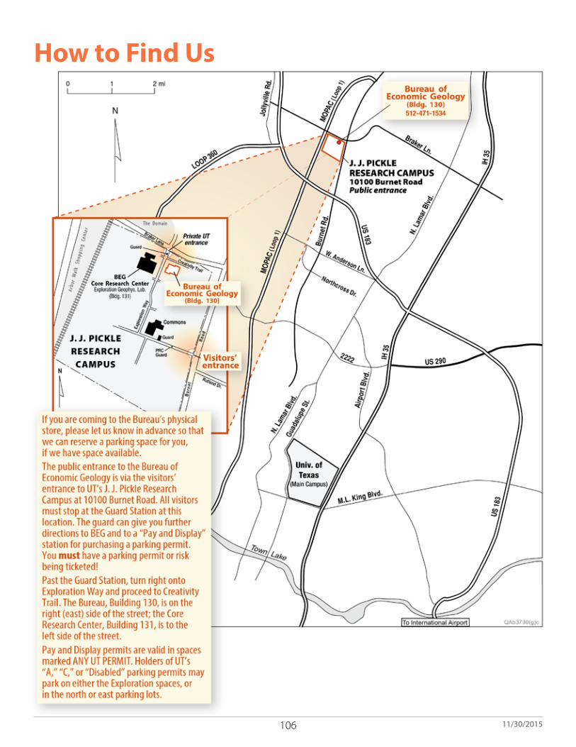
106 11/30/2015
How to Find Us

107
Order online http://begstore.beg.utexas.edu/store/ E-mail: [email protected] Phone: 512-471-7144 Fax: 512-471-0140
Orders may be placed online, by e-mail, by phone, or by fax, as noted above. Payment may be made offsite by major credit or debit cards or checks; visitors may also pay in cash. We accept purchase orders from institutions.
Please order carefully, as we do not accept returns or make refunds except in case of error or damages incurred in shipping.
Order Form
SHIP TO:
SUBTOTAL
Name
Company
Address
City State Country ZIP
Telephone ( ) Fax ( ) E-mail
SHIPPING(required for all orders)
Price Each(b)
Qty.(a) (a) × (b)
Pub. Code
Total
If Subtotal Is: Add 0.00 to 2.00 . . . . . . . 0.75 2.01 to 5.00 . . . . . . . 1.50 5.01 to 10.00 . . . . . . 2.0010.01 to 20.00 . . . . . . 2.5020.01 to 30.00 . . . . . . 3.0030.01 to 40.00 . . . . . . 3.5040.01 to 50.00 . . . . . . 4.0050.01 to 100.00 . . . . . 5.50More than 100.00 . . . . 7%
Shipping Charges
International orders add $5.00.
Note: These rates are not applicable to Rock Kits. Please contact our office for Rock Kit details.
Please check your area(s) of interest: general geology (1) geophysics (7) seismic studies (13) bibliographies/indexes (2) hydrogeology (8) sequence stratigraphy (14) coastal studies (3) maps (9) teaching/education (15) engineering geology (4) mineral studies (10) tectonics/fracture studies (16) environmental studies (5) oil and gas (11) other (specify) (17) geochemistry (6) petrology (12)
Texas Residents and Companies: If you do not include tax in your payment, you must attach a completed Texas Sales Tax Exemption Certificate, a Blanket Resale Certificate, or a Direct Exemption Certificate for your company. Personal checks and credit card payments are not tax exempt.
TOTAL AMOUNT ENCLOSED Make checks payable to:
UTBEG
PAYMENT IN FULL REQUESTEDPlease make payment in U.S. dollars drawn on a U.S. bank.
Please bill me Please add my name to your mailing list
Please send me another List of Publications
Please send me your latest Annual Report (or year ________).
Please charge my:
AMEX Discover MasterCard Visa
Account no.
Expiration date Verification Code
Authorized signature
NOTE: All orders will be filled upon receipt and will be mailed media mail.
Mail Order FOrM and PayMent tO:The University of Texas at Austin
Bureau of Economic Geology Attention: The Bureau Store
PO Box X, University StationAustin, Texas 78713-8924 USA
Phone: 512-471-7144 Toll-free phone (USA): 1-888-839-4365
Toll-free fax (USA): 1-888-839-6277Fax: 512-471-0140
8.25% sales TAX on subtotal plus shipping for shipments to Texas
No returns or refunds are permitted. First class mailing, international air mail, or courier delivery may be requested at the expense of purchaser. LOP 2015
Publication Title
Date

108 11/30/2015
List of Publications
http://begstore.beg.utexas.edu/store/
Scott W. Tinker, DirectorJackson School of Geosciences The University of Texas at Austin Austin, Texas 78713-8924
http://www.beg.utexas.edu/
Bureau ofEconomicGeology