Bulletin of the Geological Society of Denmark, Vol. 33/3-4, pp ...
Upload
khangminh22Category
view
2download
0
BULLETIN OF THE GEOLOGICAL SOCIETY OF AMERICAVOL. 67, PP. 1207-1246. 26 FIGS. SEPTEMBER 1966 '
WRENCH-FAULT TECTONICS
Bv J. D. MOODY AND M. J. HILL
ABSTRACT
Extending the work of E. M. Anderson, M. K. Hubbert, and W. Hafner on faulting,the authors develop the hypothesis that anticlinal folds, thrust faults, and wrench faultscan be generated as a result of movement on a large wrench fault such as the San Andreasof California. Extension of this concept leads to the conclusion that for any given tec-tonic area, at least eight directions of wrench faulting and four directions of anticlinalfolding and/or thrusting should accommodate the structural elements of that region;these directions should have a more or less symmetrical disposition relative to the direc-tion of the primary compressive stress. The angles a, (3, and y are defined to describethe geometry of such a wrench-fault tectonic system relatively completely.
The authors' interpretations of tectonics in various areas indicate that wrench-faulttectonic systems do exist and are aligned systematically over large portions of the earth'scrust as indicated by Hobbs, Vening Meinesz, Bonder, and others. Eight principal wrenchdirections are denned in terms of major elements of the earth's crust such as the Alpinefault of New Zealand. Structural elements aligned in these eight directions constitutemajor features of the regmatic shear pattern of Sender. The authors conclude that theshear pattern may have resulted from stresses which are oriented essentially meridionallyand have been acting in nearly the same direction throughout much of crustal history.
It is concluded that major wrench faults, which penetrate the entire outer crust ofthe earth and result in wholesale segmentation of the outer crust into polygonal blocks,constitute a fundamental type of yielding in the crust.
Possible origins of the stresses involved, formation of geosynclines, island arcs, vol-canism, and crustal evolution are discussed in terms of these ideas. Some possible objec-tions and weak points in the argument are pointed out, and suggestions for further studyare included.
CONTENTS
TEXT PagePacific Northwest examples 1223
Page Midcontinent examples 1223Introduction 1208 Other examples 1225
Purpose 1208 Geotectonics 1227Principal references 1208 Regmatic shear pattern 1227Definition of wrench fault 1208 Major wrench directions 1228Wrench-fault tectonics 1208 Primary-stress orientation 1230
Acknowledgments 1209 Analysis of fault pattern of France 1233Theory 1209 Possible origin of the regmatic shear
Stress ellipsoid and the angle /3 1209 pattern 1234Orientation of stress ellipsoid 1210 Periodic versus aperiodic orogeny 1236Normal, thrust, and wrench faults 1210 Consequences of a segmented crust 1238Second-order effects and the angle y 1211 "Island arcs" 1240The angle a 1212 Igneous activity 1240Wrench-fault tectonics 1212 Crustal evolution 1240
Field observations 1214 Conclusion 1241Recognition of wrench faults 1214 Summary 1241Dating of wrench faults 1215 Suggestions for further study 1242California examples 1215 Possible objections to the thesis 1243Basin and Range examples 1221 References cited 1243
1207

1208 MOODY AND HILL—WRENCH-FAULT TECTONICS
ILLUSTRATIONS
Figure Page1. Axes of the stress ellipsoid 12092. Shear directions in homogeneous media. . 12103. Theoretical fault orientations 12114. Second-order wrench faults 12125. Plan of wrench system under north-
south simple compression 12136. Major fault trends of California 12167. Drag folds along San Andreas fault,
California 12178. Right-lateral stream offsets along San
Andreas fault 12189. Inglewood fault trend, Los Angeles area,
California 121910. Calaveras fault, San Ramon area,
California 122011. Major lineaments of western United
States 122212. Hillside fault, Hudspeth County, Texas.. 1224
Figure Page13. Thomas fault, Wichita Mountains,
Oklahoma 122514. Ti Valley fault, Ouachita Mountains,
Oklahoma 122615. New Zealand direction 122916. Oca direction 123017. Great Glen direction 123118. Bartlett direction 123219. Major tectonic directions, a = 0° 123320. Major tectonic directions, a = 345° 123421. Relation of a to latitude, for 0 = 30°.... 123522. Structural pattern of the Dead Sea 123623. Strain rosette for 176 faults in France... 123724. Diagrammatic sketch of geosyncline and
geosynclinal sedimentary suite 123925. Cloos' Silesian shear zone 1241
TABLESTable Page1. Theoretical wrench- and thrust-fault
directions 12122. Angle of drag folding, 7, along Inglewood
trend, California 1219
INTRODUCTION
Purpose
New concepts of fault dynamics, evolvedthrough re-evaluation of published data oncrustal strain, mechanics of faulting, and fieldobservations, are presented. The purpose ofthis paper is to develop an over-all hypothesis,based on these concepts, of the stress andstrain mechanisms in the earth's crust (ex-cluding gravity tectonics and salt tectonics).
Principal References
There are three references in the Englishliterature on fault mechanics and faults whichare fundamental to the development of prin-ciples: (1) Anderson (1942; 1951) outlined thefundamental concepts of rock fracture. (2)Hubbert (1951) corroborated Anderson's viewsand presented experimental and theoreticaldata for the value of the angle between com-pressional stress directions and resultant shearplanes. (3) Hafner (1951) analyzed stress dis-tribution and faulting and emphasized thenecessity for considering stress distributionsin attempting to understand any strain situa-tion. The integration of the various principlesand theories of fault mechanics by Billings(1954) has also been most helpful.
Definition of Wrench Fault
The term wrench fault is adopted fromKennedy (1946) and Anderson (1951) to de-scribe ruptures in the earth's crust in whichthe dominant relative motion of one blockto the other is horizontal and the fault planesessentially vertical. The term is translatedfrom the German "blatt", originally used bySuess (1885), and is synonymous with strike-slip fault and transcurrent fault. The authorsfavor using wrench in deference to Anderson'sand Kennedy's pioneer work. Wrench fault isinterchangeable with lateral fault where thatexpression means actual rather than apparenthorizontal movement. Right lateral and leftlateral refer to the apparent relative movementof the two blocks viewed in plan; right lateralindicates clockwise and left lateral indicatescounterclockwise separation, as described byHill (1947). The authors extend the use ofright lateral and left lateral by adding wrench,so that actual horizontal slips are implied.
Wrench-Fault Tectonics
The writers propose that large-scale wrenchfaults may be a dominant type of failure inthe earth's crust. Large areas, probably con-tinental in dimensions, appear to have beensubjected to rather uniform stresses for ex-

INTRODUCTION 1209
tended periods. Possible orientations andorigins of these regional stresses and strainsare discussed. The application of these con-cepts to the interpretation of local and regionaltectonics is considered, and many geotectonichypotheses are re-examined in the light ofwrench-fault tectonics.
ACKNOWLEDGMENTS
This paper represents a synthesis of manyprevious workers' published material and count-less conversations with fellow workers andfriends. Particular mention is made of the manydiscussions and constructive criticisms by C. D.Cordry, H. D. Hedberg, and G. W. Ledingham.J. B. Currie, P. A. Grant, B. F. Hake, R. T.Hazzard, R. L. Johnston, and G. B. Lamb havecontributed particularly valuable ideas andsuggestions. The following have criticallyreviewed the manuscript, for which the writersare most appreciative: M. P. Billings, B. W.Blanpied, M. A. Hanna, R. T. Hazzard, K. C.Heald, H. D. Hedberg, M. L. Hill, G. B. Lamb,L. V. Lombardi, C. R. Longwell, C. L. Moody,H. M. Nielsen, and G. Pardo; no responsibilityfor any of the views presented herein is assumedby these gentlemen. The authors are indebtedto the Gulf Oil Corporation and the WesternGulf Oil Company for permission to publishthis paper and wish to express their appreciationto the officials of the Gulf Companies for thecreation of a climate favorable to interregionalexchange of ideas on a broad scale.
THEORY
Stress Ellipsoid and the Angle ft
A brief review of Anderson's (1951) workprovides a basis for understanding faultmechanics. Fundamental to his exposition is theexpression of stresses in terms of a set of threemutually perpendicular axes. In a homogeneousisotropic material under compression, themaximum compressive stress can be representedas acting in a given direction (Fig. 1, Y). Theminimum-stress direction (Fig. 1, X) is then atright angles to the maximum-stress direction,and the third rectangular axis must coincidewith the direction of an intermediate stress.
These three stress axes are of unequal lengthand describe an ellipsoid which long has beentermed the stress ellipsoid.
If a material of sufficient rigidity to reactelastically rather than plastically is stressed
MinimumCompressive
Stress
Maximumompressiv
Stress
IntermediateCompressive
Stress
FIGURE 1.—AXES OF THE STRESS ELLIPSOID
beyond its strength, it will rupture. In situa-tions such as those described above, the planesof maximum shearing stress are parallel to theintermediate stress axis and lie at angles of 45°on either side of the maximum compressivestress. The planes of actual shear do notcoincide with the planes of maximum shearingstress but lie closer to the axis of maximumcompressional stress and form an angle with itwhich is here called ft, the angle of shear(Fig. 2). The factors which contribute to thedeviation in direction between actual strainand theoretical strain are included in the "angleof internal friction" which is one of the con-trolling parameters for the value of the angle ft.
Hubbert (1951) indicates that, although thevalue of |8 may vary among different materials,a good average for rocks is approximately 31°.He wrote, "For rocks, this would correspondto normal faults with hades, or reverse faults
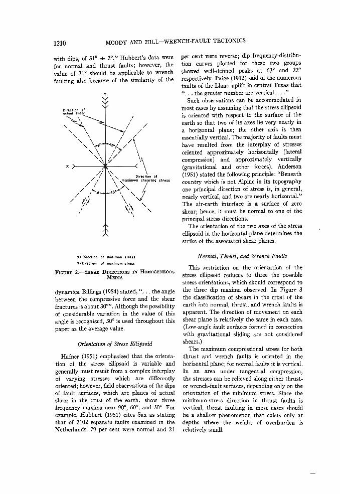
1210 MOODY AND HILL—WRENCH-FAULT TECTONICS
with dips, of 31° ± 2°." Hubbert's data werefor normal and thrust faults; however, thevalue of 31° should be applicable to wrenchfaulting also because of the similarity of the
^ v. Direction of* .maximum shearing stress
X s Direction of minimum stressY: Direction of maximum stress
FIGURE 2.—SHEAR DIRECTIONS IN HOMOGENEOUSMEDIA
dynamics. Billings (1954) stated, ".. . the anglebetween the compressive force and the shearfractures is about 30°". Although the possibilityof considerable variation in the value of thisangle is recognized, 30° is used throughout thispaper as the average value.
Orientation of Stress Ellipsoid
Hafner (1951) emphasized that the orienta-tion of the stress ellipsoid is variable andgenerally must result from a complex interplayof varying stresses which are differentlyoriented; however, field observations of the dipsof fault surfaces, which are planes of actualshear in the crust of the earth, show threefrequency maxima near 90°, 60°, and 30°. Forexample, Hubbert (1951) cites Sax as statingthat of 2102 separate faults examined in theNetherlands, 79 per cent were normal and 21
per cent were reverse; dip frequency-distribu-tion curves plotted for these two groupsshowed well-defined peaks at 63° and 22°respectively. Paige (1912) said of the numerousfaults of the Llano uplift in central Texas that". . . the greater number are vertical. . . ."
Such observations can be accommodated inmost cases by assuming that the stress ellipsoidis oriented with respect to the surface of theearth so that two of its axes lie very nearly ina horizontal plane; the other axis is thenessentially vertical. The majority of faults musthave resulted from the interplay of stressesoriented approximately horizontally (lateralcompression) and approximately vertically(gravitational and other forces). Anderson(1951) stated the following principle: "Beneathcountry which is not Alpine in its topographyone principal direction of stress is, in general,nearly vertical, and two are nearly horizontal."The air-earth interface is a surface of zeroshear; hence, it must be normal to one of theprincipal stress directions.
The orientation of the two axes of the stressellipsoid in the horizontal plane determines thestrike of the associated shear planes.
Normal, Thrust, and Wrench Faults
This restriction on the orientation of thestress ellipsoid reduces to three the possiblestress orientations, which should correspond tothe three dip maxima observed. In Figure 3the classification of shears in the crust of theearth into normal, thrust, and wrench faults isapparent. The direction of movement on eachshear plane is relatively the same in each case.(Low-angle fault surfaces formed in connectionwith gravitational sliding are not consideredshears.)
The maximum compressional stress for boththrust and wrench faults is oriented in thehorizontal plane; for normal faults it is vertical.In an area under tangential compression,the stresses can be relieved along either thrust-or wrench-fault surfaces, depending only on theorientation of the minimum stress. Since theminimum-stress direction in thrust faults isvertical, thrust faulting in most cases shouldbe a shallow phenomenon that exists only atdepths where the weight of overburden isrelatively small.

THEORY 1211
Normal faults require that the maximumstress be vertical, which means that thehorizontal stresses are smaller than the verticalstresses. This requirement obviates the syn-genetic development of normal faults with
"If movement is in progress on a main fault or'master shear', stresses in the rock adjoining it willhave such orientation as to cause failure on a newpair of mutually complementary planes, one ofwhich will make an acute angle with lie mastershear."
STRESS X > STRESS 1 > STRESS 2 STRESS Z > STRESS 1 > STRESS X STRESS X > STRESS 2 > STRESS r
THRUST FAULTS NORMAL FAULTS WRENCH FAULTSFIGURE 3.—THEORETICAL FAULT ORIENTATIONS
After E. M. Anderson (1951)
wrench or thrust faults except where normalfaults are a secondary effect due to localdeformation. Thus in an area of compressionphenomena, normal faults can result only if thevertical stresses exceed the horizontal com-pressional stresses; this situation usuallyobtains in areas of local positive uplift, as insalt domes and igneous intrusive masses.Gravity faults at the crests of anticlines andover salt domes are examples of normal faultsthat result from decreased horizontal stressand consequent increased vertical stress.Dynamically, normal faults are identical withthe other two types, except in the orientationof the stresses; all three are shears, and theterm normal fault as used here should not beconsidered a result of crustal tension.
All gradations within these three classes offaults can exist because of varying stressorientations; however, the three categoriesshould be valid for the great majority of faults.
Second-Order Effects and the Angle y
McKinstry (1953) developed a thesis ofsecondary strain features and discussed severalknown fault systems in terms of second-ordershears. He wrote,
McKinstry considered that inertial andfrictional forces involved during movement ona shear plane resulted in a local reorientationof the compressional stresses. This mechanismcan probably account for some second-ordershears; however, as McKinstry points out, theavailable forces decrease rapidly and thesystem is not regenerative. A mechanism whichis regenerative and seems more likely to explainthe large-scale second-order features contem-plated here was developed by Anderson (1951),based on computation by Inglis (1913). Bodyforces developed by movement along a faultcould also yield local stress reorientation, whichmight result in second-order features. The ideaof elastic rebound was promulgated by Lawsonet al. (1908) to explain the movement on theSan Andreas fault. A further possible mecha-nism for generating reoriented stresses adjacentto wrench-fault blocks may be found in thechange of shape which must ensue when faultblocks are subjected to continued compression.
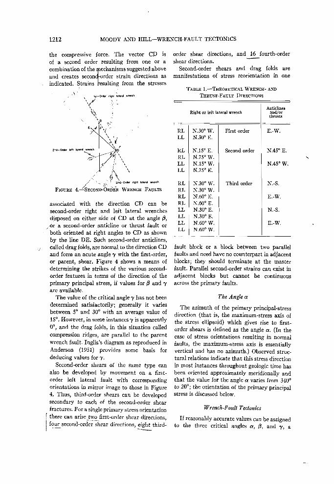
One or a combination of the mechanismsmentioned above results in locally reorientedcompressional forces which generate new straindirections called second-order shears (Fig. 4).The principal-stress direction is indicated bythe vector AB, which is equal in magnitude to
1212 MOODY AND HILL—WRENCH-FAULT TECTONICS
the compressive force. The vector CD isof a second order resulting from one or acombination of the mechanisms suggested aboveand creates second-order strain directions asindicated. Strains •esulting from the stresses
tet* Order right torero! wrench
2nd-Order tett lateral wrench
End-Order right lateral wrenchFIGURE 4.—SECOND-ORDER WRENCH FAULTS
associated with the direction CD can besecond-order right and left lateral wrenchesdisposed on either side of CD at the angle ft,
, or a second-order anticline or thrust fault orboth oriented at right angles to CD as shownby the line DE. Such second-order anticlines,called drag folds, are normal to the direction CDand form an acute angle 7 with the first-order,or parent, shear. Figure 4 shows a means ofdetermining the strikes of the various second-order features in terms of the direction of theprimary principal stress, if values for j3 and 7are available.
The value of the critical angle 7 has not beendetermined satisfactorily; generally it variesbetween 5° and 30° with an average value of15°. However, in some instances 7 is apparently0°, and the drag folds, in this situation calledcompression ridges, are parallel to the parentwrench fault. Inglis's diagram as reproduced inAnderson (1951) provides some basis fordeducing values for 7.
Second-order shears of the same type canalso be developed by movement on a first-order left lateral fault with correspondingorientations in mirror image to those in Figure4. Thus, third-order shears can be developedsecondary to each of the second-order shearfractures. For a single primary stress orientation
! there can arise two first-order shear directions,I four second-order shear directions, eight third-
order shear directions, and 16 fourth-ordershear directions.
Second-order shears and drag folds aremanifestations of stress reorientation in one
TABLE 1.—THEORETICAL WRENCH- ANDTHRUST-FAULT DIRECTIONS
Right or left lateral wrench
RLLL
RLRLLLLL
RLRLRLRLLLLLLLLL
N.30° W.N.30° E.
N,15° E.N.7S° W.N.15" W.N.75° E.
N.30° W.N.30° W.N.60° E.N.60° E.N.30° E.N.30° E.N.60° W.N.60° W.
First order
Second order
Third order
Anticlinesand/orthrusts
E.-W.
N.45° E.
N.4S° W.
N.-S.
E.-W.
N.-S.
E.-W.
fault block or a block between two parallelfaults and need have no counterpart in adjacentblocks; they should terminate at the masterfault. Parallel second-order strains can exist inadjacent blocks but cannot be continuousacross the primary faults.
The Angle a
The azimuth of the primary principal-stressdirection (that is, the maximum-stress axis ofthe stress ellipsoid) which gives rise to first-order shears is defined as the angle a. (In thecase of stress orientations resulting in normalfaults, the maximum-stress axis is essentiallyvertical and has no azimuth.) Observed struc-tural relations indicate that this stress directionin most instances throughout geologic time hasbeen oriented approximately meridionally andthat the value for the angle a varies from 340°to 20°; the orientation of the primary principalstress is discussed below.
Wrench-Fault Tectonics
If reasonably accurate values can be assignedto the three critical angles a, /3, and 7, a

THEORY 1213
complete tectonic system can be developed inaccordance with the principles presented above.If the values 0°, 30°, and 15° are assigned to
first and is dominant; however, the left lateralcould equally well be the primary fracture. Anentire geometric system of strain can be de-
Primory t8*—Order wrench(Right lateral)
I" ^-PRIMARY- STRESS DIRECTION
Complementary Is*- Order wrench(Left lateral)
right lateral wrencl
3rd-0rder drag fold
'fimory |st-or<jer wrench(Right lateral )PRIMARY-FOLD DIRECTION
PRIMARY- STRESSDIRECTION
FIGURE 5.—PLAN OF WSENCH SYSTEM UNDER NORTH-SOUTH SIMPLE COMPRESSION
a, /3, and y respectively, the tectonic directionsthat result are shown in Table 1.
The shear and anticlinal directions are dupli-cated in the third order, making it impossibleto distinguish fourth-order and lower directionsfrom first-, second-, or third-order directions.Thus, an infinity of shear directions does notarise; the system is resolved into eight majorwrench directions and four major anticlinalthrust-fault directions. Figure 5 illustrates" ahypothetical wrench-fault system showingfirst-, second-, and third-order wrench faultswith their corresponding drag folds. It isassumed that the right lateral wrench fractured
veloped from a single primary compressivestress orientation. Of course a somewhat dif-ferent system would result in the event yvaried considerably from 15°.
The values used in Figure 5 are hypotheticaland the directions indicated should not be con-sidered rigorously. Deviations from the idealsystem can result from the following:
(1) The indicated system resulted from con-sideration of essentially constant horizontalstresses in one direction, whereas Hafner(1951) showed that variable stresses acting intwo horizontal and one vertical direction mustbe considered in the general case. Although
1214 MOODY AND HILL—WRENCH-FAULT TECTONICS
these are valid and important considerations, inmost instances the result would be to impressrelatively minor curvatures on the idealizedsurfaces. However, any orientation of the stressellipsoid is possible.
(2) Crustal materials exhibit a wide range ofinhomogeneity and anisotropy.
(3) In consequence of the above, the orienta-tion of the stress ellipsoid with respect to thevertical, and the values of a, 0, and 7 probablyvary horizontally and vertically.
(4) Nonelastic deformation exists in crustalmaterials where stresses are continuous overlong periods. As Anderson (1951) points out,nonelastic behavior must contribute extensivelyto deviations from the ideal theoretical planevertical-shear surfaces.
(5) A further complicating possibility is thatsince normal and thrust faults are also shearsthe same analysis must be valid. Thus Figures4 and 5 can be regarded as vertical sections ofnormal or thrust faults, and the ensuing second-and third-order strains can be expected to occurin association with these types of faults also.
(6) In strongly orogenic areas subsequentdeformation can alter original dips and strikesof fault surfaces.
FIELD OBSERVATIONS
Recognition of Wrench Faults
Criteria for recognition of faults have beenadmirably discussed by Billings (1954); thefollowing extends his material with particularreference to wrench faults. Wrench faults arecharacterized by steeply dipping fault planes onwhich there have been appreciable strike-slipcomponents of movement. Theoreticallywrench-fault planes should be vertical; actually,any fault plane whose dip is steeper than 70° v
should be examined to see whether or not itmight be of the wrench type, and wrenchfaults with much gentler dips have beendescribed in the literature. Aerial photographsare of great assistance in identifying possiblewrench faults by means of their straight traces.Cotton (1950) gave a lucid presentation of geo-morphological aspects of faulting, much ofwhich pertains to wrench faults. Variations inapparent vertical displacement along strikesuggest wrench faults, as do fault planes which
vary in dip from high-angle normal to high-angle reverse. Scissors faults, which showreversal of apparent dip-slip displacementalong strike, might also be of the wrench type.
Evidence of strike-slip components of move-ment along fault planes is most frequently seenin slickensides, stream offsets, and offsets instructures and outcrop patterns. Modernmovement along faults of this type in someplaces provides direct evidence of horizontalmovement in association with earthquakes.1
Careful study of thicknesses, lithofacies,biofacies, and depositional fabrics can yieldevidence of strike-slip movement; this approachwas used by Hill and Dibblee (1953) to indicatethe possibility of 350 miles of post-Jurassicstrike-slip movement on the San Andreas faultin California. Mapping of subcrop contactsbelow unconformities should provide a moreprecise method of measuring horizontal compo-nents of displacement, if adequate well controlis available.
It is the writers' belief that major wrenchesneed not have strike-slip movement of theorder of magnitude indicated for the SanAndreas, Alpine, and Great Glen faults. Thequantitative relations existing between primaryand lower-order wrenches and drag folds arenot known; large-scale drag folds might developin association with wrenches of relatively smallstrike-slip displacement.
The orientation of folds and thrusts furnishesa clue which can be used to delineate wrenchfaults, inasmuch as the wrench to which anygiven anticlinal fold or thrust fault is secondaryshould make an acute angle 7 with the axis ofthe anticline or with the strike of the thrust-fault plane; drag folds should be asymmetric oroverturned on the flank closest to the parentwrench. The apex of the angle 7 should beopposed to the direction of lateral movement ofthe block. Structures which terminate abruptlywith no apparent cause might be limited by jwrench faults.
As emphasized by Anderson (1951), wrench-fault zones are characterized by the develop-ment of fault breccia along the individual
1 A series of articles recently published by J. H,Hodgson and his associates, e.g., Hodgson (1955)and Hodgson and Storey (1954), emphasize strike-slip movement associated with earthquakes.

FIELD OBSERVATIONS 1215
faults. The writers believe that the largeprimary wrenches extend through the outercrust and thus are very deep and fundamentalflaws in the crust. The result of movement alongthese deep faults can be expressed in the over-lying sedimentary veneer more commonly by acomplex zone of wrench faults and generallycomplicated structure than by an individualfault trace. Some deep-seated wrenches appearto be indicated at the surface only by systemsof small en echelon faults or anticlines.2 Situa-tions of this nature have been described byPicard (1954) as disharmonic faulting in thecase of the Jordan-Dead Sea rift system. Afurther example is the well-known zone of enechelon faulting in south-central Montana,which appears to lie in extension of the Coeurd'Alene lineament, here considered to be a leftlateral wrench-fault zone. On a large wrenchfault, such as the San Andreas, the zone offaulting can be several miles wide; in this zone,individual surfaces of movement anastomose ina complicated fashion resulting in a crush zonewith many fault splits whose surface tracesform a braided pattern, and in the developmentof a fault breccia throughout.
There are many difficulties inherent in therecognition of wrench faults; for example, thelast increment of movement in many cases hasbeen essentially vertical, so that the faultsimulates a high-angle normal fault or high-angle thrust fault. Many wrench-fault zones arecovered by secondary thrust sheets which areconsidered to have been built up from adjacentdrag folds and moved across the parent wrench.Recognition of wrench faults has lagged farbehind that of normal and thrust faults, inspite of the publication of the pioneer work ofsuch men as Anderson (1942), Hubbert (1951),Hafner (1951), and McKinstry (1953).
Dating of Wrench Faults
Exact dating of wrench-fault movements is adifficult problem arising from the continuousactivity of many of these faults throughgeologic time. In general, geologists determinethe youngest formation offset by a fault, or the
2 Wilson's (1953) paper calling attention to therelations between grabens, rifts, and wrench faultswas pointed out to the authors when this manuscriptwas in press.
oldest rock unit unaffected by a fault, andapproximate a time of rupture. This method isapplicable to wrench faults only to the extentof dating the last increment of faulting. Manyindividual pulsations can be dated by local un-conformities or buttressing of individualstratigraphic units on growing drag folds. Wherestratigraphic data are available on both sidesof a wrench, a progressively increasing offset ofolder and older units can be demonstrated bymeasuring facies separation; Hill and Dibblee(1953) successfully applied this principle to theSan Andreas fault. In some cases an approxi-mate date of fault inception can be determinedby correlating offset portions of pre-existingdeformation of known age.
Field evidence from the major wrenchesstudied suggests that the determination of faultinception is not clear-cut but is a function of thereadable geologic history. For example, the SanAndreas fault is said to have originated in thepre-Tertiary, probably Jurassic, only because Vthe oldest rocks that contribute understandabledata are probably late Jurassic and point to thepresence of an ancestral San Andreas. Thisinference suggests that some of the majorwrenches are as old as the rigid crust of theearth. On the other hand, as compression anddeformation have continued through geologicalhistory, new fractures have formed in responseto the increasingly complex stress distributionin the earth's crust.
California Examples
A discussion of field examples of wrenchfaulting should start with the San Andreas ofCalifornia. An early record of strike-slip move-ment on faults is to be found in the discussionby Lawson et al. (1908) of the San Franciscoearthquake, caused by movement on this fault.Figure 6 is an outline map of California onwhich the principal fractures have been traced,showing the San Andreas as the dominantfeature. The San Andreas fault extends fromPoint Arena to beyond the Mexican border,about 600 miles, in a general northwest-south-east direction, with its characteristic strikeN.40° W. Only two segments vary from this"normal" strike, one in the southern part, fromnear Maricopa to Banning (Fig. 6, M and B),where the strike approaches N.60° W., and the

1216 MOODY AND HILL—WRENCH-FAULT TECTONICS
FIGURE 6.—MAJOR FAULT TRENDS OF CALIFORNIA
other a small segment near Hollister, California(Fig. 6, H), where the strike approachesN.50° W.
Hill and Dibblee (1953) described the SanAndreas fault and proposed a stress orientationexplaining their interpretation of the dynamics:
"The present authors believe that: (1) the SanAndreas is a steep fault zone of variable width con-sisting of one or several nearly parallel faults; (2)its inception was quite likely pre-Tertiary, and itis now active; (3) it has probably been character-ized by right-lateral displacements throughout itshistory; (4) it marks such an important contactthat rarely can it be crossed, except in recent al-
luvium, without passing into significantly differentrocks; and (5) its cumulative displacement of somerock units is at least tens of miles, and older rocksmay have been displaced a few hundred miles."
The authors agree essentially with Hill andDibblee. Recent detailed work at severallocalities along the fault substantiates thecontention that the movement can be measuredin tens of miles since upper Miocene time andhundreds of miles since Jurassic time.
Most authors attempt to describe thedynamics of the San Andreas fault by con-structing vector diagrams surrounding its
FIELD OBSERVATIONS 1217
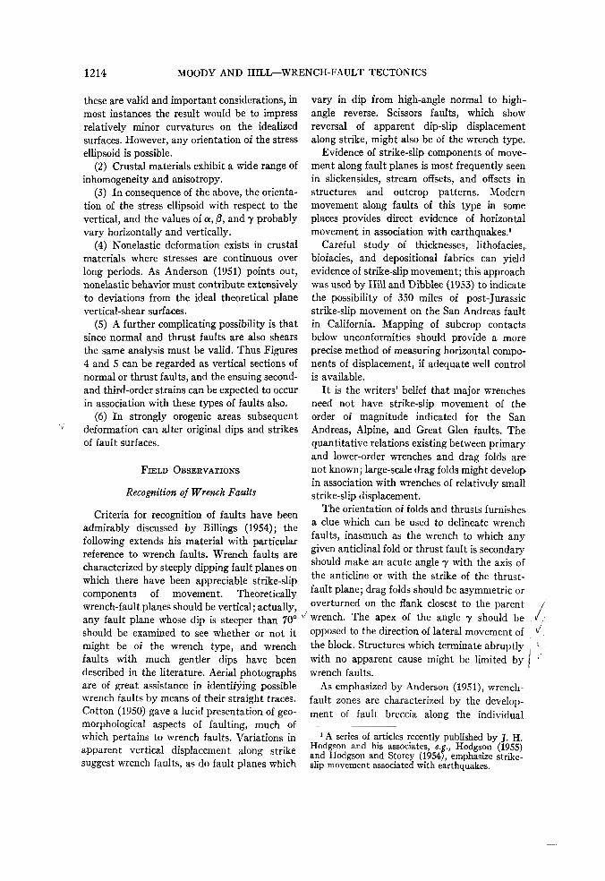
intersection with the Garlock fault. It is im- over a wide area must exist to develop such aportant to understand the mechanism of this lengthy and uniform rupture in the crust. Theanomalous section, but it is equally important authors believe that the San Andreas fault
FIGURE 7.—DRAG FOLDS ALONG SAN ANDREAS FAULT, CALIFORNIA
to define the mechanics responsible for thegreat extent of the fault where it is nearly astraight line. A N.40° W. orientation for themajor part of the fault requires a nearly north-south direction for the principal-stress axis, orpossibly a little west of north, to give rightlateral movement. The drag-fold orientationsillustrated in Figure 7 and many other dragfolds on the west side of the fault orientedN.50°-60° W. are clear evidence of right lateralmovement. The values of 7 measured from thefive drag folds in Figure 7 vary from 14° to 20°and average 17°. Uniform stress orientation
represents one of the major primary fracturesof the earth's crust, responding directly tostresses of fundamental importance in crustalmechanics.
A number of faults essentially parallel to theSan Andreas are also shown in Figure 6 andprobably represent the • first-order wrenchdirection associated with the San Andreas, orpossibly a part of a major rift-fault system ofwhich the San Andreas is the most pronouncedfracture. Such fractures as the San Gregoriofault south of San Francisco, the Nacimientofault zone, the Elsinore and San Jacinto faults,

1218 MOODY AND HILL—WRENCH-FAULT TECTONICS
appear to be part of this major system. TheElsinore and San Jacinto faults are essentiallyparallel to the principal San Andreas directionand appear to be new slices caused by the
\ x—?
fractures are shallow manifestations of a singleright lateral wrench fault at depth that is partof the San Andreas system. The many oil fieldsalong this trend are located on drag folds de-
Tract ofSon AndreosFoult
\
\%,
-&-
•r'V- x
35° 07° 30"
1/2
FIGURE 8.—RIGHT-LATERAL STREAM OFFSETS ALONG SAN ANDREAS FAULT
alteration of the San Andreas direction. Crowell(1952) assigns 15 to 25 miles of right lateraldisplacement since late Miocene time to theSan Gabriel fault. Many examples of streamoffsets by recent movements along these rightlateral faults are visible from aerial photographsand topographic maps. Figure 8 is a sketchalong the San Andreas in the Carrizo Plainsarea showing right lateral stream offsets varyingfrom a few hundred to several thousand feet.
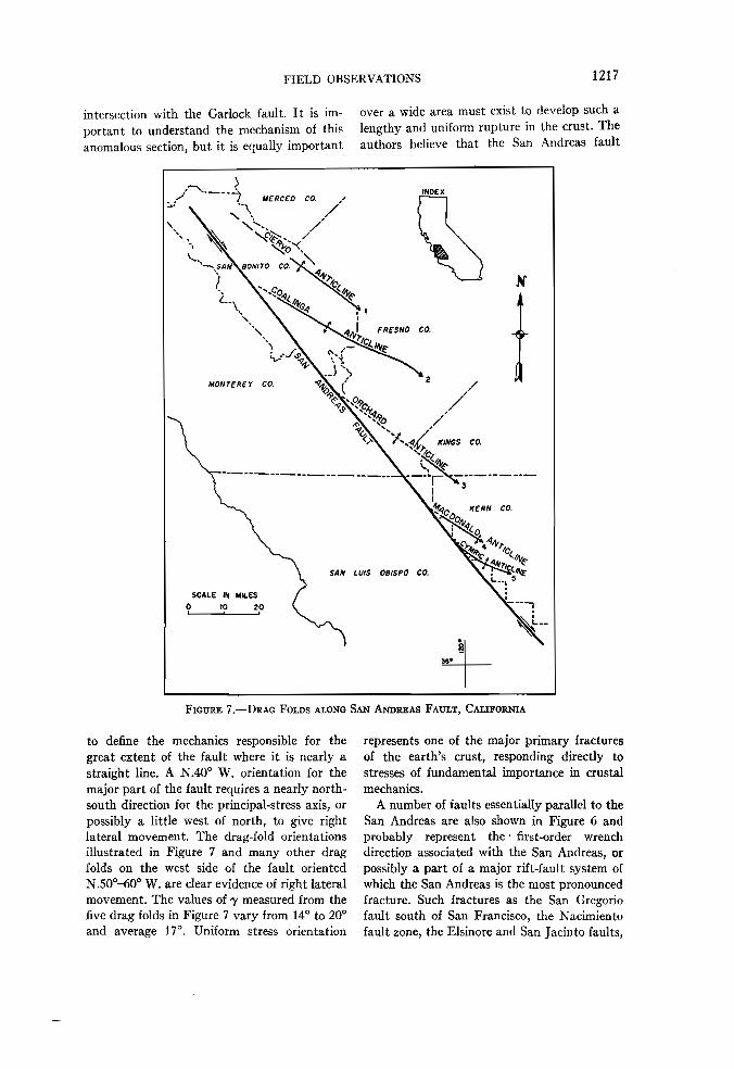
The Inglewood fault in Los Angeles Countylines up exactly with the San Andreas fault andshows recent right lateral movement as ex-emplified by the orientation of the en echelonfolds associated with it (Fig. 9). Detailed sub-surface work on the oil fields of this trend doesnot reveal a single clear-cut fault trace, butmany parallel faults are recorded in a narrowzone. The authors believe that these multiple
veloped by the right lateral motion. The angle7 was measured for each of these folds (Table 2).
The average angle 7 for the trend is 13.3°which compares favorably with the 17° notedabove for the large drag folds adjacent to theSan Andreas fault. Three of the largest folds,the El Segundo trend, the Torrance-Wilmingtontrend, and the Huntington Beach folds, demon-strate the largest values of 7, and the many enechelon folds along the Inglewood fault propermore nearly approach the strike of the faultitself.
The Calaveras and Hayward faults in theSan Francisco area are oriented N.20° W. toN.25° W. and show right lateral movementwith activity recorded in historic time. Theyintersect the San Andreas fault near Hollister,where its direction is altered, and appear to bepart of the San Andreas rift system. Figure 10
FIELD OBSERVATIONS 1219
«»>. Hunlinglon BeachTktebnds Pool
FIGURE 9.—INGLEWOOD FAULT TREND, Los ANGELES AREA, CALIFORNIA
TABLE 2.—ANGLE OF DRAG FOLDING, y, ALONGINGLEWOOD TREND, CALIFORNIA
Structure Angle
1. Inglewood 10°2. Potrero 6°3. Rosecrans 4°4. El Segundo trend 23°5. Signal Hill (average) 5° (0-10°)6. Huntington Beach 24°7. Huntington Beach tidelands pool 24°8. Seal Beach 10°9. Torrance-Wihnington trend 14°
Average 7 13.3°
is a sketch of a portion of the Calaveras faultin the San Ramon-Livermore area illustratingthe orientation of drag folds on both sides of thewrench. These folds demonstrate right lateralmovement and give values for the angle 7 from11° to 20°. An outstanding example of drag-fold evolution is shown by the Bolinger struc-ture where the drag fold developed beyond a
simple fold, became asymmetric, and finallythrust toward the controlling wrench fault.
The Garlock fault trends N.55° E. to N.65° E.and demonstrates left lateral movement. Hilland Dibblee (1953) describe it as essentiallyvertical and consider it a complement to theSan Andreas fault. Dynamically its orientationis not correct for the primary left lateraldirection, and it would more nearly fit a theo-retical position for a second-order left lateralfault, assuming north-south compression. Thegreatest change in direction of the San Andreasoccurs near its intersection with the Garlockfault. Basin and Range structure ceasesabruptly along the eastern extension of theGarlock fault, with an extremely complexstructural pattern existing south of that line, asdescribed by Hewett (1955).
Several other faults appear to be associatedwith the Garlock and may also have left lateralmovement. These are, first, the White Wolffault trend, N.52° E., along which the recentArvin-Tehachapi earthquake was located. An

1220 MOODY AND HILL—WRENCH-FAULT TECTONICS
INDEX MAP
MILES
FIGURE 10.—CALAVERAS FAULT, SAN RAMON AREA, CALIFORNIAData from Ham (1949), Taliaferro (1951), and Johnston (Unpublished map)
excellent description of this fault and itsprobable relative motion is included in a reportby Steinbrugge and Moran (1954). Anotherparallel direction is the Stockton escarpment,trending N.55° E., crossing the northern part ofthe San Joaquin Valley. This escarpment is
known only from subsurface data whichindicates that a thick section of Eocene rocksrests on Cretaceous north of the escarpmentwith nonmarine Miocene lying directly onCretaceous south of the escarpment.
The Transverse Range of California occurs at

FIELD OBSERVATIONS 1221
the position where the San Andreas makes itsmajor direction change. The Transverse Rangemay represent the primary-fold direction, conse-quently shortening the crust in this area andaltering the San Andreas direction. Possibly theTransverse Range is composed of drag foldsrelated to a second-order wrench directionoriented N,65° E., or parallel to the Garlockdirection. A third possibility is that theTransverse Range results from movementalong the Texas lineament of Ransome (1915)and that the anomalous direction of the SanAndreas system results from the intersection of
,] these two major shear zones. Many low-angle/ thrusts and structural complexities obscure the
true relationships in this area.Many of these wrench directions are as-
sociated with low-angle thrusts which areprobably due to reorientations of the stressesat a shallow depth. The eastern extension of theGarlock fault may pass into a thrust, theElsinore fault appears to be associated with theWhittier thrust, the San Gabriel fault hasthrust manifestations in its southern part, andthe Nacimiento fault has associated thrusts inthe south Cuyama area. These shallow thrustsare probably near-surface manifestations ofmajor wrench faults which in many cases areobscured by their own shallow complexities.
Shepard and Emery (1941) discussed thetectonic origin of the submarine topography onthe continental shelf off the California coast.Many of the topographic features are straightlines and parallel the major onshore faults. Thistopography clearly indicates the seawardextension of the Coast Range type of tectonics,at least as far west as the present continentalslope. Menard (1954; 1955) discusses four majorapproximately east-west lineaments on thePacific Ocean floor that no doubt have tectonicorigin. There are elevation differences acrossthem, foci of volcanism along them, and achange in character of the bottom topographybetween the various large lineaments. One ofthese major features lines up with the Mendo-cino escarpment (oS the northern Californiacoast) which has been genetically related to amajor east-west shear zone at False Cape,Humboldt County, by Ogle (1952); anotherappears to be associated with the ChannelIslands and Transverse Range.
Basin and Range Examples
Since Gilbert's (1874; 1875; 1928) descriptionof the "fault-block" theory of origin for theBasin and Range structure, many geologistshave been bound to a concept of "tensionfaulting". Other workers have long recognizedthe compressional aspects of the rock deforma-tion. Many complex thrust zones, in some casesinvolving upper Tertiary rocks, have beendescribed, and some have been observed by thepresent authors. Ferguson and Muller (1949),Ferguson, Muller, and Cathcart (1953),Roberts (1951), and Ferguson, Muller, andRoberts (1951a; 1951b) discuss areas of extremecompressional deformation in the central andnorthern parts of Nevada. Normal faults arerecognized as subordinate features. In severalcases in the literature a stratigraphic unitchanges character abruptly between two ex-posures, suggesting facies offsets. Topographiclineaments appear to have tectonic origins,indicating that a grand fracture pattern is con-trolling a large area.
Locke et al. (1940) describe a gross tectonicpattern for the western states which includes anorthwest-southeast trend parallel to the SanAndreas fault, named by them the "WalkerLane". This trend is N.40° W. and has struc-tural complexities which indicate that it is alarge wrench-type shear zone with right lateralmovement, as suggested by Locke et al. (1940).They consider the Walker Lane to be similarto the San Andreas fault. This is certainly amajor right lateral wrench-fault zone com-parable to the San Andreas of California(Fig. 11). Epicenters of several severe earth-quakes, the most recent in December 1954, arelocated near Fallon, Nevada, near the centralpart of the Walker Lane.
Several major faults have been describedalong the eastern and southeastern side of theBasin and Range province. Gregory (1950)discusses the Grand Wash, Hurricane, andSevier faults in southwestern Utah and north-western Arizona. These faults trend N.15° E.to N.25° E. and are at the approximate locationof the basinward edge of the Paleozoic shelf area(Fig. 11). The anticlinal trend described byMackin (1955) in the Cedar City-Iron Springsarea of Utah suggests drag folding. If this is

1222 MOODY AND HILL—WRENCH-FAULT TECTONICS
true, its relation to this fault zone would Most of the Basin and Range province isindicate left lateral movement. Kelley (1955) characterized by north-south ranges classicallymentioned left lateral movement on this fault described as bounded by large "normal" faults.
LEGENDKnown Wrench FaultInferred Wrench FaultMajor Tectonic Lineament:
(Possibly controlled bywrench faulting)
FIGURE 11.—MAJOR LINEAMENTS or WESTERN UNITED STATES
zone which he considered the western boundaryof the Colorado Plateau province. This generaltrend continues to the northeast along thewest boundary of the Uinta uplift and makesthe western boundary of the Green River basin.This trend could represent a first-order leftlateral wrench direction complementary to theSan Andreas-Walker Lane direction.
This trend varies from north-south to N.10° E.with a change in northwestern Nevada toN.20° E. to N.30° E. Many low-angle thrustsare involved in these mountain ranges ex-hibiting extreme compressional tectonism. Ithas been reported to the authors by severalworkers that some of these thrusts involveuppermost Tertiary rocks. Normal faults are

FIELD OBSERVATIONS 1223
present but they are subordinate features, andthe general geometry of the mountain ranges isthought to be controlled by a major wrench-fault system. The general north-south toN.10° E. orientation of these ranges suggests asecond-order right lateral shear system. If theSan Andreas and Walker Lane fault systemsrepresent the western boundary, and the edgeof the old shelf area represented by the GrandWash, Hurricane, and Sevier faults is theeastern boundary, with corresponding rightand left lateral movements, the greater part ofthe Basin and Range province should becharacterized by east-west compression of asecond order. The deformation exhibitedreflects such compression.
Pacific Northwest Examples
Much of the area of Oregon and Washingtonis covered by late Tertiary volcanics whichmask the effects of earlier tectonism. The mostpronounced lineament consists of the chain ofvolcanoes extending from Mt. Shasta in Cali-fornia to Mt. Baker in northern Washington.This trend varies from north-south to N.18° E.,the characteristic direction of the Basin andRange province. This chain of volcanoes mayexist along a major wrench fault, perhaps asecond-order right lateral shear. Other featureswhich might be significant are the north-southorientation of the Willamette Valley, thenorthwest-southeast lineament of the Straits ofJuan de Fuca, and the N.30° W. to N.3S° W.orientation of the Straits of Georgia. Raisz(1945) described a pronounced series oftopographic linears striking S.45° E. from theOlympic peninsula nearly to the Snake Riveras the Olympic-Wallowa lineament and sug-gested strike-slip faulting as a possible cause.Much of the east-west folding in centralWashington and Oregon, reflected in the youngvolcanics, could represent the primary folddirection of a north-south stress system; or, inthe case of the western Washington Tertiarybasin, the folds extending approximatelyN.60° W. could be drag folds of a second-orderleft lateral wrench trending N.65° W., whichmay be part of the Coeur d'Alene lineament.Interpretation of surface mapping is hazardousin the coastal part of the Pacific Northwest
because of the difficulty of seeing specific out-crops under rain-forest conditions. It is hopedthat current detail work by many oil companieswill contribute to the solution of the geologicalunknowns in this area. Sainsbury and Twen-hofel (1954) suggest a strike-slip origin forseveral lineaments of the fiord area of south-eastern Alaska. The principal directions notedare the N.10° W. alignment of Chatham Straitand the general orientation of many topographicfeatures N.35° W., which is characteristicallythe San Andreas direction.
Midcontinent Examples
On the Hillside fault, which is well exposed afew miles west of Van Horn, Texas, along U. S.Highway 80, low-grade metamorphic rocks ofPrecambrian age are faulted against Cretaceoussandstones. The fault plane is nearly vertical,strikes N.70° W., and its trace on the surfacecan be followed for several miles. This faultzone, if extended northwest along its strike,would pass just south of the Sierra Blancapluton and just north of the Malone Mountainsstructure. The Malone and Quitman mountainsexpose Jurassic and Cretaceous rocks whichhave been compressed into overturned andthrust-faulted folds striking generally N.45° W.The overturning and thrusting has been fromsouthwest to northeast. The northwesternportion of the Eagle Mountains and Devil'sRidge to the east of the Quitmans constitute asimilar overthrust fold. The Devil's Ridge andQuitman-Malone structural axes terminate attheir intersection with the extension of theHillside fault (Fig. 12). Farther west, the samezone is thought to be responsible for thetermination of the Franklin Mountains at ElPaso. Here a tilted block of little-deformedPaleozoic and Precambrian rocks standing athigh elevation (the Franklins) is juxtaposed tolow-lying strongly folded and faulted Cre-taceous rocks which have been intruded bylater porphyry (Cerro des Muleros). Theentire trend from El Paso to Van Horn is aportion of the Texas or Hill lineament of Hill(1902), Ransome (1915), and Baker (1934).The interpretation of the writers is that theHillside fault represents a large-scale leftlateral wrench fault and that the Quitman-

1224 MOODY AND HILL—WRENCH-FAULT TECTONICS
Malone and Devil's Ridge folds are second-order drag folds relative to this wrench. Theangle 7 between the wrench fault and the dragfolds is 29°, more or less. In the vicinity of the
considered to be one element of the boundaryfault zone between the Wichita Mountain up-lift to the south and the Anadarko basin to thenorth (Fig. 13). The Blue Creek Canyon anti-
Ipre-Combrion melasediments
| Paleozoic ? and Paleozoic sediments|Mesozoic sediments§ Tertiary igneous rocks
j£] Anticlinal axis0 Thrust fault(^Wrench fault1 0 I 2 3 4 5 6 7 8 9 JO Mi»«S
FIGURE 12.—HILLSIDE FAULT, HUDSPETH COUNTY, TEXAS
Sierra Blanca intrusives, overthrust sheets ofthe Etholen formation obscure other structuralrelations; these thrust sheets were probablycontinuous with the thrust sheets of the Devil'sRidge. North of the fault, the Cretaceoussection is relatively thin and contains no rocksolder than Fredericksburg (with a few minorexceptions); south of the fault, a thick sequenceof pre-Fredericksburg Mesozoic sediments ispresent.
The Smoky Hills on the north side of theWichita Mountains in southwestern Oklahomaconstitute an asymmetric anticlinal fold, ex-posing Precambrian in its core, which strikesN.4S° W. and has been called the Blue CreekCanyon anticline. The extensive Paleozoicexposures here are separated from the bulk ofthe Wichita Mountains to the south by theMeers Valley. A fault which has a recent scarpdeveloped in Quaternary alluvium in thisvalley has long been recognized and called theMeers Valley or Thomas (see Harlton, 1951)fault; this fault must be nearly vertical and is
cline is considered to be a secondary drag folddeveloped from movement in Pennsylvaniantime along this fault which the authors believeto be a left lateral wrench. The value of theangle y here is 25°. The Precambrian in the coreof the anticline is rhyolite porphyry, whereasmost of the Precambrian of the main mountainmass south of the fault consists of granophyresand gabbroic rocks; these rocks have beencataclastically altered adjacent to the fault.However, an area of rhyolite is known in thesoutheastern part of the mountains.
The structural relations along the southernpart of Black Knob Ridge, an Ordovician inlierin the western part of the Ouachita Mountains,Atoka County, Oklahoma, suggest wrenchfaulting (Fig. 14). The major fault of the areahas been called the Ti Valley fault; in theopinion of Hendricks et al. (1947) and others, itis the surface outcrop of a very large low-anglethrust fault along which there has been ex-tensive northwest horizontal transport. Thesurface trace is relatively straight, and the

FIELD OBSERVATIONS 1225
fault dips at the surface are very nearly 90°.The writers believe that this portion of the TiValley fault is a wrench fault. The dispositionof the small anticlines adjacent to this fault
compressive stresses adjacent to large wrenchfaults.
Henson (1951, personal communication) ex-pressed the opinion that Middle East geology is
RISw J^RIZW
FIGURE 13.—THOMAS FAULT, WICHITA MOUNTAINS, OKLAHOMAAdapted from Harlton (1951) and Decker (1939)
indicates that the relative motion occurred in aleft lateral sense. The anticlinal axes strikeN.45° E., and the trace of the fault averagesN.28° E., so that the angle 7 here is 17°.
Other Examples
Bucher (1933) cited the African rift system,the Rhine graben, the Triassic basins of theAppalachians, and the Great Basin country ofNevada and Utah as examples of broad-scalecrustal tension. The Rhine graben whichstrikes roughly N.I7° E. was shown by Cloos(1948) to coincide with one of his "geofrac-tures". The four areas cited by Bucher arecharacterized by large-scale "high-angle nor-mal" faulting; all may be wrench-fault zonesand the associated structural features areperhaps second-order effects resulting from
dominated by five major structural trends thatare associated with deep-seated block faulting.He recognizes a north-south direction (the Gulfof Aquaba-Dead Sea-Jordan River trend), anorthwest-southeast direction (the Red Seaand Persian Gulf shore lines), a northeast-southwest direction (the Hadhramaut coast),and two lesser subsurface directions. Cloos(1948) described the existence of an extensivesystem of "geofractures" in Europe which hasbroken the crust into blocks, which do notfollow presumed fundamental structural fea-tures of the crust such as the Alps and appearto have originated far back in geologic time.From Cloos' descriptions, his "geofractures"are probably wrench faults. The Philippinefault zone as described by King and McKee(1949) appears to be a major wrench-fault zone.Wrench faulting plays an important role in

1226 MOOBY AND HILL—WRENCH-FAULT TECTONICS
the tectonics of Taiwan (Biq Chingchang,personal communication, 1955). Extensivewrench faulting is recognized in New Zealand;
Palmer's map (1940) of Cuba shows thesouthern coast as part of a great fault scarpwhich coincides in part with the north flank of
FIGURE 14.—Ti VALLEY FAULT, OUACHITA MOUNTAINS, OKLAHOMAAdapted from Hendricks et al. (1947)
the Alpine fault strikes approximately N.50° E.and is a right lateral (Wellman, 1954; Gage,1952). The "fossa magna" and "median dis-location zone" of Japan appear to have some ofthe characteristics of wrench-fault zones. Anumber of wrench faults in Britain were de-scribed by Anderson (1942). Menard's (1955)discussion of major fracture zones in the north-east Pacific suggests the existence of largewrench faults in this part of the crust.
the Bartlett trough. This great topographicfeature has been considered a zone of wrenchfaulting by Hess (1939), Wilson (1950), andEardley (1951); the writers concur. TheOrganos-Cayetano front in extreme westernCuba may be a wrench fault; the major faultzone extending from Cardenas to Nuevitasalong the northeastern coast of the island mayalso be associated with left lateral wrenchfaulting. Many other wrench faults probably

FIELD OBSERVATIONS 1227
exist in the Caribbean area. (See Wilson, 1940.3)West (1951) described major shear fractures inAlaska that the authors interpret as wrenchfaults. Recently Sainsbury and Twenhofel(1954) added further evidence to the existenceof large-scale wrench faulting in southernAlaska. Major faulting with an importantwrench component has been described in theYellowknife area of the Canadian shield byBrown (1953; 1955). Brown (1955) states thatthe West Bay and associated faults are leftlaterals and concludes that minor faulting inthe area results from movement on the WestBay system. The Rocky Mountain trench ofAlberta and British Columbia in Canada is along straight topographic feature that satisfiesmost of the criteria of a major wrench-faultzone. This large feature strikes N.30° W. toN.45° W. and parallels the San Andreas fault.Several recent descriptions of portions of theGrenville front in Ontario and Quebec describetectonism which suggests large-scale wrenchfaulting to the present writers. (See Nielson,1952; Johnston, 1954.) The system of faultsextending from Bay St. George to White Bayand Notre Dame Bay in western Newfoundlandas described by Betz (1943) appears to be acomplex of major wrenches. Possibly the LakeSuperior fault zone (Eardley, 1951) and thehigh-angle normal faults of eastern Missouri,southern Illinois, and western Kentucky arewrench-fault systems. A system of faultssimilar in many respects to the Hurricane-Sevier system of central Utah extends from ElPaso to beyond Albuquerque along the RioGrande Valley, where Kelley and Reynolds(1954) described left lateral strike-slip move-ment on the frontal fault of the Sandia Moun-tains. Jones (1952) described the distribution ofvolcanism and faulting in this area. Dunham(1955) described wrench faults on the northwestflank of the Arbuckle Mountains of Oklahomaand cited Ham for similar occurrences elsewherein the Arbuckles. The Hudson and Connecticutvalleys in northeastern United States and theAllegheny structural front in eastern West
3 Major wrench faults of northern Venezuela havebeen described in an excellent paper by Rod (1956)which appeared subsequent to the submission ofthis manuscript.
Virginia show features which indicate possiblewrench faulting in these areas.
GEOTECTONICS
Regmatic Shear Pattern
Hobbs (1911), in a paper describing theuniformity of fractures, joints, and otherlineaments throughout the world, wrote:
"The practically uniform pattern and the likeorientation within each of the orderly fracturefields, point clearly to a community of origin instress conditions throughout an area of continentaldimensions.
"This recognition within the fracture complex ofthe earth's outer shell of an unique and relativelysimple fracture pattern, common to at least a largeportion of the surface, obscured though it may bein local districts through the superimposition ofmore or less disorderly fracture complexes, must beregarded as of the most fundamental and far reach-ing importance. It points inevitably to the conclu-sion that more or less uniform conditions of stressand strain have been common to probably theearth's entire outer shell.
"The ultimate cause of this common type ofdeformation is presumably the continued secularcooling of the planet."
Hobbs' ideas were poorly received; however,abundant later information has been developedand published in extension of these views. Baker(1934), in summarizing his observations on thegeology of Trans-Pecos Texas, wrote:
"... brittle rocks at and near the surface, with-out superincumbent load of other rocks, havebroken into a complicated mosaic of fault blocks bylateral slip movements in a zone under compression,producing elongated-domical or elliptical areas ofuplifted ridges, the longer dimensions or axes ofwhich are nearly parallel to the direction of lateralslippage. Therefore, they may be a consequence ofthrust or shear and differ from the commonly-accepted thrust planes in that the fracturing ismore nearly vertical than horizontal and the direc-tion is more nearly parallel than at right angle tothe direction of shear or thrust. Considerable rota-tory or torsional effect, it would seem, would be anecessary consequence and would shatter such zonesinto an assemblage of angular-outlined blocks."
The investigations of Fisk (1944) in the floodplain of the Mississippi River revealed acomplex system of shear-fault zones and jointsystems in the unconsolidated sediments of thisarea.
Locke et al. (1940) regarded the entire crustalsegment of the Sierra Nevada as part of a
1228 MOODY AND HILL—WRENCH-FAULT TECTONICS
regional shear zone. In discussing the tectonicsof this area they said, "The answer seems to bethat the longitudinal motion is fundamental,and that everything else is incidental andresultant."
Vening Meinesz (1947) described the shearpattern of the earth and investigated ana-lytically possible origins of the required stresses.He collected information supporting Hobbs'ideas that a relatively uniform fracture pat-tern is common to the greater portion of the,earth's surface; he implies that the stresseswhich yielded such a uniform shear patternresult from forces which are commonplaceand worldwide. Sender (1947), discussingVening Meinesz's paper in connection with hisown earlier publications, proposed that theworldwide shear pattern be termed the regmaticjoint or shear pattern and stated,
"I agree with Vening Meinesz that the existence ofthe regmatic shear pattern is a strong evidence of arigid crust reacting elastically to tectonic forces.The strength of this force must be considerable. Ifthis were not so, the worldwide coordination of theregmatic pattern would be impossible. The regmaticdissection runs across ocean bottoms and continentalplatforms as well, showing everywhere the existenceof a strong, rigid, and splittable body."
Cloos (1948), describing the ancient Euro-pean basement blocks, wrote:
"The major tectonic features of our continentsare generally supposed to be younger than the de-formed rocks which they transgress. During thelast two or three decades observations began toaccumulate which prove that several, if not all, ofthe main fractures or fracture zones in Europe areold and have been active practically during all thetectogenetic periods of the Earth's history. This in-dicates that the Earth's crust was divided intopolygonal fields or blocks of considerable depth orthickness during an early stage of its history. In thefollowing, the author will speak of 'basement blocks'which are separated by 'geofractures' or 'geo-sutures'."
Hobbs, Vening Meinesz, and Sonder pre-sumably included the major wrench faults asthe most important surface manifestations ofthe regmatic joint pattern of the crust; ap-parently the geosutures or geofractures de-scribed by Cloos (1948) in Europe are part ofthe same pattern. Their evidence has beensupplemented by innumerable publicationscovering local areas; for example, Johnston's(1954) description of a portion of the Grenville
front in Ontario, Canada, may be interpretedas a major wrench-fault zone that fits into theover-all regmatic joint pattern.
Major Wrench Directions
One of the most prominent tectonic directionsin the earth's crust is approximately N.30° W.to N.45° W. This direction coincides with thatof major right lateral wrench faults typifiedby the San Andreas fault in California and isdesignated the San Andreas direction. (SeeFig. 6.) The same direction is typical of theRocky Mountain trench in western Canada, ofthe submarine fault scarp off the west coast ofFlorida, of the Red Sea, and of the west coastof Sumatra which follows major structurallinears, according to Westerveld (1952).
The major tectonic directions in the GreatBasin of Nevada strike from due north toN.15° E. This tectonic direction is named theNevada direction.
The Alpine fault in New Zealand, a rightlateral wrench, strikes N.50° E., as describedby Wellman (1954). The tectonic directionN.45° E. to N.60° E. is therefore designated theNew Zealand direction (Fig. 15). The largeright lateral wrench fault in the VenezuelanAndes, extending from the Rio Santo Domingoto San Felipe and the sea, has this direction.
Another direction associated with rightlateral wrench faulting is N.75° W. to N.90° W.,which includes the strike of the Oca4 fault ofVenezuela and Colombia (Fig. 16). Theauthors refer lineaments of this strike to theOca direction, which coincides with that ofother major faults of Venezuela and Trinidadand with the southern slope of the Bay ofBiscayne, the front of the Pyrenees, and thesouthern coast of Java. Several of the largerfaults of the Transverse Range of southernCalifornia are perhaps related to this direction.
Another prominent crustal direction is ap-proximately N.15° E. to N.35° E. as typified bythe Great Glen fault in Scotland, a left lateralwrench fault; this tectonic direction is desig-nated the Great Glen direction (Fig. 17). Other
4 Ocoa of Sutton (1946), Rod (1956), and others.According to Gordon Young of Mene Grande OilCompany, Caracas, Venezuela, the correct spellingis Oca.

GEOTECTONICS 1229
prominent tectonic features with this direction fornia. The West Bay fault system in theinclude the Grand Wash-Hurricane-Sevier fault Yellowknife area of northwestern Canada is azone of Arizona and Utah, the Ryukyu deep left lateral wrench with this direction.
Ni
FIGURE 15.—NEW ZEALAND DIRECTIONAfter Wellman, Grindley, and Munden (1952)
and the Kurile Islands, the Rhine graben inwestern Europe, and the Jordan-Dead Seavalley in Palestine.
The tectonic direction N.10° W. to N.30° W.is designated the Colombia direction since thisis the strike of a large left lateral wrench faultin northern Colombia which separates theCordillera Central from the Sierra Nevada deSanta Marta. The Oslo-Kattegat line offractures separating Sweden from Denmark hasthis strike, as does the Philippine trench in thewestern Pacific and the Owens Valley in Cali-
The Texas or Hill lineament, described byHill (1902), Ransome (1915), and Baker (1934)as extending from south Texas to Los Angelesand beyond, coincides in part with a series ofknown or suspected left lateral wrench faultswhich strike N.60° W. to N.75° W. Thisdirection is termed the Texas direction. TheHillside fault (Fig. 12) is a portion of thislineament. Other structural elements with thisstrike are the south flank of the AnadarkoBasin in Oklahoma and the Texas Panhandle,and the Guerrero coast of Mexico.
1230 MOODY AND HILL—WRENCH-FAULT TECTONICS
Another well-known tectonic direction is thatof the Bartlett trough in the Caribbean Sea(Fig. 18). The north flank of this deep isbelieved to be a fault of the left lateral type
that vertical components of movements alongelements of the regmatic shear pattern varyfrom as much as 50 per cent to as little as 3 or4 per cent of the horizontal. Of course, not all
FIGURE 16.—OCA DIRECTIONData from Geol. Soc. Amer. Map of South America (1950)
striking N.70° E.; the crustal direction X.60° E.to N.75° E. is designated the Bartlett direction.Other tectonic lines with this strike are theGuadalquivir fault in southern Spain, the Hurddeep in the English Channel, and the Bronsontrough ofi Puerto Rico.
The authors believe that these eightlineament directions represent major wrenchfaults or geofractures along which the pre-dominant displacement has been horizontal.Vertical movements have occurred but are ofmuch less magnitude. The maximum elevationdifference on the surface of the earth today isapproximately 65,000 feet; the maximumvertical displacements on faults known to theauthors are somewhat less than this. This isalso the order of magnitude of the thickness ofthe thickest presumed conformable strati-graphic sections. On the other hand, the greatesthorizontal displacement suggested for anywrench fault is 350 miles; the writers believe
wrench faults have moved hundreds of miles;on the other hand it is believed that second-order structural features of considerable pro-portions can be related to wrench faults wherestrike-slip movement is measureable in tens ofmiles.
Primary-Stress Orientation
The angle a has been defined above as theazimuth of the primary principal-stress direc-tion. Anderson (1951) and Hill and Dibblee(1951) pointed out that the wrench faultsobserved in Britain and California respectivelycan have originated from a stress system whichwas oriented approximately meridionally (i.e.a = 0°). If meridional compressional forces areassumed as generating the primary principalstresses and the primary right and left lateralwrench faults, the other six wrench directionscould result as second- and third-order shears,

GEOTECTONICS 1231
IT
50 Milts
FIGURE 17.—GKEAT GLEN DIRECTIONAfter W. A. Kennedy (1946)

1232 MOODY AND HILL—WRENCH-FAULT TECTONICS
as described above. Theoretically, given anydirection for a primary compressional stress,there should result two first-order shears, foursecond-order shears, eight third-order shears,
parameters. Figure 21 shows the relationbetween a and latitude for the Great Glenfault in Scotland, the Rhine graben in westernEurope, and the Dead Sea Valley in Palestine,
FIGURE 18.—BARTLETT DIRECTIONDepths in fathoms
and 16 fourth-order shears. If the angle /3 be-tween the principal stress and the shearremains essentially unchanged and the angle 7remains sensibly constant, the directions of theresultant lower-order shears start repeatingthemselves so that only eight directions result.Figure 19 shows the wrench directions whichwould result if the primary stress were north-south (i.e. a = 0°). The prevalent directionsfor folding and thrusting are also shown; thesecond- and third-order stress directions are,of course, orthogonal to the indicated folddirections.
Figure 20 shows the resultant directions if theprimary stress is oriented north-northwest(a = 345°); the only difference is a rotation ofthe entire system. The direction of the primarystress may vary with latitude or perhaps other
assuming that all three are primary left lateralwrench-fault zones. There is thus some sug-gestion that the wrench fault systems aregradually rotated toward the west as theequator is approached. However, in any areathe relative angular relations in Figures 19and 20 should hold.
The authors believe that present evidenceindicates that the primary principal com-pressional stress direction has not varied muchmore than 20° to the west or east of north, andin most instances the wrench-fault systemsappear to be satisfied by a primary principal-stress direction lying between due north andN.15° W. However, a symmetrical distributionof shear directions would result from primarycompressional stresses oriented east-west whichmight exist in the earth's crust. Northwest-

GEOTECTONICS 1233
southeast or northeast-southwest primary com-pressional stresses could generate the sameshear pattern. The primary stresses may beactually east-west, or both north-south and
example, Lees' diagram (1952) of the Dead SeaValley in Palestine (Fig. 22) shows that therelation between anticlines and faults is suchthat the movement must have been in a left
Colombia dir.
San Andreas <
Nevada dir.
Great Glen dir.
Texas dir.
Shear directions
\
\ 5S ,
Primary fold direction
Tertiary
Fold and thrust directions
FIGURE 19.—MAJOR TECTONIC DIRECTIONS, a = 0°
east-west primary-stress systems may exist orhave existed. However a north-south orienta-tion for the primary principal compressionalstresses seems the most reasonable in the lightof the evidence at hand.
A difficult situation arises in attempting todistinguish between elements of the directionsdeveloped from primary stresses oriented sothat a = 0° and elements which result whena ^ 0°; the distinction can be made from thesense of the horizontal displacement only. For
lateral sense, so that this fault system, eventhough it strikes N.10° E., approximately, mustbe a Great Glen element resulting when a =340°. Such difficulties should arise only on thebroadest scale, since a is thought to remainsensibly the same over fairly large segments ofthe crust.
Analysis of Fault Pattern of France
The directions of 176 straight faults shownon the Carte Geologique de France (1933),

1234 MOODY AND HILL—WRENCH-FAULT TECTONICS
KGreat Glen dir.Nevada dir
Colombia dir.San Andreas dir.
Melt dir.
Oca dir.
Shear directions
Fold and thrust directions
FIGURE 20.—MAJOR TECTONIC DIRECTIONS, a = 345°
scale 1:1,000,000, are plotted on Figure 23.These measurements were not weighted forlength, and it is not known how many of theincluded faults are normal and how many arewrench. However, the strain rosette shows fivewell-defined maxima with the two mostprominent at N.45° W. and N.2S° E. If thesetwo maxima correspond to the primary rightand left lateral directions, the primaryprincipal-stress direction should lie halfwaybetween them. On this basis the value for /3 is35°, and the value for a is 350°. The peak at
N.45° W. then corresponds to the San Andreasdirection, the peak at N.25° E. corresponds tothe Great Glen direction, the peak at N.50° E.corresponds to the New Zealand direction, andthe peak at N.70° W. corresponds to the Texasdirection.
Possible Origin of the Regmatic Shear Pattern
Apparently many major wrench faults havemoved more or less continuously since theirinception; in most cases they are traceable

GEOTECTONICS 1235
back as far as the geologic record goes. Forexample, in California the San Andreas faulthas been inferred to have been moving inJurassic time; the pre-Jurassic record has beendestroyed by metamorphism so that no date
60°-
50° -
40°-
30°-
20°-
Greot Glen Fault
me graben
Dead Sea valley
—i 1 1 r r—340° 350° 360° 10° 20°
FIGURE 21.—RELATION OF a TO LATITUDE,FOR ,8 = 30°
other than pre-Jurassic can be assigned to theorigin of this fault. Cloos (1948), in describingthe geofractures in Europe, states, "Great ageand frequent activity can be proven for mostof the central European examples." Ver Wiebe(1936) believes that the boundary fault whichhe postulates in the heart of the Appalachianshad its inception in Precambrian time. VeningMeinesz (1947) wrote:
"It must be realized that many of the shear planesmust have been maintained throughout great parts,or perhaps the whole, of the crustal history; in allcases where forces have since worked on the crust,the chances must have been great of differentialmovements of the separate crustal blocks and, there-fore, of new shearing along these planes. If the crusthad been covered by more recent sediments, theselayers must have had insufficient strength for re-sisting the movements, and so the shear planesmust have penetrated these layers also. It may,therefore, be expected that a continuous rejuvena-tion of the Net has taken place at the Earth'ssurface. Doubtless this must have been one of themain causes of the volcanicity of the alkaline type."
There are large wrench faults which can be
shown to have been active in, for example, Pre-cambrian and Paleozoic time, on which there isno evidence of later movement. Apparentlyboundary faults can "heal" or lock so that nofurther movement occurs, and the stresses arethen accommodated along other fractures. Itshould be emphasized that the period of geologicobservations covers only a few scores of years,and it is possible that recent movements onfaults believed to have been inactive since, forexample, Paleozoic time may have occurred. Asan illustration, the Nemaha granite ridge inOklahoma and Kansas, believed to be associatedwith a major wrench-fault zone, had its mainstructural growth in late Paleozoic tune. Lee(1954) pointed out the apparent relation be-tween the earthquake which occurred hi thearea in 19S2 and the outline of the Nemahastructure.
The writers believe that the origin of the.regmatic joint pattern goes back to the periodwhen the earth was very young, when the crustfirst evolved enough to support compression.Several different types of forces are consideredto have been responsible for the genesis of theregmatic shear pattern. Subcrustal convectioncurrents have been suggested to explain variousphenomena associated with the deformation ofthe crust. (See Gutenberg, 1951; Hafner, 1951;Scheidegger, 1953; Vening Meinesz, 1954.) Ifsubcrustal convection currents exist, they mustexert a considerable drag on the base of thecrust. Their orientation would perhaps besymmetrical in some fashion with the axis ofrotation of the earth so that subcrustal con-vection currents could result in forces acting inan essentially meridional direction. Anothersource of compressional stress in the earth'scrust is attributable to the diurnal rotation ofthe earth itself, possibly in association with"Polfluchtkraft". (See Gutenberg et al, 1951.)Secular compression should result in conse-quence of cooling and contraction, as empha-sized by Lees (1953), Landes (1952), andJeffreys (1952). Possibly each of these threetypes of forces has had and does have largenorth-south components; other forces of asimilar nature may be involved. These forces,which have been acting essentially continuouslyand in the same sense throughout geologic time,are, in the opinion of the authors, responsible

1236 MOODY AND HILL—WRENCH-FAULT TECTONICS
Primary-stressdirection
Faults (broken line where inferred)Anticlines or Flexures (broken lines are
assumed continuations)
FIGURE 22.—STRUCTURAL PATTERN OP THE DEAD SEAModified from G. M. Lees (1952)
for the regmatic shear pattern of the earth'scrust.6
1 A. E, Scheidegger (1955) recently pointed outthe difficulties inherent in accommodating majorstrike-slip movement in either the convection-cur-rent theory of orogenesis or the contraction theoryas presented in the literature.
Periodic versus Aperiodic Orogeny
Gilluly (1949) stressed the aperiodic andcontinuing nature of crustal movement; ad-ditional support for this thesis has been de-veloped by Spieker (1950, personal communica-

GEOTECTONICS 1237
270'- -90«
180'
San AndreasGreat Glen
Zf -
f> -•
N45°W
70°35°350°
FIGURE 23.—STRAIN ROSETTE FOR 176 FAULT IN FRANCETaken from Carte Geologique de France (1933), scale 1:1,000,000
tion) in his studies of the Rocky Mountains.This is consistent with what might be expectedif the forces of compression are associated withthe rotation of the earth and related phenomenaand is consistent with the extremely long historyof most primary wrench faults. All the evidenceindicates that compression exists and hasexisted continuously in a large portion of theearth's crust throughout most of geologicaltime. Bucher (1951) wrote, ". .. the writersees no escape from the conclusion that through-
out recorded geological history, the earth'scrust has been under tangential compression."Benioff's (1951) finding from analysis of earth-quake data that energy accumulation occurs ata constant rate over periods of time of a fewtens of years in a given area is consistent withthis conclusion.
The culminations of crustal movement andorogeny at the end of the Paleozoic era and inlater Tertiary time are well known, and erogeniccycles of less magnitude have been frequently

1238 MOODY AND HILL—WRENCH-FAULT TECTONICS
described in the literature. (See Umbgrove,1950.) Tectonicists are thus faced with theparadox that orogeny in general is both periodicand aperiodic.
This seeming conflict can be resolved by con-cluding that the major crustal compression isomnipresent and results from forces derivedfrom the rotation and precession of the earth,together with its cooling and contraction.Superimposed on this continuous force fieldmay be a periodically variable force or groupof forces which coincides with the periodic re-currence of what have been called the orogenicrevolutions. It seems possible that the periodiccomponents of compression which are requiredto explain the recurrence of orogenic maximacan derive from subcrustal convection currentsor possibly from some extraterrestrial influence,as suggested by Umbgrove (1950).
Consequences of a Segmented Crust
The existence of a shear pattern comprisedpredominantly of major wrench faults results ina definite segmentation of the crust. Importantcomponents of horizontal movement on thesefaults, as has been demonstrated for the GreatGlen fault, the Alpine fault, and the SanAndreas fault, imply the existence of a surfaceof horizontal movement at some depth belowthe surface. This surface could be at Barrell'sasthenosphere, or Davison's "level of nostrain", or the base of the solid crust, or a zoneof plastic flow. Gutenberg et al. (1951) give 30to 100 km as the probable depth to the "base ofthe outer crust". The authors believe that themajor vertical faults extend to this surface,wherever and whatever it may be, so that thesolid compression-transmitting portion of theouter shell of the earth at least is divided intoblocks. These blocks, bounded by major linearelements of the regmatic shear pattern, tend tobe polygonal.
Hobbs (1911) mentioned as spacing betweenmajor fault components 125 miles betweennortheast-southwest faults, 75 miles betweennorthwest-southeast faults, and 40 miles be-tween north-south elements in eastern NorthAmerica. Cloos (1948) suggests 175-300 milesas the breadth of major blocks in Europe. Suchdimensions correspond roughly to those of
areas over which isostatic adjustment is esti-mated to be relatively complete. The diamond-shaped block of the Philippine Basin in theWestern Pacific has diagonal dimensions ofroughly 1500 and 2500 miles. This shape andsize are perhaps typical of megablocks boundedby two primary right lateral and two primaryleft lateral wrench zones.
One result of such segmentation of the crustwould be that blocks or groups of blocksseparated by major boundary faults could havedecidedly different geological histories, as borneout in many regional geological studies.
As movement continues along the boundaryfaults any block could be freed from com-pressive forces, and thus it would be possibleto have an unstressed block or blocks sur-rounded by stressed blocks; the unstressedblock or blocks could then respond to whateverother forces to which it was subjected (forexample, gravitational forces, sedimentaryloading or unloading acting on its surface, orhydrostatic stresses acting on its base) andcould then move vertically in response to suchforces. Such a stress release could explain"isostatic adjustment" and "equilibrium" andthe continued downwarping of particularcrustal areas which results in what mostgeologists call geosynclines; it could also explainthe abundant field evidence that there hasbeen late vertical movement on vertical faults.
The development of sedimentary suitesdisplaying most of the characteristics of geo-synclinal accumulations is readily visualized(Fig. 24). Given a major boundary fault be-tween two independent crustal blocks, minorvertical components of movement associatedwith the dominant strike-slip movement of thefault could be evidenced by minor tilting ofthese blocks so that the emergent part of oneblock could be apposed to the lowest part of theadjacent block. A strongly asymmetric basinwould thus be formed which could accumulatesediments from two directions. Thus the fine-grained sediments accumulating from the westin the diagram could be contaminated by coarsedebris eroded from the scarp of the boundaryfault; this could result in mixing graywackesand conglomerates into the fine-grained clasticfrom the west, yielding a bimodal sediment.Major boundary faults are considered principal

GEOTECTONICS 1239
avenues for movement of subterranean materialupward in the crust so that volcanic and/orsiliceous components could easily be added tothe already complicated sediment.
A further consequence of a crust thus seg-
Geosynclinol sedimentory suite -bimodol clastic component ismixture of a and b • may havevolcanic and/or siliceous com-ponents from igneous activity •
Source of sediment a (fine) aton' '"""•Shell depositsof sediment
ual blocks must decrease with continued com-pression; in the writers' view this contractiontakes place around the edges of the majorblocks in the vicinity of the boundary faultswhere folding and thrusting is concentrated.
MAJOR WRENCH FAULT' (with relatively small vertical component)-Source of sediment b (coarse)
Cruitol block B
FIGURE 24.—DIAGRAMMATIC SKETCH or GEOSYNCLINE AND GEOSYNCLINAL SEDIMENTARY SUITE
mented would be that, although individualblocks or groups of blocks could show greatstrength, larger groups of blocks which includeseveral major boundary faults would havevery little strength insofar as vertical move-ments are concerned. Perhaps in this mannera second paradox which has plagued geologistsfor many years could be resolved.
Ver Wiebe (1936) and Weeks (1952) pointedout that most geosynclines or large basins areasymmetric and bounded on the steep flank bywhat Ver Wiebe termed geosynclinal bound-ary faults. The authors believe that thesegeosynclinal boundary faults are in most caseswrench faults and constitute important ele-ments of the regmatic joint pattern. In viewof the tremendous boundary fault postulatedby Ver Wiebe in the Appalachian country toaccommodate his stratigraphic observations,structures of the magnitude of the Appalach-ian chains might be related to major faults ofthe type described by Ver Wiebe.
One of the requirements of a contractingearth is that its surface area should decrease,as emphasized by Jeffreys (1952). In a seg-mented crust the surface areas of the individ-
Continued distortion of individual blocks mustresult in a change of shape, so that the direc-tions of the major wrenches might vary slightlyas compression continues; this is actually anincrease in the angle /? from the theoreticalvalue of 31°. The magnitude of this effect isnot known.
Landes (1952) developed the concept of ashrinking globe and concluded that the con-tinental and oceanic sectors of the surface ofthe earth act as separate blocks or blockgroups and that in the course of secular cool-ing and accompanying contraction the oceanicblocks, or portions of them, subside while thecontinental blocks remain high. This wouldresult in a deepening of the oceans and, as-suming a relatively constant volume of water,the withdrawal of the seas from the con-tinental segments. Subsequent to the sub-sidence of the oceanic blocks Landes considersthat the continental blocks follow them down;the latter blocks are then reinundated. It issuggested that the existing average elevationdifference between continental and oceanicblocks is typical of only a small portion ofgeologic time, and that a considerably smaller

1240 MOODY AND HILL—WRENCH-FAULT TECTONICS
elevation difference resulting in widespreadshallow seas over large portions of the con-tinental blocks represents a closer approach toequilibrium conditions.
These ideas are supported by the observa-tion that practically all the sediments de-posited on the continental blocks are shallow-water accumulations. The converse of thisstatement is apparently not true, inasmuch asrecent submarine explorations have demon-strated the presence of shallow-water sedi-ments at great depths under the oceans. Atpresent many geologists ascribe these occur-rences to turbidity currents, but some of theseanomalous sediments might have accumulatedmore conventionally during episodes in theearth's history when the elevation differencesbetween the continental and oceanic blockswere much less than they are now. C. L. Moody(1951), in discussing the history of the Gulf ofMexico, expressed the opinion, based on hisstudy of the Citronelle and other formations,that during late Pliocene time at least thenorthern portion of the Gulf was filled withsediments. He concludes that post-Pliocenetime must include 12,000 feet of collapse orsubsidence in the Gulf of Mexico. M. A.Hanna (1954, personal communication) hasshown, from his environmental studies of lateTertiary sediments in the Gulf coastal area,that in given localities fluctuations in depth ofwater on the order of 1000 feet are common.
All these effects are understandable as con-sequences of a segmented crust.
"Island Arcs"
In many instances the "island arcs" re-ferred to in the literature can be resolved intosequences of straight-line segments which arebelieved to be associated with the regmaticjoint pattern. The Aleutian Archipelago, oneof the classic "island arcs", is possibly a casein point. Wilson (1950) refers to an arc alongthe west coast of the United States, extendingfrom Seattle to Los Angeles, which can beresolved into two straight-line segments—onecomprising the San Andreas group of wrenchfaults and associated structural phenomenarunning from Los Angeles to approximatelyCape Mendocino, and the second a group oftectonic elements of the Nevada direction ex-
tending from Cape Mendocino to Seattle. (SeeFig. 11.)
Other well-known "arcs," such as the In-donesian and Japanese groups, can be visu-alized as being composed in large part of linearsegments which might be considered as ele-ments of the regmatic shear pattern.
Igneous Activity
Volcanic and plutonic phenomena are knownto occur in linear belts. "Serpentine" intru-sives are associated in many cases with majorwrench faults. Werenskiold (1953) suggested amechanism which relates volcanic activity tolarge-scale geofractures. The Hawaiian Islandsconstitute a good example of volcanic linearity,as do the volcanoes of the Aleutians, theSolomon Islands, central Mexico, centralAmerica, and the Guinea group of WestAfrica. The volcanic activity of Sumatra isbelieved by Westerveld (1952) to be asso-ciated with the well-known longitudinal faulttrough, which the writers believe is the locusof a major right lateral wrench-fault zone.Figure 25, taken from Cloos (1948), illustratesan alignment of igneous activity which in-cludes a relatively large span of time as well asa relatively large range of composition.
The authors agree with Werenskiold thatgeofractures constitute the type of crustalflaws most likely to permit extensive mag-matic activity.
The association of many important types ofore deposits with both major and minor verti-cal shears, especially with shear-zone intersec-tions, is well known. Wallace et al. (1953)described the Coeur d'Alene district in Idahoand Montana in such terms, and the associa-tion of important mineralization with leftlateral wrench faults in the Yellowknife area ofnorthwestern Canada has been cited by Brown(1955). Albritton et al. (1954) related the oredeposits of the Goodsprings district of Nevadato faulting of the type described here.
Crustal Evolution
Lawson (1932) concluded that the "sialic"continental masses were derived from anoriginal "simatic" crust. Bucher (1950) sug-gested that the primordial crust of the earth
GEOTECTONICS 1241
was basic and of essentially the same composi-tion as the stony meteorites, and that thegranitic components of the crust have re-sulted from continued erosion, sedimentation,
FIGURE 25.—CLODS' SILESIAN SHEAR ZONELong lines are trends of the folded Paleozoic
(and older?) sediments and crystalline schists:(1) The serpentine pluton of Mount Zobten(2) "Syenit" of Nimptsch(3) Serpentine pluton of Frankenstein (with the
well-known nickel mines)(4) The "Syenite" of Glatz-Reichenstein(5) The Cretaceous fault trough of the Neisse
valley(6) The Permian depression of Boskowitz(7) The Paleozoic pluton of Brunn (Brno) in
Czechoslovakia
chemical sorting, and metamorphism—meta-somatism of the primary basic crust. Paige(1954) reiterated the same ideas, with whichthe present authors agree.
Most of what is known about geologicalhistory and geological processes could resultfrom a crust originally of approximately stony
meteoritic composition, which was and issubjected to a force field resulting from theearth's daily rotation and shifting upon itsaxis, the continued cooling and contraction ofthe earth, subcrustal convection currents, andother effects predictable from the laws ofphysics. The principal strains impressed uponsuch a crust by these forces are evidenced bythe regmatic shear pattern and associatedstructural phenomena; horizontal movementshave been predominant, and vertical move-ments are subordinate features which haveresulted in erosion, sedimentation, and theconsequent development of the geologicalrecord.
Inasmuch as the regmatic shear pattern is anobserved fact, the inferences drawn aboveprovide support for the theses that the earthis and has been a cooling and contractingbody, that early in its history it was molten atthe surface and later developed a solid outercrust, and that a level of no strength or atleast of reduced strength exists at unknowndepth.
CONCLUSION
Summary
The main concepts and conclusions pre-sented in this paper are:
(1) Wrench faulting is much more prev-alent than ordinarily supposed.
(2) There exists a regmatic shear patterncommon to the entire outer crust of the earth.
(3) The major elements of this shear pat-tern are extremely large wrench faults whichextend through the outer crust. Movement onthese wrench faults has been dominantlyhorizontal and has resulted in wholesale seg-mentation of the outer crust of the earth.
(4) Second-order features developed as aconsequence of movement on these large geo-fractures constitute a major portion of thelarge- and small-scale compressive phenomenaof the earth's crust.
(5) Present limited data suggest that themajor elements of the regmatic shear patterntend to be aligned in eight directions. Theseeight directions possibly resulted from pri-mary compressional stresses whose orientationdid not vary more than a few degrees from

1242 MOODY AND HILL—WRENCH-FAULT TECTONICS
north-south, although this orientation is notunique.
Deductions and inferences which can bederived from the presentation are as follows:'
Early in the history of formation of the crustof the earth compressional forces generated aprimary pattern of major shears, which wereessentially wrench faults and divided thecrust of the earth into polygonal blocks. Move-ment on many of these boundary faults,although intermittent, has been almost con-tinuous. The type of movement has beenstrike-slip with relatively small vertical com-ponents. This original segmentation of thecrust into isolated blocks has controlled subse-quent deformation.
Continued movements on the boundaryfaults have variously stressed individualblocks; in conjunction with continuous wide-spread compression in the crust, this has hadtwo important results. First, the surface areasof those blocks which were supporting ortransmitting crustal compression tended toreduce; second, the shapes of those sameblocks tended to change from polygons withnorth-south elongation to polygons with east-west elongation. Both of these changes wereeffected by the development of lower-orderstrains in the individual blocks.
In general, the areal reduction took placealong the edges of the blocks by means ofsecond-order fold and thrust-fault systems.The shape change took place by megabreccia-tion involving lower-order wrench faults. Inthe event shifting of the major blocks resultedin unstressing (in a horizontal compressionalsense) a given block, that block would thencollapse by dominantly vertical movementalong the pre-existing shear pattern comprisedof lower-order wrench faults. Thus, it shouldbe fairly common to see vertical-fault systemswhich satisfy the directions of a theoreticalwrench-fault system but on which the laterincrements of movement have been essentiallyvertical. Such faults, having the appearanceof high-angle normal or reverse faults, mayhave originated as wrench faults in response tohorizontal compressive stresses.J^n general, the parameters a (the azimuth ofprimary principal stress), ft (the angle ofshear), and 7 (the angle of drag folding)determine the geometry of the wrench-fault
tectonic systems in any given area. The writersbelieve that secondary stresses which result invariations in the orientation of the stress el-lipsoid, both vertically and horizontally, andvariations in the values of a, /3, and y have inmost cases resulted in relatively minor devia-tions and curvatures impressed on the theo-retically derived shear surfaces.
Suggestions for Further Study
Careful reinterpretation of mapped areas iswarranted. The need for accurate measure-ments of the geometry of faults, anticlines,and other structural phenomena is apparent.If the concepts are correct they must standup under critical field mapping.
Statistical analyses of the strikes of struc-tural and topographic linears across the sur-face of the earth should support or refute thehypotheses presented here. Data available tothe authors are too limited for any such wide-spread analysis.
The matter of time of genesis of faults ofvarious directions in various parts of the crustneeds to be examined carefully. Many of thelarge wrench faults of the regmatic shear pat-tern may be as old as the rigid crust of theearth, but many other wrenches have de-veloped subsequent to the initial rupturing ofthe crust. The time relations of the variousfaults and the history of movement on eachfault certainly require detailed analysis.
It is hoped that mathematical analysis cansupport at least some of the theses developedhere. Modern electronic computers shouldmake solutions to the partial differentialequations concerning stress and strain avail-able; Inglis' work (1913) might well be ex-tended using various values for ft (45° wasused in the original work) and assumingvarious amounts of stress relief and varyingboundary conditions.
Macelwane et al. (1933) made a preliminarystudy of earthquakes with respect to tec-tonism; records of tectonic earthquakes shouldbe re-examined in the light of the conceptspresented above. According to Hodgson et al.(1952), 11 of 18 circum-Pacific earthquakes re-cently investigated are related to "transcur-rent" faulting, and most of the others havelarge transverse components.
CONCLUSION 1243
Scale-model experimentation should yieldvaluable data in studying the regmatic shearpattern and determining its origins.
In view of the possibility of as much as350 miles of horizontal movement along thelarger geofractures, many stratigraphic maps(such as lithofacies maps, isopachous maps,formation-distribution maps, paleogeographicmaps, paleogeological maps) should be recon-structed on "palinspastic" principles as setforth by Kay (1945).
Possible Objections to the Thesis
The large gravity anomalies associated withareas of active tectonism such as the EastIndies (Vening Meinesz, 1954) have beeninterpreted as resulting from crustal condi-tions radically different from those postulatedhere. Although these anomalies are large inmagnitude, they are not broad and probablyarise from density differences in the outercrust, not more than 20 miles below the sur-face. Is it possible that the occurrence of largenegative and positive gravity anomalies,linearly distributed as these are, arise from thejuxtaposition of rocks of greatly differentdensity by means of large-scale wrench fault-ing? Ewing and Worzel (1954) consider thatthe large negative gravity anomaly associated,with the Puerto Rico trench is caused by agreat thickness of sediments in the trench.
Benioff (1954) and Gutenberg and Richter(1954) interpreted the foci of shallow, inter-mediate, and deep earthquakes as occurring intremendous thrust zones extending about 700km into the earth's outer layers. Intermediateand deep foci occur at depths which are belowthe base of what is here considered the outercrust, and these phenomena are more likelyrelated to subcrustal convection currents thanto crustal deformation. Horizontal displace-ments along major wrench faults which extendto the base of the outer crust might result inanomalous velocity distributions which wouldhave to be taken into account in plotting fociof shallow, intermediate, and deep earthquakes.
The oldest rocks whose ages have beendetermined (Marble et al., 1952) are associatedwith granitic rocks, and some of the oldestsediments contain arkosic debris. This arguesagainst the suggestion made by Lawson (1932),
Bucher (1950), Paige (1954; 1955), and thepresent writers that the crust was originallybasic and that the development of the graniticsuite of rocks is a result of normal evolution ofthe crust. These observations are valid; how-ever, in view of the estimated age of the earthwith respect to the greatest age measured fora rock there is no reason to presume thatoriginal crustal samples should be preservedat that advanced stage in the history of thecrust.
It has been objected that, with the eightwrench directions allowed in conjunction withvariations of about 15° in the magnitude ofthe angles a, /3, and 7, any shear on the faceof the earth can be made to fit the hypotheticalpattern. Even if this were true it would notinvalidate the hypothesis but merely indicatethat discretion must be exercised in assigningany shear to a type direction. Of the eightshear directions postulated, four are leftlateral and four are right lateral so that, in-sofar as it is possible to determine the sense ofmovement on a wrench fault, there should beno overlapping between wrenches of the sametype.
REFERENCES CITED
Albritton, C. C., Jr., Richards, A., Brokaw, A. L.,and Reinemund, J. A., 1954, Geologic controlsof lead and zinc deposits in Goodsprings(Yellow Pine) district, Nevada: U. S. Geol.Survey Bull. 1010, 111 p.
Anderson, E. M., 1942; 1951, The dynamics offaulting: Edinburgh, Oliver and Boyd, 206 p.(rev. ed. 1951)
Baker, C. L., 1934, Major structural features ofTrans-Pecos Texas: Univ. Texas Bur. Econ.Geology Bull. 3401, p. 137-214
Benioff, H., 1951, Global strain accumulation andrelease as revealed by great earthquakes:.Geol. Soc. America Bull., v. 62, p. 331-3381954, Orogenesis and deep crustal structure—
additional evidence from seismology: Geol.Soc. America Bull., v. 65, p. 385-400
Betz, F., Jr., 1943, Late Paleozoic faulting inwestern Newfoundland: Geol. Soc. AmericaBull., v. 54, p. 687-706
Billings, M. P., 1954, Structural geology: 2nd ed.,N. Y., Prentice-Hall, 514 p.
Brown, I. C., 1953, Late faults in the Yellowknifearea, Canada (Abstract): Geol. Soc. AmericaBull., v. 64, p. 1401
1955, Late faults in the Yellowknife area:Geol. Assoc. Canada Proc., v. 7, p. 123-138
Bucher, W. H., 1933, The deformation of the earth'scrust: Princeton, N. J., Princeton Univ. Press,518 p.

1244 MOODY AND HILL—WRENCH-FAULT TECTONICS
Bucher, W. H., 1950, Megatectonics and geophysics:Am. Geophys. Union Trans., v. 31, p. 495-507
1951, Fundamental properties of erogenicbelts: Am. Geophys. Union Trans., v. 32, p.514-517
Cloos, H., 1948, The ancient European basementblocks—preliminary note: Am. Geophys.Union Trans., v. 29, p. 99-103
Cotton, C. A., 1950, Tectonic scraps and fault val-leys: Geol. Soc. America Bull., v. 61, p. 717-758
Crowell, J. C., 1952, Lateral displacement on theSan Gabriel fault, southern California (Ab-stract): Geol. Soc. America Bull., v. 63, p.1241-1242
Decker, C. E., 1939, Progress report on the classifi-cation of the Timbered Hills and Arbucklegroup of rocks, Arbuckle and Wichita Moun-tains, Oklahoma: Okla. Geol. Survey Circ. 22,62 p.
Dunham, R. J., 1955, Pennsylvanian conglomerates,structure and orogenic history of Lake Glassenarea, Arbuckle Mountains, Oklahoma: Amer.Assoc. Petroleum Geologists Bull., v. 39, p.1-30
Eardley, A. J., 1951, Structural geology of NorthAmerica: N. Y., Harper and Bros., 624 p.
Ewing, M., and Worzel, J. L., 1954, Gravity anom-alies and structure of the West Indies. Part I:Geol. Soc. America Bull., v. 65, p. 165-174
Ferguson, Henry G., and Muller, Siemon W., 1949,Structural geology of the Hawthorne andTonopah quadrangles, Nevada: U. S. Geol.Survey Prof. Paper 216, 55 p.
Ferguson, H. G., Muller, S. W., and Cathcart, S.H., 1953, Geology of the Coaldale quadrangle,Nevada: U. S. Geol. Survey Geol. Quadran-gle Map
Ferguson, H. G., Muller, S. W., and Roberts,Ralph J., 1951a, Mount Moses quadrangle,Nevada: U. S. Geol. Survey Geol. Quadran-gle Map
1951b, Winnemucca quadrangle, Nevada:U. S. Geol. Survey Geol. Quadrangle Map
Fisk, H. N., 1944, Geological investigations of thealluvial valley of the lower Mississippi River:War Dept., Corps of Engineers
Gage, M., 1952, Transcurrent faulting in NewZealand tectonics (Abstract): Geol. Soc.America Bull., v. 63, p. 1380
Gilbert, G. K., 1874, Preliminary geological report,expedition of 1872: U. S. Geog. and Geol. Sur-veys W. 100th Mer. Progress Rept., p. 48-52
1875, Report on the geology of portions ofNevada, Utah, California, and Arizona, ex-amined in the years 1871 and 1872: U. S. Geog.and Geol. Surveys W. 100th Mer. Rept., v. 3,p. 411928, Studies of Basin-Range structure: U. S.
Geol. Survey Prof. Paper 153, 92 p.Gilluly, J. B., 1949, Distribution of mountain build-
ing in geologic time: Geol. Soc. America Bull.,v. 60, p. 561-590
Gregory, Herbert E., 1950, Geology and geographyof the Zion Park region, Utah and Arizona:U. S. Geol. Survey Prof. Paper 220, 200 p.
Gutenberg, B., et al., 1951, Internal constitution ofthe earth: N. Y., McGraw-Hill Book Co., 438 p.
Gutenberg, B., and Richter, C. F., 1954, Seismicityof the earth: Princeton, N. J., Princeton Univ.Press, 273 p.
Hafner, W., 1951, Stress distributions and faulting:Geol. Soc. America Bull., v. 62, p. 373-398
Ham, C. K., 1949, Geology of Las Trampas Ridge:Calif. Div. Mines Special Rept. 22, 26 p.
Harlton, Bruce, 1951, Faults in sedimentary partof Wichita Mountains of Oklahoma: Am. Assoc.Petroleum Geologists Bull., v. 35, p. 988
Hendricks, T. A., et al., 1947, Geology of the westernpart of the Ouachita Mountains of Oklahoma:U. S. Geol. Survey Oil and Gas Inv. Prelim.Map 66
Hess, H. H., 1939, Island arcs, gravity anomaliesand serpentine intrusions; a contribution tothe ophiolite problem: 17th Internal. Geol.Cong. U.S.S.R. Rept., v. 2, p. 263-283
Hewett, D. F., 1955, Structural features of theMohave Desert region, p. 377-390 inPoldevaart, A. (Editor), Crust of the Earth:Geol. Soc. America Special Paper 62, 762 p.
Hill, Mason L., 1947: Classification of faults: Am.Assoc. Petroleum Geologists Bull., v. 31, p.1669
Hill, Mason L., and Dibblee, T. W., Jr., 1953, SanAndreas, Garlock and Big Pine faults, Cali-fornia: Geol. Soc. America Bull., v. 64, p.443-458
Hill, R. T., 1902, The geographic and geologic fea-tures, and their relation to the mineral prod-ucts of Mexico: Am. Inst. Min. EngineersTrans., v. 32, p. 163-178
Hobbs, W. H., 1911, Repeating patterns in therelief and in the structure of the land: Geol.Soc. America Bull, v. 22, p. 123-176
Hodgson, J. H., 1955, Direction of faulting in Pacificearthquakes: Geofisica Pura e Applicata (Mil-ano), v. 32, p. 31-42
Hodgson, J. H., and Storey, T. S., 1954, Directionof faulting in some larger earthquakes of 1949:Seismol. Soc. America Bull., v. 44, p. 57-83
Hodgson, J. H., et al., 1952, Progress report on thefault plane project (Abstract): Geol. Soc.America Bull., v. 63, p. 1354
Hubbert, M. K., 1951, Mechanical basis for certainfamiliar geologic structures: Geol. Soc. AmericaBull., v. 62, p. 355-372
Inglis, C. E., 1913, Stresses in a plate due to thepresence of cracks and sharp corners: Inst.Naval Architects Trans., v. 55, p. 114
Jeffreys, H., 1952, The earth: 3rd ed., Cambridge,England, Cambridge Univ. Press, 392 p.
Johnston, W. G. Q., 1954, Geology of the Temi-skaming-Grenville contact southeast of LakeTemagami, northern Ontario, Canada: Geol.Soc. America Bull., v. 65, p. 1047-1074
Jones, S. M., 1952, Postlaramide structural andvolcanic trends in New Mexico (Abstract):Geol. Soc. America Bull., v. 63, p. 1333
Kay, M., 1945, Paleogeographic and palinspasticmaps: Am. Assoc. Petroleum Geologists Bull.,v. 29, p. 426-450
Kelley, V. C., 1955, Tectonic history of the ColoradoPlateau (Abstract): Geol. Soc. America Bull.,v. 66, p. 1583
Kelley, V. C., and Reynolds, C. B., 1954, Structureof the Sandia Mountains, New Mexico(Abstract): Geol. Soc. America Bull., v. 65,p. 1272
Kennedy, W. A., 1946, The Great Glen fault: Geol.Soc. London Quart. Jour., v. 102, p. 41
King, P. B., and McKee, E. M., 1949, Terrain dia-

REFERENCES CITED 1245
grams of the Philippine Islands: Geol. Soc.America Bull., v. 60, p. 1829-1836
Landes, K. K., 1952, Our shrinking globe: Geol.Soc. America Bull., v. 63, p. 225-240
Lawson, A. C., 1932, Insular arcs, foredeeps, and
feosynclinal seas of the Asiatic Coast: Geol.oc. America Bull, v. 43, p. 353-381
Lawson, A. C., et al., 1908, The California earth-quake of April 18, 1906: Washington, D. C.,Carnegie Inst. Washington, 451 p.
Lee, Wallace, 1954, Earthquake and Nemaha anti-cline: Am. Assoc. Petroleum Geologists Bull.,v. 38, p. 338-340
Lees, G. M., 1952, Foreland folding: Geol. Soc.London Quart. Jour., v. 108, p. 1-341953, The evolution of a shrinking earth: Geol.
Soc. London Quart. Jour., v. 109, p. 217-257Levorsen, A. I. (Chairman), Geologic map of South
America: Geol. Soc. AmericaLocke, Augustus, Billingsley, Paul, and Mayo,
Evans B., 1940, Sierra Nevada tectonic pat-tern: Geol. Soc. America Bull., v. 51, p. 513-540
Macelwane, J. B., et al., 1933, Seismology: Wash-ington, D. C., Natl. Research Council, 223 p.
Mackin, J. H., 1955, Relationship between deforma-tion and igneous activity in the ColoradoPlateau-Basin Range transition zone in south-western Utah (Abstract): Geol. Soc. AmericaBull., v. 66, p. 1592-1593
Marble, J. P., et al., 1952, Symposium on the meas-urement of geologic time: Am. Geophs. UnionTrans., v. 33, p. 149-203
McKinstry, H. E., 1953, Shears of the second order:Am. Jour. Sci., v. 251, p. 401^14
Menard, Henry W., 1954, Topography of the north-eastern Pacific sea floor: Am. Assoc. PetroleumGeologists Bull., v. 39, p. 2361955, Deformation of the northeastern Pacific
basin and the west coast of North America:Geol. Soc. America Bull., v. 66, p. 1149-1198
Michel-Levy, M., 1933, Carte geologique de France(echelle 1:1,000,000): Institut Cartographiquede Paris
Moody, C. L., 1951, Observations on the geologichistory of the Gulf of Mexico: Tulsa Geol. Soc.Digest, v. 19, p. 29-33
Nielson, J. M., 1952, Fault pattern of the Mistassiniregion, northern Quebec (Abstract): Geol. Soc.America Bull., v. 63, p. 1285-1286
Ogle, B. A., 1952, Major shear zone at False Cape,Humboldt Co., California (Abstract): Geol.Soc. America Bull., v. 63, p. 1341
Paige, S., 1912, Description of the Llano-Burnetquadrangles, Texas: U. S. Geol. Survey Foh'o,16 p.1954, Influence of cyclic processes on the evo-
lution of the earth's crust: Geol. Soc. AmericaBull., v. 65, p. 707-708
1955, Sources of energy responsible for thetransformation and deformation of the earth'scrust, p. 331-342 in Poldevaart, A. (Editor),Crust of the earth: Geol. Soc. America SpecialPaper 62, 762 p.
Palmer, R. H., 1940, Geology and oil prospects ofCuba: 8th Ann. Sci. Cong. Proc., v. 4, p627-637
Picard, L., 1954, Disharmonic faulting in theJordan-Araba graben: 19th Internal. Geol.Cong. (Algiers) Proc., fasc. 21, p. 213
Raisz, E., 1945, The Olympic-Wallowa lineament:Amer. Jour. Sci., v. 243A, p. 479
Ransome, F. L., 1915, Tertiary orogeny of the NorthAmerican cordillera and its problems, chap. 6in Problems of North American geology: NewHaven, Conn., Yale Univ. Press, 369 p.
Roberts, Ralph J., 1951, Geology of the Antler Peakquadrangle, Nevada: U. S. Geol. Survey Geo-logic Quadrangle Map
Rod, E., 1956, Strike-slip faults of northern Vene-zuela: Am. Assoc. Petroleum Geologists Bull.,v. 40, p. 457-476
Sainsbury, C. L., and Twenhofel, W. S., 1954,Fault patterns of southeastern Alaska (Ab-stract) : Geol. Soc. America Bull., v. 65, p. 1300
Scheidegger, A. E., 1953, Examination of thephysics of theories of orogenesis: Geol. Soc.America Bull., v. 64, p. 127-1501955, The physics of orogenesis in the light of
new seismological evidence: Royal Soc. CanadaTrans., v. XLIX, p. 65-93
Shepard, Francis P., and Emery, K. O., 1941, Sub-marine topography off the California coast:canyons and tectonic interpretation: Geol.Soc. America Special Paper 31, 171 p.
Sonder, R. A., 1947, Discussion of shear patterns ofthe earths crust, by F. A. Vening Meinesz:Am. Geophys. Union Trans., v. 28, p. 939-945
Steinbrugge, Karl V., and Moran, Donald F., 1954,An engineering study of the southern Californiaearthquake of July 21, 1952, and its aftershock:Seismol. Soc. America Bull., v. 44, p. 201-462
Suess, E., 1885, Face of the earth (Das Antlitz derErde): English translation by H. B. C. Sollasunder direction W. J. Sollas, N. Y., OxfordUniv. Press, 1904-1925, 5 v.
Sutton, F. A., 1946, Geology of Maracaibo basin,Venezuela: Am. Assoc. Petroleum GeologistsBull., v. 30, p. 1621-1741
Taliaferro, N. L., 1951, Geologic guidebook of theSan Francisco bay counties: Calif. Div. MinesBull. 154, 392 p.
Umbgrove, J. H. F., 1950, Symphony of the earth:The Hague, Holland, Martinus Nijhoff, 220 p.
Vening Meinesz, F. A., 1947, Shear patterns of theearth's crust: Am. Geophys. Union Trans.,v. 28, p. 1-61
1954, Indonesian archipelago: a geophysicalstudy: Geol. Soc. America Bull., v. 65, p. 143-164
Ver Wiebe, W. A., 1936, Geosynclinal boundaryfaults: Am. Assoc. Petroleum Geologists Bull.,v. 20, p. 910-938
Wallace, R. E., et al., 1953, Structural setting of theCoeur d'Alene mining district, Idaho-Montana(Abstract): Geol. Soc. America Bull., v. 64,p. 1486
Weeks, L. G., 1952, Factors of sedimentary basindevelopment that control oil occurrence: Am.Assoc. Petroleum Geologists Bull., v. 36, p.2071-2124
Wellman, H. W., 1954, Active transcurrent faultingin New Zealand (Abstract): Geol. Soc. AmericaBull., v. 65, p. 1322
Wellman, H. W., Grindley, G. W., and Munden,F. W., The alpine schists and the upperTriassic of Harpers Pass (sheet S52), SouthIsland, New Zealand: Royal Soc. New ZealandTrans, and Proc., v. 80, pt. 2, p. 213-227

1246 MOODY AND HILL—WRENCH-FAULT TECTONICS
Werenskiold, W., 1953, Faults and volcanoes: Am.Geophs. Union Trans., v. 34, p. 110-111
West, S. S., 1951, Major shear fractures of Alaskaand adjacent regions: Am. Geophs. UnionTrans., v. 32, p. 81-86
Westerveld, J., 1952, Quaternary volcanism onSumatra: Geol. Soc. America Bull., v. 63, p.561-594
Wilson, C. C., 1940, Los Bajos fault of southTrinidad, B. W. I.: Amer. Assoc. PetroleumGeologists, v. 24, p. 2102-2126
Wilson, J. T., 1950, An analysis of the pattern andpossible cause of young mountain ranges and
island arcs: Geol. Assoc. Canada Proc., v. 3,p. 141-1661953, On grabens, rifts, major wrench faults,
and straight chains of islands (Abstract): Am.Geophys. Union Trans., v. 34, p. 350
GULF OIL CORP., P. O. Box 1290, Ft. WORTH, TEXAS ;WESTERN GULF OIL Co., 1200 STATLER CENTER,Los ANGELES 17, CALIF.
MANUSCRIPT RECEIVED BY THE SECRETARY OF THESOCIETY, AUGUST 18, 1955
PUBLICATION AUTHORIZED BY GULF OIL COR-PORATION
Copyright © 2022 FDOKUMEN