The biodiversity of the Albertine Rift 1 Wildlife Conservation ...
1
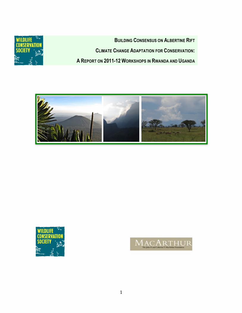
BUILDING CONSENSUS ON ALBERTINE RIFT
CLIMATE CHANGE ADAPTATION FOR CONSERVATION:
A REPORT ON 2011-12 WORKSHOPS IN RWANDA AND UGANDA
2
Acknowledgements WCS acknowledges the generous support of the John D. and Catherine T. MacArthur Foundation for funding the WCS Climate Change Assessment project, and for these two workshops in particular. The authors gratefully acknowledge all participants of the Gashora and Kampala workshops for their diligence and enthusiasm in making these meetings highly informative ventures. Dr. Phillip Thornton of the International Livestock Research Institute kindly provided new modeling output for assessment by the Gashora workshop attendees. Dr. Amy Pokempner of WCS provided valuable assistance in ensuring the smooth planning and execution of the Gashora meeting. We are also grateful to the national park services in Uganda, Rwanda, Tanzania and Democratic Republic of Congo for authorizing the participation of wardens and conservation officers in the Kampala meeting.
Organizing Hosts Wildlife Conservation Society – Rwanda Country Program (Gashora meeting) Wildlife Conservation Society – Uganda Country Program (Kampala meeting) Financial Support The John D. and Catherine T. MacArthur Foundation Authors of this Report Anton Seimon (WCS-‐New York), Andrew J. Plumptre (WCS Albertine Rift Program) and James E.M. Watson (WCS-‐New York) Citation for this report: Seimon, A., A.J. Plumptre and J.E.M. Watson, 2012: Building consensus on Albertine Rift climate change adaptation for conservation: a report on 2011-‐12 workshops in Uganda and Rwanda. WCS Workshop Report, Wildlife Conservation Society, New York, USA, 40pp. Available online at: http://www.albertinerift.org/Challenges/ClimateChange/tabid/7525/Default.aspx
3
Table of Contents
EXECUTIVE SUMMARY .......................................................................................................................... 4 1. INTRODUCTION .................................................................................................................................. 5 SIGNIFICANCE OF THE ALBERTINE RIFT ................................................................................................................ 5 THE WILDLIFE CONSERVATION SOCIETY PROGRAM ON ALBERTINE RIFT CLIMATE CHANGE ..................... 5 MOTIVATION FOR THE GASHORA AND KAMPALA WORKSHOPS ......................................................................... 8 AIMS OF THIS REPORT ................................................................................................................................................ 8
2. GASHORA SCIENCE AND STAKEHOLDER WORKSHOP ........................................................ 10 MEETING PARTICIPANTS ........................................................................................................................................ 10 PLENARY SESSIONS .................................................................................................................................................. 10 Box 1: Plenary presentations at the Gashora Workshop from 22-‐24 Feb 2011. ..................... 11
BREAKOUT GROUP ACTIVITIES .............................................................................................................................. 12 RESULTS FROM THE GASHORA BREAKOUT GROUP PROCESS .......................................................................... 15 FINDINGS AND RECOMMENDATIONS .................................................................................................................... 17
3. KAMPALA PROTECTED AREA MANAGERS WORKSHOP ..................................................... 21 WORKSHOP PARTICIPANTS .................................................................................................................................... 21 WORKSHOP AGENDA ............................................................................................................................................... 21 METHODS .................................................................................................................................................................. 21 OUTCOMES OF THE KAMPALA BREAKOUT GROUP SESSIONS ........................................................................... 22
4. ASSESSMENT OF THE WORKSHOP FINDINGS ........................................................................ 25 COMPONENTS NEEDED FOR INFORMED ADAPTATION PLANNING ................................................................... 26 SUMMARY RECOMMENDATIONS ............................................................................................................................ 28 FOLLOW UP TO THE MEETINGS ............................................................................................................................. 31
REFERENCES ......................................................................................................................................... 32 APPENDIX 1: GASHORA WORKSHOP AGENDA AND PARTICIPANTS .................................. 35 APPENDIX 2: KAMPALA WORKSHOP AGENDA AND PARTICIPANTS ................................. 39
4
Executive Summary The Wildlife Conservation Society hosted outreach meetings in Gashora (Rwanda) in February 2011 and Kampala (Uganda) in May 2012 on climate change adaption for conservation in the Albertine Rift region of east-‐central Africa. The workshops were designed to share and evaluate results of newly available environmental modeling and vulnerability assessments with key regional stakeholders in policy, conservation and research. They were aimed to serve as a starting point for developing regional consensus on key recommendations for the way forward regarding conservation action, policy, and additional research needed to confront the challenges of climate change across the Albertine Rift in the 21st century and beyond. The John D. and Catherine T. MacArthur Foundation provided funding support for both workshops. Conducted over four days with 53 participants, the Gashora meeting brought together leading researchers with representatives of key stakeholder organizations and donors. The two-‐day Kampala meeting brought together senior conservation directors, chief park wardens, and research and monitoring officers representing 14 major protected areas in four of the five countries encompassing the Albertine Rift, with 25 participants in total. The meetings summarized state of the science research findings and new environmental modeling to the regional conservation community in both formal governmental and non-‐governmental sectors. The workshops reflect a response to the growing recognition of the need for adapting conservation management to accommodate the environmental stresses introduced by climate change, and that the most favorable long-‐term outcomes require early interventions. The workshop design therefore aimed to utilize up to date knowledge on climate change and apply it to identify adaptation actions targeting actual on the ground needs, both within specific protected areas and more generally across the region. To a significant degree, however, the workshop process identified that such ambitions are premature, given the current state of climate change science and the challenging realities of the Albertine Rift where a multitude of existing threats command the immediate attention of conservation managers. The overall findings of both meetings was that comprehensive conservation planning for climate change, incorporating specific actions on adaptation, are not yet feasible in the Albertine Rift since prerequisite data components for developing such actions are for the most part not yet available. The first step, to convince key constituencies of the significance of and need to plan for climate change, has been somewhat successful, but further advancement is limited by reluctance of conservation managers to take bold actions in the absence of critically needed guidance on what options offer strategic courses of action beyond standard conservation measures. Through the workshop process participants identified that appropriate courses of action and changes to current conservation practice requires a set of foundational components for informed decision-‐making beyond predicted changes in key climate parameters. In the Albertine Rift, much of this requisite knowledge is either limited or undeveloped, greatly hindering the ability to develop properly informed climate change adaptation planning by conservation interests. The most readily available options are to (1) extend and standardize environmental monitoring of climatically sensitive variables (atmospheric, hydrologic, vegetation, wildlife species, disease, etc.) throughout the Albertine Rift; (2) increase engagement with the climate research and modeling communities to develop suites of tailored prediction products meeting conservation planning needs at appropriate spatial resolutions; (3) to develop programs on climate change adaptation structured according to planning frameworks; (4) to develop methodologies that integrate baseline knowledge and outputs from modeling into planning procedures that incorporate threats and vulnerabilities; and (5) to improve communications among sectors to build an enabling environment for responding to recommendations for adaptive action as they become available from the research and conservation communities.

5
1. Introduction This report summarizes the findings of workshops held in Gashora (Rwanda) and Kampala (Uganda) in 2011 and 2012, respectively, on climate change adaptation for environmental conservation in the Albertine Rift region of Africa. The Albertine Rift Climate Assessment program of the Wildlife Conservation Society organized both workshops under funding support from the John D. and Catherine T. MacArthur Foundation. The Foundation is currently completing a 10-‐year funding investment to ensure the improvement and sustainability of environmental conservation across the Albertine Rift in the face of daunting socioeconomic pressures. During the latter half of this decadal program, the Foundation has promoted the integration of climate change adaptation into Albertine Rift conservation work by funding several projects proposed by both regional and internationally based non-‐governmental organizations (NGOs). The workshops have provided an early opportunity to share findings being generated by these grantee organizations and other groups working to develop and apply knowledge to improve conservation outcomes for Albertine Rift biodiversity in the face of climate change. Taken together, the workshops findings therefore offer an early report on progress achieved to date on adaptive planning and action for climate change by Albertine Rift region conservation interests.
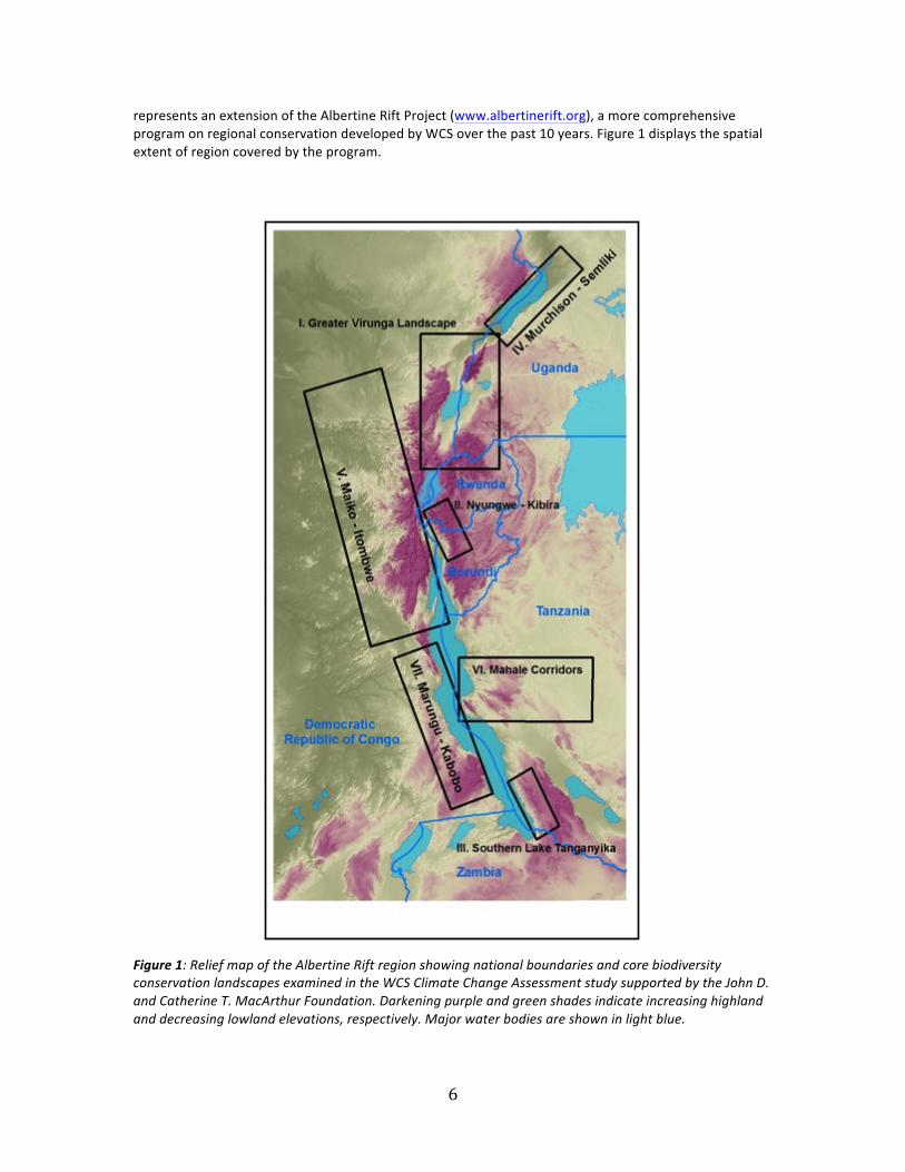
Significance of the Albertine Rift Forming the western branch of the African Great Rift Valley system, the Albertine Rift runs from the northern end of Lake Albert to the southern end of Lake Tanganyika, and encompasses land on either side of the western Rift Valley, straddling several countries: the Democratic Republic of Congo (DRC), Uganda, Rwanda, Burundi, Tanzania and Zambia (Figure 1). The Albertine Rift is one of the most important regions for the conservation of Africa’s biodiversity (Plumptre et al., 2007). Forming the continental ecotone between savanna woodlands and grasslands and the Congo rainforest biomes, with rich tracts of tropical montane forest, it is home to many endemic species including the mountain gorilla and golden monkey, 42 species of birds, and many reptiles, amphibians, fish, invertebrates, and plants. It contains more vertebrate species than any other region on mainland Africa, yet is also home to approximately 40-‐50 million people, the vast majority of whom are subsistence farmers dependent on rain-‐fed agriculture. With some of the highest population densities of rural people in Africa (up to 1,000 people per square kilometer), the region also suffers from some of the highest levels of poverty on the continent (Cordeiro et al., 2007; Plumptre et al., 2007). Between 55 and 65 percent of the population is under the age of twenty, and human population growth is between two and three percent per year (Plumptre 2012) creating inexorably increasing stress on the Albertine Rift region’s biodiversity and natural ecosystems that are already severely compromised by decades of destructive land use practices (Seimon and Plumptre 2012). The Wildlife Conservation Society program on Albertine Rift climate change
Over the past decade, the Albertine Rift conservation community has increasingly recognized climate change driven by greenhouse gas emissions as a critical concern for the future. Since 2007, the Wildlife Conservation Society (WCS) has conducted the Albertine Rift Climate Change Assessment, a multifaceted program on climate change funded by the MacArthur Foundation aimed at developing understanding of potential impacts of anthropogenic climate change challenges on wildlife conservation across the Rift region (http://www.albertinerift.org/Challenges/ClimateChange/tabid/7525/Default.aspx). This program
6
represents an extension of the Albertine Rift Project (www.albertinerift.org), a more comprehensive program on regional conservation developed by WCS over the past 10 years. Figure 1 displays the spatial extent of region covered by the program. Figure 1: Relief map of the Albertine Rift region showing national boundaries and core biodiversity conservation landscapes examined in the WCS Climate Change Assessment study supported by the John D. and Catherine T. MacArthur Foundation. Darkening purple and green shades indicate increasing highland and decreasing lowland elevations, respectively. Major water bodies are shown in light blue.
7
The Climate Assessment program has several key components: climatological baseline studies; ecological modeling using climate model inputs; developing monitoring networks for climate change; stakeholder consultation and outreach; and ultimately, recommendations for adaptive planning and implementation of adaptation activities. In its first phase of activities (2007-‐09), the Climate Change Assessment project quantified predictions of regional climate change across the Albertine Rift developed from global climate models, assessed future impacts of these changes, and demonstrated prediction tools that may aid in estimating future distributions of biodiversity in the Albertine Rift. An additional output has been detailed climatological analysis within Albertine Rift protected areas, shedding light on previously unrecognized phenomena and establishing baseline conditions for assessing climatic changes within individual protected areas (Patrick et al., 2012; Plumptre et al., 2012; Kasangaki et al., 2012; Fawcett et al., 2012; Chao et al., 2012; Itoh et al., 2012; Seimon and Picton Phillipps, 2012) The WCS modeling approach was designed to generate a suite of products that could offer early guidance on the potential impacts of anthropogenic climate change on environmental characteristics including principal climate parameters, wildlife habitat, key cultivars and carbon budgets throughout the Albertine Rift region. This generated a broad suite of products developed from a dynamic vegetation model and projections of changes in agricultural yields from crop models (Picton Phillipps and Seimon 2009). The model inputs utilized are grid-‐point means of temperature, precipitation and cloud cover averaged from a collection of climate models run under different greenhouse gas emissions scenarios and downscaled to ~60 km spatial resolution. In these model projections, the 21st century climate across the Albertine Rift region is characterized by rapid warming, with a net predicted change of 3.6°C by 2100 (the A2 model scenario), attended by an initially slow but then rapid increase in rainfall as the century progresses (Seimon and Picton Phillipps 2012). However, it must be noted that these models do not take into account human-‐related land surface changes. The WCS Climate Assessment project has since been developing and applying these findings in partnership with the wider biodiversity conservation community of stakeholders and researchers in Africa and elsewhere through meetings, consultations and the generation of reports. A second phase of the Climate Assessment project (2009-‐12) is centered on implementing long-‐term monitoring for climate change principally through climatological observations and vegetation and species monitoring within protected areas. The program also aims to understand biodiversity in contexts of human adaptation to climate change, by developing projections of the potential for shifting agricultural practices under climate change, and through consideration of human livelihoods and settlement in ongoing conservation corridor evaluations (Seimon et al., in press). Such analyses represent a critically needed step for moving from developing baseline understanding to adaptation planning by applying these quantitative analyses and projections of future environmental states. The corridor evaluations will develop a prioritized listing of conservation targets that considers long-‐term viability for maintaining ecological functioning in the face of increasing stress from climate change and human activities. The third and final phase of the Climate Assessment program, focused on stakeholder consultation and output dissemination, and includes the Gashora and Kampala workshops discussed in this report.
At the same time, findings that parallel and complement the WCS work have become available from research completed by other groups that have likewise been conducting environmental modeling studies under projected future climatic conditions within the Albertine Rift domain and adjacent regions. These include: Birdlife International for avifauna (Hole et al. 2009); the University of Edinburgh for vegetation (Doherty et al. 2009); the African Wildlife Foundation and International Gorilla Conservation Program for mountain gorillas (Belfiore et al., 2010); and the International Livestock Research Institute (ILRI) for cultivation (Thornton et al. 2009; 2011). These efforts are part of a broader portfolio of climate change adaptation programs serving environmental conservation agendas being implemented across sub-‐Saharan Africa by NGOs and their partners. In a separate effort, WCS has also been working within the Africa Biodiversity Collaborative Group (ABCG: www.abcg.org), a consortium of United States-‐based conservation NGOs, to share lessons learned from

8
our respective programs on climate change adaptation in Africa. This includes several other NGOs also represented along with WCS at the Gashora meeting (African Wildlife Foundation, Conservation International, The Nature Conservancy). An evaluation of ten of these programs, including the WCS Albertine Rift effort, conducted recently by ABCG demonstrated that the conservation community is rapidly intensifying attention on climate change-‐related issues, but that current project work generally still falls short of implementing direct actions (ABCG, 2011). The ABCG report is available for download at http://frameweb.org/adl/en-‐US/8202/file/1090/abcg-‐climatechangeadaptation.pdf Motivation for the Gashora and Kampala workshops As elucidated in the ABCG report, although the WCS Climate Assessment program and other applied research efforts have some complementarity, there has been little interaction and effort to share lessons-‐learned from our respective experiences in applied climate change work for conservation outcomes. WCS organized the February 2011 Gashora workshop to help initiate a consensus-‐building process on climate change adaption for region-‐wide conservation, to bring up to date scientific knowledge to the Albertine Rift regional conservation community, and to improve understanding of needs for effective adaptation actions within the region. The second workshop, held in Kampala in May 2012, was designed to both inform protected area managers of the challenges that climate change is likely to bring to the landscapes and species within the Albertine Rift conservation estate, and also to learn their perspectives of on the ground needs for developing meaningful adaptation actions towards sustainable park management under changing climatic conditions for the future. Aims of this report Past achievements in biodiversity conservation in the Albertine Rift have been almost invariably associated with protected area establishment and maintenance across all five nations encompassing the Rift region (Plumptre 2012). The common purpose of the Gashora and Kampala workshops was therefore to begin a process of identifying actions required to proactively manage the challenges presented by climate change, meeting conservation needs particular to protected areas but also more broadly across the region. By bringing research insights and region-‐wide stakeholder concerns together, the workshops created opportunities to elucidate the range of risks and opportunities for biodiversity conservation and adaptive management presented by climate change. The broader project goal of both workshops was to develop a regional consensus on key recommendations for the way forward regarding conservation action, policy, and additional research needed to confront the challenges of Albertine Rift climate change in the 21st century and beyond. A set of interlinked objectives addressing the project goal guided the structure and execution of the Gashora meeting. Specifically: to bring together principal stakeholders and research groups for direct dialog on climate change and conservation; to provide a forum for both presenting the challenge and the research results to date to a wider audience concerned with implementing conservation and applying adaptations across the Albertine Rift; to provide a forum for comparison of results collected by different groups and for discussion on where the climate science work should go from here to best address conservation stakeholder concerns; and to begin a discussion about next steps in conservation planning incorporating adaptation. In breakout group discussions the participants were asked to evaluate knowledge requirements and provide recommendations around themes of climate change impacts on species and their habitats, ecosystems services and human communities. With its participants limited to protected area managers, the Kampala meeting had a more limited focus. The objectives were to provide conservation managers with a scientifically based understanding of climate change and its potential ecological impacts across the Albertine Rift region, and to identify

9
protected area management options that would increase the likelihood of favorable outcomes for biodiversity conservation over the long term. The aims of this report are the following:
1. To report back to participants of the two workshops the key findings, lessons learned and recommendations.
2. To use the workshop findings to identify key needs for more effective conservation action on climate change, and to share this with the broader community, and particularly donors, national governments and other high-‐level stakeholder groups.
3. To present a status report on climate change adaptation in biodiversity conservation contexts from an on-‐the ground perspective in the Albertine Rift, thus complementing ABCG work developed more broadly across Africa.
Attendees of the Gashora and Kampala workshops collectively represented a highly diverse range of conservation interests from across the Albertine Rift nations, scientists from further abroad, as well as academics from regional universities. Lists of all of the attendees and the organizations they represent for the Gashora and Kampala workshops are provided in Appendix 1 and 2, respectively. Workshop summaries, and key outputs and recommendations generated during the Gashora and Kampala meetings are provided in sections 2 and 3 of this report, respectively. In section 4 we present an assessment of the overall status, lessons learned and steps recommended for the future for climate change adaptation by conservation interests across the Albertine Rift region.
10
2. Gashora science and stakeholder workshop
The Gashora workshop took place over three and a half days with an agenda based around plenary presentations and discussion and breakout group activities. The welcome address by the Director for Tourism of the Rwanda Development Board, Ms. Rica Rwigamba, highlighted the need for comprehensive engagement on climate change adaptation and the welcome opportunity that the meeting represented as a starting point for consolidating information and bringing together scientists with key stakeholders.
Meeting participants The 53 workshop participants (Figure 2a) were drawn primarily from the research community, key stakeholder groups and academic institutions in the Albertine Rift and several donor organizations as follows:
Stakeholder groups 1) Representatives from the directorates of governmental conservation management bodies
(governmental ministry representatives from Burundi, Uganda, Rwanda; national level wildlife management authorities from Rwanda, Uganda).
2) Members of country teams for the United Nations Environment Program-‐sponsored National Adaptation Programs of Action (NAPA) (from Rwanda and Uganda).
3) Non-‐governmental conservation actors, including NGO and community-‐based organizations (Institute for Tropical Forest Conservation, The Nature Conservancy, Conservation International, African Wildlife Foundation, World Agroforestry Center –ICRAF,).
4) WCS country program directors and regional conservation specialists (Albertine Rift, Uganda, Rwanda, Democratic Republic of Congo, WCS Global Program).
Research groups 5) Current MacArthur grantees active in the Albertine Rift with research programs related to
climate change (Albertine Rift Conservation Society, WCS, START, Field Museum, International Gorilla Conservation Program, BirdLife International).
6) Regional university faculty and graduate students (Makerere University, Uganda; National University of Rwanda; University of Dar es Salaam, Tanzania; Mbarara University, Uganda; Kitabi College, Rwanda).
7) Other research groups working on East African regional climate change (International Institute for Tropical Agriculture-‐CGIAR, Stockholm Environmental Institute).
Donors 8) International donor organizations (MacArthur Foundation, USAID-‐Rwanda, USAID-‐Central
African Regional Program for the Environment -‐ CARPE, Global Environment Facility of the World Bank – GEF)
Plenary sessions The plenary sessions included invited presentations and moderated discussions where the consideration of scientific findings in the contexts of stakeholder needs was repeatedly emphasized (Figure 2b). These discussions were instrumental in generating diverse and well-‐informed content in the breakout group findings and recommendations.
The plenary presentations at the meeting were arranged thematically based around the State of the Challenge (Day 1), the State of the Science (Day 2) and Information Consolidation to Achieve Consensus (Day 3). The topics for presentations were prescribed by the WCS organizing team to ensure thematic continuity and to cover the key issues in Albertine Rift conservation relating to climate change. The speakers, the institutions they represent and talk titles are listed in Box 1.
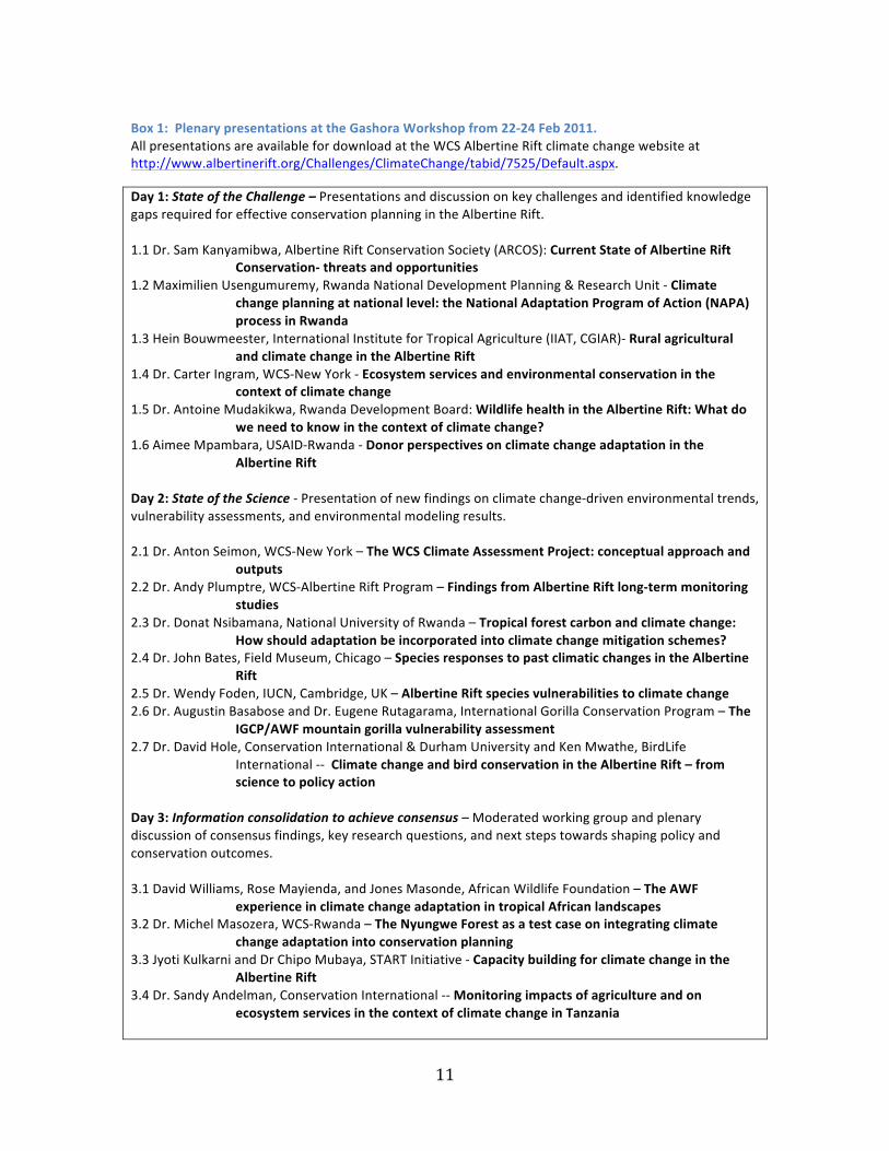
11
Box 1: Plenary presentations at the Gashora Workshop from 22-‐24 Feb 2011. All presentations are available for download at the WCS Albertine Rift climate change website at http://www.albertinerift.org/Challenges/ClimateChange/tabid/7525/Default.aspx.
Day 1: State of the Challenge – Presentations and discussion on key challenges and identified knowledge gaps required for effective conservation planning in the Albertine Rift. 1.1 Dr. Sam Kanyamibwa, Albertine Rift Conservation Society (ARCOS): Current State of Albertine Rift
Conservation-‐ threats and opportunities 1.2 Maximilien Usengumuremy, Rwanda National Development Planning & Research Unit -‐ Climate
change planning at national level: the National Adaptation Program of Action (NAPA) process in Rwanda
1.3 Hein Bouwmeester, International Institute for Tropical Agriculture (IIAT, CGIAR)-‐ Rural agricultural and climate change in the Albertine Rift
1.4 Dr. Carter Ingram, WCS-‐New York -‐ Ecosystem services and environmental conservation in the context of climate change
1.5 Dr. Antoine Mudakikwa, Rwanda Development Board: Wildlife health in the Albertine Rift: What do we need to know in the context of climate change?
1.6 Aimee Mpambara, USAID-‐Rwanda -‐ Donor perspectives on climate change adaptation in the Albertine Rift
Day 2: State of the Science -‐ Presentation of new findings on climate change-‐driven environmental trends, vulnerability assessments, and environmental modeling results. 2.1 Dr. Anton Seimon, WCS-‐New York – The WCS Climate Assessment Project: conceptual approach and
outputs 2.2 Dr. Andy Plumptre, WCS-‐Albertine Rift Program – Findings from Albertine Rift long-‐term monitoring
studies 2.3 Dr. Donat Nsibamana, National University of Rwanda – Tropical forest carbon and climate change:
How should adaptation be incorporated into climate change mitigation schemes? 2.4 Dr. John Bates, Field Museum, Chicago – Species responses to past climatic changes in the Albertine
Rift 2.5 Dr. Wendy Foden, IUCN, Cambridge, UK – Albertine Rift species vulnerabilities to climate change 2.6 Dr. Augustin Basabose and Dr. Eugene Rutagarama, International Gorilla Conservation Program – The
IGCP/AWF mountain gorilla vulnerability assessment 2.7 Dr. David Hole, Conservation International & Durham University and Ken Mwathe, BirdLife
International -‐-‐ Climate change and bird conservation in the Albertine Rift – from science to policy action
Day 3: Information consolidation to achieve consensus – Moderated working group and plenary discussion of consensus findings, key research questions, and next steps towards shaping policy and conservation outcomes. 3.1 David Williams, Rose Mayienda, and Jones Masonde, African Wildlife Foundation – The AWF
experience in climate change adaptation in tropical African landscapes 3.2 Dr. Michel Masozera, WCS-‐Rwanda – The Nyungwe Forest as a test case on integrating climate
change adaptation into conservation planning 3.3 Jyoti Kulkarni and Dr Chipo Mubaya, START Initiative -‐ Capacity building for climate change in the
Albertine Rift 3.4 Dr. Sandy Andelman, Conservation International -‐-‐ Monitoring impacts of agriculture and on
ecosystem services in the context of climate change in Tanzania
12
Breakout group activities On Days 3 and 4 much of the Gashora meeting agenda was related to breakout group evaluations of the implications of climate change for Albertine Rift conservation at the regional and sub-‐regional landscape scales, and for major national parks and other protected areas within these landscapes (Figure 2c). The purpose of the breakout groups was to utilize the diverse expertise and experience of meeting participants to consolidate information and draft findings and recommendations on climate change adaptation for four Albertine Rift geographic domains. Meeting participants were assigned to specific groups according to regional expertise and/or to provide a wide range of disciplinary expertise. The breakout groups each convened twice on Day 3 and once on Day 4, with plenary discussions following each session.
Group 1 considered the entire Albertine Rift region (i.e. the entire domain shown in Figure 1). Group 2 focused on the Murchison-‐Semliki landscape in Uganda (landscape IV in Figure 1). This landscape represents the northern extent of the Albertine Rift and contains a heterogeneous mix of savannas, montane forests, and in Lake Albert, one of the region’s great lakes. Group 3 focused on the Nyungwe-‐Kibira landscape of Rwanda and Burundi (landscape III in Figure 1). This small landscape at the headwaters of the Nile River contains one of the most biodiverse montane forests remaining on the eastern side of the Albertine Rift and is situated close to the midpoint of the rift corridor. Group 4 focused on the Marangu-‐Kabobo landscape of southeast DRC (landscape VII in Figure 1). This forested landscape in the southern part of the rift is among its least known areas and features a relatively low level of anthropogenic disturbance compared to other areas of the rift.
The breakout groups were each tasked with pursuing the following objectives for their respective landscapes: (1) to identify key knowledge gaps in order to allow conservation planning to be adaptive to climate change; (2) to prioritize knowledge gaps and identify means to address them; (3) to assess the value for conservation planning of spatially and temporally specific model guidance on climate change at the landscape scale. In each landscape, the groups first covered the following questions:
1. What do we need to know about species to be able to plan for their conservation under climate change?
2. What do we need to know about habitats to be able to plan for their conservation under climate change?
3. What do we need to know about ecological processes and ecosystem services to be able to plan for their conservation under climate change?
4. What do we need to know to help human communities to adapt to climate change in contexts of conservation?
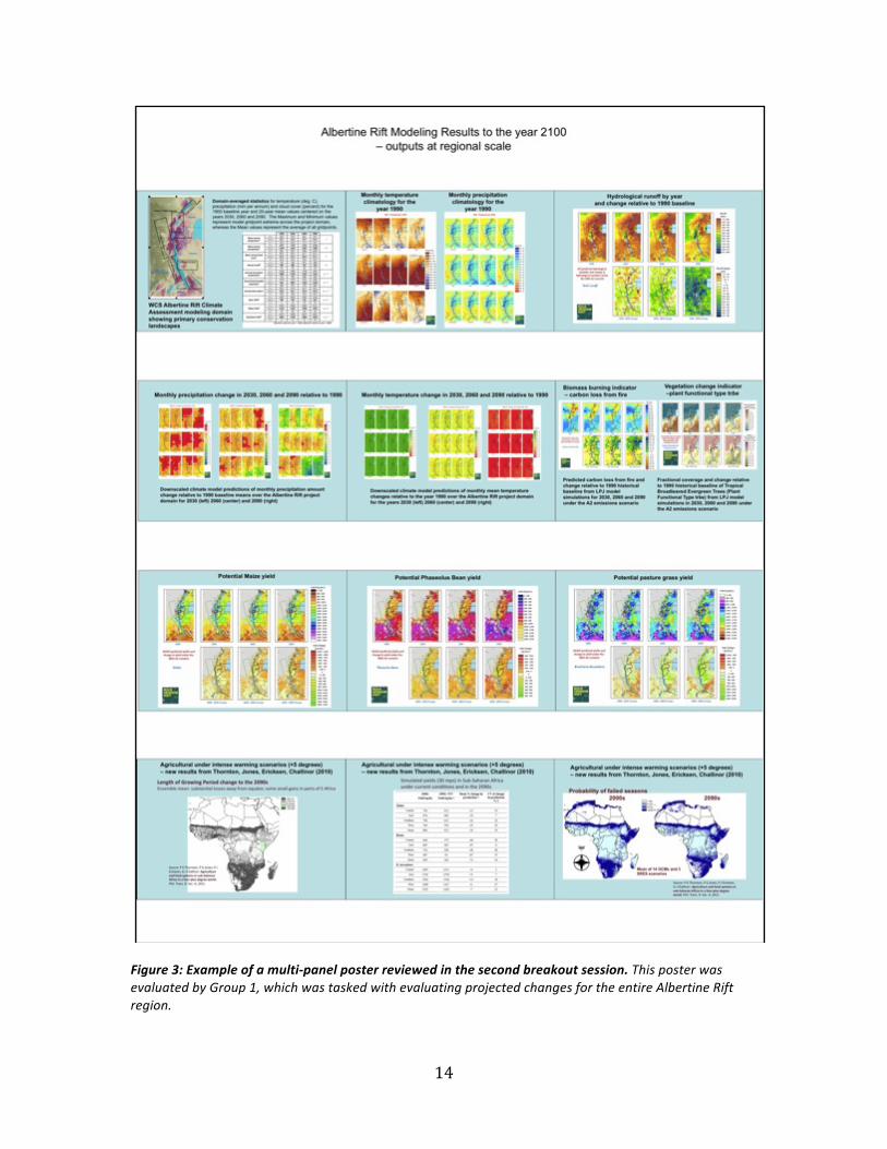
For the second session the breakout groups were provided with multi-‐panel posters containing climatic, ecological and agricultural change projections in the form of a set of model outputs for their respective landscapes (Figure 2). The modeled products included (1) downscaled climate parameters from the multi-‐model ensemble utilized in the WCS Albertine Rift Climate Assessment run under the A2 greenhouse gas emissions scenario; and (2) a set of products generated from dynamic vegetation models run under the climatic conditions simulated in (1). Group 1 also evaluated some additional Africa-‐wide predictions of agricultural changes from recently published work by Dr. Philip Thornton of the International Livestock Research Institute (Thornton et al., 2011). Further details on the models and products are available at the WCS Albertine Rift climate monitoring website: (http://programs.wcs.org/Default.aspx?alias=programs.wcs.org/albertineclimate) With these projections in hand, the groups were then asked to consider two follow-‐up questions:
5. In the context of Questions 1-‐4, what do these maps tell us about probable future changes? 6. What additional information would you like to see mapped/predicted?
13
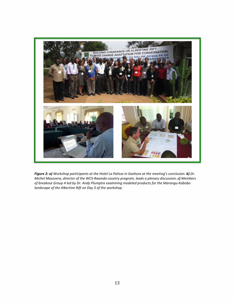
Figure 2: a) Workshop participants at the Hotel La Palisse in Gashora at the meeting’s conclusion. b) Dr. Michel Masozera, director of the WCS-‐Rwanda country program, leads a plenary discussion. c) Members of breakout Group 4 led by Dr. Andy Plumptre examining modeled products for the Marangu-‐Kabobo landscape of the Albertine Rift on Day 3 of the workshop.
14
Figure 3: Example of a multi-‐panel poster reviewed in the second breakout session. This poster was evaluated by Group 1, which was tasked with evaluating projected changes for the entire Albertine Rift region.
15
Results from the Gashora Breakout Group Process The discussions developed during the breakout group process elucidated a range of issues, challenges and opportunities that climate change presents to conservation interests in the Albertine Rift and elsewhere. The Rift presents a particularly challenging geographical context for climate change planning: data resources are meager, human population pressures are often extreme and baseline knowledge of contemporary climate is poorly developed. The broad range of findings and associated recommendations generated by the teams during the breakout group process often reflected these limitations. Responses to Questions 1-‐4, on knowledge requirements for effective conservation planning for climate change in the Albertine Rift, were drafted during the first breakout session. Questions 5-‐6, on the modeling guidance products, were addressed during the second breakout session when each group had an opportunity to examine the posters containing climate, ecological and agricultural model outputs for their respective regions. Question 1: What do we need to know about species to be able to plan for their conservation under climate change? Fundamentally needed is comprehensive knowledge on species distributions (locality data over extended time periods; common as well as endemic species), species abundance, phenology, habitat associations and threats. Some of these inputs are available for the Albertine Rift, though a significant portion is not yet in a suitable form for analysis (e.g. hard copy survey data in reports requiring digitization). To facilitate analysis, all data should be consolidated and made available through a common portal. Basic ecological data on wildlife species is also a requisite for effective assessment of threats and vulnerability to climate change (e.g. how easily/far do species move through a landscape? What are the characteristics of a permeable landscape that can support species migration outside of protected areas?). There is also a need to understand how species have endured past climate change events, and to identify those places that have provided important refugial habitats. Finally, there is a need for climatological data that can be linked to species data from comprehensive monitoring programs. Such data have been collected in an ad hoc manner over multi-‐decadal periods at several major research stations along the Albertine Rift (see extensive reviews in Plumptre (ed.) 2012). There are also some newer sites as well that adhere to strict observational protocols: The Tropical Ecosystem Assessment and Monitoring (TEAM) project has two operational sites, at Bwindi National Park in Uganda, and in the southern highlands of Tanzania; and WCS and ITFC recently established Global Research Initiative in Alpine Areas (GLORIA) sites in the Rwenzori Mountains and Mt Elgon national parks in Uganda. WCS is also coordinating efforts to produce a standard set of phenological observations at long-‐term research sites along the Albertine Rift. Question 2: What do we need to know about habitats to be able to plan for their conservation under climate change? There is a need for modelled projections of future climatic states and the ecological responses to these changes that can offer realistic portrayals of how vegetation types, aquatic environments and other characteristics are likely to diverge from current conditions as the climate changes. Fine-‐scale model data is needed to serve management and planning objectives for landscapes and individual protected areas. Since maintaining connectivity between protected areas in fragmented landscapes is a key adaptation strategy for climate change, there is a need to how to promote compatible human activities in corridors and matrix areas to support species’ migration and range expansions. WCS is currently completing a corridor assessment throughout the Albertine Rift based on bird, mammal and amphibian data but more research is needed on other taxonomic groups.
Question 3: What do we need to know about ecosystem services to be able to plan for their conservation under climate change? In human focused contexts, developing understanding on what the key ecosystem services are and how they will be impacted by climate change is fundamental to both socioeconomic development outcomes and the preservation of biodiversity. There is therefore a need to examine where and how the Albertine Rift protected area estate and other biodiverse areas provide services to humanity, and inventory the ways that climate change may influence them. Spatial mapping of
16
both provisioning and regulatory ecosystem services in the present and at time steps in the future under changing climatic states are critically needed.
Question 4: What do we need to know about human communities to be able to plan for their conservation under climate change? There is a pressing need to be able to anticipate synergistic responses between climate change and existing drivers of change, which are largely mediated by human activities. Anthropogenic and natural drivers change as the drivers themselves are transformed under climate change. Agriculture and pastoral activities will be particularly important stressors to biodiversity conservation under a changing climate. Human migration (“climate refugees”) may also become an added pressure. Assessments are needed on how vulnerable communities are at present, how climate change might affect them, and what types of resilience strategies they currently utilize against climate related hazards. Demographic, socio-‐ecological and resource use changes need to be tracked over time. Some assessments are currently ongoing, in Tanzania and Uganda, but are universally needed region wide using a standard set of methods. Practical advice for sustainable agriculture, for example, information on crops that perform well under different climate conditions, may provide useful adaptive response options for small-‐scale farmers. There is also a need to better understand the link between climate and weather (i.e. climate variability, extremes and thresholds), which is very difficult to predict but that has major influences on communities dependent on subsistence agriculture. Finally, effective strategies need to be identified to communicate such complex information and the inherent uncertainties to communities.
Question 5: What do these maps tell us about probable future changes? The breakout groups all reported that the inference on future conditions that could be derived from model projections to be interesting and informative, but that it is very difficult to translate coarse data at broad regional scales into local contexts. As an example, the crop model results look very sophisticated, yet incorporate many assumptions (e.g. management, soils and crop phenotypes will remain in their present state) and so far are constrained to just a few key cultivars. Furthermore, the examples demonstrated at the workshop (maize, beans and pasture grasses) do not serve as useful analogs for potential impacts on production of altitude-‐constrained crops such as coffee and tea. Projections of carbon storage were recognized as potentially valuable for informing long-‐term prospects of carbon sequestration on forested landscapes currently in development for climate change mitigation activities (i.e. REDD+). The possibility of ascribing higher valuations to forests where projections show increasing carbon storage potential versus those that are projected to be static or even decline was deemed especially useful. Application of the relationship between atmospheric temperature and elevation (the lapse rate, typically about 6° C per km of elevation increase in tropical latitudes (Barry 1992) makes the temporal changes in regional temperatures readily understandable as a driving force elevating ecological zones up mountainsides. Changing precipitation seasonality in the face of increasing temperatures and evapotranspiration made projected changes in the potential for fire more understandable. A significant turnover in plant functional types projected by the LPJ model in the southern third of the Albertine Rift, from a present-‐day dominance by deciduous forest to broadleaf evergreen forest by the end of the century, made the concept of abrupt biome transitions readily understandable.
Question 6: What additional information would you like to see mapped/predicted? More accurate mapped representations of baseline conditions are critically needed throughout the Albertine Rift, particularly for rainfall distribution, soils, vegetation and land-‐use. Greater detail on species distributions is needed in contexts of these other variables. Modeling studies should develop climate model output that includes information on climatic variability projections, not just mean baseline states for temperature and precipitation in the future, as well as assessments of potential changes in the occurrence of extreme events. Projections made by suites of models under different greenhouse gas emissions pathways could be used to inform scenario development, thus producing a range of scenarios under various conditions. The workshop participants also identified several ways to improve the applicability of modeled products of derived variables based on the predicted climatic changes to adaptation planning. In all cases, providing context of a larger landscape extending beyond the Albertine Rift would help place the more focused view
17
in a more regional perspective. Conversely, overlaying protected area boundaries within modeled domains would make the relevance of model scale to the landscape of concern readily apparent. The predicted changes in fire potential in natural vegetation should be mapped relative to actual vegetation types, agricultural versus unutilized land areas, and other managed and unmanaged rangelands. Vegetation change indicator maps based on plant functional types would be very useful for species modeling if they can be demonstrated to be reliable and could be tailored represent the actual variety of types found across the Albertine Rift (only three out of ten classes modeled in the WCS simulations have significant coverage).
Findings and recommendations The workshop discussions generated a broad range of findings expanding on the issues discussed above, covering themes related to data needs for baseline measurements and monitoring, species and ecological vulnerability to climate-‐related threats, indirect threats related to human response to climate change, and prediction tools needed for effective planning. Climate baseline knowledge. As outlined in the responses to the questions posed at the workshop, the breakout groups emphasized several critical areas where baseline knowledge is either lacking or insufficient. Knowledge of historical climatic conditions within and around conservation landscapes is fundamental to understanding the interaction of climate with local ecology and for assessing predictions. Reliable long-‐term climatological records do not exist across much of the Albertine Rift, and particularly within protected and other major areas of conservation concern. Areas of high topographic relief such as mountain ranges and rift valley walls are well recognized for their importance of maintaining connectivity between areas sharing similar climatic characteristics. Knowledge on how climatic conditions vary in transects across elevation gradients will therefore be critical for informing programs on adapting conservation practice for climate change. Such gradients may provide migration corridors that can facilitate adaptive responses, and in some cases may be the key for survival of some species with low thermal tolerances. Comprehensive baseline datasets are essential components for species models. Recommendations. Build baseline knowledge through both applied research and monitoring strategies, emphasizing standardized observational protocols to facilitate inter-‐site comparisons. Information should be consolidated, analysed and provided in management-‐relevant time steps (e.g. 5-‐10 years). Make efforts to build understanding of how baseline conditions have shaped the contemporary setting, for example, by analysing how climate relates to ecology and to species distributions, before attempting to evaluate climate model projections and ecological changes predicted to attend these changes. Building understanding on how species, ecosystems and the services they provide to humanity relate to climatic conditions in areas of high topographic relief will be instrumental in designing resilient conservation corridors accommodating climate change.
Monitoring for climate change. Current efforts to monitor the environment are generally locally focused to serve specific needs, making inter-‐site comparisons difficult. While various forms of environmental monitoring are performed within protected areas and at other many sites across the Albertine Rift, few activities are as yet specifically designed for climate change detection and impact. For the most part, observations currently do not follow standard protocols, making inter-‐site comparisons problematic. Sustaining funding for long-‐term monitoring efforts remains an omnipresent problem. Recommendations. Expand observational networks to fill the many gaps present throughout the Albertine Rift. A region-‐wide monitoring strategy should be developed with indicators to track pressure, state and response to climate change. There is a need to digitize records from past monitoring efforts to build long-‐term and local-‐scale data. Conservation NGOs and other conservation groups should encourage
18
donors to expand funding support for monitoring studies and research at regional and local scales, and especially so for long-‐term monitoring initiatives. The data collected by these efforts should be housed in a readily available data portal. Potentially the East African Community could help take a lead in such an initiative at least for the EAC countries in the Albertine Rift.
Climate and ecological predictions. The numerical modeling outputs presented at the workshop were generally the first such products the participants had seen for the Albertine Rift. Common sentiments expressed were that these model products – presented in the form of maps, graphs and tables of statistics – were at once informative, in portraying climate change in ecological outcomes beyond changes in climatic variables alone, yet also frustrating in the coarseness of their spatial resolution and limitation to a prescribed set of variables. Temperature and precipitation projections are indispensible when it comes to species modeling, highlighting the need for more accurate and refined predictive products. The workshop participants expressed that the process of evaluating the model projections was a valuable step towards building comprehensive understanding on how climate change is likely to change environmental conditions, but that such products still fall well short of offering the necessary guidance towards key decision-‐making and planning needs.
Recommendations. Most critically needed are credible model outputs at much higher spatial resolution that could offer conservation interests representations of changing environments within individual landscapes or protected areas. Model outputs should not only focus on shifting baseline means but also give indications on changing variability characteristics and extremes. Predictions need to be improved for site-‐specific applications, for example, provide predictions on crops, plant functional types and other vegetation characteristics found within and around a specific protected area, rather than a prescribed set of vegetation types based on global distributions. For translating model guidance to serve decision-‐making needs, model outputs should be critically evaluated by persons with requisite expertise in the underlying science as well as knowledge of on-‐the-‐ground conditions and environmental realities in the areas being considered. Finally, predictive model outputs become much more useful when placed within planning frameworks linking threats and vulnerabilities to strategic planning and adaptive actions.
Direct threats -‐-‐ species and their habitats. The vulnerability of individual species and inter-‐species associations to direct threats from climate change remains poorly understood for the Albertine Rift region. To adapt conservation practices to better safeguard species and habitats for climate change, the conservation community will require access to all data on species distributions and abundance: this includes locality data over extended time periods, data on common as well as charismatic and endemics species, habitat associations, phenology and comprehensive understanding of climate-‐related threats, some of which may not yet evident. For developing species models, the baseline datasets and knowledge on threats and vulnerabilities are essential.
Recommendations. Combine magnitude-‐of-‐change data from environmental predictions with species susceptibility data to provide information of real value to decision-‐making. Improve understanding on the dynamics of vegetation change and the climatic thresholds for species turnover. Establishing how climatic conditions are linked to species data should be developed in concert with basic ecological data (e.g. what are the adaptation strategies species are likely to employ? If dispersal is their strategy, how easily/far do species move through a landscape? What are the characteristics of a permeable landscape that can support species migration outside of protected areas? How to promote compatible human activities in corridors and matrix area to support species’ migration and expansion?)
Direct threats -‐ ecosystem services. As identified in the ABCG survey report, ecosystem based adaptation (EbA) approaches to climate change adaptation focused on ecosystem service provision may be one
19
critical component to long-‐term conservation success (ABCG 2011). This will require developing an inventory of the ways that climate change may influence human wellbeing through changes to ecosystem services. With the marked land conversions already experienced widely along the Albertine Rift, the regulatory services (e.g. disease, disaster mitigation) as well as provisioning services, of which water is particularly important, are increasingly tied to remaining tracts of wild lands. This highlights the necessity for understanding climate impacts on human wellbeing over the long-‐term in making the case for strengthening efforts to protect wild lands and less disturbed landscapes.
Recommendations. All conservation interests should recognize that preserving ecosystem services in the face of climate change is a strategy that, when combined with other conservation strategies, may underpin biodiversity conservation in the Albertine Rift into the foreseeable future. Identifying direct and indirect threats to these services from climate change and associated human responses, respectively, is therefore of paramount importance. For example, water provisioning from hydrological runoff in a watershed must be understood as not merely a product of precipitation, evaporation and infiltration, but also through complex vegetation dynamics, (which itself is influenced by changing atmospheric CO2 concentrations), and human water use and diversions. Critically needed as inputs to planning are maps of present distributions of key ecosystem services and their current utilization by people, and future projections of the same based upon changing climatic conditions, human demographic changes and shifts in land-‐use practice.
Indirect threats – human response. Indirect responses to climate change mediated by human actions hold considerable potential to add to stresses on species and ecosystems wherever human settlements abut wild lands throughout the Rift region. Since anthropogenic and natural drivers change as the drivers themselves are transformed under climate change, there is a need to build understanding of synergistic responses between climate change and existing drivers of change. Human migration may also become an added pressure, with a general push for intensifying cultivation and other activities at higher elevations as conditions become increasingly stressful to agriculture in the hotter lowland regions of the Rift and more broadly across the East Africa region. Agriculture and pastoral activities are likely to be particularly important stressors to natural ecosystems under a changing climate. Knowing the future distribution of different cultivars is a potentially valuable predictor of some aspects of human response to climate change.
Recommendations. Modeling biophysical changes under changing climatic conditions in the Albertine Rift is a first step towards understanding how landscapes, species and ecosystems may be altered by climate change, but human activity in the contexts of these changes and the associated socioeconomic dynamics should also be incorporated to obtain more relevant results. Predictive models of future ecological states should therefore be designed to accommodate human response with spatially explicit representations based on current and projected human activities and population distributions.
Setting objectives. The workshop participants emphasized the importance of stakeholder consultation in the shaping of objectives for climate change adaptation projects for biodiversity conservation. The use of local knowledge and involvement of local stakeholders could be instrumental in developing climate change adaptation strategies. Conservation objectives framed around sustaining ecosystem service provision in the face of climate change makes the societal payback of biodiversity conservation readily understandable to a wide range of local and regional stakeholders.
Recommendations. The application of planning frameworks (see section 4) in the setting of objectives is strongly encouraged to identify climate change related threats, vulnerabilities and options for addressing them. Conservation and development planners should work with local stakeholders to identify potential climate change impacts that may be experienced indirectly and largely mediated through human response, and to ensure their long-‐term buy-‐in and support for the desired outcomes. Strategic planning
20
needs to go beyond measures designed to resist climate change, but should instead adopt a longer-‐term vision that accommodates for the profound environmental reconfigurations that will be the consequence of climate change. Conservation planners should set objectives designed to protect the landscape matrix and ecological corridors, while keeping management plans flexible and dynamic to accommodate for changes in ecosystems and species (i.e. managing for change; account for flexible boundaries), as well as for the many uncertainties inherent in planning for climate change. The role of protected areas in providing ecosystem services should be championed by a wide-‐range of development NGOs and not just through conservation NGOs. Finally, conservation interests should ensure that the findings are understandable and accessible to all stakeholders.
National level planning and policy. Under the United Nations Framework Convention on Climate Change (UNFCCC) funding, NAPA reports have been generated for all Albertine Rift countries and are intended to guide national level planning for climate change. In engagement with policy-‐making bodies, the conservation community has been effective in using research findings to inform planning at all levels, and applying the best data to guide policy-‐making for protected areas in particular. This has not been the case with NAPA reports however, since the structured approach applied in the NAPA methodology largely misses the potential inputs from the conservation science community. The workshop participants noted two major issues with the NAPA program as currently implemented. First, the NAPA emphasis on socio-‐economic development relegates environmental conservation to secondary status in most reports. Second, the NAPA process is not designed to be fully iterative, and as such the original reports are already outdated (issuance dates were in 2006-‐07), and the only updates provided are in the form of brief “communications” rather than comprehensive reassessments. Recommendations. Since NAPA reports are now published for all of the Albertine Rift countries and now provide national level guidelines and recommendations, there are implications for species, habitats, ecosystem services and communities that should be recognized by the conservation community. The NAPA process should either be made iterative, with evaluations and reported results generated on a recurrent basis (e.g. 5-‐7 years, to follow Intergovernmental Panel on Climate Change (IPCC) report issuances) or be replaced by more comprehensive assessments in which ecological and socio-‐environmental considerations are ascribed a high priority in national level planning. There is also a need to broaden the role of NAPA to reach more stakeholders and to raise the impact of climate change on biodiversity conservation and the ecosystem services they provide for humans. The NAPA evaluations should also consider trans-‐boundary ecosystem management, which may require that some degree of transnational alignment be integrated into the planning process. Conservation interests should provide the most current findings on climate change impacts on biodiversity in the Albertine Rift (e.g. this document), to NAPA focal points in each of the Rift region countries.
21
3. Kampala protected area managers workshop
The Kampala workshop extended the Gashora agenda to one of the most important constituencies in Albertine Rift environmental conservation: chief park wardens and other conservation officers of major protected areas. The Kampala workshop was more focused and had fewer participants, and also contrasted with the Gashora workshop in being focused on climate change impacts and management planning in protected areas. It was also more educationally oriented for the participants, and was designed to provide a venue for a bottom-‐up assessment of actions that may be needed to adapt conservation planning and management for climate change at the protected area level. Workshop participants The Kampala meeting participants were primarily protected area conservation managers and other senior staff from national protected area agencies, with 25 participants in total. The selection of attendees was arranged indirectly. Workshop invitations were submitted to the directorates of national park agencies, who then designated wardens and officers to attend the meeting. The 25 participants included conservation officers from 14 major protected areas from within all of the Rift countries with the exception of Burundi. Several staff members from the WCS Uganda country program also attended and assisted with the execution of the workshop. A listing of the participants and their affiliations is provided in Appendix 2. The protected areas represented are as follows:
1. Tanzania: Mahale Mountains National Park, Gombe Stream National Park 2. Democratic Republic of Congo: Kahuzi Biega National Park 3. Rwanda: Nyungwe Forest National Park, Akagera National Park, Volcanoes National Park 4. Uganda: Mgahinga National Park, Bwindi Impenetrable Forest National Park, Queen Elizabeth
National Park, Kibale National Park, Lake Mburu National Park, Rwenzori Mountains National Park, Murchison Falls National Park, Mt Elgon National Park, Kabwoya Wildlife Reserve, Semliki National Park, Semliki-‐Toro Game Reserve
Workshop agenda The Kampala meeting format consisted of a series of instructional lectures on climate change, breakout group discussions and questionnaires; the schedule of activities is provided in Appendix 2. The meeting opened with introductory remarks by Mr. Aggrey Rwetsiba, the Director of Research and Monitoring for the Uganda Wildlife Authority. The lectures presented by the WCS team were designed to provide key information needed for informed discussions on climate change adaptation by the meeting participants, who have for the most part had little exposure to scientific findings on climate change and potential impacts within the protected areas where they work. Methods The Kampala workshop employed a different model for the consultation process with workshop participants than that used at the Gashora meeting. With a more specialized group of participants, many of who have intimate knowledge of their respective landscapes and the species and ecological systems contained therein, we sought to leverage this experience in the evaluation of climate change impacts and possible adaptive response to them. For the breakout group sessions, the meeting participants were divided into two sections according to their expertise and dominant biome types characterizing their respective protected areas. Group 1 assessed climate change in savanna woodland and grassland ecosystems that characterize the lowlands of the Rift. Group 2 assessed climate change in tropical montane forests, which are the characteristic vegetation type found along the rift valley walls and highlands within protected areas. These are the two dominant biome types found within Albertine Rift protected areas, and all parks represented by conservation officers at the meeting can be characterized according to one or the other. The groups met
22
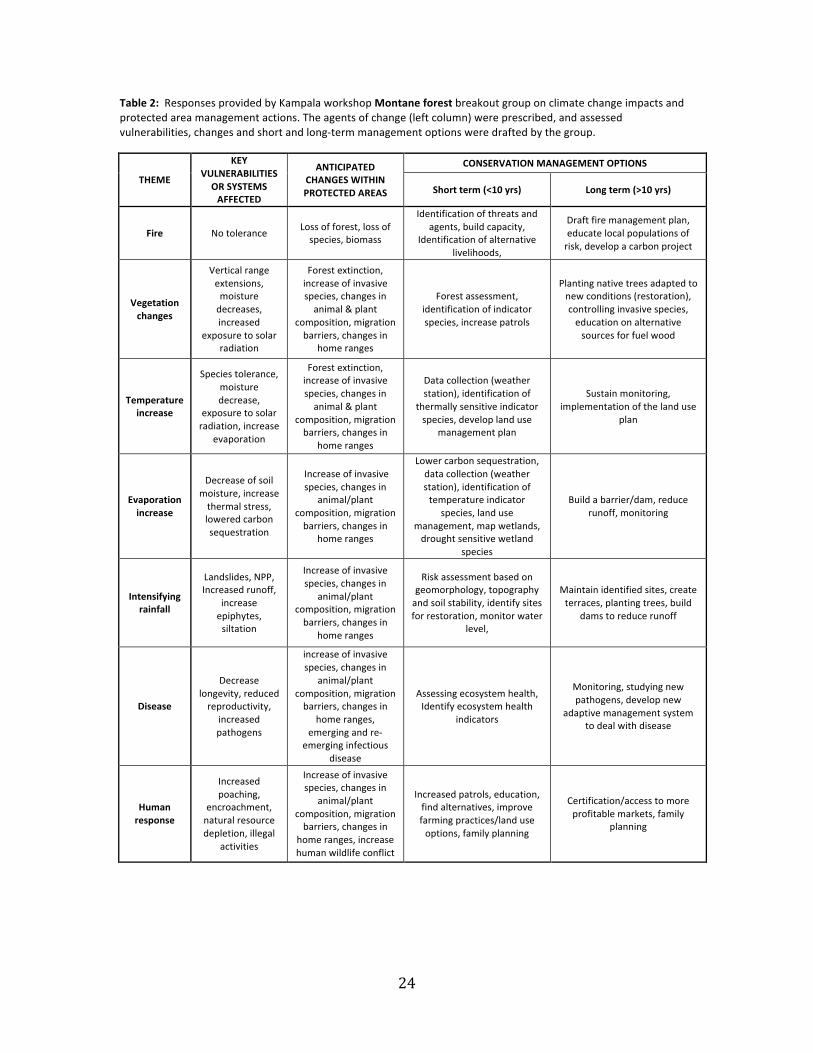
twice. In their first meeting on Day 1 the groups were tasked with identifying likely vulnerabilities within their biome type to a variety of threats and environmental stressors associated with climate change within the suite of protected areas characterized by the respective common biome type, specifically: fire, vegetation changes, hydrological changes, temperature increase, evaporation increase, intensifying rainfall, disease, human response. A short questionnaire was also distributed early on Day 1 to foster thinking through the process of linking climate change related threats to ecological vulnerabilities as a means of identifying options for actions and adaptive management. In the second meeting, on Day 2, the two breakout groups were tasked with drafting recommendations on what actions could be taken in the near-‐term (next decade) and longer-‐term (thereafter) to adapt conservation practices for climate change based on the changes and impacts identified in the initial discussions. The second session followed a presentation on the use of structured approached that demonstrated the utilization of planning frameworks as discussed in the recently published ABCG (2011) report. Outcomes of the Kampala breakout group sessions In common with many of the responses of the Gashora breakout groups, the Kampala meeting attendees reported considerable difficulty in generating site-‐specific recommendations for particular actions to apply adaptation planning into current conservation practices. In general, the recommendations gravitated towards themes of implementing more rigorous monitoring and building on existing conservation practices to achieve co-‐benefits for current and future threats. Also in common with the Gashora groups, the Kampala group members were at once enthused by the availability of the diverse modeling products demonstrated by WCS at the workshop but also frustrated at the level of resolution and tailoring that would be needed to serve their actual management interests. Tabulations of results of the breakout group discussions on savanna grasslands and woodlands and on tropical montane forest ecosystems are presented in Tables 1 and 2, respectively. Although the use of planning frameworks was explained to the Kampala breakout group teams, and a basic threats-‐vulnerabilities-‐planning evaluation process was prescribed in the tables to be filled in, it is clear that most actions identified resistance-‐oriented than adaptive to climate change. Given the absence of prediction tools portraying environmental changes in detail within the protected areas being considered, the concept that consider familiar landscapes might someday diverge from their current condition remained largely an abstraction during the discussions. Furthermore, there is considerable redundancy in anticipated changes to the various stressing agents in protected areas, suggesting some difficulty in differentiating the potential dynamic interactions between stressors and responders.
Perhaps reflecting their interest and expertise in local ecologies, both groups had particularly animated discussions related to monitoring needs within and around protected areas, and the means and methods to put monitoring systems in place. Automatic weather stations have recently been installed in at least 10 of the 14 protected areas represented by the workshop attendees. There was much also interest expressed at the prospect of improved understanding of climatological baselines and detection of trends through the expansion of such programs.

23
Table 1: Responses provided by Kampala workshop Savanna grasslands and woodlands breakout group on climate change impacts and protected area management actions. The agents of change (left column) were prescribed, and assessed vulnerabilities, changes and short and long-‐term management options were drafted by the group.
THREAT OR AGENT OF CHANGE
VULNERABILITIES OR SYSTEMS AFFECTED BY
FUTURE CLIMATE CHANGE
ANTICIPATED CHANGES WITHIN PROTECTED AREAS
CONSERVATION MANAGEMENT OPTIONS
Short term (<10 yrs) Long term (>10 yrs)
Fire Hotter fires and more frequent
Increased fire resistant vegetation, lower quality grasslands and reduced woodlands, increased runoff and sediments sediment, reducing grazer population density
Develop fire management plans including prescribed burning (cold/mosaic), firebreaks, establish fire fighting units, sensitize local communities about fire risks
Reduce edge effects (minimum/low impact) development, manage to achieve optimal animal densities
Vegetation changes
Current condition of vegetation and wildlife densities and distributions
Successional trend to dense forest affecting species numbers, diversity, distribution
Habitat manipulation (remove non native species, water provision, inventories/monitoring
Create buffer areas, establish/maintain corridors, create game areas under communal management, create incentives for conservation of natural vegetation in agricultural landscapes, mitigate illegal activities, species inventories and monitoring
Hydrological changes
Wetland ecosystems, water bodies, water tables
Increased water level variability, increased sediment loads, wetland expansion, aquatic life changes
Maintain status quo of habitat (habitat, fire management plans, animal stocking densities, appropriate siting of water points)
Maintain status quo of aquatic habitats
Temperature increase
Fire, wildlife, vegetation, water bodies
grassland increase, increased fires, lowering water levels, wildlife outmigration
Fire management, watering points, create/maintain corridors, education and awareness
Apply land use management options outside PA, create/maintain corridors
Evaporation increase
Impacts on water bodies, vegetation stress
Reducing biomass, lowering water levels, rainfall pattern distortions
Habitat manipulation -‐ remove non native species, distribution of water points, land use planning and management outside PA, regulate animal densities
Develop education and awareness, conservation agriculture, research and monitoring
Intensifying rainfall
Impacts on water bodies, vegetation, aquatic life
Increased runoff and sediment yield, vector borne diseases, flood potential
Improve disease management, vegetation and habitat management
Disease surveillance and management, develop disaster management plans
Disease Wildlife, human and livestock susceptibility
Change in disease pattern, pandemics, degraded vegetation, wildlife losses
Improve disease management, vegetation and habitat management
Disease surveillance and management, develop disaster management plans, culling, translocation as last resort, community sensitization, disease control strategies
Human response
Wildlife, human and livestock
Integrity of PA undermined (encroachment, poaching, degradation, conflicts increased, enhanced disease transmission)
Increase community education and awareness, land use management, increased benefits to the community, secure the integrity of the PA through intensive law enforcement, collaborative management/community conservation
Promote game ranching, incentivization of communities to support conservation (ecotourism), better management of human-‐wildlife conflicts (compensation plans, set up a trust fund/special guarantee fund, barriers), create buffers through purchase or promotion of non-‐palatable crops, create employment opportunities for communities
24
Table 2: Responses provided by Kampala workshop Montane forest breakout group on climate change impacts and protected area management actions. The agents of change (left column) were prescribed, and assessed vulnerabilities, changes and short and long-‐term management options were drafted by the group.
THEME
KEY VULNERABILITIES OR SYSTEMS AFFECTED
ANTICIPATED CHANGES WITHIN PROTECTED AREAS
CONSERVATION MANAGEMENT OPTIONS
Short term (<10 yrs) Long term (>10 yrs)
Fire No tolerance Loss of forest, loss of species, biomass
Identification of threats and agents, build capacity,
Identification of alternative livelihoods,
Draft fire management plan, educate local populations of risk, develop a carbon project
Vegetation changes
Vertical range extensions, moisture decreases, increased
exposure to solar radiation
Forest extinction, increase of invasive species, changes in animal & plant
composition, migration barriers, changes in
home ranges
Forest assessment, identification of indicator species, increase patrols
Planting native trees adapted to new conditions (restoration), controlling invasive species, education on alternative sources for fuel wood
Temperature increase
Species tolerance, moisture decrease,
exposure to solar radiation, increase
evaporation
Forest extinction, increase of invasive species, changes in animal & plant
composition, migration barriers, changes in
home ranges
Data collection (weather station), identification of
thermally sensitive indicator species, develop land use
management plan
Sustain monitoring, implementation of the land use
plan
Evaporation increase
Decrease of soil moisture, increase thermal stress, lowered carbon sequestration
Increase of invasive species, changes in
animal/plant composition, migration barriers, changes in
home ranges
Lower carbon sequestration, data collection (weather station), identification of temperature indicator
species, land use management, map wetlands, drought sensitive wetland
species
Build a barrier/dam, reduce runoff, monitoring
Intensifying rainfall
Landslides, NPP, Increased runoff,
increase epiphytes, siltation
Increase of invasive species, changes in
animal/plant composition, migration barriers, changes in
home ranges
Risk assessment based on geomorphology, topography and soil stability, identify sites for restoration, monitor water
level,
Maintain identified sites, create terraces, planting trees, build
dams to reduce runoff
Disease
Decrease longevity, reduced reproductivity,
increased pathogens
increase of invasive species, changes in
animal/plant composition, migration barriers, changes in
home ranges, emerging and re-‐
emerging infectious disease
Assessing ecosystem health, Identify ecosystem health
indicators
Monitoring, studying new pathogens, develop new
adaptive management system to deal with disease
Human response
Increased poaching,
encroachment, natural resource depletion, illegal
activities
Increase of invasive species, changes in
animal/plant composition, migration barriers, changes in
home ranges, increase human wildlife conflict
Increased patrols, education, find alternatives, improve farming practices/land use options, family planning
Certification/access to more profitable markets, family
planning
25
4. Assessment of the workshop findings
Taken together, the Gashora and Kampala workshop results offer an early status report for conservation interests on prospects for effective climate change adaptation planning and action in the Albertine Rift. The workshops themselves represent the first such effort to consolidate information focused on climate change impacts and prospects for adaptive planning for the entire Rift region; as outlined in the Gashora workshop findings, the NAPA reports currently available for the Albertine Rift countries mostly focus on socioeconomic development and hazards rather than biodiversity. The workshop process generated much enthusiasm among the participants at both meetings. A sentiment commonly expressed was that the multiday discussions between researchers and stakeholders had moved climate change from being a relatively abstract concept under a single catch-‐phrase to a more understandable set of challenges requiring careful consideration and planning for the future. The scientific presentations at the Gashora meeting collectively demonstrated dynamic advances in understanding of climate changes and its attendant impacts, from near-‐zero knowledge just a decade ago to the point that application of this knowledge in conservation planning is now becoming possible. The next decade will undoubtedly see even more rapid advances, abetted by regionally specific environmental modeling projections run at resolutions that are starting to converge towards the spatial scales needed for decision making and planning at the inter-‐ and intra-‐protected area level.
These positive outcomes were dampened significantly, however, by the recognition of how daunting the challenge is: the overall assessment of climate change adaptation for Albertine Rift conservation, arrived at independently during the two workshops, is actually somewhat discouraging. Whereas it had been hoped that the workshops, and particularly the wardens meeting in Kampala, might generate recommendations for specific actions to be applied in individual protected areas, it is now clear that large knowledge and resource gaps, along with considerable uncertainty over the reliability of predictions, preclude the possibility of designing effective and meaningful adaptation measures beyond the rather conservative first step of fortifying existing conservation practices. However, there were also some more concrete suggestions put forth on ways in which protected area managers could start to plan for adaptation to climate change.
At the Gashora and Kampala meetings the WCS team demonstrated some of the modeled products developed for the Albertine Rift Climate Assessment program in an effort to learn how key stakeholders might utilize such material. This material was generated by dynamic vegetation models drawing upon output from global climate models, tools considered to be close to the state of the science as of the time of publication of the IPCC Fourth Assessment Report (2007). It was therefore hoped that by uniting new tools with locally grounded stakeholder knowledge, pathways and actions for effective adaptation measured would be identified. Instead, the outcome of this exercise was largely to delineate the limitations of such tools while identifying the potential to make them more useful. The suite of modeling products presented to workshop participants for critique and evaluation offered tantalizing glimpses on how extended information could be derived from climate models, yet also yielded some frustration at the coarseness of the spatial resolution and the lack of products tailored for the geographic and ecological characteristics of the Albertine Rift. Furthermore, the actions identified by the Kampala workshop participants shown in Tables 1 and 2 seem more indicative of efforts for building resistance to climate change, to maintain the environmental status quo for as long as possible, rather than truly adaptive changes in management approach and conservation activities.
As such, for the most part, comprehensive conservation planning for climate change across the Albertine Rift may not yet be feasible since many prerequisite components are not yet in place. This does not reflect poor practice or lack of diligence, but rather the realities that knowledge resources are extremely limited, and that climate change has only recently been comprehended as a long-‐term threat of high concern, while omnipresent threats to biodiversity such as agricultural expansion, poaching and other illicit activities continue to occupy conservation attention. Protected area managers in particular regard
26
these other threats as much more immediate, therefore requiring their attention urgently. The two workshops have been useful in raising people’s awareness about the potentially severe impacts climate change will bring and as a result protected area managers are now thinking more seriously about what they can do about it. Meanwhile, formal attention on climate change at national level has been mostly focused in socioeconomic sectors, as is evident in the NAPA reports for the Albertine Rift nations. Thus, protected area managers are confronted with the need to adapt conservation practices and planning to accommodate climate change without the proper tools and resources to do so. And as the workshops demonstrated, the tools that are currently available are still largely inadequate for the task.
Despite these limitations, modeling studies and other work performed to date now provide critical foundational knowledge for developing adaptation planning for conservation. At the same time, modeling techniques and spatial resolution continue to progress rapidly. By working concurrently to address limitations and engaging the environmental modeling community directly to develop tailored products meeting planning needs, the Albertine Rift conservation community should progress steadily towards the goal of effective conservation planning for climate change.
Components needed for informed adaptation planning
In the feedback developed during their respective breakout group activities, the Gashora and Kampala workshop attendees identified a set of key component conditions that they considered to be prerequisite for properly informed adaptation planning. In the Albertine Rift, many of these conditions are either limited or undeveloped, greatly hindering the ability to develop properly informed climate change adaptation planning by conservation interests. The components are summarized in Table 3, along with a subjective assessment of their current status and critical needs to address shortcomings.
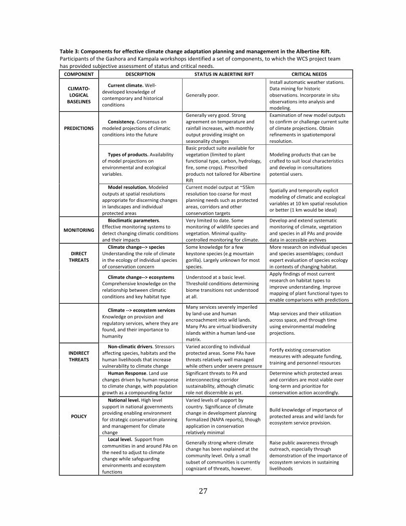
27
Table 3: Components for effective climate change adaptation planning and management in the Albertine Rift. Participants of the Gashora and Kampala workshops identified a set of components, to which the WCS project team has provided subjective assessment of status and critical needs. COMPONENT DESCRIPTION STATUS IN ALBERTINE RIFT CRITICAL NEEDS
CLIMATO-‐ LOGICAL BASELINES
Current climate. Well-‐developed knowledge of contemporary and historical conditions
Generally poor.
Install automatic weather stations. Data mining for historic observations. Incorporate in situ observations into analysis and modeling.
PREDICTIONS Consistency. Consensus on
modeled projections of climatic conditions into the future
Generally very good. Strong agreement on temperature and rainfall increases, with monthly output providing insight on seasonality changes
Examination of new model outputs to confirm or challenge current suite of climate projections. Obtain refinements in spatiotemporal resolution.
Types of products. Availability of model projections on environmental and ecological variables.
Basic product suite available for vegetation (limited to plant functional type, carbon, hydrology, fire, some crops). Prescribed products not tailored for Albertine Rift
Modeling products that can be crafted to suit local characteristics and develop in consultations potential users.
Model resolution. Modeled outputs at spatial resolutions appropriate for discerning changes in landscapes and individual protected areas
Current model output at ~55km resolution too coarse for most planning needs such as protected areas, corridors and other conservation targets
Spatially and temporally explicit modeling of climatic and ecological variables at 10 km spatial resolution or better (1 km would be ideal)
MONITORING
Bioclimatic parameters. Effective monitoring systems to detect changing climatic conditions and their impacts
Very limited to date. Some monitoring of wildlife species and vegetation. Minimal quality-‐controlled monitoring for climate.
Develop and extend systematic monitoring of climate, vegetation and species in all PAs and provide data in accessible archives
DIRECT THREATS
Climate change-‐-‐> species Understanding the role of climate in the ecology of individual species of conservation concern
Some knowledge for a few keystone species (e.g mountain gorilla). Largely unknown for most species.
More research on individual species and species assemblages; conduct expert evaluation of species ecology in contexts of changing habitat.
Climate change-‐-‐> ecosystems Comprehensive knowledge on the relationship between climatic conditions and key habitat type
Understood at a basic level. Threshold conditions determining biome transitions not understood at all.
Apply findings of most current research on habitat types to improve understanding. Improve mapping of plant functional types to enable comparisons with predictions
Climate -‐-‐> ecosystem services Knowledge on provision and regulatory services, where they are found, and their importance to humanity
Many services severely imperiled by land-‐use and human encroachment into wild lands. Many PAs are virtual biodiversity islands within a human land-‐use matrix.
Map services and their utilization across space, and through time using environmental modeling projections.
INDIRECT THREATS
Non-‐climatic drivers. Stressors affecting species, habitats and the human livelihoods that increase vulnerability to climate change
Varied according to individual protected areas. Some PAs have threats relatively well managed while others under severe pressure
Fortify existing conservation measures with adequate funding, training and personnel resources
Human Response. Land use changes driven by human response to climate change, with population growth as a compounding factor
Significant threats to PA and interconnecting corridor sustainability, although climatic role not discernible as yet.
Determine which protected areas and corridors are most viable over long-‐term and prioritize for conservation action accordingly.
POLICY
National level. High level support in national governments providing enabling environment for strategic conservation planning and management for climate change
Varied levels of support by country. Significance of climate change in development planning formalized (NAPA reports), though application in conservation relatively minimal
Build knowledge of importance of protected areas and wild lands for ecosystem service provision.
Local level. Support from communities in and around PAs on the need to adjust to climate change while safeguarding environments and ecosystem functions
Generally strong where climate change has been explained at the community level. Only a small subset of communities is currently cognizant of threats, however.
Raise public awareness through outreach, especially through demonstration of the importance of ecosystem services in sustaining livelihoods
28
Summary recommendations
From the workshop outputs and compilation of results we offer summary recommendations along five general themes towards achieving long-‐term goals of safeguarding Albertine Rift biodiversity against a tide of irrepressible climate change. Addressing these through concerted and coordinated efforts would help to create the necessary conditions for effective adaptive planning for climate change. These themes are identified and discussed in the concluding sections below.
1. Improve monitoring. Extend and standardize environmental monitoring of climatically sensitive variables (atmospheric, hydrologic, vegetation, wildlife species, disease, etc.) throughout the Albertine Rift protected area estate.
2. Develop more relevant predictions. Increase engagement with the climate research and modeling communities to develop suites of tailored prediction products meeting conservation planning needs at spatial resolutions appropriate for protected area management.
3. Developing planning around adaptation frameworks. Utilize structured approaches linking
threats and vulnerabilities to planning and action, along with monitoring to identify trends and evaluate the efficacy of interventions.
4. Integrate direct and indirect impacts on species, ecosystems and people. Recognition that people are integral agents in conservation outcomes requires holistic approaches that embrace the full complexity of climate change impacts upon species and ecosystems.
5. Improve communication to build an enabling environment. Continue to build interactions
between researchers, conservation managers and other stakeholders, and ensure that national and regional level planning for climate change focused on socioeconomic sectors incorporates biodiversity and ecosystem services.
Addressing research and monitoring needs
Across the Albertine Rift, national protected area strategies are beginning to be modified to include consideration of climate change adaptation. Climate change impacts must be recognized among direct threats at park level and addressed through management plans, with comprehensive monitoring being central to measures taken to address the threat. A coherent monitoring strategy utilizing systematic methodology and a standard set of indicators is therefore needed to track pressures, environmental state and response to climate change. While various forms of environmental monitoring is performed within protected areas and at other many sites across the Albertine Rift, few activities are as yet specifically designed for climate change detection and impact. Such monitoring activities also require long-‐term investments and local-‐scale data. Sustaining funding support for monitoring the environment over the long term has always been a challenge throughout the Rift region. Building the case that such monitoring activities comprise the backbone of methods to validate the trends and impacts on climate change at site-‐specific and regional levels should be emphasized in interactions with donors, national governments and international development agencies accordingly. Comprehensive monitoring also contributes to site-‐specific vulnerability assessments. Temperature and precipitation projections are indispensible when it comes to species modeling. Combining magnitude of change data relative to present conditions with species susceptibility data can provide information of real value to decision-‐making.
29
Improving modeling products and their utilization
Climate model projections offer a first step towards predicting how climate change will influence biodiversity, but it requires additional steps to make them meaningful for conservation management through generation of products more relevant to ecological systems. In terms of biodiversity conservation, this extended information is highly informative in determining factors influenced by climate change such as suitable species' habitat distribution, carbon budgets and sequestration, disturbance processes such as fire, and most importantly, how humans are likely to respond. The quantitative output from modeling studies needs to be applied and evaluated both subjectively and objectively within contexts of recognized threats and vulnerabilities. The importance of the Albertine Rift to global biodiversity, and the dire precariousness of its prospects for the future, suggest that the Rift region should be considered among priorities for the applying the best tools available for numerical modeling of future climatic and environmental states. Initial efforts have been informative yet fall far short of needs. Emphasis should be placed on conducting regionally focused modeling to sufficient spatial resolution to represent actual landscape complexity and detail within individual conservation target landscapes. Similarly, the types of products developed should be tailored to more fully represent the geomorphic characteristics of the Rift, its biodiversity and human land use, and be designed to address specific conservation planning needs.
Developing planning around adaptation frameworks
The workshop experience also suggests that a more structured approach to conservation planning for climate change in setting objectives, delineating threats and vulnerabilities, and identifying the adaptive actions needed to adjust to changing circumstances, would generate greater clarity and more effective utilization of the knowledge resources and predictive tools currently available. One of the principal findings of the ABCG survey report, which was prepared in 2011 between the two WCS workshops, is the value of utilizing adaptive planning frameworks to guide effective conservation planning for climate change (ABCG, 2011). Several such frameworks have been proposed: all have in common multi-‐step iterative processes to set goals and objectives, identify threats and assess vulnerabilities, and then utilizing tools such as modeled predictions of future environmental states as guidance towards developing plans and implementing actions (see review in ABCG, 2011). Monitoring is fundamental to these frameworks to provide the means for building baseline information, detecting change and ascertaining project efficacy in achieving favorable outcomes. One example that was demonstrated at the Kampala workshop, the Adaptation for Conservation Targets (ACT) framework (Cross et al., 2012), is presented in Figure 4.

30
Figure 4. The structure of the Adaptation for Conservation Targets (ACT) framework, which has been developed by a team of conservation planners organized by the National Center for Ecological Analysis and Synthesis (NCEAS) in the United States (Cross et al., 2012). An online description of this framework can be found at http://www.cakex.org/virtual-‐library/2285
Integrating direct and indirect impacts on species, ecosystems and people Climate change is forcing conservation interest to face the difficult reality that 20th century reference conditions that have shaped prior conservation planning will become increasingly unrepresentative over time due to the combined effects greenhouse gas driven climate change and other anthropogenic alterations of natural environments (Watson et al., 2011). This applies in the Albertine Rift as elsewhere; however, the intense demographic pressures already felt widely across the Albertine Rift will undoubtedly have an amplifying effect as resident populations respond to the inexorable buildup of environmental stresses upon their livelihoods and the resource they depend upon. Holistic understanding must be generated by integrated research focused not just on species and habitats, but on the social dimensions of climate change too. Research teams with broad interdisciplinary expertise will therefore be required to address climate change impacts comprehensively. All planning should adopt a long-‐term perspective that is sensitive to sustaining ecosystem services and integrate requirement for accounting for the protection of ecosystem services. For effective conservation planning to incorporate climate change, clear conservation objectives for the long-‐term should be defined with protection of ecosystem services assigned a high priority in management plans. However, it must be recognized that planning only for the protection of ecosystem services will not conserve all elements of biodiversity (Ingram et al., in press): there is also a need to identify clear targets for species and ecosystems.
Improving communications to build an enabling environment
Efforts should be intensified to build interactions and maintain channels of communication between researchers, conservation managers and other stakeholders. Conservation interests must strive to ensure that national and regional level planning for climate change focused on socioeconomic sectors fully incorporates biodiversity and ecosystem services, and ascribes appropriate valuation to them accordingly.
31
There is a need to constantly remind intended audiences (and ourselves) that modeling products are guidance tools unlikely to prove accurate, though are hopefully representative enough to meet inform planning needs. The workshop groups also stressed the importance of emphasizing qualitative interpretation of model results over quantitative statistics in interactions with policy makers: model projections, particularly those showing strong changes in future conditions relative to the present, could become a destabilizing force working contrary to planning objectives if they precipitate overly bold actions by stakeholders or decision-‐making bodies. For communicating guidance to protected area managers, there is a need to rank and assess the real value of generated information based on climate projections for protected areas in order to be really useful for decision-‐making. Offering contrasting results would be very useful to identify relative indications of need and establish prioritizations for planning and actions.
Follow up to the meetings
Since the Gashora meeting WCS has started a process of modeling how threatened and endemic species are likely to be affected by climate change as well as the main habitat types found in the Albertine Rift region. This analysis uses the biodiversity data collected by WCS over the past 10 years in this part of the World (much of it supported by the MacArthur Foundation) as well as online databases and data from scientists who have been working in the region. The resolution of this analysis is at a 1km scale and uses the WORLDCLIM data sets and the recent IPCC4 assessment models (Hijmans et al. 2005). While these are unlikely to be perfect in such a varied region such as the Albertine Rift, where the topography and the presence of large lakes strongly influence local climates, they are producing sensible predictions of current species distributions and we are gaining confidence in their use for a more fine-‐scale analysis of the impacts of climate change. We will be using these analyses to assess where critical corridors need to be conserved to allow future movement of species and also to identify critical sites for the conservation of all of the endemic and threatened species of the Albertine Rift. The taxa we are focusing on include large mammals, birds, amphibians, reptiles and plants and we hope that these will act as surrogates for other taxa.
We are also working with the US Forest Service to raise funds to provide training to protected area authorities in the region in better fire management in both forest and savanna ecosystems. A pilot training program in Nyungwe Park in Rwanda was very successful and we want to replicate this at other sites in the region.
Quality-‐controlled climatological observations meeting international standards are also becoming available for the first time in several of the key conservation landscapes of the Albertine Rift. WCS is developing an Internet portal that will disseminate data from an initial network of eight automatic weather stations that WCS has provided to the region under MacArthur Foundation funding. This portal will provide basic summaries of the data, as well as allow free access to the data archives for the global community. We are aiming to have the stations recognized as operational research-‐grade stations so that the data are accepted for global analyses. It is possible that other partner organizations that are also establishing automatic weather stations in the Albertine Rift, such as the IGCP, may also share their data through the same portal. At the Kampala workshop we learned that the Uganda Wildlife Authority had multi-‐year records from several automatic weather stations on the slopes of the Rwenzori massif that have yet to be analyzed and made available to the broader community. They have agreed to share these data with WCS and will make them available through our Internet portal.
32
References ABCG: Africa Biodiversity Collaborative Group, 2011: A Review of Climate Change Adaptation Initiatives within the Africa Biodiversity Collaborative Group NGO Consortium, Wildlife Conservation Society, New York, and Africa Biodiversity Collaborative Group, Washington DC, 124 pp. (Lead authors A. Seimon, J.E.M. Watson, R. Dave, E. Gray and J. Oglethorpe). Available at http://frameweb.org/adl/en-‐US/8202/file/1090/abcg-‐climatechangeadaptation.pdf Babweteera, F., D. Sheil, V. Reynolds, A.J. Plumptre, K. Zuberbuhler, C.M. Hill, A. Webber, and M. Tweheyo, 2012: Environmental and anthropogenic changes in and around Budongo Forest Reserve. In, A. Plumptre (Ed.), Long-‐term changes in Africa’s Rift Valley, New York: Nova Science Publishers. Barry, R.G., 1992: Mountain Weather and Climate. London, Routledge Press Belfiore, N.M, (ed.), 2010: The Implications of Global Climate Change for Mountain Gorilla Conservation. African Wildlife Foundation, the International Gorilla Conservation Program, and EcoAdapt. Chao, N., F. Mulindahabi, J. Easton, A.J. Plumptre, A. Seimon, A. Martin, and R. Fimbel, 2012: Long Term Changes in a Montane Forest in an Region of High Human Population Density. In, A. Plumptre (Ed.), Long-‐term changes in Africa’s Rift Valley, New York: Nova Science Publishers. Cordeiro, N.J., N.D. Burgess, D.B.K. Dovie, B. Kaplin, A.J. Plumptre and R. Marrs, 2007: Conservation in areas of high population density in sub-‐saharan Africa. Biological Conservation, 134, 155-‐163 Cross, M. S., E. S. Zavaleta, D. Bachelet, M. L. Brooks, C. A. F. Enquist, E. Fleishman, L. Graumlich, C. R. Groves, L. Hannah, L. Hansen, G. Hayward, M. Koopman, J. J. Lawler, J. Malcolm, J. Nordgren, B. Petersen, E. L. Rowland, D. Scott, S. L. Shafer, M. R. Shaw, and G. M. Tabor, 2012: Adaptation for Conservation Targets (ACT) Framework: A tool for incorporating climate change into natural resource conservation and management. Environmental Management (2012) 50: 341–351 Doherty, R. M., S. Sitch, B. Smith, S.L. Lewis, and P.K. Thornton, 2010: Implications of future climate and atmospheric CO2 content for regional biogeochemistry, biogeography and ecosystem services across East Africa. Global Change Biology, 16: 617–640
Fawcett, K. G. Bush, A. Seimon, G. Picton Phillips, D. Tuyisingize and P. Uwingeli, 2012: Long term changes in the Virunga Volcanoes. In, A. Plumptre (Ed.), Long-‐term changes in Africa’s Rift Valley, New York: Nova Science Publishers. * Hijmans, R.J., S.E. Cameron, J.L. Parra, P.G. Jones and A. Jarvis, 2005: Very high resolution interpolated climate surfaces for global land areas. International Journal of Climatology, 25, 1965-‐1978. Hole, D.G., S.G. Willis, D.J. Pain, L.D. Fishpool, S.H.M. Butchart, Y.C. Collingham, C. Rahbek, C. and B. Huntley, 2009: Projected impacts of climate change on a continent-‐wide protected area network. Ecology Letters, 12: 420–431 Ingram, J.C, Redford, K.H., Watson, J.E.M. (in press): Applying Ecosystem Services Approaches for Biodiversity Conservation: Benefits and Challenges. S.A.P.I.EN.S. Itoh, N., M. Nakamura, H. Ihobe, S. Uehara, K. Zamma, L. Pintea, A. Seimon and T. Nishida, 2012: Long-‐term changes in the social and natural environments surrounding the chimpanzees of the Mahale Mountains National Park. In, A. Plumptre (Ed.), Long-‐term changes in Africa’s Rift Valley, New York: Nova
33
Science Publishers. Kasangaki, A., R. Bitariho, P. Shaw, M. Robbins and A. McNeilage, 2012: Long-‐term ecological and socio-‐economic changes in and around Bwindi Impenetrable National Park, southwestern Uganda. In, A. Plumptre (Ed.), Long-‐term changes in Africa’s Rift Valley, New York: Nova Science Publishers. NAPA: The National Adaptation Programs of Action Reports. Available online at: http://unfccc.int/cooperation_support/least_developed_countries_portal/submitted_napas/items/4585.php Patrick, R., D. Patrick and K.D. Hunt, 2012: Long Term Changes at Toro-‐Semliki Wildlife Reserve. In, A. Plumptre (Ed.), Long-‐term changes in Africa’s Rift Valley, New York: Nova Science Publishers. Picton Phillipps, G. and A. Seimon, 2009: Potential Climate Change Impacts in Conservation Landscapes of the Albertine Rift, Wildlife Conservation Society whitepaper. http://www.albertinerift.org/DesktopModules/Bring2mind/DMX/Download.aspx?EntryId=11661&PortalId=49&DownloadMethod=attachment Plumptre, A. J. (ed.), 2012: The Ecological Impact of Long-‐term Changes in Africa’s Rift Valley. New York: Nova Science Publishers. Plumptre, A.J., D. Pomeroy, J. Stabach, N.Laporte, M. Driciru, G. Nangendo, F. Wanyama and A. Rwetsiba, 2012: The effects of environmental and anthropogenic changes on the Savannas of the Queen Elizabeth and Virunga National parks. In, A. Plumptre (Ed.), Long-‐term changes in Africa’s Rift Valley, New York: Nova Science Publishers. Plumptre, A. J., T. R. B. Davenport, M. Behangana, R. Kityo, G. Eilu, P. Ssegawa, C. Ewango, D. Meirte, C. Kahindo, M. Herremans, J. Kerbis Peterhans, J. Pilgrim, M. Wilson, M. Languy, and D. Moyer, 2007: The Biodiversity of the Albertine Rift. Biological Conservation, 134:178–94 Plumptre, A.J., A. Kayitare, H. Rainer, M. Gray, I. Munanura, N. Barakabuye, S. Asuma, M. Sivha, M., and A. Namara, 2004: The Socioeconomic Status of People Living Near Protected Areas in the Central Albertine Rift. Albertine Rift Technical Reports, 4. 127pp. Seimon, A., J.C. Ingram and J.E.M. Watson (in press): Climatology of the East African Great Lakes Region and potential impacts of climate change on its biodiversity and ecosystem services. In, I. Gordon (ed.) Conservation Strategy in the Great Lakes Region of East and Central Africa, 2012. John D. and Catherine T. MacArthur Foundation, International Programs for Conservation and Sustainable Development. Seimon, A. and G. Picton Phillipps, 2012: Regional Climatology of the Albertine Rift. In, A. Plumptre (Ed.), Long-‐term changes in Africa’s Rift Valley, New York: Nova Science Publishers. Seimon, A. and A.J. Plumptre, 2012: The Albertine Rift. In M. Cross, J. Hilty and C. Chester (Eds.). Conservation and climate disruption: Landscape science and practice in a changing climate. Island Press Thornton, P.K., P.G. Jones, G. Alagarswamy and J. Anresen, 2009: Spatial variation of crop yield response to climate change in East Africa. Global Environmental Change, 19: 54-‐65 Thornton P.K., P.G. Jones P.J. Ericksen and A.J. Challinor, 2011: Agriculture and food systems in sub-‐Saharan Africa in a 4°C+ world. Philosophical Transactions of the Royal Society A, 369: 117–136

34
Watson, J.E.M., M. Cross, E. Rowland, L.N. Joseph, M. Rao, M. and A. Seimon, 2011: Planning for species conservation in a time of climate change. Climate Change Volume 3: Research and technology for climate change adaptation and mitigation. pp. 379-‐402. InTech Publishers.
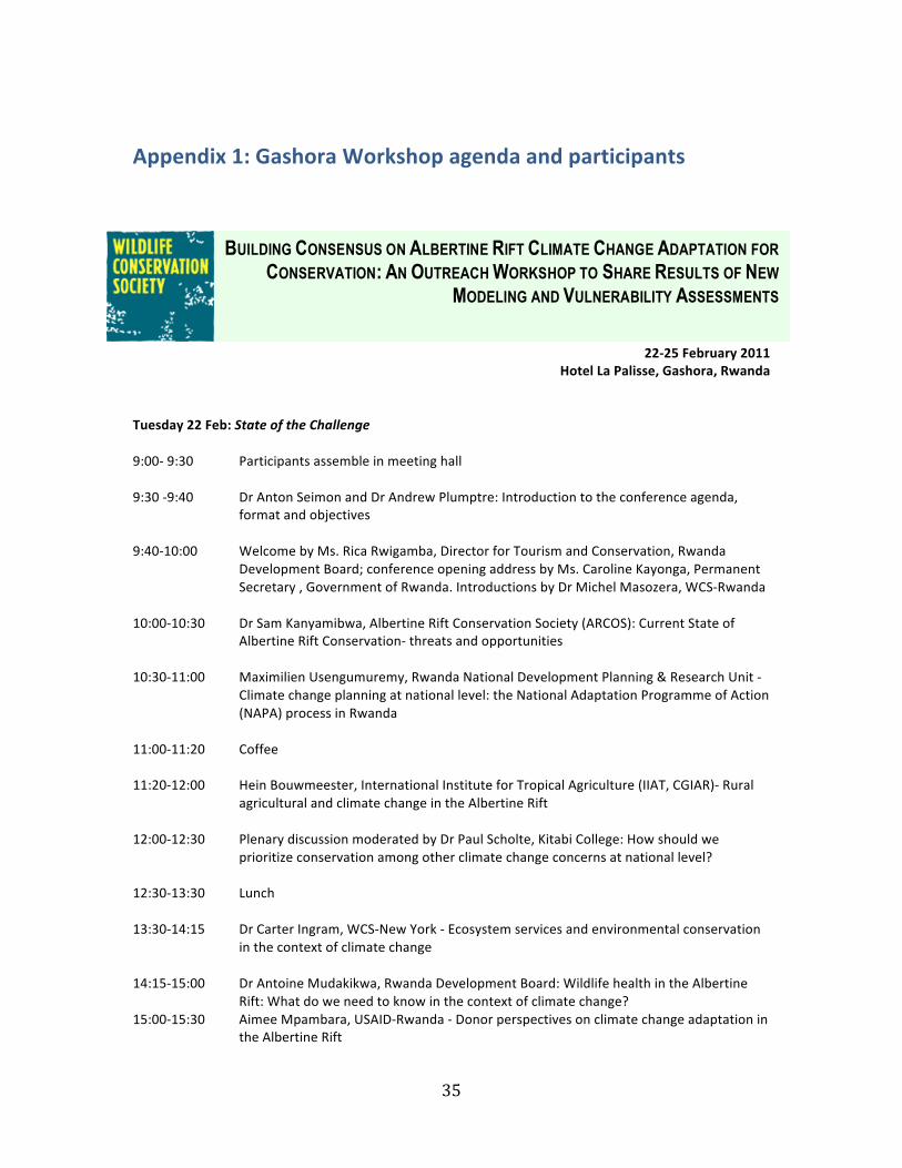
35
Appendix 1: Gashora Workshop agenda and participants
22-‐25 February 2011 Hotel La Palisse, Gashora, Rwanda
Tuesday 22 Feb: State of the Challenge 9:00-‐ 9:30 Participants assemble in meeting hall 9:30 -‐9:40 Dr Anton Seimon and Dr Andrew Plumptre: Introduction to the conference agenda,
format and objectives 9:40-‐10:00 Welcome by Ms. Rica Rwigamba, Director for Tourism and Conservation, Rwanda
Development Board; conference opening address by Ms. Caroline Kayonga, Permanent Secretary , Government of Rwanda. Introductions by Dr Michel Masozera, WCS-‐Rwanda
10:00-‐10:30 Dr Sam Kanyamibwa, Albertine Rift Conservation Society (ARCOS): Current State of
Albertine Rift Conservation-‐ threats and opportunities 10:30-‐11:00 Maximilien Usengumuremy, Rwanda National Development Planning & Research Unit -‐
Climate change planning at national level: the National Adaptation Programme of Action (NAPA) process in Rwanda
11:00-‐11:20 Coffee 11:20-‐12:00 Hein Bouwmeester, International Institute for Tropical Agriculture (IIAT, CGIAR)-‐ Rural
agricultural and climate change in the Albertine Rift 12:00-‐12:30 Plenary discussion moderated by Dr Paul Scholte, Kitabi College: How should we
prioritize conservation among other climate change concerns at national level? 12:30-‐13:30 Lunch 13:30-‐14:15 Dr Carter Ingram, WCS-‐New York -‐ Ecosystem services and environmental conservation
in the context of climate change 14:15-‐15:00 Dr Antoine Mudakikwa, Rwanda Development Board: Wildlife health in the Albertine
Rift: What do we need to know in the context of climate change? 15:00-‐15:30 Aimee Mpambara, USAID-‐Rwanda -‐ Donor perspectives on climate change adaptation in
the Albertine Rift
BUILDING CONSENSUS ON ALBERTINE RIFT CLIMATE CHANGE ADAPTATION FOR CONSERVATION: AN OUTREACH WORKSHOP TO SHARE RESULTS OF NEW
MODELING AND VULNERABILITY ASSESSMENTS
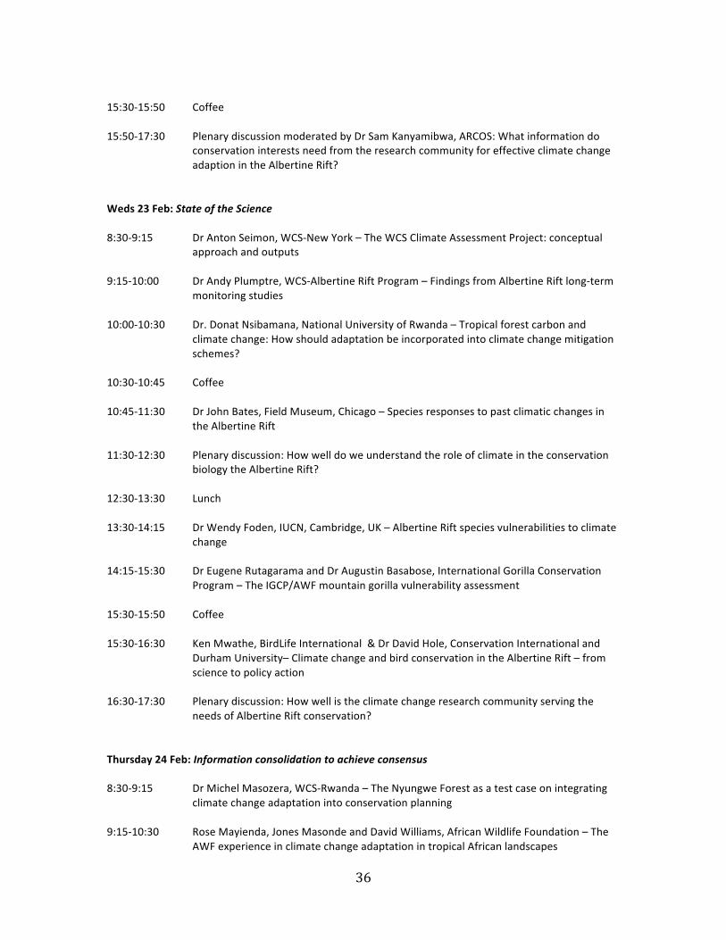
36
15:30-‐15:50 Coffee 15:50-‐17:30 Plenary discussion moderated by Dr Sam Kanyamibwa, ARCOS: What information do
conservation interests need from the research community for effective climate change adaption in the Albertine Rift?
Weds 23 Feb: State of the Science 8:30-‐9:15 Dr Anton Seimon, WCS-‐New York – The WCS Climate Assessment Project: conceptual
approach and outputs 9:15-‐10:00 Dr Andy Plumptre, WCS-‐Albertine Rift Program – Findings from Albertine Rift long-‐term
monitoring studies 10:00-‐10:30 Dr. Donat Nsibamana, National University of Rwanda – Tropical forest carbon and
climate change: How should adaptation be incorporated into climate change mitigation schemes?
10:30-‐10:45 Coffee 10:45-‐11:30 Dr John Bates, Field Museum, Chicago – Species responses to past climatic changes in
the Albertine Rift 11:30-‐12:30 Plenary discussion: How well do we understand the role of climate in the conservation
biology the Albertine Rift? 12:30-‐13:30 Lunch 13:30-‐14:15 Dr Wendy Foden, IUCN, Cambridge, UK – Albertine Rift species vulnerabilities to climate
change 14:15-‐15:30 Dr Eugene Rutagarama and Dr Augustin Basabose, International Gorilla Conservation
Program – The IGCP/AWF mountain gorilla vulnerability assessment 15:30-‐15:50 Coffee 15:30-‐16:30 Ken Mwathe, BirdLife International & Dr David Hole, Conservation International and
Durham University– Climate change and bird conservation in the Albertine Rift – from science to policy action
16:30-‐17:30 Plenary discussion: How well is the climate change research community serving the
needs of Albertine Rift conservation? Thursday 24 Feb: Information consolidation to achieve consensus 8:30-‐9:15 Dr Michel Masozera, WCS-‐Rwanda – The Nyungwe Forest as a test case on integrating
climate change adaptation into conservation planning 9:15-‐10:30 Rose Mayienda, Jones Masonde and David Williams, African Wildlife Foundation – The
AWF experience in climate change adaptation in tropical African landscapes
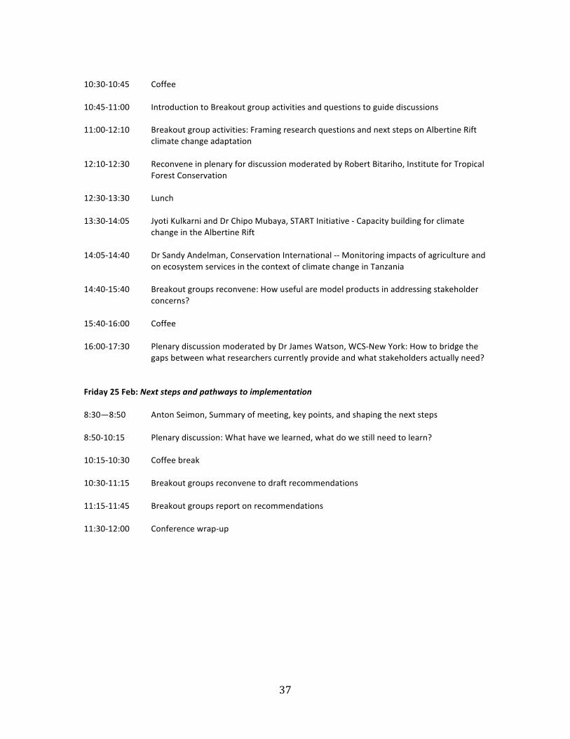
37
10:30-‐10:45 Coffee 10:45-‐11:00 Introduction to Breakout group activities and questions to guide discussions 11:00-‐12:10 Breakout group activities: Framing research questions and next steps on Albertine Rift
climate change adaptation 12:10-‐12:30 Reconvene in plenary for discussion moderated by Robert Bitariho, Institute for Tropical
Forest Conservation 12:30-‐13:30 Lunch 13:30-‐14:05 Jyoti Kulkarni and Dr Chipo Mubaya, START Initiative -‐ Capacity building for climate
change in the Albertine Rift 14:05-‐14:40 Dr Sandy Andelman, Conservation International -‐-‐ Monitoring impacts of agriculture and
on ecosystem services in the context of climate change in Tanzania 14:40-‐15:40 Breakout groups reconvene: How useful are model products in addressing stakeholder
concerns? 15:40-‐16:00 Coffee 16:00-‐17:30 Plenary discussion moderated by Dr James Watson, WCS-‐New York: How to bridge the
gaps between what researchers currently provide and what stakeholders actually need? Friday 25 Feb: Next steps and pathways to implementation 8:30—8:50 Anton Seimon, Summary of meeting, key points, and shaping the next steps 8:50-‐10:15 Plenary discussion: What have we learned, what do we still need to learn? 10:15-‐10:30 Coffee break 10:30-‐11:15 Breakout groups reconvene to draft recommendations 11:15-‐11:45 Breakout groups report on recommendations 11:30-‐12:00 Conference wrap-‐up
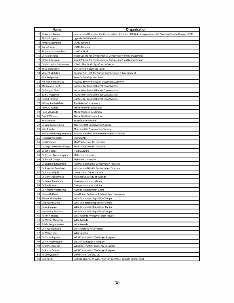
38
Name Organization! "#$%&'()$*+(&' ,'-&#'.-/+'.0$1'/+'$2+#$-3&$4+'5.-/+'$+2$7.-8#&$9,147:$;$,'-&#<+6&#'=&'-.0$>.'&0$+'$40/=.-&$43.'<&$9,>44:
? @/A3.#($B.C&#& 1<.'(.$%/0(0/2&$D8-3+#/-)
E D/=&&$FC.=G.#. 1HD,"I@J.'(.
K L.#)$4#.=&# 1HD,"I@J.'(.
M N3.((&&$O.G/).=G&#& 1HD,"I4D@>P
Q "#$>.80$HA3+0-& B/-.G/$4+00&<&$2+#$P'6/#+'=&'-.0$4+'5.-/+'$.'($F.'.<&=&'-
R @/A3.#($7.5.5/#. B/-.G/$4+00&<&$2+#$P'6/#+'=&'-.0$4+'5.-/+'$.'($F.'.<&=&'-
S "#$F8T8#.0/'(.$D-3.'.5& ,4@D*$I$N3&$%+#0($D<#+2#&5-#)$4&'-#&
U V+T+$%.-.'.G& LP*$7.-8#.0$@&5+8#A&5$N&.=
!W X/'A&'-$F83/-/#. Y8#8'(/$7.-Z$,'5-Z$2+#$7.-8#&$4+'5.-/+'$;$P'6/#+'=&'-
!! @/A.$@J/<.=G. @J.'(.$"&6&0+C=&'-$Y+.#(
!? O&#=.'$O.T8[/=.'. @J.'(.$P'6/#+'=&'-.0$F.'.<&=&'-$D8-3+#/-)
!E F/#/.=$6.'$O&/5- ,'5-/-8-&$2+#$N#+C/A.0$*+#&5-$4+'5.-/+'
!K "#$"+8<0.5$H3&/0 ,'5-/-8-&$2+#$N#+C/A.0$*+#&5-$4+'5.-/+'
!M Y.(#8$F8<&#J. ,'5-/-8-&$2+#$N#+C/A.0$*+#&5-$4+'5.-/+'
!Q @+G&#-$Y/-.#/3+ ,'5-/-8-&$2+#$N#+C/A.0$*+#&5-$4+'5.-/+'
!R \&22#&)$H=/-3$(&Y0/&8 N3&$7.-8#&$4+'5.'A)
!S \+'&5$F.5+'(& D2#/A.$%/0(0/2&$*+8'(.-/+'
!U @+5&$F.)/&'(. D2#/A.$%/0(0/2&$*+8'(.-/+'
?W ".6/($%/00/.=5 D2#/A.$%/0(0/2&$*+8'(.-/+'
?! B&'$FJ.-3& Y/#(]/2&$,'-&#'.-/+'.0
?? "#$H.=$B.').=/GJ. D0G&#-/'&$@/2-$4+'5.-/+'$H+A/&-)
?E \80/.$@/-5A3& D0G&#-/'&$@/2-$4+'5.-/+'$H+A/&-)
?K F.^/=/0/&'$15&'<8=8#&=) @J.'(.$7.-/+'.0$D(.C-.-/+'$>#+<#.=$+2$DA-/+'
?M O&/'$Y+8J=&&5-&# ,,ND_4L,D@
?Q \)+-/$B80T.#'/ HND@N$D0G&#-/'&$@/2-$,'/-/.-/6&
?R "#$43/C+$>0.^&(&5$F8G.). HND@N$D0G&#-/'&$@/2-$,'/-/.-/6&
?S "#$\+3'$Y.-&5 */&0($F85&8=
?U "#$"&''/5$NJ/'+=8</53. F.T&#&#&$1'/6/-)
EW "#$>.-#/AT$`=&a. F.T&#&#&$1'/6/-)
E! "#$P8<&'&$@8-.<.#.=. ,'-&#'.-/+'.0$L+#/00.$4+'5.-/+'$>#+<#.=
E? "#$D8<85-/'$Y.5.G+5& ,'-&#'.-/+'.0$L+#/00.$4+'5.-/+'$>#+<#.=
EE "#$D=+5$F.a80& 1'/6/-)$+2$".#$&5$H.0..=
EK "#$"+'.-$75/G.=.'. 7.-/+'.0$1'/6/-)$+2$@J.'(.
EM "#$H.'()$D'(&0=.' 4+'5.-/+'$,'-&#'.-/+'.0
EQ "#$".6/($O+0& 4+'5.-/+'$,'-&#'.-/+'.0
ER "#$D'-+/'&$F8(.T/TJ. @J.'(.$"&6&0+C=&'-$Y+.#(
ES P0/[.G&-3$43.(#/ \+3'$"Z$.'($4.-3&#/'&$NZ$F.AD#-38#$*+8'(.-/+'
EU @+G&#-$FJ/').3.0/ %4HI"&=+A#.-/A$@&C8G0/A$+2$4+'<+
KW "&+$B8a/#.TJ/'a. %4HI"&=+A#.-/A$@&C8G0/A$+2$4+'<+
K! >.C)$H3.=.68 %4HI"&=+A#.-/A$@&C8G0/A$+2$4+'<+
K? \&.'I@&=)$F.T.'. %4HI"&=+A#.-/A$@&C8G0/A$+2$4+'<+
KE D.#+'$7/A3+0.5 %4HI@J.'(.$7)8'<J&$*+#&5-$>#+a&A-
KK "#$F/A3&0$F.5+[&#. %4HI@J.'(.
KM */(&0&$@8[/<.'(&TJ& %4HI@J.'(.
KQ "#$D'()$>08=C-#& %4H$D0G&#-/'&$@/2-$>#+<#.=
KR "#$F/<8&0$]&.0 %4HI1<.'(.
KS "#$4.#-&#$,'<#.= %4H$4+'5.-/+'$43.00&'<&5$>#+<#.=
KU "#$D=)$>+T&=C'&# %4H$D2#/A.$@&</+'.0$>#+<#.=
MW "#$\.=&5$%.-5+' %4H$4+'5.-/+'$43.00&'<&5$>#+<#.=
M! "#$D'-+'$H&/=+' %4H$4+'5.-/+'$43.00&'<&5$>#+<#.=
M? \/00/.'$")5[)'5T/ 1'/6/-)$+2$`^2+#(b$1B
ME Y+G$7.-/28 1<.'(.$F/'/5-#)$+2$%.-&#$.'($P'6/#+'=&'-$I40/=.-&$43.'<&$1'/-
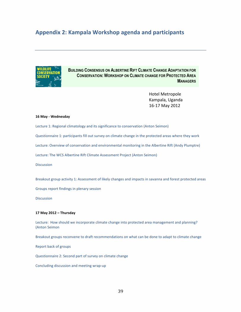
39
Appendix 2: Kampala Workshop agenda and participants
Hotel Metropole Kampala, Uganda 16-‐17 May 2012
16 May -‐ Wednesday Lecture 1: Regional climatology and its significance to conservation (Anton Seimon) Questionnaire 1: participants fill out survey on climate change in the protected areas where they work Lecture: Overview of conservation and environmental monitoring in the Albertine Rift (Andy Plumptre) Lecture: The WCS Albertine Rift Climate Assessment Project (Anton Seimon) Discussion Breakout group activity 1: Assessment of likely changes and impacts in savanna and forest protected areas Groups report findings in plenary session Discussion 17 May 2012 – Thursday Lecture: How should we incorporate climate change into protected area management and planning? (Anton Seimon Breakout groups reconvene to draft recommendations on what can be done to adapt to climate change Report back of groups Questionnaire 2: Second part of survey on climate change Concluding discussion and meeting wrap-‐up
BUILDING CONSENSUS ON ALBERTINE RIFT CLIMATE CHANGE ADAPTATION FOR CONSERVATION: WORKSHOP ON CLIMATE CHANGE FOR PROTECTED AREA
MANAGERS
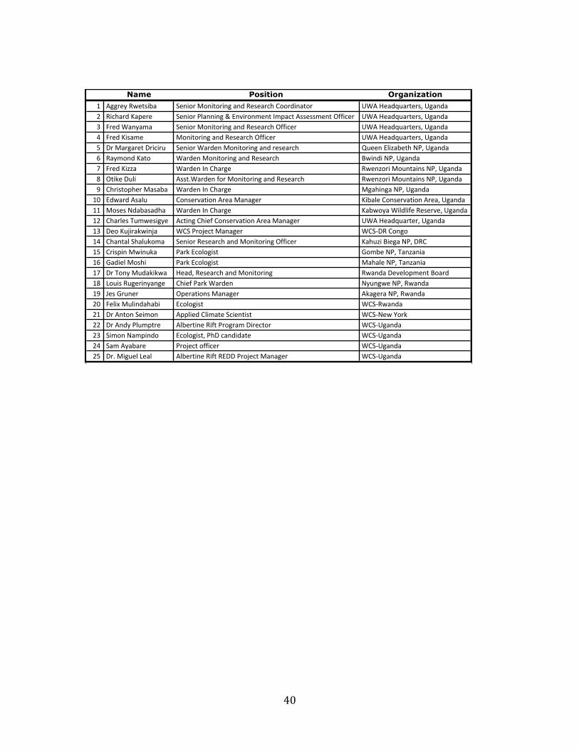
40
Name Position Organization! "##$%&'()%*+,-. /%0,1$'210,*1$,0#'.03'(%+%.$45'611$3,0.*1$ 78"'9%.3:;.$*%$+<'7#.03.= (,45.$3'>.?%$% /%0,1$'@A.00,0#'B'C0D,$10E%0*'FE?.4*'"++%++E%0*'GHH,4%$ 78"'9%.3:;.$*%$+<'7#.03.I J$%3'8.0&.E. /%0,1$'210,*1$,0#'.03'(%+%.$45'GHH,4%$ 78"'9%.3:;.$*%$+<'7#.03.K J$%3'>,+.E% 210,*1$,0#'.03'(%+%.$45'GHH,4%$ 78"'9%.3:;.$*%$+<'7#.03.L M$'2.$#.$%*'M$,4,$; /%0,1$'8.$3%0'210,*1$,0#'.03'$%+%.$45 N;%%0'CA,O.-%*5'P@<'7#.03.Q (.&E103'>.*1 8.$3%0'210,*1$,0#'.03'(%+%.$45 R),03,'P@<'7#.03.S J$%3'>,OO.' 8.$3%0'F0'65.$#% ()%0O1$,'21;0*.,0+'P@<'7#.03.T G*,U%'M;A, "++*V8.$3%0'H1$'210,*1$,0#'.03'(%+%.$45 ()%0O1$,'21;0*.,0+'P@<'7#.03.W 65$,+*1?5%$'2.+.-.' 8.$3%0'F0'65.$#% 2#.5,0#.'P@<'7#.03.!X C3).$3'"+.A; 610+%$D.*,10'"$%.'2.0.#%$ >,-.A%'610+%$D.*,10'"$%.<'7#.03.!! 21+%+'P3.-.+.35.' 8.$3%0'F0'65.$#% >.-)1&.'8,A3A,H%'(%+%$D%<'7#.03.!= 65.$A%+'Y;E)%+,#&% "4*,0#'65,%H'610+%$D.*,10'"$%.'2.0.#%$ 78"'9%.3:;.$*%$<'7#.03.!I M%1'>;Z,$.U),0Z. 86/'@$1Z%4*'2.0.#%$ 86/[M('610#1!K 65.0*.A'/5.A;U1E. /%0,1$'(%+%.$45'.03'210,*1$,0#'GHH,4%$ >.5;O,'R,%#.'P@<'M(6!L 6$,+?,0'2),0;U. @.$U'C41A1#,+* \1E-%'P@<'Y.0O.0,.!Q \.3,%A'21+5, @.$U'C41A1#,+* 2.5.A%'P@<'Y.0O.0,.!S M$'Y10&'2;3.U,U). 9%.3<'(%+%.$45'.03'210,*1$,0# ().03.'M%D%A1?E%0*'R1.$3!T ]1;,+'(;#%$,0&.0#% 65,%H'@.$U'8.$3%0 P&;0#)%'P@<'().03.!W ^%+'\$;0%$ G?%$.*,10+'2.0.#%$ "U.#%$.'P@<'().03.=X J%A,_'2;A,03.5.-, C41A1#,+* 86/[().03.=! M$'"0*10'/%,E10 "??A,%3'6A,E.*%'/4,%0*,+* 86/[P%)'`1$U== M$'"03&'@A;E?*$% "A-%$*,0%'(,H*'@$1#$.E'M,$%4*1$ 86/[7#.03.=I /,E10'P.E?,031 C41A1#,+*<'@5M'4.03,3.*% 86/[7#.03.=K /.E'"&.-.$% @$1Z%4*'1HH,4%$ 86/[7#.03.=L M$V'2,#;%A']%.A "A-%$*,0%'(,H*'(CMM'@$1Z%4*'2.0.#%$ 86/[7#.03.
Copyright © 2022 FDOKUMEN