BudgetWorldClass Drives - Albums by Patrick LEPETIT
88
B udget W orld C lass D rive s Chiang Mai -Sukhothai Loop a m a z i n g THAILAND 1998 1999 SELF DRIVE V ACATIONS Tourism Authority of Thailand (TAT)
-
Upload
khangminh22 -
Category
Documents
-
view
0 -
download
0
Transcript of BudgetWorldClass Drives - Albums by Patrick LEPETIT
Budget WorldClass DrivesChiang Mai-Sukhothai Loop
a m a z i n gT H A I L A N D
1 9 9 8
1 9 9 9SELF DRIVE VACATIONSTourism Authority of Thailand (TAT)
R
2
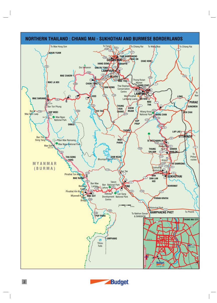
NORTHERN THAILAND : CHIANG MAI - SUKHOTHAI AND BURMESE BORDERLANDS
1194
108
105
105
1099
1090
10901206
1051140
105
1175
14
15
17
18
16
12
10
11
8
9
13
1096
1269
10611
116
1033
11
1093
1034
1037
11
1
103
1
1035
1
1081156
1031
106 1184
1274
1010
1009
108
108
1088
1103
1001
118
1317
1317
1006
107
23
4
5
115
1
1011132104
12
105
1175
1
12
1113
1113
1048
10561113 1195 101
12
11
1023
11241125
1177101
102
1110113051294 6
7
Thai ElephantConservation
Centre
Wat PhrathatLampang Luang
Thung KwianMarket
WANG CHIN
MAETHA
Wiang KosaiNational Park
To Chiang Rai
ToNan
To Wang NuaTo Chiang RaiTo Fang
LAMPHUN
LAMPANG
PHRAE
UTTARADIT
SUKHOTHAI
TAK
KAMPHAENG PHET
BanMae Sam Laep
Mae Salit
Doi Inthanon
19
1
CHIANG MAI
To Mae Hong Son
SARAPHI
SAN PA TONG
HANG DONG
MAE THA
BAN HONG
PA SANG
MAE LA NOI
MAE CHAEM
MAE SARIANG
KHUN YUAM
DOI TAO
LI
THUNGHUA
CHANG
THOEN
MAEPHRIK
SOPPRAP
SOEMNGAM
KO KHA
CHOM TONG
HOD
SAN KAMPHAENGMAE ON
CHAE HOM
HANG CHAT
SUNGMEN
DEN CHAI
LONG
OMKOI
Mae NgaoNational Park
SOP MOEI
Ban Mae Ramoeng
Ban Ton Phung
km.190
km.114
km.219
Mae Ngao National Park
SAM NGAO
Ban Tak
BanLahu
TilosuFalls
Ban MaeLamaoBan Huai
Kalok
Phrathat Ton Kaew
Phrathat Hin Kiu
MiyawadiMoei
Bridge
HilltribeDevelopment
Centre
Bhumipol Dam
MAE RAMAT
Lan SangNational Park
TaksinNational Park
PHRAN KRATAI
To Phichit
KHIRIMAT
Historical Park
To Nakhon Sawan& BANGKOK
BanKaoBAN
DAN LANHOI
SukhothaiHistorical
Park
HistoricalParkTHUNG
SALIAM
Airport
SI SATCHANALAI
SAWANKHALOK
LAP LAE
SI SAMRONGM Y A N M A R( B U R M A )
1
102
101
HUAI KAEW RD.
SUTHEP RD.
Airport
OM MUANGRD.
PI N
GR
IVER
Train Station
CHIANG MAI CITY
118
1006
11
106
108
11
107
Car and Truck Rental
R
19
1
THA SONGYANG
MAE SOT
POP PHRA
UMPHANG
ToPhitsa-nuloke
0 10 20 kms.
Ban ThaSong Yang
100Kilometre Stone
Temple
Park
Water Fall
Hot Springs.
Hotel/Resort/Guest House
Hospital
Gas Station
Restaurant
0
Main Road
Minor Road
Unsealed Road
Suggested Routes
River
Province
District
Key Point.
Distance Between Key Points (kms.)12
R
3
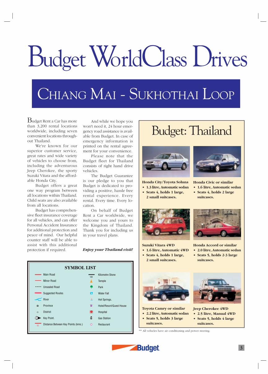
Budget Rent a Car has morethan 3,200 rental locationsworldwide, including sevenconvenient locations through-out Thailand.
We're known for oursuperior customer service,great rates and wide varietyof vehicles to choose from,including the adventurousJeep Cherokee, the sportySuzuki Vitara and the afford-able Honda City.
Budget offers a greatone way program betweenall locations within Thailand.Child seats are also availablefrom all locations.
Budget has comprehen-sive fleet insurance coveragefor all vehicles, and can offerPersonal Accident Insurancefor additional protection andpeace of mind. Our helpfulcounter staff will be able toassist with this additionalprotection if required.
Honda City/Toyota Soluna
• 1.3 litre, Automatic sedan• Seats 4, holds 1 large,
2 small suitcases.
And while we hope youwon't need it, 24 hour emer-gency road assistance is avail-able from Budget. In case ofemergency information isprinted on the rental agree-ment for your convenience.
Please note that theBudget fleet for Thailandconsists of right hand drivevehicles.
The Budget Guaranteeis our pledge to you thatBudget is dedicated to pro-viding a positive, hassle freerental experience. Everyrental. Every time. Every lo-cation.
On behalf of BudgetRent a Car worldwide, wewelcome you and yours tothe Kingdom of Thailand.Thank you for including usin your travel plans.
Enjoy your Thailand visit!
Honda Civic or similar• 1.6 litre, Automatic sedan• Seats 4, holds 2 large
suitcases.
Suzuki Vitara 4WD• 1.6 litre, Automatic 4WD• Seats 4, holds 1 large,
2 small suitcases.
Honda Accord or similar• 2.0 litre, Automatic sedan• Seats 5, holds 2-3 large
suitcases.
Toyota Camry or similar• 2.2 litre, Automatic sedan• Seats 5, holds 3 large
suitcases.
Jeep Cherokee 4WD• 2.5 litre, Manual 4WD• Seats 5, holds 4 large
suitcases.
*** All vehicles have air conditioning and power steering.
Budget: Thailand
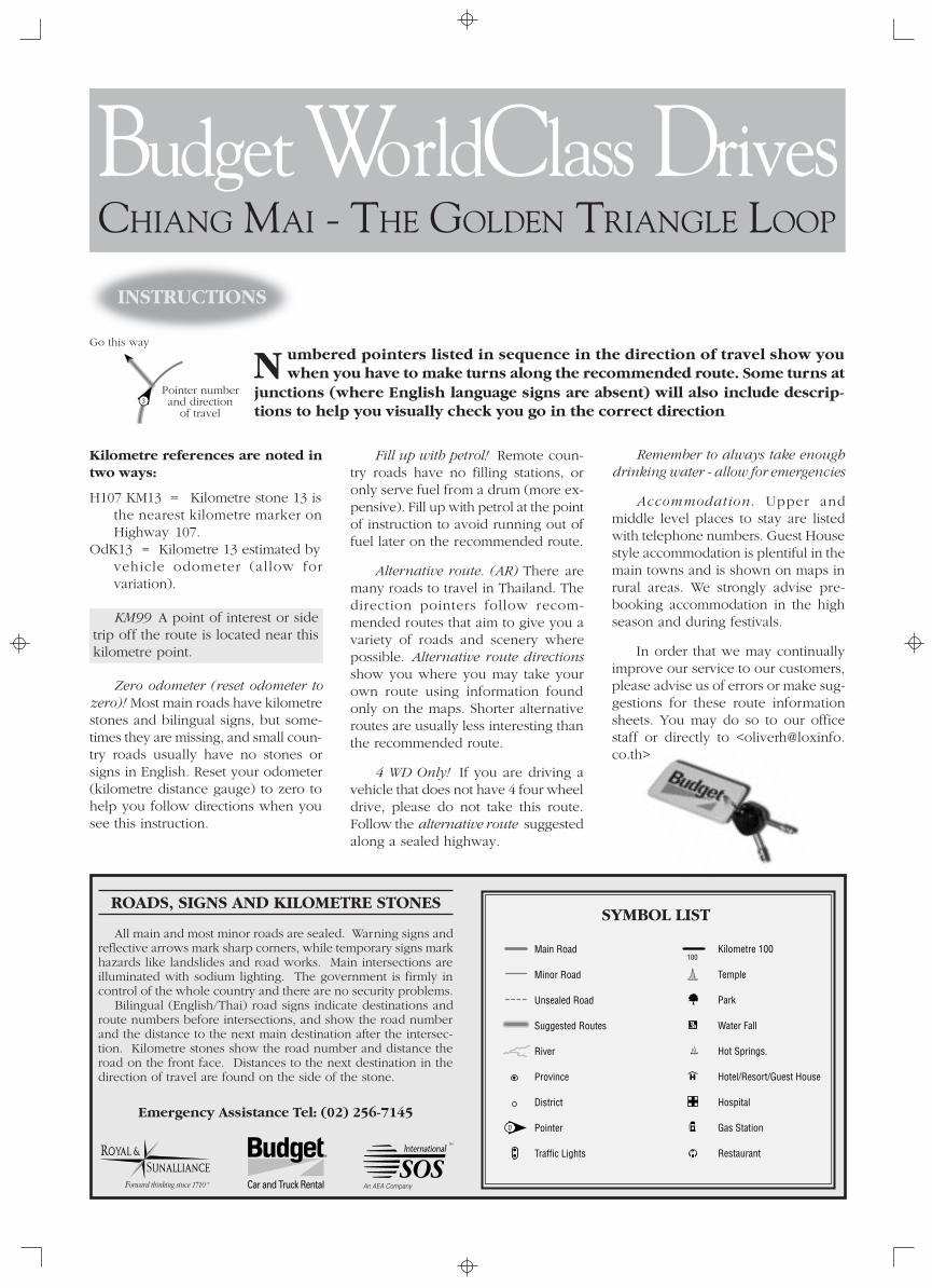
SYMBOL LIST
Budget WorldClass DrivesCHIANG MAI - SUKHOTHAI LOOP
TOUR PROGRAM
R
4
Welcome to your exclusive Budget World Class Drive.
CHIANG MAI –SUKHOTHAI LOOP
The finest old wooden temples, World Heritage historical parks, untamed jungle,rugged mountainous scenery and hill-tribes in the remote reaches of north-westernThailand await you on this tour.
his Worldclass Drive takes yousouth to the city of Lampang
before going on to the historical birth-place of the Thai Kingdom atSukhothai. From there the full tour goeswest to the border town of Mae Sot, acolourful ethnic crossroads.
A special tour goes south to theboundary of Thailand’s last remainingextensive reserve of primary forest.There the remote district town of Um-phang is the base for eco-adventureinto the jungle for two days or more.
From Mae Sot the return routefollows the Thai-Myanmar bordernorth-west along the Moei Riverthrough country populated by theKaren. Striking karst scenery is fol-lowed by a pass through mountainouscountry to the Yuam River Valley andMae Sariang. Turning north-east, theroute crosses a major watershedbefore entering the valley of the RiverPing and passing the highest moun-tain in Thailand en route back toChiang Mai.
The full tour programme takes fivedays, but this can be shortened byreturning to Chiang Mai directly fromSukhothai on alternative routes. Thistour also offers scenic and culturalalternatives to the northern section ofthe busy main highway betweenChiang Mai and Bangkok.
ACCOMMODATION
The raw distance for each day’sdrive is fairly short, allowing time forstops along the way as well as for side-trips. Destinations for each night, there-
T fore, are flexible. The listings here onlyinclude the best places to stay alongthe routes. The main towns usuallyhave local hotels (see maps) forcommercial travellers, some of whichhave more expensive rooms or suites.The rooms in many of these hotels areoften satisfactory, though basic. Fullprice indications for accommodationare listed as follows:
(1500-3000 Baht)(500-1500 Baht)
(500 Baht or less)
Major credit cards are accepted bythe up-market hotels and restaurants,but otherwise you will needcash for the small, remoteplaces along the route.
WHEN TO GO
The peak season runsfrom mid-November till afterthe Chinese New Year (at theend of the first lunar monthof the calendar year) andrises again for the Songkranfestival (Thai New Year) inmid-April. Advance bookingis necessary for peak periods.
Warm clothing is neededfor cold temperatures inupland areas, especiallybetween November andMarch. The rainy season(July-September) offers tur-bulent skies and clearervisibility over the ruggedlandscape, not to forget lowseason discounts of 50% ormore on accommodation.
MAPS, KEY POINTSAND INFORMATION
The maps in this booklet have beenspecially researched and prepared forthis tour. Key Points along the routeindicate important road junctions. Auseful addition as a general map ofNorthern Thailand, however, is the“Thailand North” map published byBerndtson & Berndtson. Visitors willalso find invaluable a good guide bookproviding cultural background andmore comprehensive information.
DAY 1
Chiang Mai - Lampang99 kms.
DAY 2
Lampang - Sukhothai205 kms.
DAY 3
Sukhothai - Mae Sot166 kms.
DAY 4
Mae Sot - Mae Sariang232 kms.
DAY 5
Mae Sariang - Chiang Mai190 kms.
106
11
116
1033
11
1093
1034
1037
11
1
1035
1
1184
1317
1006
2
3
4
11
Thai ElephantConservation
Centre
Wat PhrathatLampang Luang
Thung KwianMarket
MAE THA
To Wang Nua
LAMPHUN
LAMPANG
19
1
CHIANG MAI
SARAPHIHANG DONG
MAE THA
PA SANG
KO KHA
SANKAMPHAENG MAE ON
CHAE HOM
TH
AR
I VE
R
HANG CHAT
CHIANG MAI to LAMPANG
REVI
RG
N IP
0 10 20 kms.
To Chiang Rai
To Thoen & Tak To Den Chai & Phrae
To Chiang Rai
To Thung Hua Chang
WA
NG
RI V
E R
24 hr.
24 hr.
24 hr.
LampangRiver Lodge
Khun TanNational Park
R
5
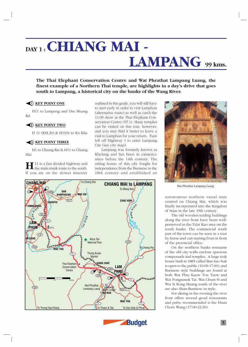
DAY 1 : CHIANG MAI -LAMPANG 99 kms.
1 KEY POINT ONE
H11 to Lampang and Om MuangRd.
KEY POINT TWO
H 11 (KM.20) & H1034 to Ko Kha
KEY POINT THREE
H1 to Chiang Rai & H11 to ChiangMai
11 is a fast divided highway andthe main trunk route to the south.
If you are on the slower itinerary
The Thai Elephant Conservation Centre and Wat Phrathat Lampang Luang, thefinest example of a Northern Thai temple, are highlights in a day’s drive that goessouth to Lampang, a historical city on the banks of the Wang River.
2
3
outlined in this guide, you will still haveto start early in order to visit Lamphun(alternative route) as well as catch the11:00 show at the Thai Elephant Con-servation Centre (ST.1). Many templescan be visited on this tour, however,and you may find it better to leave avisit to Lamphun for your return. Turnleft off Highway 1 to enter LampangCity (see city map).
Lampang was formerly known asKhelang and has been in existencesince before the 14th century. Theruling house of this city fought forindependence from the Burmese in the18th century and established an
autonomous northern vassal statecentred on Chiang Mai, which wasfinally incorporated into the Kingdomof Siam in the late 19th century.
The old wooden trading buildingsalong the river front have been well-preserved in the Talat Kao area on thesouth banks. The commercial southpart of the town can be seen in a tourby horse and cart starting from in frontof the provincial office.
On the northern banks remnantsof the old city walls enclose spaciouscompounds and temples. A large teakhouse built in 1885 called Ban Sao Nakis open to the public (10:00-17:00), andBurmese style buildings are found atboth Wat Phra Kaew Ton Taew andWat Pongsanuk Tai. Wat Chum Si andWat Si Rong Muang south of the riverare also Shan-Burmese in style.
For dining in the evening the riverfront offers several good restaurantsand pubs; recommended is the HuanChom Wang (17:00-22:30).
Wat Phrathat Lampang Luang
H
R6
ACCOMMODATION
Lampang Wiengthong Hotel. 138/109 Phaholyothin Rd. T Suan Dok,Lampang 52100 Tel: (054) 225801-2,Fax: (66 54) 225803. A modernupmarket hotel.
Lampang River Lodge. H1 KM.591opposite Susco Gas Station. Tel: (054)226922. Bangkok Res. Fax: (66 2) 2560248.
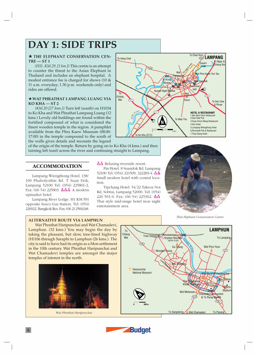
DAY 1: SIDE TRIPS THE ELEPHANT CONSERVATION CEN-TRE — ST 1
(H11. KM.29. [1 km.]) This centre is an attemptto counter the threat to the Asian Elephant inThailand and includes an elephant hospital. Amodest entrance fee is charged for shows (10 &11 a.m. everyday; 1.30 p.m. weekends only) andrides are offered.
WAT PHRATHAT LAMPANG LUANG VIAKO KHA — ST 2
(KM.20 [27 kms.]) Turn left (south) on H1034to Ko Kha and Wat Phrathat Lampang Luang (12kms.) Lovely old buildings are found within thefortified compound of what is considered thefinest wooden temple in the region. A pamphletavailable from the Phra Kaew Museum (08:00-17:00) in the temple compound to the south ofthe walls gives details and recounts the legendof the origin of the temple. Return by going on to Ko Kha (4 kms.) and thenturning left (east) across the river and continuing straight to Lampang.
ALTERNATIVE ROUTE VIA LAMPHUNWat Phrathat Haripunchai and Wat Chamadevi,
Lamphun. (32 kms.) You may begin the day bytaking the pleasant, but slow, tree-lined highway(H)106 through Saraphi to Lamphun (26 kms.). Thecity is said to have had its origin as a Mon settlementin the 10th century. Wat Phrathat Haripunchai andWat Chamadevi temples are amongst the majortemples of interest in the north.
Thai Elephant Conservation Centre
Wat Phrathat Haripunchai
Relaxing riverside resort.Pin Hotel. 8 Suandok Rd, Lampang
52100 Tel: (054) 221509, 322283-4.Small modern hotel with central loca-tion.
Tipchang Hotel. 54/22 Takroa NoiRd, Sobtui, Lampang 52000. Tel: (054)226 501-6. Fax: (66 54) 225362.Thai style mid-range hotel near nightentertainment area.
LAMPANG
1093
11
1
11
1035
ToChiang
Mai
To Chae Hom
SusarnTrilak
Wat Phra Kaew Ton Tao
WatSi
Chum
WatPongsanuk
TaiWat
Si RongMuang
To Ngao &Chiang Rai
To Den Chai& Phrae
To Mae Tha
To Ko Kha (ST.2)
To Hang Chat
WA
NG
R I V E R
ProvincialHall
Ban Sao Nak
Asawin Night Market
Oldwall
s &moa
ts
4
3
HOTEL & RESTAURANT1.Ban Nam Chim Restaurant2.East Side Pub3.Huan Chom Wang Restaurant4.Kim Hotel5.Lampang Wiengthong Hotel6.Riverside Pub & Restaurant7.Thip Chang Hotel
7236
1
5
4
0 1 2 kms.
Wat Phra Yeun
SportsStadium
Wat Chamadevi
Wat Mahawan
HaripunchaiNational Museum INTHAYONGYOT RD.
WANG SHINE RD
CHAROENRAT RD.
Sriphan Noodles(09:00-15:00)
ToChiang
Mai
Ku Chang
Train Station
Bus Station
Wooden House
Dao Khanong
Wat Phrathat Haripunchai
QueenChamadevi Monument
& To Rung Market
5000 m.
KU
AN
GR
I VE
R
106
114
1015
LAMPHUN
106
To Sanpatong
To Lampang
To Pasang
Khum Ton KaewThai Vegetarian
8
9
1093
1034
1037
11
11035
2
3
4
5
12
1113
11131201
1048
1056
1113 1195101
12
11
1023
1124
1
1125
1177101
102
101
130512946
7
WANG CHIN
MAETHA
Wiang KosaiNational Park
LAMPANG
SUKHOTHAI
SOPPRAP
KO KHA
HANG CHAT
BanKao
BANDAN LAN
HOI SukhothaiHistorical
Park
SiSatchanalaiHistorical
Park
THUNGSALIAM
Airport
SI SATCHANALAI
SAWANKHALOK
SISAM
RONG
LAMPANG to SUKHOTHAI
WA
NG
RI V
ER
YO
MR
I V E R
0 10 20 kms.
To Chiang Rai
To Den Chai& Phrae
To Kamphaeng Phet
To Tak
SiSatchanalai
NationalPark
24 hr.
24 hr.
WatPhrathatLampang
Luang
24 hr.
R7
DAY 2 : LAMPANG -SUKHOTHAI 205 kms.
The route passes into the Yom River Valley and follows it to the northern reaches ofthe central plains. There the ancient cities of Sukhothai and Si Satchanalai flour-ished prior to the rise of the great Siamese Kingdom of Ayutthaya.
Si Satchanalai Districttown is also known as HatSieo, which is famous for theweave of the people of LaoPhuan descent. Looms canbe seen beneath houses in thenearby villages, especially tothe north across the river. TheSathorn Gold Textile Museum(08:00-18:00) provides aninteresting opportunity toappreciate and buy some ofthe delicate work. Goodrestaurants for lunch areavailable in town.
Study the map of the SiSatchanalai-Sawankhalok andSukhothai areas to determineyour route and how far youwant to go for the day. Thefastest route to the SukhothaiHistorical Park is via little usedH1305 and H1113 (approx 52kms.). The turn off south-westonto H1305 is south of KM.2
on the road that followsthe west bank of the
Yom River, but it isunmarked (except
for a woodensign to Si Satcha-nalai NationalPark-the returnjourney to thepark waterfallsis 100 kms.). H101 is themain route fromwhich side tripsmay be made toSi Satchanalai
Historical Park(KM.18) and Sawan-
waranayok NationalMuseum (Sawankhalok),but it is more pleasant to
4
5
6
7
8
KEY POINT FOUR
H1 to Chiang Rai & H11 to DenChai
KEY POINT FIVE
H11 to Den Chai & H1023 to WangChin
KEY POINT SIX
H101 KM 29/28 and the road acrossthe river in Amphoe Sri Satchanalai.
KEY POINT SEVEN
H1195 to Sukhothai and H1048to Thoen
KEY POINT EIGHT
H101 Si Satchanalai/KamphaengPhet & H12 Sukhothai/Tak
11 goes through secondary wood-lands and a pass to
the Wang Valley anddown to Key Point5, where you turnoff onto H1023for Wang Chin.The small dis-trict town hasone restauranton the riverbank as wellas some foodstalls on thesingle highstreet.
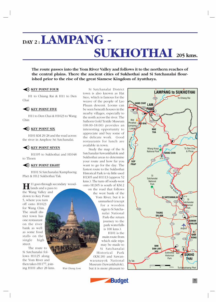
The route toSi Satchanalai fol-lows H1125 alongthe Yom River andthen takes H1177, join-ing H101 after 28 kms. Wat Chang Lom
H
R
8
SI SATCHANALAIto SAWANKHALOK
Si SatchanalaiHistorical Park
SawanwaranayokNational Museum
SAWANKHALOK
SukhothaiCeramics
Centre Kiln 42
SI SATCHANALAI
Kiln 61
Airport(BangkokAirways)
To Uttaradit
To Si SatchanalaiNational Park
ToThung Saliam
& Thoen
To Ban Kao & Sukhothai Historical Park
To Sukhothai
To Den Chai &Wang Chin
102
1305
1113
1048
1201
101
1195
101
1056
1113
1294 1201
9 k ms.
The SukhothaiResort Hotel
6
SISAM
RONG
102
101
Km 28
Km 29
24 SathornMuseum
RoseRes.
UnchanRes.
7
6
0 5 kms.
take the less busy alternativeroute on the west bank of theYom River. This will enable youto visit the kiln sites (left side ofroad after approx. 8 kms.),which are extensions of theNational Museums (see below),and then drive on to the histori-cal park and southwards.
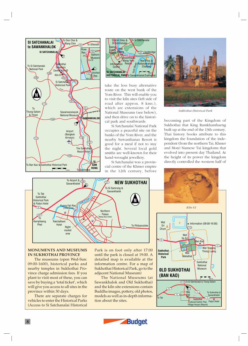
Si Satchanalai National Parkoccupies a peaceful site on thebanks of the Yom River, and thenearby Suwanthanas Resort isgood for a meal if not to staythe night. Several local goldsmiths are well-known for theirhand-wrought jewellery.
Si Satchanalai was a provin-cial centre of the Khmer empirein the 12th century, before
MONUMENTS AND MUSEUMSIN SUKHOTHAI PROVINCE
The museums (open Wed-Sun:09:00-1600), historical parks andnearby temples in Sukhothai Pro-vince charge admission fees. If youplant to visit most of these, you cansave by buying a ‘total ticket’, whichwill give you access to all sites in theprovince within 30 days.
There are separate charges forvehicles to enter the Historical Parks(Access to Si Satchanalai Historical
Park is on foot only after 17:00until the park is closed at 19:00. Adetailed map is available at theinformation centre. For a map ofSukhothai Historical Park, go to theadjacent National Museum)
The National Museums (atSawankhalok and Old Sukhothai)and the kiln site extensions containBuddha images, pottery, old photos,models as well as in-depth informa-tion about the sites.
becoming part of the Kingdom ofSukhothai that King Ramkhamhaengbuilt up at the end of the 13th century.Thai history books attribute to thiskingdom the foundation of the inde-pendent (from the northern Tai, Khmerand Mon) Siamese Tai kingdoms thatevolved into present day Thailand. Atthe height of its power the kingdomdirectly controlled the western half of
Sukhothai Historical Park
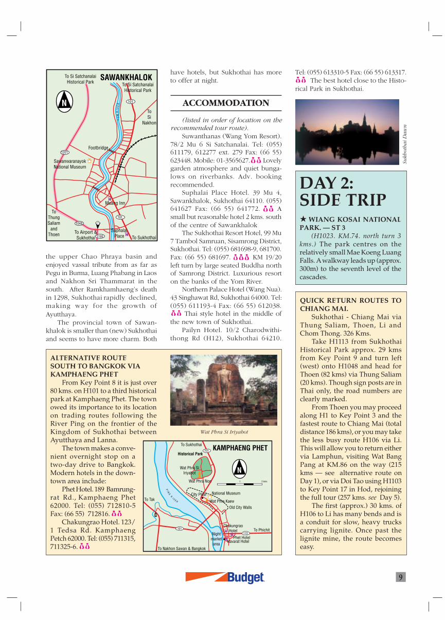
Kiln 61
SI SATCHANALAIHISTORICAL PARK
101
To Kiln Sites &Si Satchanalai
To Sawankhalok/Sukhothai
To Si Satchanalai
InformationCentre
footbridge
Wat Phra SiRattanamahathat
Chaliang
WatChangLom
KaengLuangRapids
SuwantharasWang Yom
Resort
Yom
Rive
r
0 500 m.
NEW SUKHOTHAI
ToKamphaeng
Phet
To Airport &Sawankhalok
To Si Samrong &Sawankhalok
To Phitsanuloke
To TakSukhothai
Historical Park& Pailyn Hotel
101
12
1195 101
12
8
NorthernPalace
(Wang Nua Hotel)
RatchathaniHotel
Nightmarket
area
Fuang Fah Res.(10:00-22:00)
Y O M R I V E R
0LD SUKHOTHAI(BAN KAO)
SukhothaiHistorical
Park
SukhothaiNationalMuseum
Wat TrapangThong Luang
Ban Kao
WatMahathat
WatSa Sri
Information (09:00-16:00)WatSri
Chum 1113
12
12
To Tak 12
1212
12
1113 To Si Satchanalai & Thung Saliam
To Sukhothai &Sawankhalok
BanKao
Pailyn HotelSukhothai
Cultural Centre-ThaiVillage House (Resort)
9
0 500 m.
R
9
the upper Chao Phraya basin andenjoyed vassal tribute from as far asPegu in Burma, Luang Phabang in Laosand Nakhon Sri Thammarat in thesouth. After Ramkhamhaeng’s deathin 1298, Sukhothai rapidly declined,making way for the growth ofAyutthaya.
The provincial town of Sawan-khalok is smaller than (new) Sukhothaiand seems to have more charm. Both
have hotels, but Sukhothai has moreto offer at night.
ACCOMMODATION
(listed in order of location on therecommended tour route).
Suwanthanas (Wang Yom Resort).78/2 Mu 6 Si Satchanalai. Tel: (055)611179, 612277 ext. 279 Fax: (66 55)623448. Mobile: 01-3565627. Lovelygarden atmosphere and quiet bunga-lows on riverbanks. Adv. bookingrecommended.
Suphalai Place Hotel. 39 Mu 4,Sawankhalok, Sukhothai 64110. (055)641627 Fax: (66 55) 641772. Asmall but reasonable hotel 2 kms. southof the centre of Sawankhalok
The Sukhothai Resort Hotel, 99 Mu7 Tambol Samruan, Sisamrong District,Sukhothai. Tel: (055) 681698-9, 681700.Fax: (66 55) 681697. KM 19/20left turn by large seated Buddha northof Samrong District. Luxurious resorton the banks of the Yom River.
Northern Palace Hotel (Wang Nua).43 Singhawat Rd, Sukhothai 64000. Tel:(055) 611193-4 Fax: (66 55) 612038.
Thai style hotel in the middle ofthe new town of Sukhothai.
Pailyn Hotel. 10/2 Charodwithi-thong Rd (H12), Sukhothai 64210.
QUICK RETURN ROUTES TOCHIANG MAI.
Sukhothai - Chiang Mai viaThung Saliam, Thoen, Li andChom Thong. 326 Kms.
Take H1113 from SukhothaiHistorical Park approx. 29 kmsfrom Key Point 9 and turn left(west) onto H1048 and head forThoen (82 kms) via Thung Saliam(20 kms). Though sign posts are inThai only, the road numbers areclearly marked.
From Thoen you may proceedalong H1 to Key Point 3 and thefastest route to Chiang Mai (totaldistance 186 kms), or you may takethe less busy route H106 via Li.This will allow you to return eithervia Lamphun, visiting Wat BangPang at KM.86 on the way (215kms — see alternative route onDay 1), or via Doi Tao using H1103to Key Point 17 in Hod, rejoiningthe full tour (257 kms. see Day 5).
The first (approx.) 30 kms. ofH106 to Li has many bends and isa conduit for slow, heavy truckscarrying lignite. Once past thelignite mine, the route becomeseasy.
ALTERNATIVE ROUTESOUTH TO BANGKOK VIAKAMPHAENG PHET
From Key Point 8 it is just over80 kms. on H101 to a third historicalpark at Kamphaeng Phet. The townowed its importance to its locationon trading routes following theRiver Ping on the frontier of theKingdom of Sukhothai betweenAyutthaya and Lanna.
The town makes a conve-nient overnight stop on atwo-day drive to Bangkok.Modern hotels in the down-town area include:
Phet Hotel. 189 Bamrung-rat Rd., Kamphaeng Phet62000. Tel: (055) 712810-5Fax: (66 55) 712816.
Chakungrao Hotel. 123/1 Tedsa Rd. KamphaengPetch 62000. Tel: (055) 711315,711325-6.
Sukh
oth
ai
Da
wn
DAY 2:SIDE TRIP WIANG KOSAI NATIONALPARK. — ST 3
(H1023. KM.74. north turn 3kms.) The park centres on therelatively small Mae Koeng LuangFalls. A walkway leads up (approx.300m) to the seventh level of thecascades.
Wat Phra Si Iriyabot
Tel: (055) 613310-5 Fax: (66 55) 613317. The best hotel close to the Histo-
rical Park in Sukhothai.
SAWANKHALOK
101
1201
1048
1195
101To
ThungSaliam
andThoen
To Si SatchanalaiHistorical Park To Si Satchanalai
Historical Park
ToSi
Nakhon
SawanwaranayokNational Museum
To SukhothaiSuphalai
Place
Muang Inn
Footbridge
To Airport &Sukhothai
YO
MR
IVE
R
7
KAMPHAENG PHET
101
101
115
To Tak
To Sukhothai
To Phichit
To Nakhon Sawan & Bangkok
Historical Park
Wat Phra SiIriyabot
Wat Phra Non
City Pillar National Museum
1 2 kms
Wat Phra KaewOld City Walls
ChakungraoHotel
Phet HotelNavarat Hotel
Nightmarket
area
PI N
GR
I V E R
1090
1090
105
1140
105
1175
12
10
11
8
9
13
115
1
1011132104
12
105
1175
1
12
12
101
SUKHOTHAI
TAK
KAMPHAENG PHET
Ban Tak
To Thoen & Lampang
Ban Lahu
To Umphang
Ban MaeLamao
PhrathatTon Kaew
Ban HuaiKalok
PhrathatHin Kiu
MoeiBridge
Miyawadi
Ban Lahu Ban Lahu(Musoe Hill
Tribe Villages)
Lan SangNational Park
TaksinNational Park
PHRAN KRATAI
KHIRIMAT
Historical Park
BanKao
24 hr.BANDAN LAN
HOISukhothaiHistorical
Park
MAE SOT
SUKHOTHAI to MAE SOT
MO
EI
RI V
ER
PI N
GR
IVE
R
Y
OM
R I V E R
0 10 20 kms.
MAE RAMAT
HilltribeDevelopment
Centre
R10
KEY POINT EIGHT
H101 Si Satchanalai/KamphaengPhet & H12 Sukhothai/Tak
KEY POINT NINE
H12 Sukhothai/Tak and H1113 toSi Satchanalai
KEY POINT TEN
H1 Lampang/Tak & H12 toSukhothai
KEY POINT ELEVEN
H1 Tak/Kamphaeng Phet andH105 to Mae Sot
KEY POINT TWELVE
H105 Tak/Mae Sot & H1090 toUmphang (traffic circle)
rom Sukhothai Historical Park, H12is a fast drive to Tak. You may turn
DAY 3 : SUKHOTHAI -MAE SOT 166 kms.
The route crosses to Tak and the mountains that bound the western flank of theRiver Ping Valley. Visit national parks and hill-tribe villages on the way to Mae Sot, atown grown rich on border trade.
8
9
10
11
1211. The drive offers side trips to parksand hill-tribe villages, as well as theopportunity for fresh coffee at thehill-tribe products market at KM.29. Ashrine at KM.70 honours Chao PhoPhawo, who died defending the spot
left at Key Point 10 or drive straight tothe river. Turn left (south) immediatelybefore the bridge across the river tosee the town and go to the Chid ChonRestaurant.
Turn west onto H105 at Key Point
Wa
t M
ah
ath
at,
Su
khot
ha
i
F
R
11
DAY 3: SIDE TRIPS BHUMIPHOL DAM— ST 4
(61 Kms.) Toreach the world’s eighthlargest concrete archdam turn north on H1and then west at KM.462to Sam Ngao. Followthe signs from Tak toBan Tak and Sam Ngaofor an alternative ruralroute on the west bankof the Ping. A rest housenear the dam offersaccommodation.
LAN SANG NA-TIONAL PARK — ST 5
(3 kms.) The parkcontains a small water-fall popular with thepeople of Tak.
LISU, HMONGAND LAHU VILLAGES — ST 6
(5 kms.) A right (south) turn ona sealed concrete road just beforeKM.26 leads through a Lisu and aHmong village to a Hill-tribeDevelopment Centre. Drive throughthe centre to reach a Lahu village.Other villages of the Lahu Shehlehsub-group may be reached bytaking a north turn (5 kms. 4WD)along a dirt road near KM.27.
TAKSIN MAHARAT NA-TIONAL PARK — ST 7
(3 kms. 4WD after 2 kms.) The
against a Burmese army in the late 18thcentury.
Mae Sot is a busy trading town bestknown for its morning market. Youmay purchase gems, semi-preciousstones and other products fromMyanmar, perhaps at prices that aregood.
park is famous for a huge specimenof anisoptera, a species of diptero-carp. You have to sign in beforeentering the park. To reach the treeyou walk 400m down a very steeptrack to the bottom of a ravine. Birdcalls, primary forest and cooltemperatures in the evergreen lowerdown compensate for the stiff climbback up. Allow one hour for thewalk.
THE MOEI RIVER FRONTIERCROSSING — ST 8
(5 kms.) Drive past Key Point 13to the end of H105 at the bridgeacross the Moei into Myanmar. Tour-ists may walk across for a day visit(until 17:30) and will need 10 US$.You will get a new visa upon return-ing to Thailand. The Grapow Plarestaurant on the north side of thebridge ramp is good.
Am
azi
ng
Tree
Mae Sot morning marketB
hu
mip
hol
Da
m
Lahu Shehleh
TAK
PI N
GR
I VE
R
104
1
12
1107
Viang Tak 2 Hotel
Suan SinGarden Resort
Chid ChonRestaurant
To Kamphaeng PhetTo Mae Sot
TourismAuthority
of ThailandShrine
of King Taksinthe GreatBeer
Gardens
Footbridge
To Thoen
To Sukhothai
ToBanTak
10511
1
10
ing on state of upkeep) make travelslow. Allow at least five hours for thejourney.
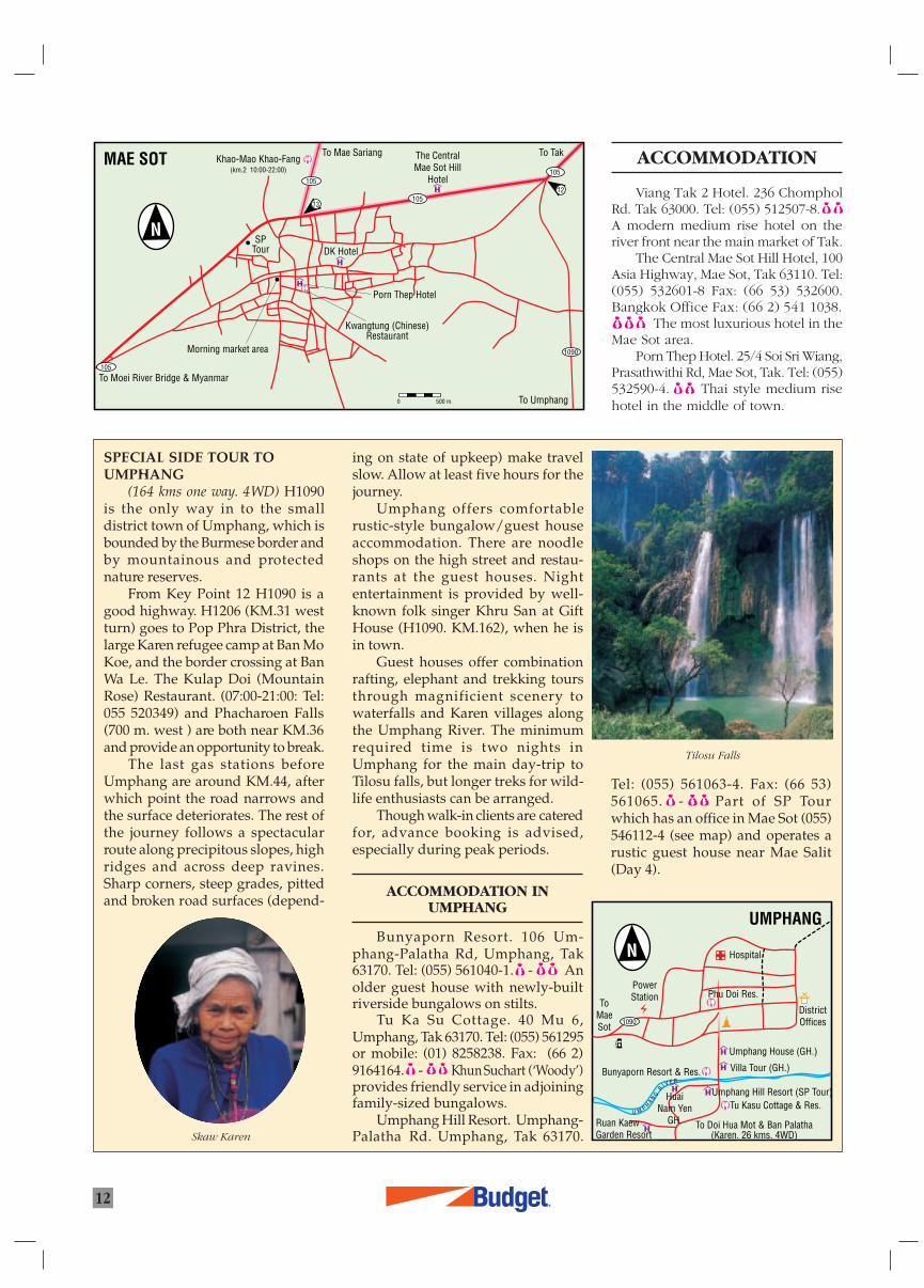
Umphang offers comfortablerustic-style bungalow/guest houseaccommodation. There are noodleshops on the high street and restau-rants at the guest houses. Nightentertainment is provided by well-known folk singer Khru San at GiftHouse (H1090. KM.162), when he isin town.
Guest houses offer combinationrafting, elephant and trekking toursthrough magnificient scenery towaterfalls and Karen villages alongthe Umphang River. The minimumrequired time is two nights inUmphang for the main day-trip toTilosu falls, but longer treks for wild-life enthusiasts can be arranged.
Though walk-in clients are cateredfor, advance booking is advised,especially during peak periods.
ACCOMMODATION INUMPHANG
Bunyaporn Resort. 106 Um-phang-Palatha Rd, Umphang, Tak63170. Tel: (055) 561040-1. - Anolder guest house with newly-builtriverside bungalows on stilts.
Tu Ka Su Cottage. 40 Mu 6,Umphang, Tak 63170. Tel: (055) 561295or mobile: (01) 8258238. Fax: (66 2)9164164. - Khun Suchart (‘Woody’)provides friendly service in adjoiningfamily-sized bungalows.
Umphang Hill Resort. Umphang-Palatha Rd. Umphang, Tak 63170.
R12
SPECIAL SIDE TOUR TOUMPHANG
(164 kms one way. 4WD) H1090is the only way in to the smalldistrict town of Umphang, which isbounded by the Burmese border andby mountainous and protectednature reserves.
From Key Point 12 H1090 is agood highway. H1206 (KM.31 westturn) goes to Pop Phra District, thelarge Karen refugee camp at Ban MoKoe, and the border crossing at BanWa Le. The Kulap Doi (MountainRose) Restaurant. (07:00-21:00: Tel:055 520349) and Phacharoen Falls(700 m. west ) are both near KM.36and provide an opportunity to break.
The last gas stations beforeUmphang are around KM.44, afterwhich point the road narrows andthe surface deteriorates. The rest ofthe journey follows a spectacularroute along precipitous slopes, highridges and across deep ravines.Sharp corners, steep grades, pittedand broken road surfaces (depend-
ACCOMMODATION
Viang Tak 2 Hotel. 236 ChompholRd. Tak 63000. Tel: (055) 512507-8.A modern medium rise hotel on theriver front near the main market of Tak.
The Central Mae Sot Hill Hotel, 100Asia Highway, Mae Sot, Tak 63110. Tel:(055) 532601-8 Fax: (66 53) 532600.Bangkok Office Fax: (66 2) 541 1038.
The most luxurious hotel in theMae Sot area.
Porn Thep Hotel. 25/4 Soi Sri Wiang,Prasathwithi Rd, Mae Sot, Tak. Tel: (055)532590-4. Thai style medium risehotel in the middle of town.
Tel: (055) 561063-4. Fax: (66 53)561065. - Part of SP Tourwhich has an office in Mae Sot (055)546112-4 (see map) and operates arustic guest house near Mae Salit(Day 4).
Tilosu Falls
Skaw Karen
MAE SOT
105
105
105
105
1090
13
12
To Moei River Bridge & Myanmar
To Mae SariangKhao-Mao Khao-Fang
(km.2 10:00-22:00)
Porn Thep Hotel
DK Hotel
Kwangtung (Chinese)Restaurant
To Tak
To Umphang
Morning market area
SPTour
The CentralMae Sot Hill
Hotel
0 500 m.
UMPHANG
ToMaeSot
To Doi Hua Mot & Ban Palatha
Phu Doi Res.
Bunyaporn Resort & Res.
Umphang Hill Resort (SP Tour)
Villa Tour (GH.)
HuaiNam Yen
GH.Tu Kasu Cottage & Res.
Ruan KaewGarden Resort
PowerStation
Hospital
DistrictOffices
Umphang House (GH.)
(Karen. 26 kms. 4WD)
U M P HA N
GR I V E R
1090
1194
105
105
1099
1090
105
105
1175
14
1517
16
1213
108
108
1088
1103
Mae Salit
MAE SARIANG HOD
OMKOI
Mae NgaoNational Park
Ban ThaSong Yang
SOP MOEI
Ban Mae Ramoeng
Mae UsuCaves
Ban Ton Phung
To Ban Sam
km.190
km.114
km.94
km.219
6:00-21:00
24 hr.24 hr.
Mae Moei National Park
Ban HuaiKalok
24 hr.
Phrathat Ton Kaew
Phrathat Hin Kiu
MiyawadiMoei
Bridge
MAE RAMATM Y A N M A R( B U R M A )
THA SONGYANG
MAE SOT
MAE SOT to MAE SARIANG
Y U A MR
I VE R
MO
E I RI V E R
MA
ET
UN
RI V
ER
NG
AO
RI V
ER
0 10 20 kms.
MA
EC
H A E M R I V E R
Ob LuangNational Park
To Mae ChaemTo Mae Hong Son
R
13
KEY POINT THIRTEEN
H105 to the Moei River and H105to Mae Sariang.
KEY POINT FOURTEEN
H105 to Mae Sot and H108 MaeSariang/Chiang Mai
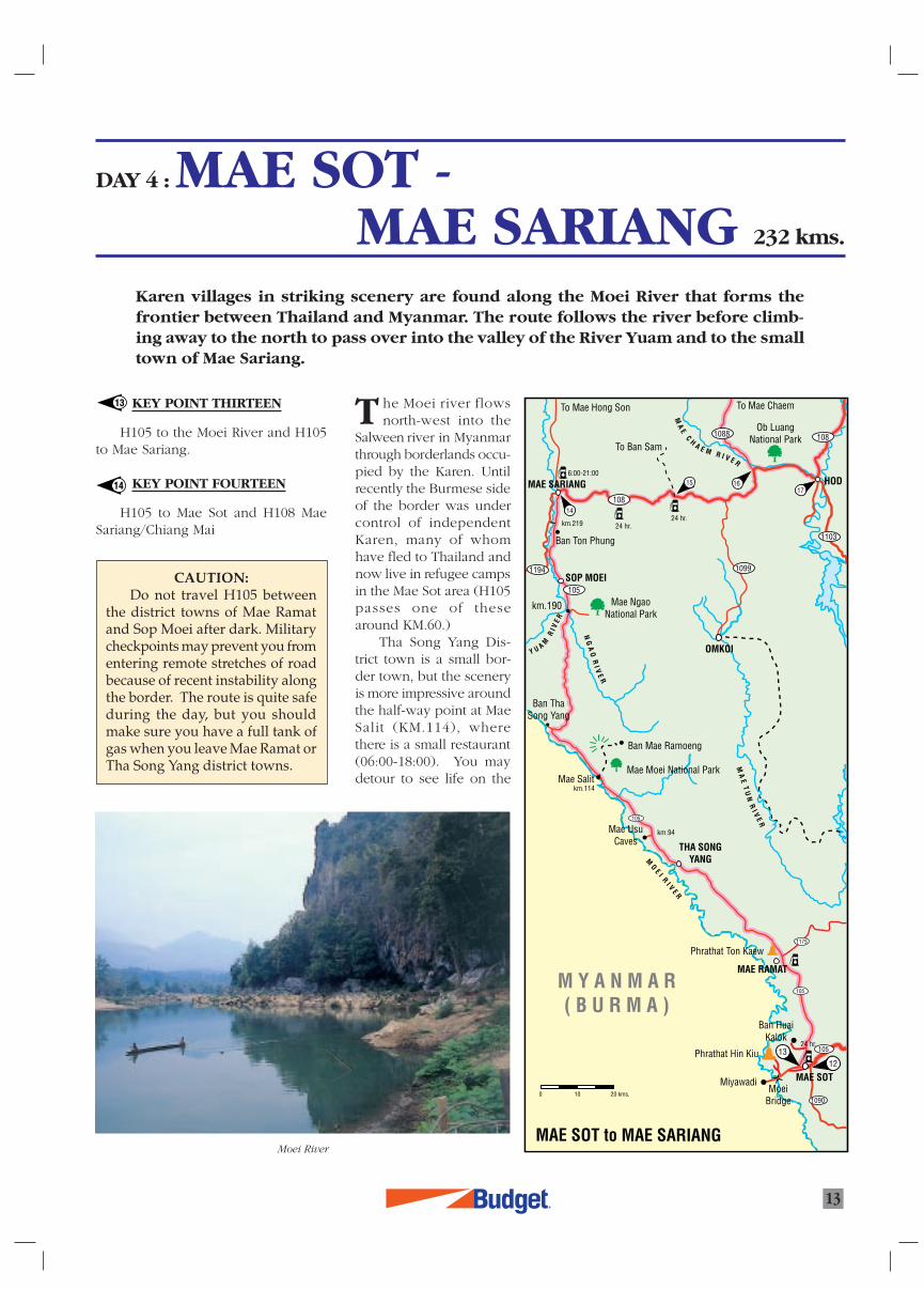
DAY 4 : MAE SOT -MAE SARIANG 232 kms.
Karen villages in striking scenery are found along the Moei River that forms thefrontier between Thailand and Myanmar. The route follows the river before climb-ing away to the north to pass over into the valley of the River Yuam and to the smalltown of Mae Sariang.
13
14
he Moei river flowsnorth-west into the
Salween river in Myanmarthrough borderlands occu-pied by the Karen. Untilrecently the Burmese sideof the border was undercontrol of independentKaren, many of whomhave fled to Thailand andnow live in refugee campsin the Mae Sot area (H105passes one of thesearound KM.60.)
Tha Song Yang Dis-trict town is a small bor-der town, but the sceneryis more impressive aroundthe half-way point at MaeSalit (KM.114), wherethere is a small restaurant(06:00-18:00). You maydetour to see life on the
T
CAUTION:Do not travel H105 between
the district towns of Mae Ramatand Sop Moei after dark. Militarycheckpoints may prevent you fromentering remote stretches of roadbecause of recent instability alongthe border. The route is quite safeduring the day, but you shouldmake sure you have a full tank ofgas when you leave Mae Ramat orTha Song Yang district towns.
Moei River
LotusHotel &GuestHouse
Mit A ReeGuestHouse
ToMae Sam Laep
(46 kms)
WatSuphan Rangsri to Mae Sot (230 kms)
Wiangmai Rd.
Laen
gPh
anit
Rd.
MAE SARIANGTo Mae Hong Son
Riverside Guest House
Kamolsorn HotelInthra 08:00-23:00
Renu 09:00-23:00Mitr A Ree Hotel
km.103
ToChiang
Mai
108
108
105
14
Royal Foundation forHandicrafts
R14
KEY POINT FIFTEEN
(KM.56) The bridge at Ban KongLoi and the turn off for side trip 11.
KEY POINT SIXTEEN
(KM.22) The junction of H1088 atthe start of the alternative route to MaeChaem, the summit of Doi Inthanonand Chom Thong (117 kms.)
KEY POINT SEVENTEEN
The clock tower at Hod and the
DAY 4: SIDE TRIPS MAE USU CAVES — ST 9
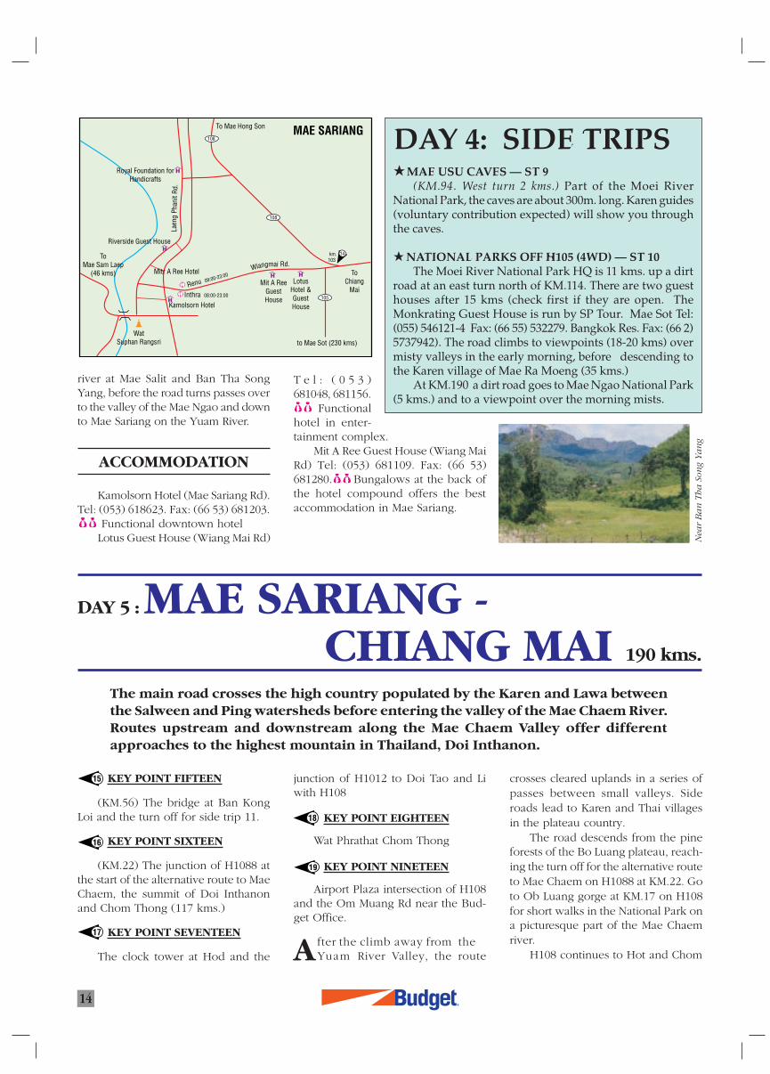
(KM.94. West turn 2 kms.) Part of the Moei RiverNational Park, the caves are about 300m. long. Karen guides(voluntary contribution expected) will show you throughthe caves.
NATIONAL PARKS OFF H105 (4WD) — ST 10The Moei River National Park HQ is 11 kms. up a dirt
road at an east turn north of KM.114. There are two guesthouses after 15 kms (check first if they are open. TheMonkrating Guest House is run by SP Tour. Mae Sot Tel:(055) 546121-4 Fax: (66 55) 532279. Bangkok Res. Fax: (66 2)5737942). The road climbs to viewpoints (18-20 kms) overmisty valleys in the early morning, before descending tothe Karen village of Mae Ra Moeng (35 kms.)
At KM.190 a dirt road goes to Mae Ngao National Park(5 kms.) and to a viewpoint over the morning mists.
DAY 5 : MAE SARIANG -CHIANG MAI 190 kms.
The main road crosses the high country populated by the Karen and Lawa betweenthe Salween and Ping watersheds before entering the valley of the Mae Chaem River.Routes upstream and downstream along the Mae Chaem Valley offer differentapproaches to the highest mountain in Thailand, Doi Inthanon.
15
16
17
18
A
river at Mae Salit and Ban Tha SongYang, before the road turns passes overto the valley of the Mae Ngao and downto Mae Sariang on the Yuam River.
ACCOMMODATION
Kamolsorn Hotel (Mae Sariang Rd).Tel: (053) 618623. Fax: (66 53) 681203.
Functional downtown hotelLotus Guest House (Wiang Mai Rd)
T e l : ( 0 5 3 )681048, 681156.
Functionalhotel in enter-tainment complex.
Mit A Ree Guest House (Wiang MaiRd) Tel: (053) 681109. Fax: (66 53)681280. Bungalows at the back ofthe hotel compound offers the bestaccommodation in Mae Sariang.
junction of H1012 to Doi Tao and Liwith H108
KEY POINT EIGHTEEN
Wat Phrathat Chom Thong
KEY POINT NINETEEN
Airport Plaza intersection of H108and the Om Muang Rd near the Bud-get Office.
fter the climb away from theYuam River Valley, the route
crosses cleared uplands in a series ofpasses between small valleys. Sideroads lead to Karen and Thai villagesin the plateau country.
The road descends from the pineforests of the Bo Luang plateau, reach-ing the turn off for the alternative routeto Mae Chaem on H1088 at KM.22. Goto Ob Luang gorge at KM.17 on H108for short walks in the National Park ona picturesque part of the Mae Chaemriver.
H108 continues to Hot and Chom
19
Nea
r B
an
Th
a S
ong
Ya
ng
R
15
DAY 5:SIDE TRIPS BAN SAM — ST 11
(H108 KM.56 Left turn [north]after bridge. 46 kms. 4 hrs). This roadfollows high ground to the newMae Tho National Park and theHmong village of Lao Lee(KM.16). From Lao Lee the roaddescends passing Karen villages[At Ban Mae Ap walk 1.5 kms to awaterfall at KM.24] in beautifulmountain scenery, eventuallyreaching the Lawa village of BanSam.
Thong. The village of Nong Ap Chang(Pa Saeng Da Textile Museum KM.69right turn [east]. 500m.) is famous forlocal weaving. In Chom Thong itself,Wat Phrathat Sri Chom Thong is an im-portant pilgrimage site for Thai Bud-dhists.
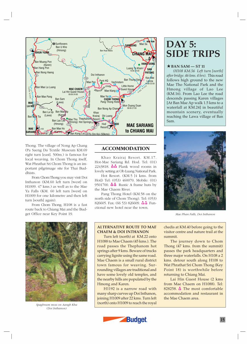
From Chom Thong you may visit DoiInthanon (KM.60 left turn [west] onH1009. 47 kms.) as well as to the MaeYa Falls (KM. 60 left turn [west] onH1009 for one kilometre and then leftturn [south] again).
From Chom Thong, H108 is a fastroute back to Chiang Mai and the Bud-get Office near Key Point 19.
ALTERNATIVE ROUTE TO MAECHAEM & DOI INTHANON
Turn left (north) at KM.22 ontoH1088 to Mae Chaem (45 kms.). Theroad passes the Thephanom hotsprings after 9 kms. Beware of truckscarrying lignite using the same road.Mae Chaem is a small rural districttown famous for weaving. Sur-rounding villages are traditional andhave some lovely old temples, andthe nearby hills are populated by theHmong and Karen.
H1192 is a narrow road withmany sharp curves up Doi Inthanon,joining H1009 after 22 kms. Turn left(north) onto H1009 to reach the royal
chedis at KM.40 before going to thevisitor centre and nature trail at thesummit.
The journey down to ChomThong (47 kms. from the summit)passes the park headquarters andthree major waterfalls. On H108 a 2kms. detour south along H108 toWat Phrathat Sri Chom Thong (KeyPoint 18) is worthwhile beforereturning to Chiang Mai.
Lai Hin Guest House (2 kmsfrom Mae Chaem on H1088). Tel:828258. The most comfortableaccommodation and restaurant inthe Mae Chaem area.
ACCOMMODATION
Khao Krairaj Resort. KM.17.Hot-Mae Sariang Rd. Hod. Tel: (01)2243818. Plank wood rooms inlovely setting at Ob Luang National Park.
Hot Resort. (KM.5 [4 kms. fromHot]) Tel: (053) 460070. Mobile: (01)9501700. Rustic A frame huts bythe Mae Chaem River.
Pang Thong Hotel (KM.58 on thenorth side of Chom Thong). Tel: (053)826605. Fax: (66 53) 826609. Fun-ctional new hotel near the town.
Spaghnum moss on Aangh Kha(Doi Inthanon)
Mae Phan Falls, Doi Inthanon
Ban Muang Pon
Ban Hang Pon
Ban Nong Haeng
Ban Mae La Luang
Ban Mae Pang
Ban Mae Tia
KHUN YUAM
MAELA NOI
MAESARIANG Ban Kong Loi
Ban Lao Lee(Hmong)
Ban Mae Ap(Karen)
Ban La Up(Lawa)
Ban Sam(Lawa)
MAE CHAEM
MA
EC
H
A E MR I V E R
CHOM THONG
HOD
PI N
GR
I V
E R
SANPATONG
HANG DONG
SAMOENGMAE RIM
Doi Inthanon
Park HQ
Lai Hin Guest House09:00-24:00
Mae Pan
19
18
1716
15
14
12
24 hr.
22
km.54
24 hr.
km.103
24
SunflowersBan U Kho(Hmong)
(Karen)
Ban Mae Ho(Karen)
06:00-21:00
(Hmong)Mae Tho
Ob LuangKhao
KrairajResortThephanom
Hot Springs
To Om Koi (50kms)
HodResort
Ban Huai Mana
Ban Thung SieoVachiratarn
Mae Klang
Pang Thong Hotel
Mae Ya
Little HomeGuest House
Mae Sa1096
108
CHIANG MAI1263
108
1266
108
108
YU
AM
RI V
ER
Luang Ta Kham10:00-22:00
Kao MaiLanna
10:00-22:00
Mon Duang Duan06:00-21:00Ban Nong Ap Chang
P I N GR I V E R
108
1088
1270
1192
1263
1099
Altern a tive route
Alte
rnat
ive
rout
e
MAE SARIANGto CHIANG MAI
À¬ÿ¥
À¬ÿ¥
µ√«®
R
SAFE DRIVINGIN THAILAND
DRIVERS LICENSE
All drivers must hold acurrent, non-probationarylicense. The license may eitherbe Thai, or from the renter’scountry of residence (with anEnglish translation), or aninternational driver’s permit.Licenses (and a valid passport)must be carried at all timeswhen driving.
IF YOU HAVE ANACCIDENT:
If possible leave yourvehicle where it came to rest,(so that police can apportionblame for the accident) andcontact the police as soon aspossible. Dial 191 for a toll freecall to the local police or 1699for the tourist police. Makesure injured parties get to ahospital as soon as possible(other Thais will often takecare of this) and set up warn-ings for other drivers ( placingbranches of trees on the road);then contact Budget. Stay withyour vehicle and take care ofyour valuables!
DRIVING ON DIRTROADS
Dirt Roads go all over themountains, but even Thais canget lost in the maze of cross-roads, so taking a guide(approx. 500 Baht/day) forremote roads is advisable.
The tracks are steep andnarrow and very tricky in therainy season. If you plan anovernight trip on a dirt roadtrip take the following: torch,candles and matches, warmclothes (especially in winter),water, dry food, insect repel-lent, and a full tank of gas.Drive very slowly to preventmechanical problems fromstranding you.
Happy safe driving!
at the major towns, but ruralstations will close in theevening. Prices are around 13baht a litre, and gas stationswill require cash.
ROAD RULES
The maximum speed limitis 60 kph in town and 90 kphon highways, if you canbelieve it! Seat belts should beworn and driving while drunkis illegal.
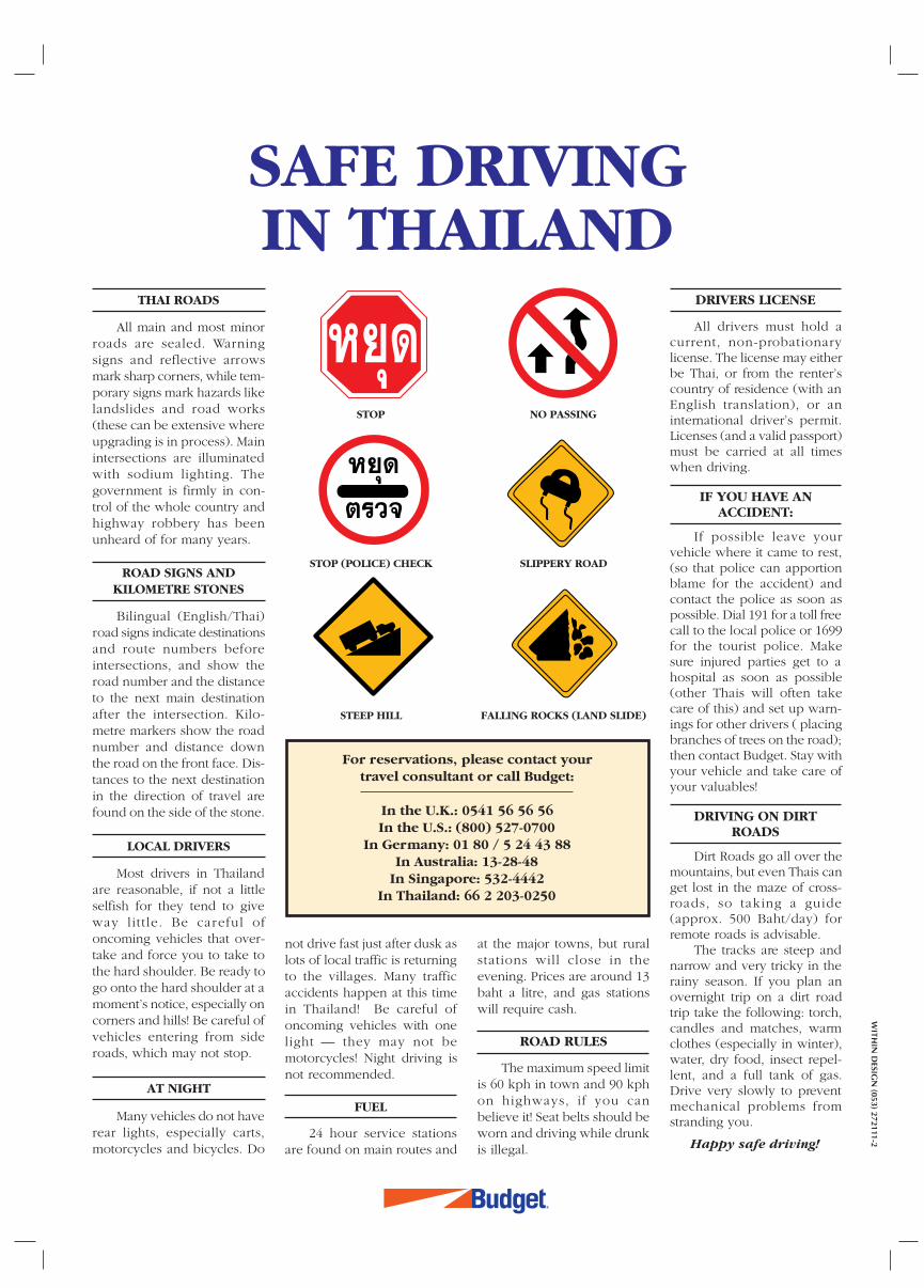
FALLING ROCKS (LAND SLIDE)STEEP HILL
STOP (POLICE) CHECK SLIPPERY ROAD
STOP NO PASSING
For reservations, please contact yourtravel consultant or call Budget:
In the U.K.: 0541 56 56 56In the U.S.: (800) 527-0700
In Germany: 01 80 / 5 24 43 88In Australia: 13-28-48
In Singapore: 532-4442In Thailand: 66 2 203-0250
WITH
IN D
ESIGN
(053) 272111-2
THAI ROADS
All main and most minorroads are sealed. Warningsigns and reflective arrowsmark sharp corners, while tem-porary signs mark hazards likelandslides and road works(these can be extensive whereupgrading is in process). Mainintersections are illuminatedwith sodium lighting. Thegovernment is firmly in con-trol of the whole country andhighway robbery has beenunheard of for many years.
ROAD SIGNS ANDKILOMETRE STONES
Bilingual (English/Thai)road signs indicate destinationsand route numbers beforeintersections, and show theroad number and the distanceto the next main destinationafter the intersection. Kilo-metre markers show the roadnumber and distance downthe road on the front face. Dis-tances to the next destinationin the direction of travel arefound on the side of the stone.
LOCAL DRIVERS
Most drivers in Thailandare reasonable, if not a littleselfish for they tend to giveway little. Be careful ofoncoming vehicles that over-take and force you to take tothe hard shoulder. Be ready togo onto the hard shoulder at amoment’s notice, especially oncorners and hills! Be careful ofvehicles entering from sideroads, which may not stop.
AT NIGHT
Many vehicles do not haverear lights, especially carts,motorcycles and bicycles. Do
not drive fast just after dusk aslots of local traffic is returningto the villages. Many trafficaccidents happen at this timein Thailand! Be careful ofoncoming vehicles with onelight — they may not bemotorcycles! Night driving isnot recommended.
FUEL
24 hour service stationsare found on main routes and
1R
3
INSTRUCTIONS
CHIANG MAI - THE GOLDEN TRIANGLE LOOP
Budget WorldClass Drives
umbered pointers listed in sequence in the direction of travel show youwhen you have to make turns along the recommended route. Some turns at
junctions (where English language signs are absent) will also include descrip-tions to help you visually check you go in the correct direction
N
Kilometre references are noted intwo ways:
H107 KM13 = Kilometre stone 13 isthe nearest kilometre marker onHighway 107.
OdK13 = Kilometre 13 estimated byvehicle odometer (allow forvariation).
KM99 A point of interest or sidetrip off the route is located near thiskilometre point.
Zero odometer (reset odometer tozero)! Most main roads have kilometrestones and bilingual signs, but some-times they are missing, and small coun-try roads usually have no stones orsigns in English. Reset your odometer(kilometre distance gauge) to zero tohelp you follow directions when yousee this instruction.
Fill up with petrol! Remote coun-try roads have no filling stations, oronly serve fuel from a drum (more ex-pensive). Fill up with petrol at the pointof instruction to avoid running out offuel later on the recommended route.
Alternative route. (AR) There aremany roads to travel in Thailand. Thedirection pointers follow recom-mended routes that aim to give you avariety of roads and scenery wherepossible. Alternative route directionsshow you where you may take yourown route using information foundonly on the maps. Shorter alternativeroutes are usually less interesting thanthe recommended route.
4 WD Only! If you are driving avehicle that does not have 4 four wheeldrive, please do not take this route.Follow the alternative route suggestedalong a sealed highway.
Remember to always take enoughdrinking water - allow for emergencies
Accommodation . Upper andmiddle level places to stay are listedwith telephone numbers. Guest Housestyle accommodation is plentiful in themain towns and is shown on maps inrural areas. We strongly advise pre-booking accommodation in the highseason and during festivals.
In order that we may continuallyimprove our service to our customers,please advise us of errors or make sug-gestions for these route informationsheets. You may do so to our officestaff or directly to <[email protected]>
ROADS, SIGNS AND KILOMETRE STONES
All main and most minor roads are sealed. Warning signs andreflective arrows mark sharp corners, while temporary signs markhazards like landslides and road works. Main intersections areilluminated with sodium lighting. The government is firmly incontrol of the whole country and there are no security problems.
Bilingual (English/Thai) road signs indicate destinations androute numbers before intersections, and show the road numberand the distance to the next main destination after the intersec-tion. Kilometre stones show the road number and distance theroad on the front face. Distances to the next destination in thedirection of travel are found on the side of the stone.
SYMBOL LIST
Emergency Assistance Tel: (02) 256-7145
Go this way
Pointer numberand direction
of travel
SOS
0
Main Road
Minor Road
Unsealed Road
Suggested Routes
River
Province
District
Pointer
Traffic Lights
100Kilometre 100
Temple
Park
Water Fall
Hot Springs.
Hotel/Resort/Guest House
Hospital
Gas Station
RestaurantR
WEBMASTER
2R
Thaton
2285Doi Phahom Pok
Mae Nam Fang National Park
MAE AI
CHIANG MAI to THATON
MYANMAR
FANG
Doi Ang Khang
Ang KhangNature Resort
Tham Ngop
SinchaiBan Mai
Nong Bua
CHAI PRAKAN
To Wiang Haeng
CHIANG DAO PHRAO
CHIANG MAI OFFICE(053) 202871
MAE TAENG
Mae Malai
Mae Ngat Dam
DOI SAKET
Regent Resort C.M.
4
1930
1089
1249
1178
1071322
1150
1001
1323
1001
1001
118
1014
1006
1269
1096
107
1095
NAM FANG RIVER
Tham Tap Tao (caves)
Chiang Dao Hill Resort
Rim Doi Resort
2240
7
86
4
5
Elephant CampTraining centre
Royal Ping Garden Resort
Khrua Khun Ya
Mae Taman Rafting(Elephant Camp)
2
3
1
PING
R IVE
R
NGA
TRI
VER
109
CHIANG MAI
SAN SAI
Lut Khao Nung(artist's compound — entrance permitted for viewing if gate open)
MAE RIMWang Tarn Resort
1150
Mae Ping Elephant Village
Arunothai
Ω“ß
·¡àÕ“¬
‰™¬ª√“°“√
‡™’¬ß¥“«
æ√â“«
·¡à·µß
·¡à√‘¡
—π∑√“¬
·¡àµ“¡“π
¥Õ¬ –‡°Á¥
‡¢◊ËÕπ·¡àß—¥
∑“µÕπ
¥Õ¬Õà“ߢ“ß
HUAI KAEW RD.
SUTHEP RD.
Airport
OM MUANGRD
PI N
GRIVER
Train Station
CHIANG MAI CITY
118
1006
11
106
108
11
107
1
R
R
N
1178
4
1071178
2
AR
107
11
1
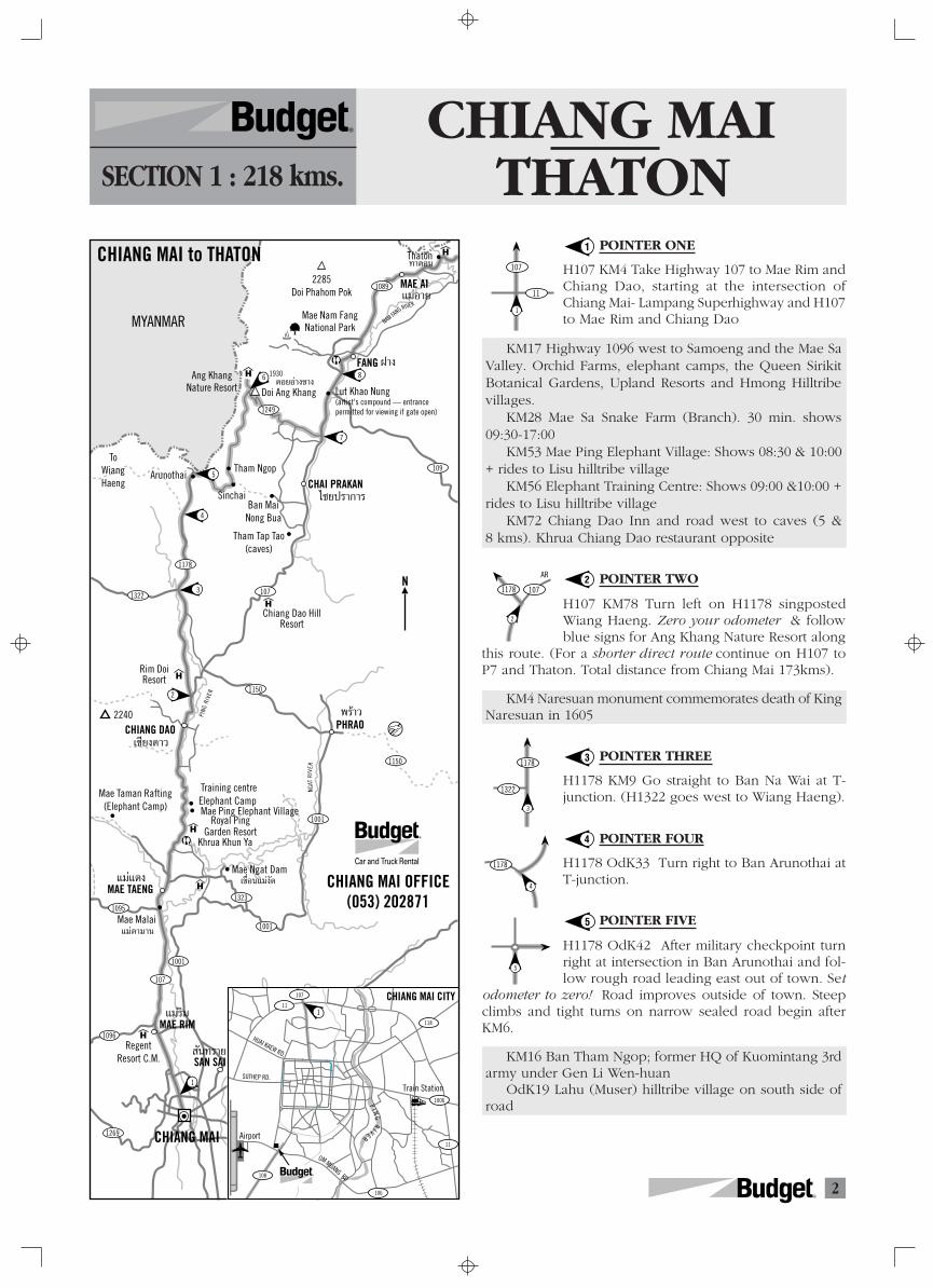
CHIANG MAITHATONSECTION 1 : 218 kms.
R
POINTER ONE
H107 KM4 Take Highway 107 to Mae Rim andChiang Dao, starting at the intersection ofChiang Mai- Lampang Superhighway and H107to Mae Rim and Chiang Dao
KM17 Highway 1096 west to Samoeng and the Mae SaValley. Orchid Farms, elephant camps, the Queen SirikitBotanical Gardens, Upland Resorts and Hmong Hilltribevillages.
KM28 Mae Sa Snake Farm (Branch). 30 min. shows09:30-17:00
KM53 Mae Ping Elephant Village: Shows 08:30 & 10:00+ rides to Lisu hilltribe village
KM56 Elephant Training Centre: Shows 09:00 &10:00 +rides to Lisu hilltribe village
KM72 Chiang Dao Inn and road west to caves (5 &8 kms). Khrua Chiang Dao restaurant opposite
POINTER TWO
H107 KM78 Turn left on H1178 singpostedWiang Haeng. Zero your odometer & followblue signs for Ang Khang Nature Resort along
this route. (For a shorter direct route continue on H107 toP7 and Thaton. Total distance from Chiang Mai 173kms).
KM4 Naresuan monument commemorates death of KingNaresuan in 1605
POINTER THREE
H1178 KM9 Go straight to Ban Na Wai at T-junction. (H1322 goes west to Wiang Haeng).
POINTER FOUR
H1178 OdK33 Turn right to Ban Arunothai atT-junction.
POINTER FIVE
H1178 OdK42 After military checkpoint turnright at intersection in Ban Arunothai and fol-low rough road leading east out of town. Set
odometer to zero! Road improves outside of town. Steepclimbs and tight turns on narrow sealed road begin afterKM6.
KM16 Ban Tham Ngop; former HQ of Kuomintang 3rdarmy under Gen Li Wen-huan
OdK19 Lahu (Muser) hilltribe village on south side ofroad
1
2
3
4
5
1178
1322
3
5
3R
1130
1089
1234
110
10161098
1016110
1290
1271
1129
1174
1020
1020
1155
1098
1174
1173
1020
1155
1020
1020
1211
118109
1089
1249
1178
1071322
1150
1150
1001
1323
10011001
1095
107
1096
1269
108
1061006
1014
118
120
1021
12021021
1093
118
12
MAE CHAN
FANG
CHAI PRAKAN
CHIANG DAOPHRAO
WIANG PA PAO
Section 1. Chiang Mai - ThatonSection 2. Thaton - Mae SaiSection 3 .Mae Sai - Chiang KhongSection 4 .Chiang Khong - PhayaoSection 5. Phayao - Chiang MaiSection 6. Chiang Saen - Chiang Mai
CHIANG MAI
CHIANG RAI
PHAYAO
PHAYAMANGRAI
WIANG CHAI
THOENG
CHIANG KHONG
MAE TAENG
MAE RIMSAN SAI
DOI SAKET
DOK KHAM TAI
CHUNMAE CHAI
PA DAET
M Y A N M A R( B U R M A )
L A O S
1
WIANGKAEN
MAE SAI
THATON
CHIANG SAEN
NORTHERN THAILAND : CHIANG MAI - THE GOLDEN TRIANGLE
MAE AI
MAE SUAI
CHIANG KHAM
MAE KHACHAN
N
R
FANG
500m.0
UK
Khu CharoenchaiTo Hot Springs & Bypass
Chok Thani
To Chiang Mai
ANG KHANG
Fort & Palaung Hilltribe Village
Kop Dong
Nature trail to peak
To Tham NgopArunothai
1249
5Kms
MYANMARAng Khang Nature Resort
To H107 Fang & pointer 7
Ban Luang
Steep!
Agricultural Station
6
Garden Home
River Side House
Thaton River View
Thaton Chalet
Mae Kok River Lodge
Wat Thaton
To Fang Section 1
Apple Guest House
Checkpoint
To Mae Salong, Doi Tung & Section 2
Mae Kok River Village
Chankasem Guest HouseApple
Thip’s Traveller’s
House
K O K R I V E R
KO
KR
I V E R
Sanaychai Nam
24
THATON
1089
Ruan Kumphranang
107
To Thaton
R
N
N
N
R
R
8
AR
6
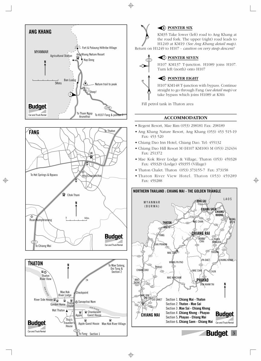
POINTER SIX
KM35 Take lower (left) road to Ang Khang atthe road fork. The upper (right) road leads toH1249 at KM19 (See Ang Khang detail map).
Return on H1249 to H107 - caution on very steep descent!
POINTER SEVEN
H107 KM137 T-junction. H1089 joins H107.Turn left (north) onto H107
POINTER EIGHT
H107 KM148 T-junction with bypass. Continuestraight to go through Fang (see detail map) ortake bypass which joins H1089 at KM4
Fill petrol tank in Thaton area
ACCOMMODATION
• Regent Resort, Mae Rim (053) 298181 Fax: 298189
• Ang Khang Nature Resort, Ang Khang (053) 453 515-19Fax: 453 520
• Chiang Dao Inn Hotel, Chiang Dao. Tel: 455132
• Chiang Dao Hill Resort M (H107 KM100) M (053) 232434Fax: 251372
• Mae Kok River Lodge & Village, Thaton (053) 459328Fax: 459329 (Lodge) 459355 (Village)
• Thaton Chalet. Thaton (053) 373155-7 Fax: 373158
• Thaton River View Hotel. Thaton (053) 459289Fax: 459288
6
7
8
107
7
4R
Takhilek
Rim Than Guest House
Mae SalongMAE CHAN
MAE AI
Pong Nam Ron
MYANMAR
7
6
9
10
4
2
5
1234
50
1089
1130 1016
1098
1149
1
1
1290
MAE SAI
Mae Fah LuangBan Samaki Mai
Ban Samaki KaoWat Phrathat Doi Tung
Ban Mae Mo
Lisu Lao Ta(Asa Guest House)
KM. 38
Nong Khi Nok
Mae Salak
Mae Chan Resort &Fishing Park
Thoed Thai
1
3
10 kms
∫â“πÀπÕߢ’Èπ°
∫â“π·¡à ≈—°
∫â“π·¡à ≈Õß∫â“π “¡·¬°Õ’°âÕ ·¡à®—π
·¡à “¬
·¡àÕ“¬
∫â“π‡∑‘¥‰∑¬
∫â“π·¡à‡¡“–
∫â“πº“¡’
·¡àøÑ“À≈«ß
∫â“π “¡—§§’„À¡à
∫â“π “¡—§§’‡°à“
Laan Tong Village
∫â“π∑à“µÕπThaton
Section 1
Laliohi Falls
11
Ban Pha Mi
12
8
Mae Fa Luang Gardens
Section 3Ban Hua Mae Kham
Ban Sam Yaek Ikor
Hilltribe DevelopmentCentre
N
R
1234
4
1089
2
AR
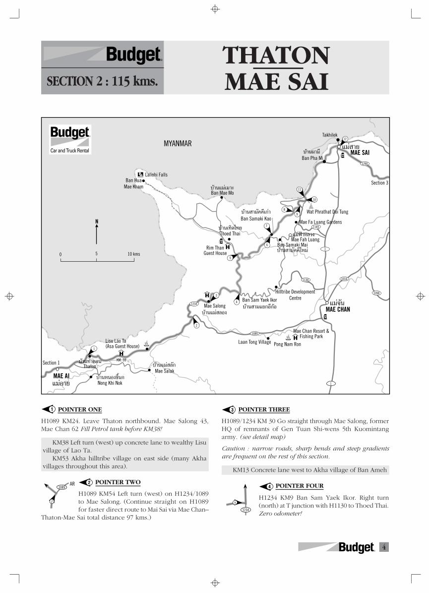
THATONMAE SAISECTION 2 : 115 kms.
R
POINTER ONE
H1089 KM24. Leave Thaton northbound. Mae Salong 43,Mae Chan 62 Fill Petrol tank before KM38!
KM38 Left turn (west) up concrete lane to wealthy Lisuvillage of Lao Ta.
KM53 Akha hilltribe village on east side (many Akhavillages throughout this area).
POINTER TWO
H1089 KM54 Left turn (west) on H1234/1089to Mae Salong. (Continue straight on H1089for faster direct route to Mai Sai via Mae Chan–
Thaton-Mae Sai total distance 97 kms.)
1
2
3
4
POINTER THREE
H1089/1234 KM 30 Go straight through Mae Salong, formerHQ of remnants of Gen Tuan Shi-wens 5th Kuomintangarmy. (see detail map)
Caution : narrow roads, sharp bends and steep gradientsare frequent on the rest of this section.
KM13 Concrete lane west to Akha village of Ban Ameh
POINTER FOUR
H1234 KM9 Ban Sam Yaek Ikor. Right turn(north) at T junction with H1130 to Thoed Thai.Zero odometer!
5R
MAE SAI
Top North Hotel
Wat Phrathat Pha Ngao
Old road to the Golden Triangle
Mae Sai Guest House Wang
Thong Hotel
MAE SAI
To Doi Tung
Section 2
To the Golden Triangle & Chiang Saen
M Y A N M A R
narrow lane
To Mae Chan & Chiang Rai1290
1
Wat Phrathat Si Tuang
Shinwattana Hotel
Bangkok Bank
Section 3
N
R
11
Garden
12
10To Temple
9
1149
8
7
6
5
POINTER FIVE
OdK 8-9 v sharp right turn on narrow sealedroad. After almost 1 km you will cross a nar-row bridge near ornate Chinese building and
go through village. After the bridge, the road follows a riverto the right (east side).
POINTER SIX
OdK20 T junction. Turn Left (north) The rightturn for Doi Tung is a longer route with manytwists and turns.
POINTER SEVEN
OdK21 T-junction at Ban Samakhi Kao (Akha).Turn left (north) and follow narrow road.
OdK40 Ban Huai Pu Mai - Lahu (Muser) village
POINTER EIGHT
OdK27 T-junction - continue straight for BanHuai Khrai, Ban Pha Bur and junction withH1149.
POINTER NINE
OdK 36 T-junction with H1149 Turn left (west)to Phrathat Doi Tung (7kms) and Mae Sai (26kms). Go right (downhill) to visit Mae FahLuang Gardens (4 kms).
POINTER TEN
H1149 OdK42 bears left (north) uphill at junc-tion with road going right to Phrathat Doi Tung(Mae Sai 21 kms). Go straight to visit interest-
ing Buddhist temple. Note animistic Buddhist site nearentrance to temple compound with twin pagoda.
5
6
7
8
9
10
11
12
POINTER ELEVEN
OdK43 Doi Chang Mup. Go straight (right fork)by entrance to 60 rai garden with azalias andrhododendron. Road descends along the bor-der with Myanmar (Shan State) from this point.
OdK68 Right turn (east) to Ban Pha Mi - Akha and Lahuvillages and alternative route to H110.
POINTER TWELVE
OdK63 Arrive at T junction with H1 KM890 inMae Sai (See Mae Sai detail Map)
ACCOMMODATION
• Kum Nai Phol Resort, Mae Salong. Tel: (053) 765001-2Fax: 765003
• Mae Salong Resort, Mae Salong. Tel: (053) 765014-8Fax: 765135
• Mae Salong Villa, Mae Salong. Tel: (053) 7651149Fax:765039
• Wang Thong Hotel, Mae Sai. Tel: (053) 733388-95Fax:765039
To hill tribe villages (4 WD)
View Point
Mae Salong Resort
Fuel from drums
Khum Nai Phol Resort
Morning market Mae Salong Central
Hills Hotel
Gold Dragon Inn
Phra Boromathat
To Mae Chan & Pointer 4
Bank & Market
To ThatonH1089
School Cherry Blossom viewing area
Mae Salong Villa
H i g h s t r e e t
0 500 m.
MAE SALONG
1234
1234
Shin Sane Guest House
3
N
R
6R
Ban Boran
Golden TriangleBan Sop Ruak
Rim Khong
Hat Bai(Leu textiles)
Huai Xai
To ThoengTo Phayao MangraiBan Kaen
To Wiang ChaiTo Chiang Rai
Ban Si DonChai(Leu textiles)
Tham Pla Caves
Section 2
Wat Phrathat Doi Tung
MAE SAI
MAE CHAN
CHIANG SAEN
CHIANG KHONG
MYANMAR
LAOS
Wat Phrathat Pha Ngao
Ban Tha Khao Phluak
(Section 6 Alternative Route) (Section 4)Ban Bong Noi
1016
1271
1129
1174
1098
1173
1020
1020
1155
5 10
1098
1209
1130
1089
1290
1
1
888
26
11
28
35 47
43
1
3
5
6
1
2
7
4
M a e
N a
m I n g
M a e
K o k
R i v e
r
·¡à “¬
‡™’¬ß· π
∫â“π∑à“¢â“«‡ª≈◊Õ°
“¡‡À≈’ˬ¡∑Õߧ”
·¡à®—π∫â“π∫ßπâÕ¬
∫â“π·°àπ
∫â“π»√’¥Õπ™—¬
∫â“πÀ“¥∫“¬
‡™’¬ß¢Õß
M A E K H O N G R I V E R
Thakhilek∑à“¢’ȇÀ≈Á°
Wang Pha Taek Falls
N
R
7
6
AR
1271
5
AR
1290 4
1016
3
AR
1290
2
1
1
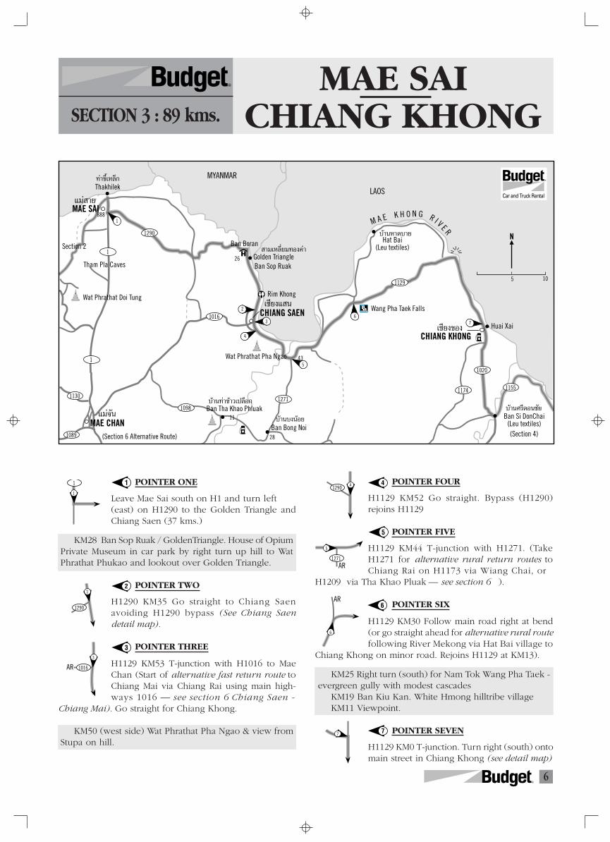
MAE SAICHIANG KHONGSECTION 3 : 89 kms.
R
POINTER ONE
Leave Mae Sai south on H1 and turn left(east) on H1290 to the Golden Triangle andChiang Saen (37 kms.)
KM28 Ban Sop Ruak / GoldenTriangle. House of OpiumPrivate Museum in car park by right turn up hill to WatPhrathat Phukao and lookout over Golden Triangle.
POINTER TWO
H1290 KM35 Go straight to Chiang Saenavoiding H1290 bypass (See Chiang Saendetail map).
POINTER THREE
H1129 KM53 T-junction with H1016 to MaeChan (Start of alternative fast return route toChiang Mai via Chiang Rai using main high-ways 1016 — see section 6 Chiang Saen -
Chiang Mai). Go straight for Chiang Khong.
KM50 (west side) Wat Phrathat Pha Ngao & view fromStupa on hill.
POINTER FOUR
H1129 KM52 Go straight. Bypass (H1290)rejoins H1129
POINTER FIVE
H1129 KM44 T-junction with H1271. (TakeH1271 for alternative rural return routes toChiang Rai on H1173 via Wiang Chai, or
H1209 via Tha Khao Pluak — see section 6 ).
POINTER SIX
H1129 KM30 Follow main road right at bend(or go straight ahead for alternative rural routefollowing River Mekong via Hat Bai village to
Chiang Khong on minor road. Rejoins H1129 at KM13).
KM25 Right turn (south) for Nam Tok Wang Pha Taek -evergreen gully with modest cascades
KM19 Ban Kiu Kan. White Hmong hilltribe villageKM11 Viewpoint.
POINTER SEVEN
H1129 KM0 T-junction. Turn right (south) ontomain street in Chiang Khong (see detail map)
1
2
3
4
5
6
7
7R
ACCOMMODATION
• Le Meridien Ban Boran, Golden Triangle (Ban Sop Ruak).Tel: (053) 784086 Fax: 784090
• The Imperial Golden Triangle, Golden Triangle. Tel: (053)784001-5 Fax: 784006
• Chiang Saen River Hill, Chiang Saen. Tel: (053) 650826-9Fax: 650830
• Guest House style accommodation only in Chiang Khong
CHIANG SAEN
L A O S
To the Golden Triangle & Mae Sai
Ban Suan House
Gin’s Guest House
Wat Roi Kho
Wat Pa Sak
Chiang Saen National Museum
Wat Chedi Luang
Chiang Saen River Hill Hotel
ToChiangKhong
Wat Phrathat Pha Ngao
Wat Phrathat Chomkitti
To Mae Chan & Chiang Rai
0 1 2 kms.
MA E
K H O N GR I V E R
3
4
2
1129
1016
N
R
District Office
Pla Buk Resort
Immigration Office& Boat Landing
To Chiang Saen
Tamila Guest House
Chiang Khong Hotel (basic)
Ruan Thai Sophaphan Lodge
Wat Phra Kaew
Wat Luang
High
Stre
et
Hat Khrai
To Thoeng
1129
CHIANG KHONG
1020
7
MA
EK
HO
NG
RI V
ER
L A O S
N
R
E“
“A
CHIANG MAICITY, VALLEY & MOUNTAINS
E X P L O R I N G
Make the most of Chiang Mai with
n impressive range of photographs and illustrations,plus elegant and useful maps.... The information....is concise, well-presented and up-to-date.” Yada Datuin The Nation
Self-drive tours outof the city
On and off thebeaten handicrafttrack
Good food andquiet momentsat country re-sorts and lots,lots more
xploring Chiang Maiis not only a visually beautifulguide, it also answers just about every questiona visitor could have.”Sarah Brown in the Bangkok Post
Contact Budget staff for a special offer to Budgetcustomers
8R
footpath
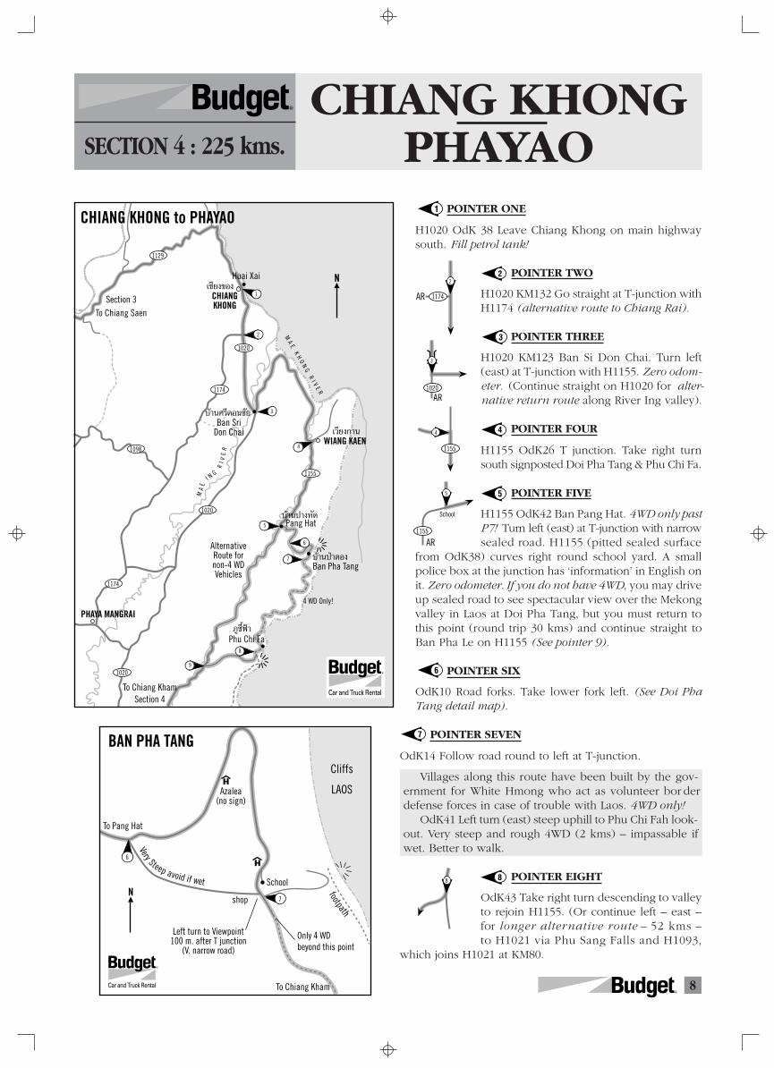
BAN PHA TANG
Cliffs
LAOS
shop
Azalea(no sign)
Left turn to Viewpoint100 m. after T junction
(V. narrow road)
School
Very Steep avoid if wet
Only 4 WDbeyond this point
6
7
To Pang Hat
To Chiang Kham
N
R
Phu Chi Fa
Pang Hat
Ban Pha Tang
Huai Xai
Section 3To Chiang Saen
CHIANG KHONG
WIANG KAEN
Ban Sri Don Chai
1129
1020
1174
1098
1020
1020
1174
1155
MA
E
I N G
RI V
ER
3
6
5
4
1
2
CHIANG KHONG to PHAYAO
4 WD Only!
7
9
8
‡™’¬ß¢Õß
∫â“π»√’¥Õπ™—¬
‡«’¬ß°“π
∫â“πªÉ“µÕß
∫â“πª“ßÀ—¥
¿Ÿ™’ÈøÑ“
MA
E K
HO
NG
RI V
ER
AlternativeRoute fornon-4 WDVehicles
To Chiang KhamSection 4
PHAYA MANGRAI
N
R
8
1155
School
AR
5
CHIANG KHONGPHAYAOSECTION 4 : 225 kms.
R
POINTER ONE
H1020 OdK 38 Leave Chiang Khong on main highwaysouth. Fill petrol tank!
POINTER TWO
H1020 KM132 Go straight at T-junction withH1174 (alternative route to Chiang Rai).
POINTER THREE
H1020 KM123 Ban Si Don Chai. Turn left(east) at T-junction with H1155. Zero odom-eter. (Continue straight on H1020 for alter-native return route along River Ing valley).
POINTER FOUR
H1155 OdK26 T junction. Take right turnsouth signposted Doi Pha Tang & Phu Chi Fa.
POINTER FIVE
H1155 OdK42 Ban Pang Hat. 4WD only pastP7! Turn left (east) at T-junction with narrowsealed road. H1155 (pitted sealed surface
from OdK38) curves right round school yard. A smallpolice box at the junction has ‘information’ in English onit. Zero odometer. If you do not have 4WD, you may driveup sealed road to see spectacular view over the Mekongvalley in Laos at Doi Pha Tang, but you must return tothis point (round trip 30 kms) and continue straight toBan Pha Le on H1155 (See pointer 9).
POINTER SIX
OdK10 Road forks. Take lower fork left. (See Doi PhaTang detail map).
POINTER SEVEN
OdK14 Follow road round to left at T-junction.
Villages along this route have been built by the gov-ernment for White Hmong who act as volunteer bor derdefense forces in case of trouble with Laos. 4WD only!
OdK41 Left turn (east) steep uphill to Phu Chi Fah look-out. Very steep and rough 4WD (2 kms) – impassable ifwet. Better to walk.
POINTER EIGHT
OdK43 Take right turn descending to valleyto rejoin H1155. (Or continue left – east –for longer alternative route – 52 kms –to H1021 via Phu Sang Falls and H1093,
which joins H1021 at KM80.
1
2
3
4
5
6
7
8
1174
2
AR
1020
3
AR
1155
4
9R
PHAYAO
Santiburi Golf& Country Club
WIANG CHAI PHAYA MANGRAI
THOENG
Phu Chi Fa
DOK KHAM TAI
CHUN
MAE CHAI
CHIANG KHAMPA DAET
Ban Huat
K & K Garden(11:00-24:00)
Phu Sang Water Falls
1020
1020
1020
1021
11481021
1021
10211202
To Nan
Wat Analayo
8
12
15 CHIANG KHONG to PHAYAO
4 WD Only
9
10
11
13
14
1155
1222
‡«’¬ß™—¬ æ√–¬“¡—ß√“¬
¿Ÿ™’ÈøÑ“
‡™’¬ß§“π
¥Õ°§”„µâæ–‡¬“
®Ÿπ
·¡à„®
ªÉ“·¥¥
1093
To Chiang Muan
‡∑‘ß
N
R
1193 15
Phayao
Chiang Mai
1021 1091
14
13
1021
102111
1155
1222
10
9
1155
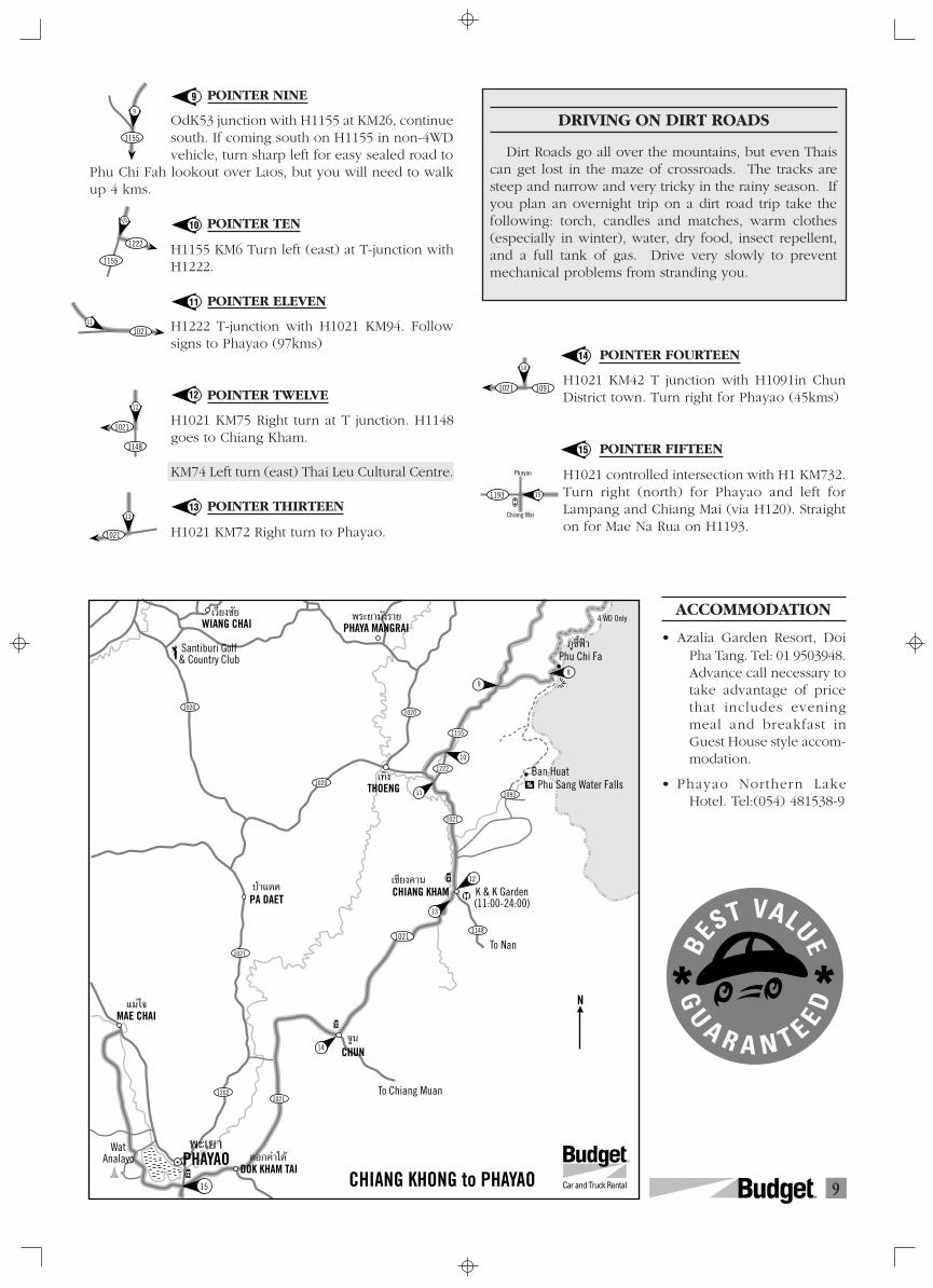
POINTER NINE
OdK53 junction with H1155 at KM26, continuesouth. If coming south on H1155 in non-4WDvehicle, turn sharp left for easy sealed road to
Phu Chi Fah lookout over Laos, but you will need to walkup 4 kms.
POINTER TEN
H1155 KM6 Turn left (east) at T-junction withH1222.
POINTER ELEVEN
H1222 T-junction with H1021 KM94. Followsigns to Phayao (97kms)
POINTER TWELVE
H1021 KM75 Right turn at T junction. H1148goes to Chiang Kham.
KM74 Left turn (east) Thai Leu Cultural Centre.
POINTER THIRTEEN
H1021 KM72 Right turn to Phayao.
9
10
11
12
13
14
15
POINTER FOURTEEN
H1021 KM42 T junction with H1091in ChunDistrict town. Turn right for Phayao (45kms)
POINTER FIFTEEN
H1021 controlled intersection with H1 KM732.Turn right (north) for Phayao and left forLampang and Chiang Mai (via H120). Straighton for Mae Na Rua on H1193.
ACCOMMODATION
• Azalia Garden Resort, DoiPha Tang. Tel: 01 9503948.Advance call necessary totake advantage of pricethat includes eveningmeal and breakfast inGuest House style accom-modation.
• Phayao Northern LakeHotel. Tel:(054) 481538-9
DRIVING ON DIRT ROADS
Dirt Roads go all over the mountains, but even Thaiscan get lost in the maze of crossroads. The tracks aresteep and narrow and very tricky in the rainy season. Ifyou plan an overnight trip on a dirt road trip take thefollowing: torch, candles and matches, warm clothes(especially in winter), water, dry food, insect repellent,and a full tank of gas. Drive very slowly to preventmechanical problems from stranding you.
1021
1148
12
10R
118
3
2
1
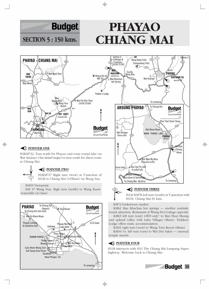
PHAYAOCHIANG MAISECTION 5 : 150 kms.
R
POINTER ONE
H1KM732. Turn north for Phayao and route round lake viaWat Analayo (See detail maps) or turn south for direct routeto Chiang Mai.
POINTER TWO
H1KM727 Right turn (west) at T-junction ofH120 to Chiang Mai (145kms) via Wang Nua
KM19 ViewpointKM 47 Wang Nua. Righ turn (north) to Wang Kaew
waterfalls (24 kms)
1
2
3
4
POINTER THREE
H120 KM78 Left turn (south) at T-junction withH118. Chiang Mai 81 kms.
KM72 basketware marketKM62 Mae Khachan hot springs — another roadside
tourist attraction. Restaurant at Wiang Doi Cottage oppositeKM63 left turn (east) 4WD only! to Ban Huai Muang
and upland valley with Lahu Villages (9kms). TrekkersLodge offers rustic accommodation.
KM16 right turn (west) to Wang Tarn Resort (6kms)KM16/14. left turn (east) to Wat Doi Saket — unusual
temple murals
POINTER FOUR
H118 intersects with H11 The Chiang Mai Lampang Super-highway. Welcome back to Chiang Mai.
CHIANG MAI
PHAYAOMAE TAENG
Mae Malai
Mae Ngat Dam
MAE RIM
SAN SAI DOI SAKET
Mai Pai Rim Than(10:00-20:00)
Trekker's Lodge
Section 6
PHAYAO - CHIANG MAI
Mae KhachanHot Spring
KM.27
MAE KHACHAN Wang Nua
Wang Kaew FallsChampatong Falls
Section 4Cabbage & Condoms
(10:00-22:00)
Wat AnalayoWiang Doi
KM. 64 DOK KHAM TAI
1269
1096
107
1001
10951323
1001
118
120
1021
1202
118
1014
1035
11931
1
1006
106
1001
4
3
1
2
Mae Kuang Dam
Wang TarnResort
‡™’¬ß„À¡à
¥Õ¬ –‡°Á¥
æ–‡¬“
¥Õ°§”„µâ
«—߇Àπ◊Õ
·¡à¢–®“π
1127
To Lampang
N
R
Suan Aharn Wiang TarnSad Saeng Duan Ruan
EmSarakhan
City Pillar
To Lampang
to Pa Daet
To Chiang Rai(bypass) Bua Resort
To Chiang Rai (old road)
Wat Sri Khom Kham
Phayao Cultural & Exhibition Hall
Phayao Northern Lake HotelGateway
Tharn ThongHotel Wattana Hotel
Wat RachakruPhaya Ngam
Muang Statue
KHWAN PHAYAO
PHAYAO
1202
1
1
1
Kwan Phayao
N
R
Wat Analayo
(local only)
KWAN PHAYAO LAKE
To Chiang RaiAROUND PHAYAO
PHAYAO
1202
1
1
1193
120
1193
735
743
741
727
Wat Khom Kham
Phra That Chom Thong
To ChunChiang Kham
To Chang Mai To Lampang
4 kms
Phayao College ofAgriculture & Technology
Ban San Pa SaK
Ban Mae Na Klua∫â“π·¡à𓇰≈◊Õ
∫â“π —πªÉ“ —°
‡™’¬ß„À¡à
«—¥Õπ“≈‚¬æ–‡¬“
1
2
N
R
11R
CHIANG MAI
MAE TAENG
Mae Malai
Mae Ngat Dam
MAE RIM SAN SAI DOI
SAKET
Mai Pai Rim Than(10:00-20:00)
Trekker's Lodge
PHAYAO - CHIANG MAI
KM.27
1269
1096
107
1001
10951323
1001
118
118
1014
1006
106
Mae Kuang Dam
Wang TarnResort
12
WIANG PA PAO
MAE SUAI
11
MAE KHACHAN
Wang NuaWiang Doi
Pong Nam Ron
Khun Korn Falls
KarenGuest House
Charin Garden Resort (06:00-20:00)
Cabbages & Candoms
(10:00-22:00)
Wang Kaew Falls
1208
118
109
118
1150
120
1035
1
To Fang
Champatong Falls
PHAN
MAE CHAN
Santiburi Golf& Country Club
WIANG CHAI
THOENG
CHUNMAE CHAI
PA DAET
9
Wat Analayo
1
2
5
MA
EK
OK
RI V
ER
WaterfordValley
1211
PHAYAO
1021
1251
1
1021
1091
1202
1098
1173
1020
1020
1020
1174
110
Doi Tung
MAE FAH LUANG
CHIANG SAEN110
1130 1016
10981271
1016
CHIANGRAI
SuanthipVana Resort
KM.107
118
DOK KHAM TAI
‡™’¬ß· π
·¡àøÑ“À≈«ß
·¡à®—π
‡™’¬ß√“¬
·¡à √«¬
‡«’¬ß®—πæ√–¬“¡—ß√“¬
æ“π
ªÉ“·¥¥
‡«’¬ßªÉ“‡ªÑ“
·¡à„®
®Ÿπ
æ–‡¬“ ¥Õ°§”„µâ
‡∑‘ß
·¡à¢–®“π·¡à·µß
·¡à√‘¡
—π∑√“¬
¥Õ¬ –‡°Á¥6
4
3
PHAYA MANGRAI
To LampangTo Chae Hom
N
R
1
4
10893
21
1016
1129
1
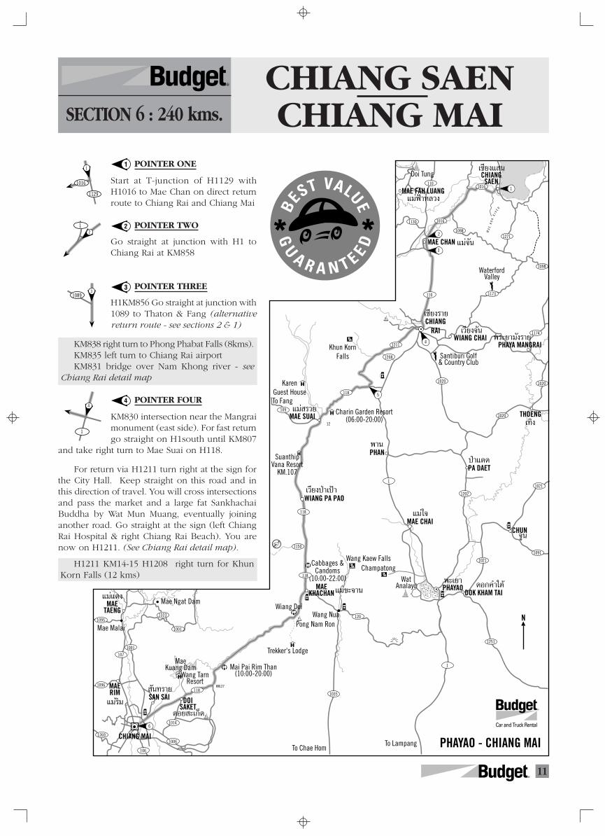
CHIANG SAENCHIANG MAISECTION 6 : 240 kms.
R
POINTER ONE
Start at T-junction of H1129 withH1016 to Mae Chan on direct returnroute to Chiang Rai and Chiang Mai
POINTER TWO
Go straight at junction with H1 toChiang Rai at KM858
POINTER THREE
H1KM856 Go straight at junction with1089 to Thaton & Fang (alternativereturn route - see sections 2 & 1)
KM838 right turn to Phong Phabat Falls (8kms).KM835 left turn to Chiang Rai airportKM831 bridge over Nam Khong river - see
Chiang Rai detail map
POINTER FOUR
KM830 intersection near the Mangraimonument (east side). For fast returngo straight on H1south until KM807
and take right turn to Mae Suai on H118.
For return via H1211 turn right at the sign forthe City Hall. Keep straight on this road and inthis direction of travel. You will cross intersectionsand pass the market and a large fat SankhachaiBuddha by Wat Mun Muang, eventually joininganother road. Go straight at the sign (left ChiangRai Hospital & right Chiang Rai Beach). You arenow on H1211. (See Chiang Rai detail map).
H1211 KM14-15 H1208 right turn for KhunKorn Falls (12 kms)
1
2
3
4
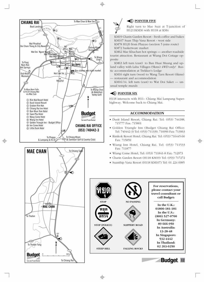
12R
118
5
POINTER FIVE
Right turn to Mae Suai at T-junction ofH1211KM30 with H118 at KM4
KM19 Charin Garden Resort - fresh coffee and bakesKM107 Suan Thip Vana Resort - west sideKM78 H120 from Phayao (section 5 joins route)KM72 basketware marketKM62 Mae Khachan hot springs — another roadside
tourist attraction. Restaurant at Wiang Doi Cottage op-posite
KM63 left turn (east) to Ban Huai Muang and up-land valley with Lahu Villages (9kms) 4WD only! Rus-tic accommodation at Trekker’s Lodge
KM16 right turn (west) to Wang Tarn Resort (6kms)— restaurant and accommodation
KM16/14. left turn (east) to Wat Doi Saket — un-usual temple murals
POINTER SIX
H118 intersects with H11– Chiang Mai Lampang Super-highway. Welcome back to Chiang Mai.
ACCOMMODATION
• Dusit Island Resort, Chiang Rai. Tel: (053) 744188,715777 Fax: 715801
• Golden Triangle Inn (Budget Chiang Rai Office:Tel: 740442-3) Tel: (053) 711339, 716996 Fax: 713963
• Rimkok Resort Hotel, Chiang Rai. Tel: (053) 716445-60Fax: 715859
• Wiang Inn Hotel, Chiang Rai. Tel: (053) 711533Fax: 711877
• Wiang Come Hotel, Tel: (053) 711841-8 Fax: 712973
• Charin Garden Resort (H118 KM19) Tel: (053) 717272
• Suanthip Vana Resort (H118 KM107) Tel: 01 224 6985
5
6
FALLING ROCKSSTEEP HILL
STOP (POLICE) SLIPPERY ROAD
STOP NO PASSING
For reservations,please contact yourtravel consultant or
call Budget:
In the U.K.:01800-181-181
In the U.S.:(800) 527-0700In Germany:89 666-950
In Australia:13-28-48
In Singapore:532-4442
In Thailand:02 203-0250
À¬ÿ¥
À¬ÿ¥
µ√«®
To Phayao& Lampang & H118
To Chiang Kham(& Santiburi Golf & Country Club)
To Wiang Chai (& WaterfordValley Golf)
To WiangChai
To Mae Chan & Mae Sai
To PongNam Ron
Hot Springs
Oub Kham Museum
To Khun Korn Falls & H118 Chiang Mai
via Mae Suai
Salung Kham RestaurantWat
Klang Wiang
TAT Office
Wat Phra KaewWat Doi Ngam Muang
Wat Phrathat Doi Chom Thong & City Navel
M A E K O K R I V E R
Bus station and night marketWat Chet Yot
Hospital
Clock tower
10201
1232
110
110
831
1207
Boat LandingCHIANG RAI
CHIANG RAI OFFICE(053) 740442-3
1233
1211
4
67
8
10
11
1
Rim Kok Resort HotelDusit Island ResortGratom Rim KokChiang Rai Inn HotelBan Khun Yom HotelSaen Phu HotelWang Come HotelWiang Inn HotelGolden Triangle Inn - Budget OfficeInn Come HotelLittle Duck Hotel
1
2
3
4
5
6
7
8
9
10
11
9
23
5
Wat Mun Muang
R
4
N
R
To Chiang Saen
To Thaton
To Chiang Rai
To Thaton Fang
856
MAE CHAN
MAE CHAN
1016
1
1
1098
2
3
·¡à®—π
0 500 m
N
R
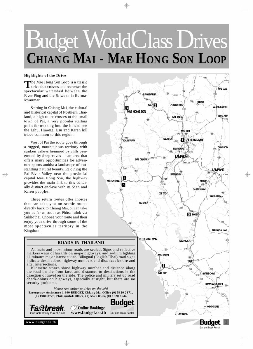
1
CHIANG MAI - MAE HONG SON LOOPBudget WorldClass Drives
1270
1192
1184
1087
1175
1267
1090
1132
115
101
11
1034
10351009
1108
1226
1095
1265108
1285
1322
1095
107
1178
1322
107
109
1150
1001
118
118
120
107
1096
1269
1157
12521001
1088
108
1033
1013 1147
11
1266
108
1263
105
105
105
12
1107
1175
1
1099
106
106
1102
106
1103
1012
1274
1294
1125
1023
1
1
1113
1
1116
1117
1206
1109
1110
5
5
5
4
3
1
2
CHIANG MAI
PANG MAPHA
PAI
MAE HONG SON
KHUN YUAM
MAE SARIANG
MAE CHAEM
DOI TAO
HOT
BAN HONG
OM KOI
MAE RIM
SAMOENG
LAMPHUN
LAMPANG
SANPATONG
MAE TAENG
MAE SUAI
CHIANG DAOPHRAO
WIANG PA PAO
TAK
LI
THA SONG YANG
WANG CHAO
SAM NGAO
THOEN
KHLONG LAN
MAE SOT
UMPHANG
MAE RAMAT
KAMPHAENG PHET
SOEM NGAM
KO KHA
N10kms
R
WANG NUA
CHAE HOM
WANG CHIN
THUNG SALIAM
Oliv
er H
arg
reav
e
ROADS IN THAILAND
All main and most minor roads are sealed. Signs and reflectivemarkers warn of hazards on major highways, and sodium lightingilluminates major intersections. Bilingual (English/Thai) road signsindicate destinations, highway numbers and distances before andafter intersections.
Kilometre stones show highway number and distance alongthe road on the front face, and distances to destinations in thedirection of travel on the side. The police and military set up roadcheck-points on highways, especially at night, but there are nosecurity problems.
Please remember to drive on the left!Emergency Assistance 1-800-BUDGET, Chiang Mai Office (0) 5320 2871,
(0) 1980 8723, Phitsanulok Office, (0) 5525 8556, (0) 1820 8644
www.budget.co.th
THighlights of the Drive
he Mae Hong Son Loop is a classicdrive that crosses and recrosses the
spectacular watershed between theRiver Ping and the Salween in Burma-Myanmar.
Starting in Chiang Mai, the culturaland historical capital of Northern Thai-land, a high route crosses to the smalltown of Pai, a very popular startingpoint for trekking into the hills to seethe Lahu, Hmong, Lisu and Karen hilltribes common to this region.
West of Pai the route goes througha rugged, mountainous territory withsunken valleys hemmed by cliffs pen-etrated by deep caves — an area thatoffers many opportunities for adven-ture sports amidst a landscape of out-standing natural beauty. Rejoining thePai River Valley near the provincialcapital Mae Hong Son, the highwayprovides the main link to this cultur-ally distinct enclave with its Shan andKaren peoples.
Three return routes offer choicesthat can take you on scenic routesdirectly back to Chiang Mai, or can takeyou as far as south as Phitsanulok viaSukhothai. Choose your route and thenenjoy your drive through some of themost spectacular territory in theKingdom.
Our fastest way to rent a car
Online Bookings:www.budget.co.th
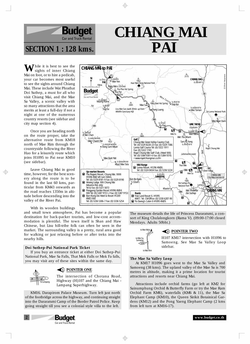
2
to Mae Malai
to Mae Rim
to Mae Sa,Samoeng
1096
18
to Lampang
107
11
CHIANG MAIPAISECTION 1 : 128 kms.
hile it is best to see thesights of inner Chiang
Mai on foot, or to hire a pedicab,your car becomes most usefulto see the sights around ChiangMai. These include Wat PhrathatDoi Suthep, a must for all whovisit Chiang Mai, and the MaeSa Valley, a scenic valley withso many attractions that the areamerits at least a full-day if not anight at one of the numerouscountry resorts (see sidebar andcity map section 4).
Once you are heading northon the route proper, take thealternative route from KM18north of Mae Rim through thecountryside following the RiverHao for a leisurely route whichjoins H1095 to Pai near KM10(see sidebar).
Leave Chiang Mai in goodtime, however, for the best scen-ery along the route is to befound in the last 60 kms, par-ticular from KM43 onwards asthe road reaches 1350m in alti-tude before descending into thevalley of the River Pai.
With its wooden buildingsand small town atmosphere, Pai has become a populardestination for back-packer tourists, and low-cost accom-modation is plentiful. The town itself is Shan and HawChinese, but Lisu hill-tribe folk can often be seen in themarket. The surrounding valley is a pretty, rural area goodfor walking or just relaxing before or after treks into thenearby hills.
Doi Suthep-Pui National Park TicketIf you buy an entrance ticket at either Doi Suthep-Pui
National Park, Mae Sa Falls, That Mok Falls or Mok Fa falls,you may visit any of these sites within the same day.
POINTER ONE
The intersection of Chotana Road,Highway (H)107 and the Chiang Mai -Lampang Superhighway.
KM16. Darapirom Palace Museum. Turn left just northof the footbridge across the highway, and continuing straightinto the Dararatsmi Camp of the Border Patrol Police. Keepgoing straight till you see a colonial style villa to the left.
1
2
W
The museum details the life of Princess Dararatsmi, a con-sort of King Chulalongkorn (Rama V). (09:00-17:00 closedMondays. Adults 50bht.)
POINTER TWO
H107 KM17 intersection with H1096 toSamoeng. See Mae Sa Valley Loopsidebar.
The Mae Sa Valley LoopAt KM17 H1096 goes west to the Mae Sa Valley and
Samoeng (38 kms). The upland valley of the Mae Sa is 700metres in altitude, making it a prime location for touristattractions and resorts near Chiang Mai.
Attractions include orchid farms (go left at KM2 forSainumphung Orchid & Butterfly Farm or try the Mae RamOrchid Farm KM6), waterfalls (KM6 & 11), the Mae SaElephant Camp (KM10), the Queen Sirikit Botainical Gar-dens (KM12) and the Pong Yaeng Elephant Camp (2 kmsfrom left turn at KM16-17).
PAIÕ.ª“¬ 1962
2175N
10kms
1265
1095
107
11
107
1096
1269
1001MAE RIMÕ.·¡à√‘¡
MAE TAENGÕ.·¡à·µß
∫.·¡àµ–¡“π
∫. ∫°“¬
∫. —πªÉ“¬“ß
∫.·¡à¡“≈—¬
∫.ªÉ“·ªÉ
SAMOENGBan Bo Kaeo
Õ. –‡¡‘ß
∫.∫àÕ·°â«
Khanin
Mae Sa
∫.¢ÿπ·¡à∑–≈–
∫.¥Õ° “¡À¡◊Ëπ
∫.·¡à·®à¡πâÕ¬
∫.«—¥®—π∑å
Khun Mae Tala
Mae Daet Not
Dong Sam Meun
Mae Chaem Noi
Wat Chan
San Pa Yang
Mae Malai
Pang Luang
Mae Sae
M a e T a e n g
Pa Pae
Mae Taman
Sop Kai
Tha Pai
Pong Mai
∫. ∫ “
∫.‡¡◊Õß·√à
Sop Sa
Muang Rae
Ping
Pai
Mok Fa
Pong Duet Hot Spring
Tha Phai Hot Spring
That Mok
Royal Chiang Mai
Green Valley
Lanna
Lisu Mae Sae (walk 30min. up fromWildlife Sanctuary HQ)
Mae Yen∫.·¡à‡¬Áπ
∫.∑à“ª“¬
∫.‚ªÉß„À¡à
Doi Suthep-PuiNational Park
Wat PhrathatDoi Suthep
Wat Tha Kham
CHIANG DAOÕ.‡™’¬ß¥“«
Sri Lanna National Park
Mae Ngat Dam
2005
1805
1422
17081685
Up-market ResortsThe Regent Resort, Chiang Mai. $$$$ H1096 KM2 left turn 500m.Tel: (0) 5329 8181-9 Fax: (0) 5329 8190Hmong Lodge. $$$ Chiang MaiAdvance Res only:Tel & Fax: (0) 5321 5072Pongyang Garden Resort H1096 KM14$$$ Tel: (0) 5387 9151-2 Fax: (0) 5387 9153Ban Klang Doi Hotel & Resort H1269KM23 $$$Tel: (0) 5336 5306-7 Fax: (0) 5336 5254
1
1
2
2
3
3
44
RusticFree Land Resort $. H1095KM17. Tel. CM Office: (0) 5330 6287-90Pa Daeng’s Cabin $ H1095 KM29.
6
6
7
7
5
5
Mid-RangeLanna Resort. H1296 KM28.Tel: (0) 5324 8434 Fax: (0) 5336 5224
CHIANG MAI‡™’¬ß„À¡à
4
5
(alternative route)
3
2
1
Huai Nam Dang National Park
GolfChiang Mai Green Valley Country ClubTel: (0) 5329 8220-23 Fax: (0) 5329 7386Lanna Golf Course Tel: (0) 5322 1911Fax: (0) 5322 1743Royal Chiang Mai Golf Club. (Hotel $$$)Tel: (0) 5384 9301-6 Fax: (0) 5384 9310.<www.royalchiangmai.co.th>
Oliv
er H
arg
reav
e
CHIANG MAICity Map (section 4)
CHIANG MAI to PAI
www.budget.co.th
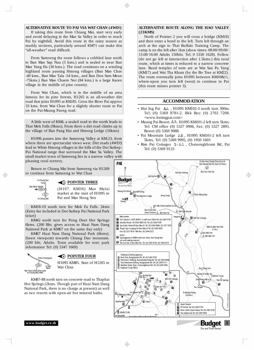
3
1265
Police Checkpoint
to MaeMalai
Wat Chan (alternative routeto Chiang Mai) 4WD!
to Chiang DaoFang
to Chiang Mai
1095
107
Mae Malai Market
A little west of KM4, a sealed road to the north leads toThat Mok Falls (9kms), From there a dirt road climbs up tothe village of Ban Pang Hai and Hmong Lodge (16kms)
H1096 passes into the Samoeng Valley at KM.23, fromwhere there are spectacular views west. Dirt roads (4WD!)lead to White Hmong villages in the hills of the Doi Suthep-Pui National range that surround the Mae Sa Valley. Thesmall market town of Samoeng lies in a narrow valley withpleasing rural scenery.
Return to Chiang Mai from Samoeng via H1269or continue from Samoeng to Wat Chan
POINTER THREE
(H107. KM36) Mae Malaimarket at the start of H1095 toPai and Mae Hong Son
KM18-19 south turn for Mok Fa Falls. 2kms(Entry fee included in Doi-Suthep Pui National Parkticket)
KM42 north turn for Pong Duet Hot Springs6kms. (200 Bht. gives access to Huai Nam DangNational Park at KM67 on the same day only)
KM67 Huai Nam Dang National Park (6kms).Dawn viewpoint towards Chiang Dao mountain.(200 bht. Adults. Tents available for rent: parkinformation Tel: (0) 5347 1669)
POINTER FOUR
H1095 KM85. Start of H1265 toWat Chan
KM87-88 north turn on concrete road to ThaphaiHot Springs (2kms. Though part of Huai Nam DangNational Park, there is no charge at present) as wellas two resorts with open-air hot mineral baths.
3
4
ALTERNATIVE ROUTE ALONG THE HAO VALLEY(23KMS)
North of Pointer 2 you will cross a bridge (KM18)and then enter a bend to the left. Turn left through anarch at the sign to Thai Buffalo Training Camp. Thecamp is on the left after 1km (show times: 08:00/09:00/15:00/16:00 Adults 150bht. Tel: 0 5330 1628). Follow(do not go left at intersection after 1.5kms.) this ruralroute, which at times is reduced to a narrow concretelane. Rural temples of note are at Wat San Pa Yang(KM17) and Wat Tha Kham (by the Bo Tree at KM22).The route eventually joins H1095 between KM10&11,where-upon you turn left (west) to continue to Pai(this route misses pointer 3).
ALTERNATIVE ROUTE TO PAI VIA WAT CHAN (4WD!)If taking this route from Chiang Mai, start very early
and avoid delaying in the Mae Sa Valley in order to reachPai by nightfall. Avoid this route in the rainy season asmuddy sections, particularly around KM71 can make this“all-weather” road difficult.
From Samoeng the route follows a cobbled lane northto Ban Mae Sap Nua (5 kms.) and is sealed to near BanMae Yang Ha (30 kms.). The road continues on a windinghighland route passing Hmong villages (Ban Mae Chae-40 kms., Ban Mae Tala -54 kms., and Ban Don Sam Meun-75kms.) Ban Mae Chaem Noi (84 kms.) is a large Karenvillage in the middle of pine country.
From Wat Chan, which is in the middle of an areafamous for its pine forests, H1265 is an all-weather dirtroad that joins H1095 at KM.85. Cross the River Pai approx33 kms. from Wat Chan for a slightly shorter route to Paion the Pai-Muang Paeng road.
Police
1095
MH
3
2
H
1
500
5
AE
B
D
C
to Chiang Mai(06:00-21:30)
View Pai Hotel
Pai Corner Bar
Be Bop Bar
Rim Pai Cottage
Jazz Up Cafe
Mountain Blue
Ban Wiang Nua
Ban Tan Chet Ton
To Ban Huai Chang Thao (Lisu) &Ban Muang Noi Pai Dam (33 kms.)
Ban Na Chalong
Wat Nam Hu
Ban Mai Sahasamphan (Lisu)
Army Camp
Hut Ing Pai
Ban Santichon(Haw Chinese)
Ban Mo PaengMuang Pai Resort
Pai Mountain Lodge
101
Rim Pai CottageHospital
99
Wat Mae Yen
Walk to Mae Yen Falls(2 hrs.)
Elephant Camp
Tha Pai Springs
Ban Thung Yao
Ban Phong Mai
Pai Canyon
92
To Muang Paeng(26 kms.)
MoPaeng
HH
H
H
34
6
5
2
1
1234
5
6
N
PAI
Michel & Yuthit GH
Wat Ban Hua Na
PAIMid-marketPai Cabana $. H105 KM101-2 north turn 500m Tel: (0) 5369 9190Skandia Resort $$ H105 KM12 $$. Tel: (0) 5369 9189Spa Exotic Home.$$ Ban Mae Hi. Tel: (0) 5369 8088, (0) 1917 9351Thapai Spa Camping $$ Ban Mae Hi Tel: (0) 5369 9695 Fax: (0) 5321 9610 Bkk Res: (0) 2944 6323
RusticSipsongpanna $ KM99 north turn 2kms, Ban Viang Nua(art and cooking courses)The Sun Hut. $ Ban Mae Yen Tel: (0) 5369 9730, (0) 1960 6519
Trekking & Rafting AgenciesBack Trax, Rungsiyanon Rd. Tel: (0) 5369 9739Permchai’s Trekking, Ratsadondamrong Rd. Tel: (0) 5369 8048Thai Adventure Rafting, Rungsiyanon Rd. Tel: (0) 5369 9111Northern Green Tours, Chaisongkhram Rd, Tel: (0) 5369 9385Elephant Camp Office
ABCDE
123
Guest Houses PP Orchid. Tel: (0) 5369 9159River Corner Guest House Tel: (0) 5369 9149The Golden Hut Tel: (0) 5369 9949
R Pa
i Ban Mae Yen
Oliv
er H
arg
reav
e
www.budget.co.th
ACCOMMODATION
• Hut Ing Pai $$, H1095 KM102-3 south turn 300m.Tel: (0) 5369 9781-2. Bkk Res: (0) 2702 7208.<www.hutingpai.com>
• Muang Pai Resort. $ . H1095 KM101-2 left turn 5kms.Tel: CM office (0) 5327 0906, Fax: (0) 5327 2895.Resort (0) 5369 9988.
• Pai Mountain Lodge $ $, H1095 KM101-2 left turn5kms. Tel: (0) 5369 9995, (0) 1950 1603
• Rim Pai Cottages $ - $$ , Chaisongkhram Rd, PaiTel: (0) 5369 9133
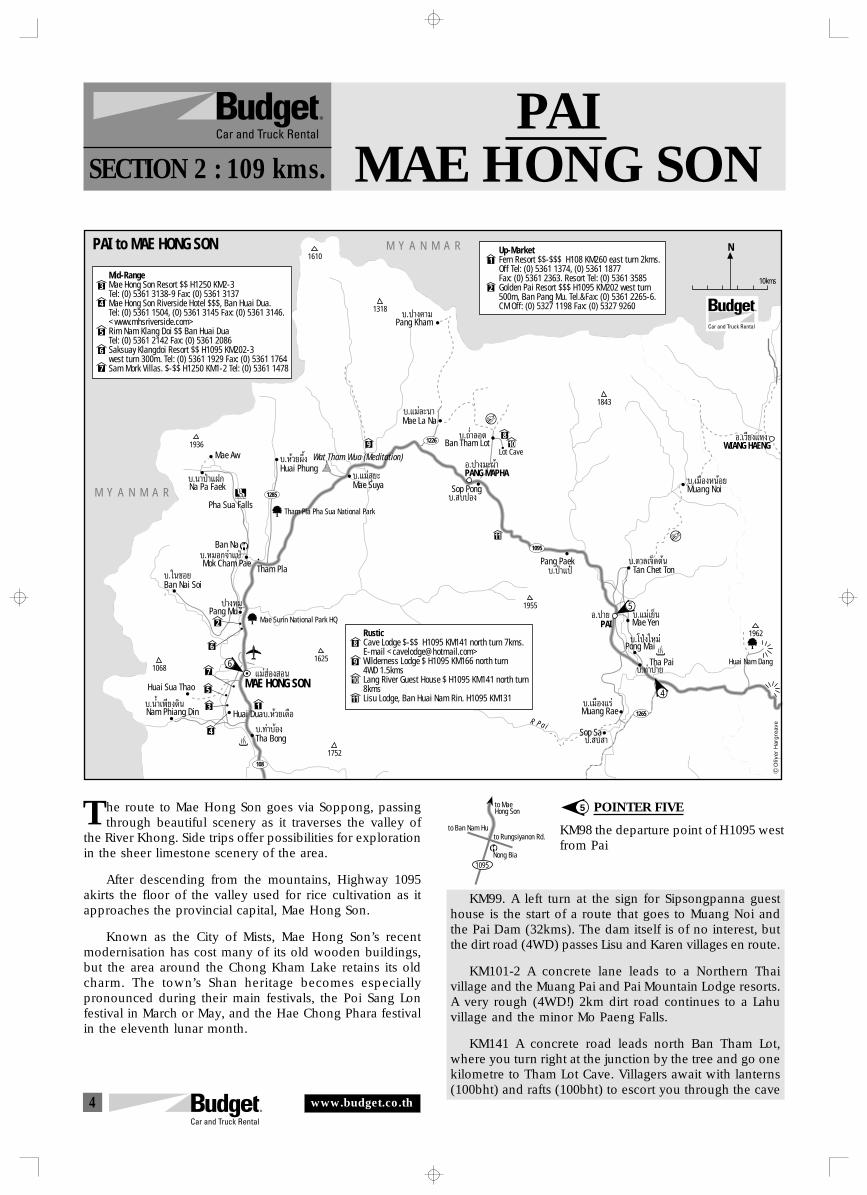
4
to Ban Nam Hu
to MaeHong Son
1095
to Rungsiyanon Rd.
Nong Bia
PAIMAE HONG SONSECTION 2 : 109 kms.
he route to Mae Hong Son goes via Soppong, passingthrough beautiful scenery as it traverses the valley of
the River Khong. Side trips offer possibilities for explorationin the sheer limestone scenery of the area.
After descending from the mountains, Highway 1095akirts the floor of the valley used for rice cultivation as itapproaches the provincial capital, Mae Hong Son.
Known as the City of Mists, Mae Hong Son’s recentmodernisation has cost many of its old wooden buildings,but the area around the Chong Kham Lake retains its oldcharm. The town’s Shan heritage becomes especiallypronounced during their main festivals, the Poi Sang Lonfestival in March or May, and the Hae Chong Phara festivalin the eleventh lunar month.
5 POINTER FIVE
KM98 the departure point of H1095 westfrom Pai
KM99. A left turn at the sign for Sipsongpanna guesthouse is the start of a route that goes to Muang Noi andthe Pai Dam (32kms). The dam itself is of no interest, butthe dirt road (4WD) passes Lisu and Karen villages en route.
KM101-2 A concrete lane leads to a Northern Thaivillage and the Muang Pai and Pai Mountain Lodge resorts.A very rough (4WD!) 2km dirt road continues to a Lahuvillage and the minor Mo Paeng Falls.
KM141 A concrete road leads north Ban Tham Lot,where you turn right at the junction by the tree and go onekilometre to Tham Lot Cave. Villagers await with lanterns(100bht) and rafts (100bht) to escort you through the cave
T
N
10kms
1095
108
1265
PAIÕ.ª“¬
Tha Pai
∫.‡¡◊Õß·√àMuang Rae
Pang Paek∫.ªÉ“·ªÜ
Sop Pong∫. ∫ªÕß
∫.∂Ë”≈Õ¥Mae La Na∫.·¡à≈–π“
∫.·¡à ÿ¬–Huai Phung∫.À⫬º÷Èß
Ban Nai Soi∫.„π´Õ¬
Mok Cham PaeTham Pla
∫.À¡Õ°®”·ªÉ
1285Mae Suya
Tham Pla Pha Sua National Park
1226 Ban Tham LotLot Cave
PANG MAPHAÕ.ª“ß¡–ºâ“
WIANG HAENGÕ.‡«’¬ß·Àß
Tan Chet Ton∫.µ“≈‡®Á¥µâπ
Muang Noi∫.‡¡◊ÕßÀπâÕ¬
∫.·¡à‡¬ÁπMae Yen
Pong Mai∫.‚ªÉß„À¡à
∫.∑à“ª“¬
Sop Sa∫. ∫ “
R P a i
Nam Phiang Din∫.πÈ”‡æ’¬ß¥‘π
Huai Sua Thao
Tha Bong
Huai Dua
∫.∑à“∫âÕß∫.À⫬‡¥◊Õ
Pang Muª“ßÀ¡Ÿ
Na Pa Faek∫.π“ªÉ“·Ω°
Mae Aw
Pang Kham∫.ª“ߧ“¡
Pha Sua Falls
Ban Na
Wat Tham Wua (Meditation)
M Y A N M A R
M Y A N M A R
1962
1955
1843
1318
1936
10681625
1752
1610
MAE HONG SON·¡àŒàÕß Õπ
3
4
5
6
7
Mid-RangeMae Hong Son Resort $$ H1250 KM2-3Tel: (0) 5361 3138-9 Fax: (0) 5361 3137Mae Hong Son Riverside Hotel $$$, Ban Huai Dua.Tel: (0) 5361 1504, (0) 5361 3145 Fax: (0) 5361 3146.<www.mhsriverside.com>Rim Nam Klang Doi $$ Ban Huai Dua Tel: (0) 5361 2142 Fax: (0) 5361 2086Saksuay Klangdoi Resort $$ H1095 KM202-3west turn 300m. Tel: (0) 5361 1929 Fax: (0) 5361 1764Sam Mork Villas. $-$$ H1250 KM1-2 Tel: (0) 5361 1478
1
1
8109
11
2
6
4
7
2
Up-MarketFern Resort $$-$$$ H108 KM260 east turn 2kms.Off Tel: (0) 5361 1374, (0) 5361 1877 Fax: (0) 5361 2363. Resort Tel: (0) 5361 3585Golden Pai Resort $$$ H1095 KM202 west turn500m, Ban Pang Mu. Tel.&Fax: (0) 5361 2265-6.CM Off: (0) 5327 1198 Fax: (0) 5327 9260
RusticCave Lodge $-$$ H1095 KM141 north turn 7kms.E-mail <[email protected]>Wilderness Lodge $ H1095 KM166 north turn4WD 1.5kms Lang River Guest House $ H1095 KM141 north turn8kmsLisu Lodge, Ban Huai Nam Rin. H1095 KM131
8
9
10
113
5
Mae Surin National Park HQ
6
4
5
Huai Nam Dang
Oliv
er H
arg
reav
e
PAI to MAE HONG SON
www.budget.co.th
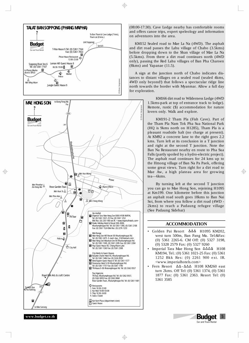
5
(08:00-17:30). Cave Lodge nearby has comfortable roomsand offers canoe trips, expert speleology and informationon adventures into the area.
KM152 Sealed road to Mae La Na (4WD). The asphaltand dirt road passes the Lahu village of Chabo (3.5kms)before dropping down to the Shan village of Mae La Na(5.5kms). From there a dirt road continues north (4WDonly), passing the Red Lahu villages of Ban Pha Charoen(8kms) and Yapanae (11.5).
A sign at the junction north of Chabo indicates dis-tances to distant villages on a sealed road (sealed 4kms,4WD only beyond!) that follows a spectacular ridge linenorth towards the border with Myanmar. Allow a full dayfor exploration.
KM166 dirt road to Wilderness Lodge (4WD1.5kms-park at top of entrance track to lodge).Remote, rustic ($) accommodation for naturelovers only. Walk and explore.
KM191-2 Tham Pla (Fish Cave). Part ofthe Tham Pla Nam Tok Pha Sua National Park(HQ is 9kms north on H1285), Tham Pla is apleasant roadside halt (no charge at present).At KM92 a concrete lane to the right goes 2.2kms. Turn left at its conclusion in a T junctionand right at the second T junction. Note theBan Na Restaurant nearby en route to Pha SuaFalls (partly spoiled by a hydro-electric project).The asphalt road continues for 24 kms up tothe Hmong village of Ban Na Pa Paek, offeringsome great views. Turn right for a dirt road toMae Aw, a high plateau area for growingtea—6kms.
By turning left at the second T junctionyou can go to Mae Hong Son, rejoining H1095at Km199. One kilometre before this junctionan asphalt road south goes 18kms to Ban NaiSoi, from where you follow a dirt road (4WD -2kms) to reach a Padaung refugee village(See Padaung Sidebar)
ACCOMMODATION
• Golden Pai Resort $$$ H1095 KM202,west turn 500m, Ban Pang Mu. Tel:&Fax:(0) 5361 2265-6. CM Off: (0) 5327 3198,(0) 5328 2579 Fax: (0) 5327 9260
• Imperial Tara Mae Hong Son $$$$ H108KM194, Tel.: (0) 5361 1021-25 Fax: (0) 53611252 Bkk Res: (0) 2261 900 ext. IR.<www.imperialhotels.com>
• Fern Resort $$-$$$ H108 KM260 eastturn 2kms. Off Tel: (0) 5361 1374, (0) 53611877 Fax: (0) 5361 2363. Resort Tel: (0)5361 3585
km141
M
H
H
H
H
NTALAT BAN SOPPONG (PHANG MAPHA)
Police
Jungle Guest House $
Market
Wat Ming Muan
Lemon Hill Guest House $Soppong River Inn.$Tel: (0) 5361 7107
Phrae House Restaurant12:00-22:00
T-Rex House $ Tel: (0) 5361 7164Fax: (0) 5361 7053
(old Soppong)
To Ban Tham & Cave Lodge (7 kms),Tham Lot (8 kms.)
to Phang Maphadistrict office
Oliv
er H
arg
reav
e
06:30-19:00
Tourist Police
Airport
Wat Chong Klang
Wat Huai To
Wat Hua Wiang
Khunlumphraphat Rd.
Wat PhrathatDoi Kong Mu
207
Wat Phra Non
City Hall
Police
Royal Folk Arts & craft Centre
264
108
1095
to Bang Pang MuPai
NMAE HONG SON
1
2
3
4
To Huai Dua& Pai Rafting
Up-marketImperial Tara Mae Hong Son $$$$ H108 KM194,Tel: (0) 5361 1021-25 Fax: (0) 5361 1252Bkk Res: (0) 2261 900 ext IR. <www.imperialhotels.com>Rooks Holiday Hotel & Resort $$$-$$$$,Khunlumphrapat Rd. Tel: (0) 5361 1390, (0) 5361 2108Fax: (0) 5361 1524 Bkk Res: (0) 2276 1233
Mid-RangeMae Hong Son Hill Resort $$ Khunlumphrapat Rd.Tel: (0) 5361 2475. E-mail<[email protected]>Mae Hong Son Mountain Inn $$ Khunlumphrapat Rd.Tel: (0) 5361 1309, (0) 5361 2285 Fax: (0) 5361 2284Piya Guest House $$, Chong Kham LakeTel: (0) 5361 1260 Fax: (0) 5361 2308
City Hotels & Guest HousesBaiyoke Chalet Hotel $$, Khunlumphrapat Rd.Tel: (0) 5361 1486 Fax: (0) 5326 0939Benchaporn Guest House $ Tel: (0) 5361 1577Panorama Hotel $-$$ Khunlumphrapat Rd.Tel: (0) 5361 1757 Fax: (0) 5361 1790TN House $-$$ Khulumphrapat Rd. Tel: (0) 5362 0557
Tour AgenciesTN Tour, Khunlumphrapat Rd. Tel: (0) 5362 0557, (0) 5362 0059 Fax: (0) 5362 0060Rose Garden Tours, Khulumphrapat Rd. Tel: (0) 5361 1681
RestaurantsFern 10:30-22:00Kai Muk 10:00-03:00Thip 10:30-24:00Swiss Chalet
Kat Kam Plaza (department store) Guest House
1
1
2
32
5
3
4
4
6
5
8
7
5
6
78
9
9
1.2.3.4.
S
TN Tour
Rose Garden TourS
to Mae Sariang
6
Oliv
er H
arg
reav
e
www.budget.co.th
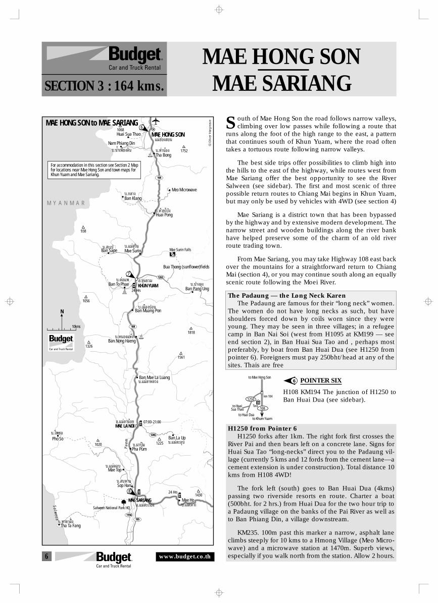
6
to HuaiSua Thao
H1250
108
to Mae Hong Son
km 104
Tara
to Huai Duato Khum Yuam
MAE HONG SONMAE SARIANGSECTION 3 : 164 kms.
outh of Mae Hong Son the road follows narrow valleys,climbing over low passes while following a route that
runs along the foot of the high range to the east, a patternthat continues south of Khun Yuam, where the road oftentakes a tortuous route following narrow valleys.
The best side trips offer possibilities to climb high intothe hills to the east of the highway, while routes west fromMae Sariang offer the best opportunity to see the RiverSalween (see sidebar). The first and most scenic of threepossible return routes to Chiang Mai begins in Khun Yuam,but may only be used by vehicles with 4WD (see section 4)
Mae Sariang is a district town that has been bypassedby the highway and by extensive modern development. Thenarrow street and wooden buildings along the river bankhave helped preserve some of the charm of an old riverroute trading town.
From Mae Sariang, you may take Highway 108 east backover the mountains for a straightforward return to ChiangMai (section 4), or you may continue south along an equallyscenic route following the Moei River.
The Padaung — the Long Neck KarenThe Padaung are famous for their “long neck” women.
The women do not have long necks as such, but haveshoulders forced down by coils worn since they wereyoung. They may be seen in three villages; in a refugeecamp in Ban Nai Soi (west from H1095 at KM199 — seeend section 2), in Ban Huai Sua Tao and , perhaps mostpreferably, by boat from Ban Huai Dua (see H1250 frompointer 6). Foreigners must pay 250bht/head at any of thesites. Thais are free
POINTER SIX
H108 KM194 The junction of H1250 toBan Huai Dua (see sidebar).
H1250 from Pointer 6H1250 forks after 1km. The right fork first crosses the
River Pai and then bears left on a concrete lane. Signs forHuai Sua Tao “long-necks” direct you to the Padaung vil-lage (currently 5 kms and 12 fords from the cement lane—acement extension is under construction). Total distance 10kms from H108 4WD!
The fork left (south) goes to Ban Huai Dua (4kms)passing two riverside resorts en route. Charter a boat(500bht. for 2 hrs.) from Huai Dua for the two hour trip toa Padaung village on the banks of the Pai River as well asto Ban Phiang Din, a village downstream.
KM235. 100m past this marker a narrow, asphalt laneclimbs steeply for 10 kms to a Hmong Village (Meo Micro-wave) and a microwave station at 1470m. Superb views,especially if you walk north from the station. Allow 2 hours.
6
S
108
1266
108
1263
1194105
N
10kms
M Y A N M A R
Nam Phiang Din
∫.πÈ”‡æ’¬ß¥‘π
Huai Sua Thao
Tha Bong∫.∑à“∫âÕß
Meo Microwave
1068
1752
MAE HONG SON·¡àŒàÕß Õπ
Huai Pong∫.À⫬‚ªÉß
Ban Klang∫.°≈“ß
Mae Surin∫.·¡à ÿ√‘π
Ban Sape∫. –‡ª
KHUN YUAMÕ.¢ÿπ¬«¡
MAE SARIANGÕ.·¡à –‡√’¬ß
MAE LA NOIÕ.·¡à≈“πâÕ¬
Ban To Phae∫.µàÕ·æ
Ban Pang Ung∫.ª“ßÕÿß
Ban Muang Pon∫.‡¡◊ÕߪÕπ
Ban Nong Haeng∫.ÀπÕß·Àâß
Ban Mae La Luang∫.·¡à≈“À≈«ß
Ban La Up∫.·¡à≈–Õÿ∫
Pha Pum∫.º“ªÿÑ¡
Mae Top∫.·¡àµÕ∫
Sop Han∫. ∫À“π
Pho So∫.‚æ´Õ
Mae Ho∫.·¡à‡À“–
Salween National Park HQ
Tha Ta Fang∫.∑“µ“Ωíòß
07:00-21:00
24 Hrs
Mae Surin Falls
938
Bua Thong (sunflower)fields
1056
1326
1818
1561
12251020
1430
Y u
a m
S a l w e e n
For accommodation in this section see Section 2 Mapfor locations near Mae Hong Son and town maps forKhun Yuam and Mae Sariang.
Oliv
er H
arg
reav
e
24 Hrs
MAE HONG SON to MAE SARIANG6
7
8
www.budget.co.th
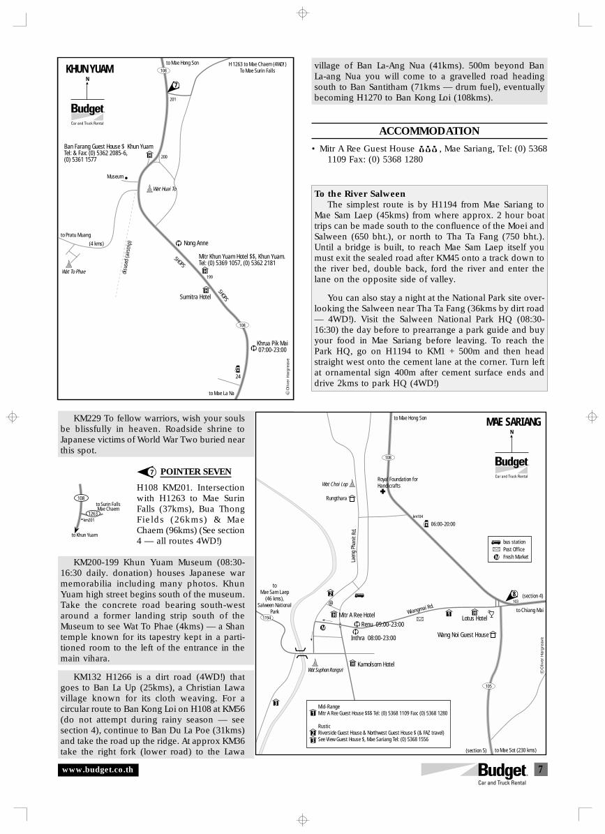
7
to Khun Yuam
108
km2011263
to Surin FallsMae Chaem
KM229 To fellow warriors, wish your soulsbe blissfully in heaven. Roadside shrine toJapanese victims of World War Two buried nearthis spot.
POINTER SEVEN
H108 KM201. Intersectionwith H1263 to Mae SurinFalls (37kms), Bua ThongFields (26kms) & MaeChaem (96kms) (See section4 — all routes 4WD!)
KM200-199 Khun Yuam Museum (08:30-16:30 daily. donation) houses Japanese warmemorabilia including many photos. KhunYuam high street begins south of the museum.Take the concrete road bearing south-westaround a former landing strip south of theMuseum to see Wat To Phae (4kms) — a Shantemple known for its tapestry kept in a parti-tioned room to the left of the entrance in themain vihara.
KM132 H1266 is a dirt road (4WD!) thatgoes to Ban La Up (25kms), a Christian Lawavillage known for its cloth weaving. For acircular route to Ban Kong Loi on H108 at KM56(do not attempt during rainy season — seesection 4), continue to Ban Du La Poe (31kms)and take the road up the ridge. At approx KM36take the right fork (lower road) to the Lawa
To the River SalweenThe simplest route is by H1194 from Mae Sariang to
Mae Sam Laep (45kms) from where approx. 2 hour boattrips can be made south to the confluence of the Moei andSalween (650 bht.), or north to Tha Ta Fang (750 bht.).Until a bridge is built, to reach Mae Sam Laep itself youmust exit the sealed road after KM45 onto a track down tothe river bed, double back, ford the river and enter thelane on the opposite side of valley.
You can also stay a night at the National Park site over-looking the Salween near Tha Ta Fang (36kms by dirt road— 4WD!). Visit the Salween National Park HQ (08:30-16:30) the day before to prearrange a park guide and buyyour food in Mae Sariang before leaving. To reach thePark HQ, go on H1194 to KM1 + 500m and then headstraight west onto the cement lane at the corner. Turn leftat ornamental sign 400m after cement surface ends anddrive 2kms to park HQ (4WD!)
7
Khrua Pik Mai07:00-23:00
Sumitra Hotel
Wat Huai To
(4 kms)
Wat To Phae
Museum
H 1263 to Mae Chaem (4WD!)To Mae Surin Falls
SHOPS
SHOPS
108
NKHUN YUAM
H
H
H
Nong Anne
108
201
200
199
to Pratu Muang
24
to Mae La Na
to Mae Hong Son
Ban Farang Guest House $ Khun YuamTel: & Fax: (0) 5362 2085-6, (0) 5361 1577
Mitr Khun Yuam Hotel $$, Khun Yuam.Tel: (0) 5369 1057, (0) 5362 2181
7
disu
sed
(airs
trip)
Oliv
er H
arg
reav
e
to Mae Hong Son
Royal Foundation forHandicrafts
06:00-20:00
toMae Sam Laep
(46 kms),Salween National
Park Mitr A Ree Hotel
Kamolsorn Hotel
Wang Noi Guest HouseInthra 08:00-23:00
Wat Suphan Rangsri
Lotus Hotel
103
km104
to Mae Sot (230 kms)
Wiangmai Rd.
Laen
gPh
anit
Rd.
Wat Chai Lop
NMAE SARIANG
1
3
2
H
H
H1194
108
105
(section 5)
(section 4)
to Chiang Mai
Rungthara
8@
M
M
Renu 09:00-23:00
Mid-RangeMitr A Ree Guest House $$$ Tel: (0) 5368 1109 Fax: (0) 5368 1280
RusticRiverside Guest House & Northwest Guest House $ (& FAZ travel)See View Guest House $, Mae Sariang Tel: (0) 5368 1556
1
23
bus stationPost OfficeFresh Market
Oliv
er H
arg
reav
e
www.budget.co.th
village of Ban La-Ang Nua (41kms). 500m beyond BanLa-ang Nua you will come to a gravelled road headingsouth to Ban Santitham (71kms — drum fuel), eventuallybecoming H1270 to Ban Kong Loi (108kms).
ACCOMMODATION
• Mitr A Ree Guest House $$$ , Mae Sariang, Tel: (0) 53681109 Fax: (0) 5368 1280
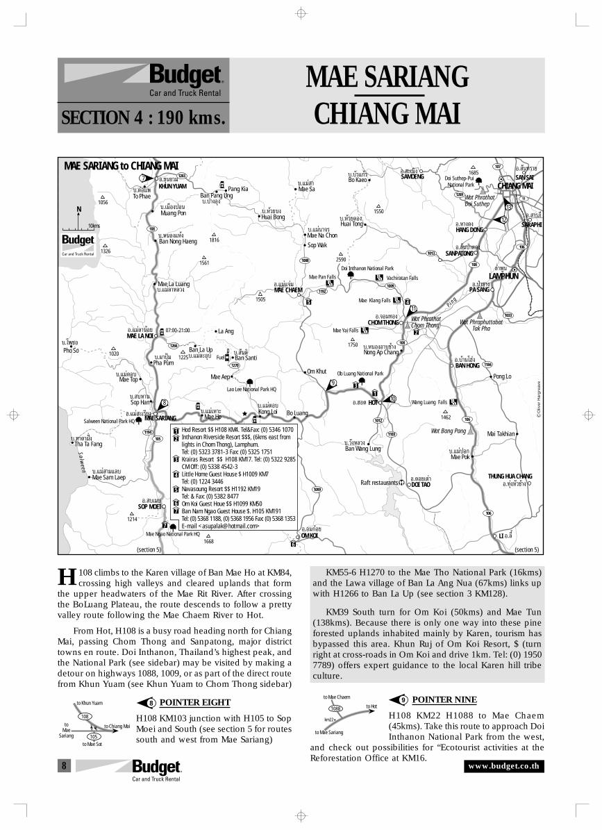
8
1088 to Hot
to Mae Chaem
to Mae Sariang
km22
to Chiang Mai
to Khun Yuam
to Mae Sot
toMae
Sariang 105
108
MAE SARIANGCHIANG MAISECTION 4 : 190 kms.
108 climbs to the Karen village of Ban Mae Ho at KM84,crossing high valleys and cleared uplands that form
the upper headwaters of the Mae Rit River. After crossingthe BoLuang Plateau, the route descends to follow a prettyvalley route following the Mae Chaem River to Hot.
From Hot, H108 is a busy road heading north for ChiangMai, passing Chom Thong and Sanpatong, major districttowns en route. Doi Inthanon, Thailand’s highest peak, andthe National Park (see sidebar) may be visited by making adetour on highways 1088, 1009, or as part of the direct routefrom Khun Yuam (see Khun Yuam to Chom Thong sidebar)
POINTER EIGHT
H108 KM103 junction with H105 to SopMoei and South (see section 5 for routessouth and west from Mae Sariang)
H KM55-6 H1270 to the Mae Tho National Park (16kms)and the Lawa village of Ban La Ang Nua (67kms) links upwith H1266 to Ban La Up (see section 3 KM128).
KM39 South turn for Om Koi (50kms) and Mae Tun(138kms). Because there is only one way into these pineforested uplands inhabited mainly by Karen, tourism hasbypassed this area. Khun Ruj of Om Koi Resort, $ (turnright at cross-roads in Om Koi and drive 1km. Tel: (0) 19507789) offers expert guidance to the local Karen hill tribeculture.
POINTER NINE
H108 KM22 H1088 to Mae Chaem(45kms). Take this route to approach DoiInthanon National Park from the west,
and check out possibilities for “Ecotourist activities at theReforestation Office at KM16.
8 9
1270
1192
1184
1009
11
107
1269
1088
108
1033
1013106
108
1266
108
1263
1194
105
106
106
1103
1099
1012
N
10kms
7
6
13
2
45
1056
LAMPHUN≈”æŸπ
CHIANG MAIKHUN YUAMÕ.¢ÿπ¬«¡
To Phae∫.µàÕ·æ
Ban Pang Ung∫.ª“ßÕÿß
Muang Pon∫.‡¡◊ÕߪÕπ
Ban Nong Haeng∫.ÀπÕß·Àâß
Mae La Luang∫.·¡à≈“À≈«ß
Ban La Up
La Ang
∫.·¡à≈–Õÿ∫Pha Pum∫.º“ªÿÑ¡ Ban Santi
∫. —πµ‘Pho So∫.‚æ´Õ
Mae Ho∫.·¡à‡À“–
Tha Ta Fang
Mae Sam Laep
∫.∑“µ“Ωíòß
∫.·¡à “¡·≈∫
MAE LA NOIÕ.·¡à≈“πâÕ¬
MAE CHAEMÕ.·¡à·®à¡
Õ.®Õ¡∑Õß
BAN HONGÕ.∫â“π‚Œàß
PA SANGÕ.ªÉ“´“ß
SANPATONGÕ. —πªÉ“µÕß
SAMOENGÕ. –‡¡‘ß
HANG DONGSARAPHI
SAN SAI
Õ.À“ߥßÕ. “√¿’
Õ. —π∑√“¬
HOTÕ.ŒÕ¥
DOI TAOÕ.¥Õ¬‡µà“
LI Õ.≈’È
THUNG HUA CHANGÕ.∑ÿàßÀ—«™â“ß
07:00-21:00
Wang Luang Falls
Vachiratan Falls
P i n g
S a l w e e n
MAE SARIANGÕ.·¡à –‡√’¬ß
SOP MOEIÕ. ∫‡¡¬
OM KOIÕ.Õ¡°ãÕ¬
Mae Top∫.·¡àµÕ∫
Kong Loi Bo Luang
Om Khut
∫.·¡àµÕ∫
Mae Aep
Sop Han∫. ∫À“π
Salween National Park HQ
Mae Ngao National Park HQ
Lao Lee National Park HQ
Ob Luang National Park
Doi Inthanon National Park
Mae Na Chon
Sop Wak
Mae Sa
∫.·¡àπ“®√Huai Tong
Bo Kaeo
∫.À⫬µÕß
∫.∫—«·°â«∫.·¡à “
Huai Bong∫.À⫬∫ß
Pang Kia
Ban Wang Lung
Raft restaurants
∫.«—ßÀ≈«ß
Mae Pok∫.·¡àªÕ°
Mai Takhian
Pong Lo
Nong Ap Chang∫.ÀπÕßÕ“∫™â“ß
Wat Bang Pang
Wat PhraphuttabatTak Pha
1326
1020
1214
1668
1225
1561
1816
1505
1750
2590
1550
1685
1462
Doi Suthep-PuiNational Park
Wat PhrathatDoi Suthep
Hod Resort $$ H108 KM4. Tel&Fax: (0) 5346 1070Inthanon Riverside Resort $$$, (6kms east fromlights in Chom Thong), Lamphum.Tel: (0) 5323 3781-3 Fax: (0) 5325 1751Krairas Resort $$ H108 KM17. Tel: (0) 5322 9285CM Off: (0) 5338 4542-3Little Home Guest House $ H1009 KM7Tel: (0) 1224 3446Navasoung Resort $$ H1192 KM19Tel: & Fax: (0) 5382 8477Om Koi Guest Houe $$ H1099 KM50 Ban Nam Ngao Guest House $. H105 KM191Tel: (0) 5368 1188, (0) 5368 1956 Fax: (0) 5368 1353E-mail <[email protected]>
12
3
4
5
67
(section 5)(section 5)
13
12
11
Wat PhrathatChom Thong CHOM THONG
Mae Yai Falls
Mae Pan Falls
Mae Klang Falls
7
8
9
10
Oliv
er H
arg
reav
e
Fuel
MAE SARIANG to CHIANG MAI
www.budget.co.th
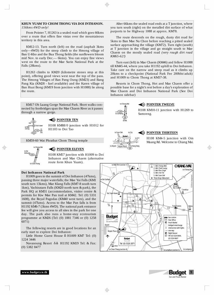
9
to City
108
to H11
to Airport Airport Plaza to Hang Dong
to Suan Dok
R
to Samoeng
to Hot
to Chiang Mai
108
1269
to Chiang Mai
to Chom Thong
to DoiInthanon
1009
Clock tower
1103
108
1012
toDoiTao
Hot
to MaeSariag
11
12KM17 Ob Luang Gorge National Park. Short walks con-nected by footbridges span the Mae Chaem River as it passesthrough a narrow gorge.
POINTER TEN
H108 KM88/0 junction with H1012 forH1103 to Doi Tao
KM59-60 Wat Phrathat Chom Thong temple
POINTER ELEVEN
H108 KM57 junction with H1009 to DoiInthanon and Mae Chaem (alternativeroute form Khun Yuam).
Doi Inthanon National ParkH1009 goes to the summit of Doi Inthanon (47kms),
passing three major waterfalls; the Mae Yai Falls (KM1south turn 13kms), Mae Klang Falls (KM7-8 south turn1km), Vachiratarn Falls (KM20 north turn & park), thePark HQ at KM31 (accommodation, visitor centre &permits for Kiw Mae Pan trail at KM42. Tel: (0) 53311608), the Royal Pagodas (KM40 west turn), and thesummit (47kms). Access to the Mae Pan falls is fromH1192 KM6-7 (3kms 4WD). The national park entrancefee will give you access to all sites in the park for oneday. The park also runs a home-stay ecotourismprogramme at KM26 (Tel: (0) 1881 7346 or (0) 12586071)
The following resorts are in good locations for anearly start to explore Doi Inthanon:
Little Home Guest House H1009 KM7 Tel: (0)1224 3446
Navasoung Resort H1192 KM19 Tel: & Fax:(0) 5382 8477
KHUN YUAM TO CHOM THONG VIA DOI INTHANON.156kms 4WD only!
From Pointer 7, H1263 is a sealed road which goes 66kmsover a route that offers fine vistas over the mountainousterritory in this area.
KM12-13. Turn north (left) on the road (asphalt 3kmsonly—4WD) for the steep climb to the Hmong village ofBan U-Kho and the Bua Thong fields (the sunflowers bloommid Nov. to early Dec.— 6kms). You can enjoy fine viewswest on the route to the Mae Surin National Park at theFalls (28kms).
H1263 climbs to KM20 (kilometre stones stop at thispoint), offering good views west near the top of the pass.The Hmong Villages of Ban Pang Oung (KM23) and BangPang Kia (KM28 - fuel available) and the Karen village ofBan Huai Bong (KM19 from junction with H1088) lie alongthe route.
After 66kms the sealed road ends at a T junction, whereyou turn south (right) on the metalled dirt surface of whatpurports to be Highway 1088 at approx. KM78.
The route descends on the rough, dusty dirt road for5kms to Ban Mae Na Chon before reaching a pitted sealedsurface approaching the village (KM72). Turn right (south)at T junction in the village and go straight south to MaeChaem on the mostly sealed road (very rough dirt roadKM65-62!)
Turn east (left) in Mae Chaem (KM46) and follow H1088till KM45-44, where you take H1192 uphill to Doi Inthanon.Take care on the narrow and steep road as it climbs up20kms to a checkpoint (National Park Fee 200bht/adult)and H1009 to Chom Thong at KM37-38.
Resorts in Chom Thong, Hot and Mae Chaem offer apossible base for a night’s rest before a day’s exploration ofMae Chaem and Doi Inthanon National Park (See DoiInthanon sidebar)
10
POINTER TWELVE
H108 KM10-11 junction with H1269 toSamoeng.
POINTER THIRTEEN
H108 KM4-5 junction with OmMuang Rd. Welcome to Chiang Mai.
13
CHIANG MAI
M
N
M
Airport
PI N
GR
IVER
Train StationN
108
1006
118
107
11
11
106
4
1
5 23
N
M
M
bus stationPost OfficeFresh Marketbridged interchangeintersection with lightsone-wayNight BazaarTAT (0) 5324 8604, (0) 5324 8607
1. Wat Chiang Man2. Wat Chedi Luang3. Wat Phra Singh4. Wat Chet Yot5. Wat Suan DokThree Kings Monument
Tel: (0) 5320 2871
1
13
bus stationCarrefour
Makro
SS
S
S
S
Kat Suan Kaew
Airport Plaza
Lotus
to Chom Thong (section 4) to Lamphun (section 5)
to Mae Rim (section 1)
to Chiang Rai
to Doi Suthep
to Lampang
Oliv
er H
arg
reav
e
Arcade
www.budget.co.th
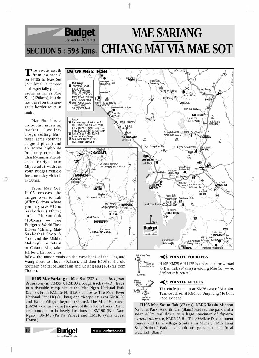
10
Phop PhraUmphang
to Takbypassto bridge
105 105
1090
to MaeSot town
to tha Song Yang
to Mae Sot
105
1175 to Ban Tak(alternative route)
MAE SARIANGCHIANG MAI VIA MAE SOTSECTION 5 : 593 kms.
he route southfrom pointer 8
on H105 to Mae Sot(232 kms) is remoteand especially pictur-esque as far as MaeSalit (120kms), but donot travel on this sen-sitive border route atnight.
Mae Sot has acolourful morningmarket, jewelleryshops selling Bur-mese gems (perhapsat good prices) andan active night-lifeYou may cross theThai Myanmar Friend-ship Bridge intoMiyawaddi withoutyour Budget vehiclefor a one-day visit till17:30hrs.
From Mae Sot,H105 crosses theranges over to Tak(83kms), from whereyou may take H12 toSukhothai (80kms)and Phitsanulok(138kms — seeBudget’s WorldClassDrives “Chiang Mai-Sukhothai Loop &“Loei and the MiddleMekong). To returnto Chiang Mai, takeH1 for a fast route, orfollow the minor roads on the west bank of the Ping andWang rivers to Thoen (92kms), and then H106 to the oldnorthern capital of Lamphun and Chiang Mai (181kms fromThoen).
H105 Mae Sariang to Mae Sot (232 kms — fuel fromdrums only till KM33!). KM190 a rough track (4WD!) leadsto a riverside camp site at the Mae Ngao National Park(5kms). From KM115-14, H1267 climbs to The Moei RiverNational Park HQ (11 kms) and viewpoints near KM18-20and Karen Villages beyond (35kms). The Mae Usu caves(KM94 west turn 2kms) are part of the national park. Rusticaccommodation in lovely locations at KM190 (Ban NamNgao), KM143 (Pa Pa Valley) and KM116 (Wila GuestHouse)
15
14
T
POINTER FOURTEEN
H105 KM35-6 H1175 is a scenic narrow roadto Ban Tak (94kms) avoiding Mae Sot — nofuel on this route!
POINTER FIFTEEN
The circle junction at KM76 east of Mae Sot.Turn south on H1090 for Umphang (164kms- see sidebar)
H105 Mae Sot to Tak (83kms). KM26 Taksin MaharatNational Park. A north turn (3kms) leads to the park and asteep 400m trail down to a large specimen of diptero-carpus.anisoptera; KM26-25 Hill Tribe Welfare DevelopmentCentre and Lahu village (south turn 5kms); KM12 LangSang National Park — a south turn goes to a small localwaterfall (3kms).
1175
1267
1090
1108
105
105
12
1107
1175
1
106
1102
1
1117
1206
1109
1110
N
10kms
TAKµ“°
S a l w a e e n
M o e i
LIÕ.≈’ÈOM KOIÕ.Õ¡°ãÕ¬
THA SONG YANGÕ.∑à“ Õ߬“ß
MAE RAMATÕ.·¡à≈–¡“¥
WANG CHAOÕ.«—߇®â“
BAN TAKÕ.∫â“𵓰
SAM NGAO
MAE PHRIK
Õ. “¡‡ß“
Õ.¬“߇ªï¬π
THOENÕ.‡∂‘π
KHLONG LANÕ.§≈Õß≈“π
MAE SOT
PHOP PHRA
Õ.·¡à Õ¥
Õ.æ∫æ√–
UMPHANGÕ.Õÿ⡺“ß
Chedi Yuttahathi
Wat Wiang
Ban Tha Song Yang
checkpoint
∫.∑à“ Õ߬“ß
Mae Salit∫.·¡à ≈‘¥
Tham Usu (cave)
Mae Usu
Refugee Camp (Bae Ko)
∫.·¡àÕÿ ÿ
Ban Chong Khep
Chedi KhoKulap Doi
(07:00-21:00)
∫.‡®¥’¬å‚§ä–
Mae Lamao∫.·¡à≈–‡¡“
Nong Luang
BanKklongLan∫.ÀπÕßÀ≈«ß Huai Nam Yen
(no through route)
Pha Charoen Falls
Lan Sang Falls& National Park
Khlong Lan Falls& National Park
Mae Wong National Park
MarketPha Wo Shrine
Taksin MaharatNational Park
HilltribeDevelopment
Centre
Na Bot∫.π“‚∫ å
Ban Tha PuiBhumiphol Golf Club(0) 5559 9093-6
Dam
Mae Rawan
Huai Khi Nok
∫.·¡à√–«“π∫.·¡àµ◊Ëπ
Kaeng Ko (boats)
Ban Thung Ko
Ban Yang Piang
(section 4)
Mae TunMae Chiang Rai
∫.·¡à‡™’¬ß√“¬
Mae PingNational Park
Mae Moei National Park
Mae NgaoNational Park
Ko Falls
1214
1668
1468
1538
1886
884
16641027
1498
1024
1450
1765
1650
W a n
g
P i n g
106
1087
1099
1184
11
1034
1035
111269
1157
10061317
1033
1061147
108
11
106
106
1274
1
1
N
10kms
CHIANG MAI
LAMPHUN
‡™’¬ß„À¡à
≈”æŸπ
LAMPANG≈”ª“ß
MAE THA
PA SANG
THUNG HUA CHANG
KO KHA
SOEM NGAM
Õ.·¡à∑“
Õ.‡°“–§“
Õ.∑ÿàßÀ—«™â“ß
Õ.ªÉ“´“ß
ElephantConservation Centre
Wat PhrathatLampang Luang
LIÕ.≈’È
Mai Takhian
RusticBan Nam Ngao Guest House $.H105 KM191 Tel: (0) 5568 1188,(0) 5568 1956 Fax: (0) 5568 1353 E-mail<[email protected]>Pa Pa Valley $ H105 KM143(Ban Tha Song Yang)Wila Guest House $ H105KM116 (Ban Mae Salit)
3
4
5
4
5
1
2
3
Mid-RangeTaweechai Resort$-$$$ H105KM71 Tel: (0) 55531287, (0) 5553 1569Fax: (0) 5553 3203 BkkRes: (0) 2656 5661Suan Kamol Resort$$ H105 KM20Tel: (0) 5558 1451
1
2
13
1216
15
1417
Oliv
er H
arg
reav
e
Chiang Mai-LamphunGolf Club (0) 5324 8397-8
Fuel
Fuel
MAE SARIANG to THOEN
18
www.budget.co.th
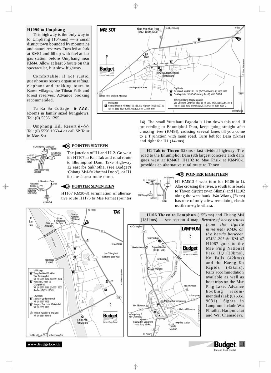
11
to Tak
1061
to Thoen
to Li, Lamphunto Lampang
km513Wat Wiang (2kms)
to Ban Tak
to Bhumiphol DamYuttahattiPagoda
alternativeroute fromMae Ramat
1107
km31(1km)
1175
to Mae Sot (H105)Bangkok
to H1107(cross riverfor alternativeroute)
to Chiang Mai (fast route)
1
12
Lampang
to SukhothaiPhitsanulok
16
18
POINTER SIXTEEN
The junction of H1 and H12. Go westfor H1107 to Ban Tak and rural routeto Bhumiphol Dam. Take Highway12 east for Sukhothai (see Budget’s‘Chiang Mai-Sukhothai Loop’), or H1for the fastest route north.
POINTER SEVENTEEN
H1107 KM30-31 termination of alterna-tive route H1175 to Mae Ramat (pointer
17
H1090 to UmphangThis highway is the only way in
to Umphang (164kms) — a smalldistrict town bounded by mountainsand nature reserves. Turn left at forkat KM31 and fill up with fuel at lastgas station before Umphang nearKM44. Allow at least 5 hours on thisspectacular, but slow highway.
Comfortable, if not rustic,guesthouse/resorts organise rafting,elephant and trekking tours toKaren villages, the Tilosu Falls andforest reserves. Advance bookingrecommended.
Tu Ka Su Cottage - .Rooms in family sized bungalows.Tel: (0) 5556 1295.
Umphang Hill Resort -$$$Tel: (0) 5556 1063-4 or call SP Tourin Mae Sot
14). The small Yuttahatti Pagoda is 1km down this road. Ifproceeding to Bhumiphol Dam, keep going straight aftercrossing river (KM54), crossing several lanes till you cometo a T junction with main road. Turn left for Dam (5kms)and right for H1 (14kms).
H1 Tak to Thoen 92kms - fast divided highway. Theroad to the Bhumiphol Dam (8th largest concrete arch damgoes west at KM463. H1102 to Mae Phrik at KM490-1provides an alternative rural route to Thoen.
POINTER EIGHTTEEN
H1 KM513-4 west turn for H106 to Li.After crossing the river, a south turn leadsto Thoen district town (4kms) and H1102along the west bank. Wat Wiang (2kms)has one of only a few remaining classicnorthern-style vihara.
H106 Thoen to Lamphun (155kms) and Chiang Mai(181kms) — see section 4 map. Beware of heavy trucks
from the lignitemine near KM36 onthe bends betweenKM12-29! At KM 47H1087 goes to theMae Ping NationalPark HQ (20kms),Ko Falls (42kms)and the Kaeng KoRapids (43kms).Rafts accommodationavailable as well asboat trips on the MaePing Lake. Advancebooking recom-mended (Tel: (0) 53519031). Sights inLamphun include WatPhrathat Haripunchaiand Wat Chamadevi.
to Moei River Bridge & Myanmar
to Mae SariangKhao-Mao Khao-Fang(km.2 10:00-22:00)
Kwangtung (Chinese)Restaurant
to Tak
to Umphang
Morning market area
SPTour
105
105
105
105
1090
1
2
3
N
MAE SOT
1Mid-RangeCentral Mae Sot Hill Hotel, $$-$$$ Asia Highway (H105 KM77-8)Tel: (0) 5553 2601-8. Bkk Res: (0) 2541 1234 ex 4444
City HotelsDK $ Hotel Intakhiri Rd. Tel: (0) 5554 2648-9, (0) 5553 1699Pornthep Hotel $-$$ Soi Sriwiang. Tel: (0) 5553 2590-4
Rafting/Trekking (Umphang area) Mae Sot Travel Centre SP Tour. Tel: (0) 5553 1409, (0) 5554 6121-3Fax: (0) 5553 2279 Bkk Off: (0) 2573 7942, (0) 2981 9991-2
23
15
Oliv
er H
arg
reav
e
PI N
GR
I VE
R
Chid ChonRestaurant
to Kamphaeng Phetto Mae Sot
TourismAuthority
of ThailandShrineof King Taksin
the GreatBeerGardens
Footbridge(closed)
to Thoen
to Sukhothai
(see Chiang Mai-
Sukhothai Loop WCD)
ToBanTak
1
105
104
1
12
1107
1
2
4
3
N
TAK
$
Mid RangeViang Tak Hotel $$ MahatThai Bamrung Rd.Tel: (0) 5551 1910, (0) 5551 1950 Viang Tak 2 Hotel $$Chomphol Rd.Tel: (0) 5551 2686, (0) 5551 2507Bkk Res: (0) 2511 2363
City HotelsSuan Sin Garden Resort $Tel: (0) 5551 1102Songwon Thai Hotel $ Taksin Rd:Tel: (0) 5551 1153
Tourism Authority of ThailandTel: (0) 5551 4341-3
1
2
3
4
419
16
Oliv
er H
arg
reav
e
KU
AN
GR
IVER
to Chiang Mai
to Pasang
LAMPHUN
106
106
114
1015
Wat Mahawan
QueenChamadevi Monument
& to Rung MarketSports
Stadium
to Lampang
Wat Phrathat Haripunchai
Wat Phra Yeun
bus station
Dao Khanong
Wooden House Sriphan Noodles(09:00-15:00)
Ku Chang
Train Station
to Sanpatong &Wat Chamadevi
N
MNational Museum
Oliv
er H
arg
reav
e
www.budget.co.th
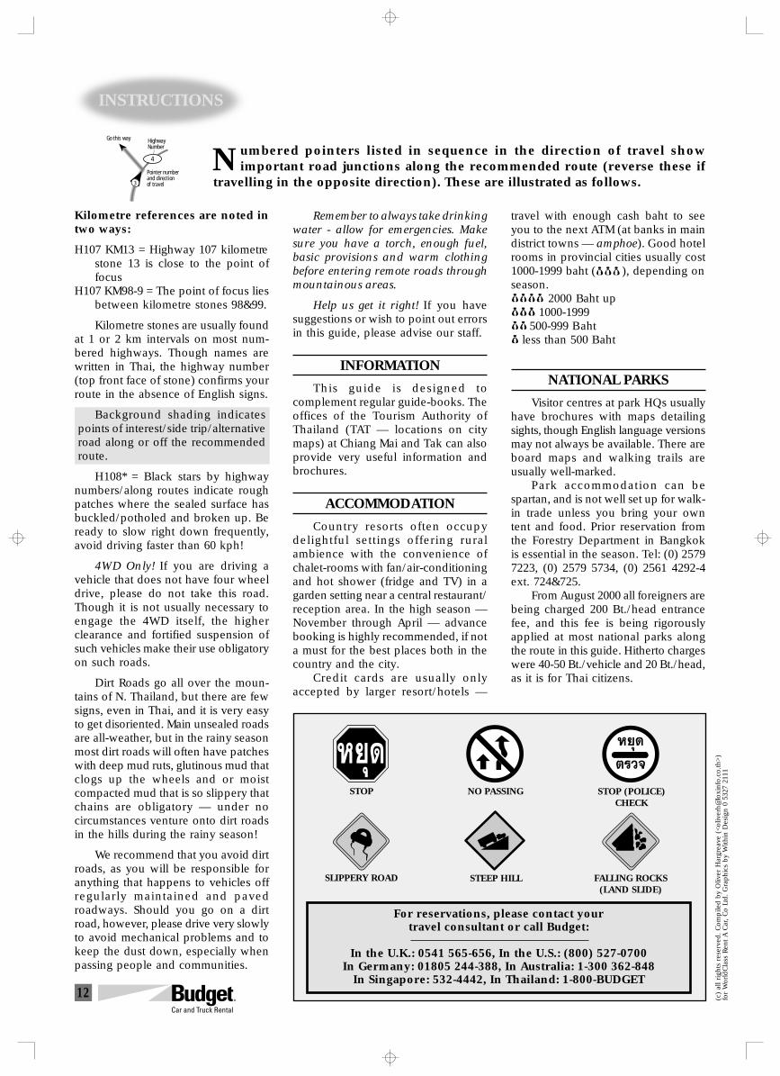
12
INSTRUCTIONS
umbered pointers listed in sequence in the direction of travel showimportant road junctions along the recommended route (reverse these if
travelling in the opposite direction). These are illustrated as follows.N
Kilometre references are noted intwo ways:
H107 KM13 = Highway 107 kilometrestone 13 is close to the point offocus
H107 KM98-9 = The point of focus liesbetween kilometre stones 98&99.
Kilometre stones are usually foundat 1 or 2 km intervals on most num-bered highways. Though names arewritten in Thai, the highway number(top front face of stone) confirms yourroute in the absence of English signs.
Background shading indicatespoints of interest/side trip/alternativeroad along or off the recommendedroute.
H108* = Black stars by highwaynumbers/along routes indicate roughpatches where the sealed surface hasbuckled/potholed and broken up. Beready to slow right down frequently,avoid driving faster than 60 kph!
4WD Only! If you are driving avehicle that does not have four wheeldrive, please do not take this road.Though it is not usually necessary toengage the 4WD itself, the higherclearance and fortified suspension ofsuch vehicles make their use obligatoryon such roads.
Dirt Roads go all over the moun-tains of N. Thailand, but there are fewsigns, even in Thai, and it is very easyto get disoriented. Main unsealed roadsare all-weather, but in the rainy seasonmost dirt roads will often have patcheswith deep mud ruts, glutinous mud thatclogs up the wheels and or moistcompacted mud that is so slippery thatchains are obligatory — under nocircumstances venture onto dirt roadsin the hills during the rainy season!
We recommend that you avoid dirtroads, as you will be responsible foranything that happens to vehicles offregularly maintained and pavedroadways. Should you go on a dirtroad, however, please drive very slowlyto avoid mechanical problems and tokeep the dust down, especially whenpassing people and communities.
(c)
all righ
ts r
eser
ved. Com
pile
d b
y O
liver
Har
grea
ve (
<oliv
erh@
loxi
nfo
.co.th
>)
for
WorldCla
ss R
ent A C
ar, Co L
td. G
raphic
s by
With
in D
esig
n 0
532
7 21
11
For reservations, please contact yourtravel consultant or call Budget:
In the U.K.: 0541 565-656, In the U.S.: (800) 527-0700In Germany: 01805 244-388, In Australia: 1-300 362-848
In Singapore: 532-4442, In Thailand: 1-800-BUDGET
3
4
Pointer numberand directionof travel
HighwayNumber
Go this way
Remember to always take drinkingwater - allow for emergencies. Makesure you have a torch, enough fuel,basic provisions and warm clothingbefore entering remote roads throughmountainous areas.
Help us get it right! If you havesuggestions or wish to point out errorsin this guide, please advise our staff.
INFORMATION
This guide is designed tocomplement regular guide-books. Theoffices of the Tourism Authority ofThailand (TAT — locations on citymaps) at Chiang Mai and Tak can alsoprovide very useful information andbrochures.
ACCOMMODATION
Country resorts often occupydelightful settings offering ruralambience with the convenience ofchalet-rooms with fan/air-conditioningand hot shower (fridge and TV) in agarden setting near a central restaurant/reception area. In the high season —November through April — advancebooking is highly recommended, if nota must for the best places both in thecountry and the city.
Credit cards are usually onlyaccepted by larger resort/hotels —
travel with enough cash baht to seeyou to the next ATM (at banks in maindistrict towns — amphoe). Good hotelrooms in provincial cities usually cost1000-1999 baht ( ), depending onseason. 2000 Baht up
1000-1999 500-999 Baht less than 500 Baht
NATIONAL PARKS
Visitor centres at park HQs usuallyhave brochures with maps detailingsights, though English language versionsmay not always be available. There areboard maps and walking trails areusually well-marked.
Park accommodation can bespartan, and is not well set up for walk-in trade unless you bring your owntent and food. Prior reservation fromthe Forestry Department in Bangkokis essential in the season. Tel: (0) 25797223, (0) 2579 5734, (0) 2561 4292-4ext. 724&725.
From August 2000 all foreigners arebeing charged 200 Bt./head entrancefee, and this fee is being rigorouslyapplied at most national parks alongthe route in this guide. Hitherto chargeswere 40-50 Bt./vehicle and 20 Bt./head,as it is for Thai citizens.
FALLING ROCKS(LAND SLIDE)
STEEP HILL
STOP (POLICE)CHECK
SLIPPERY ROAD
STOP NO PASSING
À¬ÿ¥ À¬ÿ¥
µ√«®
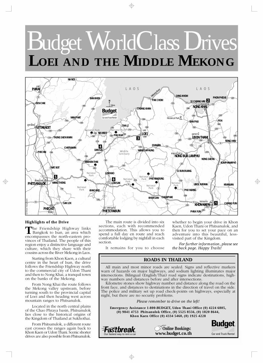
1
PHETCHABUN‡æ™√∫Ÿ√≥å
KHON KAEN¢Õπ·°àπ
UDON THANIÕÿ¥√∏“π’
ÀπÕß∫—«≈”¿Ÿ
Õ.ÀπÕߧ“¬
LOEI‡≈¬
æ‘…≥ÿ‚≈°
PHICHITæ‘®‘µ√
1146
1047
1268
1239
1047 1214
1214
1246
1296
1295
1328
1268
12372114
2294
2195
2399
2113
2013
22162016
1248
20132331
2258
1143
2115
2140
2138
2249
2108
2216
211
2376 211
2266
2020
2021
226322632097
2352
2314
228
2133
2038
2187
12
2
2062
2131
210
203
203
1212
117
11
21
21
201
12
20
11
101
11
115
11
111 201
210
2313
22
23122096
2255
20222
2329
212
2267
R
N
10kms
PHITSANULOK
Õÿµ√¥‘µ∂å UTTARADIT
·æ√àPHRAE
NONG KHAI
Historical Park
PHON PHISAISI CHIANG MAI
L A O SL A O S
BAN PHU
SANG KHOM
PEN
NONG HAN
KUMPHAWAPHI
NONG BUA LAMPHU
KRANUAN
CHIANG YUN
PHRA YUN
CHUMPHAE
UBOL RATANA
NONG SAENG
SI BUN RUANG
KHON SAN
PHU WIANG
PHU KRADUNG
WANG SAPHUNG
ERAWAN
PAK CHOM
CHIANG KHAN
THA LI
PHU RUA
DAN SAI
NAKHON THAI
CHATRAKAN
LOM KAO
LOM SAK
KHAO KHO
SAK LEK
WANG THONG
THUNG SAEN KHAN
NAM PHAT
NA HAEO
BAN KHOK
NA NOI
DEN CHAI
PHICHAI
WAT BOT
Mekong Rive
r
Nat iona l Park Nat iona l Park
Nat iona lPark
Nat iona lPark
Nat iona lPark
Nat iona lPark
Nat iona lPark
Nat iona lPark
Wi ld l i f eSanctuary
5
4
3
1
2
6
Oliv
er H
arg
reav
e
LOEI AND THE MIDDLE MEKONGBudget WorldClass Drives
ROADS IN THAILAND
All main and most minor roads are sealed. Signs and reflective markerswarn of hazards on major highways, and sodium lighting illuminates majorintersections. Bilingual (English/Thai) road signs indicate destinations, high-way numbers and distances before and after intersections.
Kilometre stones show highway number and distance along the road on thefront face, and distances to destinations in the direction of travel on the side.The police and military set up road check-points on highways, especially atnight, but there are no security problems.
Please remember to drive on the left!
Emergency Assistance 1-800-BUDGET, Udon Thani Office (0) 4224 6805,(0) 9841 4753 Phitsanulok Office, (0) 5525 8556, (0) 1820 8644,
Khon Kaen Office (0) 4334 5460, (0) 1925 4228
Highlights of the Drive
he Friendship Highway linksBangkok to Isan, an area which
encompassses the north-eastern pro-vinces of Thailand. The people of thisregion enjoy a distinctive language andculture, which they share with theircousins across the River Mekong in Laos.
Starting from Khon Kaen, a culturalcentre in the heart of Isan, the drivefollows the Friendship Highway northto the commercial city of Udon Thaniand then to Nong Khai, a tranquil townon the banks of the Mekong.
From Nong Khai the route followsthe Mekong valley upstream, beforeturning south to the provincial capitalof Loei and then heading west acrossmountain ranges to Phitsanulok.
Located in the north central plainsof the Chao Phraya basin, Phitsanuloklies close to the historical origins ofthe Kingdom of Thailand at Sukhothai.
From Phitsanulok, a different routeeast crosses the ranges again back toKhon Kaen or Udon Thani. Scenic shorterdrives are also possible from Phitsanulok.
TThe main route is divided into six
sections, each with recommendedaccommodation. This allows you tospend a full day en route and reachcomfortable lodging by nighfall in eachsection.
It remains for you to choose
whether to begin your drive in KhonKaen, Udon Thani or Phitsanulok, andthen for you to set your pace on anadventure into this beautiful, less-visited part of the Kingdom.
For further information, please seethe back page. Happy Trails!
Our fastest way to rent a car
Online Bookings:www.budget.co.th
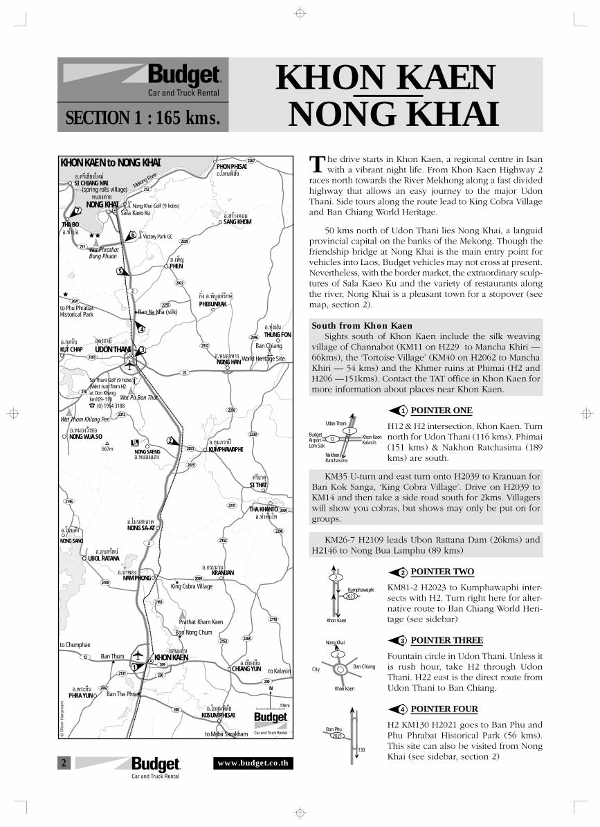
2
City
Nong Khai
Ban Chiang
2
Khon Kaen
NakhonRatchasima
Udon Thani
12
2BudgetAirportLom Sak
Khon KaenKalasin
2021
130
Ban Phu
2023
2
Kumphawaphi
Khon Kaen
2021
2263
12
2
2146
2039
2009
2298
2231
2152
2025
2023
2110
22682152
2183
2109
2062
2131
209
209
208
230
210
2313
22
2312
2350
2239
2096
2255
2022
2
2329
212
211
2267
7
6
3
4
5
2
SI CHIANG MAI
THA BO
PHEN
(spring rolls village)
Sala Kaeo Ku
PHON PHISAI
Wat PhrathatBang Phuan
Nong Khai Golf (9 holes)
Mekong River
Victory Park GC
SANG KHOM
to Phu PhrabatHistorical Park Ban Na Kha (silk)
Ban Chiang
World Heritage Site
PHIBUNRAK
KUT CHAP UDON THANI
THUNG FON
NONG HAN
NONG WUA SO
KUMPHAWAPHINONG SAENG
NONG SANG
Wat Tham Khlong Pen
NONG SA-AT
SI THAT
THA KHANTO
KRANUAN
King Cobra VillageNAM PHONG
UBOL RATANA
Ban Thum
PHRA YUN
1
Ban Tha Phra
KHON KAEN
KOSUM PHISAI
CHIANG YUN to Kalasin
Ban Nong Chum
R
to Maha Sarakham
Prathat Kham Kaen
Õ.»√’‡™’¬ß„À¡à Õ.‚æπæ‘ —¬
Õ. √â“ߧա
°‘Ëß Õ.æ‘∫Ÿ≈¬å√—°…å
Õ.∑à“∫àÕ
Õ.‡æÁ≠
Õ.°ÿ¥®—∫ Õÿ¥√∏“π’
NONG KHAI
KHON KAEN to NONG KHAI
ÀπÕߧ“¬
Õ.∑ÿàßΩπ
Õ.ÀπÕßÀ“√
Õ.ÀπÕß«—«´Õ
Õ.°ÿ¡¿«“ªï
Õ.ÀπÕß· ß
Õ.‚ππ —ßÕ.‚ππ –Õ“¥
»√’∏“µÿ
Õ.∑à“§—π‚∑
Õ.°√–π«πÕ.πÈ”æÕß
Õ.Õÿ∫≈√—µπå
Õ.æ√–¬◊π
¢Õπ·°àπ
Õ.‚° ÿ¡æ‘ —¬
Õ.‡™’¬ß¬◊π
to Chumphae
N
Sri Thani Golf (9 holes)(West turn from H2at Don Khengkm109-110 (0) 1954 3188
667m
10kms
Wat Pa Ban That
Oliv
er H
arg
reav
e
KHON KAENNONG KHAISECTION 1 : 165 kms.
he drive starts in Khon Kaen, a regional centre in Isanwith a vibrant night life. From Khon Kaen Highway 2
races north towards the River Mekhong along a fast dividedhighway that allows an easy journey to the major UdonThani. Side tours along the route lead to King Cobra Villageand Ban Chiang World Heritage.
50 kms north of Udon Thani lies Nong Khai, a languidprovincial capital on the banks of the Mekong. Though thefriendship bridge at Nong Khai is the main entry point forvehicles into Laos, Budget vehicles may not cross at present.Nevertheless, with the border market, the extraordinary sculp-tures of Sala Kaeo Ku and the variety of restaurants alongthe river, Nong Khai is a pleasant town for a stopover (seemap, section 2).
South from Khon KaenSights south of Khon Kaen include the silk weaving
village of Channabot (KM11 on H229 to Mancha Khiri —66kms), the ‘Tortoise Village’ (KM40 on H2062 to ManchaKhiri — 54 kms) and the Khmer ruins at Phimai (H2 andH206 —151kms). Contact the TAT office in Khon Kaen formore information about places near Khon Kaen.
POINTER ONE
H12 & H2 intersection, Khon Kaen. Turnnorth for Udon Thani (116 kms). Phimai(151 kms) & Nakhon Ratchasima (189kms) are south.
KM35 U-turn and east turn onto H2039 to Kranuan forBan Kok Sanga, ‘King Cobra Village’. Drive on H2039 toKM14 and then take a side road south for 2kms. Villagerswill show you cobras, but shows may only be put on forgroups.
KM26-7 H2109 leads Ubon Rattana Dam (26kms) andH2146 to Nong Bua Lamphu (89 kms)
POINTER TWO
KM81-2 H2023 to Kumphawaphi inter-sects with H2. Turn right here for alter-native route to Ban Chiang World Heri-tage (see sidebar)
POINTER THREE
Fountain circle in Udon Thani. Unless itis rush hour, take H2 through UdonThani. H22 east is the direct route fromUdon Thani to Ban Chiang.
POINTER FOUR
H2 KM130 H2021 goes to Ban Phu andPhu Phrabat Historical Park (56 kms).This site can also be visited from NongKhai (see sidebar, section 2)
1
2
3
4
T
www.budget.co.th
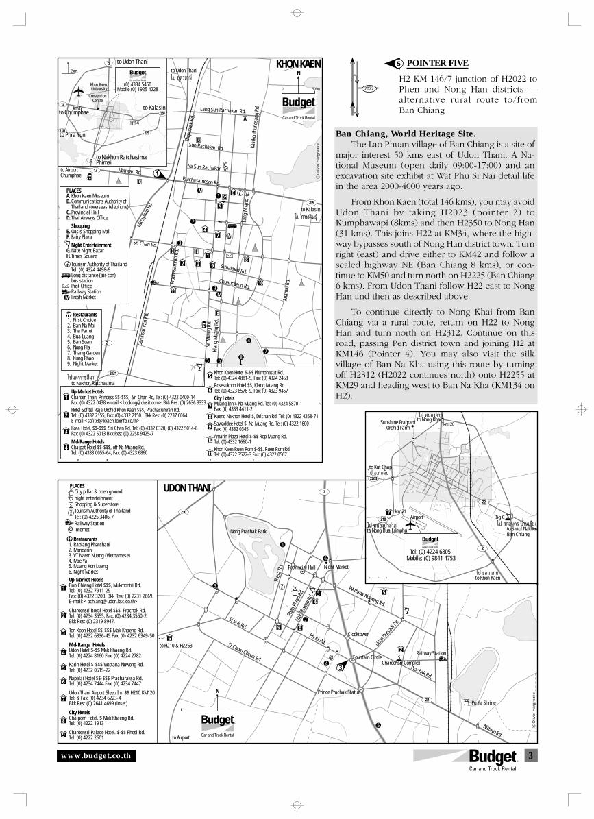
3
2022
112
209
2
2131
M
M
M
A
B
C
D
E
F
G
H
M
RestaurantsFirst ChoiceBan Na Mai The ParrotBua LuangBan SuanNong PlaThang GardenKung PhaoNight Market
1.2.3.4.5.6.7.8.9.
Up-Market HotelsCharoen Thani Princess $$-$$$, Sri Chan Rd, Tel: (0) 4322 0400-14Fax: (0) 4322 0438 e-mail <[email protected]> Bkk Res: (0) 2636 3333 Hotel Sofitel Raja Orchid Khon Kaen $$$, Prachasumran Rd. Tel: (0) 4332 2155, Fax: (0) 4332 2150. Bkk Res: (0) 2237 6064. E-mail <[email protected]>Kosa Hotel, $$-$$$ Sri Chan Rd, Tel: (0) 4332 0320, (0) 4322 5014-8Fax: (0) 4322 5013 Bkk Res: (0) 2258 9425-7
Mid-Range Hotels Chaipat Hotel $$-$$$, off Na Muang Rd,Tel: (0) 4333 0055-64, Fax: (0) 4323 6860
1
2
3
4
Khon Kaen Hotel $-$$ Phimphasut Rd.,Tel: (0) 4324 4881-5, Fax: (0) 4324 2458Rosesukhon Hotel $$, Klang Muang Rd. Tel: (0) 4323 8576-9, Fax: (0) 4323 9457City Hotels Muang Inn $ Na Muang Rd. Tel: (0) 4324 5870-1 Fax: (0) 4333 4411-2Kaeng Nakhon Hotel $, Drichan Rd. Tel: (0) 4322 4268-71Sawaddee Hotel $, Na Muang Rd. Tel: (0) 4322 1600Fax: (0) 4332 0345Amarin Plaza Hotel $-$$ Rop Muang Rd.Tel: (0) 4332 1660-1Khon Kaen Ruen Rom $-$$. Ruen Rom Rd.Tel: (0) 4322 3522-3 Fax: (0) 4322 0567
5
12 3
47
89
1011
5
6
6
7
8
9
10
11
R
N
500m0
KHON KAEN to Udon Thani
to Kalasin
to AirportChumphae
to Nakhon Ratchasima‰ªπ§√√“™ ’¡“
‰ª °“à ‘π∏ÿå
‰ª Õÿ¥√∏“π’
5 6
3
9
2
1
4
78
Khon Kaen MuseumCommunications Authority ofThailand (overseas telephone)Provincial HallThai Airways Office
ShoppingOasis Shopping MallFairy Plaza
Night EntertainmentNate Night BazarTimes Square
Tourism Authority of ThailandTel: (0) 4324 4498-9Long distance (air-con)bus stationPost OfficeRailway StationFresh Market
A.B.
C.D.
E.F.
G.H.
Lang Sun Rachakan Rd.
Sun Rachakan Rd.
Na Sun Rachakan Rd.
Prachasamoson Rd.
Kasi
kont
hung
sang
Rd.
Thep
hara
k Rd
.
Maliwan Rd.
Mitra
phap
Rd.
Sri Chan Rd.
Prac
hasa
mra
n Rd
.
Chuancheun Rd.
Sithakhon Rd.
Lang
Mua
ng R
d.
Anam
ai R
d.
Daru
nsam
ran
Rd.
Na M
uang
Rd.
Klan
g M
uang
Rd.
PLACES
2
230
km 4
to Udon Thani
2
2131
12
209
2km.
km 6to Chumphae
to Phra Yun
to Nakhon RatchasimaPhimai
to Kalasin
ConventionCentre
Khon KaenUniversity
(0) 4334 5460Mobile (0) 1925 4228
R
Oliv
er H
arg
reav
e
POINTER FIVE
H2 KM 146/7 junction of H2022 toPhen and Nong Han districts —alternative rural route to/fromBan Chiang
Ban Chiang, World Heritage Site.The Lao Phuan village of Ban Chiang is a site of
major interest 50 kms east of Udon Thani. A Na-tional Museum (open daily 09:00-17:00) and anexcavation site exhibit at Wat Phu Si Nai detail lifein the area 2000-4000 years ago.
From Khon Kaen (total 146 kms), you may avoidUdon Thani by taking H2023 (pointer 2) toKumphawapi (8kms) and then H2350 to Nong Han(31 kms). This joins H22 at KM34, where the high-way bypasses south of Nong Han district town. Turnright (east) and drive either to KM42 and follow asealed highway NE (Ban Chiang 8 kms), or con-tinue to KM50 and turn north on H2225 (Ban Chiang6 kms). From Udon Thani follow H22 east to NongHan and then as described above.
To continue directly to Nong Khai from BanChiang via a rural route, return on H22 to NongHan and turn north on H2312. Continue on thisroad, passing Pen district town and joining H2 atKM146 (Pointer 4). You may also visit the silkvillage of Ban Na Kha using this route by turningoff H2312 (H2022 continues north) onto H2255 atKM29 and heading west to Ban Na Kha (KM134 onH2).
5
Nong Prachak Park
1
2
3
4
5
6
7
8
9
City pillar & open groundnight entertainment Shopping & SuperstoreTourism Authority of ThailandTel: (0) 4225 3406-7Railway Stationinternet
Up-Market HotelsBan Chiang Hotel $$$, Mukmontri Rd,Tel: (0) 4232 7911-29Fax: (0) 4322 3200. Bkk Res: (0) 2231 2669.E-mail: <[email protected]>
Charoensri Royal Hotel $$$, Prachak Rd.Tel: (0) 4234 3555, Fax: (0) 4234 3550-2Bkk Res: (0) 2319 8947.
Ton Koon Hotel $$-$$$ Mak Khaeng Rd.Tel: (0) 4232 6336-45 Fax: (0) 4232 6349-50
Mid-Range HotelsUdon Hotel $-$$ Mak Khaeng Rd.Tel: (0) 4224 8160 Fax: (0) 4224 2782
Karin Hotel $-$$$ Wattana Nuwong Rd.Tel: (0) 4232 0515-22
Napalai Hotel $$-$$$ Pracharaksa Rd.Tel: (0) 4234 7444 Fax: (0) 4234 7447
Udon Thani Airport Sleep Inn $$ H210 KM120Tel: & Fax: (0) 4234 6223-4Bkk Res: (0) 2641 4699 (inset)
City HotelsChaiporn Hotel. $ Mak Khaeng Rd.Tel: (0) 4222 1913
Charoensri Palace Hotel. $-$$ Phosi Rd.Tel: (0) 4222 2601
Restaurants1. Rabiang Phatchani 2. Mandarin 3. VT Naem Nuang (Vietnamese)4. Mae Ya5. Muang Kon Luang6. Night Market
R
N
6
9
3
2
4
5
1
6
Pu Ya Shrine
8
43 5
2
Wattana Nuwong Rd.
Prachak Rd.
Phosi Rd.
Si Suk Rd.
Si Chom Cheun Rd.
Thes
a Rd
.Ph
an P
hrao
Rd.
Mak K
haen
g Rd.
Udon
Dutsa
di Rd
.
Nittayo Rd.
UDON THANI
Night Market
S
S
PLACES
Provincial Hall
Railway Station
Charoensri Complex3
Fountain Circle
Prince Prachak Statue
to H210 & H2263
Clocktower
22
210
2
@
to Airport
@
to Khon Kaen
to Sakol NakhonBan Chiang
‰ª °≈π§√ ∫â“π‡™’¬ß
‰ª ¢Õπ·°àπ
Airport7
to Nong Bua Lamphu
km121
‰ª ÀπÕß∫—«≈”¿Ÿ
to Nong Khai
to Kut Chap
km120
‰ª ÀπÕߧ“¬
‰ª Õ.°ÿ¥®—∫
S
R
Tel: (0) 4224 6805 Mobile: (0) 9841 4753
Sunshine FragrantOrchid Farm
Big C
2263
2
210
22
Oliv
er H
arg
reav
e
www.budget.co.th
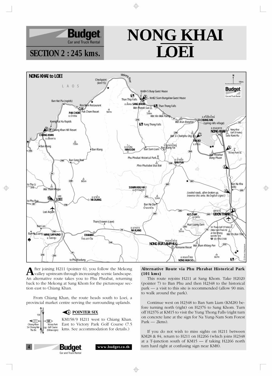
4
159
158Chiang Khan
Sri Chiang MaiTha Bo
Victory ParkGolf Course
(follow signs)
211
2140
2140
201
22502016
211
2376211
2266
2348
2020
2021
2263
22632097
2097
2352
2314
2313
2255
212
2
210210
2115
203
2108
201
2195
2249
2138
R
L A O S
9
8
CHIANG KHAN
Kaeng Kut Ku Rapids
Chiang Khan Hill Resort
Ban Klang
PAK CHOM
NONG KHAI to LOEI
Ban Hat Pia (rapids)
Pak Chom Resort
Rim Nam Restaurant
Checkpoint
Ban Song Puai
Ban Klang
Wat Tham Phapu
to Tha Li
10to Phu Rua LOEI
Loei Airport
Ban Na Luang
Ban Lao
WANG SAPHUNG
to Phu Kradung
ERAWAN
Tham Erawan (cave)
NA DUANG
NA KLANG
Ban Na Dan
SUWAN KHU HA
Phu Phrabat Historical Park
Phra Phuttabat Bua Bok
NAM SOM Ban Sam Liam Ban Klang Yai
Yung Thong Falls
Than Thip Falls
SANG KHOMThan Thong Falls
Wat Hin Mak Paeng
Wat Phatak Sua
Wat Arun BanphotSI CHIANG MAI
Wat Si Chomphu Ong Teu
NONG KHAI7
6
3
4
5
THA BO
(spring rolls village)
Sala Kaeo Ku
Wat PhrathatBang Phuan
Nong KhaiGolf (9 holes)
Victory Park GC
Sri Thani Golf (9 holes)(West turn from H2at Don Khengkm109-110 (0) 1954 3188
Õ.»√’‡™’¬ß„À¡à
Õ.∑à“∫àÕ∫â“π°≈“ß„À≠à
KUT CHAP UDON THANI
NONG WUA SO
Wat Tham Khlong Pen
Wat Pa Ban That
Õÿ¥√∏“π’
Õ.ÀπÕß«—«´Õ
Ban Na Kha(silk)
Huai Luang Dam
Kinnaree Resort
(sealed roads, often broken up,traverse this area. No English signs!)
NONG BUA LAMPHU
Õ.‡™’¬ß§“π
Õ.ª“°™¡
‡≈¬
Õ.«—ß –æÿß °‘ËßÕ.‡Õ√“«—≥
Õ.π“¥â«ß
∫â“ππ“¥à“π
Õ.π“°≈“ß
Õ. ÿ«√√≥§ŸÀ“
Õ.πÈ”‚ ¡
BAN PHUÕ.∫â“πº◊Õ
Õ. —ߧ¡
Õ.ÀπÕߧ“¬
ÀπÕß∫—«≈”¿Ÿ
Õ.°ÿ¥®—∫
NMekong River
(km115)
Km84-5 Buoy Guest House
Km82 Siam Bungalow Guest House
10kms
947m
739m
865m
524m
591m
667m
530m
Oliv
er H
arg
reav
e
NONG KHAILOEISECTION 2 : 245 kms.
fter joining H211 (pointer 6), you follow the Mekongvalley upstream through increasingly scenic landscape.
An alternative route takes you to Phu Phrabat, returningback to the Mekong at Sang Khom for the picturesque sec-tion east to Chiang Khan.
From Chiang Khan, the route heads south to Loei, aprovincial market centre serving the surrounding uplands.
POINTER SIX
KM158/9 H211 west to Chiang Khan.East to Victory Park Golf Course (7.5kms. See accommodation for details.)
6
Alternative Route via Phu Phrabat Historical Park(101 kms)
This route rejoins H211 at Sang Khom. Take H2020(pointer 7) to Ban Phu and then H2348 to the historicalpark — a visit to this site is recommended (allow 90 min.to walk around the park).
Continue west on H2348 to Ban Sam Liam (KM28) be-fore turning north (right) on H2376 to Sang Khom. Turnoff H2376 at KM15 to visit the Yung Thong Falls (right turnon concrete lane at the sign for Na Yung-Nam Som ForestPark — 2kms).
If you do not wish to miss sights on H211 betweenKM28 & 84, return to H211 on H2266 (which joins H2348at a T-junction south of KM15 — if taking H2266 northturn hard right at confusing sign near KM8).
A
www.budget.co.th
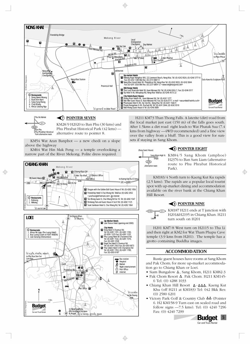
5
48
2112195
Loei
Sang Khom High St.
(Buoy Guest House)
2376
alternative route
Shops
Tha Bo Market
Ban PhuPhu Phrabhat HistoricalPark alternative route
211
2020
1 Km.
Nong Khai Station
to Udon Thani
Friendship BridgeM e k o n g R i v e r
Prap Ho Monument
Kaeo Worawut Rd.
Michai Rd.
Day Market
Provincial Hall
Sala Kaeo Ku Sculpture Park
Wat PhochaiWat Si Saket
Wat Hai Sok
@Internet
Bus Station
to Phon Phisai
LocalImmigrationCheckpoint
2
212
17 5
3
4
8
6
2
9
7
R
NONG KHAI
Nong KhaiImmigrationCheckpoint
Prachak Rd.
Phonphisai Rd.
PrasermRestaurantsDang Naem MuangRuen Rim NamSong Fang KhongChay KhongKhrua Sabang Nga
1.2.3.4.5.
Up-market HotelsMekong Royal Nongkhai $$$, 222 Jommani Beach, Nong Khai. Tel: (0) 4242 0024, (0) 4246 5777-8 Fax: (0) 4242 1280 Bkk Res: (0) 2272 0087-9Nong Khai Grand Hotel $$ Phonphisai Rd, Nong Khai Tel: (0) 4242 0033, (0) 4242 0044 Fax: (0) 4241 2026 Bkk Res: (0) 2237 6809-12 <www.nongkhaigrand.com>
Mid-Range HotelsThai Laos Riverside Hotel $$, Kaeo Worawut Rd. Tel: (0) 4246 0263-7, Fax: (0) 4246 0317Tip Hotel $-$$, Mitraphap Rd, Nong Khai Tel&Fax: (0) 4246 4513-22
City Hotels/Guest HousesKhong River Hotel$-$$ , Kaeo Worawut Rd, Tel: (0) 4241 1277Mut Mee Guest House $, Kaeo Worawut Rd. Fax: (0) 4226 0717. e-mail <[email protected]>Phantawee Hotel $-$$, Hai Sok Rd., Nong Khai Tel: (0) 4241 1568-9Prajak Bungalows $-$$, Prachak Rd, Tel: (0) 4241 2644, (0) 4242 0510Mae Khong Guest House $ Tel: (0) 4246 0689
1
2
34
56789‰ª Õÿ¥“√∏“π’
‰ª Õ.‚æπæ‘ —¬
2 3 4
51
Oliv
er H
arg
reav
e
POINTER SEVEN
KM28/9 H2020 to Ban Phu (30 kms) andPhu Phrabat Historical Park (42 kms) —alternative route to pointer 8.
KM54 Wat Aran Banphot — a new chedi on a slopeabove the highway
KM64 Wat Hin Mak Peng — a temple overlooking anarrow part of the River Mekong. Polite dress required.
7
8
H211 KM73 Than Thong Falls. A laterite (dirt) road fromthe local market just east (150 m) of the falls goes south.After 1.5kms a dirt road right leads to Wat Phatak Sua (7.4kms from highway —4WD recommended) and a fine viewover the valley from a bluff. This is a good view for sun-sets if staying in Sang Khom.
POINTER EIGHT
KM84/5 Sang Khom (amphoe)H2376 to Ban Sam Liam (alternativeroute to Phu Phrabat HistoricalPark).
KM183/4 North turn to Kaeng Kut Ku rapids(2.5 kms). The rapids are a popular local touristspot with up-market dining and accommodationavailable on the river bank at the Chiang KhanHill Resort.
POINTER NINE
KM187 H211 ends at T junction withH201&H2195 in Chiang Khan. H211turn south on H201
H201 KM7/8 West turn on H2115 to Tha Liand then right at KM2 for Wat Tham Phapu Cavetemple (3.9 kms from H201). The temple has agrotto containing Buddha images.
ACCOMMODATION
Rustic guest houses have rooms at Sang Khomand Pak Chom; for more up-market accommoda-tion go to Chiang Khan or Loei.• Siam Bungalow $, Sang Khom, H211 KM82-3• Pak Chom Resort $. Pak Chom. H211 KM145-
6 Tel: (0) 4288 1033• Chiang Khan Hill Resort $-$$$ , Kaeng Kut
Khu (off H211 at KM183) Tel: 042 Bkk Res:(0) 2580 6201
• Victory Park Golf & Country Club (Pointer6. H2 KM158-9 Turn east on sealed road andfollow signs —7.5 kms). Tel: (0) 4240 7296Fax: (0) 4240 7299
9
500m
4H
5 3
2
H1
2195
201
211
to Loei
km48
km86Wat Si Khun Muang Wat Pa Klang Wat Pa Tai
Wat Tha Khok
Chiang Khan GH
OK Guest House Wat Mahathatto Kaeng Kut Ku (5 kms)
M e k o n g R i v e r
Post Office
District Office
CHIANG KHAN
Dragon with the Golden Ball Guest House $ Tel: (0) 4282 1056
Friendship Hotel $ Chai Khong Rd. Tel&Fax: (0) 4282 2052<janchiangk@hotmail,com> internetTon Khong Guest $, Chai Khong Rd Soi 10. Tel: (0) 4282 1547Rimkong Pub and Guest House $ Soi 8 Tel: (0) 4282 1125Souk Somboon Hotel $, Chai Khong Rd, Tel: (0) 4282 1064
1
2
345
RestaurantsRabiangMekong
1.2.
‰ª ‡≈¬
12
3
7
17
21
9@
Oliv
er H
arg
reav
e
9
km207
Post Office
to Wang SaphungPhu Kradung Chumpae& Airport
to Na Duang
to Chiang Khan
to Phu Rua Dan SaiLom Kao
1
2
3
54
R
N
1 Km.
203
201
201
2138
LOEI
RestaurantsKhrua Nit (opp. Phu Luang Hotel)Bua Luang (south on H201 KM204)Loei-Danang (Vietnamese)
1.2.3.
Up-Market HotelsLoei Palace Hotel (opening end 2000)
City HotelsKing Hotel $ Chumsai Rd.Tel: (0) 4281 1701, (0) 4281 1783, (0) 4281 1225 Fax: (0) 4281 1235Phu Luang Hotel $$ Charoenrat Rd.Tel: (0) 4281 1532, (0) 4281 1570, Fax: (0) 4281 2558Royal Inn Hotel $ Chumsai RdTel: (0) 4281 2563 Fax: (0) 4283 0873Thai Udom Hotel $-$$ Charoenrat RdTel: (0) 4281 1763, (0) 4281 1789, Fax: (0) 4283 0187
1
2
3
4
5
‰ª ‡™’¬ß§“π
‰ª Õ.¿Ÿ‡√◊Õ, ¥à“π´â“¬, À≈ࡇ°à“
‰ª Õ.«—ß –æÿß, ¿Ÿ°√–¥÷ß, ™ÿ¡·æ
‰ª Õ.π“¥âÕß
1
3
2
10
Ruamchai Rd.
Nok Kaew Rd.
Char
oenr
at R
d.
M
M
Bus stationHospitalMarketNight entertainmentPost Officeinternet@
@
Oliv
er H
arg
reav
e
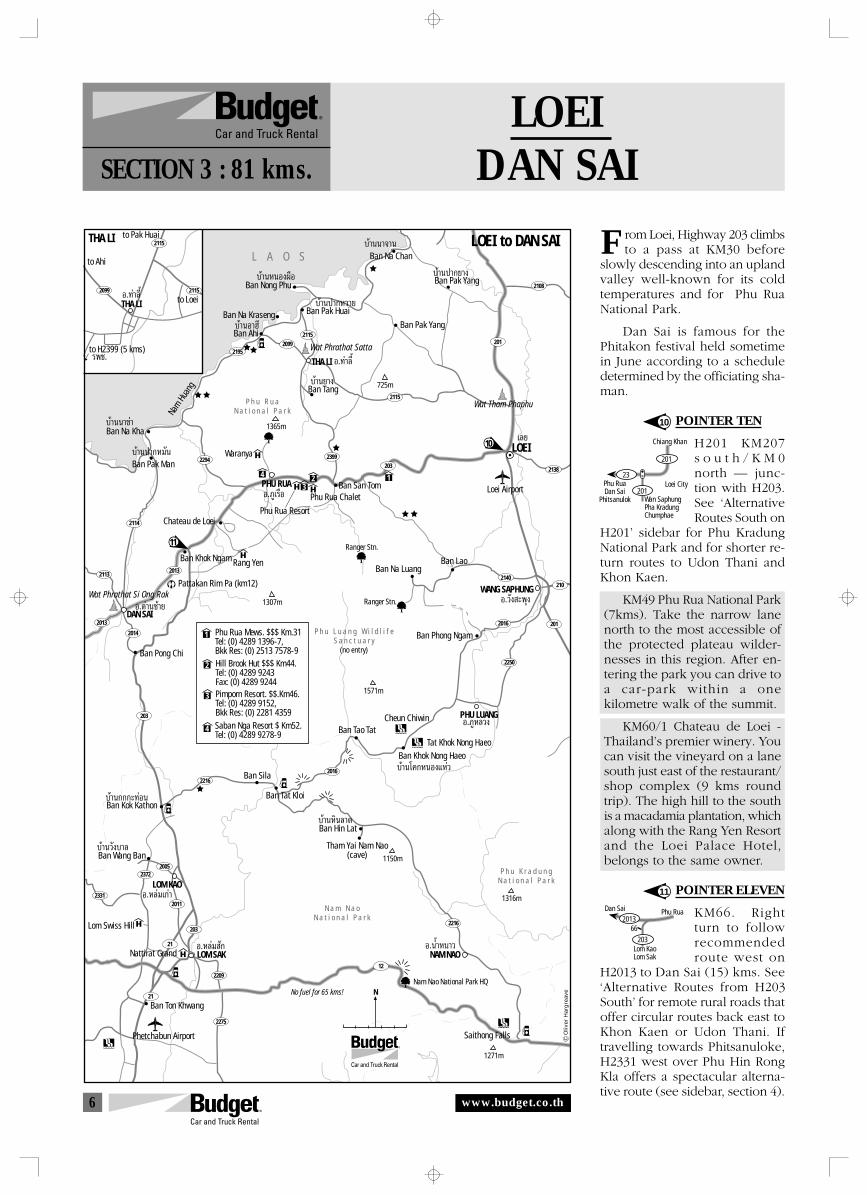
6
66
Lom KaoLom Sak
203
2013Phu RuaDan Sai
Chiang Khan
Phu RuaDan Sai
Phitsanulok201
201
23
Wan SaphungPha KradungChumphae
Loei City
LOEIDAN SAISECTION 3 : 81 kms.
rom Loei, Highway 203 climbsto a pass at KM30 before
slowly descending into an uplandvalley well-known for its coldtemperatures and for Phu RuaNational Park.
Dan Sai is famous for thePhitakon festival held sometimein June according to a scheduledetermined by the officiating sha-man.
POINTER TEN
H201 KM207s o u t h / K M 0north — junc-tion with H203.See ‘AlternativeRoutes South on
H201’ sidebar for Phu KradungNational Park and for shorter re-turn routes to Udon Thani andKhon Kaen.
KM49 Phu Rua National Park(7kms). Take the narrow lanenorth to the most accessible ofthe protected plateau wilder-nesses in this region. After en-tering the park you can drive toa car-park within a onekilometre walk of the summit.
KM60/1 Chateau de Loei -Thailand’s premier winery. Youcan visit the vineyard on a lanesouth just east of the restaurant/shop complex (9 kms roundtrip). The high hill to the southis a macadamia plantation, whichalong with the Rang Yen Resortand the Loei Palace Hotel,belongs to the same owner.
POINTER ELEVEN
KM66. Rightturn to followrecommendedroute west on
H2013 to Dan Sai (15) kms. See‘Alternative Routes from H203South’ for remote rural roads thatoffer circular routes back east toKhon Kaen or Udon Thani. Iftravelling towards Phitsanuloke,H2331 west over Phu Hin RongKla offers a spectacular alterna-tive route (see sidebar, section 4).
10
11
F
2114
21132013
2013
2014
2294
21952099
2115
2399
2016
2372
2011
203
2209
2275
2005
2331
2115
2140
2016
2138
201
210
2250
2108
2216
201
203
203
2216
21
21
12
Õ.∑à“≈’È
∫â“πÀπÕߺ◊Õ
∫â“πÕ“Œ’
∫â“𪓰À«“¬
N a m N a oN a t i o n a l P a r k
P h u K r a d u n gN a t i o n a l P a r k
Nam Nao National Park HQ
Saithong Falls
Ban Nong Phu
Ban Na Chan
Ban Na Kraseng
Ban Ahi
Ban Pak Huai
Nam H
uang
THA LI
Ban Pak Yang
Ban Tang
Ban Pak Yang
Wat Tham Phaphu
Wat Phrathat Si Ong Rak
Wat Phrathat Satta
10
11
LOEI
Loei Airport
Ban Na LuangBan Lao
WANG SAPHUNG
‡≈¬
Õ.«—ß –æÿß
∫â“π‚§°ÀπÕß·Àà«
∫â“πÀ‘π≈“¥
∫â“π«—ß∫“≈
∫â“π°°°–∑àÕπ
L A O S
P h u R u aN a t i o n a l P a r k
Ban Na Kha
Ban Pak Man Waranya
PHU RUA
LOEI to DAN SAI
Ban San Tom
Ranger Stn.
Ranger Stn.
Pattakan Rim Pa (km12)
Rang Yen
Chateau de Loei
Ban Khok Ngam
DAN SAI
Ban Pong Chi
P h u L u a n g W i l d l i f eS a n c t u a r y
(no entry)
Ban Phong Ngam
PHU LUANG
Ban Tao TatCheun Chiwin
Ban Tat Kloi
Ban Sila
Ban Khok Nong HaeoTat Khok Nong Haeo
Tham Yai Nam Nao(cave)
Ban Hin Lat
LOM KAO
LOM SAK
Ban Kok Kathon
Ban Wang Ban
Lom Swiss Hill
Nattirat Grand
Ban Ton Khwang
Phetchabun Airport
No fuel for 65 kms!
NAM NAO
Õ.¥à“π´â“¬
Õ.À≈ࡇ°à“
Õ.πÈ”Àπ“«Õ.À≈à¡ —°
Õ.¿Ÿ‡√◊Õ
Õ.¿ŸÀ≈«ß
R
N
∫â“ππ“®“π
∫â“𪓰¬“ß
∫â“π¬“ß
∫â“ππ“¢à“
∫â“𪓰À¡—π
Phu Rua Resort
Phu Rua Chalet
THA LI
2099
2115
2115Õ.∑à“≈’È
√æ™.
THA LI
to Pak Huai
to Ahi
to Loei
to H2399 (5 kms)
725m
1365m
1307m
1571m
1150m
1271m
1316m
Oliv
er H
arg
reav
e
123
4
Hill Brook Hut $$$ Km44.Tel: (0) 4289 9243Fax: (0) 4289 9244
Saban Nga Resort $ Km52.Tel: (0) 4289 9278-9
Phu Rua Mews. $$$ Km.31Tel: (0) 4289 1396-7,Bkk Res: (0) 2513 7578-9
Pimporn Resort. $$.Km46.Tel: (0) 4289 9152,Bkk Res: (0) 2281 4359
1
2
3
4
www.budget.co.th
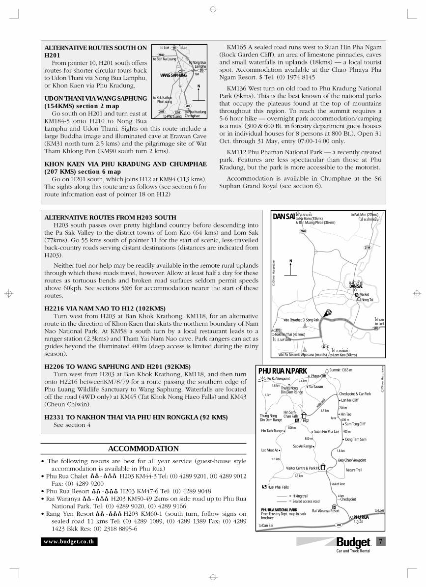
7
DAN SAI
2140
2114
2013
2014
2013
N
to Loei
to Lom Kao (50kms)‰ª Õ.À≈ࡇ°à“
‰ª ‡≈¬
12
M
DAN SAI
to Pak Man (27kms)to Na Haeo (33kms)& Ban Muang Phrae (36kms)
Nong TaiMarket
Wat Phrathat Si Song Rak
Wat Pa Neramit Wipasana (murals)
to Nakhon Thai (42 kms)
Õ.¥à“π´â“¬
‰ª Õ.π“·À⫉ª Õ.ª“°À¡—π
‰ª Õ.π§√‰∑¬
Oliv
er H
arg
reav
e
ALTERNATIVE ROUTES FROM H203 SOUTHH203 south passes over pretty highland country before descending into
the Pa Sak Valley to the district towns of Lom Kao (64 kms) and Lom Sak(77kms). Go 55 kms south of pointer 11 for the start of scenic, less-travelledback-country roads serving distant destinations (distances are indicated fromH203).
Neither fuel nor help may be readily available in the remote rural uplandsthrough which these roads travel, however. Allow at least half a day for theseroutes as tortuous bends and broken road surfaces seldom permit speedsabove 60kph. See sections 5&6 for accommodation nearer the start of theseroutes.
H2216 VIA NAM NAO TO H12 (102KMS)Turn west from H203 at Ban Khok Krathong, KM118, for an alternative
route in the direction of Khon Kaen that skirts the northern boundary of NamNao National Park. At KM58 a south turn by a local restaurant leads to aranger station (2.3kms) and Tham Yai Nam Nao cave. Park rangers can act asguides beyond the illuminated 400m (deep access is limited during the rainyseason).
H2206 TO WANG SAPHUNG AND H201 (92KMS)Turn west from H203 at Ban Khok Krathong, KM118, and then turn
onto H2216 betweenKM78/79 for a route passing the southern edge ofPhu Luang Wildlife Sanctuary to Wang Saphung. Waterfalls are locatedoff the road (4WD only) at KM45 (Tat Khok Nong Haeo Falls) and KM43(Cheun Chiwin).
H2331 TO NAKHON THAI VIA PHU HIN RONGKLA (92 KMS)See section 4
ACCOMMODATION
• The following resorts are best for all year service (guest-house styleaccommodation is available in Phu Rua)
• Phu Rua Chalet $$-$$$ H203 KM44-3 Tel: (0) 4289 9201, (0) 4289 9012Fax: (0) 4289 9200
• Phu Rua Resort $$-$ $$ H203 KM47-6 Tel: (0) 4289 9048• Rai Waranya $$-$$$ H203 KM50-49 2kms on side road up to Phu Rua
National Park. Tel: (0) 4289 9020, (0) 4289 9166• Rang Yen Resort $$-$$$ H203 KM60-1 (south turn, follow signs on
sealed road 11 kms Tel: (0) 4289 1089, (0) 4289 1389 Fax: (0) 42891423 Bkk Res: (0) 2318 8895-6
KM165 A sealed road runs west to Suan Hin Pha Ngam(Rock Garden Cliff), an area of limestone pinnacles, cavesand small waterfalls in uplands (18kms) — a local touristspot. Accommodation available at the Chao Phraya PhaNgam Resort. $ Tel: (0) 1974 8145
KM136 West turn on old road to Phu Kradung NationalPark (8kms). This is the best known of the national parksthat occupy the plateaus found at the top of mountainsthroughout this region. To reach the summit requires a5-6 hour hike — overnight park accommodation/campingis a must (300 & 600 Bt. in forestry department guest housesor in individual houses for 8 persons at 800 Bt.). Open 31Oct. through 31 May, entry 07:00-14:00 only.
KM112 Phu Phaman National Park — a recently createdpark. Features are less spectacular than those at PhuKradung, but the park is more accessible to the motorist.
Accommodation is available in Chumphae at the SriSuphan Grand Royal (see section 6).
to Ban Na Luangto Nong Bua
Lamphu
WANG SAPHUNG 184
to Loei
to Kok KathonPhu Luang
to Phu Luangto Phu Kradung Chmuphae
201
201
2016 2250
2140
210
N
‰ª‡≈¬ALTERNATIVE ROUTES SOUTH ONH201
From pointer 10, H201 south offersroutes for shorter circular tours backto Udon Thani via Nong Bua Lamphu,or Khon Kaen via Phu Kradung.
UDON THANI VIA WANG SAPHUNG(154KMS) section 2 map
Go south on H201 and turn east atKM184-5 onto H210 to Nong BuaLamphu and Udon Thani. Sights on this route include alarge Buddha image and illuminated cave at Erawan Cave(KM31 north turn 2.5 kms) and the pilgrimage site of WatTham Khlong Pen (KM90 south turn 2 kms).
KHON KAEN VIA PHU KRADUNG AND CHUMPHAE(207 KMS) section 6 map
Go on H201 south, which joins H12 at KM94 (113 kms).The sights along this route are as follows (see section 6 forroute information east of pointer 18 on H12)
= Hiking trail= Sealed access road
H
203
Summit 1365 m
Phaya Cliff
Thung NongDin Dam Range
Thung NongDin Dam Range
2.4 km
1.5 km700 m
600 m
800 m
800 m400 m
1.8 km
2.5 km
4 km
1.8 km
1. km
1.8 km
Pu Ku Viewpoint
Sa Sawan
side r
oad
Hin Sam-Chan Falls
HQ2
Checkpoint & Car Park
Lon Noi Cliff
Hin Taolane
sealed lane
Sam Tong Cliff
Dong Tam Sam
Suan Hin Pha Lae
Sao Ae Range
Visitor Centre & Park HQ
Dao Chao Viewpoint
Nature Trail
PHU RUAto Loei
to Dan Sai
Rai Waranya Resort
Huai Phai Falls
Hin Taek Range
Lat Muat Ae
PHU RUA N.PARK
PHU RUA NATIONAL PARKFrom Forestry Dept. map in parkbrochure
Checkpoint
Õ.¿Ÿ‡√◊Õ
Oliv
er H
arg
reav
e
www.budget.co.th
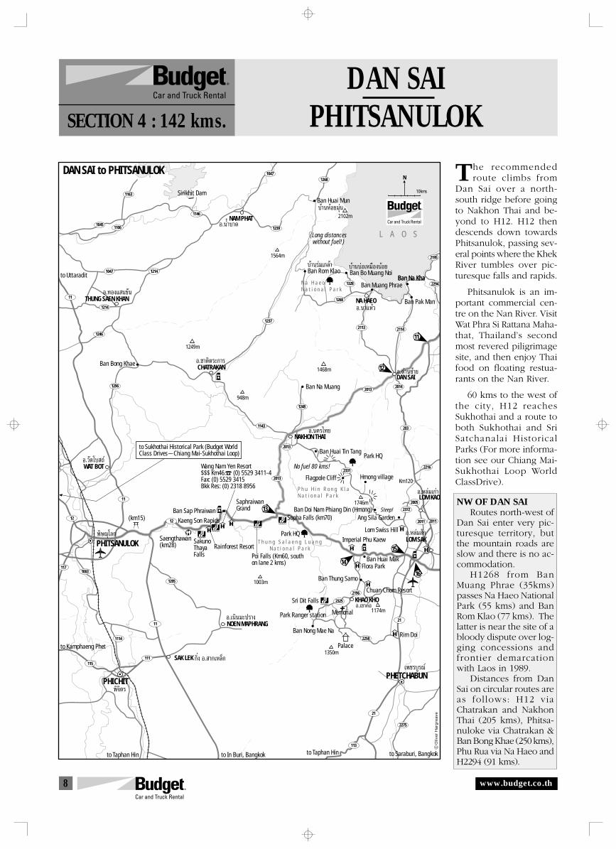
8
1146
1163
10451106
10471268
1239
1047 1214
1214
1246
1296
1328
1268
1237
2114
2294
2195
2113
2013
2216
1248
2013
2372
2005
2325
2196
2258
1143
11
203
2014
2013
2331
11
1212
1171063
2011 2011
1295
1121
113
21
2275
115111
1114
R
Sirikhit Dam
NAM PHAT
L A O S
Ban Rom Klao
Ban Huai Mun
Ban Bo Muang NoiBan Na KhaBan Na Kha
Ban Muang Phrae
NA HAEO Ban Pak Man
Ban Na MuangDAN SAIÕ.¥à“π´â“¬12
13
15
14
16
11
Ban Huai Tin Tang
Flagpole Cliff
N a H a e oN a t i o n a l P a r k
No fuel 80 kms!
Hmong village
Ban Doi Nam Phiang Din (Hmong)Ang Sila Garden
Lom Swiss HillLOM SAKÕ.À≈à¡ —°
LOM KAOÕ.À≈ࡇ°à“
Imperial Phu Kaew
Ban Huai Mak
Ban Nong Mae Na
Flora Park
Ban Thung Samo
Chuan Chom Resort
Memorial
KHAO KHO
Palace
Rim Doi
PHETCHABUN‡æ™√∫Ÿ√≥å
PHICHIT
SAK LEK
NOEN MAPHRANG
Saengthawan(km28) Sakuno
ThayaFalls
Rainforest Resort
Kaeng Son Rapids
Wang Nam Yen Resort$$$ Km46. (0) 5529 3411-4Fax: (0) 5529 3415Bkk Res: (0) 2318 8956
SaphraiwanGrandBan Sap Phraiwan
Sopha Falls (km70)
T h u n g S a l a e n g L u a n gN a t i o n a l P a r k
Sri Dit Falls
P h u H i n R o n g K l aN a t i o n a l P a r k
NAKHON THAI
WAT BOT
CHATRAKANBan Bong Khae
to Uttaradit
to Kamphaeng Phet
to Taphan Hin to In Buri, Bangkok to Taphan Hin to Saraburi, Bangkok
æ‘®‘µ√
PHITSANULOKæ‘…≥ÿ‚≈°
Õ.πÈ”∫“¥
Õ.π“·Àâ«
∫â“π√ࡇ°≈â“
∫â“πÀâÕ¬¡ÿàπ
∫â“π∫àÕ‡À¡◊ÕßπâÕ¬
Õ.π§√‰∑¬
Õ.‡π‘π¡–ª√“ß
°‘Ëß Õ. “°‡À≈Á°
Õ.«—¥‚∫ ∂å
Õ.™“µ‘µ√–°“√
Park Ranger stationÕ.‡¢“§âÕ
NDAN SAI to PHITSANULOK
Park HQ
Steep!
Poi Falls (Km60, southon lane 2 kms)
(km15)
10kms
THUNG SAEN KHANÕ.∑Õß· π¢—π
Park HQ
1564m
2102m
1249m
1468m
948m
1746m
Km120
1174m
1350m
1003m
(Long distanceswithout fuel!)
to Sukhothai Historical Park (Budget WorldClass Drives Chiang Mai-Sukhothai Loop)
Oliv
er H
arg
reav
e
DAN SAIPHITSANULOKSECTION 4 : 142 kms.
he recommendedroute climbs from
Dan Sai over a north-south ridge before goingto Nakhon Thai and be-yond to H12. H12 thendescends down towardsPhitsanulok, passing sev-eral points where the KhekRiver tumbles over pic-turesque falls and rapids.
Phitsanulok is an im-portant commercial cen-tre on the Nan River. VisitWat Phra Si Rattana Maha-that, Thailand’s secondmost revered piligrimagesite, and then enjoy Thaifood on floating restua-rants on the Nan River.
60 kms to the west ofthe city, H12 reachesSukhothai and a route toboth Sukhothai and SriSatchanalai HistoricalParks (For more informa-tion see our Chiang Mai-Sukhothai Loop WorldClassDrive).
NW OF DAN SAIRoutes north-west of
Dan Sai enter very pic-turesque territory, butthe mountain roads areslow and there is no ac-commodation.
H1268 from BanMuang Phrae (35kms)passes Na Haeo NationalPark (55 kms) and BanRom Klao (77 kms). Thelatter is near the site of abloody dispute over log-ging concessions andfrontier demarcationwith Laos in 1989.
Distances from DanSai on circular routes areas follows: H12 viaChatrakan and NakhonThai (205 kms), Phitsa-nuloke via Chatrakan &Ban Bong Khae (250 kms),Phu Rua via Na Haeo andH2294 (91 kms).
T
www.budget.co.th
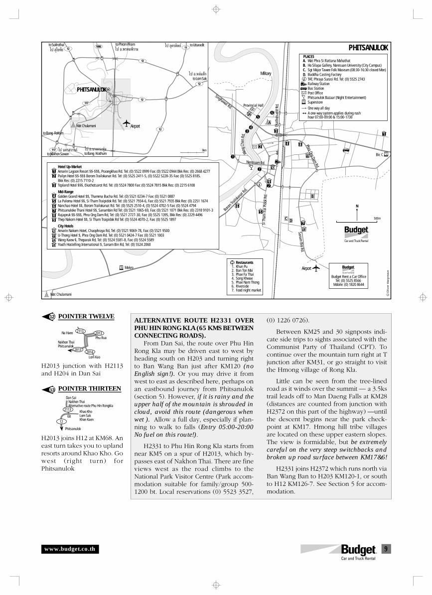
9
Khao KhoLom SakKhon Kaen
Phitsanulok
Dan Sai Nakhon Thai Alternative route Phu Hin Rongkla
2113
1268
Nakhon ThaiPhitsanulok
Phu Rua
Lom Kao
Na Haeo
2013
2013
2014
2113
12
1
2
65
9
10
3
4 8
11
7
13
A
R
N
PHITSANULOK
B
DC
Airport
Military
RestaurantsKhun PuBan Ton MaiPhae Fa ThaiSong KhwaePhae Nam ThongRiversideFood night market
1.2.3.4.5.6.7.
Wat Phra Si Rattana MahathatHo Silapa Gallery, Naresuan University (City Campus)Sgt Major Tawee Folk Museum (08:30-16:30 closed Mon)Buddha Casting FactoryTAT, Phraya Surasi Rd. Tel: (0) 5525 2743Railway StationBus StationPost OfficePhitsanulok Bazaar (Night Entertainment)Superstore
A.B.C.D.
12
3
456789
10111213
Hotel Up-MarketAmarin Lagoon Resort $$-$$$, Praongkhao Rd. Tel: (0) 5522 0999 Fax: (0) 5522 0944 Bkk Res: (0) 2668 4277Pailyn Hotel $$-$$$ Borom Trailokanat Rd. Tel: (0) 5525 2411-5, (0) 5522 5228-35 Fax: (0) 5525 8185. Bkk Res: (0) 2215 7110-2Topland Hotel $$$, Ekathotsarot Rd. Tel: (0) 5524 7800 Fax: (0) 5524 7815 Bkk Res: (0) 2215 6108
Mid-RangeGolden Grand Hotel $$, Thamma Bucha Rd. Tel: (0) 5521 0234-7 Fax: (0) 5521 0887La Paloma Hotel $$, Si Tham Traipidok Rd. Tel: (0) 5521 7934-6, Fax: (0) 5521 7935 Bkk Res: (0) 2251 1674Nanchao Hotel $$, Borom Trailokanat Rd. Tel: (0) 5525 2510-4, (0) 5524 4702-5 Fax: (0) 5524 4794Phitsanuloke Thani Hotel $$, Sanambin Rd Tel: (0) 5521 1065-69, Fax: (0) 5521 1071 Bkk Res: (0) 2318 9101-3Rajapruk $$-$$$, Phra Ong Dam Rd, Tel: (0) 5521 2727-30, Fax: (0) 5525 1395, Bkk Res: (0) 2229 4496Thep Nakorn Hotel $$, Si Tham Traipidok Rd Tel: (0) 5524 4070-2, Fax: (0) 5525 1897
City HotelsAmarin Nakorn Hotel, Chaophraya Rd, Tel: (0) 5521 9069-78, Fax: (0) 5521 9500U-Thong Hotel $, Phra Ong Dam Rd. Tel: (0) 5521 0424-7 Fax: (0) 5521 1003Wang Kaew $, Theparak Rd, Tel: (0) 5524 5581-8, Fax: (0) 5524 5589Youth Hostelling International $, Sanam Bin Rd, Tel: (0) 5524 2060
S
S
S
PLACES
Makro
Provincial Hall
Bic C
5
4
7
2
3
1
6
Wat Chulamani
A one-way system applies during rushhour 07:00-09:00 & 15:00-1730
One way all day
Borom Tra
ilokan
at Rd.
500m
R
Budget Rent a Car OfficeTel: (0) 5525 8566
Mobile: (0) 1820 8644
Ekat
hots
arot
Rd.
Phra Ong Dam Rd.
Sanam Bin Rd.
Singhawat Rd.
Wang
Chan
Rd.
Naresuan Rd.
Si T
ham
Trai
Pid
ok R
d.
117
12
12
12
11
12
121086
117
3km
Wat Chulamani
to Bang Krathum
to Bang Rakam
to Nakhon Sawan
to Sukhothai to Phrom Piram to Uttaradit
to Lom Sak
Airport
‰ª ÿ‚¢∑—¬ ‰ª Õ.æ√À¡æ‘√“¡‰ª Õÿµ√¥‘µ∂å
‰ª Õ.À≈à¡ —°
‰ª Õ.∫“ß°√–∑ÿࡉª π§√ «√√§å
PHITSANULOK
Oliv
er H
arg
reav
e
ALTERNATIVE ROUTE H2331 OVERPHU HIN RONG KLA (65 KMS BETWEENCONNECTING ROADS).
From Dan Sai, the route over Phu HinRong Kla may be driven east to west byheading south on H203 and turning rightto Ban Wang Ban just after KM120 (noEnglish sign!). Or you may drive it fromwest to east as described here, perhaps onan eastbound journey from Phitsanulok(section 5). However, if it is rainy and theupper half of the mountain is shrouded incloud, avoid this route (dangerous whenwet ). Allow a full day, especially if plan-ning to walk to falls (Entry 05:00-20:00No fuel on this route!).
H2331 to Phu Hin Rong Kla starts fromnear KM5 on a spur of H2013, which by-passes east of Nakhon Thai. There are fineviews west as the road climbs to theNational Park Visitor Centre (Park accom-modation suitable for family/group 500-1200 bt. Local reservations (0) 5523 3527,
(0) 1226 0726).
Between KM25 and 30 signposts indi-cate side trips to sights associated with theCommunist Party of Thailand (CPT). Tocontinue over the mountain turn right at Tjunction after KM31, or go straight to visitthe Hmong village of Rong Kla.
Little can be seen from the tree-linedroad as it winds over the summit — a 3.5kstrail leads off to Man Daeng Falls at KM28(distances are counted from junction withH2372 on this part of the highway) —untilthe descent begins near the park check-point at KM17. Hmong hill tribe villagesare located on these upper eastern slopes.The view is formidable, but be extremelycareful on the very steep switchbacks andbroken up road surface between KM17&6!
H2331 joins H2372 which runs north viaBan Wang Ban to H203 KM120-1, or southto H12 KM126-7. See Section 5 for accom-modation.
12
13
POINTER TWELVE
H2013 junction with H2113and H204 in Dan Sai
POINTER THIRTEEN
H2013 joins H12 at KM68. Aneast turn takes you to uplandresorts around Khao Kho. Gowest (right turn) forPhitsanulok
www.budget.co.th
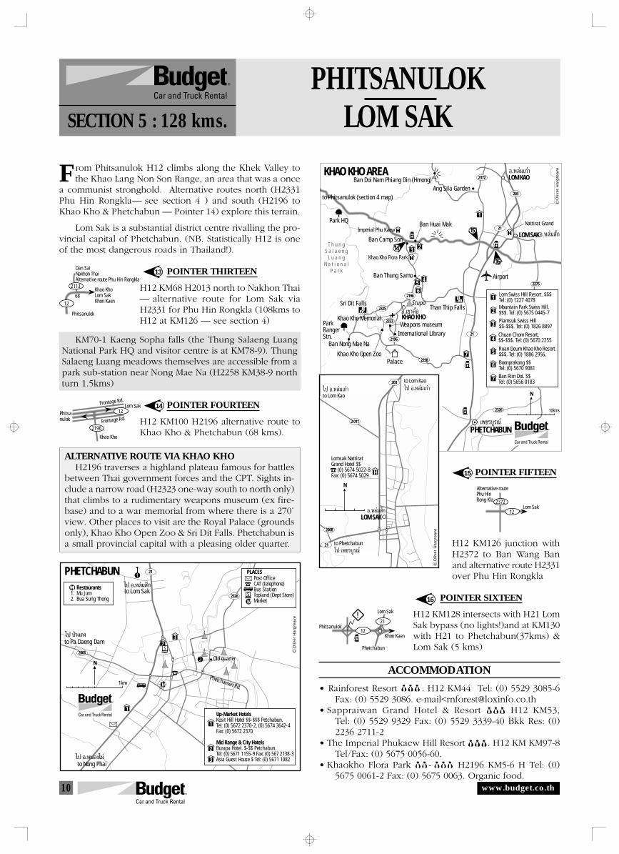
10
Frontage Rd.
Frontage Rd.
Khao Kho
Phitsanulok
Lom Sak12
2196
Phitsanulok
Khon Kaen
Lom Sak
12
21
Phetchabun
Alternative route
Lom Sak12
2372
Phu HinRong Kla
Khao KhoLom SakKhon Kaen
Phitsanulok
Dan SaiNakhon ThaiAlternative route Phu Hin Rongkla
2113
1268
2372
2325
2323
2196
2275
2196
2258
2326
21
203
21
R
15
14
16
Ang Sila Garden
LOM SAK
Nattirat Grand
Õ.À≈à¡ —°
KHAO KHOÕ.‡¢“§âÕ
Õ.À≈ࡇ°à“
Imperial Phu KaewBan Huai Mak
Khao Kho Flora Park
Khao Kho Memorial
Ban Nong Mae Na
LOM KAO
Palace
PHETCHABUN‡æ™√∫Ÿ√≥å
T h u n gS a l a e n g
L u a n gN a t i o n a l
P a r k
Ban Doi Nam Phiang Din (Hmong)
Ban Camp Son
Stupa
Weapons museum
Ban Thung Samo
ParkRangerStn.
Park HQ
Khao Kho Open Zoo
Sri Dit FallsThan Thip Falls
to Phitsanulok (section 4 map)
N
KHAO KHO AREA
Airport
International Library
10kms
Oliv
er H
arg
reav
e
7
2
1
3
456
Ban Rim Doi. $$Tel: (0) 5656 0183
Mountain Park Swiss Hill.$$$. Tel: (0) 5675 0445-7Piamsuk Swiss Hill$$-$$$. Tel: (0) 1826 8897
Ruan Deum Khao Kho Resort$$$. Tel: (0) 1886 2956.
6
7
4Chuan Chom Resort, $$-$$$. Tel: (0) 5670 2255
3
2
1
Boonprakong $$ Tel: (0) 5670 9081
5
Lom Swiss Hill Resort. $$$Tel: (0) 1227 4078
PHITSANULOKLOM SAKSECTION 5 : 128 kms.
rom Phitsanulok H12 climbs along the Khek Valley tothe Khao Lang Non Son Range, an area that was a once
a communist stronghold. Alternative routes north (H2331Phu Hin Rongkla— see section 4 ) and south (H2196 toKhao Kho & Phetchabun — Pointer 14) explore this terrain.
Lom Sak is a substantial district centre rivalling the pro-vincial capital of Phetchabun. (NB. Statistically H12 is oneof the most dangerous roads in Thailand!).
POINTER THIRTEEN
H12 KM68 H2013 north to Nakhon Thai— alternative route for Lom Sak viaH2331 for Phu Hin Rongkla (108kms toH12 at KM126 — see section 4)
KM70-1 Kaeng Sopha falls (the Thung Salaeng LuangNational Park HQ and visitor centre is at KM78-9). ThungSalaeng Luang meadows themselves are accessible from apark sub-station near Nong Mae Na (H2258 KM38-9 northturn 1.5kms)
POINTER FOURTEEN
H12 KM100 H2196 alternative route toKhao Kho & Phetchabun (68 kms).
ALTERNATIVE ROUTE VIA KHAO KHOH2196 traverses a highland plateau famous for battles
between Thai government forces and the CPT. Sights in-clude a narrow road (H2323 one-way south to north only)that climbs to a rudimentary weapons museum (ex fire-base) and to a war memorial from where there is a 270˚view. Other places to visit are the Royal Palace (groundsonly), Khao Kho Open Zoo & Sri Dit Falls. Phetchabun isa small provincial capital with a pleasing older quarter.
POINTER FIFTEEN
H12 KM126 junction withH2372 to Ban Wang Banand alternative route H2331over Phu Hin Rongkla
POINTER SIXTEEN
H12 KM128 intersects with H21 LomSak bypass (no lights!)and at KM130with H21 to Phetchabun(37kms) &Lom Sak (5 kms)
ACCOMMODATION
• Rainforest Resort $$$. H12 KM44 Tel: (0) 5529 3085-6Fax: (0) 5529 3086. e-mail<[email protected]
• Sappraiwan Grand Hotel & Resort $$$ H12 KM53,Tel: (0) 5529 9329 Fax: (0) 5529 3339-40 Bkk Res: (0)2236 2711-2
• The Imperial Phukaew Hill Resort $$$. H12 KM KM97-8Tel/Fax: (0) 5675 0056-60.
• Khaokho Flora Park $$- $$$ H2196 KM5-6 H Tel: (0)5675 0061-2 Fax: (0) 5675 0063. Organic food.
13
14
15
16
F
H
2 011
21
2008
203
LOM SAK
Lomsak NattiratGrand Hotel $$ (0) 5674 5022-8Fax: (0) 5674 5029
N
to Lom Kao
to Lom Kao
to Phetchabun
‰ª Õ.À≈ࡇ°à“‰ª Õ.À≈ࡇ°à“
‰ª ‡æ™√∫Ÿ√≥å
Õ.À≈à¡ —°
Oliv
er H
arg
reav
e
1
23
21
2006
2326
to Pa Daeng Dam
to Lom Sak
PHETCHABUNRestaurantsMu JumBua Sung Thong
1.2.
Post OfficeCAT (telephone)Bus StationTopland (Dept Store)Market
Up-Market HotelsKosit Hill Hotel $$-$$$ Petchabun. Tel: (0) 5672 2370-2, (0) 5674 3642-4Fax: (0) 5672 2370
Mid Range & City HotelsBurapa Hotel. $-$$ Petchabun.Tel: (0) 5671 1155-9 Fax: (0) 567 2138-3Asia Guest House $ Tel: (0) 5671 1082
1
2
3
R
N
to Nong Phai‰ª Õ.ÀπÕ߉ºà
‰ª Õ.À≈à¡ —°
‰ª ªÉ“·¥ß
1km
S
S
PLACES1
2
M
M
Old quarter
Phetcharoen Rd.
Oliv
er H
arg
reav
e
www.budget.co.th
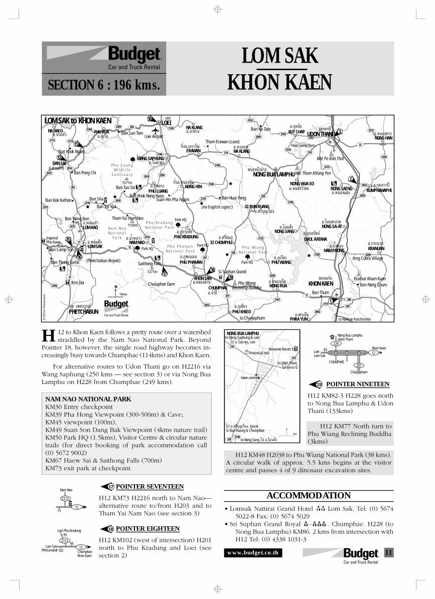
11
Nong Bua LamphuUdon Thani
Khon Kaen12
201
228
CHUMPHAE
83
Chaiyaphum
LoeiLom Sak
Loei Phu Kradung
102
942113
12
95
ChumphaeKhon Kaen
Lom SakPhitsanulok
Nam Nao
73
2113
12
to Wang Saphung & Loei
H210
2282146
210
NONG BUA LAMPHU
Provincial HallKinnaree Resort $
to Udon Thani
town centre
Si Bun Ruang & Chumphae
to Nong Sang
1km
‰ª Õ.«—ß –æÿß, ‡≈¬
‰ª Õÿ¥√∏“π’
‰ª Õ.»√’∫ÿ≠‡√◊Õß, ™ÿ¡·æ
‰ª Õ.‚ππ —ß
2114
2014
2294
2013
2016
2016 2250
2331
23722005
2011
2258
2140
2138
2216
2097
2352
2312
2350
2023
2025
2113
203
2216
12
21
21
201
2055
201
2038
2133
228
228
2146
2109
218712
2062
2131230
209
2
2039
22
2313
210
2263
2314
2263
210
2140
2140
2141
2399
R
PHETCHABUN‡æ™√∫Ÿ√≥å
NA HAEO
10
12
11
LOEILOM SAK to KHON KAEN
Loei Airport
WANG SAPHUNG
‡≈¬
Õ.«—ß –æÿßÕ.¥à“π´â“¬
Õ.π“·Àâ«
Ban Khok Ngam
DAN SAI
Ban Pong Chi
ERAWAN
NONG HIN
Tham Erawan (cave)
NA KLANG
NONG BUA LAMPHU
°‘ËßÕ.‡Õ√“«—≥
°‘ËßÕ.ÀπÕßÀ‘π
Õ.π“°≈“ß
NONG HANÕ.ÀπÕßÀ“√
NA KLANGÕ.𓥫ß
ÀπÕß∫—«≈”¿Ÿ
Ban Na Dan KUT CHAP
Huai Luang Dam
3UDON THANI
NONG WUA SO
Wat Tham Khlong Pen
Õÿ¥√∏“π’
Õ.ÀπÕß«—«´Õ KUMPHAWAPHINONG SAENG
NONG SA-AT
KRANUAN
King Cobra Village
NAM PHONG
Ban Thum
PHRA YUN
1
KHON KAEN Ban Nong ChumPrathat Kham Kaen
Õ.°ÿ¡¿«“ªïÕ.ÀπÕß· ß
Õ.‚ππ –Õ“¥
Õ.°√–π«πÕ.πÈ”æÕß
Õ.æ√–¬◊π
¢Õπ·°àπ
to Nakhon Ratchasima
NONG SANG
UBOL RATANA
Õ.‚ππ —ß
Õ.¿ŸÀ≈«ß
Õ.»√’∫ÿ≠‡√◊Õß
Õ.Õÿ∫≈√—µπå
SI BUN RUANG
Ban Huai Peng
Park HQ
Park HQ
Park HQ
Park HQ
Suan Hin Pha Ngam
PHU LUANG
P h u L u a n gW i l d l i f e
S a n c t u a r y
Ban Tao Tat
Ban Khok Nong Haeo
Tham Yai Nam Nao
Ban Tat Kloi
Ban SilaBan Kok Kathon
Ban Wang Ban
15
16
1719
18
LOM SAKÕ.À≈à¡ —°
Õ.¿Ÿ°√–¥÷ß
Õ.¿Ÿæ–·¡π Õ.¿Ÿ‡«’¬ß
Õ.¿Ÿ‡¢’¬«
Õ.»√’™¡¿Ÿ
Õ.®”ªï
Õ.§≈Õß “π
Õ.À≈ࡇ°à“
Õ.πÈ”Àπ“«
LOM KAO
NAM NAOBan Camp Son
Ban Thung Samo (Phetchabun Airport)
ImperialPhu Kaew
Rim Doi
N a m N a oN a t i o n a l
P a r k PHU KRADUNG
Saithong Falls
Chulaphon DamKHON SAN
P h u K r a d u n gN a t i o n a l P a r k
PHU PHAMAN
P h u P h a m a nN a t i o n a l P a r k
SI CHOMPHU
Si Suphan Grand
Phu WiangReclining BuddhaCHUMPHAE
PHU KHIEOto Chaiyaphum
PHU WIANG
P h u W i a n gN a t i o n a l P a r k
NONG RUA
Õ.°ÿ¥®—∫
Õ.ÀπÕ߇√◊Õ
2
N
(no English signs!)
Õ.¿Ÿ‡√◊ÕPHU RUA Ban San Tom
203
1571m
1150m
10kms
1271m
Wat Pa Ban That
Oliv
er H
arg
reav
e
LOM SAKKHON KAENSECTION 6 : 196 kms.
12 to Khon Kaen follows a pretty route over a watershedstraddled by the Nam Nao National Park. Beyond
Pointer 18, however, the single road highway becomes in-creasingly busy towards Chumphae (114kms) and Khon Kaen.
For alternative routes to Udon Thani go on H2216 viaWang Saphung (250 kms — see section 3) or via Nong BuaLamphu on H228 from Chumphae (249 kms).
NAM NAO NATIONAL PARKKM30 Entry checkpointKM39 Pha Hong Viewpoint (300-500m) & Cave;KM45 viewpoint (100m),KM49 Suan Son Dang Bak Viewpoint (4kms nature trail)KM50 Park HQ (1.5kms), Visitor Centre & circular naturetrails (for direct booking of park accommodation call(0) 5672 9002)KM67 Haew Sai & Saithong Falls (700m)KM73 exit park at checkpoint.
17
18
19
POINTER SEVENTEEN
H12 KM73 H2216 north to Nam Nao—alternative route to/from H203 and toTham Yai Nam Nao (see section 3)
POINTER EIGHTEEN
H12 KM102 (west of intersection) H201north to Phu Kradung and Loei (seesection 2)
POINTER NINETEEN
H12 KM82-3 H228 goes northto Nong Bua Lamphu & UdonThani (133kms)
H12 KM77 North turn toPhu Wiang Reclining Buddha(3kms)
H12 KM48 H2038 to Phu Wiang National Park (38 kms).A circular walk of approx. 5.5 kms begins at the visitorcentre and passes 4 of 9 dinosaur excavation sites.
ACCOMMODATION• Lomsak Nattirat Grand Hotel 000 Lom Sak. Tel: (0) 5674
5022-8 Fax: (0) 5674 5029• Sri Suphan Grand Royal $-$$$ . Chumphae. H228 (to
Nong Bua Lamphu) KM86. 2 kms from intersection withH12 Tel: (0) 4338 1031-3
H
www.budget.co.th
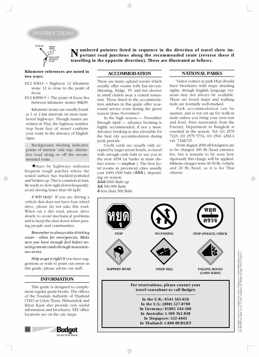
12
INSTRUCTIONS
umbered pointers listed in sequence in the direction of travel show im-portant road junctions along the recommended route (reverse these if
travelling in the opposite direction). These are illustrated as follows.N
Kilometre references are noted intwo ways:
H12 KM13 = Highway 12 kilometrestone 13 is close to the point offocus
H12 KM98-9 = The point of focus liesbetween kilometre stones 98&99.
Kilometre stones are usually foundat 1 or 2 km intervals on most num-bered highways. Though names arewritten in Thai, the highway number(top front face of stone) confirmsyour route in the absence of Englishsigns.
Background shading indicatespoints of interest/ side trip/ alterna-tive road along or off the recom-mended route.
Stars by highways indicatesfrequent rough patches where thesealed surface has buckled/potholedand broken up. This is common in Isan.Be ready to slow right down frequently,avoid driving faster than 60 kph!
4 WD Only! If you are driving avehicle that does not have four wheeldrive, please do not take this road.When on a dirt road, please driveslowly to avoid mechanical problemsand to keep the dust down when pass-ing people and communities.
Remember to always take drinkingwater - allow for emergencies. Makesure you have enough fuel before en-tering remote roads through mountain-ous areas.
Help us get it right! If you have sug-gestions or wish to point out errors inthis guide, please advise our staff.
INFORMATION
This guide is designed to comple-ment regular guide-books. The officesof the Tourism Authority of Thailand(TAT) at Udon Thani, Phitsanulok andKhon Kaen also provide very usefulinformation and brochures. TAT officelocations are on the city maps.
ACCOMMODATION
There are many upland resorts whichusually offer rooms with fan/air-con-ditioning, fridge, TV and hot showerin small chalets near a central restau-rant. Those listed in the accommoda-tion sidebars in this guide offer year-round service even during the greenseason (June-November)
In the high season — Novemberthrough April — advance booking ishighly recommended, if not a must.Advance booking is also advisable forthe best city accommodation duringpeak periods.
Credit cards are usually only ac-cepted by larger resort/hotels, so travelwith enough cash baht to see you tothe next ATM (at banks in main dis-trict towns — amphoe ). The best ho-tel rooms in provincial cities usuallycost 1000-1500 baht ( $$$), depend-ing on season. 1000 Baht up 500-999 Baht less than 500 Baht
(c)
all righ
ts r
eser
ved. Com
pile
d b
y O
liver
Har
grea
ve (
<oliv
erh@
loxi
nfo
.co.th
>)
for
WorldCla
ss R
ent A C
ar, Co L
td. G
raphic
s by
With
in D
esig
n (
053)
272
221-
2
NATIONAL PARKS
Visitor centres at park HQs shouldhave brochures with maps detailingsights, though English language ver-sions may not always be available.There are board maps and walkingtrails are normally well-marked.
Park accommodation can bespartan, and is not set up for walk-intrade unless you bring your own tentand food. Prior reservation from theForestry Department in Bangkok isessential in the season. Tel: (0) 25797223, (0) 2579 5734, (0) 2561 4292-4ext. 724&725.
From August 2000 all foreigners areto be charged 200 Bt./head entrancefee, but it remains to be seen howrigorously this charge will be applied.Hitherto charges were 40-50 Bt./vehicleand 20 Bt./head, as it is for Thaicitizens.
For reservations, please contact yourtravel consultant or call Budget:
In the U.K.: 0541 565-656In the U.S.: (800) 527-0700
In Germany: 01805 244-388In Australia: 1-300 362-848
In Singapore: 532-4442In Thailand: 1-800-BUDGET
FALLING ROCKS(LAND SLIDE)
STEEP HILL
STOP (POLICE) CHECK
SLIPPERY ROAD
STOP NO PASSING
À¬ÿ¥ À¬ÿ¥
µ√«®
3
4
Pointer numberand directionof travel
HighwayNumber
Go this way
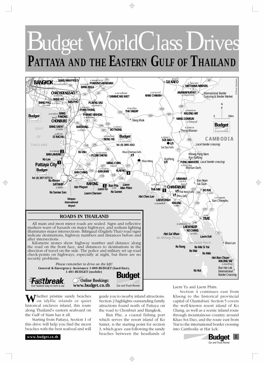
1
G U L F
O F
T H A I L A N D
G U L F O F T H A I L A N D
BANG PHLIBANG BO
BANG NAM PRIED
CHACHOENGSAO
34
3
3
3
3
3
3
318
3173157
3159
3157
3388
3148
3143
3143
3377
3220
3191
3138 3245
3471
3138
36
7
7
344
344
304
304 304
3313493245
3401
3340
3259
3259
3434
3067
317
3395
3406
33
348319
31213245
9
3268
PHANOM SARAKHAMBANG KHLA
PLAENG YAO
PHAN THONGPHANAT NIKHOM
SANAMCHAI KHET
SI RACHA
BANG SAEN
BAN PHO
BANG PAKONG
CHONBURI
BANGKOK
BAN BUNGBO THONG
BAN LAMUNG
NONG YAI
Pattaya City
SATTAHIP
BAN CHANG
RAYONG
WANG CHAN
BAN KHAI KLAENG
PLUAK DAENGKo Lan
Bo Win
Ko Khram
Ban Phe
Ko Samae San Ko Samet
LaemMae Phim
Laem CharoenLaem Ya
Hat Phayun
KHLONG HAT
WANG SOMBUN
UttapaoInternational
Airport
Hat Sai Khao
THA MAI
Hat Chao LaoLAEM SINGH
MAKHAM
KHLUNG
CHANTABURI
SOI DAO
PONG NAM RON
Khiritan Dam
C A M B O D I A
BO RAI
TRAT
LAEM NGOPKO CHANG
Ko WaiKo Mai Si YaiKo Rang
Ko Mak
Ko Kut
Laem Sok
Hat Ban ChuanKHLONG YAI
Ao Sa lak Pe tch
Ao Kh long Phrao
Khao Lan
Ban Hat LekInternationalBorder Crossing
Local border crossing
Local border crossing
Ban NoenTak Daet
Dan Chomphu
Khlong Pong NamRon Rafting
Khao Wong
SA KAEOWATTHANA NAKHON
KHA0 CHAKAN
THA TAKIAP
Tel: (0) 3895 4352
ARANYAPRATHET International BorderCrossing & Border Market
Soi Dao Falls
Khao Chamao Falls
Krathing
Trok Nong Falls
Phliu Falls
1
3
4
5
2
Thung Khanan
Nong Khok
Oliv
er H
arg
reav
e
N
0 20km
Õ.∫“ßæ≈’
Õ.∫“ßπÈ”‡ª√’Ȭ«
©–‡™‘߇∑√“
Õ.∫“ß∫àÕ
Õ.∫â“π‚æ∏‘Ï
Õ.∫“ߧ≈â“
Õ.∫“ߪ–°ß
Õ.æ“π∑Õß
Õ.æπ¡ “√§“¡
Õ.·ª≈߬“«
™≈∫ÿ√’
∫“ß· π Õ.∫â“π∫÷ß
Õ.æπ— π‘§¡
Õ.»√’√“™“
Õ. π“¡™—¬‡¢µ
∑à“µ–‡°’¬∫
Õ.∫àÕ∑Õß
Õ.‡¢“©°√√®å
√–·°â«
Õ.«—≤π“π§√
Õ.Õ√—≠ª√–‡∑»
Õ.§≈ÕßÀ“¥
Õ.«—ß ¡∫Ÿ√≥å
∫.∑ÿàߢπ“π
Õ. Õ¬¥“«
Õ.‚ªÉßπÈ”√âÕπ
Õ.¡–¢“¡
∫.¥à“π™ÿ¡æ≈
Õ.∫àÕ‰√à
µ√“¥
Õ.§≈Õß„À≠à
Õ.·À≈¡ßÕ∫
‡°“–™â“ß
Õ.¢≈ÿß
®—π∑∫ÿ√’
Õ.·À≈¡ ‘ßÀå
Õ.∑à“„À¡à∫.‡æ
Õ.·°≈ß«—ß®—π∑√å
Õ.∫â“π§à“¬
√–¬Õß
Õ.ÀπÕß„À≠à
Õ.ª≈«°·¥ß
Õ.∫â“π©“ß
Õ. —µÀ’∫
Õ.∫“ß≈–¡ÿß
Tel: (0) 3871 0717-8
PATTAYA AND THE EASTERN GULF OF THAILANDBudget WorldClass Drives
www.budget.co.th
hether pristine sandy beacheson idyllic islands or quiet
historical enclaves inland, this routealong Thailand’s eastern seaboard onthe Gulf of Siam has it all.
Starting from Pattaya, Section 1 ofthis drive will help you find the nicestbeaches with the best seafood and will
guide you to nearby inland attractions.Section 2 highlights outstanding familyattractions found north of Pattaya onthe road to Chonburi and Bangkok.
Ban Phe, a coastal fishing portwhich serves the resort island of KoSamet, is the starting point for section3, which goes east following the sandybeaches between the headlands of
W
ROADS IN THAILAND
All main and most minor roads are sealed. Signs and reflectivemarkers warn of hazards on major highways, and sodium lightingilluminates major intersections. Bilingual (English/Thai) road signsindicate destinations, highway numbers and distances before andafter intersections.
Kilometre stones show highway number and distance alongthe road on the front face, and distances to destinations in thedirection of travel on the side. The police and military set up roadcheck-points on highways, especially at night, but there are nosecurity problems.
Please remember to drive on the left!General & Emergency Assistance 1-800-BUDGET (land-line),
1-401-BUDGET (mobile)
Our fastest way to rent a car Laem Ya and Laem Phim.Section 4 continues east from
Klaeng to the historical provincialcapital of Chantaburi. Section 5 coversthe well-known resort island of KoChang, as well as a scenic inland routethrough mountainous country aroundKhao Soi Dao, and the route east fromTrat to the international border crossinginto Cambodia at Hat Lek.
Online Bookings:www.budget.co.th
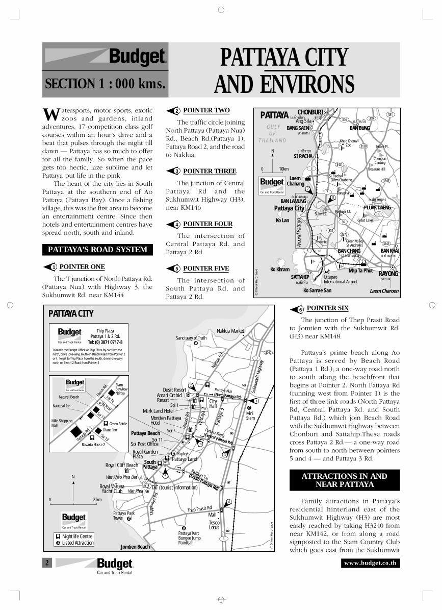
2
147
149
145
143
PATTAYA CITY
Naklua Market
Pattaya Beach
Naklu
a Rd
Beac
h Rd
Soi 7
Soi 1
Soi 11
Ripley's
Pattaya KartBungee JumpPaintball
Amari OrchidResort
Dusit Resort
Sanctuary of Truth
MiniSiam
Mark Land Hotel
Sukh
umwi
t Hig
hway
.
Patta
ya 2
Patta
ya 3
Soi Post OfficeRoyal GardenPlaza
Pattaya Tai (South Pattaya Rd)
Pattaya LandRoyal Cliff Beach South
Pattaya
Royal VarunaYacht Club
TAT (tourist information)
Thep Prasit RdPattaya ParkTower
Jomtien Beach
Wat Khao Phra Bat
Wat Phra Yai
0 2 km
Nightlife CentreListed Attraction
Pattaya Klang(Central Pattaya Rd)
City Hall
Pattaya Nua(North Pattaya Rd)
Thip PlazaPattaya 1 & 2 Rd.
MallTescoLotus
Montien PattayaHotel
Tapp
hray
aRd
.
3
3
3240
HH
H
H
H
A
C
D
G
K
A
1
5
4
3
2
To reach the Budget Office at Thip Plaza by car from the north, drive (one-way) south on Beach Road from Pointer 2 or 4. To get to Thip Plaza from the south, drive (one-way) north on Beach 2 Road from Pointer 5
6
Oliv
er H
arg
reav
e
N
Tel: (0) 3871 0717-8
Soi 11
Soi 10
Soi 13Bavaria House 2
Green Bottle
Diana Inn
SiamBayviewNarisa
Tipp Plaza
Mike ShoppingMall
Nautical Inn
Natural Beach Beac
h Rd.
Patta
yaRd.
2
G U L F O F
T H A I L A N D
3
3
3143
3191
3138
3421
3245
36
7
344331
3313376
349
SI RACHA
BANG SAEN
CHONBURI
BAN BUNG
BAN LAMUNGPattaya City
SATTAHIP
BAN CHANG
RAYONG
BAN KHAI
PLUAK DAENG
Ko Lan
Ko Khram Map Ta Phut
Laem Chabang
Ko Samae San Laem Charoen
Ang Sila
UttapaoInternational Airport
Phoenix
Pattaya CCSiam CC
Burapha
Treasure Hill
ChonburiCentury
Noble Pl.
Laem Chabang
Khao KheowZoo
Si Racha
Great Lake
Green ValleySt Andrew's
8
7
N
0 10km
Oliv
er H
arg
reav
e
Arou
nd P
atta
ya
PATTAYA ™≈∫ÿ√’
∫“ß· π
Õ.∫â“π∫÷ß
Õ.»√’√“™“
Õ.∫â“π§à“¬
√–¬Õß
Õ.ª≈«°·¥ß
Õ.∫â“π©“ß
Õ. —µÀ’∫
Õ.∫“ß≈–¡ÿß
∫.Õà“ß»‘≈“
PATTAYA CITYAND ENVIRONSSECTION 1 : 000 kms.
R
1
W
www.budget.co.th
atersports, motor sports, exoticzoos and gardens, inland
adventures, 17 competition class golfcourses within an hour’s drive and abeat that pulses through the night tilldawn — Pattaya has so much to offerfor all the family. So when the pacegets too hectic, laze sublime and letPattaya put life in the pink.
The heart of the city lies in SouthPattaya at the southern end of AoPattaya (Pattaya Bay). Once a fishingvillage, this was the first area to becomean entertainment centre. Since thenhotels and entertainment centres havespread north, south and inland.
PATTAYA’S ROAD SYSTEM
POINTER ONE
The T junction of North Pattaya Rd.(Pattaya Nua) with Highway 3, theSukhumwit Rd. near KM144
2
3
4
5
6 POINTER SIX
The junction of Thep Prasit Roadto Jomtien with the Sukhumwit Rd.(H3) near KM148.
Pattaya’s prime beach along AoPattaya is served by Beach Road(Pattaya 1 Rd.), a one-way road northto south along the beachfront thatbegins at Pointer 2. North Pattaya Rd(running west from Pointer 1) is thefirst of three link roads (North PattayaRd, Central Pattaya Rd. and SouthPattaya Rd.) which join Beach Roadwith the Sukhumwit Highway betweenChonburi and Sattahip.These roadscross Pattaya 2 Rd.— a one-way roadfrom south to north between pointers5 and 4 — and Pattaya 3 Rd.
ATTRACTIONS IN ANDNEAR PATTAYA
Family attractions in Pattaya'sresidential hinterland east of theSukhumwit Highway (H3) are mosteasily reached by taking H3240 fromnear KM142, or from along a roadsignposted to the Siam Country Clubwhich goes east from the Sukhumwit
POINTER TWO
The traffic circle joiningNorth Pattaya (Pattaya Nua)Rd., Beach Rd.(Pattaya 1),Pattaya Road 2, and the roadto Naklua.
POINTER THREE
The junction of CentralPattaya Rd and theSukhumwit Highway (H3),near KM146
POINTER FOUR
The intersection ofCentral Pattaya Rd. andPattaya 2 Rd.
POINTER FIVE
The intersection ofSouth Pattaya Rd. andPattaya 2 Rd.

3
Khao Chi Chan Buddha Image
36
3240
3240
331
3
3
Traffic lightstempleSanctuary of TruthMillion Years Stone Park Mini SiamRipley's Believe It or Not
Wannasin FarmPhanarak ParkPattaya Elephant VillagePattaya Kart, Bungee Jump, PaintballHoreshoe Point & Three Kingdoms Theme ParkBira Circuit (motor racing)J
IHGFE
DCBA
B
A
F
IK
J
G
H
E
L
M
BANG LAMUNG
AROUND PATTAYA
Naklua Market
to Si Racha To Motorway & BangkokSi Racha Tiger ZooTel: (0) 3829 6556-8Khao Kheow Open ZooTel: (0) 3829 8188
Pattaya Nua
Pattaya Klang
Wat Nong Pru
Wat Phra Yai Wat Khao Soi Thong
WatSutthawat
TATSiam
Country Club
BiraCircuit
Pattaya Country Club
to Rayong
Pattaya Tai
Hat Chom Tian(Jomtien Beach)
Wat Mai HatKrathung Thong
Seafood
Blue Lagoon
Three Kingdoms
WannasinFarm
Million YearsStone Park
Elephant Village
Jomtien Yacht Club Asian University of Scienceand Technology
Ambassador City
Ocean Marina
Phoenix Golf & Country Club
Ban Amphoe (seafood)
Ban Sarae(seafood)
Nong Nooch Tropical Garden
Khao Din (Buddha footprint)
to Sattahip to Sattahip
Vihara Sien
137
145
151
153154
158
160
163
120
117
114
17
14108
0 4 km
C
D
Wat Yang Sang Wararam
7
8
1
7
2
3
6
Oliv
er H
arg
reav
e
Patta
ya C
ity
N
∫“ß≈–¡ÿß
www.budget.co.th
Highway from approximately 800mnorth of Pointer 3.
Before going to any of theseattractions, be sure to contact ourPattaya Office to take advantage of anydiscounts available to Budgetcustomers (regular entry prices from200 to 500 baht per adult according toattraction).
A. The Sanctuary of Truth — artobjects in a fantastic eleven storey 'ThreeHeaded Elephant Art Museum' (08:00-17:00/20:00 according to season daily) and'special dolphin show' at 09:00, 11:00,13:00, 15:00. The Sanctuary of Truth hasbeen built by the same organisation thatcreated the Ancient City — muangboran— a must see attraction nearBangkok (see section 2)
B. Million Years Stone Park — a 40acre landscaped park with a botanicalgarden, fossilized plants, rare animals anda crocodile farm (09:00-18:00 hrs)
C. Mini Siam - Famous places ofThailand and the world at one twenty-fifth scale, as well as go-karting (07:00-22:00 hrs. Tel: (0) 3842 1628)
D. Ripley’s Believe it or Not — Curiosand illusions from the masters of make-believe in the Royal Garden PlazaShopping Mall between Beach andPattaya 2 Roads
E. Wannasin Farm — demonstrationsof traditional Thai culture and lifestylesinclude a floating market (09:00-18:00closed Tuesdays)
F. Phanarak Park — a quiet resortwith gardens and fish ponds ideal fortranquil retreat
G. Pattaya Elephant Village —Elephant riding
H. Pattaya Park Tower — an expresslift takes you to a high viewing platformoffering stunning views followed by adescent by gondola or harness downcableways (Tel: (0) 3825 1201-8.
I. Horseshoe Point & ThreeKingdoms Theme Park — a resort andcountry club with horse riding facilitiesand a mausoleum park honouring theChinese heritage of businessman KiartiSrifuengfung.
Sports Near PattayaInternational class motor racing can
be enjoyed as a spectator sport at theBira Circuit (J. H36 KM12 off thewestbound lane), but for hands onexperience, two go kart circuits arefound along Thep Prasit Road (West ofSukhumwit Rd at the lights near KM148).One of these, Pattaya Kart (K) also offersBungee Jumping and Paintball). Horseriding can be enjoyed at HorseshoePoint (I).
Adventurewater sportsi n c l u d eLakeland WaterCable Ski (L)and the BlueLagoon WaterSports Club(M Wind andKitesurf - turnwest off Su-khumwit Rdbetween KM155and 156). Forthe PattayaShooting Clubturn east (in-land) from theS u k h u m w i tRoad betweenKM153&154.
Golf CoursesPattaya is
p e r f e c t l ylocated to takeadvantage ofthe many Golfand CountryClubs beweenChonburi andRayong. Clubswelcome non-members andhave equipmentfor hire, but it is recommended thatyou call first to book your round andaccommodation if so desired. Signs onthe nearest turn-off from a mainhighway usually point out the routealong minor side roads to the courseitself.
Golf Clubs Around Pattaya
Pattaya Country Club, H331 KM107Tel: (0) 3842 3718-9, BKK (0) 2541 4994-7Phoenix Golf & Country ClubH3 KM158 Tel: (0) 3823 9391-6,Fax: (0) 3823 9402Siam Country Club Golf CourseH3 KM145 Tel: (0) 3824 9381-6,Fax: (0) 3824 9387, BKK (0) 2215 3334
South of PattayaHat Chomthian is the first of several
beaches between inlets fed by smallrivers that together follow the coastlinein a lazy arc southwards to Sattahip.Fishing villages along the 18 kilometrebay have become prime locations forseafood restaurants. These are found atBan Amphoe (H3 KM158 west turn) and
Ban Sarae (H3 KM164 west turn).Nong Nooch Tropical Garden, a
resort with restaurants, a mini zoo,culture hall and handicraft centre,children’s playground and elephants(showtimes 10:15, 15:00 and 15:45) islocated inland down a side-road eastfrom the Sukhumwit Highway atKM.163
Wat Yang Sang Wararam and KhaoChee Chan
A road inland from near KM161goes to Wat Yang Sang Wararam. Aroyal temple of the first class, Wat Yanghas large grounds containing a hill-topmondop with a Buddha footprint(Khao Din), a large chedi and severalinternational pavilions. The ViharaSien, a Chinese-style vihara whichhouses Tang dynasty bronzes, and theKhao Chee Chan Budda image, a 130metre tall image carved into a rockface,are found a short distance fromWat Yang.
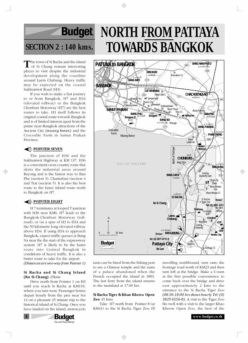
4
Oliv
er H
arg
reav
e
Motorway (toll)
Motorw
ay
Elevated Tollway
G U L F O F T H A I L A N D
BANG PHLI
BANG BO
BANG NAM PRIEO
CHACHOENGSAO
SAMUT PRAKAN
BANGKOK
9
34
3
3
331
3
36
7
7
315
3466
7 314
315
314
344
3144
3138
304
3481
3200
304
9
3268
3256
3119
3344
3117 BANG PAKONG
LAT KRABANG
MIN BURI
BANG KAPI
PHAN THONG
SI RACHA
BANG SAEN
BAN PHO
CHONBURI
BAN BUNG
BAN LAMUNG
Pattaya CityKo Lan
Ko Si Chang
Laem Chabang
Ang Sila
Chan Ta Then
Bo WinOffice
Muang Boran
Crocodile Farm
6
1
8
7
Khao Kheow CC
Burapha
Kiarti ThaniThai CC
Windmill PkThana City
(projected)
Muang Kaew Lakewood Subhaphruek
Vintage
Green V
Royal G&CC
President CC
Bang Pakong
Bangpoo IE & CC
RoyalLakeside
Pattaya CCSiam CC
LaemChabang
Pinthong
Bangphli Wellgrow
ChonburiIE
Amata City
Amata Nikhom
ESIE
SEIP
Si RachaInt.
Si RachaTiger Zoo
Khao KheowZoo
SaithipButterfly Gdn
North
of P
atta
ya
N
0 10 20 kms
PATTAYA to BANGKOK
Õ.∫“ßæ≈’
Õ.∫“ßπÈ”‡ª√’Ȭ«
©–‡™‘߇∑√“
Õ.∫“ß∫àÕ
Õ.∫â“π‚æ∏‘Ï
Õ.∫“ߪ–°ß
Õ.æ“π∑Õß
™≈∫ÿ√’
Õ.∫â“π∫÷ß
Õ.¡’π∫ÿ√’
Õ.≈“¥°√–∫—ß
Õ.∫“ß°–ªî
¡ÿ∑√ª√“°“√
∫“ß· π
Õ.»√’√“™“
Õ.∫“ß≈–¡ÿß
Tel: (0) 3871 0717-8
Tel: (0) 3895 4352
NORTH FROM PATTAYATOWARDS BANGKOKSECTION 2 : 140 kms.
R
T
www.budget.co.th
he town of Si Racha and the islandof Si Chang remain interesting
places to visit despite the industrialdevelopment along the coastlinearound Laem Chabang. Heavy trafficmay be expected on the coastalSukhumwit Road (H3).
If you wish to make a fast journeyto or from Bangkok, H7 and H34(elevated tollway) or the BangkokChonburi Motorway (H7) are the bestroutes to take. H3 itself follows itsoriginal coastal route towards Bangkokand is of limited interest apart from theprime near-Bangkok attractions of theAncient City (muang boran) and theCrocodile Farm in Samut PrakanProvince.
POINTER SEVEN
The junction of H36 and theSukhumwit Highway at KM 137. H36is a convenient cross country route thatskirts the industrial areas aroundRayong and is the fastest way to BanPhe (section 3), Chantaburi (section 4and Trat (section 5). It is also the bestroute to the faster inland route northto Bangkok on H7.
POINTER EIGHT
H 7 terminates at looped T junctionwith H36 near KM6. H7 leads to theBangkok-Chonburi Motorway (toll-road), or via a spur of H3 to H34 andthe 50 kilometre long elevated tollwayabove H34. If using H34 to approachBangkok, expect traffic queues at BangNa near the the start of the expresswaysystem. H7 is likely to be the fasterroute into Central Bangkok inconditions of heavy traffic. It is also abetter route to take for the airport.(Distances are one-way from Pointer 1)
Si Racha and Si Chang Island(Ko Si Chang) 25kms
Drive north from Pointer 1 on H3until you reach Si Racha at KM119,where you turn west. Passenger ferriesdepart hourly from the pier near Soi14 on a pleasant 45 minute trip to thehistorical island of Si Chang. Once youhave landed on the island, motorcycle
taxis can be hired from the fishing portto see a Chinese temple and the ruinsof a palace abandoned when theFrench occupied the island in 1893.The last ferry from the island returnsto the mainland at 17:00 hrs.
Si Racha Tiger & Khao Kheow OpenZoo 45 kms
Take H7 north from Pointer 8 (atKM41) to the Si Racha Tiger Zoo (If
travelling northbound, turn onto thefrontage road north of KM23 and thenturn left at the bridge. Make a U-turnat the first possible convenience tocome back over the bridge and driveeast approximately 2 kms to theentrance to the Si Racha Tiger Zoo(08:30-18:00 hrs shows hourly Tel: (0)3829 6556-8). A visit to the Tiger Zoofits well with a visit to the larger KhaoKheow Open Zoo, the best of the
7
8
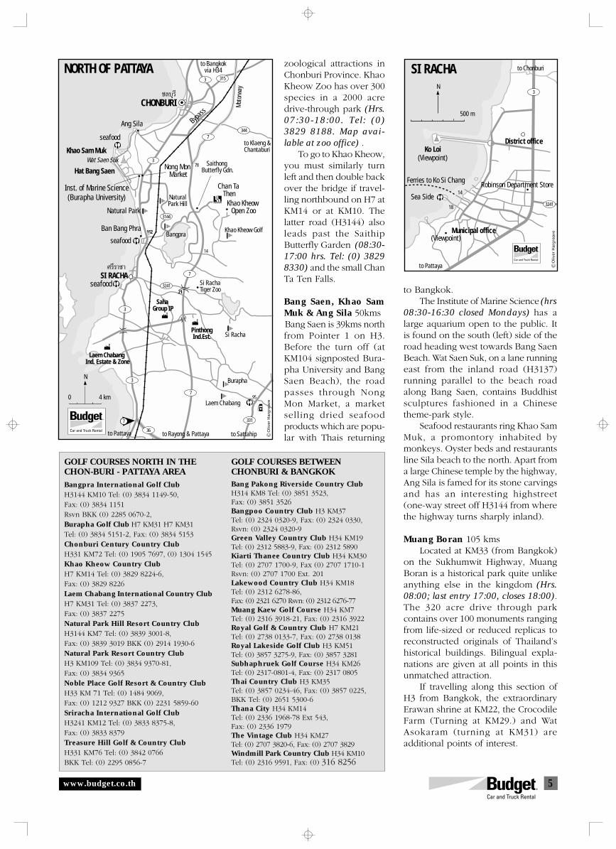
5
Ko Loi
SI RACHA
Sea Side3241
3
Ferries to Ko Si ChangRobinson Department Store
Municipal office
District office
(Viewpoint)
(Viewpoint)
to Pattaya
18
14
500 m
N
to Chonburi
Oliv
er H
arg
reav
e
to Pattaya
344
315
3241
to Bangkokvia H34
CHONBURI
NORTH OF PATTAYA
Ang Sila
seafood
seafood
seafood
Khao Sam Muk
Mot
orwa
y
Wat Saen Suk
to Klaeng &Chantaburi
Hat Bang Saen
Bangpra
Nong Mon Market
Inst. of Marine Science(Burapha University)
Ban Bang Phra
Khao Kheow Open Zoo
SI RACHA
Khao Kheow Golf
Saithong Butterfly Gdn.
Si RachaTiger Zoo
Si Racha
Burapha
Laem Chabang0 4 km
N
78
14
21
112
PinthongInd.Est.
95
3
331
36
Laem Chabang Ind. Estate & Zone
to Rayong & Pattaya
3
3
3144
7
7
3
7
Bypass
NaturalPark Hill
Natural Park
Saha Group IP
to Sattahip
7
Chan Ta Then
Oliv
er H
arg
reav
e
™≈∫ÿ√’
»√’√“™“
www.budget.co.th
zoological attractions inChonburi Province. KhaoKheow Zoo has over 300species in a 2000 acredrive-through park (Hrs.07:30-18:00. Tel: (0)3829 8188. Map avai-lable at zoo office) .
To go to Khao Kheow,you must similarly turnleft and then double backover the bridge if travel-ling northbound on H7 atKM14 or at KM10. Thelatter road (H3144) alsoleads past the SaithipButterfly Garden (08:30-17:00 hrs. Tel: (0) 38298330) and the small ChanTa Ten Falls.
Bang Saen, Khao SamMuk & Ang Sila 50kmsBang Saen is 39kms northfrom Pointer 1 on H3.Before the turn off (atKM104 signposted Bura-pha University and BangSaen Beach), the roadpasses through NongMon Market, a marketselling dried seafoodproducts which are popu-lar with Thais returning
to Bangkok.The Institute of Marine Science (hrs
08:30-16:30 closed Mondays) has alarge aquarium open to the public. Itis found on the south (left) side of theroad heading west towards Bang SaenBeach. Wat Saen Suk, on a lane runningeast from the inland road (H3137)running parallel to the beach roadalong Bang Saen, contains Buddhistsculptures fashioned in a Chinesetheme-park style.
Seafood restaurants ring Khao SamMuk, a promontory inhabited bymonkeys. Oyster beds and restaurantsline Sila beach to the north. Apart froma large Chinese temple by the highway,Ang Sila is famed for its stone carvingsand has an interesting highstreet(one-way street off H3144 from wherethe highway turns sharply inland).
Muang Boran 105 kmsLocated at KM33 (from Bangkok)
on the Sukhumwit Highway, MuangBoran is a historical park quite unlikeanything else in the kingdom (Hrs.08:00; last entry 17:00, closes 18:00).The 320 acre drive through parkcontains over 100 monuments rangingfrom life-sized or reduced replicas toreconstructed originals of Thailand’shistorical buildings. Bilingual expla-nations are given at all points in thisunmatched attraction.
If travelling along this section ofH3 from Bangkok, the extraordinaryErawan shrine at KM22, the CrocodileFarm (Turning at KM29.) and WatAsokaram (turning at KM31) areadditional points of interest.
GOLF COURSES NORTH IN THECHON-BURI - PATTAYA AREA
Bangpra International Golf ClubH3144 KM10 Tel: (0) 3834 1149-50,Fax: (0) 3834 1151Rsvn BKK (0) 2285 0670-2,Burapha Golf Club H7 KM31 H7 KM31Tel: (0) 3834 5151-2, Fax: (0) 3834 5153Chonburi Century Country ClubH331 KM72 Tel: (0) 1905 7697, (0) 1304 1545Khao Kheow Country ClubH7 KM14 Tel: (0) 3829 8224-6,Fax: (0) 3829 8226Laem Chabang International Country ClubH7 KM31 Tel: (0) 3837 2273,Fax: (0) 3837 2275Natural Park Hill Resort Country ClubH3144 KM7 Tel: (0) 3839 3001-8,Fax: (0) 3839 3019 BKK (0) 2914 1930-6Natural Park Resort Country ClubH3 KM109 Tel: (0) 3834 9370-81,Fax: (0) 3834 9365Noble Place Golf Resort & Country ClubH33 KM 71 Tel: (0) 1484 9069,Fax: (0) 1212 9327 BKK (0) 2231 5859-60Sriracha International Golf ClubH3241 KM12 Tel: (0) 3833 8375-8,Fax: (0) 3833 8379Treasure Hill Golf & Country ClubH331 KM76 Tel: (0) 3842 0766BKK Tel: (0) 2295 0856-7
GOLF COURSES BETWEENCHONBURI & BANGKOKBang Pakong Riverside Country ClubH314 KM8 Tel: (0) 3851 3523,Fax: (0) 3851 3526Bangpoo Country Club H3 KM37Tel: (0) 2324 0320-9, Fax: (0) 2324 0330,Rsvn: (0) 2324 0320-9Green Valley Country Club H34 KM19Tel: (0) 2312 5883-9, Fax: (0) 2312 5890Kiarti Thanee Country Club H34 KM30Tel: (0) 2707 1700-9, Fax (0) 2707 1710-1Rsvn: (0) 2707 1700 Ext. 201Lakewood Country Club H34 KM18Tel: (0) 2312 6278-86,Fax: (0) 2321 6270 Rsvn: (0) 2312 6276-77Muang Kaew Golf Course H34 KM7Tel: (0) 2316 3918-21, Fax: (0) 2316 3922Royal Golf & Country Club H7 KM21Tel: (0) 2738 0133-7, Fax: (0) 2738 0138Royal Lakeside Golf Club H3 KM51Tel: (0) 3857 3275-9, Fax: (0) 3857 3281Subhaphruek Golf Course H34 KM26Tel: (0) 2317-0801-4, Fax: (0) 2317 0805Thai Country Club H3 KM35Tel: (0) 3857 0234-46, Fax: (0) 3857 0225,BKK Tel: (0) 2651 5300-6Thana City H34 KM14Tel: (0) 2336 1968-78 Ext 543,Fax: (0) 2336 1979The Vintage Club H34 KM27Tel: (0) 2707 3820-6, Fax: (0) 2707 3829Windmill Park Country Club H34 KM10Tel: (0) 2316 9591, Fax: (0) 316 8256
6
to Pattaya
marketto Map Ta Phut,Sattahip
GoldenCity
RayongOrchid
RayongCity Star
Wat Pu Pradu
ProvincialHall
RAYONG
Yindee
Fishing Harbour
to Ban Phe
Rasadonbamrung Rd.
Laem Charoen Seafood
Hat Saeng Chan
Chedi Klang Nam
Saeng ChanSeaview
PMY
3 km
N
Laem ThongShopping Arcade
3138
3
3139
3
3
6
H
HH
HH
HH
TPPRefineries
3
3
3
3 3143
31
3376
331
3323220
3377
3161
3163
3192 3145
3191
3471
3138
36
3191
7
344BAN LAMUNG
Pattaya City
SATTAHIP
BAN CHANG
RAYONG
WANG CHAN
BAN KHAIKLAENG
PLUAK DAENGKo Lan
Ko Khram
Ban Phe
Sunthon Phu
Ko Samae San Ko Samet
Laem Mae Phim
Laem Ya
Mae Ram Phung
Phayun
Chom Thian
UttapaoInternational Airport
Great Lake
Pattaya CCSiam CC
Phoenix
Rayong Century SuphatraLand (fruit
garden)
Eastern StarPhutaluang
Green ValleySt. Andrews
Rayong IP
TPP
Map Ta Phut
Rojana IP
Amata City
Rayong Ind.Land
6
7
10
1
8
9
H
PurimasBeach Hotel
Laem
Ya
to K
laen
g
Rayo
ng
N
0 10 kms
Oliv
er H
arg
reav
e
to Chonburito Bangkok
Tapong
TAT (tourist information)Talat Tapong (0) 3865 5420-1
PATTAYA to KLAENG
∫.‡æ
Õ.·°≈ß
«—ß®—π∑√å
√–¬Õß
Õ.ª≈«°·¥ß
Õ.∫â“π©“ß
Õ. —µÀ’∫
Õ.∫“ß≈–¡ÿß
PATTAYABAN PHE AND KLAENGSECTION 3 : 97 kms.
R
H
www.budget.co.th
36 (from Pointer 7) is the bestroute east from Pattaya. Though
Rayong City has some old temples andgood seafood restaurants on LaemCharoen (south turn in the middle ofRayong City at KM220 — see map 9;selected accommodation is listed belowand on the maps), it is better to avoidthis industrialised area. This sectioncovers the coast east of Laem Ya, whereresorts take advantage of unspoiledbeaches east to Laem Mae Phim.
POINTER NINE
Turn south here for H3140 to BanPhe and Ko Samet and the coastal routeH3145 east to Laem Mae Phim.
POINTER TEN
H344 is the fastest route toBangkok from all points east of Klaeng
ACCOMMODATION
Sattahip to Rayong• P.M.Y Beach Resort. 147/394 Mu 2 Beach
Rd., Rayong 2100 Tel: (0) 3861 4855,Fax: (0) 3861 4887 $$ (Hat SaengChan — Saeng Chan Beach)
• Rayong City Hotel. 11 Ratbamrung Rd.Soi 4 Noenpra, Rayong 21000. Tel: (0)3861 6838-9, Fax: (0) 3861 3497 $
• Purimas Beach Resort. 34 Mu 4 Phayun-Namrin Rd., Ban Chang, Rayong 21130.Tel: (0) 3863 0382-90, Fax: (0) 38630380. $$-$$$ (Hat Phayun —Phayun Beach)
• Star Hotel. 109 Rayong Trade Centre,Rayong 21000 Tel: (0) 3861 4901-7,Fax: 3861 4608 $-$$$
Ban Phe & Ko Samet.Turn south at Pointer 9 to go to themarket centre of Ban Phe, a fishing portwith an attractive narrow high street(one-way traffic east to west) lined withshops in wooden buildings.
Mu Ko Samet Laem Ya NationalPark offers a nature trail near the parkHQ on the mainland, but the main
9
10
7
Mae Ram Phung
TAT (tourist information)Talat Tapong (0) 3865 5420-1
Ko Samet
9 13
17
21
9
269
275
27
to Chonburi Khao Chamao Falls Khao Wong Caves
Ban Sam Yaek Nam Pen
to Rayong
Bay View $Tel: (0) 3889 8678
Sea Wind Resort $-$$$Tel: (0) 3865 2736-8
Laem Ya
Ban Phe
Ban Phe Cabana $$-$$$ Tel: (0) 3864 8488-90Kaeng Samed Hotel $$-$$$ Tel: (0) 3872 2857Pakarang Resort $-$$$ Tel: (0) 3864 8412Rungnapha Lodge $$-$$$$ Tel: (0) 3864 8297-8Hinsuai Namsai Resort $$-$$$$ Tel: (0) 3863 8035-6
Sin Siam Resort $-$$$ Tel: (0) 3863 8114-5
Vang KaewResort
Silver Beach $$-$$$ Tel: (0) 3863 8096-7
Laem Mae Phim
Ao Khao Seafood
Sunthorn Phu
Ko Man NaiKo Man Klang
Palmeriae Resort
KLAENG NA YAI AM
KHA0CHAMAO
BAN PHE to KLAENG
Route to/fromLaem MaePhim
3161
344 KLAENG
3139
3320
3145
3163
3161
343333773430
3443406
3162
3190
3
3
3140
3300
10
HH
1
1
2
2
H H 3
3
4
4
H 5
5
Ban
Phae
& K
o Sa
met
9
10
NovotelRim Phe
RayongChalet
N
0 5 10km O
liver
Har
gre
ave
Õ.𓬓¬Õ“¡
Õ.·°≈ß
Õ.‡¢“™–‡¡“
∫.‡æ
Ko Chan
PPP
P
to Klaeng & Chantaburi
to Laem Mae Phim
Nuanthip PierPines Beach $$-$$$Tel: (0) 3865 1636-40Fax: (0) 3865 1641
Tourist InformationCentre PierBan Talat Phe
R e d u c t i o n 3 k m s.Sri BanPhe Pier
Ban Pak Khlong Phe
Laem Ya
Khao Laem YaMu Ko Samet National Park HQ
RayongResort
Ao Phrao ResortAo PhraoKO SAMET
Hat Sai Kaeo
Ban Ko Samet
Coconut HouseSai Kaeo Beach
Ao PhaiSamed VillaTubtim Resort
Ao Wong DuanMalibu
Ao Thian Candle Light BeachVong Duan Villa
Samed Ville Resort Ao Wai
Ao Kiu
Park Station2 kms
N
market
to Rayong
Sawet Sobha Museum
BAN PHE & KO SAMET
Ao PhraoResort Pier
3
3140
3300
3145H
HH
H
H
H
HH
H
H
9
www.budget.co.th
interest is the island of Ko Samet, anisland famous for its sandy beaches,which are mainly found on the eastside of the island.
Many places to stay are found onHat Sai Kaeo (White Sands Beach) andAo Wong Duan (Wong Duan Bay).More secluded resorts are hidden inthe coves between these main beaches.Transport is by boat except for a fewlocal pick-ups which ply the island’sunsealed tracks.
Piers serving Ko Samet are locatedon the eastern edge of Ban Phe. Thesepiers have safe overnight parking andcan reserve accommodation, arranging
boat transport directlyto the beach you planto stay on. Advancebooking may not benecessary during theweek, but the island getscrowded at weekendsduring the peak season.
ACCOMMODATION
Samet Island• Ao Phrao Resort (Ao
Phrao) 292 Mu 2, Phe,Rayong 21160 Tel: (0)3865 1134-5, Fax: (0)38651952 $$-$$$$
• Sai Kaew Beach Resort(Hat Sai Kaew) KoSamet, Phe, Rayong21160. Tel: (0) 12390208 $-$$
• Samed Villa (Ao Phai) 89Mu 4, Phe, Rayong21160. Tel: (0) 14948090, (0) 1239 0223,Fax: (0) 1239 0203 $
• Tubtim Bungalows (AoTubtim) Ko Samet, Phe,Rayong 21160 Tel: (0)1218 6425, BKK (0)2729 3144 $-$$
• Vong Duen Resort, 22 Mu4, Phe, Rayong 21160.Tel: (0) 3865 2408, (0)
3865 1777, Fax: (0) 3865 1741 $-$$• Saeng Tien, 88 Mu 4 Lo Samet, Phe,
Rayong 21160. Tel: (0) 3865 1223, Tel:(0) 3865 1223 $
• Samed Ville (Villa) Ao Wai, Ko Samet,Phe, Rayong 21160. Tel: (0) 3865 1681-2, Fax: (0) 3865 1681 $-$$$
H3145 & H3161 Ban Phe - LaemMae Phim & Klaeng 40kms
H3145 is a pleasant route linkingseveral resorts that take advantage ofthe long sandy beaches between LaemYa and Laem Mae Phim. Numerousseafood restaurants are located at LaemMae Phim.
H3161 goes to Klaeng from LaemMae Phim, skirting a flat landscape tothe east consisting of villages, prawnfarms and mangrove swamp typical ofriver estuaries on this coast. The roadpasses a park celebrating Thailand’sclassical 19th century poet, SunthornPhu, 3 kms north of Laem Mae Phim.A side road next to the park givesaccess to the estuary to the east.
ACCOMMODATION
Laem Ya-Laem Mae Phim• Rayong Resort. 186 Mu 1, Phe, Rayong
21160. Tel: (0) 3865 1000-6, Fax: (0)3865 1007 $$$-$$$$
• Rayong Chalet 4/32 Mu 3, Chak Pong,Klaeng, Rayong 21190. Tel: (0) 38648287-8. Fax: (0) 3864 8289, BKK (0)2260 3590 $$-$$$
• Novotel Rim Pae Resort. 4/5 Mu 3, ChakPong, Klaeng, Rayong 21190. Tel: (0)3864 8008-12, Fax: (0) 3864 8002, BKKRsvn: (0) 2237 1308 $$$-$$$$
• Vang Kaew, 214 Mu 2, Chak Pong,Klaeng, Rayong 21190. Tel: (0) 38638067, Fax: (0) 3863 8068. BKK Rsvn:(0) 2259 4150-1 $-$$$
• Palmeraie. 177 Mu 1, Chak Pong, Klaeng,Rayong 21190. Tel: (0) 3863 8071-2,Fax: (0) 3863 8073, BKK Rsvn: (0) 22131162. $$-$$$
GOLF COURSES IN THE SATTAHIP-RAYONG AREA
Eastern Star Resort & Country ClubH3 KM193 Tel: (0) 3863 0410-7,Fax: (0) 3863 0418Great Lake Golf & Country ClubH3376 KM9 Tel: (0) 3862 2630,(0) 1218 6913, (0) 1218 7620Phutaluang Royal Thai Navy GolfCourse H3 KM182 Tel: (0) 3870 1843Rayong Century Golf & CountryClub H3 KM197Tel & Fax: (0) 3860 2889Rayong Green Valley & St Andrews2000 H3376 KM14Tel & Fax: (0) 3889 3838-46
8
KHA0KHITCHAKUT
Õ.‡¢“§‘™¨°ŸØÕ.𓬓¬Õ“¡3
3433
3406
3399
3322
3322
3323
3409
3249
3161
3
3152 3493316
3147
31463
317
3348
3149
3377344
KLAENG
KHAOCHAMAO
NA YAI AM
Laem Mae Phim
THA MAIKhung Wiman
Chao Lao
LAEM SINGH
CHANTABURI
Sunthorn Phu
Wat Khao Sukim
Khao Wongto Kaeng Hang Maew
Krathing
10
Arou
nd C
hant
abur
i
12
11
N
0 10 kms
Ban Nong Khla
Oliv
er H
arg
reav
e
‡¢“™–‡¡“
®—π∑∫ÿ√’
Õ.·À≈¡ ‘ßÀå
Õ.·°≈ß
Õ.∑à“„À¡à
KLAENG to CHANTABURI
KLAENGCHANTABURISECTION 4 : 55 kms.
R
www.budget.co.th
rom Klaeng, Highway 3 skirtsmountains and estuaries. The
highest of the peaks, Soi Dao Nua(1605m), lies to the north ofChantaburi's provincial capital.Waterfalls tumble off the jungle cladheights, the prominence of whichcreates large amounts of rainfall andhas helped the area become the fruitbasket of Bangkok. A fruit festivalcelebrates this fact in the harvest seasonat the beginning of May.
Attractions include Chantaburi City,the waterfalls in national parks andseveral beaches where seafoodrestaurants are numerous.
If you plan to visit the waterfalls,it is as well to note that they are lesscrowded during weekdays and at theirbest as the rainy season progresses.Reaching the different levels mayinvolve sweaty climbs through moist
evergreen jungle up sometimes slippery paths. Takeswimming gear to enjoy the cool pools.
POINTER ELEVEN
The junction of H3249 and H316 with H3 atKM315
POINTER TWELVE
H3 turns sharply south at KM333. H317 goes northto Sa Kaeo.
Khao Chamao- Khao Wong National Park(H3 KM275 north turn onto H3377 — 16kms.)
A two kilometre nature trail links the eight levels of theKhao Chamao Falls. Khao Wong (H3 KM28612 kms north on H3433) is a modest sized limestonekarst with a succession of small, pungent cavesinhabited by bats. It is possible to drive directly fromKhao Chamao to Khao Wong using dirt roads (4WD)to the north or south of the mountain. This drive thatwill be of interest as much for the rural scenery youpass through as for the destination.
Hat Kung Wiman, Laem Sadet & Hat Chao Lao(south turn off H3 at KM303 on H3399 or from
11
12
F
3
3399
3152 3323
3147
3146
3149
3348
3277
316
3
3
317
3322
3493
3249
3249
3407
3249
3322
to Klaeng & RayongWat Khao
Sukim
Krathing FallsKhao Khitchakut
Krathing Resort
Ban Krathing
to Pong Nam Ron
to Khiritan
DamBan Khanun
Fruitmarket MAKHAM
KHAO KHITCHAKUT
KHLUNG
AROUND CHANTABURI
Ko Proed
LAEM SINGH
Ban Noen Sun
Maneechan ResortNoenWong
THA MAI
CHANTABURIKhung
Wiman
LaemSadet
Chao Lao
Chao Lao Sawasdee
seafood
Ban Tha Chalaep
Oasis Sea World
KhukKhi Kai
TukDaeng
Namtok Phliu
Namtok Trok Nong
to Trat
Ban Pak Sombun $ Tel:(0) 3936 3151
924 m.
566 m.302
10
N
5
22
18
10
HH
H
H
H
H
Maldives B. Res.
Hat Sai Thong Res.
12
11Õ.¡–¢“¡
Õ.¢≈ÿß
Õ.·À≈¡ ‘ßÀå
Õ.∑à“„À¡à
®—π∑∫ÿ√’
Õ.‡¢“§‘™¨°ŸØ
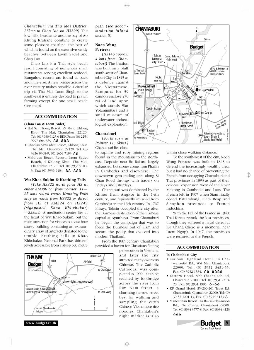
9
to Laem Sadet & Hat Chao Laofollow signs for "Khung Krabane"
to Hat Chao Lao viabridge
to H3
to Noen Sun
Airfield
to Chantaburi
to Noen Wong
narrow high street (one-way)
21
N
3152
3323
3147
THA MAI
www.budget.co.th
Chantaburi via Tha Mai District.26kms to Chao Lao on H3399) Thelow hills, headlands and the bay of AoKhung Kratiane combine to createsome pleasant coastline, the best ofwhich is found on the extensive sandybeaches between Laem Sadet andChao Lao.
Chao Lao is a Thai style beachresort consisting of numerous smallrestaurants serving excellent seafood.Bungalow resorts are found at backand little else. A new bridge across theriver estaury makes possible a circulartrip via Tha Mai. Laem Singh to thesouth-east is entirely devoted to prawnfarming except for one small beach(see map)
ACCOMMODATION
(Chao Lao & Laem Sadet)• Hat Sai Thong Resort, 99 Mu 6 Khlong
Khut, Tha Mai, Chantaburi 22120.Tel: (0) 3936 9123-6 BKK Rsvn: (0) 22549797 Ext. 369 $$-$$$
• Chaolao Sawasdee Resort, Khlong Khut,Thai Mai, Chantaburi 22120. Tel: (0)3936 9308-9, (0) 1664 7193 $$
• Maldives Beach Resort, Laem SadetBeach, 4 Khlong Khut, Tha Mai,Chantaburi 22120. Tel: (0) 3936 9100-3, Fax: (0) 3936 9104. $$-$$$
Wat Khao Sukim & Krathing Falls(Take H3322 north form H3 at
either KM306 or from pointer 11—25 kms round route. Krathing Fallsmay be roach from H3322 or directfrom H3 at KM324 on H3249(signposted Khao Khitchakut)—22kms) A meditation centre lies atthe heart of Wat Khao Sukim, but themain attraction for visitors is a vast fourstorey building containing an extraor-dinary array of artefacts donated to thetemple. Krathing Falls in KhaoKhitchakut National Park has thirteenlevels accessible from a steep 500 metre
path (see accom-modation inlandsection 5).
Noen WongFortress
(H3146 approx.4 kms from Chan-taburi) The bastionwas built on a bluffsouth-west of Chan-taburi City in 1843 asa defence againstthe Vietnamese.Ramparts for 39cannon enclose 270rai of land uponwhich stands WatYotanimittara and asmall museum ofunderwater archeo-logical exploration.
Chantaburi(South turn at
Pointer 11. 6kms.)Chantaburi lies closeto saphire and ruby mining regionsfound in the mountains to the north-east. Deposits near Bo Rai are largelyexhausted, but stones come from Phailinin Cambodia and elsewhere. Thedowntown gem trading area along SiChan Road throngs with traders onFridays and Saturdays.
Chantaburi was dominated by theKhmer from Angkor in the 14thcentury, and repeatedly invaded fromCambodia in the 16th century. In 1767Phraya Taksin occupied the city afterthe Burmese destruction of the Siamesecapital at Ayutthaya. From Chantaburihe began the campaign that was toforce the Burmese out of Siam andsecure the polity that evolved intomodern Thailand.
From the 18th century Chantaburiprovided a haven for Christians fleeing
persecution in Vietnam,and later the cityattracted many overseasChinese. The CatholicCathedral was com-pleted in 1909. It can bereached by footbridgeacross the river fromRim Nam Street, acharming narrow streetbest for walking andsampling the city’sChinese-Vietnamese ricenoodles. Chantaburi’snight market is also
within close walking distance.To the south-west of the city, Noen
Wong Fortress was built in 1843 todefend the increasingly wealthy area,but it had no chance of preventing theFrench from occupying Chantaburi andTrat provinces in 1893 as part of theircolonial expansion west of the RiverMekong in Cambodia and Laos. TheFrench left in 1907 when Siam finallyceded Battambang, Siem Reap andSisophon provinces to FrenchIndochina.
With the Fall of the France in 1940,Thai forces retook the lost provinces,though they suffered a naval defeat atKo Chang (there is a memorial nearLaem Ngop). In 1947, the provinceswere restored to the French.
ACCOMMODATION
In Chabtaburi City• Caribou Highland Hotel. 14 Cha-
wanautid Rd., Wat Mai, Chantaburi,22000. Tel: (0) 3932 3431-55,Fax: (0) 3932 1584. $$-$$$$
• Eastern Hotel. 899 Thachalaeb Rd,Chantaburi 22000. Tel: (0) 3931 2218-20, Fax: (0) 3931 1985. $-$$
• KP Grand Hotel. 35/200-201 Trirat Rd.Chantanimit, Chantaburi 22000. Tel: (0)39 32 3201-13, Fax: (0) 3934 4123 $
• Maneechan Resort. 14 Raksakcha-moonRd., Tha Chang, Chantaburi 22000.Tel: (0) 3934 3777-8, Fax: (0) 3934 4123$$$
3248
to H3 & Pointer 11
CHANTABURI
TaksinMemorialCity Pillar
Camp Taksin(Marines)
to Tha Mai &Laem Sadet
Provincial Hall(Sala Klang)
Nightmarket
Wat Bot Muang
to H3 & Pointer 12(H317 north toKhao Soi Dao)
RC Cathedral
Rim Nam RdWat
Phailom
Si Chan Rd.
Khun Daeng
Caribou
Taksin Statue
KP GrandHotel
Nai Thian
to Noen Wong
Eastern Hotel
RobinsonDept. Store
Alternative route toLaem Singh &Oasis Sea World
to H3, Trat &
Laem Ngop
500 m
N
3146
316
H
H
H
Oliv
er H
arg
reav
e
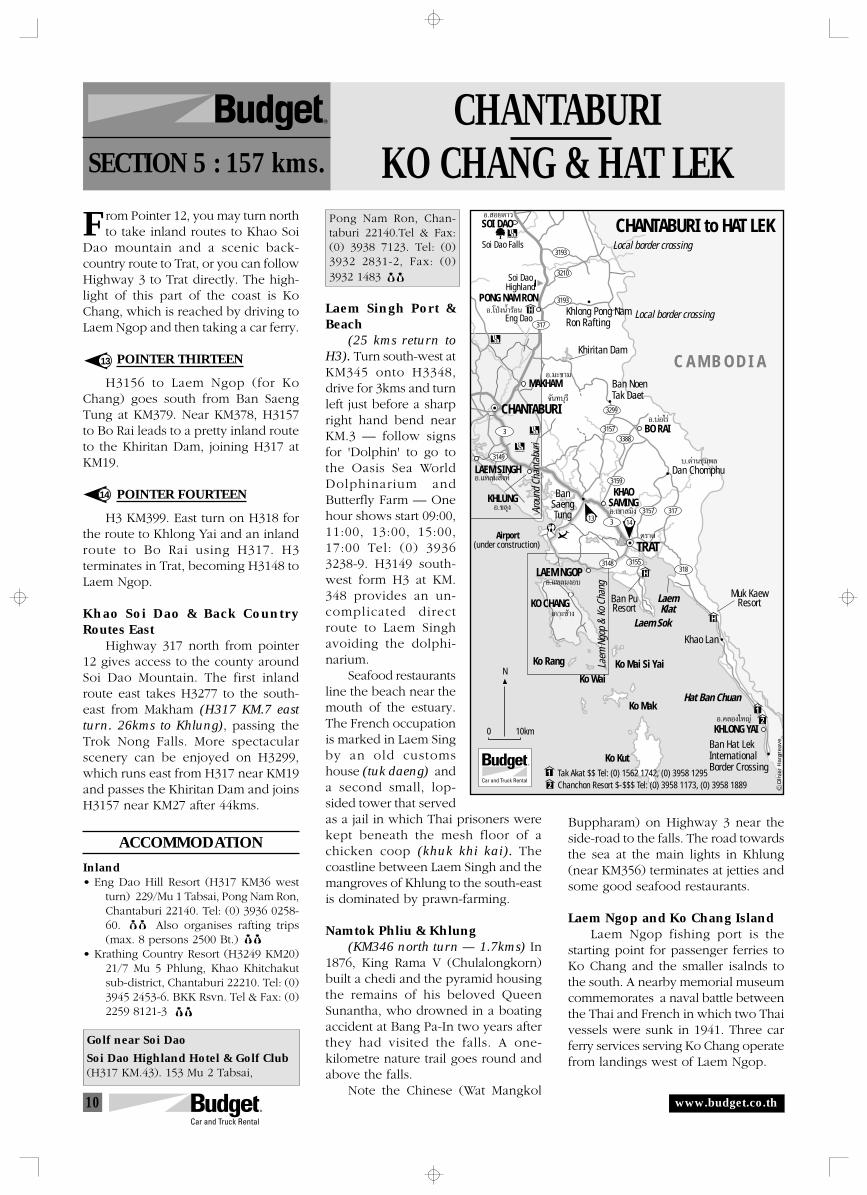
10
1314
3
3
318
3173157
3149
3155
3157
3299
3388
3159
3148
317
3193
3210
3193
LAEM SINGH
MAKHAM
KHLUNGKHAO
SAMING
CHANTABURI
SOI DAO
PONG NAM RON
Khiritan Dam
BO RAI
TRAT
Laem Sok
LaemKlat
Hat Ban Chuan
KHLONG YAI
Khao Lan
BanSaengTung
Ban Hat LekInternationalBorder Crossing
Local border crossing
Local border crossing
Ban NoenTak Daet
Dan Chomphu
Khlong Pong NamRon Rafting
Soi Dao Falls
H
H
1
1
2
2
Airport(under construction)
Muk KaewResortBan Pu
Resort
LAEM NGOP
KO CHANG
Arou
nd C
hant
abur
i
Laem
Ngo
p &
Ko C
hang
Ko WaiKo Mai Si Yai
Ko Mak
Ko Rang
Ko Kut
C A M B O D I A
N
0 10km
Soi DaoHighland
Eng DaoH
Tak Akat $$ Tel: (0) 1562 1742, (0) 3958 1295Chanchon Resort $-$$$ Tel: (0) 3958 1173, (0) 3958 1889 O
liver
Har
gre
ave
CHANTABURI to HAT LEKÕ. Õ¬¥“«
Õ.‚ªÉßπÈ”√âÕπ
Õ.¡–¢“¡
∫.¥à“π™ÿ¡æ≈
Õ.∫àÕ‰√à
µ√“¥
Õ.§≈Õß„À≠à
Õ.‡¢“ ¡‘ß
Õ.·À≈¡ßÕ∫
‡°“–™â“ß
Õ.¢≈ÿß
®—π∑∫ÿ√’
Õ.·À≈¡ ‘ßÀå
CHANTABURIKO CHANG & HAT LEKSECTION 5 : 157 kms.
R
F
www.budget.co.th
rom Pointer 12, you may turn northto take inland routes to Khao Soi
Dao mountain and a scenic back-country route to Trat, or you can followHighway 3 to Trat directly. The high-light of this part of the coast is KoChang, which is reached by driving toLaem Ngop and then taking a car ferry.
POINTER THIRTEEN
H3156 to Laem Ngop (for KoChang) goes south from Ban SaengTung at KM379. Near KM378, H3157to Bo Rai leads to a pretty inland routeto the Khiritan Dam, joining H317 atKM19.
POINTER FOURTEEN
H3 KM399. East turn on H318 forthe route to Khlong Yai and an inlandroute to Bo Rai using H317. H3terminates in Trat, becoming H3148 toLaem Ngop.
Khao Soi Dao & Back CountryRoutes East
Highway 317 north from pointer12 gives access to the county aroundSoi Dao Mountain. The first inlandroute east takes H3277 to the south-east from Makham (H317 KM.7 eastturn. 26kms to Khlung), passing theTrok Nong Falls. More spectacularscenery can be enjoyed on H3299,which runs east from H317 near KM19and passes the Khiritan Dam and joinsH3157 near KM27 after 44kms.
ACCOMMODATION
Inland• Eng Dao Hill Resort (H317 KM36 west
turn) 229/Mu 1 Tabsai, Pong Nam Ron,Chantaburi 22140. Tel: (0) 3936 0258-60. $$ Also organises rafting trips(max. 8 persons 2500 Bt.) $$
• Krathing Country Resort (H3249 KM20)21/7 Mu 5 Phlung, Khao Khitchakutsub-district, Chantaburi 22210. Tel: (0)3945 2453-6. BKK Rsvn. Tel & Fax: (0)2259 8121-3 $$
Golf near Soi Dao
Soi Dao Highland Hotel & Golf Club(H317 KM.43). 153 Mu 2 Tabsai,
13
14
Pong Nam Ron, Chan-taburi 22140.Tel & Fax:(0) 3938 7123. Tel: (0)3932 2831-2, Fax: (0)3932 1483 $$
Laem Singh Port &Beach
(25 kms return toH3). Turn south-west atKM345 onto H3348,drive for 3kms and turnleft just before a sharpright hand bend nearKM.3 — follow signsfor 'Dolphin' to go tothe Oasis Sea WorldDolphinarium andButterfly Farm — Onehour shows start 09:00,11:00, 13:00, 15:00,17:00 Tel: (0) 39363238-9. H3149 south-west form H3 at KM.348 provides an un-complicated directroute to Laem Singhavoiding the dolphi-narium.
Seafood restaurantsline the beach near themouth of the estuary.The French occupationis marked in Laem Singby an old customshouse (tuk daeng) anda second small, lop-sided tower that servedas a jail in which Thai prisoners werekept beneath the mesh floor of achicken coop (khuk khi kai). Thecoastline between Laem Singh and themangroves of Khlung to the south-eastis dominated by prawn-farming.
Namtok Phliu & Khlung(KM346 north turn — 1.7kms) In
1876, King Rama V (Chulalongkorn)built a chedi and the pyramid housingthe remains of his beloved QueenSunantha, who drowned in a boatingaccident at Bang Pa-In two years afterthey had visited the falls. A one-kilometre nature trail goes round andabove the falls.
Note the Chinese (Wat Mangkol
Buppharam) on Highway 3 near theside-road to the falls. The road towardsthe sea at the main lights in Khlung(near KM356) terminates at jetties andsome good seafood restaurants.
Laem Ngop and Ko Chang IslandLaem Ngop fishing port is the
starting point for passenger ferries toKo Chang and the smaller isalnds tothe south. A nearby memorial museumcommemorates a naval battle betweenthe Thai and French in which two Thaivessels were sunk in 1941. Three carferry services serving Ko Chang operatefrom landings west of Laem Ngop.
11
Steepdanger!
to Ban SaengTung (Pointer 13)
NavalMemorial
to Tratpetrol
Ao Tang Ku 4
10
NationalPark HQFe
rry K
o Ch
ang
Ko Cha
ng Cent
repoin
t
Ao Sapparot
Khlong Son
Tha Dan
Hospital
TAT (information)Tel: (0) 3959 7259-60
Police
KO CHANGSUB DISTRICT
Petrol
R.ThaiNavy
N ParkVisitor Centre
Ban PuKo Chang
Ayapura
Laem Ngop InnTel: (0) 3959 7044
Ruan Thalae
Khlong PhraoResort
ThanMayom
Khlong Phlu
Khiripet
KhlongNung
Steep!
Steep!
Kai Bae Hut Resort $- $$Tel: (0) 1862 8426
Seaview Resort $$Tel: (0) 1830 7529
Siam Bay Resort $-$$ Tel: (0) 1859 5529
Nature Beach Resort $Tel: (0) 1803 8933
Ko Chang Boat Chalet $$-$$$Tel: (0) 2618 7400
Ban Salak Phet
Ban Rong Than
Ban Bang BaoBan Khlong Tian
Ao Salak Petch
Ko Lao YaKo Khlum
Ko Wai
Navalbattle wrecks
Ao Khlong Phrao
Kai Bae
LAEM NGOP & KO CHANG
626 m.637 m.
743 m.
LAEM NGOP
KO CHANG
N
0 5 km
White Sand Beach Res.$-$$ Tel: (0) 1863 7737www.whitesandbeachresort.com
Ko Chang Lagoon Resort$$ Tel: (0) 1863 1530www.kohchanglagoon.com
Best Garden Resort$-$$$ Tel: (0) 1374 0944www.bestgardenresort.com
Ko Chang Grand View Resort$-$$$ Tel: (0) 1219 1542
Plaloma Cliff Resort$$ Tel: (0) 1949 2902www.plalomacliff.com
Coconut Beach Bungalows$ Tel: (0) 1904 7971
Chang Park Resort$$ Tel: (0) 1853 2572www.changparkresort.com
H
H
1
45
8
6
7
10
11
1
2
3
4
5
8
9
10
11
12
12
6
7
23
3148
3156
H
H
9
Salak Petch Seafood Tel: (0) 1429 9983
Ko Chang Ferry
Centre Point Ferry (H3156 KM4) Ferries 07:00-17:30 from mainland, 08:00-18:30 from Ko Chang (off-season schedule) — Tel: (0) 3953 8196. 100 Bt./car & driver. Approx 45min
Ferry Ko Chang (H3156 KM10) Tel: (0) 3959 7143 150 Bt./car & driver. Approx 25min
Ko Chang Ferry (Near Maritime Museum) Tel: (0) 3953 8318 250 bt./car & driver. Approx 50min.
Sai Khao
Oliv
er H
arg
reav
e
www.budget.co.th
Ko ChangKo Chang is the largest of more than40 islands that form an archipelagowhich became the Mu Ko ChangMarine National Park. Due togovernment intentions to make it aprime tourist destination, the island isundergoing rapid change.
Ko Chang's jungle clad ridgereaches over 700m in height and runsthe length of the island. A U shapedtwo-lane concrete road ( Be careful onthe very steep z bends to the south ofBan Khlong Son!) is being extendedand will be fully sealed from Ban RongThan and Ban Salak Phet round thenorthern head of the island down andaround to just east of Ban Bang Bao.The loop may be completed with afinal extension that will only be for useby mountain bicycles.
Three superb beaches are locatedon the west coast — Sai Khao, KhlongPhrao and Kai Bae. Than Mayom andKhlong Phlu Falls offer inlandattractions (park fees are collected) ,and there are some minor falls aroundAo Salak Phet. Ban Bang Bao and BanRong Than have good seafoodrestaurants in scenic locations.
Resorts are being developed
throughout the length of the west coastand inexpensive huts are still availablein keeping with the islands reputationas a haven for young travellers. Increa-singly, however, mid to up-marketresorts are occupying prime sites alongthe main beaches. Between these threemain beaches, rocky beach is common,especially at low tide.
ACCOMMODATION
Ko Chang• Aiyapura, 29 Mu 3, Ko Chang, Trat 23120.
Tel: (0) 3952 1656-60, Fax: (0) 39521656. Bkk Off. (0) 22862 1611<www.aiyapura.com>.
• Ban Pu Ko Chang, Hat Sai Khao,Tel: (0) 1942 2964, (0) 3954 2355 $$-$$$$
• Khlong Phrao Resort 21/1 Mu 4Ko Chang, Trat 23120. Tel: (0) 18300126, Laem Ngop Off: Tel: (0) 39597216, Fax: (0) 3959 7106 <www.klongpraoresort.com>
Trat to Khlong Yai & Hat Lek(89 kms from Pointer 14)
Wat Buppharam to the west of theprovincial capital town of Trat is themain point of interest apart from thefresh market at the centre of town. TheBan Pu Resort, which has an unusual
location over man-grove forest and arestaurant with alocal reputation, isthe best accom-modation nearby.
The drive toKhlong Yai andHat Lek is fast,passing sandybeaches extendingfrom Laem Klad toKhlong Yai. Vir-tually any sideroad can get youto nearly desertedbeaches. How-ever, due to theirlocation in thebight formed byLaem Sok and thearchipelago, thebeaches are not asattractive as thoseon the islands. Thebest beach isfound at HatChuen (south turneither at KM.57 orKM59). Accom-modation is found
at Hat Muk Kaew (KM41) and alongthe old road between the sea and H318around KM67 to the north-west ofKhlong Yai District.
Apart from quiet coastal back-waters and rural hinterland, H318passes a small but unusual memorialmuseum at the site of a former refugeecamp at Khao Lan Ratchakarun(KM48). Khlong Yai (KM74) is a smalltown with wooden houses on streetsthat become increasingly narrow asthey approach the sea. A large fishingport is located a few kilometres to theeast at KM.80.
Hat Lek (KM89) is a border marketselling cheaper Russian, Chinese andVietnamese products as well as Frenchwines. To gamble at the Grand HotelCasino (Tel: (0) 3954 4383-5) just acrossthe border from Hat Lek, you will needa visa from the Cambodian Embassyin Bangkok (185 Ratchadamri Rd. Tel:(0) 2254 6630, Fax: (0) 2253 9859). Youmust leave your Budget Car on the Thaiside.
ACCOMMODATION
• Ban Pu Resort & Suan Pu Restaurant. - 199 Mu 1, Tambol NongKhan Song, Trat 23120. Tel: (0) 39542355, (0) 3951 2400, Fax: (0) 3954 2359(Turn left at KM.6 on H3148.Restaurant Hrs. 10:00-22:00) Set in aman-grove forest with a recommendedrestaurant.
• Hat Muk Kaew Resort. $$$. H318KM41. Pleasant isolated setting bybeach. Tel: (0) 3951 1777, (0) 12113358. Bangkok: (0) 2559 3247-8, Fax:(0) 2530 7226.
399
to Laem Ngop & Laem Sok (H3155)
to Chantaburi to Khlong Yai
to WatBupharam (2kms)(Temple museum08:00-17:00)
Trat Dept.Store
Provincial Hall(Sala Klang)
Wat Phailom
to Tha Dan Kao
N TRAT
0 500m
3318
3148
14
Market
12
INSTRUCTIONS
o help you find your way through an unfamiliar landscape, the route isdivided into sections. Suggested routes are marked on the maps and
numbered pointers listed in sequence in the likely direction of travel.T
Kilometre references are noted intwo ways:
H3 KM13 = Kilometre stone 13 is thenearest kilometre marker onHighway 3 (Sukhumwit Highway).
(west turn — 3kms) If you are travel-ling north, this means you shouldturn left and drive 3kms to theindicated destination.
Fill up with petrol ! Before enteringback country roads, make sure you haveenough fuel. In deep country areas,filling stations are reduced to hand-pumps from barrels, which is incon-venient and more expensive.
Broken up and buckled roadsurface may sometimes be encounteredalong highways, but this is usually rareon main highways unless there is roadconstruction. Always be very carefuldriving through areas where there isroad construction, especially if you aredriving at night (we recommend youavoid driving at night in Thailand).Damaged road surface is commonlyfound on tertiary sealed roads in ruralareas. Avoid driving faster than 60kphon such roads and be ready to slowdown frequently.
4 WD Only! If you are driving avehicle that does not have four-wheeldrive, please do not enter roadsindicated as suitable for 4WD if drivingan ordinary sedan (it is not usuallynecessary to engage 4WD on most dirtroad).
Dirt roads are common in borderareas and the mountains, and importantunsealed routes are regularlymaintained. We recommend that youavoid dirt roads, in particular remoteones, as you will be responsible foranything that happens to vehicles offregularly maintained and pavedroadways. Should you go on a dirt road,however, please drive slowly to avoidmechanical problems and to keep thedust down, especially when passingpeople and driving through villages.
Remember to always take drinkingwater — allow for emergencies. A torchcan be useful as well as an umbrella orwarm clothing, depending on seasonand location.
Defensive driving. Be wary ofoncoming traffic when approaching thebrow of a hill or a blind corner, and beespecially vigilant for vehicles entering
(c)
all righ
ts r
eser
ved. Com
pile
d b
y O
liver
Har
grea
ve (
<oliv
erh@
loxi
nfo
.co.th
>)
for
WorldCla
ss R
ent A C
ar, Co L
td. G
raphic
s by
With
in D
esig
n 0
532
7 21
11
5
3
Pointer numbersidentify importantintersections
HighwayNumber
Shadinghighlightsrecommendedroutes
from side-roads which may not stop asthey enter the major road. Always slowright down when entering a village ortown, no matter how empty the roadmight look.
Help us get it right! If you havesuggestions or find serious errors in thisguide, please advise our staff.
Music while you drive. Before youset out, take advantage of low pricesfor audio tapes in Thailand and stockup with some new tunes, or play aroundwith the FM radio to see what you canpick up.
INFORMATION
This guide is designed tocomplement regular guide-books. Theoffices of the Tourism Authority ofThailand (TAT — locations on the maps)at Pattaya (Tel: (0) 3842 7667 or (0)3842 8750, Fax: (0) 3842 9113. E-mail:[email protected]), at Tapong(H3 KM230+200m) near Rayong (Tel:(0) 3865 5420-1 Fax: (0) 3865 5422) andat Laem Ngop (Tel: (0) 3959 7259-60,Fax: (0) 3959 7255) can also provideuseful information and brochures.
ACCOMMODATION
Selected accommodation suggestsa range of places that stand out forambience, but many other places onthe map listings can be just as nice. Westrongly advise pre-booking accom-modation in the high season and duringfestivals.
Accommodation near the beach ischarged at a premium in Thailand, soeven 'cheap' rooms can cost between10 and 20 dollars per night, which canbe more than double the inlandequivalent.
Travel with enough cash to get youto the next ATM machine, which areusually found at banks in main districttowns (amphoe). Credit cards can beused at large gas stations and most mainresorts/hotels. Fuel prices are around15 Baht per litre (The baht/US dollarexchange rate is fluctuating around40-42 Baht=1US$)
Only indication prices for accom-modation are given, as rack rates changeaccording to the occupancy rate. Beprepared for an additional 17% ofgovernment taxes to be added onto ahotel bill. Walk-in rates are indicated asfollows: 6000 Baht up
3000-5999 Baht 1000-2999 Baht 0-999 Baht
NATIONAL PARKS
Foreigners are charged 200 Bht.(children 100 Bht.) entrance fee tonational parks in Thailand. If you canproduce a Thai driver’s license, you maybe charged at the rate for Thai people(20 Bht./adult 30 Bht./vehicle), but thisis uncertain. The entrance fee will allowyou to enter all sites in that park on thedate of purchase.
For reservations, please contact yourtravel consultant or call Budget:
In the U.K.: 0541 565-656, In the U.S.: (800) 527-0700In Germany: 01805 244-388, In Australia: 1-300 362-848
In Singapore: 532-4442, In Thailand: 1-800-BUDGET
FALLING ROCKS(LAND SLIDE)
STEEP HILL
STOP (POLICE)CHECK
SLIPPERY ROAD
STOP NO PASSING
À¬ÿ¥ À¬ÿ¥
µ√«®
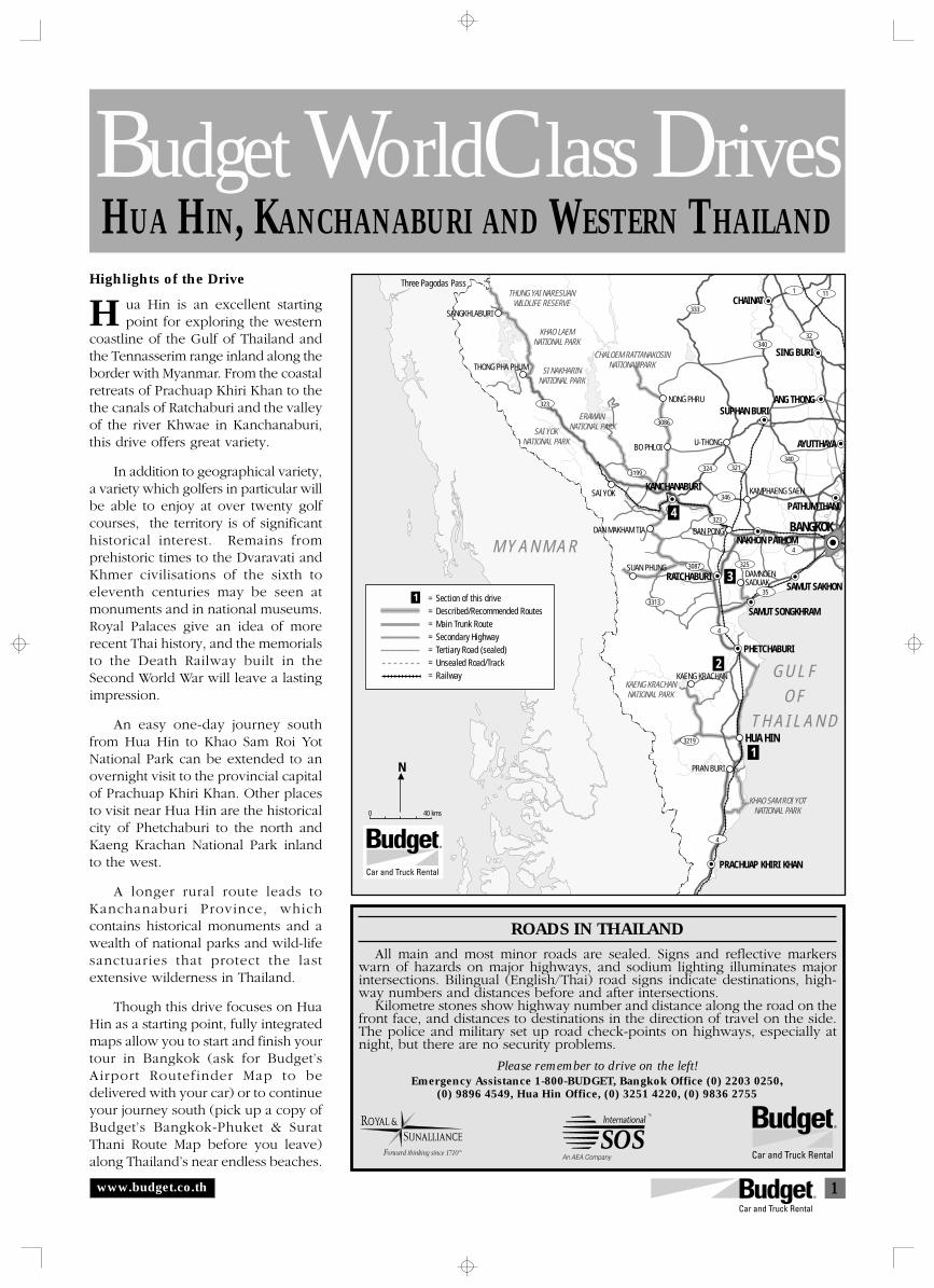
1
HUA HIN, KANCHANABURI AND WESTERN THAILAND
Budget WorldClass Drives
ROADS IN THAILAND
All main and most minor roads are sealed. Signs and reflective markerswarn of hazards on major highways, and sodium lighting illuminates majorintersections. Bilingual (English/Thai) road signs indicate destinations, high-way numbers and distances before and after intersections.
Kilometre stones show highway number and distance along the road on thefront face, and distances to destinations in the direction of travel on the side.The police and military set up road check-points on highways, especially atnight, but there are no security problems.
Please remember to drive on the left!Emergency Assistance 1-800-BUDGET, Bangkok Office (0) 2203 0250,
(0) 9896 4549, Hua Hin Office, (0) 3251 4220, (0) 9836 2755
HHighlights of the Drive
ua Hin is an excellent startingpoint for exploring the western
coastline of the Gulf of Thailand andthe Tennasserim range inland along theborder with Myanmar. From the coastalretreats of Prachuap Khiri Khan to thethe canals of Ratchaburi and the valleyof the river Khwae in Kanchanaburi,this drive offers great variety.
In addition to geographical variety,a variety which golfers in particular willbe able to enjoy at over twenty golfcourses, the territory is of significanthistorical interest. Remains fromprehistoric times to the Dvaravati andKhmer civilisations of the sixth toeleventh centuries may be seen atmonuments and in national museums.Royal Palaces give an idea of morerecent Thai history, and the memorialsto the Death Railway built in theSecond World War will leave a lastingimpression.
An easy one-day journey southfrom Hua Hin to Khao Sam Roi YotNational Park can be extended to anovernight visit to the provincial capitalof Prachuap Khiri Khan. Other placesto visit near Hua Hin are the historicalcity of Phetchaburi to the north andKaeng Krachan National Park inlandto the west.
A longer rural route leads toKanchanaburi Province, whichcontains historical monuments and awealth of national parks and wild-lifesanctuaries that protect the lastextensive wilderness in Thailand.
Though this drive focuses on HuaHin as a starting point, fully integratedmaps allow you to start and finish yourtour in Bangkok (ask for Budget’sAirport Routefinder Map to bedelivered with your car) or to continueyour journey south (pick up a copy ofBudget’s Bangkok-Phuket & SuratThani Route Map before you leave)along Thailand’s near endless beaches.
www.budget.co.th
KHAO SAM ROI YOTNATIONAL PARK
THUNG YAI NARESUANWILDLIFE RESERVE
KHAO LAEMNATIONAL PARK
CHALOEM RATTANAKOSINNATIONAL PARK
ERAWAN NATIONAL PARK
SI NAKHARINNATIONAL PARK
SAI YOKNATIONAL PARK
KAENG KRACHANNATIONAL PARK
CHAINAT
ANG THONG
SING BURI
SUPHAN BURI
KANCHANABURI
NAKHON PATHOM
PATHUM THANI
RATCHABURI
PHETCHABURI
SAMUT SONGKHRAM
SAMUT SAKHON
PRACHUAP KHIRI KHAN
BANGKOK
HUA HIN
Three Pagodas Pass
THONG PHA PHUM
SANGKHLABURI
SAI YOK KAMPHAENG SAEN
U-THONG
SUAN PHUNG
DAN MAKHAM TIA
BO PHLOI
KAENG KRACHAN
NONG PHRU
40 kms0
N
M Y A N M A R
G U L FO F
T H A I L A N D
1
2
3
4
AYUTTHAYA
= Section of this drive= Described/Recommended Routes= Main Trunk Route= Secondary Highway= Tertiary Road (sealed)= Unsealed Road/Track= Railway
1
BAN PONG
DAMNOENSADUAK
PRAN BURI
4
4
4
35
3087 325
3313
323
324 321
3219
346
340
340
333
1 11
32
323
3199
3086
SOS
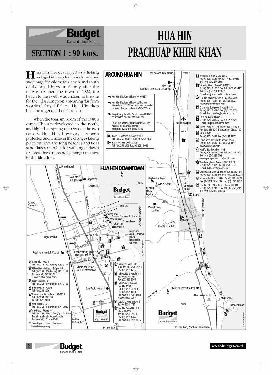
2
AROUND HUA HIN to Cha-Am, Petchaburi
Palm HillsStamford International College
Hua Hin Airport
KM222
KM226
KM229
KM235
1
2
1
2
15
16
17
18
19
20
21
22
23
24
1516
1718
2019
Elephant Village
Wat Itisukato KlaiKangwonPalace
Itsara
to NongPhlap,Pala-U
Pang ChangHua Hin
Khao Hin Fai Lek
station
Hua
Hin
Down
town
Hua Hin Elephant Camp
broken-up
Khao Sanam ChatKhao Krailat
Khao Takhiap
to Pran Buri, Prachuap Khiri Khan
21
22
2324
Hua Hin Elephant Village (H4 KM237)
Hua Hin Elephant Village (behind WatItisukato off H3128 — north turn on sealedlane opp. Rockestra Pub at KM2+700m).
Pang Chang Hua Hin (south turn off H3218on unsealed track at KM2+400m)
Prices are same (700 Bt/hour or 500 Bt/hour) at all elephant camps with rides available 08:30-17:30
Palm Hills Resort & Country ClubTel: (0) 3252 0800-11 Fax: (0) 3252 0820Royal Hua Hin Golf CourseTel: (0) 3251 2475 Fax: (0) 3251 3038
N
2 kms
Oliv
er H
arg
reav
e
Anantara Resort & Spa $$$$Tel: (0) 3252 0250 Fax: Tel: (0) 3252 0259 Bkk rsvn: (0) 2477 0800Majestic Beach Resort $$-$$$$Tel: (0) 3252 0162-8 Fax: Tel: (0) 3252 0477Bkk rsvn: (0) 2751 4020-2E-mail: [email protected] Hin Marriot Resort & Spa $$$-$$$$Tel: (0) 3251 1881 Fax: (0) 3251 2422<www.marriotthotels.com>Chanchay Bungalow & Hotel $-$$$Tel: (0) 3253 2374-5 Fax: (0) 3253 2376 E-mail: [email protected] Guest House $Tel: (0) 3253 2096-7 Fax: (0) 3251 2210 E-mail: [email protected] Hotel $$-$$$ Tel: (0) 3251 1890-1Fax: (0) 3251 2047 Bkk rsvn: (0) 2392 2109Minitel $-$$Tel: (0) 3251 2436 Fax: (0) 3251 2117Chiva Som (Int. Health Resort) $$$$Tel: (0) 3253 6536 Fax: (0) 3251 1154<www.chivasom.net>Pacific Beach Club $$-$$$Tel: (0) 3253 6698-9 Fax: Tel: (0) 3253 6697Bkk rsvn: (0) 2285 0169 <www.pantip-court.com/pacific.htm>Ban Duangkaew Resort1800-2880 Bt.Tel: (0) 3251 5307 Fax: (0) 3251 5532 E-mail: bd [email protected] Ocean View $$ Tel: (0) 3253 6330 Fax:Tel: (0) 3251 3362 Bkk rsvn: (0) 2225 3002-3Anantasila Villa $$-$$$$ Tel: (0) 3251 1879Fax: (0) 3251 5914 Bkk rsvn: (0) 2221 1732Hua Hin Blue Wave Beach Resort $$-$$$Tel: (0) 3253 6247-9 Fax: Tel: (0) 3253 6245Bkk rsvn: (0) 2930 5667-8
16B
1
2
1
2
3218
3218
4
11
89
6
10
14
N
500 m
HUA HIN DOWNTOWN
Naep Khehat Rd.
Phetkasem Highway
Chomsin Rd.
Dechanuchit Rd.
Amnuaisin Rd.
Damnoen Kasem Rd.
Sasong Rd. Phun
suk
Rd.
Naretdamri Rd.
to Phetchaburi
to Pran Buri
to KhaoHin Fai Lek
to WatItisukato
night market
night-lifearea – narrowlanesunsuitablefor cars
M
Municipal Offices –tourist information
Bon CaféSara Jane Lung Ocha
Rim Lae
Tong Kay
Saeng ThaiCharoen Pochana
Mae KarunaThanachote
Chao LaeKetsarin Se
afoo
d re
stau
rant
s
Royal Waiting RoomHua Hin Station
San Paulo Hospital
S a n d
(0) 3251-4220
54
3
7
12
13
Wat Hua Hin
3218
4
4
Royal Hua Hin Golf Course
3
4
5
6
7
8
9
10
11
12
13
14
Oliv
er H
arg
reav
e
Pananchai Hotel $Tel: (0) 3251 1707 Fax: (0) 3253 0157Hilton Hua Hin Resort & Spa $$$Tel: (0) 3251 2888 Fax: (0) 3251 1135Bkk rsvn: (0) 2253 0123<www.huahin.hilton.com>Fresh Inn Hotel $Tel: (0) 3251 1389 Fax: (0) 3253 2166Ban-Boosarin Hotel $Tel: (0) 3251 2076Central Hua Hin Village $$$-$$$$ Tel: (0) 3251 2021-38Fax: (0) 3251 1014Sirin Hotel $-$$Tel: (0) 3251 1150 Fax: (0) 3251 2045City Beach Resort $$Tel: (0) 3251 2870-5 Fax: (0) 3251 2448 E-mail: [email protected] Bkk rsvn: (0) 2319 1468-71
Puangpen Villa Hotel$-$$ Tel: (0) 3253 3785-6Fax: (0) 3251 1216Jed Pee Nong Hotel $-$$Tel: (0) 3251 2381Fax: (0) 3253 2063Hotel Sofitel CentralHua Hin $$$$ Tel: (0) 3251 2021-38Fax: (0) 3251 1014 Bkk rsvn: (0) 2541 1463<www.sofitel.com>Patchara House Hotel $Tel: (0) 3251 1787Hua Hin Grand Hotel &Plaza $$-$$$Tel: (0) 3251 3230-4Fax: (0) 3251 1765.Bkk rsvn: (0) 2254 7675
2
Several guest houses in this area –limited or no parking
HUA HINPRACHUAP KHIRI KHANSECTION 1 : 90 kms.
H ua Hin first developed as a fishingvillage between long sandy beaches
stretching for kilometres north and southof the small harbour. Shortly after therailway reached the town in 1922, thebeach to the north was chosen as the sitefor the ‘Klai Kangwon’ (meaning ‘far fromworries’) Royal Palace. Hua Hin thenbecame a genteel beach resort.
When the tourism boom of the 1980’scame, Cha-Am developed to the north,and high rises sprang up between the tworesorts. Hua Hin, however, has beenprotected and whatever the changes takingplace on land, the long beaches and tidalsand flats so perfect for walking at dawnor sunset have remained amongst the bestin the kingdom.
www.budget.co.th
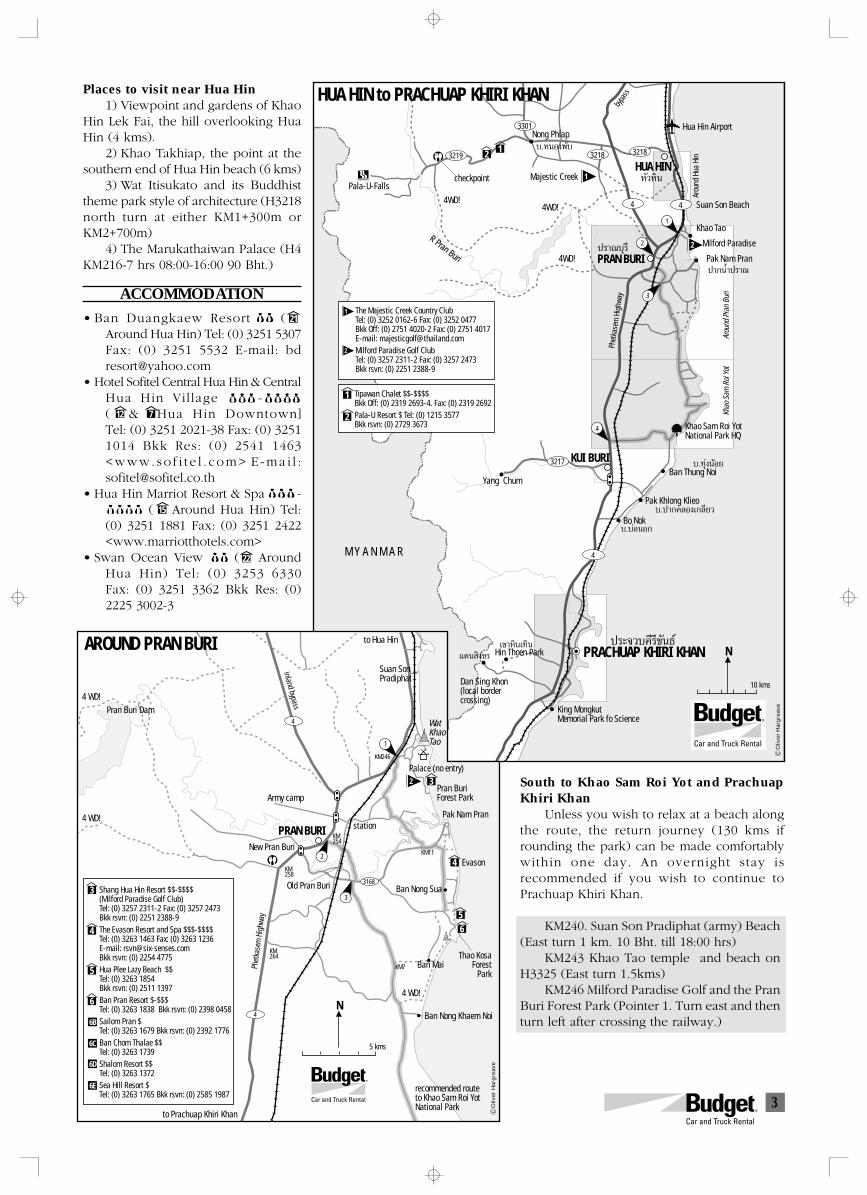
3
PRACHUAP KHIRI KHAN
HUA HIN to PRACHUAP KHIRI KHAN
3219 3218
3301
3217
3218
4
4
3
1
2
4
Majestic CreekPala-U-Falls
4WD!4WD!
4WD!
Arou
nd H
ua H
in
Hua Hin Airport
ª√“≥∫ÿ√’
ª“°πÈ”ª√“≥
∫.∑ÿàßπâÕ¬
∫.ª“°§≈Õ߇°≈’¬«
‡¢“À‘π‡∑‘π ª√–®«∫§’√’¢—π∏å·¥π ‘ߢ√
∫.∫àÕπÕ°
Suan Son Beach
Khao Tao
Milford Paradise
PRAN BURI Pak Nam Pran
Khao
Sam
Roi
Yot
Arou
nd P
ran
Buri
Khao Sam Roi YotNational Park HQ
Yang Chum
KUI BURIBan Thung Noi
∫.ÀπÕßæ—∫Nong Phlap
Pak Khlong Klieo
Bo Nok
M Y A N M A R
Dan Sing Khon(local bordercrossing)
King MongkutMemorial Park fo Science
N
R Pran Buri
Oliv
er H
arg
reav
e
1
2
The Majestic Creek Country ClubTel: (0) 3252 0162-6 Fax: (0) 3252 0477Bkk Off: (0) 2751 4020-2 Fax: (0) 2751 4017E-mail: [email protected] Paradise Golf ClubTel: (0) 3257 2311-2 Fax: (0) 3257 2473 Bkk rsvn: (0) 2251 2388-9
1
2
4
4
3168
3
12
4
56
AROUND PRAN BURI to Hua Hin
Suan SonPradiphat
WatKhaoTao1
3
2
Palace (no entry)
Pran BuriForest Park
Pak Nam Pran
Army camp
Pran Buri Dam4 WD!
4 WD!
4 WD!
5 kms
10 kms
station
KM246
KM11
KM254
KM258
KM264
KM7
PRAN BURINew Pran Buri
Old Pran Buri Ban Nong Sua
Phet
kase
m H
ighw
ay
Evason
Thao KosaForest
ParkBan Mai
recommended route to Khao Sam Roi YotNational Park
to Prachuap Khiri Khan
Ban Nong Khaem Noi
inland bypass
3
4
1
2
5
6
Shang Hua Hin Resort $$-$$$$(Milford Paradise Golf Club)Tel: (0) 3257 2311-2 Fax: (0) 3257 2473 Bkk rsvn: (0) 2251 2388-9The Evason Resort and Spa $$$-$$$$Tel: (0) 3263 1463 Fax: (0) 3263 1236 E-mail: [email protected] Bkk rsvn: (0) 2254 4775 Hua Plee Lazy Beach $$Tel: (0) 3263 1854 Bkk rsvn: (0) 2511 1397Ban Pran Resort $-$$$Tel: (0) 3263 1838 Bkk rsvn: (0) 2398 0458Sailom Pran $Tel: (0) 3263 1679 Bkk rsvn: (0) 2392 1776Ban Chom Thalae $$Tel: (0) 3263 1739Shalom Resort $$Tel: (0) 3263 1372Sea Hill Resort $Tel: (0) 3263 1765 Bkk rsvn: (0) 2585 1987
N
Oliv
er H
arg
reav
e
6B
6C
6D
6E
2
4
HUA HINÀ—«À‘π
Hin Thoen Park
Tipawan Chalet $$-$$$$Bkk Off: (0) 2319 2693-4. Fax: (0) 2319 2692Pala-U Resort $ Tel: (0) 1215 3577Bkk rsvn: (0) 2729 3673
Phet
kase
m H
ighw
ayby
pass
checkpoint
Places to visit near Hua Hin1) Viewpoint and gardens of Khao
Hin Lek Fai, the hill overlooking HuaHin (4 kms).
2) Khao Takhiap, the point at thesouthern end of Hua Hin beach (6 kms)
3) Wat Itisukato and its Buddhisttheme park style of architecture (H3218north turn at either KM1+300m orKM2+700m)
4) The Marukathaiwan Palace (H4KM216-7 hrs 08:00-16:00 90 Bht.)
ACCOMMODATION
• Ban Duangkaew Resort $$ ([8]Around Hua Hin) Tel: (0) 3251 5307Fax: (0) 3251 5532 E-mail: [email protected]
• Hotel Sofitel Central Hua Hin & CentralHua Hin Village $ $$-$ $$$( & Hua Hin Downtown]Tel: (0) 3251 2021-38 Fax: (0) 32511014 Bkk Res: (0) 2541 1463<www. so f i t e l . com> E -ma i l :[email protected]
• Hua Hin Marriot Resort & Spa $$$-$$$$ ([3] Around Hua Hin) Tel:(0) 3251 1881 Fax: (0) 3251 2422<www.marriotthotels.com>
• Swan Ocean View $$ ([9] AroundHua Hin) Tel: (0) 3253 6330Fax: (0) 3251 3362 Bkk Res: (0)2225 3002-3
South to Khao Sam Roi Yot and PrachuapKhiri Khan
Unless you wish to relax at a beach alongthe route, the return journey (130 kms ifrounding the park) can be made comfortablywithin one day. An overnight stay isrecommended if you wish to continue toPrachuap Khiri Khan.
KM240. Suan Son Pradiphat (army) Beach(East turn 1 km. 10 Bht. till 18:00 hrs)
KM243 Khao Tao temple and beach onH3325 (East turn 1.5kms)
KM246 Milford Paradise Golf and the PranBuri Forest Park (Pointer 1. Turn east and thenturn left after crossing the railway.)
21
12 7
15
22
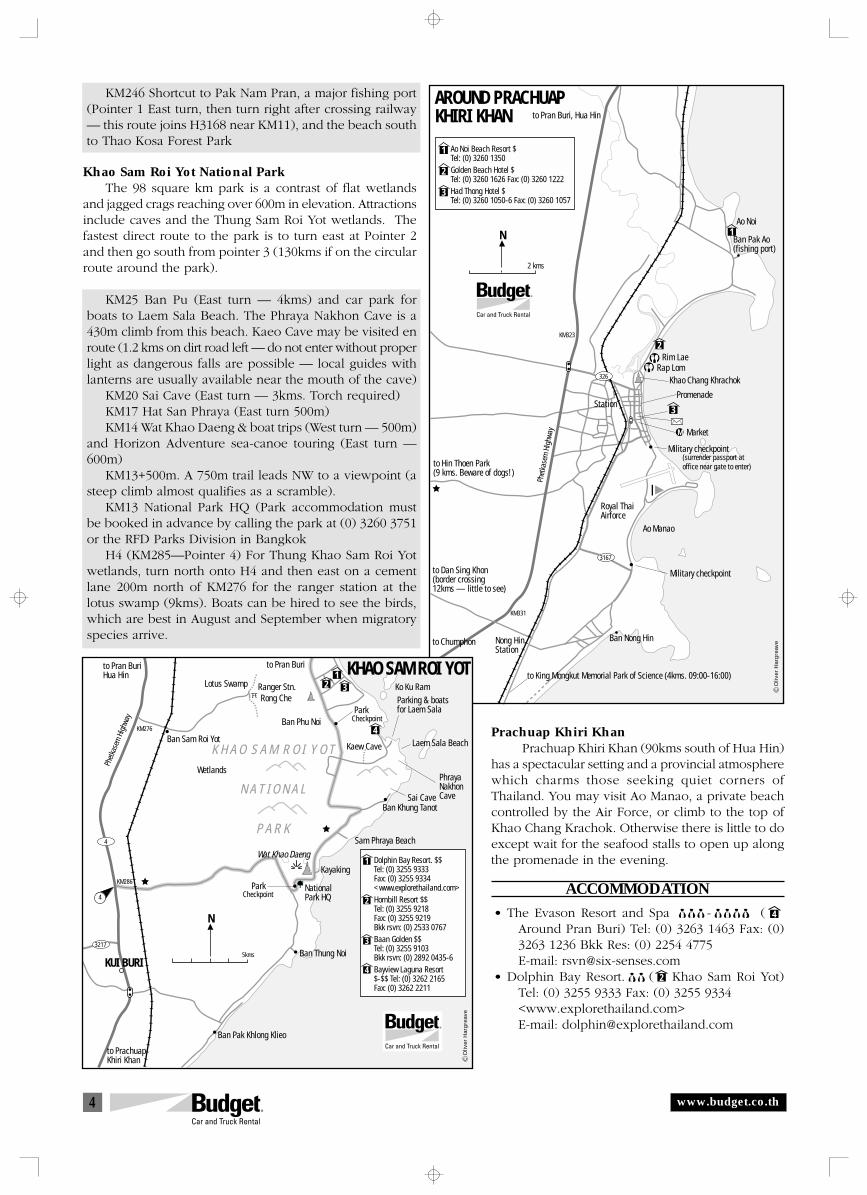
4
N
2 kms
3167
326
1
2
3
to King Mongkut Memorial Park of Science (4kms. 09:00-16:00)
AROUND PRACHUAPKHIRI KHAN
Ao Noi Beach Resort $ Tel: (0) 3260 1350 Golden Beach Hotel $ Tel: (0) 3260 1626 Fax: (0) 3260 1222Had Thong Hotel $Tel: (0) 3260 1050-6 Fax: (0) 3260 1057
to Pran Buri, Hua Hin
Ao Noi
Ban Pak Ao(fishing port)
Rim LaeRap Lom
Khao Chang Khrachok
Military checkpoint
Military checkpoint
PromenadeStation
Nong HinStation
M Market
to Hin Thoen Park(9 kms. Beware of dogs!)
Royal ThaiAirforce
Ao Manao
to Dan Sing Khon(border crossing12kms — little to see)
Ban Nong Hinto Chumphon
KM331
KM323
1
2
3
Oliv
er H
arg
reav
e
Phet
kase
m H
ighw
ay
(surrender passport atoffice near gate to enter)
N
3217
4
21
3
4
KHAO SAM ROI YOT
KUI BURI
Lotus Swamp
to Pran Burito Pran BuriHua Hin
Ranger Stn.Rong Che
Ban Phu NoiPark
Park
Checkpoint
Ko Ku Ram
Kaew CaveBan Sam Roi Yot
Wetlands
K H A O S A M R O I Y O T
N A T I O N A L
P A R K
Laem Sala Beach
Parking & boatsfor Laem Sala
PhrayaNakhonCaveSai Cave
Ban Khung Tanot
Sam Phraya Beach
Wat Khao Daeng
Kayaking
CheckpointNationalPark HQ
Ban Thung Noi
Ban Pak Khlong Klieo
to PrachuapKhiri Khan
1
2
3
4
Dolphin Bay Resort. $$Tel: (0) 3255 9333Fax: (0) 3255 9334<www.explorethailand.com>Hornbill Resort $$Tel: (0) 3255 9218Fax: (0) 3255 9219 Bkk rsvn: (0) 2533 0767Baan Golden $$Tel: (0) 3255 9103 Bkk rsvn: (0) 2892 0435-6Bayview Laguna Resort$-$$ Tel: (0) 3262 2165Fax: (0) 3262 2211
Oliv
er H
arg
reav
e
4
5kms
KM286
KM276
Phet
kase
m H
ighw
ay
KM246 Shortcut to Pak Nam Pran, a major fishing port(Pointer 1 East turn, then turn right after crossing railway— this route joins H3168 near KM11), and the beach southto Thao Kosa Forest Park
Khao Sam Roi Yot National ParkThe 98 square km park is a contrast of flat wetlands
and jagged crags reaching over 600m in elevation. Attractionsinclude caves and the Thung Sam Roi Yot wetlands. Thefastest direct route to the park is to turn east at Pointer 2and then go south from pointer 3 (130kms if on the circularroute around the park).
KM25 Ban Pu (East turn — 4kms) and car park forboats to Laem Sala Beach. The Phraya Nakhon Cave is a430m climb from this beach. Kaeo Cave may be visited enroute (1.2 kms on dirt road left — do not enter without properlight as dangerous falls are possible — local guides withlanterns are usually available near the mouth of the cave)
KM20 Sai Cave (East turn — 3kms. Torch required)KM17 Hat San Phraya (East turn 500m)KM14 Wat Khao Daeng & boat trips (West turn — 500m)
and Horizon Adventure sea-canoe touring (East turn —600m)
KM13+500m. A 750m trail leads NW to a viewpoint (asteep climb almost qualifies as a scramble).
KM13 National Park HQ (Park accommodation mustbe booked in advance by calling the park at (0) 3260 3751or the RFD Parks Division in Bangkok
H4 (KM285—Pointer 4) For Thung Khao Sam Roi Yotwetlands, turn north onto H4 and then east on a cementlane 200m north of KM276 for the ranger station at thelotus swamp (9kms). Boats can be hired to see the birds,which are best in August and September when migratoryspecies arrive.
Prachuap Khiri KhanPrachuap Khiri Khan (90kms south of Hua Hin)
has a spectacular setting and a provincial atmospherewhich charms those seeking quiet corners ofThailand. You may visit Ao Manao, a private beachcontrolled by the Air Force, or climb to the top ofKhao Chang Krachok. Otherwise there is little to doexcept wait for the seafood stalls to open up alongthe promenade in the evening.
ACCOMMODATION
• The Evason Resort and Spa $$$-$$$$ ( [2]Around Pran Buri) Tel: (0) 3263 1463 Fax: (0)3263 1236 Bkk Res: (0) 2254 4775E-mail: [email protected]
• Dolphin Bay Resort. $$ ([2] Khao Sam Roi Yot)Tel: (0) 3255 9333 Fax: (0) 3255 9334<www.explorethailand.com>E-mail: [email protected]
www.budget.co.th
4
2
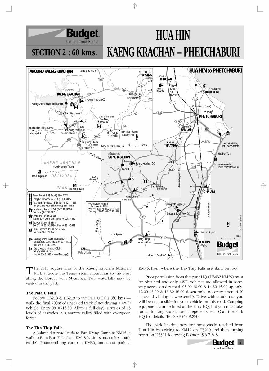
5
4
4
3349
3176
3206
31713179
3177
31873204
31753174
3432
3410
3410
3219
3301
3218
10
9
7
5
6
8
‡¢“¬âÕ¬
∫â“π·À≈¡
·°àß°√–®“π
À“¥‡®â“ ”√“≠
∫.¬“ß™ÿ¡
∫. “√‡ÀÁ¥
∫â“π≈“¥
∑à“¬“ß
™–Õ”
R Pran BuriPark HQ
‡æ™√∫ÿ√’
N
Hua
Hin-
Cha-
Am
Arou
nd K
aeng
Kra
chan
HUA HIN to PHETCHABURIKHAO YAI
SawangResort GC
ThamKhaoYoi(cave)
BAN LAEM
Khao Luang (cave)
PHETCHABURI
BAN LAT
THA YANG Hat Chao Samran
4
5
7 6
Hat Puk Tian
recommendedroute to Phetchaburi
KAENG KRACHAN
Kaeng Krachan CCDam
KM200
K A E N G K R A C H A N
N A T I O N A L
P A R K
Khao Phanoen Thong
Thao Thip Falls 4WD
Pran Buri Falls
R. Phetchaburi
Yang Chum
Ban Salahet
CHA-AM
Springfield Royal CC
Imperial Lake View CC
Majestic Creek CC
HUA HINÀ—«À‘π
Pala-U-Falls
∫.ÀπÕßæ—∫Nong Phlap
N
0 5kms
3459
3432
3432 3410
3410
3301
3432
3187
3175
3499
Ban Huai Thawai
to Nong Ya Plong
∫.¬“ß™ÿ¡
∫.ÀπÕߪóπ·µ°
·°àß°√–®“π
∑à“¬“ß
KAENG KRACHAN
AROUND KAENG KRACHAN
Kaeng Krachan CC
∫. “√‡ÀÁ¥ ∫.À⫬∑«“¬
∫.ÀπÕ߇¢“ÕÕπ∫.«—ß«π
∫.∑à“´‘°
Ban Salahet
Kaeng Krachan National Park HQ
THA YANG
Petch Dam
to H4
to H4
to H4
KM25
KM22 KM21KM19
KM8
KM14
KM15
KM10
KM12
KM11
Ban Tha Sik
Ban Wang Won
Ban Yang Chum
to Tho Thip Falls 36kms
One-way
Ban Nong Peun Taek
Ban NongKhao On
to Hua Hinback routes to Hua Hin
12
3
3
Thanu Resort $-$$ Tel: (0) 1944 6571Chatphet Resort $-$$ Tel: (0) 1866 8127 Petch Rim Tarn Resort $-$$ Tel: (0) 3241 1881Fax: (0) 3242 7220 Bkk rsvn: (0) 2241 1192Lam Luang Resort $$ Tel: (0) 3247 8177-9 Bkk rsvn: (0) 2392 7805Casuarina Resort $$-$$$Tel: (0) 3244 3080-2 Bkk rsvn: (0) 2254 1410Tipawan Chalet $$-$$$$Bkk Off: (0) 2319 2693-4. Fax: (0) 2319 2692Pala-U Resort $ Tel: (0) 1215 3577Bkk rsvn: (0) 2729 3673
123
Oliv
er H
arg
reav
eSawang Resort Golf Club (H4 KM137)Tel: (0) 3249 9556-8 Fax: (0) 3249 9555Bkk Off: (0) 2 440 0245Kaeng Krachan Country Club Tel: (0) 3242 4213-4Fax: (0) 3242 5587 (closed Mondays)
4
5
6
7
2
1
2
2
1
10 kms
87
6
Hua Hin Airport
4WD only past this point— No entry after 14:30West only 05:00-10:00 & 14:30-15:00East only 12:00-13:00 & 16:30-18:00
!
checkpoint
checkpoint
Phet
kase
m H
ighw
ay
bypa
ss
HUA HINKAENG KRACHAN – PHETCHABURISECTION 2 : 60 kms.
he 2915 square kms of the Kaeng Krachan NationalPark straddle the Tennasserim mountains to the west
along the border with Myanmar. Two waterfalls may bevisited in the park.
The Pala U FallsFollow H3218 & H3219 to the Pala U Falls (60 kms —
walk the final 700m of unsealed track if not driving a 4WDvehicle. Entry 08:00-16:30. Allow a full day), a series of 15levels of cascades in a narrow valley filled with evergreenforest.
The Tho Thip FallsA 36kms dirt road leads to Ban Krang Camp at KM15, a
walk to Pran Buri Falls from KM18 (visitors must take a parkguide), Phanoenthong camp at KM30, and a car park at
KM36, from where the Tho Thip Falls are 4kms on foot.
Prior permission from the park HQ (H3432 KM29) mustbe obtained and only 4WD vehicles are allowed in (one-way access on dirt road: 05:00-10:00 & 14:30-15:00 up only;12:00-13:00 & 16:30-18:00 down only; no entry after 14:30— avoid visiting at weekends). Drive with caution as youwill be responsible for your vehicle on this road. Campingequipment can be hired at the Park HQ, but you must takefood, drinking water, torch, repellents, etc. (Call the ParkHQ for details. Tel (0) 3245 9293).
The park headquarters are most easily reached fromHua Hin by driving to KM12 on H3219 and then turningnorth on H3301 following Pointers 5,6 7 & 8.
T
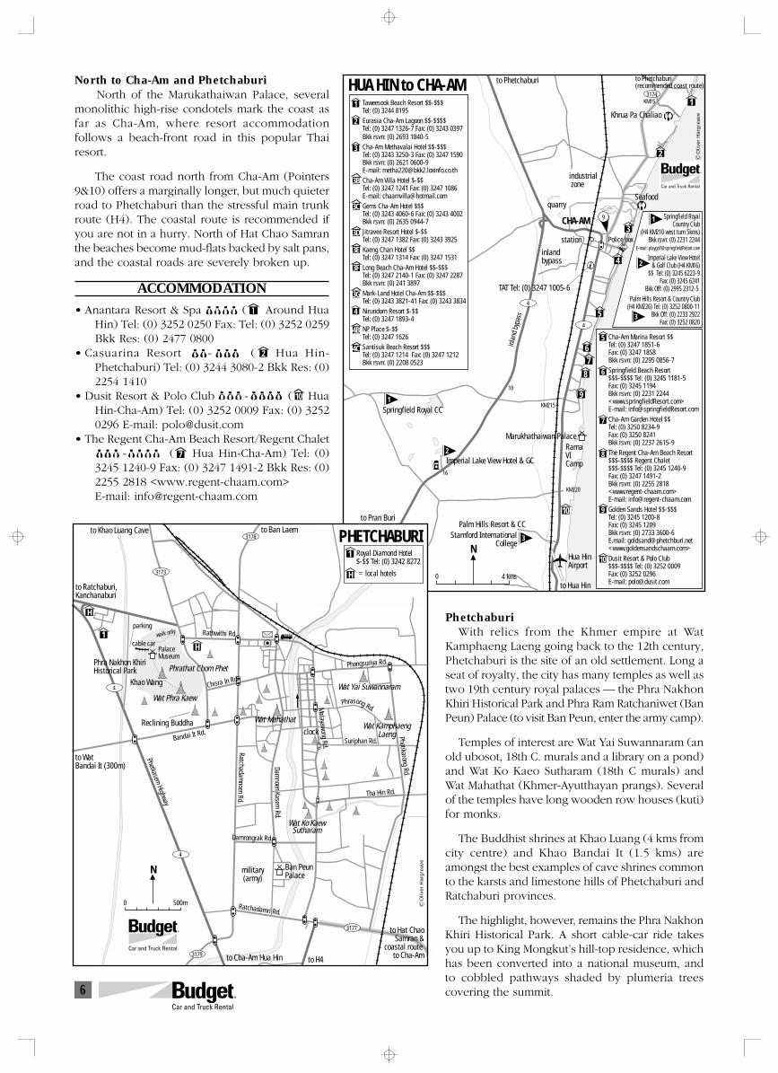
6
N
0 4 kms
HUA HIN to CHA-AM3174
4
4
1
2
3
4
5
67
8
9
10
TAT Tel: (0) 3247 1005-6
to Phetchaburi(recommended coast route)
KM15
Khrua Pa Chaliao
Seafood
Police box
to Phetchaburi
industrial zone
quarry
station
inlandbypass
CHA-AM
1
2
3
4
5
6
7
8
9
10
Stamford InternationalCollege
16
10
KM220
KM215Springfield Royal CC
Imperial Lake View Hotel & GC
RamaVICamp
Marukhathaiwan Palace
Palm Hills Resort & CC
to Hua Hin
to Pran Buri
Cha-Am Marina Resort $$Tel: (0) 3247 1851-6 Fax: (0) 3247 1858Bkk rsvn: (0) 2295 0856-7Springfield Beach Resort$$$-$$$$ Tel: (0) 3245 1181-5Fax: (0) 3245 1194Bkk rsvn: (0) 2231 2244<www.springfieldResort.com>E-mail: [email protected] Garden Hotel $$Tel: (0) 3250 8234-9Fax: (0) 3250 8241Bkk rsvn: (0) 2237 2615-9The Regent Cha-Am Beach Resort$$$-$$$$ Regent Chalet$$$-$$$$ Tel: (0) 3245 1240-9Fax: (0) 3247 1491-2Bkk rsvn: (0) 2255 2818<www.regent-chaam.com>E-mail: [email protected] Sands Hotel $$-$$$Tel: (0) 3245 1200-8Fax: (0) 3245 1209Bkk rsvn: (0) 2733 3600-6E.mail: [email protected]<www.goldensandschaam.com>Dusit Resort & Polo Club $$$-$$$$ Tel: (0) 3252 0009Fax: (0) 3252 0296E-mail: [email protected]
Oliv
er H
arg
reav
e
Taweesook Beach Resort $$-$$$Tel: (0) 3244 8195Eurasia Cha-Am Lagoon $$-$$$$Tel: (0) 3247 1326-7 Fax: (0) 3243 0397Bkk rsvn: (0) 2693 1840-5Cha-Am Methavalai Hotel $$-$$$Tel: (0) 3243 3250-3 Fax: (0) 3247 1590Bkk rsvn: (0) 2621 0600-9 E-mail: [email protected] Villa Hotel $-$$Tel: (0) 3247 1241 Fax: (0) 3247 1086 E-mail: [email protected] Cha-Am Hotel $$$Tel: (0) 3243 4060-6 Fax: (0) 3243 4002 Bkk rsvn: (0) 2635 0944-7Jitravee Resort Hotel $-$$Tel: (0) 3247 1382 Fax: (0) 3243 3925Kaeng Chan Hotel $$Tel: (0) 3247 1314 Fax: (0) 3247 1531Long Beach Cha-Am Hotel $$-$$$Tel: (0) 3247 2140-1 Fax: (0) 3247 2287 Bkk rsvn: (0) 241 3897Mark-Land Hotel Cha-Am $$-$$$Tel: (0) 3243 3821-41 Fax: (0) 3243 3834Nirundorn Resort $-$$Tel: (0) 3247 1893-4 NP Place $-$$Tel: (0) 3247 1626Santisuk Beach Resort $$$Tel: (0) 3247 1214 Fax: (0) 3247 1212 Bkk rsvn: (0) 2208 0523
9
Hua HinAirport
1
2
3
1
2
3
Springfield RoyalCountry Club
(H4 KM210 west turn 5kms)Bkk rsvn: (0) 2231 2244
E-mail: [email protected]
Imperial Lake View Hotel& Golf Club (H4 KM16)
$$ Tel: (0) 3245 6223-9Fax: (0) 3245 6241
Bkk Off: (0) 2995 2312-5 Palm Hills Resort & Country Club
(H4 KM226) Tel: (0) 3252 0800-11Bkk Off: (0) 2233 2922
Fax: (0) 3252 0820
3B
3C
4B
4C
3D
3E
3F
3G
inla
nd b
ypas
s
N
0 500m
3173
3178
4
4
3179
3177
H
H1
Royal Diamond Hotel$-$$ Tel: (0) 3242 8272
PHETCHABURIto Khao Luang Cave to Ban Laem
to Ratchaburi,Kanchanaburi
Rathwithi Rd.cable car
walk only
Khao Wang
Reclining Buddha
PalaceMuseum
Phra Nakhon KhiriHistorical Park Phrathat Chom Phet
Wat Phra Kaew
Phongsuriya Rd.
Wat Yai Suwannaram
to WatBandai It (300m)
Bandai It Rd.
Wat Mahathatclock
Phrasong Rd.
Wat KamphaengLaeng
Matayawong Rd. Suriphan Rd.
Photikarong Rd.
Ratchadamnoen Rd.
Damnoen Kasem
Rd.
Wat Ko KaewSutharam
Tha Hin Rd.
Phetkasem Highway
Damrongrak Rd.
military(army)
Ban PeunPalace
Ratchadamri Rd.
to Cha-Am Hua Hin to H4
to Hat ChaoSamran &
coastal route to Cha-Am
Chisra In Rd.
1
Oliv
er H
arg
reav
e
H = local hotels
parking
North to Cha-Am and PhetchaburiNorth of the Marukathaiwan Palace, several
monolithic high-rise condotels mark the coast asfar as Cha-Am, where resort accommodationfollows a beach-front road in this popular Thairesort.
The coast road north from Cha-Am (Pointers9&10) offers a marginally longer, but much quieterroad to Phetchaburi than the stressful main trunkroute (H4). The coastal route is recommended ifyou are not in a hurry. North of Hat Chao Samranthe beaches become mud-flats backed by salt pans,and the coastal roads are severely broken up.
ACCOMMODATION
• Anantara Resort & Spa $$$$ ([1] Around HuaHin) Tel: (0) 3252 0250 Fax: Tel: (0) 3252 0259Bkk Res: (0) 2477 0800
• Casuarina Resort $$-$$$ ([2] Hua Hin-Phetchaburi) Tel: (0) 3244 3080-2 Bkk Res: (0)2254 1410
• Dusit Resort & Polo Club $$$-$$$$ ([7] HuaHin-Cha-Am) Tel: (0) 3252 0009 Fax: (0) 32520296 E-mail: [email protected]
• The Regent Cha-Am Beach Resort/Regent Chalet$$$ -$$$$ ([4 Hua Hin-Cha-Am) Tel: (0)3245 1240-9 Fax: (0) 3247 1491-2 Bkk Res: (0)2255 2818 <www.regent-chaam.com>E-mail: [email protected]
PhetchaburiWith relics from the Khmer empire at Wat
Kamphaeng Laeng going back to the 12th century,Phetchaburi is the site of an old settlement. Long aseat of royalty, the city has many temples as well astwo 19th century royal palaces — the Phra NakhonKhiri Historical Park and Phra Ram Ratchaniwet (BanPeun) Palace (to visit Ban Peun, enter the army camp).
Temples of interest are Wat Yai Suwannaram (anold ubosot, 18th C. murals and a library on a pond)and Wat Ko Kaeo Sutharam (18th C murals) andWat Mahathat (Khmer-Ayutthayan prangs). Severalof the temples have long wooden row houses (kuti)for monks.
The Buddhist shrines at Khao Luang (4 kms fromcity centre) and Khao Bandai It (1.5 kms) areamongst the best examples of cave shrines commonto the karsts and limestone hills of Phetchaburi andRatchaburi provinces.
The highlight, however, remains the Phra NakhonKhiri Historical Park. A short cable-car ride takesyou up to King Mongkut’s hill-top residence, whichhas been converted into a national museum, andto cobbled pathways shaded by plumeria treescovering the summit.
2
10
7
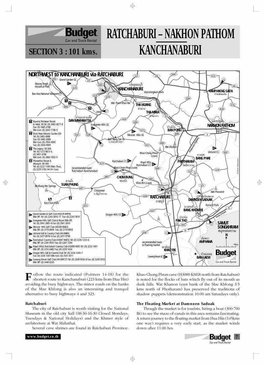
7
3455
3229
3229
3305
3229
32093429
323
323
32733089
3089
3237 3236
3097
325
3089
3087
3291
3357
3243040
3232
3394
4
4
321 3233
30363085
3361 3209
3274
3087
3087
3313
3208
3337
3206
3093
35
35
3455
18
13
23
17
16
12
15
14
11N
∑à“¡à«ß
∑à“¡–°“
∫â“π‚ªÉß
‚æ∏‘Ï∑“√“¡
®Õ¡∫÷ß
∫.™—ƪɓÀ«“¬
∫.ÀπÕßµ“°¬“
∫“ß·æ
¥à“π¡–¢“¡‡µ’Ȭ
«πº÷Èß
ª“°∑àÕ
¥”‡π‘𠥫°
∫“ߧπ∑’
°”·æß· π
12
3
4
SAMUTSONGKHRAM
Rama II Park
NORTHWEST to KANCHANBURI via RATCHABURINORTHWEST to KANCHANBURI via RATCHABURI
KANCHANABURI
‡¢“¬âÕ¬
Õ—¡æ«“
∫â“π·À≈¡
°“≠®π∫ÿ√’
π§√ª∞¡
KHAO YAI
BAN LAEMSawang Resort GC
Muang SinghHistorical Park
Grand Garden GC
Ban Kao National Museum
Wat Tham Khao Noi THA MUANG
THA MAKA
DAN MAKHAM TIAEvergreen Hills GC
Mission Hills GC
BAN PONGNAKHON PATHOM
Wat Khanon
Uniland CC
Ratchaburi CC
Khao Chom Phon (cave)
Khao Chong Phran(cave)
KM64
PHOTHARAMBANG PHAE
CHOM BUNG
Royal VillaRatchaburi CC
Khao Bin (cave)SUAN PHUNGBo Klung Hot Springs
Kao Chan Falls
Chatpawai
Ban Nong Tak Ya
√“™∫ÿ√’
¡ÿ∑√ ߧ√“¡
RATCHABURIDAMNOEN SADUAK
Wat Prasatsit
Dragon Hills CC
PAK THO
BANG KHONTHI
AMPHAWA
1
2
3
4
Baanrai Rimkwai Resort& Hotel. $$ Tel: (0) 3465 4077-8Fax: (0) 3465 4186Bkk rsvn: (0) 2643 1748-9River Kwai Botanic Garden [$$Tel: (0) 3465 4088Fax: (0) 3465 4088Bkk rsvn: (0) 2934 4909Fax: (0) 2934 4909The Legacy. $$-$$$Tel: (0) 1213 9872-6,(0) 3451 6788Bkk rsvn: (0) 2860 7602-9Phawothai Resort &Museum $$-$$$ Tel: (0) 3222 1189 (Mon-Thur),(0) 3239 5192-94 (Fri-Sun)
Oliv
er H
arg
reav
e
1
23
4
56
71
2
3
4
5
6
7
88
Vajiralongkorn Dam
Grand Garden & Golf Club (H3229 KM18)Bkk Off. Tel: (0) 2243 5816-17 Fax: (0) 2243 5819Evergreen Hills Golf Club & Resort Bkk Off:Tel: (0) 2941 2801-8 Fax: (0) 2941 2810Mission Hills Golf Club (H3209 KM23)Bkk Off: (0) 2719 8949 Fax: (0) 2719 8959Uniland Golf & Country Club (H4 KM60)Tel: (0) 2477 8976-9 Fax: (0) 2477 9798Ratchaburi Country Club (H3087 KM25) Tel: (0) 3226 1223-6Bkk Off: (0) 2281 8591 Fax: (0) 2281 7294Royal (Villa) Ratchaburi Country Club (H3089 KM7) Tel: (0) 3232 1061Bkk Off: (0) 2255 6482 Fax: (0) 2259 1634Dragon Hills Golf & Country Club Tel: (0) 3226 1205-7Fax: (0) 3226 1207 Bkk rsvn: (0) 2541 4311Sawang Resort Golf Club (H4 KM137) Tel: (0) 3249 9556-8 Fax: (0) 3249 9555Bkk Off: (0) 2440 0245
346
KAMPHAENG SAEN346
10kms
Phetk
asem
High
way
Rama II Road
recommended routeto floating market
recommended routeRatchaburi-Kanchanaburi
RATCHABURI – NAKHON PATHOMKANCHANABURISECTION 3 : 101 kms.
ollow the route indicated (Pointers 14-18) for theshortest route to Kanchanaburi (223 kms from Hua Hin)
avoiding the busy highways. The minor roads on the banksof the Mae Khlong is also an interesting and tranquilalternative to busy highways 4 and 323.
RatchaburiThe city of Ratchaburi is worth visiting for the National
Museum in the old city hall (08:30-16:30 Closed Mondays,Tuesdays & National Holidays) and the Khmer style ofarchitecture at Wat Mahathat.
Several cave shrines are found in Ratchaburi Province.
F Khao Chong Phran cave (H3089 KM18 north from Ratchaburi)is noted for the flocks of bats which fly out of its mouth asdusk falls. Wat Khanon (east bank of the Mae Khlong 3.5kms north of Photharam) has preserved the traditions ofshadow puppets (demonstration 10:00 am Saturdays only).
The Floating Market at Damnoen SaduakThough the market is for tourists, hiring a boat (300-700
Bt) to see the maze of canals in this area remains fascinating.A return journey to the floating market from Hua Hin (145kmsone way) requires a very early start, as the market windsdown after 11:00 hrs.
www.budget.co.th
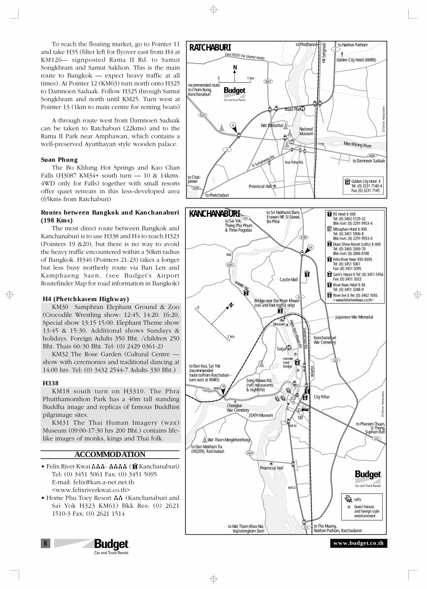
8
Golden City Hotel $Tel: (0) 3231 7140-4Fax: (0) 3231 7145
N
0 1 km
4
4
3087
3291
3208
3088
RATCHABURI to Photharam to Nakhon Pathom
H4 (o
rigin
al)
(use H3291 for shorter route) Golden City Hotel (KM96)
recommended routeto Chom Bung,Kanchanaburi
Wat Mahathat
Ruan Phe
NationalMuseum
Mae Khlong River
Si Suriyawong Rd.
Krai Peha Rd. to Damneon Saduak
Provincial Hall
to Chat-pawai
to Phetchaburi
H
Oliv
er H
arg
reav
e
9
N0
2 km
to Phanom Thuan,U-Thong,
Suphan Buri
to Sri Nakharin Dam,Erawan NP, Si Sawat,Bo Phloi
Castle Mall
Japanese War Memorial
Bridge over the River Khwae(rail and foot traffic only)
Saengchuto Rd.
Maen Nam Khwae Rd.
WarMuseum
Sutjai
narrowroadbridge station
KanchanaburiWar Cemetery
M
TAT
City Pillar
Song Khwae Rd.(raft restaurants& nightlife)
JEATH Museum
ChongkaiWar Cemetery
to Tha Muang,Nakhon Pathom, Ratchadamri
to Wat Tham Khao Noi,Vajiralongkorn Dam
Wat Tham Mongkhonthong
to Dan Makham Tia(H3209), Ratchaburi
Provincial Hall
to Ban Kao, Sai Yok(recommended route to/from Ratchaburi -turn east at KM45)
to Sai Yok,Thong Pha Phum& Three Pagodas
KHWAE YAI
3229
3199
3305
1
4
3
2
rafts
Guest housesand foreign styleentertainment
KM2
KM56
1
1B
2
3
4
5
6
Oliv
er H
arg
reav
e
RS Hotel $-$$$Tel: (0) 3462 5129-32 Bkk rsvn: (0) 2291 9953-4Mittaphan Hotel $-$$$Tel: (0) 3451 5906-8 Bkk rsvn: (0) 2291 9953-4Duen Shine Resort (rafts) $-$$$Tel: (0) 3465 3369-70 Bkk rsvn: (0) 2866 8180Felix River Kwai $$$-$$$$Tel: (0) 3451 5061Fax: (0) 3451 5095Sam's House $ Tel: (0) 3451 5956Fax: (0) 3451 2023River Kwai Hotel $-$$Tel: (0) 3451 3348-9River Inn $ Tel: (0) 3462 1056<www.felixriverkwai.co.th>
323
KANCHANABURI
323
3429
323
324
323
56
KM126
KM122
18
24
To reach the floating market, go to Pointer 11and take H35 (filter left for flyover east from H4 atKM126— signposted Rama II Rd. to SamutSongkhram and Samut Sakhon. This is the mainroute to Bangkok — expect heavy traffic at alltimes). At Pointer 12 (KM63) turn north onto H325to Damnoen Saduak. Follow H325 through SamutSongkhram and north until KM25. Turn west atPointer 13 (1km to main centre for renting boats)
A through route west from Damnoen Saduakcan be taken to Ratchaburi (22kms) and to theRama II Park near Amphawan, which contains awell-preserved Ayutthayan style wooden palace.
Suan PhungThe Bo Khlung Hot Springs and Kao Chan
Falls (H3087 KM34+ south turn — 10 & 14kms.4WD only for Falls) together with small resortsoffer quiet retreats in this less-developed area(65kms from Ratchaburi)
Routes between Bangkok and Kanchanaburi(198 Kms)
The most direct route between Bangkok andKanchanaburi is to use H338 and H4 to reach H323(Pointers 19 &20), but there is no way to avoidthe heavy traffic encountered within a 50km radiusof Bangkok. H346 (Pointers 21-23) takes a longerbut less busy northerly route via Ban Len andKamphaeng Saen. (see Budget’s AirportRoutefinder Map for road information in Bangkok)
H4 (Phetchkasem Highway)KM30 Samphran Elephant Ground & Zoo
(Crocodile Wrestling show: 12:45, 14:20. 16:20,Special show 13:15 15:00. Elephant Theme show13:45 & 15:30. Additional shows Sundays &holidays. Foreign Adults 350 Bht. /children 250Bht. Thais 60/30 Bht. Tel: (0) 2429 0361-2)
KM32 The Rose Garden (Cultural Centre —show with ceremonies and traditional dancing at14:00 hrs. Tel: (0) 3432 2544-7 Adults 330 Bht.)
H338KM18 south turn on H3310. The Phra
Phutthamonthon Park has a 40m tall standingBuddha image and replicas of famous Buddhistpilgrimage sites.
KM31 The Thai Human Imagery (wax)Museum (09:00-17:30 hrs 200 Bht.) contains life-like images of monks, kings and Thai folk.
ACCOMMODATION
• Felix River Kwai $$$ -$$$$ ([5] Kanchanaburi)Tel: (0) 3451 5061 Fax: (0) 3451 5095E-mail: [email protected]<www.felixriverkwai.co.th>
• Home Phu Toey Resort $$ (Kanchanaburi andSai Yok H323 KM61) Bkk Res: (0) 26211510-3 Fax: (0) 2621 1514
5
www.budget.co.th
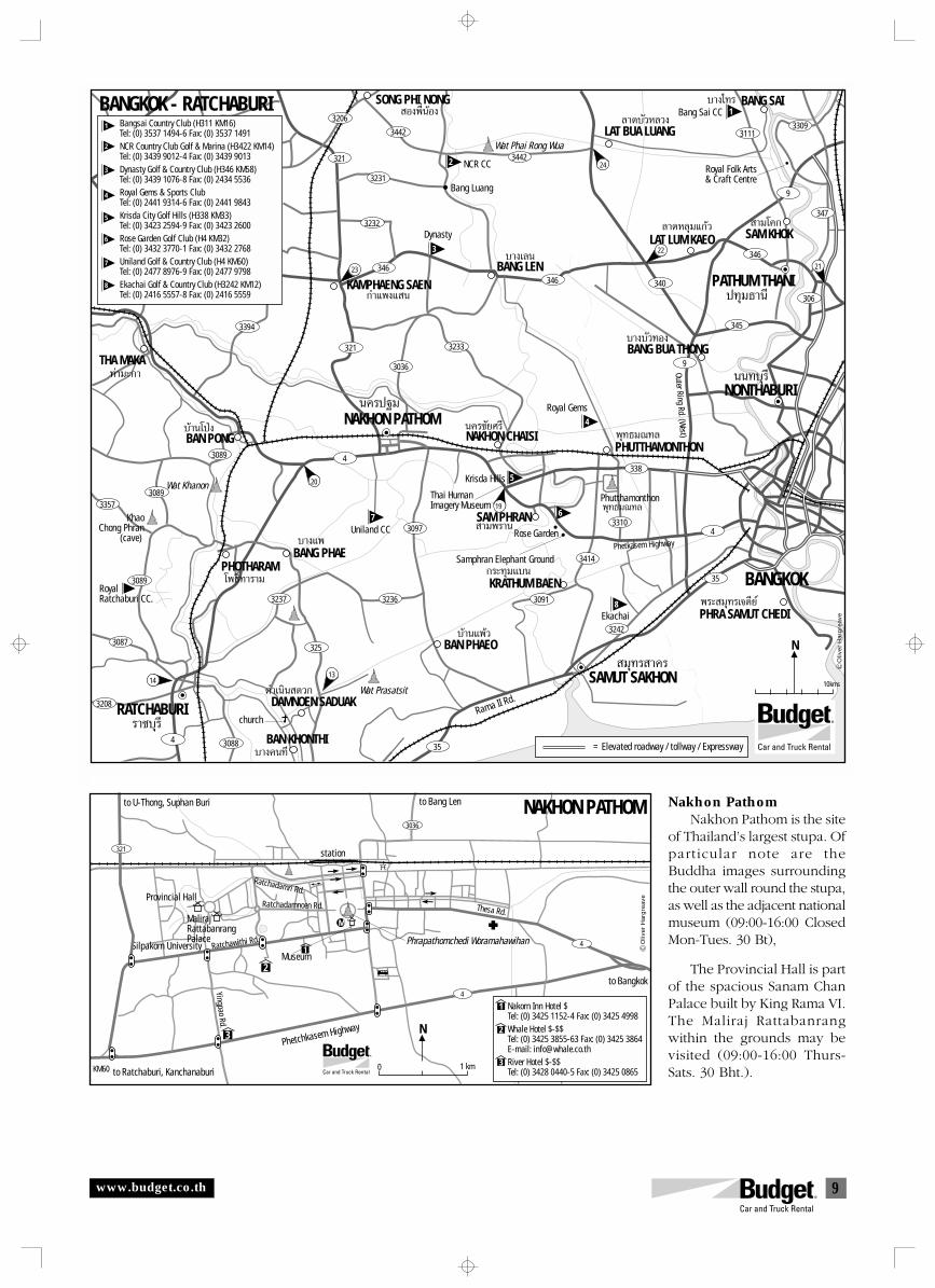
9
Nakhon PathomNakhon Pathom is the site
of Thailand’s largest stupa. Ofparticular note are theBuddha images surroundingthe outer wall round the stupa,as well as the adjacent nationalmuseum (09:00-16:00 ClosedMon-Tues. 30 Bt),
The Provincial Hall is partof the spacious Sanam ChanPalace built by King Rama VI.The Maliraj Rattabanrangwithin the grounds may bevisited (09:00-16:00 Thurs-Sats. 30 Bht.).
www.budget.co.th
321
3232
346346
346
345
306
9
340
9
338
3310
3414
3231
3442
31113309
3442
3036
3233
3040346
N
Õßæ’ËπâÕß≈“¥∫—«À≈«ß
æÿ∑∏¡≥∑≈
æÿ∑∏¡≥∑≈
∫“߇≈π
π§√™—¬»√’
“¡æ√“π
≈“¥À≈ÿ¡·°â«
∫“ß∫—«∑Õß
°√–∑ÿ¡·∫π
∫â“π·æâ«
∫“߉∑√
“¡‚§°
Wat Prasatsit
BANGKOK - RATCHABURI SONG PHI NONG
∫â“π‚ªÉßBAN PONG
√“™∫ÿ√’
14
19
20
24
‚æ∏‘Ï∑“√“¡
∫“ß·æ
¥”‡π‘𠥫°
PHOTHARAMBANG PHAE
∫“ߧπ∑’
13
23
22
DAMNOEN SADUAK
BAN KHONTHI
°”·æß· π
π§√ª∞¡
ππ∑∫ÿ√’
¡ÿ∑√ “§√
ª∑ÿ¡∏“π’KAMPHAENG SAEN
NAKHON PATHOM
PATHUM THANI
NONTHABURI
NAKHON CHAISI
Wat Khanon
Uniland CC
church
RoyalRatchaburi CC.
3089
3089
3237 3236
3097
4
4
4 3088
35
3242
3091
3394
321
325
3089
3087
3357
3208
35
∑à“¡–°“THA MAKA
RATCHABURI
Bang Luang
NCR CC
Bang Sai CC
Wat Phai Rong WuaLAT BUA LUANG
BANG SAI
Dynasty
BANG LEN
PHUTTHAMONTHON
æ√– ¡ÿ∑√‡®¥’¬åPHRA SAMUT CHEDI
LAT LUM KAEO
BANG BUA THONG
SAM KHOK
Royal Gems
Royal Folk Arts& Craft Centre
Phutthamonthon
Krisda Hills
SAM PHRAN
Thai HumanImagery Museum
Rose Garden
Samphran Elephant Ground
KRATHUM BAEN
BAN PHAEO
Ekachai
SAMUT SAKHON
Rama II Rd.
BANGKOK
Bangsai Country Club (H311 KM16)Tel: (0) 3537 1494-6 Fax: (0) 3537 1491NCR Country Club Golf & Marina (H3422 KM14)Tel: (0) 3439 9012-4 Fax: (0) 3439 9013Dynasty Golf & Country Club (H346 KM58)Tel: (0) 3439 1076-8 Fax: (0) 2434 5536Royal Gems & Sports Club Tel: (0) 2441 9314-6 Fax: (0) 2441 9843Krisda City Golf Hills (H338 KM33)Tel: (0) 3423 2594-9 Fax: (0) 3423 2600Rose Garden Golf Club (H4 KM32)Tel: (0) 3432 3770-1 Fax: (0) 3432 2768Uniland Golf & Country Club (H4 KM60)Tel: (0) 2477 8976-9 Fax: (0) 2477 9798Ekachai Golf & Country Club (H3242 KM12)Tel: (0) 2416 5557-8 Fax: (0) 2416 5559
Oliv
er H
arg
reav
e
1
2
3
1
2
3
4
5
6
7
8
4
5
67
8
3206
KhaoChong Phran
(cave)
21
347
= Elevated roadway / tollway / Expressway
10kms
Phetkasem Highway
Outer Ring Rd. (West)
N
0 1 km
NAKHON PATHOMto U-Thong, Suphan Buri to Bang Len
station
Ratchadamri Rd.Provincial Hall
MalirajRattabanrangPalace
Ratchadamnoen Rd. Thesa Rd.
Silpakorn University Ratchawithi Rd.
Yingpao Rd.
Phetchkasem Highway
to Ratchaburi, KanchanaburiKM60
to Bangkok
Phrapathomchedi Woramahawihan
Museum
4
3036
M
2
3
1
Nakorn Inn Hotel $Tel: (0) 3425 1152-4 Fax: (0) 3425 4998Whale Hotel $-$$Tel: (0) 3425 3855-63 Fax: (0) 3425 3864 E-mail: [email protected] Hotel $-$$Tel: (0) 3428 0440-5 Fax: (0) 3425 0865
1
2
3
Oliv
er H
arg
reav
e
4
321
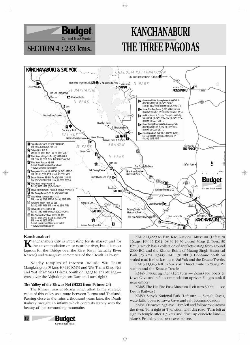
10
KANCHANABURITHE THREE PAGODASSECTION 4 : 233 kms.
Kanchanaburianchanaburi City is interesting for its market and forthe accommodation on or near the river, but it is most
famous for the ‘Bridge over the River Kwai’ (actually RiverKhwae) and war-grave cemeteries of the ‘Death Railway’.
Nearby temples of interest include Wat ThamMangkongton (9 kms H3429 KM5) and Wat Tham Khao Noiand Wat Tham Sua (17kms. South on H323 to Tha Muang —cross over the Vajiralongkorn Dam and turn right)
The Valley of the Khwae Noi (H323 from Pointer 24)The Khmer ruins at Muang Singh attest to the strategic
value of this valley as a route between Burma and Thailand.Passing close to the ruins a thousand years later, the DeathRailway brought an infamy which contrasts starkly with thebeauty of the surrounding mountains.
KKM12 H3229 to Ban Kao National Museum (Left turn
16kms. H3445 KM2. 08:30-16:30 closed Mons & Tues. 30Bht..), which has a collection of artefacts dating from around2000 BC, and the Khmer Ruins of Muang Singh HistoricalPark (25 kms. H3445 KM11 30 Bht..). Continue north onsealed road for back route to Sai Yok and the Krasae Trestle.
KM15 H3343 left to Sai Yok. Direct route to Wang Postation and the Krasae Trestle
KM45 Paksaeng Pier (Left turn — 2kms) for boats toLawa Cave and raft accommodation upriver. Fill gas tank ifnear empty!
KM65 The Hellfire Pass Museum (Left turn 300m — seeDeath Railway)
KM80. Saiyok National Park (Left turn — 3kms). Caves,waterfalls, boats to Lawa Cave and raft accommodation.
KM84. Daowadung Cave (Turn left and follow road acrossthe river. Turn right at T junction with dirt road. Turn left atsign to temple after 1.3 kms and drive up concrete lane —4kms). Probably the best caves to see.
323
3199
3480
3306
3190
3342
3475
3455323 3500
3086
324
3398
3199
3229
3305
N
1
2
34
5
H
H
9
10
11
12 13
8
»√’ «— ¥‘Ï
‰∑√‚¬§
KANCHANABURI & SAI YOK
Green World GC
Hin Dat Hot Springs
Huai Mae Khamin Falls
Phathat Falls
Si Nakharin N. Park
Chaloem Rattanakosin N. Park
SI SAWAT ÀπÕߪ√◊ÕNONG PHRU
∫àÕæ≈Õ¬BO PHLOI
Daowadung Cave
Sai Yok N. Park
Phrathat Cave
Si Nakharin Dam
Hellfire Pass MuseumErawan Falls & N. Park
Home Phutoey
Lawa Cave
Nam Tok
Pak Saeng Pier
River Khwai Golf & CC
Tha Thung Na Dam
Nine Army BattleHistorical Park
Safari Park
SAI YOK Nichigo Resort & CC
Muang SinghHistorical Park
Grand Garden
KANCHANABURI°“≠®π∫ÿ√’Ban Kao National Museum
3229
KM92
27
28
24
26
Suanthan Resort $ Tel: (0) 1908 0042Bkk Tel: & Fax: (0) 2573 5138Saiyok View Raft $Off Tel: (0) 3451 4194 Fax: (0) 3451 5913River Kwai Village $$ Tel: (0) 3463 454-6Bkk rsvn: (0) 2251 7552 Fax: (0) 2255 2350River Kwai Resotel $$-$$$E-mail: [email protected]<www.RiverKwaiFloatel.com>Pung Waan Resort $$-$$$ Tel: (0) 3451 4792-5Bkk Off: (0) 2281 3221-6 Fax: (0) 2278 5073Suansri Resort. $$-$$$ Tel: (0) 3459 1238-40Fax: (0) 3459 1062 Bkk rsvn: (0) 2880 7350-2River Kwai Jungle House $$Tel: (0) 3456 1052, (0) 3459 1062Erawan Resort Guest House. $ Tel: (0) 1907 8210Pha Daeng Resort $-$$ Tel: (0) 3451 3909River Khwai Park Resort $$-$$$Bkk rsvn: (0) 2642 6221-3 Fax: (0) 2642 6224Kasalong Resort Hotel $$-$$$Tel: (0) 3451 5061 Bkk rsvn: (0) 2246 7436Erawan Princess Hotel $-$$Tel: (0) 1480 2036 Bkk rsvn: (0) 2249 2668The Pavilion River Kwai Resort $$-$$$Tel: (0) 3451 5772-3 Fax: (0) 3451 5774Bkk rsvn: (0) 2207 0703-4E-mail: [email protected]<www.Pavilionhotel.co.th>
1
2
3
4
5
6
7
8910
11
12
13
Oliv
er H
arg
reav
e
1
2
5
3
4
1
2
3
4
5
Green World Hot Spring Resort & Golf Club(H323 KM106) Tel: (0) 3459 9210-1Fax: (0) 3459 9211 Bkk Off: (0) 2539 4613-6Home Phu Toey Resort (H323 KM61)$$-$$$Bkk rsvn: (0) 2621 1510-3 Fax: (0) 2621 1514Nichigo Resort & Country Club (H3199 KM9)$$-$$$ Tel: (0) 3451 3304 Fax: (0) 3451 3334Bkk Off: (0) 2231 2681-3River Kwai (Milford) Golf & Country Club(H323 KM40) $ Tel & Fax: (0) 3459 1037Bkk Off: (0) 2235 2871-2Grand Garden & Golf Club (H3229 KM18)$$-$$$ Bkk Off. Tel: (0) 2243 5816-17 Fax: (0) 2243 5819
7
‰∑√‚¬§
Wang Po Stn.
Krasea Cave (trestle)
6
323
SAI YOK
10kms
3343
(See section 3)
E R A W A N
N. P A R K
S I N A K H A R I N
N. P A R K
S A I Y O K
N. P A R K
C H A L O E M R A T T A N A K O S I N
N. P A R K
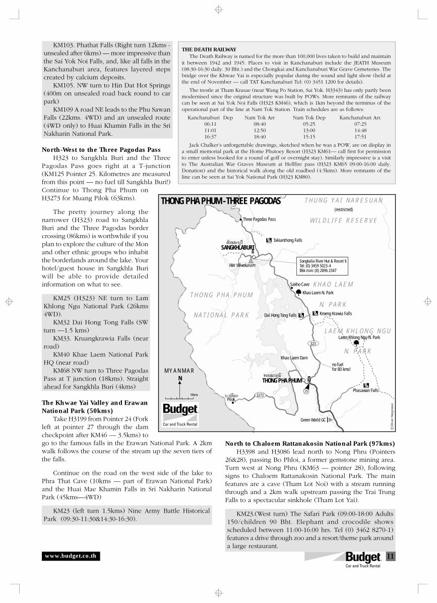
11
KM103. Phathat Falls (Right turn 12kms -unsealed after 6kms) — more impressive thanthe Sai Yok Noi Falls, and, like all falls in theKanchanaburi area, features layered stepscreated by calcium deposits.
KM105. NW turn to Hin Dat Hot Springs(400m on unsealed road back round to carpark)
KM109 A road NE leads to the Phu SawanFalls (22kms. 4WD) and an unsealed route(4WD only) to Huai Khamin Falls in the SriNakharin National Park.
North-West to the Three Pagodas PassH323 to Sangkhla Buri and the Three
Pagodas Pass goes right at a T-junction(KM125 Pointer 25. Kilometres are measuredfrom this point — no fuel till Sangkhla Buri!)Continue to Thong Pha Phum onH3273 for Muang Pilok (63kms).
The pretty journey along thenarrower (H323) road to SangkhlaBuri and the Three Pagodas bordercrossing (86kms) is worthwhile if youplan to explore the culture of the Monand other ethnic groups who inhabitthe borderlands around the lake. Yourhotel/guest house in Sangkhla Buriwill be able to provide detailedinformation on what to see.
KM25 (H323) NE turn to LamKhlong Ngu National Park (26kms4WD).
KM32 Dai Hong Tong Falls (SWturn —1.5 kms)
KM33. Kruangkrawia Falls (nearroad)
KM40 Khae Laem National ParkHQ (near road)
KM68 NW turn to Three PagodasPass at T junction (18kms). Straightahead for Sangkhla Buri (4kms)
The Khwae Yai Valley and ErawanNational Park (50kms)
Take H3199 from Pointer 24 (Forkleft at pointer 27 through the damcheckpoint after KM46 — 3.5kms) togo to the famous falls in the Erawan National Park. A 2kmwalk follows the course of the stream up the seven tiers ofthe falls.
Continue on the road on the west side of the lake toPhra That Cave (10kms — part of Erawan National Park)and the Huai Mae Khamin Falls in Sri Nakharin NationalPark (45kms—4WD)
KM23 (left turn 1.5kms) Nine Army Battle HistoricalPark (09:30-11:30&14:30-16:30).
THE DEATH RAILWAYThe Death Railway is named for the more than 100,000 lives taken to build and maintain
it between 1942 and 1945. Places to visit in Kanchanaburi include the JEATH Museum(08:30-16:30 daily. 30 Bht.) and the Chongkai and Kanchanaburi War Grave Cemeteries. Thebridge over the Khwae Yai is especially popular during the sound and light show (held atthe end of November — call TAT Kanchanaburi Tel: (0) 3451 1200 for details).
The trestle at Tham Krasae (near Wang Po Station, Sai Yok. H3343) has only partly beenmodernised since the original structure was built by POWs. More remnants of the railwaycan be seen at Sai Yok Noi Falls (H323 KM46), which is 1km beyond the terminus of theoperational part of the line at Nam Tok Station. Train schedules are as follows:
Kanchanaburi Dep Nam Tok Arr Nam Tok Dep Kanchanaburi Arr.06:11 08:40 05:25 07:2511:01 12:50 13:00 14:4816:37 18:40 15:15 17:51
Jack Chalker’s unforgettable drawings, sketched when he was a POW, are on display ina small memorial park at the Home Phutoey Resort (H323 KM61— call first for permissionto enter unless booked for a round of golf or overnight stay). Similarly impressive is a visitto The Australian War Graves Museum at Hellfire pass (H323 KM65 09:00-16:00 daily.Donation) and the historical walk along the old roadbed (4.5kms). More remnants of theline can be seen at Sai Yok National Park (H323 KM80).
North to Chaloem Rattanakosin National Park (97kms)H3398 and H3086 lead north to Nong Phru (Pointers
26&28), passing Bo Phloi, a former gemstone mining area.Turn west at Nong Phru (KM63 — pointer 28), followingsigns to Chaloem Rattanakosin National Park. The mainfeatures are a cave (Tham Lot Noi) with a stream runningthrough and a 2km walk upstream passing the Trai TrungFalls to a spectacular sinkhole (Tham Lot Yai).
KM23.(West turn) The Safari Park (09:00-18:00 Adults150/children 90 Bht. Elephant and crocodile showsscheduled between 11:00-16:00 hrs. Tel (0) 3462 8270-1)features a drive through zoo and a resort/theme park arounda large restaurant.
www.budget.co.th
Songkalia River Hut & Resort $Tel: (0) 3459 5023-4 Bkk rsvn: (0) 2896 2347
323
3272
N
—ߢ≈–∫ÿ√’
∑Õߺ“¿Ÿ¡‘
∫.ª≈ÁÕ°
THONG PHA PHUM -THREE PAGODAS
Three Pagodas Pass
(restricted)
Takianthong Falls
T H O N G P H A P H U M
N A T I O N A L P A R K
T H U N G Y A I N A R E S U A N
W I L D L I F E R E S E R V E
SANGKHLABURI
Wat Wiwekaram
Khao Laem N. Park
Sakho Cave
Kroeng Krawia FallsDai Hong Tong Falls
Khao Laem Dam
Pilok
M Y A N M A R
THONG PHA PHUM
Phasawan Falls
Green World GC
no fuelfor 80 kms!
25O
liver
Har
gre
ave
Laem Khlong Ngu N. Park
10kms
K H A O L A E M
N. P A R K
L A E M K H L O N G N G U
N. P A R K
12
See our web site
<www.budget.co.th>
for other WorldClass Drives
in Thailand
o help you find your way through an unfamiliar landscape,suggested routes have been identified with numbered
pointers listed in sequence in the likely direction of travel.T
Distances and turnings are indi-cated by kilometre references,which follow the kilometre stonesplaced on all government high-ways:
H4 KM13 = Kilometre stone 13 is thenearest kilometre marker onHighway 4 (Phetkasem Highway).
(west turn — 3kms) = if you aretravelling north, this means youshould turn left and reach yourdestination after 3kms
Fill up with petrol! Remote countryroads have no filling stations, or fuelis only served by hand pumps frombarrels, which is inconvenient andmore expensive. Check your fuelbefore leaving towns if planning to goon a long, remote route through backroads or the border country.
Alternatives routes may besuggested, and it is up to you to decidewhich road is best for you. Wherepossible, the suggested routes try toavoid busy main highways in order tohelp you cruise happily along theholiday road in Thailand.
Broken and buckled roadsurface frequently encountered!
4 WD (only)! If you are driving avehicle that does not have four-wheeldrive, please do not enter this road.Though it is not usually necessary toengage 4WD on most dirt roads, thehigher clearance and fortifiedsuspension of such vehicles make theiruse obligatory on many unsealed roadsin Thailand.
Dirt roads are common in borderareas and in the mountains, andimportant unsealed routes are regularlymaintained and classed as all-weather.In the green season, however, manyroads can have deep muddy patches.We recommend that you avoid dirtroads, in particular remote ones, as youwill be responsible for anything thathappens to vehicles off regularlymaintained and paved roadways.Should you go on a dirt road, however,please drive slowly to avoid mechanicalproblems and to keep the dust down,especially when passing people anddriving through villages.
(c)
all righ
ts r
eser
ved. Com
pile
d b
y O
liver
Har
grea
ve (
<oliv
erh@
loxi
nfo
.co.th
>)
for
WorldCla
ss R
ent A C
ar, Co L
td. G
raphic
s by
With
in D
esig
n 0
532
7 21
11
For reservations, please contact yourtravel consultant or call Budget:
In the U.K.: 0645 60-60-60, In the U.S.: (800) 527-0700In Germany: 01805 244-388, In Australia: 1-300 362-848
In Singapore: 532-4442, In Thailand: 1-800-BUDGET
Remember to allow for emergencies— always take drinking water. A torchcan also be useful, as can an umbrellaor warm clothing, depending on theseason when you are travelling.
Help us get it right! If you havesuggestions or find serious errors inthis guide, please advise our staff.
INFORMATION
This guide is designed to com-plement regular guide-books. Theoffices of the Tourism Authority ofThailand (TAT — locations on themaps) at Cha-Am (Tel: (0) 3247 1005-6Fax: (0) 3247 1502. E-mail: [email protected]) and Kanchanaburi (Tel: (0)3451 2500 Fax: (0) 3251 1200) can alsoprovide useful information andbrochures.
ACCOMMODATION
A range of places that stand outfor ambience are listed, but many otherplaces on the map listings can be justas nice. We strongly advise pre-bookingaccommodation in the high season andduring festivals.
Travel with enough cash to get youto the next ATM machine (at banks indistrict towns). Credit cards are usuallyonly accepted by larger resorts/hotels.
Only indication prices for accom-modation are given, as rates change.Be prepared for additional governmenttaxes to be added onto a hotel bill.Walk-in rates are indicated as follows:$ = 0-999 Baht$$ = 1000-2999 Baht$$$ = 3000-5999 Baht$$$$ = 6000 Baht up
NATIONAL PARKS
Visitor centres at park HQs usu-ally have brochures with maps detail-ing sights, though English languageversions may not always be available.There are board maps and walkingtrails are usually well-marked.
Park accommodation can bespartan, and is not well set up for walk-in trade unless you bring your owntent and food. Prior reservation fromthe Forestry Department in Bangkokis essential in the peak periods.Tel: (0) 2579 7223, (0) 2579 5734,(0) 2561 4292-4 ext. 724&725.
Foreigners are charged 200 Bht.(children 100 Bht.) entrance fee tonational parks in Thailand. If you canproduce a Thai driver’s license, youshould be charged at the rate for Thaipeople (20 Bht./adult). The entrancefee will allow you to enter all sites inthat park on that day.
FALLING ROCKS(LAND SLIDE)
STEEP HILL
STOP (POLICE) CHECK
SLIPPERY ROAD
STOP NO PASSING
À¬ÿ¥ À¬ÿ¥
µ√«®
www.budget.co.th
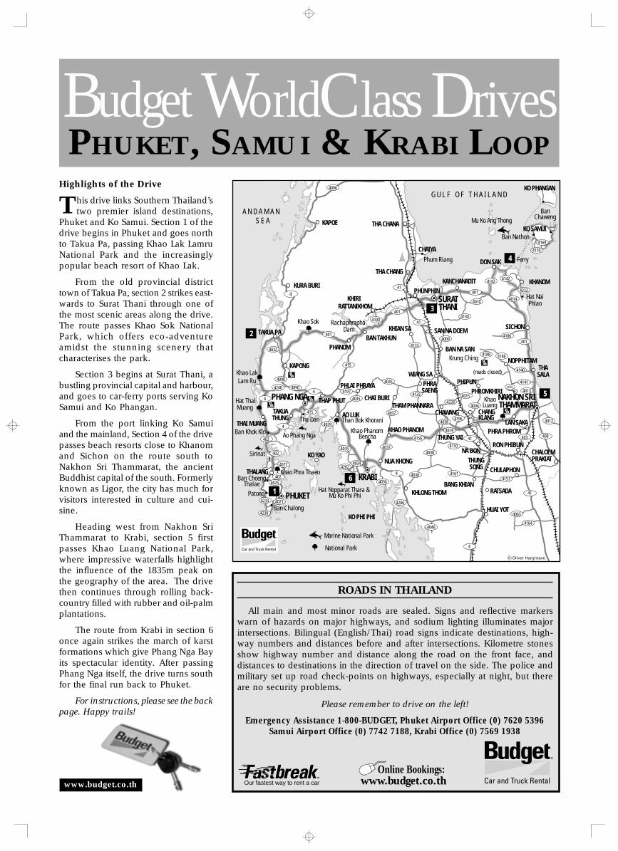
1
PHUKET, SAMUI & KRABI LOOPBudget WorldClass Drives
ROADS IN THAILAND
All main and most minor roads are sealed. Signs and reflective markerswarn of hazards on major highways, and sodium lighting illuminates majorintersections. Bilingual (English/Thai) road signs indicate destinations, high-way numbers and distances before and after intersections. Kilometre stonesshow highway number and distance along the road on the front face, anddistances to destinations in the direction of travel on the side. The police andmilitary set up road check-points on highways, especially at night, but thereare no security problems.
Please remember to drive on the left!
Emergency Assistance 1-800-BUDGET, Phuket Airport Office (0) 7620 5396Samui Airport Office (0) 7742 7188, Krabi Office (0) 7569 1938
Highlights of the Drive
his drive links Southern Thailand’stwo premier island destinations,
Phuket and Ko Samui. Section 1 of thedrive begins in Phuket and goes northto Takua Pa, passing Khao Lak LamruNational Park and the increasinglypopular beach resort of Khao Lak.
From the old provincial districttown of Takua Pa, section 2 strikes east-wards to Surat Thani through one ofthe most scenic areas along the drive.The route passes Khao Sok NationalPark, which offers eco-adventureamidst the stunning scenery thatcharacterises the park.
Section 3 begins at Surat Thani, abustling provincial capital and harbour,and goes to car-ferry ports serving KoSamui and Ko Phangan.
From the port linking Ko Samuiand the mainland, Section 4 of the drivepasses beach resorts close to Khanomand Sichon on the route south toNakhon Sri Thammarat, the ancientBuddhist capital of the south. Formerlyknown as Ligor, the city has much forvisitors interested in culture and cui-sine.
Heading west from Nakhon SriThammarat to Krabi, section 5 firstpasses Khao Luang National Park,where impressive waterfalls highlightthe influence of the 1835m peak onthe geography of the area. The drivethen continues through rolling back-country filled with rubber and oil-palmplantations.
The route from Krabi in section 6once again strikes the march of karstformations which give Phang Nga Bayits spectacular identity. After passingPhang Nga itself, the drive turns southfor the final run back to Phuket.
For instructions, please see the backpage. Happy trails!
T
Khao Sok
Phum Riang
Mu Ko Ang Thong
Hat NaiPhlao
Krung Ching
(roads closed)
BanChaweng
Than Bok Khorani
Khao Phanom Bencha
Hat Nopparat Thara & Mu Ko Phi Phi
Tha Dan
Ao Phang Nga
Hat ThaiMuang
Sirinat
Patong
Ban Chalong
Marine National Park
Khao LakLam Ru
KhaoLuang
G U L F O F T H A I L A N D
A N D A M A N S E A
4006
4169
4142
4014
4142
401
401
401
4032
4090
4240
4202
415
4039
4034
4036
4206
4046
4038
4038
4038
4228
4019
4196
41
4161
4063
4164
41
403
4013
4141
4094
40154013
408
4151
4037 4110
4156
4197
4035
4035
4035
4037
4090
415
4
4
402
402
4233
4239
402
4021
4027
4
4
4
401
4010
4134
4133
4133
414100
41
40094106
4140
4188 4186
4232
4170
4
Ban Nathon
SURATTHANI
Rachaphrapha Dam
Ban Khok Kloi
National Park
PHANG NGA
Khao Phra Thaeo Ban Choeng
Thalae
PHUKET
KRABI
NAKHON SRI THAMMARAT
4016
4015
4239
4025
PHANOM
KO PHI PHI
KHIRI RATTANIKHOM
CHAIYA
THA CHANG
THA CHANAKAPOE
KURA BURIKANCHANADIT
SICHON
KHANOM
DON SAK
KO PHANGAN
KHLONG THOM
THASALA
CHANGKLANG
BAN NA SAN
BAN TAKHUN
NUA KHONGCHALOEMPRAKIAT
CHULAPHON
RATSADABANG KHIAN
HUAI YOT
PHLAI PHRAYA
CHAI BURI
KO YAO
KO SAMUI
PHUNPHIN
SAN NA DOEMKHIAN SA
NOPPHITAM
TAKUA PA
KAPONG
THAI MUANG
TAKUATHUNG
THAP PHUT
THALANG
KHAO PHANOMTHUNG YAI
CHAWANG
NA BONTHUNGSONG
RON PHIBUN
PHRA PHROMLAN SAKA
PHIPUNPHROMKHIRI
THAM PHANNARA
WIANG SAPHRASAENG
AO LUK
Ferry
6
5
4
3
2
1
Oliver Hargreave
www.budget.co.th Our fastest way to rent a car
Online Bookings:www.budget.co.th
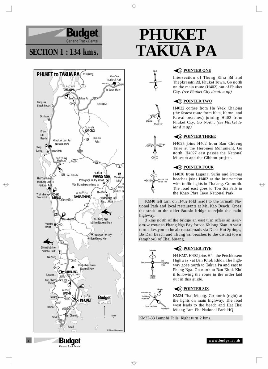
2
PHUKETTAKUA PASECTION 1 : 134 kms.
POINTER ONE
Intersection of Thung Khra Rd andThepkrasatri Rd, Phuket Town. Go northon the main route (H402) out of PhuketCity. (see Phuket City detail map)
POINTER TWO
H4022 comes from Ha Yaek Chalong(the fastest route from Kata, Karon, andRawai beaches) joining H402 fromPhuket City. Go North. (see Phuket Is-land map)
POINTER THREE
H4025 joins H402 from Ban ChoengTalae at the Heroines Monument. Gonorth. H4027 east passes the NationalMuseum and the Gibbon project.
POINTER FOUR
H4030 from Laguna, Surin and Patongbeaches joins H402 at the intersectionwith traffic lights in Thalang. Go north.The road east goes to Ton Sai Falls inthe Khao Phra Taeo National Park
KM40 left turn on H402 (old road) to the Sirinath Na-tional Park and local restaurants at Mai Kao Beach. Crossthe strait on the older Sarasin bridge to rejoin the mainhighway.
3 kms north of the bridge an east turn offers an alter-native route to Phang Nga Bay for via Khlong Kian. A westturn takes you to local coastal roads via Dusit Hot Springs,Bo Dan Beach and Thung Sai beaches to the district town(amphoe) of Thai Muang.
POINTER FIVE
H4 KM7. H402 joins H4 - the PetchkasemHighway - at Ban Khok Khloi. The high-way goes north to Takua Pa and east toPhang Nga. Go north at Ban Khok Kloiif following the route in the order laidout in this guide.
POINTER SIX
KM24 Thai Muang. Go north (right) atthe lights on main highway. The roadwest leads to the beach and Hat ThaiMuang Lam Phi National Park HQ.
KM32-33 Lamphi Falls. Right turn 2 kms.
1
2
3
4
5
6
North
1
ChalongPhuket City
24022
3
4025 4027
402
4
4030
402
National ParkTon Sai Falls
5
4
(H4)Phang NgaKrabi
beach
Takua Pa
Phuket(H402)
5
4National Park.
Local coast roadPhuket (H4)
Takua Pa
Thai MuangBeach Golf
TAKUA PA
KAPONG
TAKUA THUNG
THALANG
KATHU
Ban ThungMaphrao
Lam Pi Falls
Tha Dan
PHANG NGA
PHUKET to TAKUA PA
ManohraFalls
Ao Phang Nga Marine National Park
Hat Thai Muang and Khao Lam Pi
National Park
Ban ChoengThalae
Sirinat Marine National Park
Nai Yang
Khao Phra Thaeo National Park
Karon
Kata
Rawai
Ban Chalong
Khao Lak Lam Ru National Park
Lam Ru Falls
PHUKETPatong
Wat Tham Suwankhuha
Thai MuangBeach Golf
4021
4031
402
402
4
4
4090
4240
401
4
4032
4090
4
415
4027
4024030
4233
4021
4028
4025
4239
1
3
4
2
5
6
7
8
Khao SokNational Park
to Ranong
toKrabi
Ban Talat Takua Pa
To Surat Thani
BangsakBeach Resort
Similana
KhaoLakBeach
ThapLamu Poseidon
THAI MUANG
PhisalaiResort
Phang Nga BayResort Hotel
Phang Nga Valley Resort
House on The BayBan Khlong Kian
Õ.µ–°—Ë«ªÉ“
Õ.°–ªß
Õ.µ–°—Ë«∑ÿàß
Õ.∑⓬‡À¡◊Õß
Õ.∂≈“ß
Õ.°√–∑Ÿâ
®.¿Ÿ‡°Áµ
®.æ—ßß“
(section 2)
(section 6)
Ban Khok Kloi
10 kms
Laguna
Oliver Hargreave
www.budget.co.th
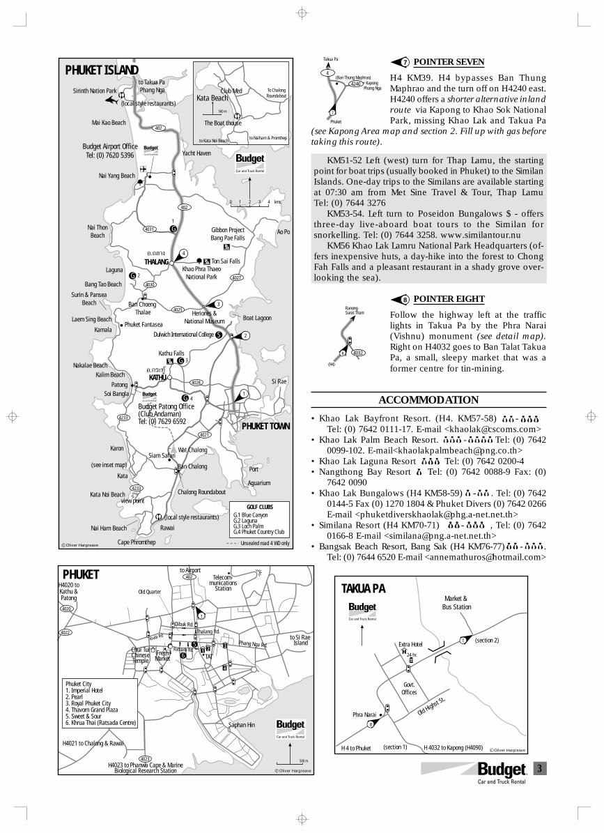
3
POINTER SEVEN
H4 KM39. H4 bypasses Ban ThungMaphrao and the turn off on H4240 east.H4240 offers a shorter alternative inlandroute via Kapong to Khao Sok NationalPark, missing Khao Lak and Takua Pa
(see Kapong Area map and section 2. Fill up with gas beforetaking this route).
KM51-52 Left (west) turn for Thap Lamu, the startingpoint for boat trips (usually booked in Phuket) to the SimilanIslands. One-day trips to the Similans are available startingat 07:30 am from Met Sine Travel & Tour, Thap LamuTel: (0) 7644 3276
KM53-54. Left turn to Poseidon Bungalows $ - offersthree-day live-aboard boat tours to the Similan forsnorkelling. Tel: (0) 7644 3258. www.similantour.nu
KM56 Khao Lak Lamru National Park Headquarters (of-fers inexpensive huts, a day-hike into the forest to ChongFah Falls and a pleasant restaurant in a shady grove over-looking the sea).
POINTER EIGHT
Follow the highway left at the trafficlights in Takua Pa by the Phra Narai(Vishnu) monument (see detail map).Right on H4032 goes to Ban Talat TakuaPa, a small, sleepy market that was aformer centre for tin-mining.
ACCOMMODATION
• Khao Lak Bayfront Resort. (H4. KM57-58)$$ -$$ $Tel: (0) 7642 0111-17. E-mail <[email protected]>
• Khao Lak Palm Beach Resort. $ - $$$$ Tel: (0) 76420099-102. E-mail<[email protected]>
• Khao Lak Laguna Resort $$$ Tel: (0) 7642 0200-4• Nangthong Bay Resort $ Tel: (0) 7642 0088-9 Fax: (0)
7642 0090• Khao Lak Bungalows (H4 KM58-59) $- $$ . Tel: (0) 7642
0144-5 Fax (0) 1270 1804 & Phuket Divers (0) 7642 0266E-mail <[email protected]>
• Similana Resort (H4 KM70-71) $ $- $$ $ , Tel: (0) 76420166-8 E-mail <[email protected]>
• Bangsak Beach Resort, Bang Sak (H4 KM76-77) $-$$$ .Tel: (0) 7644 6520 E-mail <[email protected]>
7
8
Kapong(Ban Thung Maphrao)
4240
7
4
Takua Pa
Phang Nga
Phuket
RanongSurat Thani
40328
(H4)
Gibbon ProjectBang Pae Falls
Ton Sai FallsKhao Phra Thaeo
National Park
Kathu Falls
PHUKET ISLAND
Cape Phromthep
Nai Harn Beach
Kata Noi Beach
Kata
Karon
Kalim BeachNakalae Beach
Patong
KamalaPhuket Fantasea
Laem Sing Beach
Surin & PanseaBeach
Bang Tao Beach
Laguna
Ban Choeng Thalae
Nai ThonBeach
Nai Yang Beach
Budget Airport OfficeTel: (0) 7620 5396
Mai Kao Beach
Sirinth Nation Parkto Takua Pa Phang Nga
Ao Po
Heriones &National Museum Boat Lagoon
Si Rae
PHUKET TOWN
Ban Chalong
Rawai
4
1
3
2
4
1
G
G
G
Chalong Roundabout
THALANG
KATHU
4021
4031
402
402
4027
4025
4030
4233
4233
Õ.∂≈“ß
Õ.°√–∑Ÿâ
R
Budget Patong Office(Club Andaman)Tel: (0) 7629 6592
R
0 1 2 3 4 kms.
2
G
S
3
G.1 Blue CanyonG.2 LagunaG.3 Loch PalmG.4 Phuket Country Club
GOLF CLUBS
Unsealed road 4 WD only
4028
Kata Beach
500 m
Club Med
The Boat thouse
to Naiharn & Promthepto Kata Noi Beach
To ChalongRoundabout
(local style restaurants)
Yacht Haven
Dulwich International College
Soi Bangla
Siam Safari(see inset map)
Port
Aguarium
(local style restaurants)
Wat Chalong
view point
Oliver Hargreave
Telecom-munications
StationH4020 toKathu &Patong
to Si Rae Island
Thalang Rd.Dibuk Rd.
Old Quarter
PHUKET 402
4020
4022
4023
1
to Airport
Phang Nga Rd.Chui TuiChineseTemple
FreshMarket
Ratsada Rd.
H4023 to Phanwa Cape & MarineBiological Research Station
Saphan Hin
TAT
Krabi Rd
6
51 2
3
4
500 m
H4021 to Chalong & Rawai
Phuket City1. Imperial Hotel2. Pearl3. Royal Phuket City4. Thavorn Grand Plaza5. Sweet & Sour6. Khrua Thai (Ratsada Centre)
Oliver Hargreave
Extra Hotel
Market & Bus Station
24 hr.
Govt.Offices
Old Highst St.
Phra Narai
H 4 to Phuket H 4032 to Kapong (H4090)
TAKUA PA
1
8
(section 1)
(section 2)
Oliver Hargreave
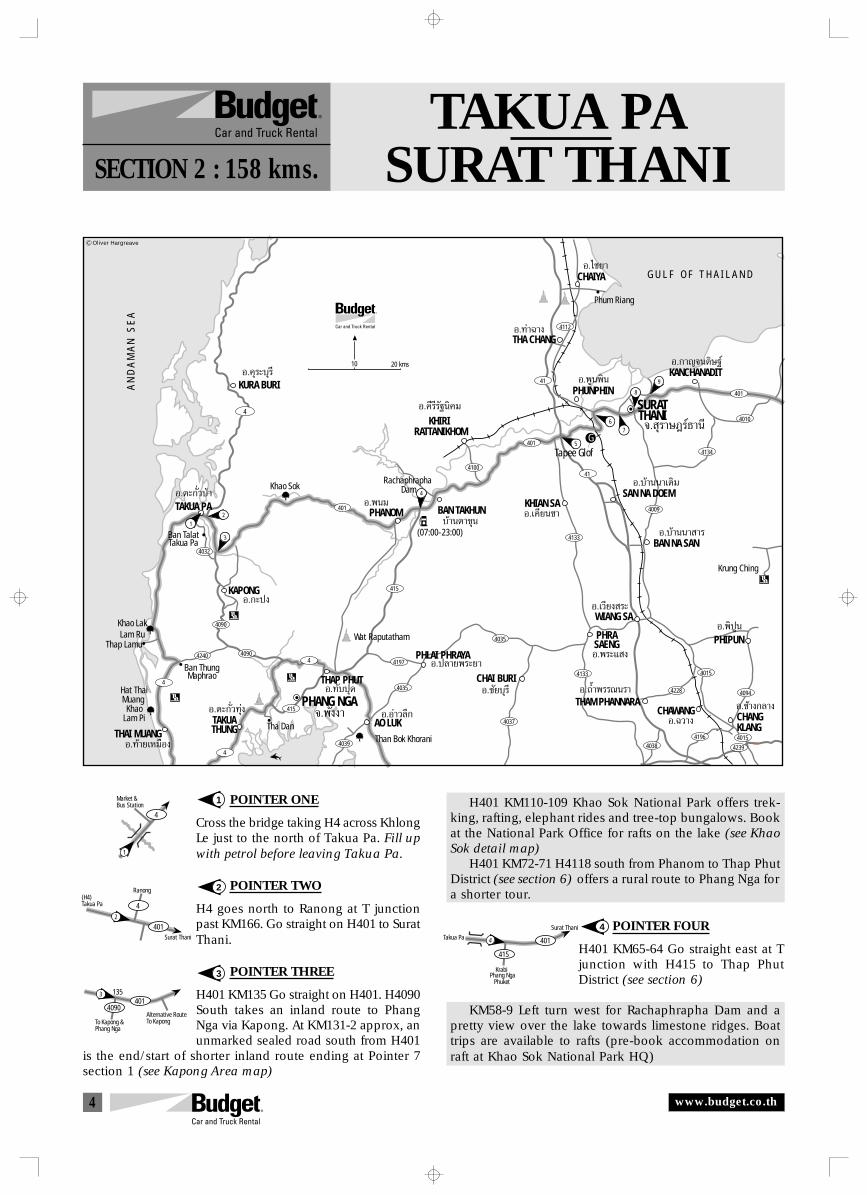
4
TAKUA PASURAT THANISECTION 2 : 158 kms.
POINTER ONE
Cross the bridge taking H4 across KhlongLe just to the north of Takua Pa. Fill upwith petrol before leaving Takua Pa.
POINTER TWO
H4 goes north to Ranong at T junctionpast KM166. Go straight on H401 to SuratThani.
POINTER THREE
H401 KM135 Go straight on H401. H4090South takes an inland route to PhangNga via Kapong. At KM131-2 approx, anunmarked sealed road south from H401
is the end/start of shorter inland route ending at Pointer 7section 1 (see Kapong Area map)
1
2
3
4
H401 KM110-109 Khao Sok National Park offers trek-king, rafting, elephant rides and tree-top bungalows. Bookat the National Park Office for rafts on the lake (see KhaoSok detail map)
H401 KM72-71 H4118 south from Phanom to Thap PhutDistrict (see section 6) offers a rural route to Phang Nga fora shorter tour.
POINTER FOUR
H401 KM65-64 Go straight east at Tjunction with H415 to Thap PhutDistrict (see section 6)
KM58-9 Left turn west for Rachaphrapha Dam and apretty view over the lake towards limestone ridges. Boattrips are available to rafts (pre-book accommodation onraft at Khao Sok National Park HQ)
1
4
Market &Bus Station
2
401
4
Surat Thani
Ranong(H4)Takua Pa
To Kapong &Phang Nga
Alternative RouteTo Kapong
4014090
1353
Phang NgaKrabi
Takua Pa
Surat Thani
Phuket
401
415
4
A N
D A
M A
N
S E
A
Khao Sok
PHANOM
KHIRI RATTANIKHOM
CHAIYA
5
76
Phum Riang
THA CHANG
KURA BURIKANCHANADIT
Krung Ching
Ban ThungMaphrao
Wat Raputatham
Than Bok KhoraniTha Dan
Hat ThaiMuang Khao
Lam Pi
Khao LakLam Ru
Ban TalatTakua Pa
CHANGKLANG
BAN NA SAN
BAN TAKHUN
G U L F O F T H A I L A N D
Tapee Glof
PHLAI PHRAYA
CHAI BURI
401
401
401
4032
4090
4240
415
4039
4228
4196 40154038 4239
4094
4015
4197
4035
4035
4037
4090
415
4
4
4
4010
4134
4133
4133
414100
41
4112
4009
4
10 20 kms
PHUNPHIN
SAN NA DOEMKHIAN SA
SURATTHANI
Rachaphrapha Dam
TAKUA PA
KAPONG
THAI MUANGTAKUATHUNG
PHANG NGA
THAP PHUT
AO LUKCHAWANG
PHIPUN
THAM PHANNARA
WIANG SA
PHRASAENG
1
3
2
4
9
8
Õ.§ÿ√–∫ÿ√’
Õ.µ–°—Ë«ªÉ“
Õ.°–ªß
Õ.æπ¡
Õ.∑⓬‡À¡◊Õß
Õ.Õà“«≈÷°
Õ.∑—∫ªÿ¥ Õ.™—¬∫ÿ√’
Õ.™â“ß°≈“ßÕ.µ–°—Ë«∑ÿàß ®.æ—ßß“
∫â“πµ“¢ÿπÕ.‡§’¬π™“
Õ.§’√’√—∞π‘§¡
Õ.°“≠®π¥‘…∞å
Õ.∑à“©“ß
Õ.‰™¬“
Õ.∫â“ππ“ “√
Õ.∫â“π𓇥‘¡
Õ.‡«’¬ß √–
Õ.æ√–· ß
®. ÿ√“…Æ√å∏“π’
Õ.æŸπæ‘π
Õ.∂È”æ√√≥π√“
Õ.©«“ß
Õ.摪Ÿπ
Õ.ª≈“¬æ√–¬“
(07:00-23:00)
Thap Lamu
Oliver Hargreave
G
www.budget.co.th
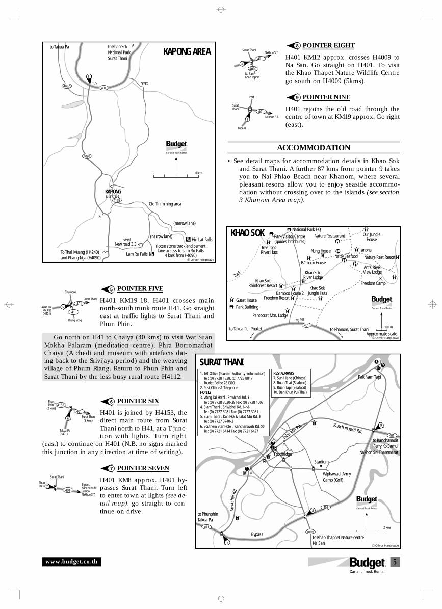
5
POINTER FIVE
H401 KM19-18. H401 crosses mainnorth-south trunk route H41. Go straighteast at traffic lights to Surat Thani andPhun Phin.
Go north on H41 to Chaiya (40 kms) to visit Wat SuanMokha Palaram (meditation centre), Phra BorromathatChaiya (A chedi and museum with artefacts dat-ing back to the Srivijaya period) and the weavingvillage of Phum Riang. Return to Phun Phin andSurat Thani by the less busy rural route H4112.
POINTER SIX
H401 is joined by H4153, thedirect main route from SuratThani north to H41, at a T junc-tion with lights. Turn right
(east) to continue on H401 (N.B. no signs markedthis junction in any direction at time of writing).
POINTER SEVEN
H401 KM8 approx. H401 by-passes Surat Thani. Turn leftto enter town at lights (see de-tail map). go straight to con-tinue on drive.
5
6
7
8
9
POINTER EIGHT
H401 KM12 approx. crosses H4009 toNa San. Go straight on H401. To visitthe Khao Thapet Nature Wildlife Centrego south on H4009 (5kms).
POINTER NINE
H401 rejoins the old road through thecentre of town at KM19 approx. Go right(east).
ACCOMMODATION
• See detail maps for accommodation details in Khao Sokand Surat Thani. A further 87 kms from pointer 9 takesyou to Nai Phlao Beach near Khanom, where severalpleasant resorts allow you to enjoy seaside accommo-dation without crossing over to the islands (see section3 Khanom Area map).
401
41
Thung Song
Surat Thani
Takua PaPhuket(H401)
5
Chumpon
6
401
4153PhunPhin
Surat Thani
Takua Pa(H401)
(2 kms)
(8 kms)
7401
PhunPhi Bipass
KanchanaditSichonNakhon S.T.
Surat Thani
8
4009
401
Nakhon S.T.Surat Thani
Na SanKhao Taphet
Nakhon S.T.
Port
SuratThani
9
401
bypass
Lam Ru Falls
Hin Lat Falls
to Khao SokNational ParkSurat Thani
KAPONGÕ.°–ªß
√æ™
4090
4175
21
25
401135
3
4032
√æ™New road 3.3 km
To Thai Muang (H4240)and Phang Nga (H4090)
(narrow lane)
(narrow lane)
Old Tin mining area
(loose stone track and cementlane access to Lam Ru Falls
4 kms from H4090)
to Takua PaKAPONG AREA
4 kms0
Oliver Hargreave
Khao SokRainforest Resort
Nature Rest Resort
Park Visitor Centre (guides brochures)
National Park HQ
Nung HouseTree Tops River Huts
Natty SeafoodJanpha
Our JungleHouse
Art's RiverView Lodge
Nature Restaurant
Bamboo House
Bamboo House 2
Khao Sok River Lodge
Khao Sok Jungle Huts
km 109
to Phanom, Surat Thanito Takua Pa, Phuket
Trail
Guest HousePark Building
KHAO SOK
Freedom Camp
Freedom Resort
Pantoorat Mtn. Lodge
401 100 m
Approximate scaleOliver Hargreave
401
401
401
4009
7
9
8
Pak Nam Tapi
to KanchanaditFerry Ko Samui
Nakhon Sri Thammarat
to Khao Thaphet Nature centreNa San
Wiphawadi ArmyCamp (Golf)
Stadium
Kanchanawiti Rd.
Footbridge
Talat Mai Rd.
Sriw
icha
i Rd.
2 kms
SURAT THANI1. TAT Office (Tourism Authority -information) Tel: (0) 7728 1828, (0) 7728 8817 Tourist Police 2813002. Post Office & TelephoneHOTELS3. Wang Tai Hotel . Sriwichai Rd. $ Tel: (0) 7728 3020-39 Fax: (0) 7728 10074. Siam Thani . Sriwichai Rd. $-$$ Tel: (0) 7727 3081 Fax: (0) 7727 30815. Siam Thara . Don Nok & Talat Mai Rd. $ Tel: (0) 7727 3740-36. Southern Star Hotel . Kanchanawiti Rd. $$ Tel: (0) 7721 6414 Fax: (0) 7721 6427
RESTAURANTS7. Sun Hiang (Chinese)8. Ruan Thai (Seafood)9. Ruan Tapi (Seafood)10. Ban Khun Pu (Thai)
to PhunphinTakua Pa 4
3
5
6
Bypass
1
27
89
10
Oliver Hargreave
www.budget.co.th
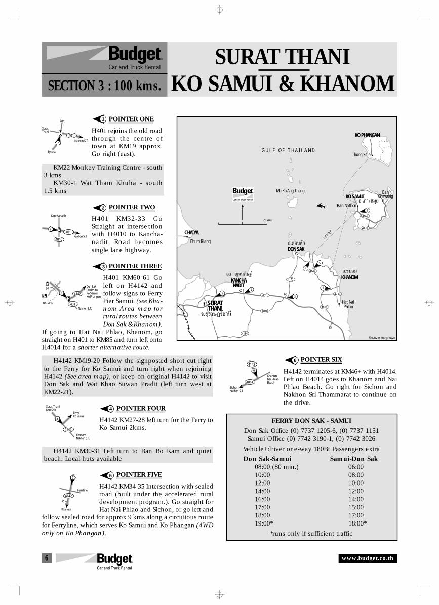
6
SURAT THANIKO SAMUI & KHANOMSECTION 3 : 100 kms.
POINTER ONE
H401 rejoins the old roadthrough the centre oftown at KM19 approx.Go right (east).
KM22 Monkey Training Centre - south3 kms.
KM30-1 Wat Tham Khuha - south1.5 kms
POINTER TWO
H401 KM32-33 GoStraight at intersectionwith H4010 to Kancha-nadit. Road becomessingle lane highway.
POINTER THREE
H401 KM60-61 Goleft on H4142 andfollow signs to FerryPier Samui. (see Kha-nom Area map forrural routes betweenDon Sak & Khanom).
If going to Hat Nai Phlao, Khanom, gostraight on H401 to KM85 and turn left ontoH4014 for a shorter alternative route.
H4142 KM19-20 Follow the signposted short cut rightto the Ferry for Ko Samui and turn right when rejoiningH4142 (See area map), or keep on original H4142 to visitDon Sak and Wat Khao Suwan Pradit (left turn west atKM22-21).
POINTER FOUR
H4142 KM27-28 left turn for the Ferry toKo Samui 2kms.
H4142 KM30-31 Left turn to Ban Bo Kam and quietbeach. Local huts available
POINTER FIVE
H4142 KM34-35 Intersection with sealedroad (built under the accelerated ruraldevelopment program.). Go straight forHat Nai Phlao and Sichon, or go left and
follow sealed road for approx 9 kms along a circuitous routefor Ferryline, which serves Ko Samui and Ko Phangan (4WDonly on Ko Phangan).
POINTER SIX
H4142 terminates at KM46+ with H4014.Left on H4014 goes to Khanom and NaiPhlao Beach. Go right for Sichon andNakhon Sri Thammarat to continue onthe drive.
1
2
3
4
5
6
FERRY DON SAK - SAMUI
Don Sak Office (0) 7737 1205-6, (0) 7737 1151Samui Office (0) 7742 3190-1, (0) 7742 3026
Vehicle+driver one-way 180Bt Passengers extra
Don Sak-Samui Samui-Don Sak08:00 (80 min.) 06:0010:00 08:0012:00 10:0014:00 12:0016:00 14:0017:00 15:0018:00 17:0019:00* 18:00*
*runs only if sufficient traffic
Nakhon S.T.
Port
SuratThani
1
401
bypass
2401
Nakhon S.T.
Kanchanadit
4010
Don SakFerries toKo SamuiKo Phangan
rest area
Nakhon S.T.
4142
401
324
FerryKo Samui
KhanomNakhon S.T.
Surat ThaniDon Sak
4
4142
5
4142
Ferryline
Khanom
35
KhanomNai PhlaoBeach
SichonNakhon S.T.
6
4142
4014
CHAIYA
9
3
4
5
12
6
Phum Riang
Mu Ko Ang Thong
F E R R Y
KANCHANADIT
Hat NaiPhlao
KHANOM
DON SAK
KO PHANGAN
BanChaweng
G U L F O F T H A I L A N D
4169
4142
4014
4142
401
4010
4134
4232
4170
Ban Nathon
Thong Sala
KO SAMUI
SURATTHANI
Õ.¥Õπ —°
Õ.¢πÕ¡Õ.°“≠®π¥‘…∞å
®. ÿ√“…Æ√å∏“π’
Õ.‡°“– ¡ÿ¬
20 kms
60
85
Oliver Hargreave
www.budget.co.th
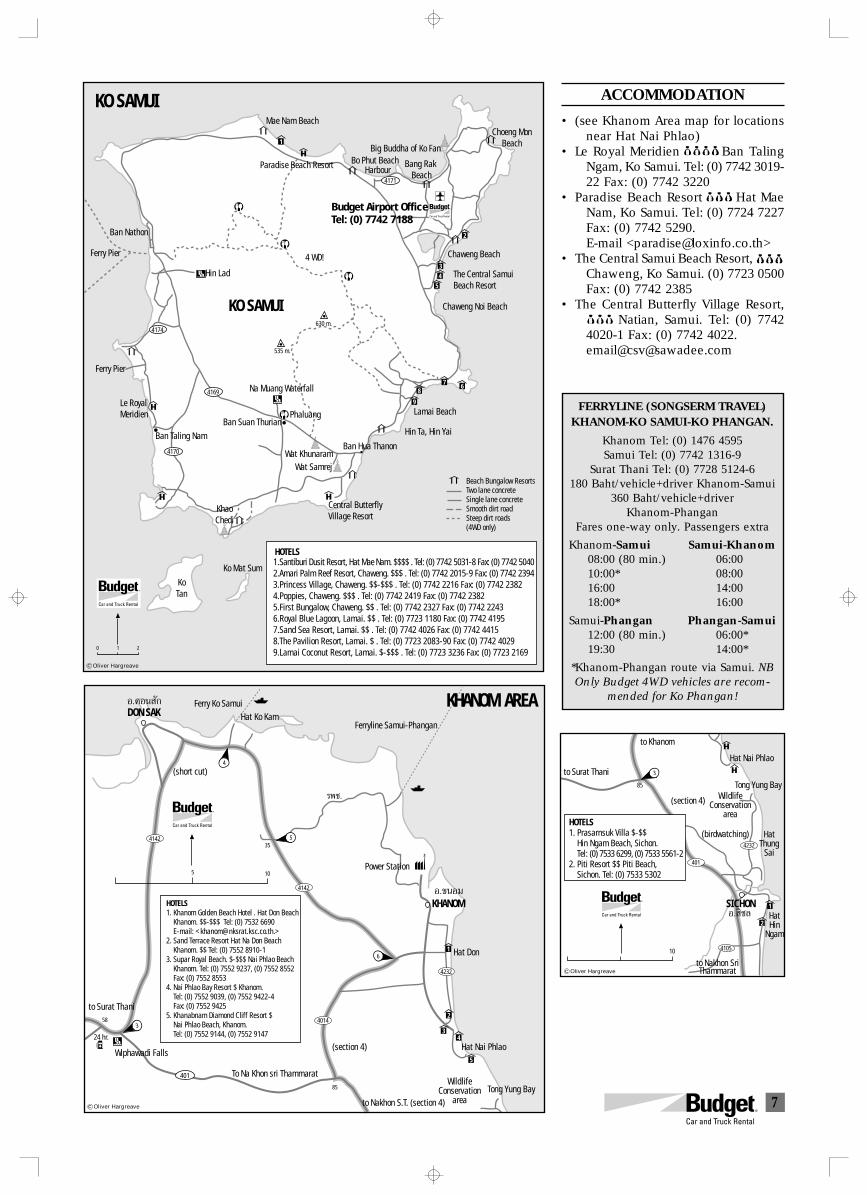
7
ACCOMMODATION
• (see Khanom Area map for locationsnear Hat Nai Phlao)
• Le Royal Meridien $$$ $ Ban TalingNgam, Ko Samui. Tel: (0) 7742 3019-22 Fax: (0) 7742 3220
• Paradise Beach Resort $$$ Hat MaeNam, Ko Samui. Tel: (0) 7724 7227Fax: (0) 7742 5290.E-mail <[email protected]>
• The Central Samui Beach Resort, $$$Chaweng, Ko Samui. (0) 7723 0500Fax: (0) 7742 2385
• The Central Butterfly Village Resort,$$$ Natian, Samui. Tel: (0) 77424020-1 Fax: (0) 7742 4022.email@[email protected]
Hin Lad
Ban Nathon
KO SAMUI
Bo Phut Beach Bang Rak BeachHarbour
Choeng MonBeach
The Central SamuiBeach Resort
Central ButterflyVillage Resort
Hin Ta, Hin Yai
Ban Hua Thanon
Wat SamrejWat Khunaram
Ban Suan ThurianPhaluang
Na Muang Waterfall
Chaweng Noi Beach
Big Buddha of Ko Fan
Mae Nam Beach
Paradise Beach Resort
535 m.
630 m.
KhaoChedi
Ko Mat Sum
KoTan
Ban Taling Nam
Le Royal Meridien
Ferry Pier
KO SAMUI
Chaweng Beach
Lamai Beach
0 1 2
4169
4170
4174
4171
Beach Bungalow ResortsTwo lane concreteSingle lane concreteSmooth dirt roadSteep dirt roads(4WD only)
4 WD!Ferry Pier
RBudget Airport OfficeTel: (0) 7742 7188
1.Santiburi Dusit Resort, Hat Mae Nam. $$$$ . Tel: (0) 7742 5031-8 Fax: (0) 7742 50402.Amari Palm Reef Resort, Chaweng. $$$ . Tel: (0) 7742 2015-9 Fax: (0) 7742 23943.Princess Village, Chaweng. $$-$$$ . Tel: (0) 7742 2216 Fax: (0) 7742 23824.Poppies, Chaweng. $$$ . Tel: (0) 7742 2419 Fax: (0) 7742 23825.First Bungalow, Chaweng. $$ . Tel: (0) 7742 2327 Fax: (0) 7742 22436.Royal Blue Lagoon, Lamai. $$ . Tel: (0) 7723 1180 Fax: (0) 7742 41957.Sand Sea Resort, Lamai. $$ . Tel: (0) 7742 4026 Fax: (0) 7742 44158.The Pavilion Resort, Lamai. $ . Tel: (0) 7723 2083-90 Fax: (0) 7742 40299.Lamai Coconut Resort, Lamai. $-$$$ . Tel: (0) 7723 3236 Fax: (0) 7723 2169
HOTELS
1
2
3
5
678
9
4
Oliver Hargreave
Ferryline Samui-Phangan
Ferry Ko Samui
5
4
3
DON SAK
Hat Nai Phlao
Hat Don
To Na Khon sri Thammarat
KHANOM
4014
4142
4142
4232
Õ.¢πÕ¡
Õ.¥Õπ —°
Hat Ko Kam
(short cut)
(section 4)
35
58
85
6
401
5 10
Wiphawadi Falls
to Nakhon S.T. (section 4)
to Surat Thani
WildlifeConservation
areaTong Yung Bay
Power Station
HOTELS1. Khanom Golden Beach Hotel . Hat Don Beach Khanom. $$-$$$ Tel: (0) 7532 6690 E-mail: <[email protected].>2. Sand Terrace Resort Hat Na Don Beach Khanom. $$ Tel: (0) 7552 8910-13. Supar Royal Beach. $-$$$ Nai Phlao Beach Khanom. Tel: (0) 7552 9237, (0) 7552 8552 Fax: (0) 7552 85534. Nai Phlao Bay Resort $ Khanom. Tel: (0) 7552 9039, (0) 7552 9422-4 Fax: (0) 7552 94255. Khanabnam Diamond Cliff Resort $ Nai Phlao Beach, Khanom. Tel: (0) 7552 9144, (0) 7552 914724 hr.
2
34
5
1
KHANOM AREA
√æ™.
Oliver Hargreave
FERRYLINE (SONGSERM TRAVEL)KHANOM-KO SAMUI-KO PHANGAN.
Khanom Tel: (0) 1476 4595Samui Tel: (0) 7742 1316-9
Surat Thani Tel: (0) 7728 5124-6180 Baht/vehicle+driver Khanom-Samui
360 Baht/vehicle+driverKhanom-Phangan
Fares one-way only. Passengers extra
Khanom-Samui Samui-Khanom08:00 (80 min.) 06:0010:00* 08:0016:00 14:0018:00* 16:00
Samui-Phangan Phangan-Samui12:00 (80 min.) 06:00*19:30 14:00*
*Khanom-Phangan route via Samui. NBOnly Budget 4WD vehicles are recom-
mended for Ko Phangan!
Hat Nai Phlao
HatHin
Ngam
to Nakhon SriThammarat
(section 4)
85
10
to Surat Thani
to Khanom
WildlifeConservation
area
Tong Yung Bay
HatThung
Sai
(birdwatching)
401
4105
4232
SICHONÕ. ‘™≈
2
1
3
HOTELS1. Prasarnsuk Villa $-$$ Hin Ngam Beach, Sichon. Tel: (0) 7533 6299, (0) 7533 5561-22. Piti Resort $$ Piti Beach, Sichon. Tel: (0) 7533 5302
Oliver Hargreave
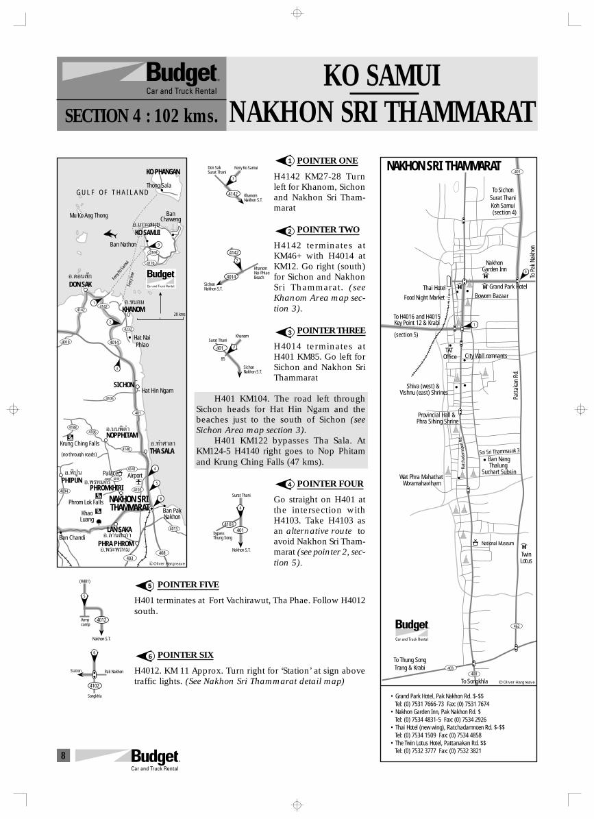
8
KO SAMUINAKHON SRI THAMMARATSECTION 4 : 102 kms.
POINTER ONE
H4142 KM27-28 Turnleft for Khanom, Sichonand Nakhon Sri Tham-marat
POINTER TWO
H4142 terminates atKM46+ with H4014 atKM12. Go right (south)for Sichon and NakhonSri Thammarat. (seeKhanom Area map sec-tion 3).
POINTER THREE
H4014 terminates atH401 KM85. Go left forSichon and Nakhon SriThammarat
H401 KM104. The road left throughSichon heads for Hat Hin Ngam and thebeaches just to the south of Sichon (seeSichon Area map section 3).
H401 KM122 bypasses Tha Sala. AtKM124-5 H4140 right goes to Nop Phitamand Krung Ching Falls (47 kms).
POINTER FOUR
Go straight on H401 atthe intersection withH4103. Take H4103 asan alternative route toavoid Nakhon Sri Tham-marat (see pointer 2, sec-tion 5).
POINTER FIVE
H401 terminates at Fort Vachirawut, Tha Phae. Follow H4012south.
POINTER SIX
H4012. KM 11 Approx. Turn right for ‘Station’ at sign abovetraffic lights. (See Nakhon Sri Thammarat detail map)
1
2
3
4
5
6
4142
1
KhanomNakhon S.T.
Don SakSurat Thani
Ferry Ko Samui
KhanomNai PhlaoBeach
SichonNakhon S.T.
2
4142
4014
3
SichonNakhon S.T.
KhanomSurat Thani
401
85
401
Surat Thani
Nakhon S.T.
4
4103
bypassThung Song
Nakhon S.T.
Armycamp
5
4012
(H401)
Pak Nakhon
4102
6
Station
Songkhla
Ferry
Ko Sa
muiFe
rry li
ne
BanChaweng
G U L F O F T H A I L A N D
Mu Ko Ang Thong
Hat NaiPhlao
Hat Hin Ngam
(no through roads)
SICHON
KHANOM
DON SAK
KhaoLuang
Krung Ching Falls
Phrom Lok Falls
4014
403408
Ban Nathon
Thong Sala
KO SAMUI
NOPPHITAM
Ban ChandiPHRA PHROM
LAN SAKA
Ban PakNakhon
NAKHON SRI THAMMARAT
4016
PHROMKHIRIPHIPUN
1
3
KO PHANGAN
2
41424142
6
5
4
9
THA SALA
4169
4013
4141
4094 4103
401
4010
4105
4140
41884186
4232
4170
Õ.‡°“– ¡ÿ¬
Õ.¥Õπ —°
Õ.¢πÕ¡
Õ.π∫摵”
Õ.æ√À¡§’√’
Õ.æ√–æ√À¡
Õ.≈“π –°“
Õ.摪Ÿπ
Õ.∑à“»“≈“
Palace Airport
20 kms
Oliver Hargreave
401
462
408403
To H4016 and H4015Key Point 12 & Krabi
NAKHON SRI THAMMARAT
To SichonSurat ThaniKoh Samui
NakhonGarden Inn
Grand Park Hotel
Food Night Market
Thai Hotel
Shiva (west) & Vishnu (east) Shrines
Provincial Hall & Phra Sihing Shrine
Ban NangThalung
Suchart Subsin
Soi Sri Thammasok 3
Patta
kan
Rd.
Wat Phra Mahathat Woramahaviharn
National Museum
TwinLotus
To Thung SongTrang & Krabi
To Songkhla
• Grand Park Hotel, Pak Nakhon Rd. $-$$ Tel: (0) 7531 7666-73 Fax: (0) 7531 7674• Nakhon Garden Inn, Pak Nakhon Rd. $ Tel: (0) 7534 4831-5 Fax: (0) 7534 2926• Thai Hotel (new wing), Ratchadamnoen Rd. $-$$ Tel: (0) 7534 1509 Fax: (0) 7534 4858• The Twin Lotus Hotel, Pattanakan Rd. $$ Tel: (0) 7532 3777 Fax: (0) 7532 3821
Boworn Bazaar
To P
ak N
akho
n
Ratc
hada
mno
enRd
.
6
City Wall remnantsTAT
Office
(section 4)
(section 5)
1
Oliver Hargreave
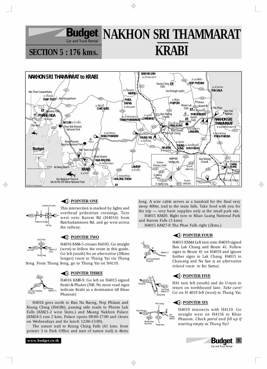
9
NAKHON SRI THAMMARATKRABISECTION 5 : 176 kms.
POINTER ONE
This intersection is marked by lights andoverhead pedestrian crossings. Turnwest onto Karom Rd (H4016) fromRatchadamnoen Rd. and go west acrossthe railway.
POINTER TWO
H4016 KM4-5 crosses H4103. Go straight(west) to follow the route in this guide.Go left (south) for an alternative (20kmslonger) route to Thung Yai via Thung
Song. From Thung Song, go to Thung Yai on H4110.
POINTER THREE
H4016 KM8-9. Go left on H4015 signedKrabi & Phuket (NB. No more road signsindicate Krabi as a destination till KhaoPhanom)
H4016 goes north to Ban Na Raeng, Nop Phitam andKrung Ching (H4186), passing side roads to Phrom LokFalls (KM21-2 west 5kms.) and Muang Nakhon Palace(KM24-5 east 2 kms. Palace opens 08:00-17:00 and closeson Wednesdays and for lunch 12:00-13:00).
The nature trail to Krung Ching Falls (61 kms. frompointer 3 to Park Office and start of nature trail) is 4kms
1
2
3
4
long. A wire cable serves as a handrail for the final verysteep 400m. trail to the main falls. Take food with you forthe trip — very basic supplies only at the small park site.
H4015 KM20. Right turn to Khao Luang National Parkand Karom Falls (3 kms)
H4015 KM27-8 Tha Phae Falls right (2kms.)
POINTER FOUR
H4015 KM44 Left turn onto H4019 signedBan Lak Chang and Route 41. Followsigns to Route 41 on H4019 and ignorefurther signs to Lak Chang. H4015 toChawang and Na San is an alternativeinland route to Ko Samui.
POINTER FIVE
H41 turn left (south) and do U-turn toreturn on northbound lane. Take care!Go on H 4019 left (west) to Thung Yai.
POINTER SIX
H4019 intersects with H4110. Gostraight west on H4156 to KhaoPhanom. Check petrol and fill up ifnearing empty at Thung Yai!
5
6
4016
Commercial centre
Pedestrian bridge
1
Old City
4016
4103
Thung Song
2Nakhon S.T(city)
Surat Thani
Lan Saka
Nakhon S.T.
40153
4016
Lan Saka ChawangThung Yai
Nakhon S.T4019
4015
Lak Chang Route41Thung Yai
4
44
Lak ChangNakhon S.T.
Thung Song
Thung Yai
41
5
4019
4019
LakChangNakhon4110
4156
4038
6
24
Thung Song
Phra Saeng
Khlong Thom(Ko Lanta)
Khao Phanom
Õ.∑—∫ªÿ¥
Õ.Õà“«≈÷°
Õ.™—¬∫ÿ√’ Õ.æ√–· ß
Õ.∂È”æ√√≥π√“
Õ.∑àÿß„À≠à
°‘ËßÕ.™â“ß°≈“ß
Õ.π“∫Õπ
Õ.∑àÿß ßÕ.√àÕπæ‘∫Ÿ≈¬å
Õ.‡«’¬ß √–
Õ.∫â“ππ“ “√
Õ.‡Àπ◊Õ§≈Õß
Õ.‡¢“æπ¡
Õ.§≈Õß∑àÕ¡
®.æ—ßß“
THAP PHUT
KRABI
KHAO PHANOM
NUA KHLONG
THUNG YAI
NA BON RON PHIBUN
41
Wat Tham Suwankhuha
Than Bok Khorani National Park
1350 m.Khao Phanom Bencha National Park
Ao Nang Beach
Hat Nopparat Thara & Mu Ko Phi Phi Mrine National Park
Krabi Airport
Tha Dan
NAKHON SRI THAMMARAT to KRABI
Ban Chandi
Khao Luang
Ban PakNakhon
Tha Phae
KHLONG THOM
KaromFalls
Phrom LokFalls
Krung ChingFalls
NOP PHITAM
THA SALA
THUNGSONG
PHRASAENG
WIANG
BAN NA SAN
NAKHON SRI THAMMARAT
10
9
6
7
3 2
1
4039
4035
20 kms
4034
4037
4036
44038
4156
4110
4038
4151
4019
4038
408
4013
4140
4141
4016
4186
41034194
4015
4015
403
4133
4035
4197
415
CHAI BURI
Õ.∫“ߢ—πBANG KHAN
Õ.≈”∑—∫LAMTAP
1835 m.
8
5
4
Manohra Falls
AO LUK
PHANG NGA415
Ban Lak Chang
4015
®.°√–∫’Ë
Õ.π∫摵”
Õ.∑à“»“≈“
PHIPUNÕ.摪Ÿπ
CHAWANGTHAM PHANNARATÕ.©«“ß
Õ.≈“π –°“LANSAKA Õ.æ√–æ√À¡
PHRA PHROM
Õ.æ√À¡§’√’PHROMKHIRI
®.π§√»√’∏√√¡√“™
(no through roads)
4116
Ban KhlongChandi
Wat Tham Sua
Wat Ratupatham
4CHANG KLANG4195
°‘ËßÕ.™â“ß°≈“ß
41
Ban Chandi
4019
4015
5
Ban Lak Chang
4015
Ban KhlongChandi
4
CHANGKLANG
4195
41
4133
4038
40194110
40384156
To H.41(KM 210)
To H.41(KM 205) To Thung Song
AMPHOETHUNG YAI
To KhlongThom
To KhaoPhanom / Krabi
6
R
4202
Palace
Oliver Hargreave
Airport
www.budget.co.th
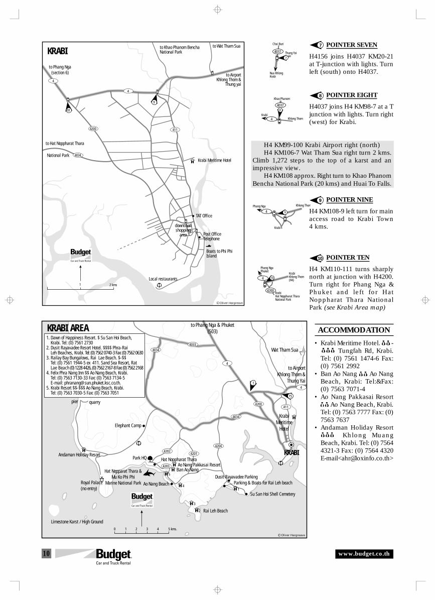
10
POINTER SEVEN
H4156 joins H4037 KM20-21at T-junction with lights. Turnleft (south) onto H4037.
POINTER EIGHT
H4037 joins H4 KM98-7 at a Tjunction with lights. Turn right(west) for Krabi.
H4 KM99-100 Krabi Airport right (north)H4 KM106-7 Wat Tham Sua right turn 2 kms.
Climb 1,272 steps to the top of a karst and animpressive view.
H4 KM108 approx. Right turn to Khao PhanomBencha National Park (20 kms) and Huai To Falls.
POINTER NINE
H4 KM108-9 left turn for mainaccess road to Krabi Town4 kms.
POINTER TEN
H4 KM110-111 turns sharplynorth at junction with H4200.Turn right for Phang Nga &Phuket and left for HatNoppharat Thara NationalPark (see Krabi Area map)
ACCOMMODATION
• Krabi Meritime Hotel. $$-$$$ Tungfah Rd, Krabi.Tel: (0) 7561 1474-6 Fax:(0) 7561 2992
• Ban Ao Nang $$Ao NangBeach, Krabi: Tel:&Fax:(0) 7563 7071-4
• Ao Nang Pakkasai Resort$$ Ao Nang Beach, Krabi.Tel: (0) 7563 7777 Fax: (0)7563 7637
• Andaman Holiday Resort$$$ Khlong MuangBeach, Krabi. Tel: (0) 75644321-3 Fax: (0) 7564 4320E-mail<[email protected]>
9
10
7
8
Thung Yai
Chai Buri
Nua KhlongKrabi
4037
7
8
4 Khlong Thom
Khao Phanom
Krabi
4037
Khlong ThomPhang Nga
Krabi
94
Phang NgaPhuket
KrabiHat Noppharat TharaNational Park
4
4200
10KrabiKhlong Thom(H4)
to Phang Nga(section 6)
KRABI
10
9
4034
4200
4
4
411
1 2 kms
to Hat Noppharat Thara
National Park
to Khao Phanom BenchaNational Park
to Wat Tham Sua
to AirportKhlong Thom &
Thung yai
TAT Office
Post OfficeTelephone
Boats to Phi PhiIsland
Local restaurants
downtownshopping
area
Krabi Meritime Hotel
Oliver Hargreave
Hat Noppharat TharaPark HQ
Ao Nang BeachDusit Rayavadee Parking
KrabiMeritime
Hotel
to AirportKhlong Thom &
Thung Yai
to Phang Nga & Phuket(503)
Wat Tham Sua
Parking & Boats for Rai Leh beach
KRABI
Su San Hoi Shell Cemetery
Ao Nang Pakkasai ResortBan Ao Nang
Rai Leh Beach
10 2 3 4 5 kms.
Hat Nopparat Thara &Mu Ko Phi Phi
Marine National Park
Limestone Karst / High Ground
KRABI AREA
15
1
Elephant Camp
Andaman Holiday Resort
pier quarry
Royal Palace(no entry) 1
2
3
4
5
4
4
4200
4034
4204
42014202
4034
4203
411
4033
1. Dawn of Happiness Resort. $ Su San Hoi Beach, Krabi. Tel: (0) 7561 27302. Dusit Rayavadee Resort Hotel. $$$$ Phra-Rai Leh Beaches, Krabi. Tel: (0) 7562 0740-3 Fax: (0) 7562 06303. Railay Bay Bungalows, Rai Lae Beach. $-$$ Tel: (0) 7561 1944-5 ex 411. Sand Sea Resort, Rat Lae Beach (0) 1228 4426, (0) 7562 2167-8 Fax: (0) 7562 21684. Felix Phra Nang Inn $$ Ao Nang Beach, Krabi. Tel: (0) 7563 7130-33 Fax: (0) 7563 7134-5 E-mail: [email protected]. Krabi Resort $$-$$$ Ao Nang Beach, Krabi. Tel: (0) 7563 7030-5 Fax: (0) 7563 7051
Oliver Hargreave
www.budget.co.th
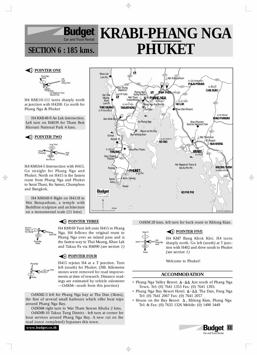
11
KRABI-PHANG NGAPHUKETSECTION 6 : 185 kms.
POINTER ONE
H4 KM110-111 turns sharply northat junction with H4200. Go north forPhang Nga & Phuket
H4 KM148-9 Ao Luk intersection.Left turn on H4039 for Tham BokKhorani National Park 4 kms.
POINTER TWO
H4 KM164-5 Intersection with H415.Go straight for Phang Nga andPhuket. North on H415 is the fastestroute from Phang Nga and Phuketto Surat Thani, Ko Samui, Chumphonand Bangkok.
H4 KM168-9 Right on H4118 toWat Ratupatham, a temple withBuddhist sculpture and architectureon a monumental scale (11 kms)
POINTER THREE
H4 KM169 Turn left onto H415 to PhangNga. H4 follows the original route toPhang Nga over an inland pass and isthe fastest way to Thai Muang, Khao Lakand Takua Pa via H4090 (see section 1)
POINTER FOUR
H415 rejoins H4 at a T junction. Turnleft (south) for Phuket. (NB. Kilometrestones were removed for road improve-ments at time of research. Distance read-ings are estimated by vehicle odometer—OdKM—south from this junction)
OdKM2-3 left for Phang Nga bay at Tha Dan (3kms),the first of several small harbours which offer boat tripsaround Phang Nga Bay.
OdKM4 right turn to Wat Tham Suwan Khuha 2 kms.OdKM9-10 Takua Tung District - left turn at corner for
boat services around Phang Nga Bay. A new cut on theroad (once completed) bypasses this town.
1
2
3
4
OdKM 28 kms. left turn for back route to Khlong Kian.
POINTER FIVE
H4 KM7 Bang Khok Kloi. H4 turnssharply north. Go left (south) at T junc-tion with H402 and drive south to Phuket(see section 1)
Welcome to Phuket!
ACCOMMODATION
• Phang Nga Valley Resort. $-$$ Just south of Phang NgaTown. Tel: (0) 7641 1353 Fax: (0) 7641 1393.
• Phang Nga Bay Resort Hotel. $-$$ Tha Dan, Pang NgaTel: (0) 7641 2067 Fax: (0) 7641 2057
• House on the Bay Resort $ , Khlong Kian, Phang Nga.Tel: & Fax: (0) 7635 1326 Mobile: (0) 1490 3449
5
Phang NgaPhuket (H4)
KrabiKhlong Thom
KrabiHat Noppharat TharaNational Park
4
4200
1
PhuketPhang Nga
Surat Thani
Krabi(H4)
2
4040
415
Ban Pak Lao
PhuketPhang Nga
Takua Pa
Krabi (H4)
3
415
Kapong 4Thai Muang
Phuket
Phang Nga
Krabi4 415
4
5
402
(H4)Phang NgaKrabi
beach
Takua Pa
Phuket
4
Hat Nopparat Thara & Mu Ko Phi Phi
KO PHI PHI
5
Ban ThungMaphrao
Lam Pi Falls
Than Bok Khorani
Khao Phanom Bencha National Park
Tha Dan
Ao Phang Nga
Hat ThaiMuang
KhaoLam Pi
Sirinat
Patong
KaronKata
Rawai
Ban Chalong
Khao LakLam Ru
KHLONG THOM
NUA KHONG
PHLAI PHRAYA
CHAI BURI
KO YAO
4090
4240
4202
415
4039
4034
4036
4206
4037
4197
4035
4035
4037
4090
4
4
402
4233
4239
402
4021
4027
4
4
THAI MUANG TAKUATHUNG
PHANG NGATHAP PHUT
AO LUK
THALANG
KHAO PHANOM
Khao Phra Thaeo
Ban ChoengThalae
PHUKET
KRABI
4
3 2
1
4025
402
Ban Khok Kloi
4118 415
Wat ThamSuwankhuha
Phang NgaValley Resort
Phang Nga Bay Resort
House on the BayBan khlong Kian
Wat Tham Sua
Wat Ratupatham
®.°√–∫’Ë
Õ.‡°“–¬“«
Õ.§≈Õß∑àÕ¡
Õ.‡¢“æπ¡
Õ.™—¬∫ÿ√’
Õ.ª≈“¬æ√–¬“
Õ.Õà“«≈÷°
®.¿Ÿ‡°Áµ
Õ.∂≈“ß
Õ.∑⓬‡À¡◊Õß
Õ.µ–°—Ë«∑ÿàß®.æ—ßß“
Õ.∑—∫ªÿ¥
20 kms
AirportAirport
Oliver Hargreave
www.budget.co.th
12
3
4
Pointer numberand directionof travel
HighwayNumber
Go this way
INSTRUCTIONS
umbered pointers listed in sequence in the direction of travel show youwhen you have to make a turn at important junctions along the recom-
mended route (reverse these if travelling in the opposite direction). Some inter-sections and turns where English language signs are absent may also includedescriptions to help you visually check you have the correct turning.
N
Kilometre references are noted intwo ways:
H4 KM13 = Highway 4 kilometre stone13 is close to the point of focus
H4 KM98-9 = The point of focus liesbetween kilometre stones 98&99.Where kilometre stones were ab-sent at time of research, kilometresare referenced by odometer(OdKM).
KM99 A point of interest or sidetrip off the recommended route islocated near this kilometre stone.Regular guide-books for the area willgive further information.
Alternative route The directionpointers follow recommended routesthat aim to give you a variety of roadsand scenery where possible. Alterna-
tive route directions show you whereyou may take your own route usinginformation found only on the maps.
4 WD Only! If you are driving avehicle that does not have four wheeldrive, please do not take this road.When driving driving off-road, pleasedrive slowly to avoid mechanical prob-lems and to keep the dust down whenpassing people and communities.
Remember to always take enoughdrinking water - allow for emergencies
Help us get it right! In order thatwe may continually improve our ser-vice to our customers, please adviseour staff of errors or make suggestionsfor these route information sheets. Thiscan also be done directly to the com-piler at <[email protected]>
For reservations, please contact yourtravel consultant or call Budget:
In the U.K.: 01800-181-181In the U.S.: (800) 527-0700In Germany: 89 666-950
In Australia: 13-28-48In Singapore: 532-4442
In Thailand: 1-800-BUDGET
ACCOMMODATION
This guide lists selected upper and mid-level places to stay. Guest House/lo-cal style accommodation is plentiful inmain destinations and more places tostay are shown on the maps. Prices areindicated as follows: 5000 Baht + 3000-5000 Baht 1000-3000 Baht less than 1000 BahtPre-booking accommodation for thehigh season and during festivals is rec-ommended. Further suggestions forplaces to stay as well as images of sug-gested accommodation can be foundon the internet:
<www.phuket.com>, <www.samuihotels.com>,<www.krabihotels.com>, <www.asiatravel.com>,<www.hotelthai.com>, <www.sawadee.com>,<www.tiscoverasia.com>
SYMBOL LIST
FALLING ROCKS(LAND SLIDE)
STEEP HILL
STOP (POLICE) CHECK
SLIPPERY ROAD
STOP NO PASSING
À¬ÿ¥ À¬ÿ¥
µ√«®
0
Main Road
Minor Road
Unsealed Road
Suggested Routes
River
Provincial Capital
District
Pointer
Traffic Lights
Kilometre 100
Temple
Park
Water Fall
Hot Springs.
Hotel/Resort/Guest House
Hospital
Gas Station
Restaurant
Golf Club
100
G
0
0
www.budget.co.th