Area-wide integration (AWI) of specialized crop and livestock ...
Upload
khangminh22Category
view
2download
0
Lower North Delaware Industrial District, Philadelphia
Brownfields
Area-Wide Plan
December 2019

© Mahbubur Meenar Community Planning + Visualization Lab School of Earth and Environment, Rowan University December, 2019
This work is supported by the US Environmental Protection Agency’s Brownfields Area-Wide Planning (BF-AWP) Program.
SHARE & CITEMeenar et al. (2019). Brownfields Area-Wide Plan: Lower North Delaware Industrial District, Philadelphia. Glassboro, NJ: Rowan University Community Planning + Visualization Lab.

Project Team
Project Lead
Rowan University Community Planning + Visualization Lab School of Earth & Environment
Faculty Mahbubur Meenar, PhD Megan Bucknum Zachary Christman, PhD Kevin Keenan, PhD
Students, Staff, and Consultants Devon Moulton Marie DiLeonardo
Joseph Foti Jason Hachadorian Kyle Hearing Giavanni Rizzo Cassandra Rodriguez Kira Rose Cassie Shugart Shane Walsh Hunter Swanson Kristina Wallace Meghan Wren
Project Partner
Temple University Tyler School of Art & Architecture
Faculty Lynn Mandarano, PhD Sally Harrison, AIA Jeffrey Doshna, PhD Terence Milstead, PhD
Students Tanner Adamson Dylan Arturo Michelle J. Atherton Leonard Bonarek Holly Colello Brett Ennis Jonathan Flamoncini Jenelle Gomes Alexandra Grabel Drew Hohenwarter Samar Ido Andrew Jacobs Jose Jimenez Natalie Lee Rachel Lewis Ted Mullen Erin Purcell Christopher Snowadzky Jake Whitehead
Community Partner
New Kensington Community Development Corporation
Andrew Goodman John Tracy
Technical Support
Market Study Daniel Miles, PhD, Econsult Solutions Inc.
Implementation Plan Sean Vroom, New Jersey Institute of Technology
Academic Collaborators
Jordan Howell, PhD, Rowan University Smitha Mysore, SJB School of Architecture & Planning, Bangalore, India Mary Myers, PhD, Temple University

Acknowledgement Nonprofit Organizations
Community Center at Visitation East Kensington Neighbors Association Olde Richmond Civic Association Rock Ministries Somerset Neighbors for Better Living
Participants — Community Engagement
Kae Anderson Tom Beck Dan Beebi Connie Bird Tyler Bradley Joe Campbell Maurice Campbell Jake Cepis Elizabeth Carpenter Mikcas Casavera Patricia Codina Natasha Cossom Elizabeth Cossom Ramon Crespo Colin Curtis June de Vries Katie Drake Victoria Engelstad Vincent Floyd Linda Fonelb Lisa Forrest Amanda Fury Nick Fury Pastor Richard Harris Luke Hildebrand Amelia Hullock Miguel Jinenez Pamela Kaminski
Lisa Khan David Kilcoyk Paul Kimport Nora Lichtash Matt Ludwig Pablo Mateo Kathyrn McConnell Bill McGraw Jim McIlhcaccy Ethan Mimm Rachael Mellon Michael Morgan Linda Mottolo Andrew Ortega Julianne Schrader Ortega Rob Palladines Susan Reeder Thurston Renwrick Dina Richman Elisa Roche Rodriguez Sandy Salzman Anya Saretzky Betty Scailon Rory Scerri Rana Sindhikara Elmira (Myra) Smith Bill Summers John Theobald Maryan Tomlite Miguel Torres Mare Trombetta Jasmin Velez Liz Volchok Liz Watkins Sean Wayland Milan Zalamidia
Russell Zebo
Advisory Committee Members
David Fecteau, Philadelphia City Planning Commission Connie Bird, Philadelphia Water Department Tom Dalfo, Philadelphia Industrial Development Corporation Rachael Gray Crandley, Conrail Amy Bernkopf, Delaware Valley Regional Planning Commission Karen Thompson, Delaware River Waterfront Corporation Leigh Ann Campbell, Pennsylvania Horticulture Society Anya Saretzky, Rails to Trails Conservancy Captain Krista Dahl-Campbell, 26th Police District Elmira Smith, Somerset Neighbors for Better Living Sister Betty Scanlon, Community Center at Visitation Ramon Crespo, Rock Ministries Foster Hardiman, East Kensington Neighbors Association Rosemary Thomas, Olde Richmond Civic Association Pastor Richard Harris, Firm Hope Baptist Church Sean McMonagle, 1st District City Councilperson Mark Squilla Mia Hylan, PA House Rep. John Taylor
Participants — Stakeholder Interviews
Ariel Ben-Amos, Philadelphia Water Department Jana Curtis, Get the Lead OUT John Haak, Philadelphia City Planning Commission Nicole Hostettler, Philadelphia Water Department Russell Zerbo, Clean Air Council

Table of Contents
Executive Summary 6
Introduction 11
Community Profile 18
Community Design Process 42
Design Proposals 55
Implementation Strategies 74
Implementation Challenges and Lessons Learned 88
Brownfields Area-Wide Plan Lower North Delaware Industrial District, Philadelphia
Section 6 —Implementation Challenges & Lessons Learned

Executive Summary
This Brownfields Area-Wide Plan (BF-AWP) was created for a portion of Philadelphia's Lower North Delaware Industrial District; within the project area, site-specific plans were developed for five catalyst sites. The BF-AWP Program was established by the US Environmental Protection Agency (US EPA) in 2010 in order to provide funding and technical assistance to communities with concentrations of brownfield parcels in close proximity to one another. The program has three primary goals: to develop brownfield reuse plans that protect the health of the community and the environment, positively impact the local economy , and reflect the local community’s vision for the area. The US EPA defines a brownfield as “a property, the expansion,
redevelopment, or reuse of which may be complicated by the presence or potential presence of a hazardous substance, pollutant, or contaminant”.
This project was administered by Rowan University's Community Planning + Visualization Lab in the School of Earth and Environment. The Project Team consisted of faculty and students from Rowan University (New Jersey) and Temple University (Pennsylvania) and staff members of New Kensington Community Development Corporation (NKCDC)—the community partner. Technical supports were provided by Econsult Solutions Inc., New Jersey Institute of Technology, and several independent consultants.
Section 1: Introduction
The project area is located in Philadelphia's Kensington neighborhood within the River Ward Planning District. During the 19th century, Kensington was home to over a third of all textile industries in Philadelphia, as well as the employees of these operations; by the late 1800s, 126 different textile firms were operating in the neighborhood. The textiles and other goods produced in the neighborhood, such as glass and leather, played a significant role in establishing Philadelphia as an internationally recognized exporter of goods, referred to by many as the “Workshop of the World.” By the 1950s, however, mass-manufacturing and cheap labor drew the textile industry overseas; the repercussions of this economic shift were felt particularly in Kensington, where production and labor work had prevailed. The large industries that had come to dominate the landscape for decades, and served as the economic engine of Kensington, deserted the neighborhood. Understanding how Kensington’s once productive past

underpins the social and economic disparities facing the neighborhood today is critical context for the conceptualization of a resulting plan. The project area—spanning 181-acres—includes brownfield sites adjacent to the Lehigh Viaduct, a freight rail corridor located along Lehigh Avenue, between Kensington Avenue and Interstate-95. There are an estimated 27 potential brownfields covering 32.6 acres of land located within the project area. Of these potential brownfields, the five catalyst sites, selected for their strong potential for revitalization and reuse, due to community interest, strategic location, as well as environmental, health, or economic concerns, are:
• Site 1: 2201 East Somerset Street (2.31 acres) • Site 2: 2750R Aramingo Avenue (2.06 acres) • Site 3: 2001 East Lehigh Avenue (1 acre) • Site 4: 2740 Amber Street (0.73 acres) • Site 5: 2838 Trenton Avenue (0.61 acres)
At the time of this writing, however, redevelopment plans created by developers of Catalyst Sites 1 and 4 have been approved and implementation processes have begun. While the Project Team’s reuse designs detailed in this plan for these two catalyst sites will not be implemented, they remain within this plan to inspire and guide future projects within the area.
Section 2: Community Profile An extensive overview of the project area’s demographic, social, physical, and market conditions frames the evaluation of the current and future potential market for redevelopment. The results of this analysis inform the conceptual design proposals to redevelop brownfields within the project area—focusing on the five catalyst sites—that prioritizes recommendations derived from an extensive
community engagement process. While positive market forces may facilitate some of the residential, retail, commercial or mixed-use, and adaptive reuse projects typical of brownfields redevelopment, the community engagement process ensures that the community’s desire for affordable housing, community spaces, green spaces, recreational amenities, health and literacy services, job training opportunities, and safety features is accounted for to the fullest extent.
Section 3: Community Design Process The engagement process spanned approximately three years, beginning with a project introduction meeting in early 2016 and culminating in a final discussion of implementation strategies with the community in the summer of 2019. Each engagement activity was specifically chosen to aid in the development of various types of design elements for the final site plans. The results of community engagement and the Project Team’s outreach efforts fundamentally guided the conceptualization of final reuse designs, incorporating design elements representative of all community members and their needs. The outreach included three public meetings, two focus groups, a photovoice project, two rounds of in-depth interviews, two advisory committee meetings, and a community design workshop. During these activities, community recommendations were collected in detail to inform design decisions.

Section 4: Design Proposals Plans for each catalyst site were developed based on various factors, including existing conditions, site typologies, and feedback provided through the community engagement process. These design ideas are intended to not only guide the redevelopment of the five catalyst sites, but also serve as prototypes for other similar brownfield sites, both within and around the project area. The formulated concepts include a site plan, an illustrative diagram, and detailed renderings for each reuse proposal. The overall goal of the area-wide plan is to create an urban design framework for rebuilding the postindustrial community from a more human-orientated, sustainable, and healthy paradigm. Creative design strategies address residents’ desire for higher quality residential life, including safe and walkable streets, green space, community gathering places, and affordable housing; heal the physical intra-neighborhood breaches created by the industrial and transport corridors and the vacant land left in their wake; and maintain a mix of uses that balances job-producing industry, retail, housing and recreation space. The resulting plan is characterized by green spaces, social connectivity, safety, affordable housing, and mixed-use development. The proposal for Catalyst Site 1 includes a mix of market rate and affordable housing units, a community center, a row of neighborhood-scale commercial buildings, a network of vegetated public spaces and walkways, and ample parking. The proposal for Catalyst Site 2, currently undeveloped, calls for the parcel to be developed with a passive park on its western end that is anchored on its east side by a new multi-story mixed-use building. A continuous vegetated buffer zone along the entire site edge abutting the rail line will be fenced and accessible to
Conrail only, ensuring the safety of neighborhood residents. The proposal for Catalyst Site 3 is of particular strategic importance, providing community-centered support, public space, and amenities that will balance the surge in residential growth and provide a gathering place for all members of the community. It builds on new developments at the corner of Frankford and Lehigh, and represents a neighborhood identifier, serving as a threshold between the two sides of the community separated by the rail viaduct. The proposal for Catalyst Site 4 includes affordable and market rate housing units with 1:1 parking and private and public green spaces. The proposal for Catalyst Site 5 seeks to reconceive the neighborhood’s industrial past with a mix of rentable space for workshops makers; space for job training and skills development classes; the creation of a new sky-lit atrium the large building footprint to create space that can be rented out for community events; and an internet café for community members who do not have service at home. Detailed in the succeeding section is a general outline for the implementation strategies of these designs. These implementation strategies will not apply to Catalyst Sites 1 and 4 because developers have been already working on design or construction.
Section 5: Implementation Strategies Through the creation of an area-wide plan, neighborhoods are able to form partnerships, engage the community, identify existing conditions, and prioritize brownfield sites which may be contributing to adverse social, economic, or environmental damage.

Accordingly, implementation partnerships, both financial and nonfinancial, were identified. Similarly, funding-dependent actions were clearly identified, and 25 funding opportunities detailed. Finally, the plan sets forth strategies community members and neighborhood organizations can utilize in order to add value to private development. Building momentum toward the achievement of this vision will require community members to support community-minded development that meets core principles of this plan and other neighborhood plans; leverage their extensive knowledge to provide technical assistance for developers; and pursue funding partnerships with non-profit community organizations.
Section 6: Challenges & Lessons Learned The Project Team is confident that the ideas discussed in this document represent the interests and priorities of the community members we worked with during the planning process. Implementing many of these ideas, however, will be challenging. Even if this plan is accepted by the City of Philadelphia as one that should be considered when making future policy and capital budget decisions, it does not have any binding authority when weighing the merits of private development proposals. Since the majority of land in this neighborhood is privately owned, advocates and community members will have to get creative to influence a real estate market that is growing at an accelerating rate in Kensington, or the overall River Wards Planning District. The Project Team hopes that the data and concepts outlined in this chapter can help interested advocates in this district and throughout Philadelphia as we collectively struggle to incorporate more community voice and input into the private development process.
We believe there are several lessons learned from this project and its approach to brownfield redevelopment and revitalization in Kensington. First, we believe that brownfields pose a significant problem when they are located within communities that emerged to work in these industrial areas. Second, engaging community members in all stages of brownfields redevelopment is necessary to understand the impacts of these properties, to heal the scars of disinvestment, and to generate hope with a shared vision for future development opportunities. Third, the Philadelphia Zoning Board of Adjustment’s (ZBA’s) proclivity to provide private developers with variances that prioritize developer interests over community concerns is unsound. It is time for Philadelphia to honor the voices of its communities and require developers to create development proposals that respond to community concerns and visions. Fourth, while the community engagement approach implemented by this team was unique and provided distinct benefits, the team has had limited success in influencing Catalyst Site development. In light of this challenge, the community partner NKCDC developed a community added value strategy (presented in subsection 6.1) that focuses on building relationships with representatives of city agencies and providing them detailed information on the community-led designs and community’s vision for their neighborhood outlined in this plan.

Section 1 — Introduction
Brownfields Area-Wide Plan Lower North Delaware Industrial District, Philadelphia

Section 1 — Introduction
This is a Brownfields area-wide plan (BF-AWP) created for a portion of Philadelphia's Lower North Delaware Industrial District, with a focus on five catalyst sites. The project was funded by the US Environmental Protection Agency's (US EPA) BF-AWP Program and administered by Rowan University's Community Planning + Visualization Lab. The Project Team consisted of faculty and students from Rowan University (New Jersey) and Temple University (Pennsylvania) and staff members of New Kensington Community Development Corporation (NKCDC)—the community partner. Technical supports were provided by Econsult Solutions Inc., New Jersey Institute of Technology, and several independent consultants. Additionally, the Project Team had four academic partners:
(i) Planning Studio 2016, Temple University Department of Planning and Community Development; (ii) Landscape Design Studio 2016, Temple University Department of Landscape Architecture and Horticulture; (iii) Urban Design Studio 2017, SJB School of Architecture & Planning, Bangalore, India; and (iv) Geovisualization 2019, Rowan University Department of Geography, Planning, and Sustainability. The project started in late 2015 and was completed at the end of 2019 with a yearlong break between September 2016 to October 2017 due to administrative reasons.
1.1 Brownfields Area-Wide Plan
Brownfields The US EPA defines a brownfield as “a property, the expansion, redevelopment, or reuse of which may be complicated by the presence or potential presence of a hazardous substance, pollutant, or contaminant”i. Brownfields previously were defined by US EPA as “abandoned, idled, or underused industrial and commercial facilities where expansion or redevelopment is complicated by real or perceived environmental contamination”ii. The updated definition frames brownfields as less of a nuisance and more of a redevelopment opportunityiii. There are an estimated 450,000 brownfield sites within the United States; the remediation of these properties can provide new job opportunities, reduce development costs by utilizing
existing infrastructure, and take development pressure off of open land. Combined, their redevelopment presents an opportunity to improve communities and protect the environmentiv.
US EPA Brownfields Area-Wide Plan The BF-AWP program was established by US EPA in 2010 in order to provide funding and technical assistance to communities with concentrations of brownfield parcels in close proximity to one another. The program has three primary goals, to develop brownfield reuse plans that protect the environmental health and community public health, impact the local economy, and reflect the local community’s vision for the areav. The US EPA requires that grant recipients focus on some core
elements including community engagement, local partnerships, assessment of the project area, and implementation strategies. While the BF-AWP Program does not explicitly mention a triple bottom line approach (e.g. economic, ecological, and equity), the
ideas and expectations described in the program naturally line up with the three areasvi. The program emphasizes catalyst sites—sites within a larger project area with higher potential for redevelopment and community impact.
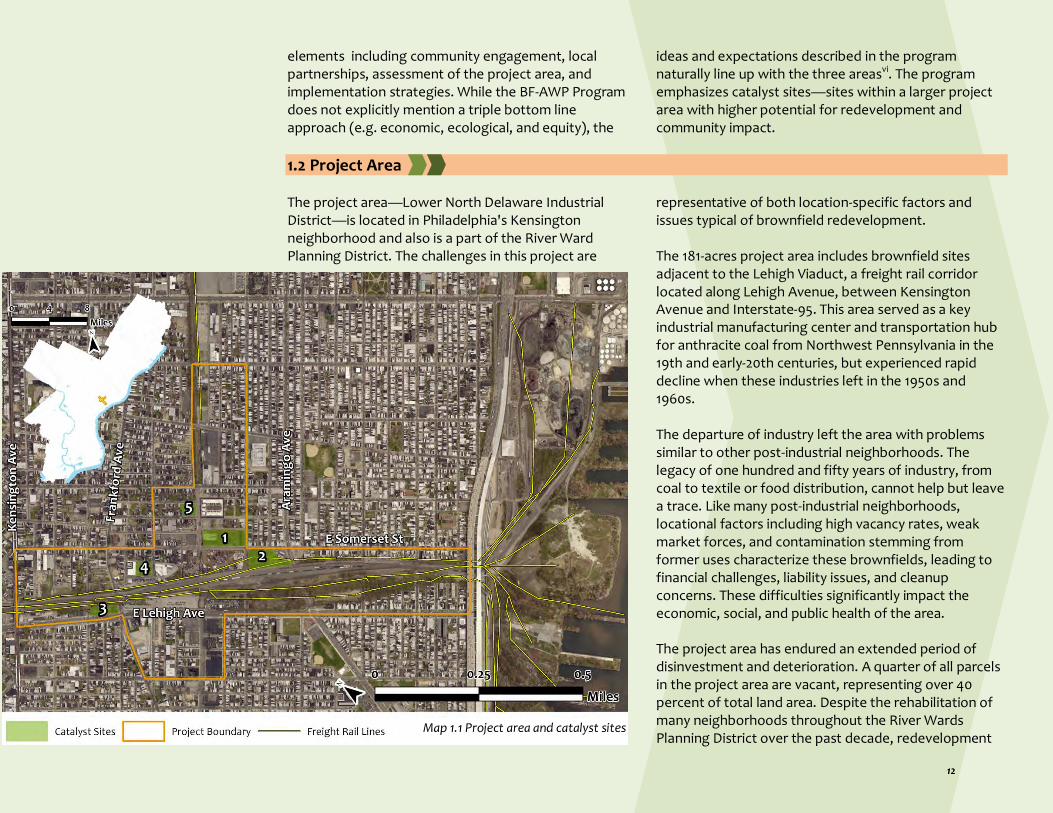
1.2 Project Area The project area—Lower North Delaware Industrial District—is located in Philadelphia's Kensington neighborhood and also is a part of the River Ward Planning District. The challenges in this project are
representative of both location-specific factors and issues typical of brownfield redevelopment. The 181-acres project area includes brownfield sites adjacent to the Lehigh Viaduct, a freight rail corridor located along Lehigh Avenue, between Kensington Avenue and Interstate-95. This area served as a key industrial manufacturing center and transportation hub for anthracite coal from Northwest Pennsylvania in the 19th and early-20th centuries, but experienced rapid decline when these industries left in the 1950s and 1960s. The departure of industry left the area with problems similar to other post-industrial neighborhoods. The legacy of one hundred and fifty years of industry, from coal to textile or food distribution, cannot help but leave a trace. Like many post-industrial neighborhoods, locational factors including high vacancy rates, weak market forces, and contamination stemming from former uses characterize these brownfields, leading to financial challenges, liability issues, and cleanup concerns. These difficulties significantly impact the economic, social, and public health of the area. The project area has endured an extended period of disinvestment and deterioration. A quarter of all parcels in the project area are vacant, representing over 40 percent of total land area. Despite the rehabilitation of many neighborhoods throughout the River Wards Planning District over the past decade, redevelopment
Map 1.1 Project area and catalyst sites

within the study area has historically lagged, due in large part to the presence of soil contamination, poor air quality, and drug issues; however, the situation is rapidly changing as brownfields or vacant properties are being sold to new owners or developers and a number of large-scale development projects are either constructed, currently under construction, or in the design phase. There are an estimated 27 potential brownfields covering 32.6 acres of land located within the project area. Potential brownfields were defined as meeting at least one of the following criteria:
A building description based on Philadelphia Office of Property Assessment (OPA) data that would be consistent with a use that has the potential to generate pollution. This includes auto repair shops, auto junk yards, gas stations, industrial manufacturing uses, scrap metal facilities, funeral homes, and vacant industrial and commercial land.
A building description that is a vacant industrial land.
Historically or currently zoned for industrial use. This includes the I2 and the ICMX zoning codes.
Over 0.5 acres in size.
1.3 Catalyst Sites Of the 27 potential brownfields in the project area, five were chosen as catalyst sites. In accordance with US EPA guidance, these sites were selected for their strong potential for revitalization and reuse, due to community interest, strategic location, as well as environmental, health, or economic concerns. Previous industrial uses have left these sites in need of probable remediation, yet they could provide critical revitalization and strategic community assets to the neighborhood. The catalyst sites are a mix of typologies, so that the Project Team could develop various "prototypical" examples whose design elements could be applied to many other similar brownfields within the project boundary and surrounding areas. The catalyst sites are:
Site 1: 2201 East Somerset Street (2.31 acres)
Site 2: 2750R Aramingo Avenue (2.06 acres)
Site 3: 2001 East Lehigh Avenue (1 acre)
Site 4: 2740 Amber Street (0.73 acres)
Site 5: 2838 Trenton Avenue (0.61 acres)
Catalyst Site 1: 2201 East Somerset Street
Catalyst site 1, the largest and most centrally located of the five sites is 2.31 acres of land in the middle of the project area, just north of the Lehigh Viaduct. Due to the property’s close proximity to the rail lines, it was first developed in the late 1800s as a coal yard, a railroad
Map 1.2 Catalyst Site 1 location
Map 1.2 Catalyst Site 1 location
Catalyst Site 1 in 2018
Catalyst Site 1 in 2019

siding, and a warehouse with several small buildings around its perimeter. In the early 1900s it was redeveloped for scouring and carbonizing wool and as a hair cloth factory, serving for over a century in the world-renowned Kensington textile industry. About a third of the parcel was dedicated for several decades to Kensington’s secondary industry, metal work. Until recently, this full-block parcel had an 81,000 square foot industrial warehouse that was demolished in June of 2019. The site, zoned as Industrial Residential Mixed-Use (IRMX), was purchased by Somerset St LLC in May of 2018 for the price of $2,725,000. Their redevelopment plans were approved by Philadelphia's Zoning Board in October of 2018, and implementation has begun. Therefore, the Project Team’s reuse designs detailed in this plan for Catalyst Site 1 will not be implemented but remain included in order to inspire and guide future projects within the area.
Catalyst Site 2: 2750R Aramingo Avenue
Located diagonal to Catalyst Site 1 and bordering the Lehigh Viaduct is Catalyst Site 2. The property, which is currently vacant, has been neglected and unmaintained allowing for dense -vegetative cover to dominate the majority of the 2.06 acres. The parcel encompasses almost an entire block, apart from a 1,740 square foot Sunoco gas station that sits at the corner of Aramingo Avenue and Somerset Street. Conrail, which owns and operates the Lehigh Viaduct, owns this property, which has an assessed value of $259,900. It was transferred from the previous owner, Reading Railroad Company, in 1997 for just one dollar, and is zoned I-2. This property has been in the hands of various railroad companies since the earliest development of the region and only had two small ‘temporary’ storage and office buildings on its northwest corner for a few years in the early 1900svii. Any contaminants would likely be consistent
with those found in a rail yard though it has been largely vacant for many decades.
Catalyst Site 3: 2001 East Lehigh Avenue
Map 1.3 Catalyst Site 2 location
Map 1.4 Catalyst Site 3 location
Catalyst Site 2
Catalyst Site 3

Catalyst Site 3 is a long and narrow parcel of partially developed land that runs along the southern boundary of the Lehigh Viaduct, opposite the first two sites. A portion of the 1-acre site is vacant, containing trees and shrubs, while the rest of it is occupied by a functioning tire shop that has received several violations for hazards and unsafe operations in recent years. The privately-owned parcel was purchased in October of 1981 for $125,000, almost $10,000 dollars more than the current assessed value ($116,400). Catalyst Site 3 is zoned as Industrial Commercial Mixed-Use (ICMX). This parcel was first developed in the 1880s and 1890s as an extension of the railroad complex with one and then two sidings and four small support buildings. In the 1900s there was a small office building on the Frankford Avenue side as it leads into the tunnel under the Viaduct. For many decades this site was used as a coal yard until it changed hands in 1981 and morphed into the tire shop/salvage yard. The tall concrete wall along Lehigh Avenue suggests a larger building than is actually on the property as only 640 sq ft of the 34,256 sq ft parcel is improved. Its proximity to a large new mixed use 155-unit development, the new Kensington Community Food Co-op and its proximity to the northern section of the project area make for an enticing location to invest in community cohesion.
Catalyst Site 4: 2740 Amber Street
Catalyst Site 4 is a half-block parcel located just north of the Lehigh Viaduct on the western half of the study area – halfway between and only a couple blocks from both Catalyst Sites 1 and 3. The land was recently occupied by an abandoned metal salvage business. This property has followed the rise and fall of Kensington; once fully occupied by the Amber Dye Works/Thomas Dawson & Co Yarn Dye Works in 1886 (and highlighted in an Atlas that year), this small-scale operation that worked in concert with hundreds of other small, related textile
companies throughout the neighborhood is characteristic of Kensington’s past as a “textile empire.”
At three quarters of an acre, the parcel has an assessed value of $244,500 (2018), but was purchased for more than twice this amount in December of 2017. The site is currently owned by Amber Street Holding LLC and is zoned for Residential Single Family Attached-5 (RSA-5). The property held a Philadelphia Hazardous Material license for the last decade and combined with its historic dying operations suggests that an environmental assessment will be an important aspect of its redevelopment. In June of 2018, the NKCDC was informed about a residential proposal for the site that was being reviewed by the Philadelphia Water Department (PWD). At the time of writing, pre-sale of the housing units had already begun, which hinders the implementation of the Project Team's proposed designs detailed in Section 4. As in the case of Catalyst Site 1, the designs remain included in
Map 1.5 Catalyst Site 4 location
Catalyst Site 4 in 2018
Catalyst Site 4 in 2019

this plan as a guide for future brownfield redevelopments in the area.
Catalyst Site 5: 2838 Trenton Avenue
The 5th Catalyst Site is a 0.61-acre parcel located one block away from Catalyst Site 1, host to a two-story brick industrial factory owned by Cramco Realty Incorporated, a furniture production company. The deteriorating structure is utilized as their storage and distribution center, as their main headquarters resides just a few blocks north of the catalyst site. This site was developed very late compared to most of the project area and lay vacant as the industrial neighborhood thrived. It wasn’t improved until 1935 when it emerged as W. F. Kreiss Bedding Co. before it was occupied by the Alco Oil and Chemical Company in the 1960s. The property was purchased by Cramco, the largest makers of ‘casual dining’ dinettes in the country in 1998 for just $100 dollars. As of 2018 the assessed value is $358,800 and
the parcel is zoned for Industrial Residential Mixed use (IRMX).
1.4 Planning Tasks and Section Organization The following four major tasks completed by the Project Team are organized in separate sections.
Understanding the community profile and analyzing existing conditions. This includes an environmental, social, and public health conditions analysis as well as a land market and infrastructure analysis. Section 2 summarizes this effort. Additionally, a complete report on market study—drafted by Econsult Solutions Inc—is available from the project web site: https://www.planviz.org/brownfields
Developing design proposals through community design. The Project Team has done extensive
community outreach and visioning exercises throughout the project period. This includes three public meetings; two focus groups and associated Photovoice activities; a community design workshop; two advisory committee meetings; a survey; 1-1 outreach to residents, land owners, and other stakeholders to receive feedback on preliminary designs; and two phases of in-depth interviews of residents and stakeholders. The Project Team members have also presented initial findings and analysis at regional and national conferences. Section 3 presents highlights from these community engagement activities and summarizes the outcomes.
Map 1.6 Catalyst Site 5 location
Catalyst Site 5
Stairs to viaduct from Emerald Street

Creating redevelopment proposals for five catalyst sites and the overall project area. This includes an overview of design principles, guidelines, and visions for the project area and brownfield sites. The Project Team has created site plans and streetscapes for five catalyst sites and a graphical plan for the overall area. These recommendations are captured in Section 4. This section also explains why recommendations for Sites 1 and 4 will not be implemented and differences between the plans created by the developers and the Project Team.
Developing plan implementation strategies. This includes an overview of brownfield redevelopment and implementation processes or phases, allocation of roles for plan implementation, and identification of funding sources. These discussions are included in Section 5.
Additionally, in Section 6, the Project Team offers some insights on lessons learned, a discussion on implementation challenges, and a summary of residents' and stakeholders' thoughts on implementation strategies and future development practices in the area.
References i U.S. EPA. (n.d.). Overview of EPA's Brownfields Program. Retrieved from https://www.epa.gov/brownfields/overview-epas-brownfields-program. ii Wisconsin Department of Health Services. (n.d.). Public Health and Brownfields. Retrieved from https://www.dhs.wisconsin.gov/environmental/brownfields.htm. iii De Sousa, C. (2005). Policy performance and brownfield redevelopment in Milwaukee, Wisconsin. The Professional Geographer, 57(2), 312-327. doi:10.1111/j.0033-0124.2005.00480.x iv US EPA (US Environmental Protection Agency), https://www.epa.gov/brownfields/overview-epas-brownfields-program v US EPA (US Environmental Protection Agency). 2018. “Overview of EPA’s Brownfields Program.” Accessed December 20, 2018. https://www.epa.gov/brownfields/overview-epas-brownfields-program. vi Meenar, M., Howell, J. P., & Hachadorian, J. (2019). Economic, ecological, and equity dimensions of brownfield redevelopment plans for environmental justice communities in the USA. Local Environment, 24(9), 901-915. https://doi.org/10.1080/13549839.2019.1652803 vii Sanborn Map Company Inc. (n.d.). Retrieved from https://libraries.psu.edu/about/collections/sanborn-fire-insurance-maps/index-philadelphia-pa-sanborn-maps-volumes
Frankford Ave underpass mural

Section 2 — Community Profile
Brownfields Area-Wide Plan Lower North Delaware Industrial District, Philadelphia

Section 2 — Community Profile This section focuses on the background of the project area and features an overview of Kensington’s legacy; existing demographic, social, and physical conditions; and an analysis of market trends. This discussion of the
neighborhood’s vibrant history and present-day challenges within the project area plays a vital role in the conceptualization of a plan to mitigate the effects of waning industrial use on Kensington residents.
2.1 Historic Context Encompassing over 100 neighborhoods, standards of living, culture, and history all vary throughout the City of Philadelphia. This plan spotlights the Kensington neighborhood and more specifically the Lower North Delaware Industrial District, which lies within Philadelphia's River Wards Planning District. The area experienced booming periods of social and economic investment during its industrial past before a period of community disinvestment and high poverty rates. Today, increasing property values and a growing number of building permits indicates new investment in the neighborhood.
The Early Days In 1854 Kensington became an official district of Philadelphia and quickly rose to be regarded as the “Workshop of the World” due to its high volume of mills, shipyards, and factories. Europeans came in great numbers to the area in pursuit of job opportunities and migrated to neighborhoods that needed workers with their set of skillsi. During the 19th Century, Kensington was home to over a third of all textile industries in Philadelphia, and employees at these operations often lived in the neighborhood. Being in such close proximity to the Delaware River, the area played a significant role in establishing Philadelphia as a chief exporter of goods.
Industries that dominated the landscape included glass factories, textile industries (carpet, cotton, hosiery, lace, woolen, and worsted mills), and tanneries/leather-working industries. Throughout Kensington, in the late 1800s, there were 126 textile firms, commonly owned by one owner and operated by few employeesii.
The Decline The district was composed of working-class individuals and families living in row-homes in the shadows of the factories. In the 1930s the Home Owners Loan Corporation surveyed the city of Philadelphia and color-coded neighborhoods on the level of “riskiness” for banks to loan to individualsiii. Industrial neighborhoods and neighborhoods where African Americans lived were color-coded on maps in red and marked with the lowest grade—creating a “stigma and discouraging investment in the area and accelerating the deterioration of property”iv. These racist practices increased segregation and created areas with limited educational opportunities, inadequate housing options, and hazardous industrial buildings. By the 1950s, the number of operating textile industries dropped from 350 to 75, leaving thousands of people in the workforce out of a job and without incomev.

1682
1730
1847
1945
1950’s
1959-1979
1968-1985
1971
1990’s
2000-2011
2008-Present 2016
William Penn forms a treaty with Chief Tamanend of the Lenape, who inhabit the land they call Shackamaxon. Negotiations are made, and Penn purchases the land of the greater Philadelphia area.
17th & 18th Century
The founding of Kensington takes place when British merchant Anthony Palmer purchases 191.5 acres of land. He names the new land after London’s Kensington Palace, located in his homeland.
1830The Cramp Shipyard is opened by William G. Cramp, providing work for thousands of residents in Kensington and Fishtown. They employed about half of the area’s working population.
Plans to convert Gunner’s Run into Aramingo Canal are proposed by landowners in the area and were unsuccessful. In 1896 it is covered by Aramingo Avenue and becomes part of a combined sewer system.
Kensington joins with neighboring towns such as Richmond and Bridesburg, who are consolidated into the City of Philadelphia through the 1854 Act of Consolidation.
Northern Liberties and Kensington are referred to as the “Workshop of the World”. William Cramp Shipyard, John B. Stetson Hat Company, Schoenhut Toy Factory, and Bromley Mills provided 35,000 textile jobs.
1920’s
The Cramp Shipyard closes indefinitely, marking the starting point for the industrial emigration that takes place within Kensington, which sparks significant job loss and disinvestment.
As deindustrialization and redlining continues, many residents begin to emigrate in search of work, and the lack of employment opportunity leads to a population decrease and a decline in economic revenue for the area.
I-95 is constructed, which connects the Northern and Southern halves of Philadelphia and consequently isolates Kensington from other areas of the city.
Period of “urban renewal” within the city of Philadelphia displaces large populations of Latino residents, forcing them out of Northern Liberties and settling into Kensington.
Stetson Hat Company closes after nearly 100 years of manufacturing, ultimately displacing thousands of workers who were employed there. The building is later destroyed by a fire in 1980.
Kensington faces a period of development and economic investment, increasing property rates and displacing longtime residents who cannot afford to own property there anymore.
Number of housing units, housing occupancy rate, and educational attainment continue to increase, and housing vacancy rates decline within the River Wards District.
Rebuilding of I-95 begins through the Pennsylvania Department of Transportation - Plan intended to, improve street connections between neighborhood and riverfront property.
2013
2015
Initiatives are being taken to provide direction for future community revitalization improvements, including Frankford Creek Brownfield Redevelopment Plan, Riverwards District Plan, and North of Lehigh Revitalization Plan.
Brownfields Area Wide Plan, funded by the U.S EPA, is prepared for Philadelphia Lower North Delaware Industrial District and Kensington Neighborhood.
19th Century
20th Century
21stCentury
1854

Throughout the country, mass-manufacturing and cheap labor pulled many of the textile industries overseas; the repercussions of this shift were felt particularly acutely in Kensington where production and labor work employed a majority of the population. These large manufacturing industries dominated the landscape for years, became the livelihood of people in the area, and then deserted the neighborhood (mainly between the 1920s and 1950s) leaving a wake of vacant buildings and unemployed laborers. In the 1980s, the last of the manufacturing plants closed in the project area. Once these industries left, vacancy and unemployment prevailed, a plight that led the area to its present status. Residents' quality of life in Kensington has since been hampered by a lack of services and limited safety precautions. This is seen especially around the Lehigh Viaduct, a haven for drug use, sex work, and illegal dumpingvi.
Current Times Though illegal activities are dispersed throughout the River Wards Planning District and the City of Philadelphia at large, the viaduct offers an enclosed location with an “anything goes” attitude that facilitates crime throughout the neighborhood. The neglected Conrail-owned track is a “raised embankment connector that runs from the Port Richmond rail yards to the Girard Avenue interchange at I-95”vii. Though the goal of transportation infrastructure is to connect people to resources, the Viaduct, widening of Delaware Avenue, and the I-95 corridor has isolated the neighborhood and hindered its growth relative to others within the River Wards Planning District. The environmental quality of the neighborhood has also suffered from post-industrial neglect. In November of 2017, the Department of Environmental Protection
found unacceptable levels of lead-contaminated soil at 26 locations close to the project area. One such soil sample tested 25 times higher than the federal limit for what is deemed safe exposure for childrenviii. Environmental injustice and brownfields are prevalent in Kensington, in part, due to the magnitude and success of its former textile industry. Vacant or abandoned sites previously used in production and manufacturing of textiles deter redevelopment due to the heightened potential of a hazardous substance, pollutant, or contaminant on the parcels.
The Start of a Rebirth
Though adversity has found root in Kensington, residents continue to be resilient. New resident-led organizations formed to strengthen Kensington’s political capital, secure more resources for their neighborhood, and coordinate cleaning and greening projects. “Beautifying” the neighborhood typically increases a sense of community pride while decreasing crime rates. Smaller residential community groups organize community workshops for adults and free recreation camps for children. Somerset Neighbors for Better Living is an example of an established community group that creates a space for community members to gather at monthly meetings, organize events, and discuss community concerns and news. Larger community-based organizations within the project area include NKCDC. The main office of the NKCDC currently resides at the Orinoka Civic House at Ruth and Somerset Streets, a $17.8 million overhaul of the former Orinoka Mills factory containing 51 units of sustainable, affordable housing, an indoor community space, and a commercial storefront.

Another large-scale affordable housing project in the project area was led by The Women’s Community Revitalization Project (WCRP) and the Firm Hope Baptist Church, on a vacant lot that previously housed a factory and currently held by the WCRP’s Community Justice
Land Trust. The 36-unit complex was completed in 2016 and offers supportive services to the families that live there. This project aims to ensure permanent affordability in an area that seems to be experiencing the beginnings of gentrificationix
2.2 Demographic Characteristics The project area is contained within five different US Census Tracts in Philadelphia; 160, 161, 178, 179 and 180.01. Demographic data were collected for the purposes of this plan using these five tracts.
Population Data from the US Census Bureau’s American Community Survey (2013-2017) reports that the population of the five census tracts is estimated to be 28,854, which represents an increase of about 10 percent from the 2010 American Community Survey. Several of these census tracts have experienced population growth, in particular Tracts 161 and 179. On the other hand, the southwest edge of the project area has seen a slight decrease in population, most notably in Tracts 160 (2.78%) and 178 (6.99%). The overall population density is approximately 35 residents per acre. Over half of the population is under the age of 35; 28 percent is aged 19 and under and 31 percent is aged 20-34, making this a relatively youthful and vulnerable neighborhood. Only 6 percent of residents are over the age of 65. The largest racial group is white, comprising over 65 percent of the population; Latinos make up 27 percent of the population and African Americans make up nearly 16 percent of the population. It is important to note that race and ethnicity are two distinct classifications in
American Community Survey data. Race refers to a person’s racial background (White, African American, Asian, or Other) while ethnicity refers to the ethnic origin of that person (Latino or Non-Latino). Therefore, people of any race could be of any ethnic origin. There is also significant variation in the racial composition of the Census Tracts that comprises the project area. The percentage of white residents within these census tracts ranges from approximately 42 percent to 94 percent; similarly, the percentage of African American residents ranges from 2.4 percent to over 31 percent, and the percentage of Latino residents ranges from approximately 7 percent to nearly 45 percent. Notably, single-mother headed households comprise almost 60 percent of all family households.
Income Since the project area is contained within five different census tracts, Median household income in five tracts varies considerably, with a range of $24,975 to $57,980. Incomes in this area are much lower than the rest of Philadelphia and the state of Pennsylvania; median income in the surrounding neighborhoods ranged from $18,290 in Fairhill to $71,240 in Fishtown. Although there are some census tracts in the project area that have a median income greater than $64,000, 30 percent of the population lived below the poverty line as of 2016. This

has decreased slightly from the 33 percent that were deemed impoverished in 2010.
Employment
Approximately 66 percent of the population is of working age (20 to 65 years of age), but the labor force participation rate is only about 64 percent. This means that more than a third of these working aged individuals do not engage in the labor force and contribute to the unemployment rate of the project area, which in 2016 was 18.2 percent. This is three times higher than the rate of unemployment for the entire country, which was 5 percent in 2016, and about 6 percent greater than the
unemployment rate for the city of Philadelphia, which was 12.5% in 2016. Approximately one percent of the working-age population that lives in these five tracts also works in the same area, and the majority of neighborhood residents are employed in “low-skilled industries.”
Educational Attainment Twenty-six percent residents 25 and older have less than a high school degree and 34 percent have a high school diploma. Twenty-six percent of the population has a college degree, including Associate’s (5.3%), Bachelor’s (14.8%), and Graduate or Professional degrees (5.6%).

Map 2.1 Demographic characteristics of project area (Census ACS 2013-2017 data)

2.3 Social Conditions
Community Assets
There are a number of parks, schools, religious institutions, and non-profit organizations situated just outside the borders of the project area; however, the Lehigh Viaduct creates a physical barrier that drastically hinders residents’ ease of access to some of these services. One of the religious institutions located along the boundary of the project area is the Rock Ministries Calvary Chapel of Kensington, a faith-based organization that provides outreach to at-risk youth. Their services include sports and recreation such as boxing, art, music, mentoring, and Bible studies as means to transform the
lives of local children by bringing hope to the neighborhood. The Community Center at Visitation, located at the intersection of Kensington Avenue and Lehigh Avenue, is a multi-use facility owned by the Archdiocese of Philadelphia that provides adult education, community outreach, youth and senior programs, and recreational facilities. There are no schools within the project area, contributing to a lack of safe community spaces. The Memphis Street Academy is adjacent to the project area boundary. There are no buildings on the National Historic Register located within the project area, but
the historic Thomas Powers School is located one and a half blocks north of one of the proposed catalyst sites and just outside the project area boundary.
Map 2.3 Project area overlapped by RCO boundaries Accessible open space acreage is a scarce commodity within the borders of the project area, as there is only one existing public space. This poses a multitude of health concerns, as physical and mental well-being can be severely impacted by a lack of green space and clean air. The only public space—the Trenton and Auburn Playground—is currently undergoing restoration. Other existing recreational facilities are located south of the project area, but access is impeded to residents north of the viaduct due to the physical barrier it creates. Map 2.2 Community assets

There is a "Save A Lot" grocery store within the boundaries of the project area. Located directly across the street from Catalyst Site 3 is the Kensington Community Food Co-op, a community-owned grocery store, which provides residents locally sourced produce from farmers and vendors in and around the Riverwards area. Both stores are located south of the Lehigh Viaduct, meaning residents without vehicles living in the northern portion of the project area may have difficulty accessing them. These residents have access to a few corner stores or mini-marts selling prepared foods (e.g., pastelitos, hoagies), packaged foods, soda, and cigarettes. There is no access to farmer’s markets. There are a few other grocery stores in adjoining neighborhoods but not within walking distance. According to Philadelphia Health Department's recent study, the northern portion of the project area is categorized as an area with low-to-no walkable access to healthy food retailers and high poverty.
Public Health
The project area exemplifies the cumulative detrimental effects of a formerly industrial neighborhood in that it is a distressed community with significant social, public health, and environmental justice concerns. Some key social justice issues for the area include the presence of significant drug activity as well as high rates of crime. Air contamination from arterial roadways, illegal dumping sites, and commercial and industrial activity (both past and present) all pose a threat to the health of community members. The burning of tires on abandoned sites is also a contributor to poor air quality within the project area as are periodic flare ups and major fires at the scrap yards that are ubiquitous in the area.
There are lead poisoning risks associated with the former Anzon/John T. Lewis facility located at Lehigh and Aramingo Avenues. The facility was involved in lead product manufacturing operations from 1849 until its closure in 1996. More than 75 percent of young children are at risk of having elevated blood-lead levels from playing regularly in contaminated dirt surrounding the factory site, and pregnant women are also at risk to exposurex. Drug use has long been associated with Kensington due to its abundance of vacant buildings and lots used for illegal activities. Opioid abuse fatally affects Philadelphians, with 1,116 reported overdose deaths throughout the city in 2019, according to Department of Healthxi. Philadelphia's rate of overdose deaths (65 per 100,000 residents) was the highest of any major city in the nation and over three times the national average in 2017, according to the Centers for Disease Control and Preventionxii. About 50 overdose deaths occur in Kensington area every yearxiii. Prevention Point Philadelphia (PPP) Center operates near the boundary of the project area and trains community members how to properly use Narcan to reverse an opioid overdose. Programs such as PPP attempt to educate and expand treatment to those addicted or affected by opioids. Additionally, much illegal dumping exists within the project area, both in the underpasses under the Lehigh Viaduct, on side-streets and dead ends, and in and around vacant properties.
Public Safety
According to Philadelphia Inquirer Data Hub, 1,000 crimes were reported in the Kensington neighborhood in the year 2018, including four homicides, three rapes, 51 aggravated assaults, 20 prostitution and commercialized vice, and 228 narcotic violationsxiv. One

of the worst drug corners in Philadelphiaxv is located at the boundary of the project area at the intersection of Kensington Avenue and Somerset Street . Sex work and drug dealing occur frequently around that intersection, and many nearby residents avoid that area and rail station out of concerns for their safety. Additionally, the Lehigh Viaduct offers a largely unpoliced open space for crime to occur unnoticed and unreported.
Map 2.4 Violent crime density in the project area
The crime rate in this area has not increased in recent yearsxvi. Recent improvements that may have contributed to a slight reduction in crime include Conrail’s addition of fencing around the viaduct, more lighting, Southeastern Pennsylvania Transportation Authority (SEPTA) expanding its police presence in neighborhood, and the redevelopment of the Orinoka
Civic House, which transformed a heroin shooting gallery into a commercial-residential mixed-use building. All the physical improvements in the area, including redevelopment of vacant lands, are leading to some ebbs and flows but the problem still remains. Many residents list crime as their most pressing concern within the neighborhood.
Homeless Encampments An ongoing social issue for many years within the project area has been the prevalence of a substantial homeless population residing within the Lehigh Viaduct and various other locations such as abandoned parking lots, underpass tunnels, and underneath the SEPTA Market-Frankford Line. Groups of up to 200 people, many of whom are struggling drug addicts, have congregated in places within Kensington where they can have suitable shelter and set up makeshift homes with camping tents, tarps, and other materials. In October of 2018, the Mayor declared Kensington to be in a state of emergency and city officials removed these encampments and community groups, service organizations, residents, and the City have worked together to address opioid related issues, homelessness, crime, and safety concerns. Multiple initiatives are underway to reduce and decriminalize addiction: including the provision of services, employment, housing, and medical care. Despite progress, opioid addiction, homelessness, overdoses, and poverty remain pervasive social issues within the project area. Revitalization of community assets, programs and services, resident participation in community development, and adaptive reuse of the many brownfields and vacant properties for placemaking are seen as critical to the future of the project area.

2.4 Physical Conditions
Brownfields
There are 27 potential brownfields covering 32.6 acres of land located within the project area. For the purpose of this analysis, potential brownfields were defined as meeting at least one of the following criteria:
A building description based on Office of Property Assessment (OPA) data that would be consistent with a use that has the potential to generate pollution. This includes: auto repair shops, auto junk yards, gas stations, industrial manufacturing uses, scrap metal facilities, funeral homes, and vacant industrial and commercial land.
A building description that is either vacant industrial land or vacant commercial land.
Historically or currently zoned for industrial use. This includes the I2 and the ICMX zoning codes.
Over 0.5 acres in size. Since many railroad-controlled parcels are unlikely to be made available for development, the Project Team did not consider the railroad-associated parcels to be potential brownfields. Many of the potential brownfield sites are large tracts of land that could be attractive for redevelopment or adaptive reuse. However, the potential presence of environmental contamination may present a barrier to returning the land to productive uses. Two of the largest brownfield sites and several smaller ones in the project area have recently been acquired and are either under construction or soon will be for adaptive reuse.
Map 2.5 Brownfields within the project area

Table 2.1: List of 27 potential brownfields sites within the project boundary
Parcel Number Address Building Description Acres Current Zoning Previous Zoning Land Use
884345387 3060-86 WITTE ST IND. WHSE MASONRY 0.53 I2 I2 Industrial
882920576 2400-18 E SOMERSET ST AUTO TIRE CENTER MASONRY 0.53 ICMX CA1 Commercial
885940260 2755 MARTHA ST VAC LAND IND < ACRE 0.54 ICMX I2 Vacant - Industrial
884671500 2111-41 E RUSH ST IND. LGHT MFG MASONRY 0.60 ICMX I2 Industrial
884345395 2838 TRENTON AVE IND. FACTORY MASONRY 0.61 IRMX I2 Industrial
884346915 1801 E LEHIGH AVE IND WHSE MAS.+OTHER 0.63 ICMX I2 Industrial
884345240 2304R-50 E SOMERSET ST VAC LAND IND < ACRE 0.66 --- --- Vacant - Industrial
885555580 2800 TRENTON AVE PUB. UTIL. 1 STY MASONRY 0.67 IRMX I2 PECO
884345510 2770-80 JASPER ST IND. FACTORY MAS+OTHER 0.68 I2 I2 Industrial
884093700 2201 E CAMBRIA ST IND. LGHT MFG MASONRY 0.69 I2 I2 Industrial
884671900 2916 WEIKEL ST IND. LGHT MFG MASONRY 0.70 I2 I2 Industrial
884345410 2740 AMBER ST IND. MILL MASONRY 0.73 RSA-5 I2 Industrial
886666000 2721-51 RUTH ST IND. WHSE MASONRY 0.74 I2 -- Industrial
884346925 2001 E LEHIGH AVE IND. WHSE MASONRY 0.81 ICMX I2 Industrial
884712900 2649-89 AMBER ST IND. LGHT MFG MASONRY 0.87 RSA-5 I2 Industrial
885242020 2731 FRANKFORD AVE VAC LAND IND < ACRE 0.94 ICMX I2 Industrial
884345400 2745 AMBER ST IND. WHSE MASONRY 0.96 ICMX I2 Industrial
885378500 2717 BELGRADE ST VAC LAND COMM. < ACRE 1.14 I2 I2 Vacant - Commercial
885325880 2201 E ANN ST VAC LAND IND < ACRE 1.18 I2 I2 Vacant - Industrial
884346920 1841 E LEHIGH AVE IND. WHSE MASONRY 1.23 ICMX I2 Industrial
884104340 2601 TRENTON AVE IND. WHSE MASONRY 1.57 I2 I2 Industrial
884346922 2157 E LEHIGH AVE AUTO JUNKYARD MASONRY 1.77 ICMX I2 Industrial
884713000 2621-67 FRANKFORD AVE IND LUMBER YARD MASONRY 2.03 IRMX I2 Industrial
884094500 2200 E ANN ST IND. WHSE MASONRY 2.31 I2 I2 Industrial
884671400 2201 E SOMERSET ST IND. WHSE MASONRY 2.31 IRMX I2 Industrial
884345252 2200-50 E SOMERSET ST IND. SCRAPMETAL YRD MASONR 2.65 ICMX I2 Industrial
885816300 2035 E LEHIGH AVE RETAIL CAR LOT NO BUILD 4.49 ICMX I2 Commercial
Source: Philadelphia City Planning Commission 2017 (data compiled by Econsult Solutions Inc.) Notes: I2 — Industrial; ICMX — Industrial Commercial Mixed-Use; IRMX — Industrial-Residential Mixed-Use; RSA-5 — Residential Single Family Attached

Landscape
The bulk of the project area consists of impervious surface, with very little green space accessible to residents. Tree cover is severely lacking, as most of the vegetative cover within and around the project area is grass and shrub. The majority of this cover is in poor condition, and does not increase the neighborhood’s attractiveness, significantly lessen the heat island effect, greatly improve air quality, or assist dramatically with stormwater management. The opportunity and obligation exist to plant more trees within the project area, to address air quality concerns as well as neighborhood beautification and other environmental
and quality of life benefits. The abundance of vacant land combined with hindered access to healthy food in the neighborhood offers the opportunity to redevelop some of the vacant land into urban agricultural gardens.
Map 2.6 Project area landscape According to the data collected by the Natural Resource Conservation Service soil survey, the soil within the project area is considered “Urban Land”, which denotes that the project area is predominantly comprised of impervious surface and built environment. Soil is compressed and lacks the essential components for vegetative growth found in healthy soil. Throughout the project area there is a relatively low or mild slope, apart from the boundaries of the Lehigh Viaduct where topography shifts to being steep.

Stormwater Management
The project area is completely encompassed within the Delaware Direct watershed. All stormwater runoff drains right into the river, generally facilitated by storm drains and the combined sewer system maintained by the City of Philadelphia. As previously mentioned, the project area
consists of relatively high amounts of impervious coverage, lacking an adequate amount of green spaces. Combined with the challenges of Philadelphia’s aging combined sewer overflow (CSO) system, there are opportunities in the neighborhood for green stormwater infrastructure (GSI) projects. At present, there are several GSI projects in the design, planning, or construction phases within the project area, and at least one completed installation. There is a small portion of the southern section of the project area that lies within the FEMA 500-year flood zone, and a historic hydro line passes through the area as well. With immense amounts of industrial use combined with Philadelphia’s CSO area and large amounts of impervious surface, increased water pollution has become a growing concern for the region that encompasses the project area.
Worth noting is the regulation requiring any development project that disturbs more than 15,000 square feet of earth to manage their stormwater on site. The abundance of brownfields in the project area suggests that soils may be contaminated, which may impact the types of stormwater infrastructure that may be used. It is likely that the contamination will preclude the use of less-costly infiltrating practices thus stormwater management will be a redevelopment cost consideration.
Air Quality
Air quality, determined by the quantity of fine particulate matter measured at a given location, is often very poor in the project area. In particular, air monitoring figures provided by the Clean Air Council in 2017 showed, in the vicinity of a recent fire at a local scrap yard, figures went from 20 micrograms per cubic meter to 773; the federal standard for air quality is 35 micrograms per cubic meter.
Photo by participant #9

2.5 Market Analysis The project area is adjacent to several neighborhoods, such as Fishtown and Northern Liberties, that have been experiencing gentrification, development pressure, and accompanying property value increases. Market signs are beginning to show similar trends in the project area.
Land Use
Map 2.7: Project area land use
The project area contains 1,768 individual parcels covering 128.5 acres. The land use categories are based on data maintained by the Philadelphia City Planning Commission (PCPC). The largest land use category, in terms of acres, are the railroad parcels associated with the freight rail line that bisects the project area, consuming 33% of its total area. Most of these parcels are required for the continued operation of the rail line, and are likely undevelopable. Industrial and residential uses comprise the second and third largest uses in the project area respectively, and each occupies nearly a quarter of the land. Scrap yards had previously taken over textiles as the most prominent use of the industrial land, but with several major yards being transformed into mixed-use development sites, the project area is down to just two remaining scrap yards. Five of just over ten acres of commercial property is in the process of being converted to mixed use, primarily residential, and several major industrial sites are also currently under consideration, recently subdivided or rezoned for residential and mixed-use commercial. While the 2017 acreage of active industrial was roughly equivalent to that of occupied residential units, this ratio is trending toward more residential. In terms of numbers of parcels and not in acreage, there are nearly as many vacant industrial parcels as there are active ones. Based on the land use data from PCPC, there were 421 vacant parcels in 2017 covering approximately 15.1 acres of the project area. The vacant parcels vary in size, from less than 0.1 acres to approximately 1.2 acres. It is important to note that while many of the vacant parcels are very small, many of those are contiguous to one

another and could potentially be combined into attractive developable parcels. Table 2.2. Land use in the project area
Land Use Parcel Count
Acres % of Total Acres
Residential 1,166 29.3 23%
Industrial 66 29.4 23%
Commercial 55 10.6 8%
Institutional 5 0.4 0%
Vacant - Commercial 13 2.0 2%
Vacant - Industrial 59 5.1 4%
Vacant - Residential 349 8.0 6%
Park 1 0.9 1%
PECO 1 0.7 1%
Railroad 53 42.1 33%
Total 1,768 128.5
Source: Philadelphia City Planning Commission 2017
Zoning
There are two crucial zoning features for brownfield redevelopment, the zoning of the catalyst sites and the surrounding areas, and the potential interactions between them. A considerable portion of the area is zoned as industrial (I-2), which presents a rezoning opportunity to increase residential, mixed-use, and commercial developments. The other zoning classifications within the project area are almost all zoned as residential, either single family, multi-family, rowhome, or mixed use. About 70% of the land is zoned as I-2, while 22% is zoned as RSA-5, which is Residential Single Family Attached. The rest of the zoning long code classifications are less than 2% each and include ICMX, RM-1, CA-1, CMX-1, and CMX-2, as described below.
Industrial Commercial Mixed-Use (ICMX) areas are zoned to serve as a buffer between heavier
industrial areas and residential or commercial districts.
Residential Multi-Family (RM-1) areas are intended for moderate to high-density multi-unit residential buildings.
Auto-Oriented Commercial (CA-1) zones are designated for a variety of uses, mainly for shopping centers where users arrive via automobile.
Neighborhood Commercial Mixed Use (CMX-1) areas are intended for low-impact, small-scale, neighborhood-serving retail and service uses in store-front buildings.
Neighborhood Commercial Mixed Use (CMX-2) zones have the same intended uses as CMX-1, though with CMX-2 uses fall under a broader range.
Transportation Infrastructure The neighborhood is dominated by aging freight transportation infrastructure with the presence of the Lehigh Viaduct, which causes several circulation and access issues. The viaduct contributes to the high number of dead-end streets within the project area, limiting connectivity and fostering crime. The area’s previous dependence on freight rail infrastructure limits its ability to adapt to the needs of modern industry. Rail is most often used for extraction industries which no longer exist in the project area. Utilization of highways for freight transport requires the use of large trucks and tractor trailers, which are only marginally compatible with the mixed-use nature of the project area. Currently, there are issues with tractor trailers blocking pedestrian and vehicular traffic in certain sections of the project area (particularly the Trenton Street corridor.)
Photo by participant #5

Access to public transportation and bike facilities in the area have some of the same connectivity issues, with the Lehigh Viaduct serving as a barrier. Two SEPTA Market-Frankford Line stations are located on the western boundary of the project area along Kensington
Avenue. Access to these SEPTA line is critical to provide job opportunities and connections to the rest of the city for residents of the project area. The entire project area is within a quarter-mile walk to a bus stop; however, the walking distance to rail stations from the eastern half of the project area is greater than a half-mile. Despite these challenges, a large portion of the residents depend on public transit as their main form of transportation. There are very few bike lanes within the project area apart from one each along Lehigh and Aramingo Avenues. These bike lanes extend toward Center City Philadelphia, providing safe routes for people who commute by bike. Some new businesses in the area have installed bike racks outside, and new developments in the area could result in increased bike rack capacity.
Housing
There has been an 11.6 percent increase in the number of housing units within five census tracts containing the project area between 2010 and 2016, which is likely attributable to the 10 percent population increase over the same time frame. This is an exceptionally high increase, considering the city of Philadelphia’s total number of households has only grown by 1.4 percent in the same time frame. In those five tracts, the number of housing units have risen from 11,100 to 11,697, 86 percent of which are occupied (10,068) and about 14 percent vacant (1,629). Over the same time period there was an increase in renter-occupied households and a decrease in homeownership. The number of renter-occupied households increased by approximately seven percent (41%-48%), and the average household size has increased slightly from 2.77 to 2.84 individuals. Additionally, 72 percent of residents in the project area have emigrated since the year 2000, with over 43 percent having moved in since 2010.
Map 2.8: Transportation infrastructure in the project area

Map 2.9: Project Area Residential Transactions 2000-2018 Source: Philadelphia Dept. of Records (2018)
Housing Market — Owner Occupied
The housing market within in the five census tracts encompassing the project area was analyzed using Econsult Solution Inc’s proprietary database of home sales from 2013 to 2017; during this time there were 2,695 residential transactions with an average of 539 per year. The median sales price in these tracts during that period was $133,589 and the average was $112,500. These numbers reflect a steady increase since 2000 with a small dip during the recession of 2008-2012. The years between 2010 and 2017 saw the area’s median sales price per square foot increase 465% and the median sales price per square foot increase by 172%. The southern portion of the project area has the highest selling price per square foot, while the lower valued parcels have tended to be found in the northern portion of the project area. This could be an indication that the development pressure that Fishtown and Kensington have experienced over the last several years is slowly moving toward, and into, the project area. The neighborhoods south of Lehigh Avenue have exhibited greater price appreciation than the neighborhoods north of Lehigh Avenue. The median price per square foot from 2000 to 2018 in the neighborhoods south of Lehigh avenue has ranged from $64 per square foot in West Kensington, to $125 in Kensington, to $186 in Fishtown. In the neighborhoods north of Lehigh Avenue, the median price per square foot has ranged from $19 in Harrowgate to $58 in Port Richmond. According to Econsult, Philadelphia's market-rate housing developers require a selling price of at least $175 per square foot in order to make development profitable. If sale prices in a neighborhood are typically below that threshold, developers will tend to look

elsewhere or will require a subsidy in order to develop. Over the 2010 to March 2018 period, there had been only 820 sales (21% of transactions) within the five census tracts that have sold for more than the $175 per square foot threshold. This is low compared to 30 and 55 percent in Kingston and Fishtown respectively. The market value of residential properties in the project area is significantly below the market value, in both average and median terms, compared to Kensington and Fishtown. It appears that development, however, has steadily moved from Fishtown up through Kensington and is starting to make its way into the project area. Given the abundance of vacant land in the project area, it appears to be the next logical place for development to occur.
Housing Market — Renter Occupied
The proximity of the project area to various public transportation options suggests that rental housing could be an attractive use. Renter-occupied units in the five census tracts tend to be in smaller structures than the City as a whole. Over 94 percent of the renter-occupied units are located in structures that have fewer than 5 units and only 3 percent of structures have more than 10 units. Citywide, only 67 percent of rental units are in structures with less than 5 units. The average median rent across the tracts that comprise the project area is $896 per month. A house or apartment is considered affordable if the resident has to spend 30 percent or less of their income on housing costs. In the project area, nearly 57 percent of the households spend more than 30 percent of their income on housing costs, including nearly 30 percent that spend more than 50 percent of their income. Citywide, 51 percent of households pay more than 30 percent of
their income on rent. This indicates that there is a lack of affordable housing in the project area.
Retail Market
In order to understand the retail market, Econsult focused on three areas. The first is the project area itself to understand how much retail demand would come from the residents living in the project area and how much retail currently exists within the project area. The second area is within one-quarter mile from the borders of the project area and the third area is within one-half mile from the borders of the project area. These distances were selected to represent walking distances from the project area.
Map 2.10: Retail catchments; Source: ESRI Business Analyst (2018)

Data from ESRI’s Business Analyst’s Retail Marketplace Profile was used to characterize the existing retail supply and demand. Specifically, Econsult looked at the following:
Supply (Retail Sales): Estimates of sales to consumers by establishments. Note that sales to businesses are excluded.
Demand (Retail Potential): Estimates the expected amount of money spent by consumers at retail establishments.
Leakage/Surplus Factor: Represents a “snapshot” of retail opportunity. Overall, this is a metric of the relationship between supply and demand that ranges from +100 (total leakage) to -100 (total surplus). If the factor is positive, there is a “leakage” of retail opportunity outside the trade area. A negative factor represents a surplus of retail sales, when customers are drawn in from outside the trade area.
Retail Gap: Represents the difference between Retail Potential and Retail Sales. A positive Retail Gap represents a retail opportunity.
Market Potential Index (MPI): Measures the relative likelihood of the households in the trade area to exhibit certain consumer behavior compared to the US average. An MPI of 100 represents the US average. A score above 100 is greater than national average and, inversely, a score below 100 is less than national average.
For the purpose of this analysis, Econsult focused on the following retail categories:
Food stores, including groceries
Health and beauty
House and home
Sports and leisure
Apparel and jewelry
General merchandise
Restaurants Table 2.3 shows the results of this analysis. There is relatively little retail within the project area itself. There are three food stores (including groceries), two house and home retailers, one sports and leisure retailers, and six restaurants. The project area does not currently have any health and beauty retailers or apparel and jewelry stores. Within a quarter mile, there is opportunity across the key retail categories, as well as for health and beauty and restaurants. However, while the data does suggest that there is an oversupply of health and beauty retail and restaurants, the oversupply is very small. Within a half mile of the project area, there appears to be an oversupply across most of the key retail categories, except for house and home and apparel retailers. It is important to note that there is a significant amount of residential development that is either under construction or in the planning stages. As these developments are completed, the population of the project area will increase as will the demand across all of the key retail categories. The retail demand that will be generated by these new residents are not reflected in the retail demand data in the table. As such, the retail gap represents an underestimate of the true retail gap. This suggests that as development occurs, both within the project area and in nearby neighborhoods, there will be a need for additional retail. In addition to analyzing retail supply and demand data from ESRI Business analyst data, Econsult also examined

data from the City of Philadelphia on walkable access to healthy food. The analysis, at the Census Block level, found that 28 percent of the project area has low access to healthy and fresh food and those areas are contiguous with low-access areas in nearby
neighborhoods. Closer inspection of the data suggests that most of the residents in the project area live in the region of the census tract that has the lowest access to healthy foods.
Table 2.3. Retail market place profile
Demand Supply Retail Gap Surplus/Leakage Factor Number of Stores
Study Area
Groceries $3,340,692 $3,358,837 -$18,145 -0.3 3
Health and Beauty $1,138,744 $0 $1,138,744 100 0
House and Home $646,366 $798,303 -$151,937 -10.5 2
Sports and Leisure $559,639 $195,847 $363,792 48.2 1
Apparel and Jewelry $1,108,353 $0 $1,108,353 100 0
Restaurants $1,976,075 $989,663 $986,412 33.3 6
Quarter Mile
Groceries $33,456,210 $26,412,675 $7,043,535 11.8 23
Health and Beauty $11,543,757 $12,599,271 -$1,055,514 -4.4 9
House and Home $6,581,990 $3,107,810 $3,474,180 35.9 5
Sports and Leisure $5,618,554 $5,208,666 $409,888 3.8 5
Apparel and Jewelry $11,037,876 $4,305,874 $6,732,002 43.9 5
Restaurants $19,884,015 $21,198,009 -$1,313,994 -3.2 58
Half Mile
Groceries $63,866,489 $71,975,464 -$8,108,975 -6 52
Health and Beauty $22,097,347 $58,437,240 -$36,339,893 -45.1 29
House and Home $12,567,533 $7,115,338 $5,452,195 27.7 10
Sports and Leisure $10,738,885 $14,656,887 -$3,918,002 -15.4 12
Apparel and Jewelry $21,135,109 $15,835,428 $5,299,681 14.3 22
Restaurants $38,024,041 $50,121,480 -$12,097,439 -13.7 134 Source: ESRI Business Analyst (2018)
Industrial Market In 2010, the Philadelphia Industrial Development Corporation (PIDC) released the Philadelphia Industrial Market and Land Use Strategy. The purpose of the report was to “expand and retain industry in the City, protect employment opportunities and tax revenues, and rationalize the city’s supply of industrially-zoned
land to meet the future needs of the Philadelphia business.” The report found that there is a fundamental supply and demand mismatch between much of Philadelphia’s older industrial buildings and the needs and requirements of modern industrial uses. As such, many
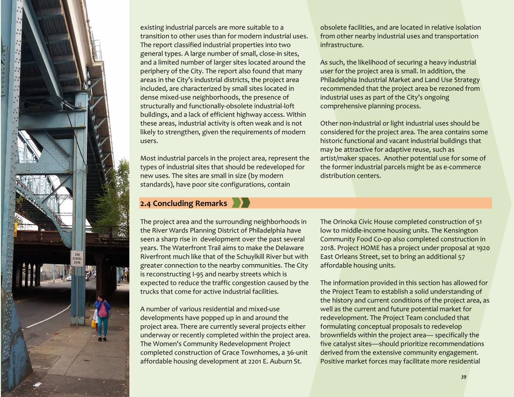
existing industrial parcels are more suitable to a transition to other uses than for modern industrial uses. The report classified industrial properties into two general types. A large number of small, close-in sites, and a limited number of larger sites located around the periphery of the City. The report also found that many areas in the City’s industrial districts, the project area included, are characterized by small sites located in dense mixed-use neighborhoods, the presence of structurally and functionally-obsolete industrial-loft buildings, and a lack of efficient highway access. Within these areas, industrial activity is often weak and is not likely to strengthen, given the requirements of modern users. Most industrial parcels in the project area, represent the types of industrial sites that should be redeveloped for new uses. The sites are small in size (by modern standards), have poor site configurations, contain
obsolete facilities, and are located in relative isolation from other nearby industrial uses and transportation infrastructure. As such, the likelihood of securing a heavy industrial user for the project area is small. In addition, the Philadelphia Industrial Market and Land Use Strategy recommended that the project area be rezoned from industrial uses as part of the City’s ongoing comprehensive planning process. Other non-industrial or light industrial uses should be considered for the project area. The area contains some historic functional and vacant industrial buildings that may be attractive for adaptive reuse, such as artist/maker spaces. Another potential use for some of the former industrial parcels might be as e-commerce distribution centers.
2.4 Concluding Remarks The project area and the surrounding neighborhoods in the River Wards Planning District of Philadelphia have seen a sharp rise in development over the past several years. The Waterfront Trail aims to make the Delaware Riverfront much like that of the Schuylkill River but with greater connection to the nearby communities. The City is reconstructing I-95 and nearby streets which is expected to reduce the traffic congestion caused by the trucks that come for active industrial facilities. A number of various residential and mixed-use developments have popped up in and around the project area. There are currently several projects either underway or recently completed within the project area. The Women’s Community Redevelopment Project completed construction of Grace Townhomes, a 36-unit affordable housing development at 2201 E. Auburn St.
The Orinoka Civic House completed construction of 51 low to middle-income housing units. The Kensington Community Food Co-op also completed construction in 2018. Project HOME has a project under proposal at 1920 East Orleans Street, set to bring an additional 57 affordable housing units. The information provided in this section has allowed for the Project Team to establish a solid understanding of the history and current conditions of the project area, as well as the current and future potential market for redevelopment. The Project Team concluded that formulating conceptual proposals to redevelop brownfields within the project area— specifically the five catalyst sites—should prioritize recommendations derived from the extensive community engagement. Positive market forces may facilitate more residential

projects, retails, commercial or mixed-use projects, and adaptive reuse of light industrial spaces, but residents would also greatly benefit from affordable housing, community spaces, green spaces, recreational amenities, health and literacy services, job training opportunities, and safety features. These projects are socially desired but may not be validated by a market
study. Section 3 illustrates the Project Team’s extensive engagement of local residents and stakeholders for more than two years to create conceptual redevelopment plans for the catalyst sites. The input obtained through this community outreach, detailed in the next section, served of vital importance to the conceptualization of the reuse designs.
References
References for historic timeline graphic: 1682: F, S. (2018, January 10). Retrieved from https://libwww.freelibrary.org/blog/post/3166. West, B. (n.d.). Philadelphia. Retrieved from https://www.history.org/history/teaching/enewsletter/volume6/nov07/primsource.cfm. 1730: Charlton, I. (n.d.). Palmer Cemetery- Kensington Burial Ground. Retrieved from http://palmercemeteryfishtown.com/history.html. Palmer Cemetery. (2001). Anthony Palmer. Retrieved from http://palmercemeteryfishtown.com/statemarker.html. 1830: Phila Place. (n.d.). Cramp Shipyard. Retrieved from http://m.philaplace.org/story/710/. Gates, K. P. (2010, September 16). How one shipbuilder impacted Philadelphia and the world. Retrieved from https://whyy.org/articles/how-one-shipbuilder-impacted-philadelphia-and-world/. 1847: Levine, A. (2009). Aramingo Canal, Then and Now. Retrieved from http://www.phillyh2o.org/backpages/AraCan.htm. 1854: Heath, A. (n.d.). Consolidation Act of 1854. Retrieved from https://philadelphiaencyclopedia.org/archive/consolidation-act-of-1854/. 1920s: Heath, A. (n.d.). Consolidation Act of 1854. Retrieved from https://philadelphiaencyclopedia.org/archive/consolidation-act-of-1854/. Bowie, J. R. (2007). Workshop of the World. Retrieved from https://www.workshopoftheworld.com/introduction/introduction.html. 1945: Phila Place. (n.d.). Cramp Shipyard. Retrieved from http://m.philaplace.org/story/710/. Wikimapia. (2012). Former Site of William Cramp & Sons Shipbuilding Company. Retrieved from http://wikimapia.org/8906130/Former-Site-of-William-Cramp-Sons-Shipbuilding-Company. 1950s: Crossney, K. (2016). Redlining. Retrieved from https://philadelphiaencyclopedia.org/archive/redlining/. 1959-1979: Pennsylvania Department of Transportation. (2019). Corridor History. Retrieved from http://www.95revive.com/i95/reviving-i-95/corridor-history. 1968-1985: Ammon, F. R. (2016). Urban Renewal . Retrieved from https://philadelphiaencyclopedia.org/archive/urban-renewal/. 1971: Historic Structures . (2018, March 23). John Steston Hat Company, Philadelphia Pennsylvania. Retrieved from http://www.historic-structures.com/pa/philadelphia/stetson_hat_company.php. 1990s: Worldpress. (n.d.). The Kensington Neighborhood of Philadelphia: A Neighborhood Divided. Retrieved from https://kensingtonphiladelphia.wordpress.com/an-introduction-to-kensington/. 2000-2010: The Encyclopedia of Greater Philadelphia. (n.d.). Retrieved from https://philadelphiaencyclopedia.org/. 2008-Present: Pennsylvania Department of Transportation. (2019). Corridor History. Retrieved from http://www.95revive.com/i95/reviving-i-95/corridor-history.
Photo by participant #5

PennDOT. (2019). I-95 Corridor Plan Overview . Retrieved from http://www.95revive.com/i95/reviving-i-95.
i Klaczynska, B. (n.d.). Immigration (1870-1930). Retrieved from philadelphiaencyclopedia.org/archive/immigration-1870-1930/. ii Weber, C., Kosmin, I., & Kirkpatrick, M. (n.d.). Kensington. Retrieved from www.workshopoftheworld.com/kensington/kensington.html. iii Mires, C., & Downs, J. (n.d.). Industrial Neighborhoods. Retrieved from philadelphiaencyclopedia.org/archive/industrial-neighborhoods/ iv Mires, C., & Downs, J. (n.d.). Industrial Neighborhoods. Retrieved from philadelphiaencyclopedia.org/archive/industrial-neighborhoods/ v Weber, C., Kosmin, I., & Kirkpatrick, M. (n.d.). Kensington. Retrieved from www.workshopoftheworld.com/kensington/kensington.html. vi Mabaso, A. (2015, March 3). A Transatlantic Collaboration Reimagines North Philly's Lehigh Viaduct. Retrieved from http://www.flyingkitemedia.com/devnews/Lehighviaduct030315.aspx. vii Mabaso, A. (2015, March 3). A Transatlantic Collaboration Reimagines North Philly's Lehigh Viaduct. Retrieved from http://www.flyingkitemedia.com/devnews/Lehighviaduct030315.aspx. viii Ruderman, W., Laker, B., & Purcell, D. (n.d.). "Toxic City": State Confirms Extreme Lead Levels in Kensington Soil. Retrieved from https://www.inquirer.com/philly/news/toxic-city-state-confirms-extreme-lead-levels-in-kensington-soil-20181018.html. ix Women's Community Revitalization Project. (n.d.). Grace Townhomes. Retrieved from www.wcrpphila.org/grace. x U.S. Department of Health and Human Services. (n.d.). Agency for Toxic Substances and Disease Registry (ATSDR). Retrieved from https://www.atsdr.cdc.gov/. xi Lozano, A. V. (n.d.). New Report on Philadelphia's Opioid Epidemic Shows Progress, Much Work to Be Done. Retrieved from https://www.nbcphiladelphia.com/news/local/Has-Opioid-Crisis-in-Philadelphia-Peaked-City-Releases-Successes-Challenges-of-Its-36-Million-Plan-511793881.html. xii Vestal, C. (n.d.). Philadelphia could become the first US city to host a safe injection site for drug users. Retrieved from https://www.usatoday.com/story/news/health/2019/11/18/philadelphia-kensington-opioid-safe-injection-sites-could-coming/4227249002/. xiii Vestal, C. (n.d.). Philadelphia could become the first US city to host a safe injection site for drug users. Retrieved from https://www.usatoday.com/story/news/health/2019/11/18/philadelphia-kensington-opioid-safe-injection-sites-could-coming/4227249002/. xiv Philadelphia Police Department. (n.d.). Crime in Philadelphia. Retrieved from http://data.philly.com/philly/crime/? xv Volk, S. (n.d.). Philly's Top 10 Drug Corners. Retrieved from https://www.phillymag.com/news/2011/08/24/phillys-top-10-drug-corners/. xvi Dovey, R. (2018, March 2). Can Fighting Blight Prevent Gun Violence? Retrieved from https://nextcity.org/daily/entry/can-fighting-blight-prevent-gun-violence.

Brownfields Area-Wide Plan Lower North Delaware Industrial District, Philadelphia
Section 3 — Community Design Process

Section 3 — Community Design Process This section details the twelve community engagement and outreach activities conducted to facilitate the development of design ideas for the five catalyst site redevelopment plans and solicit feedback on these designs. The engagement process spanned approximately three years, beginning in early 2016 with the project introduction meeting, and culminating with the final outreach activity to discuss implementation strategies in the summer of 2019. It is important to note that during the engagement process, a one-year gap was taken between the Fall of 2016 and 2017 due to
administrative changes, so no community engagement activities took place within this time frame. Each engagement activity was specifically chosen within this process in order to produce and choose various types of design elements for the final site plans. The use of community engagement and outreach was a fundamental aspect in the conceptualization of final reuse designs that incorporated design elements representative of all community members and their needs.
3.1 Public Meeting 1 The Project Team secured a spot at a monthly community meeting of Somerset Neighbors for Better Living (SNBL), the primary civic association within the project area, to introduce the EPA-funded project and recruit participants for a future focus group. The event was held at the Rock Ministries in early February 2016. The Project Team delivered a twenty-minute presentation to explain the goals and scope of the project, including the community engagement process.
About 50 residents and stakeholders attended the presentation. After this presentation, attendees were asked to sign-up as volunteers for the focus group sessions. The vast majority of the focus group participants (all but two) were selected from this list to ensure a group geographically and demographically representative of the community that is most directly impacted by the area’s brownfields.
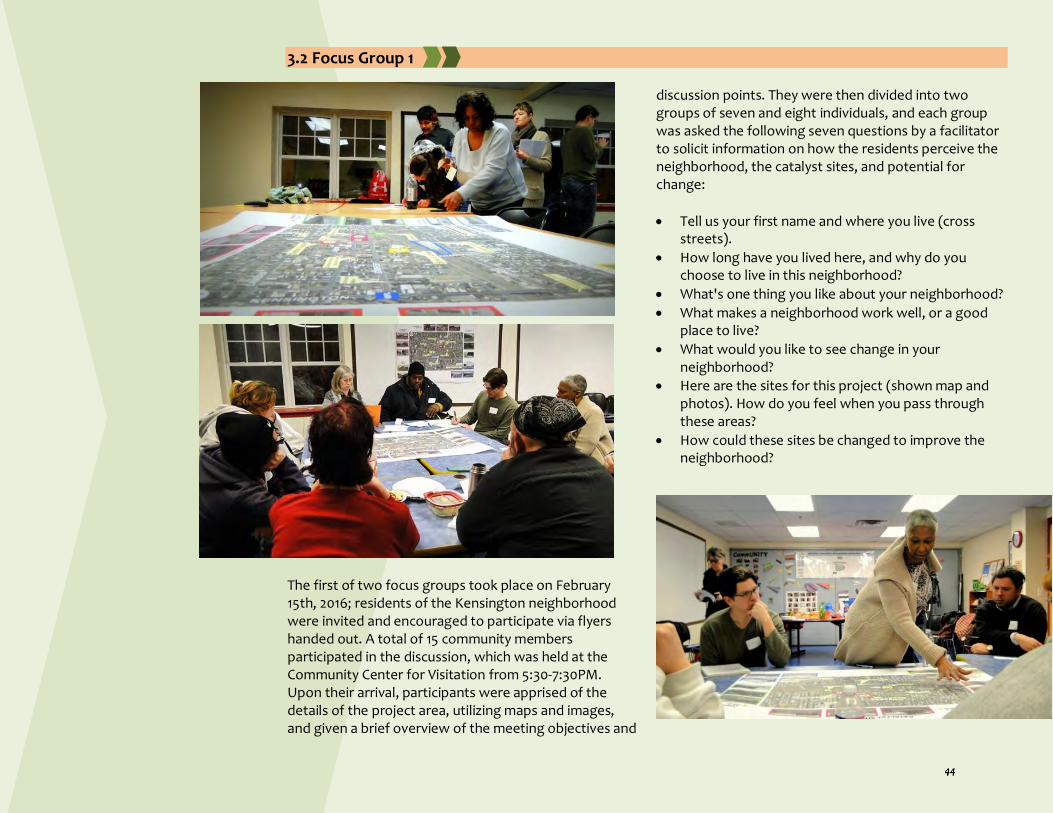
3.2 Focus Group 1
The first of two focus groups took place on February 15th, 2016; residents of the Kensington neighborhood were invited and encouraged to participate via flyers handed out. A total of 15 community members participated in the discussion, which was held at the Community Center for Visitation from 5:30-7:30PM. Upon their arrival, participants were apprised of the details of the project area, utilizing maps and images, and given a brief overview of the meeting objectives and
discussion points. They were then divided into two groups of seven and eight individuals, and each group was asked the following seven questions by a facilitator to solicit information on how the residents perceive the neighborhood, the catalyst sites, and potential for change:
Tell us your first name and where you live (cross streets).
How long have you lived here, and why do you choose to live in this neighborhood?
What's one thing you like about your neighborhood?
What makes a neighborhood work well, or a good place to live?
What would you like to see change in your neighborhood?
Here are the sites for this project (shown map and photos). How do you feel when you pass through these areas?
How could these sites be changed to improve the neighborhood?

3.3 Photovoice Process Photovoice projects have been used since the mid 1990s as means to engage community members in the identification of positive and negative aspects of their community in order to assess the needs and assets of an underserved area and promote changes. This relatively inexpensive and accessible way to gain the perspectives of community residents may be useful in cases where the population has been historically underrepresented. The images are used to relay a community member’s opinion, giving people an outlet to allow their voices to be heard and hopefully spark changes within their neighborhood. At focus group 1, each participant (15) was given their own personal disposable camera, with instructions to take a total of twenty-seven photos of their neighborhood. Ten photos would be aspects of their community that they admired, another ten would be the things they disliked, and seven photos of different design elements throughout Philadelphia they believe would be a drastic improvement to their neighborhood. Cameras were numbered one through fifteen, one per participant, along with labeled instructions and a phone number they could reach out to a member of the Project Team with any questions. Participants were given two weeks to assemble their “neighborhood album,” and on February 29th all but three focus group 1 participants submitted their cameras with the film containing their pictures. Pictures were developed, scanned, and incorporated into posters before the start of the second focus group meeting.

Sample photos submitted by participants
Participant #1 Participant #14 Participant #10
Participant #1 Participant #9 Participant #13 Participant #14 Participant #5
Participant #2 Participant #8 Participant #13
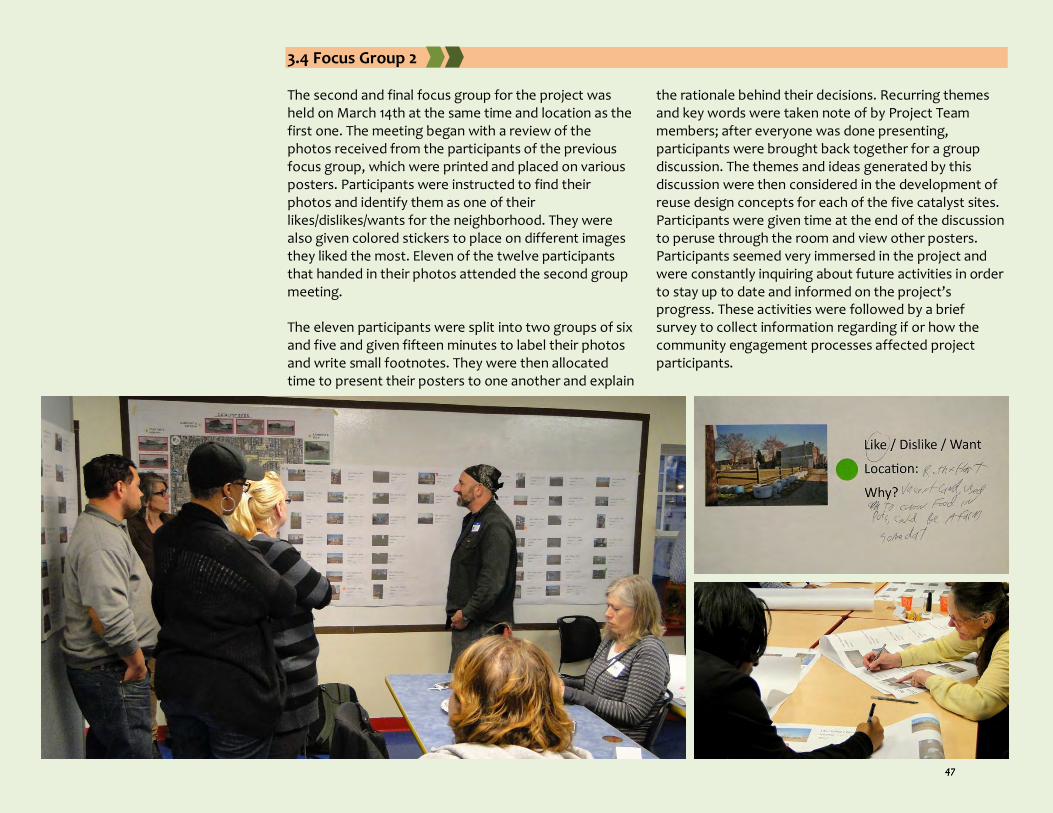
3.4 Focus Group 2 The second and final focus group for the project was held on March 14th at the same time and location as the first one. The meeting began with a review of the photos received from the participants of the previous focus group, which were printed and placed on various posters. Participants were instructed to find their photos and identify them as one of their likes/dislikes/wants for the neighborhood. They were also given colored stickers to place on different images they liked the most. Eleven of the twelve participants that handed in their photos attended the second group meeting. The eleven participants were split into two groups of six and five and given fifteen minutes to label their photos and write small footnotes. They were then allocated time to present their posters to one another and explain
the rationale behind their decisions. Recurring themes and key words were taken note of by Project Team members; after everyone was done presenting, participants were brought back together for a group discussion. The themes and ideas generated by this discussion were then considered in the development of reuse design concepts for each of the five catalyst sites. Participants were given time at the end of the discussion to peruse through the room and view other posters. Participants seemed very immersed in the project and were constantly inquiring about future activities in order to stay up to date and informed on the project’s progress. These activities were followed by a brief survey to collect information regarding if or how the community engagement processes affected project participants.

"Viaduct underpasses are not lit,
they often are flooded, they are
dirty... If that is our welcome mat
to the neighborhood, we are in
trouble. It is crazy that it has been
allowed to get that bad…”
(Participant #9)
“I stopped taking the El over
here. Too much drug activity..."
(Participant #8)
“I feel depressed because when I
was growing up it didn’t look like
that. Every building was
operating, the streets were
clean.” (Participant #2)
“…that is my hope, that [a new
development] will be for low
income people, women with
children. So this is a plus for the
neighborhood. I’m happy about
it, really pleased.” (Participant
#6)
“I like murals. It doesn’t matter
what it is. To me it’s somebody
caring, it’s someone with talent.
It’s somebody that’s trying to
beautify the neighborhood
through art, it’s their
expression.” (Participant #14)
3.5 In-Depth Interviews - Part 1 During the summer of 2016, the Project Team conducted in-depth interviews of the 11 participants who completed Photovoice exercises. The interviews were conducted in a semi-structured way and questions were asked using the photos as props. Participants were specifically asked if they felt any emotion about an urban space or issue featured in a specific photo, and questioned about their
perception of those spaces and topics. They also discussed the reasons behind taking their photos and other matters relevant to the photo topics. Interviews lasted between one to one and a half hours each, and were conducted at participants' homes, workplaces, or public spaces (e.g. cafe). All interviews were recorded and transcribed.
3.6 Advisory Committee Meeting 1 After a yearlong administrative gap, the Project Team resumed work in the Fall of 2017 with the formation of an Advisory Committee comprised of local and regional leaders and stakeholders. The following people expressed interest in participating in the Committee.
David Fecteau, Philadelphia City Planning Commission
Connie Bird, Philadelphia Water Department
Tom Dalfo, Philadelphia Industrial Development Corporation
Rachael Gray Crandley, Conrail
Amy Bernkopf, Delaware Valley Regional Planning Commission
Karen Thompson, Delaware River Waterfront Corporation
Leigh Ann Campbell, Pennsylvania Horticulture Society
Anya Saretzky, Rails to Trails Conservancy
Captain Krista Dahl-Campbell, 26th Police District
Elmira Smith, Somerset Neighbors for Better Living
Sister Betty Scanlon, Community Center at Visitation
Ramon Crespo, Rock Ministries
Foster Hardiman, East Kensington Neighbors Association
Rosemary Thomas, Olde Richmond Civic Association
Pastor Richard Harris, Firm Hope Baptist Church
Sean McMonagle, 1st District City Councilperson Mark Squilla
Mia Hylan, Pennsylvania House Representative John Taylor
The Project Team held the first Advisory Committee meeting on December 8th of 2017 at one of the Project Partner's (Econsult Solutions) office in Center City Philadelphia. Fifteen members attended this meeting. The Team presented the goal and scope of the project, lessons learned from prior community engagement and research, and discussed future tasks.
3.7 Public Meeting 2 On February 5th, 2018, the Project Team met with the community again during another monthly meeting of Somerset Neighbors for Better Living to share their
updates on the project and recruit participants for an upcoming community design workshop. The meeting, held at Rock Ministries, began with a presentation that

provided a summary of the focus group discussions and the results from a market study completed by Econsult Solutions. The Project Team members distributed flyers to about 40 attendees—residents and stakeholders,
many of whom had little to no prior knowledge of the project or previous activities. In addition, the Team reached out to all focus group participants and invited them to participate in the workshop.
3.8 Community Design Workshop
On February 21st, 2018, the Project Team partnered with Memphis Street Academy—a middle school located on the edge of the project area boundary—to organize a community design workshop. The purpose of this
workshop was to generate urban design ideas for vacant and underused old industrial lands or potential Brownfields within the project area, focusing on the five catalyst sites. About 50 community residents, business

owners, developers, and other stakeholders participated in this event, offering many valuable design ideas. Faculty and students from Temple University and Rowan University assisted with the organization and facilitation of the event, while NKCDC assisted with its promotion and recruiting. This 3-hour long event began with a brief presentation by the Project Team explaining the overall goal of the project as well as the agenda for the workshop. Attendees were then divided into six groups; five groups focused on the five catalyst sites while the sixth group focused on the overall project area. Each group
discussion was facilitated by two people representing the Project Team. Participants in each group first spent 30 minutes discussing the existing conditions and their vision for the site before creating future development scenarios in the form of conceptual sketches. Different types of drawing materials (e.g. markers, pencils, color pencils, pens) and tools (e.g. cutouts, scissors, tapes, tracing papers, maps) were supplied to each group. Brainstorming and design activities lasted for a little over an hour. Finally, each team presented their design ideas in front of the audience. The event was later featured in the local STAR newspaper.

3.9 Public Meeting 3 and Survey Utilizing feedback from focus groups and Photovoice discussions, interviews, meetings, and design workshop, the Project Team developed initial design proposals for the overall project area and five catalyst sites. On June 4th, 2018, the Team presented these designs at another monthly community meeting of Somerset Neighbors for Better Living. The Team presented the overall design principles of redeveloping brownfields, as well as revitalizing the overall project area. Next, a conceptual site plan and perspective view of each catalyst site were explained in detail. The Project Team displayed posters
of each site plan on the walls. Following the presentation, the Team handed out feedback forms to all attendees to collect their feedback on the design proposals. Approximately 35 people attended this meeting; many provided their feedback instantly. The Project Team uploaded all the drawings and design principles on the project web site, along with an online version of the feedback form.
3.10 Advisory Committee Meeting 2 On July 11th, 2018, the Project Team invited the Advisory Committee members to Temple University’s Center City campus to review draft site plans and design principles. The Project Team delivered the same presentation and displayed the same posters. This was an hour-long meeting and members provided their instant feedback on the design proposals. Only six members were able to attend this meeting in person, so the rest of the members received digital copies of the proposals along with the digital survey. Technically, reviewing these
design proposals was the final commitment/task for this Advisory Board. By the end of August 2018, the Project Team received 38 survey responses—hard copy and digital. In addition, Project Team member NKCDC reached out to a number of landowners, developers, and community groups to seek feedback on draft design proposals. The Project Team compiled and considered all the feedback and whilst formulating the final versions of the site plans in early spring of 2019.

3.11 In-Depth Interviews - Part 2 and Final Outreach After design proposals were finalized, the Project Team began drafting implementation strategies. By this time, plans for the reuse of Catalyst Sites 1 and 4 were already being developed by private developers (detailed in Sections 4 and 6). In the summer of 2019, the Project Team conducted 15 in-depth interviews of residents and
stakeholders to discuss the existing situation and potential implementation strategies. NKCDC also reached out to a number of different community groups and organizations to brainstorm potential implementation strategies. Section 6 summarizes the key findings from these efforts.
3.12 Developing Design Decisions through Community Engagement Table 3.1 details how the design decisions collected from the different community engagement activities were incorporated into the Project Team’s final designs. The feedback and design ideas collected from the focus groups, design workshop, and surveys/interviews were divided into 6 design topics, including housing type, transportation, commercial/industrial use, community
and green spaces, community development services, and overall neighborhood redevelopment. The table explains where each design decision was discussed throughout the engagement process, and to which catalyst site(s) it was applied. It is important to note that some design decisions may
have been suggested by participants regarding a specific catalyst site, but after factoring in feasibility as well as additional community input, they were applied to a different site. For example, an artists’ studio was suggested by focus group members for Site 1, but was incorporated into Site 5 by the Project Team. Regardless of which site(s) the design decision was applied to, the design suggestions made by participants of the engagement activities were critically important in the conceptualization of these reuse designs. Design suggestions were reviewed and summarized from all of the engagement activities, as the Project Team could not just rely on any individual community member’s input alone. Notably, design suggestions were considered across all sites, which explains why many design decisions were applied to multiple sites. A few suggestions, such as the skate park and dog park, were considered, but ultimately not incorporated into any of the proposed designs; they remain included in the table to serve as ideas for developers or community groups looking to include them in future projects within the neighborhood. Thanks to these suggestions provided by the participants of the community engagements activities, the Project Team was able to finalize design proposals for each of the five catalyst sites that incorporate elements beneficial to all community members.
Photo by participant #8

Table 3.1: Design Decisions through Community Engagement
Design Topic Design Decision Design Discussion Through Community Engagement Design Decision Applied to ---- Focus
Groups Design Workshop
Surveys or 1-1 Outreach with Residents, Landowners, and Other Stakeholders
Housing type Affordable housing x x x Site 1, Site 4
Market rate housing x x Site 1, Site 4
Townhouses, duplexes, apartments x x x Site 1, Site 2, Site 4
Single family row homes x x Site 4
Private outdoor gardens or decks x x Site 1, Site 4
Parking, transportation, and related topics
Parking, on-site parking, covered parking x x Site 1, Site 2, Site 3, Site 4
Traffic calming features (colored crosswalks, wider sidewalks) x x Site 2, Site 3
Bus shelter x x x Site 1, Site 3
Rails with trails, bikeway x x x Site 3
Commercial, industrial, and other uses
Community industries, workshop spaces for trades, design or digital craft (e.g., artists' studios, makers space)
x x x Site 5
Mixed-use building x x Site 1, Site 2
Community center x x x Site 1
Commercial space, event space, or rentable space x x x Site 1,
Retail space (e.g., small grocery, clothing store) x x x Site 1, Site 2
Cafe, Internet cafe x x x Site 1, Site 3, Site 5
Restaurants x Not applied
Pop-up vendor space (e.g., small vending carts, food trucks), summer produce market
x x x Site 2, Site 3
Community spaces and green spaces
Community green space, lawn space, walkways x x x Site 1, Site 3, Site 4
Passive park x x x Site 2
Dog park x x Not applied
Outdoor seating features (e.g., benches, tables, game tables, outdoor eating)
x x x Site 1, Site 2, Site 3
Creative placemaking features (e.g., temporary stage, public art, mural)
x x Site 3
Trees, vegetation, vegetated buffer x x Site 1, Site 2, Site 3, Site 4
Safety features (e.g., outdoor lighting) x x x Site 1, Site 2, Site 3, Site 4
Outdoor plaza accessible to community x x Site 1, Site 2, Site 3
Green stormwater management features (e.g., tree trenches, rain gardens, stormwater bumpouts)
x x Site 1, Site 2, Site 3, Site 4
Activity spaces (e.g., playground, running track) x x x Site 3
Skate park x Not applied

Health, literacy, and community development services
Health and literacy center (e.g., exercise rooms, gym, library, computer lab)
x x Site 3
Medical and mental health consultation center x Site 3
Classrooms for job training and IT skill development x x x Site 5
Overall neighborhood redevelopment
Recreational trail along freight rail line x x x Lehigh Viaduct
Traffic calming (expanded sidewalks, colorful crosswalks, corner bump-outs, and protected bike lanes)
x x x Lehigh Ave
Walking and biking trails, community gardens, and small play areas x x x Trenton Ave elevated rail line (abandoned)
Safety features (e.g., lighting and gateways with signage, seating, vegetation, and public art)
x x x Lehigh Viaduct tunnels or under passes

Brownfields Area-Wide Plan Lower North Delaware Industrial District, Philadelphia
Section 4 — Design Proposals

Section 4 — Design Proposals Community input and information gathered from background research of the history and physical conditions of the project area played a critical role in the conceptualization of design proposals for the catalyst sites and the project area at large. Outreach and engagement activities—detailed in Section 3—served as vital design tools, allowing for community residents and other stakeholders to explain to the Project Team exactly what was lacking within the neighborhood, while providing ideas for different revitalization scenarios for each of the five catalyst sites. Based on various factors, including existing conditions, site typologies, and feedback provided by community stakeholders, the Project Team produced a potential reuse scenario for each site. These design ideas can serve as prototypes for other brownfield sites—within or around the project area. The resulting concepts include a site plan as well as an illustrative diagram for each reuse proposal. These ideas embody the goals of US EPA’s BF-AWP Program by including various economic, social, and environmental assets that facilitate reinvestment and sustainability within the project area. The overall goal of the area-wide plan is to create an urban design framework for rebuilding the postindustrial community in a more humane, sustainable, and healthy paradigm. Creative design strategies are employed to address four broad issues. First, to respond to neighbors’ desire for higher quality residential life, including safe, walkable streets, green space, community gathering places, and affordable housing.
Second, to heal the physical intra-neighborhood breaches created by the industrial and transportation corridors and the vacant land left in their wake. Third, to maintain a mix of uses that balances job-producing industry, retail, housing and recreation space. Fourth, to design new development to fit within adjacent neighborhood context, including street grid, architectural style and building massing. The five Catalyst Sites conceived in collaboration with neighbors and other stakeholders and are strategically located in support of these three design strategies. Some key design elements include:
Green spaces
Social connectivity
Safety
Affordable housing
Mixed-use development
Community serving institutions
Job generating uses
Adaptive reuse of old industrial buildings It is important to note that due to intense development pressure in the area, the Project Team’s design proposals for Catalyst Sites 1 and 4 are unable to be implemented. When the Project Team learned of how quickly plans for the redevelopment of these sites were progressing, the Project Team's proposals were modified to better convey how these key community-minded design elements can still be incorporated into majority-residential development programs.

4.1 Proposed Development Strategies for the Project Area The project area is a cross-shaped district organized around two perpendicular industrial and transportation corridors: The Trenton Avenue corridor running north-south and the Lehigh Viaduct corridor running east-west. Both axes of the project area have considerable vacant and underutilized land, but also contain stable neighborhoods with pleasant, well-used residential streets, mixed with retail and industry. The shorter north-south axis of the project area stretches from E. Huntingdon Street north to E. Clearfield Street. The east-west axis straddling the Viaduct extends from Kensington Avenue east to I-95. The Lehigh Viaduct is the chief feature of the project area at the center of the east-west corridor; it rises from Kensington Avenue along Lehigh to create a massive wall separating the north and south sides of the neighborhood. There were once 12 active rail lines along this route; two of which are still active, but the rail spurs once serving flanking industries are no longer used. The width of the viaduct together with adjacent long stretches of vacant and underutilized land is a major impediment to the continuity between the neighborhoods to the north and south. The streets that pass under the embankment are like tunnels, some a block or more in length. South of the viaduct Lehigh Avenue is exceptionally wide and busy with fast-moving truck and vehicle traffic, creating a zone that is unfriendly to pedestrians. To the north of the viaduct, there is constant truck traffic along Somerset Street that serves a few remaining industrial concerns—including a salvage business—creating a nuisance for the neighbors who depend on Somerset bus routes for public transportation. Running north-south, the Trenton Avenue corridor was also the location of an industrial freight train line. It is
now defunct, but it has left its trace in the urban fabric dictating the street width and the size of the parcels that line it. Trenton Avenue to the south of Lehigh is undergoing redevelopment, consistent with the surrounding residential community uses and healing the east-west divide in that part of the neighborhood. North of the viaduct, Trenton Avenue is dominated by vacant lots, tractor trailer and dump truck parking, and a few major industrial/commercial uses, further dividing the residential neighborhood. Nevertheless, a new housing development on one of the vacant parcels, and plans to renovate the adjacent Trenton and Auburn playground, suggest potential for revitalization. Trenton Avenue itself terminates at Cambria Street where the right-of-way space continues as a narrow elevated and overgrown strip of land marking the site where the Trenton railway transitioned to an elevated platform.
The Lehigh Viaduct and South
The Lehigh Viaduct has active Conrail lines along its northern edge, but substantial open space to the south. Several past visioning plans have proposed its disused spaces be developed as a Rail Park, but Conrail has not actively pursued any of these proposals; the Rails to Trails Conservancy, however, has proposed a smaller recreational trail running along its southern edge, and this is under serious consideration by Conrail and other stakeholders. The Project Team supports this concept and proposes key access to the trail through the proposed recreation space in Catalyst Site 3 located on the north side of Lehigh Avenue between Frankford Avenue and Emerald Street. New housing and commercial development south of Lehigh Avenue will benefit from the recreation space in

Catalyst Site 3 and its link to the future trail. A new dense residential development is expected on a large site near Catalyst Site 3, and other underutilized sites in blocks abutting the Conrail land have the potential for future residential redevelopment. This scenario, however, demands that Lehigh Avenue’s fast-moving traffic be calmed to improve pedestrian access, so the Project Team proposes traffic calming strategies including expanded sidewalks, colorful crosswalks, corner bump-outs, and a protected bike lane.
North of the Viaduct North of the Viaduct, Somerset Street provides an important two-way transit corridor running from near I-95 to the Market-Frankford Line Somerset Station through both residential and industrial blocks. This plan proposes strengthening Somerset Street’s value to the neighborhood with the development of Catalyst Sites 1 and 2 to offer new housing and a public park, and by adding new lighting, street trees, upgraded bus stops, vegetated corner bump-outs and other traffic-calming measures for safety and walkability. It is hoped that this new development will catalyze further neighborhood-friendly uses for the vacant lots and low-value salvage sites. A proposed “Trenton Avenue Greenway” is a major organizing element in northern section of the plan. The greening and redevelopment of the Trenton Avenue corridor through park space, streetscape improvements, and new mixed-use buildings will help connect the two sides of the neighborhood. At the northernmost end a new linear park will be developed where the Trenton
elevated line was removed decades ago. New walking and biking trails, community gardens, and small play areas will be actively used contributing to the overall health of the residents. The currently heavily trafficked street will be made safe and pedestrian friendly by expanding tree-lined sidewalks into the wide cartway, adding crosswalks and corner bump-outs, which will include a range of GSIs. Catalyst Sites 1 and 5 both have a strong presence on this part of Trenton Avenue. Their specific site proposals include street-level, community-centered facilities that—together with the newly constructed housing and the rehabilitation of the recreation area—will create a hub of neighborhood activity.
Crossing the Viaduct
In an effort to break down the formidable barrier posed by the Viaduct, gateways or thresholds are proposed on either side of several through streets. They may include signage, seating, vegetation, and public art. Lighting within the tunnels is essential to the safe and attractive transition from one side to the other and could become part of a continuous public art project that links both sides of the Viaduct. The new public park in Catalyst Site 2 and the plaza on Catalyst site 1 diagonally across Somerset Street will create a spatial gateway on Tulip Street to the North of Lehigh neighborhood. A proposed gateway garden at Frankford Avenue will create a new public space a half-block from Catalyst Site 4, and will reinforce the north-south bus line that stops at the plaza on Catalyst Site 3.

Area-wide plan

4.2 Catalyst Site 1: 2201 E. Somerset Street At the time of this proposal’s development, Catalyst Site 1 was occupied by vacant one-story industrial structures that would be cleared to provide a setting for a mixed-use community-centered development. Bounded by Somerset Street to the south, Trenton Avenue to the west, Rush Street to the north and Tulip Street to the
east, this full-block parcel is of strategic importance in the community. It is situated between two relatively stable residential areas to the east and west; its southern boundary, Somerset Street, is a busy two-way street and an important bus corridor; and the block north of Rush Street is mostly occupied by a playground
Catalyst Site 1 — Site plan

that is in need for rehabilitation and expansion. Additionally, just north of this playground, a new affordable housing development has recently been established. The development of a community center, in response to community feedback on Catalyst Site 1 has the potential to knit this otherwise fragmented neighborhood together. The proposal includes a mix of market-rate and affordable housing units, a community center, a row of neighborhood-scale commercial buildings, a network of vegetated public spaces and walkways, and ample parking. There are three housing types proposed,
including 36 three-story townhouses along Trenton Ave and Rush Street, 54 apartment units above the community center to the west and the commercial space along Tulip Street, 16 stacked duplexes along Rush Street, and five above ground floor commercial units along Tulip Street. Both the row houses and duplexes have parking and private outdoor gardens or decks. Additional parking for the apartments is included adjacent to the building. A central part of the design is the network of public outdoor space that ties the programmatic elements together. Included are deep sidewalks with trees in GSI trenches, two vegetated cross-block walkways, and two south facing plazas on either end of Somerset Street. Both walkways are north-south running and will maximize solar access. The plaza at Somerset and Trenton provides an outdoor extension of the community center and ample space for a bus shelter, trees, and a seating area. The plaza at the corner of Somerset and Tulip Street is larger and is adjacent to a neighborhood café where community members can meet and relax; it includes space for tables and chairs for outdoor eating and a rain garden to soften the hardscape and capture rainwater runoff. This plaza is linked to the mid-block walkway that connects with the Rush Street playground, and further knits together the overall neighborhood space by opening up to a large proposed passive park (on Catalyst Site 2), diagonally to the southeast of Catalyst Site 1. All outdoor spaces are carefully illuminated for security, permeable for stormwater management where possible, and fully accessible. Public buildings on the site include the community center and small-scale shops along Tulip Street. A five story mixed-use building stretches the length of Trenton Avenue, an exceptionally wide industrial corridor. The ground floor houses a community center with a mix of
Catalyst Site 1 — Street view

social and recreational spaces, and access to four stories of housing above. Together with the playground across Rush Street, the building creates a node of family-centered activity along Trenton Avenue. Along the east end of the site is a smaller scale mixed use cluster. Fronting on the Somerset and Tulip plaza is the corner café; and along Tulip Street are other neighborhood retail units that may potentially include a small grocery, clothing store etc. Above are duplex housing units with street access, all reinforcing the residential character of the immediate neighborhood. What’s Happening Now? Hindrance to Implementation
The proposed design for Catalyst Site 1 is unlikely to be accomplished due to development pressures dating back to early 2017. The parcel’s zoning was remapped from Medium Industrial (I-2) in early 2017, allowing for Industrial-Residential Mixed Use (IRMX), intended to accommodate light industrial and residential-oriented commercial uses. About a year later (February 2018) staff from the NKCDC, one of the Project Team members, learned of a new redevelopment concept, mostly consisting of townhouses. The Project Team had concurrently organized a public design workshop in that same month to facilitate open brainstorming sessions
with community members about all catalyst sites. We invited this new development team to attend, and they did, heavily out-numbering community members at their table and making claims that their proposal was already a “done deal.” Nevertheless, the City of Philadelphia issued a notice of zoning refusal in August 2018. In order to make room for more townhomes, the development team needed permission from the City to build only 14% of the commercial or industrial uses that were required by the IRMX zoning code. On October 17th, 2018 a public meeting was held about a variance the developers were seeking for their proposed design. After a community meeting run by the Coordinating RCO, South Port Richmond Civic Association, residents attending the meeting voted to oppose the variance 25-14. Later in October of 2018, the Civic Design Review (CDR) Board held a meeting for the proposed development. Despite such a residential-heavy development plan, the CDR Board concluded that the proposal was so well designed that there was no need for a second consideration meeting, meaning from this point on it was highly unlikely that the Project Team’s designs would be considered. Later that month, the Zoning Board of Adjustments (ZBA) held a hearing for the developer’s variance. NKCDC testified against this during the hearing, arguing that variances shouldn’t be handed out in a recently changed zoning district. Despite their efforts as well as the public’s disapproval from the RCO meeting, the ZBA voted 3-1 in favor of the developer, giving them the right to develop much less commercial space than the zoning requires. Though disappointing, this was expected as the ZBA grants over 90 percent of variances and special exemptions.
Catalyst Site 1 — Current condition

The following year, NKCDC submitted a “Right to Know” request with the Pennsylvania Department of Environmental Protection (DEP) in an effort to learn more about possible contamination risks that might arise during construction. The Pennsylvania Right to Know Law (RTKL) allows anyone to gain access to DEP records concerning permitting, licensing, inspection, compliance, discharges of pollution, regulated storage
tanks, site remediation, and enforcement. Unfortunately, this request came back empty, as NKCDC learned that this project did not require DEP review. The sidewalk in front of the parcel was fenced off in Spring 2019 (initially with no permit filed) and demolition on the site began in June, signifying Phase 1 of the developer's implementation plan.
Table 4.1: Comparison between Proposals Created by the Project Team and the Developer
Design Decision Project Team’s Proposal Developer’s Proposal Affordable Housing Yes No
Market Rate Housing Yes Yes
Townhouses, Duplexes, Apartments 106 units 149 units
Private Outdoor Gardens/Decks Yes Yes
Parking 68 spots 125 spots
Bus Shelter Yes No
Mixed-Use Building Yes Yes
Commercial/Community Space 29,000 sq. feet 8,800 sq. feet
Community Center Yes No
Commercial, Event, Rentable Space Yes Yes
Café Yes No
Community Green Space, Lawn Space Yes Yes, but is likely private
Outdoor Seating Features Yes Yes, but is likely private
Trees, Vegetation Yes Yes
Outdoor Plaza Accessible to Community Yes Yes, but looks private
Green stormwater management features Tree trenches, rain gardens, stormwater bumpouts, porous pavement Not clear from CDR packet
Site design courtesy of Atrium Design Group
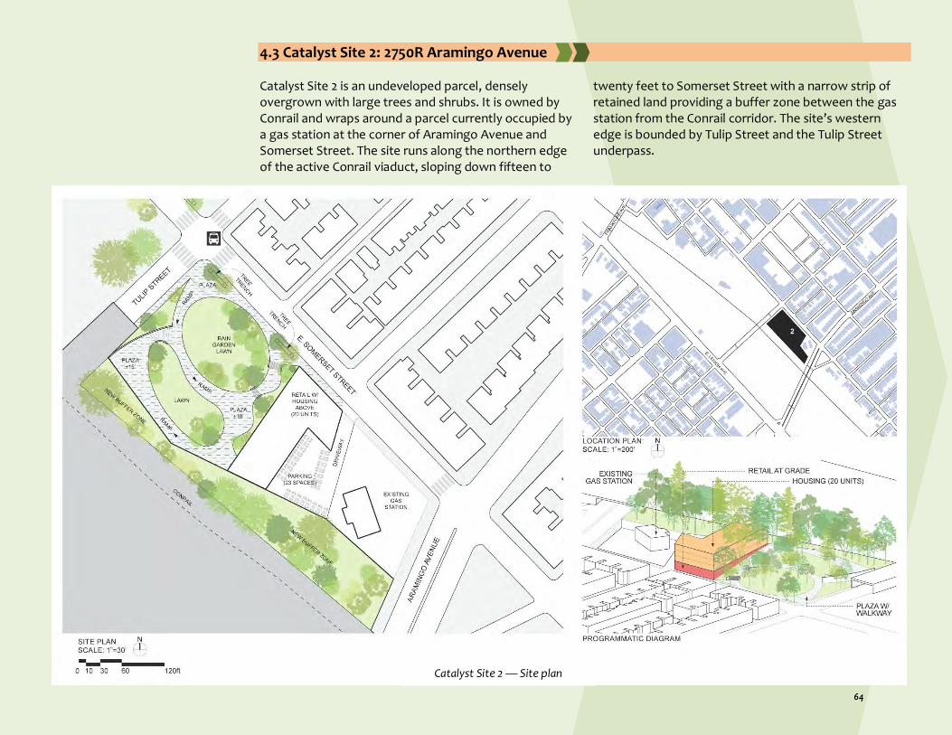
4.3 Catalyst Site 2: 2750R Aramingo Avenue Catalyst Site 2 is an undeveloped parcel, densely overgrown with large trees and shrubs. It is owned by Conrail and wraps around a parcel currently occupied by a gas station at the corner of Aramingo Avenue and Somerset Street. The site runs along the northern edge of the active Conrail viaduct, sloping down fifteen to
twenty feet to Somerset Street with a narrow strip of retained land providing a buffer zone between the gas station from the Conrail corridor. The site’s western edge is bounded by Tulip Street and the Tulip Street underpass.
Catalyst Site 2 — Site plan

The Project Team proposes that the site be developed with a passive park on its western end and anchored on the eastern side by a new multi-story mixed-use building. A continuous vegetated buffer zone along the entire site edge abutting the rail line will be fenced and accessible to Conrail only, ensuring the safety of neighborhood residents. Across Somerset Street, small scale north-south residential streets (Agate and Memphis) terminate and the new park and commercial building will activate and tie together the neighborhood. Site 2 is located diagonally across from Catalyst Site 1 (2201 Somerset Street), building additional community value. Its public
plaza at the northwest corner of Somerset and Tulip Streets creates a spatial linkage across Somerset and Tulip to the main entrance to the new park, completing the network of public spaces and walkways through Site 1 from the Trenton Avenue recreation area. This intra-neighborhood pedestrian connection is reinforced by colorful crosswalks and traffic-calming measures. The walkability of Somerset Street will be enhanced by the presence of a well-maintained park and the apartment/retail complex. Tree trenches (GSI) will line the street. All outdoor spaces will be carefully illuminated. Additionally, the adjacency of a large residential and commercial structure will provide safety
Catalyst Site 2 — Street view

and defensibility through constant use of natural surveillance. The mixed-use building is L-shaped and turns and runs the entire eastern edge of the park. The commercial area on the ground floor may be suitable for a large and active retail establishment. Above are three floors of apartments of varying sizes. These apartments will have excellent views, onsite parking, and cutting-edge stormwater management. The development of a new park will bring much-needed useable green space to the neighborhood. Designed for passive uses, this acre and a half parcel provides opportunities for relaxing, strolling neighborhood gatherings, and informal play. It is fully accessible by means of a low-incline ramp that winds from the major
entrance at Somerset and Tulip, around an oval lawn at the top of the slope which provides long views of the neighborhood. All hard and soft surfaces are permeable, promoting stormwater infiltration. At the corner of Somerset and Tulip is a plaza with benches and game tables, and there is potential for small vending carts and/or food trucks. What’s Happening Now?
The Project Team is not aware of any publicly attainable document stating that any potential redevelopment ideas are being conceptualized for this site by alternative developers. Strategies for implementing the proposed plan are detailed in the succeeding section (Section 5) and applicable to Catalyst Sites 2, 3, and 5.
4.4 Catalyst Site 3: 2001 E. Lehigh Avenue Catalyst Site 3 is currently largely vacant and holds the potential to become the setting for a new development dedicated to community health and wellness. The long and narrow site runs a full block east-west along the retaining wall that forms the edge of the viaduct; it is bounded by Frankford Avenue to the east and Emerald Street to the west. Its Lehigh Avenue edge is defined by a still-standing wall of a ruined industrial building. A small tire shop occupies the eastern end of the site and would be relocated if the site is cleared and developed. At present, the neighborhood directly to the south of the Lehigh viaduct represents the relatively stable mix of housing, industrial activity and community institutions that have been the backbone of Philadelphia’s working class neighborhoods. In recent years, this area has rapidly evolved and substantial market-rate residential development is underway along the viaduct, expanding the growth of nearby gentrifying neighborhoods.
The needs of the existing residents are substantial, and Catalyst site 3 is of strategic importance, providing community-centered support, public space, and amenities that will balance the surge in residential growth and provide a gathering place for all members of the community. It builds on new developments at the corner of Frankford and Lehigh—an under-construction high density housing to the east, and the Kensington Community Food Co-op across Lehigh. Within this concentration of activity, Catalyst Site 3 becomes a neighborhood identifier and a threshold between the two sides of the community separated by the rail viaduct. The design proposal includes built and open space that responds to local needs for health, literacy, recreation, and gathering space. A combined health and literacy center anchors the east end of the parcel. The 21,000 square foot facility proposes ground floor exercise

rooms, a gym, and a health-oriented café. The building’s second floor provides space for medical consultation and mental health counseling. The third floor literacy center houses a reading room, book collection, and offers computer access. Covered parking is located in the rear of the building.
Outdoor spaces include a corner plaza adjacent to the Kensington Community Food Co-Op where the Frankford Avenue bus stops, and where summer produce markets can be set up; a shaded lawn and a playground near the building; and a quarter size running track on the western half of the site. A temporary stage allows the track area to be used as a venue for events
Catalyst Site 3 — Site plan

and performances. A long ramp runs up the retaining wall of the viaduct to provide bike and pedestrian access to the future extension of the Richmond Industrial Trail. Due to Lehigh Avenue’s exceptional width and its fast-moving truck and car traffic, streetscape improvements are critical to make the site safe, walkable, and accessible, and could provide a model for future development on the northern side of the avenue. Crosswalks are enhanced with bright colors and materials and bump-outs with benches are provided at corners where the buses stop. Along the length of the site, the existing bike lane is upgraded to a parking protected lane; the sidewalk is widened and lined with trees in trenches; and continuous seating areas provide
a porous edge to the track area. Several of the piers that support the remnant of the former industrial building that once occupied the site are retained and will be repurposed as public art pieces with murals depicting local history. What’s Happening Now?
The project team is unaware of any alternative redevelopments in the process of being implemented for Catalyst Site 3. Detailed in the section following this (Section 5) are the recommended procedures for implementation of Catalyst Sites 2, 3, and 5.
Catalyst Site 3 — Street view

4.5 Catalyst Site 4: 2740 Amber Street Catalyst Site 4 is a former salvage business recently demolished to make room for residential development. This partial block parcel is bounded by East Seltzer Street to the north, the rear of an industrial building and several row houses fronting on Coral Street to the west, East Silver Street to the south, and Amber Street to the east.
The site currently lacks visibility within the community as it fronts another large industrial property to the south, garages and small residences to the north, and an active industrial site to the east; however, it has strategic potential as it is located only one block from a stable residential area along Somerset Street with its bus line that connects to the Market-Frankford Line Somerset Station on Kensington Avenue; and it is less than a one
block walk to Frankford Avenue—an important mixed-use commercial spine in the neighborhood. Additionally, NKCDC constructed a garden at the intersection of Frankford and Tusculum Streets in 2017 that will hopefully strengthen the identity of this neighborhood node and enhance its attractiveness as a residential area. The proposal includes affordable and market-rate housing units with 1:1 parking and both private and public green spaces. Twelve three-story (16’x 40”) single-family row houses are distributed along E. Silver Street and 14 duplex (24’x 32’) apartments are stacked one above the other along E. Seltzer Street. Both the row houses and duplexes have parking and private outdoor gardens or decks. Parking is accessed from Amber Street which has a widened sidewalk to accommodate street trees with run-off trenches. Consideration is given to the visual quality of E. Seltzer Street, which at present overlooks garages. The shape of the site allows for triangular public space within the sidewalk that will be planted with an ornate rain garden,
Catalyst Site 4 — Site plan
Catalyst Site 4 — Street view

and at the end of the row of duplexes is a vegetated pedestrian passage into the internal parking area that could also serve as hard surface play area for children in the development. All outdoor spaces are carefully illuminated for security and permeable for stormwater management where possible. What’s Happening Now? Hindrance to Implementation
Just like with Site 1, Site 4 was re-zoned through a remapping process in 2017. The new zoning for this parcel as of this change is RSA-5, or Residential Single-family Attached, where Philadelphia’s zoning classifies “5” as the smallest type of building that can be developed (“1” is the largest). RSA-5 districts are primarily zoned for attached and semi-detached homes on individual lots. In June of 2018, NKCDC was informed by a PWD contact about a residential proposal for the site that was being reviewed by PWD. In the following months, NKCDC contacted the developer to discuss their plans as well as the Project Team’s proposal, but did not receive a direct response until meeting them at a session convened by neighbors in October. The developer informed NKCDC that they were going to proceed with their existing plans; regardless, NKCDC filed another RTK request with
the PA DEP, uncovering an approved environmental review. This RTK process revealed that developers seeking variances (i.e. Site 1) are not subject to the same level of environmental review as developers that receive either public subsidies or have had their underlying zoning totally re-categorized (i.e. Site 4); however, no community meeting or ZBA hearing was required because the Site 4 development proposal fully conformed to the zoning requirements under RSA-5.
Table 4.2: Comparison between Proposals Created by the Project Team and the Developer
Design Decision Project Team’s Proposal Developer’s Proposal Affordable Housing Yes No
Market Rate Housing Yes Yes
Townhouses, Duplexes, Apartments 14 units N/A
Single Family Row Homes 12 units 20 units
Private Outdoor Gardens/Decks Yes Yes
Parking 26 spots (1 per unit) 40 spots (2 per unit)
Community Green Space Yes No
Trees, Vegetation Yes Not visible on site plan
Green stormwater management features Tree trenches, rain gardens Green roof deck
Site design courtesy of Metropolitan Property Group
Catalyst Site 4 — Current condition

4.6 Catalyst Site 5: 2838 Trenton Avenue Catalyst Site 5 is a handsome, historic one- and two-story red brick industrial structure that is re-envisioned as a structure for local community and economic development programs. The building is currently being used as a storage location for Cramco’s, with their
primary building a block north. It fronts on Trenton Avenue occupying the eastern end of the long block bounded by E. Auburn Street to the south, Amber Street to the west and E. William Street to the north.
Catalyst Site 5 — Site plan

Trenton Avenue was historically an active industrial corridor designed for the transport of goods. Now, this wide avenue is lined by many vacant lots and truck parking zones; the resulting truck traffic creates a hostile environment for emergent residential life. Across Trenton Avenue, Catalyst Site 5 faces a new housing development that strengthens the residential area to the east and north. The proposed design seeks to reconceive the neighborhood’s industrial heritage in a more user-friendly manner, as a place for community industries incubated or developed at a small scale. The program includes a mix of rentable space for workshops for hands-on trades, design or digital craft. Job training and skills development classes are held in the partial second
story above the entrance on Trenton Avenue. A new sky-lit atrium is introduced at the center of the large footprint of the building to create a light and airy overall environment and a space that can be rented out for community events. An internet café is provided for community members who do not have service at home. What’s Happening Now?
As of now, there are no documents accessible to the public that reveal any other potential redevelopments in the process of being implemented on Catalyst Site 5. The subsequent section (Section 5) is an outline of necessary actions to facilitate implementation of Catalyst Sites 2, 3, and 5.
Catalyst Site 5 — Street view

4.7 Concluding Remarks The design elements of the Project Team’s proposals are representative of the types of development that need to take place in order for social and economic prosperity in Kensington. For years the community has been burdened by disinvestment. The plans proposed above seek to change that, providing an abundance of commercial space to bring businesses to the neighborhood, creating jobs and contributing to the local economy. Plenty of open community space is included as a way to connect residents with one another and create a neighborhood feel. Incorporated green spaces not only provide stormwater management but help to beautify the neighborhood by replacing decimated impervious surface with vegetative cover to enhance biophilic design. By engaging community members and other stakeholders throughout the process of conceptualizing these plans, the Project Team was able to incorporate design elements that would improve the quality of lives of residents in Kensington. Detailed in the succeeding section is a general outline for the implementation strategies of these designs. These implementation strategies will not apply to Catalyst Sites 1 and 4, as previously stated, because developers have been already working on design or construction.

Brownfields Area-Wide Plan Lower North Delaware Industrial District, Philadelphia
Section 5 — Implementation Strategies

Section 5 — Implementation Strategies The implementation strategies outlined here are applicable to only Catalyst Sites 2, 3, and 5. As stated in the previous section, recent plans for redevelopment proposed by alternative development companies have already been approved for Catalyst Sites 1 and 4 and are in the early stages of demolition/construction.
5.1 Brownfield Redevelopment Process US EPA created the BF-AWP Program to assist communities with responding to brownfields, especially in areas which have many brownfields in close-proximity to one another. By creating an area-wide plan, neighborhoods are able to form partnerships, engage the community, identify existing conditions, and prioritize brownfield sites which may be contributing to adverse social, economic, or environmental damagei. Figure 5.1 depicts the brownfield redevelopment process with the steps further described in the next sections.
Pre-Development Phase The BF-AWP is usually the first step in the brownfield redevelopment process. This step is taken to obtain foundational background information on the sites of interest which may be contaminated with some form of harmful substance. After the creation of the plan, it is necessary to start the official brownfield redevelopment process. While it is possible to complete this step before or during the creation of the plan, a Phase I Environmental Site Assessment (ESA) solidifies whether further action is needed as part of the redevelopment process. Phase I ESAs include a visual inspection of the location to identify sources of contamination such as petroleum storage tanks or building materials containing asbestos. If a Phase I ESA does not detect the presence of serious contamination on the property, the
redevelopment process can begin absent additional complications or concerns. While the amount of time it takes to thoroughly inspect a property varies, the Phase I ESA step typically takes two to three months to complete. If the presence of serious contamination is identified, then further evaluations must be performed. This next step is called a Phase II ESAii.
Remediation and Redevelopment Phase
Phase II ESAs are much more in depth to determine the extent of the contaminants. In this step, contaminants present are identified in addition to the level of contamination. To identify and determine the level of contamination, soil and groundwater samples are collected, monitoring wells are installed, and the results are analyzed and reported. Any obvious or identified contaminants are removed (e.g. petroleum storage tanks above and under the ground, barrels and storage drums containing harmful materials, asbestos, etc.); this step typically takes six to twelve or more months depending on factors such as the size of the location and extent of contamination. While many projects are complete after this phase, if the results of the contamination levels exceed the state standards, there is a chance that the project enters another step of the remediation process which includes a Phase III ESA and Remedial Action Plan (RAP)iii.

During the Phase III ESA, there is additional collection of soil and groundwater samples with a continued investigation of any results exceeding state standards discovered during the Phase II ESA. The RAP further explores the remediation process with a Soils and Materials Management Plan which details disposal or reuse of affected soils with groundwater monitoring, permit requirements, and activity and use restriction suggestions. This step typically takes two to three months to complete. Once the remediation process is completed, it is time for the redevelopment of the landiv.
The goal of the remediation process is to revive properties to a beneficial use which helps the community, the environment, and the health of the public. As previously mentioned, the remediated location may have activity and use restrictions which depend on the contaminants identified and the cleanup methodsv. With a newly remediated property and considerations taken to avoid restricted uses, the site can now be developed to provide something to the community which they may not have had previously.
5.2 Implementation Partnerships
Nonfinancial Partnerships Pennsylvania Department of Environmental Protection (PA DEP): The PA DEP is responsible for ensuring that Pennsylvania’s air, land, and water are protected against
pollution in addition to providing a safe and healthy environment for its citizensvi. Because Brownfield redevelopment deals with contamination, which relates to providing Pennsylvania with safe land, it is important to keep local agencies such as the PA DEP involved in

the planning process to allow for proper cleanup and management of brownfield properties. Pennsylvania Department of Conservation and Natural Resources (PA DCNR): The DCNR’s primary goal is to safeguard Pennsylvania’s natural resources for every generation to utilize and enjoyvii. Because the redevelopment of the brownfields in Kensington may create new opportunities for open space, the DCNR should be involved in any plans in which a remediated area may become a space for conservation and outdoor recreation. City of Philadelphia Department of Planning and Development: As an existing planning department in the Philadelphia area, the Department of Planning and Development is tasked with establishing proper planning for every neighborhood which includes amenities such as affordable housing and art establishmentsviii. As a department with their own commissions and partners, they may be able to provide recommendations and advice for this plan which could further the impact that this plan has on the community. City of Philadelphia Police Department (PPD): As the nation’s fourth largest police department, the PPD is tasked with enforcing the law in Philadelphia County which covers a location with approximately 1.5 million residentsix. With Kensington being an area with a high crime rate, it is crucial for the PPD to be involved in educating and informing residents of the dangers in and surrounding the neighborhood. Community Partners and Neighborhood Groups: Various property owners, developers, financial institutions, community faith based organizations, and residents need to be involved in the discussion and creation of a Brownfield redevelopment plan.
Financial Partnerships US Environmental Protection Agency (US EPA): US EPA is a federal agency tasked with protecting the health of humans and the environment. One of their core goals is to provide a safe environment for every American by maintaining clean air, water, and landx. One way that they assist with providing clean land is through their various brownfield grantsxi. US Department of Housing and Urban Development (US HUD): As a federal agency concentrated on supplying affordable homes for allxii, US HUD can aid with neighborhood revitalization, rehabilitation, or even the acquisition of brownfield sites for future affordable housing developments. US Small Business Administration (US SBA): An independent federal agency created to help small businesses with the purpose of maintaining and strengthening the U.S. economy. In addition to its role as an advocacy organization, US SBA provides financing, counseling, and contracting to small businessesxiii. Through the provision of loans, small business owners would be empowered to set-up shop in Kensington, increasing the appeal of local retail. US Economic Development Administration (US EDA): As a federal bureau within the U.S. Department of Commerce, US EDA focuses solely on economic development. Their assistance program helps economically distressed communities foster a system of resilience and successxiv. US Department of Transportation (US DOT): Focused on the transportation infrastructure of the United States, US DOT’s job is to assure that the United States has a fast, efficient, safe, and accessible transportation system that serves the interest of Americaxv. With

various funding opportunities available, such as the Transportation and Community Development Initiative, the US DOT provides many ways to improve the neighborhood’s transportation systems. US Department of Health and Human Services (US HHS): With a mission to preserve and improve the health and well-being of every American through various health and human services, the US HHS offers an Opioid State Targeted Response Grant to improve treatment and reduce overdosesxvi. This grant can provide much needed relief to a community stricken with drug-related issues. Delaware Valley Regional Planning Commission (DVRPC): The DVRPC has been serving the Greater Philadelphia region for more than 50 years with a variety of objectives focused on livability and sustainability. This nine-county and two-state region allows for enhanced mobility and cooperation to address issues which encompass multiple counties or states in the Greater Philadelphia regionxvii. With a variety of trail and bike based grants, the DVRPC allows for adequate funding to implement sustainable transportation projects. Pennsylvania Department of Community & Economic Development (PA DCED): The PA DCED is a state agency which promotes sustainable development while being diverse and inclusive. By offering programs, grants, and loans to Pennsylvania projects which range from brownfield redevelopment to training programs, Pennsylvania developers can further their goals to
provide sustainable development to an assortment of areas including economically disadvantaged areasxviii. Pennsylvania Department of Transportation (PennDOT): While similar to the US DOT, the PennDOT is a state agency which focuses on the transportation systems in Pennsylvania. Any program which impacts or relates to Pennsylvania’s transportation system is overseen by the PennDOTxix. By partnering with the PennDOT, more opportunities are available to increase transportation initiatives. Schuylkill River Greenways (SRG): The SRG’s jurisdiction covers the Schuylkill River watershed which touches Schuylkill, Berks, Chester, Montgomery, and Philadelphia Counties. As a watershed with national significance, it has been deemed a National Heritage Area, which is designated by Congress as a place where cultural, historic, natural, and recreational resources combine to form a united, nationally distinctive landscapexx. With a mission to connect people with the Schuylkill River and Trail, the area serves as a stimulant for engagement and development to promote the conservation of the watershed and its heritagexxi. PeopleForBikes: PeopleForBikes works to make biking better for everyone with a focus on making biking safer, easier to access and more enjoyablexxii. By partnering with a biking organization that offers a grant program for biking infrastructure, the framework for adequate biking can be placed in a community which may have previously lacked safe and efficient bike paths or proper infrastructure to promote biking.

5.3 Actions Supported by Funding Sources Table 5.1 outlines various actions supported by funding sources. The Project Team prepared this table based on suggestions provided by Policy and Planning Innovation for Civil Infrastructure and Environment, New Jersey Institute of Technology, New Jersey Innovation Institute, which provides technical assistance to Brownfields communitiesxxiii. A critical element for effectively implementing the “actions” listed for each of the categories as well as leveraging resources will be engagement of and coordination with stakeholders and partners. This coordination will be fostered via the
creation of stakeholder groups, task forces, community engagement activities, or direct one-on-one communications. There are a number of stakeholders that should be engaged when pursuing the various proposed “actions” for the project area. These stakeholders include, at a minimum: US EPA, US HUD, US DOT, US SBA, US EDA, US HHS, PA DEP, PA DCNR, PA DCED, PennDOT, DVRPC, City of Philadelphia Department of Planning and Development, PPD, property owners, developers, financial institutions, community faith based organizations, and residents.
Table 5.1- Themes and actions supported by funding source
Theme Actions Supported by Funding Sources
Brownfield ● Involve the public in the planning process
● Secure funding for assessment and remediation activities
● Interface with regulatory agencies (i.e., US EPA and PA DEP)
● Determine the extent and type of contamination
● Determine project costs
● Manage liability issues
Housing ● Identify those brownfield sites that have the potential to accommodate residential or mixed-use development which includes a significant
housing element
● Assure that zoning ordinance is appropriate for residential development (confirm or change zoning)
● Coordinate with the City of Philadelphia Department of Planning and Development as well as property owners and developers to assure
inclusion of adequate affordable housing in proposed redevelopment
● Secure funding for the implementation of affordable housing and pursue technical assistance resources
Neighborhood Conditions
● Create a community stakeholder group charged with improving neighborhood conditions
● Create a vision that reflects the community’s needs
● Confirm that existing open/green space, and recreational space plans align with community vision
● Identify sites that have the potential to meet community open/green, and recreational space needs
● Identify streets, sidewalks, intersections that are in need of repair, improvement, and are not in compliance with ADA standards
● Identify neighborhood “gateway” focus areas and use appropriate placemaking principles to guide redevelopment and beautification
activities
● Coordinate with the City of Philadelphia Department of Planning and Development as well as property owners and developers to promote
the inclusion of open/green spaces, recreational spaces, and pedestrian improvements in proposed redevelopment plans

● Identify short and long term funding sources
Community Character and Services
● Encourage community participation in all aspects of site redevelopment
● Coordinate with the City of Philadelphia to avoid policies (i.e., tax exemptions for new businesses) that place an unfair burden on existing
business and make their ability to flourish difficult
● Identify what services and amenities the community needs through community engagement
● Coordinate with the City of Philadelphia Department of Planning and Development to promote zoning ordinances that reflect the needs of
the community
● Open a dialog with property owners and developers to promote land development and redevelopment that meets the community’s needs
● Coordinate with the City of Philadelphia’s Office of Transportation and Infrastructure, and Department of Planning and Development;
PennDOT; Conrail; and DVRPC regarding access issues associated with the Lehigh Valley Viaduct.
Economic Opportunity
● Establish a local hire program that can provide job readiness and retention services ● Promote redevelopment activities that include industrial and commercial uses that have the potential to provide employment
opportunities to local residents ● Establish a brownfields training program that is focused on training residents to conduct assessment and cleanup activities associated
with neighborhood brownfields redevelopment activities ● Coordinate with developers, property owners, the City of Philadelphia Department of Planning and Development, PA DCED, US EPA,
Industrial Resource Centers (IRCs), and Next generation Industry Partnerships (NGIPs)
Safety ● Promote activities that foster neighbor relation building (i.e., neighborhood/community meetings, create a neighborhood watch program)
● Gather crime data that will enable trends to be identified
● Coordinate with the PPD and arrange for a neighborhood meeting with a PPD representative to discuss safety concerns
● Promote hotspot, and focused deterrent policing
● Identify existing safety assets in the focus areas (i.e., surveillance cameras, neighborhood watch programs)
● Secure resources for the purchase and installation of surveillance cameras, and work with police department to create a camera
registration program
● Eliminate blighted areas
The following table (Table 5.2) provides a list of potential funding sources to redevelop Brownfield properties. This list is not intended to be a comprehensive one, it simply serves to identify commonly pursued resources for attaining Brownfield redevelopment goals. The availability and funding amounts for these resources may change from year to year and it is imperative that these potential funding sources be confirmed and updated as necessary.

Table 5.2- Potential funding sources
Resource Description
US Environmental Protection Agency (US EPA) - Brownfield Grants
Assessment Grant Assessment Grants provide funding to a grant recipient to inventory, characterize, assess, conduct a range of planning activities, develop site-specific cleanup plans, and facilitate community involvement related to brownfield sites. The performance period for these grants is three years.
Cleanup Grant Cleanup Grants provide funding for eligible entities to carry out cleanup activities at brownfield sites. An applicant must own the site to which funding is being requested. The performance period for these grants is three years.
Multipurpose Grant Multipurpose (MP) Grants provide funding to carry out a range of eligible assessment and cleanup activities with a proposed target area, such as a neighborhood, a number of neighboring towns, a district, a corridor, a shared planning area or a census tract. The target area may not include communities that are located in distinctly different geographic areas. The performance period for these grants is five years.
Revolving Loan Fund Grant (RLF) RLF grants provide funding for a grant recipient to capitalize a revolving loan fund and provide sub awards to conduct cleanup activities at brownfield sites. The goal is to provide an ongoing source of capital within a community.
Targeted Brownfield Assessment (TBA)
TBAs are conducted by an EPA Region 3 contractor on behalf of an eligible entity. Activities include site assessments, identification of cleanup options and cost estimates, and community outreach. Sites for this program are selected once a year by EPA Region 3.
128(a) Small Community Technical Assistance Grant
128(a) Small Community Technical Assistance Grants provide funding for states and tribes to provide training, technical assistance, or research for small communities, Indian tribes, rural areas, and/or disadvantaged areas. > Maximum funds of $20,000 per community > Disadvantaged area defined as a community with an annual median household income that is less than 80% of the statewide annual median household income, as determined by the most recent census.
Environmental Workforce Development Job Training (EWDJT)
Grants
Environmental Workforce Development and Job Training (EWDJT) Grants allow nonprofits, local governments, and other organizations to recruit, train, and place unemployed and under-employed residents of areas affected by the presence of brownfields. Through the EWDJT Program, graduates develop the skills needed to secure full-time, sustainable employment in various aspects of hazardous and solid waste management and within the larger environmental field, including sustainable cleanup and reuse, water quality improvement, chemical safety, and emergency response. These green jobs reduce environmental contamination and help build more sustainable futures for communities.
US Department of Housing and Urban Development (US HUD)
Community Development Bock Grants (CDBG)
The Community Development Block Grant (CDBG) program is a flexible program that provides communities with resources to address a wide range of unique community development needs. The CDBG program provides annual grants on a formula basis to 1209 general units of local government and States.
Community Services Block Grants (CSBG)
The Community Services Block Grant (CSBG) program is a federally funded block grant that provides funds to eligible nonprofit community-based organizations or governmental entities that work to ameliorate the causes and conditions of poverty in disadvantaged and low-income communities.
HOME Program This program provides grants to states and units of general local government to implement local housing strategies designed to increase homeownership and affordable housing opportunities for low and very low-income Americans.

Emergency Solutions Grants (ESG) Program
The ESG program provides funding to: (1) engage homeless individuals and families living on the street; (2) improve the number of and quality of emergency shelters for homeless individuals and families; (3) help operate these shelters; (4) provide essential services to shelter residents, (5) rapidly re-house homeless individuals and families, and (6) prevent families/individuals from becoming homeless. Eligible recipients generally consist of states, metropolitan cities, urban counties, and territories.
US Small Business Administration (US SBA)
SBA Guaranteed Business Loans The SBA works with lenders to provide loans to small businesses. The SBA itself doesn’t lend the money directly to small business owners. Instead, it sets guidelines for loans made by its partnering lenders, community development organizations, and micro-lending institutions. The SBA reduces risk for lenders and makes it easier for them to access capital, making it easier for small businesses to get loans.
US Economic Development Administration (US EDA)
Public Works and Economic Adjustment Assistance Program
EDA provides strategic investments on a competitive merit basis to support economic development, foster job creation, and attract private investment in economically distressed areas of the United States. EDA solicits applications in order to provide investments that support construction, non-construction, technical assistance, and revolving loan fund projects under EDA’s Public Works and EAA programs. Grants and cooperative agreements made under these programs are designed to leverage existing regional assets and support the implementation of economic development strategies that advance new ideas and creative approaches to advance economic prosperity in distressed communities. There are no submission deadlines, and awards range from $100,000-$3,000,000.
US Department of Transportation (US DOT)
BUILD Transportation Program Grant BUILD Transportation grants replace the pre-existing Transportation Investment Generating Economic Recovery (TIGER) grant program. These grants are a resource for a community to revitalize its surface transportation systems. Projects for BUILD will be evaluated based on merit criteria that include safety, economic competitiveness, quality of life, environmental protection, state of good repair, innovation, partnership, and additional non-Federal revenue for future transportation infrastructure investments. The Consolidated Appropriations Act of 2018 made available $1.5 billion for National Infrastructure Investments, otherwise known as BUILD Transportation Discretionary grants, through September 30th, 2020.
Transportation and Community Development Initiative (TCDI)
The Transportation and Community Development Initiative (TCDI) is an opportunity to support smart growth initiatives that implement the Connections 2045 Plan for Greater Philadelphia. TCDI focuses on linking land use and transportation planning by: (1) Improving the overall character and quality of life; (2) Enhancing the existing transportation infrastructure capacity; (3) Promoting and encouraging the use of transit, bike, and pedestrian transportation modes; (4) Building capacity in our older suburbs and neighborhoods; (5) Reinforcing and implementing improvements in designated Centers; and (6) Protecting the environment.
Transportation Alternatives Set-Aside Program (TA)
The TA Set-Aside Program is Federal highway and transit funding under the Surface Transportation Program (STP) for community based “non-traditional” projects designed to strengthen the cultural, aesthetic, and environmental aspects of the nation’s intermodal transportation system. The TA Set-Aside Program provides funds to build pedestrian and bicycle facilities, improve access to public transportation, create safe routes to school, preserve historic transportation structures, and create trail projects that serve a transportation purpose while promoting safety and mobility.

US Department of Health & Human Services (US HHS)
Opioid - State Targeted Response (STR) Grants
Opioid-STR is a two-year grant program started in fiscal year 2018 to address the opioid crisis by increasing access to treatment, reducing unmet treatment need, and reducing opioid overdose related deaths through the provision of prevention, treatment and recovery activities for opioid use disorder (OUD) (includes prescription opioids as well as illicit drugs such as heroin). Grantees must use funding to supplement and not supplant existing opioid prevention, treatment, and recovery activities in their state. Grant amounts vary from year to year. Opioid-STR provides funding to states to: > Conduct needs assessments and strategic plans > Identify gaps and resources from which to build upon existing substance use disorder prevention and treatment activities > Implement and expand access to clinically appropriate evidence-based practices for treatment of opioid use disorders, particularly the use of medication-assisted treatment and recovery support services > Advance substance misuse prevention in coordination with other federal efforts such as those funded by the Centers for Disease Control and Prevention (CDC).
Delaware Valley Regional Planning Commission (DVRPC)
Regional Trails Program DVRPC’s Regional Trails Program provides planning assistance and financial support to trail developers, counties, municipalities and nonprofit organizations to complete the Circuit, Greater Philadelphia’s 800-plus-mile network of multi-use trails. With financial support from the William Penn Foundation, the Regional Trails Program has provided almost $16 million in funding to 86 trail planning, design, and construction projects to date.
Transportation Alternative Program (TAP) Grants
These funds are administered on annual basis through both PennDOT and DVRPC, and are utilized for pedestrian, bicycle, and urban livability transportation projects.
Congestion Mitigation & Air Quality Grants (CMAQ)
DVRPC annually receives approximately $40 million in CMAQ monies from U.S. DOT. These funds are utilized for road and trail projects that reduce congestion.
Pennsylvania Department of Community & Economic Development (PA DCED)
Industrial Sites Reuse Program (ISRP) The ISRP program provides grants and low-interest loans financing to perform environmental assessment and remediation work at former industrial sites. > Up to $200,000 for environmental assessments > Up to $1 million for remediation
Infrastructure Development Program (IDP)
The Infrastructure Development Program (IDP) offers grants and loans, in conjunction with private companies and real estate developers, to municipalities and non-profit economic development agencies to help finance demolition, building renovations, new construction, and specific infrastructure. The program provides up to $1.25 million per project at 3 percent interest for 15 years. IDP provides grants and low-cost financing for economic development projects that create jobs, are executed in a timely manner, and are consistent with local and county economic development plans.
Tax Increment Financing Guarantee Program
This program promotes and stimulates the general economic welfare of various regions and communities in Pennsylvania and assists in the development, redevelopment, and revitalization of Brownfield and Greenfield sites in accordance with the TIF Act. Eligible uses include utilization of abandoned or underutilized industrial, commercial, military, previously mined institutional sites or buildings; or undeveloped sites planned and zoned for development in accordance with their existing comprehensive municipal plan.

PennVest Brownfield Loan Redevelopment Program
This program offers low-interest loans for the remediation of sites that have been contaminated by past industrial or commercial activity and pose a threat to local groundwater or surface water sources. Eligible uses include specific assessment in conjunction with remediation activities on contaminated properties across Pennsylvania. These activities must be related to a water quality benefit, which can include prevention of contamination. The purpose of this brownfield remediation financing initiative is to encourage the cleanup and reuse of contaminated properties while improving and protecting local water resources.
Business in Our Sites Loan These loans are intended to empower communities to attract growing and expanding businesses by helping them build an inventory of ready sites. Eligible activities include all site development activities that are required to make a site shovel ready. This program is for speculative projects only. Funds cannot be used for projects that are primarily residential or recreational. Sites must be previously utilized property or undeveloped property that is planned and zoned for development. Eligible entities include municipalities, municipal authorities, redevelopment authorities, industrial development agencies, and private developers.
Greenways, Trails and Recreation Program (GTRP)
Act 13 of 2012 establishes the Marcellus Legacy Fund and allocates funds to Commonwealth Financing Authority for planning, acquisition, development, rehabilitation and repair of greenways, recreational trails, open space, parks and beautification projects. Eligible entities include: > Municipalities > Councils of Governments > Authorized Organizations > Institutions of Higher Education > Watershed Organizations > For Profit Businesses Grants are awarded annually and are not to exceed $250,000 for any one project.
WEDnetPA The Workforce & Economic Development Network of Pennsylvania (WEDnetPA) is a DCED-funded workforce training program that helps employers upgrade the skills, knowledge, and effectiveness of their current employees with essential skills and advanced technology training.
Pre-Apprenticeship and Apprenticeship Grant Program
The Pre-Apprentice and Apprenticeship Grant Program (Apprenticeship Program) is a DCED-funded program and can be used to help cover the costs of formal instruction or classroom requirements associated with registered apprenticeships. To qualify, businesses must register their apprenticeship program with the PA Department of Labor & Industry’s Apprenticeship and Training Office.
Manufacturing PA Training-to-Career Grant Program
The Training-to-Career grant program provides funding to support the creation of short-term work readiness programs, with an emphasis on supporting populations facing barriers to employment. To qualify, these training programs must be developed with direct input by two or more partnering manufacturers and specifically address the skills missing in entry-level applicants for existing or near-future open positions.
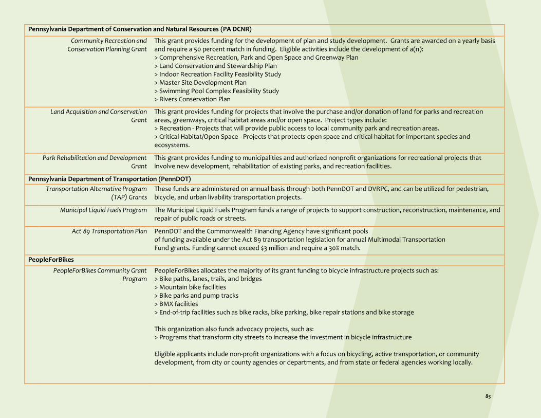
Pennsylvania Department of Conservation and Natural Resources (PA DCNR)
Community Recreation and Conservation Planning Grant
This grant provides funding for the development of plan and study development. Grants are awarded on a yearly basis and require a 50 percent match in funding. Eligible activities include the development of a(n): > Comprehensive Recreation, Park and Open Space and Greenway Plan > Land Conservation and Stewardship Plan > Indoor Recreation Facility Feasibility Study > Master Site Development Plan > Swimming Pool Complex Feasibility Study > Rivers Conservation Plan
Land Acquisition and Conservation Grant
This grant provides funding for projects that involve the purchase and/or donation of land for parks and recreation areas, greenways, critical habitat areas and/or open space. Project types include: > Recreation - Projects that will provide public access to local community park and recreation areas. > Critical Habitat/Open Space - Projects that protects open space and critical habitat for important species and ecosystems.
Park Rehabilitation and Development Grant
This grant provides funding to municipalities and authorized nonprofit organizations for recreational projects that involve new development, rehabilitation of existing parks, and recreation facilities.
Pennsylvania Department of Transportation (PennDOT)
Transportation Alternative Program (TAP) Grants
These funds are administered on annual basis through both PennDOT and DVRPC, and can be utilized for pedestrian, bicycle, and urban livability transportation projects.
Municipal Liquid Fuels Program The Municipal Liquid Fuels Program funds a range of projects to support construction, reconstruction, maintenance, and repair of public roads or streets.
Act 89 Transportation Plan PennDOT and the Commonwealth Financing Agency have significant pools of funding available under the Act 89 transportation legislation for annual Multimodal Transportation Fund grants. Funding cannot exceed $3 million and require a 30% match.
PeopleForBikes
PeopleForBikes Community Grant Program
PeopleForBikes allocates the majority of its grant funding to bicycle infrastructure projects such as: > Bike paths, lanes, trails, and bridges > Mountain bike facilities > Bike parks and pump tracks > BMX facilities > End-of-trip facilities such as bike racks, bike parking, bike repair stations and bike storage This organization also funds advocacy projects, such as: > Programs that transform city streets to increase the investment in bicycle infrastructure Eligible applicants include non-profit organizations with a focus on bicycling, active transportation, or community development, from city or county agencies or departments, and from state or federal agencies working locally.

PeopleForBikes will fund engineering and design work, construction costs including materials, labor, and equipment rental, and reasonable volunteer support costs. For advocacy projects, they will fund staffing that is directly related to accomplishing the goals of the initiative. Funding requests cannot exceed $10,000 but have no funding match requirement. They do consider leverage and funding partnerships very carefully and will not consider grant requests in which their funding would amount to 50% or more of the project budget.
Schuylkill River Greenways (SRG)
Schuylkill River Restoration Fund Watershed Restoration grants are available to non-profit organizations, watershed organizations, conservation districts, and county, municipal and local governments to undertake implementation projects that will improve the quality, and/or quantity of water in the Schuylkill River and its tributaries. The goal of the Schuylkill River Restoration Fund is to support projects in the Schuylkill River watershed that are consistent with restoration and water management goals for the entire basin. The Restoration Fund is an annual grant program that begins each year in January with funding typically being awarded in May or June. Typical award amounts range from $20,000 to $100,000.
References DCNR. (2019). About DCNR. Retrieved May 26, 2019, from https://www.dcnr.pa.gov/about/Pages/default.aspx Department of Planning and Development. (2019, May 23). Homepage. Retrieved May 26, 2019, from https://www.phila.gov/departments/department-of-planning-and-development/ DVRPC. (n.d.). About Us. Retrieved May 17, 2019, from https://www.dvrpc.org/About/ PACED. (2019). About Us. Retrieved May 18, 2019, from https://dced.pa.gov/about-us/ PADEP. (2019). About DEP. Retrieved May 26, 2019, from https://www.dep.pa.gov/About/Pages/default.aspx PADOT. (2019). About Us. Retrieved May 18, 2019, from https://www.penndot.gov/about-us/Pages/default.aspx PeopleForBikes. (n.d.). Who We Are. Retrieved May 18, 2019, from https://peopleforbikes.org/about-us/who-we-are/ PPD. (2017). About the Department. Retrieved May 26, 2019, from https://www.phillypolice.com/about/index.html Southwest Region Planning Commission. (2017). Brownfields Process. Retrieved May 20, 2019, from http://www.swrpc.org/brownfields/brownfieldsprocess SRG. (n.d.). About SRG. Retrieved May 18, 2019, from https://schuylkillriver.org/about-srg/ SRG. (n.d.). Our Mission & Vision. Retrieved May 18, 2019, from https://schuylkillriver.org/about-srg/our-mission-vision/ USDOT. (2012, March 02). About DOT. Retrieved May 17, 2019, from https://www.transportation.gov/about USEDA. (n.d.). Overview. Retrieved May 17, 2019, from https://www.eda.gov/about/ USEPA. (2012, July). Brownfields Area-Wide Planning Program. Retrieved May 19, 2019, from https://www.epa.gov/sites/production/files/2015-09/documents/awp-factsheet-july-2012_0.pdf USEPA. (2019, April 15). Overview of EPA's Brownfields Program. Retrieved May 17, 2019, from http://www.epa.gov/brownfields/overview-epas-brownfields-program USEPA. (2018, July 06). Returning EPA to its Core Mission. Retrieved May 17, 2019, from http://www.epa.gov/home/returning-epa-its-core-mission USHHS. (2016, March 18). About HHS. Retrieved May 17, 2019, from https://www.hhs.gov/about/index.html USHUD. (2012). Agency Financial Report FY 2012 Section I. Retrieved May 17, 2019, from http://www.hud.gov/program_offices/cfo/afr_fy2012/section1
Photo by participant #3

USSBA. (n.d.). Organization. Retrieved May 17, 2019, from http://www.sba.gov/about-sba/organization
i USEPA. (2012, July). Brownfields Area-Wide Planning Program. Retrieved May 19, 2019, from https://www.epa.gov/sites/production/files/2015-09/documents/awp-factsheet-july-2012_0.pdf ii Southwest Region Planning Commission. (2017). Brownfields Process. Retrieved May 20, 2019, from http://www.swrpc.org/brownfields/brownfieldsprocess iii Southwest Region Planning Commission. (2017). Brownfields Process. Retrieved May 20, 2019, from http://www.swrpc.org/brownfields/brownfieldsprocess iv Southwest Region Planning Commission. (2017). Brownfields Process. Retrieved May 20, 2019, from http://www.swrpc.org/brownfields/brownfieldsprocess v Southwest Region Planning Commission. (2017). Brownfields Process. Retrieved May 20, 2019, from http://www.swrpc.org/brownfields/brownfieldsprocess vi PADEP. (2019). About DEP. Retrieved May 26, 2019, from https://www.dep.pa.gov/About/Pages/default.aspx vii DCNR. (2019). About DCNR. Retrieved May 26, 2019, from https://www.dcnr.pa.gov/about/Pages/default.aspx viii Department of Planning and Development. (2019, May 23). Department of Planning and Development Homepage. Retrieved May 26, 2019, from https://www.phila.gov/departments/department-of-planning-and-development/ ix PPD. (2017). About the Department. Retrieved May 26, 2019, from https://www.phillypolice.com/about/index.html x USEPA. (2018, July 06). Returning EPA to its Core Mission. Retrieved May 17, 2019, from http://www.epa.gov/home/returning-epa-its-core-mission xi USEPA. (2019, April 15). Overview of EPA's Brownfields Program. Retrieved May 17, 2019, from http://www.epa.gov/brownfields/overview-epas-brownfields-program xii USHUD. (2012). Agency Financial Report FY 2012 Section I. Retrieved May 17, 2019, from http://www.hud.gov/program_offices/cfo/afr_fy2012/section1 xiii USSBA. (n.d.). Organization. Retrieved May 17, 2019, from http://www.sba.gov/about-sba/organization xiv USEDA. (n.d.). Overview. Retrieved May 17, 2019, from https://www.eda.gov/about/ xv USDOT. (2012, March 02). About DOT. Retrieved May 17, 2019, from https://www.transportation.gov/about xvi USHHS. (2016, March 18). About HHS. Retrieved May 17, 2019, from https://www.hhs.gov/about/index.html xvii DVRPC. (n.d.). About Us. Retrieved May 17, 2019, from https://www.dvrpc.org/About/ xviii PACED. (2019). About Us. Retrieved May 18, 2019, from https://dced.pa.gov/about-us/ xix PADOT. (2019). About Us. Retrieved May 18, 2019, from https://www.penndot.gov/about-us/Pages/default.aspx xx SRG. (n.d.). About SRG. Retrieved May 18, 2019, from https://schuylkillriver.org/about-srg/ xxi SRG. (n.d.). Our Mission & Vision. Retrieved May 18, 2019, from https://schuylkillriver.org/about-srg/our-mission-vision/ xxii PeopleForBikes. (n.d.). Who We Are. Retrieved May 18, 2019, from https://peopleforbikes.org/about-us/who-we-are/ xxiii https://www.njit.edu/tab/new-homepage
Photo by participant #8

Brownfields Area-Wide Plan Lower North Delaware Industrial District, Philadelphia
Section 6 —Implementation Challenges & Lessons Learned

Section 6 — Implementation Challenges & Lessons Learned The Project Team is confident that the ideas discussed in this document represent the interests and priorities of the community members we worked with during the planning process. Implementing many of these ideas, however, will be challenging. Even if this plan is accepted by the City of Philadelphia as one that should be considered when making future policy and capital budget decisions, it does not have any binding authority when weighing the merits of private development proposals. Since the majority of the land in this district is
privately owned, advocates and community members will have to be creative to influence a real estate market that has seen sale prices dramatically increase in recent years. The Project Team hopes that the data and concepts outlined in this section can help interested advocates in this district and throughout Philadelphia push for more community input in new developments. This is not the tone we expected to take when this planning process began. In early 2015, the idea of converting multi-acre formerly industrial sites into luxury townhouse communities was thought to be impossible in Philadelphia. Costs associated with brownfield redevelopment in a weak real estate market further suppressed demand. This was true even closer to Center City, let alone adjacent to the largest open-air illegal drug market on the East Coast. A lot has changed in five years. Map 6.1 displays some large-scale projects as examples of real estate spikes within and around the project area. The Project Team encountered many unexpected scenarios in the development of this plan. In 2015, NKCDC reached out to brownfield property owners to recruit catalyst sites for this plan; all catalyst site owners, with the exception for the owner of Site 4, were interested in this project because they viewed it as favorable marketing for their holdings. Having the Project Team design development scenarios for their properties based on the community’s input potentially could help them either develop or sell their properties in spite of the weak real estate market. While the owners of Site 4 were skeptical, they gave permission nonetheless.
Map 6.1 Real-estate spikes

Then, during an administrative delay in our project after the initial phase of community engagement, three of our five original catalyst sites were sold to new owners who did not necessarily see the value-added proposition of this planning process, which entailed collaborating with the community in the creation of redevelopment scenarios.
On the day of our Community Design Workshop in early 2018, the Philadelphia Zoning Board of Adjustment approved a variance allowing large-scale residential development on one of our original catalyst sites that had very recently been zoned for commercial and industrial. This led us to remove the site from our plan altogether. This site is
now well under construction, with some of the housing units selling for more than the developers told us they would sell for. Later in 2018, one of our catalyst sites received approvals for a similar proposal with even less commercial square footage, making it the first large-scale luxury housing proposal of its kind north of the Lehigh Viaduct. This showed the expansion of a heating real estate market into the 19134 zip code, Kensington, and onto the same blocks with active homeless encampments. Around the same time, a catalyst site which we selected due to its infamy in the neighborhood as a nuisance scrapyard was sold and quickly approved for townhouse development. Because this site had recently been rezoned for residential, this proposal did not require any public review. Having tried and largely failed to incorporate ideas from this plan into the above active proposals, we are focusing this concluding section on emphasizing what role a community member or organization can play in influencing private development in this project area.
6.1 How Community Members and Organizations Can Add Value to Private Development According to PCPC, there are 42 different potential approval processes required by private development in which 13 different City agencies have partial or complete oversight. Though most such reviews are conducted at closed meetings with staff who possess unique and specialized knowledge, many are still opportunities for passionate community members to exert influence. Based on our direct experience with some of these catalyst sites, as well as some new knowledge gained after the fact, here are some examples of how key design principles from this plan can be advocated for during these development review processes:
Zoning Board of Adjustment: The most commonly known part of the development review process is when applicants have to present at a community meeting and the City’s ZBA when proposing a development format that conflicts with the underlying zoning. Particularly large projects also trigger public presentations and advisory determinations by PCPC and CDR. These present opportunities to extend the public discourse about the merits of a particular development project, which also provides more time for community members to engage with the applicant. Through the coordinating RCO and/or the District Councilperson, there are opportunities to learn the details of the proposal and

communicate with developers before the community meeting. Peak time to engage your fellow community about aspects of the development that concern you are before the community meeting and before the ZBA hearing. Once RCO holds its meeting, your best bet is to pack the ZBA hearing with as many people willing to testify as possible. Data from PCPC and local community groups show that ZBA approves most applications regardless of community opinion, so in order to change that pattern, you must be prepared to turn out, be vocal, and bring your neighbors. Be prepared for developers to do the same: NKCDC saw applicants bring their paid office staff to hearings and present them as project supportersi. Philadelphia Water Department (PWD): Large development proposals will likely be reviewed by multiple different divisions within PWD. Any project that disrupts more than 15,000 square feet needs to show PWD how it will manage the stormwater. And now that owners of large development sites are paying based on impervious surface area (not just water meter readings), there is increased incentive for developers to construct green infrastructure to achieve long-term cost savings. Further, because of its Green City, Clean Waters plan to build green infrastructure as a way to address overflow problems from its aging combined sewer system, chances are that PWD has already determined whether or not a particular site is conducive to catching public or private runoff. Find the staff person in PWD’s Office of Watersheds who can point you to their Area of Analysis (AOA) work that can be used to support a community’s effort to advocate for green infrastructure. This could also provide backup when encouraging developers to apply for stormwater management Incentives Program Grant (SMIP), available to non-residential properties for on-site stormwater management, or the Green Street Incentive program, which provides customized support
to developers that can lead to PWD financing, owning, and maintaining green streets infrastructure built by the applicant. A grant like this helps advance the developer’s overall goal of earning a profit (and saving money on their stormwater billing) while also improving the project’s contribution to the neighborhood. There is also PWD’s Private Development Services department that can be engaged when trying to learn more information about how development proposals are being viewed by the agency. The “Credits Explorer” web tool can also be used to convince developers of the benefits of green infrastructureii. Streets Department: Developers have to account for public infrastructure improvements to the Streets Department. These include sidewalks, street lighting, street paving, any encroachment on the public right-of-way, and adjusting streets that are on the official City Plan. Considering that equitable public access is something that is of great importance to all residents and is often something cited during neighborhood planning projects, this is an important stage of review. Streets Department can oftentimes require public-facing improvements that the zoning code does not specifically cover. Over the course of this planning process, we saw new development proposals add new pedestrian, auto, and bicycle infrastructure after Streets Department review. This is especially true of larger development projects that can have substantial impacts on the traffic network. Streets Department also plays a critical role once construction starts. Applicants need Streets Department permission to open streets, close sidewalks, etc. Concerned community members can use this online resource to see if owners are compliant with construction best practices; if not, they can act to report and demand better behavior: https://stsweb.phila.gov/permitphl/.

PA Department of Environmental Protection and Philadelphia Department of Public Health: Some of the lengthiest approvals relate to the environmental impact of private development. The City does not have a land health agency, so decisions are made by the Commonwealth. The local Department of Public Health can be engaged with inquiries or requests for public input within the mandated review periods; these review periods are strictly adhered to, so concerned citizens must be very proactive. Notices of Intent to Remediate can be found by searching the PA DEP website: https://www.dep.pa.gov/Pages/default.aspx. The Project Team learned a lot about the limitations of this review process during the term of creating this Plan, as did the River Wards community as a whole. Thanks to dogged advocacy and in-depth journalism, it was revealed that development is unearthing contamination that has long sat dormant, and construction management regulations set by the City were in no way sufficient enough to protect adjacent residents from its impact. This is another example of residents having to educate themselves on complicated policies very quickly in order to defend the health and safety of their neighborhoods. Initiatives such as Get the Lead Outiii and Riverwards L+I Coalitioniv have done more to inform neighbors than any government or non-profit led initiative in recent years. The most significant realization for the Project Team was that the environmental review process is entirely de-coupled from the zoning review process, meaning that neighbors have no knowledge of the contamination risks of redeveloping these sites before casting their advisory vote on the merits of development proposals. In fact, one site in the project area is actively under construction right now even when DEP has rejected its remediation plan. Further, remediation is only required based on the requirements of the upcoming use, which is another example of how placing environmental review at the state level and land use review at the city
level can cause confusion. We are already seeing in the River Wards how disturbing these post-industrial sites without a full environmental review can have troubling results. The City should take a serious look at how to fix this regulatory gap. Efforts can be made to better circulate the results of environmental review, publicize when the plans are released, and promote the opportunity for the public to comment. Provisos can be added at zoning hearings that permits will only be issued once DEP has completely reviewed and approved. Results from land testing that other agencies require should be publicly shared and be part of the development review decision making process. In Fall 2019, City Council passed a bill requiring landlords to test their properties for lead every four years – a similar testing requirement could be set before developing any properties of a similar age. Just like with zoning review, environmental review requires community members to be “squeaky wheels” in demanding transparency and access to information, especially in a section of the city as environmentally sensitive as the River Wards. The City has published a list of local government permit reviews: https://www.phila.gov/media/20191113153532/FINAL-Permit-Checklist_November2019.pdf. While it does not include state government reviews, it is the best resource we have that summarizes all reviews required by the City of Philadelphia in one place. While there are many unfortunate examples of “path of least resistance” private development in progress in the River Wards, there are also ways in which partnership and collaboration can lead to better real estate projects when considered and pursued before the permit review process begins. Here are some recommendations for how community members and organizations can add value for private development.

Support community-minded development that meets core principles of this Plan and other Neighborhood Plans. For most projects that require zoning variances, they also require community meetings and votes. Though they are not binding votes, the public perception of an owner or developer still means something in Philadelphia. The positive application of this is showing that community members and Registered Community Organizations can use their social and political capital for good as long as the developer is being a thoughtful listener and making meaningful decisions based on what neighbors value.
Consider funding partnerships with non-profit community organizations. The Project Team engaged all catalyst site property owners before the planning process began to do our best to make sure the Plan could add value to their long-term sustainability. Going one step further to pursue funding that helps community-minded redevelopment concepts would be non-traditional, but could also be a win-win if the project is high-profile. Partnering with a non-profit opens up a slew of funding opportunities that would not be otherwise available to a standard developer, so this is a chance for organizations to expect a higher standard that meets their definition of community-minded redevelopment. Agencies such as the Philadelphia Department of Commerce, Philadelphia Industrial Development Corporation, PWD, and PA DCED (see Section 5 for more agency names) have grants and loans that would be uniquely applicable for proposals to redevelop properties like the catalyst sites in this Plan.
Harness the extensive knowledge in the community as technical assistance for developers. This can run deeper than knowing which neighbors are nice and where people went to high school. Neighbors in high-market areas know a lot about the development review process out of necessity. After enduring decades of an outdated zoning code and a zoning board that has never particularly valued community input, neighbors have had to educate themselves and put a lot of their own time into understanding where they can have influence. This means that in some cases, the advocates know more about the development review steps than the applicant does. If developers choose to see these community members as assets instead of adversaries or obstacles interfering with their payday, there is great potential for mutually beneficial projects and partnerships. Community members can provide essential historical context, personal connections to neighbors, technical assistance into more detailed aspects of the development review process that might be new to the applicant (i.e. environmental review), and even information on funding sources that might be available to them for fulfilling aspects of the project that meet community needs (i.e. PWD’s SMIP).
1
2
3
Support
Consider
Harness
How can community members and organizations add value for private development?

6.2 Momentum in the Project Area and the City
Momentum in the Project Area While it is essential for community members to understand where the leverage points are in the development review process, more can be accomplished if there is an opportunity to advocate for changes that affect multiple properties at once, usually in collaboration with multiple organizations. These are often catalyzed by the promise of the public-facing improvement of some kind from which multiple sectors stand to benefit. The Project Team sees a couple such opportunities in the area identified by this Plan: 1. A recreational trail running parallel to Lehigh Avenue 2. The redevelopment of the Port Richmond Rail Yards 3. The creation of a Trenton Avenue Greenway As mentioned earlier, Rails-to-Trails Conservancy released a feasibility study for creating a recreational trail running parallel to Lehigh Avenue from the Delaware River to American Street. Though other trails are further along in their development and creation, we know from other examples around the city and country that it is never too late to plan for the inevitable market spike that occurs on properties within walking distance of high-quality trails. Interventions such as zoning overlays, density bonuses for affordable housing, and prioritizing moving land into City ownership so that it may be better disposed for strategic priorities like affordable housing take years to operationalize. That being said, these sorts of interventions directly affect the land that will likely be top sites for speculative development (and as a result, displacement of adjacent lower-income communities), so they are essential to ensure that development around a public amenity, like a recreational trail, can happen as equitably as possible. A
concept like what is proposed for Catalyst Site 2 is especially important with this trail being conceptualized, as it would present a rare opportunity for park space on the north side of the viaduct. Ensuring that there are open easements for service maintenance and other forms of access at Trenton Avenue and along key entries on Site 2 will preserve opportunities for adjacent residential communities to have maximum access to these new recreational amenities. In spring 2019, it was announced that Conrail and the Delaware River Waterfront Corporation entered an agreement to convert the long-beloved Graffiti Pier into an open public space as the redevelopment along the Delaware riverfront. This Pier is part of the 180-acre parcel known as the Port Richmond Rail Yards, which, if redeveloped, would fill the largest vacant stretch along Philadelphia’s stretch of the Delaware River. Once momentum builds for this redevelopment, it will present an opportunity for the community-minded principles discussed in this Plan to be brought to life. Multi-acre
Photo by participant #5

sites like these can often feel disconnected from adjacent neighborhoods, but when built at a human scale with ample public access and connectivity, this could feel like a seamless extension of Port Richmond that is equitably accessible and enjoyable. Portions of this site will undoubtedly require environmental review as well, which poses an opportunity for more thoughtful and transparent controls as part of the Act 2 process. Finally, the concept for a Trenton Avenue Greenway does not currently have momentum, but it has the potential to be a boom for adjacent residents and property owners alike. This stretch of road is fertile opportunity to unite complementary City initiatives like Green City, Clean Waters for green infrastructure and Vision Zero for traffic safety. It also addresses an environmental injustice that made citywide news in 2018 when a four-alarm fire torched a scrapyard business at Trenton Avenue and Somerset Street. Between the hundreds of new neighbors moving into Catalyst Site 1, the thousands more who are likely coming with the inevitable redevelopment of the scrapyard properties, and PWD’s presumable need to manage stormwater in this area, this could all combine to catalyze the City to re-think this long-forgotten stretch of road.
Momentum in Philadelphia Though often more challenging, it is important for community members to see how their community might fit into policies that are changing across the city or state. Advocacy around policy reforms at this scale could bring changes that facilitate community-minded development at the neighborhood level. One example that could affect the project area is the City’s growing support for increasing the inventory of affordable housing. Council President Clarke floated an eight-figure bond to do this, and has recently called for a
series of hearings on the topic of gentrification. Similarly, some members of City Council tried to pass an inclusionary zoning bill; instead, what passed was a variation that offered density bonuses for developers willing to pay into the City’s Housing Trust Fund. Though it stopped short of requiring affordable units within the same development site or neighborhood, it will still boost the City’s ability to construct and maintain access to affordable housing. Density bonuses for constructing affordable housing on site are available along the Delaware riverfront and in high-density commercial zoning designations. Perhaps the same sort of zoning overlay could be applied to properties around the future Lehigh Avenue recreational trail. There has also been increased questioning of the merits of the 10-year tax abatement. Given how development activity has spiked, it may no longer be as essential in the same ways as it at the time it was passed under Mayor Ed Rendell. The aforementioned inclusionary housing bill passed in 2018 shows that the political climate may not be right for widespread down-sizing to the tax abatement just yet, but other adjustments could be palatable. For example, could public environmental review be a required step in order for new development to apply for the tax abatement? Could the money contributed to the Housing Trust Fund go to support affordable housing efforts elsewhere in the same neighborhood, even if not on the development site itself? These are examples in which fighting for more progressive citywide development policies could have direct impacts on what is currently happening in the River Wards. One new initiative at the state level for consideration is Governor Wolf’s Restore PA infrastructure plan. This multi-billion dollar plan intends to fund areas such as blight remediation, containment remediation, brownfield cleanup, and green stormwater
Photo by participant #14

infrastructure. These projects would be funded through a severance tax on natural gas. While a large and inspiring mandate, little is clear yet on how it would be administered and how decisions would be made at the city level. But knowing that investments like these are coming soon can help advocates position themselves to push for their priorities. If used equitably, these funds can support community-minded development in the River Wards.
Finally, certain parcels within the project area are part of federal Opportunity Zones. While there were no mandatory community inclusionary requirements set forth by the federal government with the introduction of this program, many sectors and agencies are interested in the establishment of Philadelphia-specific stipulations. There are no Opportunity Zone designations north of Lehigh Avenue, but there are two south of Lehigh: one east of Aramingo Avenue (including the aforementioned Port Richmond Rail Yards) and one west of Trenton Avenuev.
6.3 Opinions and Suggestions from the Community vis-à-vis Plan Implementation Several opinions and suggestions emerged from interviews with community members and stakeholders (n=15) regarding planning in the Kensington area. Some residents felt planning for new buildings and public spaces was premature given that the community still faced many challenges, including homelessness and drug addiction. One resident commented that the community was still “on fire” and thus any physical planning efforts would be diminished and possibly falter if the “fire” in the community was not addressed first. This particular statement, though dramatic, illuminates a much more widespread theme in the data: the need to include social planning (e.g., education, help with addiction, housing the homeless, food insecurity) with any physical planning initiatives. The interviewees often felt that physical planning had been divorced from social planning. It is time for Philadelphia to adopt similar practices as other cities have to incorporate racial and social equity considerations into its planning and development review. As part of its Comprehensive Plan, Portland (OR) explicitly requires a displacement analysis for zoning changes and development proposals. They have also passed inclusionary zoning and rent cap legislationvi.
New York is considering legislation that applies racial impact analyses similar to more commonplace environmental impact analysesvii. As the pace of development spikes well beyond the limits of Center City, it is time to acknowledge that the impacts of these developments will also be different and require a different type of review. Community members also felt that trust is essential for any plan to be welcomed and sustained by the community, and trust would be established by planners engaging directly with the community and educating community members face-to-face about planning interventions and the expected results. Several interviewees commented that the only way to build trust is by going door-to-door and by knowing the community in-depth. Face-to-face interaction was underscored as the key to successful community planning. At the same time, participants in the planning process must feel that their contributions were useful and made their way into the end product in some form. Without this condition, the interviewees cautioned that members of the community would be reluctant to participate in any future planning or maintain an existing plan. The participants acknowledged that including
“... one thing I'm thinking of, will
anything ever come to fruition
that the community agreed on?
Because those are the kind of
thing[s] that causes communities
to lose faith and trust in the
system, per se. "Well, they're not
going to do anything we say, no
way." Sort of speaking in the
negative. "What's the use? What
for? You know, they're gonna do
what they wanna do anyway."
[Interviewee #1]
“I feel like a lot of people ... this
is... it's a lot easier to have
community when you see people
face to face and walk around. So
this is a really nice neighborhood
where people are still out on their
stoops. A part of that is, some
people don't have really good air
conditioning.” [Interviewee #9]
“There’s residents that often 60%
want something and 40% doesn’t
to move forward, at least they
know that some residents were
for it, not that everyone had no
say in it.” [Interviewee #10]

everyone’s contributions in the plan would be difficult if not impossible. In such circumstances, they recommend seeking educational programs that would help people realize what is and is not possible given community input. In addition, there was recognition that the act of
soliciting feedback from the community helps people realize that some of their neighbors were in favor of a particular outcome even if that person’s own desired outcome did not come to fruition.
6.4 Lessons Learned
We believe there are several lessons learned from this project and its approach to brownfield redevelopment and revitalization in Kensington.
First, we believe that brownfields pose a significant problem when they emerged within communities adjacent to industrial areas. Factories and mills once provided the lifeblood of the Kensington community; after their closure, the abandoned building and infrastructure negatively impacted communities for decades on end. Defining and understanding the impacts of the post-industrial landscape on residents and their sense of community identity is a critical concern and paramount to creating redevelopment strategies that respond to these challenges.
Second, engaging community members in all stages of brownfields redevelopment is necessary to understand the impacts of these properties, to heal the scars of disinvestment, and to generate hope with a shared vision for future development opportunities. The photo-voice engagement effort was a central component of the project team’s community engagement plan. The use of resident-selected photos to tell the story of the impacts of the brownfields sites on the community provided the project team with local knowledge of the landscape that we would not have collected through traditional participation approaches. More so, a survey of the focus group participants indicates that the photo-voice engagement process was an effective tool to motivate and empower residents.
Table 6.1 Level of Agreement (5-point Likert scale)
The engagement process was a valuable learning experience
4.9
Photographing things I would like to see in the neighborhood raised by awareness of how the neighborhood could be improved
4.8
The engagement process increased my sense of duty to serve the community
4.7
I gained a sense of empowerment to address community needs
4.6
Focus Group 1 discussion increased my awareness of how the brownfield sites negatively impact residents
4.6
Focus Group 2 discussions about redevelopment ideas for the catalyst sites increased my awareness of actions that could be taken to improve the neighborhood
4.6
Third, the City’s Zoning Board of Adjustments’ (ZBA) proclivity to provide private developers with variances and to prioritize developer’s interests over community’s concerns in nine out of ten cases is unsoundviii. It is time for Philadelphia to honor the voice of the community and send developers back to the community to forge a development proposal that responds to core community concerns and visions of place. A pro-development stance by the ZBA was understandable when the City was desperate for public investment to plug a gaping revenue whole after losing one third of its residents; however, this stance in unacceptable today when the City is experiencing a decade of population growth, unprecedented private sector development, and development pressures leading to its rank as one of the top gentrifying cities in the nationix. As noted in Section

4, due to growing development pressures in Kensington the original Catalyst Site 1 was approved for development before this project’s engagement phase started and a new site had to be selected. Also during the course of this project, Catalyst Sites 1 and 4 changed hands from owners willing to participate in this planning process to unwilling ones. The development for Site 1 was approved by the ZBA despite community concerns and the developer’s unwillingness to consider the community’s redevelopment scenario included in this plan.
Fourth, this is the first EPA Brownfield-Wide Area Plan to be developed through a partnership led by a university and community-based organization. While the community engagement approach implemented by this Project Team was unique and provided distinct benefits, the Team has had limited success in influencing catalyst
site development. In light of this challenge, the community partner developed a community added value strategy (presented in subsection 6.1) that focuses on building relationships with representatives of City agencies and providing them detailed information on the community-led designs and community’s vision for their neighborhood outlined in this plan. With this first-hand knowledge of this plan, this growing base of City representatives across multiple agencies can become a network of advocates for the community through every stage of Catalyst Site development and other real estate and infrastructure development in the project area. This community added-value strategy recognizes that many City agencies have commitments to engage community in decision-making. This approach is transferrable to other communities in Philadelphia as well as cities across the nation seeking to influence brownfield redevelopment by the private sector.
References
i Blumgart, J. (2018, February 22). City approves plan to build luxury housing in Conrail’s backyard. Retrieved from https://whyy.org/articles/city-approves-plan-build-luxury-housing-conrails-backyard/. ii Philadelphia Water Department. (n.d.). stormwater.phila.gov. Retrieved from https://stormwater.phila.gov/explore. iii Get the Lead OUT: Riverwards Philadelphia. (n.d.). In Facebook [Group Page]. Retrieved from https://www.facebook.com/groups/1958384214442509/ iv Riverwards L+I Coalition. (n.d.). In Facebook [Group Page]. Retrieved from https://www.facebook.com/groups/RiverWardsLandICoalition/ v Philadelphia Delivers. (n.d.). Federal Opportunity Zones. Retrieved from https://www.philadelphiadelivers.com/opportunity-zones. vi Schneider, B. (2019, October 22). Bringing equity to the forefront of urban planning. Retrieved from https://www.shareable.net/bringing-equity-to-the-forefront-of-urban-planning/. vii Splvack, C. (2019, May 29). Bill aims to study how rezonings affect NYC neighborhoods’ racial demographics. Retrieved from https://ny.curbed.com/2019/5/29/18644275/bill-study-rezonings-impacts-nyc-neighborhoods-racial-demographics. viii Hahn, A. (2018, February 3). Meet the broken system costing your neighborhood its voice. Retrieved from https://whyy.org/articles/meet-the-broken-system-costing-your-neighborhood-its-voice/. ix Lubrano, A., & Gammage, J. (2019, March 20). Study: Philly among leaders in gentrification, which has pushed out people of color. Retrieved from https://www.inquirer.com/news/gentrification-philadelphia-african-american-latino-investment-neighborhood-20190320.html.

The Community Planning and Visualization Lab at Rowan University explores the connections between social, natural, and built environments and how they influence the process of planning for healthy, resilient, and equitable communities. Using a sustainability lens, we examine how the nexus of land, water, and food play a role in spatial planning and community planning. In particular, we are interested in the ways community resilience is influenced by spatial distributions and prioritization processes of green and blue infrastructure (e.g., green stormwater management projects, parks, greenways, community gardens, urban farms) at the neighborhood, urban, and regional scales. We use spatial planning models that integrate ecological and socioeconomic indicators and consider triple bottom line community benefits (e.g., social, environmental, and economic benefits).
Copyright © 2022 FDOKUMEN