Broad Development Parameters of the Indicative
13
Broad Development Parameters of the Indicative Development Proposal in Respect of Application No. Y/YL-NTM/5 關乎申請編號 Y/YL-NTM/5 而只作指示用途的擬議發展計劃的概括發展規範 Revised broad development parameters in view of the further information received on 3.12.2021 因應於 2021 年 12 月 3 日接獲的進一步資料而修訂的概括發展規範 Application No. 申請編號 Y/YL-NTM/5 Location/address 位置/地址 Various Lots in D.D. 105 and adjoining Government land, Ngau Tam Mei, Yuen Long 元朗牛潭尾丈量約份第 105 約多個地段和毗連政府土地 Site area 地盤面積 About 約 22,294 sq. m 平方米 (Includes Government Land of about 包括政府土地 約 2,849 sq. m 平方米) Plan 圖則 Approved Ngau Tam Mei Outline Zoning Plan No. S/YL-NTM/12 牛潭尾分區計劃大綱核准圖編號 S/YL-NTM/12 Zoning 地帶 "Residential (Group C)" 「住宅(丙類)」 Proposed Amendment(s) 擬議修訂 To rezone the application site from "Residential (Group C)" to "Residential (Group B)" 把申請地點由「住宅(丙類)」地帶改劃為「住宅(乙類)」地帶 sq. m 平方米 Plot ratio 地積比率 Domestic 住用 About 約 111,470 Not more than 不多於 5 Gross floor area and/or plot ratio 總樓面面積及/ 或地積比率 Non-domestic 非住用 - - Domestic 住用 4 Non-domestic 非住用 - No. of block 幢數 Composite 綜合用途 - - 1 -
-
Upload
khangminh22 -
Category
Documents
-
view
5 -
download
0
Transcript of Broad Development Parameters of the Indicative

Broad Development Parameters of the IndicativeDevelopment Proposal in Respect of Application No. Y/YL-NTM/5
關 乎 申 請 編 號 Y/YL-NTM/5 而 只 作 指 示 用 途 的 擬 議 發 展 計 劃 的 概 括 發 展 規 範
Revised broad development parameters in view ofthe further information received on 3.12.2021
因應於 2021 年 12 月 3 日接獲的進一步資料而修訂的概括發展規範
Application No.申請編號
Y/YL-NTM/5
Location/address位置/地址
Various Lots in D.D. 105 and adjoining Government land, Ngau Tam Mei, Yuen Long元朗牛潭尾丈量約份第 105 約多個地段和毗連政府土地
Site area地盤面積
About 約 22,294 sq. m 平方米 (Includes Government Land of about 包括政府土地約 2,849 sq. m 平方米)
Plan圖則 Approved Ngau Tam Mei Outline Zoning Plan No. S/YL-NTM/12
牛潭尾分區計劃大綱核准圖編號 S/YL-NTM/12
Zoning地帶 "Residential (Group C)"
「住宅(丙類)」
Proposed Amendment(s)擬議修訂
To rezone the application site from "Residential (Group C)" to "Residential (Group B)"把申請地點由「住宅(丙類)」地帶改劃為「住宅(乙類)」地帶
sq. m平方米
Plot ratio地積比率
Domestic 住用
About 約 111,470 Not more than 不多於 5
Gross floor area and/or plot ratio總樓面面積及/或地積比率
Non-domestic非住用
- -
Domestic住用 4
Non-domestic非住用
-
No. of block幢數
Composite綜合用途
-
- 1 -
- m 米
Not more than 不多於 123.3 mPD 米(主水平基準上)
Domestic住用
Not more than 不多於 35 Storey(s) 層Exclude 不包括
31
Basement 地庫
Refuge Floor 防火層
- m 米
- mPD 米(主水平基準上)
Non-domestic非住用
- Storey(s) 層
- m 米
- mPD 米(主水平基準上)
Building height/No. of storeys建築物高度/層數
Composite綜合用途
- Storey(s) 層
Site coverage上蓋面積
About 約 33.3 %
No. of units單位數目
1,980 Flats 住宅單位
Private 私人 Not less than 不少於 5,544 sq. m 平方米Open space休憩用地 Public 公眾 - sq. m 平方米
No. of parking spaces and loading / unloading spaces停車位及上落客
貨車位數目
Total no. of vehicle spaces 停車位總數 914
Private Car Parking Spaces 私家車車位 856Motorcycle Parking Spaces 電單車車位 20Bicycle Parking Spaces 單車車位 38
Total no. of vehicle loading/unloading bays/lay-bys上落客貨車位/停車處總數
4
Heavy Goods Vehicle Spaces 重型貨車車位 4
* 有關資料是為方便市民大眾參考而提供。對於所載資料在使用上的問題及文義上的歧異,城市規劃委員會概不負責。若有任何
疑問,應查閱申請人提交的文件。
The information is provided for easy reference of the general public. Under no circumstances will the Town Planning Board accept any
liabilities for the use of the information nor any inaccuracies or discrepancies of the information provided. In case of doubt, reference
should always be made to the submission of the applicant.
- 2 -
Submitted Plans, Drawings and Documents 提交的圖則、繪圖及文件
Chinese中文
English英文
Plans and Drawings 圖則及繪圖 Master layout plan(s)/Layout plan(s) 總綱發展藍圖/布局設計圖 ☐ ☐Block plan(s) 樓宇位置圖 ☐ ☐Floor plan(s) 樓宇平面圖 ☐ ☐Sectional plan(s) 截視圖 ☐ ☐Elevation(s) 立視圖 ☐ ☐Photomontage(s) showing the proposed development 顯示擬議發展的合成照片 ☐ ☑Master landscape plan(s)/Landscape plan(s) 園境設計總圖/園境設計圖 ☐ ☑Others (please specify) 其他(請註明) ☐ ☐
Reports 報告書 Planning Statement / Justifications 規劃綱領 / 理據 ☐ ☐Environmental assessment (noise, air and/or water pollutions) 環境評估(噪音、空氣及/或水的污染)
☐ ☐
Traffic impact assessment (on vehicles) 就車輛的交通影響評估 ☐ ☐Traffic impact assessment (on pedestrians) 就行人的交通影響評估 ☐ ☐Visual impact assessment 視覺影響評估 ☐ ☑Landscape impact assessment 景觀影響評估 ☐ ☑Tree Survey 樹木調查 ☐ ☐Geotechnical impact assessment 土力影響評估 ☐ ☐Drainage impact assessment 排水影響評估 ☐ ☐Sewerage impact assessment 排污影響評估 ☐ ☑Risk Assessment 風險評估 ☐ ☐Others (please specify) 其他(請註明) ☐ ☑Quantitative Risk Assessment 定量風險評估Tree Survey & Tree Preservation Proposal 樹木調查及樹木保護報告
Note: May insert more than one「✔」. 註:可在多於一個方格內加上「✔」號
Note: The information in the Gist of Application above is provided by the applicant for easy reference of the general public. Under no circumstances will the Town Planning Board accept any liabilities for the use of the information nor any inaccuracies or discrepancies of the information provided. In case of doubt, reference should always be made to the submission of the applicant.
註: 上述申請摘要的資料是由申請人提供以方便市民大眾參考。對於所載資料在使用上的問題及文義上的歧異,城市規劃委員會概
不負責。若有任何疑問,應查閱申請人提交的文件。
- 3 -

V
¦ì¸ LOCATION PLAN
FOR IDENTIFICATION PURPOSE ONLY
APPLICATION SITE BOUNDARY
¥Ó½Ð¦aÂI¬É½
100 100 200 3000
1 : 7 500SCALE ¤ñ¨
METRES
¦
METRES
¦
°Ñ¦Ò
REFERENCE No.
Y/YL-NTM/5
®Ö㪺¤À°Ïp¹º¤jºõ¹Ï½s¸¹
©Ò®Ú¾Úªº¸ê®Æ¬°©ó20
¥»ºKn¹Ï©ó2021¦~12¤
S/YL-NTM/12 APPROVED ON 5.12.2006
BASED ON OUTLINE ZONING PLAN No.
EXTRACT PLAN PREPARED ON 13.12.2021
Application Site
¥Ó½Ð
- 4 -

«C
¤s
«C
¤s
«C
¤s
«C
¤s
«C
¤s
«C
¤s
«C
¤s
«C
¤s
«C
¤s
«C
¤s
«C
¤s
«C
¤s
«C
¤s
«C
¤s
«C
¤s
«C
¤s
«C
¤s
«C
¤s
«C
¤s
«C
¤s
«C
¤s
«C
¤s
«C
¤s
«C
¤s
«C
¤s
«C
¤s
«C
¤s
«C
¤s
«C
¤s
«C
¤s
«C
¤s
«C
¤s¦Ì
®¦Ì
®¦Ì
®¦Ì
®¦Ì
®¦Ì
®¦Ì
®¦Ì
®¦Ì
®¦Ì
®¦Ì
®¦Ì
®¦Ì
®¦Ì
®¦Ì
®¦Ì
®¦Ì
®¦Ì
®¦Ì
®¦Ì
®¦Ì
®¦Ì
®¦Ì
®¦Ì
®¦Ì
®¦Ì
®¦Ì
®¦Ì
®¦Ì
®¦Ì
®¦Ì
®¦Ì
®¡¡¡¡¡¡¡¡¡¡¡¡¡¡¡¡¡¡¡¡¡¡¡¡¡¡¡¡¡¡¡¡
·s
¼
·s
¼
·s
¼
·s
¼
·s
¼
·s
¼
·s
¼
·s
¼
·s
¼
·s
¼
·s
¼
·s
¼
·s
¼
·s
¼
·s
¼
·s
¼
·s
¼
·s
¼
·s
¼
·s
¼
·s
¼
·s
¼
·s
¼
·s
¼
·s
¼
·s
¼
·s
¼
·s
¼
·s
¼
·s
¼
·s
¼
·s
¼
·s¥
Ð
·s¥
Ð
·s¥
Ð
·s¥
Ð
·s¥
Ð
·s¥
Ð
·s¥
Ð
·s¥
Ð
·s¥
Ð
·s¥
Ð
·s¥
Ð
·s¥
Ð
·s¥
Ð
·s¥
Ð
·s¥
Ð
·s¥
Ð
·s¥
Ð
·s¥
Ð
·s¥
Ð
·s¥
Ð
·s¥
Ð
·s¥
Ð
·s¥
Ð
·s¥
Ð
·s¥
Ð
·s¥
Ð
·s¥
Ð
·s¥
Ð
·s¥
Ð
·s¥
Ð
·s¥
Ð
·s¥
Ð
°ª°ª°ª°ª°ª°ª°ª°ª°ª°ª°ª°ª°ª°ª°ª°ª°ª°ª°ª°ª°ª°ª°ª°ª°ª°ª°ª°ª°ª°ª°ª°ª
FOR IDENTIFICATION PURPOSE ONLY
APPLICATION SITE BOUNDARY
¥Ó½Ð¦aÂI¬É½
°Ñ¦Ò
REFERENCE No.
¦Ì®HÅ
Substation
Mai Po
¦Ì
MAI PO
¥ SITE PLAN
Y/YL-NTM/5
CASTLE P
EA
K R
OA
D - M
AI P
O SAN TI
N HI
GHWAY
SAN TAM
ROAD
«C
¤s¦Ì
®¡
·s
¼
·s¥
Ð
®p´º
SCENIC HEIGHTS
2-SE-12A ¤Î 2-SE-12
©Ò®Ú¾Úªº¸ê®Æ¬
¥»ºKn¹Ï©ó2021¦~12¤
2-SE-12A & 2-SE-12C
BASED ON SURVEY SHEETS No.
EXTRACT PLAN PREPARED ON 14.12.2021
KO HANG
°ª
Application Site
¥Ó½Ð
- 5 -
申請編號 Application No. : Y/YL-NTM/5
備註 Remarks
申請人呈交進一步資料,包括回應部門意見表、排污影響評估、定量風險評估、視覺影響評
估、樹木調查及樹木保護報告,及經修訂的園境設計圖。
The applicant submitted a table of responses to departmental comments, a Sewerage Impact Assessment, a Quantitative Risk Assessment, a Visual Impact Assessment, a Tree Survey & Tree Preservation Proposal and a revised Landscape Master Plan.
有關資料是為方便市民大眾參考而提供。對於所載資料在使用上的問題及文義上的歧異,城市規劃委員會概不
負責。若有任何疑問,應查閱申請人提交的文件。
The information is provided for easy reference of the general public. Under no circumstances will the Town Planning

Board accept any liabilities for the use of the information nor any inaccuracies or discrepancies of the information provided. In case of doubt, reference should always be made to the submission of the applicant.

ADI LIMITEDLANDSCAPE ARCHITECTURE, URBAN DESIGN AND MASTER PLANNING10/F BANGKOK BANK BUILDING, 18 BONHAM STRAND WEST, HONG KONGTELEPHONE 2131 8630 FACSIMILE 2131 8609
雅 博 奧 頓 國 際 設 計 有 限 公 司國 際 環 境 管 理 , 城 市 規 劃 及 設 計 , 園 景 建 築 顧 問 服 務
香 港 上 環 文 咸 西 街 十 八 號 盤 谷 銀 行 大 廈 十 樓
電話 : (八 五 二 ) 二 一 三 一 八 六 三 零 傳真 : (八 五 二 ) 二 一 三 一 八 六 零 九
CHECKED DRAWN
SCALE DATEAS SHOWN
ELK TEAM
FIGURE NO. REV
S12A Amendment of Plan Application for Proposed Residential Development at Various Lots in D.D. 105 and Adjoining Government Land, Ngau Tam Mei, Yuen Long
A
NOV 2021
Figure 1.0Landscape Master Plan – The Rezoning Site
0 5 10 25M0 10 20 50M
Lawn
Shrub
Bench
Children’sPlay Area
Elderly Fitness Court/Fitness Station
Proposed Level
Trellis
Water Feature
Footpath
The Rezoning SiteBoundary
Legend
+4.825+4.825
PedestrianEntrance/Exit
VehicularEntrance/Exit
New Tree Planting(The Rezoning Site: 110 nos.)Retain Tree(The Rezoning Site:1 no.)
Swimming Pool
1 Tree planting designed for screening purpose and soften development edge.
2 Outdoor swimming pool associated with the clubhouse provides active recreational facilities for the residents, establishes a landscape core with other sitting-out areas and passive recreational facilities.
3 Tree planting with landscape features highlights the entrance threshold and establishes a green gateway to the development.
4 Entrance feature designed with ornamental planting, feature wall and water feature to create sense of arrival and character of development.
5 Strolling trail/footpath connects proposed open spaces and provides recreational facilities for the residents.
7 Courtyard garden provides intimate sitting-out area.
8 Leisure Lawn
6 Retained mature tree continuous its contribution to the lanscape context
The Rezoning Site Area: 22,294m2
Private Open Space for residents: Total not less than 5,544m2
(For estimated population of 5,544 people)
T2
T1
T4
T3
San Ti
n High
way
San Ti
n High
way
San Tam Road
San Tam Road 1
1
1
23
3
4
5
5
5
7
7
76
8
8
8
+6.00+6.00
+6.00+6.00
+6.00+6.00
+7.50+7.50
+11.00+11.00+5.70+5.70
+118.30+118.30
+118.30+118.30
+19.00+19.00
+123.30+123.30
+123.30+123.30
+6.00+6.00
cklchan2
Planning Stamp Chi Long

ADI LIMITEDLANDSCAPE ARCHITECTURE, URBAN DESIGN AND MASTER PLANNING10/F BANGKOK BANK BUILDING, 18 BONHAM STRAND WEST, HONG KONGTELEPHONE 2131 8630 FACSIMILE 2131 8609
雅 博 奧 頓 國 際 設 計 有 限 公 司
國際環境管理, 城市規劃及設計, 園景建築顧問服務
香 港 上 環 文 咸 西 街 十 八 號 盤 谷 銀 行 大 廈 十 樓
電話 : (八五二) 二 一 三 一 八 六 三 零 傳真 : (八五二) 二 一 三 一 八 六 零 九
CHECKED DRAWN
SCALE DATEAs Shown
ELK TEAM
FIGURE NO.
S12A Amendment of Plan Application for Proposed Residential Development at Various Lots in D.D. 105 and Adjoining Government Land, Ngau Tam Mei, Yuen Long
REV
-
NOV 2021
Residential ClusterResidential Cluster
FIGURE AV3.1Photomontage - Viewpoint A
Existing View View southwest from San Tin Soccer Pitch
Photomontage
Key PlanKey Plan
The Rezoning SiteThe Rezoning Site
AA
500M2001000
The Rezoning SiteThe Rezoning Site
Visual CorridorVisual Corridor/Breezeway/Breezeway
Visual CorridorVisual Corridor/Breezeway/Breezeway
Visual CorridorVisual Corridor/Breezeway/Breezeway
T3T3T1T1
Existing tree planting adjacent to the San Tin SoccerExisting tree planting adjacent to the San Tin SoccerPitch screened the lower portion of proposedPitch screened the lower portion of proposed
development and ST/LMC DN residential cluster.development and ST/LMC DN residential cluster.
Building separation and stepped building height Building separation and stepped building height descending from southeast to northwest reduces the descending from southeast to northwest reduces the development mass and enhances the permeability.development mass and enhances the permeability.
Residential ClusterResidential Cluster The Rezoning SiteThe Rezoning Site
Viewpoint AViewpoint AViewpoint Elevation: +14.4mPD at Viewpoint Elevation: +14.4mPD at San Tin Soccer PitchViewing Distance: 435mViewing Distance: 435mProposed Building Height : Approx. +118.3mPD to +123.3mPDProposed Building Height : Approx. +118.3mPD to +123.3mPD
Residential ClusterResidential Cluster
& G/GR Site& G/GR Site
San Tin / Lok Ma Chau Development Node (Under Planning Study)San Tin / Lok Ma Chau Development Node (Under Planning Study)
cklchan2
Planning Stamp Chi Long

ADI LIMITEDLANDSCAPE ARCHITECTURE, URBAN DESIGN AND MASTER PLANNING10/F BANGKOK BANK BUILDING, 18 BONHAM STRAND WEST, HONG KONGTELEPHONE 2131 8630 FACSIMILE 2131 8609
雅 博 奧 頓 國 際 設 計 有 限 公 司
國際環境管理, 城市規劃及設計, 園景建築顧問服務
香 港 上 環 文 咸 西 街 十 八 號 盤 谷 銀 行 大 廈 十 樓
電話 : (八五二) 二 一 三 一 八 六 三 零 傳真 : (八五二) 二 一 三 一 八 六 零 九
CHECKED DRAWN
SCALE DATEAs Shown
ELK TEAM
FIGURE NO.
S12A Amendment of Plan Application for Proposed Residential Development at Various Lots in D.D. 105 and Adjoining Government Land, Ngau Tam Mei, Yuen Long
REV
-
NOV 2021
FIGURE AV3.2Photomontage - Viewpoint B
Existing View View northwest from Kai Kung Leng Lower Slope
Photomontage
Planned Residential Development Planned Residential Development at Approx. +28.8mPDat Approx. +28.8mPD
(A/YL-MP/291)(A/YL-MP/291)
Planned Residential Development Planned Residential Development at Approx. +37mPDat Approx. +37mPD(A/YL-NTM/178-2)(A/YL-NTM/178-2)
The Rezoning SiteThe Rezoning Site
San Tin / Lok Ma Chau Development Node (Under Planning Study)San Tin / Lok Ma Chau Development Node (Under Planning Study)
Key PlanKey Plan
The Rezoning SiteThe Rezoning Site
BB
500M2001000
Residential Cluster Residential Cluster& G/GR Site& G/GR Site
The Rezoning SiteThe Rezoning Site
Rolling HillsRolling Hills
Mai PoMai Po+84mPD+84mPD
+66.7mPD+66.7mPD
Lok Ma ChauLok Ma ChauShenzhenShenzhen
Residential ClusterResidential Cluster
Residential ClusterResidential Cluster
Residential ClusterResidential Cluster
Viewpoint BViewpoint BViewpoint Elevation: +103.9mPD at Viewpoint Elevation: +103.9mPD at Kai Kung Leng Lower SlopeViewing Distance: 665mViewing Distance: 665mProposed Building Height : Approx. +118.3mPD to +123.3mPDProposed Building Height : Approx. +118.3mPD to +123.3mPD
Residential ClusterResidential Cluster
cklchan2
Planning Stamp Chi Long
ADI LIMITEDLANDSCAPE ARCHITECTURE, URBAN DESIGN AND MASTER PLANNING10/F BANGKOK BANK BUILDING, 18 BONHAM STRAND WEST, HONG KONGTELEPHONE 2131 8630 FACSIMILE 2131 8609
雅 博 奧 頓 國 際 設 計 有 限 公 司
國際環境管理, 城市規劃及設計, 園景建築顧問服務
香 港 上 環 文 咸 西 街 十 八 號 盤 谷 銀 行 大 廈 十 樓
電話 : (八五二) 二 一 三 一 八 六 三 零 傳真 : (八五二) 二 一 三 一 八 六 零 九
CHECKED DRAWN
SCALE DATEAs Shown
ELK TEAM
FIGURE NO.
S12A Amendment of Plan Application for Proposed Residential Development at Various Lots in D.D. 105 and Adjoining Government Land, Ngau Tam Mei, Yuen Long
REV
-
NOV 2021
Residential ClusterResidential Cluster
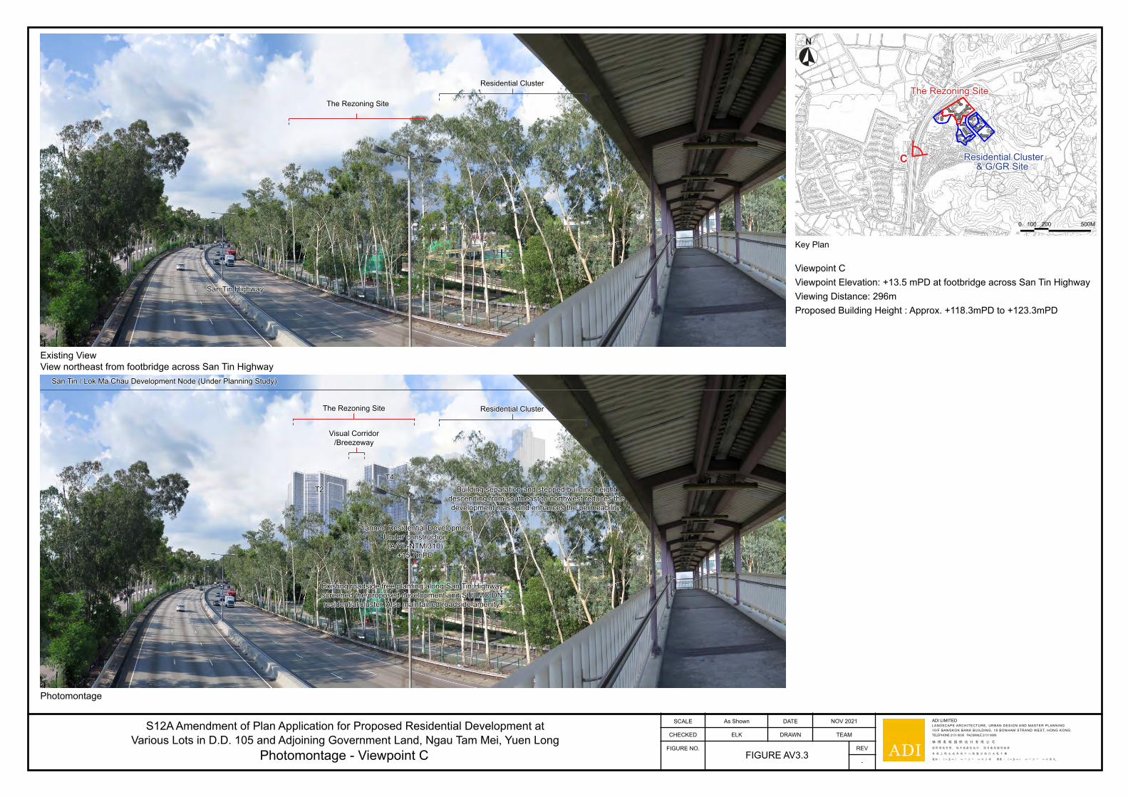
FIGURE AV3.3Photomontage - Viewpoint C
Existing View View northeast from footbridge across San Tin Highway
Photomontage
Key PlanKey Plan
The Rezoning SiteThe Rezoning Site
CC
500M2001000
The Rezoning SiteThe Rezoning Site
San Tin HighwaySan Tin Highway
Residential ClusterResidential Cluster
The Rezoning SiteThe Rezoning Site
Visual CorridorVisual Corridor/Breezeway/Breezeway
T2T2T4T4
Planned Residential Development Planned Residential Development Under constructionUnder construction
(A/YL-NTM/310)(A/YL-NTM/310)+15.7mPD+15.7mPD
Building separation and stepped building height Building separation and stepped building height descending from southeast to northwest reduces the descending from southeast to northwest reduces the development mass and enhances the permeability.development mass and enhances the permeability.
Existing roadside tree planting along San Tin Highway Existing roadside tree planting along San Tin Highway screened the proposed development and ST/LMC DN screened the proposed development and ST/LMC DN residential cluster. Also maintained roadside amenity.residential cluster. Also maintained roadside amenity.
Viewpoint CViewpoint CViewpoint Elevation: +13.5 mPD at footbridge across San Tin HighwayViewpoint Elevation: +13.5 mPD at footbridge across San Tin HighwayViewing Distance: 296mViewing Distance: 296mProposed Building Height : Approx. +118.3mPD to +123.3mPDProposed Building Height : Approx. +118.3mPD to +123.3mPD
Residential Cluster Residential Cluster& G/GR Site& G/GR Site
San Tin / Lok Ma Chau Development Node (Under Planning Study)San Tin / Lok Ma Chau Development Node (Under Planning Study)
cklchan2
Planning Stamp Chi Long

ADI LIMITEDLANDSCAPE ARCHITECTURE, URBAN DESIGN AND MASTER PLANNING10/F BANGKOK BANK BUILDING, 18 BONHAM STRAND WEST, HONG KONGTELEPHONE 2131 8630 FACSIMILE 2131 8609
雅 博 奧 頓 國 際 設 計 有 限 公 司
國際環境管理, 城市規劃及設計, 園景建築顧問服務
香 港 上 環 文 咸 西 街 十 八 號 盤 谷 銀 行 大 廈 十 樓
電話 : (八五二) 二 一 三 一 八 六 三 零 傳真 : (八五二) 二 一 三 一 八 六 零 九
CHECKED DRAWN
SCALE DATEAs Shown
ELK TEAM
FIGURE NO.
S12A Amendment of Plan Application for Proposed Residential Development at Various Lots in D.D. 105 and Adjoining Government Land, Ngau Tam Mei, Yuen Long
REV
-
NOV 2021
FIGURE AV3.4Photomontage - Viewpoint D
Existing View Existing View View south from San Tin Mai Po RoadView south from San Tin Mai Po Road
Mai Po RoadMai Po Road
Photomontage
The Rezoning SiteThe Rezoning Site
T1T1
T4T4
T2T2
T3T3
Residential ClusterResidential Cluster
Residential ClusterResidential Cluster
The Rezoning SiteThe Rezoning Site
Residential ClusterResidential Cluster
San Tin / Lok Ma Chau Development Node (Under Planning Study)San Tin / Lok Ma Chau Development Node (Under Planning Study)
Existing roadside tree planting along Existing roadside tree planting along Castle Peak Road (Mai Po) screened the Castle Peak Road (Mai Po) screened the
lower portion of proposed development and ST/LMC DN lower portion of proposed development and ST/LMC DN residential cluster. Also maintained roadside amenity.residential cluster. Also maintained roadside amenity.
Building separation and stepped building height Building separation and stepped building height descending from southeast to northwest reduces the descending from southeast to northwest reduces the development mass and enhances the permeability.development mass and enhances the permeability.
Key PlanKey Plan
The Rezoning SiteThe Rezoning Site
500M2001000
Residential Cluster Residential Cluster& G/GR Site& G/GR Site
DD
Viewpoint DViewpoint DViewpoint Elevation: +5.4 mPD at San Tin Mai Po RoadViewpoint Elevation: +5.4 mPD at San Tin Mai Po RoadViewing Distance: 214mViewing Distance: 214mProposed Building Height : Approx. +118.3mPD to +123.3mPDProposed Building Height : Approx. +118.3mPD to +123.3mPD
cklchan2
Planning Stamp Chi Long

申請編號 Application No. : Y/YL-NTM/5
與申請地點屬相同地帶的先前申請
Previous Application(s) Relating to the Application Site with Same Zoning(s)
申請編號
Application No.擬議修訂
Proposed Amendment(s)城市規劃委員會的決定(日期)
Decision of Town Planning Board (Date)
沒有 Nil
有關資料是為方便市民大眾參考而提供。對於所載資料在使用上的問題及文義上的歧異,城市規劃委員會概不
負責。若有任何疑問,應查閱申請人提交的文件。
The information is provided for easy reference of the general public. Under no circumstances will the Town Planning Board accept any liabilities for the use of the information nor any inaccuracies or discrepancies of the information provided. In case of doubt, reference should always be made to the submission of the applicant.