Brady 2011
22
3 Journal of California and Great Basin Anthropology | Vol. 31, No. 1 (2011) | pp. 3–24 Obsidian Source Distribution and Prehistoric Settlement Patterns at Mono Lake, Eastern California RYAN T. BRADY Albion Environmental, Inc., 1414 Soquel Avenue, Suite 205, Santa Cruz, CA. 95062 Hunter-gatherer settlement studies often use toolstone diversity to measure the degree to which mobility was regular, expansive, or localized. The results of a 10 km. 2 probabilistic survey investigating prehistoric wetland use at Mono Lake demonstrate a pattern that is counter-intuitive to preconceived notions. Diachronic change in landscape use is investigated with a combination of obsidian sourcing and hydration analyses. Rather than conforming to a linear distance-decay model, source distributions appear to reflect differential patch-choice among lakeside habitats. Comparisons with environmental and paleoenvironmental data underscore changes in the use of wetland habitats and highlight the utility of surface survey and obsidian data for understanding past settlement-subsistence patterns. O bsidian sourcing and hydration studies have a long history of use to support arguments for differences in past hunter-gatherer mobility, social organization, and trade relations in the Inyo-Mono region of eastern California (Basgall 1989; Basgall and Delacorte 2003; Basgall and McGuire 1988; Basgall et al. 2003; Bouey and Basgall 1984; Delacorte 1999; Gilreath and Hildebrandt 1997; Hull 2002; King et al. 2001; Singer and Ericson 1977; Zeanah and Leigh 2002). Obsidian hydration data may be used as another line of evidence to test presumptions about chronology. Moreover, in localities with well-documented obsidian sources, the study of toolstone distributions can be used to identify patterns of mobility and social interaction for people in the past (Basgall 1989; Bouey and Basgall 1984; Eerkens et al. 2007, 2008a; Hughes 1986; Jones et al. 2003; McGuire 2002; Smith 2010). The distribution of obsidian toolstone is frequently used to study patterns of lithic conveyance, which is often viewed as a rough indicator of mobility range (Basgall 1989; Hughes 1986; Jones et al. 2003; McGuire 2002; Smith 2007, 2010 — but see Close 2000). Used in conjunction with technological analyses, source provenance studies can illustrate patterns of tool manufacture and toolstone conservation that reflect mobility decisions (Beck 2008) and toolstone availability (Andrefsky 1991:131, 1994a). The type of mobility practiced, whether residential or logistical (cf. Binford 1980; Kelly 1992), can complicate interpretations as populations may be less residentially mobile, but still retain access to distant lithic resources through logistical movement. Likewise, trade and exchange may also affect the distribution of lithic raw materials (Davis 1961; Ericson 1981; Whitaker et al. 2008), though its relative importance likely fluctuated throughout prehistory. In general, a lithic distance-decay model is argued to be applicable to understanding toolstone source distributions (Giambastiani 2004; Jones et al. 2003). The model has two assumptions. The first is that the prevalence of a given source decreases as distance to the raw material source increases (Brantingham 2006). With greater distance there is an increase in the number of finished tools relative to the amount of unmodified flakes and simple tools (Andrefsky 1994a; Kuhn 1991; Ricklis and Cox 1993), or items such as cores are more intensively used (Kuhn 1995). A second implication is that flake and tool size will decrease with distance to the source (Eerkens et al. 2008a; Newman 1994; Ricklis and Cox 1993, but see Close 1999). Intrinsic characteristics of a toolstone may make one source particularly more attractive than another (Andrefsky 1994b; Elston 1992; Wilson 2007) and are suggested to account for certain spatio-temporal changes in obsidian source profiles in central-eastern California
-
Upload
independent -
Category
Documents
-
view
3 -
download
0
Transcript of Brady 2011

3
Journal of California and Great Basin Anthropology | Vol. 31, No. 1 (2011) | pp. 3–24
Obsidian Source Distribution and Prehistoric Settlement Patterns at Mono Lake, Eastern California
RYAN T. BRADYAlbion Environmental, Inc., 1414 Soquel Avenue, Suite 205, Santa Cruz, CA. 95062
Hunter-gatherer settlement studies often use toolstone diversity to measure the degree to which mobility was regular, expansive, or localized. The results of a 10 km.2 probabilistic survey investigating prehistoric wetland use at Mono Lake demonstrate a pattern that is counter-intuitive to preconceived notions. Diachronic change in landscape use is investigated with a combination of obsidian sourcing and hydration analyses. Rather than conforming to a linear distance-decay model, source distributions appear to reflect differential patch-choice among lakeside habitats. Comparisons with environmental and paleoenvironmental data underscore changes in the use of wetland habitats and highlight the utility of surface survey and obsidian data for understanding past settlement-subsistence patterns.
obsidian sourcing and hydration studies have a long history of use to support arguments
for differences in past hunter-gatherer mobility, social organization, and trade relations in the Inyo-Mono region of eastern California (Basgall 1989; Basgall and Delacorte 2003; Basgall and McGuire 1988; Basgall et al. 2003; Bouey and Basgall 1984; Delacorte 1999; Gilreath and Hildebrandt 1997; Hull 2002; King et al. 2001; Singer and Ericson 1977; Zeanah and Leigh 2002). obsidian hydration data may be used as another line of evidence to test presumptions about chronology. Moreover, in localities with well-documented obsidian sources, the study of toolstone distributions can be used to identify patterns of mobility and social interaction for people in the past (Basgall 1989; Bouey and Basgall 1984; Eerkens et al. 2007, 2008a; Hughes 1986; Jones et al. 2003; McGuire 2002; Smith 2010).
the distribution of obsidian toolstone is frequently used to study patterns of lithic conveyance, which is often viewed as a rough indicator of mobility range (Basgall 1989; Hughes 1986; Jones et al. 2003; McGuire 2002; Smith 2007, 2010 — but see Close 2000). Used in conjunction with technological analyses, source provenance studies can illustrate patterns of tool manufacture and toolstone conservation that reflect mobility decisions (Beck 2008) and toolstone availability (Andrefsky 1991:131, 1994a). the type of mobility practiced, whether residential or
logistical (cf. Binford 1980; Kelly 1992), can complicate interpretations as populations may be less residentially mobile, but still retain access to distant lithic resources through logistical movement. Likewise, trade and exchange may also affect the distribution of lithic raw materials (Davis 1961; Ericson 1981; Whitaker et al. 2008), though its relative importance likely fluctuated throughout prehistory.
In general, a lithic distance-decay model is argued to be applicable to understanding toolstone source distributions (Giambastiani 2004; Jones et al. 2003). the model has two assumptions. the first is that the prevalence of a given source decreases as distance to the raw material source increases (Brantingham 2006). With greater distance there is an increase in the number of finished tools relative to the amount of unmodified flakes and simple tools (Andrefsky 1994a; Kuhn 1991; Ricklis and Cox 1993), or items such as cores are more intensively used (Kuhn 1995). A second implication is that flake and tool size will decrease with distance to the source (Eerkens et al. 2008a; Newman 1994; Ricklis and Cox 1993, but see Close 1999).
Intrinsic characteristics of a toolstone may make one source particularly more attractive than another (Andrefsky 1994b; Elston 1992; Wilson 2007) and are suggested to account for certain spatio-temporal changes in obsidian source profiles in central-eastern California

4 Journal of California and Great Basin Anthropology | Vol. 31, No. 1 (2011)
(Basgall 1989:116; Bettinger 1981:54; Eerkens et al. 2008a:676; Stevens 2005). the presence or absence of locally available stone material will also affect patterns of stone tool use and conservation (Andrefsky 1994a; Bamforth 1986, 1991; torrence 1989).
Situations where distance-decay model expectations are not met may be better explained through differences in settlement and mobility organization (Eerkens et al. 2008a; Henry 1992; Hildebrandt and McGuire 2002; McGuire and Hildebrandt 2005; Milliken 1998) or social interaction (McGuire 2002; Whitaker et al. 2008). the distance-decay model should be expected to fail at times due to the complexities of past hunter-gatherer mobility (Kelly 1983, 1992, 1995) and toolstone acquisition strategies (Beck et al. 2002; Binford 1979; Gilreath and Hildebrandt 1997; Halford 2008). In many ways, failures of the model are more instructive than successes.
the distance-decay model applied to the present context is relatively simple in that it posits that material from the nearest obsidian source will comprise the greatest amount of the assemblage, while other, more distant obsidian sources will be represented in decreased quantities (cf. Eerkens et al. 2010; Fredrickson 1989). of course, rather than strict linear direction, stone material prevalence may also be affected by other factors, such as the mode of procurement (direct, embedded [sensu Binford 1979], or indirect [Whitaker et al. 2008]), direction of travel (King et al. 2001), and encounter rate with additional sources of toolstone (Ingbar 1994).
A second issue pertinent to the present study relates to the use of wetland habitats in the Great Basin. the role of wetlands within the subsistence-settlement patterns of Great Basin hunter-gatherers has been a topic of debate and study for several decades (Bettinger 1993; Hemphill and Larson 1999; Janetski and Madsen 1990; Kelly 2001; Madsen 1982, 2002, 2007; Zeanah 2004; Zeanah et al. 1995). the basic argument is whether wetlands were optimal habitats for hunter-gatherers to exploit and were unsurpassed by other dry land desert scrub or upland zones (Heizer 1967; Heizer and Napton 1970), or whether the fluctuating characteristics of Great Basin wetlands would have made them important areas only at times of higher productivity (Kelly 1985; thomas 1985). Research and discourse has led to the conclusion that, at times, wetlands were in fact important habitats and that people could reside near them for long periods of time (Kelly
2001; Zeanah 2004); however, the importance that they had within a regional system might vary relative to the productivity of other areas such as uplands (Cannon et al. 1990; Delacorte 2002; Madsen 2002, 2007), and in relation to the overall subsistence-settlement strategy practiced by people at the time.
the present study uses data collected during the Mono Lake Wetland Survey (MLWS), a probabilistic survey designed to investigate prehistoric hunter-gatherer land use relative to wetland habitats in the Mono Lake basin of eastern California (Brady 2007). In particular, the manner in which mobility is reflected in spatial and temporal patterns of toolstone dispersion is examined. Moving beyond simple raw material distributions, the study further identifies divergent settlement strategies practiced in different lakeshore wetland habitats.
ENVIRONMENTAL CONTEXT
Adjacent to and east of the Sierra Nevada Mountains, the Mono Basin is an ideal place to apply obsidian source provenance and hydration studies to help in understanding regional settlement and mobility patterns (Fig. 1). the basin itself is a relatively discrete depression covering over 650 km.2 (Stine 1987:14). Located in the central-western area, Mono Lake is a large saline body of water that provides wetland habitats bordering its shoreline. the wetlands support a range of economically important plant and animal species. Due to resources available there, the wetlands presumably served as key resource patches for hunter-gatherers throughout the Holocene (Brady 2007).
Unique hydrological and geographic factors have created wetland habitats which can be distinguished through vegetation distributions, slope gradient, type of freshwater inflow, as well as soil alkalinity and leaching capabilities (Jones and Stokes Associates 1993; Stine 1993). For the present study, the wetlands were grouped into three classes: freshwater, brackish, and remaining. the freshwater habitats contain the greatest diversity and density of vegetation relative to the saline areas (Brady 2007:table 2.1). the saline habitat is more restricted to halophytic vegetation, whereas the freshwater habitat contains a greater variety of plants that includes grasses, forbs, and fewer xerophytic plants. Vegetation surveys identify more barren land in the saline wetlands and

ARTICLE | Obsidian Source Distribution and Prehistoric Settlement Patterns at Mono Lake, Eastern California | Brady 5
denser flora in the freshwater ones (National Academy of Sciences 1987). Similarly, the mammalian fauna found in the three wetland habitats is richer in the freshwater and least so in the saline habitats (Brady 2007:table 2.2). Brackish wetlands are intermediary to the other two in both instances. Species richness is viewed as a rough indicator of environmental productivity. Due to greater potential foraging returns, it was assumed that areas with increased richness and density of plants and animals would hold greater importance for hunter-gatherers undertaking foraging activities in the basin (Madsen 1982:212).
Prehistoric fluctuations of Mono Lake’s shoreline have been reported by Stine (1987, 1990) for the last ca. 4,000 years and farther back into the Pleistocene by others (Benson et al. 1990; Lajoie 1968; Russell 1889) (Fig. 2). Prior to water diversion that began in the early 1900’s, the lake fluctuations occurred in direct response to environmental conditions, such as variations in water inflow and rates of evapotranspiration (Stine 1987, 1990;
Vorster 1985). Past lake fluctuations surely affected Mono Lake’s near-shore wetland habitats (JSA 1993; Stine 1993), along with potential foraging opportunities.
the geographic distribution of wetland flora and fauna changes as the lake experiences transgressions or recessions (cf. Raymond and Parks 1990:Fig. 4). Each wetland class reacts differently over time as a result of differences in hydrology and geomorphology (Brady 2007; Cohen 2003; Stine 1993). the freshwater wetland migrates more readily with changes in lake elevation due to physical characteristics. By contrast, the saline habitat remains as exposed playa for longer periods during a lakeshore recession; however, emergent marshes form along the shoreline during lake transgressions or times of stability. Like the freshwater wetlands, the brackish wetlands will more easily track changes in lake elevation. Clearly, the paleoenvironmental record is important in understanding temporal changes in hunter-gatherer wetland use.
Mono Lake
AreaEnlarged
I
IIII
II
II
II
LEGEND
Freshwater Wetland
Survey Quadrat
Brackish Wetland
Saline Wetland
I
II
III
Stream
0 4
kilometers
Figure 1. Mono Lake Wetland Survey (MLWS) study area with wetlands and surveyed quadrats.

6 Journal of California and Great Basin Anthropology | Vol. 31, No. 1 (2011)
OBSIDIAN STUDIES
Six geochemically distinct sources of obsidian are more widely dispersed in and around the basin. Source location, depicted with a 20 km. radius, illustrates differences between proximal and distant sources relative to the study area (Fig. 3). the most local source, Mono Craters (MC) (Sieh and Bursik 1986; Wood 1977), is often considered to be of poor quality when compared with other obsidian sources such as Bodie Hills (BH) or Casa Diablo (CD). this is based on MC’s rather restricted spatial distribution within regional archaeological sites, being found within the Mono Basin (Arkush 1995; Bettinger 1981; Carpenter 2001; Wickstrom and Jackson 1993), but not as commonly in more outlying areas where other obsidian sources predominate (Basgall 1983; Fredrickson 1991; Goldberg et al. 1990; Rosenthal 2011). It has also been posited that artifact quality obsidian was
not present until more recent times (Hull 2002; King et al. 2011:211).
the remaining five obsidian sources are more commonly represented in regional archaeological deposits, are prevalent in near-source contexts, and yet are less represented at greater distances. this pattern of linear decay has been identified at multiple quarry-related and other contexts in the Inyo-Mono region (Basgall 1983, 1984, 1998; Bieling 1992; Fredrickson 1991; Giambastiani 1998, 2004; Gilreath 2001; Gilreath and Hildebrandt 1997; Goldberg et al. 1990; Halford 1998; Jackson 1985; King et al. 2001; overly 2002, 2004; Ramos 2008; Richman and Basgall 1998).
In the Mono Basin, Richman and Basgall (1998) found a linear distance-decay model to be applicable. Based on XRF-sourced samples collected during surface survey, sites in the southern basin were recognized
Figure 2. Past Shoreline Elevation Changes at Mono Lake (a. after Benson et al. 1990; b. after Stine 1987).
1350 3200650
500 1500 2000 2500
2275
3000 38500 1000 3500
MR HW NW-I NW-II PN-I
1980
1970
1960
1950
1940Met
ers
Abo
ve S
ea L
evel
(m. a
sl.)
Components
b.
Components: MR= Marana (Historic–650 B.P.); HW=Haiwee (650–1,350 B.P.) NW-I=Newberry I (1,350–2,275 B.P.);NW-II=Newberry II (2,275–3,200 B.P.); PN-I=pre-Newberry I (3,200–4,000 B.P.).
Met
ers
Abo
ve S
ea L
evel
(m. a
sl.)
Years Before Present (B.P.)
a.
0 5000 10,000 15,000
1900
2000
1950
2050
2100
2150

ARTICLE | Obsidian Source Distribution and Prehistoric Settlement Patterns at Mono Lake, Eastern California | Brady 7
0 20
kilometers
Primary Obsidian Source
Secondary Obsidian Source
Legend
20 km radius from Source
Study Area
CaliforniaNevada
East WalkerRiver
BodieHills
Mt. Hicks
Mono Craters
Mono GlassMountain
Casa Diablo
Truman-Queen
Bishop
LeeVining
Bridgeport
SierraNevada
White Mountains
Owens River
Long Valley
Mono Lake
WassukRange
ExcelsiorMountains
Figure 3. Obsidian Source Locations (adapted from Carpenter 2001:Fig. 3).

8 Journal of California and Great Basin Anthropology | Vol. 31, No. 1 (2011)
to more frequently contain Mono Glass Mountain (MGM) obsidian, followed by CD and MC. In the north, BH obsidian was more common, with MC being of secondary importance.
General patterns of source material distribution have been identified from an atemporal framework, yet when attention turns to obsidian hydration data, there also appear to be temporal changes in the use of particular obsidian sources. At the Lee Vining Creek site in the southwestern Mono Basin, Bettinger (1981) identified two components that demonstrate differences in source use. the lower component (>50 cm.), dated to the middle Archaic (2,950 –1,250 B.P.), is predominantly composed of CD obsidian. the upper, late Archaic component (1,250 B.P. – contact [100 B.P.]) has a greater frequency of MC/MGM obsidian. A similar shift in the prevalence of CD and MC is identified from dated components in yosemite, immediately west of Mono Basin (Hull 2002)
these studies show that CD obsidian, representing a distant obsidian source, is more common during earlier times. It follows that a greater presence of extra-local rather than local obsidian suggests more expansive travel and stone transport among the consumers. In late prehistoric times, people appear to have practiced more constrained mobility, relying instead on local MC obsidian to fulfill toolstone provisioning requirements. Similar changes in source prevalence have been noted at other sites in the southwestern Mono Basin (Carpenter 2001; Gilreath 1996; McGuire 1994; Wickstrom and Jackson 1993).1
Gilreath (2001), investigating this pattern, compiled hydration values for CD, BH, and MC/MGM from sites in the Mono Basin (Fig. 4). In alignment with earlier propositions, the histograms show a greater use of extra-local sources (CD, BH) in the middle Archaic (3,500 –1,350 B.P.), with an increased use of MC/MGM obsidian in more recent times, as shown by smaller micron values.
Further support for a temporal change in source use is found at CA-MNo-891 in the southwestern Mono Basin (Carpenter 2001). XRF-sourced obsidian attributable to the middle Archaic component (3,500 –1,350 B.P.) had the greatest quantity of CD (n=19; 46%) and other extra-local sources, while only 9% (n=4) was attributed to MC. In contrast, the late Archaic (post
1,350 B.P.) loci contained an overwhelming majority of MC obsidian (n =15; 75%). Additional evidence for a shift in obsidian source use through time is found at CA-MNo-2122 in the southeastern Mono Basin, where 73.3% (n =11) of XRF-sourced debitage from post-850 B.P contexts is attributable to MC (Arkush 1995). No MC material was identified in the five sourced specimens from earlier contexts (CD = 2, Mt. Hicks [MH]= 3).
Microns
Cou
nt
30
20
10
01 3 5 7 9 11
Mono Craters/Mono Glass Mountain (n=183)
Microns
Bodie Hills (n=65)
Cou
nt
20
10
01 3 5 7 9 11
30
Microns
Cou
nt
30
20
10
01 3 5 7 9 11
Casa Diablo (n=159)
Figure 4. Frequency of XRF source determined items from Mono Basin sites (adapted from Carpenter et al. 2001:Fig. 29).

ARTICLE | Obsidian Source Distribution and Prehistoric Settlement Patterns at Mono Lake, Eastern California | Brady 9
Applying these data to the prehistoric use of Mono Lake’s wetlands, one may develop expectations about source distributions around the lake along with changes in source prevalence through time. Predictions are that BH would be predominant in the northwest, MH in the northeast, and CD in the south during earlier time periods. Hydration measurements with smaller values should be more commonly found on Mono Craters obsidian, with larger bands on more extra-local sources.2
METHODS
Surface Survey
to obtain information about how the wetlands were used in the past, the three habitats described above were randomly sampled using a distributional survey of forty 500 x 500 m. quadrats covering 10 km.2, comprising 8.7% of the 115 km.2 study area (Fig. 1). the number of quadrats surveyed in each habitat was weighted to the relative presence of each wetland class within the study area. All flaked stone tools encountered on transect were collected, and ground stone artifacts were field recorded. Debitage, while noted during the general survey, was only collected in the debitage collection unit for each quadrat.3
Obsidian Source Determinations
Previous efforts at visually segregating Mono Basin sources have proved problematic due to the overlapping of certain visual characteristics (cf. Bettinger et al. 1984; Carpenter 2001; Wickstrom and Jackson 1993). As a result, low accuracy is reported for earlier visual sourcing efforts in the basin (Gilreath 2001:80 – 81). With this in mind, the visual sourcing program was based on attributes derived from the study of geochemically source-determined artifacts from curated archaeological collections. Visual ascriptions were tested by submitting two rounds of samples, totaling 80 specimens, for XRF analysis. the first test of 50 specimens produced unsatisfactory results (57%) and instigated a reassessment of the criteria for segregating each material type. the second test (n = 30), using modified criteria that accounted for greater variability of MC visual characteristics, achieved a 90% accuracy rate, arguing for the accuracy of the remaining visual calls (Brady 2007:112 –118).
In addition to using raw counts and percentages, toolstone source diversity was expressed using the complement of Simpson’s index (1-D). this index is viewed as a good measure of diversity because it is not as affected by sample size as others (Magurran 2004:115). D is calculated as:
D =∑ (ni [ni–1])N[N–1]
In the calculation, ni= total number of items for each toolstone type, N= total number of items for all toolstone types. Values for D range between 0 and 1. With the complement of D, values closer to 0 represent low diversity, while those trending toward 1 represent infinite diversity. Additional measures are source richness (s) and evenness (E) (Magurran 2004).4
Obsidian Hydration Analysis
Each of the 214 collected obsidian artifacts was subjected to obsidian hydration analysis, yielding 256 hydration rims. Several variables have been identified that affect the hydration rate of a given obsidian source, including (but not limited to) the geochemical composition, relative humidity, intrinsic water content, and air temperature (Friedman and Long 1976; Friedman and Smith 1960; Friedman et al. 1997; Hull 2001; Rogers 2007, 2008, 2010; Stevens 2005; Stevenson et al. 1993, 1998; tremaine 1993). Due to the fact that individual sources are known to hydrate at different rates, previously developed source-specific rates were implemented for the present effort (table 1).
Based on empirical tests, correcting for effective hydration temperature (EHt) provides adequate results when comparing obsidian samples from different environmental contexts (Basgall 1990; Hull 2001; Rogers 2007; Stevens 2005). the hydration rates used in the present study were formulated in different environmental contexts; therefore, it is important to calculate an EHt correction so that each rate may be applied to Mono Basin hydration measurements. the EHt was calculated following the method proposed by Rogers (2007)5, which includes multiple variables to characterize each temperature regime, and which has been shown to provide reasonable results when compared with other chronometric information (Eerkens et al. 2008b; Farquhar et al. 2011).

10 Journal of California and Great Basin Anthropology | Vol. 31, No. 1 (2011)
Using this method, the EHt across the study area varies no more than 0.06 °C, and is therefore essentially the same. temperature data used to calculate the EHt comes from weather stations at Mono Lake, Cal. and Bishop, Cal. (Western Regional Climate Center 2008). the EHt for the Mono Basin is 11.81 °C. at Mono Lake and is the same for MC, since that is where the rate formulation was made (onken 1991). the truman-Queen (tQ) EHt is 17.2 °C., and is based on temperature data from Bishop, Cal,. since the tQ rate was developed in the nearby Volcanic tablelands (Basgall and Giambastiani 1995). the EHt for CD in Long Valley is 16.6 °C., based on elevation corrected temperature data from Bishop. this value is also used for MGM, BH, and MH, as the sources are from higher elevations fringing the Mono Basin, and age estimates use the CD rate (or a variant of it).
Due to uncertainties regarding the accuracy of year-specific calculations from hydration data, converted hydration measurements were grouped into temporal units commonly applied to the owens Valley, located to the south (Basgall et al. 2003; Delacorte 1999; Zeanah and Leigh 2002) (table 1). this includes terminal
Pleistocene/early Holocene (tP/EH), pre-Newberry (PN), Newberry (NW), Haiwee (HW), and Marana (MR) periods. Unexpectedly over one quarter of the readings corresponded to the PN and tP/EH time periods. to better recognize changes in land use through time, the NW and PN periods were split into six separate groups (two and four respectively). the categories show that extra-local sources are present in both early and late contexts.
Since the temporal components represent age ranges between 500 and 6,000 years, hydration counts per component were corrected to account for the variable time spans represented. the correction was made by using a simple proportion of the count of hydration measurements per component, multiplied by 6,000 and divided by the component time span. In this way, the numbers were weighted for the length of each component time span (cf. Hockett 2005, Laylander 2002). the corrected obsidian hydration data was analyzed using a chi-square test followed by a calculation of adjusted residuals.
When using contingency tables, after a significant chi-square value is recognized, adjusted residuals provide
Table 1
TEMPORAL UNITS AND HYDRATION MEASUREMENT RANGES*
Hydration Rate
Casa Diablo mono Craters mono Glass mtn. Truman-Queen Temporal units yBP=129.656x1.826 yBP=1000(x2/14.7) yBP=129.656(0.8x)1.826 yBP=82.74x2.06
marana (100–650 B.P.) 0.9–2.5μ 1.2–3.1μ 1.1–3.0μ 1.1–2.7μ
Haiwee (650–1,350 B.P.) 2.6–3.6μ 3.2–4.5μ 3.1–4.5μ 2.8–3.8μ
Newberry I (1,350–2,275 B.P.) 3.7– 4.7μ 4.6–5.7μ 4.6–6.0μ 3.9–5.0μ
Newberry II (2,275–3,200 B.P.) 4.8–5.7μ 5.8–6.8μ 6.1–7.2μ 5.1–5.9μ
Pre-Newberry I (3,200–4,000 B.P.) 5.8–6.5μ 6.9–7.6μ 7.3–8.2μ 6.0–6.5μ
Pre-Newberry II (4,000–5,000 B.P.) 6.6–7.4μ 7.7–8.5μ 8.3–9.2μ 6.6–7.3μ
Pre-Newberry III (5,000–6,000 B.P.) 7.4–8.1μ 8.6–9.3μ 9.3–10.2μ 7.4–8.0μ
Pre-Newberry IV (6,000–7,500 B.P.) 8.2–9.2μ 9.4–10.5μ 10.3–11.5μ 8.1–8.9μ
Terminal Pleistocene/early Holocene (7,500–13,500 B.P.) 9.2–12.2μ 10.6–13.5μ 11.6–15.2μ 9.0–11.4μ
*Temperature corrected. Rates derived from: Hall and Jackson 1989 (CD; also used for BH and MH); Onken 1991 (MC); Overly 2003 (MGM); Basgall and Giambastiani 1995 (TQ).

ARTICLE | Obsidian Source Distribution and Prehistoric Settlement Patterns at Mono Lake, Eastern California | Brady 11
a statistical means to identify cells that are responsible for the significant value (Everitt 1992:46). Adjusted residuals are calculated as:
dij = eij / √ [ (1 – ni. / N) (1– n.j / N)]
where N = total number of observations in the table; ni. = sum of the row total for the cell in question; n.j = sum of the column total for the cell in question; and eij = the expected frequency for a given cell. the expected frequency eij is calculated as:
eij = (nij – Eij)/√ Eij
where nij = the number in a given cell and Eij = ni.n.j /N. Significant values exceed 1.96 and illustrate instances where the phenomenon measured is significantly contributing (>1.96) or not contributing (<1.96) to the pattern being measured. Adjusted residuals have been successfully applied to regional archaeological data in order to identify changes in prehistoric settlement and technological organization (Basgall 2007; Basgall and Giambastiani 1995; Bettinger 1989, 1999; Rosenthal et al. 2011).
RESULTS
Surface Survey
General tool classes recovered within each quadrat were somewhat evenly distributed across the wetland areas (table 2), with each wetland habitat containing quadrats with only debitage, debitage and expedient flake tools, as well as debitage along with flaked and ground stone tools. the greatest tool density was encountered in the freshwater habitat (19.3/km.2), while the saline
habitat contained the least (6.3/km.2), and brackish habitats fell in between (10.1/km.2). one pattern of artifact distribution that was noted is that bifaces were over-represented in the saline wetlands. In addition, projectile points, handstones, and millingstones were significant constituents in the northern half of the basin, while projectile points were absent in the southern half, including the freshwater habitats (Brady 2009). the freshwater wetlands also contained the only bedrock mortars encountered in the study area, suggesting a certain emphasis on plant processing.
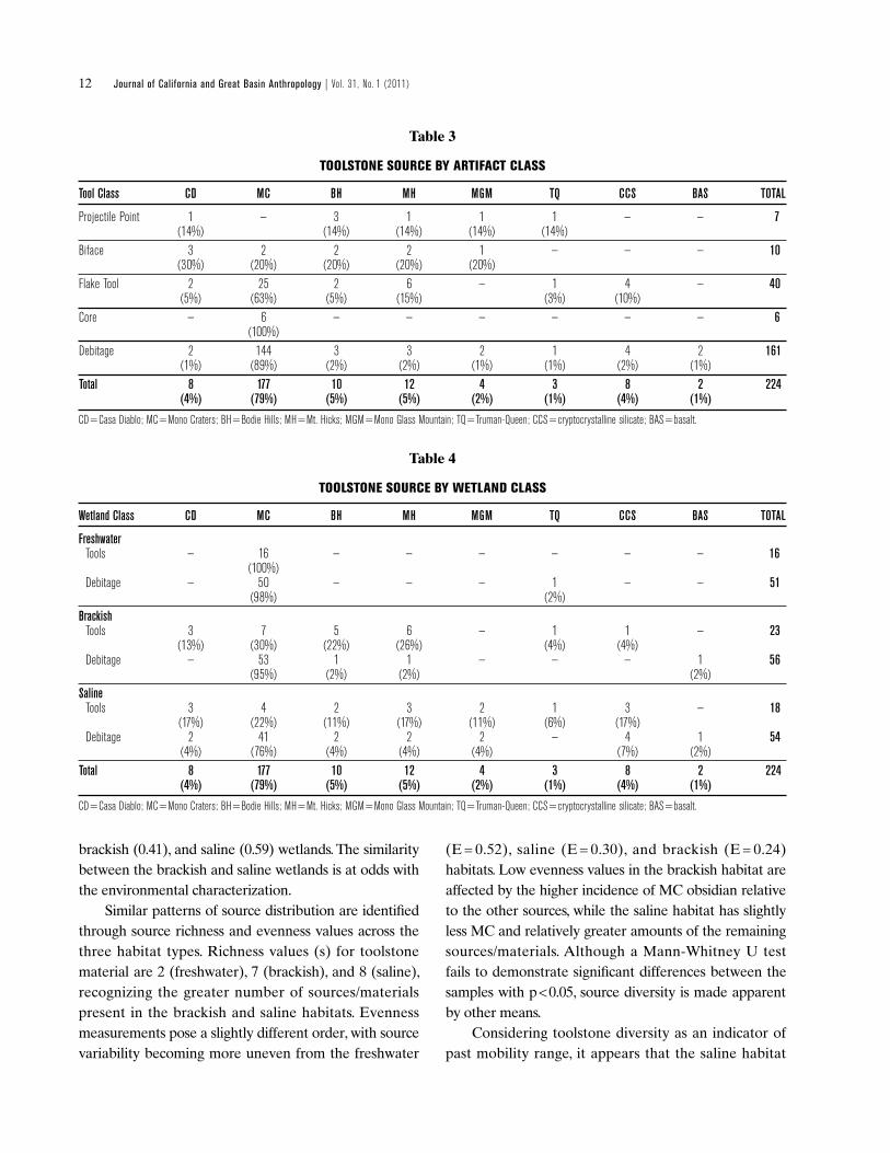
Toolstone Material Distributions
Stone materials represented in the Mono Lake wetlands show variability by artifact class as well as across wetland habitat. table 3 illustrates the notable lack of MC among projectile points, yet the source supplied the majority of flake tools, cores, and debitage. though overwhelmingly weighted toward MC obsidian, the latter class also exhibits the greatest amount of stone material variability. this indicates that curated tools, such as projectile points and bifaces, were most often fabricated on extra-local stone and were transported to the wetlands in finished form. By contrast, local material was more often used to fulfill needs related to flake production and use, as shown by the high percentage of MC among flake tools, debitage, and cores.
Segregated by wetland class, stone material is differentially distributed across the habitats (table 4). Support for differences in toolstone diversity across the three habitats is illustrated with the complement of Simpson’s Index. the values show a dramatic difference in source diversity between the freshwater (0.03),
Table 2
QUADRAT TOOL CONSTITUENTS
Wetland Class empty DeB only GST only DeB & FTl DeB & FTl DeB & GST DeB, FST & GST ToTAl
Freshwater — 2 — 2 — 1 1 6 (33%) (33%) (17%) (17%)Brackish 2 2 — 1 2 2 6 15 (13%) (13%) (7%) (13%) (13%) (40%)Saline — 11 1 2 — 2 3 19 (58%) (5%) (11%) (11%) (16%)Total 2 15 1 5 2 5 10 40 (5%) (38%) (3%) (13%) (5%) (13%) (25%)
Note: Number is count of quadrats containing each tool class group; DEB = debitage; GST= ground stone tool; FTL= flake tool (expedient); FST= flaked stone tool (formed).
12 Journal of California and Great Basin Anthropology | Vol. 31, No. 1 (2011)
brackish (0.41), and saline (0.59) wetlands. the similarity between the brackish and saline wetlands is at odds with the environmental characterization.
Similar patterns of source distribution are identified through source richness and evenness values across the three habitat types. Richness values (s) for toolstone material are 2 (freshwater), 7 (brackish), and 8 (saline), recognizing the greater number of sources/materials present in the brackish and saline habitats. Evenness measurements pose a slightly different order, with source variability becoming more uneven from the freshwater
(E = 0.52), saline (E = 0.30), and brackish (E = 0.24) habitats. Low evenness values in the brackish habitat are affected by the higher incidence of MC obsidian relative to the other sources, while the saline habitat has slightly less MC and relatively greater amounts of the remaining sources/materials. Although a Mann-Whitney U test fails to demonstrate significant differences between the samples with p < 0.05, source diversity is made apparent by other means.
Considering toolstone diversity as an indicator of past mobility range, it appears that the saline habitat
Table 3
TOOLSTONE SOURCE BY ARTIFACT CLASS
Tool Class CD mC BH mH mGm TQ CCS BAS ToTAl
Projectile Point 1 — 3 1 1 1 — — 7 (14%) (14%) (14%) (14%) (14%) Biface 3 2 2 2 1 — — — 10 (30%) (20%) (20%) (20%) (20%)Flake Tool 2 25 2 6 — 1 4 — 40 (5%) (63%) (5%) (15%) (3%) (10%) Core — 6 — — — — — — 6 (100%) Debitage 2 144 3 3 2 1 4 2 161 (1%) (89%) (2%) (2%) (1%) (1%) (2%) (1%)Total 8 177 10 12 4 3 8 2 224 (4%) (79%) (5%) (5%) (2%) (1%) (4%) (1%)
CD = Casa Diablo; MC = Mono Craters; BH = Bodie Hills; MH = Mt. Hicks; MGM = Mono Glass Mountain; TQ = Truman-Queen; CCS = cryptocrystalline silicate; BAS = basalt.
Table 4
TOOLSTONE SOURCE BY WETLAND CLASS
Wetland Class CD mC BH mH mGm TQ CCS BAS ToTAl
Freshwater Tools — 16 — — — — — — 16 (100%) Debitage — 50 — — — 1 — — 51 (98%) (2%)Brackish Tools 3 7 5 6 — 1 1 — 23 (13%) (30%) (22%) (26%) (4%) (4%) Debitage — 53 1 1 — — — 1 56 (95%) (2%) (2%) (2%)Saline Tools 3 4 2 3 2 1 3 — 18 (17%) (22%) (11%) (17%) (11%) (6%) (17%) Debitage 2 41 2 2 2 — 4 1 54 (4%) (76%) (4%) (4%) (4%) (7%) (2%)Total 8 177 10 12 4 3 8 2 224 (4%) (79%) (5%) (5%) (2%) (1%) (4%) (1%)
CD = Casa Diablo; MC = Mono Craters; BH = Bodie Hills; MH = Mt. Hicks; MGM = Mono Glass Mountain; TQ = Truman-Queen; CCS = cryptocrystalline silicate; BAS = basalt.

ARTICLE | Obsidian Source Distribution and Prehistoric Settlement Patterns at Mono Lake, Eastern California | Brady 13
represents a more wide-ranging settlement pattern, whereas the overwhelming emphasis on local obsidian found in the freshwater region indicates a more localized occupation. Source diversity in the brackish wetlands is more similar to that of the saline habitat, and toolstone deposition reflects more varied or wide-ranging settlement strategies.
the dispersion of stone material shows some correspondence with what is expected in a linear distance-decay model (table 4). the predominance of MC in the freshwater habitat is expected in the linear model, though its continued high presence in brackish and saline habitats is less expected, especially when considering patterns previously identified in the Mono Basin (Arkush 1995; Bettinger 1981; Carpenter 2001; Richman and Basgall 1998).
Separating tools and debitage, the percentage of tools by toolstone variety supports expectations of the linear model in the brackish habitat, with northern sources (BH and MH) showing the greatest presence after MC. the saline region presents greater divergence from expectations. the greater frequencies of CD and cryptocrystalline silicate (CCS) suggest, along with the higher diversity index, more wide-ranging land use when people were initially exploiting the saline wetlands.
OBSIDIAN HYDRATION ANALYSIS
MC hydration measurements from each wetland habitat are presented as histograms in Figure 5. Raw counts show the saline wetland to be more intensively used in early times, at around seven microns (ca. 3,300 B.P.) and older, while the freshwater region sees greatest use in more recent times. the brackish wetlands exhibit more continuous use from the early part of the sequence, but with a decrease in use in more recent times. t-tests comparing MC micron values across the three wetland habitats identify significant differences between the three samples (Freshwater-Brackish, t = –2.69, d.f. 162, p<0.01; Freshwater-Saline, t = –6.03, d.f. 160, p<0.001; Brackish-Saline, t =–3.30, d.f. 138, p<0.001).
Local versus Extra-local Obsidian Use
In considering the distribution of component-grouped hydration measurements, a first order of analysis is to compare the prevalence of MC to non-MC obsidian in
the sample over time. Adjusted residuals illustrate that for time corrected values, it is apparent that non-MC obsidian is significantly overrepresented before 6,000 years ago (PN-IV), with MC becoming prominent more recently (table 5). there is a weaker, fluctuating presence of local and extra-local sources between PN-III and NW-II times; however, non-MC obsidian is again significantly overrepresented in NW-I. Meeting expectations, the two most recent prehistoric periods are the only times that MC is significantly overrepresented relative to non-MC obsidians. the spike in non-MC obsidian during NW-I is also notable and deserves further discussion.
two possible factors may account for the increased presence of non-MC obsidians during NW-I times: (1) increased artifact scavenging from older archaeological deposits; or (2) an expanded mobility range during the
Saline Wetland (n=50)
Cou
nt
3 9 115 71 130
4
8
12
Microns
Microns
Cou
nt
Brackish Wetland (n=71)
0
4
8
12
3 9 115 71 13
Microns
Freshwater Wetland (n=91)
Cou
nt
3 9 115 71 130
4
8
12
4000 B.P.
Figure 5. Histograms of Mono Craters obsidian hydration measurements from the MLWS.

14 Journal of California and Great Basin Anthropology | Vol. 31, No. 1 (2011)
time interval. the first proposition could account for an increased presence of non-local sources during the NW-I interval. Mono Lake underwent a lakeshore recession during this time period, making wetland productivity similar to what it was in PN-III and earlier times. this would have provided foragers access to obsidian tools and debitage associated with earlier archaeological deposits. Raw material scavenging is sometimes identified in items with multiple hydration bands. Evidence of stone material scavenging from older archaeological deposits has been identified in other Inyo-Mono contexts (though typically post-Newberry). In these contexts, raw material profiles often mirror those identified from earlier deposits (Basgall and Giambastiani 1995; Basgall and McGuire 1988; Delacorte 1999:256 – 258; Delacorte et al. 1995; Gilreath 1995:251, but see Eerkens et al. 2008a).
Late Newberry (NW-I) non-MC samples are from quadrats with more extensive earlier hydration values, along with greater source diversity.6 Interestingly, the incidence of artifacts with multiple hydration bands accounts for 22% (n =14) of the hydration measurements dating to this era, compared with only 16% (n = 32) for the remaining sample, which lends support to the idea that scavenging may have been somewhat more prevalent during this time. However, only 14% (n = 2) of the NW-I artifacts with multiple hydration bands are from non-MC obsidian, suggesting that the increased
prevalence of non-MC obsidian at this time may be due to other factors, such as a more expansive mobility range.
A rise in logistical mobility leading up to NW-I times has been documented in the western Great Basin (Basgall and McGuire 1988; Basgall et al. 2003; Delacorte 1997, 1999; Delacorte et al. 1995; King et al. 2001; Zeanah and Leigh 2002), and more generally across much of western North America (Hildebrandt and McGuire 2002; McGuire and Hildebrandt 2005). this behavior would bring people into contact with a greater range of environments, and possibly stone material sources.
there is some debate as to why this change in settlement organization occurred; whether it was related to the sexual division of labor and differential foraging goals relative to environmental productivity (i.e., increased importance of women’s foraging activities) (Zeanah 2004), or occurred as a result of heightened large game acquisition by logistically-organized hunting parties for prestige-related benefits (Hildebrandt and McGuire 2002; McGuire and Hildebrandt 2005). one important difference between the two views involves the question of whether the residential base camps from which the logistical parties traveled were sedentary/semi-sedentary villages (King et al. 2001; McGuire and Hildebrandt 2005:705), or were seasonally (winter) occupied localities (Basgall and McGuire 1988; Basgall et al. 2003:357; Zeanah and Leigh 2002:654 – 658).
Table 5
MC VS. NON-MC OBSIDIAN BY TEMPORAL COMPONENT*
mR HW NW-I NW-II PN-I PN-II PN-III PN-IV TP/eH
CouNT MC 42 40 52 28 28 13 7 0 1 Non MC 5 5 13 4 5 3 2 2 6 Total 47 45 65 32 33 16 9 2 7 X2 = 35.79, df = 8; p < 0.001
CoRReCTeD MC 458 343 337 182 210 78 42 0 1 Non MC 55 43 84 26 38 18 12 8 6 Total 513 386 421 208 248 96 54 8 7 X2 = 97.38, df = 8; p < 0.001
ReSIDuAl MC 3.13 2.34 –3.26 1.05 –0.18 –1.07 –1.52 –6.76 –5.26 Non MC –3.13 –2.34 3.26 –1.05 0.18 1.07 1.52 6.76 5.26
*Temperature adjusted. MR = Marana (Historic [100] – 650 B.P); HW= Haiwee (650 –1,350 B.P.); NW-I = Newberry I (1,35014 – 2,275 B.P.); NW-II = Newberry II (2,275 – 3,200 B.P.); PN-I = pre-Newberry I (3,200 – 4,000 B.P.); PN-II = pre-Newberry II (4,000 – 5,000 B.P.); PN-III = pre-Newberry III (5,000 – 6,000 B.P.); PN-IV = pre-Newberry IV (6,000 –7,500 B.P.); TP/EH = Terminal Pleistocene/Early Holocene (7,500–13,500 B.P.); MC = Mono Craters obsidian; Non MC = non Mono Craters obsidian. CORRECTED = values adjusted to 6,000 year time span for each component; RESIDUAL = adjusted residual.

ARTICLE | Obsidian Source Distribution and Prehistoric Settlement Patterns at Mono Lake, Eastern California | Brady 15
the current data presented here can shed some light on this debate, as there appears to be increased access to more extra-local stone sources within the time frame in question. that five of the seven projectile points from the project have hydration measurements that correspond to the NW-I era suggests an increased importance of hunting, possibly from base camps situated adjacent to Mono Lake’s wetlands. Moreover, bifaces, cores, and flake tools also provide hydration measurements dating to this era, suggesting that a variety of processing/retooling activities occurred around the fringe of the lakeshore. the suite of the four tool classes is not present together in the remaining components. Additionally, ground stone artifacts are present in 71% (n = 5) of the quadrats with non-MC hydration readings dating to the NW-I interval, and 60% (n = 3) of the quadrats with double-band hydration measurements.
A definitive temporal placement of the ground stone artifacts is hampered by the fact that they were surface finds, and quadrats with multiple hydration readings generally exhibit an extended temporal range. Nevertheless, the association of ground stone artifacts along with the NW-I hydration measurements on both non-MC and MC obsidian suggests that the lakeshore may have served as a locality for seasonal base camps.
From the base camps, logistical forays could be made to the uplands while the remaining family unit stayed behind at lakeshore base camps to exploit wetland resources.
Temporal Changes in Wetland Use
While it appears that a linear distance-decay model does not fully account for the distribution of materials relative to Mono Lake’s near-shore wetlands, a model that accounts for changing mobility strategies through time better explains the arrangement. When source specific hydration values are converted to temporal components and corrected for component time span, there is an apparent pattern of temporal change in wetland use that is also affected by geography and lake level fluctuation (table 6). the earliest wetland use before 6,000 B.P. (EH, PN-IV) occurs mainly in the brackish habitats. the hydration readings come largely from artifacts in the northwestern basin and are associated with a time of rapidly decreasing lake levels. During the remaining portion of the pre-Newberry era, land use intensity was focused on the saline habitat. At this time, Mono Lake’s elevation remained relatively low, increasing to a high stand during the PN-I period. Items pertaining to this era are primarily debitage and suggest short-term use.
Table 6
OBSIDIAN HYDRATION MEASUREMENTS BY TEMPORAL COMPONENT AND WETLAND CLASS*
mR HW NW-I NW-II PN-I PN-II PN-III PN-IV TP/eH
CouNT Freshwater 27 23 26 13 4 0 1 0 0 Brackish 16 16 28 11 9 4 1 2 6 Saline 4 6 11 8 20 12 7 0 1 Total 47 45 65 32 33 16 9 2 7 X 2 = 83.98, df = 16; p < 0.001
CoRReCTeD Freshwater 294 197 169 84 30 0 6 0 0 Brackish 175 137 181 72 68 24 6 8 6 Saline 44 52 71 52 150 72 42 0 1 Total 513 386 421 208 248 96 54 8 7 X 2 = 563.14, df = 16; p < 0.001
ReSIDuAl Freshwater 9.22 4.86 –0.02 0.06 –9.66 –8.24 –4.42 –2.32 –2.17 Brackish –0.42 0.28 3.95 –0.08 –2.64 –2.08 –3.72 3.87 2.83 Saline –9.98 –5.82 –4.33 0.02 13.85 11.63 9.10 –1.63 –0.65
*Temperature adjusted. MR = Marana (Historic [100] – 650 B.P); HW= Haiwee (650 –1,350 B.P.); NW-I = Newberry I (1,35015 – 2,275 B.P.); NW-II = Newberry II (2,275 – 3,200 B.P.); PN-I = pre-Newberry I (3,200 – 4,000 B.P.); PN-II = pre-Newberry II (4,000 – 5,000 B.P.); PN-III = pre-Newberry III (5,000 – 6,000 B.P.); PN-IV = pre-Newberry IV (6,000 –7,500 B.P.); TP/EH = Terminal Pleistocene/Early Holocene (7,500–13,500 B.P.); MC = Mono Craters obsidian; Non MC = non Mono Craters obsidian. CORRECTED = values adjusted to 6,000 year time span for each component; RESIDUAL = adjusted residual.

16 Journal of California and Great Basin Anthropology | Vol. 31, No. 1 (2011)
During the Newberry era, there is a shift in emphasis from the saline to the brackish habitat. this appears to be a response to a lake-level decline that promoted wetland instability (especially in the saline habitat). As the lake level declined, geomorphic and hydrologic conditions indicate that wetlands in the saline area would not have been able to migrate downslope as the lake receded, but would instead have dried up. In contrast, conditions in the more well-watered western area allowed wetlands to re-establish on newly exposed lakebed.
Corresponding with this change, there was increased toolstone procurement from local quarry areas in the southwest. toolstone acquisition is apparent at this time in southwestern freshwater and brackish quadrats where Mono Craters obsidian is present in the alluvium and there is abundant debitage and assayed cobbles.
throughout the Haiwee (HW) and into the Marana (MR) periods, land use focused on the freshwater habitats at the expense of both the brackish and saline wetlands. that people increasingly spent more time in the area is demonstrated by the variety and greater density of discarded tools, along with the presence of bedrock mortar features. these imply recurring if not relatively more stable residence than found earlier. Being near permanent water sources, the freshwater habitats may have been preferable for occupations of greater duration. these latest time periods, dating from about 1,350 years ago, are associated with increased lake level oscillations. Rapid fluctuations have a more detrimental effect on the migration of wetlands or the revegetation of exposed playa in other areas around the lake.
DISCUSSION
Evidence presented here points to changes in the use of near-shore wetlands at Mono Lake throughout the Holocene. one avenue of exploration tested a linear distance-decay model of toolstone source prevalence from known obsidian sources in the vicinity of the Mono Basin. In contrast to expectations developed from excavated assemblages in the Mono Basin and in nearby areas, Mono Craters was the most prevalent source in all three habitats. When the focus was restricted to formal tools and expedient flake tools, a distance-decay model showed a somewhat better fit, accounting for the use of some alternative sources.
Source specific, temperature-corrected obsidian hydration data illustrate changing patterns of land use, with the earliest Holocene use of the basin found in the brackish wetlands. Middle to early-late Holocene times (PN-III to PN-I) had the most intensive obsidian deposition in the saline habitat. During NW-II, there appeared to be no preference for a given wetland habitat, possibly as a result of a continued lakeshore decline during this era. the late Newberry (NW-I) occupation again emphasized the brackish wetlands, while the latest Holocene use of the Mono Basin wetlands was strongly focused on the freshwater wetlands.
Recognizing temporal changes in land use better illuminates differences in obsidian source distributions than a linear distance-decay model. the earliest use of the basin involved a significant use of non-MC obsidian and was focused on the brackish habitat. Later (PN-III to PN-I) occupations shifted to the saline wetlands, where MC obsidian is prevalent; however, this habitat also contains the greatest toolstone diversity of the three wetlands, suggesting continued high levels of residential mobility with an array of sources represented in the toolkit. In late Newberry (NW-I) times, there was a shift to the brackish habitat and a renewed heightened presence of non-MC obsidian. this indicates an expanded mobility range, and possibly represents residential base camps within a logistically organized settlement system. Late Holocene (HW, MR) occupation of the study area was most intensive in the freshwater wetlands, and involved localized toolstone use.
As noted previously, tool densities were lowest in the saline habitat and highest in the freshwater habitat, suggesting that people were spending more time in the latter area and visiting the former on a more short-term basis. Additionally, the saline habitat is notable for the prevalence of bifaces and bifacial flaking debris, while the freshwater wetlands have a predominance of cores, core reduction debitage, and non-portable milling features (Brady 2007, 2009). the relationship between bifaces and mobility, along with associations of core reduction use and sedentism, is discussed in more depth elsewhere (Kelly 1988; Parry and Kelly 1987; but see Railey 2010), but is presented here as supporting evidence for greater residential stability in the late prehistoric use of the freshwater wetlands at Mono Lake.

ARTICLE | Obsidian Source Distribution and Prehistoric Settlement Patterns at Mono Lake, Eastern California | Brady 17
Placing the current study within the greater context of wetland use in the Great Basin or other semi-arid environments, it appears that wetlands must be understood not only for what they have to offer relative to the surrounding environment; one must also consider the settlement strategy being practiced, the potential resources being targeted, and the paleoenvironmental history of a given wetland. the wetlands at Mono Lake do not indicate the presence of the same levels of intensive activity that are found at other Great Basin wetlands (cf. Janetski and Madsen 1990; Livingston 1986; oetting 1989; Simms 1999; Zeanah 2004), yet this lakeshore habitat contains data relevant to changes in settlement and mobility throughout the Holocene that have not been previously addressed.
NOTES1Recent research in the western Great Basin regarding temporal patterns of source diversity has identified instances of heightened source diversity in the latest prehistoric intervals (cf. Eerkens et al. 2008a; McGuire 2002; Smith 2010). In these contexts, source profiles are as variable, if not more so, than those of earlier components. the degree to which the scavenging of raw material from older archaeological deposits or more varied trade relations might have affected this pattern, rather than increased late prehistoric mobility, is unclear. the fact that studies from obsidian quarries in the Inyo-Mono region show a consistent, significant decline in late prehistoric obsidian acquisition (Gilreath and Hildebrandt 1997; Halford 2008; Ramos 2008; Singer and Ericson 1977) lends support to the scavenging hypothesis (cf. Delacorte 1999), with changing social relations potentially introducing new or previously underrepresented raw material (Basgall and Delacorte 2003; Eerkens and Spurling 2008; Zeanah and Leigh 2002:659).
2one confounding factor may be general patterns of lithic conveyance after acquisition from the sources. For example, Bodie Hills and Casa Diablo obsidians are common west of the Sierra Nevada (Bouey and Basgall 1984; Jones et al. 1996; King et al. 2011; Rosenthal and McGuire 2005), while Mt. Hicks and truman-Queen obsidians are more commonly found at sites located to the east (Giambastiani 2004; Jones et al. 2003; Ramos 2008; Smith 2007).
3Survey methodology operated under a distributional (Ebert 1992) or non-site (thomas 1975) approach, where the individual artifact is treated as the unit of analysis. Following this approach, artifacts identified on transect were recorded and collected. tools encountered outside of the 5 m. transect area (for example, when recording a site) were not included in the sample. General transects within the quadrat were spaced at 25 m. intervals. A 100 x 100 m. debitage collection unit was situated in the southwest corner of each quadrat. transect spacing was reduced to 10 m. intervals within the debitage collection units.
4Evenness is calculated as a modification of Simpson’s D where E1/D= (1/D)/S (Magurran 2004:116)
5the method proposed by Rogers (2007) produces slightly elevated EHt measurements compared to an alternative method that uses Lee’s (1969) temperature integration equation, following Basgall (1990, 1998; see also origer 1982).
6one freshwater, four brackish, and two saline quadrats.
ACKNOWLEDGEMENTS
Fieldwork was conducted by volunteers from the CSU Sacramento Anthropology Department and others. Financial and laboratory support was provided by the Archaeological Research Center (CSUS), Sacramento Archeological Society, Archaeometrics, Inc., and Northwest obsidian Research Laboratory. Mark Basgall, Michael Delacorte, and David Zeanah were fundamental in the development and execution of the project. this paper was substantially improved by comments from Nathan Stevens and two anonymous reviewers, though the logic and conclusions reached are my responsibility alone.
REFERENCES
Andrefsky, William 1991 Inferring trends in Prehistoric Settlement Behavior
from Lithic Production technology in the Southern Plains. North American Archaeologist 12:129 –144.
1994a Raw Material Availability and the organization of technology. American Antiquity 59:21–35.
1994b the Geological occurrence of Lithic Material and Stone tool Production Strategies. Geoarchaeology 9:375 – 391.
Arkush, Brooke S.1995 the Archeology of CA-MNo-2122: A Study of
Pre-Contact and Post Contact Lifeways among the Mono Basin Paiute. University of California Anthropological Records 31. Berkeley.
Bamforth, Douglas B.1986 technological Efficiency and tool Curation. American
Antiquity 51:38 – 50.1991 technological organization and Hunter-Gatherer
Land Use: A California Example. American Antiquity 56:216 – 234.
Basgall, Mark E.1983 Archaeology of the Forest Service Forty Site (CA-Mno-
529), Mono County, California. MS on file at the Eastern Information Center, Archaeological Research Unit, University of California, Riverside.
1984 The Archaeology of CA-MNO-1529: A Secondary Reduction Site in Mammoth Lakes, Mono County, California. MS on file at the Eastern Information Center, Archaeological Research Unit, University of California, Riverside.

18 Journal of California and Great Basin Anthropology | Vol. 31, No. 1 (2011)
1989 obsidian Acquisition and Use in Prehistoric Central-Eastern California: Preliminary Assessment. In Current Directions in California Obsidian Studies, Richard. E. Hughes, ed., pp. 111–126. Contributions of the University of California Archaeological Research Facility 48. Berkeley.
1990 Hydration Dating of Coso obsidian: Problems and Prospects. Paper presented at the annual meeting of the Society for California Archaeology, Foster City.
1998 Phase II Evaluation of Archaeological Site CA-MNO-1977, on the Little Walker River, Mono County, Cali fornia. MS on file at the Eastern Information Center, Archaeo-logical Research Unit, University of California, Riverside.
2007 Prehistoric People in an Evolving Landscape: A Sample Survey of the Lake China Basin and its Implica-tions for Paleoindian Land Use. MS on file at the Eastern Information Center, Archaeological Research Unit, University of California, Riverside.
Basgall, Mark E., and Michael G. Delacorte2003 Phase II Evaluations at Nine Archaeological Sites near
Independence, Inyo County, California. MS on file at the Eastern Information Center, Archaeological Research Unit, University of California, Riverside.
Basgall, Mark E., and Mark A. Giambastiani1995 Prehistoric Use of a Marginal Environment:
Continuity and Change in occupation of the Volcanic tablelands, Mono and Inyo Counties, California. Center for Archaeological Research at Davis 12. Davis.
Basgall, Mark E., and Kelly R. McGuire1988 The Archaeology of CA-INY-30: Prehistoric Culture
Change in the Southern Owens Valley, California. MS on file at the Eastern Information Center, Archaeological Research Unit, University of California, Riverside.
Basgall, Mark E., Michael G. Delacorte, and David W. Zeanah2003 An Archaeological Evaluation of Five Prehistoric Sites
near Bishop, Inyo County, California: Results of the Ed Powers Rehabilitation Project. MS on file at the Eastern Information Center, Archaeological Research Unit, University of California, Riverside.
Beck, Charlotte, Amanda K. taylor, George t. Jones, Cynthia M. Fadem, Caitlyn R. Cook, and Sara A. Millward
2002 Rocks are Heavy: transport Costs and Paleoarchaic Quarry Behavior in the Great Basin. Journal of Anthro-pological Archaeology 21:481– 507.
Beck, R. Kelly2008 transport Distance and Debitage Assemblage Diver-
sity: An Application of the Field Processing Model to Southern Utah toolstone Procurement Sites. American Antiquity 73:759-780.
Benson, L. V., D. R. Currey, R. I. Dorn, K. R. Lajoie, C. G. oviatt, S. W. Robinson, G. I. Smith, S. Stine
1990 Chronology of Expansion and Contraction of Four Great Basin Lake Systems during the Past 35,000 years. Palaeogeography, Palaeoclimatology, Palaeoecology 78:241– 286.
Bettinger, Robert L.1981 Archaeology of the Lee Vining Site, FS-05-04-51-
219 (CA-MNO-446), Mono County, California. MS on file at the Eastern California Information Center, Archaeological Research Unit, University of California, Riverside.
1989 the Archaeology of Pinyon House, two Eagles, and Crater Midden: three Residential Sites in owens Valley, Inyo County, California. Anthropological Papers of the American Museum of Natural History 67. New york.
1993 Doing Great Basin Archaeology Recently: Coping with Variability. Journal of Archaeological Research 1:43 – 66.
1999 From traveler to Processor: Regional trajectories of Hunter-Gatherer Sedentism in the Inyo-Mono Region, California. In Settlement Pattern Studies in the Americas: Fifty Years Since Viru, Brian R. Billman and Gary M. Feinman, eds., pp. 39 – 55. Washington, D.C.: Smithsonian Institution Press.
Bettinger, Robert L., Michael G. Delacorte, and Robert J. Jackson
1984 Visual Sourcing of Central Eastern California obsidians. In Current Directions in California Obsidian Studies, Richard E. Hughes, ed., pp. 63 –78. Contributions of the University of California Archaeological Research Facility 48. Berkeley.
Bieling, David G.1992 Perspectives on Behavior Gained from Lithic Analysis
and Archaeological Investigations Near Bridgeport, Mono County, California. Master’s thesis, Sonoma State University, Rohnert Park.
Binford, Lewis R.1979 organization and Formation Processes: Looking
at Curated technologies. Journal of Anthropological Research 35(3):255 – 273.
1980 Willow Smoke and Dogs’ tails: Hunter-Gatherer Settlement Systems and Archaeological Site Formation. American Antiquity 45:4 – 20.
Bouey, Paul D., and Mark E. Basgall1984 trans-Sierran Exchange in Prehistoric California:
the Concept of Economic Articulation. In Obsidian Studies in the Great Basin, R.E. Hughes, ed., pp. 135 –172. Contributions of the University of California Archaeological Research Facility 45. Berkeley.
Brady, Ryan t.2007 Prehistoric Wetland Use in the Mono Lake Basin,
Eastern California. Master’s thesis, California State University, Sacramento.
2009 Variable Wetland Use at the Mono Lake Basin, Eastern California: Perspectives from a Non-Site Approach. In Tools of the Trade: Methods, Techniques and Innovative Approaches in Archaeology, Jayne Wilkins and Kristen Anderson, eds., pp. 201– 215. Calgary: University of Calgary Press.

ARTICLE | Obsidian Source Distribution and Prehistoric Settlement Patterns at Mono Lake, Eastern California | Brady 19
Brantingham, P. Jeffrey2006 Measuring Forager Mobility. Current Anthropology
47(3):435 – 459.
Cannon, William J., C. Cliff Creger, Don D. Fowler, Eugene M. Hattori, and Mary F. Ricks
1990 A Wetlands and Uplands Settlement-Subsistence Model for Warner Valley, oregon. In Wetland Adaptations in the Great Basin, Joel C. Janetski and David B. Madsen, eds., pp. 173 –182. Museum of Peoples and Cultures Occasional Papers 1. Provo: Brigham young University.
Carpenter, Kimberley L.2001 Data Recovery Investigations at CA-MNO-891 and
CA-MNO-2416/H. MS on file at the Eastern Information Center, Archaeological Research Unit, University of California, Riverside.
Close, Angela E.1999 Distance and Decay: An Uneasy Relationship.
Antiquity 73:24 – 32.2000 Reconstructing Movement in Prehistory. Journal of
Archaeological Method and Theory 7:49 –77.
Cohen, Andrew S.2003 Paleolimnology, the History and Evolution of Lake
Systems. oxford: oxford University Press.
Davis, James t.1961 trade Routes and Economic Exchange among
the Indians of California. University of California Archaeological Survey Reports 54. Berkeley: University of California Press.
Delacorte, Michael G.1997 Culture Change Along the Eastern Sierra Nevada/
Cascade Front, Volume VII: Pa Rah Uplands. Report on file at tuscarora Gas transmission Company, Reno.
1999 The Changing Role of Riverine Environments in the Prehistory of the Central-Western Great Basin: Data Recovery Excavations at Six Prehistoric Sites in Owens Valley, California. MS on file at the Eastern Information Center, Archaeological Research Unit, University of California, Riverside.
2002 Late Prehistoric Resource Intensification in the Northwestern Great Basin. In Boundary Lands: Archaeo-logical Investigations along the California-Great Basin Interface, Kelly R. McGuire, ed., pp. 41– 48. Nevada State Museum Anthropological Papers 24. Carson City: Nevada State Museum.
Delacorte, Michael G., Matthew C. Hall, and Mark E. Basgall1995 Final Report on the Evaluation of Twelve
Archaeological Sites in the Southern Owens Valley, Inyo County, California. MS on file at the Eastern Information Center, Archaeological Research Unit, University of California, Riverside.
Ebert, James I.1992 Distributional Archaeology. Salt Lake City: University
of Utah Press.
Eerkens, Jelmer W., Jeffrey R. Ferguson, Michael D. Glascock, Craig E. Skinner, and Sharon A. Waechter
2007 Reduction Strategies and Geochemical Character-ization of Lithic Assemblages: A Comparison of three Case Studies from Western North America. American Antiquity 72:585 – 597.
Eerkens, Jelmer W., and Amy M. Spurling2008 obsidian Acquisition and Exchange Networks:
A Diachronic Perspective on Households in the owens Valley. Journal of California and Great Basin Anthropology 28:111–128.
Eerkens, Jelmer W., Amy M. Spurling, and Michelle A. Gras2008a Measuring Prehistoric Mobility Strategies Based on
obsidian Geochemical and technological Signatures in the owens Valley, California. Journal of Archaeological Science 35:668 – 680.
Eerkens, Jelmer W., Kevin J. Vaughn, tim R. Carpenter, Christina A. Conlee, Moises L. Grados, and Katharina Schreiber
2008b obsidian Hydration Dating on the South Coast of Peru. Journal ofArchaeological Science 35: 2231– 2239.
Eerkens, Jelmer W., Kevin J. Vaughn, Moises Linares-Grados, Christina A. Conlee, Katharina Schreiber, Michael D. Glascock, and Nicholas tripcevich
2010 Spatio-temporal Patterns in obsidian Consumption in the Southern Nasca Region, Peru. Journal of Archaeo-logical Science 37:825 – 832.
Elston, Robert G.1992 Modeling the Economics and organization of
Lithic Procurement. In Archaeological Investigations at Tosawihi, A Great Basin Quarry, Part 1: The Periphery, Volume 1, Robert G. Elston and Christopher Raven, eds., pp. 31– 47. Report prepared for the Bureau of Land Management, Elko Resource Area, Nevada.
Ericson, Jonathan E.1981 Exchange and Production Systems in California
Prehistory: the Results of Hydration Dating and Chemical Characterization of obsidian Sources. BAR International Series 110. oxford.
Everitt, Brian S.1992 Analysis of Contingency Tables, 2nd edition. London:
Chapman & Hall.
Farquhar, Jennifer, Ryan Brady, thomas Garlinghouse, and John Ellison
2011 Archaeological Investigations for the Nacimiento Water Project. MS on file at the Central Coast Information Center, Department of Anthropology, University of California, Santa Barbara.
Fredrickson, David A.1989 Spatial and temporal Patterning of obsidian
Materials in the Geysers Region. In Current Directions in California Obsidian Studies, Richard E. Hughes, ed., pp. 95 –109. Contributions of the University of California Archaeological Research Facility 48. Berkeley.
20 Journal of California and Great Basin Anthropology | Vol. 31, No. 1 (2011)
1991 Archaeological Evaluation of CA-MNO-395, -2488, and -564, near Bridgeport, Mono County, California. MS on file at the Eastern Information Center, Archaeological Research Unit, University of California, Riverside.
Friedman, Irving, and William Long1976 Hydration Rate of obsidian. Science 191:347– 352.
Friedman, Irving, and Robert L. Smith1960 A New Dating Method Using obsidian. Part 1,
the Devel opment of the Method. American Antiquity 25:476 – 493.
Friedman, Irving, Fred W. trembour, and Richard E. Hughes1997 obsidian Hydration Dating. In Chronometric Dating
in Archaeology, R. E. taylor and Martin J. Aitkens, eds., pp. 297– 321. New york: Plenum Press.
Giambastiani, Mark A.1998 Phase II Evaluation of Archaeological Site CA-MNO-
3018 near Sonora Pass, Mono County, California. MS on file at the Eastern Information Center, Archaeological Research Unit, University of California, Riverside.
2004 Prehistoric Obsidian Use on the Volcanic Tableland and its Implications for Settlement Patterns and Technological Change in the Western Great Basin. Ph.D. dissertation, University of California, Davis.
Gilreath, Amy J.1995 Archaeological Evaluations of Thirteen Sites for
the Ash Creek Project, Inyo County, California. MS on file at the Eastern Information Center, Archaeological Research Unit, University of California, Riverside.
1996 Cultural Resources Inventory of Four Tributaries to Mono Lake, and an Evaluation Plan for the Mono Streams Restoration Project ARR #05-04-679. Report on file at the State Water Resources Control Board, Sacramento, and the Inyo National Forest, Bishop.
2001 obsidian Use, Procurement, and Exchange. In Data Recovery Investigations at CA-MNO-891 and CA-MNO-2416/H, Kimberley L. Carpenter, ed., pp.79 – 85. MS on file at the Eastern Information Center, Archaeological Research Unit, University of California, Riverside.
Gilreath, Amy J., and William R. Hildebrandt1997 Prehistoric Use of the Coso Volcanic Field. Contri-
butions of the University of California Archaeo logical Research Facility 56. Berkeley.
Goldberg, Susan K., Elizabeth J. Skinner, and Jeffery F. Burton1990 Archaeological Excavations at Sites CA-MNO-574,
-577, -578, and -833: Stoneworking in Mono County, Cali-fornia. MS on file at the Eastern Information Center, Archaeological Research Unit, University of California, Riverside.
Halford, F. Kirk1998 Archaeology and Environment on the Dry Lakes
Plateau, Bodie Hills, California: Hunter-Gatherer Coping Strategies for Holocene Environmental Variability. Master’s thesis, University of Nevada, Reno.
2008 Coleville and Bodie Hills NRCS Soil Inventory, Walker and Bridgeport, California: A Reevaluation of the Bodie Hills Obsidian Source (CA-MNO-4527) and its Spatial and Chronological Use. MS on file at the Eastern Information Center, Archaeological Research Unit, University of California, Riverside.
Hall, Matthew C., and Robert J. Jackson1989 obsidian Hydration Rates in California. In Current
Directions in California Obsidian Studies, Richard. E. Hughes, ed., pp. 31– 58. Contributions of the University of California Archaeological Research Facility 48. Berkeley.
Heizer, Robert F.1967 Analysis of Human Coprolites from a Dry Nevada
Cave. Papers on Great Basin Archaeology, pp. 1– 20. University of California Archaeological Survey Reports 70. Berkeley.
Heizer, Robert F., and Lewis K. Napton1970 Archaeology and the Prehistoric Great Basin
Lacustrine Subsistence Regime as seen from Lovelock Cave. Contributions of the University of California Arch-ae o logical Research Facility 10. Berkeley.
Hemphill, Brian E., and Clark S. Larsen (eds.)1999 Prehistoric Lifeways in the Great Basin Wetlands:
Bioarchaeological Reconstruction and Interpretation. Salt Lake City: University of Utah Press.
Henry, Donald o.1992 transhumance during the late Levantine Mousterian.
In The Middle Paleolithic: Adaptation, Behavior, and Variability, Harold Dibble and Paul Mellars, eds., pp. 143 –162. University Museum Symposium Series 14. Philadelphia: University of Pennsylvania.
Hildebrandt, William R., and Kelly R. McGuire1999 the Ascendance of Hunting during the California
Middle Archaic: An Evolutionary Perspective. American Antiquity 67:231– 256.
Hockett, Brian2005 Middle and Late Holocene Hunting in the Great
Basin: A Critical Review of the Debate and Future Prospects. American Antiquity 70:713 –731.
Hughes, Richard E.1986 Diachronic Variability in obsidian Procurement
Patterns in Northeast California and Southcentral oregon. University of California Publications in Anthropology 17. Berkeley.
Hull, Kathleen L.2001 Reassserting the Utility of obsidian Hydration
Dating: A temperature- Dependent Empirical Approach to Practical temporal Resolution with Archaeological obsidians. Journal of Archaeological Science 28:1025 – 1040.
2002 the temporal Significance of Mono Craters obsidian and Pumice Exploitation. Paper presented at the biennial meeting of the Great Basin Anthropological Conference, Elko.

ARTICLE | Obsidian Source Distribution and Prehistoric Settlement Patterns at Mono Lake, Eastern California | Brady 21
Ingbar, Eric E.1994 Lithic Material Selection and technological organi-
zation. In The Organization of North American Prehistoric Chipped Stone Tool Technologies, Philip J. Carr, ed., pp. 45 – 56. International Monographs in Prehistory, Archaeological Series 7. Ann Arbor.
Jackson, Robert J.1985 An Archaeological Survey of the Wet, Antelope, Rail-
road, and Ford Timber Sale Compartments in the Inyo National Forest. MS on file at the Eastern Information Center, Archaeological Research Unit, University of California, Riverside.
Janetski, Joel C., and David B. Madsen (eds.)1990 Wetland Adaptations in the Great Basin. Museum
of Peoples and Cultures Occasional Papers 1. Provo: Brigham young University.
Jones, George t., Charlotte Beck, Eric E. Jones, and Richard E. Hughes
2003 Lithic Source Use and Paleoarchaic Foraging terri-tories in the Great Basin. American Antiquity 68:5 – 38.
Jones, terry L., thad Van Bueren, Steven Grantham, Julia Huddleson, and teresa W. Fung
1996 Archaeological Test Excavations for the Castroville Bypass Project, Monterey County, California. MS on file at the Northwest Information Center, Sonoma State University, Rohnert Park.
Jones and Stokes Associates 1993 Mono Basin Environmental Impact Report. Report
submitted to the State Water Resources Control Board, Sacramento.
Kelly, Robert L.1983 Hunter-Gatherer Mobility Strategies. Journal of
Anthropological Research 39:277– 306.1985 Hunter-Gatherer Mobility and Sedentism: A Great
Basin Study. Ph.D. dissertation, University of Michigan. Ann Arbor: University Microfilms.
1988 the three Sides of a Biface. American Antiquity 53:717–734.
1992 Mobility/Sedentism: Concepts, Archaeological Measure, and Effects. Annual Review of Anthropology 21:43 – 66.
1995 the Foraging Spectrum. Washington, D.C.: Smith-sonian Institution Press.
2001 Prehistory of the Carson Desert and Stillwater Mountains: Environment, Mobility, and Subsistence in a Great Basin Wetland. University of Utah Anthropological Papers 123. Salt Lake City.
King, Jerome H., Kelly R. McGuire, and William R. Hildebrandt
2001 Data Recovery Investigations at Three Archaeological Sites near Big Pine, Inyo County, California. MS on file at the Eastern Information Center, Archaeological Research Unit, University of California, Riverside.
King, Jerome H., William Hildebrandt, and Jeffrey Rosenthal2011 trans-Sierran Movement of Bodie Hills obsidian.
In A New Frame of Reference: Prehistoric Cultural Chronology and Ecology in the North-Central Sierra Nevada, Jeffrey Rosenthal, ed., pp. 191– 214. Center for Archaeological Research at Davis 14. Davis, Cal.
Kuhn, Steven L.1991 “Unpacking” Reduction: Lithic Raw Material Econ-
omy in the Mousterian of West-Central Italy. Journal of Anthropological Archaeology 10:76 –106.
1995 A Perspective on Levallois from a “non-Levallois” Assemblage: the Mousterian of Grotta di Sant’ Agostine (Gaeta, Italy). In The Definition and Interpretation of Levallois Technology, Harold L. Dibble and ofer Bar-yosef, eds., pp. 157–170. Madison: Prehistory Press.
Lajoie, Kenneth R.1968 Late Quaternary stratigraphy and geologic history
of Mono Basin, eastern California. Ph.D. dissertation, University of California, Berkeley.
Laylander, Don2002 Measuring Settlement Intensity and Dispersion in the
Prehistoric Mojave Desert. Paper presented at the annual Kelso Conference on the Archaeology of the California Desert, Red Rock Canyon.
Lee, Richard1969 Chemical temperature Integration. Journal of
Applied Meteorology 8:423 – 430.
Livingston, Stephanie D.1986 Archaeology of the Humboldt Lakebed Site. Journal
of California and Great Basin Anthropology 8:99 –115.
McGuire, Kelly R.1994 Archaeological Resources Evaluat ion a t
CA-MNO-2473, CA-MMO-2744, CA-MMO-2747, and CA-MNO-2763/H, Mono County, California. MS on file at the Eastern Information Center, Archaeological Research Unit, University of California, Riverside.
2002 obsidian Production in Northeastern California and the Northwestern Great Basin: Implications for Land Use. In Boundary Lands: Archaeological Investigations along the California-Great Basin Interface, Kelly R. McGuire, ed., pp. 85 –103. Nevada State Museum Anthropological Papers 24. Carson City: Nevada State Museum.
McGuire, Kelly R., and William R. Hildebrandt2005 Re-thinking Great Basin Foragers: Prestige Hunting
and Costly Signaling during the Middle Archaic Period. American Antiquity 70:695 –712.
Madsen, David B.1982 Get it where the Gettin’s Good: A Variable Model of
Great Basin Subsistence and Settlement Based on Data from the Eastern Great Basin. In Man and Environment in the Great Basin, D. B. Madsen and J. F. o’Connell, eds., pp. 207-226. SAA Papers 2. Washington, D.C.: Society for American Archaeology.

22 Journal of California and Great Basin Anthropology | Vol. 31, No. 1 (2011)
2002 Great Basin Peoples and Late Quaternary Aquatic History. In Great Basin Aquatic Systems History, Robert Hershler, David B. Madsen, and Donald R. Currey, eds., pp. 387– 405. Smithsonian Contributions to Earth Sciences 33. Washington, D.C.: Smithsonian Institution Press.
2007 the Paleoarchaic to Archaic transition in the Great Basin. In Paleoindian or Paleoarchaic? Great Basin Human Ecology at the Pleistocene-Holocene Transition, Kelly E. Graf and Dave N. Schmitt, eds., pp. 3 – 20. Salt Lake City: University of Utah Press.
Magurran, Anne E.2004 Measuring Biological Diversity. oxford: Wiley-
Blackwell.
Milliken, Sarah1998 the Role of Raw Material Availability in techno-
logical organization: A Case Study from the South-East Italian Late Palaeolithic. In The Organization of Lithic Technology in Late Glacial and Early Postglacial Europe, Sarah Milliken, ed., pp. 63 – 82. BAR International Series 700. oxford.
National Academy of Sciences1987 The Mono Basin Ecosystem: Effects of Changing Lake
Level. National Academy Press: Washington, D.C.
Newman, Jay R.1994 the Effects of Distance on Lithic Material Reduction
technology. Journal of Field Archaeology 21:491– 501.
oetting, Albert C.1989 Villages and Wetlands Adaptations in the Northern
Great Basin: Chronology and Land Use in the Lake Abert-Chewaucan Marsh Basin, Lake County, oregon. University of Oregon Anthropological Papers 41. Eugene.
onken, Jill1991 The Effect of Microenvironmental Temperature
Variation on the Hydration of Late Holocene Mono Craters Volcanic Ashes from East-Central California. Master’s thesis, University of Arizona, tucson.
origer, thomas M.1982 Temporal Control in the Southern North Coast Ranges
of California: The Application of Obsidian Hydration Analysis. Master’s thesis, San Francisco State University, San Francisco.
overly, Stephen A.2002 Phase III Data Recovery at CA-MNO-3018 near
Sonora Pass, Mono County California: High Altitude Archaeology on the East Slope of the Sierra Nevada. MS on file at the Eastern Information Center, Archaeological Research Unit, University of California, Riverside.
2003 Using a Comparative Approach to Investigate a Persistently used Landscape: Site and Off-Site Archae-ology at Little Hot Creek, Mono County, California. Master’s thesis, California State University, Sacramento.
2004 Below the Crest: Excavation of CA-MNO-3494 at Sonora Pass, Mono County, California. MS on file at the Eastern Information Center, Archaeological Research Unit, University of California, Riverside.
Parry, William J., and Robert L. Kelly1987 Expedient Core technology and Sedentism. In The
Organization of Core Technology, Jay K. Johnson and Carol A. Morrow, eds., pp. 285– 304. Boulder: Westview Press.
Railey, Jim A.2010 Reduced Mobility or the Bow and Arrow? Another
Look at “Expedient” technologies and Sedentism. American Antiquity 75:259 – 286.
Ramos, Brian A.2008 Prehistoric use of the truman/Queen obsidian
Source: Examining technological Change in the Inyo-Mono Region of the Western Great Basin. In Avocados to Millingstones: Papers in Honor of D. L. True, Georgie Waugh and Mark E. Basgall, eds., pp. 151–165. Monographs in California and Great Basin Anthropology 5. California State University, Sacramento.
Raymond, Anan W., and Virginia M. Parks1990 Archaeological Sites Exposed by Recent Flooding
of Stillwater Marsh, Carson Desert, Churchill County, Nevada. In Wetland Adaptations in the Great Basin, Joel C. Janetski and David B. Madsen, eds., pp. 33 – 61. Museum of Peoples and Cultures Occasional Papers 1. Provo: Brigham young University.
Richman, Jennifer R., and Mark E. Basgall1998 Spatial and temporal Variability in obsidian Use
within the Western Great Basin: Results from the Analysis of 600 Artifacts from 94 Sites in Inyo and Mono Counties, California. Paper presented at the biennial meeting of the Great Basin Anthropological Conference, Bend, oregon.
Ricklis, Robert A., and Kim A. Cox1993 Examining Lithic technological organization as
a Dynamic Cultural Subsystem: the Advantages of an Explicitly Spatial Approach. American Antiquity 58:444 – 461.
Rogers, Alexander K.2007 Effective Hydration temperature of obsidian: A
Diffusion theory Analysis of time-Dependent Hydration Rates. Journal of Archaeological Science 34:656 – 665.
2008 obsidian Hydration Dating: Accuracy and Resolution Limitations Imposed by Intrinsic Water Variability. Journal of Archaeological Science 35: 2009 –2016.
2010 Accuracy of obsidian Hydration Dating Based on obsidian-Radiocarbon Association and optical Microscopy. Journal of Archaeological Science 37:3239 – 3246.
Rosenthal, Jeffrey (ed.)2011 A New Frame of Reference: Prehistoric Cultural
Chronology and Ecology in the North-Central Sierra Nevada. Center for Archaeological Research at Davis 14. Davis, Cal.

ARTICLE | Obsidian Source Distribution and Prehistoric Settlement Patterns at Mono Lake, Eastern California | Brady 23
Rosenthal, Jeffrey, and Kelly McGuire2005 Middle Holocene Adaptations in the Central Sierra
Nevada Foothills: Data Recovery Excavations at the Black Creek Site, CA-CAL-789. MS on file at the Central California Information Center, Department of Anthropology, California State University, Stanislaus.
Rosenthal, Jeffrey, Eric Wohlgemuth, Kimberley Carpenter, and Paul Brandy
2011 Land Use and Subsistence in the West-Central Sierra Nevada during the Archaic and Recent Prehistoric Periods. In A New Frame of Reference: Prehistoric Cultural Chronology and Ecology in the North-Central Sierra Nevada, Jeffrey Rosenthal, ed., pp. 117–158. Center for Archaeological Research at Davis 14. Davis, Cal.
Russell, Israel C.1889 Quaternary History of the Mono Valley, California.
In Eighth Annual Report of the United States Geological Survey for 1886-1887, Pt. 1, pp. 261– 394. Washington, D.C.
Sieh, Kerry, and Marcus Bursik1986 Most Recent Eruption of the Mono Craters, Eastern
Central California. Journal of Geophysical Research 91(B12):12,539 –12,571.
Simms, Steven R.1999 Farmers, Foragers, and Adaptive Diversity: the Great
Salt Lake Wetlands Project. In Prehistoric Lifeways in the Great Basin Wetlands: Bioarchaeological Reconstruction and Interpretation, Brian E. Hemphill and Clark S. Larsen, eds., pp. 21– 54. Salt Lake City: University of Utah Press.
Singer, Clay A., and Jonathan E. Ericson1977 Quarry Analysis at Bodie Hills, Mono County, Cali-
fornia: A Case Study. In Exchange Systems in Prehistory, timothy K. Earle and Jonathan E. Ericson, eds., pp. 171–188. New york: Academic Press.
Smith, Geoffrey M.2007 Pre-Archaic and Early Archaic technological
Activities at the Parman Localities, Humboldt County, Nevada. In Paleoindian or Paleoarchaic? Great Basin Human Ecology at the Pleistocene-Holocene Transition, Kelly E. Graf and Dave N. Schmitt, eds., pp. 139 –155. Salt Lake City: University of Utah Press.
2010 Footprints across the Black Rock: temporal Varia-bility in Prehistoric Foraging territories and toolstone Procurement Strategies in the Western Great Basin. American Antiquity 75:865 – 885.
Stevens, Nathan E.2005 Changes in Prehistoric Land Use in the Alpine Sierra
Nevada: A Regional Exploration Using temperature Adjusted obsidian Hydration Rates. Journal of California and Great Basin Anthropology 25:187– 205.
Stevenson, Christopher M., Elizabeth Knaus, James J. Mazer, and John K. Bates
1993 Homogeneity of Water Content in obsidian from the Coso Volcanic Field: Implications for obsidian Hydration Dating. Geoarchaeology 8:371– 384.
Stevenson, Christopher M., James J. Mazer, and Barry E. Scheetz
1998 Laboratory obsidian Hydration Rates. In Archaeo-logical Obsidian Studies: Method and Theory, M. Steven Shackley, ed., pp. 181– 204. New york: Plenum Press.
Stine, Scott1987 Mono Lake: The Last 4,000 Years. Ph.D dissertation,
University of California, Berkeley. Ann Arbor: University Microfilms.
1990 Late Holocene Fluctuations of Mono Lake, Eastern California. Palaeogeography, Palaeoclimatology, Palaeoecology 78:333 – 381.
1993 Historic and Modern Distribution of Shore-Fringing Wetlands, Mono Lake, California. MS on file at Water Resources Center Archives, University of California, Riverside.
thomas, David H.1975 Nonsite Sampling in Archaeology: Up the Creek
Without a Site? In Sampling in Archaeology, James W. Mueller, ed., pp. 61– 81. tucson: University of Arizona Press.
1985 the Archaeology of Hidden Cave, Nevada. Anthro-pological Papers of the American Museum of Natural History 61, Pt. 1. New york.
tremaine, Kim J.1993 temporal ordering of Artifact obsidians: Relative
Dating Enhanced through the Use of Accelerated Hydration Experiments. In There Grows a Green Tree: Papers in Honor of David A. Fredrickson, Greg White, Pat Mikkelsen, William R. Hildebrandt, and Mark E. Basgall, eds., pp. 271– 278. Center for Archaeological Research at Davis Publications 11. Davis, Cal.
torrence, Robin1989 Retooling: towards a Behavioral theory of Stone
tools. In Time, Energy and Stone Tools, Robin torrence, ed., pp. 57– 66. Cambridge: Cambridge University Press.
Vorster, Peter t.1985 A Water Balance Forecast Model for Mono Lake,
California. Master’s thesis, California State University, Hayward.
Whitaker, Adrian R., Jelmer W. Eerkens, Amy M. Spurling, E. L. Smith, and Michelle A. Gras
2008 Linguistic Boundaries as Barriers to Exchange. Journal of Archaeological Science 35:1104 –1113.
Wickstrom, Brian, and Robert L. Jackson1993 Final Report, Archaeological Resources Evaluation at
CA-MNO-891, CA-MNO-2678, CA-MNO-2679, Mono County, California. MS on file at the Eastern Information Center, Archaeological Research Unit, University of California, Riverside.
Wilson, Lucy2007 Understanding Prehistoric Lithic Raw Material
Selection: Application of a Gravity Model. Journal of Archaeological Method and Theory 14:388 – 411.

24 Journal of California and Great Basin Anthropology | Vol. 31, No. 1 (2011)
Wood, Spencer H.1977 Distribution, Correlation, and Radiocarbon Dating of
Late Holocene tephra, Mono and Inyo Craters, Eastern California. Geological Society of America Bulletin 88:89 – 95.
Western Regional Climate Center2008 Temperature Data. Electronic document, http://www.
wrcc.dri.edu, accessed october 24, 2008.
Zeanah, David W.2004 Sexual Division of Labor and Central Place Foraging:
A Model for the Carson Desert of Western Nevada. Journal of Anthropological Archaeology 23:1– 32.
Zeanah, David W., and Anastasia Leigh2002 Final Report on Phase II Investigations at 26 Archae-
ological Sites for the Aberdeen-Blackrock Four-Lane Project on Highway 395, Inyo County, California. MS on file at the Eastern Information Center, Archaeological Research Unit, University of California, Riverside.
Zeanah, David W., James A. Carter, Daniel P. Dugas, Robert E. Elston, and Julia E. Hammett
1995 An Optimal Foraging Model of Hunter-Gatherer Land Use in the Carson Desert. Silver City, Nevada: Intermountain Research.