Board of Directors - Sacramento Area Council of Governments
203
2020 Metropolitan Transportation Plan/Sustainable Communities Strategy: Preferred Scenario Action Prepared by: Clint Holtzen Approved by: James Corless Attachments: Yes 1. Issue: Staff is seeking board action on the land use, transportation, and budget assumptions for the 2020 Metropolitan Transportation Plan/Sustainable Communities Strategy (2020 MTP/SCS). 2. Recommendation: The Transportation Committee unanimously recommends that the board endorse the Preferred Scenario, which consists of a land use forecast (Attachment C), revenue forecast (Attachment D), transportation project list (Attachment E), and roadway pricing strategy (Attachment F), for use in the 2020 update of the MTP/SCS and associated environmental impact report (EIR) for the 2020 MTP/SCS. 3. Background/Analysis: Over the past 16 months, SACOG staff, with direction from the board, has worked to develop a land use forecast, transportation project list, revenue and budget assumptions, and future roadway pricing strategies that will serve as the technical foundation for the 2020 MTP/SCS. The SACOG board directed the update of this plan to: (1) consider future uncertainties in transportation technology and funding, (2) support and sustain the economic development of the region, and (3) use transportation performance goals to set the investments of the plan. This direction was set by a Policy Framework adopted by the board in December 2017. The board’s action this month will direct staff to conduct final analysis of the plan, develop implementation policies and strategies, and begin writing the plan document and accompanying environmental impact report (EIR) in preparation for plan adoption in February 2020. The timeline in Attachment A provides an overview of the full MTP/SCS update schedule. Summary of Plan Update Process to Date Throughout 2018, the board provided further input and direction on topics presented in staff reports and presentations from experts and practitioners from around the country in monthly board workshops. In addition to discussions with the board, staff worked with local and state partners to develop and review land use assumptions and transportation investments for inclusion in the 2020 plan. SACOG held formal calls for partner agency reviews of land use and transportation project assumptions in March 2018, and again in January 2019. Staff also held informal discussions with local and partner agency staff and gave presentations to the MTP/SCS Sounding Board, Regional Planning Partnership, Transit Coordinating Committee, and other Board of Directors Meeting Date: April 18, 2019 Agenda Item No. 8
-
Upload
khangminh22 -
Category
Documents
-
view
0 -
download
0
Transcript of Board of Directors - Sacramento Area Council of Governments

408
2020 Metropolitan Transportation Plan/Sustainable Communities Strategy: Preferred Scenario
ActionPrepared by: Clint Holtzen Approved by: James Corless Attachments: Yes
1. Issue:Staff is seeking board action on the land use, transportation, and budget assumptions for the 2020 Metropolitan Transportation Plan/Sustainable Communities Strategy (2020 MTP/SCS).
2. Recommendation:The Transportation Committee unanimously recommends that the board endorse the Preferred Scenario, which consists of a land use forecast (Attachment C), revenue forecast (Attachment D), transportation project list (Attachment E), and roadway pricing strategy (Attachment F), for use in the 2020 update of the MTP/SCS and associated environmental impact report (EIR) for the 2020 MTP/SCS.
3. Background/Analysis:Over the past 16 months, SACOG staff, with direction from the board, has worked to develop a land use forecast, transportation project list, revenue and budget assumptions, and future roadway pricing strategies that will serve as the technical foundation for the 2020 MTP/SCS. The SACOG board directed the update of this plan to: (1) consider future uncertainties in transportation technology and funding, (2) support and sustain the economic development of the region, and (3) use transportation performance goals to set the investments of the plan. This direction was set by a Policy Framework adopted by the board in December 2017.
The board’s action this month will direct staff to conduct final analysis of the plan, develop implementation policies and strategies, and begin writing the plan document and accompanying environmental impact report (EIR) in preparation for plan adoption in February 2020. The timeline in Attachment A provides an overview of the full MTP/SCS update schedule.
Summary of Plan Update Process to Date Throughout 2018, the board provided further input and direction on topics presented in staff reports and presentations from experts and practitioners from around the country in monthly board workshops. In addition to discussions with the board, staff worked with local and state partners to develop and review land use assumptions and transportation investments for inclusion in the 2020 plan. SACOG held formal calls for partner agency reviews of land use and transportation project assumptions in March 2018, and again in January 2019. Staff also held informal discussions with local and partner agency staff and gave presentations to the MTP/SCS Sounding Board, Regional Planning Partnership, Transit Coordinating Committee, and other
Board of DirectorsMeeting Date: April 18, 2019
Agenda Item No. 8

408
agency partners and advocacy groups throughout the year.
In August and September 2018, staff held eight public workshops throughout the region to gather information for the board to consider when making decisions for the plan update. Staff presented the results of the public workshops to the board in October 2018, and they are still available on the MTP/SCS Public Workshop Results page on SACOG’s website.
In December 2018, the board endorsed more specific direction for the plan through the Preferred Scenario Framework that outlined the board’s priorities and direction for developing specific assumptions in six topic areas including: (1) Performance Targets, (2) Land Use Pattern, (3) Transportation Budget, (4) Investment Priorities, (5) New Mobility, and (6) System Pricing.
Based on the direction outlined in the Preferred Scenario Framework, staff developed a land use forecast, revenue forecast and budget, transportation project list, and key performance outcomes that form the technical foundation for the plan. Staff has also facilitated a high-level discussion of the draft preferred scenario and performance outcomes with elected officials in each county in the Sacramento region, through elected official informational sessions held in February and March. A summary of the discussion and input received at each county session is included in Attachment B.
4. Discussion/Analysis:The Transportation Committee recommends that the board approve the Preferred Scenario. The components of the Preferred Scenario and their underlying assumptions are summarized as follows, and described in detail in the associated attachments:
Land Use Forecast (Attachment C): The land use forecast was developed within the policy guidelines set forth in the Preferred Scenario Framework. It forecasts the location of 270,000 new jobs and 260,000 new homes in the region based on local jurisdiction planning efforts, and represents a reasonable, but ambitious growth forecast for the next two decades.
There are several important assumptions underlying the land use forecast:
The land use forecast assumes 64 percent of new homes and 84 percent of new jobs will occur in infill areas, which are characterized in the MTP/SCS as Established Communities and Center and Corridor Communities. The forecast assumes 34 percent of new homes and 15 percent of new jobs by 2040 will occur in Developing Communities, which are new growth areas that have either started construction but are not significantly built out, or are not yet under construction. The remaining small amount of growth is assumed in Rural Residential Communities. The land use forecast also assumes strong housing growth in today’s jobs-rich areas and job growth in today’s housing-rich areas of the region.
The split of infill and greenfield growth is not that different from where development is happening today and since the Great Recession. However, the land use forecast assumes that we will see a significant increase in overall housing units being built—roughly a doubling of our average yearly permit rate since the recession. Additionally, the land use forecast assumes more than two-dozen new greenfield areas will begin building prior to 2040. As housing production doubles, and new Developing Communities break ground, it will be critical to maintain a balance of infill and greenfield growth over time to avoid the uncoordinated development pattern of the early 2000s that led to worsening congestion and air quality.

408
Single-family homes on larger lots make up the majority of the housing we have in the region today and the majority of what has been built in recent years. The land use forecast assumes a reversal of that trend, with the majority of new homes built as either attached homes or single-family homes on smaller lots. This mix of new housing products is critical to providing housing choice, affordability, walkability, transportation options, and preserving open space and agricultural land.
The land use forecast also assumes a concerted effort on the part of jurisdictions to plan for a balance of jobs and housing. Understanding that not all residents will choose to live and work in the same community, more housing near job centers, and more jobs near major residential areas, will provide choice and reduce the growth rate of vehicle miles traveled. The forecast assumes that housing-rich jurisdictions will invest in, attract, and encourage job growth and that today’s jobs-rich jurisdictions will invest in, attract, and encourage compact residential development.
Revenue Forecast (Attachment D): Federal law requires that the expenditures planned in the MTP/SCS be financially constrained and not exceed the amount of revenues that the region can “reasonably expect” to be available during the 20 years of the plan. To that end, SACOG develops a set of revenue projections for each MTP/SCS. These projections rely on the latest available data, forecasts, and policy direction from local, state, and federal sources, and guide the transportation investments in the plan. The financial projections generally consider trends in the economy, policy and regulations, fuel price and consumption, and development activity.
The major assumptions supporting the revenue forecast include:
The Preferred Scenario forecasts $33.8 billion from federal ($3.6 billion), state ($9.8 billion), and local ($20.4 billion) sources.
The revenue forecast includes two new half-cent sales tax measures in Placer and Sacramento counties dedicated to transportation. While both measures failed to gain sufficient voter support in 2016, the counties are exploring options to bring the measures back before voters in the next several years.
Improvements in passenger vehicle fuel efficiency, and increases in electric vehicles, are reducing long-term demand for gasoline and diesel compared to forecasts from prior plans. According to the California Energy Commission, consumption of gasoline is likely to decrease by one to three percent annually between 2018 and 2030. This decreasing consumption erodes some of the increase in funding created by the 2017 State Senate Bill 1 (SB 1), which added 12 cents per gallon to the state’s excise tax on gasoline. While SB 1 also requires the state’s excise tax to increase annually to keep pace with inflation, reduced consumption is still likely to reduce the overall effectiveness of the fuel-based tax in the long run: in 2018 dollars, the revenue forecast assumes about $700 million less in the latter 10 years of the plan, as compared to the first 10 years, from fuel tax-based revenue sources.
The roadway pricing strategies described in Attachment F could increase plan’s budget by an additional $1.0 to $3.5 billion. Based on the policy parameters outlined in Attachment F, any new funding from these sources would help pay for the construction and upkeep of priced highways or, in the case of mileage fees, would be used to increase the budget for roadway and transit state of good repair.

408
Transportation Project List (Attachment E): The transportation projects in Attachment E include listings for expanding and maintaining the regional road and transit system, adding new bicycle and pedestrian facilities, operational and intelligent transportation system investments, and other programs to improve air quality or manage transportation demand.
The major assumptions supporting the project list include:
About 34 percent, or $11.6 billion, of the expenditures in the project list go to maintaining and rehabilitating the nearly 30 thousand lane miles of roads and highways in the region. Funding for road maintenance comes primarily from fuel taxes, but the plan assumes that a portion of new sales taxes in Placer and Sacramento Counties will include some priority for funding road maintenance and rehabilitation, in addition to key capital expansion projects.
The expenditures for road and highway maintenance in the base budget fall short of the estimated state of good repair needs in the region by around $4 billion. Critical to making up part of this shortfall are the roadway pricing strategies described in Attachment F, including tolled express lanes and pay-as- you-go mileage fees that replace state fuel taxes in the later years of the plan. The policy direction included in Attachment F states that a priority for additional revenues generated through roadway pricing strategies should be to bring the road and transit systems up to a state of good repair. Staff estimates that an additional $1.0 to $3.5 billion from pricing strategies can be available for these purposes. Additional analysis is needed before staff can report back to the board the full budget impact of roadway pricing policies in the Preferred Scenario.
Roughly 20 percent, or $6.9 billion, of the expenditures in the project list go to road and highway capital improvements, including road widenings and new roads in growth areas, carpool and managed facilities on highways, and connections for local access to new development areas. The road expansion projects included in the Preferred Scenario add about 1,000 lane miles to the regional road and highway system and are phased to align with the forecasted growth in homes and jobs. Of the 1,000 additional lane miles in the Preferred Scenario, more than two-thirds of the system expansion investments occur on existing roads and highways, with the remaining one-third going to new roads that serve new growth in both infill and greenfield areas.
About 30 percent, or $10.1 billion, of the total plan budget will go to more transit service to achieve a 100 percent increase in service hours from today. This level of transit service is equal to the service assumed in the 2016 MTP/SCS, but includes more commuter and fixed-route bus services than expanded light rail. In the 2020 Preferred Scenario, the only light rail expansion is Sacramento Regional Transit’s Green Line to Natomas Town Center; the Preferred Scenario assumes the remaining $700 million in capital expense to extend the Green Line to the Sacramento International Airport will occur after the 2040 horizon year of the plan.
The final 16 percent, or $5.3 billion, of the Preferred Scenario Expenditures include investments in road and highway operational and safety improvements, bicycle and pedestrian facilities, and programs such as transportation demand management (TDM) and community design funding to encourage smart-growth development projects. These expenditures also include pilot funding from the state for the Green Means Go Program, designed to lower greenhouse gases by accelerating infill development, reducing vehicle trips, and facilitating faster electric vehicle deployment.

408
Roadway Pricing Parameters (Attachment F): An important policy question underpinning the Preferred Scenario is how roadway pricing, such as express lanes, tolling, and mileage-based fees should be included in the 2020 MTP/SCS. SACOG is exploring pricing mechanisms as part of a regional strategy to raise revenue sufficient to build and maintain the region’s transportation system, provide mobility benefits to residents, manage traffic and congestion, and help to achieve a state-mandated greenhouse gas reduction target. Attachment F summarizes the types of pricing strategies staff is testing for the Preferred Scenario, and outlines the parameters by which these strategies can be included in the final plan.
The major assumptions supporting the roadway pricing strategies in the Preferred Scenario include:
The region should take steps to implement tolling or pricing of specific lanes on major facilities, such as freeways, to improve traffic management, reliability, and operations of those facilities and to help raise funding for the cost of building and maintaining large capital investments.
The state will move toward a system of "pay-as-you-go" (PAYGO) fees based on mileage driven, as a replacement for the excise taxes on fuel. The SACOG region should take a leadership role in testing and piloting these mechanisms in partnership with the state, federal, and local agencies.
PAYGO fees will help raise sufficient funding to bring the region’s road and transit systems up to a state of good repair and should provide system management benefits that help the region achieve performance goals for reducing congestion, improving travel reliability, providing travel choice, and meeting the state greenhouse gas reduction target.
Key Performance Outcomes (Attachment G): This table summarizes the key inputs and performance outcomes that are part of the Preferred Scenario. The land use and transportation inputs included in the scenario draw from city, county, and state plans and programs as well as research and analysis led by SACOG staff. Throughout 2018 and the first several months of 2019, staff worked with stakeholder agencies to develop a set of assumptions that represent a reasonable, but aspirational vision for the next two decades. This future provides a diversity of housing and transportation options for the region’s residents, greater overall mobility, and improved economic prosperity through better access to jobs, educational institutions, and non-work destinations. Staff believes that the Preferred Scenario meets all state and federal regulatory requirements for the MTP/SCS. With respect to the 2035 greenhouse gas reduction target assigned to SACOG by the California Air Resources Board (CARB), the Preferred Scenario offers the best path to achieving the 19 percent per capita reduction target, and satisfying CARB technical review requirements. The Preferred Scenario also assumes implementation of the Green Means Go pilot project to help the region create momentum for infill development, reduce vehicle trips through innovative programs and transit, and accelerate electric vehicle deployment.
Following approval by the board of the Preferred Scenario, staff’s actions will include: (1) completing technical analysis of the Scenario; (2) writing the plan, including the important implementing actions to support the plan assumptions; (3) drafting the accompanying environmental impact report; (4) preparing for CARB, the technical documentation of the methodology and assumptions that are part of the state’s requirements for demonstrating greenhouse gas reductions. Each of these activities could impact whether the proposed final MTP/SCS will meet the greenhouse gas reduction target. Staff will continue to keep the board updated on
408
these activities and, if necessary, provide the board with any necessary potential options/adjustments to the plan to achieve the target.
After final adoption, the MTP/SCS will also be subject to CARB’s final review to accept or reject SACOG’s determination that the plan, if implemented, would achieve the target. If, under any of the foregoing circumstances, the plan fails to meet the greenhouse gas target, SACOG will need to develop an Alternative Planning Strategy (APS) that describes which additional measures are necessary for the region to achieve its greenhouse gas reduction target. In this event, staff would develop a work plan and schedule, with board direction, for creating an APS and modifying the environmental impact report (EIR). This work would likely occur after February 2020. As has been discussed with the board, there are risks associated with adopting an APS, including ineligibility for two state grant programs, the Trade Corridor Enhancement Program and Solutions for Congested Corridors Program which offer more than $500 million annually statewide. SACOG would be the first metropolitan planning organization in the state to adopt an APS, so staff cannot determine the full extent of potential impacts from failing to achieve the region’s greenhouse gas target, but believes an APS will make the region less competitive for other state grant programs and create some increased risks of legal action on land use and transportation projects included in the plan.
Next Steps after April If the Board endorses the Preferred Scenario for the plan update, staff will begin final efforts on the plan, including an air quality conformity analysis, and the drafting of a final plan document and the associated EIR. Over the coming months, staff will also ask the board to review near- and long-term policies and strategies that support implementation of the plan. Staff anticipates the next major action from the board will be in September 2019, when a draft plan and the associated EIR are released for a 60-day public comment period. The final plan needs to be adopted by February 2020.
5. Fiscal Impact/Grant Information:Work on the 2020 MTP/SCS is included in the fiscal year 2018-2019 Overall Work Program and Budget.
This staff report aligns with the following SACOG Work Plan Goals:1 – Advance Economic Prosperity; 3 – Assist Local economic Development Strategies; 4 – Connect Low-Income & Disadvantaged Populations to Jobs & Opportunity; 5 – Establish the Sacramento Region as an Innovator & Test-Bed for New Ideas; 6 – Help the Region Advance a Vision for “Next Generation Transit”; 7 – Deliver Key High-Profile Transportation Projects

2020 MTP/SCS Update Timeline2020 MTP/SCS Update Timeline
A S O N D J F M A M J J A S O N D J F M A M J J A S O N D J F
A S O N D J F M A M J J A S O N D J F M A M J J A S O N D J F
2019
2018
LocalAgencyReview
and Input
SoundingBoard
Reviewand Input
SoundingBoard
Reviewand Input
SoundingBoard
Reviewand Input
Issue Exploration toInform Policy Framework• Economic Prosperity• Update Growth Projections• Housing Shortage• GHG Target Update• Performance-Based Approach
AdoptPolicy
Framework
AdoptPreferredScenario
Framework
AdoptPreferred
Scenario
ReleasePlan
and EIRfor Public
Review
AdoptFinalPlan
TransportationCall for Projects
andLand Use Build Out
Create and VetDiscussion Scenario
Policy Research• Revenues• Pricing• Autonomous
Vehicles
Local Agency Review and Input
Local Agency Review and Input
Sounding Board Review and Input
Local Agency Review and Input
Elected O�cialInfo Sessions
Public CommentThrough November
Public Workshops
Preferred Scenario Modeling and Analysis
andDraft Plan and DEIR Writing
Response to Comment and Finalize Plan and EIRCreate
and Vet Preferred
Scenario
2017 2018 2020
2017 2019 2020
KEY: Board Action Major Sta� Work Informing Process Major Public and Stakeholder Informing Process
March 2019Analysis to Inform Preferred Scenario
• Performance Outcomes Scorecard
• Project Performance Assessment• Economic Prosperity Goals Integration• Environmental Justice Analysis
choltzen
Typewritten Text
Attachment A

Attachment B- Elected Official Informational Meeting Summaries
1
825
Draft 2020 Metropolitan Transportation Plan/Sustainable CommunitiesElected Officials Information MeetingYolo CountyFebruary 11, 2019Yolo County Transportation District350 Industrial WayWoodland, 95776
Meeting Attendees:
Harold Anderson, City of Winters Council MemberTerry Bassett, Yolo County Transportation DistrictBill Biasi, City of Winters MayorSteve Coyle, City of Woodland Deputy Director of Community DevelopmentWade Cowan, City of Winters Council MemberJohn Donlevy, City of Winters City ManagerTaro Echiburu, Yolo County Director of Community ServicesMat Ehrhardt, Yolo-Solano AQMDLucas Frerichs, City of Davis Council MemberRich Lansburgh, City of Woodland Council MemberPaul Navazio, City of Woodland City ManagerPierre Neu, City of Winters Council MemberJose Perez, Yolo County Transportation DistrictJanice Phillips, Yolo County Transportation DistrictXochitl Rodriguez, City of Woodland MayorBeverly Sandeen, City of West Sacramento Council MemberTara Thronson, Yolo County Oscar Villegas, Yolo County Supervisor
Meeting Summary: SACOG staff presented an overview of the 2020 Metropolitan Transportation Plan/Sustainable Communities Strategy (MTP/SCS) update. The overview included information on the regulatory framework, the planning process, the board adopted policy framework for the discussion draft preferred scenario, county specific land use and transportation highlights from the discussion draft preferred scenario, and next steps in the update process. The timing of the elected officials information meetings is aligned with the local agency vetting period for the discussion draft preferred scenario. Unless otherwise noted, all questions from attendees were answered during the meeting.
Discussion
Theme: increasing infill developmentThe biggest deterrent is the requirement for seismic improvements. Will these Green Means Go grants possibly pay for those improvements?
Theme: reducing greenhouse gas emissionsGreen means go is one of the best collection of ideas to tackle greenhouse gases.
Can SACOG produce a menu of actions to plug into our climate action programs?

Attachment B- Elected Official Informational Meeting Summaries
2
825
We need a baseline [of our GHG numbers] to use in our climate plans. That would save us consultant money.
What are the implications from the state if we don’t reach our GHG target?
Theme: land use around the region
How does the land use plan align with the Blueprint?
Why is the rest of the region not growing as sustainably as Yolo County?
It seems counterintuitive that investment goes to infrastructure needs in places that are growing less sustainably than Yolo Co.
---END---
Draft 2020 Metropolitan Transportation Plan/Sustainable CommunitiesElected Officials Information MeetingSacramento CountyFebruary 14, 2019700 H StreetSacramento, 95814
Meeting Summary: SACOG staff presented an overview of the 2020 Metropolitan Transportation Plan/Sustainable Communities Strategy (MTP/SCS) update. The overview included information on the regulatory framework, the planning process, the board adopted policy framework for the discussion draft preferred scenario, county specific land use and transportation highlights from the discussion draft preferred scenario, and next steps in the update process. The timing of the elected officials information meetings is aligned with the local agency vetting period for the discussion draft preferred scenario. Unless otherwise noted, all questions from attendees were answered during the meeting.
Meeting Attendees:Sue Frost, Sacramento County SupervisorEric Guerra, City of Sacramento Council MemberNorman Hom, Sacramento Transportation AuthorityKerri Howell, City of Folsom Council MemberMike Koslowski, City of Folsom Council MemberMark Loutenhiser, SMAQMDDon Nottoli, Sacramento County SupervisorPaul Philley, SMAQMDPaul Sandhu, City of Galt Council MemberPhil Serna, Sacramento County SupervisorDarren Suen, City of Elk Grove Council MemberAlbert Stricker, City of Rancho CordovaJennifer Donlon Wyant, City of Sacramento

Attachment B- Elected Official Informational Meeting Summaries
3
825
Discussion
Theme: Reducing greenhouse gas emissions
How about the impact of the decline of retail on greenhouse gases? You’re putting the GHG burden on local communities but there are other factors.
Note that 19 percent is the highest in the state for MPOs and note the history that the ARB initially had a higher target for our region.
Theme: Revenue for transportation/tolls
How are development fees considered when you talk about revenue?
Has anyone implemented mileage fees yet? If you want this in the plan, then we need some info from these [mileage fee] pilot programs. You start introducing this idea, this becomes very contentious.
Wouldn’t all that toll revenue go to Caltrans?
There will be a pain threshold at some point where the conversation starts to shift.
Mileage-based fees are a very different conversation from express lanes.
In Florida, nearly every road is tolled.
Theme: Congestion
How did you get to a 4 percent reduction in congestion per person?
---END---
Draft 2020 Metropolitan Transportation Plan/Sustainable CommunitiesElected Officials Information MeetingYuba CountyMarch 5, 2019526 C St, Marysville
Meeting Summary: SACOG staff presented an overview of the 2020 Metropolitan Transportation Plan/Sustainable Communities Strategy (MTP/SCS) update. The overview included information on the regulatory framework, the planning process, the board adopted policy framework for the discussion draft preferred scenario, county specific land use and transportation highlights from the discussion draft preferred scenario, and next steps in the update process. The timing of the elected officials information meetings is aligned with the local agency vetting period for the discussion draft preferred scenario. Unless otherwise noted, all questions from attendees were answered during the meeting. Meeting Attendees:
Gary Bradford, Yuba County SupervisorAndy Vasquez Jr., Yuba County SupervisorRandy Fletcher, Yuba County Supervisor

Attachment B- Elected Official Informational Meeting Summaries
4
825
Mike Leahy, Yuba County SupervisorRicky Samayoa, City of Marysville MayorStephanie McKenzie, City of City of Marysville Council MemberBill Simmons, City of Marysville Council MemberBrad Hudson, City of Marysville Council MemberBruce Buttacavoli, City of Marysville Council MemberMarti Brown, City of Marysville City ManagerMike Lee, Yuba County Public Works DirectorJamme Yang, Yuba County Management Analyst (Planner)Steve Prosser, City of Marysville Assistant Director of Community Development & Services (Planner)Jim Bermudez, City of Marysville Community Development Director
Discussion
Theme: Reducing greenhouse gas emissions
How are we going to reduce greenhouse gas emissions when we are looking at building a bigger freeway here? We’re trying to bring more people here.
Can you give us an example of how [the Green Means Go pilot program] would help a developer pay for an infill project?
Does the plan take into account the smog that drifts here from the Central Valley and the Bay Area?
Theme: Forecasting land use
What provisions are you making for annexation? We have opportunities to grow outward with annexations.
How do municipal services fit into your plan, given that most of them are provided by the county?
Theme: Regional differences
Suggest for next time you include a detailed map of the county. That would give a good sense of our different character, with only 70,000 people in the county.
If you really want feedback from us, you’ve got to break it down into smaller areas. We want to respond as the county, not as part of region. We are very different.
---END---

Attachment B- Elected Official Informational Meeting Summaries
5
825
Draft 2020 Metropolitan Transportation Plan/Sustainable CommunitiesElected Officials Information MeetingEl Dorado CountyMarch 7, 2019330 Fair Lane, Placerville
Meeting Summary: SACOG staff presented an overview of the 2020 Metropolitan Transportation Plan/Sustainable Communities Strategy (MTP/SCS) update. The overview included information on the regulatory framework, the planning process, the board adopted policy framework for the discussion draft preferred scenario, county specific land use and transportation highlights from the discussion draft preferred scenario, and next steps in the update process. The timing of the elected officials information meetings is aligned with the local agency vetting period for the discussion draft preferred scenario. Unless otherwise noted, all questions from attendees were answered during the meeting. Meeting Attendees:
Mark Acuna, City of Placerville MayorMichael Saragosa, City of Placerville Council MemberDennis Thomas, City of Placerville Council MemberKara Taylor, City of Placerville Council MemberPatty Borelli, City of Placerville Council MemberBrian Veerkamp, El Dorado County SupervisorShiva Frantzen, El Dorado County SupervisorJohn Hidahl, El Dorado County SupervisorDon Ashton, El Dorado County CAOTiffany Schmidt, El Dorado County Planning and Building DirectorPhil Mosbacher, El Dorado County SurveyorJohn D’Agostini, El Dorado County SheriffEdward Falkense, El Dorado County, Sheriff’s Dept.Rafael Martinez, El Dorado County DOT DirectorWoodrow Deloria, EDCTCJerry Barton, EDCTCPierre Rivas, City of Placerville Development Services DirectorRebecca Neves, City of Placerville Engineer
Discussion
Theme: Reducing greenhouse gas emissions
We advised CARB that this target will be far harder for us. Our rural region cannot be efficiently served by transit.
What is the penalty if we don’t meet the 19 percent target?

Attachment B- Elected Official Informational Meeting Summaries
6
825
Would the Green Means Go pilot program risk becoming another bait and switch from the state? Will you know the amount for GMG in June? Because it is tough for jurisdictions if we spend money up front and then don’t get it back from the state.
Part of the effort is to get more dollars to the region. We’re losing those GHG dollars to LA and the Bay Area. We‘re going to have to scrap for those dollars.
Theme: Facility pricing
It is important to talk about pricing at a regional level because if it becomes a statewide initiative, we could lose control of local dollars. It is important to be a leader on this issue.
Pricing is also a way to fund roading projects that are not high priority.
I’ve seen toll lanes back East but frankly, there’s still a lot of congestion. What determines if they are going to work?
Theme: Infill development
Can you explain how we’re changing environmental reports from LOS to VMT? Because it can seem counterintuitive that infill development reduces congestion.
The transportation commission is developing a plan for the city and county to help them implement those requirements, because the county plan still has LOS requirements and so now they need to do both.
Other questions/comments
Why are your projected growth rate figures different than those in our General Plan?
Have you shared the Household Travel Survey data with the county?
Has the rise of TNCs (Uber/Lyft etc) helped lower drunk driving?
In a rural setting, expanded TNC service could help residents age in place. El Dorado has the second oldest county population in the nation.
Has public safety and emergency vehicle response times been part of your MTP?
There is a bill in the state assembly now that is looking at highway specs to ensure emergency response access.
---END---

Attachment B- Elected Official Informational Meeting Summaries
7
825
Draft 2020 Metropolitan Transportation Plan/Sustainable CommunitiesElected Officials Information MeetingSutter CountyMarch 26, 2019142 Garden Highway, Yuba City
Meeting Summary: SACOG staff presented an overview of the 2020 Metropolitan Transportation Plan/Sustainable Communities Strategy (MTP/SCS) update. The overview included information on the regulatory framework, the planning process, the board adopted policy framework for the discussion draft preferred scenario, county specific land use and transportation highlights from the discussion draft preferred scenario, and next steps in the update process. The timing of the elected officials information meetings is aligned with the local agency vetting period for the discussion draft preferred scenario. Unless otherwise noted, all questions from attendees were answered during the meeting. Meeting Attendees:
Diana Langley, City of Yuba City Interim City ManagerManny Cardoza, City of Yuba City Council MemberGrace Espindola, City of Yuba City Council MemberAleksander Tica, City of Live Oak Council MemberJ.R. Thiara, City of Live Oak Council MemberRon Sullenger, Sutter County SupervisorMat Conant, Sutter County SupervisorDan Flores, Sutter County SupervisorMike Ziegenmeyer, Sutter County SupervisorJim Whiteaker, Sutter County SupervisorSteve Smith, Sutter County Interim CAOKeith Martin, Transit Manager, Yuba-Sutter TransitSukh Purewal, Sutter County Analyst
Discussion
Theme: Reducing greenhouse gas emissions
The goal of a 19 percent reduction in greenhouse gases, is that from the actual level in 2005 or does it take into account population growth?
Does planning to reduce greenhouse gas emissions mean when you plan housing that there needs to be a reduction in the distance travelled or is it some other kind of measure?
Theme: Revenue for transportation
Where are there express lanes and mileage fee pilots happening elsewhere in the country?
Will you be talking about how much money Sutter County will be getting out of these funding sources?

Attachment B- Elected Official Informational Meeting Summaries
8
825
Theme: Economic development
What are the major job sectors that will drive these projected jobs numbers? Have you factored in alternatives that might be new job sectors?
We could use help on the governance side of the Regional Prosperity Plan to help lead a regional discussion in Yuba and Sutter counties.
I like the talk about getting us all together to talk about regional prosperity. We want to make sure we’re not missing out on opportunities.
One sector we do have is trucking. We’ve probably got thousands, and they’re small family businesses. People are leaving Live Oak because trucks have to park in Yuba City and have their wives come pick them up. We need special truck routes and to set up a cluster for truck parking. That would save lots of trips just to go pick up family members.
Other questions/comments
We have a lot of stoplights going through our community. Other communities get overpasses and we’re talking to Caltrans about that.
We’ve got 300 bridges that need fixing or we could think big and scale the ideas up.
---END---
Draft 2020 Metropolitan Transportation Plan/Sustainable CommunitiesElected Officials Information MeetingPlacer CountyThis was held as a presentation and Q&A on the agenda of the Placer County Transportation Planning Agency.March 27, 2019175 Fulweiler Avenue, Auburn
Meeting Summary: SACOG staff presented an overview of the 2020 Metropolitan Transportation Plan/Sustainable Communities Strategy (MTP/SCS) update. The overview included information on the regulatory framework, the planning process, the board adopted policy framework for the discussion draft preferred scenario, county specific land use and transportation highlights from the discussion draft preferred scenario, and next steps in the update process. The timing of the elected officials information meetings is aligned with the local agency vetting period for the discussion draft preferred scenario. Unless otherwise noted, all questions from attendees were answered during the meeting. Meeting Attendees:
Matt Spokely, City of Auburn Mayor

Attachment B- Elected Official Informational Meeting Summaries
9
825
Cheryl Maki, City of Auburn Council MemberTrinity Burruss, City of Colfax Council Member Kim Douglass, City of Colfax Council MemberTim Onderko, Town of Loomis Mayor Brian Baker, Town of Loomis Council MemberJan Clark-Crets, Town of Loomis Mayor pro tempore Jim Holmes, Placer County SupervisorKen Broadway, City of Rocklin Council MemberJill Gayaldo, City of Rocklin Council MemberJohn Allard, City of Roseville MayorPauline Roccucci, City of Roseville Council Member Jaime Wright, PCTPA Citizen RepresentativeMike Luken, PCTPA executive director and other members of PCTPA staff
Discussion
Theme: Reducing greenhouse gas emissions
What types of projects are jurisdictions submitting for the Green Means Go pilot program?
There’s some low-hanging fruit [for reducing greenhouse gas emissions] but this is the time to start talking about facility pricing.
Theme: Revenue for transportation
Under the theme of ‘go big or go home’, what if we widened highway 65 and had the state pay for it and then priced it?
We know that gas tax revenue is declining and that we can’t afford some of the projects we want. What is being done legislatively and by SACOG to push for changes in transportation revenue?
Are you aligned with Caltrans on their managed lanes study?
Other questions/comments
Are there any conflicts this board needs to know about between our staff and your staff?
---END---

Attachment B- Elected Official Informational Meeting Summaries
10
825

Attachment C
1

COMMUNITY TYPES
Land uses in Center and Corridor Communities are typically higher density and more mixed than surrounding land uses. Centers and Corridors are identified in local plans as historic downtowns, main streets, suburban or urban commercial corridors, rail station areas, central business districts, or town centers. They typically have more compact development patterns, a greater mix of uses, and a wider variety of transportation infrastructure compared to the communities surrounding them.
Some have frequent transit service, either bus or rail, and all have pedestrian and bicycling infrastructure that is more supportive of walking and bicycling than other Community Types.
CENTER & CORRIDOR COMMUNITIES
Established Communities are typically the areas adjacent to, or surrounding, Center and Corridor Communities.
Many are characterized as “first tier,” “inner ring,” or mature suburban communities. Local land use plans aim to maintain the existing character and land use pattern in these areas. Land uses in Established Communities are typically made up of existing low- to medium-density residential neighborhoods, office and industrial parks, or commercial strip centers. Depending on the density of existing land uses, some Established Communities have bus service; others may have commuter bus service or very little service. The majority of the region’s roads are in Established Communities.
ESTABLISHED COMMUNITIES
SACOG has created a framework for describing the MTP/SCS using Community Types. Local land use plans (e.g. adopted and proposed general plans, specific plans, corridor plans, etc.) were divided into one of five Community Types based on the location and characteristics of the area and the MTP/SCS land use forecast.
Attachment C
2

COMMUNITY TYPES
Developing Communities are typically, though not always, situated on vacant land at the edge of existing urban or suburban development; they are the next increment of urban expansion. Developing Communities are identified in local plans as special plan areas, specific plans, or master plans and may be residential-only, employment-only, or a mix of residential and employment uses.
Transportation options in Developing Communities often depend, to a great extent, on the timing of development. Bus service, for example, may be infrequent or unavailable today, but may be available every 30 minutes or less once a community builds out. Walking and bicycling environments vary widely though many Developing Communities are designed with dedicated pedestrian and bicycle trails.
DEVELOPING COMMUNITIES
Rural Residential Communities are typically located outside of urbanized areas and designated in local land use plans for rural residential development. Rural Residential Communities are predominantly residential with some small-scale hobby or commercial farming. Travel occurs almost exclusively by automobile and transit service is minimal or nonexistent.
RURAL RESIDENTIAL COMMUNITIES
These areas of the region are not expected to develop to urban levels during the MTP/SCS planning period. Today, these areas are dominated by commercial agriculture, forestry, resource conservation, mining, flood protection, or a combination of these uses. Some have long-term plans and policies to preserve or maintain the existing “non-urban” uses; however, some are covered under adopted or proposed plans that allow urban development and/or are included in the adopted Blueprint vision for future growth.
LANDS NOT IDENTIFIED FOR DEVELOPMENT
Attachment C
3

Draft as of March 25, 2019
2020 Metropolitan Transportation Plan/Sustainable Communities Strategy Update
Review of 2035 and 2040 Draft Preferred Scenario Total in Year 2035 Total in Year 2040
Jurisdiction/Community Type Jobs Housing
Units Jobs Housing
Units Jobs Housing Units Jobs Housing
Units Jobs Housing
Units Jobs Housing
Units Jobs Housing
Units
Placerville
Center and Corridor Communites 4,260 190 4,390 210 4,430 240 4,240 240 4,940 320 130 20 170 50
Established Communitites 5,260 4,360 5,530 4,710 5,610 4,780 7,300 5,220 7,100 5,340 270 350 350 430
Jurisdiction Total 9,520 4,540 9,920 4,920 10,040 5,020 11,550 5,460 12,040 5,650 400 370 520 480
El Dorado County Unincorporated
Center and Corridor Communities (El Dorado Hills Town Center) 3,050 0 3,870 210 3,870 210 3,510 260 3,870 20 820 210 820 210
Established Communities 0 0 0 0 0 0 0 0 0 0 0 0 0 0
Cameron Park 5,330 8,280 6,330 8,790 6,670 8,930 8,030 10,190 9,280 13,010 1,000 510 1,340 650
El Dorado/Diamond Springs 6,220 4,520 6,950 4,590 7,100 4,680 7,470 5,620 11,390 10,430 730 60 880 160
El Dorado Hills 12,140 12,430 15,640 14,540 16,020 14,770 14,600 14,810 28,800 19,680 3,500 2,110 3,870 2,330
Placerville (minus city) 310 1,590 650 1,590 730 1,610 1,050 1,690 1,930 1,880 340 0 420 20
Shingle Springs 2,410 1,500 2,850 1,610 3,060 1,640 3,790 2,010 5,780 4,110 440 110 650 140
Rural Residential Communities (includes agricultural areas) 9,640 28,960 9,860 29,610 10,170 29,730 13,560 32,010 21,680 39,570 220 650 530 770
Developing Communities (listed below)
Bass Lake Hills 80 100 90 990 110 1,140 120 950 120 1,460 10 890 30 1,040
Carson Creek 40 460 140 1,700 250 1,700 210 1,160 3,620 1,700 100 1,240 210 1,240
Valley View 150 1,390 150 2,840 150 2,840 150 1,630 150 2,840 0 1,450 0 1,450
Projects Not Identified for Growth in the 2020 MTP/SCS by 2040 (listed below)
Marble Valley
Lime Rock Valley 0 0 0 0 0 0 0 0 0 0 0 0 0 0
Jurisdiction Total 39,360 59,230 46,520 66,450 48,110 67,240 52,490 70,340 86,630 94,700 7,160 7,220 8,750 8,020
EL DORADO COUNTY TOTAL 48,880 63,770 56,440 71,370 58,150 72,260 64,040 75,800 98,670 100,350 7,560 7,600 9,270 8,490
2020 MTP/SCS Preferred Scenario GROWTH
Total in Year 2016 Total in Year 2036 Total at Build Out Growth from 2016 to
2035 Growth from 2016 to
2040
2020 MTP/SCS Preferred Scenario GROWTHExisting Conditions
2020 MTP/SCS Preferred Scenario TOTAL
2020 MTP/SCS Preferred Scenario TOTAL
2016 MTP/SCS (this is for reference only) Build Out Estimate
Attachment C
4

Draft as of March 25, 2019
2020 Metropolitan Transportation Plan/Sustainable Communities Strategy Update
Review of 2035 and 2040 Draft Preferred Scenario Total in Year 2035 Total in Year 2040
Jurisdiction/Community Type Jobs Housing
Units Jobs Housing
Units Jobs Housing Units Jobs Housing
Units Jobs Housing
Units Jobs Housing
Units Jobs Housing
Units
2020 MTP/SCS Preferred Scenario GROWTH
Total in Year 2016 Total in Year 2036 Total at Build Out Growth from 2016 to
2035 Growth from 2016 to
2040
2020 MTP/SCS Preferred Scenario GROWTHExisting Conditions
2020 MTP/SCS Preferred Scenario TOTAL
2020 MTP/SCS Preferred Scenario TOTAL
2016 MTP/SCS (this is for reference only) Build Out Estimate
Auburn
Center and Corridor Communities (Amtrak station and Hwy 49) 2,980 480 3,280 630 3,350 690 2,940 750 3,810 860 300 150 370 200
Established Communities 6,600 5,660 7,250 5,960 7,380 6,020 6,890 5,910 9,110 7,290 660 300 780 360
Projects Not Identified for Growth in the 2020 MTP/SCS by 2040 (listed below)
Baltimore Ravine 0 10 0 10 0 10 230 730 230 730 0 0 0 0
Jurisdiction Total 9,580 6,150 10,540 6,600 10,740 6,720 10,060 7,390 13,150 8,870 960 450 1,150 560
ColfaxCenter and Corridor Communities (I-80 Corridor area) 600 200 1,000 220 1,100 260 1,130 260 2,380 260 400 20 500 60
Established Communities 130 710 170 830 180 860 370 760 900 1,130 40 120 50 150
Jurisdiction Total 720 920 1,170 1,060 1,280 1,120 1,500 1,020 3,280 1,390 440 140 550 200
Lincoln
Center and Corridor Communities 4,000 310 5,600 1,050 5,900 1,050 6,250 1,040 8,850 1,120 1,600 740 1,900 750
Established Communities 5,630 18,290 8,640 21,650 8,640 21,650 6,470 20,570 17,680 21,650 3,000 3,360 3,000 3,360
Developing Communities (listed below)
Hwy 65 area 1,940 0 3,540 0 3,740 0 5,460 0 11,010 0 1,600 0 1,800 0
Village 1 50 30 100 1,530 340 2,030 510 2,040 680 4,800 50 1,500 280 2,000
Village 7 0 10 110 810 150 1,410 300 3,290 400 3,290 110 800 150 1,400
Village 5/SUD B 60 120 1,070 1,110 1,560 1,620 360 2,150 11,400 8,320 1,000 1,000 1,500 1,500
Projects Not Identified for Growth in the 2020 MTP/SCS by 2040 (listed below)
Village 2 10 40 10 40 10 40 0 0 350 3,870 0 0 0 0
Village 3 0 10 0 10 0 10 0 0 unknown 4,840 0 0 0 0
Village 4 20 10 20 10 20 10 0 0 unknown 5,420 0 0 0 0
Village 6 0 10 0 10 0 10 0 0 unknown 5,080 0 0 0 0
SUD A 0 20 0 20 0 20 0 0 unknown 2,970 0 0 0 0
SUD C 110 10 110 10 110 10 0 0 unknown 0 0 0 0 0
Jurisdiction Total 11,840 18,830 19,200 26,240 20,470 27,840 19,350 29,090 50,360 61,360 7,370 7,410 8,630 9,010
Loomis
Center and Corridor Communities (Town Center area) 470 150 730 550 790 550 800 550 1,290 700 250 400 320 400
Established Communities 2,730 1,470 3,130 1,520 3,230 1,540 3,250 1,750 4,040 1,950 400 50 500 70
Rural Residential Communities 410 850 490 910 510 940 860 940 780 1,320 80 60 100 90
Jurisdiction Total 3,620 2,480 4,350 2,990 4,540 3,030 4,910 3,250 6,110 3,970 730 510 920 560
Attachment C
5

Draft as of March 25, 2019
2020 Metropolitan Transportation Plan/Sustainable Communities Strategy Update
Review of 2035 and 2040 Draft Preferred Scenario Total in Year 2035 Total in Year 2040
Jurisdiction/Community Type Jobs Housing
Units Jobs Housing
Units Jobs Housing Units Jobs Housing
Units Jobs Housing
Units Jobs Housing
Units Jobs Housing
Units
2020 MTP/SCS Preferred Scenario GROWTH
Total in Year 2016 Total in Year 2036 Total at Build Out Growth from 2016 to
2035 Growth from 2016 to
2040
2020 MTP/SCS Preferred Scenario GROWTHExisting Conditions
2020 MTP/SCS Preferred Scenario TOTAL
2020 MTP/SCS Preferred Scenario TOTAL
2016 MTP/SCS (this is for reference only) Build Out Estimate
RocklinCenter and Corridor Communities (Rocklin Downtown Plan area and Amtrak station area) 1,310 1,000 1,710 1,310 1,810 1,500 1,320 1,320 1,900 1,900 400 310 500 500
Established Communities 17,250 20,050 19,850 24,230 20,150 24,230 19,320 22,880 24,000 24,240 2,600 4,180 2,900 4,180
I-80 Commercial 1,400 0 2,500 200 2,500 200 2,560 200 2,500 300 1,100 200 1,100 200
Developing Communities (listed below)
Highway 65 Corridor 190 30 2,990 840 3,690 1,040 4,000 370 5,000 1,230 2,800 800 3,500 1,000
Sunset Ranchos 430 1,750 630 4,250 630 4,250 1,240 4,360 1,200 4,250 200 2,510 200 2,510
Clover Valley 0 0 0 200 0 200 0 140 0 560 0 200 0 200
Jurisdiction Total 20,580 22,840 27,680 31,030 28,780 31,420 28,440 29,270 34,600 32,480 7,100 8,190 8,200 8,580
RosevilleCenter and Corridor Communities (Amtrak station area and Douglas/Sunrise)
Dowtown Master Plan and remaining Amtrak station 2,550 1,550 3,490 2,150 3,750 2,350 3,790 2,310 10,790 2,270 950 590 1,200 800
Douglas West 1,600 300 1,850 360 1,900 410 1,890 420 1,920 420 250 60 300 110
Sunrise 2,200 340 2,680 430 2,800 490 3,420 490 3,500 490 480 100 600 150
Established Communities 75,350 44,910 77,820 51,030 77,860 51,030 82,120 47,170 111,800 49,730 2,470 6,120 2,500 6,120
West Roseville 670 4,380 15,670 8,180 18,660 9,200 2,980 9,430 3,250 10,500 15,000 3,800 18,000 4,810
Developing Communities (listed below)
Creekview 0 0 30 1,500 200 2,010 420 1,210 420 2,010 30 1,500 200 2,010
Sierra Vista 0 10 1,500 4,800 2,000 6,090 3,500 6,120 7,500 8,660 1,500 4,800 2,000 6,090
Amoruso Ranch 0 0 0 500 0 1,750 140 1,000 1,460 2,830 0 500 0 1,750
Jurisdiction Total 82,370 51,490 103,040 68,950 107,180 73,330 98,270 68,140 140,640 76,900 20,670 17,460 24,810 21,840
The shaded rows highlight communities that are moving from the "Developing Communities" category to the "Established Communities". These communities will be included in the Established Community total andnot called out individually in the future.
Attachment C
6

Draft as of March 25, 2019
2020 Metropolitan Transportation Plan/Sustainable Communities Strategy Update
Review of 2035 and 2040 Draft Preferred Scenario Total in Year 2035 Total in Year 2040
Jurisdiction/Community Type Jobs Housing
Units Jobs Housing
Units Jobs Housing Units Jobs Housing
Units Jobs Housing
Units Jobs Housing
Units Jobs Housing
Units
2020 MTP/SCS Preferred Scenario GROWTH
Total in Year 2016 Total in Year 2036 Total at Build Out Growth from 2016 to
2035 Growth from 2016 to
2040
2020 MTP/SCS Preferred Scenario GROWTHExisting Conditions
2020 MTP/SCS Preferred Scenario TOTAL
2020 MTP/SCS Preferred Scenario TOTAL
2016 MTP/SCS (this is for reference only) Build Out Estimate
Placer County UnincorporatedEstablished Communities 25,990 21,440 38,070 24,200 41,070 24,600 34,960 22,100 72,310 30,650 12,090 2,760 15,080 3,160
Rural Residential Communities (includes agricultural areas) 7,800 22,360 8,100 23,410 8,200 23,660 8,330 25,420 27,200 46,530 300 1,050 400 1,290
Developing Communities (listed below)
Bickford Ranch 0 10 50 1,500 50 1,890 200 1,430 50 1,890 50 1,500 50 1,880
Placer Vineyards 40 170 640 2,870 840 3,880 1,500 4,740 6,000 14,130 600 2,700 800 3,700
Regional University 0 0 240 1,200 350 1,450 380 1,450 1,400 3,230 240 1,200 350 1,450
Riolo Vineyards 30 10 80 940 80 940 150 940 170 930 50 930 50 930
Placer Ranch 0 0 300 600 500 1,000 2,000 2,900 20,160 5,830 300 600 500 1,000
Projects Not Identified for Growth in the 2020 MTP/SCS by 2040 (listed below)
Curry Creek 0 0 0 0 0 0 0 0 unknown unknown 0 0 0 0
Jurisdiction Total 33,860 43,990 47,490 54,720 51,100 57,400 47,520 58,980 127,280 103,190 13,630 10,730 17,240 13,410
PLACER COUNTY TOTAL 162,570 146,700 213,470 191,590 224,080 200,870 210,040 197,130 375,420 288,170 50,900 44,890 61,510 54,170
Attachment C
7

Draft as of March 25, 2019
2020 Metropolitan Transportation Plan/Sustainable Communities Strategy Update
Review of 2035 and 2040 Draft Preferred Scenario Total in Year 2035 Total in Year 2040
Jurisdiction/Community Type Jobs Housing
Units Jobs Housing
Units Jobs Housing Units Jobs Housing
Units Jobs Housing
Units Jobs Housing
Units Jobs Housing
Units
2020 MTP/SCS Preferred Scenario GROWTH
Total in Year 2016 Total in Year 2036 Total at Build Out Growth from 2016 to
2035 Growth from 2016 to
2040
2020 MTP/SCS Preferred Scenario GROWTHExisting Conditions
2020 MTP/SCS Preferred Scenario TOTAL
2020 MTP/SCS Preferred Scenario TOTAL
2016 MTP/SCS (this is for reference only) Build Out Estimate
Citrus Heights
Center and Corridor Communities (listed below)
Sunrise Blvd 4,620 1,020 5,820 1,330 6,120 1,630 7,230 1,840 7,230 2,070 1,200 300 1,500 600
Riverside-Auburn (Boulevard Plan) 2,550 730 2,970 930 3,070 1,030 3,120 920 4,910 2,030 430 200 520 300
Established Communities 13,330 33,830 14,330 34,330 14,730 34,430 13,460 35,300 13,680 36,550 1,000 500 1,400 600
Jurisdiction Total 20,500 35,580 23,120 36,590 23,920 37,090 23,810 38,060 25,830 40,650 2,620 1,010 3,420 1,510
Elk GroveCenter and Corridor Communities (Old Town Plan area) 1,080 70 1,280 170 1,280 170 950 50 1,500 180 200 100 200 100
Established Communities 40,630 49,380 45,430 51,880 46,130 52,460 36,470 48,960 47,030 56,240 4,800 2,500 5,500 3,080
Laguna Ridge 1,600 2,940 4,300 6,780 4,600 6,780 4,370 7,590 7,650 6,770 2,700 3,840 3,000 3,840
Rural Residential Communities 830 1,210 850 1,460 890 1,600 850 3,390 2,910 3,570 20 250 60 390
Developing Communities (listed below)
Lent Ranch 170 0 2,570 280 3,170 280 3,220 280 4,050 280 2,400 280 3,000 280
Southeast Planning Area 10 30 3,210 3,830 4,000 4,030 5,000 4,060 18,640 4,040 3,200 3,800 3,990 4,000
Sterling Meadows 0 0 0 1,180 0 1,180 0 950 0 1,180 0 1,180 0 1,180
Projects Not Identified for Growth in the 2020 MTP/SCS by 2040 (listed below)
East Study Area 0 20 0 20 0 20 0 0 3,880 4,810 0 0 0 0
South Study Area 0 0 0 0 0 0 0 0 30,370 16,250 0 0 0 0
North Study Area 0 40 0 40 0 40 0 0 0 320 0 0 0 0
West Study Area 0 20 0 20 0 20 0 0 6,130 9,220 0 0 0 0
Jurisdiction Total 44,320 53,720 57,640 65,680 60,070 66,600 50,860 65,280 122,160 102,870 13,330 11,960 15,750 12,880
The shaded rows highlight communities that are moving from the "Developing Communities" category to the "Established Communities". These communities will be included in the Established Community total andnot called out individually in the future.
FolsomCenter and Corridor Communities (light rail station areas and Bidwell) 9,160 1,440 10,460 2,040 10,760 2,140 9,850 2,010 9,850 2,190 1,300 600 1,600 700
Established Communities 36,270 26,110 38,470 28,910 38,970 29,170 32,490 28,170 41,320 29,180 2,200 2,800 2,700 3,070
Developing Communities (listed below)
Folsom South Area 0 0 1,300 5,800 2,000 6,700 7,190 8,670 13,620 11,340 1,300 5,800 2,000 6,700
Jurisdiction Total 45,430 27,550 50,230 36,750 51,730 38,010 49,540 38,850 64,790 42,700 4,800 9,210 6,300 10,470
Galt
Center and Corridor Communities (downtown and Twin Cities) 1,910 470 2,420 600 2,420 600 2,310 600 3,300 610 500 130 500 130
Established Communities 3,050 7,480 4,850 9,330 5,050 9,330 4,960 9,200 9,230 9,330 1,810 1,850 2,000 1,850
Developing Communities (listed below)
Eastview and SOI 370 220 810 1,020 970 1,230 900 1,090 24,180 7,120 450 800 600 1,000
Jurisdiction Total 5,330 8,170 8,090 10,960 8,440 11,160 8,170 10,890 36,710 17,060 2,760 2,790 3,110 2,990
Attachment C
8

Draft as of March 25, 2019
2020 Metropolitan Transportation Plan/Sustainable Communities Strategy Update
Review of 2035 and 2040 Draft Preferred Scenario Total in Year 2035 Total in Year 2040
Jurisdiction/Community Type Jobs Housing
Units Jobs Housing
Units Jobs Housing Units Jobs Housing
Units Jobs Housing
Units Jobs Housing
Units Jobs Housing
Units
2020 MTP/SCS Preferred Scenario GROWTH
Total in Year 2016 Total in Year 2036 Total at Build Out Growth from 2016 to
2035 Growth from 2016 to
2040
2020 MTP/SCS Preferred Scenario GROWTHExisting Conditions
2020 MTP/SCS Preferred Scenario TOTAL
2020 MTP/SCS Preferred Scenario TOTAL
2016 MTP/SCS (this is for reference only) Build Out Estimate
Isleton
Established Communities 140 410 150 420 160 440 140 420 170 510 10 10 20 30
Developing Communities (listed below)
Villages on the Delta 20 10 20 40 20 40 20 40 20 300 0 30 0 30
Jurisdiction Total 160 420 170 460 180 480 160 460 190 810 10 40 20 60
Rancho CordovaCenter and Corridor Communities (Folsom Blvd Corridor Plan area and light rail station areas) 16,540 6,270 19,140 7,470 19,830 7,930 22,010 8,180 22,000 7,930 2,600 1,200 3,300 1,660
Established Communities 42,270 16,850 53,070 17,920 55,270 17,920 54,340 18,040 57,630 17,910 10,800 1,070 13,000 1,070
Developing Communities (listed below)
Ranch at Sunridge 0 0 0 400 0 700 100 710 310 1,650 0 400 0 700
Rio Del Oro 0 0 1,200 4,300 1,500 5,000 2,090 5,120 15,090 12,190 1,200 4,300 1,500 5,000
Suncreek 0 0 0 2,600 200 3,200 230 3,390 2,380 4,890 0 2,600 200 3,200
Sunridge 600 3,740 1,800 7,290 2,090 7,990 2,170 7,710 2,550 8,040 1,200 3,550 1,500 4,250
Projects Not Identified for Growth in the 2020 MTP/SCS by 2040 (listed below)
Arboretum 0 0 0 0 0 0 120 1,530 3,490 4,720 0 0 0 0
Westborough 0 0 0 0 0 0 150 770 4,110 7,070 0 0 0 0
Jurisdiction Total 59,410 26,860 75,200 39,980 78,900 42,740 81,200 45,430 107,560 64,400 15,800 13,120 19,500 15,880
Attachment C
9
Draft as of March 25, 2019
2020 Metropolitan Transportation Plan/Sustainable Communities Strategy Update
Review of 2035 and 2040 Draft Preferred Scenario Total in Year 2035 Total in Year 2040
Jurisdiction/Community Type Jobs Housing
Units Jobs Housing
Units Jobs Housing Units Jobs Housing
Units Jobs Housing
Units Jobs Housing
Units Jobs Housing
Units
2020 MTP/SCS Preferred Scenario GROWTHExisting Conditions
2020 MTP/SCS Preferred Scenario TOTAL
2020 MTP/SCS Preferred Scenario TOTAL
2016 MTP/SCS (this is for reference only) Build Out Estimate
Total in Year 2016 Total in Year 2036 Total at Build Out Growth from 2016 to
2035 Growth from 2016 to
2040
2020 MTP/SCS Preferred Scenario GROWTH
Sacramento
Center and Corridor Communities (listed below)
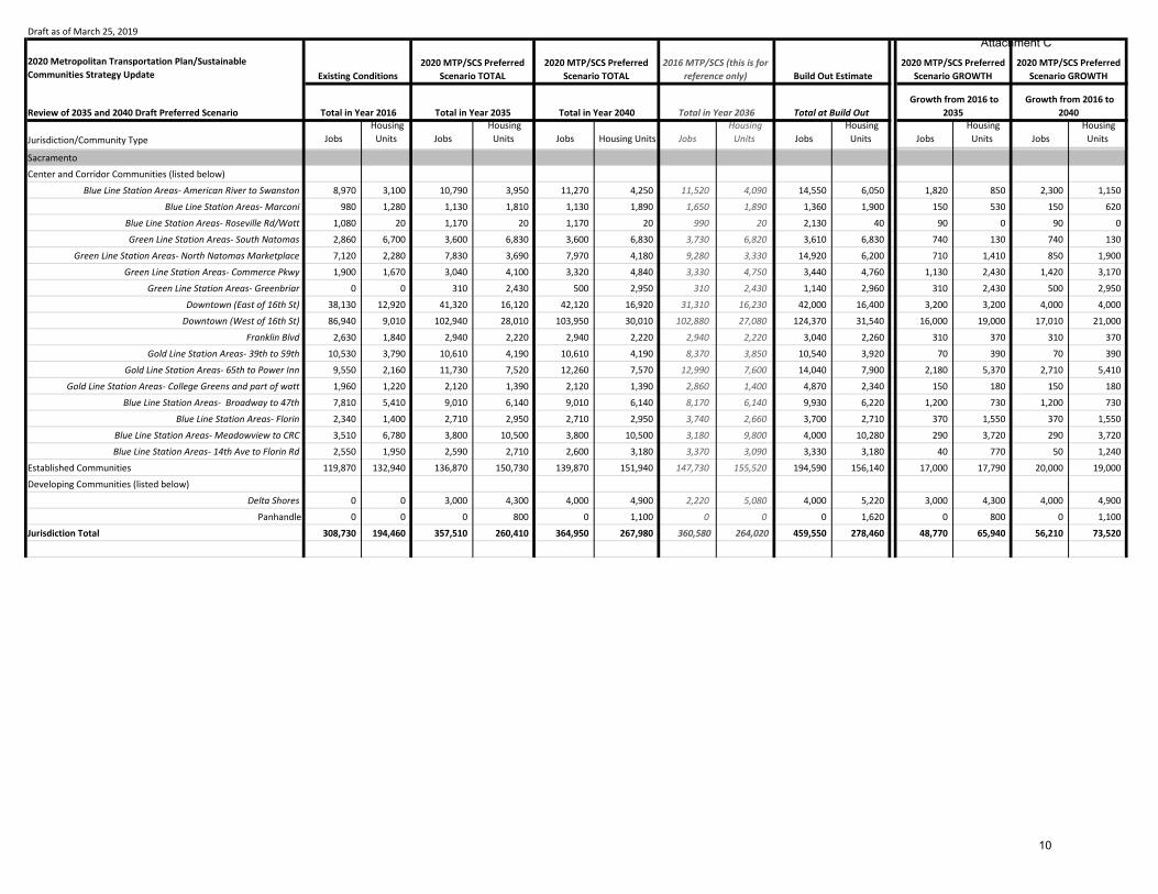
Blue Line Station Areas- American River to Swanston 8,970 3,100 10,790 3,950 11,270 4,250 11,520 4,090 14,550 6,050 1,820 850 2,300 1,150
Blue Line Station Areas- Marconi 980 1,280 1,130 1,810 1,130 1,890 1,650 1,890 1,360 1,900 150 530 150 620
Blue Line Station Areas- Roseville Rd/Watt 1,080 20 1,170 20 1,170 20 990 20 2,130 40 90 0 90 0
Green Line Station Areas- South Natomas 2,860 6,700 3,600 6,830 3,600 6,830 3,730 6,820 3,610 6,830 740 130 740 130
Green Line Station Areas- North Natomas Marketplace 7,120 2,280 7,830 3,690 7,970 4,180 9,280 3,330 14,920 6,200 710 1,410 850 1,900
Green Line Station Areas- Commerce Pkwy 1,900 1,670 3,040 4,100 3,320 4,840 3,330 4,750 3,440 4,760 1,130 2,430 1,420 3,170
Green Line Station Areas- Greenbriar 0 0 310 2,430 500 2,950 310 2,430 1,140 2,960 310 2,430 500 2,950
Downtown (East of 16th St) 38,130 12,920 41,320 16,120 42,120 16,920 31,310 16,230 42,000 16,400 3,200 3,200 4,000 4,000
Downtown (West of 16th St) 86,940 9,010 102,940 28,010 103,950 30,010 102,880 27,080 124,370 31,540 16,000 19,000 17,010 21,000
Franklin Blvd 2,630 1,840 2,940 2,220 2,940 2,220 2,940 2,220 3,040 2,260 310 370 310 370
Gold Line Station Areas- 39th to 59th 10,530 3,790 10,610 4,190 10,610 4,190 8,370 3,850 10,540 3,920 70 390 70 390
Gold Line Station Areas- 65th to Power Inn 9,550 2,160 11,730 7,520 12,260 7,570 12,990 7,600 14,040 7,900 2,180 5,370 2,710 5,410
Gold Line Station Areas- College Greens and part of watt 1,960 1,220 2,120 1,390 2,120 1,390 2,860 1,400 4,870 2,340 150 180 150 180
Blue Line Station Areas- Broadway to 47th 7,810 5,410 9,010 6,140 9,010 6,140 8,170 6,140 9,930 6,220 1,200 730 1,200 730
Blue Line Station Areas- Florin 2,340 1,400 2,710 2,950 2,710 2,950 3,740 2,660 3,700 2,710 370 1,550 370 1,550
Blue Line Station Areas- Meadowview to CRC 3,510 6,780 3,800 10,500 3,800 10,500 3,180 9,800 4,000 10,280 290 3,720 290 3,720
Blue Line Station Areas- 14th Ave to Florin Rd 2,550 1,950 2,590 2,710 2,600 3,180 3,370 3,090 3,330 3,180 40 770 50 1,240
Established Communities 119,870 132,940 136,870 150,730 139,870 151,940 147,730 155,520 194,590 156,140 17,000 17,790 20,000 19,000
Developing Communities (listed below)
Delta Shores 0 0 3,000 4,300 4,000 4,900 2,220 5,080 4,000 5,220 3,000 4,300 4,000 4,900
Panhandle 0 0 0 800 0 1,100 0 0 0 1,620 0 800 0 1,100
Jurisdiction Total 308,730 194,460 357,510 260,410 364,950 267,980 360,580 264,020 459,550 278,460 48,770 65,940 56,210 73,520
Attachment C
10

Draft as of March 25, 2019
2020 Metropolitan Transportation Plan/Sustainable Communities Strategy Update
Review of 2035 and 2040 Draft Preferred Scenario Total in Year 2035 Total in Year 2040
Jurisdiction/Community Type Jobs Housing
Units Jobs Housing
Units Jobs Housing Units Jobs Housing
Units Jobs Housing
Units Jobs Housing
Units Jobs Housing
Units
2020 MTP/SCS Preferred Scenario GROWTH
Total in Year 2016 Total in Year 2036 Total at Build Out Growth from 2016 to
2035 Growth from 2016 to
2040
2020 MTP/SCS Preferred Scenario GROWTHExisting Conditions
2020 MTP/SCS Preferred Scenario TOTAL
2020 MTP/SCS Preferred Scenario TOTAL
2016 MTP/SCS (this is for reference only) Build Out Estimate
Sacramento County Unincorporated
Center and Corridor Communities (listed below)
Auburn Blvd North/Madison Ave 8,090 400 9,390 890 9,800 1,090 9,800 1,090 11,940 1,300 1,300 500 1,710 690
Blue Line Station Areas- Roseville Rd/Watt 3,210 130 3,760 730 3,900 800 3,900 800 4,210 2,400 550 600 690 670 Fair Oaks Blvd West- Howe to Fulton 6,230 2,800 6,610 2,930 6,710 2,930 6,710 2,930 6,890 2,930 380 140 480 140
Fair Oaks Blvd Central- El Camino to Winding 6,120 3,700 7,070 4,400 7,320 4,560 7,820 4,560 10,290 5,210 950 700 1,200 860 Fair Oaks Blvd East- Fair Oaks Village 2,320 1,050 2,800 1,290 2,920 1,290 2,730 1,290 3,000 1,290 480 250 600 250
Florin Rd 8,080 1,530 8,830 2,420 9,030 2,700 8,400 2,710 12,490 6,930 750 900 950 1,180
Franklin Blvd 2,590 2,210 3,800 3,100 4,090 3,360 5,010 3,360 5,680 3,790 1,200 890 1,500 1,150
Fulton Ave 6,980 800 7,930 830 8,180 830 8,640 830 8,880 1,040 950 20 1,200 20
Gold Line Station Areas- Watt to Butterfield 12,020 4,990 14,790 7,640 15,460 8,060 15,490 9,570 16,960 8,000 2,760 2,650 3,430 3,080
Gold Line Station Areas- Hazel/Easton 1,470 580 3,760 2,590 4,270 2,790 5,860 2,120 19,410 2,800 2,300 2,010 2,800 2,220
Gold Line Station Areas- Folsom Blvd 0 0 0 0 0 0 0 0 1,210 0 0 0 0 0
Greenback Ln 4,050 2,060 4,340 2,260 4,500 2,400 4,500 2,400 4,640 2,400 300 200 460 340
Stockton Blvd- 14th Ave to Florin Rd 420 800 430 1,120 430 1,160 400 1,160 430 1,160 10 320 10 360
Stockton Blvd- Florin Rd to Mack Rd 3,570 2,940 4,360 3,890 4,660 4,580 4,900 4,240 5,630 5,830 800 950 1,090 1,650
Watt Ave Central- Auburn to Arden 9,460 2,470 12,460 2,920 13,280 3,200 13,280 3,200 13,420 3,200 3,000 450 3,810 740
North Watt and West of Watt 4,870 1,390 6,570 4,090 6,970 4,990 7,620 4,970 12,230 7,000 1,700 2,700 2,100 3,600
Established Communities 111,390 173,310 128,390 179,810 134,390 180,060 128,650 182,720 202,420 189,160 17,000 6,500 23,000 6,750
Vineyard 1,760 4,670 1,760 5,070 1,760 5,150 1,550 5,350 1,800 6,610 0 400 0 480
Rural Residential Communities (includes agricultural areas) 8,380 13,390 8,580 13,500 8,680 13,540 12,460 14,310 15,540 18,370 200 100 300 150
Developing Communities (listed below)
Elverta 20 80 170 2,080 220 2,580 360 1,510 400 5,630 150 2,000 200 2,500
Florin Vineyard 1,430 560 1,510 960 1,530 1,040 1,530 2,580 6,240 9,920 80 400 100 480
Glenborough at Easton 10 0 670 3,230 810 3,230 1,780 3,270 1,800 3,240 660 3,230 800 3,230
North Vineyard Station 120 990 230 2,890 370 3,390 380 3,420 560 6,060 110 1,900 250 2,400
Mather South 0 0 0 1,440 260 1,810 260 1,030 5,080 3,530 0 1,440 260 1,810
Vineyard Springs 650 2,400 730 2,800 750 2,880 760 3,820 760 6,540 80 400 100 480
Cordova Hills 0 0 0 1,100 0 2,000 0 0 13,560 8,000 0 1,100 0 2,000
Projects Not Identified for Growth in the 2020 MTP/SCS by 2040 (listed below)
West Jackson 1,230 150 1,230 150 1,230 150 4,030 5,140 32,840 14,760 0 0 0 0
Jackson Township 10 180 10 180 10 180 0 0 8,040 6,140 0 0 0 0
Newbridge 140 20 140 20 140 20 0 0 2,560 3,080 0 0 0 0Natomas North Precinct 20 30 20 30 20 30 0 0 14,350 23,520 0 0 0 0Upper West Side 0 0 0 0 0 0 0 0 0 0 0 0 0 0
Jurisdiction Total 204,630 223,600 240,320 254,370 251,700 260,800 256,830 268,370 443,250 359,830 35,690 30,780 47,060 37,210
SACRAMENTO COUNTY TOTAL 688,510 570,360 812,280 705,190 839,890 724,860 831,160 731,360 1,260,030 906,440 123,770 134,830 151,380 154,500
The shaded rows highlight communities that are moving from the "Developing Communities" category to the "Established Communities". These communities will be included in the Established Community total andnot called out individually in the future.
Attachment C
11
Draft as of March 25, 2019
2020 Metropolitan Transportation Plan/Sustainable Communities Strategy Update
Review of 2035 and 2040 Draft Preferred Scenario Total in Year 2035 Total in Year 2040
Jurisdiction/Community Type Jobs Housing
Units Jobs Housing
Units Jobs Housing Units Jobs Housing
Units Jobs Housing
Units Jobs Housing
Units Jobs Housing
Units
2020 MTP/SCS Preferred Scenario GROWTH
Total in Year 2016 Total in Year 2036 Total at Build Out Growth from 2016 to
2035 Growth from 2016 to
2040
2020 MTP/SCS Preferred Scenario GROWTHExisting Conditions
2020 MTP/SCS Preferred Scenario TOTAL
2020 MTP/SCS Preferred Scenario TOTAL
2016 MTP/SCS (this is for reference only) Build Out Estimate
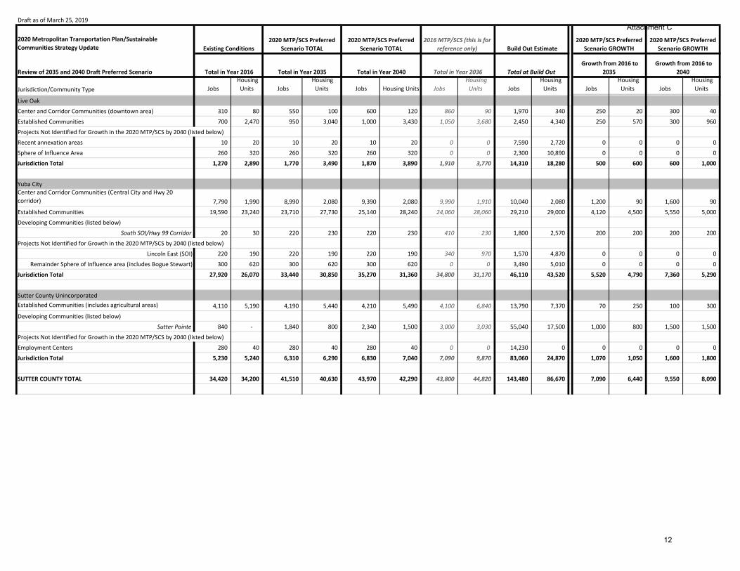
Live Oak
Center and Corridor Communities (downtown area) 310 80 550 100 600 120 860 90 1,970 340 250 20 300 40
Established Communities 700 2,470 950 3,040 1,000 3,430 1,050 3,680 2,450 4,340 250 570 300 960
Projects Not Identified for Growth in the 2020 MTP/SCS by 2040 (listed below)
Recent annexation areas 10 20 10 20 10 20 0 0 7,590 2,720 0 0 0 0
Sphere of Influence Area 260 320 260 320 260 320 0 0 2,300 10,890 0 0 0 0
Jurisdiction Total 1,270 2,890 1,770 3,490 1,870 3,890 1,910 3,770 14,310 18,280 500 600 600 1,000
Yuba CityCenter and Corridor Communities (Central City and Hwy 20 corridor) 7,790 1,990 8,990 2,080 9,390 2,080 9,990 1,910 10,040 2,080 1,200 90 1,600 90
Established Communities 19,590 23,240 23,710 27,730 25,140 28,240 24,060 28,060 29,210 29,000 4,120 4,500 5,550 5,000
Developing Communities (listed below)
South SOI/Hwy 99 Corridor 20 30 220 230 220 230 410 230 1,800 2,570 200 200 200 200
Projects Not Identified for Growth in the 2020 MTP/SCS by 2040 (listed below)
Lincoln East (SOI) 220 190 220 190 220 190 340 970 1,570 4,870 0 0 0 0
Remainder Sphere of Influence area (includes Bogue Stewart) 300 620 300 620 300 620 0 0 3,490 5,010 0 0 0 0
Jurisdiction Total 27,920 26,070 33,440 30,850 35,270 31,360 34,800 31,170 46,110 43,520 5,520 4,790 7,360 5,290
Sutter County UnincorporatedEstablished Communities (includes agricultural areas) 4,110 5,190 4,190 5,440 4,210 5,490 4,100 6,840 13,790 7,370 70 250 100 300
Developing Communities (listed below)
Sutter Pointe 840 - 1,840 800 2,340 1,500 3,000 3,030 55,040 17,500 1,000 800 1,500 1,500
Projects Not Identified for Growth in the 2020 MTP/SCS by 2040 (listed below)
Employment Centers 280 40 280 40 280 40 0 0 14,230 0 0 0 0 0
Jurisdiction Total 5,230 5,240 6,310 6,290 6,830 7,040 7,090 9,870 83,060 24,870 1,070 1,050 1,600 1,800
SUTTER COUNTY TOTAL 34,420 34,200 41,510 40,630 43,970 42,290 43,800 44,820 143,480 86,670 7,090 6,440 9,550 8,090
Attachment C
12

Draft as of March 25, 2019
2020 Metropolitan Transportation Plan/Sustainable Communities Strategy Update
Review of 2035 and 2040 Draft Preferred Scenario Total in Year 2035 Total in Year 2040
Jurisdiction/Community Type Jobs Housing
Units Jobs Housing
Units Jobs Housing Units Jobs Housing
Units Jobs Housing
Units Jobs Housing
Units Jobs Housing
Units
2020 MTP/SCS Preferred Scenario GROWTH
Total in Year 2016 Total in Year 2036 Total at Build Out Growth from 2016 to
2035 Growth from 2016 to
2040
2020 MTP/SCS Preferred Scenario GROWTHExisting Conditions
2020 MTP/SCS Preferred Scenario TOTAL
2020 MTP/SCS Preferred Scenario TOTAL
2016 MTP/SCS (this is for reference only) Build Out Estimate
Davis
Center and Corridor Communities (listed below)
Core Area 6,490 1,830 7,000 2,480 7,120 2,630 6,190 2,250 4,500 750 500 650 630 800
Nishi 0 0 0 700 0 700 410 600 1,500 700 0 700 0 700
Established Communities 17,270 25,020 18,070 26,670 18,270 27,320 13,740 26,480 18,000 27,350 810 1,650 1,000 2,300
Jurisdiction Total 23,760 26,850 25,070 29,850 25,390 30,660 20,340 29,330 24,000 28,800 1,310 3,000 1,620 3,810
West Sacramento
Center and Corridor Communities (listed below)
Bridge District 520 390 3,720 4,090 4,520 4,390 7,570 4,570 13,720 4,570 3,200 3,700 4,000 4,000
Pioneer Bluff 980 - 1,580 1,010 2,590 1,700 3,390 1,680 7,500 3,700 600 1,010 1,600 1,700
Washington 2,980 1,150 3,880 2,950 4,080 3,150 4,430 3,090 5,690 3,080 900 1,800 1,100 2,000
remaining center and corridor area 1,990 1,020 2,340 1,720 2,490 2,020 3,350 3,970 21,290 7,340 350 700 500 1,000
Established Communities 25,020 16,820 29,720 20,620 30,920 20,620 31,520 20,660 38,440 20,640 4,700 3,800 5,900 3,800
Developing Communities (listed below)
Liberty 20 20 70 1,520 70 1,520 90 530 70 1,500 50 1,500 50 1,500
Southport Industrial Park 1,590 230 4,290 430 5,000 430 5,010 430 5,010 1,380 2,700 200 3,400 200
River Park 10 40 10 40 10 840 0 0 unknown 2,790 0 0 0 800
Yarborough 20 60 60 1,060 60 1,460 0 0 unknown 3,000 40 1,000 40 1,400
Jurisdiction Total 33,120 19,730 45,670 33,430 49,720 36,130 55,360 34,930 91,710 48,000 12,550 13,700 16,600 16,400
Winters
Center and Corridor Communities (Downtown Master Plan area) 100 50 200 50 220 50 180 40 200 60 100 0 120 0
Established Communities 2,180 2,350 2,790 3,150 2,940 3,310 2,940 3,300 4,940 4,250 610 800 760 960
Projects Not Identified for Growth in the 2020 MTP/SCS by 2040 (listed below)
Sphere of Influence Area 0 0 0 0 0 0 0 0 unknown unknown 0 0 0 0
Jurisdiction Total 2,280 2,400 2,990 3,200 3,160 3,370 3,120 3,340 5,140 4,310 710 800 880 960
0 0 0 0 0 0 0 0 0 0 0 0 0 0
Woodland 0 0 0 0 0 0 0 0 0 0 0 0 0 0Center and Corridor Communities (Downtown and East St Corridor Plan areas) 3,620 730 3,870 2,020 3,910 2,040 3,390 1,350 4,740 2,040 250 1,300 300 1,320
Established Communities 21,140 18,150 26,540 18,780 27,840 18,780 28,400 18,780 43,140 18,780 5,400 630 6,700 640
Developing Communities (listed below)
Spring Lake Master Plan 1,400 1,640 1,600 4,180 1,600 4,180 1,240 4,050 1,600 4,180 210 2,540 210 2,540
Woodland Research and Technology Park 0 0 800 0 1,000 200 0 0 6,000 1,600 800 0 1,000 200
Projects Not Identified for Growth in the 2020 MTP/SCS by 2040 (listed below)
Gateway Corridor 0 0 0 0 0 0 0 0 2,000 350 0 0 0 0
New Growth Area SP-1 (minus research and technology park) 0 0 0 0 0 0 0 0 400 600 0 0 0 0New Growth Area SP-2 0 0 0 0 0 0 0 0 unknown 1,600 0 0 0 0New Growth Area SP-3 0 0 0 0 0 0 0 0 unknown 250 0 0 0 0
Jurisdiction Total 26,160 20,510 32,810 24,980 34,360 25,210 33,030 24,180 57,490 29,400 6,660 4,470 8,210 4,700
Attachment C
13

Draft as of March 25, 2019
2020 Metropolitan Transportation Plan/Sustainable Communities Strategy Update
Review of 2035 and 2040 Draft Preferred Scenario Total in Year 2035 Total in Year 2040
Jurisdiction/Community Type Jobs Housing
Units Jobs Housing
Units Jobs Housing Units Jobs Housing
Units Jobs Housing
Units Jobs Housing
Units Jobs Housing
Units
2020 MTP/SCS Preferred Scenario GROWTH
Total in Year 2016 Total in Year 2036 Total at Build Out Growth from 2016 to
2035 Growth from 2016 to
2040
2020 MTP/SCS Preferred Scenario GROWTHExisting Conditions
2020 MTP/SCS Preferred Scenario TOTAL
2020 MTP/SCS Preferred Scenario TOTAL
2016 MTP/SCS (this is for reference only) Build Out Estimate
Yolo County UnincorporatedCenter and Corridor Communities (UC Davis) 12,580 1,530 14,710 4,140 15,070 4,230 24,210 3,380 15,070 4,230 2,130 2,600 2,500 2,700 Established Communities (includes agricultural areas) 6,850 6,680 7,500 6,760 7,650 6,780 9,680 7,600 12,500 8,220 650 80 800 100
Jurisdiction Total 19,430 8,210 22,210 10,890 22,720 11,010 33,890 10,990 27,570 12,450 2,780 2,680 3,300 2,800
YOLO COUNTY TOTAL 104,740 77,710 128,750 102,360 135,350 106,370 145,740 102,770 205,910 122,970 24,010 24,650 30,610 28,660
Attachment C
14

Draft as of March 25, 2019
2020 Metropolitan Transportation Plan/Sustainable Communities Strategy Update
Review of 2035 and 2040 Draft Preferred Scenario Total in Year 2035 Total in Year 2040
Jurisdiction/Community Type Jobs Housing
Units Jobs Housing
Units Jobs Housing Units Jobs Housing
Units Jobs Housing
Units Jobs Housing
Units Jobs Housing
Units
2020 MTP/SCS Preferred Scenario GROWTH
Total in Year 2016 Total in Year 2036 Total at Build Out Growth from 2016 to
2035 Growth from 2016 to
2040
2020 MTP/SCS Preferred Scenario GROWTHExisting Conditions
2020 MTP/SCS Preferred Scenario TOTAL
2020 MTP/SCS Preferred Scenario TOTAL
2016 MTP/SCS (this is for reference only) Build Out Estimate
MarysvilleCenter and Corridor Communities (Downtown Economic Development Strategic Plan area) 3,140 390 3,290 410 3,340 410 3,300 420 3,340 440 150 20 200 20
Established Communities 4,610 5,060 4,980 5,280 5,070 5,280 6,290 5,290 6,200 5,360 370 220 460 220
Jurisdiction Total 7,750 5,450 8,270 5,690 8,410 5,690 9,590 5,710 9,540 5,790 520 240 660 240
Wheatland
Center and Corridor Communities (dowtown area) 70 110 70 110 70 110 60 100 70 110 0 0 0 0
Established Communities 730 1,220 880 1,440 930 1,570 900 1,570 760 1,670 150 220 200 350
Developing Communities (listed below)
Jones Ranch and Heritage Oaks 10 10 310 510 410 750 490 750 1,290 1,320 300 500 400 740
Projects Not Identified for Growth in the 2020 MTP/SCS by 2040 (listed below)
Nichols Grove 0 10 0 10 0 10 0 0 240 1,810 0 0 0 0
Hop Farm/Johnson Rancho 10 80 10 80 10 80 0 0 7,860 14,400 0 0 0 0
Rodden Ranch 0 0 0 0 0 0 0 0 0 370 0 0 0 0
Jurisdiction Total 810 1,420 1,260 2,140 1,410 2,510 1,460 2,420 10,230 19,680 450 720 600 1,090
Yuba County Unincorporated
Center and Corridor Communities (listed below)North Beale Corridor Reinvestmant Plan area 590 150 880 210 990 210 1,180 180 1,180 210 300 50 400 50
Olivehurst Ave 250 200 310 250 310 250 310 250 550 450 60 50 60 50
Established Communities 3,420 6,960 4,070 7,380 4,220 7,460 4,640 8,140 6,060 10,520 650 420 800 500
Established Communities-Beale AFB 3,550 820 4,650 920 4,950 920 4,550 620 5,550 1,000 1,100 100 1,400 100
Developing Communities (listed below)
East Linda 290 2,410 940 4,110 1,090 4,410 1,560 4,440 4,430 6,010 650 1,700 800 2,000
North Arboga Study Area 280 1,150 280 1,380 500 1,420 550 1,420 2,560 2,500 0 230 220 270
Plumas Lake 700 2,730 1,400 4,280 2,100 4,530 2,560 4,890 16,180 18,130 700 1,550 1,400 1,800
Highway 65 Employment Center 560 50 1,060 50 1,950 50 2,720 40 23,730 50 500 0 1,400 0
Rural Residential Communities (includes agricultural areas) 3,220 7,040 3,220 7,120 3,230 7,140 3,380 7,880 5,090 12,880 0 80 10 100
Jurisdiction Total 12,850 21,510 16,810 25,690 19,330 26,390 21,450 27,860 65,330 51,750 3,970 4,180 6,480 4,880
YUBA COUNTY TOTAL 21,410 28,380 26,340 33,520 29,150 34,590 32,500 36,000 85,090 77,230 4,930 5,140 7,750 6,210
Attachment C
15

Draft as of March 25, 2019
2020 Metropolitan Transportation Plan/Sustainable Communities Strategy Update
Review of 2035 and 2040 Draft Preferred Scenario Total in Year 2035 Total in Year 2040
Jurisdiction/Community Type Jobs Housing
Units Jobs Housing
Units Jobs Housing Units Jobs Housing
Units Jobs Housing
Units Jobs Housing
Units Jobs Housing
Units
2020 MTP/SCS Preferred Scenario GROWTHExisting Conditions
2020 MTP/SCS Preferred Scenario TOTAL
2020 MTP/SCS Preferred Scenario TOTAL
2016 MTP/SCS (this is for reference only) Build Out Estimate
Total in Year 2016 Total in Year 2036 Total at Build Out Growth from 2016 to
2035 Growth from 2016 to
2040
2020 MTP/SCS Preferred Scenario GROWTH
Region Total 1,060,530 921,110 1,278,800 1,144,660 1,330,590 1,181,240 1,327,280 1,187,870 2,168,600 1,582,150 218,260 223,550 270,060 260,130 Center and Corridor Communities 368,600 113,470 437,180 187,650 451,450 200,130 459,260 193,780 581,660 224,190 68,590 74,180 82,850 86,660 Established Communities 645,490 711,480 763,630 785,810 789,440 792,420 754,640 792,410 1,063,930 848,480 119,230 74,530 145,050 81,140 Developing Communities 12,150 20,470 41,780 93,140 52,910 110,020 66,530 108,390 301,690 231,270 29,630 72,660 40,760 89,540 Rural Residential Communities 30,280 73,820 31,100 76,000 31,680 76,610 39,440 83,950 73,200 122,240 820 2,180 1,400 2,790 Projects Not Identified for Growth in the 2020 MTP/SCS Discussion Draft by 2040 2,620 1,850 2,620 1,850 2,620 1,850 4,860 9,140 144,020 155,310 n/a n/a n/a n/a
Attachment C
16

Attachment D: Draft Revenue Forecast for the 2020 MTP/SCS
2019‐2029 2030‐2040 Total Notes
Federal Highway Administration funds including
formula funds that pay for SACOG's regional
funding programs (CMAQ & RSTP) and other
federal discretionary programs funded through
the Highway Trust Fund
$1.0 $1.0 $2.0
Federal transit programs that come to the
region and/or directly to transit operators
including formula funds and federal
discretionary programs such as New Starts
$0.7 $0.9 $1.6
Federal Subtotal $1.7 $1.9 $3.6
Caltrans funding for state system expansion and
preservation including SHOPP funding, highway
maintenance, the Highway Bridge Program, and
the Interregional Improvement Program
$3.8 $3.3 $7.1
State transportation funding programs are dependent on transfers from the Federal Trust
Fund and statewide diesel and gasoline taxes that feed the State Highway and Public
Transportation Accounts. The increase over the 2016 MTP/SCS is due to an infusion of
SB1 funds into the State Highway Operation and Protection Program (SHOPP). However,
vehicle fuel efficiency improvements over time diminish the funding available to the
program in the latter half of the MTP/SCS.
State discretionary grant programs $0.4 $0.4 $0.7State discretionary programs include the Active Transportation and other statewide
competitive programs.
State Transportation Improvement Program
(STIP) funds that contribute to SACOG's regional
funding programs
$0.3 $0.3 $0.5
Funding for the STIP comes from a combination of revenues generated by state taxes on
gasoline and diesel. Changes to the state's fuel taxes by SB1 have stabilized funding for
the STIP, however funding has not kept pace with prior MTP/SCS forecasts and is likely to
continue to decrease over time as consumption of gasoline and diesel decrease over
time.
State Transit Assistance program that flows
directly to transit operators$0.3 $0.2 $0.5
The State Transit Assistance Program is primarily funded from state taxes on diesel fuel.
However, SB1 created a State of Good Repair Program that directs some of the funding
from the state's new taxes on gasoline to transit agencies to help maintain vehicles and
facilities. Overall funding remains stable from the last MTP/SCS, but reduces in the latter
half of the plan as fuel consumption decreases.
State Cap and Trade Program $0.2 $0.4 $0.6
In July of 2017, the California legislature voted to extend the state’s cap and trade
program beyond 2020. However, auction proceeds are less than previously anticipated
likely due to a large supply of emissions allowances that keep prices low. It's likely that
this oversupply will reduce in future years and the program will generate additional
revenue that will be distributed through it's competitive programs. SACOG's share of
these funds depends on the success of grant applications to programs including the
Affordable Housing and Sustainable Communities Program and Low Carbon Transit
Operations Program.
Green Means Go Pilot Program $0.4 $0.0 $0.4
State funding to help implement a multi‐year pilot program to lower greenhouse gas
emissions in the six‐county Sacramento region by accelerating infill development,
reducing vehicle trips, and electrifying remaining trips.
State Subtotal $5.3 $4.5 $9.8
Federal Highway and Transit Trust Funds are dependent on the 18.4 cent federal excise
tax on fuel. Improvements to average fuel economy of passenger and freight vehicles
have eroded the purchasing power of this funding source over time and required
transfers from the general fund to maintain the accounts' solvency. The draft revenue
forecast assumes the federal government will maintain solvency in the general fund,
consistent with prior actions, and that federal funds will keep pace with inflation in the
long‐term.
FTA funds increased slightly over the 2016 MTP/SCS because of the addition of Woodland
as an urbanized area and the federal Small Transit Intensive Cities program that increased
formula funds that come to the region.
Federal Funding
2020 MTP/SCS Draft Preferred Scenario
(in billions of 2018 dollars)
State Funding

Attachment D: Draft Revenue Forecast for the 2020 MTP/SCS
2019‐2029 2030‐2040 Total Notes
2020 MTP/SCS Draft Preferred Scenario
(in billions of 2018 dollars)
Non‐SB1 fuel tax subventions $1.1 $1.0 $2.1
Includes the portion of the non‐SB1 state excise taxes on gasoline that are allocated to
local jurisdictions. Total funding available reduces over time as fuel consumption
decreases.
SB1 Road Maintenance and Rehabilitation
Account (Sec. 2031)$1.2 $1.2 $2.5
Includes the local streets and roads share of the SB1 excise tax on gasoline and
registration fees.
Local Transportation Fund (LTF) $1.2 $1.2 $2.4
The Local Transportation Fund is derived from 1/4 cent of the statewide sales and use tax
that is dedicated to transportation purposes. Sales tax receipts following the recovery
from the recession have exceeded previous forecasts, however the increase in this fund
source is largely due to underestimating the share of LTF funds received by Placer and El
Dorado Counties in the last MTP/SCS.
Sacramento County Measure A $1.4 $1.5 $2.9
Similar to the Local Transportation Fund, sales tax receipts have outpaced the forecast of
the previous MTP/SCS. While the draft forecast assumes slightly slower growth over the
course of the plan compared to the previous MTP/SCS, total receipts in the last several
years have been as much as 10% higher than we forecasted.
Sacramento County New Measure A $0.6 $1.5 $2.0
The Sacramento Transportation Authority (STA) is responsible for the new sales tax
measure in Sacramento County. SACOG will work with STA to determine how to account
for the new measure in the MTP/SCS.
Placer County Sales Tax $0.3 $0.6 $0.9
PCTPA is responsible for the planning assumptions for the new measure in Placer County.
SACOG will coordinate with PCTPA to determine how to account for a potential Placer
County tax in the plan. The reduced revenue in this plan update is due to districting of the
sales tax measure that would limit the measure to a portion of the county.
Locally derived streets and roads funding
(developer fees, general fund contributions,
special assessments, etc.)
$3.1 $3.0 $6.1
Locally derived revenues are based on a combination of historic allocations reported to
the state controller and growth in new land use developments forecast for the MTP/SCS.
Less growth overall in population, housing, and employment affect the total locally
derived funding available in the MTP/SCS. Additionally, local funding reported to the state
controller has not kept pace with the forecasts in the prior MTP/SCS.
Transit Fares $0.6 $0.9 $1.5
Transit fare revenues will be based on modeled ridership and forecasted average fares.
The total transit fares ultimately included in the plan will depend on the phasing of transit
service and expansion. The reduction in transit fare revenue in the draft forecast relates
to phasing of transit service expansion later in the plan.
Local Subtotal $9.5 $10.9 $20.4
TOTAL BASE REVENUES $23.7 $23.6 $47.3
New
Funding
System Pricing $0.0 $1.0‐3.5 $1.0‐3.5
Revenues generated through system pricing strategies including:
Express Lanes:
Express Lanes may be free to carpools and buses, but allow single drivers the choice to
pay for the use of the lanes. The purpose of these lanes is to improve traffic
management, reliability, and even throughput of the region’s major freeways. Potential
corridors include U.S. Route 50, Interstates 80 and 5, and State Routes 51 (Capital City
Freeway), 99, and 65. Express lane concepts may include single, high‐occupancy toll lanes
or multilane configurations that add lanes or re‐purpose existing lanes or shoulders. Tolls
for the lanes can vary based on traffic levels and time of day.
Pay as you go or mileage‐based fees:
Mileage‐based or pay as you go fees charge roadway users based on the miles they travel
on public roadways, rather than on the amount of fuel they purchase. Fees that are
lower during off‐peak hours or in less congested rural areas may be considered in order
to manage the transportation network efficiently and promote geographic equity.
TOTAL REVENUES WITH PRICING $16.6 $18.2‐$20.7 $34.8‐$37.3
Local Funding

Attachment E‐ Transportation Project List
Projects listed as "Project Development Only" are anticipated to begin early stages of development including project planning, design, preliminary engineering, environmental clearance, and ROW acquisitionby 2040. These projects remain eligible to seek federal and state funding, but under the financial constraint requirements for forecasting revenues, the construction phase is not included in the Draft PreferredScenario. If/when additional revenues for these projects become available to cover full construction costs, these projects can be considered as part of an amendment to the MTP/SCS following a technicalanalysis and reviewing consistency with plan requirements.
Project ID
Preferred ScenarioStatus (Yes, No,
ProjectDevelopment Only)
County Lead Agency Budget Category Title DescriptionTotal Project Cost
(2018 Dollars)
CAL21121ProjectDevelopment Only ELD Caltrans D3
G‐ System Management,Operations, and ITS Aux Lane Project: EB Latrobe Road US‐50 EB Latrobe Rd to Silva Valley (T); US 50 1,500,000
CAL21120 No ELD Caltrans D3G‐ System Management,Operations, and ITS
Aux Lane Project: WB El DoradoHills Blvd US‐50 WB El Dorado Hills Blvd to Empire Ranch (T) 1,500,000
ELD19290ProjectDevelopment Only ELD Caltrans D3
B‐ Road & HighwayCapacity
Cameron Park Drive to PonderosaRoad
Managed Lane facility ‐ Phase 2B (project description maychange based on results from the Managed Lanes Study.Project is being evaluated for Expressed Toll Lanes, HighOccupancy Toll Lanes, HOV lanes) 22,637,000
Cal287 Yes ELD Caltrans D3C‐ Maintenance &Rehabilitation Deck Treatments on 6 Bridges Deck Treatments on 6 Bridges 484,000
CAL21124 Yes ELD Caltrans D3G‐ System Management,Operations, and ITS
EB Bass Lake Rd. Diagonal RampMeter EB Bass Lake Rd. Diagonal Ramp Meter 380,000
CAL21125 Yes ELD Caltrans D3G‐ System Management,Operations, and ITS
EB Cambridge Rd. Loop RampMeter EB Cambridge Rd. Loop Ramp Meter 380,000
CAL21126 Yes ELD Caltrans D3G‐ System Management,Operations, and ITS
EB Cameron Park Dr. DiagonalRamp Meter EB Cameron Park Dr. Diagonal Ramp Meter 380,000
CAL21122 Yes ELD Caltrans D3G‐ System Management,Operations, and ITS
EB Latrobe Rd. Diagonal RampMeter EB Latrobe Rd. Diagonal Ramp Meter 380,000
CAL21127 Yes ELD Caltrans D3G‐ System Management,Operations, and ITS
EB Ponderosa Rd. / S. Shingle Rd.Loop Ramp Meter EB Ponderosa Rd. / S. Shingle Rd. Loop Ramp Meter 380,000
CAL21128 Yes ELD Caltrans D3G‐ System Management,Operations, and ITS
EB Shingle Springs Dr. DiagonalRamp Meter EB Shingle Springs Dr. Diagonal Ramp Meter 380,000
CAL20954 Yes ELD Caltrans D3C‐ Maintenance &Rehabilitation ED 50 Apple Hill Pavement Rehab
In and near Placerville, from westbound on‐ramp at SchnellSchool Rd OC (Br#25‐0063) to 0.3 mi east of Sly Park Rd UC(Br#25‐0150). 71,682,000

Attachment E‐ Transportation Project List
CAL21009 Yes ELD Caltrans D3C‐ Maintenance &Rehabilitation
ED 50 Echo Summit pavementrehab
In El Dorado County from Sierra‐At‐Tahoe Road to Pioneer Trailin Meyers. 28,588,000
CAL21044 Yes ELD Caltrans D3C‐ Maintenance &Rehabilitation
ED 50 Ice House Rd pavementrehab
In El Dorado County on Route 50 from Ice House Rd to approx.0.1 mile east of Wrights Lake Rd. 14,900,000
CAL20877 Yes ELD Caltrans D3C‐ Maintenance &Rehabilitation
ED 50 Kyburz Storm DamageRepair
In El Dorado County on Hwy 50 in the town of Kyburz. RepairRock wall from culvert damage. Permanent Restoration. 620,000
CAL21056 Yes ELD Caltrans D3C‐ Maintenance &Rehabilitation ED 50 Riverton Drainage rehab
In El Dorado County 0.2 mile east of Sly Park Rd UC to 0.1 milewest of Sand Flat Campground. 14,000,000
CAL21037 Yes ELD Caltrans D3C‐ Maintenance &Rehabilitation
ED 50 Shingle Springs PavementRehab
In El Dorado County on Route 50 from Cambrdge Rd OC (Br#25‐0083) to on‐ramp from Koto Rd. 14,800,000
CAL20927 Yes ELD Caltrans D3C‐ Maintenance &Rehabilitation
In ED County on Route 49 fromPatterson Dr to Missouri Flat Rd Widen shoulders to 8ft to provide ped/bike access along hwy 900,000
CAL20999 Yes ELD Caltrans D3C‐ Maintenance &Rehabilitation
In El Dorado County from KyburzDr to Strawberry Lodge Dr. CIRw/HMA Overlay.
In El Dorado County from Kyburz Dr to Strawberry Lodge Dr.CIR w/HMA Overlay. 6,200,000
CAL20857 Yes ELD Caltrans D3C‐ Maintenance &Rehabilitation
In El Dorado County on Route 50approx. 0.2 miles west of AlderCreek Road, stabilize the slope toprevent or mitigate further slideactivity
In El Dorado County on Route 50 approx. 0.2 miles west ofAlder Creek Road, stabilize the slope to prevent or mitigatefurther slide activity. EA 3H470. US 50, PM 43.69 4,830,000
CAL20880 Yes ELD Caltrans D3C‐ Maintenance &Rehabilitation
In El Dorado County on Route 50approx. 0.2 miles west of AlderCreek Road, stabilize the slope toprevent or mitigate further slideactivity (EA 3H470)
In El Dorado County on Route 50 approx. 0.2 miles west ofAlder Creek Road, stabilize the slope to prevent or mitigatefurther slide activity 4,830,000
20608 Yes ELD Caltrans D3C‐ Maintenance &Rehabilitation
In El Dorado County on Route 50at the Placerville MaintenanceStation (3065 Blairs Ln,Placerville), install retainingstructure or repair slope andfencing along stream bank (EA3H960)
In El Dorado County on Route 50 at the PlacervilleMaintenance Station (3065 Blairs Ln, Placerville), installretaining structure or repair slope and fencing along streambank (EA 3H960). US 50` 2,570,000
CAL21071 Yes ELD Caltrans D3C‐ Maintenance &Rehabilitation
In El Dorado County on Route 50from approx. 1.0 mile west ofSnow Rd UC (Br#25‐56) to SawmillUC (Br#25‐41). CAPM.
In El Dorado County on Route 50 from approx. 1.0 mile west ofSnow Rd UC (Br#25‐56) to Sawmill UC (Br#25‐41). CAPM. 3,698,000
CAL20926 Yes ELD Caltrans D3C‐ Maintenance &Rehabilitation Install wash facility SLT Maintenance Station 975,000
Project ID
Preferred ScenarioStatus (Yes, No,
ProjectDevelopment Only)
County Lead Agency Budget Category Title DescriptionTotal Project Cost
(2018 Dollars)

Attachment E‐ Transportation Project List
CAL20955 No ELD Caltrans D3B‐ Road & HighwayCapacity
Intersection of US 50 and PioneerTrail (PM 71.48) in the communityof Meyers in South Lake Tahoe ‐construct a roundabout withped/bike crossings, seperatedtravel lane approaches, curb,gutter, sidewalk, traffic signs,stripes and pavement markings.
Intersection of US 50 and Pioneer Trail (PM 71.48) in thecommunity of Meyers in South Lake Tahoe ‐ construct aroundabout with ped/bike crossings, separated travel laneapproaches, curb, gutter, sidewalk, traffic signs, stripes andpavement markings. 3,450,400
CAL21132 Yes ELD Caltrans D3G‐ System Management,Operations, and ITS
NB Cameron Park Dr. Loop RampMeter NB Cameron Park Dr. Loop Ramp Meter 380,000
CAL21018 Yes ELD Caltrans D3C‐ Maintenance &Rehabilitation Placerville MTCE Mechanic shop Placerville Resident Mechanic 2,600,000
ELD19406ProjectDevelopment Only ELD Caltrans D3
B‐ Road & HighwayCapacity
Ponderosa Road to GreenstoneRoad
Managed Lane facility ‐ Phase 3 (project description maychange based on results from the Managed Lanes Study.Project is being evaluated for Expressed Toll Lanes, HighOccupancy Toll Lanes, HOV lanes) 34,730,208
CAL21032 Yes ELD Caltrans D3C‐ Maintenance &Rehabilitation
Repair slipout by construction of amulti‐layered geotextile‐reinforced fill ("bridging element")on Route 50 approx 0.4 mileswest of Forest Road/Fresh Pond
Repair slip out by construction of a multi‐layered geotextile‐reinforced fill ("bridging element") on Route 50 approx. 0.4miles west of Forest Road/Fresh Pond. PM 33.86‐34. EA 3H450 18,410,000
CAL21131 Yes ELD Caltrans D3G‐ System Management,Operations, and ITS
SB Cameron Park Dr. DiagonalRamp Meter US‐50 WB Cameron Park Dr. Diagonal Ramp Meter 380,000
CAL21235 Yes ELD Caltrans D3G‐ System Management,Operations, and ITS
SB Ponderosa Rd. Diagonal RampMeter SB Ponderosa Rd. Diagonal Ramp Meter 380,000
CAL20868 Yes ELD Caltrans D3C‐ Maintenance &Rehabilitation
SR 193 Cool PavementRehabilitation
In El Dorado County on Route 193 from Jct Rte 49 to PilgramRd. 5,700,000
CAL20833 Yes ELD Caltrans D3C‐ Maintenance &Rehabilitation
SR 193 Cutback slope and installslope drainage
Cutback slope and install slope drainage on Route 193 approx0.2 miles west of the Route 49 Jct to approx 0.4 miles west ofthe Route 49 Jct 2,880,000
CAL21052 Yes ELD Caltrans D3C‐ Maintenance &Rehabilitation
SR 193 Georgetown PavementRehabilitation
In El Dorado County on Route 193 from Greenwood Rd to JctSR 49/End of County. 15,400,000
Project ID
Preferred ScenarioStatus (Yes, No,
ProjectDevelopment Only)
County Lead Agency Budget Category Title DescriptionTotal Project Cost
(2018 Dollars)

Attachment E‐ Transportation Project List
CAL20747 Yes ELD Caltrans D3C‐ Maintenance &Rehabilitation SR 193 Slope Stabilization
Near Placerville, on SR 193 at 1.1 miles north of the South ForkAmerican River Bridge (PM 22.8/22.9); also at 2.5 miles northof the South Fork American River Bridge (PM 24.2/24.3) ‐Restore embankment slope slip‐outs [CTIPS ID 107‐0000‐1086](Toll Credits). Toll Credits for ENG, ROW, CON; SR 193, PM22.8‐24.3; EA 1H600 9,545,000
CAL21067 Yes ELD Caltrans D3C‐ Maintenance &Rehabilitation SR 193 Storm Damage Repair
In El Dorado County on Route 193, 0.31 mile west of theSR49/193 Junction and 0.41 mile west of the SR 49/ColomaCourt intersection. Permanent Damage Restoration. 3,510,000
CAL20634 Yes ELD Caltrans D3 A‐ Bike & PedSR 49 ‐ Construct Class II BikeLane
On SR 49, from Southview Ct. in Placerville (south of US 50) toGold Hill Rd (Approximately 5 miles north of US 50), wherefeasible Construct Class II Bike Lane 2,880,000
CAL20936 Yes ELD Caltrans D3C‐ Maintenance &Rehabilitation SR 49 Pavement Rehabilitation A
In El Dorado County in and near Diamond Springs from 0.5miles North of Maisy Lane to Coon Hollow Road. PavementRehab. 30,050,000
CAL21043 Yes ELD Caltrans D3C‐ Maintenance &Rehabilitation SR 49 Pavement Rehabilitation B
In El Dorado County on Route 49 from approx. 0.1 mile northof Rattlesnake Bar Rd to the county line. 9,665,000
CAL20717 Yes ELD Caltrans D3C‐ Maintenance &Rehabilitation SR 50 Bridge Rehab at Sawmill UC
Near Pollock Pines, SR 50, at Sawmill Undercrossing #25‐0041(PM R27.9/R29.8); also at Sly Park Road (PM R30.17/R31.3) ‐Replace bridge, restore culverts and add highway lighting[CTIPS ID 107‐0000‐1029] (Toll Credits). Toll Credits for ENG,ROW, CON. EA 0H341 11,494,000
CAL18190 Yes ELD Caltrans D3C‐ Maintenance &Rehabilitation
US 50 ‐ Camino Operational /Safety Improvements
At intersection of Camino Heights Dr. and Vista Terra Dr.:Roadway widening, construct a roundabout, upgrade drainagefacilities. Near Placerville and Camino, from 0.1 mile west ofStill Meadows Road to 0.1 mile east of Upper Carson Road ‐Construct concrete median barrier, widen outside shoulders,and add acceleration/deceleration lanes at local roadconnections (PM R22.0 to 24.3) and/or associated operationaland safety improvements on and adjacent to US 50. Constructmainline undercrossing (PM 23.48) to allow extension ofPonderado Road eastward to connect with Carson Road on theNorth side of US 50. [Caltrans is the lead agency for theproject. El Dorado County, Community Development Agency,Transportation Division is a participating agency.] (Toll Credits)HSIP7‐008. Toll Credits for ENG, ROW, CON 50,270,000
Project ID
Preferred ScenarioStatus (Yes, No,
ProjectDevelopment Only)
County Lead Agency Budget Category Title DescriptionTotal Project Cost
(2018 Dollars)

Attachment E‐ Transportation Project List
CAL20718 Yes ELD Caltrans D3G‐ System Management,Operations, and ITS US 50 Advance Warning and ITS
In El Dorado County, US 50, from the Sacramento County Lineto east of Stateline Avenue (PM 0.0/80.4) ‐ Upgrade newTransportation Management System elements. IntelligentTransportation System (ITS) (Toll Credits). Toll Credits for ENG,ROW, CON. EA 0H520 13,000,000
CAL20734 Yes ELD Caltrans D3C‐ Maintenance &Rehabilitation US 50 Cameron Park Safety
On US 50 in Cameron Park at Cameron Park Drive: Improvesight distance and upgrade curb ramps [PM 6.5] (CTIPS ID 107‐0000‐1075) (Toll Credits). Toll Credits for ENG, ROW, CON 2,422,000
CAL20948 Yes ELD Caltrans D3G‐ System Management,Operations, and ITS US 50 Crash Cushion Upgrade
In El Dorado, Butte, Placer, Sacramento, Sutter, and YoloCounties, on Routes 50, 65, 70, 80, 89, and 99 at variouslocations. Upgrade crash cushions and sand barrel arrays tomake more durable. 3,360,000
CAL20940 Yes ELD Caltrans D3C‐ Maintenance &Rehabilitation US 50 Drainage Improvements A
In and near Placerville, from west of El Dorado Road to 0.1 mileeast of Braeburn Lane. Rehabilitate deteriorated culverts andprovide access for wildlife crossing the route. 8,230,000
CAL20939 Yes ELD Caltrans D3C‐ Maintenance &Rehabilitation US 50 Drainage Improvements B
Near Cameron Park and Shingle Springs, from east of SilvaValley Parkway to west of El Dorado Road. Rehabilitateculverts. 6,760,000
CAL20716 Yes ELD Caltrans D3C‐ Maintenance &Rehabilitation US 50 Guard Rail Upgrade
In El Dorado County, US 50, at various locations from Red HawkUndercrossing to 1.9 miles west of Route 89 (PM 11.20/68.70)‐ Upgrade guard rail to current standards (Toll Credits). TollCredits for ENG, ROW, CON. EA 0H500 4,506,000
CAL21061 Yes ELD Caltrans D3C‐ Maintenance &Rehabilitation
US 50 Point View Dr LandscapeRehabilitation
In El Dorado County on Route 50 from EB off ramp at PointView Dr to approx. 0.2 mile west of Newtown Rd. HighwayPlanting Rehab. 1,040,000
CAL20820ProjectDevelopment Only ELD Caltrans D3
C‐ Maintenance &Rehabilitation
US 50 Reconstruct Shingle Springsinterchange Reconstruct Shingle Springs Interchange 30,000,000
CAL21062 Yes ELD Caltrans D3C‐ Maintenance &Rehabilitation US 50 Storm Damage Repair
In El Dorado County on Route 50 approx. 0.6 miles west ofBridal Veil Falls Rd. 7,720,000
CAL20649ProjectDevelopment Only ELD Caltrans D3
G‐ System Management,Operations, and ITS US 50 WB Auxiliary Lane
In Placerville, from west of Coloma Road offramp to thePlacerville Drive offramp, Construct WB Auxiliary Lane (PM17/19) 20,000,000
CAL21129 Yes ELD Caltrans D3G‐ System Management,Operations, and ITS
WB Bass Lake Rd. Diagonal RampMeter WB Bass Lake Rd. Diagonal Ramp Meter 380,000
CAL21130 Yes ELD Caltrans D3G‐ System Management,Operations, and ITS
WB Cambridge Rd. Loop RampMeter WB Cambridge Rd. Loop Ramp Meter 380,000
Project ID
Preferred ScenarioStatus (Yes, No,
ProjectDevelopment Only)
County Lead Agency Budget Category Title DescriptionTotal Project Cost
(2018 Dollars)

Attachment E‐ Transportation Project List
CAL21133 Yes ELD Caltrans D3G‐ System Management,Operations, and ITS
WB Shingle Springs Dr. DiagonalRamp Meter WB Shingle Springs Dr. Diagonal Ramp Meter 380,000
CAL21262 Yes ELD Caltrans D3G‐ System Management,Operations, and ITS
WB US 50 Placerville Dr/Forni Rd.Diagonal Ramp Meter WB US 50 Placerville Dr/Forni Rd. Diagonal Ramp Meter 380,000
ELD19423 Yes ELD City of Placerville A‐ Bike & Ped Broadway Bike LanesBroadway in Placerville ‐ add bike facility: Main Street to BlairsLane 300,000
ELD19257 Yes ELD City of PlacervilleC‐ Maintenance &Rehabilitation Clay St. / Hangtown Creek Bridge
Clay St. over Hangtown Creek, 150' north of Main St.: Replace 1lane bridge with 2 lane bridge. (Toll Credits for ROW & CON).Toll Credits for ROW, CON 4,308,864
ELD19418 Yes ELD City of PlacervilleB‐ Road & HighwayCapacity Coleman Street Extension
Construct 150‐foot 2‐lane roadway with sidewalk and gutter onboth sides to extend Coleman Street from Bedford Avenue toSpring Street 2,300,000
ELD19419 Yes ELD City of PlacervilleB‐ Road & HighwayCapacity Combellack Road Extension Road Extension: Combellack Road 3,466,000
ELD19441ProjectDevelopment Only ELD City of Placerville
B‐ Road & HighwayCapacity Immigrant Ravine Road Extension
Construct a new 4,200‐foot 2‐lane roadway with sidewalk toextend Immigrant Ravine Road from Carson Road to theproposed Clay Street Extension 15,422,000
ELD19420ProjectDevelopment Only ELD City of Placerville
B‐ Road & HighwayCapacity Main Street Realignment
Construct 700‐foot of new 2‐lane road. Includes sidewalks toCity collector street standards between Broadway and MainStreet. New road will extend Main Street down Spanish RavineRoad. 8,121,768
ELD19443 Yes ELD City of Placerville A‐ Bike & PedMallard Lane/Green Valley RoadBike Lanes
Install bicycle lanes on Mallard Lane at the intersection ofGreen Valley Road, and on Green Valley Road from MallardLane to Placerville Drive. 1,750,000
ELD19447 Yes ELD City of Placerville A‐ Bike & Ped Middletown Road Bike LanesInstall bike lanes on Middletown Road from Canal Street toCold Springs Road. 8,100,000
ELD19464 No ELD City of PlacervilleB‐ Road & HighwayCapacity Mosquito Road Interchange New Interchange: Mosquito Road and US50 Interchange 60,000,000
ELD19185 Yes ELD City of PlacervilleB‐ Road & HighwayCapacity Placerville Dr Bridge Widening
Hangtown Creek Bridge at Placerville Drive, 0.3 mi west of ColdSprings Rd: Replace existing functionally obsolete 2‐lane bridgewith a new 4‐lane bridge. 4,935,550
ELD19509 Yes ELD City of Placerville A‐ Bike & PedPlacerville Drive Bicycle andPedestrian Facilities
In the City of Placerville along Placerville Drive from west of theUS 50 undercrossing to Green Valley road: Construct bicyclefacilities and sidewalks; on the west side of Green Valley Roadfrom Placerville Drive to Mallard Lane: construct sidewalk.(Both Class II bike lanes and Class IV bikeways will be evaluatedduring the preliminary engineering phase.) (CMAQ EmissionReductions in kg/day: ROG 0.08, NOx 0.04, PM10 0.02, PM2.50.02). Toll Credits for ENG, ROW 11,100,000
Project ID
Preferred ScenarioStatus (Yes, No,
ProjectDevelopment Only)
County Lead Agency Budget Category Title DescriptionTotal Project Cost
(2018 Dollars)

Attachment E‐ Transportation Project List
ELD19409ProjectDevelopment Only ELD City of Placerville
B‐ Road & HighwayCapacity
Placerville Drive Widening ‐ FairLane to Ray Lawyer Drive
Widen Placerville Drive from Fair Lane to Ray Lawyer Drive toaccomodate 4 lanes of traffic, a dual left turn lane, sidewalks,and bike lanes on both sides. 3,169,000
ELD19412 Yes ELD City of PlacervilleB‐ Road & HighwayCapacity Ray Lawyer Drive Extension East
Ray Lawyer Drive Extension East ‐ Construct a new 2,500 ft. 2‐lane road to City collector street standard to support futurecounty courthouse joint project with El Dorado County 8,122,000
ELD19417 Yes ELD City of PlacervilleB‐ Road & HighwayCapacity
US 50 Broadway Eastbound Exit(#47) ‐ Signalization and ramplengthening
Lengthen eastboud exit ramp of US 50 at Broadway (#47) andinstall traffic signal. 4,100,000
ELD19363 Yes ELD City of PlacervilleB‐ Road & HighwayCapacity
Western Placerville InterchangesPhase 3
Replacement and widening of the Forni Road/Placerville DriveUS 50 Overcrossing, improved operations at the ForniRoad/Placerville Drive/US 50 interchange, a westbound US 50offramp and offramps at the existing Ray Lawyer Driveovercrossing, and an eastbound auxiliary lane between theForni Road/Placerville Drive/ US 50 interchange and the RayLawyer Drive interchange. 23,374,018
ELD19387 Yes ELD City of PlacervilleB‐ Road & HighwayCapacity
Wiltse Road IntersectionImprovements
Wiltse Road Intersection Improvements/Signalization.Construct 400 feet of 2 lane roadway with sidewalk, curb andgutter both sides. A new bridge over Hangtown Creek. 4,728,000
ELD19217 Yes ELD EDCTCG‐ System Management,Operations, and ITS Aux Lane Project: EB Bass Lake EB Bass Lake to Cambridge Road 1,500,000
CAL20835 Yes ELD EDCTCG‐ System Management,Operations, and ITS
Aux Lane Project: EB CameronPark Drive EB Cameron Park Drive to Ponderosa Road 1,500,000
ELD19182 Yes ELD EDCTCG‐ System Management,Operations, and ITS Aux Lane Project: WB Bass Lake
Interchange Improvements: this phase includes detailed studyto determine complete improvements needed; Phase 1 mayinclude ramp widening, road widening, signals, and WBauxiliary lane between Bass Lake and Silva Valley interchanges;Phase 1 assumes bridge replacement. (See ELD19217 for Phase2) CIP71330 1,500,000
ELD19273 Yes ELD EDCTCG‐ System Management,Operations, and ITS
Aux Lane Project: WB LatrobeRoad / ED Hills Blvd WB Latrobe Road/ ED Hills Blvd. to Empire Ranch 1,500,000
ELD19219 Yes ELD EDCTCG‐ System Management,Operations, and ITS
Aux Lane Project: WB PonderosaRoad WB Ponderosa Road and Cameron Park Drive 1,500,000
Project ID
Preferred ScenarioStatus (Yes, No,
ProjectDevelopment Only)
County Lead Agency Budget Category Title DescriptionTotal Project Cost
(2018 Dollars)

Attachment E‐ Transportation Project List
ELD19215 Yes ELD EDCTCG‐ System Management,Operations, and ITS Aux Lane Project: WB Silva Valley WB Silva Valley to El Dorado Hills Blvd (T) 1,500,000
CAL20834 Yes ELD EDCTCG‐ System Management,Operations, and ITS
US50 Aux Lanes, Empire Ranch toLatrobe Rd (T)
US‐50 In EB direction from Empire Ranch to Latrobe Rd (T)install auxiliary lane 1,500,000
ELD19224 Yes ELD El Dorado CountyB‐ Road & HighwayCapacity Bass Lake Road Widening
Widen and reconstruct Bass Lake Road from US 50 to SerranoParkway to 4‐lane divided road. Includes a median, sidewalkand bike lanes. (CIP66109) 14,257,000
ELD19337 Yes ELD El Dorado CountyC‐ Maintenance &Rehabilitation
Bassi Rd/Granite Creek BridgeReplacement
Bassi Rd, over Granite Creek, 0.3 mi N/W of Lotus Rd. Replacethis structurally deficient 1‐lane bridge with a new 2‐lanebridge. (Toll credits for PE, R/W, & CON.) (CIP77128). TollCredits for ENG, ROW, CON 4,325,000
ELD19321 Yes ELD El Dorado CountyC‐ Maintenance &Rehabilitation
Bucks Bar Rd/North ForkCosumnes River BridgeReplacement
Bucks Bar Rd over north fork of Cosumnes River, 1.2 milesnorth of Mount Aukum Rd: Replace existing 1 lane bridge withnew 2 lane bridge, including approaches. (CIP77116) 8,556,940
ELD19424 Yes ELD El Dorado County A‐ Bike & Ped Cameron Park Drive Bike LanesInstall bike lanes on entire length of Cameron Park Drive.(CIP72307) 162,000
ELD15930 Yes ELD El Dorado CountyB‐ Road & HighwayCapacity
Cameron Park Drive Widening ‐Palmer Drive to Sudbury Road
Widen Cameron Park Drive to 4 lanes (divided) from PalmerDrive to Sudbury Road Includes a curb, gutter, and sidewalk.(CIP 72143/36105004) 8,687,000
ELD19527 Yes ELD El Dorado CountyG‐ System Management,Operations, and ITS
Camino Agritourism CongestionRelief Project Phase 1
Includes innovative technology‐based solutions to addressyearly congestion in Camino, as well as ITS, signage, planningstudies, etc. 5,000,000
ELD19425 Yes ELD El Dorado County A‐ Bike & Ped Carson Road Bike LanesInstall bike lanes on Carson Road from Jacquier Road to LarsenDrive (on climbing shoulder). 787,500
ELD19350 Yes ELD El Dorado CountyC‐ Maintenance &Rehabilitation
Clear Creek Rd/Clear Creek (0.25mi E of Sly Park Rd) BridgeReplacement
Clear Creek Rd over Clear Creek, 0.25 mi east of Sly Park Rd.:Replace 1‐lane bridge with a new 2‐lane bridge. (Toll Creditsfor PE, ROW, & CON.) (CIP 77139/36105006). Toll Credits forENG, ROW, CON 4,457,000
ELD19351 Yes ELD El Dorado CountyC‐ Maintenance &Rehabilitation
Clear Creek Rd/Clear Creek (1.82mi E of Sly Park Rd) BridgeReplacement
Clear Creek Rd over Clear Creek, 1.82 miles east of Sly Park Rd.:Replace 1‐lane bridge with a new 2 lane bridge. Toll credits forPE, ROW, & CON. (CIP77138/36105005). Toll Credits for ENG,ROW, CON 4,373,000
ELD19426 Yes ELD El Dorado County A‐ Bike & Ped Coach Lane Bike Lanes Install bike lanes on entire length of Coach Lane. 131,250
ELD19429 Yes ELD El Dorado County A‐ Bike & Ped Country Club Drive Bike LanesPhase 1: Install bike lanes on Country Club Drive from BassLake Road to Cambridge Road 350,000
ELD19227 Yes ELD El Dorado CountyB‐ Road & HighwayCapacity
Country Club Drive Extension ‐Bass Lake Road to Tong Road
Construct 2‐lane extension of Country Club Drive from TongRoad to Bass Lake Road. Roadway includes 8‐foot pavedshoulders, curb, and gutter (CIP# 71361) 13,258,000
Project ID
Preferred ScenarioStatus (Yes, No,
ProjectDevelopment Only)
County Lead Agency Budget Category Title DescriptionTotal Project Cost
(2018 Dollars)

Attachment E‐ Transportation Project List
ELD19229 Yes ELD El Dorado CountyB‐ Road & HighwayCapacity
Country Club Drive Extension ‐ ElDorado Hills Blvd to Silva ValleyParkway
Construct new 2‐lane extension of Country Club Drive from ElDorado Hills Blvd to Silva Valley Parkway. Includes curb,gutter, and sidewalk on both sides. (CIP# 72377) 11,451,000
ELD19228 Yes ELD El Dorado CountyB‐ Road & HighwayCapacity
Country Club Drive Extension ‐Silva Valley Parkway to Tong Road
Construct new 2‐lane extension of Country Club Drive fromSilva Valley Parkway to Tong Road. Includes curb, gutter andsidewalk on both sides. (CIP 71362/36105008) 6,930,000
ELD19533 No ELD El Dorado CountyB‐ Road & HighwayCapacity
County Club Drive Realignment ‐Bass Lake Rd to Tierra de Dios Dr
Realign Country Club Drive from Bass Lake Road/Old Bass LakeRoad to Tierra de Dios Drive. Work includes constructing a two‐lane road with 8‐foot paved shoulders, sidewalk, curb andgutter. Part of the Bass Lake Hills Public Facilities FinancingPlan (PFFP). Sidewalk, curb and gutter are not TIM Fee funded.Includes necessary improvements at Bass Lake RoadIntersection to accommodate realignment. (CIP71360/36105010) 7,969,000
ELD15990 Yes ELD El Dorado CountyB‐ Road & HighwayCapacity Diamond Springs Pkwy ‐ Phase 1B
Construct new 4‐lane divided arterial roadway from MissouriFlat Rd east of Golden Center Dr to a new T‐intersection withSR‐49 south of Bradley Dr; includes planning, environmentalclearance, grading and right of way for the ultimate 4‐laneroad, required improvements to SR‐49 and three new signals.See ELD19348/CIP72375 for Phase 1A and ELD19203/CIP72368for Phase 2. (CIP72334) 28,292,000
ELD19168 No ELD El Dorado CountyB‐ Road & HighwayCapacity
El Dorado Hills Boulevard /Francisco Drive ‐ Realignment
Realign existing El Dorado Hills Boulevard / Francisco Drive /Brittany Way intersection and approach roadways to result in anew 4‐way intersection with extensions and signal installation.Northern portion of El Dorado Hills Boulevard (at thisintersection) will become new minor traffic way, and currentFrancisco Drive between El Dorado Hills Boulevard and GreenValley Road will become new major traffic way. CIP72332 9,452,000
ELD19510 Yes ELD El Dorado CountyC‐ Maintenance &Rehabilitation
El Dorado Hills Boulevard OverlayProject
Roadway overlay, ADA ramp improvements, Class II bike lanes,and bicycle and pedestrian loop detection improvements at allintersections from Saratoga Way/Park Drive to Brittany Place..Toll Credits for ENG 5,397,285
ELD19528 Yes ELD El Dorado CountyG‐ System Management,Operations, and ITS El Dorado Hills ITS
ITS technology implementation along major signalizedcorridors in the El Dorado Hills area, including El Dorado HillsBoulevard, Latrobe Road, White Rock Road, and Silva ValleyParkway. 5,000,000
Project ID
Preferred ScenarioStatus (Yes, No,
ProjectDevelopment Only)
County Lead Agency Budget Category Title DescriptionTotal Project Cost
(2018 Dollars)

Attachment E‐ Transportation Project List
ELD19380 Yes ELD El Dorado County A‐ Bike & Ped
El Dorado Trail ‐ Missouri FlatRoad Bike/PedestrianOvercrossing
Construct a multi‐use bike and ped over‐crossing structurewith a 12 to 14 foot wide concrete deck on the El Dorado Trailover Missouri Flat Road. (Emission benefits in kg/day: 0.07ROG, 0.04 NOx, 0.02 PM10)(CIP #97015) (Toll Credits for PE,ROW). Toll Credits for ENG, ROW 5,203,000
ELD19371 Yes ELD El Dorado County A‐ Bike & PedEl Dorado Trail Ext. ‐ Missouri FlatRd to El Dorado Rd
El Dorado Trail, from Missouri Flat Rd to El Dorado Rd:Construct Class I multi‐use bike/ped path, approximately 2.54miles. Improvements include: 10‐foot wide paved path,signage, roadway crossing at Forni/Blanchard Rds, andunpaved nature trail adjacent to the bike path. (Toll credits forPE & ROW) (Emission Benefits in kg/day: 0.05 ROG, 0.03 NOx,0.01 PM 10). Toll Credits for ENG, ROW 4,394,000
ELD19433 Yes ELD El Dorado County A‐ Bike & Ped Enterprise Drive Bike RouteInstall bicycle route signs and markings on entire length ofEnterprise Drive. 1,000
ELD19536 Yes ELD El Dorado CountyB‐ Road & HighwayCapacity
Enterprise Drive/Missouri FlatRoad Signalization
Includes signalization, turn lanes, utility relocation. (CIP73365/36105052) 2,484,000
ELD19434 Yes ELD El Dorado County A‐ Bike & Ped Gold Hill Road Bike RouteInstall bicycle route signs and markings on Gold Hill Road fromState Route 49 to Lotus Road. 4,000
ELD19253 Yes ELD El Dorado CountyB‐ Road & HighwayCapacity
Green Valley Rd Widening ‐Francisco Dr to Silva ValleyParkway
Widen existing Green Valley Rd from Francisco Dr to SilvaValley Parkway from two to four lanes; inculdes curb gutterand sidewalk. (CIP GP178/36105018) 6,421,000
ELD19335 Yes ELD El Dorado CountyC‐ Maintenance &Rehabilitation
Green Valley Rd/Indian CreekBridge Replacement
Green Valley Rd, over Indian Creek, 0.9 miles north ofGreenstone Rd. Replace existing 2 lane bridge with 2 lanebridge. (CIP 77127/36105014) 5,614,000
ELD19353 Yes ELD El Dorado CountyC‐ Maintenance &Rehabilitation
Green Valley Rd/Mound SpringsCreek Bridge Rehabilitation
Green Valley Rd over Mound Springs Creek, 0.8 miles west ofMissouri Flat Rd. Replace functionally obsolete 2 lane bridgewith 2 lane bridge. No added lane capacity. (CIP77136/36105015) 5,638,000
ELD19354 Yes ELD El Dorado CountyC‐ Maintenance &Rehabilitation
Greenstone Rd/Slate Creek BridgeReplacement
Greenstone Rd over Slate Creek, 0.5 miles north of MotherLode Rd.: Replace existing 2 lane bridge with new 2 lanebridge. Toll credits for PE, ROW, & CON. (CIP77137/36105019). Toll Credits for ENG, ROW, CON 3,643,000
ELD19352 Yes ELD El Dorado CountyC‐ Maintenance &Rehabilitation
Hanks Exchange Rd/Squaw HollowCreek Bridge Replacement
Hanks Exchange Rd over Squaw Hollow Creek, 0.4 miles southof Pleasant Valley Rd.: Replace existing 1‐lane bridge with new2‐lane bridge. Toll credits for PE, ROW, & CON. (CIP77135/36105020). Toll Credits for ENG, ROW, CON 4,087,000
Project ID
Preferred ScenarioStatus (Yes, No,
ProjectDevelopment Only)
County Lead Agency Budget Category Title DescriptionTotal Project Cost
(2018 Dollars)

Attachment E‐ Transportation Project List
ELD19342 Yes ELD El Dorado CountyC‐ Maintenance &Rehabilitation
Hazel Valley Rd/EID Canal BridgeReplacement
Hazel Valley Rd, over E.I.D Canal, 0.8 miles southeast of SR50:Replace functionally obsolete 1 lane bridge with a new 2 lanebridge. Toll credits programmed for PE, ROW, & CON. (CIP77125/36105021). Toll Credits for ENG, ROW, CON 3,639,000
ELD19245 Yes ELD El Dorado CountyB‐ Road & HighwayCapacity
Headington Rd Ext ‐ Missouri Flatto El Dorado
Construct new 2‐lane arterial with median extension ofHeadington Rd from Missouri Flat Rd to El Dorado Rd. Doesinclude curb, gutter or sidewalk. (CIP71375) 6,747,000
ELD19522 Yes ELD El Dorado CountyB‐ Road & HighwayCapacity
Industrial Drive/Missouri FlatRoad Signalization
Includes signalization, turn lanes, utility relocation. (CIP73366/36105053) 2,150,000
ELD19240 Yes ELD El Dorado CountyG‐ System Management,Operations, and ITS
Intelligent Transportation System(ITS) Improvements (Phase 2)
Minor ITS Improvement: Deployment of various ITSimprovements along U.S. 50 and regionally significant corridorsin the County. Includes: implementation of ITS projects listedand prioritized in El Dorado County. (See ELD19239 for Phase1) 5,000,000
ELD19523ProjectDevelopment Only ELD El Dorado County
B‐ Road & HighwayCapacity Intersection Improvements
Intersection Improvements to increase capacity at variouslocations. Projects could include signalization, channelization,ITS improvements, etc. 37,065,000
ELD19239 Yes ELD El Dorado CountyG‐ System Management,Operations, and ITS ITS Improvements ‐ Phase 1
Identification of various Intelligent Transportation System (ITS)improvements along US 50 and regionally significant corridorsin the County; projects may include upgrading all controllers,building the communications infrastructure, adding CCTVs,adding DMS, connecting all the signals. (See ELD19240 forPhase 2) 5,833,200
ELD19438 Yes ELD El Dorado County A‐ Bike & Ped Jacquier Road Bike Lanes Placerville City limit to Carson Road 175,000
ELD19236 Yes ELD El Dorado CountyB‐ Road & HighwayCapacity
Latrobe Rd Widening ‐ GoldenFoothill Pkwy to Investment Blvd
Widen Latrobe Rd from Golden Foothill Pkwy (south end) toInvestment Blvd from 2‐lanes undivided to 4‐lanes divided withcurb, gutter, and Class II bike lanes; modify signal atInvestment Blvd. (CIP Unfunded Project List 81/72350) 3,516,000
ELD19439 Yes ELD El Dorado County A‐ Bike & Ped Latrobe Road Bike Lanes Investment Boulevard to Deer Creek/SPTC 525,000
ELD19232 Yes ELD El Dorado CountyB‐ Road & HighwayCapacity Latrobe Road Connection
Intersection improvements at Golden Foothill Parkway (south)and Carson Crossing Drive. Sidewalk, curb and gutter are notTIM Fee Funded (CIP 66116/36105024) 747,000
ELD19440 Yes ELD El Dorado County A‐ Bike & Ped Lotus Road Bike Lanes Phase 1: Gold Hill Road to SR 49 525,000
ELD19444 Yes ELD El Dorado County A‐ Bike & Ped Marshall Road Bike LanesClass II bike lanes from the top of Prospectors Road to BlackOak Mine Road 525,000
ELD19445 Yes ELD El Dorado County A‐ Bike & Ped Marshall Road Bike RouteClass III Bike Route on Marshall Road from Black Oak MineRoad to SR 193 20,000
ELD19446 Yes ELD El Dorado County A‐ Bike & Ped Meder Road Bike Lanes Phase 1: Cameron Park Drive to Paloran Court 175,000
Project ID
Preferred ScenarioStatus (Yes, No,
ProjectDevelopment Only)
County Lead Agency Budget Category Title DescriptionTotal Project Cost
(2018 Dollars)

Attachment E‐ Transportation Project List
ELD19333 Yes ELD El Dorado CountyG‐ System Management,Operations, and ITS
Metal Beam Guardrail Installation‐ Various Locations
Construction/reconstruction of guardrail at various locationsthroughout the County. Listed locations are those most inneed and for which FHWA HSIP grant funds are anticipated tobe available. As funding permits, addtional locations will beidentified. (CIP OP005/36105026) 672,000
ELD19396 Yes ELD El Dorado CountyB‐ Road & HighwayCapacity
Missouri Flat Rd Widening,Headington Rd to Prospector'sPlaza Add 1 lane in each direction with a raised median (CIP GP 165) 1,299,000
ELD19448 Yes ELD El Dorado County A‐ Bike & PedMissouri Flat Road Bike LanesPhase 1
Phase 1: Campus Drive to existing Class II on the south side ofUS 50 350,000
ELD19449 Yes ELD El Dorado County A‐ Bike & PedMissouri Flat Road Bike LanesPhase 2
Phase 2: Golden Center Drive near Wal‐Mart to Pleasant ValleyRoad 175,000
ELD19534 Yes ELD El Dorado CountyB‐ Road & HighwayCapacity
Missouri Flat Road Widening ‐China Garden Rd to PleasantValley Road/SR49
Widening of Missouri Flat Road from China Garden to PleasantValley Road/State Route 49. Work includes widing the road to4 lanes, sidewalk, curb, and gutter. (CIP 72142/36105027) 4,175,000
ELD19340 Yes ELD El Dorado CountyC‐ Maintenance &Rehabilitation
Mosquito Rd/South ForkAmerican River BridgeReplacement
Mosquito Rd, over South Fork American River, 5.7 miles northof US 50: Replace existing structurally deficient 1 lane bridgewith new 2 lane bridge. (Toll credits programmed for PE, ROW,& CON. (CIP 77126/36105028). High Cost Project agreementrequired.. Toll Credits for ENG, ROW, CON 71,814,000
ELD19241 Yes ELD El Dorado CountyB‐ Road & HighwayCapacity
Mother Lode Dr/Pleasant ValleyRd ‐ Signalization
Reconfigure existing "Y" all‐way stop to a signalized "T"intersection including turn pockets and shoulderimprovements. CIP73307 7,782,300
ELD19451 Yes ELD El Dorado County A‐ Bike & Ped Mother Lode Drive Bike Lanes Phase 1: Missouri Flat Road to Lindberg Ave 175,000
ELD19339 Yes ELD El Dorado CountyC‐ Maintenance &Rehabilitation
Mt. Murphy Rd/South ForkAmerican River BridgeReplacement
Mt Murphy Rd, over South Fork American River, 0.1 mile eastof SR49. Replace existing 1 lane truss bridge with new 2 lanebridge. Toll credits programmed for PE, ROW, and CON. (CIP77129/36105029). Toll Credits for ENG, ROW, CON 32,107,000
ELD19322 Yes ELD El Dorado CountyC‐ Maintenance &Rehabilitation
Newtown Rd/South Fork WeberCreek ‐ Bridge Rehab
Newtown Rd., Over S Fork Weber Cr., 0.7Mi W Of Snows Rd.Replace existing 2 lane bridge. (CIP 77122/36105030) 5,658,000
ELD19355 Yes ELD El Dorado CountyC‐ Maintenance &Rehabilitation
Oak Hill Rd/Squaw Hollow CreekBridge Replacement
Oak Hill Rd over Squaw Hollow Creek, 0.6 miles south ofPleasant Valley Rd: Replace existing 2 lane bridge with new 2lane bridge. Toll credits for PE, ROW, & CON. (CIP77134/36105031). Toll Credits for ENG, ROW, CON 4,074,000
Project ID
Preferred ScenarioStatus (Yes, No,
ProjectDevelopment Only)
County Lead Agency Budget Category Title DescriptionTotal Project Cost
(2018 Dollars)
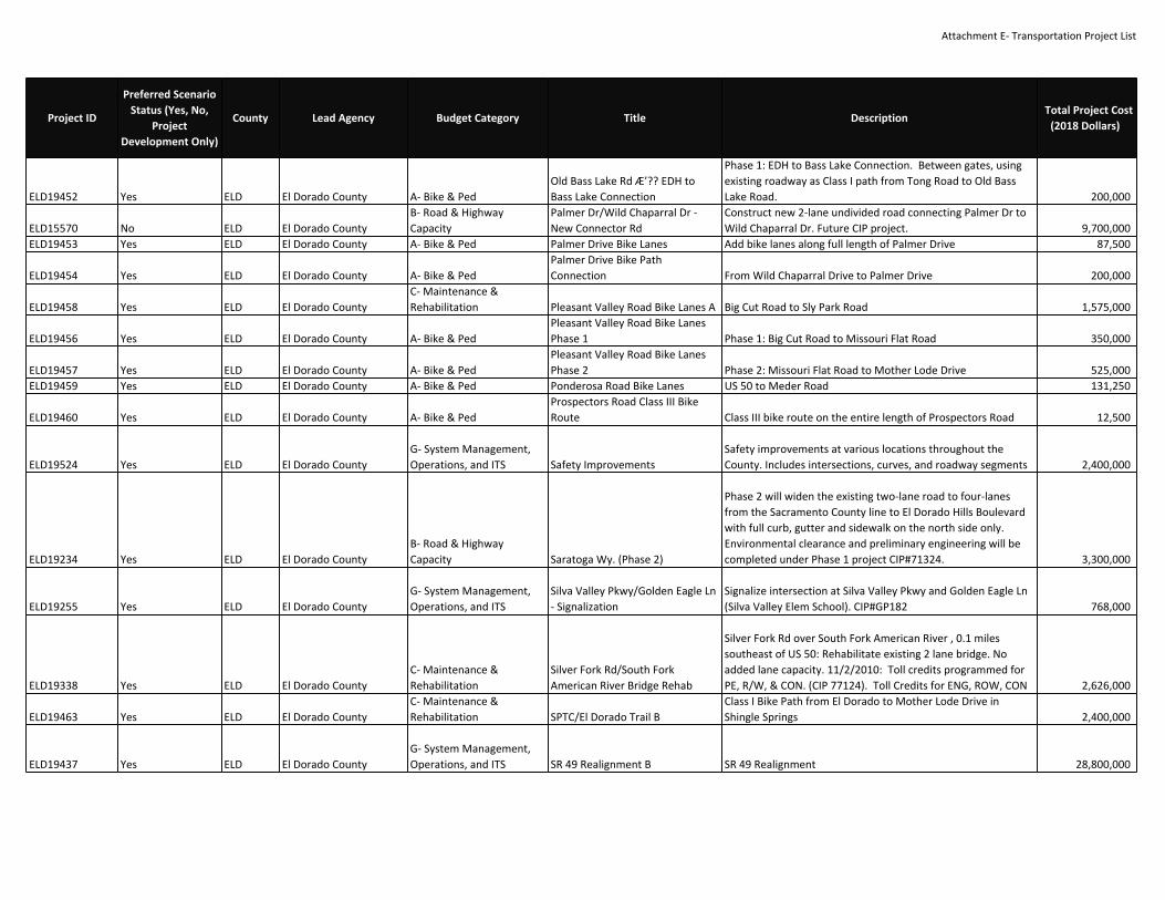
Attachment E‐ Transportation Project List
ELD19452 Yes ELD El Dorado County A‐ Bike & PedOld Bass Lake Rd Æ’?? EDH toBass Lake Connection
Phase 1: EDH to Bass Lake Connection. Between gates, usingexisting roadway as Class I path from Tong Road to Old BassLake Road. 200,000
ELD15570 No ELD El Dorado CountyB‐ Road & HighwayCapacity
Palmer Dr/Wild Chaparral Dr ‐New Connector Rd
Construct new 2‐lane undivided road connecting Palmer Dr toWild Chaparral Dr. Future CIP project. 9,700,000
ELD19453 Yes ELD El Dorado County A‐ Bike & Ped Palmer Drive Bike Lanes Add bike lanes along full length of Palmer Drive 87,500
ELD19454 Yes ELD El Dorado County A‐ Bike & PedPalmer Drive Bike PathConnection From Wild Chaparral Drive to Palmer Drive 200,000
ELD19458 Yes ELD El Dorado CountyC‐ Maintenance &Rehabilitation Pleasant Valley Road Bike Lanes A Big Cut Road to Sly Park Road 1,575,000
ELD19456 Yes ELD El Dorado County A‐ Bike & PedPleasant Valley Road Bike LanesPhase 1 Phase 1: Big Cut Road to Missouri Flat Road 350,000
ELD19457 Yes ELD El Dorado County A‐ Bike & PedPleasant Valley Road Bike LanesPhase 2 Phase 2: Missouri Flat Road to Mother Lode Drive 525,000
ELD19459 Yes ELD El Dorado County A‐ Bike & Ped Ponderosa Road Bike Lanes US 50 to Meder Road 131,250
ELD19460 Yes ELD El Dorado County A‐ Bike & PedProspectors Road Class III BikeRoute Class III bike route on the entire length of Prospectors Road 12,500
ELD19524 Yes ELD El Dorado CountyG‐ System Management,Operations, and ITS Safety Improvements
Safety improvements at various locations throughout theCounty. Includes intersections, curves, and roadway segments 2,400,000
ELD19234 Yes ELD El Dorado CountyB‐ Road & HighwayCapacity Saratoga Wy. (Phase 2)
Phase 2 will widen the existing two‐lane road to four‐lanesfrom the Sacramento County line to El Dorado Hills Boulevardwith full curb, gutter and sidewalk on the north side only.Environmental clearance and preliminary engineering will becompleted under Phase 1 project CIP#71324. 3,300,000
ELD19255 Yes ELD El Dorado CountyG‐ System Management,Operations, and ITS
Silva Valley Pkwy/Golden Eagle Ln‐ Signalization
Signalize intersection at Silva Valley Pkwy and Golden Eagle Ln(Silva Valley Elem School). CIP#GP182 768,000
ELD19338 Yes ELD El Dorado CountyC‐ Maintenance &Rehabilitation
Silver Fork Rd/South ForkAmerican River Bridge Rehab
Silver Fork Rd over South Fork American River , 0.1 milessoutheast of US 50: Rehabilitate existing 2 lane bridge. Noadded lane capacity. 11/2/2010: Toll credits programmed forPE, R/W, & CON. (CIP 77124). Toll Credits for ENG, ROW, CON 2,626,000
ELD19463 Yes ELD El Dorado CountyC‐ Maintenance &Rehabilitation SPTC/El Dorado Trail B
Class I Bike Path from El Dorado to Mother Lode Drive inShingle Springs 2,400,000
ELD19437 Yes ELD El Dorado CountyG‐ System Management,Operations, and ITS SR 49 Realignment B SR 49 Realignment 28,800,000
Project ID
Preferred ScenarioStatus (Yes, No,
ProjectDevelopment Only)
County Lead Agency Budget Category Title DescriptionTotal Project Cost
(2018 Dollars)
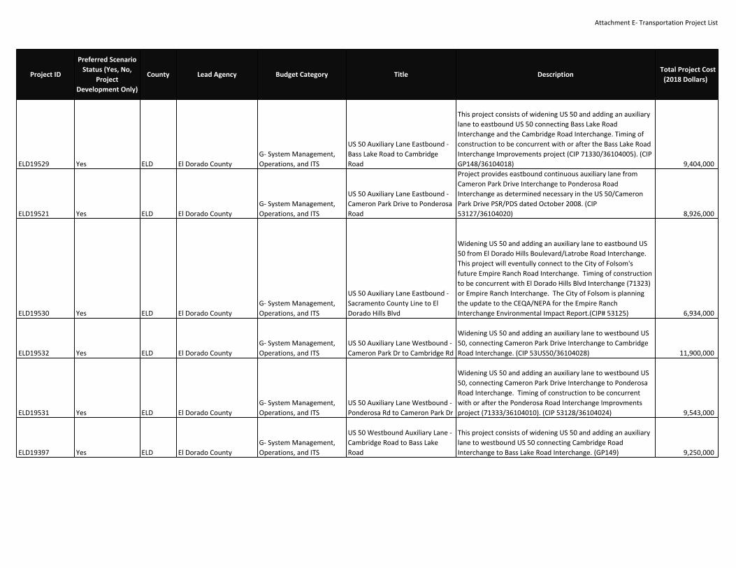
Attachment E‐ Transportation Project List
ELD19529 Yes ELD El Dorado CountyG‐ System Management,Operations, and ITS
US 50 Auxiliary Lane Eastbound ‐Bass Lake Road to CambridgeRoad
This project consists of widening US 50 and adding an auxiliarylane to eastbound US 50 connecting Bass Lake RoadInterchange and the Cambridge Road Interchange. Timing ofconstruction to be concurrent with or after the Bass Lake RoadInterchange Improvements project (CIP 71330/36104005). (CIPGP148/36104018) 9,404,000
ELD19521 Yes ELD El Dorado CountyG‐ System Management,Operations, and ITS
US 50 Auxiliary Lane Eastbound ‐Cameron Park Drive to PonderosaRoad
Project provides eastbound continuous auxiliary lane fromCameron Park Drive Interchange to Ponderosa RoadInterchange as determined necessary in the US 50/CameronPark Drive PSR/PDS dated October 2008. (CIP53127/36104020) 8,926,000
ELD19530 Yes ELD El Dorado CountyG‐ System Management,Operations, and ITS
US 50 Auxiliary Lane Eastbound ‐Sacramento County Line to ElDorado Hills Blvd
Widening US 50 and adding an auxiliary lane to eastbound US50 from El Dorado Hills Boulevard/Latrobe Road Interchange.This project will eventully connect to the City of Folsom'sfuture Empire Ranch Road Interchange. Timing of constructionto be concurrent with El Dorado Hills Blvd Interchange (71323)or Empire Ranch Interchange. The City of Folsom is planningthe update to the CEQA/NEPA for the Empire RanchInterchange Environmental Impact Report.(CIP# 53125) 6,934,000
ELD19532 Yes ELD El Dorado CountyG‐ System Management,Operations, and ITS
US 50 Auxiliary Lane Westbound ‐Cameron Park Dr to Cambridge Rd
Widening US 50 and adding an auxiliary lane to westbound US50, connecting Cameron Park Drive Interchange to CambridgeRoad Interchange. (CIP 53US50/36104028) 11,900,000
ELD19531 Yes ELD El Dorado CountyG‐ System Management,Operations, and ITS
US 50 Auxiliary Lane Westbound ‐Ponderosa Rd to Cameron Park Dr
Widening US 50 and adding an auxiliary lane to westbound US50, connecting Cameron Park Drive Interchange to PonderosaRoad Interchange. Timing of construction to be concurrentwith or after the Ponderosa Road Interchange Improvmentsproject (71333/36104010). (CIP 53128/36104024) 9,543,000
ELD19397 Yes ELD El Dorado CountyG‐ System Management,Operations, and ITS
US 50 Westbound Auxiliary Lane ‐Cambridge Road to Bass LakeRoad
This project consists of widening US 50 and adding an auxiliarylane to westbound US 50 connecting Cambridge RoadInterchange to Bass Lake Road Interchange. (GP149) 9,250,000
Project ID
Preferred ScenarioStatus (Yes, No,
ProjectDevelopment Only)
County Lead Agency Budget Category Title DescriptionTotal Project Cost
(2018 Dollars)

Attachment E‐ Transportation Project List
ELD19181 Yes ELD El Dorado CountyB‐ Road & HighwayCapacity US 50/Cambridge Rd Interchange
Phase 1 Improvements to Cambridge Road Interchange. PhaseI project consists of widening the existing eastbound andwestbound off‐ramps; addition of new westbound on‐rampfrom southbound Cambridge Road; reconstruction of the localintersections to provide for additional capacity, both turningand through; and the installation of traffic signals at eastboundrampterminal intersection. Also includes preliminary engineering forPhase 2 improvements to Cambridge Interchange. This projectshall also be coordinated with the US 50 Eastbound AuxiliaryLane from Bass Lake Road Interchange to Cambridge RoadInterchange (GP148/36104018), US 50 Eastbound AuxiliaryLanefrom Cambridge Road Interchange to Cameron ParkInterchange (53126/36104019). (CIP 71332/36104006) 9,173,000
ELD19177 Yes ELD El Dorado CountyB‐ Road & HighwayCapacity
US 50/Cameron Park DrInterchange Improvements
Interchange Improvements: this project includes detailed studyto identify capacity improvements alternatives and selection ofpreferred alternative; assumes reconstruction of existing US50bridges to widen Cameron Park Dr to 8 lanes under theovercrossing; road and ramp widenings. (CIP 72361/36104007) 61,116,000
ELD19345 Yes ELD El Dorado CountyG‐ System Management,Operations, and ITS
US 50/El Dorado Hills BlvdInterchange Eastbound Ramps(Phase 2B)
Part of larger project to reconstruct the interchange and widenLatrobe Rd/El Dorado Hills Boulevard. Coplete reconstructionis being phased to align improvement needs, constructionstaging within US 50 corridor, and available funding. Thisphase improves on‐/off‐ramps for eastbound US 50 and widensLatrobe Road/El Dorado Hills Boulevard. Design to becoordinated with US 50 Westbound Auxilliary Lane from ElDorado Hills Blvd. Interchange to the County Line(53115/36104021) and US 50 Eastbound Auxiliary Lane fromCounty Line to El Dorado Hills Blvd. Interchange(53125/36104017). (CIP 71323/36104001) 9,196,000
ELD19173 Yes ELD El Dorado County A‐ Bike & PedUS 50/El Dorado Hills BlvdPedestrian Overcrossing
Construct ped/bike overcrossing over US 50 just east of ElDorado Hills Blvd Interchange; includes a Class 1 mixed‐usepath; Construction and ROW acquisition for 10‐ft widesidewalk and adjacent retaining walls, barriers, railings andlandscape replacement included with CIP71323/36104001.(CIP71340) 6,783,000
Project ID
Preferred ScenarioStatus (Yes, No,
ProjectDevelopment Only)
County Lead Agency Budget Category Title DescriptionTotal Project Cost
(2018 Dollars)

Attachment E‐ Transportation Project List
ELD19178 Yes ELD El Dorado CountyB‐ Road & HighwayCapacity
US 50/El Dorado Rd Interchange ‐Phase 1
Phase 1 project includes sinalization and widening of existingramps and minor widening/lane adjustments on El DoradoRoad. See project 71376/36104012 for Phase 2 improvements.(CIP 71347/36104011) 5,488,000
ELD19272 Yes ELD El Dorado CountyB‐ Road & HighwayCapacity
US 50/El Dorado Rd Interchange ‐Phase 2
Project would involve construction of left and right turn lanesand additional through traffic lanes as follows:noth/southbound El Dorado Road, and east/westbound on‐/off‐ramps for US 50. Will require either widening of the existing ElDorado Road/US50 overcrossing structure and/or constructionof a new adjacent structure. Refer to 2000 PSR. See projectNo. 71347/36104011 for Phase 1 improvements. (CIP71376/36104012) 11,165,000
ELD19535 No ELD El Dorado CountyB‐ Road & HighwayCapacity
US 50/Missouri Flat RoadInterchange Improvements
Improvements include ramp widening, traffic signalimprovements, bridge widening and other improvements.Interchagne alternatives include a Diverging Diamond or HookRamps. Possible relocation of Mother Lode Drive (CIPUnfunded Project List 125) 11,300,000
ELD19244 Yes ELD El Dorado CountyG‐ System Management,Operations, and ITS
US 50/Ponderosa Rd Interchange ‐Durock Rd Realignment
Realign approx. 1/4 mile of Durock Rd toSouth ShingleRoad/Sunset Ln and signalize new intersection. Durock Rd willbe two through lanes with turn pockets at the intersection.this project is part of a larger project, US 50/PonderoasRoad/South Shingle Road Interchange (71333/36104010).Preliminary engineering shall be perforned under theinterchange project. Work needs to be coordinated with US 50Ponderosa Road/South Shingle Road Ingerchange(7133/36104010), US 50/Ponderosa Road Interchnage ‐ N.Shingle Road Realingment (project 71339/36104009) andUS 50Eastbound Auxiliary Lane from Cameron Park DriveInterchange to Ponderosa Road Interchange(53127/36104020). (CIP 71338/36104008) 10,521,000
Project ID
Preferred ScenarioStatus (Yes, No,
ProjectDevelopment Only)
County Lead Agency Budget Category Title DescriptionTotal Project Cost
(2018 Dollars)

Attachment E‐ Transportation Project List
ELD19170 Yes ELD El Dorado CountyG‐ System Management,Operations, and ITS
US 50/Ponderosa Rd Interchange ‐N. Shingle Rd Realignment
Realign approx. 1/4 mile of N. Shingle Rd about 600 ft north atPonderosa Rd; realign WB off‐ramp to align with WildChaparral Dr; and signalize the new intersection. Realigned N.Shingle Rd will be two through lanes with turn pockets at theintersection. Part of a loarger Project for the reconstruction ofthe US50/Ponderosa Road/South Shingle Road interchange(7133/36104010). Preliminary Engineering for this phase shallbe performed under the interchange project. Work needs tobe coordinated with 7133/36104010, 71338/36104008, and53128/36104024. (CIP 71339/36104009) 7,385,000
ELD19180 Yes ELD El Dorado CountyB‐ Road & HighwayCapacity
US 50/Ponderosa Rd/So. ShingleRd Interchange Improvements
Project provides capacity improvements to the interchange,includes a detailed study to identifya preferred alternative. This phase of the project includes thewidening of the existing US 50overcrossing to accommodate five lanes and the realignmentof the westbound loop on‐ramp,ramp widenings, and widening of Ponderosa Road, MotherLode Drive and South ShingleRoad. Preliminary engineering for all phases (projects71333/36104010, 71338/36104008 and71339/36104009) shall be performed under the interchangeproject. This project requires theconstruction of US 50 /Ponderosa Road ‐ North Shingle RoadRealignment (project71338/36104008) and US 50 / Ponderosa Road Interchange ‐Durock Road Realignment(project 71339/36104009). This project shall also becoordinated with US 50 EastboundAuxiliary Lanes ‐ Cameron Park Interchange to Ponderosa RoadInterchange(53127/36104020), and US 50 Westbound Auxiliary Lanes ‐Ponderosa Road Interchange toCameron Park Drive Interchange (53128/36104024). (CIP7133/36104010) 24,064,000
ELD19291 Yes ELD El Dorado CountyB‐ Road & HighwayCapacity
US 50/Silva Valley PkwyInterchange ‐ Phase 2
Final phase of US 50/Silva Valley Parkway Interchange. Due tofuture growth in the area this project will be necessary toaccomodate traffic projected for 2030. Project includeseastbound diagonal and westbound loop on‐ramps to US 50.Project is in the preliminary planning phase. (CIP71345/36104004) 8,156,000
Project ID
Preferred ScenarioStatus (Yes, No,
ProjectDevelopment Only)
County Lead Agency Budget Category Title DescriptionTotal Project Cost
(2018 Dollars)

Attachment E‐ Transportation Project List
ELD19526 No ELD El Dorado CountyB‐ Road & HighwayCapacity
White Rock Road Widening ‐ PostStreet to South of Silva ValleyParkway
Widen White Rock Road from two to four lanes from PostStreet east to South of Silva Valley Parkway. Improvementsinclude curb, gutter, sidewalk and Class II bike lanes.(CIP72374/36105042) 5,987,000
ELD19525 Yes ELD El Dorado CountyB‐ Road & HighwayCapacity
White Rock Road Widening ‐Windfield Way to SacramentoCounty Line
Widen White Rock Road between the County line andWindfield Way from two to four‐lane divided roadway withcurb, gutter and Class I bike/pedestrian trail and/or an on‐street Class II bike facility. This roadway is part of the CapitalSoutheast Connector.(CIP 72381/36105041) 4,404,000
ELD19461 Yes ELD El Dorado County Transit E‐ Transit Capital (Major) Regional Fueling StationDevelop a regional fueling station near the Sacramento/ElDorado County Line. 20,310,000
VAR56136 Yes ELDEl Dorado County,Caltrans District 3
G‐ System Management,Operations, and ITS AVI/AVL For Emergency Vehicles AVI/AVL For Emergency Vehicles 400,000
VAR56143 Yes ELDEl Dorado County,Caltrans District 3
C‐ Maintenance &Rehabilitation Communications Plan Communications Plan 100,000
VAR56145 Yes ELDEl Dorado County,Caltrans District 3
G‐ System Management,Operations, and ITS
Continued Signal CoordinationImprovements 2010‐2020 Continued Signal Coordination Improvements 50,000
VAR56146 Yes ELDEl Dorado County,Caltrans District 3
C‐ Maintenance &Rehabilitation
Critical IntersectionImprovements Critical Intersection Improvements 5,000,000
VAR56147 Yes ELDEl Dorado County,Caltrans District 3
G‐ System Management,Operations, and ITS
El Dorado County IntegrationProject El Dorado County Integration Project 400,000
VAR56155 Yes ELDEl Dorado County,Caltrans District 3
C‐ Maintenance &Rehabilitation
Highway Advisory RadioDeployment and WeatherStations Æ’?? integrate withCaltrans
Highway Advisory Radio Deployment and Weather Stations ?integrate with Caltrans 6,500,000
VAR56156 Yes ELDEl Dorado County,Caltrans District 3
C‐ Maintenance &Rehabilitation
Install Animal Vehicle CollisionAvoidance Systems‐Hwy 49 andUS 50
Install Animal Vehicle Collision Avoidance Systems‐Hwy 49 andUS 50 150,000
VAR56157 Yes ELDEl Dorado County,Caltrans District 3 A‐ Bike & Ped
Install bicycle loop detection at allmajor intersections B Install bicycle loop detection at all major intersections 6,000
VAR56158 Yes ELDEl Dorado County,Caltrans District 3
C‐ Maintenance &Rehabilitation Install Communication Phase II Install Communication Phase II 200,000
VAR56159 Yes ELDEl Dorado County,Caltrans District 3
C‐ Maintenance &Rehabilitation
Install Downhill Speed WarningSystem on U.S. 50 Near Camino Install Downhill Speed Warning System on U.S. 50 Near Camino 100,000
VAR56160 Yes ELDEl Dorado County,Caltrans District 3
C‐ Maintenance &Rehabilitation
Install Ice Detection and WarningSystems Install Ice Detection and Warning Systems 200,000
Project ID
Preferred ScenarioStatus (Yes, No,
ProjectDevelopment Only)
County Lead Agency Budget Category Title DescriptionTotal Project Cost
(2018 Dollars)

Attachment E‐ Transportation Project List
VAR56161 Yes ELDEl Dorado County,Caltrans District 3
C‐ Maintenance &Rehabilitation
Install Rock/Mudslide andAvalanche Detection and WarningSystem
Install Rock/Mudslide and Avalanche Detection and WarningSystem 200,000
VAR56162 Yes ELDEl Dorado County,Caltrans District 3
C‐ Maintenance &Rehabilitation Installation of CCTV Installation of CCTV 390,000
VAR56163 Yes ELDEl Dorado County,Caltrans District 3
G‐ System Management,Operations, and ITS
Landslide Sensor IntegrationProject Landslide Sensor Integration Project 60,000
VAR56164 Yes ELDEl Dorado County,Caltrans District 3
G‐ System Management,Operations, and ITS
Long‐Term Priority CorridorDeployment of ITS Long‐Term Priority Corridor Deployment of ITS 900,000
VAR56165 Yes ELDEl Dorado County,Caltrans District 3 D‐ Programs & Planning
Long‐Term Regional ITS PlanUpdate Long‐Term Regional ITS Plan Update 200,000
VAR56166 Yes ELDEl Dorado County,Caltrans District 3
G‐ System Management,Operations, and ITS
Lower US 50 FreewayManagement Lower US 50 Freeway Management 500,000
VAR56167 Yes ELDEl Dorado County,Caltrans District 3 D‐ Programs & Planning
Medium‐Term Regional ITS PlanUpdate Medium‐Term Regional ITS Plan Update 200,000
VAR56168 Yes ELDEl Dorado County,Caltrans District 3
G‐ System Management,Operations, and ITS
Placerville Signal SystemTechnology Advances Placerville Signal System Technology Advances 800,000
VAR56169 Yes ELDEl Dorado County,Caltrans District 3
G‐ System Management,Operations, and ITS
Portable Traffic ManagementDevices Portable Traffic Management Devices 350,000
VAR56170 Yes ELDEl Dorado County,Caltrans District 3
G‐ System Management,Operations, and ITS
Priority Corridor Deployment ofITS Latrobe Road/El Dorado Hills
Priority Corridor Deployment of ITS Latrobe Road/El DoradoHills 900,000
VAR56171 Yes ELDEl Dorado County,Caltrans District 3
G‐ System Management,Operations, and ITS
Procure and deploy PortableDynamic Message Signs (DMS)and Trailblazers
Procure and deploy Portable Dynamic Message Signs (DMS)and Trailblazers 90,000
VAR56172 Yes ELDEl Dorado County,Caltrans District 3 D‐ Programs & Planning
Remote Traffic ControlWorkstation Remote Traffic Control Workstation 8,000
VAR56176 Yes ELDEl Dorado County,Caltrans District 3
G‐ System Management,Operations, and ITS
Traffic Control System (TCS)Upgrade Traffic Control System (TCS) Upgrade 30,000
VAR56177 Yes ELDEl Dorado County,Caltrans District 3
G‐ System Management,Operations, and ITS
Traffic Control SystemProcurement Traffic Control System Procurement 250,000
VAR56178 Yes ELDEl Dorado County,Caltrans District 3
G‐ System Management,Operations, and ITS
Traveler InformationDissemination Devices at KeyLocations Traveler Information Dissemination Devices at Key Locations 300,000
Project ID
Preferred ScenarioStatus (Yes, No,
ProjectDevelopment Only)
County Lead Agency Budget Category Title DescriptionTotal Project Cost
(2018 Dollars)

Attachment E‐ Transportation Project List
VAR56179 Yes ELDEl Dorado County,Caltrans District 3
G‐ System Management,Operations, and ITS US 50 Surveillance US 50 Surveillance 1,100,000
VAR56180 Yes ELDEl Dorado County,Caltrans District 3
G‐ System Management,Operations, and ITS US 50 Traveler Information US 50 Traveler Information 1,500,000
VAR56181 Yes ELDEl Dorado County,Caltrans District 3
C‐ Maintenance &Rehabilitation US 50 Winter Traffic Management US 50 Winter Traffic Management 250,000
VAR56141 Yes ELDEl Dorado County,Caltrans District 3
C‐ Maintenance &Rehabilitation Web Page Development Web Page Development 100,000
VAR56175 Yes ELD
El Dorado County,Caltrans District 3,SACOG
G‐ System Management,Operations, and ITS STARNET Integration B STARNET Integration 40,000
VAR56137 Yes ELDEl Dorado County, ElDorado Hills CSD
C‐ Maintenance &Rehabilitation Bass Lake Road Bike Lanes Class II Bike Lanes from Green Valley Road to US 50 1,500,000
VAR56142 Yes ELDEl Dorado County, ElDorado Hills CSD A‐ Bike & Ped
Bike Path Parallel to US 50 on thenorth side ‐EDH to Bass LakeConnection
Phase 2: EDH to Bass Lake Connection From Silva Valley Roadto El Dorado Hills Village Center Shopping Center 300,000
VAR56148 Yes ELDEl Dorado County, ElDorado Hills CSD A‐ Bike & Ped
El Dorado Hills Boulevard BikeLanes Phase 1: Saratoga Way to Governor Drive/St. Andrews 297,500
VAR56149 Yes ELDEl Dorado County, ElDorado Hills CSD A‐ Bike & Ped
El Dorado Hills Boulevard BikePath
Phase 2: Utilizing an existing golf cart undercrossing of SerranoParkway, extend the bike path from the current terminus atSerrano Parkway to Raley?s Center 200,000
VAR56151 Yes ELDEl Dorado County, ElDorado Hills CSD A‐ Bike & Ped
El Dorado Hills to Bass LakeConnection (phase 1)
Class III Bike Route on Tong Road, Class III Bike Route on OldBass Lake Road. 25,000
VAR56173 Yes ELDEl Dorado County, ElDorado Hills CSD A‐ Bike & Ped Silva Valley Road Bike Lanes
From the new connection with White Rock Road to GreenValley Road 700,000
VAR56174 Yes ELDEl Dorado County, ElDorado Hills CSD A‐ Bike & Ped SPTC/El Dorado Trail A Class I Bike Path from Latrobe Road to County Line 2,800,000
VAR56198 Yes ELD FHWAC‐ Maintenance &Rehabilitation Ice House Road Rehab
Eldorado National Forest, Ice House Road, for 17.5 miles:Rehabilitate road. (CA FLAP ED CR147(2)) (Toll Credits). TollCredits for CON 5,000,000
CAL21227ProjectDevelopment Only PLA Caltrans D3
G‐ System Management,Operations, and ITS
49 Corridor ‐Roundabouts/Median Barrier
Construct median barrier between Lorenson Rd and LonestarRd and roundabouts at Lorenson Rd and Lone Star Rdintersections. (EA 4H600) 21,800,000
CAL20928 Yes PLA Caltrans D3C‐ Maintenance &Rehabilitation Auburn Mtce Station Install wash facility 975,000
16151 Yes PLA Caltrans D3G‐ System Management,Operations, and ITS
Beg of Pla‐49 at various locationsto End of Pla‐49. Install new ITSsystems.
Beg of Pla‐49 at various locations to End of Pla‐49. Install newITS systems. 3,960,000
Project ID
Preferred ScenarioStatus (Yes, No,
ProjectDevelopment Only)
County Lead Agency Budget Category Title DescriptionTotal Project Cost
(2018 Dollars)

Attachment E‐ Transportation Project List
CAL20838 Yes PLA Caltrans D3C‐ Maintenance &Rehabilitation Colfax Narrows Segment 1
In Placer County in the City of Colfax, from SR 174 IC to LongRavine UP. Construct truck climbing lane (WB). (PM 33.3‐35.1) 54,175,000
CAL20971 Yes PLA Caltrans D3C‐ Maintenance &Rehabilitation Colfax Narrows Segment 3
WB Long Ravine UP to Magra OC. Add shoulders in WBdirection. Investigate truck descend lane WB. 45,210,000
CAL21115 Yes PLA Caltrans D3G‐ System Management,Operations, and ITS
Eastbound I‐80 at Auburn RavineRoad. Install ramp meters. Eastbound I‐80 at Auburn Ravine Road. Install ramp meters. 380,000
CAL21116 Yes PLA Caltrans D3G‐ System Management,Operations, and ITS
Eastbound I‐80 at Elm Avenue.Install ramp meters. Eastbound I‐80 at Elm Avenue. Install ramp meters. 380,000
CAL21106 Yes PLA Caltrans D3G‐ System Management,Operations, and ITS
Eastbound I‐80 at NewcastleRoad. Install ramp meters. Eastbound I‐80 at Newcastle Road. Install ramp meters. 380,000
CAL21100 Yes PLA Caltrans D3G‐ System Management,Operations, and ITS
Eastbound I‐80 at northboundSierra College Blvd. Install rampmeters.
Eastbound I‐80 at northbound Sierra College Blvd. Install rampmeters. 380,000
CAL21109 Yes PLA Caltrans D3G‐ System Management,Operations, and ITS
Eastbound I‐80 at Ophir Road.Install ramp meters. Eastbound I‐80 at Ophir Road. Install ramp meters. 380,000
CAL21103 Yes PLA Caltrans D3G‐ System Management,Operations, and ITS
Eastbound I‐80 at Penryn Road.Install ramp meters. Eastbound I‐80 at Penryn Road. Install ramp meters. 380,000
CAL21108 Yes PLA Caltrans D3G‐ System Management,Operations, and ITS
Eastbound I‐80 at SR 193. Installramp meters. Eastbound I‐80 at SR 193. Install ramp meters. 380,000
CAL21118 Yes PLA Caltrans D3G‐ System Management,Operations, and ITS
Eastbound I‐80 at the Bowmanundercrossing. Install rampmeters.
Eastbound I‐80 at the Bowman undercrossing. Install rampmeters. 380,000
CAL21102 Yes PLA Caltrans D3G‐ System Management,Operations, and ITS
Eastbound I‐80 Horseshoe BarRoad. Install ramp meters. Eastbound I‐80 Horseshoe Bar Road. Install ramp meters. 380,000
CAL20844 Yes PLA Caltrans D3C‐ Maintenance &Rehabilitation EB 3 location truck lane
In Placer County on Route 80 in 3 locations from Heather Glento EB offramp to Nyack, construct truck climbing lanes: PMs(27.2/28.8, 39.5/41.3, 53.0/54.7) (EA 3H590) 57,168,000
CAL20845 Yes PLA Caltrans D3C‐ Maintenance &Rehabilitation EB Baxter/Drum Truck lane
On Placer 80 from Sawmill to approx. 0.2 mile east of DrumForebay. Truck climbing lane. 77,990,000
CAL21012 Yes PLA Caltrans D3G‐ System Management,Operations, and ITS
EB Big Bend (Kingvale GradeSegment 1)
On Placer 80 from Cisco Grove to Hampire Rocks. Truckclimbing lane.(PM 64.2/66.3) 20,600,000
Project ID
Preferred ScenarioStatus (Yes, No,
ProjectDevelopment Only)
County Lead Agency Budget Category Title DescriptionTotal Project Cost
(2018 Dollars)

Attachment E‐ Transportation Project List
CAL21011 Yes PLA Caltrans D3C‐ Maintenance &Rehabilitation EB Colfax 174 Grade
On Placer 80 from E. of Illnoistown OC to E. of SR 174. Truckclimbing lane. 13,762,000
CAL21072 Yes PLA Caltrans D3C‐ Maintenance &Rehabilitation
EB I‐80 Applegate offramp chainon improvements
Extend right turn lane of EB Applegate off‐ramp to facilitatechain on screening 2,000,000
CAL20846 Yes PLA Caltrans D3C‐ Maintenance &Rehabilitation
EB Troy Grade ‐ Kingvale GradeSegment 2
On Placer 80 from South Yuba River (Br # 19‐105) to Kingvale.Truck climbing lane. 17,470,000
CAL20822 Yes PLA Caltrans D3C‐ Maintenance &Rehabilitation
Grind and replace existingpavement and rehabilitate orreplace poor condition drainagesystems in Placer County on Route28 from Jct SR 89 to Nevada StateLine
Grind and replace existing pavement and rehabilitate orreplace poor condition drainage systems in Placer County onRoute 28 from Jct SR 89 to Nevada State Line 15,950,000
CAL21054 Yes PLA Caltrans D3C‐ Maintenance &Rehabilitation I‐80 Drainage Improvements
In Placer County from Sacramento County Line to 0.3 mile westof Gilardi Rd OC. 12,500,000
CAL20969 Yes PLA Caltrans D3C‐ Maintenance &Rehabilitation
I‐80 Applegate PavementRehabilititation
In Placer County from 0.8 miles west of Auburn Ravine RoadOC to Route 174/80 Seperation 53,000,000
CAL21240 Yes PLA Caltrans D3B‐ Road & HighwayCapacity I‐80 Atlantic On‐ramp Widening
Widen existing on‐ramp and structure over Miners Ravine toprovide a standard 2+1 on‐ramp. Work involves earthwork,structures work, roadway work, electrical work. 2,180
CAL21036 Yes PLA Caltrans D3C‐ Maintenance &Rehabilitation
I‐80 Auburn PavementRehabilititation
In Placer County on Route 80 from Ophir Road to East AuburnOH (Br# 19‐0071). 5,300,000
CAL20719 Yes PLA Caltrans D3C‐ Maintenance &Rehabilitation
I‐80 Bridge Rehab (G13Contingency Project)
In Placer and Nevada counties, I‐80, at various locations (PM28.7/R63.5) (G13 SHOPP Contingency Project) ‐ Rehabilitate orreplace bridges at six locations [#19‐0038, #19‐0112, #19‐0113,#19‐0114, #17‐0023, #19‐0118] (EFIS 0300020615 EA 2F570)(Toll Credits). Toll Credits for ENG, ROW 48,385,000
CAL20922 Yes PLA Caltrans D3C‐ Maintenance &Rehabilitation I‐80 Cold Plane & RHMA Overlay
I‐80 Cold Plane & RHMA Overlay ‐ In Placer County near SierraCollege Blvd. to Penryn Rock Springs UC 750,000
CAL20721 Yes PLA Caltrans D3C‐ Maintenance &Rehabilitation I‐80 Colfax Culvert Rehabilitation
In and near Colfax, I‐80, from west of Illinoistown Overcrossingto east of Cape Horn Undercrossing ‐ Drainage systemrehabilitation (PM 31.5/36.89) (EFIS 0300020600 EA 1E050)(Toll Credits). Toll Credits for ENG, ROW, CON 4,730,000
CAL20720 Yes PLA Caltrans D3C‐ Maintenance &Rehabilitation I‐80 Culvert Rehab
Near Weimar, I‐80, from west of Applegate Road to west ofWeimar Cross Road (PM 25.9/28.5) ‐ Drainage systemrehabilitation (Toll Credits). Toll Credits for ENG, ROW, CON 4,540,000
CAL21055 Yes PLA Caltrans D3C‐ Maintenance &Rehabilitation I‐80 Drainage Improvements A
In Placer County from 0.3 mile east of Drum Forebay OC to 0.1mile West of Yuba Pass OH 20/80 Separation. 10,800,000
Project ID
Preferred ScenarioStatus (Yes, No,
ProjectDevelopment Only)
County Lead Agency Budget Category Title DescriptionTotal Project Cost
(2018 Dollars)

Attachment E‐ Transportation Project List
CAL20869 Yes PLA Caltrans D3C‐ Maintenance &Rehabilitation I‐80 Drainage Improvements B
In Placer County, approx 0.3 mile west of Gilardi Rd OC to 0.3mile west of Applegate Rd OC. 15,000,000
CAL20974 Yes PLA Caltrans D3C‐ Maintenance &Rehabilitation I‐80 Drainage Rehabilitation
From East of Gold Run OC to Beg Chain on Area. DrainageRehab. 4,167,000
CAL20770 Yes PLA Caltrans D3C‐ Maintenance &Rehabilitation
I‐80 Gold Run DrainageRehabilititation
Near Magra, from Secret Town Overcrossing to the Gold RunSafety Roadside Rest Area (SRRA). Rehabilitate drainagesystems. 5,386,000
CAL20947 Yes PLA Caltrans D3C‐ Maintenance &Rehabilitation I‐80 Guardrail upgrade
In and near various cities, at various locations, from 0.3 milewest of Douglas Boulevard to 0.2 mile east of Hampshire RocksUndercrossing. Upgrade guardrail to current standards. 3,750,000
CAL20963 Yes PLA Caltrans D3C‐ Maintenance &Rehabilitation
I‐80 Kingvale PavementRehabilititation
In Placer and Nevada Counties from Troy Rd UC to Soda SpringsOC. Pavement Rehab. 93,134,000
CAL20630ProjectDevelopment Only PLA Caltrans D3
B‐ Road & HighwayCapacity
I‐80 Managed Lanes East of SR65in both directions
New managed lane facility ‐ one each direction ‐ on I‐80 fromSR65 east to SR49 in Auburn. (project description may changebased on results from the Managed Lanes Study. Project isbeing evaluated for Expressed Toll Lanes, High Occupancy TollLanes, HOV lanes)(PM R4.160‐17.374) 200,000,000
CAL20973 Yes PLA Caltrans D3C‐ Maintenance &Rehabilitation I‐80 Pavement Rehabilititation A
From Secret Town OC to Mone Vista OC. Pla‐80‐38.3/41.5. EA1H030 5,386,000
CAL21007 Yes PLA Caltrans D3C‐ Maintenance &Rehabilitation I‐80 Pavement Rehabilititation E Near Loomis from King Road OC to Route 193 Interchange. 18,200,000
CAL21039 Yes PLA Caltrans D3C‐ Maintenance &Rehabilitation I‐80 Pavement Rehabilititation F
In Placer County on Route 80 from Drum Forebay OC to approx0.8 mile west of Yuba Gap. 22,000,000
CAL21010 Yes PLA Caltrans D3B‐ Road & HighwayCapacity
In Placer and Nevada Counties onRoute 80 from Kingvale to SodaSprings. Add truck climbing lane.
In Placer and Nevada Counties on Route 80 from Kingvale toSoda Springs. Add truck climbing lane. 33,423,000
CAL21229 Yes PLA Caltrans D3C‐ Maintenance &Rehabilitation
In Placer County at Gold Run atthe Gold Run Safety Roadside RestArea Install back up generators 395,000
CAL21000ProjectDevelopment Only PLA Caltrans D3
G‐ System Management,Operations, and ITS
In Placer County in the city ofAuburn, at the Bell Rd/I‐80Interchange. Construct capacity &operational improvements tointerchange.
In Placer County in the city of Auburn, at the Bell Rd/I‐80Interchange. Construct operational improvements tointerchange. SHOPP ID 18145 4,850,000
Project ID
Preferred ScenarioStatus (Yes, No,
ProjectDevelopment Only)
County Lead Agency Budget Category Title DescriptionTotal Project Cost
(2018 Dollars)

Attachment E‐ Transportation Project List
CAL20837ProjectDevelopment Only PLA Caltrans D3
G‐ System Management,Operations, and ITS
In Placer County on Route 267 atBrockway Road and Pla 267. Addthrough lanes to mainline, adddedicated left turn phasing andlanes to minor approaches.
In Placer County on Route 267 at Brockway Road and Pla 267.Add through lanes to mainline, add dedicated left turn phasingand lanes to minor approaches. 2,160,000
CAL20992 Yes PLA Caltrans D3G‐ System Management,Operations, and ITS
In Placer County on Route 49approaching the Dry Creek Roadintersection. Dual left turn lanes(NB).
In Placer County on Route 49 approaching the Dry Creek Roadintersection. Dual left turn lanes (NB). 4,700,000
CAL20991 Yes PLA Caltrans D3G‐ System Management,Operations, and ITS
In Placer County on Route 49approaching the Willow CreekDrive intersection. Dual left turnlanes (NB).
In Placer County on Route 49 approaching the Willow CreekDrive intersection. Dual left turn lanes (NB). 4,700,000
CAL20989 Yes PLA Caltrans D3G‐ System Management,Operations, and ITS
In Placer county on route 49 atBell Road intersections. NB RightTurn lanes.
In Placer county on route 49 at Bell Road intersections. NBRight Turn lanes. 1,500,000
CAL20988 Yes PLA Caltrans D3G‐ System Management,Operations, and ITS
In Placer county on Route 49 atElm Avenue/Harrison Streetintersection. Intersectionimprovements/channelization.
In Placer county on Route 49 at Elm Avenue/Harrison Streetintersection. Intersection improvements/channelization. 5,200,000
CAL20990 Yes PLA Caltrans D3G‐ System Management,Operations, and ITS
In Placer County on Route 49 atthe Kemper Road intersection.Kemper Rd channelization toimprove SR49 operations.
In Placer County on Route 49 at the Kemper Road intersection.Kemper Rd channelization to improve SR49 operations. 1,500,000
CAL20987 Yes PLA Caltrans D3G‐ System Management,Operations, and ITS
In Placer County on route 49 fromthe El Dorado County line toBorland Avenue. Turnouts,pullouts and shoulders.
In Placer County on route 49 from the El Dorado County line toBorland Avenue. Turnouts, pullouts and shoulders. 5,700,000
CAL20986ProjectDevelopment Only PLA Caltrans D3
G‐ System Management,Operations, and ITS
In Placer County on Route 80 inthe City of Auburn from Ophir Rdto Elm Ave. Improve short weave.
In Placer County on Route 80 in the City of Auburn from OphirRd to Elm Ave. Improve short weave. 7,000,000
CAL20981ProjectDevelopment Only PLA Caltrans D3
G‐ System Management,Operations, and ITS
In Placer County, on Route 174 inColfax, at South Auburn St andCentral Street. IntersectionImprovements (possibleroundabout)
In Placer County, on Route 174 in Colfax, at South Auburn Stand Central Street. Intersection Improvements (possibleroundabout) 5,000,000
Project ID
Preferred ScenarioStatus (Yes, No,
ProjectDevelopment Only)
County Lead Agency Budget Category Title DescriptionTotal Project Cost
(2018 Dollars)

Attachment E‐ Transportation Project List
CAL21094 Yes PLA Caltrans D3C‐ Maintenance &Rehabilitation
Northbound SR 65 at Blue OaksBlvd. Install ramp meters. Northbound SR 65 at Blue Oaks Blvd. Install ramp meters. 380,000
CAL21093 Yes PLA Caltrans D3C‐ Maintenance &Rehabilitation
Northbound SR 65 at PleasantGrove Blvd. Install ramp meters. Northbound SR 65 at Pleasant Grove Blvd. Install ramp meters. 900,000
CAL21097 Yes PLA Caltrans D3G‐ System Management,Operations, and ITS
Northbound SR 65 at TwelveBridges Drive. Install rampmeters.
Northbound SR 65 at Twelve Bridges Drive. Install rampmeters. 900,000
17225 Yes PLA Caltrans D3G‐ System Management,Operations, and ITS
Overhead Sign StructureReplacement
On Routes 20 and 49 in Nevada County and on Route 80 inPlacer County at various locations. Overhead sign structurereplacement. EA 1H250 2,555,000
CAL20821 Yes PLA Caltrans D3G‐ System Management,Operations, and ITS
PLA 80 Colfax WB AccelerationLane Improvement
Improve accelreation lane from 0.3 mile south of WB SR 174 on‐ramp to WB SR 174 on‐ramp (PM 32.7/33.0) (4H660) 2,146,000
CAL20609 Yes PLA Caltrans D3G‐ System Management,Operations, and ITS Ramp Meters
Installation of Ramp Meters: Various Locations in Placer,Sacramento, and Yolo Counties. Rocklin Rd., SB and NB SierraCollege Blvd. 4,800,000
CAL21230 Yes PLA Caltrans D3C‐ Maintenance &Rehabilitation Roseville Mtce Station Rebuild crewrooms, offices and EQ barn 999,000
CAL20633ProjectDevelopment Only PLA Caltrans D3
B‐ Road & HighwayCapacity Route 65 Lincoln Bypass Phase 2B
In Placer County, SR65: Right‐of‐way acquisition & construct a4‐lane expressway from North Ingram Slough to Sheridan. 55,000,000
CAL21098 Yes PLA Caltrans D3G‐ System Management,Operations, and ITS
Southbound SR 65 at eastboundFerrari Ranch Road. Install rampmeters.
Southbound SR 65 at eastbound Ferrari Ranch Road. Installramp meters. 900,000
CAL21095 Yes PLA Caltrans D3G‐ System Management,Operations, and ITS
Southbound SR 65 at TwelveBridges Drive. Install rampmeters.
Southbound SR 65 at Twelve Bridges Drive. Install rampmeters. 900,000
CAL20937 Yes PLA Caltrans D3C‐ Maintenance &Rehabilitation
SR 193 Widen Shoulders andOverlay
In Placer County on SR 193 betwen 3.5 miles east of Lincolnand 0.1 miles east of Clark Tunnel Road. Widen shoulders andoverlay. 7,708,000
CAL21045 Yes PLA Caltrans D3C‐ Maintenance &Rehabilitation SR 267 Pavement Rehabilitation
In Placer County on Route 267 from approx. 0.4 mile east ofNorthstar Dr to Jct St 28. 8,905,000
CAL20638 Yes PLA Caltrans D3G‐ System Management,Operations, and ITS SR 267 SB Truck Climbing Lane
Extend the existing SR 267 SB truck‐climbing lane; shoulderwidening from Northstar Dr to Brockway Summit (PM 3.76/PM6.67) 19,500,000
PLA25136 No PLA Caltrans D3B‐ Road & HighwayCapacity SR 267 Widening
In eastern Placer County, widen SR 267 from 2 lanes to 4 lanesfrom Nevada County line to Northstar Drive (PM 0.0/3.76). 10,000,000
Project ID
Preferred ScenarioStatus (Yes, No,
ProjectDevelopment Only)
County Lead Agency Budget Category Title DescriptionTotal Project Cost
(2018 Dollars)

Attachment E‐ Transportation Project List
CAL20541 Yes PLA Caltrans D3C‐ Maintenance &Rehabilitation SR 49 Pavement Rehab
In Auburn, SR 49, from 0.1 mile south of Routes 49/80separation to 0.1 mile north of Dry Creek Road. HMA overlay,Class II bike lanes, two new traffic signals. (PM 3.1/7.5) [CTIPSID 107‐0000‐0992] [EFIS 0300020616 EA 2F340] (Toll Creditsfor PE, ROW, and CON). Toll Credits for ENG, ROW, CON 39,905,000
CAL20728 Yes PLA Caltrans D3G‐ System Management,Operations, and ITS SR 49 Realignment A
In Auburn, from 0.3 mile south of Lincoln Way/Borland Avenueto Lincoln Way/Borland Avenue (PM 2.2/2.4) ‐RealignRoadway. Construct RSP or concrete retaining structure.Replace culverts. (EA 1H240) [CTIPS ID 107‐0000‐1063] (TollCredits for PE, ROW, CON). Toll Credits for ENG, ROW, CON 5,364,000
CAL20849 Yes PLA Caltrans D3C‐ Maintenance &Rehabilitation SR 49 Resident Mechanic Shop Auburn Resident Mechanic 2,600,000
CAL20768 Yes PLA Caltrans D3C‐ Maintenance &Rehabilitation SR 65 Advance Mitigation
Near Lincoln, on McCourtney Road between Riosa Road andKilaga Springs Road at the Coon Creek Conservation (C4) Ranch‐ Advance mitigation construction (4 acres) for future SHOPPprojects expected to impact wetland, riparian and other waters[CTIPS ID 107‐0000‐1113] (Toll Credits) (Total Project Cost$2,639,000). Toll Credits for ENG, ROW, CON. EA 1H530 2,639,000
CAL20729 Yes PLA Caltrans D3C‐ Maintenance &Rehabilitation SR 65 Galleria Blvd. Ramp Meters
In Placer County on SR 65, at Galleria Blvd. ‐ Install rampmeters [CTIPS ID 107‐0000‐1064] (Toll Credits for PE, ROW,CON) [EA 0F352, PPNO 6913A] [second child project of parentEA 0F350; first child is EA 0F351, PPNO 6913]. Toll Credits forENG, ROW, CON 4,950,000
CAL20823 Yes PLA Caltrans D3G‐ System Management,Operations, and ITS SR 65 ICM Implement ICM strategies on the SR 65 corridor (Non‐capacity) 45,000,000
CAL21070 Yes PLA Caltrans D3C‐ Maintenance &Rehabilitation
SR 65 Ingram Slough StormDamage A
In Placer County on Route 65 at the South Ingram SloughBridge (Br# 19‐0188 L/R). Permanent Restoration. 1,200,000
CAL21079 Yes PLA Caltrans D3C‐ Maintenance &Rehabilitation
SR 65 Ingram Slough StormDamage B
In Placer County on Route 65 at the South Ingram SloughBridge (Br# 19‐0188 L/R). Permanent Restoration. 1,200,000
CAL20756 Yes PLA Caltrans D3C‐ Maintenance &Rehabilitation SR 89 Slope Mesh Drapery
In Placer County, on SR 89, from 0.2 mile south of GooseMeadows Campground to 0.5 mile south of Montreal Road(PM 17.2/18.3): Place slope mesh drapery (201.150 SHOPPRoadway Protective Betterments 17/18 FY Minor A). TollCredits for CON 1,422,000
Project ID
Preferred ScenarioStatus (Yes, No,
ProjectDevelopment Only)
County Lead Agency Budget Category Title DescriptionTotal Project Cost
(2018 Dollars)

Attachment E‐ Transportation Project List
17657 Yes PLA Caltrans D3G‐ System Management,Operations, and ITS
SR‐267 North Lake Tahoe. Installped signal. SR‐267 North Lake Tahoe. Install ped signal. 3,600,000
CAL20637 Yes PLA Caltrans D3G‐ System Management,Operations, and ITS
System Management/TrafficOperations System on SR49
Operational Improvements: traffic monitoring stations, closedcircuit television, highway advisory radio, changeable messagesigns, and other system management infrastructure in PlacerCounty. (PM 3.2/11.372) 4,000,000
CAL21231 Yes PLA Caltrans D3C‐ Maintenance &Rehabilitation Tahoe City Mtce Station Install wash facility 975,000
CAL20923 No PLA Caltrans D3B‐ Road & HighwayCapacity
US 50 Multimodal CorridorEnhancement Project / US 50 HOVLanes (I‐5 to Watt Ave)
Location 1: In Rocklin: Between SR 65 and Rocklin Rd. constructEB I‐80 auxiliary lane, including two‐lane off‐ramp, concretebarrier/retaining walls, and shoulder improvements. Location2: Extend I‐80 WB auxiliary lane (PLA25542) to the east andwest to create continuous 5th lane on WB I‐80. The DouglasBlvd. off‐ramp would be reduced from a 2‐lane off‐ramp to a 1‐lane off‐ramp. 18,645,000
CAL20879 Yes PLA Caltrans D3C‐ Maintenance &Rehabilitation
Var Location Safety surfacetreatment A
In Placer County on Route 65 from Blue Oaks Blvd to TwelveBridges; also in Sac County on Routes 5 and 51; and NevadaCounty on Route 174. Place HFST and OGAC. 2,390,000
CAL21078 Yes PLA Caltrans D3C‐ Maintenance &Rehabilitation
Var Location Safety surfacetreatment B
In Placer County on Route 65 from Blue Oaks Blvd to TwelveBridges; also in Sac County on Routes 5 and 51; and NevadaCounty on Route 174. Place HFST and OGAC. 2,390,000
CAL21013 Yes PLA Caltrans D3C‐ Maintenance &Rehabilitation WB Eagle Lake Grade
On Placer 80 from East of SR 20 to Yuba Pass Summit. Truckclimbing lane. 25,365,000
CAL21114 Yes PLA Caltrans D3G‐ System Management,Operations, and ITS
Westbound I‐80 at Auburn RavineRoad. Install ramp meters. Westbound I‐80 at Auburn Ravine Road. Install ramp meters. 380,000
CAL21119 Yes PLA Caltrans D3G‐ System Management,Operations, and ITS
Westbound I‐80 at Bell Road.Install ramp meters. Westbound I‐80 at Bell Road. Install ramp meters. 380,000
CAL21112 Yes PLA Caltrans D3G‐ System Management,Operations, and ITS
Westbound I‐80 at Elm Avenue.Install ramp meters. Westbound I‐80 at Elm Avenue. Install ramp meters. 380,000
CAL21101 Yes PLA Caltrans D3G‐ System Management,Operations, and ITS
Westbound I‐80 at Horseshoe BarRoad. Install ramp meters. Westbound I‐80 at Horseshoe Bar Road. Install ramp meters. 380,000
Project ID
Preferred ScenarioStatus (Yes, No,
ProjectDevelopment Only)
County Lead Agency Budget Category Title DescriptionTotal Project Cost
(2018 Dollars)

Attachment E‐ Transportation Project List
CAL21110 Yes PLA Caltrans D3G‐ System Management,Operations, and ITS
Westbound I‐80 at Nevada St.Install ramp meters. Westbound I‐80 at Nevada St. Install ramp meters. 380,000
CAL21105 Yes PLA Caltrans D3G‐ System Management,Operations, and ITS
Westbound I‐80 at NewcastleRoad. Install ramp meters. Westbound I‐80 at Newcastle Road. Install ramp meters. 380,000
CAL21104 Yes PLA Caltrans D3G‐ System Management,Operations, and ITS
Westbound I‐80 at Penryn Road.Install ramp meters. Westbound I‐80 at Penryn Road. Install ramp meters. 380,000
CAL21113 Yes PLA Caltrans D3G‐ System Management,Operations, and ITS
Westbound I‐80 at Russel Road.Install ramp meters. Westbound I‐80 at Russel Road. Install ramp meters. 380,000
CAL21107 Yes PLA Caltrans D3G‐ System Management,Operations, and ITS
Westbound I‐80 at SR 193. Installramp meters. Westbound I‐80 at SR 193. Install ramp meters. 380,000
CAL21111 Yes PLA Caltrans D3G‐ System Management,Operations, and ITS
Westbound I‐80 at SR 49. Installramp meters. Westbound I‐80 at SR 49. Install ramp meters. 380,000
CAL21099 Yes PLA Caltrans D3G‐ System Management,Operations, and ITS
Westbound I‐80 at SR 65. Installconnector meter Westbound I‐80 at SR 65. Install connector meter 1,940,000
CAL21117 Yes PLA Caltrans D3G‐ System Management,Operations, and ITS
Westbound I‐80 at the Bowmanundercrossing. Install rampmeters.
Westbound I‐80 at the Bowman undercrossing. Install rampmeters. 380,000
CAL21215 Yes PLA Caltrans D3C‐ Maintenance &Rehabilitation Whitmore Sand house Repair sand house 1,600,000
CAL20639 Yes PLA Caltrans Division of Rail E‐ Transit Capital (Major)Auburn to Donner Summit TrackImprovements Phases 1 & 2
Upgrade Donner Pass Summit (UP Line) double track: includingaddition of crossovers, notching of tunnels, reactivation &replacement of second mainline track between Auburn &Reno, Nevada 86,000,000
CAL20640ProjectDevelopment Only PLA Caltrans Division of Rail E‐ Transit Capital (Major) UP Over/Under Crossing
Build over/undercrossing at Union Pacific crossing of SierraCollege Boulevard 30,000,000
VAR56134 Yes PLACapitol Corridor JointPowers Authority F‐ Transit O&M (Rail)
Capitol Corridor Operations &Maintenance
Capitol Corridor operations & equipment maintenance, fundedby the State of California/ Caltrans Division of Rail. (Total Cost:$728,000,000) 58,181,760
VAR56135ProjectDevelopment Only PLA
Capitol Corridor JointPowers Authority E‐ Transit Capital (Minor)
Capitol Corridor Rail Replacement& Expansion
Lump‐sum of capital improvements between Colfax & Davis(Total Cost: $120,720,000) 9,647,942
Project ID
Preferred ScenarioStatus (Yes, No,
ProjectDevelopment Only)
County Lead Agency Budget Category Title DescriptionTotal Project Cost
(2018 Dollars)

Attachment E‐ Transportation Project List
PLA25353 Yes PLA City of AuburnC‐ Maintenance &Rehabilitation
Auburn Multi Modal Station ‐ RailPlatform Extension
At the existing Auburn Multi Modal Station: Obtain right‐of‐way and install rail platform extension . (Emission Benefits inkg/day: 0.93 ROG, 1.18 NOx, 0.43 PM10) 1,416,480
PLA25234 No PLA City of AuburnB‐ Road & HighwayCapacity Baltimore Ravine Development
Construct New Road: various roadways in the Baltimore Ravinearea of Auburn. Includes: widening and construction of newlocal roadways as a result of new development. 200,000
PLA‐Rehab1 Yes PLA City of AuburnC‐ Maintenance &Rehabilitation
Street & Road Maintenance,Auburn
Estimated street and road maintenance costs including signals,safety devices, & street lights, storm drains, storm damage,patching, overlay and sealing, other street purposemaintenance. Excludes major rehabilitation and reconstructionprojects. ($ 500,000 annually) 10,000,000
PLA25146 Yes PLA City of ColfaxG‐ System Management,Operations, and ITS
Grass Valley St./UPRROvercrossing
Rail Crossing Project; above‐grade crossing of UP Tracks fromeast side (S Auburn)to west side (Main) 14,700,000
PLA20420 Yes PLA City of ColfaxC‐ Maintenance &Rehabilitation
I‐80/Canyon Wy. IntersectionImprovements
Intersection Improvements at Canyon Wy. / I‐80 Overpass, toinclude signalization, intersection realignment and striping. 600,000
PLA25591 Yes PLA City of ColfaxG‐ System Management,Operations, and ITS
I‐80/SR174 InterchangeImprovements (Constructionfunds) Reconstruct I‐80/SR 174 Interchange 25,000,000
PLA25490 Yes PLA City of ColfaxG‐ System Management,Operations, and ITS
I‐80/SR174 Road Widening andSignal Improvements
Roadway Operational Improvements at Hwy. 174 & I‐80, toinclude new signal and intersection widening with sidewalksand curb ramps 550,000
PLA25466 Yes PLA City of ColfaxG‐ System Management,Operations, and ITS
Main and Grass Valley SignalImprovements
Design and construction of a new traffic signal and turn‐lane atthe intersection of Main Street and Grass Valley Street.(Emission reductions: ROG .02 kg/day; NOx .01 kg/day) 450,000
PLA25237 Yes PLA City of Colfax A‐ Bike & PedS Auburn Street BicycleImprovements
Add bike routes lanes on both sides of South Auburn Streetfrom Mink Creek to Grass Valley UP Tracks. 50,000
PLA25676 Yes PLA City of ColfaxC‐ Maintenance &Rehabilitation S. Auburn St. & I‐80 Roundabout
In Colfax: At the intersection of S. Auburn St. and WestboundInterstate 80 on/off‐ramps; construct a four‐leg, one‐laneroundabout. (Emission benefits in kg/day: ROG 0.05, NOx 0.05,PM2.5 0.01). Toll Credits for ENG 2,600,000
PLA25235 Yes PLA City of ColfaxC‐ Maintenance &Rehabilitation
S. Auburn/Central/Hwy.174Intersection Improvements
Intersection improvements on S. Auburn St. at CentralAve./Hwy. 174 intersection, to include widening, signalization,and pedestrian improvements. 700,000
Project ID
Preferred ScenarioStatus (Yes, No,
ProjectDevelopment Only)
County Lead Agency Budget Category Title DescriptionTotal Project Cost
(2018 Dollars)

Attachment E‐ Transportation Project List
PLA‐Rehab2 Yes PLA City of ColfaxC‐ Maintenance &Rehabilitation
Street & Road Maintenance,Colfax
Estimated street and road maintenance costs including signals,safety devices, & street lights, storm drains, storm damage,patching, overlay and sealing, snow removal, other streetpurpose maintenance. Excludes major rehabilitation andreconstruction projects. ($ 135,000 annually) 2,700,000
PLA20740 No PLA City of LincolnB‐ Road & HighwayCapacity Airport Rd.
Construct New Road: 4 lanes from Northwest Rd. to Wise Rd.and from Nicolaus Rd to Southern extension. Widen Airport Rdfrom 2 to 4 lanes from Northwest Rd to Nicolaus Rd. 12,781,053
PLA25738 No PLA City of LincolnB‐ Road & HighwayCapacity Athens Avenue Expansion
Construct New / Widen: Athens Avenue to 4 lanes from 0.5miles west of Dowd Road to Fiddyment Road 11,380,870
PLA18650ProjectDevelopment Only PLA City of Lincoln
B‐ Road & HighwayCapacity
Aviation Blvd. Extension north ofVenture
Widen Aviation Blvd. from 2 to 4 lanes from Venture Dr. toterminus 0.5 miles north of Venture Dr. 3,150,192
PLA25304 No PLA City of LincolnB‐ Road & HighwayCapacity
Aviation Blvd. Extension to WiseRd Road Extension: 4 lanes from Venture Dr. to Wise Rd. 6,618,670
PLA25770 No PLA City of LincolnB‐ Road & HighwayCapacity Catlett Road Expansion
Widen Catlett Road to 4 lanes from 0.5 miles west of DowdRoad to Fiddyment Road 16,742,329
PLA25731 No PLA City of LincolnB‐ Road & HighwayCapacity Dowd Road Auburn Ravine Bridge Construct 4 lane bridge on Dowd Road across Auburn Ravine 7,250,000
PLA25766 No PLA City of LincolnB‐ Road & HighwayCapacity
Dowd Road Markham RavineBridge Construct 4 lane bridge on Dowd Road across Markham Ravine 5,800,000
PLA25730 No PLA City of LincolnB‐ Road & HighwayCapacity Dowd Road Stream Bridge Construct 4 lane bridge on Dowd Road across stream 4,350,000
PLA25767 No PLA City of LincolnB‐ Road & HighwayCapacity Dowd Road Widening
Widen Dowd Road from 2 lanes to 6 lanes from Athens Ave to"widening" (approx. 0.25 miles north of Catlett Rd) 10,581,952
PLA25729 No PLA City of LincolnB‐ Road & HighwayCapacity
Dowd Road, Road Realignment,Widening, and extension
Road Realignment, Widening, and extension: 4 lanes from oldintersection of Wise Rd and Dowd Rd to "widening" (approx.0.25 miles north of Catlett Rd. 34,263,346
PLA18760 Yes PLA City of LincolnB‐ Road & HighwayCapacity E. Joiner Pkwy.
Widen: 6 lanes from Ferrari Ranch Rd. to Sterling Pkwy.Includes: Lincoln Blvd / UPRR overcrossing. 10,000,000
PLA18810 Yes PLA City of LincolnB‐ Road & HighwayCapacity East Joiner Parkway Widening A
Widen East Joiner Parkway from 2 to 4 lanes from TwelveBridges Dr. to Rocklin city limits. 7,800,000
PLA18790 Yes PLA City of LincolnB‐ Road & HighwayCapacity East Joiner Parkway Widening B
Widen: East Joiner Parkway from 2 to 4 lanes from Del WebbBlvd. North to Del Webb Blvd. South; 2 to 6 lanes from DelWebb Blvd. South to Twelve Bridges 8,992,396
PLA25771 Yes PLA City of LincolnB‐ Road & HighwayCapacity East Joiner Parkway Widening C
Widen East Joiner Parkway from 4 to 6 lanes from TwelveBridges Dr. to Bella Breeze. 2,519,661
Project ID
Preferred ScenarioStatus (Yes, No,
ProjectDevelopment Only)
County Lead Agency Budget Category Title DescriptionTotal Project Cost
(2018 Dollars)

Attachment E‐ Transportation Project List
PLA25747 Yes PLA City of LincolnB‐ Road & HighwayCapacity Ferrari Ranch Rd
Widen Ferrari Ranch Road from Caledon Circle East to SR‐65Interchange, lane reconfiguration for one additional lane 1,961,358
PLA25746 Yes PLA City of LincolnG‐ System Management,Operations, and ITS
Ferrari Ranch Rd Phase IIInterchange Ferrari Ranch Road interchange improvements 4,241,250
PLA25739 Yes PLA City of LincolnB‐ Road & HighwayCapacity Ferrari Ranch Rd Village 7 Bridge
Construct 4 lane bridge on Ferrari Ranch Road across InghramSlough 3,625,000
PLA25169 Yes PLA City of LincolnB‐ Road & HighwayCapacity Ferrari Ranch Road
Widen Ferrari Ranch Road from 2 to 4 lanes from 0.2 mileswest of Ingram Pkwy to 0.1 miles north of SR‐193 5,412,211
PLA25467 Yes PLA City of LincolnB‐ Road & HighwayCapacity Ferrari Ranch Road Extension
Extend Ferrari Ranch Road from Caledon Circle West to MooreRoad (Village 7 boundary). 3,255,522
PLA25769 Yes PLA City of LincolnB‐ Road & HighwayCapacity Fiddyment Road Expansion
Widen Fiddyment Road to 6 lanes from Moore Road to AthensAve 24,990,495
PLA25736 Yes PLA City of LincolnB‐ Road & HighwayCapacity
Fiddyment Road Orchard CreekBridge
Construct 6 lane bridge on Fiddyment Road across OrchardCreek 4,350,000
PLA20780 No PLA City of LincolnB‐ Road & HighwayCapacity Gladding Parkway A
Construct new 2 lane road from E. 10th Street to GladdingRoad 8,532,980
PLA25772 No PLA City of LincolnB‐ Road & HighwayCapacity Gladding Parkway B
Construct new 2 lane road from Gladding Road to NicolausRoad / 9th Street 2,776,952
PLA25741 No PLA City of LincolnB‐ Road & HighwayCapacity Gladding Parkway Overcrossing
Construct new 2 lane overpass on Gladding Parkway over UPRRand Lincoln Blvd 8,855,935
PLA25776 No PLA City of LincolnB‐ Road & HighwayCapacity Gladding Road
Widen Gladding Road from 2 to 4 lanes from Oak Tree Ln toWise Road 988,108
PLA25668 Yes PLA City of LincolnC‐ Maintenance &Rehabilitation Joiner Parkway Repaving Project
In Lincoln; from Moore Road to Venture Drive on JoinerParkway. Project will consist of AC overlay, slurry seal, baserepairs, ADA ramps and striping. 3,071,654
PLA25164 Yes PLA City of LincolnB‐ Road & HighwayCapacity Joiner Pkwy. Widen: 6 lanes from Ferrari Ranch Rd. to Moore Rd. 7,001,921
Project ID
Preferred ScenarioStatus (Yes, No,
ProjectDevelopment Only)
County Lead Agency Budget Category Title DescriptionTotal Project Cost
(2018 Dollars)

Attachment E‐ Transportation Project List
PLA25677 Yes PLA City of LincolnC‐ Maintenance &Rehabilitation
Lincoln Blvd StreetscapeImprovement Project Phase 4
The overall goal of the Lincoln Boulevard StreetscapeImprovement Project is to provide for a more pedestrian,bicycle, and neighborhood Electric Vehicles (NEV) friendlyenvironment along and across the main street through theCity. This will be accomplished by closing gaps between andimproving existing sidewalks, upgrading and shorteningpedestrian crossings with curb bulb outs and ADA compliantpedestrian ramps, and installing combined Class 2 bike lanesand NEV lanes along Lincoln Boulevard. This project willcontinue the streetscape improvements to construct improvedsidewalks, curb bulb outs, curb ramps, and traffic signalimprovements on Lincoln Boulevard between 1st Street and2nd Street and at the intersections of Lincoln Boulevard at 7thStreet.. Toll Credits for ENG, CON 1,566,000
PLA25775 Yes PLA City of LincolnB‐ Road & HighwayCapacity
Lincoln Blvd Widening OverAuburn Ravine
Lincoln Blvd at Auburn Ravine; Replace 2‐lane bridge with a 4‐lane bridge 9,880,000
PLA18710 Yes PLA City of LincolnB‐ Road & HighwayCapacity Lincoln Blvd. Widening A
Widen Lincoln Blvd. (formerly Industrial Blvd.) from 2 to 4 lanesfrom SR‐65 to Twelve Bridges Dr. 4,233,719
PLA18720 No PLA City of LincolnB‐ Road & HighwayCapacity Lincoln Blvd. Widening B
Widen Lincoln Blvd. (formerly Industrial Blvd.) from 2 to 4 lanesfrom 12 Bridges Dr. to Athens Blvd. 6,596,957
PLA25645 Yes PLA City of Lincoln A‐ Bike & PedLincoln Boulevard StreetscapeImprovements Project Phase 3
Lincoln Boulevard for a half mile and sections of First Street,Third Street, Fifth Street, Sixth Street and Seventh Street:construct streetscape improvements, including improvedsidewalks and 0.3 miles of NEV/Bike Lanes. (Emission Benefitsin kg/day: 0.08 ROG, 0.05 NOx, 0.02 PM2.5, 0.02 PM10) (Tollcredits for PE & CON). Toll Credits for ENG, CON 1,469,458
PLA25732 Yes PLA City of LincolnB‐ Road & HighwayCapacity Mavis Road A
Construct New Road: 4 lanes, Mavis Road from Dowd Rd to 1.0miles east of Dowd Rd 2,809,772
PLA25733 Yes PLA City of LincolnB‐ Road & HighwayCapacity Mavis Road B
Construct New Road: 6 lanes, Mavis Road from 1.0 miles eastof Dowd Rd to existing Nelson Ln 7,954,197
PLA25705 Yes PLA City of LincolnB‐ Road & HighwayCapacity McBean Drive Widening ‐ Phase 1
Widen McBean Drive to four lanes from Ferrari Ranch to OakTree Lane 9,249,021
PLA25714 Yes PLA City of LincolnB‐ Road & HighwayCapacity McBean Drive Widening ‐ Phase 2
Widen McBean Drive to four lanes from Oak Tree Lane to N/SConnector Loop (approximately 2900 feet east of Oak TreeLane) 5,729,091
PLA25745 Yes PLA City of LincolnB‐ Road & HighwayCapacity McBean Drive Widening ‐ Phase 3
Widen McBean Drive to four lanes from N/S Connector Loop(approximately 2900 feet east of Oak Tree Lane) to SierraCollege Blvd 2,296,256
Project ID
Preferred ScenarioStatus (Yes, No,
ProjectDevelopment Only)
County Lead Agency Budget Category Title DescriptionTotal Project Cost
(2018 Dollars)

Attachment E‐ Transportation Project List
PLA25540 Yes PLA City of LincolnC‐ Maintenance &Rehabilitation
McBean Park BridgeRehabilitation
McBean Park Dr. over Auburn Ravine, east of East Ave.:Rehabilitate existing 2 lane bridge. No added lane capacity. 14,472,000
PLA25652 Yes PLA City of LincolnB‐ Road & HighwayCapacity
McBean Park Drive WideningOver Auburn Ravine
From East Ave. to Ferrari Ranch Rd.: Replace 2‐lane bridge witha 4‐lane bridge, including the McBean Park Bridge at AuburnRavine. 11,818,131
PLA25737 Yes PLA City of LincolnB‐ Road & HighwayCapacity Moore Road Expansion
Widen Moore Road to 4 lanes from Fiddyment Road to 0.5miles east of existing Nelson Lane 4,493,949
PLA25768 Yes PLA City of LincolnB‐ Road & HighwayCapacity Nelson Lane Auburn Ravine Bridge Construct 6 lane bridge on Nelson Lane across Auburn Ravine 8,700,000
PLA25595 Yes PLA City of LincolnB‐ Road & HighwayCapacity Nelson Lane Extension
Road Realignment and Widening: 6 lanes, Nelson Lane fromRockwell Ln to Moore Rd 12,114,449
PLA25734 Yes PLA City of LincolnB‐ Road & HighwayCapacity Nelson Lane Interchange Interchange at Nelson Lane and SR‐65 40,600,000
PLA25735 Yes PLA City of LincolnB‐ Road & HighwayCapacity Nelson Lane Widening
Widen Nelson Lane to 6 lanes from Nicolaus Road to RockwellLane 6,772,102
PLA15970 Yes PLA City of LincolnB‐ Road & HighwayCapacity Nicolaus Rd. Widen Nicolaus Rd. 1 lane from Airport Rd. to Aviation Blvd. 3,999,142
PLA25728 No PLA City of LincolnB‐ Road & HighwayCapacity Nicolaus Road A
Widen Nicolaus Road from 2 lanes to 6 lanes from Dowd Roadto 0.15 miles west of Airport Road 6,841,216
PLA25727 No PLA City of LincolnB‐ Road & HighwayCapacity Nicolaus Road B
Widen Nicolaus Road from 2 lanes to 4 lanes from AirportRoad to 0.15 miles west of Airport Road, and from Dowd Roadto William Road 5,140,253
PLA25765 No PLA City of LincolnB‐ Road & HighwayCapacity Nicolaus Road Interchange Interchange at Nicolaus Road and SR‐65 23,200,000
PLA25774 No PLA City of LincolnB‐ Road & HighwayCapacity Northwest Road
Construct New Road: 4 lanes, Northwest Road from DowdRoad to Airport Road 1,286,012
PLA25764 No PLA City of LincolnB‐ Road & HighwayCapacity Northwest Road Overcrossing Overcrossing at Northwest Road and SR‐65 6,960,000
PLA25305 Yes PLA City of LincolnB‐ Road & HighwayCapacity Oak Tree Extension
Construct New Road: Oak Tree Lane, 4 lanes between McBeanPark Dr. and Ferrari Ranch Road. 8,471,567
PLA25743 Yes PLA City of LincolnB‐ Road & HighwayCapacity Oak Tree Extension Phase 2
Construct New Road: Oak Tree Lane, 4 lanes betweenVirginiatown Rd. and Fox Ln 1,332,543
PLA25744 No PLA City of LincolnB‐ Road & HighwayCapacity Oak Tree Extension Phase 3
Construct New Road: Oak Tree Lane, 4 lanes between Fox Ln.and Lincoln Blvd. 15,730,222
PLA25742 Yes PLA City of LincolnB‐ Road & HighwayCapacity
Oak Tree Lane Auburn RavineBridge
Construct 4 lane bridge on Oak Tree Lane across Auburn Ravine(Ferrari Ranch Road to Virginiatown Road) 7,975,000
PLA25773 Yes PLA City of LincolnB‐ Road & HighwayCapacity Oak Tree Lane Southern Widening
Widen 1 lane on Oak Tree Ln. from McBean Park Dr. to 0.35miles south of McBean Park Dr 754,835
Project ID
Preferred ScenarioStatus (Yes, No,
ProjectDevelopment Only)
County Lead Agency Budget Category Title DescriptionTotal Project Cost
(2018 Dollars)

Attachment E‐ Transportation Project List
PLA‐Rehab3 Yes PLA City of LincolnC‐ Maintenance &Rehabilitation
Street & Road Maintenance,Lincoln
Estimated street and road maintenance costs including signals,safety devices, & street lights, storm drains, storm damage,patching, overlay and sealing, other street purposemaintenance. Excludes major rehabilitation and reconstructionprojects. ($ 1,400,000 annually) 28,000,000
PLA25646 Yes PLA City of LincolnC‐ Maintenance &Rehabilitation Street Resurfacing
On 1st (First) Street between Lincoln Boulevard and R Street:Rehabilitate and resurface roadway. Various drainage, ADA,and striping improvements will also be constructed as part ofthe project. (Toll credits for CON). Toll Credits for CON 1,671,954
PLA19020 Yes PLA City of LincolnB‐ Road & HighwayCapacity Twelve Bridges Dr. Widening A
Widen Twelve Bridges Dr.from 2 to 4 lanes from Lincoln Blvd.to west side of SR‐65 Interchange (approx. 0.15 miles) 1,981,120
PLA25166 No PLA City of LincolnB‐ Road & HighwayCapacity Twelve Bridges Dr. Widening B Widen: 4‐6 lanes from Hwy. 65 Interchange to Lincoln Pkwy. 225,200
PLA25740 No PLA City of LincolnB‐ Road & HighwayCapacity Twelve Bridges Interchange Interchange at Twelve Bridges and SR‐65 5,089,500
PLA20760 Yes PLA City of LincolnC‐ Maintenance &Rehabilitation Venture Drive Rehabilitation Rehabilitate Venture Drive from McClain Drive to Aviation Blvd. 1,430,909
PLA25310 No PLA City of LincolnB‐ Road & HighwayCapacity Wise Rd.
Road Realignment and Widening: 2 lanes to 6 lanes fromAccess Rd (approx. 0.25 miles NE of Lincoln Blvd) to Dowd Rd 23,433,432
PLA25748 No PLA City of LincolnB‐ Road & HighwayCapacity Wise Road
Road Realignment and Widening: 2 lanes to 4 lanes fromMcCourtney Rd to Access Rd (approximately 0.25 miles NE ofLincoln Blvd) 10,603,137
PLA25749 No PLA City of LincolnB‐ Road & HighwayCapacity Wise Road Interchange Interchange at Wise Road and SR‐65 31,900,000
PLA25777 No PLA City of LincolnB‐ Road & HighwayCapacity Wise Road Overcrossing Overcrossing at Wise Road and Lincoln Blvd 9,048,000
PLA19260 Yes PLA City of RocklinB‐ Road & HighwayCapacity Dominguez Road
In Rocklin, Dominguez Road: extend with 2 lanes from GraniteDrive to Sierra College Boulevard, including new bridge over I‐80. 11,000,000
PLA25722 Yes PLA City of RocklinB‐ Road & HighwayCapacity Monument Springs 2‐lane extension and 2‐lane bridge 2,147,226
PLA25635 Yes PLA City of RocklinC‐ Maintenance &Rehabilitation
Pacific St at Rocklin RoadRoundabout
At Rocklin Rd/Pacific St., replace existing traffic signalintersection with a two lane roundabout : (Toll Credits for PE,ROW, CON).(Emission Benefits kg/day: ROG 0.26; NOx 0.21;PM2.5 0.01).. Toll Credits for ENG, ROW, CON 2,707,607
PLA25272 Yes PLA City of RocklinB‐ Road & HighwayCapacity Pacific St. Widen: 6 lanes from SW of Sunset Blvd. to NE of Sunset Blvd. 240,000
Project ID
Preferred ScenarioStatus (Yes, No,
ProjectDevelopment Only)
County Lead Agency Budget Category Title DescriptionTotal Project Cost
(2018 Dollars)

Attachment E‐ Transportation Project List
PLA25718 Yes PLA City of RocklinB‐ Road & HighwayCapacity Pacific Street
Widen Pacific street to 4 lanes from Sierra Meadows to LoomisTown Limits 5,251,927
PLA25712 Yes PLA City of RocklinG‐ System Management,Operations, and ITS Rocklin Rd. & Pacific Ave.
On Rocklin Rd. & Pacific Avenue construct ITS Master Plandowntown improvements. 4,000,000
PLA25273 Yes PLA City of RocklinB‐ Road & HighwayCapacity Rocklin Road Widening
Widen Rocklin Road from 2 to 4 lanes from Loomis town limitsto east of Sierra College Boulevard. 372,266
PLA19401 Yes PLA City of RocklinB‐ Road & HighwayCapacity Rocklin Road Widening A
In Rocklin, Rocklin Road from Aguilar Road / Eastbound I‐80 on‐ramps to Sierra College Blvd: widen from 4 to 6 lanes. 1,534,000
PLA25720 No PLA City of RocklinB‐ Road & HighwayCapacity Rocklin Road Widening B
Widen Rocklin Rd. to 6 lanes from I‐80 WB Ramps to West ofGranite Drive. 236,875
PLA25345 Yes PLA City of RocklinB‐ Road & HighwayCapacity Rocklin Road/I‐80 Interchange
In Rocklin: from Rocklin Rd. onto both WB and EB I‐80;construct roundabouts or other improvements at ramp EB/WBramp terminus. 26,150,000
PLA15400 Yes PLA City of RocklinB‐ Road & HighwayCapacity Sierra College Blvd. Widening D
In Rocklin, widen Sierra College Boulevard from 4 to 6 lanesfrom I‐80 to Aguliar Tributary. 3,800,000
PLA20460 Yes PLA City of RocklinB‐ Road & HighwayCapacity Sierra College Blvd. Widening E
In Rocklin, Sierra College Boulevard from Aguilar Tributary toNightwatch: widen from 4 to 6 lanes. 2,750,000
PLA25721 Yes PLA City of RocklinB‐ Road & HighwayCapacity Sierra College Boulevard
Widen Sierra College Blvd. to 6 lanes from I‐80 to south ofTaylor Rd. 3,565,550
PLA‐Rehab4 Yes PLA City of RocklinC‐ Maintenance &Rehabilitation
Street & Road Maintenance,Rocklin
Estimated street and road maintenance costs including signals,safety devices, & street lights, storm drains, storm damage,patching, overlay and sealing, other street purposemaintenance. Excludes major rehabilitation and reconstructionprojects. ($ 5,400,000 annually) 108,000,000
PLA17820 Yes PLA City of RocklinG‐ System Management,Operations, and ITS Sunset Blvd. & Sierra College Blvd.
On Sunset Blvd. & Sierra College Blvd. construct ITS MasterPlan improvements. 4,000,000
PLA25156 Yes PLA City of RocklinB‐ Road & HighwayCapacity Sunset Blvd. Widening B
Sunset Boulevard: Widen from 4 to 6 lanes from north boundSR 65 ramp to West Stanford Ranch Road. 1,100,000
PLA15620 Yes PLA City of RocklinB‐ Road & HighwayCapacity Sunset Boulevard
Widen Sunset Boulevard from 4 to 6 lanes, from StandfordRanch Road to Pacific Street, inlcuding Bridge of UPRR. 4,177,406
PLA25268 Yes PLA City of RocklinB‐ Road & HighwayCapacity University Avenue Phase 1
University Avenue: Construct new four lane roadway from theintersection of Whitney Ranch Parkway north to the extensionof West Ranch View Drive. One or more phases of this projectmay require federal permitting. 2,300,000
Project ID
Preferred ScenarioStatus (Yes, No,
ProjectDevelopment Only)
County Lead Agency Budget Category Title DescriptionTotal Project Cost
(2018 Dollars)

Attachment E‐ Transportation Project List
PLA25151 Yes PLA City of RocklinB‐ Road & HighwayCapacity West Oaks Boulevard
West Oaks Boulevard: Construct new 4‐lane extension fromterminus to 4‐lane portion to Whitney Ranch Parkway. 3,500,000
PLA19290 Yes PLA City of RocklinB‐ Road & HighwayCapacity Whitney Ranch Parkway
Whitney Ranch Parkway, construct new 4‐lane facility fromeast of Wildcat Blvd. to Whitney Oaks Dr. 12,428,000
PLA25751 Yes PLA City of RocklinB‐ Road & HighwayCapacity Whitney Ranch Parkway Widening
Widen Whitney Ranch Parkway from 2 to 6 lanes fromNorthbound SR 65 Ramp to East of Wildcat Blvd. 3,083,809
PLA25709 No PLA City of RocklinB‐ Road & HighwayCapacity
Whitney Ranch Parkway WideningB
Wident Whitney Ranch Parkway from 2 to 6 lanes fromNorthbound SR 65 Ramp to East of Wildcat Blvd. 3,083,809
PLA19810ProjectDevelopment Only PLA City of Roseville
B‐ Road & HighwayCapacity Atkinson St./PFE Rd. Widening
In Roseville, Atkinson St./PFE Rd.: widen from two to four lanesfrom Foothills Blvd to just south of Dry Creek, includingconnector road from Foothills to Atkinson (mirror image ofexisting Denio Loop connector on N/E side of Foothills) andsignal removal. 7,000,000
PLA25647 Yes PLA City of RosevilleB‐ Road & HighwayCapacity
Atlantic Eureka I‐80 W/B On‐rampWidening
In Roseville, widen the Atlantic Street/Eureka Road/I‐80 W/BOn‐ramp, including bridge widening over Miners Ravine, from1‐lane to 2‐lanes plus an HOV bypass lane. (Toll Credits forCON). Toll Credits for CON 8,380,000
PLA25763 Yes PLA City of RosevilleB‐ Road & HighwayCapacity Atlantic/Vernon Roundabout
construct roundabout at intersection of Atlantic Street andVernon Street 4,000,000
PLA15660 Yes PLA City of RosevilleB‐ Road & HighwayCapacity Baseline Rd. Widening
In Roseville, Baseline Rd., from Brady Lane to Fiddyment Road:widen from 3 to 4 lanes. 6,106,889
PLA15100 Yes PLA City of RosevilleB‐ Road & HighwayCapacity Baseline Road
In Roseville, Baseline Road from Fiddyment Road to Sierra VistaWestern edge west of Watt Avenue: widen from 2 to 6 lanes. 7,852,055
PLA25758 Yes PLA City of Roseville A‐ Bike & PedBicycle Master Plan Class I TrailBuildout
Construct trails as described in the City of Roseville BicycleMaster Plan and Specific Plan Bicycle Master Plans 45,000,000
PLA25528 Yes PLA City of RosevilleB‐ Road & HighwayCapacity
Blue Oaks Blvd Extension ‐ Phase1
In Roseville, Extend 2 lanes of Blue Oaks Blvd from HaydenParkway to Westbrook Dr ., Including south half of a 6‐lanebridge over Kaseberg Creek. 6,000,000
PLA25539 Yes PLA City of RosevilleB‐ Road & HighwayCapacity Blue Oaks Blvd. Extension Phase 2
In Roseville, Blue Oaks Blvd., from Westbrook Dr. to SantucciBlvd. (formerly Watt Ave.), extend 2 lanes. 6,350,000
PLA25752 Yes PLA City of RosevilleB‐ Road & HighwayCapacity
Blue Oaks over UPRR BridgeWidening
Construct 4 lane bridge over UPRR tracks and Industrial Ave. onwestbound Blue Oaks Blvd. between Foothills Blvd. andWashington Blvd to widen existing 4 lane roadway to 8 lanes 23,000,000
PLA25707 Yes PLA City of RosevilleB‐ Road & HighwayCapacity
Blue Oaks west widening, Santuccito Westbrook
North of Pleasant Grove Blvd., construct 4 lanes to widen BlueOaks to 6 Lane Roadway from Santucci Blvd. to WestbrookBlvd. (first two lanes will be constructed with Blue Oaks Blvd.Extension Phase 2). 5,700,000
Project ID
Preferred ScenarioStatus (Yes, No,
ProjectDevelopment Only)
County Lead Agency Budget Category Title DescriptionTotal Project Cost
(2018 Dollars)

Attachment E‐ Transportation Project List
PLA25753 Yes PLA City of RosevilleB‐ Road & HighwayCapacity
Blue Oaks west widening,Westbrook to Westpark
North of Pleasant Grove Blvd., 4 lanes to widen Blue Oaks toconstruct 6 Lane Roadway from Westbrook Blvd. to WestparkBlvd. 1,600,000
PLA25754 Yes PLA City of RosevilleB‐ Road & HighwayCapacity
Blue Oaks west widening,Westpark to Fiddyment
North of Pleasant Grove Blvd., 4 lanes to widen Blue Oaks toconstruct 6 Lane Roadway from Westpark Blvd. to FiddymentRd. 3,000,000
PLA25710 Yes PLA City of RosevilleB‐ Road & HighwayCapacity
Blue Oaks west widening,Woodcreek Oaks to Foothills
North of Pleasant Grove Blvd., construct 1 additionalwestbound lane to widen Blue Oaks to a construct 8 LaneRoadway from Woodcreek Oaks Blvd to Foothills Blvd 500,000
PLA19910 Yes PLA City of Roseville A‐ Bike & Ped Dry Creek Greenway Trail
In Roseville, along Dry Creek, Cirby Creek and Linda Creek,construct class 1 bike trail. (Emission Benefits in kg/day: 0.09ROG, 0.07 NOx, 0.03 PM2.5) 11,790,629
PLA25318 Yes PLA City of RosevilleB‐ Road & HighwayCapacity Dry Creek Greenway West Trail
Bikeway Facilities: from Darling Wy. to western Roseville Citylimits along Dry Creek. 4,000,000
PLA25666 Yes PLA City of RosevilleC‐ Maintenance &Rehabilitation Fleet Rehabilitation
Rehabilitation of ten (10) buses to extend the useful life of thevehicles. (Transportation Development Credits/Toll Credits forCON). Toll Credits for CON 3,000,000
PLA15740 No PLA City of RosevilleB‐ Road & HighwayCapacity Galleria Blvd. Widen: 6 lanes from Berry to Roseville Pkwy. 1,500,000
PLA25716 Yes PLA City of Roseville A‐ Bike & Ped Mahany Park TrailConstruct approximately 1 .1 miles of Class I trail through OpenSpace behind Mahany Park to Fiddyment Road. 2,000,000
PLA25527 Yes PLA City of RosevilleB‐ Road & HighwayCapacity Pleasant Grove Blvd. Extension
In Roseville, extend 4 lanes of Pleasant Grove from 1500 feetwest of Market St to Santucci Blvd (Watt Ave). 5,300,000
PLA15760 Yes PLA City of RosevilleB‐ Road & HighwayCapacity Pleasant Grove Blvd. Widening
In Roseville, from Foothills Blvd to Wood Creek Oaks, widenPleasant Grove Blvd from 4 to 6 lanes. 4,200,000
PLA25713 Yes PLA City of Roseville E‐ Transit Capital (Minor) Purchase 3 dial‐a‐ride buses
In Roseville, consistent with the City of Roseville 2011 ShortRange Transit Plan, purchase 3 dial‐a‐ride buses to replaceexisting buses on our local dial‐a‐ride fleet. 450,000
PLA25756 Yes PLA City of Roseville E‐ Transit Capital (Minor)Purchase 3 Local Fixed RouteBuses
In Roseville, consistent with the City of Roseville 2011 ShortRange Transit Plan, purchase 3 buses to replace existing busesused on our local fixed route transit system. 2,000,000
PLA25715 Yes PLA City of RosevilleC‐ Maintenance &Rehabilitation Purchase 8 dial‐a‐ride buses
In Roseville, consistent with the City of Roseville 2011 ShortRange Transit Plan, purchase 8 dial‐a‐ride buses to replaceexisting buses on our local dial‐a‐ride fleet. 1,200,000
Project ID
Preferred ScenarioStatus (Yes, No,
ProjectDevelopment Only)
County Lead Agency Budget Category Title DescriptionTotal Project Cost
(2018 Dollars)

Attachment E‐ Transportation Project List
PLA25711 Yes PLA City of RosevilleB‐ Road & HighwayCapacity Roseville Parkway Extension
North of Pleasant Grove Blvd. and South of Blue Oaks Blvd.,construct roadway segment between Foothills Blvd. andWashington Blvd. extending Roseville Parkway from it's currenttermination point at Washington Boulevard, through toFoothills Blvd. The segment will include a bridge overIndustrial Blvd. and the UPRR tracks. 22,500,000
PLA25762 Yes PLA City of RosevilleB‐ Road & HighwayCapacity
Roseville Parkway Widening @Galleria
Construct additional eastbound and westbound through laneson Galleria Blvd. between Creekside Ridge Dr. and Gibson Driveand add an additional left turn lane from SW bound PleasantGrove Blvd. onto SE bound Roseville Parkway 8,000,000
PLA15850 Yes PLA City of RosevilleB‐ Road & HighwayCapacity Roseville Road Widening
Widen Roseville Rd. from 2 to 4 lanes Between Cirby Way andsouthern city limit. 2,500,000
PLA15600ProjectDevelopment Only PLA City of Roseville
B‐ Road & HighwayCapacity Sierra College Blvd Widening
Sierra College Blvd from Sacramento County line to OlympusDr.: widen to 6 lanes. 5,000,000
PLA‐Rehab5 Yes PLA City of RosevilleC‐ Maintenance &Rehabilitation
Street & Road Maintenance,Roseville
Estimated street and road maintenance costs including signals,safety devices, & street lights, storm drains, storm damage,patching, overlay and sealing, other street purposemaintenance. Excludes major rehabilitation and reconstructionprojects. ($ 14,400,000 annually) 288,000,000
PLA15911 Yes PLA City of RosevilleB‐ Road & HighwayCapacity
Taylor Rd. OperationalImprovments B
In Roseville; from just N/O E. Roseville Parkway to City Limits,widen Taylor Rd. from 2 to 4 lanes. 17,200,000
PLA25538 Yes PLA City of RosevilleB‐ Road & HighwayCapacity Vista Grande Arterial A
In Roseville, from just west of Upland Dr., to Westbrook Blvd,construct new 4‐lane arterial. 2,500,000
PLA20 Yes PLA City of RosevilleB‐ Road & HighwayCapacity Vista Grande Arterial B
In Roseville, from Westbrook Blvd, west to Siera Vista SpecificPlan western boundary, construct new 4‐lane arterial includinga bridge over Curry Creek. 5,500,000
PLA25673 Yes PLA City of RosevilleC‐ Maintenance &Rehabilitation
Washington Bl/All America City BlRoundabout
In Roseville, at the intersection of Washington Blvd/All AmericaCity Blvd., design and construct a 2‐lane roundabout.. TollCredits for CON 2,438,000
PLA25501 Yes PLA City of RosevilleB‐ Road & HighwayCapacity
Washington Blvd/AndoraUndercrossing ImprovementProject
In Roseville, widen Washington Blvd from 2 to 4 lanes,including widening the Andora Underpass under the UPRRtracks, between Sawtell Rd and just south of Pleasant GroveBlvd. and construct bicycle and pedestrian improvementsadjacent to roadway. (CMAQ funds are for bicycle andpedestrian improvements only. Emission Benefits in kg/day:0.9 ROG, 0.51 NOx, 0.16 PM10) 32,612,000
Project ID
Preferred ScenarioStatus (Yes, No,
ProjectDevelopment Only)
County Lead Agency Budget Category Title DescriptionTotal Project Cost
(2018 Dollars)

Attachment E‐ Transportation Project List
PLA25483 Yes PLA City of RosevilleB‐ Road & HighwayCapacity Westbrook Blvd. A
Construct 4 New lanes of the ultimate 6‐lane Road: west ofFiddyment Road between Baseline and Pleasant Grove inproposed new Sierra Vista Specific Plan. 7,500,000
PLA25481 Yes PLA City of RosevilleB‐ Road & HighwayCapacity Westbrook Blvd. B
Construct New Road: west of Fiddyment and north of BlueOaks in proposed new Creekview Specific Plan. 6,000,000
PLA25755 Yes PLA City of RosevilleB‐ Road & HighwayCapacity
Westbrook Blvd. between BlueOaks and Pleasant Grove.
Construct 4 lane of ultimate 6‐lane roadway between BlueOaks Blvd. and Pleasant Grove Blvd. 4,500,000
PLA19470 Yes PLA City of RosevilleB‐ Road & HighwayCapacity Woodcreek Oaks
In Roseville, widen Woodcreek Oaks Boulevard from two tofour lanes from just north of Pleasant Grove Boulevard toCrimson Ridge Way, including bridge over Pleasant GroveCreek. 8,500,000
PLA25626 Yes PLA PCTPAG‐ System Management,Operations, and ITS At‐Grade Railroad Crossings
At‐Grade Railroad Crossings, including quiet zones throughoutCounty 500,000,000
PLA25588 Yes PLA PCTPA A‐ Bike & Ped Bicycle Facilities
Construct various bicycle facilities to implement the RegionalBicycle Master Plan and Local Bicycle Master Plans asamended. 40,000,000
PLA25632 Yes PLA PCTPA E‐ Transit Capital (Vehicles) Bus ReplacementLump‐sum for bus vehicles for fiscal years 2019‐2036; does notaccount for expansion of service. Placer County operators only. 63,153,000
PLA25587 Yes PLA PCTPA A‐ Bike & PedComplete Street & Safe Routes toSchool Improvements
Enhance pedestrian/bicycle and landscaping alongapproximately 40 miles of roadway and construct Safe Routesto School improvements to implement local plans. 52,000,000
PLA25586 Yes PLA PCTPAG‐ System Management,Operations, and ITS
Electric Vehicle Charging andAlternative Fuels Infrastructure
Develop and construct an electric vehicle charging andalternative fuels infrastructure. 20,000,000
PLA25670 Yes PLA PCTPA A‐ Bike & Ped Highway 49 Sidewalk Gap Closure
Along SR 49 from I‐80 to Dry Creek Road In the City of Auburnand County of Placer construct sidewalks and ADA curb rampsat various locations (Emissions Benefit in kg/day: ROG 0.06,NOx 0.04, PM2.5 0.01). Toll Credits for PE and ROW.. TollCredits for ENG, ROW 13,800,000
PLA25576 Yes PLA PCTPAG‐ System Management,Operations, and ITS
I‐80 Eastbound Auxiliary Lane andI‐80 Westbound 5th Lane
In Roseville and Rocklin: Between SR 65 and Rocklin Rd. oneastbound I‐80, and east of Douglas Blvd. to west of RiversideAve. on westbound I‐80; Construct eastbound I‐80 auxiliarylane, including two‐lane off‐ramp to Rocklin Rd, and construct5th lane on westbound I‐80, including reducing DouglasBoulevard off‐ramp from 2‐lanes to 1‐lane. (Toll credits for PE,ROW, and CON). Toll Credits for ENG, ROW, CON 18,655,000
Project ID
Preferred ScenarioStatus (Yes, No,
ProjectDevelopment Only)
County Lead Agency Budget Category Title DescriptionTotal Project Cost
(2018 Dollars)

Attachment E‐ Transportation Project List
PLA25440 Yes PLA PCTPAB‐ Road & HighwayCapacity
I‐80/SR 65 InterchangeImprovements Phase 1
In Placer County: Between I‐80 and Pleasant Grove Boulevard;Reconfigure I‐80/SR 65 interchange to add auxiliary lane onnorthbound SR 65 from I‐80 westbound on‐ramp to GalleriaBoulevard/Stanford Ranch Road off‐ramp, widen insidenorthbound SR 65 from 2 to 3 lanes from south of GalleriaBoulevard/Stanford Ranch Road off‐ramp to Pleasant GroveBoulevard off‐ramp, including widening GalleriaBoulevard/Stanford Ranch Road northbound off‐ramp and on‐ramp, and southbound on‐ramp (PA&ED, PS&E, ROW, and CONto be matched with Toll Credits). SHOPP funding (EA 03‐0H260)for auxiliary lane on northbound SR 65 between I‐80 andGalleria Boulevard/Stanford Ranch Road. SHOPP funding (EA03‐0F352) for southbound on‐ramp from GalleriaBoulevard/Stanford Ranch Road. 53,283,200
PLA25649 Yes PLA PCTPAB‐ Road & HighwayCapacity
I‐80/SR 65 InterchangeImprovements Phase 2
In Placer County: Between Douglas Blvd. and Rocklin Road;Reconfigure I‐80/SR 65 interchange to widen southbound toeastbound ramp from 1 to 2 lanes, replace existing eastboundto northbound loop ramp with a new 3 lane direct flyover ramp(including full middle structure for East Roseville Viaduct),construct collector‐distributor roadway parallel to eastbound I‐80 between Eureka Road off‐ramp and SR 65, and widen TaylorRoad from 2 to 4 lanes between Roseville Parkway and PacificStreet. 250,000,000
PLA25602 Yes PLA PCTPAB‐ Road & HighwayCapacity
I‐80/SR 65 InterchangeImprovements Phase 3
In Placer County: Between Douglas Blvd. and Rocklin Road;Reconfigure I‐80/SR 65 interchange to widen the southboundto westbound ramp from 2 to 3 lanes and the westbound tonorthbound ramp from 1 to 2 lanes. 100,000,000
PLA25603 Yes PLA PCTPAB‐ Road & HighwayCapacity
I‐80/SR 65 InterchangeImprovements Phase 4
In Placer County: Between Douglas Blvd. and Rocklin Road;Reconfigure I‐80/SR 65 interchange to construct one lane HOVdirect connectors from eastbound to northbound andsouthbound to westbound (HOV lanes would extend tobetween Galleria Blvd. and Pleasant Grove Blvd. on SR 65). 95,000,000
CAL21092 No PLA PCTPAG‐ System Management,Operations, and ITS
Northbound SR 65 from PleasantGrove Blvd off ramp to PleasantGrove on ramp (T). Auxillary Lane
Northbound SR 65 from Pleasant Grove Blvd off ramp toPleasant Grove on ramp (T). Auxillary Lane 1,500,000
Project ID
Preferred ScenarioStatus (Yes, No,
ProjectDevelopment Only)
County Lead Agency Budget Category Title DescriptionTotal Project Cost
(2018 Dollars)

Attachment E‐ Transportation Project List
PLA25634 Yes PLA PCTPA E‐ Transit Capital (Major)Placer County ‐ Bus Rapid TransitCapital
Capital Costs for a three route Bus Rapid Transit (BRT) systemserving South Placer County; including planning, engineering,environmental studies, right‐of‐way acquisition, vehicles,related roadway improvements, signalization, park & ridefacilities, signage, bus stop improvements, ITS elements, farevending equipment. BRT Route 1‐CSUS Placer to Galleria toWatt/I‐80 LRT station via I‐80 HOV lane. BRT Route 2 ‐ CSUSPlacer to Placer Vineyards to Watt/I‐80 LRT station via WattAvenue. BRT Route 3 ‐ Galleria to Hazel & Sunrise LRT stationsvia Sierra College Boulevard/Hazel Avenue. 82,526,000
PLA25585 Yes PLA PCTPAF‐ Transit O&M (BRT &Express)
Placer County ‐ Bus Rapid TransitO&M
Annual operating & maintenance (O&M) costs ($5,704,000)specifically for a three route BRT system for Fiscal years 2023‐2040 for a TBD transit operator. 142,600,001
PLA25468 Yes PLA PCTPAC‐ Maintenance &Rehabilitation
Placer County CongestionManagement Program
Provide educational and outreach efforts regarding alternativetransportation modes to employers, residents, and the schoolcommunity through the Placer County CongestionManagement Program (CMP). CMP activities will becoordinated with the City of Roseville and SACOG's RegionalRideshare / TDM Program. (Emission Benefits kg/day: ROG11.44; NOx 11.59; PM2.5 5.54). Toll Credits for CON 1,256,813
PLA25543 Yes PLA PCTPAC‐ Maintenance &Rehabilitation
Placer County Freeway ServicePatrol
In Placer County: provide motorist assistance and towing ofdisabled vehicles during am and pm commute periods on I‐80(Riverside Ave to SR 49) and SR 65 (I‐80 to Twelve Bridges Dr).(Emission Benefits in kg/day: ROG 5.62; NOx 2.25; PM2.5 0.34) 2,703,927
PLA25631 Yes PLA PCTPA F‐ Transit O&M (Bus)Placer County Transit Operating &Maintenance
Lump‐sum annual Operating & Maintenance costs for fiscalyears 2023‐2040; does not account for expansion of service 224,910,000
PLA25413 Yes PLA PCTPAC‐ Maintenance &Rehabilitation
Planning, Programming,Monitoring 2011‐2019
PCTPA plan, program, monitor (PPM) for RTPA relatedactivities. 1,455,000
CAL21091 No PLA PCTPAG‐ System Management,Operations, and ITS
Southbound SR 65 from GalleriaBlvd off ramp to Galleria Blvd onramp (T). Auxillary lane
Southbound SR 65 from Galleria Blvd off ramp to Galleria Blvdon ramp (T). Auxillary lane 1,500,000
CAL20889 No PLA PCTPAG‐ System Management,Operations, and ITS
Southbound SR 65 from PleasantGrove Blvd off ramp to PleasantGrove on ramp (T). Auxillary Lane
Southbound SR 65 from Pleasant Grove Blvd off ramp toPleasant Grove on ramp (T). Auxillary Lane 1,500,000
Project ID
Preferred ScenarioStatus (Yes, No,
ProjectDevelopment Only)
County Lead Agency Budget Category Title DescriptionTotal Project Cost
(2018 Dollars)

Attachment E‐ Transportation Project List
PLA25529 Yes PLA PCTPAB‐ Road & HighwayCapacity
SR 65 Capacity & OperationalImprovements Phase 1
SR 65, from Galleria Blvd. to Lincoln Blvd., makecapacity and operational improvements. Phase 1:From Blue Oaks Blvd. to Galleria Blvd., construct thirdlane on southbound SR 65 and auxiliary lane fromGalleria Blvd. to Pleasant Grove Blvd on southboundSR 65, including widening Galleria Blvd. southboundoff-ramp, (Toll credits for PA&ED)(Emission Benefitsin kg/day: ROG 15.80; NOx 15.88; PM10 11.66) 12,750,000
PLA25637 Yes PLA PCTPAB‐ Road & HighwayCapacity
SR 65 Capacity & OperationalImprovements Phase 2
SR 65, from Galleria Blvd. to Lincoln Blvd., make capacity andoperational improvements. Phase 2: From Galleria Blvd. toBlue Oaks Blvd., widen from 5 to 7 lanes with 1 carpool lanesouthbound and 1 general purpose lane northbound, andconstruct auxiliary lanes from Galleria Blvd. to Pleasant GroveBlvd on northbound and southbound SR 65, including wideningGalleria Blvd. southbound off‐ramp, Pleasant Grove Blvd.southbound on‐ramp, and Blue Oaks Blvd. southbound on‐ramps and northbound on‐ramp. 35,250,000
PLA25638 Yes PLA PCTPAB‐ Road & HighwayCapacity
SR 65 Capacity & OperationalImprovements Phase 3
SR 65, from Galleria Blvd. to Lincoln Blvd., make capacity andoperational improvements. Phase 3: From Blue Oaks Blvd. toLincoln Blvd., construct auxiliary lanes both northbound andsouthbound, including widening Lincoln Blvd. southbound on‐ramp. 12,000,000
PLA25719ProjectDevelopment Only PLA PCTPA
B‐ Road & HighwayCapacity
SR 65 Capacity & OperationalImprovements Phase 4
SR 65, from Galleria Blvd. to Lincoln Blvd., make capacity andoperational improvements. Phase 4: From Lincoln Blvd. to BlueOaks Blvd., widen southbound in median to add lane; and fromnorth of Galleria Blvd. (end of the I‐80/SR 65 Interchangeproject) to Lincoln Blvd., widen northbound in median to addlane. Future environmental document will be completed todetermine if widening in median will be carpool or generalpurpose lanes. 55,000,000
PLA‐Rehab6 Yes PLA PCTPAC‐ Maintenance &Rehabilitation
Street & Road Maintenance,PCTPA
Lump‐sum estimated street and road maintenance costsincluding signals, safety devices, & street lights, storm drains,storm damage, patching, overlay and sealing, snow removal,other street purpose maintenance. Excludes majorrehabilitation and reconstruction projects. ($52,000,000annually) 1,040,000,000
Project ID
Preferred ScenarioStatus (Yes, No,
ProjectDevelopment Only)
County Lead Agency Budget Category Title DescriptionTotal Project Cost
(2018 Dollars)

Attachment E‐ Transportation Project List
PLA15070ProjectDevelopment Only PLA Placer County
B‐ Road & HighwayCapacity
Auburn Ravine Road at I‐80Overcrossing
Auburn Ravine Road overcrossing over I‐80 between BowmanRoad to Lincoln Way: widen overcrossing from 2 to 4 lanes. 60,000,000
PLA25127ProjectDevelopment Only PLA Placer County
B‐ Road & HighwayCapacity
Baseline Road Four to Six LaneWidening (West Portion)
Placer County, Baseline Road from Watt Avenue to SutterCounty Line, widen from 4 to 6 lanes. 22,000,000
PLA15105 Yes PLA Placer CountyB‐ Road & HighwayCapacity
Baseline Road Widening Phase 1(West Portion)
Baseline Rd. from Watt Avenue to future 16th street: Widenfrom 2 to 4 lanes. 19,200,000
PLA25463 Yes PLA Placer CountyB‐ Road & HighwayCapacity
Baseline Road Widening Phase 2(West Portion)
Baseline Road from Sutter County Line to Future 16th Street.Widen from 2 to 4 lanes. 29,000,000
PLA25671 Yes PLA Placer CountyG‐ System Management,Operations, and ITS Bell Road at I‐80 Roundabouts
The project will replace the existing traffic signal and all‐waystop control at the Bell Road / Interstate 80 interchange withtwo roundabouts. PE Only. Total Project Cost is $7.5 million.(Emission Benefits in kg/day: ROG 0.25, NOx 0.19, PM2.50.01).. Toll Credits for ENG 7,500,000
PLA25448 Yes PLA Placer CountyC‐ Maintenance &Rehabilitation
Bowman Rd Bridge, north of 19C‐61
Bowman Rd, over UP Railroad, BNSF Railyards & AMTRAK, 0.1miles north of 19C‐61: Rehabilitate the existing bridge withoutadding additional lanes. (Toll credits for CON). Toll Credits forCON 3,637,018
PLA25447 Yes PLA Placer CountyC‐ Maintenance &Rehabilitation
Bowman Rd Bridge, south of 19C‐62
Bowman Rd, over UP Railroad, BNSF RR and AMTRAK, 0.1 milessouth of 19C‐62: Rehabilitate the existing bridge withoutadding additional lanes. (Toll credits for CON). Toll Credits forCON 3,248,002
PLA25536 Yes PLA Placer CountyC‐ Maintenance &Rehabilitation Crosby Harold Rd. Bridge
Crosby Harold Rd. Over Doty Creek, 0.9 mi N of Wise Rd.:Replace an existing 1 lane bridge with a new 2 lane bridge. (TollCredits for PE, ROW, CON). Toll Credits for ENG, ROW, CON 5,000,000
PLA25663 Yes PLA Placer County A‐ Bike & Ped Crosswalk Safety Enhancements
At various locations in Placer County: Install crosswalkenhancements to existing unprotected crosswalks. (H8‐03‐010). Toll Credits for CON 249,700
PLA25449 Yes PLA Placer CountyC‐ Maintenance &Rehabilitation
Dowd Rd Bridge Replacement atCoon Creek
Dowd Rd over Coon Creek, 0.4 miles north of Wise Rd.: Replaceexisting 2 lane bridge with a new 2 lane bridge. (Toll Creditsprogrammed for ROW & CON). Toll Credits for ROW, CON 10,400,000
PLA25474 Yes PLA Placer CountyC‐ Maintenance &Rehabilitation
Dowd Rd Bridge Replacement atMarkham Ravine
Dowd Rd, over Markham Ravine, 0.5 miles south Nicolaus Rd:Replace existing 2 lane structurally deficient bridge with a new2 lane bridge. (Toll credits for CON.). Toll Credits for CON 6,050,000
Project ID
Preferred ScenarioStatus (Yes, No,
ProjectDevelopment Only)
County Lead Agency Budget Category Title DescriptionTotal Project Cost
(2018 Dollars)

Attachment E‐ Transportation Project List
PLA18390 Yes PLA Placer CountyB‐ Road & HighwayCapacity Dyer Lane Extension
Extend Dyer Lane west/north to Baseline Road at Brewer Roadand east/north to Baseline Road west of Fiddyment Road andwiden to four lanes in accordance with the Placer VineyardsSpecific Plan. 10,025,700
PLA25757ProjectDevelopment Only PLA Placer County
B‐ Road & HighwayCapacity Dyer Lane Widening
Widen Dyer Lane from Baseline Rd at Brewer Rd to BaselineRoad near Fiddyment from 2 to 4 lanes in accordance with thePlacer Vineyards Specific Plan. 10,025,700
PLA25725 Yes PLA Placer CountyB‐ Road & HighwayCapacity Education Street
Construct 2 lane roadway and signal modifications ‐ east of SR49 to Quartz Drive 3,835,900
PLA25130 Yes PLA Placer CountyB‐ Road & HighwayCapacity Fiddyment Road Widening
Widen Fiddyment Road from 2 lanes to 4 lanes from RosevilleCity Limits to Athens Road. 11,550,000
PLA15220 Yes PLA Placer CountyB‐ Road & HighwayCapacity Foothills Boulevard
Foothills Blvd.: Construct as a 2 lane road from the City ofRoseville to Sunset Blvd. 8,452,200
PLA25541 Yes PLA Placer CountyC‐ Maintenance &Rehabilitation Gold Hill Rd. Bridge Replacement
Gold Hill Rd. over Auburn Ravine, 0.65 mi north of SR 193:Replace existing 2 lane bridge with a new 2 lane bridge. (Tollcredits for PE, ROW, CON). Toll Credits for ENG, ROW, CON 6,672,600
PLA25661 Yes PLA Placer CountyC‐ Maintenance &Rehabilitation Haines Rd. Bridge Replacement
Haines Rd., over South Fork of Dry Creek, south of Dry CreekRd.: Replace existing 2‐lane bridge with a new 2‐lane bridge.(Toll credits for PE, ROW, CON). Toll Credits for ENG, ROW,CON 6,200,000
PLA25479 Yes PLA Placer CountyB‐ Road & HighwayCapacity New Road: 16th St.
Construct New Road: 4 lanes from Sacramento/Placer CountyLine to Baseline Rd. 7,118,300
PLA15270 Yes PLA Placer CountyB‐ Road & HighwayCapacity North Antelope Rd.
North Antelope Rd: Widen from 2 to 4 lanes from SacramentoCounty line to PFE Rd. 1,704,300
PLA15300 Yes PLA Placer CountyB‐ Road & HighwayCapacity Parallel Rd.
In Placer County, east of Route 49, from Dry Creek Rd to QuartzRd, construct a 2 lane road. Name of road shall be determinedin the future. 12,244,300
PLA20690ProjectDevelopment Only PLA Placer County
B‐ Road & HighwayCapacity PFE Rd.
Widen: 4 lanes from North Antelope Rd. to Roseville CityLimits. 2,434,000
PLA18490 Yes PLA Placer CountyB‐ Road & HighwayCapacity PFE Rd. Widening
PFE Rd, from Watt Ave. to Walerga Rd: Widen from 2 to 4 lanesand realign. 13,085,000
PLA25759 Yes PLA Placer County F‐ Transit O&M (Bus) Placer County Transit Operations and Preventive Maintenance in Urbanized Area 6,000,000
PLA25761 Yes PLA Placer County F‐ Transit O&M (Bus)
Placer County Transit/TahoeTruckee Area Regional Transit,Bus Replacement Bus Replacement Program 2,500,000
PLA25760 Yes PLA Placer County F‐ Transit O&M (Bus)
Placer County Transit/TahoeTruckee Area Regional Transit,Non Urbanized Ops Operations in Non‐Urbanized areas of Placer County 4,000,000
Project ID
Preferred ScenarioStatus (Yes, No,
ProjectDevelopment Only)
County Lead Agency Budget Category Title DescriptionTotal Project Cost
(2018 Dollars)

Attachment E‐ Transportation Project List
PLA25299 Yes PLA Placer CountyB‐ Road & HighwayCapacity Placer Parkway Phase 1
In Placer County: Between SR 65 and Foothills Boulevard;Construct phase 1 of Placer Parkway, including upgrading theSR 65/Whitney Ranch Parkway interchange to include asouthbound slip off‐ramp, southbound loop on‐ramp,northbound loop on‐ramp, six‐lane bridge over SR 65, and four‐lane roadway extension from SR 65 (Whitney Ranch Parkway)to Foothills Boulevard. 70,000,000
PLA25337 Yes PLA Placer CountyB‐ Road & HighwayCapacity Placer Parkway Phase 2
Construct New Road: 4 lane divided Hwy. between FoothillsBoulevard and Fiddyment Road. Includes signalizedintersections at Fiddyment Rd. 14,500,000
PLA20350 Yes PLA Placer CountyB‐ Road & HighwayCapacity Quartz Drive Extension Extend Quartz Drive from Route 49 to Bell Road. 6,902,600
PLA25726 Yes PLA Placer CountyB‐ Road & HighwayCapacity Richardson Drive
Construct 2 lane roadway ‐ connection between Dry CreekRoad and Bell Road 6,243,200
PLA15390 Yes PLA Placer CountyB‐ Road & HighwayCapacity Sierra College Blvd. Widening A
Widen Sierra College Blvd. from 2 to 4 lanes from Route 193 toLoomis Town Limits. 15,400,000
PLA25598 Yes PLA Placer CountyB‐ Road & HighwayCapacity SR 49 Widening A Widen from 4 lanes to 6 lanes Bell Road to Locksley Lane 8,350,650
PLA25724ProjectDevelopment Only PLA Placer County
B‐ Road & HighwayCapacity SR 49 Widening B Widen from 4 lanes to 6 lanes Locksley Lane to Dry Creek Road 8,350,650
PLA25628 Yes PLA Placer CountyB‐ Road & HighwayCapacity SR 49 Widening C
Widen from 4 lanes to 6 lanes from Luther Road to NevadaStreet. 9,595,600
PLA25630 Yes PLA Placer CountyG‐ System Management,Operations, and ITS
SR49 Signalizations/Improvements
Signalizations and Improvements along SR 49 in Auburn/NorthAuburn. 5,705,100
PLA‐Rehab7 Yes PLA Placer CountyC‐ Maintenance &Rehabilitation
Street & Road Maintenance,Placer
Estimated street and road maintenance costs including signals,safety devices, & street lights, storm drains, storm damage,patching, overlay and sealing, snow removal, other streetpurpose maintenance. Excludes major rehabilitation andreconstruction projects. ($ 19,000,000 annually) 380,000,000
PLA25170 Yes PLA Placer CountyB‐ Road & HighwayCapacity Sunset Blvd Phase 2
Sunset Blvd, from Foothills Boulevard to Fiddyment Rd:Construct a 2‐lane road extension [PLA15410 is Phase 1.] 6,365,000
PLA25044 Yes PLA Placer CountyB‐ Road & HighwayCapacity Sunset Blvd. Widening A
Widen Sunset Boulevard from State Route 65 to CincinnatiAvenue from 2 to 6 lanes. Project includes widening IndustrialBlvd / UPRR overcrossing from 2 to 6 lanes. 37,500,000
Project ID
Preferred ScenarioStatus (Yes, No,
ProjectDevelopment Only)
County Lead Agency Budget Category Title DescriptionTotal Project Cost
(2018 Dollars)
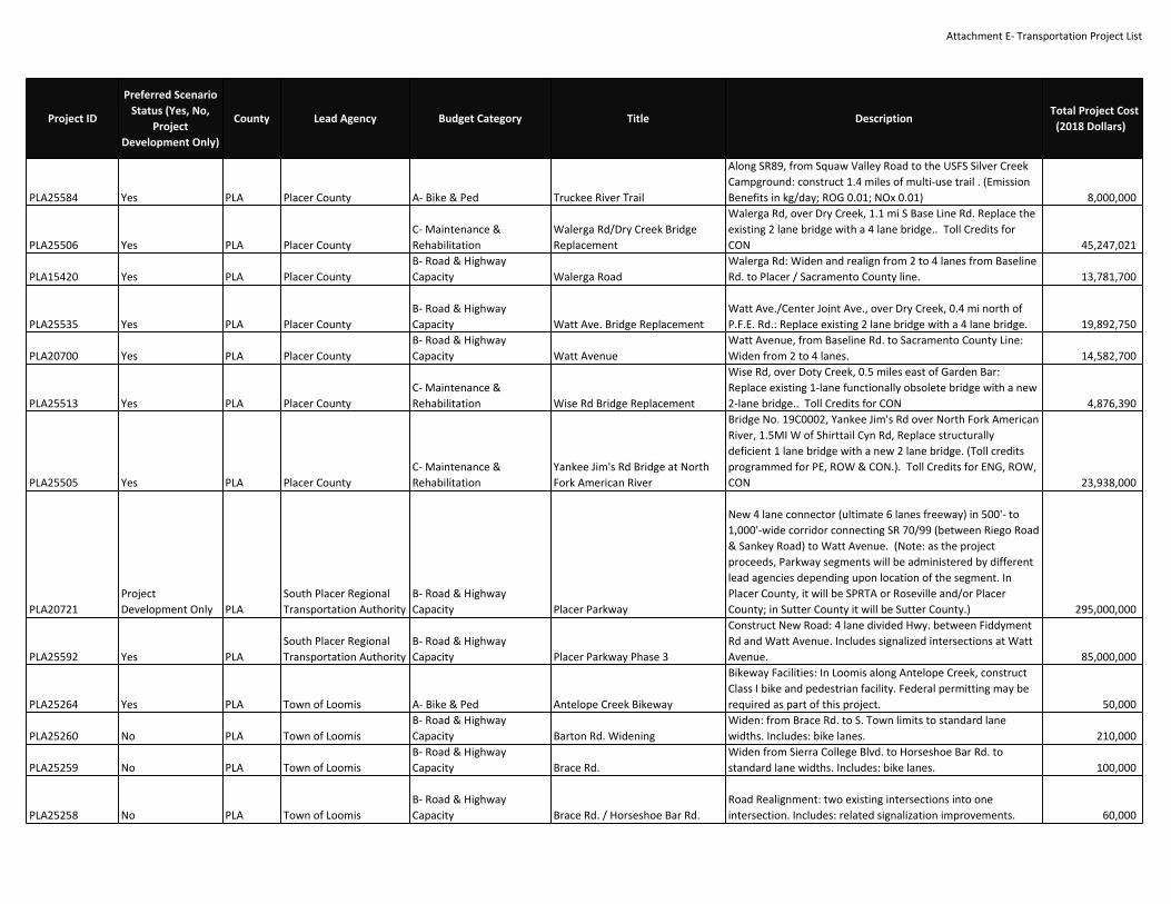
Attachment E‐ Transportation Project List
PLA25584 Yes PLA Placer County A‐ Bike & Ped Truckee River Trail
Along SR89, from Squaw Valley Road to the USFS Silver CreekCampground: construct 1.4 miles of multi‐use trail . (EmissionBenefits in kg/day; ROG 0.01; NOx 0.01) 8,000,000
PLA25506 Yes PLA Placer CountyC‐ Maintenance &Rehabilitation
Walerga Rd/Dry Creek BridgeReplacement
Walerga Rd, over Dry Creek, 1.1 mi S Base Line Rd. Replace theexisting 2 lane bridge with a 4 lane bridge.. Toll Credits forCON 45,247,021
PLA15420 Yes PLA Placer CountyB‐ Road & HighwayCapacity Walerga Road
Walerga Rd: Widen and realign from 2 to 4 lanes from BaselineRd. to Placer / Sacramento County line. 13,781,700
PLA25535 Yes PLA Placer CountyB‐ Road & HighwayCapacity Watt Ave. Bridge Replacement
Watt Ave./Center Joint Ave., over Dry Creek, 0.4 mi north ofP.F.E. Rd.: Replace existing 2 lane bridge with a 4 lane bridge. 19,892,750
PLA20700 Yes PLA Placer CountyB‐ Road & HighwayCapacity Watt Avenue
Watt Avenue, from Baseline Rd. to Sacramento County Line:Widen from 2 to 4 lanes. 14,582,700
PLA25513 Yes PLA Placer CountyC‐ Maintenance &Rehabilitation Wise Rd Bridge Replacement
Wise Rd, over Doty Creek, 0.5 miles east of Garden Bar:Replace existing 1‐lane functionally obsolete bridge with a new2‐lane bridge.. Toll Credits for CON 4,876,390
PLA25505 Yes PLA Placer CountyC‐ Maintenance &Rehabilitation
Yankee Jim's Rd Bridge at NorthFork American River
Bridge No. 19C0002, Yankee Jim's Rd over North Fork AmericanRiver, 1.5MI W of Shirttail Cyn Rd, Replace structurallydeficient 1 lane bridge with a new 2 lane bridge. (Toll creditsprogrammed for PE, ROW & CON.). Toll Credits for ENG, ROW,CON 23,938,000
PLA20721ProjectDevelopment Only PLA
South Placer RegionalTransportation Authority
B‐ Road & HighwayCapacity Placer Parkway
New 4 lane connector (ultimate 6 lanes freeway) in 500'‐ to1,000'‐wide corridor connecting SR 70/99 (between Riego Road& Sankey Road) to Watt Avenue. (Note: as the projectproceeds, Parkway segments will be administered by differentlead agencies depending upon location of the segment. InPlacer County, it will be SPRTA or Roseville and/or PlacerCounty; in Sutter County it will be Sutter County.) 295,000,000
PLA25592 Yes PLASouth Placer RegionalTransportation Authority
B‐ Road & HighwayCapacity Placer Parkway Phase 3
Construct New Road: 4 lane divided Hwy. between FiddymentRd and Watt Avenue. Includes signalized intersections at WattAvenue. 85,000,000
PLA25264 Yes PLA Town of Loomis A‐ Bike & Ped Antelope Creek Bikeway
Bikeway Facilities: In Loomis along Antelope Creek, constructClass I bike and pedestrian facility. Federal permitting may berequired as part of this project. 50,000
PLA25260 No PLA Town of LoomisB‐ Road & HighwayCapacity Barton Rd. Widening
Widen: from Brace Rd. to S. Town limits to standard lanewidths. Includes: bike lanes. 210,000
PLA25259 No PLA Town of LoomisB‐ Road & HighwayCapacity Brace Rd.
Widen from Sierra College Blvd. to Horseshoe Bar Rd. tostandard lane widths. Includes: bike lanes. 100,000
PLA25258 No PLA Town of LoomisB‐ Road & HighwayCapacity Brace Rd. / Horseshoe Bar Rd.
Road Realignment: two existing intersections into oneintersection. Includes: related signalization improvements. 60,000
Project ID
Preferred ScenarioStatus (Yes, No,
ProjectDevelopment Only)
County Lead Agency Budget Category Title DescriptionTotal Project Cost
(2018 Dollars)

Attachment E‐ Transportation Project List
PLA25277 Yes PLA Town of LoomisC‐ Maintenance &Rehabilitation Brace Rd. Bridge Improvements
Replace Bridge: at Secret Ravine creek. Includes: ancillary roadwork. 50,000
PLA25708ProjectDevelopment Only PLA Town of Loomis
B‐ Road & HighwayCapacity Brace Rd. Phase 2
Widen from I‐80 Overpass to Horseshoe Bar Rd. to standardlane widths. Includes: bike lanes. 100,000
PLA15290 Yes PLA Town of LoomisB‐ Road & HighwayCapacity Doc Barnes Dr.
Road Extension: 2 lanes, landscaped median and bike lanesfrom Horseshoe Bar Rd. to King Rd. 200,000
PLA16350 No PLA Town of LoomisB‐ Road & HighwayCapacity
Horseshoe Bar Road at I‐80Overcrossing Widening
Widen Horseshoe Bar Rd. @ I‐80 overcrossing 2 to 4 lanes andimprove ramps. 15,000,000
PLA25597 No PLA Town of LoomisB‐ Road & HighwayCapacity Horseshoe Bar Road Widening
Widen from Taylor Rd. to Highway 80 Interchange 2000 feetof two‐way left turn lanes/landscaped median, bike lanes,sidewalk, curb, gutter & underground Drainage system 800,000
PLA25261 Yes PLA Town of LoomisC‐ Maintenance &Rehabilitation
I‐80/Brace Road OvercrossingImprovements Modify Bridge: Brace Rd. Bridge to Caltrans standards. 1,000,000
PLA25262 Yes PLA Town of LoomisG‐ System Management,Operations, and ITS
King Rd. Interchange Modificationand Aux Lane
Interchange Modification: existing King Rd. overcrossing toaccommodate freeway access for traffic from King Rd. onto WBI‐80. Includes: a transition auxiliary lane on I‐80 from King Rd.to Horseshoe Bar interchange. 500,000
PLA25279 Yes PLA Town of LoomisC‐ Maintenance &Rehabilitation King Rd. Ops Improvements
Roadway Operational Improvements: at Sucker Ravine andKing Rd. expand culvert. Includes: ancillary road work. Federalpermitting may also be required as part of this project. 10,000
PLA25278 Yes PLA Town of LoomisC‐ Maintenance &Rehabilitation
Operational Improvements onAntelope Creek
Roadway Operational Improvements: Expand/ replace culvertalong Antelope Creek at King Rd. from Sierra College Blvd. toVet Clinic. Includes: ancillary road work. 60,000
PLA15350ProjectDevelopment Only PLA Town of Loomis
B‐ Road & HighwayCapacity Rocklin Rd. Widening
In Loomis, Rocklin Rd. from Barton Rd. to west town limits:widen from 2 to 4 lanes. 1,200,000
PLA25274 Yes PLA Town of LoomisC‐ Maintenance &Rehabilitation S. Holly Area
Roadway Operational Improvements: Storm drain extension inthe South Holly area. Includes: ancillary road work. Federalpermitting may also be required as part of this project. 40,000
PLA25263 Yes PLA Town of Loomis A‐ Bike & Ped Secret Ravine
Bikeway Facilities: Along Secret Ravine creek system fromnorth Loomis town limits to south Loomis town limits,construct Class I bike and pedestrian facility. 60,000
PLA20510ProjectDevelopment Only PLA Town of Loomis
B‐ Road & HighwayCapacity
Sierra College Blvd. RailroadCrossing Improvements Construct 4 lane overcrossing/undercrossing at UPRR Tracks. 3,000,000
Project ID
Preferred ScenarioStatus (Yes, No,
ProjectDevelopment Only)
County Lead Agency Budget Category Title DescriptionTotal Project Cost
(2018 Dollars)

Attachment E‐ Transportation Project List
PLA25280 Yes PLA Town of LoomisC‐ Maintenance &Rehabilitation Sierra College Blvd. Widening B
Roadway Operational Improvements: Culvert expansion atLoomis Tributary and Sierra College Blvd. Includes: ancillaryroad work. 40,000
PLA20890 Yes PLA Town of LoomisB‐ Road & HighwayCapacity Sierra College Blvd. Widening C
In Loomis, Sierra College Blvd. from railroad tracks (Taylor Rd.)to the north town limits: widen from 2 to 4 lanes and constructturn lanes, bike lanes, and landscaped median. 5,899,180
PLA20960 Yes PLA Town of LoomisB‐ Road & HighwayCapacity
Sierra College BoulevardWidening
In Loomis, Sierra College Blvd. from Granite Drive to TaylorRoad: widen from 4 to 6 lanes. 3,600,000
PLA‐Rehab8 Yes PLA Town of LoomisC‐ Maintenance &Rehabilitation Street & Road Maintenance
Estimated street and road maintenance costs including signals,safety devices, & street lights, storm drains, storm damage,patching, overlay and sealing, other street purposemaintenance. Excludes major rehabilitation and reconstructionprojects. ($ 634,000 annually) 12,680,000
PLA25269 Yes PLA Town of LoomisC‐ Maintenance &Rehabilitation
Taylor Rd. OperationalImprovments A
Roadway Operational Improvements: Construct storm drainfacility from King Rd. to Sierra College Blvd. Includes: ancillaryroad work. Federal permitting may also be required as part ofthis project. Phase 1 is King Rd. to Walnut Street, $800,000. 230,000
PLA25600 No PLA Town of LoomisB‐ Road & HighwayCapacity Webb St. Extension
Extend from Laird St. to future Doc Barnes Dr. 1800 feet of two‐way left turn lanes/landscaped median, bike lanes, sidewalk,curb, gutter & underground Drainage system 1,000,000
PLA25594 Yes PLA
Western PlacerConsolidatedTransportation ServiceAgency E‐ Transit Capital (Major) Placer County ‐ CTSA Capital
Capital costs for CTSA Article 4.5 & complementary ADA dial‐a‐ride services for designated CTSA operating in Placer County,including vehicles, miscellaneous capital items & facilitiesexpansion. 55,490,317
PLA25593 Yes PLA
Western PlacerConsolidatedTransportation ServiceAgency
F‐ Transit O&M (DemandResponse) Placer County ‐ CTSA O&M
Annual operation & maintenance (O&M) costs for Article 4.5Community Transit Services & complimentary Transit Services& complimentary ADA dial‐a‐ride services for designated CTSAof Placer County servicing Placer County & Cities 28,233,907
PLA25510 Yes PLA Western Placer CTSAF‐ Transit O&M (DemandResponse) Western Placer CTSA Operations
The Western Placer CTSA operates non‐emergency medicaltransportation demand‐response paratransit service; volunteerdoor‐to‐door transportation; & voucher program withinwestern Placer County. 4,900,000
Project ID
Preferred ScenarioStatus (Yes, No,
ProjectDevelopment Only)
County Lead Agency Budget Category Title DescriptionTotal Project Cost
(2018 Dollars)

Attachment E‐ Transportation Project List
CAL21068 Yes PLA, NEV Caltrans D3C‐ Maintenance &Rehabilitation
Repair shoulder damage andinstall concrete gutter in PlacerCounty on Route 80 from 0.3miles east of the South Yuba RiverBridge to Nevada County onRoute 80 at the Soda Springs OC A
Repair shoulder damage and install concrete gutter in PlacerCounty on Route 80 from 0.3 miles east of the South YubaRiver Bridge to Nevada County on Route 80 at the Soda SpringsOC 7,000,000
CAL21202 No SAC Caltrans D3B‐ Road & HighwayCapacity
15th ST off ramp to 16th ST onramp
US‐50 In EB direction from 15th ST off ramp to 16th ST on rampinstall auxiliary lane 1,500,000
CAL21204 No SAC Caltrans D3B‐ Road & HighwayCapacity
59th St off ramp to 65th St onramp
US‐50 In EB direction from 59th St off ramp to 65th St onramp install auxiliary lane 1,500,000
CAL20932 Yes SAC Caltrans D3G‐ System Management,Operations, and ITS 5th St.
US‐50 In Sacramento County on diagonal ramp at 5th St. Installramp meter 900,000
CAL21190 No SAC Caltrans D3G‐ System Management,Operations, and ITS
Add Aux Lane ‐ Truxel Rd slip offramp to Truxel Rd loop on ramp(T)
I‐80 Add Aux Lane ‐ Truxel Rd slip off ramp to Truxel Rd loop onramp (T) 1,500,000
CAL21020 Yes SAC Caltrans D3B‐ Road & HighwayCapacity
Arden to SB‐51/160. Add meter;change config from 1 to 2+1;convert ex to HOV; extendweaving area to Rte 51/160 SEP.
Arden to SB‐51/160. Add meter; change config from 1 to 2+1;convert ex to HOV; extend weaving area to Rte 51/160 SEP. 10,610,000
17691 Yes SAC Caltrans D3G‐ System Management,Operations, and ITS
At various locations on Sac, Ed,Yol, Pla and Nev counties onRoutes 5,50,51,65,80,89 and 99.Upgrade existing CCTV cameras.
At various locations on Sac, Ed, Yol, Pla and Nev counties onRoutes 5,50,51,65,80,89 and 99. Upgrade existing CCTVcameras. 2,376,000
17692 Yes SAC Caltrans D3G‐ System Management,Operations, and ITS
At various locations on Sac, ED,Yol, Pla, Nev and Sut counties onRoutes 5,50,51,65,80,89,99,160and 267. Upgrade existing CMSsigns with LED.
At various locations on Sac, ED, Yol, Pla, Nev and Sut countieson Routes 5,50,51,65,80,89,99,160 and 267. Upgrade existingCMS signs with LED. 4,224,000
CAL20949 Yes SAC Caltrans D3C‐ Maintenance &Rehabilitation
Bridge Rail Upgrades on 4 bridgesalong I‐80 and SR 51
Bridge rail upgrades at Br #24‐0291L (PM SR51_8.46); BR #24‐0293R (PM SR51_8.52); BR #24‐0203 (PM I‐80_M6.6); BR #24‐0205 (PM I‐80_M8.67). EA 1H910 29,210,000
CAL20625 Yes SAC Caltrans D3G‐ System Management,Operations, and ITS
Caltrans District 3 TrafficManagement Center (TMC)
Upgrade Caltrans District 3 TMC to manage US 50, I‐80 andother ITS Deployments 1,500,000
Project ID
Preferred ScenarioStatus (Yes, No,
ProjectDevelopment Only)
County Lead Agency Budget Category Title DescriptionTotal Project Cost
(2018 Dollars)
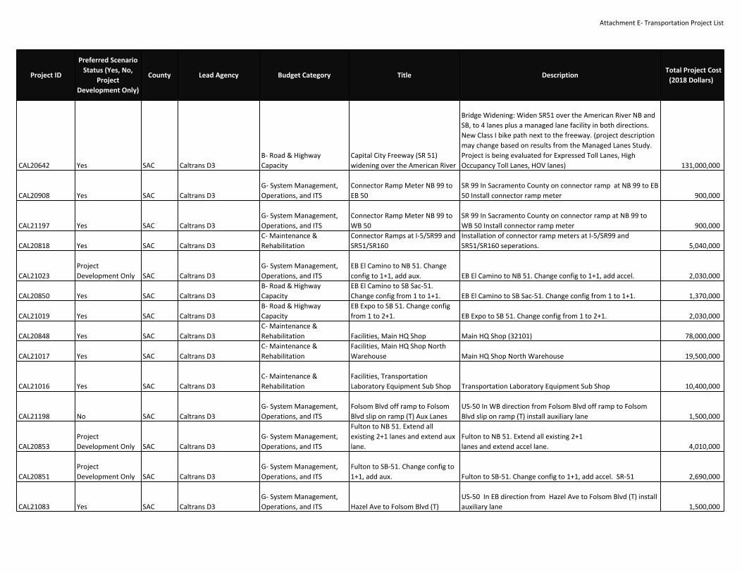
Attachment E‐ Transportation Project List
CAL20642 Yes SAC Caltrans D3B‐ Road & HighwayCapacity
Capital City Freeway (SR 51)widening over the American River
Bridge Widening: Widen SR51 over the American River NB andSB, to 4 lanes plus a managed lane facility in both directions.New Class I bike path next to the freeway. (project descriptionmay change based on results from the Managed Lanes Study.Project is being evaluated for Expressed Toll Lanes, HighOccupancy Toll Lanes, HOV lanes) 131,000,000
CAL20908 Yes SAC Caltrans D3G‐ System Management,Operations, and ITS
Connector Ramp Meter NB 99 toEB 50
SR 99 In Sacramento County on connector ramp at NB 99 to EB50 Install connector ramp meter 900,000
CAL21197 Yes SAC Caltrans D3G‐ System Management,Operations, and ITS
Connector Ramp Meter NB 99 toWB 50
SR 99 In Sacramento County on connector ramp at NB 99 toWB 50 Install connector ramp meter 900,000
CAL20818 Yes SAC Caltrans D3C‐ Maintenance &Rehabilitation
Connector Ramps at I‐5/SR99 andSR51/SR160
Installation of connector ramp meters at I‐5/SR99 andSR51/SR160 seperations. 5,040,000
CAL21023ProjectDevelopment Only SAC Caltrans D3
G‐ System Management,Operations, and ITS
EB El Camino to NB 51. Changeconfig to 1+1, add aux. EB El Camino to NB 51. Change config to 1+1, add accel. 2,030,000
CAL20850 Yes SAC Caltrans D3B‐ Road & HighwayCapacity
EB El Camino to SB Sac‐51.Change config from 1 to 1+1. EB El Camino to SB Sac‐51. Change config from 1 to 1+1. 1,370,000
CAL21019 Yes SAC Caltrans D3B‐ Road & HighwayCapacity
EB Expo to SB 51. Change configfrom 1 to 2+1. EB Expo to SB 51. Change config from 1 to 2+1. 2,030,000
CAL20848 Yes SAC Caltrans D3C‐ Maintenance &Rehabilitation Facilities, Main HQ Shop Main HQ Shop (32101) 78,000,000
CAL21017 Yes SAC Caltrans D3C‐ Maintenance &Rehabilitation
Facilities, Main HQ Shop NorthWarehouse Main HQ Shop North Warehouse 19,500,000
CAL21016 Yes SAC Caltrans D3C‐ Maintenance &Rehabilitation
Facilities, TransportationLaboratory Equipment Sub Shop Transportation Laboratory Equipment Sub Shop 10,400,000
CAL21198 No SAC Caltrans D3G‐ System Management,Operations, and ITS
Folsom Blvd off ramp to FolsomBlvd slip on ramp (T) Aux Lanes
US‐50 In WB direction from Folsom Blvd off ramp to FolsomBlvd slip on ramp (T) install auxiliary lane 1,500,000
CAL20853ProjectDevelopment Only SAC Caltrans D3
G‐ System Management,Operations, and ITS
Fulton to NB 51. Extend allexisting 2+1 lanes and extend auxlane.
Fulton to NB 51. Extend all existing 2+1lanes and extend accel lane. 4,010,000
CAL20851ProjectDevelopment Only SAC Caltrans D3
G‐ System Management,Operations, and ITS
Fulton to SB‐51. Change config to1+1, add aux. Fulton to SB‐51. Change config to 1+1, add accel. SR‐51 2,690,000
CAL21083 Yes SAC Caltrans D3G‐ System Management,Operations, and ITS Hazel Ave to Folsom Blvd (T)
US‐50 In EB direction from Hazel Ave to Folsom Blvd (T) installauxiliary lane 1,500,000
Project ID
Preferred ScenarioStatus (Yes, No,
ProjectDevelopment Only)
County Lead Agency Budget Category Title DescriptionTotal Project Cost
(2018 Dollars)

Attachment E‐ Transportation Project List
CAL20811 No SAC Caltrans D3B‐ Road & HighwayCapacity Hazel Ave to Sunrise Blvd on ramp
US‐50 In WB direction from Hazel Ave to Sunrise Blvd on rampinstall auxiliary lane 1,500,000
CAL21134 No SAC Caltrans D3B‐ Road & HighwayCapacity
Howe Ave loop on ramp to HoweAve slip on ramp
US‐50 In WB direction from Howe Ave loop on ramp to HoweAve slip on ramp install auxiliary lane 1,500,000
CAL20915 No SAC Caltrans D3B‐ Road & HighwayCapacity
Howe Ave off ramp to 59th St onramp
US‐50 In WB direction from Howe Ave off ramp to 59th St onramp install auxiliary lane 1,500,000
CAL21206 No SAC Caltrans D3B‐ Road & HighwayCapacity
Howe Ave on ramp to Watt Aveoff ramp
US‐50 In EB direction from Howe Ave on ramp to Watt Ave offramp install auxiliary lane 1,500,000
CAL21025 Yes SAC Caltrans D3G‐ System Management,Operations, and ITS
Howe to NB 51. Lengthen auxlane. Howe to NB 51. Lengthen aux lane. 2,690,000
CAL21024ProjectDevelopment Only SAC Caltrans D3
G‐ System Management,Operations, and ITS
Howe to NB‐51. Reconstruct I/C,hook ramp Howe to NB‐51. Reconstruct I/C, hook ramp, can't meter. 19,850,000
CAL20591ProjectDevelopment Only SAC Caltrans D3
B‐ Road & HighwayCapacity I‐ 5 / SR 99 Interchange
I‐5/SR 99 Interchange Reconstruction: includes: managed lanefacility freeway to freeway connectors. 200,000,000
16299 Yes SAC Caltrans D3 A‐ Bike & Ped I‐5 ADA ImprovementsADA Design‐Build at various locations in District 3 and inDistrict 4 in Solano County. (EA 0H320) 50,000,000
CAL18410 Yes SAC Caltrans D3B‐ Road & HighwayCapacity
I‐5 and I‐80 Managed LaneConnectors and Lanes toDowntown
Reconstruct I‐5/I‐80 Interchange, including lmanaged lanefacility connectors, and construction of managed lane facilityfrom the I‐5/I‐80 Interchange to downtown Sacramento (PM26.7/27.0) [EFIS ID 0300000313] (Emission Benefits in kg/day1.0 ROG) (project description may change based on resultsfrom the Managed Lanes Study. Project is being evaluated forExpressed Toll Lanes, High Occupancy Toll Lanes, HOV lanes) 300,000,000
CAL20771 Yes SAC Caltrans D3C‐ Maintenance &Rehabilitation
I‐5 at West End Viaduct (SHOPPLong Lead)
In the city of Sacramento, at West End Viaduct #24‐0069R/L(PM 23.6/24.3) ‐ Improve to standard truck capacity (SHOPPLong Lead) [CTIPS ID 107‐0000‐1116]. EA 1H610 51,434,000
CAL20417 Yes SAC Caltrans D3G‐ System Management,Operations, and ITS I‐5 Aux Lanes, Florin to Pocket
On I‐5, in the City and County of Sacramento, from Florin Roadto Pocket Road Southbound ‐ Operational improvements, laneextension (PM 16.1/17.2) [EFIS ID 0300001102] 1,500,000
CAL21270 Yes SAC Caltrans D3G‐ System Management,Operations, and ITS
I‐5 auxiliary (or transition lane)from Cosumnes River Blvd toPocket Road
In the City of Sacramento construct auxilary (or transition)lanes from Cosumnes River Blvd to Pocket Road in bothdirections 1,500,000
CAL21272 Yes SAC Caltrans D3G‐ System Management,Operations, and ITS
I‐5 Auxiliary Lane (NB) from DelPaso Road to SR 99 NB connectorramp
In Sacramento County construct auxiliary lanes on I‐5 from DelPaso Road off ramp to SR 99 NB connector ramp (PM 28.817‐29.772) 4,770,000
Project ID
Preferred ScenarioStatus (Yes, No,
ProjectDevelopment Only)
County Lead Agency Budget Category Title DescriptionTotal Project Cost
(2018 Dollars)

Attachment E‐ Transportation Project List
CAL21252 Yes SAC Caltrans D3G‐ System Management,Operations, and ITS
I‐5 Auxiliary Lane (NB) from ElkGrove Blvd to Laguna Blvd
In the City of Elk Grove construct an auxiliary lane on I‐5between Elk Grove Blvd to Laguna Blvd (NB direction) (PM10.822‐11.896) 5,370,000
CAL20809ProjectDevelopment Only SAC Caltrans D3
G‐ System Management,Operations, and ITS
I‐5 Auxiliary Lane (NB) from SR 99NB connector off ramp to SR 99SB connector on ramp
In the City of Sacramento at the I‐5/SR 99 interchange from SR99 NB connector off ramp to SR 99 SB connector on rampextend acceleration lanes (NB) on I‐5 2,520,000
CAL21271 No SAC Caltrans D3G‐ System Management,Operations, and ITS
I‐5 Auxiliary lane (NB) from theRichards Blvd off ramp to theRichard Blvd on ramp
In the City of Sacramento at the I‐5/Richards Blvd interchange(NB) construction an auxiliary between the Richards Blvd offramp and on ramp (24.525 ‐ 24.821) 2,940,000
CAL21254 No SAC Caltrans D3G‐ System Management,Operations, and ITS
I‐5 Auxiliary lane (NB) from theWB US 50 connector ramp to theP Street on ramp
In the City of Sacramento on I‐5, construct auxiliary lane fromthe WB US 50 connector ramp to the P street onramp (PM22.878‐23.302) 3,540,000
CAL21253ProjectDevelopment Only SAC Caltrans D3
G‐ System Management,Operations, and ITS
I‐5 Auxiliary Lane (SB) fromLaguna Blvd to Elk Grove Blvd
In the City of Elk Grove on I‐5 from Laguna Blvd to Elk GroveBlvd (SB) construct an auxiliary lane (PM 12.130‐10.822) 6,540,000
CAL21255 No SAC Caltrans D3G‐ System Management,Operations, and ITS
I‐5 Auxiliary Lane (SB) from the W.El Camino Ave on ramp to GardenBlvd
In the City of Sacramento on I‐5 between the W. El Camino Aveand Garden Blvd interchanges construct a SB auxiliary lane 7,320,000
CAL21256 Yes SAC Caltrans D3G‐ System Management,Operations, and ITS
I‐5 Auxiliary lane from Arena Blvdoff ramp to Arena Blvd on ramp(SB)
In the City of Sacramento at the I‐5/Arena Blvd interchangeconstruction an auxiliary lane between the SB off and on ramps(PMs 27.757 to 28.320) 1,500,000
CAL20975 Yes SAC Caltrans D3C‐ Maintenance &Rehabilitation I‐5 Bridge Improvements B West End Viaduct Bridge No. 24‐0069R/L 156,800,000
CAL21074 Yes Sac Caltrans D3C‐ Maintenance &Rehabilitation
I‐5 CAPM Strategy from AmericanRiver Bridge to Yolo County Line(PM 25.40 to 34.60)
CAPM strategy cold plane existing pavement an overlay with0.15' RHMA‐G and 0.1' RHMA‐O on mainline and ramps,rehabilitate existing drainage as needed, rehabilitate or replacenon‐standard ADA features, overhead sign structures, signpanels, and lighting as needed in Sacramento County on Route5 from American River Br 24‐0068 to Yolo Coiunty line 46,300,000
CAL20589 Yes SAC Caltrans D3B‐ Road & HighwayCapacity I‐5 Connector Ramp Extension
I‐5: Extend Southbound connector ramp from U.S. 50connector‐ramp to the Sutterville Rd. off‐ramp (PM 20.726 to21.55). 4,746,000
CAL20875 Yes SAC Caltrans D3C‐ Maintenance &Rehabilitation I‐5 Detection
In Sac, Yol, Col, & Gle Counties on Route 5 at various locations.Inductive Loop Replacement. 2,000,000
CAL20697 Yes SAC Caltrans D3C‐ Maintenance &Rehabilitation
I‐5 Elkhorn SRRA Water andWaste Water Rehab
Near the City of Sacramento, at the Elkhorn Safety RoadsideRest Area (SRRA) (PM 33.7) ‐ Upgrade potable water andwastewater systems (Toll Credits). Toll Credits for ENG, ROW,CON (EA: 4F580) (EFIS: 0314000186) 4,614,000
Project ID
Preferred ScenarioStatus (Yes, No,
ProjectDevelopment Only)
County Lead Agency Budget Category Title DescriptionTotal Project Cost
(2018 Dollars)

Attachment E‐ Transportation Project List
CAL20693 Yes SAC Caltrans D3C‐ Maintenance &Rehabilitation I‐5 Fiber Optics
In Sacramento, on I‐5, from 1.1 miles south of Elk GroveBoulevard to Route 50 ‐ Install fiber optic cable (PM 9.7/22.7)[CTIPS ID 107‐0000‐1004] (Toll Credits). Toll Credits for ENG,ROW, CON 10,580,000
CAL20466 Yes SAC Caltrans D3B‐ Road & HighwayCapacity I‐5 HOV Lanes ‐ Phase 1
In Sacramento County on I‐5, from US 50 to Morrison Creek ?Add high‐occupancy vehicle (HOV) lanes (i.e., bus/carpoollanes) and soundwalls in both directions (PM 12.9/22.5) [EFISID 0312000165]; see 03‐3C002 (CAL20467) for Phase 2 [PA&EDbeing done under 03‐3C000 (CAL17840)]. (Toll Credits for PEand ROW) (Emission Benefits in kg/day: 52.9 NOx, 50.4 ROG,10.5 PM10) [CTIPS ID 107‐0000‐0880](The I‐5 HOV Lanes ‐ Phase 1 project (03‐3C001/CAL20466) willbe combined for construction with the I‐5 Road Rehab project(03‐0H100/CAL20700) and the I‐5 Fiber Optics Installationproject (03‐4F450/CAL20693) to form the overall I‐5 CorridorEnhancement project (03‐0H10U). Project description maychange based on results from the Managed Lanes Study.Project is being evaluated for Expressed Toll Lanes, HighOccupancy Toll Lanes, HOV lanes 42,000,000
CAL20467 Yes SAC Caltrans D3B‐ Road & HighwayCapacity I‐5 HOV Lanes ‐ Phase 2
In Sacramento County on I‐5, from 1.1 mile south of Elk GroveBlvd to just north of Morrison Creek ‐ Add managed lanefacility (PM 9.7/13.1) [EFIS ID 0312000171]; see 03‐3C001(CAL20466) for Phase 1 [PA&ED being done under 03‐3C000(CAL17840)]. (project description may change based on resultsfrom the Managed Lanes Study. Project is being evaluated forExpressed Toll Lanes, High Occupancy Toll Lanes, HOV lanes) 15,000,000
CAL20824 Yes SAC Caltrans D3G‐ System Management,Operations, and ITS I‐5 ICM Implement ICM strategies on the I‐5 Corridor (Non‐capacity) 45,000,000
CAL20645 Yes SAC Caltrans D3C‐ Maintenance &Rehabilitation I‐5 ITS ‐ Fiber Optic ‐ 5 In Sacramento County on I‐5 from Pocket Road to Jct I‐80 2,800,000
CAL21261 Yes SAC Caltrans D3G‐ System Management,Operations, and ITS
I‐5 Loop Ramp Meter at the I‐5/Twin Cities Rd. interchange (SB)
In the Sacramento County at the I‐5/Twin Cities Roadinterchange (SB I‐5) install a loop ramp meter (1+1configuraiton) (PM 19.929) 900,000
Project ID
Preferred ScenarioStatus (Yes, No,
ProjectDevelopment Only)
County Lead Agency Budget Category Title DescriptionTotal Project Cost
(2018 Dollars)

Attachment E‐ Transportation Project List
CAL20586ProjectDevelopment Only SAC Caltrans D3
B‐ Road & HighwayCapacity I‐5 Managed Lanes A
Managed Lanes: US 50 to Junction I‐80 in both directions,including a new Class I bike path over the American River(project description may change based on results from theManaged Lanes Study. Project is being evaluated for ExpressedToll Lanes, High Occupancy Toll Lanes, HOV lanes) 116,000,000
CAL18790ProjectDevelopment Only SAC Caltrans D3
B‐ Road & HighwayCapacity I‐5 Managed Lanes B
Managed Lanes: Junction I‐80 to Sacramento InternationalAirport in both directions (project description may changebased on results from the Managed Lanes Study. Project isbeing evaluated for Expressed Toll Lanes, High Occupancy TollLanes, HOV lanes) 100,000,000
CAL21260ProjectDevelopment Only SAC Caltrans D3
B‐ Road & HighwayCapacity I‐5 Managed Lanes C
I‐5 Managed Lanes: Hood Franklin (1.1 mile south) to Elk GroveBoulevard 35,000,000
CAL20882 Yes SAC Caltrans D3B‐ Road & HighwayCapacity
I‐5 Managed Lanes fromSutterville Road to Yolo CountyLine
Construct managed lanes in both directions in SacramentoCounty on Route 5 from south of US 50 to Yolo County line 312,000,000
CAL20812ProjectDevelopment Only SAC Caltrans D3
B‐ Road & HighwayCapacity
I‐5 Managed Lanes: SacramentoInternational Airport to SR 16
I‐5 Managed Lanes: Yolo County Line to SR 16 (projectdescription may change based on results from the ManagedLanes Study. Project is being evaluated for Expressed TollLanes, High Occupancy Toll Lanes, HOV lanes) Pending
CAL21234ProjectDevelopment Only SAC Caltrans D3
G‐ System Management,Operations, and ITS
I‐5 NB add auxiliary lane fromHood Frankin slip on‐ramp to ElkGrove Blvd off‐ramp
In Sacramento County at the I‐5/Hood Franklin interchange,add truck‐only lane in both directions from Hood Frankin Blvdslip on‐ramp to Elk Grove Blvd off‐ramp 900,000
CAL20816 Yes SAC Caltrans D3G‐ System Management,Operations, and ITS
I‐5 NB Connector ramp meter atthe I‐5/I‐80 Interchange (EB 80 toNB 5)
In the City of Sacramento at the I‐5/I‐80 interchange (PM26.72), install a connector ramp meter from EB I‐80 to NB I‐5.Future configuration is a 2+1. 1,940,000
CAL20817 Yes SAC Caltrans D3G‐ System Management,Operations, and ITS
I‐5 NB Connector ramp meter atthe I‐5/I‐80 Interchange (WB 80 toNB 5)
In the City of Sacramento at the I‐5/I‐80 interchange (PM26.96), install a connector ramp meter from WB I‐80 to NB I‐5.Future configuration is a 2+1. 1,940,000
CAL21269 Yes SAC Caltrans D3G‐ System Management,Operations, and ITS
I‐5 NB Connector ramp meter atthe I‐5/US 50 Interchange (EB 50to NB 5)
In the City of Sacramento at the I‐5/US 50 interchange, install aconnector ramp meter from EB US 50 to NB I‐5 (PM 22.646) 1,940,000
CAL20910 Yes SAC Caltrans D3C‐ Maintenance &Rehabilitation
I‐5 NB Connector ramp meter atthe I‐5/US 50 Interchange (WB 50to NB 5)
In the City of Sacramento at the I‐5/US 50 interchange, install aconnector ramp meter from WB US 50 to NB I‐5 (PM 23.79) 1,940,000
CAL20819 Yes SAC Caltrans D3G‐ System Management,Operations, and ITS
I‐5 NB Loop Ramp Meter at the I‐5/Airpord Blvd. interchange
In Sacramento County at the I‐5/Airport Blvd interchange (PM32.69) install a loop ramp meter at the NB ramp 380,000
Project ID
Preferred ScenarioStatus (Yes, No,
ProjectDevelopment Only)
County Lead Agency Budget Category Title DescriptionTotal Project Cost
(2018 Dollars)

Attachment E‐ Transportation Project List
CAL21238 Yes SAC Caltrans D3G‐ System Management,Operations, and ITS
I‐5 NB Ramp Meter at Twin CitiesRoad
Near Galt, at the Twin Cities Road/SR 99 interchange (PM2.33), install a NB ramp meter (diagonal) 380,000
CAL20962 Yes SAC Caltrans D3C‐ Maintenance &Rehabilitation I‐5 Pavement Rehabilitation A
In Sacramento County from American River Bridge (Br#24‐0068) to Yolo County line. Pavement Rehab/CAPM. (EA 1H170) 46,303,000
CAL21035 Yes SAC Caltrans D3C‐ Maintenance &Rehabilitation I‐5 Pavement Rehabilitation B
In Sacramento County on Route 5 from the San Joaquin CountyLine to approx 0.2 miles north of Twin Cities Rd. (PM 0.0 ‐2.5) 22,700,000
CAL21034 Yes SAC Caltrans D3C‐ Maintenance &Rehabilitation
I‐5 Permit Load Mobilityimprovement project tostrengthen or replace structures24‐00267, 24‐0068L, and 24‐0068R to PPPPP standard; fair railrating on 24‐00627, 24‐0068L, and24‐0068R will be improved tocurrent standards in SacramentoCounty from the
I‐5 Permit Load Mobility improvement project to strengthen orreplace structures 24‐00267 (PM 22.42), 24‐0068L (24.82), and24‐0068R to PPPPP standard; fair rail rating on 24‐00627, 24‐0068L, and 24‐0068R will be improved to current standards inSacramento County from the 5/50 Separation to 0.5 milessouth of West El Camino OC (Accelerated Freight DeliveryProject). EA 3H390 (remove references to 24‐00267, thestructure was re‐evaluated and rated PPPPP) 54,750,000
CAL20700 Yes SAC Caltrans D3C‐ Maintenance &Rehabilitation I‐5 Road Rehab
In and near the City of Sacramento, from Beach Lake Bridge atMorrison Creek to the American River Bridge (#24‐0068) (PM13.0/24.9) ‐ Roadway rehabilitation (CTIPS ID 107‐0000‐1037)(Toll Credits). Toll Credits for ENG, ROW 267,400,000
CAL20965 Yes SAC Caltrans D3C‐ Maintenance &Rehabilitation
I‐5 Roadside PlantingRehabilitation A
In the city of Sacramento, from south of Broadway to 0.12 milesouth of R Street. Highway planting rehabilitation. 3,770,000
CAL21060 Yes SAC Caltrans D3C‐ Maintenance &Rehabilitation
I‐5 Roadside PlantingRehabilitation B
In Sacramento County on Route 5 from approx. 0.2 mile northof I St to Richards Blvd. Highway Planting Rehab. 1,300,000
CAL21247 Yes SAC Caltrans D3G‐ System Management,Operations, and ITS
I‐5 SB Loop Ramp Meter at the I‐5/Florin Road interchange (EB)
In Sacramento county at the I‐5/Florin Road interchange installa loop ramp meter. Future configuration is a 1+1. (EB FlorinRoad to SB I‐5) (PM 17.26)(EA 0H100) Pending
CAL21267 Yes SAC Caltrans D3G‐ System Management,Operations, and ITS
I‐5 SB Loop Ramp Meter at the I‐5/Florin Road interchange (WB)
In the City of Sacramento at the I‐5/Florin Road interchangeinstall a loop ramp meter. Future configuration is a 1+1. (WBFlorin Road to SB I‐5) (PM 17.26)(EA 0H100) Pending
CAL21259 Yes SAC Caltrans D3G‐ System Management,Operations, and ITS
I‐5 SB add auxiliary lane from ElkGrove Blvd on‐ramp toHoodFrankin slip off‐ramp
In Sacramento County at the I‐5/Hood Franklin interchange,install a NB ramp meter (loop) for the EB direction (PM 8.44).Future configuration 1+1. This project is part of EA 4F240. 900,000
Project ID
Preferred ScenarioStatus (Yes, No,
ProjectDevelopment Only)
County Lead Agency Budget Category Title DescriptionTotal Project Cost
(2018 Dollars)

Attachment E‐ Transportation Project List
CAL20815 Yes SAC Caltrans D3G‐ System Management,Operations, and ITS
I‐5 SB Connector Ramp Meter atthe I‐5/I‐80 interchange (EB I‐80to SB I‐5)
In the City of Sacramento at the I‐5/I‐80 interchange (PM26.55) install a connector ramp meter at the SB ramp from EB I‐80 to SB I‐5 1,940,000
CAL21251 Yes SAC Caltrans D3G‐ System Management,Operations, and ITS
I‐5 SB Connector Ramp Meter atthe I‐5/US 50 interchange
In the City of Sacramento at the I‐5/US 50 interchange, install aconnector ramp meter from EB US 50 to SB I‐5 (PM 22.347) 1,940,000
CAL20899 Yes SAC Caltrans D3G‐ System Management,Operations, and ITS
I‐5 SB Diagonal Ramp Meter atthe I‐5 rest stop
In Sacramento County, approximately one mile east of theSac/Yolo County line, install a SB diagonal ramp meter at therest stop south of I‐5 380,000
CAL21248 Yes SAC Caltrans D3G‐ System Management,Operations, and ITS
I‐5 SB Diagonal Ramp Meter atthe I‐5/Seamas Ave. interchange
In Sacramento county at the I‐5/Seamas Ave. interchange (SBdirection) install a diagonal ramp meter. Future configuration isa 1+1. (PM 19.186)(EA 0H100) Pending
CAL21249 Yes SAC Caltrans D3G‐ System Management,Operations, and ITS
I‐5 SB Diagonal Ramp Meter atthe I‐5/Sutterville Rd. interchange
In the City of Sacramento at the I‐5/Sutterville Roadinterchange (SB direction) install a diagonal ramp meter.Future configuration is a 1+1. (PM 20.388) (EA 0H100) Pending
CAL21080 Yes SAC Caltrans D3G‐ System Management,Operations, and ITS
I‐5 SB Loop Ramp Meter at the I‐5/Airpord Blvd. interchange
In Sacramento County at the I‐5/Airport Blvd interchange (PM32.87) install a loop ramp meter at the SB ramp 380,000
CAL21242 Yes SAC Caltrans D3G‐ System Management,Operations, and ITS
I‐5 SB Loop Ramp meter at the I‐5/Elk Grove Blvd interchange
In the City of Elk Grove at the I‐5/Elk Grove Blvd interchangeinstall a loop ramp meter. Future configuration is a 1+1. (PM10.882) 900,000
CAL21264 Yes SAC Caltrans D3G‐ System Management,Operations, and ITS
I‐5 SB Loop Ramp Meter at the I‐5/Laguna Blvd interchange
In the City of Elk Grove at the I‐5/Laguna Blvd interchangeinstall a loop ramp meter. Future configuration a 1+1. (PM12.188) 380,000
CAL21246 Yes SAC Caltrans D3G‐ System Management,Operations, and ITS
I‐5 SB Loop Ramp Meter at the I‐5/Pocket Road interchange (EB)
In Sacramento county at the I‐5/Pocket Road interchangeinstall a loop ramp meter. Future configuration is a 1+1. (EBPocket Road to SB I‐5) (PM 16.025) (EA0H100) Pending
CAL21266 Yes SAC Caltrans D3G‐ System Management,Operations, and ITS
I‐5 SB Loop Ramp Meter at the I‐5/Pocket Road interchange (WB)
In the City of Sacramento at the I‐5/Pocket Road interchangeinstall a loop ramp meter. Future configuration is a 1+1. (WBPocket Road to SB I‐5) (PM 16.201) (EA0H100) Pending
CAL20587 Yes SAC Caltrans D3G‐ System Management,Operations, and ITS I‐5 Transition Lane
I‐5 Transition Lane: SB, from Garden Hwy. off‐ramp to theGarden Hwy. on‐ramp. 4,000,000
CAL21082ProjectDevelopment Only SAC Caltrans D3
B‐ Road & HighwayCapacity
I‐5 transition lane (SB) at restarea 1 mile east of Sac/Yol countyline
In Sacramento County, about one mile east of the Sac/Yolocounty line, construct a SB transition lane at the rest area offramp to rest area on‐ramp (PM 34.008‐33.716) 1,500,000
Project ID
Preferred ScenarioStatus (Yes, No,
ProjectDevelopment Only)
County Lead Agency Budget Category Title DescriptionTotal Project Cost
(2018 Dollars)

Attachment E‐ Transportation Project List
CAL21258ProjectDevelopment Only SAC Caltrans D3
B‐ Road & HighwayCapacity
I‐5 transition lane (SB) Del Pasooff ramp to Del Paso loop on ramp(T), if SR‐99 added lane
In the City of Sacramento (SB) construct transition lane fromDel Paso off ramp to Del Paso loop on ramp (T), if SR‐99 addedlane (PM 29.226‐29.084) 6,070,000
CAL21001ProjectDevelopment Only SAC Caltrans D3
G‐ System Management,Operations, and ITS
I‐5 Transition Lane (SB) fromAirport Blvd on ramp to SR 99 NBConnector A
In Sacramento County near the city of Sacramento, at SB I‐5 atthe Airport Loop on‐ramp. Extend accel lane & add storagelane. (SHOPP ID: 18155) 3,102,000
CAL21073 Yes SAC Caltrans D3G‐ System Management,Operations, and ITS
I‐5 Transition Lane (SB) fromAirport Blvd on ramp to SR 99 NBConnector B
In Sacramento County near the city of Sacramento, at SB I‐5 atthe Airport Loop on‐ramp. Extend aux lane & add storage lane.(SHOPP ID: 18155) 3,000,000
CAL21273ProjectDevelopment Only SAC Caltrans D3
B‐ Road & HighwayCapacity
I‐5 transition lane (SB) from theSR‐99 SB connector to Del Pasooff ramp, if SR‐99 adds a lane
In the City of Sacramento (SB) construct I‐5 transition lanesfrom the SR‐99 SB connector to Del Paso off ramp, if SR‐99adds a lane (PM 23.535‐29.226) 1,500,000
CAL20810ProjectDevelopment Only SAC Caltrans D3
G‐ System Management,Operations, and ITS
I‐5 transition lane at the Air PortBlvd slip on ramp to County Road22 off ramp (NB)
In Sacramento County construct a NB accel. lane at the AirportBlvd slip on ramp to County Road 22 off ramp (PM 32.874‐0.469) 1,500,000
CAL21257ProjectDevelopment Only SAC Caltrans D3
B‐ Road & HighwayCapacity
I‐5 transiton lane (SB) Del Pasoloop on ramp to Del Paso slip onramp (T), if SR‐99 added lane
In the City of Sacramento (SB) construct I‐5 transition lanesfrom the Del Paso loop on ramp to Del Paso slip on ramp (T), ifSR‐99 added lane (PM 29.084‐28.882) 1,500,000
CAL18801ProjectDevelopment Only SAC Caltrans D3
B‐ Road & HighwayCapacity
I‐5/US 50 Riverfront InterchangeReconstruction
Reconstruct I‐5/US50 Riverfront Interchange, includingmanaged lane connectors (project description may changebased on results from the Managed Lanes Study. Project isbeing evaluated for Expressed Toll Lanes, High Occupancy TollLanes, HOV lanes) 100,000,000
CAL20707 Yes SAC Caltrans D3G‐ System Management,Operations, and ITS I‐80 Antelope Truck Scales
In Citrus Heights, I‐80, from east of Elkhorn Blvd. / GreenbackLane to west of Riverside Ave. (PM 15.2/17.0) ‐ Upgrade weigh‐in‐motion (WIM) station and widen the westbound auxiliarylane to the Antelope Truck Scales [CTIPS ID 107‐0000‐1046].Toll Credits for ENG (EA 0H530) 6,200,000
CAL20858 Yes SAC Caltrans D3C‐ Maintenance &Rehabilitation I‐80 Bridge Improvements
In Sacramento County in Sacramento from Northgate Blvd OCto Natomas East Canal OH. Rehab 2 structures (Br#24‐0217, 24‐0218). EA 4H190 1,535,000
Cal300 Yes SAC Caltrans D3G‐ System Management,Operations, and ITS
I‐80 Dig outs/Overlay,Ramps/Connectors I‐80 Dig outs/Overlay, Ramps/Connectors (1G500) 438,000
CAL20825 Yes SAC Caltrans D3G‐ System Management,Operations, and ITS I‐80 ICM A Implement ICM strategies on the I‐80 Corridor (Non‐capacity) 45,000,000
Project ID
Preferred ScenarioStatus (Yes, No,
ProjectDevelopment Only)
County Lead Agency Budget Category Title DescriptionTotal Project Cost
(2018 Dollars)
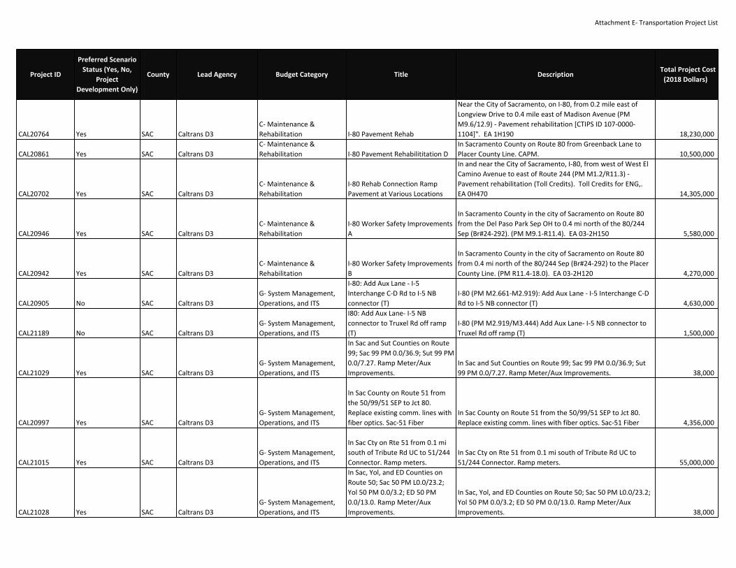
Attachment E‐ Transportation Project List
CAL20764 Yes SAC Caltrans D3C‐ Maintenance &Rehabilitation I‐80 Pavement Rehab
Near the City of Sacramento, on I‐80, from 0.2 mile east ofLongview Drive to 0.4 mile east of Madison Avenue (PMM9.6/12.9) ‐ Pavement rehabilitation [CTIPS ID 107‐0000‐1104]". EA 1H190 18,230,000
CAL20861 Yes SAC Caltrans D3C‐ Maintenance &Rehabilitation I‐80 Pavement Rehabilititation D
In Sacramento County on Route 80 from Greenback Lane toPlacer County Line. CAPM. 10,500,000
CAL20702 Yes SAC Caltrans D3C‐ Maintenance &Rehabilitation
I‐80 Rehab Connection RampPavement at Various Locations
In and near the City of Sacramento, I‐80, from west of West ElCamino Avenue to east of Route 244 (PM M1.2/R11.3) ‐Pavement rehabilitation (Toll Credits). Toll Credits for ENG,.EA 0H470 14,305,000
CAL20946 Yes SAC Caltrans D3C‐ Maintenance &Rehabilitation
I‐80 Worker Safety ImprovementsA
In Sacramento County in the city of Sacramento on Route 80from the Del Paso Park Sep OH to 0.4 mi north of the 80/244Sep (Br#24‐292). (PM M9.1‐R11.4). EA 03‐2H150 5,580,000
CAL20942 Yes SAC Caltrans D3C‐ Maintenance &Rehabilitation
I‐80 Worker Safety ImprovementsB
In Sacramento County in the city of Sacramento on Route 80from 0.4 mi north of the 80/244 Sep (Br#24‐292) to the PlacerCounty Line. (PM R11.4‐18.0). EA 03‐2H120 4,270,000
CAL20905 No SAC Caltrans D3G‐ System Management,Operations, and ITS
I‐80: Add Aux Lane ‐ I‐5Interchange C‐D Rd to I‐5 NBconnector (T)
I‐80 (PM M2.661‐M2.919): Add Aux Lane ‐ I‐5 Interchange C‐DRd to I‐5 NB connector (T) 4,630,000
CAL21189 No SAC Caltrans D3G‐ System Management,Operations, and ITS
I80: Add Aux Lane‐ I‐5 NBconnector to Truxel Rd off ramp(T)
I‐80 (PM M2.919/M3.444) Add Aux Lane‐ I‐5 NB connector toTruxel Rd off ramp (T) 1,500,000
CAL21029 Yes SAC Caltrans D3G‐ System Management,Operations, and ITS
In Sac and Sut Counties on Route99; Sac 99 PM 0.0/36.9; Sut 99 PM0.0/7.27. Ramp Meter/AuxImprovements.
In Sac and Sut Counties on Route 99; Sac 99 PM 0.0/36.9; Sut99 PM 0.0/7.27. Ramp Meter/Aux Improvements. 38,000
CAL20997 Yes SAC Caltrans D3G‐ System Management,Operations, and ITS
In Sac County on Route 51 fromthe 50/99/51 SEP to Jct 80.Replace existing comm. lines withfiber optics. Sac‐51 Fiber
In Sac County on Route 51 from the 50/99/51 SEP to Jct 80.Replace existing comm. lines with fiber optics. Sac‐51 Fiber 4,356,000
CAL21015 Yes SAC Caltrans D3G‐ System Management,Operations, and ITS
In Sac Cty on Rte 51 from 0.1 misouth of Tribute Rd UC to 51/244Connector. Ramp meters.
In Sac Cty on Rte 51 from 0.1 mi south of Tribute Rd UC to51/244 Connector. Ramp meters. 55,000,000
CAL21028 Yes SAC Caltrans D3G‐ System Management,Operations, and ITS
In Sac, Yol, and ED Counties onRoute 50; Sac 50 PM L0.0/23.2;Yol 50 PM 0.0/3.2; ED 50 PM0.0/13.0. Ramp Meter/AuxImprovements.
In Sac, Yol, and ED Counties on Route 50; Sac 50 PM L0.0/23.2;Yol 50 PM 0.0/3.2; ED 50 PM 0.0/13.0. Ramp Meter/AuxImprovements. 38,000
Project ID
Preferred ScenarioStatus (Yes, No,
ProjectDevelopment Only)
County Lead Agency Budget Category Title DescriptionTotal Project Cost
(2018 Dollars)

Attachment E‐ Transportation Project List
CAL20855 Yes SAC Caltrans D3G‐ System Management,Operations, and ITS
In Sac, Yol, and Pla Counties onRoute 80; Sac 80 PM M0.0/18.0;Yol 80 PM 0.0/R11.7; Pla 80 PM0.0/12.3. Ramp Meter/AuxImprovements.
In Sac, Yol, and Pla Counties on Route 80; Sac 80 PMM0.0/18.0; Yol 80 PM 0.0/R11.7; Pla 80 PM 0.0/12.3. RampMeter/Aux Improvements. 38,000
CAL21006ProjectDevelopment Only SAC Caltrans D3
G‐ System Management,Operations, and ITS
In Sacramento County at SB Sac‐99 to NB I‐5. Implementconnector metering and extendaux lane.
In Sacramento County at SB Sac‐99 to NB I‐5. Implementconnector metering and extend accel. lane. (PMR32.2) 700,000
18157 Yes SAC Caltrans D3G‐ System Management,Operations, and ITS
In Sacramento County at variouslocations from freeway tofreeway. Install 6 Master TrafficMonitoring Stations to capture allmajor interchanges Rampsdetection. Fwy to fwy connectorCMS.
In Sacramento County at various locations from freeway tofreeway. Install 6 Master Traffic Monitoring Stations to captureall major interchanges Ramps detection. Fwy to fwy connectorTMS. 4,200,000
CAL21004 Yes SAC Caltrans D3G‐ System Management,Operations, and ITS
In Sacramento County in the Cityof Galt from the county line toCosumnes River Bridge. Installnew Fiber Optics, upgrade existingITS, and install new ITS elements.Sac 99 Fiber/ITS
In Sacramento County in the City of Galt from the county lineto Cosumnes River Bridge. Install new Fiber Optics, upgradeexisting ITS, and install new ITS elements. Sac 99 Fiber/ITS 6,300,000
CAL20840 Yes SAC Caltrans D3G‐ System Management,Operations, and ITS
In Sacramento County in the Cityof Sacramento from county line toED County Line. Ramp metering,extend aux lanes. US 50 ICM‐Segment 2: Comm Detection, ITSElements, Ramp meter upgrades
US‐50 In Sacramento County in the City of Sacramento fromcounty line to ED County Line. Upgrade 22 ramp meteringsystems. Widen Ramps at WB Sac‐50 SB Bradshaw, SB Matherand NB Mather and extend accel. lanes. US 50 ICM‐Segment 2:Comm Detection, ITS Elements, RM upgrades. SHOPP ID 18166 9,700,000
CAL20841 Yes SAC Caltrans D3G‐ System Management,Operations, and ITS
In Sacramento County near theCity of Sacramento at NB On‐ramp at EB Florin Road. Add HOVRamp Meter Lane. EB Florin to NB99
In Sacramento County near the City of Sacramento at NB On‐ramp at EB Florin Road. Add HOV Ramp Meter Lane. EB Florinto NB 99 2,350,000
Project ID
Preferred ScenarioStatus (Yes, No,
ProjectDevelopment Only)
County Lead Agency Budget Category Title DescriptionTotal Project Cost
(2018 Dollars)

Attachment E‐ Transportation Project List
19487ProjectDevelopment Only SAC Caltrans D3
G‐ System Management,Operations, and ITS
In Sacramento County on I‐5 NBjust north of Elk Grove Blvd,construct 650 foot accelerationlane to close the gap and providea continuous three lane facility
In Sacramento County on I‐5 NB just north of Elk Grove Blvd,construct 650 foot acceleration lane to close the gap andprovide a continuous three lane facility 1,240,000
18498ProjectDevelopment Only SAC Caltrans D3
G‐ System Management,Operations, and ITS
In Sacramento County on Route 5.Ramp Meter/Aux Improvements.
In Sacramento County on Route 5. Ramp Meter/AuxImprovements. 38,000
CAL21031 Yes SAC Caltrans D3C‐ Maintenance &Rehabilitation
In Sacramento County on Route50 from Watt Ave to 0.5 mileseast of Folsom Blvd. PavementRehab.
In Sacramento County on Route 50 from Watt Ave to 0.5 mileseast of Folsom Blvd. Pavement Rehab. 86,500,000
CAL21232 Yes SAC Caltrans D3C‐ Maintenance &Rehabilitation
In Sacramento County on Route50 in Sacramento from FolsomBlvd UC to Occidental dr OC Roadside Restoration 1,250,000
CAL21003 Yes SAC Caltrans D3G‐ System Management,Operations, and ITS
In Sacramento County on Route80 at various locations fromcounty line to county line. Sac 80Fiber
In Sacramento County on Route 80 at various locations fromcounty line to county line. Sac 80 Fiber 13,400,000
CAL21219 Yes SAC Caltrans D3C‐ Maintenance &Rehabilitation
In Sacramento County on Route99 at Elkhorn Park & Ride Lot.
In Sacramento County on Route 99 at Elkhorn Park & Ride Lot.Replace AC surfacing
175,000
CAL20956ProjectDevelopment Only SAC Caltrans D3
G‐ System Management,Operations, and ITS
In Sacramento from the E StreetUC (Br#24‐192 R/L) to theAmerican River Bridge (Br#24‐3).Construct auxiliary lanes.
SR 51 In Sacramento from the E Street UC (Br#24‐192 R/L) tothe American River Bridge (Br#24‐3). Construct accel lanes. 3,960,000
CAL20972 Yes SAC Caltrans D3G‐ System Management,Operations, and ITS
In Sacramento, from Elk GroveBlvd to US 50, From Arden toMarconi, at Antelope Interchangeand from I‐80 to Pioneer Bridge.Install ramp meters.
In Sacramento, from Elk Grove Blvd to US 50, From Arden toMarconi, at Antelope Interchange and from I‐80 to PioneerBridge. Install ramp meters. 16,025,000
CAL21194 Yes SAC Caltrans D3G‐ System Management,Operations, and ITS
Install connector ramp meter SB51 to EB 50
SR 51 In Sacramento County on connector ramp at SB 51 to EB50 Install connector ramp meter 900,000
CAL21196 Yes SAC Caltrans D3G‐ System Management,Operations, and ITS
Install connector ramp meter SB51 to WB 50
SR 51 In Sacramento County on connector ramp at SB 51 to WB50 Install connector ramp meter 900,000
Project ID
Preferred ScenarioStatus (Yes, No,
ProjectDevelopment Only)
County Lead Agency Budget Category Title DescriptionTotal Project Cost
(2018 Dollars)

Attachment E‐ Transportation Project List
CAL21193 Yes SAC Caltrans D3G‐ System Management,Operations, and ITS
Install Connector Ramp Meter ‐ SB5 to EB 50
I‐5 In Sacramento County on connector ramp at SB 5 to EB 50Install connector ramp meter 900,000
CAL21195 Yes SAC Caltrans D3G‐ System Management,Operations, and ITS
Install Connector Ramp Meter ‐ SB5 to WB 50
I‐5 In Sacramento County on connector ramp at SB 5 to WB 50Install connector ramp meter 900,000
CAL21174 Yes SAC Caltrans D3G‐ System Management,Operations, and ITS Install Meter ‐ NB 5 to EB 80 EB Install Meter ‐ NB 5 to EB 80 EB 1,940,000
CAL20897 Yes SAC Caltrans D3G‐ System Management,Operations, and ITS Install Meter ‐ SB 5 to EB 80 EB Install Meter ‐ SB 5 to EB 80 EB 1,940,000
CAL21175 Yes SAC Caltrans D3G‐ System Management,Operations, and ITS
Install Meter ‐ EB Watt Ave RTStation Install Meter ‐ EB Watt Ave RT Station 300,000
CAL21268 Yes SAC Caltrans D3G‐ System Management,Operations, and ITS
Install Meter ‐ EB West El CaminoRd WB Install Meter ‐ EB West El Camino Rd WB 300,000
CAL21176 Yes SAC Caltrans D3G‐ System Management,Operations, and ITS Install Meter ‐ NB I5 to WB 80 WB Install Meter ‐ NB I5 to WB 80 WB 1,940,000
CAL20898 Yes SAC Caltrans D3G‐ System Management,Operations, and ITS Install Meter ‐ SB I5 to WB 80 WB Install Meter ‐ SB I5 to WB 80 WB 1,940,000
CAL21250 Yes SAC Caltrans D3G‐ System Management,Operations, and ITS
Install Meter ‐ WB West El CaminoRd WB Install Meter ‐ WB West El Camino Rd WB 3,000,000
CAL21233 Yes SAC Caltrans D3G‐ System Management,Operations, and ITS
Install Ramp Meters at variouslocation in Sacramento, Placerand Yolo counties
I‐5 (SB) Diagonal Ramp Meter in Sac County ‐ I Street (PM23.64)I‐80 (EB) Diagonal Ramp Meter in Yolo County ‐ Richards Blvd(PM 0.451)SR 51 (SB) Loop Ramp Meter in Sac County ‐ Arden Way (PM4.068)SR 99 (SB) Diagonal Ramp Meter in Sac County ‐ EB ElkhornBlvd (PM 33.18)SR 99 (SB) Loop Ramp Meter in Sac County ‐ WB Elk Horn Blvd(PM33.41)SR 65 (NB) Loop Ramp Meter in PLA county ‐ Pleasant GroveBlvd (PM R7.14) 137,000
CAL21021ProjectDevelopment Only SAC Caltrans D3
G‐ System Management,Operations, and ITS
Marconi to SB‐51. Add meter,change config from 1 to 2+1, addaux.
Marconi to SB‐51. Add meter, change config from 1 to 2+1, addaccel. 4,010,000
Project ID
Preferred ScenarioStatus (Yes, No,
ProjectDevelopment Only)
County Lead Agency Budget Category Title DescriptionTotal Project Cost
(2018 Dollars)

Attachment E‐ Transportation Project List
CAL21027ProjectDevelopment Only SAC Caltrans D3
G‐ System Management,Operations, and ITS
NB Watt to NB 51. Change configto 2+1, add aux. NB Watt to NB 51. Change config to 2+1, add accel. 4,010,000
CAL20911 No SAC Caltrans D3G‐ System Management,Operations, and ITS
Prairie City Rd off ramp to PrairieCity Rd loop on ramp (T) AuxLanes
US‐50 In WB direction from Prairie City Rd off ramp to PrairieCity Rd loop on ramp (T) install auxiliary lane (PM 19.510‐19.260) 1,500,000
CAL21200 No SAC Caltrans D3G‐ System Management,Operations, and ITS
Prairie City Rd loop on ramp toPrairie City Rd slip on ramp (T)Aux Lanes
US‐50 In WB direction from Prairie City Rd loop on ramp toPrairie City Rd slip on ramp (T) install auxiliary lane (PM 19.260‐18.990) 1,500,000
CAL21199 No SAC Caltrans D3G‐ System Management,Operations, and ITS
Prairie City Rd to Scott Rd (T) AuxLanes
US‐50 In EB direction from Prairie City Rd to Scott Rd (T) installauxiliary lane 1,500,000
CAL21216 Yes SAC Caltrans D3C‐ Maintenance &Rehabilitation
Repair steel structuralcomponents, 4 bridges, in SacCounty on SR 160
In Sacramento County near Rio Vista at the Three Mile SloughBr 24‐0121, Sacramento River (Isleton) Br 24‐0051, SteamboatSlough Br 24‐0052, and the Sacramento River (Paintersville) Br24‐0053, replace truss bridge lift system electrical andmechanical equipment, construct sidewalks at Three MileSlough bridge to provide access from roadway shoulder ontobridge and upgrade MBGR, install TMS count stations,communication, camera, and bridge instrumentation; provideMVPs for bridge operators (SHOPP ID 17676) 4,710,000
CAL20856 Yes SAC Caltrans D3C‐ Maintenance &Rehabilitation RTMC Upgrades
In Sacramento County at the Regional TransportationManagement Center (RTMC). Install new roof, new AC, andHVAC. Upgrade interior/exterior lighting to LED. Upgradesecurity system. If feasible, install solar panels. 1,953,000
CAL20943ProjectDevelopment Only SAC Caltrans D3
G‐ System Management,Operations, and ITS
Sac 005 OperationalImprovements
Extend Accel Lanes from SB Garden Hwy onramp and addcarpool/transit preferential lane at ramp meter (EA 0H430) 5,580,000
CAL20669 Yes SAC Caltrans D3C‐ Maintenance &Rehabilitation
SAC 05/80 Bridge Deck Rehab andRail Upgrade
I‐5, Florin Road OC (Br #24‐0264) and on I‐80 Del Paso OHBridges R/L (Br #24‐0193R/L) ‐ Perform deck maintenance andrehab of three bridges 10,230,000
CAL20696 Yes SAC Caltrans D3G‐ System Management,Operations, and ITS Sac/Yol Upgrade MBGR
In Sacramento County on Routes 5, 80 and 99 at variouslocations (PM 0.1/34.6); also in Yolo County on Route 80 (PM0.0/R11.7) ‐ Upgrade guard rail to current standards (TollCredits). Toll Credits for ENG, ROW, CON 3,605,000
Project ID
Preferred ScenarioStatus (Yes, No,
ProjectDevelopment Only)
County Lead Agency Budget Category Title DescriptionTotal Project Cost
(2018 Dollars)

Attachment E‐ Transportation Project List
CAL20471 Yes SAC Caltrans D3C‐ Maintenance &Rehabilitation
Sacramento Seismic Retrofit onVarious Bridges
In the City of Sacramento, on SR 160, at Sacramento RiverBridge #24‐0053 and North Sacramento Undercrossing #24‐0111L; also in San Joaquin County, at Mokelumne River Bridge#29‐0197R/L ‐ Seismic retrofit (PM 20.9) [CTIPS ID 107‐0000‐0908] (Toll Credits). Toll Credits for ENG, ROW, CON 38,681,000
CAL20699 Yes SAC Caltrans D3C‐ Maintenance &Rehabilitation
Sac‐Var Seismic Retrofit TwoStructures
In the City of Sacramento, at Southbound Route 99/5Connector Overcrossing #24‐0241F (PM R32.1); also on Route80 at Longview Ramp Overcrossing #24‐0281K (PM M9.15) ‐Seismic retrofit two structures [CTIPS ID 107‐0000‐1043] (TollCredits). Toll Credits for ENG 3,689,000
CAL20914 No SAC Caltrans D3B‐ Road & HighwayCapacity
SB Bradshaw Rd to Watt Ave offramp
US‐50 In WB direction from SB Bradshaw Rd to Watt Ave offramp install auxiliary lane 1,500,000
CAL21026ProjectDevelopment Only SAC Caltrans D3
G‐ System Management,Operations, and ITS
SB Watt to NB 51. Change configto 1+1, add aux. SB Watt to NB 51. Change config to 1+1, add accel. 2,690,000
CAL21022ProjectDevelopment Only SAC Caltrans D3
G‐ System Management,Operations, and ITS
SB Watt to SB‐51. Change configto 1+1, add aux. SB Watt to SB‐51. Change config to 1+1, add accel. 2,690,000
CAL21221 Yes SAC Caltrans D3C‐ Maintenance &Rehabilitation SR 104 Culvert Repairs
In Sacramento County from 0.9 mile east of Ivie Road to 2.5miles west of Rancho Secco Road.
325,000
CAL20867 Yes SAC Caltrans D3C‐ Maintenance &Rehabilitation SR 104 Pavement Rehabilitation
In Sacramento County on Route 104 from 104/99 Junction tothe county line. 16,940,000
CAL20507 Yes SAC Caltrans D3C‐ Maintenance &Rehabilitation SR 12 Bridge Rehab Near Rio Vista
SR 12 In Sacramento and Solano counties, near Rio Vista, atSacramento River Bridge #23‐0024 ‐ Clean and repaint steelsurfaces (PM 0.0/0.4) [EFIS ID 0313000139; CTIPS ID 107‐0000‐0961] [Total Project Cost $22,705,000 in 16/17 FY] (Toll Creditsfor PE). EA 3F570 37,057,000
CAL20427 Yes SAC Caltrans D3C‐ Maintenance &Rehabilitation SR 12 Operational Improvements
SR 12 Roadway Operational and Safety Improvements: RioVista to San Joaquin County line. Improvements will becoordinated with San Joaquin and Solano counties andanticipated corridor improvements. 10,000,000
16331 Yes SAC Caltrans D3C‐ Maintenance &Rehabilitation SR 12 Pavement Rehabilitation
In Sacramento County, near Rio Vista from the SacramentoRiver Bridge to the Mokelumne River Bridge. Sac‐12‐0/6.2. EA2F800 3,725,000
16779 Yes SAC Caltrans D3G‐ System Management,Operations, and ITS
SR 12 Rio Vista BridgeImprovements
In Sacramento County at the Sacramento River Bridge (Br#23‐0024) 22,860,000
CAL21075 Yes SAC Caltrans D3G‐ System Management,Operations, and ITS SR 16 Relinquishment A
In Sacramento County and City of Rancho Cordova, from SouthWatt Ave to East of Grant line Road. Relinquish Roadway. 2,100,000
Project ID
Preferred ScenarioStatus (Yes, No,
ProjectDevelopment Only)
County Lead Agency Budget Category Title DescriptionTotal Project Cost
(2018 Dollars)

Attachment E‐ Transportation Project List
CAL20878 Yes SAC Caltrans D3C‐ Maintenance &Rehabilitation SR 16 Relinquishment B
In Sacramento County and City of Rancho Cordova, from SouthWatt Ave to East of Grant line Road. Relinquish Roadway. 2,100,000
D3‐1ProjectDevelopment Only Sac Caltrans D3
B‐ Road & HighwayCapacity SR 16 Relinquishment Ph 2 SR 16 Relinquishment Ph 2
CAL21218 Yes SAC Caltrans D3C‐ Maintenance &Rehabilitation
SR 160 Electrical & MechnicalRepairs
In Sacramento County on Route 160 at three bridges,Paintersville Bridge (Br# 24‐0053), Isleton Bridge (Br# 24‐0051),and Steamboat Slough (Br# 24‐0052).
636,900
CAL21030 Yes SAC Caltrans D3C‐ Maintenance &Rehabilitation SR 160 Mitigation
Giant Garter Snake mitigation south Sacramento County, eastof Sacramento River. 1,700,000
CAL20862 Yes SAC Caltrans D3C‐ Maintenance &Rehabilitation SR 160 Pavement Rehabiliation A
In Sacramento County on Rte 160 from Walker Landing Rd toapprox 0.1 mile south of River Rd. (PM 9.6‐35.0) 23,900,000
CAL21047 Yes SAC Caltrans D3C‐ Maintenance &Rehabilitation SR 160 Pavement Rehabiliation B
In Sacramento County in Route 160 from Jct Rte 12 to approx0.1 mile north of Poverty Rd. CAPM. (R0.0 ‐ 6.0) 3,760,000
CAL21046 Yes SAC Caltrans D3C‐ Maintenance &Rehabilitation SR 160 Pavement Rehabiliation C
In Sacramento County on Route 160 from the county line to JctRte 12. (PM L0.0‐L10.8) 13,500,000
CAL20873 Yes SAC Caltrans D3C‐ Maintenance &Rehabilitation
SR 160 Roadside PlantingImprovement
In Sacramento County on Route 160 from Del Paso to TributeRd. Highway Planting Rehab. 1,300,000
CAL21059 Yes SAC Caltrans D3C‐ Maintenance &Rehabilitation SR 220 Pavement Rehabiliation
In Sacramento County on Route 220 from county line to Jct160. 3,000,000
CAL20597ProjectDevelopment Only SAC Caltrans D3
B‐ Road & HighwayCapacity SR 51 Transition Lane
Construct a SB transition lane on SR 51 SB from ExpositionBlvd. slip off‐ramp to Exposition Blvd. loop on‐ramp. 12,500,000
CAL21236 No SAC Caltrans D3G‐ System Management,Operations, and ITS
SR 51 (NB) Connector RampMeter A
In the City of Sacramento at the SR 51/99/50 interchangeconstruct a NB connector ramp meter from EB US 50 to NB SR51 (PM 0.14) 1,940,000
CAL21237 No SAC Caltrans D3G‐ System Management,Operations, and ITS
SR 51 (NB) Connector RampMeter B
In the City of Sacramento at the SR 51/99/50 interchangeconstruct a NB connector ramp meter from WB US 50 to NB SR51 (PM 0.14) 1,940,000
CAL21263 Yes SAC Caltrans D3G‐ System Management,Operations, and ITS
SR 51 (NB) Hook Ramp Meter atthe Howe Ave interchange
In the City of Sacramento construct a hook ramp meter at theSR 51/Howe Ave interchnage (NB) (PM 5.945) 380,000
CAL20909 Yes SAC Caltrans D3G‐ System Management,Operations, and ITS
SR 51 (NB) transition lane from ElCamino Ave slip on ramp toMarconi Ave
In the City of Sacramento construct SR 51 (NB) transition lanefrom El Camino Ave slip on ramp to Marconi Ave 1,500,000
CAL21164 No SAC Caltrans D3B‐ Road & HighwayCapacity
SR 51 (NB) transition lane from HStreet to J Street
In the City of Sacramento construct SR 51 (NB) aux. lane from HStreet to J Street (PM 1.066‐1.257) 1,500,000
CAL21222 No SAC Caltrans D3B‐ Road & HighwayCapacity
SR 51 (NB) Transition lane fromWatt Ave Slip off ramp to WattAve Slip on ramp
In the City of Sacramento construct SR 51 (NB) aux. lane fromWatt Ave Slip off ramp to Watt Ave Slip on ramp 1,500,000
Project ID
Preferred ScenarioStatus (Yes, No,
ProjectDevelopment Only)
County Lead Agency Budget Category Title DescriptionTotal Project Cost
(2018 Dollars)

Attachment E‐ Transportation Project List
CAL21239 Yes SAC Caltrans D3G‐ System Management,Operations, and ITS
SR 51 (SB) Diagonal Ramp Meterat Marconi Avenue
In the City of Sacramento construct a diagonal ramp meter atthe SR 51/Marconi Avenue interchange (SB) (PM 5.374) Futureconfiguration is a 2+1 380,000
CAL20921 No SAC Caltrans D3B‐ Road & HighwayCapacity
SR 51 (SB) transition lane fromAuburn Blvd off ramp to MarconiAve on ramp
In the City of Sacramento construct SR 51 (SB) aux. lane fromAuburn Blvd off ramp to Marconi Ave on ramp (PM 5.761‐5.374) 1,500,000
CAL21135 Yes SAC Caltrans D3G‐ System Management,Operations, and ITS
SR 51 (SB) transition lane from EStreet to J Street
In the City of Sacramento construct SR 51 (SB) transition lanefrom E Street to J Street (PM 1.674‐1.288) 1,500,000
CAL20919 No SAC Caltrans D3B‐ Road & HighwayCapacity
SR 51 (SB) transition lane fromFulton Ave on ramp to AuburnBlvd off ramp
In the City of Sacramento construct SR 51 (SB) aux. lane fromFulton Ave on ramp to Auburn Blvd off ramp 1,500,000
CAL21171 No SAC Caltrans D3B‐ Road & HighwayCapacity
SR 51 (SB) transition lane from JStreet to E Street
In the City of Sacramento construct SR 51 (NB) aux. lane from JStreet to E Street (PM 1.257‐1.579) 1,500,000
CAL21154 Yes SAC Caltrans D3G‐ System Management,Operations, and ITS
SR 51 (SB) transition lane from PStreet to N Street
In the City of Sacramento construct SR 51 (SB) transition lanefrom P Street to N Street (PM 0.808‐0.523) 1,500,000
CAL20906 Yes SAC Caltrans D3G‐ System Management,Operations, and ITS
SR 51 (SB) Transition Lane from SBWatt Ave slip on ramp to AuburnBlvd slip on ramp
In the City of Sacramento construct SB transition lane from SBWatt Ave slip on ramp to Auburn Blvd slip on ramp (PM 7.886‐7.521) 1,500,000
CAL21209 No SAC Caltrans D3B‐ Road & HighwayCapacity
SR 51 (SB) transition lanes fromFulton Ave off ramp to Fulton Aveon ramp
In the City of Sacramento construct SR 51 SB aux. lanes fromFulton Ave off ramp to Fulton Ave on ramp 1,500,000
CAL20594 Yes SAC Caltrans D3G‐ System Management,Operations, and ITS SR 51 Auxiliary Lane
SR 51: Widen structure over Arden Way to 8 lanes plus 2bus/carpool lanes a managed lane facility in both directionsand construct a Transition Lane: NB, from SR160 off ramp toArden Way on ramp (project description may change based onresults from the Managed Lanes Study. Project is beingevaluated for Expressed Toll Lanes, High Occupancy Toll Lanes,HOV lanes) 46,000,000
CAL20691 Yes SAC Caltrans D3C‐ Maintenance &Rehabilitation
SR 51 Bridge Deck Replacement(G13 Contingency Project)
In the City of Sacramento at the American River Bridge #24‐0003, from north of B Street Underpass to north of ExpositionBoulevard Overcrossing (PM 2.0/3.5) ‐ Widen and replacebridge deck (G13 Contingency Project) [CTIPS ID 107‐0000‐1048]. Toll Credits for ENG". EA 3F070 163,940,000
CAL21123 Yes SAC Caltrans D3B‐ Road & HighwayCapacity
SR 51 Bus/Carpool Lanes: Ardento I‐80
Managed Lane Facility: Arden to I‐80 in both directions (projectdescription may change based on results from the ManagedLanes Study. Project is being evaluated for Expressed TollLanes, High Occupancy Toll Lanes, HOV lanes) 265,000,000
Project ID
Preferred ScenarioStatus (Yes, No,
ProjectDevelopment Only)
County Lead Agency Budget Category Title DescriptionTotal Project Cost
(2018 Dollars)

Attachment E‐ Transportation Project List
CAL20977 Yes SAC Caltrans D3C‐ Maintenance &Rehabilitation SR 51 Drainage Improvements
In Sacramento County, approximately 0.1 mile North ofMarconi Ave, 24‐31W, 24‐117W, 24‐123W. 1,816,000
CAL20826 Yes Sac Caltrans D3G‐ System Management,Operations, and ITS SR 51 ICM Implement ICM strategies on the SR 51 Corridor (Non‐capacity) 45,000,000
CAL21053 Yes SAC Caltrans D3C‐ Maintenance &Rehabilitation SR 51 Median Concrete Barrier
In Sacramento County on Route 51 just north of Marconi AveOC, install outer separation barrier from PM 5.6 to PM 5.9 inthe NB direction and replace MBGR with outer separationbarrier from PM 5.6 to PM 5.7 in the SB direction 4,985,000
CAL21038 Yes SAC Caltrans D3C‐ Maintenance &Rehabilitation SR 51 Pavement Rehab
In Sacramento County on Route 51 from the County Line toapprox. 0.4 mile north of Arden Way. 10,247,000
CAL20924 Yes SAC Caltrans D3C‐ Maintenance &Rehabilitation SR 51 Roadside Restoration A
In Sacramento County on Route 51 in Sacramento from the50/99/51 Seperation to E Street 1,250,000
CAL21223 Yes SAC Caltrans D3C‐ Maintenance &Rehabilitation SR 51 Roadside Restoration B
In Sacramento County on Route 51 in Sacramento from ardenWay to marconi Ave 1,250,000
CAL20592 No SAC Caltrans D3B‐ Road & HighwayCapacity SR 51 Transition Lane
SR 51 Transition Lane: NB, from the Elvas Underpass toExposition Blvd. 1,500,000
CAL21203 No SAC Caltrans D3B‐ Road & HighwayCapacity
SR 51 Transition Lane (NB) at ElCamino Interchange
In the City of Sacramento construction SR 51 (NB) aux. lanes atthe El Camino IC: El Camino Ave off ramp to El Camino Aveloop on ramp and El Camino Loop on ramp to El Camino Aveslip on ramp 1,500,000
CAL20596 Yes SAC Caltrans D3G‐ System Management,Operations, and ITS SR 51 Transition Lanes
SR 51 Transition Lanes: NB from Marconi Ave. to FultonAve.and SB from Fulton Ave. to Watt Ave. 84,700,000
CAL20933 Yes SAC Caltrans D3B‐ Road & HighwayCapacity
SR 51 Worker SafetyImprovements
In Sacramento County in the city of Sacramento on Route 51from 0.1 mi south of B street UP (Br#24‐23) to 0.4 mi north ofArden Way. 2H110 5,990,000
CAL20600 Yes SAC Caltrans D3G‐ System Management,Operations, and ITS SR 99 Auxiliary Lane A
SR 99 auxiliary lane: NB from WB Florin Rd. slip on ramp to EB47th Ave. slip off ramp. Right‐of‐way aquisition required.Soundwall relocation required. 3,000,000
CAL21084ProjectDevelopment Only SAC Caltrans D3
G‐ System Management,Operations, and ITS SR 99 Auxiliary Lane B
SR 99 auxiliary lane: SB from 47th Ave slip on ramp to FlorinRd slip off ramp 3,040,000
CAL21081 Yes SAC Caltrans D3G‐ System Management,Operations, and ITS
SR 99 (NB) auxiliary lane from theWB Mack Road slip on ramp tothe EB Florin Road slip off ramp
In the City of Sacramento construct SR 99 (NB) auxiliary lanefrom the WB Mack Road slip on ramp to the EB Florin Road slipoff ramp (PM 19.747‐20.628) 7,560,000
CAL21177 Yes SAC Caltrans D3G‐ System Management,Operations, and ITS
SR 99 (NB) diagonal ramp meterat the SR 99/Elkhorn Blvdinterchange
In the City of Elk Grove construct a diagonal ramp meter at theSR 99/Elkhorn Blvd westbound (WB) on ramp (PM 33.55) 380,000
Project ID
Preferred ScenarioStatus (Yes, No,
ProjectDevelopment Only)
County Lead Agency Budget Category Title DescriptionTotal Project Cost
(2018 Dollars)
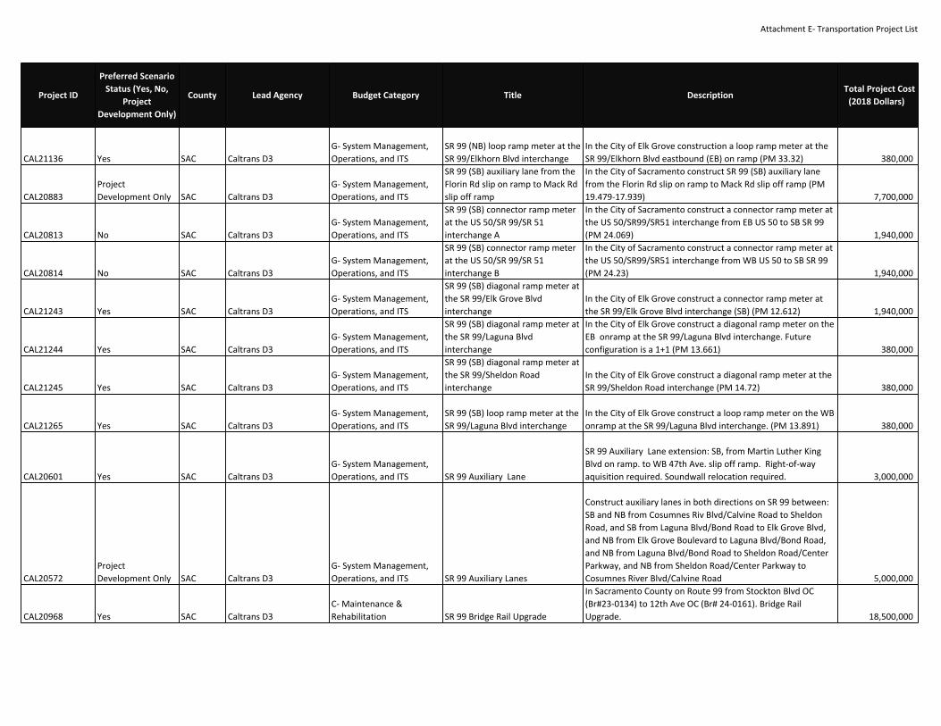
Attachment E‐ Transportation Project List
CAL21136 Yes SAC Caltrans D3G‐ System Management,Operations, and ITS
SR 99 (NB) loop ramp meter at theSR 99/Elkhorn Blvd interchange
In the City of Elk Grove construction a loop ramp meter at theSR 99/Elkhorn Blvd eastbound (EB) on ramp (PM 33.32) 380,000
CAL20883ProjectDevelopment Only SAC Caltrans D3
G‐ System Management,Operations, and ITS
SR 99 (SB) auxiliary lane from theFlorin Rd slip on ramp to Mack Rdslip off ramp
In the City of Sacramento construct SR 99 (SB) auxiliary lanefrom the Florin Rd slip on ramp to Mack Rd slip off ramp (PM19.479‐17.939) 7,700,000
CAL20813 No SAC Caltrans D3G‐ System Management,Operations, and ITS
SR 99 (SB) connector ramp meterat the US 50/SR 99/SR 51interchange A
In the City of Sacramento construct a connector ramp meter atthe US 50/SR99/SR51 interchange from EB US 50 to SB SR 99(PM 24.069) 1,940,000
CAL20814 No SAC Caltrans D3G‐ System Management,Operations, and ITS
SR 99 (SB) connector ramp meterat the US 50/SR 99/SR 51interchange B
In the City of Sacramento construct a connector ramp meter atthe US 50/SR99/SR51 interchange from WB US 50 to SB SR 99(PM 24.23) 1,940,000
CAL21243 Yes SAC Caltrans D3G‐ System Management,Operations, and ITS
SR 99 (SB) diagonal ramp meter atthe SR 99/Elk Grove Blvdinterchange
In the City of Elk Grove construct a connector ramp meter atthe SR 99/Elk Grove Blvd interchange (SB) (PM 12.612) 1,940,000
CAL21244 Yes SAC Caltrans D3G‐ System Management,Operations, and ITS
SR 99 (SB) diagonal ramp meter atthe SR 99/Laguna Blvdinterchange
In the City of Elk Grove construct a diagonal ramp meter on theEB onramp at the SR 99/Laguna Blvd interchange. Futureconfiguration is a 1+1 (PM 13.661) 380,000
CAL21245 Yes SAC Caltrans D3G‐ System Management,Operations, and ITS
SR 99 (SB) diagonal ramp meter atthe SR 99/Sheldon Roadinterchange
In the City of Elk Grove construct a diagonal ramp meter at theSR 99/Sheldon Road interchange (PM 14.72) 380,000
CAL21265 Yes SAC Caltrans D3G‐ System Management,Operations, and ITS
SR 99 (SB) loop ramp meter at theSR 99/Laguna Blvd interchange
In the City of Elk Grove construct a loop ramp meter on the WBonramp at the SR 99/Laguna Blvd interchange. (PM 13.891) 380,000
CAL20601 Yes SAC Caltrans D3G‐ System Management,Operations, and ITS SR 99 Auxiliary Lane
SR 99 Auxiliary Lane extension: SB, from Martin Luther KingBlvd on ramp. to WB 47th Ave. slip off ramp. Right‐of‐wayaquisition required. Soundwall relocation required. 3,000,000
CAL20572ProjectDevelopment Only SAC Caltrans D3
G‐ System Management,Operations, and ITS SR 99 Auxiliary Lanes
Construct auxiliary lanes in both directions on SR 99 between:SB and NB from Cosumnes Riv Blvd/Calvine Road to SheldonRoad, and SB from Laguna Blvd/Bond Road to Elk Grove Blvd,and NB from Elk Grove Boulevard to Laguna Blvd/Bond Road,and NB from Laguna Blvd/Bond Road to Sheldon Road/CenterParkway, and NB from Sheldon Road/Center Parkway toCosumnes River Blvd/Calvine Road 5,000,000
CAL20968 Yes SAC Caltrans D3C‐ Maintenance &Rehabilitation SR 99 Bridge Rail Upgrade
In Sacramento County on Route 99 from Stockton Blvd OC(Br#23‐0134) to 12th Ave OC (Br# 24‐0161). Bridge RailUpgrade. 18,500,000
Project ID
Preferred ScenarioStatus (Yes, No,
ProjectDevelopment Only)
County Lead Agency Budget Category Title DescriptionTotal Project Cost
(2018 Dollars)

Attachment E‐ Transportation Project List
CAL20766 Yes SAC Caltrans D3C‐ Maintenance &Rehabilitation
SR 99 Bridge Rehab at 21stAvenue UC
In the City of Sacramento, SR 99, at 21st Avenue Undercrossing#24‐0154 (PM 21.9/23.6) ‐ Replace bridge deck [CTIPS ID 107‐0000‐1107] (Toll Credits). Toll Credits for ENG, ROW, CON 5,843,000
CAL20876 Yes SAC Caltrans D3G‐ System Management,Operations, and ITS SR 99 Detection
In Sac, Sut, & But Counties on Route 99 at various locations.Inductive Loop Replacement. 2,000,000
CAL20871 Yes SAC Caltrans D3C‐ Maintenance &Rehabilitation SR 99 Drainage Improvements A
In Sacramento County from Amador Ave OC to just north of41st Ave OC, PP 24‐139W, 24‐144W, 24‐146W. Upgrade PumpPlants. 1,816,000
CAL20976 Yes SAC Caltrans D3C‐ Maintenance &Rehabilitation SR 99 Drainage Improvements B
In Sacramento County, approximately 0.1 mile North ofMcConnell UP (Br# 24‐48L), 24‐48W. Pump Plant Upgrade. 528,000
CAL20762 Yes SAC Caltrans D3G‐ System Management,Operations, and ITS SR 99 Fiber Optics
Install fiber in and near the cities of Elk Grove and Sacramento,on SR 99, from Grant Line Road to SR 50 (PM 10.0/R24.3); alsoon SR 51 from SR 50 to 0.1 mile south of the Fort SutterViaduct (PM 0.0/0.1) ‐ Install fiber optic cable [CTIPS ID 107‐0000‐1106] (Toll Credits). Toll Credits for ENG. 0H670 12,150,000
CAL20827 Yes SAC Caltrans D3G‐ System Management,Operations, and ITS SR 99 ICM Implement ICM strategies on the SR 99 Corridor (Non‐capacity) 45,000,000
CAL20602 Yes SAC Caltrans D3G‐ System Management,Operations, and ITS SR 99 Interchange Improvements
Interchange Improvements: Mack Road, Florin Road, 47th Ave.,12th Ave. 40,000,000
CAL20945 Yes SAC Caltrans D3G‐ System Management,Operations, and ITS SR 99 ITS
From Elk Grove Blvd Over Crossing to City of Sacramento Jnct50/51 Rte Break. EA 0H670 12,150,000
CAL20929ProjectDevelopment Only SAC Caltrans D3
B‐ Road & HighwayCapacity SR 99 Managed lane extension
SR 99 Managed Lane facility extension ‐ San Joaquin/SacCounty Line to Kammerer/Grant Line Road (project descriptionmay change based on results from the Managed Lanes Study.Project is being evaluated for Expressed Toll Lanes, HighOccupancy Toll Lanes, HOV lanes) 35,000,000
CAL20647 Yes SAC Caltrans D3B‐ Road & HighwayCapacity SR 99 Managed Lanes
Managed Lane Facility and auxiliary lanes in both directionsfrom Elk Grove Boulevard to Kammerer Road/Grant Line Road. 36,000,000
CAL20828ProjectDevelopment Only SAC Caltrans D3
G‐ System Management,Operations, and ITS
SR 99 Managed Lanes from ElkGrove Boulevard to J StreetUnderpass
Convert existing HOV lanes to toll lanes or possibly install areversible lane Pending
CAL20859 Yes SAC Caltrans D3C‐ Maintenance &Rehabilitation SR 99 Pavement Rehabilitation B
In Sacramento County on Route 99 from MLK Blvd OC toapprox 0.1 mile north of Jct 50/51. 12,100,000
Project ID
Preferred ScenarioStatus (Yes, No,
ProjectDevelopment Only)
County Lead Agency Budget Category Title DescriptionTotal Project Cost
(2018 Dollars)

Attachment E‐ Transportation Project List
CAL20843 Yes SAC Caltrans D3C‐ Maintenance &Rehabilitation SR 99 Pavement Rehabilitation D In Sacramento from Route 5 Interchange to Sutter County Line. 9,550,000
CAL20703 Yes SAC Caltrans D3C‐ Maintenance &Rehabilitation
SR 99 RHMA Overlay (G13Contingency Project)
In Galt, from the San Joaquin County Line to Simmerhorn Road(PM 0.2/1.6); also in the cities of Elk Grove and Sacramento, SR99, from 0.7 mile south of Elk Grove Blvd to Martin Luther KingJr Blvd (PM 11.9/21.5) ‐ Pavement rehabilitation [CTIPS ID 107‐0000‐1047] 45,012,000
CAL20470 Yes SAC Caltrans D3C‐ Maintenance &Rehabilitation
SR 99 Seismic Retrofit and BridgeRail Upgrade
In and near Elk Grove, from 0.3 mile south of Dillard Road OCto south of Grant Line Road [replace Cosumnes River Bridge#24‐0020R/L and Cosumnes River Overflow Bridge #24‐0021R/L; upgrade bridge rails at Dillard Road OC #24‐0163;construct new McConnell OH #24‐0048L) ‐ Bridge seismicretrofit, bridge scour retrofit, bridge rail replacement andbridge replacement (PM 7.1/9.4) [CTIPS ID 107‐0000‐0904] 139,000,000
CAL20599 Yes SAC Caltrans D3G‐ System Management,Operations, and ITS SR 99 Transition Lane
SR 99 Transition Lane: NB, from WB 47th Ave. slip on ramp toEB Fruitridge Rd. slip on ramp, and from WB Fruitridge Rd. loopoff ramp to WB Fruitridge Rd. slip on ramp. Right‐of‐wayaquisition required. Soundwall relocation required. 3,000,000
CAL20508 Yes SAC Caltrans D3C‐ Maintenance &Rehabilitation
SR 99/160 Scour Mitigation forFour (4) Bridges
In Sacramento County, on SR 99, at South Lagoon Creek Bridge#24‐0028L (PM 4.9), Lagoon Creek Bridge #24‐0045L (PM 5.0)and North Lagoon Creek Bridge #24‐0027L (PM 5.1); also on SR160 (PM 44.5) at American River Bridge #24‐0001L ‐ Scourmitigation [EFIS ID 0313000136; CTIPS ID 107‐0000‐0963] (TollCredits). Toll Credits for ENG, ROW, CON 26,792,000
18171ProjectDevelopment Only SAC Caltrans D3
B‐ Road & HighwayCapacity SR‐99 Improvements
SR‐99 In Sacramento County from Laguna Blvd to Bond Rd. AddGP and HOV lanes at each location. Ramp MeterImprovements. 6,100,000
CAL21201 No SAC Caltrans D3B‐ Road & HighwayCapacity
SR‐99 on ramp to 59th ST offramp
US‐50 In E+M364:M381B direction from SR‐99 on ramp to 59thST off ramp install auxiliary lane 1,500,000
Project ID
Preferred ScenarioStatus (Yes, No,
ProjectDevelopment Only)
County Lead Agency Budget Category Title DescriptionTotal Project Cost
(2018 Dollars)

Attachment E‐ Transportation Project List
CAL20689 Yes SAC Caltrans D3B‐ Road & HighwayCapacity
State Route 51 (Capital City)Corridor Improvements: J St toArden
SR 51, from J Street to Arden Way: Extend bus/carpool lanes,widen the American River Bridge to 10 lanes (4 lanes NB and SBplus bus/carpool lane in both directions) and add new Class Ibike path adjacent to NB lanes, new SB auxiliary lane fromExposition Blvd to E St, NB transition lane from Elvas UP toExposition Blvd, SB transition lane from Exposition Blvd slip off‐ramp to loop on‐ramp, replace B St UP, A St OC, and Elvas UP,and widen Tribute Rd UC. (PE Only. Toll Credits for PE. TotalProject Cost: $436,900,000). Toll Credits for ENG. 0H931(HOV) and 3F070 (American Rvr Br) 436,900,000
CAL20913 No SAC Caltrans D3G‐ System Management,Operations, and ITS
Stockton Blvd onramp, extend auxlane, add storage
US‐50 In WB direction from Stockton Blvd onramp, extendaccel. lane, add storage 1,500,000
CAL20884 Yes SAC Caltrans D3G‐ System Management,Operations, and ITS
Sunrise Blvd to Hazel Ave (T) AuxLanes
US‐50 In EB direction from Sunrise Blvd to Hazel Ave (T) installauxiliary lane 1,500,000
CAL20598 Yes SAC Caltrans D3C‐ Maintenance &Rehabilitation
System Management/TrafficOperations System on SR 51between U.S. 50 and I‐80
Operational Improvements: traffic monitoring stations, closedcircuit television, highway advisory radio, changeable messagesigns, and other system management infrastructure. 3,000,000
CAL20967 Yes SAC Caltrans D3C‐ Maintenance &Rehabilitation TransLab Upgrades In Sacramento at the TransLab on 59th Street 13,000,000
CAL20574 Yes SAC Caltrans D3G‐ System Management,Operations, and ITS Traveler Information System
110 locations throughout Sacramento County. Travel timedetection and notification systems. 1,939,200
CAL21217 Yes SAC Caltrans D3C‐ Maintenance &Rehabilitation
Treat 5 bridge decks in Sac Countyat various routes
In Sacramento County on Routes 5,50, & 80 on 5 structures(Br#24‐0175, 24‐0203, 24‐0218, 24‐0263, and 24‐0281K)
524,000
CAL20606ProjectDevelopment Only SAC Caltrans D3
B‐ Road & HighwayCapacity
U.S. 50 / SR 99 / SR 51 Oak ParkInterchange Reconstruction Managed Lane Facility freeway to freeway connectors. 10,000,000
SAC24220 Yes SAC Caltrans D3B‐ Road & HighwayCapacity
US 50 / Rancho Cordova ParkwayInterchange
About 7 miles east of Sacramento between Sunrise Boulevardovercrossing and Hazel/Nimbus overcrossing‐Construct newinterchange. 99,162,000
Project ID
Preferred ScenarioStatus (Yes, No,
ProjectDevelopment Only)
County Lead Agency Budget Category Title DescriptionTotal Project Cost
(2018 Dollars)

Attachment E‐ Transportation Project List
CAL20705 Yes SAC Caltrans D3G‐ System Management,Operations, and ITS
US 50 65th St.. to Howe Ave.Auxiliary Lane
In the City of Sacramento, US 50, from 65th Street to east ofHowe Avenue (PM R2.6/R3.8) ‐ Construct westbound auxiliarylane [project proposes to add/extend US 50 auxiliary lane,which currently begins with the Howe Ave slip entrance, andwill be extended to the east to receive traffic from the HoweAve loop entrance ramp] (Toll Credits). Toll Credits for ENG,ROW, CON 3,930,000
CAL20379 Yes SAC Caltrans D3G‐ System Management,Operations, and ITS
US 50 Auxiliary Lanes, Bradshawto Mather
Near Sacramento, from Bradshaw Road OC to Mather Field OC‐ Add auxiliary lanes EB & WB (PM R7.8/R9.5) [EFIS ID0300001101] 9,498,000
CAL20951 Yes SAC Caltrans D3C‐ Maintenance &Rehabilitation US 50 Bridge Improvements
In Sacramento on Rte 50 at eastern end Sacramento RiverViaduct (Pioneer Bridge). Bridge painting. EA 1H100 21,030,000
CAL20870 Yes SAC Caltrans D3C‐ Maintenance &Rehabilitation US 50 Drainage Improvements C In Sacramento County near Oak Park Seperation, PP 24‐231W 528,000
CAL20961 Yes SAC Caltrans D3G‐ System Management,Operations, and ITS US 50 Fiber Optics
In Sac and ED counties on US 50 from Sunrise Blvd to Sly ParkRd. Install fiber optics network. 1H820 7,021,000
CAL18838 Yes SAC Caltrans D3B‐ Road & HighwayCapacity
US 50 HOV Lanes (I‐5 to WattAve.)
US 50 HOV Lanes ‐ Construct High Occupancy Vehicle (HOV)Managed Lanes ‐ Managed lanes on US 50 [project covers PE:from I‐5 to 0.8 mile east of Watt Avenue (PM L0.2/R6.1) andCON: from 0.3 mile west of SR 99 to 0.8 mile east of WattAvenue (PM L2.2/R6.1)] (project description may change basedon results from the Managed Lanes Study. Project is beingevaluated for Expressed Toll Lanes, High Occupancy Toll Lanes,HOV lanes). 0H08U 118,400,000
CAL20829ProjectDevelopment Only SAC Caltrans D3
G‐ System Management,Operations, and ITS
US 50 Managed Lanes from WattAvenue to Cameron Drive
Convert existing HOV lanes between Watt Avenue andCameron Park Drive to a Toll Lane or possibly install areversible lane Pending
CAL20938 Yes SAC Caltrans D3C‐ Maintenance &Rehabilitation US 50 Pavement Rehab
US 50 pavement rehab In Sacramento from South Park Viaduct(Br#24‐243) to Watt Ave OC (Br#24‐34). Approximately 51 Lanemiles, 7 structures ‐ increase vertical clearance, 6 structures ‐outside widening. EA 0H080 278,300,000
CAL20860 Yes SAC Caltrans D3C‐ Maintenance &Rehabilitation US 50 Pavement Rehabilitation
In Sacramento County on Route 50 from Sunrise Blvd to approx0.7 mile west of Prairie City Rd OC. 24,720,000
CAL20761 Yes SAC Caltrans D3C‐ Maintenance &Rehabilitation
US 50 PavementRehabilitation/BridgeImprovements
In Sacramento from South Park Viaduct (Br#24‐243) to WattAve OC (Br#24‐34) 278,300,000
Project ID
Preferred ScenarioStatus (Yes, No,
ProjectDevelopment Only)
County Lead Agency Budget Category Title DescriptionTotal Project Cost
(2018 Dollars)

Attachment E‐ Transportation Project List
CAL21033 Yes SAC Caltrans D3C‐ Maintenance &Rehabilitation US 50 Pump Plant
In Sacramento County approx. 0.1 miles West of Mather FieldOC (Br#24‐0175). Upgrade Pump Plant. 528,000
CAL20648ProjectDevelopment Only SAC Caltrans D3
G‐ System Management,Operations, and ITS
US 50 Transition and AuxiliaryLane
In Sacramento County on US 50, construct an eastboundtransition lane from the Folsom Blvd slip off ramp to the PrairieCity Rd slip off ramp, and construct an auxiliary lane from thePrairie City Rd slip on ramp to the Folsom Blvd slip off ramp 5,000,000
CAL20641 Yes SAC Caltrans D3G‐ System Management,Operations, and ITS US 50 Transition Lane
US 50 Westbound Transition Lane from Stockton Blvd off‐rampto Rt‐51 connector on‐ramp. Realign and add accelerationtaper to Stockton loop off ramp 15,000,000
CAL20941 Yes SAC Caltrans D3B‐ Road & HighwayCapacity
US 50 Worker SafetyImprovements
In Sacramento from Stockton Blvd to Folsom Blvd UC (Br#24‐288 L/R) 5,220,000
CAL20912ProjectDevelopment Only SAC Caltrans D3
G‐ System Management,Operations, and ITS
US‐50 In WB direction from SR‐51 off ramp to SR‐99 off rampinstall auxiliary lane
US‐50 In WB direction from SR‐51 off ramp to SR‐99 off rampinstall auxiliary lane 1,500,000
CAL20931 Yes SAC Caltrans D3G‐ System Management,Operations, and ITS
US‐50 (EB) In Sacramento Countyon diagonal ramp at NB PrairieCity Rd. Install ramp meter
US‐50 (EB) In Sacramento County on diagonal ramp at NBPrairie City Rd. Install ramp meter 900,000
CAL20930 Yes SAC Caltrans D3G‐ System Management,Operations, and ITS
US‐50 (WB) In Sacramento Countyon loop ramp at NB Prairie CityRd. Install ramp meter
US‐50 (WB) In Sacramento County on loop ramp at NB PrairieCity Rd. Install ramp meter 900,000
17693 Yes SAC Caltrans D3G‐ System Management,Operations, and ITS
Various locations in Sac, ED, Yol,Pla and Nev counties on Routes5,50,51,65,80,89,and 99. Installnew CCTV and CMS systems.
Various locations in Sac, ED, Yol, Pla and Nev counties onRoutes 5,50,51,65,80,89,and 99. Install new CCTV and CMSsystems. 8,184,000
CAL21205 No SAC Caltrans D3B‐ Road & HighwayCapacity
Watt Ave on ramp to BradshawRd off ramp
US‐50 In EB direction from Watt Ave on ramp to Bradshaw Rdoff ramp install auxiliary lane 1,500,000
CAL20852ProjectDevelopment Only SAC Caltrans D3
G‐ System Management,Operations, and ITS
WB El Camino to NB 51. Changeconfig to 1+1, add aux.
WB El Camino to NB 51. Change config to 1+1, add accel. SR‐51 3,102,000
CAL20998 No SAC Caltrans D3G‐ System Management,Operations, and ITS
WB El Camino to NB 51: Changeconfig to 1+1, add aux. WB El Camino to NB 51: Change config to 1+1, add accel. 3,102,000
SAC25049 Yes SACCapital SoutheastConnector JPA D‐ Programs & Planning
Capital SouthEast Connector ‐ C ‐PE Only
In Elk Grove: Grant Line Rd from Bond Rd to Calvine Rd; Widenfrom 2 to 4 lanes. PE Only (Total Project Cost is $32,600,000) 2,000,000
Project ID
Preferred ScenarioStatus (Yes, No,
ProjectDevelopment Only)
County Lead Agency Budget Category Title DescriptionTotal Project Cost
(2018 Dollars)
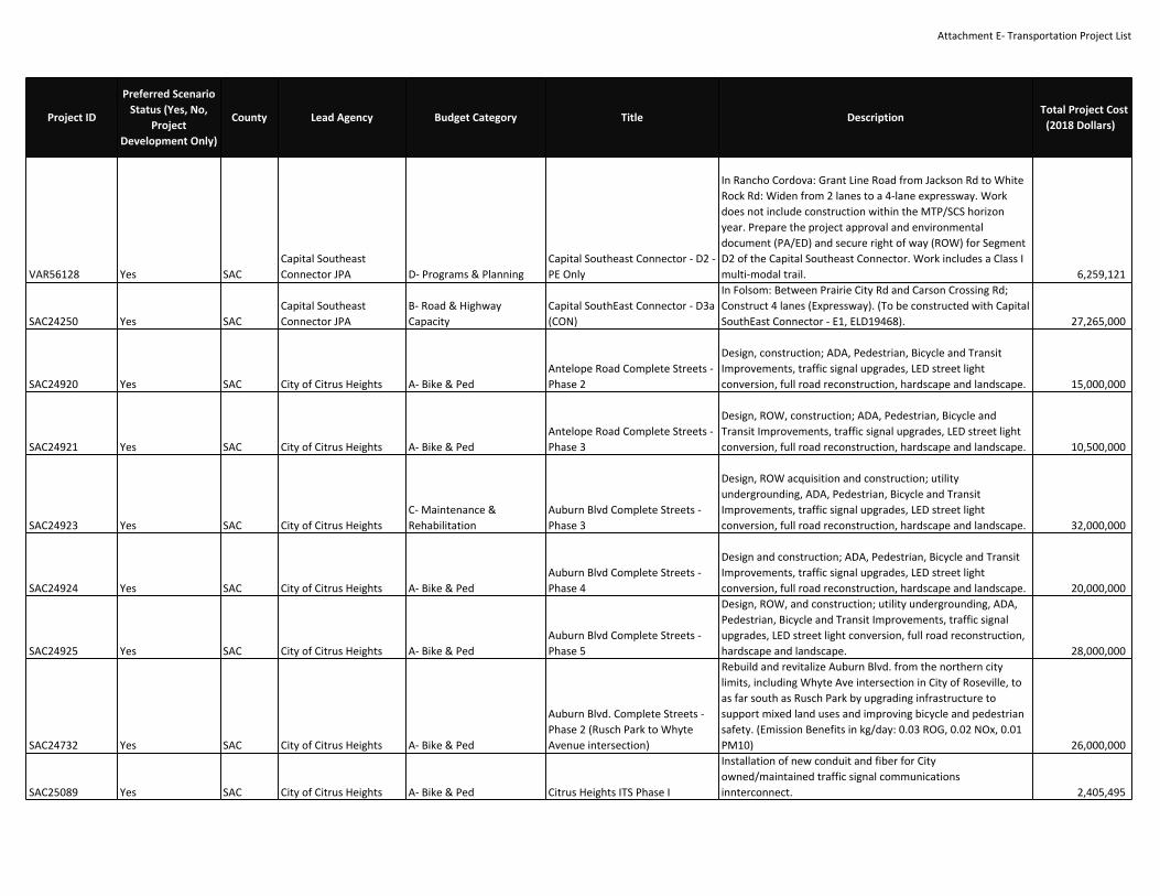
Attachment E‐ Transportation Project List
VAR56128 Yes SACCapital SoutheastConnector JPA D‐ Programs & Planning
Capital Southeast Connector ‐ D2 ‐PE Only
In Rancho Cordova: Grant Line Road from Jackson Rd to WhiteRock Rd: Widen from 2 lanes to a 4‐lane expressway. Workdoes not include construction within the MTP/SCS horizonyear. Prepare the project approval and environmentaldocument (PA/ED) and secure right of way (ROW) for SegmentD2 of the Capital Southeast Connector. Work includes a Class Imulti‐modal trail. 6,259,121
SAC24250 Yes SACCapital SoutheastConnector JPA
B‐ Road & HighwayCapacity
Capital SouthEast Connector ‐ D3a(CON)
In Folsom: Between Prairie City Rd and Carson Crossing Rd;Construct 4 lanes (Expressway). (To be constructed with CapitalSouthEast Connector ‐ E1, ELD19468). 27,265,000
SAC24920 Yes SAC City of Citrus Heights A‐ Bike & PedAntelope Road Complete Streets ‐Phase 2
Design, construction; ADA, Pedestrian, Bicycle and TransitImprovements, traffic signal upgrades, LED street lightconversion, full road reconstruction, hardscape and landscape. 15,000,000
SAC24921 Yes SAC City of Citrus Heights A‐ Bike & PedAntelope Road Complete Streets ‐Phase 3
Design, ROW, construction; ADA, Pedestrian, Bicycle andTransit Improvements, traffic signal upgrades, LED street lightconversion, full road reconstruction, hardscape and landscape. 10,500,000
SAC24923 Yes SAC City of Citrus HeightsC‐ Maintenance &Rehabilitation
Auburn Blvd Complete Streets ‐Phase 3
Design, ROW acquisition and construction; utilityundergrounding, ADA, Pedestrian, Bicycle and TransitImprovements, traffic signal upgrades, LED street lightconversion, full road reconstruction, hardscape and landscape. 32,000,000
SAC24924 Yes SAC City of Citrus Heights A‐ Bike & PedAuburn Blvd Complete Streets ‐Phase 4
Design and construction; ADA, Pedestrian, Bicycle and TransitImprovements, traffic signal upgrades, LED street lightconversion, full road reconstruction, hardscape and landscape. 20,000,000
SAC24925 Yes SAC City of Citrus Heights A‐ Bike & PedAuburn Blvd Complete Streets ‐Phase 5
Design, ROW, and construction; utility undergrounding, ADA,Pedestrian, Bicycle and Transit Improvements, traffic signalupgrades, LED street light conversion, full road reconstruction,hardscape and landscape. 28,000,000
SAC24732 Yes SAC City of Citrus Heights A‐ Bike & Ped
Auburn Blvd. Complete Streets ‐Phase 2 (Rusch Park to WhyteAvenue intersection)
Rebuild and revitalize Auburn Blvd. from the northern citylimits, including Whyte Ave intersection in City of Roseville, toas far south as Rusch Park by upgrading infrastructure tosupport mixed land uses and improving bicycle and pedestriansafety. (Emission Benefits in kg/day: 0.03 ROG, 0.02 NOx, 0.01PM10) 26,000,000
SAC25089 Yes SAC City of Citrus Heights A‐ Bike & Ped Citrus Heights ITS Phase I
Installation of new conduit and fiber for Cityowned/maintained traffic signal communicationsinnterconnect. 2,405,495
Project ID
Preferred ScenarioStatus (Yes, No,
ProjectDevelopment Only)
County Lead Agency Budget Category Title DescriptionTotal Project Cost
(2018 Dollars)

Attachment E‐ Transportation Project List
SAC25090 Yes SAC City of Citrus HeightsG‐ System Management,Operations, and ITS Citrus Heights ITS Phase II
Installation of new conduit and fiber for Cityowned/maintained traffic signal communicationsinnterconnect. 1,434,025
SAC25091 Yes SAC City of Citrus HeightsC‐ Maintenance &Rehabilitation Citrus Heights ITS Phase III
Installation of new conduit and fiber for Cityowned/maintained traffic signal communicationsinnterconnect. 2,156,500
SAC25066 Yes SAC City of Citrus HeightsC‐ Maintenance &Rehabilitation
Community CorridorRevitalization Program
In Citrus Heights: Community Corridor Revitalization Program,including Auburn Blvd Plan review, development fee structurereview, technical assistance program development, andtechnical assistance for approx. 10 businesses or propertyowners. 110,000
SAC25064 Yes SAC City of Citrus Heights A‐ Bike & PedElectric Greenway (Class I Multi‐Use Trail)
In Citrus Heights: Between Arcade Creek Park Preserve andWachtel Way; Construct a 2.9 mile long Class I Multi‐Use Trail. 7,015,000
SAC24929 Yes SAC City of Citrus HeightsC‐ Maintenance &Rehabilitation
Fair Oaks Blvd Complete StreetsPhase 1
Design and construction; ADA, Pedestrian and Bicycleimprovements, LED street light conversion, road resurfacing. 2,700,000
SAC24930 Yes SAC City of Citrus HeightsC‐ Maintenance &Rehabilitation
Fair Oaks Blvd Complete StreetsPhase 2
Design and construction; ADA and Pedestrian improvementsincluding sidewalk infill, Bicycle improvements, LED street lightconversion, road resurfacing. 3,200,000
SAC24919 Yes SAC City of Citrus HeightsC‐ Maintenance &Rehabilitation Greenback Lane Complete Streets
construction; ADA, Pedestrian, Bicycle and TransitImprovements, traffic signal modifications, full roadreconstruction, LED street light conversion. 4,200,000
SAC25065 Yes SAC City of Citrus HeightsC‐ Maintenance &Rehabilitation
Mariposa Safe Routes to School(Phase IV)
In Citrus Heights: Mariposa Ave. between Northeast Circle andMadison Ave: Construct Class II bike lanes, infill sidewalk,street lights, pedestrian safety improvements, and signalimprovements. 2,603,000
SAC24932 Yes SAC City of Citrus Heights A‐ Bike & PedOak Avenue Complete StreetsPhase 1
Design and construction; ADA and Pedestrian improvementsincluding sidewalk infill, Bicycle improvements, installation ofnew LED street lights, road resurfacing. 3,800,000
SAC24933 Yes SAC City of Citrus Heights A‐ Bike & PedOak Avenue Complete StreetsPhase 2
Design and construction; ADA and Pedestrian improvementsincluding sidewalk infill, Bicycle improvements, installation ofnew LED street lights, road resurfacing. 3,500,000
SAC24927 Yes SAC City of Citrus HeightsC‐ Maintenance &Rehabilitation
Old Auburn Road CompleteStreets Phase 1
Design, ROW and construction; ADA, Pedestrian and Bicycleimprovements (major sw infill for accessibility), traffic signalupgrades, installation of new LED street lights, full roadreconstruction. 15,000,000
Project ID
Preferred ScenarioStatus (Yes, No,
ProjectDevelopment Only)
County Lead Agency Budget Category Title DescriptionTotal Project Cost
(2018 Dollars)

Attachment E‐ Transportation Project List
SAC24928 Yes SAC City of Citrus HeightsC‐ Maintenance &Rehabilitation
Old Auburn Road CompleteStreets Phase 2
Design and construction ; ADA, Pedestrian and Bicycleimprovements (major sw infill for accessibility), traffic signalupgrades, installation of new LED street lights, full roadreconstruction. 12,000,000
SAC24926 Yes SAC City of Citrus HeightsC‐ Maintenance &Rehabilitation San Juan Ave Complete Streets
Design, ROW and construction; utility undergrounding, ADA,Pedestrian, Bicycle and Transit Improvements, traffic signalupgrades, LED street light conversion, full road reconstruction,hardscape and landscape. 22,000,000
SAC24934 Yes SAC City of Citrus Heights A‐ Bike & PedSaybrook/Misty Creek I‐80Pedestrian/bicycle overpass
Design and construction; ADA compliant Pedestrian and Bicyclebridge/overpass connecting west side at Saybrook with eastside at Misty Creek. 15,000,000
SAC24917 Yes SAC City of Citrus Heights A‐ Bike & PedSunrise Blvd Complete Streets ‐Phase 2
construction; ADA, Pedestrian, Bicycle and TransitImprovements, traffic signal upgrades, LED street lightconversion, full road reconstruction, hardscape and landscape. 6,000,000
SAC24918 Yes SAC City of Citrus Heights A‐ Bike & PedSunrise Blvd Complete Streets ‐Phase 3
construction; ADA, Pedestrian, Bicycle and TransitImprovements on east side of road including installation ofnew sw/c&g, LED street light conversion, full roadreconstruction, hardscape and landscape. 5,002,000
SAC25131 Yes SAC City of Elk GroveG‐ System Management,Operations, and ITS
Big Horn Blvd. & Bilby Rd.Intersection
Install a trafic signal at the Big Horn Blvd. & Bilby Rd.Intersection 500,000
SAC25098 Yes SAC City of Elk GroveG‐ System Management,Operations, and ITS
Big Horn Blvd. & Poppy Ridge Rd.Intersection
Install a trafic signal at the Big Horn Blvd. & Poppy Ridge Rd.Intersection 500,000
SAC25102ProjectDevelopment Only SAC City of Elk Grove
B‐ Road & HighwayCapacity
Big Horn Blvd. Extension toEschinger
Big Horn Blvd. from Kammerer Rd. to Eschinger Rd., Construct2 lane road. 20,800,000
SAC24982 Yes SAC City of Elk GroveB‐ Road & HighwayCapacity
Big Horn Blvd. Extension toKammerer
In Elk Grove, Big Horn Blvd. from Bilby Rd. to Kammerer Rd.:Construct new 2‐lane roadway 5,669,500
SAC25138 Yes SAC City of Elk GroveB‐ Road & HighwayCapacity Big Horn Blvd. Widening
In Elk Grove, Big Horn Blvd. from Bilby Rd. to Kammerer Rd.:Widen to 4‐lane roadway 4,600,000
SAC25103 Yes SAC City of Elk GroveB‐ Road & HighwayCapacity Bilby Rd. extension past Big Horn
In Elk Grove, Bilby Road Extension from Bruceville Road to2,000 feet past McMillan Road/Big Horn Extension, Widen to 4‐lane roadway 16,000,000
SAC24972 Yes SAC City of Elk GroveB‐ Road & HighwayCapacity Bilby Rd. extension to Lotz Pkwy
Construct New Road: 4 lanes from McMillan Rd./Future BigHorn Blvd. extension to Lotz Pkwy. 3,495,600
SAC24101 No SAC City of Elk GroveB‐ Road & HighwayCapacity Bond Road Widening
In Elk Grove, between Bradshaw Road and Grant Line Road:Widen from 2 to 4 lanes. 18,250,000
SAC24073 Yes SAC City of Elk GroveB‐ Road & HighwayCapacity Bradshaw Rd. Widening B Widen: 4 lanes from Sheldon Rd. to Calvine Rd. 6,200,200
Project ID
Preferred ScenarioStatus (Yes, No,
ProjectDevelopment Only)
County Lead Agency Budget Category Title DescriptionTotal Project Cost
(2018 Dollars)

Attachment E‐ Transportation Project List
SAC24103ProjectDevelopment Only SAC City of Elk Grove
B‐ Road & HighwayCapacity Bradshaw Rd. Widening C
In Elk Grove, from Grant Line Road to Bond Road, widen from 2to 4 lanes. 1,043,550
SAC24102ProjectDevelopment Only SAC City of Elk Grove
B‐ Road & HighwayCapacity Bradshaw Rd. Widening D
In Elk Grove, between Bond Road and Sheldon Road: Widenfrom 2 to 4 lanes. 696,120
SAC24076ProjectDevelopment Only SAC City of Elk Grove
B‐ Road & HighwayCapacity Bradshaw Rd. Widening E Widen: 4 to 6 lanes from Grant Line Rd. to Bond Rd. 6,200,000
SAC24074ProjectDevelopment Only SAC City of Elk Grove
B‐ Road & HighwayCapacity Bradshaw Rd. Widening F Widen: 4 to 6 lanes from Sheldon Rd. to Calvine Rd. 3,800,000
SAC24075ProjectDevelopment Only SAC City of Elk Grove
B‐ Road & HighwayCapacity Bradshaw Rd. Widening G Widen: 4 to 6 lanes from Bond Rd. to Sheldon Rd. 3,700,000
SAC24792 Yes SAC City of Elk GroveC‐ Maintenance &Rehabilitation
Bruceville Rd. and PoppyRidge/Quail Run Intersection
Install a trafic signal at the Bruceville Rd. and PoppyRidge/Quail Run intersection. 338,100
SAC25139 Yes SAC City of Elk GroveB‐ Road & HighwayCapacity Bruceville Rd. Widening A Widen: 6 lanes from Sheldon Rd. to Big Horn Blvd. 5,400,000
SAC19010 Yes SAC City of Elk GroveB‐ Road & HighwayCapacity Bruceville Rd. Widening B
In Elk Grove, from Whitelock Parkway to Bilby Road: Widenfrom 2 to 4 lanes. 3,719,000
SAC24105 Yes SAC City of Elk GroveB‐ Road & HighwayCapacity Bruceville Rd. Widening C
In Elk Grove, Bruceville Road from Bilby Road to KammererRoad: Widen from 2 to 4 lanes. 2,200,000
SAC24949ProjectDevelopment Only SAC City of Elk Grove
B‐ Road & HighwayCapacity Bruceville Rd. Widening D
Widen from 4 to 6 lanes from Elk Grove Blvd. to WhitelockParkway 1,683,600
SAC24082ProjectDevelopment Only SAC City of Elk Grove
B‐ Road & HighwayCapacity Bruceville Rd. Widening E Widen: 6 lanes from Bilby Rd. to Kammerer Rd. 1,834,200
SAC24081ProjectDevelopment Only SAC City of Elk Grove
B‐ Road & HighwayCapacity Bruceville Rd. Widening F Widen: 6 lanes from Whitelock Pkwy. to Bilby Rd. 1,845,900
SAC24084ProjectDevelopment Only SAC City of Elk Grove
B‐ Road & HighwayCapacity Calvine Road Widening A
Widen Calvine Road from Vineyard Road to Grant Line Roadfrom 2 to 4 lanes 14,000,000
SAC25140ProjectDevelopment Only SAC City of Elk Grove
B‐ Road & HighwayCapacity Calvine Road Widening B
Widen Calvine Road from Elk Grove Florin Rd to Waterman Rd.from 4 to 6 lanes 4,000,000
SAC25104 Yes SAC City of Elk GroveB‐ Road & HighwayCapacity Calvine Road Widening C
Widen Calvine Road from Cliffcrest Dr. to Elk Grove Florin Rd.from 4 to 6 lanes 7,000,000
SAC24700 Yes SAC City of Elk GroveB‐ Road & HighwayCapacity
Capital SouthEast Connector ‐ B2 ‐CON
In Elk Grove, Grant Line Road; from Mosher Road to Bradshaw:Widen from 2 to 4 lanes. 8,349,000
Project ID
Preferred ScenarioStatus (Yes, No,
ProjectDevelopment Only)
County Lead Agency Budget Category Title DescriptionTotal Project Cost
(2018 Dollars)

Attachment E‐ Transportation Project List
SAC25048 Yes SAC City of Elk Grove D‐ Programs & PlanningCapital SouthEast Connector ‐ B3 ‐PE Only
In Elk Grove: Grant Line Rd from Bradshaw Rd to Bond Rd;Widen from 2 to 4 lanes (thoroughfare). PE Only. (Total ProjectCost is $23,100,000.) 2,000,000
SAC25105 Yes SAC City of Elk GroveC‐ Maintenance &Rehabilitation
East Stockton Blvd & Valley OakLn. Intersection Improvements Install a trafic signal at East Stockton Blvd & Valley Oak Ln. 500,000
SAC25093 Yes SAC City of Elk GroveC‐ Maintenance &Rehabilitation Elk Grove Blvd & Grant Line Road Install a traffic signal at Elk Grove Blvd & Grant Line Road. 500,000
SAC24951 Yes SAC City of Elk GroveB‐ Road & HighwayCapacity
Elk Grove Blvd Center Turn Laneand Shoulders
Widen to provide a two way left turn lane and adequateshoulder/bike lanes. from Bradshaw Rd. to Grant Line Rd. 2,661,500
SAC25092 Yes SAC City of Elk GroveC‐ Maintenance &Rehabilitation
Elk Grove Blvd OperationalImprovements
Traffic Signal communication upgrade (new fiber) Elk GroveBoulevard from Elk Grove Florin to Franklin ÿ 1,100,000
SAC24966 Yes SAC City of Elk GroveG‐ System Management,Operations, and ITS Elk Grove Blvd Right Turn Pockets Right Turn pocket from EB Elk Grove Blvd to SB SR99 875,000
SAC25132 Yes SAC City of Elk GroveC‐ Maintenance &Rehabilitation Elk Grove Blvd. and Bradshaw Rd.
Install a traffic signal or roundabout at Elk Grove Blvd. andBradshaw Rd. 4,000,000
SAC25094 Yes SAC City of Elk GroveC‐ Maintenance &Rehabilitation
Elk Grove Florin Rd. and La HayaWay Signal Install Signal at Elk Grove Florin Rd. and La Haya Way 500,000
SAC25074 Yes SAC City of Elk GroveC‐ Maintenance &Rehabilitation
Elk Grove Florin Road SidewalkInfill SRTS
In Elk Grove: On Elk Grove Florin Road, between Valley OakLane and East Stockton Blvd, eliminate sidewalk gaps andimprove ADA access, bus stop access, bicycle and pedestriancrossings, and overall safety in the corridor. Provide walkingand biking education for three school communities: FlorenceMarkofer Elementary, Joseph Kerr Middle School, and ElkGrove High School. 1,101,000
SAC25095 Yes SAC City of Elk GroveC‐ Maintenance &Rehabilitation
Elk Grove‐Florin Road ITSImprovements
Traffic signal communications upgrade and coordination alongElk Grove Florin from Bond Road to Valley Oak Lane, hook upto existing fiber optic and upgrade controllers 280,000
SAC24086ProjectDevelopment Only SAC City of Elk Grove
B‐ Road & HighwayCapacity Elk Grove‐Florin Road Widening A
Widen Elk Grove‐Florin Road from 4 to 6 lanes from CalvineRoad to Sheldon 9,540,000
SAC25133 No SAC City of Elk GroveB‐ Road & HighwayCapacity Elk Grove‐Florin Road Widening B
Widen Elk Grove‐Florin Road from 4 to 6 lanes from Sheldon toBond Road 10,550,000
SAC24952 Yes SAC City of Elk GroveB‐ Road & HighwayCapacity Excelsior Rd Full 2 lane Improvement from Sheldon Rd. to Calvine Rd. 5,000,000
SAC20510 Yes SAC City of Elk GroveC‐ Maintenance &Rehabilitation Grant Line Road
Grant Line Road from Bond Road to Calvine Road: alignmentstudy. 800,000
Project ID
Preferred ScenarioStatus (Yes, No,
ProjectDevelopment Only)
County Lead Agency Budget Category Title DescriptionTotal Project Cost
(2018 Dollars)

Attachment E‐ Transportation Project List
SAC24795 Yes SAC City of Elk GroveC‐ Maintenance &Rehabilitation
Grant Line Road Sheldon AreaOperational Improvements Phase1
Widen Grant Line Road, between Bond Road and Calvine Road,to accommodate Signals/Roundabouts and left and right turnlanes at intersections. 5,200,000
SAC25134 No SAC City of Elk GroveB‐ Road & HighwayCapacity
Grant Line Road Sheldon AreaOperational Improvements Phase2
Widen Grant Line Road, between Bond Road and Calvine Road,from 2 to 4 lanes. 15,000,000
SAC24962 Yes SAC City of Elk GroveC‐ Maintenance &Rehabilitation Hi Bus from CRC to Elk Grove
This project is to develop an enhanced bus corridor 8.5 milesalong Bruceville Rd to Big Horn to Kammerer to 99 betweenCosumnes River College and Elk Grove. 37,813,160
SAC24788ProjectDevelopment Only SAC City of Elk Grove
B‐ Road & HighwayCapacity Hi Bus from I‐5 to Bradshaw Rd
Develop anÿEast‐Westÿenhanced bus corridor in Elk Grovealong Elk Grove Blvd. from I‐5 to Bradshaw Road. 1,000,000
SAC24094 Yes SAC City of Elk GroveB‐ Road & HighwayCapacity
Kammerer Rd Extension(Connector Segment A)
In Elk Grove, Kammerer Rd. from existing Kammerer Road,from Bruceville Rd. to Lent Ranch Parkway: Reconstruct roadat 2 lanes with shoulders, and Kammerer Rd., from BrucevilleRd. to Interstate 5/Hood Franklin Interchange: Extend road.Modify the I‐5/Hood Franklin interchange (signalization andturn lanes at the ramps), construct a grade separation at theUPRR tracks, Class 2 bike lanes, and signalized intersections atmajor road crossings including the extension of a two laneWillard roadway. Environmental phase (CEQA and NEPA)covers full project scope, to be built in phases: KammererRoad: In Elk Grove, from Lent Ranch Parkway to I‐5/HoodFranklin Interchange: Widen and extend from 2 to 4 lanes (seeMTP/SCS project SAC24114). 50,737,000
SAC25097 Yes SAC City of Elk GroveB‐ Road & HighwayCapacity
Kammerer Rd Extension(Connector Segment)
Extend Kammerer Road, between Bruceville Rd. and HoodFranklin with seperated median, 2 lanes, and Class 3 bike lanes.Would inlcude a railroad grade seperation and connections toa two lane Willard. Could include minor midifications to HoodFranklin & I‐5 interchange. 50,000,000
SAC25135 Yes SAC City of Elk GroveC‐ Maintenance &Rehabilitation
Kammerer Rd Reconstruction(Connector Segment)
Reconstruct Kammerer Road, between Lent Ranch Pkwy. andBruceville Road, with seperated median, 2 lanes, and Class 2bike lanes. 24,000,000
SAC24114 Yes SAC City of Elk GroveB‐ Road & HighwayCapacity
Kammerer Road Widening(Connector Segment)
In Elk Grove, from approximately 6000' west of SR 99 toBruceville Road: Widen from 2 to 4 lanes. This Project isincluded in the Environmental Studies (NEPA and CEQA) forSAC24094, Kammerer Road Extension. 20,400,000
Project ID
Preferred ScenarioStatus (Yes, No,
ProjectDevelopment Only)
County Lead Agency Budget Category Title DescriptionTotal Project Cost
(2018 Dollars)

Attachment E‐ Transportation Project List
SAC25136 Yes SAC City of Elk GroveC‐ Maintenance &Rehabilitation
Laguna Boulevard/Bond RoadOperational Improvements
Traffic Signal communication upgrade (new fiber) Laguna fromBig Horn to Franklin. In Addition, Traffic signal communicationupgrade along Bond/Laguna/Bighorn from Bond at Watermanto Big Horn at Civic Center Drive 1,100,000
SAC25019 Yes SAC City of Elk Grove A‐ Bike & PedLaguna Creek Trail and BrucevilleRd Sidewalks
In Elk Grove, Laguna Creek Trail, from Lewis Stein Rd. toBruceville Rd undercrossing. Laguna Creek Trail, from south ofCenter Pkwy to Big Horn Blvd.; Laguna Creek Trail at CenterParkway; Sidewalk on west side of Bruceville, from Big HornBoulevard to south of Center Parkway and on a section northof Laguna Blvd. (Emission Benefits in kg/day: ROG 0.08, NOx 2,309,000
SAC25099ProjectDevelopment Only SAC City of Elk Grove
B‐ Road & HighwayCapacity Lotz Parkway Extension
Lotz Parkway from Kammerer road to Eschinger Rd: extend 2lane road 20,800,000
SAC24980 Yes SAC City of Elk GroveB‐ Road & HighwayCapacity Lotz Parkway Widening A
In Elk Grove, from Laguna Springs Drive to Whitelock Parkway:widen to 4‐lanes. 3,500,000
SAC24987 Yes SAC City of Elk GroveB‐ Road & HighwayCapacity Lotz Parkway Widening B
In Elk Grove, Lotz Pkwy. from Whitelock Pkwy to Kammerer Rd:widen to 4‐lanes 10,000,000
SAC24169 Yes SAC City of Elk Grove A‐ Bike & PedOld Town Elk Grove StreetscapePhase 2
In Elk Grove, Elk Grove Boulevard, from School St. toWaterman Rd.: Street frontage improvements, including:expanded decorative sidewalks & landscape strips, corner bulb‐outs,landscaped median islands at intersections/pedestriancrossings, crosswalks, bike lanes/routes, signs and striping, busshelters, related frontage improvement features and potentialutility undergrounding. Project may include bike and busimprovements at the City proposed Railroad Avenue Plaza.The Plaza improvements would be along Elk Grove Boulevardnear Railroad Avenue, just east of the UPRR Railroad Tracks inOld Town Elk Grove. (Emission Benefits in kg/day: .0.04 ROG,0.03 NOx, 0.01 PM10, 0.01 PM2.5). 5,957,000
SAC25096ProjectDevelopment Only SAC City of Elk Grove
B‐ Road & HighwayCapacity
Reconstruct Hood Franklin/ I‐5interchange Reconstruct Interchange at Hood Franklin/ I‐5 interchange 7,000,000
SAC19160 Yes SAC City of Elk GroveB‐ Road & HighwayCapacity Sheldon Road Widening A
Widen Sheldon Road from Elk Grove‐Florin Road to WatermanRoad: widen from 2 to 4 lanes. 7,651,500
SAC24120 No SAC City of Elk GroveB‐ Road & HighwayCapacity Sheldon Road Widening B
In Elk Grove, from Waterman Road to Bradshaw Road: Widenfrom 2 to 4 lanes. 2,572,930
SAC25100 Yes SAC City of Elk GroveC‐ Maintenance &Rehabilitation
Sheldon/Bader Rd. IntersectionImprovements
Install a trafic signal or roundabout at Sheldon Rd. and BaderRd. 4,000,000
Project ID
Preferred ScenarioStatus (Yes, No,
ProjectDevelopment Only)
County Lead Agency Budget Category Title DescriptionTotal Project Cost
(2018 Dollars)

Attachment E‐ Transportation Project List
SAC24968 Yes SAC City of Elk GroveG‐ System Management,Operations, and ITS State Route 99
Southbound Auxiliary Lane from Elk Grove Blvd. to LagunaBlvd. 6,400,000
SAC25137 Yes SAC City of Elk GroveG‐ System Management,Operations, and ITS State Route 99 Auxillary Lanes A
Northbound Auxilary Lane on SR99 from Northbound On Rampto SR99 4,900,000
SAC24963 No SAC City of Elk GroveG‐ System Management,Operations, and ITS State Route 99 Auxillary Lanes B
Northbound Auxilary Lane on SR99 from Northbound On Rampto SR99 6,400,000
SAC25101 Yes SAC City of Elk GroveG‐ System Management,Operations, and ITS State Route 99 Auxillary Lanes C
Northbound Auxilary Lane on SR99 from Northbound On Rampto SR99 6,500,000
SAC24097 Yes SAC City of Elk GroveB‐ Road & HighwayCapacity Waterman Rd. Widen: 4 lanes from Elk Grove Blvd. to Bond Rd. 4,800,000
SAC24112 Yes SAC City of Elk GroveB‐ Road & HighwayCapacity Waterman Road Widening A
In Elk Grove, from Elk Grove Blvd to Grant Line Road: Widenfrom 2 to 4 lanes. 7,500,000
SAC24095 No SAC City of Elk GroveB‐ Road & HighwayCapacity Waterman Road Widening B
Widen Waterman Road from Calvine Road to Sheldon Road:Widen from 2 to 4 lanes 3,000,000
SAC24096 Yes SAC City of Elk GroveB‐ Road & HighwayCapacity Waterman Road Widening C
Widen Waterman Road from Sheldon Road to Bond Road from2 to 4 lanes. 357,540
SAC24960 Yes SAC City of Elk GroveB‐ Road & HighwayCapacity West Stockton Blvd
On West Stockton north of Promenade to Whitelock Pkwy,construct full 2 lane improvements and realign road tointersect with Lotz Pkwy south of Whitelock. Rename toPromenade. 1,583,039
SAC20320 Yes SAC City of Elk GroveB‐ Road & HighwayCapacity Whitelock Parkway Widening
In Elk Grove, from Big Horn Blvd to West Stockton Blvd: Widento 4 lane roadway and add signals. 520,280
SAC24098 Yes SAC City of Elk GroveB‐ Road & HighwayCapacity
Whitelock Parkway/SR99Interchange Project
In Elk Grove, Whitelock Parkway and SR 99, Construct newInterchange with new pedestrian bridge over SR99 to Elk GroveRegional Park and High School. (Total Project cost =$72,200,000) 17,500,000
SAC24955 No SAC City of Elk GroveB‐ Road & HighwayCapacity Willard Parkway C
Extend Center Lanes & Widen Median from South Bilby Rd. toNew Kammerer Rd. 26,187,200
SAC24954 Yes SAC City of Elk GroveB‐ Road & HighwayCapacity Willard Parkway D
Widen from 4 to 6 lanes from Whitelock Pkwy. to South BilbyRd. 1,854,100
SAC20340ProjectDevelopment Only SAC City of Elk Grove
B‐ Road & HighwayCapacity Willard Parkway Extension
In Elk Grove, Willard Parkway from Bilby Road to KammererRoad, Widen to four lane roadway. 15,000,000
SAC24088 No SAC City of Elk GroveB‐ Road & HighwayCapacity Willard Pkwy. Widen: 6 lanes from Bilby Rd. to Kammerer Rd. 370,800
SAC24961 Yes SAC City of Elk GroveB‐ Road & HighwayCapacity Wilton Rd Full 2 lane improvements from Grant Line Rd. to City Limit 7,789,900
Project ID
Preferred ScenarioStatus (Yes, No,
ProjectDevelopment Only)
County Lead Agency Budget Category Title DescriptionTotal Project Cost
(2018 Dollars)

Attachment E‐ Transportation Project List
SAC24331 Yes SAC City of FolsomB‐ Road & HighwayCapacity Alder Creek Parkway
Construct New Road: 4 lanes from Prairie City Rd. to EmpireRanch Rd. Extension south of U.S. 50. 45,000,000
SAC22060 Yes SAC City of FolsomB‐ Road & HighwayCapacity East Natoma Street Widening
In Folsom, East Natoma St from Fargo Way to Folsom LakeCrossing: widen from 2 to 4 lanes and construct bicycle trailundercrossing. 3,150,000
SAC24327 Yes SAC City of FolsomB‐ Road & HighwayCapacity Empire Ranch Rd. Road Extension: 4 lanes from U.S. 50 to White Rock Rd. 18,000,000
SAC24400 Yes SAC City of FolsomC‐ Maintenance &Rehabilitation
Folsom Blvd. Bike/Ped GradeSeparation
In Folsom, at Folsom Blvd. and Humbug‐Willow Creek Parkway,construct a bicycle and pedestrian grade‐separated crossing ofFolsom Blvd. Includes connections to existing trails on bothsides of Folsom Blvd. 2,500,000
SAC24324 Yes SAC City of FolsomC‐ Maintenance &Rehabilitation Folsom Lake Trail
In Folsom, along the Folsom Lake Trail corridor from theFolsom Lake Crossing Bike/Pedestrian overcrossing to GreenValley Road, construct approx 2‐miles of class 1 bike trail. 2,500,000
SAC22930 Yes SAC City of FolsomB‐ Road & HighwayCapacity Folsom‐Auburn Rd.
Add Turn Lanes: Folsom‐Auburn Rd. / Oak Ave. Includes: leftand right turn lanes and intersection signal modifications. 2,000,000
SAC21280 Yes SAC City of FolsomB‐ Road & HighwayCapacity Green Valley Road Widening
On Green Valley Road, from East Natoma Street to SophiaParkway: widen from 2 lanes to 4 lanes and provide Class IIbicycle paths. (Toll Credits for PE and CON.) . Toll Credits forENG, CON 6,183,934
SAC24506 Yes SAC City of FolsomC‐ Maintenance &Rehabilitation
Greenback Lane BridgeRehabilitation
Greenback Lane, over the American River, 0.2 miles east ofFolsom‐Auburn Rd.: Structural rehabilitation of the 2 lanebridge. 8,644,000
SAC21210 Yes SAC City of FolsomB‐ Road & HighwayCapacity Iron Point Rd.
Widen: 6 lanes from Black Diamond Dr. to Prairie City andOutcropping to Broadstone Pkwy. 5,000,000
SAC19890 Yes SAC City of FolsomB‐ Road & HighwayCapacity US 50 at Empire Ranch Road
US 50 at Empire Ranch Road: Construct 4 lane interchange withUS 50 at Empire Ranch Road (formerly Russell Ranch Road).HPP #337 (Toll Credits for PE). Toll Credits for ENG 58,885,000
SAC24463 Yes SAC City of FolsomB‐ Road & HighwayCapacity US 50 at Scott Road
Ramp modifications and overpass widening for US 50/EastBidwell/Scott Road Interchange to improve access todevelopment south of US 50. 3,180,000
SAC24888 Yes SAC City of FolsomG‐ System Management,Operations, and ITS
US 50 Auxilary Lane Prairie City toOak Avenue EB Auxiliary lane from Prairie City Road to Oak Avenue 3,000,000
SAC24891 Yes SAC City of FolsomG‐ System Management,Operations, and ITS
US 50 Auxiliary Lane EmpireRanch to Latrobe Road EB Auxiliary lane from Empire Ranch to Latrobe Road 3,000,000
Project ID
Preferred ScenarioStatus (Yes, No,
ProjectDevelopment Only)
County Lead Agency Budget Category Title DescriptionTotal Project Cost
(2018 Dollars)

Attachment E‐ Transportation Project List
SAC24889 Yes SAC City of FolsomG‐ System Management,Operations, and ITS
US 50 Auxiliary Lane Oak Avenueto Scott Road EB Auxiliary lane from Oak Avenue to Scott Road 3,000,000
SAC24890 Yes SAC City of FolsomG‐ System Management,Operations, and ITS
US 50 Auxiliary Lane Scott Road toEmpire Ranch EB Auxiliary lane from Scott Road to Empire Ranch 3,000,000
SAC24970 Yes SAC City of FolsomB‐ Road & HighwayCapacity US50 Rowberry Overcrossing
Construct New Overcrossing: 2 lanes between Iron Point Roadand Alder Creek Parkway over US50 3,000,000
SAC24337 Yes SAC City of GaltB‐ Road & HighwayCapacity Carillion Extension new 4 lane road from Simmerhorn to A Street / Boessow 2,500,000
SAC24341ProjectDevelopment Only SAC City of Galt
B‐ Road & HighwayCapacity Highway 99 / Ayers Ln.
On/Off Ramp Improvement: widen 1,280 linear feet of Hwy. 99on/off ramps at Ayers Lane. 500,000
SAC24829ProjectDevelopment Only SAC City of Galt
B‐ Road & HighwayCapacity Marengo Extension new 4 lane road (Simmerhorn to A Street @ Crystal) 2,500,000
SAC24830ProjectDevelopment Only SAC City of Galt
B‐ Road & HighwayCapacity Mingo I/C new interchange at Mingo Road on / off ramps 20,000,000
SAC24831ProjectDevelopment Only SAC City of Galt
B‐ Road & HighwayCapacity New Road A New 4 Lane Road (Mingo I/C to Twin Cities @ Carillion) 15,300,000
SAC24832ProjectDevelopment Only SAC City of Galt
B‐ Road & HighwayCapacity New Road B New 4 Lane Road (Mingo I/C to Twin Cities [west sr99]) 8,500,000
SAC24165ProjectDevelopment Only SAC City of Galt
B‐ Road & HighwayCapacity
Simmerhorn Road OvercrossingReplacement
In Galt: Simmerhorn Road overcrossing of SR 99; Constructrealigned overcrossing. 4,450,000
SAC24837ProjectDevelopment Only SAC City of Galt
B‐ Road & HighwayCapacity Twin Cities I/C new interchange at Twin Cities Road 15,300,000
SAC20590ProjectDevelopment Only SAC City of Galt
B‐ Road & HighwayCapacity Twin Cities Rd.
Twin Cities Rd. Interchange on Hwy. 99: widen 4 lanes.Includes: bicycle lanes. 5,105,100
SAC24833ProjectDevelopment Only SAC City of Galt
B‐ Road & HighwayCapacity Twin Cities Widening A widening 2 to 4 lanes (Carillion to Cherokee) 10,000,000
SAC24834ProjectDevelopment Only SAC City of Galt
B‐ Road & HighwayCapacity Twin Cities Widening B widening 4 to 6 lanes (Carillion to Marengo) 5,000,000
Project ID
Preferred ScenarioStatus (Yes, No,
ProjectDevelopment Only)
County Lead Agency Budget Category Title DescriptionTotal Project Cost
(2018 Dollars)
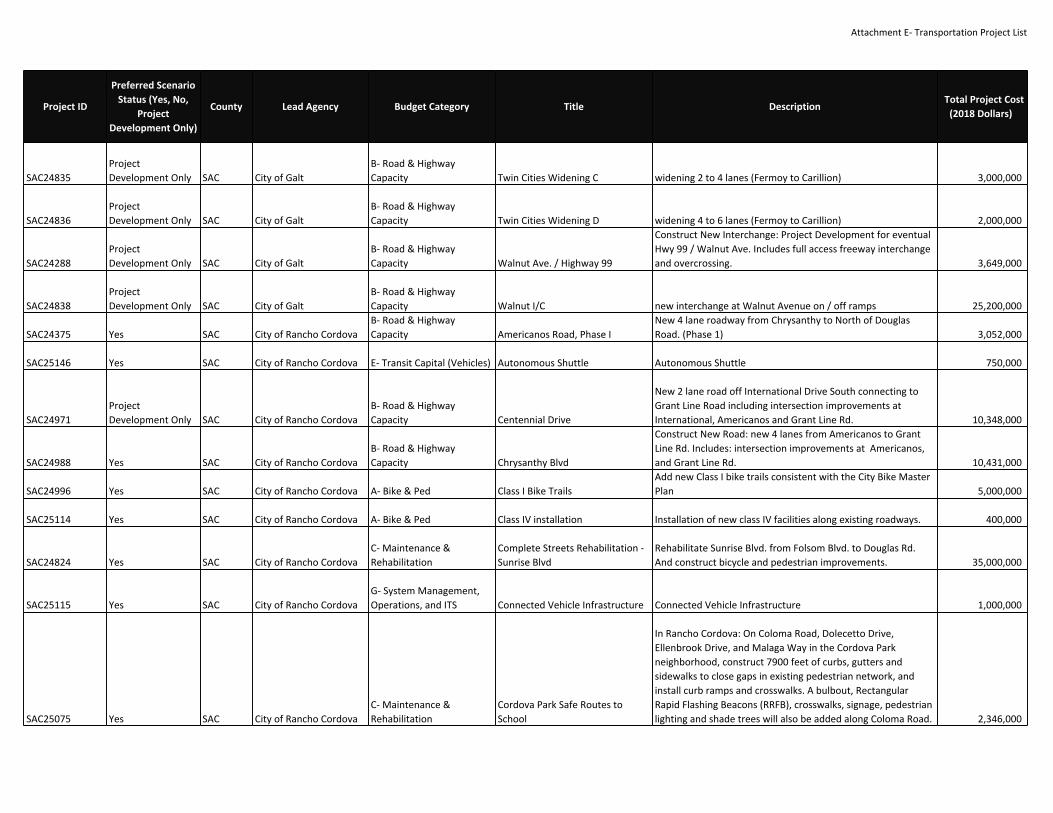
Attachment E‐ Transportation Project List
SAC24835ProjectDevelopment Only SAC City of Galt
B‐ Road & HighwayCapacity Twin Cities Widening C widening 2 to 4 lanes (Fermoy to Carillion) 3,000,000
SAC24836ProjectDevelopment Only SAC City of Galt
B‐ Road & HighwayCapacity Twin Cities Widening D widening 4 to 6 lanes (Fermoy to Carillion) 2,000,000
SAC24288ProjectDevelopment Only SAC City of Galt
B‐ Road & HighwayCapacity Walnut Ave. / Highway 99
Construct New Interchange: Project Development for eventualHwy 99 / Walnut Ave. Includes full access freeway interchangeand overcrossing. 3,649,000
SAC24838ProjectDevelopment Only SAC City of Galt
B‐ Road & HighwayCapacity Walnut I/C new interchange at Walnut Avenue on / off ramps 25,200,000
SAC24375 Yes SAC City of Rancho CordovaB‐ Road & HighwayCapacity Americanos Road, Phase I
New 4 lane roadway from Chrysanthy to North of DouglasRoad. (Phase 1) 3,052,000
SAC25146 Yes SAC City of Rancho Cordova E‐ Transit Capital (Vehicles) Autonomous Shuttle Autonomous Shuttle 750,000
SAC24971ProjectDevelopment Only SAC City of Rancho Cordova
B‐ Road & HighwayCapacity Centennial Drive
New 2 lane road off International Drive South connecting toGrant Line Road including intersection improvements atInternational, Americanos and Grant Line Rd. 10,348,000
SAC24988 Yes SAC City of Rancho CordovaB‐ Road & HighwayCapacity Chrysanthy Blvd
Construct New Road: new 4 lanes from Americanos to GrantLine Rd. Includes: intersection improvements at Americanos,and Grant Line Rd. 10,431,000
SAC24996 Yes SAC City of Rancho Cordova A‐ Bike & Ped Class I Bike TrailsAdd new Class I bike trails consistent with the City Bike MasterPlan 5,000,000
SAC25114 Yes SAC City of Rancho Cordova A‐ Bike & Ped Class IV installation Installation of new class IV facilities along existing roadways. 400,000
SAC24824 Yes SAC City of Rancho CordovaC‐ Maintenance &Rehabilitation
Complete Streets Rehabilitation ‐Sunrise Blvd
Rehabilitate Sunrise Blvd. from Folsom Blvd. to Douglas Rd.And construct bicycle and pedestrian improvements. 35,000,000
SAC25115 Yes SAC City of Rancho CordovaG‐ System Management,Operations, and ITS Connected Vehicle Infrastructure Connected Vehicle Infrastructure 1,000,000
SAC25075 Yes SAC City of Rancho CordovaC‐ Maintenance &Rehabilitation
Cordova Park Safe Routes toSchool
In Rancho Cordova: On Coloma Road, Dolecetto Drive,Ellenbrook Drive, and Malaga Way in the Cordova Parkneighborhood, construct 7900 feet of curbs, gutters andsidewalks to close gaps in existing pedestrian network, andinstall curb ramps and crosswalks. A bulbout, RectangularRapid Flashing Beacons (RRFB), crosswalks, signage, pedestrianlighting and shade trees will also be added along Coloma Road. 2,346,000
Project ID
Preferred ScenarioStatus (Yes, No,
ProjectDevelopment Only)
County Lead Agency Budget Category Title DescriptionTotal Project Cost
(2018 Dollars)

Attachment E‐ Transportation Project List
SAC24473 Yes SAC City of Rancho CordovaB‐ Road & HighwayCapacity Douglas Rd. Widening
Widen Douglas Rd. from 2 to 4 lanes from Sunrise Blvd. to theWest City Limit. Includes the addition of a new bridge over theFolsom South Canal adjacent to the existing bridge. (SeeSAC20240) 13,000,000
SAC24183 Yes SAC City of Rancho CordovaB‐ Road & HighwayCapacity Easton Valley Pkwy Phase 1
Construct Easton Valley Parkway as a new 4‐lane road fromRancho Cordova Parkway to the City Limits includingintersection improvements at Rancho Cordova Parkway. 10,192,000
SAC24372ProjectDevelopment Only SAC City of Rancho Cordova
B‐ Road & HighwayCapacity Easton Valley Pkwy. Widening B
Widen: from 4 to 6 lanes from Rancho Cordova Pkwy. to HazelAve. with enhanced intersection improvements at RanchoCordova Pkwy. and Hazel Ave. (Phase II) 47,090,000
SAC24993 Yes SAC City of Rancho Cordova A‐ Bike & PedFolsom South Canal Bike TrailAmenities
Amenities including, but not limited ot, way finding signs, bikerepair stations, shade strictures, striping, and other amenitiesas appropriate 640,000
SAC24243 Yes SAC City of Rancho CordovaG‐ System Management,Operations, and ITS
Grade Separate RT Gold Line AtBradshaw Road
Rail Crossing Project: at Bradshaw Road, plan and construct arail grade seperation for RT s Gold line. 12,500,000
SAC24245 Yes SAC City of Rancho CordovaG‐ System Management,Operations, and ITS
Grade Separate RT Gold Line AtMather Field Road
Rail Crossing Project: at Mather Field Road, plan and Constructa Rail Grade Seperation for RT s Gold line. 25,000,000
SAC24244 Yes SAC City of Rancho CordovaG‐ System Management,Operations, and ITS
Grade Separate RT Gold Line AtRoutier Road
Rail Crossing Project: at Routier Road, plan and Construct a RailGrade Seperation for RT s Gold line. 25,000,000
SAC24247 Yes SAC City of Rancho CordovaG‐ System Management,Operations, and ITS
Grade Separate RT Gold Line AtZinfandel Drive
Rail Crossing Project: at Zinfandel Drive plan and Construct aRail Grade Seperation for RT s Gold line. 25,000,000
SAC25113 Yes SAC City of Rancho CordovaG‐ System Management,Operations, and ITS Highway 50 ICM
Deployment of various ITS improvements along U.S. 50 and theCity of Rancho Cordova, and regionally significant corridors inthe County and the City of Folsom for incident management(non‐capacity increasing) 5,000,000
SAC25112 Yes SAC City of Rancho Cordova A‐ Bike & PedInstall bicycle loop detection at allmajor intersections A Install bicycle loop detection at all major intersections 200,000
SAC25143 Yes SAC City of Rancho CordovaC‐ Maintenance &Rehabilitation
Interesection safety andoperations, cameras and signs
Install CCTVs and CMS at various intersections and majorcorridors within the City 600,000
SAC25110 Yes SAC City of Rancho CordovaC‐ Maintenance &Rehabilitation
Interesection safety andoperations, Communications
Fill the gaps in field communication infrastructure, includinguse of fiberoptics, wireless or radio technlogy 2,000,000
SAC24471 Yes SAC City of Rancho CordovaB‐ Road & HighwayCapacity International Dr. A
Construct New Road: 4‐lanes from Luyung Drive (western RioDel Oro Specific Plan Boundary) to White Rock Rd. Includes:intersection improvements at Rancho Cordova Parkway, andWhite Rock Road. 4,219,700
Project ID
Preferred ScenarioStatus (Yes, No,
ProjectDevelopment Only)
County Lead Agency Budget Category Title DescriptionTotal Project Cost
(2018 Dollars)

Attachment E‐ Transportation Project List
SAC24276ProjectDevelopment Only SAC City of Rancho Cordova
B‐ Road & HighwayCapacity International Dr. B
Construct New Road: 4 lanes from Sunrise Blvd. to RanchoCordova Parkway Includes: intersection improvements atSunrise Blvd. 37,230,800
SAC24989ProjectDevelopment Only SAC City of Rancho Cordova
B‐ Road & HighwayCapacity International Dr. C
Construct New Road: International Drive northern 4‐lane loopfrom White Rock Road back to Rancho Cordova Parkway.Includes: intersection improvements at Rancho CordovaParkway. 5,250,600
SAC25142 Yes SAC City of Rancho CordovaC‐ Maintenance &Rehabilitation Intersection Safety
At various signalized intersections in the City of RanchoCordova: Upgrade all existing 8" and combination vehicle signalindications to 12" indications. Retrofit all pedestrian signalheads to "count‐down", battery back up systems andpedestrian APS push buttons. 550,000
SAC24707 Yes SAC City of Rancho CordovaB‐ Road & HighwayCapacity Kiefer Blvd Extension
In Rancho Cordova, extend Kiefer Blvd from Rancho CordovaPkwy to Grant Line as 4 lane road. Includes intersectionimprovements at Americanos and Grant Line. Developer willdeliver project 5,621,000
SAC24374 Yes SAC City of Rancho CordovaB‐ Road & HighwayCapacity Kiefer Boulevard, Phase 2
Widen Kiefer Blvd. from 2‐4 lanes from Sunrise Blvd. to RanchoCordova Parkway. 3,510,000
SAC24201 Yes SAC City of Rancho CordovaG‐ System Management,Operations, and ITS Kilgore Rd. Widen to 2‐4 lanes from International Dr. to White Rock Rd. 693,000
SAC24202 Yes SAC City of Rancho CordovaB‐ Road & HighwayCapacity Mather Blvd.
Construct New Road:4 lanes from Rockingham Rd. to ZinfandelDr. Includes: widening existing roadway to 4 lanes. 17,266,000
SAC24204ProjectDevelopment Only SAC City of Rancho Cordova
B‐ Road & HighwayCapacity Mather Field Rd.
Widen: 6 lanes from Rockingham Rd. to Folsom Blvd. Includes:intersection improvements at Rockingham Rd. 2,514,000
SAC24990 Yes SAC City of Rancho CordovaG‐ System Management,Operations, and ITS
Mather Field Rd./U.S. 50Interchange A
Construct intersection modification at Mather Field Road.,modify on and off ramp configuration and turn pockets, andimprove pedestrian connectivity 2,000,000
SAC24219ProjectDevelopment Only SAC City of Rancho Cordova
B‐ Road & HighwayCapacity
Mather Field Rd./U.S. 50Interchange B Interchange Modification: at U.S. 50/Mather Field Rd. 20,000,000
SAC24550 Yes SAC City of Rancho CordovaB‐ Road & HighwayCapacity
Old Placerville Rd.:InternationalDrive Widening A
Widen to 4 lanes from Bradshaw Rd. to Peter McCuen Blvd.Includes: intersection improvements at Routier Rd. & MatherBlvd. 9,389,000
SAC24991ProjectDevelopment Only SAC City of Rancho Cordova
B‐ Road & HighwayCapacity
Old Placerville Rd.:InternationalDrive Widening B
Widen to 6 lanes from Bradshaw Rd. to Peter McCuen Blvd.Includes: intersection improvements at Routier Rd. & MatherBlvd. 30,886,000
Project ID
Preferred ScenarioStatus (Yes, No,
ProjectDevelopment Only)
County Lead Agency Budget Category Title DescriptionTotal Project Cost
(2018 Dollars)

Attachment E‐ Transportation Project List
SAC24317 Yes SAC City of Rancho Cordova A‐ Bike & PedPedestrian Facilities and SidewalkGap program
Pedestrian Improvements: Throughout Rancho Cordova,construct new pedestrian facilities based on Pedestrian MasterPlan. Continue Sidewalk Gap project delivery. Includes: gradeseparations at key locations. 12,200,000
SAC24997 Yes SAC City of Rancho Cordova A‐ Bike & PedPedestrian Overcrossing atFolsom Lake College
Bicycle and pedestrian overcrossing of Folsom Bouleardconnecting the Mather Field/Mills SACRT Lght Rail Station tothe Bicycle and pedestrian overcrossing of Folsom Bouleardconnecting the new Folsom Lake College campus to the MatherField/Mills SACRT Lght Rail Station to the new
4,000,000
SAC24180 Yes SAC City of Rancho Cordova A‐ Bike & Ped Pedestrian Promenade
Bicycle and pedestrian overcrossing of U.S. 50 connectingOlsen Drive to Prospect Park Drive as defined in ThePromenade: Connecting and Revitalizing Rancho CordovaPlanning Study (reference SAC24157). 8,500,000
SAC24586 Yes SAC City of Rancho CordovaB‐ Road & HighwayCapacity Peter A. McCuen Blvd.
Widen to 4 lanes from Mather Blvd. to International Dr.(including Femoyer St). Includes: intersection improvements atMather Boulevard, Mather Field Road, Femoyer Street/Air ParkDr. and International Dr. 17,571,000
SAC24185ProjectDevelopment Only SAC City of Rancho Cordova
B‐ Road & HighwayCapacity Phase 1: Americanos Rd.
Construct New Road: 2 lanes from Kiefer Blvd. to ChrysanthyBlvd. Includes: intersection improvements at Keifer Blvd. andChrysanthy Blvd. 3,423,000
SAC24376ProjectDevelopment Only SAC City of Rancho Cordova
B‐ Road & HighwayCapacity Phase 2: Americanos Rd.
Construct New Road: 2 lanes from Douglas Rd. to InternationalDr. Includes: intersection improvements at International Dr.and Villagio (Phase III) 9,247,000
SAC24826ProjectDevelopment Only SAC City of Rancho Cordova
B‐ Road & HighwayCapacity
Promenade Stage 2, TransitBridges
This project consists of constructing two Bridge structuresdirectly adjacent to the bike/ped Bridge (PedestrianPromenade). Each of these new Bridge structures willaccommodate a transit way (rubber tired or fixed guidewaystreetcar) in addition to bike and pedestrian movements ifdesired. The project would provide directl transit linkagebetween the town center and the employment and residentialareas south of Hwy 50. 21,600,000
SAC24239 Yes SAC City of Rancho Cordova E‐ Transit Capital (Vehicles) Purchase or Lease 23 ShuttlesReplace contracted shuttle fleet with city owned or leasedfleet, including three back‐up vehicles (23 shuttles total) 5,750,000
Project ID
Preferred ScenarioStatus (Yes, No,
ProjectDevelopment Only)
County Lead Agency Budget Category Title DescriptionTotal Project Cost
(2018 Dollars)
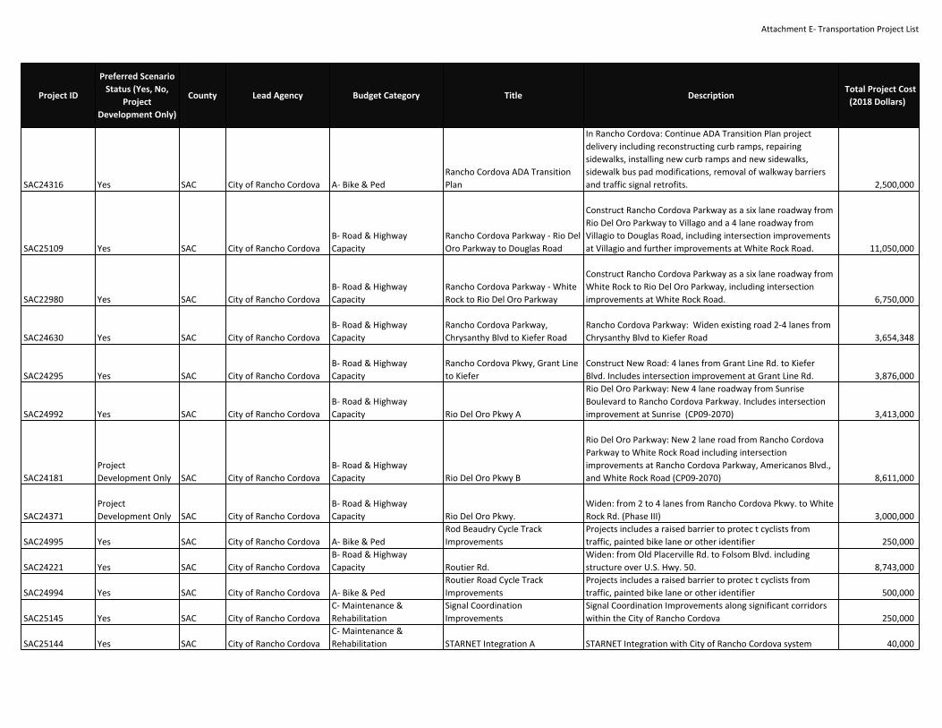
Attachment E‐ Transportation Project List
SAC24316 Yes SAC City of Rancho Cordova A‐ Bike & PedRancho Cordova ADA TransitionPlan
In Rancho Cordova: Continue ADA Transition Plan projectdelivery including reconstructing curb ramps, repairingsidewalks, installing new curb ramps and new sidewalks,sidewalk bus pad modifications, removal of walkway barriersand traffic signal retrofits. 2,500,000
SAC25109 Yes SAC City of Rancho CordovaB‐ Road & HighwayCapacity
Rancho Cordova Parkway ‐ Rio DelOro Parkway to Douglas Road
Construct Rancho Cordova Parkway as a six lane roadway fromRio Del Oro Parkway to Villago and a 4 lane roadway fromVillagio to Douglas Road, including intersection improvementsat Villagio and further improvements at White Rock Road. 11,050,000
SAC22980 Yes SAC City of Rancho CordovaB‐ Road & HighwayCapacity
Rancho Cordova Parkway ‐ WhiteRock to Rio Del Oro Parkway
Construct Rancho Cordova Parkway as a six lane roadway fromWhite Rock to Rio Del Oro Parkway, including intersectionimprovements at White Rock Road. 6,750,000
SAC24630 Yes SAC City of Rancho CordovaB‐ Road & HighwayCapacity
Rancho Cordova Parkway,Chrysanthy Blvd to Kiefer Road
Rancho Cordova Parkway: Widen existing road 2‐4 lanes fromChrysanthy Blvd to Kiefer Road 3,654,348
SAC24295 Yes SAC City of Rancho CordovaB‐ Road & HighwayCapacity
Rancho Cordova Pkwy, Grant Lineto Kiefer
Construct New Road: 4 lanes from Grant Line Rd. to KieferBlvd. Includes intersection improvement at Grant Line Rd. 3,876,000
SAC24992 Yes SAC City of Rancho CordovaB‐ Road & HighwayCapacity Rio Del Oro Pkwy A
Rio Del Oro Parkway: New 4 lane roadway from SunriseBoulevard to Rancho Cordova Parkway. Includes intersectionimprovement at Sunrise (CP09‐2070) 3,413,000
SAC24181ProjectDevelopment Only SAC City of Rancho Cordova
B‐ Road & HighwayCapacity Rio Del Oro Pkwy B
Rio Del Oro Parkway: New 2 lane road from Rancho CordovaParkway to White Rock Road including intersectionimprovements at Rancho Cordova Parkway, Americanos Blvd.,and White Rock Road (CP09‐2070) 8,611,000
SAC24371ProjectDevelopment Only SAC City of Rancho Cordova
B‐ Road & HighwayCapacity Rio Del Oro Pkwy.
Widen: from 2 to 4 lanes from Rancho Cordova Pkwy. to WhiteRock Rd. (Phase III) 3,000,000
SAC24995 Yes SAC City of Rancho Cordova A‐ Bike & PedRod Beaudry Cycle TrackImprovements
Projects includes a raised barrier to protec t cyclists fromtraffic, painted bike lane or other identifier 250,000
SAC24221 Yes SAC City of Rancho CordovaB‐ Road & HighwayCapacity Routier Rd.
Widen: from Old Placerville Rd. to Folsom Blvd. includingstructure over U.S. Hwy. 50. 8,743,000
SAC24994 Yes SAC City of Rancho Cordova A‐ Bike & PedRoutier Road Cycle TrackImprovements
Projects includes a raised barrier to protec t cyclists fromtraffic, painted bike lane or other identifier 500,000
SAC25145 Yes SAC City of Rancho CordovaC‐ Maintenance &Rehabilitation
Signal CoordinationImprovements
Signal Coordination Improvements along significant corridorswithin the City of Rancho Cordova 250,000
SAC25144 Yes SAC City of Rancho CordovaC‐ Maintenance &Rehabilitation STARNET Integration A STARNET Integration with City of Rancho Cordova system 40,000
Project ID
Preferred ScenarioStatus (Yes, No,
ProjectDevelopment Only)
County Lead Agency Budget Category Title DescriptionTotal Project Cost
(2018 Dollars)

Attachment E‐ Transportation Project List
SAC24468 Yes SAC City of Rancho CordovaB‐ Road & HighwayCapacity Sunrise Blvd ‐ Kiefer Blvd to SR16
Widen Sunrise Boulevard: 2 to 4‐lanes from Kiefer Boulevard toState Route 16 (Jackson Highway) and construct partialintersection improvements at Sunrise Boulevard and StateRoute 16. The project includes modifications to the bridge onSunrise Boulevard over Laguna Creek. (The $5,227,000 of localagency funds is Sac County funding. City will advance costs andenter into MOU with County for reimbursement for Countyshare.) 10,000,000
SAC24349 No SAC City of Rancho CordovaB‐ Road & HighwayCapacity
Sunrise Blvd. and Jackson Hwy.Intersection
Construct 6x6 intersection with two bridge sections over thecreek at Sunrise Boulevard and Jackson Highway. 11,845,000
SAC24210ProjectDevelopment Only SAC City of Rancho Cordova
B‐ Road & HighwayCapacity Sunrise Complex Improvements
On Sunrise Blvd, construction intersection modifications andpedestrian improvements and include road widening alongSunrise or capacity increasing improvements and modificationsat US 50. 50,000,000
SAC25111 Yes SAC City of Rancho CordovaC‐ Maintenance &Rehabilitation Traffic Signal Installation
Install traffic signal at warranted locations within the City ofRancho Cordova 750,000
SAC24182ProjectDevelopment Only SAC City of Rancho Cordova
B‐ Road & HighwayCapacity Villagio
Construct New Road: 2 lanes from Douglas Rd. to White RockRd. Includes: intersection improvements at Douglas Rd.,Rancho Cordova Pkwy., International Dr., Americanos Rd., andWhite Rock Rd. 2,608,000
SAC24470 Yes SAC City of Rancho CordovaB‐ Road & HighwayCapacity
White Rock Rd. ‐ ConstructSunrise Blvd. to City Limits;Environmental Sunrise to GrantLine
Environmental will be for both this project and the County ofSacramento project SAC24249. Environmental completed forWhite Rock Road Sunrise Blvd to Grant Line Road.Construction will include: On existing 6‐lane White Rock Rd.,from Sunrise Blvd. to Luyung Dr.: construct improvements,including Class II bikeway. On White Rock Rd from Luyung Dr.to eastern City Limits: widen and reconstruct from 2 to 4 lanesand construct Class II bikeway. (CMAQ funds only to be usedfor new bicycle facilities.) (Emission Benefits in kg/day: 0.03ROG, 0.03 NOx, 0.02 PM10). Additional construction will becompleted under the Sacramento County project SAC24662. 18,366,000
Project ID
Preferred ScenarioStatus (Yes, No,
ProjectDevelopment Only)
County Lead Agency Budget Category Title DescriptionTotal Project Cost
(2018 Dollars)

Attachment E‐ Transportation Project List
SAC24703 Yes SAC City of Rancho CordovaC‐ Maintenance &Rehabilitation Zinfandel Complex Improvements
On Zinfandel Dr., from westbound US 50 off‐ramp to WhiteRock Rd. widen southbound travel lanes from 2 to 3 lanes. Onthe eastbound US 50 off‐ramp at Zinfandel, from Zinfandel Dr.intersection to US 50, widen from 4 to 6 lanes. On westboundUS 50 off‐ramp at Zinfandel, from Zinfandel Dr. intersection toUS 50, widen from 3 to 4 lanes. On Gold Center Dr. atZinfandel Dr intersection, widen by 6 feet for 300 feet. OnZinfandel Dr., from White Rock Dr to the WB US 50 off‐ramp,add bicycle lanes. at the WB US 50 off ramp, EB 50 on ramp/onramp and Gold Center Dr at the Zinfandel Dr intersections:build pedestrian refuge islands. On the NB to WB US 50 on‐ramp, reduce from 2 lanes to 1 lane to accommodatepedestrian refuge island and reduce crossing width. Addingoverhead signage. 7,101,500
SAC24828 Yes SAC City of Rancho Cordova A‐ Bike & PedZinfandel Complex Improvements‐ Phase2
Construct intersection and pedestrian improvements onZinfandel Drive between White Rock Road and Folsom Blvd,including modifications at US 50/Zinfandel to improve safetyand ease congestion along the corridor, including bridgewidenings, ramp and intersection reconstruction andreconstruction of intersections. 45,968,000
SAC24610 Yes SAC City of SacramentoB‐ Road & HighwayCapacity 14th Ave. Extension Phase 1
Sacramento. Extension of 14th Avenue from Power Inn Rd toFlorin‐Perkins. Phase I includes environmental/PE for four laneroadway and construction of two‐lane roadway with class IIbicycle lanes and landscape planter/sidewalks on the southside of the roadway. Also includes new water and drainagefacilities, new streetlights, new traffic signal at 14th Ave/FlorinPerkins Rd, and modification to existing traffic signal. (Phase 2SAC24656, Phase 3 SAC24657) 12,000,000
SAC24656ProjectDevelopment Only SAC City of Sacramento
B‐ Road & HighwayCapacity 14th Ave. Extension Phase 2
Sacramento. 14th Ave., from Power Inn Road to Florin Perkins,widen from 2 to 4 lanes. Construction includes bike lanes,landscaped center median, landscaping and sidewalk on northside of street. Retaining wall along north side of project.(PE/ENV included in Phase 1, SAC24610) 10,000,000
SAC24657ProjectDevelopment Only SAC City of Sacramento
B‐ Road & HighwayCapacity 14th Ave. Extension Phase 3
Sacramento. 14th Avenue from Florin‐Perkins Rd to Watt Ave:extend as a four lane road. 16,000,000
Project ID
Preferred ScenarioStatus (Yes, No,
ProjectDevelopment Only)
County Lead Agency Budget Category Title DescriptionTotal Project Cost
(2018 Dollars)

Attachment E‐ Transportation Project List
SAC24623 Yes SAC City of Sacramento A‐ Bike & Ped 16th Street Streetscape
On 16th Street from S Street to N Street, pedestrianimprovements including bulb‐outs, landscaping and trees,banners, pavement treatments, bike racks, and streetfurniture,and street lights. 2,680,000
SAC25017 Yes SAC City of Sacramento A‐ Bike & Ped16th Street Streetscape ‐ H st. toRichards Blvd.
North 16th St./Lincoln Highway, from H St. to Richards Blvd.:Streetscape improvements, including restriping travel lanes to11 feet, on street parking on both sides, curbs, six footseparated sidewalk, and pedestrian lighting. 8,000,000
SacCity‐F11 Yes Sac City of SacramentoC‐ Maintenance &Rehabilitation 65th Area Plan Projects
ITS, Roadway, Bike, and pedstrian improvements to implementthe 65th Street Transit Station Area Specific Plan, including67th Street Extenstion from Folosm Boulevard to Elvas Avenue 12,000,000
SAC23630 Yes SAC City of SacramentoB‐ Road & HighwayCapacity 65th St. Widen: 5 lanes from Hwy. 50 to Broadway. 8,000,000
SacCity‐F9 Yes Sac City of SacramentoC‐ Maintenance &Rehabilitation ADA Improvements
Accessibilty improvements to meet current accessibiltyrequirements 60,000,000
SAC24693 Yes SAC City of SacramentoC‐ Maintenance &Rehabilitation Auburn Blvd. Bridge Replacement
Auburn Blvd. over Arcade Creek, at Winding Way: Replaceexisting five lane bridge with a new five lane bridge 8,174,952
SAC22840 No SAC City of SacramentoB‐ Road & HighwayCapacity Bell Ave. [delete a] Widen: 3 lanes from Norwood Ave. to Raley Blvd. 30,000,000
SAC22850 No SAC City of SacramentoB‐ Road & HighwayCapacity Bell Ave. [delete b] Widen: 3 lanes from Raley Blvd. to Winters St. 2,400,000
SAC24633 Yes SAC City of SacramentoC‐ Maintenance &Rehabilitation
Bridge Preventive MaintenanceProgram B
Various Locations in the City of Sacramento: rehabilitatebridges. For locations and detail, see Caltrans Local AssistanceHBP website. 4,200,000
SAC22530 Yes SAC City of Sacramento A‐ Bike & PedBridging I‐5/RiverfrontReconnection Phase 3
Environmental clearance/PE for Riverfront Reconnection.Construct connection over I‐5 between approximately CapitolAve. to "O" St. (T15998100) Phase 1 constructed underSAC24705 9,432,709
SAC25051 Yes SAC City of SacramentoB‐ Road & HighwayCapacity
Broadway Complete Street PhaseI & 2
Phase I: In Sacramento, Broadway from 3rd St to 24th St,convert four lane arterial to two lane arterial with bufferedbike lanes, median improvements, sidewalk improvements andstreetscape enhancements. Create surface street (29th St.)from X St. to Hwy 99 South. PA&ED will be completed for theentire 2‐mile corridor. 8,000,000
Project ID
Preferred ScenarioStatus (Yes, No,
ProjectDevelopment Only)
County Lead Agency Budget Category Title DescriptionTotal Project Cost
(2018 Dollars)

Attachment E‐ Transportation Project List
SAC24712 No SAC City of Sacramento A‐ Bike & Ped Carlson Dr. Safety Improvements
On Carlson Dr between approx. 250' north of H St and 250'south of J St; On H ST between Camilla Ave and Carlson Dr:Upgrade traffic signals, signs, and striping; Construct curbramps and crosswalks. (HSIP6‐03‐015) (Toll Credits for CON).Toll Credits for CON 1,308,400
SAC24557 Yes SAC City of Sacramento A‐ Bike & PedCentral City Specific Plan Multi‐modal improvements.
Two‐way conversions, three to two lane conversions, freewayramps, buffered bike lanes, Ped, Transit, and Bike Projects (seeTable A‐3 from Central City Specific Plan) 165,000,000
SAC24723 No SAC City of SacramentoC‐ Maintenance &Rehabilitation
Complete Street Rehabilitation ‐Power Inn Rd.
Power Inn Rd., from Folsom Blvd. to Alpine Ave.: Pavementrehabilitation and complete streets improvements. (TollCredits for PE and CON) T15145400. Toll Credits for ENG, CON 2,597,989
SAC24719 Yes SAC City of SacramentoC‐ Maintenance &Rehabilitation
Complete Streets Rehabilitation ‐Bell Ave.
Bell Ave. from Bollenbacher Ave. to Astoria St.,: rehabilitatepavement, fill in sidewalk gaps, add new bicycle lanes, add two‐way left turn lanes, and add bus pullouts. (Toll Credits for PEand CON). Toll Credits for ENG, CON 5,759,968
SAC24722 Yes SAC City of SacramentoC‐ Maintenance &Rehabilitation
Complete Streets Rehabilitationand Road Diet ‐ Fruitridge Rd.
Fruitridge Rd., from Power Inn Rd to Stockton Boulevard.,:Reduce from four lanes to two lanes. rehabilitate sidewalks upto standard, and add bicycle lanes, actuated crosswalks, andnew crosswalks. (Toll Credits for PE and CON). T15036300. TollCredits for ENG, CON 5,000,000
SAC25026 Yes SAC City of SacramentoC‐ Maintenance &Rehabilitation Corridor Street Lighting
Three corridors: On Freeport Bl from Meadowview Rd to FlorinRd, on Rio Linda Bl from North Ave to Claire Ave, and onMeadowview from Amherst to 24th St.: Install street lighting.(Toll Credits) HSIP7‐03‐014. Toll Credits for CON 5,000,000
SacCity‐F13 Yes SAC City of SacramentoG‐ System Management,Operations, and ITS Cosumnes River Boulevard
Improve safety, capacity, and operations of CRB and threeintersections at Franklin Boulevard, Center Parkway, andBruceville Road 15,000,000
SAC25000 Yes SAC City of Sacramento A‐ Bike & PedD W Babcock School AccessImprovements
City of Sacramento: Woolley Way from Albatross to DWBabcock School; Cormorant Way from DW Babcock School toBabcock Park: Construct sidewalks, install a signalizedintersection with accessibility compliant crosswalks at theintersection of Albatross Way and El Camino Avenue., curbramps, and other access improvements for students whoattend D.W. Babcock School. 1,124,700
SAC24139 Yes SAC City of SacramentoB‐ Road & HighwayCapacity Del Paso Rd
In Sacramento,from I‐5 N/B offramp to East Commerce (northside only), widen Del Paso Road. 516,000
Project ID
Preferred ScenarioStatus (Yes, No,
ProjectDevelopment Only)
County Lead Agency Budget Category Title DescriptionTotal Project Cost
(2018 Dollars)

Attachment E‐ Transportation Project List
SAC24999 Yes SAC City of Sacramento A‐ Bike & Ped Del Rio Trail
Along unused rail corridor near Freeport Blvd from Sutterville Road to south of Meadowview/Pocket Road (4.5 miles): Build rails�]to�]trails project. (Emission Benefits in kg/day: 0.06 ROG,0.04 NOx, 0.02 PM 10) 15,000,000
SAC24499 Yes SAC City of Sacramento A‐ Bike & Ped Docks Riverfront Promenade
In Sacramento, extend pedestrian/bicycle riverfrontpromenade from R St to Pioneer Bridge. Relocation andreconstruction of main rail line. Pedestrian/bicycle paths,benches, lighting, interpretative signs, rail crossings, and on‐street bicycle lanes. 20,000,000
SAC25071 No SAC City of SacramentoC‐ Maintenance &Rehabilitation
Downtown Controller andCommunications Upgrade Phase 1
Phase 1, in Downtown Sacramento: On 15th St., 16th St., 19thSt, 21st St. and J St: Replace 246 existing end of life controllers,install fiber cables in existing conduits, install fiber switches,and replace some cabinets and CCTVs. (Phase 2 is SAC25013) 849,605
SAC25013 Yes SAC City of SacramentoG‐ System Management,Operations, and ITS
Downtown Controller andCommunications Upgrade Phase 2
Phase 2, in Downtown Sacramento: On 15th St., 16th St., 19thSt, 21st St. and J St: Replace 246 existing end of life controllers,install fiber cables in existing conduits, install fiber switches,and replace some cabinets and CCTVs. 3,243,000
SAC24497 Yes SAC City of Sacramento D‐ Programs & Planning
Downtown SacramentoTransportation Study: EastBroadway
Downtown Sacramento, bounded by Broadway extending intothe Oak Park neighborhood, Sacramento River, American River,and Alhambra Blvd. 1,200,000
SAC25025 No SAC City of SacramentoG‐ System Management,Operations, and ITS Downtown Signal Improvements
Various downtown corridors bounded by I‐5, Broadway,Alhambra Blvd., and C St., including the intersections of North16th St/Sproule St‐Basler St and North 16th St/North B St:Install pedestrian countdown signal heads; replace 8" with 12"vehicle signal heads; install emergency vehicle preemptionequipment. (Toll credits) (HSIP7‐03‐013). Toll Credits for CON 3,142,600
SAC18460 Yes SAC City of SacramentoB‐ Road & HighwayCapacity East Commerce Way A
In Sacramento, East Commerce Way from Club Center Drive toDel Paso Rd, extend as a 6‐lane facility. 8,142,225
SAC18570 Yes SAC City of SacramentoB‐ Road & HighwayCapacity East Commerce Way B
In Sacramento, extend East Commerce Way from Arena Blvd.to Natomas Crossing Drive, as a 6 lane road. 3,329,000
SAC18580 Yes SAC City of SacramentoB‐ Road & HighwayCapacity East Commerce Way C
Extend East Commerce Way from planned Natomas CrossingDrive to San Juan Rd. as a 4 lane road. 4,000,000
SAC18740 Yes SAC City of SacramentoB‐ Road & HighwayCapacity El Centro Rd. New Overcrossing: El Centro Rd. overcrossing. 11,000,000
SAC23690 No SAC City of SacramentoB‐ Road & HighwayCapacity Elder Creek Rd. Widen: 4 lanes from Power Inn Rd. and Florin Perkins Rd. 1,900,000
SAC23680 Yes SAC City of SacramentoB‐ Road & HighwayCapacity Elder Creek Rd. Widen: 4 lanes from Florin Perkins Rd. to South Watt Ave. 7,000,000
Project ID
Preferred ScenarioStatus (Yes, No,
ProjectDevelopment Only)
County Lead Agency Budget Category Title DescriptionTotal Project Cost
(2018 Dollars)

Attachment E‐ Transportation Project List
SAC18510 Yes SAC City of SacramentoB‐ Road & HighwayCapacity Elkhorn Boulevard
In Sacramento, Elkhorn Boulevard from SR 99 to east citylimits: widen from 2 to 6 lanes. 14,000,000
SAC24711 No SAC City of SacramentoG‐ System Management,Operations, and ITS Flashing Beacons
9 locations throughout the City of Sacramento: Install flashingbeacon. (HSIP6‐03‐014) T15145800 (Toll Credits for CON).Toll Credits for CON 1,641,700
SAC24402 Yes SAC City of Sacramento A‐ Bike & PedFolsom Blvd Operations andMaintenance
Folsom Blvd. from Power Inn Road to Watt Avenue;streetscape project including pedestrian and bicycleimprovements, a raised landscaped median, landscapedplanters, improvements to signal operations, frontagelandscaping, and enhanced connections to transit facilities. 19,500,000
SAC24535 Yes SAC City of Sacramento A‐ Bike & Ped Folsom Blvd. Streetscape Project: Folsom Blvd from Power Inn. to Ramona. 6,000,000
SAC24636 No SAC City of SacramentoC‐ Maintenance &Rehabilitation
Folsom Blvd. Complete StreetsRehabilitation
Folsom Blvd., from 65th St. to 350’ east of the Union PacificRailroad underpass: rehabilitate roadway. Complete streetsfeatures include new bicycle lanes and new sidewalks to fill inmissing sections. A new signalized pedestrian signal will beconstructed at the Elvas Ave intersection.(Emission Benefits inkg/day: 0.13 ROG, 0.1 NOx, 0.06 PM10) ‐ T15135100 2,045,345
SAC22610 Yes SAC City of SacramentoB‐ Road & HighwayCapacity
Folsom Blvd./Power Inn Rd.Intersection (Ramona Ave Phase I)
Near intersection of Folsom Blvd. and Power Inn: Ramona Ave.,extend northward from Brighton Ave. to connect to FolsomBlvd. This will improve the operations of the FolsomBlvd./Power Inn Intersection. (Phase 2, SAC24654) (CMAQEmission Reductions in kg/day: ROG 0.05, NOx 0.04, PM100.02, PM2.5 0.02). Toll Credits for CON 8,656,889
SAC25009 Yes SAC City of SacramentoG‐ System Management,Operations, and ITS Franklin Boulevard Streetscape
In the City of Sacramento, on Franklin Blvd., from SuttervilleRd./12th Ave. to the Sacramento County Line: Reduce travellanes from four to two lanes, add bicycle lanes, installlandscaping and landscaped medians, and provide on‐streetparking. 12,000,000
SAC25021 Yes SAC City of Sacramento A‐ Bike & Ped Franklin Cycle Track
On Franklin Blvd. between Cosumnes River Blvd. and thesouthern city limit near Francesca St.: Construct one‐way ClassIV bikeways. (Emission Benefits in kg/day: 0.02 ROG, 0.01 NOx,0.01 PM10. 0.01 PM2.5) 1,100,000
SAC23810 Yes SAC City of SacramentoB‐ Road & HighwayCapacity
Highway 99 Meister WayOvercrossing New Overcrossing: Meister Wy. / Hwy. 99. 8,000,000
Project ID
Preferred ScenarioStatus (Yes, No,
ProjectDevelopment Only)
County Lead Agency Budget Category Title DescriptionTotal Project Cost
(2018 Dollars)

Attachment E‐ Transportation Project List
SAC24683 Yes SAC City of SacramentoC‐ Maintenance &Rehabilitation I St. Bridge Replacement
I Street Bridge, over Sacramento River and complex of bridgeapproach structures. Replace existing 2 lane bridge with a 2lane bridge on a new alignment. Project includes bridgeapproaches 22C0154, 24C0006, 24C0364L, 24C0364R,24C0351J. 172,000,000
SAC18660 Yes SAC City of SacramentoG‐ System Management,Operations, and ITS I‐5 Add Auxiliary Lane: NB from Del Paso Rd. to Hwy. 99. 857,000
SAC18670 Yes SAC City of SacramentoB‐ Road & HighwayCapacity I‐5 / Highway 99
On/Off Ramp Improvement: Add 2nd on‐ramp at I‐5 / Hwy. 99Interchange. 216,000
SAC18170 Yes SAC City of SacramentoC‐ Maintenance &Rehabilitation I‐5 at Richards Blvd. Interchange
Sacramento, Richards Blvd. and I‐5; reconstruct interchange(ult). (HPP #3784)(T15165100) 80,000,000
SAC18650 Yes SAC City of SacramentoB‐ Road & HighwayCapacity
I‐80 @ West El CaminoInterchange
Expand the West El Camino interchange on I‐80 from 2 to 4lanes and modify ramps. 30,000,000
SAC25024 No SAC City of SacramentoG‐ System Management,Operations, and ITS Intersection Dilemma Zone Loops
Six locations throughout the City of Sacramento: Installadvanced dilemma zone loops for the high speed approachesat six existing signalized intersections. (Toll Credits for allphases) HSIP7‐03‐012. Toll Credits for CON 415,300
SAC16040 No SAC City of SacramentoB‐ Road & HighwayCapacity Jackson Hwy. (SR 16)
Road Realignment: 4 lane Rd. from Power Inn Rd. to SouthWatt Ave. 25,000,000
SAC24886 No SAC City of SacramentoG‐ System Management,Operations, and ITS K Street Streetscaping Streetscape improvements along K Street 2,000,000
SAC23410 No SAC City of SacramentoB‐ Road & HighwayCapacity Kiefer Blvd. Widen: 4 lanes from Florin‐Perkins Rd. to S. Watt Ave. 1,000,000
SAC24539 Yes SAC City of SacramentoB‐ Road & HighwayCapacity Lower American River Crossing
New all‐modal Bridge: between downtown Sacramento andSouth Natomas across the Lower American River. Includes:Auto, transit, bicycle, and pedestrian facilties. Scale andfeatures to be determined through need and purpose studyanticipated to begin in 2012. 150,000,000
SAC23430 Yes SAC City of SacramentoB‐ Road & HighwayCapacity Main Ave. [delete] Widen: 4 lanes from Norwood Ave. to Rio Linda Blvd. 10,000,000
SAC24536 Yes SAC City of SacramentoB‐ Road & HighwayCapacity Main Ave. A Road Extension: 2 lanes from Rio Linda Blvd. to Marysville Blvd. 3,000,000
SAC24541 No SAC City of SacramentoB‐ Road & HighwayCapacity Main Ave. B Widen: 4 lanes from Norwood Ave to Marysville Blvd. 6,000,000
SAC23440 Yes SAC City of Sacramento A‐ Bike & Ped Mangan Park
Bikeway Facilities: 0.6 mile in City of Sacramento Mangen Parkfrom 24th St. to Freeport Blvd. Bike trail south in ExecutiveAirport right‐of‐way. 800,000
Project ID
Preferred ScenarioStatus (Yes, No,
ProjectDevelopment Only)
County Lead Agency Budget Category Title DescriptionTotal Project Cost
(2018 Dollars)
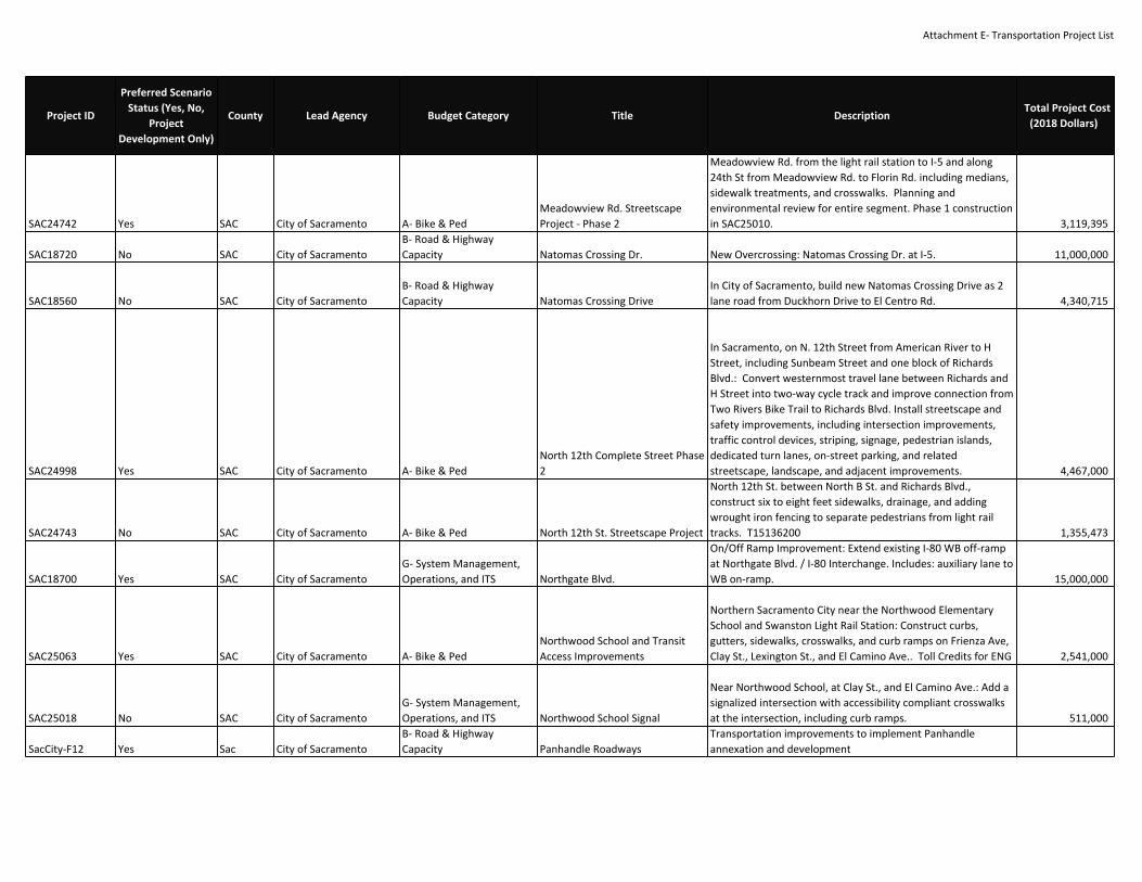
Attachment E‐ Transportation Project List
SAC24742 Yes SAC City of Sacramento A‐ Bike & PedMeadowview Rd. StreetscapeProject ‐ Phase 2
Meadowview Rd. from the light rail station to I‐5 and along24th St from Meadowview Rd. to Florin Rd. including medians,sidewalk treatments, and crosswalks. Planning andenvironmental review for entire segment. Phase 1 constructionin SAC25010. 3,119,395
SAC18720 No SAC City of SacramentoB‐ Road & HighwayCapacity Natomas Crossing Dr. New Overcrossing: Natomas Crossing Dr. at I‐5. 11,000,000
SAC18560 No SAC City of SacramentoB‐ Road & HighwayCapacity Natomas Crossing Drive
In City of Sacramento, build new Natomas Crossing Drive as 2lane road from Duckhorn Drive to El Centro Rd. 4,340,715
SAC24998 Yes SAC City of Sacramento A‐ Bike & PedNorth 12th Complete Street Phase2
In Sacramento, on N. 12th Street from American River to HStreet, including Sunbeam Street and one block of RichardsBlvd.: Convert westernmost travel lane between Richards andH Street into two‐way cycle track and improve connection fromTwo Rivers Bike Trail to Richards Blvd. Install streetscape andsafety improvements, including intersection improvements,traffic control devices, striping, signage, pedestrian islands,dedicated turn lanes, on‐street parking, and relatedstreetscape, landscape, and adjacent improvements. 4,467,000
SAC24743 No SAC City of Sacramento A‐ Bike & Ped North 12th St. Streetscape Project
North 12th St. between North B St. and Richards Blvd.,construct six to eight feet sidewalks, drainage, and addingwrought iron fencing to separate pedestrians from light railtracks. T15136200 1,355,473
SAC18700 Yes SAC City of SacramentoG‐ System Management,Operations, and ITS Northgate Blvd.
On/Off Ramp Improvement: Extend existing I‐80 WB off‐rampat Northgate Blvd. / I‐80 Interchange. Includes: auxiliary lane toWB on‐ramp. 15,000,000
SAC25063 Yes SAC City of Sacramento A‐ Bike & PedNorthwood School and TransitAccess Improvements
Northern Sacramento City near the Northwood ElementarySchool and Swanston Light Rail Station: Construct curbs,gutters, sidewalks, crosswalks, and curb ramps on Frienza Ave,Clay St., Lexington St., and El Camino Ave.. Toll Credits for ENG 2,541,000
SAC25018 No SAC City of SacramentoG‐ System Management,Operations, and ITS Northwood School Signal
Near Northwood School, at Clay St., and El Camino Ave.: Add asignalized intersection with accessibility compliant crosswalksat the intersection, including curb ramps. 511,000
SacCity‐F12 Yes Sac City of SacramentoB‐ Road & HighwayCapacity Panhandle Roadways
Transportation improvements to implement Panhandleannexation and development
Project ID
Preferred ScenarioStatus (Yes, No,
ProjectDevelopment Only)
County Lead Agency Budget Category Title DescriptionTotal Project Cost
(2018 Dollars)
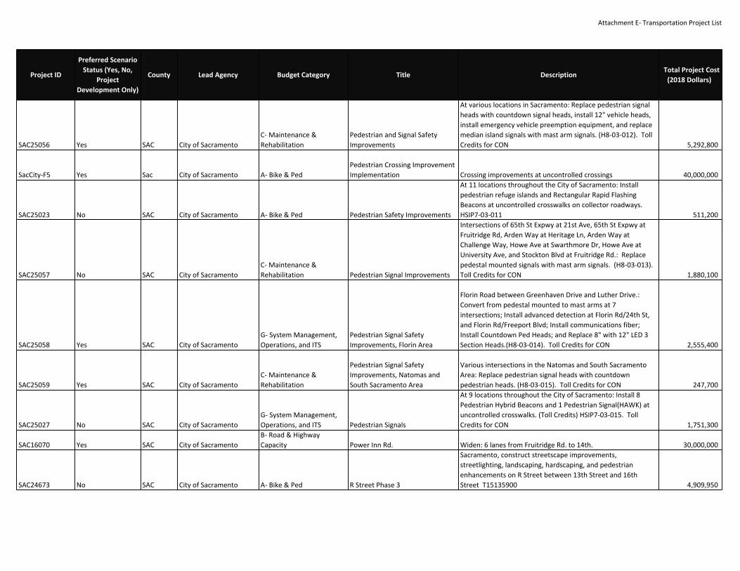
Attachment E‐ Transportation Project List
SAC25056 Yes SAC City of SacramentoC‐ Maintenance &Rehabilitation
Pedestrian and Signal SafetyImprovements
At various locations in Sacramento: Replace pedestrian signalheads with countdown signal heads, install 12" vehicle heads,install emergency vehicle preemption equipment, and replacemedian island signals with mast arm signals. (H8‐03‐012). TollCredits for CON 5,292,800
SacCity‐F5 Yes Sac City of Sacramento A‐ Bike & PedPedestrian Crossing ImprovementImplementation Crossing improvements at uncontrolled crossings 40,000,000
SAC25023 No SAC City of Sacramento A‐ Bike & Ped Pedestrian Safety Improvements
At 11 locations throughout the City of Sacramento: Installpedestrian refuge islands and Rectangular Rapid FlashingBeacons at uncontrolled crosswalks on collector roadways.HSIP7‐03‐011 511,200
SAC25057 No SAC City of SacramentoC‐ Maintenance &Rehabilitation Pedestrian Signal Improvements
Intersections of 65th St Expwy at 21st Ave, 65th St Expwy atFruitridge Rd, Arden Way at Heritage Ln, Arden Way atChallenge Way, Howe Ave at Swarthmore Dr, Howe Ave atUniversity Ave, and Stockton Blvd at Fruitridge Rd.: Replacepedestal mounted signals with mast arm signals. (H8‐03‐013).Toll Credits for CON 1,880,100
SAC25058 Yes SAC City of SacramentoG‐ System Management,Operations, and ITS
Pedestrian Signal SafetyImprovements, Florin Area
Florin Road between Greenhaven Drive and Luther Drive.:Convert from pedestal mounted to mast arms at 7intersections; Install advanced detection at Florin Rd/24th St,and Florin Rd/Freeport Blvd; Install communications fiber;Install Countdown Ped Heads; and Replace 8" with 12" LED 3Section Heads.(H8‐03‐014). Toll Credits for CON 2,555,400
SAC25059 Yes SAC City of SacramentoC‐ Maintenance &Rehabilitation
Pedestrian Signal SafetyImprovements, Natomas andSouth Sacramento Area
Various intersections in the Natomas and South SacramentoArea: Replace pedestrian signal heads with countdownpedestrian heads. (H8‐03‐015). Toll Credits for CON 247,700
SAC25027 No SAC City of SacramentoG‐ System Management,Operations, and ITS Pedestrian Signals
At 9 locations throughout the City of Sacramento: Install 8Pedestrian Hybrid Beacons and 1 Pedestrian Signal(HAWK) atuncontrolled crosswalks. (Toll Credits) HSIP7‐03‐015. TollCredits for CON 1,751,300
SAC16070 Yes SAC City of SacramentoB‐ Road & HighwayCapacity Power Inn Rd. Widen: 6 lanes from Fruitridge Rd. to 14th. 30,000,000
SAC24673 No SAC City of Sacramento A‐ Bike & Ped R Street Phase 3
Sacramento, construct streetscape improvements,streetlighting, landscaping, hardscaping, and pedestrianenhancements on R Street between 13th Street and 16thStreet T15135900 4,909,950
Project ID
Preferred ScenarioStatus (Yes, No,
ProjectDevelopment Only)
County Lead Agency Budget Category Title DescriptionTotal Project Cost
(2018 Dollars)

Attachment E‐ Transportation Project List
SAC24615 Yes SAC City of SacramentoB‐ Road & HighwayCapacity Railyard Boulevard Extension
Railyard Boulevard, between Jibboom Street and Bercut Street:construct approximately 200 feet of new roadway (one laneeach direction) to provide access to Downtown Railyards. (SeeMTP Project SAC24537.) 1,000,000
SAC24537 Yes SAC City of SacramentoB‐ Road & HighwayCapacity Railyards Streets
Construct New Road/Bike/Ped Improvements to implementRailyards Specific Plan 163,000,000
SAC19550ProjectDevelopment Only SAC City of Sacramento
B‐ Road & HighwayCapacity Raley Blvd. Widen: 4 lanes from Santa Ana Ave. to Ascot Ave. 2,000,000
SAC24654 Yes SAC City of SacramentoB‐ Road & HighwayCapacity Ramona Avenue Phase II
Ramona Avenue: Widen and add new frontage improvementsfrom Cucamonga to Brighton. Environmental review completedunder SAC22610. (No new travel lanes.) 5,000,000
SAC24538 No SAC City of SacramentoG‐ System Management,Operations, and ITS
Rio Linda & Main IntersectionImprovements
Intersection Improvements: at Rio Linda Blvd. and Main Ave.Includes: traffic signal installation and intersection re‐configuration. 4,500,000
SAC24517 No SAC City of SacramentoC‐ Maintenance &Rehabilitation Rio Linda Blvd. Bridge Rehab
Rio Linda Blvd., Over Magpie Creek, 0.92 miles north of FAI880: Replace the existing 2 lane bridge without addingadditional through lanes. Project includes turn lane. 7,146,749
SacCity‐F10 Yes Sac City of Sacramento A‐ Bike & PedRiver District TransportationImprovements
Roadway, bikeway, and pedestrian improvements toimplement the River District Specific Plan. 120,000,000
SacCity‐F8 Yes Sac City of SacramentoC‐ Maintenance &Rehabilitation
Roadway Pavement MaintenanceBacklog To maintain current PCI 400,000,000
SAC23530 No SAC City of SacramentoB‐ Road & HighwayCapacity Roseville Rd. Widen: 4 lanes from Connie Dr. to Sacramento limits. 4,000,000
SAC24658 No SAC City of SacramentoB‐ Road & HighwayCapacity
Sacramento IntermodalCirculation Phase 2 (3rd & I)
Design and construct access improvements at 3rd & I (HPP#2788 and #3784). Feasibility Studies, preliminary designincluded in Phase 1. 2,417,165
SAC20350 No SAC City of Sacramento E‐ Transit Capital (Major)Sacramento Intermodal Trans.Facility ‐ Phase 2
Sacramento Intermodal Transportation Facility Valley Station:Improvements to the existing station including: relocating theexisting LRT station to a north‐south alignment; relocating(repave/restripe) the existing RT and Amtrak bus berths;providing enhanced passenger connections; relocatingpassenger vehicle and bicycle parking; upgrading the Depot'selectrical system; providing a transit way. 40,663,140
Project ID
Preferred ScenarioStatus (Yes, No,
ProjectDevelopment Only)
County Lead Agency Budget Category Title DescriptionTotal Project Cost
(2018 Dollars)

Attachment E‐ Transportation Project List
SAC24883 No SAC City of Sacramento E‐ Transit Capital (Major)Sacramento Intermodal Trans.Facility ‐ Phase 2b
Sacramento Intermodal Transportation Facility Valley Station:Intermodal Facility Phase 2B project is a complete makeoverand rehabilitation of the historic Depot to make the facilityfully usable and attractive, arrest deterioration and meet code.The project elements will consist of repair and upgrade to theinterior and exterior sections of the building includingarchitectural, structural, plumbing, mechanical, electrical,energy, internal circulation, access and other work. Historicrehabilitation will involve features such as façades, canopies,openings, windows, doors, the mural and decorativetreatments, finishes and other items. 27,000,000
SAC24898 Yes SAC City of Sacramento E‐ Transit Capital (Major)Sacramento IntermodalTransportation Facility ‐ Phase 3
Intermodal Facility Phase 3 project is the creation of a largermulti‐modal transportation center that can meet the region’sexpanded transportation needs and accommodate high speedtrains, commuter rail, light rail, streetcars, transit bus lines, andintercity buses. It will involve relocating the existing LRT stationto a north‐south alignment; expansion of the terminal facilitiesincluding passenger amenities and spaces, transportationoperations areas, site and circulation improvements and jointdevelopment 225,000,000
SacCity‐F3 Yes Sac City of Sacramento A‐ Bike & PedShort‐term Bikeway ProjectImplementaiton Priority projects identified in the Bicycle Master Plan 52,000,000
SAC18710 Yes SAC City of Sacramento A‐ Bike & Ped Snowy Egret Wy.
New bike/ped overcrossing: for the planned Snowy Egret Wy.that will run east‐west from El Centro Rd. to Commerce Wy.crossing over I‐5. 10,000,000
SAC24745 Yes SAC City of Sacramento A‐ Bike & PedSouth Sacramento Parkway Trail ‐West
Adjacent to I‐5, south of Pocket Road/Meadowview Road andFreeport Boulevard, build Class I bike trail connecting theFreeport Shores Bike Trail to the existing North Delta ShoresBike Trail. (Emission Benefits in kg/day: 0.12 ROG, 0.07 NOx,0.02 PM 2.5, 0.02 PM10) 914,000
SAC18690 Yes SAC City of SacramentoB‐ Road & HighwayCapacity
SR 99 Elkhorn BoulevardInterchange
In Sacramento County :Expand the Elkhorn Blvd. interchangeon Route 99 to accommodate the widening of Elkhorn Blvd.from 2 to 6 lanes 15,000,000
SacCity1 Yes SAC City of SacramentoG‐ System Management,Operations, and ITS SR 99 Mack Road Interchange
Sacramento. Construct improvements at the State Route99/Mack Road interchange to improve operations and relievecongestion. The project will also construct improvements alongMack Road and Stockton Boulevard in close proximity to theinterchange. 20,000,000
Project ID
Preferred ScenarioStatus (Yes, No,
ProjectDevelopment Only)
County Lead Agency Budget Category Title DescriptionTotal Project Cost
(2018 Dollars)

Attachment E‐ Transportation Project List
SacCity‐F6 Yes Sac City of SacramentoC‐ Maintenance &Rehabilitation Street maintenance Street maintenance 240,000,000
SAC23890 No SAC City of Sacramento A‐ Bike & Ped Sutter's Landing Bridge
Multi‐Use Crossing: Sacramento, Sutter's Landing Bridge,between American River Pkwy. and Sutter Landing Park.Construct bike/ped Bridge over American River. 30,000,000
SAC24600 No SAC City of SacramentoB‐ Road & HighwayCapacity Sutter's Landing Parkway
Construct New Road: 1.6 mile 4‐lane arterial on new alignmentbetween Hwy. 160 and Hwy. 51. Includes: sidewalks and bikelanes in both directions, a grade separation with the railroad,and a full interchange at the connection with Hwy. 51. 100,000,000
SacCity‐F7 Yes Sac City of SacramentoG‐ System Management,Operations, and ITS Traffic Signal Grid Traffic signal list 8,500,000
SAC25028 No SAC City of SacramentoG‐ System Management,Operations, and ITS Traffic Signal Replacement
Five signalized locations throughout the City of Sacramento:Install mast arm traffic signals to replace traffic signal headsmounted on pedestals in median. (Toll credits) HSIP7‐03‐016.Toll Credits for CON 1,346,500
SAC24755 Yes SAC City of Sacramento A‐ Bike & Ped Two Rivers Trail Phase 3
On the American River Parkway, construct a new Class IWestern segment between Sutter's Landing and the CaliforniaState University of Sacramento (CSUS) campus. PE for Phase 2and 3 was completed as part of SAC24486. 3,000,000
SAC24486 Yes SAC City of Sacramento A‐ Bike & Ped Two Rivers Trail Phase II
Study and design bike/ped connections between the NorthernBicycle Trail and Sutter's Landing Park (Phase 2 and 3). BuildPhase 2, construct the eastern segment of the multi‐use path,connecting the American River Parkway at H St. in EastSacramento to the trail at Sutter’s Landing Park in Midtown.Additional study future bicycle trial connections across theAmerican River, Crossing the Capitol City Freeway, andextending east along the American River towards CaliforniaState University at Sacramento. Phase 3 construction scopeshown in SAC24755. (Emission Benefits in kg/day: 0.02 ROG,0.02 NOx, 0.02 PM10) K15125000. Toll Credits for ENG 6,398,422
SacCity‐F4 Yes Sac City of SacramentoG‐ System Management,Operations, and ITS
Vision Zero Traffic SafetyImplementation Traffic safety improvements along the High Injury Network 107,000,000
SAC16130 Yes SAC City of SacramentoB‐ Road & HighwayCapacity W. El Camino Ave.
Widen: 6 lanes West El Camino Interchange. Includes: bikelanes at I‐80 / Natomas Main Drainage Canal. 24,000,000
Project ID
Preferred ScenarioStatus (Yes, No,
ProjectDevelopment Only)
County Lead Agency Budget Category Title DescriptionTotal Project Cost
(2018 Dollars)

Attachment E‐ Transportation Project List
SAC25062 Yes SAC Sacramento County A‐ Bike & Ped47th Ave Pedestrian and BicycleImprovement
47th Ave., between the City of Sacramento/SacramentoCounty border and light rail tracks (western limit) to StocktonBoulevard (eastern limit): Construct continuous 2‐mile Class IIbicycle and pedestrian facility. 4,235,000
SAC24839 Yes SAC Sacramento CountyB‐ Road & HighwayCapacity Aerojet Rd
Construct New 4 lane road between Easton Valley Parkway andFolsom Blvd. 10,000,000
SAC24280ProjectDevelopment Only SAC Sacramento County
B‐ Road & HighwayCapacity Alta Florin Rd.
Construct New Road: 4 lanes from Power Inn Rd. to Florin‐Perkins Rd. (Runs parallel and north of Florin Rd.) Includes:Railroad grade separation. 30,000,000
SAC24618 Yes SAC Sacramento CountyC‐ Maintenance &Rehabilitation Alta Mesa Rd Bridge Replacement
Alta Mesa Rd over Laguna Creek, 0.4 mi north of SR 104:Replace existing structurally deficient 2‐lane bridge with a new2‐lane bridge. 9,765,975
SAC22020 Yes SAC Sacramento CountyB‐ Road & HighwayCapacity Antelope North Road Widening
In Sacramento County, Antelope North Road, from Poker Ln. toOlive Ave.: Realign and widen to 4 lanes. 3,020,000
SAC24264 Yes SAC Sacramento CountyB‐ Road & HighwayCapacity Antelope Rd. Widen Antelope Road to 4 lanes from Watt Ave. to Elverta Rd 9,307,473
SAC19790ProjectDevelopment Only SAC Sacramento County
B‐ Road & HighwayCapacity Antelope Road Widening
Antelope Road from Watt Avenue to Roseville Road: widenfrom 4 to 6 lanes. 735,000
SAC19840 Yes SAC Sacramento County A‐ Bike & Ped Bike/Ped ImprovementsBikeway Facilities: In various Sacramento County locations.Includes: 2010 Bikeway Master Plan Implementation. 50,000,000
SAC24840 Yes SAC Sacramento CountyB‐ Road & HighwayCapacity Birkmont Drive
Construct New 4 lane road between Easton Valley Parkway andFolsom Blvd. 10,000,000
SAC24224 Yes SAC Sacramento CountyB‐ Road & HighwayCapacity Bradshaw Rd. Widening A Widen: 6 lanes between Old Placerville Rd. and Florin. 37,500,000
SAC24844 Yes SAC Sacramento CountyB‐ Road & HighwayCapacity
Cordova Hills, Chrysanthy BlvdExt. from Grant Line Road toTown Center Blvd
New 4 lane roadway on Chrysanthy Blvd Ext. from Grant LineRoad to Town Center Blvd with median, landscaping,sidewalks, 1 traffic signals at Town Center Blvd 2,160,000
SAC24841 Yes SAC Sacramento CountyB‐ Road & HighwayCapacity Cordova Hills, North Loop Road
New 4 lane roadway on North Loop Road from Grant Line Roadto Street "F" with NEV/Bike lanes, median, landscaping,sidewalks, 4 traffic signals at Town Center Blvd, Street "D" andPrimary Residential Street between Street "D" and Street "F"and Street "F", roundabout at Street "A" 20,990,000
SAC24847 Yes SAC Sacramento CountyB‐ Road & HighwayCapacity
Cordova Hills, Street "A" (south ofSt. "B") to Street "A" (south ofNorth Loop Rd.)
New 2 lane roadway from Street "A" (south of St. "B") to Street"A" (south of North Loop Rd.) with Class 2 Bike Lines, NEVCompact, landscaping, sidewalks 5,800,000
Project ID
Preferred ScenarioStatus (Yes, No,
ProjectDevelopment Only)
County Lead Agency Budget Category Title DescriptionTotal Project Cost
(2018 Dollars)

Attachment E‐ Transportation Project List
SAC24848 Yes SAC Sacramento CountyB‐ Road & HighwayCapacity
Cordova Hills, Street "A" to Street"C"
New 2 lane roadway from Street "A" to Street "C" with Class 2Bike Lines, NEV Compact, landscaping, sidewalks 1,160,000
SAC24845 Yes SAC Sacramento CountyB‐ Road & HighwayCapacity
Cordova Hills, Street "A" to Street"F"
New 2 lane roadway from Street "A" to Street "F" withNEV/Bike lanes, median, landscaping, sidewalks 7,651,000
SAC24850 Yes SAC Sacramento CountyB‐ Road & HighwayCapacity
Cordova Hills, Street "A" toUniversity Ave
New 2 lane roadway from Street "A" to University Ave withClass 2 Bike Lines, NEV Compact, landscaping, sidewalks 3,480,000
SAC24846 Yes SAC Sacramento CountyB‐ Road & HighwayCapacity
Cordova Hills, Street "E" to NorthLoop Rd
New 2 lane roadway from Street "E" to North Loop Rd withClass 2 Bike Lines, NEV Compact, median, landscaping,sidewalks, traffic signal at Street "B" and 1 roundabout atStreet "D" 7,334,000
SAC24849 Yes SAC Sacramento CountyB‐ Road & HighwayCapacity
Cordova Hills, Street A to NorthLoop Rd
New 2 lane roadway from Street "A" to North Loop Rd withClass 2 Bike Lines, NEV Compact, median, landscaping,sidewalks, and 2 roundabouts at Street "A" and University Blvd 8,167,500
SAC24851 Yes SAC Sacramento CountyB‐ Road & HighwayCapacity
Cordova Hills, University Ave toNorth Loop Rd
New 2 lane roadway from University Ave to North Loop Rdwith Class 2 Bike Lines, NEV Compact, landscaping, sidewalks 2,320,000
SAC24842 Yes SAC Sacramento CountyB‐ Road & HighwayCapacity Cordova Hills, University Blvd
New 4 lane roadway on University Blvd from Grant Line Roadto Street "A" with NEV/Bike lanes, median, landscaping,sidewalks, 3 traffic signals (at Town Center Blvd, and 2between Town Center Blvd and Street "A"), roundabout atStreet "A" 12,056,000
SAC24843 Yes SAC Sacramento CountyB‐ Road & HighwayCapacity
Cordova Hills, University Blvd toNorth Loop Rd
New 2 lane roadway from University Blvd to North Loop Rdwith Class 2 Bike Lines, NEV Compact, median, landscaping,sidewalks, 3 traffic signals and 2 roundabouts 6,875,000
SAC25128 Yes SAC Sacramento CountyG‐ System Management,Operations, and ITS
Countywide IntelligentTransportation SystemsEnhancements
The Sacramento County Transportation Development FeeProgram has identified twenty‐seven(27) roadway segmentsthroughout the County that will require ITS enhancements.ÿThis work includes upgrades to the signal controllers,communication to the Traffic Operations Center (TOC)network, Changeable Message Signs (CMS), and traffic datacollection facilities.ÿ It will also provide for expansion of theTOC facilities to accommodate future network growth as wellas incident management and traveler informationsystems.ÿÿ 95,000,000
SAC19610ProjectDevelopment Only SAC Sacramento County
B‐ Road & HighwayCapacity Cypress Ave. Widen: 4 lanes from Pasadena Ave. to Manzanita Ave. 10,441,000
Project ID
Preferred ScenarioStatus (Yes, No,
ProjectDevelopment Only)
County Lead Agency Budget Category Title DescriptionTotal Project Cost
(2018 Dollars)

Attachment E‐ Transportation Project List
SAC24520 Yes SAC Sacramento CountyC‐ Maintenance &Rehabilitation
Dillard Rd. Bridge ScourCountermeasures
Dillard Rd., over Cosumnes river, 0.2 miles south of S.R. 16:Install scour countermeasures on scour critical bridge. 1,278,751
SAC‐2ProjectDevelopment Only SAC Sacramento County
B‐ Road & HighwayCapacity
Don Julio Blvd. ‐ Elverta Rd. to N.Loop Blvd.
In Sacramento County, Don Julio Boulevard from Elverta Roadto N. Loop Boulevard; Widen from 2‐4 lanes with raisedlandscaped median, curb, gutter and sidewalk, improvementsalso includes a traffic signal modification at Don Julio/TitanDrive&Poker Lane and Don Julio/Antelope Road. 2,400,000
SAC24663 Yes SAC Sacramento CountyB‐ Road & HighwayCapacity
Douglas Rd. ‐ Zinfandel Dr. toRancho Cordova City Limit
Widen Douglas Road, from Zinfandel Drive to Rancho Cordovawest City Limits, from 2 to 4 lanes. 2,400,000
SAC22410 Yes SAC Sacramento CountyB‐ Road & HighwayCapacity Douglas Road Extension
In Sacramento County, Douglas Road from Zinfandel Drive toKiefer Boulevard; new 4 lane roadway with raised landscapedmedian, curb, gutter and sidewalk, improvements also includeinstallation of traffic signals at Douglas/Kiefer andDouglas/Excelsior Road. 19,837,200
SAC24529 Yes SAC Sacramento CountyB‐ Road & HighwayCapacity Easton Valley Pkwy. Widening A Construct New Road: 4 lanes from Hazel Ave. to Prairie City Rd. 36,000,000
SAC24973ProjectDevelopment Only SAC Sacramento County
B‐ Road & HighwayCapacity El Centro Rd. Widening 4 lanes from I‐80 to Arena Blvd (City of Sacramento Limits) 8,500,000
SAC24943 Yes SAC Sacramento CountyB‐ Road & HighwayCapacity Elder Creek Rd. Widening C Widen: 4 lanes from South Watt Ave. to Excelsior Rd. 21,000,000
SAC24527 Yes SAC Sacramento CountyB‐ Road & HighwayCapacity Elkhorn Blvd. Extension
Construct New Road: 2 lanes from Airport Blvd. / Crossfield Dr.to Power Line Rd. Includes: landscaped medians. 8,200,000
SAC15230 Yes SAC Sacramento CountyB‐ Road & HighwayCapacity Elkhorn Blvd. Widening
In Sacramento County, Elkhorn Blvd. from Watt Ave. to DonJulio Blvd.: widen from 4 to 6 lanes. 14,284,000
SAC24525ProjectDevelopment Only SAC Sacramento County
B‐ Road & HighwayCapacity Elkhorn Blvd. Widening A Widen: 4 lanes from Lone Tree Rd. to Hwy. 99. 10,000,000
SAC24938ProjectDevelopment Only SAC Sacramento County
B‐ Road & HighwayCapacity Elkhorn Blvd. Widening B Widen: 6 Lanes from Metro Air Parkway to Lone Tree Rd 6,400,000
SAC24974ProjectDevelopment Only SAC Sacramento County
B‐ Road & HighwayCapacity Elkhorn Blvd. Widening C 4 lanes from Airport Blvd. / Crossfield Dr. to Lone Tree Rd 14,800,000
SAC24526ProjectDevelopment Only SAC Sacramento County
B‐ Road & HighwayCapacity Elkhorn Blvd. Widening D Widen: 6 lanes from Lone Tree Rd. to Hwy. 99. 110,000
Project ID
Preferred ScenarioStatus (Yes, No,
ProjectDevelopment Only)
County Lead Agency Budget Category Title DescriptionTotal Project Cost
(2018 Dollars)

Attachment E‐ Transportation Project List
SAC15180 Yes SAC Sacramento CountyB‐ Road & HighwayCapacity Elkhorn Boulevard Widening
In Sacramento County, Elkhorn Boulevard from Rio LindaBoulevard to SR 99: widen from 2 to 4 lanes, including bridgeover Natomas east main drain, landscaping, new RR crossingand bike/ped facilities. 14,000,000
SAC22300ProjectDevelopment Only SAC Sacramento County
B‐ Road & HighwayCapacity Elverta Rd. Widening A
Widen: 4 lanes from Rio Linda Blvd. to connection to north sideof the Sacramento International Airport. Includes: bicycle andpedestrian facilities. 2,600,000
SAC24533ProjectDevelopment Only SAC Sacramento County
B‐ Road & HighwayCapacity Elverta Rd. Widening B Widen: 6 lanes from Watt Ave. to Dutch Haven Ave. 750,000
SAC19620 Yes SAC Sacramento CountyB‐ Road & HighwayCapacity
Elverta Road & Dry Creek BridgeWidening
Widen Elverta Rd. from Dutch Haven Blvd. to Watt Ave. from 2to 4 lanes. North Channel Dry Creek Bridge, between 28th St.and Gibson Ranch Park Rd.: replace 2 lane bridge with 6 lanebridge. 9,622,612
SAC24248 Yes SAC Sacramento CountyB‐ Road & HighwayCapacity Elverta Road Extension
In Northern Sacramento County: Extension of Elverta Roadfrom just south east of Sand City Drive to Don Julio Boulevard;new 6 lane roadway extension to Don Julio Boulevard with atraffic signal modification at the intersection of Elverta Roadand Don Julio Boulevard and a possible realignment ofAntelope Road to Elverta Road. 7,500,000
SAC19621 Yes SAC Sacramento CountyB‐ Road & HighwayCapacity Elverta Road Widening
Widen Elverta Rd. from Rio Linda Blvd. to Dutch Haven Blvd.from 2 to 4 lanes including landscaped median, ADAimprovements, transit access and bike/pedestrian facilities. 14,797,000
SAC‐1ProjectDevelopment Only SAC Sacramento County
B‐ Road & HighwayCapacity Excelsior Rd. Widening A
Widen: 4 lanes from Hwy. 16 to Elder Creek Rd. Includes:landscaped median, bicycle and pedestrian improvements,new traffic signal, traffic signal modification(s), and ADAcompliant improvements. 4,500,000
SAC24391ProjectDevelopment Only SAC Sacramento County
B‐ Road & HighwayCapacity Excelsior Rd. Widening B
Widen: 4 lanes from Hwy. 16 to Calvine Rd. Includes:landscaped median, bicycle and pedestrian improvements,new traffic signal(s), traffic signal modification(s), and ADAcompliant improvements. 22,500,000
SAC24263 Yes SAC Sacramento CountyB‐ Road & HighwayCapacity Excelsior Road Widening
In Sacramento County: Between Kiefer Boulevard/DouglasRoad Extension and Jackson Road (SR16); construct and widento 4 lanes with raised landscaped median and curb and gutter.Improvements also include the construction of a pit pumpstation. 12,000,000
SAC24799ProjectDevelopment Only SAC Sacramento County
B‐ Road & HighwayCapacity Fair Oaks Blvd Widening Widen 2 to 4 Lanes from Sunset Ave to Madison Ave 4,000,000
Project ID
Preferred ScenarioStatus (Yes, No,
ProjectDevelopment Only)
County Lead Agency Budget Category Title DescriptionTotal Project Cost
(2018 Dollars)

Attachment E‐ Transportation Project List
SAC24748 Yes SAC Sacramento County A‐ Bike & PedFair Oaks BoulevardImprovements, Phase 3
In Sacramento County and Community of Carmichael: on FairOaks Boulevard from 500 feet north of Marconi Avenue to 400feet south of Landis Avenue; construct roadway and pedestrianimprovements including rehabilitation of the roadway,landscaping and streetscape, medians, ADA compliantimprovements, transit access, bike and pedestrian facilities,traffic signal modifications at Stanley Avenue, and a new signalat Robertson Avenue. (Emission Benefits in kg/day: 0.05 ROG,0.04 NOx, 0.02 PM 10, 0.02 PM 2.5) 9,493,971
SAC25041 Yes SAC Sacramento CountyC‐ Maintenance &Rehabilitation
FFY 2017‐2023 OperatingAssistance for Sacramento CountyRural Transit Program
Operating assistance for rural transit services withinSacramento County. Outside the Sacramento Urbanized Area. 4,760,000
SAC24281 Yes SAC Sacramento CountyB‐ Road & HighwayCapacity Florin Rd. Widening A
Widen: 4 lanes from Elk Grove‐Florin Rd. to Vineyard Rd.Includes: a traffic signal modification at Bradshaw and a coupleof new traffic signals at Hedge Ave. and Waterman Rd. 23,700,000
SAC24282ProjectDevelopment Only SAC Sacramento County
B‐ Road & HighwayCapacity Florin Rd. Widening B
Widen: 4 lanes from Vineyard Rd. to Sunrise Blvd. Includes: 3new traffic signals at the intersections of Excelsior Rd., EaglesNest Rd. and Sunrise Blvd. 1,850,000
SAC24578ProjectDevelopment Only SAC Sacramento County
B‐ Road & HighwayCapacity Florin Rd. Widening C Widen: 6 lanes from Florin Perkins to Elk Grove‐Florin 500,000
SAC25060 Yes SAC Sacramento County A‐ Bike & Ped Florin Road Safety Improvements
Florin Rd between Franklin Blvd and Power Inn Rd (excludingthe segment at the SR‐99 interchange): Install bicycle lanes,upgrade traffic signals to accommodate bicycles at allintersections, construct ADA improvements, install roadwaylighting for a segment of Florin Rd. (H8‐03‐016) 3,637,400
SAC25072 Yes SAC Sacramento County A‐ Bike & PedFolsom Boulevard CompleteStreet Improvements, Phase 1
In Sacramento County: On Folsom Boulevard between MayhewRoad and Bradshaw Road; Construct safe and unobstructedsidewalks, pedestrian safety lighting, functional landscaping,accessible curb ramps and pedestrian signal improvements.Existing utility poles will be relocated at the expense of theutility providers to provide space for these much needed safetyimprovements to encourage active modes of travel along thisimportant corridor. 5,001,000
SAC24941 Yes SAC Sacramento CountyB‐ Road & HighwayCapacity Fruitridge Rd Widen: 4 Lanes from S. Watt Ave to Bradshaw 6,000,000
Project ID
Preferred ScenarioStatus (Yes, No,
ProjectDevelopment Only)
County Lead Agency Budget Category Title DescriptionTotal Project Cost
(2018 Dollars)

Attachment E‐ Transportation Project List
SAC24800ProjectDevelopment Only SAC Sacramento County
B‐ Road & HighwayCapacity Garfield Ave 4 Lanes from Cypress Ave to Winding Way 2,300,000
SAC24942ProjectDevelopment Only SAC Sacramento County
B‐ Road & HighwayCapacity Gerber Road Widen: 4 lanes from Vineyard Rd. to Excelsior Rd. 4,500,000
SAC24035 Yes SAC Sacramento CountyB‐ Road & HighwayCapacity Gerber Road Widening A
Widen Gerber Road between Elk Grove‐Florin Road andBradshaw Road from 3 to 4 lanes. (This road is already 3 lanes(two westbound and one eastbound)from Elk Grove‐FlorinRoad to about 1/4‐mile west of Bradshaw Road.) 3,854,000
SAC19690 Yes SAC Sacramento CountyB‐ Road & HighwayCapacity Gerber Road Widening B
In Sacramento County, Gerber Road from Bradshaw Road toVineyard Road: widen from 2 to 4 lanes. 6,688,000
SAC24852 Yes SAC Sacramento CountyB‐ Road & HighwayCapacity Glenborough Drive
Construct New 4 lane road between Easton Valley Parkway andFolsom Blvd. 26,000,000
SAC19090ProjectDevelopment Only SAC Sacramento County
B‐ Road & HighwayCapacity Greenback Lane Widening
Widen Greenback Lane from Fair Oaks Blvd to Hazel Ave from4 to 6 lanes. 41,716,000
SAC24255 Yes SAC Sacramento CountyB‐ Road & HighwayCapacity Hazel Ave ‐ U.S. 50 to Folsom Blvd
In Sacramento County, Hazel Avenue, between FolsomBoulevard and US Highway 50: multi‐modal corridorimprovements, interchange improvements; widen from 4lanes to 6 lanes of Hazel Avenue between Folsom Boulevardand US Highway 50. 82,563,000
SAC24626 Yes SAC Sacramento CountyB‐ Road & HighwayCapacity Hazel Ave Widening Phase 3
Sacramento County, Hazel Avenue, from Sunset Ave. toMadison Ave.: Widen from 4 to 6 lanes. New traffic signals atRoediger Lane and Phoenix Avenue. Improve existing andprojected traffic congestion; enhance pedestrian and bicyclemobility in the corridor, address safety concerns, and improvethe aesthetics of the corridor. 14,649,000
SAC23160ProjectDevelopment Only SAC Sacramento County
B‐ Road & HighwayCapacity Hazel Ave. extension
Construct New Road: 4 lane limited access Rd. through Aerojets property between Easton Valley Pkwy. and Grant LineRd./White Rock Rd. 18,000,051
SAC24268 Yes SAC Sacramento CountyB‐ Road & HighwayCapacity Hazel Ave. Improvements
In Sacramento County and City of Rancho Cordova: BetweenEaston Valley Parkway and Folsom Boulevard; joint projectwith the City of Rancho Cordova to construct a new 6‐laneexpressway with special treatment. 15,000,000
SAC23080ProjectDevelopment Only SAC Sacramento County
B‐ Road & HighwayCapacity Hazel Avenue
In Sacramento County, Hazel Avenue from Madison toSacramento/Placer County line: Widen from 4 to 6 lanes. 105,000,000
Project ID
Preferred ScenarioStatus (Yes, No,
ProjectDevelopment Only)
County Lead Agency Budget Category Title DescriptionTotal Project Cost
(2018 Dollars)
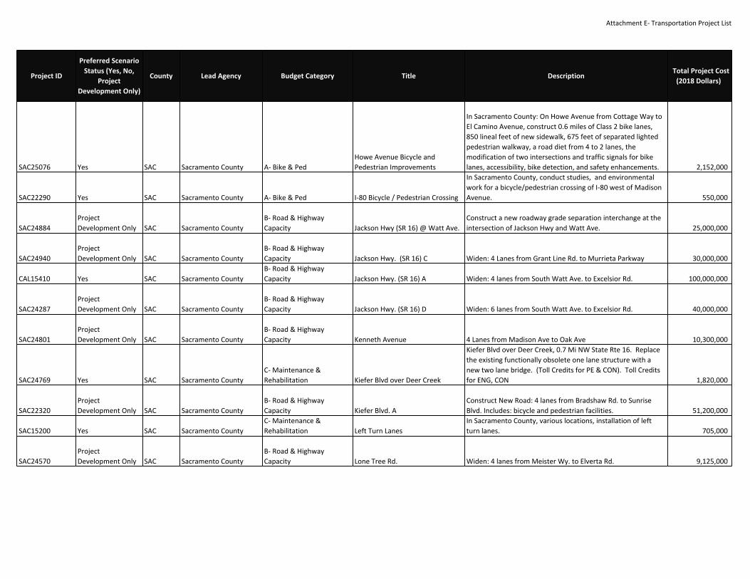
Attachment E‐ Transportation Project List
SAC25076 Yes SAC Sacramento County A‐ Bike & PedHowe Avenue Bicycle andPedestrian Improvements
In Sacramento County: On Howe Avenue from Cottage Way toEl Camino Avenue, construct 0.6 miles of Class 2 bike lanes,850 lineal feet of new sidewalk, 675 feet of separated lightedpedestrian walkway, a road diet from 4 to 2 lanes, themodification of two intersections and traffic signals for bikelanes, accessibility, bike detection, and safety enhancements. 2,152,000
SAC22290 Yes SAC Sacramento County A‐ Bike & Ped I‐80 Bicycle / Pedestrian Crossing
In Sacramento County, conduct studies, and environmentalwork for a bicycle/pedestrian crossing of I‐80 west of MadisonAvenue. 550,000
SAC24884ProjectDevelopment Only SAC Sacramento County
B‐ Road & HighwayCapacity Jackson Hwy (SR 16) @ Watt Ave.
Construct a new roadway grade separation interchange at theintersection of Jackson Hwy and Watt Ave. 25,000,000
SAC24940ProjectDevelopment Only SAC Sacramento County
B‐ Road & HighwayCapacity Jackson Hwy. (SR 16) C Widen: 4 Lanes from Grant Line Rd. to Murrieta Parkway 30,000,000
CAL15410 Yes SAC Sacramento CountyB‐ Road & HighwayCapacity Jackson Hwy. (SR 16) A Widen: 4 lanes from South Watt Ave. to Excelsior Rd. 100,000,000
SAC24287ProjectDevelopment Only SAC Sacramento County
B‐ Road & HighwayCapacity Jackson Hwy. (SR 16) D Widen: 6 lanes from South Watt Ave. to Excelsior Rd. 40,000,000
SAC24801ProjectDevelopment Only SAC Sacramento County
B‐ Road & HighwayCapacity Kenneth Avenue 4 Lanes from Madison Ave to Oak Ave 10,300,000
SAC24769 Yes SAC Sacramento CountyC‐ Maintenance &Rehabilitation Kiefer Blvd over Deer Creek
Kiefer Blvd over Deer Creek, 0.7 Mi NW State Rte 16. Replacethe existing functionally obsolete one lane structure with anew two lane bridge. (Toll Credits for PE & CON). Toll Creditsfor ENG, CON 1,820,000
SAC22320ProjectDevelopment Only SAC Sacramento County
B‐ Road & HighwayCapacity Kiefer Blvd. A
Construct New Road: 4 lanes from Bradshaw Rd. to SunriseBlvd. Includes: bicycle and pedestrian facilities. 51,200,000
SAC15200 Yes SAC Sacramento CountyC‐ Maintenance &Rehabilitation Left Turn Lanes
In Sacramento County, various locations, installation of leftturn lanes. 705,000
SAC24570ProjectDevelopment Only SAC Sacramento County
B‐ Road & HighwayCapacity Lone Tree Rd. Widen: 4 lanes from Meister Wy. to Elverta Rd. 9,125,000
Project ID
Preferred ScenarioStatus (Yes, No,
ProjectDevelopment Only)
County Lead Agency Budget Category Title DescriptionTotal Project Cost
(2018 Dollars)

Attachment E‐ Transportation Project List
SAC24257ProjectDevelopment Only SAC Sacramento County
B‐ Road & HighwayCapacity Madison Ave Widening
This project will widen Madison aver from 4 to 6 lanesbetween Hazel Ave and Greenback Lane in the Fair Oaks area.The project proposes to widen the roadway to accommodatetwo additional traffic lanes, a raised landscaped median,bicycle and pedestrian facilities, traffic signal modifications andtraffic operations system upgrades, landscaping andstreetscape enhancements, and soundwalls. 22,361,626
SAC16500 Yes SAC Sacramento CountyB‐ Road & HighwayCapacity Madison Avenue Widening
Madison Avenue from Fair Oaks Blvd. to Hazel Ave.: Widenfrom 4 to 6 lanes. 29,045,000
SAC24802ProjectDevelopment Only SAC Sacramento County
B‐ Road & HighwayCapacity Main Avenue 4 Lanes from Madison Ave to Oak Ave 7,900,000
SAC24571ProjectDevelopment Only SAC Sacramento County
B‐ Road & HighwayCapacity Manzanita Ave.
Implement "Smart Growth Street" improvements from FairOaks Blvd. to Cypress Ave; and Streetscape improvementsfrom Cypress Ave. to Madison Ave. 1,600,000
SAC24573 Yes SAC Sacramento CountyB‐ Road & HighwayCapacity Meister Way
Construct New Road: 4 lane Rd. from Metro Air Pkwy. to LoneTree Rd. 2,500,000
SAC18150 Yes SAC Sacramento CountyB‐ Road & HighwayCapacity
Metro Air Parkway Interchange atI‐5
In Sacramento County, I‐5 @ Metro Air Parkway nearSacramento International Airport: Construct the first phase ofa five‐lane partial clover Type L‐9 interchange for Metro AirParkway at Interstate 5 (I‐5). Construct a three laneovercrossing facility with a median, bike lanes and a sidewalkon the west side. Metro Air Parkway will connect on the northof the interchange and terminate south of I‐5 with a cul‐de‐sac.South Bayou Rd will realigned to provide the r/w for partialcompletion of two‐quadrant partial cloverleaf interchange.Project also includes a one‐lane northbound I‐5 exit ramp anddiagonal entrance ramp, one‐lane southbound I‐5 exit ramp, atwo‐lane southbound I‐5 loop entrance ramp with auxiliarylane, street lighting, striping, signs, relocation of an existingdrainage ditch on the south side of the freeway, constructionof drainage improvements with the interchange, andrelocation of utilities. 24,139,000
SAC24512 Yes SAC Sacramento CountyB‐ Road & HighwayCapacity Metro Air Parkway Widening A
In Sacramento County, Metro Air Parkway from north of I‐5 toElverta Road: Widen roadway from 2 to 4 lanes. 5,320,000
SAC24937ProjectDevelopment Only SAC Sacramento County
B‐ Road & HighwayCapacity Metro Air Parkway Widening B Widen: from 4 to 6 Lanes from I‐5 to Elverta Rd 2,350,800
Project ID
Preferred ScenarioStatus (Yes, No,
ProjectDevelopment Only)
County Lead Agency Budget Category Title DescriptionTotal Project Cost
(2018 Dollars)

Attachment E‐ Transportation Project List
SAC24609 Yes SAC Sacramento CountyC‐ Maintenance &Rehabilitation
Michigan Bar Rd/Cosumnes RiverBridge Replacement
Michigan Bar Rd, over Cosumnes River, 1.2 mi north of SR 16.Replace the existing one lane structurally deficient bridge witha new one lane bridge. (Toll credits for PE, ROW, & CON). TollCredits for ENG, ROW, CON 13,783,000
SAC24620 Yes SAC Sacramento CountyC‐ Maintenance &Rehabilitation New Hope Rd Bridge Replacement
New Hope Rd over Grizzley Slough, 0.5 mi north of SanJoaquin/Sacramento County Line: replace existing structurallydeficient 2‐lane bridge with a new 2‐lane bridge. 5,683,403
SAC24251ProjectDevelopment Only SAC Sacramento County
B‐ Road & HighwayCapacity Oak Ave. Widen: 4 lanes from Hazel Ave. to Folsom City Limits. 16,400,000
SAC25061 Yes SAC Sacramento County A‐ Bike & PedPower Inn Rd Bike & Ped SafetyImprovements
Power Inn Road from Elsie Avenue to about 400 feet north ofMacfadden Drive: Install curb, gutter, sidewalk infill and curbramps; widen substandard bike lanes.(H8‐03‐017) 3,505,400
SAC25035 Yes SAC Sacramento CountyB‐ Road & HighwayCapacity
Power Inn Rd. ImprovementProject
Power Inn Road, from Florin Rd. to 52nd Ave.: Widen fromthree to four lanes, and from 450 feet south of Loucreta Dr. to52nd Ave.: Install curb, gutter, sidewalk infills, ADA ramps, bikelane improvements, and landscape medians. (Scope included inMTP/SCS project SAC24274. Related ATP project is SAC25022) 4,522,000
SAC25022 Yes SAC Sacramento CountyC‐ Maintenance &Rehabilitation
Power Inn Road SidewalkImprovements
In Sacramento County, on Power Inn Road from approximately450 feet south of Loucreta Drive to Florin Road: Constructcontinuous sidewalks and bike lanes. At Florin Rd. and PowerInn Rd.: Modify intersection. 2,374,000
SAC24803ProjectDevelopment Only SAC Sacramento County
B‐ Road & HighwayCapacity Power Line Road A 4 Lanes from Road A to Elverta Road 7,200,000
SAC25129ProjectDevelopment Only SAC Sacramento County
B‐ Road & HighwayCapacity Power Line Road B 4 lanes from Elverta Road to Sutter County line 7,000,000
SAC24330 Yes SAC Sacramento CountyB‐ Road & HighwayCapacity Prairie City Road Widening
Widen Prairie City Road from 2 to 4 lanes between US 50 andWhite Rock Road. 11,000,000
SAC24805ProjectDevelopment Only SAC Sacramento County
B‐ Road & HighwayCapacity Rio Linda Blvd Widening A 4 Lanes from Elkhorn Blvd to Elverta Rd 8,250,000
SAC24935ProjectDevelopment Only SAC Sacramento County
B‐ Road & HighwayCapacity Rio Linda Blvd Widening B Widen: 4 Lanes from Ascot Ave to Elkhorn Blvd 4,338,000
Project ID
Preferred ScenarioStatus (Yes, No,
ProjectDevelopment Only)
County Lead Agency Budget Category Title DescriptionTotal Project Cost
(2018 Dollars)

Attachment E‐ Transportation Project List
SAC24804ProjectDevelopment Only SAC Sacramento County
B‐ Road & HighwayCapacity Rio Linda Blvd Widening C
(Elverta Specific Plan Mitigation)4 Lanes from Elverta Rd to Sorento Rd 8,500,000
SAC24806ProjectDevelopment Only SAC Sacramento County
B‐ Road & HighwayCapacity Road A 4 Lanes from Power Line Road to Lone Tree Rd 4,000,000
SAC19680 Yes SAC Sacramento CountyB‐ Road & HighwayCapacity Roseville Rd. Widening B Widen: 4 lanes from Watt Ave. to Walerga Rd. 38,422,000
SAC24575ProjectDevelopment Only SAC Sacramento County
B‐ Road & HighwayCapacity Roseville Rd. Widening C Widen: 4 lanes from Antelope Rd. to Placer County line. 6,750,000
SAC24584ProjectDevelopment Only SAC Sacramento County
B‐ Road & HighwayCapacity Routier Road Extension A Road Extension: 4 lanes from Old Placerville Rd. to Kiefer Blvd. 13,000,000
SAC24581ProjectDevelopment Only SAC Sacramento County
B‐ Road & HighwayCapacity Routier Road Extension B
Road Extension: 4 lanes from Kiefer Blvd. to Jackson Rd (Rte16) 15,000,000
SAC23860 Yes SAC Sacramento CountyB‐ Road & HighwayCapacity S. Watt Ave. Widen: 6 lanes from Jackson Road (SR16) to Kiefer Blvd. 10,000,000
SAC24259ProjectDevelopment Only SAC Sacramento County
B‐ Road & HighwayCapacity S. Watt Ave. / Elk Grove‐Florin Rd. Widen: 6 lanes from Jackson Rd. to Calvine Rd. 3,250,000
SAC21530 Yes SAC Sacramento County A‐ Bike & PedSacramento County ADATransition Plan
Facilities Plan: In Sacramento County, various locations,construct ADA compliant improvements in accordance with thecounty DOTs ADA Transition Plan. 15,000,000
SAC24807ProjectDevelopment Only SAC Sacramento County
B‐ Road & HighwayCapacity Sorento Rd Widen: 4 Lanes from Elverta Rd to Placer County Line 6,000,000
SAC19290 Yes SAC Sacramento CountyB‐ Road & HighwayCapacity South Watt Avenue Widening
In Sacramento County: South Watt Avenue from: Florin Roadto Jackson Road (Route 16); widen from 2 to 4 lanes. 29,210,000
SAC19700ProjectDevelopment Only SAC Sacramento County
B‐ Road & HighwayCapacity Stockton Blvd. Widen: 6 lanes from 65th Ave. to Hwy. 99. 23,800,000
SAC19710 Yes SAC Sacramento CountyB‐ Road & HighwayCapacity Sunrise Blvd. Widening A
In Sacramento County: Sunrise Blvd. between Jackson Highwayand Grant Line Road; Widen from 2 to 4 lanes 12,000,000
SAC24261ProjectDevelopment Only SAC Sacramento County
B‐ Road & HighwayCapacity Sunrise Blvd. Widening B
From Madison Ave. to Gold Country Blvd.: Implement ITSStrategies and partial grade separation at Fair Oaks Blvd andtransit enhancements 6,162,807
SAC24808ProjectDevelopment Only SAC Sacramento County
B‐ Road & HighwayCapacity Sunset Ave 4 Lanes from San Juan Avenue to Fair Oaks Blvd 6,100,000
Project ID
Preferred ScenarioStatus (Yes, No,
ProjectDevelopment Only)
County Lead Agency Budget Category Title DescriptionTotal Project Cost
(2018 Dollars)

Attachment E‐ Transportation Project List
SAC24522 Yes SAC Sacramento CountyC‐ Maintenance &Rehabilitation
Twin Cities Rd BridgeReplacement
Twin Cities Rd, over Snodgrass Slough: Replace the existing 2lane structurally deficient structure with a new 2 lanestructure. 18,114,002
SAC24283ProjectDevelopment Only SAC Sacramento County
B‐ Road & HighwayCapacity Vineyard Rd.
Construct New Road: Enhanced 2 lanes from Gerber Rd. toJackson Hwy. 2,900,000
SAC24809ProjectDevelopment Only SAC Sacramento County
B‐ Road & HighwayCapacity W. 6th Street ‐ Rio Linda 4 Lanes from Elkhorn Blvd to Elverta Rd 1,000,000
SAC24687 Yes SAC Sacramento CountyC‐ Maintenance &Rehabilitation Walnut Grove Bridge Rehab
In Walnut Grove, Walnut Grove crossing, over SacramentoRiver: Rehabilitate existing bridge. No added lane capacity. 2,769,375
SAC25130ProjectDevelopment Only SAC Sacramento County
B‐ Road & HighwayCapacity Waterman Road Extension
Extend Waterman Road from Gerber Road to Florin Road withan at‐grade railroad crossing. 20,000,000
SAC24285 Yes SAC Sacramento CountyB‐ Road & HighwayCapacity Waterman Road Widening D
Between Vintage Park Drive and Gerber Road; widen existingroadway to 4 lanes 20,000,000
SAC24885 Yes SAC Sacramento CountyB‐ Road & HighwayCapacity Waterman Road Widening E
Between Florin Rd. to Jackson Rd.; construct roadway to 4lanes 16,500,000
SAC24939ProjectDevelopment Only SAC Sacramento County
B‐ Road & HighwayCapacity Watt Ave Widen: 6 Lanes from Antelope Rd to Placer County Line 327,000
SAC24352ProjectDevelopment Only SAC Sacramento County
B‐ Road & HighwayCapacity Watt Ave. Construct New Interchange: Watt Ave. / Folsom Blvd. 7,500,000
SAC15750 Yes SAC Sacramento CountyB‐ Road & HighwayCapacity Watt Avenue Couplet
In Sacramento County, Watt Ave: Between Palm Ave. Don JulioBlvd. and Antelope Rd. Elkhorn Blvd. widen to 6 lanes; 3 lanesnorth bound on Watt Ave and 3 lanes southbound on 34th St;smart growth st. with proposed BRT/HI Bus ‐ exclusive lanes. 7,800,000
SAC15720 Yes SAC Sacramento CountyB‐ Road & HighwayCapacity Watt Avenue Widening
In Sacramento County, Watt Ave.: Between Elkhorn Blvd andAntelope Rd widen from 4 to 6 lanes 9,641,800
SAC24662 Yes SAC Sacramento CountyB‐ Road & HighwayCapacity
White Rock Road ‐ Grant Line Rd.to Rancho Cordova City Limits
Widen White Rock Road, from Grant Line Road to RanchoCordova easterly City limits, from 2 to 4 lanes. Environmentalto be cleared as part of SAC24470. 10,000,000
SAC24389 Yes SAC Sacramento CountyB‐ Road & HighwayCapacity Widen 16th St.
Widen: 4 lanes from Ascot Blvd. to Sacramento/Placer CountyLine. 44,500,000
SAC24936ProjectDevelopment Only SAC Sacramento County
B‐ Road & HighwayCapacity Winding Way Widen: 4 Lanes from Auburn Blvd to San Juan Ave 1,432,500
Project ID
Preferred ScenarioStatus (Yes, No,
ProjectDevelopment Only)
County Lead Agency Budget Category Title DescriptionTotal Project Cost
(2018 Dollars)

Attachment E‐ Transportation Project List
SAC24619 Yes SAC Sacramento CountyC‐ Maintenance &Rehabilitation Winding Way Bridge Replacement
Winding Way over Chicago Creek, 0.1 mi west of Chicago Ave:Replace existing functionally obsolete 2‐lane bridge with a new2‐lane bridge. 3,763,100
SAC24622 Yes SAC Sacramento CountyB‐ Road & HighwayCapacity
Zinfandel Drive Extension &Realignment
In Sacramento County: Zinfandel Drive, from Douglas Rd. to7,100 ft south of Douglas Rd.: reconstruct Zinfandel Drive as atwo lane road. From 7,100 ft south of Douglas Rd. to KieferBlvd.: extend Zinfandel Dr. as a two lane road on a slightlydifferent alignment than the existing dirt road. Constructconcrete box culvert over creek just north of Kiefer Blvd. 5,848,000
SAC22430 Yes SAC Sacramento CountyB‐ Road & HighwayCapacity Zinfandel Drive Widening A
In Sacramento County, Eagles Nest Road Zinfandel Drive fromKiefer Boulevard to Douglas Road, construct and widen from 2to 4 lanes with curb, gutter, sidewalk, raised landscapedmedian; improvements also include the installation of a boxculvert and traffic signal at Eagles Nest Road/Kiefer Boulevard. 11,800,000
SAC24975ProjectDevelopment Only SAC Sacramento County
B‐ Road & HighwayCapacity Zinfandel Drive Widening B
In Sacramento County, Zinfandel Drive from Jackson Road(State Route 16) to Kiefer Boulevard, construct and widen from2 to 4 lanes with curb, gutter, sidewalk, raised landscapedmedian and traffic signal modification at Jackson Road (StateRoute 16). 4,800,000
SAC20240 Yes SAC Sacramento CountyB‐ Road & HighwayCapacity Zinfandel Road Widening
Zinfandel Drive, from Southern boundary of the Villages ofZinfandel to Douglas Road: Widen from 2 to 4 lanes with araised landscaped median. (For other phases see SAC24473and SAC24467) 10,500,000
SAC24222 Yes SACSacramento County andCity of Rancho Cordova D‐ Programs & Planning
Jackson Hwy. (SR 16) fromExcelsior to Grant Line Road:Project Development andOperational Improvements
Complete project analysis efforts, as needed, to identify andimplement operational improvements to improve safety andtraffic flow along the corridor in the near‐term. Improvementsto study may include intersection improvements, accessmanagement strategies, and traffic signalization enhancementsthat benefit travel for automobiles and commercial vehicles.The project listing also allows other project developmentactivities to advance so the corridor segment can eventuallybecome a four lane facility in a manner that is consistent withthe City and County's design guidelines. Rancho Cordova wouldcontribute to portions of work between Sunrise and Grant Linewithin the city's limits. 6,235,000
SAC25153 No SACSacramento RegionalTransit District E‐ Transit Capital (Major) 16th Street Station Relocation
Relocate the 16th Street light rail station one block east,between 16th & 17th Streets. 15,525,000
Project ID
Preferred ScenarioStatus (Yes, No,
ProjectDevelopment Only)
County Lead Agency Budget Category Title DescriptionTotal Project Cost
(2018 Dollars)

Attachment E‐ Transportation Project List
SAC25126‐A Yes SACSacramento RegionalTransit District E‐ Transit Capital (Vehicles)
2800 Series 40' CNG BusReplacement (FY20‐FY22) 2800 Series 40' CNG Bus Replacement (FY20‐FY22) 70,920,000
SAC24869 Yes SACSacramento RegionalTransit District E‐ Transit Capital (Minor) Automatic Passenger Counters
Purchase and install Automatic Passenger Counters (APC) onSacRT's light rail vehicles. 500,000
SAC25154ProjectDevelopment Only SAC
Sacramento RegionalTransit District E‐ Transit Capital (Major)
Blue Line Light Rail Extension toElk Grove
Extension of Blue Line from Cosumnes River College station toElk Grove. 690,000,000
REG18037 Yes SACSacramento RegionalTransit District E‐ Transit Capital (Minor)
BMF1 CNG Facility EquipmentReplacement
At RT’s Bus Maintenance Facility #1 (BMF1): Replace andupgrade aging compressor equipment, the flow devices for theCNG dispensers, the HMI fueling control monitors and thecontrol systems. 1,824,450
SAC25126‐B Yes SACSacramento RegionalTransit District E‐ Transit Capital (Vehicles)
Bus Fleet Replacement (FY23‐FY35) Bus Fleet Replacement (FY23‐FY35) 180,087,000
SAC24874 Yes SACSacramento RegionalTransit District E‐ Transit Capital (Minor)
Bus Maintenance Facility #1Rehabilitation Rehabilitate the District's existing Bus Maintenance Facility. 10,000,000
SAC25147 Yes SACSacramento RegionalTransit District F‐ Transit O&M (Light Rail)
CAF Fleet Mid‐Life ComponentOverhaul
Overhaul major subsystems/components on the CAF fleet (40vehicles) 120,000,000
SAC25119 Yes SACSacramento RegionalTransit District E‐ Transit Capital (Vehicles) CAF Series Fleet Replacement (40) CAF Series Fleet Replacement (40) 228,000,000
REG18031 Yes SACSacramento RegionalTransit District E‐ Transit Capital (Minor)
Center for Public Interest Design(CPID) Study, station conversionconcepts
Design station conversion concepts to accommodate futurelow‐floor vehicles. First phase of study is the Center for PublicInterest Design (CPID) initial study. (Toll credits for the $350KRSTP for CPID initial study.). Toll Credits for CON 350,000
SAC25117 Yes SACSacramento RegionalTransit District E‐ Transit Capital (Vehicles)
Circulator Bus/MicrotransitExpansion Vehicles Circulator Bus/Microtransit Expansion Vehicles 9,885,353
SAC25121 Yes SACSacramento RegionalTransit District E‐ Transit Capital (Vehicles) CNG Bus Expansion CNG Bus Expansion 221,179,000
REG18023 Yes SACSacramento RegionalTransit District E‐ Transit Capital (Major) Dos Rios Light Rail Station
On Blue Line light rail, on the east side of 12th St., south ofRichards Blvd.: build new light rail station. The station is part ofthe redevelopment of Twin Rivers public housing development.(Emission Benefits in kg/day: 1.02 ROG, 0.97 NOx, 0.58 PM10) 23,100,000
REG18042 Yes SACSacramento RegionalTransit District F‐ Transit O&M (General)
Enhanced Employee ProtectionWarning System
This project will first deploy an Enhanced Employee ProtectionWarning System (EEPWS) that will alert both the train operatorof an upcoming work zone and the workers in that zone of theapproaching train. This system consists of two elements. Thefirst element is vehicle mounted equipment; the secondcomponent is a wearable warning device used by trackworkers. It will also develop and demonstrate a state of the artdispatcher work crew/lone worker software system. 1,103,400
Project ID
Preferred ScenarioStatus (Yes, No,
ProjectDevelopment Only)
County Lead Agency Budget Category Title DescriptionTotal Project Cost
(2018 Dollars)

Attachment E‐ Transportation Project List
SAC25126 Yes SACSacramento RegionalTransit District E‐ Transit Capital (Vehicles)
Existing Bus Fleet Replacement(2020‐2042) Existing Bus Fleet Replacement (2020‐2042) 130,900,000
SAC25152 Yes SACSacramento RegionalTransit District E‐ Transit Capital (Major)
Gold Line Frequency and ServiceEnhancements
Modifications and enhancements to the Gold Line to enablemore frequent service and/or limited stop express servicebetween Folsom and downtown Sacramento including 10Expansioin LRVs, Side Track, Signal and Crossing Upgrades, LRfacility and yard expansions. 194,800,000
REG17943 Yes SACSacramento RegionalTransit District E‐ Transit Capital (Major)
Green Line (DNA) Light Rail ‐Planning
This project will redefine a Minimum Operable Segment (MOS)2 and a MOS 3. REG17935 includes the Final Design andConstruction for the project (excluding MOS‐1).This phase ofthe Green Line to the Airport (DNA) Light Rail Project willconsist of two discreet, yet connected efforts. For the segmentof the Green Line near and adjacent to the SacramentoIntermodal Transfer Center (SITF), the effort will entail thepreparation of Draft EIS (and EIR), its circulation for publicreview and comment, addressing the comments and willculminate with a Final EIS (and EIR). The segment of theproject adjacent to the SITF will be coordinated with on‐goingSacramento Streetcar planning, environmental review, anddesign development. For the remainder of the 13‐milecorridor, the effort will entail the preparation of a Draft EIS(and EIR) only and its circulation for public review andcomments. An MOS will also be identified for this segment.The effort will also evaluate low‐floor LRT vehicles and theirintegration into the RT system, evaluate LRT vehiclemaintenance locations for the Green Line, evaluate downtownSacramento rail/traffic effects of the proposed service, preparethe necessary technical information and for a New Startsevaluation under MAP‐21, and involve the community andstakeholders in an outreach program for both efforts.Advanced conceptual engineering and preliminary engineeringin key areas with potential for environmental impacts that mayrequire mitigation strategies for the EIS will be completed. 14,310,336
REG17935‐A Yes SACSacramento RegionalTransit District E‐ Transit Capital (Major)
Green Line: MOS2 Township 9 toNorth Natomas Town Center(CON) Extend rail from Township 9 to North Natomas Town Center 390,000,000
REG17935‐BProjectDevelopment Only SAC
Sacramento RegionalTransit District E‐ Transit Capital (Major)
Green Line: MOS3 North NatomasTown Center to Airport (CON) Extend rail from North Natomas Town Center to Airport 700,000,000
Project ID
Preferred ScenarioStatus (Yes, No,
ProjectDevelopment Only)
County Lead Agency Budget Category Title DescriptionTotal Project Cost
(2018 Dollars)

Attachment E‐ Transportation Project List
SAC25148 Yes SACSacramento RegionalTransit District E‐ Transit Capital (Vehicles) Hi‐Bus Expansion Vehicles Hi Bus Vehicles for five BRT lines and 20 Enhanced Bus Lines 168,877,000
SAC25151 Yes SACSacramento RegionalTransit District E‐ Transit Capital (Major) Hi‐Bus Infrastructure
Hi Bus Infrastructure for five BRT lines and 20 Enhanced BusLines 368,317,000
REG18024 Yes SACSacramento RegionalTransit District E‐ Transit Capital (Major) Horn Light Rail Station
On the Gold Line, between Butterfield and Mather/Millsstations, at Horn Rd. and Old Winery Pl, construct new light railstation. (Emission Benefits in kg/day: 0.27 ROG, 0.26 NOx, 0.15PM10) 4,600,000
SAC25149 Yes SACSacramento RegionalTransit District
G‐ System Management,Operations, and ITS
InformationTechnologyEnhancements
Various Information Technology (IT) enhancement projectsincluding transit ops & maintenance software; Connect Cardtechnology; computer, network and telephone upgrades; etc. 3,965,399
REG17999 Yes SACSacramento RegionalTransit District E‐ Transit Capital (Minor) Light Rail Crossing Enhancements
Transit Capital/Operations: Purchase and install, as needed, avariety of components in the grade crossing mechanisms. 3,500,000
REG17966 Yes SACSacramento RegionalTransit District A‐ Bike & Ped
Light Rail Station PedestrianImprovements
Pedestrian Improvements: At the Fruitridge, Cosumnes RiverCollege, and City College light rail stations, improve pedestrianaccess. 11,950,000
REG18008 Yes SACSacramento RegionalTransit District E‐ Transit Capital (Minor)
Light Rail Station ShelterImprovement Program
Passenger Amenities: Add and improve light rail stationshelters. 2,581,436
SAC24783 Yes SACSacramento RegionalTransit District E‐ Transit Capital (Minor) Metro Light Rail Yard Expansion
Modify, reconfigure and expand the Metro light rail yard (orother terminal yards). Add storage yard tracks at AcademyWay site 13,700,000
SAC25125 No SACSacramento RegionalTransit District E‐ Transit Capital (Vehicles)
Neighborhood Ride VehicleExpansion Neighborhood Ride Vehicle Expansion 20,052,444
SAC24864 Yes SACSacramento RegionalTransit District E‐ Transit Capital (Major) New Light Rail Stations
Project is to build stations previously deferred duringconstruction of the light rail system: such as T St, Mineshaft orothers. 9,025,000
REG17959 Yes SACSacramento RegionalTransit District E‐ Transit Capital (Minor) Noise Attenuation Soundwalls
Transit Capital/Operations: construct soundwalls at variouslocations along the light rail system. 4,290,000
REG16470 Yes SACSacramento RegionalTransit District E‐ Transit Capital (Major) Northeast Corridor Enhancements
Double track existing single track sections and improvealignment of Northeast Corridor LRT, upgrade the tractionpower system and signaling to provide limited‐stop service,make enhancements to yard track and maintenance facility,and installation of communications infrastructure. (LocalAgency Funds are from selling a parcel of land.) 40,000,000
SAC25123 Yes SACSacramento RegionalTransit District E‐ Transit Capital (Vehicles) Paratransit Vehicle Expansion Paratransit Vehicle Expansion 27,057,661
SAC25122 Yes SACSacramento RegionalTransit District E‐ Transit Capital (Vehicles)
Paratransit Vehicle ReplacementA Paratransit Vehicle Replacement A 81,543,153
Project ID
Preferred ScenarioStatus (Yes, No,
ProjectDevelopment Only)
County Lead Agency Budget Category Title DescriptionTotal Project Cost
(2018 Dollars)

Attachment E‐ Transportation Project List
REG18010 Yes SACSacramento RegionalTransit District E‐ Transit Capital (Vehicles)
Paratransit Vehicle ReplacementFY10/11 to FY13/14
Purchase replacement and some expansion vehicles andcommunication equipment to be used by Paratransit, Inc toprovide complementary ADA paratransit service on behalf ofRT. 7,297,205
REG18035 Yes SACSacramento RegionalTransit District E‐ Transit Capital (Minor) Rail Yards Boulevard Station
In Sacramento, on the Green Line, at Rail Yards Boulevard:Design and construct light rail station . (Environmentalcovered by REG17943.) 2,367,200
REG18033 Yes SACSacramento RegionalTransit District F‐ Transit O&M (Bus) RT ADA Operations
ADA operations for transit services within the RT DistrictParatransit Area. Sacramento Urbanized Area.FFY2017:$2,881,903FFY2018: $2,881,903FFY2019: $2,881,903FFY2020:$2,881,903 28,803,666
REG18034 Yes SACSacramento RegionalTransit District F‐ Transit O&M (Bus) RT Preventive Maintenance
Provide for scheduled and unscheduled maintenance for busand light rail revenue vehicles and facilities.FTA 5307FFY2017:$16,068,407FFY2018: $16,068,407FFY2019:$16,068,407FFY2020: $16,068,407FTA 5337FFY2017:$11,487,417FFY2018: $11,487,417FFY2019:$11,487,417FFY2020: $11,487,417 136,184,109
SAC25116 Yes SACSacramento RegionalTransit District D‐ Programs & Planning SacRT Plans and Studies
SacRT Plans and Studies including Long Range Plan Update,TOD‐Related Professional Services, and MiscellaneousPlanning/Studies 1,450,000
SAC24871 Yes SACSacramento RegionalTransit District E‐ Transit Capital (Minor) Shop Equipment ‐ Bus
Purchase a variety of equipment as needed for vehicle andshop maintenance. 307,739
SAC25118 No SACSacramento RegionalTransit District E‐ Transit Capital (Vehicles)
Shuttle Buses and Above GroundGas Tank Shuttle Buses and Above Ground Gas Tank 2,000,000
SAC25120 Yes SACSacramento RegionalTransit District E‐ Transit Capital (Vehicles)
Siemens 2nd Series FleetReplacement Siemens 2nd Series Fleet Replacement 65,100,000
REG18032 Yes SACSacramento RegionalTransit District E‐ Transit Capital (Vehicles)
Siemens Light Rail Vehicle (LRV)Replacement Replace 26 Siemens Light Rail Vehicles. 148,200,000
REG17300 Yes SACSacramento RegionalTransit District E‐ Transit Capital (Major)
SRTD Satellite Bus MaintenanceFacility #2 Phase 1
In Sacramento: Acquire land and construct a new busmaintenance facility in McClellan Park. Plans for this facilityinclude two fueling stations, one land bus wash, and a revenuecollection center. Also includes site work for parking andbuilding modifications to support 125 buses. A Phase 2 willfollow. 81,010,860
SAC25150 Yes SACSacramento RegionalTransit District E‐ Transit Capital (Major)
State of Good Repair ‐ TransitInfrastructure
Various projects to maintain the state of good repair of SacRT'slight rail system 47,565,273
REG17979 Yes SACSacramento RegionalTransit District E‐ Transit Capital (Minor)
Transit Station and StopEnhancements
Light Rail Station and Stop Enhancements (Ped/Bike Access,Lighting, Wayfinding, Shelters, etc.) 25,000,000
SAC25124 Yes SACSacramento RegionalTransit District E‐ Transit Capital (Vehicles) UTDC Fleet Replacement UTDC Fleet Replacement 119,700,000
Project ID
Preferred ScenarioStatus (Yes, No,
ProjectDevelopment Only)
County Lead Agency Budget Category Title DescriptionTotal Project Cost
(2018 Dollars)

Attachment E‐ Transportation Project List
SAC24311 No SAC
Sacramento RegionalTransit District, City ofRancho Cordova E‐ Transit Capital (Major) Rancho Cordova Streetcar
Rancho Cordova Town Center Loop Streetcar‐ Phase 1 (7.5miles) 182,918,000
CAL20370 Yes SAC SJRRC E‐ Transit Capital (Major) Elk Grove Intercity Rail Station
In Elk Grove, San Joaquin Rail Corridor, construct 100‐spaceparking lot, 800 foot platform, and passenger shelter area forintercity passenger rail station. 26,100,000
VAR56006 Yes SAC SMAQMD D‐ Programs & Planning Spare the Air Phase 2
Sacramento Federal Non‐attainment Area: Spare The AirVoluntary Driving Curtailment Program. [Continued fromSAC21080, Larger MTP project is VAR56022] (Emission Benefitsin kg/day: ROG 0.2, NOx 0.2) 8,807,521
SacCity‐F1 Yes Sac City of SacramentoG‐ System Management,Operations, and ITS Stockon Blvd Moblity Project
Improve safety, transit, and moblity on Stockton Blvd fromAlhambra to 47th Street. Reduce number of lanes from four totwo to accommodate BRT or Bike/Ped 100,000,000
CAL20830ProjectDevelopment Only SAC, PLA Caltrans D3
G‐ System Management,Operations, and ITS
I‐80 Managed Lanes fromYolo/Sac County line to the I‐80/SR65 IC
Convert existing HOV lanes to toll lanes or possibly install areversible lane Pending
D3‐3 No SUT Caltrans D3B‐ Road & HighwayCapacity 99/20 Interchange
Interchange improvements at Route 99/20 intersection STIP.EA 1H770 195,599,000
CAL20934 Yes SUT Caltrans D3C‐ Maintenance &Rehabilitation
In and near Yuba City on SR 20from Sycamore Canal to the YubaCo Line (PM 12.13/17.06) and onSR 99 from south of Franklin Roadto Queens Ave OC (PM29.67/31.31). ADA Improvements.(EA 2F090)
In and near Yuba City on SR 20 from Sycamore Canal to theYuba Co Line (PM 12.13/17.06) and on SR 99 from south ofFranklin Road to Queens Ave OC (PM 29.67/31.31). ADAImprovements. (EA 2F090) 4,500,000
CAL21014 Yes SUT Caltrans D3G‐ System Management,Operations, and ITS
In Sut & Yub Co, on Rte 20, 70 &99; Sut 20 PM 12/16.7, Sut 99 PM26/R31.7, Yub 20 PM 0/0.2, Yub70 PM 14/15.5. Upgrade trafficsignals, install video detection andCCTV, transit vehicle & adaptivesignal control, and ADAimprovements.
In Sut & Yub Co, on Rte 20, 70 & 99; Sut 20 PM 12/16.7, Sut 99PM 26/R31.7, Yub 20 PM 0/0.2, Yub 70 PM 14/15.5. Upgradetraffic signals, install video detection and CCTV, transit vehicle& adaptive signal control, and ADA improvements. 9,100,000
CAL20865 Yes SUT Caltrans D3C‐ Maintenance &Rehabilitation
In Sutter County from 0.6 milenorth of Jct Rte 70 to Marcuse Rd.CAPM.
In Sutter County from 0.6 mile north of Jct Rte 70 to MarcuseRd. CAPM. 5,675,000
D3‐2 Yes SUT Caltrans D3 A‐ Bike & Ped Live Oak Street Scape Streetscape Enhancement and widen to 4 lanes. EA 3F990 10,460,000
CAL20429 Yes SUT Caltrans D3C‐ Maintenance &Rehabilitation Lomo Railroad Crossing
ROW Acquisition and Construction: Railroad Crossing. North ofSR 99 / Live Oak Blvd. intersection. 12,203,000
Project ID
Preferred ScenarioStatus (Yes, No,
ProjectDevelopment Only)
County Lead Agency Budget Category Title DescriptionTotal Project Cost
(2018 Dollars)

Attachment E‐ Transportation Project List
CAL15780 Yes SUT Caltrans D3G‐ System Management,Operations, and ITS
SR 20 / SR 99 Interchange ROWAcquisition
ROW Acquisition: for urban interchange at existing SR 20 / SR99 intersection 30,507,000
CAL15770 Yes SUT Caltrans D3B‐ Road & HighwayCapacity SR 20 Improvements Widen: SR 20 to six (6) lanes from Walton Rd. to Rocca Wy. 2,000,000
CAL21042 Yes SUT Caltrans D3C‐ Maintenance &Rehabilitation SR 20 Pavement Rehabilitation A
In Sutter County on Route 20 from S. Butte Rd to the countyline. 6,900,000
CAL21048 Yes SUT Caltrans D3C‐ Maintenance &Rehabilitation SR 70 Pavement Rehabilitation B In Sutter County on Route 70 from Jct 70/99 to end of county. 5,675,000
CAL20569 Yes SUT Caltrans D3C‐ Maintenance &Rehabilitation SR 99 Class II Bike Lane On SR 99, construct bike lane from Bogue Road to SR 20 Jct. 1,440,000
CAL20731 Yes SUT Caltrans D3C‐ Maintenance &Rehabilitation
SR 99 City of Live Oak SafetyImprovements
In the City of Live Oak, on State Route 99, at the intersection ofElm Street and Pennington Road: Intersection safetyimprovements (PM 40.0/40.5) [CTIPS ID 107‐0000‐1067] (TollCredits for PE, ROW and CON). Toll Credits for ENG, ROW, CON 6,310,000
CAL20888 Yes SUT Caltrans D3G‐ System Management,Operations, and ITS
SR 99 Diagonal Ramp Meter at theSR 99/Howsley Road interchange
In Sutter County at SR 99/Howsley Road Interchange aDiagonal ramp meter. Future Configuration is 1+1. (HowsleyRoad to SB SR 99) (PM 5.401) 900,000
CAL20885 Yes SUT Caltrans D3G‐ System Management,Operations, and ITS
SR 99 Diagonal Ramp Meter at theSR 99/Riego Road interchange(EB)
In Sutter County at SR 99/Riego Road Interchange Repair aDiagonal ramp meter. Future Configuration is 2+1. (EB RiegoRoad to SB SR 99) (PM 1.015) 1,120,000
CAL21087 Yes SUT Caltrans D3G‐ System Management,Operations, and ITS
SR 99 Diagonal Ramp Meter at theSR 99/Riego Road interchange(WB)
In Sutter County at NB SR 99/Riego Road Interchange aDiagonal ramp meter. Future Configuration is 2+1. (WB RiegoRoad to NB SR 99) (PM 0.895) 1,120,000
CAL21066 Yes SUT Caltrans D3C‐ Maintenance &Rehabilitation SR 99 Drainage Improvements C
In Sutter County on Route 99 at the Howsley Rd UC (PumpPlant #18‐0045W). Upgrade pump plant. 710,000
CAL20872 Yes SUT Caltrans D3C‐ Maintenance &Rehabilitation SR 99 Drainage Improvements D In Sutter County at Queens Ave OC, PP 18‐34W 528,000
CAL20763 Yes SUT Caltrans D3C‐ Maintenance &Rehabilitation SR 99 Live Oak Rehab
In Live Oak, on SR 99, from 0.1 mile north of Coleman Avenueto 0.2 mile north of Ramsdell Drive (PM 39.4/41.0) ‐ Roadwayrehabilitation [CTIPS ID 107‐0000‐1105] (Toll Credits). TollCredits for ENG, ROW, CON 30,765,000
CAL21088 Yes SUT Caltrans D3G‐ System Management,Operations, and ITS
SR 99 Loop Ramp Meter at the SR99/Riego Road interchange (EB)
In Sutter County at NB SR 99/Riego Road Interchange a Loopramp meter. Future Configuration is 2+1. (EB Riego Road to NBSR 99) (PM 1.169) 1,120,000
CAL21085 Yes SUT Caltrans D3G‐ System Management,Operations, and ITS
SR 99 Loop Ramp Meter at the SR99/Riego Road interchange (WB)
In Sutter County at SR 99/Riego Road Interchange Repair aLoop ramp meter. Future Configuration is 1+1. (WB Riego Roadto SB SR 99) (PM 0.79) 900,000
CAL20767 Yes SUT Caltrans D3G‐ System Management,Operations, and ITS SR 99 Mitigation Banking
In Glenn, Colusa, Sutter, Yuba, Placer, Yolo & Sac Counties atvarious locations. Advanced mitigation banking credits. 1,510,000
Project ID
Preferred ScenarioStatus (Yes, No,
ProjectDevelopment Only)
County Lead Agency Budget Category Title DescriptionTotal Project Cost
(2018 Dollars)

Attachment E‐ Transportation Project List
CAL20607 Yes SUT Caltrans D3C‐ Maintenance &Rehabilitation SR 99 Passing Lanes Passing Lanes: Yuba City to Butte County Line. 24,406,000
CAL20952 Yes SUT Caltrans D3C‐ Maintenance &Rehabilitation SR 99 Pavement Rehabilitation A
In and near Live Oak from Coleman Ave to Ramsdall Dr (PM39.4‐40.9) 20,050,000
CAL21041 Yes SUT Caltrans D3C‐ Maintenance &Rehabilitation SR 99 Pavement Rehabilitation C
In Sutter County on Route 99 approx 0.1 mile south of MessickRoad to Jct of Rte 20. (PM 24.1 ‐ 30.6) 5,050,000
CAL20887 Yes SUT Caltrans D3G‐ System Management,Operations, and ITS
SR 99 Ramp Meter at the SR99/Sankey Road
In Sutter County at SB SR 99/Sankey Road ramp meter. (PM3.04) 380,000
Cal113 Yes SUT Caltrans D3G‐ System Management,Operations, and ITS
SR 99 Ramp Meter at the SR99/Sutter Bay Blvd. Roadinterchange (EB to NB)
In Sutter County at SR 99/Sutter Bay Blvd. Road Interchangeramp meter. Future Configuration is 1+1. (EB Sutter Bay Blvd.to NB SR 99) 900,000
Cal118 Yes SUT Caltrans D3G‐ System Management,Operations, and ITS
SR 99 Ramp Meter at the SR99/Sutter Bay Blvd. Roadinterchange (EB to SB)
In Sutter County at SR 99/Sutter Bay Blvd. Road Interchangeramp meter. (EB Sutter Bay Blvd. to SB SR 99) 380,000
Cal112 Yes SUT Caltrans D3G‐ System Management,Operations, and ITS
SR 99 Ramp Meter at the SR99/Sutter Bay Blvd. Roadinterchange (WB to NB)
In Sutter County at SR 99/Sutter Bay Blvd. Road Interchangeramp meter. (WB Sutter Bay Blvd. to NB SR 99) 380,000
Cal119 Yes SUT Caltrans D3G‐ System Management,Operations, and ITS
SR 99 Ramp Meter at the SR99/Sutter Bay Blvd. Roadinterchange (WB to SB)
In Sutter County at SR 99/Sutter Bay Blvd. Road Interchangeramp meter. (WB Sutter Bay Blvd. to SB SR 99) 380,000
CAL20522 Yes SUT Caltrans D3C‐ Maintenance &Rehabilitation
Sutter Bypass Rehab andWidening
Near Yuba City on SR 20, from east end of Sutter Bypass toLytle Road ‐ Rehabilitate roadway, widen shoulders andreplace Wadsworth Canal Bridge #18‐0003 (PM 5.0/11.3) [EFISID 0300020608; CTIPS ID 107‐0000‐0968] (Toll Credits for PE,ROW, CON). Toll Credits for ENG, ROW, CON 31,356,000
SUT18914 Yes SUT City of Live OakB‐ Road & HighwayCapacity Apricot St. Extension
Construct New Road: 2 lane collector from Samuel St. toRichard Ave. Includes: drainage, curb, gutter, sidewalk, andbike lanes. 1,716,000
SUT17011 Yes SUT City of Live OakC‐ Maintenance &Rehabilitation Apricot St. Rehab
Pavement Rehabilitation: in Live Oak from N St. to Samuel St.Includes: resurface existing pavement. 360,000
SUT17009 Yes SUT City of Live OakC‐ Maintenance &Rehabilitation Archer Ave. Phase 2
Pavement Rehabilitation: from L St. to K St. Includes: curb,gutter, sidewalks, and drainage improvements. (Phase II) 486,000
SUT17025 Yes SUT City of Live OakC‐ Maintenance &Rehabilitation Archer Ave. Phase 3
Pavement Rehabilitation: from K St. to City Limit. Includes:curb, gutter, sidewalks, and drainage improvements. (Phase III) 480,000
SUT18915 Yes SUT City of Live OakC‐ Maintenance &Rehabilitation Bishop Ave.
Road Reconstruction: from SR 99 to Planning Area LimitsIncludes drainage, curb, gutter, sidewalk, and bike lanes. 1,047,000
Project ID
Preferred ScenarioStatus (Yes, No,
ProjectDevelopment Only)
County Lead Agency Budget Category Title DescriptionTotal Project Cost
(2018 Dollars)
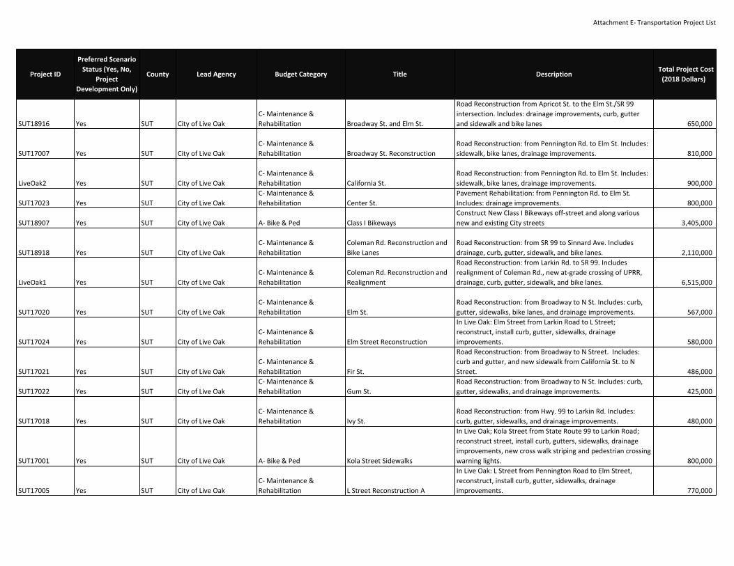
Attachment E‐ Transportation Project List
SUT18916 Yes SUT City of Live OakC‐ Maintenance &Rehabilitation Broadway St. and Elm St.
Road Reconstruction from Apricot St. to the Elm St./SR 99intersection. Includes: drainage improvements, curb, gutterand sidewalk and bike lanes 650,000
SUT17007 Yes SUT City of Live OakC‐ Maintenance &Rehabilitation Broadway St. Reconstruction
Road Reconstruction: from Pennington Rd. to Elm St. Includes:sidewalk, bike lanes, drainage improvements. 810,000
LiveOak2 Yes SUT City of Live OakC‐ Maintenance &Rehabilitation California St.
Road Reconstruction: from Pennington Rd. to Elm St. Includes:sidewalk, bike lanes, drainage improvements. 900,000
SUT17023 Yes SUT City of Live OakC‐ Maintenance &Rehabilitation Center St.
Pavement Rehabilitation: from Pennington Rd. to Elm St.Includes: drainage improvements. 800,000
SUT18907 Yes SUT City of Live Oak A‐ Bike & Ped Class I BikewaysConstruct New Class I Bikeways off‐street and along variousnew and existing City streets 3,405,000
SUT18918 Yes SUT City of Live OakC‐ Maintenance &Rehabilitation
Coleman Rd. Reconstruction andBike Lanes
Road Reconstruction: from SR 99 to Sinnard Ave. Includesdrainage, curb, gutter, sidewalk, and bike lanes. 2,110,000
LiveOak1 Yes SUT City of Live OakC‐ Maintenance &Rehabilitation
Coleman Rd. Reconstruction andRealignment
Road Reconstruction: from Larkin Rd. to SR 99. Includesrealignment of Coleman Rd., new at‐grade crossing of UPRR,drainage, curb, gutter, sidewalk, and bike lanes. 6,515,000
SUT17020 Yes SUT City of Live OakC‐ Maintenance &Rehabilitation Elm St.
Road Reconstruction: from Broadway to N St. Includes: curb,gutter, sidewalks, bike lanes, and drainage improvements. 567,000
SUT17024 Yes SUT City of Live OakC‐ Maintenance &Rehabilitation Elm Street Reconstruction
In Live Oak: Elm Street from Larkin Road to L Street;reconstruct, install curb, gutter, sidewalks, drainageimprovements. 580,000
SUT17021 Yes SUT City of Live OakC‐ Maintenance &Rehabilitation Fir St.
Road Reconstruction: from Broadway to N Street. Includes:curb and gutter, and new sidewalk from California St. to NStreet. 486,000
SUT17022 Yes SUT City of Live OakC‐ Maintenance &Rehabilitation Gum St.
Road Reconstruction: from Broadway to N St. Includes: curb,gutter, sidewalks, and drainage improvements. 425,000
SUT17018 Yes SUT City of Live OakC‐ Maintenance &Rehabilitation Ivy St.
Road Reconstruction: from Hwy. 99 to Larkin Rd. Includes:curb, gutter, sidewalks, and drainage improvements. 480,000
SUT17001 Yes SUT City of Live Oak A‐ Bike & Ped Kola Street Sidewalks
In Live Oak; Kola Street from State Route 99 to Larkin Road;reconstruct street, install curb, gutters, sidewalks, drainageimprovements, new cross walk striping and pedestrian crossingwarning lights. 800,000
SUT17005 Yes SUT City of Live OakC‐ Maintenance &Rehabilitation L Street Reconstruction A
In Live Oak: L Street from Pennington Road to Elm Street,reconstruct, install curb, gutter, sidewalks, drainageimprovements. 770,000
Project ID
Preferred ScenarioStatus (Yes, No,
ProjectDevelopment Only)
County Lead Agency Budget Category Title DescriptionTotal Project Cost
(2018 Dollars)

Attachment E‐ Transportation Project List
SUT18921 Yes SUT City of Live OakC‐ Maintenance &Rehabilitation L Street Reconstruction B
In Live Oak: L Street from Elm St. to Ash Street, reconstruct,install curb, gutter, sidewalks, drainage improvements. 1,013,000
SUT18922 Yes SUT City of Live OakC‐ Maintenance &Rehabilitation Larkin Road and Elm Street
In Live Oak on Larkin Road from Archer Ave. to the Elm St./SR99 intersection. reconstruct road and install drainage, curb andgutter, sidewalk, and bike lanes. 581,000
SUT18882 Yes SUT City of Live OakC‐ Maintenance &Rehabilitation Larkin Road Reconstruction A
In Live Oak on Larkin Road from Apricot St. to current CityLimit. reconstruct road and install drainage, curb and gutter,sidewalk, and bike lanes. 2,450,000
SUT16984 Yes SUT City of Live OakC‐ Maintenance &Rehabilitation Larkin Road Reconstruction B
In Live Oak on Larkin Road from Nevada Street to Riviera Roadreconstruct road and install drainage, curb and gutter,sidewalk, and bike lanes. 9,350,000
SUT18880 Yes SUT City of Live OakC‐ Maintenance &Rehabilitation Larkin Road Reconstruction C
In Live Oak on Larkin Road from current City Limit to PaseoAve. reconstruct road and install drainage, curb and gutter,sidewalk, and bike lanes. 4,510,000
SUT18865 Yes SUT City of Live OakB‐ Road & HighwayCapacity
Live Oak Collaborative Highway 99Streetscape Improvements
In Live Oak, SR 99, from Ash Street to Ramsdell Drive: widenfrom 2 to 4 lanes and build streetscape improvements. (Tollcredits for PE, ROW, and CON) (See project phases in MTP:SUT18872, SUT17014, SUT18865, SUT18906, SUT17013,SUT17015, and SUT17016.). Toll Credits for ENG, ROW, CON 22,090,938
SUT18917 Yes SUT City of Live Oak A‐ Bike & Ped Live Oak Community Trail
Construct New Class I Bikeway along the abandon SacramentoNorthern Railroad right‐of‐way from Elm St. to the PenningtonRd./O St. Intx. (Phase 2) 885,000
SUT16987 Yes SUT City of Live OakC‐ Maintenance &Rehabilitation Luther Rd.
Road Reconstruction: from the current existing city boundaryto Riviera Rd. Includes: drainage, curb and gutter, sidewalk,and bike lanes. 5,887,000
SUT18884ProjectDevelopment Only SUT City of Live Oak
B‐ Road & HighwayCapacity N St.
Construct New Road: 2 lane collector from current City Limit toPaseo Ave. Includes: drainage, curb, gutter, sidewalk, and bikelanes. 6,786,000
SUT18883 Yes SUT City of Live OakC‐ Maintenance &Rehabilitation N St. Reconstruction A
Road Reconstruction: from Pennington Road to Elm St.Includes drainage, curb and gutter, sidewalk, and bike lanes. 935,000
SUT17017 Yes SUT City of Live OakC‐ Maintenance &Rehabilitation N St. Reconstruction B
Road Reconstruction: from Kola St. to Epperson Way. Includes:curb, gutters, sidewalks, drainage improvements, and bikelanes. 1,256,000
SUT18885 Yes SUT City of Live OakC‐ Maintenance &Rehabilitation N St. Reconstruction C
Road Reconstruction: from Fir St. to Apricot St. Includesdrainage, curb and gutter, sidewalk, and bike lanes. 1,418,000
SUT17019 Yes SUT City of Live OakC‐ Maintenance &Rehabilitation Nevada St.
Road Reconstruction: from Hwy. 99 to Larkin Rd. Includes:curb, gutter, sidewalk, and drainage improvements. 600,000
Project ID
Preferred ScenarioStatus (Yes, No,
ProjectDevelopment Only)
County Lead Agency Budget Category Title DescriptionTotal Project Cost
(2018 Dollars)

Attachment E‐ Transportation Project List
SUT18890 Yes SUT City of Live OakC‐ Maintenance &Rehabilitation P St. Reconstruction A
Road Reconstruction: from Pennington Road to Apricot St.Includes drainage, curb and gutter, sidewalk, and bike lanes. 1,870,000
SUT18889 Yes SUT City of Live OakC‐ Maintenance &Rehabilitation P St. Reconstruction B
Road Reconstruction: from Park St. to Pennington RoadIncludes drainage, curb and gutter, sidewalk, and bike lanes. 567,000
SUT18891 Yes SUT City of Live OakC‐ Maintenance &Rehabilitation Paseo Ave.
Reconstruct roadway from Hwy. 99 to Township Road, realignwest 0.5 mi. Includes: drainage improvements, curb, gutter,sidewalk, and bike lanes. 11,150,000
SUT17012 Yes SUT City of Live OakC‐ Maintenance &Rehabilitation Pennington Rd. Reconstruction A
Road Reconstruction from Hwy. 99 to Larkin Rd. Includes: curband gutter, sidewalk, drainage improvements, bike lanes andunderground utilities. 500,000
SUT18892 Yes SUT City of Live OakC‐ Maintenance &Rehabilitation Pennington Rd. Reconstruction B
Road Reconstruction from Orchard Way to Sinnard Ave.Includes: curb and gutter, sidewalk, drainage improvements,bike lanes and underground utilities. 1,800,000
SUT17004ProjectDevelopment Only SUT City of Live Oak
B‐ Road & HighwayCapacity Pennington Rd. Reconstruction C
Widen and Reconstruct: add 2 traffic lanes from Hwy. 99 to NStreet. Includes: center median with turn pockets, drainageimprovements, bike lanes, and underground utilities. 1,500,000
SUT17010 Yes SUT City of Live OakC‐ Maintenance &Rehabilitation Pennington Rd. Reconstruction D
Road Reconstruction from Connecticut Ave. to Luther Rd.Includes: drainage, curb and gutter, sidewalk, and bike lanes. 1,370,000
SUT16997 Yes SUT City of Live OakC‐ Maintenance &Rehabilitation Pennington Rd. Reconstruction E
Road Reconstruction: from Sinnard Ave. to Sheldon Ave.Includes: drainage, curb, gutter, sidewalk, and bike lanes. 1,079,000
SUT16985 Yes SUT City of Live OakC‐ Maintenance &Rehabilitation Pennington Rd. Reconstruction F
Road Reconstruction: from Township Rd. to Luther Rd.Includes: drainage, curb and gutter, sidewalk, and bike lanes. 3,973,000
SUT16990 Yes SUT City of Live OakC‐ Maintenance &Rehabilitation Riviera Rd.
Road Reconstruction: from Township Rd. to Larkin Rd.Includes: drainage, curb and gutter, sidewalk, and bike lanes.(Phase II) 7,332,000
SUT16983 Yes SUT City of Live OakC‐ Maintenance &Rehabilitation Riviera Road
In Live Oak, Riviera Road from SR99 to Larkin Road reconstructroad and install drainage, curb and gutter, sidewalk, and bikelanes. 4,518,000
SUT18898ProjectDevelopment Only SUT City of Live Oak
B‐ Road & HighwayCapacity Road 9
Construct New Road: 2 lane collector from Richard Ave. toLinda St. Includes: drainage, curb, gutter, sidewalk, and bikelanes. 2,808,000
SUT18900 Yes SUT City of Live OakB‐ Road & HighwayCapacity Road E
Construct New Road: 2 lane collector from SR 99 to Riviera Rd.Includes: drainage, curb, gutter, sidewalk, and bike lanes. 3,822,000
Project ID
Preferred ScenarioStatus (Yes, No,
ProjectDevelopment Only)
County Lead Agency Budget Category Title DescriptionTotal Project Cost
(2018 Dollars)

Attachment E‐ Transportation Project List
SUT18902 Yes SUT City of Live OakB‐ Road & HighwayCapacity Sean Drive
Construct New Road: 2 lane collector from Luther Rd. to RoadC. Includes: drainage, curb, gutter, sidewalk, and bike lanes. 2,028,000
SUT16991 Yes SUT City of Live OakC‐ Maintenance &Rehabilitation Sinnard Ave.
Road Reconstruction: from Fir St. to Pennington Rd. Includes:drainage, curb and gutter, sidewalk, and bike lanes. 542,700
SUT16981ProjectDevelopment Only SUT City of Live Oak
B‐ Road & HighwayCapacity South Loop Road
In Live Oak, phase‐1 Township to Sinnard, construct SouthLoop Road, a new 4 lane connector including drainage, curband gutter, sidewalk, and bike lanes 1,581,650
SUT17014 Yes SUT City of Live OakB‐ Road & HighwayCapacity SR 99 Widening A
Widen: Add 2 travel lanes from Ramsdell Dr. to Riviera Rd.Includes: curb, gutter, sidewalks, and drainage improvements.(Phase II) 8,313,000
SUT17016 Yes SUT City of Live OakB‐ Road & HighwayCapacity SR 99 Widening C
Widen: Add 2 travel lanes from Elm St. to Coleman Rd.Includes: sidewalks and drainage improvements. (Phase III) 6,120,000
SUT18906ProjectDevelopment Only SUT City of Live Oak
B‐ Road & HighwayCapacity SR 99 Widening D
Widen: Add 2 travel lanes from Coleman Rd. to Paseo Ave.Includes: curb, gutter, sidewalks, and drainage improvements.(Phase V) 734,400
SUT16989 Yes SUT City of Live OakC‐ Maintenance &Rehabilitation Township Rd.
Road Reconstruction: from Pennington Road to Riviera Road.Includes drainage, curb, gutter, sidewalk, and bike lanes. 9,436,000
SUT16988ProjectDevelopment Only SUT City of Live Oak
B‐ Road & HighwayCapacity Township Road
In Live Oak, Phase‐1 from Paseo Road to Pennington Roadconstruct Township Road a new 4 lane connector includingdrainage, curb and gutter, sidewalk, and bike lanes. 17,083,000
SUT16956ProjectDevelopment Only SUT City of Yuba City
B‐ Road & HighwayCapacity Bogue Rd. Widening Phase 1 Widen: 4 lanes from Harter Pkwy to Hwy 99 17,526,000
SUT16976ProjectDevelopment Only SUT City of Yuba City
B‐ Road & HighwayCapacity Bogue Rd. Widening Phase 2 Widen: 4 lanes from Township Rd. to George Washington Blvd. 4,041,000
SUT16957ProjectDevelopment Only SUT City of Yuba City
B‐ Road & HighwayCapacity Bogue Rd. Widening Phase 3 Widen: 4 lanes from George Washington Blvd. to Harter Pkwy. 2,372,000
SUT16953 Yes SUT City of Yuba CityB‐ Road & HighwayCapacity Bridge St.
Widen: 4 lanes from Western Pkwy. to Geo. Washington Blvd.Widen: 4 lanes from Geo. Washington Blvd. to El Margarita Rd.Widen: 4 lanes from El Margarita Rd. to Walton Ave. 16,453,000
SUT10250 Yes SUT City of Yuba CityB‐ Road & HighwayCapacity Bridge Street Widening
In Yuba City, Widen Bridge Street from Cooper Street to GrayAvenue: widen to 4 lanes. 9,393,543
Project ID
Preferred ScenarioStatus (Yes, No,
ProjectDevelopment Only)
County Lead Agency Budget Category Title DescriptionTotal Project Cost
(2018 Dollars)

Attachment E‐ Transportation Project List
SUT16961ProjectDevelopment Only SUT City of Yuba City
B‐ Road & HighwayCapacity Butte House Rd. Widen: 4 lanes from Township Rd. to Tharp Rd. 18,361,000
SUT16963 Yes SUT City of Yuba CityB‐ Road & HighwayCapacity Clark Ave.
Roadway Operational Improvements: from Richland Rd. toFranklin Ave. add a continuous left‐turn lane and bike lanes. 6,016,405
SUT16969 Yes SUT City of Yuba CityB‐ Road & HighwayCapacity El Margarita Rd.
Roadway Operational Improvements: from Hwy. 20 to FranklinRd. add a continuous left turn lane and bike lanes. 5,189,000
SUT10828 Yes SUT City of Yuba CityB‐ Road & HighwayCapacity Feather River Bridge at 5th St
5th St/Bridge St crossing over the Feather River/2nd St,between Marysville and Yuba City: Replace two‐lane bridgewith 4‐lane bridge. (HPP# 3631) (Toll Credits for ROW andCON) (Local Agency funds for CON are non‐participating.). TollCredits for ROW, CON 89,102,631
SUT16977ProjectDevelopment Only SUT City of Yuba City
B‐ Road & HighwayCapacity Franklin Ave. Widen: 4 lanes from Plumas Blvd. to Garden Hwy. 4,944,000
SUT10530 Yes SUT City of Yuba CityB‐ Road & HighwayCapacity Franklin Avenue
Widen Franklin Avenue from 2 to 4 lanes from Route 99 toClark Avenue. 5,224,500
SUT16954ProjectDevelopment Only SUT City of Yuba City
B‐ Road & HighwayCapacity Franklin Rd. Widen: 4 lanes from Township Rd. to Hwy. 99. 18,515,000
SUT16970ProjectDevelopment Only SUT City of Yuba City
B‐ Road & HighwayCapacity
George Washington Blvd.Widening A Widen: 4 lanes from Hwy. 20 to Bogue Rd. 21,614,000
SUT16971 Yes SUT City of Yuba CityB‐ Road & HighwayCapacity
George Washington Blvd.Widening B Construct New Road: 4 lanes from Pease Rd. to Hwy. 20. 16,486,000
SUT18932 Yes SUT City of Yuba City A‐ Bike & PedHarter Parkway and Sutter BikePath Gap Closure
In Yuba City: From Hooper Road to Harter Parkway on thenorth side of Jefferson Avenue and on Harter Parkway fromButte House Road to Spirit Way, extend the existing 4.6‐mile‐long Sutter Bicycle Path from Hooper Road to Harter Parkwayand build a Class I shared use path on Harter Parkway fromButte House Road to State Route 20. 2,241,000
SUT10260ProjectDevelopment Only SUT City of Yuba City
B‐ Road & HighwayCapacity Harter Road
In Yuba City, construct 4 lanes, Harter Road between LassenBoulevard and Bridge Street. 2,236,000
SUT16955ProjectDevelopment Only SUT City of Yuba City
B‐ Road & HighwayCapacity Lincoln Rd. Widening D Widen: 4 lanes from Township Rd. to Garden Hwy. 29,975,000
Project ID
Preferred ScenarioStatus (Yes, No,
ProjectDevelopment Only)
County Lead Agency Budget Category Title DescriptionTotal Project Cost
(2018 Dollars)

Attachment E‐ Transportation Project List
SUT16974 Yes SUT City of Yuba CityB‐ Road & HighwayCapacity Pease Rd. New Interchange
Construct New Interchange: 4 lanes at Pease Rd. / Hwy 99.Includes: overcrossing and connecting ramps at Hwy 99. 57,880,554
SUT16962ProjectDevelopment Only SUT City of Yuba City
B‐ Road & HighwayCapacity Pease Rd. Widening Widen: 4 lanes from Township Rd. to Hwy. 99 18,972,000
SUT16975 Yes SUT City of Yuba CityB‐ Road & HighwayCapacity Percy Ave.
Widen: 4 lanes from Franklin Ave. to Garden Hwy. Includes:landscaped medians. 6,632,500
SUT16964ProjectDevelopment Only SUT City of Yuba City
B‐ Road & HighwayCapacity SR 99 Widening B Widen: 6 lanes from Hwy. 20 to Bogue Rd. 31,434,000
SUT16960ProjectDevelopment Only SUT City of Yuba City
B‐ Road & HighwayCapacity
State Route 20 ‐ Stabler Lane toState Route 99
Widen State Route 20 from 4 to 6 lanes from Stabler Lane toState Route 99 7,453,000
SUT16966 Yes SUT City of Yuba CityB‐ Road & HighwayCapacity Tharp Rd. Widen: 4 lanes from Hwy. 20 to Butte House Rd. 4,109,000
SUT10241 Yes SUT City of Yuba CityB‐ Road & HighwayCapacity Walton Avenue Widening A
Widen Walton Ave from Lincoln Rd. to Franklin Rd. from 2‐3lanes to 5 lanes including upgrades to bike lanes, sidewalks,curbs, gutters, and drainage. 13,762,794
SUT16965ProjectDevelopment Only SUT City of Yuba City
B‐ Road & HighwayCapacity Walton Avenue Widening B
Widen Walton Avenue to 4‐lanes from Bogue Road to AugustaLane 9,879,408
SUT10813ProjectDevelopment Only SUT City of Yuba City
B‐ Road & HighwayCapacity Western Parkway
Construct Western Parkway (4 lanes) from State Route 20 toButte House Road 10,000,000
CAL18590ProjectDevelopment Only SUT PCTPA
B‐ Road & HighwayCapacity Route 99, New Interchange
Sutter County, north of Sacramento: along Route 99 betweenRiego Road and Sankey Road, construct new interchange 22,000,000
SUT18925 Yes SUT Sutter CountyC‐ Maintenance &Rehabilitation
Bridge Replacement On HowsleyRd Over Pleasant Grove CreekCanal
Howsley Rd Over Pleasant Grove Creek Canal at Natomas Rd.Replace 2 lane bridge with 2 lane bridge. No added capacity. 7,937,000
SUT18876ProjectDevelopment Only SUT Sutter County
B‐ Road & HighwayCapacity Howsley Rd Widening
Widen Howsley Rd between Pleasant Grove Rd and NatomasRd 3,960,000
SUT18875 Yes SUT Sutter CountyC‐ Maintenance &Rehabilitation
Kent Road Bridge at Sutter ButteCanal.
Kent Road over Sutter Butte Canal, 0.2 Mi South of McDonaldAve.: Replace two lane bridge with two lane bridge. (Tollcredits for PE, ROW & CON.). Toll Credits for ENG, ROW, CON 2,760,000
SUT18856 Yes SUT Sutter CountyC‐ Maintenance &Rehabilitation Larkin Rd. Bridge Replacement
Larkin Rd. over South Birch Sutter‐Butte Canal, 0.2 miles northof Encinal Rd.: Replace the existing 2‐lane bridge with a new 2‐lane bridge. 1,158,000
Project ID
Preferred ScenarioStatus (Yes, No,
ProjectDevelopment Only)
County Lead Agency Budget Category Title DescriptionTotal Project Cost
(2018 Dollars)

Attachment E‐ Transportation Project List
SUT10370ProjectDevelopment Only SUT Sutter County
B‐ Road & HighwayCapacity Lincoln Rd. Widening C
Widen: 2 lanes from Jones Rd. to Walton Rd. Includes: centerlane. 3,000,000
SUT18855 Yes SUT Sutter CountyC‐ Maintenance &Rehabilitation Nicolaus Ave. Bridge Replacement
Nicolaus Ave., over Coon Creek, 1 mile west of Pleasant GroveRd.: Replace the existing 2‐lane bridge with a new 2‐lanebridge 1,422,000
SUT18936 Yes SUT Sutter CountyC‐ Maintenance &Rehabilitation
Nuestro Road Bridge over SnakeRiver
On Nuestro Road, 0.7 miles east of East Butte Road, Replacethe existing structurally deficient bridge and the approach 300feet east and west of the bridge for a total length of 640 feet.The width of the project site will be within the County right‐of‐way. 1,339,550
SUT10340 Yes SUT Sutter CountyB‐ Road & HighwayCapacity Riego Rd Widening Widen Riego Rd to 4 lanes, Route 99 to Placer Co. 3,142,000
SUT18937 Yes SUT Sutter CountyC‐ Maintenance &Rehabilitation
Sanders Road Bridge over SutterButte Canal
On Sanders Road, 1.2 miles west of Broadway, Replace theexisting structurally deficient bridge and the approach 300 feeteast and west of the bridge for a total length of 640 feet. Thewidth of the project site will be within the County right‐of‐way. 1,338,220
SUT10500ProjectDevelopment Only SUT Sutter County
B‐ Road & HighwayCapacity Sankey Rd. Widen: 4 lanes from Pleasant Grove Blvd. to Hwy. 99 / Hwy. 70. 2,500,000
SUT18830 Yes SUT Sutter CountyG‐ System Management,Operations, and ITS SR 99 Intersection Improvements
Intersection improvements to add turn lanes, address drainageissues and sound attenuation as needed along both sides ofState Route 99 at Bogue Rd, Lincoln Rd, Richland Rd andFranklin Rd. 3,800,000
SUT18873 Yes SUT Sutter CountyC‐ Maintenance &Rehabilitation
Tisdale Rd, Over Westside Canal‐Sutter County
Tisdale Rd., over Westside Canal, 100 E Cranmore Rd.: Replacethe existing structurally deficient 2 lane bridge with a new 2lane bridge, (Toll Credits programmed for PE, R/W, & CON.).Toll Credits for ENG, ROW, CON 2,221,250
CAL20713 Yes VAR Caltrans D3G‐ System Management,Operations, and ITS District 3 AVC Upgrades
In various counties on various routes at various locationswithin Caltrans District 3 ‐ Repair and install permanentAutomatic Vehicle Classification (AVC) truck data collectionstations [CTIPS ID 107‐0000‐1051] 13,570,000
CAL20722 Yes VAR Caltrans D3G‐ System Management,Operations, and ITS District 3 LED Upgrades
In various counties on various routes at various locationswithin District 3 (listed under PLA‐80‐Var in 2018 SHOPP) ‐Upgrade Extinguishable Message Signs (EMS) to LED [CTIPS ID107‐0000‐1035] 2,530,000
CAL20650 Yes VAR Caltrans D3G‐ System Management,Operations, and ITS
I‐5 Install Vehicle DetectionStations
In Sacramento and Yolo Counties I‐5 Install Vehicle DetectionStations on I‐5 at 9 locations 1,000,000
Project ID
Preferred ScenarioStatus (Yes, No,
ProjectDevelopment Only)
County Lead Agency Budget Category Title DescriptionTotal Project Cost
(2018 Dollars)

Attachment E‐ Transportation Project List
CAL20758 Yes VAR Caltrans D3G‐ System Management,Operations, and ITS Loop Detectors
In various counties on various routes at various locationswithin District 3 (Primary Location: I‐80): Repair or replacedamaged inductive loop vehicle detection elements [CTIPS ID107‐0000‐1099]. Toll Credits for ENG, ROW, CON 1,629,000
CAL20760 Yes VAR Caltrans D3G‐ System Management,Operations, and ITS Pla/Sac/Yol Repair Field Elements
In Placer, Sacramento and Yolo Counties on I‐5, I080, SR 99 andSR 113 at various locations: Replace obsolete MicrowaveVehicle Detection System (MVDS) elements [CTIPS ID 107‐0000‐1098]. Toll Credits for ENG, ROW, CON 2,344,000
CAL20652 Yes VAR Caltrans D3G‐ System Management,Operations, and ITS Sac/Yolo Ramp Meters
In Sacramento and Placer Counties, on Routes 51, 65 and 99 atvarious locations. Install ramp meters. 28,530,000
CAL17380 Yes VAR Caltrans D3C‐ Maintenance &Rehabilitation
SACOG Region Emergency RepairProgram
Lump Sum ‐ Emergency Repair (excluding Federal EmergencyRelief Program funds)for non‐capacity increasing projects only. 400,000
CAL20615 Yes VAR Caltrans D3C‐ Maintenance &Rehabilitation SHOPP ‐ Bridge Preservation
Various bridge preservation projects throughout the six‐countyregion. 860,000,000
CAL20616 Yes VAR Caltrans D3G‐ System Management,Operations, and ITS SHOPP ‐ Collision Reduction SHOPP ‐ Collision Reduction 505,000,000
CAL20617 Yes VAR Caltrans D3G‐ System Management,Operations, and ITS SHOPP ‐ Emergency Response SHOPP ‐ Emergency Response 10,000,000
CAL20584 Yes VAR Caltrans D3C‐ Maintenance &Rehabilitation SHOPP ‐ Facilities SHOPP‐ Facilities 20,000,000
CAL20618 Yes VAR Caltrans D3C‐ Maintenance &Rehabilitation SHOPP ‐ Mandates SHOPP ‐ Mandates 9,500,000
CAL20622 Yes VAR Caltrans D3C‐ Maintenance &Rehabilitation SHOPP ‐ Minor SHOPP ‐ Minor 200,000,000
CAL20619 Yes VAR Caltrans D3 A‐ Bike & Ped SHOPP ‐ Mobility SHOPP ‐ Mobility 105,500,000
CAL20620 Yes VAR Caltrans D3C‐ Maintenance &Rehabilitation SHOPP ‐ Roadside Preservation SHOPP ‐ Roadside Preservation 15,000,000
CAL20621 Yes VAR Caltrans D3C‐ Maintenance &Rehabilitation SHOPP ‐ Roadway Preservation SHOPP ‐ Roadway Preservation 570,000,000
CAL18808ProjectDevelopment Only VAR Caltrans D3
B‐ Road & HighwayCapacity
SR 99 Managed Lanes in bothdirections
Managed Lane Facility in both directions from I‐5 to the SR 99/SR 70 Wye junction in Sacramento and Sutter Counties.(project description may change based on results from theManaged Lanes Study. Project is being evaluated for ExpressedToll Lanes, High Occupancy Toll Lanes, HOV lanes andreversible lanes) 10,000,000
Project ID
Preferred ScenarioStatus (Yes, No,
ProjectDevelopment Only)
County Lead Agency Budget Category Title DescriptionTotal Project Cost
(2018 Dollars)

Attachment E‐ Transportation Project List
CAL20614 Yes VAR Caltrans D3G‐ System Management,Operations, and ITS
System Management/TrafficOperations System on U.S. 50between I‐80 and Cedar Grove
Operational Improvements: traffic monitoring stations, closedcircuit television, highway advisory radio, changeable messagesigns, and other system management infrastructure in ElDorado and Sacramento Counties. 4,000,000
CAL20611 Yes VAR Caltrans D3G‐ System Management,Operations, and ITS
System Management/TrafficOperations System on I‐5between the San Joaquin CountyLine and SR113
Operational Improvements: traffic monitoring stations, closedcircuit television, highway advisory radio, changeable messagesigns, and other system management infrastructure in Placer,Sacramento and Yolo Counties. 5,000,000
CAL20610 Yes VAR Caltrans D3G‐ System Management,Operations, and ITS
System Management/TrafficOperations System On I‐80between SR113 and Bell Road andon Rt‐51
Operational Improvements: traffic monitoring stations, closedcircuit television, highway advisory radio, changeable messagesigns, and other system management infrastructure in Placer,Sacramento and Yolo Counties. 5,000,000
CAL20772 Yes VAR Caltrans D3C‐ Maintenance &Rehabilitation
US 50 in Sacramento and ElDorado Counties ITS
In and near Rancho Cordova and Folsom, from Sunrise Blvd. tothe county line (PM 12.5/23.1); also in El Dorado County nearEl Dorado Hills, from the county line to Silva Valley Parkway(PM 0.0/1.7) ‐ Install fiber optic cable [CTIPS ID 107‐0000‐1121](Toll Credits). Toll Credits for ENG. EA 1H820 12,800,000
SAC25141ProjectDevelopment Only VAR
Capital SoutheastConnector JPA
B‐ Road & HighwayCapacity
Capital SouthEast Connector ‐ C ‐CON
Segment C: Widen Grant Line Road from 2 to 4 lanes(thoroughfare), from Bond Road to Calvine Road. Completeproject development efforts, as needed, to identify andimplement improvements along the corridor segment in thenear‐term, as needed. Improvements may include intersectionimprovements and frontage improvements that benefit travelfor automobiles and commercial vehicles. The project listingalso allows for other near‐term planned project developmentactivities to advance, including environmental clearance, so thecorridor segment can eventually become a four lane facility ina manner that is consistent with the Project Design Guidelinesfor the corridor. 34,800,000
Project ID
Preferred ScenarioStatus (Yes, No,
ProjectDevelopment Only)
County Lead Agency Budget Category Title DescriptionTotal Project Cost
(2018 Dollars)

Attachment E‐ Transportation Project List
SAC25107ProjectDevelopment Only VAR
Capital SoutheastConnector JPA
B‐ Road & HighwayCapacity
Capital SouthEast Connector ‐ D1 ‐CON
Segment D1: Construct 4 lanes (Expressway), from CalvineRoad to SR 16 (Jackson Hwy). Complete project developmentefforts, as needed, to identify and implement improvementsalong the corridor segment in the near‐term, as needed.Improvements may include intersection improvements andfrontage improvements that benefit travel for automobiles andcommercial vehicles. The project listing also allows for othernear‐term planned project development activities to advance,including environmental clearance, so the corridor segmentcan eventually become a four lane facility in a manner that isconsistent with the Project Design Guidelines for the corridor. 47,200,000
VAR56131 Yes VAR
Capital SouthEastConnector JPA ,City ofFolsom, SacramentoCounty
B‐ Road & HighwayCapacity
Capital SouthEast Connector ‐ D3 ‐CON Prairie City Road toSacramento/El Dorado CountyLine
Segment D3: Construct 4 lanes (Expressway), from Prairie CityRoad to the Sacramento County Line. 48,000,000
VAR56132ProjectDevelopment Only VAR
Capital SouthEastConnector JPA, City ofElk Grove, RanchoCordova, Folsom,Sacarmento County, ElDorado County
B‐ Road & HighwayCapacity
Capital SouthEast Connector‐Phase 2
Capital SouthEast Connector Phase 2 will include adding HOVlanes as needed and constructing interchanges at variouslocations. 209,300,000
VAR56133 Yes VAR
Capital SouthEastConnector JPA, City ofRancho Cordova,Sacramento County
B‐ Road & HighwayCapacity
Capital SouthEast Connector ‐ D2 ‐CON From Douglas Road to WhiteRock Road.
Construction of Segment D2: Construct 4 lanes (Expressway),from Douglas to White Rock Road. 24,847,500
ELD19468 Yes VAR
Capital SouthEastConnector JPA, ElDorado County
B‐ Road & HighwayCapacity
Capital SouthEast Connector ‐ E1 ‐CON From Sacramento/El DoradoCounty Line to Latrobe Road
Segment E1: Widen White Rock Road from 2 to 4 lanes(thoroughfare), from the Sacramento‐El Dorado County line toLatrobe Road. 4,500,000
ELD19469 Yes VAR
Capital SouthEastConnector JPA, ElDorado County
B‐ Road & HighwayCapacity
Capital SouthEast Connector ‐ E2 ‐CON From Latrobe Road to the US50/Silva Valley Pkwy Interchange
Segment E2: Widen White Rock Road from 2 to 4 lanes(thoroughfare), from Latrobe Road to the US 50/Silva ValleyParkway Interchange. 6,000,000
Project ID
Preferred ScenarioStatus (Yes, No,
ProjectDevelopment Only)
County Lead Agency Budget Category Title DescriptionTotal Project Cost
(2018 Dollars)

Attachment E‐ Transportation Project List
CAL18320 Yes VAR Capitol Corridor JPAC‐ Maintenance &Rehabilitation
Sacramento to Roseville ThirdMain Track ‐ Phase 1
On the Union Pacific mainline, from near the Sacramento andPlacer County boarder to the Roseville Station area in PlacerCounty: Construct a layover facility, install various Union PacificRailroad Yard track improvements, required signaling, andconstruct the most northern eight miles of third mainline trackbetween Sacramento and Roseville (largely all in PlacerCounty), which will allow up to two additional round trips (for atotal of three round trips) between Sacramento and Roseville. 82,276,000
VAR56199 Yes VAR Capitol Corridor JPA E‐ Transit Capital (Major)Sacramento to Roseville ThirdMain Track ‐ Phase 2
On the UP mainline, from Sacramento Valley Stationapproximately 9.8 miles toward the Placer County line:Construct third mainline track including all bridges andrequired signaling. Project improvements will permit servicecapacity increases for Capitol Corridor in Placer County, withup to seven additional round trips added to Phase 1‐CAL18320(for a total of ten round trips) between Sacramento toRoseville including track and station improvements. 195,000,000
SAC25106ProjectDevelopment Only VAR City of Elk Grove
B‐ Road & HighwayCapacity
Capital SouthEast Connector ‐ B3 ‐CON
Segment B3: Widen Grant Line Road from 2 to 4 lanes(thoroughfare), from Bradshaw Road to Bond Road. Completeproject development efforts, as needed, to identify andimplement improvements along the corridor segment in thenear‐term, as needed. Improvements may include intersectionimprovements and frontage improvements that benefit travelfor automobiles and commercial vehicles. The project listingalso allows for other near‐term planned project developmentactivities to advance, including environmental clearance, so thecorridor segment can eventually become a four lane facility ina manner that is consistent with the Project Design Guidelinesfor the corridor. 23,600,000
SAC24420 Yes VARCity of Sacramento andCity of West Sacramento
B‐ Road & HighwayCapacity Sacramento River Crossing
New Northern Bridge: from Sacramento to West Sacramentoacross the Sacramento River. Includes: Auto, transit, bicycleand pedestrian facilities. The Sacramento River CrossingsAlternatives Study analyzed a new crossing at either RichardsBlvd or C Street, but final alignment options will be studied insubsequent planning efforts. 150,000,000
Project ID
Preferred ScenarioStatus (Yes, No,
ProjectDevelopment Only)
County Lead Agency Budget Category Title DescriptionTotal Project Cost
(2018 Dollars)

Attachment E‐ Transportation Project List
YOL19328 Yes VAR City of West SacramentoB‐ Road & HighwayCapacity Broadway Bridge
From West Sacramento to Sacramento, across the SacramentoRiver, construct the Broadway Bridge, a new southern crossingof the Sacramento River. Project includes: Auto, transit, bicycleand pedestrian facilities. (Local funding is split between theCities of Sacramento and West Sacramento) 254,500,000
VAR‐4 Yes VAR Multiple Lead AgenciesC‐ Maintenance &Rehabilitation
Local Streets and RoadsMaintenance Lump‐sum for annual local streets and roads maintenance 2,200,000,000
VAR‐5 Yes VAR Multiple Lead AgenciesG‐ System Management,Operations, and ITS
Regional Network of ExpressLanes
Express Lanes may be free to carpools and buses, but allowsingle drivers the choice to pay for the use of the lanes. Thepurpose of these lanes is to improve trafficmanagement, reliability, and even throughput of the region’smajor freeways. Potential corridors include U.S. Route 50,Interstates 80 and 5, and State Routes 51 (Capital CityFreeway), 99, and 65. Express lane concepts may includesingle, high‐occupancy toll lanes or multilane configurationsthat add lanes or re‐purpose existing lanes or shoulders. Tollsfor the lanes can vary based on traffic levels and time of day. Pending
VAR‐3 Yes VAR Multiple Lead Agencies F‐ Transit O&M (General) Transit Operating & MaintenanceLump‐sum annual Operating & Maintenance costs for fiscalyears 2023‐2040; does not account for expansion of service 5,400,000,000
YCT18199 Yes VAR Multiple Lead Agencies E‐ Transit Capital (Major)West Sacramento/SacramentoStreetcar (Phase 2)
Construction Phase 2 Downtown/Riverfront Streetcar: South toR Street and Broadway corridors 45,000,000
VAR‐1 Yes VAR SACOG D‐ Programs & Planning Green‐Means‐Go
Green Means Go is a multi‐year pilot program to lowergreenhouse gas emissions in the six‐county Sacramento regionby accelerating infill development, reducing vehicle trips, andelectrifying remaining trips. 400,000,000
VAR56197 Yes VAR SACOG D‐ Programs & PlanningPlanning Programming andMonitoring (RSTP) Phase 3
Conduct necessary planning, state and federal programming,and monitoring activities, including updates to the MTP,revisions to the MTIP and STIP, ensuring timely delivery ofprojects using state and federal funds, coordination withFHWA, FTA, Caltrans, CTC, transit operators, and local projectsponsors. Ongoing. (See VAR56008, VAR56101) (Toll Credits).Toll Credits for CON 641,267
VAR56196 Yes VAR SACOG D‐ Programs & PlanningPPM Sacramento, Sutter, Yolo,Yuba Counties
For SACOG staff to plan, program and monitor (non‐construction) for the counties of Sacramento, Sutter, Yolo, andYuba. (Previous phases: SAC21710, SUT10450, YOL17010,YUB15630) 5,892,000
Project ID
Preferred ScenarioStatus (Yes, No,
ProjectDevelopment Only)
County Lead Agency Budget Category Title DescriptionTotal Project Cost
(2018 Dollars)

Attachment E‐ Transportation Project List
VAR56125 Yes VAR SACOG D‐ Programs & PlanningRegional Bicycle and PedestrianData Collection
In the SACOG Region: develop regional standards forevaluating bicycle/pedestrian projects, procure automatedbicycle/pedestrian counters, and develop a smartphoneapplication for collecting user?s bicycle/pedestrian travel data(Toll Credits for CON). (CycleSac). Toll Credits for CON 559,510
VAR56195 Yes VAR SMAQMD D‐ Programs & Planning SECAT Program Phase 3
Phase 3 of Sacramento Emergency Clean Air TransportationProgram (SECAT), Heavy‐Duty NOx control strategies. (Phase 1SAC22090, Phase 2 VAR56037 ) (Emission Benefits in kg/day:236 NOx, 21 PM10, 9 ROG. And in kg/day for each $3mincrement: 835 NOx, 109 ROG) (Toll Credits). Toll Credits forCON 11,175,428
YOL19346 Yes VAR Yolo CountyC‐ Maintenance &Rehabilitation
CR 96 Bridge Replacement, UnionSchool Slough
County Road 96, over Union School Slough, 1.38 Mi South ofCR 27: Replace two lane bridge with two lane bridge. (TollCredits for PE, ROW, & CON). Toll Credits for ENG, ROW, CON 1,741,779
Cal305 YesVarious:ELD, NEV Caltrans D3
C‐ Maintenance &Rehabilitation Build pre‐wash facilities SLT & Truckee MS 800,000
CAL20571 Yes
Various:ELD, PLA,SAC, SUT,YUB, YOL Caltrans D3 A‐ Bike & Ped
Complete Streets Improvementsto the SHS
Complete Streets improvements in various locations on theState Highway System (SHS) in El Dorado, Placer, Sacramento,Sutter, Yuba and Yolo Counties. 50,000,000
CAL20831ProjectDevelopment Only
Various:NEV, PLA Caltrans D3
G‐ System Management,Operations, and ITS
SR 49 Safety CorridorImprovements
Route 49 Safety Corridor Improvements (Grass Valley toAuburn). '4E170 Pending
20835 Yes
Various:PLA , SAC,YOL, SAC,GLE, SAC,PLA, SAC,SAC, YOL,PLA Caltrans D3
G‐ System Management,Operations, and ITS
Install various safetyimprovements at multiplelocations
Install various safety improvements at multiple locations (EA4H020). Various routes 4,000,000
CAL20881 YesVarious:PLA, NEV Caltrans D3
C‐ Maintenance &Rehabilitation
Repair shoulder damage andinstall concrete gutter in PlacerCounty on Route 80 from 0.3miles east of the South Yuba RiverBridge to Nevada County onRoute 80 at the Soda Springs OC B
In Placer County on Route 80 from 0.3 miles east of the SouthYuba River Bridge to Nevada County on Route 80 at the SodaSprings OC. Repair shoulder damage and install concretegutter. EA4H110 10,900,000
Project ID
Preferred ScenarioStatus (Yes, No,
ProjectDevelopment Only)
County Lead Agency Budget Category Title DescriptionTotal Project Cost
(2018 Dollars)

Attachment E‐ Transportation Project List
CAL20612 YesVarious:PLA, YUB Caltrans D3
C‐ Maintenance &Rehabilitation
System Management/TrafficOperations System on SR 65between I‐80 and SR 70
Operational Improvements: traffic monitoring stations, closedcircuit television, highway advisory radio, changeable messagesigns, and other system management infrastructure in Placerand Yuba Counties. 4,000,000
CAL20708 YesVarious:SAC, PLA Caltrans D3
C‐ Maintenance &Rehabilitation
I‐80 Fiber Optics at VariousLocations
In and near the cities of Sacramento and Citrus Heights, I‐80,from east of the Yolo County Line to the Placer County Line(PM M0.1/18.0); also in Placer County in the City of Roseville I‐80, from the Sacramento County Line to east of theSacramento County Line (PM 0.0/0.7) ‐ Install fiber opticscommunication lines (Toll Credits). Toll Credits for ENG, ROW,CON. EA 0H540 19,000,000
Cal240 YesVarious:SAC, PLA Caltrans D3
C‐ Maintenance &Rehabilitation
In Sacramento and PlacerCounties on Route 80 at variouslocations ‐ Infill planting topreserve landscape freewaystatus Infill planting to preserve landscape freeway status 1,250,000
CAL20613 YesVarious:SAC, SUT Caltrans D3
G‐ System Management,Operations, and ITS
System Management/TrafficOperations System on SR99between the San Joaquin CountyLine and SR20
Operational Improvements: traffic monitoring stations, closedcircuit television, highway advisory radio, changeable messagesigns, and other system management infrastructure inSacramento and Sutter Counties. 5,000,000
CAL21096 Yes
Various:SAC, YOL,ELD Caltrans D3
G‐ System Management,Operations, and ITS
US 50 Integrated CorridorManagement Projects
ICM projects on US 50 between Enterprise Blvd in WestSacramento and Cameron Park Drive in El Dorado County (Non‐capacity) 45,530,000
CAL18812 Yes
Various:SOL, YOL,SAC Caltrans D3
B‐ Road & HighwayCapacity
I‐80 / U.S. 50 Managed Lanes inboth directions
On I‐80 just west of Davis in both directions from the KidwellRd IC in Solano County (D4) to the US‐50/I‐5 interchange and I‐80/West El Camino interchange in Sacramento: Constructmanaged lanes; remove existing Class I bike path and constructa separate world‐class ped/bike path (project description maychange based on results from the Managed Lanes Study.Project is being evaluated for Expressed Toll Lanes, HighOccupancy Toll Lanes, HOV lanes and reversible lanes). EA3H900 442,000,000
CAL20775 YesVarious:YOL /COL Caltrans D3
G‐ System Management,Operations, and ITS
I‐5 Vertical ClearanceImprovements in Yolo and ColusaCounties
In Yolo, Colusa, and Glenn Counties, increase vertical clearanceof structures 22‐0155, 22‐0156, 22‐0157, 15‐0067, and 15‐0075; improve 22‐0155 and 22‐0157 to current standards fromcurrent fair health rating (Accelerated Freight Delivery Project).3H391 14,674,000
Project ID
Preferred ScenarioStatus (Yes, No,
ProjectDevelopment Only)
County Lead Agency Budget Category Title DescriptionTotal Project Cost
(2018 Dollars)

Attachment E‐ Transportation Project List
CAL21220 YesVarious:YOL/SAC Caltrans D3
C‐ Maintenance &Rehabilitation
In Sacramento County restripe 6"striping on Routes 50 and 51 atvarious locations.
In Sacramento County restripe 6" striping on Routes 50 and 51at various locations:Sac US 50 (PM L0.00 ‐ L2.400)Sac US 50 (PM R0.00 ‐ 12.300)Sac SR 51 (PM 0.00 ‐ 8.860) 4,500,000
CAL21178 No YOL Caltrans D3G‐ System Management,Operations, and ITS
Add Aux Lane ‐ From SolanoCounty line to Richards Blvd offramp
I‐80: Add Aux Lane ‐ From Solano County line to Richards Blvdoff ramp 1,440,000
CAL21183 No YOL Caltrans D3G‐ System Management,Operations, and ITS
Add Aux Lane‐ County Rd 102 offramp to County Rd 102 on ramp(T)
I‐5 Add Aux Lane‐ County Rd 102 off ramp to County Rd 102 onramp (T) 1,500,000
CAL20904 No YOL Caltrans D3G‐ System Management,Operations, and ITS
Add Aux Lane‐ County Rd 102 onramp to E Main St off ramp (T)
I‐5 ‐ Add Aux Lane‐ County Rd 102 on ramp to E Main St offramp (T) 1,500,000
CAL20902 No YOL Caltrans D3G‐ System Management,Operations, and ITS
Add Aux Lane‐ County Rd 102 onramp to Old River Rd off ramp (T)
I‐5 ‐ Add Aux Lane‐ County Rd 102 on ramp to Old River Rd offramp (T) 1,500,000
CAL21185 No YOL Caltrans D3G‐ System Management,Operations, and ITS
Add Aux Lane‐ County Rd 22 offramp to County Rd 22 on ramp (T)
I‐5 ‐ Add Aux Lane‐ County Rd 22 off ramp to County Rd 22 onramp (T) 1,500,000
CAL21186 No YOL Caltrans D3G‐ System Management,Operations, and ITS
Add Aux Lane‐ County Rd 22 onramp to County Rd 102 off ramp(T)
I‐5 ‐ Add Aux Lane‐ County Rd 22 on ramp to County Rd 102 offramp (T) 1,500,000
CAL21187 No YOL Caltrans D3G‐ System Management,Operations, and ITS
Add Aux Lane‐ E Main St off rampto New SR‐113 SB Connector (T)
I‐5 ‐ Add Aux Lane‐ E Main St off ramp to New SR‐113 SBConnector (T) 1,500,000
CAL21182 No YOL Caltrans D3G‐ System Management,Operations, and ITS
Add Aux Lane‐ E Main St toCounty Rd 102 Off Ramp(T) I‐5 ‐ Add Aux Lane‐ E Main St to County Rd 102 Off Ramp(T) 1,500,000
CAL21188 No YOL Caltrans D3G‐ System Management,Operations, and ITS
Add Aux Lane‐ New I‐5 NB to SR‐113 SB Connector (T) I‐5 ‐ Add Aux Lane‐ New I‐5 NB to SR‐113 SB Connector (T) 1,500,000
CAL20901 No YOL Caltrans D3G‐ System Management,Operations, and ITS
Add Aux Lane‐ New SR‐113 NBConnector to E Main St (T) I‐5 ‐ Add Aux Lane‐ New SR‐113 NB Connector to E Main St (T) 1,500,000
CAL21181ProjectDevelopment Only YOL Caltrans D3
G‐ System Management,Operations, and ITS
Add Aux Lane‐ New SR‐113 NB to I‐5 SB Connector (T) I‐5 ‐ Add Aux Lane‐ New SR‐113 NB to I‐5 SB Connector (T) 66,310,000
CAL21184 No YOL Caltrans D3G‐ System Management,Operations, and ITS
Add Aux Lane‐ Old River Rd offramp to Old River Rd on ramp (T)
I‐5 ‐ Add Aux Lane‐ Old River Rd off ramp to Old River Rd onramp (T) 1,500,000
Project ID
Preferred ScenarioStatus (Yes, No,
ProjectDevelopment Only)
County Lead Agency Budget Category Title DescriptionTotal Project Cost
(2018 Dollars)

Attachment E‐ Transportation Project List
CAL20903 No YOL Caltrans D3G‐ System Management,Operations, and ITS
Add Aux Lane‐ Old River Rd onramp to Rest Area off ramp (T)
I‐5 ‐ Add Aux Lane‐ Old River Rd on ramp to Rest Area off ramp(T) 1,500,000
CAL21179 No YOL Caltrans D3G‐ System Management,Operations, and ITS
Add Aux Lane‐ Richards Blvd slipon ramp to Solano County line
I‐80: Add Aux Lane‐ Richards Blvd slip on ramp to SolanoCounty line 530,000
CAL21180 No YOL Caltrans D3G‐ System Management,Operations, and ITS
Add Aux Lane‐ S River Rd to SR‐275 on ramp SR 275: Add Aux Lane‐ S River Rd to SR‐275 on ramp 5,480,000
CAL20900ProjectDevelopment Only YOL Caltrans D3
G‐ System Management,Operations, and ITS
Add Aux Lane‐ SR‐275 on ramp toHarbor Blvd off ramp Add Aux Lane‐ SR‐275 on ramp to Harbor Blvd off ramp 5,440,000
CAL21241 Yes YOL Caltrans D3G‐ System Management,Operations, and ITS
Esparto Maintenance Facility ‐Build crew room, rest rooms &office Build crew room, rest rooms & office 450,000
CAL20847 Yes YOL Caltrans D3C‐ Maintenance &Rehabilitation
Facilities, West Sac MaintenanceStation ‐ Crew Room West Sac Maintenance Station ‐ Crew Room 4,420,000
CAL15881 Yes YOL Caltrans D3B‐ Road & HighwayCapacity I‐5 / 113 Connector Phase 2
Phase 2 ‐ Construct northbound I‐5 to southbound SR 113freeway to freeway connection. 56,000,000
CAL15882ProjectDevelopment Only YOL Caltrans D3
B‐ Road & HighwayCapacity I‐5 / SR 113 Interchange
Construct New Interchange: NB SR 113 to SB I‐5 freeway tofreeway connection. Phase 3. 66,000,000
CAL20944 Yes YOL Caltrans D3C‐ Maintenance &Rehabilitation I‐5 Bridge Improvements A
In Yolo Cty near Woodland from Wye Line Rd OC (Br#22‐158)to Cty Line Rd OC (Br#22‐139) and in Colusa Cty at Cty Line RdOC. EA 0F760 18,315,000
CAL20709 Yes YOL Caltrans D3G‐ System Management,Operations, and ITS I‐5 Roadside Safety
In and near Woodland, I‐5, from the Sacramento County Lineto the Colusa County Line (PM 0.4/R28.9) ‐ Improvements toreduce maintenance worker exposure [includes roadsidepaving, paving areas beyond gore, and access gates and roads,vehicle pullouts] (Toll Credits). Toll Credits for ENG, ROW,CON. 4F830 2,134,000
CAL20978 Yes YOL Caltrans D3C‐ Maintenance &Rehabilitation I‐505 Bridge Improvements
Putah Creek Bridges (Br#22‐0072 R/L) on I505, 0.4 miles southof Jct 128 and 505 in Winters. 19,904,000
CAL21065 Yes YOL Caltrans D3G‐ System Management,Operations, and ITS I‐80 Detection
In Yol, Sac, Pla, & Nev Counties on Route 80 at variouslocations. Inductive Loop Replacement. 2,000,000
CAL20832 Yes YOL Caltrans D3G‐ System Management,Operations, and ITS I‐80 ICM B
Implement ICM strategies on the I‐80 Corridor in Yolo County(Non‐capacity) 45,000,000
Project ID
Preferred ScenarioStatus (Yes, No,
ProjectDevelopment Only)
County Lead Agency Budget Category Title DescriptionTotal Project Cost
(2018 Dollars)

Attachment E‐ Transportation Project List
CAL20964 Yes YOL Caltrans D3C‐ Maintenance &Rehabilitation I‐80 Pavement Rehabilititation B
In Yolo County in West Sacramento on Route 80 from 0.5 mileseast of Mace Blvd Interchange to Sacramento River Bridge(Bryte Bend) and on Route 50 from Route 80 Junction toJefferson Blvd UC (Br#22‐0106 L/R). 343,305,000
CAL20935 Yes YOL Caltrans D3C‐ Maintenance &Rehabilitation I‐80 Pavement Rehabilititation C
In and near Davis from Solano County Line to Yolo Causeway(Br#22‐45) 33,800,000
CAL21063 Yes YOL Caltrans D3C‐ Maintenance &Rehabilitation I‐80 Roadside Improvements
Install new pump plant that includes mechanical work (pump,piping, valves, pipe supports, etc.), electrical work (electricalcabinets, conductors, breakers, etc.) on Route 80 near Davis atWebster Road UC 22‐0043 3,850,000
CAL20712 Yes YOL Caltrans D3C‐ Maintenance &Rehabilitation
I‐80 Sacramento River BOH (BryteBend) (G13 Contingency Project)
In West Sacramento, I‐80, at the Sacramento River Bridge andOverhead #22‐0026L/R (PM R11.3) (G13 Contingency Project ‐Rehabilitate Bridge (Toll Credits). Toll Credits for ENG, ROW 39,497,000
CAL20984 Yes YOL Caltrans D3C‐ Maintenance &Rehabilitation
In Yolo County from Cache CrrekBridge (Br#22‐0019) to CountyRoad 46. CAPM.
In Yolo County from Cache Crrek Bridge (Br#22‐0019) toCounty Road 46. CAPM. 4,440,000
D3‐4 No YOL Caltrans D3C‐ Maintenance &Rehabilitation
In Yolo County on Route 16approximately 0.2 miles west ofCache Creek Br 22‐19, protect theroadway from rock fall; rockfallmitigation to include theplacement of cable net draperysystem
In Yolo County on Route 16 approximately 0.2 miles west ofCache Creek Br 22‐19, protect the roadway from rock fall;rockfall mitigation to include the placement of cable netdrapery system 1,922,000
CAL20993 Yes YOL Caltrans D3G‐ System Management,Operations, and ITS
In Yolo County on Route 5Southbound from County Road 8OC (22‐30) to I‐505. AuxiliaryLane.
In Yolo County on Route 5 Southbound from County Road 8 OC(22‐30) to I‐505. Auxiliary Lane. 6,800,000
CAL21002 Yes YOL Caltrans D3G‐ System Management,Operations, and ITS
In Yolo County on Route 80, EB onramp from Webster/Chiles Rd.Add storage lane and metering.Yol 80 EB Chiles Rd On‐ramp.
In Yolo County on Route 80, EB on ramp from Webster/ChilesRd. Add storage lane and metering. Yol 80 EB Chiles Rd On‐ramp. 8,600,000
CAL21146 Yes YOL Caltrans D3C‐ Maintenance &Rehabilitation Install Meter ‐ EB S River Rd. Install Meter ‐ EB S River Rd. 380,000
CAL21162 Yes YOL Caltrans D3G‐ System Management,Operations, and ITS Install Meter ‐ EB E Gibson Rd. NB Install Meter ‐ EB E Gibson Rd. NB 300,000
CAL20893 Yes YOL Caltrans D3G‐ System Management,Operations, and ITS Install Meter ‐ EB E Gibson Rd. SB Install Meter ‐ EB E Gibson Rd. SB 300,000
Project ID
Preferred ScenarioStatus (Yes, No,
ProjectDevelopment Only)
County Lead Agency Budget Category Title DescriptionTotal Project Cost
(2018 Dollars)

Attachment E‐ Transportation Project List
CAL21156 Yes YOL Caltrans D3G‐ System Management,Operations, and ITS
Install meter ‐ EB HutchinisonDrive on SR 113 Install Meter ‐ EB Hutchinson Drive NB 300,000
CAL21173 Yes YOL Caltrans D3G‐ System Management,Operations, and ITS
Install Meter ‐ EB HutchinsonDrive SB Install Meter ‐ EB Hutchinson Drive SB 300,000
CAL21145 Yes YOL Caltrans D3C‐ Maintenance &Rehabilitation Install Meter ‐ EB Jefferson Blvd Install Meter ‐ EB Jefferson Blvd 380,000
CAL20907 Yes YOL Caltrans D3G‐ System Management,Operations, and ITS Install Meter ‐ EB Richards Blvd Install Meter ‐ EB Richards Blvd 300,000
CAL21172 Yes YOL Caltrans D3G‐ System Management,Operations, and ITS Install Meter ‐ EB Russell Blvd SB Install Meter ‐ EB Russell Blvd SB 300,000
CAL21139 Yes YOL Caltrans D3G‐ System Management,Operations, and ITS Install Meter ‐ NB County Rd. 102 Install Meter ‐ NB County Rd. 102 380,000
CAL20892 Yes YOL Caltrans D3G‐ System Management,Operations, and ITS Install Meter ‐ NB E Main Street Install Meter ‐ NB E Main Street 300,000
CAL21141 Yes YOL Caltrans D3G‐ System Management,Operations, and ITS Install Meter ‐ NB N East St. Install Meter ‐ NB N East St. 380,000
CAL21137 Yes YOL Caltrans D3G‐ System Management,Operations, and ITS Install Meter ‐ NB Old River Rd. Install Meter ‐ Old River Rd. 380,000
CAL21150 Yes YOL Caltrans D3G‐ System Management,Operations, and ITS
Install meter ‐ NB Richard BlvdWB Install meter ‐ NB Richard Blvd WB 300,000
CAL20890 Yes YOL Caltrans D3G‐ System Management,Operations, and ITS Install Meter ‐ NB Route 25A Install Meter ‐ NB Route 25A 300,000
CAL21161 Yes YOL Caltrans D3G‐ System Management,Operations, and ITS Install Meter ‐ NB Route 27 Install Meter ‐ NB Route 27 300,000
CAL21160 Yes YOL Caltrans D3G‐ System Management,Operations, and ITS Install Meter ‐ NB Route 29 Install Meter ‐ NB Route 29 300,000
CAL21158 Yes YOL Caltrans D3G‐ System Management,Operations, and ITS Install Meter ‐ NB Russell Blvd Install Meter ‐ NB Russell Blvd 300,000
Project ID
Preferred ScenarioStatus (Yes, No,
ProjectDevelopment Only)
County Lead Agency Budget Category Title DescriptionTotal Project Cost
(2018 Dollars)

Attachment E‐ Transportation Project List
CAL21140 Yes YOL Caltrans D3G‐ System Management,Operations, and ITS Install Meter ‐ NB SR‐113 Install Meter ‐ SR‐113 Connector 1,940,000
CAL21159 Yes YOL Caltrans D3G‐ System Management,Operations, and ITS Install Meter ‐ NB W Covell Blvd Install Meter ‐ NB W Covell Blvd 300,000
CAL21165 Yes YOL Caltrans D3G‐ System Management,Operations, and ITS Install Meter ‐ SB 5 to SB 113 Install Meter ‐ SB 5 to SB 113 1,940,000
CAL21138 Yes YOL Caltrans D3G‐ System Management,Operations, and ITS Install Meter ‐ SB County Rd. 102 Install Meter ‐ SB County Rd. 102 380,000
CAL21143 Yes YOL Caltrans D3G‐ System Management,Operations, and ITS Install Meter ‐ SB E Main St. Install Meter ‐ SB E Main St. 380,000
CAL21142 Yes YOL Caltrans D3G‐ System Management,Operations, and ITS Install Meter ‐ SB N East St. Install Meter ‐ SB N East St. 380,000
CAL21144 Yes YOL Caltrans D3G‐ System Management,Operations, and ITS Install Meter ‐ SB Old River Rd. Install Meter ‐ SB Old River Rd. 380,000
CAL21149 Yes YOL Caltrans D3G‐ System Management,Operations, and ITS
Install meter ‐ SB Richard Blvd.WB Install meter ‐ SB Richard Blvd. WB 300,000
CAL21167 Yes YOL Caltrans D3G‐ System Management,Operations, and ITS Install Meter ‐ SB Route 25 A Install Meter ‐ SB Route 25 A 300,000
CAL21168 Yes YOL Caltrans D3G‐ System Management,Operations, and ITS Install Meter ‐ SB Route 27 Install Meter ‐ SB Route 27 300,000
CAL20894 Yes YOL Caltrans D3G‐ System Management,Operations, and ITS Install Meter ‐ SB Route 29 Install Meter ‐ SB Route 29 300,000
CAL21170 Yes YOL Caltrans D3G‐ System Management,Operations, and ITS Install Meter ‐ SB W Covell Blvd Install Meter ‐ SB W Covell Blvd 300,000
CAL21152 Yes YOL Caltrans D3G‐ System Management,Operations, and ITS Install meter ‐ WB Chiles Rd Install meter ‐ WB Chiles Rd 300,000
CAL20891 Yes YOL Caltrans D3G‐ System Management,Operations, and ITS
Install Meter ‐ WB E Gibson Rd.NB Install Meter ‐ WB E Gibson Rd. NB 300,000
Project ID
Preferred ScenarioStatus (Yes, No,
ProjectDevelopment Only)
County Lead Agency Budget Category Title DescriptionTotal Project Cost
(2018 Dollars)

Attachment E‐ Transportation Project List
CAL21166 Yes YOL Caltrans D3G‐ System Management,Operations, and ITS Install Meter ‐ WB E Gibson Rd. SB Install Meter ‐ WB E Gibson Rd. SB 300,000
CAL21153 Yes YOL Caltrans D3C‐ Maintenance &Rehabilitation Install meter ‐ WB Enterprise Install meter ‐ WB Enterprise 300,000
CAL21157 Yes YOL Caltrans D3G‐ System Management,Operations, and ITS
Install Meter ‐ WB HutchinsonDrive NB Install Meter ‐ WB Hutchinson Drive NB 300,000
CAL20896 Yes YOL Caltrans D3G‐ System Management,Operations, and ITS
Install Meter ‐ WB HutchinsonDrive SB Install Meter ‐ WB Hutchinson Drive SB 300,000
CAL21148 Yes YOL Caltrans D3C‐ Maintenance &Rehabilitation Install Meter ‐ WB Jefferson Blvd Install Meter ‐ WB Jefferson Blvd 300,000
CAL21151 Yes YOL Caltrans D3G‐ System Management,Operations, and ITS Install meter ‐ WB Mace Blvd Install meter ‐ WB Mace Blvd 900,000
CAL20895 Yes YOL Caltrans D3G‐ System Management,Operations, and ITS Install Meter ‐ WB Russell Blvd SB Install Meter ‐ WB Russell Blvd SB 300,000
CAL21147 Yes YOL Caltrans D3C‐ Maintenance &Rehabilitation Install Meter ‐ WB SR‐275 Install Meter ‐ WB SR‐275 300,000
CAL21155 Yes YOL Caltrans D3C‐ Maintenance &Rehabilitation
Install meter ‐ WB West CapitolAve Install meter ‐ WB West Capitol Ave 300,000
D3‐5 Yes YOL Caltrans D3C‐ Maintenance &Rehabilitation
Ramsey Slide. In Yolo County onRoute 16 approximately 0.2 mileswest of Cache Creek Br 22‐19,protect the roadway from rockfall; rockfall mitigation to includethe placement of cable netdrapery system
Ramsey Slide. In Yolo County on Route 16 approximately 0.2miles west of Cache Creek Br 22‐19, protect the roadway fromrock fall; rockfall mitigation to include the placement of cablenet drapery system 3,210,000
CAL21008 Yes YOL Caltrans D3C‐ Maintenance &Rehabilitation SR 113 Pavement Rehabilitation A
In Knights Landing from County Road 102 to Sacramento RiverBr (22‐0040). Include YOL 45, PM 0.0/0.2 4,190,000
CAL20983 Yes YOL Caltrans D3C‐ Maintenance &Rehabilitation SR 113 Pavement Rehabilitation B In Yolo County from Rte 5 North to Dubach Park. 1,750,000
CAL20626 Yes YOL Caltrans D3C‐ Maintenance &Rehabilitation SR 128 Class II Bike Lane
Where ROW permits, construct Class II bike lane on SR 128from Valley Oak Dr. to E. Main St., Winters (PM 7.755 to 9.359) 2,730,000
CAL20970 Yes YOL Caltrans D3C‐ Maintenance &Rehabilitation SR 128 Pavement Rehabilitation West of and in winters from Solano Co Line to Jct 505 13,000,000
CAL20627 Yes YOL Caltrans D3B‐ Road & HighwayCapacity
SR 16 & CR 85B Intersectionmodification Install intersection controls at SR 16 and County Road 85B 2,000,000
Project ID
Preferred ScenarioStatus (Yes, No,
ProjectDevelopment Only)
County Lead Agency Budget Category Title DescriptionTotal Project Cost
(2018 Dollars)

Attachment E‐ Transportation Project List
CAL20664 No YOL Caltrans D3C‐ Maintenance &Rehabilitation SR 16 CIR with HIMA Overlay
SR 16 from Colusa Co Line to Cache Creek Indian Casino ‐ Coldin‐place recycle with Hot Mix Asphalt Overlay (EA 0A870) 23,400,000
CAL21051 Yes YOL Caltrans D3C‐ Maintenance &Rehabilitation SR 16 Pavement Rehabiliation
In Yolo County on Route 16 from approx 0.6 mile west of CacheCreek to approx. 0.1 mile east of County Road 42. (PM 0.0‐8.2) 4,600,000
CAL21050 Yes YOL Caltrans D3C‐ Maintenance &Rehabilitation SR 16 Pavement Rehabilitation A
In Yolo County on Route 16 from approx. 0.3 mile west ofCounty Rd 79 to County Road 21A. (PM 20.5‐28.2) 12,100,000
CAL20866 Yes YOL Caltrans D3C‐ Maintenance &Rehabilitation SR 16 Pavement Rehabilitation B
In Yolo County on Route 16 from County Rd 42 to approx. 0.4mile west of County Rd 79. (PM 8.2‐20.5) 7,800,000
CAL21040 Yes YOL Caltrans D3C‐ Maintenance &Rehabilitation SR 16 Pavement Rehabilitation C
In Yolo County on Rte 16 from County Rd 98 to Route 5Junction. (PM R40.5‐R43.42) 4,600,000
CAL20528 Yes YOL Caltrans D3G‐ System Management,Operations, and ITS
SR 16 Safety Improvement Project‐ Phase 2
Near Cadenasso, from 0.4 mile west of County Road 79 to 0.4mile east of County Road 79; also from Esparto to 0.2 mile westof Route 505 ‐ Shoulder widening, curve correction, left‐turnchannelization, signalization and two‐way left‐turn lanes (PM20.5/31.6 [EFIS ID 0314000272; CTIPS ID 10700000983]; Phase1 of project is 03‐0C471 / CAL18743 (Toll Credits for PE, ROW,CON). Toll Credits for ENG, ROW, CON. EA 0C472 37,299,000
CAL20982 Yes YOL Caltrans D3C‐ Maintenance &Rehabilitation SR 16 Slope Stabilization
In Yolo County along SR 16. Slope stabilization, slideprotection/repair, slide detention basin, slide clean up. 3,050,000
CAL20510 Yes YOL Caltrans D3C‐ Maintenance &Rehabilitation
SR 275 Tower Bridge FenderReplacement
In West Sacramento, on SR 275, at the Tower Bridge(Sacramento River Bridge #22‐0021) ‐ Replace existing fendersystem (PM 13.1) [EFIS ID 0313000137; CTIPS ID 107‐0000‐0971] (Toll Credits for PE, ROW, CON). Toll Credits for ENG,ROW, CON 14,916,000
CAL20663 Yes YOL Caltrans D3C‐ Maintenance &Rehabilitation SR 45 CIR with HIMA Overlay
SR 45 from Junction 113 in Knights Landing to Colusa Co Line ‐Cold in‐place recycle with Hot Mix Asphalt Overlay (EA 0G900) 15,200,000
D3‐6 Yes Yol Caltrans D3C‐ Maintenance &Rehabilitation
SR 45: Replace AC Surfacing &RHMA Overlay SR 45: Replace AC Surfacing & RHMA Overlay (0G900) 5,300,000
CAL21049 Yes YOL Caltrans D3C‐ Maintenance &Rehabilitation SR 84 Pavement Rehabilitation
In Yolo County on Route 84 from County Rd 161 to approx. 0.5mile north of Courtland Rd. 6,540,000
CAL20765 Yes YOL Caltrans D3C‐ Maintenance &Rehabilitation
SR 84 Restore Pavement andLevee Embankment
Near West Sacramento, on SR 84, from 3.7 miles north ofClarksburg Road to Levee Access Road (PM 13.3/15.7) ‐Permanent restoration of damaged pavement and supportinglevee embankment [CTIPS ID 107‐0000‐1102] (Toll Credits).Toll Credits for ENG, ROW, CON. EA 2H460, PM 13.3/15.7 70,040,000
Project ID
Preferred ScenarioStatus (Yes, No,
ProjectDevelopment Only)
County Lead Agency Budget Category Title DescriptionTotal Project Cost
(2018 Dollars)

Attachment E‐ Transportation Project List
CAL21064 Yes YOL Caltrans D3G‐ System Management,Operations, and ITS US 50 Detection
In Yol, Sac, & ED Counties on Route 50 at various locations.Inductive Loop Replacement. 2,000,000
CAL21192 Yes YOL Caltrans D3G‐ System Management,Operations, and ITS
West Sac Mtce Station ‐ Installwash facility Install wash facility 975,000
CAL20842 Yes YOL Caltrans D3C‐ Maintenance &Rehabilitation
Winters. Repair/upgrade curbramps. Winters. Repair/upgrade curb ramps. 2,600,000
CAL20711 Yes YOL Caltrans D3C‐ Maintenance &Rehabilitation
Yolo County I‐5 Curb RampUpgrades
In and near Woodland, I‐5, from East Main Street to CountyRoad 13 at various locations (PM R6.5/R17.6) ‐ Upgrade ADAfacilities [CTIPS ID 107‐0000‐1050]. EA 3F140 860,000
YOL19401 Yes YOL City of Davis A‐ Bike & Ped Anderson Road Improvements
Street redesign to improve walking, biking, and transit.Includes frontage improvements at Chavez elementary school,intersection safety improvements, widened sidewalks, andlandscaped medians. Dedicated planning process withoutreach scheduled for FY 17/18. Will be applying for Grantfunding for construction in FY 19/20 and FY 20/21. ImplementsWBAR High Priority projects for Chavez E.S. Project currentlyranks 1st in the Transportation Implementation Plan. 8,170,000
YOL19408 Yes YOL City of DavisG‐ System Management,Operations, and ITS
Covell / Pole Line Road ProtectedIntersection Protected intersection at Pole Line Road & Covell Blvd. 1,125,000
YOL19406 Yes YOL City of Davis A‐ Bike & PedCovell Blvd Shared‐Use Path (JStreet to Pole Line Road) Shared‐use path on south side from J Street to Pole Line Rd. 760,000
YOL17130 Yes YOL City of DavisG‐ System Management,Operations, and ITS
Covell Blvd. Turn Lanes andOvercrossing
Add Turn Lanes: Covell Blvd. / Hwy. 113. Includes: turn lanesfor access‐egress to Hwy. 113 including the overcrossingstructure. 15,000,000
YOL17180 Yes YOL City of DavisB‐ Road & HighwayCapacity Covell Blvd. Widening
Widen: 4 lanes from Shasta Dr. to Denali Dr. Includes: bikelanes and a center median. 1,600,000
YOL19407 Yes YOL City of Davis A‐ Bike & Ped Downtown Gateway ArchDowntown gateway arch and bike/ped crossing of RichardsBlvd immediately south of the U.P. Railroad bridge. 6,800,000
Project ID
Preferred ScenarioStatus (Yes, No,
ProjectDevelopment Only)
County Lead Agency Budget Category Title DescriptionTotal Project Cost
(2018 Dollars)

Attachment E‐ Transportation Project List
YOL19210 Yes YOL City of Davis E‐ Transit Capital (Minor)Downtown Multimodal ParkingStructure
In Davis, at downtown Amtrak Depot, improve entrance andparking lot, provide additional parking, construct bike/pedcrossing of the railroad tracks, and improve service byincreasing the frequency of bus service to the facility. Thisimproved bus service will require the purchase of an additionalone to two heavy‐duty buses. (Buses would be purchased withEarmarks CA‐E2007?BUSP‐0060 for $200,640 and CA‐2008‐BUSP‐0060 for $217,380) 15,370,000
YOL19409 Yes YOL City of DavisG‐ System Management,Operations, and ITS EV Charging Station Infrastructure
Per EV Readiness Plan, identify priorities and funding forinstallation of charging stations at city facilities. 200,000
YOL19410 Yes YOL City of Davis A‐ Bike & PedF Street Improvements (FifthStreet to Covell Blvd)
Corridor safety improvements including intersection curbextensions, Class IV bike lanes, enhanced crossings, enhancedtransit stops. 1,000,000
YOL19411 Yes YOL City of Davis A‐ Bike & PedFifth Street Improvements (LStreet to Pole Line Road)
Restripe/Redesign corridor to include Class IV parking‐protected bike lanes, restriping, mid‐block crossing. 350,000
YOL17140 Yes YOL City of DavisC‐ Maintenance &Rehabilitation I‐80/Richards Interchange
Reconstruct the north side of Richards Blvd. interchange toremove the loop on and off ramps and replace with new rampin diamond configuration. Includes traffic signal installation. 12,800,000
YOL17160 Yes YOL City of DavisG‐ System Management,Operations, and ITS Lake Blvd. / Covell Blvd. Traffic Signalization: at Lake Blvd/Covell Blvd. 250,000
YOL17170 Yes YOL City of DavisB‐ Road & HighwayCapacity Mace Blvd Curve
In Davis, between Alhambra Dr. and Alhambra Dr. (Macecurve), widen from 2 to 4 lanes, provide bike lanes, alandscaped median, and turn lanes. 2,300,000
YOL19412 Yes YOL City of DavisG‐ System Management,Operations, and ITS
Olive Drive / Train DepotOvercrossing
Grade‐separated crossing between the Olive Driveneighborhood and the Amtrak station. 6,500,000
YOL19402 Yes YOL City of Davis A‐ Bike & PedOlive Drive Improvements (S.Putah Creek Parkway to I‐80)
Class IV bike lanes or two‐way cycle track with accompanyingstreet safety enhancements including enhanced crossings. 1,550,000
YOL19403 Yes YOL City of DavisG‐ System Management,Operations, and ITS
Pole Line Road / Fifth StreetIntersection Improvements Protected intersection at Pole Line Road & Fifth Street. 1,125,000
YOL19393 Yes YOL City of Davis A‐ Bike & Ped
Providing Safe Passage:Connecting Olive Drive andMontgomery Elementary School
Design and construct Safe Routes to School Infrastructureimprovements for Montgomery Elementary School and abicycle/pedestrian bridge from the Olive Drive bike path to thetwo‐way multi‐use path on the Pole Line Road overcrossing. 4,300,000
Project ID
Preferred ScenarioStatus (Yes, No,
ProjectDevelopment Only)
County Lead Agency Budget Category Title DescriptionTotal Project Cost
(2018 Dollars)
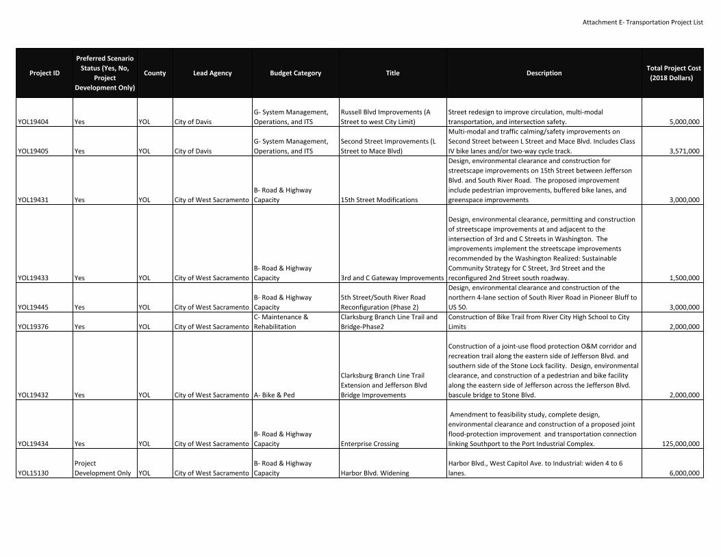
Attachment E‐ Transportation Project List
YOL19404 Yes YOL City of DavisG‐ System Management,Operations, and ITS
Russell Blvd Improvements (AStreet to west City Limit)
Street redesign to improve circulation, multi‐modaltransportation, and intersection safety. 5,000,000
YOL19405 Yes YOL City of DavisG‐ System Management,Operations, and ITS
Second Street Improvements (LStreet to Mace Blvd)
Multi‐modal and traffic calming/safety improvements onSecond Street between L Street and Mace Blvd. Includes ClassIV bike lanes and/or two‐way cycle track. 3,571,000
YOL19431 Yes YOL City of West SacramentoB‐ Road & HighwayCapacity 15th Street Modifications
Design, environmental clearance and construction forstreetscape improvements on 15th Street between JeffersonBlvd. and South River Road. The proposed improvementinclude pedestrian improvements, buffered bike lanes, andgreenspace improvements 3,000,000
YOL19433 Yes YOL City of West SacramentoB‐ Road & HighwayCapacity 3rd and C Gateway Improvements
Design, environmental clearance, permitting and constructionof streetscape improvements at and adjacent to theintersection of 3rd and C Streets in Washington. Theimprovements implement the streetscape improvementsrecommended by the Washington Realized: SustainableCommunity Strategy for C Street, 3rd Street and thereconfigured 2nd Street south roadway. 1,500,000
YOL19445 Yes YOL City of West SacramentoB‐ Road & HighwayCapacity
5th Street/South River RoadReconfiguration (Phase 2)
Design, environmental clearance and construction of thenorthern 4‐lane section of South River Road in Pioneer Bluff toUS 50. 3,000,000
YOL19376 Yes YOL City of West SacramentoC‐ Maintenance &Rehabilitation
Clarksburg Branch Line Trail andBridge‐Phase2
Construction of Bike Trail from River City High School to CityLimits 2,000,000
YOL19432 Yes YOL City of West Sacramento A‐ Bike & Ped
Clarksburg Branch Line TrailExtension and Jefferson BlvdBridge Improvements
Construction of a joint‐use flood protection O&M corridor andrecreation trail along the eastern side of Jefferson Blvd. andsouthern side of the Stone Lock facility. Design, environmentalclearance, and construction of a pedestrian and bike facilityalong the eastern side of Jefferson across the Jefferson Blvd.bascule bridge to Stone Blvd. 2,000,000
YOL19434 Yes YOL City of West SacramentoB‐ Road & HighwayCapacity Enterprise Crossing
Amendment to feasibility study, complete design,environmental clearance and construction of a proposed jointflood‐protection improvement and transportation connectionlinking Southport to the Port Industrial Complex. 125,000,000
YOL15130ProjectDevelopment Only YOL City of West Sacramento
B‐ Road & HighwayCapacity Harbor Blvd. Widening
Harbor Blvd., West Capitol Ave. to Industrial: widen 4 to 6lanes. 6,000,000
Project ID
Preferred ScenarioStatus (Yes, No,
ProjectDevelopment Only)
County Lead Agency Budget Category Title DescriptionTotal Project Cost
(2018 Dollars)

Attachment E‐ Transportation Project List
YOL19424 Yes YOL City of West Sacramento A‐ Bike & Ped I Street Bridge Deck Conversion
Design, environmental clearance, permitting and constructionof approaches and the upper deck for the I St Bridge. Theimprovements include construction/modification of theapproaches for ADA compliance, resurfacing of the deck andother appurtenant circulation improvements. Civic spaces willbe incorporated into the project. 13,000,000
YOL19377 Yes YOL City of West Sacramento A‐ Bike & PedI Street to Indian Heritage BikeTrail
Construct Bike Trail under I Street Bridge and new C StreetBridge then continue atop levee to Indian Heritage Center 2,000,000
YOL15891 Yes YOL City of West SacramentoB‐ Road & HighwayCapacity I‐80 Enterprise Boulevard
In West Sacramento, I‐80 at Enterprise Boulevard: constructeastbound on‐ramp. 4,800,000
YOL15670 Yes YOL City of West SacramentoB‐ Road & HighwayCapacity I‐80/Reed Ave. Interchange
I‐80 at Reed Ave. interchange: widen ramps at the intersectionwith Reed Avenue, widen Reed Avenue, and limit some localstreet access. Add ramp metering to the on‐ramps. 12,350,000
YOL15160ProjectDevelopment Only YOL City of West Sacramento
B‐ Road & HighwayCapacity Industrial Boulevard Widening
In West Sacramento, Industrial Boulevard from the PalamidessiBridge at the Barge Canal to Harbor Boulevard: widen from 4to 6 lanes. 16,440,000
YOL19430 Yes YOL City of West Sacramento A‐ Bike & PedJefferson StreetscapeImprovements
Design and construction of streetscape improvements onJefferson Blvd from 15th Street to Stone Blvd. The proposedenhancements include buffered bike lanes, on‐street parking,and greenspace improvements. 2,000,000
YOL15950 Yes YOL City of West SacramentoB‐ Road & HighwayCapacity
Lake Washington Blvd. BridgeWidening
Lake Washington Blvd.: Widen the Palamidessi Bridge over thebarge canal from 4 to 6 lanes. 10,100,000
YOL15940ProjectDevelopment Only YOL City of West Sacramento
B‐ Road & HighwayCapacity Lake Washington Blvd. Widening
Widen Lake Washington Blvd. from 2 to 6 lanes from JeffersonBlvd. to the new Palamidessi Bridge at the barge canal. 4,000,000
YOL19428 Yes YOL City of West SacramentoB‐ Road & HighwayCapacity
Locks Drive Modification andExtension
Design, environmental clearance and construction of theeastern extension of Locks Drive to Village Parkway. 4,000,000
YOL19439 Yes YOL City of West SacramentoB‐ Road & HighwayCapacity
Pioneer Bluff Districteast‐westconnections
Design, environmental clearance and construction of five neweast‐west local/collector roads in Pioneer Bluff. It is expectedthat one of the new roadway would include a signal onJefferson Blvd. 30,000,000
YOL19438 No YOL City of West SacramentoB‐ Road & HighwayCapacity
Pioneer Bluff north/southcollector
Design, environmental clearance and construction of a newinternal north/south collector in Pioneer Bluff 15,000,000
YOL19437 Yes YOL City of West Sacramento A‐ Bike & Ped Pioneer Bluff Riverfront Trail
Design, evniromental clearance, permitting and construction ofa joint‐use flood protection O&M corridor and recreation trailalong the Sacramento River in Pioneer Bluff. 2,000,000
Project ID
Preferred ScenarioStatus (Yes, No,
ProjectDevelopment Only)
County Lead Agency Budget Category Title DescriptionTotal Project Cost
(2018 Dollars)

Attachment E‐ Transportation Project List
YOL19361 Yes YOL City of West SacramentoG‐ System Management,Operations, and ITS
Port of West SacramentoEntrance
This project includes the construction of a new port entrance,including the installation of a new rail crossing near Beaconand Industrial Boulevards. This project will increase theefficiency and safety of travel to, from and within the Port, andis required prior to the construction of a new area project. Thisproject will improve transportation operations, and is likely tolead to significant positive economic benefits. 2,400,000
YOL19426 Yes YOL City of West SacramentoB‐ Road & HighwayCapacity Rail Street Phase 1 Improvements
Design, environmental clearance amendment , andconstruction of the northern section of Rail Street. 4,000,000
YOL19427 Yes YOL City of West SacramentoB‐ Road & HighwayCapacity Rail Street Phase 2 Improvements
Design, environmental clearance amendment , andconstruction of the southern section of Rail Street. 7,000,000
YOL19385 Yes YOL City of West SacramentoB‐ Road & HighwayCapacity Riverfront Street Extension
Riverfront Street, from Mill Street to the existing 3‐wayintersection at 5th St., S. River Rd., and 15th St. (0.3 mi):Extend as a two‐lane roadway with sidewalks, protectedbicycle lanes, lighting, and landscaping. At existing 3‐wayintersection construct the new four‐way intersection to includeRiverfront St. extension. Also, 15th St., from Jefferson Blvd. tofuture 4‐way intersection at River Rd., 5th St., and RiverfrontSt.: Realign roadway. 5,334,500
YOL19351 Yes YOL City of West SacramentoB‐ Road & HighwayCapacity Seaway Property Infrastructure
Construct internal roadway, utilities and storm drainagenetwork for Port Property Development 5,000,000
YOL19443 Yes YOL City of West Sacramento D‐ Programs & Planning
South Market Sacramento RiverBike/Ped/Transit River Crossing @Locks Drive
Feasibility study, preliminary design and environmentalclearance for a proposed bike, pedestrian, and (possible)transit bridge across the Sacramento River connecting WestSacramento's Central Park and Stone Lock District to MillerPark and the Sacramento Marina. 120,000,000
YOL15180 Yes YOL City of West SacramentoB‐ Road & HighwayCapacity
South River Rd. Reconfiguration(Phase 3)
Reconstruct South River Road to 4‐lanes from 15th Street tothe 19th Street extension and restripe Village Parkway toStonegate Boulevard, including restriping the 4‐lane bridgefrom 2‐lanes to 4‐lanes over barge canal. 20,000,000
YOL19444 Yes YOL City of West SacramentoB‐ Road & HighwayCapacity
South River Road Reconfiguration(Phase 1)
Design, environmental clearance and construction of thesouthern 4‐lane section of South River Road in Pioneer Blufffrom the Mike McGowan Bridge to the proposed futureextension of 19th Street. 3,000,000
Project ID
Preferred ScenarioStatus (Yes, No,
ProjectDevelopment Only)
County Lead Agency Budget Category Title DescriptionTotal Project Cost
(2018 Dollars)
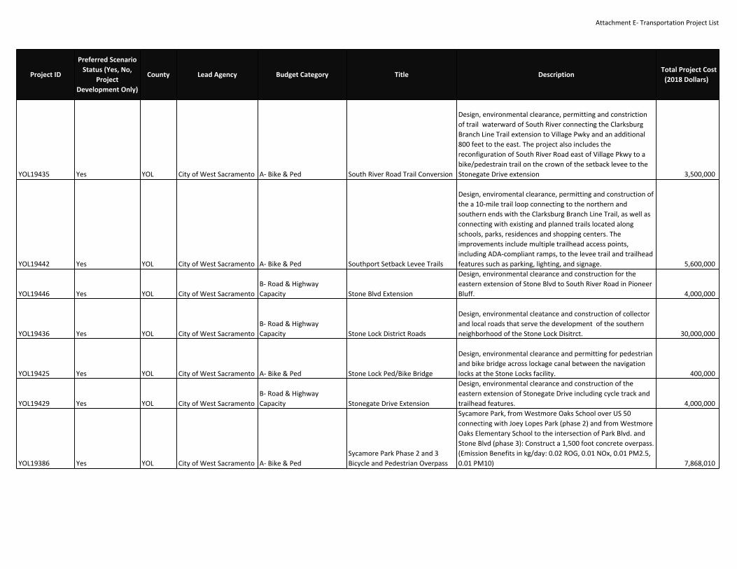
Attachment E‐ Transportation Project List
YOL19435 Yes YOL City of West Sacramento A‐ Bike & Ped South River Road Trail Conversion
Design, environmental clearance, permitting and constrictionof trail waterward of South River connecting the ClarksburgBranch Line Trail extension to Village Pwky and an additional800 feet to the east. The project also includes thereconfiguration of South River Road east of Village Pkwy to abike/pedestrain trail on the crown of the setback levee to theStonegate Drive extension 3,500,000
YOL19442 Yes YOL City of West Sacramento A‐ Bike & Ped Southport Setback Levee Trails
Design, enviromental clearance, permitting and construction ofthe a 10‐mile trail loop connecting to the northern andsouthern ends with the Clarksburg Branch Line Trail, as well asconnecting with existing and planned trails located alongschools, parks, residences and shopping centers. Theimprovements include multiple trailhead access points,including ADA‐compliant ramps, to the levee trail and trailheadfeatures such as parking, lighting, and signage. 5,600,000
YOL19446 Yes YOL City of West SacramentoB‐ Road & HighwayCapacity Stone Blvd Extension
Design, environmental clearance and construction for theeastern extension of Stone Blvd to South River Road in PioneerBluff. 4,000,000
YOL19436 Yes YOL City of West SacramentoB‐ Road & HighwayCapacity Stone Lock District Roads
Design, environmental cleatance and construction of collectorand local roads that serve the development of the southernneighborhood of the Stone Lock Disitrct. 30,000,000
YOL19425 Yes YOL City of West Sacramento A‐ Bike & Ped Stone Lock Ped/Bike Bridge
Design, environmental clearance and permitting for pedestrianand bike bridge across lockage canal between the navigationlocks at the Stone Locks facility. 400,000
YOL19429 Yes YOL City of West SacramentoB‐ Road & HighwayCapacity Stonegate Drive Extension
Design, environmental clearance and construction of theeastern extension of Stonegate Drive including cycle track andtrailhead features. 4,000,000
YOL19386 Yes YOL City of West Sacramento A‐ Bike & PedSycamore Park Phase 2 and 3Bicycle and Pedestrian Overpass
Sycamore Park, from Westmore Oaks School over US 50connecting with Joey Lopes Park (phase 2) and from WestmoreOaks Elementary School to the intersection of Park Blvd. andStone Blvd (phase 3): Construct a 1,500 foot concrete overpass.(Emission Benefits in kg/day: 0.02 ROG, 0.01 NOx, 0.01 PM2.5,0.01 PM10) 7,868,010
Project ID
Preferred ScenarioStatus (Yes, No,
ProjectDevelopment Only)
County Lead Agency Budget Category Title DescriptionTotal Project Cost
(2018 Dollars)

Attachment E‐ Transportation Project List
YOL19440 Yes YOL City of West Sacramento A‐ Bike & Ped Sycamore Phase 4
Design, environmental clearance and construction of thesouthern extension and terminus of the Sycamore Trail. Thisphase would connect at Stone Blvd and include pedestriancrossing improvements across Stone Blvd and provide safepassage through the Barge Canal rail switching yard. Acrossthe Barge Canal waterway a new bike/pedestrian bridge wouldbe constructed and land at the future Arlington Oaksneighborhood park. The trail would continue along aconverted Arlington Road and terminate at the intersection ofLake Washington Blvd and Jefferson Blvd. 4,300,000
YOL19441 Yes YOL City of West Sacramento A‐ Bike & Ped Sycamore Phase 5Design and construct a bicycle and pedestrian undercrossingon the UPRR and SNRR rail ROW from Rice Ave to Yolo Street. 6,000,000
YOL15900 Yes YOL City of West SacramentoB‐ Road & HighwayCapacity
U.S. 50/Jefferson Blvd.Interchange
Jefferson Blvd interchange‐‐expand the ramps and signals from1 to 2 lanes, add ramp metering and turn lanes, and relatedstreet closures. 26,450,000
YOL15680 Yes YOL City of West SacramentoG‐ System Management,Operations, and ITS U.S. 50/South River Road
U.S. 50: Install ramp meters and modify ramp design at SouthRiver Rd interchange. 23,625,000
YOL19284 Yes YOL City of West Sacramento A‐ Bike & PedWest Capitol Avenue StreetscapeImprovements ‐ Phase 3
In West Sacramento on West Capitol Avenue from WestacreRoad to Sycamore Avenue, construction of streetscapeimprovements, including wider sidewalks, flatter road cross‐section, reconfigure lanes, roundabout, utility relocation, newlighting, and substantial planting and hardscape treatments. 12,420,000
YOL19285 Yes YOL City of West Sacramento A‐ Bike & PedWest Capitol Avenue StreetscapeImprovements ‐ Phase 4
In West Sacramento on West Capitol Avenue from SycamoreAvenue to Harbor Boulevard, construction of streetscapeimprovements, including wider sidewalks, flatter road cross‐section, reconfigure lanes, utility relocation, new lighting, andsubstantial planting and hardscape treatments. 12,720,000
YOL19288 Yes YOL City of West Sacramento F‐ Transit O&M (Rail)Yolo Rail Realignment Project RailRelocation (Phase 2A)
Design, environmental clearance, permitting and constructionof the Yolo Rail Realignment Project, Phase 2A 70,000,000
YOL19339 Yes YOL City of Winters A‐ Bike & Ped
Complete Streets ImprovementsGrant Ave/State Rte 128/RussellBlvd
Complete Streets Improvements Grant Ave/State Rte128/Russell Blvd between El Rio Villa housing community andthe city of Winters ‐pedestrian and bike improvementsincluding overcrossing of Hwy 505 20,919,000
YOL19417 Yes YOL City of WoodlandB‐ Road & HighwayCapacity Abandon Harry Lorenzo Avenue
Abandon existing road Harry Lorenzo Avenue from ParklandAvenue to CR 25A. 350,000
Project ID
Preferred ScenarioStatus (Yes, No,
ProjectDevelopment Only)
County Lead Agency Budget Category Title DescriptionTotal Project Cost
(2018 Dollars)
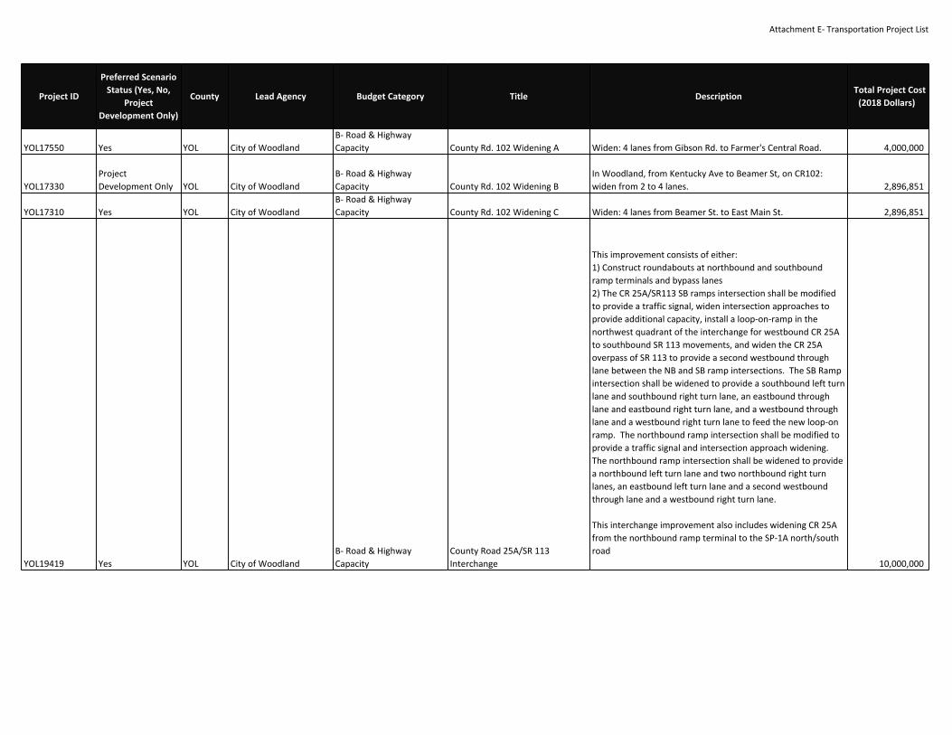
Attachment E‐ Transportation Project List
YOL17550 Yes YOL City of WoodlandB‐ Road & HighwayCapacity County Rd. 102 Widening A Widen: 4 lanes from Gibson Rd. to Farmer's Central Road. 4,000,000
YOL17330ProjectDevelopment Only YOL City of Woodland
B‐ Road & HighwayCapacity County Rd. 102 Widening B
In Woodland, from Kentucky Ave to Beamer St, on CR102:widen from 2 to 4 lanes. 2,896,851
YOL17310 Yes YOL City of WoodlandB‐ Road & HighwayCapacity County Rd. 102 Widening C Widen: 4 lanes from Beamer St. to East Main St. 2,896,851
YOL19419 Yes YOL City of WoodlandB‐ Road & HighwayCapacity
County Road 25A/SR 113Interchange
This improvement consists of either:1) Construct roundabouts at northbound and southboundramp terminals and bypass lanes2) The CR 25A/SR113 SB ramps intersection shall be modifiedto provide a traffic signal, widen intersection approaches toprovide additional capacity, install a loop‐on‐ramp in thenorthwest quadrant of the interchange for westbound CR 25Ato southbound SR 113 movements, and widen the CR 25Aoverpass of SR 113 to provide a second westbound throughlane between the NB and SB ramp intersections. The SB Rampintersection shall be widened to provide a southbound left turnlane and southbound right turn lane, an eastbound throughlane and eastbound right turn lane, and a westbound throughlane and a westbound right turn lane to feed the new loop‐onramp. The northbound ramp intersection shall be modified toprovide a traffic signal and intersection approach widening.The northbound ramp intersection shall be widened to providea northbound left turn lane and two northbound right turnlanes, an eastbound left turn lane and a second westboundthrough lane and a westbound right turn lane.
This interchange improvement also includes widening CR 25Afrom the northbound ramp terminal to the SP‐1A north/southroad
10,000,000
Project ID
Preferred ScenarioStatus (Yes, No,
ProjectDevelopment Only)
County Lead Agency Budget Category Title DescriptionTotal Project Cost
(2018 Dollars)
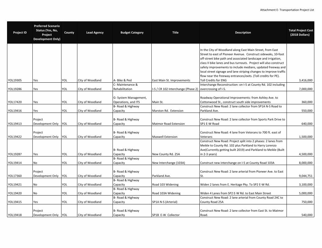
Attachment E‐ Transportation Project List
YOL19305 Yes YOL City of Woodland A‐ Bike & Ped East Main St. Improvements
In the City of Woodland along East Main Street, from EastStreet to east of Pioneer Avenue. Construct sidewaks, 10‐footoff‐street bike path and associated landscape and irrigation,class II bike lanes and bus turnouts. Project will also constructsafety improvements to include medians, updated freeway andlocal street signage and lane striping changes to improve trafficflow near the freeway entrances/exits. (Toll credits for PE).Toll Credits for ENG 3,416,000
YOL19286 Yes YOL City of WoodlandC‐ Maintenance &Rehabilitation I‐5 / CR 102 Interchange (Phase 2)
Interchange Reconstruction: on I‐5 at County Rd. 102 includingovercrossing of I‐5. 7,000,000
YOL17420 Yes YOL City of WoodlandG‐ System Management,Operations, and ITS Main St.
Roadway Operational Improvements: from Ashley Ave. toCottonwood St., construct south side improvements 360,000
YOL19416 Yes YOL City of WoodlandB‐ Road & HighwayCapacity Marston Rd. Extension
Construct New Road: 2 lane collector from SP1A N‐S Road toParkland Ave. 550,000
YOL19413ProjectDevelopment Only YOL City of Woodland
B‐ Road & HighwayCapacity Matmor Road Extension
Construct New Road: 2 lane collector from Sports Park Drive toSP1 E‐W Road 640,000
YOL19422ProjectDevelopment Only YOL City of Woodland
B‐ Road & HighwayCapacity Maxwell Extension
Construct New Road: 4 lane from Veterans to 700 ft. east ofVeterans 1,500,000
YOL19287 Yes YOL City of WoodlandB‐ Road & HighwayCapacity New County Rd. 25A
Construct New Road: Project split into 2 phases: 2 lanes fromMeikle to County Rd. 102 plus Parkland to Harry LorenzoAve(Currently getting built 2019) and Parkland to Meikle (Builtin 2‐3 years) 4,500,000
YOL19414 No YOL City of WoodlandB‐ Road & HighwayCapacity New Interchange (103A) Construct new interchange on I‐5 at County Road 103A 8,000,000
YOL17360ProjectDevelopment Only YOL City of Woodland
B‐ Road & HighwayCapacity Parkland Ave.
Construct New Road: 2 lane arterial from Pioneer Ave. to EastSt. 9,044,751
YOL19421 No YOL City of WoodlandB‐ Road & HighwayCapacity Road 103 Widening Widen 2 lanes from E. Heritage Pky. To SP2 E‐W Rd. 3,100,000
YOL19420 No YOL City of WoodlandB‐ Road & HighwayCapacity Road 103A Widening Widen 4 Lanes from SP2 E‐W Rd. to East Main Street 5,000,000
YOL19415 Yes YOL City of WoodlandB‐ Road & HighwayCapacity SP1A N‐S (Arterial)
Construct New Road: 2 lane arterial from County Road 24C toCounty Road 25A 750,000
YOL19418ProjectDevelopment Only YOL City of Woodland
B‐ Road & HighwayCapacity SP1B E‐W Collector
Construct New Road: 2 lane collector from East St. to MatmorRoad. 540,000
Project ID
Preferred ScenarioStatus (Yes, No,
ProjectDevelopment Only)
County Lead Agency Budget Category Title DescriptionTotal Project Cost
(2018 Dollars)

Attachment E‐ Transportation Project List
VAR56140 Yes YOLCity of Woodland, City ofDavis, Yolo County A‐ Bike & Ped
Alternative TransportationCorridor‐ Davis to Woodland
Class 1 bike/low speed electric vehicle path between Davis andWoodland, along alignment identified in September 2009feasibility study. 10,000,000
VAR56182 Yes YOLCity of Woodland, City ofDavis, Yolo County D‐ Programs & Planning Yolo Regional Freight Rail Project
Feasibility Study for realighment of freright rail out of the citiesof Davis, Woodland and West Sacramento to area east of Davisto create enhanced freight operations, remove safety issues incities, to encourage redevelopment of communities and toimproved regional flood contrrol 500,000
YCT18198 Yes YOL SACOG E‐ Transit Capital (Major)
Sacramento‐West SacramentoDowntown/Riverfront StreetcarProject (Phase 1)
Construction of the Phase 1 of the Downtown/RiverfrontStreetcar. The alignment runs from West Sacramento CivicCenter/Riverfront Street to the Midtown entertainment, retail,and residential district of Sacramento. 194,000,000
YOL19293 Yes YOL UC DavisC‐ Maintenance &Rehabilitation La Rue Ave. Bridge Replacement
On UC Davis Campus, La Rue Ave. (formerly California St.) overPutah Creek: Replace functionally obsolete 2 lane bridge with 2lane bridge including bike lanes and pedestrian access. 7,337,327
UNI10466 Yes YOL Unitrans F‐ Transit O&M (Bus) Operating Assistance
Operation, maintenance, administration, and programdevelopment for the provision of fixed route transit servicewithin the City of Davis. Program development includestraining and direct education expenses for employeedevelopment (pursuant to 2 CFR Part 200.472) in the areas ofsafety, security, and business administration. Davis UrbanizedArea. FFY 2017 to FFY 2020 30,688,566
UNI10469 Yes YOL Unitrans E‐ Transit Capital (Vehicles) Rolling Stock Replacement
For Davis Community Transit, replace up to four paratransitvehicles plus related equipment (radios, fareboxes, etc). ForUnitrans, purchase up to six standard 40‐foot buses and threedouble‐deck buses between FY 2017 and FY 2020 to replaceexisting buses when they have surpassed their useful lives plusrelated equipment (radios, fare boxes, security equipment,etc). (CMAQ Emission Reductions in kg/day: ROG 0.17, NOx0.51, PM10 0.01, PM2.5 0.01) 10,951,219
UNI10465 Yes YOL Unitrans E‐ Transit Capital (Minor)Unitrans Bus Stop Access andPassenger Amenties
Implement various bus stop improvements, accessibility, andpassenger amenities, including but not limited to installation,replacement, and repair of bus shelters/benches, passengerinformation displays, and passenger safety/securityequipment. 550,000
Project ID
Preferred ScenarioStatus (Yes, No,
ProjectDevelopment Only)
County Lead Agency Budget Category Title DescriptionTotal Project Cost
(2018 Dollars)
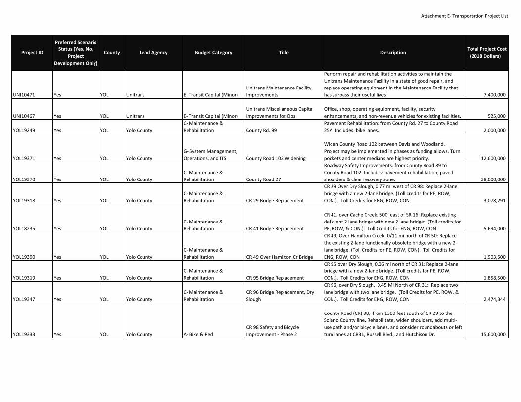
Attachment E‐ Transportation Project List
UNI10471 Yes YOL Unitrans E‐ Transit Capital (Minor)Unitrans Maintenance FacilityImprovements
Perform repair and rehabilitation activities to maintain theUnitrans Maintenance Facility in a state of good repair, andreplace operating equipment in the Maintenance Facility thathas surpass their useful lives 7,400,000
UNI10467 Yes YOL Unitrans E‐ Transit Capital (Minor)Unitrans Miscellaneous CapitalImprovements for Ops
Office, shop, operating equipment, facility, securityenhancements, and non‐revenue vehicles for existing facilities. 525,000
YOL19249 Yes YOL Yolo CountyC‐ Maintenance &Rehabilitation County Rd. 99
Pavement Rehabilitation: from County Rd. 27 to County Road25A. Includes: bike lanes. 2,000,000
YOL19371 Yes YOL Yolo CountyG‐ System Management,Operations, and ITS County Road 102 Widening
Widen County Road 102 between Davis and Woodland.Project may be implemented in phases as funding allows. Turnpockets and center medians are highest priority. 12,600,000
YOL19370 Yes YOL Yolo CountyC‐ Maintenance &Rehabilitation County Road 27
Roadway Safety Improvements: from County Road 89 toCounty Road 102. Includes: pavement rehabilitation, pavedshoulders & clear recovery zone. 38,000,000
YOL19318 Yes YOL Yolo CountyC‐ Maintenance &Rehabilitation CR 29 Bridge Replacement
CR 29 Over Dry Slough, 0.77 mi west of CR 98: Replace 2‐lanebridge with a new 2‐lane bridge. (Toll credits for PE, ROW,CON.). Toll Credits for ENG, ROW, CON 3,078,291
YOL18235 Yes YOL Yolo CountyC‐ Maintenance &Rehabilitation CR 41 Bridge Replacement
CR 41, over Cache Creek, 500' east of SR 16: Replace existingdeficient 2 lane bridge with new 2 lane bridge: (Toll credits forPE, ROW, & CON.). Toll Credits for ENG, ROW, CON 5,694,000
YOL19390 Yes YOL Yolo CountyC‐ Maintenance &Rehabilitation CR 49 Over Hamilton Cr Bridge
CR 49, Over Hamilton Creek, 0/11 mi north of CR 50: Replacethe existing 2‐lane functionally obsolete bridge with a new 2‐lane bridge. (Toll Credits for PE, ROW, CON). Toll Credits forENG, ROW, CON 1,903,500
YOL19319 Yes YOL Yolo CountyC‐ Maintenance &Rehabilitation CR 95 Bridge Replacement
CR 95 over Dry Slough, 0.06 mi north of CR 31: Replace 2‐lanebridge with a new 2‐lane bridge. (Toll credits for PE, ROW,CON.). Toll Credits for ENG, ROW, CON 1,858,500
YOL19347 Yes YOL Yolo CountyC‐ Maintenance &Rehabilitation
CR 96 Bridge Replacement, DrySlough
CR 96, over Dry Slough, 0.45 Mi North of CR 31: Replace twolane bridge with two lane bridge. (Toll Credits for PE, ROW, &CON.). Toll Credits for ENG, ROW, CON 2,474,344
YOL19333 Yes YOL Yolo County A‐ Bike & PedCR 98 Safety and BicycleImprovement ‐ Phase 2
County Road (CR) 98, from 1300 feet south of CR 29 to theSolano County line. Rehabilitate, widen shoulders, add multi‐use path and/or bicycle lanes, and consider roundabouts or leftturn lanes at CR31, Russell Blvd., and Hutchison Dr. 15,600,000
Project ID
Preferred ScenarioStatus (Yes, No,
ProjectDevelopment Only)
County Lead Agency Budget Category Title DescriptionTotal Project Cost
(2018 Dollars)
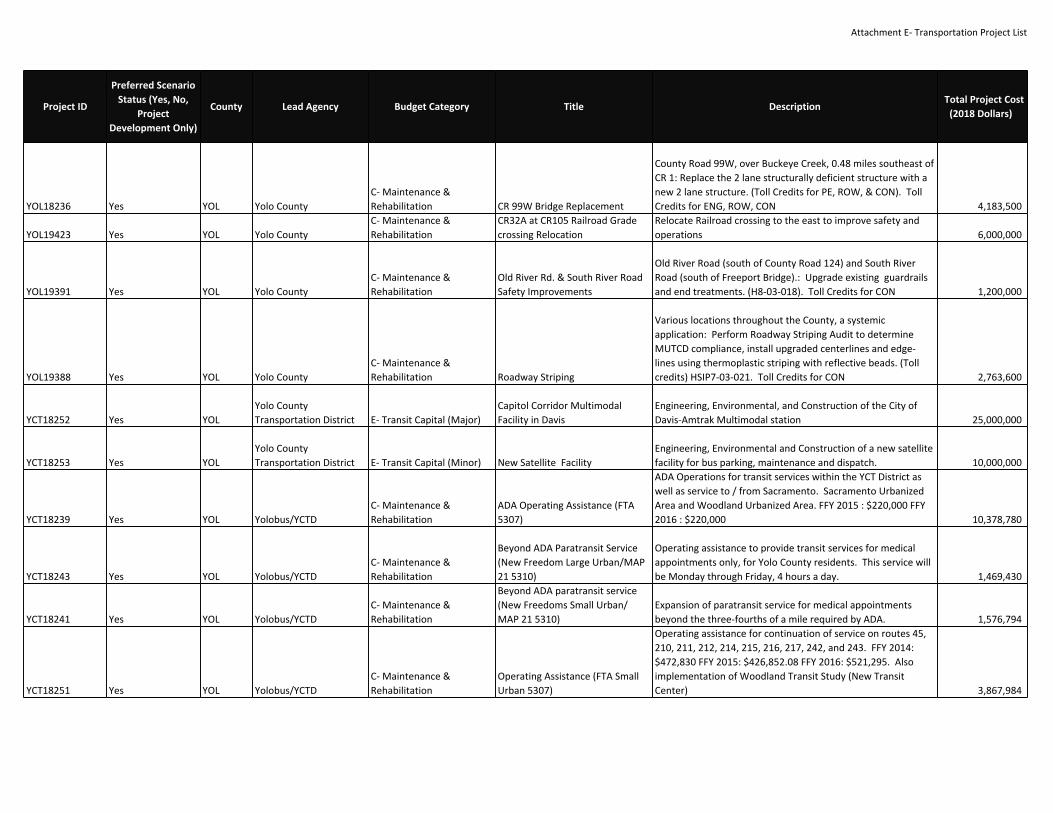
Attachment E‐ Transportation Project List
YOL18236 Yes YOL Yolo CountyC‐ Maintenance &Rehabilitation CR 99W Bridge Replacement
County Road 99W, over Buckeye Creek, 0.48 miles southeast ofCR 1: Replace the 2 lane structurally deficient structure with anew 2 lane structure. (Toll Credits for PE, ROW, & CON). TollCredits for ENG, ROW, CON 4,183,500
YOL19423 Yes YOL Yolo CountyC‐ Maintenance &Rehabilitation
CR32A at CR105 Railroad Gradecrossing Relocation
Relocate Railroad crossing to the east to improve safety andoperations 6,000,000
YOL19391 Yes YOL Yolo CountyC‐ Maintenance &Rehabilitation
Old River Rd. & South River RoadSafety Improvements
Old River Road (south of County Road 124) and South RiverRoad (south of Freeport Bridge).: Upgrade existing guardrailsand end treatments. (H8‐03‐018). Toll Credits for CON 1,200,000
YOL19388 Yes YOL Yolo CountyC‐ Maintenance &Rehabilitation Roadway Striping
Various locations throughout the County, a systemicapplication: Perform Roadway Striping Audit to determineMUTCD compliance, install upgraded centerlines and edge‐lines using thermoplastic striping with reflective beads. (Tollcredits) HSIP7‐03‐021. Toll Credits for CON 2,763,600
YCT18252 Yes YOLYolo CountyTransportation District E‐ Transit Capital (Major)
Capitol Corridor MultimodalFacility in Davis
Engineering, Environmental, and Construction of the City ofDavis‐Amtrak Multimodal station 25,000,000
YCT18253 Yes YOLYolo CountyTransportation District E‐ Transit Capital (Minor) New Satellite Facility
Engineering, Environmental and Construction of a new satellitefacility for bus parking, maintenance and dispatch. 10,000,000
YCT18239 Yes YOL Yolobus/YCTDC‐ Maintenance &Rehabilitation
ADA Operating Assistance (FTA5307)
ADA Operations for transit services within the YCT District aswell as service to / from Sacramento. Sacramento UrbanizedArea and Woodland Urbanized Area. FFY 2015 : $220,000 FFY2016 : $220,000 10,378,780
YCT18243 Yes YOL Yolobus/YCTDC‐ Maintenance &Rehabilitation
Beyond ADA Paratransit Service(New Freedom Large Urban/MAP21 5310)
Operating assistance to provide transit services for medicalappointments only, for Yolo County residents. This service willbe Monday through Friday, 4 hours a day. 1,469,430
YCT18241 Yes YOL Yolobus/YCTDC‐ Maintenance &Rehabilitation
Beyond ADA paratransit service(New Freedoms Small Urban/MAP 21 5310)
Expansion of paratransit service for medical appointmentsbeyond the three‐fourths of a mile required by ADA. 1,576,794
YCT18251 Yes YOL Yolobus/YCTDC‐ Maintenance &Rehabilitation
Operating Assistance (FTA SmallUrban 5307)
Operating assistance for continuation of service on routes 45,210, 211, 212, 214, 215, 216, 217, 242, and 243. FFY 2014:$472,830 FFY 2015: $426,852.08 FFY 2016: $521,295. Alsoimplementation of Woodland Transit Study (New TransitCenter) 3,867,984
Project ID
Preferred ScenarioStatus (Yes, No,
ProjectDevelopment Only)
County Lead Agency Budget Category Title DescriptionTotal Project Cost
(2018 Dollars)

Attachment E‐ Transportation Project List
YCT18238 Yes YOL Yolobus/YCTDC‐ Maintenance &Rehabilitation Preventive Maintenance (5307)
Preventive Maintenance for transit services within the YCTDistrict as well as service to / from Sacramento. SacramentoUrbanized Area and Woodland Urbanized Area. FFY 2015 :$1,109,780 FFY 2016 : $1,109,780 16,349,391
YCT18240 Yes YOL Yolobus/YCTDC‐ Maintenance &Rehabilitation
Rural Operating Assistance (FTA5311)
Operating assistance for rural transit services within the YCTDistrict. Outside the Sacramento Urbanized Area and theWoodland Urbanized Area. FFY 2014: $110,000 8,510,183
YCT18255 Yes YOL Yolobus/YCTDC‐ Maintenance &Rehabilitation
Woodland Transit Center and BusShelter Improvements
In Downtown Woodland: Construct new transit center andmodify routes to pulse concept, requiring new bus routecorridor in north part of Woodland and other areas. (TollCredits for PE, ROW, CON). Toll Credits for ENG, ROW, CON 4,975,000
YCT18256 Yes YOL Yolobus/YCTDC‐ Maintenance &Rehabilitation Yolobus Downtown Shuttle
Creation of new shuttle service between West SacramentoTransit Center and Downtown Sacramento to address eveningpeak downtown traffic. Existing routes 40,41,42 and 240would terminate at West Sacramento Transit Center duringpeak traffic events. 800,000
YCT18165 Yes YOL Yolobus/YCTDC‐ Maintenance &Rehabilitation
Yolobus Maintenance FacilityImprovements & Equipment
Repair, replace shop equipment, and perform maintenance forYolobus maintenance shop. (FTA 5309(c) funds are State ofGood Repair funding) 650,000
CAL20509 Yes YUB Caltrans D3C‐ Maintenance &Rehabilitation
Feather River Bridge ScourMitigation (G13 ContingencyProject)
In Marysville, at Feather River Bridge #18‐009 ‐ Scourmitigation and retrofit piers (PM 0.10) (G13 ContingencyProject) [EFIS ID 0313000033; CTIPS ID 107‐0000‐0969] [TotalProject Cost $36,568,000 in 20/21 FY] (Toll Credits for PE,ROW). Toll Credits for ENG, ROW, CON 36,568,000
CAL18824 No YUB Caltrans D3B‐ Road & HighwayCapacity Feather River Expressway
In the City of Marysville, construct a new alignment for SR‐70and SR‐20 through the City of Marysville, creating a newalignment from 3rd Street westward towards the levee justnorth of Binney Junction, reconnecting to SR‐20 and continuingto reconnect with SR‐70 north of town (Yub‐20‐0.0/1.5, Yub‐70‐13.5/16.1) 74,400,000
CAL20994ProjectDevelopment Only YUB Caltrans D3
G‐ System Management,Operations, and ITS
In Yuba County on Route 70 in theCity of Marysville. NB/SB auxiliarylanes between Feather River BlvdIC and 3rd Street.
In Yuba County on Route 70 in the City of Marysville. NB/SBAccel. lanes between Feather River Blvd IC and 3rd Street. 199,000,000
Project ID
Preferred ScenarioStatus (Yes, No,
ProjectDevelopment Only)
County Lead Agency Budget Category Title DescriptionTotal Project Cost
(2018 Dollars)

Attachment E‐ Transportation Project List
CAL20523 Yes YUB Caltrans D3C‐ Maintenance &Rehabilitation
Loma Rica Rd./Spring Valley Rd.Rehab and Widening (G13Contingency Project)
Near Marysville on Yub‐20, from 0.1 mile east of Loma RicaRoad to 0.2 mile west of Spring Valley Road ‐ Rehabilitateroadway and widen shoulders (includes adjust verticalalignment to standard and straighten the horizontal alignment)(PM 8.0/10.2) (G13 Contingency Project) [EFIS ID 0300020594;CTIPS ID 107‐0000‐0972] (Toll Credits for PE, ROW, CON). TollCredits for ENG, ROW, CON 17,420,000
CAL20715 Yes YUB Caltrans D3C‐ Maintenance &Rehabilitation Marysville Railroad Bridge Rehab
In and near Marysville, SR 70, from 14th Street to LaurellenRoad (PM 14.9/16.5) ‐ Rehabilitate pavement, OperationalImprovements, ADA upgrades, AC overlay (CTIPS ID 107‐0000‐1055) (Toll Credits). Toll Credits for ENG, ROW, CON. EA0H160 104,500,000
CAL20953 Yes YUB Caltrans D3C‐ Maintenance &Rehabilitation
North of Nevada City in Yuba Cofrom Nevada Co Line to Sierra CoLine. CAPM.
North of Nevada City in Yuba Co from Nevada Co Line to SierraCo Line. CAPM. 6,255,000
CAL20431 Yes YUB Caltrans D3G‐ System Management,Operations, and ITS SR 20 Passing Lanes Passing Lanes: Loma Rica Rd. to Kibbe Rd. (PM 7.9/9.4) 2,500,000
CAL20864 Yes YUB Caltrans D3C‐ Maintenance &Rehabilitation SR 20 Pavement Rehabilitation B
In Yuba County on Route 20 from Yuba Street to 0.6 mile westof 17th Street. (PM 1.6‐R2.0) 8,080,000
CAL20980 Yes YUB Caltrans D3C‐ Maintenance &Rehabilitation SR 20 Pavement Rehabilitation C
In Marysville on Route 20 from I Street to Orange Street and onRoute 70 from 3rd Street to 6th Street (PM 0.0‐0.84) 5,435,000
CAL20432 Yes YUB Caltrans D3C‐ Maintenance &Rehabilitation SR 20 Safety Improvements
Roadway Safety Improvements: Parks Bar Rd. to Hammonton‐Smartville Rd. Includes: standard shoulders, vertical andhorizontal curve improvements, and EB & WB left‐turn lanes. 6,500,000
CAL20514 Yes YUB Caltrans D3C‐ Maintenance &Rehabilitation
SR 20 Shoulder Widening(Timbuctoo)
Near Smartsville, from the Yuba River Bridge to east ofSmartsville Road ‐ Realign and widen roadway (PM R18.0/20.3)[EFIS ID 0313000020; CTIPS ID 107‐0000‐0973] (Toll Credits forPE, ROW, CON). Toll Credits for ENG, ROW, CON 67,321,000
CAL20475 Yes YUB Caltrans D3C‐ Maintenance &Rehabilitation
SR 20 Smartsville SafetyEnhancements
In Yuba County on SR 20, near Lake Wildwood, from 0.4 mileeast of McGanney Lane to Yuba/Nevada county line; also inNevada County, from Yuba/Nevada county line to Mooney FlatRoad ‐ Shoulder widening and curve improvements (PM20.1/21.6) (Toll Credits for PE, ROW, CON) [CTIPS ID 107‐0000‐0912]. Toll Credits for ENG, ROW, CON 28,780,000
Project ID
Preferred ScenarioStatus (Yes, No,
ProjectDevelopment Only)
County Lead Agency Budget Category Title DescriptionTotal Project Cost
(2018 Dollars)

Attachment E‐ Transportation Project List
CAL21069 Yes YUB Caltrans D3C‐ Maintenance &Rehabilitation SR 49 Roadside Improvements
In Yuba County on Route 49 approximately 0.4 miles south ofSleighville Circle, cut back slope, install slope drainage andsurface drainage 7,265,000
CAL21058 Yes YUB Caltrans D3C‐ Maintenance &Rehabilitation SR 65 Drainage Improvements
In Yuba County at McGowan Rd OC, PP 16‐47W (UpgradePump Plant) 528,000
CAL21226 Yes YUB Caltrans D3C‐ Maintenance &Rehabilitation
SR 70 Diagonal Ramp Meter atthe SR 70/North Beale Roadinterchange (EB)
In Yuba County at SR 70/North Beale Road Interchange install aDiagonal ramp meter. Future Configuration is 1. (EB PlumasLake Road to SR 70) (PM 13.57) 380,000
CAL20925 Yes YUB Caltrans D3C‐ Maintenance &Rehabilitation
SR 70 Diagonal Ramp Meter atthe SR 70/Plumas Lake Roadinterchange (WB)
In Yuba County at SR 70/Plumas Lake Road Interchange installa Diagonal ramp meter. Future Configuration is 1. (WB PlumasLake Road to SR 70) (PM 3.30) 380,000
CAL20950 Yes YUB Caltrans D3C‐ Maintenance &Rehabilitation SR 70 Bridge Rail Upgrade
Upgrade bridge rail on Route 70 in Yuba County nearMarysville at Olivehurst Ave OC Br 16‐0036, Feather River BlvdUC Br 16‐0033, and South Marysville UC Br 16‐0035. EA 1H270 14,762,000
CAL21057 Yes YUB Caltrans D3C‐ Maintenance &Rehabilitation SR 70 Drainage Improvements
In Yuba County from 65/70 Separation to just east ofOlivehurst Ave OC, PP 16‐36W, 16‐42W 1,200,000
CAL21225 Yes YUB Caltrans D3C‐ Maintenance &Rehabilitation
SR 70 Loop Ramp Meter at the SR70/Plumas Lake Road interchange(EB)
In Yuba County at SR 70/Plumas Lake Road Interchange installa Loop ramp meter. Future Configuration is 1. (EB Plumas LakeRoad to SR 70) (PM 3.40) 380,000
CAL18815ProjectDevelopment Only YUB Caltrans D3
C‐ Maintenance &Rehabilitation SR 70 Passing Lanes
Construct a new continuous passing lane in both directionsfrom Marysville to Butte County line. Seg 4 & 5 STIP. EA 3F283 32,000,000
CAL20863 Yes YUB Caltrans D3C‐ Maintenance &Rehabilitation SR 70 Pavement Rehabilitation A
In Yuba County on Route 70 from approx. 0.5 mile east ofFeather River Blvd to approx. 0.6 mile west of Olivehurst Ave. 10,100,000
CAL20679 Yes YUB Caltrans D3G‐ System Management,Operations, and ITS SR 70 Safety Improvements
Near Marysville, from Laurellen Road to Butte County Line ‐Widen shoulders and improve clear recovery zone [PM16.2/25.8] ; add continuous a two‐way left turn lane (TWLTL)throughout the project; 2 separate slow moving vehicle lanesare planned in each direction. Each one is less than a mile inlength (PM 16.2/25.8); overlay with RHMA; replace and extendculverts; install TMS elements, fiber optic system elements,and lighting intersection; and install a classification station.Seg 4 & 5 SHOPP. EA 4F380 104,640,000
CAL20472 Yes YUB Caltrans D3C‐ Maintenance &Rehabilitation
SR 70 Simmerly Slough BridgeReplacement
Near Marysville, on SR 70, from 0.1 mile north of BinneyJunction Underpass to 0.3 mile north of Laurellen Road, atSimmerly Slough Bridge #16‐0019 ‐ Replace bridge (PM15.5/16.5) [CTIPS ID 107‐00000909 (Toll Credits PE, ROW,CON). Toll Credits for ENG, ROW, CON. EA 1E060 83,260,000
Project ID
Preferred ScenarioStatus (Yes, No,
ProjectDevelopment Only)
County Lead Agency Budget Category Title DescriptionTotal Project Cost
(2018 Dollars)

Attachment E‐ Transportation Project List
CAL20960 Yes YUB Caltrans D3C‐ Maintenance &Rehabilitation Wheatland HMA and ADA
On Route 65 in and near Wheatland from 0.18 miles south ofMain Street to Grasshopper Slough Br 16‐0001, grind andreplace 0.2' of existing asphalt with RHMA‐G, rehabilitatedrainage as needed, widen shoulders to accommodatebicyclists, upgrade existing non‐standard ADA features, andevaluate existing lighting and traffic signals 5,502,000
CAL21228 Yes YUB Caltrans D3C‐ Maintenance &Rehabilitation Yuba 49 at 5.97 slipout repair Slipout Project (repair) 900,000
CAL20916 Yes YUB Caltrans D3G‐ System Management,Operations, and ITS
Yuba 70 Connector ramp meter(EB) at NB SR 65
In Yuba County on SR 70 construct connector ramp meter atNB SR 65 (PM R8.51) 1,940,000
CAL21212 Yes YUB Caltrans D3G‐ System Management,Operations, and ITS
Yuba 70 ramp meter at Erle Road(WB)
In Yuba County on SR 70 construct ramp meter at WB ErleRoad IC (PM R10.03) 380,000
CAL21213 Yes YUB Caltrans D3G‐ System Management,Operations, and ITS
Yuba 70 ramp meter at FeatherRiver Blvd (EB)
In Yuba County on SR 70 construct ramp meter at EB FeatherRiver blvd IC (PM R11.35) 380,000
CAL20918 Yes YUB Caltrans D3G‐ System Management,Operations, and ITS
Yuba 70 ramp meter at FeatherRiver Blvd (WB)
In Yuba County on SR 70 construct ramp meter at WB FeatherRiver blvd IC (PM R11.26) 380,000
CAL21211 Yes YUB Caltrans D3G‐ System Management,Operations, and ITS
Yuba 70 ramp meter at LindhurstAve (EB)
In Yuba County on SR 70 construct ramp meter at EB LindhurstAve IC (PM R10.01) 380,000
CAL21208 Yes YUB Caltrans D3G‐ System Management,Operations, and ITS
Yuba 70 ramp meter at McGowanRoad (EB)
In Yuba County on SR 70 construct ramp meter at EB McGowanRoad IC (PM R7.60) 380,000
CAL21207 Yes YUB Caltrans D3G‐ System Management,Operations, and ITS
Yuba 70 ramp meter at McGowanRoad (WB)
In Yuba County on SR 70 construct ramp meter at WBMcGowan Road IC (PM R7.07) 380,000
CAL21214 Yes YUB Caltrans D3G‐ System Management,Operations, and ITS
Yuba 70 ramp meter at NorthBeale Rd (EB)
In Yuba County on SR 70 construct ramp meter at EB NorthBeale Rd IC (PM 13.57) 380,000
CAL20917 Yes YUB Caltrans D3G‐ System Management,Operations, and ITS
Yuba 70 ramp meter at OlivehurstAve (EB)
In Yuba County on SR 70 construct ramp meter at EB OlivehurstAve IC (PM R9.27) 380,000
CAL21210 Yes YUB Caltrans D3G‐ System Management,Operations, and ITS
Yuba 70 ramp meter at OlivehurstAve (WB)
In Yuba County on SR 70 construct ramp meter at WBOlivehurst Ave IC (PM R9.09) 380,000
Project ID
Preferred ScenarioStatus (Yes, No,
ProjectDevelopment Only)
County Lead Agency Budget Category Title DescriptionTotal Project Cost
(2018 Dollars)

Attachment E‐ Transportation Project List
YUB16063 Yes YUB City of Marysville A‐ Bike & PedMarysville Bicycle and PedestrianImprovement
Throughout Marysville, with concentration downtown andnear schools: Install 26 bicycle racks on public sidewalks, 7.23miles of bicycle lanes, 5.74 miles of bicycle routes, four highvisibility crosswalks, two Rectangular Rapid Flash Beacons, twospeed feedback signs, a raised intersection, and 1,193 feet ofsidewalk. 583,000
YUB16054 Yes YUB City of MarysvilleC‐ Maintenance &Rehabilitation
Marysville Medical Arts DistrictTransportation Development
5th St., from SR 70 to J St., including the Medical Arts District:Rehabilitate road. Second St. (2nd St.) from Hwy 70 to J St.,including the Medical Arts District: Extend and realign. 2,791,000
YUB15981 Yes YUB City of MarysvilleC‐ Maintenance &Rehabilitation Pavement Rehab. Project IV
Pavement Rehabilitation: 25th St. from Sampson to Covillaud,Sicard St. from East 16th St. to East 19th St., Freeman St. fromEast 18th St. to East 19th St. and East 19th St. from Covillaud toRamirez. (Project IV) 700,000
YUB15982 Yes YUB City of MarysvilleC‐ Maintenance &Rehabilitation Pavement Rehab. Project V
Pavement Rehabilitation: Rideout Wy. from Covillaud toRamirez St., Greeley from East 19th St. to East 22nd St. andBoulton from East 19th St. to East 22nd St. (Project V) 700,000
YUB15979 Yes YUB City of MarysvilleG‐ System Management,Operations, and ITS Upgrade Signals
Traffic Signalization: Upgrade the 4 existing traffic signals (inMarysville) that are not on the State Hwy. System. 1,200,000
YUB16053 Yes YUB City of WheatlandC‐ Maintenance &Rehabilitation C Street Resurfacing Repair base failures, resurface and replace ped ramps. 280,000
YUB16052 Yes YUB City of WheatlandB‐ Road & HighwayCapacity Olive Street Extension Obtain right of way and construct arterial roadway. 2,400,000
YUB16051 Yes YUB City of WheatlandC‐ Maintenance &Rehabilitation
Pedestrian Safety Enhancementsat Railroad Grade Crossings
Construct ADA compliant sidewalks, detectable warningsurfaces and extend rail crossings, and modify railroad warningdevices. 980,000
CAL18280ProjectDevelopment Only YUB City of Wheatland
B‐ Road & HighwayCapacity Wheatland Pkwy.
Construct New Road: 2 lane expressway from the future northend of Hwy. 65 Lincoln Bypass to the existing Hwy. 65, nearSouth Beale Rd. Includes: access control. 15,000,000
YUB16046 Yes YUB City of WheatlandC‐ Maintenance &Rehabilitation Wheatland Rd. Rehab Pavement rehab and ADA pedestian compliance. 460,000
YUB15903ProjectDevelopment Only YUB Yuba County
B‐ Road & HighwayCapacity Anderson Rd.
Widen from 2 to 3 lane collector from Feather River Blvd. toLinks Pkwy. 230,000
YUB15883 Yes YUB Yuba CountyB‐ Road & HighwayCapacity Arboga Rd.
Widen: 4 lanes from McGowan Pkwy. to Erle Rd. Includes:curb, gutter, sidewalk, and landscaping. 3,250,000
YUB15880 Yes YUB Yuba CountyB‐ Road & HighwayCapacity Arboga Road
New modified 4‐lane arterial from Broadway Rd to Ella Ave,including pavement, curb, gutter, sidewalk and back of curblandscaping 6,600,000
Project ID
Preferred ScenarioStatus (Yes, No,
ProjectDevelopment Only)
County Lead Agency Budget Category Title DescriptionTotal Project Cost
(2018 Dollars)
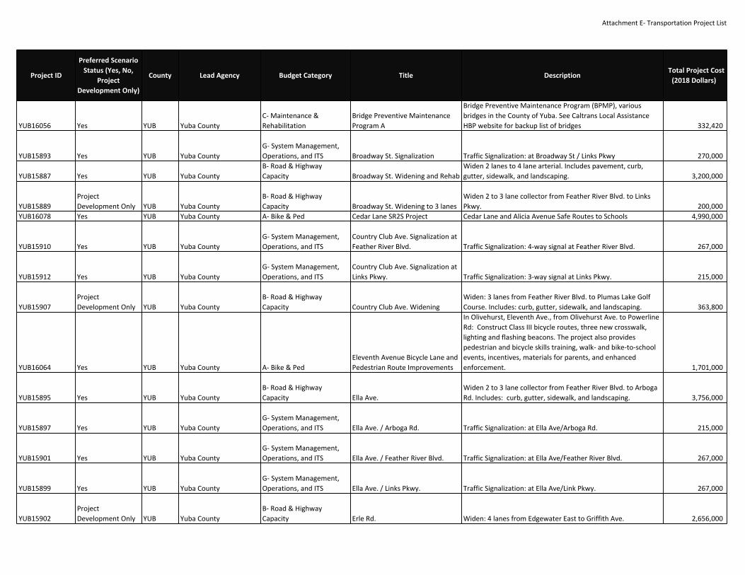
Attachment E‐ Transportation Project List
YUB16056 Yes YUB Yuba CountyC‐ Maintenance &Rehabilitation
Bridge Preventive MaintenanceProgram A
Bridge Preventive Maintenance Program (BPMP), variousbridges in the County of Yuba. See Caltrans Local AssistanceHBP website for backup list of bridges 332,420
YUB15893 Yes YUB Yuba CountyG‐ System Management,Operations, and ITS Broadway St. Signalization Traffic Signalization: at Broadway St / Links Pkwy 270,000
YUB15887 Yes YUB Yuba CountyB‐ Road & HighwayCapacity Broadway St. Widening and Rehab
Widen 2 lanes to 4 lane arterial. Includes pavement, curb,gutter, sidewalk, and landscaping. 3,200,000
YUB15889ProjectDevelopment Only YUB Yuba County
B‐ Road & HighwayCapacity Broadway St. Widening to 3 lanes
Widen 2 to 3 lane collector from Feather River Blvd. to LinksPkwy. 200,000
YUB16078 Yes YUB Yuba County A‐ Bike & Ped Cedar Lane SR2S Project Cedar Lane and Alicia Avenue Safe Routes to Schools 4,990,000
YUB15910 Yes YUB Yuba CountyG‐ System Management,Operations, and ITS
Country Club Ave. Signalization atFeather River Blvd. Traffic Signalization: 4‐way signal at Feather River Blvd. 267,000
YUB15912 Yes YUB Yuba CountyG‐ System Management,Operations, and ITS
Country Club Ave. Signalization atLinks Pkwy. Traffic Signalization: 3‐way signal at Links Pkwy. 215,000
YUB15907ProjectDevelopment Only YUB Yuba County
B‐ Road & HighwayCapacity Country Club Ave. Widening
Widen: 3 lanes from Feather River Blvd. to Plumas Lake GolfCourse. Includes: curb, gutter, sidewalk, and landscaping. 363,800
YUB16064 Yes YUB Yuba County A‐ Bike & PedEleventh Avenue Bicycle Lane andPedestrian Route Improvements
In Olivehurst, Eleventh Ave., from Olivehurst Ave. to PowerlineRd: Construct Class III bicycle routes, three new crosswalk,lighting and flashing beacons. The project also providespedestrian and bicycle skills training, walk‐ and bike‐to‐schoolevents, incentives, materials for parents, and enhancedenforcement. 1,701,000
YUB15895 Yes YUB Yuba CountyB‐ Road & HighwayCapacity Ella Ave.
Widen 2 to 3 lane collector from Feather River Blvd. to ArbogaRd. Includes: curb, gutter, sidewalk, and landscaping. 3,756,000
YUB15897 Yes YUB Yuba CountyG‐ System Management,Operations, and ITS Ella Ave. / Arboga Rd. Traffic Signalization: at Ella Ave/Arboga Rd. 215,000
YUB15901 Yes YUB Yuba CountyG‐ System Management,Operations, and ITS Ella Ave. / Feather River Blvd. Traffic Signalization: at Ella Ave/Feather River Blvd. 267,000
YUB15899 Yes YUB Yuba CountyG‐ System Management,Operations, and ITS Ella Ave. / Links Pkwy. Traffic Signalization: at Ella Ave/Link Pkwy. 267,000
YUB15902ProjectDevelopment Only YUB Yuba County
B‐ Road & HighwayCapacity Erle Rd. Widen: 4 lanes from Edgewater East to Griffith Ave. 2,656,000
Project ID
Preferred ScenarioStatus (Yes, No,
ProjectDevelopment Only)
County Lead Agency Budget Category Title DescriptionTotal Project Cost
(2018 Dollars)

Attachment E‐ Transportation Project List
YUB15905 Yes YUB Yuba CountyG‐ System Management,Operations, and ITS Erle Rd. / Goldfields Pkwy. Traffic Signalization: 3‐way traffic signal. 215,000
YUB16050 Yes YUB Yuba CountyB‐ Road & HighwayCapacity Erle Rd/SR70 Intch Mod
Modify ex Interchange: South of Marysville, SR 70 at Erle RoadInterchange. 2,000,000
YUB15928 Yes YUB Yuba CountyG‐ System Management,Operations, and ITS
Feather River Blvd Traffic Signal atRiver Oaks Blvd
Construct new traffic signal at Feather River Blvd and RiverOaks Blvd. 300,000
YUB15927 Yes YUB Yuba CountyB‐ Road & HighwayCapacity Feather River Blvd. Widen: 4 lanes from Ella Ave. to south of Country Club Rd. 9,725,000
YUB15904 Yes YUB Yuba CountyG‐ System Management,Operations, and ITS Feather River Blvd. / Anderson Rd. Traffic Signalization: at Feather River Blvd/Anderson St. 267,000
YUB15894 Yes YUB Yuba CountyG‐ System Management,Operations, and ITS
Feather River Blvd. / BroadwayStreet Traffic Signalization: at Feather River Blvd/Broadway St. 270,000
YUB16074 Yes YUB Yuba County A‐ Bike & PedFleming & Ninth Avenue SafeRoutes to Schools Fleming & Ninth Avenue Safe Routes to Schools 3,582,000
YUB16075 Yes YUB Yuba County A‐ Bike & Ped Forty‐Mile Road Bike Lanes
On Forty‐Mile Road between Plumas‐Arboga Road and StateRoute 65; construct bicycles lanes and wider shoulders; installnew striping and signage. 4,564,800
YUB15881 Yes YUB Yuba CountyG‐ System Management,Operations, and ITS Goldfields Parkway Traffic Signal
Install new traffic signal at the intersection of North Beale Roadand Goldfields Parkway 300,000
YUB15930 Yes YUB Yuba CountyB‐ Road & HighwayCapacity Goldfields Pkwy.
Construct New Road: 2 lanes from North Beale Rd. to north ofHammonton‐Smartsville Rd. 995,000
YUB15931ProjectDevelopment Only YUB Yuba County
B‐ Road & HighwayCapacity Goldfields Pkwy. Interchange
Construct New Interchange: Goldfields Pkwy. at Hwy. 65 / Hwy70 connection. 66,000,000
YUB15929 Yes YUB Yuba CountyB‐ Road & HighwayCapacity Goldfields Pkwy. Widening
Widen Road: 4 lanes (of 6 lane arterial) from Orchard S.S. toNorth Beale Rd. 2,100,000
YUB15934ProjectDevelopment Only YUB Yuba County
B‐ Road & HighwayCapacity Griffith Ave. Widen: 3 lanes from Hammonton‐Smartsville Rd. to Linda Ave. 6,600,000
YUB15939 Yes YUB Yuba CountyG‐ System Management,Operations, and ITS
Hammonton‐Smartsville Rd. /Goldfields Pkwy.
Traffic Signalization: at Hammonton‐Smartsville Rd/GoldfieldsPkwy. 300,000
YUB15940 Yes YUB Yuba CountyG‐ System Management,Operations, and ITS
Hammonton‐Smartsville Rd. /Griffith Ave.
Traffic Signalization: at Hammonton‐Smartsville Rd/GriffithAve. 300,000
Project ID
Preferred ScenarioStatus (Yes, No,
ProjectDevelopment Only)
County Lead Agency Budget Category Title DescriptionTotal Project Cost
(2018 Dollars)

Attachment E‐ Transportation Project List
YUB15938 Yes YUB Yuba CountyG‐ System Management,Operations, and ITS
Hammonton‐Smartville Rd. /Dantoni Rd.
Traffic Signalization: at Hammonton‐Smartsville Rd/DantoniAve. 300,000
YUB15867 Yes YUB Yuba CountyC‐ Maintenance &Rehabilitation Highway 70
Widen: overpass at McGowan Pkwy. Includes: new trafficsignals. 4,200,000
YUB16032 Yes YUB Yuba CountyC‐ Maintenance &Rehabilitation Iowa City Rd. Bridge Replacement
Iowa City Rd. over Jack Slough, 0.35 miles east of Fruitland Rd.:Replace existing 2 lane bridge with a new 2 lane bridge. (Tollcredits for PE, ROW, CON). Toll Credits for ENG, ROW, CON 1,980,000
YUB15942 Yes YUB Yuba CountyB‐ Road & HighwayCapacity La Porte Rd. Widen and Realign: from Butte County to Willow Glen Rd. 3,200,000
YUB15944ProjectDevelopment Only YUB Yuba County
B‐ Road & HighwayCapacity
Links Parkway Extension toCounty Club Road
From Plumas Arboga Rd to Country Club Rd., construct newextension of Links Parkway. 12,000,000
YUB15943ProjectDevelopment Only YUB Yuba County
B‐ Road & HighwayCapacity Links Pkwy.
Construct New Road: 2 lane arterial from Ella Ave. to currentLinks Parkway. 850,000
YUB15906 Yes YUB Yuba CountyG‐ System Management,Operations, and ITS Links Pkwy. / Anderson Rd. Traffic Signalization: at Links Pkwy/Anderson Rd. 267,000
YUB15946 Yes YUB Yuba CountyG‐ System Management,Operations, and ITS Loma Rica Rd. Signalization Traffic Signalization: at Hwy. 20 / Loma Rica Rd. 300,000
YUB15945 Yes YUB Yuba CountyG‐ System Management,Operations, and ITS
Loma Rica Rd. Turn Pockets andShoulders
Roadway Operational Improvements: Widen and constructturn pockets at various locations. Includes: shoulder widening. 2,650,000
YUB15949 Yes YUB Yuba CountyG‐ System Management,Operations, and ITS Marysville Rd.
Roadway Operational Improvements: Construct turn pocketsand widen shoulders at various intersections from Hwy. 20 toWillow Glen Rd. 3,955,000
YUB16077 Yes YUB Yuba County A‐ Bike & PedMarysville Road Bicycle LaneProject
On Marysville Road between Willow Glenn Road and StateRoute 49; widen roadway for bicycles lanes and widenshoulders. 18,180,000
YUB15950 Yes YUB Yuba CountyB‐ Road & HighwayCapacity McGowan Parkway
Construct 3‐lane collector McGowan Parkway from ArbogaRoad to Union Pacific Railroad. 1,300,000
YUB15871 Yes YUB Yuba CountyG‐ System Management,Operations, and ITS
McGowan Parkway and ArbogaRoad Traffic Signalization
Install new Traffic Signal at the intersection of McGowanParkway and Arboga Road. 250,000
YUB16065 Yes YUB Yuba CountyC‐ Maintenance &Rehabilitation
McGowan Parkway Bicycle Laneand Pedestrian RouteImprovements
In Olivehurst, along McGowan Parkway between SR 70 andOlive Ave.: Construct sidewalks, Class II bicycle lanes, ADA‐compliant ramps, striping, traffic control devices, storm drain,and new crosswalks. Project includes a locally fundedcontinuous left‐turn lane. 1,559,000
Project ID
Preferred ScenarioStatus (Yes, No,
ProjectDevelopment Only)
County Lead Agency Budget Category Title DescriptionTotal Project Cost
(2018 Dollars)

Attachment E‐ Transportation Project List
YUB15951ProjectDevelopment Only YUB Yuba County
B‐ Road & HighwayCapacity McGowan Pkwy.
Widen: 4 lanes from UPRR to Hwy. 65. Includes: turn lane,curb, gutter, sidewalk, and landscaping. 278,000
YUB15868 Yes YUB Yuba CountyG‐ System Management,Operations, and ITS McGowan Pkwy. / UPRR
Rail Crossing Project: Upgrade the existing at gradeintersection at the UPRR tracks. 810,000
YUB15886 Yes YUB Yuba CountyG‐ System Management,Operations, and ITS N. Beale Rd. / Griffith Rd.
Traffic Signalization: at the intersection of North Beale Rd. /Griffith Rd. 215,000
YUB16018 Yes YUB Yuba CountyC‐ Maintenance &Rehabilitation
New York House Rd BridgeReplacement
New York House Rd over Dry Creek, 0.2 miles northeast ofFrenchtown Rd: Replace the existing structurally deficient 2lane bridge with a new 2‐lane bridge. (Toll Credits for PE, ROW& CON). Toll Credits for ENG, ROW, CON 2,568,289
YUB16041 Yes YUB Yuba County A‐ Bike & PedNorth Beale Rd. Complete StreetsPhase 2
North Beale Rd.,from Hammonton Smartsville Rd. to LindaAve.: construct bicycle lanes, curb and gutter, sidewalks,drainage facilities, lighting and other improvements. (PE wasdone on YUB16008) 3,233,138
YUB16029 Yes YUB Yuba County A‐ Bike & PedNorth Beale Rd. Complete StreetsRevitalization Phase 3
Construct complete streets improvements for a 9400 ft stretchon North Beale Rd. from Linda Avenue. to Griffith Ave. in thecommunity of Linda. The project will construct curbs, gutters,sidewalks, ADA compliant corner ramps, transit stopenhancements, intersection improvements and several otherstreetscape features. (PE is programmed on YUB16008) 11,450,000
YUB15877 Yes YUB Yuba CountyB‐ Road & HighwayCapacity North Beale Road Improvements
Widen Roadway from 2‐lanes to 4‐lanes and install curb gutterand sidewalk from Linda Ave to Griffith Rd. 2,000,000
YUB15909ProjectDevelopment Only YUB Yuba County
B‐ Road & HighwayCapacity Plumas Arboga Rd. Widen from 2 to 3 lane collector from UPRR to Algodon Rd. 8,700,000
YUB15958ProjectDevelopment Only YUB Yuba County
B‐ Road & HighwayCapacity Plumas Arboga Rd. Ext Plumas Arboga Rd. Extension to the new interchange at SR 65 2,675,000
YUB15913 Yes YUB Yuba CountyG‐ System Management,Operations, and ITS Plumas Arboga Rd. Rail Crossing Rail Crossing Project: Upgrade at the Union Pacific Railroad. 815,000
YUB15917 Yes YUB Yuba CountyG‐ System Management,Operations, and ITS Plumas Arboga Rd. Signalization A Traffic Signalization: at Plumas Arboga Rd. / Feather River Blvd. 267,000
YUB15915 Yes YUB Yuba CountyG‐ System Management,Operations, and ITS Plumas Arboga Rd. Signalization B Traffic Signalization: at Plumas Arboga Rd. / Arboga Rd. 267,000
Project ID
Preferred ScenarioStatus (Yes, No,
ProjectDevelopment Only)
County Lead Agency Budget Category Title DescriptionTotal Project Cost
(2018 Dollars)
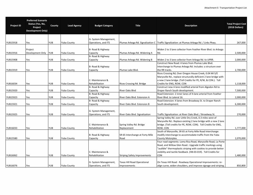
Attachment E‐ Transportation Project List
YUB15918 Yes YUB Yuba CountyG‐ System Management,Operations, and ITS Plumas Arboga Rd. Signalization C Traffic Signalization: at Plumas Arboga Rd. / Links Pkwy. 267,000
YUB15916ProjectDevelopment Only YUB Yuba County
B‐ Road & HighwayCapacity Plumas Arboga Rd. Widening A
Widen 2 to 3 lane collector from Feather River Blvd. to ArbogaRd. 2,500,000
YUB15908 Yes YUB Yuba CountyB‐ Road & HighwayCapacity Plumas Arboga Rd. Widening B Widen 2 to 3 lane collector from Arboga Rd. to UPRR. 2,000,000
YUB15919 Yes YUB Yuba CountyB‐ Road & HighwayCapacity Plumas Lake Blvd.
Construct New Road: 4 lanes from Plumas Lake Blvd.Interchange to Plumas Arboga Rd. Includes: a structure overthe RR tracks. 2,700,000
YUB16034 Yes YUB Yuba CountyC‐ Maintenance &Rehabilitation Rices Crossing Rd. Bridge
Rices Crossing Rd, Over Oregon House Creek, 0.04 MI S/EMarysville Rd., replace structurally deficient 2 lane bridge witha new 2 lane bridge. (Toll Credits for PE, R/W, & CON.). TollCredits for ENG, ROW, CON 1,118,000
YUB15920 Yes YUB Yuba CountyB‐ Road & HighwayCapacity River Oaks Blvd
Construct new 4‐lane modified arterial from Algodon Rd toDraper Ranch South development. 7,500,000
YUB15923 Yes YUB Yuba CountyB‐ Road & HighwayCapacity River Oaks Blvd. Extension A
Road Extension: 2 inner lanes of 4‐lane arterial from FeatherRiver Blvd. to Lateral 16. 2,000,000
YUB15921 Yes YUB Yuba CountyB‐ Road & HighwayCapacity River Oaks Blvd. Extension B
Road Extension: 4 lanes from Broadway St. to Draper RanchSouth development. 6,300,000
YUB15925 Yes YUB Yuba CountyG‐ System Management,Operations, and ITS River Oaks Blvd. Signalization Traffic Signalization: at River Oaks Blvd. / Broadway St. 270,000
YUB16033 Yes YUB Yuba CountyC‐ Maintenance &Rehabilitation
Spring Valley Rd. BridgeReplacement
Spring Valley Rd. over Little Dry Creek, 0.3 miles west ofMarysville Rd.: Replace existing 2 lane bridge with a new 2 lanebridge. (Toll credits for PE, ROW, CON). Toll Credits for ENG,ROW, CON 1,777,000
YUB15580 Yes YUB Yuba CountyB‐ Road & HighwayCapacity
SR 65 Interchange at Forty MileRoad
South of Marysville, SR 65 at Forty Mile Road Interchange:modify interchange to accommodate traffic from the YubaCounty Motorplex. 2,070,000
YUB16062 Yes YUB Yuba CountyC‐ Maintenance &Rehabilitation Striping Safety Improvements
Four road segments: Loma Rica Road, Marysville Road, La PorteRoad, and Willow Glen Road.: Upgrade traffic markings using"audible" thermoplastic striping with cookies to provide bettervisibility and tactile feedback. (H8‐03‐019). Toll Credits forCON 1,480,000
YUB16076 Yes YUB Yuba CountyG‐ System Management,Operations, and ITS
Texas Hill Road OperationalImprovements
On Texas Hill Road ‐ Roadway Operational Improvements: re‐align curve, widen shoulders, and improve signage and striping. 850,800
Project ID
Preferred ScenarioStatus (Yes, No,
ProjectDevelopment Only)
County Lead Agency Budget Category Title DescriptionTotal Project Cost
(2018 Dollars)
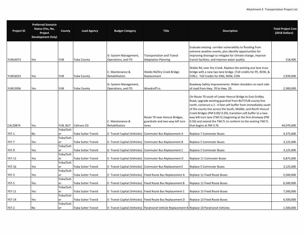
Attachment E‐ Transportation Project List
YUB16073 Yes YUB Yuba CountyG‐ System Management,Operations, and ITS
Transportation and TransitAdaptation Planning
Evaluate existing corridor vulnerability to flooding fromextreme weather events, plus identify opportunities forimproving drainage to mitigate for climate change, improvetransit facilities, and improve water quality. 218,400
YUB16023 Yes YUB Yuba CountyC‐ Maintenance &Rehabilitation
Waldo Rd/Dry Creek BridgeReplacement
Waldo Rd, over Dry Creek. Replace the existing one lane trussbridge with a new two lane bridge. (Toll credits for PE, ROW, &CON.). Toll Credits for ENG, ROW, CON 2,939,000
YUB15956 Yes YUB Yuba CountyG‐ System Management,Operations, and ITS Woodruff Ln.
Roadway Safety Improvements: Widen shoulders on each sideof road from Hwy. 70 to Hwy. 20. 2,300,000
CAL20874 Yes YUB, BUT Caltrans D3C‐ Maintenance &Rehabilitation
Route 70 near Honcut Bridges,guardrails and two‐way left turnlanes
On Route 70 south of Lower Honcut Bridge to East GridleyRoad, upgrade existing guardrail from BUT/YUB county linenorth, construct a 2 ‐ 4 foot soft buffer from immediately southof the county line across the South, Middle, and North HoncutCreek Bridges (PM 0.00/ 0.20), transition soft buffer to a two‐way left‐turn lane (TWLTL) beginning at the first driveway (PM0.50) and extend the TWLTL to conform to the existing TWLTLthat begins at PM 3.76 44,070,000
YST‐1 NoYuba/Sutter Yuba Sutter Transit E‐ Transit Capital (Vehicles) Commuter Bus Replacement A Replace 7 Commuter Buses 4,375,000
YST‐7 YesYuba/Sutter Yuba Sutter Transit E‐ Transit Capital (Vehicles) Commuter Bus Replacement B Replace 5 Commuter Buses 3,125,000
YST‐9 YesYuba/Sutter Yuba Sutter Transit E‐ Transit Capital (Vehicles) Commuter Bus Replacement C Replace 5 Commuter Buses 3,125,000
YST‐12 YesYuba/Sutter Yuba Sutter Transit E‐ Transit Capital (Vehicles) Commuter Bus Replacement D Replace 11 Commuter Buses 6,875,000
YST‐16 YesYuba/Sutter Yuba Sutter Transit E‐ Transit Capital (Vehicles) Commuter Bus Replacement E Replace 5 Commuter Buses 3,125,000
YST‐3 YesYuba/Sutter Yuba Sutter Transit E‐ Transit Capital (Vehicles) Fixed Route Bus Replacement A Replace 11 Fixed Route Buses 5,500,000
YST‐5 YesYuba/Sutter Yuba Sutter Transit E‐ Transit Capital (Vehicles) Fixed Route Bus Replacement B Replace 11 Fixed Route Buses 6,500,000
YST‐11 YesYuba/Sutter Yuba Sutter Transit E‐ Transit Capital (Vehicles) Fixed Route Bus Replacement C Replace 15 Fixed Route Buses 7,500,000
YST‐14 YesYuba/Sutter Yuba Sutter Transit E‐ Transit Capital (Vehicles) Fixed Route Bus Replacement D Replace 13 Fixed Route Buses 6,500,000
YST‐2 NoYuba/Sutter Yuba Sutter Transit E‐ Transit Capital (Vehicles) Paratransit Vehicle Replacement B Replace 10 Paratransit Vehicles 1,500,000
Project ID
Preferred ScenarioStatus (Yes, No,
ProjectDevelopment Only)
County Lead Agency Budget Category Title DescriptionTotal Project Cost
(2018 Dollars)

Attachment E‐ Transportation Project List
YST‐4 YesYuba/Sutter Yuba Sutter Transit E‐ Transit Capital (Vehicles) Paratransit Vehicle Replacement C Replace 7 Paratransit Vehicles 1,050,000
YST‐6 YesYuba/Sutter Yuba Sutter Transit E‐ Transit Capital (Vehicles)
Paratransit Vehicle ReplacementD Replace 10 Paratransit Vehicles 1,500,000
YST‐10 YesYuba/Sutter Yuba Sutter Transit E‐ Transit Capital (Vehicles) Paratransit Vehicle Replacement E Replace 10 Paratransit Vehicles 150,000
YST‐13 YesYuba/Sutter Yuba Sutter Transit E‐ Transit Capital (Vehicles) Paratransit Vehicle Replacement F Replace 10 Paratransit Vehicles 1,500,000
YST‐15 YesYuba/Sutter Yuba Sutter Transit E‐ Transit Capital (Vehicles)
Paratransit Vehicle ReplacementG Replace 10 Paratransit Vehicles 1,500,000
YST‐8 YesYuba/Sutter Yuba Sutter Transit E‐ Transit Capital (Major) Replace Bus Facility #10424 Replace Current Bus Facility 25,000,000
YOL19419‐A Yes City of WoodlandB‐ Road & HighwayCapacity CR 25A widening
Widen CR 25A from East Street to the southbound rampterminal intersection from 2 lanes to 4 lanes 2,000,000
RT‐2 YesSacramento RegionalTransit District E‐ Transit Capital (Major)
Electric Bus ChargingInfrastructure
Add new electric bus charging infrastructure to be used tocharge both fixed route and microtransit zero emissionvehicles. 7,000,000
REG18049 YesSacramento RegionalTransit District E‐ Transit Capital (Vehicles) Expansion ZEBs for Airport Service
Ten (10) Zero Emission Buses (ZEBs) and associated chargers tobe used in new public transit service between DowntownSacramento and Sacramento International Airport. 11,519,854
RT‐3 YesSacramento RegionalTransit District E‐ Transit Capital (Major)
General Facilities Maintenanceand Improvements
General maintenance of facilities throughtou the district,including LR maintenance faciliites, Bus maintenance facilities,administrative buidlings, Customer Service building, etc. 3,625,000
RT‐1 YesSacramento RegionalTransit District E‐ Transit Capital (Major)
Light Rail Low Floor StationConversions ‐ Blue & Green Lines
For the 19 light rail stations along the Blue and Green Linesthat are not already low‐floor compatibble, design andconstruct improvements to convert stations to accommodatefuture low‐floor vehicles. 36,150,000
REG18048 YesSacramento RegionalTransit District E‐ Transit Capital (Major)
Light Rail Low Floor StationConversions ‐ Gold Line
For the 29 light rail stations along the Gold Line, design andconstruct improvements to convert stations to accommodatefuture low‐floor vehicles. 50,100,000
SAC24881 YesSacramento RegionalTransit District E‐ Transit Capital (Vehicles)
Neighborhood Ride VehicleReplacement Neighborhood Ride Vehicle Replacement 4,400,000
Project ID
Preferred ScenarioStatus (Yes, No,
ProjectDevelopment Only)
County Lead Agency Budget Category Title DescriptionTotal Project Cost
(2018 Dollars)

Attachment F- Roadway Pricing Strategies
Sacramento Area Council of Governments
8
2
9
Pricing Strategies that will be included in the MTP/SCS:
Express Lanes:
Express Lanes may be free to carpools and buses, but allow single drivers the choice to pay for the use of the lanes. The purpose of these lanes is to improve traffic management, reliability, and even throughput of the region’s major freeways. Potential corridors include U.S. Route 50, Interstates 80 and 5, and State Routes 51 (Capital City Freeway), 99, and 65. Express lane concepts may include single, high-occupancy toll lanes or multilane configurations that add lanes or re-purpose existing lanes or shoulders. Tolls for the lanes can vary based on traffic levels and time of day.
Pay as you go or mileage-based fees:
Mileage-based or pay as you go fees charge roadway users based on the miles they travel on public roadways, rather than on the amount of fuel they purchase. Fees that are lower during off-peak hours or in less congested rural areas may be considered to manage the transportation network efficiently and promote geographic equity.
Parameters for roadway pricing strategies in the MTP/SCS:
1. Pricing strategies should be sensitive to changes in roadway demand during different parts of the day
(peak/off-peak) with the objective of managing demand and providing travel choice.
2. Mileage-based/pay as you go fees would replace, not be on top of, existing state fuel taxes.
3. Assumptions for a new mileage-based/pay as you go fee should not increase the average cost of driving
above what SACOG adopted as future travel costs in the previous two MTP/SCS plans.
4. Every effort should be made not to negatively impact lower income and rural households through pricing
strategies.
MTP/SCS assumptions about the use of revenues from roadway pricing:
1. Revenues generated through express lanes/pay as you go fees must be committed to transportation
investments only.
2. The priority, for planning purposes, of revenues generated through express lanes is to help build and
maintain the priced facility. Additional revenues could help fund transit, vanpool and shared ride
investments in the corridor and mitigate potential impacts to local streets along the corridor.
3. The priority, for planning purposes, of revenues generated through mileage-based/pay as you go fees
above those generated by the current state fuel tax, is to help bring the region’s roadways and transit
system up to a state of good repair.
Steps SACOG will take as part of and following adoption of the MTP/SCS to further analyze and implement
roadway pricing:
1. Develop specific policies and an action plan to implement pricing by 2035 in the region including
identification of partner agencies.
2. Pursue opportunities to pilot creative road pricing concepts in partnership with federal, state and local
agencies that are responsible for building and maintaining the transportation system.

Attachment G- Preferred Scenario Measures and Performance
Performance Metric 2016 Baseline
PreferredScenario
Change (2016-2040)
PreferredScenario by
2040Notes
Land
Use
Pat
tern
Share of homes in Center & CorridorCommunities
113,470 +86,650 200,120 Includes growth in a variety of communities throughoutthe region to provide residents with choices on where tolive and work. The land use forecast assumes 64 percentof new homes will occur in infill areas, which arecharacterized in the MTP/SCS as EstablishedCommunities and Center and Corridor Communities. By2040, the Preferred Scenario forecasts that morehomes, 18 percent of all homes compared to 12 percentin 2016, will be in Center & Corridor Communties whereresidents access to the greatest mix of amenities, jobs,and transportation options.
(percent of total homes in region) 12% 33% 18%
Share of homes in Established Communities 711,480 +81,140 792,620
(percent of total homes in region) 77% 31% 70%
Share of homes in Developing Communities 12,150 +89,540 101,690
(percent of total homes in region) 2% 34% 9%
Share of homes in Rural ResidentialCommunities
30,280 +2,790 33,070
(percent of total homes in region) 8% 1% 3%
Total Homes 867,380 260,120 1,127,500
Hous
ing
Mix
Share of homes in rural residential and large-lot single-family homes
553,334 +68,580 621,914The region has a majority of its homes today in large-lot,single-family products (60 percent in 2016). ThePreferred Scenario plans to provide a greater diversityof homes for future residents by increasing the numberof small-lot and attached housing available throughoutthe region. To achieve more housing choices by 2040,the Preferred Scenario forecasts 74 percent of newhomes over the next 20 years to be small-lot orattached products.
(percent of total homes in region) 60% 26% 53%
Share of homes in small-lot single-family orattached homes
367,807 +191,550 559,357
(percent of total homes in region) 40% 74% 47%

Attachment G- Preferred Scenario Measures and PerformanceAc
cess
to E
mpl
oym
ent A
ctiv
ities
Jobs within 30-minute drive of homes 381,100 +69,200 450,300
Access, in this instance, means the number of activitiesa person can reach within a given travel time and mode.Improved access to jobs correlates strongly with lowervehicle miles traveled. Access can be increased in twoways: 1) improving travel speeds, and increasing thearea one can reach within 30 minutes; 2) putting moreactivities closer to homes through more focused growth.The Preferred Scenario affects both, through more infilland compact development, reduction of congestion onkey corridors for drivers, and improvements to transitservice to reduce transit travel times.
The Preferred Scenario also greatly improves access tojobs from environmental justice areas. EnvironmentalJustice areas are places in region with concentrations oflower income and/or minority residents, single-parenthouseholds, elderly residents, non-English speakingresidents, residents with less than highschool degrees,and disabled residents.
Jobs within 30-minute transit of homes 4,650 +10,250 14,900
Jobs within 30-minute drive of homes inenvironmental justice areas
429,250 +90,800 520,050
Jobs within 30-minute transit of homes inenvironmental justice areas
5,910 +13,600 19,510
Average vehicle miles traveled per workerto jobs centers
17.5 n/a 15.7
Average VMT per worker to jobs centers captures bothtrip length and mode of travel. Average VMT perworker can be reduced by shortening the commute, orby shifting more travel into non-vehicle modes likebiking or walking. The Preferred Scenario affects both--shortening commutes by improving jobs-housing ratios,and enhancing non-vehicle and transit modes to jobscenters.
Performance Metric 2016 Baseline
PreferredScenario
Change (2016-2040)
PreferredScenario by
2040Notes

Attachment G- Preferred Scenario Measures and PerformanceRo
ad &
Hig
hway
Sys
tem
New or Expanded Major Road Lane Miles 8,320 +1,070 9,390
Increase in lane miles of major roads and highways byabout 13 percent compared to 2016. More than two-thirds of this increase is on existing facilities and phasedto add capacity as housing and employment growthoccur. The Preferred Scenario does not includesignificant road and highway expansion for growth thatis anticipated to happen beyond the 20 year period ofthe plan, but might eventually be needed toaccomodate local general plans.
Tran
sit S
yste
m
Transit Weekday Service Hours 4,000 +4,400 8,400 Doubles transit service hours by 2040 compared to2016. This service increase comes primarily fromcommuter and fixed-route buses, with a smallerincrement coming from light rail. The transit network inthe Preferred Scenario emphasizes increasedfrequencies on productive transit routes near homes toprovide faster access to jobs and job centers. Thenumbers of homes and jobs near high-frequency transitservice, with vehicles coming every 15 minutes or morefrequently, more than double by 2040.
Total number of homes near high-frequencytransit3 148,472 +296,330 444,802
(share of all homes near high-frequencytransit)
16% n/a 38%
Total number of jobs near high-frequencytransit3 327,911 +321,037 648,948
(share of all jobs near high-frequencytransit)
31% n/a 49%
Performance Metric 2016 Baseline
PreferredScenario
Change (2016-2040)
PreferredScenario by
2040Notes

Attachment G- Preferred Scenario Measures and PerformanceTr
avel
Cho
ice
and
Traf
fic
Share of commute trips by transit, bike orwalk to jobs centers
12% n/a 15%Provides more opportunities for residents to choose totravel by transit, biking, or walking. This is madepossible by developing in a way that allows people tolive closer to jobs and amenitites and investing intransit, bicycle and pedestrian infrastructure, andprograms to encourage options that do not rely ondriving.
Mode share for transit, walking andbicycling(percent of all trips)
12% n/a 13%
Percent of total vehicle miles traveled inheavy congestion
6.4% n/a 5.6%
Reduces the amount of travel on heavily congestedroadways by 2040 in three ways; 1) targeting capacityinvestments where traffic bottlenecks occur; 2)providing options to take non-driving modes andreducing vehicle demand during peak travel hours; and3) providing express lanes in some congested corridors,allowing more travelers access to less congestedfacilities.
Gre
enho
use
Gas
Em
issi
ons
Weekday passenger vehicle CO2 emissions(percent change per capita from 2005)
n/a n/a -18% to -19%
The assumptions and indicators described above offerthe best path to achieving the 19 percent per capitagreenhouse gas reduction target assigned to SACOG bythe California Air Resources Board
Performance Metric 2016 Baseline
PreferredScenario
Change (2016-2040)
PreferredScenario by
2040Notes