Biodiversity Impact assessment if the project involves 50 ha of ...
67
Biodiversity Impact assessment if the project involves 50 ha of NP /WLS area The project is located outside the protected area . The nearest well Location from Sakkarkotai Bird Sanctuary is W8 which is at a distance of 0.4km, and from Theeretengal Bird Sanctuary W17 is 7.52 km & Gulf of Mannar National Park is W2 at a distance of 6.5km. Hence this point is not applicable . However we have proposed a Wildlife Management Plan
-
Upload
khangminh22 -
Category
Documents
-
view
0 -
download
0
Transcript of Biodiversity Impact assessment if the project involves 50 ha of ...

Biodiversity Impact assessment if the project involves 50 ha of NP /WLS area
The project is located outside the protected area . The nearest well Location from
Sakkarkotai Bird Sanctuary is W8 which is at a distance of 0.4km, and from Theeretengal
Bird Sanctuary W17 is 7.52 km & Gulf of Mannar National Park is W2 at a distance of
6.5km.
Hence this point is not applicable .
However we have proposed a Wildlife Management Plan

Wildlife Management Plan
for Exploratory Drilling, at
Ramanathpuram Onshore
PML, Ramanathpuram
District, Tamil Nadu
Wildlife Management Plan
Prepared for:
Oil and Natural Gas Corporation Limited
Prepared by:
SENES Consultants India Pvt. Ltd.
January, 2015


Contents
1 Introduction ....................................................................................................................1
1.1 Block Details .................................................................................................................. 1
1.2 Objective ........................................................................................................................ 2
1.3 Scope of the Wildlife Management Plan ....................................................................... 2
1.3.1 Study Area ........................................................................................................... 2
1.3.2 Approach of the Study ......................................................................................... 2
2 Regulatory Framework ..................................................................................................3
2.1 National Forest Policy 1998 .......................................................................................... 3
2.2 Forest Conservation Act, 1980 (amended in 1988) ....................................................... 3
2.3 The Wildlife Protection (WLP) Act 1972(as amended in 2002 and 2006) ................... 3
2.3.1 Eco-Sensitive Zone Demarcation under Environment Protection Act ................ 3
3 Project Details ................................................................................................................4
3.1 Introduction .................................................................................................................... 4
3.2 Location of Proposed Exploratory Wells ....................................................................... 4
3.3 Accessibility ................................................................................................................... 7
3.4 Development Drilling .................................................................................................... 7
3.4.1 Land ..................................................................................................................... 7
3.4.2 Project Activities & Schedule .............................................................................. 7
3.4.3 Drill Site & Access Road Development .............................................................. 7
3.4.4 Drilling & Testing ................................................................................................ 8
3.4.5 General Requirements of Drilling ...................................................................... 10
3.5 Waste & Disposal ........................................................................................................ 11
3.5.1 Solid and Hazardous Waste Streams ................................................................. 11
3.5.2 Liquid wastes ..................................................................................................... 12
3.5.3 Drilling Hazards ................................................................................................. 13
3.6 Project Investment ....................................................................................................... 13
4 Description of Wildlife Habitat & Wildlife .................................................................14
4.1 Wildlife Habitat ........................................................................................................... 14
4.1.1 Forest Habitat ..................................................................................................... 14
4.1.2 Inland Wetland Habitats .................................................................................... 14
4.1.3 Coastal and Marine Habitat ............................................................................... 15
4.2 Sensitive Ecological Habitat ........................................................................................ 15
4.2.1 Birds Sanctuary .................................................................................................. 15

4.2.2 Gulf of Mannar Marine National Park ............................................................... 18
4.3 Marine Ecosystem: Gulf of Mannar ............................................................................ 21
4.3.1 Off shore islands and coral reefs ........................................................................ 21
4.3.2 Mangrove Habitat .............................................................................................. 22
4.3.3 Sea Grass & Sea-weed habitat ........................................................................... 23
4.4 Biodiversity Profile of Study Area .............................................................................. 24
4.4.1 Vegetation in the ML area ................................................................................. 24
4.4.2 Faunal Diversity in ML area .............................................................................. 25
4.4.3 Biodiversity Profile in GOMMNP ..................................................................... 25
4.4.4 Biodiversity Profile in Palk Bay ........................................................................ 29
5 Potential Impacts on Habitat & Wildlife .....................................................................30
5.1 Potential Impact of Site Preparation on Wildlife Habitat and Wildlife ....................... 30
5.1.1 Vegetation Clearance ......................................................................................... 30
5.1.2 Sourcing of Fill Material .................................................................................... 30
5.1.3 Transport of Construction Material ................................................................... 30
5.1.4 Surface Runoff ................................................................................................... 30
5.2 Potential Impact of Operation of Drilling Rig on Wildlife Habitat & Wildlife........... 31
5.2.1 Noise .................................................................................................................. 31
5.3 Potential Impact of Illumination on Wildlife ............................................................... 31
5.4 Potential Impact of Disposal of Waste on Wildlife Habitat and Wildlife ................... 32
5.4.1 Disposal of solid waste ...................................................................................... 32
5.4.2 Discharge of waste water ................................................................................... 32
5.5 Surface Runoff ............................................................................................................. 32
5.6 Oil Spill Impact on Ecosystem and Biodiversity ......................................................... 33
6 Wildlife Mitigation & Management Plan ....................................................................34
6.1 Noise and Vibration Control Plan ................................................................................ 34
6.2 Waste Management Plan ............................................................................................. 35
6.3 Spill Management ........................................................................................................ 40
6.4 Storm Water Management Plan ................................................................................... 40
6.5 Flare & Illumination Reduction Plan ........................................................................... 42
6.6 Oil Spill Management Plan .......................................................................................... 42
6.7 Wildlife Management Cell ........................................................................................... 43
6.8 Employee Education and Awareness ........................................................................... 43
6.9 Responsibility .............................................................................................................. 43

6.9.1 Capacity Building .............................................................................................. 44
6.9.2 Monitoring and Auditing ................................................................................... 44
6.9.3 Reporting and Review........................................................................................ 45
6.9.4 Financial Allocation ........................................................................................... 45
List of Tables
Table 3.1: Location of Drill Sites and GGS ...............................................................................4
Table 3.2: Waste Streams and Disposal ...................................................................................11
Table 3.3: Liquid Wastes Generated during Drilling and their Disposal ................................13
Table 4.1: Birds Sanctuaries in the Ramanathapuram District ................................................16
Annexure 1.1: Approved ToR for EIA Study ..........................................................................47
Annexure 4.1: Checklist of Plant Species in Ramanathapuram ML Area ...............................51
Annexure 4.2: Checklist of Birds in Study Area .....................................................................53
List of Figures
Figure 3.1: ML and Drill Sites Location Map on Toposheet .....................................................6
Figure 4.1: Bird Sanctuaries in Ramanathapuram District ......................................................17
Figure 4.2: Gulf of Mannar ......................................................................................................18
Figure 4.3: Ecological Sensitivity Map ...................................................................................20
Figure 4.4: Turtle Nesting Sites in Palk Bay and Gulf of Mannar ..........................................28
Figure 6-1: Environment Management Measures at Drill Site ................................................39
List of Annexure
Annexure 1.1: Approved ToR for EIA Study ..........................................................................47
Annexure 4.1: Checklist of Plant Species in Ramanathapuram ML Area ...............................51
Annexure 4.2: Checklist of Birds in Study Area .....................................................................53

The page has been intentionally left blank

Wildlife Management Plan for Exploratory Wells in Ramanathapuram PML
SENES/H-ESM-20084 1 ONGC
1 Introduction
The Ramanathapuram ML area (493.21 sq. km) is located in Ramanathapuram, district of
Tamil Nadu, in the southern part of India (Figure 1.1). The exploratory block lies between
Latitude 9°29'12.05'' to 9°19'1.63'' N and Longitude 78°53'54.25'' to 78°40'15.01'' E. The
Block is bounded in the north by Paramkudi and Nayinar Kovil, in south by Gulf of Mannar,
in the east by Palk Bay and in the west by Uttarkosamangi and Sikkal.
MoPNG, GOI, vide O.O F.No 12012/52/2003-ONG-II has approved Mining license for
Ramanathapuram PML (493.21SKM) for a period of seven years with effect from the date of
grant by Government of Tamil Nadu. Application for grant of PML has been submitted to
Government of Tamil Nadu.
Gas is being produced commercially from Upper Cretaceous reservoirs by ONGC in
Ramanathapuram district from Kanjirangudi (KJ), Periyapattinam (PP), Ramanavalasi (RV),
Perungulam (PE) & Palk bay Shallow (PBS) fields from the established reserve base of about
29.75 MMt (O+OEG) IIP.
1.1 BLOCK DETAILS
Ramanathapuram PML is in Ramnad sub-basin which is in the southern part of Cauvery
Basin. Ramnad sub-basin and its continuation into Palk Bay-Gulf of Mannar is bounded in
the northwest by Pattukottai-Mannargudi ridge and in the southeast by Mandapam-Delft
ridge. The sub basin holds sediments over 6000 m in thickness, ranging in age from Lower
Cretaceous and older(?) to Recent. The synrift sedimentary column comprises mainly of
shale and sandstone in the Andimadam Formation. Sag phase sedimentation represented in
the upper Cretaceous Bhuvanagiri, Kudavasal Shale, Nannilam and Portonovo shale is
predominantly sand shale alternations with minor limestone development.
The hydrocarbon potential of Upper Cretaceous reservoirs ranging in age from Turonian to
Campanian (Bhuvanagiri & Nannilam formations) is well established while the efforts to
establish hydrocarbon prospectivity of Lower Cretaceous & older sequences are still at the
nascent stage. About 55 exploratory & development wells were drilled in Ramanathapuram
PML, out of which 29 are gas bearing in Nannilam, Bhuvanagiri and Lower Kamalapuram
formations. The Lower Cretaceous being the source rocks, there is a fair chance of
hydrocarbon accumulation in these sequences at favourable places.
Based on detailed G&G studies, 22 prospects have been identified in Ramanathapuram PML
area to test the prospectivity of Nannilam, Bhuvanagiri and Andimadam formations. Twenty
two wells are planned to be drilled in the area demarcated by the ML boundary of
Ramanathapuram PML.
ONGC had already received approved Terms of Reference (ToR) from MoEF vide F.No. J-
11011/207/2013-IA II (I) dated 5th November 2013 for conducting EIA study (Annexure
1.1).

Wildlife Management Plan for Exploratory Wells in Ramanathapuram PML
SENES/H-ESM-20084 2 ONGC
1.2 OBJECTIVE
The purpose of the Wildlife Management Plan is to ensure that the effects of the Oil and Gas
development on wildlife and wildlife habitats within the project area are minimized. As a part
of that, the Wildlife Management Plan provides the guidelines aimed at preventing,
minimizing or mitigating potential adverse impacts of the project on wildlife and wildlife
habitat.
1.3 SCOPE OF THE WILDLIFE MANAGEMENT PLAN
1.3.1 Study Area
A study area is the entire ML area and nearby ecologically sensitive area i.e. Gulf of Mannar
Marine National Park and Biosphere Reserve. This delineation has been done based on the
nature of the project and also after gaining understanding of the surrounding areas through
the initial reconnaissance surveys.
1.3.2 Approach of the Study
The study involves the systematic process of identifying, predicting and evaluating the
potential impacts on wildlife and wildlife habitat resulting from the proposed oil and gas
activity. Our approach to the wildlife study for the proposed oil and gas activity will be
largely based upon the project related information from project feasibility report (PFR), study
of wildlife management plan, study of various research reports, stakeholder consultations and
interpretation of Toposheet and Satellite imagery. Based on the results of the review, primary
study, consultations, the wildlife management Plan has been prepared. The wildlife
management Plan may be altered to better protect local wildlife and wildlife habitat;
therefore, is not a static design but will continuously evolve based on the results of future
data collection as well as input from the authority.

Wildlife Management Plan for Exploratory Wells in Ramanathapuram PML
SENES/H-ESM-20084 3 ONGC
2 Regulatory Framework
2.1 NATIONAL FOREST POLICY 1998
One of the basic objectives of the forest policy is to safeguard forest land or land with tree
cover for providing sustained benefits to the entire community. The policy does allow
diversion of forest land for any non-forestry purpose but subject to the most careful
examinations by specialists from the standpoint of social and environmental costs and
benefits. Projects which involve such diversion should at least provide in their investment
budget, funds for regeneration/compensatory afforestation.
2.2 FOREST CONSERVATION ACT, 1980 (AMENDED IN 1988)
The act deals with regulatory framework for the protection of the forest areas, resources,
diversion of forestry land for non-forestry purposes. The Act requires the state government in
question to get approval from the central government before de-gazetting or de-notifying
reserved forests, leasing reserved forest lands to private persons or corporations or clearing
land for reforestation.
The proposed exploratory wells would not involve any forest land. Therefore diversion of
forest land would not require for this project.
2.3 THE WILDLIFE PROTECTION (WLP) ACT 1972(AS AMENDED IN 2002 AND 2006)
The Wildlife Protection Act, 1972, provides for protection to listed species of flora and fauna
and establishes a network of ecologically-important protected areas. There is a blanket ban on
carrying out any industrial activity inside these protected areas. In case forest land within the
protected areas network is to be diverted for any non-wildlife use, a no objection has to be
obtained from the Indian Board of Wildlife and the State Legislature, before the final
consideration by MoEF.
The WLPA provides for protection of species listed in Schedules I, II, III and IV, regardless
of its location, and the protection of all species in designated protected areas.
The proposed activity, i.e. all the exploratory wells is not falling in the Gulf of Mannar
Marine National Park.
2.3.1 Eco-Sensitive Zone Demarcation under Environment Protection Act
The State Govt./Union Territory is responsible to declaring the ESZ around National Park,
Wildlife Sanctuary. After declaring the ESZ, State Govt. has to prepare master plan to
prohibit/regulate/permit activities within the ESZ. In case where ESZ was not notified an area
of 10 km surrounding the protected area will be treated as eco-sensitive zone. Government of
Tamil Nadu has not notified the eco-sensitive for Gulf of Mannar Marine National Park
(GOMMNP); therefore, the 10 km around the national park will be treated as ESZ. 6 wells
(W1, W2, W3, W6, W21 and W22) are located within 10 km of the Gulf of Mannar Marine
National Park. ONGC will prepare the wildlife management plan and would take approval
from Standing Committee of National Board of Wildlife (NBWL).

Wildlife Management Plan for Exploratory Wells in Ramanathapuram PML
SENES/H-ESM-20084 4 ONGC
3 Project Details
3.1 INTRODUCTION
ONGC have drilled about 55 exploratory & development wells in Ramanathapuram PML,
out of which 29 are gas bearing in Nannilam, Bhuvanagiri and Lower Kamalapuram
formations. ONGC now planned to drill 22 exploratory wells in Ramanathapurma ML area.
3.2 LOCATION OF PROPOSED EXPLORATORY WELLS
The proposed 22 exploratory wells are located in the Ramanathapuram district of Tamil
Nadu. The coordinates of these sites is presented in Table 3.1.
TABLE 3.1: LOCATION OF DRILL SITES AND GGS
S.No Well No Approximate of
Final Location
distance from
Gulf Of
Mannar
Marine
National Park
Approximate
distance of Final
Location from
Therthangali
Bird Sanctuary
Approximate
distance of Final
Location from
Sakkarkottai
Bird Sanctuary
1 W1 9°16'41.67"N 78°49'7.38"E 8.7km >10km 6.1km
2 W2 9°16'40.92"N 78°54'27.78"E 6.5km >10km 9.6km
3 W3* 9°18'14.01"N 78°55'11.24"E 9.01km >10km 9.4km
4 W4* 9°22'4.77"N 78°56'16.44"E >10km >10km >10km
5 W5 9°17'28.10"N 78°47'16.90"E >10km >10km 5.0km
6 W6 9°14'37.67"N 78°43'27.85"E 8.11km >10km >10km
7 W7* 9°17'21.03"N 78°47'3.10"E >10km >10km 5.1km
8 W8* 9°21'3.47"N 78°48'15.16"E >10km >10km 0.4km
9 W9 9°18'34.43"N 78°47'48.74"E >10km >10km 2.9km
10 W10 9°18'44.24"N 78°44'24.88"E >10km >10km 5.5km
11 W11 9°18'55.57"N 78°49'49.55"E >10km >10km 2.4km
12 W12 9°20'14.98"N 78°52'24.98"E >10km >10km 3.5km
13 W13 9°21'16.79"N 78°52'3.12"E >10km >10km 2.6km
14 W14* 9°24'17.54"N 78°52'7.16"E >10km >10km 6.20km
15 W15* 9°26'51.62"N 78°53'45.86"E >10km >10km >10km
16 W16 9°27'10.58"N 78°53'1.76"E >10km >10km >10km
17 W17 9°28'25.26"N 78°51'41.43"E >10km 7.52km >10km
18 W18 9°24'39.49"N 78°55'19.31"E >10km >10km >10km
19 W19* 9°19'15.25"N 78°58'33.01"E >10km >10km >10km
20 W20* 9°18'46.69"N 78°59'31.12"E >10km >10km >10km

Wildlife Management Plan for Exploratory Wells in Ramanathapuram PML
SENES/H-ESM-20084 5 ONGC
21 W21* 9°18'21.96"N 79° 2'32.24"E 8.9km >10km >10km
22 W22 9°17'31.38"N 79° 4'18.14"E 6.74km >10km >10km
[9 WELL LOCATIONS MARKED WITH (*) WERE CHANGED FROM THEIR PREVIOUS LOCATION]
The proposed wells are not located within the Gulf of Mannar Marine National Park,
however, 6 wells (W1, W2, W3, W6, W21 and W22) are located within 10 km of the
National Park.
The proposed wells are not located within the Gulf of Sakkarkottai Bird Sanctuary,
however, 12 wells (W1, W2, W3, W5, W7, W8, W9, W10, W11, W12, W13 and W14)
are located within 10 km of the Bird Sanctuary.
The proposed wells are not located within the Gulf of Therthangali Bird Sanctuary,
however, 1 wells (W17) are located within 10 km of the Bird Sanctuary.
The well location map is presented in Figure 3.1.

Wildlife Management Plan for Exploratory Wells in Ramanathapuram PML
SENES/H-ESM-20084 6 ONGC
FIGURE 3.1: ML AND DRILL SITES LOCATION MAP ON TOPOSHEET
Wildlife Management Plan for Exploratory Wells in Ramanathapuram PML
SENES/H-ESM-20084 7 ONGC
3.3 ACCESSIBILITY
The proposed drill sites falls within Ramanathapur district of Tamil Nadu and well connected
with other districts of Tamil Nadu through NH-49 and NH 210. Ramanathapuram is also wel
connected through railway. Madurai Airport is the nearest airport located at distance of 125
km from Ramanathapurm. The ML area is well connected with MDR.
3.4 DEVELOPMENT DRILLING
3.4.1 Land
All the proposed drill sites are located in non-forest land mostly privately owned. About 2.5
hectares (approx) of land for each drilling will be taken on short-term lease from land
owners. No forest land is involved for the proposed drilling wells.
3.4.2 Project Activities & Schedule
The drilling for the ONGC project is planned to commence during 2015 with an estimated
drilling period of 40-50 days, testing period of 15 days and a possible additional contingency
period of 15 days per well. Site preparation and construction is estimated to take about 2
months with another one month being allotted for decommissioning and site closure.
3.4.3 Drill Site & Access Road Development
Access Road Development
Site preparation will involve all activities required to facilitate the operation of the drilling rig
and associated equipments and machineries. Most of the drill sites is connected with existing
road network, if required new approach road will be constructed/widen by a contractor
appointed by ONGC. It will be ensured that the land fill material and gravel for this purpose
is obtained from government approved borrow areas and quarries.
Site Development
Once the approach road to the site is developed, the drilling site will be elevated to a required
height. The top soil which primarily comprises of 150 mm loose top soil will be removed
using mechanical means like dozer and saved at a nearby place for later use during site
restoration. Leveling and compaction will be done with the help of graders and mechanical
rollers. Earth and fill material and rubble will be required for land filling and site preparation.
All such materials will be procured from government approved borrows and quarries. A
backhoe will be used for all excavation and cutting activities (for construction of pits) on site.
Subsequently, the proposed well site & campsite will be duly fenced using chain link and
barbed wires.
Disposal of drilling waste in the form of spent drilling mud and cuttings will be disposed on-
site in specially designed pits provided with an impervious HDPE liner of 1-1.5 mm
thickness. There will be a cuttings pit of 28m X 24m for disposal of drill cuttings and two
waste pits of 17m X 12m for disposal of drilling mud and rig wash water.

Wildlife Management Plan for Exploratory Wells in Ramanathapuram PML
SENES/H-ESM-20084 8 ONGC
Platforms for drill pad and all other heavy equipment systems or machinery, cast in-situ
Reinforced Cement Concrete (RCC) will be used for the construction of foundation system.
The rig foundation will be of size 20m X 20m and will have an elevation 0.6 m from rest of
the site. For making the foundations of main rig structure cast in-situ bored under- reamed
piles of specified lengths will also be used. The elevated structures will have proper storm
water drains with sufficient gradient, made of brick masonry, to take care of surface runoff
water.
Transportation of Rig & Machineries
The transport of the Rig including auxiliary equipments & Camp facilities to the site is
expected to comprise around 100 truck loads. Though the rig and related equipments will be
directly brought to site, spares, chemicals and other materials will be received at the staging
point and will be used for intermediate storage of materials. The rig equipment will however
be transported directly to the drilling site during mobilisation and will be de-mobilised
directly from the site. The materials will be intermittently supplied from warehouse to the
drilling site, during the operations with some stock at the drilling site itself.
Given the sensitivity of the site from the noise emission viewpoint, it has been decided that
all construction activities and transportation of goods and equipments related to such
activities will be restricted to the extent possible to day time.
3.4.4 Drilling & Testing
Drilling operations will be carried out using an Onshore Mobile Drilling unit. The major
components of drilling unit are Hoisting system, Rotating Equipment, Circulating System,
Tubular Goods, Pressure Control, Derrick and Substructure.
The hoisting system consists of draw works an assembly of a rotating drum, a series of shafts,
clutches, chains and gears for changing speed and for reversing. A crown block located at top
of derrick. The crown block provides a means of taking the drilling line from the hoisting
drum to the traveling block. The crown block is stationary and is firmly fastened to the top of
the derrick. The Hook connects the Kelly or top drive (top drive is equivalent to Kelly &
rotary table) with the traveling block.
A Kelly drive refers to a type of well drilling device on an oil or gas drilling rig that employs
a section of pipe with a polygonal (three-, four-, six-, or eight-sided) or splinted outer surface,
which passes through the matching polygonal or splinted kelly bushing and rotary table. This
bushing is rotated via the rotary table and thus the pipe and the attached drill string turn while
the polygonal pipe is free to slide vertically in the bushing as the bit digs the well deeper.
When drilling, the drill bit is attached at the end of the drill string and thus the kelly drive
provides the means to turn the bit.
The Kelly is the polygonal tubing and the Kelly bushing is the mechanical device that turns
the Kelly when rotated by the rotary table. Together they are referred to as a Kelly drive. The
upper end of the Kelly is screwed into the swivel, using a left-hand thread to preclude
loosening from the right-hand torque applied below. The Kelly typically is about 10 ft (3 m)

Wildlife Management Plan for Exploratory Wells in Ramanathapuram PML
SENES/H-ESM-20084 9 ONGC
longer than the drill pipe segments, thus leaving a portion of newly drilled hole open below
the bit after a new length of pipe has been added and the drill string has been lowered until
the Kelly bushing engages again in the rotary table.
The rotary table receives the power to drive it from an electric motor. The electric motor
rotates the rotary table which passes through the Kelly bushing and the rotations are
transmitted to the bit as the drilling progresses, the drill pipe in singles are added to continue
the drilling process. At the end of the bit life, the drill pipes are pulled out in stands and
stacked on the derrick platform. A stand normally has 3 single drill pipes. After changing the
bit, the drill string is run back into the hole and further drilling is continued. This process
continues till the target depth is reached.
Mud System & Cuttings
During the course of drilling, cuttings are generated due to crushing action of the bit. These
cuttings are removed by flushing the well with duplex/triplex mud pumps. The mud from the
pump discharge through the rotary hose connected to stationary part of the swivel, the drill
string and bit nozzles. The mud coming out of the bit nozzles pushes the cuttings up hole and
transports them to the surface through the annular space between the drill string and the hole.
The mud not only carries away crushed rock from the bottom of the hole but it also cools the
bit as it gets heated due to friction with formation while rotating. The mud also helps in
balancing subsurface formation pressures and by forming a cake on the walls of the well
diminishes the possibility of crumbling or caving of the well bore.
At the surface, the mud coming out from well along with the cuttings falls in a trough, passes
through the solids control equipments i.e. shale shaker, de-sander and de-silter. These
equipments remove the solids of different sizes which get mixed with the mud during the
course of drilling. The cleaned mud flows back to the suction tanks to be again pumped into
the well. The drilling mud/fluid circulation is thus a continuous cyclic operation. The most
suitable clay for mud preparation is bentonite which is capable of forming highly dispersed
colloidal solutions. Various other chemicals are also used in mud preparation as per
requirements dictated by the temperature/pressure conditions of the wells. The mud is
continuously tested for its density, viscosity, yield point, water loss, pH value etc. to ensure
that the drilling operations can be sustained without any down hole complications.
Testing
Testing facilities will be available at drilling rig for separation of liquid phase and burning of
all hydrocarbons during testing. The test flare boom will be located at a distance from the
drilling rig.

Wildlife Management Plan for Exploratory Wells in Ramanathapuram PML
SENES/H-ESM-20084 10 ONGC
3.4.5 General Requirements of Drilling
Drilling programme requires the following common facilities:
Drilling mud
Drilling of wells requires specially formulated mud which basically comprises inert earth
materials like bentonite, barite in water with several additives to give mud weight, fluidity
and filter cake characteristics while drilling. The drilling mud have several functions like
lubrication and cooling of the drill bit, balancing subsurface formation, bringing out the drill
cuttings from the well bore thixotropic property to hold cuttings during non-operations,
formation of thin cake to prevent liquid loss along well bore etc. Several additives are mixed
into the mud system to give the required properties. Water based mud will be used to the
possible extent in development drilling
Power Supply
The power requirements at the site preparation and construction phase will be met by DG
Sets. Although the drilling operations will be continuous, the power requirement will vary
depending on the activities being carried out. It is anticipated that four diesel-engine
generators, each with a capacity of 750 kW, will be sufficient for rig operations. Three
generators will be used at a time and one will be kept on standby. A 134 kW generator will be
made available for lighting and other emergency requirements.
Water Consumption and Supply
The total water requirement for the site preparation and construction phase of the project is
estimated to be about 1200 KL per well. With average time requirement for site preparation
being about 60 days, it means about 20 KLD of water will be consumed on an average every
day for each well.
The total projected average consumption of water during the drilling phase will be about 900-
1200 KL with a maximum of 25 KLD being utilized to run the drilling rig continuously,
24hrs a day. Surface water near the site will be sourced through vendors to meet the demand
of non-potable water for drilling activity and camp site. Potable water requirement at site will
be met through filtered bore well water and packaged drinking water.
Fuel Consumption
The fuel consumed will mainly be diesel used by rig, various equipments, and vehicles
operating to transport goods and supplies to the site. During the drilling phase, the
consumption of diesel is estimated to be about 4.5-5 KLD. Out of this, a major part
comprising about 85 % will be consumed by the rig (also including the DG sets) and about 15
% will be required for the Campsite. There will be provision for storing about 7-9 days of
fuel which means storage of about 35 KL. The fuel will be provided by the drilling contractor
and transported to site in tanker lorries.

Wildlife Management Plan for Exploratory Wells in Ramanathapuram PML
SENES/H-ESM-20084 11 ONGC
Manpower / Employment
The project will be employing considerable manpower for all the phases. The Site preparation
phase of 60 days will employ on an average about 45 to 50 workmen, preferably from local
settlements.
The total number of personnel involved in the drilling activities is expected to be about 50 to
60. At any one time there will be 25-30 staff and security personnel on the well site thus a
Camp Site will be set up to provide boarding & lodging. Rest of the staff will be housed in
Digboi and will continue on 12hrs shift basis to the well-site.
3.5 WASTE & DISPOSAL
3.5.1 Solid and Hazardous Waste Streams
The different solid and hazardous waste streams generated during drilling and their disposal
methodology has been presented in Table 3.2.
TABLE 3.2: WASTE STREAMS AND DISPOSAL
Waste Type Quantity Characteristics Disposal
Kitchen Waste 10 – 20 kg
per day
Organic waste
(Non HW)
Will be stored in compost pits on
daily basis.
Drill Cuttings 300-400
m3/ well
Mainly Inert material
Consisting of shales,
sands and clay; about
1% of drilling mud.
(Non HW)
Drill cuttings will be disposed off in
a well designed pit lined with
impervious liner located on site as
per S No. 72 C.1.a Schedule I
Standards for Emission or Discharge
of Environmental Pollutants from
Oil Drilling and Gas Extraction
Industry of CPCB as modified in
2005.
Waste Drilling
Mud (Fluid)
15-20 m3/
day
Barite, Bentonite and
Traces of
Heavy metals (HW)
The mud will be tested for
hazardous contaminants and will be
disposed as per S No. 72 C.1.a
Schedule I Standards for Emission
or Discharge of Environmental
Pollutants from Oil Drilling and Gas
Extraction Industry of CPCB as
modified in 2005
Acid – Lead
Batteries
2 – 3
Batteries
per
drilling of
well
Lead – Acid (HW) Will be recycled through the
vendors supplying acid – lead
batteries as required under the
Batteries (Management & Handling)
Rules, 2001.
Oily waste-
used oil & spent
Oil and loose
0.3 m3
5-10 Kg
Used & Waste oil Will be collected in metal drums
kept in secured dyked area &
disposed as per Used Oil rules in
approved used oil recycling facility

Wildlife Management Plan for Exploratory Wells in Ramanathapuram PML
SENES/H-ESM-20084 12 ONGC
Waste Type Quantity Characteristics Disposal
Recyclables viz.
packaging
wastes, paper,
plastic,
packaging wastes
Depending
on usage
- Proper segregation and storage of
recyclable waste in designated bins
onsite. Recyclables will be
periodically sold to local waste
recyclers.
Drill Cuttings and Waste Residual Mud
During drilling operations, approx 300-400 cum per well of wet drill cuttings are expected to
be generated from each well depending on the type of formation and depth of drilling. In
addition to the cuttings 15-20 cum/day of wastewater is likely to be generated during well
drilling. The waste residual mud and drill cuttings which contain clay, sand etc. will be
disposed into the waste pit.
The drill cuttings may be contaminated with the proposed water based drilling fluid with
which it comes out. The drilling fluid with which drill cuttings come out will be recycled and
maintained in good condition throughout the operation. The drill cuttings will be separated in
the drilling rig solids control system through shale-shakers and centrifuge and then conveyed
through a conveyor system to a solid discharge pit from which the cuttings will emerge as a
disposable state. The cuttings will then be disposed on-site in a specially designed pit lined
with High Density Polyethylene (HDPE) liners. This lined pit after being filled up will be
covered with an impervious liner, over which a thick layer of native top soil with proper top
slope shall be provided.
3.5.2 Liquid wastes
During the drilling operations, drilling wastewater generated (approximately 15- 20 m3 per
day) as a result of rig wash and dewatering of spent mud and washing of drill cuttings will be
treated and reused and recycled. Effluents from, floor washings, pump, seal leakages,
spillages will comprise of chemical ingredients of drilling fluid thereby rendering effluent to
be polluted. The characteristics of drilling and wash wastewater will be primarily dependent
on type and composition of drilling fluid used for drilling. As ONGC is proposing the use of
water-based drilling mud, the potential for contamination of such waste water is significantly
lower. The drilling wastewater will contain spent drilling fluid generated as a result of
washings. The rig wash water and drilling wastewater generated is proposed to be collected
in a wastewater pit (constructed at the drilling site. Domestic waste water generated (about
2.4 m3 per day for the drilling camp) will be treated through a soak pit/septic tank
arrangement. The quantities of the liquid wastes, their characteristics and anticipated disposal
methods are given in Table 3.3.

Wildlife Management Plan for Exploratory Wells in Ramanathapuram PML
SENES/H-ESM-20084 13 ONGC
TABLE 3.3: LIQUID WASTES GENERATED DURING DRILLING AND THEIR DISPOSAL
Waste Type Quantity Disposal
Drilling and Wash
wastewater 15- 20 m3 per day
The water will be adequately treated in an ETP
to ensure conformance to the CPCB onshore oil
and gas extraction industry effluent standards
Domestic
wastewater
2.4 m3 per day from
drilling site Septic tank followed by soak pit
Effluent Generation, Treatment and Disposal
The drilling waste water around 1000 -1200 m3 will be generated during the entire drilling
period from rig wash and dewatering of spent drilling mud. ONGC will ensure that effluent
from the project comply with the waste water discharge standards as mentioned in the S No.
72 A (ii) Schedule I Standards for Emission or Discharge of Environmental Pollutants from
Oil Drilling and Gas Extraction Industry of CPCB, a mobile Effluent Treatment Plant will be
installed.. Domestic waste water generated (about 2.4m3 for the drilling camp) will be treated
through a soak pit/septic tank arrangement
3.5.3 Drilling Hazards
Loss of well control / blow-out, fire, explosion and oil spills are the major potential hazards
associated with drilling for oil and gas. Primary well control will be achieved by providing
sufficient hydrostatic pressure by means of drilling fluid column in the hole to prevent the
influx of formation fluid into the well bore. In addition to careful monitoring and control of
the fluid system and installation of casing in each section of the well, a blowout preventor
stack consisting of a series of individual preventors will be installed on the wellhead in the
cellar pit. The design will ensure that zone of abnormal pressure, if any, can be
accommodated and the BOP will be rated for pressures well in excess of those expected to be
present
3.6 PROJECT INVESTMENT
The anticipated cost of drilling of each well (which stacking of the location, land acquisition,
site preparation and drilling activity works out to Rs.20.00 crores for one well and the total
project cost is Rs 440Crores.
Wildlife Management Plan for Exploratory Wells in Ramanathapuram PML
SENES/H-ESM-20084 14 ONGC
4 Description of Wildlife Habitat & Wildlife
The Ramanathapuram district is rich in biodiversity and has a number of sensitive ecosystems
comprising both terrestrial and coastal & marine components. In the study area important
wildlife habitat is Gulf of Mannar Marine National Park and Biosphere Reserve.
4.1 WILDLIFE HABITAT
The study area has important wildlife habitat – Gulf of Mannar Marine National Park and
Biosphere Reserve. The sanctuary and its adjoining areas are very rich in diversity. The
district has Important Bird Area (IBA) and Bird Sanctuary.
4.1.1 Forest Habitat
Forest Resources
The district has only 273 sq km forest cover, i.e. 6.4% of the total geographical area of the
district. The Forest Department has declared certain lands as reserved lands, under the
provision of rule 5 of general rules for the management of reserved and unreserved lands
under section 26 of the Tamil Nadu Forest Act. The mangrove blocks are situated in
Ramanathapuram and Thiruvadanai talukas; most of the blocks in north of Ramanathapurma
district one in the south of Ramanathapuram district.
The ML area has one mangrove block, near Koraikuttam village. However, none of the wells
are located in the forest land. There some scrub land in the ML area. In the study area has
four types of habitat –forests (mostly scrub land), inland wetlands, coastal habitat and
agricultural land.
Habitat
When Tropical dry-mixed evergreen forests are destroyed, often, tropical thorn forests
(scrublands) grow in their place. The scrub land is dominated by Prosopis juliflora; other
species are Acacia nilotica, Tamarindus indica, Azadirachita indica, Ficus spp., Borassus
flabellifer, Moringa oleifera, Albizzia spp., etc.
The forests in the ML area provides the habitat of small mammals like Jackals, Todd cat,
Mongoose, Rodents, Hares; reptiles like Common cobra, Krait, Rat snake, Green snake, Tree
snake, Skink, Garden Lizard, etc; and birds like Doves, Eagles, Parakeets, Koels, Owls,
Wood peckers, Drongo, Crows, Mynas, Babblers, Peacocks.
4.1.2 Inland Wetland Habitats
Several streams and rivers drain into the Palk Strait and Gulf of Mannar. Rivers and streams
are bodies of water that move continuously in one direction. At the beginning of the stream
the channel is narrow and the water is pure and carries less sediment than downstream, as
well as only a few minerals. Many such streams (tributaries of a river) join together to form a
larger river.

Wildlife Management Plan for Exploratory Wells in Ramanathapuram PML
SENES/H-ESM-20084 15 ONGC
The Vaigai river is the main river in the ML area, drain into the Palk Strait. Few creeks area
also recorded in the ML area from Gulf of Mannar side. There are number of seasonal
wetlands are recorded in the ML area. Some of major wetlands are Chittur Muttunal,
Sakkerekottai, Kalari Kanmoi Tanks.
These wetlands, provides habitat for aquatic birds-like Pelicans, Painted storks, Ducks, Teals,
Gulls, Terns, Cormorants, Egret, Kingfishers, etc; variety of fishes; turtles like Pond turtles,
Flap shell turtles and Amphibians.
4.1.3 Coastal and Marine Habitat
In this region there are also many coastal and marine habitats. They are
Mangroves,
Salt marshes,
Sand dunes and beaches (including seashore vegetation),
Mud flats,
Sea grass meadows, and
Coral Reefs.
The eastern part of the ML area has Palk Strait and southern part of ML area has Gulf of
Mamman. The coastal and marine habitat is described in the Gulf of Mammanr Marine
National Park and Biosphere Reserve section.
4.2 SENSITIVE ECOLOGICAL HABITAT
The sensitive ecological habitat in the study area is Gulf of Mannar Marine National Park and
Bird Sanctuary.
4.2.1 Birds Sanctuary
The Ramanathapuram is known for water starved district, when compared to other districts of
Tamil Nadu. However, this district if full of tanks, ponds and lakes of various sizes. During
the good north-east monsoon all the water bodies are filled up with water. This water is being
used for irrigation and drinking purposes. These water bodies are harbouring variety of
micro-organisms like phyto-plankton, zoo plankton and vertebrates like fishes, turtles, etc.
These wetlands attract large number of migratory birds. In 1980’s, the Forest Department has
undertaken planting Babul (Acacia planifrons) trees as foreshore planting. This plantation
latter supported the migratory birds as roosting sites. The major tanks in the district provides
habitat for migratory birds; considering this Forest Department has declared these tanks as
Birds Sanctuary.
Ramanathapuram district has five bird sanctuaries, namely Chitrangudi Bird Sanctuary,
Kanjirankulam Bird Sanctuary, Melaselvanur - Kilaselvanur Bird Sanctuary, Therthangal
Bird Sanctuary and Sakkarakottai Bird Sanctuary.
The location and details of bird sanctuaries in the district is shown in Table 4.1. and Figure
4.1

Wildlife Management Plan for Exploratory Wells in Ramanathapuram PML
SENES/H-ESM-20084 16 ONGC
TABLE 4.1: BIRDS SANCTUARIES IN THE RAMANATHAPURAM DISTRICT
Sanctuary Area of the
Sanctuary (sq. km)
Location Distance from
ML area
Chitrangudi Bird Sanctuary 0.48 9°19′48″N 78°29′23″E 22.5
Kanjirankulam Bird Sanctuary 1.04 .9°20′N 78°29′E. 23.4
Melaselvanur - Kilaselvanur
Bird Sanctuary
5.93 9°13’47” & 9°12’27” N
and 78°32’29” &
78°34’28” E
10.8
Therthangal Bird Sanctuary 0.29 9°28'15.09"N &
78°47'15.19"E
4.0
Sakkarakottai Bird Sanctuary 16.50 09°22'00"N, 78°
52'00"E
Within the ML
area
The Sakkarakottai Bird Sanctuary is located with the ML area. All other bird sanctuaries are
more than 10 km from the ML area.
Sakkarakottai bird sanctuary
The Sakkarakottai Kanmai (Non-system Tank) of 1,650 ha was initially built to provide
irrigation and drinking water. Sakkarakottai Kanmai is rainfed. This wetland is located
adjacent to the district headquarters at Ramanathapuram.
The tank lies between latitude 9°20'5.54"N and 9°21'11.69"N and longtitude 78°50'19.93"E
and 78°49'22.49"E in Ramanathapuram taluk of Ramanathapuram District in Tamil Nadu.
The flora of the area is dominated by species like Acacia nilotica, Prosopis juliflora,
Tamarindus indica, Azadirachita indica, Albizzia amara, Ficus bengalensis, Ficus religiosa,
Morinda tinctoria, Borassus flabellifer, Syzygium cumuni, Acacia planifons, etc. The wetland
is rich in aquatic flora, especially Scirpus, Cyperus pygmaeus, Cyperus difformis and
Cynodon dactylon, Ipomea carnea can be seen in dense stands on the periphery.
This site has been selected as an IBA
based on the large numbers of
congregatory waterfowl, and especially as
a nesting site for the globally threatened
Spot-billed Pelican (Pelecanus
philippensis). Significant numbers of
heron species such as the Grey Heron
(Ardea cinerea), Purple Heron (Ardea
purpurea), cormorants (Phalacrocorax
spp.), Cattle Egret (Bubulcus ibis), Little
Egret (Egretta garzetta) and Large or
Great Egret (Casmerodius albus) nest
there. Coot (Fulica atra) are also reported and breeding on these wetland. A small numbers
of Spot-billed Pelican were found breeding.
Sakkarakottai bird sanctuary

Wildlife Management Plan for Exploratory Wells in Ramanathapuram PML
SENES/H-ESM-20084 17 ONGC
FIGURE 4.1: BIRD SANCTUARIES IN RAMANATHAPURAM DISTRICT

Wildlife Management Plan for Exploratory Wells in Ramanathapuram PML
SENES/H-ESM-20084 18 ONGC
Wells located ESZ of Bird Sanctuary
The Eco-sensitive Zone (ESZ) for Sakkarakottai Bird Sanctuary has not been notified by the
Government. No well falling in this bird sanctuary; however, 12 wells (W1, W2, W3, W5, W7, W8,
W9, W10, W11, W12, W13 and W14) are located within 10 km of the Bird Sanctuary. 1 wells (W17) is located
within 10 km of the Therthangali Bird Sanctuary.
(Refer Figure 4.3).
4.2.2 Gulf of Mannar Marine National Park
The Gulf of Mannar lies between India and Sri Lanka. It encompasses the territorial waters of
the southeast coast of India, from Dhanushkodi in the north to Kanyakumari in the south
(Figure 4.1). It has a chain of 21 islands covering an area of 623 ha, with each island having
an area of 0.5 ha minimum and 129 ha maximum. They are located 2 to 10 km from the
mainland along the 140 km stretch between Tuticorin and Rameswaram (Lat 8°55'-9°15’N
and Long 78°0'-79°16’E). The islands are occurring in 4 groups namely Mandapam group,
Keezhakarai group, Vembar group and Tuticorin group. There are no permanent inhabitants
in these islands and temporary camping by forest officials and fishermen for a few days is
common in some of the islands.
FIGURE 4.2: GULF OF MANNAR
Gulf of Mannar Marine National Park
The government of Tamil Nadu in G.O. M.S. No 962 dated 10th September 1986 notified
under section 35(1) of the Wildlife (Protection) Act 1972 the intention to declare the 21

Wildlife Management Plan for Exploratory Wells in Ramanathapuram PML
SENES/H-ESM-20084 19 ONGC
islands as Gulf of Mannar Marine National Park (GOMMNP) for the purpose of protecting
marine wildlife and its environment including depths of 3.5 fathoms on the bay side to 5
fathoms on the seaward side.
The primary objective of the establishment of the GOMMNP is to conserve the rich marine
biodiversity of the Gulf of Mannar region by providing protection and through management
and restoration of the degraded marine coral reef system, which have been historically mined
and exploited to an unsustainable level.
Gulf of Mannar Biosphere Reserve
The GOMBR was set up as part of the UNESCO-MAB programme in 1989 through a
notification issued by the MoEF, following acceptance by the Government of Tamil Nadu.
The GOMBR was set up with the broad objectives of conserving representative samples of
ecosystems, providing long-term conservation of genetic diversity in situ, promoting basic
and applied research work and its monitoring, and disseminating experiences for education
and training. The GOMBR is the first marine biosphere reserve not only in India but also in
all of South and Southeast Asia.
According to the notification, the area of the GOMBR is 10,500 sq km, running southwards
and parallel to the mainland coastline to a distance of about 170 nautical miles. It includes the
national park as the core area. The original notification includes the 21 islands, starting from
the northern-most Pamban island to Tuticorin (the pearl banks near and away from Tuticorin,
and between Tuticorin and Kanyakumari). The buffer zone includes the immediate sea
between Keezhakarai and Mukairyur, Valimunai, Poovarsanpatti, Van, Kasuwar, Karaichalli
and Vallanguchali islands and the remaining waters in the Tuticorin– Kanyakumari belt.
Recent reports from the GOMBRT office show that the reserve has a coastline of about 300
km and a 10-km wide buffer zone on either side of the coastline (Melkani et al., 2006). The
buffer zone comprises Gulf waters to the south and an inhabited coastline to the north,
according to the draft management plan prepared by the WII and submitted to the GOI.
The broad guidelines and principle of this biosphere reserve is to safeguard the traditional and
eco-friendly nature based livelihood practices of local communities as well as the
ecologically fragile Marine habitat within the GOMBR.
Wells located ESZ in GOMMNP
The Eco-sensitive Zone (ESZ) for Gulf of Mnnar Marine National Park has not been notified
by the Government. The proposed wells are not located within the Gulf of Mannar Marine
National Park, however, 6 wells (W1, W2, W3, W6, W21 and W22) are located within 10 km
of the National Park. (Refer Figure 4.3).

Wildlife Management Plan for Exploratory Wells in Ramanathapuram PML
SENES/H-ESM-20084 20 ONGC
FIGURE 4.3: ECOLOGICAL SENSITIVITY MAP

Wildlife Management Plan for Exploratory Wells in Ramanathapuram PML
SENES/H-ESM-20084 21 ONGC
4.3 MARINE ECOSYSTEM: GULF OF MANNAR
The national park was declared to protect wildlife and its environment, because of its
ecological, faunal, floral and zoological association and importance. The GOM has coral reefs,
and mangrove and seaweed ecosystems, apart from rocky shores, sandy beaches, mud flats
and estuaries.
These ecosystems support a wide variety of fauna and flora including rare cowries, cones,
volutes, murices, whelks, strombids, chanks, tonnids, prawns, lobsters, pearl oysters,
seahorses, seacucumbers, etc. The biosphere reserve and particularly the Marine National
Park of the Gulf of Mannar also gains more importance because of the alarmingly declining
population of the endangered Dugongs.
4.3.1 Off shore islands and coral reefs
A chain of 21 low islands has been observed along the offshore region of GOM. All islands
are made up of a calcareous framework of dead reef and sand. They have a low and narrow
sandy coast and some of them have rocky coast. Around all offshore islands, well-developed
coral reefs have been noticed. Geomorphologically, coral reefs in this area are of fringing
type, though some patchy corals are also observed in between Appa Island and Pilliyarmuni
Island, and in some areas like Bharathinagar coast and southeast coast of Kariya Shuli Island.
Two islands namely Velanguchalli and Poovarasanpatti are now submerged in the seascape.
Based on biodiversity assessments made by the recent survey in 2013 conducted by
Zoological survey of India the fauna and flora known so far from our Indian reefs comprises
1097 species under 254 families and 567 genera which includes 85 species of corals, 15
gorgonids,16 sea anemones, 24 prawns, 3 lobsters, 21 crabs, 88 molluscs, 106 echinoderms, 2
hemichordates, 2 cephalochordates, 78 tunicates, 553 fishes, 6 reptiles, 63 birds, 6 mammals
(Venkataraman et al., 2002). Endemic Hemichordata Phycodera fluva flagship species such
as Dugong, 3 species of dolphins, 2 species of whales, at least 5 species of turtles and 68
elasmobranchs (Venkataraman et al., 2002).
Threats
The anthropogenic factors such as industrialization, pollution and discharge of large
quantities of sewage into coastal areas, in addition to the over exploitation of reef resources
and illegal mining of corals by the local population are the major threat to coral reefs.
Coral mining: The majority of damage to coral reefs in the Gulf of Manar has been through
direct anthropogenic stress The human activity such as coastal development, destructive
fishing, over exploitation, marine pollution, runoff from deforestation and toxic discharge
from industrial and agricultural chemicals. Some of the factors affecting coral reefs growth
are regression of coral growth due to silt laden water with greater load of suspended matter
during monsoon flow, wind blown sandy deposition, cyclone, quarrying for limestone, effect
of current, etc.

Wildlife Management Plan for Exploratory Wells in Ramanathapuram PML
SENES/H-ESM-20084 22 ONGC
Seaweed collection: Seaweed collection was carried out around the islands as a source of
alternate livelihood for fishermen communities. Seaweed collections over coral reefs severely
threaten and destroy coral reefs causing the release of bottom sediments and smothering
affect, increase of turbidity and reducing the intensity of light; breaking and killing of coral.
Destructive Fishing Practices: Bottom trawlers and trap nets for crab and lobster are two of
the major destructive fishing practices in the region. This fishing practices churn up the sea
bottom releasing the sediments and casing turbidity, these silt laden waters are carried by
currents and wave action over reefs causing stress to the corals by reducing light penetration
or smothering the corals with sediment. These fishing activities are also destroying the corals.
Sedimentation: Sedimentation affects corals in three ways, photo-synthetically, physically
and chemically. Sedimentation is caused my many sources, both natural and anthropogenic.
The anthropogenic causes are through seaweed collection and by coral mining; the other
sources of sedimentation are from afforestation and removal of vegetation on sand dunes and
coast increases erosion by waves, wind and rainfall increases the sediment load in the water
Eutrophication: The release of sewage has resulted in heavy load of organics and low
primary production, which in turn would drastically affect the growth of the coral habitat
Industrial pollutants: The release of heated water and fly ash from thermal plant has an affect
the coral reefs.
Natural threats: During cyclones heavy wave actions uproots and break corals.
4.3.2 Mangrove Habitat
Islands Mangrove
The Gulf of Mannar islands possess some unique type of mangrove vegetation. A total of 10
true mangrove species were reported belonging to 6 families of 6 order1. Mangrove species
was reported in 16 islands. The island Manoli ranks high in having 9 mangrove species and is
followed by Krusadai, Pullivasal, Poomarichan and Hare Island respectively. The mangrove
vegetation in Manoli is striking for its luxuriant growth and diversity. The islands Valai,
Pullimunai, Nallathanni, Upputhanni and Van islands have only one mangrove species each.
About 24 mangrove associated species were recorded from all the islands. The species
Salvadora persica and Sesuvium portulacastrum were the dominant associate flora found in
about 15 islands. Similarly, the species like Thespesia populnea and Scaevola taccada have
been recorded in 13 islands. Caesalpenia, Dalbergia, Pandanus, Pongamia, Salvadora and
Thespesia were found distributed well away from the upper reaches of high tide. The grass
species like Aleuropus, Fimbristylis, Spinifex and Tamarix were recorded at or near the upper
reaches whereas halophytes Salicornia, Scaevola, Sesuvium, Suaeda occupies the gaps
1 A study was conducted by the Wildlife Institute of India, National Institute for Coastal and Marine
Biodiversity Centre in 2006
Wildlife Management Plan for Exploratory Wells in Ramanathapuram PML
SENES/H-ESM-20084 23 ONGC
between the mangroves and in exposed areas in the mudflats. Clerodendrum, Ipomoea, and
Spinifex covers the periphery of the islands.
About 61 species belong to trees, herbs, shrubs etc. (other than mangroves and mangrove
associates), were identified at all islands of the Gulf of Mannar. Three alien invasive species
(Acacia eburnean, Acacia nilotica and Prosopis juliflora) were reported from these islands.
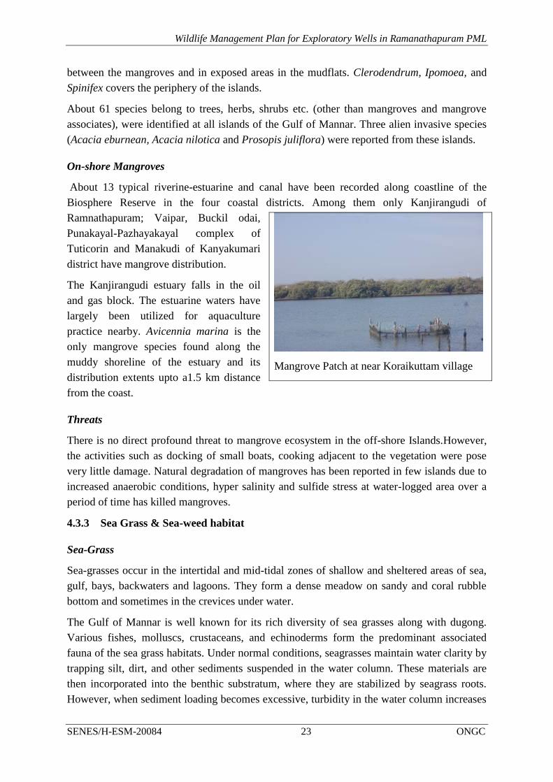
On-shore Mangroves
About 13 typical riverine-estuarine and canal have been recorded along coastline of the
Biosphere Reserve in the four coastal districts. Among them only Kanjirangudi of
Ramnathapuram; Vaipar, Buckil odai,
Punakayal-Pazhayakayal complex of
Tuticorin and Manakudi of Kanyakumari
district have mangrove distribution.
The Kanjirangudi estuary falls in the oil
and gas block. The estuarine waters have
largely been utilized for aquaculture
practice nearby. Avicennia marina is the
only mangrove species found along the
muddy shoreline of the estuary and its
distribution extents upto a1.5 km distance
from the coast.
Threats
There is no direct profound threat to mangrove ecosystem in the off-shore Islands.However,
the activities such as docking of small boats, cooking adjacent to the vegetation were pose
very little damage. Natural degradation of mangroves has been reported in few islands due to
increased anaerobic conditions, hyper salinity and sulfide stress at water-logged area over a
period of time has killed mangroves.
4.3.3 Sea Grass & Sea-weed habitat
Sea-Grass
Sea-grasses occur in the intertidal and mid-tidal zones of shallow and sheltered areas of sea,
gulf, bays, backwaters and lagoons. They form a dense meadow on sandy and coral rubble
bottom and sometimes in the crevices under water.
The Gulf of Mannar is well known for its rich diversity of sea grasses along with dugong.
Various fishes, molluscs, crustaceans, and echinoderms form the predominant associated
fauna of the sea grass habitats. Under normal conditions, seagrasses maintain water clarity by
trapping silt, dirt, and other sediments suspended in the water column. These materials are
then incorporated into the benthic substratum, where they are stabilized by seagrass roots.
However, when sediment loading becomes excessive, turbidity in the water column increases
Mangrove Patch at near Koraikuttam village

Wildlife Management Plan for Exploratory Wells in Ramanathapuram PML
SENES/H-ESM-20084 24 ONGC
and the penetration of sunlight is inhibited. In extreme cases, excessive sediment loading can
actually smother seagrasses.
It was estimated that the total extent of seagrass beds around all islands of the Gulf of Mannar
Biosphere Reserve was 80.7 sq. km. The species composition of seagrass community in the
Gulf of Mannar region include Enhalus acoraides, Halophila ovalis, Halophila ovata,
Halophila beccari, Halophila stipulacea, Thalassia lemprichii, Cymadocea serrulata,
Cymadocea rotundata, Halodule uninervis and Syringodium isoetifolium etc .
Threats
The major threats which present in this region are mentioned below
Since the seagrass productivity is highly dependent on ideal salinity, water temperature,
and turbidity, which are getting polluted by industrial and domestic wastes, which comes
from the near by coastal areas of the GOMMNP
Port and dredging related activities in the region churns up seagrass beds, increasing
turbidity and suspended sediments in the water column, which would have a long-term
impacts on seagrasses of this region.
Use of indiscriminate fishing technology especially trawling on these beds is also
expected to harm this habitat.
With increased agricultural activity on the nearby landscape is also posing a threat to the
sea grass beds because of its pollution.
Fishing in the seagrass beds and increase use of fishing vessels on the habitat are also
threatening this habitat.
Collection of sea grasses for fodder and fertilizers.
Sea-weeds
Seaweeds are marine plants belonging to lower Cryptogams. They occur in the intertidal,
shallow and deep waters of the sea upto 150m depth and also in estuaries 49 and backwaters.
These are large and diversified groups with size ranging from single cell such as
Chlamydomonas to several meters in length (Macrocystis). The four classes of seaweeds are
Chlorophyta (green algae), Phaeophyta (brown algae),
A total number of 147 species of algae comprising 42 species of green algae, 31 species of
brown algae, 69 species of red algae and 5 species of blue green algae distributed in Gulf of
Mannar islands.
4.4 BIODIVERSITY PROFILE OF STUDY AREA
4.4.1 Vegetation in the ML area
Forest types occurring in this region are Tropical dry-mixed evergreen forests and Tropical
thorn forests (scrublands). It was observed that Prosopis juliflora are most dominated species
in the scrub land, village road side, besides creek, bank of the ponds. Coconut plantation

Wildlife Management Plan for Exploratory Wells in Ramanathapuram PML
SENES/H-ESM-20084 25 ONGC
(Cocus nucifera) was also recorded in the area towards the sea side. The Borassus flabellifer
is also dominant species in this area.
The other dominated flora of the area are Acacia nilotica, Tamarindus indica, Azadirachita
indica, Albizzia amara, Ficus bengalensis, Ficus religiosa, Morinda tinctoria, Syzygium
cumuni, Acacia planifons, etc. About 61 plant species belong to trees, shrubs and herbs were
reported from this area. The checklist of floral species in the study area is provided in
Annexure-4.1.
4.4.2 Faunal Diversity in ML area
The Ramanathapuram ML area has no natural forest. The predominant land uses in the ML
area are scrub land, block plantation (coconut, Borassus) and tanks. No major mammals were
reported from the study area. However, Toddy cat, Jungle cat, Mongoose, Jackals, Hares and
Rodents are reported from this area. The reptiles like Common cobra, Krait, Rat snake, Green
snake, Tree snake, Garden lizard, Monitor lizard, water snakes are also reported from this
area. The tanks, ponds and creeks in the ML area provides habitat for large number of
migratory birds.
4.4.3 Biodiversity Profile in GOMMNP
About 3600 species of fauna and flora have been identified in the GOMBR by the Central
Marine Fisheries Research Institutes and other organizations. The fauna is said to be one of
the richest in the whole of Indo-west pacific region.
About 126 species of phytoplankton, 360 species of zooplankton, 51 species (2 endemic) of
foraminiferans, 275 species (31 endemic) of sponges, 128 species (42 endemic), 14 species of
Gorgonids, 75 species of Polychaeta, 9 species of Nematoda, 41 species Penaeid and Non-
Penaeid shrimps, 7 specise Lobster, 210 species of Crabs, 25 species of Stomatopod, 731
species of Molluscs (Bivalvia, Gastropods and Cephalopods), 264 species of Echinodermata
were reported from GOMMBR.
Corals
128 species (42 endemic) were recorded (Pillai, 1986, CMFRI, 1998). The dominant genera
were Pocillopora, Acropora, Montipora, Favia, Favites, Goniopora, Goniastrea, Platygyra,
Echinopora, Galaxea, Porites, Turbinaria, Leptoria, Pavona and Pachyseris.
Crabs and economically important
A total of 38 crab species belong to 21 genera and five families occur in the Gulf of Mannar
Biosphere Reserve, which is 5.6% of Indian crab germ plasm. Of the 11 important
commercial crabs in India, six crab species occur in this region. Several species are
considered to be becoming rare and threatened, or having reduced over all size because of
over exploitation and their habitat destruction. Inter-tidal zone of Gulf of Mannar Marine
National Park and the Biosphere Reserve are considered to be good habitats for these crabs in
this region.

Wildlife Management Plan for Exploratory Wells in Ramanathapuram PML
SENES/H-ESM-20084 26 ONGC
Shrimps
Shrimps are abundant in the Gulf of Mannar. Penaeus semisulcatus, P. indicus and P.
monodon are commonly available. There are 18 species of shrimps of which 10 are heavily
exploited. The lobsters Panulirus homarus, P.ornatus, P. logipes and P. versicolor are
abundant, of the 7 species of spiny and sand lobsters. The crabs Scylla serrata, Portunus
pelagicus, and P. sanguinolentus are the three commercially important species. The sacred
chunk, Xancus pyrum, forms an important fishery in the Gulf of Mannar. About 1,000 km2
area of inshore waters of Gulf of Mannar have been identified as chunk grounds.
Fishes
A large number of finfish species are available in the Gulf of Mannar. This includes nearly
125 species of reef fishes. The common finfishes of Gulf of Mannar belong to Leiognathids,
Sardines, Lethrinids, Perches, Carangids, Anchovies, Seer fishes, Red mullets, Half beaks,
Needle fishes and Elasmobranchs such as sharks and rays. There are 15 species of silver
bellies in this region of which four species of Leiognathus are common. They are L.equulus,
L.bindus, L.dussumieri and L. splendens. As many as 20 species of lethrinids have been
reported. The commonly available species of Lethrinus are L. ornatus, L. varigatus, L. hark,
L. lentjan, L. nebulosus and L. microdon. The other major contributors to the fishery are
Perches, Nemipterids Haemulids, Serranids, Lutjanids and Epinephelids.
Avi-fauna
The Gulf of Mannar Marine National Park is also an Important Bird Area. About 187 species
of aquatic and terrestrial birds have been identified from this IBA (Balachandran 1990,
1995), which is famous for waders and seabirds. Sometimes >50,000 water birds are found
here. Pelagic birds are also recorded (Balachandran 1990).
A total of 187 species of shore birds including wadors, terns and gulls were recorded in the
Gulf of Mannar, of which 84 were of aquatic species and the remaining terrestrial. The birds
reported, mainly in the winter season (Balachandran, 1995).
Sea turtles
Four of the seven species of sea turtles found worldwide are reported to occur in the Gulf of
Mannar Biosphere Reseves (Kar & Bhaskar, 1982; Bhupathy & Saravanan, 2003). These are
the olive ridley (Lepidochelys olivacea), green (Chelonia mydas), hawksbill (Eretmochelys
mbricate) and leatherback (Dermochelys coriacea. All the four species of sea turtles that
occur in these coastal waters are protected under Schedule I of the Indian Wildlife Protection
Act (1972), as well as listed in Appendix I of Convention of International Trade in
Endangered Species of Wild Fauna and Flora (CITES) which prohibits trade in turtle
products by signatory countries.

Wildlife Management Plan for Exploratory Wells in Ramanathapuram PML
SENES/H-ESM-20084 27 ONGC
Marine Turtle Nesting Sites
The coastline of Tamil Nadu extends from Pulicat Lake in the north to Cape Comorin in
Kanyakumari district in the south. The coastline (1076 km) of the state spreads across 13
coastal districts along the Bay of Bengal, Indian Ocean and Arabian Sea. The coastline of
Tamil Nadu has been divided into the Coromandal coast (extending from Chennai to Point
Calimere about 357 km), Palk Bay (extending from Point Calimere to Pamban about 294
km), Gulf of Mannar (extending from Pamban to Kanyakumari about 365 km) and West
Coast Arabian Sea (about 60 km). The coastline is characterized by sandy beaches, mudflats,
rocky outcrops, spits, coastal dunes, estuaries, lagoons and mangrove vegetation across the
state. The Palk Bay (Devipatnam to Pamban and Gulf of Mannar (from Pamban to
Kanjirangudi) area falls under ML area; however, no drill has been proposed in the Gulf of
Mannar Coastal area.
The turtle nesting beaches in the Palk Bay are Pondicherry, Cuddolore, Pazhaiyar,
Poombhuhar, Tarangambadi and Karikal. Turtle nesting beaches in Gulf of Mannar are
Vembar, Vipar, Taravaikulam, Uvari, Kootapuli and Kanyakumari. The nesting period of the
marine turtle is December to March.
None of these turtle nesting sites are located in the coastal area of Ramanathapuram ML area.
The discussion with Wildlife Warden reveals that the sandy beaches in the Park Bay and Gulf
of Mannar is also potential for turtle nesting sites.
Sea snakes
Sea snakes are considered to be the most successful marine reptiles in the world. 12 species
of sea snakes have been reported in the Gulf of Mannar region. Of which, nine species are
true sea snakes i.e. belong to the family Hydrophiinae. Studies shows that the sea snake
population in Indian seas are declining. It is understood that, incidentally captured sea snakes
are released back into sea but in several occasions the incidentally captured sea snakes are
killed by the fishermen due to fear.
Marine Mammals
11 species have been recorded (James and Lal Mohan, 1987, CMFRI, 1998) including 6
species of whales, 4 species of dolphins and 1 species of Dugong. All are endangered species
and placed under schedule 1 of "The Wild Life (Protection) Act 1972

Wildlife Management Plan for Exploratory Wells in Ramanathapuram PML
SENES/H-ESM-20084 28 ONGC
FIGURE 4.4: TURTLE NESTING SITES IN PALK BAY AND GULF OF MANNAR

Wildlife Management Plan for Exploratory Wells in Ramanathapuram PML
SENES/H-ESM-20084 29 ONGC
Dugong
The Dugong (Dugong dugong) is one of the four surviving species in the Order Sirenia and it
is the only existing species of herbivorous mammal that lives exclusively in the sea
(Heinsohn, 1972). The Dugong ranges along the coast of east Africa into the Red Sea, along
the coast of southern Asia to as far east as the Solomon Islands, and along the northern coasts
of Australia from southern Queensland to subtropical Western Australia (Marsh et al. 1999).
In India, the dugong occurs in the Gulf of Mannar and Gulf of Kutch, the Palk Bay and in the
Andaman and Nicobar Islands. All these areas have sea grass beds, which are good foraging
ground for the Dugongs.
The Gulf of Mannar had a good population of dugong but due to illegal off take of this
species caused the species to be threatened with local extinction.. However, since from 1988
the Tamil Nadu Forest Department initiated awareness campaign to safeguard this species.
Though, the illegal off take of this species drastically reduced their population, information
on current status and distribution is not known in detail.
Dolphins and Whales
The dolphins found in the Gulf of Mannar are oceanic and roam about in the area. It is most
likely that only the frail and the infirm whales move towards this area as known from
standings of whales. So far no mass standing of whales has been reported in the area. The
dolphins reported in Gulf of Mannar are Dolphinus delphis,Stenella longirostris,Sousa
chinensis and Tursiops truncates.
4.4.4 Biodiversity Profile in Palk Bay
The Palk Bay lies between India and Sri Lanka. It encompasses on the South by the Pamban
Strait, the islands of Rameswaram and Adams Bridge, a series of coral reef and sandy islets
also called Ramasethu that connects to Mannar Island of Sri Lanka, on the East by the Sri
Lanka coast and on the North East by an open passage accessing the Bay of Bengal.
The bay is a shallow and flat basin with the average depth hardly exceeds 9 meters. The
waters of the bay is generally void of upwelling, major ocean currents, turbid, confined and
remains calm during most of the months however, turbulent conditions prevail during
northeast monsoon period.
The area is rich in biological diversity, contain diversified and productive ecosystems such as
estuaries, salt marshes, coral reefs, sea grass beds, mangroves and sandy beaches.
About 3288 species of fauna and flora have been identified in the Palk BayOceanography and
Marine Geology University of Ruhuna , Matara, Sri Lanka.
About 51 species of Foraminifera, 12 species of Tintinnids, 143 species of flora, 275 species
of Sponges, 123 species of Coelentrates other than corals, 128 species of Stony corals, 100
species of Polyzoa,75 species of Polychaeta, 651 species of Crustaces, 733 species of
Mollusca,274 species of Echinodermata, 66 species of Protochordata, 580 species of Fishes, 5
species of Turtles, 61 species of Birds 61, and 11 species of Mammals.

Wildlife Management Plan for Exploratory Wells in Ramanathapuram PML
SENES/H-ESM-20084 30 ONGC
5 Potential Impacts on Habitat & Wildlife
The information collected with regard to the protected areas and critical habitats through
surveys and discussions with the officials Forest Department was analyzed and potential
impacts on wildlife habitat and wildlife were predicted at all the stages of the project.
Potential impact on wildlife and wildlife habitat may arise due to the project activities like
site construction, drilling activity and disposal of waste material.
5.1 POTENTIAL IMPACT OF SITE PREPARATION ON WILDLIFE HABITAT AND WILDLIFE
The construction drill sites will involve following activities:
Clearing of vegetation
Raising of drill sites
Transportation of fill material, construction material, Rig and associate machineries.
Surface runoff
5.1.1 Vegetation Clearance
The proposed drill sites are located in the non-forest land/ open scrub land. The drill sites
located in the scrub land have some vegetation, which need to clear during site development.
Therefore, degradation of forest vegetation and wildlife habitat is not anticipated from the
proposed oil and gas activity. The vegetation clearance in the scrub land may have impact on
local ecology.
5.1.2 Sourcing of Fill Material
Numbers of drill sites are located in the low laying areas. Rising of drill sites would be
required, cut material will be utilized for filling, the required fill material will be sourced
from Govt. approved borrow areas and quarries. The required fill material will not be sourced
from National Park or Biosphere Reserve. Therefore sourcing of fill material and other
construction material from authorized sources may not have direct impact on wildlife habitat.
5.1.3 Transport of Construction Material
All the proposed drill sites are well connected through NH, MDR and village roads. Same
will be utilized for transportation of construction material, drilling rig and associate
machineries and equipments. During the site preparation & decommissioning phase, increase
in traffic (NH, MRD and village roads), noise and human activity may result in temporary
disturbance of faunal habitat adjacent to the approach road and drill site. However, giving to
the intermittent nature of the project lasting for a period of few months no long term
significant impacts on the fauna of the Sanctuary are anticipated.
5.1.4 Surface Runoff
The site clearance and stripping of top soil during site construction will result in an increase
in soil erosion potential leading to an increased sediment load in the surface run-off during
monsoon. Also, surface run off from drilling waste, hazardous waste (waste oil, used oil etc)

Wildlife Management Plan for Exploratory Wells in Ramanathapuram PML
SENES/H-ESM-20084 31 ONGC
and chemical storage areas on open soil is likely to be contaminated leading to the pollution
of receiving water bodies viz. natural drainage channels, coastal water, etc. This situation is
likely to be more pronounced considering rainfall records of Ramanathapuram district.
However, taking into account the provision of onsite drainage system and sediment control
measures to be implemented by the proponent in compliance with the S No. 72 A.1.a
Schedule I Standards for Emission or Discharge of Environmental Pollutants from Oil
Drilling and Gas Extraction Industry of CPCB as modified in 2005, the impact is considered
to be of low significance.
5.2 POTENTIAL IMPACT OF OPERATION OF DRILLING RIG ON WILDLIFE HABITAT &
WILDLIFE
5.2.1 Noise
Noises generated from drilling are less intense compared to other oil and gas activities like
blasting during seismic survey but are more stationary and persistent. The sound produced by
the drilling operation consists of loud mechanical noises emitted over a range of frequencies
and intensities.
Noise generated from drilling operations and vehicular movement within the drill site is also
likely to affect the faunal habitat leading them to move away from the project area and its
immediate vicinity. Such disturbance may be impacted approximately 0.5 km. And in the
vicinity only few small mammalian species and birds are likely to be inhabited and those
animals can adapt the changed environment for temporarily.
The 13 drill sites are located within the Biosphere Reserve and few of them are closure to
coast and swamp, those are suitable habitat for migratory birds. Therefore noise generated
from these drill sites would have adverse impact on migratory birds adjacent to these drill
sites.
5.3 POTENTIAL IMPACT OF ILLUMINATION ON WILDLIFE
The physical presence of drilling rig is also to be felt at night because of the illuminated at
night by lighting arrangements. Other possible sources of illumination will be flaring
conducted for a short period of time during well testing phase. Artificial lighting and well
testing flares may result in the attraction of some wildlife leading to their disorientation and
confusion behaviour.
The 13 drill sites are located within the Biosphere Reserve and few of them are closure to
coast and swamp, those are suitable habitat for migratory birds. Therefore, impact of
illumination of all the drill sites will be anticipated from the proposed drilling activity.

Wildlife Management Plan for Exploratory Wells in Ramanathapuram PML
SENES/H-ESM-20084 32 ONGC
5.4 POTENTIAL IMPACT OF DISPOSAL OF WASTE ON WILDLIFE HABITAT AND
WILDLIFE
5.4.1 Disposal of solid waste
It is estimated that nearly about 300-400 m3 of drill cuttings and waste drilling mud is likely
to be generated from each well during drilling operation. Improper storage and disposal of
such process waste on open soil or unlined areas may therefore lead to the contamination of
soil onsite, ground water, surface water and abutting land if not properly managed.
Construction of a HDPE lined impervious pits for temporary storage of drill cuttings and
drilling mud respectively and their disposal in accordance with S No. 72 C.1.a Schedule I
Standards for Emission or Discharge of Environmental Pollutants from Oil Drilling and Gas
Extraction Industry of CPCB as modified in 2005 will be ensured by ONGC. Further with the
proponent catering to the use of water based mud the drill cuttings and waste drilling mud
generated are likely to be non-hazardous in nature and is not anticipated to pose any potential
threat to the soil environment. No waste will be disposed in the existing wildlife habitat.The
impact is therefore considered to be of low significance.
5.4.2 Discharge of waste water
The drill sites will primarily generate effluent because of discharges of sanitary (black water)
and domestic waste water (grey water) which will be stored in septic tank/soak pits. Some
waste water, from the process comprising of drain out from rig wash, cement preparation, and
other sources which will be generated intermittently and subsequently treated in batches. This
waste water along with spill over mud will be diverted to waste water mud pit whose bottom
would be lined with HDPE sheet so as to avoid percolation of water contaminants in the soil
It is expected that waste water in the form of washings shall be generated at an average rate
of around 5 KLD during the drilling operations from a single well. The wash water would
contain variable quantities of mineral salts, solids, suspended and dissolved hydrocarbons,
and other organic and inorganic components in very minor quantities, which on discharge to
nearby natural drainage channels and/or rivers may lead to possible surface water
contamination. However considering usage of water based mud for the proposed project,
temporarily storage of drilling waste in an HDPE lined pit and subsequent treatment to ensure
conformance with CPCB Industry Specific Standards for Oil Drilling & Gas Extraction
Industry and guidelines provided by the MoEF under the Hazardous Wastes (Management,
Handling & Transboundary Movement) Rules, 2008 the impact is not considered to be of
significance
5.5 SURFACE RUNOFF
As the area experiences considerable rainfall, the site will generate considerable volume of
runoffs during such rainy periods. The storm water generally contains high concentration of
suspended matter eroded from the soil by the runoff. There is also a potential for
contamination of the storm-water if the runoff picks up contaminants in the form of
chemicals, oil and lubricants, etc. that have been spilled or even if material is stored in open

Wildlife Management Plan for Exploratory Wells in Ramanathapuram PML
SENES/H-ESM-20084 33 ONGC
areas (uncovered) in any particular area like the fuel storage or the chemical storage areas.
This may result in a potential impact to the receiving water body.
In event of heavy rainfall chances of chemical contaminants (heavy metals, hydrocarbons,
other toxic chemicals) along with wastewater from the site creating harmful long term
impacts, if not properly managed during the monsoon period, cannot be ruled out.
However, taking into account the provision of onsite drainage system and sediment control
measures to be implemented by the proponent in compliance with the S No. 72 A.1.a
Schedule I Standards for Emission or Discharge of Environmental Pollutants from Oil
Drilling and Gas Extraction Industry of CPCB as modified in 2005, the impact is considered
to be of low significance.
5.6 OIL SPILL IMPACT ON ECOSYSTEM AND BIODIVERSITY
The chronic oil spills can arise from loading of oil from oil tanker to onsite storage facility,
drilling operation and storage area. Acute pollution- oil spills can arise from the accidents
from ‘blowouts’ of wells. Oil spill pose a considerable threat to estuarine ecosystem and
biodiversity of this region.
The Ramanathapuram ML area is primarily gas bearing block. However, some associate oil
may be produced from these wells. Some wells are located adjacent to coast and estuarine
river. Major blowouts from these wells may release the oil into estuarine water can
When oil is released into sea waters, the fate of oil in the environment depends on many
factors, such as the source and composition of the oil, as well as its persistence. Once oil
enters the environment, it begins to change through physical, chemical, and biological
weathering processes (National Research Council 2003). These processes may interact and
affect the properties and persistence of the oil through: evaporation (volatilization),
emulsification (the formation of a mousse), dissolution, oxidation, and transport processes.
When oil is released into coastal waters, it often deposits on surface exposed during regular
fluctuations of tides. This can affect the mangrove vegetation, benthos, marine
microorganisms, fish, coastal birds, marine mammals, corals.

Wildlife Management Plan for Exploratory Wells in Ramanathapuram PML
SENES/H-ESM-20084 34 ONGC
6 Wildlife Mitigation & Management Plan
The proposed oil and gas activities may not have any significant impact on wildlife habitat
and wildlife. However, the likely impacts of the project activities on the ecological habitat
have been addressed in a Management Plan prepared to safeguard the sanctuary and
biosphere reserve and their characteristic floral and faunal components. The Management
Plan details out the mitigation measures and strategies to be adopted by ONGC and the
contractors during each phase of the project, at the same time establishing a monitoring
network to oversee the effective implementation of the Management Plan. The following
measures and strategies needs to be adopted to safeguard the natural habitat from the possible
impacts resulting from the project and its related activities.
The following measures and strategies needs to be adopted to safeguard the natural habitat
from the possible impacts resulting from the project and its related activities
6.1 NOISE AND VIBRATION CONTROL PLAN
Scope
The noise and vibration control plan is applicable for all the three phases- construction of
drill sites, drilling of wells and decommissioning of drill sites. The major noise and vibration
will be generated from drilling activities.
Purpose
The noise and vibration control plan to ensure specific measures to minimize noise level in
the drill site 75 dB(A) as per CPCB Noise rules. The plan also outlines roles and
responsibilities of both ONGC and the contractors involved in the implementation of the
plan.
Mitigation Measures
ONGC has planned to restrict their proposed oil and drilling activities in the sensitive bird’s
habitat like Birds sanctuary and large water bodies by locating these wells at least 2.0 km
from this area.
ONGC will also restrict the oil and drilling activities during migration period of birds
(November to January) around identified bird’s habitat (Sakkarakottai Bird Sanctuary,
Ramanthapuram Tank and Kalari Kanmai)
The following mitigation measures will be adopted and implemented by ONGC and its
contractors for all the drill sites.
Project Phase Mitigation measures
Construction Selection and use of low noise generating equipment equipped with
engineering controls viz. mufflers, silencers etc
All vehicles utilized in transportation of raw material and personnel will

Wildlife Management Plan for Exploratory Wells in Ramanathapuram PML
SENES/H-ESM-20084 35 ONGC
Project Phase Mitigation measures
have valid Pollution under Control Certificate (PUC)
All high noise generating equipments will be identified and subjected to
periodic preventive maintenance.
No night time operation of vehicles and construction activities will be
undertaken in the sensitive area like migratory birds habitat.
Engines of vehicles and construction equipment will be turned off when
not in use for long periods.
Drilling Installing acoustic enclosures and muffler on engine exhaust of DG sets to
ensure compliance with generator noise limits specified by CPCB in
accordance with Sl No 94 GSR 371(E) dated 17.5.2002.
Setup effective noise barrier at the fence-line of the site, in case of
sensitive wildlife sites; i.e. birds habitat;
Restrict all noise generating operations ,except drilling, to daytime;
Periodic monitoring of noise levels on site and nearby receptors to ensure
compliance with Noise Pollution (Regulation & Control) Rules 2000.
The drilling activities will be restricted during bird migration period in
around these habitats.
Decommissioning/
Site Closure
Management measures to address noise impacts with respect to operation of
heavy equipments/machinery and movement of vehicles during
decommissioning/site closure phase are similar to those discussed in the
“Construction Phase” of this section
The Drill site in charge at drill site would be responsible for implementing the plan during the
site construction, drilling and decommissioning in consultation with Area In charge under
guidance of Head Drilling Services/Assest manager.
6.2 WASTE MANAGEMENT PLAN
Scope
The Waste Management Plan (WMP) is applicable for all process and non-process waste
streams which are generated during various phases of ONGC’s proposed exploratory drilling
of hydrocarbons. The major waste streams covered under this plan includes drill cuttings,
waste drilling mud, wash water, domestic waste and sewage. In addition, waste oil and lead
acid batteries generated from the proposed project operations have also been dealt in this
plan.
Purpose
The WMP establishes specific measures to ensure proper collection, storage, treatment and
disposal of the identified process and non-process waste streams in accordance with the

Wildlife Management Plan for Exploratory Wells in Ramanathapuram PML
SENES/H-ESM-20084 36 ONGC
applicable national regulations and guidelines2 and also to ensure compliance with ONGC’s
corporate HSE Policy. The plan also outlines roles and responsibilities of both ONGC and the
contractors involved in the implementation of the plan.
Mitigation Measures
The following mitigation measures need to be adopted and implemented by ONGC and its
contractors for the major waste streams identified in the plan.
Waste Quantity Mitigation Measure
Drill Cuttings 400 m3/well Drill cuttings separated from drilling fluid will be
adequately washed and temporarily stored and
disposed in an impervious pit lined by HDPE.
The drilling cuttings pit will be bunded and kept
covered using tarpaulin sheets during monsoon
Periodic monitoring and analysis of drill cuttings will
be undertaken to establish its nature and
characteristics. Earlier test reports of drill cuttings
from ML area has shown the absence of hazardous
nature of the soil
The waste pit after it is filled up will be covered with
impervious liner over which a thick layer of native top
soil with proper top slope will be provided.
Feasibility study for use of drill cuttings for lining or
capping of landfill sites, or as a road construction
material in consultation with nodal authorities
Drilling Mud and
wash water
12 m3/day Use of water based mud as the drilling fluid.
Use of low toxicity chemicals for the preparation of
drilling fluid.
Barite used in the preparation of drilling fluid shall not
contain Hg>1mg/kg and Cd>3mg/kg
Recycling of drilling mud will be ensured to the
maximum extent possible.
Temporary storage of drilling fluid and wash waste
water will be done in an impervious pit lined with
HDPE.
The drilling fluid pit will be bunded to prevent water
overflow during heavy monsoon.
Drilling wash water will be treated through onsite
2 “Guidelines for Disposal of Waste – CPCB Oil & Gas Extraction Industry Standard” – EPA Notification
[GSR 176(E), April 1996]
“Guidelines for disposal of Solid Waste, Drill Cuttings and Drilling Fluids for Offshore & Onshore Drilling
Operation” –MoEF Notification, 30th August 2005

Wildlife Management Plan for Exploratory Wells in Ramanathapuram PML
SENES/H-ESM-20084 37 ONGC
Waste Quantity Mitigation Measure
Effluent Treatment Plant (ETP) to comply with the S
No.72 A(ii) Standard for Liquid effluents of CPCB
effluent discharge standard for oil drilling and gas
extraction industry for reuse and recycling purpose.
Domestic Waste 10-20 kg/day The waste will be segregated and stored in designated
waste bins.
All such waste bins will be properly labeled and
covered.
The kitchen waste will be disposed in nearest
municipal dumping site on a daily basis through
approved waste handling contractors
Waste oil
Used oil
As generated The hazardous waste (waste and used oil) will be
managed in accordance with Hazardous Waste
(Management, Handling & Transboundary Movement)
Rules, 2008.
The hazardous waste will be stored in properly labeled
and covered bins located in paved and bunded area.
Necessary spill prevention measures viz. spill kit will
be made available at the hazardous material storage
area
Storage details of onsite hazardous waste generated
will be maintained and periodically updated.
Adequate care will be taken during storage and
handling of such waste viz. use of proper PPEs by
personnel
The hazardous waste so stored (not more than 3
months) to be periodically sent to TNPCB registered
user and/or waste oil recyclers/ facilities.
Proper manifest as per HWMH rules to be maintained
during storage, transportation and disposal of
hazardous waste.
Sewage 8 m3/day per
well
The sewage generated will be treated in a combination
of septic tank and soak pit.
Regular supervision will be undertaken for the
domestic waste treatment system to report any
overflows, leakage, foul odour etc.
Lead Acid Batteries 2-3 batteries
per well
Will be recycled through the vendors supplying lead
acid batteries as required under the Batteries
(Management & Handling) Rules, 2001.
Proper logbook will be maintained as per Batteries
(Management & Handling) Rules, 2001.
Recyclables viz. paper,
plastic, packaging
Depending
on usage
Proper segregation and storage of recyclable waste in
designated bins onsite.
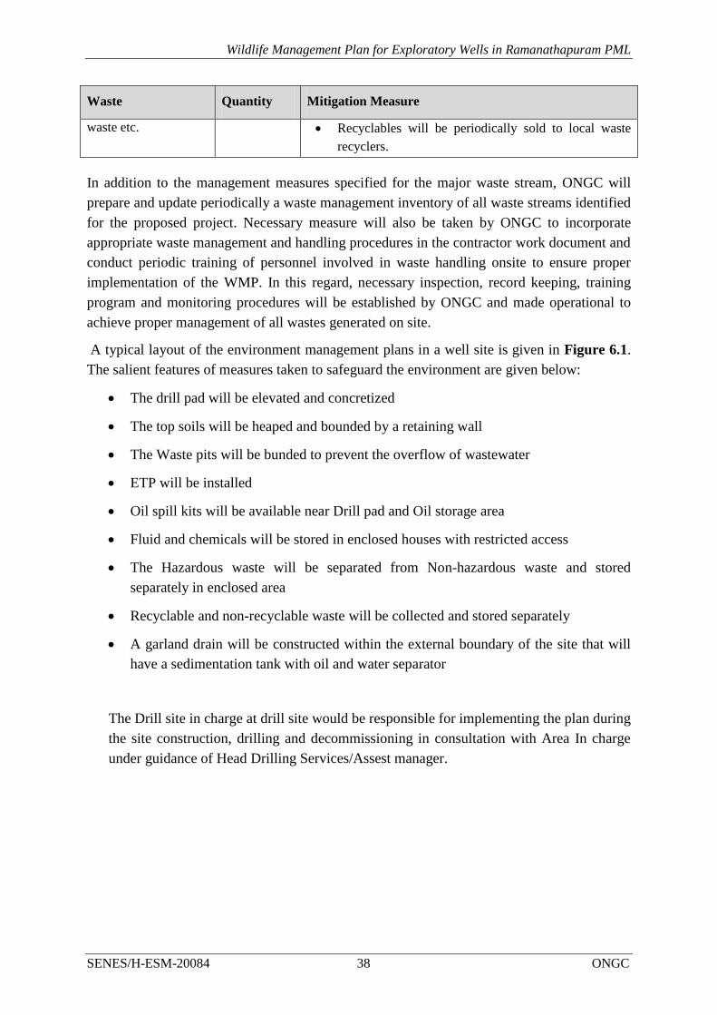
Wildlife Management Plan for Exploratory Wells in Ramanathapuram PML
SENES/H-ESM-20084 38 ONGC
Waste Quantity Mitigation Measure
waste etc. Recyclables will be periodically sold to local waste
recyclers.
In addition to the management measures specified for the major waste stream, ONGC will
prepare and update periodically a waste management inventory of all waste streams identified
for the proposed project. Necessary measure will also be taken by ONGC to incorporate
appropriate waste management and handling procedures in the contractor work document and
conduct periodic training of personnel involved in waste handling onsite to ensure proper
implementation of the WMP. In this regard, necessary inspection, record keeping, training
program and monitoring procedures will be established by ONGC and made operational to
achieve proper management of all wastes generated on site.
A typical layout of the environment management plans in a well site is given in Figure 6.1.
The salient features of measures taken to safeguard the environment are given below:
The drill pad will be elevated and concretized
The top soils will be heaped and bounded by a retaining wall
The Waste pits will be bunded to prevent the overflow of wastewater
ETP will be installed
Oil spill kits will be available near Drill pad and Oil storage area
Fluid and chemicals will be stored in enclosed houses with restricted access
The Hazardous waste will be separated from Non-hazardous waste and stored
separately in enclosed area
Recyclable and non-recyclable waste will be collected and stored separately
A garland drain will be constructed within the external boundary of the site that will
have a sedimentation tank with oil and water separator
The Drill site in charge at drill site would be responsible for implementing the plan during
the site construction, drilling and decommissioning in consultation with Area In charge
under guidance of Head Drilling Services/Assest manager.

Wildlife Management Plan for Exploratory Wells in Ramanathapuram PML
SENES/H-ESM-20084 39 ONGC
FIGURE 6-1: ENVIRONMENT MANAGEMENT MEASURES AT DRILL SITE

Wildlife Management Plan for Development of oil and gas in Dirok
SENES/H-ESM-20084 40 ONGC
6.3 SPILL MANAGEMENT
A number of chemicals and oil (diesel) will be stored on site, improper handling or accidents
are likely to result in spills which have a potential for contaminating the environment. ONGC
would develop and educate the Contractors/personnel working to prevent such spills and also
develop a proper spill response and management plan.
As best practices to avoid/contain any spill ONGC would ensure:
All chemicals are stored within the designated area. To an extent possible all such areas
would away from drainage channels
The flooring of the area should be impervious (paved or HDPE lining) and bunding to be
provide on all sides of the chemical storage areas
The chemical storage area to be covered to ensure it has the minimum runoff.
All transfers of chemicals to be done with proper care and under the supervision of the
store supervisor, fuelling will take place in designated areas
No oil transfers will occur, unless adequate protection is in place
ONGC’s spill management plan would aim to control the spill to a limited area and take
necessary mitigative actions. The following additional measures will be implemented for spill
management:
Once a spill incident has occurred, identify the chemical involved and check hazardous
property of the chemical from the Material Safety Datasheet (MSDS);
Person wearing required PPE will apply necessary absorbent like saw dust for a liquid
spill to ensure that the spill does not spread over a wide area or reach any surface water
body or drainage channels;
Thereafter, the substance will be properly collected and stored in a separate labeled
container marked “hazardous waste – do not burn”;
Truck it away to the hazardous waste pit site and dispose it.
The Drill site in charge at drill site would be responsible for implementing the plan during
the site construction, drilling and decommissioning in consultation with Area In charge
under guidance of Head Drilling Services/Assest manager.
6.4 STORM WATER MANAGEMENT PLAN
Scope
The Storm Water Management Plan (SWMP) refers to the proper management of surface
run-off generated during monsoons for various phases of activities involved in the project.

Wildlife Management Plan for Development of oil and gas in Dirok
SENES/H-ESM-20084 41 ONGC
Purpose
The purpose of Storm Water Management Plan (SWMP) is to ensure prevent and control any
adverse impact of discharge of storm water from the well site and road
widening/strengthening areas to nearby natural drainage channels and community water
bodies. Proper management of storm water runoff will minimize damage to public and
private property, reduce effects of development on land, control stream channel erosion,
pollution and sediment deposition and also reduce local flooding.
Mitigation Measures
The following mitigation measures need to be adopted and implemented by ONGC and its
contractors for the identified in the plan.
Project Phase Mitigation measures
Construction Minimize clearing and construction activities during monsoon season (as
far as practicable).
Construction work close to the streams or water bodies to be avoided
during monsoon
During site preparation and construction, surface water run-off will be
managed through implementation of proper drainage system and silt trap
and sedimentation tank onsite.
Sediment filters and oil-water interceptor will be installed by the
Contractor to intercept run-off and remove sediment before it enters water
courses.
Regular inspection of surface water drainage/diversion system and
sediment controls will be undertaken.
Drilling Run-off from vehicular wash and chemical storage areas will be limited to
closed drainage system provided with an oil-water separator prior to silt
trap and sedimentation tank to disposal to nearby drainage
channels/surface water bodies. Spill kits will be made available in these
areas.
Drip trays will be used during preventive maintenance of vehicles and
machinery.
Hazardous chemicals and fuel drum will be stored in bunded and lined
area equipped with proper spill control equipment.
Management of drill cuttings, waste drilling mud, waste oil and domestic
waste will be made in accordance with S No. 72 C.1.a Schedule I
Standards for Emission or Discharge of Environmental Pollutants from Oil
Drilling and Gas Extraction Industry of CPCB as modified in 2005
Decommissioning/
Site Closure No significant impact to surface water quality can be associated with activities
during decommissioning/site closure phase. Any possible impacts that may
arise due to surface run-off will be mitigated in manner similar to that discussed
during construction phase activities.

Wildlife Management Plan for Development of oil and gas in Dirok
SENES/H-ESM-20084 42 ONGC
The Drill site in charge at drill site would be responsible for implementing the plan during the
site construction, drilling and decommissioning in consultation with Area In charge under
guidance of Head Drilling Services/Assest manager.
6.5 FLARE & ILLUMINATION REDUCTION PLAN
The glare from the flare and illumination not only cause visual impacts but also causes
ecological impacts These best practices can be adopted for reducing ecological impacts
especially when operating in the migratory birds habitat.
Enclosed Ground Flaring: Ground flaring can be used to reduce the glare and thus reduce
the impact of the glare on nocturnal and migratory birds.
Work Place Illuminations: The modification of the work place illumination can be used in
the wells sites located adjacent to coast and bird’s habitat to reduce the ecological impacts.
Restrict of Oil & gas Activities in the sensitive areas: ONGC will restrict of oil & gas
activities away from sandy coastal area, which is turtle nesting site and potential nesting site
and also restrict their operation nesting period of turtles (January to March) wells located
adjacent to coastal area.
The Drill site in charge at drill site would be responsible for implementing the plan during the
site construction, drilling and decommissioning in consultation with Area In charge under
guidance of Head Drilling Services/Assest manager.
6.6 OIL SPILL MANAGEMENT PLAN
Loss of well control / blow-out, fire, explosion and oil spills are the major potential hazards
associated with drilling for oil and gas. Effective response plans to foreseeable emergencies
will be developed by ONGC and communicated to the project teams. A risk assessment to be
carried out as part of this EIA will also contribute towards identification of hazards, risks and
formulating management plans for emergency response, blowout, oil spills.
ONGC has in place a Disaster Management Plan which has been developed to set up the
appropriate mechanism and course of action to mitigate the impact of an Emergency event
viz. blow out, fire, explosion etc. The plan provides a procedure allowing all those involved
in and outside ONGC to mobilize their resources in an orderly manner and react effectively
in time. The plan therefore, aims at immediate response to an Emergency event to prevent
escalation to a Disaster and also the response in the event of such escalation. The plan will be
updated as and when necessary, but at least once in every year by Basin HSE in consultation
with Surface Team, Sub surface Team, Drilling Services and Well Services Group. Also
ONGC has been accredited with ISO 9001:2008; 14001:2004 and OHSAS 18001.
The Drill site in charge at drill site would be responsible for implementing the plan during the
site construction, drilling and decommissioning in consultation with Area In charge under
guidance of Head Drilling Services/Assest manager.
Wildlife Management Plan for Development of oil and gas in Dirok
SENES/H-ESM-20084 43 ONGC
6.7 WILDLIFE MANAGEMENT CELL
An Environment Management Cell (EMC) will be developed for implementation of
environmental mitigation & management plan. Wildlife Warden- Gulf of Mannar Marine
National Park, Gulf of Mannar Marine Biosphere Reserve Trust (GOMMBRT), village
marine conservation committees (VMCs). and eco-development committees (EDCs) will be
taken into the management cell for implementing the wildlife management plan. The
environment cell would look after the following measures:
Any wild animal species if trapped during site development or operation of drilling
would be released into the suitable habitat;
Proper monitoring of indicator species will be carried out and compared to baseline to
understand any negative impacts;
The committee will review the mitigation measures and management plan
implementation.
All sightings of sensitive species in and around the project site will be reported and adequate
steps will be taken with the help of forest personnel to reduce conflict between such animals
and project activities or people working at site.
The Drill site in charge at drill site would be responsible for implementing the plan during the
site construction, drilling and decommissioning in consultation with Area In charge under
guidance of Head Drilling Services/Assest manager.
6.8 EMPLOYEE EDUCATION AND AWARENESS
The following will be incorporated into an employee education and awareness program:
The Environment Compliance Officer will hold training program to all the ONGC
employees and sub-contractor on the applicable practice and mitigation measures
contained within the Wildlife Management Plan.
The ‘Vanmohotsav’ in monsoon and ‘Vanya Prani Saptah’ in October should also be
celebrated in the area to create awareness among the Site workers and local people and
the personnel and organization in respect of conservation of biodiversity and wildlife
conservation should be awarded.
The Environment Compliance Officer will provide all employees with Bird Conservation
Awareness -material and need for wildlife conservation.
6.9 RESPONSIBILITY
For the implementation of the Wildlife Management Plan assigning the roles and
responsibilities is important. It is however important that these roles are in sync with the
overall roles of exploratory drilling activities. The roles of the professional for each of the
plans have already been defines. This section defines the roles by activities.

Wildlife Management Plan for Development of oil and gas in Dirok
SENES/H-ESM-20084 44 ONGC
Drill Site Planning and Construction
The HSE Head (ONGC) in consultation with Block Manager (Kaveri Basin) would be
responsible for the construction of drill sites and also ensure that infrastructure required for
protecting the environment has been developed.
The plans for the EMP implementation include the Siting of drill sites, considering the local
sensitivity, sourcing of resources especially fill material, storage of fuels, chemicals, etc. The
plans would be duly approved by the Block Manager. The Environment Compliance Officer,
under guidance of HSE Head and Block Manager would be responsible for implementing the
same on the ground.
Carrying out Exploratory Drilling & Testing
All activities including the i) transport of drilling chemicals and fuels, ii) drilling, iii)
treatment and disposal of waste, iv) testing of wells has been considered under this. The
Environment Compliance Officer would be primary responsibility of ensuring that the
measures as stated in the wildlife management plan are implemented. The Drilling In-Charge
would ensure these measures are implemented.
Decommissioning of Drill Sites
All activities including the i) demobilization rig and machineries, ii) transport of machinaries
and construction material, iii) site restoration and handover of sites has been considered under
this. The Environment Compliance Officer would be primary responsibility of ensuring that
the measures as stated in the wildlife management plan are implemented.
6.9.1 Capacity Building
The Environment Compliance Officer of ONGC under guidance of HSE Head (ONGC) along
with Drilling In-Charge would carry out induction training of all personnel irrespective
whoever he joins the project. In case non-conformance is observed during the periodic
reviews refresher training would be conducted.
The Induction training would focus on the measures which have been specified in the WMP
especially related to the activity the personnel is expected to perform during the
implementation of all phases under exploratory drilling.
6.9.2 Monitoring and Auditing
Weekly monitoring would be carried out to identify whether the measures suggested is being
adhered to. The monitoring would look into:
Implementation of the WMP measures;
Visible signs of habitat loss and disturbance to wildlife;
Grievance of the stakeholder.

Wildlife Management Plan for Development of oil and gas in Dirok
SENES/H-ESM-20084 45 ONGC
Fortnightly audits would be carried out to ensure that the practices suggested is adhered to.
The audit would not only focus on the practices and management measures but would also
look into the record keeping and also into actions taken against previous non compliance.
6.9.3 Reporting and Review
The reporting and review mechanism is detailed in table below:
Reporting and Review Mechanism
Reporting Frequency Review
Monitoring Report Weekly HSE Head, Block Manager, Wildlife Management
Cell
Audits Fortnightly HSE Head, Block Manager, Wildlife Management
Cell
The review meeting would not only look into the problems but would also analyze whether
action has been taken to address the non-conformance which has been identified in the earlier
monitoring or audits. The resource required for implementation if any would also be
provided.
6.9.4 Financial Allocation
The financial resource required for the implementation of the WMP will be decided by
ONGC based on ground conditions.

Wildlife Management Plan for Development of oil and gas in Dirok
SENES/H-ESM-20084 46 ONGC
ANNEXURE

Wildlife Management Plan for Development of oil and gas in Dirok
SENES/H-ESM-20084 47 ONGC
ANNEXURE 1.1: APPROVED TOR FOR EIA STUDY

Wildlife Management Plan for Development of oil and gas in Dirok
SENES/H-ESM-20084 48 ONGC

Wildlife Management Plan for Development of oil and gas in Dirok
SENES/H-ESM-20084 49 ONGC

Wildlife Management Plan for Development of oil and gas in Dirok
SENES/H-ESM-20084 50 ONGC

Wildlife Management Plan for Development of oil and gas in Dirok
SENES/H-ESM-20084 51 ONGC
ANNEXURE 4.1: CHECKLIST OF PLANT SPECIES IN RAMANATHAPURAM ML AREA
Sl No. Plant Species Local Distribution
A. Trees
1. Acacia eburnean Sporadic
2. Acacia nilotica Common
3. Acacia planifrons Sporadic
4. Syzygium cumuni Sporadic
5. Moginga oleifera Sporadic
6. Thespesia populnea Sporadic
7. Albizia lebbeck Common
8. Azadiracta indica Common
9. Borasus flabilifer Abundant
10. Buchannania axillaris Sporadic
11. Caesalpenia coriasia Sporadic
12. Casuarina equisetifolia Sporadic
13. Cocus nucifera* Abundant
14. Ficus benghalensis Sporadic
15. Ficus religiosa Sporadic
16. Merope angulata Sporadic
17. Pongamia glabra Common
18. Olax scandens Sporadic
19. Phoenix lourerii Common
20. Pithicellobium dulce Sporadic
21. Peltophorum pterocarpum Sporadic
22. Prosopis juliflora Abundant
23. Psidium guajava Sporadic
24. Odian wadia Sporadic
25. Tamarind sp. Common
26. Terminala catppa Sporadic
27. Siaminea saman Sporadic
28. Terminalia arjuna Sporadic
29. Ziziphus mauritiana Common
30. Ziziphus xylophyrus Common
B. Shrubs
31. Azima tetracantha Common
32. Cassia auriculata Common
33. Euphorbia tirucalli Sporadic
34. Hoya parasitica Sporadic
35. Jasminum angustifolium Sporadic
36. Jatropa sp Common
37. Lumnitzera racemosa Common
38. Manilkara hexandra Common
39. Opuntia monocanthus Sporadic
40. Tephrosia perpurea Common

Wildlife Management Plan for Development of oil and gas in Dirok
SENES/H-ESM-20084 52 ONGC
C. Herbs and climbers
41. Allotropis cimicina Common
42. Aloe vera Sporadic
43. Aristida adscensiones Common
44. Aspargaus racemosus Common
45. Bulbostylis densa Common
46. Canavelia virosa Common
47. Capparis divaricata Common
48. Cassis obtusa Common
49. Catharanthus roseus Common
50. Chloris barbata Common
51. Cissus quandrangularis Common
52. Citronella sp. Common
53. Cleome aspera Common
54. Coccinia grandis Common
55. Crotolaria laburnifolia Common
56. Crotolaria verucosa Common
57. Cymbophogon gibarba Common
58. Cynadaon dactylon Common
59. Cyperus arenarius Common
60. Cyperus cartaneus Common
61. Cyperus rubicundus Common
62. Emilia scabra Common
63. Eragros unioloides Common
64. Eragrostis altrovirens Common
65. Hydrophylax maritime Common
66. Leucas maritinicensis Common
67. Lophopogon tridentatus Common
68. Rottboellia exaltata Common
69. Sporobolus diander Common
70. Veronica albicans Common
71. Vigna trilobata Common
[Source: SENES Primary Survey, September 2014 and Integrated Management Plan for the Gulf of
Mannar Marine National Park and Biosphere Reserve (2007-2016)]

Wildlife Management Plan for Development of oil and gas in Dirok
SENES/H-ESM-20084 53 ONGC
ANNEXURE 4.2: CHECKLIST OF BIRDS IN STUDY AREA

Wildlife Management Plan for Development of oil and gas in Dirok
SENES/H-ESM-20084 54 ONGC

Wildlife Management Plan for Development of oil and gas in Dirok
SENES/H-ESM-20084 55 ONGC

Wildlife Management Plan for Development of oil and gas in Dirok
SENES/H-ESM-20084 56 ONGC

Wildlife Management Plan for Development of oil and gas in Dirok
SENES/H-ESM-20084 57 ONGC

Wildlife Management Plan for Development of oil and gas in Dirok
SENES/H-ESM-20084 58 ONGC
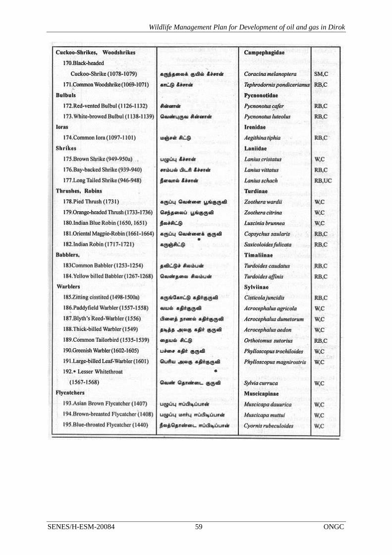
Wildlife Management Plan for Development of oil and gas in Dirok
SENES/H-ESM-20084 59 ONGC

Wildlife Management Plan for Development of oil and gas in Dirok
SENES/H-ESM-20084 60 ONGC
[Source: Integrated Management Plan for the Gulf of Mannar Marine National Park and Biosphere
Reserve (2007-2016)]