Biodiversity and Local Perceptions on the Edge of a ... - CIFOR
118
Biodiversity and Local Perceptions on the Edge of a Conservation Area, Khe Tran Village, Vietnam Manuel Boissière • Imam Basuki • Piia Koponen Meilinda Wan • Douglas Sheil
-
Upload
khangminh22 -
Category
Documents
-
view
0 -
download
0
Transcript of Biodiversity and Local Perceptions on the Edge of a ... - CIFOR

Decisions on land use in Vietnam are often only based on biophysical and economical assessments, with little consideration for the local people’s opinions or perspectives. This can lead to conflicts over natural resources management, unsustainable land use and decisions that are unfair to local people. In the landscape surrounding Khe Tran, a village in Central Vietnam lives a Pahy minority group. The driving force in this area has been different land use policies, resulting mainly from a government ‘top down’ approach, and the consequent changes in local forest status.
The major activities for local livelihoods have shifted from swidden agriculture and high dependency on natural forests, to more sedentary activities. Khe Tran is now situated in the buffer zone of a planned nature reserve and the government has encouraged the villagers to plant economic crops in the bare hills around the village. The people’s dependence on forest resources has significantly decreased, and most of the local knowledge about natural forests may soon be lost. The main land covers around the village are now Acacia and rubber plantations, bare lands, and lands for agriculture.
Local knowledge and perspectives are rarely taken into account by state institutions when implementing land allocation projects or making decisions on natural resource management and land use at the landscape level. There is opportunity to better inform development agencies and involve local level stakeholders so that more sustainable decisions can be made. This book reports on what Khe Tran villagers find important in terms of environmental services and resources in their landscape. Our approach integrates multidisciplinary activities - through human and natural sciences- and explains the relative importance of landscape components, products and species for local people. It aims to better articulate local people’s priorities for the future, their hopes and values as well as their relationship with the conservation area.
Biodiversity and Local Perceptions on the Edge of a Conservation Area, Khe Tran Village, Vietnam
Manuel Boissière • Imam Basuki • Piia KoponenMeilinda Wan • Douglas Sheil
Manuel Boissière • Im
am Basuki • Piia Koponen
Meilinda W
an • Douglas Sheil
Biodiversity and Local Perceptions on the Edge of a Conservation Area,
Khe Tran Village, Vietnam
VIETNAM

National Library of Indonesia Cataloging-in-Publication Data
Boissière, ManuelBiodiversity and local perceptions on the edge of a conservation area, Khe Tran village, Vietnam/ by Manuel Boissière, Imam Basuki, Piia Koponen, Meilinda Wan, Douglas Sheil. Bogor, Indonesia: Center for International Forestry Research (CIFOR), 2006.
ISBN 979-24-4642-7106p.
CABI thesaurus: 1. nature reserve 2. nature conservation 3. landscape 4. biodiversity 5. assessment 6. community involvement 7. Vietnam I. Title
© 2006 by CIFORAll rights reserved. Printed by Inti Prima Karya, JakartaRevised edition, June 2006Design and layout by Catur Wahyu and Gideon SuharyantoPhotos by Manuel Boissière and Imam BasukiMaps by Mohammad Agus Salim
Cover photos, from left to right:- A villager prepares the soil for peanut plantation in a former rice field, Khe Tran- A young woman carries Acacia seedling ready to be planted- Villagers discuss the future of Phong Dien Nature Reserve- The different land types in Khe Tran: bare land, village with home gardens, rice fields, and
protected mountain areas
Published byCenter for International Forestry ResearchJl. CIFOR, Situ Gede, Sindang Barang Bogor Barat 16680, IndonesiaTel.: +62 (251) 622622; Fax: +62 (251) 622100E-mail: [email protected] Web site: http://www.cifor.cgiar.org

iii
Contents
Acronyms and terms vii
Acknowledgements ix
1. Research context and objectives 1
2. Methods 3 Village activities 3 Field activities 4
3. Achievements 8
4. Conservation context in Khe Tran 10 4.1. Previous conservation activities 10 4.2. Government programs that affected Khe Tran village 12 Summary 14
5. Site description 15 5.1. Research site 15 5.2. People from Khe Tran 17 5.3. Land use and natural resources 23 Summary 28
6. Local perceptions of the different land types and resources 29 6.1. Local land uses 29 6.2. Land type importance 31 6.3. Forest importance 32 6.4. Forest importance in the past, present and future 34 6.5. Importance according to source of products 36 6.6. Most important products from the forest 37 6.7. Threats to local forests and biodiversity 41 6.8. People’s hopes for the future of their forest and life 42 Summary 45

iv | Contents
7. Characterization of land types 46 7.1. Sampling of land types 46 7.2. Specimen collection and identification 48 7.3. Plant biodiversity 51 7.4. Forest structure 53 7.5. Species vulnerability 55 Summary 58
8. Ethno-botanical knowledge 59 8.1. Plant uses 59 8.2. Species with multiple uses 61 8.3. Uses of trees 62 8.4. Uses of non-trees 62 8.5. Forest as resource of useful plants 64 8.6. Nonsubstitutable species 65 8.7. Remarks on potential uses of species 66 Summary 66
9. Local perspectives on conservation 67 Summary 70
10. Conclusion and recommendations 71 10.1. Conclusion 71 10.2. Recommendations 75 Bibliography 77
Annexes 791. LUVI (mean value) of important plant species by different use categories (result based on scoring exercise of four groups of informant) 79
2. LUVI (mean value) of important animal species by different use categories based on scoring exercise of four groups of informant 83
3. The botanical names, families and local name of specimens collected within and outside the plots by their use categories 84

Biodiversity and Local Perceptions | v
Tables and figures
Tables1. Composition of MLA research team in Khe Tran village 32. Important events affecting the local livelihoods 213. Income range by source of products and settlement area 224. Identified land types in Khe Tran 245. Regrouped land types in Khe Tran 256. Important forest plants and their local uses 307. Main categories of use of plant and animal resources 308. Local importance of land types by use category (all groups) 339. Forest importance by use categories (all groups) 3310. Forest importance over time according to different use categories (all groups) 3511. Importance (%) of source of product by gender 3712. Most important forest plants and animals in Khe Tran (all groups) 3913. Most important forest plants by categories of use (all groups) 4014. Most important forest animals by categories of use (all groups) 4015. Locally important plant species by use category and IUCN list of threatened trees 4116. Villagers’ perception on threats to forest and biodiversity (19 respondents) 4217. Villagers’ perception about forest loss (19 respondents) 4318. Villagers’ ideas on threats to human life (19 respondents) 4319. Summary of specimen collection and identification of plant species from 11 sample sites 5020. Plant richness in Khe Tran 5321. Main tree species based on basal area and density listed with their uses in Khe Tran 5422. Richness (total number of species recorded per plot) of life forms of non-tree species in all land types in Khe Tran 5523. Threatened species in Khe Tran based on vegetation inventories and PDM exercises 5724. Summary of specimen collection and identification of plant species from 11 sample sites 5925. Mean number of species and number of useful species recorded in each land type 6026. Distribution of all useful plant species per plot and by use category 6127. Plant species with at least four uses 6228. Distribution of tree species considered useful per plot and per use category 6329. Distribution of non-tree species considered useful per plot and per use category 6430. Villager’s perceptions on conservation and Phong Dien Nature Reserve 69

vi | Contents
Figures1. Scoring exercise (PDM) with Khe Tran men group 52. Working on sample plot 63. Location of Khe Tran village in the buffer zone of Phong Dien Nature Reserve 164. Situation of Khe Tran village 185. Livestock and Acacia plantations are important in Khe Tran 206. A woman from the lower part of the village harvests rubber from her plantation 227. Considerable areas of bare land are used in Khe Tran for new Acacia plantation 258. Biodiversity and resource distribution map of Khe Tran 279. Land type by importance (all groups) 3110. Importance of forest types (all groups) 3211. Forest importance over time (all groups) 3512. Source of product importance (all groups) 3713. Importance of forest resources by use categories (all groups) 3814. Recent flood on a bridge between Phong My and Khe Tran 4415. Field sampling of land types in Khe Tran (total sample size 11 plots) 4716. Distribution of sample plots in the research area 4917. Accumulation of non-tree species with the increasing random order of subplots (each 20 m2) for various land types in Khe Tran 5018. Relative dominance in primary and secondary forest plots in Khe Tran based on basal area 5219. Forest structural characteristics in Khe Tran. Left panel: basal area and density; right panel: tree height, stem diameter and furcation index 5620. All plant species considered useful by the Khe Tran villagers shown in use categories 6321. Total number of all useful plant species per category in primary, secondary and plantation forests 65

vii
Acronyms and terms
asl above sea levelCBEE Community-Based Environmental EducationCIFOR Center for International Forestry ResearchCIRAD Centre de coopération Internationale en Recherche Agronomique
pour le Développementdbh diameter at breast heightDPC District Peoples Committee ETHZ Eidgenössische Technische Hochschule Zürich (Federal Institute of
Technology in Zürich) ETSP Extension and Training Support ProjectFIPI Forestry Inventory and Planning InstituteFPD Forest Protection DepartmentGoV Government of VietnamHUAF Hue University of Agriculture and ForestryIUCN International Union for Conservation of Nature and Natural
ResourcesLand type component of landscape that is covered by natural coverage or used
for human activitiesLand use component of landscape that is used for human activitiesLandscape holistic and spatially explicit concept that is much more than the
sum of its components e.g. terrain, soil, land type and useLowlands village area on the lower reaches of O Lau river

viii | Acronyms and terms
LUVI Local User Value Index MLA Multidisciplinary Landscape AssessmentNTFP Non-Timber Forest ProductPDM Pebble Distribution MethodPDNR Phong Dien Nature ReservePPC Province Peoples Committee SDC Swiss Development CooperationSFE State Forest EnterprisesTBI-V Tropenbos International-VietnamUplands village area on the upper reaches of O Lau riverUSD US DollarVillage group of households included in a commune (subdistrict level) but
not recognised as a legal entity in VietnamVND Vietnamese Dong (USD 1 approximately equals to VND 15,700)WWF World Wildlife Fund
ix
Acknowledgements
We would like to express our profound gratitude to individuals and institutions for their assistance in the course of undertaking this research. We wish to thank the representatives of the Government of Vietnam, the Provincial Peoples Committee (PPC) of Thua Thien Hue province, Peoples Committee of Phong Dien district and Phong My commune for their interest in our work.
Our appreciations are addressed to Tran Huu Nghi, Jinke van Dam, Tu Anh, Nguyen Thi Quynh Thu, from Tropenbos International Vietnam, for their cooperation and for their assistance in organising our surveys.
We were lucky to collaborate with all the MLA participants: Le Hien (Hue University of Agriculture and Forestry), Ha Thi Mung (Tay Nguyen University), Vu Van Can, Nguyen Van Luc (FIPI), Nguyen Quy Hanh and Tran Thi Anh Anh (Department of Foreign Affairs of Thua Thien Hue province), and Ho Thi Bich Hanh (Hue College of Economics) for their hard work and interest for the project.
We would like to thank Patrick Rossier (ETSP-Helvetas), Eero Helenius (Thua Thien Hue Rural Development Programme), and Chris Dickinson (Green Corridor Project-WWF), for their useful suggestions.
We wish to thank Ueli Mauderli (SDC), Jean Pierre Sorg (ETHZ), for their useful comments and suggestions during their survey in Khe Tran, Jean-Laurent Pfund and Allison Ford (CIFOR) for their valuable comments during the redaction of the report, Michel Arbonnier (CIRAD) for the revision of the plant list, Henning Pape-Santos, our copy-editor, and Wil de Jong, the coordinator of the project for his support.
Last but not the least, we would like to thank the villagers from Khe Tran, Son Qua and Thanh Tan for their cooperation during our different surveys, for their patience and for all the information they provided to us.


�
�. Research context and objectives
Vietnam has been reforming its forest management in favour of household and local organization (Barney 2005). The government increasingly gives local people the right to manage the forests. Unfortunately, in this changing environment, recognition of local people’s rights is still limited and local knowledge and perspectives are rarely taken into account by the state institutions implementing land titling and decentralization. The challenge is to better inform each stakeholder on the perspectives of people living in and near the forest on the natural resources and landscapes. Furthermore, clarification of the local capacity to manage forests is necessary for better informed decision making.
Stakeholder and biodiversity at the local level is a three-year collaboration between the Center for International Forestry Research (CIFOR) and the Swiss Development Cooperation (SDC). Tropenbos International-Vietnam (TBI-V) has been a very helpful collaborator for coordinating the project activities. The project goal is to contribute to the enhancement of the livelihoods of local forest dependent communities and sustainable forest management. The project aims to strengthen local capacity to plan and implement locally relevant forest landscape management as a mechanism to achieve those goals. It focuses on situations where decentralization has given local government more authority and responsibility for forests. The project fosters better engagement by local decision-makers that takes into consideration the needs and preferences of local people, especially the poor communities.
Multidisciplinary landscape assessment, or MLA, is a set of methods developed by CIFOR scientists to determine ‘what is important to local communities, in terms of landscape, environmental services, and resources’. The approach is rooted in social (anthropology, ethnobotany and socio-economics) as well as natural sciences (botany, ecology, geography and pedology); was tested and used in different countries (Bolivia, Cameroon, Gabon, Indonesia, Mozambique and Philippines). The methods are fully detailed in four languages: English, French, Indonesia and Spanish (Sheil et al. 2003; http://www.cifor.cgiar.org/mla/).

�
� | Research context and objectives
MLA helps the project by providing information on the way local people articulate and document their knowledge of land and natural resources uses. Local knowledge is considered crucial information for the management of forest.
Finally, in this report we aim to provide information on the way the local community in Khe Tran (Phong My commune, Phong Dien district, Thua Thien Hue province) perceives and manages its environment, and we discuss the options it has to participate in future nature reserve management.

�
The multidisciplinary approach of MLA gathers information on land use in village and field, and studies local perceptions on forest landscapes and resources as well as local priorities in terms of land management and which land types, resources and activities are important to local people. The MLA team, working in both village and field, was composed by scientists from different disciplines (Table 1).
�. Methods
Table 1. Composition of MLA research team in Khe Tran village
Team member Responsibility/research aspect Contact
Manuel Boissière Team coordinator/ethnobotany [email protected] Thi Mung Socio-economy [email protected] Basuki Socio-economy [email protected] Hien Socio-economy [email protected] Wan Socio-economy [email protected] Sheil Ecology [email protected] Koponen Ecology [email protected] Van Luc Botany [email protected] Van Can Botany Tel. 04-861-6946Ho Thi Bich Hanh Translator [email protected] Nguyen Quy Hanh Translator [email protected] Thu Anh Anh Translator [email protected]
Village activitiesConsisting of one or two researchers assisted by a translator, the village team was responsible for all socio-economic data collection. The team used questionnaire and data sheets to interview most households and key informants and to record

� | Methods
the results of community meetings and focus group discussions. Information was gathered from each household head on socio-economic aspects (demography, sources of income and livelihoods) and some other cultural aspects (history of the village, social organization, stories and myths, religion). The questionnaire and data sheets also provided basic information on local views by gender, threats against biodiversity and forests, perspectives on natural resource management and conservation, and land tenure.
Participatory mapping exercises began during the very first days of the survey with two women and men groups of villagers using two basic maps, assisted by two research members to explain the objectives of the exercise. They facilitated the process through discussion with villagers about which resources and land types to add to the basic maps. These maps were then put together to build a single map representing the perception of the overall community. During all our onsite activities, the map was available to any villager for adding features and making corrections. In the case of Khe Tran, we worked a second time with a group of key informants to increase the precision of the map, and two young villagers drew the map again with their own symbols.
Village activities involved:(a) community meetings to introduce the team and its activities to the village
members, to cover basic information on land and forest types available, location of each type (through participatory resources mapping) and categories of use that people identify for each of these landscapes and resources;
(b) personal and small groups interviews to learn about village and land use history, resource management, level of education, main sources of income, livelihoods and land utilization system;
(c) focus group discussion on natural resource location, land type identification by category of uses, people’s perception of forests, sources of products for household consumption and important species for different groups of informants using the scoring exercise known as ‘pebble distribution method’, or PDM. PDM was used to quantify the relative importance of land types, forest products and species to local people by distributing 100 pebbles or beans among illustrated cards representing land types, use categories or species (Figure 1). In the following tables and figures with information from PDM, the 100% value refers to the total number of pebbles. The pebbles were distributed by the informants among the cards according to their importance.
Field activitiesThe field team consisted of four researchers assisted by one translator, two local informants and a field assistant. This team was responsible for botany, ethno-botany and site history data collection. It gathered information through direct observations, measurements and interviews in each sample plot using structured datasheets.

Biodiversity and Local Perceptions | �
Activities in the field were decided on and set up in accordance with information collected in the village. The field team collected data from sample plots (Figure 2). The team chose plot locations after the different land types had been identified by the villagers. Sampling of land types took into account the main categories of the land types and sites where the most important resources could be found. Village informants accompanying the field team provided details on history and land use of each site, as well as the uses and names of the main forest products that were traditionally collected there. Although the sampling effort was distributed across most of the land types, forest habitats were given emphasis since they cover the largest area and generally house more species per sample than other land types. Most of the land types were sampled with one (rice field, primary forest) or two plots, in total 11 plots were surveyed with 110 subplots. For each plot a general site description with tree and non-tree data and detailed ethno-ecological information was composed and plot position was recorded with GPS. Plots consisted of 40 m transects subdivided into 10 consecutive 5 m wide subunits, where the presence of all herbs, climbers with any part over 1.5 m long and other smaller plants was recorded. Trees with a diameter at breast height (dbh) of 10 cm or more were censused and their height and diameter measured using the same base-transect but variable area subunits (Sheil et al. 2003).
Collaboration between village team and field team was crucial to the collection of relevant information, but collaboration with villagers was also important to link the data collected by direct measurements with those coming from discussions,
Figure 1. Scoring exercise (PDM) with Khe Tran men group

� | Methods
interviews and questionnaires. Preparation of the final reference list of plants with their corresponding local-language names took considerable time because of the mixture of Vietnamese language and Pahy language used by the local people. Some specimens identified to one species had several local names (e.g. Ageratum conyzoides) and other specimens with one local name belonged to different species (e.g. Fibraurea tinctoria and Bowringia sp.). A. conyzoides was given two local names (Cá hỡi and Sắc par abon) by different informants at different sites along with different uses. (Being bad for soil, Cá hỡi has few uses, while Sắc par abon was mentioned as potential fertilizer for sweet potato, although another informant said that it is actually not used by villagers). Catimbium brevigulatum, which was recorded in seven plots, had four different local names (A kai, A xây cỡ, Betre, Papan). Although informants were reliable and persistent in their ways of naming species, both gender and different experiences caused variation and the mixture of different languages (mainly Pahy and Vietnamese) was sometimes confusing for the researchers. The ethno-botanical survey was conducted simultaneously in the field, where we had in total 12 informants, normally two or more at the same time with both genders represented. This was important to ensure the broad sampling of knowledge about uses and sites. As an example, genus Bowringia, which was present in four plots in two land types (secondary forest and primary forest), had no use according to five informants, whereas two informants said it was used as firewood and its roots could be sold.
Figure 2. Working on sample plot

Biodiversity and Local Perceptions | �
From each plot plant specimens for further herbarium identification were collected. The entire specimen collection has been left with botanist Vu Van Can in Hanoi. All specimens were conserved in alcohol before drying and identification. Some specimens were identified in the field, others later in Hanoi. Genus and species names follow the nomenclature used in Iconographia Cormophytorum Sinicorum (Chinese Academy of Science, Institute of Plant Research 1972–1976), Cây cỏ Việt Nam (Pham Hoang Ho 1993), Vietnam Forest Trees (Forest Inventory and Planning Institute 1996), Yunnan Kexue Chubanshe (Yunnan Shumu Tuzhi 1990) and the International Plant Names Index database (http://www.ipni.org/); and family names in The plant-book: a portable dictionary of the vascular plants (Mabberley 1997) and the International Plant Names Index database except Leguminosae sensu lato, which follows the subfamily categorization of Mimosaceae, Fabaceae sensu stricto and Caesalpiniaceae.
The study in Khe Tran covered two periods, from 15 May to 9 June 2005 and from 2 to 15 October 2005. The first period was reserved mainly for data collection on the importance of local land types, while during the second period we focused more on quality control and biodiversity and conservation aspects according to local people. During both periods, commune officers joined the research team to make sure that we were safe. Even if their presence was not directly useful to our research, it was an opportunity for researchers to socialize with local authorities and discuss local perspectives on biodiversity and land types.

�
During the project, our objectives were to
(a) test and adapt the MLA method as an appropriate mechanism forintegratinglocalperceptionsandviewsindecisionmakingandplanning. The method was successfully tested in the rural context of Khe Tran, and even if the MLA was originally designed for assessments of local perceptions and priorities of forest dependant societies in a tropical context, we have shown here that the method can be adapted to situations where local communities rely less on the forest products than they used to;
(b) providebaselinedatathatcanbeusedforthebiodiversityconservationoftheplannedPhongDienNatureReserve.We have a considerable data base from our different surveys in Khe Tran, with an amount of important information on local priorities and perceptions, on the richness of the vegetation in the village’s vicinity, on the uses of forest and non-forest products by the local people as well as on the economic, social and demographic data of the village. Seven hundred and fifty-four specimens of plants were recorded, consisting of 439 species from 108 families, for which we registered 824 uses. All these data, including socio-economic data will be valuable for the successful management of the planned nature reserve, providing information on the biodiversity in the buffer and core zones, and on the different uses and valuation of species and of natural resources by the local people;
(c) provide an overview of the importance of landscape and local speciesto thepeopleofKheTranandcollect informationon their livelihoodsand perspectives on Phong Dien Nature Reserve. Through community meetings, participatory mapping and scoring exercises, the landscape of the research area has been studied. Findings reflect the local point of view and
�. Achievements

Biodiversity and Local Perceptions | �
relative importance of each category of use. Direct field observations using systematic sampling supported the recorded local views of the importance of different species, land types and spatial design of the landscape;
(d) discuss the opportunities and constraints faced by conservationinstitutions in the futurenaturereserveregarding landallocationandforest rehabilitation schemes. Dialogue with local informants occurred during the survey, in focus group discussion, interviews and more informal discussions, to understand the local priorities and perspectives facing the future nature reserve planning. A workshop with local people was held at the end of the survey to discuss the implications of conservation according to the local point of view, the options for local people in the frame of the future nature reserve, the role they would like to play and the threats to biodiversity they identified; and
(e) facilitategreaterinvolvementoflocalpeopleandotherstakeholdersindecisionmakingandplanningatthelocallevel. Based on survey results, workshops will be held at the provincial, communal and village levels to share our information and experience with all interested partners, stakeholders and decision makers, and discussions will be held to look for options to involve local communities in reserve management. Before these workshops another part of the project, called Future Scenario, was implemented as a follow-up of our activity in Khe Tran (Evans 2006). Future Scenario helped the local community in Khe Tran to build strategies for their future based on local knowledge and preliminary MLA results. A presentation of the local people’s future scenario was made to the local authorities (commune officers).
Before we analyse the survey results, it is necessary to better understand the context of conservation in the Phong Dien area and who the villagers of Khe Tran are.

�0
4.1. Previous conservation activitiesGovernment of Vietnam (GoV) policies have affected the forest-related activities of Khe Tran village. Prior to 1992, the upland forest, one of the last remaining patches of lowland evergreen forest including and adjacent to Khe Tran, was considered a ‘productive forest’ and managed by logging companies under the Department of Forestry at the province level. Then in 1992 this site, ‘dominated by a ridge of low mountains, which extends south-east from the Annamite mountains and forms the border between Quang Tri and Thua Thien Hue provinces’, was recognised for its ‘important role in protecting downstream water supplies and reducing flooding in the lowlands of Thua Thien Hue province’ and designated as a ‘watershed protection forest’, a status it still has (Le Trong Trai et al. 2001).
In 1998, international bird conservation groups focused attention on the site after rediscovery of Edward’s Pheasant (Lophura edwardsi) in these hills, a fowl thought extinct. Today the site is part of a government forest strategy to create a system of 2 million ha of special use forest (national parks, nature reserves and historical sites) throughout the country and it is listed as one of the sites destined to become a nature reserve (41,548 ha) in 2010 (Barney 2005).
Local forests around Khe Tran are one of the key biodiversity areas of the province, since many rare and endangered species of plants and animals can be found there. Le Trong Trai et al. (2001) report that significant numbers of endemic and nonendemic plants, mammals, birds, reptiles, amphibians and butterflies are found in Phong Dien forests including Khe Tran. Endangered tiger, Panthera tigris, was confirmed to be present in this area. Muoc, who belongs to the Pahy ethnic group from Khe Tran, reported that in March 1998 he observed a tiger of approximately 100 kg at 200 meters from his village. He also reported that in May 1998 a tiger preyed on one of his buffalo in the Moi valley (16°27’N 107°15’E). He further noticed that, judging by the footprints, two adults and one cub were present. Villagers also reported during our survey the regular presence of some of the globally threatened green peafowl (Pavo muticus), although these reports
�. Conservation context in Khe Tran

Biodiversity and Local Perceptions | ��
remain unconfirmed. Some of these key biodiversity species are closely related to the livelihood of the local people. Our study analyses this kind of knowledge.
First among the threats to forest biodiversity identified by BirdLife International and the Forest Inventory and Planning Institute (FIPI) is hunting, because of the value and rarity of the game, followed by firewood and other non-timber forest product (NTFP) collection, timber cutting, forest fires (including human-made as part of scrap metal collection) and clearance of forest land for agriculture (Le Trong Trai et al. 2001). But the threats are usually specific to each site, and detailed information is needed for each location, as we did in Khe Tran.
In June and July 2001, the nature reserve project team including the project leader and two local people, in collaboration with the Phong Dien Forest Protection Department (FPD), conducted hunting surveys in Khe Tran and other parts of the future Phong Dien Nature Reserve (PDNR). International Nature Conservation made this investigation in the frame of a project named ‘Understanding the impacts of Hunting on Edwards’s Pheasant Lophura edwardsi at PDNR, Vietnam: Towards a Strategy for Managing Hunting Activities’. Interviews were conducted with villagers, village leader, hunters/trappers (hereinafter called hunters) and wildlife traders. Villagers also helped to cross-check information obtained in the field. During the initial meetings with hunters in the future core zone, the team was accompanied by a local guide. The guide helped to introduce the survey and emphasized its scientific nature. This helped the socialization of the team’s activities and to gain local support and trust (see the report in http://www.rufford.org/rsg/Projects/reports/Tran_Quang_Ngoc_Aug_2001.doc).
The Protection Area and Development review, in collaboration with the World Wildlife Fund (WWF), BirdLife International and FPD undertook another field study in Khe Tran and other specific sites of Thua Thien Hue province in late 2001 and early 2002. The objective was to examine the actual and potential economic contribution of the protected areas to different economic sectors in the province and to define important policy and planning issues related to maintaining and enhancing the development benefits from the protected areas. This information helped policy-makers and planners to understand how their actions could influence protected area management, local livelihoods and associated economic development in the areas. A number of case studies also investigated specific connections between protected areas and economic sectors (see http://www.mekong-protected-areas.org/vietnam/docs/vietnam-field.pdf).
A project on Community Participation for Conservation Success developed by WWF, Xuan Mai Forestry University and FPD used Khe Tran as one of the training sites in buffer zones. It was designed to increase the effectiveness of conservation programs in Vietnam by promoting community participation through community-based environmental education (CBEE). The project, started in 2003, aimed to increase the immediate and long-term capacity of government to incorporate CBEE training into mainstream training institutions. It also contributed directly to conservation actions in two priority sites in the Central Annamite, by integrating CBEE activities into the implementation of protected area conservation projects (Matarasso and Do Thi Thanh Huyen 2005).

�� | Conservation context in Khe Tran
4.2. Government programs that affected Khe Tran villageSwidden cultivation was a major activity for local livelihoods until 1992–1993, when most of the households were resettled as part of the government’s fixed cultivation program. Called ‘327 Program’ (1992–1997), it was the first effort of the GoV to develop industrial plantations and to decentralize control over and reallocate benefit-sharing of forest resources in Vietnam (Barney 2005), in line with the ‘Doi Moi’ economic reform (which, with six major economic changes, helped Vietnam come out of the economic crisis in 1986). Since then most of the Khe Tran people have concentrated more on their new agriculture and plantation land and decreased their activity in the natural forests. In this community, there was little land suitable for wet rice cultivation, and villagers began to cultivate crops such as maize and peanuts, and to diversify crop production with rubber and Acacia plantations supported by the national 327 Program.
In 2003, according to Artemiev (2003), new guidelines were formed on State Forest Enterprises (SFE) by various government institutions (see Prime Minister Decision 187/1999/QĐ-TTg from September 1999 and Political Bureau Resolution 28-NQ/TW of 16 June 2003 on the arrangement, renovation and development of State Farm and Forest Enterprises), which reformed its status to1. businessSFE(forestryrelatedbusiness), which earns profits as its main
performance objective and receives no subsidies to cover its operating cost;2. ProtectionForestManagementBoard(forestprotectionactivities),which
combines earned profits and subsidies only for cost recovery;3. other business form (transportation, construction, wood processing,
extensionservices,etc.),which is similar to business SFE in its objective; and
4. publicutilityStateOwnedEnterprises.
For more than one decade forestry activities have been implemented under a series of national forest development programs, most recently the ‘661 Program’ and its predecessor, the 327 Program. In Phong Dien district, the 661 Program is managed by Phong Dien Forest Enterprise and the management board of Bo River Watershed Protection Forest (Le Trong Trai et al. 2001). The main forestry activities focused on ‘afforesting’ bare lands and degraded areas, and establishing forest plantations. In Khe Tran village, households were paid VND 700,000 to VND 1 million per hectare for planting trees on land allocated for plantations (Acacia spp.). They were then paid a further VND 450,000 for the first year and VND 250,000 for each of the next two years under the terms of the forest protection contract (for comparison, the average annually per capita income in Khe Tran is VND 1,944,167). They were not allowed to cut the trees but, in places with older trees, were allowed to collect fallen branches for firewood. In A Luoi district, for example, households were paid VND 400 per tree for planting cinnamon trees, which equals VND 4 million/ha (high planting density of Cinnamomum cassia is 10,000 trees/ha; Le Thanh Chien 1996).

Biodiversity and Local Perceptions | ��
Further, Le Trong Trai et al. (2001) described that payments from these national forestry programs have provided benefits to villagers in the short term, and Acacia spp. and pine plantations established under these programs are growing reasonably well. However, villagers brought attention to a number of problems they had to face in response to the needs of the national forestry programs. For example, villagers from Khe Tran and Ha Long pointed out that they faced considerable difficulties after their individual agreement (temporary Land Use Certificate) on plantation with the Forest Enterprise expired, and they were left without any further incentive. This kind of agreement does not provide any official recognition of the local people’s rights to the land, and they only have the right to use the land, temporarily, for the time of the agreement. These same villagers expressed a preference for natural forest management approaches that deliver sustainable and regular benefits and allow them to manage existing forest land (including regenerating forest and ‘bare’ lands) in a more sustainable manner.
In Phong Dien district, the main species for plantation establishment are Acacia auriculiformis, Acacia mangium and Pinus kesiya, selected by project managers of the national forestry programs. The total area under forest plantation is substantial: according to Phong Dien Forest Enterprise, 30,366 ha of plantations have now been established in the three communes of Phong Dien district near the buffer zone, with support from the 327 and 661 programs. Most plantations have been established on flat lands and lower slopes, for accessibility and financial reasons.
Rubber trees were also established under the 327 Program in Khe Tran. Unfortunately, according to Le Trong Trai et al. (2001), this plantation was established on the river banks, the village’s best lands available for agriculture crops. Because the trees already produce latex, villagers are left without any better option for other agriculture. In our survey we observed that beyond the rubber plantation and the plain area in the lower part of the village, land is composed of reddish, stony and hard soil surface.
Le Trong Trai et al. (2001) argued that with an abundance of heavily degraded land available for rehabilitation, forest management and other land uses, there is considerable potential for cash earning activities in the buffer zone (for example through economic crop plantations). This activity would also reduce the overall pressure on the forest resources in the nature reserve. They also suggested that current arrangements for forest development and management in the bare lands are costly, create social tensions and seem to be unsustainable in the long run. On the other hand some of the Acacia plantations have been established in areas that are not optimal from environmental or economical perspectives. This practice may lead to increasing conflicts, especially as land pressure for crops continues to increase. Consideration might, therefore, be given to allocating a greater proportion of existing forest lands for community management.

�� | Conservation context in Khe Tran
SummaryKhe Tran village has been through different land use policies. Its forests were first considered productive forests, then watershed protection forests, and it is planned to be part of Phong Dien Nature Reserve in 2010, because of its important biodiversity and the presence of rare and endangered species. However, forests in the village’s surroundings have been deeply disturbed, because of war, logging activities and agricultural practices. Many projects linked to the preparation of the nature reserve have taken place in Khe Tran. Banning local people from many extractive activities in the planned reserve, the government has proposed to develop other activities to provide incomes to all households. In this context, rubber and Acacia plantation programs were implemented with government support. Even if these programs are supposed to provide cash income to the local people, some villagers worry about their future rights on the plantations and expect to get rights to manage the natural forests and the bare land in a sustainable way. Lack of land for agriculture may become a problem for food security and may leave many villagers with few alternatives to the exploitation of the natural forest.

��
5.1. Research siteKhe Tran (Phong My commune, Phong Dien district, Thua Thien Hue province) is situated near the limits of the future Phong Dien Nature Reserve (PDNR) (Figure 3). The village covers an area of about 200 ha and its average elevation is 160 m asl. Located to the north-west of Hue city, it can be reached by car in 1.5 hours from the provincial capital. During the rainy season flooding regularly isolates the village for several days. Khe Tran is bordered by the Phong Dien Nature Reserve on the west and south, and by Hoà Bac village on the east.
The village is in the buffer zone of PDNR, an area of forest and converted lands. The reserve and the village area are dominated by low mountains, which extend south-east from the Annamite Mountains and form the border between Quang Tri and Thua Thien Hue provinces. The highest points within the nature reserve are Coc Ton Bhai (1,408 m), Ca Cut (1,405 m), Ko Va La Dut (1,409 m), Coc Muen (1,298 m) and Co Pung (1,615 m).
Very little natural forest remains in the village vicinity, and plantations cover an increasing portion of the abundant bare lands. Village houses are scattered on both sides of a small trail, 1 km from the main road running between Phong My and Hoà Bac. One characteristic of the village is the isolation of the houses from each other, and it takes approximately 30 minutes to walk from one end to the other of this village of 20 households. Home gardens commonly consisting of pepper and jackfruit are surrounding most of the houses.
This place was chosen for our project as the reference site for the MLA activities for several reasons: 1. There is a strong presence of a minority group, the Pahy, in the village,
mixed with some Kinh (the majority ethnic group in Vietnam) and Khome (an alternate name for one of the Khmer language groups in Vietnam; see Gordon 2005). There are 53 ethnic minorities in Vietnam (12.7% of the population in 1979 census) and some of them have problematic relationships with the main ethnic group, represented by the central government (Yukio
�. Site description

�� | Site description
Figu
re 3
. Loc
atio
n of
Khe
Tra
n vi
llage
in th
e bu
ffer z
one
of P
hong
Die
n N
atur
e R
eser
ve
Sou
rces
:-
Le T
rong
Tra
i et a
l. 20
01-
SR
TM 9
0m D
igita
l E
leva
tion
Dat
a, T
he
NA
SA
Shu
ttle
Rad
ar
Topo
grap
hic
Mis
sion
- W
orld
Adm
inis
trativ
e B
ound
arie
s, U
NE
P W
orld
C
onse
rvat
ion
Mon
itorin
g C
entre
, 199
4

Biodiversity and Local Perceptions | ��
2001). Generally the main conflicts occur in the Central Highlands (conflicts over land allocation to Kinh people, problems of traditional land management and of shifting cultivation), and ethnic minority groups often are not well perceived by the Kinh. Nevertheless, the GoV has recently made efforts to recognize the situation and vulnerability of minority groups and has developed a policy of integration of these groups into the more global economic life, through development and infrastructures programs (ADB 2005). We found it relevant to work with a local community belonging to a minority group that was already mixed with the main Kinh group. The fact that this community has been forbidden to practice its traditional shifting cultivation activities, and encouraged to follow the more sedentary mode of agriculture, was one more reason for us to study its perception and priorities for natural resource management, and how it manages its relationships with other village groups and government authorities at commune, district and provincial levels.
2. A second important reason was the presence of a future nature reserve in the village’s vicinity. This reserve, decided on after the discovery of Edward’s Pheasant in the mountains of Phong Dien district, is planned for 2010 (BirdLife International et al. 2001) and has great potential for local communities’ involvement, although at this time people from Khe Tran and other villages at the limit of the reserve are forbidden to pursue any extractives activity inside the future core zone. Yet our survey could provide valuable information on the way local people envisage their possible participation in reserve management and for negotiations among all stakeholders.
3. Last, most of the projects in Phong Dien district focus on mines and infrastructure, while few seek to gain experiences in land use planning (some projects have developed activities in community forestry, but mainly plantation forests). Results from our activities can be used for comparison with similar projects undertaken in other districts of Thua Thien Hue, or even other provinces of Vietnam.
5.2. People from Khe Tran
5.2.1. History of the people from Khe TranPrior to 1967, Khe Tran village was situated around the upstream portion of the O Lau and My Chanh rivers (see Figure 4). The villagers practiced shifting cultivation in this hilly area. They were displaced by war to A Luoi district and even Laos PDR. In 1971, the GoV informed them that their homeland was safe and that they could re-occupy it. The village leader and a few other villagers returned to Tam Gianh, a place situated 2 km from the actual settlement, upstream on O Lau river, and the remaining refugees followed soon after. The displaced Khe Tran villagers settled there for five years, before moving on to Khe Cat village, where they remained until 1978. Finally, they re-occupied their former homeland, the upstream part of O Lau river. In 1992, encouraged by the government to settle closer to the main road, some villagers moved to Khe Tran lowlands (the lower part of O Lau river

�� | Site description
Figu
re 4
. S
ituat
ion
of K
he T
ran
villa
ge
Sou
rces
:-
Depa
rtmen
t of
Pla
nnin
g an
d In
vest
men
t, TT
-Hue
pr
ovin
ce, 2
005
- L
ands
at S
atel
lite
Imag
ery
Pat
h 12
5 R
ow 0
49, T
he G
loba
l La
nd C
over
Fac
ility
, 20
01-
SR
TM 9
0m D
igita
l E
leva
tion
Dat
a, T
he
NA
SA
Shu
ttle
Rad
ar
Topo
grap
hic
Mis
sion
- W
orld
Adm
inis
trativ
e B
ound
arie
s, U
NE
P W
orld
Con
serv
atio
n M
onito
ring
Cen
tre,
1994

Biodiversity and Local Perceptions | ��
in the lower part of the village), thus moving away from the lands traditionally occupied by the Pahy. Most of these villagers were of mixed ethnic origins. This is how the village became divided into two parts, as mentioned before, on the upper and lower reaches of the O Lau river; with support from the government the villagers living in the lowlands developed agricultural crops (including rice) and rubber plantations.
5.2.2. Population and ethnicityOne hundred twenty-four villagers, divided into 20 households, live in Khe Tran. People 15 to 60 years old represent 71% of the population, the remainder being composed of children (21%) and seniors (8%). Most villagers are farmers and only a few have other occupations such as police, teacher or tailor.
As mentioned before, most of the villagers belong to the Pahy ethnic group, one of the many minority groups found in Vietnam; 23 people are Kinh, which is the majority ethnic group in Thua Thien Hue province and in Vietnam generally (Vu Hoai Minh and Warfvinge 2002). There is a single representative of the Khome ethnic group. Originally only Pahy people inhabited Khe Tran and the surrounding areas, but with time other ethnic groups have settled in the region through intermarriages. Pahy and Kinh people live together in both the upland and lowland village parts.
Interactions between government and minorities like the Pahy are sometimes strained, especially in respect to land and natural resources rights of usage. Working with the Pahy of Khe Tran allowed us to study the situation of a minority group for which the process of integration and transformation is practically achieved, and our observations may be of value as a basis for comparison with other groups in Central Vietnam.
5.2.3. EducationOnly eight villagers have not received an education. The villagers who have received the most years of education are young people (under 30 years old), most of whom have finished elementary school. A very few have gone to high school.
The sole elementary school is located in a nearby village on the way to the commune (Phong My). The primary (middle) school is at the commune (5 km from the village), and secondary (high) schools are located in Phong Dien district. There was an elementary school in the village, but it closed for lack of students.
Most of villagers hope for better education, infrastructure and institutions. They think that education can help them to increase their welfare by providing their children with useful knowledge and skills.
5.2.4. Livelihood Villagers of Khe Tran work most of the time in their rice fields, in their home gardens (mostly growing pepper and jackfruit) and in rubber and Acacia plantations

�0 | Site description
as a result of the government resettlement program. Despite these new sources of income, people still occasionally gather forest products (e.g. honey, rattan) and war wreckage from the nature reserve. Some villagers still depend on nature reserve forests, but an increasing number of people depend on more permanent agriculture and plantation for their livelihoods and for cash earning. Villagers in the lowlands principally depend for their livelihoods on cultivation of seasonal crops, plantations, livestock and home gardens, whereas those in the uplands are relying on plantations and livestock (Figure 5).
Figure 5. Livestock and Acacia plantations are important in Khe Tran
Some important events have affected the livelihoods of the villagers. Until recently, the inhabitants of Phong Dien districts, including Khe Tran village, had to cope with problems of flooding, drought and forest fire. For example, floods caused widespread damage to crops and infrastructure in 1983 and 1999. During the 1999 floods, houses, crops and even lives were lost in Khe Tran. Widespread fires and drought were also reported in the district in 1985, and another drought occurred in 1990. We recorded these events which started from 1992, when some villagers started to settle in the lower part of the village (Table 2).
5.2.5. Source of incomeThere is a big difference between the two parts of the village in terms of household income (Table 3). According to the household survey, people from the lower part have a higher annual income (average of VND 13.7 million) than those from the

Biodiversity and Local Perceptions | ��
upper area (VND 9.6 million). The average household contains six members, with an income of VND 1.6 million to VND 2.3 million per capita. These values are much lower than the general per capita income in Vietnam of USD 553, or VND 8.7 million in 2004 (http://www.state.gov/r/pa/ei/bgn/4130.htm). We found that some households’ income was below the poverty line of VND 1.04 million per capita (Vietnam General Statistical Office at http://www.unescap.org/Stat/meet/povstat/pov7_vnm.pdf#search=’poverty%20line%20in%20vietnam’).
Rubber (Figure 6) and Acacia plantation, livestock, home gardens and retirement subsidies are the main source of income for the lower area, while Acacia plantations and war subsidies (compensation) represent the main source for the upper part. People from the upper part have little cash income from livestock, rattan, home gardens and the collection of war wreckage.
Some of the villagers were in the army during the war against the USA, and they still receive compensation from the government. Two villagers have opened small shops that sell drinks and foods. The owners lay in supplies at the market of Phong My commune. Some villagers work in Phong Dien as teachers and police officers, and one is a tailor in Ho Chi Minh City.
Villagers living in the upper part are near the natural forest and use it when they experience food shortages. Food security is critical in the upper part as they do not cultivate rice and for cash income depend on Acacia plantation. Efforts to intensify livestock and home garden production may help to improve their income and to secure food availability. Maltsoglou and Rapsomanikis (2005) reported that livestock plays an important role in household income in rural areas of Vietnam.
Acacia plantation is a potential source of substantial income for households nowadays and may become even more important in the future. Demand for local Acacia production is significant and absorbs all harvested products in Khe Tran. Demand from pulp and chipboard factories located near Thua Thien Hue and the GoV program to expand the plantation area (Barney 2005) bode well for forest plantation as a means to increase local income. Plantation may also provide fodder for livestock.
Table 2. Important events affecting the local livelihoods
Year Disasters/important events Causes1992 Settlement in Khe Tran village Following government plans1993 Forest assigned to villagers Because previous forest management by
the government failed to prevent forest destruction, forests were assigned to local people (reforestation program). This helped the local people to use the bare lands, which are still officially included in the forest category
1999 Flood Natural disaster which damaged/destroyed some houses
2003 Access to electricity Government program2004 Access to water for irrigation
(self-running water system)Government program for poverty alleviation

�� | Site description
Figure 6. A woman from the lower part of the village harvests rubber from her plantation
Table 3. Income range by source of products and settlement area
Source of incomeHousehold income (VND millions)
Lower area Upper areaMonthly Annually Monthly Annually
Rubber plantation 0.27–0.67 3.20–8.00 0.00 0.00Acacia plantation 0.58 7.00 0.10–0.25 1.20–3.00 Livestock 0.25 3.00 0.10–0.29 1.20–3.50 Home garden 0.58 7.00 0.25 3.00Pension 0.61 7.30 0.60 7.20Agriculture n.a. n.a. 0.10 1.20Rattan 0.05 0.60 n.a. n.a. War wreckage 0.00 0.00 0.02 0.20Store 0.00 0.00 0.05–0.58 0.60–7.00Others 0.17 2.00 0.03–0.15 0.30–1.80Average 1.14 13.70 0.80 9.63 Range 0.35–2.08 4.2–25 0.33–1.67 4–20
n.a. means respondents gave no information in regard to the small amount of income obtained from corresponding source

Biodiversity and Local Perceptions | ��
Another opportunity to increase and diversify income is to utilize the river for fish production. O Lau river, near the village, is approximately 20 m wide and in some parts has natural pools that offer potential for fish farming. Fisheries have been introduced and are popular in other areas of Phong Dien and A Luoi districts (Le Trong Trai et al. 2001) and may also prove useful in this village, even if there are great concerns in case of flood and about dioxin contamination of the river.
5.2.6. Access and interaction with outsidersAccess to the commune is good, with a 4 m–wide path linking the village to the main road of the commune. Villagers use bicycles and motorbikes to go to the commune. During the rainy season, however, sections of the path are sometimes cut by floods, especially in the lower parts. The village road becomes muddy and slippery. A bridge connects the lower and upper parts of the village, and a bigger bridge is under construction with assistance from the Thua Thien Hue Rural Development Project (Appraisal Mission 2004).
Outsiders interacting with villagers are traders who buy agricultural products (peanut, pepper, rubber, cassava) or sell meat and clothes. Sometimes villagers meet outsiders who collect eaglewood, war wreckage or rattan, but there is little interaction. The coffee shops in the upper part of the village are the place where villagers frequently chat with outsiders.
Villagers reported that many extension workers from government and nongovernment institutions have held training courses in the village since the program of land allocation and reforestation started in the early 1990s. They think that these extension efforts have been very useful and hope to have more workshops especially on technical and management aspects of livestock, plantation and agriculture.
5.3. Land use and natural resourcesIn the village’s vicinity the planned nature reserve and its buffer zone consist of patches of degraded forest, grassland, Acacia and rubber plantations, and areas reserved for agriculture. Two main rivers can be found near the village, the O Lau and My Chanh rivers.
During our first observations and community meetings, we identified the main surrounding land types, e.g. alluvial plain with settlements, pepper gardens, rubber plantations, rice fields and other dry-land agriculture, hilly areas with secondary forests, Acacia plantations, settlements, pepper gardens and grasslands. We recorded about 20 different land types identified by the villagers around Khe Tran (Table 4). The land type identification reflects the official perception and classification of land tenure (e.g. land reserved for settlement, land for peanut farming), along with some features less relevant to our activities (e.g. waterfall, small road, bridge).
We tried, therefore, to classify the local perception, rather than the official one, and the land types were regrouped into six main types, namely bare hills,

�� | Site description
Table 4. Identified land types in Khe Tran
Land types (Pahy) DescriptionCutect vườn Land for gardenCutect màu Land for agricultureCutect a tong Land for peanut farmingCutect along Land for forest plantationCutect vá Land for cemeteryCutect cho tro Land for rice farmingCutect tiêu Land for pepper farmingCutect cao su Land for rubber farmingCutect âm bút Land for natural forestCutect cỏ Land for grass/bare landĐa pưh Pahy Pahy/O Lau riverĐá so tù moi Tu moi tributaryCutect ta xu Land for housesÂn yên cooh 935 Mountain peak of 935A chuh Rana Rana waterfallChooh Rana Sandy area of Rana riversideMỏ zeeng Gold mineAlong papứt Big tree forestAlong cacet Small tree forestCâm foong fứt Bridge
dry land for agriculture, forests, home garden, rice field and rivers. The forests classification was further divided into plantation, small tree and big tree forests (see Table 5).
O Lau river is an important part of the landscape near the village. It traverses the entire village territory, close to the settlements. The second big river, My Chanh river in the northern part of Khe Tran, is rarely used by the local people.
Forests within and around the village are categorized into three types as mentioned above. Plantation forests in our survey include Acacia and rubber. The oldest (8 years) rubber plantation of the village is situated near the main road, and covers about 10 ha, including some patches of new plantations. The Acacia plantation begins in the middle of the village and reaches to the upper part, covering about 160 ha. Small tree forest represents the dominant types of forest around the village, mainly inside the Phong Dien Nature Reserve, and consists of young Myrtaceae and Rubiaceae forests. Big tree forest (or primary forest) is distant from the village, situated at more than one day’s walk, inside the reserve area.
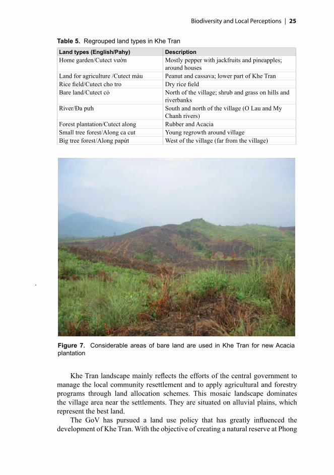
Bare lands (Figure 7) were caused historically by war, fires, grazing and shifting cultivation (Le Trong Trai et al. 2001). This land type, dominated by shrubs and grasses, is the target of reforestation efforts by the government. Acacia plantations are developed on these bare hills.
The rest of the village’s landscape is divided into settlements, home gardens (pepper and fruits), bare hills, rivers and roads. If land for plantation is geographically specialized (Acacia in the upper part and rubber in the lower part), home gardens can be found near the houses in both parts of the village.
Biodiversity and Local Perceptions | ��
Table 5. Regrouped land types in Khe Tran
Land types (English/Pahy) DescriptionHome garden/Cutect vườn Mostly pepper with jackfruits and pineapples;
around housesLand for agriculture /Cutect màu Peanut and cassava; lower part of Khe Tran Rice field/Cutect cho tro Dry rice fieldBare land/Cutect cỏ North of the village; shrub and grass on hills and
riverbanksRiver/Đa pưh South and north of the village (O Lau and My
Chanh rivers)Forest plantation/Cutect along Rubber and AcaciaSmall tree forest/Along ca cut Young regrowth around villageBig tree forest/Along papứt West of the village (far from the village)
Figure 7. Considerable areas of bare land are used in Khe Tran for new Acaciaplantation
Khe Tran landscape mainly reflects the efforts of the central government to manage the local community resettlement and to apply agricultural and forestry programs through land allocation schemes. This mosaic landscape dominates the village area near the settlements. They are situated on alluvial plains, which represent the best land.
The GoV has pursued a land use policy that has greatly influenced the development of Khe Tran. With the objective of creating a natural reserve at Phong

�� | Site description
Dien, the government has encouraged villagers to abandon traditional agriculture and other activities in the mountains for permanent agriculture in the rich lowland soils. The government is omnipresent in the activities of villagers through the Provincial People’s Council, which frequently intervenes at the local level. The people’s council of the Phong My commune is involved in all decision-making concerning daily village management, nominates the village chief and decides the attribution of government-financed development projects.
Our informers said that they did no longer hunt in the forest because there is little game and hunting is banned by the government. This said, when shown a map, they can tell where to find the different wild animals, which shows that they have only recently given up hunting or that some clandestine hunting (mostly by snares as firearms are illegal) still occurs.
An old cemetery is situated in the middle of an Acacia plantation, and the remains of abandoned villages can be found around the small tree forest in the village area. These land features represent important historical and cultural sites for the villagers.
5.3.1. Distribution of resource and land types (participatory resource mapping)
As mentioned previously (see Methods, Chapter 2), community meetings were used to map the main resources and land types identified by villagers. These participatory mappings are a preliminary condition to arrive at a common understanding of the local perceptions of the different land types and activities in the target area.
During the participatory mapping exercise, we provided a basic map showing the main rivers and tributaries, roads and village location. Local representatives added the spatial distribution of many land types and resources, e.g. forests, Acacia and rubber plantation, agricultural land, settlements and home gardens, old village, specific locations for hunting and other specific resources such as war wreckage, rattan, bear, pheasants, etc. The final result of this map can be seen in Figure 8.
Villagers showed good knowledge of the resources near their settlement, including resources from home gardens, agriculture land, plantation forests, small tree forests, bare hills and rivers. Most of the villagers seem to have limited knowledge of the resources situated farther from the village, e.g. in the big tree forest.
Even if the map was not meant to be used for official or legal purposes, villagers considered it a good tool for communication with the outsiders on local land types and resources. The map was used during a workshop with villagers on biodiversity conservation issues in Khe Tran during the last days of our survey (see local perceptions in Chapter 6). The field team also used the map for the selection of relevant sites for measuring plots in the various land types identified by villagers and collecting information on local knowledge of forest products and sites history.

Biodiversity and Local Perceptions | ��
Figu
re 8
. B
iodi
vers
ity a
nd re
sour
ce d
istri
butio
n m
ap o
f Khe
Tra
n

�� | Site description
SummaryThe village is characterized by the presence of a strong minority group, the Pahy, mixed with the majority group in Vietnam, the Kinh, and with the Khome. The population of Khe Tran moved during the war against the USA, some to A Luoi district, close to the Laotian border, and some into Laos. At the end of the war, they were authorized to resettle in their village, and in 1992 the government encouraged the villagers to settle near the main road and helped them to develop more sedentary cultivation of rice fields and industrial crops plantations of Acacia and rubber.
Only few people among the 20 households have received no education. Most villagers spend a large amount of time in their gardens, rice fields and plantations. The village is divided in two areas, the upper part, where villagers have smaller incomes and depend on home gardens and Acacia plantations for their livelihoods; and the lower part, with a higher mean income, depending on more diversified crops cultivation, including Acacia and rubber plantations, home gardens and peanut, cassava and rice fields. The 20 households are scattered and it takes about 30 minutes to walk from one end of the village to the other.
Villagers distinguish a large number of land types, some corresponding with the official nomenclature. Of the eight main land types, forests account for three. In addition to big tree forests and small tree forests, villagers include plantations among the forest landscape. This classification may relate to the official ‘forest status’ of the bare land used for plantation. Plantation forests are part of a large land allocation and forest rehabilitation plan promoted by the local government to provide more income from ‘stable’ and sedentary activities and to keep the villagers out of more forest-dependant activities (shifting cultivation, timber collection, NTFP collection), especially in the Phong Dien Nature Reserve. Nevertheless, participatory mapping of the natural resources of the village shows that knowledge of forest products, wildlife and other natural resources is still important among the villagers, even if this knowledge tends to be limited to the close vicinity of the village. We did not collect much information on areas situated farther from the village, in the core zone of the Nature Reserve. Villagers also have a strong sense of ownership when discussing land tenure in the village, repartition of plantation responsibilities and expectation in the future.
The process of compiling the map showed us that, even if the landscape around Khe Tran is severely disturbed, mainly made up of secondary forests, plantations, grassland and bare lands, villagers recognize a large number of wild resources not far from the village, including some extremely rare animals (tigers, bear). According to informants, these animals were observed at some time during the last 5–6 years.
Therefore, even if the knowledge of resources and land type locations is important, it is concentrated mainly in the village’s vicinity. We will return to this map during our discussion on traditional knowledge in the following chapter.

��
Perceptions of natural resources differ between local people, such as the Pahy, and outsiders such as the government, traders, researchers or development agencies. Decision makers need information on local perspectives to plan and manage the natural resources in a more sustainable way. We present here the villagers’ perceptions of their surrounding natural (e.g. forest, river) and other (forest plantation, home garden, etc.) land types and the village’s biodiversity.
We captured local perceptions of the surrounding landscape and biodiversity using scoring exercises (PDM), focus group discussions and interviews (as described in Methods, Chapter 2). Some of the results were qualitative concerning the description of the perceptions, others were quantitative to compare the perceptions of different groups of villagers, but always accompanied by explanations on the values given by informants.
Villagers use numerous natural resources in their daily activities. These resources (plants and animals) can be found in the various landscape units identified by the local people. Natural resources are used for food, medicine, construction, basketry, firewood, cash earning, etc. The following results show how and why these resources are meaningful for local people in Khe Tran.
6.1. Local land usesAs discussed earlier, there are six main land types around Khe Tran (Table 5, page 25). Bare land, river, big tree forest and small tree forest represent the natural land types, while garden, forest plantation, rice field and dry land for agriculture are the direct consequence of villagers’ activities, sometimes with support from the local government. During the community meetings, villagers named some areas allocated by the government for agriculture and plantations in a highly formal way, e.g. ‘allocated land for rubber plantation’, or, in Pahy, ‘cutect cao su, in contrast with more basic land type, e.g. ‘small tree forest’ (along papút).
�. Local perceptions of the different land types and resources

�0 | Local perceptions of the different land types and resources
According to the villagers biodiversity is important for their livelihoods. Table 6 shows some important products that local people still gather exclusively from the natural forest. Hundreds of other products (plant and animal) are still collected during their daily activities in the surrounding landscape. In Section 6.6, we discuss in more detail the most important products from forest.
More complete, although not exhaustive, lists are also available in Annexes 1 and 2, which show the important knowledge of local people on biodiversity and the large range of uses they have for many forest products. During discussions, informants agreed to categorize the main uses of these products into 14 big categories (Table 7) adapted from the MLA method to the local context.
Table 6. Important forest plants and their local uses
Product names (Pahy or Vietnamese/scientific) UsesA ro/Licuala spinosa Conical hatẤp lăng/— RoofCây re/Calamus walkeri FurnitureChùn quét/— BroomLong huện/Tarrietia javanica Cattle cageTu vien/Melocalamus compactiflorus RopeTân ning/— HoneyÙi a dúm/— Firewood
Table 7. Main categories of use of plant and animal resources
Categories of use DescriptionBasketry Rope made from leaves, rattan or bark for weaving or tyingFirewood Wood for fireFodder Used for feeding cattle, pigsFood Primary and secondary foods, famine foodHeavy construction Material for permanent construction (houses and bridges)Hunting function Poisons, bait, gums, catapult made of plant/animal parts
used to catch animal Hunting place Indirect use of plant as hunting location, usually fruits
appreciated by gameLight construction Poles and cuttings for cattle cage, fences, furnitureMarketable items Plant/animal parts and processed products that are sold for
cashMedicine Medicinal and health related Ornamental/traditional/ritual Plant/animal parts used in ceremony, dress, decoration,
house ornamentsRecreation Area or forest products used for entertainment needsThe future Plant/animal invested and will be important in the futureTools Plant/animal parts used for tools in agriculture, housing;
includes rice pounders, ploughs, tool handles, etc.

Biodiversity and Local Perceptions | ��
6.2. Land type importanceThe results from the scoring exercise with men and women groups show that villagers consider forest the most important land type (40% and 35%; Figure 9). Both natural and plantation forests are important to villagers because they provide many products for the local livelihoods such as latex, timber, rattan, firewood, honey, medicinal plants, bamboo, food, etc. Natural forests also have the role of protection of the village against floods and erosion. Villagers consider gardens the second most important land type, especially for those who live on the upper part of the village, because gardens provide fodder, bamboo for fences for cattle and fruits for cash income. They consider rice fields the least important because they belong to only those who live in the lower part of the village and because rice is a recently cultivated crop here that can be substituted by cassava or peanut. People who do not have rice fields buy rice from the local market at Phong My commune, not far from the village.
0
10
20
30
40
Forest
Garden
River
Drylan
d forag
ricult
ure
Barehil
l
Ricefie
ld
Land types
Impo
rtan
ceva
lue
(%)
Men
Women
The high importance villagers place on forest is explained by the products sold and by the contribution to the local livelihoods that forest can provide. Forest will support the villagers’ livelihoods in the future too (Table 8, page 33). Rice fields provide only few uses such as food for humans and cattle. Cattle are often let free in the rice fields once the harvest is completed.
Figure 9. Land type by importance (all groups)

�� | Local perceptions of the different land types and resources
Gardens and forests are important for the future because they can provide consequent income. Bare land comes in third position for its use in the future because it will provide lands for new forest plantations. Forest dominates all but four of the use categories (Table 8). Bare lands are the most important land types for fodder, and gardens for food. Gardens and the riverside are equally important as hunting places, and they represent the places where villagers spend a large amount of their time. The main game hunted is small birds in the vicinity of the village. River is important for recreation because villagers regularly go to swim and wash in the nearby river, and children go there to play.
6.3. Forest importanceVillagers divide forest land type into three categories, namely big tree forest (primary forest), small tree forest (young, secondary regrowth) and plantation forest. Men and women have different points of view concerning the importance of these forest types. Men consider plantation the most important forest type (49%; Figure 10), because they reckon that in the future plantations will provide them with more regular cash income. Big tree forest comes in second place (43%), although villagers said they gather more products there than in the other forest types. One reason for the lower importance given is the difficult accessibility of these forests.
0
10
20
30
40
50
Plantation forest Big tree forest Small tree forest
Forest types
Impo
rtanc
eva
lue
(%)
Men
Women
Women consider the big tree forest the most important type (50%). They explain that big tree forest provides many valuable products to them. Uses of these products includes food, medicine, heavy construction, tools, basketry, ornaments and marketable items (Table 9). Women also often go to the forest to collect leaves to make conical hats.
Figure 10. Importance of forest types (all groups)

Biodiversity and Local Perceptions | 33
Tabl
e 8.
Loc
al im
porta
nce
of la
nd ty
pes
by u
se c
ateg
ory
(all
grou
ps)
Land
typ
eOverall
Basketry
Firewood
Fodder
Food
Heavy construction
Hunting function
Hunting place
Light construction
Marketable items
Medicines
Ornament
Recreation
The future
Tools
Bar
e la
nd9.
000.
0028
.25
40.2
55.
000.
000.
006.
0019
.25
3.25
12.7
53.
000.
0014
.75
6.75
Dry
land
for
agri
cultu
re14
.00
0.00
0.00
25.0
021
.25
0.00
0.00
3.00
0.00
16.0
03.
750.
000.
009.
003.
75Fo
rest
37.5
070
.00
50.2
57.
0019
.50
68.7
550
.67
12.6
754
.50
48.7
552
.75
74.5
08.
5037
.00
67.2
5G
arde
n23
.00
28.7
518
.50
11.5
024
.00
31.2
549
.33
39.3
322
.50
26.2
514
.75
15.0
030
.00
22.7
521
.00
Ric
e fie
ld5.
250.
000.
001.
508.
250.
000.
000.
000.
000.
000.
000.
000.
004.
500.
00R
iver
11.2
51.
258.
0014
.75
22.0
00.
000.
0039
.00
3.75
5.75
16.0
07.
5061
.50
12.0
01.
25To
tal
100.
0010
0.00
100.
0010
0.00
100.
0010
0.00
100.
0010
0.00
100.
0010
0.00
100.
0010
0.00
100.
0010
0.00
100.
00
Tabl
e 9.
For
est i
mpo
rtanc
e by
use
cat
egor
ies
(all
grou
ps)
Fore
st ty
pe
Overall
Basketry
Firewood
Fodder
Food
Heavy construction
Hunting function
Hunting place
Light construction
Marketable items
Medicines
Ornament
Recreation
The future
Tools
Big
tree
fore
st46
.25
63.2
511
.25
23.0
064
.50
59.5
046
.50
20.0
038
.25
45.5
053
.50
79.0
00.
0041
.25
52.0
0Sm
all t
rees
fore
st19
.25
21.7
540
.00
62.5
020
.25
13.5
033
.50
45.0
041
.00
27.0
026
.25
21.0
00.
0013
.50
36.5
0Pl
anta
tion
fore
st34
.50
15.0
048
.75
14.5
015
.25
27.0
020
.00
35.0
020
.75
27.5
020
.25
0.00
100.
0045
.25
11.5
0To
tal
100.
0010
0.00
100.
0010
0.00
100.
0010
0.00
100.
0010
0.00
100.
0010
0.00
100.
0010
0.00
100.
0010
0.00
100.
00

�� | Local perceptions of the different land types and resources
Men do not consider the small tree forests important. They are mostly used for fodder extraction and for hunting. We will see in the section on ethno-botanical knowledge, Chapter 8, that a large number of herbaceous plants are recognized for their use as fodder. Usually, villagers find food for their cattle in the grasslands near the village, rather than in the forest, but this result shows that their knowledge is focused on this kind of activity and that their perception has followed their progressive settling process. In these forest areas, they also gather small materials for tools and cattle fences. On the contrary, women consider this forest type the second most important. According to them, because small tree forests are closer to the village, it is easier for them to collect grass for cattle, tool materials and firewood. The results show that resource accessibility and the differing activities by gender play an important role in the difference of perception by the villagers.
The results of group discussions show that plantation forests have not brought optimal benefits yet, as plantations are still recent, but in the near future they will become the most profitable source of income. This point seems to relate to the fact that plantations are the key element of the government policy for the settling process. Government officials emphasize that plantations bring more income and a better livelihood to local people than shifting cultivation, and for that reason villagers should stay close to the main road and reduce their activities in the forest. But local perception shows a different perspective on the importance of natural and planted forests to local livelihoods.
In the context of nature reserve management, the Khe Tran community needs alternative sources of income to replace the loss of products previously provided by the forest (marketable items, construction materials, tools, etc.). There should be an agreement on the possibility of access to the forest during hard times (drought or flood). Perception of forests should be considered in its dynamic aspects, however, and the importance of forests to local people may change with time.
6.4. Forest importance in the past, present and futureThe notion of forest importance across different time scales was difficult to explain during group discussions. Groups had to compare the importance of forest (both natural and plantation) among three time periods (present, 30 years ago and the next 20 years) based on the different categories of uses, but to avoid confusion the category ‘for the future’ was not used.
The result shows that forest of 30 years ago was more important for villagers than that of today (Figure 11). According to local informants, in the past they were more dependent on forest products for food, heavy construction, firewood, basketry, hunting and recreation. Today agriculture (home gardens and plantations) has replaced many previous activities in the forest.
Villagers consider the forest of the future more important than the forest at present. All groups think that it will provide more fodder, more products for ornament and more marketable resources such as latex and timber (Table 10). Each household should have a bigger plantation that is a more important source of

Biodiversity and Local Perceptions | ��
Present23%
30 years ago43%
Next 20 years34%
Figure 11. Forest importance over time (all groups)
Table 10. Forest importance over time according to different use categories (all groups)
Category of use 30 years ago Present Next 20 years TotalTotalimportance 44.0 22.5 33.5 100.0Basketry 43.5 37.0 19.5 100.0Firewood 47.8 32.0 20.3 100.0Fodder 17.3 36.3 46.5 100.0Food 43.5 28.3 28.3 100.0Heavyconstruction 40.0 29.0 31.0 100.0Huntingfunction 75.0 19.3 5.7 100.0Huntingplace 70.0 20.7 9.3 100.0Lightconstruction 33.0 39.5 27.5 100.0Marketableitems 22.0 31.5 46.5 100.0Medicine 32.5 33.0 34.5 100.0Ornamental/traditional/ritual 8.5 32.0 59.5 100.0Recreation 58.0 0.0 42.0 100.0Tools 36.5 37.8 25.8 100.0
income. The forest of the future will also protect the water source and will prevent the village from floods and erosion. Moreover, forest will be a safety net in case of hard times.
Looking at the results in more detail, we find that for most use categories the forest of the past was the most important, except for fodder, light construction, marketable items, medicine, ornamental and tools. The presence of a protected area, affording limited access to forest resources, partly explains why the forest of the present is the least important one. Another reason is the diversification of subsistence activities, which makes local people rely less on forest products than
�� | Local perceptions of the different land types and resources
they used to. The growing importance of marketable items in the future comes from the expectation of more Acacia and rubber plantations. Villagers also expect to have more cattle in the future and will rely more on forest resources for feeding it. Justification for the increasing importance of medicinal and ornamental functions of the forest in the future is key to a better understanding of the local perception of the village’s development. The future is supposed to bring wealth, education and time. Education will sharpen the local knowledge on medicinal plants and wealth will provide more time to look for ornamental plants in the forest. Villagers told about the possibility of developing an ornamental plants business and were aware of the good possibilities for cash earning, but they are not yet fully using them.
These results also suggest that villagers’ dependency on and perception of natural forest importance have been affected by the application of GoV programs such as the Phong Dien Nature Reserve management and forest rehabilitation. Reserve management has stopped people from looking for forest products. The consequence is that natural forest has become less important to villagers. Plantation forest, being part of the rehabilitation program and a relatively new activity in Khe Tran, has an increasing importance and is replacing natural forests in that function. Villagers expect to be granted permanent land use certificates (the ‘red book’) for these planted areas, a way, according to them, to secure their rights.
The source of products is also important to understand the local dependency on domestic or wild products.
6.5. Importance according to source of products Villagers use a large number of plants and animals in their daily lives. To better understand the importance of the different products we categorize them into three sources: wild, cultivated/farmed and purchased.
Villagers perceive domesticated products as the most important source for both plant and animal products (Figure 12). The villagers cultivate plants (pepper, peanut, cassava, rice, jackfruit, bamboo) as well as grow animals (cattle, chickens, pigs). They use these products mainly for domestic use and for cash earning. Although the villagers still depend on wild products, they focus more on maintaining their farming and plantation systems. Wild products from the natural forest (mostly plants) are still collected, but, as villagers are not allowed to hunt animals or cut trees in the natural forest of the conservation area, they usually collect wild animals from places close to the village but outside the nature reserve, e.g. gardens, bare lands and forest plantations.
Both men and women groups agree that cultivated plants and farmed animals are the most important sources of products for consumption (Table 11). They explain that these are their most valuable and accessible sources for food and cash. The importance local people give to wild products may be influenced by the fact that free wild resources are limited and often inaccessible because of the ban on extractive activities in the future reserve.

Biodiversity and Local Perceptions | ��
0
10
20
30
40
50
Domesticated Wild Purchased
Source of product
Impo
rtan
ceva
lue
(%)
Plant
Animal
All
Figure 12. Source of product importance (all groups)
Table 11. Importance (%) of source of product by gender
Gender
Wild plants Wild animalsCultivated/
farmed Purchased
Totalforestnon
forest forestnon
forest plant animal plant animalWomen 8.00 7.00 4.00 6.50 25.00 19.00 17.00 13.50 100.00Men 13.00 6.50 6.50 5.50 26.00 18.00 13.50 11.00 100.00Mean 10.50 6.75 5.25 6.00 25.50 18.50 15.25 12.25 100.00
6.6. Most important products from the forestForest is the most important land type according to the local people partly because of the products it supplies. Here we show how the forest (both natural and plantation) provides people with products and which are the most important plants and animals.
Figure 13 shows that forests are considered most important in providing for a better future (20%) and for food (11%), marketable items (11%), fodder (10%), heavy construction (10%) and tools (10%). These values were calculated from a general consideration of the uses of forest types, the first step during the scoring exercises, when groups of villagers estimate the overall importance of forest resources.

�� | Local perceptions of the different land types and resources
Figure 13. Importance of forest resources by use categories (all groups)
Fodder
A second activity was to assess the importance of the 10 main species for each category of use. Informants listed and scored the most important plant and animal species they gather from the forest. A list was made for each of the categories of use except hunting place, recreation and the future. Villagers decided not to include these latter categories because no specific plant or animal from the forest was used for them. The result shows that local people consider forest important for the future, but cannot name any specific plant or animal to support this assumption. This emphasizes the fact that specific knowledge on forest has decreased. Local people still recognize the various roles of forest in general, but have difficulty to provide information on more specific resources.
The scores of the important species from the forest were analysed, and the top 10 most important plants and animals were identified using a tool called LUVI (Local User Value Index; Sheil et al. 2003), which represents the sum of all a species values. A summary of the results is shown in Table 12.
The importance of plants seems correlated to their usefulness (number of use categories). Bamboo (Pheo), the most important plant in Khe Tran, is used for
Biodiversity and Local Perceptions | ��
Table 12. Most important forest plants and animals in Khe Tran (all groups)
Plant Animal
Pahy Latin/English LUVI Pahy/English LUVI
Pheo Poaceae/bamboo 24.22 A binh/rat 7.81Ki re Calamus walkeri /rattan 20.49 Chon den/— 3.67Tràm Acacia auriculiformis/Acacia 19.21 A cuot/frog 3.55Pe Musaceae/banana 12.87 A at na/— 2.35A xop Wendlandia glabrata/tree 12.28 Khuou/bird 1.87A ro Licuala spinosa/Licuala palm 11.96 A ut/— 1.75Huen Tarrietia javanica/tree 11.06 Truoi/chicken 1.63Pa lar Cleistanthus aff. myrianthus/tree 10.41 Chim Cuong/peacock 1.22Tu vien Melocalamus compactiflorus/
scrambling bamboo9.82 Hon/— 1.21
Lim Afzelia xylocarpa/Macka wood 9.03 Pi reo/— 1.15
food (bamboo shoots), in construction and as fodder (Table 13). It can also be sold to the chopstick industry and provide villagers with cash income. This valuable plant is available in nearby forests, especially on the riverside, where people grow it near their settlement.
Another important resource, rattan is used for making ropes and baskets, but it is also sold to the furniture industry. Villagers still regularly go into the forest to look for rattan, which is then transported to the village by river. The FPD tolerates this activity even near conservation areas, as it provides income to local people without disturbing the natural forest too much. Acacia is valued for its economic importance, and banana for food (and sometimes as commodity sold among villagers).
Macka wood (Lim) was the tenth most important plant. The wood from this tree has two specific uses: heavy construction and tools. Many other plants, such as Pheo, Huen, A xop, and Tràm, have the same uses, but Lim is one of the best. It seems that the importance of plants, especially plants from natural forest, for heavy construction is decreasing because people are not allowed to cut trees in the nature reserve. Some villagers explained that they had planted forest trees in their yard to satisfy some of their log needs, as otherwise they would have to buy expensive planks and posts for the construction of their houses.
No plant is used for the three categories of hunting place, recreation and the future, but several of the top 10 plants can share the same uses, such as for tools or marketable items. No plant has just one use, and Lim is the only one to have just two uses.
A type of rat, A binh is considered the most important animal from the forest. It is important for food, as it is easy to catch. We were able to find only the Pahy names for most of the animals, as we could not observe them directly. Animals have only four different uses, according to the villagers: the main one is for food, then ornaments, medicine and cash earning (Table 14).

�0 | Local perceptions of the different land types and resources
Table 14. Most important forest animals by categories of use (all groups)
Animal (Pahy) Bas
ketr
y
Fire
woo
d
Fodd
er
Food
Hea
vy c
onst
ruct
ion
Hun
ting
func
tion
Hun
ting
plac
e
Ligh
t con
stru
ctio
n
Mar
keta
ble
item
s
Med
icin
es
Orn
amen
t
Rec
reat
ion
The
futu
re
Tool
s
A binhChon denA cuotA at naKhuouA utTruoiChim cuongHonPi reo
People have valuable knowledge on local biodiversity of natural resources found near the village and those that can be linked to activities important for their livelihoods (e.g. knowledge on plants used as fodder is important in all the land types). The species recognised and assessed cover both rare and abundant
Table 13. Most important forest plants by categories of use (all groups)
Pahy name Scientific name B
aske
try
Fire
woo
d Fo
dder
Food
H
eavy
con
stru
ctio
nH
untin
g fu
nctio
nH
untin
g pl
ace
Ligh
t con
stru
ctio
nM
arke
tabl
e it
ems
Med
icin
es
Orn
amen
tR
ecre
atio
nTh
e fu
ture
Tool
s
Pheo PoaceaeKi re Calamus walkeri Tràm Acacia auriculiformisPe MusaceaeA xop Wendlandia glabrataA ro Licuala spinosaHuen Tarrietia javanicaPa lar Cleistanthus aff. myrianthus Tu vien Melocalamus compactiflorus Lim Afzelia xylocarpa

Biodiversity and Local Perceptions | ��
Table 15. Locally important plant species by use category and IUCN list of threatened trees
Pahy name Scientific name Local uses IUCN Red List category
Lim Afzelia xylocarpa Tools, construction material EndangeredSao Hopea odorata Marketable items VulnerablePrao Parashorea stellata Construction material Critically endangeredA ngo Pinus latteri Marketable items Near threatened/almost
vulnerable
resources, as well as cheap and expensive products. For example, Macka wood (Lim) is a useful plant for tools and construction materials in Khe Tran but it is also listed in the World Conservation Union’s (IUCN) World List of Threatened Trees, and is more generally known as a valuable commercial timber (Table 15).
Local knowledge can be used to better understand conservation priorities for plants and animals. We learned that local people can provide much information on species’ abundance, distribution and other biodiversity parameters. It would also be useful to involve local people more closely in the biodiversity management of the future nature reserve. Their familiarity with the area and their perception of the forest would be a valuable contribution to the conservation of the area.
6.7. Threats to local forests and biodiversityPeople in Khe Tran have a long history of living near forests and managing them for their livelihoods. They have accumulated experiences and knowledge on local forests and biodiversity conditions. It is important to understand and acknowledge this wisdom when planning future management activities appropriate for the reserve.
When asked about threats to the local forest and biodiversity, informants gave various answers. The diversity of results indicates that the nature of recognized threats is highly related to the informant’s location (lower or upper part of the village) and to individual experience.
Timber felling was the main threat identified by villagers (17 of 19 respondents; Table 16). The GoV declared logging forbidden in 2000, following the establishment of an investment plan for Phong Dien Nature Reserve. Even if the reserve status is not yet official (it will be in 2010), the government is already taking action to protect the forests of the future conservation area. Villagers consider that logging may destroy the forest, and it is a sensitive issue because, while the villagers are banned from logging, they have no right to stop outsiders from collecting timber in the area. Villagers have no rights with respect to forest management, and they would like this situation to change (see following section).
Forest fire is considered a threat because fire is often used for war wreckage and honey collection or caused by careless cigarette smoking and (in the past) clearing land for agriculture. To collect scrap metal in grasslands people use metal

�� | Local perceptions of the different land types and resources
Table 16. Villagers’ perception on threats to forest and biodiversity (19 respondents)
Threat to forests and biodiversityNumber of respondents
perceiving threatLogging 17Forest fire 8Slash-and-burn agriculture 6War wreckage collection 6Hunting 4Extraction of forest products 3Firewood collection 1
detectors and because it is difficult to use them on this kind of land, they clear the grass with fire. When this is done during the dry season, the danger is high for the fire to expand out of control.
People think that hunting activities can harm the forest’s wildlife. Although hunting is forbidden, villagers often meet poachers in the forest looking for endangered species (bear, tiger). The collection of firewood and other NTFPs is considered less harmful to the forest habitats.
People’s knowledge and perception of the threats to forest and biodiversity are similar to those reported by Le Trong Trai et al. (2001), even if we found that the ranks attributed to those threats are quite different. For example, the Le Trong Trai et al. (2001) affirm that Khe Tran people perceive NTFP collection and timber cutting as the most pernicious ongoing threat to the forest, but our survey shows local people rank logging and forest fire as the most serious threats. To some extent, the discourses of local people may be influenced by the official vision and discourse on threats. Villagers try to follow the communal, district and provincial rules as much as possible and this effort may influence their perception of land management. We think that this behaviour helps villagers to emphasize the struggle for their rights over the lands around Khe Tran.
These factors, according to villagers, in addition to the ‘open access’ to the forest for outsiders (because of limited FPD personnel to control access) have increased the threat to local biodiversity. Local people’s involvement in the management of the reserve could be a way to reduce some of the threats. During one of the meetings some villagers expressed their interest to become more directly involved in the management of the surrounding natural forest and they hoped that it might bring them some benefits, e.g. employment and even some timber for their daily needs. If they were to become part of the nature reserve management, it could help achieve a win-win situation.
6.8. People’s hopes for the future of their forest and lifeVillagers gave many answers to our questions on the future of their forest and life during personal interviews. Their aspirations are presented in Tables 17 and 18 .
The main answer given by villagers asked what they would do if the forest degraded or disappeared is to reforest the area. They think they will always

Biodiversity and Local Perceptions | ��
Table 17. Villagers’ perception about forest loss (19 respondents)
What to do after forest is lostNumber of respondents choosing
measureReforestation 8Expand agricultural land 3Expand forest plantation 3Improve livestock 2Nothing but sadness and regret 2Prepare to face flood and storm 2Expand home garden 1
Table 18. Villagers’ ideas on threats to human life (19 respondents)
Threats to human lifeNumber of respondents perceiving
threatDisease 14Naturalhazard 11Poverty 11Lack of knowledge 3Lack of transport infrastructure 2Land mines 2Pests of agricultural plants 2Lack of communication facilities 1Unemployment 1War 1
need forest to protect them from floods and storms. They believe that the effect of natural disasters is often increased by the absence of forest on the hills. The idea to reforest the area reflects villagers’ familiarity with forest rehabilitation. The government project of Acacia plantation is well accepted in Khe Tran and successfully implemented in the main bare land areas.
Some of the villagers think they would develop more agricultural and farming activities, forest plantations on cleared forest land, expecting more income from these activities. A few of them said they would just be sad because of the floods in case of forest loss. Other villagers considered the option of preparing ample livestock and cash reserves to face the hazards. Local people generally believe natural forests can protect them from natural hazards, and this opinion is emphasized by those who have experienced disasters during the past.
Villagers identified many threats to human life, but the main factors were disease, poverty/hunger and natural hazards (flood, storm and drought, Figure 14). The lack of knowledge on cultivation and plantation techniques is also considered a threat, because it would cause failures in harvest and provoke starvation (Table 18).
Local people explain that they would work harder to face these threats and would ask for help from the government, which shows their high reliance on government support and guidance. They expect their children to have better

�� | Local perceptions of the different land types and resources
Figure 14. Recent flood on a bridge between Phong My and Khe Tran
education opportunities and to receive training on cultivation techniques and land management. They also expect to earn more money, build stronger houses, yield more agricultural products, and plant more trees to prevent hunger and diseases.
It seems that people will use any possible way to prevent and overcome those threats. Plantation, agriculture and livestock are considered important activities to be intensified.

Biodiversity and Local Perceptions | ��
SummaryThe natural resources from the various land types in Khe Tran provide important products for local livelihoods. Forest, including natural forest and plantations, is the most important land type for all the villagers because of all the products that can be collected from it. Rice fields are the least important land type, as very few are being cultivated because of the inappropriate soil. An important category of use is fodder, mainly found on bare lands.
Perception on forests types differ by informant gender and according to the accessibility of the resource and the different activities. Plantation is the most important category for men, because of its economic benefits. Among women big tree forest ranks first, because of the diversity of NTFP they collect from it. Because of its relatively recent development, villagers do not consider plantation an optimal activity from which to get full benefits. Plantation is the alternative to forest extractive activities proposed by the government, but it should not be the only one, as the profitability of plantation products depends on fluctuating market condition.
The importance of forest on different time scales is changing for local people. Forest in the present is the least important category, because of the depletion of resources, the government ban on all natural resource collection in the forest, and the actual alternative activities. Forest of the past is considered the most important one for all the activities that were carried out there. Forest of the future is more important than that of the present time because of the belief that plantation forest will bring more income.
Domesticated resources are considered more important than wild and purchased resources. Dependency on forest resources has been affected by the government policy on the PDNR.
When asked what is most important in general, among all use categories, local people consider the forest resources of the future most important, followed by food and marketable item. Local expectations on what forest could provide in the future is therefore high. But at the same time, when asked concretely about the uses of the 10 main species, the future is no longer mentioned. This shows that the specific knowledge on forest has decreased. Local people still recognize the different roles of the forest in general, but have difficulty to provide information on specific resources. Knowledge is still important for areas near the village, and the familiarity with the area and local perceptions on forest land types would be a valuable contribution for conservation agencies.
The main threat to forests identified by villagers is logging, followed by forest fires. Most of them agreed to reforest an area after natural forest loss so as to protect them from natural hazards. Even if local discourses may, sometimes, follow the official one, this opinion shows awareness of the risks of unsustainable activities for both the forest and local livelihoods.

��
Our objective in Chapters 7 and 8 is to report the results from the field team activities, which were based on information provided by the village team. These two types of activities, even though separated, were the result of tight collaboration between all the team members.
7.1. Sampling of land typesSmall amounts of repetition of particular land types within the 11 plots (Figure 15) restrict the possibilities for statistical analysis and broader generalization but nevertheless the sample serves the purpose of better understanding the valuation and perceptions of landscape based on quantitative data, e.g. species identification. We will make some generalizations throughout the text, such as reporting densities and basal areas per hectare, but we ask the reader to be aware of limitations to broad quantitative characterizations of landscapes and their land type comparisons.
The first plot was established in a 12-year-old rubber plantation, which was created just one year after the resettlement of Khe Tran village. This area does not suffer frequent flooding and it has experienced only minimum disturbance, the most severe impacts being caused by strong winds. Although cattle grazing is officially disallowed, some was evident during the fieldwork. Hunting is also not allowed, and for other activities permission from owners (10 households) is needed.
The Acacia plantation was eight years old, which is already the harvesting age in plantations of many similarly fast growing species. When the forest was young, the government prohibited the cutting of trees or branches, along with cattle grazing. Any digging was also forbidden. Nevertheless everyone has free access to the graveyard inside the plantation, which is to be honoured by refraining from hunting in its proximity. In 1983 and 1999, when most of the
�. Characterization of land types

Biodiversity and Local Perceptions | ��
village area was prone to flooding, this area was affected as well. Plantations have also experienced forest fires, especially in 1983.
Most of the secondary forests of the area have experienced disturbance rather recently. One plot (Plot 3) was established in forest that had experienced many fires in the period between 1980 and 1995, and in 1983 a big storm had caused many trees to fall. Earlier this area had also been used for shifting cultivation, and the forest was evaluated to be young, not more than 10 years old. The second secondary forest plot (Plot 9) was in older forest (40 years old) with clearly less disturbance, although it bore some marks of illegal logging. A third plot (Plot 11) was established at a site that had seen some fires in 1983, but the age of the forest was relatively high (40 years) and it was mainly used as a source of firewood and scrap metal.
Two plots were established in gardens with more than 10 years of cultivation history after having been natural forests—one a pepper garden and the other a jackfruit garden with riparian bamboo patches. Both areas had flooded in 1983 and the riparian area had burned. The jackfruit garden had been a small bamboo plantation from 1986 to 1995, and before that it was a mixed banana, pineapple and cassava garden. Cassava and pineapple were still cultivated next to the jackfruit garden, which was presently not intensively managed and thus in close to natural condition with the main trees being jackfruits. In the pepper garden there had been cassava and sweet potato cultivation between 1996 and 2002 and natural forest before that. The rice field was a young fallow between the first harvests at the time of the survey. This area has also been cultivated with peanuts.
Secondary forest(small tree forest)
28%
Primary forest(big tree forest)
9%
Rice field9%
Shrub land(bare hill)
18%
Garden (pepper andjackfruit garden)
18%
Plantation forest(rubber, Acacia)
18%
Figure 15. Field sampling of land types in Khe Tran (total sample size 11 plots)
�� | Characterization of land types
The edge of old growth primary forest is not easily reached by walking from the Khe Tran village. Some of the oldest patches of forest lie close to the mountain tops or on steep slopes reached only after more than one hour’s climb and walk. The only plot in mature secondary forest closest to the condition of primary forest was established in 60-to-70-year-old stands visited regularly, but not often, by villagers. Men and women come to this site to collect rattan, honey and metal. The forest was afforded protected status by the provincial government in 1983, and the earlier regular hunting for bear, ‘helmeted’ hornbills, elephants and porcupines was thus forbidden along with timber production activities.
Shrub lands (or bare hills) are a rather heterogeneous land type category with areas that have a history of having been under sugar cane cultivation (Plot 2) but are now fallows waiting to be converted to production area. Villagers describe those barren areas without any clear function for villagers as being degraded or barren because of the impact of chemicals during the war time (Plot 8).
7.2. Specimen collection and identificationA total of 754 plant specimens were collected from 11 plots (Figure 16). In addition to systematic plot sampling of trees and non-trees, the most abundant seedling, sapling, shrub and monocot species were also recorded and sampled separately. In the text all the categories of ‘abundant’ species refer to this separate census, if not otherwise stated. Table 19 shows the division of specimens in trees, non-trees and abundant species. In total 108 families comprising 260 genera and 439 species were recorded (Annex 3 provides the botanical names, families and local name of specimens collected within and outside the plots). The number of unidentified taxa remains high due to the technical difficulties in sampling as well as the high vascular plant richness of the area.
The sampling was not exhaustive, and was not supposed to be so, as one of the main objectives of using MLA was to test the relevance of such a tool in the Vietnamese context. Nevertheless the sampling using 11 plots in total was considered rigorous and adequate for non-tree representativeness, since the curves of cumulating numbers of non-tree vascular plant species laid against cumulating numbers of random subplots are levelling out for most land types (Figure 17). There was surprisingly diverse under storey in the plantation forests and thus they could have been sampled with an additional plot. For trees this short inventory time did not enable as good sampling as for non-trees, but nevertheless the collected data can be used as a basis for recommendations and considerations of further inventories of the forests. For trees the accumulation curves show in most of the land types no levelling down, pointing to the need for more plots, which were unfeasible considering the time constraints.
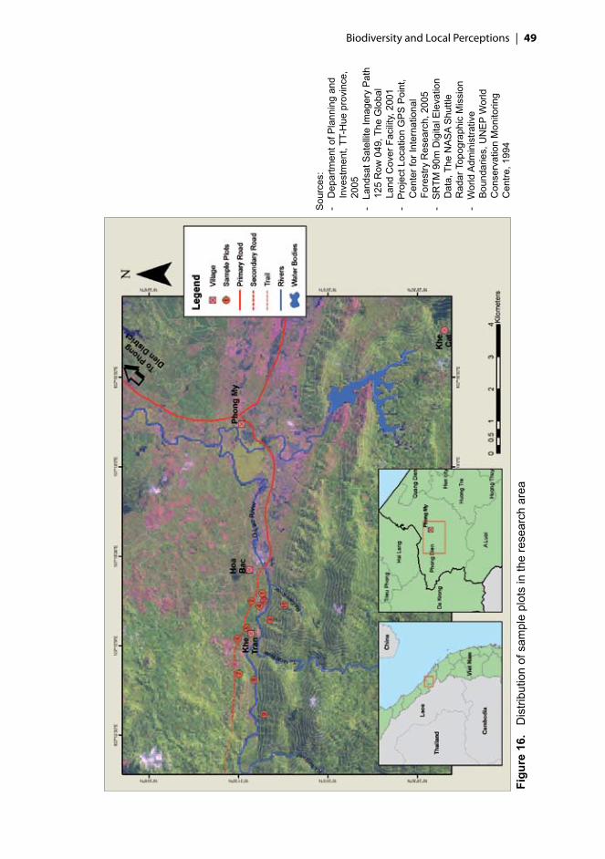
Biodiversity and Local Perceptions | ��
Figu
re 1
6.
Dis
tribu
tion
of s
ampl
e pl
ots
in th
e re
sear
ch a
rea
Sou
rces
:-
Dep
artm
ent o
f Pla
nnin
g an
d In
vest
men
t, TT
-Hue
pro
vinc
e,
2005
- La
ndsa
t Sat
ellit
e Im
ager
y P
ath
125
Row
049
, The
Glo
bal
Land
Cov
er F
acili
ty, 2
001
- P
roje
ct L
ocat
ion
GP
S P
oint
, C
ente
r for
Inte
rnat
iona
l Fo
rest
ry R
esea
rch,
200
5-
SR
TM 9
0m D
igita
l Ele
vatio
n D
ata,
The
NA
SA
Shu
ttle
Rad
ar T
opog
raph
ic M
issi
on-
Wor
ld A
dmin
istra
tive
Bou
ndar
ies,
UN
EP
Wor
ld
Con
serv
atio
n M
onito
ring
Cen
tre, 1
994

�0 | Characterization of land types
Table 19. Summary of specimen collection and identification of plant species from 11 sample sites
Family Genus Species Total records
Tree 39Identified = 34Unidentified = 5
65Identified = 56Unidentified = 9
98Completely identified = 71Identified up to genus = 18Unidentified = 9
268
Non-tree 80Identified = 64Unidentified = 16
172Identified = 130Unidentified = 42
292Completely identified = 166Identified up to genus = 84Unidentified = 42
413
Abundant* 28Identified = 25Unidentified = 3
50Identified = 40Unidentified = 10
62Completely identified = 34Identified up to genus = 18Unidentified = 10
73
Allplants 108Identified = 84Unidentified = 24
260Identified = 199Unidentified = 61
439Completely identified = 261Identified up to genus = 117Unidentified = 61
754
*Abundant refers to the seedling, sapling, shrub and monocot species separately recorded in the field as the most abundant ones based on expert opinion.
Figure 17. Accumulation of non-tree species with the increasing random order of subplots (each 20 m2) for land types in Khe Tran
0
20
40
60
80
100
120
1 3 5 7 9 11 13 15 17 19 21 23 25 27 29
Subplots
Cum
ulat
ing
num
bero
fnon
-tre
esp
ecie
s
Secondary forest
Plantation forestPrimary forest
Rice fieldShrub land
Garden

Biodiversity and Local Perceptions | ��
7.3. Plant biodiversityTree species (dbh ≥10 cm) among 39 families and non-tree species among 80 families were inventoried. The most common families among non-trees were Cyperaceae and Poaceae, both of which were present in 10 of the 11 plots. The most common families among trees and non-trees combined were Rubiaceae and Euphorbiaceae (each found in 9 plots) and Fabaceae (8). Among trees the most common families were Euphorbiaceae and Moraceae (5) followed by Lauraceae, Myrtaceae and Rubiaceae (4).
Twenty-eight percent of identified families and 84% of all plant species were singletons, present in only one plot, which indicates the high diversity of vegetation and large differences among land types. This view is also supported by the data from non-tree species alone, in which case 68 of the total of 292 species (identified and unidentified lumped together) were present in only one subplot (out of 110 subplots), 38 in two subplots and 258 species (88%) were present in only one land type. Only a few true generalists were recorded in many land types. The most common and abundant non-trees were the herbs Centella asiatica (Apiaceae), present in 34 subplots and four land types, Catimbium breviligulatum (Zingiberaceae) in 33 subplots in four land types, and Curculigo cf. capitulata (Hypoxidaceae) in 10 subplots and four land types. The next most common ones were Hypolytrum nemorum (Cyperaceae) (23, 4), Schizostachyum cf. gracile (Poaceae) (23, 2), Paspalum conjugatum (Poaceae) (21, 3) and Cleome viscosa (Capparaceae) (19, 1). Nevertheless only a few species were shared between different land types.
Secondary forests stand mainly on steep slopes and consist of diverse tree species (from 20 to 30 tree species per plot, tree richness index from 0.81 to 0.91), often with fairly open canopy and dense understorey. Basal area in secondary forests varied from 11 to 17 m2 ha-1. Relative dominance of a species is commonly expressed as percentage of the total basal area. Based on this index one more dominating tree species in secondary forests was identified (Figure 18). Barringtonia macrostachya (Lecythidaceae) was recorded in all secondary forest plots with its relative dominance always being close to 35%. Its relative abundance (percentage of the total number of individuals per plot) varied from 15% to 43%. Other species with relative large basal areas were Cinnamomum cf. burmannii (Lauraceae) (21% present in one plot) and Aporosa tetrapleura (Euphorbiaceae) (relative dominance from 2% to 8% in three plots, present in both secondary and primary forest). In secondary forests 55 tree species (132 individuals) out of the total of 70 species were present with a single individual, indicating high overall diversity of the forests and the need for larger sample size for trees if more rigorous information on them is needed.
Planted and managed forests are very common and promoted by the government, thus many bare hills have recently been converted into mixed fast wood plantations of Acacia mangium, Acacia auriculiformis and Acacia siamensis (Plot 5) or rubber (Hevea brasiliensis) plantations (Plot 1). Since for example A. mangium reaches harvest age in a mere 6 to 8 years after planting, the landscape has changed fast. Planting Acacia has also been supported by its catalyzing effect

�� | Characterization of land types
0
0.1
0.2
0.3
0.4
0.5
0.6
0.7
0.8
0.9
1
1 3 5 7 9 11 13 15 17 19 21 23 25 27 29
SpeciesR
elat
ive
basa
lare
a
Secondary forest (Plot 11)
Secondary forest (Plot 9)
Secondary forest (Plot 3)
Primary forest
Figure 18. Relative dominance in primary and secondary forest plots in Khe Tran based on basal area
on the growth of natural forest tree species. Many of the fast wood plantations close to the village were not intensively managed and the plot located in Acacia plantation shows that the diversity of non-tree species in the understorey was relatively high (on average 32 species per plot), even comparable to secondary forests (from 27 to 51) (Table 20).
The primary forests (which could also be considered to be old secondary forests) of the area are relatively inaccessible because of the distance and their rarity due to the disturbance history. The most abundant species in the primary forest were Adinandra cf. hainanensis (Theaceae), Aporosa tetrapleura and A. dioica, all with 7% of the total number of individuals in the plot of primary forest.
The most abundant seedlings in the understorey of Acacia plantation were not Acacia but species from the genera Ficus (Moraceae) and Eurya (Theaceae) and saplings of Maesa balansae (Myrsinaceae). The only primary forest plot had relatively open canopy and thus an almost as diverse understorey as secondary forests or bare hills (shrub lands) with abundant seedlings from Myrtaceae and saplings from Lauraceae and Polygalaceae. In the understorey of rubber plantations the most abundant tree seedling was Mallotus paniculatus (Euphorbiaceae), sapling Maesa balansae with the most abundant shrub Melastoma sp.1 (Melastomataceae). None of the recorded most abundant seedlings or saplings were present as main tree species in respective land use type. Most of the main tree species have specified use value for local people, and Table 21 shows different land types with the main tree species and their importance to local livelihoods. The main uses for tree products are for construction, firewood and food, which can be considered major forest services.

Biodiversity and Local Perceptions | ��
7.4. Forest structureRichness of life forms of non-tree species varied substantially among land types. Epiphytes were present in only one secondary forest plot. Herbs, with 190 species, were the richest non-tree life form category in all land types, especially in more open and managed areas such as dry rice fields and gardens. Lianas, climbers and ferns were also present in all of the land types, except rice fields (Table 22).
Secondary forests had the highest canopy, highest dbh and second lowest furcation index, as illustrated in Figure 19 on the right. Mean height of the secondary forest varied from 10 to 17 m with a maximum of two canopy layers, which indicates the lack of high primary forest species. Mean height of the primary forest was 14 m, which is in line with other survey results from this area (e.g. Le Trong Trai et al. 2001). Canopy height in plantation forest varied between 14 and 16 m and in gardens from 6 to 10 m.
Furcation index indicates the plant height where apical dominance is no longer a property of a single defined stem. It was recorded on a continuous scale from 0 to 110% (the latter being a tree trunk without clear dominant stem). Some structural features of trees may be linked to their disturbance history and MLA experiences from, for example, Papua and Kalimantan show that apical dominance is generally low in primary rainforests with closed canopy. An increase of value may reflect the rate of disturbance in the forests (trees resprout after breakage) and history of utilization of trees. As presented in Figure 19, on the right, furcation index values in Khe Tran varied from 30 to 63. The highest value was recorded in rubber plantation and the lowest ones in the most distant secondary forest plots and Acacia plantation without intensive management.
Table 20. Plant richness in Khe Tran
Land type Plot Tree richness*
Number of tree
individuals recorded
Number of tree
species
Mean number of tree
species
Number of non-
tree species
Mean number of non-tree species
Garden 4 0.25 16 22
4637
6 0.00 12 1 27Plantationforest
1 0.00 40 12
2533
5 0.30 40 3 39Primaryforest 7 0.91 40 29 29 33 33
Rice field 10 n.a. 0 0 0 31 31
Secondaryforest
3 0.87 40 2525
36419 0.92 40 30 51
11 0.81 40 20 36Shrubland
2 n.a. 0 00
3027
8 n.a. 0 0 24*Tree richness = log10sp/log10countn.a. means not applicable

�� | Characterization of land types
Table 21. Main tree species based on basal area and density listed with their uses in Khe Tran
Landtype
Main tree species Uses Basal area (m2 ha-1)
Density (tree ha-1)
Gar
den
(pep
per a
nd
jack
frui
t gar
den)
Artocarpus heterophyllus
Food (fruit), heavy and light construction (timber for house and cattle barn), firewood
2.3 100
cf. Moraceae Food (fruit), heavy construction (timber for house), support stalk for growing of pepper
0.6 73
Unknown species Tree used as a support stalk for growing of pepper
2.5 233
Plan
tatio
n fo
rest
Acacia auriculiformis Heavy construction (timber for house), marketable item (timber for pulp), firewood
5.8 429
Acacia mangium Heavy construction (timber for house), marketable item (timber for pulp), firewood
1.3 67
Hevea brasiliensis Marketable item (latex) 11.0 398
Prim
ary
(big
tree
) for
est
Adinandra cf. hainanensis
Firewood 1.0 53
Aporosa tetrapleura Heavy construction (timber for house), firewood, light construction (timber for cattle barn)
0.8 51
cf. Osmanthus sp.1 Firewood 1.8 40
Syzygium cf. cochinchinensis
Heavy construction (timber for house)
1.2 28
Vitex trifolia Firewood 0.5 45
Seco
ndar
y (s
mal
l tre
e)
fore
st
Aporosa tetrapleura Firewood, light construction (timber for cattle barn)
7.1 42
Barringtonia macrostachya
Food, firewood 5.3 123
Cinnamomum cf. burmannii
Firewood 3.7 19
Fagaceae Firewood 3.2 43
Trees with dbh ≥ 10 cm are clearly smaller and growing less densely in gardens compared to other land types with trees. Density is very similar in plantations and secondary forests, but the latter has clearly higher basal areas per hectare.

Biodiversity and Local Perceptions | ��
Table 22. Richness (total number of species recorded per plot) of life forms of non-tree species in all land types in Khe Tran
Land type Plot
num
ber
Her
bs
Lian
as (w
oody
cl
imbe
rs)
Clim
bers
(non
-w
oody
lian
as)
Palm
s
Pand
anus
Fern
s
Clim
bing
fern
s
Epip
hyte
s
Garden4 38 4 2 26 10 8 5 1 3
Plantationforest1 21 1 35 14 13 6 6
Primaryforest 7 12 10 5 1 3 2Rice field 10 31
Secondaryforest3 15 12 2 3 49 7 14 3 7 2 211 13 17 3 8 2 5 2 1
Shrubland2 16 2 3 7 28 20 2 2
Allplots 190 77 27 20 5 36 6 1
7.5. Species vulnerabilityTen plant species with threatened status were recorded in the field and/or in PDM exercises. These threatened species and their status are shown in Table 23. Species with undefined status are omitted. Data is based on checklist of WCMC (1994) and IUCN (2006). None of the red-listed plant species recorded at Phong Dien and Dakrong Nature Reserves and reported by BirdLife (Le Trong Trai et al. 2001) were found in the sample plots.
For most of these threatened species villagers named uses, and four of the species, Hopea odorata, Parashorea stellata, Afzelia xylocarpa and Pinus latteri, were valued as very important ones. Those were found only outside the sampling plots. Most of the threatened species recorded in the field were found in secondary forests and no threatened species were found from intermediate or cultivated land types.
All of the threatened species were considered to have substitute sources for their particular use. Calamus tonkinensis, which is used for making furniture and building roofs, is also listed as threatened. The biggest threats to Parashorea stellata are habitat degradation and wood clear cutting, the latter being also conducted by Khe Tran villagers. According to IUCN (2006), Amesiodendron chinense is a dominant component of some forest localities and has been observed to regenerate well, although population reductions have occurred. It was considered

�� | Characterization of land types
0
200
400
600
800
1000
1200
Gar
den
Pla
ntat
ion
Prim
ary
Sec
onda
ry
Indi
vidu
als
ha-1
0
2
4
6
8
10
12
14
16
18
20
m2
ha-1
Density
Basalarea
0
0.2
0.4
0.6
0.8
1
Gar
den
Pla
ntat
ion
fore
st
Prim
ary
fore
st
Sec
onda
ryfo
rest
Prop
ortio
nof
max
valu
e
Avg. dbh (cm) Max. dbh (cm)Avg. height (m) Max. height (m)Avg. furcation
Figure 19. Forest structural characteristics in Khe Tran. Left panel: basal area and density; right panel: tree height, stem diameter and furcation index
a marketable item in the village. Apart from threatened status, Gnetum montanum (present in secondary forest, in one plot), which is one of the CITES-listed species for Vietnam, listed in Annex 3, was not valued as useful species since it was mentioned many times without uses and only once as a source of children food.

Biodiversity and Local Perceptions | ��
Table 23. Threatened species in Khe Tran based on vegetation inventories and PDM exercises
Species Family Uses Status1 Land use typeCalamus dioicus Arecaceae Basketry R Secondary forestCalamus salicifolius Arecaceae None R Secondary forestCalamus tonkinensis Arecaceae Heavy and light
constructionR Secondary forest
Epiprinus balansae Euphorbiaceae Firewood R Secondary forestHopea odorata Dipterocarpaceae Marketable item VU* 2
Parashorea stellata Dipterocarpaceae Heavy construction
CR* 2
Afzelia xylocarpa Mimosaceae Marketable item EN* 2
Pinus latteri Pinaceae Marketable item R, LR/NT*
2
Amesiodendron chinense
Sapindaceae Heavy construction, firewood
LR/NT* Primary forest, secondary forest
Camellia cf. fleuryi Theaceae Firewood, heavy construction
R, VU* Primary forest
1 Status according to WCMC (1994) without asterisk, according to IUCN (2006) with asterisk. R: rare; VU: vulnerable; CR: critically endangered; EN: endangered; LR/ NT: near threatened.2 Recorded in PDM exercise as locally important species, but not observed in the field plots.

�� | Characterization of land types
SummaryThe flora of Khe Tran exhibits high species richness, and although our sampling was not exhaustive, it is sufficiently rigorous to address the value and relative richness of remaining natural forests as well as other land types. It also shows that the potentially monotonous land types, such as plantations or rice fields, are still very high in non-tree diversity in Khe Tran, which enables and maintains their multiuse function.
According to this survey, the people of Khe Tran represent no imminent threat for recorded endangered species. We recommend that information on threatened species be given to villagers to raise the awareness of conservation needs and that the specific uses of especially threatened species be discussed in order to give people the option to choose other species for these uses. It seems likely that the range of threats from cutting of construction material and collection of firewood and material for basketry may have contributed to the status of plant species in the past, but the impact at present is difficult to assess. Direct impact on forest cover or composition as a whole is impossible to quantify based on our sampling. Therefore further research on sustainability of NTFP collection is required. Most of the natural vegetation is disturbed forest or shrub lands and the impacts of floods and fires continue to influence forest cover and structure. The most substantive influence on remaining forests may be the way of planning and measure of recognising the outside effect on land types. During the fieldwork we saw many people coming from elsewhere to collect NTFPs and some marks of illegal logging conducted by people from outside the area.

��
8.1. Plant usesWe categorized all the uses of plants recorded in the field according to the categories used in the PDM exercise (Table 7, Chapter 6). In addition a category of ‘miscellaneous’ was created for 15 species that were outside the most common use categories. In the miscellaneous group we find: fertilizer, support stalk for growth of pepper, fabric dye, shampoo, charcoal to blacken teeth, incense and furniture polish. Similarly to the results from the PDM exercises, no plant was recorded for the future and hunting place categories.
The result of herbarium identification shows that 71% species gathered are useful species from 81 families and 164 genus (Table 24). Annex 3 provides local uses information of collected plants with their botanical names, families and local names.
Table 24. Summary of specimen collection and identification of plant species from 11 sample sites
Family Genus Species Totalcollectedplants
108Identified = 84Unidentified = 24
260Identified = 199Unidentified = 61
439Completely identified = 261Identified up to sp. = 117Unidentified = 61
Totalusefulplants
81Identified = 72Unidentified = 9
202Identified = 164Unidentified = 38
312Completely identified = 202Identified up to sp. = 72Unidentified = 38
Trees are very useful for the Khe Tran people (Table 25). From the total of 98 tree species recorded in the 11 plots, 94 have at least one use. All trees recorded
�. Ethno-botanical knowledge

�0 | Ethno-botanical knowledge
(dbh ≥10 cm) in the garden and plantation forest are considered useful, which reflects the fact that these forests are relatively intensively managed and mainly useful species are left to grow there. No tree was found in the rice fields and shrub lands, as they are usually cut at the seedling stage.
Table 25. Mean number of species and number of useful species recorded in each land type
-------------- Tree -------------- ----------- Non-tree -----------
Land type
Mean number of species
Mean number of useful species
Percent useful
Mean number of species
Mean numberof useful species
Percent useful
All plots (n = 11) 98* 94* 96 292* 175* 60
Garden (n = 2) 2 2 100 37 27 73
Plantation forest (n = 2) 2 2 100 33 21 62
Primary forest (n = 1) 29 27 93 33 11 33
Rice field (n = 1) 0 0 0 31 24 77
Secondary forest (n = 3) 25 22 87 41 15 37
Shrub land (n = 2) 0 0 0 27 17 61*Total number of species from all plots
At the time of the fieldwork the rice field was dry, a young fallow during a short period before the rainy season returned with the new planting. It had the highest percentage of useful non-tree species (77%, 24 species) of all land types, while primary forest had the lowest (33%, 11 species).
For all non-trees, the percentage of useful species is higher in cultivated areas (rice field, garden and plantation forest) than in other places, including the natural forest. This reflects the distance and accessibility of the different areas for the local people. Since villagers visit the cultivated areas more often than they go to the natural forest, they are more familiar with the plants near the settlement. In comparison with the PDM exercise for the source of products, cultivated plants have more value than wild plants (Figure 12, Chapter 6).
The use categories with the largest total number of recorded useful species are firewood, fodder and food. Firewood is gathered mainly from the natural forest, while fodder is found mainly in gardens and rice fields (after harvest). Food comes mainly from the garden. Therefore even if forests are important in most of the categories of uses, land types near the village, such as gardens, plantations and rice fields, are the most important for the main categories (Table 26).

Biodiversity and Local Perceptions | ��
Table 26. Distribution of all useful plant species per plot and by use category
Land type Plot
num
ber
Bas
ketr
y/ro
pe
Fire
woo
d
Fodd
er
Food
Hea
vy c
onst
ruct
ion
Hun
ting
func
tion
Ligh
t con
stru
ctio
n
Mar
keta
ble
item
Med
icin
e
Orn
amen
tal/r
itual
Mis
cella
neou
s
Rec
reat
ion
Tool
s
Tota
l num
ber o
f spe
cies
Mea
n nu
mbe
r of s
peci
es
Garden4 1 24 8 2 1 5 5 38
326 1 6 9 11 1 2 2 3 5 2 1 25
Plantationforest1 4 12 5 1 1 3 6 1 1 25
305 1 13 12 8 3 2 4 4 1 1 1 35
Primaryforest 7 3 23 1 5 15 1 4 1 4 2 1 2 39 39Rice field 10 19 5 2 2 1 24 24
Secondaryforest3 19 5 8 11 3 11 2 2 4 4 3 50
469 4 29 2 5 11 1 2 1 4 3 2 4911 3 24 8 3 1 1 1 3 1 2 39
Shrubland2 7 11 5 1 1 2 1 1 22
228 5 11 3 1 1 1 2 1 1 1 22
Allplots 12 117 89 57 44 5 21 16 29 15 18 2 11 318
8.2. Species with multiple usesSome species have multiple uses (Table 27), as is apparent in the following examples. The most multipurpose species is Gigantochloa sp. (giant bamboo), which is used for basketry, firewood, food (from the shoot), fodder (leaf), fence for cattle facility, marketable item (chopstick) and tools. Giant bamboo was only present near the jackfruit garden, but grows abundantly in the whole area, not far from the settlements. Imperata cylindrica (Cogon grass) is used for spice (from the roots), medicine (root), thatching (leaf) and fodder (leaf). Macaranga trichocarpa, a pioneer species, indicates disturbance in forests and is commonly used by local people. It was not very abundant (one individual in each secondary forest plot), although rather common in secondary forest. Drink made from its leaves is believed to improve and maintain health and its wood is used for firewood. In the past this species was also used to make beds. Artocarpus heterophyllus (jackfruit) is used for firewood, heavy and light construction and food (fruits).
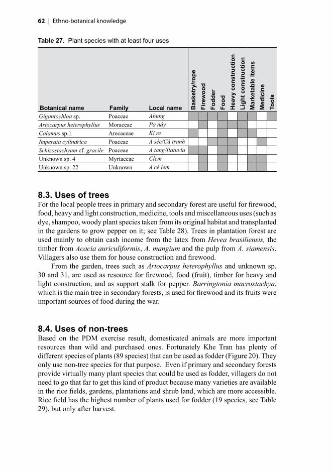
�� | Ethno-botanical knowledge
Table 27. Plant species with at least four uses
Botanical name Family Local name Bas
ketr
y/ro
peFi
rew
ood
Fodd
erFo
odH
eavy
con
stru
ctio
nLi
ght c
onst
ruct
ion
Mar
keta
ble
item
sM
edic
ine
Tool
s
Gigantochloa sp. Poaceae AbungArtocarpus heterophyllus Moraceae Pa nâyCalamus sp.1 Arecaceae Ki reImperata cylindrica Poaceae A séc/Cá tranhSchizostachyum cf. gracile Poaceae A tang/IlatuviaUnknown sp. 4 Myrtaceae ClemUnknown sp. 22 Unknown A cê lem
8.3. Uses of treesFor the local people trees in primary and secondary forest are useful for firewood, food, heavy and light construction, medicine, tools and miscellaneous uses (such as dye, shampoo, woody plant species taken from its original habitat and transplanted in the gardens to grow pepper on it; see Table 28). Trees in plantation forest are used mainly to obtain cash income from the latex from Hevea brasiliensis, the timber from Acacia auriculiformis, A. mangium and the pulp from A. siamensis. Villagers also use them for house construction and firewood.
From the garden, trees such as Artocarpus heterophyllus and unknown sp. 30 and 31, are used as resource for firewood, food (fruit), timber for heavy and light construction, and as support stalk for pepper. Barringtonia macrostachya, which is the main tree in secondary forests, is used for firewood and its fruits were important sources of food during the war.
8.4. Uses of non-treesBased on the PDM exercise result, domesticated animals are more important resources than wild and purchased ones. Fortunately Khe Tran has plenty of different species of plants (89 species) that can be used as fodder (Figure 20). They only use non-tree species for that purpose. Even if primary and secondary forests provide virtually many plant species that could be used as fodder, villagers do not need to go that far to get this kind of product because many varieties are available in the rice fields, gardens, plantations and shrub land, which are more accessible. Rice field has the highest number of plants used for fodder (19 species, see Table 29), but only after harvest.

Biodiversity and Local Perceptions | ��
Table 28. Distribution of tree species considered useful per plot and per use category
Land type Plot
num
ber
Tota
l num
ber o
f tr
ee s
peci
es
Fire
woo
d
Food
Hea
vy
cons
truc
tion
Ligh
t co
nstr
uctio
n
Mar
keta
ble
item
Med
icin
e
Mis
cella
neou
s
Tool
s
Garden 4 2 1 1 26 1 1 1 1 1
Plantationforest 1 1 15 3 3 3 3
Primaryforest 7 29 23 1 13 3 1 1 1Rice field 10 0
Secondaryforest3 25 17 2 8 5 2 29 30 23 1 9 211 20 18 1 2
Shrubland 2 08 0
0 10 20 30 40 50 60 70 80 90 100 110 120 130
Firewood
Fodder
Food
Heavy construction
Medicine
Light construction
Miscellaneous
Marketable item
Ornamental/ritual
Basketry/rope
Tools
Hunting function
Recreation
Usecategory
Number of species
Tree species
Non-tree species
Abundant species*
Figure 20. All plant species considered useful by the Khe Tran villagers shown in use categories*Including the seedling, sapling, monocot or shrub of the tree and non-tree species

�� | Ethno-botanical knowledge
For food and medicine they use, respectively, 39 and 22 non-tree species (Figure 20). Centella asiatica (Rau ma/Pahy), a major wild vegetable, is used for food and medicine, as well as sold in the market.
Table 29. Distribution of non-tree species considered useful per plot and per use category
Land type Plot
num
ber
Bas
ketr
y/ro
pe
Fire
woo
d
Fodd
er
Food
Hea
vy c
onst
ruct
ion
Hun
ting
func
tion
Ligh
t con
stru
ctio
n
Mar
keta
ble
item
Med
icin
e
Orn
amen
tal/r
itual
Mis
cella
neou
s
Rec
reat
ion
Tool
s
Tota
l num
ber o
f spe
cies
Garden 4 24 7 1 1 5 3 466 1 1 8 7 1 1 3 5 2 1 27
Plantationforest
1 12 4 1 1 1 5 1 255 1 12 5 1 3 1 1 1 39
Primaryforest 7 3 1 3 2 1 1 1 3 2 1 33Rice field 10 19 5 2 2 1 31
Secondaryforest
3 5 4 3 1 3 2 1 3 1 369 4 1 2 3 2 1 4 3 2 5111 3 7 1 1 1 1 2 1 2 36
Shrubland2 1 11 4 1 1 308 11 2 2 1 1 1 24
8.5. Forest as resource of useful plantsThe most important useful species recorded from the forest are used for firewood (101 species), followed by species for heavy construction (41 species) and food (35 species), as shown in Figure 21. The local people use not only wood species for firewood but also bamboo (Gigantocloa sp. 1, Schizostachyum cf. gracile and Stixis scandens).
Secondary forest has more species (18) used for the food category than plantation and primary forests (13 and 5 species, respectively), all plant forms considered. The species from primary forest are Artocarpus styracifolius (Moraceae), Linociera cf. ramiflora (Oleaceae), Zingiber sp. 2 (Zingiberaceae), Schizostachyum cf. gracile (Poaceae) and Tetracera sarmentosa ssp. asiatica (Dilleniaceae).
There are several plants from the forest, especially from plantation and secondary forests, appreciated by children for food: Catimbium breviligulatum (young stem), Dracaena sp. (shoot), Gnetum cf. montanum (fruit), Fibraurea recisa (fruit), Linociera cf. ramiflora (flower), Melastoma sp. 2 (fruit), Physalis angulata (fruit), Psychotria sp. 2 (fruit), Randia spinosa (fruit), Rubus sp. 2 (fruit) and Stixis suaveolens (fruit).
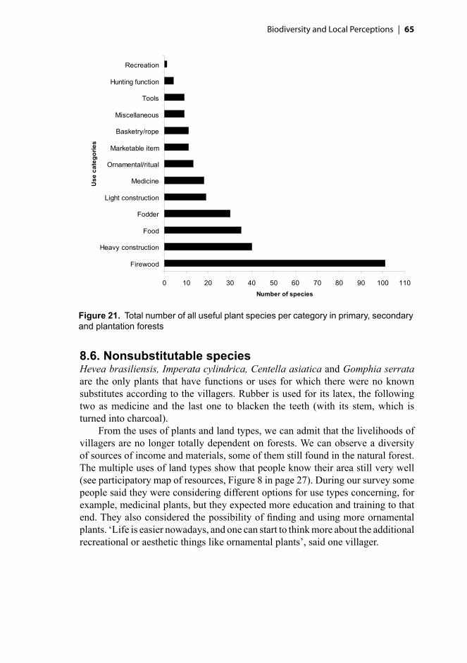
Biodiversity and Local Perceptions | ��
8.6. Nonsubstitutable speciesHevea brasiliensis, Imperata cylindrica, Centella asiatica and Gomphia serrata are the only plants that have functions or uses for which there were no known substitutes according to the villagers. Rubber is used for its latex, the following two as medicine and the last one to blacken the teeth (with its stem, which is turned into charcoal).
From the uses of plants and land types, we can admit that the livelihoods of villagers are no longer totally dependent on forests. We can observe a diversity of sources of income and materials, some of them still found in the natural forest. The multiple uses of land types show that people know their area still very well (see participatory map of resources, Figure 8 in page 27). During our survey some people said they were considering different options for use types concerning, for example, medicinal plants, but they expected more education and training to that end. They also considered the possibility of finding and using more ornamental plants. ‘Life is easier nowadays, and one can start to think more about the additional recreational or aesthetic things like ornamental plants’, said one villager.
Figure 21. Total number of all useful plant species per category in primary, secondary and plantation forests
0 10 20 30 40 50 60 70 80 90 100 110
Firewood
Heavy construction
Food
Fodder
Light construction
Medicine
Ornamental/ritual
Marketable item
Basketry/rope
Miscellaneous
Tools
Hunting function
Recreation
Use
cate
gorie
s
Number of species

�� | Ethno-botanical knowledge
8.7. Remarks on potential uses of speciesSaccharum spontaneum (Poaceae), which in Khe Tran is used for fodder, is a valuable medicinal plant in India (Oudhia 2004). There may be some potential in scoping further possibilities for this usage.
Caryota urens (Arecaceae) is recorded as food only in the past and the stems of Caryota monostachya are used to build floors, while Le Van Lan, Ziegler and Grever (2002) mentions that leaves of the Caryota sp. are used for building roofs and sheds, and their stalks for fences. He also lists that Ageratum conyzoides (Asteraceae) is medicinal plant against cold (Le Van Lan, Ziegler and Grever 2002).
More ethno-botanical and socio-economic studies are necessary to collect data on potentially economically viable plants that could be developed in the area, considering market demand and network, and the sustainability of resources.
SummaryThe villagers use a large range of species for their livelihoods, not only from the natural forests, but on the contrary, mainly from the cultivated areas. The reason is that their main activities are near the village, and primary forests are of difficult and restricted access. The plant with the most numerous uses, bamboo, can be found everywhere near the habitations. Rice fields, Acacia and rubber plantations and home gardens are places where villagers can find a lot of useful plants, mainly for fodder, medicine and food. Very few species (only four) are not substitutable for the usage villagers have of it, and local people are no longer relying as much on forest products for their livelihoods as they once did, since their subsistence activities have recently diversified, even if some forest products are still used.
��
�. Local perspectives on conservation
From the previous sections of this report it is apparent that biodiversity is high in the Khe Tran area and that natural resources still play an important role in local people’s livelihoods. During our survey we observed that villagers gather these products from wild and domesticated sources and sometime even purchase them. Even if domesticated sources are perceived as the most important product sources, many products from the natural forest are still collected for several uses. In all, 134 plant and 29 animal species are considered important species of the forest (see Site description, Chapter 5).
Considering the presence of a conservation area close to the village, local people’s relations to their natural environment, and the ban on extractive activities in the reserve, we organized a small workshop with the villagers to better understand their perceptions concerning forest and biodiversity conservation as well as their perspectives and priorities concerning Phong Dien Nature Reserve development. The villagers were divided into two groups, according to the part of the village in which they live (lower and upper part of the village). The groups had more or less similar perspectives on the meaning of conservation (Table 30). Villagers from the lower part defined conservation as forest protection, which bans any activities that disturb it, such as hunting, logging, making fire or gold mining. They considered conservation more along its management perspectives, whereby all villagers should share responsibilities, with a task force available to solve urgent forest problems. Clear demarcation between conservation and production forests should be available, with a concrete management strategy at all levels. The upper village group also perceived conservation as forest protection, but they considered it according to their willingness to protect it and as an opportunity for employment.
Apart from the local definition of conservation, we asked both groups how they would imagine their life and activities in Khe Tran if there were no conservation area. Both groups agreed that, without a conservation area, they would have free

�� | Local perspectives on conservation
access to the forest. The lower village group thought that they would also have free access to new places to settle and for their cattle, but that their lives would be more difficult, because they would be more dependent on forest resources (unless a governmental program gave them incentive to move away from extractive activities) and more vulnerable to natural hazards. The upper village group thought that they would have a hard time and poor life conditions; they would be obliged to move more often to open new gardens, and this option was linked, according to the local point of view, to the traditional use of shifting cultivation. Conservation is synonymous with more sedentary agricultural practices for the villagers.
For both groups the presence of the conservation area implied a better future, with more infrastructure facilities, domesticated products (plants and animals), better relationships among villagers and more employment opportunities.
These answers, even if conditioned and influenced by the position and vulnerability of the local people towards government policy, shows that conservation, according to their perception, means change, progress, education, new activities and the loss of the main traditional activities. Once again these answers have to be considered in their political and social context, taking into account the tendency of villagers to give a soothing discourse to outsiders (here, the scientists). But it affords perspectives on the way local people consider their future living at the edge of a conservation area, their opportunities and expectations.
Local people hope that, with the formation of Phong Dien Nature Reserve, they will acquire the right to participate in its management and they even expect to have a key role in coordination with the government staff in charge of reserve protection.
Villagers have a positive perception of conservation of forest and biodiversity, even if they worry about their right to collect natural resources in the future. Their interest in participating in reserve management depends on their expectation of financial compensation if they, for example, take part in the task force in charge of the control of the reserve. It is also a way to emphasize their land rights and to push the government to recognize these rights. They consider that a negotiated participation in reserve management will allow them to collect some forest resources, including timber, NTFPs and even the valuable eaglewood.

Biodiversity and Local Perceptions | ��
Perception Lower part villagers Upper part villagersDefinition of conservation
• Forest area is protected; all hunting of precious animals, logging, setting of forest fires, gold mining and trapping is banned
• Conservation area must be considered as the work of all people, with a task force that can solve urgent cases
• There must be a definite demarcation between conservation area and production/planted forest
• In order to have good conservation efforts, a concrete plan/program/project/organization is required at all levels
• Forest and natural resources are protected
• Hunting, setting fires, logging, etc. is prohibited
• Conservation is very important and it is the job of both state and local people
• Local people will have employment from conservation area activities
Life with conservation
• Will stabilize their life• Forbidden from entrance to forest
and clearing for cultivation. More focus on planting forest; better income from production forest harvesting
• Will establish cattle facilities• Gain better awareness of forest and
literacy standard• Better infrastructure• Close relationships among local
people
• Conservation brings brighter future and offers employment
• Focus on planting and tending forest, animal husbandry
• More state projects; better infrastructure (roads, etc.)
Life without conservation
• Free access to forest, clearance to search for metals, for cultivation, logging and trapping (hunting)
• Free migration (movement to other locations)
• Free grazing of cattle • Low awareness of natural disasters• Local life is dependent on forest
• Free access to forest, e.g. cattle grazing, hunting and clearing for cultivation
• Life is hard and poor• People had to move to
different places several times annually
• More efforts on planting forest for younger generations
Role to play in future management of Phong Dien Natural Reserve area
• Have the right to manage/protect the reserve and receive a subsidy
• In general, management should rest in the cooperation of staff in charge and local people, with a permanent task force
• Local people may collect NTFPs
• Every person has to protect the forest (including its animals)
• Local people want to be staff that look after the conservation area
• Hope to establish a conservation organization in Khe Tran and make Phong Dien Reserve an area of rich biodiversity and beauty
Table 30. Villager’s perceptions on conservation and Phong Dien Nature Reserve

�0 | Local perspectives on conservation
These results show that the local people want to be part of the conservation process and not just be considered an external threat that should be banned from any extractive activity. Recognition of their rights, negotiation on the possibility to collect forest products and emphasis on local people’s responsibility for their own land should be considered important elements of a successful conservation effort in Khe Tran.
SummaryEven if sometimes they are following the ‘official’ position on biodiversity conservation and its definition, villagers explained that they would like to be part of the process, for various reasons: to get access to resources, to enhance their rights to the land, to get payment for the activities they would perform for the FPD. By doing so, local people expect to be able to negotiate with the government the sustainable use of a number of resources, mainly NTFPs, but some logging and game hunting too. They want to collaborate with conservation institutions and to preserve the forest for the future and as a safety net, since they do not strongly rely on forest resource anymore.

��
In conclusion to the MLA activities implemented during this SDC-funded project, ‘Stakeholders and biodiversity at the local level’, we discuss the relevance of the method, summarize the main results of our surveys in the context of the different objectives of the project and provide recommendations in the Khe Tran village context.
10.1. Conclusion
10.1.1. Relevance of MLA in a Vietnamese contextIf the overall project sought to strengthen local capacity to plan andimplement locally relevant and viable forest landscape management, two objectives were particularly relevant to our MLA activities:• to develop appropriate mechanisms for integrating local perceptions and
views in decision making and planning; and• to facilitate greater involvement of local people and other stakeholders in
decision making and planning at the local level.
We proposed, by our activities, to test a set of tools, the MLA, designed to study local perception of landscapes and natural resources in the local context, a small village in rural Central Vietnam.
We are now able to confirm that the MLA tool was relevant to this kind of study and provided valuable information on the local management of natural resources. It was adapted to the Khe Tran context, where forest has been disturbed and no longer plays the role it used to play in local livelihoods. Plot sampling, because it records both tree and non-tree specimens, can be used in various environments: forests, plantations or even rice fields. The socio-economic data and the information about local perception gained through scoring exercises and
�0. Conclusion and recommendations

�� | Conclusion and recommendations
participatory mapping are also relevant to a context where local people have shifted from forest-oriented activities to more sedentary agriculture. They show the evolution and transformation of the local people’s priorities and knowledge on natural resources. The set of methods used during our survey provided a large set of data and results on Khe Tran villagers and their perspectives and options concerning the management of the future Phong Dien Nature Reserve.
An important database is available containing the data we collected through 11 plot samplings and 20 household surveys undertaken in Khe Tran on ethnobotany, forest landscapes characterization, local importance of natural resources and all socio-economic data necessary to the project achievement. This database helps us to provide an overview of the forest condition and on how forests still influence the local livelihood of the Pahy.
Soil analysis, which could not be implemented in the frame of our activities for logistical reasons, may provide relevant information on land suitability for the different land use options proposed by the government to the local people.
The MLA survey and the participatory development of future scenarios have also helped to facilitate discussions with local villagers about their options in the context of living at the edge of a nature reserve. The results of these discussions provide an informed case study and can help the government to make better-informed decisions on Khe Tran–specific land and forest management. A June 2006 workshop in Thua Thien Hue will give us the opportunity to share this information with provincial and local institutions. During the workshop we will report the project results at the provincial and local levels. We will present the results to government agencies, nongovernmental organizations and villagers, and we will collect feedback on the way these results, and more generally the MLA set of tools, can be used by each participant in the frame of their own activities and projects in Vietnam.
Based on previous presentation and on interactions with various stakeholders during project implementation, it is clear that the method has already raised interest.• District and commune officers consider MLA a valuable source of information
on socio-economy, land use and local point of view on land management.• Educational institutions such as the Hue University of Agriculture and Forestry
have expressed interest to integrate the method into their curriculum.• Conservation institutions such as the FPD consider MLA a valuable source
of information for future forest land allocation, natural resource management and forest conservation.
• The international nongovernmental organizations Helvetas, SNV (Netherland Development Organization), TBI and WWF consider it an interesting way to gather information on local perceptions and priorities in the context of their own projects. Some partners have argued that a systematic implementation might be difficult in Vietnam because the land use planning and land allocation processes are already following specific procedures and because some parts of MLA may be considered time consuming and dependent on specialized expertise. Nevertheless they have expressed interest to compare the results
Biodiversity and Local Perceptions | ��
collected by this method with their own information on community forestry, community-based natural resource management and land allocation.
• The Vietnamese participants in the surveys have also expressed great interest in and enthusiasm for the set of methods, the important information it generates and the strong relationship with local people it helps to build. Some of the participants working in government institutions such as FIPI, Department of Foreign Affairs, HUAF (Hue University of Agriculture and Forestry) and Tay Nguyen University have expressed the desire to use the methods in their own projects in other places in the province and in the rest of Vietnam, as they find that MLA provides relevant data on local priorities related to land allocation in the country.
More generally, in Vietnam, the government increasingly gives local people the right to manage the forests, even if recognition of local people’s rights is still limited, as is the consideration of local knowledge and perspectives in that rapidly changing context. The government still makes decisions on land use planning following a relatively rigid top-down approach. In this context, MLA provides a relevant set of tools that can be selectively utilized in situations where stakeholders and especially decision makers want to become better informed on the perspectives of the local people on the important issues of forest land management, reforestation and allocation.
The results of our survey were also used as a basis for follow-up activities in Khe Tran, in the frame of the Future Scenario part of this SDC project (Evans, 2006). The information provided by MLA activities and the good relationship we built with the villagers were important contributions to the success of Future Scenario activities.
10.1.2. Main results of our surveysThe status of forest in Khe Tran has changed within the last 13 years from productive forest to watershed protection forest, which is planned to become part of Phong Dien Nature Reserve in 2010 because of its high biodiversity. The war, logging activities and agricultural practices have deeply disturbed theforest landscape. In the frame of the future reserve, local people have been banned from most of the extractive activity in the natural forest. The government has proposed to develop other activities to provide income to each household. In this context, rubber and Acacia plantation programs are supposed to provide cash income to villagers.
The village is characterized by the presence of a strong minority group, the Pahy, mixed with other groups. The villagers moved away during the war, and they were authorized to resettle in their village only after the conflict ended.They routinely spend a large amount of time in their gardens, rice fields and plantations. The village is divided into two areas, the upper part, where villagers have lower incomes and depend on home gardens and Acacia plantations for their livelihoods, and the lower part, with a higher mean income and depending on more diversified crop cultivation, including rubber and rice.

�� | Conclusion and recommendations
Among the eight main land covers, forests are divided into three categories: big tree forests, small tree forests and plantations. The fact that villagers include plantations in the forest category seems related to the official forest status of plantation lands. Species richness is high in Khe Tran and even potentially monotonous land cover types such as plantations or rice fields still have high non-tree diversity, which enables and maintains their multiuse function.Villagers still use a wide range of species for their livelihoods, partly from the natural forests but, under present conditions, mainly from the cultivated areas.
Participatory mapping also showed that knowledge on forest products, wildlife and other natural resources is still important for villagers, even if this knowledge tends to be limited in diversity of resources and in area covered. Apart from this ethno-botanical knowledge, we found thatvillagers also have a strong sense of ownership when they discuss land tenure in the village, repartition of plantation responsibilities and expectations for the future. Local people represent no imminent threat to the recorded endangered species. The direct impact of human activities on forest cover at present cannot be quantified based on our sampling.
Forest, including natural forest and plantations, is the most important landscape element for all the villagers for all the products that can be collected from it. Perceptions of forest types vary by gender and according to accessibility and activities performed. For men, plantation is the most important category because of the economic benefits, while for women it is natural forest because of the diversity of NTFPs encountered.
With respect to different time frames, forest in the present (including plantations) is the least important, because of the actual resources depletion, the government ban on all natural resource collection in the forest and the actual alternative activities. Forest of the past is considered more important, because of all the activities that were possible then. Domesticated resources are considered more important than any other category, wild or purchased. The government policy on the PDNR has affected dependency on forest resources.
Even if the knowledge on natural resources is still important considering the new management activities, we observe that the knowledge on forest is progressively decreasing. Local people still recognize the different roles of the forest in general, but have difficulty to provide information on specific resources.
A big contribution to conservation could be realized by integrating the local point of view into it and by preserving the local knowledge. The main threat identified by villagers is logging, followed by forest fires. This ranking shows that there is awareness of the risks for the forest, but also for local livelihoods, of engaging in unsustainable activities.
The villagers explained that they would like to be part of the conservation process, for various reasons: to get access to the resources, to enhance their rights to the land, to get payment for the activities they would perform for the FPD. They expect also to be able to negotiate the use of some of the resources, mainly NTFPs, but logging as well. They want to collaborate with conservation institutions, not only for the reasons mentioned above, but also to keep the forest as a safety net for the future.
Biodiversity and Local Perceptions | ��
10.2. Recommendations The following recommendations are based on the results of our survey, and are taking into account the different objectives of the project. More specifically, these recommendations concern potential follow-up in Khe Tran and the possibility of more closely involving the local population in conservation management and other land use planning. Government and other development agencies may use them to analyse the role of local stakeholders in forest management.
10.2.1. Community forestry and forest management• Community forestry should be considered an interesting option for involving
local people in reserve management by involving them in more sustainable activities.
• More, and longer-term, targeted studies of the different categories of land cover would help to gain more comprehensive information on the forest conditions in and near Khe Tran and on the local knowledge and priorities concerning forest conservation and management. This would necessitate closer involvement in the daily life of the Pahy, the possibility to stay for longer periods in the villages and authorization to travel to less accessible forests located farther from the village in the core zone of the reserve.
10.2.2. Land tenure• Land tenure remains a sensitive issue, even if initiatives are undertaken by
the government to recognize the rights of local communities on their land. Especially concerning plantations, land tenure should be secured so that the local community does not have to rely only on limited contracts to exploit these lands.
10.2.3. Conservation • Involvement in management. Local people should be more directly involved
in conservation area management. At the moment, they only have to follow the rules designed by government and conservation agencies, and they are not allowed to perform any extractive activity in forest proximate to or within the nature reserve. Local people represent a human resource that can be useful for the reserve (in the fight against poachers and illegal loggers, for example). The local interest clearly was direct participation in reserve administration activities, through jobs.
• Involvement in negotiations. We recommend that information on threatened species be given to villagers to raise the awareness of conservation needs. The specific uses of especially threatened species should be discussed in order to give people the option of choosing other species for these uses.
• Zonation in the reserve. Traditionally a part of the reserve has belonged to the local community, and villagers should not be kept away from their territory
�� | Conclusion and recommendations
but be part of the decisions concerning its sustainable management. Local people should be given more rights to collect and use forest products, through a negotiation process. Viewing the local people as part of the solution for conserving Phong Dien Nature Reserve is not yet an option for the government but they could help keep poachers away from the reserve. There should be an agreement on the possibility to access the forest, even that inside the nature reserve, during hard times (drought or flood) to collect some important forest products.
10.2.4. Economic incentives• The danger of the new economic and subsistence activities (plantations, rice
farming) is that they keep people away from more-traditional activities. Even if the Pahy society is changing, preserving its traditional roots and its bases should be an important condition in any attempt of integration into other economic systems.
• Decisions should be made on the diversification of agricultural practices (aquaculture, etc.). The profitability of plantations depends on market fluctuation and they should not be taken as the sole alternative to shifting cultivation and extractive activities in the forest.
• The current new economic activities (especially plantations) are unsecured. Since most of the land around the village has been converted, few options are left to villagers in case of an economic crisis.
10.2.5. Cultural identity and local knowledge• The political process of integration of the Pahy minority group into the
lowland way of life carries the danger of loss of cultural identity. Even if the integration of other ethnic groups into Pahy society is a slow process, these communities bring with them new behaviours, new activities and relationships with the local government.
• Emphasis should be placed on tapping the existing (remaining) local knowledge of the village community. More studies should be implemented to collect information on local skills, and the traditional knowledge should be sustained.
• Further research on the sustainability of NTFP collection is necessary, as an option for sustainable use of forest resources. Most of the natural vegetation in Khe Tran is disturbed forest or shrub lands, and the impacts of floods and fires continue to influence forest cover and structure.

��
Appraisal Mission. 2004. Thua Thien Hue rural development programme II: programme framework document. Post Appraisal Revision. (http://global.finland.fi/english/procurement/ThuaThienHue/pd_viet_tthII.pdf)
Artemiev, Igor. 2003. State forestry enterprise reform in Vietnam: unlocking the potential for commercial wood growing. Technical note. Rural Development and Natural Resources East Asia and Pacific Region.
Asian Development Bank (ADB). 2005. Ethnic minority development plan for Central region water resources project. ADB VIE 30292. (http://www.adb.org/Documents/IndigenousPeoples/VIE/EMDP-CRWR.pdf)
Barney, Keith. 2005. Central plans and global exports: Tracking Vietnam’s Forestry Commodity Chains and Export Links to China. Forest Trend. (http://www.forest-trends.org/documents/publications/Vietnam%20Final%20Report%207-1-05.pdf)
Evans, Kristen. 2006. Evaluating and Adapting Future Scenarios in Forest-Dependent Communities in Hue Province, Vietnam.
Le Thanh Chien. 1996. Trial planting of Cinnamomum cassia for high essential oil productivity from the leaves. Forest Science Institute of Vietnam, Hanoi.
Forest Inventory and Planning Institute (FIPI). 1996. Vietnam Forest Trees. Agricultural Publishing House, Hanoi.
Gordon, Raymond G., Jr. (ed.) 2005. Ethnologue: Languages of the world, 15th edition. SIL International, Dallas, TX, USA. (http://www.ethnologue.com/)
Chinese Academy of Science, Institute of Plant Research. 1972-1976. Iconographia Cormophytorum Sinicorum. Volume 1 – 5. Since Press. Beijing. (Zhongguo Gaodeng Zhiwu Tujian, Kexue Chubanshe:1-5 Beijing)
IUCN. 2006. IUCN red list of threatened species. http://www.iucnredlist.org/
Bibliography
�� | Conclusion and recommendations
Le Van Lan, S. Ziegler, and T. Grever. 2002. Utilization of forest products and environmental services in Bach Ma National Park, Vietnam. http://www.mekong-protected-areas.org/vietnam/docs/bach_ma_forest_products.pdf
Mabberley, D.J. 1997. The plant-book: a portable dictionary of the vascular plants. Cambridge University Press, Cambridge, UK.
Maltsoglou, Irini and George Rapsomanikis. 2005. The contribution of livestock to household income in Vietnam: a household typology based analysis. PPLPI Working Paper No. 21. FAO. (http://www.fao.org/ag/AGAinfo/projects/en/pplpi/docarc/wp21.pdf)
Matarasso, Michael and Do Thi Thanh Huyen. 2005. Community participation for conservation success: promoting effective conservation of Vietnam’s natural heritage through community-based environmental education. Final Progress Report. WWF Indochina Environmental Education Unit, Vietnam.
Oudhia, Pankaj. 2004. Kans (Saccharum spontaneum L.). http://www.hort.purdue.edu/newcrop/CropFactSheets/kans.html
Pham Hoang Ho. 1993. Cây cỏ Việt Nam. Volume 1-6. Montreal. Sheil, Douglas, Rajindra Puri, Imam Basuki, Miriam van Heist, Meilinda Wan,
Nining Liswanti, Rukmiyati, Mustofa A. Sardjono, Ismayadi Samsoedin, Kade Sidiyasa, Chrisandini, Edi Permana, Eddy M. Angi, Franz Gatzweiler, Brook Johnson, Akhmad Wijaya. 2003. Exploring biological diversity, environment and local people’s perspectives in forest landscapes, 2nd revised and updated edition. Center for International for Forestry Research, Ministry of Forestry and International Tropical Timber Organization, Bogor, Indonesia.
Le Trong Trai, Tran Hieu Minh, Tran Quang Ngoc, Tran Quoc Dung and Ross Hughes. 2001. An investment plan for the establishment of Phong Dien Nature Reserve, Thua Thien Hue Province, Vietnam. BirdLife International Vietnam Program and the Forest Inventory and Planning Institute, Hanoi, Vietnam.
Vu Hoai Minh and Hans Warfvinge. 2002. Issues in management of natural forests by households and local communities of three provinces in Viet Nam: Hoa Binh, Nghe An, and Thua Thien Hue. Asia Forest Network; Working Paper Series vol 5, California. 47p.
WCMC. 1994. Biodiversity profile of the Socialist Republic of Viet Nam. Appendix 5: threatened plant species. (http://www.wcmc.org.uk/infoserv/countryp/vietnam/app5.html)
Yukio, Ikemoto. 2001. Poverty alleviation policies and ethnic minority people in Vietnam. Conference Justice and Poverty: Examining Sen’s Capability Approach, Cambridge, 5–7 June 2001. (http://www.st-edmunds.cam.ac.uk/vhi/sen/papers/ikemoto.pdf )
Yunnan Shumu Tuzhi, 1990. Yunnan Kexue Chubanshe, Kunming.

��
Ann
ex 1
. L
UV
I (m
ean
valu
e) o
f im
porta
nt p
lant
spe
cies
by
diffe
rent
use
cat
egor
ies
(res
ult
base
d on
sco
ring
exer
cise
of
four
gro
ups
of
info
rman
t)
No.
Plan
t nam
eC
ateg
ory
of u
se
Scie
ntifi
c/En
glis
hFa
mily
Pahy
Fire
woo
dFo
dder
Food
Mar
keta
ble
item
sTo
ols
1Al
lium
sp.
Alli
acea
eTo
i-
-0.
10-
-2
Col
ocas
ia sp
.A
race
aePo
ng-
0.16
0.75
--
3C
oloc
asia
sp.
Ara
ceae
Tu v
en-
0.56
--
-4
Col
ocas
ia sp
.A
race
aeTu
ven
thuc
-0.
56-
--
5Sc
heffl
era
octo
phyl
laA
ralia
ceae
A ru
om0.
09-
--
-6
Cal
amus
wal
keri
A
reca
ceae
Ki r
e-
-0.
991.
96-
7C
aryo
ta u
rens
A
reca
ceae
A tú
t-
-0.
14-
-8
Licu
ala
spin
osa
Are
cace
aeA
ro0.
27-
-1.
781.
479
Livi
ston
a sa
ribu
sA
reca
ceae
Ta lo
--
0.30
--
10O
rmos
ia b
alan
sae
Are
cace
aeR
àng
--
--
0.42
11Rh
apis
laoe
nsis
Are
cace
aeà
ché
r-
-0.
68-
-12
Can
ariu
m p
imel
a B
urse
race
aeC
lam
0.20
--
--
13C
rato
xylu
m p
runi
floru
m
Clu
siac
eae
Leng
nge
ng0.
64-
--
-14
Gar
cini
a m
ergu
ensi
sC
lusi
acea
eC
haon
--
0.12
--
15*
Con
volv
ulac
eae
La b
ai-
0.17
--
-16
Hop
ea o
dora
taD
ipte
roca
rpac
eae
Sao
--
-0.
25-
17Ap
oros
a sp
.Eu
phor
biac
eae
Mộc
0.11
--
0.08
-18
Bacc
aure
a an
nam
ensi
sEu
phor
biac
eae
Dau
ne
--
0.08
--
19H
evea
bra
silie
nsis
Euph
orbi
acea
eC
u su
/Cao
su0.
27-
-1.
68-
20*
Euph
orbi
acea
eA
leo
0.28
--
--
An
nex
es

�0 | Annexes
Ann
ex 1
. C
ontin
ued
No.
Plan
t nam
eC
ateg
ory
of u
se
Scie
ntifi
c/En
glis
hFa
mily
Pahy
Fire
woo
dFo
dder
Food
Mar
keta
ble
item
sTo
ols
21C
leis
tant
hus a
ff. h
irsu
tulu
s Eu
phor
biac
eae
Pala
r-
--
-2.
0922
Afze
lia x
yloc
arpa
Fa
bace
aeLi
m-
0.21
--
0.14
23Li
thoc
arpu
s sp.
Faga
ceae
A re
0.60
--
-1.
2724
*G
esne
riace
aeTa
i nai
--
0.06
--
25Li
tsea
sp.
Laur
acea
eB
oi lo
i-
--
0.22
0.72
26Ba
rrin
gton
ia m
acro
stac
hya
Lecy
thid
acea
eTâ
m la
ng-
-0.
14-
-27
Angi
opte
ris s
p.M
arat
tiace
aeTi
lai
--
0.07
--
28M
elas
tom
a sp
. M
elas
tom
atac
eae
Car
cho
0.27
--
--
29K
haya
sene
gale
nsis
Mel
iace
aeX
a cu
--
-0.
30-
30Ac
acia
aur
icul
iform
isM
imos
acea
eTr
àm1.
22-
-2.
530.
2131
Acac
ia m
angi
umM
imos
acea
eK
eo-
--
1.16
-32
Ficu
s rac
emos
aM
orac
eae
Tut n
at-
0.14
--
-33
Ban
ana
Mus
acea
ePe
-0.
892.
160.
17-
34H
orsfi
eldi
a am
ygda
lina
Myr
istic
acea
eC
ha h
àm0.
05-
--
-35
Arto
carp
us h
eter
ophy
llaM
yrta
ceae
Pana
y -
-0.
44-
0.31
36Ba
ecke
a fr
utes
cens
Myr
tace
aeSe
n-
--
1.03
-37
Euca
lypt
us sp
.M
yrta
ceae
Bac
h da
n0.
27-
--
-38
Rhod
omyr
tus t
omen
tosa
M
yrta
ceae
Cle
m0.
45-
--
0.23
39Pi
nus l
atte
riPi
nace
aeA
ngo
--
-0.
49-
40B
ambo
oPo
acea
eM
ang
--
-0.
44-
41B
ambo
oPo
acea
eTa
ng n
u-
--
-0.
1442
Bam
boo
Po
acea
ePh
eo0.
270.
131.
910.
370.
4943
Dig
itari
a pe
telo
tii
Poac
eae
Sam
alu
-0.
15-
--

Biodiversity and Local Perceptions | ��
Ann
ex 1
. C
ontin
ued
No.
Plan
t nam
eC
ateg
ory
of u
se
Scie
ntifi
c/En
glis
hFa
mily
Pahy
Fire
woo
dFo
dder
Food
Mar
keta
ble
item
sTo
ols
44G
rass
Poac
eae
Sắc
-1.
94-
--
45Im
pera
ta sp
.Po
acea
eSắ
c bl
ang
-0.
60-
--
46M
eloc
alam
us sp
.1
Poac
eae
A ta
ng0.
27-
-0.
59-
47M
eloc
alam
us sp
.2Po
acea
eTu
vie
n-
--
-2.
1948
Thys
anol
aena
sp.
Poac
eae
Chu
l-
2.12
-0.
39-
49*
Poac
eae
Sắc
ila-
0.44
--
-50
Mus
saen
da sp
.R
ubia
ceae
Piên
g pa
ng-
0.14
--
-51
Wen
dlan
dia
glab
rata
Rub
iace
aeA
xop
--
--
2.32
52C
omm
erso
nia
bart
ram
ia
Ster
culia
ceae
A
pon
g0.
47-
--
1.28
53Ta
rrie
tia ja
vani
caSt
ercu
liace
ae
Hue
n-
--
0.69
1.15
54M
ushr
oom
*Tr
ia-
-1.
090.
10-
55Ve
geta
ble
*C
o ch
o0.
11-
0.23
--
56*
*A
lo0.
11-
--
-57
**
A p
ang
--
--
0.47
58*
*A
roc
-
0.24
-0.
2159
**
Bon
g bo
t0.
20-
--
-60
**
Cac
cho
0.04
--
--
61*
*C
hel
0.11
--
--
62*
*C
hoan
0.28
--
--
63*
*C
hua
--
0.07
--
64*
*C
hun
--
-0.
11-
65*
*C
o ch
at-
0.34
--
-66
**
Co
chin
h-
0.26
--
-

�� | Annexes
Ann
ex 1
. C
ontin
ued
No.
Plan
t nam
eC
ateg
ory
of u
se
Scie
ntifi
c/En
glis
hFa
mily
Pahy
Fire
woo
dFo
dder
Food
Mar
keta
ble
item
sTo
ols
67*
*C
o ro
n-
-0.
26-
-68
**
Cro
l0.
32-
--
-69
**
Cro
n-
-0.
24-
-70
**
Cu
--
--
0.21
71*
*D
ong
0.14
0.24
--
72
**
Leng
nga
nh0.
27-
--
-73
**
Pa ro
ne
--
-0.
15-
74*
*R
an x
el0.
07-
--
-75
**
Ta ra
ng-
--
-0.
5376
**
Tan
ao0.
22-
--
-77
**
Tu lu
on-
--
0.17
-78
**
Tu p
hi0.
56-
--
-79
**
Tu V
a -
-0.
38-
-80
**
Tung
ao
0.17
--
--
81*
*Va
0.14
--
--
- mea
ns th
at th
e sp
ecie
s is
not
use
d fo
r the
cor
resp
ondi
ng c
ateg
ory
* m
eans
that
the
spec
ies
is u
nide
ntifi
ed b
ecau
se o
f no
spec
imen
/sam
ple
was
foun
d in
the
rese
arch
site
.

Biodiversity and Local Perceptions | ��
No.Animal name Category of use
Pahy English Food Marketable item Medicine Tools
1 A at na * 0.59 - - -2 A binh Rat 1.95 - - -3 A che Bird 0.02 - - -4 A cuot Frog 0.89 - - -5 A ut * - - 0.44 -6 Can chong * - - 0.24 -7 Chim chao mao Bird - 0.14 - 0.038 Chim chich choe Bird - - 0.039 Chim cuong Peacock - 0.21 - 0.10
10 Chim sao Bird - 0.20 - 0.0411 Chon den * 0.92 - - -12 Co chong * - - 0.17 -13 Cu lui * 0.14 - - -14 Cu xanh Snake 0.02 - 0.12 -15 Cuong * - - - 0.2716 Dong * - - - 0.0817 Hon * - - 0.30 -18 K chu * - 0.09 - 0.0519 Khep * - - 0.03 -20 Khuou Bird - 0.27 - 0.2521 Kien * 0.06 - - -22 Kiep * 0.08 - - -23 Pi reo * - - - 0.2924 Quai * 0.04 - - -25 quai * - - 0.24 -26 Tac ke * - - 0.16 -27 Truoi Chicken 0.41 - - -28 Truon prieng * 0.15 - - -29 Vet * - - - 0.07
- means that the species is not used for the corresponding category
Annex 2. LUVI (mean value) of important animal species by different use categories based on scoring exercise of four groups of informant

�� | Annexes
Ann
ex 3
. Th
e bo
tani
cal n
ames
, fam
ilies
and
loca
l nam
e of
spe
cim
ens
colle
cted
with
in a
nd o
utsi
de th
e pl
ots
by th
eir u
se c
ateg
orie
s
Bot
anic
al n
ame
Fam
ilyLo
cal n
ame*
(P
ahy/
Viet
nam
ese)
Land
ty
pe**
Basketry/rope
Firewood
Fodder
Food
Heavy construction
Hunting function
Light construction
Marketable item
Medicine
Miscellaneous***
Ornamental/ritual
Recreation
Tools
No use
Dic
otyl
edon
esAd
iant
um d
iaph
anum
Adi
anta
ceae
-
2
Adia
ntum
sp.1
Adi
anta
ceae
-
2
Adia
ntum
sp.2
Adi
anta
ceae
-
2
Adia
ntum
sp.3
Adi
anta
ceae
Ta ra
nh c
anh
3
Anog
ram
ma
mic
roph
ylla
Adi
anta
ceae
Sắc
a tro
m c
an c
hong
4
Alte
rnan
ther
a se
ssili
sA
mar
anth
acea
eSắ
c ch
iêú
5
Al
tern
anth
era
sp.1
Am
aran
thac
eae
Sắc
cằn
cờ le
ng
6
C
ente
lla a
siat
ica
Api
acea
eR
au m
á/Sắ
c a
tăng
/Sắc
i ch
a
3
4 5
6
M
elod
inus
cf.
anna
men
sis
Apo
cyna
ceae
A m
ư a
tang
2
Mel
odin
us c
f. m
yrtif
oliu
s A
pocy
nace
aeA
mư
cê ló
2
Mel
odin
us lo
cii
Apo
cyna
ceae
A m
ư cê
ló
2
Wri
ghtia
dub
iaA
pocy
nace
aeC
hoh/
Còi
ke
2
Hoy
a sp
.1A
scle
piad
acea
eA
mư
bỏ tê
ró
2
Stre
ptoc
aulo
n sp
.1A
scle
piad
acea
eA
mu
pu x
á
3
6
Ag
erat
um c
onyz
oide
sA
ster
acea
eC
á hỡ
i/Sắc
par
abo
n
3
4
Cra
ssoc
epha
lum
cre
pidi
oide
sA
ster
acea
eR
au n
ghđo
/Sắc
a n
gươn
3
6
Eupa
tori
um sp
.1A
ster
acea
eTô
m b
ro b
on
6
G
naph
aliu
m p
olyc
aulo
nA
ster
acea
e-
5
Lact
uca
sp.1
Ast
erac
eae
Sắc
a pi
6

Biodiversity and Local Perceptions | ��
Ann
ex 3
. Con
tinue
d
Bot
anic
al n
ame
Fam
ilyLo
cal n
ame*
(P
ahy/
Viet
nam
ese)
Land
ty
pe**
Basketry/rope
Firewood
Fodder
Food
Heavy construction
Hunting function
Light construction
Marketable item
Medicine
Miscellaneous***
Ornamental/ritual
Recreation
Tools
No use
Lact
uca
sp.2
Ast
erac
eae
Sắc
tía
6
Sp
ilant
hes c
f. ia
badi
cens
isA
ster
acea
eSắ
c ră
m b
on
6
Ve
rnon
ia p
atul
aA
ster
acea
eSắ
c a
chể
6
Bego
nia
cf. p
orte
ri
Beg
onia
ceae
Cu
to a
rop
2
Can
ariu
m p
imel
aB
urse
race
aeC
lam
2
Dac
ryod
es c
f. br
evir
acem
osa
Bur
sera
ceae
A lo
ng c
hua
lòy/
A lo
ng k
hét
2
Gar
uga
sp.1
Bur
sera
ceae
A lo
ng c
ì ăi
2
Gar
uga
sp.2
Bur
sera
ceae
A
long
chu
á
2
Ba
uhin
ia c
f. lo
rant
haC
aesa
lpin
iace
aeA
mư
cu ti
ên
2
Bauh
inia
cf.
peni
cilli
loba
Cae
salp
inia
ceae
A m
ư cu
tiên
/A m
ư tà
riên
g1
2
Pelto
phor
um d
asyr
rhac
his
Cae
salp
inia
ceae
Tulv
om
2
C
leom
e vi
scos
aC
appa
race
aeC
ơn c
ôc m
ẵn
5
6
Stix
is sc
ande
nsC
appa
race
aeN
ôm b
ê lố
c
4
St
ixis
suav
eole
nsC
appa
race
aeC
ần c
ò lố
t
3
Cal
ophy
llum
cf.
bala
nsae
Clu
siac
eae
A lo
ng c
ồn
2
C
rato
xylu
m m
aing
ayi
Clu
siac
eae
A lo
ng o
i/A lo
ng râ
u gi
a/R
ìng
rìng
2
6
Cra
toxy
lum
sp.1
Clu
siac
eae
A lo
ng ra
n si
a
3
Hyp
eric
um ja
poni
cum
Clu
siac
eae
Sắc
a da
pan
g na
ng
4
Q
uisq
ualis
indi
caC
ombr
etac
eae
A lo
ng c
hà c
hế
3
Ipom
oea
bata
tas
Con
volv
ulac
eae
A ra
u cu
lang
6
Ipom
oea
purp
urea
Con
volv
ulac
eae
A m
u ra
n gi
on/S
ắc rầ
n dò
n
6

�� | Annexes
Ann
ex 3
. Con
tinue
d
Bot
anic
al n
ame
Fam
ilyLo
cal n
ame*
(P
ahy/
Viet
nam
ese)
Land
ty
pe**
Basketry/rope
Firewood
Fodder
Food
Heavy construction
Hunting function
Light construction
Marketable item
Medicine
Miscellaneous***
Ornamental/ritual
Recreation
Tools
No use
Dill
enia
turb
inat
aD
illen
iace
aeR
ipo
1 2
Tetr
acer
a sa
rmen
tosa
spp.
asi
atic
aD
illen
iace
aeA
mư
cah
hát/A
mư
lân
hát/A
mư
lang
ha
t1
2
Acer
atiu
m sp
.1El
aeoc
arpa
ceae
Sắc
a nả
6
Elae
ocar
pus c
f. ni
tidus
Elae
ocar
pace
ae-
2
Itea
mac
roph
ylla
Esca
lloni
acea
eC
ỏ ch
a
2
Ap
oros
a di
oica
Euph
orbi
acea
eA
long
mom
/Mom
alo
ng sê
n1
4
Apor
osa
mic
rost
achy
aEu
phor
biac
eae
Mộc
4
Apor
osa
tetr
aple
ura
Euph
orbi
acea
eA
long
mom
pu
xá/A
long
môt
/Mom
1 2
C
leis
tant
hus c
f. hi
rsut
ulus
Euph
orbi
acea
ePa
lar
2
Cle
ista
nthu
s sp.
1Eu
phor
biac
eae
A lo
ng ti
2
Cro
ton
pota
bilis
Euph
orbi
acea
eA
long
lán
liếc
2
Epip
rinu
s bal
ansa
eEu
phor
biac
eae
A lo
ng p
a ch
a
2
Eu
phor
bia
sp.1
Euph
orbi
acea
e-
5
Glo
chid
ion
cf. j
ussi
euan
umEu
phor
biac
eae
A lo
ng v
u ve
3
H
evea
bra
silie
nsis
Euph
orbi
acea
eC
aosu
3
M
acar
anga
tric
hoca
rpa
Euph
orbi
acea
eA
long
cà
pai
2
Mal
lotu
s flor
ibun
dus
Euph
orbi
acea
eLa
nh le
p1
Mal
lotu
s hoo
keri
anus
Euph
orbi
acea
eA
long
tò rà
ng a
rây
2
Mal
lotu
s pan
icul
atus
Euph
orbi
acea
eA
lỏe/
A lo
ng a
ló
3
Phyl
lant
hus a
mar
usEu
phor
biac
eae
Chã
ợị
3
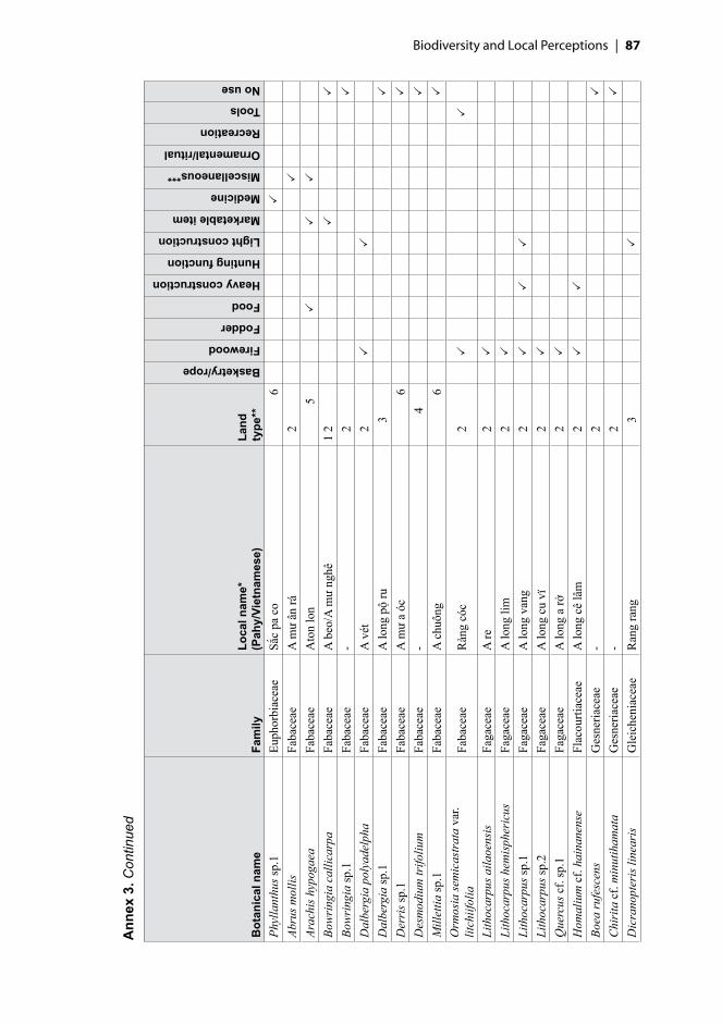
Biodiversity and Local Perceptions | ��
Ann
ex 3
. Con
tinue
d
Bot
anic
al n
ame
Fam
ilyLo
cal n
ame*
(P
ahy/
Viet
nam
ese)
Land
ty
pe**
Basketry/rope
Firewood
Fodder
Food
Heavy construction
Hunting function
Light construction
Marketable item
Medicine
Miscellaneous***
Ornamental/ritual
Recreation
Tools
No use
Phyl
lant
hus s
p.1
Euph
orbi
acea
eSắ
c pa
co
6
Abru
s mol
lisFa
bace
aeA
mư
ân rá
2
Arac
his h
ypog
aea
Faba
ceae
Ato
n lo
n
5
Bow
ring
ia c
allic
arpa
Faba
ceae
A b
eo/A
mư
nghê
1 2
Bow
ring
ia sp
.1Fa
bace
ae-
2
Dal
berg
ia p
olya
delp
haFa
bace
aeA
vét
2
Dal
berg
ia sp
.1Fa
bace
aeA
long
pộ
ru
3
Der
ris s
p.1
Faba
ceae
A m
ư a
óc
6
Des
mod
ium
trifo
lium
Faba
ceae
-
4
Mill
ettia
sp.1
Faba
ceae
A c
huôn
g
6
Orm
osia
sem
icas
trat
a va
r. lit
chiif
olia
Faba
ceae
Ràn
g có
c
2
Lith
ocar
pus a
ilaoe
nsis
Faga
ceae
A re
2
Lith
ocar
pus h
emis
pher
icus
Faga
ceae
A lo
ng li
m
2
Li
thoc
arpu
s sp.
1Fa
gace
aeA
long
van
g
2
Li
thoc
arpu
s sp.
2Fa
gace
aeA
long
cu
vï
2
Q
uerc
us c
f. sp
.1Fa
gace
aeA
long
a rở
2
Hom
aliu
m c
f. ha
inan
ense
Flac
ourti
acea
eA
long
cê
lâm
2
Boea
rufe
scen
sG
esne
riace
ae-
2
Chi
rita
cf.
min
utih
amat
aG
esne
riace
ae-
2
Dic
rano
pter
is li
near
isG
leic
heni
acea
eR
ang
rang
3
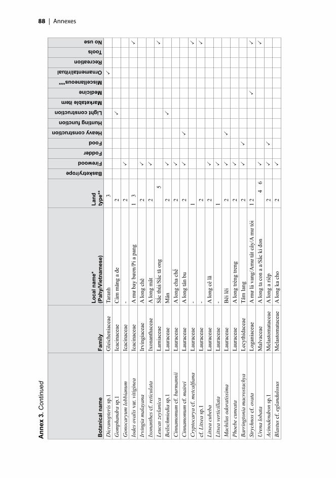
�� | Annexes
Ann
ex 3
. Con
tinue
d
Bot
anic
al n
ame
Fam
ilyLo
cal n
ame*
(P
ahy/
Viet
nam
ese)
Land
ty
pe**
Basketry/rope
Firewood
Fodder
Food
Heavy construction
Hunting function
Light construction
Marketable item
Medicine
Miscellaneous***
Ornamental/ritual
Recreation
Tools
No use
Dic
rano
pter
is sp
.1G
leic
heni
acea
eTa
ranh
3
G
omph
andr
a sp
.1Ic
acin
acea
eC
àm m
ăng
a đe
2
Gon
ocar
yum
lobb
ianu
mIc
acin
acea
e-
2
Iode
s ova
lis v
ar. v
itigi
nea
Icac
inac
eae
A m
ư ba
y bư
ơn/P
i a p
ang
1
3
Irvi
ngia
mal
ayan
aIr
ving
iace
aeA
long
chê
2
Ixon
anth
es c
f. re
ticul
ata
Ixon
anth
acea
eA
long
mât
2
Leuc
as ze
ylan
ica
Lam
iace
aeSắ
c th
úi/S
ắc tă
ong
5
Beils
chm
iedi
a sp
.1La
urac
eae
Mân
2
Cin
nam
omum
cf.
burm
anni
iLa
urac
eae
A lo
ng c
ha c
hế
2
C
inna
mom
um c
f. m
aire
iLa
urac
eae
A lo
ng tâ
n bu
2
Cry
ptoc
arya
cf.
met
calfi
ana
Laur
acea
e-
1
cf. L
itsea
sp.1
Laur
acea
e-
2
Lits
ea c
ubeb
aLa
urac
eae
A lo
ng c
ê lã
2
Lits
ea v
ertic
illat
aLa
urac
eae
-1
Mac
hilu
s odo
ratis
sim
aLa
urac
eae
Bêi
lêi
2
Phoe
be c
unea
taLa
urac
eae
A lo
ng tr
èng
treng
2
Barr
ingt
onia
mac
rost
achy
aLe
cyth
idac
eae
Tâm
lang
2
Stry
chno
s cf.
ovat
aLo
gani
acea
eA
mư
lá v
ang/
Am
ư tâ
t cây
/A m
ư tó
i1
2
Ure
na lo
bata
Mal
vace
aeA
long
ta c
on a
a/S
ắc k
i đon
4
6
Acin
oden
dron
sp.1
Mel
asto
mat
acea
eA
long
a ri
êp
2
Bl
astu
s cf.
egla
ndul
osus
Mel
asto
mat
acea
eA
long
ka
cho
2

Biodiversity and Local Perceptions | ��
Ann
ex 3
. Con
tinue
d
Bot
anic
al n
ame
Fam
ilyLo
cal n
ame*
(P
ahy/
Viet
nam
ese)
Land
ty
pe**
Basketry/rope
Firewood
Fodder
Food
Heavy construction
Hunting function
Light construction
Marketable item
Medicine
Miscellaneous***
Ornamental/ritual
Recreation
Tools
No use
Blas
tus e
glan
dulo
sus
Mel
asto
mat
acea
eA
long
ka
cho
2
Mel
asto
ma
sp.1
Mel
asto
mat
acea
eC
râr c
ho
3
Mel
asto
ma
sp.2
Mel
asto
mat
acea
eA
long
ca
ro c
ho
3
Mel
asto
ma
sp.3
Mel
asto
mat
acea
eA
long
ca
ro c
ho
4
cf
. Mem
ecyl
on sp
.1M
elas
tom
atac
eae
A lo
ng tr
ẽn tr
ẽn
2
Mem
ecyl
on c
f. fr
utic
osum
Mel
asto
mat
acea
eA
long
apă
ng
2
M
emec
ylon
ligu
stri
num
Mel
asto
mat
acea
eC
ê lâ
m
2
D
ysox
ylum
cf.
bine
ctar
iferu
mM
elia
ceae
A lo
ng c
apo
1
Dip
locl
isia
gla
uces
cens
Men
ispe
rmac
eae
Am
ư/D
ây a
mư/
Piro
pan
g ko
n/ S
ắc c
ì pỡ
ng
3
4
6
Fibr
aure
a re
cisa
Men
ispe
rmac
eae
A m
ư ng
hê/S
ắc rầ
n sà
ng 2
3
Fi
brau
rea
cf. r
ecis
aM
enis
perm
acea
e-
1
Fibr
aure
a tin
ctor
iaM
enis
perm
acea
eA
beo
2
Acac
ia a
uric
ulifo
rmis
Mim
osac
eae
A lo
ng tr
àm
3
Acac
ia m
angi
umM
imos
acea
eA
long
keo
3 4
Acac
ia si
amen
sis
Mim
osac
eae
A lo
ng m
uồng
3
Ac
acia
sp.1
Mim
osac
eae
A m
ư tà
riên
g
2
Arch
iden
dron
che
valie
riM
imos
acea
eEa
lìt
2
Mim
osa
pudi
caM
imos
acea
eSắ
c a
chiế
t
6
Mim
osa
sp.2
Mim
osac
eae
Sắc
a xô
ng
6
Mol
lugo
pen
taph
ylla
Mol
lugi
nace
aeSắ
c a
cho
5 6
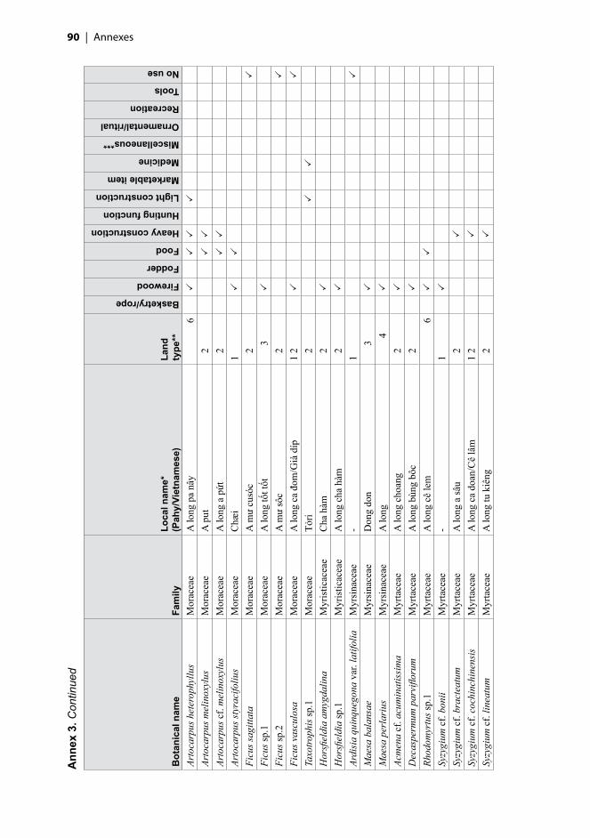
�0 | Annexes
Ann
ex 3
. Con
tinue
d
Bot
anic
al n
ame
Fam
ilyLo
cal n
ame*
(P
ahy/
Viet
nam
ese)
Land
ty
pe**
Basketry/rope
Firewood
Fodder
Food
Heavy construction
Hunting function
Light construction
Marketable item
Medicine
Miscellaneous***
Ornamental/ritual
Recreation
Tools
No use
Arto
carp
us h
eter
ophy
llus
Mor
acea
eA
long
pa
nây
6
Arto
carp
us m
elin
oxyl
usM
orac
eae
A p
ut
2
Ar
toca
rpus
cf.
mel
inox
ylus
Mor
acea
eA
long
a p
ứt
2
Ar
toca
rpus
styr
acifo
lius
Mor
acea
eC
hæi
1
Fi
cus s
agitt
ata
Mor
acea
eA
mư
cusó
c
2
Ficu
s sp.
1M
orac
eae
A lo
ng tố
t tốt
3
Fi
cus s
p.2
Mor
acea
eA
mư
sôc
2
Ficu
s vas
culo
saM
orac
eae
A lo
ng c
a đo
m/G
ià d
íp1
2
Taxo
troph
is sp
.1M
orac
eae
Tỏri
2
Hor
sfiel
dia
amyg
dalin
aM
yris
ticac
eae
Cha
hàm
2
Hor
sfiel
dia
sp.1
Myr
istic
acea
eA
long
cha
hàm
2
Ardi
sia
quin
queg
ona
var.
latif
olia
Myr
sina
ceae
-1
Mae
sa b
alan
sae
Myr
sina
ceae
Don
g do
n
3
Mae
sa p
erla
rius
Myr
sina
ceae
A lo
ng
4
Ac
men
a cf
. acu
min
atis
sim
aM
yrta
ceae
A lo
ng c
hoan
g
2
D
ecas
perm
um p
arvi
floru
mM
yrta
ceae
A lo
ng b
ùng
bôc
2
Rhod
omyr
tus s
p.1
Myr
tace
aeA
long
cê
lem
6
Syzy
gium
cf.
boni
iM
yrta
ceae
-1
Syzy
gium
cf.
brac
teat
umM
yrta
ceae
A lo
ng a
sâu
2
Syzy
gium
cf.
coch
inch
inen
sis
Myr
tace
aeA
long
ca
doan
/Cê
lâm
1 2
Sy
zygi
um c
f. lin
eatu
mM
yrta
ceae
A lo
ng tu
kiê
ng
2

Biodiversity and Local Perceptions | ��
Ann
ex 3
. Con
tinue
d
Bot
anic
al n
ame
Fam
ilyLo
cal n
ame*
(P
ahy/
Viet
nam
ese)
Land
ty
pe**
Basketry/rope
Firewood
Fodder
Food
Heavy construction
Hunting function
Light construction
Marketable item
Medicine
Miscellaneous***
Ornamental/ritual
Recreation
Tools
No use
Syzy
gium
rubi
cund
umM
yrta
ceae
A lo
ng tr
ám1
Syzy
gium
sp.1
Myr
tace
ae-
1
Syzy
gium
sp.2
Myr
tace
ae-
1
Syzy
gium
sp.4
Myr
tace
aeC
ê lâ
m c
ù so
1
Sy
zygi
um sp
.5M
yrta
ceae
A lo
ng a
păn
g
2
Sy
zygi
um sp
.6M
yrta
ceae
A lo
ng a
pán
g
2
Sy
zygi
um sp
.7M
yrta
ceae
A lo
ng tầ
n co
i tì r
á
2
Sy
zygi
um sp
.8M
yrta
ceae
A lo
ng a
tiởn
g
2
Sy
zygi
um v
estit
umM
yrta
ceae
Trâm
tổ k
iến
2
Gom
phia
serr
ata
Och
nace
aeTờ
nu
2
Lino
cier
a cf
. ram
iflor
aO
leac
eae
A lo
ng c
hot a
vot
1
Li
noci
era
thor
elii
Ole
acea
eA
long
ta rê
con
ke/
Trai
3 4
Myx
opyr
um n
ervo
sum
Ole
acea
eA
mư
a pư
ăng
1 2
cf. O
sman
thus
sp.1
Ole
acea
eC
hàm
hàm
1
Lu
dwig
ia p
rost
rata
Ona
grac
eae
Sắc
tiêu
6
Mic
rode
smis
cas
eari
aefo
liaPa
ndac
eae
A lo
ng tù
nu
tù m
ò/Tờ
nu
tờ m
o
2
Ad
enia
het
erop
hylla
Pass
iflor
acea
eA
mư
cu ti
ên
3
Pipe
r cf.
brev
icau
lePi
pera
ceae
-1
Pipe
r nig
rum
Pipe
race
aeTi
êu th
o
6
Pi
per s
p.1
Pipe
race
ae-
1
Pipe
r sp.
2Pi
pera
ceae
A a
i ki n
en1

�� | Annexes
Ann
ex 3
. Con
tinue
d
Bot
anic
al n
ame
Fam
ilyLo
cal n
ame*
(P
ahy/
Viet
nam
ese)
Land
ty
pe**
Basketry/rope
Firewood
Fodder
Food
Heavy construction
Hunting function
Light construction
Marketable item
Medicine
Miscellaneous***
Ornamental/ritual
Recreation
Tools
No use
Pipe
r sp.
3Pi
pera
ceae
Là b
ả âm
bút
/Tiê
u th
o
2
6
Pi
per s
p.4
Pipe
race
aeSắ
c al
ít
6
Xa
ntho
phyl
lum
cf.
flave
scen
sPo
lyga
lace
aeA
long
to ră
ng a
rây
1 2
Xant
hoph
yllu
m c
f. ha
inan
ense
Poly
gala
ceae
A lo
ng a
so
2
Ru
bus s
p.1
Ros
acea
eSắ
c a
lau
6
Rubu
s sp.
2R
osac
eae
A lo
ng p
o ro
su/P
aros
u
3
6
G
arde
nia
soot
epen
sis
Rub
iace
aeA
long
ca
ao1
2
Gar
deni
a sp
.1R
ubia
ceae
A lo
ng k
a ao
2
Hed
yotis
cap
itella
ta v
ar. m
ollis
Rub
iace
aeA
mư
a tó
i
3
Hed
yotis
diff
usa
Rub
iace
aeSắ
c pi
nhe
6
Hed
yotis
hed
yotid
esR
ubia
ceae
Pi a
pàn
g cù
téc
2
Hed
yotis
cf.
hisp
ida
Rub
iace
ae-
2
Hed
yotis
cf.
lept
oneu
raR
ubia
ceae
Sắc
a dó
6
Hed
yotis
cf.
mic
roce
phal
aR
ubia
ceae
Tà ri
nh
3
Hed
yotis
mul
tiglo
mer
ata
Rub
iace
aeR
au m
è
3
Hed
yotis
mul
tiglo
mer
ulat
aR
ubia
ceae
Sắc
lá tr
e
5
Hed
yotis
cf.
pilu
lifer
aR
ubia
ceae
Sắc
ản tr
uôi
1
3
Hed
yotis
cf.
sym
ploc
iform
isR
ubia
ceae
Sắc
tê rá
i a
chá
4
Hed
yotis
sp.1
Rub
iace
aeC
ây m
è/Sắ
c m
è
5
6
Ix
ora
sp.1
Rub
iace
aePi
n ra
vốt
2

Biodiversity and Local Perceptions | ��
Ann
ex 3
. Con
tinue
d
Bot
anic
al n
ame
Fam
ilyLo
cal n
ame*
(P
ahy/
Viet
nam
ese)
Land
ty
pe**
Basketry/rope
Firewood
Fodder
Food
Heavy construction
Hunting function
Light construction
Marketable item
Medicine
Miscellaneous***
Ornamental/ritual
Recreation
Tools
No use
Lasi
anth
us c
yano
carp
us v
ar.
aspe
rula
tus
Rub
iace
ae-
2
Lasi
anth
us sp
.2R
ubia
ceae
-1
Mor
inda
cf.
parv
ifolia
Rub
iace
aeA
mư
a dó
/A m
ư bo
tê ro
2
3
Mor
inda
cf.
umbe
llata
Rub
iace
aeD
ây a
mư
4
Mor
inda
sp.1
Rub
iace
aeA
mư
pa la
i
2
Mus
saen
da a
pter
aR
ubia
ceae
A m
ư pa
ro p
ang/
Pia
rơ p
ang
2
3
M
ussa
enda
cf.
apte
raR
ubia
ceae
A m
ư a
lá/P
ia p
àng
âm b
út
2
Mus
saen
da sp
.1R
ubia
ceae
Pi a
rỏ p
ang
3
N
eola
mar
ckia
cf.
adam
baR
ubia
ceae
A lo
ng k
a ao
2
Neo
nauc
lea
cf. p
urpu
rea
Rub
iace
aeM
ắt b
oái
2
Paed
eria
scan
dens
Rub
iace
aeSắ
c co
lo/S
ắc la
van
g/Ta
r bo
tro
6
Psyc
hotr
ia se
rpen
sR
ubia
ceae
Sắc
bul
2
Psyc
hotr
ia sp
.1R
ubia
ceae
Còi
ke
2
Ps
ycho
tria
sp.2
Rub
iace
aeA
long
pia
rarố
t
3
Rand
ia sp
inos
aR
ubia
ceae
Alo
ng a
xôn
g a
tói
3
Ac
rony
chia
ped
uncu
lata
Rut
acea
eA
long
atố
t/Cơm
rưîu
2
Euod
ia c
alop
hylla
Rut
acea
eA
long
a lô
2
Mac
luro
dend
ron
sp.1
Rut
acea
eA
long
cfs
ốc lâ
m p
á/A
long
par
cha
/A
long
răng
sê
2
Ames
iode
ndro
n ch
inen
seSa
pind
acea
eTà
ràng
1 2

�� | Annexes
Ann
ex 3
. Con
tinue
d
Bot
anic
al n
ame
Fam
ilyLo
cal n
ame*
(P
ahy/
Viet
nam
ese)
Land
ty
pe**
Basketry/rope
Firewood
Fodder
Food
Heavy construction
Hunting function
Light construction
Marketable item
Medicine
Miscellaneous***
Ornamental/ritual
Recreation
Tools
No use
Nep
heliu
m la
ppac
eum
Sapi
ndac
eae
A lo
ng c
ê rô
l
2
Pl
anch
onel
la c
f. an
nam
ensi
sSa
pota
ceae
-
2
Li
nder
nia
anag
allis
Scro
phul
aria
ceae
Pi a
rò p
ang
4
6
Lind
erni
a ob
long
aSc
roph
ular
iace
ae-
3
5
Lind
erni
a pu
silla
Scro
phul
aria
ceae
Sắc
a pú
a/Sắ
c cu
so
4
6
Scop
aria
sp.1
Scro
phul
aria
ceae
Sắc
răng
cưa
5
Tore
nia
bent
ham
iana
Scro
phul
aria
ceae
Sắc
a qu
ang
4
Tore
nia
glab
raSc
roph
ular
iace
ae-
3
Phys
alis
ang
ulat
aSo
lana
ceae
Cê
leng
3
Ph
ysal
is sp
.1So
lana
ceae
Sắc
cê le
ng c
ê lo
ng
5
Sola
num
cf.
amer
ican
umSo
lana
ceae
Sắc
rau
bay
4
6
Her
itier
a au
gust
ata
Ster
culia
ceae
Man
g
2
H
eriti
era
mac
roph
ylla
Ster
culia
ceae
A lo
ng m
ang
2
Mel
ochi
a co
rcho
rifo
liaSt
ercu
liace
aeSắ
c bá
y/Sắ
c lă
n lé
p/Sắ
c tờ
con
5 6
Adin
andr
a cf
. hai
nane
nsis
Thea
ceae
-1
Cam
ellia
cf.
fleur
yiTh
eace
aeA
tung
1
C
amel
lia c
f. ni
tidis
sim
aTh
eace
aeA
long
a tu
ng
2
Cam
ellia
sine
nsis
Thea
ceae
A lo
ng tr
e
3
Cam
ellia
sp.0
Thea
ceae
Rau
ròn
1
C
amel
lia sp
.1Th
eace
ae-
1
C
amel
lia sp
.2Th
eace
aeLâ
n lé
p1

Biodiversity and Local Perceptions | ��
Ann
ex 3
. Con
tinue
d
Bot
anic
al n
ame
Fam
ilyLo
cal n
ame*
(P
ahy/
Viet
nam
ese)
Land
ty
pe**
Basketry/rope
Firewood
Fodder
Food
Heavy construction
Hunting function
Light construction
Marketable item
Medicine
Miscellaneous***
Ornamental/ritual
Recreation
Tools
No use
Eury
a cf
. acu
min
ata
var.
eupr
ista
Thea
ceae
A tí
ch/C
ần n
ổ
2
Eu
rya
cf. n
itida
Thea
ceae
A lo
ng c
hên
3
Eu
rya
cf. t
rich
ocar
paTh
eace
aeA
tich
1
Eu
rya
sp.1
Thea
ceae
A tê
ch1
Eury
a sp
.2Th
eace
aeM
âl1
Lino
stom
a de
cand
rum
Thym
elae
acea
eA
tiên
g
2
G
ironn
iera
cus
pida
taU
lmac
eae
A x
ấc
2
G
ironn
iera
suba
equa
lisU
lmac
eae
A lo
ng a
sất
2
Giro
nnie
ra y
unna
nens
isU
lmac
eae
A lo
ng a
sấc
2
Cle
rode
ndru
m c
yrto
phyl
lum
Verb
enac
eae
A lo
ng a
lau
3
Pr
emna
sp.1
Verb
enac
eae
Piar
ò pa
ng
6
Pr
emna
sp.2
Verb
enac
eae
Piar
ò pa
ng
6
Vi
tex
cf. p
ierr
eana
Verb
enac
eae
Ti
2
Vi
tex
trifo
lia
Verb
enac
eae
A lo
ng ti
hê
1
Ri
nore
a cf
. ang
uife
raV
iola
ceae
A lo
ng a
sâc
2
Tetr
astig
ma
cf. t
onki
nens
eV
itace
ae-
2
Tetr
astig
ma
sp.1
Vita
ceae
-
2
Fern
sAl
lant
odia
met
teni
ana
var.
faur
ieri
A
thyr
iace
aeC
ằn
2
Dip
lazi
um c
rass
iusc
ulum
Ath
yria
ceae
-
2
Blec
hnum
ori
enta
leB
lech
nace
aeSắ
c cô
n că
n
3

�� | Annexes
Ann
ex 3
. Con
tinue
d
Bot
anic
al n
ame
Fam
ilyLo
cal n
ame*
(P
ahy/
Viet
nam
ese)
Land
ty
pe**
Basketry/rope
Firewood
Fodder
Food
Heavy construction
Hunting function
Light construction
Marketable item
Medicine
Miscellaneous***
Ornamental/ritual
Recreation
Tools
No use
Blec
hnum
sp.1
Ble
chna
ceae
Con
6
Aspi
dist
ra c
f. m
inut
iflor
aC
onva
llaria
ceae
Sắc
ta c
ao
2
D
ispo
rum
trab
ecul
atum
Con
valla
riace
ae-
2
Oph
iopo
gon
japo
nicu
sC
onva
llaria
ceae
Sắc
a bo
n/Sắ
c ta
riết
3 4
6
Oph
iopo
gon
rept
ans
Con
valla
riace
ae-
2
Oph
iopo
gon
sp.1
Con
valla
riace
aeSắ
c so
i tần
cào
2
Lind
saea
ens
ifolia
Den
nsta
edtia
ceae
Sắc
ta re
nh c
o
2
Pter
is c
f. ve
nust
aPt
erid
acea
eTờ
cây
2
Pter
is m
ultifi
daPt
erid
acea
eSắ
c co
n ca
n
4
Pt
eris
sp.1
Pter
idac
eae
Bon
g bo
ng
2
Pter
is sp
.2Pt
erid
acea
e-
2
Pter
is sp
.3Pt
erid
acea
eTa
ron
3
Pter
is sp
.4Pt
erid
acea
e-
1
Lygo
dium
con
form
eSc
hiza
eace
aeSắ
c pa
ng tu
oi/s
ắc c
ong
chao
2
4
Lygo
dium
dig
itatu
mSc
hiza
eace
aeSắ
c cổ
ng c
hào
2
Lygo
dium
cf.
digi
tatu
mSc
hiza
eace
aeTa
ranh
2
Lygo
dium
flex
uosu
mSc
hiza
eace
aeB
ong
bong
3
Ly
godi
um m
icro
phyl
lum
Schi
zaea
ceae
Sắc
co
4
Lygo
dium
sp.1
Schi
zaea
ceae
Sắc
cê te
n nh
on
6
Lygo
dium
sp.2
Schi
zaea
ceae
Sắc
cê te
n nh
on
6
Lygo
dium
sp.3
Schi
zaea
ceae
Sắc
cê te
n nh
on
6

Biodiversity and Local Perceptions | ��
Ann
ex 3
. Con
tinue
d
Bot
anic
al n
ame
Fam
ilyLo
cal n
ame*
(P
ahy/
Viet
nam
ese)
Land
ty
pe**
Basketry/rope
Firewood
Fodder
Food
Heavy construction
Hunting function
Light construction
Marketable item
Medicine
Miscellaneous***
Ornamental/ritual
Recreation
Tools
No use
Lygo
dium
sp.4
Schi
zaea
ceae
Sắc
tà ra
ng
6
Lygo
dium
sp.5
Schi
zaea
ceae
Ta rò
nho
n
3
Fern
salli
esLy
copo
dium
cer
nuum
Lyco
podi
acea
eH
oa ợ
ĩ
3
Sela
gine
lla c
f. pi
cta
Sela
gine
llace
ae-
2
Gym
nosp
erm
aeG
netu
m c
f. m
onta
num
Gne
tace
aeA
mư
cê lã
t
2
M
onoc
otyl
edon
esC
oloc
asia
esc
ulen
taA
race
aeU
ìlang
6
Poth
os sp
.1A
race
aeA
mư
cănc
rô
2
Poth
os sp
.2A
race
ae-
2
Raph
idop
hora
sp.1
Ara
ceae
-
2
Raph
idop
hora
sp.2
Ara
ceae
-
2
Raph
idop
hora
sp.3
Ara
ceae
-1
Raph
idop
hora
sp.4
Ara
ceae
-
2
Raph
idop
hora
sp.5
Ara
ceae
Ati
kahé
p
2
Cal
amus
cf.
dioi
cus
Are
cace
aeK
i re
tăng
2
Cal
amus
cf.
salic
ifoliu
sA
reca
ceae
-
2
Cal
amus
sp.1
Are
cace
aeK
i re
2
Cal
amus
sp.2
Are
cace
aeSa
phun
2
Cal
amus
sp.3
Are
cace
aeA
tói
2

�� | Annexes
Ann
ex 3
. Con
tinue
d
Bot
anic
al n
ame
Fam
ilyLo
cal n
ame*
(P
ahy/
Viet
nam
ese)
Land
ty
pe**
Basketry/rope
Firewood
Fodder
Food
Heavy construction
Hunting function
Light construction
Marketable item
Medicine
Miscellaneous***
Ornamental/ritual
Recreation
Tools
No use
Cal
amus
sp.5
Are
cace
aeA
tút
2
Cal
amus
sp.6
Are
cace
aeLế
t
2
C
alam
us sp
.7A
reca
ceae
A z
ay
2
C
alam
us to
nkin
ensi
sA
reca
ceae
Kì r
e đá
2
Cal
amus
wal
keri
Are
cace
aeK
ì re
1
C
aryo
ta m
onos
tach
yaA
reca
ceae
A tú
t
2
C
aryo
ta u
rens
Are
cace
aeA
tút
2
Kor
thal
sia
sp.1
Are
cace
aeK
i a sa
phu
n
2
Li
cual
a sp
.1A
reca
ceae
A ro
2
Licu
ala
spin
osa
Are
cace
aeA
ro
2
Li
cual
a cf
. spi
nosa
Are
cace
aeA
chê
rê
6
Pi
nang
a du
perr
eana
Are
cace
aeK
i re
tăng
2
Pina
nga
sp.1
Are
cace
aeÂ
ntôm
apo
ang
2
Plec
toco
mia
elo
ngat
aA
reca
ceae
Adu
r
2
cf
. Ple
ctoc
omia
sp.4
Are
cace
aeA
dur
2
Com
mel
ina
cf. d
iffus
aC
omm
elin
acea
eSắ
c pờ
lông
a tó
t
6
C
omm
elin
a sp
.2C
omm
elin
acea
eSắ
c ne
m
6
Tr
ades
cant
ia ze
brin
aC
omm
elin
acea
eC
o riu
3
Bu
lbos
tylis
bar
bata
var
. pul
chel
laC
yper
acea
eSắ
c a
bơn
6
Cyp
erus
diff
usus
Cyp
erac
eae
-
3
Cyp
erus
has
pan
Cyp
erac
eae
Sắc
a m
ôn/S
ắc ta
riởn
g
4

Biodiversity and Local Perceptions | ��
Ann
ex 3
. Con
tinue
d
Bot
anic
al n
ame
Fam
ilyLo
cal n
ame*
(P
ahy/
Viet
nam
ese)
Land
ty
pe**
Basketry/rope
Firewood
Fodder
Food
Heavy construction
Hunting function
Light construction
Marketable item
Medicine
Miscellaneous***
Ornamental/ritual
Recreation
Tools
No use
Cyp
erus
iria
Cyp
erac
eae
-
5
Cyp
erus
cf.
nuta
nsC
yper
acea
eSắ
c ch
a ch
éc
4
C
yper
us c
f. th
orel
iiC
yper
acea
e-
3
Fi
mbr
isty
lis a
rgen
tea
Cyp
erac
eae
Sắc
bông
4
Fim
bris
tylis
cf.
arge
ntea
Cyp
erac
eae
Sắc
pa rư
ơi
6
Fi
mbr
isty
lis g
raci
lent
aC
yper
acea
eSắ
c tra
vuỡ
i a c
hiên
4
Fim
bris
tylis
mili
acea
Cyp
erac
eae
-
5
Fim
bris
tylis
cf.
mili
acea
Cyp
erac
eae
Sắc
tiá
6
Fi
mbr
isty
lis c
f. pa
rvile
nta
Cyp
erac
eae
Sắc
nu
5
Hyp
olyt
rum
nem
orum
Cyp
erac
eae
A se
t/Sắc
a p
ê rư
ng/S
ắc c
ha c
héc/
Sắc
cha
chiế
t/Chu
a/Pi
nhi
eh1
2 3
6
Hyp
olyt
rum
nem
orum
var
. pr
olife
rum
Cyp
erac
eae
-1
Rhyn
chos
pora
chi
nens
isC
yper
acea
e-
5
Rh
ynch
ospo
ra ru
gosa
Cyp
erac
eae
Sắc
tarv
angl
6
Scle
ria
cf. l
evis
Cyp
erac
eae
Sắc
dai
3
D
iosc
orea
cf.
laur
ifolia
Dio
scor
eace
aeA
mư
cu tr
óc
2 3
Dio
scor
ea sp
.1D
iosc
orea
ceae
A m
ư ta
la1
2
Dra
caen
a sp
.1D
raca
enac
eae
A lo
ng lĩ
vằn
g/Sắ
c lá
vằn
g
2
Flag
ella
ria
indi
caFl
agel
laria
ceae
Sắc
a tê
n1
6
Cur
culig
o cf
. ann
amiti
caH
ypox
idac
eae
A đ
òm đ
o
2

�00 | Annexes
Ann
ex 3
. Con
tinue
d
Bot
anic
al n
ame
Fam
ilyLo
cal n
ame*
(P
ahy/
Viet
nam
ese)
Land
ty
pe**
Basketry/rope
Firewood
Fodder
Food
Heavy construction
Hunting function
Light construction
Marketable item
Medicine
Miscellaneous***
Ornamental/ritual
Recreation
Tools
No use
Cur
culig
o cf
. cap
itula
taH
ypox
idac
eae
A đ
om đ
o/N
om c
a la
i/Sắc
a đ
om đ
o1
2 3
4
Stac
hyph
ryni
um sp
.1M
aran
tace
aeA
nen
1 2
Bulb
ophy
llum
cf.
pect
inat
umO
rchi
dace
aeA
long
cù
chỏ
2
Mis
chob
ulbu
m sp
.1O
rchi
dace
aeSắ
c pa
par
2
Pand
anus
cf.
gres
sitti
i Pa
ndan
acea
eC
hứa
a sô
ng/R
oso/
Sắc
cha
chiế
t
2
Pand
anus
sp.1
Pand
anac
eae
A ro
1
Pa
ndan
us sp
.2Pa
ndan
acea
eA
tút
1
Pa
ndan
us sp
.3Pa
ndan
acea
eA
long
sâm
1
D
iane
lla e
nsifo
liaPh
orm
iace
aeSắ
c a
chun
g
6
C
ynod
on d
acty
lon
Poac
eae
Bắt
rờ k
ên
6
D
acty
loct
eniu
m a
egyp
tium
Poac
eae
Sắc
chin
5
D
igita
ria
hete
rant
haPo
acea
eSắ
c vo
i
4
D
igita
ria
pete
lotii
Poac
eae
Sam
alu
3
D
igita
ria
viol
asce
nsPo
acea
eSắ
c ch
ỉn
5
Echi
noch
loa
colo
num
Poac
eae
Sắc
tói
6
Eleu
sine
indi
caPo
acea
eSắ
c pa
pát
5 6
Erag
rost
is u
niol
oide
sPo
acea
eSắ
c a
bon/
Sắc
chi
4
Erag
rost
is ze
ylan
ica
Poac
eae
A té
p
6
Er
iach
ne c
hine
nsis
Poac
eae
Co
chi
3
G
igan
toch
loa
sp.1
Poac
eae
A b
ung
6
Hem
arth
ria
sp.1
Poac
eae
-
5

Biodiversity and Local Perceptions | �0�
Ann
ex 3
. Con
tinue
d
Bot
anic
al n
ame
Fam
ilyLo
cal n
ame*
(P
ahy/
Viet
nam
ese)
Land
ty
pe**
Basketry/rope
Firewood
Fodder
Food
Heavy construction
Hunting function
Light construction
Marketable item
Medicine
Miscellaneous***
Ornamental/ritual
Recreation
Tools
No use
Impe
rata
cyl
indr
ica
Poac
eae
A sé
c/C
á tra
nh
3
4
O
plis
men
us c
f. co
mpo
situ
sPo
acea
eA
luôn
g tâ
y/Sắ
c trá
a c
há/S
ắc p
a lô
ng
3
4
O
plis
men
us sp
.1Po
acea
eSắ
c ôn
g
6
O
plis
men
us sp
.2Po
acea
eTa
rò n
hon
3
Ory
za sa
tiva
Poac
eae
A c
ả
5
Pani
cum
cf.
atro
sang
uine
um
Poac
eae
-
5
Pani
cum
bre
vifo
lium
Poac
eae
-
3
Pani
cum
cf.
psilo
podi
umPo
acea
eSắ
c tre
4
Pani
cum
repe
nsPo
acea
eSắ
c pò
lông
a tó
t
6
Pa
nicu
m c
f. tr
icho
ides
Poac
eae
Sắc
âm b
út
2
Pa
nicu
m sp
.1Po
acea
eSắ
c lé
p
3
Pasp
alum
con
juga
tum
Poac
eae
Luôn
tây/
Sắc
lóng
/Sắc
cê
ri a
cha
4
5 6
Pasp
alum
cf.
dist
ichu
mPo
acea
eSắ
c bắ
t
6
Pa
spal
um o
rbic
ular
ePo
acea
eSắ
c ne
m
4
Pe
nnis
etum
sp.1
Poac
eae
-
3
Sacc
haru
m a
rund
inac
eum
Poac
eae
A sé
c
3
Sacc
haru
m sp
.1Po
acea
eSắ
c a
reng
3
Sa
ccha
rum
spon
tane
umPo
acea
eA
séc/
À sé
c/Sắ
c pờ
lăng
3 4
6
Sacc
iole
pis i
ndic
aPo
acea
eSắ
c a
mư/
Sắc
a lu
ông
con
hê
4
6
Sc
hizo
stac
hyum
cf.
grac
ilePo
acea
eA
tang
/Ilat
uvia
1 2
Sc
hizo
stac
hyum
hai
nane
nse
Poac
eae
A tà
ng
2

�0� | Annexes
Ann
ex 3
. Con
tinue
d
Bot
anic
al n
ame
Fam
ilyLo
cal n
ame*
(P
ahy/
Viet
nam
ese)
Land
ty
pe**
Basketry/rope
Firewood
Fodder
Food
Heavy construction
Hunting function
Light construction
Marketable item
Medicine
Miscellaneous***
Ornamental/ritual
Recreation
Tools
No use
Seta
ria
palm
ifolia
Poac
eae
Sắc
tê rá
a c
há/S
ắc a
luỡn
g
3
4
Thys
anol
aena
latif
olia
Poac
eae
A tè
ng
4
Th
ysan
olae
na m
axim
aPo
acea
eA
ròng
/A tă
ng
2 3
Smila
x cf
. asp
eric
aulis
Smila
cace
aeA
mư
trăn
trót
2
Smila
x ba
uhin
ioid
esSm
ilaca
ceae
Sắc
gai
3
Smila
x co
rbul
aria
Smila
cace
aeA
mư
tà rá
2
Smila
x cf
. cor
bula
ria
Smila
cace
aeA
mư
răng
đơn
1 2
Smila
x cf
. fer
oxSm
ilaca
ceae
-
3
Smila
x gl
abra
Smila
cace
aeD
ây a
mư/
Sắc
a xô
ng/S
ắc a
pâc
/Sắc
pa
ruoi
/Sắc
po
mê
po
3
4
6
Smila
x cf
. lan
ceae
folia
Smila
cace
ae-
2
Smila
x m
egac
arpa
Smila
cace
aeA
mư
trung
guâ
n
2
Smila
x m
egal
anth
aSm
ilaca
ceae
Coi
toria
3
Smila
x cf
. meg
alan
tha
Smila
cace
ae-
1
Sm
ilax
cf. o
crea
taSm
ilaca
ceae
Mùn
g m
ơ
4
Sm
ilax
perf
olia
taSm
ilaca
ceae
Phon
g ph
ô
3
Smila
x cf
. pet
elot
iiSm
ilaca
ceae
A m
ư tră
n tró
t
2
Smila
x cf
. pot
tinge
riSm
ilaca
ceae
-
2
Smila
x sp
.1Sm
ilaca
ceae
-1
Smila
x sp
.3Sm
ilaca
ceae
A m
ư tru
ng g
uân
2
Alpi
nia
chin
ensi
sZi
ngib
erac
eae
A k
ai
2

Biodiversity and Local Perceptions | �0�
Ann
ex 3
. Con
tinue
d
Bot
anic
al n
ame
Fam
ilyLo
cal n
ame*
(P
ahy/
Viet
nam
ese)
Land
ty
pe**
Basketry/rope
Firewood
Fodder
Food
Heavy construction
Hunting function
Light construction
Marketable item
Medicine
Miscellaneous***
Ornamental/ritual
Recreation
Tools
No use
Alpi
nia
cf. p
huth
oens
isZi
ngib
erac
eae
A đ
òm đ
o/A
kai
2
Cat
imbi
um b
revi
ligul
atum
Zing
iber
acea
eA
kai
/A x
ây c
ỡ/B
etre
/Pap
an1
2 3
4
Cat
imbi
um c
f. br
evili
gula
tum
Zing
iber
acea
eA
kai
/A sa
i sen
6
Zing
iber
sp.1
Zing
iber
acea
eA
sai a
m b
ut
2
Zing
iber
sp.2
Zing
iber
acea
ePa
par
1
In
dete
rmin
ated
Dic
otyl
edon
esun
know
n63
sp.6
3A
mar
anth
acea
eSắ
c bô
ng g
à
5
unkn
own4
6 sp
.46
Ast
erac
eae
Sắc
ang
von
4
unkn
own2
3 sp
.23
cf. E
upho
rbia
ceae
A lẻ
o
4
un
know
n42
sp.4
2Fa
bace
aeLi
m x
ủt1
unkn
own5
9 sp
.59
Faga
ceae
Alo
ng a
re
2
un
know
n38
sp.3
8G
esne
riace
ae-
1
unkn
own1
9 sp
.19
Laur
acea
eD
ây a
mư
4
unkn
own4
4 sp
.44
Laur
acea
eB
oi lo
i1
unkn
own2
1 sp
.21
Mel
asto
mat
acea
eC
ành
chò
4
unkn
own2
9 sp
.29
Mel
asto
mat
acea
eTô
m c
ờ ch
o
6
un
know
n26
sp.2
6M
enis
perm
acea
e-
2
unkn
own3
1 sp
.31
cf. M
orac
eae
Tôm
pa
nây
6
unkn
own0
4 sp
.04
Myr
tace
aeC
lem
3
un
know
n36
sp.3
6R
ubia
ceae
A lo
ng c
hôt a
vot
6
unkn
own2
0 sp
.20
Rut
acea
eA
song
4

�0� | Annexes
Ann
ex 3
. Con
tinue
d
Bot
anic
al n
ame
Fam
ilyLo
cal n
ame*
(P
ahy/
Viet
nam
ese)
Land
ty
pe**
Basketry/rope
Firewood
Fodder
Food
Heavy construction
Hunting function
Light construction
Marketable item
Medicine
Miscellaneous***
Ornamental/ritual
Recreation
Tools
No use
Inde
term
inat
edM
onoc
otyl
edon
esun
know
n35
sp.3
5C
omm
elin
acea
eSắ
c eó
5
un
know
n50
sp.5
0C
omm
elin
acea
eSắ
c éo
5
un
know
n51
sp.5
1C
omm
elin
acea
eSắ
c tra
i
5
unkn
own5
2 sp
.52
Com
mel
inac
eae
Sắc
eó
5
unkn
own5
7 sp
.57
Com
mel
inac
eae
Sắc
a lík
4
unkn
own5
8 sp
.58
Com
mel
inac
eae
Sắc
pa p
ar
4
unkn
own1
8 sp
.18
Cyp
erac
eae
Sắc
lau
4
unkn
own2
4 sp
.24
Cyp
erac
eae
A sé
c
2
un
know
n25
sp.2
5C
yper
acea
e-
2
unkn
own4
7 sp
.47
Cyp
erac
eae
Sắc
a sé
c
4
un
know
n49
sp.4
9C
yper
acea
eSắ
c ka
kie
t
2
unkn
own5
5 sp
.55
Cyp
erac
eae
Sắc
a sé
c
2
unkn
own6
1 sp
.61
Cyp
erac
eae
Sắc
cú
5
unkn
own0
2 sp
.02
cf. C
yper
acea
eC
o le
t
3
unkn
own0
3 sp
.03
Poac
eae
Co
chi
3
un
know
n11
sp.1
1Po
acea
eSắ
c tre
4
unkn
own1
2 sp
.12
Poac
eae
-
4
un
know
n14
sp.1
4Po
acea
eSắ
c tre
4
unkn
own2
7 sp
.27
Poac
eae
A sa
ma
lu
6
un
know
n33
sp.3
3Po
acea
eSắ
c tó
i
6

Biodiversity and Local Perceptions | �0�
Ann
ex 3
. Con
tinue
d
Bot
anic
al n
ame
Fam
ilyLo
cal n
ame*
(P
ahy/
Viet
nam
ese)
Land
ty
pe**
Basketry/rope
Firewood
Fodder
Food
Heavy construction
Hunting function
Light construction
Marketable item
Medicine
Miscellaneous***
Ornamental/ritual
Recreation
Tools
No use
unkn
own1
3 sp
.13
Zing
iber
acea
ePa
pan
4
unkn
own4
8 sp
.48
Zing
iber
acea
eA
kai
2
Inde
term
inat
edp
lant
sun
know
n01
sp.0
1U
nkno
wn0
1C
r chu
ònco
3
unkn
own0
5 sp
.05
Unk
now
n05
-
4
unkn
own0
6 sp
.06
Unk
now
n06
Ta ra
n
4
unkn
own0
7 sp
.07
Unk
now
n07
Cỏ
lác
4
unkn
own0
8 sp
.08
Unk
now
n08
Van
tuế
4
unkn
own0
9 sp
.09
Unk
now
n09
Ta ra
n
4
unkn
own1
0 sp
.10
Unk
now
n10
Ta ra
n
4
unkn
own1
5 sp
.15
Unk
now
n15
Ta ra
n
4
unkn
own1
6 sp
.16
Unk
now
n16
Ta ra
n
4
unkn
own1
7 sp
.17
Unk
now
n17
Bỡn
g la
u
4
un
know
n22
sp.2
2U
nkno
wn2
2A
cê
lem
4
unkn
own3
0 sp
.30
Unk
now
n30
Tôm
cằn
côm
6
unkn
own3
2 sp
.32
Unk
now
n32
Cân
cán
3
un
know
n34
sp.3
4U
nkno
wn3
4A
long
co
ro c
ho
6
un
know
n37
sp.3
7U
nkno
wn3
7-
1
unkn
own3
9 sp
.39
Unk
now
n39
Car
chu
al k
o1
unkn
own4
0 sp
.40
Unk
now
n40
-1
unkn
own4
1 sp
.41
Unk
now
n41
A lô
1

�0� | Annexes
Ann
ex 3
. Con
tinue
d
Bot
anic
al n
ame
Fam
ilyLo
cal n
ame*
(P
ahy/
Viet
nam
ese)
Land
ty
pe**
Basketry/rope
Firewood
Fodder
Food
Heavy construction
Hunting function
Light construction
Marketable item
Medicine
Miscellaneous***
Ornamental/ritual
Recreation
Tools
No use
unkn
own4
3 sp
.43
Unk
now
n43
Aru
om1
unkn
own4
5 sp
.45
Unk
now
n45
Mâl
1
un
know
n53
sp.5
3U
nkno
wn5
3A
mư
lân
hát
2
unkn
own5
4 sp
.54
Unk
now
n54
-
2
unkn
own5
6 sp
.56
Unk
now
n56
A lo
ng p
u lố
t
2
un
know
n60
sp.6
0U
nkno
wn6
0Sắ
c
6
*F
urth
er re
sear
ch is
nee
ded
to im
prov
e th
e ac
cura
cy o
f the
loca
l nam
es**
Land
type
s: 1
=prim
ary
fore
st, 2
=sec
onda
ry fo
rest
, 3=p
lant
atio
n fo
rest
, 4=s
hrub
land
, 5=r
ice
field
, 6=g
arde
n**
*Mis
cella
neou
s: fe
rtiliz
er, s
uppo
rt st
alk
for g
row
th o
f pep
per,
fabr
ic d
ye, s
ham
poo,
cha
rcoa
l to
blac
ken
teet
h, in
cens
e an
d fu
rnitu
re p
olis
h

The Center for International Forestry Research (CIFOR) is a leading international forestry research organization established in 1993 in response to global concerns about the social, environmental, and economic consequences of forest loss and degradation. CIFOR is dedicated to developing policies and technologies for sustainable use and management of forests, and for enhancing the well-being of people in developing countries who rely on tropical forests for their livelihoods. CIFOR is one of the 15 Future Harvest centres of the Consultative Group on International Agricultural Research (CGIAR). With headquarters in Bogor, Indonesia, CIFOR has regional offices in Brazil, Burkina Faso, Cameroon and Zimbabwe, and it works in over 30 other countries around the world.
DonorsThe Center for International Forestry Research (CIFOR) receives its major funding from governments, international development organizations, private foundations and regional organizations. In 2005, CIFOR received financial support from Australia, Asian Development Bank (ADB), Belgium, Brazil, Canada, China, Centre de coopération internationale en recherche agronomique pour le développement (CIRAD), Cordaid, Conservation International Foundation (CIF), European Commission, Finland, Food and Agriculture Organization of the United Nations (FAO), Ford Foundation, France, German Agency for Technical Cooperation (GTZ), German Federal Ministry for Economic Cooperation and Development (BMZ), Indonesia, International Development Research Centre (IDRC), International Fund for Agricultural Development (IFAD), International Tropical Timber Organization (ITTO), Israel, Italy, The World Conservation Union (IUCN), Japan, Korea, Netherlands, Norway, Netherlands Development Organization, Overseas Development Institute (ODI), Peruvian Secretariat for International Cooperation (RSCI), Philippines, Spain, Sweden, Swedish University of Agricultural Sciences (SLU), Switzerland, Swiss Agency for the Environment, Forests and Landscape, The Overbrook Foundation, The Nature Conservancy (TNC), Tropical Forest Foundation, Tropenbos International, United States, United Kingdom, United Nations Environment Programme (UNEP), World Bank, World Resources Institute (WRI) and World Wide Fund for Nature (WWF).

Decisions on land use in Vietnam are often only based on biophysical and economical assessments, with little consideration for the local people’s opinions or perspectives. This can lead to conflicts over natural resources management, unsustainable land use and decisions that are unfair to local people. In the landscape surrounding Khe Tran, a village in Central Vietnam lives a Pahy minority group. The driving force in this area has been different land use policies, resulting mainly from a government ‘top down’ approach, and the consequent changes in local forest status.
The major activities for local livelihoods have shifted from swidden agriculture and high dependency on natural forests, to more sedentary activities. Khe Tran is now situated in the buffer zone of a planned nature reserve and the government has encouraged the villagers to plant economic crops in the bare hills around the village. The people’s dependence on forest resources has significantly decreased, and most of the local knowledge about natural forests may soon be lost. The main land covers around the village are now Acacia and rubber plantations, bare lands, and lands for agriculture.
Local knowledge and perspectives are rarely taken into account by state institutions when implementing land allocation projects or making decisions on natural resource management and land use at the landscape level. There is opportunity to better inform development agencies and involve local level stakeholders so that more sustainable decisions can be made. This book reports on what Khe Tran villagers find important in terms of environmental services and resources in their landscape. Our approach integrates multidisciplinary activities - through human and natural sciences- and explains the relative importance of landscape components, products and species for local people. It aims to better articulate local people’s priorities for the future, their hopes and values as well as their relationship with the conservation area.
Biodiversity and Local Perceptions on the Edge of a Conservation Area, Khe Tran Village, Vietnam
Manuel Boissière • Imam Basuki • Piia KoponenMeilinda Wan • Douglas Sheil
Manuel Boissière • Im
am Basuki • Piia Koponen
Meilinda W
an • Douglas Sheil
Biodiversity and Local Perceptions on the Edge of a Conservation Area,
Khe Tran Village, Vietnam
VIETNAM