Benefits and Problems in Digital Map for Autonomous Driving
21
Benefits and Problems in Digital Map for Autonomous Driving: From Our Research Experiences Shunsuke Kamijo The University of Tokyo, IATSS member 14 th ATRANS Annual Conference 18 th December 2021
-
Upload
khangminh22 -
Category
Documents
-
view
1 -
download
0
Transcript of Benefits and Problems in Digital Map for Autonomous Driving

Benefits and Problems in Digital Map for Autonomous Driving:From Our Research Experiences
Shunsuke KamijoThe University of Tokyo, IATSS member
14th ATRANS Annual Conference 18th December 2021

LiDAR: One of the well-known sensor for localization
LiDAR-based self-localization methods SLAM (Simultaneous localization and
mapping) Map-based methods
LiDAR-based vehicle localization
9 December 2021
3D Light Detection and Ranging (LiDAR) sensor 360 field of view Measuring error is less than 2cm in 100m Night condition without illumination Google, Toyota, Uber, Ford are using
LiDAR
Collection data usingMobile Mapping System
NDT Map
Occupancy map
Generate point cloud map
(HD map)
Based on the matching algorithm the point
cloud is converted to other map formats
Input scan is matched to the map to get
position
ITSC 2018 - Adaptive Resolution Refinement of NDT Map Based on Localization Error Modeled by Map Factors

Benefits of Digital Map in Autonomous Vehicle Application- Self-Localization referencing to point-cloud data.- Static rules are annotated in the High-Definition map.
- Buildings, road sided facilities, lanes, road markings, …- lane semantics, speed limitation, traffic sign, stop line, pedestrian crossing,
direction guiadance, …- Those information are useful for motion planning.
- Dynamic information are attached on the HD map, and delivered through digitalnetwork to the autonomous vehicles.
- Macroscopic events of road construction, traffic regulation, damaged road, …- Mesoscopic events as congestion, accident, …- Those information are useful for travel planning.
- Object detection aided by HD map- HD map might comprise information of traffic signals, traffic sings, variable message
signs: 3D positions and bounding boxes.- Improve the detection accuracy of those facilities in adverse condition as rain, fog,
night time, …

Problems of Digital Map in Autonomous Vehicle Application
- How the digital map can be updated?- Cloud sourcing or Tailor made?
- How the digital map should be standardized among countries, map providers, and OEMs?- What kind of format is available and suitable for the digital map?
point cloud, vector, polygon, …- How the quality of the digital map should be defined, evaluated and secured?
- and by whom?
- LiDAR is not reliable for localization in some scenarios.- Adverse weather conditions: heavy rain and fog- Occlusion effects: beams are interrupted by the surrounding tall vehicles- Passive sensor fusion mitigates the occlusion effects in conjunction with the digital map.

Algorithm Flow of the HD map aided Object Detection
1. HD map projection as an image
2. Inference with HD map

Evaluation of Object Detection in Night Image
HD map projectionRetinaNetRetinaNetw HD mapground truth

Generated Normal distribution form vector map
Points that made a vector form a normal distribution
HD map comprising Vector Elements: Vector NDT
Points that made a vector segment
Mean of generated normal distributionCovariance of generated normal distribution
ITSC 2018 - Adaptive Resolution Refinement of NDT Map Based on Localization Error Modeled by Map Factors
Route of experiments
Our experimental vehicle
Velodyne’s VLP-16 (16 chennel)
Evaluation of data size
Evaluation of vector ND map-matching
Evaluation of multilayer 2D vector structure (comparison with conventional 2D methods)
Experimental results
ITSC 2018 - Adaptive Resolution Refinement of NDT Map Based on Localization Error Modeled by Map Factors

Target local point for evaluation
Visible region from P
Map evaluation criteria to formulate the Localization accuracy
• For each local point 𝑃𝑃 on the map, a visible region is extracted • To evaluate the map ability for localization for point 𝑃𝑃 4 criteria are introduced
NDmap of visible region
Local similarity
How much is similarity in map?
Representationquality
Does map represent reality?
Map qualityfor localization
Quality of Map vs Reality
Criteria
Based on laser range and laser FOV How is layout of the features?
Point cloud mapNormal distribution
ITSC 2018 - Adaptive Resolution Refinement of NDT Map Based on Localization Error Modeled by Map Factors

Test-bed and Setups for the Experiments
A
B
Laser scanner range : 20m Frequency : 20Hz Driving speed : 10km/h (distortion is less than 7cm in each scan)
Our experimental vehicle
Path VI 00-15-5
Path I
Experimental Path in Shinjuku, Tokyo
1.2 km path
Point cloud map of experimental path
Experimental Path
ITSC 2018 - Adaptive Resolution Refinement of NDT Map Based on Localization Error Modeled by Map Factors

Start point
End point
Results of error modeling
Experimental path (m)
Experimental path (m)
Error
Error
Localization error for 3.0m grid size NDT map
ITSC 2018 - Adaptive Resolution Refinement of NDT Map Based on Localization Error Modeled by Map Factors

Occlusion Effects for Localization in Urban Scenario
- LiDAR beams are interrupted by tall vehicles in heavy traffics, and could not reach the reference infrastructures for the localization.
- The accuracy of the localization degenerates due to occlusion effects

Test-bed to evaluate Occlusion effects in Urban Canyon
- The evaluations were performed in Shinjuku, Tokyo.- Total length of the trajectory is 7.0km.

Evaluation of Occlusion effects: Convergence and Error
In the case which occlusion ratio is high:- convergence ratio becomes lower for the localization algorithm- localization error becomes larger even in the converged case.

Direct path
Reflected path
GPSresultGround
truth
Our method
Signal Observation:- Pseudorange- RSSI (Received Signal Strength
Indicator)- Deceived positioning results
Position Assumptions:Estimated by ray tracing- Pseudorange- RSSI (Received Signal Strength
Indicator)- Deceived positioning resuts
Findthe most consistent
3D-GNSS Positioning in Urban Canyon

iPhone4S with WiFiu-blox NEO-6PProposed (with NEO-6P)Ground Truth
Evaluations applying 3D method to GPS signals
Shunsuke Miura, Shoma Hisaka, and Shunsuke Kamijo,"GPS Multipath Detection and Rectification using 3DMaps", IEEE ITSC2013, pp.1528-1534, The Hague, TheNetherlands, Oct.6-9, 2013

Experimental result: GPS Weighted least square (WLS) GPS
3D map based GPSGround truth
Mean error (m)
Standard Deviation (m)
Maximum error (m)
WLS GPS 17.8 11.8 82.93D map based GPS 3.1 3.2 24.1
Right turning
Left turning

Experimental result for localization
(a) First right turning experiment
(b) Second right turning experiment
Ex. Evaluation method GNSS GNSS/
INSGNSS/INS/Lane Det.
1Positioning Error mean (meter) 3.44 1.79 0.73Correct lane rate 43.2% 59.1% 93.2%
2Positioning Error mean (meter) 2.41 1.29 0.71Correct lane rate 55.0% 82.5% 95.0%
GNSS
GNSS/INS
GNSS/INS/lane detection
Ground truth

Case Study of Under the Bridge Environment
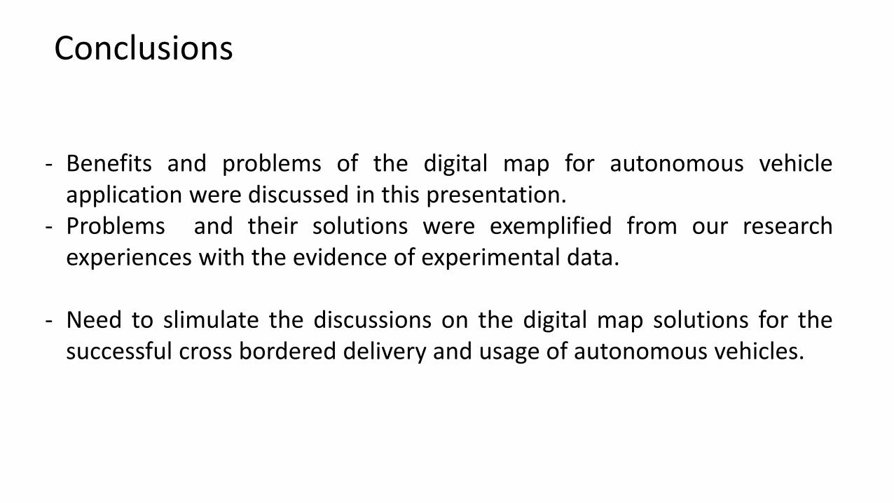
Conclusions
- Benefits and problems of the digital map for autonomous vehicleapplication were discussed in this presentation.
- Problems and their solutions were exemplified from our researchexperiences with the evidence of experimental data.
- Need to slimulate the discussions on the digital map solutions for thesuccessful cross bordered delivery and usage of autonomous vehicles.