Author Copy QSR Delgado et al. 2012
22
This article appeared in a journal published by Elsevier. The attached copy is furnished to the author for internal non-commercial research and education use, including for instruction at the authors institution and sharing with colleagues. Other uses, including reproduction and distribution, or selling or licensing copies, or posting to personal, institutional or third party websites are prohibited. In most cases authors are permitted to post their version of the article (e.g. in Word or Tex form) to their personal website or institutional repository. Authors requiring further information regarding Elsevier’s archiving and manuscript policies are encouraged to visit: http://www.elsevier.com/copyright
Transcript of Author Copy QSR Delgado et al. 2012
This article appeared in a journal published by Elsevier. The attachedcopy is furnished to the author for internal non-commercial researchand education use, including for instruction at the authors institution
and sharing with colleagues.
Other uses, including reproduction and distribution, or selling orlicensing copies, or posting to personal, institutional or third party
websites are prohibited.
In most cases authors are permitted to post their version of thearticle (e.g. in Word or Tex form) to their personal website orinstitutional repository. Authors requiring further information
regarding Elsevier’s archiving and manuscript policies areencouraged to visit:
http://www.elsevier.com/copyright

Author's personal copy
Sea-level rise and anthropogenic activities recorded in the late Pleistocene/Holocene sedimentary infill of the Guadiana Estuary (SW Iberia)
J. Delgado a,*, T. Boski b, J.M. Nieto a, L. Pereira b, D. Moura b, A. Gomes b, C. Sousa b, R. García-Tenorio c
aDepartment of Geology, University of Huelva, Campus ‘El Carmen’, 21071 Huelva, SpainbCIMA e Centre for Marine and Environmental Research, University of Algarve, 8005-139 Faro, PortugalcDepartment of Applied Fisic, ETS Arquitectura, University of Seville, 41013 Sevilla, Spain
a r t i c l e i n f o
Article history:Received 24 June 2011Received in revised form29 November 2011Accepted 2 December 2011Available online 27 December 2011
Keywords:Late PleistoceneHoloceneSea-level riseGeochemical recordGuadiana EstuaryIberian Pyrite Belt
a b s t r a c t
This study reviews data on sea-level rise during the last 13000 yr cal. BP (13 kyr) as recorded in theestuarine sediments of the Guadiana River (SE Portugal, SW Spain). We combined new data froma 63 m-long borehole, drilled through the entire postglacial sedimentary sequence, with information onfive previously studied cores. By integrating sedimentological, geochemical and palaeontological proxies,we were able to make a palaeoenvironmental reconstruction of the Guadiana terminal palaeovalleyduring the last 13 kyr and propose a curve of sea-level rise for the SW Iberian Atlantic margin. Ourforaminifera-based palaeoecological reconstruction, anchored to a 14C age model, reveals rapid sea-levelrise from 13 kyr, interrupted during the Younger Dryas and resuming ca 11.5 kyr. The pace of marinetransgression slackened ca. 7.5 kyr and since then has progressed upwards at a rate of 1.2 mm yr�1.
HoloceneeAnthropocene sediments from two boreholes were also analysed to assess the timing,levels and sources of trace metals produced by acid mine drainage from the Iberian Pyrite Belt. Study ofmetal/aluminium ratios through the profiles allowed background metal concentrations to be estimatedfrom lithostratigraphic units older than ca. 5 kyr (i.e. unaffected by anthropogenic activities). Humanactivities are especially evident from 4.5 kyr (the beginning of the Copper Age), with anthropogenicsources of metal fluxes prevailing over natural sources (especially Pb, Co, Ni, and Mn, and, to a lesserextent, Zn, Cu, and Ni). Mining activities became particularly intensive between the late Bronze Age andthe Roman period (3e1.5 kyr), when the highest metal enrichment factors were recorded: EFPb z 2,EFCd > 10, EFCr z 2, EFCu z 3, EFZn ¼ 1.4.This study reveals the utility of postglacial sedimentary recordsfor reconstructing historical changes in regional water-sediment quality and separating natural andanthropogenic sources of geochemical contaminants.
� 2011 Elsevier Ltd. All rights reserved.
1. Introduction
The rapid rise in sea-level that occurred following the last glacialmaximum (LGM) created tens of metres of vertical accommodationspace for sediments deposited in fluvial palaeovalleys. In particular,the deeply incised terminal segments of river valleys provideexcellent conditions for the uninterrupted accumulation andpreservation of continuous records of sedimentation, evolvingprogressively from fluvial to estuarine/marine. Estuarine sedimen-tary archives usually contain abundant 14C-datable items and maybe seen as complementary to the classical, coral-based records usedin sea-level reconstructions, like those in Barbados (Fairbanks,1989)
and Tahiti (Bard et al., 1996, 2010). On the Spanish side of Gulf ofCadiz, the process of postglacial coastal sedimentation has beenreviewed by several authors (e.g. Goyet al.,1996; Dabrio et al., 2000;Zazo et al., 2005, 2008). Postglacial sea-level rise also inducedchanges in human settlement patterns (Turney and Brown, 2007),and adaptations tomarine transgression (Rolett et al., 2011) throughdifferentiated dispersal patterns and social structures (Fa, 2008).Marine resources made an important contribution to the humandiet, especially after 10 kyr when terrestrial resources becamedepleted due to overpopulation (Cohen, 1977). The importance ofmarine resources in the Mesolithic diet has been demonstratedthrough the isotopic composition of bones (e.g., Mannino andThomas, 2001; Fischer et al., 2007). Considering the limitations onthe transport and preservation of food, humansprobably spent largeamounts of time near the coast (Fischer et al., 2007). Between 8500and 5630 years cal. BC, a marine diet composed mainly of speciesoccurring on intertidal rocky substrates sustained Mesolithic
* Corresponding author. Tel.: þ34 959 219 826; fax: þ34 959 219 810.E-mail addresses: [email protected] (J. Delgado), [email protected]
(T. Boski), [email protected] (J.M. Nieto).
Contents lists available at SciVerse ScienceDirect
Quaternary Science Reviews
journal homepage: www.elsevier .com/locate/quascirev
0277-3791/$ e see front matter � 2011 Elsevier Ltd. All rights reserved.doi:10.1016/j.quascirev.2011.12.002
Quaternary Science Reviews 33 (2012) 121e141

Author's personal copy
populations along the SW Portuguese coast (Dean et al., 2011). Shellmiddens, some of them including artefacts dated to 8e7 ka BP,reflect the vital importance of marine sources for pre-historiccommunities (Bailey and Flemming, 2008) and can be used asa proxy for coastline evolution (e.g., Pavlopoulos et al., 2010).
Due to strong chemical gradients and dynamic mixing ofcontinental and marine waters, estuaries have a great capacity forthe accumulation of contaminant elements introduced by anthro-pogenic activities, both within the catchment and the estuary itself(Weistein, 1996; Sanger et al., 1999; Spencer et al., 2003). Sincethese areas are often places of intense human and animal activity,playing an important role in themaintenance of ecological diversitythrough their provision of shelter and food to numerous species,contamination levels are of particular interest in estuarine envi-ronments (Rae, 1997; Price et al., 2005). Over millennia, humanactivities like forest clearing, mining, waste dumping and metal-lurgy have accelerated the supply of heavy metals to coastal areas.Interpretation of the human influence, however, requires knowl-edge of natural reference (background) concentrations, which canbe obtained from the pre-anthropogenic part of the estuarinesedimentary record.
Trace metals in the water column generally tend to be adsorbedonto fine, chemically active particles in suspension, which aresubsequently accreted to the sedimentary column. Sedimentationof these metal-adsorbing particles incorporates the historicalrecord of the sources (both local and regional) of contaminant inputinto the host sediment (Hwang et al., 2009). Where 14C-datableitems are abundant, these sedimentary archives may thereforeprovide time-resolved information for the reconstruction ofhistorical changes in water quality, local sedimentation and sea-level rise (Hartmann et al., 2005; Cantwell et al., 2007; Bakeret al., 2010). In estuaries affected by acid mine drainage (AMD),natural salt-induced coagulation/precipitation processes, throughwhich suspended elements in particulate matter are incorporatedonto sediments (Stecko and Bendell-Young, 2000), are altered.These environments are characterized by high sulphate, metal andmetalloid concentrations, the behaviour of which is controlled bychanges in pH and salinity. As a result, all these behaviouralmodifications may be reflected in the geochemical characteristicsof the sediments (Borrego et al., 2004).
Catchments of the Iberian Pyrite Belt in SW Iberia have beenwidely documented on account of their massive sulphide depositsand associated intensive mining. The extraction of minerals fromthese deposits dates back to the age of the Iberians and Tartessos,some 5000 years ago (Davis et al., 2000; Leblanc et al., 2000; Noceteet al., 2005). Acid discharges from these mineral extractions intothe river network almost inevitably left a chemical imprint in thegeological record. Hence, sedimentary geochemistry should bea powerful tool to trace environmental changes in the area, inducedboth by natural and anthropogenic causes. Previous investigationshave indeed shown that study of sediments at depth may helpestablish the effects of natural and anthropogenic processes insedimentary environments (van Geen et al., 1997; Leblanc et al.,2000; Borrego et al., 2004; Price et al., 2005; López-Gónzalezet al., 2006; Chatterjee et al., 2007; Viguri et al., 2007; Hwanget al., 2009).
Various studies have examined aspects of coastal sedimentationsystems in the vicinity of the Guadiana River, which crosses thefinal section (Fig. 1) of the Iberian Pyrite Belt. For example, Morales(1993) and Morillo et al. (2004) provided geochemical data onsediments at the coast near Huelva, González et al. (2007) char-acterized sediments on the Gulf of Cádiz shelf, and Ruiz (2001)made an assessment of estuarine pollution levels. González-Vilaet al. (2003) and Polvillo et al. (2009) presented data on organicgeochemical markers to infer aspects of the history of vegetation,
diagenesis of organic matter and possible anthropogenic interfer-ence, as well as on climatic and environmental changes (mainlyderived from changes in sea-level) during the HoloceneeAnthropocene.
Historically, the waters in the Lower Basin of the Guadiana Riverhave received acid input frommining activity (Delgado et al., 2009),thus the surface sediments of the estuary contain significant levelsof contamination associated with this input (Delgado et al., 2010,2011). However, there are no detailed data concerning the post-glacial input of toxic metals to the estuary. A thorough examinationof historic variations in contaminant elements and the establish-ment of the background metal concentrations are importantprecursors to an assessment of anthropogenic impact on theseenvironments (Mil-Homens et al., 2006). Such studies may alsoprovide valuable data on the behaviour of metals in estuarinesettings that have been historically affected by AMD.
Given the exceptionally long sedimentary record accumulatedsince the LGM in the Guadiana River Estuary, the present studyaims to bring together existing information on sedimentaryevolution in the area and to propose the first regional curve forpostglacial sea-level rise (SLR) in the Gulf of Cádiz, embracing theterminal Pleistocene and Holocene. From a geochemical perspec-tive, our goal is to establish background values for contaminantelements and discriminate between natural and anthropogenicinputs of these elements into the system. This information willcomplement an existing pollen-based reconstruction of environ-mental change in the Lower Guadiana Basin, as proposed byFletcher et al. (2007).
1.1. Study area and historical perspective
The Guadiana River is the fourth-longest river on the IberianPeninsula, with a total length of 810 km. The last 200 km stretchforms a natural border between Portugal and Spain. In geologicalterms, the estuary is located almost entirely in the Central Domain(Iberian Pyrite Belt) of the South-Portuguese Zone (Simancas andPérez Estaún, 2004). Its Late Quaternary geological frameworkhas been described in several previous works (Boski et al., 2002,2008; González-Vila et al., 2003; Delgado et al., 2009). In a physicalsense, the Guadiana Estuary covers the zone of tidal influenceextending 50 km upstream of the point where the river debouchesinto the Atlantic Ocean (Ruiz et al.,1996) (Fig.1). Themain estuarinechannel varies in depth between 2 and 14 m and experiencesa semi-diurnal mesotidal regime, with maximum spring-tideamplitude reaching 3.44 m (Garel et al., 2009). A schematic cross-section, based on exploratory geotechnical drilling and seismicprofiles, shows that the estuary’s palaeovalley was 600 mwide andapproximately 70 m deep, 8 km north from the mouth (Boski et al.,2002). In contrast to the sedimentary infill characteristic of otherestuaries in the region (soft, unconsolidated sediments from thePlio-Pleistocene accumulated in large, shallow structures valleys:Borrego et al., 1999), the Guadiana has thick (70e80 m) Lateglacialand Holocene deposits, enabling high-resolution temporal analysisof the sedimentary record (Boski et al., 2002). For the purpose ofthis study, core materials from two deep boreholes were used: CM5and CM6, which define a NWeSE cross-section approximately 9 kmupstream from the mouth (Fig. 1).
The Iberian Pyrite Belt (IPB), through which the Guadiana runs,is one of the most important metallogenic provinces in the world,with original reserves of about 1700 million tonnes of sulphides(Sáez et al., 1999). In line with archaeological evidence, theextraction of minerals in the IPB started in the thirdmillennium BC,and focused on the production of copper (Davis et al., 2000; Leblancet al., 2000; Nocete et al., 2005). During the first millennium BC,silver was targeted. Silver and gold extraction developed on a larger
J. Delgado et al. / Quaternary Science Reviews 33 (2012) 121e141122

Author's personal copy
scale during Roman times (2000e1800 BP). Subsequent cultures,including the Visigoths and Arabs (1600e500 BP), essentiallyabandoned mining operations (Davis et al., 2000). It was not untilthe first half of the 18th century that mining recommenced, thistime by the United Kingdom, spurred initially by demand forcopper and, later, for sulphuric acid. These mines were large-scale,open-pit operations (van Geen et al., 1997). The largest volumes ofpyrite were extracted in the late 19th century and early 20thcentury, until the activity finally ceased in the 1990s.
In the study area, the São Domingos Mine in Portugal and theTharsis and Las Herrerías Mines in Spain (Fig. 1) stand out for theirarea or production. Tharsis follows an exploitation pattern verysimilar to that described above for the IPB in general. The SãoDomingos site has been worked since the Chalcolitic, althoughintense exploitation began in Roman times (Álvarez-Valero et al.,2008). Mineral extraction at São Domingos was especially inten-sive from 1857 to 1966 (Matos et al., 2002), exposing the GuadianaEstuary to serious contamination. The Las Herrerías Mine’sproduction peaked in 1880, with the arrival of the English company,The Bedel Metal and Chemical Co. Ltd., which was interested inpyrite extraction instead of manganese. After successive changes inownership that went on for about a century, mining activity ceasedin 1988. At the height of production, important minerals from themain mines in the area (Las Herrerías, El Lagunazo, Cabezo delPasto and Sardón) were transported by rail to Puerto de la Laja(upstream of the study area) and exported by ship.
2. Materials and methods
2.1. Borehole data
We studied the sedimentological and geochemical character-istics of two deep sediment cores: CM5 (51 m deep, 600 in diam-eter) and CM6 (63 m deep, 300 in diameter) (Fig. 1). Borehole CM5was positioned in an area of intertidal saltmarshes close to theconfluence of the Beliche Rivulet and the Guadiana main channel.Borehole CM6 was positioned within the intertidal zone of salt-marshes covering the lateral sediment bank of the main channelon the Spanish side of the river. The vertical elevation of themouths of the two boreholes described in this work, as well asthat of 3 additional Guadiana boreholes (Boski et al., 2002; theirlocation on the Guadiana saltmarshes are shown in Fig. 2) used inthe construction of the local sea-level curve, were 2e5 cm belowthe upper reaches of spring-tides. Considering that the maximumspring-tide amplitude in the estuary is 3.4 m, we assigneda vertical elevation of 1.7 m above mean sea-level (MSL) to all 5boreholes. Overall core recovery was close to 90% for silt/claysediments and 70% for sand/gravel sediments. Only one 1.3 msegment, probably of sand/sandy silt, was lost entirely during thedrilling of borehole CM6.
Prior to sample extraction, the cores were photographed andmacroscopically described in terms of lithology, presence of sedi-mentary structures and macrofossil content.
Fig. 1. Maps of the study area, showing geological setting, locations of principal mining operations, and locations of the CM5 and CM6 cores in the Guadiana River Estuary.
J. Delgado et al. / Quaternary Science Reviews 33 (2012) 121e141 123

Author's personal copy
2.2. Sample collection and analytical procedures
Based on the chronostratigraphic model established from theCM5 profile (Boski et al., 2008), sampling frequency in each corewas defined as follows: (1) samples were collected every 20 cm inthe top 6 m to characterize the variations in metal content due torecent human activity; (2) samples were taken every 50 cmfrom 6 to 12 m to characterize environmental changes and otherhuman activities in the drainage basin; (3) samples werecollected every 2 m below 12 m to complete the geochemicalcharacterization of estuarine infill and to establish the back-ground levels of elements. Sub-sampling for dating, grain sizeanalysis, and geochemical analysis was performed in 1 cm-thicksub-samples. Wet sediments were placed rapidly into porcelaincontainers and desiccated in a SELECTA DIGITHEAT 2001245(150 l) oven at a temperature no higher than 40 �C to removemoisture without causing mineralogical changes within thesamples. The samples were sieved through a 2 mm mesh anddivided into two sub-samples, one for grain-size study and theother for chemical analysis.
The grain-size distribution of the fine fractionwas analysedwitha Malvern Mastersizer 2000� particle size analyser, using sedimentsamples suspended in distilled water, to which 0.5 g of Sodiumhexametaphosphate antiflocculant solution was added.
A total of 50 and 55 samples were selected from cores CM5 andCM6, respectively, to characterize the geochemistry of the estuary’spostglacial infill. The dried samples were ground to 63 mm usinga mechanical agate mortar. Total element concentrations wereanalyzed by Acme Analytical Laboratories Ltd. (Vancouver, Canada),accredited under ISO 9002, through its Italian affiliate (ERS srl,Napoli). Major elements and a number of trace elements indicativeof possible environmental impact (i.e. As, Cd, Co, Cr, Cu, Fe, Mn, Ni,Pb, and Zn) were determined by optical (ICP-AES) and mass (ICP-MS) spectrometry. Other parameters such as total carbon (TC) andtotal sulphur (TS) were determined using a LECO elementalanalyzer and the sum of volatile substances was quantified by Losson Ignition (LOI) at 1050 �C.
The accuracy of measurements was calculated based on Acme’sin-house reference materials: DS7 and SO-18. Reference materialsDS7 and SO-18 were calibrated to an aqua regia digestion/ICP-MSdetermination against published values for a concentrated HCland HNO3 digestion of the Canadian Certified Reference MaterialsProject (CCRMP) TILL-4 and LKSD-2 (CANMET Mining and MineralSciences Laboratories Ottawa, ON, Canada).
In addition, to check the quality of the analysis, four replicateswere analyzed. From them, the Relative Percentage Difference(% RPD) was calculated as:
% RPD ¼ ðS� DÞ=ðSþ DÞ=2� 100 (1)
Where: S ¼ determined value of the samples, and D ¼ value of theduplicates. The results for % RPD (Table 1) are reasonably good andclose to zero, the expected value. Most values are below 0.5%,except for Cr at 2.14%. No values are higher than 5% RPD.
Evaluation of the analytical performance of the total concen-tration was made by analyzing the Certified Reference Materials(CRMs) STSD-1 and STSD-2 (the standard for stream sediments).Themeasured concentrations of all 29 elements overlap, or are veryclose to, the certified reference values for this standard (Table 1).Recovery ranges were calculated by:
% Recovery ¼ ðObtained value=Certified valueÞ � 100 (2)
Generally, the ranges of recovery of the principal elementsunder study (Fe, Al, As, Cd, Co, Cr, Cu, Ni, Pb, and Zn) are between78.5 and 105%, except Cd and Cr, which do not have certifiedreference values. There is a good level of agreement between ourresults and the reference values (Table 1).
2.3. 14C time-scale and micropalaeontological analysis
For the purpose of establishing the age models for both post-glacial sedimentary profiles, the 14C ages of datable items preservedin the sediment were determined according toTable 2. Dated items,in order of preference for dating, were: autochthonous organic
Fig. 2. Aerial image showing the geographical context and location of the boreholes in the Guadiana saltmarshes system.
J. Delgado et al. / Quaternary Science Reviews 33 (2012) 121e141124

Author's personal copy
Table 2Summary information for 14C age determinations showing conventional age, d13C& 1s range and midpoint. Radiocarbon ages were calibrated using the program CALIB v. 6.0(Stuiver et al., 2009; Reimer et al., 2009).
Borehole 14C Lab code Depth conv. 14C d13C& 2s range midpoint Material Method
n� sample cm Age BP PDB cal. BP
CM1CM1.7 KIA-13241 787 3360 � 31 0.64 2984e3385 3185 Cerastoderma glaucum AMSCM1.1 GX-25447 824 5020 � 310 1.1 4509e6051 5280 Cerastoderma glaucum b radiom.CM1.2 GX-25448 1712 6210 � 220 �25.9 6626e7513 7070 peat b radiom.CM1.3 KIA-8376 1860 6205 � 40 2.08 6438e6836 6637 Cerastoderma edule AMSCM1.4 SAC-1534 2127 7590 � 100 0.02 7805e8312 8059 Cerastoderma angulata b radiom.CM1.5 GX-25449 2850 8430 � 380 1.5 8137e10009 9073 Cerastoderma glaucum b radiom.CM1.6 KIA-9691 3606 9500 � 70 na 10165e10545 10355 Cerastoderma sp. AMSCM2CM2.1 Beta-128887 200 3040 � 100 �27.3 2955e3449 3202 peat b radiom.CM2.2 Beta-128886 715 5980 � 160 0.4 5987e6782 6385 Acanthocardia tuberculata b radiom.CM3CM3.1 GX-25421 459 3300 � 160 25.9 2731e3538 3135 Cerastoderma angulata b radiom.CM3.2 GX-25452 960 6710 � 120 1.6 6897e7480 7189 Cerastoderma angulata b radiom.CM3.3 GX-25453 1452 7080 � 200 0.7 7159e7962 7561 Cerastoderma angulata b radiom.CM3.4 GX-25454 2690 9470 � 250 �22.9 10155e11412 10784 wood b radiom.CM5CM5.0 WK16012 333 3375 � 39 0.2 2994e3413 3204 Scrobicularia plana AMSCM5.1 KIA 15211 579 4295 � 35 na 4153e4625 4389 Venerupis AMSCM5.6 WK16013 890 6764 � 45 25.4 7115e7443 7279 Cerastoderma glaucum AMSCM5.2 KIA 15213 1085 4095 � 30 na 4027e4257 4142 Cerastoderma edule AMSCM5.3 KIA15212 1345 7585 � 35 na 7866e8202 8034 Venerupis AMSCM5.4 KIA15210 1775 7725 � 45 na 7999e8349 8174 Cerastoderma.sp AMSCM5.7 WK 16014 2095 8256 � 55 25.3 9083e9423 9253 wood AMSCM5.8 WK 16015 4270 10273 � 66 25.5 11802e12227 12015 wood AMSCM5.5 Beta-137110 4767 10990 � 40 �25.7 12681e12989 12835 wood AMSCM6CM6.1 CNA974 200 830 � 30 -28.1 686e789 738 organic matter AMSCM6.2 CNA975 310 1000 � 45 -31 792e981 887 organic matter AMSCM6.3 CNA976 450 1215 � 35 30.6 1059e1189 1124 organic matter AMSCM6.4 KIA30369 1403 6060 � 50 �25.96 6777e7027 6902 peat AMSCM6.5 KIA30368 2120 7150 � 50 �8.36 7455e7789 7622 Venus nux AMSCM6.6 Beta-282088 5245 11110 � 40 �28.9 12792e13131 12961 wood AMSCM6.7 CNA979 5500 11370 � 50 �46.01 13125e13357 13241 organic matter AMS
Table 1Evaluation of the accuracy of element concentration measurements, involving calculation of the Relative Percentage Difference (RPD) and its comparisonwith certified valuesof the STSD-1 and STSD-2 Certified Reference Materials from stream sediments.
CAN STSD-1 CAN STSD-2
% RPD Obtained value Certified value % Recovered Obtained value Certified value % Recovered
Al2O3 0.30 8.67 9.00 96.3 16.0 16.1 99.4Fe2O3 0.33 6.28 6.50 96.6 7.35 7.50 98.0MgO 0.04 2.16 2.20 98.2 3.15 3.10 102CaO 0.01 3.66 3.60 102 4.18 4.00 105Na2O 0.32 1.73 1.80 96.1 1.70 1.70 100K2O 0.13 1.24 1.20 103 2.13 2.10 101TiO2 0.01 0.64 0.80 80.0 0.73 0.80 91.3MnO 0.00 0.47 0.50 94.0 0.13 0.10 130TOT/C 0.05 13.2 12.3 108 1.69 1.60 106As 0.28 19.8 23.0 86.1 33.3 42.0 79.3Ba 0.45 585 630 92.9 515 540 95Cd 0.05 0.90 no data e 0.80 no data e
Co 0.24 16.3 17.0 95.9 20.0 19.0 105Cr 2.14 54.4 no data e 102 no data e
Cs 0.40 1.50 1.80 83.3 10.8 12.0 90.0Cu 0.10 34.6 36.0 96.1 41.2 47.0 87.7Ni 0.41 19.3 24.0 80.4 49.2 53.0 92.8Pb 0.16 37.4 35.0 107 68.5 66.0 104Rb 0.25 e 3.00 e 95.7 104 92Sc 0.46 12.0 14.0 85.7 14.0 16.0 87.5Sr 0.32 193 170 114 455 400 114V 0.15 89.0 98.0 90.8 100 101 99.0Y 0.20 36.2 42.0 86.2 35.6 37.0 96.2Zn 0.04 150 178 84.3 193 246 78.5Zr 0.25 221 218 101 183 185 99.1
Mayor in %, trace in ppm. % RPD (Relative Percentage Difference).
J. Delgado et al. / Quaternary Science Reviews 33 (2012) 121e141 125
Author's personal copy
matter, wood fragments, entire bivalve shells and dispersed organicmatter. Organic matter samples were freeze-dried after sectioningthe cores, in order to avoid introduction of “young carbon” frombacteria and fungi that may colonize the sediment particles(Wohlfarth et al., 1998). Dispersed sedimentary organic matter wasgraphitized and submitted to AMS measurement after removal ofcarbonates and humic and fulvic acids. Radiocarbon ages werecalibrated using the program CALIB v. 6.0 (Reimer et al., 2009;Stuiver et al., 2009). A marine reservoir correction of 328 years,available from the CALIB database, was applied tomarine carbonatesamples. All radiocarbon dates are expressed in calibrated calendaryears (cal. BP) as the midpoints of 2s confidence intervals (Table 2).
The foraminiferal assemblages of borehole CM5 have beendescribed in previous investigations (Fletcher et al., 2007; Boskiet al., 2008). From the new borehole, CM6, a total of 75 sampleswere examined for their benthic foraminiferal content. Sampleswere sieved through 500 mm and 63 mm meshes after decantingaway organic debris. After sieving, samples with a high sandcontent were dried and the sediment sprinkled with carbontetrachloride to float off the foraminifera. Samples with large totalnumbers of foraminifera were divided with a modified planktonsplitter (Scott and Hermelin, 1993), which divided the sample intoeight equal parts in order to reduce the total number of individualsto statistically representative count of 300e400. In samples withfew identifiable foraminifera, however, 100 individuals wereconsidered to be sufficient (Fatela and Taborda, 2002). Processedsamples were examined under a binocular microscope in a gridded,circular counting tray. Species diversity was assessed with Shannondiversity index (H0).
In several samples, diatoms were also identified and counted tobetter define marine influence in the sedimentary record.Approximately 1 g of sediment was cleaned in H2O2 and HCl toeliminate organic matter and carbonates. Microscope slides wereprepared with a measured volume of solution containing diatomsand mounted in Naphrax for identification and counting (Roundet al., 1990). Approximately 150e300 diatom valves per samplewere identified and counted.
2.4. Statistical analyses
Factor analysis (FA) was applied to determine the sources ofmetals from the two sedimentary cores. This technique has beenwidely used to distinguish natural and anthropogenic elementalcontributions to sediments and to determine the factors thatcontrol their geochemical behaviour in the estuarine system, basedon the variable levels of association (Ayyamperumal et al., 2006;Covelli et al., 2006; Wu et al., 2007; Katahira et al., 2009). Thevalues of the factor matrix can be improved by using the varimaxrotation method, which maximizes factor variance (Kaiser, 1958).An orthogonal rotation minimises the number of variables thathave high loadings on each factor, simplifying the transformed datamatrix and assisting interpretation.
The FA output was presented in terms of: (a) factor loadings,which display the correlations that exist between the original vari-ables (Jolliffe, 2002), and (b) factor scores, which represent thedistributionof theprincipal components in space (in this case, depth).
Statistical analysis of the data was performed using the STA-TISTICA 7.0 software package (StatSoft, USA).
3. Results and discussion
3.1. Sedimentary facies
The classification of sedimentary facies in both borehole profileswas based on their textural features and foraminiferal content,
complemented by diatom counts in samples where dissolution offoraminifera tests could occur. Given the site specificity of time-space evolution in estuarine environments, a Foraminiferal Indi-cator of Marine Influence (FIMI) was applied for the purpose ofclassification. The FIMI (Boski et al., 2008) may ranges from 1, influvial environments with no foraminifera, to 5, in open estuarineenvironments in which the foraminiferal assemblage is entirelycalcareous, containing numerous shelf species and also planktonicspecies. Intermediate values are defined according to the propor-tions between agglutinated and calcareous species.
3.1.1. Lithology and foraminifera fauna: boreholes CM5 and CM6The lithological profiles of the two boreholes and graphs
depicting FIMI values and the changing composition of foraminif-eral assemblages in borehole CM6 are shown in Fig. 3. The detaileddescription of foraminiferal assemblages in borehole CM5 waspresented by Boski et al. (2008). Both sedimentary sequences haveaccumulated on top of a coarse to very coarse basal gravel layer(Unit I), which was deposited by the Guadiana River during a pastmarine lowstand. Unit I sits directly on top of the Carboniferousshale/greywacke substratum at depths of 50.8 m in CM5 and 72.5min CM6. Similar basal gravel layers have been described in otherestuaries around the Gulf of Cádiz (Borrego et al., 1999).
3.1.1.1. Description of the sedimentary profile in borehole CM5(Beliche Rivulet). Unit II (depth 48.6e40.8 m). Transition fromfluvial to estuarine saltmarsh facies: FIMI 1 to 2. The silt and finemicaceous sand intercalations in the first 3 m of this unit indicatea transition from fluvially- to tidally-conditioned sedimentation.The first foraminiferal fauna (agglutinated Trochammina, typical forupper saltmarsh) and indicating a marine influence were detectedat a depth of 44.9 m. The complex FeeCaeMg and Mn carbonatestructures described in this unit (Boski et al., 2008) are scavengingsites where several heavy metal elements are concentrated (seegeochemical section). The sediment characteristics indicate thatmarine transgression started between the dated point at 47.67(wood, Table 2) and the next dated level at 42.7 m, with radio-carbon ages of 12835 yr cal. BP and 12015 yr cal. BP, respectively.
Unit III (depth 40.8e24.5 m). Estuarine saltmarsh facies: FIMI 2.This unit is composed of dark grey silt with sporadic centimetriclaminae distinguished by a high content of macerated plantremains. In terms of the foraminiferal fauna, the diversity of whichis low, the entire sequence is dominated by inner linings andagglutinated Trochammina spp.
Unit IV (depth 24.5e4.2 m). Open estuarine, mudflat facies: FIMI3e4. This silty unit contains a highly diverse foraminiferal assem-blage, indicating the greatest marine influence in the entire profile.The co-dominance of Ammonia beccarii and Haynesina germanica,associated with Elphidium spp. and exotic (shelf) Brizalina spp.,reflects an estuarine environment open to the free circulation ofshelf waters.
Unit V (4.2e0 m). Confined, estuarine saltmarsh facies: FIMI 2.The foraminiferal assemblages of this uppermost segment of theborehole are dominated by an association of Trochamminamacrescens and Trochammina inflata. Its top 2m displays prominentmottling, probably due to exposure to oxidizing conditions. Thisunit marks a final stage in the infilling of the estuary.
3.1.1.2. Description of the sedimentary profile in borehole CM6. Unit I(depth 72.2e63.4m). Fluvial gravel unit. Only the first 30 cm of UnitI, composed of coarse fluvial gravels, could be recovered by themechanical drilling rig. However, by inserting a steel rod into thegravel, it was possible to establish the bottom limit of this fluvialhorizon at a depth of 72.2 m, i.e. at the contact with the Carbonif-erous shale/greywacke substratum.
J. Delgado et al. / Quaternary Science Reviews 33 (2012) 121e141126

Author's personal copy
Fig. 3. Lithostratigraphic sequences of the CM5 and CM6 boreholes showing sedimentary units and their palaeoenvironmental significance based on textural features and theForaminiferal Indicator of Marine Influence (FIMI). Pie-charts illustrate the structure of the foraminiferal assemblages in CM6. For every sedimentary unit 4 most representativewere taken to compute average abundances, which are very similar to those described for CM5 (see Boski et al., 2008).
J. Delgado et al. / Quaternary Science Reviews 33 (2012) 121e141 127

Author's personal copy
Unit II (depth 63.4e62.5 m). Open estuarine mudflat facies: FIMI5. A dark grey silty unit containing abundant benthic foraminiferalfauna, almost entirely calcareous, with Asterigerinata mamilladominant and associated with the estuarine species A. beccarii andH. germanica (<10% of the total). Planktonic species account forabout 10% of the assemblage and indicate free water exchange withthe marine environment. No 14C-datable items were recovered inthis horizon. However, the foraminiferal assemblage has the mostmarine character in the entire borehole profile and points to a sea-level comparable to, or even higher than, the Holocene highstand.The unit may be tentatively interpreted as a remnant of the sedi-mentary record corresponding to the transgression preceding theMIS 5e marine highstand.
Unit III (depth 62.5e57.5 m). Fluvial facies: FIMI 1. This horizonis also composed of silts, but of generally lighter colour than theunderlying estuarine sequence. Foraminifera are totally absent inthis sediment. There are frequent couplets of dark-grey silts andlighter-coloured micaceous sandy silts, most probably resultingfrom deposition on a floodplain adjacent to the main river channel.
Unit IV (depth 57.5 me51.8). Estuarine saltmarsh facies: FIMI 2.This unit is composed of dark, fine silts and marine influence isfirmly established through a fauna of agglutinated saltmarshspecies T. macrescens and the internal linings of the calcareousspecies, A. beccarii and H. germanica. Diatoms are very abundant in5 of the 6 samples taken from the unit, with dominant species(Nitzschia navicularis, Scolioneis tumida and Diploneis didyma)typical of brackish to littoral ecosystems. The poor preservation offoraminifera tests and diatom frustules (particularly in the samplefrom 53.0 m), is certainly due to the acidification of sedimentcontaining disseminated acid volatile sulphides (AVS). Indeeda routine pH check of the sampled sediment at a depth of 53m gavea pH of 3. Two geochronological reference points were obtained inthis section. At the depth of 55.0 m, dispersed sediment organicmatter gave an age of 13241 yr cal. BP and at 52.45 m-depth a 3 cm-thick wood fragment, filling the entire core section, yielded an ageof 12961 yr cal. BP.
Unit V (depth 51.8e48.8 m). Fluvial e upper saltmarsh facies:FIMI 1e2. The mostly silty sediments of Unit V, with their lightyellowish laminae attesting to periods of subaerial exposure, aretotally void of foraminifera. Only a few, poorly preserved frustulesof Nitzchia navicularis were observed. The uppermost 1.2 m, prob-ably silty sand, was not recovered in the core barrel. The unit’sfeatures point once more to a transitional fluvial/upper estuarinefloodplain facies established during a period of sea-level stabiliza-tion or slight retreat. Taking into consideration the 14C ages ob-tained in the underlying unit IV, this interval could well correspondto the Younger Dryas, as Fletcher et al. (2007) proposed for thelowermost segment of the CM5 profile.
Unit VI (depth 48.8e24.5 m). Estuarine saltmarsh facies: FIMI 2.This unit is composed of homogenous grey silts, with mean particlesize ranging from 13 to 35 mm and containing occasional mudclastsproduced by bioturbation. In the 34 samples analyzed, the fora-miniferal assemblage is dominated by agglutinated species T.macrescens and calcareous estuarine species, A. beccarii and Hay-nesina germanica, often preserved as inner linings. Several samples(i.e., 41.5, 40.3, 33.3, 28.7 m) contain no foraminifera at all. The lackof tests is attributed to their dissolution, because the samples thusaffected occur in between intervals where foraminifera wereabundant.
Unit VII (depth 24.5e13.5 m). Estuarine mudflat facies: FIMI 4.Sediment in this interval is slightly coarser than in the underlyingunit, with mean grain size ranging from 17 to 66 mm. It is composedof dark, sandy silts and contains abundant bivalve fragments. Theupper limit of the unit is erosional and marks a transition to a high-energy channel environment. A. beccarii andH. germanica dominate
the foraminiferal assemblage. Elphidium advenum and othercalcareous species were also frequent. From the bottom to the topof the horizon, Shannon diversity index (H’) rises from 1 to 2.2,pointing to more frequent tidal inundation than in the previousunit. Foraminifera were absent in several sections, probably due topost-depositional dissolution. Preliminary observation of thesesections, centred on 23.8 and 22.9 m, revealed the presence ofestuarine/coastal diatoms, namely Nitzschia navicularis, Fragilariabrevistriata, Gomphonema parvulum and Ephitemia adnata.
Two radiocarbon ages, obtained from dispersed organic matterat 19.0 m and on a Cerastoderma sp. shell at 14.03 m, gave ages of8235 and 6902 yr cal. BP, respectively. These figures provide a timeconstraint on the terminal period of rapid sea-level rise in the CM6sedimentary record.
Unit VIII (depth 13.1e0 m). Channel facies evolving to mudflatand saltmarsh facies: FIMI 1e5. From the bottom gravels and coarsesands containing shell debris, this unit becomes progressively morefine-grained towards the surface, where the silty sediment indi-cates a transition from a channel situation to a lower energyenvironment of mudflats and saltmarshes. As a whole, the unitformed during the build-up of an estuarine meander bar, evolvingfrom a deeper, more energetic environment to a shallower, inter-tidal depositional environment. The emplacement of the meanderoccurred most probably under the influence of the “ArroyoPedroza”, an ephemeral, now extinct creek, which once draineda small tributary valley joining the principal estuarine channel nearthe borehole site.
The foraminiferal assemblage, which was well preserved in 4 ofthe 5 silt samples analysed, is dominated by A. beccarii and H.germanica, accompanied by E. advenum, Elphidium excavatum,Cibicides lobatulus and Haynesina depressula. In the 3 uppermostmetres of the core where foraminifera were absent, diatoms wereabundant, with the leading species Nitzschia navicularis, Pinnulariaborealis, Fragilaria brevistriata and Navicula cf. laevissima.
3.1.2. Sea-level change and sediment infilling of the GuadianaEstuary through the terminal Pleistocene and Holocene
The curve of sea-level rise proposed in this work is based on 28radiocarbon dates from the 5 sediment cores: CM5 and CM6 (Boskiet al., 2008; present study) and CM1, CM2 and CM3 (Boski et al.,2002). Most of the dated items were identified bivalve shells (19)and the remainders were peat/peaty sediment, wood fragmentsand dispersed organic matter. There are several sources of uncer-tainty in determining the past sea-level elevation with respect tothe present MSL through the dating of organic or carbonate itemsretrieved from the sediment cores. With no evidence of recenttectonic movements along the S. Portuguese continental margin,the four main sources of error, and the respective error marginsmay be estimated as follows: i) elevation of the borehole mouthwith respect to the present MSL: �20 cm (see Section 2.1), ii) depthbelow the borehole mouth from which the dated item wasrecovered:�20 cm, (due to the incomplete core recovery), iii)position of dated items recovered from the mudflat/saltmarsh unitswith respect to the past MSL: �1.4 m (equal to the present meantidal range amplitude), and iv) position of dated items recoveredfrom channel facies with respect to the past MSL: �5 m (equal tothe average depth of the main tidal channel in the area ofboreholes).
Sediment compaction was not taken into account because peat,usually the most compaction-prone material in sediment profiles,was all but absent in the studied cores, apart from some layers ofa few centimetres in thickness. According to our previous studies,sediment density, and consequently the volume of sediments, doesnot change significantly below the first 20 cm of sedimentarycolumn (Boski et al., 2008).
J. Delgado et al. / Quaternary Science Reviews 33 (2012) 121e141128

Author's personal copy
A linear age/depth relation for the process of palaeovalleyinfilling since the LGM was established for borehole CM5 by Boskiet al. (2008) and has been completed for borehole CM6 in this work(Fig. 4). According to our interpretation, both sequences seem tohave mostly accumulated in an intertidal environment either anunvegetated mudflat or saltmarsh. The rate of infilling is repre-sented by linear regression of the depth/age relation (Fig. 4), whichis split into two separate phases. The earlier phase corresponds toa period of rapid sea-level rise (13,000e7200 yr cal. BP), witha sediment accumulation rate of ca. 7.3 mm/yr from the CM5borehole and 6.6 mm/yr from the 3 newly dated samples from theCM6 borehole. In the subsequent phase, from 7200 yr cal. BPonwards, the sediment accumulation rate decelerated to ca.1.2 mm/yr and 2.4 mm/yr from CM5 and CM6, respectively. Thisdifference in accretion rates arises from differences in sedimentarydynamics and accommodation space at the two sites. While CM50saccretion occurred continuously in the sheltered intertidal zone,the upper portion of the CM6 profile corresponded initially todeeper channel facies, progressively evolving into intertidalmudflat and saltmarsh facies.
As noted above, the first foraminifera-rich estuarine unit, at thebottom of borehole CM6, did not yield any datable items and wastentatively attributed to the last interglacial, possibly the MIS 5ehighstand. The first chronological evidence of marine influence inthe Guadiana Estuary came from dating disseminated organicmatter and a wood fragment. Both ages, 13241 yr cal. BP and12961 yr cal. BP, precede the first cooling phase of the YoungerDryas stadial at ca. 12.6 kyr, which may have led to a slight drop insea-level (Rodrigues et al., 2010). On the NW Spanish continentalmargin, in the area of “Ría de Vigo”, YD regression has been inferredfrom a seismic/erosional discontinuity at 45 m depth below thepresent sea-level (García-García et al., 2005). It seems that this briefregression did not produce any observable erosion in either of theGuadiana records, but was sufficient to impede development ofbrackish foraminiferal fauna during the deposition of unit V, clas-sified as fluvial facies. At the location of CM5, near the confluence ofthe Beliche Rivulet and the Guadiana River, the palaeovalley wasstill too shallow to allow the accumulation of estuarine sedimentsat that time. Consequently, vegetal remains dated 12835 yr cal. BPin borehole CM5 belong to the fluvial phase of sedimentation,contemporaneous with a climatic phase that was cooler and drierthan the subsequent phase in the lower Guadiana Basin (Fletcheret al., 2007). Brackish conditions were detected in CM5 close to
the second dated point, i.e. 12015 yr cal. BP. This age is slightlyearlier than the beginning of the Holocene transgression, which,according to Smith et al. (2011), begun at 11650 yr cal. BP. The curveof sea-level rise presented in Fig. 5 is a 2-segment regression linebased on 28 index points. The 5 index points from channel facieshave been corrected by adding the average value of channel depth,i.e. 5 m. The lower segment of the regression line (Fig. 5) points tosea-level rise occurring at a rate 6.8 mm yr�1 until ca. 7500 yr cal.BP. Correlation for that time laps (R2 ¼ 0.946) points to a spatiallycoherent trend, with the possible exception of the CM3 borehole,whose sedimentary record accumulated to large extent in channelfacies. The dated fragment of abraded wood from a depth of 26.9 mis clearly an outlier, being excessively old, probably much olderthan the age of active sediment surface on which it was depositedand was therefore not considered in the computation of theregression line. Scrutiny of the position of sea-level index pointsdated between 8500 and 7500 yr cal. BP (Fig. 5) indicates that thesea-level could have risen at an even faster rate than the figureproposed above. Indeed, this period corresponds to the last meltwater pulse from the collapsing Laurentide ice sheet (Clarke et al.,2004; Turney and Brown, 2007; Hijma and Cohen, 2010). Van derSchriek et al. (2007) reported a widespread intrusion of saltwaterinto the Lower Tagus Valley in Central Portugal during that period.However, the fact that the error in depth estimation is quite large inthe 5 of the 10 age-points corresponding to channel facies calls forsome caution in interpretation. The period from the mid Holoceneto the present witnessed a much slower, ca. 1.8 mm yr�1, sea-levelrise, whose record is less coherent because of the more limitedaccommodation space for the sediments and the more complexsedimentary dynamics imposed by the closer proximity of theshore-line. Deposition of both terrigenous and shelf sediments wasless continuous and possibly interrupted by erosional events, i.e.when sediment supply surpasses accommodation (Stanley andWarne, 1994; Tjallingii et al., 2010). The less linear accretion trendfor the latter part of the Holocenemay relate to the fact that most ofthe dated items from that period were bivalve shells, which werenot necessarily sampled in their original living position.
Overall, the presented curve (which could be more accuratelydescribed as a band) complements the SLR curve proposed by
Fig. 4. Chronological model of the sedimentary infilling in the Guadiana Estuary (SWIberia) showing the deptheage relationship in boreholes CM5 and CM6.
Fig. 5. Sea-level rise regression lines established from depth/age relations in 5 bore-holes: CM6 this study, CM5 this study and Boski et al. (2008), CM1, CM2 and CM3(Boski et al., 2002). The grey band shows the error margins of sea-level position, takinginto consideration the uncertainties of 14C dating and uncertainties of past sea-leveldetermination with respect to the MSL.
J. Delgado et al. / Quaternary Science Reviews 33 (2012) 121e141 129
Author's personal copy
Dias et al. (2000) for the N part of the Portuguese shelf onthe basis of bathymetric, geomorphological and relative ages,however with very limited chronological data. Vis et al. (2008)proposed a SLR curve for the Tagus Valley matching very closelythe one proposed in this study in the period postdating8890 yr cal. BP. Below that date, the match is not satisfactorybecause the Tagus curve is based on only 2 index points, whoseintertidal position is deduced solely from the presence of pyrite.In a wider, global context, the sedimentary record of SLR in theGuadiana Valley bears strong similarities to the Yangtze Estuary,where Liu et al. (2010) have documented the postglacial trans-gression for the last 12 kyr. However, their proposed sea-level for12 kyr, ranging from w53e62 m below present MSL, is some 15 mbelow our projection. The Guadiana curve seems to accord withthe coral-derived records from Barbados (Peltier and Fairbanks,2006) and Tahiti (Bard et al., 2010) until ca. 11000 yr cal. BP. Forthe earlier part of the two records, 11e13 kyr, the regression linein the centre of our error envelope is 10e12 m above the UeThdated index points from Barbados with a trend to increase indepth. The observed difference between the trend of global ice-equivalent eustatic sea-level curve and our line can be attrib-uted to the age overestimation of Guadiana index points, becausethere is no evidence of recent tectonic movements in the lowerGuadiana basin. In the cases of wood fragment and disseminatedorganic matter dating, such overestimation may be in the order ofhundreds of years.
3.2. Geochemical characteristics
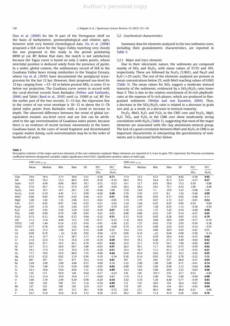
Summary data for elements analyzed in the two sediment cores,including their granulometric characteristics, are reported inTable 3.
3.2.1. Major and trace elementsDue to their siliciclastic nature, the sediments are composed
mainly of SiO2 and Al2O3, with mean values of 57.5% and 16%,respectively. These are followed by Fe2O3 (5.96%), and Na2O andK2O (z2% each). The rest of the elements analyzed are present atmean concentrations below 2%, with MnO reaching values of 0.06%(Table 3). The mean values for SiO2 suggest a moderate texturalmaturity of the sediments, evidenced by a SiO2/Al2O3 ratio lowerthan 5. This is due to the relative enrichment of Al-rich phyllosili-cates at the expense of Si-rich phases, which are produced in fine-grained sediments (Weltje and von Eynatten, 2004). Thus,a decrease in the SiO2/Al2O3 ratio is related to a decrease in grainsize and, as a result, to a decrease in textural maturity.
Fe2O3, MnO, K2O, and P2O5 in the CM5 core and Fe2O3, MgO,K2O, TiO2, and P2O5 in the CM6 core show moderately strongcorrelations with Al2O3 (Table 3), suggesting that most of the majorelements are associated with the clay aluminium-mineral group.The lack of a good correlation betweenMnO and Al2O3 in CM6 is animportant characteristic in interpreting the geochemistry of sedi-ments and is discussed further below.
Table 3Descriptive statistics of the major and trace elements of the core sediments analysed. Major elements are reported in %, trace in ppm. PCC represents the Pearson correlationcoefficient between designated variables (alpha significance level 0.05). Significative positive values in bold type.
CM5 core N¼50 CM6 core N¼55
Mean Median Min Max SD PCC PCC Mean Median Min Max SD PCC PCC
SiO2 Al2O3 SiO2 Al2O3
Clay 19.0 18.4 3.73 38.9 5.51 �0.36 0.71 17.4 15.3 4.72 32.6 8.82 �0.38 0.92Silt 74.6 76.2 15.3 80.5 8.91 �0.39 �0.16 68.5 70.3 34.4 81.2 9.53 �0.27 0.57Sand 6.37 4.94 0.06 80.9 10.7 0.52 �0.23 14.1 12.7 0.01 58.4 15.3 0.39 �0.88SiO2 57.0 56.7 51.2 67.9 2.87 1.00 �0.44 58.3 58.2 34.5 75.7 6.53 1.00 �0.48Al2O3 16.9 16.7 14.7 20.1 1.36 �0.44 1.00 15.0 14.9 7.1 19.9 3.25 �0.48 1.00Fe2O3 6.34 6.19 4.45 11.1 0.99 �0.66 0.49 5.59 5.45 2.57 8.2 1.42 �0.46 0.89MnO 0.06 0.05 0.03 0.43 0.06 �0.21 0.51 0.06 0.06 0.03 0.17 0.02 �0.08 0.15MgO 1.80 1.82 1.35 2.06 0.13 �0.63 �0.05 1.74 1.79 0.67 2.15 0.27 �0.81 0.52CaO 0.71 0.65 0.07 1.66 0.35 �0.21 �0.43 1.24 1.04 0.25 4.47 0.85 0.54 �0.84Na2O 2.05 2.16 1.39 2.64 0.37 0.07 �0.70 2.67 2.07 1.44 6.55 1.12 �0.36 �0.56K2O 2.87 2.82 2.50 3.50 0.24 �0.39 0.97 2.58 2.54 1.37 3.42 0.54 �0.40 0.98TiO2 0.89 0.90 0.79 1.00 0.05 0.41 0.02 0.86 0.88 0.32 1.07 0.14 �0.37 0.65P2O5 0.13 0.12 0.06 0.33 0.04 �0.32 0.51 0.12 0.10 0.05 0.28 0.05 �0.31 0.79LOI 11.3 11.0 4.90 15.5 1.93 �0.71 �0.23 11.8 10.9 4.60 38.6 4.99 �0.77 �0.16TOT/C 1.42 1.44 0.14 2.23 0.43 �0.41 �0.49 2.22 1.57 0.62 13.8 2.03 �0.56 �0.38TOT/S 0.77 0.78 0.03 1.62 0.48 �0.28 �0.60 0.74 0.73 0.08 2.03 0.55 �0.14 �0.55As 14.8 15.3 1.00 24.7 4.15 �0.48 0.25 14.4 13.5 4.60 36.9 5.03 �0.47 0.55Cd 0.09 0.10 < d.l. 0.30 0.05 0.04 �0.35 0.09 0.10 <d.l. 0.60 0.09 �0.58 �0.14Co 16.3 15.7 11.5 28.7 3.17 �0.18 0.26 15.3 15.1 6.50 39.4 4.43 �0.33 0.60Cr 21.8 22.4 17.6 25.6 2.10 �0.18 0.69 19.4 19.2 6.40 27.2 4.49 �0.64 0.92Cu 26.9 25.7 16.5 42.1 4.78 �0.01 0.62 25.0 27.1 9.70 54.1 7.84 �0.82 0.67Ni 32.7 31.5 24.9 60.7 5.80 �0.03 0.47 28.2 30.1 11.7 39.4 6.75 �0.59 0.92Pb 18.3 17.9 13.9 35.6 3.76 �0.20 0.51 19.3 18.7 11.2 41.3 5.19 �0.52 0.41Zn 71.7 70.0 55.0 88.0 7.55 �0.06 0.44 63.8 65.0 29.0 87.0 16.2 �0.43 0.95Hg 0.53 0.52 0.02 3.19 0.56 0.10 �0.34 0.36 0.14 0.02 5.26 0.78 �0.22 0.08Ba 407 397 351 477 35.5 �0.19 0.81 397 373 244 537 86.8 �0.31 0.95Be 2.69 3.00 2.00 4.00 0.57 0.09 0.10 2.22 2.00 1.00 3.00 0.71 �0.41 0.74Cs 7.64 7.80 5.10 9.50 0.90 �0.65 0.82 6.00 5.95 2.00 9.90 2.13 �0.44 0.98Sc 16.3 16.0 14.0 20.0 1.31 �0.36 0.89 14.3 14.0 5.00 20.0 3.35 �0.63 0.96Sr 116 115 93.0 144 9.64 �0.17 �0.23 136 129 101.7 216 25.7 0.52 �0.82Th 13.5 13.4 10.9 16.9 1.17 �0.04 0.43 11.0 11.4 3.40 14.6 2.68 �0.50 0.90U 3.86 3.70 2.90 8.20 0.99 �0.20 0.54 3.02 3.10 1.20 4.40 0.77 �0.59 0.83V 120 120 100 151 11.8 �0.34 0.89 112 110 36.0 156 26.4 �0.67 0.94Rb 127 125 108 165 12.9 �0.37 0.95 110 107 49.6 154 30.1 �0.43 0.99Zr 218 206 165 315 38.1 0.58 �0.72 220 213 96.5 368 48.8 0.23 �0.09Y 32.2 31.8 25.6 41.9 3.12 0.28 �0.14 30.2 30.7 11.4 41.6 6.20 �0.64 0.78
J. Delgado et al. / Quaternary Science Reviews 33 (2012) 121e141130
Author's personal copy
The highest concentrations of trace elements are of Ba, Zr, Sr, andRb, whose mean values exceed 100 ppm. These high values areassociated with shell fragments in the case of Sr and Rb, or withheavy minerals such as zircon in the case of Zr, which is very abun-dant in nearby coastal sediments (Fernández-Caliani et al., 1997).
There are moderately elevated concentrations of elements thatare potential contaminants, mainly those associated with miningoperations in the IPB. Zn shows a wide range of values between 29and 87 ppm, with a mean of 67.7 ppm (Table 3). The results for Nialso stand out, with a range of 11.7e60.7 ppm, and a mean value of30 ppm. Cu ranges from 9.7 to 54 ppm (mean 26 ppm). Otherelements include Pb, Co, As, and Cr with maximum (and mean)values of 41.3 (18.7), 39.4 (15.8), 36.9 (14.6) and 27.2 (20.6) ppm,respectively. Cd concentrations are also significant, up to 0.6 ppm(a significant value, given the high toxicity of this element), witha mean value of 0.09 ppm. Chromium, Ni, Pb, and Zn havemoderate, positive correlations (r > 0.44) with Al2O3 in the CM5core. Similar correlations with Al2O3 (r > 0.41) were also found forAs, Co, Cr, Cu, Ni, Pb, and Zn in CM6. On this basis, the variability ofthese metals appears to be closely related to the percentage of claypresent in the samples, and hencewith the clay aluminium-mineralgroup.
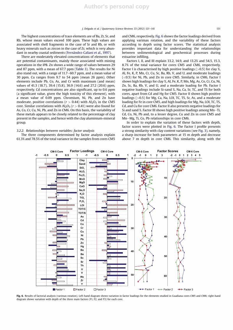
3.2.2. Relationships between variables: factor analysisThe three components determined by factor analysis explain
61.3% and 78.5% of the total variance in the samples from cores CM5
and CM6, respectively. Fig. 6 shows the factor loadings derived fromapplying varimax rotation, and the variability of these factorsaccording to depth using factor scores. The statistical analysisprovides important data for understanding the relationshipsbetween sedimentological and geochemical processes duringestuarine infilling.
Factors I, II, and III explain 33.2, 14.9, and 13.2% and 54.5, 15.3,8.7% of the total variance for cores CM5 and CM6, respectively.Factor I is characterised by high positive loadings (>0.5) for clay %,Al, Fe, K, P, Mn, Cr, Cu, Sc, Ba, Rb, V, and U, and moderate loadings(<0.5) for Ni, Pb, and Zn in core CM5. Similarly, in CM6, Factor Ishows high loadings for clay %, Al, Fe, K, P, Mn, Mg, As, Co, Cr, Cu, Ni,Zn, Sc, Ba, Rb, V, and U, and a moderate loading for Pb. Factor Inegative loadings include Si-sand %, Na, Ca, Sr, TC, and TS for bothcores, apart from Cd and Hg for CM5. Factor II shows high positiveloadings (>0.5) for Mg, Ca, Na, LOI, TC, TS, Sr, As, and a moderateloading for Fe in core CM5, and high loadings for Mg, Na, LOI, TC, TS,Cd, and Cu for core CM6. Factor II also presents negative loadings forSi and sand %. Factor III shows high positive loadings amongMneTi,Cd, Co, Ni, Pb and, to a lesser degree, Cu and Zn in core CM5 andMneMg, Ti, Co, Pb relationships in core CM6.
In order to explain the variation of these factors with depth,factor scores were plotted in Fig. 6. The Factor I profile presentsa strong similarity with clay content variations (see Fig. 3), namely,a sharp increase for both parameters at 15 m depth and decreaseabove 7 m depth in core CM6. This similarity, along with the
Fig. 6. Results of factorial analysis (varimax rotation). Left-hand diagram shows variation in factor loadings for the elements studied in Guadiana cores CM5 and CM6; right-handdiagram shows variation with depth of the three main factors (F1, F2, and F3) for each core.
J. Delgado et al. / Quaternary Science Reviews 33 (2012) 121e141 131

Author's personal copy
associations described above, indicates that Factor I mainly repre-sents geochemical inputs from soil and bedrock erosion (Wu et al.,2007) in the basin. The relationship also indicates the knownaffinity of the metallic elements to the Al-clay mineral group(López-Gónzalez et al., 2006), which, in addition to the funda-mental role played by FeeMn oxyhydroxides, are responsible forthe scavenging and subsequent deposition of these elements bysuspended matter in the estuary.
According to Borrego et al. (2004) the distribution of Factor IIshows a clear association with components of biogenic origin, suchas LOI, TC, Ca, and Sr, in addition to carbonate minerals (Ca, Mg, Na,and Fe), which can incorporate metal elements such as As, Cd, andCu. These carbonate minerals, such as siderite observed in coreCM5, could form through diagenetic oxidation of pyrite due to thehigh permeability of Unit III, which favours groundwater circula-tion (Boski et al., 2008). This factor shows the mineral associationidentified by Boski et al. (2008), confirming that this process shouldoccur during diagenesis. This would also account for the presenceof TS in Factor II. TS explains the important role of CaCO3 in theabsorption of trace metals that leach under acidic conditions(Ayyamperumal et al., 2006) and which, therefore, have an originclearly associated either with acid rock drainage (ARD) and/or withpost-depositional oxidation of sulphides under acidic conditions.The higher factor scores of Factor II at ca. 35 m depth (core CM5)coincide with an increase in Sr concentration. The increment offactor scores upwards of 20 m-depth in both cores may be relatedto bioclastic content, since the first macrofaunal remains appearfrom 24.5 m.
Finally, the distribution of Factor III shows an important asso-ciation between Mn and metal elements such as Cd, Co, Ni, Pb, andZn, and to a lesser extent, Cu, in core CM5, and Co and Pb in coreCM6, as previously described by Wu et al. (2007). These associa-tions are especially strong in the upper part of the cores (Fig. 6),which is indicative of the significant role of Mn in thewithdrawal ofmetals from the water during the last 4500 years (z6.5 m depth).As a result, Factor III reflects elements strongly associated withhuman activity in recent times.
3.2.3. Geochemical markers and palaeo-environmentalinterpretations
To properly compare the concentration of an element betweensamples, it is necessary to compensate for the effects of grain sizeby applying an appropriate correction (Aloupi and Angelidis, 2001).Otherwise, for the same input conditions, fine-grained sampleswould exhibit relatively high metal concentrations compared withsamples having a higher sand content. Although grain-size effectscan be compensated by establishing a relationship between metalconcentrations and the grain-size distribution of each sample, itmust be remembered that particle size is not the sole factorcontrolling elemental concentrations. Thus, many authors chooseto normalise metal concentration using another element/compo-nent predominantly associated with the clay size-fraction (Lee andCundy, 2001). Among the components that have been proposed asa base for normalisation are Al (Bertine and Goldberg, 1977; Carralet al., 1995; Covelli et al., 2006), Li (Loring, 1991), Cs (Ackermann,1980; Grousset et al., 1995), Fe (Piper, 1971; Blomqvist et al.,1992; Herut et al., 1993; Cobelo-García and Prego, 2003), andothers, including Sc, grain size, and organic carbon. Fe and Al havebeen usedmost frequently as normalising elements, both in marineand estuarine sediments (Cundy and Croudace, 1996). This isbecause they are the principal constituents of the fine-grainedaluminosilicates with which metals are frequently associated(Loring and Rantala, 1992; Daskalakis and O’Connor, 1995).
Simple linear regressions with 95% confidence intervals werecalculated for Al, Fe, Cs, Sc, and metals on Al2O3 and Fe2O3; R2
(correlation) values obtained when normalised with Al werealways higher (Fig. 7). Examples of these strong correlations with Alinclude Fe (0.89), Co (0.60), Cr (0.92), Cu (0.66), Ni (0.92) and Zn(0.94). For this reason, we decided to use Al for normalisation(Aloupi and Angelidis, 2001). Previous investigations in the studyarea (Delgado et al., 2010) have shown that Al and heavy metals areassociated with the clay fraction of the surface sediments of theestuary. Aluminium and heavy metals are also strongly associatedin surficial waters of the drainage basin (Delgado et al., 2009).Moderate correlations between Al and As (0.55) were found,whereas the weakest were for Pb (0.41) and Cd (0.22).
The M/Al ratio (metal normalised with respect to Al) may bea useful indicator of natural or anthropogenic changes in thepostglacial record. Temporal variations in the concentrations ofelements preferentially associated with the oxidation of massivesulphide deposits (e.g. Fe, As, Cd, Co, Cr, Cu, Ni, Pb, and Zn) areshown in Fig. 8. Significant variations in the M/Al ratio for thevarious metal elements evidently reflect changes in the deposi-tional environment of the sediments.
Units II and IV in core CM5 and CM6, respectively, correspond tothe initial stage of the post-glacial estuarine sedimentary record ofthe Iberian Peninsula. Unit I in both cores is the legacy of a formerfluvial regime that operated during past lowstands (equivalentunits in the estuaries of the Gulf of Cádiz have been described byDabrio et al., 2000). Regularly interbedded compact silts in Unit II(CM5) and III (CM6) point to the initial stages of an intertidalenvironment. The change in sedimentation conditions is lessevident in core CM6, although the final units (II to V) do havesimilar sedimentary characteristics to those described for themarineefluvial transition. The transition from marineefluvialmixed sedimentation to purely fluvial sedimentation is recordedgeochemically by significant variation in the concentration ofelements such as Fe, As, Cd, Co, and Pb, which tend to decreasedrastically, as do elements that are bioclastic in nature, such as Srand Y. In contrast, Cr, Cu, Ni, and Zn tend to increase (Fig. 8), and areassociated with other elements that are clearly lithophile in nature,such as Ba and Ti, and M/Al maximum values.
Most of the analysed elements do not vary significantly interms of their concentrations in the central sections of bothprofiles (12e41 m in CM5 and 13e47.5 m in CM6, correspondingto Units IVeV and Units VIeVII respectively), with the exception ofAs, which varies significantly through the entire record. Thebenthic foraminifera assemblage, which is associated with anabundance of bivalve shells and large quantity of halophyte pollen(Fletcher et al., 2007), indicate clearly that Unit IV from CM5 wasdeposited in an intertidal zone that evolved from a mudflat toa saltmarsh environment (Unit V). The increase in faunal contentwith depth correlates well with variations in the Sr/Al ratio (notplotted), increasing dramatically from 6 (at 20 m-depth) to 9 at thesurface. Likewise, Sr presents a significant peak, coinciding withthe only noticeable variation of Fe in the entire core CM5. The co-variation of these elements, associated in Factor II (see Section3.2.2 above), could be the result of post-depositional sulphideoxidation (Fe, As, and Cu), creating low-pH conditions and corro-sion of carbonate items (Ca, Sr, and TC). Both phenomena weredocumented by Boski et al. (2008) in core CM5. Unit VI of coreCM6, with a geochemical behaviour similar to that described forcore CM5, has also lithological characteristics that define a typicallow-energy, estuarine sedimentary environment. On top of Unit VII(from 24.5 m, in CM6 core) another increase in the Sr/Al ratio isapparent, and coincides with the maximum abundance of shellfragments (see Fig. 3) and substantially coarser grain size ofsediment accumulated in a point bar.
Finally, upwards of 12 m depth in both cores (i.e. since ca.7800 cal. BP), substantial variations in elemental concentrations are
J. Delgado et al. / Quaternary Science Reviews 33 (2012) 121e141132

Author's personal copy
observed. Broadly speaking, all elements associated with theexploitation of massive sulphides tend to increase until post-Roman times (ca. 1800 cal. BP). Since previous studies of biogeo-chemical markers found only very tenuous associations withsea-level fluctuations in the Guadiana sedimentary record(González-Vila et al., 2003), it is likely that the modulation ofelemental fluxes is associated with anthropogenic activity in theGuadiana basin, such as tree felling, farming and, primarily, miningactivity in the IPB. In this context, the coarsening sediment grainsize and abundant fragments of bivalve shells in the base of Unit VII(CM6 core) suggest that this unit was deposited under increasingenergy conditions during the Neolithic period. In the uppermostUnit VIII, two horizons ofmedium to coarse sandswere laid down ina growing meander bar, fed by the sediments from tributary creek“Arroyo Pedroza”. Increasing sediment delivery to the S Portuguesecoastal zone was also observed by Chester and James (1991) andAllen (2003), who proposed that the decrease in the intertidal areaof local estuaries occurred during an “alluviation” stage of the lateHolocene. They attribute this process to the above mentionedanthropogenic causes, which are widely documented and supportthe idea that this unit could be the result of Neolithic occupation ofthe SW Iberian Peninsula. Palynological analyses of Neolithic sitesshow that, since the Middle Neolithic ca. 6000 years ago, humanintervention in forests in Extremadura (north of the IPB) led to theformation of a savanna-like landscape, similar to that currentlytermed “dehesa”. This kind of landscape may have been distributedto the south of Huelva, including the Algarve and the Alentejo inPortugal (Stevenson and Harrison, 1992; López-Sáenz et al., 2005).Recent studies of core CM5 (González-Vila et al., 2003) indicate
a significant decrease in the presence of lipidic biomarkers, inter-preted as indicating loss of forest mass during the Neolithic period.The beginning of mining activity in the IPB in the III millennium BC(Nocete et al., 2005) also generated an increase in the M/Al ratiothrough the last 5000 years of the stratigraphic record, corre-sponding to the uppermetres of both cores, as discussed in the nextsection.
3.2.4. Heavy metal sedimentary record: background levels andenrichment factors
Variations in M/Al ratios and lithological characteristicsthrough the continuous 13 kyr postglacial sedimentation recordfrom the Guadiana Estuary (cores CM5 and CM6) allow the esti-mation of background metal concentrations from lithostrati-graphic units that were unaffected by anthropogenic activities.These values are required in order to gauge whether an elementpresent in the environment has a natural origin or derivesprimarily from anthropogenic activities (Liu et al., 2003). Basedon palaeoenvironmental-lithological interpretations, we consid-ered that the Units IVeIII (12e41 m, core CM5) and Unit VI(24.5e47.5 m, core CM6) are associated with clearly estuarine andquite homogeneous sedimentation, unaffected by human activi-ties. For this reason these units were chosen to obtain naturalmetal concentration levels. Background values (Table 4) wereobtained from the mean concentrations of the elements analysedin the units studied.
In order to analyse the impact of human activities in the last8000 years, the metal enrichment (or enrichment factor, EF) of thesediments was determined using Equation (3):
Fig. 7. Variation in Al and Sc with clay percentage in samples from Guadiana cores CM5 and CM6 (first graphic); relationship between aluminium and various metals in the samples(remainder of graphics). Regression lines and 95% confidence intervals are shown. Major elements are expressed in % and trace elements in ppm.
J. Delgado et al. / Quaternary Science Reviews 33 (2012) 121e141 133

Author's personal copy
EF ¼ ð½M�=½N�Þsample=ð½M�=½N�Þbackground (3)
Where: [M] sample ¼ metal concentration for the studied sample,[M] background ¼ regional background, [N] sample ¼concentration of the normalising element for each sample, and [N]background ¼ value of the normalising element in the background.
The coefficient EF, which is used to estimate human impact onestuarine environments (Chatterjee et al., 2007; Hwang et al.,2009), allows the concentration of a certain element to becompared with the concentration expected if anthropogeniccontributions of this element were removed from the medium, thatis, with the background value. Anthropogenic input of metals may
Fig. 8. Variation with depth of the Al2O3-normalized concentrations of Fe, Mn, As, Cd, Co, Cr, Cu, Ni, Pb, and Zn through Guadiana cores CM5 and CM6. The synthetic sedimentaryrecord and inferred natural processes or anthropogenic activities in the environment corresponding to the studied units are also shown.
J. Delgado et al. / Quaternary Science Reviews 33 (2012) 121e141134

Author's personal copy
be expected when the normalised concentration of the samples ishigher than background levels (Hwang et al., 2009); i.e. whenEF > 1.
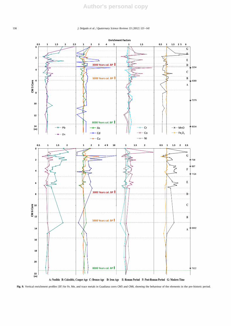
If the EF variation is analysed on the basis of chronologicalperiods (Fig. 9), it can be observed that anthropogenic input ofmetals into the estuary during the Neolithic (A in Fig. 9) waspractically non-existent until the end of this period, when anincrease in erosion (associated with the Holocene thermal climaticmaximum around 7000 years cal. BP) took place (Azevêdo andGonçalves, 2009). However, insignificant increases in EFs (Fig. 10)associated with basic rocks (common in the study area) could berelated to human activities. In fact, the climatic optimum couldhave favoured the first settlements with fortifications and vinecrops constructed in the province of Huelva, according to aninterpretation of pollen data by Chapman (2008). This could haveled to selective deforestation, increasing the erosion of the Guadi-ana Estuary’s bedrock. The local- to regional-scale pollution signalof some metals (e.g., Cu, Pb, and Hg) has been widely linked to theearliest phase of agriculture and metallurgy in Europe during theNeolithic (ca. 5800 yr cal. BP) and Bronze Age (ca. 4500 yr cal. BP)(Shotyk et al., 1998; Kalis et al., 2003; Turney and Brown, 2007;Thevenon et al., 2011).
As it has been mentioned, mineral extraction in the IPB startedaround the Third Millennium BC (e.g. Nocete et al., 2005), duringthe Copper Age (B in Fig. 9). These early, small-scale extractions leftevidence in the sedimentary record. As shown in Fig. 10, theseextractions could have increased the concentration of metal-sulphur (Cu, Pb and Zn) in the environment. Increases in heavymetals are mirrored by increases in the enrichment of lithogenicelements (Co, Cr, Ni), which are probably related to the firstsettlements and associated anthropogenic activities, such as agri-culture and deforestation. The archaeological sites of João Marquesin Portugal (Gomnçalves, 1987) and Cabezo Juré in Spain (Noceteand Linares, 1999) date from this period and provide evidence forCopper Age metallurgy. Fig. 9 shows a generalized increase in theEF of Mn, Co, Cr, and Ni (EF values> 1) in core CM5 up until the endof the Copper Age, whereas other EFs, such as those of Pb and Zn,reach values of 1.2 and exhibit very similar behaviour. Likewise, EFvalues> 1were detected in core CM6 for Co and As, whereas highervalues, close to 1.5, were obtained for Pb and Mn. Recent Pb isotopetests (Nocete et al., 2008) provide evidence for the exploitation of
deposits in Tharsis, which required deep mining. These extractionsare thought to have created large-scale impacts, due to deforesta-tion, erosion, and contamination of the area, including impacts onthe rivers and estuaries of western Andalusia. While little evidencefor Copper Age fluvio-estuarine pollution has been found in sedi-mentary deposits from SW Andalusia, the Guadiana Estuary sedi-ments record a general increase in elements such as Co, Cr and Niduring this period.
Through the Early-Middle Bronze Age (3800e3200 yr cal. BP),Iberian metallurgists began to smelt silver for the first time. Themost extensive remains (slag) have been found around Rio Tinto(Pérez-Macías, 1996). In the I Millennium BC, coinciding withanother climate optimum (after Dansgaard et al., 1969 andSchönwiese, 1995), Co and Ni increase significantly, and both Cuand Zn increase moderately (Fig. 10). These peaks in the EFs of Cuand Zn could be the first sedimentary evidence for mining by theTartessian civilization in the SW Iberian Peninsula. The Late BronzeAge (3200e2900 yr cal. BP) saw mining and metallurgy flourish inthe region, with strong trade networks that gradually fell under thecontrol of Phoenician merchants (Blanco and Rothemberg, 1981). Itappears that Copper was particularly sought after by Tartessianmetallurgy. Pb-isotopic tests suggest that a large number of localand regional mineral deposits were exploited in search of Cu (Hunt,2003). The Guadiana sediments from this period exhibit increasesin Cu enrichment factors, together with other elements commonlyassociated with sulphide exploitation (Zn, Cd, Fe, Mn), and otherelements (Co and Ni) frequently associated with deforestation andbedrock erosion.
During the Bronze Age (C in Fig. 9), Pb shows a small decrease inEF values close to 1 in core CM5. Cadmium maintains its trend asdescribed above, while elements such as Zn, Cd, Cu, Co, Ni, Fe andMn exhibit higher EF peaks (Znz 1.3, Cuz 1.3, Coz 1.52, Niz 1.3,Fe z 1.3 and Mn z 1.4), coinciding with the middle of the period(ca. 4000 years BP). A substantial increase in enrichment is recor-ded at 3.7 m (ca. 3170 years BP) for Zn (EF z 1.2), Cr (EF z 1.1), Ni(EF z 1.4), Co (EF z 1.9) and Cd (EF z 4.3), whereas Fe and Mnreach values close to 1. Bronze Age EF variations in core CM6 showtrends similar to those of the earlier period (Copper Age), althoughthe lack of samples is evident. This is due to sediment infilling bya high-energy event, with high sand content between 7 and 13 mdepth.
In the VI century BC (2600 yr cal. BP), activity at the Rio Tintomine appears to have declined, coinciding with the rise of theCarthaginian civilization, which became the leading power in theWestern Mediterranean (Pinedo Vara, 1963). This could explaina small decrease in EFs for Pb and Zn, which have values close to 1in the sedimentary record of core CM5 (Iron Age: D in Fig. 9). HigherEF values were obtained for Cd (EF ¼ 1.5), Co (EF ¼ 1.3) and Ni(EF¼ 1.2). The CM6 profile begins to shows a general increase in EFsand has similarly high values for Cd (EF¼ 2.1), Co (EFz 1.2) andMn(EF > 1.3).
In the Roman period (E in Fig. 9), the general trend for theenrichment of elements is maintained, and elements such as Cu(EF ¼ 1.54), Pb (EF ¼ 1.9), Zn (EF ¼ 1.33) and Cd (EF > 3) reachmaximumvalues in the middle or final period, whereas peaks of Co(1.52) and Ni (1.47) are also evident. EFs in CM6 also havea tendency to toward an increase, and reached the highest values(Pb ¼ 1.46, Cd z 2, As ¼ 1.24, Co ¼ 1.38 and Mn ¼ 1.9) during themiddle part of the period. Roman domination involved massivedevelopment in mining and metallurgy in the study area, clearlyregistered in the EF of Cu, Pb and Zn (Fig. 10). The industry estab-lished by the Romans in the area of today’s Spanish provinces ofSeville and Huelva and Portuguese Alentejo was destined tobecome one of the largest mining operations in the human history(Pinedo Vara, 1963).
Table 4Statistics for element concentrations in the sedimentary units selected for calcula-tion of natural background (bkd, in bold type) levels for the Guadiana River Estuary.Major elements are reported in %, trace in ppm.
CM5 Core CM6 Core Bkd %RPD
Min Max Mean Min Max Mean
Al2O3 16.3 19.0 17.8 14.7 19.9 18.6 18.2 0.30Fe2O3 5.54 11.10 7.05 4.70 8.22 6.97 7.01 0.33MnO 0.04 0.17 0.07 0.04 0.11 0.06 0.06 0.01TiO2 0.79 0.96 0.86 0.82 0.95 0.88 0.87 0.00As 9.20 24.70 15.5 13.1 36.90 19.5 17.5 0.28Cd 0.01 0.10 0.09 0.01 0.10 0.07 0.08 0.05Co 12.0 18.1 15.7 13.8 19.10 16.9 16.3 0.24Cr 20.8 25.6 23.4 16.0 27.20 23.4 23.4 2.14Cs 7.40 9.50 8.33 5.70 9.90 8.63 8.48 0.40Cu 23.6 31.2 26.6 23.0 32.3 29.4 28.0 0.10Ni 24.9 36.6 31.9 27.1 35.9 33.4 32.6 0.41Pb 16.3 21.1 19.0 14.0 22.0 20.4 19.7 0.16Zn 61.0 83.0 73.4 64.0 87.0 79.4 76.4 0.04Ba 373 473 422 409 518 481 452 0.45Rb 123 145 133 111 154 144 139 0.25Sr 102 133 114 102 120 112 113 0.32V 113 136 124 96 147 136 130 0.15Zr 167 217 190 174 325 211 201 0.20Y 27.8 34.4 30.7 33.2 36.9 34.9 32.8 0.25
J. Delgado et al. / Quaternary Science Reviews 33 (2012) 121e141 135
Author's personal copy
Fig. 9. Vertical enrichment profiles (EF) for Fe, Mn, and trace metals in Guadiana cores CM5 and CM6, showing the behaviour of the elements in the pre-historic period.
J. Delgado et al. / Quaternary Science Reviews 33 (2012) 121e141136

Author's personal copy
Fig. 10. Relationship between geochemistry (Enrichment Factors) and possible changes induced by natural and/or anthropogenic agency in the Guadiana Estuary infill between theHolocene Period (more that 4500 years BP) and Anthropocene Period (4500 years BP to present, sensu Zalasiewicz et al., 2010). Palaeohistorical reconstruction based on both coresCM5 (11000e800 years BP) and CM6 (800 years BPepresent). The figure shows the climate-optima after Dansgaard et al. (1969) and Schönwiese (1995), as well as the most recenttemperature and precipitation anomalies (TA and PpA, respectively) and social changes suggested by Büntgen et al. (2011).
J. Delgado et al. / Quaternary Science Reviews 33 (2012) 121e141 137

Author's personal copy
During theBronze Age and later periods (up to ca.1800 yr cal. BP),silver and gold became important sources of wealth for the Phoeni-cians andRomans (vanGeenet al.,1997). This could explain increasesin the enrichment of metals frequently associated with gold andmassive sulphide deposits, such as Pb, Zn, Cd, Mn, and Cu. Enrich-ment of Co, Cr, and Ni, elements associated with host rocks in thelower basin of the Guadiana Estuary (Donaire et al., 1998), could belinked to deforestation and open-pit mining in the past. In fact, themineralization of CoeNi crops out as veins, which favours theleaching of thesemetals during theweathering ofmassive sulphides(Almodóvar et al., 1998), either natural or influenced by miningoperations.Moreover, temperature and rainfall anomalies (Fig.10) incertain periods (Late Iron Age or post-Roman migration period sug-gested by Büntgen et al., 2011) do not show any relation with Co, Crand Ni EFs, thus pointing to a preferential anthropogenic influence.At the end of Roman period and during the early post-Roman period(II century AD, 1800 yr cal. BP), the concentrations of all elementstend to decrease, approaching and even reaching background values.According to Berglund (2003), heavy metal fluxes continuouslydecrease following thedeclineof theRomanEmpire (ca. 400AD), andremain low during the subsequent cold “Migration period” (Fig. 10),which is knownasaperiodof landabandonmentandreforestation inNorthwest Europe. According to Davis et al. (2000), the culturesthat followed the Roman period (1600e500 yr cal. BP) essentiallyabandoned mining operations in SW Iberia.
Our data indicate that from ca. 1200 yr cal. BP, coinciding withthe Medieval Period, a gradual increase in some elements occurs.This increase in EFs is clearly related to another climatic optimumand the expansion of medieval metallurgy, which could be relatedto the intensive production of armaments (Fig. 10). In this respect,Fig. 9 shows that mainly Pb (1.64), Zn (z1.6), As (z1.3), Cd (z1.5),Co (1.6), and Ni (1.7) present maximum enrichment values associ-atedwith highMn enrichment (z6). This may reflect the beginningof modern mining in the Lower Basin of the Guadiana Estuary,given that the volcanic sedimentary successions of the IPB containa large number of Manganese mineral occurrences (Fernández-Caliani et al., 2009). Some authors (e.g. Salkield, 1987) have sug-gested that these deposits were exploited on a small scale sincepre-Roman times. The EF depletion in the CM6 record at thebeginning of post-Roman period is less obvious and a generalincrease in EF for Pb (z1.7), Mn (z1.75) and in less extent Co(z1.4), Ni (z1.3) is observed.
In more recent times, ranging from late Medieval times to thepresent (Modern time: Fig. 9), a short and abrupt decline inanthropogenic trace metal deposition between 800 and 500 yr cal.BP (Thevenon et al., 2011) occurred. This period, clearly depicted inFig. 10, saw the occurrence of the Great Famine and one of thedeadliest pandemics in human history, the Black Death, peaking inEurope between 1346 and 1353 AD (Hays, 2005). Additionally,a small depletion of EF is observed ca. 200 yr BP, probably related toa modern migration period (Büntgen et al., 2011). While an overallincrease of Pb (1.84), Zn (2.47), As (1.77), Cd (1.94) and Cu (1.86) hascontinued in both cores since 200 year BP, other elements, such asCo (1.08), Cr (0.96), Ni (0.92) and Mn, have returned to naturallevels, according to the result obtained by Delgado et al. (2010) forsurficial sediments.
4. Conclusions
Sedimentological, foraminiferal and diatom analyses of corematerial from two deep boreholes enabled the palae-oenvironmental reconstruction of the Guadiana River Estuaryduring postglacial sea-level rise. These datawere complemented bythe results of our previous studies in 3 other boreholes from thesame estuary and allowed the elaboration of a local sea-level curve.
The transition from fluvial to estuarine sedimentation in GuadianaRiver Estuary began around 13.3 kyr cal. BP and was halted duringthe Younger Dryas stadial. From beginning of the Holocene until themid-Holocene the sea-level rose at a rate close to 7 mm yr�1.Although this figure could be even higher during the period8500e7500 yr cal. BP, the evidence is based on dated shells fromthe estuarine channel facies and therefore requires further confir-mation. From the mid-Holocene to the present, the rate of sea-levelrise decelerated to 1.8 mm yr�1. The age/depth relation for thatperiod is less linear than the previous phase, because sedimenta-tionwas not synchronous at all the 5 sites due to reduced sedimentaccommodation space.
Factor Analysis highlights three associations between elements.Group I principally includes major elements, metals, and someother trace elements related to clay minerals. The distribution offactor scores points to a dual origin for this group: a natural originas a constituent of phyllosilicates and an anthropogenic origincharacterized by an increase in factor scores through the last 4500years, probably due to the mining activities in the IPB. Group II(Fe, Mg, Ca, Sr Na, LOI, TC, TS, As, Cd, and Cu) is of essentially naturalorigin, associated with the marine fauna present in the record andwith diagenetic processes that provoke the oxidation of pyrite andthe precipitation of secondary carbonate minerals. Group III (Mn,Cd, Co, Ni, Pb, Zn, and Cu) consists of strongly correlated elementsin the top section of the cores, revealing that they are clearlyassociated with mining activities.
M/Al ratios, together with the lithostratigraphic characteristicsof the postglacial sedimentary record, enable us to identify unitstypical of tidal environments unaffected by anthropogenic activi-ties and therefore establish background levels of element concen-trations. Significant enrichment of Mn, Pb, Zn, Cd, Co, Ni, and Cu arerecorded through the last 4500 years. Cu, Pb and Zn are clearlyderived from anthropogenic activities and correlated with theexploitation of sulphide deposits in the area, while Co and Ni areprobably enriched as a consequence of deforestation linked topre-historic settlements in general and to mining operations inparticular. Levels of other elements such as Fe and As haveremained practically unaltered.
The palaeoenvironmental reconstruction of the GuadianaEstuary (and, by extension, of the SW Iberian Peninsula) based on EFprofiles distinguishes five historical stages: 1) the Holocene climateoptimum around 7000 yr cal. BP, when the supply of tracemetals tothe estuary was due to natural processes, and four stages (Anthro-pocene period) in which anthropogenic inputs of metals prevailedover natural sources in the sedimentary record: 2) the commence-ment of mining in the Iberian Pyrite Belt in the III Millennium BC,around 4500 years ago (since the beginning of the Copper Age); 3)the rise of Tartessos in the I Millennium BC; 4) the height of theRoman Empire (2000 yr cal. BP), when mining activities becameparticularly intensive; and 5) the last 1200 yr cal. BP, during whichmodern mining activities in the Iberian Pyrite Belt intensified.
Our analysis of the sedimentological and geochemical charac-teristics of postglacial infill in the Guadiana Estuary has revealedvaluable information from a palaeo-environmental/historicalperspective. Combining marine (radiocarbon age) and environ-mental (metal enrichment) proxies informed about the sea-levelchanges and the anthropogenic impact in the study area. More-over, it has allowed us to better understand the factorswhich controlthe behaviour of the metals responsible for contamination in estu-arine environments historically affected by acid mine drainage.
Acknowledgements
This study has been carried out within the framework of theEuropean Union POCTEP program RISE project and Portuguese
J. Delgado et al. / Quaternary Science Reviews 33 (2012) 121e141138
Author's personal copy
Science Foundation EVEDUS project. J. Delgado acknowledgesa Ph.D. grant from the Huelva University and C. Barba-Brioso for herresearch help. We thank Simon Connor for linguistic improvementsto the manuscript and Sarita Encarnação for her help in the iden-tification of foraminifera. We greatly appreciate the work of threeanonymous reviewers, which helped us to substantially improvethe final manuscript.
References
Ackermann, F., 1980. A procedure for correcting the grain size effect in heavy metalanalyses of estuarine and coastal sediments. Environmental Technology Letters1 (11), 518e527.
Allen, H.D., 2003. A transient coastal wetland: from estuarine to supratidal condi-tions in less than 2000 years - Boca do Rio, Algarve, Portugal. Land Degradationand Development 14, 265e283.
Almodóvar, G.R., Sáez, R., Pons, U.M., Maestre, A., Toscano, M., Pascual, E., 1998.Geology and genesis of the Aznalcollar massive sulphide deposits, Iberian PyriteBelt, Spain. Mineralium Deposita 33, 111e136.
Aloupi, M., Angelidis, M.O., 2001. Geochemistry of natural and anthropogenicmetals in the coastal sediments of the island of Lesvos, Aegean Sea. Environ-mental Pollution 113 (2), 211e219.
Álvarez-Valero, A.M., Pérez-López, R., Matos, J., Capitán, M.A., Nieto, J.M., Sáez, R.,Delgado, J., Caraballo, M., 2008. Potential environmental impact at Sao Domi-ngos mining district (Iberian pyrite belt, SW Iberian Peninsula): evidence froma chemical and mineralogical characterization. Environmental Geology 55 (8),1797e1809.
Ayyamperumal, T., Jonathan, M.P., Srinivasalu, S., Armstrong-Altrin, J.S., Ram-Mohan, V., 2006. Assessment of acid leachable trace metals in sediment coresfrom River Uppanar, Cuddalore, Southeast coast of India. EnvironmentalPollution 143 (1), 34e45.
Azevêdo, T.M., Gonçalves, A., 2009. Geochemistry of core sediments from theMiddle Tagus alluvial plain (Portugal) since the last glacial: using backgrounddetermination methods to outline environmental changes. EnvironmentalEarth Sciences 59, 191e204.
Bailey, G.N., Flemming, N., 2008. Archaeology of the continental shelf: marineresources, submerged landscapes and underwater archaeology. QuaternaryScience Reviews 27, 2153e2165.
Baker, D., Peterson, C., Hemphill-Haley, E., Twichell, D., 2010. Latest Pleistocene andHolocene (2e16 ka) sedimentation in the Columbia River estuary, Oregon, USA.Marine Geology 273 (1e4), 44e61.
Bard, E., Hamelin, B., Arnold, M., Montaggioni, L., Cabloch, G., Faure, G., Rougerie, F.,1996. Deglacial sea-level record from Tahiti corals and the timing of globalmeltwater discharge. Nature 382 (6588), 241e244.
Bard, E., Hamelin, B., Delanghe-Sabatier, D., 2010. Deglacial melt water pulse 1B andYounger Dryas sea-levels revisited with new onshore boreholes at Tahiti.Science 327, 1235e1237.
Berglund, B.E., 2003. Human impact and climate changes e synchronous events anda causal link? Quaternary International 105, 7e12.
Bertine, K.K., Goldberg, E.D., 1977. History of heavy metal pollution in southernCalifornia coastal zone e reprise. Environmental Science and Technology 11 (3),297e299.
Blanco, A., Rothemberg, B., 1981. In: Exploración Arqueometalúrgica de Huelva. Ed.Labor, S.A. Barcelona, Spain.
Blomqvist, S., Larsson, U., Borg, H., 1992. Heavy metal decrease in the sediments ofa Baltic bay following tertiary sewage treatment. Marine Pollution Bulletin 24(5), 258e266.
Borrego, J., Ruiz, F., González-Regalado, M.L., Pendón, J.G., Morales, J.A., 1999. TheHolocene transgression into the estuarine central basin of the Odiel Rivermouth (Cadiz Gulf, SW, Spain): lithology and faunal assemblages. QuaternaryScience Reviews 18 (6), 769e788.
Borrego, J., López-González, N., Carro, B., 2004. Geochemical signature as palae-oenvironmental markers in holocene sediments of the Tinto River estuary(Southwestern Spain). Estuarine. Coastal and Shelf Science 61 (4), 631e641.
Boski, T., Moura, D., Veiga-Pires, C., Camacho, S., Duarte, D., Scott, D.B.,Fernandes, S.G., 2002. Postglacial sea-level rise and sedimentary response inthe Guadiana Estuary, Portugal/Spain border. Sedimentary Geology 150 (1e2),103e122.
Boski, T., Camacho, S., Moura, D., Fletcher, W., Wilamowski, A., Veiga-Pires, C.,Correia, V., Loureiro, C., Santana, P., 2008. Chronology of the sedimentaryprocesses during the postglacial sea level rise in two estuaries of the Algarvecoast, Southern Portugal. Estuarine, Coastal and Shelf Science 77 (2), 230e244.
Büntgen, U., Tegel, W., Nicolussi, K., McCormick, M., Frank, D., Trouet, V., Kaplan, J.O.,Herzig, F., Heussner, K.-U., Wanner, H., Luterbacher, J.r., Esper, J., 2011. 2500years of European climate variability and human susceptibility. Science 331,578e582.
Cantwell, M.G., King, J.W., Burgess, R.M., Appleby, P.G., 2007. Reconstruction ofcontaminant trends in a salt wedge estuary with sediment cores dated usinga multiple proxy approach. Marine Environmental Research 64 (2), 225e246.
Carral, E., Villares, R., Puente, X., Carballeira, A., 1995. Influence of watershedlithology on heavy metal levels in estuarine sediments and organisms in Galicia(north-west Spain). Marine Pollution Bulletin 30 (9), 604e608.
Chapman, R., 2008. Producing inequalities: regional sequences in later prehistoricsouthern Spain. World Prehist 21, 195e260.
Chatterjee, M., Silva Filho, E.V., Sarkar, S.K., Sella, S.M., Bhattacharya, A.,Satpathy, K.K., Prasad, M.V.R., Chakraborty, S., Bhattacharya, B.D., 2007. Distri-bution and possible source of trace elements in the sediment cores of a tropicalmacrotidal estuary and their ecotoxicological significance. Environment Inter-national 33 (3), 346e356.
Chester, D.K., James, P.A., 1991. Holocene alluviation in the Algarve, southern Por-tugal: the case for an anthropogenic cause. Journal of Archaeological Science 18,73e87.
Clarke, G.K.C., Leverington, D.W., Teller, J.T., Dyke, A.S., 2004. Palleohydraulics of thelast outburst flood from glacial Lake Agassiz and the 8200 BP cold event.Quaternary Science Reviews 23, 389e407.
Cobelo-García, A., Prego, R., 2003. Heavy metal sedimentary record in a Galician Ria(NW Spain): background values and recent contamination. Marine PollutionBulletin 46 (10), 1253e1262.
Cohen, M.N., 1977. The Food Crisis in Prehistory: Overpopulation and Origins ofAgriculture. Yale University Press, New Haven, 342 pp.
Covelli, S., Fontolan, G., Faganeli, J., Ogrinc, N., 2006. Anthropogenic markers in theholocene stratigraphic sequence of the Gulf of Trieste (northern Adriatic Sea).Marine Geology 230 (1e2), 29e51.
Cundy, A.B., Croudace, I.W., 1996. Sedimentary and geochemical variations in a saltmarsh/mud flat environment from the mesotidal Hamble estuary, southernEngland. Marine Chemistry 51 (2), 115e132.
Dabrio, C.J., Zazo, C., Goy, J.L., Sierro, F.J., Borja, F., Lario, J., Gonzalez, J.A., Flores, J.A.,2000. Depositional history of estuarine infill during the last postglacial trans-gression (Gulf of Cadiz, Southern Spain). Marine Geology 162 (2e4), 381e404.
Dansgaard, W., Johnsen, S.J., Moller, J., 1969. One thousand centuries of climaticrecord from Camp century on the Greenland ice sheet. Science 166, 377e381.
Daskalakis, K.D., O’Connor, T.P., 1995. Normalization and elemental sedimentcontamination in the coastal United States. Environmental Science and Tech-nology 29 (2), 470e477.
Davis Jr., R.A., Welty, A.T., Borrego, J., Morales, J.A., Pendón, J.G., Ryan, J.G., 2000. RioTinto estuary (Spain): 5000 years of pollution. Environmental Geology 39 (10),1107e1116.
Dean, R.M., Valente, M.J., Carvalho, A.F., 2011. The Mesolithic/Neolithic transition onthe Costa Vicentina, Portugal. Quaternary International. doi:10.1016/j.quaint.2011.10.024.
Delgado, J., Sarmiento, A., Condesso de Melo, M., Nieto, J., 2009. Environmentalimpact of mining activities in the southern Sector of the Guadiana basin (SW ofthe Iberian Peninsula). Water, Air, and Soil Pollution 199 (1), 323e341.
Delgado, J., Nieto, J.M., Boski, T., 2010. Analysis of the spatial variation of heavymetals in the Guadiana Estuary sediments (SW Iberian Peninsula) based on GIS-mapping techniques. Estuarine. Coastal and Shelf Science 88, 71e83.
Delgado, J., Barba-Brioso, C., Nieto, J.M., Boski, T., 2011. Speciation and ecological riskof toxic elements in estuarine sediments affected by multiple anthropogeniccontributions (Guadiana saltmarshes, SW Iberian Peninsula): I. Surficial sedi-ments. Science of the Total Environment 409, 3666e3679.
Dias, J.M.A., Boski, T., Rodrigues, A., Magalhães, F., 2000. Coast line evolution inPortugal since the last glacial maximum until present e A synthesis. MarineGeology 170, 17e186.
Donaire, T., Sáez, R., Pascual, E., 1998. Geología y evolución magmática del ejevolcánico de Paymogo, Faja Pirítica Ibérica. Geogaceta 24, 115e118.
Fa, D.A., 2008. Effects of tidal amplitude on intertidal resource availability anddispersal pressure in prehistoric human coastal populations: theMediterranean-Atlantic transition. Quaternary Science Reviews 27, 2194e2209.
Fairbanks, R.G., 1989. A 17,000-year glacio-eustatic sea level record: influence ofglacial melting rates on the Younger Dryas event and deep-ocean circulation.Nature 342, 637e642.
Fatela, F., Taborda, R., 2002. Confidence limits of species proportions in microfossilassemblage. Marine Micropalleontology 45, 169e174.
Fernández-Caliani, J.C., Muñoz, F.R., Galán, E., 1997. Clay mineral and heavy metaldistributions in the lower estuary of Huelva and adjacent Atlantic shelf, SWSpain. Science of the Total Environment 198 (2), 181e200.
Fernández-Caliani, J.C., Barba-Brioso, C., González, I., Galán, E., 2009. Heavy metalpollution in soils around the abandoned mine sites of the Iberian Pyrite Belt(Southwest Spain). Water Water, Air, and Soil Pollution 200, 211e226.
Fischer, A., Olsen, J., Richards, M., Heinemeier, J., Sveinbjornsdottir, A.E., Bennike, P.,2007. Coast-inland mobility and diet in the Danish Mesolithic and Neolithic:evidence from stable isotope values of humans and dogs. Journal of Archaeo-logical Science 34 (12), 2125e2150.
Fletcher, W.J., Boski, T., Moura, D., 2007. Palynological evidence for environmentaland climatic changes in the lower Guadiana valley (Portugal) during the last13,000 years. The Holocene 17, 479e492.
García-García, A., García-Gil, S., Vilas, F., 2005. Quaternary evolution of the Ria deVigo, Spain. Marine Geology 220, 153e179.
Garel, E., Pinto, L., Santos, A., Ferreira, O., 2009. Tidal and river discharge forcingupon water and sediment circulation at a rock-bound estuary (Guadianaestuary, Portugal). Estuarine, Coastal and Shelf Science 84, 269e281.
Gomnçalves, V., 1987. Megalitismo e Metalurgia no Alto Algarve Oriental. Umaaproximação integrada Lisboa, Portugal.
González, R., Araújo, M.F., Burdloff, D., Cachão, M., Cascalho, J., Corredeira, C.,Dias, J.M.A., Fradique, C., Ferreira, J., Gomes, C., Machado, A., Mendes, I.,Rocha, F., 2007. Sediment and pollutant transport in the Northern Gulf of Cadiz:a multi-proxy approach. Journal of Marine Systems 68 (1e2), 1e23.
J. Delgado et al. / Quaternary Science Reviews 33 (2012) 121e141 139
Author's personal copy
González-Vila, F.J., Polvillo, O., Boski, T., Moura, D., de Andres, J.R., 2003. Biomarkerpatterns in a time-resolved Holocene/terminal Pleistocene sedimentarysequence from the Guadiana river estuarine area (SW Portugal/Spain border).Organic Geochemistry 34 (12), 1601e1613.
Goy, J.L., Zazo, C., Dabrio, C.J., Lario, J., Borja, F., Sierro, F.J., Flores, J.A., 1996. Globaland regional factors controlling changes of coastlines in Southern Iberia (Spain)during the Holocene. Quaternary Science Reviews 15, 773e780.
Grousset, F.E., Quetel, C.R., Thomas, B., Donard, O.F., Lambert, C.E., Guillard, F.,Monaco, A., 1995. Anthropogenic vs. lithogenic origins of trace elements (As, Cd,Pb, Rb, Sb, Sc, Sn, Zn) in water column particles: Northwestern Mediterraneansea. Marine Chemistry 48 (3e4), 291e310.
Hartmann, P.C., Quinn, J.G., Cairns, R.W., King, J.W., 2005. Depositional history oforganic contaminants in Narragansett bay, Rhode Island, USA. Marine PollutionBulletin 50 (4), 388e395.
Hays, J.N., 2005. Epidemics and Pandemics: Their Impacts on Human History, ISBN1851096582, 513 pp.
Herut, B., Hornung, H., Krom, M.D., Kress, N., Cohen, Y., 1993. Trace metals inshallow sediments from the Mediterranean coastal region of Israel. MarinePollution Bulletin 26 (12), 675e682.
Hijma, M.P., Cohen, K.M., 2010. Timing and magnitude of the sea-level jumppreluding the 8200 yr event. Geology 38 (3), 275e278.
Hunt, M.A., 2003. Prehistoric Mining and Metallurgy in South West IberianPeninsula British Archaeological Reports International Series 1188, Oxford.
Hwang, H.M., Green, P., Young, T., 2009. Historical trends of trace metals in a sedi-ment core from a contaminated tidal salt marsh in San Francisco Bay. Envi-ronmental Geochemistry and Health 31 (4), 421e430.
Jolliffe, T., 2002. Principal Component Analysis. Series, second ed., vol. XXIX.Springer Series in Statistics, 487 pp.
Kaiser, H.F., 1958. The varimax criterion for analytic rotation in factor analysis.Psychometrika 23, 187e200.
Kalis, A.J., Merkt, J., Wunderlich, J., 2003. Environmental changes during theHolocene climatic optimum in central Europe-human impact and naturalcauses. Quaternary Science Reviews 22 (1), 33e79.
Katahira, K., Ishitake, M., Moriwaki, H., Yamamoto, O., Fujita, T., Yamazaki, H.,Yoshikawa, S., 2009. Statistical analysis of metal concentrations in a sedimentcore to reveal influences of human activities on atmospheric environment for200 years. Water, Air, and Soil Pollution 204 (1), 215e225.
Leblanc, M., Morales, J.A., Borrego, J., Elbaz-Poulichet, F., 2000. 4,500-year-oldmining pollution in southwestern Spain: long-term implications for modernmining pollution. Economic Geology 95 (3), 655e661.
Lee, S.V., Cundy, A.B., 2001. Heavy metal contamination and mixing processes insediments from the Humber Estuary, Eastern England. Estuarine, Coastal andShelf Science 53 (5), 619e636.
Liu, W.X., Li, X.D., Shen, Z.G., Wang, D.C., Wai, O.W.H., Li, Y.S., 2003. Multivariatestatistical study of heavy metal enrichment in sediments of the Pearl RiverEstuary. Environmental Pollution 121 (3), 377e388.
Liu, J., Saito, Y., Kong, X., Wang, H., Xiang, L., Wen, C., Nakashima, R., 2010. Sedi-mentary record of environmental evolution off the Yangtze River estuary, EastChina Sea, during the last w13,000 years, with special reference to the influ-ence of the Yellow River on the Yangtze River delta during the last 600 years.Quaternary Science Reviews 29 (17e18), 2424e2438.
López-Gónzalez, N., Borrego, J., Ruiz, F., Carro, B., Lozano-Soria, O., Abad, M., 2006.Geochemical variations in estuarine sediments: provenance and environmentalchanges (Southern Spain). Estuarine. Coastal and Shelf Science 67 (1e2),313e320.
López-Sáenz, J.A., López-García, P., López-Merino, L., Cerrillo-Cuenca, E., González-Cordero, A., Prada, A., 2005. Prehistoric landscapes in North Extremadurabetween the VIth and the IVth millennia cal. BC. Journal of Iberian Archaeology7, 23e35.
Loring, D.H., Rantala, R.T.T., 1992. Manual for the geochemical analyses of marinesediments and suspended particulate matter. Earth-Science Reviews 32 (4),235e283.
Loring, D.H., 1991. Normalization of heavy-metal data from estuarine and coastalsediments. ICES Journal of Marine Science 48 (1), 101e115.
Mannino, M.A., Thomas, K.D., 2001. Extensive Mesolithic exploitation of coastalresources? Evidence from a shell deposit on the Isle of Portland (SouthernEngland) for the impact of human foraging on populations of intertidal rockyshore molluscs. Journal of Archaeological Science 28 (10), 1101e1114.
Matos, J., Pereira, Z., Oliveira, V., Oliveira, J.T., 2002. The Geological Setting of the SãoDomingos Pyrite Orebody, Iberian Pyrite Belt. VII Congresso Nacional de Geo-logia. 1e4.
Mil-Homens, M., Stevens, R.L., Abrantes, F., Cato, I., 2006. Heavy metal assessmentfor surface sediments from three areas of the Portuguese continental shelf.Continental Shelf Research 26 (10), 1184e1205.
Morales, J.A., 1993. Sedimentología del Estuario del Río Guadiana (SO España-Por-tugal). Doctoral Tesis, University of Sevilla, 300 pp.
Morillo, J., Usero, J., Gracia, I., 2004. Heavy metal distribution in marine sedimentsfrom the southwest coast of Spain. Chemosphere 55 (3), 431e442.
Nocete, F., Linares, J.A., 1999. Las primeras sociedades mineras en Huelva. Alosno. In:En Historia de la provincia de Huelva, cap. 4. Diario Huelva Información, Huelva,Spain. 50e64.
Nocete, F., Álex, E., Nieto, J.M., Sáez, R., Bayona, M.R., 2005. An archaeologicalapproach to regional environmental pollution in the south-western IberianPeninsula related to third millennium BC mining and metallurgy. Journal ofArchaeological Science 32 (10), 1566e1576.
Nocete, F., Queipo, G., Sáez, R., Nieto, J.M., Inácio, N., Bayona, M.R., 2008. Thesmelting quarter of Valencina del la Concepción (Seville, Spain): the speci-alised copper industry in a political centre of the Guadalquivir valley duringthe third millennium BC (2750e2500 BC). Journal of Archaeological Science35, 717e732.
Pavlopoulos, K., Triantaphyllou, M., Karkanas, P., Kouli, K., Syrides, G.,Vouvalidis, K., Palyvos, N., Tsourou, T., 2010. Paleoenvironmental evolutionand prehistoric human environment, in the embayment of Palamari (SkyrosIsland, Greece) during Middle-late Holocene. Quaternary International 216,41e53.
Peltier, W.R., Fairbanks, R.G., 2006. Global glacial ice volume and Last GlacialMaximum duration from an extended Barbados sea level record. QuaternaryScience Reviews 25, 3322e3337.
Pérez-Macías, J.A., 1996. Metalurgia Extractiva Prerromana en Huelva. Servicio dePublicaciones de la Universidad de Huelva, Huelva, Spain.
Pinedo Vara, I., 1963. In: Piritas de Huelva. Su historia, minería y aprovechamiento.Ed. Summa, Madrid, Spain, 1003 pp.
Piper, D.Z., 1971. The distribution of Co, Cr, Cu, Fe, Mn, Ni and Zn in Framveren,a Norwegian anoxic Fjord. Geochimica et Cosmochimica Acta 35, 531e559.
Polvillo, O., González-Pérez, J.A., Boski, T., González-Vila, F.J., 2009. Structuralfeatures of humic acids from a sedimentary sequence in the Guadiana estuary(PortugaleSpain border). Organic Geochemistry 40 (1), 20e28.
Price, G.D., Winkle, K., Gehrels, W.R., 2005. A geochemical record of the mininghistory of the Erme Estuary, south Devon, UK. Marine Pollution Bulletin 50 (12),1706e1712.
Rae, J.E., 1997. Trace metals in deposited intertidal sediments. In: Jickells, T.D.,Rae, J.E. (Eds.), Biogeochemistry of Intertidal Sediments. Cambridge UniversityPress, Cambridge, pp. 16e41.
Reimer, P.J., Baillie, M.G.L., Bard, E., Bayliss, A., Beck, J.W., Blackwell, P.G., Bronk-Ramsey, C., Buck, C.E., Burr, G.S., Edwards, R.L., Friedrich, M., Grootes, P.M.,Guilderson, T.P., Hajdas, I., Heaton, T.J., Hogg, A.G., Hughen, K.A., Kaiser, K.F.,Kromer, B., McCormac, F.G., Manning, S.W., Reimer, R.W., Richards, D.A.,Southon, J.R., Talamo, S., Turney, C.S.M., van der Plicht, J., Weyhenmeyer, C.E.,2009. IntCal09 and Marine09 radiocarbon age calibration curves, 0e50,000years cal BP. Radiocarbon 51 (4), 1111e1150.
Rodrigues, T., Grimalt, J.O., Abrantes, F., Naughton, F., Flores, J.-A., 2010. The lastglacial-interglacial transition (LGIT) in the western mid-latitudes of the NorthAtlantic: abrupt sea surface temperature change and sea level implications.Quaternary Science Reviews 29 (15e16), 1853e1862.
Rolett, B.V., Zheng, Z., Yue, Y., 2011. Holocene sea-level change and the emergence ofNeolithic seafaring in the Fuzhou Basin (Fujian, China). Quaternary ScienceReviews 30 (7e8), 788e797.
Round, F.E., Crawford, R.M., Mann, D.G., 1990. The Diatoms, Biology and Morphologyof the Genera. Cambridge University Press, Cambridge, 747 pp.
Ruiz, F., González-Regalado, M.L., Morales, J.A., 1996. Distribución y ecología de losforaminiferainíferos y ostrácodos actuales del estuario mesomareal del RíoGuadiana (S.O. España). Geobios 29 (5), 513e528.
Ruiz, F., 2001. Trace metals in Estuarine sediments from the southwestern Spanishcoast. Marine Pollution Bulletin 42 (6), 481e489.
Sáez, R., Pascual, E., Toscano, M., Almodóvar, G.R., 1999. The Iberian type of volcano-sedimentary massive sulphide deposits. Mineralium Deposita 34 (5e6),549e570.
Salkield, L.U., 1987. A Technical History of the Rio Tinto Mines. Some Notes onExploitation from Pre-Phoenician Times to the 1950s. Institution of Mining andMetallurgy, London.
Sanger, D.M., Holland, A.F., Scott, G.I., 1999. Tidal creek and salt marsh sediments inSouth Carolina coastal estuaries: I. Distribution of trace metals. Archives ofEnvironmental Contamination and Toxicology 37 (4), 445e457.
Schönwiese, C., 1995. Klimaänderungen: Daten, Analysen, Prognosen. Springer,Heidelberg, 229 pp.
Scott, D.B., Hermelin, J.O.R., 1993. A device for precision splitting of micro-palleontological samples in liquid suspension. Journal of Paleontology 67,151e154.
Shotyk, W., Weiss, D., Appleby, P.G., Cheburkin, A.K., Frei, R., Gloor, M., Kramers, J.D.,Reese, S., van der Knaap, W.O., 1998. History of atmospheric lead depositionsince 12,370 14C yr BP recorded in a peat bog profile, Jura Mountains, Swit-zerland. Science 281, 1635e1640.
Simancas, J.F., Pérez Estaún, A., 2004. Evolución tectónica del Macizo Ibérico. In:Vera, J.A. (Ed.), Geología de España. (Macizo Ibérico; Pérez Estaún, A. and Bea, F.,Eds). SGE-IGME, Madrid, pp. 224e230 (Chapter 2).
Smith, D.E., Harrison, S., Firth, C.R., Jordan, J.T., 2011. The early Holocene sea levelrise. Quaternary Science Reviews 30, 1846e1860.
Spencer, K.L., Cundy, A.B., Croudace, I.W., 2003. Heavy metal distribution and early-diagenesis in salt marsh sediments from the Medway Estuary, Kent, UK. Estu-arine, Coastal and Shelf Science 57 (1e2), 43e54.
Stanley, D.J., Warne, A.G., 1994. Worldwide initiation of holocene marine deltas bydeceleration of sea-level rise. Science 265, 228e231.
Stecko, J.R.P., Bendell-Young, L.I., 2000. Contrasting the geochemistry of suspendedparticulate matter and deposited sediments within an estuary. AppliedGeochemistry 15 (6), 753e775.
Stevenson, A.C., Harrison, R.J., 1992. Ancient forests in Spain: a model for land-useand dry forest management in south-west Spain from 4000 BC to 1900 AD.Proceedings of the Prehistoric Society 58, 227e247.
Stuiver, M., Reimer, P.J., Reimer, R.W., 2009. CALIB 6.0. Internet Program andDocumentation.
J. Delgado et al. / Quaternary Science Reviews 33 (2012) 121e141140
Author's personal copy
Thevenon, F., Guédron, S., Chiaradia, M., Loizeau, J., Poté, J., 2011. (Pre-) historicchanges in natural and anthropogenic heavy metals deposition inferred fromtwo contrasting Swiss Alpine lakes. Quaternary Science Reviews 30, 224e233.
Tjallingii, R., Stattegger, K., Wetzel, A., Van Phach, P., 2010. Infilling and flooding ofthe Mekong River incised valley during deglacial sea-level rise. QuaternaryScience Reviews 29, 1432e1444.
Turney, C.S.M., Brown, H., 2007. Catastrophic early Holocene sea level rise, humanmigration and the Neolithic transition in Europe. Quaternary Science Reviews26, 2036e2041.
Van der Schriek, T., Passmore, D.G., Rolao, J., Stevenson, A.C., 2007. Estuarineefluvialfloodplain formation in the Holocene Lower Tagus valley (Central Portugal) andimplications for Quaternary fluvial system evolution. Quaternary ScienceReviews 26, 2937e2957.
van Geen, A., Adkins, J.F., Boyle, E.A., Nelson, C.H., Palanques, A., 1997. A 120-yrrecord of widespread contamination from mining of the Iberian pyrite belt.Geology 25 (4), 291e294.
Viguri, J.R., Irabien, M.J., Yusta, I., Soto, J., Gomez, J., Rodriguez, P., Martinez-Madrid, M., Irabien, J.A., Coz, A., 2007. Physico-chemical and toxicologicalcharacterization of the historic estuarine sediments: a multidisciplinaryapproach. Environment International 33 (4), 436e444.
Vis, G.J., Kasse, C., Vandenberghe, J., 2008. Late Pleistocene and Holocene palae-ogeography of the Lower Tagus Valley (Portugal): effects of relative sea level,valley morphology and sediment supply. Quaternary Science Reviews 27,1682e1709.
Weistein, J.E., 1996. Anthropogenic impacts on salt marshes. In: Vernberg, F.J.,Vernberg, W.B., Siewicki, T. (Eds.), Sustainable Development in the South-eastern Coastal Zone. University of South Carolina Press, Columbia, SC,pp. 135e170.
Weltje, G.J., von Eynatten, H., 2004. Quantitative provenance analysis of sediments:review and outlook. Sedimentary Geology 171 (1e4), 1e11.
Wohlfarth, B., Possnert, G., Skog, G., Holmquist, B., 1998. Pitfalls in the AMSradiocarbon-dating of terrestrial macrofossils. Journal of Quaternary Science 13,137e145.
Wu, Y., Hou, X., Cheng, X., Yao, S., Xia, W., Wang, S., 2007. Combining geochemicaland statistical methods to distinguish anthropogenic source of metals inlacustrine sediment: a case study in Dongjiu Lake, Taihu Lake catchment, China.Environmental Geology 52 (8), 1467e1474.
Zalasiewicz, J., Williams, M., Steffen, W., Crutzen, P., 2010. The New worldof the Anthropocene. Environmental Science and Technology 44 (7),2228e2231.
Zazo, C., Mercier, N., Silva, P.G., Dabrio, C.J., Goy, J.L., Roquero, E., Soler, V., deLuque, L., 2005. Landscape evolution and geodynamic controls in the Gulf ofCadiz (Huelva coast, SW Spain) during the late Quaternary. Geomorphology 68(3e4), 269e290.
Zazo, C., Dabrio, C.J., Goy, J.L., Lario, J., Cabero, A., Silva, P.G., Bardají, T., Roquero, E.,2008. The coastal archives of the last 15 ka in the Atlantic-MediterraneanSpanish linkage area: sea level and climate changes. Quaternary International181 (1), 72e87.
J. Delgado et al. / Quaternary Science Reviews 33 (2012) 121e141 141