Aurore Mathys, Jonathan Brecko, Kévin Di Modica, Grégory Abrams, Dominique Bonjean & Patrick...
10
Notae Prae hi sto ri cae , 33/2013 : 33-42 Agora 3D. Low cost 3D imaging: a first look for field archaeology Aurore MATHYS, Jonathan BRECKO, Kévin DI MODICA, Grégory ABRAMS, Dominique BONJEAN & Patrick SEMAL 1 . Introduction 3D recording is used in many domains and cultural heritage is not the exception. There are many 3D digitisation techniques. Although these techniques were not originally de- signed for archaeological purposes, some of them are useful for the digitisation of herit- age collections (Mathys et al., 2013). Moreover, some 3D recording techniques have proven to be fast and accurate tools which are very useful to follow the process of an excavation. Archaeological excavation is a process that, by its nature, destroys the context of the remains. The maximum amount of data should therefore be recorded during the excava- tion process. In rescue and preventive archaeology, excavations have to be accomplished in a relatively short period of time. Therefore “speed and precision are the trademark of today’s archaeology” (Archeotech, 2013). Information can easily be recorded during the survey by using 3D methodology and a lot of time can be saved, which can be very valuable. Agora 3D is an 18-month project funded by the Belgian Federal Science Policy Office (BELSPO, AG/LL/164). This project is a consortium of the Royal Belgian Institute of Natural Sciences, the Royal Museum for Central Africa, the Royal Museums of Art and History and the Royal Institute for Cultural Heritage. The project’s objective is to evalu- ate the major digitisation technologies available on the market. In this paper, we focused on affordable technologies which are usable on the field. In order to evaluate current techniques on the field, Agora 3D collaborated with the Scladina Cave Archaeological Centre. Scladina cave is located on the valley of a small tributary of the Meuse River, in the village of Sclayn (prov. Namur, Belgium). Multiple archaeological assemblages mostly belonging to Middle Palaeolithic have been discovered there, as well as Neanderthal remains mostly belonging to a same juvenile individual (Bonjean et al., 2011 for detailed information). As this prehistoric site is one of the few sites in Europe to be under permanent excavation (since 1985; Bonjean et al., 2011), it appeared to be a very good field lab in order to test how new 3D technologies can be adapted to archaeological field constraint in a Prehistoric context and to evaluate their contribution to prehistoric excavation record methodologies. 2. Methodology 2.1. Technologies Photogrammetry and infra-red sensors are the two techniques discussed here. Both are affordable (Tab. 1), fast and portable systems, without a need for complex infrastruc-
-
Upload
naturalsciences-be -
Category
Documents
-
view
5 -
download
0
Transcript of Aurore Mathys, Jonathan Brecko, Kévin Di Modica, Grégory Abrams, Dominique Bonjean & Patrick...
Agora 3D. Low cost 3D imaging: a first look for field archaeology
33
Notae Praehistoricae, 33
/2013
: 33-4
2
Agora 3D. Low cost 3D imaging:a first look for field archaeology
Aurore MATHYS, Jonathan BRECKO, Kévin DI MODICA,Grégory ABRAMS, Dominique BONJEAN & Patrick SEMAL
1. Introduction
3D recording is used in many domains and cultural heritage is not the exception. There are many 3D digitisation techniques. Although these techniques were not originally de-signed for archaeological purposes, some of them are useful for the digitisation of herit-age collections (Mathys et al., 2013). Moreover, some 3D recording techniques have proven to be fast and accurate tools which are very useful to follow the process of an excavation.
Archaeological excavation is a process that, by its nature, destroys the context of the remains. The maximum amount of data should therefore be recorded during the excava-tion process. In rescue and preventive archaeology, excavations have to be accomplished in a relatively short period of time. Therefore “speed and precision are the trademark of today’s archaeology” (Archeotech, 2013). Information can easily be recorded during the survey by using 3D methodology and a lot of time can be saved, which can be very valuable.
Agora 3D is an 18-month project funded by the Belgian Federal Science Policy Office (BELSPO, AG/LL/164). This project is a consortium of the Royal Belgian Institute of Natural Sciences, the Royal Museum for Central Africa, the Royal Museums of Art and History and the Royal Institute for Cultural Heritage. The project’s objective is to evalu-ate the major digitisation technologies available on the market. In this paper, we focused on affordable technologies which are usable on the field.
In order to evaluate current techniques on the field, Agora 3D collaborated with the Scladina Cave Archaeological Centre. Scladina cave is located on the valley of a small tributary of the Meuse River, in the village of Sclayn (prov. Namur, Belgium). Multiple archaeological assemblages mostly belonging to Middle Palaeolithic have been discovered there, as well as Neanderthal remains mostly belonging to a same juvenile individual (Bonjean et al., 2011 for detailed information). As this prehistoric site is one of the few sites in Europe to be under permanent excavation (since 1985; Bonjean et al., 2011), it appeared to be a very good field lab in order to test how new 3D technologies can be adapted to archaeological field constraint in a Prehistoric context and to evaluate their contribution to prehistoric excavation record methodologies.
2. Methodology
2.1. Technologies
Photogrammetry and infra-red sensors are the two techniques discussed here. Both are affordable (Tab. 1), fast and portable systems, without a need for complex infrastruc-

34
A. Mathys, J. Brecko, K. Di Modica, G. Abrams, D. Bonjean & P. Semal
ture. It is even possible to use both technologies without an electrical power supply on the field. There are other techniques available such as the terrestrial laser scanner (TLS). However, this technique is a more expensive system needing a prolonged post-process and the Scladina Cave, with numerous structures of different heights, is not adapted for the use of a TLS. Nevertheless, its use has already proven useful in the field in many cases (Barber et al., 2011; Kersten et al., 2010).
Photogrammetry is a relatively old technique but recent developments in computer sci-ences have enabled high resolution models with very good texture to be obtained with personal computers. This technique can be adapted to different sized objects by using different lenses. In the present evaluation, we used a 18 Mpx Canon 600D camera with a macro fixed 50 mm lens and a 18-135 mm zoom lens. The images were processed with Agisoft PhotoScan (http://www.agisoft.ru). The models were created on a workstation with an Intel i7 processor, 12Gb RAM, and two SLI GeForce9800GT graphic cards.
The infra-red sensor family (Kinect based) was originally a motion sensor device used for the Microsoft Xbox video games. There are currently several different brands of sensors which are used for 3D scanning. These sensors are very fast (several millions of points per second) and transfer data by means of a USB 2.0 connection to a laptop. The need for a power supply on the site depends on the battery lifetime of the computer. The accuracy is approximately one millimetre and is adapted to record large structures. The following examples were made with a Primesense Carmine 1.09 sensor which has a theoretical precision of 0.6 mm using the Mephisto Gotcha software package (http://www.4ddynamics.com).
2.2. Testing structure
At Scladina cave, we used the transversal section E41/42 which was under excavation. On the top of the section, a 1 m by 25 cm surface has already been excavated, which makes appear the upper part of the transversal section E42 (in x = 25). The excavation following microstratigraphic subdivision of the sedimentary deposits (for an overview of the methodology, Bonjean et al., 2009) leaded to multiple more or less horizontal surfaces. This area has been considered as a good case study as it combines vertical and horizontal structures (Fig. 1).
We tried several protocols of acquisition with both the Gotcha Infra-Red sensor and photogrammetry.
Concerning the IR sensor, we evaluated the influence of lighting and digitisation strategies:- One capture was made in complete darkness as IR sensors can work in low light conditions;- a second capture was made with two LED flash-lights (10 W each) placed on each side
of the IR sensor moving along with it;
Tab. 1 - Specifications of the used techniques.
Photogrammetry Infra-red sensor
Field equipment DLSR Camera Portable computer + Sensor
Price Agisoft PhotoScan: 139 € (46 € educational price)DLSR Camera: 900 € (+ computer)
Gotcha scanner sensor and software: 1000 € (+ portable computer)
Direct scaling NoNeed to use reference measurements or a scale in the pictures
Yes

Agora 3D. Low cost 3D imaging: a first look for field archaeology
35
- a third and a fourth capture were made using four external 500 W halogen spots. For the third capture, nine horizontal acquisitions were taken from the side and were realigned;
- the fourth consisted of three vertical scans which were realigned afterwards.
Several photogrammetry captures were taken with different settings (Tab. 2). All were made with four 500 W halogen spot lights to illuminate the zone of the excavation in question.- A first set of pictures (capture 1, Tab. 2) consisted of 169 pictures taken randomly and
rapidly. The pictures were processed with several settings (sharp and smooth recon-structions) and with different resolutions (low, medium and high). The other captures were all processed in a medium resolution.
- The second capture (capture 2, Tab. 2) is the only one taken with a tripod (while the others were taken hand-held) whilst moving around the section.
- The third capture (capture 3, Tab. 2) was made hand-held with close-up pictures like the first one, but in a more structured way to ensure every part is photographed.
- The fourth capture (capture 4, Tab. 2) consisted of 35 pictures of the complete section from different points of view.
- The fifth capture (capture 5, Tab. 2) was taken similarly to the third capture but with a different lens.
- The first three captures (captures 1, 2 & 3, Tab. 2) used the 50 mm macro lens while the last two captures (captures 4 & 5, Tab. 2) were made with the 18-135 mm zoom lens. The macro lens was used as it ceates less distortion.
Fig. 1 - Location of the section E41/42 on the map of the cave and picture of the section captured in 3D.The upper part of the section has been excavated.

36
A. Mathys, J. Brecko, K. Di Modica, G. Abrams, D. Bonjean & P. Semal
All the photogrammetric models were scaled manually by means of a reference measure-ment, but the models could also be scaled with the infra-red model.
Tab. 2 - Settings of the different photogram-metry captures.
Lens Focal Exposure time ISO Number of
pictures Support
Capture 1 50 mm macro auto auto auto 169 Hand-held
Capture 2 50 mm macro F7.1 1/25 100 72 Tripod
Capture 3 50 mm macro F3.5 1/125 100 79 Hand-held
Capture 4 18-135 mm zoom auto auto auto 35 Hand-held
Capture 5 18-135 mm zoom auto auto auto 65 Hand-held
2.3. Comparing models
In order to evaluate quality, we compared models by taking measurements and then used GOM Inspect to compute and display relative differences. This (free) application developed by GOM (www.gom.com) allows the visualization, editing, analysis and the comparison of surface models produced by 3D scanners. The visualization can also be done with Meshlab (www.sourceforge.net/meshlab) but the alignment of 3D models is easier and more accurate with GOM Inspect.
3. Results
3.1. Infra-red captures
All the captures from the infra-red sensors produced a mesh with more or less the same visual level of detail.
The capture taken in complete darkness recorded all of the volume, although texture was missing. From our point of view it is not the best surface acquisition because we could not see what we were doing. This test shows that an infra-red sensor can provide exploitable results about geometric and spatial information even in very poor lighting conditions. However, that kind of acquisition is unable to record colour data regarding the aspect of the sedimentary deposits in order to contribute to stratigraphic recording.
The capture using flash-lights worked reasonably well. Nevertheless, the texture was imprecise and displayed different shades for the same area as the lights were moving alongside the sensor. Even if better than in complete darkness, that kind of capture does not provide enough exploitable data concerning the colour of the sediment and therefore does not contribute in an efficient way to stratigraphic recording.
Two different kind of captures have been made with one mobile external spot light: the first one consists of nine horizontal scans which were posteriorly realigned; the second one of three vertical captures. In both cases, the point cloud and the mesh were quite precise and the final result displayed the most complete acquisition of the structure. Nevertheless, the texture of the model is of a relatively poor quality regarding the re-quirements on the field about the stratigraphis records. During this capture, the moving spot light was too close to the surface, which created an overexposed texture on the top of the acquisition. This implies that improvement still has to be done concerning light management during captures with an infra-red sensor. This is crucial to obtain a quality

Agora 3D. Low cost 3D imaging: a first look for field archaeology
37
3D model which satisfies the needs concerning the data recording on the field, especially in terms of stratigraphic recording. However, in 3D terms, this capture appeared to be the most detailed IR acquisitions.
For all captures made with the infra-red sensor, there was a loss of precision during the post-processing when the point-clouds were meshed, due to oversmoothing the angles (Fig. 2A).
To summarise, the infra-red captures shows that:- The sensor can record in low light and even in total darkness;- the results are instantly obtained and the strategy can be adapted in real time;- the technique produce detailed point cloud models but the meshing is not optimal;- the technique is not reliable for texture recording (Fig. 4);- the recording does not need scaling.
3.2. Photogrammetry captures
Regarding photogrammetry, the first capture (random hand-held automatic) was proc-essed with several settings (sharp and smooth) and with different resolutions (low, me-dium and high). The sharp result did not capture everything and there was a lot of noise or artefacts (Fig. 2B). The smooth (watertight) version closed the holes (Fig. 2C), but surprisingly the best result was the one reconstructed with the low resolution option, as both the medium and high resolution created additional noise. The level of precision is, in this case, similar to that of the infra-red sensors.
Fig. 2 - An example of an infra-red capture (A), the sharp version with photogrammetry (B) and the smooth (watertight) photogrammetry version (C). Detailed views below. The sharp model display holes where pictures were not taken,
while the smooth model closes them thanks to interpolation.
38
A. Mathys, J. Brecko, K. Di Modica, G. Abrams, D. Bonjean & P. Semal
The second (capture 2, using the tripod), third (capture 3, hand-held manual) and fifth (capture 5, hand-held automatic 18-135 mm lens) captures show more precise and more complete data than the first capture. The textures are very accurate. These models have a more detailed mesh than the infra-red sensor.
The fourth model (capture 4, large view, automatic, 18-135 mm lens) was calculated in smooth medium resolution as well but the result is of poor quality. The mesh presents a lot of noise or artefacts inexistent on the real site. This could be the result of a low number of pictures (n = 35) used in this acquisition.
In general photogrammetry capture:- records an excellent texture which allowed us to see small details on the texture (Fig. 4);- does not display the result in real-time;- needs internal or external scaling.
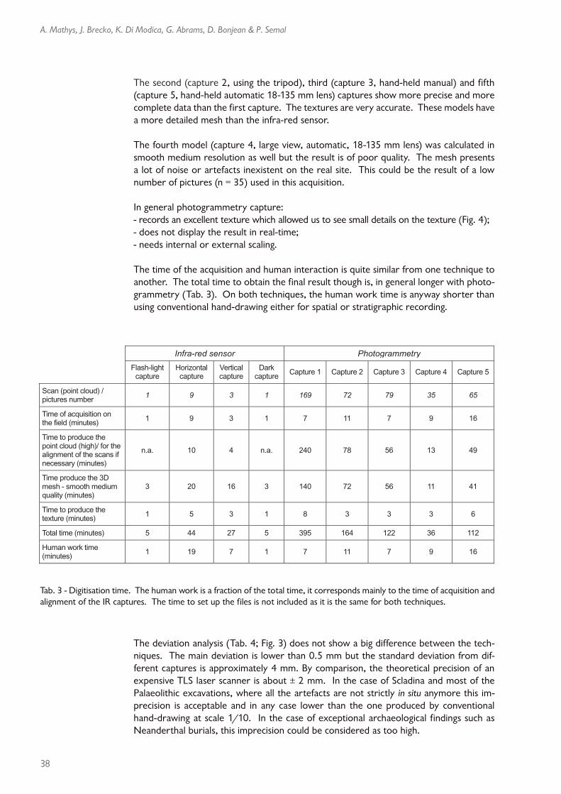
The time of the acquisition and human interaction is quite similar from one technique to another. The total time to obtain the final result though is, in general longer with photo-grammetry (Tab. 3). On both techniques, the human work time is anyway shorter than using conventional hand-drawing either for spatial or stratigraphic recording.
The deviation analysis (Tab. 4; Fig. 3) does not show a big difference between the tech-niques. The main deviation is lower than 0.5 mm but the standard deviation from dif-ferent captures is approximately 4 mm. By comparison, the theoretical precision of an expensive TLS laser scanner is about ± 2 mm. In the case of Scladina and most of the Palaeolithic excavations, where all the artefacts are not strictly in situ anymore this im-precision is acceptable and in any case lower than the one produced by conventional hand-drawing at scale 1/10. In the case of exceptional archaeological findings such as Neanderthal burials, this imprecision could be considered as too high.
Tab. 3 - Digitisation time. The human work is a fraction of the total time, it corresponds mainly to the time of acquisition and alignment of the IR captures. The time to set up the files is not included as it is the same for both techniques.
Infra-red sensor Photogrammetry
Flash-light capture
Horizontal capture
Vertical capture
Darkcapture
Capture 1 Capture 2 Capture 3 Capture 4 Capture 5
Scan (point cloud) / pictures number
1 9 3 1 169 72 79 35 65
Time of acquisition on the field (minutes)
1 9 3 1 7 11 7 9 16
Time to produce the point cloud (high)/ for the alignment of the scans if necessary (minutes)
n.a. 10 4 n.a. 240 78 56 13 49
Time produce the 3D mesh - smooth medium quality (minutes)
3 20 16 3 140 72 56 11 41
Time to produce the texture (minutes)
1 5 3 1 8 3 3 3 6
Total time (minutes) 5 44 27 5 395 164 122 36 112
Human work time (minutes)
1 19 7 1 7 11 7 9 16

Agora 3D. Low cost 3D imaging: a first look for field archaeology
39
As mentioned before, the photogrammetry capture has an excellent texture (Fig. 4), but as the result is not complete, parts of the data may not have been recorded as it was the case for the first model. Depending on the capture, the final model can have more or less precision and the same capture can display some parts with a high level of detail and a large quantity of artefacts in other parts (Fig. 5). Therefore, a large number of pictures has to be taken from various angles in order to compute complete and accurate 3D models and to avoid that kind of problems. In the case of a day-by-day fieldwork following without any time to check the quality of the 3D model before the end of the excavation, the use of this photogrammetry technique can be risky if used alone and/or if the shooting is not operated by a person knowing well the requirement of, both, field recording and 3D reconstruction using photogrammetry.
Infra-red sensor Photogrammetry
Horizontal capture
Vertical capture
Darkcapture
Capture 1 Capture 2 Capture 3 Capture 4 Capture 5
Main deviation – from flash-light capture (mm) 0.00 -0.13 -0.20 -0.22 -0.11 0.13 0.11 0.28
Standard deviation – from flash-light capture (mm) 3.48 3.16 3.00 6.93 3.82 4.06 4.22 4.15
Tab. 4 - Results: Variation between the different models. The mesh captured with the flash-lights is chosen as areference. We do not presume this model to be error free, but as it is automatically scaled and necessitated no
re-alignment of several scans, it does not have any post-processing errors.The standard deviation is an expression uncertain measurements while the mean deviation is the average of all the devia-
tion values. The deviations were calculated from the complete model GOM Inspect software.
Fig. 3 - Display of the variation from one
model to another in GOM Inspect.
Fig. 4 - The photogrammetry cap-ture (left) and, the infra-red sensor
capture (right) of the square E42 and profile E41/42 with the same lighting. The texture is more accurate and pre-
cise on the photogrammetry model whilst the IR capture is more blurry.

40
A. Mathys, J. Brecko, K. Di Modica, G. Abrams, D. Bonjean & P. Semal
4. Conclusions and perspectives
With regards to the recording time in the field, both methods take approximately the same amount of human time.
Infra-red sensor types are less accurate than photogrammetry but have the advantage of being a real-time acquisition and enable the user to instantly know if all data needed iscaptured. The result is more consistent although has the disadvantage of being auto-matically smoothed (Fig. 2). This problem might be overcome by using a third party soft-ware to mesh the point cloud and will be further investigated. We also need to investi-
gate the real difference between the point clouds from photogrammetry and IR sensors. The IR captures do not require extra scaling and 3D re-sults are directly usable even when captured in the worst lighting conditions.
Photogrammetry requires a higher computation time. This means that if your target has been destroyed by the continuation of the excavation, the information is lost if the computed model was not complete. A standardization of the protocol could avoid this problem but this is still difficult as each structure is unique. Photogrammetry has the advantage of producing a more accu-rate texture which can even be used for com-plex stratigraphy, but this approach imperatively needs good specific lighting conditions and user experience. Nevertheless we need to investi-gate why the first model added increasing noise when increasing the resolution. Is this due to the large f-stop, i.e. low depth of field?
Fig. 5 - Photogrammetry capture. The artefacts and the noise are highlighted by the squares.
Fig. 6 - IR model coloured with photogrammetry texture.

Agora 3D. Low cost 3D imaging: a first look for field archaeology
41
On the field, both technologies have their advantages and their drawbacks, which make them complementary techniques. An IR acquisition will ensure the capture of the physi-cal data whilst photogrammetry can give a better texture and in optimal conditions a better 3D model. Fig. 6 displays a 3D model from IR sensor fused with the texture of the photogrammetry model. This could be a good strategy when using both low-cost techniques. In this way the benefits of both techniques are combined, in essence the automatically scaled mesh generated by the IR sensor and the better texture produced by the photogrammetry software.
We are currently planning to further investigate the reliability of measurements made with the infra-red sensor, comparing measurements on 3D models with the landmarks taken with the total station across different recording conditions.
Lighting is also very important for photogrammetry whereas IR sensors are made for indoor use with poor light conditions. We plan on testing both techniques in open air excavations to evaluate the impact of direct sunlight on the recording and if needed to define a protocol solving this issue.
Bibliography
ARCHEOTECH SA, 2013. 3D Measurements. Critical Advances in the f ield of Archaeology and the Preservation of National Heritage Monuments and Artifacts. Brochure, Epalinges/Lausanne (CH).
BARBER D., MILLS J. & ANDREWS D., 2011. 3D laser scanning for heritage. Advice and guid-ance to users on laser scanning in archaeology and architecture. 2nd ed., English Heritage, Swindon (UK).
BONJEAN D., ABRAMS G., DI MODICA K., OTTE M., 2009. La microstratigraphie, une clé de lecture des remaniements sédimentaires successifs. Le cas de l’industrie moustérienne 1A de Scladina. Notae Praehistoricae, 29 : 139-147.
BONJEAN D., DI MODICA K., ABRAMS G., PIRSON S. & OTTE M., 2011. La grotte Scladina : bilan 1971-2011. In: TOUSSAINT
M., DI MODICA K. & PIRSON S. eds, Le Paléo-lithique moyen en Belgique. Mélanges Margue-rite Ulrix-Closset, ‘Bulletin de la Société royale belge d’Études Géologiques et Archéologiques Les Chercheurs de la Wallonie’, hors-série, 4, Études et Recherches Archéologiques de l’Université de Liège, 128: 323-334.
KERSTEN Th., LINDSTAEDT M., MECHELKE K. & VOGT B., 2010. Terrestrial Laser Scanning for the Documentation of Archaeological Objects and Sites on Easter Island. In: MELERO F. J., CANO P. & REVELLES J. eds, Fusion of Cultures. Abstracts of the XXXVIII Conference on Computer Applications and Quantitative Methods in Archaeology, CAA 2010, Granada (SP): 309-312.
MATHYS A., LEMAITRE S., BRECKO J. & SEMAL P., 2013, in press. Agora 3D: evaluating 3D im-aging technology for the research, conservation and display of museum collections. Antiquity Project Gallery, vol. 087, issue 336, june 2013 (http://antiquity.ac.uk/projgall/mathys336/).
Acknowledgements
We wish to express our thanks all the partners of the Agora 3D project. We are also grateful to Mona Hess with whom we are working on the absolute calibration of the 3D scanners. We also wish to thank all the members of the COSCH network (Cost Action TD-1201) as we benefited from their experience.
Finally, we thank Tasnim Patel and Tara Chapman for the proofreading.
This research has been conducted in the context of the Agora Project (AG/LL/164), funded by the Belgian federal scientific policy.

42
A. Mathys, J. Brecko, K. Di Modica, G. Abrams, D. Bonjean & P. Semal
Abstract
Many3D imaging techniques exist and are already applied in the numerous domains in relation to archaeology. Agora 3D is evaluating those techniques in the framework of the digitisation of collections and for their use on field archaeology. Each technique has its own specificity and is not always easy to apply in the field or affordable for every excavation. In this paper we evalu-ated photogrammetry and infra-red sensors. Both these methods allow a fast acquisition with transportable and affordable equipment (about 1000 €). In order to evaluate these techniques on the field we performed some scans in the archaeological site of Scladina cave. Our results show that both approaches are complementary and allows valuable survey information to be cap-tured in a small amount of time with a precision which is similar or even better than traditional 3D coordinates recording systems and which can be very useful, especially for rescue excavation.
Keywords: photogrammetry, infra-red sensor, 3D digitisation, Scladina (B), Agora 3D.
Résumé
Différentes techniques d’imagerie 3D existent et sont déjà appliquées dans de nombreux domaines en rapport avec l’archéologie. Agora 3D évalue ces techniques dans le cadre de la numérisation 3D des collections, mais également leur utilisation sur chantier. Chaque technique a ses propres spécificités et toutes ne sont pas applicables sur le terrain ou financièrement accessibles. Dans cet article, nous avons évalué la photogrammétrie et le capteur infra-rouge. Ces deux méthodes permettent l’acquisition rapide avec du petit matériel transportable et abordable (± 1000 €). Afin d’évaluer ces méthodes sur le terrain, nous avons réalisé des tests sur le site archéologique de la grotte Scladina. Nos résultats montrent que ces deux techniques sont complémentaires et permettent de recueillir des données de surface et de texture en peu de temps et avec une précision équivalente voire même supérieure aux méthodes d’enregistrement traditionnelles des coordonnées 3D, ce qui peut s’avérer fort utile dans le cas de fouilles réalisées dans l’urgence.
Mots-clés : photogrammétrie, capteur infra-rouge, scan 3D, Scladina (B), Agora 3D.
Aurore MATHYSJonathan BRECKO
Patrick SEMALRoyal Belgian Institute of Natural Sciences
Scientific Service of Heritage29, Vautier street
BE – 1000 [email protected]
[email protected]@naturalsciences.be
Dominique BONJEANGrégory ABRAMSKévin DI MODICA
Centre archéologique de la grotte ScladinaASBL Archéologie Andennaise
339d, rue Fond des VauxBE – 5300 Sclayn
[email protected]@scladina.be