pignatelli - New Hampshire Public Utilities Commission - NH.gov
Upload
khangminh22Category
view
1download
0
ATTACHMENT A
Docket No. DE 15-464 Testimony of John Schmick
Page 17 of 373
000017
Attachment JS-A

2
Articles by John T. Schmick
Schmick, John T., “Current ‘Corridor Valuation’ Practices Misleading for Transmission Rights-of-
Way.” Natural Gas & Electricity 33/12, ©2017 Wiley Periodicals, Inc., a Wiley company." July
2017
Schmick, John T., “Author’s Response”, Appraisal Journal, Spring 2015
Schmick, John T., “The Real Value of Business Property.” Right of Way January/February 2015
Schmick, John T., and Jones, Jeffrey K., “Is Across the Fence Methodology Consistent with
Professional Standards?” Appraisal Journal, Fall 2014
Schmick, John T., “Railroad Corridor Valuation: Misconceptions about Across-the-Fence
Methodology.” Right of Way March/April 2013
Schmick, John T., “Electric Transmission Lines and their Impact on Rural Land Values – A
Rebuttal.”, Right of Way March/April 2011
Schmick, John T., and Strachota, Robert J., “Overhead Utility Crossings.”,
Right of Way July/August 2010
Schmick, John T., “Faulty Interpretations of the Consistent Use Principle.”
Right of Way May/June 2010
Schmick, John T., “Unintended Consequences: The Impact of Medians.”
Right of Way January/February 2008
Schmick, John T., “Appraising Public Utility Easements in a Railroad Corridor.”
Right of Way January/February 2007
Schmick, John T., “Complexities of Pipeline Easement Damages on Midwest Farmland.”
Right of Way November/December 2006
Schmick, John T., and Strachota, Robert J., “Railroad Right Of Way: Appraising Public Utility
Easements- Part II.”
Right of Way March/April 2006
Schmick, John T., and Strachota, Robert J., “Railroad Right Of Way: Appraising Public Utility
Easements -Part I.”
Right of Way January/February 2006
Schmick, John T., “Adopting Old Theories for New Applications: A New Approach to Church
Valuations.” Paper Presented at 16th Annual Meeting, American Real Estate Society April 2000
Schmick, John T., and Strachota, Robert J., “Larger Parcel Theory.”,
Real Estate Review, Fall 1987
Docket No. DE 15-464 Testimony of John Schmick
Page 18 of 373
000018
Attachment JS-A

ATTACHMENT B
Docket No. DE 15-464 Testimony of John Schmick
Page 19 of 373
000019
Attachment JS-B

Docket No. DE 15-464 Testimony of John
Schmick Page 20 of 373
000020
Attachment JS-B

APPRAISAL REVIEW REPORT
Northern Pass Transmission Project Dummer to Bethlehem and Bridgewater to
Deerfield, New Hampshire
February 15, 2017
Prepared for: Mr. Jay Dudley
Utilities Analysis, Electric Division New Hampshire Public Utilities Commission
21 South Fruit Street Concord, New Hampshire 03301-2429
Job Number: 17012R-1
Docket No. DE 15-464 Testimony of John Schmick
Page 21 of 373
000021
Attachment JS-B

Member of the American Business Appraisers Network • EEO/Affirmative Action Employer
April 3, 2017
Mr. Jay Dudley Utilities Analysis, Electric Division New Hampshire Public Utilities Commission 21 South Fruit Street Concord, New Hampshire 03301-2429
RE: Appraisal Review of a Market Value Appraisal of Northern Pass Transmission Project Dummer to Bethlehem and Bridgewater to Deerfield, New Hampshire
Dear Mr. Dudley:
At your request, we reviewed an appraisal report of the above referenced property that was prepared by Mr. Robert P. LaPorte, Jr., MAI, CRE and Mr. Gintaras P. Cepas of Colliers International in Boston, Massachusetts, dated November 14, 2014 and updated September 18, 2015. The work under review was prepared for Mr. Christopher J. Allwarden, Senior Counsel, Eversource Energy Services Company, Energy Park, Manchester, New Hampshire.
The effective date of our review is February 15, 2017. The purpose of our appraisal review is twofold: Step 1: to evaluate compliance with relevant professional standards applicable to real property appraisers and determine the reasonableness and/or credibility of the analysis and value opinion contained in the work under review. Step 2: if step one determines the appraisal report under review is not credible, to develop and report the reviewer’s opinion of market value for the subject property. Our review will be based on Uniform Standards of Professional Appraisal Practice (USPAP) 2014-2015 Edition. It should be noted that the appraisal review step and the review appraiser’s opinion of value step will be presented in separate, but related report documents.
The intended user of this review is our client, the New Hampshire Public Utilities Commission, and the intended use is to provide an understanding of the reasonableness and credibility of the document for regulatory review. The depth of discussion contained in our review report is specific to the stated purpose and intended use. Shenehon Company is not responsible for unauthorized or improper use of the report. Detaching this transmittal letter from the report may mislead the intended user of the report.
In the context of this appraisal review report (also referred to as the “review report,”) “appraiser” refers to Mr. Robert P. LaPorte, Jr., MAI, CRE and/or Mr. Gintaras P. Cepas, and “the appraisal” or “the work under review” refers to their appraisal of “Northern Pass Transmission Project” located in “Dummer to Bethlehem, New Hampshire” and “Bridgewater to Deerfield, New Hampshire.” The work under review reported a “market value of the corridor to be leased” of $11,076,163 as of November 14, 2014 with a corresponding “First year annual rent payable monthly” of $775,331. These opinions were subsequently updated September 18, 2015 to $11,360,038 (value of the corridor to be leased) and $795,230 (annual rent payable monthly). The reported value of the corridor
Docket No. DE 15-464 Testimony of John Schmick
Page 22 of 373
000022
Attachment JS-B

Mr. Jay Dudley Page 2 April 3, 2017
includes the area to be leased and areas defined as “uneconomic remnant.” It does not include Public Service Company of New Hampshire’s (PSNH) existing usage outside the defined leased area. The entire PSNH corridor is reported to be 2,397.28 acres of which the proposed leased area is reported to be 52.3% of the corridor (32.6% tenant space and 19.7% shared space with PSNH) with 3.1% classified as leftover or uneconomic remnant. Prior to the proposed lease, PSNH occupies 64.3% with electrical infrastructure resulting in 35.7% extra/surplus land area.
It is our opinion that the valuation conclusion of the work under review is not reasonable and is not credible. Specifically, we identified:
Use of outdated terminology;
Failure to analyze corridor transaction data;
Failure to disclose relevant and/or material proposed lease terms;
Failure to analyze transaction risk;
Failure to resolve conflicting statements.
This review report complies with the reporting requirements of USPAP Standard Rule 3. To the best of our knowledge and belief, the statements and opinions contained in this review report are correct and reasonable subject to the limiting conditions set forth herein.
Thank you for selecting Shenehon Company for providing appraisal services. If you have any questions concerning the report, please contact us at 612.333.6533.
Respectfully,
SHENEHON COMPANY
Certified to this 3rd day of April, 2017.
John T. Schmick Vice President Minnesota License No. 4000878 Temporary New Hampshire License No. NHTP-737 Certified General Appraiser [email protected]
Robert J. Strachota, MAI, MCBA, CRE® President, Shareholder Minnesota License No. 4000882 Temporary New Hampshire License No. NHTP-738 Certified General Appraiser [email protected]
/ckp
Docket No. DE 15-464 Testimony of John Schmick
Page 23 of 373
000023
Attachment JS-B

TABLE OF CONTENTS
Review .................................................................................................................................................. 1 Purpose and Intended Use of the Report ........................................................................................... 1 Property Identification ....................................................................................................................... 1 Relevant Dates ................................................................................................................................... 1 Values Concluded in the Work Under Review ................................................................................. 2 Property Rights Appraised ................................................................................................................ 2 Extraordinary Assumptions and Hypothetical Conditions ................................................................ 3 Report Content .................................................................................................................................. 3 Methods and Techniques ................................................................................................................... 9 Conclusion ....................................................................................................................................... 12
ADDENDA
Certification ...................................................................................................................................... A-1 Assumptions and Limiting Conditions ..............................................................................................B-1 Qualification of Appraisers ................................................................................................................C-1
Docket No. DE 15-464 Testimony of John Schmick
Page 24 of 373
000024
Attachment JS-B

17012R-1 SHENEHON COMPANY 1
REVIEW
PURPOSE AND INTENDED USE OF THE REPORT
The purpose of our appraisal review is to evaluate compliance with relevant professional standards. For the purpose of this review, the relevant standards are:
2014 - 2015 Edition: Uniform Standards of Professional Appraisal Practice – USPAP(including Advisory Opinions (AO) and Statement on Appraisal Standards (SMT))
In addition to the relevant USPAP requirements, we have referred to the following resources for guidance in evaluating the reasonableness of the appraisal under review:
Uniform Appraisal Standards for Federal Land Acquisitions, 2000 Edition
The Appraisal of Real Estate, 14th Edition (2013)
Real Estate Valuation in Litigation, Second Edition (1995)
Additional materials provided by the client include:
Copies of Easements granting PSNH the existing right to build an electric transmission line
Copy of the Proposed Lease between PSNH and NTP
The intended user of this review report is the New Hampshire Public Utilities Commission in connection with regulatory review procedures. It is our understanding that this review will be used in public hearings related to the proposed lease transaction.
PROPERTY IDENTIFICATION
The subject property is defined as a portion of a high voltage electric power line corridor, or electric utility corridor, owned by Public Service Company of New Hampshire (PSNH). Public Service Company of New Hampshire’s ownership is comprised of both fee simple ownership and easement rights. A total of 100.61 miles of PSNH’s corridor ownership rights are included in the appraisal under review. This is divided into 40.50 miles in the Northern Segment (Dummer to Bethlehem) and 60.11 miles in the Southern Section (Bridgewater to Deerfield).
The distribution of fee simple ownership and easement ownership is not stated in the appraisal report. However, a review of exhibits attached to the proposed lease indicates 23.84 acres are owned in fee interest, or approximately one percent of the defined corridor, or approximately 1.9 percent of the project area (not including the remnant land). The remaining corridor land area is easement rights owned by PSNH. Overall, the appraisal report indicates the corridor ownership ranges from 150 feet wide to 300 feet wide.
RELEVANT DATES
Effective Date of the Review
The effective date of the review is November 14, 2014. The date of our review report is February 15, 2017.
Docket No. DE 15-464 Testimony of John Schmick
Page 25 of 373
000025
Attachment JS-B

REVIEW
17012R-1 SHENEHON COMPANY 2
Dates of the Work Under Review
The date of the work under review is November 14, 2014 and updated September 18, 2015. The effective date of the value conclusion of the work under review is November 14, 2014 and updated September 18, 2015.
SCOPE OF WORK
The appraisal review problem or question to be addressed is a determination of the reasonableness and/or credibility of the analysis and value opinion contained in the work under review as well as compliance to relevant professional standards. The scope of work relates to the extent and manner information may be researched and analyzed based upon the review assignment. In this case we:
Identified and reviewed relevant professional appraiser standards;
Reviewed background material relevant to the valuation problem including, but not limited tothe proposed lease, corridor ownership records, available information on the proposedproject;
Reviewed instructional material related to methodologies employed in the appraisal report.
This Appraisal Review complies with the reporting requirements set forth under Standards Rule 3 of USPAP (2016-2017 Edition). An Appraisal Review addresses the completeness of the appraisal, the adequacy and relevance of the data and analysis, and the appropriateness of the methodology used in the appraisal under review. Its findings and conclusions relate to the quality and reasonableness of the value opinion reported in the appraisal under review. If the review determines that the appraisal under review is not credible, an independent opinion of value will be prepared as part of the review process.
VALUES CONCLUDED IN THE WORK UNDER REVIEW
The work under review reported a “market value of the corridor to be leased” of $11,076,163 as of November 14, 2014 with a corresponding “First year annual rent payable monthly” of $775,331. These opinions were subsequently updated September 18, 2015 to $11,360,038 (value of the corridor to be leased) and $795,230 (annual rent payable monthly).
PROPERTY RIGHTS APPRAISED
The subject property, as defined by the appraiser, is land and land rights owned by Public Service of New Hampshire (PSNH). PSNH owns a corridor in both the fee simple interest (1% of the land area) and in an easement (99% of the land area) for use in electrical transmission. The appraiser estimated “the fair market value of the land and land rights belonging to Public Service of New Hampshire (PSNH for long-term lease….” The market value and market rent definitions provided in the work under review follow standard language.
Docket No. DE 15-464 Testimony of John Schmick
Page 26 of 373
000026
Attachment JS-B

REVIEW
17012R-1 SHENEHON COMPANY 3
EXTRAORDINARY ASSUMPTIONS AND HYPOTHETICAL CONDITIONS
Extraordinary assumption is defined as:
“An assumption, directly related to a specific assignment, as of the effective date of theassignment results, which if found to be false, could alter the appraiser’s opinions orconclusions”1
- The work under review is dated November 14, 2014. It contains summaryinformation related to a proposed lease agreement. A copy of that proposed leaseagreement, dated October 19, 2015 was provided as part of this review process.Other than the addition of the proposed rent payment amounts, we are informed thatthe terms and conditions of the 2015 lease document are essentially the same as theproposed lease document available to the appraisers as they prepared their valuationanalysis in 2014. Therefore, we accept the proposed lease document as accurate forthis review process.
Hypothetical condition is defined as:
“A condition, directly related to a specific assignment, which is contrary to what is known bythe appraiser to exist on the effective date of the assignment results, but is used for thepurpose of the analysis”2
- This review does not incorporate any hypothetical conditions.
REPORT CONTENT
Completeness of Material
In this review, completeness of material refers to compliance with minimum requirements for an appraisal report under USPAP.
USPAP Standard Rule 2-2 states that the type of appraisal report (Appraisal Report of Restricted Appraisal Report) must be “prominently” stated in the appraisal report. Advisory Opinion 11 (AO-11) indicates “…the statement should appear at or near the beginning of the report.”
A statement on the type of report option is not provided in Volume 1 of the appraiser’sreport. This is a violation of USPAP. However, the work under review appears to qualify as aSummary Report.
Standard Rule (SR) 2-2(a)(i) requires the appraiser to state the appraisal client, intended use and users, real property interest appraised, definition of value and relevant dates of value of the appraisal. This information has been included in the appraisal report.
1 Uniformed Standards of Professional Appraisal Practice, 2014-2015 Edition, p. U-3 2 Ibid, p. U-3
Docket No. DE 15-464 Testimony of John Schmick
Page 27 of 373
000027
Attachment JS-B

REVIEW
17012R-1 SHENEHON COMPANY 4
SR 2-2(a)(iii) requires the appraiser “summarize information sufficient to identify the real estate involved in the appraisal, including the physical, legal, and economic property characteristics relevant to the assignment.”
The appraisal identifies nearly 700 underlying parcels of land with tax parcel identificationnumbers and map exhibits. Consequently, there is sufficient descriptive information toidentify the location, size and shape and type of the subject and related properties.
The work under review provides information on PSNH’s ownership by easement for electricpower related uses. However, there is no information or discussion related to PSNH’s right- to-lease to others for similar or non-similar uses. A review of the underlying easementdocuments indicate they are silent on this issue. As a result, the appraiser has assumed aright-to-lease that is not evident to the reader. The appraiser has not disclosed anextraordinary assumption related to this issue. This is a material issue and a possibleviolation of USPAP.
The appraisal provides minimal information or analysis of supply and demand factors for thesubject’s current use (economic characteristics). For the supply side, the amount of surplusland available in PSNH’s corridor is not clearly stated. However, from the descriptions ofthe two segments (North and South Segments), the reader can calculate the amount of surplusland available for lease.
SR 2-2(a)(vii) requires the appraiser “summarize the scope of work used to develop the appraisal.”
The scope of work presented in the appraisal is found on page 5 (vol. 1) along with thestatement of the appraisal problem. It indicates the steps taken to address the appraisalproblem, the appraisal methodology used and data sources. Overall, the scope of workcomplies with minimal requirements for disclosure.
SR 2-2(a)(xi) requires the appraiser “clearly and conspicuously state all extraordinary assumptions and hypothetical conditions; and state that their use might have affected the assignment results;”
The appraiser indicates no hypothetical conditions, and three extraordinary assumptions,were used in the valuation assignment.
- Extraordinary assumption 1: “All costs associated with the construction of thecorridor are to be paid by NPT.”
This assumption is only partially relevant. The appraisal does not purport tovalue the electric transmission facilities. Only the land value, and rent for theland are included in the appraiser’s opinions. However, the cost to relocatePSNH’s existing facilities may increase project costs over that of building ona new corridor. As such, the relocation costs are an additional cost of usingthe existing corridor land. This issue has not been addressed in the appraisalreport.
- Extraordinary assumption 2: “...valuation is based on the proposed lease termsassuming execution on the date of this appraisal.”
Docket No. DE 15-464 Testimony of John Schmick
Page 28 of 373
000028
Attachment JS-B

REVIEW
17012R-1 SHENEHON COMPANY 5
This statement is misleading. The overall discussion within the cover letterand Volume 1 of the appraisal report indicates that the appraiser’s opinions ofvalue were based on market data. However, this statement indicates that thecontents of the proposed lease influenced the value opinions, which contradictthe body of the report. The reader is left wondering what is in the proposedlease and how has it influenced the appraiser’s value opinions. The fullproposed lease has not been provided so the reader is unable to determine thesignificance of this extraordinary assumption.
- Extraordinary assumption 3: client-provided land areas to be leased are accurate.
This is an unnecessary extraordinary assumption that is covered by a normalassumption found in the Statement of Assumptions and Limiting Conditions(item 6) found on page 56 (vol. 1).
SR 2-2(a)(x) requires that “…when an opinion of highest and best use was developed by theappraiser, summarize the support and rational for that opinion[;]” The appraiser’s discussionof highest and best use is presented on pages 30/31, (vol. 1).
- The appraisal states that there are two general possibilities for highest and best use ofa utility corridor like the subject. The first is liquidation by selling pieces of thecorridor to adjacent property owners for expansion of existing abutting uses.
99.0% of the full corridor is in the form of an easement for electrictransmission. It is unlikely that any of the adjacent property owners are in theelectrical transmission business other than those few parcels owned in fee byPSNH. Consequently, there is likely no demand for the easement itself fromadjacent owners. Alternatively, PSNH could seek payment for releasing(vacate) the easement so the adjacent property owner has full use of theirunderlying fee interest. However, if there is no demand for the existingeasement, then transactions to adjacent property owners would be based onbenefit to the buyer, or in this case, hostage pricing to remove the easementfrom their property.
Secondly, the appraiser sets forth other possible general uses for an intactcorridor including “…transportation, other utilities lines, pipelines for oil andnatural gas; pipelines for water and sewer; recreations and/or communicationpurposes.” The discussion is general in nature and not specific to the subject.Because PSNH’s easement rights limit use to transmitting electrical currentand/or intelligence (undefined use), the general uses listed would not bepermitted other than possibly “other utility lines.”
- The remainder of the highest and best use analysis focuses on benefits to a buyer andlack of demand for the subject but for the proposed project.
The appraisal offers one example, on pages 41/42, (vol. 1) to support thepremise that “The acquisition cost…. of obtaining rights from over 700owners to create a substitute line makes the existing corridor more financiallyfeasible to accommodate a power line.” However, the example provided does
Docket No. DE 15-464 Testimony of John Schmick
Page 29 of 373
000029
Attachment JS-B

REVIEW
17012R-1 SHENEHON COMPANY 6
not support this statement. In the Bango Hydro-Electric Company (BHE) example, the appraiser states land costs and soft costs combine for total cost to acquire a new corridor of $10,132 per acre. At the same time, the appraiser indicates the Across-The-Fence (ATF) land values ranged between $1,000 per acre to $7,500 per acre. If we simple take the average of this range ($4,250 per acre and compare it to the indicated acquisition cost, we find a corridor factor of 2.38 times ATF. ($10,132/$4,250 = 2.38). By opining a corridor factor of 2.3 times ATF in the body of the appraisal report, the appraiser has essentially valued the subject corridor at full replacement cost or cost new to assemble a corridor. As a result, the statement that the “…existing corridor is more financially feasible…” is contradicted and shown to be false in this case. In addition, not considered is the cost to relocate some of the existing PSNH power line facility which would not be a cost incurred in a new corridor.
From a theoretic viewpoint, the BHE acquisition cost example demonstratesthat as corridor factors increase in size, the assumed economic advantage ofan existing corridor over assembling a new corridor declines to a point atwhich the buyer becomes indifferent between the two choices. In this case, theappraiser equated the two through use of an enhancement factor.
Adequacy and Relevance
In this review, adequacy and relevance refers to the data and information that is provided in the appraisal report. The relevant guidelines are USPAP Standard Rules 1 and 2.
SR 2-2(a)(viii) requires the appraiser to “summarize the information analyzed, the appraisal methods and techniques employed, and the reasoning that supports the analysis, opinions and conclusion[.]”
Both on page 4 of the cover letter and on page 44, (vol. 1) the appraiser provides a summaryof the proposed lease for the subject property. Since the appraiser has established that hisvaluation opinions are based on the terms of the lease (p. 2 of cover letter) it is incumbent onthe appraiser to provide the relevant details of the lease for the reader to understand howthose terms may have influenced the value opinion. In this case, the summary lease termspresented in the appraisal report are insufficient. The following lease details were omitted:
- Page 4, Recital B: “PSNH is a wholly owned direct subsidiary and NPT is a whollyowned indirect subsidiary of Eversource Energy,…”
This is a clear statement that the parties to the lease are related. As a related-party transaction, the remaining terms of the lease need to be reviewed todetermine how this relationship impacts the appraiser’s analysis and/orconclusions.
- Page 10, Section 3.3 Lessor’s Appraisal Cost: The full cost of the lessor’s appraisalcost, including all testimony, witness costs, and expenses incurred in supporting theappraisal in any and all regulatory filings and proceedings, are paid by the Lessee. Incontrast, the appraisal report was prepared for, and the intended user of the report is,
Docket No. DE 15-464 Testimony of John Schmick
Page 30 of 373
000030
Attachment JS-B

REVIEW
17012R-1 SHENEHON COMPANY 7
Eversource Energy Service Company, the parent company of both the Lessor and Lessee.
The definition of Market Value stated in the appraisal (page 8, vol. 1) includes“... the specific property interest should sell for in a competitive market… withthe buyer and seller each acting prudently, knowledgeably and for self-interest….” This related-party transaction between two wholly owned subsidiaries of a parent company does not appear to be based on a competitive market between independent entities acting in their self-interest. The shifting of the appraisal cost to the tenant, and other terms of the lease, appears to shift all cost and risk to the lessee. As such, the proposed lease resembles a financial engineering transaction for the parent company rather than a market transaction between independent market participants.
- Pages 6 and 7, Section 1.5 Disclaimer… and Section 1.6 Easement Disputes: TheLessor does not warrant title to the subject property and the Lessee takes the property‘AS IS.” More importantly, if any dispute over title is raised, the full cost ofdefending PSNH’s title and easement rights is shifted to the Lessee.
The full financial burden of defending PSNH’s right to lease the subject landis the responsibility of the Lessee. All risk is shifted away from the Lessor.
- Page 7, Section 1.8 Quiet Enjoyment/Encumbrances: The Lessee does not receiveexclusive use of the leased property.
Section 1.8(a)(iii): the lessee takes the leased property subject to “ allLessor’s retention of all rights …not leased to Lessee..”
Section 1.8(b): Lessor retains the right to lease to others.
- Page 11 Section 4.4 Non-Interference…: The Lessee is responsible for the full costof relocating any of Lessor’s existing facilities necessary to accommodate Lessee’sproject.
While the appraisal conveys an opinion of annual market rent for the leasedproperty, any cost related to relocating the Lessor’s facilities is an additionalcost of leasing the subject land. Essentially, not all of the subject property iscurrently available for rent but can be made available if some of the Lessor’sfacilities are moved. This is basically additional rent to the Lessee (tenant hasto improve the landlord’s property before the landlord can rent the property tothe tenant). No cost estimate for this additional rent has been disclosed in theappraisal, nor has it been included in the overall rent opinion. Again, all risk isshifted to the Lessee.
- Page 8 Section 1.11 Conveyance of AC Line to Lessor: “...Lessee may, in theexercise of Lessee’s sole discretion, transfer to Lessor the AC Line, and Lessor may,in the exercise of Lessor’s sole discretion, accept such transfer…”
Docket No. DE 15-464 Testimony of John Schmick
Page 31 of 373
000031
Attachment JS-B

REVIEW
17012R-1 SHENEHON COMPANY 8
This section illustrates the close related-party relationship between lessor andlessee in the proposed lease. The AC line represents approximately 72.4% ofthe total value reported in the appraisal report. A transfer of the AC lineeliminates almost three-quarters of rent required under the lease.
The terms listed above were not disclosed in the appraisal report. As a result, the reader has not been informed that the proposed lease is between related parties and is not a market transaction. Rather, the proposed lease resembles a financial engineering transaction for the parent company of both the Lessor and Lessee.
The economic analysis of the subject property lacks support.
- The appraisal contains the following statements related to market demand for thesubject property:
In the Highest and best use Section (page 30/31, vol. 1):
“Demand is evidenced by the need for this sub corridor… ”
“…demand beyond NPT is not present.”
“Public Service has stated that there is no demand at present or in theforeseeable future for an additional electric transmission line withinthis corridor. Therefore, demand beyond NPT does not exist.”
“The subject represents a special benefit to the buyer…”
Conclusions (page 43, vol. 1)
“On the demand side, the proposed lessee is the only identified user ofthe corridor. Public Service has not (no) immediate or near term needfor the subject. They also have stated that there is no third party userof the subject beyond NPT.”
Appraisal problem (page 5, vol. 1)
“This is a limited market property of which there is limited demand.However, when demand exists, the assemblage of a corridor presents avalue opportunity for the buyer or lessee as compared to the long andexpensive process of acquiring land to create the corridor.”
The statements above raise two material issues. First, the appraiser’s limited economic analysis of the subject property has established that there is no identifiable demand for the existing surplus land in the PSNH corridor other than the proposed related-party lease. As a result, economic demand for the subject land appears to be based entirely on the proposed project. When measuring the value impact on the subject property of the proposed lease, the property can be valued before the project and again after the project with the difference being the value capture by the project. This before and after comparison has the benefit identifying both the direct impact (value captures) as well as any indirect impact (reduced functionality in the remaining land).
Docket No. DE 15-464 Testimony of John Schmick
Page 32 of 373
000032
Attachment JS-B

REVIEW
17012R-1 SHENEHON COMPANY 9
The commonly used before-and-after methodology reflects the Project Rule in appraisal.3 The project rule basically establishes that the starting value of the subject property cannot be influenced by the proposed project. Thus, the starting value of the subject can be neither enhanced nor diminished by the project. While this rule is frequently used in eminent domain litigation, it is relevant to all valuation assignments. In this case, the appraiser appears to base the subject’s value on the demand created by the project itself rather than on market demand before the project. Quite simply, but for the project, what is the market demand of the subject property? Violating the project rule in the analysis of economic demand has the effect of reducing the appraisal’s value opinion to value engineering rather that market value.
Second, the statements on benefit to the buyer appear to shift the focus of the appraisal from what the seller has to offer, or lose, to what the buyer gains. All market value appraisals are based on the implied value ‘as is’ condition of the subject property. From that starting point, the appraiser can invoke extraordinary assumption or hypothetical conditions as need to address the client’s appraisal question. The implied ‘as is’ condition establishes a consistent value to any user in the market. In contrast, basing value on the benefit to the buyer creates a moving value opinion based on different benefit levels to different buyers. Thus, when the appraisal question is ‘what is the market value of the property’, the necessary response is ‘who is the buyer and how much do they benefit?’ To the extent that the current appraisal considered the benefit received to the buyer rather than what the seller has to sell, this is not a market value appraisal. Instead, the appraisal becomes value to a specific buyer, or use value to a specific user. Combined with the proposed related-party lease transaction, there is a strong possibility that the value opinion reflects use value rather than market value.
The appraisal report offers an opinion of “market value” with the definition presented onpage 8 (vol. 1) and is defined as: “The most probable price that the specific property interestshould sell for in a competitive market after a reasonable exposure time, as of a specific date,in cash, or in terms equivalent to cash, under all conditions requisite to a fair sale, with thebuyer and seller each acting prudently, knowledgeably and for self-interest, and assumingneither is under duress.” In an open and competitive market with independent buyers andseller, it is common that both buyer and seller obtain valuation advice to negotiate terms of alease. However, the electric utility industry is characterized by monopolistic entities withregulated service areas. In the instant case, the appraisal was prepared for the parentcompany of both the Lessor and Lessee and the lease rate appears to be imposed on theLessee. As a result, the work under review offers an opinion of “market value” for a related-party, non-market transaction, for land with no stated demand at a premium price.
METHODS AND TECHNIQUES
USPAP emphasize knowledge and competency in completing appraisal assignments that produce credible results. To that end, USPAP’s Competency Rule states “The appraiser must determine, prior to accepting an assignment, that he or she can perform the assignment competently.” Given the extensive list of appraisal assignments undertaken by the appraisers, presented on page 37 (vol. 1), we acknowledge the appraisers have the requisite experience to meet the competency requirement of USPAP.
3 Eaton, J.D., MAI, SRA, Scope Of The Project Rule, Real Estate Valuation in Litigation, Appraisal Institute, 1995, pp. 120-124
Docket No. DE 15-464 Testimony of John Schmick
Page 33 of 373
000033
Attachment JS-B

REVIEW
17012R-1 SHENEHON COMPANY 10
In addition, Standard Rule 1-1(a) requires the appraiser, “be aware of, understand, and correctly employ those recognized methods and techniques that are necessary to produce a credible appraisal.”
The methodology used by the appraisers refers to an “enhancement factor” (cover letterpage 4, vol. 1 and page 34/35, vol. 1). This is outdated terminology that can impact the valueconclusion. At the Corridors and Right-Of-Way II Symposium, Valuation & Policy, SanDiego, November 4, 20024, speaker Charles F. Seymore, CRE, MAI (see listed articles onpage 42 vol. 1) acknowledged that the “term ‘Enhancement Factor’ has been changed to‘Corridor Factor’ by some appraisers who now recognize that Price divided by ATF issometimes less than One…” This change in terminology recognizes that there may be somesituations where the lack of economic demand for a particular corridor may result in avaluation less than ATF value. By using the outdated term “enhancement factor,” theappraiser implies that the subject’s value cannot be less than ATF value. This constitutes anassumed minimum value (AMV) for which there is no disclosed extraordinary assumptionrequired by USPAP.
Across The Fence (ATF) methodology reflected in the appraisal report is essentially a salescomparison approach to value without the normal adjustment process for differences betweenthe sales data and the subject property. Because the defined subject property is 98.1%easement rights (99.0% of the full corridor), the appraiser valued the fee simple interest ofthe underlying land parcels using a mass appraisal technique common for valuing largenumbers of properties, in this case 700 properties, at one time. The underlying fee simpleinterest parcels have not been assembled into a corridor. As a result, employing massappraisal techniques for the fee simple interest of the underlying land is reasonable.
ANALYSIS AND OPINIONS
In this section of our review, we consider the analysis and opinions presented in the appraisal report. The relevant guideline is USPAP Standard Rule 1-1(b) and (c), which relate to error and carelessness in the appraisal assignment that impact the credibility of the conclusion. Specifically this rule states:
(b) not commit a substantial error of omission or commission that significantly affects anappraisal; and
(c) not render appraisal services in a careless or negligent manner, such as by making aseries of errors that, although individually might not significantly affect the results ofan appraisal, in the aggregate affects the credibility of those results.
For the demand side, the appraiser states, on page 31 (vol. 1) that “Demand is evidenced bythe need for this sub corridor… ” and “…demand beyond NPT is not present.” On page 43(vol. 1) the appraiser concludes by stating “On the demand side, the proposed lessee is theonly identified user of the corridor.” However, there are indications in some photographs inVolumes 2 and 3 of the work under review of markers related to subsurface uses, possiblypipelines or fiber optic lines on the corridor. Having indicated on page 30 (vol. 1) that theseare possible uses of an intact corridor, there is no discussion of existing demand and/or usageof the subject by PSNH’s current occupancy or other secondary occupancies. These and
4 Sponsored by the Centre for Advanced Property Economic and the International Right of Way Association.
Docket No. DE 15-464 Testimony of John Schmick
Page 34 of 373
000034
Attachment JS-B

REVIEW
17012R-1 SHENEHON COMPANY 11
similar statements on demand do not provide sufficient information or analysis for the reader to determine the reasonableness of the report’s value conclusion and the stated lack of demand for the excess/surplus land.
The appraisal offers data on six specific corridor transactions and summaries four morecorridor transactions in support of the appraiser’s ‘enhancement factor’ (pp 39-41, vol. 1).The concluded corridor factor of 2.3 times ATF is not supported. The four summarized sales(p. 41, vol. 1) are from 1973 to 1977 and averaged 1.74 times ATF. Four of the six describedcorridor sales occurred from 1969 to 1988 and averaged 1.97 times ATF. These eight datapoints all occurred before the adoption of the USPAP in 1989 by the Appraisal StandardsBoard, part of the Appraisal Foundation. The two sales after USPAP became the industrystandard, 1998 and 2002, averaged just 23% above ATF (1.23 times ATF). As a result, theappraiser has clearly demonstrated that corridor factors have been declining and aresignificantly lower today than for that time period before professional standards (USPAP –1989) became industry standards. Not only is the appraisal opinion of 2.3 times ATF notsupported by the transaction data, but the trend in the data indicates a decline both in size andsignificance.
In the development of an overall rate (OAR) of return on the defined value of the subjectland, the appraisal includes references to investor surveys (pp. 46-51, vol. 1). Data fromRealtyRates.com (pp. 47/48, Vol. 1) indicates land lease rates for special purpose projectsaverage 8.32%. Special purpose properties developed with land leases included in the dataincluded schools, day care centers, churches, temples and synagogues. In addition, the datareflects fee simple land leased for various development projects while the subject is easementrights limited to electric transmission usage in a regulated, monopolistic industry. Finally,the data reflects arms-length market transaction while the proposed subject lease is a related-parties transaction with cost and risk shifted from the lessor to the lessee.
The difference in risk levels between the data and the subject property is provided in thePriceWaterhouseCoopers (PwC) data on pages 49-50. The difference between PwC YieldIndicator and Long-Term Mortgages is 398 basis points lower. The difference between PwCDividend Indicator and Equity REIT dividends is 287 basis points lower. Consequently, theappraisal clearly demonstrates that lower risk is rewarded with lower rates of return andhigher risks are penalized with higher rates of return. As it relates to the subject property andthe proposed lease, the appraisal appears to use average real estate rates of return withoutrecognizing or adjusting for the lower risk of a relate-parties transaction in a regulated,monopolistic industry with little to no competition.
We have identified a number of issues in this appraisal review report which are directly related to USPAP Standard Rule 1-1 (b) and (c). These include the following:
Use of outdated terminology (enhancement factor);
Failure to analyze corridor transaction data (data trends);
Failure to disclose relevant and/or material proposed lease terms (related parties);
Failure to analyze transaction risk (capitalization rate for related parties);
Docket No. DE 15-464 Testimony of John Schmick
Page 35 of 373
000035
Attachment JS-B

REVIEW
17012R-1 SHENEHON COMPANY 12
Failure to resolve conflicting statements (economic analysis – demand/no demand).
As a result of these appraisal deficiencies, we find that the appraisal, as a whole, was prepared in violation of Standard Rule 1-1(b) and (c).
CONCLUSION
Completeness of Material
The appraisal report under review discloses many of the minimum requirements such as client, property identification, scope of work, etc. However, the appraisal omitted significant/material information regarding the proposed lease and how it impacts the value opinions expressed in the appraisal. As a result, the reader is denied relevant and critical information necessary to understand the reasoning, conclusions and value opinions contained therein.
Adequacy and Relevance
The appraisal report under review contains insufficient market analysis to support the highest and best use conclusion, economic obsolescence and market rent.
Methods and Techniques
The appraisal report under review applies a mass appraisal methodology that is acceptable when valuing larger numbers of properties as an interim step in the analysis.
Analysis and Opinions
The appraisal report under review contains inadequate analysis of data, contradictory statements on economic analysis, and unsupported assumptions that, when combined, render the opinions and conclusion not credible.
Overall Conclusion
The appraisal report appears to be a summary appraisal but does not meet minimal USPAP requirements. In our opinion, the appraiser’s analyses, opinions, and conclusions were not supported and therefore are not reasonable or credible.
Docket No. DE 15-464 Testimony of John Schmick
Page 36 of 373
000036
Attachment JS-B

ADDENDA
Docket No. DE 15-464 Testimony of John Schmick
Page 37 of 373
000037
Attachment JS-B

ADDENDUM A
CERTIFICATION
Docket No. DE 15-464 Testimony of John Schmick
Page 38 of 373
000038
Attachment JS-B

17012R-1 SHENEHON COMPANY A-1
CERTIFICATION
I certify that to the best of my knowledge and belief:
1. The statements of fact contained in this review report are true and correct.
2. The reported analyses, opinions, and conclusions in this review report are limited only by theassumptions and limiting conditions stated in the review report, and are my personal,impartial, and unbiased professional analyses, opinions, and conclusions.
3. I have no present or prospective interest in the property that is the subject of work underreview and have no personal interest with respect to the parties involved.
4. I have performed no services, as an appraiser or in any other capacity, regarding the propertythat is the subject of work under review within the three-year period immediately precedingacceptance of this assignment.
5. I have no bias with respect to the property that is the subject of the work under review or tothe parties involved.
6. My engagement in this assignment was not contingent upon developing or reportingpredetermined results.
7. My compensation for completing this assignment is not contingent upon the development orreporting of a predetermined opinion or conclusion that favors the cause of the client, theattainment of a stipulated result, or a subsequent event directly related to the intended use ofthis appraisal review.
8. My analysis, opinions, and conclusions were developed and this review report was preparedin conformity with the Uniform Standards of Professional Appraisal Practice.
9. I have made a personal inspection of the property that is the subject of the work underreview.
10. No one has provided significant appraisal, appraisal review, or appraisal assistance to theperson signing this certification.
11. The reported analysis, opinions, and conclusion were developed, and this report has beenprepared, in conformity with the Code of Professional Ethics and the Standards ofProfessional Appraisal Practice of the Appraisal Institute.
12. The use of this review report is subject to the requirements of the Appraisal Institute relatingto review by its duly authorized representatives.
13. As of the date of this review report, I have completed the Standards and Ethics EducationRequirement for Practicing Affiliates of the Appraisal Institute.
John T. Schmick Vice President Minnesota License No. 4000878 Temporary New Hampshire License No. NHTP-737 Certified General Appraiser
Docket No. DE 15-464 Testimony of John Schmick
Page 39 of 373
000039
Attachment JS-B

CERTIFICATION
17012R-1 SHENEHON COMPANY A-2
I certify that to the best of my knowledge and belief:
1. The statements of fact contained in this review report are true and correct.
2. The reported analyses, opinions, and conclusions in this review report are limited only by theassumptions and limiting conditions stated in the review report, and are my personal,impartial, and unbiased professional analyses, opinions, and conclusions.
3. I have no present or prospective interest in the property that is the subject of work underreview and have no personal interest with respect to the parties involved.
4. I have performed no services, as an appraiser or in any other capacity, regarding the propertythat is the subject of work under review within the three-year period immediately precedingacceptance of this assignment.
5. I have no bias with respect to the property that is the subject of the work under review or tothe parties involved.
6. My engagement in this assignment was not contingent upon developing or reportingpredetermined results.
7. My compensation for completing this assignment is not contingent upon the development orreporting of a predetermined opinion or conclusion that favors the cause of the client, theattainment of a stipulated result, or a subsequent event directly related to the intended use ofthis appraisal review.
8. My analysis, opinions, and conclusions were developed and this review report was preparedin conformity with the Uniform Standards of Professional Appraisal Practice.
9. I have not made a personal inspection of the property that is the subject of the work underreview.
10. No one has provided significant appraisal, appraisal review, or appraisal assistance to theperson signing this certification.
11. The reported analysis, opinions, and conclusion were developed, and this report has beenprepared, in conformity with the Code of Professional Ethics and the Standards ofProfessional Appraisal Practice of the Appraisal Institute.
12. The use of this review report is subject to the requirements of the Appraisal Institute relatingto review by its duly authorized representatives.
13. As of the date of this review report, I have completed the Standards and Ethics EducationRequirement for Designated Members of the Appraisal Institute.
Robert J. Strachota, MAI, MCBA, CRE® President, Shareholder Minnesota License No. 4000882 Temporary New Hampshire License No. NHTP-738 Certified General Appraiser
Docket No. DE 15-464 Testimony of John Schmick
Page 40 of 373
000040
Attachment JS-B

ADDENDUM B
ASSUMPTIONS AND LIMITING CONDITIONS
Docket No. DE 15-464 Testimony of John Schmick
Page 41 of 373
000041
Attachment JS-B

17012R-1 SHENEHON COMPANY B-1
ASSUMPTIONS AND LIMITING CONDITIONS
The review report was written based on the following assumptions and limiting conditions:
1. The property that is the subject of this review is assumed to be free and clear of any and allliens or indebtedness, leases/encumbrances, unless otherwise stated. Documents dealingwith such matters were not reviewed.
2. Title is assumed to be clear and marketable unless otherwise stated. Shenehon Companyassumes no responsibility for title considerations.
3. The information contained in this review report was gathered from reliable sources and isassumed to be correct, but no warranty is given for its accuracy.
4. No responsibility is assumed for the legal description contained in the work under review orfor matters pertaining to legal issues unless otherwise stated. It is assumed that the land andimprovements (when applicable) are located within the boundaries or property lines of thelegally described property and that the improvements (when applicable) comply with allordinances unless otherwise stated.
5. All opinions in this review report assume stable soils. No analysis of soil conditions wasrequired and none was made. The reviewer is not qualified to make such an analysis. Noresponsibility is assumed for unknown soil conditions or for obtaining the engineeringstudies that may be required to discover them. All value estimates in this report assume thatany necessary soil corrections are to be made at the seller’s expense.
6. The forecasts, projections, or operating estimates contained herein, if any, are based uponmarket conditions, anticipated short-term supply and demand factors applicable as of thevaluation date. These forecasts are, therefore, subject to change in future conditions.
7. Any maps, plats, sketches, photographs, building plans, or exhibits included in this reviewreport are for illustrative purposes only and are included to assist the reader in visualizing theproperty. Data pertaining to the size or area of the subject and comparable properties, if any,was obtained from sources believed to be reliable.
8. The market value in this review report, if applicable, is based upon: A) the physical conditionof the property as of the date it was inspected by the appraiser of the work under review,unless otherwise indicated; and B) the market conditions applicable as of the valuation date,which may differ from the market conditions applicable to the date of inspection.
9. The reviewer is not required to prepare for or appear in court or before any board orgovernmental body by reason of this appraisal report unless previous arrangements weremade. If Shenehon Company is compelled to produce documents or testify with regard towork performed, the requesting party shall reimburse Shenehon Company for all costs andexpenses incurred.
10. Information relating to the review report such as market data, studies, field notes,conversation notes, and calculations is more fully documented in Shenehon Company’sconfidential work files.
11. The allocation of the total value conclusion in this review report, if applicable, between theland and the improvements apply only under the stated highest and best use of the property.
Docket No. DE 15-464 Testimony of John Schmick
Page 42 of 373
000042
Attachment JS-B

ASSUMPTIONS AND LIMITING CONDITIONS
17012R-1 SHENEHON COMPANY B-2
The allocation of the value between the land and the buildings must not be used in conjunction with any other appraisal and are invalid if so used.
12. Full compliance with all applicable zoning and use regulations and restrictions is assumedunless the nonconformity has been stated, defined, and considered in this review report. Fullcompliance with all applicable federal, state, and local environmental regulations and laws isassumed unless noncompliance is stated, defined, and considered in this review report. It isassumed that all required licenses, certificates of occupancy, consents, or other legislative oradministrative authorizations from any local, state, or national government or private entityor organization were or may be obtained or renewed for any use on which the valueconclusion contained in this review report is based unless otherwise stated.
13. The subject property is assumed to be under responsible ownership and competentmanagement.
14. This review report recognizes that available financing is a major consideration by typicalpurchasers of real estate in the market, and this review report appraisal assumes availabilityof financing to responsible and sufficiently substantial purchasers of the property in amountssimilar to those indicated or implied in this review report.
15. Unless otherwise stated in this review report, the reviewer has no knowledge of the existenceof hazardous materials on or in the subject property. The reviewer, however, is not qualifiedto detect such substances. The presence of substances such as asbestos, urea formaldehydefoam insulation, contaminated groundwater, or other potentially hazardous materials mayaffect the value of the property. The value conclusion is predicated on the assumption thatthere is no such material on or in the property that would result in a loss of value. Noresponsibility is assumed for any such conditions or for any expertise or engineeringknowledge required to discover them. The client is urged to retain an expert in this field, ifdesired.
16. The client agrees that by performing the services rendered, Shenehon Company does notassume, abridge, abrogate, or undertake to discharge any duty of the client to any otherentity.
17. Any use of this review report, by the client, is contingent upon payment of all fees inaccordance with the agreed upon terms.
18. In consideration for performing the services rendered at the fee charged, Shenehon Companyexpressly limits its liability to five times the amount of the fee paid or $100,000, whichever isless. Shenehon Company expressly disclaims liability as an insurer or guarantor. Anypersons seeking greater protection from loss or damage than is provided for herein shouldobtain appropriate insurance. The client shall indemnify and hold harmless ShenehonCompany and its employees against all claims by any third party or any judgment for loss ordamage relating to the performance or nonperformance of any services by ShenehonCompany.
19. Unless specifically brought to the reviewer’s attention, the reviewer assumes that there are nohidden or unexpected conditions of the subject property that would adversely affect orenhance the value.
Docket No. DE 15-464 Testimony of John Schmick
Page 43 of 373
000043
Attachment JS-B

ASSUMPTIONS AND LIMITING CONDITIONS
17012R-1 SHENEHON COMPANY B-3
20. In the event of a dispute involving interpretation or application of this agreement, the partiesshall be governed under the laws of the state of Minnesota.
21. Shenehon Company and/or the reviewers are not qualified to render expert opinionsregarding structural issues, water damage, environmental assessments (such as mold),engineering/ mechanical issues, ADA and/or building code compliance, land planning,architectural expertise, or soil conditions. If requested, Shenehon Company will recommendqualified experts in these fields to assist the client and/or the appraisal process.
22. The appraisal review report has been prepared for the intended use the New HampshirePublic Utilities Commission. The purposes of this review report are to evaluate compliancewith USPAP and to provide an understanding of the document under review as it relates todispute resolution. Possession of this review report, or a copy thereof, does not carry with itthe right of publication, either in whole or in part, nor may it be used for any purpose otherthan the one stated in the Letter of Transmittal and the Intended Use of the Report, withoutthe express, written, consent of the reviewer and the client. Authorized copies of this reportwill be signed in blue ink by the reviewers. Unsigned copies or copies not signed in blue inkshould be considered incomplete. All unauthorized or incomplete copies of this reportshould also be considered confidential and, as such, must be returned, in their entirety, toShenehon Company.
Docket No. DE 15-464 Testimony of John Schmick
Page 44 of 373
000044
Attachment JS-B

ADDENDUM C
QUALIFICATION OF APPRAISERS
Docket No. DE 15-464 Testimony of John Schmick
Page 45 of 373
000045
Attachment JS-B

17012R-1 SHENEHON COMPANY C-1
JOHN T. SCHMICK
John is a highly respected and experienced appraiser who has prepared over 500 appraisals of commercial properties, special use properties, and easements. He is a vice president at Shenehon Company and a member of the real estate division. John’s specialty is corridor valuation. In particular, he values right of ways, pipelines, fiber optic lines, and high-voltage transmission lines. He is frequently called upon to provide litigation support for matters relating to these types of properties and has published numerous articles in national journals describing his valuation methodologies. John is adjunct faculty at the University of St. Thomas and also a Hennepin County condemnation commissioner.
EDUCATION
St. Cloud State University, Master of Business Administration St. Cloud State University, Bachelor of Science, Finance
LICENSES
Minnesota License No. 4000878 Colorado License No. CG40029459 South Dakota License No. 1105CG
AFFILIATIONS
Appraisal Institute International Right of Way Association
ARTICLES AND PRESENTATIONS
“The Real Value of Business Property,” Right of Way magazine, January/February 2015
Presenter, “Right of Way – Three Case Studies with Two Approaches to Value,” co-presenterwith Robert J. Strachota and Matthew Lubaway, Appraisal Institute, webinar, October 22, 2014
“Is Across the Fence Methodology Consistent with Professional Standards?” co-author withJeffrey K. Jones, MAI, The Appraisal Journal, Fall 2014
“Buy the Farm Law: Objective Measure of Power Line Damages,” Valuation Viewpointnewsletter, Summer 2013
“Appraising Railroad Corridors: Misconceptions about Across-the-Fence Methodology,” Rightof Way magazine, March/April 2013
“Minnesota Ranks High,” Shenehon Company Hot Topic post, September 2012
“Non-Conforming Use: Impact on Value,” Valuation Viewpoint newsletter, Fall 2012
“A Rebuttal - Electric Transmission Lines and Their Impact on Rural Land Values,” Right ofWay magazine, March/April 2011
“CapX2020 and Buy the Farm,” Shenehon Company Hot Topic post, April 2011
Docket No. DE 15-464 Testimony of John Schmick
Page 46 of 373
000046
Attachment JS-B

17012R-1 SHENEHON COMPANY C-2
ROBERT J. STRACHOTA, MAI, MCBA, CRE®
Bob, president and shareholder of Shenehon Company, is a nationally recognized leader in the real estate and business valuation industries. He is highly respected by those seeking professional opinions of value, such as individual property owners, investors, government agencies, corporations, lenders, and courts. Bob holds both the MAI and MCBA designations, the highest professional designation in each industry. During his 30 years of appraisal experience, Bob has completed thousands of appraisals for a wide variety of complex commercial real estate and business properties. Unusual assignments include valuing mining interests, conservation easements, and medical device companies. Bob also regularly advises clients on development matters, feasibility issues, and purchase decisions. Bob is an acclaimed expert witness in federal, state, and district courts, as well as commission hearings and mediations. Litigators rely on his depth of experience, understanding of valuation issues, and knowledge of real estate and financial markets. Bob is frequently invited to speak at valuation seminars and is published in local and national trade journals.
EDUCATION
University of Minnesota, Master of Business Administration University of St. Thomas, Bachelor of Arts, Finance, with honorable distinction
LICENSES
Minnesota License No. 4000882 Arizona License No. 30727 Colorado License No. CG40027370 Florida License No. RZ0002662 Georgia License No. 336466
Iowa License No. CG03026 North Dakota License No. CG-21370 South Dakota License No. 585CG Virginia License No. 4001014234 Wisconsin License No. 585-010
DESIGNATIONS AND AFFILIATIONS
Member Appraisal Institute (MAI) Master Certified Business Appraiser (MCBA) Counselor of Real Estate (CRE®) Fellow of the Institute of Business Appraisers (FIBA) Master Analyst in Financial Forensics (MAFF™) Business Certified Appraiser (BCA) Senior Real Property Appraiser (SRPA) American Business Appraisers (ABA) Minnesota Association of Business Valuation Professional (MABVP) University of Minnesota Foundation Real Estate Advisors University of St. Thomas Real Estate Advisory Board
PRESENTATIONS
Presenter, “The Condition of Business and Real Estate Asset Values,” Minneapolis BusinessLaw Institute, May 2, 2016
“Real Estate Taxes: Calculation, Methodology, and Trends,” Shenehon Company ValuationViewpoint, May 2016, and BOMA Greater Minneapolis Newsletter, Spring 2016
Presenter, “Real Estate: Current State of the Market in Minnesota,” Minnesota Continuing LegalEducation, podcast, January 5, 2016
Docket No. DE 15-464 Testimony of John Schmick
Page 47 of 373
000047
Attachment JS-B

ATTACHMENT C
Docket No. DE 15-464 Testimony of John Schmick
Page 48 of 373
000048
Attachment JS-C

Docket No. DE 15-464 Testimony of John Schmick
Page 49 of 373
000049
Attachment JS-C

Copyright © 2017 Shenehon Company
APPRAISAL REPORT
Northern Pass Transmission Project
Dummer to Bethlehem and Bridgewater to
Deerfield, New Hampshire
November 14, 2014
Prepared for:
New Hampshire Public Utilities Commission (PUC) Staff
21 South Fruit Street
Concord, New Hampshire 03301-2429
Job Number: 17012R-2
Docket No. DE 15-464 Testimony of John Schmick
Page 50 of 373
000050
Attachment JS-C

Member of the American Business Appraisers Network • EEO/Affirmative Action Employer
September 14, 2017
New Hampshire Public Utilities Commission (PUC) Staff
21 South Fruit Street
Concord, New Hampshire 03301-2429
RE: Market Value Appraisal of Northern Pass Transmission Project, Dummer to Bethlehem and
Bridgewater to, Deerfield, New Hampshire
Dear PUC Staff:
At your request, we reviewed an appraisal report of the above referenced property that was prepared
by Mr. Robert P. LaPorte, Jr., MAI, CRE and Mr. Gintaras P. Cepas of Colliers International
(Colliers) in Boston, Massachusetts, dated November 14, 2014 and updated September 18, 2015. The
work reviewed was prepared for Mr. Christopher J. Allwarden, Senior Counsel, Eversource Energy
Services Company, Energy Park, Manchester, New Hampshire. Our assignment was a two-step
process whereby Step Two, the reviewer’s opinion of value, would be prepared only if Step One
found the Colliers appraisal not credible. That review report was presented previously as a separate,
but related, report. This appraisal report constitutes Step Two, the Reviewer’s Opinion of Market
Value.
The effective date of our value opinion is November 14, 2014. Consequently, this is a retrospective
appraisal report. The intended user of this appraisal is our client, the New Hampshire Public Utilities
Commission Staff, and the intended use of our appraisal is to offer valuation guidance for a proposed
lease between related parties for a new high voltage power line (HVPL). Our findings, analyses, and
conclusions are presented in the attached Reviewer’s Appraisal Report. The depth of discussion
contained in the report is specific to the intended use. Shenehon Company is not responsible for
unauthorized or improper use of the report. Detaching this transmittal letter from the report may
mislead the intended user.
Note: Our review was based on Uniform Standards of Professional Appraisal Practice (USPAP)
2014-2015 Edition which was the relevant standard at the time of the Colliers appraisal. However,
this appraisal report is prepared under the 2016-2017 Edition of USPAP.
The subject property is part of Public Service Company of New Hampshire’s (PSNH) existing electric
power line ownership throughout the state of New Hampshire. The entire PSNH subject corridor is
reported to be 2,397.28 acres of which PSNH owns 23.84 acres in fee interest, or approximately one
percent of the defined corridor. The remaining corridor land area is easement rights owned by PSNH.
PSNH occupies 64.3% of the existing area with electrical infrastructure resulting in 35.7%
extra/surplus land area. Significant areas of the subject’s northern section are identified as wetland
areas.
Docket No. DE 15-464 Testimony of John Schmick
Page 51 of 373
000051
Attachment JS-C

New Hampshire Public Utilities Commission
Page 2
September 14, 2017
The proposed lease area is referred to as the “Northern Pass Transmission Project” and is composed of
two separate sections. The northern section runs from Dummer to Bethlehem, New Hampshire and
the south section runs from Bridgewater to Deerfield, New Hampshire. The proposed leased area is
reported to cover 52.3% of the subject corridor (32.6% tenant space and 19.7% shared space with
PSNH) with 3.1% remaining. Numerous secondary occupancies exist in the defined corridor area
including pipelines, open storage, and parking. In some areas, there appear to be adjacent, parallel
power line corridors or occupancies.
Extraordinary Assumption #1: All segment sizes and larger parcels sizes are derived from Parcel
Identification Sheet data provided in the original Colliers appraisal report. We have assumed the data
is accurate. We believe the data does not include land area for highways, railroads, and rivers, but
may include land area for small rural roads. In some cases, a paper road (drawn on a map but not
constructed) may exist but there is no physical road. The data is presented by tax parcel in the
Colliers appraisal. As a result, larger parcels sizes related to the existing power line corridor
(easement rights and fee simple ownership) are estimated based on allocation of the base data.
Extraordinary Assumption #2: We have relied on the comparable sales data presented in the
original Colliers appraisal. We have assumed the data is accurate and inspected a sample of the data
to confirm it is reasonable and relevant to the subject property.
Extraordinary Assumption #3: Various larger parcels that comprise the subject property do not
have frontage on a public street. A sample of PSNH easement documents reviewed revealed they are
silent on the ingress/egress rights granted to PSNH. We consider this a legal issue and have assumed
that each larger parcel has some access through the servient estates. If this assumption is incorrect,
the valuation of those larger parcels would be negatively impacted.
Extraordinary Assumption #4: As of the date of valuation, it was unknown if PSNH had the right to
lease their easement rights to other parties. The underlying easement documents are silent on the
issue. Subsequent to the date of valuation, the PUC ruled in Order No. 26,001 that it would treat
PSNH’s assertion of the right to lease the easement to others as a “rebuttable presumption” for the
purpose of the current proceeding. As a result, we assume the proposed lease can be consummated.
Disclosure #1: We have been provided with copies of planned route maps or parcel maps. These are
similar to the maps and exhibits provided in the original Colliers appraisal and available through a
website: www.northernpass.us. To the extent that these exhibits are reduced copies of larger maps,
distortions caused by copying copies of maps reduces readability of the exhibits.
Disclosure #2: Section 4.4 Non-Interference and Changes to Lessor’s Facilities of the proposed lease
agreement (attached to this report as Addenda A) provides for Lessee to relocate and a rebuild any of
Lessor’s facilities that are required to accommodate the NPT project. The cost of this requirement is
unknown at this time. To the extent that PSNH’s operating cost may increase after relocation, there
could be additional rent. To the extent that NPT has additional costs, there could be a credit, or
Docket No. DE 15-464 Testimony of John Schmick
Page 52 of 373
000052
Attachment JS-C

New Hampshire Public Utilities Commission
Page 3
September 14, 2017
reduction in rent. Consequently, we offer no opinion on the impact of this requirement in the
proposed lease.
Based upon the analyses contained in the following report, it is our opinion that the estimated market
value of the subject property as of November 14, 2014, is:
Subject Corridor Market Value – Before the Proposed Lease: $7,186,300
Value Captured by the Proposed Lease: $2,836,300
Annual Market Rent on Value Captured: $120,500
This appraisal excludes personal property, trade fixtures, and intangible items that are not real
property.
Our report complies with the reporting requirements of the Uniform Standards of Professional
Appraisal Practice. We inspected the subject property and investigated information believed to be
pertinent to its valuation. To the best of our knowledge and belief, the statements and opinions
contained in this report are correct and reasonable subject to the limiting conditions set forth.
Thank you for selecting Shenehon Company for your valuation needs. If you have any questions
concerning the report, please contact us at 612.333.6533.
Respectfully,
SHENEHON COMPANY
Certified to this 14th day
of September, 2017.
John T. Schmick
Vice President
Minnesota License No. 4000878
Certified General Appraiser
New Hampshire License No. NHTP-784
Robert J. Strachota, MAI, MCBA, CRE®
President, Shareholder
Minnesota License No. 4000882
Certified General Appraiser
New Hampshire License No. NHTP-783
/nat
Docket No. DE 15-464 Testimony of John Schmick
Page 53 of 373
000053
Attachment JS-C

TABLE OF CONTENTS
Executive Summary .............................................................................................................................. 1
Introduction ........................................................................................................................................... 2
Property Identification ....................................................................................................................... 2
Legal Description .............................................................................................................................. 2
Intended Use and User ...................................................................................................................... 2
Date of Valuation .............................................................................................................................. 2
Date of Report ................................................................................................................................... 2
Property Rights Appraised ................................................................................................................ 2
Property History ................................................................................................................................ 3
Market Value Definition ................................................................................................................... 3
Reasonable Exposure Time ............................................................................................................... 3
Scope of Work ................................................................................................................................... 5
Population Study ................................................................................................................................... 7
Site Description ................................................................................................................................... 10
Real Estate Taxes and Assessments .................................................................................................... 12
Improvement Description ................................................................................................................... 13
Methodology ....................................................................................................................................... 14
Highest and Best Use .......................................................................................................................... 20
Appraisal Methodology ...................................................................................................................... 23
Sales Comparison Approach to Value – before condition .................................................................. 26
After Lease Condition ....................................................................................................................... 163
ADDENDA
Eversource Lease Agreement ........................................................................................................... A-1
Joint Use Agreements ........................................................................................................................B-1
Northeast Utilities System Corporate Chart ......................................................................................C-1
Certification ...................................................................................................................................... D-1
Assumptions and Limiting Conditions .............................................................................................. E-1
Qualification of Appraisers ................................................................................................................ F-1
Docket No. DE 15-464 Testimony of John Schmick
Page 54 of 373
000054
Attachment JS-C

17012R-2 SHENEHON COMPANY 1
EXECUTIVE SUMMARY
PROPERTY NAME Northern Pass Transmission Project
LOCATION Dummer to Bethlehem and Bridgewater to
Deerfield, New Hampshire
PROPERTY RIGHTS APPRAISED Fee simple interest and easement rights
ZONING Various zoning classifications
DATE OF APPRAISAL November 14, 2014
DATE OF REPORT September 14, 2017
Market Value of PSNH's Easement Rights Northern Section $ 708,300
Southern Section $ 6,478,000
Total $ 7,186,300
Summary of Value Captured by Proposed Lease
Northern Section: Southern Section: Total
NPT Space
Size - acres 331.32 449.89 781.21
Value $ 361,400 $ 1,518,100 $ 1,879,500
Shared Space
Size - acres 153.09 319.69 472.78
Value $ 75,500 $ 813,700 $ 889,200
Uneconomic Remnant
Size - acres 19.77 54.90 74.67
Value $ 7,100 $ 60,500 $ 67,600
Total
Size - acres 504.18 824.48 1,328.66
Value $ 444,000 $ 2,392,300 $ 2,836,300
Docket No. DE 15-464 Testimony of John Schmick
Page 55 of 373
000055
Attachment JS-C

17012R-2 SHENEHON COMPANY 2
INTRODUCTION
PROPERTY IDENTIFICATION
The subject property includes a high voltage electric power line corridor (HVPL) located between
Dummer to Bethlehem and Bridgewater to Deerfield, New Hampshire. The corridor ranges in width
from 150 feet to 315 feet. The property includes numerous tax identification numbers which have
not been included in this appraisal. Please refer to The Colliers Appraisal Report for individual tax
parcels.
LEGAL DESCRIPTION
We have been provided with copies of easement documents that we believe represent the full legal
description for the subject property easement rights. Those documents are retained in our file and are
not included herein. We have not been provided legal description of the parcels owned in fee simple
by PSNH.
INTENDED USE AND USER
The intended use of this appraisal report is to conclude a market value of the subject property to
providing valuation guidance for value captured by a proposed related-party lease transaction. The
intended user of this report is New Hampshire Public Utilities Commission (PUC) Staff Use of this
report by others is not intended by the appraiser.
DATE OF VALUATION
The effective date of the appraisal is November 14, 2014.
DATE OF REPORT
The date of the report is September 14, 2017.
PROPERTY RIGHTS APPRAISED
We appraised the fee simple interest and easement rights of the real estate defined in The Dictionary
of Real Estate Appraisal, 6th ed. (Chicago: Appraisal Institute, 2015), as:
Fee Simple:
Absolute ownership unencumbered by any other interest or estate, subject only to the
limitations imposed by the governmental powers of taxation, eminent domain, police
power, and escheat.
An easement interest is defined in The Dictionary of Real Estate Appraisal, 6th ed. (Chicago:
Appraisal Institute, 2015), as:
The right to use another’s land for a stated purpose.
A lease is defined in The Dictionary of Real Estate Appraisal, 6th ed. (Chicago: Appraisal Institute,
2015), as:
Docket No. DE 15-464 Testimony of John Schmick
Page 56 of 373
000056
Attachment JS-C

INTRODUCTION
17012R-2 SHENEHON COMPANY 3
A contract in which the rights to use and occupy land or structures are transferred by the
owner to another for a specific period of time in return for a specific rent.
PROPERTY HISTORY
The subject property is owned by Public Service Company of New Hampshire. A cursory review of
easement documents indicate the subject was assembled in the late 1940s and mid-1950s. The
subject property has not sold or leased within the five years prior to the effective date of the
appraisal.
MARKET VALUE DEFINITION
Market value is defined in The Dictionary of Real Estate Appraisal, 6th ed. (Chicago: Appraisal
Institute, 2015), as:
The most probable price, as of a specified date, in cash, or in terms equivalent to cash,
or in other precisely revealed terms, for which the specified property rights should
sell after reasonable exposure in a competitive market under all conditions requisite to
a fair sale, with the buyer and seller each acting prudently, knowledgeably, for self-
interest, and assuming that neither is under duress.
Agencies that regulate federal financial institutions in the United States define market value as:
The most probable price which a property should bring in a competitive and open
market under all conditions requisite to a fair sale, the buyer and seller each acting
prudently and knowledgeably, and assuming the price is not affected by undue
stimulus. Implicit in this definition are the consummation of a sale as of a specified
date and the passing of title from seller to buyer under conditions whereby:
1. Buyer and seller are typically motivated;
2. Both parties are well informed or well advised, and acting in what they
consider their own best interests;
3. A reasonable time is allowed for exposure in the open market;
4. Payment is made in terms of cash in U.S. dollars or in terms of financial
arrangements comparable thereto; and
5. The price represents the normal consideration for the property sold unaffected
by special or creative financing or sales concessions granted by anyone
associated with the sale.
REASONABLE EXPOSURE TIME
Reasonable exposure time is one of a series of conditions in most market value definitions.
Exposure time is always presumed to precede the effective date of the appraisal. Exposure time is
defined in The Dictionary of Real Estate Appraisal, 6th ed. (Chicago: Appraisal Institute, 2015), as:
Docket No. DE 15-464 Testimony of John Schmick
Page 57 of 373
000057
Attachment JS-C

INTRODUCTION
17012R-2 SHENEHON COMPANY 4
The estimated length of time that the property interest being appraised would have
been offered on the market prior to the hypothetical consummation of a sale at market
value on the effective date of the appraisal.
Exposure time is a retrospective opinion based on an analysis of past events assuming a competitive
and open market. Reasonable exposure time may differ from actual exposure time. The concept of
reasonable exposure encompasses not only adequate, sufficient, and reasonable time but also
adequate, sufficient, and reasonable effort. The opinion of the time period for reasonable exposure is
not intended to be a prediction of a date of sale. Instead, it is an integral part of the analyses
conducted during the appraisal assignment.
In this case, we are not aware of any longitudinal lease, license, or grants of use or occupancy to any
other related or non-related party in the last five years. While we have observed the presence of
secondary uses within the defined PSNH - HVPL corridor, no information has been provided as to
the terms and conditions of those occupancies. Furthermore, transactions involving longitudinal
users on corridors sometimes involve duress, or hostage conditions by the users. As a result, we do
not offer an opinion of reasonable exposure time for the subject property.
APPRAISAL QUESTION
The valuation issue presented by our client involves measuring or determining the value impact
caused, or captured by a proposed lease of excess space in PSNH’s power line corridor for additional
power line usage by a related-party. In this case, the proposed power line expansion space will
overlap with PSNH’s own occupancy for the same use. A copy of the proposed lease is presented in
the addenda. Essentially, the question is: what is the value impact, or value captured by the
proposed lease?
Simply stated, what can you do with the subject property before the lease is considered that you
cannot do after the lease is recognized? What use or uses are precluded by the presence of the
additional power lines and how does that impact market value of the PSNH’s ownership interest?
Consequently, the first question to be answered is: What is the value PSNH’s ownership interest
which are made up of approximately one-percent fee simple ownership and approximately ninety-
nine percent permanent easement rights limited to electric transmission?
The second appraisal question is: What portion of value is captured by the proposed lease to expand
electrical transmission operations within the PSNH’s corridor?
These appraisal questions are answered from the perspective of what does the seller give up or lose.
Or, in other words, what is the value impact as a result of a leasing excess corridor space and sharing
some space currently occupied by the landlord, PSNH? This ensures that the value measured is
consistent for any potential buyer, or market value. Answering these questions from the perspective
of what does the buyer gain is inconsistent with the idea of market value because the value measured
would be different for every buyer. As a result, value would be a range of prices based on who the
buyer is and what his or her needs are. This can introduce buyer duress or a hostage element into the
value opinion. Ultimately, this detaches the value opinion from the land and attaches it to a specific
buyer. Furthermore, answering these appraisal questions from the buyer’s perspective is not
consistent with valuation standards for eminent domain cases that are based on what the seller loses.
New Hampshire follows the Federal Rule in eminent domain which is the classic ‘before and after’
Docket No. DE 15-464 Testimony of John Schmick
Page 58 of 373
000058
Attachment JS-C

INTRODUCTION
17012R-2 SHENEHON COMPANY 5
methodology. The alternative methodology is the State Rule which is a five step process starting
with the Part Taken and measures severance and special benefits separately. Both of these
methodologies are not limited to eminent domain use and are commonly employed by appraisers
when measuring the impact of some event or issue. Measuring the impact of the proposed leases is
consistent with these methodologies.
The third appraisal question is: What is the market rent for the portion of value captured by the
proposed lease to expand electrical transmission operations within the PSNH corridor?
Market rent is defined in The Dictionary of Real Estate Appraisal, 6th ed. (Chicago: Appraisal
Institute, 2015), as:
The most probable rent that a property should bring in a competitive and open market
reflecting all conditions and restrictions of the lease agreement, including permitted
uses, use restrictions, expense obligations, terms, concessions, renewal and purchase
options, and tenant improvements.
SCOPE OF WORK
The scope of work is the type and extent of research and analysis completed for a specific appraisal
assignment. We completed the following steps:
1. Gathered and verified information about the subject property.
2. Inspected the subject property.
3. Reviewed and adopted by reference public data about the subject property contained in the
Colliers Appraisal report including the zoning ordinance, flood zone designation, legal
description, and assessment and tax information.
4. Assembled and studied community data.
5. Analyzed neighborhood uses and trends.
6. Interpreted the market forces that affect the subject property and identified the use or uses on
which the final opinion of value is based.
7. Reviewed and adopted comparable land sales data provided in the original Colliers appraisal
report to estimate the market value of the land under the sales comparison approach to value.
A sample of sales data was inspected to verify reasonableness.
8. Examined and summarized the data, reasoning, analyses, and conclusions to estimate the
final market value conclusion of the subject property before the proposed lease.
9. Analyzed the impact of a proposed lease for excess and shared space on the subject property
to identify the value captured by the lease.
10. Analyzed the proposed lease and estimated market rent for the leased property based on the
terms of the proposed lease.
Docket No. DE 15-464 Testimony of John Schmick
Page 59 of 373
000059
Attachment JS-C

INTRODUCTION
17012R-2 SHENEHON COMPANY 6
The scope of work is further described within this report. Sources utilized to obtain this information
include the original Colliers Appraisal report, public records, published information, and discussions
with market participants.
This is an Appraisal Report which complies with the reporting requirements of USPAP Standard
Rules 2-2(a). An Appraisal Report summarizes the data, reasoning, and analyses used in the
assignment to develop the appraiser’s opinion of value. Additional supporting information and
documentation are retained in the appraiser’s workfile.
Docket No. DE 15-464 Testimony of John Schmick
Page 60 of 373
000060
Attachment JS-C

17012R-2 SHENEHON COMPANY 7
POPULATION STUDY
POPULATION
Population growth in the communities that make up the northern portion of the corridor has been
slow, at best. In fact, from 2000 through 2015, population fell in five of the seven cities that the
corridor travels through. From 2010 through 2015, just four of the seven cities saw population fall,
with Lancaster posting the biggest losses, losing population at a 3.86% annual rate. The largest gain
from 2010 through 2015 was seen in Stark, which added population at a 1.09% annual rate.
Population Change in Corridor Communities
Northern Section
City 2000 2010 Annual Change 2015 Annual Change
Dummer 309 304 -0.16% 307 0.20%
Stark 516 556 0.75% 587 1.09%
Northumberland 2,438 2,288 -0.63% 2,280 -0.07%
Lancaster 1,695 1,725 0.18% 1,417 -3.86%
Whitefield 1,098 1,142 0.39% 1,087 -0.98%
Dalton 927 979 0.55% 906 -1.54%
Bethlehem 2,199 2,526 1.40% 2,551 0.20%
Southern Section
City 2000 2010 Annual Change 2015 Annual Change
Ashland 1,955 2,076 0.60% 2,196 1.13%
Bridgewater 974 1,083 1.07% 1,114 0.57%
New Hampton 1,950 2,165 1.05% 2,228 0.58%
Bristol 1,670 1,688 0.11% 1,928 2.69%
Hill 992 1,089 0.94% 1,173 1.50%
Franklin 8,405 8,477 0.09% 8,460 -0.04%
Northfield 4,548 4,829 0.60% 4,803 -0.11%
Canterbury 1,979 2,352 1.74% 2,223 -1.12%
Concord 40,687 42,695 0.48% 42,537 -0.07%
Pembroke 6,897 7,115 0.31% 7,120 0.01%
Allenstown 4,843 4,322 -1.13% 4,302 -0.09%
Deerfield 3,678 4,280 1.53% 4,349 0.32%
Source: U.S. Census Bureau
In the cities that make up the southern portion of the corridor, population growth has been more
prevalent, with only Allenstown recording a total population loss from 2000 through 2015.
However, more recent population growth in the area has been stunted. From 2010 through 2015,
four communities along the corridor posted losses in population, led by Canterbury, which saw
population fall at a 1.12% annual rate. At the same time, seven communities posted population
growth, led by Bristol, which grew at a 2.69% annual rate.
At the county level, all four counties along the southern portion of the corridor recorded population
growth from 2000 through 2010, and again from 2010 through 2015. Over both periods, the highest
Docket No. DE 15-464 Testimony of John Schmick
Page 61 of 373
000061
Attachment JS-C

POPULATION STUDY
17012R-2 SHENEHON COMPANY 8
annual growth rate was recorded in Rockingham County, which saw population grow at a 2.65%
annual rate from 2000 through 2010, then at a 0.25% annual rate from 2010 through 2015.
In Coos County (in which the northern section lies, save for a small portion of Grafton County),
population fell by 0.02% annually from 2000 through 2010, then by 0.73% annually from 2010
through 2015.
Population Change in Pipeline Communities
Northern Section
County 2000 2010 Annual Change 2015 Annual Change
Coos 33,111 33,055 -0.02% 31,870 -0.73%
Southern Section
County 2000 2010 Annual Change 2015 Annual Change
Grafton* 81,743 89,118 0.87% 89,341 0.05%
Belknap 56,325 60,088 0.65% 60,399 0.10%
Merrimack 136,225 146,445 0.73% 147,262 0.11%
Rockingham 227,359 295,223 2.65% 299,006 0.25%
Source: U.S. Census Bureau. *Also applies to small portion of Northern Section
Residential Permits Issued As seen in the chart on the following page, residential permitting activity in Coos County fell from
2006 through 2009 (in line with national trends) and has fluctuated since then, with no real trend
emerging. It is worth noting that residential permits issued in the county are yet to return to pre-
recession norms.
Residential Permits Issued
Northern Section
Year Coos Change
2005 126 --
2006 126 0.00%
2007 77 -38.89%
2008 47 -38.96%
2009 37 -21.28%
2010 39 5.41%
2011 36 -7.69%
2012 70 94.44%
2013 34 -51.43%
2014 56 64.71%
2015 33 -41.07%
2016 65 96.97%
Source: HUD State of the Cities Data
Systems
Docket No. DE 15-464 Testimony of John Schmick
Page 62 of 373
000062
Attachment JS-C

POPULATION STUDY
17012R-2 SHENEHON COMPANY 9
Along the southern portion of the corridor, similar trends were observed to the northern section of
the corridor, with losses taken during the most recent national economic recession (2006-2011) not
yet recovered in any of the counties studied. All four counties have seen permitting activity
fluctuate in the years since 2011.
Residential Permits Issued
Southern Section
Year Belknap Change Grafton Change Merrimack Change Rockingham Change
2005 648 -- 566 -- 831 -- 1,667 --
2006 455 -29.78% 614 8.48% 641 -22.86% 1,035 -37.91%
2007 374 -17.80% 489 -20.36% 439 -31.51% 998 -3.57%
2008 282 -24.60% 295 -39.67% 337 -23.23% 797 -20.14%
2009 177 -37.23% 238 -19.32% 222 -34.12% 473 -40.65%
2010 178 0.56% 401 68.49% 180 -18.92% 593 25.37%
2011 144 -19.10% 189 -52.87% 119 -33.89% 510 -14.00%
2012 118 -18.06% 188 -0.53% 127 6.72% 694 36.08%
2013 166 40.68% 133 -29.26% 237 86.61% 897 29.25%
2014 198 19.28% 187 40.60% 312 31.65% 875 -2.45%
2015 364 83.84% 244 30.48% 378 21.15% 1,041 18.97%
2016 198 -45.60% 249 2.05% 248 -34.39% 1,104 6.05%
Source: HUD State of the Cities Data Systems
Docket No. DE 15-464 Testimony of John Schmick
Page 63 of 373
000063
Attachment JS-C

17012R-2 SHENEHON COMPANY 10
SITE DESCRIPTION
DESCRIPTION
The subject property is an existing HVPL corridor owned by PSNH. The width of the corridor
ranges from a low of 150 feet wide to a high of 315 feet wide in the Northern Section. The northern
section is more rural in character with 2015 population estimates ranging from a low of 307 residents
in Dummer to a high of 2,551 residents in Bethlehem. In general, the land is more rugged with hilly
and rocky topography. Level land areas exist in the developed town areas and along some river
valley areas where agricultural uses are sustainable. The northern section is reported to be
40.5 miles in length encompassing 945.015 acres.
In the Southern Section, the corridor ranges in width from a low of 150 feet wide to a high of
285 feet wide. Topography softens to rolling hills and generally level land. The southern section is
generally more developed in character with 2015 population estimates ranging from a low of
974 residents in Bridgewater to a high of 40,687 residents in Concord. In comparison, the next
largest community through which the subject property passes is Franklin, slightly north of Concord,
with a population of 8,405 residents. In general, the land starts to transition from the rugged
northern section to rolling hills and level areas that are more functional. The southern section is
reported to be 60.11 miles in length encompassing 1,452.27 acres.
EASEMENTS AND ENCROACHMENTS
While we have not been provided with complete information regarding easements, a visual
inspection indicates the presence of other entities.
COVENANTS, CONDITIONS, AND RESTRICTIONS
There are no known covenants, conditions, or restrictions that affect the marketability or highest and
best use of the subject property other than zoning requirements.
UTILITIES
Various portions of the subject property may not be served with municipal utilities. Those portions
are the more rural or isolated areas. Portions of the subject property that have access to public
streets in developed areas are believed to have public utilities available.
FLOOD ZONE
We have not included flood zone maps for the subject property. The maps provided indicate areas of
delineated wetlands.
ENVIRONMENTAL ISSUES
The appraiser has not observed the existence of hazardous materials and is not qualified to detect
such substances. The presence of substances such as asbestos, urea formaldehyde foam insulation,
contaminated groundwater, or other potentially hazardous materials may affect the value of the
property. The value conclusion is predicated on the assumption that there is no such material on or
in the property that would cause a loss in value.
Docket No. DE 15-464 Testimony of John Schmick
Page 64 of 373
000064
Attachment JS-C

SITE DESCRIPTION
17012R-2 SHENEHON COMPANY 11
TOPOGRAPHY
The topography of the subject land changes dramatically when traversing from north to south. A
comment on general topography is provided for each larger parcel.
SOILS
No analysis of soil conditions was required and none was made. The appraiser is not qualified to
analyze soil conditions. The value conclusion assumes soils can support development.
CONCLUSION
The subject is ninety-nine percent easement rights granted to Public Service of New Hampshire
(PSNH) limited to electrical power transmission use. The remaining one percent is owned in fee
simple by PSNH and generally used for electrical substations supporting the electrical power
transmission function. As a result, the easement rights are a partial interest in the land or servient
estates and capture some portion of use and value. As the easement places more of a burden on the
servient estate, it reduces potential use and captures more value. The opposite is true as well; as the
easement places less of a burden on the servient estate, it has less impact on potential use and
captures less value. Each larger parcel is evaluated to form an opinion of potential impact on the
servient estate based on the known factors present and the challenge of developing it to its highest
and best use as vacant.
Docket No. DE 15-464 Testimony of John Schmick
Page 65 of 373
000065
Attachment JS-C

17012R-2 SHENEHON COMPANY 12
REAL ESTATE TAXES AND ASSESSMENTS
We have not included real estate taxes or assessments in this analysis. The various segments of
property that are the subject of this appraisal are part of a much larger PSNH electrical system that is
outside the scope of this appraisal.
SPECIAL ASSESSMENT INFORMATION
As of the date of this appraisal, we are not aware of any special assessments charged against the
subject property.
Docket No. DE 15-464 Testimony of John Schmick
Page 66 of 373
000066
Attachment JS-C

17012R-2 SHENEHON COMPANY 13
IMPROVEMENT DESCRIPTION
IMPROVEMENTS
Improvements are often thought of as buildings or other structures. In that sense, there are no
building improvements on the subject property. In terms of electric power improvements, we
observed several electrical substations and at least one gas pipeline valve or pump station as surface
uses within the area of the subject corridor. Combined with the existing HVPLs, these facilities are
considered improvements that we have considered in our analysis but have not valued.
Secondary uses within HVPL corridors cannot interfere with the primary use of electric
transmission. Therefore, we recognize PSNH’s power lines as the primary use of the subject
corridor. Consequently, all other secondary, non-electric uses cannot interfere with the primary use.
As a result, we have considered the existing improvements in the area of the subject corridor but
have not valued them in this appraisal.
Docket No. DE 15-464 Testimony of John Schmick
Page 67 of 373
000067
Attachment JS-C

17012R-2 SHENEHON COMPANY 14
METHODOLOGY
The larger parcels identified in this appraisal report as the subject property are part of a larger
ownership interest of Eversource that owns electrical transmission properties throughout the New
England area.
While we know of no listing or offerings for sale of the subject property as of the date of this
appraisal, we have observed secondary occupancies and encroachments on and into the boundaries
of the subject property. It is unknown if these secondary occupancies relate to the fee simple
owner’s use of the land or if the secondary users obtained their occupancies through the use of
eminent domain litigation. What is obvious is that the full bundle of sticks in fee simple ownership
has been divided into multiple ownership interests or uses. In many areas, pipeline markers were
observed under PSNH’s power lines.
The methodology employed in this appraisal is relatively straightforward and considers the property
appraised, the highest and best use of that property, and the property value in both the before impact
condition, the contributory value of the part taken, and the after impact condition. The following is a
brief description of the process followed in achieving that goal.
The first step in appraising permanent easement rights for electrical power transmission is to identify
the subject property. To that end, the original Colliers appraisal report provides a complete list of
properties that are burdened by the subject easement as well as those few parcels that are owned in
fee simple by PSNH. Maps and exhibits are also provided in the Colliers report and are incorporated
by reference herein. It should be noted that the tax parcels referenced in the Collier report are not
grouped by larger parcels that make up the subject. As a result, the defined larger parcels described
herein are the reviewer’s estimate of size for each larger parcel and are based on an allocation size in
each city.
Second, a review of the subject property is necessary to determine both the physical characteristics
of the subject property and to identify any encroachments or secondary occupancies within the
corridor boundaries.
The third step is to determine the larger parcel or parcels that make up the subject. Normal appraisal
procedure is to consider the physical characteristics, zoning (also referred to as legal) characteristics,
and the economic characteristics of each larger parcel and/or segment. Identification of the larger
parcel is discussed in detail later in this appraisal and includes contiguity of the land, unity of
ownership, and unity of use (or unity of highest and best use).
Step four is to determine the highest and best use of the right-of-way land which would assist in
identifying by whom and how this land, including any excess land, could be used. We studied
supply and demand factors for the subject property with a primary emphasis on bulk users, or
longitudinal users, to determine if there is current demand for the subject land. Alternatively, in the
absence of private market bulk user demand, we determine if there is demand from the adjacent
property owners or other private, open market buyers.
Note: Market demand for the subject does not include the current project as inclusion would violate
the Project Rule which states the current project cannot be used to influence the value of the subject
property, either positively or negatively, in determining value before the project.
Step five is to value the subject property without the proposed (before) condition that is the subject
of this appraisal. Comparable sales are gathered and adjusted to reflect differences between the
Docket No. DE 15-464 Testimony of John Schmick
Page 68 of 373
000068
Attachment JS-C

METHODOLOGY
17012R-2 SHENEHON COMPANY 15
subject parcels and the comparable sale properties based on how a private market purchaser (willing
buyer/willing seller) would view the subject consistent with the highest and best use of the parcel(s).
Ultimately, the appraiser seeks to answer the question: What can I do with the property to maximize
its market value?
Step six is to determine the value impact, or value captured by the proposed lease.
Step seven is to determine the value of the remainder.
Step eight is to determine if there is any severance, or additional damage to the remainder, or any
special benefits to the remainder after recognizing the impact of the taking.
Conclusion
Essentially, the appraiser’s assignment is to evaluate the most likely use of the subject property and
value the property accordingly. To that extent, the appraiser determines the larger parcel(s) and
reviews the highest and best use of the larger parcel(s). Based on market demand, sales of similar
land are located and adjusted for differences between the subject larger parcels and the comparable
sale properties to estimate market value for the various subject larger parcels. Basically, the
appraiser attempts to evaluate the economic potential of the subject larger parcels to optimize its
highest and best use.
LARGER PARCEL
In preparation for our highest and best use analysis, we first identify the larger parcel(s). The
determination of the larger parcel is governed by unity of use, unity of ownership, and contiguity of
the land.
The importance of determining the larger parcel cannot be over emphasized. According to the
American Institute of Real Estate Appraisers in Real Estate Valuation in Litigation, Second Edition,
pages 75 and 76:
1. “. . . , the portion of a property that has unity of ownership, contiguity, and unity of
use, the three conditions that establish the larger parcel for the consideration of
severance damages in most states. In federal and some state cases, however,
contiguity is sometimes subordinated to unitary use.”
2. “. . . , that tract or tracts of land which are under the beneficial control of a single
individual or entity or have the same, or integrated, highest and best use. Elements
for consideration by the appraiser in making a determination in this regard are
contiguity, or proximity, as it bears on the highest and best use of the property, unity
of ownership, and unity of highest and best use.”
As we look at the subject property, we find that ninety-nine percent of the subject consists of
permanent easement rights limited in use to electrical power transmission. The remaining one-
percent is owned in fee simple interest by PSNH who owns the easement rights as well.
Consequently, PSNH has beneficial control over the power line corridor and uses it for electrical
power transmission through existing power line infrastructure. Excess or surplus land in the corridor
is available for expansion of the existing permitted use.
Docket No. DE 15-464 Testimony of John Schmick
Page 69 of 373
000069
Attachment JS-C

METHODOLOGY
17012R-2 SHENEHON COMPANY 16
Demand for the excess/surplus space in the subject corridor is very limited. Not only is the
permitted use limited to electric power transmission, but the electric utility industry is heavily
regulated which results in monopolistic conditions in a geographic area often characterized by one
major utility company and one or more smaller electric companies serving more outlying areas. As
a result, the primary user of the surplus space in the subject property is the current owner, PSNH, for
expansion of its current facilities. As an example, the proposed lease for the surplus space in the
subject property is by a related-party entity that will use the space for the same permitted use as
PSNH. As a result, there appears to be economic demand for use of the surplus space in the subject
property by PSNH, or a related entity, to expand the existing electric power facilities.
Beyond the space needed for the existing electric power transmission facilities and their expansion
needs, any land or land rights remaining in the corridor can be put to other uses as long as there is
demonstrable market demand by other users. To that extent, we have observed pipelines, pipeline
valve or pump stations, open storage, agricultural uses, and parking within the boundaries of the
subject corridor. Assuming the underlying fee owners seeks to maximize the economic potential of
their property burdened by the PSNH power line easement, attracting secondary users to the corridor
land would be consistent with prudent management of the land and the economic concept of wealth
maximization.
In this case, we are aware of numerous secondary occupancies in various locations along the subject
property. In the northern section we observed multiple markers for pipelines and a surface area
occupied by a pipeline valve or pump station. In the urban area in or around Concord in the southern
section we observed parking lots supporting retail properties within the subject boundaries as well as
open yard storage supporting industrial properties. Also in the southern section we observed
encroachments/occupancies in residential areas for gardens, parking, and storage yards. Finally, we
observed areas with multiple power lines facilities. Given that the widest area in the southern
section is reported to be 285-feet wide, it is unknown if the observed power lines were contained
within the subject property boundaries or if there are parallel adjacent corridors.
The first component of the larger parcel is contiguity of the land. This is important because there
can be various physical interruptions of the right-of-way/corridor that limit contiguity. Physical
barriers or limitation to establishing the larger parcel can include public streets, highways,
rivers/lakes, and ravines. At grade streets, highways, or other public transportation routes physically
separate the surface of corridors and create a maximum limit on the length of the larger parcel. As a
result, a larger parcel may extend from one end of the block to the other end of the block, but not
beyond. The distance is from one street to the next.
In addition to the physical limitation created by the streets and rivers, we considered other physical
characteristics such as topography, pollution, and soil conditions which may limit the larger parcel’s
physical functional use.
The second component of the larger parcel is unity of ownership. It should be noted that for
determining the larger parcel, “... unity of ownership of title does not necessarily mean that the
quality of the title is identical.”1 Depending on legal jurisdiction, unity of title often relates to unity
of beneficial ownership. For example, a husband and wife may own a restaurant building but the
wife owns the parking lot separately. Both are put to the same use and there is beneficial ownership
if not the exact same title. In this case, we are aware that ninety-nine percent of the subject property
1 Eaton, J.D., MAI, SRA, Real Estate Valuation in Litigation, 2 ed., Appraisa2,190l Institute, 1995, p. 83
Docket No. DE 15-464 Testimony of John Schmick
Page 70 of 373
000070
Attachment JS-C

METHODOLOGY
17012R-2 SHENEHON COMPANY 17
is held in permanent easement rights for electrical power transmission with the remaining one-
percent owned in fee simple by PSNH who owns the easement rights as well. As a result, there is
beneficial ownership of the entire subject property. In the north section, the easement is reported to
range in size from 150 feet to 315 feet wide. In the south section, the easement is reported to range
in size from 150 feet to 285 feet wide. We are aware that there is sufficient width to support
expansion of the existing electrical facilities.
The last component of larger parcel is unity of use. This requires “... that the parcel or parcels of
land can be devoted to the same use as, or an integrated use with, the land from which the taking is
made. It is generally not the presence or absence of actual unity of use which is considered; rather
the unity of highest and best use is the controlling factor.”2 Issues such as zoning, size and shape,
topography, access, etc., all come into consideration as the appraiser reviews the current and
potential use of the property. Normal market demand from private buyers, not government buyers
with the right of eminent domain, will influence the unity of use component of the larger parcel. In
this case, the easement rights limit the use to electric power transmission.
Given the purpose of this appraisal, we have defined the subject in 33 larger parcels (1-33) in the
north section and 87 larger parcels (34-120) in the south section.
The combined length of the various larger parcels in the northern section is 40.50 miles, or
213,818 linear feet with a total acreage of 945.017 acres. The combined length of the various larger
parcels in the southern section is 60.11 miles, or 317,359 linear feet with a total acreage of
1,452.27 acres. It should be noted that allocation of the total land area and length into individual
larger parcels results in slight round differences.
2 Ibid, p. 84
Docket No. DE 15-464 Testimony of John Schmick
Page 71 of 373
000071
Attachment JS-C

METHODOLOGY
17012R-2 SHENEHON COMPANY 18
Land/Site Data
Location:
The subject property consists of 116 larger parcels, in two sections, that are part of a much
larger PSNH ownership within the State of New Hampshire. The North Section starts in
Dummer and ends in Bethlehem. The South Section starts in Ashland and ends in Deerfield.
Present Use:
In general, the subject larger parcels form a longitudinal ownership (corridor) that is used for
electrical power transmission. Other secondary longitudinal uses are present within the
boundaries of the corridor as well as other surface uses.
Land Size and Shape:
The individual larger parcels vary in width and length. Larger parcels in the North Section
range in width from 150 feet to 315 feet. Larger parcels in the South Section range in width
from 150 feet to 285 feet. We have incorporated general survey information of the overall
subject property by city from the Colliers appraisal to assist in the preparation of this
appraisal. As a result, we estimate the length and size of each larger parcel.
Access:
Primary access to the individual larger parcels in the before impact/lease condition is from
street crossings which also serve to define larger parcels. In addition, ingress/egress access
through the underlying fee ownership property is provided for in the underlying easement
rights that were mostly acquired in the late 1940s and early 1950s. Access remains
unchanged in the after impact/lease condition.
Topography:
Northern Section topography is mostly hilly topography that ranges from rugged to rolling in
character. There are a few areas where the land is level enough for agricultural uses and
urban development. Given the electrical transmission use of the subject, the vegetation has
been maintained at small to medium size bushes. Southern Section topography has a similar
range of topography but has less rugged hills and more urban areas with rolling residential
development and commercial/industrial developments.
Utilities:
The availability of utility services varies by location. Urban areas where municipal services
are available would include potential service to the subject. Rural areas where those services
are not available limit those properties to private utility systems with local electric service.
Potential Environmental Hazards:
We are not aware of any environmental studies or reports that have identified the subject
property as potentially contaminated. We are not aware of any leaks or spills of
contaminants from secondary uses on the larger parcels.
Tenant Improvements:
Tenant improvements may have been considered but have not been included in this analysis.
Docket No. DE 15-464 Testimony of John Schmick
Page 72 of 373
000072
Attachment JS-C

METHODOLOGY
17012R-2 SHENEHON COMPANY 19
Sales History:
We have not been provided with any information on past sales, leases, licenses, permits, or
grants of occupancy on the subject property or the underlying fee owned land within the last
three years. However, we have observed areas of multiple occupancies.
Docket No. DE 15-464 Testimony of John Schmick
Page 73 of 373
000073
Attachment JS-C

17012R-2 SHENEHON COMPANY 20
HIGHEST AND BEST USE
The highest and best use of the property to be appraised provides the foundation for its market value.
The highest and best use analysis identifies the most probable competitive use to which the property
can be put. A distinction is made between the highest and best use of the land as vacant and the
highest and best use of the property as improved.
Highest and best use is defined in The Appraisal of Real Estate, 14th Edition, page 332, as:
The reasonably probable use of property that results in the highest value.
The criteria for the highest and best use analysis are:
1. Physically Possible
2. Legally Permissible
3. Financially Feasible
4. Maximally Productive
HIGHEST AND BEST USE OF THE LAND AS VACANT
Land is generally appraised as vacant and available for development to its highest and best use. The
appraisal report should clearly specify the highest and best use underlying the land value estimate,
and state that the land value estimates may not be valid for a different highest and best use
conclusion. The information presented and analyzed in this section is dictated by the purpose of the
appraisal.
The definition of highest and best use listed above conveys a basic understanding of the components
and limitation on the use that results in the highest value to the property. However, the statement
does not convey the broad implications that are necessary for the reader to understand the process
that determines that use. The following discussion is provided to give the reader a better
understanding of the concept of highest and best use.
First, the study of highest and best use (HBU) is an analytical process in which the appraiser
searches through various alternative uses to find the use that best fits the subject property and results
in the maximum present value. A series of tests must be passed for an alternative use to move closer
to being identified as the HBU. These tests are based on market data which will ultimately identify
the HBU, the relevant market for the subject, and comparable sales for estimating the subject’s
value. This process is not based on a particular client’s needs or special requirements but is market-
oriented and determined by which use in the market results in maximum profitability, which is
consistent with the economic concept of owner’s wealth maximization and the concept of prudent
management.
In the course of this analytical process, the appraiser employs four tests to judge each alternative use.
These tests or criteria evaluate potential uses based on what is (1) physically possible, (2) legally
permissible, (3) financially feasible, and (4) maximally productive. Maximally productive is often
viewed as the conclusion of the first three criteria. The term “legally permissible” is not intended to
offer a legal opinion, but is a review of pertinent land use codes to determine restrictions on the use
of the subject land. Applying these criteria in sequential order allows the appraiser to quickly focus
Docket No. DE 15-464 Testimony of John Schmick
Page 74 of 373
000074
Attachment JS-C

HIGHEST AND BEST USE
17012R-2 SHENEHON COMPANY 21
on a narrow range of possible uses and, ultimately to identify the HBU. Ultimately, one use or type
of use will remain after all alternative uses have been eliminated.
The HBU analysis not only identifies possible uses, it also identifies possible users or probable
purchasers and relevant markets for the property. The financial feasibility test causes the appraiser
to look to the market for potential owners, developers, renters, or others whose motivation and
perceptions of benefits from ownership or use produces the incentive to purchase the property.
Basically, the appraiser seeks to find who could use the property, what they could use it for, and
what market conditions would require them to pay. This last point is important because it implies a
free and open market; a competitive market, consistent with the definition of fair market value.
Just as in financial markets where there is competition between alternative investments, competition
exists in a free and open real estate market. A competitive, free and open market sets price and
value. Public entities with the right of eminent domain take the price set in a competitive market;
they do not make the market. Purchases by entities with the right of eminent domain often do not
represent fair market value because the transaction is not between willing buyer and willing seller
but is colored by the threat of condemnation. Simply stated, a public buyer with the power of
eminent domain should pay no more for a property than a fully informed private market buyer (one
without the power of eminent domain) would pay, whether or not benefit to be received by the
public buyer exceeds any benefit to be received by a private market buyer. This also implies that the
transaction involves only real property value not clouded by other costs.
Finally, the reader should be aware that a determination of HBU is necessary before market value
can be determined. Both buyers and sellers are motivated to maximize value. In order to obtain
maximum value, both parties try to discern the most reasonable and probable use that creates the
most benefit to them. Sellers want to receive the highest possible price for their property and buyers
will want to maximize the productivity of the land for the least cost. Without first knowing the best
potential use of the property, a willing buyer/willing seller may use irrelevant or unsuitable market
data in an attempt to negotiate a fair value for the property. The HBU analysis will allow sellers to
identify relevant markets as well as potential buyers. Competition between potential buyers leads to
fair market transactions. As a result, the opportunity to maximize value is identified.
In terms of the subject property, the real property rights owned by PSNH are ninety-nine percent
permanent easement rights limited to electric power transmission use and one-percent fee simple
ownership which is used in support of the easement rights. In general, the fee owned land is used for
electrical substations (surface use). Physically the current use can be accommodated over a wide
range of topography but tends to be more intrusive in level areas where it can interfere with
development. Legally the easement rights owned by PSNH limit the use to electric power
transmission. Finally, economically the electric power industry is characterized as heavily regulated
and monopolistic in geographic areas. As a result, there is little direct competition from unrelated
parties. With demand for electricity unlikely to diminish in the near future, the existing use of the
subject should continue with space available in the corridor area for secondary uses such as
pipelines, open storage, parking, etc. Therefore, it is our opinion that the highest and best use of the
PSNH rights is to continue to provide electrical power transmission services.
Docket No. DE 15-464 Testimony of John Schmick
Page 75 of 373
000075
Attachment JS-C

HIGHEST AND BEST USE
17012R-2 SHENEHON COMPANY 22
Highest and Best Use of the Property as Improved
To determine the highest and best use of a property as improved, an appraiser considers whether or
not the removal and replacement of the existing improvements are economically warranted on the
date of the appraisal. If an existing improvement is to be retained, the property’s highest and best
use is based on how the entire property should be used to maximize its benefits or the income it
produces. An appraiser may suggest a possible course of action such as rehabilitation, improved
maintenance, or better property management.
In a general sense, the analysis of highest and best use as improved focuses on buildings and other
structures which is not the case for these larger parcels. The improvements are not included but are
considered in determining larger parcels and highest and best use of the subject.
Docket No. DE 15-464 Testimony of John Schmick
Page 76 of 373
000076
Attachment JS-C

17012R-2 SHENEHON COMPANY 23
APPRAISAL METHODOLOGY
There are three approaches to value. The appraiser develops each approach applicable to the subject
property and derives an indication of value. Listed below is a summary of each of the three
approaches to value.
COST APPROACH
The cost approach is based upon the principle that a prudent buyer will not pay more for a property
than the cost to develop a new or substitute property with the same utility. This approach is useful in
valuing new or proposed construction, special-purpose properties, and properties that are not
frequently exchanged in the market.
In the cost approach, the value of the property is derived by adding the estimated land value to the
cost of constructing a reproduction or replacement improvement and then subtracting the amount of
depreciation from all causes (that is, wear and tear on the property, design and plan deficiencies, or
neighborhood and market influences). This technique can also be employed to derive information
needed in the sales comparison and income capitalization approaches to value.
SALES COMPARISON APPROACH
The sales comparison approach is based upon the principle of substitution. In other words, a buyer
will not pay more to acquire a substitute property of similar utility and desirability within a
reasonable timeframe. The sales comparison approach is useful when a number of similar properties
have recently sold or are currently for sale in the subject’s market. This method is often used for
properties that are not usually purchased for their income-producing capability such as owner-
occupied properties.
In the sales comparison approach, similar properties are compared to the subject property.
Adjustments are made to the known sale price for the various differences between the comparable
property and the subject property, and the adjusted prices are used to estimate the probable price at
which the subject property would sell if offered on the open market.
INCOME CAPITALIZATION APPROACH
The income capitalization approach is based upon the principle of anticipation. Any property that
generates income can be valued using the income capitalization approach. When more than one
approach to value is used to develop an opinion of value for an income-producing property, the
value indication produced by the income capitalization approach might be given greater weight than
that of the other approaches in the final reconciliation of value indications.
In the income capitalization approach, the rental income of the property is calculated and deductions
are made for vacancy and collection loss, and expenses. The prospective net operating income of the
property is then estimated. To support this estimate, historical operating statements for the subject
property and comparable properties are reviewed. An applicable capitalization method and
appropriate capitalization rate are developed and used in computations that result in an indication of
value.
Docket No. DE 15-464 Testimony of John Schmick
Page 77 of 373
000077
Attachment JS-C

APPRAISAL METHODOLOGY
17012R-2 SHENEHON COMPANY 24
FOUNDATIONS OF APPRAISAL
The principles of anticipation, change, supply and demand, substitution, and balance are
fundamental to understanding the dynamic and interactive factors of value. They are defined in
The Appraisal of Real Estate, 14th Edition, pages 27-31, as:
Anticipation: The perception that value is created by the expectation of benefits to
be derived in the future.
Change: The result of the cause and effect relationship among the forces that
influence real property value.
Supply and Demand: The price of real property varies directly, but not necessarily
proportionately, with demand and inversely, but not necessarily proportionately, with
supply.
Substitution: When several similar or commensurate commodities, goods, or
services are available, the one with the lowest price will attract the greatest demand
and widest distribution.
Balance: Real property value is created and sustained when contrasting, opposing, or
interacting elements are in a state of equilibrium.
VALUATION PROCESS
The valuation process is a systematic procedure an appraiser follows to provide answers to a client’s
questions about real property value. The valuation process is accomplished through specific steps,
and the number of steps followed depends on the intended use of the assignment results, the nature
of the property, the scope of work deemed appropriate for the assignment, and the availability of
data. The goal of the valuation process is a well-supported value conclusion. To achieve this goal,
an appraiser studies a property from three different viewpoints. The three approaches to value are
interrelated, each requiring the gathering and analyzing of data that pertains to the property being
appraised. One or more approaches to value may be used depending on which approaches are
necessary to produce credible assignment results, given the intended use.
The subject property is a high voltage electric power line corridor located in two sections stretching
across north central and south central New Hampshire. The northern section is more rural and/or
residential in character while the southern section spans a range of uses as it traverses from one side
of an urban area to the other side. Overall, both sections exist in areas that exhibit a stable economic
base.
It is our opinion that the cost approach is not relevant because the subject real estate is land and is
appraised as unimproved. However, the land analysis in the cost approach is helpful in determining
the highest and best use as vacant and whether the value as improved exceeds the value as vacant
when relevant. While the income approach to value would be relevant to our analysis of market
value, specific income and expense information for the various sections of the subject has not been
provided. This information is relevant as it can be used for a test of reasonableness and as a means
of increasing the reliability of the sales comparison approach to value. However, given the lack of
financial information, a traditional income approach to value has not been included in this appraisal
Docket No. DE 15-464 Testimony of John Schmick
Page 78 of 373
000078
Attachment JS-C

APPRAISAL METHODOLOGY
17012R-2 SHENEHON COMPANY 25
report. Consequently, for this analysis, we prepared only the land sales comparison approach to
value for the subject property.
Docket No. DE 15-464 Testimony of John Schmick
Page 79 of 373
000079
Attachment JS-C

17012R-2 SHENEHON COMPANY 26
SALES COMPARISON APPROACH TO VALUE – BEFORE CONDITION
The sales comparison approach to value is defined in The Appraisal of Real Estate, 14th Edition,
page 377, as:
The process of deriving a value indication for the subject property by comparing
similar properties that have recently sold with the property being appraised,
identifying appropriate units of comparison, and making adjustments to the sale
prices (or unit prices, as appropriate) of the comparable properties based on relevant,
market-derived elements of comparison. The sales comparison approach may be used
to value improved properties, vacant land, or land being considered as though vacant
when an adequate supply of comparable sales is available.
A major premise of the sales comparison approach is that the market value of a property is related to
the prices of comparable, competing properties. This valuation method assumes not only that both
buyer and seller are fully informed about the property, but also that both have general knowledge of
the market for that property type and that the property was exposed in the open market for a
reasonable time.
The steps for preparing the sales comparison approach are:
1. Research the competitive market for information on properties that are similar to the subject
property and that have recently sold, are listed for sale, or are under contract.
2. Verify the information by confirming that the data obtained is factually accurate and that the
transactions reflect arm’s-length market considerations. In this case, the sales data from the
work under review, the Colliers appraisal, is adopted as reasonable and verified sales data.
3. Select the most relevant units of comparison used by participants in the market (e.g., price
per acre, price per square foot, price per front foot) and develop a comparative analysis for
each unit.
4. Look for differences between the comparable sale properties and the subject property using
all appropriate elements of comparison.
5. Reconcile the various value indications produced from the analysis of comparable property
sales into a value conclusion.
LAND VALUE
Land has value because it provides potential utility. If land has utility for a specific use and there is
demand for that use, then the land has value to a particular category of users. In addition to basic
utility of land, the principles and factors that influence value must be considered in land valuation.
These are anticipation, change, supply and demand, substitution, and balance. These principles
essentially state that a prudent investor considers not only the subject site itself, but also the existing
market, competition, and potential uses for the future.
There are six available methods to use when valuing land. They are: (1) sales comparison,
(2) market extraction, (3) allocation, (4) land residual, (5) ground rent capitalization, and
(6) subdivision development. Sales comparison is usually the preferred method for developing a
Docket No. DE 15-464 Testimony of John Schmick
Page 80 of 373
000080
Attachment JS-C

SALES COMPARISON APPROACH TO VALUE – BEFORE CONDITION
17012R-2 SHENEHON COMPANY 27
land value opinion. When there are not enough sales of similar parcels to apply the sales comparison
method, alternative methods may be used.
Notice to Reader: It should be noted that the selection of comparable sales data within this
appraisal report is influenced by two issues. First, the Appraisal Institute teaches that a competitive
site is not a comparable sale if it does not have the same highest and best use as the subject. In this
case, we defined the subject highest and best use as electric power transmission corridor with excess
land for expansion of the same use. The underlying fee ownership has the ability to permit
secondary occupancies that may capture an equal or greater portion of value.
The second issue relates to special purpose or limited market properties. By its very nature as a long
narrow parcel of land, electric utility property is a special purpose property. Typically, this type of
property is sold either as part of a larger business transaction or as an abandoned operation that will
undergo a change in highest and best use; for example, a recreational trail for hikers and bikers, an
open storage or parking area, etc. For appraisers, special purpose, or limited market property,
presents a challenge in that non-traditional techniques, or any reasonable approach to value becomes
the accepted methodology to estimating value. This is also supported by the Appraisal Institute and
case law.
We have adopted the sales data provided in the Colliers appraisal report as relevant to individual
larger parcels. Corridor property is frequently compared to surrounding land values as a surrogate to
the limited market nature of the subject. While these sales may not have the same highest and best
use as the subject property, this comparison is often based on an assumption of equal functional
utility. It should be noted that an assumption of equal utility is not included in our analysis.
Through the adjustment process, the appraiser attempts to reconcile the differences in physical and
functional characteristics of the sale properties and the subject. Our analysis is presented in the
following sections of this appraisal.
Adjustments to Sales Data
When analyzing sales data in the sale comparison approach to value, adjustments are made to reflect
differences between each comparable sale property and the subject property. Some fairly common
elements of differences include non-market financing (cash equivalency), changes in market
conditions over time, location, size, shape, and topography. Additional elements of differences are
added as they are encountered with each comparable sale property. While the appraiser looks to the
market to quantify the adjustments, quite often, the market does not provide clear examples of how
to measure these adjustments, or the examples found in the market must be modified or adapted to
the subject property and the comparable sales under consideration. In the end, the appraiser
estimates a range of values and develops an opinion of value based on that range.
In order to simplify this appraisal report, we have provided a discussion of the major adjustments
common to all the sales data and subject larger parcels in the following section.
Docket No. DE 15-464 Testimony of John Schmick
Page 81 of 373
000081
Attachment JS-C

SALES COMPARISON APPROACH TO VALUE – BEFORE CONDITION
17012R-2 SHENEHON COMPANY 28
Financing
This adjustment eliminates the effect of advantageous and disadvantageous financing terms that can
obscure the underlying market price paid for a property. The difference between seller-provided
financing or assumed financing contract terms and fair market financing terms is discounted at a fair
market rate and factored into the stated selling price. In effect, each sales transaction that includes
seller-provided financing or assumed financing is adjusted to reflect a “cash equivalent” sale price,
thereby eliminating the effect of that financing and placing all transactions on an equal cash basis.
Time of Sale or Market Conditions
After adjusting for non-market seller financing, the first adjustment made was for changes in market
conditions, commonly known as changes in value over time from the date of sale to the date of
valuation. In this adjustment, an attempt was made to quantify changes in the market over time so
that the comparable sales, which occurred at different times in the past few years, can be brought to
the date of the appraisal. Various techniques can be used to estimate market changes including
matched pair analysis and graphing/trend analysis.
Northern Section: To understand the overall market for land in the Northern Section, we gathered a
number of sales and plotted them on a scatter plot over time as shown below. Our original scatter
plots suggested that sale prices were influenced more by size than time. By eliminating all sales
under six acres, we find that sale prices for land over six acres has remained flat between 2010 and
the end of 2014. At the same time, sales under six acres in size had a wide range of pricing but did
show a general upward trend approaching six percent annually. Given the dispersion of the data
points, we have adopted an adjustment factor of one-percent for sale over six acres in size and three-
percent for sales under six acres in size for the Northern Section.
$0
$2,000
$4,000
$6,000
$8,000
$10,000
$12,000
$14,000
10.00 11.00 12.00 13.00 14.00 15.00 16.00
Pri
ce p
er a
cre
Year - 20xx
Price by Time - Northern Section
Series1
Linear (Series1)
Docket No. DE 15-464 Testimony of John Schmick
Page 82 of 373
000082
Attachment JS-C

SALES COMPARISON APPROACH TO VALUE – BEFORE CONDITION
17012R-2 SHENEHON COMPANY 29
Southern Section: To understand the overall market for land in the Southern Section, we gathered a
number of sales and plotted them on a scatter plot over time as shown below. Our original scatter
plots suggested that sale prices were influenced more by size and location than time. In terms of
location, the city of Concord skewed the data for the remaining areas. Therefore, we considered
Concord sale data separately. For the remaining data, when we eliminated all sales under six acres,
all non-residential sales and extreme sales data, we find that sale prices for land over six acres has
increased rapidly in price between 2010 and the end of 2014. At the same time, sales under six acres
in size had a wide range of pricing but showed a general flat trend over the same time period. Given
the dispersion of the data points, we have adopted an adjustment factor of one-percent for sales
under six acres in size and five-percent for sales over six acres in size for the Southern Section.
*Does not included Concord area and extreme data points.
For the sales data in the Concord area, we have developed a separate scatter plot graph to understand
the data. Approximately thirty-five percent of this data is considered commercial, industrial, or
mixed- use. In general, the graph suggests that sale prices have been flat between 2010 and 2014.
However, the data is widely dispersed and activity in the market reflects growth in the Concord area.
As a result, we have recognized an adjustment factor of four-percent.
$0
$5,000
$10,000
$15,000
$20,000
$25,000
$30,000
$35,000
$40,000
$45,000
$50,000
10.00 11.00 12.00 13.00 14.00 15.00 16.00
Pri
ce p
er a
cre
Year - 20xx
Price by Time - Southern Section*
Docket No. DE 15-464 Testimony of John Schmick
Page 83 of 373
000083
Attachment JS-C

SALES COMPARISON APPROACH TO VALUE – BEFORE CONDITION
17012R-2 SHENEHON COMPANY 30
Location Adjustment
This adjustment recognizes that the location of a property relates to its market position and that some
locations command better prices than others. Overall, this is a multi-faceted characteristic that can
reflect traffic patterns, access issues, visibility issues, distance to major centers of commerce, and the
character and condition of surrounding properties. No two properties are exactly alike because no
two properties occupy the same location.
The difficulty in applying this adjustment to special purpose or limited market properties, such as a
current electric power line corridor, is that its location changes as it traverses the market. However,
individual larger parcels are more readily identifiable with a specific location or geographic area
which can be compared to that of the sales data. In addition, land on opposite sides of the power line
longitudinal easement can have different uses such as residential on one side and industrial on the
other side. Location adjustments with different uses on opposite sides of the subject are often a
compromise between the two land use types. Consequently, we have recognized a broad-based
location adjustment using relative comparison of the general area of the subject and the sales data.
Size Adjustment
A typical size adjustment recognizes the generally held concept that unit price is inversely related to
property size; as size increases, unit price decreases. Given a particular neighborhood, there is
generally a range of sizes that is optimal for development that would be compatible with the area.
As size increases, a buyer/user accepts increasing risks or costs in holding excess land. Very large
tracts of land may require extensive subdivision, which can be expensive and time consuming.
Consequently, the market sometimes places a discount on large parcels of land to reflect the higher
risk of ownership. However, this relationship is not universally applicable. In some higher-density
areas (generally downtown areas), municipalities will sometimes offer density premiums for specific
development design features. In those cases, a larger property may command a higher unit price
because those design features can be physically and economically achieved only with the large-sized
parcel.
$0
$20,000
$40,000
$60,000
$80,000
$100,000
$120,000
$140,000
$160,000
$180,000
10.00 11.00 12.00 13.00 14.00 15.00 16.00
Price by Time - Concord
Concord
Linear (Concord)
Docket No. DE 15-464 Testimony of John Schmick
Page 84 of 373
000084
Attachment JS-C

SALES COMPARISON APPROACH TO VALUE – BEFORE CONDITION
17012R-2 SHENEHON COMPANY 31
As it relates to the subject property, land prices in the Northern Section are impacted by size. Land
sizes above six acres show a clear downward trend. Land below six acres has a wide range of
pricing with no clear pattern but starts at approximately $4,000 per acre and up for usable land.
These smaller sites tend to be buildable home sites or small commercial sites. Existing easements,
other than the current PSNH power line easement, can impact the functional size of a property which
is a relative characteristic when compared to the sales data.
For example, a six-acre square industrial lot may be an average size lot in the market with many
potential users for a standard office/warehouse development. If a pipeline easement crosses through
the northern third of the parcel, no buildings can be developed on that part of the property. The
potential density of development is reduced which impacts pricing of the lot. The highest and best
use of the lot is not changed, only the density of use.
In this case, we have recognized a size adjustment relative to a typical six-acre to ten-acre lot with
normal market demand for the potential use of the land.
Shape Adjustment
Typically, this adjustment reflects the efficiency, or lack thereof, resulting from the shape of the
comparable sale property when compared to the subject property. The general market recognizes
that a square or rectangular shape offers a greater degree of efficiency in site development than does
an odd-shaped site. Basically, there is less wasted space in terms of building site and parking layout.
Greater site efficiency translates into an advantage in terms of site density. However, there is a point
of diminishing return as the length and width of a rectangular site becomes unbalanced. For
example, a site that measures 200 feet by 300 feet can be efficiently developed, while a site 50 feet
by 500 feet is out of balance, and is less efficient in terms of the general market. As a result, its
highest and best use may be to assemble with adjacent properties for development. This, in turn,
affects the potential use and number of users of the site. As the shape of a parcel places increased
$-
$2,000
$4,000
$6,000
$8,000
$10,000
$12,000
$14,000
0 5 10 15 20 25 30 35 40 45 50 55 60
Ad
j. P
rice
p
er a
cre
Size - acres
Adj. Time by Size - North Section
Series1
Linear (Series1)
Docket No. DE 15-464 Testimony of John Schmick
Page 85 of 373
000085
Attachment JS-C

SALES COMPARISON APPROACH TO VALUE – BEFORE CONDITION
17012R-2 SHENEHON COMPANY 32
constraints on its flexibility, the market reflects that diminished functional utility in a
correspondingly lower price. Less than level topography can magnify the lack of usability caused by
a limiting shape. The most common reference point for the restrictions inherent in poorly shaped
parcels is found in local zoning code restrictions for such categories as setbacks, minimum lot sizes,
and minimum lot widths which define building sites within an individual lot.
In this case, the underlying fee owned lots reflect a wide range of shapes with no one shape
considered typical. Shape is often a reflection of physical boundaries and topography issues in the
general area. As a result, we recognize an adjustment for shape for sales data that are considered to
have a severe shape relative to the land underlying the PSNH easement within the context of the
existing occupancy from all uses.
We observed pipeline markers in various areas of the existing corridor that would not allow building
improvements to be constructed over the subsurface use because it would obstruct access to those
uses. As a result, we find that current use of the land within the boundary of the existing corridor is
functional for its current power line use with significant space available for other or secondary uses.
Achieving full occupancy of the land within the existing corridor will be challenging. Some degree
of existing functional utility can be estimated through current use. In this case, the corridor is
defined by the width of the PSNH easement rights ranging between 150 feet wide to 315 feet wide.
Within this space, we observed two to four pipeline markers at various locations. We believe these
are substantial pipelines as we noted a reference to a 24-inch pipe on Lost Nation Road in
Northumberland. If we assume these pipelines occupy a twenty-foot space to sixty-foot space, it
would account for six-percent to forty-percent of the corridor width depending on corridor width at
various locations. Recognizing a reasonable work space around each exiting power line tower of
thirty feet with towers spaced an average of 400 feet apart would account for approximately
13,000 square feet per mile of corridor, or less than two percent. We have observed parking use and
outdoor storage use that capture nearly one-hundred percent of the surface area not occupied by
electrical towers on individual lots but only in urban areas. Finally, we have observed agricultural
uses under the power lines in some areas. In addition, PSNH existing facilities only occupy 64.3% of
their easement space including all aerial space. Most of secondary uses exist under the existing
PSNH easement area.
Based on existing occupancies and history of the land within the existing corridor, we conclude that
the subject property has limited to average functional utility. Furthermore, we estimate the land in
the existing corridor currently averages thirty-percent to forty-percent physically occupied/absorbed
based on all observed uses.
Topography and Soils Adjustment
This adjustment recognizes that significant changes in grade level, both over the site and between the
site and street level, can greatly impact the cost of development on the site. Generally, a relatively
level site will sell before a site with difficult terrain that requires expensive modification. In this
case, the topography of the land starts as hilly, rugged land in the north and gradually levels out as
the subject traverses to the south. Sales data generally reflects this same pattern as we move from
north to south with some variation. As a result, we recognize difference in topography and make
adjustment when necessary.
Docket No. DE 15-464 Testimony of John Schmick
Page 86 of 373
000086
Attachment JS-C

SALES COMPARISON APPROACH TO VALUE – BEFORE CONDITION
17012R-2 SHENEHON COMPANY 33
Soil conditions are relevant to the analysis of the land within the corridor. Various Larger Parcels
include land areas with delineated wetlands while a significant number of sales data appear to be
unencumbered with wetland issues. Therefore, we have made adjustments where necessary to
reflect the impact of poor soil conditions.
Other Adjustments
This adjustment attempts to identify items or characteristics that are specific or unique to either an
individual sale that are not present in the subject, or that are present in the subject that are not found
in the sales data. Often, the market data does not easily quantify these unique elements and requires
the appraiser exercise his or her judgment. Within our analysis of each subject larger parcel and its
comparable sales data, any adjustment under this category will be discussed as needed.
PSNH Easement Value Capture Rate Adjustment
In general, easements are a burden on the land and impact use of the remaining land not included in
the easement, referred to as the “remainder.” Easement rights are defined which include, but are not
limited to, permitted use, length of term, exceptions, and limitations on use for the remainder. The
obvious question when analyzing the impact of an easement is; what portion of fee simple value is
captured by easement? What can you do with the land before the easement that you cannot do after
the easement and how does it impact fee value?
Where more than one easement is present, it is generally recognized in new easement scenarios that
the first easement has the greatest impact with each successive easement having incrementally less
impact. However, typically on a lease, license, or easement renewal or adjustment to market rent,
the value is determined for the ‘as is’ condition. That implies that value is determined recognizing
all existing occupancies. In this case, we are aware of one or more subsurface pipelines, surface
value/pump stations, parking areas, and open storage in various areas under the PSNH easements.
We are also aware the PSNH has permitted minor encroachments into their easement area for
buildings and driveways. Consequently, we recognize that where the PSNH easement overlays an
existing pipeline occupancy, they would have an equal impact on fee ownership market value.
Finally, we consider the Sherwood’s “Easement Valuation Matrix” which relates the percentage of
fee simple value captured by an easement to the impact it has the property.3 Not intended to be a
fixed rule on value impact, the matrix requires the appraiser to consider the impact an easement has
on the use of a property. Common sense suggests that where there is little to minor limitation on use
there should be nominal value impact. Conversely, where the easement imposes significant
restrictions on use, the value impact would be greater. Limitations on use are viewed in context of
market demand for the property. The facts and characteristics of each property are different and the
same easement may have different impacts on different properties.
3 Sherwood, Donnie, SR/WA, MAI, FRICS, “The Valuation of Easements”, Right of Way Magazine
November/December 2014
Docket No. DE 15-464 Testimony of John Schmick
Page 87 of 373
000087
Attachment JS-C

SALES COMPARISON APPROACH TO VALUE – BEFORE CONDITION
17012R-2 SHENEHON COMPANY 34
EASEMENT IMPACT VALUATION MATRIX
In this case, many of the individual easement agreements from the late 1940s and mid-1950s do not
specify ingress/egress rights. We understand this to mean that access to the easement area is through
public streets rather than through other portions of the underlying fee owned land. While structures
are not permitted, there is no prohibition on other surface uses or any subsurface use. Our review of
the PSNH corridor found few, if any, parcels where development could not occur on the
unencumbered area of the site. In addition, recreational and agricultural uses are still permitted.
During our inspection of the power line easement areas, we observed pipeline markers,
encroachments for parking and yard space, fenced open storages, open material storage for
landscaping, parking for retail stores, and encountered riders of recreational vehicles (RVs). As a
result, the observed impact appears to range between a balanced use between owner and easement
holder to a less intrusive use of back areas or across unusable land which corresponds to a general
impact range of 26% to 50% on the Sherwood Valuation Matrix. On some specific sites along the
PSNH easement, the impact may be more or less than the general impact level.
Therefore, we recognize a general market value impact rate for the PSNH easement at forty-five
percent of fee simple value. Characteristics associated with individual larger parcels will be
recognized by increasing or decreasing this general range of impacts.
Street and Highway Rights-of-Way (Crossings)
Maps of the subject property indicate that in some locations the street area is included in the size of
the subject and in other areas the streets are not included. This occurs most often with small rural
road that may not yet be platted but exist as gravel roads or unimproved roads similar to a logging
road. We have considered the mapping data and tax parcel data in defining the subject larger parcels.
Consequently, there may be some rural road land area in a few larger parcels.
Docket No. DE 15-464 Testimony of John Schmick
Page 88 of 373
000088
Attachment JS-C

SALES COMPARISON APPROACH TO VALUE – BEFORE CONDITION
17012R-2 SHENEHON COMPANY 35
In addition, we are aware there are some railroad crossings and river crossings which are not
included in the reported size of the PSNH easement area. As a result, no value is assigned to those
areas.
Docket No. DE 15-464 Testimony of John Schmick
Page 89 of 373
000089
Attachment JS-C

SALES COMPARISON APPROACH TO VALUE – BEFORE CONDITION
17012R-2 SHENEHON COMPANY 36
NORTHERN SECTION
Larger Parcels 1, 2, 3, 4, 5, 6, 7, and 8.
Descriptions:
Larger Parcel One (LP -1) starts west of the electrical substation near Berlin Road and the
Androscoggin River in Dummer, New Hampshire. It travels west to Cedar Pond Hill Road, a
distance of 2,118 linear feet. It is 150-feet wide and contains 317,772 square feet, or 7.295 acres.
Topography is rough, rolling hills with no delineated wetland. There is 0% PSNH fee owned land in
this LP.
Larger Parcel Two (LP -2) starts at Cedar Pond Hill Road and travels west to Kelly Brook Road, a
distance of 5,216 linear feet. It is 150-feet wide and contains 782,393 square feet, or 17.961 acres.
Topography is rough, rolling hills with approximately 15% delineated wetland. There is 0% PSNH
fee owned land in this LP.
Larger Parcel Three (LP -3) starts at Kelly Brook Road and travels west to Holt Road, a distance of
5,552 linear feet. It is 150-feet wide and contains 832,756 square feet, or 19.117 acres. Topography
is rough, rolling hills with approximately 30% delineated wetland. There is 0% PSNH fee owned
land in this LP.
Larger Parcel Four (LP -4) starts at Holt Road (Dummer) and travels west to Paris Road (Stark), a
distance of 4,240 linear feet. It is 150-feet wide and contains 636,020 square feet, or 14.601 acres.
Topography is rough, rolling hills with approximately 5% delineated wetland. There is 0% PSNH
fee owned land in this LP.
Larger Parcel Five (LP -5) starts at Paris Road and travels west to Phillips Brook, a distance of
94 linear feet. It is 150-feet wide and contains 14,132 square feet, or 0.324 acres. Topography is
uneven and slopping towards the water with approximately 90% delineated wetland. There is 0%
PSNH fee owned land in this LP.
Larger Parcel Six (LP -6) starts at Phillips Brook and travels west to Bell Hill Road, a distance of
5,118 linear feet. It is 150-feet wide and contains 767,670 square feet, or 17.623 acres. Topography
is rough, rolling hills with approximately 15% delineated wetland. There is 0% PSNH fee owned
land in this LP.
Larger Parcel Seven (LP -7) starts at Bell Hill Road and travels west to Christine Lake Road, a
distance of 10,895 linear feet. It is 150-feet wide and contains 1,634,221 square feet, or
37.517 acres. Topography is rough, rolling hills with minimal delineated wetland. There is
0% PSNH fee owned land in this LP.
Larger Parcel Eight (LP -8) starts at Christine Lake Road and travels west to Northside Road, a
distance of 11,732 linear feet. It is 150-feet wide and contains 1,759,821 square feet, or
40.400 acres. Topography is rough, rolling hills with approximately 45% delineated wetland. There
is 0% PSNH fee owned land in this LP.
Docket No. DE 15-464 Testimony of John Schmick
Page 90 of 373
000090
Attachment JS-C

SALES COMPARISON APPROACH TO VALUE – BEFORE CONDITION
17012R-2 SHENEHON COMPANY 37
Existing occupancies:
We observed two to three pipelines markers starting with LP-1 and continuing to LP-8. Related to
these pipeline markers, we observed a surface valve/pump station on LP-7 (east end). In addition,
there is a sand/gravel surface mining operation encroaching into LP-6. Finally, there is a bridge over
Phillips Brook connecting LP-5 and LP-6.
Highest and Best Use – Larger Parcels 1 through 8
Physically, Larger Parcels 1 through 8 consist of easement rights over rough rolling hills in an area
characterized as heavy woodlands. Included in this are areas of lowland with some delineated
wetlands. The width of subject LP 1-8 is limited in width to 150 feet wide. With the exception of
LP-5, the remaining subject LPs range in size from 7.295 acres to 40.4 acres. LP-5 is approximately
150 feet by 94 feet and is located between a river and a street. As a result, it lacks sufficient size to
be developed as an independent site. Access to LP 1-8 is by one or more street crossings (one end or
both ends). The current use requires vegetation management resulting in small to medium size
bushes only.
Legally, we look to the surrounding land and zoning to estimate the most likely zoning and uses for
the individual larger parcels. In this case, the Town of Stark has no zoning code and the Town of
Dummer has the subjects in a Rural Residential zone which requires a minimum two acre site and a
150-foot setback from streets. Applying these criteria to the land under LP-5 the servient estate is
undevelopable as an independent site. Overall LP 1-8 cross over numerous parent tracts but do not
prevent any parent tract for being developed to its highest and best use.
LPs 1-8 are permanent easement rights for the transmission of electrical power. In this case, no
servient estate is prevented from being developed according to local zoning.
Economically, the potential use of residential development on land under LP 1-8 is limited.
Between 2010 and 2014, residential housing permits for the entire Coos County averaged 47 permits
annually for a county with a reported 2015 population of 31,870 people. Agricultural, logging, and
recreational activities were observed in some locations in this general region.
The current occupancy by PSNH and the presence of secondary uses under the subject PSNH
easement rights for pipelines indicates there is some level of economic demand for the subject and
the land under the subject. The existing pipeline occupancies appear to occupy approximately 15%
to 40% of the overall width of LP 1-8 depending on the number and size of pipes.
Therefore, it is our opinion that the servient estates can be developed to their highest and best use as
what is physically possible, permitted by zoning, and economically supported with the burden of the
PSNH easement rights. Furthermore, it is our opinion that the highest and best use of LP 1-8 is to
continue in its restricted use as an electrical power transmission corridor.
Docket No. DE 15-464 Testimony of John Schmick
Page 91 of 373
000091
Attachment JS-C

SALES COMPARISON APPROACH TO VALUE – BEFORE CONDITION
17012R-2 SHENEHON COMPANY 38
COMPARABLE LAND SALES FOR LP 1-8
We have adopted the land sale data base provided in the Colliers Appraisal Report by reference.
Furthermore, we believe the data was assembled through reliable sources and is accurate as
presented.
SUMMARY OF COMPARABLE LAND SALES - LP 1-8
Sale Location Intended Use Zoning
Size
AC Sale Date
Sale Price
Acre
Dummer 2 Dummer Pond Road,
Dummer, New Hampshire
(E of LP-1)
Electrical
Substation
RR 9.69 8/29/11 $2,002
Dummer 3 Dummer Pond Road,
Dummer, New Hampshire
(N of LP-1)
Electrical
Substation
RR 6.37 8/29/11 $2,009
Stark 5 Potter Road,
Stark, New Hampshire
(SW of LP-8)
Residential N/A 21.3 6/18/14 $892
Stark 6 Potter Road,
Stark, New Hampshire
(SW of LP-8)
Residential N/A 114.0 11/22/10 $1,008
Stark 7 NH Route 110,
Stark, New Hampshire
(SW of LP-8)
Home Site N/A 9.2 10/31/11 $4,891
Stark 2 Forbush Road,
Stark, New Hampshire
(S of LP-4)
Residential N/A 55.0 11/9/12 $1,181
Subject
Property
Larger Parcels 1 - 8 Rural
Residential
Varies 11/14/14
valuation
date
N/A
SUMMARY OF LAND SALES
Dummer 2 and 3 were both purchased for placement of electrical substations from the same seller.
These are level sites with good road access.
Stark 5 has a small power line easement across a back corner of the property. It is reported to cover
40 feet at the back corner. This sale does not have direct street access. Rather, access is reported to
be by a 40-foot easement which is readily identifiable. This property fronts on an active railroad
track.
Stark 6 is a large property that borders a National Forest. Access is from Potter Road across the
railroad tracks and observable in aerial photos. This property fronts on an active railroad track.
Docket No. DE 15-464 Testimony of John Schmick
Page 92 of 373
000092
Attachment JS-C

SALES COMPARISON APPROACH TO VALUE – BEFORE CONDITION
17012R-2 SHENEHON COMPANY 39
Stark 7 fronts on Route 110 and is level land partially used for agriculture. It is in an area with some
rural residential development along the Route 110.
Stark 2 is a level parcel of land along the Upper Ammonoosuc River with some potential to develop
residential sites. We estimate that only 38 of the 55 acres is usable land area. This property fronts
on an active railroad track.
ADJUSTMENT PROCESS
A sale price reflects many different elements that affect a property’s value in varying degrees.
Characteristic differences between a comparable sale and the subject property often require
adjustments to increase the reliability of a given sale as an indicator of value for the subject property.
The elements of comparison are described below and shown in the adjustment grid that follows.
REAL PROPERTY RIGHTS CONVEYED
The property rights of the comparable property should be similar to those being appraised. The fee
simple property rights were conveyed in all the sales. In comparison, the overall subject is
99% easement rights limited to electrical power transmission. The impact, or value capture rate, on
the servient estate was presented earlier in this appraisal report. For ease of presentation, we have
analyzed fee simple value of the underlying land and recognized the value impact, or value capture
rate at the end of the analysis. Consequently, no adjustments are made under this category.
FINANCING TERMS
The transaction price of one property may differ from that of an identical property due to financing
arrangements. The financing adjustment considers any favorable or unfavorable financing for the
comparable sales that may have affected the purchase price paid. There is a general tendency for
buyers to pay higher prices for below-market financing and lower prices for above-market financing.
We are not aware of any financing terms that require adjustment under this category.
CONDITIONS OF SALE
Non-market conditions such as buyer and seller motivations, related parties, lack of exposure, threat
of condemnation, or tax considerations may affect a sale price. Any adjustment for conditions of
sale considers these circumstances. We are unaware of any condition that requires an adjustment.
MARKET CONDITIONS
A discussion of market conditions for sales data relevant to the Northern section was presented
earlier in this appraisal report. We recognize 1% for sales over six acres in size and 3% for sales
under six acres in size.
LOCATION
Most comparable properties in the same market area have similar locational characteristics, but
variations may exist. A location adjustment considers differences in surrounding land uses,
visibility, and access. In this case, Stark-7 is located on a paved highway in an area with residential
development. We have adjusted this sale downward. Stark-5 and Stark-6 do not have direct street
Docket No. DE 15-464 Testimony of John Schmick
Page 93 of 373
000093
Attachment JS-C

SALES COMPARISON APPROACH TO VALUE – BEFORE CONDITION
17012R-2 SHENEHON COMPANY 40
access. Rather, they reportedly have access through a right-of-way across the railroad tracks.
Access for Stark-6 is readily identifiable while access to Stark-5 is not observable. As a result, we
adjust both sales upward to different degrees.
ZONING
To qualify as a comparable property, the highest and best use of the comparable property should be
the same as, or similar to, the subject property. Potential land uses and zoning requirements, or the
reasonable probability of a zoning change, are dictated by local zoning codes and are legal
restrictions on development. Other legal considerations include environmental requirements,
easements, and parking requirements. The sales data employed in this section have similar zoning.
Therefore, we have not adjusted the sales data for zoning.
SIZE
A general tendency of the real estate market is to pay higher prices for smaller parcels than for larger
parcels. This is because there are fewer potential users for a large site than there are for a small site,
and a large site takes longer to absorb. Sales data in the Northern Section indicates that near the six-
acre size point, land uses start to move towards home site development while the large sites may still
support a single home but are more often associated with agriculture, recreation, or natural
woodlands. We have recognized a size adjustment where there is a wide range in sizes.
SHAPE
The market tends to pay more for rectangular or square parcels than for irregular parcels of similar
size because irregular parcels are usually more difficult and more costly to develop. In rural
New Hampshire, irregular shapes are more common than in urban areas. As a result, we have
recognized adjustments where there is a wide range of shapes.
TOPOGRAPHY AND SOILS
Topographical characteristics, grade, drainage, and the bearing capacity of the soil determine the
suitability of a land parcel for an agricultural use or a proposed improvement. Severe slopes and
poor soils can generate inefficient site plans and increase development costs. In this case, the subject
LPs are generally located on rugged rolling hills while some of the sales data in level land or have a
substantial amount of unusable wetland. Therefore, we have recognized adjustments where there is
a significant difference in topographic or soil conditions.
In this case, Stark-2 has significant amount of wetland resulting in only 38 acres of 55 acres usable.
We have adjusted this sale upward. Stark-7 is level land which is partly used for agriculture. We
have adjusted this sale downward.
OTHER
This adjustment considers any other differences between a comparable sale and the subject that the
appraiser believes would influence value. In this case, Stark-5 has several pipelines located in the
power line easement area that cross the back of the subject. To the extent that the pipeline and the
power lines have an equal impact, we recognize an upward adjustment for the presence of the
pipelines. We are not aware of any other unique issues either with the subject larger parcels or the
Docket No. DE 15-464 Testimony of John Schmick
Page 94 of 373
000094
Attachment JS-C

SALES COMPARISON APPROACH TO VALUE – BEFORE CONDITION
17012R-2 SHENEHON COMPANY 41
remaining sales data that would require recognition under this category. Therefore, we have not
made additional adjustments.
Docket No. DE 15-464 Testimony of John Schmick
Page 95 of 373
000095
Attachment JS-C

SALES COMPARISON APPROACH TO VALUE – BEFORE CONDITION
17012R-2 SHENEHON COMPANY 42
The quantitative adjustments are made in the adjustment grid below.
Category Dum. 2 Dum-3 Stark 5 Stark 6 Stark 7 Stark 2
Sale Price Acre $2,002 $2,009 $892 $1,008 $4,891 $1,181
Real Property Rights Conveyed 0% 0% 0% 0% 0% 0%
Financing Terms 0% 0% 0% 0% 0% 0%
Conditions of Sale 0% 0% 0% 0% 0% 0%
Market Conditions 3% 3% 0% 4% 3% 2%
Subtotal Price Acre $2,062 $2,069 $892 $1,048 $5,038 $1,205
Location 0% 0% 15% 10% -25% 0%
Zoning 0% 0% 0% 0% 0% 0%
Size 0% 0% 0% 5% 0% 0%
Shape 0% 0% 0% 0% 0% 0%
Topography/Soils 0% 0% 0% 0% -20% 45%
Other 0% 0% 5% 0% 0% 0%
Net Adjustments 0% 0% 20% 15% -45% 45%
ADJUSTED PRICE Acre $2,062 $2,069 $1,070 $1,206 $2,771 $1,747
COMPARABLE LAND SALES ADJUSTMENT CHART - LP 1-8
LAND VALUE CONCLUSION – LARGER PARCELS 1-8
After adjustments, the comparable sales ranged from $1,070 per acre to $2,771 per acre with a mean
of $1,821 per acre. Testing for sensitivity by removing the high and low adjusted sale price slightly
reduces the average adjusted sale price.
The sales selected for adjustments reflect a shallow market but reasonably represents market
conditions of the overall market.
As a result, it is our opinion that subject Larger Parcels 1-8 has a market value, before the proposed
lease, as follows:
Easement Existing
Unit Capture Easement LP # Size - Ac x Price = Fee Value x Rate = Value Rounded to:
1 7.295 x $ 1,700 = $ 12,402 x 45% = $ 5,581 $ 5,600
2 17.961 x $ 1,600 = $ 28,738 x 45% = $ 12,932 $ 12,900
3 19.117 x $ 1,500 = $ 28,676 x 45% = $ 12,904 $ 12,900
4 14.601 x $ 1,700 = $ 24,822 x 45% = $ 11,170 $ 11,200
5 0.324 x $ 1,000 = $ 324 x 45% = $ 146 $ 100
6 17.623 x $ 1,600 = $ 28,197 x 45% = $ 12,689 $ 12,700
7 37.517 x $ 1,700 = $ 63,779 x 45% = $ 28,701 $ 28,700
8 40.400 x $ 1,400 = $ 56,560 x 45% = $ 25,452 $ 25,500
Docket No. DE 15-464 Testimony of John Schmick
Page 96 of 373
000096
Attachment JS-C

SALES COMPARISON APPROACH TO VALUE – BEFORE CONDITION
17012R-2 SHENEHON COMPANY 43
Larger Parcels 9, 10, and 11
Descriptions:
Larger Parcel Nine (LP -9) starts at Northside Road and travels southwest to the
Upper Ammonoosuc River, a distance of 878 linear feet. It is 150-feet wide and contains
131,707 square feet, or 3.024 acres. Topography is generally level with approximately
40% delineated wetland. There is 0% PSNH fee owned land in this LP.
Larger Parcel Ten (LP -10) starts at the Upper Ammonoosuc River and travels southwest to
Route 110, a distance of 4,429 linear feet. It is 150-feet wide and contains 664,275 square feet, or
15.25 acres. Topography is rolling hills with less than 5% delineated wetland. There is 0% PSNH
fee owned land in this LP.
Larger Parcel Eleven (LP -11) starts at Route 110 and travels southwest to Potter Road (Stark) and
the railroad tracks, a distance of 442 linear feet. It is 150-feet wide and contains 66,353 square feet,
or 1.523 acres. Topography is rolling hills with no delineated wetland. There is 0% PSNH fee
owned land in this LP.
Existing occupancies:
We observed two to three pipelines markers starting with LP-9 and continuing to LP-11. In addition,
we observed encroachment for field parking.
Highest and Best Use – Larger Parcels 9, 10, and 11.
Physically, Larger Parcels 9 through 11 consist of easement rights over rough rolling hills with some
areas of level topography in an area characterized as woodlands starting to transition to agriculture
uses and periodic homesteads. Included in this are small areas of lowland with delineated wetlands.
The width of subject LP 9-11 is limited in width to 150 feet wide. LP-9 and LP-11 are smaller sites
which could be suitable for home sites while LP-10 is a more wooded area with patches of wetlands.
Access to LPs 9-11 is by one street crossing (one end). The current use requires vegetation
management resulting in small to medium size bushes only.
Legally, we look to the surrounding land and zoning to estimate the most likely zoning and uses for
the individual larger parcels. In this case, the Town of Stark has no zoning code, but the nearby
Town of Northumberland has a Low-Density Residential zoning classification which requires a
minimum one acre site and a 150-foot setback from streets. Northumberland also has as Agriculture
zoning classification that requires a minimum lot size of two-acres with a 200-foot front setback.
Applying these criteria to the land under LP-9 to LP-11 indicates the servient estates are of sufficient
size to be developed independently. Overall LP 9-11 cross over numerous parent tracts but do not
prevent any parent tract for being developed to its highest and best use.
LPs 9-11 are permanent easement rights for the transmission of electrical power. In this case, no
servient estate is prevented from being developed according to local zoning.
Docket No. DE 15-464 Testimony of John Schmick
Page 97 of 373
000097
Attachment JS-C

SALES COMPARISON APPROACH TO VALUE – BEFORE CONDITION
17012R-2 SHENEHON COMPANY 44
Economically, the potential use of residential development on land under LP 9-11 is limited.
Between 2010 and 2014, residential housing permits for the entire Coos County averaged 47 permits
annually for a county with a reported 2015 population of 31,870 people. Agricultural, logging, and
recreational activities were observed in some locations in this general region.
The current occupancy by PSNH and the presence of secondary uses under the subject PSNH
easement rights for pipelines indicates there is some level of economic demand for the subject and
the land under the subject. The existing pipeline occupancies appear to occupy approximately 15%
to 40% of the overall width of LP 1-8 depending on the number and size of pipes.
Therefore, it is our opinion that the servient estates can be developed to their highest and best use as
what is physically possible, permitted by zoning, and economically supported with the burden of the
PSNH easement rights. Furthermore, it is our opinion that the highest and best use of LP 9-11 is to
continue in its restricted use as an electrical power transmission corridor.
COMPARABLE LAND SALES FOR LP 9-11
We have adopted the land sale data base provided in the Colliers Appraisal Report by reference.
Furthermore, we believe the data was assembled through reliable sources and is accurate as
presented.
SUMMARY OF COMPARABLE LAND SALES- LP 9-11
Sale Location Intended Use Zoning
Size
AC Sale Date
Sale Price
Acre
Stark 5 Potter Road,
Stark, New Hampshire
(SW of LP-8)
Residential N/A 21.3 6/18/14 $892
Stark 6 Potter Road,
Stark, New Hampshire
(SW of LP-8)
Residential N/A 114.0 11/22/10 $1,008
Stark 7 NH Route 110,
Stark, New Hampshire
(SW of LP-8)
Home Site N/A 9.2 10/31/11 $4,891
Stark 2 Forbush Road,
Stark, New Hampshire
(S of LP-4)
Residential N/A 55.0 11/9/12 $1,181
Northum. 1 Paige Hill Road,
Northumberland,
New Hampshire
(E of LP-14)
Residential Ag. 25.3 10/14/11 $2,367
Subject
Property
Larger Parcels 9-11 Rural
Residential
Varies 11/14/14
valuation
date
N/A
Docket No. DE 15-464 Testimony of John Schmick
Page 98 of 373
000098
Attachment JS-C

SALES COMPARISON APPROACH TO VALUE – BEFORE CONDITION
17012R-2 SHENEHON COMPANY 45
SUMMARY OF LAND SALES
Stark 5 has a small power line easement across a back corner of the property. It is reported to cover
40 feet at the back corner. This sale does not have direct street access. Rather, access is reported to
be by a 40-foot easement which is readily identifiable. This property fronts on an active railroad
track.
Stark 6 is a large property that borders a National Forest. Access is from Potter Road across the
railroad tracks and observable in aerial photos. This property fronts on an active railroad track.
Stark 7 fronts on Route 110 and is level land partially used for agriculture. It is in an area with some
rural residential development along the Route 110.
Stark 2 is a level parcel of land along the Upper Ammonoosuc River with some potential to develop
residential sites. We estimate that only 38 of the 55 acres is usable land area. This property fronts
on an active railroad track.
Northumberland 1 fronts on Paige Hill Road and is generally level to rolling land that is used for a
rural residence. It is in an area with some rural residential development.
ADJUSTMENT PROCESS
A sale price reflects many different elements that affect a property’s value in varying degrees.
Characteristic differences between a comparable sale and the subject property often require
adjustments to increase the reliability of a given sale as an indicator of value for the subject property.
The elements of comparison are described below and shown in the adjustment grid that follows.
Because the valuation of land in a corridor can be repetitive, we have not included the full
description of each adjustment. Please refer to description in valuation section of LPs 1-8.
REAL PROPERTY RIGHTS CONVEYED
The fee simple property rights were conveyed in all the sales. In comparison, the overall subject is
99% easement rights limited to electrical power transmission. The impact, or value capture rate, on
the servient estate was presented earlier in this appraisal report. For ease of presentation, we have
analyzed fee simple value of the underlying land and recognized the value impact, or value capture
rate at the end of the analysis. Consequently, no adjustments are made under this category.
FINANCING TERMS
We are not aware of any financing terms that require adjustment under this category.
CONDITIONS OF SALE
We are unaware of any condition that requires an adjustment.
MARKET CONDITIONS
A discussion of market conditions for sales data relevant to the Northern section was presented
earlier in this appraisal report. We recognize 1% for sales over six acres in size and 3% for sales
under six acres in size.
Docket No. DE 15-464 Testimony of John Schmick
Page 99 of 373
000099
Attachment JS-C

SALES COMPARISON APPROACH TO VALUE – BEFORE CONDITION
17012R-2 SHENEHON COMPANY 46
LOCATION
A location adjustment considers differences in surrounding land uses, visibility, and access. In this
case, Stark-7 is located on a paved highway in an area with residential development. We have
adjusted this sale downward. Stark-5 and Stark-6 do not have direct street access. Rather, they
reportedly have access through a right-of-way across the railroad tracks. Access for Stark-6 is
readily identifiable while access to Stark-5 is not observable. As a result, we adjust both sales
upward to different degrees. Northumberland-1 is located in an area with more and higher priced
residential development. Therefore we have adjusted this sale downward slightly.
ZONING
The sales data employed in this section have similar zoning. Therefore, we have not adjusted the
sales data for zoning.
SIZE
Sales data in the Northern Section indicates that near the six-acre size point, land uses starts to move
towards home site development while the large sites may still support a single home but are more
often associated with agriculture, recreation, or natural woodlands. We have recognized a size
adjustment where there is a wide range in sizes.
SHAPE
In rural New Hampshire, irregular shapes are more common than in urban areas. As a result, we
have recognized adjustments where there is a wide range of shapes.
TOPOGRAPHY AND SOILS
In this case, the subject LPs are generally located on level to rolling hills while some of the sales
data in level land or have a substantial amount of unusable wetland. Therefore, we have recognized
adjustments where there is a significant difference in topographic or soil conditions.
In this case, Stark-2 has significant amount of wetland resulting in only 38 acres of 55 acres usable.
We have adjusted this sale upward. Stark-7 is level land which is partly used for agriculture. We
have adjusted this sale downward.
OTHER
In this case, Stark-5 has several pipelines located in the power line easement area that cross the back
of the subject. To the extent that the pipeline and the power lines have an equal impact, we
recognize an upward adjustment for the presence of the pipelines. We are not aware of any other
unique issues either with the subject larger parcels or the remaining sales data that would require
recognition under this category. Therefore, we have not made additional adjustments.
Docket No. DE 15-464 Testimony of John Schmick
Page 100 of 373
000100
Attachment JS-C

SALES COMPARISON APPROACH TO VALUE – BEFORE CONDITION
17012R-2 SHENEHON COMPANY 47
The quantitative adjustments are made in the adjustment grid below.
Category Stark 5 Stark 6 Stark 7 Stark 2 North. 1
Sale Price Acre $892 $1,008 $4,891 $1,181 $2,367
Real Property Rights Conveyed 0% 0% 0% 0% 0%
Financing Terms 0% 0% 0% 0% 0%
Conditions of Sale 0% 0% 0% 0% 0%
Market Conditions 0% 4% 3% 2% 3%
Subtotal Price Acre $892 $1,048 $5,038 $1,205 $2,438
Location 15% 10% 0% 0% -10%
Zoning 0% 0% 0% 0% 0%
Size 0% 5% 0% 0% 0%
Shape 0% 0% 0% 0% 0%
Topography/Soils 0% 0% -20% 45% 0%
Other 5% 0% 0% 0% 0%
Net Adjustments 20% 15% -20% 45% -10%
ADJUSTED PRICE Acre $1,070 $1,206 $4,030 $1,747 $2,194
COMPARABLE LAND SALES ADJUSTMENT CHART - LP 9-11
LAND VALUE CONCLUSION – LARGER PARCELS 9-11
After adjustments, the comparable sales ranged from $1,070 per acre to $4030 per acre with a mean
of $2,049 per acre. Testing for sensitivity by removing the high and low adjusted sale price has a
significant impact on the average adjusted price of $1,715 per acre, indicating sale Stark-7 has an
over-weighted impact on the data set.
The sales selected for adjustments reflect a shallow market but reasonably represents market
conditions of the overall market.
As a result, it is our opinion the subject Larger Parcels 9-11 has a market value, before the proposed
lease, as follow.
Easement Existing
Unit Capture Easement LP # Size - Ac x Price = Fee Value x Rate = Value Rounded to:
12 42.810 x $ 2,200 = $ 94,182 x 45% = $ 42,382 $ 42,400
13 83.153 x $ 1,700 = $ 141,360 x 45% = $ 63,612 $ 63,600
14 69.201 x $ 1,600 = $ 110,722 x 45% = $ 49,825 $ 49,800
Larger Parcels 12, 13, and 14
Descriptions:
Larger Parcel Twelve (LP -12) starts at Potters Road (Stark) and travels southwest to Lost Nation
Road (Northumberland), a distance of 12,432 linear feet. It is 150-feet wide and contains
Docket No. DE 15-464 Testimony of John Schmick
Page 101 of 373
000101
Attachment JS-C

SALES COMPARISON APPROACH TO VALUE – BEFORE CONDITION
17012R-2 SHENEHON COMPANY 48
1,864,788 square feet, or 42.810 acres. Topography is generally level to rolling hills with less than
5% delineated wetland. There is 0% PSNH fee owned land in this LP.
Larger Parcel Thirteen (LP -13) starts at Lost Nation Road and travels southwest and south to Paige
Hill Road, a distance of 24,148 linear feet. The existing easement starts at what appears to be 225
feet wide on available maps but is actually reported to be 150-feet wide and contains 3,622,142
square feet, or 83.153 acres. Topography is rolling hills with less than 35% delineated wetland.
There is approximately 4.4% PSNH fee owned land in this LP.
Larger Parcel Fourteen (LP -14) starts at Paige Hill Road (Northumberland) and travels southwest to
North Road (Lancaster), a distance of 20,096 linear feet. It is 150-feet wide and contains
3,014,375 square feet, or 69.201 acres. Topography is generally level with approximately
40% delineated wetland. There is 0% PSNH fee owned land in this LP.
Existing occupancies:
We observed three to four pipelines markers starting with LP-12 but appear to leave the subject after
passing Lost Nation Road. At least one of the pipelines is a 24-inch natural gas pipeline. There is an
adjacent natural gas tank/storage facility near the south end of LP-12 and an electrical substation and
on the north end of LP-13.
Highest and Best Use – Larger Parcels 12, 13, and 14
Physically, Larger Parcels 12 through 14 consist of easement rights over generally level to rolling
hills in an area characterized as woodlands and wetlands with a few homesteads or industrial
properties located near the ends of the LPs at street crossings. Lowlands or wetlands make up a
significant part of LP-13 and LP-14. The width of subject LP 12-14 is limited in width to 150 feet
wide. Paige Hill road is a gravel road while Lost Nation Road and North Road are paved roads.
Access to LPs 12-14 is available at both ends by public street. The current use requires vegetation
management resulting in small to medium size bushes only.
Legally, we look to the surrounding land and zoning to estimate the most likely zoning and uses for
the individual larger parcels. In this case, the Town of Stark has no zoning code, but the Town of
Northumberland has a Low-Density Residential zoning classification which requires a minimum one
acre site and a 150-foot setback from streets. Northumberland also has as Agriculture zoning
classification that requires a minimum lot size of two-acres with a 200-foot front setback.
Applying these criteria to the land under LP-12 to LP-14 indicates the servient estates are of
sufficient size to be developed independently. Overall LP 12-14 cross over numerous parent tracts
but do not prevent any parent tract for being developed to its highest and best use.
LP-12 and LP-14 are permanent easement rights for the transmission of electrical power. LP-13
includes a portion of an electrical substation site owned in fee by PSNH. In this case, no servient
estate is prevented from being developed according to local zoning.
Economically, the potential use of residential development on land under LP 12-14 is limited.
Between 2010 and 2014, residential housing permits for the entire Coos County averaged 47 permits
annually for a county with a reported 2015 population of 31,870 people. Agricultural, logging, and
Docket No. DE 15-464 Testimony of John Schmick
Page 102 of 373
000102
Attachment JS-C

SALES COMPARISON APPROACH TO VALUE – BEFORE CONDITION
17012R-2 SHENEHON COMPANY 49
recreational activities were observed in some locations in this general region. As the land transitions
to less rolling hills and more level land, we find more agriculture and rural development.
The current occupancy by PSNH and the presence of secondary uses under the subject PSNH
easement rights for pipelines indicates there is some level of economic demand for the subject and
the land under the subject. The existing pipeline occupancies appear to occupy approximately 15%
to 40% of the overall width of LP 12 depending on the number and size of pipes. With no pipelines
observed on LP-13 and LP-14, the remaining occupancy is the existing PSNH power line, an owner-
occupant.
Therefore, it is our opinion that the servient estates can be developed to their highest and best use as
what is physically possible, permitted by zoning, and economically supported with the burden of the
PSNH easement rights. Furthermore, it is our opinion that the highest and best use of LP 12-14 is to
continue in its restricted use as an electrical power transmission corridor.
Docket No. DE 15-464 Testimony of John Schmick
Page 103 of 373
000103
Attachment JS-C

SALES COMPARISON APPROACH TO VALUE – BEFORE CONDITION
17012R-2 SHENEHON COMPANY 50
COMPARABLE LAND SALES FOR LP 12-14
We have adopted the land sale data base provided in the Colliers Appraisal Report by reference.
Furthermore, we believe the data was assembled through reliable sources and is accurate as
presented.
SUMMARY OF COMPARABLE LAND SALES- LP 12-14
Sale Location Intended Use Zoning
Size
AC Sale Date
Sale Price
Acre
Stark 5 Potter Road,
Stark, New Hampshire
(SW of LP-8)
Residential N/A 21.3 6/18/14 $892
Stark 6 Potter Road,
Stark, New Hampshire
(SW of LP-8)
Residential N/A 114.0 11/22/10 $1,008
Northum. 1 Paige Hill Road,
Northumberland,
New Hampshire
(E of LP-14)
Residential Ag. 25.3 10/14/11 $2,367
Northum. 2 Lost Nation Road,
Northumberland,
New Hampshire
(E of LP-13)
Residential Ag/TM. 52.0 6/15/12 $1,153
Northum. 6 Paige Hill Road,
Northumberland,
New Hampshire
(W of LP-14)
Residential Ag. 130.23 6/11/10 $1,243
Northum. 9 Chellie Lane,
Northumberland,
New Hampshire
(W of LP-14)
Residential Ag. 6.3 1/11/11 $5,555
Northum. 11 Chellie Lane,
Northumberland,
New Hampshire
(W of LP-14)
Residential Ag. 5.3 7/23/10 $4,528
Subject
Property
Larger Parcels 12-14 Rural
Residential
Varies 11/14/14
valuation
date
N/A
SUMMARY OF LAND SALES
Stark 5 has a small power line easement across a back corner of the property. It is reported to cover
40 feet at the back corner. This sale does not have direct street access. Rather, access is reported to
be by a 40-foot easement which is readily identifiable. This property fronts on an active railroad
track.
Docket No. DE 15-464 Testimony of John Schmick
Page 104 of 373
000104
Attachment JS-C

SALES COMPARISON APPROACH TO VALUE – BEFORE CONDITION
17012R-2 SHENEHON COMPANY 51
Stark 6 is a large property that borders a National Forest. Access is from Potter Road across the
railroad tracks and observable in aerial photos. This property fronts on an active railroad track.
Northumberland 1 fronts on Paige Hill Road and is generally level to rolling land that is used for a
rural residence. It is in an area with some rural residential development.
Northumberland 2 and 6 are larger tracts of land located east and west of the south end of LP-13
fronting on Lost Nation Road and Paige Hill Road respectively. The land is generally level to
rolling land that is used for a woodland and rural residence.
Northumberland 9 and 11 are smaller tracts of land located in a rural subdivision located west of the
north end of LP-14 along Chellie Lane with access to Paige Hill Road. The land is generally level
and used for a woodland and rural residence.
ADJUSTMENT PROCESS
A sale price reflects many different elements that affect a property’s value in varying degrees.
Characteristic differences between a comparable sale and the subject property often require
adjustments to increase the reliability of a given sale as an indicator of value for the subject property.
The elements of comparison are described below and shown in the adjustment grid that follows.
Because the valuation of land in a corridor can be repetitive, we have not included the full
description of each adjustment. Please refer to description in valuation section of LPs 1-8.
REAL PROPERTY RIGHTS CONVEYED
The fee simple property rights were conveyed in all the sales. In comparison, the overall subject is
99% easement rights limited to electrical power transmission. The impact, or value capture rate, on
the servient estate was presented earlier in this appraisal report. For ease of presentation, we have
analyzed fee simple value of the underlying land and recognized the value impact, or value capture
rate at the end of the analysis. Consequently, no adjustments are made under this category.
FINANCING TERMS
We are not aware of any financing terms that require adjustment under this category.
CONDITIONS OF SALE
We are unaware of any condition that requires an adjustment.
MARKET CONDITIONS
A discussion of market conditions for sales data relevant to the Northern section was presented
earlier in this appraisal report. We recognize 1% for sales over six acres in size and 3% for sales
under six acres in size.
LOCATION
A location adjustment considers differences in surrounding land uses, visibility, and access. In this
case, Stark-5 and Stark-6 do not have direct street access. Rather, they reportedly have access
through a right-of-way across the railroad tracks. Access for Stark-6 is readily identifiable while
Docket No. DE 15-464 Testimony of John Schmick
Page 105 of 373
000105
Attachment JS-C

SALES COMPARISON APPROACH TO VALUE – BEFORE CONDITION
17012R-2 SHENEHON COMPANY 52
access to Stark-5 is not observable. As a result, we adjust both sales upward to different degrees.
Northumberland-1 is located in an area with more and higher priced residential development.
Therefore we have adjusted this sale downward slightly. Northumberland 2 and 6 are located near
the south end of LP-13. Northumberland 9 and 11 are located near the south end of LP-13 as well.
No adjustments were required for Northumberland 1, 2, 6, 9, and 11.
ZONING
The sales data employed in this section have similar zoning. Therefore, we have not adjusted the
sales data for zoning.
SIZE
Sales data in the Northern Section indicates that near the six-acre size point, land uses start to move
towards home site development while the large sites may still support a single home but are more
often associated with agriculture, recreation, or natural woodlands. We have recognized a size
adjustment where there is a wide range in sizes. In this case, Northumberland 9 and 11 are included
to represent the smaller land servient land parcels that LP-14 passes through. Consequently, we do
not adjust for size.
SHAPE
In rural New Hampshire, irregular shapes are more common than in urban areas. As a result, we
have recognized adjustments where there is a wide range of shapes. Northumberland 2 has a unique
shape as it wraps around another lot. Therefore, we adjust this sale upward slightly.
TOPOGRAPHY AND SOILS
In this case, the subject LPs are generally located on level to rolling hills while some of the sales
data in level land or have a substantial amount of unusable wetland. Therefore, we have recognized
adjustments where there is a significant difference in topographic or soil conditions.
In this case, Northumberland 9 appears to have some lowland that impacts the back half of the
property. However, the site was developed with a home/business and does not appear to have been
significantly impacted when compared to Northumberland 11. Nonetheless, we have recognized an
adjustment upward for some impact.
OTHER
In this case, Stark-5 has several pipelines located in the power line easement area that cross the back
of the subject. To the extent that the pipeline and the power lines have an equal impact, we
recognize an upward adjustment for the presence of the pipelines. We are not aware of any other
unique issues either with the subject larger parcels or the remaining sales data that would require
recognition under this category. Therefore, we have not made additional adjustments.
Docket No. DE 15-464 Testimony of John Schmick
Page 106 of 373
000106
Attachment JS-C

SALES COMPARISON APPROACH TO VALUE – BEFORE CONDITION
17012R-2 SHENEHON COMPANY 53
The quantitative adjustments are made in the adjustment grid below.
Category Stark 5 Stark 6 North. 1 North. 2 North. 6 North. 9 North. 11
Sale Price Acre $892 $1,008 $2,367 $1,153 $1,243 $5,555 $4,528
Real Property Rights Conveyed 0% 0% 0% 0% 0% 0% 0%
Financing Terms 0% 0% 0% 0% 0% 0% 0%
Conditions of Sale 0% 0% 0% 0% 0% 0% -5%
Market Conditions 0% 4% 3% 3% 3% 4% 13%
Subtotal Price Acre $892 $1,048 $2,438 $1,188 $1,280 $5,777 $4,861
Location 15% 10% -5% 0% 0% 0% 0%
Zoning 0% 0% 0% 0% 0% 0% 0%
Size 0% 5% 0% 0% 0% 0% 0%
Shape 0% 0% 0% 5% 0% 0% 0%
Topography/Soils 0% 0% 0% 0% 0% 10% 0%
Other 5% 0% 0% 0% 0% 0% 0%
Net Adjustments 20% 15% -5% 5% 0% 10% 0%
ADJUSTED PRICE Acre $1,070 $1,206 $2,316 $1,247 $1,280 $6,355 $4,861
COMPARABLE LAND SALES ADJUSTMENT CHART - LP 12-14
LAND VALUE CONCLUSION – LARGER PARCELS 12-14
After adjustments, the larger comparable sales ranged from $1,070 per acre to $2,438 per acre with a
mean of $1,423 per acre. Testing for sensitivity by removing the high and low adjusted sale price
has a slight diminishing impact on the large size data set.
The limited small size data has a mean of $5,547 per acre. LP-14 is composed of approximately
two-percent and LP-12 is composed of approximately twenty-percent smaller servient land tracts.
As a result, we weight the composition of these LPs in our value opinion.
The small servient estates represent approximately 1% for LP-44. As a result, we weight the
composition of large site and small sites in our value opinion.
The sales selected for adjustments reflect a shallow market but reasonably represents market
conditions of the overall market.
As a result, it is our opinion the subject Larger Parcels 12-14 has a market value, before the proposed
lease, as follows:
Easement Existing
Unit Capture Easement LP # Size - Ac x Price = Fee Value x Rate = Value Rounded to:
12 42.810 x $ 2,000 = $ 85,620 x 45% = $ 38,529 $ 38,500
13 83.153 x $ 1,100 = $ 91,468 x 45% = $ 41,161 $ 41,200
14 69.201 x $ 1,150 = $ 79,581 x 45% = $ 35,812 $ 35,800
Docket No. DE 15-464 Testimony of John Schmick
Page 107 of 373
000107
Attachment JS-C

SALES COMPARISON APPROACH TO VALUE – BEFORE CONDITION
17012R-2 SHENEHON COMPANY 54
Larger Parcels 15, 16, 17, 18, and 19
Descriptions:
Larger Parcel Fifteen (LP -15) starts at North Road (Lancaster) and travels southwest to Otter Brook,
a distance of 557 linear feet. It is 150-feet wide and contains 83,492 square feet, or 1.917 acres.
Topography is generally level to rolling hills with less than 15% delineated wetland. There is
0% PSNH fee owned land in this LP.
Larger Parcel Sixteen (LP -16) starts at Otter Brook and travels south to the Israel River, a distance
of 1,164 linear feet. It is 150-feet wide and contains 174,630 square feet, or 4.009 acres.
Topography is generally level to rolling hills with less than 10% delineated wetland. There is
0% PSNH fee owned land in this LP.
Larger Parcel Seventeen (LP -17) starts at Israel River and travels south to an unnamed railroad line,
a distance of 661 linear feet. It is 150-feet wide and contains 99,085 square feet, or 2.275 acres.
Topography is generally level to rolling hills with approximately 0%delineated wetland. There is
0% PSNH fee owned land in this LP.
Larger Parcel Eighteen (LP -18) starts at unnamed railroad line and travels south to US Highway 2, a
distance of 4,392 linear feet. It is 150-feet wide and contains 658,726 square feet, or 15.122 acres.
Topography is generally level to rolling hills with approximately 50% delineated wetland. There is
0% PSNH fee owned land in this LP.
Larger Parcel Nineteen (LP -19) starts at US Highway 2 and travels south to Wesson Road, a
distance of 4,361 linear feet. It is 150-feet wide but expands to 190 feet wide at the south end, and
contains 654,088 square feet, or 15.016 acres. Topography is generally level to rolling hills with
approximately 40% delineated wetland. There is 0% PSNH fee owned land in this LP. We note that
LP-19 is crossed by two other power lines and merges with a third power line.
Existing occupancies:
We did not observe any secondary occupancy on LP 15-19.
Highest and Best Use – Larger Parcels 15, 16, 17, 18, and 19
Physically, Larger Parcels 15 through 18 consists of easement rights over generally level to rolling
hills in an area characterized as woodlands, agriculture, wetlands with a few homesteads located near
the ends of the LPs at street crossings. Lowlands or wetlands make up a significant part of LP-18
and LP-19 with lesser amounts on LP-15 and LP-16. The width of subject LP 15-18 is limited in
width to 150 feet wide.
Direct access to LP-15 and LP-18 is available by public street at only one end and by two streets for
LP-19. Access to LP-16 and LP-17 is not available from a public right-of-way. However, access is
available through the underlying servient estate. The current use requires vegetation management
resulting in small to medium size bushes only.
Legally, we look to the surrounding land and zoning to estimate the most likely zoning and uses for
the individual larger parcels. In this case, the Town of Northumberland has a Low-Density
Docket No. DE 15-464 Testimony of John Schmick
Page 108 of 373
000108
Attachment JS-C

SALES COMPARISON APPROACH TO VALUE – BEFORE CONDITION
17012R-2 SHENEHON COMPANY 55
Residential zoning classification which requires a minimum one acre site and a 150-foot setback
from streets. Northumberland also has as Agriculture zoning classification that requires a minimum
lot size of two-acres with a 200-foot front setback. The Town of Lancaster has an agriculture zoning
that requires a minimum one acre site and a 50-foot setback from streets.
Applying these criteria to the land under LP-15 to LP-19 indicates the servient estates are of
sufficient size to be developed independently. Overall LP 15-19 cross over numerous parent tracts
but do not prevent any parent tract for being developed to its highest and best use.
LP-15 to LP-19 are permanent easement rights for the transmission of electrical power. In this case,
no servient estate is prevented from being developed according to local zoning.
Economically, the potential use of residential development on land under LP 15-19 is limited.
Between 2010 and 2014, residential housing permits for the entire Coos County averaged 47 permits
annually for a county with a reported 2015 population of 31,870 people. Agricultural, logging, and
recreational activities were observed in some locations in this general region. As the land transitions
to less rolling hills and more level land, we find more agriculture and rural development.
The current occupancy by PSNH and the lack of any observable secondary uses under the subject
PSNH easement rights for pipelines or other secondary uses indicates there is some level of
economic demand for the subject and the land under the subject currently limited to the owner-
occupant. At stated previously, PSNH facilities occupy approximately 64.3% of their partial
interest in the land.
Therefore, it is our opinion that the servient estates can be developed to their highest and best use as
what is physically possible, permitted by zoning, and economically supported with the burden of the
PSNH easement rights. Furthermore, it is our opinion that the highest and best use of LP 15-19 is to
continue in its restricted use as an electrical power transmission corridor.
Docket No. DE 15-464 Testimony of John Schmick
Page 109 of 373
000109
Attachment JS-C

SALES COMPARISON APPROACH TO VALUE – BEFORE CONDITION
17012R-2 SHENEHON COMPANY 56
COMPARABLE LAND SALES FOR LP 15-19
We have adopted the land sale data base provided in the Colliers Appraisal Report which by
reference. Furthermore, we believe the data was assembled through reliable sources and is accurate
as presented.
SUMMARY OF COMPARABLE LAND SALES- LP 15-19
Sale Location Intended Use Zoning
Size
AC Sale Date
Sale Price
Acre
Northum. 1 Paige Hill Road,
Northumberland,
New Hampshire
(E of LP-14)
Residential Ag. 25.3 10/14/11 $2,367
Northum. 9 Chellie Lane,
Northumberland,
New Hampshire
(W of LP-14)
Residential Ag. 6.3 1/11/11 $5,555
Northum. 11 Chellie Lane,
Northumberland,
New Hampshire
(W of LP-14)
Residential Ag. 5.3 7/23/10 $4,528
Lancaster 3 Wesson Road,
Lancaster, New Hampshire
(on LP-20)
Residential Ag. 23.83 3/2/13 $1,204
Lancaster 7 Pleasant Valley Road,
Lancaster, New Hampshire
(E of LP-14)
Residential Ag. 8.1 9/26/13 $3,209
Whitefield 4/5 Route 116,
Whitefield, New Hampshire
(E of LP-20)
Residential N/A 10.4 3/26/14 $2,197
Subject
Property
Larger Parcels 15-19 Rural
Resid.
Varies 11/14/14
valuation
date
N/A
SUMMARY OF LAND SALES
Northumberland 1 fronts on Paige Hill Road and is generally level to rolling land that is used for a
rural residence. It is in an area with some rural residential development.
Northumberland 9 and 11 are smaller tracts of land located in a rural subdivision located west of the
north end of LP-14 along Chellie Lane with access to Paige Hill Road. The land is generally level
and used for a woodland and rural residence.
Lancaster 3 is a three lot assemblage with the subject power line passing through the middle of the
assemblage on a diagonal track. This sale is also approximately 10% to 15 % wetland. In this sale,
the presence of the power line easement creates severance in that the middle lot is probably
Docket No. DE 15-464 Testimony of John Schmick
Page 110 of 373
000110
Attachment JS-C

SALES COMPARISON APPROACH TO VALUE – BEFORE CONDITION
17012R-2 SHENEHON COMPANY 57
undevelopable. The lot on the east side has minimal easement impact because it appears to cross a
small area on the front corner. The lot on the west side has minimal easement impact because it
appears to cross a back corner area that is wetland and unusable.
Lancaster 7 is smaller tract of land located in a rural area on the east side of Lancaster. The land is
generally level and used for a rural residence.
Whitefield 4/5 is a two lot (10.4 acres and 16.5 acre) assemblage located in a rural area east of LP-
20. The land is generally level and will be used for one of more rural residences. Access by is by a
right-of-way from Route 116.
ADJUSTMENT PROCESS
A sale price reflects many different elements that affect a property’s value in varying degrees.
Characteristic differences between a comparable sale and the subject property often require
adjustments to increase the reliability of a given sale as an indicator of value for the subject property.
The elements of comparison are described below and shown in the adjustment grid that follows.
Because the valuation of land in a corridor can be repetitive, we have not included the full
description of each adjustment. Please refer to description in valuation section of LPs 1-8.
REAL PROPERTY RIGHTS CONVEYED
The fee simple property rights were conveyed in all the sales. In comparison, the overall subject is
99% easement rights limited to electrical power transmission. The impact, or value capture rate, on
the servient estate was presented earlier in this appraisal report. For ease of presentation, we have
analyzed fee simple value of the underlying land and recognized the value impact, or value capture
rate at the end of the analysis. Consequently, no adjustments are made under this category.
FINANCING TERMS
We are not aware of any financing terms that require adjustment under this category.
CONDITIONS OF SALE
We are unaware of any condition that requires an adjustment.
MARKET CONDITIONS
A discussion of market conditions for sales data relevant to the Northern section was presented
earlier in this appraisal report. We recognize 1% for sales over six acres in size and 3% for sales
under six acres in size.
LOCATION
A location adjustment considers differences in surrounding land uses, visibility, and access. In this
case, Northumberland-1 is located in an area with more and higher priced residential development.
Therefore we have adjusted this sale downward slightly Northumberland 9 and 11 are located near
the south end of LP-13 as well and are part of a rural subdivision. When compared to LP 15-19, we
adjust these two sales downward. Lancaster 3 is located in a developing area. Consequently, no
Docket No. DE 15-464 Testimony of John Schmick
Page 111 of 373
000111
Attachment JS-C

SALES COMPARISON APPROACH TO VALUE – BEFORE CONDITION
17012R-2 SHENEHON COMPANY 58
adjustment is required. Lancaster 7 is located on the far eastern end of Lancaster and is adjusted
upward slightly. Whitefield 4/5 does not have frontage on a public street and is adjusted upward.
ZONING
The sales data employed in this section have similar zoning. Therefore, we have not adjusted the
sales data for zoning.
SIZE
Sales data in the Northern Section indicates that near the six-acre size point, land uses start to move
towards home site development while the large sites may still support a single home but are more
often associated with agriculture, recreation, or natural woodlands. We have recognized a size
adjustment where there is a wide range in sizes. In this case, Northumberland 9 and 11 are included
to represent the smaller land servient land parcels. Consequently, we do not adjust for size.
SHAPE
In rural New Hampshire, irregular shapes are more common than in urban areas. As a result, we
have recognized adjustments where there is a wide range of shapes. No adjustments were required
for shape.
TOPOGRAPHY AND SOILS
In this case, the subject LPs are generally located on level to rolling hills while some of the sales
data in level land or have a substantial amount of unusable wetland. Therefore, we have recognized
adjustments where there is a significant difference in topographic or soil conditions.
In this case, Northumberland 9 appears to have some lowland that impacts the back half of the
property. However, the site was developed with a home/business and does not appear to have been
significantly impacted when compared to Northumberland 11. Nonetheless, we have recognized an
adjustment upward for some impact. In addition, Lancaster 3 has approximately 10% to 15%
wetland. Therefore, we have adjusted this sale upward.
OTHER
In this case, Lancaster 3 has a power line easement passing through the middle of the site on a
diagonal track. Of the three lots that make up this property, the middle lot (7.84 acres) is impacted
significantly as the easement makes it unlikely that the middle lot can be developed. The outside
lots (6.48 acres and 8.51 acres) have minimal impact from the power line easement. As a result of
the general impact of a power line easement, combined with severance to the middle lot, we allocate
the full purchase price to the outside lots, after the wetland issue, which results in an upward
adjustment. We are not aware of any other unique issues either with the subject larger parcels or the
remaining sales data that would require recognition under this category. Therefore, we have not
made additional adjustments.
Docket No. DE 15-464 Testimony of John Schmick
Page 112 of 373
000112
Attachment JS-C

SALES COMPARISON APPROACH TO VALUE – BEFORE CONDITION
17012R-2 SHENEHON COMPANY 59
The quantitative adjustments are made in the adjustment grid below.
Category North. 1 North. 9 North. 11 Lanc. 3 Lanc. 7 White. 4/5
Sale Price Acre $2,367 $5,555 $4,528 $1,204 $3,209 $2,197
Real Property Rights Conveyed 0% 0% 0% 0% 0% 0%
Financing Terms 0% 0% 0% 0% 0% 0%
Conditions of Sale 0% 0% -5% 0% 0% 0%
Market Conditions 3% 4% 13% 2% 1% 0%
Subtotal Price Acre $2,438 $5,777 $4,861 $1,228 $3,241 $2,197
Location -5% -10% -10% 0% 5% 10%
Zoning 0% 0% 0% 0% 0% 0%
Size 0% 0% 0% 0% 0% 0%
Shape 0% 0% 0% 0% 0% 0%
Topography/Soils 0% 10% 0% 10% 0% 0%
Other 0% 0% 0% 50% 0% 0%
Net Adjustments -5% 0% -10% 60% 5% 10%
ADJUSTED PRICE Acre $2,316 $5,777 $4,375 $1,965 $3,403 $2,417
COMPARABLE LAND SALES ADJUSTMENT CHART - LP 15-18
LAND VALUE CONCLUSION – LARGER PARCELS 15-19
After adjustments, the larger comparable sales ranged from $1,842 per acre to $3,403 per acre with a
mean of $2,525 per acre. Testing for sensitivity by removing the high and low adjusted sale price
has minimal impact on the large size data set.
The limited small size data has a mean of $5,076 per acre. LP-19 is composed of approximately
thirteen-percent smaller servient land tracts. As a result, we weight the composition of LP-19s in our
value opinion.
The small servient estates represent approximately 1% for LP-18. As a result, we weight the
composition of large site and small sites in our value opinion.
The sales selected for adjustments reflect a shallow market but reasonably represents market
conditions of the overall market.
As a result, it is our opinion the subject Larger Parcels 15-19 has a market value, before the proposed
lease, as follows: Larger Parcels 21 and 23.
Easement Existing
Unit Capture Easement LP # Size - Ac x Price = Fee Value x Rate = Value Rounded to:
15 1.917 x $ 2,300 = $ 4,409 x 45% = $ 1,984 $ 2,000
16 4.009 x $ 2,400 = $ 9,622 x 45% = $ 4,330 $ 4,300
17 2.275 x $ 2,600 = $ 5,915 x 45% = $ 2,662 $ 2,700
18 15.122 x $ 1,500 = $ 22,683 x 45% = $ 10,207 $ 10,200
19 15.016 x $ 1,700 = $ 25,527 x 45% = $ 11,487 $ 11,500
Docket No. DE 15-464 Testimony of John Schmick
Page 113 of 373
000113
Attachment JS-C

SALES COMPARISON APPROACH TO VALUE – BEFORE CONDITION
17012R-2 SHENEHON COMPANY 60
Larger Parcels 21 and 23
Descriptions:
Larger Parcel Twenty-one (LP -21) starts at Nutting Road (Whitefield) and travels south to
Jefferson Road, a distance of 101 linear feet. It is 190-feet wide and contains 19,200 square feet, or
0.441 acres. Topography is generally level with less than 0% delineated wetland. There is
0% PSNH fee owned land in this LP.
Larger Parcel Twenty-Three (LP -23) starts at Route 116 and travels west to Hatfield Drive, a
distance of 47 linear feet. It is 315-feet wide and contains 14,737 square feet, or 0.338 acres.
Topography is generally level with approximately 25% delineated wetland. There is 0% PSNH fee
owned land in this LP.
Existing occupancies:
We did not observe any secondary occupancy on LP 21 and LP 23.
Highest and Best Use – Larger Parcel 21 and Larger Parcel 23
Physically, Larger Parcels 21 and 23 consists of easement rights over generally level land in an area
characterized as woodlands, agriculture, wetlands with homesteads. Lowlands or wetlands make up
a significant part of LP-23. The width of subject LP-21 is 190- feet and for LP-23 is limited to 315
feet.
Direct access to LP-21 and LP-23 is available by public street. The current use requires vegetation
management resulting in small to medium size bushes only.
Legally, we look to the surrounding land and zoning to estimate the most likely zoning and uses for
the individual larger parcels. In this case, the Town of Lancaster has an agriculture zoning that
requires a minimum one acre site and a 50-foot setback from streets. The Town of Whitefield has no
set zoning code but does have a Development Code that determines minimum lot size based on soil
type. Most categories of soil type require approximately a one acre minimum lot size.
Applying these criteria to the land under LP-21 and LP-23 indicates the servient estates are of
sufficient size to be developed independently. In fact, LP-21 servient estate has been developed with
a single family home. Overall LP-21 and LP-23 are permanent easement rights for the transmission
of electrical power. In this case, no servient estate is prevented from being developed according to
local zoning.
Economically, the potential use of residential development on land under LP-21 and LP-23 is
limited. Between 2010 and 2014, residential housing permits for the entire Coos County averaged
47 permits annually for a county with a reported 2015 population of 31,870 people. Agricultural,
logging, and recreational activities were observed in some locations in this general region. As the
land transitions to less rolling hills and more level land, we find more agriculture and rural
development.
Docket No. DE 15-464 Testimony of John Schmick
Page 114 of 373
000114
Attachment JS-C

SALES COMPARISON APPROACH TO VALUE – BEFORE CONDITION
17012R-2 SHENEHON COMPANY 61
The current occupancy by PSNH and the lack of any observable secondary uses under the subject
PSNH easement rights for pipelines or other secondary uses indicates there is some level of
economic demand currently limited to the owner-occupant. At stated previously, PSNH facilities
occupy approximately 64.3% of their partial interest in the land.
Therefore, it is our opinion that the servient estates can be developed to their highest and best use as
what is physically possible, permitted by zoning, and economically supported with the burden of the
PSNH easement rights. Furthermore, it is our opinion that the highest and best use of LP-21 and LP-
23 is to continue in its restricted use as an electrical power transmission corridor.
COMPARABLE LAND SALES FOR LP-21 AND LP-23
We have adopted the land sale data base provided in the Colliers Appraisal Report which by
reference. Furthermore, we believe the data was assembled through reliable sources and is accurate
as presented.
SUMMARY OF COMPARABLE LAND SALES- LP 21 AND LP 23
Sale Location Intended Use Zoning
Size
AC Sale Date
Sale Price
Acre
Northum. 9 Chellie Lane,
Northumberland,
New Hampshire
(W of LP-14)
Residential Ag. 6.3 1/11/11 $5,555
Northum. 11 Chellie Lane,
Northumberland,
New Hampshire
(W of LP-14)
Residential Ag. 5.3 7/23/10 $4,528
Bethlehem 4 Cherry Valley Road,
Bethlehem, New Hampshire
(Eon LP-33)
Residential Dist. 2 2.63 8/27/14 $4,904
Bethlehem 6 Ranch Road,
Bethlehem, New Hampshire
(S of LP-32)
Residential Dist, 2 1.93 10/10/12 $7,772
Bethlehem 9 Thorn Hill Road,
Bethlehem, New Hampshire
(S of LP-32)
Residential Dist. 2 1.85 3/26/14 $9,729
Subject
Property
Larger Parcels 21 and 23 Rural
Resid.
Varies 11/14/14
valuation
date
N/A
SUMMARY OF LAND SALES
Northumberland 9 and 11 are smaller tracts of land located in a rural subdivision located west of the
north end of LP-14 along Chellie Lane with access to Paige Hill Road. The land is generally level
and used for a woodland and rural residence.
Docket No. DE 15-464 Testimony of John Schmick
Page 115 of 373
000115
Attachment JS-C

SALES COMPARISON APPROACH TO VALUE – BEFORE CONDITION
17012R-2 SHENEHON COMPANY 62
Bethlehem 4 is a triangular shaped residential lot near the intersection of Ridgewood Lane and
Cherry Valley Road. The land is level with good access. There are no wetland issues.
Bethlehem 6 is a rectangular-shaped, wooded residential lot on a small rural subdivision off
Route 116. The land is generally level with good access to Route 116 and near the
Ammonoosuc River. There are no wetland issues.
Bethlehem 9 is an irregular-shaped, wooded residential lot on a cul-de-sac. The land is level with
good access. The land is generally level with good access to Route 116 and near the
Ammonoosuc River. There are no wetland issues.
ADJUSTMENT PROCESS
A sale price reflects many different elements that affect a property’s value in varying degrees.
Characteristic differences between a comparable sale and the subject property often require
adjustments to increase the reliability of a given sale as an indicator of value for the subject property.
The elements of comparison are described below and shown in the adjustment grid that follows.
Because the valuation of land in a corridor can be repetitive, we have not included the full
description of each adjustment. Please refer to description in valuation section of LPs 1-8.
REAL PROPERTY RIGHTS CONVEYED
The fee simple property rights were conveyed in all the sales. In comparison, the overall subject is
99% easement rights limited to electrical power transmission. The impact, or value capture rate, on
the servient estate was presented earlier in this appraisal report. For ease of presentation, we have
analyzed fee simple value of the underlying land and recognized the value impact, or value capture
rate at the end of the analysis. Consequently, no adjustments are made under this category.
FINANCING TERMS
We are not aware of any financing terms that require adjustment under this category.
CONDITIONS OF SALE
We are unaware of any condition that requires an adjustment.
MARKET CONDITIONS
A discussion of market conditions for sales data relevant to the Northern section was presented
earlier in this appraisal report. We recognize 1% for sales over six acres in size and 3% for sales
under six acres in size.
LOCATION
A location adjustment considers differences in surrounding land uses, visibility, and access. In this
case, Northumberland 9 and 11 are located near the south end of LP-13 and are part of a rural
subdivision. Bethlehem 4, 6, and 9 are all smaller lots in rural subdivisions with woods, good
access, and no wetland issues. Bethlehem 6 and 9 are located in better areas (better housing).
Therefore, they have been adjusted downward slightly.
Docket No. DE 15-464 Testimony of John Schmick
Page 116 of 373
000116
Attachment JS-C

SALES COMPARISON APPROACH TO VALUE – BEFORE CONDITION
17012R-2 SHENEHON COMPANY 63
ZONING
The sales data employed in this section have similar zoning. Therefore, we have not adjusted the
sales data for zoning.
SIZE
Sales data in the Northern Section indicates that near the six-acre size point, land uses start to move
towards home site development while the large sites may still support a single home but are more
often associated with agriculture, recreation, or natural woodlands. We have recognized a size
adjustment where there is a wide range in sizes.
SHAPE
In rural New Hampshire, irregular shapes are more common than in urban areas. As a result, we
have recognized adjustments where there is a wide range of shapes. No adjustments were required
for shape.
TOPOGRAPHY AND SOILS
In this case, the subject LPs are generally located on level to rolling hills while some of the sales
data in level land or have a substantial amount of unusable wetland. Therefore, we have recognized
adjustments where there is a significant difference in topographic or soil conditions.
In this case, Northumberland 9 appears to have some lowland that impacts the back half of the
property. However, the site was developed with a home/business and does not appear to have been
significantly impacted when compared to Northumberland 11. Nonetheless, we have recognized an
adjustment upward for some impact
OTHER
We are not aware of any other unique issues either with the subject larger parcels or the remaining
sales data that would require recognition under this category.
Docket No. DE 15-464 Testimony of John Schmick
Page 117 of 373
000117
Attachment JS-C

SALES COMPARISON APPROACH TO VALUE – BEFORE CONDITION
17012R-2 SHENEHON COMPANY 64
The quantitative adjustments are made in the adjustment grid below.
Category North. 9 North. 11 Beth. 4 Beth. 6 Beth. 9
Sale Price Acre $5,555 $4,528 $4,904 $7,772 $9,729
Real Property Rights Conveyed 0% 0% 0% 0% 0%
Financing Terms 0% 0% 0% 0% 0%
Conditions of Sale 0% -5% -5% 0% 0%
Market Conditions 4% 13% 1% 6% 3%
Subtotal Price Acre $5,777 $4,861 $4,705 $8,238 $10,021
Location 0% 0% 0% -5% -5%
Zoning 0% 0% 0% 0% 0%
Size 0% 0% 0% 0% 0%
Shape 0% 0% 0% 0% 0%
Topography/Soils 10% 0% 0% 0% 0%
Other 0% 0% 0% 0% 0%
Net Adjustments 10% 0% 0% -5% -5%
ADJUSTED PRICE Acre $6,355 $4,861 $4,705 $7,826 $9,520
COMPARABLE LAND SALES ADJUSTMENT CHART - LP 21 and LP 23
LAND VALUE CONCLUSION – LARGER PARCELS 21 AND 23
After adjustments, the comparable sales ranged from $4,705 per acre to $9,520 per acre with a mean
of $6,653 per acre. Testing for sensitivity by removing the high and low adjusted sale price has
minimal impact on the selected data set.
The small servient estates represent approximately 100% for both LP-21 and LP-23. As a result, we
weight the composition of large site and small sites in our value opinion.
The sales selected for adjustments reflect a shallow but market but reasonably represents market
conditions of the overall market. It should be noted that the sales data does not adequately reflect
severance issues. In this case, the servient estate under LP-21 is left with 1.059 acres of
unencumbered land area shaped in a less than ideal configuration for development of a house.
Therefore, our opinion of value presented below includes severance damages in the value capture
rate of LP-21.
As a result, it is our opinion the subject Larger Parcels 21 and 23 have a market value, before the
proposed lease, as follows:
Easement Existing
Unit Capture Easement LP # Size - Ac x Price = Fee Value x Rate = Value Rounded to:
21 0.441 x $ 9,000 = $ 3,969 x 50% = $ 1,985 $ 2,000
23 0.338 x $ 7,500 = $ 2,535 x 45% = $ 1,141 $ 1,100
Docket No. DE 15-464 Testimony of John Schmick
Page 118 of 373
000118
Attachment JS-C

SALES COMPARISON APPROACH TO VALUE – BEFORE CONDITION
17012R-2 SHENEHON COMPANY 65
Larger Parcels 20, 22, and 24
Descriptions:
Larger Parcel Twenty (LP -20) starts at Wesson Road (Lancaster) and travels south to Nutting Road
(Whitefield), a distance of 18,823 linear feet. It is 190-feet wide and contains 3,576,396 square feet,
or 82.103 acres. Topography is generally level to rolling hills with approximately 40% to 50%
delineated wetland. There is 0% PSNH fee owned land in this LP.
Larger Parcel Twenty-two (LP -22) starts at Route 116 and travels south and then west to Route 116,
a distance of 14,557 linear feet. It is 190-feet wide but expands to 315 feet wide when it turns
westward. It contains 3,190,010 square feet, or 73.233 acres. Topography is generally level to
rolling hills with approximately 40% to 50% delineated wetland. There is 0% PSNH fee owned land
in this LP.
Larger Parcel Twenty-four (LP -24) starts at Route 116 and Hatfield Drive and travels west to
US Highway 3, a distance of 7,471 linear feet. It is 315-feet wide but narrows to 240 feet wide
shortly before it reaches US Highway 3. It contains 2,344,441 square feet, or 53.821 acres.
Topography is generally level to rolling hills with approximately 40% delineated wetland. There is
0% PSNH fee owned land in this LP.
Existing occupancies:
We did not observe any secondary occupancy on LP 22 and LP 24. We did observe an
encroachment at the south end of LP 20 for parking, yard space, and a residential garden.
Highest and Best Use – Larger Parcels 20, 22, and 24
Physically, Larger Parcels 20, 22, and 24 consists of easement rights over generally level to rolling
hills in an area characterized as woodlands, agriculture, and wetlands with homesteads as the subject
transitions from rural to the northern outskirt of a small urban area (Whitefield). Lowlands or
wetlands make up a significant part of all three larger parcels. The width of subject LP 20, 22, and
24 ranges from 190 feet to 315 feet.
Direct access to LP 20, 22, and LP 24 is available by public street at both ends. The current use
requires vegetation management resulting in small to medium size bushes only.
Legally, we look to the surrounding land and zoning to estimate the most likely zoning and uses for
the individual larger parcels. In this case, the Town of Whitefield has no zoning ordinance.
However, adjacent towns typically require a one-acre to 1.8-acre minimum lot size for residential
development. Typical setback requirements in adjacent towns average from 50 feet to 150 feet from
the street.
Applying these criteria to the land under LP 20, 22, and 24 indicates the servient estate are of
sufficient size to be developed independently. LP 20, 22, and 24 are permanent easement rights for
the transmission of electrical power. In this case, no servient estate is prevented from being
developed to its highest and best use and according to local zoning.
Docket No. DE 15-464 Testimony of John Schmick
Page 119 of 373
000119
Attachment JS-C

SALES COMPARISON APPROACH TO VALUE – BEFORE CONDITION
17012R-2 SHENEHON COMPANY 66
Economically, the potential use of residential development on LP 20, 22, and 24 is limited. Between
2010 and 2014, residential housing permits for the entire Coos County averaged 47 permits annually
for a county with a reported 2015 population of 31,870 people. Agricultural, logging, and
recreational activities were observed in some locations in this general region. As the land transitions
to less rolling hills and more level land, we find more rural development and fringe in-town
development.
The current occupancy by PSNH and the lack of any observable secondary uses under the subject
PSNH easement rights for pipelines or other secondary uses indicates there is some level of
economic demand currently limited to the owner-occupant. At stated previously, PSNH facilities
occupy approximately 64.3% of their partial interest in the land. In addition, there is a significant
amount of lowland/wetland on the land under LP 20, 22, and 24 that diminishes the development
potential of the servient estates.
Therefore, it is our opinion that the servient estates can be developed to their highest and best use as
what is physically possible, permitted by zoning, and economically supported with the burden of the
PSNH easement rights. Furthermore, it is our opinion that the highest and best use of LP-20, LP-22,
and LP-24 is to continue in its restricted use as an electrical power transmission corridor.
Docket No. DE 15-464 Testimony of John Schmick
Page 120 of 373
000120
Attachment JS-C

SALES COMPARISON APPROACH TO VALUE – BEFORE CONDITION
17012R-2 SHENEHON COMPANY 67
COMPARABLE LAND SALES FOR LP 20, 22, AND 24
We have adopted the land sale data base provided in the Colliers Appraisal Report by reference.
Furthermore, we believe the data was assembled through reliable sources and is accurate as
presented.
SUMMARY OF COMPARABLE LAND SALES- LP 20, 22, AND 24
Sale Location Intended Use Zoning
Size
AC Sale Date
Sale Price
Acre
Whitefield 4/5 Route 116,
Whitefield, New Hampshire
(E of LP-20)
Residential N/A 10.4 3/26/14 $2,197
Whitefield 8 Old East Road,
Whitefield, New Hampshire
(W of LP-20)
Residential N/A 33.0 1/7/11 $1,666
Whitefield 9 305 Jefferson Road,
Whitefield, New Hampshire
(S of LP-24)
Residential N/A 10.22 7/30/13 $5,577
Whitefield 11 Lancaster Road (Route 3),
Whitefield, New Hampshire
(W of LP-20)
Residential N/A 58.3 2/17/12 $457
Whitefield 12 Kimball Hill Road,
Whitefield, New Hampshire
(E of LP-30)
Residential N/A 65.0 2/28/14 $1,215
Whitefield 13 Kimball Hill Road,
Whitefield, New Hampshire
(E of LP-30)
Residential N/A 42.87 7/24/14 $1,376
Subject
Property
Larger Parcels 20, 22, and 24 Rural
Residential
Varies 11/14/14
valuation
date
N/A
SUMMARY OF LAND SALES
Whitefield 4/5 is a two lot (10.4 acres and 16.5 acre) assemblage located in a rural area east of
LP-20. The land is generally level and will be used for one of more rural residences. Access by is
by a right-of-way from Route 116.
Whitefield 8 is a larger wooded parcel of land located in a rural area west of LP-20. The land is
generally level and will be used for one of more rural residences. Access is average.
Whitefield 9 is a parcel of land located on the edge of development on the east side of Whitefield
and south of LP-24. The land is level pasture land and is used for a residence. Access is good.
Docket No. DE 15-464 Testimony of John Schmick
Page 121 of 373
000121
Attachment JS-C

SALES COMPARISON APPROACH TO VALUE – BEFORE CONDITION
17012R-2 SHENEHON COMPANY 68
Whitefield 11 is a large tract of land located in a rural area west of LP-20. The land is generally
level but is reported to have wet soils making it mostly unsuitable for residential development.
Access is average.
Whitefield 12 is a large L-shaped parcel purchased for subdivision into three smaller lots. It is
located in a rural area south of Whitefield commercial area. The land is rolling with some steep
areas. Access is average.
Whitefield 13 is a large L-shaped parcel of land that represents two of the three lots created by
subdividing the land in Whitefield 12. The increase in unit price ($161 per acre) represents the cost
of subdivision and potential profit to the developer. The third lot in the subdivision is found in
Whitefield 10 and likely represents the majority of the developer’s profit after costs are deducted.
ADJUSTMENT PROCESS
A sale price reflects many different elements that affect a property’s value in varying degrees.
Characteristic differences between a comparable sale and the subject property often require
adjustments to increase the reliability of a given sale as an indicator of value for the subject property.
The elements of comparison are described below and shown in the adjustment grid that follows.
Because the valuation of land in a corridor can be repetitive, we have not included the full
description of each adjustment. Please refer to description in valuation section of LPs 1-8.
REAL PROPERTY RIGHTS CONVEYED
The fee simple property rights were conveyed in all the sales. In comparison, the overall subject is
99% easement rights limited to electrical power transmission. The impact, or value capture rate, on
the servient estate was presented earlier in this appraisal report. For ease of presentation, we have
analyzed fee simple value of the underlying land and recognized the value impact, or value capture
rate at the end of the analysis. Consequently, no adjustments are made under this category.
FINANCING TERMS
We are not aware of any financing terms that require adjustment under this category.
CONDITIONS OF SALE
We are unaware of any condition that requires an adjustment.
MARKET CONDITIONS
A discussion of market conditions for sales data relevant to the Northern section was presented
earlier in this appraisal report. We recognize 1% for sales over six acres in size and 3% for sales
under six acres in size.
LOCATION
A location adjustment considers differences in surrounding land uses, visibility, and access. In this
case, Whitefield 4/5 does not have frontage on a public street and is adjusted upward. The
Docket No. DE 15-464 Testimony of John Schmick
Page 122 of 373
000122
Attachment JS-C

SALES COMPARISON APPROACH TO VALUE – BEFORE CONDITION
17012R-2 SHENEHON COMPANY 69
remaining sales have location characteristics that are relevant to the subject property and require no
adjustment.
ZONING
The sales data employed in this section have similar zoning. Therefore, we have not adjusted the
sales data for zoning.
SIZE
Sales data in the Northern Section indicates that near the six-acre size point, land uses start to move
towards home site development while the large sites may still support a single home but are more
often associated with agriculture, recreation, or natural woodlands. We have recognized a size
adjustment where there is a wide range in sizes. In this case, the sales data includes two smaller size
sites and four larger size sites which represent the overall composition of servient estates under the
larger parcels. Consequently, we do not adjust for size.
SHAPE
In rural New Hampshire, irregular shapes are more common than in urban areas. As a result, we
have recognized adjustments where there is a wide range of shapes. Whitefield 12 and
Whitefield 13 are L-shaped and are adjusted upward. No additional adjustments were required for
shape.
TOPOGRAPHY AND SOILS
In this case, the subject LPs are generally located on level to rolling hills while some of the sales
data in level land or have a substantial amount of unusable wetland. Therefore, we have recognized
adjustments where there is a significant difference in topographic or soil conditions.
In this case, Whitefield 11 is included in the data set because it represents the impact poor soils have
on sale prices in this area. It is believed that site is unsuitable for residential development. This sale,
unadjusted for wet soils, provides a measure of balance in our value opinions.
OTHER
In this case we are not aware of any other unique issues either with the subject larger parcels or the
remaining sales data that would require recognition under this category. Therefore, we have not
made adjustments.
Docket No. DE 15-464 Testimony of John Schmick
Page 123 of 373
000123
Attachment JS-C

SALES COMPARISON APPROACH TO VALUE – BEFORE CONDITION
17012R-2 SHENEHON COMPANY 70
The quantitative adjustments are made in the adjustment grid below.
Category White. 4/5 White. 8 White. 9 White. 11 White. 12 White.13
Sale Price Acre $2,197 $1,666 $5,577 $457 $1,215 $1,376
Real Property Rights Conveyed 0% 0% 0% 0% 0% 0%
Financing Terms 0% 0% 0% 0% 0% 0%
Conditions of Sale 0% 0% 0% 0% 0% 0%
Market Conditions 0% 4% 1% 3% 1% 1%
Subtotal Price Acre $2,197 $1,733 $5,633 $471 $1,227 $1,390
Location 10% 0% 0% 0% 0% 0%
Zoning 0% 0% 0% 0% 0% 0%
Size 0% 0% 0% 0% 0% 0%
Shape 0% 0% 0% 0% 10% 10%
Topography/Soils 0% 0% 0% 0% 0% 0%
Other 0% 0% 0% 0% 0% 0%
Net Adjustments 10% 0% 0% 0% 10% 10%
ADJUSTED PRICE Acre $2,417 $1,733 $5,633 $471 $1,350 $1,529
COMPARABLE LAND SALES ADJUSTMENT CHART - LP 20, 22, and 24
LAND VALUE CONCLUSION – LARGER PARCELS 20, 22 AND 24
After adjustments, the larger comparable sales ranged from $471 per acre to $1,733 per acre with a
mean of $1,270 per acre. When we remove Whitefield 11 the mean increases to $1,537 per acre
with a narrow range of adjusted sale prices.
The limited small size data has a mean of $4,025 per acre. LP 20, 22 and 24 each have one small
servient estate that composes approximately 2.8%, 4.7%, and 5.9% respectively of the larger parcels.
As a result, we weight the composition of large site and small sites in our value opinion.
The sales selected for adjustments reflect a shallow market but reasonably represents market
conditions of the overall market.
As a result, it is our opinion the subject Larger Parcels 20, 22, and 24 has a market value, before the
proposed lease, as follows:
Easement Existing
Unit Capture Easement LP # Size - Ac x Price = Fee Value x Rate = Value Rounded to:
20 82.103 x $ 1,100 = $ 90,313 x 45% = $ 40,641 $ 40,600
22 73.233 x $ 1,100 = $ 80,556 x 45% = $ 36,250 $ 36,300
24 53.821 x $ 1,100 = $ 59,203 x 45% = $ 26,641 $ 26,600
Docket No. DE 15-464 Testimony of John Schmick
Page 124 of 373
000124
Attachment JS-C

SALES COMPARISON APPROACH TO VALUE – BEFORE CONDITION
17012R-2 SHENEHON COMPANY 71
Larger Parcels 25, 26, 27, 28, and 29
Descriptions:
Larger Parcel Twenty-five (LP -25) starts at US Highway 3 (Whitefield) and travels northwest to
Mirror Lake Road (Dalton), a distance of 2,760 linear feet. It is 315-feet wide and contains
820,801 square feet, or 18.843 acres. Topography is generally level to rolling hills with less than 5%
delineated wetland. There is approximately 20% PSNH fee owned land in this LP.
Larger Parcel Twenty-six (LP -26) starts at Mirror Lake Road (Dalton) and travels west to
Route 142, a distance of 820 linear feet. It is 275-feet wide and contains 225,394 square feet, or
5.174 acres. Topography is generally level to rolling hills with 0% delineated wetland. There is
0% PSNH fee owned land in this LP.
Larger Parcel Twenty-seven (LP -27) starts at Route 142 and travels west to an unnamed railroad
line, a distance of 800 linear feet. It is 275-feet wide and contains 219,974 square feet, or 5.05 acres.
Topography is generally level to rolling hills with approximately 0% delineated wetland. There is
0% PSNH fee owned land in this LP.
Larger Parcel Twenty-eight (LP -28) starts at unnamed railroad line and travels west to Johns River,
a distance of 628 linear feet. It is 275-feet wide and contains 172,575 square feet, or 3.962 acres.
Topography is generally level to rolling hills with approximately 50% delineated wetland. There is
0% PSNH fee owned land in this LP.
Larger Parcel Twenty-nine (LP -29) starts at the Johns River and travels west to Faraway Road, a
distance of 353 linear feet. It is 275-feet wide but expands to 190 feet wide at the south end, and
contains 97,140 square feet, or 2.23 acres. Topography is generally level to rolling hills with
approximately 65% delineated wetland. There is 0% PSNH fee owned land in this LP.
Existing occupancies:
We did not observe any secondary occupancy on LP 25-29.
Highest and Best Use – Larger Parcels 25, 26, 27, 28, and 29
Physically, Larger Parcels 25 through 29 consists of generally level to rolling hills in an area
characterized as transitioning from high ground on one side of a river, across the valley to high
ground on the other side of the river. In the process, the subject passes through the northern edge of
Whitefield with mobile home parks, a few highway businesses, and an electrical substation.
Lowlands or wetlands make up a significant part of LP-28 and LP-29. The width of subject
LP 25-29 is limited in width to 275 feet wide.
Direct access from a public street is available to all but LP-28 in this group of LPs. However, access
is available through the underlying servient estate. The current use requires vegetation management
resulting in small to medium size bushes only.
Legally, we look to the surrounding land and zoning to estimate the most likely zoning and uses for
the individual larger parcels. In this case, the Town of Whitefield has no zoning ordinance. The
Town of Dalton has standards for subdivisions that require a two-acre minimum lot size and a
Docket No. DE 15-464 Testimony of John Schmick
Page 125 of 373
000125
Attachment JS-C

SALES COMPARISON APPROACH TO VALUE – BEFORE CONDITION
17012R-2 SHENEHON COMPANY 72
minimum 200 frontage on a street for development. Typical setback requirements in adjacent towns
average from 50 feet to 150 feet from the street. Dalton has no set requirement as to where a
business can locate.
Applying these criteria to LP-25 to LP-29 indicates that subject parcels are of sufficient size to be
developed independently. Overall LP 25-29 are permanent easement rights for the transmission of
electrical power. In this case, no servient estate is prevented from being developed to its highest and
best use according to local zoning.
Economically, the potential use of residential development on LP 25-29 is limited. Between 2010
and 2014, residential housing permits for the entire Coos County averaged 47 permits annually for a
county with a reported 2015 population of 31,870 people. Agricultural, logging, and recreational
activities were observed in some locations in this general region. As the land transitions to less
rolling hills and more level land, we find more rural development and fringe in-town development.
The current occupancy by PSNH and the lack of any observable secondary uses under the subject
PSNH easement rights for pipelines or other secondary uses indicates there is some level of
economic demand currently limited to the owner-occupant. At stated previously, PSNH facilities
occupy approximately 64.3% of their partial interest in the land.
Therefore, it is our opinion that the servient estates can be developed to their highest and best use as
what is physically possible, permitted by zoning, and economically supported with the burden of the
PSNH easement rights. Furthermore, it is our opinion that the highest and best use of LP-25 thru LP-
29 is to continue in its restricted use as an electrical power transmission corridor.
Docket No. DE 15-464 Testimony of John Schmick
Page 126 of 373
000126
Attachment JS-C

SALES COMPARISON APPROACH TO VALUE – BEFORE CONDITION
17012R-2 SHENEHON COMPANY 73
COMPARABLE LAND SALES FOR LP 25-29
We have adopted the land sale data base provided in the Colliers Appraisal Report by reference.
Furthermore, we believe the data was assembled through reliable sources and is accurate as
presented.
SUMMARY OF COMPARABLE LAND SALES- LP 25-29
Sale Location Intended Use Zoning
Size
AC Sale Date
Sale Price
Acre
Whitefield 2 Forest Lake Road,
Whitefield, New Hampshire
(W of LP-31)
Residential N/A 5.11 3/25/10 $3,913
Whitefield 6 Van Sandt Drive,
Whitefield, New Hampshire
(S of LP-24)
Residential N/A 9.44 8/20/14 $3,972
Whitefield 9 305 Jefferson Road,
Whitefield, New Hampshire
(S of LP-24)
Residential N/A 10.22 7/30/13 $5,577
Dalton 4 Route 142, (Whitefield Road)
Dalton, New Hampshire
(N LP-30)
Residential N/A 14.7 8/15/14 $2,653
Bethlehem 8 Route 116,
Bethlehem, New Hampshire
(N of LP-33)
Residential Dist. 2 5.05 10/10/13 $7,425
Bethlehem 9 Thorn Hill Road,
Bethlehem, New Hampshire
(S of LP-31)
Residential Dist. 2 1.85 10/29/12 $9,729
Subject
Property
Larger Parcels 25-29 Rural & In-
town
Residential
Varies 11/14/14
valuation
date
N/A
SUMMARY OF LAND SALES
Whitefield 2 fronts on Forest Lake Road and is generally level to rolling land that is intended for a
recreation and rural residence. It is in an area with rural residential development on Forest Lake but
does not have lake frontage.
Whitefield 6 is a medium size rural residential lot fronting on Route 116/Jefferson Road. It is
generally level with good access.
Whitefield 9 is a parcel of land located on the edge of development on the east side of Whitefield
and south of LP-24. The land is level pasture land and is used for a residence. Access is good.
Dalton 4 is a level, wooded tract of land located along Route 142 (Whitefield Road). It is used for
rural residential with a mobile home on-site.
Docket No. DE 15-464 Testimony of John Schmick
Page 127 of 373
000127
Attachment JS-C

SALES COMPARISON APPROACH TO VALUE – BEFORE CONDITION
17012R-2 SHENEHON COMPANY 74
Bethlehem 8 is an irregular-shaped residential lot on the Ammonoosuc River. The land is steps
down from Route 116 across a railroad track and again to the river. There is sufficient area of level
ground for placement of a house. There are no wetland issues.
Bethlehem 9 is an irregular-shaped, wooded residential lot on a cul-de-sac. The land is level with
good access. The land is generally level with good access to Route 116 and near the
Ammonoosuc River. There are no wetland issues.
ADJUSTMENT PROCESS
A sale price reflects many different elements that affect a property’s value in varying degrees.
Characteristic differences between a comparable sale and the subject property often require
adjustments to increase the reliability of a given sale as an indicator of value for the subject property.
The elements of comparison are described below and shown in the adjustment grid that follows.
Because the valuation of land in a corridor can be repetitive, we have not included the full
description of each adjustment. Please refer to description in valuation section of LPs 1-8.
REAL PROPERTY RIGHTS CONVEYED
The fee simple property rights were conveyed in all the sales. In comparison, the overall subject is
99% easement rights limited to electrical power transmission. The impact, or value capture rate, on
the servient estate was presented earlier in this appraisal report. For ease of presentation, we have
analyzed fee simple value of the underlying land and recognized the value impact, or value capture
rate at the end of the analysis. Consequently, no adjustments are made under this category.
FINANCING TERMS
We are not aware of any financing terms that require adjustment under this category.
CONDITIONS OF SALE
We are unaware of any condition that requires an adjustment.
MARKET CONDITIONS
A discussion of market conditions for sales data relevant to the Northern section was presented
earlier in this appraisal report. We recognize 1% for sales over six acres in size and 3% for sales
under six acres in size.
LOCATION
A location adjustment considers differences in surrounding land uses, visibility, and access. In this
case, Bethlehem 8 is a river front lot which is similar to LP-28 and LP-29. Dalton 4, Whitefield 6,
and Whitefield 9 are rural residential tracts on good traffic routes and which is similar to LP-26 and
LP-27. Whitefield 2 and Bethlehem 9 are located on either side of Whitefield town center and have
different degrees of similarities to this group of LPs.
Docket No. DE 15-464 Testimony of John Schmick
Page 128 of 373
000128
Attachment JS-C

SALES COMPARISON APPROACH TO VALUE – BEFORE CONDITION
17012R-2 SHENEHON COMPANY 75
ZONING
The sales data employed in this section have similar zoning. Therefore, we have not adjusted the
sales data for zoning.
SIZE
Sales data in the Northern Section indicates that near the six-acre size point, land uses start to move
towards home site development while the large sites may still support a single home but are more
often associated with agriculture, recreation, or natural woodlands. We have recognized a size
adjustment where there is a wide range in sizes. In this case, Bethlehem 9 is a small site with good
access while the remaining data set are slightly larger. As a group, the data set is similar to one or
more of the servient estates under the subject LPs. Consequently, we do not adjust for size.
SHAPE
In rural New Hampshire, irregular shapes are more common than in urban areas. As a result, we
have recognized adjustments where there is a wide range of shapes. No adjustments were required
for shape.
TOPOGRAPHY AND SOILS
In this case, the subject LPs are generally located on level to rolling hills while some of the sales
data are on level land or have a substantial amount of unusable wetland. Therefore, we have
recognized adjustments where there is a significant difference in topographic or soil conditions.
In this case, none of the data set reflected wetland issues. To the extent that LP-28 and LP-29 have
substantial wetlands, we recognize that difference after the adjustment process.
OTHER
In this case, we are not aware of any other unique issues either with the subject larger parcels or the
remaining sales data that would require recognition under this category. Therefore, we have not
made additional adjustments.
Docket No. DE 15-464 Testimony of John Schmick
Page 129 of 373
000129
Attachment JS-C

SALES COMPARISON APPROACH TO VALUE – BEFORE CONDITION
17012R-2 SHENEHON COMPANY 76
The quantitative adjustments are made in the adjustment grid below.
Category White. 2 White. 6 White. 9 Dalton 4 Beth. 8 Beth. 9
Sale Price Acre $3,913 $3,972 $5,577 $2,653 $7,425 $9,729
Real Property Rights Conveyed 0% 0% 0% 0% 0% 0%
Financing Terms 0% 0% 0% 0% 0% 0%
Conditions of Sale 0% 0% 0% 0% 0% 0%
Market Conditions 10% 0% 1% 0% 3% 6%
Subtotal Price Acre $4,304 $3,972 $5,633 $2,653 $7,648 $10,313
Location 0% 0% 0% 0% 0% 0%
Zoning 0% 0% 0% 0% 0% 0%
Size 0% 0% 0% 0% 0% 0%
Shape 0% 0% 0% 0% 0% 0%
Topography/Soils 0% 0% 0% 0% 0% 0%
Other 0% 0% 0% 0% 0% 0%
Net Adjustments 0% 0% 0% 0% 0% 0%
ADJUSTED PRICE Acre $4,304 $3,972 $5,633 $2,653 $7,648 $10,313
COMPARABLE LAND SALES ADJUSTMENT CHART - LP 25-29
LAND VALUE CONCLUSION – LARGER PARCELS 25-29
After adjustments, the comparable sales ranged from $2,653 per acre to $10,313 per acre with a
mean of $5,754 per acre. Testing for sensitivity by removing the high and low adjusted sale price
lowers the mean to $5,389 per acre. Bethlehem 9 has an over-weighted influence on the data set that
moves the mean to $4,842 per acre.
The small servient estates represent approximately 9% for LP-26, represent approximately 8% for
LP-27, and approximately 23% of LP-29. As a result, we weight the composition of large site and
small sites in our value opinion. In addition, we have recognized severance to the unencumbered
land area of a smaller servient estate on LP-29 related to the after-easement shaped that is less than
ideal configuration for development of a house. Therefore, our opinion of value presented below
includes severance damages in the value capture rate.
The sales selected for adjustments reflect a shallow market but reasonably represents market
conditions of the overall market.
As a result, it is our opinion the subject Larger Parcels 25-29 have a market value, before the
proposed lease, as follows:
Docket No. DE 15-464 Testimony of John Schmick
Page 130 of 373
000130
Attachment JS-C

SALES COMPARISON APPROACH TO VALUE – BEFORE CONDITION
17012R-2 SHENEHON COMPANY 77
Easement Existing
Unit Capture Easement LP # Size - Ac x Price = Fee Value x Rate = Value Rounded to:
25 18.843 x $ 4,800 = $ 90,446 x 45% = $ 40,701 $ 40,700
26 5.174 x $ 5,000 = $ 25,870 x 45% = $ 11,642 $ 11,600
27 5.050 x $ 5,000 = $ 25,250 x 45% = $ 11,363 $ 11,400
28 3.962 x $ 3,500 = $ 13,867 x 45% = $ 6,240 $ 6,200
29 2.230 x $ 3,000 = $ 6,690 x 45% = $ 3,011 $ 3,000
Larger Parcels 30, 31, 32, and 33
Descriptions:
Larger Parcel Thirty (LP -30) starts at Faraway Road (Dalton) and travels west and southwest to
Forest Lake Road (Whitefield), a distance of 16,321 linear feet. It starts at 275-feet wide, then
narrow to 265-feet wide for the remainder of its length. It contains 4,325,286 square feet, or
99.295 acres. Topography is generally level to rolling hills with approximately 10% delineated
wetland. There is approximately 0% PSNH fee owned land in this LP.
Larger Parcel Thirty-one (LP -31) starts at Forest Lake Road (Whitefield) and travels southwest to
Route 116 and unnamed railroad (Bethlehem), a distance of 10,368 linear feet. It is 265-feet wide
and contains 2,747,423 square feet, or 63.072 acres. Topography is generally level to rolling hills
with less than 5% percent delineated wetland. There is 0% PSNH fee owned land in this LP.
Larger Parcel Thirty-two (LP -32) starts at Route 116 and unnamed railroad (Bethlehem) and travels
southwest to the Ammonoosuc River, a distance of 86 linear feet. Most of it is 265-feet wide and
contains 22,776 square feet, or 0.523 acres. Topography is sloping down to the river with
approximately less than 5% percent delineated wetland. There is 0% PSNH fee owned land in this
LP.
Larger Parcel Thirty-three (LP -33) starts at the Ammonoosuc River and travels southwest and south
to US Highway 302, a distance of 21,171 linear feet. It is 265-feet wide and contains
5,610,253 square feet, or 128.794 acres. Topography is rolling hills with approximately 20%
delineated wetland. There is 0% PSNH fee owned land in this LP.
Existing occupancies:
We did not observe any secondary occupancy on LP 30-33.
Highest and Best Use – Larger Parcels 30, 31, 32, and 33
Physically, Larger Parcels 30 through 33 consist of easement rights over generally level to rolling
hills in an area characterized as long stretches of rural land. There is little rural development near
the subject in southern Whitefield and northern Bethlehem. Lowlands or wetlands make up a
significant part of LP-33 with lesser impacts on the LP 30-32. The width of subject LP 30-33 is
limited in width to 265 feet wide.
Docket No. DE 15-464 Testimony of John Schmick
Page 131 of 373
000131
Attachment JS-C

SALES COMPARISON APPROACH TO VALUE – BEFORE CONDITION
17012R-2 SHENEHON COMPANY 78
Direct access from a public street is available to all in this group of LPs. In addition, access is
available through the underlying servient estate. The current use requires vegetation management
resulting in small to medium size bushes only.
Legally, we look to the surrounding land and zoning to estimate the most likely zoning and uses for
the individual larger parcels. In this case, the Town of Whitefield has no zoning ordinance. The
Town of Bethlehem zoning code has a classification for District 2 which permits a wide range of
uses ranging from residential to commercial. Development standards for District 2 require a
minimum lot size of 80,000 square feet, or 1.837 acres, and a minimum 200 frontage on a street for
development. Minimum front setback requirements in District 2 are 60 feet from the centerline of
the street.
Applying these criteria to the land under LP-30 to LP-33 indicates the servient estates are of
sufficient size to be developed independently. Overall LP 30-33 are permanent easement rights for
the transmission of electrical power. In this case, no servient estate is prevented from being
developed to its highest and best use according to local zoning.
Economically, the potential use of residential development on land under LP 30-33 is limited.
Between 2010 and 2014, residential housing permits for the entire Coos County averaged 47 permits
annually for a county with a reported 2015 population of 31,870 people. Between 2010 and 2014,
residential housing permits for the entire Grafton County (Bethlehem) averaged 220 permits
annually for a county with a reported 2015 population of 89,341 people. This average is influenced
by strong activity in 2010. The average between 2011 and 2014 is 174 permits per year. Thus,
Grafton County has higher population and slightly more growth than Coos County.
The current occupancy by PSNH and the lack of any observable secondary uses under the subject
PSNH easement rights for pipelines or other secondary uses indicates there is some level of
economic demand currently limited to the owner-occupant. At stated previously, PSNH facilities
occupy approximately 64.3% of their partial interest in the land.
Therefore, it is our opinion that the servient estates can be developed to their highest and best use as
what is physically possible, permitted by zoning, and economically supported with the burden of the
PSNH easement rights. Furthermore, it is our opinion that the highest and best use of LP 30-33 thru
is to continue in its restricted use as an electrical power transmission corridor.
Docket No. DE 15-464 Testimony of John Schmick
Page 132 of 373
000132
Attachment JS-C

SALES COMPARISON APPROACH TO VALUE – BEFORE CONDITION
17012R-2 SHENEHON COMPANY 79
COMPARABLE LAND SALES FOR LP 30-33
We have adopted the land sale data base provided in the Colliers Appraisal Report by reference.
Furthermore, we believe the data was assembled through reliable sources and is accurate as
presented.
SUMMARY OF COMPARABLE LAND SALES- LP 30-33
Sale Location Intended Use Zoning
Size
AC Sale Date
Sale Price
Acre
Dalton 1 Route 135,
Dalton, New Hampshire
(W of LP-30)
Residential N/A 64.72 3/6/13 $1,390
Whitefield 4/5 Route 116,
Whitefield, New Hampshire
(E of LP-20)
Residential N/A 10.4 3/26/14 $2,197
Whitefield 8 Old East Road,
Whitefield, New Hampshire
(W of LP-20)
Residential N/A 33.0 1/7/11 $1,666
Whitefield 11 Lancaster Road (Route 3),
Whitefield, New Hampshire
(W of LP-20)
Residential N/A 58.3 2/17/12 $457
Whitefield 12 Kimball Hill Road,
Whitefield, New Hampshire
(E of LP-30)
Residential N/A 65.0 2/28/14 $1,215
Bethlehem 10 Maple Street,
Bethlehem, New Hampshire
(E of LP-33)
Residential Dist. 2 10.1 3/6/13 $2,376
Subject
Property
Larger Parcels 30-33 Rural & In-
town
Residential
Varies 11/14/14
valuation
date
N/A
SUMMARY OF LAND SALES
Dalton 1 fronts on Route 135 and is split into two sections; a small lot approximately 2.75 acres in
size is on the west side of the road and has Connecticut River frontage across the river from the
waste water treatment facility for Gilman, Vermont. The remaining 61.97 acres is located on the
east side of the road and wraps around a small residence. The land is generally level to rolling land
that is intended for a recreation and future rural residence. It is in an area with some rural residential
development along Route 135.
Whitefield 4/5 is a two lot (10.4 acres and 16.5 acre) assemblage located in a rural area east of
LP-20. The land is generally level and will be used for one of more rural residences. Access by is
by a right-of-way from Route 116.
Docket No. DE 15-464 Testimony of John Schmick
Page 133 of 373
000133
Attachment JS-C

SALES COMPARISON APPROACH TO VALUE – BEFORE CONDITION
17012R-2 SHENEHON COMPANY 80
Whitefield 8 is a larger wooded parcel of land located in a rural area west of LP-20. The land is
generally level and will be used for one of more rural residences. Access is average.
Whitefield 11 is a large tract of land located in a rural area west of LP-20. The land is generally
level but is reported to have wet soils making it mostly unsuitable for residential development.
Access is average.
Whitefield 12 is a large L-shaped parcel of purchased for subdivision into three smaller lots. It is
located in a rural area south of Whitefield commercial area. The land is rolling with some steep
areas. Access is average.
Bethlehem 10 is a wooded residential lot on a paved road. The land is level to rolling hills with
good access. There is a small creek on the property but no significant wetland issues.
ADJUSTMENT PROCESS
A sale price reflects many different elements that affect a property’s value in varying degrees.
Characteristic differences between a comparable sale and the subject property often require
adjustments to increase the reliability of a given sale as an indicator of value for the subject property.
The elements of comparison are described below and shown in the adjustment grid that follows.
Because the valuation of land in a corridor can be repetitive, we have not included the full
description of each adjustment. Please refer to description in valuation section of LPs 1-8.
REAL PROPERTY RIGHTS CONVEYED
The fee simple property rights were conveyed in all the sales. In comparison, the overall subject is
99% easement rights limited to electrical power transmission. The impact, or value capture rate, on
the servient estate was presented earlier in this appraisal report. For ease of presentation, we have
analyzed fee simple value of the underlying land and recognized the value impact, or value capture
rate at the end of the analysis. Consequently, no adjustments are made under this category.
FINANCING TERMS
We are not aware of any financing terms that require adjustment under this category.
CONDITIONS OF SALE
We are unaware of any condition that requires an adjustment.
MARKET CONDITIONS
A discussion of market conditions for sales data relevant to the Northern section was presented
earlier in this appraisal report. We recognize 1% for sales over six acres in size and 3% for sales
under six acres in size.
LOCATION
A location adjustment considers differences in surrounding land uses, visibility, and access. In this
case, Dalton 1 has a small amount of river frontage that could be sold separate from the assemblage.
Therefore, we adjust this sale downward.
Docket No. DE 15-464 Testimony of John Schmick
Page 134 of 373
000134
Attachment JS-C

SALES COMPARISON APPROACH TO VALUE – BEFORE CONDITION
17012R-2 SHENEHON COMPANY 81
ZONING
The sales data employed in this section have similar zoning. Therefore, we have not adjusted the
sales data for zoning.
SIZE
Sales data in the Northern Section indicates that near the six-acre size point, land uses start to move
towards home site development while the large sites may still support a single home but are more
often associated with agriculture, recreation, or natural woodlands. We have recognized a size
adjustment where there is a wide range in sizes. As a group, the data set is similar to one or more of
the servient estates under the subject LPs. Consequently, we do not adjust for size.
SHAPE
In rural New Hampshire, irregular shapes are more common than in urban areas. As a result, we
have recognized adjustments where there is a wide range of shapes. No adjustments were required
for shape. In this case, Whitefield 12 is L-shaped and is adjusted upward. No additional
adjustments were required for shape.
TOPOGRAPHY AND SOILS
In this case, the subject LPs are generally located on level to rolling hills while some of the sales
data in level land or have a substantial amount of unusable wetland. Therefore, we have recognized
adjustments where there is a significant difference in topographic or soil conditions.
In this case, Whitefield 11 is included in the data set because it represents the impact poor soils have
on sale prices in this area. It is believed that site is unsuitable for residential development. This sale,
unadjusted for wet soils, provides a measure of balance in our value opinions.
OTHER
In this case, we are not aware of any other unique issues either with the subject larger parcels or the
remaining sales data that would require recognition under this category. Therefore, we have not
made additional adjustments.
Docket No. DE 15-464 Testimony of John Schmick
Page 135 of 373
000135
Attachment JS-C

SALES COMPARISON APPROACH TO VALUE – BEFORE CONDITION
17012R-2 SHENEHON COMPANY 82
The quantitative adjustments are made in the adjustment grid below.
Category Dalton 1 White. 4/5 White. 8 White. 11 White. 12 Beth. 10
Sale Price Acre $1,390 $2,197 $1,666 $457 $1,215 $2,376
Real Property Rights Conveyed 0% 0% 0% 0% 0% 0%
Financing Terms 0% 0% 0% 0% 0% 0%
Conditions of Sale 0% 0% 0% 0% 0% 0%
Market Conditions 2% 0% 4% 3% 1% 2%
Subtotal Price Acre $1,418 $2,197 $1,733 $471 $1,227 $2,424
Location -5% 0% 0% 0% 0% 0%
Zoning 0% 0% 0% 0% 0% 0%
Size 0% 0% 0% 0% 0% 0%
Shape 0% 0% 0% 0% 10% 0%
Topography/Soils 0% 0% 0% 0% 0% 0%
Other 0% 0% 0% 0% 0% 0%
Net Adjustments -5% 0% 0% 0% 10% 0%
ADJUSTED PRICE Acre $1,347 $2,197 $1,733 $471 $1,350 $2,424
COMPARABLE LAND SALES ADJUSTMENT CHART - LP 30-33
LAND VALUE CONCLUSION – LARGER PARCELS 30-33
After adjustments, the comparable sales ranged from $470 per acre to $2,423 per acre with a mean
of $1,587 per acre. Testing for sensitivity by removing the high and low adjusted sale price
increases the mean to $1,657 per acre. Whitefield 11 has an over-weighted influence on the data set
that moves the mean by approximately fourteen percent to $1,810 per acre.
The small servient estates represent approximately 3% for LP-30, represent approximately 11% for
LP-31, and less than 1% of LP-33. As a result, we weight the composition of large site and small
sites in our value opinion. In addition, we have recognized severance to the unencumbered land area
of a smaller servient estate on LP-31 related to the after-easement shaped that is less than ideal
configuration for development of a house. Therefore, our opinion of value presented below includes
severance damages in the value capture rate.
The sales selected for adjustments reflect a shallow market but reasonably represents market
conditions of the overall market.
As a result, it is our opinion the subject Larger Parcels 30-33 has a market value, before the proposed
lease, as follows:
Easement Existing
Unit Capture Easement
LP # Size - Ac x Price = Fee Value x Rate = Value Rounded to:
30 99.295 x $ 1,600 = $ 158,872 x 45% = $ 71,492 $ 71,500
31 63.072 x $ 2,000 = $ 126,144 x 45% = $ 56,765 $ 56,800
32 0.523 x $ 1,900 = $ 994 x 45% = $ 447 $ 400
33 128.794 x $ 1,500 = $ 193,191 x 45% = $ 86,936 $ 86,900
Docket No. DE 15-464 Testimony of John Schmick
Page 136 of 373
000136
Attachment JS-C

SALES COMPARISON APPROACH TO VALUE – BEFORE CONDITION
17012R-2 SHENEHON COMPANY 83
Summary of North Section
SUMMARY – BEFORE CONDITION
Easement Existing
Unit Capture Easement
LP # Size - Ac x Price = Fee Value x Rate = Value Rounded to:
1 7.295 x $ 1,700 = $ 12,402 x 45% = $ 5,581 $ 5,600
2 17.961 x $ 1,600 = $ 28,738 x 45% = $ 12,932 $ 12,900
3 19.117 x $ 1,500 = $ 28,676 x 45% = $ 12,904 $ 12,900
4 14.601 x $ 1,700 = $ 24,822 x 45% = $ 11,170 $ 11,200
5 0.324 x $ 1,000 = $ 324 x 45% = $ 146 $ 100
6 17.623 x $ 1,600 = $ 28,197 x 45% = $ 12,689 $ 12,700
7 37.517 x $ 1,700 = $ 63,779 x 45% = $ 28,701 $ 28,700
8 40.400 x $ 1,400 = $ 56,560 x 45% = $ 25,452 $ 25,500
9 3.024 x $ 1,500 = $ 4,536 x 45% = $ 2,041 $ 2,000
10 15.250 x $ 2,000 = $ 30,500 x 45% = $ 13,725 $ 13,700
11 1.523 x $ 2,000 = $ 3,046 x 45% = $ 1,371 $ 1,400
12 42.810 x $ 2,200 = $ 94,182 x 45% = $ 42,382 $ 42,400
13 83.153 x $ 1,700 = $141,360 x 45% = $ 63,612 $ 63,600
14 69.201 x $ 1,600 = $110,722 x 45% = $ 49,825 $ 49,800
15 1.917 x $ 2,300 = $ 4,409 x 45% = $ 1,984 $ 2,000
16 4.009 x $ 2,400 = $ 9,622 x 45% = $ 4,330 $ 4,300
17 2.275 x $ 2,600 = $ 5,915 x 45% = $ 2,662 $ 2,700
18 15.122 x $ 1,500 = $ 22,683 x 45% = $ 10,207 $ 10,200
19 15.016 x $ 1,700 = $ 25,527 x 45% = $ 11,487 $ 11,500
21 0.441 x $ 9,000 = $ 3,969 x 50% = $ 1,985 $ 2,000
23 0.338 x $ 7,500 = $ 2,535 x 45% = $ 1,141 $ 1,100
20 82.103 x $ 1,100 = $ 90,313 x 45% = $ 40,641 $ 40,600
22 73.233 x $ 1,100 = $ 80,556 x 45% = $ 36,250 $ 36,300
24 53.821 x $ 1,100 = $ 59,203 x 45% = $ 26,641 $ 26,600
25 18.843 x $ 4,800 = $ 90,446 x 45% = $ 40,701 $ 40,700
26 5.174 x $ 5,000 = $ 25,870 x 45% = $ 11,642 $ 11,600
27 5.050 x $ 5,000 = $ 25,250 x 45% = $ 11,363 $ 11,400
28 3.962 x $ 3,500 = $ 13,867 x 45% = $ 6,240 $ 6,200
29 2.230 x $ 3,000 = $ 6,690 x 45% = $ 3,011 $ 3,000
30 99.295 x $ 1,600 = $158,872 x 45% = $ 71,492 $ 71,500
31 63.072 x $ 2,000 = $126,144 x 45% = $ 56,765 $ 56,800
32 0.523 x $ 1,900 = $ 994 x 45% = $ 447 $ 400
33 128.794 x $ 1,500 = $193,191 x 45% = $ 86,936 $ 86,900
TOTAL : NORTHERN SECTION: $708,300
Docket No. DE 15-464 Testimony of John Schmick
Page 137 of 373
000137
Attachment JS-C

17012R-2 SHENEHON COMPANY 84
SOUTHERN SECTION
Larger Parcels 34, 35, 36, and 37
Descriptions:
Larger Parcel Thirty-four (LP -34) starts at the unnamed railroad tracks north of US Highway 3
(Bridgewater - N) and travels southwest to US Highway 3, a distance of 119 linear feet. It is 225-
feet wide and contains 26,677 square feet, or 0.612 acres. Topography is generally level with
approximately 0% delineated wetland. There is 0% PSNH fee owned land in this LP.
Larger Parcel Thirty-five (LP -35) starts at US Highway 3 and travels southwest and southeast to the
Pemigewasset River, a distance of 2,172 linear feet. It is 225-feet wide and contains 488,770 square
feet, or 11.221 acres. Topography is generally level to slightly rolling hills with 0% delineated
wetland. There is 0% PSNH fee owned land in this LP.
Larger Parcel Thirty-six (LP -36) starts at Pemigewasset River (Ashland) and travels south to a
branch of the Pemigewasset River, a distance of 7,912 linear feet. It is 225-feet wide and contains
1,780,203 square feet, or 40.868 acres. Topography is generally level to slightly rolling hills with
0% delineated wetland. There is 0% PSNH fee owned land in this LP.
Larger Parcel Thirty-seven (LP -37) starts at the branch of the Pemigewasset Riverand (Ashland)
and travels south to US I-93, a distance of 4,439 linear feet. It is 225-feet wide and contains
1,018,691 square feet, or 23.386 acres. Topography is generally level to slightly rolling hills with
0% delineated wetland. There is 0% PSNH fee owned land in this LP.
Existing occupancies:
We did not observe any secondary occupancy on LP 34-37.
Highest and Best Use – Larger Parcels 34, 35, 36, and 37
Physically, Larger Parcels 34 through 37 consist of easement rights over generally level to rolling
hills in an area characterized as industrial uses interspersed with a few remaining residences. The
dominant feature of this area is the industrial uses in Bridgwater (north) and the wastewater
treatment facility along the river in Ashland. There are no wetland issues. The width of subject LP
34-37 is limited in width to 225 feet wide.
Direct access from a public street is an issue for LP-37 which is provided to the servient estate by a
small dirt trail off of Collins Street (Ashland) across a one-lane farm bridge. The current use
requires vegetation management resulting in small to medium size bushes only.
Legally, we look to the surrounding land and zoning to estimate the most likely zoning and uses for
the individual larger parcels. In this case, the Town of Bridgewater has a commercial/industrial
zoning on the land under LP-34 and LP-35. However, there are two small residences remaining in
this area. Minimum lot size for either use is two acres with 150 feet front setback. For the Town of
Ashland, zoning for both Rural Residential and Industrial uses require a minimum lot size of two
acres with 100 feet and 150 feet respectively. The Town of New Hampton has an overlay district for
the Pemigewasset River that requires a minimum lot of two acres for residential use with a 200 foot
minimum river frontage and a thirty-five foot setback from the road. However, limited access to the
servient estate of LP-37 makes it unlikely the property could be developed.
Docket No. DE 15-464 Testimony of John Schmick
Page 138 of 373
000138
Attachment JS-C

SALES COMPARISON APPROACH TO VALUE – BEFORE CONDITION
17012R-2 SHENEHON COMPANY 85
Applying these criteria to the land under LP-34 to LP-37 indicates the servient estates are of
sufficient size to be developed independently. Overall LP 34-37 are permanent easement rights for
the transmission of electrical power. In this case, no servient estate is prevented from being
developed to its highest and best use according to local zoning.
Economically, the potential use of residential development on land under LP 34-37 is fair to average.
Between 2010 and 2014, residential housing permits for the entire Grafton County (Bridgewater and
Ashland) averaged 220 permits annually for a county with a reported 2015 population of 89,341
people. This average is influenced by strong activity in 2010. The average between 2011 and 2014
is 174 permits per year. Between 2010 and 2014, residential housing permits for the entire Belknap
County (New Hampton) averaged 161 permits annually for a county with a reported 2015 population
of 60,399 people.
The current occupancy by PSNH and the lack of any observable secondary uses under the subject
PSNH easement rights for pipelines or other secondary uses indicates there is some level of
economic demand currently limited to the owner-occupant. At stated previously, PSNH facilities
occupy approximately 64.3% of their partial interest in the land.
Therefore, it is our opinion that the servient estates can be developed to their highest and best use as
what is physically possible, permitted by zoning, and economically supported with the burden of the
PSNH easement rights. Furthermore, it is our opinion that the highest and best use of LP 34-37 thru
is to continue in its restricted use as an electrical power transmission corridor.
Docket No. DE 15-464 Testimony of John Schmick
Page 139 of 373
000139
Attachment JS-C

SALES COMPARISON APPROACH TO VALUE – BEFORE CONDITION
17012R-2 SHENEHON COMPANY 86
COMPARABLE LAND SALES FOR LP 34-37
We have adopted the land sale data base provided in the Colliers Appraisal Report which by
reference. Furthermore, we believe the data was assembled through reliable sources and is accurate
as presented.
SUMMARY OF COMPARABLE LAND SALES- LP 34-37
Sale Location Intended Use Zoning
Size
AC Sale Date
Sale Price
Acre
Ashland 4 46 West Street,
Ashland, New Hampshire
Commerical/
Rural
Residential
V. Res. +
River Ovl.
2.0 3/13/13 $22,500
Ashland 8 177 N. Ashland Road,
Ashland, New Hampshire
Residential R. Res. /
River Ovl.
5.2 10/28/14 $12,500
Bridgewater 3 1482 River Road,
Bridgewater, New Hampshire
Residential Gen. R 109.24 5/20/11 $1,785
New Hamp.10 Packard Drive,
New Hampton, New Hampshire
Commercial BC-2 10.54 10/30/13 $13,472
New Hamp. 11 Route 132,
New Hampton, New Hampshire
Residential Gen. Res. 5.05 1/07/14 $5,742
Subject
Property
Larger Parcels 34-37 Rural & In-
town
Residential
Varies 11/14/14
valuation
date
N/A
SUMMARY OF LAND SALES
Ashland 4 is one of only two commercial sales found north of Franklin. It is a long narrow, sloping
property with a house on the property located in the middle of a business park. It has easy access to
US Interstate 93.
Ashland 8 is a wooded, river front, residential property located north of LP-34. It has good access
on a paved road and is level with some slope near the river.
Bridgewater 3 is a large wooded tract located on a paved road that is intended for general residential
use. Topography is rolling hills.
New Hampton 10 is the second of only two commercial lots found north of Franklin. It is located in
a business park near access to US Interstate 93.
New Hampton 11 is a wooded, residential lot that slopes upward. It suffers some highway noise.
ADJUSTMENT PROCESS
A sale price reflects many different elements that affect a property’s value in varying degrees.
Characteristic differences between a comparable sale and the subject property often require
Docket No. DE 15-464 Testimony of John Schmick
Page 140 of 373
000140
Attachment JS-C

SALES COMPARISON APPROACH TO VALUE – BEFORE CONDITION
17012R-2 SHENEHON COMPANY 87
adjustments to increase the reliability of a given sale as an indicator of value for the subject property.
The elements of comparison are described below and shown in the adjustment grid that follows.
Because the valuation of land in a corridor can be repetitive, we have not included the full
description of each adjustment. Please refer to description in valuation section of LPs 1-8.
REAL PROPERTY RIGHTS CONVEYED
The fee simple property rights were conveyed in all the sales. In comparison, the overall subject is
99% easement rights limited to electrical power transmission. The impact, or value capture rate, on
the servient estate was presented earlier in this appraisal report. For ease of presentation, we have
analyzed fee simple value of the underlying land and recognized the value impact, or value capture
rate at the end of the analysis. Consequently, no adjustments are made under this category.
FINANCING TERMS
We are not aware of any financing terms that require adjustment under this category.
CONDITIONS OF SALE
We are unaware of any condition that requires an adjustment.
MARKET CONDITIONS
A discussion of market conditions for sales data relevant to the Southern section was presented
earlier in this appraisal report. We recognize 1% for sales under six acres in size and 5% for sales
over six acres in size.
LOCATION
A location adjustment considers differences in surrounding land uses, visibility, and access. In this
case, Ashland 4 and New Hampton 10 are both commercial lots in business parks with good
highway access while the subject commercial area is further from highway access. In addition, the
subject commercial area is less developed indicating less demand for commercial uses. Both
Ashland 4 and New Hampton 10 are adjusted downward. Ashland 8 and New Hampton 11 are rural
residential lots, one with river frontage and one without river frontage. As it related to LP-37, we
adjust New Hampton 11 upward. Bridgewater 3 is adjusted upward for lack of water frontage
ZONING
The sales data employed in this section have similar zoning. Therefore, we have not adjusted the
sales data for zoning.
SIZE
Sales data in the Southern Section indicates that near the six-acre size point, land uses start to move
towards home site development while the large sites may still support a single home but are more
often associated with agriculture, recreation, or natural woodlands. We have recognized a size
adjustment where there is a wide range in sizes. In this case, Ashland 8 and New Hampton 11 are
smaller residential lots and Bridgewater 3 is a large residential tract. All three sales relate to LP-37
Docket No. DE 15-464 Testimony of John Schmick
Page 141 of 373
000141
Attachment JS-C

SALES COMPARISON APPROACH TO VALUE – BEFORE CONDITION
17012R-2 SHENEHON COMPANY 88
which is a larger residential tract. As a result, we adjust Ashland 8 and New Hampton 11
downward.
SHAPE
In rural New Hampshire, irregular shapes are more common than in urban areas. As a result, we
have recognized adjustments where there is a wide range of shapes. No adjustments were required
for shape.
TOPOGRAPHY AND SOILS
In this case, the subject LPs are generally located on level to rolling hills while some of the sales
data are located on level land or have a substantial amount of unusable wetland. Therefore, we have
recognized adjustments where there is a significant difference in topographic or soil conditions. We
are not aware of any soil issues or severe topographical issues with this group of sales data.
OTHER
In this case, we recognize a significant access issue with LP-37. Access is a gravel and dirt field
road from Collins Street, Ashland. It crosses a single-lane farm bridge over a branch of the
Pemigewasset River. The access is within the subject PSNH easement. We do not believe this
access is sufficient to support development. Therefore, we have adjusted Ashland 8, Bridgewater 3,
and New Hampton 11 downward. We are not aware of any other unique issues either with the
subject larger parcels or the remaining sales data that would require recognition under this category.
Therefore, we have not made additional adjustments.
Docket No. DE 15-464 Testimony of John Schmick
Page 142 of 373
000142
Attachment JS-C

SALES COMPARISON APPROACH TO VALUE – BEFORE CONDITION
17012R-2 SHENEHON COMPANY 89
The quantitative adjustments are made in the adjustment grid below.
Category Ash. 4 Ash. 8 Bridg. 3 N Ham. 10 N Ham. 11
Sale Price Acre $22,500 $12,500 $1,785 $13,472 $5,742
Real Property Rights Conveyed 0% 0% 0% 0% 0%
Financing Terms 0% 0% 0% 0% 0%
Conditions of Sale 0% 0% 0% 0% 0%
Market Conditions 2% 0% 17% 5% 1%
Subtotal Price Acre $22,950 $12,500 $2,088 $14,146 $5,799
Location -20% 0% 10% -20% 10%
Zoning 0% 0% 0% 0% 0%
Size 0% -10% 0% 0% -10%
Shape 0% 0% 0% 0% 0%
Topography/Soils 0% 0% 0% 0% 0%
Other 0% -25% -25% 0% -25%
Net Adjustments -20% -35% -15% -20% -25%
ADJUSTED PRICE Acre $18,360 $8,125 $1,775 $11,316 $4,350
COMPARABLE LAND SALES ADJUSTMENT CHART - LP 34-37
LAND VALUE CONCLUSION – LARGER PARCELS 34-37
After adjustments, the comparable sales ranged from $1,775 per acre to $18,360 per acre with a
mean of $8,785 per acre. Within this range, the commercial sales average $14,838 and the
residential sales average $4,750 per acre.
The small servient estates represent approximately 100% for LP-34, represent approximately 36%
for LP-35, and less than 4% of LP-37. As a result, we weight the composition of large site and small
sites in our value opinion.
The sales selected for adjustments reflect a shallow commercial market in the area north of Franklin
but reasonably represent market conditions of the overall market. The sales selected for adjustments
also reflect a shallow residential market in this immediate area but reasonably represent market
conditions of the overall market.
As a result, it is our opinion the subject Larger Parcels 34-37 has a market value, before the proposed
lease, as follows:
Easement Existing
Unit Capture Easement LP # Size - Ac x Price = Fee Value x Rate = Value Rounded to:
34 0.612 x $ 13,000 = $ 7,956 x 45% = $ 3,580 $ 3,600
35 11.221 x $ 16,000 = $ 179,536 x 45% = $ 80,791 $ 80,800
36 40.868 x $ 5,000 = $ 204,340 x 45% = $ 91,953 $ 92,000
37 23.386 x $ 3,000 = $ 70,158 x 45% = $ 31,571 $ 31,600
Docket No. DE 15-464 Testimony of John Schmick
Page 143 of 373
000143
Attachment JS-C

SALES COMPARISON APPROACH TO VALUE – BEFORE CONDITION
17012R-2 SHENEHON COMPANY 90
Larger Parcels 38, 39, 40, 41, 42, 43, 44, 45, 46, and 47
Descriptions:
Larger Parcel Thirty-eight (LP -38) starts at US Highway 3 (New Hampton - N) and travels south to
Route 132, a distance of 1,413 linear feet. It is 225-feet wide and contains 317,818 square feet, or
7.296 acres. Topography is generally level to rolling hills with approximately 0% delineated
wetland. There is 0% PSNH fee owned land in this LP.
Larger Parcel Thirty-nine (LP -39) starts at Route 132 and travels south to cross US Interstate 93, a
distance of 10,522 linear feet. It is 225-feet wide but narrows to 150 wide near the south end. It
contains 2,367,513 square feet, or 54.351 acres. Topography is generally level to slightly rolling
hills with 0% delineated wetland. There is 0% PSNH fee owned land in this LP.
Larger Parcel Forty (LP -40) starts at US Interstate 93 and travels west to Route 132, a distance of
150 linear feet. It is 150-feet wide and contains 66,248 square feet, or 1.521 acres. Topography is
generally level to slightly rolling hills with 0% delineated wetland. There is 0% PSNH fee owned
land in this LP. However, the State of New Hampshire owns 100% of this LP in fee.
Larger Parcel Forty-one (LP -41) starts at Route 132 and travels southwest the Pemigewasset River,
a distance of 629 linear feet. It is 150-feet wide and contains 94,407 square feet, or 2.167 acres.
Topography is generally level to slightly rolling hills with 0% delineated wetland. There is
100% PSNH fee owned land in this LP.
Larger Parcel Forty-two (LP -42) starts at the Pemigewasset River and travels southwest to River
Road (Bridgewater –S), a distance of 304 linear feet. It is 150-feet wide and contains 45,657 square
feet, or 1.048 acres. Topography is generally level to slightly rolling hills with 0% delineated
wetland. There is 100% PSNH fee owned land in this LP.
Larger Parcel Forty-three (LP -43) starts at the River Road and travels southwest to Able Road, a
distance of 3,829 linear feet. It is 150-feet wide but widens to 280 feet near the south end. It
contains 574,351 square feet, or 13.185 acres. Topography is generally slightly rolling hills with
less than 5% delineated wetland. There is 0% PSNH fee owned land in this LP.
Larger Parcel Forty-four (LP -44) starts at the Able Road (Bridgewater) and travels southwest to
Schaefer Road (Bristol), a distance of 6,437 linear feet. It is 280-feet wide and contains
1,802,344 square feet, or 41.376 acres. Topography is generally level to slightly rolling hills with
approximately 15% delineated wetland. There is 0% PSNH fee owned land in this LP.
Larger Parcel Forty-five (LP -45) starts at the Schaefer Road and travels southwest to Peaked Hill
Road, a distance of 3,977 linear feet. It is 280-feet wide and contains 833,522 square feet, or
19.135 acres. Topography is generally level to slightly rolling hills with less than 10% delineated
wetland. There is 0% PSNH fee owned land in this LP.
Larger Parcel Forty-six (LP -46) starts at the Peaked Hill Road and travels southwest to Route 104, a
distance of 6,371 linear feet. It starts at 280-feet wide, widens briefly to 285-feet wide, and then
narrows to 225-feet wide. It contains 1,742,058 square feet, or 39.992 acres. Topography is
generally level to slightly rolling hills with less than 5% percent delineated wetland. There is
0% PSNH fee owned land in this LP.
Docket No. DE 15-464 Testimony of John Schmick
Page 144 of 373
000144
Attachment JS-C

SALES COMPARISON APPROACH TO VALUE – BEFORE CONDITION
17012R-2 SHENEHON COMPANY 91
Larger Parcel Forty-seven (LP -47) starts at the Route 104 and travels south to Pemigewasset River,
a distance of 221 linear feet. It is 225-feet wide and contains 49,814 square feet, or 1.144 acres.
Topography is generally sloping to the river with 0% delineated wetland. There is approximately
1% PSNH fee owned land in this LP.
Existing occupancies:
We did not observe any secondary occupancy on LP 38-47.
Highest and Best Use – Larger Parcels 38 to 47
Physically, Larger Parcels 38 through 47 consists of easement rights over generally level to rolling
hills in an area characterized as intended for residential uses interspersed with a few industrial
parcels such as an auto repair shop, outside storage site, and two excavation sites. There are no
significant wetland issues. The width of subject LP 38 to 47 ranges from 150 feet in width to 285
feet wide.
Direct access from a public street to this group of larger parcels is available from at least one end.
The current use requires vegetation management resulting in small to medium size bushes only.
Legally, we look to the surrounding land and zoning to estimate the most likely zoning and uses for
the individual larger parcels. In this case, the Town of Bridgewater has a Rural Residential zoning
and a General Residential zoning. Minimum requirement for Rural Residential is five acre lots with
300 feet of frontage. Minimum lot size for General Residential use is two acres with 150 feet
frontage. For the Town of Bristol, zoning for Rural District differentiates between sites with town
water and sewer, and sites with private water and septic. The larger parcels in Bristol appear to be
rural on private water and septic which requires a minimum lot size of 40,000 square feet for the first
dwelling unit and 10,000 square feet for each additional dwelling unit. The Town of New Hampton
has an overlay district for the Pemigewasset River that requires a minimum lot of two acres for
residential use with a 200 foot minimum river frontage and a thirty-five foot setback from the road.
However, limited access to the servient estate of LP-37 makes it unlikely the property could be
developed.
Applying these criteria to the land under LP-38 to LP-47 indicates the servient estates are of
sufficient size to be developed independently. Overall LP 38-47 are permanent easement rights for
the transmission of electrical power. In this case, we identified three servient estates in New
Hampton (LP-39) that may be prevented for being developed to its highest and best use according to
local zoning. Of these, one does not appear to have access from a public road.
Economically, the potential use of residential development on land under LP 38-47 is fair to average.
Between 2010 and 2014, residential housing permits for the entire Grafton County (Bridgewater and
Bristol) averaged 220 permits annually for a county with a reported 2015 population of 89,341
people. This average is influenced by strong activity in 2010. The average between 2011 and 2014
is 174 permits per year. Between 2010 and 2014, residential housing permits for the entire Belknap
County (New Hampton) averaged 161 permits annually for a county with a reported 2015 population
of 60,399 people.
The current occupancy by PSNH and the lack of any observable secondary uses under the subject
PSNH easement rights for pipelines or other secondary uses indicates there is some level of
Docket No. DE 15-464 Testimony of John Schmick
Page 145 of 373
000145
Attachment JS-C

SALES COMPARISON APPROACH TO VALUE – BEFORE CONDITION
17012R-2 SHENEHON COMPANY 92
economic demand currently limited to the owner-occupant. At stated previously, PSNH facilities
occupy approximately 64.3% of their partial interest in the land.
Therefore, it is our opinion that the servient estates can be developed to their highest and best use as
what is physically possible, permitted by zoning, and economically supported with the burden of the
PSNH easement rights. Furthermore, it is our opinion that the highest and best use of LP 38-47 thru
is to continue in its restricted use as an electrical power transmission corridor.
COMPARABLE LAND SALES FOR LP 38-47
We have adopted the land sale data base provided in the Colliers Appraisal Report which by
reference. Furthermore, we believe the data was assembled through reliable sources and is accurate
as presented.
SUMMARY OF COMPARABLE LAND SALES- LP 38-47
Sale Location
Intended
Use Zoning
Size
AC Sale Date
Sale Price
Acre
Bridgewater 3 1482 River Road,
Bridgewater, New Hampshire
Residential Gen. R 109.24 5/20/11 $1,785
Bridgewater 4 2958 River Road,
Bridgewater, New Hampshire
Residential Gen. R. 115.6 4/30/14 $1,860
Bristol 1 4300 River Road,
Bristol, New Hampshire
Residential Rural 21.5 9/02/11 $2,093
Bristol 6 Maple Grove Lane,
Bristol, New Hampshire
Residential Village
Resid.
6.0 9/2/14 $5,833
New Hamp. 1 Old Bristol Road,
New Hampton, New Hampshire
Residential Gen. R 71.1 3/23/10 $5,996
New Hamp. 4 Old Bristol Road (3A),
New Hampton, New Hampshire
Residential Gen. R. 3.22 7/8/10 $10,093
New Hamp. 7 Old Bristol Road,
New Hampton, New Hampshire
Residential Gen. R
w/overlay
10.3 12/19/12 $2,427
New Hamp. 11 Route 132,
New Hampton, New Hampshire
Residential Gen. Res. 5.05 1/07/14 $5,742
Subject
Property
Larger Parcels 38-47 Rural & In-
town
Residential
Varies 11/14/14
valuation
date
N/A
SUMMARY OF LAND SALES
Bridgewater 3 is a large wooded tract located on a paved road that is intended for general residential
use. Topography is rolling hills.
Docket No. DE 15-464 Testimony of John Schmick
Page 146 of 373
000146
Attachment JS-C

SALES COMPARISON APPROACH TO VALUE – BEFORE CONDITION
17012R-2 SHENEHON COMPANY 93
Bridgewater 4 is a large wooded tract located on a paved road that is intended for general residential
use. Topography is rolling hills. Site contains a well and septic system and is improved with a camp
structure of nominal contributory value.
Bristol 1 is a partially wooded and partially open tract located on a paved road that is intended for
general residential use. Topography is rolling hills.
Bristol 6 is a lightly wooded tract located on a paved road that is intended for general residential use.
Topography is generally level to rolling hills. Maple Grove Lane passes a small mobile home park
and a lot with open storage (junk) before reaching this site.
New Hampton 1 is a collection of four, non-contiguous wooded lots located on a paved road that is
intended for general residential use. Topography is rolling hills.
New Hampton 4 is a small wooded tract located adjacent to New Hampton 7 on a paved road that is
intended for general residential use. Topography is generally level to rolling hills. There is no water
frontage with this site.
New Hampton 7 is a wooded residential tract with a 192 feet frontage on the Pemigewasset River.
There is also a small power line easement near the river frontage. Topography is generally level to
rolling hills.
New Hampton 11 is a wooded, residential lot that slopes upward. It suffers some highway noise.
ADJUSTMENT PROCESS
A sale price reflects many different elements that affect a property’s value in varying degrees.
Characteristic differences between a comparable sale and the subject property often require
adjustments to increase the reliability of a given sale as an indicator of value for the subject property.
The elements of comparison are described below and shown in the adjustment grid that follows.
Because the valuation of land in a corridor can be repetitive, we have not included the full
description of each adjustment. Please refer to description in valuation section of LPs 1-8.
REAL PROPERTY RIGHTS CONVEYED
The fee simple property rights were conveyed in all the sales. In comparison, the overall subject is
99% easement rights limited to electrical power transmission. The impact, or value capture rate, on
the servient estate was presented earlier in this appraisal report. For ease of presentation, we have
analyzed fee simple value of the underlying land and recognized the value impact, or value capture
rate at the end of the analysis. Consequently, no adjustments are made under this category.
FINANCING TERMS
We are not aware of any financing terms that require adjustment under this category.
CONDITIONS OF SALE
We are unaware of any condition that requires an adjustment.
Docket No. DE 15-464 Testimony of John Schmick
Page 147 of 373
000147
Attachment JS-C

SALES COMPARISON APPROACH TO VALUE – BEFORE CONDITION
17012R-2 SHENEHON COMPANY 94
MARKET CONDITIONS
A discussion of market conditions for sales data relevant to the Southern section was presented
earlier in this appraisal report. We recognize 1% for sales under six acres in size and 5% for sales
over six acres in size.
LOCATION
A location adjustment considers differences in surrounding land uses, visibility, and access. In this
case, each of the sales represents one of more types of property found in the larger parcels. As a
group, their locations are relevant to the LP 38-47. Therefore, we have made no adjustment for
location.
ZONING
The sales data employed in this section have similar zoning. Therefore, we have not adjusted the
sales data for zoning.
SIZE
Sales data in the Southern Section indicates that near the six-acre size point, land uses start to move
towards home site development while the large sites may still support a single home but are more
often associated with agriculture, recreation, or natural woodlands. We have recognized a size
adjustment where there is a wide range in sizes.
In this case, Bridgewater 3 and Bridgewater 4 represent prices for larger tracts of land. Bristol 6,
New Hampton 4, and New Hampton 11 represent smaller residential lots, and Bristol 1 and
New Hampton 7 represent medium size residential tracts of land. Each represents a component of
the larger parcels. As a result, we make no adjustments.
SHAPE
In rural New Hampshire, irregular shapes are more common than in urban areas. As a result, we
have recognized adjustments where there is a wide range of shapes. No adjustments were required
for shape.
TOPOGRAPHY AND SOILS
In this case, the subject LPs are generally located on level to rolling hills with little to no indication
of wetland issues while some of the LPs have a various amounts of unusable wetland. Therefore, we
have recognized adjustments where there is a significant difference in topographic or soil conditions.
We are not aware of any soil issues or severe topographical issues with this group of sales data.
OTHER
In this case, we are aware of a small power line easement across the north edge of the
New Hampton 7 near the river frontage. We estimate it covers approximately less than five percent
of the property with no identified severance issues. Therefore we adjust this sale upward slightly to
remove any impact the power line easement might have on sale price, if any. We are unaware of any
Docket No. DE 15-464 Testimony of John Schmick
Page 148 of 373
000148
Attachment JS-C

SALES COMPARISON APPROACH TO VALUE – BEFORE CONDITION
17012R-2 SHENEHON COMPANY 95
other unique issues either with the subject larger parcels or the remaining sales data that would
require recognition under this category. Therefore, we have not made additional adjustments.
Docket No. DE 15-464 Testimony of John Schmick
Page 149 of 373
000149
Attachment JS-C

SALES COMPARISON APPROACH TO VALUE – BEFORE CONDITION
17012R-2 SHENEHON COMPANY 96
The quantitative adjustments are made in the adjustment grid below.
Category Bridg. 3 Bridg. 4 Bristo 1 Bristol 6 N Ham. 1 N Ham. 4 N Ham. 7 N Ham. 11
Sale Price Acre $1,785 $1,860 $2,093 $5,833 $5,996 $10,093 $2,427 $5,742
Real Property Rights Conveyed 0% 0% 0% 0% 0% 0% 0% 0%
Financing Terms 0% 0% 0% 0% 0% 0% 0% 0%
Conditions of Sale 0% 0% 0% 0% 0% 0% 0% 0%
Market Conditions 17% 3% 15% 0% 20% 4% 10% 1%
Subtotal Price Acre $2,088 $1,916 $2,407 $5,833 $7,195 $10,497 $2,670 $5,799
Location 0% 0% 0% 0% 0% 0% 0% 0%
Zoning 0% 0% 0% 0% 0% 0% 0% 0%
Size 0% 0% 0% 0% 0% 0% 0% 0%
Shape 0% 0% 0% 0% 0% 0% 0% 0%
Topography/Soils 0% 0% 0% 0% 0% 0% 0% 0%
Other 0% 0% 0% 0% 0% 0% 5% 0%
Net Adjustments 0% 0% 0% 0% 0% 0% 5% 0%
ADJUSTED PRICE Acre $2,088 $1,916 $2,407 $5,833 $7,195 $10,497 $2,803 $5,799
COMPARABLE LAND SALES ADJUSTMENT CHART - LP 38-47
LAND VALUE CONCLUSION – LARGER PARCELS 38-47
After adjustments, the comparable sales ranged from $1,916 per acre to $10,497 per acre with a
mean of $4,817 per acre. Within this range, the large acreage sales average $2,002, the medium size
residential sale average $4,135 and the small residential sales average $7,376 per acre.
The small servient estates represent approximately 32% of LP-38, 9% of LP-39 and 9% of LP-44.
As a result, we weight the composition of large site and small sites in our value opinion. In addition,
we have recognized severance to the unencumbered land area of a smaller servient estate on LP-39
related to the after-easement shape that is less than ideal configuration for development of a house.
Therefore, our opinion of value presented below includes severance damages in the value capture
rate.
The sales selected for adjustments reflect a modest market in the area north of Franklin but
reasonably represents market conditions of the overall market. As a result, it is our opinion the
subject Larger Parcels 38-47 have a market value, before the proposed lease, as follows:
Docket No. DE 15-464 Testimony of John Schmick
Page 150 of 373
000150
Attachment JS-C

SALES COMPARISON APPROACH TO VALUE – BEFORE CONDITION
17012R-2 SHENEHON COMPANY 97
Easement Existing
Unit Capture Easement LP # Size - Ac x Price = Fee Value x Rate = Value Rounded to:
38 7.296 x $ 5,800 = $ 42,317 x 45% = $ 19,043 $ 19,000
39 54.351 x $ 3,000 = $ 163,053 x 45% = $ 73,374 $ 73,400
40 1.521 x $ 3,000 = $ 4,563 x 45% = $ 2,053 $ 2,100
41 2.167 x $ 4,000 = $ 8,668 x 45% = $ 3,901 $ 3,900
42 1.048 x $ 6,000 = $ 6,288 x 45% = $ 2,830 $ 2,800
43 13.185 x $ 2,000 = $ 26,370 x 45% = $ 11,867 $ 11,900
44 41.376 x $ 1,800 = $ 74,477 x 45% = $ 33,515 $ 33,500
45 19.135 x $ 1,900 = $ 36,357 x 45% = $ 16,360 $ 16,400
46 39.992 x $ 2,000 = $ 79,984 x 45% = $ 35,993 $ 36,000
47 1.144 x $ 3,000 = $ 3,432 x 45% = $ 1,544 $ 1,500
Larger Parcels 48, 49, 50, 51, 52, and 53
Descriptions:
Larger Parcel Forty-eight (LP -48) starts at the Pemigewasset River (New Hampton - S) and travels
south to Old Bristol Road, a distance of 1,420 linear feet. It is 258-feet wide and contains
366,331 square feet, or 8.410 acres. Topography is rolling hills with approximately 0% delineated
wetland. There is 100% percent PSNH fee owned land in this LP. This larger parcel is crossed by
another power line.
Larger Parcel Forty-nine (LP -49) starts at Old Bristol Road and travels south to Brook Road, a
distance of 6,449 linear feet. It starts at 258-feet wide but narrows to 150 wide near the middle and
then expands to 225 feet wide for the south portion. It contains 1,221,672 square feet, or
28.046 acres. Topography is generally rolling hills with less than 1% delineated wetland. There is
less than 1% PSNH fee owned land in this LP.
Larger Parcel Fifty (LP -50) starts at Brook Road and travels south to Cross Road, a distance of
4,675 linear feet. It is 225-feet wide and contains 1,051,765 square feet, or 24.145 acres.
Topography is generally rolling hills with less than 5% percent delineated wetland. There is
0% PSNH fee owned land in this LP. However, US Army Corps of Engineers owns 6% of this LP
in fee.
Larger Parcel Fifty-one (LP -51) starts at Cross Road and travels southwest to Coolidge Wood Road,
a distance of 3,358 linear feet. It is 225-feet wide and contains 755,568 square feet, or 17.345 acres.
Topography is generally rolling hills with approximately 1% delineated wetland. There is 0% PSNH
fee owned land in this LP. However, US Army Corps of Engineers owns approximately 7% of this
LP in fee.
Larger Parcel Fifty-two (LP -52) starts at Coolidge Woods Road and travels southwest to the
Pemigewasset River, a distance of 2,390 linear feet. It is 225-feet wide and contains 537,838 square
feet, or 12.347 acres. Topography is generally rolling hills with 0% delineated wetland. There is
0% PSNH fee owned land in this LP. However, US Army Corps of Engineers owns approximately
19% of this LP in fee.
Docket No. DE 15-464 Testimony of John Schmick
Page 151 of 373
000151
Attachment JS-C

SALES COMPARISON APPROACH TO VALUE – BEFORE CONDITION
17012R-2 SHENEHON COMPANY 98
Larger Parcel Fifty-three (LP -53) starts at the Pemigewasset River (Hill) and travels southwest and
southeast to Old Town Road, a distance of 5,631 linear feet. It is 225-feet wide and contains
1,266,961 square feet, or 29.085 acres. Topography is generally rolling hills with less than
1% delineated wetland. There is 0% PSNH fee owned land in this LP. However, US Army Corps of
Engineers and the State of New Hampshire, combined, own approximately 75% of this LP in fee.
Existing occupancies:
We did not observe any secondary occupancy on LP 48-53.
Highest and Best Use – Larger Parcels 48 to 53
Physically, Larger Parcels 48 through 53 consists of easement rights over generally level to rolling
hills in an area characterized as intended for residential uses of various sizes. There are no
significant wetland issues. The width of subject LP 48 to 53 ranges from 150 feet in width to 258
feet wide.
Direct access from a public street to this group of larger parcels is available from at least one end.
The current use requires vegetation management resulting in small to medium size bushes only.
Legally, we look to the surrounding land and zoning to estimate the most likely zoning and uses for
the individual larger parcels. The Town of New Hampton has an overlay district for the
Pemigewasset River that requires a minimum lot of two acres for residential use with a 200 foot
minimum river frontage and a thirty-five foot setback from the road. The Town of Hill has a zoning
classification for Rural Residential that requires a minimum lot of three acres, front setback of fifty
feet and a minimum lot frontage of 200 feet.
Applying these criteria to the land under LP-48 to LP-53 indicates the servient estates are of
sufficient size to be developed independently. Overall LP 48-53 are permanent easement rights for
the transmission of electrical power. There are no severance issues within this group of LPs.
Economically, the potential use of residential development on land under LP 48-53 is fair to average.
Between 2010 and 2014, residential housing permits for the entire Belknap County (New Hampton)
averaged 161 permits annually for a county with a reported 2015 population of 60,399 people.
During this same time period residential housing permits for the entire Merrimack County (Hill)
averaged 195 permits annually for a county with a reported 2015 population of 147,262 people.
The current occupancy by PSNH and the lack of any observable secondary uses under the subject
PSNH easement rights for pipelines or other secondary uses indicates there is some level of
economic demand currently limited to the owner-occupant. At stated previously, PSNH facilities
occupy approximately 64.3% of their partial interest in the land.
Therefore, it is our opinion that the servient estates can be developed to their highest and best use as
what is physically possible, permitted by zoning, and economically supported with the burden of the
PSNH easement rights. Furthermore, it is our opinion that the highest and best use of LP 48-53 thru
is to continue in its restricted use as an electrical power transmission corridor.
Docket No. DE 15-464 Testimony of John Schmick
Page 152 of 373
000152
Attachment JS-C

SALES COMPARISON APPROACH TO VALUE – BEFORE CONDITION
17012R-2 SHENEHON COMPANY 99
COMPARABLE LAND SALES FOR LP 48-53
We have adopted the land sale data base provided in the Colliers Appraisal Report which by
reference. Furthermore, we believe the data was assembled through reliable sources and is accurate
as presented.
SUMMARY OF COMPARABLE LAND SALES- LP 48-53
Sale Location
Intended
Use Zoning
Size
AC Sale Date
Sale Price
Acre
Bridgewater 4 2958 River Road,
Bridgewater, New Hampshire
Residential Gen. R. 115.6 4/30/14 $1,860
Bristol 1 4300 River Road,
Bristol, New Hampshire
Residential Rural 21.5 9/02/11 $2,093
Bristol 6 Maple Grove Lane,
Bristol, New Hampshire
Residential Village
Resid.
6.0 9/2/14 $5,833
New Hamp. 1 Old Bristol Road,
New Hampton, New Hampshire
Residential Gen. R 71.1 3/23/10 $5,996
New Hamp. 15 160 Blake Hill Road
New Hampton, New Hampshire
Residential Gen. R. 9.34 10/17/14 $6,423
Hill 5 Tioga Road,
Hill, New Hampshire
Residential Res. 17.55 11/25/13 $2,621
Subject
Property
Larger Parcels 48-53 Resid. Varies 11/14/14
valuation
date
N/A
SUMMARY OF LAND SALES
Bridgewater 4 is a large wooded tract located on a paved road that is intended for general residential
use. Topography is rolling hills. Site contains a well and septic system and is improved with a camp
structure of nominal contributory value.
Bristol 1 is a partially wooded and partially open tract located on a paved road that is intended for
general residential use. Topography is rolling hills.
Bristol 6 is a lightly wooded tract located on a paved road that is intended for general residential use.
Topography is generally level to rolling hills. Maple Grove Lane passes a small mobile home park
and a lot with open storage (junk) before reaching this site.
New Hampton 1 is a collection of four, non-contiguous wooded lots located on a paved road that is
intended for general residential use. Topography is rolling hills.
New Hampton 15 is a small wooded tract located on a paved road that is intended for general
residential use. Topography is generally rolling hills. There is no water frontage with this site.
Property borders a conservation area.
Docket No. DE 15-464 Testimony of John Schmick
Page 153 of 373
000153
Attachment JS-C

SALES COMPARISON APPROACH TO VALUE – BEFORE CONDITION
17012R-2 SHENEHON COMPANY 100
Hill 5 is a wooded, sloping residential tract located on a gravel road. Electrical service is reported to
be available approximately 400 feet from the site.
ADJUSTMENT PROCESS
A sale price reflects many different elements that affect a property’s value in varying degrees.
Characteristic differences between a comparable sale and the subject property often require
adjustments to increase the reliability of a given sale as an indicator of value for the subject property.
The elements of comparison are described below and shown in the adjustment grid that follows.
Because the valuation of land in a corridor can be repetitive, we have not included the full
description of each adjustment. Please refer to description in valuation section of LPs 1-8.
REAL PROPERTY RIGHTS CONVEYED
The fee simple property rights were conveyed in all the sales. In comparison, the overall subject is
99% easement rights limited to electrical power transmission. The impact, or value capture rate, on
the servient estate was presented earlier in this appraisal report. For ease of presentation, we have
analyzed fee simple value of the underlying land and recognized the value impact, or value capture
rate at the end of the analysis. Consequently, no adjustments are made under this category.
FINANCING TERMS
We are not aware of any financing terms that require adjustment under this category.
CONDITIONS OF SALE
We are unaware of any condition that requires an adjustment.
MARKET CONDITIONS
A discussion of market conditions for sales data relevant to the Southern section was presented
earlier in this appraisal report. We recognize 1% for sales under six acres in size and 5% for sales
over six acres in size.
LOCATION
A location adjustment considers differences in surrounding land uses, visibility, and access. In this
case, each of the sales represents one of more types of property found in the larger parcels.
However, we have adjusted Hill 5 upward because it lacked electrical service at its more remote
location. The remaining sales data was considered relevant to one or more of the subject LPs in this
group. Therefore, we have made no additional adjustment for location.
ZONING
The sales data employed in this section have similar zoning. Therefore, we have not adjusted the
sales data for zoning.
Docket No. DE 15-464 Testimony of John Schmick
Page 154 of 373
000154
Attachment JS-C

SALES COMPARISON APPROACH TO VALUE – BEFORE CONDITION
17012R-2 SHENEHON COMPANY 101
SIZE
Sales data in the Southern Section indicates that near the six-acre size point, land uses start to move
towards home site development while the large sites may still support a single home but are more
often associated with agriculture, recreation, or natural woodlands. We have recognized a size
adjustment where there is a wide range in sizes.
In this case, Bridgewater 4 represents a price for larger tracts of land. Bristol 6 is represents smaller
residential lots and the remaining sales represent medium size residential tracts of land. Each
represents a component of the larger parcels. As a result, we make no adjustments.
SHAPE
In rural New Hampshire, irregular shapes are more common than in urban areas. As a result, we
have recognized adjustments where there is a wide range of shapes. No adjustments were required
for shape.
TOPOGRAPHY AND SOILS
In this case, the subject LPs are generally located on level to rolling hills with little to no indication
of wetland issues while some of the LPs have a various amounts of unusable wetland. Therefore, we
have recognized adjustments where there is a significant difference in topographic or soil conditions.
We are not aware of any soil issues or severe topographical issues with this group of sales data.
OTHER
We are not aware of any other unique issues either with the subject larger parcels or the sales data
that would require recognition under this category. Therefore, we have not made additional
adjustments.
Docket No. DE 15-464 Testimony of John Schmick
Page 155 of 373
000155
Attachment JS-C

SALES COMPARISON APPROACH TO VALUE – BEFORE CONDITION
17012R-2 SHENEHON COMPANY 102
The quantitative adjustments are made in the adjustment grid below.
Category Bridg. 4 Bristo 1 Bristol 6 N Ham. 1 N Ham. 15 Hill 5
Sale Price Acre $1,860 $2,093 $5,833 $5,996 $6,423 $2,621
Real Property Rights Conveyed 0% 0% 0% 0% 0% 0%
Financing Terms 0% 0% 0% 0% 0% 0%
Conditions of Sale 0% 0% 0% 0% 0% 0%
Market Conditions 3% 15% 0% 20% 0% 5%
Subtotal Price Acre $1,916 $2,407 $5,833 $7,195 $6,423 $2,752
Location 0% 0% 0% 0% 0% 5%
Zoning 0% 0% 0% 0% 0% 0%
Size 0% 0% 0% 0% 0% 0%
Shape 0% 0% 0% 0% 0% 0%
Topography/Soils 0% 0% 0% 0% 0% 0%
Other 0% 0% 0% 0% 0% 0%
Net Adjustments 0% 0% 0% 0% 0% 5%
ADJUSTED PRICE Acre $1,916 $2,407 $5,833 $7,195 $6,423 $2,890
COMPARABLE LAND SALES ADJUSTMENT CHART - LP 48-53
LAND VALUE CONCLUSION – LARGER PARCELS 48-53
After adjustments, the comparable sales ranged from $1,916 per acre to $7,195 per acre with a mean
of $4,444 per acre. Within this range the medium size residential sale average $4,729 per acre.
The small servient estates represent approximately 22% of LP-51 and 2% of LP-52.
As a result, we weight the composition of large site and small sites in our value opinion. The sales
selected for adjustments reflect a modest market in the area north of Franklin but reasonably
represents market conditions of the overall market. As a result, it is our opinion the subject
Larger Parcels 48-53 have a market value, before the proposed lease, as follows:
Easement Existing
Unit Capture Easement LP # Size - Ac x Price = Fee Value x Rate = Value Rounded to:
48 8.410 x $ 2,000 = $ 16,820 x 45% = $ 7,569 $ 7,600
49 28.046 x $ 2,000 = $ 56,092 x 45% = $ 25,241 $ 25,200
50 24.145 x $ 2,000 = $ 48,290 x 45% = $ 21,731 $ 21,700
51 17.345 x $ 3,000 = $ 52,035 x 45% = $ 23,416 $ 23,400
52 12.347 x $ 3,500 = $ 43,215 x 45% = $ 19,447 $ 19,400
53 29.085 x $ 2,000 = $ 58,170 x 45% = $ 26,177 $ 26,200
Docket No. DE 15-464 Testimony of John Schmick
Page 156 of 373
000156
Attachment JS-C

SALES COMPARISON APPROACH TO VALUE – BEFORE CONDITION
17012R-2 SHENEHON COMPANY 103
Larger Parcels 54, 55, 56, 57, 58, 59, 60, and 61
Descriptions:
Larger Parcel Fifty-four (LP -54) starts at Old Town Road (Hill) and travels south to Route 3A, a
distance of 987 linear feet. It is 200-feet wide and contains 197,475 square feet, or 4.533 acres.
Topography is rolling hills with approximately 15% delineated wetland. There is 0% PSNH fee
owned land in this LP.
Larger Parcel Fifty-five (LP -55) starts at Route 3A (Franklin) and travels south to Bennett Brook
Road, a distance of 3,203 linear feet. It starts at 225-feet wide and contains 1,405,611 square feet, or
32.268 acres. Topography is generally rolling hills with less than 1% delineated wetland. There is
0% PSNH fee owned land in this LP.
Larger Parcel Fifty-six (LP -56) starts at Bennett Brook Road and travels southeast to Route 3A, a
distance of 2,389 linear feet. It is 225-feet wide and contains 537,441 square feet, or 12.338 acres.
Topography is generally rolling hills with less than 5% delineated wetland. There is 0% PSNH fee
owned land in this LP.
Larger Parcel Fifty-seven (LP -57) starts at Route 3A and travels southeast to Route 3A, a distance
of 2,331 linear feet. It is 225-feet wide and contains 524,249 square feet, or 12.035 acres.
Topography is generally level to rolling hills with approximately 1% delineated wetland. There is
0% PSNH fee owned land in this LP. However, US Army Corps of Engineers owns approximately
16% of this LP in fee.
Larger Parcel Fifty-eight (LP -58) starts at Route 3A and travels southwest to the Timberland Drive,
a distance of 148 linear feet. It is 225-feet wide and contains 33,195 square feet, or 0.763 acres.
Topography is generally level with 0% delineated wetland. There is 0% PSNH fee owned land in
this LP.
Larger Parcel Fifty-nine (LP -59) starts at the Timberland Drive and travels southeast to Lakeshore
Drive, a distance of 6,544 linear feet. It is 225-feet wide and contains 1,472,323 square feet, or
33.80 acres. Topography is generally rolling hills with less than 1% delineated wetland. There is
less than 1% PSNH fee owned land in this LP.
Larger Parcel Sixty (LP -60) starts at Lakeshore Drive and travels south to Griffin Road, a distance
of 5,456 linear feet. It is 225-feet wide and contains 1,227,647 square feet, or 28.183 acres.
Topography is generally level to slightly rolling hills with less than 1% delineated wetland. There is
approximately 11% PSNH fee owned land in this LP.
Larger Parcel Sixty-one (LP -61) starts at the Griffin Road and travels south to Lake Avenue, a
distance of 2,833 linear feet. It is 225-feet wide and contains 637,332 square feet, or 14.631 acres.
Topography is generally level to slightly rolling hills with less than 20% delineated wetland. There is
less than 1% PSNH fee owned land in this LP.
Existing occupancies:
We did not observe any secondary occupancy on LP 54-61.
Docket No. DE 15-464 Testimony of John Schmick
Page 157 of 373
000157
Attachment JS-C

SALES COMPARISON APPROACH TO VALUE – BEFORE CONDITION
17012R-2 SHENEHON COMPANY 104
Highest and Best Use – Larger Parcels 54 to 61
Physically, Larger Parcels 54 through 61 consists of easement rights over generally level to rolling
hills in an area characterized as intended for residential uses. There are wetland issues LP-54 and
LP-61. The width of subject LP 54 to 61 ranges from 200 feet in width to 225 feet wide.
Direct access from a public street to this group of larger parcels is available from at least one end.
The current use requires vegetation management resulting is small to medium size bushes only.
Legally, we look to the surrounding land and zoning to estimate the most likely zoning and uses for
the individual larger parcels. In this case, the Town of Hill has a zoning classification for Rural
Residential that requires a minimum lot of three acres, front setback of fifty feet, and a minimum lot
frontage of 200 feet. The Town of Franklin has three relevant zoning districts. These are
Conservation (C), Lake Protection (LP), and Low Density Residential (R-1). The R-1 District
guides small lots, generally under one-acre, in town while the LP and C District guide larger tracts of
land. Minimum lot size, which has some variations, are 20,000 square feet with city water and
sewer for R-1, 2.5 acres for the LP-District, and 5.165 acres for the C-District. Minimum lot
frontages are similar with 150 feet for R-1 District, 200 feet for LP-District, and 400 feet for
C-District. Front yard setbacks range between 40 feet and 50 feet for all three districts.
Applying these criteria to the land under LP-54 to LP-61 indicates the servient estates are of
sufficient size to be developed independently. However, we identified one small site on LP-58 that
could not be developed independently but it is part of a larger assemblage. Subdividing the
assembled land into compliant parcels would eliminate the issue. Another small site on LP-59 was
purchased by PSNH. It can be incorporated into the power line transmission function thereby
eliminating the severance issue. Another small site under LP-61 did not meet minimum size for
independent development.
Economically, the potential use of residential development on land under LP 54-61 is fair to average.
Between 2010 and 2014, residential housing permits for the entire Merrimack County (Hill and
Franklin) averaged 195 permits annually for a county with a reported 2015 population of 147,262
people.
The current occupancy by PSNH and the lack of any observable secondary uses under the subject
PSNH easement rights for pipelines or other secondary uses indicates there is some level of
economic demand currently limited to the owner-occupant. At stated previously, PSNH facilities
occupy approximately 64.3% of their partial interest in the land.
Therefore, it is our opinion that the servient estates can be developed to their highest and best use as
what is physically possible, permitted by zoning, and economically supported with the burden of the
PSNH easement rights. Furthermore, it is our opinion that the highest and best use of LP 54-61 thru
is to continue in its restricted use as an electrical power transmission corridor.
Docket No. DE 15-464 Testimony of John Schmick
Page 158 of 373
000158
Attachment JS-C

SALES COMPARISON APPROACH TO VALUE – BEFORE CONDITION
17012R-2 SHENEHON COMPANY 105
COMPARABLE LAND SALES FOR LP 54-61
We have adopted the land sale data base provided in the Colliers Appraisal Report which by
reference. Furthermore, we believe the data was assembled through reliable sources and is accurate
as presented.
SUMMARY OF COMPARABLE LAND SALES- LP 54-61
Sale Location Intended Use Zoning
Size
AC Sale Date
Sale Price
Acre
Hill 5 Tioga Road,
Hill, New Hampshire
Residential Res. 17.55 11/25/13 $2,621
Franklin 1 50 Gile Road,
Franklin, New Hampshire
Residential Rural
Resid.
4.52 6/3/14 $9,458
Franklin 4 Ward Hill Road,
Franklin, New Hampshire
Residential Rural
Resid.
112.7 9/30/14 $1,198
Franklin 6 Hill Road (3A),
Franklin, New Hampshire
Residential Conser. 119.1 4/25/11 $1,008
Franklin 7 Chance Pond Road,
Franklin, New Hampshire
Residential Conser. 22.0 9/19/14 $1,259
Franklin 8 Chance Pond Road,
Franklin, New Hampshire
Residential Conser. 51.1 4/6/12 $1,371
Subject
Property
Larger Parcels 54-61 Resid.,
Con., &
Lake P.
Varies 11/14/14
valuation
date
N/A
SUMMARY OF LAND SALES
Hill 5 is a wooded, sloping residential tract located on a gravel road. Electrical service is reported to
be available approximately 400 feet from the site.
Franklin 1 is a single wooded lot located on a paved road that is intended for general residential use.
Topography is generally level to slightly rolling hills.
Franklin 4 is a large wooded tract located on a paved road that is intended for rural residential use.
Topography is rolling hills.
Franklin 6 is a large, wooded tract located on a paved road that is intended for residential
(conservation) use. Topography is rolling hills.
Franklin 7 is a mid-size residential tract located on a paved road that is intended for residential
(conservation) use. Topography is rolling hills.
Franklin 8 is a wooded tract located adjacent to Franklin 7 on a paved road that is intended for
general residential use. Topography is generally rolling hills.
Docket No. DE 15-464 Testimony of John Schmick
Page 159 of 373
000159
Attachment JS-C

SALES COMPARISON APPROACH TO VALUE – BEFORE CONDITION
17012R-2 SHENEHON COMPANY 106
ADJUSTMENT PROCESS
A sale price reflects many different elements that affect a property’s value in varying degrees.
Characteristic differences between a comparable sale and the subject property often require
adjustments to increase the reliability of a given sale as an indicator of value for the subject property.
The elements of comparison are described below and shown in the adjustment grid that follows.
Because the valuation of land in a corridor can be repetitive, we have not included the full
description of each adjustment. Please refer to description in valuation section of LPs 1-8.
REAL PROPERTY RIGHTS CONVEYED
The fee simple property rights were conveyed in all the sales. In comparison, the overall subject is
99% easement rights limited to electrical power transmission. The impact, or value capture rate, on
the servient estate was presented earlier in this appraisal report. For ease of presentation, we have
analyzed fee simple value of the underlying land and recognized the value impact, or value capture
rate at the end of the analysis. Consequently, no adjustments are made under this category.
FINANCING TERMS
We are not aware of any financing terms that require adjustment under this category.
CONDITIONS OF SALE
We are unaware of any condition that requires an adjustment.
MARKET CONDITIONS
A discussion of market conditions for sales data relevant to the Southern section was presented
earlier in this appraisal report. We recognize 1% for sales under six acres in size and 5% for sales
over six acres in size.
LOCATION
A location adjustment considers differences in surrounding land uses, visibility, and access. In this
case, each of the sales represents one of more types of property found in the larger parcels.
However, we have adjusted Hill 5 upward because it lacked electrical service at its more remote
location. The remaining sales data was considered relevant to one or more of the subject LPs in this
group. Therefore, we have made no additional adjustment for location.
ZONING
The sales data employed in this section have similar zoning. Therefore, we have not adjusted the
sales data for zoning. Franklin 1 and Franklin 4 are located on the east side of the Franklin town
center. The Rural Residential zoning of this area has a minimum lot size of 1.99 acres for lots with
on-site water and septic. In contrast, much of LP-54 to LP-61 are zoned Conservation or Lake
Protection which require minimum lots sizes of 5.165 acres and 2.5 acres respectively. As a result of
the higher density zoning of sales Franklin 1 and Franklin 4, they command higher prices in the
market. Franklin 1 and Franklin 4 also demonstrate the difference in price between large tracts of
raw land and a single lot after subdivision. As a result, we adjust these to sales downward.
Docket No. DE 15-464 Testimony of John Schmick
Page 160 of 373
000160
Attachment JS-C

SALES COMPARISON APPROACH TO VALUE – BEFORE CONDITION
17012R-2 SHENEHON COMPANY 107
SIZE
Sales data in the Southern Section indicates that near the six-acre size point, land uses start to move
towards home site development while the large sites may still support a single home but are more
often associated with agriculture, recreation, or natural woodlands. We have recognized a size
adjustment where there is a wide range in sizes.
In this case, each sale represents a component of the larger parcels. As a result, we make no
adjustments.
SHAPE
In rural New Hampshire, irregular shapes are more common than in urban areas. As a result, we
have recognized adjustments where there is a wide range of shapes. No adjustments were required
for shape.
TOPOGRAPHY AND SOILS
In this case, the subject LPs are generally located on level to rolling hills with little to no indication
of wetland issues while some of the LPs have a various amounts of unusable wetland. Therefore, we
have recognized adjustments where there is a significant difference in topographic or soil conditions.
We are not aware of any soil issues or severe topographical issues with this group of sales data.
OTHER
In this case, we are not aware of any unique issues either with the subject larger parcels or the
remaining sales data that would require recognition under this category. Therefore, we have not
made additional adjustments.
Docket No. DE 15-464 Testimony of John Schmick
Page 161 of 373
000161
Attachment JS-C

SALES COMPARISON APPROACH TO VALUE – BEFORE CONDITION
17012R-2 SHENEHON COMPANY 108
The quantitative adjustments are made in the adjustment grid below.
Category Hill 5 Frank. 1 Frank. 4 Frank. 6 Frank. 7 Frank. 8
Sale Price Acre $2,621 $9,458 $1,198 $1,008 $1,259 $1,371
Real Property Rights Conveyed 0% 0% 0% 0% 0% 0%
Financing Terms 0% 0% 0% 0% 0% 0%
Conditions of Sale 0% 0% 0% 0% 0% 0%
Market Conditions 5% 0% 1% 14% 1% 9%
Subtotal Price Acre $2,752 $9,458 $1,210 $1,149 $1,272 $1,494
Location 5% 0% 0% 0% 0% 0%
Zoning 0% -40% -20% 0% 0% 0%
Size 0% 0% 0% 0% 0% 0%
Shape 0% 0% 0% 0% 0% 0%
Topography/Soils 0% 0% 0% 0% 0% 0%
Other 0% 0% 0% 0% 0% 0%
Net Adjustments 5% -40% -20% 0% 0% 0%
ADJUSTED PRICE Acre $2,890 $5,675 $968 $1,149 $1,272 $1,494
COMPARABLE LAND SALES ADJUSTMENT CHART - LP 54-61
LAND VALUE CONCLUSION – LARGER PARCELS 54-61
After adjustments, the comparable sales ranged from $968 per acre to $5,675 per acre with a mean
of $2,241 per acre. Testing for sensitivity, we removed the high and low adjusted sale prices which
results in a decrease in the mean to $1,701 per acre which indicates the small lot sale price has
disproportionate impact in the data.
The small servient estates represent approximately six-percent of LP-55, 100% percent of LP-58, 2%
of LP-59, 3% of LP-60, and 15% of LP-61.
As a result, we weight the composition of large site and small sites in our value opinion. In addition,
we have recognized severance to the unencumbered land area of a smaller servient estate on LP-60
where the easement covers 1.55 acres of a 1.74 acre site. Therefore, our opinion of value presented
below includes severance damages in the value capture rate.
The sales selected for adjustments reflect a modest market in the area north of Franklin but
reasonably represents market conditions of the overall market. As a result, it is our opinion the
subject Larger Parcels 54-61 has a market value, before the proposed lease, as follows:
Docket No. DE 15-464 Testimony of John Schmick
Page 162 of 373
000162
Attachment JS-C

SALES COMPARISON APPROACH TO VALUE – BEFORE CONDITION
17012R-2 SHENEHON COMPANY 109
Easement Existing
Unit Capture Easement
LP # Size - Ac x Price = Fee Value x Rate = Value Rounded to:
54 4.533 x $ 2,000 = $ 9,066 x 45% = $ 4,080 $ 4,100
55 32.268 x $ 1,600 = $ 51,629 x 45% = $ 23,233 $ 23,200
56 12.338 x $ 1,300 = $ 16,039 x 45% = $ 7,218 $ 7,200
57 12.035 x $ 1,200 = $ 14,442 x 45% = $ 6,499 $ 6,500
58 0.763 x $ 1,200 = $ 916 x 45% = $ 412 $ 400
59 33.800 x $ 1,200 = $ 40,560 x 45% = $ 18,252 $ 18,300
60 28.183 x $ 1,200 = $ 33,820 x 45% = $ 15,219 $ 15,200
61 14.631 x $ 2,500 = $ 36,578 x 45% = $ 16,460 $ 16,500
Larger Parcels 62, 63, 64, 65, 66, and 67
Descriptions:
Larger Parcel Sixty-two (LP -62) starts at Lake Avenue and travels south to Lark Street, a distance
of 733 linear feet. It is 225-feet wide and contains 165,000 square feet, or 3.778 acres. Topography
is level with 0% delineated wetland. There is 0% PSNH fee owned land in this LP.
Larger Parcel Sixty-three (LP -63) starts at Lark Street and travels south to Robin Street, a distance
of 295 linear feet. It starts at 225-feet wide and narrows to 200 feet wide. It contains 59,032 square
feet, or 1.355 acres. Topography is level with 0% delineated wetland. There is 17% PSNH fee
owned land in this LP.
Larger Parcel Sixty-four (LP -64) starts at Robin Street and travels south to Oriole Street, a distance
of 284 linear feet. It is 200-feet wide and contains 56,887 square feet, or 1.306 acres. Topography is
generally rolling hills with 0% delineated wetland. There is 46% PSNH fee owned land in this LP.
Larger Parcel Sixty-five (LP -65) starts at Oriole Street and travels south to Route 11, a distance of
329 linear feet. It is 200-feet wide and contains 65,733 square feet, or 1.509 acres. Topography is
generally level with 0% delineated wetland. There is 20% PSNH fee owned land in this LP.
Larger Parcel Sixty-six (LP -66) starts at Route 11 and travels south to the unnamed railroad line, a
distance of 633 linear feet. It is 200-feet wide and contains 126,693 square feet, or 2.908 acres.
Topography is generally level with 0% delineated wetland. There is 100% PSNH fee owned land in
this LP.
Larger Parcel Sixty-seven (LP -67) starts at the unnamed railroad line and travels south to a pond, a
distance of 365 linear feet. It is 200-feet wide and contains 72,998 square feet, or 1.676 acres.
Topography is generally rolling hills with 0% delineated wetland. There is 0% PSNH fee owned
land in this LP.
Existing occupancies:
We observe secondary occupancies on land under the PSNH easement LP 62-67. This included yard
space, parking, and open storage for an auto repair business.
Docket No. DE 15-464 Testimony of John Schmick
Page 163 of 373
000163
Attachment JS-C

SALES COMPARISON APPROACH TO VALUE – BEFORE CONDITION
17012R-2 SHENEHON COMPANY 110
Highest and Best Use – Larger Parcels 62 to 67
Physically, Larger Parcels 62 through 67 consists of easement rights over generally level land in an
area characterized as in-town residential use. There are no wetland issues on LP-62 and LP-67. The
width of subject LP 62 to 67 ranges from 200 feet in width to 225 feet wide.
Direct access from a public street to this group of larger parcels is available from at least one end.
The current use requires vegetation management resulting in small to medium size bushes only.
There is some use of servient estate land for yard space.
Legally, we look to the surrounding land and zoning to estimate the most likely zoning and uses for
the individual larger parcels. In this case, the Town of Hill has a zoning classification for Rural
Residential that requires a minimum lot of three acres, front setback of fifty feet, and a minimum lot
frontage of 200 feet. The Town of Franklin has three relevant zoning districts. These are
Conservation (C), Lake Protection (LP), and Low Density Residential (R-1). The R-1 District
guides small lots, generally under one-acre, in town while the LP and C-District guide larger tracts
of land. Minimum lot size, which has some variations, are 20,000 square feet with city water and
sewer for R-1, 2.5 acres for the LP-District, and 5.165 acres for the C-District. Minimum lot
frontages are similar with 150 feet for R-1 District, 200 feet for LP-District, and 400 feet for
C-District. Front yard setbacks range between 40 feet and 50 feet for all three districts.
Applying these criteria to the land under LP-62 to LP-67 indicates that several servient estates are
not of sufficient size to be developed independently. According to the tax parcel, most of the servient
estates under LP-62, LP-63, and LP-64 do not meet minimum size for development in compliance
with zoning codes. Rezoning from Lake Protection District to R-1 with city water and sewer services
would not eliminate many of the non-conformities.
Overall LP 62-67 are permanent easement rights for the transmission of electrical power.
Economically, the potential use of residential development on land under LP 62-67 is average.
Between 2010 and 2014, residential housing permits for the entire Merrimack County (Hill and
Franklin) averaged 195 permits annually for a county with a reported 2015 population of 147,262
people.
Use of the servient estates within the boundaries of LP-62 to LP-67 for yard space, open storage, and
auto repair shop indicate demand for the land under the PSNH easement for non-power line use.
The current occupancy by PSNH and the lack of any observable longitudinal secondary uses on the
subject and the land under the subject indicates there is some level of economic demand currently
limited to the owner-occupant. At stated previously, PSNH facilities occupy approximately 64.3%
of their partial interest in the land.
The current occupancy by PSNH and the lack of any observable secondary uses under the subject
PSNH easement rights for pipelines or other secondary uses indicates there is some level of
economic demand currently limited to the owner-occupant. At stated previously, PSNH facilities
occupy approximately 64.3% of their partial interest in the land.
Therefore, it is our opinion that the servient estates under LP 65-67 can be a developed to their
highest and best use as what is physically possible, permitted by zoning, and economically supported
with the burden of the PSNH easement rights. For the servient estates under LP 62-64, assemblage
Docket No. DE 15-464 Testimony of John Schmick
Page 164 of 373
000164
Attachment JS-C

SALES COMPARISON APPROACH TO VALUE – BEFORE CONDITION
17012R-2 SHENEHON COMPANY 111
into a larger site would be required to meet minimum size requirements for development.
Furthermore, it is our opinion that the highest and best use of LP 62-67 is to continue in its restricted
use as an electrical power transmission corridor.
COMPARABLE LAND SALES FOR LP 62-67
We have adopted the land sale data base provided in the Colliers Appraisal Report which by
reference. Furthermore, we believe the data was assembled through reliable sources and is accurate
as presented.
SUMMARY OF COMPARABLE LAND SALES- LP 62-67
Sale Location Intended Use Zoning
Size
AC Sale Date
Sale Price
Acre
Ashland 2 Glove Street,
Ashland, New Hampshire
Residential Village
Res. 0.26 7/15/11 $38,462
Franklin 2 16 Sky Meadow Lane,
Franklin, New Hampshire
Residential Rural
Resid.
1.51 8/1/14 $29,801
Franklin 3 Madeline Street,
Franklin, New Hampshire
Residential Resid. 0.34 6/15/11 $38,235
Northfield 3 Bay Hill Road,
Northfield, New Hampshire
Residential R-1,
GWPO
1.02 12/6/13 $24,510
Subject
Property
Larger Parcels 62-67 Resid.,
Con., &
Lake P.
Varies 11/14/14
valuation
date
N/A
SUMMARY OF LAND SALES
Ashland 2 is a level, open, residential in-town lot located near the south-center section of Ashland.
Full utility services are available.
Franklin 2 is a level, open, residential suburban lot located in the south section of Franklin. This lot
has private well and on-site septic.
Franklin 3 is a level, open, residential in-town lot located in the north section of Franklin. City water
service is available but on-site septic is required.
Northfield 3 is a wooded site located east of the town center on a on a gravel road. This lot has
private well and on-site septic. There is a Ground Water Protection Overlay district that limits uses
to those that are unlikely to harm the ground water. Topography is rolling hills. Seller financed
80% of the sale; terms not provided. Site does not meet minimum zoning requirements.
ADJUSTMENT PROCESS
A sale price reflects many different elements that affect a property’s value in varying degrees.
Characteristic differences between a comparable sale and the subject property often require
adjustments to increase the reliability of a given sale as an indicator of value for the subject property.
Docket No. DE 15-464 Testimony of John Schmick
Page 165 of 373
000165
Attachment JS-C

SALES COMPARISON APPROACH TO VALUE – BEFORE CONDITION
17012R-2 SHENEHON COMPANY 112
The elements of comparison are described below and shown in the adjustment grid that follows.
Because the valuation of land in a corridor can be repetitive, we have not included the full
description of each adjustment. Please refer to description in valuation section of LPs 1-8.
REAL PROPERTY RIGHTS CONVEYED
The fee simple property rights were conveyed in all the sales. In comparison, the overall subject is
99% easement rights limited to electrical power transmission. The impact, or value capture rate, on
the servient estate was presented earlier in this appraisal report. For ease of presentation, we have
analyzed fee simple value of the underlying land and recognized the value impact, or value capture
rate at the end of the analysis. Consequently, no adjustments are made under this category.
FINANCING TERMS
We are aware Northfield 3 was sold with 80% seller financing. The terms of the financing were not
disclosed. Because this site does not meet minimum size per zoning for the R-1 district, it is
unlikely traditional bank financing would be available. Therefore, we adjust this sale downward to
remove any risk of unfavorable financing terms.
CONDITIONS OF SALE
We are unaware of any condition that requires an adjustment.
MARKET CONDITIONS
A discussion of market conditions for sales data relevant to the Southern section was presented
earlier in this appraisal report. We recognize 1% for sales under six acres in size and 5% for sales
over six acres in size.
LOCATION
A location adjustment considers differences in surrounding land uses, visibility, and access. In this
case, there is a difference in pricing between lots with city water and sewer services and those with
private well and septic systems. In general, this is the difference between in-town location and near-
town location. As a result, we have adjusted this group of sales upward by various degrees to reflect
this location difference.
ZONING
The sales data employed in this section have similar zoning. Therefore, we have not adjusted the
sales data for zoning.
SIZE
Sales data in the Southern Section indicates that near the six-acre size point, land uses start to move
towards home site development while the large sites may still support a single home but are more
often associated with agriculture, recreation, or natural woodlands. We have recognized a size
adjustment where there is a wide range in sizes. Northfield 3 does not meet minimum size
requirements per zoning. Therefore, we have adjusted this sale downward.
Docket No. DE 15-464 Testimony of John Schmick
Page 166 of 373
000166
Attachment JS-C

SALES COMPARISON APPROACH TO VALUE – BEFORE CONDITION
17012R-2 SHENEHON COMPANY 113
In this case, each sale represents is a good representation of the larger parcels. As a result, we make
no adjustments.
SHAPE
In rural New Hampshire, irregular shapes are more common than in urban areas. As a result, we
have recognized adjustments where there is a wide range of shapes. No adjustments were required
for shape.
TOPOGRAPHY AND SOILS
In this case, the subject LPs are generally located on level to rolling hills with little to no indication
of wetland issues. We are not aware of any soil issues or severe topographical issues with this group
of sales data.
OTHER
In this case, we are not aware of any unique issues either with the subject larger parcels or the
remaining sales data that would require recognition under this category. Therefore, we have not
made additional adjustments.
Docket No. DE 15-464 Testimony of John Schmick
Page 167 of 373
000167
Attachment JS-C

SALES COMPARISON APPROACH TO VALUE – BEFORE CONDITION
17012R-2 SHENEHON COMPANY 114
The quantitative adjustments are made in the adjustment grid below.
Category Ash. 2 Frank. 2 Frank. 3 North. 3
Sale Price Acre $38,462 $29,801 $38,235 $24,510
Real Property Rights Conveyed 0% 0% 0% 0%
Financing Terms 0% 0% 0% -5%
Conditions of Sale 0% 0% 0% 0%
Market Conditions 3% 0% 3% 0%
Subtotal Price Acre $39,616 $29,801 $39,382 $23,285
Location 0% 15% 5% 15%
Zoning 0% 0% 0% 0%
Size 0% 0% 0% -20%
Shape 0% 0% 0% 0%
Topography/Soils 0% 0% 0% 0%
Other 0% 0% 0% 0%
Net Adjustments 0% 15% 5% -5%
ADJUSTED PRICE Acre $39,616 $34,271 $41,351 $22,120
COMPARABLE LAND SALES ADJUSTMENT CHART - LP 54-61
LAND VALUE CONCLUSION – LARGER PARCELS 62-67
After adjustments, the comparable sales ranged from $28,187 per acre to $41,351 per acre with a
mean of $34,340 per acre. Testing for sensitivity, we removed the high and low adjusted sale prices
which results in an increase in the mean to $36,944 per acre.
For LP-66 we incorporate the sales data applied to LP-53 to LP-61.
With the exception of LP-66, small, servient estates represent approximately 100% percent of this
group of LPs. LP-66 is 100% owned by PSNH and is a modern size servient estate.
In addition, we have recognized severance to the unencumbered land area of a smaller servient estate
on LP-63 and LP-64 where the easement covers a significant amount of the servient estate and make
it unlikely that it could be developed independently. Therefore, our opinion of value presented
below includes severance damages in the value capture rate.
The sales selected for adjustments reflect a modest market for small in-town lots in the area of north
Franklin but reasonably represents market conditions of the overall market. As a result, it is our
opinion the subject Larger Parcels 62-67 has a market value, before the proposed lease, as follows:
Docket No. DE 15-464 Testimony of John Schmick
Page 168 of 373
000168
Attachment JS-C

SALES COMPARISON APPROACH TO VALUE – BEFORE CONDITION
17012R-2 SHENEHON COMPANY 115
Easement Existing
Unit Capture Easement LP # Size - Ac x Price = Fee Value x Rate = Value Rounded to:
62 3.778 x $ 27,000 = $ 102,006 x 45% = $ 45,903 $ 45,900
63 1.355 x $ 35,000 = $ 47,425 x 45% = $ 21,341 $ 21,300
64 1.306 x $ 35,000 = $ 45,710 x 45% = $ 20,570 $ 20,600
65 1.509 x $ 35,000 = $ 52,815 x 45% = $ 23,767 $ 23,800
66 2.908 x $ 10,000 = $ 29,080 x 45% = $ 13,086 $ 13,100
67 1.676 x $ 27,000 = $ 45,252 x 45% = $ 20,363 $ 20,400
Larger Parcels 68, 69, 70, 71, 72, 73, 74, and 75
Descriptions:
Larger Parcel Sixty-eight (LP -68) starts at Chance Pond and travels south to Flagpole Road, a
distance of 2,899 linear feet. It is starts at 200-feet wide and contains 712,581 square feet, or
16.359 acres. Topography is rolling hills with less than 5% delineated wetland. There is 56% PSNH
fee owned land in this LP.
Larger Parcel Sixty-nine (LP -69) starts at Flagpole Road and travels south to Montgomery Road, a
distance of 1,868 linear feet. It is starts at 200-feet wide but widens to 300 feet wide. It contains
560,311 square feet, or 12.863 acres. Topography is generally rolling hills with approximately 65%
delineated wetland. There is 35% PSNH fee owned land in this LP with the remainder owned by the
town of Franklin.
Larger Parcel Seventy (LP -70) starts at Montgomery Road and travels south to Route 127, a
distance of 5,025 linear feet. It is 300-feet wide and contains 1,507,483 square feet, or 34.607 acres.
Topography is generally rolling hills with less than 5% delineated wetland. There is 0% PSNH fee
owned land in this LP.
Larger Parcel Seventy-one (LP -71) starts at Route 127 and travels south to Punch Brook Road, a
distance of 2,575 linear feet. It starts at 300-feet wide but narrows to 225-feet wide. It contains
668,331 square feet, or 15.343 acres. Topography is generally level to rolling hills with less than
5% delineated wetland. There is less than 1% PSNH fee owned land in this LP. However, Concord
Regional Solid Waste Resource Recovery Cooperative owns approximately 93% of this LP in fee.
Larger Parcel Seventy-two (LP -72) starts at Punch Brook Road and travels south to the Smith Hill
Road, a distance of 2,826 linear feet. It is 225-feet wide and contains 635,813 square feet, or
14.596 acres. Topography is generally rolling hills with less than 1% delineated wetland. There is
4% PSNH fee owned land in this LP.
Larger Parcel Seventy-three (LP -73) starts at the Smith Hill Road and travels southeast to
US Highway 3, a distance of 8,187 linear feet. It is 225-feet wide and contains 1,842,070 square
feet, or 42.288 acres. Topography is generally rolling hills with less than 1% delineated wetland.
There is 0% PSNH fee owned land in this LP.
Docket No. DE 15-464 Testimony of John Schmick
Page 169 of 373
000169
Attachment JS-C

SALES COMPARISON APPROACH TO VALUE – BEFORE CONDITION
17012R-2 SHENEHON COMPANY 116
Larger Parcel Seventy-four (LP -74) starts at US Highway 3 and travels southeast to unnamed
railroad line, a distance of 217 linear feet. It is 225-feet wide and contains 48,931 square feet, or
1.123 acres. Topography is generally level to slightly rolling hills with 0% delineated wetland.
There is 0% PSNH fee owned land in this LP.
Larger Parcel Seventy-five (LP -75) starts at the unnamed railroad line and travels southeast to the
Merrimack River a distance of 164 linear feet. It is 225-feet wide and contains 36,999 square feet,
or 0.849 acres. Topography is generally sloping with 0% delineated wetland. There is 0% PSNH fee
owned land in this LP but the site is owned by the State of New Hampshire.
Existing occupancies:
We did not observe any secondary longitudinal occupancy on LP-68 to LP-75.
Highest and Best Use – Larger Parcels 68 to 75
Physically, Larger Parcels 63 through 75 consists of easement rights over generally level to rolling
hills in an area characterized as intended for residential uses, with some significant industrial uses
adjacent to LP-71. There is a significant wetland issue on the servient estate of LP-69. The width of
subject LP 68 to 75 ranges from 200 feet in width to 300 feet wide.
Direct access from a public street to this group of larger parcels is available from at least one end.
The current use requires vegetation management resulting in small to medium size bushes only.
Legally, we look to the surrounding land and zoning to estimate the most likely zoning and uses for
the individual larger parcels. In this case, the Town of Franklin has four relevant zoning districts.
These are Conservation (C), Lake Protection (LP), and Low Density Residential (R-1) and Industrial
(I-1).
The R-1 District guides small lots, generally under one-acre, in town while the LP and C District
guide larger tracts of land. Minimum lot size, which has some variations, are 20,000 square feet
with city water and sewer for R-1, 2.5 acres for the Lake Protection district, and 5.165 acres for the
C-District. Minimum lot frontages are similar with 150 feet for R-1 District, 200 feet for
LP-District, and 400 feet for C-District. Front yard setbacks range between 40 feet and 50 feet for
all four districts.
The Industrial district requires a minimum lot size of 2.296 acres without city water and sewer.
Minimum lot frontage is only 80 feet for the I-1 District.
Applying these criteria to the land under LP-68 to LP-75 indicates the servient estates are of
sufficient size to be developed independently. Overall LP 68-75 are permanent easement rights for
the transmission of electrical power.
Economically, the potential use of residential development on LP 68-75 is fair to average. Between
2010 and 2014, residential housing permits for the entire Merrimack County (Franklin) averaged
195 permits annually for a county with a reported 2015 population of 147,262 people.
The current occupancy by PSNH and the lack of any observable secondary uses under the subject
PSNH easement rights for pipelines or other secondary uses indicates there is some level of
Docket No. DE 15-464 Testimony of John Schmick
Page 170 of 373
000170
Attachment JS-C

SALES COMPARISON APPROACH TO VALUE – BEFORE CONDITION
17012R-2 SHENEHON COMPANY 117
economic demand currently limited to the owner-occupant. At stated previously, PSNH facilities
occupy approximately 64.3% of their partial interest in the land.
Therefore, it is our opinion that the servient estates can be developed to their highest and best use as
what is physically possible, permitted by zoning, and economically supported with the burden of the
PSNH easement rights. Furthermore, it is our opinion that the highest and best use of LP-68 thru LP-
75 is to continue in its restricted use as an electrical power transmission corridor.
COMPARABLE LAND SALES FOR LP 68-75
We have adopted the land sale data base provided in the Colliers Appraisal Report which by
reference. Furthermore, we believe the data was assembled through reliable sources and is accurate
as presented.
SUMMARY OF COMPARABLE LAND SALES- LP 68-75
Sale Location Intended Use Zoning
Size
AC Sale Date
Sale Price
Acre
Franklin 1 50 Gile Road,
Franklin, New Hampshire
Residential Rural
Resid.
4.52 6/3/14 $9,458
Franklin 4 Ward Hill Road,
Franklin, New Hampshire
Residential Rural
Resid.
112.7 9/30/14 $1,198
Franklin 6 Hill Road (3A),
Franklin, New Hampshire
Residential Conser. 119.1 4/25/11 $1,008
Franklin 7 Chance Pond Road,
Franklin, New Hampshire
Residential Conser. 22.0 9/19/14 $1,259
Franklin 8 Chance Pond Road,
Franklin New Hampshire
Residential Conser. 51.1 4/6/12 $1,371
Franklin 11 91 Range Road,
Franklin, New Hampshire
Industrial/
Residential
I-1, R-2 10.58 2/1/13 $9,452
Franklin 13 726 Salisbury Road,
Franklin, New Hampshire
Residential Conser. 59.3 9/26/14 $1,433
Subject
Property
Larger Parcels 68-75 Resid.,
Con., &
Lake P.
Varies 11/14/14
valuation
date
N/A
SUMMARY OF LAND SALES
Franklin 1 is a single wooded lot located on a paved road that is intended for general residential use.
Topography is generally level to slightly rolling hills.
Franklin 4 is a large wooded tract located on a paved road that is intended for rural residential use.
Topography is rolling hills.
Docket No. DE 15-464 Testimony of John Schmick
Page 171 of 373
000171
Attachment JS-C

SALES COMPARISON APPROACH TO VALUE – BEFORE CONDITION
17012R-2 SHENEHON COMPANY 118
Franklin 6 is a large, wooded tract located on a paved road that is intended for residential
(conservation) use. Topography is rolling hills.
Franklin 7 is a mid-size residential tract located on a paved road that is intended for residential
(conservation) use. Topography is rolling hills.
Franklin 8 is a wooded tract located adjacent to Franklin 7 on a paved road that is intended for
general residential use. Topography is generally rolling hills.
Franklin 11 is a level industrial tract located on the west side of Franklin. The former use has been
razed and only the concrete slab remains. There are residential uses across the street. In addition, a
PSNH power line easement crosses this site.
Franklin 13 is a wooded residential tract located on a paved road abutting a state forest. Topography
is generally rolling hills.
ADJUSTMENT PROCESS
A sale price reflects many different elements that affect a property’s value in varying degrees.
Characteristic differences between a comparable sale and the subject property often require
adjustments to increase the reliability of a given sale as an indicator of value for the subject property.
The elements of comparison are described below and shown in the adjustment grid that follows.
Because the valuation of land in a corridor can be repetitive, we have not included the full
description of each adjustment. Please refer to description in valuation section of LPs 1-8.
REAL PROPERTY RIGHTS CONVEYED
The fee simple property rights were conveyed in all the sales. In comparison, the overall subject is
99% easement rights limited to electrical power transmission. The impact, or value capture rate, on
the servient estate was presented earlier in this appraisal report. For ease of presentation, we have
analyzed fee simple value of the underlying land and recognized the value impact, or value capture
rate at the end of the analysis. Consequently, no adjustments are made under this category.
FINANCING TERMS
We are not aware of any financing terms that require adjustment under this category.
CONDITIONS OF SALE
We are unaware of any condition that requires an adjustment.
MARKET CONDITIONS
A discussion of market conditions for sales data relevant to the Southern section was presented
earlier in this appraisal report. We recognize 1% for sales under six acres in size and 5% for sales
over six acres in size.
Docket No. DE 15-464 Testimony of John Schmick
Page 172 of 373
000172
Attachment JS-C

SALES COMPARISON APPROACH TO VALUE – BEFORE CONDITION
17012R-2 SHENEHON COMPANY 119
LOCATION
A location adjustment considers differences in surrounding land uses, visibility, and access. In this
case, each of the sales represents one of more types of property found in the larger parcels.
However, we have adjusted Franklin 11 downward because it is located in an area served with city
water and sewer. Sales data for residential lots in the city service area and outside the city service
area indicates a significant difference in pricing. Therefore, we have adjusted this sale downward.
The remaining sales data was considered relevant to one or more of the subject LPs in this group.
Therefore, we have made no additional adjustment for location.
ZONING
The sales data employed in this section have similar zoning. Therefore, we have not adjusted the
sales data for zoning. Franklin 1 and Franklin 4 are located on the east side of the Franklin town
center. The Rural Residential zoning of this area has a minimum lot size of 1.99 acres for lots with
on-site water and septic. In contrast, much of LP-68 to LP-75 are zoned Conservation, Lake
Protection, or Industrial which require minimum lots sizes of 5.165 acres, 2.5 acres, and 2.296 acres
respectively. As a result of the higher density zoning of sales Franklin 1 and Franklin 4, they
command higher prices in the market. Franklin 1 and Franklin 4 also demonstrate the difference in
price between large tracts of raw land and a single lot after subdivision. As a result, we adjust these
to sales downward.
Franklin 11 is zoned 42% Industrial (I-1) and 58% High-Density Residential (R-2). The I-1 zoning
is similar to LP-71. However, the R-2 zoning has a minimum lot size of .92 acres without city water
and sewer. This allows between 2.4 times to 5.6 times more density than LP-71 is permitted.
Therefore, we adjust Franklin 11 downward.
LP-71 is partially zoned for L-1 (light industrial) use and partially Conservation (very low density
residential). In this case, Franklin 11 is partially zoned for industrial use and high-density residential
use.
SIZE
Sales data in the Southern Section indicates that near the six-acre size point, land uses start to move
towards home site development while the large sites may still support a single home but are more
often associated with agriculture, recreation, or natural woodlands. We have recognized a size
adjustment where there is a wide range in sizes.
In this case, each sale represents a component of the larger parcels. As a result, we make no
adjustments.
SHAPE
In rural New Hampshire, irregular shapes are more common than in urban areas. As a result, we
have recognized adjustments where there is a wide range of shapes. In this case, Franklin 13 is very
irregularly shaped. Therefore, we have adjusted this sale upward. No other adjustments were
required for shape.
Docket No. DE 15-464 Testimony of John Schmick
Page 173 of 373
000173
Attachment JS-C

SALES COMPARISON APPROACH TO VALUE – BEFORE CONDITION
17012R-2 SHENEHON COMPANY 120
TOPOGRAPHY AND SOILS
In this case, the subject LPs are generally located on level to rolling hills with little to no indication
of wetland issues while some of the LPs have a various amounts of unusable wetland. Therefore, we
have recognized adjustments where there is a significant difference in topographic or soil conditions.
We are not aware of any soil issues or severe topographical issues with this group of sales data.
OTHER
In this case, we are not aware of any unique issues either with the subject larger parcels or the
remaining sales data that would require recognition under this category. Therefore, we have not
made additional adjustments.
Docket No. DE 15-464 Testimony of John Schmick
Page 174 of 373
000174
Attachment JS-C

SALES COMPARISON APPROACH TO VALUE – BEFORE CONDITION
17012R-2 SHENEHON COMPANY 121
The quantitative adjustments are made in the adjustment grid below.
Category Frank. 1 Frank. 4 Frank. 6 Frank. 7 Frank. 8 Frank. 11 Frank. 13
Sale Price Acre $9,458 $1,198 $1,008 $1,259 $1,371 $9,452 $1,433
Real Property Rights Conveyed 0% 0% 0% 0% 0% 0% 0%
Financing Terms 0% 0% 0% 0% 0% 0% 0%
Conditions of Sale 0% 0% 0% 0% 0% 0% 0%
Market Conditions 0% 1% 14% 1% 9% 9% 1%
Subtotal Price Acre $9,458 $1,210 $1,149 $1,272 $1,494 $10,303 $1,447
Location 0% 0% 0% 0% 0% -30% 0%
Zoning -40% -20% 0% 0% 0% -25% 0%
Size 0% 0% 0% 0% 0% 0% 0%
Shape 0% 0% 0% 0% 0% 0% 10%
Topography/Soils 0% 0% 0% 0% 0% 0% 0%
Other 0% 0% 0% 0% 0% 0% 0%
Net Adjustments -40% -20% 0% 0% 0% -55% 10%
ADJUSTED PRICE Acre $5,675 $968 $1,149 $1,272 $1,494 $4,636 $1,592
COMPARABLE LAND SALES ADJUSTMENT CHART - LP 54-61
LAND VALUE CONCLUSION – LARGER PARCELS 68-75
After adjustments, the comparable sales ranged from $968 per acre to $5,675 per acre with a mean
of $2,398 per acre. Testing for sensitivity, we removed the high and low adjusted sale prices which
results in a modest decrease in the mean to $2,029 per acre.
The small servient estates represent approximately 6% of LP-68, 13% of LP-71, 5% of LP-72, and
100% of LP-74.
As a result, we weight the composition of large site and small sites in our value opinion.
The sales selected for adjustments reasonably represent market conditions of the overall market. As
a result, it is our opinion the subject Larger Parcels 68-75 has a market value, before the proposed
lease, as follows:
Easement Existing
Unit Capture Easement
LP # Size - Ac x Price = Fee Value x Rate = Value Rounded to:
68 16.359 x $ 2,200 = $ 35,990 x 45% = $ 16,195 $ 16,200
69 12.863 x $ 2,000 = $ 25,726 x 45% = $ 11,577 $ 11,600
70 34.607 x $ 2,400 = $ 83,057 x 45% = $ 37,376 $ 37,400
71 15.343 x $ 2,200 = $ 33,755 x 45% = $ 15,190 $ 15,200
72 14.596 x $ 2,200 = $ 32,111 x 45% = $ 14,450 $ 14,500
73 42.288 x $ 2,000 = $ 84,576 x 45% = $ 38,059 $ 38,100
74 1.123 x $ 5,000 = $ 5,615 x 45% = $ 2,527 $ 2,500
75 0.849 x $ 2,000 = $ 1,698 x 45% = $ 764 $ 800
Docket No. DE 15-464 Testimony of John Schmick
Page 175 of 373
000175
Attachment JS-C

SALES COMPARISON APPROACH TO VALUE – BEFORE CONDITION
17012R-2 SHENEHON COMPANY 122
Larger Parcels 76, 77, 78, 79, and 80
Descriptions:
Larger Parcel Seventy-six (LP -76) starts at the Merrimack River (Northfield) and travels southeast
to Fiddlers Choice Road, a distance of 3,360 linear feet. It is 225-feet wide and contains
755,969 square feet, or 17.355 acres. Topography is rolling hills with less than 1% delineated
wetland. There is 0% PSNH fee owned land in this LP.
Larger Parcel Seventy-seven (LP -77) starts at Fiddlers Choice Road and travels southeast to
Intervale Road (Canterbury), a distance of 5,960 linear feet. It is starts at 225-feet wide and contains
1,340,767 square feet, or 30.78 acres. Topography is generally rolling hills with less than 1%
delineated wetland. There is 0% PSNH fee owned land in this LP.
Larger Parcel Seventy-eight (LP -78) starts at Intervale Road and travels southeast to
US Interstate 93 (Canterbury), a distance of 5,897 linear feet. It is 225-feet wide and contains
1,326,754 square feet, or 33.458 acres. Topography is generally rolling hills with less than
5% delineated wetland. There is 0% PSNH fee owned land in this LP.
Larger Parcel Seventy-nine (LP -79) starts at US Interstate 93 and travels southeast to West Road, a
distance of 5,671 linear feet. It is 225-feet wide and contains 1,275,975 square feet, or 29.292 acres.
Topography is generally level to rolling hills with less than 5% delineated wetland. There is
approximately 21% PSNH fee owned land in this LP.
Larger Parcel Eighty (LP -80) starts at West Road and travels southeast to the Boyce Road, a
distance of 14,981 linear feet. It starts at 225-feet wide but widens to 250-feet wide near the south
end. It contains 3,393,852 square feet, or 77.912 acres. Topography is generally rolling hills with
less than 1% delineated wetland. There is 0% PSNH fee owned land in this LP.
Existing occupancies:
We did not observe any secondary longitudinal occupancy on LP-76 to LP-80.
Highest and Best Use – Larger Parcels 76 to 80
Physically, Larger Parcels 76 through 80 consists of easement rights over generally level to rolling
hills in an area characterized as intended for residential and recreational uses. There are no
significant wetland issues. The width of subject LP 76 to 80 ranges from 225 feet in width to 250
feet wide.
Direct access from a public street to this group of larger parcels is available from at least one end.
The current use requires vegetation management resulting in small to medium size bushes only.
Legally, we look to the surrounding land and zoning to estimate the most likely zoning and uses for
the individual larger parcels. In this case, the Town of Northfield has two relevant zoning districts.
These are Conservation (C) and Residential (R-1).
The R-1 District guides small lot rural residential development while the Conservation district
guides larger tracts of land. Minimum lot sizei R-1 is two-acres and for the Conservation district the
Docket No. DE 15-464 Testimony of John Schmick
Page 176 of 373
000176
Attachment JS-C

SALES COMPARISON APPROACH TO VALUE – BEFORE CONDITION
17012R-2 SHENEHON COMPANY 123
minimum lot size is five–acres. Minimum lot frontages are 150 feet for R-1 District, and 250 feet
for C-District. Front yard setbacks range between 35 feet and 100 feet respectively.
The Town of Canterbury has four relevant zoning districts (2014 Zoning Code). These are
Agricultural, Rural, Residential, and Commercial. Performance standards are as follows:
Agricultural Rural Residential Commercial
Min. Lot Size 5 acres 3 acres 2 acres 1 acre
Min. Frontage 300 feet 300 feet 300 feet 200 feet
Min. Depth 300 feet 250 feet 200 feet 150 feet
Min. Front Setback 50 feet 50 feet 50 feet 50 feet
Applying these criteria to the land under LP-76 to LP-80 indicates the servient estates are of
sufficient size to be developed independently. There are no severance issues with this group of LPs.
Overall LP 76-80 are permanent easement rights for the transmission of electrical power.
Economically, the potential use of residential development on land under LP 76-80 is average.
Between 2010 and 2014, residential housing permits for the entire Merrimack County (Northfield
and Canterbury) averaged 195 permits annually for a county with a reported 2015 population of
147,262 people. It should be noted that the majority of LP-79 is devoted to recreational use
including the Canterbury Woods Golf Club and the Sunset Mountain Fish and Game Club (shooting
ranges). PSNH owns the remaining parcel in LP-79.
The current occupancy by PSNH and the lack of any observable secondary uses under the subject
PSNH easement rights for pipelines or other secondary uses indicates there is some level of
economic demand currently limited to the owner-occupant. At stated previously, PSNH facilities
occupy approximately 64.3% of their partial interest in the land.
Therefore, it is our opinion that the servient estates can be developed to their highest and best use as
what is physically possible, permitted by zoning, and economically supported with the burden of the
PSNH easement rights. Furthermore, it is our opinion that the highest and best use of LP-76 thru LP-
80 is to continue in its restricted use as an electrical power transmission corridor.
Docket No. DE 15-464 Testimony of John Schmick
Page 177 of 373
000177
Attachment JS-C

SALES COMPARISON APPROACH TO VALUE – BEFORE CONDITION
17012R-2 SHENEHON COMPANY 124
COMPARABLE LAND SALES FOR LP 76-80
We have adopted the land sale data base provided in the Colliers Appraisal Report, which by
reference. Furthermore, we believe the data was assembled through reliable sources and is accurate
as presented.
SUMMARY OF COMPARABLE LAND SALES- LP 76-80: LARGE LOT
Sale Location Intended Use Zoning
Size
AC Sale Date
Sale Price
Acre
Northfield 5 Cross Mill Road,
Northfield, New Hampshire
Residential R-1 45.32 11/14/12 $1,192
Northfield 6 Hidden Lane Road,
Northfield, New Hampshire
Residential R-1 19.10 7/10/12 $1,990
Northfield 8 Windfall Road,
Northfield, New Hampshire
Residential R-1 35.0 12/22/14 $1,500
Canterbury 6 Foster Road,
Canterbury, New Hampshire
Residential Rural Res. 105.94 11/1/12 $1,888
Canterbury 8 Barnett Road,
Canterbury, New Hampshire
Residential Rural Res. 36.0 8/26/11 $1,667
Canterbury 12 Pickard Road,
Canterbury, New Hampshire
Residential Rural Res. 83.0 6/20/13 $3,373
Subject
Property
Larger Parcels 76-80 Residential Varies 11/14/14
valuation
date
N/A
SUMMARY OF LAND SALES
Northfield 5 is a larger tract of land located on a paved road behind a row of developed residential
lots on Cross Mill Road. Access is provided by platted right-of-ways for future streets. Topography
is generally level to slightly rolling hills.
Northfield 6 is a wooded tract located on what is intended to be the connecting link of Hidden Lane.
It is intended for rural residential use. Topography is generally level land across US Interstate 93
from the town center of Northfield.
Northfield 8 is a large, wooded tract located on a gravel road that is intended for residential use.
Topography is rolling hills and the site is L-shaped. Access is via Ayers Road from Route 132.
Canterbury 6 is a large, wooded tract of land located on a gravel road that is intended for residential
use. Topography is rolling hills with some sloping.
Canterbury 12 is a wooded tract located on a gravel road that is intended for general residential use.
Topography is generally level with substantial wetlands. We estimate the land is 30% unusable.
Docket No. DE 15-464 Testimony of John Schmick
Page 178 of 373
000178
Attachment JS-C

SALES COMPARISON APPROACH TO VALUE – BEFORE CONDITION
17012R-2 SHENEHON COMPANY 125
SUMMARY OF COMPARABLE LAND SALES- LP 76-80: SMALL LOT
Sale Location Intended Use Zoning
Size
AC Sale Date
Sale Price
Acre
Northfield 2 Zion Hill Road,
Northfield, New Hampshire
Residential R-1 3.0 5/9/14 $9,967
Canterbury 1 Shaker Road,
Canterbury, New Hampshire
Residential Rural Res. 3.54 7/29/14 $16,949
Canterbury 2 Barnett Road,
Canterbury, New Hampshire
Residential Rural Res. 5.0 2/25/14 $13,000
Canterbury 3 Route 132 (Southwest Road),
Canterbury, New Hampshire
Residential Rural Res. 3.47 6/20/13 $21,037
Canterbury 7 Old Tilton Road,
Canterbury, New Hampshire
Residential Rural Res. 4.86 6/26/13 $9,239
Canterbury 9 Oxbow Pond Road,
Canterbury, New Hampshire
Residential Rural Res. 5.03 5/30/14 $18,898
Subject
Property
Larger Parcels 76-80 Residential Varies 11/14/14
valuation
date
N/A
SUMMARY OF LAND SALES
Northfield 2 is a single wooded lot located on a paved road that is intended for general residential
use. Topography is generally level to slightly rolling hills. It has frontage on two roads.
Canterbury 1 is a wooded residential lot located on a paved road. Topography is rolling hills.
Canterbury 2 is a wooded residential lot located on a gravel road Topography is generally level.
Canterbury 3 is a wooded residential lot located on a paved road. Topography is generally level.
Canterbury 7 is a wooded residential lot located on a gravel road. Topography is rolling hills.
Canterbury 9 is a wooded lot located at the end of a cul-de-sac on a gravel road. It has extensive
water frontage on the Merrimack River. Topography is generally rolling hills.
ADJUSTMENT PROCESS
A sale price reflects many different elements that affect a property’s value in varying degrees.
Characteristic differences between a comparable sale and the subject property often require
adjustments to increase the reliability of a given sale as an indicator of value for the subject property.
The elements of comparison are described below and shown in the adjustment grid that follows.
Because the valuation of land in a corridor can be repetitive, we have not included the full
description of each adjustment. Please refer to description in valuation section of LPs 1-8.
Docket No. DE 15-464 Testimony of John Schmick
Page 179 of 373
000179
Attachment JS-C

SALES COMPARISON APPROACH TO VALUE – BEFORE CONDITION
17012R-2 SHENEHON COMPANY 126
REAL PROPERTY RIGHTS CONVEYED
The fee simple property rights were conveyed in all the sales. In comparison, the overall subject is
99% easement rights limited to electrical power transmission. The impact, or value capture rate, on
the servient estate was presented earlier in this appraisal report. For ease of presentation, we have
analyzed fee simple value of the underlying land and recognized the value impact, or value capture
rate at the end of the analysis. Consequently, no adjustments are made under this category.
FINANCING TERMS
We are not aware of any financing terms that require adjustment under this category.
CONDITIONS OF SALE
We are unaware of any condition that requires an adjustment.
MARKET CONDITIONS
A discussion of market conditions for sales data relevant to the Southern section was presented
earlier in this appraisal report. We recognize 1% for sales under six acres in size and 5% for sales
over six acres in size.
LOCATION
A location adjustment considers differences in surrounding land uses, visibility, and access. In this
case, each of the sales represents one of more types of property found in the larger parcels.
Larger Lots: The selected sales data was considered relevant to one or more of the subject LPs in
this group. Therefore, we have made no adjustment for location.
Small Lots: The selected sales data was considered relevant to one or more of the subject LPs in this
group. Canterbury 9 has river frontage but is within the general range of pricing for small lots.
Therefore, we have made no adjustment for location.
ZONING
The sales data employed in this section have similar zoning.
Large Lot: Zoning for the large lot sales were considered similar to the composition of one or more
of the subject LPs in this group. Therefore, no adjustment was required.
Small Lot: Zoning for the small lot sales were considered similar to the composition of one or more
of the subject LPs in this group. Therefore, no adjustment was required.
SIZE
Sales data in the Southern Section indicates that near the six-acre size point, land uses start to move
towards home site development while the large sites may still support a single home but are more
often associated with agriculture, recreation, or natural woodlands. We have recognized a size
adjustment where there is a wide range in sizes.
Docket No. DE 15-464 Testimony of John Schmick
Page 180 of 373
000180
Attachment JS-C

SALES COMPARISON APPROACH TO VALUE – BEFORE CONDITION
17012R-2 SHENEHON COMPANY 127
Large Lot: Sizes for the large lot sales were considered similar to the composition of one or more of
the subject LPs in this group. Therefore, no adjustment was required.
Small Lot: Sizes for the small lot sales were considered similar to the composition of one or more of
the subject LPs in this group. Therefore, no adjustment was required.
SHAPE
In rural New Hampshire, irregular shapes are more common than in urban areas. As a result, we
have recognized adjustments where there is a wide range of shapes. In this case, Northfield 8 is
L-shaped. Therefore, we have adjusted this sale upward. No other adjustments were required for
shape.
TOPOGRAPHY AND SOILS
In this case, the subject LPs are generally located on level to rolling hills with little to no indication
of wetland issues. However, Canterbury 12 has significant wetland issues. We estimate that 30% of
the site is unusable. Therefore, we adjusted this sale upward.
OTHER
In this case, we are not aware of any unique issues either with the subject larger parcels or the
remaining sales data that would require recognition under this category. Therefore, we have not
made additional adjustments.
Docket No. DE 15-464 Testimony of John Schmick
Page 181 of 373
000181
Attachment JS-C

SALES COMPARISON APPROACH TO VALUE – BEFORE CONDITION
17012R-2 SHENEHON COMPANY 128
The quantitative adjustments are made in the adjustment grid below.
Category North. 5 North. 6 North. 8 Cant.6 Cant. 8 Cant.12
Sale Price Acre $1,192 $1,990 $1,500 $1,888 $1,667 $3,373
Real Property Rights Conveyed 0% 0% 0% 0% 0% 0%
Financing Terms 0% 0% 0% 0% 0% 0%
Conditions of Sale 0% 0% 0% 0% 0% 0%
Market Conditions 2% 2% 0% 2% 2% 1%
Subtotal Price Acre $1,216 $2,030 $1,500 $1,926 $1,700 $3,407
Location 0% 0% 0% 0% 0% 0%
Zoning 0% 0% 0% 0% 0% 0%
Size 0% 0% 0% 0% 0% 0%
Shape 0% 0% 5% 0% 0% 0%
Topography/Soils 0% 0% 0% 0% 0% 30%
Other 0% 0% 0% 0% 0% 0%
Net Adjustments 0% 0% 5% 0% 0% 30%
ADJUSTED PRICE Acre $1,216 $2,030 $1,575 $1,926 $1,700 $4,429
COMPARABLE LAND SALES ADJUSTMENT CHART - LP 76-80: Large Lot
The quantitative adjustments are made in the adjustment grid below.
Category North.2 Cant. 1 Cant. 2 Cant.3 Cant.7 Cant. 9
Sale Price Acre $9,967 $16,949 $13,000 $21,037 $9,239 $18,898
Real Property Rights Conveyed 0% 0% 0% 0% 0% 0%
Financing Terms 0% 0% 0% 0% 0% 0%
Conditions of Sale 0% 0% 0% 0% 0% 0%
Market Conditions 3% 2% 3% 8% 8% 3%
Subtotal Price Acre $10,266 $17,288 $13,390 $22,720 $9,978 $19,465
Location 0% 0% 0% 0% 0% 0%
Zoning 0% 0% 0% 0% 0% 0%
Size 0% 0% 0% 0% 0% 0%
Shape 0% 0% 0% 0% 0% 0%
Topography/Soils 0% 0% 0% 0% 0% 0%
Other 0% 0% 0% 0% 0% 0%
Net Adjustments 0% 0% 0% 0% 0% 0%
ADJUSTED PRICE Acre $10,266 $17,288 $13,390 $22,720 $9,978 $19,465
COMPARABLE LAND SALES ADJUSTMENT CHART - LP 76-80: Large Lot
LAND VALUE CONCLUSION – LARGER PARCELS 76-80
Large Lots: After adjustments, the comparable sales ranged from $1,216 per acre to $4,429 per acre
with a mean of $2,146 per acre. Testing for sensitivity, we removed the high and low adjusted sale
prices which results in a modest decrease in the mean to $1,808 per acre.
Docket No. DE 15-464 Testimony of John Schmick
Page 182 of 373
000182
Attachment JS-C

SALES COMPARISON APPROACH TO VALUE – BEFORE CONDITION
17012R-2 SHENEHON COMPANY 129
Small Lots: After adjustments, the comparable sales ranged from $9,978 per acre to $22,720 per acre
with a mean of $15,518 per acre. Testing for sensitivity, we removed the high and low adjusted sale
prices which results in a modest decrease in the mean to $15,102 per acre.
The small servient estates represent approximately 4% of LP-77, 4% of LP-78, 2% of LP-79, and
2% of LP-80.
It should be noted that five servient parcels on LP-77 and one servient parcel on LP-80 do not have
the minimum lot size required by their indicated zoning. Consequently, we do not believe they can
be independently developed.
As a result, we weight the composition of large site and small sites in our value opinion.
The sales selected for adjustments reasonably represent market conditions of the overall market. As
a result, it is our opinion the subject Larger Parcels 76-80 has a market value, before the proposed
lease, as follows:
Easement Existing
Unit Capture Easement LP # Size - Ac x Price = Fee Value x Rate = Value Rounded to:
76 17.355 x $ 2,000 = $ 34,710 x 45% = $ 15,620 $ 15,600
77 30.780 x $ 2,400 = $ 73,872 x 45% = $ 33,242 $ 33,200
78 30.458 x $ 2,400 = $ 73,099 x 45% = $ 32,895 $ 32,900
79 29.292 x $ 2,100 = $ 61,513 x 45% = $ 27,681 $ 27,700
80 77.912 x $ 2,100 = $ 163,615 x 45% = $ 73,627 $ 73,600
Larger Parcels 81, 82, 83, 84, 85, 86, 87, 88, and 89
Descriptions:
Larger Parcel Eighty-one (LP -81) starts at Boyce Road (Canterbury) and travels southeast to
Route 132 Road, a distance of 4,444 linear feet. It is 250-feet wide and contains 1,049,693 square
feet, or 24.098 acres. Topography is generally level to slightly rolling hills with less than 5%
delineated wetland. There is 0% PSNH fee owned land in this LP.
Larger Parcel Eight-two (LP -82) starts at Route 132 and travels southeast to Hoit Road (Concord), a
distance of 116 linear feet. It is starts at 250-feet wide and contains 29,002 square feet, or
0.666 acres. Topography is generally level with approximately 0% delineated wetland. There is 0%
PSNH fee owned land in this LP.
Larger Parcel Eighty-three (LP -83) starts at Hoit Road and travels southeast to Sanborn Road, a
distance of 2,642 linear feet. It starts at 250-feet wide and widens to 257.5 feet wide. It contains
660,531 square feet, or 15.164 acres. Topography is generally level with approximately
45% percent delineated wetland. There is 0% PSNH fee owned land in this LP.
Larger Parcel Eight-four (LP -84) starts at Sanborn Road and travels southeast to Shaker Road, a
distance of 10,238 linear feet. It is 257.5-feet wide and contains 2,636,240 square feet, or
60.520 acres. Topography is generally level with less than 10% delineated wetland. There is
Docket No. DE 15-464 Testimony of John Schmick
Page 183 of 373
000183
Attachment JS-C

SALES COMPARISON APPROACH TO VALUE – BEFORE CONDITION
17012R-2 SHENEHON COMPANY 130
approximately 15% PSNH fee owned land in this LP. However, the City of Concord owns
approximately 28% of this LP in fee.
It should be noted that Farmwood Road, which appears on the project maps between Sanborn Road
and Shaker Road, may not be a public road at the point the PSNH easement crosses over it. Rather,
we believe it may be owned in fee by PSNH and is essentially a private driveway to a substation. It
is not listed on the project parcel number list which suggests it is a public street. Examination of
zoning maps and project maps indicate that Farmwood Road ends a few hundred feet to the west of
LP-84. Therefore, we have assumed it is not a public road for the purpose of defining the subject
larger parcels.
Larger Parcel Eighty-five (LP -85) starts at the Shaker Road and travels southeast to Oak Hill Road,
a distance of 3,599 linear feet. It is 257.5-feet wide and contains 926,761 square feet, or 21.276
acres. Topography is generally rolling hills with less than 5% delineated wetland. There is 0%
PSNH fee owned land in this LP.
Larger Parcel Eighty-six (LP -86) starts at Oak Hill Road and travels southeast to Appleton Street, a
distance of 2,294 linear feet. It is 257.5-feet wide and contains 590,656 square feet, or 13.560 acres.
Topography is generally level to slightly rolling hills with approximately 90% delineated wetland.
This LP passes through the edge of Turtle Pond. There is 0% PSNH fee owned land in this LP.
Larger Parcel Eighty-seven (LP -87) starts at the Appleton Street and travels southeast to the
Curtisville Road a distance of 3,506 linear feet. It is 257.5-feet wide and contains 902,767 square
feet, or 20.725 acres. Topography is generally level with approximately 60% delineated wetland.
There is 0% PSNH fee owned land in this LP.
Larger Parcel Eighty-eight (LP -88) starts at the Curtisville Road and travels southeast to the
US Interstate 393 a distance of 5,131 linear feet. It is 257.5-feet wide and contains 1,321,283 square
feet, or 30.332 acres. Topography is generally level with approximately 10% delineated wetland.
There is 0% PSNH fee owned land in this LP.
Larger Parcel Eighty-nine (LP -89) starts at the US Interstate 393 and travels southeast to the
Old Loudon Road, a distance of 1,685 linear feet. It starts at 257.5-feet wide and is believed to
narrow to 245-feet wide near the south end. It contains 412,886 square feet, or 9.479 acres.
Topography is generally level with approximately 20% delineated wetland. There is 0% PSNH fee
owned land in this LP.
Existing occupancies:
We did not observe any secondary longitudinal occupancy on LP-81 to LP-89.
Highest and Best Use – Larger Parcels 81-89
Physically, Larger Parcels 81 through 90 consists of easement rights over generally level to rolling
hills in an area characterized as intended for residential uses. There is a significant wetland issue on
LP-83, LP-86, and LP-87. The width of subject LP 81-89 ranges from 245 feet in width to 257.5
feet wide.
Docket No. DE 15-464 Testimony of John Schmick
Page 184 of 373
000184
Attachment JS-C

SALES COMPARISON APPROACH TO VALUE – BEFORE CONDITION
17012R-2 SHENEHON COMPANY 131
Direct access from a public street to this group of larger parcels is available from at least one end.
The current use requires vegetation management resulting in small to medium size bushes only.
Legally, we look to the surrounding land and zoning to estimate the most likely zoning and uses for
the individual larger parcels. In this case, the Town of Concord has four relevant residential zoning
districts. These are Open Space Residential (RO), Medium Density Residential (RM), and High
Density Residential (RH). Performance standards are as follows:
Open Space
Residential
Single-Family
Residential
Medium Density
Residential: with
public water &
sewer
High Density
Residential
Min. Lot Size 87,120 sf. 12,500 sf. 12,500 sf. 10,000 sf
Min. Frontage 200 feet 100 feet 100 feet 80 feet
Min. Front
Setback
50 feet 25 feet 25 feet 50 feet
Applying these criteria to the land under LP-81 to LP-89 indicates the servient estates are of
sufficient size to be developed independently. In addition, there are no severance issues with this
group of LPs. Overall LP 81-90 are permanent easement rights for the transmission of electrical
power.
Economically, the potential use of residential development under LP 81-90 is fair to average.
Between 2010 and 2014, residential housing permits for the entire Merrimack County (Concord)
averaged 195 permits annually for a county with a reported 2015 population of 147,262 people.
The current occupancy by PSNH and the lack of any observable secondary longitudinal uses on the
subject servient estates indicates there is some level of economic demand currently limited to the
owner-occupant. As stated previously, PSNH facilities occupy approximately 64.3% of their partial
interest in the land.
The current occupancy by PSNH and the lack of any observable secondary uses under the subject
PSNH easement rights for pipelines or other secondary uses indicates there is some level of
economic demand currently limited to the owner-occupant. At stated previously, PSNH facilities
occupy approximately 64.3% of their partial interest in the land.
Therefore, it is our opinion that the servient estates can be developed to their highest and best use as
what is physically possible, permitted by zoning, and economically supported with the burden of the
PSNH easement rights. Furthermore, it is our opinion that the highest and best use of LP-81 thru LP-
89 is to continue in its restricted use as an electrical power transmission corridor.
Docket No. DE 15-464 Testimony of John Schmick
Page 185 of 373
000185
Attachment JS-C

SALES COMPARISON APPROACH TO VALUE – BEFORE CONDITION
17012R-2 SHENEHON COMPANY 132
SUMMARY OF COMPARABLE LAND SALES- LP 81-89: LARGE LOT
Sale Location Intended Use Zoning
Size
AC Sale Date
Sale Price
Acre
Concord 16 39 Sanborn Road,
Concord, New Hampshire
Residential RM 22.89 8/25/14 $18,895
Concord 17 84 Bog Road,
Concord, New Hampshire
Residential RM & RO 26.00 1/6/15 $6,923
Concord 18 Sheep Davis Road,
Concord, New Hampshire
Residential RO 27.04 3/22/11 $5,918
Subject
Property
Larger Parcels 81-90 Resid. Varies 11/14/14
valuation
date
N/A
SUMMARY OF LAND SALES
Concord 16 is a tract of land with street frontage on both Sanborn Road and Mountain Road in the
northeast segment of the city. It has since been subdivided into nine residential lots which have been
developed with homes. Buyer still retains two lots. Access is good and topography is generally
level.
Concord 17 is a wooded tract located on the west side of the city next to townhouse development. It
is intended for rural residential use. Several lots have been created across the front of the site and
sold. Topography is generally level.
Concord 18 is a large, wooded tract located in the far eastern corner of the city. The city indicates it
is a potential development site intended for residential use. Topography is rolling hills with
elevation changes of up to forty-feet.
Docket No. DE 15-464 Testimony of John Schmick
Page 186 of 373
000186
Attachment JS-C

SALES COMPARISON APPROACH TO VALUE – BEFORE CONDITION
17012R-2 SHENEHON COMPANY 133
SUMMARY OF COMPARABLE LAND SALES- LP 81-89: SMALL LOT
Sale Location Intended Use Zoning
Size
AC Sale Date
Sale Price
Acre
Concord 10 373 South Main Street,
Concord, New Hampshire
Residential RM 2.25 6/22/12 $21,111
Concord 8 15 Appleton Road,
Concord, New Hampshire
Residential RM 1.25 5/19/14 $137,280
Concord 7 83 West Parish Road,
Concord, New Hampshire
Residential RO 1.08 6/26/14 $16,019
Concord 5 263 South Street,
Concord, New Hampshire
Residential RS 0.73 10/24/14 $121,918
Concord 2 83 Pembroke Road
Concord, New Hampshire
Residential RS 0.32 8/11/14 $155,938
Subject
Property
Larger Parcels 81-90 Residential Varies 11/14/14
valuation
date
N/A
SUMMARY OF LAND SALES
Concord 10 is a single wooded lot located next to a highway interchange and a pond. We estimate
that 30% of the site is unusable because of steep slope down and into the pond.
Concord 8 is a wooded residential lot located east side of the city in an upper-middle class area.
Topography is generally level with a gentle slope down from west to east.
Concord 7 is a wooded residential lot located on the west side of the city. It is irregular shaped and
has sloping topography with elevation changes of fifty-feet from front to back.
Concord 5 is a wooded, corner residential lot located on the south side of the city. It was divided
into two residential lots after purchase. Both lots have a Goldenrod Land address. Topography is
generally level.
Concord 2 is an open residential lot located at the intersection of Pembroke Road and Branch
Turnpike. Topography is level and the lot is a triangular shape.
ADJUSTMENT PROCESS
A sale price reflects many different elements that affect a property’s value in varying degrees.
Characteristic differences between a comparable sale and the subject property often require
adjustments to increase the reliability of a given sale as an indicator of value for the subject property.
The elements of comparison are described below and shown in the adjustment grid that follows.
Because the valuation of land in a corridor can be repetitive, we have not included the full
description of each adjustment. Please refer to description in valuation section of LPs 1-8.
Docket No. DE 15-464 Testimony of John Schmick
Page 187 of 373
000187
Attachment JS-C

SALES COMPARISON APPROACH TO VALUE – BEFORE CONDITION
17012R-2 SHENEHON COMPANY 134
REAL PROPERTY RIGHTS CONVEYED
The fee simple property rights were conveyed in all the sales. In comparison, the overall subject is
99% easement rights limited to electrical power transmission. The impact, or value capture rate, on
the servient estate was presented earlier in this appraisal report. For ease of presentation, we have
analyzed fee simple value of the underlying land and recognized the value impact, or value capture
rate at the end of the analysis. Consequently, no adjustments are made under this category.
FINANCING TERMS
We are not aware of any financing terms that require adjustment under this category.
CONDITIONS OF SALE
We are unaware of any condition that requires an adjustment.
MARKET CONDITIONS
A discussion of market conditions for sales data relevant to the Concord section was presented
earlier in this appraisal report. We recognize an overall 4% adjustment for the Concord area.
LOCATION
A location adjustment considers differences in surrounding land uses, visibility, and access. In this
case, each of the sales represents one of more types of property found in the larger parcels.
Larger Lots: The selected sales data was considered relevant to one or more of the subject LPs in
this group. Concord 18 is located at the far eastern edge of the city on a busy road with some
potential for alternative uses. Therefore, we have adjusted this sale upward. We have made no other
adjustments for large lot location.
Small Lots: The selected sales data was considered relevant to one or more of the subject LPs in this
group. In this case, Concord 10 is located closer to the downtown core area with the potential for
market density. In contrast, the subject passes through generally lower density areas. As a result,
we have adjusted this sale downward. We have made no other adjustments for small lot location.
ZONING
The sales data employed in this section have similar zoning.
Large Lot: Zoning for the large lot sales were considered similar to the composition of one or more
of the subject LPs in this group. Therefore, no adjustment was required.
Small Lot: Zoning for the small lot sales were considered similar to the composition of one or more
of the subject LPs in this group. Therefore, no adjustment was required.
SIZE
Sales data in the Southern Section indicates that near the six-acre size point, land uses start to move
towards home site development while the large sites may still support a single home but are more
Docket No. DE 15-464 Testimony of John Schmick
Page 188 of 373
000188
Attachment JS-C

SALES COMPARISON APPROACH TO VALUE – BEFORE CONDITION
17012R-2 SHENEHON COMPANY 135
often associated with agriculture, recreation, or natural woodlands. We have recognized a size
adjustment where there is a wide range in sizes.
SHAPE
In rural New Hampshire, irregular shapes are more common than in urban areas. As a result, we
have recognized adjustments where there is a wide range of shapes. In this case, Concord 7 is
irregular shaped. We have adjusted this sale upward. No other adjustments were required for shape.
TOPOGRAPHY AND SOILS
In this case, the subject LPs are generally located on level to rolling hills with little to no indication
of wetland issues while some of the LPs have a various amounts of unusable wetland. Therefore, we
have recognized adjustments where there is a significant difference in topographic or soil conditions.
In this case, Concord 10 has steep slope across the back of the lot that go down into a pond. We
estimate 30% of the site is unusable and have adjusted this sale upward. In addition, Concord 7 and
Concord 18 have significant elevation changes ranging from forty-feet to fifty-feet. This impacts the
cost and ability to develop a site. Therefore, both of these sales are adjusted upward.
We are not aware of any soil issues or severe topographical issues with the remainder of this group
of sales data.
OTHER
In this case, we are not aware of any unique issues either with the subject larger parcels or the
remaining sales data that would require recognition under this category. Therefore, we have not
made additional adjustments.
Docket No. DE 15-464 Testimony of John Schmick
Page 189 of 373
000189
Attachment JS-C

SALES COMPARISON APPROACH TO VALUE – BEFORE CONDITION
17012R-2 SHENEHON COMPANY 136
The quantitative adjustments are made in the adjustment grids below.
Category Concord 16 Concord 17 Concord 18
Sale Price Acre $18,895 $6,923 $5,918
Real Property Rights Conveyed 0% 0% 0%
Financing Terms 0% 0% 0%
Conditions of Sale 0% 0% 0%
Market Conditions 0% 0% 10%
Subtotal Price Acre $18,895 $6,923 $6,510
Location 0% 0% 10%
Zoning 0% 0% 0%
Size 0% 0% 0%
Shape 0% 0% 0%
Topography/Soils 0% 0% 25%
Other 0% 0% 0%
Net Adjustments 0% 0% 35%
ADJUSTED PRICE Acre $18,895 $6,923 $8,788
COMPARABLE LAND SALES ADJUSTMENT CHART - LP 81-89: Large Lot
Category Conc. 10 Conc. 8 Conc. 7 Conc. 5 Conc. 2
Sale Price Acre $21,111 $137,280 $16,019 $121,918 $155,938
Real Property Rights Conveyed 0% 0% 0% 0% 0%
Financing Terms 0% 0% 0% 0% 0%
Conditions of Sale 0% 0% 0% 0% 0%
Market Conditions 10% 2% 2% 0% 1%
Subtotal Price Acre $23,222 $140,026 $16,339 $121,918 $157,497
Location -10% 0% 0% 0% 0%
Zoning 0% 0% 0% 0% 0%
Size 0% 0% 0% 0% 0%
Shape 0% 0% 10% 0% 0%
Topography/Soils 30% 0% 30% 0% 0%
Other 0% 0% 0% 0% 0%
Net Adjustments 20% 0% 40% 0% 0%
ADJUSTED PRICE Acre $27,867 $140,026 $22,875 $121,918 $157,497
COMPARABLE LAND SALES ADJUSTMENT CHART - LP 81-89: Large Lot
LAND VALUE CONCLUSION – LARGER PARCELS 81-89
Large Lots: After adjustments, the comparable sales ranged from $6,923 per acre to $18,895 per
acre with a mean of $11,535 per acre.
Docket No. DE 15-464 Testimony of John Schmick
Page 190 of 373
000190
Attachment JS-C

SALES COMPARISON APPROACH TO VALUE – BEFORE CONDITION
17012R-2 SHENEHON COMPANY 137
Small Lots: After adjustments, the comparable sales ranged from $22,875 per acre to $157,497 per
acre with a mean of $94,037 per acre. Testing for sensitivity, we removed the high and low adjusted
sale prices which results in a modest decrease in the mean to $96,603 per acre.
The small servient estates represent approximately 21% of LP-81, 55% of LP-83, 5% of LP-84,
2% of LP-85, 9% of LP-86, 3% of LP-87, and 44% of LP-89.
As a result, we weight the composition of large site and small sites in our value opinion. In addition,
we have recognized the significant wetland issues with LP-83, LP-86, and LP-87.
The sales selected for adjustments reasonably represent market conditions of the overall market. As
a result, it is our opinion the subject Larger Parcels 81-89 has a market value, before the proposed
lease, as follows:
Easement Existing
Unit Capture Easement LP # Size - Ac x Price = Fee Value x Rate = Value Rounded to:
81 24.098 x $ 30,000 = $ 722,940 x 45% = $ 325,323 $ 325,300
82 0.666 x $ 12,000 = $ 7,992 x 45% = $ 3,596 $ 3,600
83 15.164 x $ 35,000 = $ 530,740 x 45% = $ 238,833 $ 238,800
84 60.52 x $ 16,000 = $ 968,320 x 45% = $ 435,744 $ 435,700
85 21.276 x $ 14,000 = $ 297,864 x 45% = $ 134,039 $ 134,000
86 13.56 x $ 2,500 = $ 33,900 x 45% = $ 15,255 $ 15,300
87 20.725 x $ 6,500 = $ 134,713 x 45% = $ 60,621 $ 60,600
88 30.332 x $ 12,000 = $ 363,984 x 45% = $ 163,793 $ 163,800
89 9.479 x $ 49,000 = $ 464,471 x 45% = $ 209,012 $ 209,000
Larger Parcels 90, 91, 92, 93, 94, and 95
Descriptions:
Larger Parcel Ninety (LP -90) starts at the Old Loudon Road and travels south to Loudon
Road/Route 9, a distance of 91 linear feet. It is 245-feet wide and contains 22,229 square feet, or
0.510 acres. Topography is generally level with 0% delineated wetland. There is 0% PSNH fee
owned land in this LP.
Larger Parcel Ninety-one (LP -91) starts at the Loudon Road/Route 9 and travels south to Pembroke
Road, a distance of 3,166 linear feet. It is 245-feet wide and contains 775,562 square feet, or
17.804 acres. Topography is generally level with 0% delineated wetland. There is less than
1% PSNH fee owned land in this LP.
Larger Parcel Ninety-two (LP -92) starts at the Pembroke Road and travels south and east to
Regional Drive, a distance of 3,208 linear feet. It starts at 245-feet wide and quickly expands to
265-feet wide. It contains 823,409 square feet, or 18.903 acres. Topography is generally level with
0% delineated wetland. There is 0% PSNH fee owned land in this LP.
Larger Parcel Ninety-three (LP -93) starts at the Regional Drive and travels south to Chenell Drive, a
distance of 807 linear feet. It is 265-feet wide and contains 213,773 square feet, or 4.908 acres.
Docket No. DE 15-464 Testimony of John Schmick
Page 191 of 373
000191
Attachment JS-C

SALES COMPARISON APPROACH TO VALUE – BEFORE CONDITION
17012R-2 SHENEHON COMPANY 138
Topography is generally level with 0% delineated wetland. There is 0% PSNH fee owned land in
this LP.
Larger Parcel Ninety-four (LP -94) starts at the Chenell Drive and travels south to the Antrim
Avenue, a distance of 1002 linear feet. It is 265-feet wide and contains 265,454 square feet, or
6.094 acres. Topography is generally level with 0% delineated wetland. There is approximately
16% PSNH fee owned land in this LP.
Note: The PSNH ownership is a single site but located on both sides of Antrim Avenue. As a result,
we have allocated the defined easement area to LP-94 and LP-95
Larger Parcel Ninety-five (LP -95) starts at the Antrim Avenue and travels south to the Suncook
River, a distance of 1,126 linear feet. It is 265-feet wide and contains 298,320 square feet, or
6.848 acres. Topography is generally level with 0% delineated wetland. There is approximately
16% PSNH fee owned land in this LP.
Note: The PSNH ownership is a single site but located on both sides of Antrim Avenue. As a result,
we have allocated the defined easement area to LP-94 and LP-95
Existing occupancies:
We did not observe any secondary longitudinal occupancy on LP-90 to LP-95. However, we have
observed parking for retail store, office buildings, and industrial properties. We have also observed
open yard material and product storage for industrial businesses and encroachments for residential
parking.
Highest and Best Use – Larger Parcels 90-95
Physically, Larger Parcels 90 through 95 consists of easement rights over generally level in an area
characterized as intended for commercial and industrial uses. There are a no significant wetland
issues in this area. The width of subject LP 90-95 ranges from 245 feet in width to 265 feet wide.
Direct access from a public street to this group of larger parcels is available from at least one end.
The current use requires vegetation management resulting in small to medium size bushes only.
Legally, we look to the surrounding land and zoning to estimate the most likely zoning and uses for
the individual larger parcels. In this case, the Town of Concord has three relevant zoning districts.
These are Office Park Performance (OFP), Industrial (IN), and Gateway Performance (GWP).
Performance standards are as follows:
Office Park
Performance
Industrial Gateway
Performance
Min. Lot Size None 40,000 sf. None
Min. Frontage 200 feet 200 feet 300 feet
Docket No. DE 15-464 Testimony of John Schmick
Page 192 of 373
000192
Attachment JS-C

SALES COMPARISON APPROACH TO VALUE – BEFORE CONDITION
17012R-2 SHENEHON COMPANY 139
Min. Front
Setback
25 feet 50 feet 25 feet
Applying these criteria to the land under LP-90 to LP-95 indicates that subject parcels are of
sufficient size to be developed independently. In addition, there are no severance issues with this
group of LPs. Overall, LP 90-95 are permanent easement rights for the transmission of electrical
power.
Economically, the potential use of commercial and industrial development on LP 90-95 is good.
This area has high traffic, good visibility, is close to the airport, and easy access to highways. The
Steeplegate Mall is a commercial anchor on the east side of Concord.
Demand generators for commercial and industrial property are growth in jobs. It follows that
population growth is a reflection on job growth. Between 2010 and 2015, the population of Concord
was flat while Merrimack County realized a population growth rate of 0.73% annually. In addition,
between 2010 and 2014, residential housing permits for the entire Merrimack County (Concord)
averaged 195 permits annually for a county with a reported 2015 population of 147,262 people.
Overall, Concord is a medical, shopping, financial and governmental center of the region.
Consequently, we believe the demand for commercial and industrial property in the area is stable.
The current occupancy by PSNH and the observed secondary uses on the servient estates under the
PSNH easement indicates there is some level of economic demand for the subject and the land under
the subject. As stated previously, PSNH facilities occupy approximately 64.3% of their partial
interest in the land. However, there is likely greater demand for the land if the PSNH easement were
removed.
Therefore, it is our opinion that the servient estates can be developed to their highest and best use as
what is physically possible, permitted by zoning, and economically supported with the burden of the
PSNH easement rights. Furthermore, it is our opinion that the highest and best use of LP-90 thru LP-
95 is to continue in its restricted use as an electrical power transmission corridor.
Docket No. DE 15-464 Testimony of John Schmick
Page 193 of 373
000193
Attachment JS-C

SALES COMPARISON APPROACH TO VALUE – BEFORE CONDITION
17012R-2 SHENEHON COMPANY 140
SUMMARY OF COMPARABLE LAND SALES- LP 90-95
Sale Location Intended Use Zoning
Size
S.F. Sale Date
Sale Price
S. F.
Concord 3 205 North Main Street,
Concord, New Hampshire
Commercial CU 0.47 9/1/11 $20.51
Concord 9 13 Triangle Park Drive,
Concord, New Hampshire
Commercial GWP 1.79 7/28/10 $2.89
Concord 11 8 Integra Drive,
Concord, New Hampshire
Industrial IN 2.40 3/2/11 $2.97
Concord 15 Hall Street,
Concord, New Hampshire
Industrial IN 7.31 8/29/12 $1.57
Concord 19 15 Integra Drive,
Concord, New Hampshire
Industrial IN 54.68 12/30/11 $0.37
Subject
Property
Larger Parcels 90-95 GWP, OFP
&
Industrial
Varies 11/14/14
valuation
date
N/A
SUMMARY OF LAND SALES
Concord 3 is a commercial lot on Main Street lot. At the time of purchase, there was a three level
house on the side used for office space. That building has been razed to clear the way for new
development. The site is next to a family restaurant and an office building. The site is level with
good access.
Concord 9 is a wooded commercial lot located behind the Target Store in the Gateway commercial
area on the east side of the city. Topography is level.
Concord 11 is a triangular shaped industrial lot located south of the airport. It was developed with a
one-story office building. It has level topography and good access. It is adjacent to a mini-storage
facility, a vacant industrial lot, and other small shops and business.
Concord 15 is an open industrial lot located in an established industrial area south of downtown. It
is adjacent to railroad tracks, the city’s waste water treatment facility, and several truck terminals.
Topography is generally level and it has good access.
Concord 19 is a large wooded tract of land intended for future development of smaller industrial lots
(subdivide). Topography is generally level and good access.
ADJUSTMENT PROCESS
A sale price reflects many different elements that affect a property’s value in varying degrees.
Characteristic differences between a comparable sale and the subject property often require
adjustments to increase the reliability of a given sale as an indicator of value for the subject property.
The elements of comparison are described below and shown in the adjustment grid that follows.
Docket No. DE 15-464 Testimony of John Schmick
Page 194 of 373
000194
Attachment JS-C

SALES COMPARISON APPROACH TO VALUE – BEFORE CONDITION
17012R-2 SHENEHON COMPANY 141
Because the valuation of land in a corridor can be repetitive, we have not included the full
description of each adjustment. Please refer to description in valuation section of LPs 1-8.
REAL PROPERTY RIGHTS CONVEYED
The fee simple property rights were conveyed in all the sales. In comparison, the overall subject is
99% easement rights limited to electrical power transmission. The impact, or value capture rate, on
the servient estate was presented earlier in this appraisal report. For ease of presentation, we have
analyzed fee simple value of the underlying land and recognized the value impact, or value capture
rate at the end of the analysis. Consequently, no adjustments are made under this category.
FINANCING TERMS
We are not aware of any financing terms that require adjustment under this category.
CONDITIONS OF SALE
We are unaware of any condition that requires an adjustment.
MARKET CONDITIONS
A discussion of market conditions for sales data relevant to the Concord section was presented
earlier in this appraisal report. We recognize an overall 4% adjustment for the Concord area.
LOCATION
A location adjustment considers differences in surrounding land uses, visibility, and access. In this
case, each of the sales represents one of more types of property found in the larger parcels. The
commercial and industrial sale data spans the full range of property types from downtown
commercial area to bulk industrial land for subdivision into an industrial park. In this case, the
subject property does not pass near the downtown area. Therefore Concord 3 is the least relevant in
this group of sales. We have adjusted this sale downward.
ZONING
The sales data employed in this section have similar zoning. Therefore, no adjustment was required.
SIZE
Sales data provided for commercial and industrial use in the Concord area generally reflect owner-
users and small sites. In this case, Concord 19 is a large bulk sale of that is too large for the typical
in-town industrial user. As a result, it will need to be subdivided. Therefore, we have adjusted this
sale upward.
SHAPE
In the Concord area, irregular shaped commercial or industrial land occurs more infrequently than in
rural areas. As a result, we have recognized adjustments where there is a wide range of shapes. In
this case, we find the shape of the sales data within a reasonable range and no adjustments were
required for shape.
Docket No. DE 15-464 Testimony of John Schmick
Page 195 of 373
000195
Attachment JS-C

SALES COMPARISON APPROACH TO VALUE – BEFORE CONDITION
17012R-2 SHENEHON COMPANY 142
TOPOGRAPHY AND SOILS
In this case, the subject LPs are generally located on level to rolling hills with little to no indication
of wetland issues while some of the LPs have a various amounts of unusable wetland. We are not
aware of any soil issues or severe topographical issues with the commercial or industrial sales data in
the Concord area. Therefore, no adjustment is required.
OTHER
In this case, we are not aware of any unique issues either with the subject larger parcels or the
remaining sales data that would require recognition under this category. Therefore, we have not
made additional adjustments.
Docket No. DE 15-464 Testimony of John Schmick
Page 196 of 373
000196
Attachment JS-C

SALES COMPARISON APPROACH TO VALUE – BEFORE CONDITION
17012R-2 SHENEHON COMPANY 143
The quantitative adjustments are made in the adjustment grids below.
Category Conc. 3 Conc. 9 Conc. 11 Conc. 15 Conc. 19
Sale Price Sq. Ft. $20.51 $2.89 $2.97 $1.57 $0.37
Real Property Rights Conveyed 0% 0% 0% 0% 0%
Financing Terms 0% 0% 0% 0% 0%
Conditions of Sale 0% 0% 0% 0% 0%
Market Conditions 12% 8% 15% 9% 12%
Subtotal Price Sq. Ft. $22.97 $3.12 $3.42 $1.71 $0.41
Location -50% 0% 0% 0% 0%
Zoning 0% 0% 0% 0% 0%
Size 0% 0% 0% 0% 100%
Shape 0% 0% 0% 0% 0%
Topography/Soils 0% 0% 0% 0% 0%
Other 0% 0% 0% 0% 0%
Net Adjustments -50% 0% 0% 0% 100%
ADJUSTED PRICE Sq. Ft. $11.49 $3.12 $3.42 $1.71 $0.82
COMPARABLE LAND SALES ADJUSTMENT CHART - LP 90-95
LAND VALUE CONCLUSION – LARGER PARCELS 90-95
After adjustments, the comparable sales ranged from $0.82 per square foot to $11.49 per square foot
with a mean of $4.11 per square foot. Testing for sensitivity, we removed the high and low adjusted
sale prices which results in a modest decrease in the mean to $2.75 per square foot. Overall, we find
Concord 3 and Concord 19 less similar to the subject property than the other sales data.
The small servient estates represent approximately 67% of LP-91, 29% of LP-92, 100% of LP-93,
100% of LP-94, and less than 1% of LP-95.
The sales selected for adjustments reasonably represent market conditions of the overall market. As
a result, it is our opinion the subject Larger Parcels 90-95 have a market value, before the proposed
lease, as follows:
Easement Existing
Unit Capture Easement LP # Size - Ac x Price -S. F. = Fee Value x Rate = Value Rounded to:
90 0.510 x $ 1.50 = $ 33,323 x 45% = $ 14,996 $ 15,000
91 17.804 x $ 1.75 = $1,357,199 x 45% = $ 610,740 $ 610,700
92 18.903 x $ 1.75 = $1,440,976 x 45% = $ 648,439 $ 648,400
93 4.908 x $ 1.75 = $ 374,137 x 45% = $ 168,362 $ 168,400
94 6.094 x $ 1.75 = $ 464,546 x 45% = $ 209,046 $ 209,000
95 6.848 x $ 1.00 = $ 298,299 x 45% = $ 134,234 $ 134,200
Docket No. DE 15-464 Testimony of John Schmick
Page 197 of 373
000197
Attachment JS-C

SALES COMPARISON APPROACH TO VALUE – BEFORE CONDITION
17012R-2 SHENEHON COMPANY 144
Larger Parcels 96, 97, 98, 99, 100, 101, 102, 103, 104, 105, 106, and 107
Descriptions:
Larger Parcel Ninety-six (LP -96) starts at the Soucook River (Pembroke) and travels south to
Riverwood Drive, a distance of 877 linear feet. It is 265-feet wide and contains 232,494 square feet,
or 5.337 acres. Topography is generally level to slightly rolling hills with less than 1% delineated
wetland. There is 0% PSNH fee owned land in this LP but the land is 100% owned by the State of
New Hampshire. Please note that Riverwood Drive is a paper street (platted but not built) at the
point of the PSNH easement.
Larger Parcel Ninety-seven (LP -97) starts at Riverwood Drive and travels south and then turn east
to Route 106, a distance of 5,983 linear feet. It starts at 265-feet wide and narrows to 150-feet wide
after it turns east. It contains 1,483,588 square feet, or 34.058 acres. Topography is generally level
to slightly rolling hills with 0% delineated wetland. There is approximately 9% PSNH fee owned
land in this LP with another 44% owned by the State of New Hampshire.
Larger Parcel Ninety-eight (LP -98) starts at Route 106 and travels east to Fourth Range Road, a
distance of 4,343 linear feet. It starts at 150-feet wide and widens to 195-feet wide near the east end.
It contains 704,637 square feet, or 16.176 acres. Topography is generally level to rolling hills with
approximately 15% delineated wetland. There is 0% PSNH fee owned land in this LP.
Larger Parcel Ninety-nine (LP -99) starts at Fourth Range Road and travels southeast to Bush Road,
a distance of 2,062 linear feet. It is 195-feet wide and contains 402,005 square feet, or 9.229 acres.
Topography is generally level to slightly rolling hills with less than 5% delineated wetland. There is
0% PSNH fee owned land in this LP.
Larger Parcel One-hundred (LP -100) starts at Bush Road and travels southeast to Cross County
Road, a distance of 2,378 linear feet. It is 195-feet wide and contains 443,247 square feet, or
10.176 acres. Topography is generally level to slightly rolling hills with less than 5% delineated
wetland. There is 0% PSNH fee owned land in this LP.
Larger Parcel One-hundred-one (LP -101) starts at Cross Country Road and travels southeast to
Sixth Range Road (paper street), a distance of 3,155 linear feet. It is 150-feet wide and contains
467,296 square feet, or 10.728 acres. Topography is generally level to slightly rolling hills with less
than 5% delineated wetland. There is 0% PSNH fee owned land in this LP.
Larger Parcel One-hundred-two (LP -102) starts at Sixth Range Road (paper street)and travels
southeast to Flagg Road (paper street), a distance of 962 linear feet. It is 150-feet wide and contains
144,302 square feet, or 3.313 acres. Topography is generally level to slightly rolling hills with
approximately 10% delineated wetland. There is 0% PSNH fee owned land in this LP.
Larger Parcel One-hundred-Three (LP -103) starts at Flagg Road (paper street) and travels southeast
to Fuller Road (paper street), a distance of 3,627 linear feet. It is 150-feet wide and contains
544,046 square feet, or 12.490 acres. Topography is generally level to slightly rolling hills with
approximately 10% delineated wetland. There is 0% PSNH fee owned land in this LP.
Larger Parcel One-hundred-four (LP -104) starts at Fuller Road (paper street) and travels southeast
to North Pembroke, a distance of 5,511 linear feet. It is 150-feet wide and contains 826,602 square
Docket No. DE 15-464 Testimony of John Schmick
Page 198 of 373
000198
Attachment JS-C

SALES COMPARISON APPROACH TO VALUE – BEFORE CONDITION
17012R-2 SHENEHON COMPANY 145
feet, or 18.976 acres. Topography is generally level to slightly rolling hills with approximately
5% delineated wetland. There is 0% PSNH fee owned land in this LP.
Larger Parcel One-hundred-five (LP -105) starts at North Pembroke Road and travels southeast to
Route 28, a distance of 864 linear feet. It is 150-feet wide and contains 129,539 square feet, or
2.974 acres. Topography is generally level to slightly rolling hills with 0% delineated wetland.
There is 0% PSNH fee owned land in this LP.
Larger Parcel One-hundred-six (LP -106) starts at Route 28 and travels southeast to Bachelder Road,
a distance of 616 linear feet. It is 150-feet wide and contains 92,372 square feet, or 2.121 acres.
Topography is generally level to slightly rolling hills with approximately 0% delineated wetland.
There is 0% PSNH fee owned land in this LP.
Larger Parcel One-hundred-seven (LP -107) starts at Bachelder Road and travels southeast to the
Suncook River, a distance of 32 linear feet. It is 150-feet wide and contains 4,855 square feet, or
0.111 acres. Topography is generally level to slightly rolling hills with 0% delineated wetland.
There is 0% PSNH fee owned land in this LP.
Existing occupancies:
We did not observe any secondary longitudinal occupancy on LP 96-107. However, the PSNH
easement goes through The Dirt Doctors, a large landscape material supplier that uses the area for
open material storage, composting, and processing of materials.
Highest and Best Use – Larger Parcels 96-107
Physically, Larger Parcels 96 through 107 consists of easement rights generally level to rolling hills
in an area characterized as industrial uses close to Concord and then changes to rural residential
uses. A dominant feature of this industrial area is the NH Army National Guard facility. A new
contractor was selected in December 2014 to restart construction on this 100,000 square foot project.
In addition, the PSNH easement goes through The Dirt Doctors, a large landscape material supplier
in the same area. There are little to no significant wetland issues. The width of subject LP 96-107
ranges from 150-feet wide to 265-feet wide. The current use requires vegetation management
resulting in small to medium size bushes only.
Legally, we look to the surrounding land and zoning to estimate the most likely zoning and uses for
the individual larger parcels. In this case, the Town of Pembroke has two relevant zoning
classifications: Commercial/Industrial (C-1) and Rural/Agricultural-Residential (R-3). Minimum
lot sizes are 80,000 square feet for the R-3 (without town water), and 87,120 square feet (2.0 acres)
for the C-1 district. Minimum lot with is the same for both at 200 feet. Minimum front yard setback
is similar at 55 feet for R-3 and 50 feet for C-1.
Applying these criteria to the land under LP-96 to LP-107 indicates the servient estates are of
sufficient size to be developed independently. Overall LP 96-107 are permanent easement rights for
the transmission of electrical power. In this case, no servient estate is prevented from being
developed to its highest and best use according to local zoning.
Economic demand generators for commercial and industrial property are growth in jobs. It follows
that population growth is a reflection on job growth. Between 2010 and 2015, the population of
Docket No. DE 15-464 Testimony of John Schmick
Page 199 of 373
000199
Attachment JS-C

SALES COMPARISON APPROACH TO VALUE – BEFORE CONDITION
17012R-2 SHENEHON COMPANY 146
Pembroke was flat while Merrimack County realized a population growth rate of 0.73% annually. In
addition, between 2010 and 2014, residential housing permits for the entire Merrimack County
(Pembroke) averaged 195 permits annually for a county with a reported 2015 population of
147,262 people. Overall, Pembroke is adjacent to Concord which is a medical, shopping, financial,
and governmental center of the region. Consequently, we believe the demand for commercial,
industrial, and residential property in the area is stable.
The current occupancy by PSNH and the observable secondary uses under the subject indicates there
is some level of economic demand for the subject and the land under the subject. At stated
previously, PSNH facilities occupy approximately 64.3% of their partial interest in the land. Open
yard storage for landscape materials and processing indicate there is some economic demand for the
servient estate.
Therefore, it is our opinion that the servient estates can be developed to their highest and best use as
what is physically possible, permitted by zoning, and economically supported with the burden of the
PSNH easement rights. Furthermore, it is our opinion that the highest and best use of LP-96 thru LP-
107 is to continue in its restricted use as an electrical power transmission corridor.
COMPARABLE LAND SALES FOR LP 96-107
We have adopted the land sale data base provided in the Colliers Appraisal Report, which by
reference. Furthermore, we believe the data was assembled through reliable sources and is accurate
as presented.
SUMMARY OF COMPARABLE LAND SALES- LP 96-107 COMMERCIAL/INDUSTRIAL
Sale Location Intended Use Zoning
Size
S.F. Sale Date
Sale Price
S. F.
Allentown 6 Allenstown Road,
Allenstown, New Hampshire
Commercial Bus. 5.03 2/14/12 $0.96
Concord 13 139 Old Turnpike Road,
Concord, New Hampshire
Commercial RM/IN 3.15 7/31/13 $1.17
Concord 11 8 Integra Drive,
Concord, New Hampshire
Industrial IN 2.40 3/2/11 $2.97
Concord 15 Hall Street,
Concord, New Hampshire
Industrial IN 7.31 8/29/12 $1.57
Subject
Property
Larger Parcels 96-107 Comm &
Ind.
Varies 11/14/14
valuation
date
N/A
SUMMARY OF LAND SALES
Allentown 6 is a vacant commercial lot on Allenstown Road/Route 3. It is adjacent to a Rite Aid
Store and a Family Dollar Store. It has good visibility and access. The site is level but has a pond in
the front-center portion of the site. We estimate this site is 40% unusable.
Docket No. DE 15-464 Testimony of John Schmick
Page 200 of 373
000200
Attachment JS-C

SALES COMPARISON APPROACH TO VALUE – BEFORE CONDITION
17012R-2 SHENEHON COMPANY 147
Concord 13 is a mixed use lot located southwest of the airport. The front portion of the site is zoned
Industrial and the back portion is zoned Residential. There are residential uses adjacent to the back
portion and industrial uses adjacent to the front portion. Topography is level with good access and
visibility.
Concord 11 is a triangular shaped industrial lot located south of the airport. It was developed with a
one-story office building. It has level topography and good access. It is adjacent to a mini-storage
facility, a vacant industrial lot and other small shops and business.
Concord 15 is an open industrial lot located in and established industrial area south of downtown. It
is adjacent to railroad tracks, the city’s waste water treatment facility, and several truck terminals.
Topography is generally level and it has good access.
Concord 19 is a large wooded tract of land intended for future development of smaller industrial lots
(subdivided). Topography is generally level and good access.
SUMMARY OF COMPARABLE LAND SALES- LP 96-107: RESIDENTIAL
Sale Location
Intended
Use Zoning
Size
AC Sale Date
Sale Price
Acre
Pembroke 4 304 Dearborn Road,
Pembroke, New Hampshire
Residential R-1 2.5 5/29/12 $15,000
Pembroke 6 644-646 Haleights Court,
Pembroke, New Hampshire
Residential R-3 3.12 5/1/13 $23,237
Pembroke 2 301 Beacon Hill Road,
Pembroke, New Hampshire
Residential R-1 & R-3 42.66 10/16/14 $3,446
Pembroke 3 450-464 Seventh Range Road,
Pembroke, New Hampshire
Residential R-3 42.30 5/30/13 $1,773
Pembroke 1 506-508 Borough Road
Pembroke, New Hampshire
Residential R-3 9.15 5/23/14 $9,836
Pembroke 5 666 Cross county Road,
Pembroke, New Hampshire
Residential R-3 12.17 4/30/12 $7,068
Subject
Property
Larger Parcels 96-107 Residential Varies 11/14/14
valuation
date
N/A
SUMMARY OF LAND SALES
Pembroke 4 is a single wooded lot located in the southern part of Pembroke. The site has public
water service, good access, and is L-shaped.
Pembroke 6 is a narrow wooded residential lot located east of the commercial area of Pembroke in
an upper-middle class area. Topography is generally level. This lot is at the end of a newer
cul-de-sac.
Docket No. DE 15-464 Testimony of John Schmick
Page 201 of 373
000201
Attachment JS-C

SALES COMPARISON APPROACH TO VALUE – BEFORE CONDITION
17012R-2 SHENEHON COMPANY 148
Pembroke 2 is a large wooded residential tract located on the south of the commercial area of
Pembroke. It is generally level to slightly rolling hills. Approximately the western 20% to 25% of
the site is within the R-1 zoning district and the remainder of the site is in the R-3 zoning district. It
has one access point on Beacon Hill Road but a road extension along the west side of the site may be
possible.
Pembroke 3 is a large wooded tract of land located near the center of the Town of Pembroke.
Access is not physically available as Seventh Range Road is a paper street at this time. The
topography is rolling hills and a small creek crossed the near the back of the site.
Pembroke 1 is a two-lot wooded residential site located adjacent to the commercial area of
Pembroke. Topography is level with a small creek crossing diagonally across the north corner of the
site.
Pembroke 5 is a wooded residential lot located slightly north of Pembroke 3. This site current has
road access from Cross Country Road but may have future access by an extension of Seventh Range
Road. Topography is rolling hills.
ADJUSTMENT PROCESS
A sale price reflects many different elements that affect a property’s value in varying degrees.
Characteristic differences between a comparable sale and the subject property often require
adjustments to increase the reliability of a given sale as an indicator of value for the subject property.
The elements of comparison are described below and shown in the adjustment grid that follows.
Because the valuation of land in a corridor can be repetitive, we have not included the full
description of each adjustment. Please refer to description in valuation section of LPs 1-8.
REAL PROPERTY RIGHTS CONVEYED
The fee simple property rights were conveyed in all the sales. In comparison, the overall subject is
99% easement rights limited to electrical power transmission. The impact, or value capture rate, on
the servient estate was presented earlier in this appraisal report. For ease of presentation, we have
analyzed fee simple value of the underlying land and recognized the value impact, or value capture
rate at the end of the analysis. Consequently, no adjustments are made under this category.
FINANCING TERMS
We are not aware of any financing terms that require adjustment under this category.
CONDITIONS OF SALE
We are unaware of any condition that requires an adjustment.
MARKET CONDITIONS
A discussion of market conditions for sales data relevant to the Concord section was presented
earlier in this appraisal report. We recognize an overall 4% adjustment for sales in the Concord area.
For sales not in the Concord area, we recognize 1% for sales under six acres in size and 5% for sales
over six acres in size.
Docket No. DE 15-464 Testimony of John Schmick
Page 202 of 373
000202
Attachment JS-C

SALES COMPARISON APPROACH TO VALUE – BEFORE CONDITION
17012R-2 SHENEHON COMPANY 149
LOCATION
A location adjustment considers differences in surrounding land uses, visibility, and access.
Commercial/Industrial: In this case, each of the commercial/industrial sales represents the
commercial/industrial property found in LP-96, LP-97, and LP-98. The commercial and industrial
sales data spans a range of commercial areas and/or industrial areas. The sales data in Concord are
considered a better location than the subject and are adjusted downward.
Residential: The PSNH does not pass through any part of the R-1 zoning district. The R-1 district
has the potential for town water and sewer services while the R-3 has some potential for town water
only. The difference is that the R-1 district is generally more developed and closer to commercial,
industrial, and office uses. As a result, we adjust sales Pembroke 4 and Pembroke 2 downward for
location.
In addition, pricing patterns indicate that being closer to Concord has greater value than being on the
south side or east side of Pembroke. In this case, Pembroke 6 and Pembroke 1 are located near the
commercial area of Pembroke which is the closest point to Concord’s Gateway commercial district.
Therefore, we have adjusted these sales downward.
Finally, Pembroke 3 has inadequate access and is more reflective of a longer term investment in
land. Therefore, we adjusted this sale upward for location.
ZONING
Commercial/Industrial: In this case, Concord 13 is a mixed zoning of part residential and part
industrial. Industrial development in the front part inhibits access to the residential part. Therefore,
we have adjusted this sale upward. No other adjustments were required.
Residential: The sales data employed in this section have similar zoning. Therefore, no adjustment
was required. In this case, adjusting for zoning overlaps our location adjustment and would result in
double-counting of the impacts of location/zoning. Therefore, no adjustment was required.
SIZE
Sales data in the Southern Section indicates that near the six-acre size point, land uses start to move
towards home site development while the large sites may still support a single home but are more
often associated with agriculture, recreation, or natural woodlands. We have recognized a size
adjustment where there is a wide range in sizes. In this case, the sales were considered similar to the
composition of one or more of the subject LPs in this group. Therefore, no adjustment was required.
SHAPE
In rural New Hampshire, irregular shapes are more common than in urban areas. As a result, we
have recognized adjustments where there is a wide range of shapes. No adjustments were required
for shape.
Docket No. DE 15-464 Testimony of John Schmick
Page 203 of 373
000203
Attachment JS-C

SALES COMPARISON APPROACH TO VALUE – BEFORE CONDITION
17012R-2 SHENEHON COMPANY 150
TOPOGRAPHY AND SOILS
In this case, the subject LPs are generally located on level to rolling hills with little to no indication
of wetland issues. However, Allenstown 6 has a pond that we estimate occupied 40% of the site.
Therefore, we adjusted this sale upward. No additional adjustments were required.
OTHER
In this case, we are not aware of any unique issues either with the subject larger parcels or the
remaining sales data that would require recognition under this category. Therefore, we have not
made additional adjustments.
Docket No. DE 15-464 Testimony of John Schmick
Page 204 of 373
000204
Attachment JS-C

SALES COMPARISON APPROACH TO VALUE – BEFORE CONDITION
17012R-2 SHENEHON COMPANY 151
The quantitative adjustments are made in the adjustment grids below.
Category Allen. 6 Conc. 13 Conc. 11 Conc. 15
Sale Price Sq. Ft. $0.96 $1.17 $2.97 $1.57
Real Property Rights Conveyed 0% 0% 0% 0%
Financing Terms 0% 0% 0% 0%
Conditions of Sale 0% 0% 0% 0%
Market Conditions 2% 6% 15% 9%
Subtotal Price Sq. Ft. $0.98 $1.24 $3.42 $1.71
Location 0% -10% -10% -10%
Zoning 0% 10% 0% 0%
Size 0% 0% 0% 0%
Shape 0% 0% 0% 0%
Topography/Soils 40% 0% 0% 0%
Other 0% 0% 0% 0%
Net Adjustments 40% 0% -10% -10%
ADJUSTED PRICE Sq. Ft. $1.37 $1.24 $3.08 $1.54
COMPARABLE LAND SALES ADJUSTMENT CHART - LP 96-107: Comm./Ind.
Category Pem.4 Pem. 6 Pem. 2 Pem. 3 Pem. 1 Pem. 5
Sale Price Acre $15,000 $23,237 $3,446 $1,773 $9,836 $7,068
Real Property Rights Conveyed 0% 0% 0% 0% 0% 0%
Financing Terms 0% 0% 0% 0% 0% 0%
Conditions of Sale 0% 0% 0% 0% 0% 0%
Market Conditions 3% 2% 0% 6% 3% 13%
Subtotal Price Acre $15,450 $23,702 $3,446 $1,879 $10,131 $7,987
Location -5% -10% -5% 20% -10% 0%
Zoning 0% 0% 0% 0% 0% 0%
Size 0% 0% 0% 0% 0% 0%
Shape 0% 0% 0% 0% 0% 0%
Topography/Soils 0% 0% 0% 0% 0% 0%
Other 0% 0% 0% 0% 0% 0%
Net Adjustments -5% -10% -5% 20% -10% 0%
ADJUSTED PRICE Acre $14,678 $21,332 $3,274 $2,255 $9,118 $7,987
COMPARABLE LAND SALES ADJUSTMENT CHART - LP 96-107: Residential
LAND VALUE CONCLUSION – LARGER PARCELS 96-107
Commercial/Industrial: After adjustments, the comparable commercial/industrial sales ranged from
$1.24 per square foot to $3.08 per square foot with a mean of $1.81 per square foot. Testing for
sensitivity, we removed the high and low adjusted sale prices which results in a decrease in the mean
to $1.46 per square foot.
Residential: After adjustments, the comparable residential sales ranged from $2,255 per acre to
$21,332 per acre with a mean of $9,774 per acre. When we break the sales data down by type of
Docket No. DE 15-464 Testimony of John Schmick
Page 205 of 373
000205
Attachment JS-C

SALES COMPARISON APPROACH TO VALUE – BEFORE CONDITION
17012R-2 SHENEHON COMPANY 152
residential, we find the average for large acreage is $2,765 per acre, the average for medium size
sites is $8,553, and the average for small lots is $18,005.
The small servient estates represent approximately 2% of LP-97, 13% of LP-98, 3% of LP-104,
56% percent of LP-105, and 100% of LP-106 and LP-107.
The sales selected for adjustments reasonably represent market conditions of the overall market. As
a result, it is our opinion the subject Larger Parcels 96-107 have a market value, before the proposed
lease, as follows:
Easement Existing
Unit Capture Easement LP # Size - Ac x Price per S.F. = Fee Value x Rate = Value Rounded to:
96 5.337 x $ 1.00 = $ 232,480 x 45% = $ 104,616 $ 104,600
97 34.058 x $ 1.50 = $ 2,225,350 x 45% = $ 1,001,407 $1,001,400
98 16.176 x $ 1.10 = $ 775,089 x 45% = $ 348,790 $ 348,800
Price per Acre 99 9.229 x $ 3,500 = $ 32,302 x 45% = $ 14,536 $ 14,500
100 10.176 x $ 4,500 = $ 45,792 x 45% = $ 20,606 $ 20,600
101 10.728 x $ 2,900 = $ 31,111 x 45% = $ 14,000 $ 14,000
102 3.313 x $ 2,900 = $ 9,608 x 45% = $ 4,323 $ 4,300
103 12.49 x $ 2,900 = $ 36,221 x 45% = $ 16,299 $ 16,300
104 18.976 x $ 5,000 = $ 94,880 x 45% = $ 42,696 $ 42,700
105 2.974 x $ 15,000 = $ 44,610 x 45% = $ 20,075 $ 20,100
106 2.121 x $ 18,000 = $ 38,178 x 45% = $ 17,180 $ 17,200
107 0.111 x $ 5,000 = $ 555 x 45% = $ 250 $ 200
Larger Parcels 108, 109, 110, 111, 112, 113, 114, 115, 116, 117, 118, 119, and 120
Descriptions:
Larger Parcel One-Hundred-eight (LP -108) starts at the Soucook River (Allenstown) and travels
southeast to New Rye Road, a distance of 6,991 linear feet. It is 150-feet wide and contains
1,048,587 square feet, or 24.072 acres. Topography is generally level to slightly rolling hills with
less than 1% delineated wetland. There is 0% PSNH fee owned land in this LP but the land is
64% owned by the State of New Hampshire for the Bear Brook State Park.
Larger Parcel One-Hundred-nine (LP -109) starts at New Rye Road and travels southeast to
Philbrick Road (paper road), a distance of 3,785 linear feet. It is 150-feet wide and contains
567,710 square feet, or 13.033 acres. Topography is generally level to rolling hills with less than
5% delineated wetland. There is 0% PSNH fee owned land in this LP.
Larger Parcel One-Hundred-ten (LP -110) starts at Philbrick Road and travels southeast to Dowst
Road (dirt road), a distance of 6,441 linear feet. It is 150-feet wide and contains 966,195 square feet,
or 22.181 acres. Topography is generally level to rolling hills with approximately 15% delineated
wetland. There is 0% PSNH fee owned land in this LP.
Docket No. DE 15-464 Testimony of John Schmick
Page 206 of 373
000206
Attachment JS-C

SALES COMPARISON APPROACH TO VALUE – BEFORE CONDITION
17012R-2 SHENEHON COMPANY 153
Larger Parcel One-Hundred-eleven (LP -111) starts at Dowst Road (Allenstown) and travels
southeast to Mt. Delight Road (Deerfield), a distance of 3,919 linear feet. It is 150-feet wide and
contains 587,644 square feet, or 13.490 acres. Topography is generally level to rolling hills with less
than 5% delineated wetland. There is 0% PSNH fee owned land in this LP.
Larger Parcel One-Hundred-twelve (LP -112) starts at Mt. Delight Road (Deerfield) and travels
southeast to Thurston Pond Road, a distance of 10,625 linear feet. It is 150-feet wide and contains
1,593,797 square feet, or 36.589 acres. Topography is generally level to rolling hills with less than
5% delineated wetland. There is 0% PSNH fee owned land in this LP.
Larger Parcel One-Hundred-thirteen (LP -113) starts at Thurston Pond Road and travels southeast to
Haynes Road, a distance of 3,773 linear feet. It is 150-feet wide and contains 556,012 square feet, or
12.764 acres. Topography is generally level to rolling hills with less than 5% delineated wetland.
There is 0% PSNH fee owned land in this LP.
Larger Parcel One-Hundred-fourteen (LP -114) starts at Haynes Road and travels southeast to Lang
Road (paper road), a distance of 2,684 linear feet. It is 150-feet wide and contains 402,617 square
feet, or 9.243 acres. Topography is generally level to rolling hills with approximately
30% delineated wetland. There is 0% PSNH fee owned land in this LP.
Larger Parcel One-Hundred-fifteen (LP -115) starts at Lang Road (paper road) and travels southeast
and east to Church Street, a distance of 4,438 linear feet. It starts at 150-feet wide and expands to
200-feet wide when if turns east. It contains 785,269 square feet, or 18.027 acres. Topography is
generally level to rolling hills with approximately 25% delineated wetland. There is 0% PSNH fee
owned land in this LP.
Larger Parcel One-Hundred-sixteen (LP -116) starts at Church Street and travels east to
Route 43/107, a distance of 2,206 linear feet. It is 200-feet wide and contains 441,174 square feet,
or 10.128 acres. Topography is generally level to rolling hills with approximately 30% delineated
wetland. There is 0% PSNH fee owned land in this LP.
Larger Parcel One-Hundred-seventeen (LP -117) starts at Route 43/107 and travels east to Mountain
Road, a distance of 2,580 linear feet. It is 200-feet wide and contains 516,066 square feet, or
11.847 acres. Topography is generally level to rolling hills with approximately 10% delineated
wetland. There is approximately 29% PSNH fee owned land in this LP.
Larger Parcel One-Hundred-eighteen (LP -118) starts at Mountain Road and travels east to
Nottingham Road, a distance of 6,801 linear feet. It is 200-feet wide and contains 1,360,185 square
feet, or 31.226 acres. Topography is generally level to rolling hills with approximately
20% delineated wetland. There is 0% PSNH fee owned land in this LP.
Larger Parcel One-Hundred-nineteen (LP -119) starts at Nottingham Road and travels east to Cate
Road, a distance of 3,928 linear feet. It is 200-feet wide and contains 785,564 square feet, or
18.034 acres. Topography is generally level to rolling hills with approximately 50% delineated
wetland. There is 0% PSNH fee owned land in this LP.
Larger Parcel One-Hundred-twenty (LP -120) starts at Cate Road and travels east to the end at
PSNH property, a distance of 815 linear feet. It is 200-feet wide and contains 163,007 square feet,
Docket No. DE 15-464 Testimony of John Schmick
Page 207 of 373
000207
Attachment JS-C

SALES COMPARISON APPROACH TO VALUE – BEFORE CONDITION
17012R-2 SHENEHON COMPANY 154
or 3.742 acres. Topography is generally level to rolling hills with 0% delineated wetland. There is
0% PSNH fee owned land in this LP.
Existing occupancies:
We did not observe any secondary longitudinal occupancy on LP 96-107. However, we note that
there are references to trail use on the PSNH in the sales data and trails are observable on the
property.
Highest and Best Use – Larger Parcels 108-120
Physically, Larger Parcels 108 through 120 consists of easement rights over generally level to rolling
hills in an area characterized as residential uses. There are some areas of with significant wetland
issues. The width of subject LP 108-120 ranges from 150-feet wide to 200-feet wide. The current
use requires vegetation management resulting in small to medium size bushes only.
Legally, we look to the surrounding land and zoning to estimate the most likely zoning and uses for
the individual larger parcels. In this case, the Town of Allenstown has one relevant zoning
classification: Open Space/Farming. Minimum lot size is 5.0 acres with minimum front yard
setback is similar at 20 feet and minimum lot frontage of 200 feet.
The Town of Deerfield has one relevant zoning classification: Agricultural-Residential. Minimum
lot size is 3.0 acres with minimum front yard setback is similar at 40 feet and minimum lot frontage
of 200 feet.
Applying these criteria to the land under LP-108 to LP-120 indicates the servient estates are of
sufficient size to be developed independently. However, we note that eleven servient estates under
the PSNH easement in Allenstown that do not meet the minimum five acre size required by zoning
for development. In Deerfield, we note three servient parcels that do not meet the minimum three
acre size required by zoning for development. We have not been provided with information to
determine if these parcels are part of a larger ownership that would nullify the issue of minimum lot
size.
Overall LP 108-120 are permanent easement rights for the transmission of electrical power. In this
case, no servient estate is prevented from being developed to its highest and best use according to
local zoning.
Economically, the potential use of residential development under LP 108-120 is average. Between
2010 and 2015, the population of Pembroke was flat while Merrimack County realized a population
growth rate of 0.73% annually. In addition, between 2010 and 2014, residential housing permits for
the entire Merrimack County (Allenstown) averaged 195 permits annually for a county with a
reported 2015 population of 147,262 people.
Between 2010 and 2015, the population of Deerfield increased slightly while Rockingham County
realized a population growth rate of 2.65% annually. In addition, between 2010 and 2014,
residential housing permits for the entire Rockingham County (Deerfield) averaged 714 permits
annually for a county with a reported 2015 population of 299,006 people.
Docket No. DE 15-464 Testimony of John Schmick
Page 208 of 373
000208
Attachment JS-C

SALES COMPARISON APPROACH TO VALUE – BEFORE CONDITION
17012R-2 SHENEHON COMPANY 155
The current occupancy by PSNH and the lack of any observable secondary uses under the subject
PSNH easement rights for pipelines or other secondary uses indicates there is some level of
economic demand currently limited to the owner-occupant. At stated previously, PSNH facilities
occupy approximately 64.3% of their partial interest in the land.
Therefore, it is our opinion that the servient estates can be developed to their highest and best use as
what is physically possible, permitted by zoning, and economically supported with the burden of the
PSNH easement rights. Furthermore, it is our opinion that the highest and best use of LP-108 thru
LP-120 is to continue in its restricted use as an electrical power transmission corridor.
COMPARABLE LAND SALES FOR LP 108-120
We have adopted the land sale data base provided in the Colliers Appraisal Report which by
reference. Furthermore, we believe the data was assembled through reliable sources and is accurate
as presented.
SUMMARY OF COMPARABLE LAND SALES- LP 108-120
Sale Location
Intended
Use Zoning
Size
AC Sale Date
Sale Price
Acre
Allenstown 1 316 Deerfield Road,
Allenstown, New Hampshire
Residential OS/F 15.26 4/25/12 $9,830
Allenstown 5 402 Mount Delight Road
Allentown, New Hampshire
Residential OS/F 37.0 2/1/12 $3,243
Deerfield 1 Griffin Road,
Deerfield, New Hampshire
Residential AR 3.19 9/30/14 $18,809
Deerfield 10 Route 107 (North Road),
Deerfield, New Hampshire
Residential AR 1.59 1/6/14 $29,560
Deerfield 4 Reservation Road
Deerfield, New Hampshire
Residential AR 23.2 7/2/12 $2,586
Deerfield 13 70 Reservation Road,
Deerfield, New Hampshire
Residential AR 10.98 11/20/13 $6,439
Deerfield 12 Ridge Road,
Deerfield, New Hampshire
Residential AR 110.37 1/29/13 $3,171
Subject
Property
Larger Parcels 108-120 Residential Varies 11/14/14
valuation
date
N/A
SUMMARY OF LAND SALES
Allenstown 1 is a group of three rural residential lots located on a paved road near Bear Brook State
Park. Topography is generally level to rolling hills.
Docket No. DE 15-464 Testimony of John Schmick
Page 209 of 373
000209
Attachment JS-C

SALES COMPARISON APPROACH TO VALUE – BEFORE CONDITION
17012R-2 SHENEHON COMPANY 156
Allenstown 5 is a large, wooded tract of land intended for residential use. It has frontage on both
Mount Delight Road and Deerfield Road. There is a small brook on the property with topography
that is generally level to rolling hills.
Deerfield 1 is a small, wooded residential lot located on a paved road. Topography is generally
level.
Deerfield 10 is a small, wooed residential lot on a major traffic artery (Route 107). Topography is
slightly sloping upward from the front to back.
Deerwood 4 is a wooded, rural tract of land on a paved road intended for residential use. It is long
and narrow. Topography is generally level to rolling hills. It is located slightly west of
Pawtuckaway State Park.
Deerwood 13 is a wooded, rural tract of land on a paved road intended for residential use. It is long
and narrow. Topography is generally level to rolling hills. It is located adjacent to Pawtuckaway
State Park.
Deerwood 12 is a large, mostly wooded, rural tract of land on a paved road intended for residential
use. There is some open field along the frontage. Topography is generally level to rolling hills. It is
located near the Inn At Deerfield.
ADJUSTMENT PROCESS
A sale price reflects many different elements that affect a property’s value in varying degrees.
Characteristic differences between a comparable sale and the subject property often require
adjustments to increase the reliability of a given sale as an indicator of value for the subject property.
The elements of comparison are described below and shown in the adjustment grid that follows.
Because the valuation of land in a corridor can be repetitive, we have not included the full
description of each adjustment. Please refer to description in valuation section of LPs 1-8.
REAL PROPERTY RIGHTS CONVEYED
The fee simple property rights were conveyed in all the sales. In comparison, the overall subject is
99% easement rights limited to electrical power transmission. The impact, or value capture rate, on
the servient estate was presented earlier in this appraisal report. For ease of presentation, we have
analyzed fee simple value of the underlying land and recognized the value impact, or value capture
rate at the end of the analysis. Consequently, no adjustments are made under this category.
FINANCING TERMS
We are not aware of any financing terms that require adjustment under this category.
CONDITIONS OF SALE
We are unaware of any condition that requires an adjustment.
Docket No. DE 15-464 Testimony of John Schmick
Page 210 of 373
000210
Attachment JS-C

SALES COMPARISON APPROACH TO VALUE – BEFORE CONDITION
17012R-2 SHENEHON COMPANY 157
MARKET CONDITIONS
A discussion of market conditions for sales data relevant to the Southern section was presented
earlier in this appraisal report. We recognize 1% for sales under six acres in size and 5% for sales
over six acres in size.
LOCATION
A location adjustment considers differences in surrounding land uses, visibility, and access. In this
case, each of the sales represents one of more types of property found in the larger parcels. The
selected sales data was considered relevant to one or more of the subject LPs in this group. We have
made no other adjustments for location.
ZONING
Zoning for the selected sales data was considered similar to the composition of one or more of the
subject LPs in this group. Therefore, no adjustment was required.
SIZE
Sales data in the Southern Section indicates that near the six-acre size point, land uses start to move
towards home site development while the large sites may still support a single home but are more
often associated with agriculture, recreation, or natural woodlands. We have recognized a size
adjustment where there is a wide range in sizes. In this case, the data was considered similar to the
composition of one or more of the subject LPs in this group. Therefore, no adjustment was required.
SHAPE
In rural New Hampshire, irregular shapes are more common than in urban areas. As a result, we
have recognized adjustments where there is a wide range of shapes. No adjustments were required
for shape.
TOPOGRAPHY AND SOILS
In this case, the subject LPs are generally located on level to rolling hills with little to no indication
of wetland issues. We are not aware of any significant soil issues or severe topographical issues
with this group of sales data. Therefore, no adjustments were required.
OTHER
In this case, we are not aware of any unique issues either with the subject larger parcels or the
remaining sales data that would require recognition under this category. Therefore, we have not
made additional adjustments.
Docket No. DE 15-464 Testimony of John Schmick
Page 211 of 373
000211
Attachment JS-C

SALES COMPARISON APPROACH TO VALUE – BEFORE CONDITION
17012R-2 SHENEHON COMPANY 158
The quantitative adjustments are made in the adjustment grid below.
Category Allen. 1 Allen. 5 Deer. 1 Deer. 10 Deer. 4 Deer. 13 Deer. 12
Sale Price Acre $9,830 $3,243 $18,809 $29,560 $2,586 $6,439 $3,171
Real Property Rights Conveyed 0% 0% 0% 0% 0% 0% 0%
Financing Terms 0% 0% 0% 0% 0% 0% 0%
Conditions of Sale 0% 0% 0% 0% 0% 0% 0%
Market Conditions 13% 14% 0% 1% 12% 5% 10%
Subtotal Price Acre $11,108 $3,697 $18,809 $29,856 $2,896 $6,761 $3,488
Location 0% 0% 0% 0% 0% 0% 0%
Zoning 0% 0% 0% 0% 0% 0% 0%
Size 0% 0% 0% 0% 0% 0% 0%
Shape 0% 0% 0% 0% 0% 0% 0%
Topography/Soils 0% 0% 0% 0% 0% 0% 0%
Other 0% 0% 0% 0% 0% 0% 0%
Net Adjustments 0% 0% 0% 0% 0% 0% 0%
ADJUSTED PRICE Acre $11,108 $3,697 $18,809 $29,856 $2,896 $6,761 $3,488
COMPARABLE LAND SALES ADJUSTMENT CHART - LP 108-120
LAND VALUE CONCLUSION – LARGER PARCELS 108-120
After adjustments, the comparable sales ranged from $2,896 per acre to $29,856 per acre with a
mean of $10,945 per acre. When we break the sales data down by type of residential, we find the
average for large acreage is $3,592 per acre, the average for medium size sites is $6,285 and the
average for small lots is $24,185.
The small servient estates represent approximately 4% for LP-109, approximately 22% for LP-110,
approximately 7% of LP-111, approximately 15% for LP-114, approximately 4% for LP-115,
approximately 21% for LP-116, approximately 6% for LP-117, approximately 1% for LP-118,
approximately 5% for LP-119, and approximately 8% for LP-120. As a result, we weight the
composition of large site and small sites in our value opinion.
The sales selected for adjustments reflect a shallow residential market in this immediate area but
reasonably represents market conditions of the overall market.
As a result, it is our opinion the subject Larger Parcels 108-120 has a market value, before the
proposed lease, as follows:
Docket No. DE 15-464 Testimony of John Schmick
Page 212 of 373
000212
Attachment JS-C

SALES COMPARISON APPROACH TO VALUE – BEFORE CONDITION
17012R-2 SHENEHON COMPANY 159
Easement Existing
Unit Capture Easement LP # Size - Ac x Price per S.F. = Fee Value x Rate = Value Rounded to:
108 24.072 x $ 4,500 = $ 108,324 x 45% = $ 48,746 $ 48,700
109 13.033 x $ 4,500 = $ 58,649 x 45% = $ 26,392 $ 26,400
110 22.181 x $ 8,000 = $ 177,448 x 45% = $ 79,852 $ 79,900
111 13.49 x $ 7,400 = $ 99,826 x 45% = $ 44,922 $ 44,900
112 36.589 x $ 4,000 = $ 146,356 x 45% = $ 65,860 $ 65,900
113 12.764 x $ 4,000 = $ 51,056 x 45% = $ 22,975 $ 23,000
114 9.243 x $ 6,800 = $ 62,852 x 45% = $ 28,284 $ 28,300
115 18.027 x $ 4,500 = $ 81,122 x 45% = $ 36,505 $ 36,500
116 10.18 x $ 8,000 = $ 81,440 x 45% = $ 36,648 $ 36,600
117 11.847 x $ 5,000 = $ 59,235 x 45% = $ 26,656 $ 26,700
118 31.226 x $ 4,500 = $ 140,517 x 45% = $ 63,233 $ 63,200
119 18.034 x $ 7,000 = $ 126,238 x 45% = $ 56,807 $ 56,800
120 3.742 x $ 6,000 = $ 22,452 x 45% = $ 10,103 $ 10,100
SUMMARY
SOUTH SECTION
Easement Existing
Unit Capture Easement LP # Size - Ac x Price per Acre = Fee Value x Rate = Value Rounded to:
34 0.612 x $ 13,000 = $ 7,956 x 45% = $ 3,580 $ 3,600
35 11.221 x $ 16,000 = $ 179,536 x 45% = $ 80,791 $ 80,800
36 40.868 x $ 5,000 = $ 204,340 x 45% = $ 91,953 $ 92,000
37 23.386 x $ 3,000 = $ 70,158 x 45% = $ 31,571 $ 31,600
38 7.296 x $ 5,800 = $ 42,317 x 45% = $ 19,043 $ 19,000
39 54.351 x $ 3,000 = $ 163,053 x 45% = $ 73,374 $ 73,400
40 1.521 x $ 3,000 = $ 4,563 x 45% = $ 2,053 $ 2,100
41 2.167 x $ 4,000 = $ 8,668 x 45% = $ 3,901 $ 3,900
42 1.048 x $ 6,000 = $ 6,288 x 45% = $ 2,830 $ 2,800
43 13.185 x $ 2,000 = $ 26,370 x 45% = $ 11,867 $ 11,900
44 41.376 x $ 1,800 = $ 74,477 x 45% = $ 33,515 $ 33,500
45 19.135 x $ 1,900 = $ 36,357 x 45% = $ 16,360 $ 16,400
46 39.992 x $ 2,000 = $ 79,984 x 45% = $ 35,993 $ 36,000
47 1.144 x $ 3,000 = $ 3,432 x 45% = $ 1,544 $ 1,500
48 8.410 x $ 2,000 = $ 16,820 x 45% = $ 7,569 $ 7,600
49 28.046 x $ 2,000 = $ 56,092 x 45% = $ 25,241 $ 25,200
50 24.145 x $ 2,000 = $ 48,290 x 45% = $ 21,731 $ 21,700
51 17.345 x $ 3,000 = $ 52,035 x 45% = $ 23,416 $ 23,400
52 12.347 x $ 3,500 = $ 43,215 x 45% = $ 19,447 $ 19,400
53 29.085 x $ 2,000 = $ 58,170 x 45% = $ 26,177 $ 26,200
54 4.533 x $ 2,000 = $ 9,066 x 45% = $ 4,080 $ 4,100
55 32.268 x $ 1,600 = $ 51,629 x 45% = $ 23,233 $ 23,200
56 12.338 x $ 1,300 = $ 16,039 x 45% = $ 7,218 $ 7,200
Docket No. DE 15-464 Testimony of John Schmick
Page 213 of 373
000213
Attachment JS-C

SALES COMPARISON APPROACH TO VALUE – BEFORE CONDITION
17012R-2 SHENEHON COMPANY 160
57 12.035 x $ 1,200 = $ 14,442 x 45% = $ 6,499 $ 6,500
58 0.763 x $ 1,200 = $ 916 x 45% = $ 412 $ 400
59 33.800 x $ 1,200 = $ 40,560 x 45% = $ 18,252 $ 18,300
60 28.183 x $ 1,200 = $ 33,820 x 45% = $ 15,219 $ 15,200
61 14.631 x $ 2,500 = $ 36,578 x 45% = $ 16,460 $ 16,500
62 3.778 x $ 27,000 = $ 102,006 x 45% = $ 45,903 $ 45,900
63 1.355 x $ 35,000 = $ 47,425 x 45% = $ 21,341 $ 21,300
64 1.306 x $ 35,000 = $ 45,710 x 45% = $ 20,570 $ 20,600
65 1.509 x $ 35,000 = $ 52,815 x 45% = $ 23,767 $ 23,800
66 2.908 x $ 10,000 = $ 29,080 x 45% = $ 13,086 $ 13,100
67 1.676 x $ 27,000 = $ 45,252 x 45% = $ 20,363 $ 20,400
68 16.359 x $ 2,200 = $ 35,990 x 45% = $ 16,195 $ 16,200
69 12.863 x $ 2,000 = $ 25,726 x 45% = $ 11,577 $ 11,600
70 34.607 x $ 2,400 = $ 83,057 x 45% = $ 37,376 $ 37,400
71 15.343 x $ 2,200 = $ 33,755 x 45% = $ 15,190 $ 15,200
72 14.596 x $ 2,200 = $ 32,111 x 45% = $ 14,450 $ 14,500
73 42.288 x $ 2,000 = $ 84,576 x 45% = $ 38,059 $ 38,100
74 1.123 x $ 5,000 = $ 5,615 x 45% = $ 2,527 $ 2,500
75 0.849 x $ 2,000 = $ 1,698 x 45% = $ 764 $ 800
76 17.355 x $ 2,000 = $ 34,710 x 45% = $ 15,620 $ 15,600
77 30.780 x $ 2,400 = $ 73,872 x 45% = $ 33,242 $ 33,200
78 30.458 x $ 2,400 = $ 73,099 x 45% = $ 32,895 $ 32,900
79 29.292 x $ 2,100 = $ 61,513 x 45% = $ 27,681 $ 27,700
80 77.912 x $ 2,100 = $ 163,615 x 45% = $ 73,627 $ 73,600
81 24.098 x $ 30,000 = $ 722,940 x 45% = $ 325,323 $ 325,300
82 0.666 x $ 12,000 = $ 7,992 x 45% = $ 3,596 $ 3,600
83 15.164 x $ 35,000 = $ 530,740 x 45% = $ 238,833 $ 238,800
84 60.52 x $ 16,000 = $ 968,320 x 45% = $ 435,744 $ 435,700
85 21.276 x $ 14,000 = $ 297,864 x 45% = $ 134,039 $ 134,000
86 13.56 x $ 2,500 = $ 33,900 x 45% = $ 15,255 $ 15,300
87 20.725 x $ 6,500 = $ 134,713 x 45% = $ 60,621 $ 60,600
88 30.332 x $ 12,000 = $ 363,984 x 45% = $ 163,793 $ 163,800
89 9.479 x $ 49,000 = $ 464,471 x 45% = $ 209,012 $ 209,000
Price per Sq.Ft. 90 0.510 x $ 1.50 = $ 33,323 x 45% = $ 14,996 $ 15,000
91 17.804 x $ 1.75 = $1,357,199 x 45% = $ 610,740 $ 610,700
92 18.903 x $ 1.75 = $1,440,976 x 45% = $ 648,439 $ 648,400
93 4.908 x $ 1.75 = $ 374,137 x 45% = $ 168,362 $ 168,400
94 6.094 x $ 1.75 = $ 464,546 x 45% = $ 209,046 $ 209,000
95 6.848 x $ 1.00 = $ 298,299 x 45% = $ 134,234 $ 134,200
96 5.337 x $ 1.00 = $ 232,480 x 45% = $ 104,616 $ 104,600
97 34.058 x $ 1.50 = $2,225,350 x 45% = $1,001,407 $1,001,400
98 16.176 x $ 1.10 = $ 775,089 x 45% = $ 348,790 $ 348,800
Price per Acre 99 9.229 x $ 3,500 = $ 32,302 x 45% = $ 14,536 $ 14,500
Docket No. DE 15-464 Testimony of John Schmick
Page 214 of 373
000214
Attachment JS-C

SALES COMPARISON APPROACH TO VALUE – BEFORE CONDITION
17012R-2 SHENEHON COMPANY 161
100 10.176 x $ 4,500 = $ 45,792 x 45% = $ 20,606 $ 20,600
101 10.728 x $ 2,900 = $ 31,111 x 45% = $ 14,000 $ 14,000
102 3.313 x $ 2,900 = $ 9,608 x 45% = $ 4,323 $ 4,300
103 12.49 x $ 2,900 = $ 36,221 x 45% = $ 16,299 $ 16,300
104 18.976 x $ 5,000 = $ 94,880 x 45% = $ 42,696 $ 42,700
105 2.974 x $ 15,000 = $ 44,610 x 45% = $ 20,075 $ 20,100
106 2.121 x $ 18,000 = $ 38,178 x 45% = $ 17,180 $ 17,200
107 0.111 x $ 5,000 = $ 555 x 45% = $ 250 $ 200
108 24.072 x $ 4,500 = $ 108,324 x 45% = $ 48,746 $ 48,700
109 13.033 x $ 4,500 = $ 58,649 x 45% = $ 26,392 $ 26,400
110 22.181 x $ 8,000 = $ 177,448 x 45% = $ 79,852 $ 79,900
111 13.49 x $ 7,400 = $ 99,826 x 45% = $ 44,922 $ 44,900
112 36.589 x $ 4,000 = $ 146,356 x 45% = $ 65,860 $ 65,900
113 12.764 x $ 4,000 = $ 51,056 x 45% = $ 22,975 $ 23,000
114 9.243 x $ 6,800 = $ 62,852 x 45% = $ 28,284 $ 28,300
115 18.027 x $ 4,500 = $ 81,122 x 45% = $ 36,505 $ 36,500
116 10.18 x $ 8,000 = $ 81,440 x 45% = $ 36,648 $ 36,600
117 11.847 x $ 5,000 = $ 59,235 x 45% = $ 26,656 $ 26,700
118 31.226 x $ 4,500 = $ 140,517 x 45% = $ 63,233 $ 63,200
119 18.034 x $ 7,000 = $ 126,238 x 45% = $ 56,807 $ 56,800
120 3.742 x $ 6,000 = $ 22,452 x 45% = $ 10,103 $ 10,100
1,452.59 Total Value: PSNH Easement Before Proposed Lease: South $6,611,300
Market Value of PSNH's Easement Rights Northern Section $ 708,300
Southern Section $ 6,478,000
Total $ 7,186,300
Docket No. DE 15-464 Testimony of John Schmick
Page 215 of 373
000215
Attachment JS-C

17012R-2 SHENEHON COMPANY 162
PROPOSED LEASE
Docket No. DE 15-464 Testimony of John Schmick
Page 216 of 373
000216
Attachment JS-C

17012R-2 SHENEHON COMPANY 163
AFTER LEASE CONDITION
PROPOSED LEASE
The current project is a proposed lease of shared and surplus space on the subject PSNH electric
power transmission corridor for a similar use by another, related entity. Important points in the
proposed lease are as follows:
Lessor: Public Service Company of New Hampshire (PSNH) doing business as
Eversource Energy
Lessee: Northern Pass Transmission LLC (NPT)
Recitals (B): PSNH is a wholly owned direct subsidiary and NPT is a wholly owned
indirect subsidiary of Eversource Energy
Spaced to be leased:
NPT will occupy certain surplus space that includes space exclusively
occupied by NPT (no physical occupation by PSNH) and space shared with
PSNH. NPT will also be responsible for economic damage to remnant space
(uneconomic remnant) not occupied by either party.
Use: “…install, operate, maintain, patrol, inspect, repair, rebuild, replace,
decommission and remove one overhead direct-current (DC) 320 kV electric
power transmission line….and one overhead alternating-current (AC) 345 kV
electric power transmission line…”
Term: Forty (40) years with two (2) ten-year options
Expenses: Real estate taxes and operation costs on the leased space will be paid by the
tenant in the following proportions:
NPT space: 100% of cost for area exclusive
easement
Shared space: 50% of cost for area of shared easement
Uneconomic remnant: 50% of cost for area severed by NPT
occupancy
Rent: To be determined as part of a PUC approval process.
Non-Interference:
Lessee cannot interfere with Lessor’s use, operations, or rights and privileges
on the leased space or Lessor’s lands.
Lessor may grant rights or easements in the leased property to others provided
they do not interfere in any material manner with Lessee’s intended use.
Withdrawal of Uneconomic Remnant:
Docket No. DE 15-464 Testimony of John Schmick
Page 217 of 373
000217
Attachment JS-C

AFTER LEASE CONDITION
17012R-2 SHENEHON COMPANY 164
Lessor may withdraw any uneconomic remnant space, whether for its own use
or other utility facilities, or otherwise. Annual rent to be reduced relative to
the withdrawn space.
Transfer Option:
Lessee may transfer the AC Line to Lessor, and Lessor may accept from
Lessee, the AC Line “…on such terms as the parties may at the time mutually
agree…” In the event of a transfer, annual rent will be reduced relative to the
space involved in the transfer.
The amount of space within the subject PSNH power line corridor to be occupied by NPT is reported
to be 1,253.97 acres, or 52.3% of the total before lease easement space. Within this occupancy,
781.2 acres will be NPT exclusive space and 472.77 acres will be shared space. Another 74.66 acres
has been defined as uneconomic remnant space. Overall, PSNH occupies 64.3% of the subject
easement area, NPT will occupy 32.6% (surplus space) of the total, leaving 3.1% of the total as
uneconomic remnant. Sharing of space between PSNH and NPT is necessary because the NPT
project is larger than the available surplus space left over from the PSNH occupancy. An alternative
to sharing space on the PSNH property, avoiding creating an uneconomic remnant and eliminating
the need to relocate existing power lines, would have been to expand the existing corridor.
Minimum expansion space would average approximately thirty-nine feet.
AFTER LEASE
In the after lease condition, there is no change in highest and best use of the PSNH easement area
nor is there any physical change in PSNH’s ownership. NPT’s occupancy of surplus space within
the PSNH power line corridor is consistent with PSNH’s own usage of space. However, when there
is joint occupancy, the proposed power line lease shares some portion of the PSNH easement value
after recognizing other value garnered by the other existing occupancies. The appraisal question to
be answered is what portion of easement value is captured by the proposed lease?
In this case, the lease allocates operating expenses and real estate taxes 50% on the uneconomic
remnant, 50% on the shared space and 100% on the exclusive NPT space. But allocation of
operating expenses and real estate taxes does not address the rights captured by the lease. Section
1.8(b) of the lease, Quiet Enjoyment/Encumbrances, states “Lessor may grant subsequent to the date
of this Lease rights or easements in the Leased Properties to others, provided (i) that all such rights
or easements shall.….not interfere in any material manner with the Leased Use….” It is clear from
this section of the proposed lease that PSNH intended to retain some portion of their rights in the
Leased Properties. Appraisers often refer to the full bundle of sticks in fee ownership. In this case,
PSNH owns a portion of the full bundle of rights, in the form of an easement, and proposes to lease
some portion of their bundle of sticks for the easement to NPT while retaining control over the
leased space. In practice, the rights retained by PSNH are likely nominal which we define as up to
five percent. As a result, we recognize value captured by the lease at 95% for the exclusive NPT
space, 45% for the shared space, and 45% for the uneconomic remnant. This is consistent with the
overall requirement that NPT will not interfere with PSNH’s use and rights in their property.
Starting with the full value of PSNH’s easement before the proposed lease, we calculate the value
captured by the proposed lease as follows:
Docket No. DE 15-464 Testimony of John Schmick
Page 218 of 373
000218
Attachment JS-C

AFTER LEASE CONDITION
17012R-2 SHENEHON COMPANY 165
Northern Section: NPT Space
NPT Space PSNH Easemt. Gross 95% Lease LP # Acres x Value per acre = Value x Capture Rate Rounded to:
1 2.440 x $ 768 = $ 1,873 x $ 1,780 $ 1,800
2 6.095 x $ 718 = $ 4,378 x $ 4,159 $ 4,200
3 6.528 x $ 675 = $ 4,405 x $ 4,185 $ 4,200
4 4.965 x $ 767 = $ 3,809 x $ 3,618 $ 3,600
5 0.119 x $ 309 = $ 37 x $ 35 $ -
6 7.676 x $ 721 = $ 5,532 x $ 5,255 $ 5,300
7 16.614 x $ 765 = $ 12,710 x $ 12,074 $ 12,100
8 14.824 x $ 631 = $ 9,357 x $ 8,889 $ 8,900
9 1.003 x $ 661 = $ 664 x $ 630 $ 600
10 5.246 x $ 898 = $ 4,713 x $ 4,478 $ 4,500
11 0.620 x $ 919 = $ 570 x $ 541 $ 500
12 19.048 x $ 990 = $ 18,865 x $ 17,922 $ 17,900
13 40.974 x $ 765 = $ 31,339 x $ 29,772 $ 29,800
14 35.063 x $ 720 = $ 25,233 x $ 23,971 $ 24,000
15 1.041 x $ 1,043 = $ 1,086 x $ 1,032 $ 1,000
16 1.949 x $ 1,073 = $ 2,090 x $ 1,986 $ 2,000
17 1.106 x $ 1,187 = $ 1,312 x $ 1,247 $ 1,200
18 7.757 x $ 675 = $ 5,232 x $ 4,971 $ 5,000
19 7.536 x $ 766 = $ 5,771 x $ 5,483 $ 5,500
21 33.082 x $ 4,535 = $150,033 x $ 142,531 $ 142,500
23 0.349 x $ 3,254 = $ 1,136 x $ 1,079 $ 1,100
20 22.965 x $ 495 = $ 11,356 x $ 10,788 $ 10,800
22 0.271 x $ 496 = $ 134 x $ 128 $ 100
24 13.441 x $ 494 = $ 6,643 x $ 6,311 $ 6,300
25 4.718 x $ 2,160 = $ 10,191 x $ 9,682 $ 9,700
26 1.685 x $ 2,242 = $ 3,777 x $ 3,588 $ 3,600
27 1.354 x $ 2,257 = $ 3,056 x $ 2,903 $ 2,900
28 0.938 x $ 1,565 = $ 1,468 x $ 1,395 $ 1,400
29 0.679 x $ 1,345 = $ 913 x $ 868 $ 900
30 24.322 x $ 720 = $ 17,514 x $ 16,638 $ 16,600
31 15.374 x $ 901 = $ 13,845 x $ 13,153 $ 13,200
32 0.120 x $ 765 = $ 92 x $ 87 $ 100
33 31.416 x $ 675 = $ 21,197 x $ 20,137 $ 20,100
331.32 NPT SPACE TOTAL: NORTHERN SECTION: $ 361,400
Docket No. DE 15-464 Testimony of John Schmick
Page 219 of 373
000219
Attachment JS-C

AFTER LEASE CONDITION
17012R-2 SHENEHON COMPANY 166
Northern Section: Shared Space
Shared Space PSNH Easemt. Gross 45% Lease LP # Acres x Value per acre = Value x Capture Rate Rounded to:
1 1.518 x $ 768 = $ 1,166 x $ 525 $ 500
2 3.798 x $ 718 = $ 2,728 x $ 1,227 $ 1,200
3 4.077 x $ 675 = $ 2,751 x $ 1,238 $ 1,200
4 3.117 x $ 767 = $ 2,391 x $ 1,076 $ 1,100
5 0.063 x $ 309 = $ 20 x $ 9 $ -
6 4.178 x $ 721 = $ 3,011 x $ 1,355 $ 1,400
7 8.928 x $ 765 = $ 6,830 x $ 3,073 $ 3,100
8 8.830 x $ 631 = $ 5,574 x $ 2,508 $ 2,500
9 0.656 x $ 661 = $ 434 x $ 195 $ 200
10 3.226 x $ 898 = $ 2,898 x $ 1,304 $ 1,300
11 0.329 x $ 919 = $ 302 x $ 136 $ 100
12 10.119 x $ 990 = $ 10,022 x $ 4,510 $ 4,500
13 15.090 x $ 765 = $ 11,541 x $ 5,194 $ 5,200
14 14.170 x $ 720 = $ 10,197 x $ 4,589 $ 4,600
15 0.375 x $ 1,043 = $ 391 x $ 176 $ 200
16 0.835 x $ 1,073 = $ 896 x $ 403 $ 400
17 0.474 x $ 1,187 = $ 562 x $ 253 $ 300
18 3.105 x $ 675 = $ 2,094 x $ 943 $ 900
19 2.999 x $ 766 = $ 2,297 x $ 1,034 $ 1,000
21 13.263 x $ 4,535 = $ 60,150 x $ 27,068 $27,100
23 0.066 x $ 3,254 = $ 214 x $ 96 $ 100
20 9.510 x $ 495 = $ 4,703 x $ 2,116 $ 2,100
22 0.050 x $ 496 = $ 25 x $ 11 $ -
24 4.923 x $ 494 = $ 2,433 x $ 1,095 $ 1,100
25 1.639 x $ 2,160 = $ 3,540 x $ 1,593 $ 1,600
26 0.818 x $ 2,242 = $ 1,834 x $ 825 $ 800
27 0.668 x $ 2,257 = $ 1,508 x $ 679 $ 700
28 0.508 x $ 1,565 = $ 795 x $ 358 $ 400
29 0.290 x $ 1,345 = $ 390 x $ 176 $ 200
30 12.148 x $ 720 = $ 8,748 x $ 3,937 $ 3,900
31 7.640 x $ 901 = $ 6,880 x $ 3,096 $ 3,100
32 0.055 x $ 765 = $ 42 x $ 19 $ -
33 15.626 x $ 675 = $ 10,543 x $ 4,744 $ 4,700
153.09 SHARED SPACE TOTAL: NORTHERN SECTION: $ 75,500
Docket No. DE 15-464 Testimony of John Schmick
Page 220 of 373
000220
Attachment JS-C

AFTER LEASE CONDITION
17012R-2 SHENEHON COMPANY 167
Northern Section: Uneconomic Remnant
Uneconomic
Remnant PSNH Easemt. Gross 45% Lease LP # Acres x Value per acre = Value x Capture Rate Rounded to:
1 1.196 x $ 768 = $ 918 x $ 413 $ 400
2 2.976 x $ 718 = $ 2,137 x $ 962 $ 1,000
3 3.176 x $ 675 = $ 2,143 x $ 964 $ 1,000
4 2.424 x $ 767 = $ 1,859 x $ 837 $ 800
5 0.068 x $ 309 = $ 21 x $ 9 $ -
6 0.124 x $ 721 = $ 89 x $ 40 $ -
7 - x $ 765 = $ - x $ - $ -
8 5.111 x $ 631 = $ 3,226 x $ 1,452 $ 1,500
9 0.468 x $ 661 = $ 309 x $ 139 $ 100
10 2.596 x $ 898 = $ 2,332 x $ 1,050 $ 1,000
11 0.170 x $ 919 = $ 157 x $ 71 $ 100
12 - x $ 990 = $ - x $ - $ -
13 0.109 x $ 765 = $ 83 x $ 37 $ -
14 - x $ 720 = $ - x $ - $ -
15 - x $ 1,043 = $ - x $ - $ -
16 - x $ 1,073 = $ - x $ - $ -
17 - x $ 1,187 = $ - x $ - $ -
18 - x $ 675 = $ - x $ - $ -
19 - x $ 766 = $ - x $ - $ -
21 - x $ 4,535 = $ - x $ - $ -
23 - x $ 3,254 = $ - x $ - $ -
20 - x $ 495 = $ - x $ - $ -
22 - x $ 496 = $ - x $ - $ -
24 0.184 x $ 494 = $ 91 x $ 41 $ -
25 1.085 x $ 2,160 = $ 2,343 x $ 1,054 $ 1,100
26 0.079 x $ 2,242 = $ 177 x $ 80 $ 100
27 - x $ 2,257 = $ - x $ - $ -
28 - x $ 1,565 = $ - x $ - $ -
29 - x $ 1,345 = $ - x $ - $ -
30 - x $ 720 = $ - x $ - $ -
31 - x $ 901 = $ - x $ - $ -
32 - x $ 765 = $ - x $ - $ -
33 - x $ 675 = $ - x $ - $ -
19.77
UNECONOMIC REMNANT TOTAL: NORTHERN SECTION $ 7,100
Docket No. DE 15-464 Testimony of John Schmick
Page 221 of 373
000221
Attachment JS-C

AFTER LEASE CONDITION
17012R-2 SHENEHON COMPANY 168
Southern Section: NPT Space
NPT Space PSNH Easemt. Gross 95% Lease LP # Acres x Value per acre = Value x Capture Rate Rounded to:
34 0.163 x $ 5,882 = $ 959 x $ 911 $ 900
35 4.159 x $ 7,201 = $ 29,951 x $ 28,453 $ 28,500
36 12.009 x $ 2,251 = $ 27,034 x $ 25,682 $ 25,700
37 8.178 x $ 1,351 = $ 11,051 x $ 10,498 $ 10,500
38 2.612 x $ 2,604 = $ 6,803 x $ 6,463 $ 6,500
39 18.834 x $ 1,350 = $ 25,435 x $ 24,163 $ 24,200
40 0.787 x $ 1,381 = $ 1,086 x $ 1,032 $ 1,000
41 1.052 x $ 1,800 = $ 1,893 x $ 1,799 $ 1,800
42 0.552 x $ 2,672 = $ 1,474 x $ 1,400 $ 1,400
43 6.148 x $ 903 = $ 5,549 x $ 5,272 $ 5,300
44 14.911 x $ 810 = $ 12,073 x $ 11,469 $ 11,500
45 6.629 x $ 857 = $ 5,682 x $ 5,398 $ 5,400
46 12.000 x $ 900 = $ 10,802 x $ 10,262 $ 10,300
47 0.411 x $ 1,311 = $ 539 x $ 512 $ 500
48 2.723 x $ 904 = $ 2,460 x $ 2,337 $ 2,300
49 10.926 x $ 899 = $ 9,817 x $ 9,326 $ 9,300
50 9.025 x $ 853 = $ 7,700 x $ 7,315 $ 7,300
51 6.122 x $ 1,349 = $ 8,258 x $ 7,846 $ 7,800
52 5.401 x $ 1,571 = $ 8,486 x $ 8,061 $ 8,100
53 12.085 x $ 901 = $ 10,887 x $ 10,342 $ 10,300
54 1.834 x $ 816 = $ 1,497 x $ 1,422 $ 1,400
55 11.132 x $ 899 = $ 10,004 x $ 9,504 $ 9,500
56 4.007 x $ 762 = $ 3,053 x $ 2,900 $ 2,900
57 5.111 x $ 631 = $ 3,228 x $ 3,066 $ 3,100
58 0.168 x $ 1,835 = $ 309 x $ 293 $ 300
59 11.385 x $ 630 = $ 7,175 x $ 6,816 $ 6,800
60 8.491 x $ 632 = $ 5,363 x $ 5,094 $ 5,100
61 4.752 x $ 991 = $ 4,709 x $ 4,474 $ 4,500
62 1.490 x $ 12,149 = $ 18,107 x $ 17,201 $ 17,200
63 0.526 x $ 15,720 = $ 8,270 x $ 7,857 $ 7,900
64 0.466 x $ 15,773 = $ 7,353 x $ 6,985 $ 7,000
65 0.456 x $ 15,772 = $ 7,199 x $ 6,839 $ 6,800
66 0.538 x $ 4,505 = $ 2,424 x $ 2,303 $ 2,300
67 0.455 x $ 12,172 = $ 5,535 x $ 5,258 $ 5,300
68 5.474 x $ 990 = $ 5,420 x $ 5,149 $ 5,100
69 4.573 x $ 498 = $ 2,275 x $ 2,162 $ 2,200
70 12.799 x $ 991 = $ 12,685 x $ 12,051 $ 12,100
71 5.084 x $ 1,082 = $ 5,500 x $ 5,225 $ 5,200
72 4.985 x $ 993 = $ 4,952 x $ 4,705 $ 4,700
73 13.708 x $ 901 = $ 12,350 x $ 11,733 $ 11,700
74 0.282 x $ 2,226 = $ 628 x $ 597 $ 600
Docket No. DE 15-464 Testimony of John Schmick
Page 222 of 373
000222
Attachment JS-C

AFTER LEASE CONDITION
17012R-2 SHENEHON COMPANY 169
75 0.212 x $ 942 = $ 200 x $ 190 $ 200
76 4.403 x $ 899 = $ 3,957 x $ 3,759 $ 3,800
77 7.869 x $ 1,079 = $ 8,487 x $ 8,063 $ 8,100
78 8.156 x $ 1,080 = $ 8,810 x $ 8,370 $ 8,400
79 7.508 x $ 946 = $ 7,100 x $ 6,745 $ 6,700
80 19.648 x $ 945 = $ 18,561 x $ 17,633 $ 17,600
81 5.543 x $ 13,499 = $ 74,830 x $ 71,088 $ 71,100
82 0.073 x $ 5,405 = $ 397 x $ 377 $ 400
83 3.444 x $ 15,748 = $ 54,234 x $ 51,522 $ 51,500
84 13.376 x $ 6,750 = $ 90,284 x $ 85,770 $ 85,800
85 4.776 x $ 6,298 = $ 30,082 x $ 28,578 $ 28,600
86 2.535 x $ 1,128 = $ 2,860 x $ 2,717 $ 2,700
87 4.623 x $ 2,924 = $ 13,517 x $ 12,841 $ 12,800
88 6.307 x $ 4,949 = $ 31,212 x $ 29,652 $ 29,700
89 1.957 x $ 18,905 = $ 36,997 x $ 35,147 $ 35,100
90 0.075 x $ 29,412 = $ 2,202 x $ 2,092 $ 2,100
91 3.258 x $ 34,301 = $111,746 x $ 106,159 $106,200
92 3.766 x $ 34,301 = $129,190 x $ 122,731 $122,700
93 0.964 x $ 34,311 = $ 33,088 x $ 31,434 $ 31,400
94 0.929 x $ 34,296 = $ 31,845 x $ 30,253 $ 30,300
95 1.551 x $ 19,597 = $ 30,402 x $ 28,882 $ 28,900
96 1.094 x $ 19,599 = $ 21,436 x $ 20,364 $ 20,400
97 6.364 x $ 29,403 = $187,133 x $ 177,776 $177,800
98 6.200 x $ 21,563 = $133,689 x $ 127,005 $127,000
99 4.388 x $ 1,571 = $ 6,894 x $ 6,549 $ 6,500
100 4.180 x $ 2,024 = $ 8,463 x $ 8,040 $ 8,000
101 4.109 x $ 1,305 = $ 5,363 x $ 5,094 $ 5,100
102 1.115 x $ 1,207 = $ 1,346 x $ 1,279 $ 1,300
103 4.712 x $ 1,217 = $ 5,734 x $ 5,447 $ 5,400
104 7.197 x $ 2,250 = $ 16,195 x $ 15,385 $ 15,400
105 1.039 x $ 6,759 = $ 7,022 x $ 6,670 $ 6,700
106 0.808 x $ 8,109 = $ 6,556 x $ 6,228 $ 6,200
107 0.048 x $ 1,802 = $ 86 x $ 81 $ 100
108 9.007 x $ 2,023 = $ 18,221 x $ 17,310 $ 17,300
109 4.866 x $ 2,026 = $ 9,857 x $ 9,364 $ 9,400
110 8.382 x $ 3,151 = $ 26,414 x $ 25,093 $ 25,100
111 4.961 x $ 3,150 = $ 15,629 x $ 14,847 $ 14,800
112 13.728 x $ 1,801 = $ 24,726 x $ 23,489 $ 23,500
113 4.795 x $ 1,802 = $ 8,641 x $ 8,208 $ 8,200
114 3.463 x $ 2,164 = $ 7,494 x $ 7,119 $ 7,100
115 5.764 x $ 1,348 = $ 7,770 x $ 7,381 $ 7,400
116 2.585 x $ 2,250 = $ 5,815 x $ 5,524 $ 5,500
117 3.323 x $ 2,026 = $ 6,733 x $ 6,396 $ 6,400
Docket No. DE 15-464 Testimony of John Schmick
Page 223 of 373
000223
Attachment JS-C

AFTER LEASE CONDITION
17012R-2 SHENEHON COMPANY 170
118 8.481 x $ 2,251 = $ 19,093 x $ 18,139 $ 18,100
119 4.681 x $ 1,802 = $ 8,436 x $ 8,014 $ 8,000
120 0.274 x $ 2,699 = $ 741 x $ 704 $ 700
** 0.905 x $ 2,699 = $ 2,443 x $ 2,321 $ 2,300
449.89 NPT SPACE TOTAL: SOUTHERN SECTION: $1,518,100
Southern Section: Shared Space
Shared Space PSNH Easemt. Gross 45% Lease
LP # Acres x Value per
acre = Value x Capture Rate Rounded to:
34 0.081 x $ 5,882 = $ 476 x $ 214 $ 200
35 1.444 x $ 7,201 = $ 10,401 x $ 4,681 $ 4,700
36 6.775 x $ 2,251 = $ 15,252 x $ 6,864 $ 6,900
37 3.029 x $ 1,351 = $ 4,093 x $ 1,842 $ 1,800
38 0.946 x $ 2,604 = $ 2,463 x $ 1,108 $ 1,100
39 7.104 x $ 1,350 = $ 9,594 x $ 4,317 $ 4,300
40 0.309 x $ 1,381 = $ 427 x $ 192 $ 200
41 0.453 x $ 1,800 = $ 815 x $ 367 $ 400
42 0.211 x $ 2,672 = $ 564 x $ 254 $ 300
43 2.092 x $ 903 = $ 1,888 x $ 850 $ 800
44 1.055 x $ 810 = $ 854 x $ 384 $ 400
45 0.482 x $ 857 = $ 413 x $ 186 $ 200
46 3.701 x $ 900 = $ 3,331 x $ 1,499 $ 1,500
47 0.157 x $ 1,311 = $ 206 x $ 93 $ 100
48 1.072 x $ 904 = $ 969 x $ 436 $ 400
49 4.215 x $ 899 = $ 3,788 x $ 1,704 $ 1,700
50 3.454 x $ 853 = $ 2,947 x $ 1,326 $ 1,300
51 2.208 x $ 1,349 = $ 2,979 x $ 1,341 $ 1,300
52 1.305 x $ 1,571 = $ 2,051 x $ 923 $ 900
53 2.943 x $ 901 = $ 2,651 x $ 1,193 $ 1,200
54 0.665 x $ 816 = $ 543 x $ 244 $ 200
55 4.200 x $ 899 = $ 3,774 x $ 1,698 $ 1,700
56 1.612 x $ 762 = $ 1,228 x $ 553 $ 600
57 1.298 x $ 631 = $ 820 x $ 369 $ 400
58 0.101 x $ 1,835 = $ 186 x $ 84 $ 100
59 4.358 x $ 630 = $ 2,746 x $ 1,236 $ 1,200
60 3.690 x $ 632 = $ 2,330 x $ 1,049 $ 1,000
61 1.969 x $ 991 = $ 1,951 x $ 878 $ 900
62 0.487 x $ 12,149 = $ 5,918 x $ 2,663 $ 2,700
63 0.198 x $ 15,720 = $ 3,112 x $ 1,400 $ 1,400
64 0.200 x $ 15,773 = $ 3,153 x $ 1,419 $ 1,400
65 0.218 x $ 15,772 = $ 3,441 x $ 1,548 $ 1,500
66 0.237 x $ 4,505 = $ 1,067 x $ 480 $ 500
67 0.171 x $ 12,172 = $ 2,083 x $ 937 $ 900
Docket No. DE 15-464 Testimony of John Schmick
Page 224 of 373
000224
Attachment JS-C

AFTER LEASE CONDITION
17012R-2 SHENEHON COMPANY 171
68 2.164 x $ 990 = $ 2,143 x $ 964 $ 1,000
69 1.743 x $ 498 = $ 867 x $ 390 $ 400
70 4.475 x $ 991 = $ 4,435 x $ 1,996 $ 2,000
71 2.088 x $ 1,082 = $ 2,260 x $ 1,017 $ 1,000
72 1.989 x $ 993 = $ 1,975 x $ 889 $ 900
73 7.394 x $ 901 = $ 6,662 x $ 2,998 $ 3,000
74 0.394 x $ 2,226 = $ 877 x $ 395 $ 400
75 0.296 x $ 942 = $ 279 x $ 126 $ 100
76 6.189 x $ 899 = $ 5,563 x $ 2,503 $ 2,500
77 11.064 x $ 1,079 = $ 11,934 x $ 5,370 $ 5,400
78 11.464 x $ 1,080 = $ 12,383 x $ 5,572 $ 5,600
79 10.538 x $ 946 = $ 9,965 x $ 4,484 $ 4,500
80 27.582 x $ 945 = $ 26,055 x $ 11,725 $ 11,700
81 7.805 x $ 13,499 = $105,364 x $ 47,414 $ 47,400
82 0.180 x $ 5,405 = $ 975 x $ 439 $ 400
83 4.822 x $ 15,748 = $ 75,943 x $ 34,175 $ 34,200
84 18.811 x $ 6,750 = $126,968 x $ 57,136 $ 57,100
85 6.661 x $ 6,298 = $ 41,951 x $ 18,878 $ 18,900
86 4.128 x $ 1,128 = $ 4,658 x $ 2,096 $ 2,100
87 6.489 x $ 2,924 = $ 18,975 x $ 8,539 $ 8,500
88 10.009 x $ 4,949 = $ 49,532 x $ 22,289 $ 22,300
89 2.986 x $ 18,905 = $ 56,448 x $ 25,402 $ 25,400
90 0.205 x $ 29,412 = $ 6,030 x $ 2,714 $ 2,700
91 6.176 x $ 34,301 = $211,829 x $ 95,323 $ 95,300
92 6.153 x $ 34,301 = $211,043 x $ 94,969 $ 95,000
93 1.575 x $ 34,311 = $ 54,040 x $ 24,318 $ 24,300
94 1.550 x $ 34,296 = $ 53,156 x $ 23,920 $ 23,900
95 2.553 x $ 19,597 = $ 50,039 x $ 22,518 $ 22,500
96 1.630 x $ 19,599 = $ 31,943 x $ 14,374 $ 14,400
97 9.160 x $ 29,403 = $269,341 x $ 121,204 $121,200
98 4.524 x $ 21,563 = $ 97,543 x $ 43,895 $ 43,900
99 2.621 x $ 1,571 = $ 4,118 x $ 1,853 $ 1,900
100 3.089 x $ 2,024 = $ 6,253 x $ 2,814 $ 2,800
101 2.895 x $ 1,305 = $ 3,777 x $ 1,700 $ 1,700
102 0.897 x $ 1,207 = $ 1,083 x $ 487 $ 500
103 3.363 x $ 1,217 = $ 4,093 x $ 1,842 $ 1,800
104 5.126 x $ 2,250 = $ 11,535 x $ 5,191 $ 5,200
105 0.815 x $ 6,759 = $ 5,509 x $ 2,479 $ 2,500
106 0.573 x $ 8,109 = $ 4,644 x $ 2,090 $ 2,100
107 0.030 x $ 1,802 = $ 54 x $ 24 $ -
108 6.500 x $ 2,023 = $ 13,150 x $ 5,917 $ 5,900
109 3.518 x $ 2,026 = $ 7,126 x $ 3,207 $ 3,200
110 5.988 x $ 3,151 = $ 18,872 x $ 8,492 $ 8,500
Docket No. DE 15-464 Testimony of John Schmick
Page 225 of 373
000225
Attachment JS-C

AFTER LEASE CONDITION
17012R-2 SHENEHON COMPANY 172
111 3.644 x $ 3,150 = $ 11,482 x $ 5,167 $ 5,200
112 9.878 x $ 1,801 = $ 17,792 x $ 8,006 $ 8,000
113 3.446 x $ 1,802 = $ 6,210 x $ 2,794 $ 2,800
114 2.495 x $ 2,164 = $ 5,399 x $ 2,430 $ 2,400
115 4.281 x $ 1,348 = $ 5,771 x $ 2,597 $ 2,600
116 2.101 x $ 2,250 = $ 4,726 x $ 2,127 $ 2,100
117 2.557 x $ 2,026 = $ 5,180 x $ 2,331 $ 2,300
118 6.653 x $ 2,251 = $ 14,978 x $ 6,740 $ 6,700
119 3.792 x $ 1,802 = $ 6,833 x $ 3,075 $ 3,100
120 0.185 x $ 2,699 = $ 501 x $ 225 $ 200
**
319.69 SHARED SPACE TOTAL: SOUTHERN SECTION: $813,700
Southern Section: Uneconomic Remnant
Uneconomic
Remnant PSNH Easemt. Gross 45% Lease
LP # Acres x Value per acre = Value x Capture Rate Rounded to:
34 0.038 x $ 5,882 = $ 222 x $ 100 $ 100
35 1.436 x $ 7,201 = $ 10,343 x $ 4,654 $ 4,700
36 2.720 x $ 2,251 = $ 6,122 x $ 2,755 $ 2,800
37 2.670 x $ 1,351 = $ 3,608 x $ 1,624 $ 1,600
38 0.855 x $ 2,604 = $ 2,228 x $ 1,002 $ 1,000
39 5.795 x $ 1,350 = $ 7,826 x $ 3,522 $ 3,500
40 - x $ 1,381 = $ - x $ - $ -
41 - x $ 1,800 = $ - x $ - $ -
42 - x $ 2,672 = $ - x $ - $ -
43 0.128 x $ 903 = $ 115 x $ 52 $ 100
44 2.076 x $ 810 = $ 1,681 x $ 756 $ 800
45 0.621 x $ 857 = $ 533 x $ 240 $ 200
46 8.830 x $ 900 = $ 7,948 x $ 3,577 $ 3,600
47 0.163 x $ 1,311 = $ 213 x $ 96 $ 100
48 - x $ 904 = $ - x $ - $ -
49 4.960 x $ 899 = $ 4,456 x $ 2,005 $ 2,000
50 2.855 x $ 853 = $ 2,436 x $ 1,096 $ 1,100
51 2.041 x $ 1,349 = $ 2,754 x $ 1,239 $ 1,200
52 1.765 x $ 1,571 = $ 2,774 x $ 1,248 $ 1,200
53 3.875 x $ 901 = $ 3,491 x $ 1,571 $ 1,600
54 - x $ 816 = $ - x $ - $ -
55 3.568 x $ 899 = $ 3,207 x $ 1,443 $ 1,400
56 1.202 x $ 762 = $ 915 x $ 412 $ 400
57 1.759 x $ 631 = $ 1,111 x $ 500 $ 500
58 0.024 x $ 1,835 = $ 45 x $ 20 $ -
59 3.688 x $ 630 = $ 2,324 x $ 1,046 $ 1,000
Docket No. DE 15-464 Testimony of John Schmick
Page 226 of 373
000226
Attachment JS-C

AFTER LEASE CONDITION
17012R-2 SHENEHON COMPANY 173
60 - x $ 632 = $ - x $ - $ -
61 1.155 x $ 991 = $ 1,145 x $ 515 $ 500
62 0.537 x $ 12,149 = $ 6,524 x $ 2,936 $ 2,900
63 - x $ 15,720 = $ - x $ - $ -
64 - x $ 15,773 = $ - x $ - $ -
65 - x $ 15,772 = $ - x $ - $ -
66 - x $ 4,505 = $ - x $ - $ -
67 - x $ 12,172 = $ - x $ - $ -
68 - x $ 990 = $ - x $ - $ -
69 - x $ 498 = $ - x $ - $ -
70 - x $ 991 = $ - x $ - $ -
71 - x $ 1,082 = $ - x $ - $ -
72 - x $ 993 = $ - x $ - $ -
73 - x $ 901 = $ - x $ - $ -
74 - x $ 2,226 = $ - x $ - $ -
75 - x $ 942 = $ - x $ - $ -
76 - x $ 899 = $ - x $ - $ -
77 - x $ 1,079 = $ - x $ - $ -
78 - x $ 1,080 = $ - x $ - $ -
79 - x $ 946 = $ - x $ - $ -
80 - x $ 945 = $ - x $ - $ -
81 - x $ 13,499 = $ - x $ - $ -
82 - x $ 5,405 = $ - x $ - $ -
83 - x $ 15,748 = $ - x $ - $ -
84 - x $ 6,750 = $ - x $ - $ -
85 - x $ 6,298 = $ - x $ - $ -
86 - x $ 1,128 = $ - x $ - $ -
87 - x $ 2,924 = $ - x $ - $ -
88 - x $ 4,949 = $ - x $ - $ -
89 - x $ 18,905 = $ - x $ - $ -
90 - x $ 29,412 = $ - x $ - $ -
91 - x $ 34,301 = $ - x $ - $ -
92 - x $ 34,301 = $ - x $ - $ -
93 - x $ 34,311 = $ - x $ - $ -
94 - x $ 34,296 = $ - x $ - $ -
95 - x $ 19,597 = $ - x $ - $ -
96 - x $ 19,599 = $ - x $ - $ -
97 2.133 x $ 29,403 = $ 62,713 x $28,221 $ 28,200
98 - x $ 21,563 = $ - x $ - $ -
99 - x $ 1,571 = $ - x $ - $ -
100 - x $ 2,024 = $ - x $ - $ -
101 - x $ 1,305 = $ - x $ - $ -
102 - x $ 1,207 = $ - x $ - $ -
Docket No. DE 15-464 Testimony of John Schmick
Page 227 of 373
000227
Attachment JS-C

AFTER LEASE CONDITION
17012R-2 SHENEHON COMPANY 174
103 - x $ 1,217 = $ - x $ - $ -
104 - x $ 2,250 = $ - x $ - $ -
105 - x $ 6,759 = $ - x $ - $ -
106 - x $ 8,109 = $ - x $ - $ -
107 - x $ 1,802 = $ - x $ - $ -
108 - x $ 2,023 = $ - x $ - $ -
109 - x $ 2,026 = $ - x $ - $ -
110 - x $ 3,151 = $ - x $ - $ -
111 - x $ 3,150 = $ - x $ - $ -
112 - x $ 1,801 = $ - x $ - $ -
113 - x $ 1,802 = $ - x $ - $ -
114 - x $ 2,164 = $ - x $ - $ -
115 - x $ 1,348 = $ - x $ - $ -
116 - x $ 2,250 = $ - x $ - $ -
117 - x $ 2,026 = $ - x $ - $ -
118 - x $ 2,251 = $ - x $ - $ -
119 - x $ 1,802 = $ - x $ - $ -
120 - x $ 2,699 = $ - x $ - $ -
**
54.90 UNECONOMIC REMNANT SPACE: SOUTHERN SECTION $ 60,500
Docket No. DE 15-464 Testimony of John Schmick
Page 228 of 373
000228
Attachment JS-C

AFTER LEASE CONDITION
17012R-2 SHENEHON COMPANY 175
Summary of Value Captured by Proposed Lease
Northern Section: Southern Section: Total
NPT Space
Size - acres 331.32 449.89 781.21
Value $ 361,400 $ 1,518,100 $ 1,879,500
Shared Space
Size - acres 153.09 319.69 472.78
Value $ 75,500 $ 813,700 $ 889,200
Uneconomic Remnant
Size - acres 19.77 54.90 74.67
Value $ 7,100 $ 60,500 $ 67,600
Total
Size - acres 504.18 824.48 1,328.66
Value $ 444,000 $ 2,392,300 $ 2,836,300
FAIR MARKET RENT
Fair market rent is a function of the master easement holder’s perception of risk reflected in the
proposed transaction. What is the quality and durability of the income stream as well as how does
the sub-occupancy of the NPT lease affect the master easement usage? Essentially, the master
easement owner trades current value for a series of rent payments over a given period of time and
then receives back the exclusive use of the master easement area when the sub-occupancy of the
NPT lease terminates. For our analysis, we focus only on the initial rental rate.
The Appraisal of Real Estate, 14th Edition comments on risk as follows:
“The anticipation of receiving future benefits creates value, but the possibility of not
receiving or losing future benefits reduces value and creates risk. Higher rewards are required
in return for accepting higher risk. To a real estate investor, risk is the chance of incurring a
financial loss and the uncertainty of realizing projected future benefits. Most investors try to
avoid excessive risk. Appraisers must recognize investors’ attitudes in analyzing market
evidence, projecting future benefits, and applying capitalization procedures. The appraiser
must be satisfied that the income rate or yield rate used in capitalization is consistent with
market evidence and reflects the level of risk associated with receiving the anticipation of
benefits.”
Transactional risk, or the risk of default, varies by property type, quality of tenant, and terms of the
rental agreement (lease, license, or easement). The basic terms of the proposed sub-occupancy of
the NPT lease have been presented on pages 163-164. Additional lease terms include:
Lessee’s Right to Encumber or Transfer:
Docket No. DE 15-464 Testimony of John Schmick
Page 229 of 373
000229
Attachment JS-C

AFTER LEASE CONDITION
17012R-2 SHENEHON COMPANY 176
Section 14.1 The Lessee may “…mortgage, pledge, grant a security interest in or
encumber the Lessee’s right, title and interests … in the NPT Project Facilities
installed or constructed on the Leased Properties…”
Section 14.1(a)(ii) “Leasehold Lender(s) shall have the right to do any act or thing
required to be performed by Lessee….to prevent a default under this lease and/or a
forfeiture of any of Lessee’s rights…. As if done by Lessee itself.”
Section 14.1(a)(iii) This clause in the proposed lease essentially creates a process
where the Lessor``````````` agrees to forestall termination of the lease due to Lessee
default to give time to a Leasehold Lender to “…take possession of Lessee’s interest
under the Lease…” and to cure the default. However, during the delay, the Leasehold
Lender is required to make the payment required under the lease.
Section 11.1 Decommission; Removal at End of Term
At the end of the Lease term, the tenant is required to decommission and remove the
facility from the PSNH property. If the tenant does not comply with the requirement,
PSNH has two options: it can remove the facility and send NPT a bill for the cost, or
it can claim ownership of the facility free and clear of any encumbrances or claims.
The effect of these conditions is to provide PSNH (Lessor) with protection in the event of default by
NPT or its successor in interest. This essentially lowers the risk of the transaction. Note however,
that Lessor (PSNH) and the lessee (NPT) are related parties both owned by Eversource Energy, a
large publicly traded utility company. To the extent that both sides of the proposed transaction are
owned by the same parent company, the risk of default is very low. It should be noted that Northern
Pass Transmission LLC is a New Hampshire limited liability company owned by Eversource Energy
Transmission Ventures, LLC which is a wholly owned subsidiary of Eversource Energy.4 Since
NPT is a new entity, we look to the credit of Eversource to evaluate the quality and durability of the
proposed income stream from the sub-occupancy of the NPT lease.
Lastly, we look to the type of property to be leased. The property to be leased is surplus space in a
PSNH electric utility easement corridor. It is a very specific property right limited in use to
transmission of electrical power. The easement holder occupies approximately 64.3% of the existing
space and proposes to lease surplus space to a related party for the same restricted use. Since the
electric utility industry is characterized as regulated and monopolistic, the most likely user of the
surplus space is either PSNH for expansion of its current use, or a related party for the same use. As
a result, the property type and proposed transaction is essentially an intra-company utilization of
surplus space for its intended use. Therefore, we judge the risk of default to be very low.
To illustrate the impact risk has on rates, the following chart reflects going-in capitalization rates for
investment grade properties purchased by institutional investors such as insurance companies,
pension funds, investment funds, and investment banks. The data is assembled by region and by
quality of investment. In this example we have selected the category of suburban office buildings.
Tier one properties are newest, biggest, and best located properties. Tier two is slightly older
properties, located in secondary cities. Tier three properties are older in secondary or third level
4 Source: Company Profile, Forward NH Plan, www.NorthernPass.us
Docket No. DE 15-464 Testimony of John Schmick
Page 230 of 373
000230
Attachment JS-C

AFTER LEASE CONDITION
17012R-2 SHENEHON COMPANY 177
cities. Within each region of the company, as the quality of the investment goes down, the risk and
rate, goes up.
Understanding Investment Risk: Suburban Office Buildings
Going-In Capitalization Rates: Winter 2015
Regions
West Midwest South East
Tier One 6.9% 8.0% 7.5% 7.4%
Tier Two 7.4% 8.7% 8.1% 8.2%
Tier Three 8.1% 9.6% 9.1% 9.2% Source: RERC Real Estate Report, Winter 2015
To put these improved property capitalization rates into perspective, we calculated the allocation of
the East Regions, Tier One rate (7.4%) between land and building using a typical thirty percent land
contribution rate and PSNH’s cost of capital (debt).
Allocation of Capitalization Rate
Building 70% x 8.75% = 6.13%
Land 30% x 4.25% = 1.28%
7.40%
In this example, the capitalization rate for a tier-one investment grade improved property places the
greatest risk in the building, not in the land. Since Eversource is an investment grade company and
the subject property is an easement right over land, it is reasonable to expect that a capitalization rate
for the subject property, between related parties, would reflect a very low risk rate.
The cost of capital for Eversource Energy calculated for data in their SEC 10K Report for Fiscal
Year Ending December 2016 is 4.251%. For their business unit PSNH, the cost of capital is 4.244%
for this same reporting period.5 We also note that PSNH’s permitted return on equity in the late
2014 time period was limited to 9.81% but were earning approximately 9.58%, according to the
NHPUC. Since the proposed lease transaction is essentially an intra-company utilization of surplus
space, an appropriate for market rent would be equivalent to Eversource Energy’s cost of capital in
the relevant time period. Therefore, it is our opinion that the first year fair market rent for the value
captured by the proposed lease is 4.25%.
Value Captured by Proposed Lease of the Master Easement Area $2,836,300
First Year Capitalization Rate 4.25%
First Year Fair Market Rent $ 120,543
Rounded to: $ 120,500
5 It should be noted the term ‘cost of capital’ refers only to debt while the term ‘weighted average cost of capital
(WACC)’ includes the equity portion of a company’s total capital structure.
Docket No. DE 15-464 Testimony of John Schmick
Page 231 of 373
000231
Attachment JS-C

ADDENDA
Docket No. DE 15-464 Testimony of John Schmick
Page 232 of 373
000232
Attachment JS-C

ADDENDUM A
EVERSOURCE LEASE AGREEMENT
Docket No. DE 15-464 Testimony of John Schmick
Page 233 of 373
000233
Attachment JS-C

EXHIBIT A
THE STATE OF NEW HAMPSHIRE BEFORE THE NEW HAMPSHIRE PUBLIC UTILITIES COMMISSION
Docket No. DE 15-xxx
PETITION FOR APPROVAL OF LEASE AGREEMENT BETWEEN PUBLIC SERVICE COMPANY OF NEW HAMPSHIRE
D/B/A EVERSOURCE ENERGY AND NORTHERN PASS TRANSMISSION LLC
LEASE AGREEMENT
October 19, 2015
000009
Docket No. DE 15-464 Testimony of John Schmick
Page 234 of 373
000234
Attachment JS-C

Execution Version 10/2015
LEASE AGREEMENT
Between
Public Service Company of New Hampshire, doing business as Eversource Energy
(Lessor)
And
Northern Pass Transmission LLC (Lessee)
October 13, 2015
000010
Docket No. DE 15-464 Testimony of John Schmick
Page 235 of 373
000235
Attachment JS-C

Execution Version 10/2015
TABLE OF CONTENTS
ARTICLE PAGE
ARTICLE 1. GRANT OF LEASE FOR LESSOR'S PROPERTY 4
ARTICLE 2. TERM 9
ARTICLE 3. COMPENSATION; PAYMENT 9
ARTICLE4. REGULATORY APPROVALS; OWNERSHIP 10
ARTICLE 5. MAINTENANCE 11
ARTICLE 6. TAXES; MECHANIC'S LIENS 12
ARTICLE 7. RF INTERFERENCE/NOISE; ENCROACHMENTS 13
ARTICLE 8. RECORDING OF NOTICE OF LEASE; TERMINATION 14
ARTICLE 9. TIMBER CLEARING; CONSTRUCTION 14
ARTICLE 10. LEGAL COMPLIANCE; STANDARDS OF LESSEE CONDUCT 15
ARTICLE 11. DECOMMISSIONING; REMOVAL AT END OFTERM 16
ARTICLE 12. UTILITIES 17
ARTICLE 13. HAZARDOUS MATERIALS OR SUBSTANCES 17
ARTICLE 14. MORTGAGING; ENCUMBERING; ASSIGNMENT; SUBLEASING; RELEASE OF LESSEE; ESTOPPEL CERTIFICATE 18
ARTICLE 15. INSURANCE; INDEMNITY AND HOLD HARMLESS 21
ARTICLE 16. LESSEE'S PROPERTY INSURANCE; HOLD HARMLESS AND WAIVER OF SUBROGATION 23
ARTICLE 17. LESSOR'S FIRST
2
000011
Docket No. DE 15-464 Testimony of John Schmick
Page 236 of 373
000236
Attachment JS-C

Execution Version 10/2015
MORTGAGE INDENTURE; LESSOR'S TRANSFER RIGHTS 23
ARTICLE 18. DEFAULT; REMEDIES; JURISDICTION; TERMINATION; LATE PAYMENTS 25
ARTICLE 19. ACCESS BY LESSOR TO LEASED PROPER TIES 27
ARTICLE 20. MISCELLANEOUS 27
LIST OF APPENDICES
A LEASED PROPERTIES
B NORTH AND SOUTH SEGMENT ANNUAL RENT PER ACRE- UNECONOMIC REMNANTS
C SOUTH SEGMENT ANNUAL RENT PER ACRE- AC LINE LEASED PROPERTIES
D ANNUAL RENT SCHEDULE- 40 YEAR TERM
E ANNUAL RENT SCHEDULE- 10 YEAR OPTION PERIODS
F NOTICE OF LEASE
3
000012
Docket No. DE 15-464 Testimony of John Schmick
Page 237 of 373
000237
Attachment JS-C

Execution Version 10/2015
LEASE AGREEMENT
THIS LEASE AGREEMENT (this "Lease") is made this 13th day of October, 2015, by and between PUBLIC SERVICE COMPANY OF NEW HAMPSHIRE, doing business as EVERSOURCE ENERGY ("PSNH" or "Lessor"), a New Hampshire corporation, with an address of780 North Commercial Street, Manchester, New Hampshire 03101, and NORTHERN PASS TRANSMISSION LLC, a New Hampshire limited liability company, with an address of 780 North Commercial Street, Manchester, New Hampshire 03101 ("NPT" or "Lessee").
RECITALS:
A. PSNH is the owner of certain fee-owned lands and easements comprising electric power line rights of way and substation parcels located in certain counties and municipalities within the State ofNew Hampshire (the "State"), as more fully described in this Lease below.
B. PSNH is a wholly owned direct subsidiary and NPT is a wholly owned indirect subsidiary of Eversource Energy, an unincorporated Massachusetts voluntary association, or Massachusetts business trust ("Eversource Energy").
C. NPT is planning to site and construct, and to own and operate, a new high-voltage electric power transmission line, commonly known as the "Northern Pass" project, beginning at the Canada/New Hampshire border and extending southerly and easterly through the State and ending in Deerfield, New Hampshire.
D. NPT desires to lease from PSNH real estate rights in and to a certain undivided part or portion of the fee-owned lands and easements ofPSNH within the State, as more fully described in this Lease below, for the location of a part or portion of its new high-voltage electric power transmission line and related facilities, and PSNH is willing to lease the same to NPT subject to and on all the terms and conditions set forth hereinafter in this Lease.
NOW THEREFORE, for good and valuable consideration, the receipt and sufficiency of which is hereby acknowledged by the parties hereto, the parties hereto agree as follows:
ARTICLE 1. GRANT OF LEASE FOR LESSOR'S PROPERTY
1.1 Leased Properties. Subject to and on all of the terms and conditions of this Lease, Lessor hereby leases to Lessee, and Lessee hereby leases from Lessor, certain real estate rights in and to a certain undivided part or portion of the fee-owned lands and easements of the Lessor comprising certain existing power line rights of way and substation parcels owned by the Lessor situated in the following counties and municipalities in the State, as more fully and particularly described in this Lease below (hereinafter collectively the "Leased Properties"): Coos CountyDummer, Stark, Northumberland, Lancaster, Dalton and Whitefield; Grafton CountyBethlehem, Bridgewater and Ashland; Belknap County- New Hampton and Bristol; Merrimack County- Hill, Franklin, Northfield, Canterbury, Concord, Pembroke and Allenstown; Rockingham County- Deerfield. The Leased Properties are leased by Lessor to Lessee for both
4
000013
Docket No. DE 15-464 Testimony of John Schmick
Page 238 of 373
000238
Attachment JS-C

Execution Version 10/2015
the exclusive, and for the non-exclusive (shared or common), use and occupancy by the Lessee for the Leased Use (as defined in Article 1.2 below) as more specifically described in the attached APPENDIX A- LEASED PROPERTIES. Lessor also leases to Lessee hereunder (but not for any use or occupancy by Lessee for the Leased Use, or for the exercise by Lessee of any leased appurtenant rights, and subject further to Lessor's rights of withdrawal of any part or portion thereof from the provisions of this Lease, as set forth in Article 1.1 0 below), those certain undivided parts or portions of the fee-owned lands and easements of the Lessor comprising certain existing power line rights of way and substation parcels owned by the Lessor situated in one or more of the above-referenced counties and municipalities in the State ofNew Hampshire, which are so isolated, limited and/or reduced in size, width and/or location as a result of the Lessee's exclusive and non-exclusive (shared or common) use and occupancy of the Leased Properties for the Leased Use, as to be of significantly reduced or little or no future use or utility to the Lessor (hereinafter collectively the "Uneconomic Remnants", or referred to singularly as an "Uneconomic Remnant"), as more specifically described in the attached APPENDIX ALEASED PROPERTIES. (When used hereafter, the term "Leased Prope1iies" shall include the Uneconomic Remnants unless otherwise provided.)
1.2 Leased Use. Lessee shall have the rights on, over and across the Leased Properties to install, construct, operate, maintain, patrol, inspect, repair, rebuild, replace, decommission and remove one overhead direct-current (DC) 320 kV electric power transmission line beginning in Dummer and terminating in Franklin at Lessee's converter station to be constructed on other land or other leasehold interest of the Lessee (the "DC Line"), and one overhead alternating-current (AC) 345 kV electric power transmission line beginning at the Lessee's Franklin converter station and terminating at the Lessor's Deerfield Substation in Deerfield (the "AC Line"), with associated poles, towers, wires, cables, insulators, foundations, anchors, guys and appurtenant fittings and equipment, together with telecommunication wires, cables and appurtenant equipment affixed thereto for transmitting data and communications related solely to the operation and maintenance of said lines (the "Leased Use") (hereinafter collectively the "NPT Project" or the "NPT Project Facilities"). The design and location of the NPT Project Facilities on the Leased Properties shall be subject to the prior review and approval of Lessor, which approval shall not be unreasonably withheld, but which shall be conditioned upon Lessee providing Lessor sufficiently in advance of the requested approval with sufficient and comprehensive engineering plans, details and specifications to allow for full and adequate engineering review and analysis by Lessor. Except as otherwise specifically stated in this Lease, no other, additional or substituted use of the Leased Properties by the Lessee is permitted under this Lease. Lessee shall, at Lessee's sole cost and expense and without charge to Lessor, be obligated to provide to Lessor a set of "as-built" survey and engineering plans and drawings, prepared by a licensed professional engineer and in form and format to be specified by Lessor, of the NPT Project Facilities installed and constructed upon the Leased Properties, within ninety (90) days of the completion thereof.
1.3 Lease of Appurtenant Rights. There is also hereby leased to the Lessee by Lessor ce1iain non-exclusive rights and privileges appurtenant to the Leased Properties for the Leased Use only, as follows:
5
000014
Docket No. DE 15-464 Testimony of John Schmick
Page 239 of 373
000239
Attachment JS-C

Execution Version 10/2015
(a) the rights to use, to the extent lawful to do so, easements and rights appurtenant to the Lessor's ownership of the Leased Properties, subject to the tetms thereof;
(b) the rights to pass and repass on, over and across the Leased Properties on any existing access drives, roads and ways, and on any new access drives, roads and ways lawfully constructed for the NPT Project, with personnel, vehicles and equipment for all purposes and at all times in the lawful exercise of the rights leased herein;
(c) the rights to clear and keep clear the Leased Properties of all trees and underbrush by such legal means as Lessee may select, and to cut or trim such trees on the land adjacent to the Leased Properties that in the reasonable judgment of Lessee may interfere with or endanger the NPT Project Facilities or their maintenance and operation, for the purposes of the installation and construction of the NPT Project Facilities on the Leased Properties;
(d) the rights from time to time to access and use the Leased Properties on a limited, temporary, and non-disruptive basis where necessary to maintain operating permits for the NPT Project and/or the NPT Project Facilities, including but not limited to access and use for studies (e.g., biological surveys);
(e) the rights to conduct site tours on the Leased Properties for business, educational, or promotional purposes; and,
(f) the rights to undertake on the Leased Properties any other activities that Lessee determines are necessary, helpful, appropriate or convenient in connection with or incidental to the construction, operation, maintenance, inspection, patrol, replacement, repair, rebuild, removal or decommissioning of the NPT Project Facilities.
1.4 Limitation of Lessee's Leased Rights. Notwithstanding any other or different terms or provisions contained in this Lease, the Lessee's leased rights in and to those parts or potiions of the Leased Properties which are comprised of easements owned by the Lessor shall not be deemed or construed to be any more expansive than the rights owned by Lessor under any such easements, and the Lessee's rights herein to use the Leased Properties for the Leased Use under Article 1.2 above, and for the appurtenant rights under Atiicle 1.3 above, shall be limited and restricted to only such rights and interests as Lessor may own and/or be entitled to exercise under such easements, either expressly or as implied by law or in fact.
1.5 Disclaimer of Warranties/No Title Representations/Prohibition of Certain Third Party Use.
(a) The lease of the Leased Properties to Lessee under this Lease is on an "AS IS" basis, and Lessee accepts the Leased Properties hereunder in their existing, "AS IS" condition; no representations or warranties, express or implied, including fitness for use or particular purpose, are made by Lessor as to the Leased Properties or the Leased Use, and Lessee assumes all risk inherent in this disclaimer of warranties.
6
000015
Docket No. DE 15-464 Testimony of John Schmick
Page 240 of 373
000240
Attachment JS-C

Execution Version 10/2015
(b) Lessor makes no representation as to the status of its title to the Leased Premises, including easements and rights appurtenant thereto. Lessee may conduct its own examination of title ofthe Lessor, at Lessee's expense.
(c) With respect to any and all telecommunications wires, cables or appurtenant equipment (inclusive of dark fiber capacity) installed, constructed, used or operated on the Leased Properties by Lessee, Lessee shall not authorize any third pmiy lease, license or use of the same or grant any interests in the same to any other person. Any attempt by Lessee to enter into any such use arrangements or grant any such rights or interests shall be null and void.
1.6 Easement Disputes. Lessor and Lessee agree to jointly defend and to resolve (to the extent resolution is reasonably achievable in good faith on fair and reasonable terms), at Lessee's sole cost and expense, all third party complaints or adverse claims made or asserted regarding the transferability or scope of Lessor's easement rights, or any other similar easement disputes, and all risk of such complaints and adverse claims is assumed entirely by Lessee. All resolutions to perfect any easement rights as a result of any such complaints or claims shall be for the benefit of both Lessor and Lessee. Lessor shall be entitled to be reimbursed and to be indemnified by Lessee for all loss, cost, damage and expense (including reasonable attorney fees), if any, incurred or sustained by Lessor in connection with any third party easement disputes and resolutions thereof under this provision. Nothing herein is intended by the parties or is to be deemed or construed as any acknowledgment, recognition or admission by the parties of the validity or merit of any such easement complaint, claim or dispute, but is intended solely to define and allocate the responsibility as between the parties for addressing any such matters.
1. 7 Access Roads. Lessee shall be entitled to the non-exclusive use of existing access roads or ways for access to and from the Leased Properties to the same extent as Lessor is entitled to use such roads or ways. No representations or warranties by Lessor are given hereunder, and use of all such roads or ways is permitted at Lessee's sole cost and risk, and the use thereof and any improvements thereto shall be for the mutual benefit of Lessee and Lessor. All damages to and repairs of access roads and ways arising out of Lessee's use shall be at Lessee's sole cost and expense.
1.8 Quiet Enjoyment/Encumbrances.
(a) Provided Lessee is not in a default which has not been or is not cured within any applicable grace period, Lessee shall be entitled to quiet enjoyment of the Leased Properties, subject to (i) Lessor's retention of all rights in the Leased Properties not expressly leased to Lessee hereunder, (ii) all rights of Lessor under this Lease, including its use of the non-exclusive (shared or common) portion of Leased Properties, and to the terms and provisions ofthis Lease, and (iii) all third party rights, easements and improvements, recorded or unrecorded, and whether aboveground or underground, including but not limited to natural gas lines, sewer lines, water lines, electric lines, telecommunication lines, recreational trails, and rights of travel or passage, as any of the same may exist as of the date of this Lease stated in the first paragraph above, the location and effect of which on the Leased Properties shall be the sole responsibility of Lessee to determine.
7
000016
Docket No. DE 15-464 Testimony of John Schmick
Page 241 of 373
000241
Attachment JS-C

Execution Version 10/2015
(b) Lessor may grant subsequent to the date of this Lease rights or easements in the Leased Properties to others, provided (i) that all such rights or easements shall comply with the National Electrical Safety Code and not interfere in any material manner with the Leased Use and (ii) upon no less than thirty (30) days prior written notice to the Lessee.
1.9 Non-Interference with Lessor's Use. Except as otherwise specifically stated in this Lease, Lessee, in the exercise of its rights and privileges leased under this Lease, will not interfere with Lessor's transmission, distribution and telecommunication lines and other Lessor equipment or facilities existing or installed or constructed in the future on the Leased Properties, or the operation and maintenance thereof, or with the exercise or use by Lessor of any its rights and privileges on the Leased Properties, or on the Lessor's lands of which the Leased Properties are a part or portion.
1.10 Withdrawal of Uneconomic Remnants by Lessor. From time to time during the term of this Lease, the Lessor shall have the right, in its sole determination, to withdraw any Uneconomic Remnant from inclusion in the Leased Propetiies, whether for its own use for its distribution or other utility facilities, or otherwise. Such withdrawal may be exercised by giving the Lessee a written notice of withdrawal, specifying the Uneconomic Remnant to be withdrawn by location and acreage area reasonably described in the notice, with such withdrawal to become effective no sooner than ninety (90) days after the giving of such notice. Upon any such withdrawal, the Lessee shall be entitled to a reduction in the then annual rent payable by the Lessee for the Uneconomic Remnants included in the Leased Properties, for the remainder of the term or extended term of the Lease after such withdrawal is effective. The amount of such reduction shall be derived by multiplying (i) the acreage area of the withdrawn Uneconomic Remnant by (ii) the applicable (North Segment or South Segment) annual rent per acre of Uneconomic Remnants listed in the attached APPENDIX B- NORTH AND SOUTH SEGMENT ANNUAL RENT PER ACRE- UNECONOMIC REMNANTS, for the year of the term or extended term in which the withdrawal is effective.
1.11 Conveyance of AC Line to Lessor. Consistent with Section 8.6 of the TSA (as that term is defined below), Lessee has designed the AC Line so as to enable the AC Line to become Pool Transmission Facilities ("PTF") (as that term is defined in the ISO-NE Tariff). Subject to and in accordance with the applicable provisions of the TSA, in the event that the AC Line meets the ISO-NE PTF criteria, Lessee may, in the exercise of Lessee's sole discretion, transfer to Lessor the AC Line, and Lessor, in the exercise of Lessor's sole discretion, may accept such transfer on such terms as the parties may at that time mutually agree (and subject to such regulatory approvals that may, at that time, be required). On and after the date of transfer by Lessee of ownership of the AC Line to Lessor, and Lessor's acceptance of such transfer (the "Transfer Date"), so much of the undivided part or portion of the fee-owned lands and easements of the Lessor that are leased to the Lessee hereunder and used and occupied for the AC Line (the "AC Line Leased Propetiies") shall no longer be included within the Leased Properties. Accordingly, on and after the Transfer Date, and for the remainder of the term or extended term of the Lease, the annual rent payable by Lessee under this Lease shall be reduced by an amount derived by multiplying (i) the acreage area of the AC Line Leased Properties by (ii) the applicable South Segment aggregate annual rent per acre of the AC Line Leased Properties listed in the attached APPENDIX C- SOUTH SEGMENT ANNUAL RENT PER ACRE- AC LINE
8
000017
Docket No. DE 15-464 Testimony of John Schmick
Page 242 of 373
000242
Attachment JS-C

Execution Version 10/2015
LEASED PROPERTIES, for the year of the term or extended term in which the Transfer Date occurs.
ARTICLE 2. TERM
2.1 Initial Term. The initial term of this Lease shall commence on the date that construction begins on any part of the NPT Project or NPT Project Facilities on the Leased Properties, including any site preparation (the "Lease Commencement Date"), and shall continue for the entire period of construction to the Commercial Operation Date (as that term is defined in the Transmission Service Agreement between Lessee and Hydro Renewable Energy, Inc., f/k/a H.Q. Hydro Renewable Energy, Inc., dated October 4, 2010, as amended (the "TSA")), and shall continue thereafter for a term of forty ( 40) years from the Commercial Operation Date.
2.2 Term Extension. Lessee shall have the option to extend the initial term of this Lease for two consecutive ten (10) year terms, coterminous with extension(s) ofthe term ofthe TSA. Any extension(s) of the initial or any extended term by Lessee shall be exercised on not less than one hundred eighty (180) days notice prior to the end of the initial or any extended tetm, by written notice of extension given by Lessee to Lessor. Any such extension(s) shall, unless otherwise mutually agreed to in writing by the parties, be on the same terms and conditions, subject to the rental compensation adjustment as set forth in Article 3 below. The failure of Lessee to timely exercise its option to extend shall cause this Lease to terminate at either the end of the initial term, or at the end of the first 1 0 year extension term, as the case may be.
2.3 Construction Not Commenced/Commercial Operation Date/Termination. This Lease shall be deemed automatically terminated and of no further force or effect between the parties (i) if construction of the NPT Project or NPT Project Facilities on the Leased Properties does not commence by May 31, 2017, or (ii) if the Commercial Operation Date does not occur by December 31, 2019, unless said dates shall be extended by mutual written agreement of the parties on such terms as they shall then agree.
ARTICLE 3. COMPENSATION; PAYMENT
3.1 Initial Rent. Effective on and after the Lease Commencement Date, Lessee shall pay monthly rent to the Lessor on or before the first day of each month of the initial term, based on the schedule of annual rent for the initial40 year term set forth in the attached APPENDIX D -ANNUAL RENT SCHEDULE- 40 YEAR TERM, which schedule incorporates an annual increase in said annual rent of 0.5%. The monthly rent due and payable in each year shall be determined by dividing the annual rent set forth in APPENDIX D for each such year by twelve (12). The monthly rent payable for the period from the Lease Commencement Date to the Commercial Operation Date shall be the same as the monthly rent payable during the first full year of the 40 year term as set forth in APPENDIX D, adjusted by the appropriate proration for the first monthly payment only if the Lease Commencement Date does not fall on the first day of a month.
9
000018
Docket No. DE 15-464 Testimony of John Schmick
Page 243 of 373
000243
Attachment JS-C

Execution Version 10/2015
3.2 Extended Term Rent. In the event of any extension(s) ofthe initial term, pursuant to Article 2.2 above, it is agreed that the annual rent payable during any such extended term shall be the annual rent for the first 1 0-year extension term, and for the second 10 year extension term, as set forth in the attached APPENDIX E- ANNUAL RENT SCHEDULE- 10 YEAR OPTION PERIODS, incorporating in each case an annual increase in said annual rent of 0.5%, with the monthly rent due and payable in each year determined by dividing the annual rent set forth in APPENDIX E for each such year by twelve (12).
3.3 Lessor's Appraisal Cost. The parties understand that the compensation terms contained in this Article 3 have been determined based on an independent real estate appraisal of the Leased Properties commissioned by the Lessor prior to the parties entering into this Lease. The entire cost of such appraisal, and all testimony and witness costs and expenses incurred for the purposes of supporting such appraisal in any and all regulatory filings and proceedings for the approval of this Lease and lease transaction, shall be borne by the Lessee. Lessee shall pay and reimburse to Lessor all of such costs and expenses as invoiced by Lessor, as a condition of this Lease, upon the issuance of an order or other final determination of the regulatory agency or authority have jurisdictional authority to approve this Lease and lease transaction, and irrespective of whether such order or determination approves or disapproves the same.
3.4 Initial Rent Adjustment to Lease Commencement Date. It is understood and agreed by Lessor and Lessee that, due to regulatory approval requirements and/or for other reasons, the Lease Commencement Date may not occur until a subsequent year after the first year of the annual schedule of rent for the 40 year term set forth in APPENDIX D. Accordingly, and notwithstanding anything to the contrary contained in Articles 3.1 and 3 .2 above, the monthly rent payable on the Lease Commencement Date shall be based upon the annual rent set forth in APPENDIX D for the year equating to the year of the Lease Commencement Date, using 2015 as "Year # 1 ". The parties further agree that APPEND IX D shall be revised by the parties to account for this adjustment, by the substitution at that time of an amended APPENDIX D.
ARTICLE 4. REGULATORY APPROVALS; OWNERSHIP
4.1 Regulatory Approvals. This Lease, and all rights, obligations and performance of the parties hereunder, is subject to and conditioned upon obtaining all necessary or required Federal, State and, to the extent needed, if at all, any local regulatory filings and licenses, permits and approvals of the siting and construction of the NPT Project and NPT Project Facilities, and of this Lease and lease transaction. All such regulatory approvals shall be the responsibility of Lessee, at Lessee's sole expense, excepting the necessary approval of this Lease and lease transaction, which the parties agree shall be the responsibility of Lessor with the full cooperation and participation of the Lessee. The failure to obtain any necessary or required regulatory approvals hereunder by not later than March 31, 2017, shall cause this Lease to be deemed automatically terminated and of no further force or effect between the parties, unless said date shall be extended by mutual written agreement of the parties on such terms as they shall then agree.
4.2 NPT Project Facilities. Lessee shall own, and shall have the right to install, construct, operate, maintain, patrol, inspect, repair, rebuild, replace, decommission and remove
10
000019
Docket No. DE 15-464 Testimony of John Schmick
Page 244 of 373
000244
Attachment JS-C

Execution Version 10/2015
the NPT Project Facilities on the Leased Properties at Lessee's sole cost and expense, and at Lessee's sole risk.
4.3 Lessor's Facilities. Except as otherwise provided in Article 4.4 below, Lessor shall own, and shall have the right to install, construct, operate, maintain, patrol, inspect, repair, rebuild, replace and remove Lessor's existing and any future, or additional, overhead and underground electric power transmission, distribution and telecommunication lines, equipment and facilities used or useful in its electric utility operations on or within the Leased Properties, or on or within the Lessor's lands, easements and rights of way of which the Leased Properties are a part or pmiion ("Lessor's Facilities") at Lessor's sole cost and expense, and sole risk.
4.4 Non-Interference and Changes to Lessor's Facilities. Lessee's actions and activities on the Leased Properties under this Lease may not interfere with the operation and maintenance of Lessor's Facilities. Notwithstanding the provisions of Article 4.3 above, any and all of Lessor's Facilities which are required (whether due to electric transmission system impacts or requirements, regulatory approval requirements, or otherwise) to be relocated and rebuilt to accommodate the NPT Project or the NPT Project Facilities, whether temporarily or permanently, shall be relocated and rebuilt as required in accordance with Lessor's reasonable specifications and requirements, and in accordance with good utility practice, all at Lessee's sole cost and expense. No such relocations or rebuilds shall interfere with Lessor's use of Lessor's Facilities, and shall be so coordinated and managed as to minimize or avoid any such interference consistent with good utility practice. Lessee shall provide notice to and coordinate with Lessor, consistent with Lessor's reasonable requirements and good utility practice, prior to any installation, construction, maintenance, repair, rebuild, relocation or removal of Lessor's Facilities by Lessee on the Leased Prope1iies. The risk of loss as to any such relocated and rebuilt facilities shall remain with Lessee until such facilities are transferred by Lessee to Lessor as Lessor's Facilities, pursuant to such terms as shall be mutually and separately agreed to by the parties at the time in writing. Lessee shall, at Lessee's sole cost and expense and without charge to Lessor, provide to Lessor a set of "as-built" survey and engineering plans and drawings, prepared by a licensed professional engineer and in form and format to be specified by Lessor, of the Lessor's Facilities which are relocated and rebuilt under this provision, within ninety (90) days of the completion of the relocation and rebuilding thereof.
ARTICLE 5. MAINTENANCE
5.1 Maintenance of Leased Properties. Lessee shall be required, at Lessee's sole cost and expense, to operate and maintain the NPT Project Facilities on the Leased Properties at all times in a safe manner, in compliance with all applicable electrical and other safety codes, and all applicable permits and approvals, and in a manner that is consistent with good utility practice, so as not to cause or create any dangerous, hazardous or unsafe conditions on the Leased Properties, or violations of any applicable laws, regulations, permits or approvals. Lessee shall not cause or permit any unlawful or improper use of the Leased Properties, or commit waste or damage to the Leased Properties, reasonable wear and tear from normal business operations excepted.
11
000020
Docket No. DE 15-464 Testimony of John Schmick
Page 245 of 373
000245
Attachment JS-C

Execution Version 10/2015
5.2 Vegetation Maintenance of Leased Properties. All maintenance tree and brush clearing, trimming and vegetation control of the Leased Prope1iies is to be canied out by Lessor at its cost and expense. Lessee shall be responsible to reimburse Lessor annually for its share of vegetation maintenance costs attributable to the Leased Properties allocated on a pro-rated basis, based on the ratio the width of the exclusive portion of the Leased Properties used and occupied by the Lessee for the Leased Use, plus fifty percent (50%) of the width of the non-exclusive (shared or common) portion ofthe Leased Properties and of any Uneconomic Remnants, bears to the total maintained width ofthe Leased Properties, in the respective rights of way location(s) covered by the vegetation maintenance cost(s) being allocated.
ARTICLE 6. TAXES; MECHANIC'S LIENS
6.1 Taxes. Lessor and Lessee are each responsible to pay all property taxes assessed against their respectively owned Lessor Facilities and NPT Project Facilities, and all utility property taxes assessed against their respective utility property under New Hampshire RSA Chapter 83-F, or otherwise. Lessee is responsible to pay all real estate or other taxes assessed against the Leased Properties attributable to the use and occupancy of the Leased Properties by Lessee under this Lease. Lessee is responsible to reimburse Lessor for real estate or other taxes assessed against the Leased Properties and paid by Lessor attributable to the use and occupancy of the Leased Properties by Lessee under this Lease, reimbursable one hundred percent (1 00%) for the exclusive portion of the Leased Properties used and occupied by Lessee for the Leased Use, and fifty percent (50%) for the non-exclusive (shared or common) portion of the Leased Properties and any Uneconomic Remnants, such reimbursement to be made by Lessee within ten (1 0) business days after receipt of an invoice from Lessor. Lessee agrees to fully cooperate with Lessor in proposing to any local, county or State tax assessor that the real estate rights and interests of the Lessee in the Leased Properties under this Lease, and the Lessee's NPT Project Facilities installed or constructed on the Leased Prope1iies in pursuance of the Leased Use, be assessed separately to the Lessee with Lessee being solely liable for any taxes, and interest or penalties, assessed thereon.
6.2 Contest of Taxes. Lessee shall have the right to contest or seek review or abatement of any taxes assessed against its real estate rights and interests in the Leased Prope1iies under this Lease, or against the Lessee's NPT Project Facilities installed or constructed on the Leased Properties in pursuance of the Leased Use, at Lessee's sole cost and expense, but only in accordance with appropriate procedures and proceedings established under New Hampshire law for such matters, and provided further that Lessee shall timely pay (which payment may be made under protest to the applicable government taxing authority) the full amount or its entire pro rata share thereof to the applicable government taxing authority when due regardless of such protest or contest. The filing of a tax lien against the Leased Properties or any part or p01iion thereof by any governmental taxing authority for the non-payment or late payment of any such taxes by Lessee shall be deemed a default by Lessee under this Lease. Notice shall be promptly provided by Lessee to Lessor of any proceeding instituted by Lessee to contest or seek review or abatement of any such taxes.
6.3 Mechanic's Liens. Lessee will not create, permit or allow to remain any mechanic's lien, builder's lien or supplier's lien as a charge against the Leased Properties, or any
12
000021
Docket No. DE 15-464 Testimony of John Schmick
Page 246 of 373
000246
Attachment JS-C

Execution Version 10/2015
of the Lessor's real estate rights or interests of which the Leased Prope1iies are a part or pmiion, arising out of any work, services or materials performed or supplied for or on behalf of Lessee or the NPT Project, and shall cause by payment, bonding or otherwise any such lien to be discharged or removed within thirty (30) days of any notice thereof, at Lessee's sole cost and expense. Lessee shall fully indemnify and defend Lessor against any such claim or lien and all costs and expenses of Lessor (including reasonable attorney fees) in defending or otherwise responding in any way to the assertion of any such lien. Lessee's obligations under this Article 6.3 shall survive the expiration or earlier termination of this Lease.
ARTICLE 7. RF INTERFERENCE/NOISE; ENCROACHMENTS
7.1 RF Interference/Noise. Lessee shall be obligated at Lessee's sole cost and expense to defend against, address and to resolve all complaints of radio frequency (RF) interference, noise and any other complaints that are found to have solely arisen out of, or found in any way to be solely attributable to or caused by, the NPT Project Facilities installed or constructed, or operated and maintained on the Leased Properties; provided, however, that to the extent any such complaints are made as to both the NPT Project Facilities and Lessor's Facilities, both Lessee and Lessor shall jointly defend against such a complaints with each party bearing its own costs. Lessee shall be obligated to notify Lessor promptly upon becoming aware of any such complaints that Lessee is solely obligated to defend, address and resolve, with a reasonable explanation thereof, and shall be under a continuing obligation to keep Lessor fully apprised of the handling and disposition thereof. If Lessor becomes aware of any such complaints which are alleged to be solely attributable to or solely caused by Lessee's NPT Project or NPT Project Facilities, Lessor shall promptly report same to the Lessee for further handling under this provision. Should any complaint jointly defended by both Lessor and Lessee be subsequently found to have solely arisen out of or be solely attributable to or caused by the NPT Project Facilities installed or constructed, or operated and maintained on the Leased Properties, then Lessee shall be obligated to reimburse Lessor for all of Lessor's costs in jointly defending such complaint.
7.2 Management of Encroachments. Third party encroachments of buildings, structures or other objectionable improvements of any kind on the Leased Properties, other than those existing as of the date of this Lease, shall be jointly addressed by Lessor and Lessee in accordance with Lessor's then current encroachment policies and procedures, subject to consideration of both existing NPT Project Facilities, and existing and future Lessor's Facilities on the Leased Properties. Lessor and Lessee shall, as reasonably necessary and required, cooperate with each other in their common interest to address any such encroachments in a reasonable manner and with a minimum of cost consistent with the safe and reliable operation and maintenance of their respective facilities, public safety, utility worker safety, applicable safety codes, including but not limited to the National Electrical Safety Code, and good utility practice.
13
000022
Docket No. DE 15-464 Testimony of John Schmick
Page 247 of 373
000247
Attachment JS-C

Execution Version 10/2015
ARTICLE 8. RECORDING OF NOTICE OF LEASE; TERMINATION
8.1 Recordation ofNotice of Lease.
(a) Lessor and Lessee hereby agree that this Lease shall not be recorded in the public records of any County Registry of Deeds. Instead, there shall be recorded in each applicable County Registry of Deeds a notice of this Lease (the "Notice of Lease") that complies in content and form with New Hampshire RSA Section 477:7-a. Lessor and Lessee shall execute and deliver Notices of Lease in the form attached to this Lease as APPENDIX F- NOTICE OF LEASE for such purpose for each county in which the Leased Properties are located. Each fully executed Notice of Lease shall be held by Lessor for recording pending regulatory approval of this Lease and lease transaction, and shall be recorded only when such approval has been obtained. Lessor and Lessee agree to jointly execute and to record an amended Notice of Lease giving notice of the Lease Commencement Date and/or the Commercial Operation Date under this Lease when and if such dates are achieved.
(b) Any and all recording fees and real estate transfer taxes, if any, required in connection with the recording of the Notice of Lease, any amendment thereto, or replacement thereof shall be at the sole cost and expense of Lessee.
8.2 Notice of Termination. In the event of any termination of this Lease, Lessee shall properly execute, acknowledge and deliver to Lessor within thirty (30) days of request thereof, a notice of termination or any other such instrument or document as may be necessary or desirable in order to release the Notice of Lease and Lease from Lessor's title. The promise of Lessee to properly execute and deliver said notice of termination and/or any other document is a material consideration to entering into this Lease and shall survive the expiration or earlier termination of this Lease.
ARTICLE 9. TIMBER CLEARING; CONSTRUCTION
9.1 Timber Clearing. If, as and when Lessee seeks to develop the Leased Properties in connection with the NPT Project or NPT Project Facilities, Lessee shall be responsible for all timber clearing and trimming necessary or required for the installation and construction of the NPT Project Facilities on or within the Leased Properties, at Lessee's sole cost and expense. The commencement of any such timber clearing and trimming of the Leased Properties by Lessee shall constitute site preparation for purposes of establishment ofthe Lease Commencement Date under Article 2.1. Prior to any and all clearing or trimming of timber associated with these activities, Lessee shall provide notice to Lessor of the location of all such timber to be cleared or trimmed, the intended dates of commencing and completing the clearing operations, and the permit conditions applicable to such clearing, if any. To the extent such timber is harvested from parts or portions of the Leased Properties which are comprised in whole or in part of Lessor's fee-owned lands, such timber shall remain the prope1iy of Lessor and Lessor shall have the sole right to direct the disposition of same.
14
000023
Docket No. DE 15-464 Testimony of John Schmick
Page 248 of 373
000248
Attachment JS-C

Execution Version 10/2015
9.2 Timber Taxes. It shall be the sole responsibility of Lessee and/or its foresters and/or contractors, at Lessee's sole cost and expense, to comply with all timber harvesting and timber yield tax laws and requirements under New Hampshire law in connection with any such clearing and trimming activities. Lessee shall fully indemnify and defend Lessor against any loss, cost, damage or expense incurred or sustained by Lessor (including reasonable attorney fees) arising out of or resulting from Lessee's failure or refusal (or the failure or refusal of Lessee's foresters or contractors) to comply with this provision.
ARTICLE 10. LEGAL COMPLIANCE; STANDARDS OF LESSEE CONDUCT
1 0.1 Legal Compliance. In the exercise of its rights hereunder and the Leased Use of the Leased Properties hereunder, including but not limited to the alteration, addition or improvement to or of the NPT Project Facilities, Lessee shall comply with, and be governed by the following terms:
(a) Prior to the commencement of work on any such alteration, addition or improvement, Lessee shall procure, at its own cost and expense, all necessary permits and approvals required for such work;
(b) In carrying out all such alterations, additions and improvements, Lessee shall comply with the standards, guidelines and specifications imposed by all Federal, State, municipal or other governmental departments and agencies having jurisdiction over the same, including without limitation, all building and safety codes;
(c) Prior to the commencement of work on any such alteration, addition or improvements, Lessee shall have procured and delivered to Lessor the required insurance coverages, as described in this Lease below;
(d) All work shall be completed promptly and in a good and workmanlike manner, in compliance with all applicable safety codes and consistent with good utility practice, and shall be performed in such a manner that no mechanic's, materialmen's or other similar liens shall attach to the Leased Properties or Lessee's rights or interests in the Leased Properties, and in no event shall Lessee permit, or be authorized to permit, any such liens or other claims to be asserted against Lessor or Lessor's rights, estate and interest with respect to the Leased Properties as provided in this Lease above; and at the completion of all work, Lessee shall obtain waivers of mechanic's and materialmen's liens from all persons performing work on or furnishing material to the Leased Properties.
10.2 Compliant Use Only. In its use of the Leased Properties, Lessee shall comply with all Federal, State and local statutes, ordinances and regulations applicable to the use thereof, including, without limiting the generality of the foregoing, the zoning ordinances applicable to the Leased Properties or the fee-owned lands of the Lessor which are a part or portion of the Leased Properties, as now in effect or as hereafter amended, to the extent that the same apply to Lessee's Leased Use of the Leased Properties.
15
000024
Docket No. DE 15-464 Testimony of John Schmick
Page 249 of 373
000249
Attachment JS-C

Execution Version 10/2015
10.3 No Injury, Defacement, or Waste. Lessee shall not injure or deface, or commit waste with respect to the Leased Properiies, nor shall it occupy or use the Leased Properties, or permit any part thereof to be occupied or used, for any unlawful or illegal business, use or purpose. Lessee shall, promptly upon the discovery of any such unlawful or illegal use by Lessee, take, at its own cost and expense, all necessary steps, legal and equitable, to compel the discontinuance of such use and to oust and remove the occupants or other persons guilty of such unlawful or illegal use.
10.4 Responsibility for Permits and Licenses; Cooperation.
(a) Lessee shall procure at its sole expense all approvals, permits and licenses required for the transaction of the Lessee's business on the Leased Properties under this Lease, and shall otherwise comply with all applicable laws, ordinances, and governmental regulations affecting the Lessee's use of the Leased Properties for the Leased Use, including those relating to Hazardous Materials (hereinafter defined in Article 13.1) now in force or that may be hereafter enacted or promulgated.
(b) Lessor agrees to reasonably cooperate with Lessee in all applications of Lessee to obtain a Certificate of Site and Facility pursuant to New Hampshire RSA 162-H for the NPT Project and NPT Project Facilities and any and all other land use permits, building permits, and any other governmental approvals necessary for the development, construction, or operation of the NPT Project Facilities at the Leased Properties. When the signature of a fee property owner or easement owner is required as part of such applications, Lessor agrees to provide its signature promptly following Lessee's request for the same as to any fee-owned lands or easements of the Lessor comprising any part or portion of the Leased Properties. All costs incurred by Lessor under this Article 1 0 .4(b) shall be paid by Lessee.
ARTICLE 11. DECOMMISSIONING; REMOVAL AT END OF TERM
11.1 Decommissioning. Lessee shall submit a decommissioning plan in its application to the New Hampshire Site Evaluation Committee for removal of the NPT Project Facilities from the Leased Properties (excepting any access drives, roads or ways newly installed or constructed by Lessee, which shall remain as improvements to the Leased Properties under the control and management of Lessor) (such removal is hereinafter called "Decommissioning"), at the end of the initial term or any extended term of this Lease and/or when this Lease is no longer in effect, and shall comply with all orders of the Site Evaluation Committee regarding Decommissioning. Lessee shall be liable for any and all costs of Decommissioning, whether or not such costs are covered by Lessee's decommissioning plan or the Site Evaluation Committee's orders regarding Decommissioning. In the event Lessee cannot or does not comply in full with the requirements of this Ariicle 11.1 regarding Decommissioning, then Lessor shall have the option (but not the obligation) to remove and dispose of the NPT Project Facilities from the Leased Properties without notice and without liability to Lessee for any damage to the same, and the Lessee shall on demand promptly reimburse Lessor for all of its removal expenses, less the actual salvage value of the NPT Project Facilities removed by Lessor, with Lessor entitled to the salvage value thereof. The exercise by Lessor of its option to remove and dispose of the NPT Project Facilities under this provision shall be cause to deem title to and ownership of the NPT Project Facilities to
16
000025
Docket No. DE 15-464 Testimony of John Schmick
Page 250 of 373
000250
Attachment JS-C

Execution Version 10/2015
be immediately vested in Lessor, free and clear of any rights, liens, interests, or demands or claims, of or by Lessee or any others claiming by, through or under Lessee, without fmiher notice to or any further act or action required by or from Lessee, and Lessee shall be deemed to have fully and knowingly waived, and shall hold harmless and fully indemnify Lessor from and against any and all adverse or other demands or claims relating to the ownership of, or any right, title or interest in, the NPT Project Facilities upon or after such exercise by Lessor. Lessee's obligations and liabilities under this Atiicle 11.1 shall survive the expiration or earlier termination of this Lease.
11.2 Ownership Upon Decommissioning. All NPT Project Facilities and other related improvements constructed or installed by Lessee on or to the Leased Properties (excepting access drives, roads or ways) shall remain the property of Lessee so long as Lessee has fulfilled the requirements of Atiicle 11.1 regarding Decommissioning.
ARTICLE 12. UTILITIES
12.1 Arrangement and Payment. Lessee shall make anangements for and pay when due all charges for gas, oil, electricity, water, light, heat, air conditioning, sewer, power, telephone and any other services used by Lessee on or about the Leased Properties in connection with the Leased Use of the Leased Properties, or supplied to Lessee's NPT Project Facilities on the Leased Properties, and shall indemnify and hold harmless Lessor from and against any and all liability on any such accounts. Lessor shall not be required to furnish any such services of any kind to the Leased Properties for Lessee's use. Lessor shall not be liable for any failure or disruption of any such service by any utility; or injury to persons (including death) or damage to property resulting from any such failure or disruption however caused, except if caused by the negligence or willful misconduct of Lessor or its agents or employees.
12.2 Utility System Maintenance, Repair, and Improvement. Lessee shall, at its sole cost and expense, maintain, repair, change and improve the utility systems, or be responsible for the costs of the maintenance, repair, change and improvement of the utility systems, which are placed upon and located within the Leased Properties by Lessee, or by a utility at Lessee's request, during this Lease, if any. Any work performed by Lessee under this Article 12.2 shall be governed by all of the terms contained in Article 1 0.1 of this Lease above.
ARTICLE 13. HAZARDOUS MATERIALS OR SUBSTANCES
13.1 (a) Use of Hazardous Materials. Lessee shall not use Hazardous Materials (as defined hereinafter in this Article 13.1) in connection with the operation of the NPT Project Facilities on the Leased Properties and hereby certifies that its operation ofthe NPT Project Facilities will not involve the same. Lessee, upon prior notice to and with the prior approval of Lessor (which shall not be unreasonably withheld, conditioned or delayed) may use Hazardous Materials as may be required or customary during the construction and/or maintenance of the NPT Project Facilities, but excluding the operation of the same. Lessee agrees that any Hazardous Materials used by Lessee or its contractors during construction or maintenance of the NPT Project Facilities shall be in compliance with all laws and regulations pertaining to the same, including the use and storage thereof.
17
000026
Docket No. DE 15-464 Testimony of John Schmick
Page 251 of 373
000251
Attachment JS-C

Execution Version 10/2015
(b) Definition of Hazardous Materials. For purposes of this Lease, the term "Hazardous Materials" is defined by cumulative reference to the following sources as amended from time to time ("Environmental Laws"): (1) The Resource Conservation and Recovery Act of 1976, 42 U.S.C. Section 901 et seq. ("RCRA"); (2) Comprehensive Environmental Response, Compensation and Liability Act of 1980, 42 U.S.C. Section 9601 et seq. ("CERCLA"); (3) Superfund Amendments and Reauthorization Act of 1986,42 U.S.C. Section 6901 et seq; (4) EPA Federal Regulations promulgated thereunder and codified in 40 C.P.R. Parts 260-265 and Parts 122-124; and (5) New Hampshire Regulations promulgated thereunder by any agency or depmiment of the State. Hazardous Materials shall include, without limitation, any material or substance which is (1) petroleum, (2) asbestos, (3) designated as a "hazardous substance" pursuant to the Federal Water Pollution Control Act, 33 U.S.C.§§ 1251 et seq. (33 U.S.C. §§ 1321) or listed pursuant to § 307 of the Federal Water Pollution Control Act (33 U.S.C. § 1317), (4) defined as such by the Resource Conservation and Recovery Act, 42 U.S.C.§ 901 et seq., §§ 6901 et seq. (42 U.S.C. §§ 6903), (5) defined as such by the Comprehensive Environmental Response, compensation, and Liability Act, 42 U.S.C. §§ 9601 et seq. (42 U.S.C. §§ 9601), as amended, (6) defined as such by Superfund Amendments and Reauthorization Act of 1986, 42 U.S.C. Section 6901 et. seq. (SARA, amending CERCLA); (7) defined as such by New Hampshire RSA 147 and 147-A and 147-B; (8) defined as such by any federal, state or local regulations, rules or orders issued or promulgated, now or hereafter, under or pursuant to any of the foregoing or otherwise by any department, agency or other administrative, regulatory or judicial body; or (9) defined as "oil" or a "hazardous waste," a "hazardous substance," a "hazardous material" or a "toxic material" under any other law, rule or regulation applicable to the Leased Properties.
13.2 Escape, Disposal, and Release on Lessor's Property. Lessee shall not (either with or without negligence) cause or permit any party claiming by, through or under Lessee to cause the escape, disposal, or release of any Hazardous Materials (as said term is defined above) on, in, upon or under the Leased Propetiies or any lands or easements owned by Lessor of which the Leased Properties are a part or pmiion, in violation of any applicable law, rule or regulation. Lessee shall not generate, store, use or dispose of such Hazardous Materials in any manner not sanctioned by the foregoing cumulative references and in compliance with all applicable laws, rules and regulations.
ARTICLE 14. MORTGAGING; ENCUMBERING; ASSIGNMENT; SUBLEASING; RELEASE OF LESSEE; ESTOPPEL CERTIFICATE
14.1 Lessee's Right to Encumber or Transfer.
(a) Provided Lessee shall not then be in default under this Lease, Lessee, its permitted assignees, transferees or sublessees, may voluntarily mortgage, pledge, grant a security interest in or encumber the Lessee's rights, title and interests under this Lease and in the NPT Project Facilities installed and constructed on the Leased Properties, at one time or at any time, without the express prior written consent of Lessor. Lessee, its permitted assignees, transferees or sub lessees, shall provide written notice to Lessor of each such mortgage, pledge, grant of security interest or encumbrance promptly upon its occurrence. Lessor and Lessee expressly
18
000027
Docket No. DE 15-464 Testimony of John Schmick
Page 252 of 373
000252
Attachment JS-C

Execution Version 10/2015
stipulate and agree between themselves and for the benefit of any and all such mortgagees, pledgees or holders of a security interest (the "Leasehold Lender(s)") as follows:
(i) They shall not mutually amend this Lease, without the prior written consent of the Leasehold Lender(s), which consent shall not be unreasonably withheld, conditioned or delayed by the Leasehold Lender(s).
(ii) The Leasehold Lender(s) shall have the right to do any act or thing required to be performed by Lessee under this Lease, and any such act or thing performed by the Leasehold Lender(s) shall be as effective to prevent a default under this Lease and/or a forfeiture of any of Lessee's rights under this Lease as if done by Lessee itself.
(iii) No notice to Lessee that is required under this Lease upon Lessee's default shall be effective unless a like notice is given to the Leasehold Lender(s) (provided Lessor has been given written notice by the Lessee of the interest of such Leasehold Lender(s)). If Lessor shall become entitled to terminate this Lease due to an uncured default by Lessee, Lessor shall not terminate this Lease unless it has first given written notice of such uncured default and of its intent to terminate this Lease to the Leasehold Lender(s) (provided Lessor has been given written notice by the Lessee of the interest of such Leasehold Lender(s)) and has then waited at least thirty-five (35) days to allow any Leasehold Lender to cure the default in order to prevent such termination of this Lease. Furthermore, if within such thirty-five (35) day period a Leasehold Lender notifies Lessor that such Leasehold Lender must foreclose on Lessee's interest or otherwise take possession of Lessee's interest under this Lease in order to cure the default, Lessor shall not terminate this Lease and shall permit such Leasehold Lender a sufficient period of time as may be necessary for such Leasehold Lender, with the exercise of due diligence, to foreclose or otherwise take possession of Lessee's interest under this Lease and to perform or cause to be performed all of the covenants and agreements to be performed and observed by Lessee, provided that such Leasehold Lender agrees to compensate Lessor for any such delay by making the payments required hereunder to Lessor during any such period of delay.
(iv) In the event that the Leasehold Lender, its designee or a purchaser at a foreclosure sale or other proceeding initiated by the Leasehold Lender against the Lessee comes into possession of or acquires Lessee's rights, title and interests under this Lease and in the NPT Project Facilities installed and constructed on the Leased Prope1iies as a result of such foreclosure or other enforcement proceeding against the Lessee or by a conveyance of Lessee in lieu of foreclosure, provided that the Leasehold Lender, its designee, or such purchaser expressly agrees to assume all of the responsibilities and obligations of Lessee under the Lease, the Lessor will recognize the Leasehold Lender, its designee or such purchaser as Lessee for the remainder of the unexpired term of the Lease.
(v) If Lessee or a trustee in bankruptcy rejects this Lease in connection with any bankruptcy, insolvency, reorganization, composition, or similar proceeding, whether voluntary or involuntary, under the United States Bankruptcy Code or any similar state or
19
000028
Docket No. DE 15-464 Testimony of John Schmick
Page 253 of 373
000253
Attachment JS-C

Execution Version 10/2015
federal statute for the relief of debtors (a "Bankruptcy Proceeding") involving Lessee as debtor, then Lessor shall give prompt notice of such rejection to the Leasehold Lender(s). The Lessor shall, upon written request of the Leasehold Lender holding first lien position, made within fmiy-five (45) days after notice to the Leasehold Lender(s), enter into a new lease agreement with such Leasehold Lender, or its designee, within twenty (20) days after the receipt of such request. Such new lease agreement shall be effective as of the date of the rejection of this Lease, upon the prevailing terms, covenants, conditions and agreements contained in this Lease. Upon the execution of any such new lease agreement, the Leasehold Lender shall (i) pay Lessor any amounts which are due to Lessor under the Lease at the time of rejection, (ii) pay Lessor any and all amounts which would have been due under this Lease (had this Lease not been rejected) from the date of the rejection of this Lease to the date of the new lease agreement, and (iii) agree in writing to perform or cause to be performed all of the other covenants and agreements set forth in this Lease to be performed by Lessee to the extent that Lessee failed to perform the same prior to the execution and delivery of the new lease agreement. Nothing in this Article 14.1 (a)(v) is intended to waive any rights Lessor may have under applicable law to pursue the satisfaction of Lessee's obligations or damages for breach of the Lease from Lessee's bankruptcy estate.
(v) If Lessor or a trustee in bankruptcy rejects this Lease in connection with any Bankruptcy Proceeding involving Lessor as debtor, then Lessee shall not have the right to elect to treat this Lease as terminated except with the Leasehold Lender's consent. If Lessee purports, without the Leasehold Lender's consent, to elect to treat this Lease as terminated, then such election and purported termination shall be null, void, and of no force or effect. In such event, or if Lessee elects not to treat this Lease as terminated, then this Lease shall continue in effect upon all the terms and conditions set forth in this Lease. Thereafter, Lessee and its successors (including the Leasehold Lender) shall be entitled to offset against rent any damages arising from such rejection, in accordance with applicable law governing the Bankruptcy Proceeding. The Leasehold Lender's lien that was in effect prior to rejection of this Lease shall extend to Lessee's continuing possessory and other rights, pursuant to applicable law governing the Bankruptcy Proceeding, with the same priority as such lien would have enjoyed had such rejection not occurred.
(b) Provided Lessee shall not then be in default under this Lease, Lessee may, voluntarily, or by operation of law, assign, transfer, or sublease this Lease or sublease its rights under this Lease, in whole or any part thereof, to an affiliate or successor of Lessee as designated by Lessee, without the express prior written consent of Lessor, provided the assignee or transferee possesses the technical, operational, and financial capability to perform all of the covenants, duties, and obligations of Lessee hereunder, including but not limited to funding and carrying out the decommissioning plan (Article 11 ). An entity acquiring all or substantially all of the assets of the Lessee, or greater than 50% ownership and control of the management and control of Lessee's business affairs, shall be deemed a successor of Lessee for purposes of this Article. Lessee shall provide written notice to Lessor of each such transfer promptly upon its occurrence. Any other voluntary assignment, transfer or sublease of Lessee's rights under this Lease, in whole or in part, shall require the prior written consent of Lessor, which consent shall
20
000029
Docket No. DE 15-464 Testimony of John Schmick
Page 254 of 373
000254
Attachment JS-C

Execution Version 10/2015
not be unreasonably withheld, conditioned or delayed, but which may be reasonably conditioned upon such financial assurances as Lessor may then require, including the curing of any default by Lessee, and the express written assumption by such transferee or assignee of the covenants, duties and obligations of the Lessee under this Lease.
14.2 Release. Lessee shall, in the event of an assignment or transfer of this Lease pursuant to Article 14.1 (b) hereof and assumption thereof by the assignee or transferee, which is in whole and not in part, be released from the further performance of all of the covenants, duties and obligations of lessee hereunder. Lessor shall thereafter be permitted to enforce the provisions of this Lease against any such assignee or transferee without demand upon or proceeding in any way against any other person. Lessee shall remain liable for its performance under this Lease prior to any such transfer or assignment.
14.3 Continued Liability. Lessee shall, in the event of an assignment or transfer of this Lease pursuant to Article 14.1 (b) hereof which is only in pmi, remain liable to Lessor for the performance of all of the covenants, duties and obligations of Lessee hereunder.
14.4 Execution of Estoppel Ce1iificate by Lessor. Provided Lessee shall not then be in default under this Lease, Lessor shall execute and acknowledge an estoppel certificate containing such infmmation as may be customarily and reasonably requested for the benefit of Lessee, any Leasehold Lender, or any current or prospective mortgagee of Lessee's rights in the Lessee's NPT Project Facilities within twenty (20) business days of receipt of same.
ARTICLE 15. INSURANCE; INDEMNITY AND HOLD HARMLESS
15.1 Insurance. Lessee shall, commencing on the Lease Commencement Date, and continuing throughout the initial and any extended term(s) of this Lease, procure and carry at its sole cost and expense, (i) Worker's Compensation coverage in not less than the minimum statutory limits with respect to any work performed on the Leased Properties, (ii) an automobile liability policy with respect to any motor vehicles used on the Leased Properties, and (iii) a policy of commercial general liability insurance insuring Lessee against any claims or liability for personal injury, including death, and property damage, arising out of or resulting in any way from the Lessee's use and occupancy of the Leased Prope1iies under this Lease, or the Leased Use of the Leased Properties by Lessee, or the exercise of any real estate rights or interests of the Lessee under this Lease, or the installation, construction, operation, maintenance, patrol, inspection, repair, rebuild, replacement, decommissioning or removal of the NPT Project Facilities, or any part of portion thereof, on, over, across or within the Leased Properties, or the land or real estate rights or interests of the Lessor comprising any part or portion of the Leased Properties, or the performance or non-performance by Lessee of any of its rights, duties or obligations under this Lease, whether such use, occupancy, exercise, activity or performance is by Lessee or by anyone directly or indirectly employed or contracted by Lessee. Such liability insurance shall be in the amount of not less than Five Million Dollars ($5,000,000) per occurrence, and in the amount of not less than Ten Million Dollars ($1 0,000,000) in the annual aggregate. All policies shall be issued only by insurance companies with an A.M. Best financial strength rating of not less than A-. The total liability coverage required may be provided by Lessee under a combination of a primary and an umbrella or blanket policy and/or excess
21
000030
Docket No. DE 15-464 Testimony of John Schmick
Page 255 of 373
000255
Attachment JS-C

Execution Version 10/2015
coverage. Notwithstanding the foregoing, for so long as Lessee, and any permitted assignee or transferee of Lessee hereunder, continues to be a wholly owned or more than fifty percent controlled subsidiary of Eversource Energy, all or any pmi of such coverage may be self-insured by Lessee. All such liability policies shall be endorsed to (i) name the Lessor, its directors, officers, employees and affiliates, as additional insureds, as their interests may appear, with respect to any and all third party bodily injury (including death) and/or property damage, (ii) require not less than thirty (30) days prior written notice to Lessor in advance of any cancellation or material change in any such policy, (iii) contain a waiver of subrogation in favor of the Lessor, and (iv) be primary to any similar insurance or self-insurance maintained by the Lessor. The limits of coverage shall not be deemed a limit on the liability of Lessee hereunder. Lessor shall reserve the right to periodically increase the amount of insurance coverage required hereunder during the term and any extended term(s) of this Lease, not more than once every five (5) years, to limits customarily required to be maintained by lessees in similar long-term ground leases with Lessor or any of its affiliated companies, provided that Lessor and Lessee shall mutually and in good faith agree upon the amount of any such increase. Lessee upon request shall be obligated to deliver to Lessor, at the commencement of this Lease on the Lease Commencement Date, and annually thereafter, a ce1iificate or certificates of insurance evidencing the existence of the above required insurance coverages and terms.
15.2 Indemnity and Hold Harmless. To the maximum extent permitted by law, Lessee shall, except for injury or damage caused by Lessor's negligence or willful misconduct, defend (with counsel reasonably acceptable to Lessor), indemnify and hold Lessor, and its directors, officers, employees and affiliates, harmless from and against any and all responsibility, liability, losses and damages (inclusive of but not limited to any property damage caused to Lessor's Facilities), costs and expenses, including reasonable attorneys' fees, and from and against any and all suits, claims and demands of any kind or nature whatsoever, by and on behalf of any person, firm, association, corporation, company or other entity, arising out of or resulting in any way from the Lessee's use and occupancy of the Leased Properties under this Lease, or the Leased Use of the Leased Properties by Lessee, or the exercise of any real estate rights or interests of the Lessee under this Lease, or the installation, construction, operation, maintenance, patrol, inspection, repair, rebuild, replacement, decommissioning or removal of the NPT Project Facilities, or any part of portion thereof, on, over, across or within the Leased Properties, or the land or real estate rights or interests of the Lessor comprising any part of portion of the Leased Properties, or the performance or non-performance by Lessee of any of its rights, duties or obligations under this Lease, whether such use, occupancy, exercise, activity or performance is by Lessee or by anyone directly or indirectly employed or contracted by Lessee. This indemnity and hold harmless agreement shall include indemnity against all costs, expenses and liabilities incuned in or in connection with any such claim or proceeding brought thereon, or in the defense thereof, including investigation costs, comi costs and fees, and reasonable attorneys' fees. Lessee shall not settle or compromise any claim with respect thereto without the consent of Lessor, not to be unreasonably withheld, conditioned or delayed, except for a settlement or compromise which involves only the payment of monies by Lessee. Lessee's obligations under this Article 15.2 shall survive expiration or earlier termination of this Lease.
15.3 Indemnity and Hold Harmless for Lessee's Discharge or Release of Hazardous Materials. In addition, to the maximum extent permitted by law, Lessee agrees to defend, with
22
000031
Docket No. DE 15-464 Testimony of John Schmick
Page 256 of 373
000256
Attachment JS-C

Execution Version 10/2015
counsel reasonably acceptable to Lessor, indemnify and hold Lessor harmless from and against any and all losses, damages, costs and expenses, and any and all suits, administrative proceedings, claims and demands arising from the discharge or other release onto the Leased Properties, or any lands or easements owned by Lessor of which the Leased Prope1iies are a part or portion, of any Hazardous Material, to the extent caused by or attributable to the use or activities of Lessee, its officers, directors, agents, employees, invitees, licensees or contractors. Lessee shall not settle or compromise any claim with respect thereto without the consent of Lessor, not to be unreasonably withheld, conditioned or delayed, except for a settlement or compromise which involves only the payment of monies by Lessee. Lessee's obligations under this Article 15.3 shall survive expiration or earlier termination of this Lease.
ARTICLE 16. LESSEE'S PROPERTY INSURANCE; HOLD HARMLESS AND WAIVER OF SUBROGATION
16.1 Property Insurance. Lessee shall, commencing on the Lease Commencement Date, and continuing throughout the initial and any extended term(s) of this Lease, procure and cany, at its sole cost and expense, a policy or policies of insurance covering the Lessee's NPT Project Facilities and any other property of the Lessee used on or about the Leased Properties against risk of loss or damage by fire and other risks, hazards and perils as may be covered under a customary policy insuring similar property under an extended "all risks" policy, such insurance to be on a full replacement cost basis. Notwithstanding the foregoing, for so long as Lessee, and any permitted assignee or transferee of Lessee hereunder, continues to be a wholly owned or more than fifty percent controlled subsidiary of Eversource Energy, all or any part of such coverage may be self-insured by Lessee. All such insurance policies shall be required to expressly waive any right on the part ofthe insurer against the Lessor by way of right of subrogation, in accordance with A1iicle 16.2 below, but the failure or refusal of the insurer to provide for any such waiver in any such policy shall not affect the waiver made by Lessee in A1iicle 16.2 below.
16.2 Lessor Held Harmless for Lessee's Property Loss or Damage. Unless caused by the gross negligence or willful misconduct of the Lessor, to the fullest extent permitted by law, Lessor shall be held free and harmless from any responsibility or liability for any loss or damage to the NPT Project Facilities and any other prope1iy of the Lessee used, installed or constructed on the Leased Properties under this Lease or in the exercise of the Leased Use under this Lease by Lessee by fire or any other risk, hazard or peril whether or not such loss or damage is insured against by Lessee. The Lessee does hereby waive, on behalf of itself and any of its insurers, any right or claim of subrogation against the Lessor on account of any loss or damage (except to the extent caused by the gross negligence or willful misconduct of the Lessor) to any of such property of the Lessee arising from any risk covered by or required to be covered by insurance under this Lease.
ARTICLE 17. LESSOR'S FIRST MORTGAGE INDENTURE; LESSOR'S TRANSFER RIGHTS
17.1 Lessor's First Mortgage Indenture. Substantially all of Lessor's real and personal property used in the operation of its business of generating, transmitting, distributing and selling
23
000032
Docket No. DE 15-464 Testimony of John Schmick
Page 257 of 373
000257
Attachment JS-C

Execution Version 10/2015
electricity is subject to the first mortgage lien and security interest granted by Lessor pursuant to that certain First Mortgage Indenture, dated as of August 15, 1978, as amended and restated on June 1, 2011 (the "First Mortgage Indenture"), to U.S. Bank National Association, as successor Trustee (the "Trustee"), together with all supplemental indentures thereto heretofore or hereafter recorded in the Registry of Deeds of the Counties of Coos, Grafton, Belknap, Merrimack and Rockingham. The remainder fee interest of Lessor in the Leased Properties, and all rights of Lessor therein not leased to the Lessee under this Lease, will continue to be subject to the First Mortgage Indenture to secure all outstanding bonds issued by Lessor thereunder and to be issued in the future. Pursuant to the terms of the First Mortgage Indenture, Lessor, upon application to the Trustee, may require the Trustee to release from the lien of the First Mortgage Indenture all of the Lessee's rights under the Lease, as it may be amended, for the initial term and the two extension terms (the "Leasehold Interests"). Lessor shall apply to the Trustee to obtain an instrument executed by the Trustee, which releases the Leasehold Interests from the lien and operation of the First Mortgage Indenture, causing the Leasehold Interests to be prior in right to the lien of the First Mortgage Indenture the same as if notice thereof were recorded prior thereto. Such instrument of release shall be recorded in the Registry of Deeds of the Counties of Coos, Grafton, Belknap, Merrimack and Rockingham.
1 7.2 Lessor's Transfer Rights
(a) Lessor shall have the right to transfer its remaining fee interest in all of the Leased Properties to any person or entity ("Transferee") provided there is a concurrent transfer and/or assignment and assumption of Lessor's rights and obligations under this Lease to the same Transferee as part of the same transaction. Such transfer to and assumption by the Transferee shall relieve Lessor of its obligations under this Lease and Lessor shall have no continuing liability under this Lease. To the extent any rental compensation has been paid by Lessee in advance, Lessor may transfer the prepaid rent to the Transferee, and on such transfer Lessor shall be discharged from any further liability with respect to such prepaid rent.
(b) Lessor shall have the right to transfer its interest in a p01iion of the Leased Properties to any person or entity; provided, however, that if Lessor transfers less than all ofthe Leased Properties to any person or entity ("Partial Transferee") (i) Lessee shall have the right to receive, review, comment on and/or approve any applications for any subdivision, if applicable to or required for any such transfer, before the same are submitted to or filed with the applicable governmental body, which review, comment on and/or approval, if required, shall not be umeasonably withheld, conditioned or delayed, and shall be entitled to receive prior written notice from Lessor of any public proceeding related thereto, and (ii) each such Partial Transferee shall assume in a writing reasonably acceptable to Lessee all of the Lessor's then-existing obligations under this Lease to the extent same relate to the portion of the Leased Properties being transferred. In the event of such assumption, all references in this Lease (as same may be partially transferred) to "Lessor" shall be deemed to include such Partial Transferee. Such transfer to and assumption by the Partial Transferee shall relieve Lessor of its obligations under this Lease to the extent the same relate to the portion of the Leased Properties transferred and Lessor shall have no continuing liability under this Lease with respect to the portion of the Leased Properties transferred. To the extent any rental compensation has been paid by Lessee in
24
000033
Docket No. DE 15-464 Testimony of John Schmick
Page 258 of 373
000258
Attachment JS-C

Execution Version 10/2015
advance, Lessor may transfer the prepaid rent to the Pmiial Transferee, and on such transfer Lessor shall be discharged from any further liability with respect to such prepaid rent.
(c) Subject to Article 17.2 (b), Lessor shall have no right to sever the rents or any other payments to be made to Lessor pursuant to this Lease; provided however, that the Lessor shall have the right to transfer its remaining fee interest in the Leased Properties in its entirety and to reserve all rents and other payments due under this Lease, provided there is a concurrent agreement by the Transferee to assume all of Lessor's rights and obligations under this Lease. In the event of such entire transfer with reservation of rents, the Lessor shall remain liable as to Lessor's obligations under this Lease. Lessor shall also have the right to borrow against such reserved rent payments and to grant a mmigage, assignment of rents, or security interest against such reserved rent to a lender to secure a loan to Lessor.
17.3 Execution of Estoppel Certificate by Lessee. Lessee shall execute and acknowledge an estoppel certificate containing such information as may be customarily and reasonably requested for the benefit of Lessor, any prospective assignee, transferee or purchaser, or any current or prospective mortgagee of Lessor's interests in the Lease or the Leased Properties (as the case may be) within twenty (20) business days of receipt of same.
ARTICLE 18. DEFAULT; REMEDIES; JURISDICTION; TERMINATION; LATE PAYMENTS
18.1 Events Causing Default by Lessee. In the event of any ofthe following (each an event of "Default" or "Defaults"), Lessor shall have the rights set forth in this Article 18:
(a) Lessee fails to pay any installment ofrent when due, subject to a grace period of ten (1 0) business days; or
(b) Lessee defaults in the performance or observance of any other material covenant, obligation, or condition in this Lease and such default remains uncured or unremedied for a period of sixty (60) days after written notice thereof has been given or sent to Lessee by Lessor; provided, however, in the event that the cure or remedy is of a nature that it cannot be cured within said sixty (60) day period, then Lessee shall have such additional time as needed for such cure or remedy so long as the remedy or cure is begun within such sixty (60) day period and is prosecuted to completion with commercially standard diligence, care, and speed; or
(c) The making by Lessee of any general assignment for the benefit of creditors; the appointment of a trustee or receiver to take or the taking of possession of all or substantially all of Lessee's NPT Project Facilities on the Leased Properties, where possession is not restored to Lessee within thirty (30) days after Lessor is notified or otherwise made aware thereof; all or substantially all of Lessee's NPT Project Facilities on the Leased Properties have been attached or judicially seized, where the seizure or attachment is not discharged within thirty (30) days after Lessor is notified or otherwise made aware thereof; or, there shall be filed by, or against, Lessee a petition to have Lessee adjudged a bankrupt or a petition for reorganization or arrangement under any law relating to bankruptcy in any court or jurisdiction (unless, in the case
25
000034
Docket No. DE 15-464 Testimony of John Schmick
Page 259 of 373
000259
Attachment JS-C

Execution Version 10/2015
of a petition filed against Lessee, the same is dismissed within thirty (30) days after Lessor is notified or otherwise made aware thereof).
18.2 Lessor's Rights Upon Default by Lessee. In the event of any of such Defaults, Lessor shall have the right to immediately terminate this Lease, and/or may immediately or at any time thereafter (but prior to the cure thereof or, if a cure has begun and is then being prosecuted to completion with commercially standard diligence, care and speed, not while such cure is underway and continuing) enter upon the Leased Properties, or any part thereof in the name of the whole and (i) repossess the same as Lessor's estate (ii) expel Lessee and those claiming through or under Lessee and (iii) remove the NPT Project Facilities and other property forcibly if necessary, without being deemed guilty in any manner of trespass and without prejudice to any remedies which might otherwise be used for arrears of rent or preceding breach of covenant, and upon such entry this Lease will terminate. In the event of any of such Defaults, Lessor may also pursue issuance of a writ of possession as to the Leased Properties from any court specified in Article 18.4 below. Lessor's rights and remedies under this Lease are distinct, separate and cumulative remedies, and no one of them, whether or not exercised by Lessor, will be deemed to be in exclusion of any of the others herein or by law or equity provided.
18.3 Lessee's Rights Upon Default by Lessor. In the event that Lessor defaults in the performance or observance of any material covenant or material condition in this Lease and such default remains uncured or unremedied for a period of sixty (60) days after written notice thereof has been given or sent to Lessor by Lessee, Lessee shall have all rights and remedies against Lessor, at its option available at law or in equity, including the right of immediate termination of this Lease, provided however, in the event that the cure or remedy is of a nature that it cannot be cured within said sixty (60) day period, then Lessor shall have such additional time as needed for such cure or remedy so long as the remedy or cure is begun within such sixty (60) day period and is prosecuted to completion with commercially standard diligence, care, and speed.
18.4 Jurisdiction. Lessor and Lessee, to the extent they may legally do so, hereby consent to the exclusive jurisdiction of the courts of the State ofNew Hampshire and the United States District Comi for the District of New Hampshire, as well as to the jurisdiction of all courts from which an appeal may be taken from such courts, for the purpose of any suit, action or other proceeding arising out of any of their obligations under this Lease or with respect to the transactions contemplated hereby, and expressly waive any and all objections they may have to venue in any such courts.
18.5 Termination of Lease. In addition to the right to termination ofthis Lease as a result of a Default or Defaults by either party hereunder, this Lease shall terminate upon the occurrence of any of the following: (i) construction of the NPT Project or NPT Project Facilities on the Leased Properties does not commence by the date set forth in Article 2.3 above, (ii) the Commercial Operation Date does not occur by the date set forth in Article 2.3 above, (iii) the failure to obtain any necessary or required regulatory approval by the date set forth in Article 4.1 above, (iv) expiration ofthe initial or any extended term of this Lease without the timely and proper extension thereof, or (v) at any time during this Lease, at the request of and for the convenience of the Lessee, upon not less than one hundred eighty (180) days prior written notice to Lessor. Upon any such termination, all rights and obligations ofthe parties hereunder shall be
26
000035
Docket No. DE 15-464 Testimony of John Schmick
Page 260 of 373
000260
Attachment JS-C

Execution Version 10/2015
deemed automatically terminated as of the date of termination and of no further force or effect, excepting only such outstanding obligations which shall have arisen prior to such termination, and those which by the express terms of the Lease survive such termination.
18.6 Late Payments. Unless otherwise provided in this Lease, any amount due from Lessee to Lessor, including rent, other charges, or any amount due as reimbursement to Lessor for costs incurred by Lessor which are required to be reimbursed by Lessee under this Lease, which is not paid when due, shall bear interest from the date due until the date paid at the rate of 1.5% per month (18% per annum) compounded; provided, however, that so long as Lessee shall not be in default hereunder, Lessee shall be entitled to a period of thirty (30) days after presentation of an invoice from Lessor for the payment of any amounts due under this Lease, other than rent.
ARTICLE 19. ACCESS BY LESSOR TO LEASED PROPERTIES.
Notwithstanding any other terms, conditions of provisions ofthis Lease, Lessee shall have no right to exclude Lessor from free access to any and all parts or portions of the Leased Properties, inclusive of any such parts or portions leased for Lessee's exclusive use and occupancy or otherwise, and Lessor, its employees, agents and representatives, upon execution of this Lease and during the entire term and any extended term(s) thereof, shall have free access to the Leased Properties at all times in cases of emergency, and at reasonable intervals during normal business hours for the purposes of inspection, vegetation maintenance activities, and other acts or activities related to the Lessor's rights under this Lease or the Lessor's utility business and operations; provided, that (with the exception of emergency situations), Lessor shall not unreasonably or materially interfere with Lessee's Leased Use. Nothing herein shall impose on Lessor any obligation to inspect, patrol, report on, maintain or repair the Lessee's NPT Project Facilities, or the condition thereof.
ARTICLE 20. MISCELLANEOUS
20.1 Notices. Any written notice, request or demand required or permitted by this Lease will, until either party notifies the other in writing of a different address, be properly given if hand delivered or delivered by a nationally recognized overnight delivery service or by ce1iified or registered mail by the USPS and addressed as follows:
If to Lessor:
With a copy to:
Public Service Company ofNew Hampshire d/b/a Eversource Energy 780 North Commercial Street Manchester, New Hampshire 03101 Attention: Real Estate Department
Public Service Company of New Hampshire d/b/a Eversource Energy 780 North Commercial Street Manchester, New Hampshire 03101 Attention: Legal Department
27
000036
Docket No. DE 15-464 Testimony of John Schmick
Page 261 of 373
000261
Attachment JS-C

Execution Version 10/2015
If to Lessee:
With a copy to:
Nmihern Pass Transmission, LLC 780 Nmih Commercial Street Manchester, New Hampshire 03101 Attention: Real Estate Department
Northern Pass Transmission, LLC 780 North Commercial Street Manchester, New Hampshire 031 01 Attention: Legal Department
20.2 Succession. This Lease is binding upon and will inure to the benefit of the successors and permitted assigns of the parties hereto.
20.3 Waiver. Any consent, express or implied, by Lessor to any breach by Lessee of any covenant or condition of this Lease will not constitute a waiver by Lessor of any prior or succeeding breach by Lessee of the same or any other covenant or condition of this Lease. Acceptance by Lessor of rent or other payment with knowledge of a breach of or default under any condition hereof by Lessee will not constitute a waiver by Lessor of such breach or default.
20.4 Governing Law. This Lease will be construed and interpreted in accordance with the laws of the State ofNew Hampshire.
20.5 Modification; Entire Agreement. This Lease constitutes the entire agreement between the parties hereto with regard to the subject matter hereof, supersedes all prior agreements and discussions between the parties hereto with respect to the subject matter hereof, and there are no other understandings or agreements between the parties hereto with respect to this Lease. Any and all amendments to or modifications of this Lease must be in writing and executed by all of the parties to this Lease, or shall otherwise be void and of no force or effect.
20.6 Article Headings. The headings at the beginning of each of the Articles in this Lease are solely for purposes of convenience and identification and are not to be deemed or construed to be part of this Lease.
20.7 Severability. If any term, clause or provision of this Lease is judged to be invalid and/or unenforceable, the validity and/or enforceability of any other term, clause or provision in this Lease will not be affected thereby.
20.8 Interpretation. The captions of the Articles of this Lease are to assist the parties in reading this Lease and are not a part of the terms or provisions of this Lease. Whenever required by the context of this Lease, the singular shall include the plural and the plural shall include the singular. The masculine, feminine and neuter genders shall each include the other. This Lease shall not be construed more strictly against one party than against the other merely by virtue of
28
000037
Docket No. DE 15-464 Testimony of John Schmick
Page 262 of 373
000262
Attachment JS-C

Execution Version 10/2015
the fact that it may have been prepared by counsel for one of the pmiies, it being recognized that Lessor and Lessee have contributed with the advice of counsel to the preparation of this Lease.
20.9 Counterparts. This Lease may be executed in one or more counterparts each of which shall be considered part of the same single document.
[SIGNATURE PAGE FOLLOWS]
29
000038
Docket No. DE 15-464 Testimony of John Schmick
Page 263 of 373
000263
Attachment JS-C

Execution Version 10/2015
IN WITNESS WHEREOF, the parties have executed this Lease by their duly authorized undersigned representatives as of the day and year first above written.
Witness
PUBLIC SERVICE COMPANY OF NEW HAMPSHIRE doing business as EVERSOURCE ENERGY
By:~~~ Name: Ellen K. Angley, it~ authorized VP Supply Chain, Environmental Affairs
& Property Management
NORTHERN PASS TRANSMISION LLC
By: _____________ _ Name: , its duly authorized -------------
30
000039
Docket No. DE 15-464 Testimony of John Schmick
Page 264 of 373
000264
Attachment JS-C

Execution Version 10/2015
IN WITNESS WHEREOF, the parties have executed this Lease by their duly authorized undersigned representatives as of the day and year first above written.
Witness
PUBLIC SERVICE COMPANY OF NEW HAMPSHIRE doing business as EVERSOURCE ENERGY
By: --------------------------~
Name: its duly --------------------------authorized -----------------------
NORTHERN PASS TRANSMISION LLC
By:~ Name: 1 , ,{'At) auth~== , its duly
31
000040
Docket No. DE 15-464 Testimony of John Schmick
Page 265 of 373
000265
Attachment JS-C

ADDENDUM B
JOINT USE AGREEMENTS
Docket No. DE 15-464 Testimony of John Schmick
Page 266 of 373
000266
Attachment JS-C

DE 15-464, Joint Use Agreements (“JUAs”) Table (From Staff 2-004 Attachments) (Page 1 of 4)
Year Other Parties to JUA AGA # Prop. Location Map Reserv. Height Other Use in
Included? of Rts.? Restrict.? Easement
1989 Arthur D. & Dorothy 125 West Franklin No No None Campsites
Gonzales
1984 Town of Ashland, 201 Ashland, Yes No None Bridge, Gravel pit
Harry L. Cote, Jr., New Hampton
Clarence Fife
1991 McKenna’s Purchase, 294 Concord Yes No** None Retention areas (4)
Inc.
2001 Michael D. Cannata, 462 Deerfield No No* Yes/12 feet Christmas tree farm
Jr. & Linda J. Cannata
2002 Canterbury Woods, 489 Canterbury Yes No* None Golf course trail
LLC
2008 New Hampshire 646 Concord Yes No* None Part of a parking lot,
Motor Transport lighting, rip-rap down
Association chute, underground
drainage & landscaping
2008 Brian Smith, Trustee 659 Concord Yes No* None Part of a driveway,
& Lora Goss, Trustee protective well radius
Of The H. Byers Smith
& Marian B. Smith Trust
2008 Lisa M. Wroblewski 663 Canterbury Yes No* None Building
2009 Melanie D. MacNeill 670 Concord Yes No* None Part of a garage and
attached horse stable,
fence and shed
Docket No. DE 15-464 Testimony of John Schmick
Page 267 of 373
000267
Attachment JS-C

DE 15-464, Joint Use Agreements (“JUAs”) Table (From Staff 2-004 Attachments) (Page 2 of 4)
Year Other Parties to JUA AGA # Prop. Location Map Reserv. Height Other Use in
Included? of Rts.? Restrict.? Easement
1987 Russell E. Burtt 009 Deerfield No No None Driveway
1987 TAFA Incorporated 011 Concord No No** None Drainage pipe, part
of a retention pond
1987 Dennis E. Masse 021 Franklin Yes Yes (¶ 11) None Driveway, underground
electric service and
water line
1983 Hodges Development 164 Concord Yes Yes (¶ 13) None Pipe and open
Corporation drainage ditch;
easement to Concord
(***1985 Amendment “ Yes Yes (¶ 2) None)
***This amendment was assigned to Hodges Properties, Inc. See Assignment Agreement with Consent (of PSNH) dated 2/4/1985.
1984 Robert C. Maguire 190 Franklin Yes No None Driveway and slope for
a leach field
1991 N.H. Dept. of 295 New Hampton Yes No** No above- Parking lot for a
Transportation, ground firearms training range
Dist. 3; N.H. Dept. of structures
Safety, Div. of State (¶ 10)
Police
1995 TAFA, Inc. 379 Concord No No* PSNH will Parking lot and
Manage height plantings
of trees (¶ 10)
1996 Schwan’s Sales 387 Concord No No* None Driveway, parking
Enterprises, Inc. lot, lighting, electrical
corner of building
Docket No. DE 15-464 Testimony of John Schmick
Page 268 of 373
000268
Attachment JS-C

DE 15-464, Joint Use Agreements (“JUAs”) Table (From Staff 2-004 Attachments) (Page 3 of 4)
Year Other Parties to JUA AGA # Prop. Location Map Reserv. Height Other Use in
Included? of Rts.? Restrict.? Easement
1996 Town of Ashland 401 Ashland No Yes* (¶ 13) None Access road, parking
and utilities
2004 Portland Natural Gas 435 In Coos Co. No No None Natural gas pipeline
Transmission System
(Exhibits A-D missing)
2011 Sabbow and Co., Inc. 466 Concord No No* None Storage area for
concrete products
2001 E & B Realty Co. 473 Pembroke No Yes* (¶ 13) None Driveway and detention
pond
2002 Clara Cass 490 Bridgewater No No* None Driveway
2002 Central Gas Co., Inc. 491 Pembroke No No* None Roadway, parking lot,
sewer and water
(2006 Amendment with
R I C Real Estate, Inc. “ No No None Same
2003 Beverly Nelson, 508 Concord No No* None Driveway
Co-Trustee of the
Sylvia Alice Potter
1992 Revocable Trust
2003 SNHS Deerfield 518 Deerfield No No* None Sewer and water lines
Elderly Housing LP
Docket No. DE 15-464 Testimony of John Schmick
Page 269 of 373
000269
Attachment JS-C

DE 15-464, Joint Use Agreements (“JUAs”) Table (From Staff 2-004 Attachments) (Page 4 of 4)
Year Other Parties to JUA AGA # Prop. Location Map Reserv. Height Other Use in
Included? of Rts.? Restrict.? Easement
2003 EnergyNorth Natural 525 Pembroke, No No* None Underground natural
Gas, Inc. d/b/a KeySpan Concord gas pipeline adjacent to
easement
2004 Hodges Properties, 530 Concord No No* None Driveway and
Inc.; USCOC of New underground utilities
Hampshire RSA #2
d/b/a U.S. Cellular
2005 New Hampshire 559 Concord No No* None Driveway, 4-ft. high
Distributors fence and 12-ft. high
Associates fence
2005 Capital Regional 562 Concord No No None Roadway, underground
Development Council, utilities and detention
City of Concord ponds
2005 Steven Rattee 579 Concord No No* None Underground utilities
2008 Nancy L. Brubaker 650 Concord No No* None Garage and leach
field
2009 William A. & 678 Hill No No* None 20 ft.-wide access road,
Yvonne Thomas, 10 ft.-wide access road,
Town of Hill water main
2009 Jeffrey W. & 691 Concord No No* None Driveway
Alyson E. Holt
1924 George B. Dean 4404 New Hampton No No None 30-ft. private way
(driveway?)
Docket No. DE 15-464 Testimony of John Schmick
Page 270 of 373
000270
Attachment JS-C

*Easement authorizes removal of all obstructions within easement.
**Easement has a no structures and obstructions clause.
Docket No. DE 15-464 Testimony of John Schmick
Page 271 of 373
000271
Attachment JS-C

ADDENDUM C
NORTHEAST UTILITIES SYSTEM CORPORATE CHART
Docket No. DE 15-464 Testimony of John Schmick
Page 272 of 373
000272
Attachment JS-C

Docket No. DE 15-464 Testimony of John Schmick
Page 273 of 373
000273
Attachment JS-C

Docket No. DE 15-464 Testimony of John Schmick
Page 274 of 373
000274
Attachment JS-C

ADDENDUM D
CERTIFICATION
Docket No. DE 15-464 Testimony of John Schmick
Page 275 of 373
000275
Attachment JS-C

17012R-2 SHENEHON COMPANY D-1
CERTIFICATION
I certify that to the best of my knowledge and belief:
1. The statements of fact contained in this report are true and correct.
2. The reported analyses, opinions, and conclusions are limited only by the reported
assumptions and limiting conditions and are my personal, impartial, and unbiased
professional analyses, opinions, and conclusions.
3. I have no present or prospective interest in the property that is the subject of this report and
no personal interest with respect to the parties involved.
4. I have performed no services, as an appraiser or in any other capacity, regarding the property
that is the subject of this report within the three-year period immediately preceding
acceptance of this assignment.
5. I have no bias with respect to the property that is the subject of this report or to the parties
involved with this assignment.
6. My engagement in this assignment was not contingent upon developing or reporting
predetermined results.
7. My compensation for completing this assignment is not contingent upon the development or
reporting of a predetermined value or direction in value that favors the cause of the client, the
amount of the value opinion, the attainment of a stipulated result, or the occurrence of a
subsequent event directly related to the intended use of this appraisal.
8. My analyses, opinions, and conclusions were developed, and this report has been prepared, in
conformity with the Uniform Standards of Professional Appraisal Practice.
9. I have made a personal inspection of the property that is the subject of this report.
10. No one provided significant real property appraisal assistance to the person signing this
certification.
11. The reported analyses, opinions, and conclusions were developed, and this report has been
prepared, in conformity with the Code of Professional Ethics and Standards of Professional
Appraisal Practice of the Appraisal Institute.
12. The use of this report is subject to the requirements of the Appraisal Institute relating to
review by its duly authorized representatives.
Docket No. DE 15-464 Testimony of John Schmick
Page 276 of 373
000276
Attachment JS-C

CERTIFICATION
17012R-2 SHENEHON COMPANY D-2
13. As of the date of this report, I have completed the Standards and Ethics Education
Requirements for Practicing Affiliates of the Appraisal Institute.
John T. Schmick
Vice President
Minnesota License No. 4000878
Certified General Appraiser
New Hampshire License No. NHTP-784
Docket No. DE 15-464 Testimony of John Schmick
Page 277 of 373
000277
Attachment JS-C

CERTIFICATION
17012R-2 SHENEHON COMPANY D-3
I certify that to the best of my knowledge and belief:
1. The statements of fact contained in this report are true and correct.
2. The reported analyses, opinions, and conclusions are limited only by the reported
assumptions and limiting conditions and are my personal, impartial, and unbiased
professional analyses, opinions, and conclusions.
3. I have no present or prospective interest in the property that is the subject of this report and
no personal interest with respect to the parties involved.
4. I have performed no services, as an appraiser or in any other capacity, regarding the property
that is the subject of this report within the three-year period immediately preceding
acceptance of this assignment.
5. I have no bias with respect to the property that is the subject of this report or to the parties
involved with this assignment.
6. My engagement in this assignment was not contingent upon developing or reporting
predetermined results.
7. My compensation for completing this assignment is not contingent upon the development or
reporting of a predetermined value or direction in value that favors the cause of the client, the
amount of the value opinion, the attainment of a stipulated result, or the occurrence of a
subsequent event directly related to the intended use of this appraisal.
8. My analyses, opinions, and conclusions were developed, and this report has been prepared, in
conformity with the Uniform Standards of Professional Appraisal Practice.
9. I have not made a personal inspection of the property that is the subject of this report.
10. John T. Schmick provided significant real property appraisal assistance to the person signing
this certification. He gathered and verified information about the property that is the subject
of this report. He also inspected and analyzed the neighborhood, and gathered and analyzed
information on the market conditions for the property type. Under my supervision and
direction, he assisted in estimating replacement costs and accrued depreciation, researched
comparable properties and made adjustments, forecasted income and expenses, and inspected
the property that is the subject of this report.
11. The reported analyses, opinions, and conclusions were developed, and this report has been
prepared, in conformity with the Code of Professional Ethics and Standards of Professional
Appraisal Practice of the Appraisal Institute.
12. The use of this report is subject to the requirements of the Appraisal Institute relating to
review by its duly authorized representatives.
Docket No. DE 15-464 Testimony of John Schmick
Page 278 of 373
000278
Attachment JS-C

CERTIFICATION
17012R-2 SHENEHON COMPANY D-4
13. As of the date of this report, I have completed the continuing education program for
Designated Members of the Appraisal Institute.
Robert J. Strachota, MAI, MCBA, CRE®
President, Shareholder
Minnesota License No. 4000882
Certified General Appraiser
New Hampshire License No. NHTP-783
Docket No. DE 15-464 Testimony of John Schmick
Page 279 of 373
000279
Attachment JS-C

ADDENDUM E
ASSUMPTIONS AND LIMITING CONDITIONS
Docket No. DE 15-464 Testimony of John Schmick
Page 280 of 373
000280
Attachment JS-C

17012R-2 SHENEHON COMPANY E-1
ASSUMPTIONS AND LIMITING CONDITIONS
This appraisal report was written based on the following assumptions and limiting conditions:
1. The property is appraised free and clear of any and all liens or indebtedness,
leases/encumbrances, unless otherwise stated. Documents dealing with such matters were
not reviewed.
2. Title is assumed to be clear and marketable unless otherwise stated. Shenehon Company
assumes no responsibility for title considerations.
3. All factual data furnished by the client, property owner, owner’s representative, or persons
designated by the client or owner is assumed to be accurate and correct. The information
contained in this report was gathered from reliable sources and is assumed to be correct, but
no warranty is given for its accuracy.
4. No responsibility is assumed for the legal description provided or for matters pertaining to
legal issues. It is assumed that the land and improvements are located within the boundaries
or property lines of the legally described property and that the building complies with all
ordinances unless otherwise stated.
5. No analysis of soil conditions was required and none was made. The appraiser is not
qualified to make such an analysis. All opinions in this report assume stable soils. No
responsibility is assumed for unknown soil conditions or for obtaining the engineering
studies that may be required to discover them.
6. Estimates in this appraisal report are based upon the present status of the national business
economy and the current purchasing power of the dollar. The forecasts, projections, or
operating estimates contained herein are based upon current market conditions, anticipated
short-term supply and demand factors, and a continued stable economy. These forecasts are,
therefore, subject to change in future conditions.
7. Any maps, drawings, and photographs included in this report are for illustrative purposes
only and are included to assist the reader in visualizing the property. Data pertaining to the
size or area of the subject property and comparable properties was obtained from reliable
sources.
8. The market value in this appraisal report is based upon the physical conditions of the
property at the time of inspection, unless otherwise indicated, and the market conditions
applicable as of the date of valuation, which may differ from the market conditions
applicable as of the date of inspection.
9. The appraiser is not required to prepare for or appear in court or before any board or
governmental body by reason of this appraisal report unless previous arrangements were
made. If Shenehon Company is compelled to produce documents or testify with regard to
work performed, the client shall reimburse Shenehon Company for all costs and expenses
incurred.
10. Information relating to the appraisal report such as market data, studies, field notes,
conversation notes, and calculations is more fully documented in Shenehon Company’s
confidential work files.
Docket No. DE 15-464 Testimony of John Schmick
Page 281 of 373
000281
Attachment JS-C

ASSUMPTIONS AND LIMITING CONDITIONS
17012R-2 SHENEHON COMPANY E-2
11. The allocation of the total value conclusion in this report between the land and the
improvements applies only under the stated highest and best use of the property. The
allocation of the value between the land and the improvements must not be used in
conjunction with any other appraisal and is invalid if so used.
12. Full compliance with all applicable zoning and use regulations and restrictions is assumed
unless the nonconformity has been stated, defined, and considered in the appraisal report.
Full compliance with all applicable federal, state, and local environmental regulations and
laws is assumed unless noncompliance is stated, defined, and considered in the appraisal
report. It is assumed that all required licenses, certificates of occupancy, consents, or other
legislative or administrative authorizations from any local, state, or national government or
private entity or organization were or may be obtained or renewed for any use on which the
value conclusion contained in this report is based.
13. The subject property is assumed to be under responsible ownership and competent
management.
14. This appraisal recognizes that available financing is a major consideration by typical
purchasers of real estate in the market, and the appraisal assumes availability of financing to
responsible and sufficiently substantial purchasers of the property in amounts similar to those
indicated or implied in this report.
15. Unless otherwise stated in this report, the existence of hazardous materials, which may or
may not be present on the subject property, was not observed by the appraiser. The appraiser
has no knowledge of the existence of such materials on or in the property, and the appraiser
is not qualified to detect such substances. The presence of hazardous materials may affect
the value of the subject property. The value conclusion is predicated on the assumption that
there is no such material on or in the subject property that would result in a loss of value. No
responsibility is assumed for any such conditions or for any expertise or engineering
knowledge required to discover them. The client is urged to retain an expert in this field, if
desired.
16. The appraiser has not made a specific compliance survey or analysis of the property to
determine whether or not it conforms with the detailed requirements of the Americans with
Disabilities Act (ADA) which became effective January 26, 1992. Alterations required to
comply with ADA regulations may have a negative impact on the value of the subject
property.
17. The client agrees that by performing the services rendered, Shenehon Company does not
assume, bridge, abrogate, or undertake to discharge any duty of the client to any other entity.
18. Any use of this appraisal report, by the client, is contingent upon payment of all fees in
accordance with the agreed upon terms.
19. In consideration for performing the services rendered at the fee charged, Shenehon Company
expressly limits its liability to five times the amount of the fee paid or $100,000, whichever is
less. Shenehon Company expressly disclaims liability as an insurer or guarantor. Any
persons seeking greater protection from loss or damage than is provided for herein should
Docket No. DE 15-464 Testimony of John Schmick
Page 282 of 373
000282
Attachment JS-C

ASSUMPTIONS AND LIMITING CONDITIONS
17012R-2 SHENEHON COMPANY E-3
obtain appropriate insurance. The client shall indemnify and hold harmless Shenehon
Company and its employees against all claims by any third party or any judgment for loss or
damage relating to the performance or nonperformance of any services by Shenehon
Company.
20. Unless specifically brought to the appraiser’s attention, the appraiser assumes that there are
no hidden or unexpected conditions of the asset being appraised that would adversely affect
or enhance the value.
21. In the event of a dispute involving interpretation or application of this agreement, the parties
shall be governed under the laws of the state of Minnesota.
22. Shenehon Company and/or the appraisers are not qualified to render expert opinions
regarding structural issues, water damage, environmental assessments, engineering/
mechanical issues, ADA and/or building code compliance land planning, architectural
expertise, or soil conditions. If requested, Shenehon Company will recommend qualified
experts in these fields to assist the client and/or the appraisal process.
23. The appraisal report has been prepared for the New Hampshire PUC Staff for the intended
use of providing valuation guidance for value captured by a proposed related-party lease
transaction. Possession of this report, or a copy thereof, does not carry with it the right of
publication, either in whole or in part, nor may it be used for any purpose other than the one
stated in the Letter of Transmittal and the Intended Use of the Report, without the express,
written consent of the appraiser and the client. Authorized copies of this report will be
signed in blue ink by the appraiser. Unsigned copies or copies not signed in blue ink should
be considered incomplete. All unauthorized or incomplete copies of this report also should
be considered confidential and, as such, must be returned, in their entirety, to Shenehon
Company.
Docket No. DE 15-464 Testimony of John Schmick
Page 283 of 373
000283
Attachment JS-C

ADDENDUM F
QUALIFICATION OF APPRAISERS
Docket No. DE 15-464 Testimony of John Schmick
Page 284 of 373
000284
Attachment JS-C

17012R-2 SHENEHON COMPANY F-1
JOHN T. SCHMICK
John is a highly respected and experienced appraiser who has prepared over 500 appraisals of
commercial properties, special use properties, and easements. He is a vice president at Shenehon
Company and a member of the real estate division. John’s specialty is corridor valuation. In
particular, he values right of ways, pipelines, fiber optic lines, and high-voltage transmission lines.
He is frequently called upon to provide litigation support for matters relating to these types of
properties and has published numerous articles in national journals describing his valuation
methodologies. John is adjunct faculty at the University of St. Thomas and also a Hennepin County
condemnation commissioner.
EDUCATION
St. Cloud State University, Master of Business Administration
St. Cloud State University, Bachelor of Science, Finance
LICENSES
Minnesota License No. 4000878
Colorado License No. CG40029459
South Dakota License No. 1105CG
AFFILIATIONS
Appraisal Institute
International Right of Way Association
ARTICLES AND PRESENTATIONS
“The Real Value of Business Property,” Right of Way magazine, January/February 2015
Presenter, “Right of Way – Three Case Studies with Two Approaches to Value,” co-presenter
with Robert J. Strachota and Matthew Lubaway, Appraisal Institute, webinar, October 22, 2014
“Is Across the Fence Methodology Consistent with Professional Standards?” co-author with
Jeffrey K. Jones, MAI, The Appraisal Journal, Fall 2014
“Buy the Farm Law: Objective Measure of Power Line Damages,” Valuation Viewpoint
newsletter, Summer 2013
“Appraising Railroad Corridors: Misconceptions about Across-the-Fence Methodology,” Right
of Way magazine, March/April 2013
“Minnesota Ranks High,” Shenehon Company Hot Topic post, September 2012
“Non-Conforming Use: Impact on Value,” Valuation Viewpoint newsletter, Fall 2012
“A Rebuttal - Electric Transmission Lines and Their Impact on Rural Land Values,” Right of
Way magazine, March/April 2011
“CapX2020 and Buy the Farm,” Shenehon Company Hot Topic post, April 2011
ROBERT J. STRACHOTA MAI, MCBA, CRE®, FIBA President 612.333.6533 Main [email protected]
Docket No. DE 15-464 Testimony of John Schmick
Page 285 of 373
000285
Attachment JS-C

17012R-2 SHENEHON COMPANY F-2
ROBERT J. STRACHOTA, MAI, MCBA, CRE®
Bob, president and shareholder of Shenehon Company, is a nationally recognized leader in the real
estate and business valuation industries. He is highly respected by those seeking professional opinions
of value, such as individual property owners, investors, government agencies, corporations, lenders,
and courts. Bob holds both the MAI and MCBA designations, the highest professional designation in
each industry. During his 30 years of appraisal experience, Bob has completed thousands of appraisals
for a wide variety of complex commercial real estate and business properties. Unusual assignments
include valuing mining interests, conservation easements, and medical device companies. Bob also
regularly advises clients on development matters, feasibility issues, and purchase decisions. Bob is an
acclaimed expert witness in federal, state, and district courts, as well as commission hearings and
mediations. Litigators rely on his depth of experience, understanding of valuation issues, and
knowledge of real estate and financial markets. Bob is frequently invited to speak at valuation
seminars and is published in local and national trade journals.
EDUCATION
University of Minnesota, Master of Business Administration
University of St. Thomas, Bachelor of Arts, Finance, with honorable distinction
LICENSES
Minnesota License No. 4000882
Arizona License No. 30727
Colorado License No. CG40027370
Florida License No. RZ0002662
Georgia License No. 336466
Iowa License No. CG03026
North Dakota License No. CG-21370
South Dakota License No. 585CG
Virginia License No. 4001014234
Wisconsin License No. 585-010
DESIGNATIONS AND AFFILIATIONS
Member Appraisal Institute (MAI)
Master Certified Business Appraiser (MCBA)
Counselor of Real Estate (CRE®)
Fellow of the Institute of Business Appraisers (FIBA)
Master Analyst in Financial Forensics (MAFF™)
Business Certified Appraiser (BCA)
Senior Real Property Appraiser (SRPA)
American Business Appraisers (ABA)
Minnesota Association of Business Valuation Professional (MABVP)
University of Minnesota Foundation Real Estate Advisors
University of St. Thomas Real Estate Advisory Board
PRESENTATIONS
Presenter, “The Condition of Business and Real Estate Asset Values,” Minneapolis Business
Law Institute, May 2, 2016
“Real Estate Taxes: Calculation, Methodology, and Trends,” Shenehon Company Valuation
Viewpoint, May 2016, and BOMA Greater Minneapolis Newsletter, Spring 2016
Presenter, “Real Estate: Current State of the Market in Minnesota,” Minnesota Continuing Legal
Education, podcast, January 5, 2016
ROBERT J. STRACHOTA MAI, MCBA, CRE®, FIBA President 612.333.6533 Main [email protected]
Docket No. DE 15-464 Testimony of John Schmick
Page 286 of 373
000286
Attachment JS-C

ATTACHMENT D
Docket No. 15-464 Testimony of John Schmick
Page 287 of 372 Attachment JS-D
000287

SUBJECT PHOTOGRAPHS
Subject Photographs 17012R-2 SHENEHON COMPANY 1
Northern Section
Cedar Pond Hill Road – LP #2
Docket No. 15-464 Testimony of John Schmick
Page 288 of 372 Attachment JS-D
000288

SUBJECT PHOTOGRAPHS
Subject Photographs 17012R-2 SHENEHON COMPANY 2
Cedar Pond Hill Road – LP #1
LP #1 – pipeline markers
Docket No. 15-464 Testimony of John Schmick
Page 289 of 372 Attachment JS-D
000289

SUBJECT PHOTOGRAPHS
Subject Photographs 17012R-2 SHENEHON COMPANY 3
Kelly Brook Road – LP #2
Kelly Brook Road – LP #3
Docket No. 15-464 Testimony of John Schmick
Page 290 of 372 Attachment JS-D
000290

SUBJECT PHOTOGRAPHS
Subject Photographs 17012R-2 SHENEHON COMPANY 4
Hoff Road – LP #4
Hoff Road – LP #3
Docket No. 15-464 Testimony of John Schmick
Page 291 of 372 Attachment JS-D
000291

SUBJECT PHOTOGRAPHS
Subject Photographs 17012R-2 SHENEHON COMPANY 5
Paris Road – LP #4
Bell Hill Road – LP #7 with surface pipeline valve or pump station
Docket No. 15-464 Testimony of John Schmick
Page 292 of 372 Attachment JS-D
000292

SUBJECT PHOTOGRAPHS
Subject Photographs 17012R-2 SHENEHON COMPANY 6
Bell Hill Road – LP #6
Christine Lake Road – LP #7
Docket No. 15-464 Testimony of John Schmick
Page 293 of 372 Attachment JS-D
000293

SUBJECT PHOTOGRAPHS
Subject Photographs 17012R-2 SHENEHON COMPANY 7
Christine Lake Road – LP #8
Northside Road – L #8
Docket No. 15-464 Testimony of John Schmick
Page 294 of 372 Attachment JS-D
000294

SUBJECT PHOTOGRAPHS
Subject Photographs 17012R-2 SHENEHON COMPANY 8
North Side Road – LP #9
Route 110 – LP #10
Docket No. 15-464 Testimony of John Schmick
Page 295 of 372 Attachment JS-D
000295

SUBJECT PHOTOGRAPHS
Subject Photographs 17012R-2 SHENEHON COMPANY 9
Route 110 – LP #11
Potter Road – LP #11
Docket No. 15-464 Testimony of John Schmick
Page 296 of 372 Attachment JS-D
000296

SUBJECT PHOTOGRAPHS
Subject Photographs 17012R-2 SHENEHON COMPANY 10
Potter Road – LP #12
Potters Road – Pipeline markets on LP #12
Docket No. 15-464 Testimony of John Schmick
Page 297 of 372 Attachment JS-D
000297

SUBJECT PHOTOGRAPHS
Subject Photographs 17012R-2 SHENEHON COMPANY 11
Lost Nation Road – LP #12
Lost Nation Road – between LP #12 and LP #13
Docket No. 15-464 Testimony of John Schmick
Page 298 of 372 Attachment JS-D
000298

SUBJECT PHOTOGRAPHS
Subject Photographs 17012R-2 SHENEHON COMPANY 12
Natural Gas Facility adjacent to LP #12 – Eversource Energy
Lost Nation Road – LP #13
Docket No. 15-464 Testimony of John Schmick
Page 299 of 372 Attachment JS-D
000299

SUBJECT PHOTOGRAPHS
Subject Photographs 17012R-2 SHENEHON COMPANY 13
Paige Hill Road – LP #13
Paige Hill Road – LP #14
Docket No. 15-464 Testimony of John Schmick
Page 300 of 372 Attachment JS-D
000300

SUBJECT PHOTOGRAPHS
Subject Photographs 17012R-2 SHENEHON COMPANY 14
North Road – LP #14
North Road – LP #15
Note: No photos of LP #16 and #17 – Private property access only
Docket No. 15-464 Testimony of John Schmick
Page 301 of 372 Attachment JS-D
000301

SUBJECT PHOTOGRAPHS
Subject Photographs 17012R-2 SHENEHON COMPANY 15
US Highway 2 – LP #19
US Highway 2 – LP #18
Docket No. 15-464 Testimony of John Schmick
Page 302 of 372 Attachment JS-D
000302

SUBJECT PHOTOGRAPHS
Subject Photographs 17012R-2 SHENEHON COMPANY 16
Wesson Road – LP #19
Wesson Road – LP #20
Docket No. 15-464 Testimony of John Schmick
Page 303 of 372 Attachment JS-D
000303

SUBJECT PHOTOGRAPHS
Subject Photographs 17012R-2 SHENEHON COMPANY 17
Nutting Road – LP #20
Route 116 – LP #21
Docket No. 15-464 Testimony of John Schmick
Page 304 of 372 Attachment JS-D
000304

SUBJECT PHOTOGRAPHS
Subject Photographs 17012R-2 SHENEHON COMPANY 18
Route 116 – LP #22
Route 116 (Jefferson Road) – LP #22
Docket No. 15-464 Testimony of John Schmick
Page 305 of 372 Attachment JS-D
000305

SUBJECT PHOTOGRAPHS
Subject Photographs 17012R-2 SHENEHON COMPANY 19
Route 116 (Jefferson Road) – LP #23
US Highway 3 – LP #24
Docket No. 15-464 Testimony of John Schmick
Page 306 of 372 Attachment JS-D
000306

SUBJECT PHOTOGRAPHS
Subject Photographs 17012R-2 SHENEHON COMPANY 20
US Highway 3 – LP #25
Mirror Lake Road – LP #26
Docket No. 15-464 Testimony of John Schmick
Page 307 of 372 Attachment JS-D
000307

SUBJECT PHOTOGRAPHS
Subject Photographs 17012R-2 SHENEHON COMPANY 21
Mirror Lake Road – LP #25
Mirror Lake Road – Looking over Route 142 to LP #27 and LP #28
Docket No. 15-464 Testimony of John Schmick
Page 308 of 372 Attachment JS-D
000308

SUBJECT PHOTOGRAPHS
Subject Photographs 17012R-2 SHENEHON COMPANY 22
Faraway Road – LP #30
Forest Lake Road – LP #31
Docket No. 15-464 Testimony of John Schmick
Page 309 of 372 Attachment JS-D
000309

SUBJECT PHOTOGRAPHS
Subject Photographs 17012R-2 SHENEHON COMPANY 23
Route 116 (Whitefield) – LP #31
Route 116 (Whitefield) – LP #32 and LP #33
Docket No. 15-464 Testimony of John Schmick
Page 310 of 372 Attachment JS-D
000310

SUBJECT PHOTOGRAPHS
Subject Photographs 17012R-2 SHENEHON COMPANY 24
US Highway 302 – LP #33
Docket No. 15-464 Testimony of John Schmick
Page 311 of 372 Attachment JS-D
000311

SUBJECT PHOTOGRAPHS
Subject Photographs 17012R-2 SHENEHON COMPANY 25
Southern Section
Service Road adjacent to US Highway 3 – LP #34
Docket No. 15-464 Testimony of John Schmick
Page 312 of 372 Attachment JS-D
000312

SUBJECT PHOTOGRAPHS
Subject Photographs 17012R-2 SHENEHON COMPANY 26
Collins Street - Police Shooting Range – adjacent to Ashland waste water treatment facility – LP #37
Private access from Collins Street at south end of LP #37
Docket No. 15-464 Testimony of John Schmick
Page 313 of 372 Attachment JS-D
000313

SUBJECT PHOTOGRAPHS
Subject Photographs 17012R-2 SHENEHON COMPANY 27
Route 132 at Huckleberry Road – LP #38
Route 132 at Huckleberry Road – LP #39
Docket No. 15-464 Testimony of John Schmick
Page 314 of 372 Attachment JS-D
000314

SUBJECT PHOTOGRAPHS
Subject Photographs 17012R-2 SHENEHON COMPANY 28
Route 132 – Police Shooting Range – LP #40
Route 132 – LP #41
Docket No. 15-464 Testimony of John Schmick
Page 315 of 372 Attachment JS-D
000315

SUBJECT PHOTOGRAPHS
Subject Photographs 17012R-2 SHENEHON COMPANY 29
River Road – LP #42
Able Road (Bridgewater) – LP #43
Docket No. 15-464 Testimony of John Schmick
Page 316 of 372 Attachment JS-D
000316

SUBJECT PHOTOGRAPHS
Subject Photographs 17012R-2 SHENEHON COMPANY 30
Able Road – LP #44
Schaefer Road – LP #44
Docket No. 15-464 Testimony of John Schmick
Page 317 of 372 Attachment JS-D
000317

SUBJECT PHOTOGRAPHS
Subject Photographs 17012R-2 SHENEHON COMPANY 31
Schaefer Road – LP #45
Peaked Hill Road – LP #45
Docket No. 15-464 Testimony of John Schmick
Page 318 of 372 Attachment JS-D
000318

SUBJECT PHOTOGRAPHS
Subject Photographs 17012R-2 SHENEHON COMPANY 32
Peaked Hill Road – LP #46
Route 104 – LP #46
Docket No. 15-464 Testimony of John Schmick
Page 319 of 372 Attachment JS-D
000319

SUBJECT PHOTOGRAPHS
Subject Photographs 17012R-2 SHENEHON COMPANY 33
Route 104 – LP #47
Old Bristol Road – LP #48
Docket No. 15-464 Testimony of John Schmick
Page 320 of 372 Attachment JS-D
000320

SUBJECT PHOTOGRAPHS
Subject Photographs 17012R-2 SHENEHON COMPANY 34
Old Bristol Road – LP #49
Brook Road – LP #49
Docket No. 15-464 Testimony of John Schmick
Page 321 of 372 Attachment JS-D
000321

SUBJECT PHOTOGRAPHS
Subject Photographs 17012R-2 SHENEHON COMPANY 35
Brook Road – LP #50
Coolidge Woods Road – LP #51
Docket No. 15-464 Testimony of John Schmick
Page 322 of 372 Attachment JS-D
000322

SUBJECT PHOTOGRAPHS
Subject Photographs 17012R-2 SHENEHON COMPANY 36
Coolidge Woods Road – LP #52
Old Town Road – LP #53
Docket No. 15-464 Testimony of John Schmick
Page 323 of 372 Attachment JS-D
000323
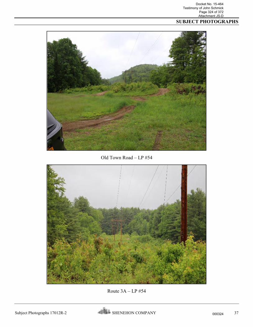
SUBJECT PHOTOGRAPHS
Subject Photographs 17012R-2 SHENEHON COMPANY 37
Old Town Road – LP #54
Route 3A – LP #54
Docket No. 15-464 Testimony of John Schmick
Page 324 of 372 Attachment JS-D
000324

SUBJECT PHOTOGRAPHS
Subject Photographs 17012R-2 SHENEHON COMPANY 38
Route 3A – LP #55
Bennet Brook Road – LP #55
Docket No. 15-464 Testimony of John Schmick
Page 325 of 372 Attachment JS-D
000325

SUBJECT PHOTOGRAPHS
Subject Photographs 17012R-2 SHENEHON COMPANY 39
Bennet Brook Road – LP #56
Route 3A (#1) – LP #56
Docket No. 15-464 Testimony of John Schmick
Page 326 of 372 Attachment JS-D
000326

SUBJECT PHOTOGRAPHS
Subject Photographs 17012R-2 SHENEHON COMPANY 40
Route 3A (#1) – LP #57
Route 3A (#2) – LP #57
Docket No. 15-464 Testimony of John Schmick
Page 327 of 372 Attachment JS-D
000327

SUBJECT PHOTOGRAPHS
Subject Photographs 17012R-2 SHENEHON COMPANY 41
Route 3A (#2) – LP #58
House on Timberland Road – LP #59
Docket No. 15-464 Testimony of John Schmick
Page 328 of 372 Attachment JS-D
000328

SUBJECT PHOTOGRAPHS
Subject Photographs 17012R-2 SHENEHON COMPANY 42
Lakeshore Drive – LP #59
Lakeshore Drive – LP #60
Docket No. 15-464 Testimony of John Schmick
Page 329 of 372 Attachment JS-D
000329

SUBJECT PHOTOGRAPHS
Subject Photographs 17012R-2 SHENEHON COMPANY 43
Griffin Road – LP #60
Griffin Road – LP #61
Docket No. 15-464 Testimony of John Schmick
Page 330 of 372 Attachment JS-D
000330

SUBJECT PHOTOGRAPHS
Subject Photographs 17012R-2 SHENEHON COMPANY 44
Lake Avenue – LP #61
Lake Avenue – LP #62
Docket No. 15-464 Testimony of John Schmick
Page 331 of 372 Attachment JS-D
000331

SUBJECT PHOTOGRAPHS
Subject Photographs 17012R-2 SHENEHON COMPANY 45
Lark Avenue – LP #62
Lark Avenue – LP #63
Docket No. 15-464 Testimony of John Schmick
Page 332 of 372 Attachment JS-D
000332

SUBJECT PHOTOGRAPHS
Subject Photographs 17012R-2 SHENEHON COMPANY 46
Robin Avenue - LP #63
Robin Street – LP #64
Docket No. 15-464 Testimony of John Schmick
Page 333 of 372 Attachment JS-D
000333

SUBJECT PHOTOGRAPHS
Subject Photographs 17012R-2 SHENEHON COMPANY 47
Oriole Street – LP #64
Oriole Street – LP #65
Docket No. 15-464 Testimony of John Schmick
Page 334 of 372 Attachment JS-D
000334

SUBJECT PHOTOGRAPHS
Subject Photographs 17012R-2 SHENEHON COMPANY 48
Route 11 (Webster Lake Road) – LP #65
Route 11 (Webster Lake Road) – LP #66
Docket No. 15-464 Testimony of John Schmick
Page 335 of 372 Attachment JS-D
000335

SUBJECT PHOTOGRAPHS
Subject Photographs 17012R-2 SHENEHON COMPANY 49
Chance Pond – LP #67 on far side of pond
Chance Pond Road – LP #68
Docket No. 15-464 Testimony of John Schmick
Page 336 of 372 Attachment JS-D
000336

SUBJECT PHOTOGRAPHS
Subject Photographs 17012R-2 SHENEHON COMPANY 50
Flaghole Road – LP #68
Flaghole Road – LP #69
Docket No. 15-464 Testimony of John Schmick
Page 337 of 372 Attachment JS-D
000337

SUBJECT PHOTOGRAPHS
Subject Photographs 17012R-2 SHENEHON COMPANY 51
Route 127 – LP #70
Route 127 – LP #71
Docket No. 15-464 Testimony of John Schmick
Page 338 of 372 Attachment JS-D
000338

SUBJECT PHOTOGRAPHS
Subject Photographs 17012R-2 SHENEHON COMPANY 52
Punch Brook Road – LP #71
Punch Brook Road – LP #72
Docket No. 15-464 Testimony of John Schmick
Page 339 of 372 Attachment JS-D
000339

SUBJECT PHOTOGRAPHS
Subject Photographs 17012R-2 SHENEHON COMPANY 53
Smith Hill Road – LP #72
Smith Hill Road – LP #73
Docket No. 15-464 Testimony of John Schmick
Page 340 of 372 Attachment JS-D
000340

SUBJECT PHOTOGRAPHS
Subject Photographs 17012R-2 SHENEHON COMPANY 54
US Highway 3 – LP #73
US Highway 3 – LP #74
Docket No. 15-464 Testimony of John Schmick
Page 341 of 372 Attachment JS-D
000341

SUBJECT PHOTOGRAPHS
Subject Photographs 17012R-2 SHENEHON COMPANY 55
Fiddlers Choice Road – LP #76
Fiddlers Choice Road – LP #77
Docket No. 15-464 Testimony of John Schmick
Page 342 of 372 Attachment JS-D
000342

SUBJECT PHOTOGRAPHS
Subject Photographs 17012R-2 SHENEHON COMPANY 56
Intervale Road – LP #77
Intervale Road – LP #78
Docket No. 15-464 Testimony of John Schmick
Page 343 of 372 Attachment JS-D
000343

SUBJECT PHOTOGRAPHS
Subject Photographs 17012R-2 SHENEHON COMPANY 57
US Highway I-93 – LP #78
US Highway I-93 – LP #79
Docket No. 15-464 Testimony of John Schmick
Page 344 of 372 Attachment JS-D
000344

SUBJECT PHOTOGRAPHS
Subject Photographs 17012R-2 SHENEHON COMPANY 58
West Road – LP #79
Golf Cart Path in Canterbury Woods Country Club – LP #79
Docket No. 15-464 Testimony of John Schmick
Page 345 of 372 Attachment JS-D
000345

SUBJECT PHOTOGRAPHS
Subject Photographs 17012R-2 SHENEHON COMPANY 59
West Road – LP #80
Boyce Road – LP #80
Note: Joint Use Agreement for building in PSNH’s easement area.
Docket No. 15-464 Testimony of John Schmick
Page 346 of 372 Attachment JS-D
000346

SUBJECT PHOTOGRAPHS
Subject Photographs 17012R-2 SHENEHON COMPANY 60
Boyce Road – LP #81
Route 132 (Mountain) Road) – LP #81
Docket No. 15-464 Testimony of John Schmick
Page 347 of 372 Attachment JS-D
000347

SUBJECT PHOTOGRAPHS
Subject Photographs 17012R-2 SHENEHON COMPANY 61
Hoit Road – LP #82
Hoit Road – LP #83
Docket No. 15-464 Testimony of John Schmick
Page 348 of 372 Attachment JS-D
000348

SUBJECT PHOTOGRAPHS
Subject Photographs 17012R-2 SHENEHON COMPANY 62
Sanborn Road – LP #83
Sanborn Road – LP #84
Docket No. 15-464 Testimony of John Schmick
Page 349 of 372 Attachment JS-D
000349

SUBJECT PHOTOGRAPHS
Subject Photographs 17012R-2 SHENEHON COMPANY 63
Shaker Road – LP #84
Shaker Road – LP #85
Docket No. 15-464 Testimony of John Schmick
Page 350 of 372 Attachment JS-D
000350

SUBJECT PHOTOGRAPHS
Subject Photographs 17012R-2 SHENEHON COMPANY 64
Oak Hill Road – LP #85
Oak Hill Road – LP #86
Note: Part of Turtletown Pond Conservation Area.
Docket No. 15-464 Testimony of John Schmick
Page 351 of 372 Attachment JS-D
000351

SUBJECT PHOTOGRAPHS
Subject Photographs 17012R-2 SHENEHON COMPANY 65
Appleton Road – LP #86
Appleton Road – LP #87
Docket No. 15-464 Testimony of John Schmick
Page 352 of 372 Attachment JS-D
000352

SUBJECT PHOTOGRAPHS
Subject Photographs 17012R-2 SHENEHON COMPANY 66
Curtisville Road (south) – LP # 87
Curtisville Road (south) – LP # 88
Docket No. 15-464 Testimony of John Schmick
Page 353 of 372 Attachment JS-D
000353

SUBJECT PHOTOGRAPHS
Subject Photographs 17012R-2 SHENEHON COMPANY 67
Portsmouth Street/ US Highway I-393 – LP #88
Old Loudon Road – LP #89
Docket No. 15-464 Testimony of John Schmick
Page 354 of 372 Attachment JS-D
000354

SUBJECT PHOTOGRAPHS
Subject Photographs 17012R-2 SHENEHON COMPANY 68
Old Loudon Road – LP #90
Shaws Grocery parking lot – LP #91
Docket No. 15-464 Testimony of John Schmick
Page 355 of 372 Attachment JS-D
000355

SUBJECT PHOTOGRAPHS
Subject Photographs 17012R-2 SHENEHON COMPANY 69
Pembroke Road – LP #91
Pembroke Road – LP #92
Docket No. 15-464 Testimony of John Schmick
Page 356 of 372 Attachment JS-D
000356

SUBJECT PHOTOGRAPHS
Subject Photographs 17012R-2 SHENEHON COMPANY 70
Regional Drive – LP #92
Regional Drive – LP #93
Docket No. 15-464 Testimony of John Schmick
Page 357 of 372 Attachment JS-D
000357

SUBJECT PHOTOGRAPHS
Subject Photographs 17012R-2 SHENEHON COMPANY 71
Chenell Road – LP #93
Chenell Road – LP #94
Docket No. 15-464 Testimony of John Schmick
Page 358 of 372 Attachment JS-D
000358

SUBJECT PHOTOGRAPHS
Subject Photographs 17012R-2 SHENEHON COMPANY 72
Fourth Range Road – LP #98
Fourth Range Road – LP #99
Docket No. 15-464 Testimony of John Schmick
Page 359 of 372 Attachment JS-D
000359

SUBJECT PHOTOGRAPHS
Subject Photographs 17012R-2 SHENEHON COMPANY 73
Bush Road – LP #99
Bush Road – LP #100
Docket No. 15-464 Testimony of John Schmick
Page 360 of 372 Attachment JS-D
000360

SUBJECT PHOTOGRAPHS
Subject Photographs 17012R-2 SHENEHON COMPANY 74
Cross Country Road – LP #100
Cross Country Road – LP #101
Docket No. 15-464 Testimony of John Schmick
Page 361 of 372 Attachment JS-D
000361

SUBJECT PHOTOGRAPHS
Subject Photographs 17012R-2 SHENEHON COMPANY 75
North Pembroke Road – LP #104
North Pembroke Road – LP #105
Docket No. 15-464 Testimony of John Schmick
Page 362 of 372 Attachment JS-D
000362

SUBJECT PHOTOGRAPHS
Subject Photographs 17012R-2 SHENEHON COMPANY 76
Route 28 – LP #105
Route 28 – LP #106
Docket No. 15-464 Testimony of John Schmick
Page 363 of 372 Attachment JS-D
000363

SUBJECT PHOTOGRAPHS
Subject Photographs 17012R-2 SHENEHON COMPANY 77
New Rye Road – LP #108
New Rye Road – LP #109
Docket No. 15-464 Testimony of John Schmick
Page 364 of 372 Attachment JS-D
000364

SUBJECT PHOTOGRAPHS
Subject Photographs 17012R-2 SHENEHON COMPANY 78
Mt. Delight Road – LP #111
Mt. Delight Road – LP #112
Docket No. 15-464 Testimony of John Schmick
Page 365 of 372 Attachment JS-D
000365

SUBJECT PHOTOGRAPHS
Subject Photographs 17012R-2 SHENEHON COMPANY 79
Thurston Pond Road – LP #113
Hayes Road – LP #113
Docket No. 15-464 Testimony of John Schmick
Page 366 of 372 Attachment JS-D
000366

SUBJECT PHOTOGRAPHS
Subject Photographs 17012R-2 SHENEHON COMPANY 80
Hayes Road – LP #114
Church Street – LP #115
Docket No. 15-464 Testimony of John Schmick
Page 367 of 372 Attachment JS-D
000367

SUBJECT PHOTOGRAPHS
Subject Photographs 17012R-2 SHENEHON COMPANY 81
Church Street – LP #116
Route 43/107 – LP #116
Docket No. 15-464 Testimony of John Schmick
Page 368 of 372 Attachment JS-D
000368

SUBJECT PHOTOGRAPHS
Subject Photographs 17012R-2 SHENEHON COMPANY 82
Route 43/107 – LP #117
Mountain Road – LP #117
Docket No. 15-464 Testimony of John Schmick
Page 369 of 372 Attachment JS-D
000369

SUBJECT PHOTOGRAPHS
Subject Photographs 17012R-2 SHENEHON COMPANY 83
Mountain Road – LP #118
Nottingham Road – LP #118
Docket No. 15-464 Testimony of John Schmick
Page 370 of 372 Attachment JS-D
000370

SUBJECT PHOTOGRAPHS
Subject Photographs 17012R-2 SHENEHON COMPANY 84
Nottingham Road – LP #119
Cate Road – LP #119
Docket No. 15-464 Testimony of John Schmick
Page 371 of 372 Attachment JS-D
000371

SUBJECT PHOTOGRAPHS
Subject Photographs 17012R-2 SHENEHON COMPANY 85
Cate Road – LP #120
Docket No. 15-464 Testimony of John Schmick
Page 372 of 372 Attachment JS-D
000372
Copyright © 2022 FDOKUMEN