ASSESSING THE FORM AND FUNCTION OF STRUCTURES 42
136
Transcript of ASSESSING THE FORM AND FUNCTION OF STRUCTURES 42


Copyright Mark P. Luzmoor
All Rights Reserved

DEDICATION
This thesis is dedicated to my wonderful family. They made me who I am and I am eternally
grateful. It is especially dedicated to my late uncle William John (Bill) Luzmoor III. He was an
inspiration to us all and was taken much too early.
ASSESSING THE FORM AND FUNCTION OF STRUCTURES 42
AND 43 AT BUENAVISTA DEL CAYO,
BELIZE
by
MARK LUZMOOR, B.A.
THESIS
Presented to the Graduate Faculty of
The University of Texas at San Antonio
in Partial Fulfillment
of the Requirements
for the Degree of
MASTER OF ARTS IN ANTHROPOLOGY
THE UNIVERSITY OF TEXAS AT SAN ANTONIO
College of Liberal and Fine Arts
Department of Anthropology
May 2013

iv
ACKNOWLEDGEMENTS
This thesis was made possible with the help from many, many different sources,
including physical, emotional and financial support. First and foremost, I would like to thank my
committee. I am greatly indebted to my advisor, Dr. M. Kathryn Brown for her guidance and
support throughout the whole process in completing this thesis. I would also like to thank Dr.
Jason Yaeger for his support on the ground during my field season at Buenavista del Cayo as
well as explaining many of the architectural and ceramic details of the excavations to me during
the writing process. I would also like to thank Dr. Sonia Alconini for serving on my committee
and all of her support and guidance in completing this program.
Many other people have encouraged me throughout the process of writing this thesis and
it is to them that I am eternally grateful. A special thanks goes out to my close friends Becca
Friedel, Tiffany Lindley, Matthew Warren, and Chris Jarrett who have generously given up their
time to look through many drafts and have given me many comments as well as many laughs
throughout these last few years. Without their support and encouragement this thesis would not
have been possible. Other important people include Melissa Eiring, Carla Pezzia, Sebastián
Salgado-Flores, Andie Thomas, Tawny Tibbits and Lynn Wack who also provided valuable
feedback during the editing process. A world of thanks goes to Thomas Chapman who took my
drawings and made them into pieces of art. His contributions provide a welcome sight to the
thesis. Thanks also goes to Sarah Bratsch who provided me with the pictures of the sub-
operations. A special thanks goes to Bernadette Cap who provided pictures of the Special Finds
and a plan view illustration of the Operations excavated within the layout of the West Plaza. A
world of thanks goes to some of my best friends: Stacey Smoot, Matt Freeman, Aaron Ortega,
and Joe Rudd who all helped me to get to where I am with their friendship and by always
v
providing a laugh, some inspiration and help when I needed it. One of the most important
persons that helped and encouraged me every step of the way is Milena Andrea Melo. Without
her love and never-ending support this thesis probably would have never materialized.
Financial support was provided by the Gifford Scholarship, which was awarded to the
author by the University of Texas at San Antonio and personal contributions. I would also like
to thank my local workmen Adrian Cruz and Carlos Perez for their hard work, company, and
good humor at my attempts at Spanish. I would also like to thank the MVAP 2011 field school
students for their help with excavations and companionship throughout the field season. I would
like to thank Dominic Juan for his amazing hospitality and for welcoming us all to stay at his
home away from home during the 2011 field season.
Finally, I would like to thank my family. My sister, Jenny Luzmoor Schow and her
wonderful family: Jeff, John and Isaiah; my brother, Joel Luzmoor and his beautiful family:
Heather, Clara, Tristan, and Libby; my aunts and uncles: Dave and Beth Luzmoor, Rita and Paul
Rotter, Tedd and Kim Bloom, William ‘Bill’ and Gloria Luzmoor, my grandma: Jean Bloom and
all of their families. They have always supported me through all of my trials and tribulations and
I am forever grateful for their love and support. Finally, I would like to thank my parents, Phillip
and Kathy Luzmoor, who, without their continued love, support and encouragement, both
financial and emotional, I would not be where I am today. They have always been there for me
through all my ups and downs and I hope to one day be worthy of their constant praise.
May 2013
vi
ASSESSING THE FORM AND FUNCTION OF STRUCTURES 42
AND 43 AT BUENAVISTA DEL CAYO,
BELIZE
Mark Luzmoor, M.A.
The University of Texas at San Antonio, 2013
Supervising Professor: M. Kathryn Brown, Ph.D.
This thesis examines the form and function of Structures 42 and 43 at the site of
Buenavista del Cayo, Belize. These structure are long, narrow, and low platforms built in the
northern part of Buenavista’s West Plaza. Excavations revealed them to be formally constructed
with cut stone masonry and rubble fill. They both sit on the final plaster floor of the West Plaza,
suggesting that these structures were built near the end of the site’s history. Analyses of the
recovered ceramic artifacts suggest they were built in the Late Classic II period and used into the
Terminal Classic period. The unusually long form of both Structures 43 and 42 and their
strategic placement demarcating the northern edge of the West Plaza and controlling access into
the plaza from the north suggests the possibility that these structures functioned as some sort of
fortification during the final phases of occupation at Buenavista, perhaps forming a baffled entry
and/or killing alley in this sector of the site. These platforms were modified by the placement of
several posts, two of which were intruded through the platforms’ original facings, that are argued
to be the remains of a palisade. Several of the postholes showed evidence of burning, which
suggests a warfare event.

vii
TABLE OF CONTENTS
Acknowledgements.........................................................................................................................iv
Abstract............................................................................................................. ..............................vi
List of Figures..................................................................................................................................x
List of Tables.................................................................................................................................xii
Chapter 1: Introduction....................................................................................................................1
1.1 Research Objectives..................................................................................................... .2
1.2 Format of this Thesis....................................................................................................3
Chapter 2: The environment and Cultural Setting of the
Belize River valley................................................................................................5
2.1 Geographic and Environmental Setting.......................................................................5
2.1.1 Climate............................................................................................................8
2.1.2 Vegetation and Fauna.....................................................................................8
2.1.3 Agricultural Potential....................................................................................10
2.2 Cultural History of the Maya Lowlands....................................................................11
2.2.1 Preclassic Period - ca. B.C. 2000-250 A.D..................................................11
2.2.2 Classic Period - ca. A.D. 250-900................................................................15
2.2.3 Postclassic Period - ca. A.D. 900-1500........................................................19
Chapter 3: Previous investigations of Buenavista del Cayo
and the Nearby Site of Xunantunich...................................................................22
3.1 Investigations at Xunantunich....................................................................................22
3.2.1 Early Investigations at Xunantunich............................................................22
3.2.2 The Xunantunich Archaeological Project (XAP)........................................23
3.1.3 Xunantunich Palace Excavations (XPE).....................................................24

viii
3.1.4 Mopan Valley Preclassic Project (MVPP)...................................................25
3.2 Investigations of Buenavista del Cayo.......................................................................25
3.2.1 The Mopan-Macal Triangle Archaeological
Project (MMT).......................................................................................25
3.2.2 The Mopan Valley Archaeological Project
(MVAP).................................................................................................26
Chapter 4: Warfare in the Maya Lowlands....................................................................................29
4.1 Warfare Defined..........................................................................................................29
4.2 History of the Study of Warfare in the Maya Lowlands.............................................30
4.2.1 Evidence of Warfare………………............................................................33
4.3 Defensive Features and Their Implications for
Ancient Warfare.................................................................................................37
4.3.1 Defensive Features in the Maya Lowlands..................................................39
4.3.2 Examples of Defensive Features outside of
the Maya Lowlands................................................................................44
4.4 Comparisons and Conclusions....................................................................................46
Chapter 5: Investigations of Structures 42 and 43 at Buenavista
del Cayo.................................................................................................................49
5.1 Introduction: Research Design....................................................................................50
5.2 Field Methods.............................................................................................................54
5.3 Laboratory Methods....................................................................................................56
5.4 Excavations of Operation 367 in 2011........................................................................57
5.4.1 Initial Clearing of Structure 43....................................................................57
5.4.2 Detail of Operation 367 Excavations in 2011..............................................59
5.4.3 Artifact Analysis of Operation 367 in 2011.................................................80

ix
5.5 Excavations of Operation 367 in 2012........................................................................82
5.6 Excavations of Operation 371 in 2012........................................................................88
5.7 Summary of Excavations............................................................................................94
Chapter 6: Interpretations and Discussions...................................................................................95
6.1 Architectural Histories of Structures 42 and 43..........................................................95
6.2 Evaluation of Structures 42 and 43 as a Defensive Feature......................................101
6.3 Contributions to Maya Archaeology and Warfare....................................................104
References................................................................................................................... .................106
Vita

x
LIST OF FIGURES
Figure 1-1 Map of the Maya Area (adapted from Sharer and Traxler
2006:Figure 1.1)...................................................................................................6
Figure 1-2 Map of Buenavista del Cayo and Important Surrounding
Sites (From LeCount et al. 2002:Figure 1)..........................................................7
Figure 5-1 Buenavista del Cayo. ca. A.D. 800 (Map courtesy of
Joseph Ball)........................................................................................................51
Figure 5-2 Buenavista del Cayo Site Core with the West Plaza,
Structures 36, 42, 43, and Operations 367 and
371 indicated (Map by Bernadette Cap)............................................................53
Figure 5-3 Plan of Operation 367, including 2011 and 2012
excavations.........................................................................................................58
Figure 5-4 Base of Operation 367A/13 showing FA 1, FA 2, PH 1
and partially preserved plaster floors.................................................................62
Figure 5-5 Operation 367A profile of half-section of PH 1 looking
north...................................................................................................................63
Figure 5-6 Operation 367B showing FA 1 in NE corner and FA 3 in
SE corner............................................................................................................66
Figure 5-7 Base of Op 367E/2 showing FA 1, FA 2 and PH 2…...........................................68
Figure 5-8 Base of Op 367D/6 showing plaster floor and FA 5..............................................70
Figure 5-9 Ops 367A and 367D, profile of west wall.............................................................71
Figure 5-10 Base of Op 367E/2 showing PH 2.........................................................................73
Figure 5-11 Operation 367H, plan showing location of PH 3 and
profile of half-section of PH 3 looking west......................................................85
Figure 5-12 Operation 367I, plan showing PH 4 and profile of
half-section of PH 4 facing east.........................................................................87
Figure 5-13 Operation 371A, plan showing PH 5 and profile of
half-section of PH 5 facing east.........................................................................90
Figure 5-14 Operation 371D, plan showing PH 6 and profile of
half-section of PH 6 facing east.........................................................................92

xi
Figure 6-1 Operation 371F & D North Wall Profile...............................................................99

xii
LIST OF TABLES
Table 5-1 Area of ground excavated in 2011 and 2012 seasons.......................................52-53
Table 5-2 Counts and weights of ceramic sherds in lots
from Operation 367 in 2011 (* indicates no
data available)...............................................................................................75-76
Table 5-3 Small Finds found in Operation 367 in 2011.........................................................76
Table 5-4 Chronologically diagnostic Types and Modes
from Operation 367 in 2011.........................................................................77-80

1
CHAPTER 1: INTRODUCTION
The ancient Maya have been involved in warfare since at least the Middle Preclassic
(1000 B.C.-A.D. 250) and perhaps earlier (see Brown and Garber 2003). Warfare played a
prominent role in ancient Maya politics and society (Sharer and Golden 2004). Warfare was
carried out for a variety of reasons among the Classic Maya including the procurement of
captives and land, control of trade routes, elite prestige, tribute, revenge, and intrapolity political
advantage (Webster 1999:349). Many wars were fought in the open plains of the Maya lowlands
and highlands (Webster 2000:66); however, some were also fought on the doorsteps of
monumental centers. Some of these centers were protected by defensive features or located in a
defensible position, although many were not.
The study of warfare has greatly increased in the past several decades due to the
discovery of military themed murals as well as breakthroughs in the decipherment of the Maya
hieroglyphs. However, our understanding of defensive features remains limited. Why some
sites construct defensive features while many other centers did not is a central question in the
study of warfare strategies and the nature of conflict in the Maya lowlands. The presence of
defensive features suggests conflict and the threat of war. A close examination of defensive
features including construction effort expended, integration into the formal layout of the city, as
well as chronological assessment of these features, can shed light on the nature of conflict and
warfare present in a region. It seems logical that defensive features that were erected in a rapid
fashion and were not formally integrated into the architectural arrangement of a site, may
indicate an attack or the extreme threat of warfare over a short duration. On the other hand, a
defensive feature, such as a wall or palisade, that is more formally constructed and is integrated
into the architectural plan of the city, as well as periodically maintained, may indicated conflict

2
in the region for an extended period of time. This thesis examines the excavation data from
Structures 42 and 43 at Buenavista del Cayo in western Belize with the aim to evaluate their
function as possible defensive features. Great attention will be paid to the architectural sequence
in order to shed light on the construction methods and materials utilized, architectural features
present such as postholes, as well as the chronology of the buildings.
1.1 Research Objectives
Three main objectives guided the research of this thesis. The first goal was to gain a
basic understanding of Maya warfare and especially how the ancient Maya used defensive
features/fortifications in and around their site cores. The literature review for this thesis includes
a brief description of a few sites that have been studied thoroughly and are known to contain
defensive fortifications. These sites will be used to compare and contrast the data that has been
collected from my own excavations at Buenavista del Cayo. My second research objective was
to investigate the form and function of Structure 43. The long and narrow form of this structure
was somewhat unusual and coupled with its placement on the edge of the site core suggests that
it may have served a defensive function. The third objective was to investigate areas adjacent to
Structure 43 in order to fully evaluate the function of the structure. This thesis presents data
from my excavations at Buenavista del Cayo on Structure 43 in 2011 and relevant excavation
data collected in 2012 by Chris Matthews and Bernadette Cap. A comparative analysis of these
data to other sites with known defensive features will form the basis for interpretations. I argue
that Structure 43 shares similarities to a number of defensive features found throughout the Maya
lowlands. Additionally, I argue that the somewhat formal arrangement of the structure and its
integration into the site plan is more indicative of extended conflict in the region, but may reflect
an escalation of this conflict during the final occupation of the site.

3
1.2 Format of this Thesis
This thesis is organized into six chapters followed by a reference section. The first
chapter includes an introduction to this study, its research objectives, the organization of this
thesis and a summary of each chapter.
Chapter 2 presents an environmental and historical overview of the Belize River valley
and nearby regions. This chapter places the site of Buenavista del Cayo into a geographic and
historic context. It begins with an overview of the environment which includes sections on its
climate, the vegetation and fauna that are located throughout the area, the agricultural potential
of the area as well as the geography of central Belize. Finally, the chapter concludes with a
discussion on the cultural history of the Maya lowlands. This discussion focuses mainly on the
most influential events of each sub-period and their individual importance on cultural history of
the Maya as a whole.
Previous archaeological investigations of the Belize River valley are presented in Chapter
3 with a specific focus on the sites of Xunantunich and Buenavista del Cayo. This chapter
provides background information on the archaeological work that has been undertaken at these
two nearby sites.
Chapter 4 provides a background on the study of warfare within the Maya region. The
term warfare, which can cause heavy debate among Mayanists, is defined. A history of the study
of warfare in the Maya lowlands, as well as the archaeological signatures of warfare are that can
be obtained to determine whether warfare did take place is discussed. The issue of defensive
features and how they can implicate warfare is provided. Finally a number of sites that contain
defensive features both inside and outside the Maya lowlands are presented.

4
Chapter 5 presents the data obtained from Structures 42, 43 and the area between
Structures 36 and 43 at Buenavista del Cayo during excavations in 2011 and 2012. The research
design that was used to obtain the data is provided as well as the field and laboratory methods
used to collect and process the artifacts. Excavation and artifact data are presented.
Chapter 6 provides some preliminary interpretations of Structures 42 and 43 from the
data collected in 2011 and 2012. It also presents architectural histories from both Structures 42
and 43 as well as an evaluation of these structures as a defensive feature. It also provides
contributions of this work towards Maya archaeology and warfare.

5
CHAPTER 2: THE ENVIRONMENTAL AND CULTURAL SETTING OF THE BELIZE
RIVER VALLEY
In this chapter, I place the research site of Buenavista del Cayo into a historical context. I
will highlight the geographic and environmental data of the Maya lowlands and discuss in more
detail the environment of the Belize River valley. The climate, vegetation, fauna and soil
chemistry of the Belize River valley will be examined and will provide important contextual data
for this thesis. Additionally, I provide an overview of the culture history of the Maya lowlands,
highlighting some of the monumental advancements made in the Preclassic, Classic, and
Postclassic time periods and providing details related to the culture history of the Belize River
valley.
2.1 Geographic and Environmental Setting
For its relative size, the Maya area represented one of the most environmentally diverse
regions on the planet ranging from the almost inaccessible fertile volcanic soils of the highlands
to the jungles, bajos and rock infested plains of the lowlands (Coe 2008:14; Sharer & Traxler
2006:29). The highlands include the area of southern Guatemala, Western Honduras, El
Salvador and the Chiapas region of southern Mexico. The lowlands encompass northern
Guatemala, Belize and the Yucatan Peninsula. The Maya lowlands cover a geographical area
encompassing approximately 324,000 square kilometers (Sharer and Traxler 2006:23; see also
Hammond 1982:67-8; Figure 1-1). The site of study for this thesis: Buenavista del Cayo, is
located in this lowland region in Belize (Figure 1-2).

6
Figure 1-1: Map of the Maya Area (adapted from Sharer and Traxler 2006:Figure 1.1).

7
Figure 1-2: Map of Buenavista del Cayo and Important Surrounding Sites (From LeCount
et al. 2002:Figure 1)
The country of Belize borders the Caribbean ocean on its East, Guatemala to its West as
well as its South and finally Quintana Roo, Mexico to its North. Buenavista del Cayo, lies on the
far western edge of Belize just 2.5 kilometers from the border of Guatemala. It lies
approximately 55 kilometers inland from the Caribbean ocean. This medium level center is
situated along the uppermost terrace of the Mopan River valley and lies approximately 400
meters to the East of its bank in the “upper” Belize River valley (Ball & Tashek 2004:149; Chase
& Garber 2004:1).

8
Belize, along with all of the Maya lowlands offered a number of different ecological
niches for the ancient Maya to settle. The many natural resources within this vast area offered an
attractive landscape to early Maya settlers.
2.1.1 Climate
Similar to many other Central American countries, Belize has fairly high yearly average
of rainfall. Being situated on the coast, it experiences an average annual temperature of around
80 degrees Fahrenheit and can range between 50-95 degrees Fahrenheit (Willey et al. 1965:21).
The climate throughout Belize can be classified best as ranging from a tropical to subtropical
environment, which contains distinctive dry and wet seasons throughout the year (Gunn et al.
2002:80). June to January is the wet season and the dry season runs from February to April
(Fedick 1995:18). The average annual amounts of rainfall vary dramatically between northern
and southern Belize with 50 inches in the north and up to 160 inches in the south (Willey et al.
1965:21; see also Wright et al. 1959: Figure 2). It is because of these abundantly fertile
conditions that the “residents of the upper Belize River valley enjoy a readily available and
abundant supply of fresh water that is rare in many parts of the Maya Lowlands” (Yaeger
2000:70).
2.1.2 Vegetation and Fauna
Along with the favorable climactic conditions, the vegetation and fauna throughout the
Maya lowlands were very beneficial to the ancient Maya people. Hundreds of different types of
trees and animals can be found throughout the Maya lowlands. In the Belize River valley, for
example, there are many densely forested areas as well as upland regions that contained many
different kinds of trees including several varieties of palm, Spanish cedar, mahogany, sapodilla,
and ramón (breadnut) trees (Bullard 1960:357). These available tree resources were utilized to

9
the fullest by the ancient Maya including being used as construction materials, food resources
and in the case of the rubber tree, for the extraction of rubber for rubber balls used in the Ancient
Maya ball game (Sharer and Traxler 2006:42).
The natural environment of the Maya lowlands was home to numerous animal species,
many of which were utilized by the ancient Maya as a source of protein or for ritual/ideological
purposes. For example, evidence suggests that stingless bees were an important resource for the
ancient Maya as they produced wax and honey (Clendinnen 1987:152). Common to the lowland
environment were anteaters, tapirs, white-tailed and brocket deer, rabbits, howler and spider
monkeys, as well as many carnivores such as the jaguarundi, ocelot and the largest New World
cat, the jaguar. The jaguar played an important role in the ideology of the ancient Maya. Many
bird species were found throughout the lowlands including macaws, toucans, parrots and the
ocellated turkey.
Sea life abounds along the coastal zone of the Yucatan and Belize and many marine
species were utilized for protein as well as shell resources to manufacture adornments. Rivers
within the Maya lowlands not only provided valuable resources such as jute snails, crayfish and
many types of fish (Sharer and Traxler 2006:42-3; Willey et al. 1965:23), they were also
important transportation routes. With the importance of trade items and the routes they followed
throughout the Maya area, many marine and other resources were transported up-river to
multiple sites in Belize and in some cases all the way to Guatemala (Cochran 2008; Demarest
2004; Ford 2004; McKillop 2004; Willey et al. 1965). The site of Moho Cay, situated along the
Caribbean coast at the mouth of the Belize River valley was a site where many trading
expeditions began into the heart of Belize and continued on elsewhere deep into the Maya realm

10
(McKillop 2004). The ancient Maya adapted to their natural environment and clearly utilized the
numerous species of flora and fauna readily available to them.
2.1.3 Agricultural Potential
To better understand how the Maya were able to achieve such complexity in the Maya
lowlands, it is necessary to examine issues related to subsistence strategies and population
densities in a diachronic fashion, beginning in the Early Preclassic and continuing into the
Postclassic period (1000 B.C. - A.D. 1500) (Coe 2011; Demarest 2004; Sharer and Traxler
2006:79).
In order to achieve this in-depth look at the relationship between the environment and the
distribution of ancient Maya peoples across the landscape, it is necessary to conduct land-
resource surveys as well as soil inundation tests to determine the fertility of the environment (see
Birchall and Jenkin 1979; Fedick 1995; Jenkin et al. 1976). Many years of research have been
dedicated to determining the availability of cultivable and fertile lands throughout the Belize
River valley. The results of these research projects point to a high level of fertility throughout
the study area (Fedick 1995:Figure 1). The sheer number of Maya sites, including several
medium to large polities, within a 25 kilometer radius attests to this fact. In addition, settlement
surveys suggest that the region was densely settled, with increasing populations in the Late
Classic (see Ford and Fedick 1992; Ford 1995; Hammond 1974, 1975, 1982b; LeCount and
Yaeger 2010; Leventhal et al. 2010; Lucero 1999; Willey et al. 1965; Yaeger 2000). However,
there is a high degree of variability in the productivity and fertility of the soil throughout the
Belize River valley (Yaeger 2000:78). None-the-less, it is clear that the ancient Maya people
fully utilized their surroundings to their advantage (see Webster 1977 for a discussion on
population density through time in the Maya region).
11
2.2 Culture History of the Maya lowlands
Archaeologists usually frame the history of the Maya area into three general periods: the
Preclassic (2000 B.C.-A.D. 100), Classic (A.D. 100-900/1100) and the Postclassic (A.D. 900-
1500) (Sharer & Traxler 2006:98). Some of these dates differ but in general these are the
accepted time frames for the Maya area (see Coe 2011:10; Demarest 2004; Lucero 1999:212 for
some alternative views). Much work on the ceramic and architectural areas have allowed
archaeologists to be able to better define these periods that were first established over 60 years
ago by Armillas (1948). These three periods are usually subdivided into smaller timeframes of
the Early Preclassic (2000-1000/900 B.C.), Middle Preclassic (1000/900-400 B.C.), Late
Preclassic (400 B.C.-A.D. 100), Terminal Preclassic (A.D. 100-250), Early Classic (A.D. 250-
600), Late Classic (A.D. 600-800), Terminal Classic (A.D.A.D. 800-900/1100) and finally the
Postclassic (A.D. 900/1100-1500) (Sharer & Traxler 2006:98). In the following sections, I
provide brief summaries of the culture history for each of these periods.
2.2.1 The Preclassic Period - ca. B.C. 2000-250 A.D.
The Maya lowlands have been in constant fluid motion ever since it was first inhabited
thousands of years ago. The transition from the Archaic period (8000-2000 B.C.) to the Early
Preclassic (1200-900 B.C.) in the Maya lowlands is mainly brought on by the establishment of
sedentary villages and the use of agriculture as the main source of nourishment instead of
hunting and gathering. Around 1200 B.C. some of the first groups of Maya began to establish
themselves on the Pacific Coasts of southern Mexico and Guatemala as well as in Belize. These
groups were mainly farming communities spread out along the fertile landscape. These early
groups may have had some measure of social ranking but clear social stratification was not
present (Sullivan et al. 2010). A well defined ceramic tradition was also being developed

12
throughout the Mesoamerican world in the Early Preclassic. The earliest of which appears to be
found on the Pacific Coast of Chiapas, Guatemala and also in Western El Salvador dating to (ca.
1850-1650 B.C.) (Sharer and Traxler 2006:160; Marcus 2003a). In the Belize River valley, at
the sites of Cahal Pech and Blackman Eddy, the earliest ceramics in the valley have been
encountered dating back to at least 1200 B.C.: “The early ceramic assemblages from both sites
are similar and are technologically advanced indicating a superior knowledge of ceramic
technology.” (Brown 2007:4). Besides being technologically advanced for their time, they also
“...consist[ed] of both utilitarian wares and a special ritual sub-assemblage of ash tempered,
slipped serving vessels, often incised with ideologically related motifs” (Brown 2007:4).
During the Middle Preclassic, populations throughout the lowlands began to grow and
sites become more numerous. Sites with public and monumental architecture appear on the
landscape at this time indicating labor investment in architecture. This is seen at such sites as
Cerros, Cival, Nakbe, and San Bartolo in the Peten region (Estrada-Belli 2011; Freidel 1979;
Hansen and Guenter 2005; Saturno 2002). Funerary and ritual practices were widespread during
this time as well. The site of Cuello, Belize, contains at least 27 burials that date from 1200 to
650 B.C. (Hammond 1999:51). During the Middle Preclassic in the Belize River valley, Brown
(2009) has argued that a two-tiered settlement hierarchy was present by this time. Blackman
Eddy, Cahal Pech, and Xunantunich were larger Middle Preclassic centers with monumental
architecture, while Nohoch Ek and Chan were smaller in scale (Brown 2009). Some indicators
of emerging social inequalities are present in the Middle Preclassic through the craft production
of prestige objects such as marine shell and green stone, long distance trade, and restricted access
to monumental architecture (Brown 2003; Garber et al. 2004). By the end of the Middle

13
Preclassic time period, the Maya were socially stratified and the roots of the institution of
kingship were firmly in place (Brown and Bey in press; Estrada-Belli 2011).
Evidence of warfare during the Middle Preclassic has been found at a number of sites in
the Maya lowlands. This is not surprising as evidence for conflict has been found in other areas
of Mesoamerica during this early time period including burned buildings and probable palisades
in the valley of Oaxaca, Mexico by about 1800 B.C. (Sharer and Traxler 2006:160). Warfare
cannot be securely dated this early in the Maya area. However, one of the earliest dates that
points to evidence of warfare in the Maya area is seen at Blackman Eddy, Belize, around 600
B.C. (Brown and Garber 2003:91). In particular, the main temple at the site, Structure B1-4th,
was severely burned and destroyed. In fact, the summit of this building, which was constructed
of thick plaster, exhibits severe discoloration from extreme heat (Brown and Garber 2003:98).
Defensive features begin to appear during the Middle to Late Preclassic in the Maya
lowlands. Multiple sites have been found to exhibit some type of defensive system dating to
around 300 B.C. to A.D. 250. For example, the site of Becán in Campeche, Mexico, contains a
large ditch and parapet system that surrounds the entire site. David Webster, states that “the
main component of the fortifications is a kidney-shaped ditch 1.9 km in circumference with an
average width of 16 meters and depth of 5.3 meters” (1976b:362; see also Webster 1976a). The
site of Los Naranjos of northern Honduras also has evidence of two massive defensive features
that might even predate the Becán feature. The site contains one 1,300 meter long ditch that
screens the eastern approaches to the site which dates to approximately 800-400 B.C., as well as
another 3,200 meter ditch that was erected further to the east to protect an even larger area and
dates to approximately 400 B.C.-550 A.D. (Webster 1976b:361-2). By the end of the Middle
Preclassic and the beginning of the Late Preclassic, there are examples of sites building

14
defensive features due to an increase in inter-site raiding and warfare. For example Marcus
(1998:61) states that “during the Late Preclassic in the Maya region (300 B.C.-A.D. 250) we
have evidence for societies with hereditary differences in rank, settlement hierarchies of two or
three tiers and sufficient interpolity raiding so that some sites have ditches, ramparts, palisades
and other defensive earthworks.”
During this time period, large regional centers appear. This time period is marked by the
construction of triadic architectural arrangements and deity masks on temples (see Marcus
2003a). The site of El Mirador illustrates the level of complexity that the ancient Maya had
reached by the Late Preclassic (Canuto 2009:7). The enormous El Mirador polity constructed
some of the most impressive Maya architecture of all time including the Danta pyramid, possibly
the largest ever constructed in Maya history. In addition to the massive monumental
constructions at the site, there was also an elaborate terracing and raised field system that could
support thousands of people (Hansen 1991). Lucero (1999:219-221) highlights the fact that in
order to feed the ever increasing population, the Maya had to implement new agricultural
technologies including the raised field system to help make their lands more profitable in terms
of their yield for each planting season.
The site of El Mirador also had multiple sacbes (causeways) extending out from it, which
indicates that it was the center of a very large trading system. El Mirador had a substantial
defensive wall surrounding most of the site (Dahlin 1984). Other Late Preclassic sites such as
Tikal, Uaxactun, and Calakmul were quite large with impressive monumental architecture.
Several Late Preclassic polities erected defensive features such as walls and ditches indicating
warfare and conflict at this time. At the end of the Late Preclassic, El Mirador was abandoned
15
(due to massive deforestation and increased periods of drought) and Tikal, Calakmul and Caracol
began to increase in size (McAnany 2001, Sharer & Traxler 2006).
Archaeological investigations in the last two decades have shed light on the nature of the
hierarchical and political structure of early polities in the Maya lowlands. Early polities such as
El Mirador, clearly attracted large populations and early rulers/kings were able to mobilize and
utilize the resources and labor to construct major architectural works. Scholars have debated the
level of complexity during the Late Preclassic and especially whether the Maya had achieved a
true “state” level system or not (see Chase and Chase 1998; Webster 1997; see below for a
discussion). It is clear, however, that the institution of kingship was present by this time period
and the Maya had achieved a high level of complexity.
The sites of Nakbe and El Mirador in the Mirador Basin as well as a plethora of others
have the capability of being the first state level system with El Mirador at its center (see Dahlin
1984; Hansen 1991 for reviews). The massive scale and elaborateness of the monumental
architecture at El Mirador by around 250 B.C. illustrates the complexity reached by this period.
Many scholars would agree that El Mirador represents the first state in the Maya lowlands. The
fluorescence seen in the Mirador Basin, then, was the culmination of almost a millennium of
growth and progress beginning around 800 B.C. and resulting in the monumental center of El
Mirador by around 150 B.C. (Inomata and Triadan 2009:66). Other sites such as Tikal, Cerros
and Lamanai exhibited large-scale architecture and elaborate iconographic programs that
supported and reinforced the newly established hierarchical social system.
2.2.2 The Classic Period - ca A.D. 250-900
The Early Classic period (A.D. 250-600) is marked by a continuation of the state-level
political organization throughout the Maya lowlands first initiated in the Mirador Basin (Marcus

16
2003a; see below). This time period also saw a visible increase in the amount of social
interaction between the sites of the lowland Maya and the central Mexican site of Teotihuacán.
Evidence of this interaction and marked influence by Teotihuacán can be seen on monuments
and murals as well as the appearance at many Maya sites of new ceramic forms. Certain sites
such as Copan, Tikal and Uaxactun experienced notable influence by this powerful Mexican site
(Sharer 2003; Marcus 2003b; see also Stuart 2000). Excavations throughout the Maya realm
have revealed distinct differences between the elite and non-elite in material goods, mortuary
practices as well as domestic dwellings. During this time period, polychrome decorated vessels
became widespread, kings were being buried in exquisite royal tombs and more sites contained
corbel-vaulted archways and the central Mexican talud-tablero style of architecture (Sharer and
Traxler 2006).
Many sites saw a dramatic increase in population during this period, especially in the
Petén after the fall of El Mirador and its many surrounding satellite sites (Sharer and Traxler
2006:295). One of the sites to benefit from the decline of El Mirador was Tikal, which began its
dynasty around A.D. 100. Towards the north, the site of Calakmul, Tikal’s biggest, longest
running rival, also prospered from the decline of El Mirador and the power vacuum that it left.
Towards the east in the Maya mountains of Belize, the site of Caracol also grew to prominence
during the early Classic and became one of Calakmul’s most important allies (Sharer and Traxler
2006:317). By the end of the Early Classic, Teotihuacan’s influence diminished significantly
(Sharer and Traxler 2006:293; see also Stuart 2000). By A.D. 562, Tikal was defeated by
Caracol, which severely limited the power of the dynastic line for well over one hundred years
(Chase and Chase 1989).

17
Within the Belize River valley, it seems that Buenavista del Cayo rose to prominence and
may have been powerful within the Mopan valley during the first part of the Early Classic (A.D.
300-562). Then towards the end of the Early Classic and into the first half of the Late Classic
period, with Tikal’s power waning and Caracol experiencing a period of unprecedented growth,
Buenavista and Xunantunich held equal sway over the valley (Connell and Silverstein
2006:402).
The Late Classic period (A.D. 600-800) saw a continued increase in population
throughout the Maya realm. However, from current research, there were a few sites which
seemed to control vast quantities of land and labor. As seen above, Tikal and Calakmul
controlled much of the Petén with Calakmul reaching its apogee around A.D. 636-686 (Sharer
and Traxler 2006:381). Other notable sites in the Maya lowlands include Yaxchilan and Piedras
Negras in the Usumacinta region, Copan towards the southeast and Palenque in the far western
region (Golden et al. 2008; Sharer 2003; Sharer and Traxler 2006:451-72).
In the Belize River valley, this time period was marked by three ceramic phases: the
Samal Phase or Late Classic I (A.D. 600-670); the Hats’ Chaak Phase or Late Classic II (A.D.
670-780); and finally the Tsak’ phase or Terminal Classic (A.D. 780-890) (LeCount et al.
2002:42). Besides Caracol (Chase and Chase 2002), other important polities during this time
include Buenavista del Cayo (Ball 1987; Ball and Taschek 1991, 2004) and Xunantunich
(LeCount and Yaeger 2010). It seems that Xunantunich maintained control of the valley
throughout the Late Classic (A.D. 680-798) as a satellite of Naranjo (Connell and Silverstein
2006:402). During this time, there was an increase in economic and political competition which
resulted in increased warfare throughout the lowlands (Webster 1999:336). This escalation of
warfare may have stimulated the construction of defensive features in many lowland Maya sites

18
(see Tuerenhout 1996; Demarest et al. 1997; Palka and Escobedo 1997; Golden et al. 2008;
Inomata 2008).
The Terminal Classic period (A.D. 780-900/1100) saw the drastic demise of many
lowland sites. There is heavy debate among scholars as to the cause of this demise; although
most agree that it was a combination of factors (see Aimers 2007; Andrews et al. 2003).
Overpopulation and endemic warfare stemming from the Late Classic had significant
consequences on the ways in which polities were able to continue in their daily lives (Webster
2000:111-2). Deforestation, drought and water control also had profound impacts upon the
environment and may have contributed significantly to the rapid decline and collapse of many
lowland Maya polities (see Lucero 2002; Sharer and Traxler 2006; although see Demarest 1997
for an alternative view of the Petexbatun region). This decline in population and the inability to
sustain their ways of life did not happen quickly but over a period of a century or more. By
around A.D. 900, many lowland sites were abandoned (Sharer and Traxler 2006:525). In the
Belize River valley, it seems that with the fall of Naranjo in the late eighth century, Xunantunich
was able to become autonomous and rule the valley without an overlord (Connell and Silverstein
2006:402-3). Additionally, Cahal Pech and Buenavista had royal burials and evidence of some
architectural construction during the Terminal Classic (Yaeger personal Communication 2013)
suggesting that the Belize River valley did not decline as rapidly as the Peten region. Evidence
does suggest that most of the Belize River valley was largely abandoned by the late ninth century
(Ashmore 2010:63).
Towards the north in the Yucatan peninsula, many Maya sites were not nearly as affected
by this collapse. In fact, many lowland sites including Uxmal, Cobá, Chichén Itzá and Mayapan
ruled over large populations and they constructed and produced some of the most exquisite art
19
and architecture ever seen in Maya history (Estrada-Belli 2011:25). These large populations
probably resulted from the mass exodus from the southern lowlands during this time.
Furthermore, due to the increased periods of drought in the southern lowlands, many populations
deemed it pertinent to move north due to the greater reliability of rainfall in the northwest
Yucatan (Sharer and Traxler 2006:532).
2.2.3 The Postclassic - ca. A.D. 900-1500
The Postclassic period (A.D. 900/1100-1500) was a time of major change and
revitalization for the Maya as many centers in the southern lowlands were abandoned and many
new and powerful polities grew to prominence in the northern lowlands. The site of Chichén
Itzá, which was founded between A.D. 750-800, grew to dominate most of the Yucatan
peninsula within a century of its founding (Sharer Traxler 2006:568). In the Belize River valley,
evidence of Early Postclassic ritual has been found at Xunantunich and Chan in the form of small
alters placed in front of abandoned Preclassic pyramids (Brown 2011).
The site of Mayapan, located to the west of Chichén Itzá, became powerful during the
Late Postclassic and was the regional capital of the northern Maya lowlands. Late Postclassic
censors have been found on the Castillo at Xunantunich suggesting ritual re-visitation (Brown
2011).
During the Postclassic, Maya centers were governed by a stable and successful council
system, a significant change from the institution of kingship utilized by the Maya during the Late
Preclassic and Classic periods. The control of trade routes of important commodities became
even more important during this time as well for Maya polities (Sharer and Traxler 2006:569).

20
By the time the Spanish arrived in the early 1500’s, Mayapan along with many centers
were largely abandoned and the last independent Maya center to fall to the Spanish was the Itzá
Kingdom of Tayasal, in northern Guatemala in 1697 (Webster 2000:77).
The Maya civilization was one of the most complex societies in the Americas. By at
least 1000 B.C. there were Maya peoples living in pole and thatch houses along the Pacific Coast
of Guatemala who created rather sophisticated pottery that points to some undiscovered
precursors to the Maya (McKillop 2004:8). Some question whether the Olmec civilization had a
hand in the beginnings of the Maya (Demarest 2004:62). One of the earliest instances of warfare
in the Maya realm has been securely dated to around 600 B.C. at the site of Blackman Eddy
(Brown and Garber 2003:91). By around 100 B.C. we have some of the first instances of
kingship and royal authority in the Maya lowlands at the site of El Mirador with its monumental
architecture and evidence of an independent kingdom ruling hundreds of thousands of people
(Sharer and Traxler 2006). By the mid sixth century A.D., multiple independent kingdoms had
emerged in the Maya lowlands ushering in a time of great wealth and flourescence. Some
scholars believe that the enormous Mexican site of Teotihuacan had an influence on some of
these kingdoms fortunes both positively and negatively (see Coe 2011:92; Stuart 2000).
However, many of these kingdoms and polities in the lowlands had collapsed by the late tenth
century due to numerous causes. Many sites were completely abandoned and sites to the north in
the Yucatan experienced unparalleled population growth from the migration of many of these
lowland peoples. By the late 17th century the last independent Maya kingdom fell to the Spanish
(Webster 2000:77).
In the next chapter, I provide a background on site of study for this thesis: Buenavista del
Cayo and Xunantunich in order to trace the type and amount of work that has been carried out at

21
these two monumental centers in the Belize River valley. This chapter will assist the reader in
understanding the complexity of each center and it will also form a baseline for the work that I
present in Chapter 5.

22
CHAPTER 3: PREVIOUS INVESTIGATIONS OF BUENAVISTA DEL CAYO AND
THE NEARBY SITE OF XUNANTUNICH
The Belize River valley has been under intensive archaeological investigations since the
late nineteenth century (see Awe et al. 1990; Ball and Taschek 1987, 1988, 1990, 1991; Bullard
1960; Gann 1893-95, 1897-98; Garber 2004; Hammond 1975; Joyce et al. 1928; LeCount and
Yaeger 2010; Wiley et al. 1965; Willey and Bullard 1965; Wright et al. 1959; Yaeger 2000,
2005, 2007, 2010, 2012). This data set represents one of the most intensively worked areas in
the Maya area (Chase and Chase 2003:xix; Yaeger 2007:2) and provides an important baseline
for my work conducted at Buenavista del Cayo. This chapter will provide a brief history of the
work that has been conducted in the Belize River valley, specifically focusing on the
archaeological investigations at two of its main monumental centers: Xunantunich and
Buenavista del Cayo.
3.1 Investigations of Xunantunich
Being one of the largest sites within the Belize River valley (Willey et al. 1965:315),
Xunantunich, or Benque Viejo, as it is was first referred to (Gann 1893-95:430-1), has received
years of sustained attention by archaeologists who have been investigating the many facets of
this enormous site.
3.1.1 Early Investigations at Xunantunich
Since the first investigations of the site by explorers in the 1840s and others in the late
nineteenth century, many more archaeological investigations have been carried out at
Xunantunich and the Belize River valley as a whole (see Gann 1893-95; Leventhal et al. 2010:2-
3). However, as with many early investigations in the Maya region prior to the 1950s: “These
have varied considerably in purpose and quality and have resulted in pastiche-like knowledge of

23
the area’s pre-Conquest and early Colonial history” (Ball and Taschek 1987:18). By the mid-
century reports became better and reported on Xunantunich as well as other sites in the Belize
River valley (see Graham 1975, 1978; Hammond 1975; Leventhal et al. 2010; Proskouriakoff
1961; Willey et al. 1965).
Even though the work prior to 1950 was more focused on quantity rather than on quality,
it is still helpful in tracing the research that has been carried out at the site. The mapping and
recording of Xunantunich and its monuments was first conducted in the early twentieth century
by Teobart Maler and Ian Graham (Maler 1908, 1940; Graham 1978). Other early important
work was carried out in the 1930s by J. E. S. Thompson (1940) and Euan Mackie (1985)
between 1959 and 1960. Thompson was also the first to define a composite ceramic sequence
for the area based upon his own excavations and those that had been carried out by others in the
region. T. F. Gann and M. Stewart conducted mining operations of structures searching for
burials and caches in 1924 and 1952 respectively (see Gann 1925; Anderson 1952).
3.1.2 The Xunantunich Archaeological Project (XAP)
In the late 1980s and early 1990s, tourism became a large economic development in
Central America. During this time, the government of Belize, with the help of the United States
Agency for International Development (USAID) began to look into the possibility of developing
tourist attractions. Since it was easily accessible and located on the modern road to Tikal,
Xunantunich was targeted for this development. However, knowing that an increase in tourism
at the site would have an adverse affect to its conservation, Belize’s Ministry of Tourism and the
Environment and the Department of Archaeology sought for the preservation and development
of the site which combined architectural consolidation, archaeological conservation, and

24
scientific investigation. To this end, John Morris, the Acting Commissioner of Archaeology in
Belize, invited Richard Leventhal to oversee those tasks in 1991 (Leventhal et al. 2010:2).
The product of this was the Xunantunich Archaeological Project (XAP) which began
with a pilot season in 1991 and continued with yearly Spring field seasons until 1997. Even
though XAP conservation efforts focused on the site center of Xunantunich, Leventhal realized
that in order to understand Xunantunich the focus needed to also be on the polity as a whole. To
this end, he invited Wendy Ashmore to co-direct the project and help develop the Xunantunich
Settlement Survey to be able to fully understand Xunantunich’s hinterlands (Leventhal et al.
2010:2).
3.1.3 Xunantunich Palace Excavations (XPE)
The Xunantunich Palace Excavations project, directed by Jason Yaeger, excavated the
northern palace in 2003 to examine the construction history and use of this location. This project
was a joint effort with the Tourism Development Project directed by Jaime Awe and Allen
Moore. Yaeger (2010:147) mentions that the construction of the palace itself signals a
transformation in the political organization of Xunantunich. It allowed the ruling court to
relocate from the isolated patio and gallery complexes atop the Castillo (the largest structure at
the site) to a more open and usable palace structure (see Leventhal 2010). Furthermore, the
evidence that the ruling court moved from atop the Castillo to this new space indicated an
establishment of a new line of rulers. Finally, the XPE discovered that constructing the new
palace was only one component of an ambitious expansion program which indicates access to a
large pool of labor resources. This suggests that polity’s rulers engaged in new and novel
strategies to legitimize their rulership (Yaeger 2010:147-8).

25
3.1.4 Mopan Valley Preclassic Project (MVPP)
The Classic period of Xunantunich has been the focus of previous archaeological
investigations and is well known. The Mopan Valley Preclassic Project, directed by M. Kathryn
Brown, began working at Xunantunich in 2008 in order to examine the Preclassic occupation of
the site as well as how the site developed through time (Brown et al. 2011).
3.2 Investigations of Buenavista del Cayo
The archaeological work that has been conducted at Buenavista del Cayo does not extend
back a century like at Xunantunich. However, recent investigations have provided a plethora of
data in order to understand and incorporate this monumental center into the history of the Belize
River valley.
3.2.1 The Mopan-Macal Triangle Archaeological Project (MMT)
It seems that Buenavista del Cayo, a fairly large site in and of itself, was largely
overlooked while most of the attention was focused on Xunantunich. In fact, the site of
Buenavista, which was well known to local residents of the area, was only reported in 1968 and
formally recorded in the National Register of Archaeological Sites in 1969. The first
archaeologists to visit and record the site were Joesph Ball and Jennifer Taschek in 1981 (Ball
and Taschek 2004:164; 1991:151).
In order to better understand the cultural history of Buenavista del Cayo and its
relationship to other polities in the region, Ball and Taschek created the Mopan-Macal Triangle
Archaeological Project, which ran from 1984 to 1992 (see Ball and Taschek 1987; 1988; 1990;
1991; 2004). From these years of investigation and preliminary excavations at Buenavista, Ball
and Taschek were able to create a ceramic typology for the site (see Ball and Taschek 1987:50).

26
Several publications have resulted from their field work at Buenavista del Cayo and nearby sites.
(see Helmke et al. 2008; Mitchell 2006:13 for an overview).
Archaeological investigations that were carried out by Ball and Taschek included large
scale stripping of the West Acropolis to look for on-floor and refuse deposits, as well as test pits,
and trenches that were excavated to acquire stratigraphic information to shed light on a cultural
history of the site (Ball and Taschek 1988:2). Architectural stabilization and partial restoration
of the entire south palace wing was also conducted (Ball and Taschek 1988:8-11). Large,
pedestrian surveys were also carried out between 1984 and 1985 (Ball and Taschek 1987:21).
3.2.2 The Mopan Valley Archaeological Project (MVAP)
More recent field work has been carried out within the past decade at sites all throughout
the Mopan River valley. In continuing the work of Ball and Taschek at Buenavista del Cayo,
Jason Yaeger created the Mopan Valley Archaeological Project (MVAP) to investigate the
changing social and political landscape of the Mopan valley focusing on the site of Buenavista.
Preliminary field and survey work began in 2005 and continues to the publication of this thesis
(see Yaeger 2005, 2007, 2011).
The overarching research goal of the MVAP is to gain a better understanding of Maya
social and political dynamics by focusing on small-scale Maya centers and their roles in regional
political dynamics” (Yaeger 2007:1). In order to accomplish this, Yaeger, along with many
graduate students, have undertaken the task to survey (and in some instances re-survey) the area
in-between Buenavista and Xunantunich in order to better understand the dynamic relationships
that these two centers had with each other during the Classic Period (A.D. 250-900) (see
Peuramaki-Brown 2007; Yaeger 2007). The area was first surveyed by Ball and Taschek

27
(1987:21), but some areas are being resurveyed for finer grained accuracy (Peuramaki-Brown
2007:11).
Other work has focused on the site core of Buenavista del Cayo, including work on the
East Plaza which investigated a possible marketplace. This investigation was overseen by
Bernadette Cap and was fundamental because little was known about the use of marketplaces by
the ancient Maya. Bernadette believes the East Plaza to be a prime area for a marketplace due to
its ease of access, evidence of specialized production goods coming from and outside of
Buenavista and the existence of several ecological and geological zones around Buenavista that
contained different agricultural and resource potential. This therefore “...could have created
limited access to resources and the need for specialized producers” (Cap 2007:44).
Other work in the site core has focused on the West Plaza and included investigations of
Structures 43 and 42 in order to explore the notion of defensive features integrated into the site
core (see Chapter 5 for a full overview of the excavations). These investigations form the basis
of this MA thesis.
Investigations by MVAP include areas and sites in the hinterland between Buenavista and
Xunantunich. Excavations at the nearby site of Callar Creek, overseen by Sara Kurnick, have
shown a long history of occupation beginning in the Middle Preclassic through the Late Classic.
Of interest, a Middle Preclassic (1000-400 B.C.) jute shell midden, with approximately 13,000
shells was found at the site (Kurnick 2012:6-7). One important feature at Callar Creek that is
relevant to this thesis is an unusual alignment of two parallel lines of stones that borders the
southern edge of the main plaza (Kurnick 2011, 2012; Kurnick and Hulse 2012). This feature is
placed in a similar location as Structure 43 at Buenavista and may represent the remains of a
possible defensive feature.

28
Additional work by MVAP includes the investigation of several chert outcrops by Rachel
Horowitz, that may prove to be the primary chert source for Buenavista. MVAP continues to
work at both the site core and hinterland areas of Buenavista to date.
In the following chapter, I provide a background on the study of warfare in the Maya
lowlands. This chapter will be crucial to be able to understand the ways in which the Maya went
to war with one another. It will also provide a number of examples of defensive features, both
from other Maya sites as well as outside the Maya realm to be able to contextualize the defensive
feature discussed at Buenavista del Cayo in Chapters 5 and 6.
29
CHAPTER 4: WARFARE IN THE MAYA LOWLANDS
This chapter will provide a general background on warfare in the Maya lowlands as a
backdrop for the investigations of Structures 42 and 43 at Buenavista del Cayo. The study of
warfare itself is difficult, as it is often challenging to identify signatures of warfare in the
archaeological record. With a multi-dimensional approach, however, patterns related to conflict
and warfare can be uncovered. In this chapter, I discuss the history of warfare studies in the
Maya lowlands and examine the archaeological signatures of warfare. I also discuss defensive
features and their implications for ancient warfare, as well as examine the evidence for defensive
features within the Maya lowlands and provide some examples from outside the lowlands for
comparison purposes.
4.1 Warfare Defined
Prior to a discussion of defensive features within the Maya lowlands, it is necessary to
examine the issue of warfare and determine the proper definition of the term. For example,
Ronald Cohen (1984:330) provides an excellent window through which we can view Maya
warfare:
Warfare may be carried out differently for many reasons by more and by less complex
societies, but it is carried out everywhere. Non-state societies do not exist in a noble and
peaceful sublime state of nature. Indeed, the anthropological record shows we are warlike
and always have been.
In the last couple decades, scholars have produced a robust body of literature covering
theories on the causes of war in societies of varying complexity (see Carroll and Fink 1975).
Some such theories even credit warfare with being one of the primary drivers of state formation.
According to Robert Carneiro: “force, and not enlightened self-interest, is the mechanism by
which political evolution has led, step by step, from autonomous villages to the state” (1970:734;

30
see also Haas 2001). This body of literature helps us to understand the ways in which societies,
and especially the Maya, involve themselves in warfare.
The term ‘warfare’ has many different definitions. The lack of consensus on the
definition is due in part to arguments about the actual causes of aggression between groups, the
scales of that aggression, and whether aggression was ever a part of human nature (Stanton and
Brown 2003:2). For example, Webster (2000:72) defines warfare as
...planned confrontations between organized groups of combatants who share, or believe
they share, common interests. Such groups represent political communities or factions
that are prepared to pursue these interests through armed and violent confrontations that
might involve deliberate killing of opponents.
Divale and Harris (Riches 1991:290) provide their definition of warfare as: “…warfare means all
organized forms of inter-group homicide involving combat teams of two or more persons,
explicitly includes highly localized and small-scale incidents which would more usually be
described as skirmishes, raids or feuds.” Maschner and Reedy-Maschner provide another
definition: “Warfare is defined as the use of organized force between independent groups”
(1998:20). They go on to note that this definition can expand to include multiple groups: “In
discussing conflicts in non-industrial societies, it is often difficult to separate interpersonal
violence from warfare since a conflict between two individuals often escalates into a war
between villages or other corporate entities” (Maschner and Reedy-Maschner 1998:20). For this
thesis, the Divale and Harris definition will be used for its simplicity and ability to define/outline
the issue of warfare.
4.2 History of the Study of Warfare in the Maya Lowlands
Prior to the 1960s, the Maya were thought of as a peaceful society that was presided over
by priest-kings (Thompson 1954; Borgstede and Mathieu 2007:191). Wilk (1985:312) suggests

31
this was because “In the early years, when little actual excavation had been done, the
imagination could run riot, and images of the past tell more about the culture of the prehistorian
than about the Maya.” J. Eric S. Thompson was one of the leading proponents of the model
which depicts the Maya as living in ‘empty ceremonial centers’ presided over only by religious
elite (Becker 1979:10-12). He goes on to explain that:
I think one can assume fairly constant friction over boundaries sometimes leading to a
little fighting, and occasional raids on outlying parts of a neighboring city state to assure
a constant supply of sacrificial victims, but I think the evidence is against the assumption
of regular warfare on a considerable scale. (Thompson 1954:81; see also Becker 1979;
Steward 1949; Wilk 1985)
However, with more research in settlement patterns, epigraphy, iconography, ethnohistoric and
archaeological data, the Maya have come to be seen as a much more warlike society over the
past half century (Brown and Stanton 2003; Fash 1994:192-3; Fedick 1995; Miller 1986;
Proskouriakoff 1961; Willey et al. 1965; Willey and Bullard 1965; Wright et al. 1959).
Although, the transition of viewing the Maya as a peaceful society ruled by priest-kings
to one that regularly conducts warfare was a gradual process. Webster highlights this concisely
when he states that “only when convincing evidence of early fortifications emerged did some
Mayanists begin to think that something more serious was going on, and even so, not until the
inscriptions began to comprehensible did the tide of opinion finally turn” (2000:83).
As scholars began to uncover evidence of warfare, new questions related to warfare were
addressed (Rands 1952; Coe 1962, 1966). Although scholars are still trying to understand the
changing nature of ancient Maya warfare, evidence does suggest that warfare was practiced
throughout the lowlands beginning in the Preclassic for ideological and social/political reasons
(Brown, personal communication 2013). Warfare practices included the taking of captives (in
many cases for blood sacrifice), and revenge raids and killings. It appears that several motives

32
existed for warfare including the desire to control trade routes in order to obtain valuable
materials and to acquire land and labor, especially during the Late Classic (A.D. 600-800) (see
Chase and Chase 2002; Dahlin 2000:283; Tuerenhout 2001; Webster 1999:345-8, 2000:81).
However, one of the most important reasons for going to war was “...either to extend the
boundaries of political authority or to eliminate threats and thereby maintain those boundaries”
(Golden 2003:31). Scholars are examining these issues through the use of many avenues of
study including archaeological signatures of warfare which include the study of epigraphy,
iconography, ethnohistory and archaeology throughout the Maya realm (see below).
Webster suggests that warfare was usually conducted in an open field for opposing sides
to display their polity’s colors and intimidate the enemy (2000:66, 1998, 1999:345-52). Warfare
was also practiced within much tighter quarters than an open field. Many battles were fought
within the periphery of a settlement, or even within a settlement itself (Webster 1999).
Defensive features were heavily used throughout the Maya world in order to prevent intruders
from entering settlements and to protect from incoming arrow fire. These findings come from
the discoveries of warfare implements such as defensive features and weapons found in, around
and between different sites. In some instances, different types of weapons (including different
sources of chert) indicate different groups.
Our knowledge of specific warfare events has increased with the recent achievements in
hieroglyphic decipherments (Proskouriakoff 1961; Boot 2002; Chase and Chase 1998:19; 2003).
With these decipherments by scholars, especially Tatiana Proskouriakoff, we were better able to
understand the histories of many sites and in some cases even know the names of the rulers
throughout the dynasty of certain sites. Additionally, we are able to gain new and important
information about the ways in which sites went to war with each other by reading their stela.

33
4.2.1 Evidence of Warfare
Identifying evidence of warfare in the archaeological record is difficult. Evidence of
warfare can be divided into the following categories: epigraphy, iconography, ethnohistoric and
archaeological data (Stanton and Brown 2003; Sheets 2003). By examining the evidence of
warfare within these categories, archaeologists are better able to assess ancient patterns of
warfare in the Maya lowlands.
By investigating the epigraphic and iconographic evidence of warfare in the Maya region,
scholars are able to shed light on specific warfare events. Recent advances in epigraphy have
allowed scholars to read a large percent of ancient Maya hieroglyphic texts (Bricker 1995; Awe
2008). Scholars well versed in Maya hieroglyphs have been able to identify certain battles
between polities during the Classic Period (see Chase and Chase 1989, 1998; Freidel n.d.; Schele
and Freidel 1990; Tuerenhout 2001; Webster 2000:96-99). Images of warfare are often part of
important events that are discussed on carved monuments in the Maya lowlands. Recent
epigraphic advances have allowed a better understanding of the types of warfare practiced by the
ancient Maya. Chase and Chase (2003) discuss four different glyphs that represent four basic
types of warfare activities.
Iconographic studies in the Maya lowlands have added to our understanding of ancient
Maya warfare. Kings are often depicted standing on top of bounded captives (see Helmke et al.
2010:Figure 5.6; Miller 1986:Figure 26; Schele and Friedel 1990:Figure 4.14, Figure 4.17). In
other cases, bounded captives are offered to kings from other kings or their subordinates (see
Golden et al. 2008:Figure 6; Schele and Friedel 1990:Figure 5.24; Sharer and Traxler
2006:Figure 5.8, Figure 8.29, Figure 8.31, Plates 12-13). Additionally, the Bonampak murals
have added significantly to our understanding of the ways in which the Maya prepared for

34
warfare, conducted warfare, as well as the ceremonies that were carried out after a successful
campaign (see Miller 1986; see also Rands 1952; Tuerenhout 2001:132). Furthermore, in
studying the iconography of the Maya, we can understand the ideological themes of conflict and
the importance of individual deities in warfare (Lindley 2012).
The study of both iconography and epigraphy can provide compelling instances when
warfare was carried out between two different polities. For example, Chase and Chase (1989)
note that at the site of Caracol, there are many monuments that record the successive campaigns
that the king of Caracol waged against the site of Tikal. Two of these wars (or ‘axe-events’)
occurred within a very short time period: A.D. 556 and A.D. 562 (Chase and Chase 1989:9).
Furthermore, with more systematic land settlement surveys, it was possible to determine that
there was a significant depopulation in the hinterlands of Tikal around the time of these defeats
by Caracol.
Oftentimes, iconographic and epigraphic data are limited. Archaeologists must rely on
material evidence of warfare in most cases. Weapons used in warfare vary throughout time and
space; however, many scholars have identified the main implements of warfare used by the
Maya. Webster (1999) notes that the Maya arsenal was quite simple compared to those of the
Classical or Medieval periods in Europe in that they only used stone, wood and fiber to create
their weapons. In close combat situations, “...the Maya used clubs, sword or poleaxe-like
implements consisting of flint or obsidian blades set in wooden shafts, as well as knives and
axes” (Webster 1999:343; see also Aoyama 2005; Rands 1952:35-6; Webster 2000).
For longer range combat, the Maya utilized spears or dart points hafted and oftentimes
propelled by atlatl. Weapons were found in situ at the site of Aguateca in Guatemala (Aoyama
2005). Weapons, 30 to 40 chert points, were found associated with the royal palace and elite
35
residences suggesting that the royal family may have been involved in the final battle at the site.
Aoyama argues that “...the residents of Aguateca, including the scribes/artists, shot most of the
chert bifacial points used not only as weapons but also for craft production and domestic
activities...” (2005:297). Additionally, the site was heavily fortified during the Late Classic
(Inomata 1997, 2008). Further evidence of warfare was seen in the destruction and burning of
almost every structure at the site. He concludes that “together, these data strongly suggest that
many broken spears and darts were deposited in battle” (Aoyama 2005:297; see also Ciofalo
2012).
Evidence of warfare can be seen through the study of human remains. Paleopathologies
found on human remains can signal violent conflict (Sheets 2003). For example, at the site of
Yaxuná, Charles Suhler and David Freidel found the remains of 11 individuals within a vaulted
chamber in a pyramid dated to the Classic Period: “At the bottom of the pile of bones were the
remains of the tomb’s principal occupant, a male more than 55 years old. He had been
decapitated, his head tossed atop the heap of bodies. The contorted positions of many of them
suggested they had been thrown down the stairs” (1998:29). Suhler and Freidel believe that this
tomb was the resting place of the royal family of Yaxuná who were all killed by an invading
force during the Classic period. Evidence of a defensive feature surrounding the site further
points to repeated warfare events (Ambrosino et al. 2003).
Another, possibly even more horrific, episode of warfare was uncovered at Colha, Belize.
There, two mass burials were excavated within thirty meters of each other (Barrett and Scherer
2005:Figure 6). One contained the skulls of thirty individuals; the other contained the bodies of
no fewer than twenty five individuals (Barrett and Scherer 2005:107-8). The interpretations of

36
these finds are less explicit than those at Yaxuná. For example, Mock (1998) provides her
argument for the skull pit as such:
Despite the presence of so many skulls...and their auspicious placement in a liminal inner
corner of the structure, it is doubtful that dedication was the objective of the event. On the
contrary the subsequent destruction of the building above and abandonment of Colha
shortly thereafter argue for a termination rather than an attempted ensouling of the
structure. (Mock 1998: 115-6)
Similarly, Barrett and Scherer argue that these two mass burials are an act of desecratory
termination in that they “...are the end products of a violent act carried out against the Colha
population...they are intentional acts of violence, coeval with the Terminal Classic razing of
Colha” (Barrett and Scherer 2005:113). Furthermore, they highlight that “during the Terminal
Classic Period, a planned redirection of human and material resources toward the intensive
production of weaponry occurred, and residents moved to within the confines of enclosed,
defensible plazas” (Barrett and Scherer 2005:114). This transition of Colha from a site arrayed
in open plazas to one situated within the protection of defensibly enclosed plazas might explain
the two mass burials at the end of the sites history.
Another important tool in studying warfare is the ethnohistoric record. These records
provide us with many details about specific events, tactics and weapons utilized. For example,
we can learn much about warfare from the numerous Spanish documents. An interesting case
study that highlights the importance of the ethnohistoric record is discussed briefly below.
In 1517, the de Córdoba expedition had already landed on the Yucatán coast and avoided
one Maya attack, but further down the coast, they were not so fortunate. Bernal Diaz recounts
what happened to the doomed de Córdoba expedition early one morning:
Once it was daylight we could see many more warriors advancing along the coast with
banners raised and plumes and drums. After forming up in squadrons and surrounding
us on all sides, they assailed us with such a shower of arrows and darts and stones from

37
their slings that more than eighty of our soldiers were wounded. Then they attacked us
hand to hand, some with lances and some shooting arrows, and others with their two-
handed cutting swords. (cited in Webster 2000:66)
This example sheds light on the types of weapons used by Maya warriors in battle (Webster
1999:343).
Arguments of warfare events are stronger when two or more categories of evidence are
used, such as archaeological data coupled with epigraphic and iconographic data from a
particular site. Further evidence of warfare can be seen in the utilization of defensive features by
a site. The discovery of such features can imply that particular sites were threatened, if not
physically attacked. Additionally, the amount of labor invested in defensive features can
indicate broadly the scale of hostilities (Webster 2000:73). These will be discussed in more
detail below.
4.3 Defensive Features and Their Implications for Ancient Warfare
In order to study warfare on a regional scale, an understanding of defensive features and
positioning is important. The study of defensive features like fortifications and defensive
positioning of sites on hilltops can provide a productive avenue for research related to warfare in
ancient societies. As Webster (1967a:7) states, “All things considered, the presence of
fortifications provides the best positive evidence for warfare.” Defensive features such as
ancient fortifications, however, can be difficult to locate archaeologically. Conversely, many
features found in or around a settlement, may not have functioned as a defensive feature or
fortification. According to Rowlands (1972:447): “In many cases…defense against attack need
not necessarily result in fortification and the presence of physical barriers in or around
settlements need not necessarily be due to defense.” Furthermore, Rowlands (1972:447-8)
highlights several reasons why a wall could be placed in or around a settlement for reasons other
38
than defense. Therefore, the interpretations one makes about defensive features from the
archaeological record need to be carefully studied and analyzed before any conclusions can be
made about them. Additionally, as Webster (1976:7) states, the lack of defensive features at a
site should not be considered indicative of the lack of warfare. It is clear that archaeologists
should search for several lines of evidence of warfare including defensive features or posturing
of sites in defendable locations.
The identification of defensive features archaeologically can be difficult. Some examples
of defensive features can include stone walls, wooden walls or palisades, mounded earth barriers,
moats, ditches, and/or the defensive placement of sites in easily defendable locations such as
hilltops (M. Kathryn Brown, personal communication 2012).
Additionally, even if we find these features in situ, they could also have other uses
besides that of defense. For example, according to Rowlands (1972):
In New Guinea, Dani compounds are surrounded by a ditch and wooden fence yet these
compounds are not attacked in fighting and it seems that the ditch only serves to drain
and irrigate the gardens and the fence serves only to contain pigs. In many societies the
provision of walls around dwellings and courtyards serves to retain the privacy of their
occupants. Such barriers can also be used as a means of regulating social relations and
preventing the entrance of undesirable visitors into certain sections of a dwelling or
settlement. (Rowlands 1972:448).
The same can be seen in European archaeology of the Neolithic and Bronze Age. According to
Parkinson and Duffy (2007), during the sixth millennium B.C., herding and farming populations
began to construct many different types of walls, ditches and earthworks; some of which were
defensive fortifications as well as having other functions: “Some were built directly around
settlements--for defense, as animal pens or to define the settlement perimeter” (Parkinson &
Duffy 2007:97). Therefore, “...the proper identification of defensive systems requires multiple
lines of evidence and a healthy skepticism” (Webster 1979:4-5; see also Otterbein 2004:189-90).

39
4.3.1 Defensive Features in the Maya lowlands
As discussed above, the identification of defensive features archaeologically is often
difficult. Nevertheless, numerous examples of possible defensive features have been identified
in the Maya lowlands (see Rincon 2007; Tuerenhout 2001). Several of these are discussed below
to contextualize the investigations of Structure 43 and the area to its west at the site of
Buenavista del Cayo.
One of the earliest surveys of defensive fortifications was done by Pedro Armillas in
1951 throughout Mesoamerica. Many of these sites were located in Mexico and were not of
Maya construction (see Gorenstein 1973 for an example). However, Armillas does mention the
site of Becán and its massive defensive ditch and wall system as well as the antiquity of the site
(Armillas 1951:78; see also Webster 1976a).
One of the first intensive surveys that was focused on ancient Maya warfare was
conducted by Arthur Demarest and his colleagues in the Petexbatun Region of the southwest
Petén, Guatemala between the late 1980s and mid 1990s. This project identified evidence of
warfare throughout the region. The investigations of Dos Pilas indicated that the inhabitants
constructed a defensive wall in a very hurried manner. “Palisade base walls were low (about
1.5m) and obviously very rapidly constructed in concentric defensive rings, with walls often
running right over existing buildings and often poorly placed in relation to the local topography”
(Demarest 1997:231; see also Barrett and Scherer 2005:106-7). It seems then that the site had
come under attack very rapidly and the inhabitants had to quickly erect some type of defensive
fortification in the face of an oncoming threat, even taking stones from previously built buildings
in order to construct the defensive feature (Demarest 1997).
40
Investigations in other regions of the Maya lowlands have uncovered additional evidence
of defensive features. For example, Charles Golden and his colleagues have been conducting
research in the Usumacinta Basin since the late 1990s investigating the nature of the political
boundaries across which warfare was conducted by the large sites of Yaxchilan and Piedras
Negras (see Golden 2003, Golden et al. 2005, 2008; Golden and Scherer 2006; Scherer and
Golden 2009; Zorich 2012). From their research, Golden and his colleagues have identified
many sites which contain defensive fortifications. Additionally, research has determined a
definite border between the sites of Yaxchilan and Piedras Negras. They note that defensive
strategies in this region were ‘landscape oriented’ instead of being ‘site orientated.’ By this they
insist that the defensive fortifications found in the periphery of these large sites “...are not
necessarily associated directly with the defense of a particular settlement, but instead intended to
defend the polity as a whole and block access to large portions of the landscape—the
implications are that there was a polity capable of building, maintaining, and manning such
defenses” (Golden et al. 2008:268).
An example from the Usumacinta Basin where a defensive system was placed outside a
polity can be seen near the site of Tecolote. Even though these defensive fortifications were
outside of the polity they still provided adequate protection from any incoming threat: “The low,
stone walls alone would have been sufficient to slow the advance of attackers and provide cover
for Tecolote's defenders. The defensibility of the walls was further enhanced by their location on
slight inclines” (Scherer and Golden 2009:292; see also Golden et al. 2008:268).
Therefore, even though these walls did not surround the actual site core, they still provided
the protection that the warriors from Tecolote needed in order to defend their home. Therefore,
this decisive advantage may have been the reason why defensive features were not located

41
around the site core because of the unique land features of narrow valley-passageways, the
Tecolote warriors had the advantage (Scherer and Golden 2009).
Another example of a defensive feature can be seen at the site of El Mirador, Guatemala.
The discovery and subsequent excavations of the site suggested that a defensive wall was
preplanned and constructed well before a looming attack. This wall, is one of the largest in the
Maya lowlands, measuring approximately 1,270 meters in length, twenty meters at its base and
about four to six meters in height. In fact, estimates suggest that over 100,000 cubic meters of
fill and facing stones went into the construction of this wall, and according to some, this volume
is well in excess of all but the largest pyramids within the Maya lowlands (Dahlin 1984:21).
The El Mirador wall appears to have been constructed for defensive purposes, with other
massive fortifications around the site (Hansen 1991; Tuerenhout 2001:138). The labor invested
in this defensive feature has implications for extended conflict during the Late Preclassic period,
suggesting that warfare was not only present, but was a particularly strong threat. Furthermore,
the use of palisades could have been implemented at the site of El Mirador as they were at other
sites (Keeley et al. 2007; Demarest et al. 1997) and there is some evidence for this at the end of
the Preclassic (Sharer and Traxler 2006:295). However, the wall itself was so large that a
wooden palisade may not have been necessary (Tuerenhout 1996:156). The enormous wall at El
Mirador is unusual and needs further investigation in order to understand more fully its function.
Palisades or ‘curtains’ were extremely important in the use of defensive fortifications.
Oftentimes, sites were outfitted with palisades on top of their defensive foundations. For
example, at the site of Dos Pilas: “…low stone masonry walls were built to sustain and act as
footings for wooden palisades surrounding site epicenters or encircling higher defensible
locations. Original stone base wall heights ranged from 1.5 to 3.5 meters” (Demarest et al.

42
1997:229). Furthermore, where the soils were of sufficient thickness, or when palisades could
run over previously existant architecture, stone base walls were very short or even non existent.
The use of palisades provided many advantages to the defenders including additional
protection from an invading force, a way to keep their numbers and movements hidden, as well
as providing (in many cases) a raised platform from which to fight. However, once the attacking
force arrives at the wall, the invaders have almost the same advantages as the defender, since the
defenders would have to expose their bodies in order to attack around the palisade whereas from
a distance they could have shot their arrows or thrown their darts and have been more protected.
On the other hand, the construction and maintenance of palisades (cutting and shaping the trees
to fit within the defensive feature) would have required considerable time. Additionally, these
construction works needed to be carefully planned as an incorrectly constructed palisade would
have been easy to topple (Dahlin 2000:293; however, see Palka 2001 for a contrasting view).
Another example of a defensive feature utilized at a Maya site (although not built nearly as
rapidly as at Dos Pilas, and not nearly as large as those at El Mirador) is the fortified center of
Aguateca. The ways in which the walls were constructed throughout the site suggests that they
were purely for defensive purposes and not for either agricultural purposes or for walkways
(Inomata 1997, 2008). Even though these walls were not built as hastily or as haphazardly as the
walls at Dos Pilas, they were certainly constructed later than any of the other buildings,
suggesting that they were not planned in the original construction plan of the site. However,
unlike Dos Pilas whose walls were built on top of existing structures, Aguateca’s walls abut
existing structures and guard passageways that lead into the site core, indicating that these
defensive features were at least somewhat integrated into the design of the city (Inomata
2008:28-9).

43
Enormous earthworks have been found at the site of Tikal and appear to have served a
defensive function. Similar to those at Tecolote, this defensive earthwork is located away from
the site core, almost 4.5 kilometers to the north. The size of this defensive feature is similar to
the defensive wall at El Mirador, meausring approximately 9.5 kilometers long with both a ditch
and a wall running east to west. Demarest (1977:11) also notes that subsequent research
discovered a southern earthwork that is 8.8 kilometers southeast of the site core but that its full
extent remains unknown. The placement of the northern earthwork would have blocked off
access from Tikal’s biggest rival during the Classic Period: Calakmul.
Of importance to this thesis is the example of a defensive feature from the site of Quim Chi
Hilan in the Petexbetun region of Guatemala. The defensive feature at Quim Chi Hilan exibits a
baffled gateway built into the feature (Tuerenhout 1996:154-72). A baffled gateway overalaps
an already established defensive feature to form a flanked and indirect entry for an attacker. This
flanked entrance forces the attacker to expose their flanks and rear to a defenders’ fire (Keeley et
al. 2007:62-4). Baffled gateways were incorporated within some of the earliest known
fortifications in history and were continued to be used up into the late 18th century (Keeley et al.
2007:64). The baffled gate at Quim Chi Hilan has been suggested to be of the ‘Serpentine’ type.
The data presented in this thesis suggests that the potential baffled gate at Buenavista is of the
‘Simple’ type (see Keeley et al. 2007:63). However, unlike the close proximity of the proposed
wall and baffled gate at Buenavista del Cayo to the site center, the wall and baffled gate at Quim
Chi Hilan were in the periphery guarding the agricutlural fields instead of the site center
(Tuerenhout 1996:44). Tuerenhout argues that this was done in order to protect the crops in case
the site was besigeged by an opposing force (Tuerenhout 1996:155).

44
4.3.2 Comparable Defensive Features outside of the Maya lowlands
There are many examples of sites that were surrounded by defensive features throughout
time and space (see Keeley et al. 2007). Perhaps the earliest evidence of a defensive feature
comes from the site of Jericho, Tell es-Sultan in the Near East (Roper 1975:304-5). The site,
dated to a approximately 7,500 B.C. has “...(a) remnants of walls found on all three sides of the
pertinent levels of the ancient mound at Jericho, Tell es-Sultan, (b) a tower surviving to the
height of 8.50 meters, and (c) a rock-cut ditch 27 feet wide and 9 feet deep.” These features,
appear to be the remains of a massive defensive project which encircled the estimated ten acre
site (Roper 1975:304). The size of the defensive features at the site can be easily compared to a
number of Maya sites including Tikal and El Mirador.
Another example of a defensive feature can be found at the site of Monte Ablán in the
Oaxaca Valley of Mexico. This site, which was located on an easily defended mountain top that
rose 400 meters from the valley floor, also had a defensive wall towards the north of the site to
protect itself from invaders. This defensive wall was at least three kilometers long, 15-20 meters
wide and still stands nine meters high at some points (Marcus and Flannery 1996). Its northern
section is a double wall, possibly indicative of two construction periods (Marcus and Flannery
1996:150).
Within the Oaxaca Valley, there were many other sites that were located in defensible
locations and/or had defensive walls. Marcus and Flannery (1996:151) mention that “by the end
of Monet Albán I (ca 300-100 B.C.) more than a third of the valley’s population lived at such
sites.” The need for these defensible locations indicates a volitale atmosphere in the Oaxaca
Valley and perhaps the entire region during this time (Joyce 2003).

45
Other comparable examples of defensive features can be see off of the southern coast of
Alaska. Research in this area has documented “Palisaded enclosures on promontories, on
inaccessible bluffs or cliffs, and around large villages” (Maschner and Reedy-Maschner
1998:25). These features are similar in nature to several found within the Maya lowlands
suggesting that palisades and defensive locations such as hilltops are common strategies of
defensive features. For example, the village site of UNI-018 on Unimak Island’s Northwest
Coast was positioned on a defensible position on the coast so that the inhabitants could use the
natural topography to defend against invaders and therefore the “inhabitants could see
approaching enemies from two directions and rain projectiles down on anyone that tried to land”
(Maschner and Reedy-Maschner 1998:32-33).
As in the Maya lowlands, ethnohistoric sources have been useful in the study of warfare in
the Northwest Coast as well. There are many accounts of fortified villages by early Europeans
who first visited sites in this region. For example, Vancouver (cited in Moss and Erlandson
1992:75) describes eight fortified villages in the North Pacific near Kake, Alaska in that they:
…were all uniformly situated on the summit of some precipice, or steep insular rock,
rendered by nature almost inaccessible, and by art and great labour made a strong
defence; which proved, that the inhabitants had been subject to the incursions of hostile
visitors. These fortified places were well constructed with a strong platform of wood, laid
on the most elevated part of the rock, and projecting as far from its sides as to overspread
the declivity. The edge of the platform was surrounded by a barricade raised by logs of
wood placed on each other.
Comparable to the example given by Maschner and Reedy-Maschner (1998; for a comparable
case in the Maya lowlands see also Inomata 2008), the inhabitants of these fortified villages used
the natural environment to their advantage. They built their villages in unison with the natural
topography to defend against incoming hostile groups. Furthermore, like the site of Aguateca,
these villages also built defensive features to further defend themselves from any threat.

46
4.4 Comparisons and Conclusions
According to some scholars, the practice of warfare has a very long history and has been
part of human society since human groups began interacting with each other (Cohen 1984:330;
Otterbein 2004:3; Otto et al. 2006). Many scholars have identifed warfare as a key factor in the
creation of state level societies (see Carneiro 1970; Webster 1975). Clearly, warfare played an
important role in Maya society. Inomata and Triadan (2009:56) state that in “In Maya society,
warfare occupied a prominent place in the mind and practice of many people. War was a
common theme of art, inscriptions, and rituals.”
The archaeological record is replete with instances of warfare as revealed by the many
examples given above. However, it is often difficult to identify evidence of warfare in the
archaeological record. This chapter highlighted several lines of evidence that scholars use to
identify possible warfare events. Material evidence such as the presence of weapons and conflict
related injuries on human remains can indicate warfare activities. Iconography, epigraphy, and
ethnohistoric sources can provide evidence of warfare as well. In addition to these lines of
evidence, the study of defensive features and fortifications shed light on conflict within past
societies. “Careful analysis of defensive systems provides information concerning the scale,
intensity, tactics, and social organization of warfare-information which it is difficult to derive
from other lines of evidence” (Webster 1976b:361). Along with these advantages, “…the
patterning of fortified sites on the landscape obviously has implications for widespread political
and economic structuring” (Webster 1976b:361).
The utilization of epigraphic, ethnohistoric, iconographic and archaeological lines of
evidence together, allows us a more robust understanding of the nature of ancient warfare. When
several lines of evidence are combined, our interpretations of warfare are strengthened.
47
In this chapter, I have provided background on defensvie features within the Maya
lowlands as well as several examples from around the world. These examples provide a
framework for the interpretations that I make in regards to Structures 42 and 43 at Buenavista del
Cayo. I briefly summarize, compare and constrast several important case studies discussed
above.
First, the evidence of a hastily erected palisade wall at the site of Dos Pilas illustrates the
immediate need of the inhabitants to defend their site from an immenent threat (see Demarest
1997). Second, at the site of El Mirador , an enormous defensive wall was constructed around its
site core. In this case, evidence suggests that much labor was invested in this feature well in
advance of any threat (see Dahlin 1984). Third, the evidence from Aguateca suggests that the
location of the site may have been chosen primarily becasue fo the natural topography that
provides a defensive advantage. This is similar to the sites of Alaska’s southern coast which
were purposely built on a defensible location. Additionally, I presented several examples of
defensive features that were constructed outside a site core, such as those from the sites of Tikal,
Tecolote, and sites within the Usamacinta Basin. These particular defensive features appear to
protect more than just the site core or elite segment of polities, but include portions of the
settlement zone within the protected area (see Puleston and Callender 1967; Golden 2003;
Golden et al. 2005, 2009; Golden and Scherer 2006; Scherer and Golden 2009).
Defensive features such as walls are often easily identified in the archaeological record, As
mentioned above, it is more difficult to identify associated palisades and a key factor in
identifying such a feature would be the presence of postholes. Dahlin (2000:293) notes two
instances of palisades in the Maya area: at Punta de Chimino and Quim Chi Hilan. Furthermore,
along with the positive evidence of palisades at the site of Quim Chi Hilan, Tuerenhout

48
(1996:155) also argues that the site utilized a baffled gateway to protect its agricultural lands.
The use of a baffled gateway as an entry way through a wall “...forces an enemy to slow down
and turn several times before gaining access” (Tuerenhout 1996:158). It also forced attackers
who entered them to expose their flanks and rear to defenders’ fire (Keeley et al. 2007:64). In
the following chapters, I present data that suggests that a palisade may have indeed been present
at Buenavista del Cayo as well as a possible baffled gateway.

49
CHAPTER 5: INVESTIGATONS OF STRUCTURE 42 AND 42 AT BUENAVISTA DEL
CAYO
During the Mopan Valley Archaeology Project’s 2011 field season, I supervised
excavation of Buenavista del Cayo Structure 43, which is located on the north side of the site’s
West Plaza (Figures 5-1 and 5-2). The excavations comprised Operation 367 (Op 367).
The site of Buenavista del Cayo was first discovered and placed in the archaeological
registry in the late 1960s but was not fully investigated until the early 1980s by Joseph Ball and
Jennifer Taschek as part of the Mopan-Macal Triangle Archaeological Project (Ball and Taschek
2004; see Chapter 3).
A 1 x 2 meter test pit was placed on Structure 43, and it was thought to be a mound of
unused facing stones (Ball 1993). However, the structure’s placement within the context of the
site core, coupled with its unusual elongated form, suggests it could have been a defensive
feature. This prompted the 2011 excavations, described below, which sought to evaluate this
possible function.
The following year, MVAP conducted further testing and excavations in the Buenavista
del Cayo site core. Chris Matthews, expanded Op 367, focusing on the area between Structures
43 and 36 and Bernadette Cap directed Op 371 on Structure 42 which is located to the south of
Structure 43 (Figures 5-1 and 5-2). Both of these excavations provided crucial information about
this area and will be referenced in this thesis. I will argue that the combined data from 2011 and
2012 support the argument that Structures 42 and 43 formed a defensive feature along the north
side of the West Plaza at Buenavista del Cayo.
50
5.1 Introduction: Research Design
I had three primary goals for my investigation of Structure 43 at Buenavista. First, I
wanted to determine the form of the structure through horizontal excavation. Second, I wanted
to better understand the function of the structure through the analysis of its form, features
present, and associated artifacts. The final goal for the investigations of Structure 43 was to
place this structure in the larger architectural and chronological context of the site. The formal
and functional analysis of Structure 43 will shed light on the way in which the elites at
Buenavista demarcated and potentially protected their ceremonial space. The following sections
will provide descriptions of the fieldwork carried out at Structures 42 and 43 and the methods
utilized in the excavations and analysis of the artifacts collected, followed by a presentation of
the findings.

51
Figure 5-1: Buenavista del Cayo. ca. A.D. 800 (Map courtesy of Joseph Ball).
My excavations focused on the western portion of the structure, as it appeared to be
relatively intact. One of the main objectives of the excavations was to search for postholes that
might signal a palisade. Wooden palisades should leave a line of postholes within the
archaeological record. The use of palisades was widely observed throughout the Maya area in
the Preclassic and Classic periods (Dahlin 1984; Demarest 1997; Garber et al. 2004; Inomata
2008; Tuerenhout 1996; Keeley et al. 2007; see above). During my excavations, one and
possibly two postholes were discovered in Ops 367A and 367B, and they will be described more

52
fully below. For a breakdown of the area excavated in both 2011 and 2012 field seasons see
Table 5-1.
Chris Matthew’ 2012 excavations continued to explore the area between Structures 43
and 36, just southwest of the 2011 investigations. Structure 36 was a part of the palace complex,
and its northeast corner was located approximately four meters southwest of Structure 43 (Figure
5-2). This location was selected specifically because it was an access point into and out of the
West Plaza. These excavations revealed two more postholes in Ops 367H and 367I which will be
described in full below.
The same year, Bernadette Cap directed excavations that partially exposed the western
portion of Structure 42. Her excavations were intended to (1) reveal the physical characteristics
of the structure; (2) determine if there was a physical connection between it and Structure 36 to
the west; (3) assess the structure’s stratigraphic relationship to the plaza and adjacent structures;
and (4) collect any material remains of activities left on the structure and adjacent plaza that
might indicate the structure’s function. These four objectives were all related to the overarching
goal of determining whether Structure 42 might have been stratigraphically and functionally
related to Structure 43. Both structures are similar size (with Structure 43 being longer), they are
very close to one another, and they are both arranged east to west. These excavations revealed
two more postholes in Ops 371D and 371E which will be highlighted below.
Table 5-1: Area of ground excavated in 2011 and 2012 seasons
Op 367A-F (2011) 25 square meters
Op 367G-I (2012) 12 square meters
Op 371A-I (2012) 32 square meters

53
Table 5-1: Continued
Total 69 square meters
Figure 5-2: Buenavista del Cayo Site Core with the West Plaza, Structures 36, 42, 43,
and Operations 367 and 371 indicated (Map by Bernadette Cap).

54
5.2 Field Methods
The methods used to collect data for this thesis follow the Mopan Valley Archaeological
Project protocol. The project uses a modified Tikal system and the lot system. In this system, an
operation is a set of excavation units that investigate a structure or area, or that share a goal.
They are numbered sequentially, and the numbers carry over from one field season to the next.
For example, Op 367 refers to all excavations on Structure 43, both in 2011 and 2012. A sub-
operation is an excavation unit within an operation and is designated using a letter. For example,
Op 367A is a 2 x 2 sub-operation within the larger operation Op 367. A lot is the matrix from a
cultural level or feature excavated separately within a sub-operation. It is the smallest unit of
provenience, and all of the materials from a lot are collected together. Lots are designated with
sequential numbers as they are excavated. For example, Op 367A/1 is the designation for the
first lot excavated in Sub-operation A of Op 367.
As discussed above, the research strategy for Structure 43 was to clear the western third
of the structure looking for any indication of intact architecture and especially for any postholes.
This clearing included six sub-operations, of which three were 2 x 2 meters, one was 1 x 1 meter
and two were 2 x 3 meters. Each of these sub-operations is discussed in more detail below. The
entire structure was not uncovered, as the sub-operations skirted around the front, side and back
of the structure leaving a portion of the top un-excavated, and we only examined the western end
of the structure (Figure 5-3) due to time constraints.
I supervised the 2011 excavations of Structure 43 with the assistance of two very helpful
and able local Belizean archaeologists, Adrian Cruz and Carlos Perez. They helped excavate and
screen the matrix from the excavations. I received additional help on occasion from other
excavators, but Adrian and Carlos were with me the entire season. Units were excavated with a

55
pick and shovel initially, but when increased numbers of artifacts were uncovered or we found
indicators that we were nearing an intact facing or plaster floor, work was slowed and trowels
were used to carefully uncover the features. Each sub-operation was excavated in cultural levels,
which were arbitrarily terminated if the lot approached 20 centimeters in depth. When an intact
feature was encountered such as a limestone facing or plaster floor, efforts were made to expose
it and continue to excavate the rest of the lot around the feature. Care was taken to ensure that
lots contained matrix from only one cultural context and did not mix contexts.
For the purpose of this thesis, each stone facing is designated FA with a sequential
number, for example FA 1 is the first facing encountered within the excavations on Structure 43.
According to Loten and Pendergast (1984:8), a ‘facing’ is “The body of masonry that includes
surface plaster, facing stones, and backing masonry, if present, and forms the complete exterior
skin of a structure.” Similarly, postholes were designated PH with a sequential number to
distinguish each posthole feature.
The matrix was sifted through a 1/4” screen. Carlos Perez screened most of the matrix
while I often checked to make sure no artifacts were missed. All artifacts were placed in bags
according to lots. All bags had their own tags which were labeled with site name, year,
provenience (Op, Sub-op, and Lot), the date, and investigator’s name. Artifact bags were
brought in from the field to the laboratory for processing every day.
A lot form was filled out for every lot excavated. Each form had the beginning and
ending depths of the four corners of the lot in which we were excavating as well as a goal for
each lot. For each form, I described the color of the soil using a Munsell Color Chart. I also
included the texture of the matrix and described any inclusions that were present. If there were
any cultural materials present within the lot, I attempted to give a relatively accurate account of

56
them. I also provided a sketch of what the lot looked like at the end of each lot. Finally, I
provided some comments and interpretations about what we were finding within each lot.
Every drawing (plans and profiles) included the following information: site name and
date; provenience and the context of the drawing; whether it was a plan or profile drawing and if
it was a profile then the side of the unit that was being profiled was indicated; the datum that was
used; initials of mapper; a scale and a north arrow pointing to magnetic north as well as the
deviation from mag north. Each photograph included a photo-board with the following
information on it: project name, year, provenience and context information, and the date. A
scale and north arrow were placed in the unit for each photograph. Photo numbers were
recorded upon lot forms.
The 2012 excavations followed the same field methods as discussed above. Both crews
consisted of supervisors (Chris Matthews and Bernadette Cap), Belizean archaeological
assistants, and University of Texas at San Antonio undergraduate field school students.
5.3 Laboratory Methods
All artifacts were brought back to the laboratory. All artifacts were washed, air-dried,
counted, and weighed. Yaeger conducted an initial type:variety analysis of the ceramics for
chronological purposes. Due to time-constraints, formal analysis of the lithic material was not
completed. All artifacts that were of exotic material were categorized as Special Finds. All
Special Finds were given a catalogue number by material type and photographed. All artifacts
are curated at the Mopan Valley Archaeological Project laboratory facility in Succotz village,
Cayo District, Belize.

57
5.4 Excavations of Operation 367 in 2011
As briefly discussed above, during the 2011 field season, I had three primary objectives:
first, I wanted to determine the form of the structure through horizontal excavation. Second, I
wanted to better understand the function of the structure. I planned to interpret the function of
the building through the analysis of its form, features present, and associated artifacts. The final
goal for the investigations of Structure 43 was to place this structure in the broader spatial and
historical chronological context of the site.
5.4.1 Initial Clearing of Structure 43
Much of the settlement zone of Buenavista del Cayo has been stripped of its vegetation
and has been turned into farming land by local Mennonite farmers. However, the site core itself
has thankfully remained largely untouched with the exception of a few looters’ trenches that
have been recorded, none of which was found on Structure 43.
Much of the site core is covered in low, secondary scrub vegetation. We removed that
vegetation from the western end of Structure 43 and pushed it to the side and out of the way of
the operations.
After the vegetation was removed, I inspected the structure to determine its physical
relationship with the surrounding structures. We set up screens approximately 4 meters from the
southeast corner of the excavation area so that we could sort through the material being
excavated from the various sub-operations without crowding our excavation units.

58
Figure 5-3: Plan of Operation 367, including 2011 and 2012 excavations.

59
5.4.2 Detail of Operation 367 Excavations in 2011
As I mentioned previously, my second objective was to excavate along the western side
of Structure 43 and analyze the artifacts recovered in those excavations. This section will
provide an in-depth description of my excavations by sub-operation, followed by the analysis of
the artifacts recovered.
Operation 367A was a 2 x 2 meter sub-operation located approximately 2 meters north of
the south edge of the mound. This sub-operation was placed where we thought we would
encounter the frontal (south) facing of the structure. Op 367A/1 removed the humus layer and
sought to find the architecture of the south facing. After removing the humus layer, we began to
encounter a number of large stones which appeared to be collapse from the structure. Op 367A/2
and 367A/3 were dedicated to further defining these collapsed rocks. At approximately 40
centimeters from the surface we came into contact with what looked to be an intact facing (FA 1
in Figure 5-3), indicated by an alignment of large limestone rocks, most of which were faced on
their southern edge. Ceramics from this lot appeared to be from the Late Classic I and II periods.
In Op 367A/4 we removed some of the rocks that we believed to be collapse to try to better
define the intact facing beneath them. We were fortunate to find FA 1 to be fairly intact beneath
this collapse at about 90 centimeters below the datum. It consisted of several courses of faced
limestone rocks.
Op 367A/5 continued to remove collapse from the area south of FA 1 until we
encountered a partially preserved section of the final plaza floor at around 100 centimeters below
the datum. This floor extended from FA 1 to the southeast corner of the sub-operation. Op
367A/6 was dedicated to determine if the floor extended across the entire sub-operation or was
localized to only the eastern section. At the end of this lot, we discovered more plaster floor

60
towards the west edge of the sub-operation which was associated with FA 1. We also discovered
many small to medium sized cobbles in the middle of the sub-operation at floor level, which are
likely cobble fill exposed where the plastered plaza floor was not preserved.
Op 367A/7 was dedicated to cleaning up the northern section of the sub-operation and to
evaluate signs of a posthole that was covered by collapsed rocks from FA 1. We determined that
there was indeed a posthole (PH 1 in Figure 5-3) that actually penetrated through the facing
bisecting it completely (Figure 5-4). While it is possible that the post in PH 1 was set as part of
the original construction of FA 1, this seems unlikely for two reasons. First, this design would
have structurally weak points where the edges of FA 1 abutted the post, which would have been
susceptible to slump and collapse as the weight of the retained fill pushed against the facing.
Second, the standard practice in Classic Maya architecture was to place the posts for perishable
buildings in the fill of their substructure platforms, set back from the facings. For these reasons,
we think PH 1 was a later modification to Structure 43.
Op 367A/8 was used to determine if the floor in front of the facing on the west side of the
sub-operation in the collapse from Structure 43 continued throughout the sub-operation. By the
end of the lot, we determined that there was no continuation of the floor but that the two sections
are fragments of a single plaster surface because they are located at the same depth below the
datum (Figure 5-4).
Lots 367A/9 through 367A/14 were dedicated to excavating PH 1 (Figure 5-5). PH 1 was
fairly large with an approximate diameter of 50 centimeters at the top and 20 centimeters
towards the bottom with a depth of 50 centimeters. It penetrated FA 1 of Structure 43 and the
floor just described. Due to its large size, we decided to only excavate the southern half so that
we could record its internal stratigraphy in a profile drawing.

61
At the base of Op 367A/11, we discovered that the matrix color of the east part of the
posthole was beginning to resemble the color of the fill surrounding the posthole (10YR5/3) and
not consistent with the rest of PH 1 (2.5Y4/1). This is important for many reasons. When
viewing the profile of PH 1 (Figure 5-5) it appears that the posthole is narrower at the base and
widens dramatically at the halfway mark and has a shelve-like form. This unusual profile form
may have been the result of two posts placed together in one posthole, with one post penetrating
deeper into the structure and the second post used as additional support. Alternatively, the
posthole form may have been altered when it deteriorated or was altered in some way in
antiquity. Op 367A/12 and 367A/13 were dedicated to continuing to excavate PH 1.
The profile of PH 1 (Figure 5-5) reveals a large charcoal lens measuring approximately
15 centimeters long and 2.5 centimeters thick, and another large ash lens towards the bottom of
the feature. These ash lenses and 13 charcoal fragments recovered in our excavation of the
feature suggests that the post was burned in antiquity. The burning of a post, possibly part of a
palisade, is intriguing and may be indicative of warfare at the site of Buenavista del Cayo. Op
367A/14 was dedicated to removing the northern half section of PH 1. The matrix recovered
was run through a flotation device in order to collect both heavy and light fraction.

62
Figure 5-4: Base of Operation 367A/13 showing FA 1, FA 2, PH 1 and partially preserved
plaster floors.

63
Figure 5-5: Operation 367A profile of half-section of PH 1 looking north.
64
Operation 367B was a 2 x 3 meter sub-operation that was offset 50 centimeters
northwest of Op 367A (Figure 5-3). This sub-operation was initiated so that we could clear more
of FA 1 and look for the southwest corner of Structure 43. Op 367B/1 was dedicated to
removing the humus layer and attempting to expose the large rocks towards the northeast section
of the sub-operation that would have been part of FA 1. At the end of this lot, we encountered
many small to medium sized cobble stones in the northwest portion of the sub-operation which I
interpret as a possible cobble fill. We also noticed a large number of ceramics throughout the
middle of the sub-operation
Op 367B/2 was dedicated to removing these ceramics and determining why they were in
such an unusual position. As we were uncovering them, I noticed that they were arrayed as if
sitting on a sloping surface that was highest in the northeast corner of the sub-operation and
lowest was the southwest corner. While our initial interpretation was that these sherds were
located on top of collapse from Structure 43, Yaeger (personal communication 2013) later
suggested that these sherds could have been resting on a sloping surface or ramp that was a later
addition to Structure 43, like the one found on Structure 42 in 2012 (discussed below). There
was no evidence of plaster, however, and it is thus difficult to fully confirm this possibility. I
will discuss the ramifications of this possible building program in Chapter 6.
Op 367B/3 was dedicated to further exposing the large rocks in the northeast corner of
the sub-operation and to determine if they were in situ architecture or collapse from Structure 43.
This lot was also used to clean up the northwest section of the sub-operation to determine
whether the many small to medium sized cobbles that were located in this area were fill or
collapse. Op 367B/4 was dedicated to removing the rocks that were known to be collapse in the
northeast section and to better reveal FA 1. At the end of this lot, we encountered a very large
65
facing stone that was approximately 50 centimeters wide by 40 centimeters long. This appeared
to be part of the corner of Structure 43 that was still in place based on its size and position
relative to the rest of the structure.
At the base of Op 367B/4, excavations encountered a few large stones in the southeast
corner of the sub-operation. The following lot, Op 367B/5 was dedicated to investigating the
large stones. By the end of the lot, we realized that these stones were not in line with the corner
of FA 1 discussed above but instead were facing to the east possibly indicating that they were
facing stones of a completely different structure (FA 3 in Figure 5-3). This facing was located
directly to the south of the large corner stone mentioned in Op 367B/4 and was approximately 60
centimeters to the west of the western portion of plaster floor in Op 367A. Additionally, the
facing was higher in elevation than this plaster floor indicating that they were placed after the
plaza floor was laid. Due to time constraints, we were unable to investigate this second
architectural feature.
Op 367B/6 and 367B/7 were dedicated to excavating the area in-between FA 1 and the
probable cobble fill in the collapse of Structure 43. In this area, we encountered matrix
intermixed with a high density of small cobble pebbles beginning at a depth of approximately 15
centimeters below the surface. This small pebble fill was different from that of the larger
cobbles discussed above. This further supports the notion that a small rough cobble platform
was placed directly adjacent to Structure 43 as the small cobble fill was too uniform to be
architectural collapse.

66
Figure 5-6: Operation 367B showing FA 1 in NE corner and FA 3 in SE corner.
Op 367C was another 2 x 3 meter sub-operation located one meter north of Op 367B.
This sub-operation was placed to try to find the northwest corner of Structure 43 so that we could
determine its width. Op 367C/1 removed the humus layer. At the base of the lot, we
encountered many rocks throughout the sub-operation. These appeared to be collapse from
Structure 43 as none were found in place. The following lots, 367C/2 through 367C/4 were
dedicated to removing most of the smaller rocks from the collapse and trying to reveal any facing

67
stones or any indications of intact architectural features. Surprisingly, we were unable to locate
any facing stones or alignments that would indicate a facing or the corner of the structure. It
appears that the corner of the structure was farther north than we anticipated or the corner of the
building was no longer preserved, perhaps dismantled in antiquity.
We did find a rough line of stones that was aligned as if it were a northward continuation
of FA 1. This possible facing differs from FA 1 in two ways, however. The masonry is rougher
and it faces east, rather than west. It was designated FA 2 (Figures 5-2 and 5-7). It is unclear
whether this set of facing stones was ever associated with FA 1 and Structure 43, but I would
suggest two possible ways in which they could be connected. First, it is possible that parts of
the west facing (FA 1) of Structure 43 was crudely constructed using stones recycled from other
buildings at the site, and some of them were placed with their faces toward the structure’s fill.
This seems relatively unlikely. Alternatively, if a ramp-like feature was placed on the western
side of Structure 43, as suggested above, the west facing of Structure 43 may have been
dismantled first, and the facing stones were reused in the remodeling project. This alignment of
stones might have been placed as part of the ramp fill. This latter explanation also explains why
FA 1 does not continue north. Further investigations of this area is necessary, however, to
confirm either possibility.

68
Figure 5-7: Operation 367C showing FA 2.
Op 367D was a 2 x 2 meter sub-operation located directly east of Op 367C. It was
initiated to look for any remnants of facing stones that could indicate the north face of Structure
43. Op 367D/1 was used to remove the humus layer and other debris from the top of the sub-
operation. As was the case at the base of Op 367C/1, we encountered many small to medium
sized rocks throughout Op 367D/1. Ops 367D/2 and 367D/3 were dedicated to removing many

69
of the smaller rocks and determining if any of the larger ones were faced or formed an alignment.
We were unable to discover any in situ architecture, however.
Op 367D/4 was dedicated to cleaning up the sub-operation in the hopes of discovering a
posthole. We were again unsuccessful in this endeavor. Op 367D/5 involved placing a 1 x 2
meter penetrating excavations through the fill of Structure 43 to determine whether the floor
from Op 367A/6 continued underneath Structure 43 or not. At the end of this lot, we discovered
a rough line of facing stones (FA 5 in Figure 5-2) that were faced to the south and not to the
north like we would have expected. Yaeger posits that these stones were a possible south face of
an earlier version of Structure 43 or an internal construction division within Structure 43. Op
367D/6 was dedicated to continue down in search of the floor and at about 100 centimeters
below the datum, we encountered an intact plaster floor surface at the same elevation as the floor
south of FA 1. This suggests that the plaza floor extends under FA 1, and that FA 1 and the
associated version of Structure 43 postdate the final plaza surface. Additionally, it seems that
FA 5 sits atop the plaster floor, further indicating that Structure 43 postdates the final plaza
surface. It should also be noted that to the north of the sub-operation, many large stones were
found in the deeper lots and were most likely large stone fill from the core of the building. No
additional postholes were encountered.

70
Figure 5-8: Base of Op 367D/6 showing plaster floor and FA 5.

71
Figure 5-9: Ops 367A and 367D, profile of west wall.

72
Op 367E was a small 1 x 1 meter excavation placed between Ops 367B and 367C (Figure
5-3). The goal of this sub-operation was to try to follow FA 1 in Op 367B and connect it with
FA 2 in Op 367C. We also wanted to provide a broader context for understanding FA 2 in Op
367C. Op 367E/1 and 367E/2 were dedicated to removing humus to expose the surface of
Structure 43. While we were able to uncover more of the west facing of Structure 43 (FA 1), the
architecture became confusing in this area. It seems that FA 1 continues through Op 367E but
then changed direction and faced east, instead of west in Op 367C. As described above, it is
possible that the west facing stones of Structure 43 may have been removed in antiquity and then
reused in a remodeling project for either a ramp or perhaps another structure entirely.
In the northwest corner of the sub-operation at about 20 centimeters below the surface we
found what appeared to be another posthole (PH 2 in Figure 5-3; see Figure 5-10). This area had
a darker soil than the rest of the sub-operation and it had a rounded shape to it. However, we
were unable to fully investigate this possible feature due to time constraints. Its location does
align at a right angle with FA 1 and PH 1 in Op 367A, though, further suggesting that a wooden
feature, possibly a palisade, was placed on Structure 43 (Figure 5-3).

73
Figure 5-10: Base of Op 367E/2 showing PH 2.
Op 367F was a 2 x 2 meter excavation unit placed north of Op 367C and Op 367D. The
objective of this sub-operation was to locate any intact facing stones on the north side of
Structure 43 and any other postholes. Op 367F/1 was dedicated to removing the humus layer
and exposing the rocks beneath. Throughout the lot, we uncovered some probable fill from
Structure 43 and one possible facing stone in the unit’s northeast section. Ops 367F/2 and
367F/3 were dedicated to further exposing the large rocks throughout the unit while looking for
any indicators of a posthole. Op 367F/4 was initiated in order to penetrate the collapsed fill and
to look for a possible plaster floor below the structure as well as to gain a sample of ceramics

74
from within the building for chronological purposes. Unfortunately, no facing stones were
located in place, and we did not encounter any additional posthole features. It appears that this
portion of the building was badly preserved and may have partially collapsed down slope to the
north (Figure 5-2). Alternatively, the edge of the building may have been located farther south,
outside our excavations area. We did not encounter the floor surface that was seen in Op 367A
and Op 367D, and we terminated the excavations at 131 centimeters below datum.

75
Table 5-2: Counts and weights of ceramic sherds in lots from Operation 367 in 2011 (*
indicates no measurements available). Sub-
operation
Lot Rim
Count
Rim Weight
(g)
Body
Count
Body Weight
(g)
Cultural Context
367A 1 18 365.8 165 1559.5 Collapse
367A 2 22 439.5 256 2564.9 Collapse
367A 3 4 59.2 43 502.5 Collapse
367A 4 8 145.5 59 870.2 Collapse
367A 5 11 137.9 93 720.5 Collapse
367A 6 0 0 7 32.5 Collapse; perhaps some fill
below eroded floor
367A 7 1 27.6 16 339.2 Collapse
367A 8 2 7.4 39 406.3 Collapse
367A 9 0 0 2 28.4 Posthole (PH 1)
367A 10 3 49 5 56.2 Posthole (PH 1)
367A 11 3 59.1 1 5.5 Posthole (PH 1)
367A 12 * * * * Posthole (PH 1)
367A 13 * * * * Posthole (PH 1)
367A 14 * * * * Posthole (PH 1)
367B 1 59 853 914 6,216.3 Collapse/Fill
367B 2 3 118.9 39 854.5 Possible refuse on surface of
addition to Str 43
367B 3 4 289.6 326 2491.1 Collapse and Fill of addition to
Str 43
367B 4 2 115.7 31 203.7 Collapse and Fill of addition to
Str 43
367B 5 0 0 38 243.3 Collapse
367B 6 5 117 82 493.7 Fill of addition to Str. 43
367B 7 0 0 5 24 Fill of addition to Str. 43
367C 1 2 42.3 46 403.4 Collapse
367C 2 10 1063.5 121 270.5 Collapse
367C 3 7 125.8 99 870.2 Collapse
367C 4 2 15 88 555.1 Collapse and Fill of Str 43
367D 1 0 0 13 71.6 Collapse
367D 2 4 174.5 37 235.5 Collapse and Fill of Str 43
367D 3 3 83.5 46 347.8 Collapse and Fill of Str 43
367D 4 3 66.7 36 238.8 Collapse and Fill of Str 43
367D 5 5 329.6 28 415.6 Fill of Str 43
367D 6 0 0 3 21.8 Fill of Str 43
367E 1 3 23.5 54 523.2 Collapse
367E 2 3 26.6 22 156.5 Collapse and Fill
367F 1 5 129 107 726.8 Collapse
367F 2 9 153.9 120 907 Collapse and Fill of Str 43
367F 3 3 58.4 21 162.5 Collapse and Fill of Str 43

76
Table 5-2: Continued
Table 5-3: Small Finds found in Operation 367 in 2011.
Sub-operation Lot Material Type Description Weight (g)
367A 1 Obsidian Irregular early stage production blade
N/A
367A 2 Ground stone Mano; looks like it was broken
directly in half.
Over 1200
367A 2 Ground stone Metate fragment with edge 469.8
367A 2 Obsidian Medial fragment of prismatic blade. N/A
367A 3 Ground stone Mano fragment. 597.8
367A 5 Chert Biface fragment 219.8
367B 1 Chert Nearly complete biface 296
367B 7 Obsidian Medial section of prismatic blade. N/A
367C 2 Obsidian Proximal fragment of irregular
biface
N/A
367C 3 Chert Small Biface Fragment 148.5
367C 3 Chert Medium sized Biface Fragment 276.3
367D 5 Ground stone Metate fragment with edge. Over 1200
367D 5 Ground stone Celt/Adze. 364.9
367E 1 Ground stone Fragment of probable metate. 430.5
367E 2 Chert Small biface Fragment 136
Sub-
Operation
Lot Rim Count Rim
Weight (g)
Body Count Body Weight
(g)
Cultural Context
367F 4 5 138.5 29 369.5 Fill of Str 43
Totals 209 5216 2991 23888.1

77
Table 5-4: Chronologically Diagnostic Types and Modes from Operation 367 in 2011.
Op/Sub-operation/Lot Types Represented
367A/1 1 Terminal Classic Mount Maloney Restricted Bowl
1 Late Classic I Medial Ridge Plate
Large Number of Ashware
367A/2 Late Classic I Ashware/Opaque Carbonate
1 Late Classic I Mount Maloney Bowl 1 Early Classic Basal Flange
1 Wedge Rimmed Cauldren
367A/4 Ashware
1 Opaque Carbonate
1 Late Classic I Incurving Bowl
367A/5 Late Classic I Mount Maloney Bowl
Late Classic II Mount Maloney Bowl
Late Classic II Martin’s incised body fragment
Late Classic I pinched lip jar
Large amounts of ashware
367A/7 Early Classic/Late Classic I Wedge Rim Cauldron Late Preclassic Flor Cream Bowl
367A/10 Belize Red Bowl
367A/11 Belize Red Open Form
Late Classic II Mount Maloney Black Bowl
367A/12 Eroded Rim, probably Late Preclassic
367A/14 Late Classic IIa Mount Maloney Black Bowl Rim, heavily burned

78
Table 5-4: Continued
367B/1 Many large jar bodies and necks
15 unrestricted jar rims
13 unknown rims
4 ashware rims (forms unknown)
1 restricted jar rim
1 groove-incised body
5 large ashware bowl rims, 4 with thickened lips 1 spout (?)
2 Alexanders unslipped unrestricted jar fragments (Late Classic
II)
3 Early Classic basal flanges
4 unknown open form rims
1 Late Classic I pinched lip jar rim
1 Late Classic IIa Mount Maloney black bowl rim
2 Late Classic I medial ridge plat fragments
1 Belize Red incised dish fragment
367B/2 6 unslipped/eroded jar necks
19 calcite unslipped/eroded body sherds
3 unslipped/eroded ashware
1 opaque carbonate 5 slipped calcite body sherds
2 ashware rims open forms, possible bowl or dish
1 ashware open form base with foot scar, nearly flat, probably
Terminal Classic
1 eroded ashware punctate and mend hold
1 eroded wedged rim cauldron
2 unknown/unrestricted jar necks unslipped calcite
1 unknown eroded rim calcite
367B/3 Late Classic IIa Mount Maloney Black Bowl rim
2 Late Classic I medial ridge Belize Red plate fragments
Belize Red plate rim
2 ashware bowl/vase rims
3 ashware incurving bowl rims
3 unrestricted jar rims 4 open form eroded rims
1 Early Classic/Late Classic I wedge-rimmed cauldron rim
5 unknown ashware rims
5 unknown rims
367B/4 Late-Terminal Classic Belize Red dish, possible Cayo
unslipped jar
367B/6 Late-Terminal Classic ashware rim
3 Late Classic I pinch lipped jars
367C/1 1 Late Classic I pinched lip jar rim
1 unknown rim
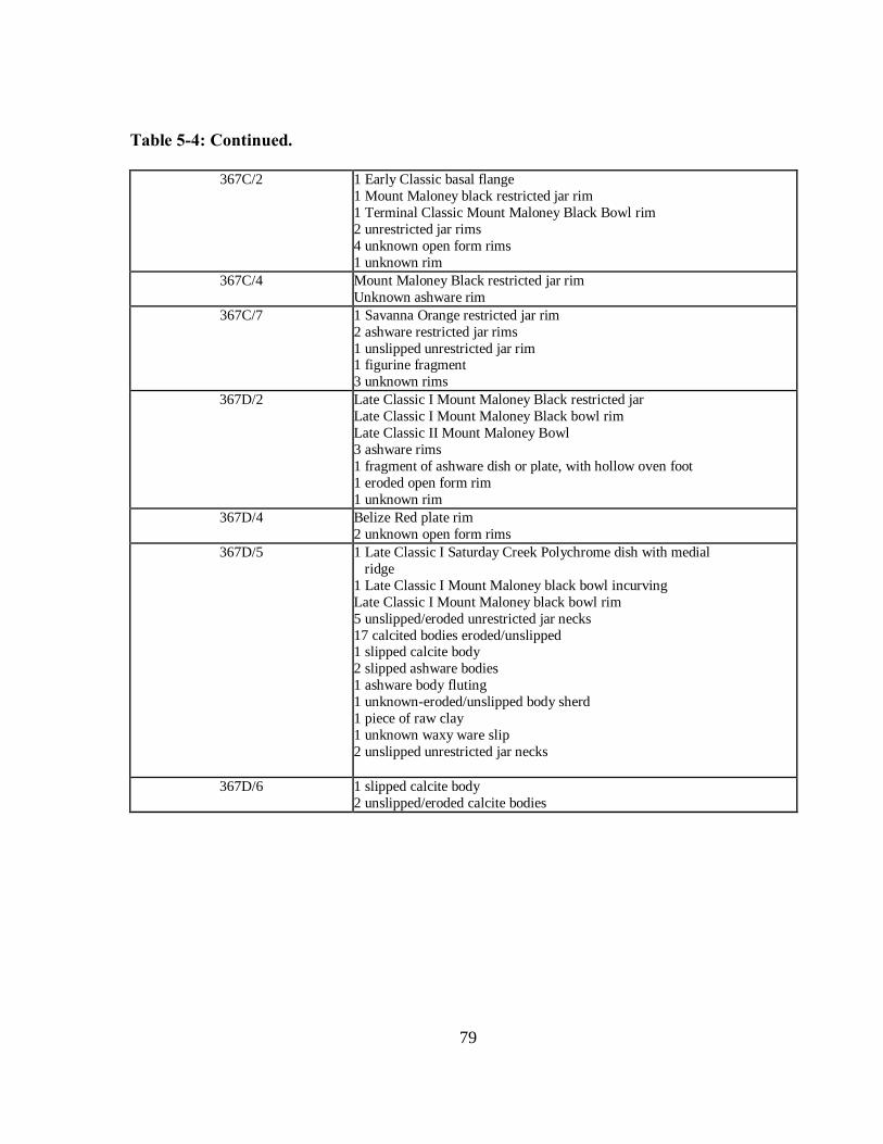
79
Table 5-4: Continued.
367C/2 1 Early Classic basal flange
1 Mount Maloney black restricted jar rim
1 Terminal Classic Mount Maloney Black Bowl rim
2 unrestricted jar rims
4 unknown open form rims
1 unknown rim
367C/4 Mount Maloney Black restricted jar rim
Unknown ashware rim
367C/7 1 Savanna Orange restricted jar rim
2 ashware restricted jar rims
1 unslipped unrestricted jar rim 1 figurine fragment
3 unknown rims
367D/2 Late Classic I Mount Maloney Black restricted jar
Late Classic I Mount Maloney Black bowl rim
Late Classic II Mount Maloney Bowl
3 ashware rims
1 fragment of ashware dish or plate, with hollow oven foot
1 eroded open form rim
1 unknown rim
367D/4 Belize Red plate rim
2 unknown open form rims
367D/5 1 Late Classic I Saturday Creek Polychrome dish with medial
ridge
1 Late Classic I Mount Maloney black bowl incurving
Late Classic I Mount Maloney black bowl rim
5 unslipped/eroded unrestricted jar necks
17 calcited bodies eroded/unslipped 1 slipped calcite body
2 slipped ashware bodies
1 ashware body fluting
1 unknown-eroded/unslipped body sherd
1 piece of raw clay
1 unknown waxy ware slip
2 unslipped unrestricted jar necks
367D/6 1 slipped calcite body
2 unslipped/eroded calcite bodies

80
Table 5-4: Continued.
367E/1 1 unrestricted jar rim
2 unknown rims
367E/2 1 unknown rim (plate, comal, or lid)
2 unknown rims
367F/1 1 large inflaring ashware vase rim
1 restricted jar rim
1 eroded dish rim
1 unrestricted jar rim
1 unknown open form rim
367F/2 1 Savanna Orange bowl rim
1 Platon Punctate dish rim 1 eroded dish rim
3 unrestricted rims
3 unknown rims
367F/3 2 black-on-white vase/bowl fragments, fine paste but not
ashware (Chinos Black on White?)
1 unknown rim
367F/4 1 Late Classic II Chial/Orange Brown
Large fragments of unslipped striated jar(s); very little erosion,
suggesting not redeposited
1 unknown ashware slipped Late-Terminal Classic
1 neck fragment of unslipped unrestricted jar
3 small unknown rims, one with incising
1 eroded restricted jar rim
1 large unslipped unrestricted jar rim
3 unknown/eroded calcite rims 1 unknown/calcite restricted jar rim
3 slipped calcite body sherds
24 calcite unslipped/eroded
5.4.3 Artifact Analysis of Operation 367 in 2011
Following the completion of our 2011 excavations, preliminary analysis was conducted
on the ceramics recovered from Structure 43 (Tables 5-2 and 5-4). Sherds were sorted into rim
and body categories and then counted and weighed by lot. The 2011 excavations produced a
total of 209 rim sherds weighing 5.23 kilograms and 2,991 body sherds weighing 23.82
kilograms.

81
Type-variety and modal analyses were applied by Jason Yaeger to determine the
chronology of the lots. These sherds ranged in date from the Middle Preclassic to the Terminal
Classic but most of the diagnostic ceramic material dated to the Late Classic I and II periods (see
Table 5-4).
Our excavations in Op 367D (Ops 367D/2 through 367D/6) and Op 367F (Op 367F/2
through 367F/4) penetrated the fill of Structure 43. Given the very small volumes of fill
excavated in Op 367 and the small numbers of diagnostics recovered, our chronological
assessment is tentative. The cleanest fill lots are Ops 367D/5, 367D/6 and 367F/4. The
diagnostic sherds from these lots shown in Table 5-4 include many Late Classic I diagnostics,
indicating that the earliest that Structure 43 could have been constructed is during the Late
Classic I period (A.D. 600-670) (the Samal phase in LeCount et al. 2002:42). The presence of a
Late Classic II diagnostic in Op 367F/2 suggests that the structure may date to this later phase,
but the possibility that it was use-related material from the eroded surface of the platform cannot
be discounted. Yaeger (personal communication, 2013) believes that a Late Classic II date is
more likely, given Structure 43’s placement on top of the final plaza floor and the Late Classic II
date of Structure 42, which is in the same stratigraphic position (see below). The material
recovered from PH 1 includes Late Classic II diagnostics as well, and they likely washed in from
the eroding fill of Structure 43. This general conclusion supports the chronological assignment
of Structure 43 by Ball and Taschek (2004:Figure 9.4).
Ops 367B/3 though 367B/7 sample the fill from the hypothesized addition to the west
side of Structure 43. The diagnostics include Late Classic I and Late Classic IIa diagnostics, and
other diagnostic forms that span the Late Classic through Terminal Classic periods. This is
consistent with a date in the Late Classic II or Terminal Classic period.

82
The use of Structure 43 apparently continued into the Terminal Classic period, as
evidenced by the presence of several Terminal Classic sherds in collapse and surficial lots. Of
greatest relevance is Op 367B/2, a scatter of sherds on what we interpret as the sloped surface of
the western addition to Structure 43. This lot includes a large Terminal Classic dish fragment.
Preliminary analysis was conducted by Cap on the Small Finds (Table 5-3). These
included four pieces of obsidian, five bifacially worked chert tool fragments, and six ground
stone fragments. The obsidian blade fragments included two medial sections of prismatic blades
from 367A/2 and 367B/7, one irregular early stage production blade from 367A/1 and one
proximal irregular blade fragment from 367C/2. The bifacially-worked stone tool fragments
included one chert biface fragment found in 367A/5, an almost intact chert biface in 367B/1, two
chert biface fragments both found in 367C/3 and a small chert biface fragment found in 367E/2.
The ground stone assemblage included the distal section and part of the medial section of manos
which were found in 367A/2, the edge of the platform of a metate fragment from 367A/2, and
the partial side of a mano fragment from 367A/3; a celt or adze that had a notch on its side and
the edge and part of the side of a metate were both found in 367D/5 and a probable piece of a
metate but it could also be limestone that was discovered in 367E/1. An in-depth analysis was
not performed on the artifacts recovered in Matthews or Cap’s excavations in 2012.
5.5 Excavations of Operation 367 in 2012.
In 2012, the MVAP opened three sub-operations between Structures 43 and 36 to
determine if there was a physical connection between the two structures and to examine the
defensibility of this point of access into the West Plaza (Figure 5-2). These excavations were
directed by Chris Matthews under the supervision of Bernadette Cap. Although I was not
present for these excavations, these data are directly relevant to my thesis and therefore are

83
included in this study. These sub-operations were located west of Op 367B, overlapping Op
367B somewhat (Figure 5-3).
Operation 367G was a 2 x 2 meter sub-operation placed between Structures 43 and 36 to
examine rocks protruding from the ground surface that suggested the presence of an architectural
feature. Op 367G/1 was dedicated to taking out the humus layer and determining the meaning of
the rocks mentioned previously. Directly beneath the humus layer, numerous limestone rocks
were encountered with a higher density in the northeast and northwest section of the sub-
operation. These rocks were sampled in Op 367G/2 and appeared to be fill from Structure 36.
Excavations continued down in Op 367G/3 to look for a floor surface, but none was encountered.
A large metate fragment and a few pieces of daub were recovered, several of which had paint
present. The daub was probably from a secondary context, which suggests that it was from the
remains of a house located elsewhere that was redeposited here as fill.
Operation 367H was a 2 x 2 meter sub-operation placed south of Op 367G. The goal for
this sub-operation was find the plaza floor and look for possible features. Excavations revealed a
high density of cultural material within the humus layer. which included numerous jute shells.
Beneath the humus, Op 367H/2 contained several interesting artifacts including a large metate
fragment, a carved shell, and a spindle whorl. The higher density of cultural material in Op
367H/2 suggests that this area might have been an area of trash disposal during the final
occupation of the site core, but it could also represent materials washed out of the fill of the
adjacent structures or eroding out of the fill below this lot. One Terminal Classic sherd and one
Late Classic Belize Red sherd were noted in this lot. Additionally, at the base of Op 367H/2, a
circular area of dark matrix appeared in the northwest corner of the sub-operation. As discussed
below, this appears to be a posthole, designated PH 3.

84
Further excavations in Op 367H/3 to Op 367H/6 revealed a line of faced limestone rocks
running east to west designated as FA 4 (Figure 5-3). This facing is in a very unusual position.
Perhaps it was one of the facings for an older structure at the site. It could also have connected
in some way with FA 3 to form a type of structure. With the cobble fill from Op 367B and
367G, this seems like a possibility. However, more excavations are needed to determine what its
actual function was.
Op 367H/7 was dedicated to removing the matrix of PH 3 and to determine its maximum
depth and diameter. A handful of ceramics and 12 pieces of carbon were encountered within the
matrix of the PH 3. The posthole feature measured approximately 10 centimeters in diameter
and was approximately 63 centimeters in depth (Figure 5-11). As evidenced in the figure, PH 3
seems to taper quite dramatically as it continued deeper. Perhaps this was caused by the post
being moved around before it was burned. A large rock was uncovered at its lowest point
perhaps a footer upon which the post originally occupied the hole was seated. The burning of the
post is evidenced by the many charcoal samples discovered with the posthole. PH 1 and PH 3
they seem to be in a direct line with Structure 43 which furthers the hypothesis that Structure 43
and its surrounding area was a defensive feature (Figure 5-3).

85
Figure 5-11: Operation 367H, plan showing location of PH 3 and profile of half-section of
PH 3 looking west.

86
Op 367H/8 was another 1 x 1 meter area excavated in the northeast portion of the sub-
operation to search for additional postholes and to gain a better understanding of FA 4.
Unfortunately, excavators did not encounter a second posthole or more of the facing. This
indicates that the facing had an east-west orientation. In this lot, smaller stones were found that
appeared to be cobblestone fill of the facing. Op 367H/9 to 367H/12 further exposed FA 4 and
Op 367H/11 exposed portions of the plaza floor in the southeast section of the sub-operation.
This floor most likely ran underneath FA 4 similar to the floor in Op 367A. However, since no
penetrating excavations were conducted, it is difficult to tell whether this floor ran underneath or
abutted against FA 4. It should be noted that this floor was 36 centimeters lower than the floor in
Op 367A indicating that they are not the same surface.
Operation 367I was opened up to determine if FA 4 continued east from Op 367H and
whether there were any more postholes. In Op 367I/1, excavators removed the humus layer and
defined the area previously excavated as Op 367B in the northeast corner of the unit. The
backfill from this unit was excavated as Op 367I/2. Since the matrix was backfill from a
previously excavated sub-operation, it was not screened.
While continuing below the humus layer in Op 367I/3, another posthole was encountered
(PH 4 in Figure 5-3). Op 367I/4 was located around PH 4 and excavated the matrix within it
which exhibited a high density of ceramic material and only a small number of lithics. PH 4 was
much smaller than PH 3, measuring only approximately 20 centimeters deep and 20 centimeters
in diameter (see Figure 5-12). Furthermore, very little carbon material was found within the
matrix; only one carbon sample was taken from PH 4.

87
Figure 5-12: Operation 367I, plan showing PH 4 and profile of half-section of PH 4 facing
east.

88
Op 367I/5 and 367I/6 were excavated to determine if FA 4 from Op 367H extended any
farther into Op 367I and to search for other postholes. Unfortunately, the facing did not continue
and no additional postholes were encountered.
5.6 Excavations of Operation 371 in 2012
Structure 42 is located approximately 5 meters east of Structure 36, the eastern building
of the palace complex and approximately 20 meters south of Structure 43 (Figure 5-2). It is
oriented east west, 24.5 meters long, and 5 meters wide, and it is roughly 50 centimeters tall. It
is orientated west to east. The map by Ball and Taschek, (Figure 5-1) has the structure oriented
northwest to southeast, however, once it was cleared and examined closely by the MVAP, it was
determined to be orientated east to west (Jason Yaeger, personal communication 2013). Several
sub-operations included penetrating excavations to reveal the architectural stratigraphy of the
area and obtain fill for dating purposed.
The first known construction of Structure 42 was a low platform built directly on top of
the final plastered surface of the West Plaza. It rises from the plaza surface in a single facing,
without terraces or documented steps. The plastered plaza surface runs under the facings of
Structure 42, and probing excavations documented that it extends under the platform’s fill,
showing definitively that Structure 42 post-dates the plaza surface. The top of the in situ fill of
Structure 42 lay just under the modern ground surface, capped by a very thin layer of humus.
The presence of a Late Classic II Mount Maloney Black bowl fragment in the fill of Structure 42
(Op 371A/4) provides the earliest possible date for its construction and the most likely date for
its construction (Yaeger personal communication 2013).

89
The construction of Structure 42 left a narrow alley, approximately 2 m wide, between
the platform’s western face and the eastern face of Structure 36. This alley was later modified in
two ways. First, the west face of Structure 42 was partially dismantled and a posthole (PH 5)
was intruded through the facing. Excavated as Op 371A/7, PH 5 was quite shallow (Figure 5-
13), similar to PH 4 that was found in Op 367I. PH 5 contained some large cobbles along the
edges of where the post would have been and was similar to the posthole discovered in Op 371D
(PH 6, described below). Cap inferred that PH 5 was probably intrusive into the initial
construction of the structure based on stratigraphy (personal communication, 2013). The finding
of charcoal in the posthole suggests that the post in it may have burned, but there was not as
much charcoal in PH 5 or PH 6 as there was in PH 1.

90
Figure 5-13: Operation 371A, plan showing PH 5 and profile of half-section of PH 5 facing
east.
91
PH 6 was found in Op 371D, which was placed to understand the relationship between
Structures 42 and 36. PH 6 was excavated as Op 371D/4. Like PH 5, it was lined with small
pebbles all around where the post would have been (Figure 5-14). It appeared to be intrusive to
plaster and ballast layers of the plaza surface (Cap, personal communication, 2013). PH 6 had
dark (2.5YR3/2) matrix, but no visible charcoal. PH 6 is located 1 meter southwest of PH 5;
they are not aligned with the axis of Structure 43.

92
Figure 5-14: Operation 371D, plan showing PH 6 and profile of half-section of PH6 facing
east.
93
The alley between Structures 42 and 36 was later filled in, as evidenced by the cobble fill
above the alley’s plastered surface, the dismantling of the west face of Structure 42 and the east
face of Structure 36, and the presence of small patches of ballast at 20 cm above the plaza
surface, just below the modern ground surface. Cap and Yaeger (personal communication, 2013)
interpret these as a poorly preserved floor, presumably plastered, that sat atop the fill in the alley.
This fill episode apparently was not restricted to the alley. Despite careful excavation,
Cap found no facing between the northwest corner of Structure 42 and the east face of Structure
36 that would demarcate and retain the fill in the alley. That fact, coupled with indications that
the intermittent surface on top of the alley fill mentioned above seemed to slope downward
toward the north, suggests that the alley was filled in as part of a larger remodeling of Structure
42 that changed its northern face into a ramp.
The presence of burned pieces of limestone and charcoal in the fill that filled in the alley
corroborates the inference that the earlier version of Structure 42 was burned, as indicated by the
charcoal on the alley surface, mentioned above. These burned stones are likely recycled from
the burned facings of Structures 42 and 36. They could be evidence of a termination ritual
and/or an attack against the site (Cap, field notes, 2012).
The relationship between PH 5 and PH 6 is an important question. It is unclear whether
they were part of a single construction of some kind, or placed at different times. Both are
intrusive to the plaza surface, but Yaeger (2013 personal communication) thinks it is likely that
PH 6 was associated with the plastered alley, and PH 5 was placed when the alley was filled.
Charcoal found associated with the plastered surface of the alley in Ops 371A and 371D suggests
that at least one of the posts burned while they alley was open. The fact that PH 5 was placed
intrusively through the west face of Structure 42 and the masonry facing of the structure was

94
partially dismantled suggests that it occurred at the time when the west face was going to be
covered with the fill episode that covered the alley, effectively extending the west side of
Structure 42 west to join the east face of Structure 36. This suggests that PH 5 was associated
with the final version of Structure 42, and PH 6 with the initial version of the structure.
5.7 Summary of Excavations
The excavations conducted by myself, Bernadette Cap, and Chris Matthews on and
around Structures 36, 42 and 43 answered many of the questions that we had about these
structures. However, even as many questions were answered, more became apparent with the
plethora of information we collected from each individual sub-operation, and some individual
lots even proved to be difficult to understand. In the next chapter, I will provide some
interpretations on these and some of the other findings from our excavations in the West Plaza of
Buenavista del Cayo. I will also attempt to provide some comments on the form and use of
Structures 42 and 43 and their possible combined use as a defensive feature.
95
CHAPTER 6: INTERPRETATIONS AND DISCUSSION
This chapter provides some preliminary interpretations and a discussion of all of the data
recovered from Operations 367 and 371 during the 2011 and 2012 seasons in order to address the
research objectives stated in the first chapter. First, I wanted to determine the form of the
structure through horizontal excavation. Second, I wanted to better understand the function of
the structure. I planned to interpret the function of the building through the analysis of its form,
features present, and associated artifacts. Unfortunately, no primary deposits were discovered in
association with these structures, so the artifact assemblages cannot help in my interpretations.
The final goal for the investigations of Structure 43 was to place this structure in the
chronological context of the site.
6.1 Architectural Histories of Structures 42 and 43
The investigations of Structures 42 and 43 have provided sufficient data to make
interpretation about their form and construction histories. From my excavations in 2011, we
discovered that there was a well preserved plaster floor that ran underneath Structure 43,
indicating that the structure was a later addition to the West Plaza. Structure 43 was
approximately 40 meters long, by 7 meters wide and 60 centimeters tall in its final form. Our
penetrating excavations in Op 367D revealed a possible southward facing (line of stones) along
its north wall indicating a possible earlier construction episode. We were unable to further
investigate this earlier construction episode due to time constraints.
The fill of Structure 43 was probably refuse gathered up from surrounding house mounds
for use as fill, as is indicated by the random pieces of obsidian, chert bifaces, manos and metates.
The platform’s masonry consisted mostly of roughly shaped lime stone blocks, some more nicely
cut than others, such as one large faced stone that formed the southwest corner of the structure

96
(FA 1; Figure 5-3, 5-4). Additionally, in Op 367D, we encountered several finely faced and
stacked stones as well (FA 5; Figure 5-8). The variability in quality of masonry blocks suggests
that the builders may have reused construction materials from other buildings.
In Op 367C we encountered a facing that faced east and may have been a different
building. We also encountered some other eastward facing stones to the southwest of Structure
43. These two large faced stones (FA 3) were located above the plaza floor surface as well
possibly indicative of a step up into the area and/or another building off the western side of
Structure 43.
An additional stone facing (FA 4) was encountered in Ops 367H and 367I and was
constructed of rough limestone blocks. This facing may have been related to FA 3 which further
supports the notion of a building off of the western side of Structure 43. We encountered a
plaster floor south of FA 4, however, it is unclear if the floor continued under FA 4.
A series of postholes were found within the 2011 and 2012 field seasons. We
encountered the first posthole (PH 1) in Op 367A. PH 1 appears to have been intrusive into
Structure 43 (Figure 5-4). A second, and smaller posthole (PH 2) was encountered in Op 367E,
in the possible appended platform located to the west side of Structure 43. A third posthole (PH
3), discovered by Matthews in Op 367H, was located north of FA 4. The fourth (PH 4) was
discovered near Structure 43 in Op 367I towards the east. This posthole penetrates FA 4
indicating that it was placed after the construction of this facing possibly at the same time as PH
3. This posthole, however, was smaller in diameter, more similar in size to PH 2.
The two larger postholes, PH 1 and PH 3, may represent the remains of support posts of a
palisade. Although more data is necessary to fully understand the nature of these features,
several important observations can be made. First, PH 1 and PH 3 are aligned with the south

97
face of Structure 43. Second, both have roughly the same dimensions. Third, it is clear that
these large posts were erected after the construction of Structure 43 as PH 1 penetrates into, and
partially dismantles, the south facing of the structure. Finally, both postholes exhibited evidence
of severe burning.
The variability in size between the larger postholes, PH 1 and PH 3, and the smaller
postholes PH 2 and PH 4, is interesting. It is unclear how these two sets of posts are related, but
they do seem to be associated. Perhaps the smaller posts form some type of appended or
ancillary features related to the larger wooden palisade.
Ceramic data have provided a preliminary chronology for Structure 43. Although the
ceramic sample from the structure is small, diagnostic sherds from structural fill indicate a Late
Classic II date (see Chapter 5 for more details). We did not conduct any penetrating excavations
beneath the plaza floor underlying Structure 43. The structure was constructed above the plaza
floor surface and therefore, the plaza surface is earlier in date. Future excavations are planned to
gain a better understanding of the chronology of this plaza floor. The chronology of the
postholes has proven to be more difficult to define. The postholes post date the construction of
Structure 43 (Late Classic II or later), however, how much later is unknown at this time. We
plan to analyze the carbon recovered from PH 1 and PH 3 to better refine the chronology.
Although, it must be noted that dates from these features will correspond to the cutting of the
trees and not necessarily the erection or destruction of the wooden feature. Therefore we must
use caution in attempting a chronological assessment for the postholes.
In Cap’s excavations in 2012, she discovered that there had been a series of plaster floors
in the West Plaza (Figure 6-1). Additionally, excavations revealed that the final plaza floor
extended underneath Structure 42, indicating that it, like Structure 43, was built late in the

98
construction history of the West Plaza. Structure 42 is located approximately 13 meters to the
south of Structure 43 (Figure 5-2). It was approximately 24.5 meters long by 7 meters wide and
was approximately 50 centimeters in height.

99
Figure 6-1: Operation 371F & D North Wall Profile

100
Structure 42 is quite similar to Structure 43 in many ways. It is quite long, relative to its
width and quite low. It is a simple platform without terraces or steps. Similar to Structure 43,
Structure’s 42 fill was probably refuse from surrounding house mounds due to the high
frequency of domestic debris within the construction fill. Finally, its masonry also consisted of
both rough and nicely faced stones. Also, as noted above, both were built on top of the final
surface of the West Plaza
When Structure 42 was initially constructed above the final plaza surface, there was an
alley way between Structure 42‘s western face and the eastern face of Structure 36. Structure 42
was later modified in two important ways. First, Structure 42’s western face was partially
dismantled and a post (PH 5) was placed into the facing in Op 371A, a pattern identical to the
placement of PH 1 through FA 1 in Op 367A. The discovery of charcoal within the posthole
indicates that it was burned in antiquity. Second, the alley was later filled in as evidenced by the
cobble fill above the alley’s plastered surface. Essentially, Structure 42 was extended to abut
Structure 36. This fill episode was not limited to the alley as there was no evidence of a facing
to act as a barrier for the fill in between Structures 42 and 36. Instead, it seems that this fill also
extended towards the north which suggests a larger remodeling of Structure 42. The fill that
extended towards the north sloped downward forming a ramp-like feature or access way. It is
unclear from our excavations as to the function of this sloping ramp. The post that was placed
into the facing of Structure 43 (PH 5) appears to have been a part of this remodeling episode
Excavations in the alley revealed another posthole (PH 6) that most likely pre-dates PH 5.
This posthole was set in the alley and was also burned in antiquity. The in-filling of the alley
appears to have covered this posthole, therefore, stratigraphically this feature is earlier than PH
5.

101
Preliminary ceramic analysis suggests that Structure 42 dates to the Late Classic II and is
contemporaneous with Structure 43. The chronology of the postholes and the burning episode
along the western face of Structure 42 is more difficult to define. As discussed above, PH 6 pre-
dates PH 5 and may date to the Late Classic II since it pre-dates the remodeling episode. PH 5
clearly post-dates the original version of Structure 42 and appears to date to the remodeling of
the platform (later in the Late Classic II phase or possible Terminal Classic).
6.2 Evaluation of Structures 42 and 43 as Defensive Features
The ways in which Structures 42 and 43 were constructed within the layout of the West
Plaza at Buenavista del Cayo is suggestive of a defensive feature or features. Both structures
were built on top of the final plastered plaza surface and were constructed using both rough and
finely cut stones. Although both platforms were formal structures, the labor invested in
construction materials appears to have been minimal. Additionally, the positioning of both
structures on the northern side of the West Plaza is important. This portion of the plaza was
likely not formally bounded by architecture prior to the construction of Structure 43. Its
construction and the placement of Structure 42 would have shored up the northern entrance into
the site during the Late Classic II, an apparent time of increased conflict in the Belize River
valley. In addition, the postholes are suggestive of a palisade-like feature. At least some of these
postholes were placed into the facing of the structures and post-date their construction. This
suggests that the platforms were first constructed originally and were further modified with the
erection of a wooden palisade-like feature.
The data from Structures 42 and 43 provide strong evidence of the escalation of warfare
and conflict during the Late Classic II. Furthermore, the burning of the posts is intriguing and
may be indicative of warfare activities. Excavations documented at least two episodes of burning

102
that may be evidence of desecratory termination events related to warfare (Brown and Garber
2003; Stanton and Brown 2003). The first of these is the burning of a post (PH 6) placed in the
alley between Structure 42 and Structure 36. Evidence of this burning episode was also
encountered in the form of charcoal and burned facing stones in the alley west of Structure 42.
Following this event, as discussed above, the alley way was filled in and Structure 42 was
modified with the addition of at least one post placed in the platform facing. This posthole
exhibited evidence of burning suggesting that this later wooden feature was burned as well. The
burning of this final phase of Structure 42 could correspond with the burning event on Structure
43 (as evidence by the charcoal and ash in PH 1 and PH 3). Although speculative without
further data, this burning event might represent one of the final acts at the site of Buenavista.
When Structures 42 and 43 are compared with known defensive features in the Maya
lowlands, several interesting observations can be made. First, although Structures 42 and 43 are
a later addition to the formal architecture in the West Plaza, they do not appear to have been
constructed in a hurried fashion such as the defensive walls seen at Dos Pilas (Demarest et al.
1997). Second, since they were a relatively late construction project, they were not part of the
original site plan as we see with the massive wall surrounding El Mirador (Dahlin 1984). This
might suggest an increased need for protection during the Late Classic II period. I would suggest
that these structures were constructed in a similar manner as the defensive features seen at
Aguateca, not constructed in a hurried fashion, but also not built centuries before the collapse of
the city (Inomata 2008). Lastly, the possible palisade feature was erected later than the platforms
and was intrusive into the facings of both structures. This suggests a need for increased
protection and may, in fact, be more similar to the Dos Pilas final wooden defensive features

103
(Brown personal communication 2013). Below, I discuss each of these examples in more detail
to contextualize the data from Buenavista del Cayo.
The defensive features from these other sites provide examples to compare and contrast
with the possible defensive feature at Buenavista del Cayo. At the site of Dos Pilas, the need for
a defensive feature was so great that some of the buildings were stripped of their stone facings in
order to construct a crudely built defensive wall. In contrast, even though Structures 42 and 43
were constructed atop the final plaster surface, their masonry is formal and they contained fill
brought in from beyond the site core’s boundary. Without further excavations, we cannot
determine whether surrounding buildings were stripped of their stones to create these structures
(except for possibly Structure 36 in the construction of Structure 42; see Chapter 5), but the
masonry and form of Structure 42 and 43 are quite different from the hurriedly stacked walls at
Dos Pilas.
As mentioned above, the later erection of a possible wooden palisade, may, however,
suggest an increased need to further secure the site. However, it is difficult to assess if this
addition was constructed rapidly or not. It is intriguing that the placement of at least two of the
Buenavista posts was in the facings of Structures 42 and 43 suggesting that aesthetics were not a
priority. Further work at Buenavista de Cayo is necessary to shed light on this issue.
The site of El Mirador exhibits one of the largest defensive features in the Maya lowlands
(Dahlin 1984). Even though Structures 42 and 43 did not contain even a fraction of the mass of
the defensive feature at El Mirador, this example is useful for contrasting purposes. El Mirador’s
wall was constructed early in the sites history and was probably well maintained due to its
relative size today. Conversely, since Structures 42 and 43 were constructed atop the final plaza
surface, we know that they were built late in the site’s history. Thus, it may be that the earlier

104
periods of the site’s history were less violent. Nonetheless, it appears that conflict was
increasing during the Late Classic II in the Belize River valley at around the time of the
construction of Structures 42 and 43.
As mentioned above, the site of Aguateca offers us, perhaps, the closest comparison to
Structures 42 and 43. Demarest and his colleagues (1997:238) mention that not only were these
defensive features planned and constructed with rough cut stone blocks of limestone and posts,
they were also constructed to utilize the defensibility of the site to their upmost advantage. This
construction plan can be seen at Buenavista del Cayo as well with the construction of Structures
42 and 43 in an area that provided relatively unrestricted access to anyone coming into the site
core from the north (Figure 5-1). From the data at hand, I argue that the construction of
Structures 42 and 43 was a planned effort to shore up the northern edge of the site and to place
them near existing buildings (perhaps with Structure 42 abutting against Structure 36).
The positioning of Structures 42 and 43 relative to one another in the West Plaza,
coupled with the possible palisade wall on each suggests the form of either a “killing alley” or a
“simple baffled gateway” (Demarest et al. 1997:234-5; Keeley et al. 2007:62-3). If these
structures did actually form either a killing alley or a baffled gateway, it would be one of only a
few examples in the Maya lowlands (see Chapter 4 for details related to Dos Pilas and Quim Chi
Hilan). Therefore, further investigations of these two platforms are necessary to fully document
and understand the nature of this defensive feature.
6.3 Contributions to Maya Archaeology and Warfare
The archaeological data from Structures 42 and 43, collected during the 2011 and 2012
field seasons contribute to our understanding of defensive features in the Maya lowlands and
more broadly, to warfare patterns in general. At a regional level, the evidence from Buenavista
105
del Cayo sheds light on conflict within the Belize River valley. The defensive feature at the site
should be examined in light of the shifting political dynamics during the Late Classic. It is
important to note that the nearby site of Xunantunich appears to have been conquered by the
Naranjo polity during the Late Classic II (LeCount and Yaeger 2010). Additionally, excavations
by the Mopan-Macal Triangle Project (directed by Joseph Ball and Jennifer Taschek) uncovered
a cylinder-vase in an elite burial at Buenavista del Cayo that named the king of Naranjo. It has
been suggested that the king of the more powerful Naranjo polity gave this vessel to a lord from
Buenavista early in the Late Classic II, possibly as an alliance building gesture (Ball and Taschek
1992). During this time, Naranjo was attempting to control the valley through its satellite site of
Xunantunich. However, after ca A.D. 750, Xunantunich overthrew the Naranjo leadership and
became an autonomous polity (LeCount and Yaeger 2010). Conflict may have increased in the
valley at this time (Connell and Silverstein 2006:402-3). Elsewhere in the Maya lowlands, there
was an increase in economic and political competition which resulted in increased warfare
(Webster 1999:336). This escalation of warfare may have stimulated the construction of
defensive features in many lowland Maya sites (see Demarest et al. 1997; Golden et al. 2008;
Inomata 2008 Palka and Escobedo 1997; Tuerenhout 1996) including the defensive feature from
Buenavista.

106
REFERENCES
Aimers, James J.
2007 What Maya Collapse? Terminal Classic Variation in the Maya Lowlands. Journal
of Archaeological Research 16(4):329-377.
Ambrosino, James N, with Traci Ardren and Travis W. Stanton
2003 The History of Warfare at Yaxuná. In Ancient Mesoamerican Warfare. M.
Kathryn Brown and Travis W. Stanton, eds. Pp. 109-23. Altamira Press, Walnut
Creek, CA.
Anderson, A. H.
1952 Archaeology in British Honduras today. Proceedings of the Thirtieth International
Congress of Americanists. Pp. 32-35. London.
Andrews, Anthony P., with E. Wyllys Andrews, and Fernando Robles Castellanos
2003 The Northern Maya Collapse and its Aftermath. Ancient Mesoamerica 14:151-
156.
Aoyama, Kazuo
2005 Classic Maya Warfare and Weapons: Spear, Dart and Arrow Points of Aguateca
and Copan. Ancient Mesoamerica 16:291-304.
Armillas, Pedro
1948 A Sequence of Cultural Development in Meso-America. Memoirs of the Society
for American Archaeology: A Reprisal of Peruvian Archaeology. 4:105-11.
1951 Mesoamerican Fortifications. Antiquity 25: 77-86.
Ashmore, Wendy
2010 Antecedents, Allies, Antagonists: Xunantunich and its Neighbors. In Classic
Provincial Politics: Xunantunich and Its Hinterlands. Lisa J. LeCount and Jason
Yaeger, eds. Pp. 46-64. Tucson: The University of Arizona Press.
Awe, Jaime
2008 Ancient Maya Territorial Organization of Central Belize: Confluence of
Archaeological and Epigraphic Data. Mayab 20:65-91.
Awe, Jaime, with Cassandra Bill, Mark Campbell and David Cheetham
1990 Early Middle Formative Occupation in the Central Maya Lowlands: Recent
Evidence from Cahal Pech, Belize. Institute of Archaeology Papers 1:1-6.
University College, London.

107
Ball, Joseph W.
1993 Cahal Pech, the Ancient Maya, and Modern Belize: The Story of an
Archaeological Park. San Diego State University Press.
Ball, Joseph and Jennifer T. Taschek
1987 Rural Community Structure in the Late Classic Maya Lowlands. Proposal
submitted to the National Science Foundation, January 1987.
1988 Settlement System and Community Organization in a Classic Maya Realm: The
1988-90 SDSU Mopan-Macal Triangle Archaeological Project. Preliminary
Interim Report submitted to the National Science Foundation.
1990 Settlement System and Community Organization in a Classic Maya Realm: The
1988-90 SDSU Mopan-Macal Triangle Archaeological Project. Preliminary
Interim Report No. 2, submitted to the National Science Foundation.
1991 Late Classic Lowland Maya Political Organization and Central-Place Analysis:
New Insights from the Upper Belize Valley. Ancient Mesoamerica 2:149-65.
2004 Buenavista del Cayo: A Short Outline of Occupational and Cultural History at an
Upper Belize Valley Regal-Ritual Center. In The Ancient Maya of the Belize
Valley: Half a Century of Archaeological Research. James F. Garber, ed. Pp.
149-167. Gainesville: The University Press of Florida.
Barrett, Jason W. and Andrew K. Scherer
2005 Stones Bones and Crowded Plazas: Evidence for Terminal Classic Maya Warfare
at Colha, Belize. Ancient Mesoamerica 16:101-18.
Becker, Marshall J.
1979 Priests, Peasants, and Ceremonial Centers: The Intellectual History of a Model. In
Maya Archaeology and Ethnohistory. Norman Hammond and Gordon R. Willey,
eds. Pp. 3-20. Austin: University of Texas Press.
Bey, George J. III
2003 The Role of Ceramics in the Study of Conflict in Maya Archaeology. In Ancient
Mesoamerican Warfare. M. Kathryn Brown and Travis W. Stanton, eds. Pp.
19-29. Altamira Press, Walnut Creek, CA.
Birchall, C. J., and R. N. Jenkin
1979 The Soils of the Belize Valley, Belize. Supplementary Report No.15. Overseas
Development Administration, Land Resources Development Centre, Surbiton,
England.
Boot, E.
2002 The Dos Pilas-Tikal Wars from the perspective of Dos Pilas Hieroglyphic

108
Stairway 4. Mesoweb.
Borgstede, Greg, and James R. Mathieu
2007 Defensibility and Settlement Patterns in the Guatemalan Highlands. Latin
American Antiquity 18:191-211.
Bricker, Victoria R.
1995 Advances in Maya Epigraphy. Annual Review of Anthropology 24:215-235.
Brown, M. Kathryn and James F. Garber
2003 Evidence of Conflict during the Middle Formative in the Maya Lowlands: A
View from Blackman Eddy, Belize. In Ancient Mesoamerican Warfare, M.
Kathryn Brown and Travis W. Stanton, eds. Pp. 91-108. Altamira Press, Walnut
Creek, CA.
Brown, M. Kathryn, Jennifer Cochran, Leah McCurdy, and David Mixter
2011 Preceramic to Postclassic: A Brief Synthesis of the Occupation History of Group
E, Xunantunich. Research Reports in Belizean Archaeology 8:209-219. Institute
of Archaeology, NICH, Belize.
Bullard, William R.
1960 Maya Settlement Pattern in Northeaster Petén, Guatemala. American Antiquity
25(3):355-72.
Cap, Bernadette
2007 Investigations in Buenavista del Cayo’s East Plaza. In The Mopan Valley
Archaeological Project: Results of the 2007 Season. Jason Yaeger, ed. Pp. 44-60.
Report submitted to the Belize Institute of Archaeology: Belmopan, Belize.
Canuto, Marcello
2009 Middle Preclassic Maya Society: Quixotic Tilting at Windmills or Giants of
Civilization? In Early Maya States. Robert J. Sharer and Loa P. Traxler, eds. Pp.
1-35. Philadelphia: University of Pennsylvania Press.
Carneiro, Robert L.
1970 A Theory of the Origin of the State. Science 169:733-9.
Carroll, B. A. and C. F. Fink
1975 Theories of war causation: a matrix for analysis. In War, Its Causes and
Correlates. Martin A. Nettleship, R. Dale Givens and Anderson Nettleship, eds.
Pp. 55-72. Hague and Paris: Mouton.
Chase, Arlen F. and Diane Z. Chase
1989 The Investigation of Classic Period Maya Warfare at Caracol, Belize. Mayab
5:5-18.

109
1998 Late Classic Maya Political Structure, Polity Size, and Warfare Arenas. In
Anatomia de una Civilizacion: Aproximaciones Interdisciplinarias a la Cultura
Maya. Andres Ciudad Ruiz et al., eds. Pp. 11-29. Socieadad Espanola de Estudios
Maya, Madrid.
2003a Forward. In The Ancient Maya of the Belize Valley: Half a Century of
Archaeological Research. James F. Garber ed. Pp. xix-xx. Gainesville: The
University Press of Florida.
2003b Texts and Contexts in Maya Warfare: A Brief Consideration of Epigraphy an
Archaeology at Caracol, Belize. In Ancient Mesoamerican Warfare. M. Kathryn
Brown and Travis W. Stanton eds. Pp. 171-88. Altamira Press, Walnut Creek,
CA.
Chase, Diane Z. and Arlen F. Chase
2002 Classic Maya Warfare and Settlement Archaeology at Caracol, Belize. Estudios
de Cultura Maya 23:33-51.
Chase, Arlen F., Diane Z. Chase and Rafael Cobos
2008 Maya Hieroglyphs and Maya Archaeology: Collusion or Collision? Mayab
20:5-21.
Chase, Arlen F. and James F. Garber
2004 The Archaeology of the Belize Valley in Historical Perspective. In The Ancient
Maya of the Belize Valley: Half a Century of Archaeological Research. James F.
Garber ed. Pp. 1-14. Gainesville: The University Press of Florida.
Ciofalo, Andrew W.
2012 Maya Use and Prevalence of the Atlatl: Projectile Point Classification Function
Analysis from Chichén Itzá, Tikal and Caracol. M.A. Thesis, Department of
Anthropology, University of Central Florida.
Cochran, Jennifer L.
2009 A Diachronic Perspective of Marine Shell use from Structure B1 at Blackman
Eddy, Belize. M.A. Thesis, Department of Anthropology, University of Texas at
Arlington.
Coe, Michael D.
1962 Mexico. New York: Frederick A. Praeger.
2011 The Maya. London: Thames and Hudson.
Cohen, Ronald.
1984 Warfare and State Formation: Wars Make States and States Make Wars. In
Warfare, Culture and Environment. R. V. Ferguson ed. Pp. 329-358. New York:

110
Academic Press.
Connell, Samuel V. and Jay E. Silverstein
2006 From Laos to Mesoamerica: Battlegrounds between Superpowers. In The
Archaeology of Warfare: Prehistories of Raiding and Conquest. Elizabeth N.
Arkush and Mark W. Allen eds. Pp. 395-433. Gainesville: University Press of
Florida.
Dahlin, Bruce H.
1984 A Colossus in Guatemala: the Preclassic City of El Mirador. Archaeology
37:18-25.
2000 The Barricade and Abandonment of Chunchucmil: Implications for Northern
Maya Warfare. Latin American Antiquity 11:283-298.
Demarest, Arthur
1977 Regional Patterning of Lowland Classic Fortifications: The ‘Situational Ethics‘
of Maya Warfare. Middle American Archaeology 211:1-75.
2004 Ancient Maya: The Rise and Fall of a Rainforest Civilization. United Kingdom:
University of Cambridge Press.
Demarest, Arthur A., Matt O'Mansky, Claudia Wolley, Dirk Van Turenhout, Takeshi Inomata, J.
Palka & H. Escobedo.
1997 Classic Maya Defensive Systems and Warfare in the Petexbatun Region. Ancient
Mesoamerica 8:229-53.
Divale, W. T. and M. Harris
1976 Population, warfare and the male supremacist complex. American Anthropology
78:521-38.
Elliott, Michelle
2005 Evaluation Evidence for Warfare and Environmental Stress in Settlement Pattern
Data from the Malpaso Valley, Zacatecas, Mexico. Journal of Anthropological
Archaeology 24:297-15.
Estrada-Belli, Francisco
2011 The First Maya Civilization: Ritual and Power Before the Classic Period.
Routledge: New York.
Fash, William L.
1994 Changing Perspectives on Maya Civilization. Annual Review of Anthropology
23:181-208.

111
Fedick, Scott L.
1995 Land Evaluation and Ancient Maya land use in the Upper Belize River Area,
Belize, Central America. Latin American Antiquity 6(1):16-34.
Ford, Anabel
2004 Integration among Communities, Center and Regions: The Case from El Pilar. In
The Ancient Maya of the Belize Valley: Half a Century of Archaeological
Research. James F. Garber ed. Pp. 238-256. Gainesville: The University Press of
Florida.
Ford, Anabel and Scott Fedick
1992 Prehistoric Maya Settlement Patterns in the Upper Belize River Area: Initial
Results of the Belize River Archaeological Settlement Survey. Journal of Field
Archaeology 19:35-49.
Freidel, David
1979 Culture Areas and Interaction Spheres: Contrasting Approaches to the
Emergence of Civilization in the Maya Lowlands. American Antiquity 44
(1):36-54.
1995 Centering the World. In Maya Cosmos: Three Thousand Years on the Shaman’s
Path. David Freidel, Linda Schele and Joy Parker eds. Pp. 123-172. New York:
HarperCollins.
n.d. Maya Warfare, Myth and Reality. Electronic Document,
http://maya.csueastbay.edu/yaxuna/warfare.html, accessed October 16, 2012.
Freidel, David and Linda Schele
1988 Kingship in the Late Preclassic Lowlands: The Instruments and Places of Ritual
Power. American Anthropologist 90(3):547-567.
Freidel, David A., Kathryn Reese-Taylor and David Mora-Marín
2002 The Origins of Maya Civilization: The Old Shell Game, Commodity, Treasure
and Kingship. In Ancient Maya Political Economies. Marilyn A. Masson and
David A. Freidel eds. Pp. 41-86. Altamira Press: Walnut Creek, CA.
Fried, Morton H.
1961 Warfare, Military Organization, and the Evolution of Society. Anthropologica
3(2):134-147.
Gann, Thomas F.
1893-5 On the exploration of two mounds in British Honduras. Proceedings of the
Society of Antiquaries of London 15:430-34.
1897-8 Mounds in Northern Honduras. Nineteenth Annual Report of the Bureau of

112
American Ethnology to the Secretary of the Smithsonian Institution. Part 2.
Government Printing Office: Washington 1900.
1925 Mystery Cities. New York: Charles Scribners.
Garber, James F.
2004 The Ancient Maya of the Belize Valley: Half a Century of Archaeological
Research. Gainesville: The University Press of Florida.
Garber, James F., M. Kathryn Brown, W. David Driver, David M. Glassman, Christopher J.
Hartman, F. Kent Reilly III, and Lauren A. Sullivan
2004 Archaeological Investigations at Blackman Eddy. In The Ancient Maya of the
Belize Valley: Half a Century of Archaeological Research. James F. Garber ed.
Pp. 48-69. Gainesville: The University Press of Florida.
Golden, Charles W.
2003 The Politics of Warfare in the Usumacinta Basin: La Pasadita and the Realm of
Bird Jaguar. In Ancient Mesoamerican Warfare. M. Kathryn Brown and Travis
W. Stanton eds. Pp. 31-48. Altamira Press, Walnut Creek, CA.
Golden, Charles W., Andrew K. Scherer & A. Rene Muñoz.
2005 Exploring the Piedras Negras-Yaxchilán Border Zone: Archaeological
Investigations in the Sierra del Lacandón, 2004. Mexicon XXVII(1):11-16.
Golden, Charles W. and Andrew K. Scherer
2006 Border Problems: Recent Archaeological Research along the Usumacinta River.
PARI Journal 7(2):1-16.
Golden, Charles W., Andrew K. Scherer, A. Rene Muñoz & Rosaura Vasquez
2008 Piedras Negras and Yaxchilán: Divergent Political Trajectories in Adjacent Maya
Polities. Latin American Antiquity 19(3):249-274.
Gorenstein, Shirley
1973 Tepexi el Viejo: A Postclassic Fortified Site in the Mixteca-Puebla Region of
Mexico. Transactions of the American Philosophical Society, 63(1):1-75.
Graham, Ian
1975 Corpus of Maya Hieroglyphic Inscriptions, vol. 2, part 1. Peabody Museum,
Harvard University, Cambridge.
1978 Corpus of Maya Hieroglyphic Inscriptions, vol. 2, part 2. Peabody Museum,
Harvard University, Cambridge.
Gunn, Joel D., Ray T. Matheny and William J. Folan
2002 Climate-Change Studies in the Maya Area. Ancient Mesoamerica 13(1):79-84.

113
Haas, Jonathan.
2007 Warfare and the Evolution of Culture. In Archaeology at the Millennium: A
Sourcebook. Gary Feinman and T. Douglas Price eds. Pp. 329-350. New York:
Kluwer- Plenum.
Hammond, Norman
1974 The Distribution of Late Classic Major Ceremonial Centres in the Central Area.
In Mesoamerican Archaeology: New Approaches. Norman Hammond ed. Pp.
313-334. Austin: University of Texas Press.
1975 Maya Settlement Hierarchy in Northern Belize. In Studies in Ancient
Mesoamerica. J. A. Graham ed. Pp. 40-55. Contributions of the University of
California Archaeological Research Facility 27. University of California
Archaeological Research Facility, Berkeley.
1982a Ancient Maya Civilization. New Jersey: Rutgers University Press.
1982b The Prehistory of Belize. Journal of Field Archaeology 9(3):349-362.
Hansen, Richard D.
1991 The Maya Rediscovered: The Road to Nakbe. Natural History 91(5):8-14.
Hansen, Richard and Stanley P. Guenter
2005 Early Social Complexity and Kingship in the Mirador Basin. In Lords of
Creation: The Origins of Sacred Maya Kinship. Virginia M. Fields and Dorie
Reents-Budet eds. Pp. 60-61. Los Angeles: Los Angeles County Museum of Art.
Hassig, Ross
1992 War and Society in Ancient Mesoamerica. Berkeley: University of California
Press.
Healy, Paul F., David Cheetham, Terry G. Powis, Jaime J. Awe
2003 Cahal Pech: The Middle Formative Period. In The Ancient Maya of the Belize
Valley: Half a Century of Archaeological Research. James F. Garber ed. Pp.
103-24. Gainesville: The University Press of Florida.
Helmke, Christophe and Jaime Awe
2008 Ancient Maya Territorial Organization of Central Belize: Confluence of
Archaeological and Epigraphic Data. Mayab 20:65-91.
Helmke, Christophe, Joseph W. Ball, Patricia T. Mitchell and Jennifer T. Taschek
2008 Burial BVC88-1/2 at Buenavista del Cayo, Belize: Resting Place of the Last King
of Puluul? Mexicon XXX(2):43-49.

114
Helmke, Christophe, Jaime Awe and Nikolai Grube
2010 The Carved Monuments and Inscriptions of Xunantunich: Implications for
Terminal Classic Sociopolitical Relationships in the Belize Valley. In Classic
Maya Provincial Politics: Xunantunich and Its Hinterlands. Lisa J. LeCount and
Jason Yaeger eds. Pp. 97-121. Tucson: The University of Arizona Press.
Houston, Stephen and David Stuart
1996 Of Gods, Glyphs and Kings: Divinity and Rulership Among the Classic Maya.
Antiquity 70(268):289.
Inomata, Takeshi.
1997 The Last Day of a Fortified Classic Maya Center. Ancient Mesoamerica 8:337-
351.
2008 Warfare and the Fall of a Fortified Center: Archaeological Investigations at
Aguateca. Nashville: Vanderbilt Institute of Mesoamerican Archaeology,
Vanderbilt University Press.
Inomata, Takeshi & Daniela Triadan
2009 Culture and Practice of War in Maya Society. In Warfare in Cultural Context:
Practice, Agency, and the Archaeology of Violence, Axel E. Nielsen and William
H. Walker eds. Pp. 56-82. Tucson: The University of Arizona Press.
Iannone, Gyles
2003 Problems in the Definition and Interpretation of ‘Minor Centers’ in Maya
Archaeology with Reference to the Upper Belize Valley. In The Ancient Maya of
the Belize Valley: Half a Century of Archaeological Research. James F. Garber
ed. Pp. 273-286. Gainesville: The University Press of Florida.
Jenkin, R. N., R. Rose Innes, J. R. Dunsmore, S. H. Walker, C. J. Birchall, and J. S. Briggs
1976 The Agricultural Development Potential of the Belize Valley. Land Resources
Study No. 24. Land Resources Division, Ministry of Overseas Development,
Surbiton, England.
Joyce, Arthur A.
2003 Imperialism in Pre-Aztec Mesoamerica: Monte Albán, Teotihuacan, and the
Lower Río Verde Valley. In Ancient Mesoamerican Warfare. M. Kathryn Brown
and Travis W. Stanton eds. Pp. 49-72. Altamira Press, Walnut Creek, CA.
Joyce, T. A., T. Gann, E. L. Gruning and R. C. E. Long
1928 Report on the British Museum Expedition to British Honduras. The Journal of
The Royal Anthropological Institute of Great Britain and Ireland. 58:323-50.
Keeley, Lawrence H., Marisa Fontana, and Russell Quick
2007 Baffles and Bastions: The Universal Features of Fortifications. Journal of

115
Archaeological Research 15:55-95.
Kurnick, Sarah
2011 Investigations in the Callar Creek Site Core. In The Mopan Valley Archaeological
Project: Results of the 2010 Season. Jason Yaeger ed. Report submitted to the
Belize Institute of Archaeology: Belmopan, Belize.
2012 The Importance of the Past to the Ancient Maya Political Present: Recent
Investigations at Callar Creek, Belize. Paper presented at the tenth annual Belize
Archaeological Symposium, San Ignacio.
Kurnick, Sarah and Alexander Hulse
2012 Continued Investigations in the Callar Creek Site Core. Manuscript in possession
of the author.
LeCount, Lisa J.
2010 Mount Maloney People?: Domestic Pots, Everyday Practice, and the Social
Formation of the Xunantunich Polity. In Classic Maya Provincial Politics:
Xunantunich and Its Hinterlands. Lisa J. LeCount and Jason Yaeger eds. Pp.
209-230. Tucson: The University of Arizona Press.
LeCount, Lisa J., Jason Yaeger, Richard M. Leventhal and Wendy Ashmore
2002 Dating the Rise and Fall of Xunantunich, Belize: A Late and Terminal Classic
Lowland Maya regional center. Ancient Mesoamerica 13:41-63.
Lecount, Lisa J. and Jason Yaeger
2010 Classic Maya Provincial Politics: Xunantunich and its Hinterlands. University of
Arizona Press: Tucson.
Leventhal, Richard M.
2010 Changing Places: The Castillo and the Structure of Power at Xunantunich. In
Classic Maya Provincial Politics: Xunantunich and Its Hinterlands. Lisa J.
LeCount and Jason Yaeger eds. Pp. 79-96. Tucson: The University of Arizona
Press.
Leventhal, Richard M., and Wendy Ashmore
2004 Xunantunich in a Belize Valley Context. In The Ancient Maya of the Belize
Valley: Half a Century of Archaeological Research. James F. Garber ed. pp.
168-90. Gainesville: The University Press of Florida.
Leventhal, Richard M., Wendy Ashmore, Lisa J. LeCount, and Jason Yaeger
2010 The Xunantunich Archaeological Project, 1991-1997. In Classic Maya Provincial
Politics: Xunantunich and Its Hinterlands. Lisa J. LeCount and Jason Yaeger eds.
Pp. 1-19. Tucson: The University of Arizona Press.
116
Lindley, Tiffany M.
2012 With the Protection of the Gods: An Interpretation of the Protector Figure in
Classic Maya Iconography. M.A. thesis, Department of Anthropology, University
of Central Florida, Orlando.
Loten, Stanley L., and David M. Pendergast
1984 A Lexicon for Maya Architecture. Archaeology Monograph 8. Royal Ontario
Museum, Toronto.
Lucero, Lisa J.
1999 Classic Lowland Maya Political Organization: A Review. Journal of World
Prehistory 13(2):211-263.
2002 The Collapse of the Classic Maya: A Case for the Role of Water Control.
American Anthropologist 104(3):814-826.
Lucero, Lisa J., Scott L. Feddick, Andrew Kinkella, and Sean M. Graebner
2004 Ancient Maya Settlement in the Valley of Peace Area. In The Ancient Maya of
the Belize Valley: Half a Century of Archaeological Research. James F. Garber
ed. Pp. 86-102. Gainesville: The University Press of Florida.
Mackie, Euan W.
1985 Excavations at Xunantunich and Pomona, Belize, 1959-60. Bar International
Series 251. Oxford.
Maler, Teobart
1908 Exploration in the Department of Peten, Guatemala, and Adjacent Region.
Memoirs, Peabody Museum, Harvard University, vol. 4, no. 2. Cambridge.
Marcus, Joyce
1973 Territorial Organization of the Lowland Classic Maya. Science 180(4089):
911-916.
2003a Recent Advances in Maya Archaeology. Journal of Archaeological Research
11(2):71-148.
2003b The Maya and Teotihuacan. In The Maya and Teotihuacan: Reinterpreting Early
Classic Interaction. G.E. Braswell ed. Pp. 337-356. Austin: University of Texas
Press.
Marcus, Joyce, and Kent V. Flannery
1996 Zapotec Civilization: How Urban Society Evolved in Mexico’s Oaxaca Valley.
Thames and Hudson, London.
117
Maschner, H. D. G., and Katherine L. Reedy-Maschner
1998 Raid, Retreat, Defend (Repeat): The Archaeology and Ethnohistory of Warfare on
the North Pacific Rim. Journal of Anthropological Archaeology 17:19-51.
McKillop, Heather
2004 The Ancient Maya: New Perspectives. ABC-CILO: Santa Barbara.
Miller, Mary E.
1986 The Murals of Bonampak, Princeton University Press, Princeton, NJ.
Mitchell, Patricia T.
2006 The Royal Burials of Buenavista del Cayo and Cahal Pech: Same Lineage,
Different Places? M.A. Thesis, Department of Anthropology, San Diego State
University.
Morley, S. G.
1937-8 The Inscriptions of Peten. Carnegie Institution of Washington, Pub. 437.
Washington, D.C.
Moss, M. L. and Jon M. Erlandson.
1992 Forts, Refuge Rocks, and Defensive Sites: The Antiquity of Warfare along the
North Pacific Coast of North America. Arctic Anthropology, Maritime Cultures of
Southern Alaska: Papers in Honor of Richard H. Jordan, 29(2):73-90.
Otterbein, Keith F.
2004 How War Began. Texas A&M University Press: College Station.
Otto, Ton, Henrik Thrane and Helle Vandkilde eds.
2006 Warfare and Society: Archaeological and Social Anthropological Perspective.
Aarhus University Press: Denmark.
Pagliaro, Jonathan B., James F. Garber and Travis W. Stanton
2003 Evaluating the Archaeological Signatures of Maya Ritual and Conflict. In Ancient
Mesoamerican Warfare. M. Kathryn Brown and Travis W. Stanton eds. Pp. 75-
89. Altamira Press, Walnut Creek, CA.
Palka, Joel W.
2001 Ancient Maya Defensive Barricades, Warfare, and Site Abandonment. Latin
American Antiquity 12(4):427-430.
Palka, J., and H. Escobedo
1997 Classic Maya Defensive Systems and Warfare in the Petexbatun Region.
Ancient Mesoamerica 8:229-253.

118
Parkinson, William A. and Paul R. Duffy
2007 Fortifications and Enclosures in European Prehistory: A Cross-Cultural
Perspective. Journal of Archaeological Research 15(2):97-141.
Peuramaki-Brown, Meaghan
2007 Settlement Survey and Testing. In The Mopan Valley Archaeological Project:
Results of the 2007 Season. Jason Yaeger ed. Pp. 11-43. Report submitted to
the Belize Institute of Archaeology: Belmopan, Belize.
Proskouriakoff, T.
1961 The lords of the Maya realm. Expedition Fall:14–21.
Puleston, D. E.
1974 Intersite Areas in the Vicinity of Tikal and Uaxactun. In Mesoamerican
Archaeology: New Approaches. Normand Hammond ed. Pp. 303-311, University
of Texas Press, Austin.
Puleston, Dennis E. and Donald W. Callender
1967 Defensive Earthworks at Tikal. Expedition 9:40-48.
Rands, Robert L.
1952 Some Evidences of Warfare in Classic Maya Art. Ph.D. dissertation, Department
of Anthropology, Columbia University, New York.
Rice, Prudence M., Don S. Rice, Timothy W. Pugh and Rómulo Sánchez Polo
2009 Defensive Architecture and the Context of Warfare at Zacpetén. In The Kowoj:
Identity, Migration, and Geopolitics in Lat Postclassic Petén, Guatemala.
Prudence M. Rice, Don S. Rice and Don Stephen Rice eds. Pp. 123-140.
University Press of Colorado.
Riches D.
1991 Aggression, War, Violence: Space/Time and Paradigm. Man 26:281-98.
Ricketson, O. G., Jr., and E. B. Ricketson
1937 Uaxactun, Guatemala: Group E: 1926-1931. Carnegie Institution of Washington,
Publication 477. Washington, D. C.
Rincon, Marisol C.
2007 A Comparative Study of Fortification Developments Throughout The Maya
Region and Implications of Warfare. Ph.D. Dissertation, Department of
Anthropology, University of Texas, Austin.

119
Roper, M. K.
1975 Evidence of warfare in the Near East from 10,000–4,300 B.C. In War: Its Causes
and Correlates. Anderson Nettleship and R. Dale Givens eds. Pp. 299-343. The
Hague: Mouton.
Rowlands, M. J.
1972 Defense: a Factor in the Organization of Settlement. In Man, Settlement and
Urbanism. P.J. Ucko, R. Tringham and G. W. Dimbleby eds. Pp. 447-62.
Duckworth, London.
Satterthwaite, Linton
1950 Plastic Art on a Maya Palace. Archaeology 3:215-22.
Saturno, William
2002 Archaeological Investigation and Conservation at San Bartolo, Guatemala.
Foundation for the Advancement of Mesoamerican Studies.
http://www.famsi.org/reports/01038/index.html Accessed March 6, 2013.
Schele, Linda and David Freidel
1990 A Forest of Kings: The Untold Story of the Ancient Maya. New York: Quill.
Scherer, Andrew K. & Charles Golden
2009 Tecolote, Guatemala: Archaeological Evidence for a Fortified Late Classic Maya
Political Border. Journal of Field Archaeology 34:285-305.
Sharer, Robert J.
2003 Founding Events and Teotihuacán Influence at Copan, Honduras. In The Maya
and Teotihuacan: Reinterpreting Early Classic Interaction. G.E. Braswell ed. Pp.
143-166. Austin: University of Texas Press.
Sharer, Robert J. and Charles Golden
2004 Kingship and Polity: Conceptualizing the Maya Body Politic. In Continuities and
Changes in Maya Archaeology: Perspectives at the New Millennium. Charles
Golden and Gregory Borgstede eds. Pp. 23-50. London: Routledge Press.
Sherer, Robert J. & Loa P. Traxler
2006 The Ancient Maya, Stanford: Stanford University Press.
Sheets, Payson D.
2003 Warfare in Ancient Mesoamerica: A Summary View. In Ancient Mesoamerican
Warfare. M. Kathryn Brown and Travis W. Stanton eds. Pp. 287-302. Altamira
Press, Walnut Creek, CA.
120
Stanton, Travis W. and M. Kathryn Brown
2003 Studying Warfare in Ancient Mesoamerica. In Ancient Mesoamerican Warfare.
M. Kathryn Brown and Travis W. Stanton eds. Pp. 1-16. Altamira Press, Walnut
Creek, CA.
Stanton, Travis W. and Tomás Gallareta Negrón
2001 Warfare, Ceramic Economy, and the Itza: A Reconsideration of the Itza Polity in
Ancient Yucatan. Ancient Mesoamerica 12:229-45.
Steward, Julian H.
1949 Cultural Causality and Law: A Trial Formulation of the Development of Early
Civilizations. American Anthropologist 51 (1):1-27.
Stuart, David
2000 The Arrival of Strangers: Teotihuacan and Tollan in Classic Maya History. In
Mesoamerica’s Classic Heritage: From Teotihuacan to the Aztecs. Davíd
Carrasco, Lindsay Jones, and Scott Sessions eds. Boulder: University Press of
Colorado.
Suhler, Charles, & David Freidel
1998 Life and Death in a Maya War Zone. Archaeology 51 (3):28-34.
Sullivan, Lauren A., M. Kathryn Brown, and Jaime J. Awe
2009 Refining the Cunil Ceramic Complex at Cahal Pech, Belize. Research Reports in
Belizean Archaeology. Vol. 6:161-168. National Institute of Culture and History,
Belmopan, Belize.
Taschek, Jennifer T. and Joseph W. Ball
2004 Buenavista del Cayo, Cahal Pech, and Xunantunich: Three Centers, Three
Histories, One Central Place. In The Ancient Maya of the Belize Valley: Half a
Century of Archaeological Research. James F. Garber ed. pp. 191-206.
Gainesville: The University Press of Florida.
Thompson, J. E. S.
1940 Late Ceramic Horizons at Benque Viejo, British Honduras. Carnegie Institution of
Washington, Pub. 528, Contribution 35. Washington D.C.
1954 The Rise and Fall of Maya Civilization. Norman: University of Oklahoma Press.
Tuerenhout Dirk V.
1996 Rural Fortifications at Quim Chi Hilan, El Petén, Guatemala: Late Classic Maya
Social Change Seen from a Small Site Perspective. Unpublished Ph.D.
Dissertation, Department of Anthropology, Tulane University, New Orleans, LA.
2001 Maya Warfare: Sources and Interpretations. Civilisations 50(1/2):129-152.

121
Webster, David
1975 Warfare and Evolution of the State. American Antiquity 40:464-70.
1976a Defensive Earthworks at Becán, Campeche, Mexico, Middle American Research
Institute Publication 41, Tulane University, New Orleans.
1976b Lowland Maya Fortifications. Proceedings of the American Philosophical
Society 120:5:361-371.
1977 Warfare and the Evolution of Maya Civilization. In Origins of Maya Civilization.
R. E. W. Adams ed. Pp. 335-73. Albuquerque: University of New Mexico Press.
1979 Cuca, Chacchob, Dzonot Aké: Three Walled Northern Maya Centers. Occasional
Papers in Anthropology, Number 11, Department of Anthropology, The
Pennsylvania State University, University Park, Pennsylvania.
1997 City-States of the Maya. In The Archaeology of City States: Cross-Cultural
Approaches. Deborah Nichols and Thomas Charleton eds. Pp. 135-54.
Washington D.C.: Smithsonian Institution Press.
1998 Warfare and Status Rivalry: Lowland Maya and Polynesian Comparisons. In
Archaic States. Gary M. Feinman and Joyce Marcus eds. Pp. 311-51. Santa Fe:
School of American Research Press.
1999 Ancient Maya Warfare. In War and Society in the Ancient and Medieval worlds:
Asia, the Mediterranean, Europe, and Mesoamerica. Kurt Raaflaub and Nathan
Rosenstein eds. Pp. 333-60. Washington D.C.: Center for Hellenic Studies:
2000 The Not So Peaceful Civilization: A Review of Maya War. Journal of World
Prehistory 14:65-119.
Willey, G. R. and William R. Bullard Jr.
1965 Prehistoric Settlement Patterns in the Maya Lowlands. In Archaeology of
Southern Mesoamerica. Gordon R. Willey ed. Pp. 360-77. University of Texas
Press, Austin.
Willey, Gordon. R., William. R. Bullard Jr., John. B. Glass, and James. C. Gifford
1965 Prehistoric Maya Settlements in the Belize Valley. Papers of the Peabody
Museum of Archaeology and Ethnology 54. Harvard University, Cambridge.
Wilk, Richard R.
1985 The Ancient Maya and the Political Present. Journal of Anthropological
Research 41 (3):307-26.

122
Wright, A. C. S., D. H. Romney, R. H. Arbuckle, V. E. Vial
1959 Land in British Honduras: Report of the British Honduras Land Use Survey
Team. D. H. Romney ed. Her Majesty’s Stationery Office: London.
Yaeger, Jason
2000 Changing Patterns of Social Organization: The Late and Terminal Classic
Communities at San Lorenzo, Cayo District, Belize. Ph.D. dissertation,
Department of Anthropology, University of Pennsylvania, Philadelphia.
2005 The Mopan Valley Archaeological Project: Preliminary findings of the 2005
season. Report prepared for the Belize Institute of Archaeology.
2007 Introduction. In The Mopan Valley Archaeological Project: Results of the 2007
Season. Jason Yaeger ed. Report submitted to the Belize Institute of Archaeology:
Belmopan, Belize.
2010 Shifting Political Dynamics as Seen from the Xunantunich Palace. In Classic
Maya Provincial Politics: Xunantunich and Its Hinterlands. Lisa J. LeCount and
Jason Yaeger eds. Pp. 145-160. Tucson: The University of Arizona Press.
2012 Recent Excavations at the Buenavista del Cayo Palace. Paper proposed for the
Belize Archaeology Symposium, San Ignacio.
Zorich, Zach
2011 Defending a Jungle Kingdom. Archaeology 64(5):34-38.

VITA
Mark P. Luzmoor earned a B.A. from the University of Wyoming in History in 2009.
His laboratory and field work experience is varied, consisting of work in Wyoming, Montana,
Texas and Mesoamerica. He has been a part of many field seasons including a season at El
Mirador, Guatemala in 2009; one at Buenavista del Cayo in 2011 with Dr. Jason Yaeger and Dr.
M. Kathryn Brown; five ten day sessions at two rock shelters in Wyoming and Montana with Dr.
Marcel Kornfeld from the University of Wyoming in 2010 and some CRM work in eastern and
south central Texas between 2012 and 2013. He plans on continuing to work for CRM firms, the
forest service, private firms and possibly teaching at at community college in the future.