Informal Settlements and Marginalization in Argentine Film ...
Upload
independentCategory
view
1download
0
DISASTER RESILIENT URBAN SETTLEMENTS
A DOCTORAL DISSERTATION SUBMITTED TO THE FACULTY OF SPATIAL PLANNING OF TECHNICAL UNIVERSITY OF DORTMUND
BY
EBRU ALARSLAN
IN PARTIAL FULFILLMENT OF THE REQUIREMENTS FOR THE DEGREE OF DOCTOR OF ENGINEERING (Dr. Ing.) IN SPATIAL PLANNING
DECEMBER 2009

ii
I hereby declare that all information in this document has been obtained and presented in accordance with academic rules and ethical conduct. I also declare that, as required by these rules and conduct, I have fully cited and referenced all material and results that are not original to this work.
Name, Last name: Ebru ALARSLAN Signature :

iii
ABSTRACT
DISASTER RESILIENT URBAN SETTLEMENTS
Alarslan, Ebru
Dr. Ing. In Spatial Planning, Faculty of Spatial Planning
Supervisors:Prof.Dr. Stefan Greiving, Prof.Dr.H.Hans Blotevogel, Prof.Dr.
Konstantin Meskouris
September 2009, 480 pages
Recently, natural disasters with devastating effects on human settlements have
proliferated. Against this background, this study outlines a resilience model for
urban settlements with respect to natural disasters. The focus on urban
settlements has been chosen because of their high disaster risks due to (i) their
dense population and construction, (ii) their position as a center of economic
and cultural activities, (iii) their location on the significant cross-roads of
transportation routes and other modern networks, and (iv) their exploitation of
natural resources and generation of environmental pollution. In addition to
these reasons, variables of disaster risks in urban settlements may be grouped
in two main categories, namely “Risks Stemming from the Urban Settlement”
and “Risks Stemming from the Natural Disaster”. An assessment of risks
stemming from the urban settlement will start with an analysis of peculiar
existing features of urban settlements under consideration including the site of
the settlement (coastal settlement, hillside settlement, alluvial plain settlement
…), the ground survey of the settlement (whether urban settlement sits on firm
ground or not, land liquefaction factors, ground water levels…), the planning
standards and criteria of the settlement, land-use, population density,
population profile and public awareness for disasters (social indicators),

iv
construction density and quality of the settlement, quality in urban
infrastructure & services, economic profile of the settlement (sectors,
employment rate and profile, scale of production such as domestic scale
production or country scale or international scale). The risks stemming from the
natural disaster can be captured in terms of magnitude and range of the natural
disasters; the frequency, occurrence time, duration, and type of disasters (e.g.
only earthquake or earthquake + flood triggered by earthquake). The
combination of such variables determines the degree of risks of a certain urban
settlement prone to natural disasters.
The natural disaster risk profile of urban settlements as drawn above shows
that it is not possible to resist all devastating effects of natural disasters. Thus,
the term resilience implies the adaptation capacity of urban settlements
potentially exposed to natural hazards for maintaining or restoring an
acceptable level of functioning and structure. This study concentrates on the
physical resilience of urban settlements rather than on strengthening social,
political, administrative, etc. structures. However, since an urban settlement is
a space in which multi-dimensional functions interact, other relevant issues
such as political, administrative, economic, and social factors are also taken into
consideration to support the physical resilience of urban settlements.
To build a disaster-resilience model for urban settlements, the main objectives
are synthesizing data from international studies such as project reports from
the UN, World Bank, and EU as well as best country examples; determining
strengths, weaknesses, opportunities, and threats for urban settlements prone
to disasters; transferring lessons learned from the 1999 earthquakes in Turkey;
structuring guidelines; and testing the proposed guidebook. In this respect, a
two-fold method is used comprising theoretical and empirical aspects. The
theoretical part encompasses literature reviews, desktop researches,
institutional documents, and project evaluations as well as lessons learned from
various countries and international projects. The empirical part offers a

v
comparative case study of two high seismic cities: Yalova/TURKEY and
Cologne/GERMANY.
While this study searches for best indicators and approaches to design a
disaster-resilience model, it also takes into account differences of urban
settlements as regards their disaster risks. Especially, in terms of priorities in
disaster mitigation activities, two different approaches are proposed for urban
settlements of developing countries and developed countries, respectively. First
of all, from the perspective of a city planner, it is possible to distinguish
between urbanization processes and urban settlements in developing countries
and developed countries. According to UN statistics and relevant international
data the rate of urbanization in developing countries increased more than that
in developed countries due to the rapid population increase in developing
countries. The growth of urban population has different reflections to the urban
space in developing and developed countries, respectively. While urban
settlements grow in a decentralized form in developed countries,
agglomerations around urban settlements become the trend of urban growth in
developing countries. Secondly, urban settlements play a much more dominant
role in developing countries than in developed ones. While urban settlements
are the concentration of political, administrative, economic, cultural, technical,
and infrastructural functions in developing countries; they are just larger rings
of the whole chain of infrastructure and services in developed countries. Due to
the dominant role of urban settlements in developing countries, the
vulnerability of such settlements translates into vulnerability of the country at
large. Thirdly, urban settlements in developing countries tend to be more
vulnerable to natural disasters than those in developed countries in terms of
physical, social, economical, and environmental aspects. Thus, as a principle,
the pertinent priorities of countries are found in disaster mitigation plans
developed on the basis of the sustainability concept. Saving lives tends to be
the prime focus of disaster mitigation activities in developing countries. On the
other hand, disaster mitigation plans and programs in developing countries
primarily concentrate on saving assets and establishments of settlements.

vi
In the light of key findings and approaches mentioned above, the model is
consists of two main parts, namely risk factors of an urban settlement and
elements of resilience. Risk factors are classified as natural disaster variables
and urban settlement variables. The coping capacity, policies, and instruments
of disaster resilience of an urban settlement are assessed in the part of
elements of resilience. The model is structured as a standard checklist of key
questions to relevant authorities and actors, and it addresses optimum
standards for the physical resilience of an urban settlement concerned.
However, it suggests different approaches for developing countries and
developed countries, respectively. These different approaches are designed in
terms of different priorities as already mentioned. The model is flexible enough
to be modified for urban settlements with different features in terms of
geographic, demographic, administrative, and social aspects. The variables
used in the model and the checklist are open to be updated to changing
conditions of urban settlements over time. Multi-dimensional features and
prospective methods of the discipline of city planning are taken into account in
designing the model. Thus, the model concludes with a feedback on a selected
country as well as international data on the basis of periodical monitoring and
scientific research.
The comparative case study serves a basis for developing and testing the
aforementioned model. A synthesis of the 1999 Eastern Marmara Earthquakes
lessons learned and the international experience with comparable features
provide guidance to building the thrust of the model. Yalova located on the
Eastern Marmara Earthquake Zone has been selected to add further specifics to
the aforementioned lessons learned. Cologne as a high seismic city in Germany
is used to test the proposed model. If the proposed guidelines of the model are
confirmed in Cologne, they might also be relevant for other disaster-prone
urban settlements. Although there are several urban settlements which are
prone to earthquake risks, the City of Cologne was selected due to its
remarkable particularities in the dimension of earthquake potential and possible

vii
loss in its valuable urban assets as well as its lack of experience in terms of
devastating earthquakes.
The comparative case study also provides an opportunity to support the
proposed distinction between urban settlements of developing countries and
developed countries, respectively for mitigating natural disasters. Despite the
fact that Turkey is not a developing country, she has similar vulnerability
features as developing countries due to her rapidly increasing population and
densely constructed urban settlements. Firstly, the proposed model is assessed
and formed entirely in the frame of the existing urban physical resilience
features of Yalova such as recent spatial plans, building codes as well as
relevant authorities and their responsibilities. As a result, the degree of its
resilience is measured in accordance with the model in accordance with the
recommended priorities of developing countries. Secondly, the degree of the
physical resilience of Cologne is measured in the lights of interviews with
relevant authorities and outputs of questionnaires in the worst case earthquake
scenario in accordance with the recommended priorities of developed countries.
The test results aim at paving the way to developing earthquake resilience in
Cologne. They may also provide guidance for further disaster resilience
activities towards other types of natural disasters by modifying relevant parts of
the model. In this respect, the proposed model is an instrument providing
guidance to the local authorities as well as to policy- and decision-makers of
Cologne by asking them some key questions and proposing some studies in
response to their answers. However, due to time constraints for the study, the
confidential nature of some data, and the hesitation of some authorities to give
genuine answers to questions on earthquake risks, the proposed model could
not be entirely completed on the basis of information received from authorities.
Rather, the model was supplemented according to data collected via interviews
and questionnaires in Cologne.

viii
The proposed model of disaster resilience can be modified according to the
different features of an urban settlement concerned as well as characteristics of
the natural disaster which threaten that urban settlement. If applied correctly,
the model will provide guidance towards a disaster resilient urban settlement.
The success of the model depends on the willingness and openness of the
relevant authorities to apply it. In the meantime, the checklist form of the
model provides an opportunity for further development. Experience from
applying the model to different urban settlements prone to various disasters
can add further questions or modify existing ones. To have a potential for
dynamic development, the proposed disaster resilience model can provide long-
term guidance to urban settlements.
Keywords: Disaster mitigation, urban settlements, physical vulnerabilities of
urban settlements, risk assessment, disaster resilience, disaster resilience model

ix
ACKNOWLEDGEMENTS
I wish to express my deepest gratitude to my supervisors Prof. Dr. Stefan
Greiving and Prof. Dr. H. Hans Blotevogel as well as the chairman of the
jury, Prof. Dr. Konstantin Meskouris for their guidance, advice, criticism,
encouragements and insight throughout the research.
I am especially grateful to Dr. Klaus Block and Dr. Juergen Voss for their
friendship, support and encouragement throughout the various stages of
my study.
I am indebted to all persons listed in Annexes I and II who have
contributed to my study through interviews and responds to
questionnaires. My appreciation also belongs to Johann Martins and Daniel
Tries who provided valuable assistance in the assessment process of
questionnaires and interviews.
Last but certainly not least, I must acknowledge the boundless support of
my family, especially my parents, Gonul and Yusuf Halil Alarslan, and my
sister Gamze Alarslan in every stage of my life. I am grateful to them for
the feeling of safety they offer as well as their understanding and
encouragement of my study.

x
TABLE OF CONTENTS
PLAGIARISM……………………………………………………………………………………………..….ii
ABSTRACT……………………………………………………………………………………………….…..iii
ACKNOWLEDGMENTS…………………………………………………………………………..……….ix
TABLE OF CONTENTS…………………………………………………………………………………….x
LIST OF FIGURES………………………………………………………………………………………..xiii
LIST OF TABLES………………………………,………………………………………………………..xiv
CHAPTERS
1.INTRODUCTION ..................................................................................... 1
1.1. Hypothesis and Research Questions .................................................................... 1
1.2. Definitions and Concepts ......................................................................................... 3
1.3. Objective and Purposes of The Thesis ................................................................. 7
1.4. Scope of The Study ..................................................................................................... 8
1.5. Methodology ............................................................................................................... 12
2.MAIN DISASTER MITIGATION APPROACHES IN THE WORLD ...... Fehler! Textmarke nicht definiert.13
2.1. United Nations Organizations ............................................................................... 13
2.2. USA ................................................................................................................................. 21
2.3. The European Union ................................................................................................. 25
2.4. Japan .............................................................................................................................. 51
2.5. International Seminars & Conventions ............................................................. 53
3.DISASTER MITIGATION APPROACHES AND LESSONS LEARNED IN TURKEY ................................................................................................ 72
3.1. Review in Turkish Disaster Legislation ............................................................. 77
3.2. Institutions Involved in the Disaster Mitigation Process ........................... 83
3.3. Criticism on Existing Disaster Mitigation System and Process in Turkey.... ........................................................................................................................ 95
3.4. SWOT Analysis as an Evaluation ........................................................................ 124
4.DISASTER RISKS ON URBAN SETTLEMENTS ..................................... 133
4.1. Analysis of Existing Risks in Urban Settlements ......................................... 133
4.2. Vulnerability and Coping Capacity of An Urban Settlement .................... 141
4.3. Policies and Instruments Related to Disaster Resilience ......................... 157
5. EVALUATION AND MODEL BUILDING........................................................ 172
6. COMPARATIVE CASE STUDY. ............................................................ 205
6.1. Scope ........................................................................................................................... 205

xi
6.2. Analysis of Existing Urban Structures ............................................................. 208 6.2.1. Analysis of Existing Urban Structure of Yalova .................................... 209
6.2.2. Analysis of Existing Urban Structure of Cologne .................................. 230
6.3. Risk Assessment ...................................................................................................... 263
6.4. Model Fixing and Testing ..................................................................................... 280
6.5. Evaluation and Recommendation ..................................................................... 306
7. CONCLUSION ..................................................................................... 312
7.1. Overall Assessment ................................................................................................ 312
7.2. Evaluation for Turkey ............................................................................................ 316
7.3. Recommendations and Suggestions of Other Countries .......................... 318
8. REFERENCES ...................................................................................... 320
9. ANNEXES ........................................................................................... 334 Annex I: Institutional Visits and Interviews on Disaster Mitigation.......................... ..............334
Annex I.1. The Interview with The Interview with Dr. Robert BACKHAUS, Project Manager in the UN-Spider Office of Bonn
Annex I.2 The Interview with Prof.Dr. Klaus G. HINZEN, Director of the Earthquake Observatory in the University of Cologne
Annex I.3 The Interview with Prof.Dr. Jürgen POHL, Head of Department in the University of Bonn/ Institution of Geography
Annex I.4 The Interview with Dr. Jörn BIRKMANN, Head of Section in the United Nations University (UNU-EHS)
Annex I.5 The Interview with Mr. Reinhard VOGT, Head of Department in the Municipality of Cologne/Cologne Flood Prevention Authority
Annex I.6 The Interview with Mr. Martin SPANGENBERG, Senior Officer in the Federal Office for Building and Regional Planning
Annex I.7 The Interview with Mr. Paul Schmitz Civil Engineer in the Federal Office for Building and Regional Planning
Annex I.8 The Interview with Dr. Bernard FISCHER, Civil Engineer in the Federal Office for Building and Regional Planning
Annex I.9 The Interview with Mr. Peter GEORGIAN, Civil Engineer in the Federal Office for Building and Regional Planning
Annex I.10 The Interview with Mr. Helmut BLEEKER, Head of Department in the Sub-district Authority of Cologne (Regierungsbezirk Köln)
Annex I.11 The Interview with Mr. Christoph RIEGEL, Public Officer in the Ministry of Interior/Federal Office for Civil Protection & Disaster Response/ Center for Critical Infrastructure Protection
Annex I.12 The Interview with Dr. Robert BACKHAUS, Project Manager in the UN-Spider Office of Bonn
Annex I.13 The Interview with Dr. Klaus LEHMANN, Director in the North Rhine-Westphalia State Office of Geological Survey (Geologischer Dienst NRW)
Annex I.14 The Interview with Prof.Dr. Jochen ZSCHAU, Director of Department in the Center of Geological Search in Potsdam (Geoforschungszentrum Potsdam)
Annex I.15 The Interview with Prof.Dr. Konstantin MESKOURIS, Vice President of the University of Aachen (RWTH)
Annex I.16 The Interview with Mr.Koray CAKAN, Division Chief in the Turkish Ministry of Public Works & Settlement
Annex I.17 The Interview with Mr.Hasan IPEK, General Director in the Turkish Prime Ministry/ General Directorate of Turkish Emergency Management
Annex I.18 The Interview with Mr.Rainer Drese, Director of Preparatory Land-use Planning in the Municipality of Cologne/ Department of City Planning

xii
Annex I.19 The Interview with Dr. Ulrich Broecker, Senior Officer inThe Union of German Insurance Companies (GDV)
Annex II: A Questionnaire on Cologne………………………………………………………………………………380
Annex II.1. Academics Annex II.2 Local Authorities Annex II.3 Insurance Companies Annex II.4 NGOs and Citizens Organizations Annex II.5 Members of the Industrial and Business Sectors Annex II.6 Media
Annex III: Relevant Terminology on Disasters..................................................................476

xiii
LIST OF FIGURES
Figure 1: Total Amount of Reported Economic Damages: All Natural Disasters in
the period 1991 - 2005 (2005 US $ Billion).........................................9 Figure 2: Aggregated Natural Hazards in Europe.............................................28 Figure 3: Administrative Boundaries in the Federal States in the Federal Republic
of Germany …………………………..…………….........................................32 Figure 4: Earthquake Hazard Map in Germany.................................................43 Figure 5: The Earthquake Hazard Map of Turkey ............................................74 Figure 6: Urban vs Rural Population Increasing Trends Comparing to Figures in
Developing and Developed Countries..............................................134 Figure 7: Economic Damages: Amount Reported by Natural Disaster & Country in
the Period of 1991-2005................................................................140 Figure 8: A Disaster Resilience Model for an Urban Settlement…………..…..…...174 Figure 9: The Location Map of Yalova and Its Districts…………………................219 Figure 10: The Location Map of Cologne………………............ …….......………..…..232

xiv
LIST OF TABLES
Table 1: Reported Effects of Selected Larger Natural Disasters on European Countries (1970-2005) .....................................................................26
Table 2: Planning Institutions & Functions at the Federal Level ........................34 Table 3: Plans & Programs in the German Planning System...............................36 Table 4: Plans & Programs of Federal States on Disaster Mitigation...................40 Table 5: A Synthesis on Main Disaster Mitigation Approaches in the World…......70 Table 6: The Number of Casualties in the Eastern Marmara Earthquakes in
1999………………………………………..……………………………………………………75 Table 7: The Building Stock Damage Assessment Results in the Eastern Marmara
Earthquakes in 1999 ........................................................................76 Table 8: SWOT Analysis-I for Disaster Mitigation Activities in Turkey …………….127 Table 9: SWOT Analysis-II for Disaster Mitigation Activities in Turkey..............129 Table 10: Variables of Natural Disaster Risks in Urban Settlements ................. 136 Table 11: Vulnerable Physical Elements of Urban Settlements ..........................142 Table 12: The Coping Capacity of an Urban Settlement....................................156 Table 13: The Measurement of Vulnerable Physical Elements of the Urban
Settlement at Macro Scale…………………………………..……………………….177 Table 14: The Measurement of Vulnerable Physical Elements of the Urban
Settlement at Meso Scale………………………………………..…………...………179 Table 15: The Measurement of Vulnerable Physical Elements of the Urban
Settlement at Micro Scale…………………………………….…………………….…183 Table 16: The Process of Temporary and Permanent Housing Followed by the
Ministry of Public Works & Settlement in 1999 Earthquakes………….....222 Table 17: The SWOT Analysis on Earthquake Resilience of Cologne………………...307

1
CHAPTER 1:
1. INTRODUCTON
1.1. Hypothesis and Research Questions
Recently, natural disasters with devastating effects on human
settlements have proliferated. In light of this fact, this study aims at
searching for the possibility of designing a disaster resilience model for
urban settlements. Since urban settlements are habitats of human
beings where are densely populated and constructed (infrastructure
and buildings), they have high natural disaster risks. Unless the new
planning strategies integrated with disaster mitigation approaches are
not applied into the urbanization process, urban settlements
unfortunately will still have high natural disaster risks. There are some
main principles, policies, strategies, and standards to guide disaster
prone urban settlements to mitigate disasters. In sum, the following
hypothesis is the main determinant of the scope of this study:
HYPOTHESIS: As urban settlements are particularly vulnerable to
various types of disasters, new strategies and concepts are needed to
enhance disaster resilience of urban settlements.
To clarify the above hypothesis, two issues, namely urban settlements
and disaster resilience need to be explained shortly. The further
explanations about urban settlements and disaster resilience are also
available in the following parts and chapters (see also “1.2.Definitions
and Concepts” & “4.1.Analysis of Existing Risks in urban Settlements”).
The reasons of remarkable disaster vulnerability of urban settlements
are (i) high population, (ii) dense construction in terms of super- and
infra-structure, (iii) degradation of environmental quality due to their
overpopulation and dense construction, (iv) economically and
technologically high investments. Thus, urban settlements need to be
disaster resilient which implies elasticity and flexibility in coping with

2
the particular challenges of the various natural disasters(Vale, L. J.,
Campanella, T. J.; 2005).
To serve this hypothesis, the main objectives are synthesizing data
from international studies such as project reports from the UN, World
Bank, and EU as well as best country examples; determining strengths,
weaknesses, opportunities, and threats for urban settlements prone to
disasters; transferring lessons learned from the 1999 earthquakes in
Turkey; structuring guidelines; and testing the proposed guidebook.
The method towards such a disaster-resilience model consists of a
theoretical and an empirical part. The theoretical part consists of
literature reviews, desktop researches, institutional visits and
documents, and project evaluations and lessons learned from various
countries and international projects. The empirical part consists of a
comparative case study on earthquakes. Although the scope of the
study covers all types of natural disasters, it won’t be practical to test
the disaster-resilience model for each natural disaster case. Based on
field experience of the author, earthquakes are chosen as a topic of
comparative case study. Yalova as a Turkish city located on the south-
eastern coastal part of the Marmara Sea (see also fig. 9) and Cologne
as a Germany city lies on the River Rhine in the Federal State of North
Rhine-Westphalia (see also fig. 10) are selected for the comparative
earthquake case study. While Yalova experienced a high intensity
earthquake in 1999, Cologne has not yet experienced a devastating
earthquake despite of its high seismic risk. This difference creates an
opportunity to test the proposed disaster-resilience model which is
designed based on lessons learned from the 1999 earthquakes in
Turkey. The empirical part of the study also constitutes with additional
relevant examples from personal experience in the Turkish Government
in the field of urban planning and disaster mitigation, tests of the
proposed model, and reflections of criticism received from international
and scientific platforms.

3
In order to fulfill both theoretical and practical studies, the following
research questions provide guidance:
RESEARCH QUESTIONS
I. How can disaster risks for urban settlements be defined and
categorized?
II. What types of improvement should be proposed to develop
disaster resilience of urban settlements (development of a
resilience policy, a mitigation plan, an effective controlling
process on construction and infrastructure quality, a
comprehensive legislation, public awareness…)?
III. How can general rules be formulated in light of different local
conditions for disaster resilient urban settlements?
IV. Is it possible to derive some principles, guidelines, strategies
and standards from a review of international best practices?
V. Is it possible to test those principles, guidelines, strategies and
standards in a (comparative) case study?
1.2. Definitions and Concepts
Definitions and concepts are important issues because there is not
(yet) existing commonly shared established disaster terminology. In
this study, since the main concept is resilience, the terminology on
disaster, damage, hazard, loss, risk, resilience, recovery, mitigation is
studied intensively. The concepts used in this study are more physical
than social. Thus the concepts like damage, loss, hazard, risk,
resilience, etc. denote physical dimension of settlements.
On the other hand, natural disasters, especially earthquakes are the
core of the study. That’s why a few concepts such as adaptation and
coping capacity are defined according to the natural disaster features.

4
In order to define the principal terms, a literature survey was carried
out. The terminology of the UN, JICA, FEMA, EU, and Turkish literature
(including scientific publications and the documents and files of the
Ministry of Public Works & Settlement) were scanned. The report
prepared by experts of the ARMONIA (=Applied Multi Risk Mapping of
Natural Hazards for Impact Assessment) Project funded by the
European Community was also be taken into account in proposing a
disaster terminology. Some key definitions related to the study are set
out in the Annex III (see also Annex III). However the term “disaster
resilience” is analyzed more than other terms due to its significance
with respect to the topic of the study.
The concept of disaster resilience has been developed in the 21st
century, in lieu of the previous concept of disaster resistance. Unlike
the concept of disaster resistance, the concept of disaster resilience
emphasizes elasticity and flexibility in coping with the particular
challenges of the various natural disasters (Vale, L. J., Campanella, T.
J.; 2005). Especially, with regard to the uncertainty of natural
disasters, the term of resilience can provide a better guidance to
produce effective disaster mitigation approaches in urban settlements.
The disaster resilience concept is defined in terms of the adaptation
capacity of a settlement system (built up and non-built up environment
as well as community of life) potentially exposed to natural hazards
with a view to maintaining or restoring an acceptable level of
functioning and structure (Greiving et al.,2006). As already mentioned,
this study focuses on physical resilience of urban settlements in the
case of disasters.
In addition to developing a disaster terminology it is useful to clarify
the concept of urban settlement. The definitions of urban settlement
are varying country by country and/or institution by institution like
disaster terms. Actually, the concept of urban does not denote a

5
certain definition but a process. It is possible to describe this process
as a scale proceeding from rural to urban. In this frame, all cities are
urban settlements but not all urban settlements are cities. Although the
concept of urban settlement differs country by country, it is generally
identified in terms of size & function, threshold number of inhabitants,
combination of criteria such as population density, political function,
and predominant activity of the region (World Resources Institute,
1996-97).
In order to clarify the concept of urban settlements it is useful to
review various planning approaches in terms of their criteria to form
urban settlements during the urban history (Theory of Spatial Planning-
Lecture Notes, 2009). As John Friedmann mentioned, a city is a place
with all subjects concerning its functions, namely demographic, social,
cultural, economic, technical-technological, physical, and administrative
(Faludi, 1973: 212).
On the other hand, a rural settlement is also a place with similar
functions such as demographic, social, cultural, economic, technical-
technological, physical, and administrative. In this frame, criteria of the
aforementioned functions are the key issues to clarify the differences
between urban and rural settlements. For instance, in terms of
demographic criteria, urban settlements has higher amount of
population and density. In terms of social criteria, they have more
heterogeneous and modern communities. The more, the urban social
life is open to publicity. In terms of economic criteria, they have more
economic developments, larger scale markets, various innovations in
production, and different type of labour and labour organizations
(Campbell & Fainstein, 2003). In terms of physical criteria, urban
settlements have larger area and various types of land-uses which are
more controlled with respect to development, conservation,
environmental protection as well as urban design values (Faludi, 1973).

6
After clarifying the concept of urban settlements, it is easier to explain
why urban settlements are at the focus of the thesis. Since an urban
settlement is a center of denser population, construction,
infrastructure, it has a high risk potential for disasters. In other words,
urban settlements are more vulnerable settlements than rural
settlements.
With respect to vulnerability, the thesis focuses on physical assets of
urban settlements rather than social, administrative or psychological
issues. That is to say, the disaster resilience of an urban settlement is
supported by the model which includes construction, infrastructure,
planning standards, and technical services. This approach also satisfies
the concept of risk determined in this study for urban settlements
prone to natural disasters. According to the definition, risk is a
combination of the probability (or frequency) of occurrence of a natural
hazard and the extent of the impacts. It is a function of the exposure
and potential impacts as perceived by a community or settlement (see
also Annex III). Since this study aims at reducing the undesired
physical effects of natural disasters on urban settlements, the resilience
model is developed on normative aspects such as codes, standards,
guiding rules. As also stated in the annual report of “German Advisory
Council on Global Change”, when the effects of disasters are undesired,
the concept of risk always implies a normative aspect (WBGU, 1998).
On the other hand, when generating rules, methods, standards, and
techniques to maintain physical resilience of urban settlements, it is
difficult to separate the administrative, social, and economic issues
from features of the urban physical structure. Thus, the administrative,
social, and economic issues will also be evaluated in this study but the
core of the study will focus on the physical/constructed part of urban
settlements.

7
1.3. Objective and Purposes of the Thesis
The thesis, on the basis of a review of the pertinent literature is
envisaged to ascertain some broad guidelines for disaster mitigation,
including standards, criteria, and building codes for disaster-prone
urban settlements. These guidelines will be tested in the comparative
case study. The guidelines that tested will provide the basis for
formulating short-, medium-, and long-term policies and strategies for
promoting disaster resilient urban settlements in Turkey, especially in
earthquake-prone regions. These strategies and policies will finally be
translated into planning principles for disaster resilient urban
settlements in Turkey (1999 Marmara Earthquake Region). Then the
city which has earthquake risks but not yet experienced a severe
earthquake, namely Cologne will be tested by these determined
policies, strategies, and criteria. Finally, pathfinder recommendations
will be explored for disaster resilient urban settlements in worldwide.
The proposed thesis is envisaged to provide a contribution to disaster
mitigation know-how developed under the lead of the EU, the World
Bank, UNDP, and JICA. Such a contribution would be particularly useful
for Turkey where non-compliance to building codes and negligence in
urban planning have significantly exacerbated the damages caused by
(natural) disasters and where continued population agglomerations in
some regions with high disaster propensity further increase the threads
of future catastrophes.
The aforementioned organizations have played an important role
towards improving disaster-prone settlements. They have also carried
out projects for enhancing early warning systems, disaster
preparedness, and public awareness. However, city planners in Turkey
would obtain useful guidance from a synthesis of the lessons learnt in
the various activities on disaster-resilient settlements. In this context,
the author is benefiting from her involvement in the disaster mitigation

8
of the 1999 earthquakes in Turkey (team leader of relevant World Bank
Project, Department Head of newly established D.G. of Emergency
Management). The 1999 earthquakes present a milestone in disaster
mitigation experience in view of their magnitudes (7.4 / 7.2 Richter
Scale) and extensive devastating effects on the densely populated
heartland of Turkish industry (JICA, 2004). From the dynamics of
disaster mitigation experienced in this case, tentative conclusions can
be drawn for disaster mitigation at large.
1.4. Scope of the Study
Recently, natural disasters with devastating effects on human
settlements have proliferated. The top 50 countries of the world are
ranked by International Strategy of Disaster Reduction on the basis of
their financial losses suffered in the last decade due to natural disasters
(see also fig.1). The propensity of disasters is increasing in the light of
such trends as increasing rate of population in and around metropolitan
areas, degrading environmental quality, global heating. By the year
2000, half the world’s population will live in urban areas, crowded into
3% of the earth’s surface (Domeisen & Palm, 1996). In addition to the
density of population, urban settlements are especially prone to high
risks of natural disasters due to the density of construction and
accumulation of investments (see further “4.1. Analysis of Existing
Risks in Urban Settlements”).
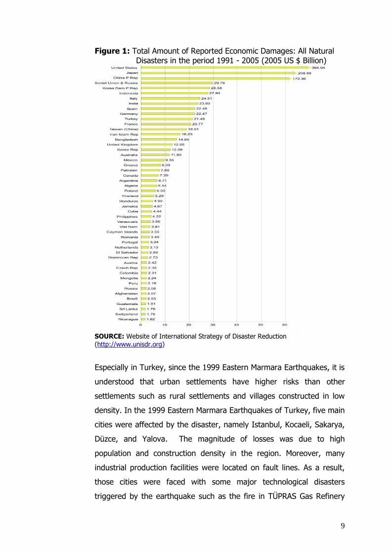
9
Figure 1: Total Amount of Reported Economic Damages: All Natural Disasters in the period 1991 - 2005 (2005 US $ Billion)
SOURCE: Website of International Strategy of Disaster Reduction
(http://www.unisdr.org)
Especially in Turkey, since the 1999 Eastern Marmara Earthquakes, it is
understood that urban settlements have higher risks than other
settlements such as rural settlements and villages constructed in low
density. In the 1999 Eastern Marmara Earthquakes of Turkey, five main
cities were affected by the disaster, namely Istanbul, Kocaeli, Sakarya,
Düzce, and Yalova. The magnitude of losses was due to high
population and construction density in the region. Moreover, many
industrial production facilities were located on fault lines. As a result,
those cities were faced with some major technological disasters
triggered by the earthquake such as the fire in TÜPRAS Gas Refinery

10
and the spilling over of some dangerous and poisonous chemicals from
the AKSA textile factory.
Thus, urban settlements are high disaster risk areas not only because
they are densely constructed but also due to the vicinity of accident
prone plants to residential areas. Technological disasters may lead to a
collapse of infrastructure and main technical services, such as
electricity, water, and gas.
Another major difficulty has been experienced in, disaster response
activities such as search and rescue, debris clearance, evacuation of
people, provision of food and shelter, and provision of security in urban
settlements in the course of disasters. Firstly, such activities include
time consuming efforts and require an extensive organization of works.
Secondly, disaster response activities in urban settlements have led to
considerable interruptions and delays in daily routines of the country.
Thirdly, they come at considerable financial expenses. For those
reasons, it is useful to concentrate on disaster resilient urban
settlements with a view of saving human life, economic resources,
environmental sustainability as well as socio-cultural and historical
assets.
In order to draw the guidelines for disaster resilience, this study starts
from the 1999 Eastern Marmara Earthquakes in Turkey as a lesson
learned example. As already mentioned, although the scope of the
study covers all types of natural disasters, it won’t be practical to test
the disaster-resilience model for each natural disaster case. Based on
field experience of the author, earthquakes are chosen as a theme for
the process of the model building. In this process, some principles are
derived with the aim of providing guidance for urban settlements on
how to be disaster resilient. In the context of resilience, as already
mentioned, the proposed model focuses on physical resilience (see also

11
“1.2. Definitions and Concepts”). However, it should be emphasized
that the term “resilience” does not covers only a spatial issues but also
all other relevant processes affecting spatial development. Such
endeavours as construction and infrastructure quality upgrading,
proper site development, correct implementation of planning principles
are not only related to spatial issues. In order to carry out those
endeavours, proper legislation (laws, by-laws, building codes, and
related standards) and implementing as well as controlling capacities
are required. The study also explain the roles of the key actors,
appropriate procedures, roles of stake holders, roles of policy makers,
interactive process among all decision makers with a view to the
dynamics of urban disaster resilient settlement.
The guidelines derived from the analysis of the 1999 Eastern Marmara
Earthquakes in Turkey are compared with accumulated disaster
mitigation experiences reported in international literature and project
reports of international organizations on selected disasters. As a result
of this comparison, it is expected to attain a synthesis of the 1999
Eastern Marmara Earthquake experiences with international
experiences towards comparable features.
Since disaster boundaries do not necessarily coincide with political
borders (e.g. A disaster occurred in a country can possibly affect
several neighbour countries), this study encompasses geographical
regions neighbouring Turkey. For instance, in the past several disasters
that occurred in Turkey had sequential effects in European countries.
In addition, there exist some geographical and geological sources of
disaster risks that is common in Turkey and European countries such as
fault lines, mountains, and rivers. For these reasons, a comparative
case study between a Turkish city (Yalova) and a European city
(Cologne) is included in the study.

12
1.5. Methodology
As already mentioned in “1.1.Hypothesis and Research Questions”, the
method towards a disaster-resilience model consists of a theoretical
and an empirical part. The theoretical part consists of literature
reviews, desktop research, institutional visits and documents, and
project evaluations and lessons learned from various countries and
international projects. The empirical part consists of (i) a comparative
case study on earthquakes as a basis of testing the proposed model,
(ii) additional relevant examples from personal experience in the
Turkish Government in the field of urban planning and disaster
mitigation, and (iii) reflections of criticism received from international
and scientific platforms.
To build a disaster resilience model for urban settlements, an
integrated disaster mitigation approach is proposed in view of the
multi-dimensional aspects of urban settlements. An integrated disaster
mitigation approach does not only focus on urban space but also
considers other aspects of urban settlements to maintain physical
resilience. While the details of this approach are reflected in the
proposed model subsequently, the following main components of this
approach are listed below:
Policy making process (supranational, international,
interregional, national, local),
Organizational procedures to address relevant
actors/responsible bodies (at international, national, regional,
local, citizens levels),
Legislation and Control (laws, by-laws, building codes,
standards, controlling mechanisms),
Scientific research and technological integration,
Coordination, organization, networking and harmonization.
The above method is developed in light of best international examples
and lessons learned from 1999 earthquakes in Turkey. The relevant

13
experience in Yalova served to further develop the model. As a result
of the above studies, some main principles, policies, strategies, and
standards are derived to provide guidance in form of a checklist for
other disaster prone urban settlements with a view to disaster
resilience. To illustrate the applicability of the model, the
aforementioned checklist is tested with respect to Cologne. The results
of this test provide two opportunities, namely assessing the physical
resilience of Cologne to earthquakes and modifying the test according
to dynamics of an urban settlement.
CHAPTER 2:
2. MAIN DISASTER MITIGATION APPROACHES IN THE WORLD
In this part it is aimed to draw a disaster mitigation profile upon a
review of approaches worldwide. For that purpose disaster mitigation
approaches of some countries and some organizations will be
surveyed. These countries & organizations will be selected with a view
to sampling the most developed legislation and organizational
structures. The scope of these samples will be determined within the
timing and financial parameters of the thesis.
At the end of this chapter, the comparative analysis of the following
selected examples with respect to their disaster mitigation activities is
presented in a table (see also table 5). This analysis can provide
guidance to design a rough draft of disaster resilience model.
2.5. United Nations Organizations
The following United Nations organizations have issued documents that
reflect multi-country experiences on disaster prevention and mitigation:
International Strategy for Disaster Reduction(=ISDR), Office for
Coordination of Humanitarian Affairs(=OCHA), The Office of the United
Nations Disaster Relief Co-ordinator (=UNDRO), United Nations

14
Development Program(=UNDP), The United Nations Disaster
Assessment and Coordination (UNDAC) team, International Search and
Rescue Advisory Group (=INSARAG), Field Coordination Support
Section (FCSS), Virtual Operations Coordination Centre (VOSOCC), UN
Volunteers(=UNV), Relief Web,…
Especially for this study, documents and activities of ISDR are helpful.
Because “the ISDR aims at building disaster resilient communities by
promoting increased awareness of the importance of disaster reduction
as an integral component of sustainable development, with the goal of
reducing human, social, economic and environmental losses due to
natural hazards and related technological and environmental disasters.”
(http://www.unisdr.org/eng/about_isdr/isdr-mission-objectives-
eng.htm)
International Strategy for Disaster Reduction (=ISDR)
Actually ISDR is an successor program of the International Decade for
Natural Disaster Reduction (=IDNDR). On 11 of December 1987, the
General Assembly of the United Nations designed a program to
decrease the loss in disasters in the period of 1990-2000. According to
the UN assessment at the end of the IDNDR period, there are some
achievements especially in facilitating the common efforts of political,
scientific, and technological groups on disasters. IDNDR had also
efficient publications called “Stop Disasters” that are also useful for
disaster researches e.g. many volumes of that periodical were used in
this study. (IDNDR:1994) Due to these remarkable success, the United
Nations designed a new program after IDNDR as a new body of
coordinated action programs which is called International Strategy for
Disasters (=ISDR). (ISDR:2007)
As it is mentioned before, ISDR is designed by the UN Assembly as a
successor program of IDNDR. It aims disaster reduction by increasing

15
of disaster awareness as an integral part of sustainable development.
ISDR tries to satisfy that aim to build an integral approach of social,
economic, and environmental dimension of communities on the basis of
disaster resilience. ISDR generated 4 main objectives to achieve that
aim as follows:
1. Increase public awareness to understand risk, vulnerability and
disaster reduction globally
2. Obtain commitment from public authorities to implement disaster
reduction policies and actions
3. Stimulate interdisciplinary and inter-sectoral partnership, including
the expansion of risk reduction networks
4. Improve scientific knowledge about disaster reduction
The central office of ISDR is in Geneva/Switzerland and regional units
are in Costa Rica and Kenya. ISDR is also focal point in the UN System
to coordinate and support all disaster related efforts such as disaster
reduction activities, disaster policy integration, disaster awareness
campaigns, disaster related publications, and information. ISDR works
in a cooperation with the Inter-Agency Task Force on Disaster
Reduction (=IATF/DR) and the Inter-Agency Secretariat of the ISDR to
achieve efficiency in disaster reduction. (ISDR Mission and
Objectives:2007 )
One of the main recent initiatives of ISDR is guiding to
establish/support National Platforms for Disaster Risk Reduction. This
initiative was organized after the December 2004 Indian Ocean
tsunami disaster. Various countries who have national platforms for
disaster risk reduction and who have some plan to establish national
platforms for that purpose, entrusted the UN/ISDR secretariat to their
national data and documents to reorganized as a new reference
document. The concept of disaster reduction consists of many fields or
denoted various mechanisms such as political and legal issues and
frames, public awareness, science and technology, planning and

16
standards, organization & coordination, early warning systems,
response mechanisms, and effective disaster preparedness. This
concept also denotes multi-stakeholder national mechanisms such as
various government sectors, NGOs, academic institutions, private
sectors, and the media. The countries which prepared their data and
documents according to this main frame are China, France, Germany;
Iran; Italy, Japan, Madagascar, Nigeria, Norway, Panama, Peru,
Senegal, South Africa, and Uganda.
In the World Conference of Disaster Reduction 2005, 168 governments
adopted the Hyogo Framework Action for the period of 20005-2015 to
build disaster resilient nations and communities. The main objectives of
the Hyogo Framework Action are establishing and strengthening multi-
disciplinary national platforms for disaster risk reduction and
coordinating the all national platforms via UN/ISDR secretariat to
facilitate integrating them in the case of disaster. (International
Strategy for Disaster Reduction; 2007)
The Office of the United Nations Disaster Relief Co-ordinator
(=UNDRO):
The UNDRO has published a seven-volume-study on Disaster
Prevention and Mitigation including a methodology for evaluating
economic effects of natural disasters. It suggests that economic effects
of natural disasters be grouped into three categories:
Direct effects on the property and income of the persons, business
enterprises and communities affected by the disasters
Indirect effects which result from the reduction in family income
and the decline in the production of other business enterprises, in a
chain reaction

17
Secondary effects which may appear some time after the disaster
such as epidemics, inflation, increase in income disparities, isolation
of farming areas.
The first group includes the loss and damage to properties such as
buildings and equipment. In this context, properties may be related to
some main sectors such as agriculture, industry, infrastructure,
housing, commerce, and services. These sectors are typically
concentrated in urban settlements. Due to such concentration, the
vulnerability of urban settlements to natural disasters such as
earthquakes, floods, landslides, avalanches, volcanic eruptions,
cyclones tend to be higher than in other regions.
The features and dynamics of urban settlements vary according to
levels of development and other particularities. Importantly, urban
settlements in developing countries tend to be more vulnerable to
natural disasters than those in developed countries. This proposition is
supported by the following characteristics of conurbations in developing
countries:
Special difficulties in disaster response and mitigation due to rapid
urbanization and population agglomeration
Lack of resources for the disaster improvement works while
investment programs in other regions run
Problem of enforcing building codes and planning standards despite
highly populated and rapidly growing conurbations
The higher economic loss in urban settlements resulting from local
concentration of facilities due to high population
Against this background, UNDRO has developed some proposals on
approaches toward improving disaster resilience of disaster prone
urban settlements. One of its proposals is to carry out simulation
studies with a view to obtaining a better assessment of the

18
vulnerability of urban settlements which are particularly prone to
natural disasters. Such studies, it is further proposed, could provide the
basis for designing a global prevention policy comprising measures
towards more effective protection of the population and the reflection
of disaster resilience objectives in urban planning regulations.
UNDRO furthermore proposed to asses urban settlement policies in
light of actual disaster experiences by means of Cost-Benefit Analysis.
From the economic point of view cost-benefit analyses at first sight
appear as an appropriate tool for such assessment. However cost-
benefit analyses depend on various types of direct and indirect costs
and benefits of assessed policies and their implementations. Since the
planning is a multi-dimensional discipline, multiple criteria should be
used to make such assessment meaningful. UNDRO recognizes this
difficulty and tries to develop a model towards an integrated planning
methodology. It includes analytical steps backwards where results
appear to be inadequate. For instance, alternative urban projects are
developed for disaster mitigation. If the criteria under one approach do
not sustain a desired result towards disaster resilient settlements, it is
possible to go back to test an alternative approach to reach that result.
As a result of cost-benefit analyses through integrated planning
methodology exercises, it is possible determine some principles of
efficient planning for disaster resilient urban settlements. The main
principle to serve this objective is to integrate vulnerability analysis into
physical planning policy. An action program to satisfy this main
principle may be drawn up into the following stages:
To prepare checklists of risk for each type of natural disaster
To prepare checklists of risk-relevant urban features (building
stocks, open spaces, quality of infrastructure and services,
population and immigration statistics)
19
To re-model urban centers to make them safer for each type of
natural disaster
To synthesize of outputs of different re-models
To make zoning in light of risk propensity and urban planning
constraints
To draw effective policies with a view to minimizing the vulnerability
of each zone
According to UNDRO such action program is not sufficient for disaster
mitigation in the cases of earthquake and cyclones that are effective on
a country-wide. For such cases, risk analyses must be carried out at
the regional or even national scale planning into account such factors
as seismicity indicators on the basis of geological formations and the
sites of previous epicenters together with historical records which vary
both in scale and type.
UNDRO concludes that in order to be fully effective in disaster
mitigation, the analyses should be carefully adapted to the institutional
structures and procedures generally used in the planning process and
in the prevention of disasters. In the prevention and mitigation of
natural disasters, proper socio-economic studies are inevitable. In this
context, effective means of improving the coordination of the activities
of responsible authorities (ministries, public bodies, and local
communities), research centers and other competent organizations play
an important role. (The United Nations Disaster Relief Co-ordinator
Office, 1979)
The UN-SPIDER:
The UN-SPIDER is a quite new program of the United Nations Office for
Outer Space Affairs (UNOOSA). It is an information provider program
for space-based information for Disaster Management and Emergency

20
Response. In other words, UN-SPIDER has a larger definition in
UNOOSA Website as in the following:
“In its resolution 61/110 of 14 December 2006 the United Nations
General Assembly agreed to establish the “United Nations Platform for
Space-based Information for Disaster Management and Emergency
Response – UN-SPIDER”, as a new programme of the United Nations
Office for Outer Space Affairs, to provide universal access to all
countries and all relevant international and regional organizations to all
types of space-based information and services relevant to disaster
management to support the full disaster management cycle by being a
gateway to space information for disaster management support,
serving as a bridge to connect the disaster management and space
communities and being a facilitator of capacity-building and
institutional strengthening, in particular for developing countries.” (The
United Nations Office for Outer Space Affairs; 2007)
The UN-SPIDER is a voluntary program based on voluntary contribution
of member states. So far, voluntary contribution countries are
Germany, Switzerland, and China. China has well-established office in
Beijing, Germany has in Bonn, and Germany & Switzerland have a
liaison office in Geneva. It is likely that voluntary contributions will
increase over time (see also Annex I.1 ).
Despite it is newly organized program, UN-SPIDER already organized a
workshop to promote the access and use of space-based technologies
and solutions for disaster management and emergency response within
the relevant communities in 29–31 October 2007 in Bonn/GERMANY.
The workshop participants are decision-makers and senior experts of
various responsible national and regional institutions for providing
disaster management support, capacity building in and promoting the
use of space-based technologies; UN SPIDER Regional Support Offices
and national focal points; UN agencies and NGOs involved in disaster
management mitigation and relief; space agencies; academic and
21
research institutions; geospatial information management and IT
companies.
Major topics on the basis of UN-SPIDER objectives to be discussed at
the workshop were as follows:
Identification of relevant space-based information for Disaster
Management Support and Emergency Response including on-going
and planned initiatives, case studies and best practices, archived
data for disaster studies and capacity building opportunities.
Definition of a Knowledge Portal to ensure that relevant information
is easily accessible and disseminated to all interested end-users
including the design of an appropriate information database system
Identification of existing and planned Communities of Practice that
contribute to bringing together the space-based technology and
disaster management communities
Discussion and definition of a knowledge management and transfer
framework and implementation of specific activities that will
contribute to the transfer of knowledge.
GEOSS Capacity Building Task CB-07-02 - Knowledge Sharing for
Improved Disaster Management and Emergency Response
Harmonisation of the various existing initiatives that are
contributing to helping developing countries access and use space-
based technologies for disaster management and risk reduction
(The United Nations Office for Outer Space Affairs; 2007)
While UN-Spider has still organized meetings, conference, and
workshops on disasters, it regularly informed to various interest groups
about those activities.
2.6. USA
In the USA, the main approach for emergency disaster management is
“Integrated Emergency Management System” instead of drawing
separate management methods for each disaster. The Integrated

22
Emergency Management System (=IEMS) provides an opportunity to
incorporate all available resources such as federal and local resources
as well as resources of NGOs and other interest groups. There are four
phases in IEMS namely, preparedness, response, recovery, and
mitigation. According to the general point of view, since “all disasters
are local”(International Emergency Management Symposium, 2002),
local authorities are responsible for the first response and the
emergency management. Nevertheless there is coordination among the
federal government, the federal state, and local authorities to support
all activities in financial and technical terms.
There is an agency for emergencies and disasters that reports directly
to the President. It is called Federal Emergency Management Agency
(=FEMA). USA has ten disaster regions in which FEMA cooperates with
regional organizations, local governments, private volunteer
organizations, units of international organizations and other local
organizations. In 1999 Eastern Marmara Earthquake, a central disaster
coordination organization like FEMA was built in Turkey. It is called the
General Directorate of Turkish Emergency Management which works
under the Prime Ministry. (See also “3.2. Institutions Involved in the
Disaster Mitigation Process”) FEMA and its modern operations are very
important examples for the thesis.
FEMA was established in 1979. It was originated from the Council of
National Defence in 1916. The main task of FEMA is providing guidance
in national level, funding, disaster training, and recovery programs. The
legal frame of its responsibilities is drawn by the Robert T. Stafford Act.
The Act clarifies the requirements for the Presidential Declaration of
Disaster or Emergency. According to the Act, the Federal Government
activates resources of FEMA and the Federal Response Plan when the
means of a disaster prone State are beyond to cope with the disaster.
The Federal Response Plan considers all federal agencies, establishes
policies and procedures, defines the scope of operations, builds
coordination mechanism among, explains the federal responsibilities

23
and capabilities, the federal government and federal states, addresses
response, recovery, and mitigation activities. In sum, the Federal
Response Plan integrates the central and local needs and provides
assistance to restore infrastructure and to protect the disaster prone
region against future disasters (International Emergency Management
Symposium, 2002).
On the other hand, the Robert T. Stafford Act provides a mitigation
planning framework for each federal state to facilitate the preparation
of its own disaster plan of actions. The mitigation planning framework
drawn by the Act constitutes following components (Godschalk, 1999):
Assessment of natural hazards
Analysis of existing policies and local capabilities of the hazard
mitigation
Hazard mitigation goals and objectives
Proposed strategies, programs, and actions
Proposed approach to implementation
Proposed approach to monitoring of implementation and hazard
conditions
Proposed approach to updating the plan
Proposed approach to evaluating the plan and its implementation
Each federal state must have a mitigation plan prepared according the
components above if it needs to get federal grants for hazard
mitigation following a declared disaster. Each federal state should also
prepare an identification of a project which will be funded and a
coordination schedule with other related local institutions.
The Federal Disaster Recovery Program constitutes with individual
assistance, public assistance, hazard mitigation, and small business
administration is another program also managed by FEMA. The share
of the federal government to fund the Program is 75%. The rest is

24
funded by federal states (International Emergency Management
Symposium, 2002).
It is possible to see that an increasing awareness of environmental
protection influences the activities of FEMA such as disaster response,
recovery, mitigation, and preparedness. In parallel to Federal
environmental laws, FEMA guides to local authorities and central
institutions to insert environmental requirements into the mission of
disasters, e.g. site selection of temporary housing, debris management,
improvement of infrastructure, hazard mitigation projects, etc. FEMA
aims at not only protection of environmental resources but also
minimizing potential adverse impacts to children and low income and
minority groups of people (Environmental Documents, 2008).
Since the scope of the thesis is to draw the guidelines for disaster
resilience based on lessons learned 1999 Eastern Marmara Earthquake
in Turkey, it is also useful to pay much attention on the earthquake
mitigation policy of the USA. The USA earthquake mitigation policy
constitutes of updated building codes, mapping of fault zones,
determining restrictions on buildings in fault zones, inserting seismic
elements, general safety elements and retrofitting programs into local
plans. To serve the earthquake mitigation policy, the USA has an
initiative called the National Earthquake Hazard Reduction Program
(=NEHRP). The program was created by the Earthquake Hazards
Reduction Act in 1977. The scope of NEHRP is funding earthquake
research activities, clarifying the dynamics of seismic hazards, and
organizing training and technical assistance. NEHRP supports central
and local earthquake mitigation activities via some sources of funds,
namely, the Federal Emergency Management Agency (=FEMA), the
U.S. Geological Survey (=USGS), the National Science Foundation
(=NSF), and the National Institute for Standards and Technology. In
addition to these funds, the USA also updates seismic insurance system
(Godschalk, 1999).

25
In addition to those efforts of the central government, each federal
state pays its own effort for disaster mitigation. For instance, the
practice in the State of California is remarkable to be mentioned
shortly. The California Public Resources Law requires that all natural
hazards should be mapped. The local governments in the State of
California have to display these maps publicly to provide transparency
for the real estate market. The data of these maps are updated by the
feedback of relevant public institutions such as the US Geological
Survey and the California Geological Survey as well as relevant experts
e.g. planners, geologists, etc. The California Geological Survey
manages geological surveys in the State of California in the directions
of the Alquist-Priolo Earthquake Faults Zoning Act. According to the
Act, it is compulsory to prepare 1/24.000 scale geological and seismic
failure map in each earthquake zone. As a synthesis of various
earthquake zone maps, an Urban Geology Master Plan for the State of
California was already prepared. This Master Plan shows guidance to
spatial planners for the preparation of settlement plans of each
settlement in California (The Turkish Ministry of Public Works &
Settlement, 2006).
2.7. The European Union
The review of related legislation in the EU will encompass both the
Acquis Communautaire and Member States legislations. Although the
Acquis Communautaire does not include a legislative framework for
disasters, in last 5-6 years there are some relevant EU initiatives, such
as the Community Mechanism for Civil Protection( Council Decision of
23 October 2001), EU Strategic Environmental Assessment Directive
(SEA, 2001/42/EC; European Parliament & European Council, 2001), a
Community Framework For Cooperation in the Field Of Accidental or
Deliberate Marine Pollution (a later Commission Decision of 29
December 2003 laid down the rules for the DECISION No
2850/2000/EC OF THE EUROPEAN PARLIAMENT AND OF THE COUNCIL
of 20 December 2000).

26
While there are only a few ad hoc legislations, Europe as a
geographical region is prone to various natural disasters. Since the
Western, Eastern, and Central parts of Europe have big rivers, these
parts have been threatened by floods. The Southern part of Europe
and the Mediterranean region have been threatened by forest fires and
drought. The Western part of Europe and British Islands have been
threatened by storms. The mountain areas notably the Alps, the
Pyrenees, and the Carpathians have been threatened by landslides and
avalanches. Earthquakes and volcanic eruptions pose relatively smaller
threats in the European region compared to the other types of natural
disasters. Only some specific areas in the Central and Eastern
Mediterranean are threatened by earthquakes and volcanic eruptions.
The table below provides a natural disaster profile of Europe. However,
these table figures do not show all disaster events in the period of
1970-2005. Disaster events were recorded only either caused more
than 10 casualties and/or 100 or more people were injured; and/or
there was a declaration of a state of emergency; and/or there was a
call for international assistance.
Table 1: Reported Effects of Selected Larger Natural Disasters on European Countries (1970-2005)
DISASTERS/RECORDS
NUMBER OF DISASTERS
CASUALTIES
ESTIMATED COSTS FOR DAMAGE (in 1000 €)
FLOOD 274 3 270 53 577 458
WINDSTORM 215 1 546 34 403 573
EARTHQUAKE 123 19 644 43 936 462
EXTREME TEMPERATURE
69 47 466 1 889 329
WILD FIRES 63 248 2 471 688
SLIDES 46 1 314 1 023 464
DROUGHT 26 0 12 989 281
VOLCANO ERUPTIONS 7 9 36 769
WAVE/SURGE 1 11 0
TOTAL 824 73 508 150 328 003 SOURCE: Greiving et al., 2006 (EM-DAT, 2005)

27
The above figures clearly show that financial losses from natural
disasters are high in the EU while casualties from natural disasters are
relatively lower compare to the casualty figures of developing
countries. The table below shows the geographic distribution of natural
hazards in Europe. The table is prepared according to the “NUTS”
definition used for statistical purposes in the European Union. NUTS
means “Nomenclature of territorial units for statistics” and NUTS 3
refers to the regional level. The aggregated natural hazard typology
consisting of 11 natural disasters is used for preparing the figure below
(see also fig.2). These disasters are avalanches, droughts,
earthquakes, extreme temperatures, floods, forest fires, landslides,
storm surges, tsunamis, volcanic eruptions, and winter & tropical
storms. For each natural disaster, there is a scale showing the
magnitude of the hazard from 1 to 5 (Greiving et al., 2006).

28
Figure 2 : Aggregated Natural Hazards in Europe
SOURCE: Schmidt-Thomé, 2006
The “Figure 2” shows that the damages from natural disasters in
Europe are considerable. In addition to the EU Solidarity Fund which
intervenes mainly in cases of major natural disasters, the European
Union should have a developed disaster legislation and
multidimensional disaster mitigation policy. While this does not exist
thus far, the European Union has taken some relevant initiatives in the
last few years. For example, one of its recent attempts is a Directive on
the Assessment and Management of Floods adopted by the European
Commission on 18 January 2006 (COM (2006)15 final of 18.1.2006).
29
The Directive mostly outlines approaches and a general frame for flood
risk management but does not describe the tools in detail. It proposes
the following obligations of the Member States:
1. Preliminary Flood Risk Assessment: Risk mitigation measures should
focus on areas where potential significant flood risks exist or are
reasonably foreseeable in the future. River basins, sub-basins or
stretches of coastline with potentially significant flood risk at
present or in the future, should be identified in the Preliminary
Flood Risk Assessment. For these river basins and/or sub-basins no
further action would have to be taken.
2. Flood Risk Maps: With the possible exceptions provided for in the
Preliminary Flood Risk Assessment, flood risks would be mapped for
the river basins and sub-basins with potentially significant risk of
flooding in order to increase public awareness; support the process
of prioritizing, justifying and targeting investments and developing
sustainable policies and strategies; as well as to support flood risk
management plans, spatial planning and emergency plans. Where
maps conforming to the requirements of the directive already exist
for river basins and stretches of coast line, Member States may use
these existing maps for the purposes of satisfying the directive.
3. Flood Risk Management Plans: With the possible exceptions
provided for in the Preliminary Flood Risk Assessment, flood risk
management plans would be developed and implemented at the
river basin/sub-basin level to reduce and manage the flood risks.
These plans would include an analysis and assessment of flood risk,
a definition of the level of protection, and an identification of
sustainable measures. Such measures would follow the principle of
solidarity which require not to pass on problems to upstream or
downstream regions and preferably to contribute to reducing flood
risks in upstream and downstream regions.
While the general guidelines above are compulsory, the details of
implementation such as detailed objectives and deadlines for managing

30
flood risks are left to the Member States. (“European Flood Action
Program”:2006)
Furthermore, there are EU documents that indirectly provide guidance
on enhancing disaster resilience such as Eurocode 7 & 8. These two
documents were originally prepared for the purpose of designing
spatial planning policies among Member States in late 1990s.
(Eurocode 7-1997, Eurocode 8-1998) Eurocode 7 deals with
geotechnical design including ground surveys and soil analysis.
Eurocode 8 addresses the design of structures for earthquake
resistance. However these two documents are not binding legal
instrument but recommendations to Member States in designing their
own laws for building disaster resilient settlements. (The Turkish
Ministry of Public Works & Settlement-General Directorate of Disaster
Affairs: 2006)
As a result, The European Union should start to pay more intension on
disaster mitigation. Recently, EU has much intention on cohesion
policies and economic models. Since the loss in disasters will cause
many economic problems, it may possible to insert disaster mitigation
approaches into the cohesion policies. The studies in vulnerability
analysis, hazard assessment, and risk mitigation approaches should be
supported in national and regional level. For example the existing
Strategic Environmental Assessment Directive can be developed on this
basis. It is also possible to update the Water Framework Directive
under the threat of floods due to the climatic change or to assess
together with the new Directive on the assessment and management
of floods. Besides EU should also review its Interreg policies on the
basis of disaster mitigation because disaster never pay attention on
political boundaries. It is also possible to define new disaster
interregional areas to produce efficient policies for the risk mitigation.
Some Member States pay much attention to disaster issues like

31
Germany or France. Thus it is beneficial to study disaster mitigation
implementations and some best examples. The examples of Germany,
United Kingdom, and France are outlined bellows. Since the disaster
mitigation is, or at least ought to be integrated into overall spatial and
land-use planning, the review will start from general planning
procedures, include building codes and construction permits, and add
also institutions and mechanisms specifically aimed at disaster
mitigation.
GERMANY
Before examining spatial planning system in Germany, it will be useful
to review Germany’s underlying administrative structure (see also
fig.3). This structure sets on five hierarchical level namely, Federation
(=Bund), sixteen federal states (=Länder), sub-districts
(=Regierungsbezirken), counties (=Kreisen), and municipalities. The
federal states have their own state authority and their own legislation.
Thus authorities and responsibilities of administrative units vary from
one state to another (Greiving et al., Eds. 2006).

32
Figure 3: Administrative Boundaries of Federal States in the Federal
Republic of Germany
SOURCE:Statistisches Bundesamt Deutschland, 2008
As any other EU Member Country, Germany has spatial planning
policies and the legislation initiated from the EU level. Despite the fact
that there is no common Spatial Planning Act in the EU level, various
frame laws and legislations have lead to member countries in their
spatial planning studies, e.g., EU Strategic Environmental Impact
Assessment Directive(SEA, 2001/42/EC; European Parliament &
European Council, 2001). The more, there are such EU programs
leading to spatial policy making issues as “European Inter-regional
Cooperation” (=INTERREG IV) and as its subprogram “European
Spatial Development Perspective” (=ESDP), “European Spatial Planning

33
Observation Network” (=ESPON). Studies and projects of all these
programs have been managed and organized by the Federal Ministry of
Transportation, Building and Urban Development in Germany (The
Federal Office for Building and Regional Planning of Germany,2008).
Some other EU programs and perspectives have also some indirect
effects on designing spatial planning policies of member countries. For
instance, spatial planning policies and macro scale decisions in
Germany are prepared in the lights of the Lisbon Strategy which aims
at supporting inter-regional competitiveness and the European Union
Territorial Agenda which aims at building efficient connections among
cities and regions (Federal Ministry of Transport, Building and Urban
Development of Germany, Eds.2006).
In country level spatial planning issues, in line with the federal state
structure of Germany, spatial planning and land-use planning take
place at the federal level (Bund), federal state level (Länder), and
municipality level (Städte). On the federal level, macro goals and
principles are defined and broad procedures are set out by (framework)
legislation. On the federal state level, according to the Federal Regional
Planning Act (Raumordnungsgesetz) the federal states are responsible
for managing land-use policies by the “Regional Plan for the Territory
of the State” (Raumordnungsplan fuer das Landesgebiet) and “Regional
Plans for parts of the States” (Regionalplan). These plans include many
aspects as energy, security, telecommunication networks, protection of
nature, transportation, and economic development. On the municipal
level, preparation of land-use plans are determined and executed.
(Federal Ministry of Economics of Germany Twinning-Project in
cooperation with the Turkish Treasury; 2005) In the preparation of
land-use plans, the Federal Building Code (Baugesetzbuch) lays down
similar objectives, instruments, and procedures for all municipalities.
The land-use planning consists of two levels namely, preparatory land-
use plan (Flaechennutzungsplan) and detailed land-use plan
(Bebauungsplan). The preparatory land-use plan determines the main
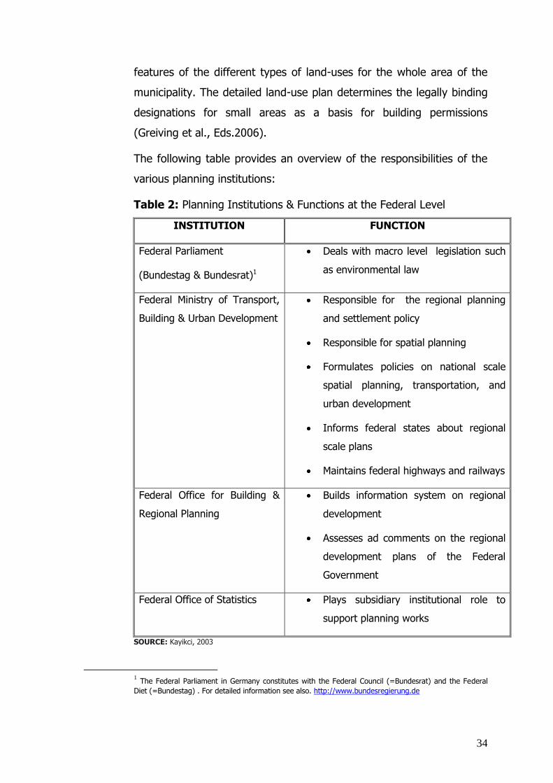
34
features of the different types of land-uses for the whole area of the
municipality. The detailed land-use plan determines the legally binding
designations for small areas as a basis for building permissions
(Greiving et al., Eds.2006).
The following table provides an overview of the responsibilities of the
various planning institutions:
Table 2: Planning Institutions & Functions at the Federal Level
INSTITUTION FUNCTION
Federal Parliament
(Bundestag & Bundesrat)1
Deals with macro level legislation such
as environmental law
Federal Ministry of Transport,
Building & Urban Development
Responsible for the regional planning
and settlement policy
Responsible for spatial planning
Formulates policies on national scale
spatial planning, transportation, and
urban development
Informs federal states about regional
scale plans
Maintains federal highways and railways
Federal Office for Building &
Regional Planning
Builds information system on regional
development
Assesses ad comments on the regional
development plans of the Federal
Government
Federal Office of Statistics Plays subsidiary institutional role to
support planning works
SOURCE: Kayikci, 2003
1 The Federal Parliament in Germany constitutes with the Federal Council (=Bundesrat) and the Federal
Diet (=Bundestag) . For detailed information see also. http://www.bundesregierung.de

35
The Federal Office for Building & Regional Planning has a remarkable
function in planning process as it provides technical support and views
on issues of spatial planning, urban development, and settlement to
the Federal Government and other related authorities. It is a research
institution affiliated with the Federal Ministry of Transport, Building &
Urban Development. It was founded in 1998 assuming the functions of
the previous Federal Public Works Directorate and the Research
Institution of Regional Planning. According to the Federal Regional
Planning Act, the Federal Office for Building & Regional Planning
prepares periodic “Spatial Planning Reports” for submission to the
Parliament through the Federal Ministry of Transportation, Building &
Urban Development. The reports address spatial planning and
development as well as sectoral planning issues in a detailed way. The
reports suggest future spatial development trends in light of emerging
dynamics. In preparing the reports, the office relies on the data of the
Spatial Information System. Thus, the Federal Office plays a significant
role in providing coordination and integration in the planning process in
Germany. It collects all spatial data, processes, assesses and writes
reports, and informs related institution including the Federal Parliament
to achieve a consistency of overall central policies and planning
policies.
In Germany, the main objectives in spatial planning and spatial
planning policies are achieving a balance between advantageous and
disadvantageous features of the development, reducing regional
disparities, and creating conditions for ensuring equivalent living
conditions in all regions. At this respect equivalence and sustainability
are two key concepts in spatial planning studies. Equivalence does not
mean to create identical living conditions in each settlement but
equality of chances and ensuring certain minimum standards with
respect to accessibility and availability of public services and other
living standards. Sustainable spatial development is a concept also
takes place in the Federal Regional Planning Act. It implies that the

36
social and economic demands on space are to be harmonized with its
ecological functions. (Federal Ministry of Transport, Building and Urban
Development of Germany/Federal Office for Building and Regional
Planning of Germany;2006)
The planning process in Germany is furthermore characterized by
horizontal and vertical coordination among planning institutions.
Vertical coordination refers to the coordination of activities among at
different levels of the State (central-federal states-municipal).
Horizontal coordination refers to the coordination of activities among
authorities at the same level of the State; the concept also extends to
the consultation process among public and private stake holders in the
planning process. Planning in Germany is moreover governed by the
principle of “reverse flow”. This principle implies a decision making
process which starts from the bottom and develops to the top. That is
to say, a certain decision is generated based on the data of
municipalities, developed and controlled in districts, federal states and
federation levels. The following table compiles the planning tools used
in Germany (Kayikci, 2003):
Table 3: Plans & Programs in the German Planning System
PLANS/PROGRAMS FEATURES
FEDERAL SPATIAL
DEVELOPMENT PROGRAM
1:4 000 000 scale plans
Objective is to provide equal living
conditions in all regions
Provides guidance to all spatial plans
Multidisciplinary orientation frame for
planning on national plane.
Supports federal states in
implementing their plans.
Citizens do not participate in
development of program.
PROVINCIAL PLANS & PROGRAMS, 1:500 000 - 1:200 000 scale plans.

37
PROVINCIAL SPATIAL PROGRAMS
(Landesentwicklungsprogramm)
(Landesentwicklungsplan)
Plans determine the goals of spatial
development and provincial plans on
the basis of the Law of Spatial
Development and the Law of Provincial
Planning.
Plans and programs can be organized
as integrated plans and programs.
REGIONAL PLANS, REGIONAL
DEVELOPMENT PLANS, REGIONAL
DEVELOPMENT PROGRAMS
(Regionalplan)
1:300 000 - 1:50 000 scale plans.
Regional plans and programs govern
sub-regional plans.
The organizations supporting these
plans are regional planning
communities, regional planning
institutions, and federal states
planning institutions
Regional plans and programs set out
regional objectives for spatial
development based on federal states
plans. They also set out regional
objectives for residential areas and
infrastructures for commerce, industry,
agriculture, forests, traffic,
communication, schools, and social
services.
PREPARATORY LAN-USE PLANS
(Flaechennutzungsplan)
1:50 000 - 1:5 000 scale plans.
apply to defined parts of cities or
districts.
are land-use plans reflecting existing
land-use and urban development
decisions.
are harmonized with the objectives of
provincial plans and regional plans.
provide the legislative frame of

38
detailed land-use plans.
Preparatory land-use plans do not
have direct legal effects on citizens but
are obligatory for communities and
participatory planning organizations.
DETAILED LAND-USE PLANS
(Bebauungsplan)
1:2 000 - 1:500 scale plans.
apply to defined part of cities.
provide obligatory rules for urban
development.
are designed for the implementation of
building codes. ( Thus, they are legal
basis for required building codes.)
derive from preparatory land-use plans
and are developed under the authority
of city councils/ municipalities.
set out direct tasks and obligations for
citizens.
BUILDING PERMISSION
(Baugenehmigung)
1:100, 1:50 or 1:10 scale plans.
apply to individual buildings.
set out criteria and standards of the
buildings such as site, section, and
elevation.
SOURCE: Kayikci, 2003
After examining the whole planning system starting from the larger
scale down to the smaller scale, it is useful to have a short look at the
building control system as an integral part of the spatial planning field.
The building control system is closely related to land-use planning and
a prerequisite of disaster mitigation. The responsible body for
construction control in Germany is “The Directorate of High Planning &
Building” affiliated to the federate states. The Directorate is responsible

39
for controlling the design, static, and electricity projects; calculations of
sound and thermo isolation projects; precautions against earthquakes
and fires through control engineers. Control engineers
(=Prüfingenieure) and insurance systems are also pillars of the building
control system in Germany. On the other hand, building works for
private properties are controlled by Building Directorates which are part
of district administrations (municipal level). Building Directorates
control each construction at three levels namely, project controlling
(static, sound and thermo isolation, precautions against earthquakes
and fires), implementation project controlling, building controlling.
(METU Group of Professors in Fac. of Arch & Civ. Eng.;1999)
After the review of the planning system in Germany, the disaster plans
and programs of ad hoc authorities will be examined as an integral part
of the planning system. In Germany, the Federal Government has only
framework competences in the field of disaster risk assessment and
management. In this frame, it provides disaster-related guidance to the
Federal States in the exercise of its spatial planning competences. It
mostly deals with observations on various planning issues such as
demography, urbanization, transport, environment, etc. While the
Federal Government deals with questions related to disaster risk
assessment and management, it has no framework for disaster hazards
and vulnerability analysis.
According to the existing natural disaster profile of Germany, the major
sources of disaster hazards can be ranked as winter storms, thunder
storms, hail storms, river floods, flash floods, forest fires, avalanches,
land slides, and earthquakes. All these natural disasters certainly vary
from region to region in Germany. The federal states set their disaster
plans and programs as part of their regional plans. The table below
provides an overview of the plans and/programs on disaster mitigation
(Greiving et al., Eds. 2006):

40
Table 4: Plans & Programs of Federal States on Disaster Mitigation
PLAN OR PROGRAMME FOREST FIRES
AVALANCHES/ LANDSLIDES
EARTHQUAKES FLOODS
Baden-Wuerttemberg Regionalplan Region Bodensee Oberschwaben, Regionalverband Bodensee-Oberschwaben (1996)
-
-
-
River Floods
Baden-Wuerttemberg Regionalplan Schwarzwald-Baar Heuberg 2003, Regionalverband SBH
-
-
-
River Floods
Bavaria Regionalplan Allgäu, Region 16 (PV Ingoldstadt, 2000)
-
Avalanches Landslides Protective
Forest
-
Flash Floods
Bavaria Regionalplan Regensburg Reg PV Regensburg 2000
-
Avalanches
-
River Floods
Hesse Regionalplan Mittelhessen 2001, RegPräs Gießen
-
-
-
River Floods
Hesse Regionalplan Nordhessen 2001, RegPräs Kassel
- -
-
River Floods
Mecklenburg-Western Pommerania RROPro Westmecklenburg 1996
- -
-
Coastal
Protection
North Rhine-Westphalia Gebietsentwicklungsplan RB Köln, Teilabschnitt Aachen 2003
- -
-
River Floods
North Rhine-Westphalia Gebietsentwicklungsplan Teilabschnitt Köln 2003
-
-
-
River Floods
Rhineland-Palatinate Planungsgemeinschaft Region Trier, Regionales Raumordnungsprogramm Region Trier 1985
-
-
-
River Floods
Rhineland-Palatinate Regionales Raumordnungsprogramm Mittelrhein-Westerwald, Planungsgemeinschaft M-W, Entwurf 2002
-
Landslides
-
River Floods
Saxony Regionalplan Oberes Elbtal/ Osterzgebirge, Reg. PV, 2001
-
-
-
River Floods
Schleswig-Holstein Regionalplan Kreisfreie Stadt Flensburg, Kreise Nordfriesland und Schleswig-Flensburg (Planungsraum V, 2002), Ministerium für ländliche Räume, Landesplanung, Landwirts. & Tourismus
-
-
-
Coastal
Protection
Thuringia Regionales Raumordnungsprogramm Nordthüringen, Reg. Planungsgem. Nordthüringen 1999
-
-
-
-
SOURCE: Greiving et al., 2006

41
As the above table shows, the major and most frequent natural
hazards in Germany are river floods and flash floods. Floods are the
main natural disasters in Germany. The main risky rivers of Germany
are Elbe and Rhine which cross many large cities.
As it was mentioned before, regional and/or spatial planning
responsibilities lie with the federal states. The spatial plans of the
federal states include many sectors such as energy, water, security,
telecommunication networks, protection of nature, transportation, and
economic development. Each planning authorities take the
responsibility for the planning and implementation of related projects
specified with sectoral aspects according to the adhoc sectoral planning
act. At the level of the Federal law the “Water Management Act”
provides some basic legal framework for flood protection. On the basis
of “Water Management Act”, the federate states are dealing with flood
protection. In addition to the national scale programs and projects
there are several international commissions and projects for
transboundary rivers such as Rhine, Elbe, Odra, and Danube.
As a secondary level natural hazard, landslides and avalanches usually
occur in Germany in the Federal State of Bavaria. While there is no
federal legislation on landslides and avalanches, there are some plans
and programs prepared by the federal states, notably the Federal State
of Bavaria. It is possible to group the plans and programs of the
Federal State of Bavaria for landslides and avalanches such as risk
assessment and management.
As a mitigation method for forest fires, the forest plans in Germany are
implemented at the regional level. While the legal frame for forest
management is provided by the Federal Forest Act, planning authorities
aim at developing and protecting the environmental and economic
functions of forests through Forest Framework Plans. These Plans

42
focused more on the thread of landslides, avalanches and river floods
than on forest fires. The main areas prone to forest fires in Germany
are in the north part of the country between Lower Saxony and
Brandenburg (near Polish Border). The Federal Agency for Agriculture
and Food (Bundesanstalt für Landwirtschaft und Ernährung) prepares
forest fire statistics and publishes annual reports. However, all statistics
are on the hazard component, not on the vulnerability.
Storms are another type of natural disasters in Germany affecting
mostly coastal areas. For many centuries therefore, storms are
addressed as a part of coastal protection activities. Areas prone to
storms are along the North Sea Coast in Germany. Activities towards
disaster mitigation for storms are hence specially found in the federal
states of Lower Saxony, Schleswig-Holstein, Mecklenburg-Pomerania,
Bremen and Hamburg. The disaster mitigation for storms is directly
included in federal state coastal protection legislation and indirectly
addressed in the Water Management Act, because coastal protection is
a part of the water management. Under German Basic Law, there is a
joint responsibility for coastal protection between of the Federation and
federal states. While previously the coastal areas in Germany were
protected by the Federal State´s the Water Management Act and
federal states´ related legislation, Germany is introduced “Integrated
Coastal Zone Management” (ICZM) as a new concept of the European
Union. ICZM provides for a coastal protection policy with a view to the
multidimensional use and functions of coastal areas. Some federal
states recently revised their implementation processes and procedures
according to the principles of ICZM. In this context, methods of risk
estimation, assessment of hazard potentials, vulnerability analysis, and
risk management have been integrated into the coastal protection
programs.
.
Earthquakes are not considered as especially significant disasters in
Germany as the earthquake zones map below shows (see also fig.4).

43
Thus the threats of earthquakes are usually not taken into
consideration in spatial planning although geological surveys of the 16
federal states provide information about earthquake (seismic) hazards.
As for other natural disasters, federal states are in charge of preparing
earthquake plans. Some federal states, such as North Rhine-Westphalia
and Bavaria, deal with earthquake issues and provide guidance to the
municipalities. Institutional awareness on earthquake threat focuses
only on building standards and permits.
Figure 4: The Earthquake Hazard Map of Germany
SOURCE: Greiving et al., 2006(Deutsches Institut für Normung, DIN 4149)

44
There exists a joint agency of the Federation and federal states, called
Deutsches Institut für Bautechnik (German Institute for Structural
Engineering). The main task of this institute is to define common
technical building standards to be intended in the building legislation of
the federal states. The institute designed a bundle of technical building
standards (DIN 4149) for areas prone to earthquake risks. These
standards were updated in 2002 due to EU standardization. As
mentioned above under the heading of “European Union”, Eurocode 8
(EC 8) “Design provision for earthquake resistance of structures” was
prepared by the European Committee for Standardization (CEN) on
behalf of the EU. Since Eurocode 8 provides a frame code rather than
detailed bundle of standards, each Member States will prepare its own
detailed legislation. Germany as a country less frequently threatened
by earthquakes, prepared its own standards with a view to different
earthquake risk zones. In the past, two significant earthquake events
have occurred in Germany; one in Albstadt (1978) and the other in
Roermond (1992) at the German-Dutch border. In those events,
buildings were damaged that had failed to comply with DIN 4149.
Recent researches show that some parts of Germany geologically are
exposed to earthquake risks. Germany has now been divided into one
alert zone (see also fig.4-Zone 0) and three hazard zones (see also
fig.4-Zones 1,2,3), based on new probabilistic assessment methods,
which lead to a serious extension of the hazard zones. In each hazard
zone, special technical standards imposed by municipalities as a
condition of obtaining construction permits. These standards vary from
zone to zone, e.g., while four-storey-buildings are permitted in Zone 1,
only two-storey-buildings are permitted in Zone 3 (Greiving et al., Eds.
2006).

45
Conclusion
As already mentioned (see also “1.1. Hypothesis & Research
Questions” and “1.3. Objectives & Purposes of the Thesis”) that a city
at high seismic risk in Germany (Cologne) is chosen for comparative
case study in the thesis, it is useful to examine the spatial planning and
building system of Germany as a framework of disaster mitigation. It is
easily understood that the planning system is effectively structured in
Germany through to vertical and horizontal organization and
coordination. Especially, the method for coordination between spatial
planning policy and overall federal policies is noteworthy (This
coordination is supported by the Federal Office for Public Works &
Regional Planning through periodic “Spatial Planning Reports” to the
Federal Parliament.). In Turkey, there is still a big gap between
technical policies and General Government policies. Due to this gap,
there are many shortcomings in the implementation of spatial planning
and disaster legislation.
Since the effectiveness and efficiency in planning and building system
can be assumed as a prerequisite step of disaster mitigation, Germany
is rather well organized for disaster mitigation with respect to spatial
planning standards and building codes. Nevertheless, the whole spatial
planning and building process and procedures should be updated in the
light of new disaster mitigation policies.
While the German disaster mitigation system appears to be well
structured, various weaknesses should be noted with a view to future
disaster threats. According to existing studies and programs for all
expected types of disasters in Germany, it is clearly understood that
most of the efforts of the central and local authorities focus on disaster
prevention and response. The planning standards, building codes, and
existing insurance system are put into the core of disaster mitigation.
Furthermore, the existing legislation and standards were developed in
light of former disaster experiences. Most of the institutional capacities

46
and scientific studies concentrate on floods because of the high
frequency of flood events in Germany. However, new disaster trends
are emerging. For instance, the earthquake risks in the beginning of
20th century and present earthquake risks in Germany are not same.
Hence, Germany needs newly developed, multidimensional tools in the
legislation and implementation process to build especially disaster
resilient urban settlements. The existing legislation and implementation
process needs to be updated under changing environmental conditions
and various threats of disasters such as recent effects of climatic
changes and some high risk disasters like earthquakes. By taking into
account this issue, the Federal Government of Germany adopted a new
strategy on 17.12.2008. The new strategy, namely “The German
Adaptation Strategy” provides a framework of adaptation to impacts of
climate change. It has an integral approach on risk assessment and
mitigation activities with a view to sustainable development of
Germany (The German Adaptation Strategy; 2008).
It will now be beneficial to develop further strategies with regard to
other types of disasters like earthquakes. In this context, it must be
noted that new risks may well activate old disaster potentials. For
instance, earthquakes have a quite big potential to trigger floods in
Germany. The newly developed strategies and multidimensional
tools advocated in this study should be reflected in regional
and local level implementation plans.
UNITED KINGDOM (UK)
In the United Kingdom, local authorities are the authorities who are
primarily responsible for disaster response. However, the central
government has some responsibilities as may be required. For instance,
local authorities can ask for the help of the central government in some
special cases like nuclear accidents or satellite accidents. There are also
Regional Emergency Committees to support the local authorities.

47
In emergency cases, a principal responsible unit is determined for
disaster response and coordination of different institutions. During the
improvement and recovery period, responsibilities are assumed by
different institutions. (METU Group of Professors in Fac. of Arch & Civ.
Eng.; 1999)
Floods and landslides mainly determine the natural disaster profile of
the United Kingdom. Accordingly the UK’s spatial planning policy
concentrates on floods and landslides. Nevertheless, there are some
monitoring studies on other type of natural disasters such as
earthquakes.
The planning system of the United Kingdom (UK) consists of two levels,
namely regional planning strategies for each English regions and local
development frameworks. The English regions denote that England,
Northern Ireland, Scotland, and Wales as they take place in the United
Kingdom Parliament. The Regional Spatial Strategies for each English
region provide guidance to the development plan and carry the weight
of laws. The policies in a development plan must be in conformity with
the Regional Spatial Strategies. The planning permits for all proposed
developments are issued by local authorities. Within the overall
planning system in the UK there are some variances region by region.
In the UK, a few authorities at both central and local levels deal with
floods. The Environment Agency is responsible for flood warnings and
flood management. Also, Drainage Boards and local authorities are
active in flood management and prevention. Several institutions are
involved in the flood emergency response process such as the police,
local authorities, and emergency services. In the wake of climatic
change, an increasing amount of rainfall causes floods and coastal
degradations. In response, the Environment Agency recently became
involved in floods and coastal erosion; and developed an integrated

48
management framework with long term plans. This new integrated
management framework is linked to spatial plans and planning policies
which vary region by region in the UK.
There is no established planning policy guidance with respect to
landslides which are another major natural disaster in UK. The efficient
planning policy guidance called PPG14 and land-use plans apply to
England and Wales. PPG14 assesses landslides with a wider perspective
in conjunction with various events such as land instability arising from
past mining or from coastal erosion, unstable slopes, and other type of
landslides. While local authorities often adopt their own local strategies
to deal with landslides, the Environment Agency and maritime local
authorities cooperate in the Shoreline Management Plan preparation
process.
As already noted, the UK primarily focuses on the disaster management
of floods. In order to maintain efficient disaster management on floods,
the responsible authorities try to improve existing approaches
especially by taking into consideration the implications of future climate
change. Rivers and coastal areas are evaluated in an integrated risk
management framework with a view to the threat of heavy rainfalls
causing floods and coastal degradation. Thus, existing Shoreline
Management Plans and Catchment Flood Management Plans are
upgraded from engineering documents to spatial documents including
social, economic, and environmental considerations.
The recent efforts of the UK with respect to floods are parallel to
similar approaches in the EU. Especially the “Integrated Coastal Zone
Management” and “Flood Risk Assessment and Management”
approaches of the EU provide planning authorities with more detailed,
long-term risk assessment techniques and policy frameworks than
previously (Greiving et al., 2006).

49
FRANCE
Since her territory covers various types of geographical regions (coastal
areas, big rivers, big mountain systems), France is prone to most of the
existing natural hazards, notably floods, windstorms, droughts,
avalanches and other slides, forest fires, earthquakes and volcanoes. In
France, the Directorate of Civil Defense under the Ministry of Interior is
responsible for disaster management and response. The Directorate of
Civil Defense carries out two main plans, namely general aid and
emergency aid. The Directorate operates in 9 regions of the country. In
each region, there is a vertical organizational structure from the
regional level to village level. In addition, all ministries have some
responsibilities for disaster mitigation and risk mitigation. (METU Group
of Professors in Fac. of Arch & Civ. Eng.; 1999)
The major natural disasters in France are river floods and winter
storms according to data covering the period 1909-2005. Land slides,
wild fires, and extreme temperatures come after those two major
natural disasters in the natural disaster profile of France. France has a
quite systematic approach in dealing with natural hazards responsive to
interrelations among natural hazards with respect to risk assessment,
risk management, and planning.
Because of the increasing number of natural hazards since 1970s, the
Government of France in 1982 developed a prevention system for
natural hazards. The government also adopted a ten-year programme
for the prevention of major natural risks in response to many serious
flood events in the early 1990s. (Programme décennal de prévention
des risques naturels majeurs of 24 January 1994). This programme
consists of cartography, risk prevention and development control in
areas prone to flood risk.
France has quite a long experience in preparing risk and hazard maps,
as well as in managing natural disaster risks. All risk information plans

50
and disaster mitigation approaches are developed in the central level
while risk prevention plans are prepared at the local levels. Natural risk
prevention plans include risk zoning regulations which in term include
compensation rules. Natural risk prevention plans provide detailed
information about the area at risk and relevant building authorizations.
Natural risk prevention plans exist only for some natural disasters,
namely river floods, landslides, avalanches, forest fires, earthquakes,
and volcanic eruptions.
The French Government has published a general guidebook and
specialized handbooks on flood risks, seismic risks, forest fire risks, and
coastal risks for developing risk prevention plans. There are also
informative hazard zoning approaches at the central level for each type
of natural hazards. In consonance with the hierarchical structure of the
French administration, regional information about major risks is under
the responsibility of governors while local information and technical
mapping are under the responsibility of municipalities.
France has recorded success in coordinating natural disaster mitigation
and planning activities. For example, the integration of risk prevention
plans into the local plans is a significant achievement in linking risk
management with spatial development. Another successful feature of
the French disaster mitigation system is the hierarchical process in
developing pertinent policies from the central government (ministries)
to local authorities such as governorates and municipalities. There are
possibly some weaknesses and/or problems in disaster mitigation
system in France such as conflicts between policy makers at different
levels. Nevertheless, the French disaster mitigation system can be
evaluated as well structured, especially owing to its integration into the
spatial planning system (Greiving et al., 2006).

51
2.4. Japan
The organization and coordination for natural disasters are established
by the “Basic Law of Disaster Prevention” of 1961 as amended 1997. The
Law prescribes disaster responsibilities, management of disaster
preparedness, emergency response, and recovery activities,
establishment of a comprehensive and objective administrative system
for disaster management process, and declaration of state of emergency
(International Emergency Management Symposium, 2002).
According to that law, there are two types of organizations, i.e., a
permanent organization and an ad hoc organization. The disaster
coordination authority in Japan is the National Land Agency; it belongs to
the Office of the Prime Minister like its Turkish counterpart (General
Directorate of Emergency Management of Turkey). In the permanent
organization, there is an emergency center called “Headquarter for Major
Disaster Control and Emergency Disaster Control”. This headquarter is
managed by the Prime Minister in the case of large scale disasters. In
the case of smaller scale disasters, it is managed by the State Minister in
charge of the National Land Agency Works. The ad hoc organization
operates at three levels, namely national, provincial, and municipal
(METU Group of Professors in Fac. of Arch & Civ. Eng.,1999).
In the frame of disaster management, efficient emergency operations
and recovery activities are organized according to the Basic Plan for
Disaster Management based on the Basic Law of Disaster Prevention.
The Basic Plan for Disaster Management is prepared in national level
conducted by the Prime Minister. The plan presents the main
governmental policy on disaster management, the organization and
program of the national disaster management system, methods serves
fast and efficient ways in recovery and reconstruction activities, the
support of scientific and technological researches. The plan is updated
after significant disasters.

52
The National Land Agency plays a significant role in the context of
integration of land use plans and disaster mitigation issues. The National
Land Agency prepares the national land use plans as a part of National
Development Plans. In the process of land use plan preparations, the
Office of Earthquakes belongs to the National Land Agency reflects its
recommendations and precautions in the respect of earthquake loss
mitigation (The Turkish Ministry of Public Works & Settlement, 2006).
To pay attention in coordination in disaster management, Japanese
central and local institutions yearly come together to make
comprehensive disaster management training. For that purpose 1st of
September is designated as “Disaster Prevention Day” in Japan
(International Emergency Management Symposium, 2002).
The disaster management system in Japan has also close contact with
UN International Strategy for Disaster Reduction (see also “2.1.United
Nations Organizations”). The International Disaster Reduction Liaison
Council is established by the participation of heads of related
departments from various ministries and institutions.
The Japan International Cooperation Agency (=JICA) also has
responsibilities in the field of disasters. JICA focuses on advancing
international cooperation through the sharing of knowledge and
experience. In this context, JICA has prepared many reports and studies;
and it has carried out many projects and training programs related to
disasters. In fact, JICA was founded to provide technical cooperation to
developing countries in 1954. While in the beginning, the scope of JICA’s
programs is technical cooperation, development of investments and
financing, emigration service, and training of personnel, JICA expanded
its programs such as “Promotion of Implementing Grant Aid Project”,
“Youth Invitation”, and “Disaster Relief” (Overview of JICA, 2008). Due
to the fact that Japan and Turkey are two earthquake prone countries,
JICA provided assistance to Turkey in strengthening disaster prevention

53
system and disaster recovery activities. The Government of Japan
established JICA Turkey Office in June 1995 with a view to enable more
appropriate response to emerging assistance needs in the country. JICA
Turkey Office also focuses on ongoing activities and projects, monitoring
and evaluation of the activities and strengthening further cooperation
between two countries (JICA, 2004).
2.5. International Seminars & Conventions It is also useful to examine the disaster-related seminars and
conventions such as Hyogo Framework for Action 2005-2015, the
Yokohama Strategy, the Stability Pact, etc. Every year many seminars
are held in the field of disasters, offering remarkable scientific
presentations and papers. Thus, outcomes of those international
seminars and conventions provide an opportunity to understand the
degree of disaster resilience of human settlements.
THE YOKOHAMA STRATEGY & PLAN OF ACTION
The Yokohama Strategy is one of the significant UN initiatives in
prevention, preparedness, and mitigation of natural disasters at the
international level. The member states of the United Nations and other
states met in the World Conference on Natural Disaster Reduction in
Yokohama/JAPAN from 23 to 27 May 1994. In this global conference,
the profile of participants varied from central government authorities to
NGOs, international organizations, scientific communities, business,
industry, and media group. The main objective of the conference was
expressing global concern and attention on devastating effects of
natural disasters on human life and environment. On this basis, the
Yokohama Strategy and Plan of Action was adopted. All participants of
the conference agreed on the following topics:
Devastating effects of natural disasters on human lives and
countries’ economies have been increasing.

54
All nations should incorporate disaster prevention, preparedness,
mitigation, and response activities to ensure sustainable
development policies.
Since natural disasters are not limited by political borders, all
countries should act in a spirit of partnership to build a safer
world, and enhance various regional & international cooperation
in disasters.
The optimum provision of information, knowledge, and
technology is necessary to reduce the effects of natural
disasters.
Community involvement and their active participation in disaster
phases (preparedness, prevention, mitigation, and response)
should be encouraged.
The Yokohama Strategy for a Safer World should be perceived
as a call to action by all participant countries. While each
country has strengthened its natural disaster coping capacity,
developing sub-regional, regional, and international cooperation
, and paying primary attention to developing countries, least
developing countries, land-locked countries, and small island
developing countries.
On the basis of common topics, the participants drew a series of
principles, strategies, and a plan of action. The principles were adopted
on the following concepts:
Importance of risk assessment
Primary intention on disaster prevention and preparedness
Integration of disaster mitigation approaches into development
policies
Development of disaster coping capacity and support follow-up
activities

55
Strengthening of early warning systems and mechanisms
provided by telecommunications measures as key factors to
successful disaster prevention and preparedness
Supporting multi-level participation in disaster studies from the
local community to the international level
Reducing the vulnerability by enhancing public awareness and
community training
Building technological cooperation among the international
communities to prevent, reduce, and mitigate natural disasters
Considering environmental protection as a component of
sustainable development in the prevention and mitigation of
natural disasters
Prior intention on developing and least developed countries
By taking the principles above into consideration, the Yokohama
Strategy was stipulated as follows:
In order to reduce devastating effects of natural disasters,
countries should strengthen the traditional disaster mitigation
methods and explore new ways to live with such risks.
Vulnerable groups should receive primary attention. In this
context, developing countries, least developed countries, small
island developing countries, and land-locked countries are the
most vulnerable countries. The poor and socially
disadvantageous groups in all countries are other vulnerable
groups.
The primary aim in effective disaster management is to reduce
casualties and physical losses.
The efforts and capacities should be directed more on disaster
prevention and mitigation than response.
In the light of principles and strategies above, the Conference adopted
a plan of action for the future comprising series of actions at the

56
community and national levels, sub-regional and regional levels, and
the international level. At the community and national levels, all
countries agreed up on enhancing national capacities to review related
legislation, policy decisions, participation programs for various levels; to
mobilize domestic resources (money, equipment, human resources,
information, knowledge, technology,…); to develop infrastructure and
services; and to strengthen national committees for the promotion and
the coordination of the disaster reduction activities. At the regional and
sub-regional; and regional levels, the countries decided to build sub-
regional and regional centers for disaster reduction; to design common
training programs, technical information exchange systems, and early
warning mechanisms; to establish joint projects & mutual assistance
agreements; and to give importance of vulnerable groups (countries
and communities). At the international level, the countries agreed to
set up a disaster fund supported by voluntary contribution from
governments, international organizations, private sectors, etc. In
addition to this financial initiative, they all agreed to organize various
development projects financed by multilateral financial institutions, to
promote all regional and sub-regional level activities to the
international level, and to hold of a review conference on natural
disaster reduction at the end of the decade in order to draw a new
strategy for natural disasters in the course of 21st century.
At the end of the conference, all outcomes of the conference and
reports prepared by participants were all organized by the Secretariat
of United Nations. In the case of necessity, national committees, non-
governmental organizations, scientific and technical associations,
private sectors, etc. could easily reach those outcomes to implement in
their further plans. That type of approach can provide an opportunity
to design effective disaster mitigation approaches in the future.
(Yokohama Strategy and Plan of Action for a Safer World; 2007)

57
THE HYOGO FRAMEWORK FOR ACTION FOR 2005-2015
The Hyogo Framework is another remarkable international cooperation
and partnership in reduction of disaster risks and vulnerabilities. This
Framework was adopted in the World Conference on Disaster
Reduction that was held from 18 to 22 January 2005 in Kobe-
Hyogo/JAPAN. The Hyogo Framework for Action can be perceived as a
successor of the Yokohama Strategy & a Plan of Action. The World
Conference on Disaster Reduction in Hyogo started on the basis of
conclusions and lessons learned from the Yokohama Strategy.
According to the assessment on the Yokohama Strategy, the specific
gaps and challenges of disaster risk reduction were stipulated into 5
key topics for the decade 2005-2015 in Hyogo:
1. Governance with a view to organizational, legal, and policy
frameworks
2. Risk identification, assessment, monitoring, and early warning
3. Knowledge management and education
4. Reducing underlying risk factors
5. Preparedness for effective response and recovery
The World Conference in Disaster Reduction in Hyogo has also similar
goals in disaster reduction like the Yokohama Strategy. Despite this
similarity, the Conference in Hyogo much focused on two remarkable
concepts namely, resilience and risk reduction. In this respect, the
Conference stipulated the following strategic goals to draw a
“Framework for Action”:
o Disaster risk prevention measures should be integrated
into sustainable developments policies, plans, and
programs at all levels (community levels, national levels,
sub-regional and regional levels, international level).
o Institutions, mechanisms, and capacities at all levels
should be developed and strengthened with a specific
focus on community levels to build hazard resilience.

58
o Risk reduction approaches should be systematically
incorporated into the preparedness, response, and
recovery programs when the disaster affected
communities are reconstructed.
Since the Conference was held by the United Nations, the
International Strategy for Disaster Reduction (=ISDR) has assisted in
implementing the Hyogo Framework for Action. In order to assist the
Framework for Action ISDR has following tasks:
o Developing a matrix of roles and initiatives in support of follow
up to the Framework for Action
o Facilitating the coordination of actions within the UN
organizational network and among other relevant international
and regional organizations
o Consulting with relevant UN agencies and organizations,
regional and multilateral organizations and technical and
scientific institutions as well as interested governments and
civil societies
o Ensuring support to national platforms for disaster reduction
o Coordinating with the secretariat of the Commission of
Sustainable Development to ensure that relevant partnership
o Creating and maintaining a global information platform on
disaster risk reduction for the benefit of the participants in the
Framework
o Preparing periodic progress reports on the Framework for
Action for UN bodies and other interested participants.
(Hyogo Framework for Action 2005-2015)
THE EUR-OPA MAJOR HAZARDS AGREEMENT
As another international initiative, the “EUR-OPA Major Hazards
Agreement” established an intergovernmental platform for co-operation
on prevention and mitigation of major natural and technological
disasters among Eastern European, Western European, and Southern
countries. This agreement encompasses myriad aspects of natural and

59
technological disasters such as knowledge generation, prevention, risk
management, post-crisis analysis and rehabilitation. (The Eur-opa
Major Hazards Agreement, 2007)
In 1987, the Committee of Ministers of the Council of Europe opened
for signature the EUR-OPA Major Hazards Agreement. It was also
called “Open Partial Agreement” because Non-Member States of the
Council of Europe were invited to accede in addition to Member States.
To date, the Agreement has 25 Member States namely, Albania,
Algeria, Armenia, Azerbaijan, Belgium, Bulgaria, Cyprus, Croatia,
France, Georgia, Greece, Lebanon, Luxembourg, Malta, Moldova,
Monaco, Morocco, Portugal, San Marino, Romania, Russia, Spain, “the
Republic of Macedonia”, Turkey, Ukraine.
In addition to states, European Commission, UNESCO, The World
Health Organisation (WHO), the International Strategy for Disaster
Reduction (ISDR) of the United Nations, the Office for Co-ordination of
Humanitarian Affairs of the United Nations (OCHA) and the United
Nations Institute for Training and Research (UNITAR) cooperate in the
implementation of the Agreement.
The Agreement provides a framework for co-operation of Member
States and participating organizations in a multidisciplinary context with
a view to empowering risk management with respect to major natural
and technological disasters. The EUR-OPA Major Hazards Agreement
acknowledged two following facts:
o Societies are increasingly vulnerable to natural and other related
technological and environmental hazards, whose impact is made
more acute by the consequences of demographic, economic and
social changes including urbanization and development
processes

60
o Disaster reduction is one central element of sustainable
development and the associated integrated disaster risk
management is a primary responsibility of governments
In the frame of the Agreement, significant European programmes have
been launched since 1987 through a network of 26 specialized
European Centers, especially in research, training, and dissemination of
information and expertise related to disaster management. The
network comprises the following centers:
• CRSTRA - Euro-Mediterranean Center on research in arid zones
(Biskra, Algeria)
• ECTR - European Interrregional Educational Centre for Training
Rescuers (Yerevan, Armenia)
• ECMHT - European Centre on Training and Information of Local and
Regional Authorities and Population in the Field of Natural and
Technological Disasters (Baku, Azerbaijan)
• ISPU - Higher Institute of Emergency Planning (Florival, Belgium)
• ECRP - European Centre for Risk Prevention (Sofia, Bulgaria)
•BE-SAFE-NET - European Centre for Disaster awareness with the use
of the Internet (Nicosia, Cyprus).)
• EMSC - European Mediterranean Seismological Centre (Bruyères-le-
Châtel, France)
• EMORIM – Euro-Mediterranean Observatory on Risk Management
(Montpellier, France)
• CERG - European Centre for Seismic and Geomorphological Hazards
(Strasbourg, France)
• CETICA - Euro-Mediterranean Centre for Technologies of information
and Communications Applied to Risk Management (Draguignan,
France)
• EMORIM – Euro-Mediterranean Observatory on Risk Management
(Montpellier, France)
• GHHD - European Centre on Geodynamical Risks of High Dams
(Tbilisi, Georgia)

61
• ECPFE - European Centre on Prevention and Forecasting of
Earthquakes (Athènes, Greece)
• ECFF - European Centre on Forest Fires (Athens, Greece)
• CUEBC - European University for the Cultural Heritage (Ravello, Italy)
• ECGS - European Centre for Geodynamics and Seismology
(Walferdange, Luxemburg)
• ICoD - Euro-Mediterranean Centre on Insular Coastal Dynamics
(Valletta, Malta)
• ECILS - European Centre on the Vulnerability of Industrial and Lifeline
Systems (Skopje, Former Yugoslav Republic of Macedonia)
• ECMNR - European Centre for Mitigation of Natural Risks (Kishinev,
Moldova)
• CEPRIS - Euro-Mediterranean Centre for Evaluation and Prevention of
Seismic Risk (Rabat, Morocco)
• CERU - European Centre on Urban Risk (Lisbon, Portugal)
• ECBR - European Centre for Rehabilitation of Buildings (Bucharest,
Romania)
• ECNTRM - European Centre of New Technologies for the
Management of Natural and Technological Major Hazards (Moscow,
Russian Federation)
• CEMEC - European Centre for Disaster Medicine (San Marino)
• CEISE - Centro Europeo de Investigación Social de Situaciones de
Emergencia (Madrid, Spain)
• TESEC - European Centre of Technological Safety (Kiev, Ukraine)
• AFEM - European Natural Disasters Training Centre (Ankara,
Turkey)
As noted before EUR-OPA Major Hazards Agreement provides an
elaborate framework for regional co-operation among northern and
southern Mediterranean countries and South Eastern Europe by
furthering inter-sectoral and multidisciplinary cooperation by active
institutions in regional/spatial planning, environmental and civil
protection by offering platform for multinational and trans-frontier co-
operation on prevention, protection and awareness-raising policies, and
by fostering the coordination of initiatives between member countries.

62
The signatory countries of the EUR-OPA Major Hazards Agreement are
guided by objectives and strategies set out in the United Nations
International Strategy for Disaster Reduction. With parallel to the ISDR
principles, the EUR-OPA Major Hazards Agreement has some plans in
making expertise as well as training and research capacities of the 26
Euro-Mediterranean Centers to the international community in
particular with a view to supporting initiatives for assistance to Asia.
(DRAGONI, 2005) Besides, in co-operation with the relevant EUR-OPA
Major Hazards Agreement Centre from the region, took the initiative to
organize the adequate working groups in the Caucasus region
(Regional Co-operation in the Field of Risk Mitigation and Emergency
Management, 2004).
After 26th of December 2004, a tsunami of unprecedented violence hit
the coastlines of fifteen South-East Asian countries by an earthquake of
extraordinary magnitude; the EUR-OPA Major Hazards Agreement has
paid much attention on the importance of earthquake and tsunami
hazards and early warning systems. Especially, the EUR-OPA Major
Hazards Agreement has set up a number of centers specializing in this
field. The 2004 catastrophe highlights the urgency of the objectives
pursued by the Agreement that is to define a new framework for
hazard management on an unprecedented scale. Thus the EUR-OPA
Major Hazards Agreement developed a plan to focus on two themes,
namely “risk prevention and management” and “contribution of the
EUR-OPA Major Hazards Agreement”.
The “sectoral policy” on disaster prevention must be closely
coordinated with the Commission of the European Union, especially the
latter’s “ECHO-DIPECHO” disaster preparedness program and other
pertinent programs notably those of the European Commission’s. More
systematic interaction of the Agreement’s European centers and
international institutions should be sought in such fields as public
information and education, legislation and decision-making assistance.

63
The expertise accumulated by all the Agreement’s European centers
might be pooled for that purpose. (Le Clei, 2005)
So far, the EUR-OPA Major Hazards Agreement has also organized
various meeting, workshops, and ministerial meetings to enhance
regional co-operation in the field of risk mitigation and risk
management. (AFEM; 2006)
NORTH ATLANTIC TREATY ORGANIZATION (=NATO)
The North Atlantic Treaty Organization (=NATO) is an alliance of 26
countries from North America and Europe committed to safeguard the
freedom and security, common values of democracy of themselves.
The organization was found by signing the North Atlantic Treaty on 4
April 1949. In addition to its major peacekeeping activities, NATO has
been dealing with civil emergency planning (=CEP) in disaster relief.
While the member states have been dealing with the preparation of
civil emergency planning and disaster relief in national level, NATO CEP
has been assisting nations in planning and preparing and to facilitate
effective international response in cases where a given nation is not
able to handle a disaster by itself. The coordination of these efforts is
managed by the Euro-Atlantic Disaster Response Coordination Center
(=EADRCC). (NATO Activities; 2007)
Since 1950s, NATO has been involved with coordinating assistance in
response to disasters when a major disaster strikes in a member or
partner country. In 1998, it established the Euro-Atlantic Disaster Relief
Coordination Centre (EADRCC) to coordinate the responses of NATO
member and partner countries to disasters occurring in the Euro-
Atlantic region. The EADRCC serves as a focal point for information-
sharing, ensuring that all respondents had accurate and timely
overviews of the events. The centre, which is located at NATO
Headquarter in Brussels, is operational 24 hours, ready to respond
quickly when needed.

64
The Euro-Atlantic Disaster Relief Unit (EADRU) is another organ of
NATO. It is comprised of multi-national mix of national civil and military
assets and resources such as qualified, search and rescue personnel,
medical supplies and equipment, strategic airlift capabilities, temporary
housing, and water sanitation equipment that countries are prepared to
make available at short notice in the case of a disaster’s strike. That is
to say it is a non-standing unit. The composition and size of this
multinational unit is determined by the requirements of disasters.
According to NATO principles, when a NATO country is stricken by a
major natural or man-made disaster, the assistance provided by other
countries should comply with the requirements of a disaster stricken
country. The assistance should also be delivered as quick as possible to
the area designated by the disaster stricken country. The procedures of
EADRU are organized into 5 phases namely, Preparedness Phase,
Emergency Phase, Deployment, Withdrawal, After Withdrawal.
(EADRCC; 2008)
STABILITY PACT
Despite the mission of the Stability Pact is long-term conflict prevention
strategy in the South Eastern Europe, it has also an initiative for
disaster preparedness and prevention. The Stability Pact is an EU
initiative which was adopted on 10 June 1999 in Cologne/GERMANY.
The Stability Pact aims to foster peace, democracy, respect for human
rights, and economic prosperity in order to achieve stability in the
South Eastern Europe. In the summit meeting in Sarajevo on 30 July
1999, the Pact was reaffirmed by more than 40 countries and
organizations. The Stability Pact partners are:
The Countries in the Region: Albania, Bosnia-Herzegovina,
Bulgaria, Croatia, Moldova, Montenegro, Romania, Serbia, and
Republic of Macedonia
The European Union Member States and the European
Commission

65
Other Countries: Canada, Japan, Norway, Russia, Switzerland,
Turkey, USA
International Organizations: United Nations(=UN), Organization
for Security and Co-operation in Europe(=OSCE), Council of
Europe, United Nations Commission on Human Rights
(=UNCHR), North Atlantic Treaty Organization(=NATO),
Organization for Economic Co-operation and
Development(=OECD)
International Financial Institutions: World Bank, International
Monetary Fund(=IMF), European Bank for Reconstruction and
Development(=EBRD), European Investment Bank(=EIB),
Council of Europe Development Bank(=CEB)
Regional Initiatives: Black Sea Economic Cooperation(=BSEC),
Central European Initiative(=CEI), South East European Co-
operative Initiative (=SECI), and South East Europe Co-
operation Process(=SEECP)
(About the Stability Pact; 2007)
On the March 16, 2000, the Stability Pact has an attempt for disaster
preparedness and prevention initiative for South Eastern Europe, in
Brussels/BELGIUM. The objective of this initiative was to join the
international and local efforts in disasters (natural & man-made) to
encourage the full participation and mutual support of all regional
countries. The initiative also brings together donor countries and
international governmental and non-governmental organizations to
coordinate ongoing and future activities in order to improve the
efficiency of national disaster management systems within the regional
cooperation framework. The structure of DPPI constitutes the decision
making and governing body which defines goals and objectives for
DPPI SEE activities, based on actual needs and potentials and in line
with the overall policy of the Stability Pact for South Eastern Europe.
The DPPI SEE Secretariat consists of Head of the Secretariat and
Administration/Finance Assistant and function as the administrative and

66
supporting structure to the DPPI SEE Regional Meeting. The DPPI SEE
Secretariat enhances regional cooperation by being the guardian of
responsible for monitoring and implementation of the decisions reached
by the DPPI SEE Regional Meeting. The 13 member countries meet bi-
annually in Disaster Preparedness and Prevention Initiative for South
Eastern Europe (=DPPI SEE) Regional Meetings hosted by one regional
country.
The first operational step of DPPI was organizing an operational team
which led an assessment of the needs and capacities related to the
disaster preparedness of 12 countries in the region. The operational
team was constituted by the participation of experts from Bulgaria,
Croatia, Italy, Sweden, Turkey, USA, the International Federation of
Red Cross and Red Crescent Societies(=IFRC), NATO, and the United
Nations Development Programme(=UNDP). The team assessed disaster
preparedness and prevention necessities and capabilities; examined
natural and technological disaster risks; studied on existing disaster
management and preparedness plans; and identified ongoing
emergency response projects and coordination procedures. At the end
of the area visits and the study, the operational team prepared a “The
Regional Report” that was discussed at the Geneva Workshop on 16-17
June 2001(Regional Report of the DPPI Operational Team; 2001). On
the following workshop of DPPI in Banja Luka, from 10-12 October
2001, regional countries brought several project proposals on disasters.
Follow-up and prioritization of the projects was done on DPPI working
metting in Budapest/HUNGARY, from 11-13 March 2002. On 5 June
2002, the Declaration on Cooperation in Disaster Preparedness and
Prevention in South Eastern Europe was signed by 11 countries and
International Federation for Red Cross and Red Crescent Societies. in
Bucharest/ROMANIA. At the DPPI Regional Meeting in Sofia/BULGARIA,
16-18 September 2002, a new Disaster Preparedness and Prevention
Initiative for South Eastern Europe (=DPPI SEE) structure was adopted

67
and the DPPI SEE Action Plan with Terms of Reference for Advisory
Board was determined by participants.
From 2002 to 2006, the remarkable activity of DPPI was “Disaster
Management Training Program 2002 – 2006”. During this period more
than 700 participants participated to 53 training events. The DPPI has
organized 2007-2008 training program in the light of previous training
experiences. In addition to these disaster management training
program DPPI has “Joint Fire Fighting Unit Project” that has been
concluded with the Joint Fire-fighting Exercise, held in May 2004 in
Budva/MONTENEGRO. Another disaster project of DPPI is “The
Harmonization of Seismic Risk Hazard Maps”. The project has been
supported by the NATO Science for Peace Program and the
implementation of the project by Moldova, Bulgaria, Romania and
Turkey started in late 2004. The objective of the Project is to determine
the new seismic hazard maps of the region designed by new
technologies. Maps should ensure harmonization of seismic hazard
within the broader region in the sense of applied methodology, as well
as to overcome the problem of present differences of seismic hazard in
border regions. Maps will also satisfy the formats of seismic zoning
drawn by European Standards namely, Eurocode 8.
In the case of floods in the South Eastern European Region, the DPPI
Secretariat and Hungary developed a “Project Proposal for the
Establishment of Joint Emergency Response Units” to improve the
conditions for flood protection. The overall objective of the JERU
Project is to improve regional preparedness and response capacity in
case of floods regardless of the national borders by equipping and
jointly training 8 emergency response units in 8 countries of the SEE
region. The training for the JERU Operation Officers/Team Leaders was
conducted in November 13-17, 2006; and with the First/Main and Final
Planning Conference to be concluded with the Joint Emergency

68
Response Unit Exercise, are tentatively scheduled for 2008/9
respectively (DPPI; 2008).
As a recent development, the Stability Pact for South Eastern Europe
came to an end and the Pact's Secretariat was officially closed on
30.06.2008. But the Regional Cooperation Council (RCC) was officially
launched on 27 February 2008, as the successor of the Stability Pact
for South Eastern Europe. The Regional Co-operation Council and its
Secretariat in Sarajevo/BOSNIA AND HERZEGOVINA formally intended
to sustain responsibility for promoting regional co-operation processes
as well as the DPPI activities in South Eastern Europe through a
regionally owned and led framework that also supports European and
Euro-Atlantic integration (RCC, 2009).
GENEVA CONVENTIONS
The Geneva Conventions has pretty different status among other
international organizations and seminars above in the field of disasters.
Despite the Geneva Conventions aim protection of victims of
international armed conflicts, it has recently some arrangements for
disasters.
The Geneva Conventions originally were initiated by a Swiss Man,
Henry Dunant in 1859 after the Battle of Solferino. The Geneva
Conventions were basically formulated as 4 treaties of international law
about humanitarian issues in Geneva/SWITZERLAND. The content of
these 4 treaties are as follows:
1. First Geneva Convention was adopted in 1864 and revised in
1949. (For the Amelioration of the Condition of the Wounded
and Sick in Armed Forces in the Field)
2. Second Geneva Convention was adopted in 1949. (For the
Amelioration of the Condition of the Wounded, Sick and
Shipwrecked Members of Armed Forces at Sea)

69
3. Third Geneva Convention was adopted in 1929 and revised in
1949. (Relative to the Treatment of Prisoners of War)
4. Fourth Geneva Convention was adopted in 1949. (Relative to the
Protection of Civilian Persons in Time of War)
In addition to the conventions above there are three more protocols
namely, Protocol of Protection of Victims of International Armed
Conflicts, Protocol of Victims of Non-International Armed Conflicts, and
Protocol of Adoption of an Additional Distinctive Emblem. In sum the
Geneva Conventions are completely non-disaster topic legislative
documents. (Geneva Conventions; 2008)
While the Geneva Conventions are mainly concern with the protection
of humans in various types of armed conflicts, in the last decade of
20th century, initiatives were taken with a view to inserting disaster
issues into additional protocols. The following statement formulated in
the in 22-24 June 1988 Hague International Conference on
Humanitarian Assistance in Armed Conflict is a significant indicator of
increasing attention paid by various relief organizations to natural
disasters, even their original missions are in different fields:
“Each National Society must prepare itself to assume the responsibility
devolving on it in the case of disaster. It must establish its own plan of
action, adapt its organization accordingly, recruit, instruct and train the
necessary personnel, and ensure the availability of the reserves in cash
and kind which it might need in the emergency phase of a relief
operation.” (Kvelalshoven; 1988)
These instruments start to provide guidance to member states in
shaping disaster response and relief actions as well as relevant bi- and
multilateral cooperation activities.

70
Conclusion and Synthesis on Main Disaster Mitigation Approaches in the World
At the end of this chapter, a brief conclusion on the above best
examples of countries and organizations as well as international
seminars and conventions provides guidance to develop a disaster
resilience model in Chapter 4. As “Table 5” shows, the comprehensive
information on “Main Disaster Mitigation Approaches in the World” are
summarized under two sub-headings, namely “approaches on disaster
mitigation” and “relevant achievements of best examples”.
Table 5: A Synthesis on Main Disaster Mitigation Approaches in the World
COUNTRY/ORGANIZATION/ SEMINAR/CONVENTION
APPROACHES ON DISASTER
MITIGATION
RELEVANT ACHIEVEMENTS
United Nations Organizations
Increasing public
awareness Implementing
disaster reduction
policies and actions Building relevant
cooperation at
international,
regional, and national levels
Motivating
international and inter-sectoral
cooperation on disaster reduction
activities
USA Building an
integrated
emergency management system
A federal plan for
disaster response,
recovery, and mitigation activities
The European Union Building cooperation
and solidarity in
disaster preparedness and
response among the Member States
Preparing some
frame directives to
provide guidance to the Member States
Providing guidance
for cooperation in
disaster response activities and
coordination in preparation of
disaster legislation
Germany Organizing disaster
preparedness
activities by complying with
building codes and planning standards
Developing disaster
response activities
Optimal compliance
with building codes
& planning standards with respect to
disaster prevention
71
United Kingdom Building capacity for
disaster
management activities
Developing disaster
prevention methods
especially for floods
Integrated Coastal
Zone Management
as a tool for disaster mitigation for floods
France Developing multi-
disaster mitigation
approach Designing disaster
prevention activities
by taking into consideration of risk
assessment,
management & planning
Integrating disaster
mitigation methods into spatial plans
A detailed disaster
prevention program
A general guidebook
and specialized handbooks on
various risk prevention plans
Japan Performing activities
of disaster preparedness,
recovery &
management as well as emergency
response in accordance with the
frame law
A plan for disaster
management Integration of
disaster mitigation
tools into spatial
plans
International Seminars & Conventions
Enhancing regional
and international as well as sectoral
cooperation in disaster prevention,
preparedness,
response & mitigation activities
Developing
information, knowledge &
technology on
disaster mitigation issues
Enhancing public
awareness & training Considering
environmental
protection in disaster mitigation activities
Supporting
vulnerable groups
and developing countries
Integration of
disaster mitigation approaches into
development policies Supporting scientific
studies on disaster
Maintaining solidarity
activities in case of
emergencies
SOURCE: Own source

72
Each of the above best examples focuses on different approaches to
mitigate natural disasters. For instance, while USA focuses on building
an effective disaster management system, the European Union mostly
supports activities of disaster response and preparedness. However,
each Member State has some differences in accordance with its
national priorities. The successful implementations of the best
examples, such as (i) inter-sectoral cooperation in disaster reduction of
the UN Organizations, (ii) optimal compliance with building codes and
planning standards of Germany, (iii) integration of disaster mitigation
approaches of international seminars and conventions into
development policies will provide valuable participation to develop the
disaster resilient model in this study.
CHAPTER 3:
3. DISASTER MITIGATION APPROACHES AND LESSONS LEARNED IN TURKEY
It is useful to start with writing up the story of 1999 Earthquakes in
Turkey. This also clarifies the reason why 1999 Earthquakes lessons
learned are chosen as an initiative of the thesis. However, before
drawing the profile of the 1999 earthquakes, it is useful to give brief
information about the hierarchic administrative system in Turkey.
Turkey is a centralized state comprising 81 provinces. At the top of the
provincial administrations are governors as appointed by the central
government. Governors delegate some of their authorities to district
governors who manage some administrative issues in districts of
provinces. According to the administrative structure in Turkey
governorates and district governorates mostly have administrative
responsibilities as local agencies of the central government. In addition

73
to this administrative hierarchy, mayors (mayors of provinces and
district mayors) take place in administrative system of provinces. While
mayors are locally elected for 5-year-period governors are appointed
by the Ministry of Interior (SPO, 2006).
Since Turkey is a country which frequently subjects to natural disaster,
mainly earthquakes, a destructive earthquake occurs within 1.5 year-
period or shorter than it. According to the statistical data on natural
disasters within last 60 years, earthquakes cause 62% of the natural
hazards in Turkey. Another significant issue for Turkey is the majority
of total population and a great proportion of the economic activities
have been subjected to the high earthquake risks.
“In the last century, 58 damaging earthquakes occurred in Turkey
caused almost 100 000 casualties and more than 500 000 seriously
damaged and collapsed housing units. Erzincan (1939), Gediz (1970),
Erzurum-Kars (1983), Erzincan (1992) and the recent Earthquakes are
the most severe disasters. However, the Eastern Marmara Earthquakes
have exceeded by far the other earthquake experiences in Turkey so
far.” (Ministerial Meeting on Regional Cooperation and Coordination in
Crisis Management, 2000; p.1)
The following map which is prepared by the Turkish Ministry of Public
Works & Settlement/General Directorate of Disaster Affairs shows
earthquake hazard zones in Turkey (see also fig.5). According to this
map Turkey is divided into 5 different earthquake hazard zones. The
red zone represents high earthquake zone areas and the white zone
represents earthquake safe areas.
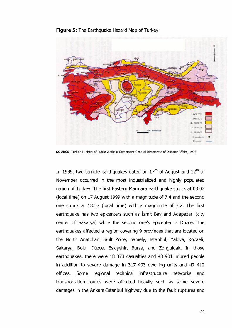
74
Figure 5: The Earthquake Hazard Map of Turkey
SOURCE: Turkish Ministry of Public Works & Settlement-General Directorate of Disaster Affairs, 1996
In 1999, two terrible earthquakes dated on 17th of August and 12th of
November occurred in the most industrialized and highly populated
region of Turkey. The first Eastern Marmara earthquake struck at 03.02
(local time) on 17 August 1999 with a magnitude of 7.4 and the second
one struck at 18.57 (local time) with a magnitude of 7.2. The first
earthquake has two epicenters such as İzmit Bay and Adapazarı (city
center of Sakarya) while the second one’s epicenter is Düzce. The
earthquakes affected a region covering 9 provinces that are located on
the North Anatolian Fault Zone, namely, Istanbul, Yalova, Kocaeli,
Sakarya, Bolu, Düzce, Eskişehir, Bursa, and Zonguldak. In those
earthquakes, there were 18 373 casualties and 48 901 injured people
in addition to severe damage in 317 493 dwelling units and 47 412
offices. Some regional technical infrastructure networks and
transportation routes were affected heavily such as some severe
damages in the Ankara-Istanbul highway due to the fault ruptures and

75
liquefactions and high damages (more than 50%) in the drinking water
and sewerage systems in the region.
Those earthquakes gave crucial damage to the Turkish economy.
Firstly, the earthquakes hit major industrial zone of Turkey. Secondly,
when the earthquakes occurred, Turkey had a critical economic period.
In mid-1999 Turkish Government had launched an extensive economic
reform program to control high inflation and build sustainable economic
growth. The total financial loss is estimated as more than 10 billion US$
according to the 2000 economic figures. That amount of the financial
loss refers 5% of Turkey’s Gross National Product (GNP) in 2000. The
per capita GNP in 2001 decreased by 26.7 percent, dropping to 2,123
US$ due to the economic recession and the decrease in the value of
the Turkish Lira (JICA, 2004;pp. 6-7).
The following figures are denoting regional dispersion of physical
damages and losses clearly:
Table 6: The Number of Casualties in the Eastern Marmara
Earthquakes in 1999
PROVINCES NUMBER OF CASUALTIES
BOLU 318
BURSA 268
DÜZCE 838
ESKİŞEHİR 87
ISTANBUL 981
KOCAELİ 9 476
SAKARYA 3 894
YALOVA 2 505
ZONGULDAK 6
TOTAL 18 373
SOURCE: Turkish Ministry of Public Works & Settlement (PW & S)/ General Directorate of Disaster Affairs,
Crisis Management Center, 2000

76
Table 7: The Building Stock Damage Assessment Results in the
Eastern Marmara Earthquakes in 1999
DAMAGE CLASSIFICATION
COLLAPSED/HEAVILY
DAMAGED
MODERATELY
DAMAGED
SLIGHTLY
DAMAGED
PROVINCES
DWELLING
UNITS
OFFICES DWELLING
UNITS
OFFICES DWELLING
UNITS
OFFICES
BOLU 2 334 219 6 099 902 5 736 837
BURSA 141 3 571 25 940 68
DÜZCE 16 666 3 873 10 968 2 573 10 124 1 422
ESKİŞEHİR 90 21 167 18 314 22
ISTANBUL 3 051 447 15 102 2 510 14 065 1 943
KOCAELİ 35 839 5 478 41 100 5 861 45 111 6 122
SAKARYA 24 689 5 146 18 406 3 764 24 423 2 349
YALOVA 13 895 751 14 540 1 159 11 879 1 885
ZONGULDAK 91 1 286 4 691 8
TOTAL 96 796 15 939 107 315 16 816 113 382 14 657
SOURCE: Turkish Ministry PW & S/ DG of Disaster Affairs, Crisis Management Center, 2000
Many factors caused those catastrophes, namely, magnitude and range
of the earthquakes; disaster occurrence times; demographic &
economic conditions of the disaster areas; public awareness &
institutional technical care for constructions; limited existing economic
conditions of the country; and existence of rapid and distorted
urbanization & industrialization in disaster areas. Those factors became
the items of lessons learned of Turkey. In addition to these items
Turkey gained some experiences in disaster response process. That is
to say some problems such as lack of coordination and organization
showed the weakness of the country disaster response capacity.
In sum, Turkey has some lessons learned stemming from disaster
response, recovery, and preparedness processes of 1999 Eastern
Marmara Earthquakes. Thus, it could be beneficial to start this study
based on Turkey’s lessons learned from 1999 Eastern Marmara

77
Earthquakes to share previous experiences in the scientific era as an
efficient initiation for strengthening technical capacity of other disaster
prone countries.
3.5. Review in Turkish Disaster Legislation
In Turkey, the whole body of legislation related to disaster issues can
be elaborated into three groups such as disaster legislation, planning
legislation, and the building legislation. The current disaster legislation
consists of various laws, decree laws, regulations, directions and
circulars. The major laws on disasters can be summarized as follows:
(a) The Law on Civil Defense No. 7126 of 13 June, 1958: Some
amendments were made in due course in parallel with the changing
requirements. The Ministry of Interior is responsible for implementing
the law. The law aims at minimizing the losses of lives and properties
due to reasons or armed conflicts, foreign attacks, natural disasters
and big fires; protecting the substantial plants and ensuring the
continuity of public services. The law also sets out the organization,
tasks and responsibilities of the national defence authorities.
(b) The Law on Precautions and Aids for Disasters Influenced the
Common Daily Life, No. 7269 of 25 May, 1959: According to the Law,
the Ministry of Public Works and Settlement is in charge of
responsibilities in the case of the natural disasters. After some disaster
experiences such as earthquakes and floods, the law was needed to be
enlarged. Hence, some substantial amendments were made by the Law
No. 1051 of 1968 and latter amendments were made by Laws No.4123
and 4133. The Law with its amendments aims to serve disaster
response, emergency aid, and recovery activities. To fulfill this aim, the
Law determines the procedures, principles, and responsibilities of
authorities in the case of disaster hazards such as earthquakes, fires,
floods, landslides and avalanches.
(c) The Prime Ministry /Turkey Atomic Energy Institution is in
charge of responsibilities of nuclear security by the Law on Turkish
Atomic Energy No. 2690 of 9 July, 1982: The purpose of the law is to
78
determine the organization, responsibilities and tasks of the Turkey
Atomic Energy Institution with respect to planning and supervision of
usage of nuclear energy, security of radiation, and protection of
nuclear plants, and prevention of nuclear accidents in Turkey.
(d) The Regulation on Constructions in Disaster Areas: The
regulation is issued in the official gazette of 13 May, 1996, no. 22635
(second print) provides that constructions in disaster prone areas must
comply with the “Turkish Standards and the General Technical Contract
of the Ministry of Public Works and Settlement”.
(e) The Regulation on Principles of City and Town Plans and of
Significant Buildings and Establishments in terms of Civil Defence,
Decree No. 4/11715 of 6 July, 1959: This regulation sets out standards
and procedures of settlement areas and construction plans of cities and
towns in sensitive areas as a matter of civil defence.
(f) The Regulation No. 88/12777 on “Emergency Relief
Organization and Planning Principles on Disasters” which is legally
based on the Law on Precautions and Aids for Disasters Influenced the
Common Daily Life (Law No. 7269) is issued in the official gazette of
8.5.1988, no. 19808. The regulation determines principles for
organizing central and local emergency management institutions and
designing an emergency management plan.
(g) The Prime Ministry Crisis Management Center Decree No.
96/8716 of 9 January, 1997: The aim of the regulation is to determine
the organization, tasks, working procedures, and responsibilities of the
Prime Ministry Crisis Management Center. The regulation was updated
due to the reasons of establishment of the General Directorate or
Turkish Emergency Management and building efficient organization and
coordination in disasters in 4.7.2002 by the decision of the Cabinet no.
2002/4518.
(h) The Decree Law No. 99/583 (issued in the official gazette of
22.12.1999, no: 23884) and Decree Law No. 600 (issued in the official

79
gazette of 14.7.2000, no: 24079) on the establishment of Turkey
Emergency Management. These decree laws aim at ensuring the
countrywide effectiveness of emergency management in the event of
natural and technological disasters. The implementing principles and
procedures are to be determined by subsequent regulation (Alarslan;
2001).
The planning legislation is mainly constituted with the Public Works
Law (Law No.3194) and its related regulations and circulars. The
existing Public Works Law that came into force in 1985 designates
principles, processes, procedures and responsible institutions in all
planning and public works in Turkey. In addition to planning issues,
there are construction issues such as standards and procedures,
building and residence permits, technical responsibilities, quality
controls, qualification of contractors, and construction penalties in the
Public Works Law. The law also consists of procedures of disaster
plans. In its 9th article, 2nd paragraph, the law assigns the preparation
and modification of plans in disaster prone areas to the Ministry of
Public Works and Settlement. 39th article of the Law serves to purpose
of disaster mitigation indirectly with the explanation on technical
procedures of insecure buildings (The Turkish Ministry of Public Works
& Settlement-General Directorate of Disaster Affairs; 2006). After 1999
earthquake experience, the Ministry of Public Works and Settlement
had many updates on this law and related regulations. In 2004, the
Ministry prepared a draft law (Draft Law of Public Works and
Urbanization) to serve more modern and safer settlements and built
environments. Nevertheless, that draft law is still in evaluation process.
In addition to the Public Works Law, there are a few complementary
regulations which are indirectly related to the disaster legislation.
These are:

80
The Regulation on Tasks and Responsibilities of Technicians
Except Engineers, Architects, and City Planners (issued in the
official gazette of 2.11.1985, no. 18916 (second print))
The Regulation on Tasks and Responsibilities of Electrical
Technicians(issued in the official gazette of 11.11.1989, no.
20339)
The Regulation on Qualifications of Map Preparation Contractors
(issued in the official gazette of 11.10.1993, no.21725)
The Regulation on Qualifications of Plan Preparation
Contractors(issued in the official gazette of 7.1.2005, no. 26046)
The Regulation on Principles of Plan Preparation(issued in the
official gazette of 2.11.1985, no. 18916 (second print))
The Regulation on Development of Non-Planned Areas (issued in
the official gazette of 2.9.1999, no.23804)
The regulations above denote that the planning legislation in Turkey
does not only cover the principles of planning but also sets out
principles of technical qualifications of planners and technicians in the
sector, criteria of building and residence permits, and standards of
buildings. It is still discussed that whether all building regulations
and/or standards should be gathered under the building act. In
addition to these regulations, many circulars related planning, disaster,
and building issues cause confusion in the implementation frequently.
On the other hand, the planning legislation itself is very complicated in
Turkey due to the fact that there are many ministries, local authorities,
and institutions took part in spatial planning (Duyguluer, 2007).
The building legislation in Turkey is not well organized. It consists of
the technical specifications, related regulations, circulars, standards of
building materials, the Public Procurement Law (Law No. 4734) (issued
in the official gazette of 22.01.2002, no.24648) and its regulations
came into force by the Ministry of Public Works and Settlement, the
Building Inspection Law (Law No.4708) (issued in the official gazette of

81
13.07.2001, no.24461) and the Building Insurance. The more, as it is
already mentioned that there are legal provisions related with buildings
in the Public Works Law. The building related regulations can be listed
as follows:
The Standard Regulation for Development of Non-Metropolitan
Municipalities(issued in the official gazette of 2.11.1985,
no.18916)
The Additional Regulation for Bunkers (issued in the official
gazette of 25.8.1988, no. 19910)
The Regulation for Development of Metropolitan Municipalities
(Each Metropolitan Municipalities has its own original regulation)
The Regulation for High Rise Buildings in Metropolitan
Municipalities(Each Metropolitan Municipalities has its own original
regulation)
The Regulation for Installation for Metropolitan
Municipalities(Each Metropolitan Municipalities has its own original
regulation)
The Regulation of Thermal Isolation (issued in the official gazette
of 8.5.2000, no. 24043)
The Regulation of Buildings in Earthquake Prone Areas (issued in
the official gazette of 6.3.2007, no.26454)
The Regulation of Building Materials(issued in the official gazette
of 1.12.2006, no. 26363)
The Regulation of Elevator(issued in the official gazette of
15.2.2003, no. 25021)
The Regulation of Fire(issued in the official gazette of 26.7.2002,
no. 24822)
The main technical specifications are on the principles on ground
survey and soil analysis, preparation of architectural and engineering
projects, architectural and engineering works in buildings.

82
After 1999 Marmara Earthquake and some successor earthquakes in
Turkey, it was decided to build a building inspection system due to the
fact that main earthquake hazards stems from non-controlled
constructions. In 2001, the Building Inspection Law (Law No.4708)
came into force. The law also brought some new concepts and
processes to the construction field in Turkey such as building inspection
institutions. All types of buildings and constructions defined in the
Public Works Law are subject to the building inspection. Building
inspection institutions certified by the Ministry of Public Works and
Settlement are in charge of building inspection in Turkey. They are
responsible for;
i. examining the ground survey and soil analysis of the building lot
and all types of building plans and projects such as architectural,
static, electric,
ii. assenting to projects for the building permit application
iii. inspecting the building process and building materials
iv. controlling occupational safety and health in the construction site
v. informing to building and residence permit authorities in respect
to the construction quality.
Another initiative after 1999 Marmara Earthquake is “Earthquake
Insurance”. Due to the reason that the Disaster Fund belonged to the
Disaster Law did not surmount on all earthquake hazards, the necessity
of earthquake insurance arose. The Decree Law on Compulsory
Earthquake Insurance (Decree Law No. 587) came into force in 1999
established the earthquake insurance system in Turkey (issued in the
official gazette of 27.12.1999, no. 23919 (second print)). The Decree
Law assigned a “Natural Disaster Insurance Institution” reported to the
Undersecretary of Turkish Treasury. The earthquake insurance system
in Turkey aims to compensate the losses of dwelling units due to the
earthquake hazards while facilitates the responsibilities of central
government. Besides it ensures sharing earthquake risks in the country
83
while transfers some of the risks to the international market via
reinsurance. The system insures losses of dwelling units due to
earthquakes and fires, explosions, and land slides triggered by
earthquakes. The earthquake insurance system covers all
registered/legal dwelling units and all commercial and administrative
units located in residential buildings. Hence public buildings, non-
residential buildings, and buildings in villages are not subject to the
earthquake insurance system (The Turkish Ministry of Public Works &
Settlement; 2004).The earthquake insurance is compulsory where the
Natural Disaster Insurance Institution declared. Failure to comply with
the insurance requirement results in for feature of public assistance in
ability to register property title, and denial of access to drinking water
and natural gas, electricity, telephone, cable TV, and other utilities
(Gençosmanoğlu; 2005).
3.6. Institutions Involved in the Disaster Mitigation Process
Before introducing the institutions with responsibilities in the disaster
mitigation process, it is useful to draw a profile of Turkish disaster
institutions from a historical perspective. The existing geography of
Turkey has witnessed many disasters especially earthquakes since
ancient times. According to one of the oldest Ottoman documents,
earthquake recovery activities had mostly focused around Istanbul
(JICA; 2004). From the foundation of Turkish Republic up to now,
some milestones can be highlighted in building disaster-related
institutions and disaster management system.
Between last decade of the Ottoman Empire and the foundation of the
new Turkish Republic (1914-1930) the most active institution was the
Turkish Red Crescent Society. It provided emergency relief to the
people in both disaster and war cases. In the period of 1930-1944,
various laws were enacted to enlarge the responsibilities of
municipalities and the Ministry of Public Works and Settlement for the

84
improvement and reconstruction of settlements. Those responsibilities
may be characterized as disaster recovery activities. In this period,
because of extensive loss of lives and properties due to flash floods
and earthquakes, some important legislative and institutional
arrangements were adopted. Thus, in 1943, the Directorate of State
Hydraulic Works was founded by the Law of Precautions and
Preventions of Floods and Underground Waters. In 1944, the
responsibility of the Ministry of Public Works and Settlement was
enlarged by a law on “Measures to Be Put into Effect Prior and
Subsequent to Ground Tremors” (Law No. 4623). The Ministry of Public
Works and Settlement prepared the first earthquake hazard map of
Turkey and adopted a regulation on compulsory technical building
requirements in cooperation with universities and other related
governmental institutions. This law also charged the municipalities with
the task of implementing technical building requirements. In the period
of 1944-1958, there were many revisions of the earthquake hazard
map and the regulation on compulsory technical building requirements.
After 1950, the rapid increase in population and urbanization and
industrialization caused a gradual diminishing importance of those
obligations (JICA; 2004). According to Ergunay, due to the fact that
there was no major earthquake during 1950-1960, some political
repercussions arose and the implementations based on the Law No.
4623 lost their effectiveness (Management of Natural Disasters in the
Eastern Mediterranean Region, 1998). With the rapid increase in
population, construction and planning activities rose tremendously. In
response to these developments, the Ministry of Public Works and
Settlement was reorganized (assuring tasks of physical planning, land-
use, disaster affairs, and hydraulic works) by a new law of 1956 (Law
No. 6785). In 1958, another new institution, the General Directorate of
Civil Defence was founded to conduct search and rescue operations in
disasters. The legal base of the General Directorate of Civil Defence
was the Civil Defence Law (Law No. 7126). In 1959, the Ministry of
Public Works and Settlement assumed further responsibilities in natural
disasters such as earthquakes, floods, landslides, rock falls and fires by

85
Law No. 7269 on “Precautions and Aids for Disasters Influenced the
Common Daily Life” which is still in force as of today . In line with this
new disaster law, the General Directorate of Disaster Affairs which
reported to the Ministry of Public Works and Settlement was
established in 1965. Another new feature of the Law is the
establishment of a “Disaster Fund” to finance necessary disaster
activities without depending on the central budget. In 1971, the
Earthquake Research Institute (currently Earthquake Research
Department) was established in the General Directorate of Disaster
Affairs. The Institute was responsible for earthquake research activities
in cooperation with universities and other scientific institutions. In
1972, a special “Earthquake Fund” was created by Law No. 1571. In
the period of 1970-2000, while the General Directorate of Disaster
Affairs developed its organization, technology, and personnel profile,
several disaster research centers were established in universities, e.g.
the “Earthquake Engineering Research Center” in the Middle East
Technical University/Ankara, the “Turkish National Committee on
Earthquake Engineering” in the Istanbul Technical University. In this
period, the Ministry of Public Works and Settlement also developed
some public awareness and training projects and programs (JICA;
2004). The European Disaster Training Center (=AFEM) was
established under the Ministry on the basis of the Council of Europe’s
Open Partial Agreement of 1988(The Turkish Ministry of Public Works &
Settlement, 2007) (see also “International Seminars & Conventions”-
AFEM). In the period of 1990-2000, the International Decade for
Natural Disaster Reduction (=IDNDR) (see also “International Seminars
& Conventions”-IDNDR) organized a center under the chair of the
Deputy Undersecretary of the Ministry of Public Works and Settlement.
This center and its activities provided an opportunity to criticize the
disaster management system and mitigation activities of Turkey. The
center prepared a National Plan of Turkey for the IDNDR period and
distributed it to all pertinent institutions and decision making
authorities (JICA; 2004).

86
The Eastern Marmara Earthquakes in 1999 became a milestone for the
history of disaster legislation and institution building in Turkey. The
responsible institutions started to criticize the disaster management
system and its features such as organization, funds, and legislation. In
contrast to these positive initiatives, the economic crisis after the
earthquakes caused some adverse effects such as the transfer of
earthquake and all other special funds to the central budget. In the
period of 1999-2004, the Turkish Government promulgated many
decrees, regulations, decree laws and laws in conjunction with the
creation of some new institutions, such as the Natural Disaster
Insurance Institution, the General Directorate of Turkish Emergency
Management (JICA; 2004).
The creation of the ad hoc Turkish National Earthquake Council is
another initiative in the wake of the 1999 Eastern Marmara
Earthquakes. The Turkish National Earthquake Council aimed at making
scientific assessments of earthquake predictions and informing the
public, identifying the priority of researches on earthquake mitigation,
policy development, and strategy building, and proposing necessary
actions and programs. The Council comprised twenty independent
scientists; it was established by circular of the Prime Ministry dated
21.3.2000. These scientists came from various universities and
scientific research institutions, and they included 8 earth scientists, 8
structural and earthquake engineers, an architect, a city planner, a
social psychologist, and an environmental engineer. The Council
determined its own working principles, made numerous public
announcements, organized many researches and studies, and
published a booklet called “The National Earthquake Mitigation
Strategy” as a result of its studies. This booklet was published in 2002
and distributed extensively to universities, central and local authorities,
members of the Parliament, etc. (JICA; 2004). The outcomes of the
National Mitigation Strategy document were also taken into

87
consideration of latter “Earthquake Council” organized by the Ministry
of Public Works and Settlement (The Turkish Ministry of Public Works &
Settlement; 2004). The Council was abolished by circular of the Prime
Ministry dated 6.1.2007.
In September 29-October 1, 2004, the Ministry of Public Works and
Settlement, organized an event called "Earthquake Council" with the
participation of universities, public institutions and other pertinent
authorities, NGOs and interest groups. This event aimed at evaluating
future proposals on earthquake-related precautions and regulations; it
had been prepared by seven ad hoc committees that had worked for
approximately 3 months on the following topics: Institutional Building,
Legislation, Disaster Information System, Examination of Existing
Building Stock & Building Inspection, Building Materials, Funding &
Disaster Insurance, Disaster Training (The Turkish Ministry of Public
Works & Settlement; 2004).
Currently, the following institutions are involved in disaster
management and mitigation system in Turkey:
Tasks of the Prime Ministry/General Directorate of Turkish Emergency
Management (Responsibilities and authorities as per decrees law nos.
583 and 600)
a) To ensure that the public institutions involved in disaster field form
emergency management centers with the aim of efficient emergency
management and co-ordination in accordance with sound working
procedures
b) To evaluate the precautionary measures taken by institutions in order
to prevent disasters and/or to minimize the damages, including the
preparation of short- and medium-term plans and the establishment of
information banks
88
c) To maintain coordination services for the employment of rescue and
aid equipment, land, sea and air vehicles belonging to public and
private sectors in cases of emergency
d) To prepare regulations encouraging the voluntary aid institutions to
coordinate in the deliverance, protection and transference of aid
equipment
Tasks of the Ministry of Public Works & Settlement/General Directorate
of Disaster Affairs
a) To implement and coordinate emergency aid in cases of disasters
b) To ensure that the short- and medium-term measures are taken in
disaster stricken areas in order to provide temporary settlement, to
distribute services to these areas to maintain cooperation and
coordination among public institutions involved.
c) To identify disaster prone areas and to take due measures towards
preventing disasters,
d) To determine and implement measures and principles aiming at
minimizing the death toll and loss of property in disaster areas in
cooperation with relevant ministries and public institutions.
Tasks and Brief Introduction of the European Natural Disasters Training
Centre (AFEM)
The European Natural Disasters Training Centre (AFEM) is a non-profit
organization which provides training on hazard reduction techniques.
AFEM was established within the EUR-OPA framework in 1988 and
affiliated to the Ministry of Public Works and Settlement. Its
institutional structure and operational procedures are governed rules
and establishment principles have been determined by Turkish
legislation. AFEM focuses on providing training for technicians and
executives who with responsibilities for management of natural
disasters. Bodies of AFEM are of the Council, the Scientific Committee
and the Training Centre. The Council makes decisions on the annual
programs and budget of the Centre. It in particular sets priorities for

89
topics, target groups, policies and strategies of AFEM. The members of
the Council are appointed by the Member States of the Eur-Opa Major
Hazard Agreement. Budget of AFEM is in equal parts provided from the
budgets of the European Open Partial Agreement (OPA) and the
Turkish Government. Additional contributions come from international
organizations, and special projects are financed by much organizations,
such as DIFD-of U.K., The World Bank, etc. (The Turkish Ministry of
Public Works & Settlement, 2007)
More specifically, AFEM carries out three types of activities:
training of technicians and governmental officers
preparation of visual and written training materials for citizens in
all age and occupation categories
organization of seminars for specialized target groups
In addition to these three tasks above, AFEM has been searching on
development of training programs.
Tasks of the Ministry of Interior/General Directorate of Civil Defence
a) To ensure the security of people and property at the time of war, to
rescue lives and property in the event of disasters and to encourage
the civil society to support defence activities case of war
b) To organize civil defence services across the country, to maintain and
supervise the preparation, implementation and coordination of these
services at public and private institutions
c) To plan and implement armless, protective and rescue precautions,
emergency rescue and first aid activities, to determine measures
against fires and standards for fire brigades, to educate, supervise and
coordinate the personnel, to keep civil defence search and rescue
teams ready and to entrust them when necessary
The General Directorate of Civil Defence in co-operation with the
Ministry of Finance discharges these functions through Civil Defence
Expertise in public and private institutions and Civil Defence
Directorates in cities and provinces (Alarslan, 2001).

90
Tasks of the General Directorate of Red Crescent
a) Provides services such as distribution of tents, blankets, food and
clothing for the disaster stricken areas
b) Provides urgent shelter for disaster stricken people in cooperation
with the relevant institutions as per decisions of its own committee
and provides food at common shelters.
c) Collects foreign or local aid equipment and distributes it to the
shelter areas determined by the committee.
d) Provides medical equipment and services such as health teams,
blood and blood products in cooperation with the Ministry of Health
and relevant institutions, if necessary.
The Undersecretary of Treasury/ the Natural Disaster Insurance
Institution (=DASK)
The Decree Law on Compulsory Earthquake Insurance (Decree Law No.
587) came into force in 1999 established the earthquake insurance
system in Turkey (issued in the official gazette of 27.12.1999, no.
23919 (second print)). The Decree Law assigned a “Natural Disaster
Insurance Institution” reported to the Undersecretary of Turkish
Treasury. The Natural Disaster Insurance Institution is responsible for
insurance and designation of insurance obligators. The Institution
performs its duties on hazard assessment, marketing, and
administrative procedures for earthquake insurance and reinsurance via
service procurements. It is a public and non-profit institution. It is
managed by a steering committee constituted by seven members
including the chief executive. Other committee members are executive
officers from various fields (4 of them), private sector representatives
(2 of them), and an academic staff (The Turkish Ministry of Public
Works & Settlement; 2004).

91
In addition to aforementioned organizations, the organization and co-
ordination of Turkish institutions in disaster field –in emergency cases-
is provided by the Regulation No. 88/12777 on “Emergency Relief
Organization and Planning Principles on Disasters” (issued in the official
gazette of 8.5.1988, no. 19808) for both of central and provincial
levels:
(1) Central Organization: There are three pieces of legislation on
the central organization of disaster management. The boundaries
among these legislations are as yet indefinite. Thereunder, the
following bodies are envisaged:
(a) “Central Coordination Council on Disasters” is a disaster
management center which shall be established in case a disaster
affects common life and exceeds the city boundaries. It competencies
are set out in Regulation No. 88/12777 of the Ministry of Public Works
and Settlement.
The council is chaired by the Undersecretary of the Ministry of Public
Works and Settlement, and it consists of the following
undersecretaries. The participant authorities of the council are
responsible for maintain accurate information about their own
technical, financial, and personnel resources for efficient coordination.
*The Ministry of National Defence
* The Ministry of Foreign Affairs
* The Ministry of Finance
* The Ministry of Justice
*The Ministry of National Education
* The Ministry of Health
* The Ministry of Transportation
* The Ministry of Energy and Natural Resources
* The Ministry of Agriculture and Rural Affairs
92
* The Ministry of Environment and Forestry
* The Ministry of Labour and Social Security
* The Ministry of Industry and Commerce
(b) “Turkish Emergency Management Department” was established by
the Decree Law No. 583 of 15 November, 1999 and No. 600 of 14
June, 2000. The department is charged with taking necessary
precautions for the efficient functioning of emergency management in
events of the earthquakes, landslides, fires, accidents, meteorological
disasters, nuclear and chemical accidents and immigration movements
affecting the safety of the country. The department also tasked with
coordinating institutions implementing studies on precautionary
measures taken to prevent or mitigate disasters, on search and rescue
activities and on the improvement facilities after disasters.
(c) “Prime Ministry Crisis Management Center” (BKYM) shall be
organized at the central level in case of a crisis (including disasters) as
stipulated by the Regulation No. 96/8716 of the Prime Ministry. The
Center is to operate under the authority of the General Directorate of
Turkish Emergency Management.
The aim of the regulation is to determine the organization, working
procedures, mission statement and responsibilities of BKYM and to
ensure that
preparations and activities are performed correctly in accordance
with the national interests to prevent or end a crisis, and
a crisis causes minimum damage and interests are preserved by
maintaining coordination and cooperation among General Staff,
relevant ministries and other institutions.
The mission statements, responsibilities and working procedures of
these three centers are generally similar.
(2) Organization of Provinces: Civil defence services established by the
Ministry of Internal Affairs under the Law No. 7126 are organized in a

93
way to provide services during and after wars. They are not envisaged
for disasters.
To fill this legislative gap, the Ministry of Internal Affairs has
interpreted the term “movable teams” under its enabling legislation and
established Civil Defence Unions in Ankara (35 staff), İstanbul and
Erzurum (20 staff). These new bodies were employed successfully in
local disasters. However the fact that they were inadequately staffed
during the last local disasters (and subjective press statements) led to
the underestimation of their activities and to criticisms.
The Ministry of Public Works and Settlement (General Directorate of
Disaster Affairs) established “Central Coordination Council for
Disasters” for the fight against disasters and disaster management and
“”Emergency Aid Service Groups for Disasters” in cities and provinces.
Emergency Aid Provincial Organization for Disasters in Cities and
Districts
In cities and city districts “City Rescue and Aid Committees” are
created under the chairmanship of the governor or deputy governor;
these consist of:
*Municipality representatives
*City Gendarme Regiment Commandership
*Chief of Police
*Chief of Civil Defence
* Directorate of National Education Youth and Sports
*Directorate of Public Works and Settlement
*Directorate of Agriculture
*Directorate of Forestry
*Representative of Turkish Red Crescent

94
*Garrison commander or highest ranked military officer of the area.
Tasks
The Committee
1. ensures that the emergency aid plans are developed and
implemented
2. evaluates the provincial plans and submits them to the governor for
ratification
3. establishes service groups in accordance with the plans and
determines arrangements for staffing, educating, and making such
groups ready for service
4. determines the principles of relief management and satisfaction of
needs
5. determines the operational principles of the service groups,
coordinates follow up the activities
6. maintains cooperation and coordination among institutions
responsible for the implementation of emergency aid services
7. evaluates the disaster relief activities and their results
8. coordinates the provision of personnel and equipment for service
groups.
9. returns back to the central fund account funds allocated for
emergency aid activities but not spent
10. makes relief proposals such as postponement of debts and opening
of new credits for the disaster-stricken people.
These following service groups may be credited in cities and provinces
to perform emergency aid activities:
*Transportation Service Groups
*Communication Service Groups
*Rescue and Debris Removal Groups

95
*Preliminary Damage Determination and Temporary Settlement Service
Groups
*Security Service Groups
*Purchasing, Renting, Detention and Distribution Service Groups
*Agriculture Service Groups
*Electricity, Water and Sewerage Service Groups
3.7. Criticism on Existing Disaster Mitigation System and Process in
Turkey
The problems and shortcomings resulting from deficient legislation,
procedures, and implementing practices, have been documented in
many written or oral evaluations after the 1999 Eastern Marmara
Earthquake in Turkey. In response, many laws, regulations, and
directives were issued to resolve observed problems and conflicts.
These attempts at modernizing disaster legislation, however, failed to
achieve expected results. Thus far many efforts in Turkey have been
made as reactions to disaster experience; yet even the recent
legislation fails to set out an effective system of precautionary
measures aimed preventing disaster-related damages.
The lack of a general policy and/or master plan for disasters in
Turkey is widely criticized. Although Turkey is one of the high
risk disaster countries, she has no country scale disaster policy
as a tool for disaster mitigation. In the Turkish Five Year
Development Plans, a first attempt for disaster awareness can be found
in the 4th Five Year Development Plan for the period of 1973-1979
which stated:
“In natural disaster sensitive areas, special standards and by-laws shall
be applied for the structures to be built, and renewal and retrofitting
works will be carried out for existing buildings.” However, this
statement was misused as a basis for obtaining the government
cooperation in legalizing unsafe and irregular constructions in urban
settlements.

96
In the 5th Five Year Development Plan (1985-1989), the following
statement was made under the heading of Principles and Policies:
“The villages located in disaster zones will have first priority with
respect to improving activities for residential buildings by supporting
training, application and encouragement and developing village type
dwelling units.”
While the above principle was developed, Public Works Law numbered
3194 was newly became into force in 1984. Regrettably, the Law failed
to set out an approach for taking into account natural disasters in the
planning process. Approaches on disaster risk mitigation were first laid
down in the 6th Year Development Plan (1990-1994). The Erzincan
Earthquake in 1992 also prompted some initiatives for disaster
emergency management and improvement of building stocks in
disaster areas.
The 7th (1995-2000) and 8th (2000-2005) Five Year Development Plans
provided more concrete approaches such as the preparation of country
scale earthquake zoning maps and the insertion of local earthquake
hazard zones into the physical plans. The Public Works Law and related
planning legislation were updated in those periods in accordance with
the main policies set out in the Development Plans. Especially in the
period of 8th Five Year Development Plan with the experience of 1999
Earthquake in Turkey, many modern approaches were initiated such as
the preparation of country scale disaster maps, designing an integral
planning process together with a building quality control system, and
establishing a national scale disaster information system. (The Turkish
Ministry of Public Works & Settlement (General Directorate of Disaster
Affairs), 2006)
The recent adoption of the Ninth Seven-Year Development Plan (2007
– 2013) provided an opportunity of remedying the main policy deficit

97
and/or sustainability, but again it was missed. Although the Seven-Year
Development Plan sets out a comprehensive medium-term master plan
for economic, social, and regional development in Turkey, it does not
include policies and strategies on disasters. It is believed that the
criticism of Seven-Year Development Plan (2007–2013) would be an
efficient initiation to examine the disaster implementations in Turkey.
The Ninth Seven-Year Development Plan (2007 – 2013) was prepared
by the State Planning Organization (SPO) and adopted by the National
Assembly. The SPO is the undersecretariat of the Prime Minister in
charge of overall economic and development planning. The multi-year
development plans are the main instruments of medium- and long-term
economic policy planning and coordination. They set out a
comprehensive vision for development and outline in broad terms
strategic action plans towards this vision. Since the 1990s,
international field disaster mitigation is considered as an important
element for achieving sustainable development. In this frame,
development plans could make a significant contribution to disaster
mitigation by including this topic into Turkey’s macro-economic policy
framework (BALAMİR, 2006).
However, the Ninth Seven-Year Development Plan addresses
urbanization and urban settlements issues only in a socio-
economic context and entirely ignores the spatial planning and
disaster prevention challenges. Although Turkey is one of the high
disaster risk countries, such topics as urban risk assessment, disaster
threats for urban settlement, disaster mitigation to achieve sustainable
urban settlements are not mentioned at all in the Development Plan.
While special ad hoc-committees had been convened in the preparation
of the Development Plan on myriad policy areas (see table below), the
issues of disasters or risk mitigation in urban areas were not studied in
this frame at all (The Prime Ministry/SPO, 2006).

98
Disaster prevention and management are addressed in the
Development Plan only in the context of “Rationalizing the Authority
and Responsibilities among Different Institutions” and “Provision of
Development in Rural Areas”. Under the first heading, questions of
administrative competencies and responsibilities among various state
authorities involved in disaster prevention and management are
discussed; and under the second heading, disaster mitigation is
recognized as a planning priority for high risk rural areas (The Prime
Ministry/SPO, 2006).
Particularly after the 1999 earthquakes in Turkey, it is understood that
Turkey urgently needs a macro policy and a master plan on disaster
prevention and management. To serve as an effective policy
instrument towards this objective, the Ninth Seven-Year Development
Plan would have to set out basic principles and main actions on
disaster mitigation. These would have to focus on urban areas where
disaster risks are demonstrably higher than in the rural areas of
Turkey.
After the criticism of Seven-Year Development Plan as a macro political
tool for the country, various implementations in Turkey will be
examined such as directives on decision-making mechanisms, plans,
programs, controlling mechanisms. The existing process and
procedures of various working committees set up by the Ministry of
Public Works and Settlement in 2004 with respect to an "Earthquake
Council" will be reviewed. Seven ad hoc committees worked on the
topics of institution- building, legislation, disaster information system,
examination of existing building stock and building inspection, building
materials, funding and disaster insurance, and disaster training (The
Turkish Ministry of Public Works & Settlement; 2004) (see also “3.2.
Responsible Institutions in the Disaster Field”).
99
Before reviewing existing process and procedures of the various
working committees, a profile of difficulties in the emergency
management of the 1999 earthquakes will be drawn. A task paper
prepared by an official worked in the Prime Ministry Crisis Management
Center pointed out the following shortcomings (Göktürk & Yilmaz,
2005):
o Shortcomings in Personnel: The staff of the Emergency
Management Center of the Prime Ministry lacked proper
professional orientation, work discipline, as well as foreign
language skills to communicate with foreign assistance
programs.
o Shortcomings in Transportation and Organization: The staffs of
the Emergency Management Center and urgently needed
services were not quickly transported to disaster prone areas.
For instance, satellite based communication systems were
transported via highways rather than by air, even though
highways to disaster prone areas were blocked by earthquakes
for several days. Work shifts in the Emergency Management
Center as well as distribution of urgent goods and services to
disaster prone areas also functioned suboptimally.
o Shortcomings in Coordination: Inefficient coordination problem
between the Prime Ministry Emergency Management Center and
regional emergency management centers in disaster prone areas
often created chaotic conditions during the crisis time.
o Problems with Media: The Prime Ministry Emergency
Management Center experienced difficulties in securing the
release of accurate information to the media, i.e. the
dissemination of wrong or biased information created
misjudgments or adverse reactions of the public.

100
o Inefficiencies in Emergency Management: The competition
among government executives slowed downed decisions on
necessary emergency measures.
o Pressures from Private Firms of Pre-fabricated Housing: The
decision making on numbers and site of temporary housing units
was hampered by attempts of firms of pre-fabricated housing at
influencing decisions of Prime Ministry Emergency Management
Center on building temporary houses.
It is an interesting point of experiences in 1999 earthquakes
that while governmental institutions revealed major
shortcomings, non-governmental organizations and volunteer
groups played a remarkably active and efficient role in
responding to the 1999 earthquakes, arising as a new sector in
the disaster response system of Turkey.
The Institution-Building Committee aimed at analyzing the
existing situation of the disaster management system in Turkey,
pointing out problematic fields, and designating compulsory measures
and precautions. The following main problems of the Turkish disaster
management system can be identified in light of the findings of the
Committee:
MAIN CONCERN: Although Turkey is prone to many types of natural
and man-made disasters, the main concern relates to the natural
disasters and mostly earthquakes. Accordingly, the legislation and
institutional structure of disaster management chiefly focus on
earthquakes (see also 3.1. Review in Turkish Disaster Legislation and
3.2. Institutions Involved in the Disaster Mitigation Process).
Moreover, existing institutional organization and legislation
mostly concentrate on disaster response and recovery
activities. Precautions and measures for disaster preparedness

101
are inadequately developed. Even legislative and institution-
building initiatives in the wake of the 1999 earthquakes are mainly
concerned with improving recovery activities or disaster response
organization. Notably, the activities of public training, disaster
recognition and awareness in relation to disaster preparedness have
not been properly organized in Turkey, as yet. Another significant
shortcoming in the disaster preparedness process relates quality
control and construction standards. A study of the Union of Turkish
Contractors proposes the vocation of a new quality control and
insurance mechanism in Turkey and a mechanism should be introduced
by legislation and rely on the cooperation of and contribution from local
authorities, private sector and other interest groups (Karaesmen,
1996).
COORDINATION & ORGANIZATION: All disaster mitigation plans and
programs need to be prepared before actual disasters occur, and they
need to be coordinated under one single authority. Although there are
many institutions with disaster-related responsibilities, including
coordination functions in Turkey, a single coordination authority is
still outstanding. As noted before, the “General Directorate of Turkey
Emergency Management” founded by the decrees with the force of law
nos. 99/583 and 600 is charged with coordinating the institutions
involved in the preparation, response, and recovery process of
earthquakes, land slides, falling rocks, fires, accidents, meteorological
disasters, nuclear and chemical accidents, and people movements
affecting the security of the country. Yet, this General Directorate thus
far fails to operate effectively due to staff and budget constraints. A
draft law on “Tasks and Organization of the Directory of Disaster and
Emergency Management” was introduced on 18.03.2008 to the
Parliament where it is still pending. The draft law aims at regulating
conflicts among various Turkish institutions with similar roles in disaster
mitigation such as the General Directorate of Disaster Affairs, General

102
Directorate of Civil Defence, and General Directorate of Turkish
Emergency Management. The proposed Directory of Disaster and
Emergency Management will report to the Prime Ministry. Discussions
are still proceeding on the abolishment of existing institutions
envisaged in the draft law. If adopted, the law will accomplish a
remarkable reform of the more than fifty year old framework of
disaster institutions (see also Annex I.17 ).
Overlapping responsibilities of authorities in disaster events
sometimes cause gaps in the provision of services and
inconsistencies of instructions issued by different authorities.
Conflicts have sometimes been experienced even in the same
institutions. For instance, in the 1999 Marmara Earthquake, the
settlement plans for disaster prone areas were prepared by two
different General Directorates of the Turkish Ministry of Public Works
and Settlement in the exercise of planning responsibilities provided in
the Public Works Law (Law No.3194) and the Disaster Law (Law
No.7269). Both of the laws provide for plan preparation responsibilities
in disaster areas without addressing a specific General Directorate. To
resolve the ensuring ambiguity, two General Directorates negotiated an
ad hoc formula for the coordinating settlement plans in disaster prone
areas; however, this formula applied only to the 1999 earthquakes.
Similar problems were experienced in search and rescue activities and
relief organizations after disasters.
Several disaster mitigation activities revealed a lack of
coordination between central and local authorities. There are
some fundamental reasons behind it. First of all, Turkey is a central
state with a strong central government. Secondly, many disaster-
related responsibilities are bestowed on ministries and other central
authorities due to the fact that central authorities have better financial
resources and technical personnel than local authorities. Although local
authorities are easier accessible and are more familiar with local
conditions, central authorities in Turkey traditionally wield most
103
powers. In order to improve cooperation and coordination among
central and local authorities in the disaster mitigation process, a new
system should be developed with devolution of competencies to local
authorities, NGOs, and various organizations of local community
(Management of Natural Disasters in the Eastern Mediterranean
Region, 1998).
The 1999 Marmara Earthquakes, inconsistencies were
observed among disaster management approaches, methods,
and even terminologies of various governmental and non-
governmental organizations involved in the process. Hence,
disaster managers in GOs and NGOs should be trained according to a
common concept of disaster management, organization and
coordination with common approaches and disaster terminology (The
Turkish Ministry of Public Works & Settlement; 2004). Moreover, an
integral disaster management system is urgently needed; this system
would have to intend all phases of disaster management, namely,
preparedness, prevention, response, recovery and mitigation. A single
institution should coordinate the interaction institutions and
organizations operating within this system.
INTEGRATION OF DISASTER MITIGATION ACTIVITIES AND SPATIAL
PLANNING INSTRUMENTS: Although Turkey is prone to frequent
natural disasters, disaster mitigation techniques and approaches
are not reflected in spatial planning methods and procedures.
This dichotomy undermines the effectiveness of disaster mitigation in
Turkey, notably with respect to earthquake hazards. As earthquake
hazards correlate with spatial planning standards and building codes,
earthquake mitigation techniques should be inserted in tools of spatial
planning and construction works. Natural disaster mitigation techniques
should thus become an integral part of national and local level planning
activities (Management of Natural Disasters in the Eastern
Mediterranean Region, 1998).

104
The “GEMITIS” Project introduced in the International Seminar on the
Management of Natural Disasters in the Eastern Mediterranean Region
presents an example for integrating disaster mitigation techniques into
spatial planning approaches. The GEMITIS Project which is supported
by the French Committee for IDNDR, aims at forming of regional
networks of cities committed to joint action in the spheres of disaster
prevention and sustainable development. Disaster mitigation will be at
the core of close collaboration between cities until a systematic
exchange of information and experiences coordinated by French
specialists. Reference procedures will be adapted by the participating
cities to their socio-economic, technical, political, and cultural
circumstances (Management of Natural Disasters in the Eastern
Mediterranean Region, 1998).
Akin to the GEMITIS Project’s dynamics and principles, disaster hazard
assessment data can be inserted into spatial planning analysis base
maps which provide guidance to spatial planning decisions. Risk
assessment and mitigation techniques can also be taken into
consideration in making spatial planning decisions. For instance,
disaster risks and other spatial planning criteria can be taken into
account in developing site of the residential areas, standards and
construction details of new residential areas. Such approaches were
initiated in Turkey in areas with high earthquake hazards, especially
after 1999 Marmara earthquakes. It is recommended to redesign all
spatial planning tools and materials with a view to various natural
disaster risks in countries prone to frequent natural disasters like
Turkey.
In addition to integrating disaster mitigation approaches with spatial
planning tools, Turkey needs to rearrange her entire spatial planning
procedures and processes. At present, Turkey has a quite chaotic
spatial planning system overlapping responsibilities of various
institutions involved in spatial planning with various planning

105
legislations. The existing spatial planning system of Turkey consists
of 18 institutions and 56 different types of spatial plans. Besides, there
are more institutions (approximately 50 institutions having
responsibility of spatial plans and decision making processes) took part
in the decision making process of the spatial planning (Duyguluer,
2007). Fragmented spatial planning responsibilities and complex
planning processes tend to cause difficulties in integrating disaster
mitigation approaches with spatial planning tools.
PUBLIC & INSTITUTIONAL AWARENESS AND TRAINING: This topic will
be developed in some detail in the criticism of the “Disaster Training
Committee”. In this context, some topics and principal
recommendations will be underlined with respect to institutional
awareness and training which indirectly affect public awareness. All
institutions taking part in disaster mitigation and management
processes should provide training to their staff and they should follow a
common definition of key disaster-related terms such as risk,
mitigation, hazard, vulnerability, etc. All institutions with responsibilities
related to spatial planning and building sectors should be fully familiar
with the control process for spatial plans and constructions. Such
institutions should employ planners, architects, civil engineers,
geologists, cartographers, etc. with criteria of technical proficiency,
liability, and experience.
Spatial planning institutions should also initiate a public participation
process in planning and disaster mitigation topics. Such initiative might
be easier to adopt on the local level than on the central level. Local
citizens or civil society organizations can be involved in the process of
developing local spatial plans and disaster mitigation projects via local
authorities, i.e., municipalities and governorates (The Istanbul
Metropolitan Municipality, 2002).

106
SUSTAINABILITY OF INSTITUTIONS AND INSTITUTIONAL
ACTIVITIES: The criticism under this subtitle derives from on personal
practical experience and observations as well as international working
groups on disaster mitigation and cooperation in Turkey. Turkey has a
high capacity of building new institutions and enacting new legislation.
Nevertheless, Turkey has experienced many failures in
sustaining new institutions and organizations as well as in
solving conflicts between new legislation and related
(existing) legislation. For instance, the Prime Ministry/General
Directorate of Turkish Emergency Management was established in the
wake of the 1999 earthquakes to coordinate disaster activities has thus
for failed to provide effective coordination. To some extend, such
failure is due to weaknesses of the enabling legislation of decree laws
(law nos. 583 and 600) rather than full-fledged laws with proper
budgetary allocations. Another unfortunate example is the Turkish
National Earthquake Council. Established in 2000 (just after the 1999
Marmara Earthquake) due to urgent needs, the Council was abolished
by circular of the Prime Ministry dated 6.1.2007. It is difficult to explain
the instability of these key institutions in the light of the high disaster
threats and hazards in Turkey. The decision makers in Turkey should
review their approaches to institution-building. Adequate time and
efforts should be spent on deciding the question whether a new
institution is necessary or not. Before it is decided to establish a new
institution, legislative, financial, and organizational foundations should
be designed properly. Similarly, before an institution is abolished, a
cost-benefit analysis should be carried out including an assessment of
its activities and an evaluation of its performance.
Frequently, the members of committee or working groups on
disaster topics do not serve sufficiently long terms to sustain
activities or programs. For instance, the Turkish Delegation to the
South-eastern European Countries Civil-Military Cooperation Workshops

107
(see also 2.5 International Seminars & Conventions-Stability Pact) in
2000-2001, attracted considerable criticism because of frequent
changes of its members. Several measures are proposed to remedy
this problem. First members of both local and international working
committees should be carefully selected and appointed. Secondly,
technical persons appointed to various disaster working groups should
be able to accomplish their tasks without fear of being replaced
arbitrarily or as a matter of administrative routine. Thirdly, working
group or committee members should be relieved from other tasks so
that they can devote sufficient time to the task of the committee or
working group. Lastly, members of disaster committees should not be
replaced as a result of changes in the central government and other
political conflicts.
FINANCE: Securing sufficient financing is a significant challenge in
organizing or reorganizing the disaster management system in Turkey.
Lack of financial support and budgetary constraints related to disaster
mitigation activities make it difficult to organize an effective disaster
management system and to build necessary institutions. As
substantiated in more detail under the criticism of the “Funding and
Disaster Insurance Committee”, new funds, budgetary items and
related financial measures are necessary to sustain an efficient disaster
management system in such a disaster prone country as Turkey. New
financial measures are also necessary for scientific research and
technological developments for disaster mitigation. Especially with
respect to earthquakes, scientific researches and technology based
methods are inevitable for building disaster resilient settlements since
major threats do not emanate from the earthquakes themselves but
inadequate and inefficient adherence to construction and spatial
planning standards.
The Disaster Legislation Committee aimed at examining and
criticizing the existing earthquake legislation in Turkey. As already

108
mentioned, in Turkey, the earthquake legislation is understood to
encompass legislation directly addressing earthquake issues, spatial
planning legislation, and building legislation (see also “3.1. Review in
Turkish Disaster Legislation”).
The main criticism relates to the chaotic condition of the
earthquake legislation itself with myriad of laws, regulations,
and decrees enacted by various institutions in various
earthquake incidents without coordination. As a result, many
conflicts among different institutions have been experienced so far. It
is strongly recommended to build a new coherent legislative system
that furthers a common understanding, terminology, approach, and
coordination among related institutions.
The existing earthquake legislation moreover does not include
definitions of key terms, such as risk, risk assessment, and
disaster mitigation. An effective earthquake legislation is especially
important for Turkey where more than half of the population lives in
urban areas. In accordance with the assumption of this study, urban
areas are more vulnerable to earthquakes than rural areas due to the
density of population and constructions.
Detailed criticism of existing earthquake legislation and proposals for
new legislation will be elaborated under three following three subtitles:
EARTHQUAKE LEGISLATION: As noted above the existing earthquake
legislation consists of myriad laws, decree laws and regulations with
insufficient coordination among various institutions involved. To resolve
this problem a new earthquake frame law clarifying responsibilities and
interaction of various institutions in the pre-disaster period, in the
course of disaster, and the post- disaster period is needed. The new
frame law should outline disaster mitigation activities and approaches.
Disaster mitigation activities should encompass:

109
i) preparation of earthquake hazard and risk maps
ii) building and developing local and international networks of
earthquake information
iii) preparation of urban earthquake risk maps and risk
assessment studies
iv) management of the earthquake insurance system
PLANNING LEGISLATION: The existing spatial planning system chiefly
concentrates on earthquake recovery activities. After 1999
earthquakes, some amendments to the existing planning legislation
addressed risk prevention (see also “3.1. Review in Turkish Disaster
Legislation”). These amendments, however, are not sufficient to make
settlements disaster resilient. The Public Works Law (Law No.3194) as
a main planning law has been criticized for rather soft obligations and
penalties with respect to building permits. According to a 1992 report
on the assessment of the earthquake in Erzincan, especially articles 31,
32, and 42 of the existing Public Works Law need to be revised
urgently. These articles set out obligations and penalties in the case of
buildings without construction and/or settlement permits (Ergunay et
al., 1993).
In terms of approaches, the spatial planning legislation needs to be
revised with respect to risk assessment and disaster mitigation. For
that purpose, the Disaster Legislation Committee proposes to
incorporate some new terminologies and approaches into the existing
planning legislation. These are “micro-zoning”, “mitigation plan”, and
“urban transformation action plan”.
The concept of “micro-zoning” requires the preparation of maps that
relate earthquake risks to settlement areas. For this purpose,
settlement areas could be divided into a few types of micro zones such
as zones where buildings are prohibited, zones where special ground
survey analyses are required, zones where buildings are permitted only

110
subject to adherence to special technical standards, and safe zones.
This approach should also be inserted into spatial plans. Spatial plans
should also have plan notes to determine conditions of settlement and
construction for each earthquake risk zone.
The “mitigation plan” is a document to provide guidance on
coordinating outputs of risk analyses and risk management activities in
various sectors such as housing, transportation, infrastructure, public
services, etc. Such guidance can be provided, and hence mitigation
plans be prepared, for settlements, regions, or an entire country.
Mitigation plans serve to: (i) create data bases for risk analyses of
various sectors, (ii) assess risks, (iii) generate methods for risk
reduction and sharing, (iv)prepare multi-stake holder mitigation
programs in the short-, medium-, and long-run, (v) prepare public
training and awareness programs and projects, and (vi) organize
monitoring programs for mitigation activities. A mitigation plan should
also address responsibilities of various institutions involved in action
program of disaster mitigation for a settlement prone to earthquakes. A
mitigation plan should be prepared as a base map of a spatial plan. All
planning decisions should be taken in light of the risks pointed out by
the mitigation plan.
An “urban transformation action plan” is a spatial plan with an action
program; this might include resettlement activities, measures to
strengthen all constructions, measures to upgrade the environment in
high disaster risk areas pointed out in the mitigation plans.
BUILDING LEGISLATION: As already mentioned, the building legislation
in Turkey comprises technical specifications for constructions, building
related regulations, circulars, and standards for building materials. It
also includes the Public Procurement Law No. 4734 with implementing
regulations issued by the Ministry of Public Works and Settlement as
well as, the Building Inspection Law No.4708 and the building

111
insurance legislation. Provisions on buildings can furthermore be found
in the Public Works Law (see also “3.1. Review of Turkish Disaster
Legislation”). It is recommended to aggregate all these partial
legislations in a new “Building Law” to improve efficiency and
effectiveness in the quality control of building stocks.
As a complementary part, the Turkish building legislation entails
provisions on the ground survey analysis. In the light of lessons
learned from 1999 earthquakes, the following basic mistakes are
addressed in the respect to ground survey analyses of buildings:
The difference between geological surveys for spatial plans and
ground survey analyses is often misunderstood or ignored.
Geological surveys for spatial plans serve the purpose of proper
site development for settlement areas. So far, results of
geological surveys for spatial plans have been used in lieu of
ground survey analyses for building dots. However, ground
survey analyses are necessary to establish basic technical
standards for buildings. To clarify roles of geological surveys and
ground survey analyses, respectively, the Ministry of Public
Works and Settlements has prepared a document called
“Basic Principles on Preparation of the Report on Ground
Survey and Analysis of Building Foundations” in 1993.
The document was prepared on the basis of Eurocode 7.
Lack of control and unqualified staff engaged in ground survey
analyses have caused many failures and losses in earthquakes,
even though such deficiencies are not peculiar to earthquake
events. Ground survey and building foundation analyses should
only be performed by expert engineers who bear all technical
responsibilities. In the case of larger area ground survey and
building foundation analyses, an expert engineer group
consisting of geological engineers, geo-physical engineers, civil
112
engineers, and mining engineers should be appointed (The
Turkish Ministry of Public Works & Settlement; 2004).
The Disaster Information System Committee has been tasked
with developing a Disaster Information System that would gather
process and assess all geological and seismic data. A Disaster
Information System (in Turkey mainly with a view to earthquakes) is
considered as a useful basis for a Disaster Mitigation System. Building a
Disaster Information System requires four steps, namely
(i)rehabilitating and integrating existing seismic networks and
observatories, (ii) designing a seismic and geological data base and
building an earthquake data bank, (iii) determining earthquake threats,
and (iv)micro-zoning.
In Turkey, some existing seismic observatories and networks
are already operative. These networks need to be upgraded in
response to existing needs and in light of modern
technologies. Turkey needs a National Seismic Network System which
will help to observe and asses seismic data, send reliable data rapidly
to disaster emergency management units, disseminate information to
the media and public, generate and file data for scientific researches on
disaster mitigation. The Committee proposed a National Seismic
Network System with the following sub-systems:
A National Earthquake Observatory
A National Seismic Network
A National Network on Strong Motions
Regional, Local and Temporal Networks
A reliable and sufficiently comprehensive data base on geological and
seismic conditions is a prerequisite for determining real earthquake
threats; such determination in turn provides the basis for disaster
mitigation activities. The Committee proposed that data base

113
concentrate mainly on active fault lines and paleo-seismology which
explains numbers and frequency of hazardous earthquakes stemming
from active fault lines in historical and pre-historical periods. A
seismology map showing fault lines and protection zones should be
prepared based on such data bases.
In conjunction with creating the aforementioned data base, the
Committee also proposed to build an earthquake data bank which
provides an opportunity to share and exchange all earthquake related
data by all types of users, such as emergency management units, relief
organizations, scientific researchers, etc. Some initiatives on this topic
have been taken by some universities and municipalities in Turkey, but
none of them has sufficiently progressed yet. Towards a national scale
earthquake data bank, the Committee proposed to:
Build an earthquake data center based on space technology and
GIS(=Geological Information System) to manage the data bank,
Adopt governmental policies that guide institutions in
participating in data gathering and assessment that
institutionalize coordination among the various institutions
involved in the process,
Define a common terminology and information standards for
disasters and/or earthquakes, and
Strengthen international cooperation on space based technology
and organize training programs in this field.
As already mentioned, the concept of threat implies a combination of
the probability (or frequency) of occurrence of a natural hazard (see
also Annex III). In accordance with this basic definition, an earthquake
threat can be described in terms of the probability of occurrence of a
hazardous earthquake. The determination of earthquake threats in the
frame of a National Disaster Information System implies analytical
studies of geological, seismological and historical data, classification
114
and mapping of earthquake sources, modeling on earthquake events
and reoccurrences, and transforming outputs of earthquake threat
analyses into technical specifications for buildings.
Micro-zoning is a method for preparing detailed analyses of the
geological structure and ground conditions in regions threatened by
earthquake. The micro-zoning mainly serves to purpose of determining
earthquake hazard zones in urban plans. Micro-zoning can be
implemented in three basic steps and scales: (i) In 1/25 000 scale
maps, main characteristics of earthquakes are determined in
accordance with probabilistic method for different regions. (ii) In 1/5
000 scale maps, geological, topographical, and geo-technical features
of ground strata are determined for each regions. (iii)In 1/ 5 000 or 1/1
000 scale maps, micro zones are determined to guide planning
decisions of urban settlements (The Turkish Ministry of Public Works &
Settlement; 2004).
Since disaster mitigation has many interrelated sub-topics, different
working committees sometimes have presented common solutions, e.g.
micro-zoning. While this method is a proposal of the Disaster
Legislation Committee, the Committee of Disaster Information System
also suggests this method as a disaster mitigation measure.
The Examination of Existing Building Stock and Building
Inspection Committee aimed at analyzing the disaster/earthquake
resilience of existing building stocks as well as at determining
problematic areas in the building process and possible solutions for
improvements. The Committee proposed a method of graduated
assessment of the existing building stock. This method envisages three
grades of assessment:
1. Primary Grade: Quality assessment of buildings on the basis of
observation from outside, e.g. from the street. At this level, data

115
such as outlook of a building, number of storeys, single or
attached building, and overhangs can be collected.
2. Secondary Grade: Detailed analysis and data collection from the
inside of a building. At this level, data are collected from
architectural and structural plans, sections, etc. The assessment
at this level mostly serves risk classification. The outcomes of
this assessment improve decision-making on the future of the
building stocks, such as retrofitting, removal, and renovation
(Sucuoğlu, 2006).
3. Tertiary Grade: At this level, detailed analysis is performed on
buildings in need of special attention, such as highly damaged
buildings and important public service buildings. Detailed
information on ground survey of the building, building materials,
bearing system materials, etc. is needed for that purpose.
The proposed method of graduated assessment should also be
supported by data from earthquake risk maps and micro-zoning. The
stability of buildings and building performance can be measured by
synthesizing geological data and building data.
As another important element of the method of graduated assessment
foresees a classification of building stock. The Committee proposed to
classify urban building stocks in Turkey according to their use and
building types as follows:
1-7 storey concrete buildings
1-5 storey masonry buildings
High rise buildings (more than 7 storeys), such as
business centers and residential buildings
Schools, hospitals, and fire brigade buildings
Public buildings
116
Single industrial buildings, such as 1-2 storey concrete
buildings, prefabricated buildings, organized industrial site
buildings, etc.
Industrial establishments, such as factories
Strategically important buildings
Buildings containing hazardous waste
Bridges and viaducts
Wood constructions
Infrastructure networks
Cultural assets
The method of graduated assessment for the examination and
measurement of earthquake safety of existing building stock should be
supported by building inspection. Building inspection involves two
steps, namely project control and construction control. Project control
denotes the control of architectural, static, electrical plans by the
authorities in charge according to principles drawn laid down in the
Public Works Law (Law No. 3194). Construction control is based on the
Building Inspection Law (Law No.4708) (see also “3.1. Review in
Turkish Disaster Legislation”). The Building Inspection Law sets out a
building inspection system aimed at saving lives and assets, increasing
the quality of buildings for that purpose, clarifying responsibilities and
authorities of technical staff such as building contractors and building
inspection institutions2, architect and engineer controllers in the
building process. The building inspection system also aims at increasing
awareness of consumers, protecting of consumers, and applying
sanctions in the case of failure in legal aspects. The implementation of
2 Building inspection institutions are incorporated institutions certified by the Ministry of Public Works and
Settlement. They have to employ at least 8 architects and engineer controllers). Building inspection institutions play an intermediate role between building owners and relevant authorities. They are responsible for controlling the entire construction process and procedures; they have to guarantee the safety of the building for a certain period of time determined in the Law (The Turkish Ministry of Public Works & Settlement; 2004).
.

117
the system is presently tested in 19 provinces in Turkey on a pilot
implementation basis.
The Building Inspection Law (Law No.4708) has some weaknesses.
Most notably is the failure of setting out a compulsory the building
insurance system in the frame of the Law. The Committee strongly
recommended a building insurance system that would
facilitate improving the solidity of buildings and the prompt
repair of constructional damages (The Turkish Ministry of Public
Works & Settlement; 2004).
The Building Materials Committee aimed at analyzing existing
construction quality and building materials in Turkey and at developing
some recommendations on improving the build-up environment. Since
this thesis mainly focuses on spatial planning for urban settlements,
the topic of building materials is not studied in detailed. Only the
quality and usage of building materials are significant in the context of
the present thesis.
The Committee categorized building materials into three groups,
namely main building materials, repairing and rehabilitation materials,
and isolation materials. Two main problem areas related with building
materials are -relevant in the present context- inadequate quality of
building materials and improper use of building materials in a
construction. For instance, buildings have severe damages after
earthquakes due to low quality of building materials, failure to observe
technical standards in the construction process, and improper condition
of fixing building materials. In light of lessons learned in the 1999
Marmara earthquakes in Turkey, the Regulation on “Building Materials”
was adopted (issued in the official gazette of 1.12.2006, no.26363).
This Regulation was based on EU Directives on “Construction Products”
(EU Directive No.89/106EEC).

118
The Committee also categorized materials used in existing building
bearing systems in Turkey as follow (The Turkish Ministry of Public
Works & Settlement; 2004):
In Concrete Construction: Concrete and steel installation
In Masonry Construction: Bricks
In Wood Construction: Wooden materials
In Construction of Rural Areas (Stone & Sun-dried Brick
construction): Stone and Sun-dried Bricks
In Steel Construction: Steel and metal materials
Upon the analysis of the existing situation, the Committee made the
following recommendations towards improving the quality and use of
building materials (The Turkish Ministry of Public Works & Settlement;
2004):
A comprehensive legislation on building materials should be
prepared.
A market surveillance and control system for building materials
based on the existing and/or new legislation should be
established.
The number of building material testing laboratories should be
increased to support the market surveillance and control system.
A Supreme Council for building materials which guides
surveillance and control of building material with respect to
issues of principle building, activities, control and training should
be established.
The Funding and Disaster Insurance Committee aimed at
mitigating disaster risks by a disaster insurance system and designing a
model for financing necessary activities in pre-disaster and after
disaster periods. Since all aforementioned ad hoc committees

119
concentrated on earthquakes, an insurance system and a finance
model were derived from the dynamics of earthquakes.
The Committee recommended creating the following systems
and facilities for financing activities in the pre-disaster, in
disaster, and post-disaster periods:
A Disaster Insurance System
A National Disaster Fund
A Model on Sustainable Housing Ownership Subsidy and
Rehabilitation
In Turkey, so far, activities, measures, and programs in the course of
disasters and in post-disaster periods have been financed by the
central government budget. Foreign grants and credits have been
obtained and new taxes have been imposed to finance budget deficits
emanating from disaster related expenditures and investments. This
traditional mode of financing had causes a lack of investments in
disaster preparedness in Turkey. While a compulsory earthquake
insurance system was established in 2000, the following problems
remain unresolved (see also “3.1.Review in Turkish Disaster
Legislation”):
Due to economic crises in the wake of disasters, lack of public
awareness and recognition of earthquake risks, and weak
enforcement of the compulsory earthquake insurance system,
the rate of insured dwelling units remains low.
The Natural Disaster Insurance Institution under the
Undersecretariat of the Turkish Treasury faces organizational
and legislative difficulties. It in particular needs an enabling
legislation which provides sufficient authority and sanctions to
implement compulsory earthquake insurance system.

120
Especially after 1999, the increasing number of devastating
disasters worldwide lead to a shortage of reinsurance capacity
and a rise of reinsurance premiums. This has adversely affected
the insurance market in Turkey for disaster risks.
In light of these problems, Governmental incentives are strongly
advised by the Committee to increase the number of earthquake
insurance holders. In addition to such incentives, the following
financing methods are recommended to decrease the risk of
earthquakes and the costs of possible earthquake hazards.
Since Turkey is a country prone to disasters which may exceed
her own coping capacity, the Committee strongly advised to
create a main disaster authority that organizes disaster
preparedness and response activities with the support of
special funds and an organizational structure(The Turkish
Ministry of Public Works & Settlement, 2004). Although a special
“Earthquake Fund” had already existed, the fund was in the wake of
1999 earthquakes transferred to the central budget (see also
“3.2.Institutions Involved the Disaster Mitigation Process”). The
Committee strongly recommended a new disaster fund supported by
some other monetary resources such as some transfers from the
insurance sector, revenues from the use of some goods and
commodities (e.g. certain percentage of Value Added Tax), and some
portions of the central budget revenues.
Another recommendation of the Committee was a model for a
sustainable housing ownership and rehabilitation subsidy to help
people living in earthquake prone areas to improve the building stock.
This model recommends public-private partnerships for new housing
areas and rehabilitation projects for existing settlement areas (The
Turkish Ministry of Public Works & Settlement; 2004).
Recommendations of the Committee do not imply a fundamentally

121
different approach than that followed by the Ministry of Public Works
and Settlement in earthquake related projects. The latter Ministry
prepares many plans and construction projects for temporary
settlement (prefabricated units for earthquake victims after
earthquakes) and permanent settlement areas. Nevertheless the
Ministry of Public Works and Settlement encounters considerable
difficulties due to the lack of financial resources and technical
personnel. Better results could be achieved through a public-private
partnership model with the support of financing methods as proposed
by the Committee. The author’s practical experiences on earthquake
mitigation projects suggests that existing and experienced institutions
rather than newly founded institutions should be responsible for
planning and constructing new settlement areas as well as
rehabilitating existing settlement areas. Otherwise all lessons learned
from former disasters can fall into oblivion.
In addition to the above outlined financial proposals, regional and
international cooperation in accordance with the principles of the
Yokohama Strategy and the Hyogo Framework, is essential to mitigate
disaster risks including strengthening of financial coping capacities (see
also “2.5. International Seminars and Conventions”).
The Disaster Training Committee aimed at organizing training on
disaster mitigation topics at various levels. The task of this Committee
hence included compiling techniques and methods that should be used
in disaster mitigation of a country like Turkey where 92% of its land is
prone to earthquakes (See also “3.Disaster Mitigation Approaches and
Lessons Learned in Turkey”). Before designing effective training
methods and techniques, the Committee drew a hazard profile of
earthquakes in Turkey with the following items:
Casualties

122
Injuries, permanent physical disabilities, and mental defects
depending on post traumatic stress
Loss of livestock
Loss of building
Building hazards
Transportation route hazards (roads, railways, ports, etc.)
Infrastructure hazards (sewerage, pipelines, etc.)
Technical service hazards (electricity, drinking water, energy
lines, telecommunication networks, etc.)
Interruption in public services (security, health, education, etc.)
Hazards of cultural assets (historic buildings, culturally protected
buildings, archaeological sites, etc.)
Environmental degradation
With a view to the above hazard items, the Committee
distinguished between two main training groups, namely
formal education and mass education. Formal education
comprehends compulsory education from pre-school education to
university education. In this process, hazard-related theoretical and
practical lectures are inserted into students’ study curriculum. Mass
education relies on the voluntary participation and contribution of
people. In the mass education process, there are two main target
groups, namely (i) people who are prone to disasters and (ii)
politicians, administrative staff, and public personnel who take place in
the political, economic, social, and physical planning procedures. More
specifically, the Committee identified four target groups for mass
education:
National education
Adult education
On-the-job training
Training of business groups and NGOs
123
In national and adult education, priority is given to teachers, heads of
districts/villages, group leaders and members of district volunteer
organizations, building managers, chaplains, disabled people. The
primary target groups for on-the job training are the staff of central
authorities, local authorities, sectors of civil defence, fire brigades,
public works, conservation of cultural, historical, and natural
environment, education, rural affairs and forestry, health, technical
infrastructure, transportation, telecommunication, security, and armed
forces. Technical training and certification programs for professionals
and university students in spatial planning, geology, and the
construction sector can be carried out in the frame of both on-the-job
training programs and training of business groups and NGOs. Especially
in earthquakes, where risks are largely exacerbated by improper
constructions, co-workers and technicians in spatial planning, geology,
and construction sectors should be well trained on standards, qualified
works, and new technologies. Media representatives are another target
group which should be taken into a consideration for training of
business groups and NGOs. The Media representatives should be
trained on methods of obtaining reliable and transparent information
and disseminating such information without creating panic among the
people, as well as on building efficient and effective relationship with
governmental bodies and scientific groups in light of the psychology of
people prone to disasters. The Media should also be trained on
how to inform people about risks and increase public
awareness of disasters (The Turkish Ministry of Public Works &
Settlement; 2004).
It is moreover important to increase community awareness by
training people on what should be done before, during, and
after disasters. Such training programs can be carried out in meeting
format such as lectures, seminars, workshops as well as published
documents such as handbooks, posters, etc. Prior to disasters, people

124
and institutions can be trained on techniques of staying alive in the
course of disasters, search and rescue activities, first aid methods,
construction qualities in hosing markets, and risk awareness for their
living environment. Public administration staff should also be trained in
disaster preparedness, response, relief, and recovery process, in
addition to disaster and risk management methods and strategies.
After disasters, people and institutions should be organized to
conclude lessons learned and overall criticism of last events (Karanci &
Aksit, 2000).
The Disaster Training Committee finally recommended to include
disaster management in the university curricula for city planning,
architecture, civil engineering, public administration, and other related
disciplines. These curricula should offer lectures on disaster risks,
disaster mitigation, disaster management, and related topics (The
Turkish Ministry of Public Works & Settlement; 2004).
3.8. SWOT Analysis as an Evaluation
In this part, the findings under the above chapters (“3.3”) will be
evaluated in terms of Strengths-Weaknesses-Opportunities-Threats
(SWOT). A SWOT Analysis will be helpful in designing a best model for
disaster resilience for several purposes, such as decision making,
physical planning, controlling procedures, participation and
organization.
Originally, the SWOT analysis was designed as a strategic tool for
planning and decision making at multiple levels within an enterprise or
public or private organization. The father of the SWOT analysis was
Albert Humphrey. Albert Humphrey and Robert Stewart developed the
SWOT analysis in a team work with colleagues in the Stanford
Research Institute during 1960s. The SWOT Analysis was initially
developed for business management purposes, soon became a
planning tool (SWOT Analysis Resource Page, 2008).

125
Four aspects of the SWOT analysis can be defined in several ways. In
this study, the Turkish Disaster Mitigation System will be elaborated i
the light of following criteria of the SWOT aspects:
Strengths: As a simple definition, the strengths of the Turkish
Disaster Mitigation System denote the positive results,
achievements, and sustainable trends to the benefit of various
stakeholders, such as institutions, organizations, media, business
owners, and citizens. From a deeper perspective, strengths can
be determined in terms of factors crucial to the effectiveness of
the mitigation system, namely general advantageous in
comparison with other countries, geographical location, geo-
political status, institutional coping capacities, resources, assets,
experience & knowledge, innovations & technology used, finance
& marketing items, cultural level(literacy, value judgments,
attitudes) & awareness, administrative & management process
and procedures.
Weaknesses: Weaknesses denote exactly the opposite of
strengths. However, in order to define weaknesses of a disaster
mitigation system, it is also possible to use similar criteria as for
“strengths”. For instance, while the vast human resources in
Turkey can be evaluated as strength, over population and/or
misallocation of human resources may well be interpreted as
weakness.
To avoid confusion, different criteria are suggested for
measuring strengths and weaknesses, respectively, to the extent
possible. Thus, weaknesses of the disaster mitigation system
may best be measured in terms of general disadvantageous,
adaptation and development capacities in general, institutional
and legislative gaps, regional cohesion, shortage of resources,
vulnerable items, frequency of disasters and time frames for
preparedness and recovery, reliability of institutions, authorities,
and other stake holders in the disaster mitigation system.

126
Opportunities: Although opportunities have some similarities
with strengths; the main distinctive feature of opportunities can
be determined as positives stemming from external effects. The
criteria for assessing opportunities can be a peaceful and stable
political atmosphere, positive global influences, new
technologies and business sectors, new markets and export
quotes, willingness of foreign partners in cooperation on various
topics, such as information, disaster projects, funding, exchange
programs, etc., innovations and international scientific studies.
Threats: Similar to the relationship between opportunities and
strengths, threats have some common features with
weaknesses. Both threats and weaknesses refer to negatives
yet, while threats refer to external negatives on the disaster
mitigation system, weaknesses denote shortcomings in the
system.
Criteria used in the SWOT analysis for assessing opportunities may
also be used for assessing threats. For instance while the geo-political
situation of Turkey provides some advantageous, it may also entangle
Turkey in political problems. While Turkey has a chance of building
cooperation in her region on earthquake mitigation, such efforts can
suffer from the political turmoil in her neighbour countries. The
following aspects may be taken into account is assessing threats in the
context of a SWOT analysis: disaster profiles in neighbouring regions,
adverse political developments, international and bilateral agreements
and conventions, environmental effects such as transboundary waters,
pollutions and contaminations, adverse climate effects such as global
warming, erosion, external market dynamics such as import, export, oil
prices, changing trends in technology and consumption behaviours.
In the following tables (see also table 8 & 9), disaster mitigation
activities and programs in Turkey are examined on the basis of the
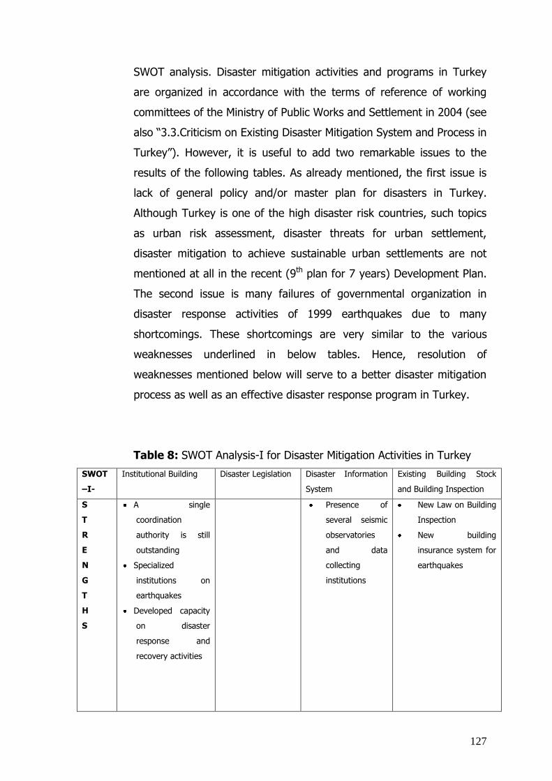
127
SWOT analysis. Disaster mitigation activities and programs in Turkey
are organized in accordance with the terms of reference of working
committees of the Ministry of Public Works and Settlement in 2004 (see
also “3.3.Criticism on Existing Disaster Mitigation System and Process in
Turkey”). However, it is useful to add two remarkable issues to the
results of the following tables. As already mentioned, the first issue is
lack of general policy and/or master plan for disasters in Turkey.
Although Turkey is one of the high disaster risk countries, such topics
as urban risk assessment, disaster threats for urban settlement,
disaster mitigation to achieve sustainable urban settlements are not
mentioned at all in the recent (9th plan for 7 years) Development Plan.
The second issue is many failures of governmental organization in
disaster response activities of 1999 earthquakes due to many
shortcomings. These shortcomings are very similar to the various
weaknesses underlined in below tables. Hence, resolution of
weaknesses mentioned below will serve to a better disaster mitigation
process as well as an effective disaster response program in Turkey.
Table 8: SWOT Analysis-I for Disaster Mitigation Activities in Turkey
SWOT
–I-
Institutional Building Disaster Legislation Disaster Information
System
Existing Building Stock
and Building Inspection
S
T
R
E
N
G
T
H
S
A single
coordination
authority is still
outstanding
Specialized
institutions on
earthquakes
Developed capacity
on disaster
response and
recovery activities
Presence of
several seismic
observatories
and data
collecting
institutions
New Law on Building
Inspection
New building
insurance system for
earthquakes

128
W
E
A
K
N
E
S
S
E
S
Shortage of funds
and budgetary
constraints
Instability of
institutional
structures
Insufficient
sustainability of
institutional
programs and
projects
Insufficient
institutional
awareness with
respect to
earthquake hazards
Insufficient
attention to natural
disasters except
earthquakes
Inadequate
organization and
coordination among
various institutions
No common
terminology among
GOs and NGOs
Overlapping
responsibilities of
various disaster
mitigation
authorities
Insufficient
coordination
between disaster
mitigation methods
and tools of spatial
planning
Incoherent
and
fragmented
legislation
Conflicts
among various
laws
The main
focus in only
on disaster
response and
recovery
activities but
preparedness
and mitigation
Absence of
some basic
concepts and
approaches
such as risk
assessment,
risk prevention
Rules for
building
permits and
penalties for
illegal
constructions
not sufficiently
strict
No “National
Seismic Network
System
Difficulties in
sharing seismic
data with the
public
Insufficient
effort on
implementing an
earthquake
threat model
Insufficient
coordination and
mutual
reinforcement
between the building
inspection law and
insurance system

129
O
P
P
O
R
T
U
N
I
T
I
E
S
Institutional
initiatives on
coordination in light
of lessons learned
of 1999
earthquakes
Various institutional
innovations in
terms of
approaches and
organizations
Remarkable active
and efficient roles
of NGOs in
response activities
especially in 1999
earthquakes
Preparation of
a draft law on
disaster
mitigation
Introduction of
common
terminologies
of key terms,
such as micro-
zoning, risk
mitigation,
urban
transformation
action plans
Updates in
building
quality control
system
Awareness of
necessity of a
data collecting
and processing
center for
earthquakes
Pilot implementation
of the building
inspection system
covering 19 province
T
H
R
E
A
T
S
Competition among
disaster mitigation
institutions for lead
role
Perceiving other
institutions as
threats due to
conflicting interests
Disagreement
of various
institutions on
new approaches
and
responsibilities
Weaknesses and
failures of the
existing building
stock
SOURCE: Own source
Table 9: SWOT Analysis-II for Disaster Mitigation Activities in Turkey
SWOT
–II-
Building Materials Funding and Disaster
Insurance
Disaster Training
S
T
R
E
N
G
T
H
S
New Directive on
“Building Materials”
patterned after EU
Directive No.89/106EEC
New compulsory
disaster insurance
system for earthquakes
Professional staffs such as
planners, architects,
engineers have basic
knowledge and experience on
disasters

130
W
E
A
K
N
E
S
S
E
S
Inadequate quality of
building materials
Improper use of building
materials
Existing disaster
insurance system
covers only pre-
disaster period
No National Disaster
Fund and No Model on
Sustainable Housing
Ownership Subsidy &
Rehabilitation for
disaster and post-
disaster periods
Shortcomings of
existing legislation on
disaster insurance
Insufficient training on
disaster management
Insufficient knowledge and
experience on working
principles in disasters on the
part of media
Insufficient training on public
awareness with respect to
necessary actions before,
during and after disasters
O
P
P
O
R
T
U
N
I
T
I
E
S
Generation of numerous
proposals on legislation;
a system for market
surveillance and control;
testing laboratories for
building materials; and a
supreme council for
building materials
Various proposals for
government subsidies,
funds, and instruments
for disaster insurance
Many universities designed
their curricula and created
new departments in
accordance with needs in the
field of disaster mitigation
T
H
R
E
A
T
S
Deficiencies in existing
building materials
(already in use)
Public negligence and
low rate of insured
dwelling units due to
the economic crisis in
Turkey
Shortage of
reinsurance capacity
and remarkable rise in
reinsurance premiums
(due to increasing
number of devastating
disasters worldwide)
Due to some misinformation
of Media, the willingness of
citizens to support the
disaster mitigation activities
may reduce
SOURCE: Own source

131
As an overall assessment of disaster mitigation activities and programs
in Turkey, some basic strengths can be acknowledged in terms of
institutions, theoretical frame of legislation, spatial planning standards
and building codes, technical staff, building inspection and insurance
system. These strengths are, however, undermined by many
shortcomings on specifics. For instance, Turkey has several institutions
specializing on disasters, but efficient operations of these institutions
are curtailed by instable institutional structure, budgetary constraints,
and inadequate organization and coordination. On the other hand, the
1999 earthquakes gave rise to reviewing the entire disaster mitigation
system. Many initiatives and ongoing studies on legislation, institution-
building, insurance, and quality control look promising for disaster
resilient settlements.
Institutional cooperation, coordination, and organization are three key
issues to be developed in Turkey to sustain various initiatives after the
1999 earthquakes. Experiences of Turkey in former devastating
earthquakes show that inefficiencies in institutional organization,
coordination and cooperation are main threats for a modern disaster
mitigation system (see also “3. Disaster Mitigation Approaches and
Lessons Learned in Turkey” and “3.2. Institutions Involved in the
Disaster Mitigation Process”). In this respect, after 1999 earthquakes,
an initiative for establishing a single disaster coordinator institution is
an promising event. However, the process and procedures of
organization of this authority is still continuing due to an introduction of
new legislation and disagreement of relevant institutions (see also
Annex I.17).
Lessons learned from 1999 earthquakes also emphasized the necessity
of building a Disaster Information System in Turkey. Despite of the
presence of several seismic observatories and data collecting
institutions, there are many problems in data collecting and sharing.
Thus, Turkey needs a National Seismic Network System to provide a

132
modern services in observing and assessing seismic data as well as
user friendly platform for data sharing and updating.
Training and public awareness are other weaknesses in such a densely
populated country as Turkey. It is obvious that an effective disaster
mitigation system cannot be built on well designed institutional
structures and legislation alone. It should also be supported by
public awareness which requires public training. Turkey is
capable of organizing disaster training programs for a broad public.
According to outputs of the SWOT Analysis above, new curricula and
approaches should be introduced in Turkey. For instance, disaster
training programs should not be limited to teaching survival techniques
to the public in the course of disasters. Various training programs can
be designed for different target groups such as local authorities,
citizens, trainer for trainees, etc. The ultimate issue of public
awareness and training refers the training of Media on public
information. According to the lessons learned of 1999 earthquakes, it is
understood that citizens can reduce the willingness to comply with
essential rules and procedures of disaster mitigation activities when
they are misinformed about some public services or when they are in a
panic due to some inappropriate information of the media.
As a consequence, lessons learned from the 1999 earthquakes
can provide guidance to design a disaster resilience model for
urban settlements. While the evaluation of best international
examples gives precious inspirations to develop the model
(see also table 5), the results of the SWOT Analysis above
share more hints of the disaster mitigation capacity of a
country prone to devastating earthquakes.

133
CHAPTER 4:
4. DISASTER RISKS ON URBAN SETTLEMENTS
4.5. Analysis of Existing Risks in Urban Settlements As already mentioned (see also “1.4. Scope of the Study”), especially,
in last twenty years, natural disasters with devastating effects on
human settlements have proliferated. The propensity of disasters is
increasing in the light of such trends as increasing rate of population in
and around urban areas, degrading environmental quality, global
heating. By the year 2000, half the world’s population will live in urban
areas, crowded into 3% of the earth’s surface (Domeisen & Palm,
1996).
While urban settlements exploit natural resources and cause
environmental pollution due to their dense population and construction,
they are the core area of economic and cultural activities as well as
significant cross-roads of transportation routes, technologies, and other
modern networks. Despite their disadvantageous features, urban
settlements have therefore attracted and are attracting their increasing
populations. According to the United Nations’ figures, the share of the
world’s population in urban settlements has risen to 50% from 30%
since the 1950s and this share is expected to increase to 60% in 2030
(Munich Re Group; 2004). The increasing trend of urban population
can be observed in the following graphics (see fig. 6) in the period
1950-2050 based on the United Nations data. While the global trends
of increasing population in urban and rural settlements are shown in
the graphic on the left side, the same trend are categorized as the
population increase in developing countries and developed countries,
respectively, on the right side.

134
Figure 6: Urban vs Rural Population Increasing Trends Comparing to
Figures in Developing and Developed Countries
SOURCE: The United Nations; 2008
Owing to the density of population, construction, and accumulation of
investment, urban settlements are especially prone to high risks of
natural disasters (Management of Natural Disasters in the Eastern
Mediterranean Region, 1998). The statement above emphasizes two
remarkable issues, namely (i) urban settlements are at risk of natural
disasters and (ii) this risk is high due to their density of population,
construction, and accumulation of investment. Hence, variables of
disaster risks may be grouped in two main categories, namely
“Variables of the Urban Settlement” and “Variables of the Natural
Disaster”. An assessment of variables of the urban settlement will start
with an analysis of peculiar existing features of urban settlements
under consideration such features include the site of the settlement
(coastal settlement, hillside settlement, alluvial plain settlement …), the
ground survey of the settlement (whether urban settlement sits on firm
ground or not, land liquefaction factors, ground water levels…), the
planning standards and criteria of the settlement, land-use, population
density, population profile and public awareness for disasters (social
indicators), construction density and quality of the settlement, the

135
quality in urban infrastructure & services, economic profile of the
settlement (sectors, employment rate and profile, scale of production
such as domestic scale production or country scale or international
scale). The variables of the natural disaster can be expressed in terms
of magnitude and range of the natural disasters; the frequency, the
occurrence time and duration of disasters, and type of disasters, e.g.
only earthquake or earthquake + flood triggered by earthquake. While
each variable is equally effective on the risk, the combination of all
below variables would determine the degree of risks of a certain urban
settlement prone to natural disasters.
A third dimension will be added to the below matrix which may be
called “total capacity of disaster response” in an urban settlement.
Actually the total capacity will be compounded two parts namely,
national disaster response capacity and local disaster response capacity
which partially covers institutional coping capacity. Then the synthesis
of these three dimensions (variables for urban settlements-variables for
disasters-total capacity of disaster response) will provide the basis for
determining the risk profile and the vulnerability level of urban
settlements.

136
Table 10: Key Variables of Natural Disaster Risks in Urban Settlements
NATURAL
DISASTER
VARIABLES
URBAN SETTLEMENT
VARIABLES
C
a
us
es
Type
(Single-
Multi)
M
a
gn
itu
de
R
a
ng
e
F
r
eq
ue
nc
y
Disaster
Occurrence
Time
Duration of the
Disaster
Population Size Population Density Land-use Construction Density Construction Quality Infrastructure Quality Geology-Geomorphology Planning & Building Regulations
and Legislation
Control & Monitoring Institutional Coping Capacity
Institutional Coordination
& Organization Capability
Public Awareness &
Training Level
Economic Activities of the Settlement
Economic Conditions of
the Country
SOURCE: Own source.
After drawing the main frame of risk profile of urban settlements, two
different approaches are proposed to lessen the hazardous effects of
natural disasters on urban settlements of developing countries and
developed countries, respectively. Actually, a need for different
approaches in disaster mitigation with respect to developed and
developing countries has been recently argued by many researchers
and academics. For instance, a group of scientific researchers prepared
an article in 1999 called “A New Approach to Disaster Mitigation and
Planning in Megacities” (Valasquez et al., 1999). First of all, from the
perspective of a city planner, it is possible to distinguish between

137
urbanization processes and urban settlements in developing countries
and/or population increasing countries and developed countries. In
1950, more than half of the population of developing countries lived in
urban areas whereas the proportion was around 18% in developing
countries (Munich Re Group, 2004). Since then, the rate of
urbanization in developing countries increased more than that in
developed countries due to the rapid population increase in developing
countries (see also fig. 15). The growth of urban population has
different reflections to the urban space in developing and developed
countries. While urban settlements grow in a decentralized form in
developed countries, agglomerations around urban settlements become
the trend of urban growth in developing countries. In many developing
countries, central and local authorities have numerous difficulties to
provide adequate infrastructure and urban services to citizens. Besides,
densely populated squatter settlements around urban settlements
create more difficulties in the provision of urban services and
infrastructure in developing countries. On the other hand, the people
living in squatter settlements are mostly prone to risks of natural
disasters such as floods, land slides, and earthquakes (Domeisen &
Palm, 1996).
Outcomes of main international seminars and programs, and projects
of international organizations also indirectly support the need of two
different approaches. Thus, the Office of the United Nations Disaster
Relief Coordinator(=UNDRO) has published a seven-volume study on
Disaster Prevention and Mitigation including a methodology for
evaluating economic effects of natural disasters. According to this
study, features and dynamics of urban settlements vary according to
levels of development and other particularities. Importantly, urban
settlements in developing countries tend to be more vulnerable to
natural disasters than those in developed countries (UNDRO, 1979). At
the World Conference on Natural Disaster Reduction in Yokohama,

138
JAPAN from 23 to 27 May 1994, participant countries agreed on some
principles for disaster mitigation. One of these principles is “Vulnerable
groups should receive primary attention. In this context, developing
countries, least developed countries, small island developing countries,
and land-locked countries are the most vulnerable countries. The poor
and socially disadvantageous groups in all countries are other
vulnerable groups” (ISDR, 2007). This principle and related
approaches were also supported at the World Conference on Disaster
Reduction that was held from 18 to 22 January 2005 in Kobe-Hyogo,
JAPAN (Hyogo Framework for Action 2005-2015). According to a study
prepared by Godschalk, Edward, and Kaiser, the priorities of the
countries are set in disaster mitigation plans designed on the basis of
the sustainability concept. While sustainability comprises economic
features as well as social and environmental features of a country,
economic conditions possibly determine the priorities of mitigation
(Burby, 1998).
Another international study on disaster risks states that saving lives is
the prime focus of disaster mitigation activities in developing countries
and slum settlements in all countries (Wisner, 2004). On the other
hand, disaster mitigation plans and programs in the United States
focus primarily on saving assets and establishments of settlements
(Godschalk, 1999). This distinction also supports to two different types
of approaches towards the disaster mitigation process in different
urban settlements with different primary concerns. While saving urban
assets is the primary concern in developed countries, developing
countries’ primary concern is preventing causalities. The top 50
countries of the world are ranked by International Strategy of Disaster
Reduction on the basis of their financial losses suffered in the last
decade due to natural disasters. Despite their high-tech methods,
sophisticated standards of planning, building codes and infrastructures,
disaster insurance systems, well organized public awareness

139
campaigns and public training; many developed countries suffer
significant financial losses from natural disasters. This fact can also be
seen in the figures that among the top ten countries with highest
losses are six developed countries (see also fig. 1).
Another difference between developing and developed countries stems
from the dominance of urban settlements. Urban settlements play a
much more dominant role in developing countries and/or population
increasing countries than in developed ones. While urban settlements
are the concentration of political, administrative, economic, cultural,
technical, and infrastructural functions in developing countries; they
are just larger rings of the whole chain of infrastructure and services in
developed countries. Due to their dominant role of urban settlements
in developing countries, the vulnerability of such settlements translates
into vulnerability of the country at large. This trend can easily be
observed in the following graph. Although many developed countries
suffer significant financial losses from natural disasters, financial
vulnerability is much higher in developing countries in relation to the
GDPs (see also fig. 7). Mostly, the vulnerability extends beyond
financial losses and even triggers severe interruption of basic services
in developing countries. Thus, rebuilding the active daily life of the
entire country requires both time and monetary investments. For
instance, “Japan can recover quickly from the destruction of an event
such as the Kobe earthquake in 1995 while Nicaragua financially
suffered till the end of 20th century because of the Managua
earthquake in 1972” (Management of Natural Disasters in the Eastern
Mediterranean Region, 1998).

140
Figure 7: Economic Damages: Amount Reported by Natural Disaster & Country in the Period of 1991-2005
SOURCE: Website of International Strategy of Disaster Reduction (http://www.unisdr.org)
Despite the different disaster risk features of urban settlements in
developing and developed countries, respectively, losses of urban
settlements for both groups of countries can be categorized as i)
environmental losses such as contamination of air, soil, water, damage
to flora & fauna, etc.; ii) human resource losses such as casualties,
accidents, epidemics, etc.; iii) property losses such as livestock,
movables, immovables, etc.; iv) economic losses such as financial
losses, business interruptions, etc. (Munich Re Group, 2004). In this
frame, one of the main differences between developing countries’ and
developed countries’ urban settlements lies in the magnitude of such
losses as a share of GDP. International studies, country reports, and
statistics show that developed countries can easily cope with disaster

141
related losses, as casualties and property losses tend to amount to only
minor fraction of overall GDP. Thus governments can easily mobilize
resources for the recovery of public life, business sectors,
infrastructure, etc. In developing countries, central and local
governments face a much more serious problem to recover from
damages and losses due to disasters. While authorities in developing
countries even in normal times have inadequate resources to supply
basic public services, housing and infrastructure facilities due to rapid
population increase and migration from rural areas to urban areas, in
the case of disasters, they need foreign aid and support to prevent
turmoil in urban settlements. In addition to these problems, disaster
struck urban settlements in developing countries face further
environmental degradation because of squatter settlements and illegal
constructions.
In sum, despite all urban settlements are at disaster risk, risks and
vulnerabilities vary in developing and developed countries, respectively.
In order to reduce the risk of natural disasters, two different
approaches are effective by considering the differences in
vulnerabilities of developing and developed countries.
4.6. Vulnerability and Coping Capacity of An Urban Settlement
After examining risks in urban settlements, urban settlements are
analyzed in lights of two more concepts: Vulnerability and Coping
Capacity. Like any other disaster term, vulnerability has numerous
definitions. Variations notwithstanding, the concept of vulnerability is
described in terms of different correlations with hazard, exposure, risk,
coping capacity, and susceptibility (Greiving et al., 2006, Villagrán de
León, J.C.,2006). In order to develop a useful definition, the following
questions need to be addressed:
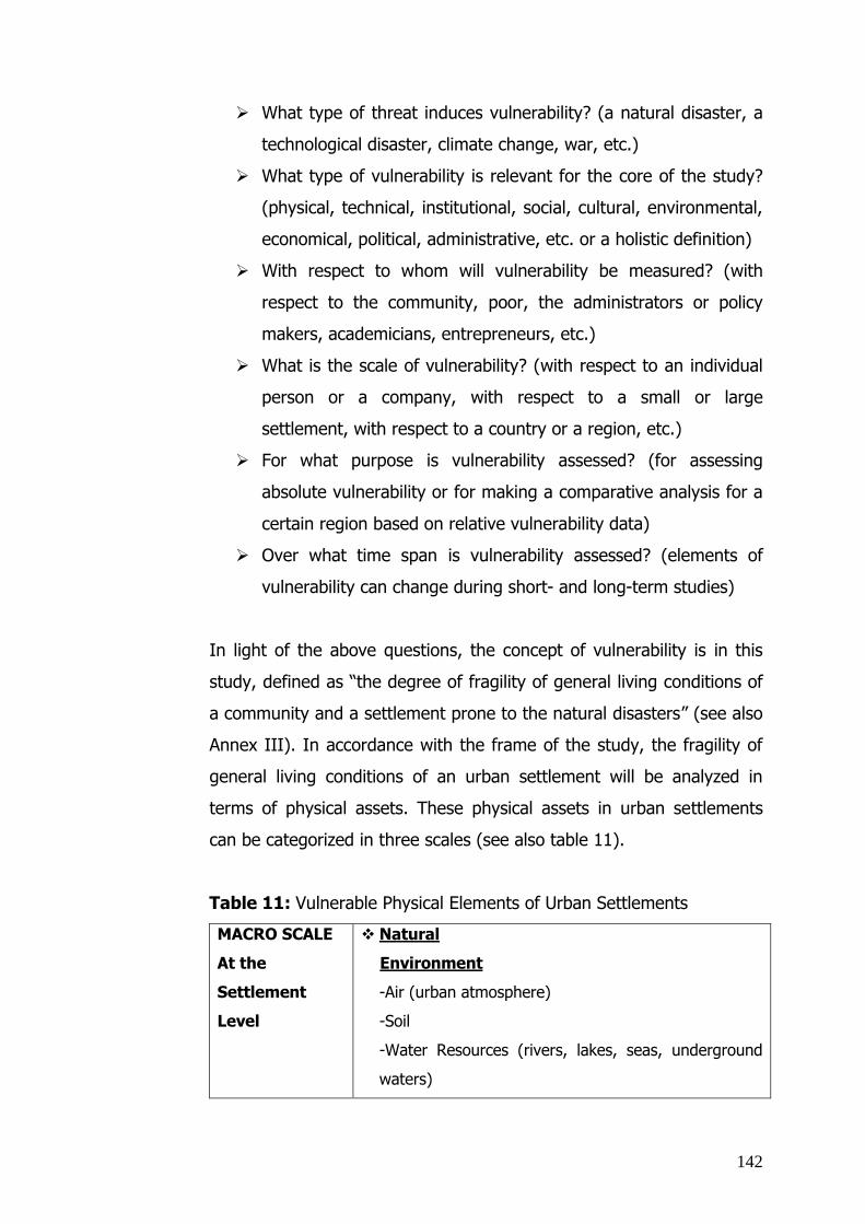
142
What type of threat induces vulnerability? (a natural disaster, a
technological disaster, climate change, war, etc.)
What type of vulnerability is relevant for the core of the study?
(physical, technical, institutional, social, cultural, environmental,
economical, political, administrative, etc. or a holistic definition)
With respect to whom will vulnerability be measured? (with
respect to the community, poor, the administrators or policy
makers, academicians, entrepreneurs, etc.)
What is the scale of vulnerability? (with respect to an individual
person or a company, with respect to a small or large
settlement, with respect to a country or a region, etc.)
For what purpose is vulnerability assessed? (for assessing
absolute vulnerability or for making a comparative analysis for a
certain region based on relative vulnerability data)
Over what time span is vulnerability assessed? (elements of
vulnerability can change during short- and long-term studies)
In light of the above questions, the concept of vulnerability is in this
study, defined as “the degree of fragility of general living conditions of
a community and a settlement prone to the natural disasters” (see also
Annex III). In accordance with the frame of the study, the fragility of
general living conditions of an urban settlement will be analyzed in
terms of physical assets. These physical assets in urban settlements
can be categorized in three scales (see also table 11).
Table 11: Vulnerable Physical Elements of Urban Settlements
MACRO SCALE
At the
Settlement
Level
Natural
Environment
-Air (urban atmosphere)
-Soil
-Water Resources (rivers, lakes, seas, underground
waters)

143
-Flora
-Fauna
Built-up Environment
-Housing Areas
-Health Services
-Education Services
-Social Services
-Administrative and Security Areas
-Commercial Areas
-Industrial Areas
-Infrastructure & Technical Service Areas
-Transportation Routes & Terminals
-Open & Green Areas
-Protection Zones (Cultural, historical, natural assets)
MESO SCALE
At the
Urban
Functions
Level
-Housing Areas
Mass housing complex
Individual buildings
-Health Services
Neighbourhood unit health care centers
Hospitals
Special rehabilitation clinics (for old, disabled,
poor, etc.)
Health centers (hospitals + labs+ research
units)
Medicine and other medical material
warehouses
Pharmacies
-Education Services
Day-care centers
Kindergartens
Primary schools
High schools
Academies and universities
Special schools for disabled persons
Education centers for adults (vocational or other

144
social purposes)
Libraries and archives
-Social Services
Theatre, opera, and cinema buildings
Concert and congress halls
Sport centers, stadiums, Olympic complexes
Museums, art galleries and other cultural facility
buildings
Cultural clubs and society buildings
Foundations
-Administrative and Security Areas
Administration centers (Governorates,
municipalities, district administration centers)
Relevant public buildings
Fire brigades
Police stations
Gendarmerie centers
Military and security facilities
Civil defence centers and their warehouses and
sanctuaries
Warehouses for vehicles, technical equipments,
and other materials for search and rescue
purposes
-Commercial Areas
Retail commercial areas
Wholesale commercial areas
Central Business Districts
Shopping Malls and Centers
Hotels and other tourism facilities
Restaurants, Cafes, and Bars
-Industrial Areas
Industrial buildings
Industrial estates
Warehouses
Technical equipment and vehicle parking areas

145
Power stations
Storage facilities for hazardous materials
Nuclear power plants
-Infrastructure & Technical Service Areas
Sewerage
Drinking water
Gas
Electricity
Telecommunication networks (TV, phone,
mobile, Internet, etc.)
Waste water treatment and solid waste disposal
areas
Energy generation and transformer stations
Gasoline stations
Dams
-Transportation Routes & Terminals
Motorways, highway, bus terminals, and
highway service stations
Railways and railway stations
Airports and heliports
Harbours, marinas, embankments, docks, quays
Bridges, tunnels, viaducts
Public transportation routes, subway lines,
stops, pedestrian underground and overpasses
Closed car parking areas
-Open & Green Areas
Green parks and playground areas
Open air sport facilities (tennis courts, swimming
pools, motor-racing tracks, horse riding and
racing areas, etc.)
Big urban parks
Arboretums
Open market areas
Cemeteries
-Protection Zones (Cultural, historical, natural

146
assets)
Architectural heritage (buildings, monuments,
bridges, aqueducts, fountains, etc.)
Other cultural and historical sites
Archeological assets and excavation sites
National parks, endemic species habitats
MICRO SCALE
At the
Citizens
Level
-Vulnerable Elements of Indoors (houses, offices,
shopping centers, etc.)
Elements of rooms such as walls, columns,
windows, doors, etc.
Elements of buildings such as stairs, balconies,
alcoves, chimneys, towers, minarets, pendent
elements, sign boards, lifts, garden walls, water
tanks, laundries, storerooms, bunkers, etc.
Elements of technical services such as electric
cables, heating system, drinking water, and gas
pipe lines, sewerage systems, ventilation
systems, power control, etc.
Elements of personal assets such as furniture,
money, documents, archives, dresses, food, etc.
-Vulnerable Elements of Outdoors (streets, car
parking areas, green parks)
Elements on streets such as buildings, street and
traffic lamps, vehicles, garbage storage areas,
parking areas and bus-stops, etc.
Elements in neighbourhood units such as
buildings, emergency centers, health care
centers, schools, shops, roads, underground and
overpasses, energy links, telecommunication
lines, fire plugs, trees, etc.
Source: Own source.

147
All vulnerable physical elements of urban settlements above are
categorized in three scales in accordance with the scales in spatial
planning. Hierarchical scales and elements of spatial plans are thus
used as a method to draw the above table. In the macro scale,
vulnerable elements of an urban settlement are listed in the regional
planning scale (1: 100 000, 1:50 000, 1:25 000 scales). Spatial plans in
regional scale can only show basic features of an urban settlement,
such as housing areas, industrial areas, main transportation routes and
environmental elements surrounding an urban settlement, such as
rivers, forests, natural conservation areas, etc. In this respect,
vulnerable physical elements of macro scale may deserve attention by
urban policy-makers and administrative officers of the central
government or decision makers in the upper level of the local
government. In meso scale, vulnerable physical elements are
eliminated under the urban planning scale such as 1:5 000 and 1:
1000. In 1:5 000 and 1:1 000 scale spatial plans, detailed decisions are
produced for various land use areas. For example, spatial plan
decisions lead to site selection for factories and technical standards of
warehouses, power stations, related infrastructures in industrial areas.
Thus, vulnerable physical elements in meso scale can be taken into
consideration at the municipal level. Mayors, district mayors, decision-
makers of local authorities, chambers of related business groups, trade
associations, academics and scientific researchers, NGOs which work at
the urban settlement scale can be actors to prepare vulnerability
analyses and generate solutions to decrease vulnerability in this scale.
Vulnerable physical elements in micro scale are eliminated in small
scale urban design or architectural scale such as 1:100, 1:50. As also
described in the above table, citizens are the target group for paying
attention to vulnerabilities and taking some precautions. Moreover,
construction institutions (public & private), insurance firms, relevant
technical professionals such as architects, landscape architects, and

148
engineers, quality control bodies, and community level NGOs can play
roles in preparing vulnerability analyses and producing solutions.
The measurement and assessment of vulnerability is another challenge.
What types of indicators or tools can be helpful for measuring physical
vulnerability of an urban settlement? A similar approach as used for the
categorization of vulnerable physical elements in urban settlements can
be applied for analyzing indicators of vulnerability. In other words,
indicators of vulnerability can be grouped in three scales, namely
macro, meso, and micro. According to Queste and Lauwe, scale
indicators are especially important with respect to regional differences
of a country. In this frame, vulnerability indicators are grouped into
local, regional, and national levels. At the local level, vulnerability
indicators are closely related to local settlement features such as
building codes, public information campaigns, local capability for
disaster response, etc. At the regional level, vulnerability indicators are
mostly characterized by disaster management features such as
distribution of resources, knowledge of vulnerability, regional policies,
etc. At the national level, the disaster-related legislative framework,
coordination and organization, financial policies and nation-wide
policies are examples of vulnerability indicators (Birkmann, 2006).
To come back to the approach in fig. 17, many indicators can be listed
in addition to the strengths/weaknesses of vulnerable physical
elements in urban settlements. At the macro scale, indicators for
effectively measuring the vulnerability are main policies of the country
and the urban settlement; financial programs; economic indicators
such as GNP (=Gross National Product) per capita, tax revenues,
employment rates; population indicators such as population increasing
rate, immigration; institutional structure and organizational profile. At
this level, urban policy makers, officials of the central
government, and decision makers at the upper levels of the

149
local governments can assess the level of vulnerability by
answering the following key questions:
Are economic indicators of the country and/or urban settlement
good? (GNP per capita, employment rate, budget deficiencies,
economic consistency,…)
In case of a natural disaster are there sufficient financial
resources for disaster mitigation?
What financial and economic means are available in terms of the
disaster precaution such as insurances, funds, subsidies, etc?
Are the country and/or the urban settlement ready for
cooperating with foreign assistance programs and organizations
in the case of an unexpected natural disaster?
What is the basic demographic trend of the country and/or
urban settlement (population increase or decrease)?
Is there any migration to or from the urban settlement?
Is there any population agglomeration around the urban
settlement? If yes, are urban infrastructures and facilities
capable to respond to this agglomeration? What types of policies
have been generated for the migration so far? Are they
successful?
Does the administrative structure of the country and/or the
urban settlement work efficiently? If not, what are basic
problems? Can these problems be resolved in the short-,
medium- or long-term?
Are there deficiencies in the coordination and organization
among institutions responsible for disaster mitigation?
Are there problems in disaster legislation causing inefficiencies in
disaster mitigation? If yes, can these problems be resolved in
the short-, medium- or long-term (update of existing legislation
or an enactment of a new law)?

150
What type of policies and strategies are in place to preserve
natural resources and assets (air, soil, water, flora, fauna,…)
surrounding the urban settlement against negative effects of
disasters and response activities?
In this study, at the meso scale, the focus is on main functions
of the urban settlement. Some researchers suggest other methods
to assess/measure vulnerability. For instance, according to Masure, an
analysis of earthquake vulnerability for an urban settlement is applied
to the interactive base of social and functional vulnerabilities (Masure,
2002). Under the approach of this study which is derived from spatial
planning dynamics, appropriate indicators for vulnerability assessment
are; (i) local resources (financial, technical, personnel), (ii) local spatial
plans and programs, (iii) existing conditions of superstructures and
infrastructures, technical and social services, (iv) basic features of
different areas in the urban settlement such as construction density of
housing areas, (v) types of industrial zones, (vi) age of settlement
areas, (vii) number of historic and archeological sites, and (viii) disaster
indicators such as types of disasters to which the urban settlement is
prone, chronological records of disasters and damage profiles. At this
level, mayors, decision makers of local authorities, chambers
of various business groups, trade associations, academics and
scientific researchers, NGOs which work at the urban
settlement scale can assess the vulnerability by answering the
following questions:
In case of a natural disaster, are there sufficient local financial,
technical, and personnel resources for disaster mitigation?
What is the basic geographic character of the urban settlement?
Is the settlement located on a coastal area, plateau, river side,
etc.?

151
What is the basic function of the urban settlement? Is it an
commercial, industrial, touristic, historical, business,
recreational, etc. urban settlement?
What is the political importance of the urban settlement? Is it a
capital, metropolitan, international center, regional center, small
urban settlement?
What types of disasters have threatened the urban settlements
so far?
What is chronological damage and loss profile of the urban
settlement due to disasters?
What is the hazards profile of the urban settlement?
Who/Which institutions are responsible for the administrative
issues of the urban settlement? Do they work efficiently?
Are these institutions efficient and effective in terms of
organization and coordination?
What is the growth potential and development policy of the
urban settlement?
Do spatial plans of the settlement contain disaster mitigation
policies and strategies?
Does the legislation encourage spatial plans and programs
containing disaster mitigation issues?
Do planning standards sufficiently support disaster mitigation
strategies and methods in various land use areas such as
housing, industry, health, education, commerce?
Do controlling mechanisms effectively secure the appropriate
implementation of planning standards?
Do trade unions and chambers of various business groups
prepare their mitigation plans for the case of a disaster?
How strong are the main transportation routes connecting the
urban settlement to other regions in the course of a disaster?
Have feasibility analyses been carried out with respect to main
terminals, ports, and airports in relation to disaster hazards?

152
What types of precautions have been taken to conserve natural,
historical, archeological protection areas?
At the micro scale, appropriate indicators to assess
vulnerability are the architectural and design features of
constructions, construction projects and the controlling
system, building codes, construction standards, quality of
construction materials, reliability of technical service networks
and emergency services, daily habits and the life style of
citizens reflected on the urban space, such as their tendencies
to use open spaces, demands for indoor and outdoor activities,
etc., population profile of the community (gender, age,
occupation, ratio of disabled people,…), capacities of search
and rescue teams and organizations, etc. Citizens, community-
based organizations, construction companies, insurance firms, technical
experts working on spatial issues (such as architects, landscape
architects, civil engineers, geological engineers, quality controllers),
municipal construction controlling directories, private construction
controlling firms, search and rescue organizations, and other relevant
organizations may ask the following question to assess
vulnerability at the micro scale:
Are building codes capable to cope with natural disaster risks?
Are existing construction standards and quality of building
materials adequate for disaster resilience?
Do controlling mechanisms for constructions function effectively?
Is there any illegal construction? If yes, what is the share of
illegal constructions in all constructions of the settlement?
Do public utility networks such as electricity, drinking water, gas,
function effectively? Do they need upgrading in view of their
age, capacity, and other reliability factors?

153
Are there risks of explosion, fire or other dangerous incident that
might be triggered by a disaster in the urban settlement?
Do inner-city transportation routes have sufficient capacities to
respond to existing demands?
Are inner-city transportation routes capable for emergency use
in the course of disasters?
Do features of super structures (design, height, density, etc.)
include means of disaster mitigation?
Are there any architectural elements that aggravate disaster
risks? (E.g. minarets, some bridges, alcoves, pendent elements
can have high risks in terms of earthquakes.)
Is there a balance between open spaces and built-up areas? If
not, which part is dominant: Buildings or open spaces?
Is sufficient space reserved for emergency uses? (storage areas,
bunkers, temporary shelters, emergency aid centers)
Are organizations for search and rescue as well as other
emergency services adequately equipped to respond to a
possible disaster?
Do community-based organizations sufficiently interact with
citizens and organize citizens with a view to enhancing disaster
awareness and preparedness?
In what type of areas do citizens tend to spend most of their
time? (In open spaces, such as green and urban parks,
stadiums, open sport complexes and outdoor activities, picnic
areas, open air bazaars, exhibition and museum areas or in
closed spaces, such as houses, shopping malls, operas, theaters,
cinemas, museums, conference halls, sport centers?)
Do citizens have any insurance for their assets such as homes,
cars, furniture, lives?
What is the ratio of people at high risk in terms of natural
disasters, such as children, old-age people, disabled and sick
people in the urban community?

154
Vulnerability assessments on the basis of the above questions
should be undertaken periodically. Since urban settlements
develop dynamics akin to living organisms, the vulnerability of an urban
settlement changes over time. Hence, actors who ask these questions
at macro, meso, and micro scales should update their answers
periodically and, especially, after each disaster striking an urban
settlement.
Outputs derived from vulnerability assessments as explained above will
also be helpful to test the coping capacity of an urban settlement. In
this study, coping capacity is defined as means used by people,
organizations, and authorities in organizing available resources and
abilities with a view to lessening adverse consequences of a disaster
(see also Annex III). In this respect, outputs of vulnerability
assessments can provide detailed picture of potential adverse
consequences of disasters.
In addition to the vulnerability assessment, some other main
determinants for the coping capacity of an urban settlement
are risk perception, institutional and public awareness,
organizational, administrative, technical, and financial
structure and equipment (which are partially taken into
account in vulnerability assessment). A SWOT analysis can be
applied for measuring the coping capacity as used in this study for
assessing the disaster mitigation capacity of Turkey (see also “3.4.
SWOT Analysis As An Evaluation”). Wisner also advocated about the
SWOT Analysis as a tool used by communities to understand their
vulnerabilities and coping capacities in his paper on “Self-assessment
of Coping Capacity”, (Birkmann, Ed. 2006). Table 12 reflects
administrative, communal, financial, and geographical features as
components of the coping capacity for urban settlements. It also
serves to clarify the differences between urban settlements of

155
developing countries and developed countries as already mentioned in
“4.1.Analysis of Existing Risks in Urban Settlements”.
Determinants as risk perception, institutional and public awareness,
organizational, administrative, technical, and financial structure and
equipment can be analyzed at settlement, regional, and national levels
due to the fact that urban settlements are parts of regional and/or
national systems. From a broader perspective, it is also possible to
analyze these determinants at the global level. According to the paper
prepared by the International Strategy for Disaster Reduction, global
factors and the transboundary nature of natural hazards are features to
be taken into consideration in designing strategies for development
policies towards reducing disasters vulnerabilities. Such global factors
as economic crisis, deforestation, and climatic changes can possibly
increase the vulnerability of an urban settlement and its coping
capacity. The transboundary nature of natural hazards such as seismic
faults and transboundary river basins is another factor for the
vulnerability and coping capacity of an urban settlement (ISDR, 2003).
However, in this study, the vulnerability analysis and the assessment
method for coping capacity are structured with a view to settlement,
regional, and national levels. In accordance with the location of an
urban settlement, global factors underlined by ISDR could be inserted
into the vulnerability analysis and the assessment of the coping
capacity. For instance, if an urban settlement located nearby a
transboundary river, it is inevitable to include transboundary effects
into the vulnerability analysis. However, if an urban settlement is
located on a single island which has no common feature of risk with
neigbouring geographical areas, analyses on national, regional, and
settlement levels will be sufficient.

156
Table 12: The Coping Capacity of an Urban Settlement
SETTLEMENT
LEVEL
REGIONAL
LEVEL
NATIONAL
LEVEL
I
N
D
I
V
I
D
U
A
L
S
E
C
T
O
R
A
L
T
O
T
A
L
RISK
PERCEPTION
Strengths S. S. Strengths Strengths
Weaknesses W. W. Weaknesses Weaknesses
Opportunities O. O. Opportunities Opportunities
Threats T. T. Threats Threats
INSTITUTIONAL
AWARENESS
Strengths S. S. S. S.
Weaknesses W. W. W. W.
Opportunities O. O. O. O.
Threats T. T. T. T.
PUBLIC
AWARENESS
Strengths S. S. S. S.
Weaknesses W. W. W. W.
Opportunities O. O. O. O.
Threats T. T. T. T.
STRUCTURING
& EQUIPMENT
ORGANIZATIONAL Strengths S. S. S. S.
Weaknesses W. W. W. W.
Opportunities O. O. O. O.
Threats T. T. T. T.
ADMINISTRATIVE Strengths S. S. S. S.
Weaknesses W. W. W. W.
Opportunities O. O. O. O.
Threats T. T. T. T.
TECHNICAL Strengths S. S. S. S.
Weaknesses W. W. W. W.
Opportunities O. O. O. O.
Threats T. T. T. T.
FINANCIAL Strengths S. S. S. S.
Weaknesses W. W. W. W.
Opportunities O. O. O. O.
Threats T. T. T. T.
Source: Own source.

157
At the urban settlement level, determinants of the coping capacity
should be examined with a view to three categories, namely total,
sectoral, and individual. In this respect, results of SWOT analyses can
vary for these different categories in terms of risk perception,
institutional and public awareness, and structuring & equipment. For
instance, the institutional awareness may be different for a gas
distribution company (individual level), a sector of gas distribution
(sectoral level), and all stakeholders of the gas distribution system in
an urban settlement (total level). As another example, the risk
perception of a household can be different from that of the population
in a neighbourhood unit and that the total population in an urban
settlement. Hence, a detailed classification of determinants of coping
capacity at the settlement level will provide more meaningful results of
assessments which in turn will facilitate resilient approach for an urban
settlement.
4.7. Policies and Instruments Related to Disaster Resilience
Upon drawing a vulnerability profile and assessing the coping capacity
of an urban settlement, an effective disaster mitigation approach can
be designed with a view to disaster resilience. Unless new planning
strategies together with disaster mitigation approaches are applied to
the urbanization process, urban settlements will remain exposed to
high and probably increasing natural disaster risks. Some main
principles, policies, strategies, and standards are proposed to guide
disaster prone urban settlements on disaster mitigation. Because of the
multi-dimensional structure of disaster mitigation, approaches to policy-
making, organizational structure, legislation and control, scientific
research and technological integration will be explained with a view to
urban settlements prone to natural disasters. The elements of the
disaster mitigation process will be analyzed with a view to the question
of “What makes urban settlements disaster resilient?”
158
As already mentioned, the concept of disaster resilience has
been developed in the 21st century, in lieu of the previous
concept of disaster resistance. Unlike the concept of disaster
resistance, the concept of disaster resilience emphasizes
elasticity and flexibility in coping with the particular
challenges of the various natural disasters. The disaster
resilience concept is defined in terms of the adaptation
capacity of a settlement system (built up and non-built up
environment as well as community of life) potentially exposed
to natural hazards with a view to maintaining or restoring an
acceptable level of functioning and structure (see also
“1.2.Definitions and Concepts”). It is still difficult to estimate the
probability of occurrence and the magnitude of many natural disasters,
especially earthquakes. Thus, uncertainties of natural disasters also
support the method of resilience instead of resistance. The term
uncertainty does not imply incapacity to act, but unpredictable
consequences of disasters. There are various methods such as
observation, modeling and scenario formation to assess unpredictable
consequences but none of them resolves the issue of uncertainty
completely (WBGU, 1998). Hence, in accordance to its own aim, this
study focuses on physical resilience of urban settlements to reduce
disaster risks and to prepare urban settlements for uncertainties.
After the definition and explanation of disaster resilience, the
instruments available for designing a disaster resilience process will be
outlined. In this context, the following questions will be addressed:
What particular features of urban settlements imply risks and
challenges for a disaster resilience policy?
What particular features of urban settlements are supportive of a
disaster resilience policy?
What long-, medium- and short-term approaches can be envisaged
towards improving disaster resilience of urban settlements?

159
What processes and instruments may be available in implementing
disaster resilience policies?
What (potential) side-effects of disaster resilience policies and
measures must be taken into account?
The first two questions were mainly answered in the “4.1. Analysis of
Existing Risks in Urban Settlements”. However, the topic of risk with
respect to the challenge for disaster resilience needs to be explored
further in the light of vulnerability and coping capacity of an urban
settlement. The detailed features of vulnerability and coping capacity in
terms of the relationship with risk were examined in “ 4.2. Vulnerability
and Coping Capacity of An Urban Settlement”.
To design relevant long-, medium and short-term approaches
towards improving disaster resilience, it is important to know
the administrative structures and division of competences in
urban settlements. For instance, the decision making process on
priorities of an urban settlement for disaster resilience touches upon
responsibilities of policy makers and administrators. Policy makers and
administrators need to cooperate on the basis of long-term action plans
for the future of urban settlements due to multi-dimensional aspects of
urban settlements (see also “1.2. Definitions and Concepts”). In
addition to the multi-dimensional aspects of urban settlements
themselves, effects of a natural disaster on an urban settlement are
another multi-dimensional topic (see also table 10). In that respect,
decisions on priorities of an urban settlement for disaster resilience
should be handled and designed as long term approaches. On the
other hand, the answer of how to behave as a citizen in the course of a
natural disaster is a typical short term approach. In this example, the
core issue is saving lives and preserving urgent materials such as
water, basic foods, medicine, etc. Tactics and techniques that should
be used in the course of a natural disaster for survival are mostly
designed as a part of disaster prevention activities by citizen

160
organizations and NGOs. Due to dynamics of disaster prevention
activities and working principles of NGOs or citizen organizations,
approaches to behaviours in the course of natural disasters need to be
developed with a focus on short-term activities.
In addition to categorizing activities for disaster resilience by their
duration, each pertinent activity can be analyzed in terms of its long-,
medium and short-term goals and methods. For example, with respect
to the decision making process on priorities of an urban settlement for
disaster resilience, long-, medium and short-term goals and methods
could be characterized as follows:
Short-term goals: to describe existing weaknesses and strengths of the
urban settlement
Short-terms methods: to carry out analyses on urban assets, services,
daily activities, etc. with a view to identifying strengths and
weaknesses
Medium-term goals: to draw vulnerability profile of urban settlements
in the light of natural hazard maps and weaknesses of the urban
settlements concerned
Medium-term methods: to prepare natural hazard maps for urban
settlements and to determine weaknesses that can trigger hazards in
the course of natural disasters
Long-term goals: to design a scheme which determines priority needs,
investment areas, and shortcomings of urban settlements and to
mobilize available resources and capabilities for implementing this
scheme
Long-term methods: to design a working program including actors,
responsible bodies, resources and financing; to organize and
coordinate different activities under the working program; and to build
monitoring, feedback, and updating mechanisms
161
Every urban settlement prone to natural disasters needs similar
analyses and studies as outlined above to build its resilience for natural
disasters.
In order to answer the question of “what processes and instruments
may be available in implementing disaster resilience policies”, the list of
vulnerable physical elements of urban settlements (see also table 11)
will be helpful. Scales and items of vulnerable physical elements in
urban settlements will inspire features and dynamics of relevant
physical resilience processes and instruments. As the following selected
examples show, various relevant instruments, approaches, and
processes in implementing disaster resilience policies in urban
settlements can be designed with respect to the needs of the target
communities:
EXAMPLE 1: In Italy, seismic codes and zoning are used as
instruments to mitigate earthquake risks. After the seismic emergency
of 23 January 1985 in the Tuscany Region, a new law was enacted and
the administration of Tuscany carried out its own research program on
seismic hazards, building codes, spatial planning, public information
and professional training programs. As a result of this research
program, vulnerability analyses on urban centers are prepared wit a
view to their infrastructures, transportation systems, urban services,
social profiles as well as geographical and geological features. Based
on outputs of the research program, the most seismically vulnerable
features in urban settlements are defined and the people living in this
region are informed adequately (Ferrini, 1994).
EXAMPLE 2: In Caribbean countries, the Government with the
supports of the United Nations Development Program (=UNDP) and the
United Nations Center for Human Settlements (=UNCHS) organized a
project in 1990s. The project aimed at mitigating damage caused by

162
natural disasters such as earthquakes, hurricanes, volcanic eruptions.
Since many housing units and infrastructure facilities did not meet
applicable building codes and planning standards, local technical staff
and citizens were supported to upgrade existing buildings to minimum
acceptable levels and to make low-cost improvements. The minimum
acceptable levels for building codes and planning standards were
defined by the local planning departments and building inspectorates.
However, the Government and the United Nation institutions concluded
that these efforts can only be effective when disaster mitigation
approaches are integrated with economic and social conditions of the
society (Gavidia, 1996).
EXAMPLE 3: In 1990s, the United Nations Center for Human
Settlements entered into a cooperation with the Technical Research
Center of Finland (=VTT) to develop a new approach for disaster
mitigation in urban planning. This approach is called “ViSP-Visual
Settlement Planning”. The ViSP approach can be described as a
computerized approach in land-use planning. The major steps of ViSP
are: (i) Data collecting for the target area via existing land use maps,
aerial photos and videos, flights over the area; (ii) data processing,
building photo mosaics, arranging image materials, preparation of a
GIS map; (iii) making statistical analyses and preparation of thematic
maps; (iv) preparation of spatial plans on the collected data, (v)
organizing training activities to use this approach, (vi) follow-up
activities. The ViSP approach can also be used in spatial planning and
urban management projects as well as disaster mitigation efforts
(Nieminen, 1996).
EXAMPLE 4: Many Latin American Countries face high risks of natural
disasters. Approximately half of the hospitals in the Caribbean Basin
are at high risk and the majority of them have no disaster
preparedness plan and proper conditions in terms of disaster resilience.

163
In view of the importance of health facilities for disaster mitigation, in
1990, the Pan American Health Organization (=PAHO) developed a
“Disaster Mitigation in Hospitals” project in accordance with the goals
of the International Decade for Natural Disaster Reduction 1990-2000
(=IDNDR). The project aimed at promoting risk assessments in local
hospitals, and taking mitigation measures for construction, renovation,
and maintenance facilities. The project was assisted by Canadian and
U.S. agencies as well as the European Community Humanitarian Affairs
Office in assessing and reducing seismic vulnerability. Hospitals in
Chile, Colombia, Ecuador, and Venezuela were selected as pilot
projects (Ville de Goyet & Rosales, 1996).
EXAMPLE 5: The 1993 was announced by the International Decade
for Natural Disaster Reduction as a year of vulnerability reduction of
schools and hospitals. In the wake of this announcement, the
Organization of American States (=OAS) launched a program towards
reducing the vulnerability of schools and libraries. At the start, the
program took stock of considerable deterioration of schools and
libraries during the 1980s and recognized the crucial roles of schools
and libraries. Schools are places for training of future generations as
well as shelters in case of emergency; and libraries are important for
repositions of culture and cultural heritage of the societies. The
program prepared by the OAS provides technical assistance and
training for technical staff to conduct vulnerability assessments and
organize a vulnerability reduction programs. It also supported disaster
management activities by addressing the physical vulnerability of
schools and libraries. The OAS Member States carried out this program
through various working groups and submitted the final report to the
central government for implementing (Higuero, 1993).
EXAMPLE 6: In accordance with the policy of IDNDR on school
buildings in 1990s, a checklist approach was developed by UNESCO for

164
various stages of school inspections. Under this approach, each
community was tasked with preparing a list including (i) site plans and
locations of school buildings, (ii) numbers of classroom and students in
the schools, (iii) disaster-prone areas in the settlements, and (iv) a
brief damage report of former disasters. Thereupon, checklists showing
detailed information about buildings and disaster mitigation measures
were to be prepared. Checklist included the following items (Macks,
1996):
Measures for annual inspection of schools in terms of design,
equipment, maintenance requirements, building codes, light,
ventilation, and site planning
Measures of spatial and building plans in terms of plan
preparation and documentation
Measures for construction details in terms of construction
systems, materials, quality of materials and workmanship
In the beginning of 1990s, the above approach was implemented in
Bangladesh in view of Bangladesh’s exposure to frequent cyclone
events. In the frame of this approach, proper schools were built with
accessible concrete roof platforms to accommodate people in the case
of floods (Macks, 1996).
EXAMPLE 7: Japanese researchers have studied on a new approach
for the safety of buildings through the traditional way of construction.
Although Japan has been experienced frequent earthquakes, the
traditional multi-storey pagodas3 were not damaged. In 1995, while the
Hanshin Awaji Earthquake caused the collapsing of many high rise
buildings around Kobe, 13 storey pagodas in Hyogo near to Kobe have
no damage. Pagodas are typical Japanese temples which looks similar
to pines. The following features make pagodas earthquake resilient
(Atsushi, 2005):
3 In Japan, five-storey pagodas are representatives of traditional architecture for temples. However Japanese called a five-
storey pagoda as „go-ju no to“. It means a „five-layer-tower“ (Atsushi, 2005).

165
o The basic material of pagodas is wood which has a remarkable
elasticity in the course of earthquakes.
o In pagodas, the conjunction materials of the construction are
also wooden. Hence, elasticity of the construction increases in
the course of earthquakes.
o Since pagodas are constructed like boxes connected from
bottom to top, each box (each floor) tends to stabilize itself
independently when an earthquake starts to shake. These
movements keep pagodas resilient.
o Each pagoda has a basic column which stands in the center of
the temple and rises from the first floor to the top. In the
course of earthquakes, this column pulls floors back after their
deviation from the center. The column thus ensures a vertical
lock safety in the temple.
EXAMPLE 8: As already mentioned in “4.1. Analysis of existing Risks
in Urban Settlements”, urban settlements are especially prone to high
risks of natural disasters due to the density of population, construction,
and facilities. UNDP, in its “Sustainable Cities Program”, suggests that
these risks can be reduced by effective and efficient approaches of
local authorities in urban planning and management. The Sustainable
Cities Program was originally designed in the early 1990s with an aim
of setting guidelines for a sustainable urban environment. The program
had addressed disasters such as industrial and other accidents, caused
by environmental degradation in urban areas. Such accidents are
frequently triggered by natural disasters. For that reason many
initiatives of the Sustainable Cities Program addressed issues of
treatment of solid waste, establishment of storm water drains,
management of hazardous lands, and control of sewage discharge into
local rivers. In order to reduce the risks in urban settlements, cities
participating in the program suggested the preparation of a strategic
development plan covering environmental planning, management

166
strategies, sector-investment strategies, financial planning, and
administrative requirements. To sustain this strategic development
plan, a monitoring process and exchange of knowledge and experience
with other cities were recommended (Deshpande, 1996).
EXAMPLE 9: Urban settlements are also prone to high risks of natural
disasters with respect to archeological sites and other cultural heritage.
There are various studies on how to preserve cultural heritage
structures and archeological sites especially against the threat of
earthquakes. In a Seminar on the “Protection of Cultural Heritage
Against Earthquakes” in 1992, the topics of (i) general approaches for
the protection of historical buildings against earthquakes, (ii) analysis
of earthquake hazards for historical buildings, and (iii) techniques of
protection and reinforcement with case studies from various countries
were discussed (The Turkish Ministry of Public Works & Settlement,
1992). As the protection of cultural heritage involves high expenses,
the priority given to such protection tends to depend on the economic
conditions of the country. Moreover, techniques and strategies applied
in the conservation program of cultural heritage require specialized
knowledge and training (Helly, 1995).
The above examples show that various approaches and instruments of
spatial planning are used to strengthen the physical resilience for urban
settlements prone to natural disasters, especially earthquakes. In
principle, policies for disaster resilient urban settlements should include
a synthesis of instruments of spatial planning and disaster mitigation
methods. As already mentioned in “3.3 Criticism on Existing Disaster
Mitigation System and Process in Turkey”, urban settlements can be
developed in the light of some spatial planning techniques, namely
micro-zoning, mitigation plan, and urban transformation action plan. A
micro-zoning technique must be based on an analysis on the urban
settlement concerned with its particular spatial and disaster risk

167
features. As a result of micro-zoning, urban settlement areas are
divided into a few types of micro-zones such as safe zones, zones
where buildings are permitted subject to adherence to special technical
standards, and building prohibited zones.
Mitigation plans provide guidance on coordinating outputs of risk
analyses and risk management activities in various sectors, such as
housing, transportation, infrastructure, public services, etc. They serve
to assess risks, generate methods for risk reduction, prepare multi-
stakeholder mitigation programs for the short-, medium-, and long-run,
prepare public training and awareness programs and projects, and
organize monitoring programs for mitigation activities. On this basis,
mitigation plans should interact with micro-zones in urban settlements.
Similar to mitigation plans there are also some approaches towards
preparing an emergency plan on the basis of a spatial plan. Preparing
an emergency plan for an urban settlement requires an analysis of the
existing situation, a risk analysis, and the development of possible
disaster scenarios. Each urban settlement has different settlement
features, disaster risks, and coping capacities. Hence, emergency plans
for urban settlements are developed on the basis of spatial plans.
Emergency plans should include action programs with clear
determinations of responsible institutions, management and control
procedures, resource management, evacuation plans, communication,
public information, early warning, etc. (Kadıoğlu & Özdamar,
Eds.2006).
An Urban transformation action plan is a spatial plan including an
action program. It aims at driving resettlement activities, measures to
strengthen constructions, measures to upgrade the environment in
high disaster risk areas pointed out in the mitigation plans.

168
To sustain disaster resilient urban policies, relevant spatial planning
instruments should be supported by controlling mechanisms and
processes as well as dynamics of institutional and public awareness.
Controlling processes and measures towards increasing institutional
and public awareness play integral roles in implementing a disaster
resilience policy. The controlling process consists of different types of
controlling mechanisms for construction and planning standards of
urban settlements. For an efficient controlling process, suitable
methods should be developed on the basis of an analysis of strengths
and weaknesses of the various controlling mechanisms.
Public and institutional awareness helps to build disaster resilience
policies which implement relevant spatial planning standards and
methods and foresee adequate disaster preparedness measures.
Disaster awareness of citizens and institutions also tends to increase
qualities in urban planning and construction activities, as lessons
learned in 1999 earthquakes of Turkey show (see also “3.3.Criticism on
Existing Disaster Mitigation System and Process in Turkey”). To achieve
a desirable level of public and institutional awareness in an urban
settlement, answers may be sought to the following questions:
How can public & institutional awareness for the importance of
disaster resilience be increased?
What are the dynamics of building public & institutional awareness
for disasters in disaster prone societies?
What methods are useful to build public & institutional awareness
for disaster resilience policies?
What outcomes can be expected from awareness building measures
for the effectiveness of disaster resilience policies?
In order to answer the question of “What (potential) side-effects of
disaster resilience policies and measures must be taken into account?”,
some key topics such as environmental pollution, environmental

169
degradation, spatial distortion and chaos will provide guidance. Most
natural disasters cause damages to urban built-up environment as well
as natural environment, depending on their scales, frequencies, and
extent of own impacts. Clearly, many countries are increasingly
becoming more vulnerable due to impacts of natural disasters as those
can aggravate environmental degradation, deforestation, unplanned
occupation of conservation areas (Kreimer et al., 2003). Similarly, some
efforts in disaster response period and disaster mitigation activities can
possibly cause environmental degradation, spatial distortion and
disorder. ISDR points out the similar issues with a following phrase:
“Disaster reduction policies and measures need to be implemented to
build disaster resilient societies and communities, with a two-fold aim:
to reduce the level of risk in societies, while ensuring, on the other
hand, that development efforts do not increase the vulnerability to
hazards but instead consciously reduce such vulnerability (ISDR,
2003).”
According to the field experience of the author in 1999 earthquakes in
Turkey, such damages possibly resulted from disaster response
activities in urban settlements can be grouped as follows:
Damages on the urban environment such as contamination of air,
soil and water as well as some harm on human health, flora, and
fauna may frequently occur as a result disaster of some response
activities. For instance:
- During response activities, marine coastal areas, rivers,
lakes may be polluted by some search and rescue activities,
debris clearance, misplanned infrastructural facilities of
temporary housing areas and tent cities
- Some response activities for accidents and fires triggered
by disasters may cause some damages on human health,

170
flora, and fauna and/or may contaminate air, soil, and
water.
Distortion and disorder of urban spaces are also likely to occur in
the disaster response process. For instance:
- An urban settlement may loose the space quality, unless
the site selections of temporary houses and tent cities are
well planned. The macro form of an urban settlement may
be distorted due to misuse of space. Thus, site selection of
temporary houses should be determined in urban spatial
plans in case of natural disasters.
- The decision of evacuation in case of natural disasters may
be another source of threats on urban space quality.
People subject to evacuation and resettlement areas should
be planned in advance for various possible natural
disasters. Otherwise, unauthorized occupation of forest and
natural conservation areas, as well as fertile agricultural
lands and urban green areas will become inevitable.
- Since disaster response activities and humanitarian
assistance absorb remarkable amounts of resources
(financial & technical), urban settlements can possibly
suffer from unplanned urbanization and uncontrolled
development due to lack of resources (ISDR, 2003).
All the above issues can be interpreted as side-effects of disaster
response activities. Some disaster mitigation activities cause similar
side-effects, too. These side-effects can be grouped as follows:
Side-effects of disaster mitigation activities on the urban
environment: While new settlement policies and new permanent
housing sites are developed, planning authorities should take
environmental conservation measures and collect technical data on
disaster safe areas under consideration. Urban settlements should

171
not suffer from the environmental degradation while they are
designed to become disaster resilient.
Side-effects of disaster mitigation activities on the urban space:
Similar to side-effects of disaster response activities, insufficiently
planned disaster mitigation activities such as site selection,
infrastructure, classification of building damages and their
rehabilitation process, rehabilitation of transportation routes may
cause spatial distortion and disorder.
In addition to these side-effects of disaster resilience activities,
development trends and policies of countries may create further
undesired results on and vulnerabilities of urban settlements. As
already mentioned (see also “4.1. Analysis of Existing Risks in Urban
Settlements”), developing countries and countries with rapidly
increasing population are more vulnerable in disasters than developed
countries. Furthermore, according to the ISDR study, there is especially
in developing countries, a close correlation among growing
environmental degradation, increased human vulnerability, and the
intensity of disasters (ISDR, 2003). This vulnerability of urban
settlements in developing countries can be evaluated on the basis of
interactive relationships of intensity of disasters, environmental
degradation, and side-effects of disaster resilience policies & activities.
After examining different disaster experiences of various countries in
the world, notably Asian, European, American countries, some common
features and typical local differences can be found with respect to
disaster mitigation. Such findings in light of available instruments in
designing disaster resilience policies –which are highlighted out by key
questions in this part- provide an opportunity of designing a standard
model for guiding disaster resilient urban settlements. In addition to
international studies on disaster prone urban settlements, lessons
learned from the 1999 earthquakes in Turkey and various disaster
172
mitigation studies in Germany are especially helpful to design an
international standard model. This standard model can be designed as
a check list of actions rather than a detailed and comprehensive
guidebook.
CHAPTER 5:
5. EVALUATION AND MODEL BUILDING
After examining different disaster features of various
countries -in terms of both developing and developed
countries- in the world, some common features and local
differences in disaster mitigation can be identified (Arnold,
2006). Such common features and local differences together
with a synthesis of project outcomes of international
organizations provide an opportunity to design a model for
disaster resilient urban settlements. The model is envisaged
to develop guidelines for disaster mitigation, including
standards, criteria, and building codes for disaster-prone
settlements. On the basis of such guidelines, proposals are
formulated for short-, medium-, and long-term strategies
and policies for promoting lessons learned from 1999
earthquake in Turkey and various disaster mitigation studies
in Germany (Gruenthal, 2004) as well as international
studies in disaster prone urban settlements which were
already mentioned in the theoretical part of the study.
As already mentioned, this model is aimed at maintaining physical
resilience of urban settlements rather than strengthening social,
political, administrative, etc. structures (see also “1.2. Definitions
and Concepts”). However, since an urban settlement is a space in
which multi-dimensional functions interact, other relevant issues

173
such as political, administrative, economic, and social are also taken
into consideration to support the physical resilience of urban
settlements (see also “1.4. Scope of the Study”). The disaster
resilience model is structured with a view to correlations between
disaster mitigation stages and the procedure of spatial planning in
various scales. This structure was also applied in listing vulnerable
physical elements of urban settlements (see also “4.2.Vulnerability
and Coping Capacity of An Urban Settlement”).
The model has two main parts, namely risk factors of an urban
settlement and elements of resilience. Risk variables are classified
as shown in “Table 10”. Natural disaster variables and urban
settlement variables are taken into consideration in drawing the risk
profile of an urban settlement. Although the total disaster response
capacity of an urban settlement is mentioned as a third dimension
of risk variables in “4.1. Analysis of Existing Risks in Urban
Settlements”, it is evaluated as a part of “Elements of Resilience” in
the model. Similarly, coping capacity, policies, and instruments of
disaster resilience of an urban settlement are assessed in the part of
“Elements of Resilience” (see also fig. 8). As “Figure 8” shows, the
parts of the model interact each other to adapt to the dynamic
features of the urban settlement concerned or those of the natural
disaster threatened the urban settlement.

174
Figure 8: A Disaster Resilience Model for an Urban Settlement
P
R
I
O
R
I
T
I
E
S
F
O
R
D
E
V
E
L
O
P
I
N
G
C
O
U
N
T
R
I
E
S
DISASTER RESILIENCE MODEL
P
R
I
O
R
I
T
I
E
S
F
O
R
D
E
V
E
L
O
P
E
D
C
O
U
N
T
R
I
E
S
THE TYPE OF NATURAL
DISASTERS
THE URBAN SETTLEMENT
CONCERNED
RISK FACTORS
POTENTIAL
IMPACTS
VULNERABILITIES
WORST CASE
SCENARIOS
MACRO
MESO
MICRO
ELEMENTS OF RESILIENCE
POLICY LEVEL
ADMINISTRATIVE
LEVEL
IMPLEMENTATION
LEVEL
a. LEGISLATION
AND CONTROL
b. PLANNING
PROCESS
Spatial
Plans
Constructions
c. INSTITUTIONAL
ORGANIZATION
AND
COORDINATION
Source: Own source.

175
The model is designed as a checklist of actions rather than as a
detailed and comprehensive guidebook. This checklist of actions and
recommendations can be easily modified to urban settlements of both
developing and developed countries in light of the relevant set of
priorities. The model is designed in a hierarchical structure from macro
policies to implementation details through the headings set out below:
1. Risk Factors (of a Settlement)
a. Potential Impacts
For a certain urban settlement, the characters/features, magnitude
and range of the natural disasters as well as the frequency, the
occurrence time, the duration of disasters, and the type of disasters
(e.g. only earthquake or earthquake + flood triggered by
earthquake) should be determined by considering recorded
historical data. Depending on historical damage reports of natural
disasters, future potential hazard estimations should be calculated
(see also table 10).
Natural hazards are parts of potential impacts of natural disasters.
As already defined, impacts are consequences on natural and
human systems (see also“1.2. Definitions & Concepts”). In this
respect, flood hazards can be determined as damages on vegetation
and forests, coastal degradation (e.g. lakes, rivers, ponds),
precipitation. The typical features of drought hazards can be
extinction of species and degradation of soil. Hazards of volcanic
eruptions can be characterized by damages on flora, fauna, and soil,
collapse of cavities in the earth’s crust. Landslides hazards can be
figured out by geographical deformation, damages on vegetation
and forests. Cyclones hazards can be environmental degradation,
floods, damages on flora and fauna. Although the proposed model
aims at maintaining the physical resilience for urban settlements

176
prone to natural disasters, in this study, the theme of the model is
earthquakes (see also “1.4. Scope of the Study”).
In the case of earthquakes, ground shaking, surface faulting,
liquefaction, landslides, tectonic deformation are all features of
natural hazards (Melching & Pilon, Eds.2006). In addition to these
hazards, the potential impact of earthquakes cover environmental,
technological, social, political and infrastructure risks as well as
economic risks (Munich Re Group, 2004). A risk assessment study
for an urban settlement prone to earthquakes should be prepared
by considering each feature of potential earthquake impacts.
Furthermore, such a risk assessment study can be enriched by long-
, medium-, and short-term impact analyses. Following a detailed
risk assessment study, efficient solutions can be produced for
earthquake resilience.
b. Vulnerabilities
In light of the aforementioned potential impacts, a vulnerability
analysis should be prepared with respect to each feature of an
urban settlement, such as the site of the settlement (coastal
settlement, hillside settlement, alluvial plain settlement …), the
ground survey of the settlement (whether urban settlement sits on
firm ground or not, land liquefaction factors, ground water levels…),
the planning standards and criteria of the settlement, land-use,
population density, the population profile and public awareness for
disasters (social indicators), the construction density and quality of
the settlement, the quality in urban infrastructure & services,
economic profile of the settlement (sectors, employment rate and
profile, scale of production such as domestic scale production or
country scale or international scale) (see also table 10). In order to
facilitate a vulnerability analysis for an urban settlement, the table

177
of vulnerable physical elements (see also table 11) is used as a
checklist.
As already mentioned, vulnerable physical elements of urban
settlements are grouped in three scales in accordance with the
scales in spatial planning. In the macro scale, vulnerable elements
of an urban settlement are checked at the regional planning level.
In the meso scale, vulnerable elements of an urban settlement are
checked at the level of main urban functions such as
transportation, residential area, and commerce. In the micro scale,
vulnerable elements of an urban settlement are checked at the
level of detailed urban features, such as architectural and design
features of constructions, building codes, reliability of technical
service networks and emergency services, and daily habits and the
life style of citizens reflected on the urban space. In this frame, the
following check list provides guidance for measuring physical
vulnerability of an urban settlement. In each level, useful questions
are recommended to relevant authorities and other responsible
bodies for assessing physical vulnerability.
Table 13: The Measurement of Vulnerable Physical Elements of
the Urban Settlement at Macro Scale
THE MEASUREMENT OF VULNERABLE PHYSICAL ELEMENTS
AT MACRO SCALE
LEVEL Settlement Level
RELEVANT
AUTHORITIES
Urban policy-makers and officials of the central
government
Decision makers in the upper levels of local
governments.
QUESTIONS TO BE
RAISED
Are economic indicators of the country and/or
urban settlement good? (GNP per capita,
employment rate, budget deficiencies, economic
consistency…)
In case of a natural disaster are there sufficient

178
financial resources for disaster mitigation?
What financial and economic means are available
in terms of the disaster precaution such as
insurances, funds, subsidies, etc?
Are the country and/or the urban settlement ready
for cooperating with foreign assistance programs
and organizations in the case of an unexpected
natural disaster?
What is the basic demographic trend of the country
and/or urban settlement (population increase or
decrease)?
Is there any migration to or from the urban
settlement?
Is there any population agglomeration around the
urban settlement? If yes, are urban infrastructures
and facilities capable to respond to this
agglomeration? What types of policies have been
generated for the migration so far? Are they
successful?
Does the administrative structure of the country
and/or the urban settlement work efficiently? If
not, what are basic problems? Can these problems
be resolved in the short-, medium- or long-term?
Are there deficiencies in the coordination and
organization among institutions responsible for
disaster mitigation?
Are there problems in disaster legislation causing
inefficiencies in disaster mitigation? If yes, can
these problems be resolved in the short-, medium-
or long-term (update of existing legislation or an
enactment of a new law)?
What type of policies and strategies are in place to
preserve natural resources and assets (air, soil,
water, flora, fauna,…) surrounding the urban
settlement against negative effects of disasters and
response activities?
LIST OF PHYSICAL
VULNERABLE
Natural Environment
-Air (urban atmosphere)

179
ELEMENTS -Soil
-Water Resources (rivers, lakes, seas, underground
waters)
-Flora
-Fauna
Built-up Environment
-Housing Areas
-Health Services
-Education Services
-Social Services
-Administrative and Security Areas
-Commercial Areas
-Industrial Areas
-Infrastructure & Technical Service Areas
-Transportation Routes & Terminals
-Open & Green Areas
-Protection Zones (Cultural, historical, natural assets)
Table 14: The Measurement of Vulnerable Physical Elements of
the Urban Settlement at Meso Scale
THE MEASUREMENT OF VULNERABLE PHYSICAL ELEMENTS
AT MESO SCALE
LEVEL Urban Functions Level
RELEVANT
AUTHORITIES
Mayors
Decision makers of local authorities
Chambers of various business groups
Trade associations
Academics and scientific researchers
NGOs which work at the urban settlement scale
QUESTIONS TO BE
RAISED
In case of a natural disaster, are there sufficient
local financial, technical, and personnel resources for
disaster mitigation?
What is the basic geographic character of the urban
settlement? Is the settlement located on a coastal
area, plateau, river side, etc.?
What is the basic function of the urban settlement?
Is it an commercial, industrial, touristic, historical,

180
business, recreational, etc. urban settlement?
What is the political importance of the urban
settlement? Is it a capital, metropolitan, international
center, regional center, small urban settlement?
What types of disasters have threatened the urban
settlements so far?
What is chronological damage and loss profile of the
urban settlement due to disasters?
What is the hazards profile of the urban settlement?
Who/Which institutions are responsible for the
administrative issues of the urban settlement? Do
they work efficiently?
Are these institutions efficient and effective in terms
of organization and coordination?
What is the growth potential and development policy
of the urban settlement?
Do spatial plans of the settlement contain disaster
mitigation policies and strategies?
Does the legislation encourage spatial plans and
programs containing disaster mitigation issues?
Do planning standards sufficiently support disaster
mitigation strategies and methods in various land
use areas such as housing, industry, health,
education, commerce?
Do controlling mechanisms effectively secure the
appropriate implementation of planning standards?
Do trade unions and chambers of various business
groups prepare their mitigation plans for the case of
a disaster?
How strong are the main transportation routes
connecting the urban settlement to other regions in
the course of a disaster?
Have feasibility analyses been carried out with
respect to main terminals, ports, and airports in
relation to disaster hazards?
What types of precautions have been taken to
conserve natural, historical, archeological protection
areas?

181
LIST OF PHYSICAL
VULNERABLE
ELEMENTS
-Housing Areas
Mass housing complex
Individual buildings
-Health Services
Neighbourhood unit health care centers
Hospitals
Special rehabilitation clinics (for old, disabled,
poor, etc.)
Health centers (hospitals + labs+ research units)
Medicine and other medical material warehouses
Pharmacies
-Education Services
Day-care centers
Kindergartens
Primary schools
High schools
Academies and universities
Special schools for disabled persons
Education centers for adults (vocational or other
social purposes)
Libraries and archives
-Social Services
Theatre, opera, and cinema buildings
Concert and congress halls
Sport centers, stadiums, Olympic complexes
Museums, art galleries and other cultural facility
buildings
Cultural clubs and society buildings
Foundations
-Administrative and Security Areas
Administration centers (Governorates,
municipalities, district administration centers)
Relevant public buildings
Fire brigades
Police stations
Gendarmerie centers
Military and security facilities
Civil defence centers and their warehouses and

182
sanctuaries
Warehouses for vehicles, technical equipments,
and other materials for search and rescue purposes
-Commercial Areas
Retail commercial areas
Wholesale commercial areas
Central Business Districts
Shopping Malls and Centers
Hotels and other tourism facilities
Restaurants, Cafes, and Bars
-Industrial Areas
Industrial buildings
Industrial estates
Warehouses
Technical equipment and vehicle parking areas
Power stations
Storage facilities for dangerous materials
Nuclear power plants
-Infrastructure & Technical Service Areas
Sewerage
Drinking water
Gas
Electricity
Telecommunication networks (TV, phone, mobile,
Internet, etc.)
Waste water treatment and solid waste disposal
areas
Energy generation and transformer stations
Gasoline stations
Dams
-Transportation Routes & Terminals
Motorways, highway, bus terminals, and highway
service stations
Railways and railway stations
Airports and heliports
Harbours, marinas, embankments, docks, quays
Bridges, tunnels, viaducts
Public transportation routes, subway lines, stops,

183
pedestrian underground and overpasses
Close car parking areas
-Open & Green Areas
Green parks and playground areas
Open air sport facilities (tennis courts, swimming
pools, motor-racing tracks, horse riding and racing
areas, etc.)
Big urban parks
Arboretums
Open market areas
Cemeteries
-Protection Zones (Cultural, historical, natural assets)
Architectural heritage (buildings, monuments,
bridges, aqueducts, fountains, etc.)
Other cultural and historical sites
Archeological assets and excavation sites
National parks, endemic species habitats
Table 15: The Measurement of Vulnerable Physical Elements of
the Urban Settlement at Micro Scale
THE MEASUREMENT OF VULNERABLE PHYSICAL ELEMENTS
AT MICRO SCALE
LEVEL Citizens Level
RELEVANT
AUTHORITIES
Citizens
Community based organizations
Construction companies
Insurance firms
Technical experts working on spatial issues such
as architects, landscape architects, civil engineers,
geological engineers, quality controllers, etc.
Municipal construction controlling directories
Private construction controlling firms
Search and rescue organizations and other
relevant organizations
QUESTIONS TO BE
RAISED
Are building codes capable to cope with natural
disaster risks?
Are existing construction standards and quality of

184
building materials adequate for disaster resilience?
Do controlling mechanisms for constructions function
effectively?
Is there any illegal construction? If yes, what is the
share of illegal constructions in all constructions of
the settlement?
Do public utility networks such as electricity, drinking
water, gas, function effectively? Do they need
upgrading in view of their age, capacity, and other
reliability factors?
Are there risks of explosion, fire or other dangerous
incident that might be triggered by a disaster in the
urban settlement?
Do inner-city transportation routes have sufficient
capacities to respond to existing demands?
Are inner-city transportation routes capable for
emergency use in the course of disasters?
Do features of super structures (design, height,
density, etc.) include means of disaster mitigation?
Are there any architectural elements that aggravate
disaster risks? (E.g. minarets, some bridges, alcoves,
pendent elements can have high risks in terms of
earthquakes.)
Is there a balance between open spaces and built up
areas? If not, which part is dominant: Buildings or
open spaces?
Is sufficient space reserved for emergency uses?
(storage areas, bunkers, temporary shelters,
emergency aid centers)
Are organizations for search and rescue as well as
other emergency services adequately equipped to
respond to a possible disaster?
Do community-based organizations sufficiently
interact with citizens and organize citizens with a
view to enhancing disaster awareness and
preparedness?
In what type of areas do citizens tend to spend most
of their time? (In open spaces, such as green and

185
urban parks, stadiums, open sport complexes and
outdoor activities, picnic areas, open air bazaars,
exhibition and museum areas or in closed spaces,
such as houses, shopping malls, operas, theaters,
cinemas, museums, conference halls, sport centers?)
Do citizens have any insurance for their assets such
as homes, cars, furniture, lives?
What is the ratio of people at high risk in terms of
natural disasters, such as children, old-age people,
disabled and sick people in the urban community?
LIST OF PHYSICAL
VULNERABLE
ELEMENTS
-Vulnerable Elements of Indoors (houses,
offices, shopping centers, etc.)
Elements of rooms such as walls, columns, windows,
doors, etc.
Elements of buildings such as stairs, balconies,
alcoves, chimneys, towers, minarets, pendent
elements, sign boards, lifts, garden walls, water
tanks, laundries, storerooms, bunkers, etc.
Elements of technical services such as electric
cables, heating system, drinking water, and gas pipe
lines, sewerage systems, ventilation systems, power
control, etc.
Elements of personal assets such as furniture,
money, documents, archives, dresses, food, etc.
-Vulnerable Elements of Outdoors (streets, car
parking areas, green parks)
Elements on streets such as buildings, street and
traffic lamps, vehicles, garbage storage areas,
parking areas and bus-stops, etc.
Elements in neighbourhood units such as buildings,
emergency centers, health care centers, schools,
shops, roads, underground and overpasses, energy
links, telecommunication lines, fire plugs, trees, etc.

186
c. Worst Case Scenarios
In order to be prepared for the future natural disasters, the
administrative body or disaster management authorities of the urban
settlement should prepare various alternative disaster management
plans and programs based on possible destructive natural disaster
scenarios. These scenarios should be designed by the participation
of disaster experienced executives, technical experts, academics and
members of other scientific institutions, representatives of search
and rescue teams and relief organizations, NGOs, other public
interest groups, the Media. To prepare urban settlements for natural
disasters according to the following criteria worst case scenarios
should be designed:
Disaster scenarios should be creative due to the fact that
many devastating natural disasters are not predictable.
Disaster scenario should include either biggest magnitude of a
single threatening disaster event or various combinations of
disaster events.
Disaster scenarios should describe various damages and
losses which are estimated according to existing statistics and
other quantitative data of urban settlements and recorded
facts from former disasters.
Disaster scenarios should point out uncertainties.
Disaster scenarios should address relevant institutions and
fields and scale of relief.
Disaster scenarios should denote consequences with respect
to existing capacity and capability of urban settlements.
The worst case scenarios are designed according to above criteria
should lead participants (such as disaster experienced executives,
technical experts, academics and members of other scientific
institutions, representatives of search and rescue teams and relief
organizations, NGOs, other public interest groups, the Media) to

187
answer the following questions in the case of materialization of the
scenario:
What are major lessons learned?
What are priority topics?
What are challenges in terms of institutional, financial,
organizational, administrative, and political capacities and
capabilities?
If possible, what are the results of SWOT Analysis in terms of
local coping capacity?
What short-, medium-, and long-term solutions can be
generated?
2. Elements of Resilience
a. Policy Level
At the policy level, urban policy-makers and governors, mayors, and
relevant local administrative officers as well as agents of the central
governments who are in charge of local development policies should
design an effective disaster mitigation approach with a view to disaster
resilience. As already mentioned, unless new planning strategies
together with disaster mitigation approaches are applied to the
urbanization process, urban settlements will remain exposed to high
and probably increasing natural disaster risks. Some main principles,
policies, and strategies are proposed to guide disaster prone urban
settlements on disaster resilience. The elements of the disaster
resilience policies should be analyzed with a view to the question of
“What makes the urban settlement disaster resilient?” The
policy instruments available for designing a disaster resilience process
should be determined by the guidance of the following questions:
What particular features of the urban settlement imply
risks and challenges for a disaster resilience policy? This
question should be answered in the light of risk elements and
vulnerable items of the urban settlement which are already

188
mentioned in the part of “Risk Factors” of this disaster resilience
model.
Which elements of the coping capacity of the urban
settlement are supportive of a disaster resilience policy?
This question can be answered with a preparation of a table as
shown in the “Figure 19”. As already mentioned, that table aims at
analyzing and measuring coping capacity of the urban settlement.
By considering the national and regional effects on the urban
settlement, the total coping capacity of the urban settlement are
measured at national, regional and urban settlement levels in terms
of risk perception, institutional awareness, public awareness, as well
as structuring and equipment. At the urban settlement level,
determinants of the coping capacity should be examined with a
view to three categories, namely total, sectoral, and individual. The
method of SWOT analysis is used in analyzing and measuring the
coping capacity of the urban settlement (see also “3.4. SWOT
Analysis as an Evaluation”).
What long-, medium- and short-term approaches can be
envisaged towards improving disaster resilience of the
urban settlement?
To design relevant long-, medium and short-term approaches
towards improving disaster resilience, the administrative structures
and division of competences in urban settlements will provide
guidance. For instance, the decision making process on priorities of
an urban settlement for disaster resilience touches upon
responsibilities of policy makers and administrators. Policy makers
and administrators need to cooperate on the basis of long-term
action plans for the future of urban settlements due to multi-
dimensional aspects of urban settlements (see also “1.2. Definitions
and Concepts”). On the other hand, the answer of how to behave
as a citizen in the course of a natural disaster is a typical short term
approach. In this example, the core issue is saving lives and

189
preserving urgent materials such as water, basic foods, medicine,
etc. Tactics and techniques that should be used in the course of a
natural disaster for survival are mostly designed as a part of
disaster prevention activities by citizen organizations and NGOs.
Another significant issue is categorizing activities for disaster
resilience by their duration. Thus, each pertinent activity can be
analyzed in terms of its long-, medium and short-term goals and
methods. For example, with respect to the decision making process
on priorities of an urban settlement for disaster resilience, long-,
medium and short-term goals and methods could be characterized
as follows (see also “4.3. Policies and Instruments related to
Disaster Resilience”):
Short-term goals: to describe existing weaknesses and strengths of
the urban settlement
Short-terms methods: to carry out analyses on urban assets,
services, daily activities, etc. with a view to identifying strengths and
weaknesses
Medium-term goals: to draw vulnerability profile of the urban
settlement in the light of natural hazard maps and weaknesses of
the urban settlement concerned
Medium-term methods: to prepare natural hazard maps for the
urban settlement and to determine weaknesses that can trigger
hazards in the course of natural disasters
Long-term goals: to design a scheme which determines priority
needs, investment areas, and shortcomings of urban settlements
and to mobilize available resources and capabilities for
implementing this scheme
Long-term methods: to design a working program including actors,
responsible bodies, resources and financing; to organize and
coordinate different activities under the working program; and to
build monitoring, feedback, and updating mechanisms

190
What processes and instruments are available in
implementing disaster resilience policies?
In order to answer this question, the list of vulnerable physical
elements of urban settlements (see also table 11) will be helpful.
Scales and items of vulnerable physical elements in urban
settlements will inspire features and dynamics of relevant physical
resilience processes and instruments. For further explanations in
terms of various relevant instruments, approaches, and processes in
implementing disaster resilience policies designed with respect to
the needs of the target communities, the aforementioned
international disaster mitigation examples in “4.3. Policies and
Instruments related to Disaster Resilience” could be helpful.
What (potential) side-effects of disaster resilience policies
and measures must be taken into account?
To answer this question, some key topics such as environmental
pollution, environmental degradation, spatial distortion and chaos
will provide guidance. Most natural disasters cause damages to
urban built-up environment as well as natural environment,
depending on their scales, frequencies, and extents of own impacts.
Clearly, many countries are increasingly becoming more vulnerable
due to impacts of natural disasters as those can aggravate
environmental degradation, deforestation, unplanned occupation of
conservation areas. Similarly, some efforts in disaster response
period and disaster mitigation activities can possibly cause
environmental degradation, spatial distortion and disorder ( see also
“4.3. Policies and Instruments related to Disaster Resilience”).
However, development trends and policies of countries may
create further undesired results on and vulnerabilities of
urban settlements. As already mentioned (see also “4.1. Analysis
of Existing Risks in Urban Settlements”), developing countries and

191
countries with rapidly increasing population are more vulnerable in
disasters than developed countries. While this model serves to both
developing and developed countries, it is useful to emphasize that
developing countries should pay more attention on generating
policies to reduce environmental degradation. In this context, the
vulnerability of urban settlements in developing countries should be
evaluated on the basis of interactive relationships of intensity of
disasters, environmental degradation, and side-effects of disaster
resilience policies & activities. On the other hand, in developed
countries, various approaches and methods are available with a
view to protect the environment such as policy instruments for
sustainable urban settlements and EU Strategic Environmental
Impact Assessment Directive (SEA, 2001/42/EC; European
Parliament & European Council, 2001). Hence, developed countries
should integrate these instruments into disaster resilience programs
of urban settlements.
In general, policy designers and decision makers of the urban
settlement should pay attention on negative effects of disaster
response and mitigation activities as well as general development
policies and settlement strategies on urban environment and space.
In this respect, the following questions will provide guidance to
policy designers and decision makers of the urban settlement:
What are the possible sources of environmental
contamination and damages in the urban settlement during
the disaster response activities? This question should be
answered in terms of following issues:
- Contamination of air
- Contamination of soil
- Contamination of water
- Damage on flora
- Damage on fauna

192
- Damage on human health
What types of disaster response activities can give damage to
the urban space in terms of disorder and distortion? To
answer this question the following key topics should be taken
into consideration:
- The process and procedures of the site selection of
temporary houses and tent cities
- The decision of evacuation in case of emergencies
- The emergency activities need some urgent
construction and spatial arrangement works such as
land filling, construction of temporary walls, bridges,
and relevant structures, cutting trees
- The financial and technical capacity used in the disaster
response with a view to effective planning of local
resources for pre- and post-disaster periods
What are the possible sources of environmental
contamination and damages in the urban settlement as a
result of disaster mitigation activities? Similar to the question
for disaster response activities, this question should be
answered in terms of following issues:
- Contamination of air
- Contamination of soil
- Contamination of water
- Damage on flora
- Damage on fauna
- Damage on human health
What types of disaster mitigation activities can give damage
to the urban space in terms of disorder and distortion? To
answer this question the following key topics should be taken
into consideration:
193
- The process and procedures of the site selection for
new housing areas and other relevant land-uses
- The damage classification of the existing building stock
and the rehabilitation process of the buildings subject to
moderate damages
- The construction project and process of infrastructure
and networks of utilities
- The rehabilitation process of transportation routes
which are damaged by earthquakes
- The financial and technical capacity used in the disaster
mitigation activities (A lack of resources may cause a
disorder in the urban settlement leading by incomplete
construction projects.)
What are the possible sources of environmental contamination
and damages in the urban settlement as a result of general
development policies and settlement strategies? To answer this
question the following key topics should be taken into
consideration:
Contamination of air
Contamination of soil
Contamination of water
Damage on flora
Damage on fauna
Damage on human health
What types of general development policies and settlement
strategies can give damage to the urban space in terms of
disorder and distortion? To answer this question the following
key topics should be taken into consideration:
Over constructed urban settlements in response to high
demand for new housing stocks
194
Misplanning of transportation routes, energy networks
and telecommunication links which do not comply with
settlement strategies
Amnesties for illegal settlement areas and constructions
such as squatter areas
Un-well planned regional, national and international
nucleus such as regional business centers, international
scale harbours, free trade zones
The misallocation of financial and technical resources in
the infrastructure facilities of urban settlements
In the light of the above questions, the preparations of the following
documents are strongly recommended to build effective disaster
resilience policies:
A macro scale disaster mitigation map should be prepared on
a national scale land-use base map and identifying all natural
disasters prone area and risk zones.
A macro scale spatial policy document which outlines national
scale policies and approaches towards mitigating the
disasters should be prepared. The macro scale spatial policy
document should be integrated with the macro scale disaster
mitigation map. This would facilitate the inclusion specific
policies and approaches for each risk zone of the country.
In the light of the macro scale disaster mitigation map and
the spatial policy document, the local scale disaster
mitigation map and spatial policy document including
relevant local details should be prepared. The local level
spatial policy document should also be designed on the basis
of interdisciplinary and inter-sectoral partnership. An efficient
resilient policy should be constituted with the participation
and sharing knowledge of central governmental institutions,
local authorities, NGOs and community-based organizations
195
as well as private sector representatives, academic and
research institutions, search and rescue teams, disaster
assistance organizations, and media (ISDR, 2003).
The aforementioned above documents should be updated periodically
(e.g. in each five year period and especially after disasters).
The ultimate remarkable question in terms of disaster resilience policies
is whether a threat of earthquake/natural disaster may have trans-
boundary effects. In this case, a coordinated disaster resilience policy
of the countries which are prone to the same earthquake is likely to
produce better results for disaster resilience of the urban settlement
concerned. For instance, if an urban settlement is located in a region
that has common seismic fault lines and geological failure zones with
other settlements in the neigbour countries, the more effective disaster
resilience policies could be designed in light of each individual urban
settlement’s coping capacity.
b. Administrative Level
One of the pre-requisites of an effective disaster management is a
well-organized administrative structure as well as institutional
organization and coordination. In case of problems and
inefficiencies in the administrative structure and institutional
organization the following questions would be helpful to designate
problem areas and to find effective solutions out:
? Is there any conflict or gap among the responsibilities of
various institutions in terms of disaster mitigation,
preparedness and response? If yes, the following criteria will
provide guidance to the reorganization of tasks and
responsibilities among institutions:
Historical background of an institution (age and
experience)

196
Field of experience in terms of disaster mitigation
(response, preparedness, recovery, mitigation)
Financial and technical capacity and capability
Institutional performance in case of disasters (overall
assessment of institutional capacity as well as capability
of intercommunication and coordination of relevant
institutions and organizations)
? Are responsibilities efficiently shared by relevant institutions?
Is there any overloaded or below capacity worked institution?
Is there any institution which misfit to its field of work?
According to answers of these three questions, the
establishment of a new institution and/or reorganization of
an existing institution may be necessary. In this respect,
national and international best practices in the disaster
management will be helpful. In case of a new institution or
reorganization, legislative and financial arrangements should
be performed accordingly.
With a view to build a well-organized administrative structure,
local authorities and central government institutions should be
equally taken critics and proposals coming from governmental
institutions as well as scientific groups and committees,
universities, NGOs, private companies, entrepreneurs, and the
media into the consideration.
c. Implementation Level
Implementation level can be divided under three subtitles namely,
legislation and control, planning process, and institutional
organization & coordination.
c-1. Legislation and Control
To sustain disaster resilient urban settlements, relevant spatial
planning instruments should be supported by effective legislation,
controlling mechanisms and processes as well as dynamics of

197
institutional and public awareness. In terms of effective legislation
the following principles are recommended. Unless the existing
legislation satisfies the following principles, the new legislation
should be design with respect to these principles.
A macro scale disaster frame law should be prepared. (In the
case of conflicts among various types of disaster legislation
of the country, this framework law will provide guidance for
relevant activities and organizations in various phases of
disasters such as preparedness, response, recovery and
mitigation.)
All disaster related-legislations of the country should be
brought in line with this macro scale disaster framework law.
Controlling mechanism and processes should be described
and clarified through execution of the legislation. Responsible
authorities should be clarified with a view to avoiding
conflicts and gaps.
Controlling processes and measures towards increasing
institutional and public awareness play integral roles in
implementing a disaster resilience policy. The controlling
process consists of different types of controlling mechanisms
for construction and planning standards of urban
settlements. For an efficient controlling process, suitable
methods should be developed on the basis of an analysis of
strengths and weaknesses of the various controlling
mechanisms.
Public and institutional awareness facilitates to build disaster
resilience policies which implement relevant spatial planning
standards and methods and foresee adequate disaster
preparedness measures. Disaster awareness of citizens and
institutions also tends to increase qualities in urban planning
and construction activities, as lessons learned in 1999

198
earthquakes of Turkey show (see also “3.3.Criticism on
Existing Disaster Mitigation System and Process in Turkey”).
To achieve a desirable level of public and institutional
awareness in an urban settlement, answers may be sought
to the following questions:
How can public & institutional awareness with a view to
disaster/earthquake resilience be developed?
What are the dynamics of building public & institutional
awareness for disasters/earthquakes in disaster prone
societies?
What methods are useful for disaster/earthquake resilience
policies to create public & institutional awareness?
What is the importance of training and public information
on disaster/earthquake risks to raise public awareness?
What outcomes can be expected from awareness building
measures for the effectiveness of disaster/earthquake
resilience policies?
c-2. Planning Process
Spatial plans are important to prepare a base for a disaster
resilient urban settlement. For the disaster resilience, multi-
dimensional planning instruments and integrated process of
spatial planning and disaster mitigation are useful. Disaster
mitigation techniques should be included in the preparation
process of a spatial plan; more specifically, the process should
include the i) preparation of analysis maps, ii) preparation of a
synthesis map by inserting data of analysis maps, iii) preparation
of a spatial plan based on a synthesis map. It is possible to insert
disaster/earthquake mitigation techniques and approaches into
these steps of spatial plan preparation process as follows:
Preparation of a land-use map (Preparation of land-use map
reflecting existing land-use texture of the urban settlement is a

199
basic work. The land-use map can be prepared at various
levels such as macro, meso and micro levels to guide effective
hazard and vulnerability analyses. For instance, optimum
scales for the preparation land-use map of an urban
settlement can be 1:50 000 for macro level, 1:10 000 for meso
level and 1:1 000 for micro level)
Preparation of various layers of analysis maps (population
distribution and density & texture of property, geological (geo-
morphological + geo-physical + geo-seismic) features, soil
analysis, slopes, climatic elements such as wind directions,
rain/snow falls, sunny areas, etc.)
Preparation of vulnerability analysis maps of different land-
uses with respect to the records of previous
disasters/earthquakes (Physical vulnerable elements can also
be helpful in each different scale.)
Preparation of disaster/earthquakes risks maps (These maps
are prepared as a synthesis of hazard maps and an analysis
map of spatial distribution of vulnerable physical elements.)
Preparation of spatial plans of the urban settlement in various
scales such as 1:50 000, 1:10 000, 1:5 000, and 1:1 000.
Preparation of a micro zoning map (A micro-zoning technique
must be based on an analysis on the urban settlement
concerned with its particular spatial and disaster/earthquake
risk features. As a result of micro-zoning, urban settlement
areas may be divided into a few types of micro-zones such as
safe zones, zones where buildings are permitted subject to
adherence to special technical standards, and building
prohibited zones.)
Preparation of a risk mitigation plan including an evacuation
plan and an urban transformation action plan (see also “4.3.
Policies and Instruments Related to Disaster Resilience”) in the
case of emergency (Risk mitigation plans should constitute

200
with spatial plans and action program sheets referred actors
and target groups)
As integral parts of spatial planning process, building plans and
construction process should also serve to earthquake resilience. In
this respect, this model provides guidance to the actors involved
with building design and construction process on what types of
strategies and instruments can be useful to enhance earthquake
resilience. Among these actors, local authorities should play an
important role with regard to issues such as building standards,
including the enforcement of building codes as well as the
regulation and taxation of land and property markets, planning,
infrastructure construction and management. The recommended
strategies and instruments serving to earthquake resilience of
buildings are stipulated as follows:
Preparation of existing building stock analysis in terms of
quantifying the amount and likelihood of losses that buildings
may suffer in future earthquakes.
The recommended analysis should be prepared according to
different indicators, such as function of the building,
construction style and materials of the building, other relevant
technical construction details of the building, height of the
building, age of the building, soil ground analysis of the
building (Meskouris, Kuhlmann, Mistler, 2003). This analysis
should also be prepared for other types of construction
elements such as storage areas, terminals, bridges, dams,
viaducts, etc.
Preparation of feasibility analyses of various alternative
programs aimed at reducing the possible loss in future
earthquakes (FEMA, 2004)

201
Designing earthquake resilience action programs in
cooperation with building insurance and building permit
authorities and their procedures.
c-3. Institutional Organization & Coordination
The effective institutional organization and coordination is a
significant issue in terms of implementation of disaster resilience
on the urban settlement. All disaster mitigation plans and
programs need to be prepared in the pre-disaster period, and they
need to be coordinated under one single authority. In this context,
the following key questions should be answered to find an
effective coordinator institution:
Is there an institution in charge of coordinating all disaster
mitigation activities and programs in the urban settlement?
If yes, does this institution work effectively?
If not, what are the shortcomings of the existing coordinating
institution?
Is the existing institution able to overcome such shortcomings
or is a new coordinating institution required?
After clarifying the position of coordinating institution, the dynamics of
the institutional structure in terms of coordination and organization
should be determined. In this respect, such an analysis as in the
“Figure 19. The Coping Capacity of an Urban Settlement” will provide
guidance to determining the most suitable position for each institution
or organization in the local organizational setting. As already
mentioned, main elements of institutional coping capacity are (i) risk
perception: (ii) institutional awareness, (iii) organizational
administrative, technical, financial structures and equipments.
Furthermore, these elements should be elaborated at three levels,
namely urban settlement, regional, national levels. As a result of

202
SWOT analyses of each element and each level, the most suitable
position for each institution or organization will be found out.
In terms of working principles with a view to a disaster resilient urban
settlement, the following key concepts and standards should be
incorporated into the institutional and organizational structures:
Efficiency and effectiveness
Openness to new technologies and information systems
Institutional transparency
Reliability and sustainability
Cooperation & interaction capacity with other institutions and
organizations
Supporting public awareness and public participation
Technical and scientific capabilities
Modernity and self-criticism
The above outlined model is aimed at providing guidance to
urban settlements with a view to disaster resilience. Though
based on a standard checklist, the model will include the different
approaches for developing countries and developed countries,
respectively. In this part, these different approaches are clarified in
terms of different priorities of developing and developed countries. The
following topics are stipulated to provide guidance to developing
countries with respect to their priorities in terms of disaster resilience:
Survival of citizens (Due to the high rate of casualties in
earthquakes/natural disasters, the prior issue of earthquake
resilient urban settlement is the resilience of the citizens.)
Provision of shelter, security, and some basic goods and services
for survival of citizens (Policies, relevant process, procedures,
and resources should be designed to serve this priority.)

203
Organizing public campaigns and well-attended public training
programs to teach citizens how to apply self-survival techniques.
Considering the limit of financial resources, strengthening of
super- and infrastructure starting from centers of provision of
essential services such as hospitals, fire brigade and police
departments, water tanks, electricity supply units, main
transportation terminals, schools. If further financial resources
are available, relevant building codes and planning standards
should be applied gradually.
Prevention of environmental degradation and protection of
natural resources (In the post-earthquake period, the urban
settlement needs these resources to sustain its daily activities.)
The implementation of this model is recommended in the light of
above priorities for developing countries. For instance, for developing
countries, geographic distribution of casualties guides to policy and
decision makers how priority areas are described and organized.
For developed countries, the following issues are recommended as
priorities:
Strengthening of super- and infrastructure
Building effective disaster/earthquake insurance system for both
buildings and infrastructure
Designing the new program and process to provide
earthquake/disaster resilience in provision of main services and
utilities, such as electricity, telecommunication, energy and
drinking water pipelines as well as emergency service units
(hospitals, police and fire brigade departments, etc.)
Building and developing the capacity of airway transportation
modes and vehicles for disaster response
204
Enhancing civil initiatives and community based organizations
with a view to increase public awareness on disasters
The priorities above should always be taken into consideration while
each part of model is applied on the concerned urban settlement.
However, these priorities will provide more guidance in the part of
“Element of Resilience” rather than “Risk Factors” due to the structure
of check list in terms of potential impacts and vulnerabilities. While the
questions and items of check lists in the part of “Risk Factors” can
easily direct authorities and responsible institutions to raise specific
features of the urban settlement, there will be no need to make
another classification to reach an effective result in terms of disaster
resilience. However in the part of “Element of Resilience” the way of
applying policies and other relevant instruments is much more
important than types of policies and instruments applied on the urban
settlement. In this respect, above priorities for urban settlements in
developing and developed countries, respectively, will provide guidance
to the relevant authorities to reach efficient results.
This model is flexible enough to be modified for an urban settlement
with different features in terms of geographic, demographic,
administrative, and social aspects. The variables used in the model and
the checklist will be open to be updated to changing conditions of
urban settlements over time. Multi dimensional features and
prospective methods of the discipline of city planning will be taken into
account in designing the model. Thus, the model will conclude with a
feed back on a selected country as well as international data on the
basis of periodical monitoring and scientific research.

205
CHAPTER 6:
6. COMPARATIVE CASE STUDY:
6.5. Scope In this study, it is aimed to focus on the pre-disaster period in the
frame of lesson learned examples from past disasters. In order to serve
this aim, the guidelines derived from a synthesis of the 1999 Eastern
Marmara Earthquake experience and accumulated disaster mitigation
experiences reported in international literature and project reports of
international organizations on selected best examples with comparable
features are applied to a comparative case study in Yalova as an
Eastern Marmara City (see also fig. 9) and Cologne as a high seismic
city lies on the River Rhine in Germany (see also fig. 10). Since
Yalova experienced a high intensity earthquake in 1999, the
aforementioned guidelines are updated and detailed in light of
local experiences in Yalova. On the other hand, Cologne has
not yet experienced a devastating earthquake despite of its
high seismic risk. This difference creates an opportunity to test
the proposed disaster-resilience model which is enriched by
the local experiences of Yalova ultimately.
If the proposed guidelines are confirmed in the case study, those
guidelines might also be relevant for other disaster prone European
urban settlements where locate close to Turkey. There are several
European cities which are prone to earthquake risks and are therefore
potential candidates for a comparative study. Among these cities, the
City of Cologne has remarkable particularities in the dimension of
earthquake potential and possible loss in its valuable urban assets. Also
these issues are highlighted in the study of the Munich Reinsurance
Company (Munich Re) (Allman &, Smolka, 2000). In addition to the
study of the Munich Re, there are other studies prepared by other
research groups and universities in Germany such as the German
Research Network Natural Disasters (Friedrich & Merz, 2002),

206
Comparative Risk Assessments for the City of Cologne (Gruenthal et
al., 2004), Estimation of Regional Stock of Residential Buildings as a
Basis for a Comparative Risk Assessment in Germany (Kleist et al.,
2006), An Earthquake Catalog for the Northern Rhine Area, Central
Europe (Hinzen & Reamer, 2004). It is therefore intended to compare
the earthquake risk potential of Cologne with that of Yalova affected by
the 1999 Eastern Marmara Earthquake. This comparative study will
provide an opportunity to formulate some lesson learned experiences
from the 1999 Eastern Marmara Earthquake with respect to the City of
Cologne.
On the other hand, the comparative case study will also provide an
opportunity to support the proposed method in “4.1. Analysis of
Existing Risks in Urban Settlements”. As already mentioned, two
different approaches are proposed to lessen the hazardous effects of
natural disasters on urban settlements of developing countries and
developed countries, respectively. Despite the fact that Turkey is not a
developing country, she has similar vulnerable features as in
developing countries due to rapidly increasing population and densely
constructed urban settlements. Especially, what Yalova experienced in
the 1999 earthquake presented very typical earthquake damage
features in the developing countries. As another city of the
comparative case study, Cologne is a representative urban settlement
of a developed country. Hence the proposed model is tested on
Cologne in accordance with relevant priorities of developed countries.
For the comparative case study, first, existing features of two
cities will be analyzed. Secondly, risk assessments of each city
will be done in the light of outputs of the existing features
analyses. In accordance with the disaster risk variables shown in the
Table 10 (see also table 10); two cities are examined through
earthquake risk variables and settlement variables. Earthquake

207
variables of each city are examined with a chronological perspective.
Urban settlement variables are examined through spatial planning
activities and responsibilities of relevant institutions to reflect physical
and/or spatial features. Thirdly, institutional coping capacities of these
cities are tried to be measured to complete the inputs of the risk
assessment analyses. To measure coping capacity of each city, two
different methods are used. Since Yalova already experienced a
severe earthquake in 1999, all reports, documents of field trips,
personal contacts and experience of the author during the disaster
mitigation activities between 1999 and 2002 facilitate the analysis of
problems, conflicts as well as institutional coordination and organization
activities. On the other hand, since Cologne has not yet experiences as
similarly devastating earthquake, an interview method is used to
measure Cologne’s institutional coping capacity. Through this interview,
relevant local actors are interviewed with a view to assessing their risk
perceptions and determining their responsibilities in case of a severe
earthquake. The interviewees include the following actors:
Academics
Local authorities
Insurance companies
NGOs and citizen organizations
Members of industrial and business sectors
Media
In the light of findings about two cities of the comparative case study,
the proposed resilience model (see also “5. Evaluation and Model
Building”) is enriched on the basis of a feedback process. To test the
proposed model on Yalova, the existing urban physical features such as
recent spatial plans, building codes, relevant authorities and their
responsibilities are compared to proposed guidelines of the model. As a
result, the degree of its resilience will be measured in accordance with

208
the model. Due to experiences from 1999 earthquake, Yalova has
plenty of projects and organizations to be tested through
recommendations of the model. On the other hand, outputs of
interviews for Cologne give general frame and tendencies of
earthquake mitigation capability of the settlement. According to those
general frame and tendencies, the degree of earthquake resilience will
be measured.
6.6. Analysis of Existing Urban Structures
Yalova as a city in the Marmara Region in Turkey and Cologne as a city
with high seismic risk in Germany will be analyzed in this chapter. In
addition to common high seismic risks, these cities have some other
common features in terms of geological and some urban features. Both
of them are coastal cities. While Yalova lies on the Marmara Sea
coastal area, Cologne lies on the River Rhine coastal area. In terms of
geological features, both of them are surrounded by fault lines and
partially locate on an alluvial plain. Hence, these cities similar risks due
to land liquefaction and amplification in case of earthquakes.
In terms of urban features, both of them have ports and other coastal
facilities such as marine transportation, quays, coastal land filling
areas. In the aspect of urban activities, Yalova and Cologne are not
completely different. While Cologne is a metropolitan city, Yalova used
to be a part of Istanbul Metropolitan City since 1930. In 1995, Yalova
became a city according to the Law No. 550. In terms of touristic and
cultural activities, they may have similar attractiveness. While Cologne
is famous for Carnival activities, Yalova is famous to be a summer town
where especially attracted by people living in Istanbul (The
Governorate of Yalova & the Municipality of Yalova, 2006).
According to some common historical features and archeological
assets, Yalova is as vulnerable as Cologne in the case of earthquakes.
Both of these cities are used to be Roman cities. Yalova used to be a

209
Roman city between 1st century B.C. and 14th century A.D. till the
Ottoman’s Period (The Governorate of Yalova & the Municipality of
Yalova, 2006). Especially, thermal baths of Yalova are famous since the
Roman Period. Cologne is used to be a Roman city from the 1st to 3rd
century A.D. till (Hinzen & Schuette, 2003 ). In addition to
archeological remnants of the Roman Period, these cities have further
historical and archeological monuments and sites.
The characteristics of these two urban settlements will initially be
analyzed. This analysis was done into three subheadings namely, (i)
Geological and Seismic Retrospective View of Cities, (ii) Existing
Planning Situation and Disaster Mitigation Activities, and (iii)
Institutional Coping Capacity and Problems. The analysis of existing
urban structures of these cities will serve a technical base for risk
assessment which will be explained in “5.3. Risk Assessment”.
6.6.1. Analysis of Existing Urban Structure of Yalova
GEOLOGICAL AND SEISMIC RETROSPECTIVE VIEW OF YALOVA: Yalova is a Turkish city located on the south-eastern coastal part of
the Marmara Sea (see also fig.9). She lies on the Northern Anatolian
Fault Zone. Since 1509, the Marmara Sea has been affected largely by
six major earthquakes bigger than 7 magnitude. These occurred on 10
September 1509, 25 May 1766, 5 August 1766, 10 July 1894. The last
severe earthquake was the Eastern Marmara Earthquake with a 7.4
magnitude in 17 August 1999 (see also “3.Disaster Mitigation
Approaches and Lesson Learned in Turkey”). In Yalova, 9 474 dwelling
units (12% of total) and 726 work places (10% of total) were
destroyed by this earthquake. 22 162 dwelling units and 3 021 work
places were damaged in varying degrees. In addition the Eastern
Marmara Earthquake caused 2505 casualties and 5 937 injuries in
Yalova (see also “3.Disaster Mitigation Approaches and Lesson Learned
in Turkey”).

210
“Yalova itself lies on a coastal fringe largely composed of recent
Quaternary Deposits. Such deposits also infill the base of valleys as a
result of active erosion of the landscape. The existing geological
formation of Yalova forms low hills between the coastal part to the
north and the mountainous part to the south. This formation is
composed of weak rocks that easily weather to soil which, as a result
of tectonic disturbance, are frequently reduced to their residual shear
strength. In these areas, a high water table exists and this, together
with the low shear strength, frequently creates slope instability”
(BECT, 2000). Thus, the geologic and geomorphologic features of
Yalova made the settlement especially vulnerable to the tremors of
1999 Earthquake; wide-.spread failure of constructions in complying
with Turkish Building Codes exacerbated the vulnerability. It is possible
to group geological failure areas in Yalova except fault lines as follows:
Areas with the slope instability resulting in deep landslides
Areas of deep fine alluvium and organic material likely prone
to liquefaction
Areas with limestone sub-formations prone to cavitations and
collapse
Areas with irregular weathering profiles
Areas with the gypsum hazardous to concrete foundations
The geological profile drawn above illustrates the unsafe conditions for
constructions in Yalova in the absence of compliance with the relevant
building codes and planning standards.
Although 1999 Earthquake has been the largest earthquake in Yalova,
Yalova has a quite long history of major earthquakes. The previous
earthquake that affected Yalova significantly occurred on 18
September 1963 and had the magnitude 6.4. The earthquakes in the
region are all result of tectonic processes, which take place within the
crust of the earth. Tectonic deformation in the Middle East and Eastern

211
Mediterranean region is occurring at the boundaries between three
major tectonic plates, namely, The Eurasian Plate, the African Plate,
and the Arabian Plate. Smaller, relatively rigid, blocks or micro-plates,
including the Anatolian and the Iranian micro-plates, separate these
major plates. The Anatolian macro-plate is bounded to the north by
the 1200km long Northern Anatolian Fault Zone and to the south and
east by the Eastern Anatolian Fault Zone. The relative movement
between the major plates results in the westward movement of the
Anatolian micro-plate (BECT, 2000, p.2.7).
While the British Earthquake Consortium for Turkey mentioned the
seismic profile of Yalova Region briefly in the above paragraph, it is
possible to find detailed historical records for the Marmara Region in
the report of Prof. Dr.Yücemen. According to the report there were
many destructive earthquakes in the period of 281 BC- 1899 AD. The
area with the highest earthquake density covers Istanbul, the Gulf of
Izmit, the Gulf of Saros, Gemlik-Bandirma-Biga line and Bursa. “Most
of devastating historical earthquakes occurred around Istanbul in order
of chronological records, 325, 427, 478, 866, 986, 1344, 1462, 1509,
1659, 1766, 1894. Devastating earthquakes around the Gulf of Izmit in
the Eastern Marmara Region, occured in order of chronological records
in 358, 447, 553, 1719, 1754. Moreover, the 1354, 1766, 1893
earthquakes occurred around the Gulf of Saros, the 24, 715, 1863
earthquakes in the Iznik-Gemlik Region, the 170, 543, 1064, 1556,
1737 earthquakes in the Bandirma-Edincik-Denizkent-Bayramic Region,
and 1855 earthquakes (2 events) in Bursa” (Yücemen et al., 2005).
Yalova is hence surrounded by high seismic risk areas. While a large
alluvial plain facilitates the devastating effects of earthquakes in the
neighbour regions, Yalova has its own earthquake risks due to fault
lines in its region. The Marmara region has also been seismically active
in the period of 1900-2003. In this period, 25 devastating earthquakes

212
-including 1999 earthquakes- occurred with magnitudes ranging
between 5 to 7.4 (Yücemen et al., 2005).
Most of the earthquakes in the Marmara Sea Region are the results of
the North Anatolian Fault Zone movements. The movements along the
Northern Anatolian Fault Zone have been shaping the region. These
movements can be categorized in two groups, namely normal and
strike-slip faulting. Several earthquake experts assume that the main
character of movements on the Northern Anatolian Fault Zone is
migrating along its length by periodic earthquake hits. And each hit
made the Northern Anatolian Fault Zone to slip to the west. Especially
the strike-slip faulting of the Northern Anatolian Fault Zone has caused
many drastic results. The main fault lines in Yalova are, Taskopru,
Tavsanli, Subasi, Yalova, Cinarcik, Calica, Kocadere, and Laledere
faults as parts of the North Anatolian Fault Zone (Yücemen et al.,
2005). Another severe hazard risk stems from the fault ruptures in the
Marmara Sea Region as a result of various earthquakes, where larger
ruptures can easily cause a real fatal tragedy. Furthermore, experts in
geo-seismology suggest that fault ruptures in the Marmara Sea are
worse than those in the land (BECT, 2000).
The detailed information above shows the high earthquake risk of
settlements in Yalova. Landslide hazards triggered by earthquakes
further exacerbate the damage potential. Since the settlement of
Yalova is mainly located on an alluvial plain irrigated by various
streams, soil creeping, flow slides, rotational slips, and land
liquefaction are other threats for the urban settlement. Segments of
former tidal lagoon channels and river channels of the coastal zone
and in downstream sections of the river valleys are formed by fine
Alluvium and organic materials. As these materials are mostly soft
residuals, building foundations should be designed on the basis of an
adequate site investigation and ground analysis.

213
Another type of active erosion in Yalova can be observed in the form
of steep slopes in hilly areas that lay behind the costal alluvial plain. In
Yalova, there is a form of slope instability with rocks located at the top
of steep slopes. It gradually creeps forward separating from
surrounding rocks along joint planes. Slope instability can be triggered
by erosion or undercutting of the toe of a slope, a rise in water levels,
heavy rainfall or seismic activity. Thus, land slide hazards have been
observed in Yalova especially in the course of earthquakes. There are
also other ground-related hazards in the Yalova area such as irregular
weathering of rocks, collapsed cavities, Karstic zones (deeply incised
rock joints, surface holes, caves, cavities, residual soils). These
ground-related hazard features can easily lead to a foundation collapse
if it is not recognized in time.
All the information above relates to the main geological features of the
settlement of Yalova. In addition to high seismic hazard risk, the
following kinds of hazard risks are triggered by earthquakes:
Liquefaction or loss of strength in saturated granular soil
due to a built-up of pore water pressure under cyclical
loading. Liquefaction is a process by which non-cohesive or
granular sediments below the water table temporarily lose
strength and behave as a viscous liquid rather than solid
ground when subjected to strong ground shaking during an
earthquake. Typically saturated, poorly graded, loose, and
granular deposits with low fines content are most susceptible
to liquefaction. The liquefaction process itself may not
necessarily be particularly damaging or hazardous. For
construction purpose, it is not the occurrence of liquefaction
as such that is important, but the capability of the process and
associated hazards to cause damage to structures.
Fault movements, which can prove damaging to structures
constructed across a fault. A fault is a fracture in the crust of

214
the earth along which the ground on one side has moved
relative to the other. Surface rupture occurs when
displacement on a fault deep within the earth breaks through
to the surface. It typically occurs during large earthquakes
when the surface area of the fault is large enough to fracture
the earth’s crust from depth right through the surface. Only
more powerful earthquakes result in surface rupture. In this
case, determination of the location of active faults is an
essential component of the seismic hazard mitigation process.
In the Yalova region, there are numbers of active fault
segments associated with the North Anatolian Fault Zone.
Landslides and mud flows, often triggered by liquefaction
of a soil stratum. Although the landslide hazard is very
present in Yalova, it poses only a moderate risk for human
lives and properties, as urban areas have historically been
constructed away from landsliding zones. The greatest
current landslide risk might apply to roads, pipelines, and
cables that have to cross landslide zones. This condition has
sometimes created continuous creep movements increasing
maintenance needs and occasionally leading to severance of
roads, etc. The hazard of landslides always presents itself as
a natural process. Landslide events can be triggered by an
earthquake with its lateral accelerations and ground motions.
If it can be demonstrated that instability is due to a high
water table, stability can even in earthquakes be achieved by
lowering water level with drains. Geologists recommend that
areas prone to landslide risks should not be used for
settlements unless adequate stabilization measures can be
taken. In sum, in earthquake prone areas, landslides and
earthquakes form unfortunate integral relationships. While
extensive slope instability predates the earthquake, the
earthquake triggers a number of new landslides.

215
Tsunamis or sea waves, which are caused by the sudden
change in sea bed level that may occur in an offshore
earthquake. Wave heights tend to increase as they enter
shallow water. A tsunami is a sea wave caused by an
earthquake caused by mass movements of part of the
seafloor. As the wave approaches the shore, the decreasing
depth of water causes the height of the wave to increase
resulting in a high energy wave that travels significant
distances inland potentially causing substantial damage. Over
last 500 years, at least 9 tsunamis have occurred in the
Marmara Sea. The last one happened on 17 August 1999.
Wave heights at the coastline are reported to have been in
the range of 1 meter to 2.5 meters with a maximum height of
4 meters reported near Gölcük located in the east of Yalova.
However, no significant damage was reported from these
waves so far in the Marmara Region.
Seiches or waves in lakes due to resonance of the water
with the earthquake motions. Earthquake induced waves in
enclosed bodies of water, such as lakes or reservoirs are
called “seiches”. A seiche is commonly caused when long
period seismic waves match the natural period of oscillation
of the body of water leading to a formation and amplification
of a surface wave. Seiches may also be caused by fault
displacement or earthquake induced landslides within the lake
or reservoir. The seiches are associated with fault rupture
near the water bodies. Nevertheless, no seiche or other
surface wave in the lakes or water reservoirs in the Yalova
region have been reported subsequent to the 17 August 1999
earthquake.

216
Some man-made actions exacerbate the risk exposure of the Yalova
settlement in addition to the aforementioned risk factors. Such actions
include:
Non compliance of buildings and other structures with
applicable building codes. People are seldom killed by the
ground shaking itself; the main cause of death is the collapse
of structures triggered by a shaking.
Fall of objects from the outside of buildings such as cladding
and balcony.
Floods due to dam failures.
Fires caused by electrical faults, overturned fires, fractured
gas pipelines, etc. in the wake of an earthquake.
Explosions of gas and oil tanks and other dangerous
chemicals (BECT, 2000).
Upon drawing a detailed geologic and/or seismic hazard profile of the
settlement of Yalova, some conclusions can be drawn to provide
guidance building disaster resilient settlement. According to a very
well-known formula for determining risk (Risk=hazard x vulnerability),
the risk in the settlement of Yalova can be decreased by building
awareness of hazards as well as designing and building of all
infrastructure and superstructure with a view to decreasing
vulnerability. For an earthquake, many authorities and citizens are
already aware of the hazard of a certain magnitude. However disaster
awareness and improvement processes are still complicated in such a
country with an increasing population like Turkey. Because of the
multitude of institutional responsibilities for relevant public services
such as planning and infrastructure works, the awareness of disasters
is not always sufficient to prevent the next disaster hazard. With this
shortcoming in mind, measures towards lessening vulnerability can be
grouped under three headings:
Site and Location: Ground survey, soil analysis and geological
report of the area are basic for all infrastructures and

217
superstructures. Either constructions should be prohibited in
geological failure areas, non-stable ground bases, fault lines
or technology intensive (that is to say high cost techniques)
construction methods should be applied to offset the risk
features of these areas.
Construction Quality and Design: For settlement areas prone
to earthquake risks, the building codes should be different
than for other settlement areas. For instance reinforced
concrete and shear walls should be required for issuing
construction permits. The design of infrastructure and
superstructure should be assessed with a view to decreasing
risks to an acceptable level. For instance, although building a
mosque with minaret is quite an old cultural trend in Turkey,
mosques in earthquake-prone areas should be redesigned
with a view to lessening hazards of minarets on human life in
the course of an earthquake.
Control and Monitoring: The process of control is quite long
and multidimensional in the construction field. The whole
controlling procedures and processes range from project
control over construction control to construction material
quality control. In the 1999 earthquake in Yalova, it is
notable that many collapsed buildings had proper
architectural and construction projects. Nevertheless most of
the building stocks were severely damaged due to lack of
control of construction and quality. For instance, many field
surveys in the earthquake area proved that marine sand had
been widely used in buildings. Periodical monitoring is
another essential service especially in such an often
earthquake prone settlement like Yalova. The control and
current condition assessment should be done periodically and
especially after each earthquake hit.

218
EXISTING PLANNING SITUATION AND DISASTER MITIGATION FOR
THE CITY OF YALOVA:
According to the population census data of Turkey Statistics Institute
in 2000, Yalova has 168 593 inhabitants. Due to the 1999 earthquake,
the urban population has increased less than the population in rural
areas. It should be noted, however, that Yalova serves as a summer
residence so that the population increases considerably during the
summer season. The Province of Yalova comprises a total of 16
municipalities. Of these, 6 form the central municipalities and districts
(Yalova-Center, Altinova, Armutlu, Cinarcik, Ciftlikkoy, Termal) and 10
smaller municipalities (Kadıköy, Kaytazdere, Subaşı, Tavşanlı,
Koruköy, Esenköy, Teşvikiye, Kocadere, Kılıç, Taşköprü) are at the
periphery of the province (see also fig.9). Each of these districts is also
a municipality with a mayor of its own. Accordingly, Yalova has 5
district governors (The district of Yalova Center is under the
responsibility of the Governor in Yalova) and 16 mayors (The
Governorate of Yalova & the Municipality of Yalova, 2006).
Spatial planning responsibilities are divided among governorates and
municipalities. Municipalities have responsibilities for spatial plans in
local scales in addition to their administrative responsibilities (see
further “3. Disaster Mitigation Approaches and Lessons Learned in
Turkey”). Nevertheless, some tasks for spatial plans are given to
governorates by the Law of Provincial Special Authority (Law. No. 5302
issued in the official gazette of 4.3.2005, no: 25745). According to the
Law of Provincial Special Authority, the Governorate of Yalova has a
responsibility for coordination to prepare large scale provincial master
plans by participation of the Provincial Special Authority and
municipalities. In Yalova 6 district municipalities play major role to
prepare spatial plans. Especially for the preparation of existing Yalova
Provincial Master Plan, the Municipality of Yalova-Center and the

219
Provincial Special Authority worked together in 2007 (see also Annex
I.16).
Figure 9 : The Location Map of Yalova and Its Districts
SOURCE: The Governorate of Yalova & the Municipality of Yalova, 2006
Procedures of and responsibilities for spatial planning in Turkey have
undergone major changes over the past decade. Until 1985, the role of
the central government had virtually been comprehensive. In 1985,
however, the Law of Public Works (Law No.3194) transferred some
planning authorities from the Ministry of Public Works and Settlement
to local authorities. This law distinguishes three main planning
categories, namely regional plans, large scale (1/25 000) master plans,
and implementation plans. Regional plans which focus on economic
development are prepared by the State Planning Organization
reporting to the Prime Ministry. Master plans in 1/25 000 scale, setting
out main land use decisions for settlements and their periphery are
prepared by the Ministry of Public Works and Settlement. According to

220
the main land use decisions, 1/5000 and 1/1000 scale implementation
level plans are prepared by municipalities while they used to be
prepared and approved by the Ministry of Public Works and Settlement
before 1985. The transition period for transferring planning authorities
to local authorities caused some problems, such as misuse of public
benefit areas e.g. forests, coastal zones, agricultural areas, etc., illegal
housing areas, misapplication of planning legislation due to the lack of
knowledge and experience. For these reasons, since 1990, the
authority of the Public Works and Settlement for plan preparation was
re-increased (BECT, 2000). Over the past 4 years (2004-2008), spatial
planning proceeded dynamically in Turkey with numerous institutions
taking part in the planning process and numerous planning legislations
becoming effective without considering conflicts and duplications
among planning authorities.
When the earthquake hit Yalova in 1999, Yalova had a plan in 1/25
000 scale approved by the Ministry of Public Works and Settlement on
4.8.1982. The plan called “Cinarcik-Yalova-Karamürsel Master Plan”
was cancelled on 18.6.2002 on the ground that it no longer responded
to needs of the settlement. After the earthquake, 1/5000 and 1/1000
scale plans were prepared by the Ministry (General Directorate of
Technical Research and Implementation) for new settlements areas for
citizens who were prone to the disaster. At the same time, the Ministry
approved a frame of principles to provide guidance to municipalities in
preparing spatial plans in Yalova in 2002. This frame explains
principles and standards of spatial plans; as lays down rules and
standards for buildings in various earthquake prone areas such as
alluvial lands, land slide areas, etc.
After 2004, Turkey again adopted new planning laws and modified
authorities, e.g. Provincial Special Authorities. In this frame, Yalova
have a recent spatial plan in 1/25 000 scale. This plan was approved in

221
coordination with the Municipality of Yalova and the Provincial General
Council on 8.6.2007 (The Governorate of Yalova & the Municipality of
Yalova, 2006). On 8.8.2008, the Ministry of Public Works & Settlement
also prepared and approved a large scale plan for Yalova and the Izmit
Gulf area in light of the significant earthquake risks in these regions.
The plan was prepared with a view to the concept of Integrated
Coastal Zone Management along Izmit Gulf and Yalova coastal areas.
It sets out main policies and principles for land uses in the region
concerned. The Ministry prepared this plan in 1/50 000 scale on the
basis of the Public Works Law (Law No. 3194) and the Coastal Law
(Law No. 3621). In addition to these large scale spatial plans, the
Ministry of Public Works and Settlement approved various coastal area
plans (including quays, naval docks, marinas) in 1/1000 scale on the
basis of its authority under the Coastal Law (Law No.3621) (see also
Annex I.16).
In addition to preparing spatial plans, the Ministry of Public Works and
Settlement was responsible for organizing temporary and permanent
housing works in the wake of the 1999 earthquakes. To provide
immediate shelter and better housing conditions for disaster-struck
citizens, site survey and selection procedures for temporary housing
areas (prefabricated units and tents) were completed quickly. In the
mean time, the Ministry initiated a process for the construction of
permanent housing units in view of the approaching winter season.
Nevertheless, completion of the work took more than one year due to
the process consisting of site analysis and selection, expropriation (if
necessary), geological examination, preparation of spatial plans,
preparation of infrastructure projects, related consultancy works for
housing, construction, and control. The whole housing process
followed by the Ministry is illustrated in the following table (The
Turkish Ministry of Public Works & Settlement, 2000):

222
Table 16: The Process of Temporary and Permanent Housing
Followed by the Ministry of Public Works & Settlement in 1999
Earthquakes
HOUSING
PROJECTS
STEPS
IN THE PROCESS
TEMPORARY
HOUSING PROJECTS
PERMANENT
HOUSING
PROJECTS
SITE ANALYSIS &
SELECTION
data gathering in
coordination with
Governorates
priority given to lands
owned by public and/or
treasury
data gathering in
coordination with
Governorates
priority given to
lands owned by
public and/or
treasury
geological surveys
other feasibility
analyses
GENERATION OF
ALTERNATIVES FOR
HOUSING PROJECTS
tent cities
prefabricated housing
units
rent subsidies
reconstruction of
existing housing
units
aid for housing
repairs
aid for new housing
units
PLAN PREPARATION schematic preparation
large scale spatial
plans (1/25 000)
implementation
plans in 1/5000 &
1/1000 scales
CONSULTANCY &
CONSTRUCTION
infrastructure (basic
works for prefabricated
units)
housing
infrastructure
(technical services
and transportation
facilities)

223
housing
CONTROL basic quality control of
construction materials
prefabricated units
financed by foreign aid
controlled by firms
contracted by funding
institutions
construction permit
settlement permit
SOURCE: Own Source
The Ministry of Public Works and Settlement (General Directorate of
Disaster Affairs) carries out geotechnical and geomorphologic surveys
in earthquake prone areas. Since the extensive damage in 1999
earthquakes was to a large extent attributed to unplanned urban
development and constructions with insufficient consideration of
geological and ground conditions, the Ministry performed numerous
geological and geotechnical studies in Yalova as well as other
earthquake prone cities. In these studies, the Ministry gave a priority
to accomplishing geotechnical and geomorphologic surveys in
permanent housing areas for earthquake-struck citizens in Yalova.
According to results of those surveys, permanent housing areas were
grouped into the following three zones (The Turkish Ministry of Public
Works & Settlement, 2000):
1. Zone with no need for a geotechnical study
2. Zone with a need for the geotechnical study
3. Zone with a hard soil sedimentation (can only be suitable for
green areas)
Under these 3 zones, special technical requirements for constructions
were adopted. While new housing units were constructed, damage
assessment and categorization studies of existing building stocks were
carried out by the General Directorate of Disaster Affairs. For the
purpose of damage assessment studies, the existing building stock was
categorized according to the damage level. Moderately damaged

224
buildings were rehabilitated while heavily damaged ones were
demolished. According to damage assessment and categorization
studies in Yalova, 14 646 units (dwelling units +offices) were
determined as heavily damaged and/or collapsed, and 15 699 units
(dwelling units +offices) were determined as moderately damaged.
However, only 8184 applications were recorded in the inventory of the
Ministry of Public Works and Settlement with respect to heavily
damaged buildings as well as 8607 applications with respect to
moderately damaged buildings. Differences in numbers between
damaged units and applications for governmental support may be
explained by casualties in 1999 earthquakes (The Turkish Ministry of
Public Works & Settlement, 2000).
As an affiliated organization of the Ministry of Public Works and
Settlement, the General Directorate of Provinces had also some
responsibilities in earthquake areas with respect to disaster mitigation.
This General Directorate is an organization responsible for preparation
of small scale spatial plans, construction of drinking water and
sewerage systems of municipalities, and financing of their projects.
After 1999 earthquakes, the General Directorate took part in
cartography and preparation of small scale plans in cooperation with
the General Directorate of Technical Research and Implementation.
Various sewerage and drinking water supply projects were also
implemented by the General Directorate (The Turkish Ministry of Public
Works & Settlement, 2000).
The General Directorates of Highways used to be an institution of the
Ministry of Public Works and Settlement. It is responsible for building
and maintenance of highways except municipal roads. In the wake of
the 1999 earthquakes, rehabilitation projects of main routes which link
the Eastern Marmara Region to other regions were carried out by the

225
General Directorate of Highways (The Turkish Ministry of Public Works
& Settlement, 2000).
In addition to all mitigation activities above, as already mentioned in
“3.2.Institutions Involved in the Disaster Mitigation Process”, other
necessary activities and projects were organized by relevant ministries
as well as local authorities in the coordination of the Ministry of Public
Works and Settlement via Central Coordination Council on Disasters.
INSTITUTIONAL COPING CAPACITY AND PROBLEMS: In Turkey, the
main challenge of the institutional coping capacity for disasters stems
from gaps and conflicts among authorities and relevant institutions.
Gaps and conflicts between central and local authorities arose
immediately just after earthquakes in 1999. The Ministry of Public
Works and Settlement established the legal obligations for
municipalities with respect to the preparation of local scale geological
maps and ground survey analyses with a view to ensuring appropriate
constructions (see also “3.1. Review in Turkish Disaster Legislation”).
However, many municipalities failed to comply with these obligations
due to insufficient financial capacities. Municipalities also failed in
building local organization and coordination for disaster mitigation due
to their lack of financial and technical capacities.
Another conflict was derived from different approaches of local and
central authorities, respectively. For instance, results of building
damage assessment reports and damage classification studies are
remarkable to point out the conflict. According to the Law on
Precautions and Aids for Disasters Influenced the Common Daily Life
(Law No. 7269), the Ministry of Public Works and Settlement is
responsible for the preparation of damage assessment reports and
classifying damaged buildings for rehabilitation works. While the
Municipality of Yalova-Center had limited buildings to a maximum of 3
226
storeys, the Ministry of Public Works and Settlement’s damage
assessment reports and building rehabilitation credits gave support for
some 6 storey damaged buildings (Göktürk & Yilmaz, 2005).
Consequently, many contradicting decisions in building permits were
issued due to differences in working principles of the Ministry and
municipalities in Yalova.
The disagreement between the Ministry of Public Works and
Settlement and industrial companies located on earthquake hazardous
areas is another source of conflicts. Although the Izmit Bay region and
the coastal zone of Yalova are prone to earthquakes, more than half of
these areas are covered by industrial plants (see also “3. Disaster
Mitigation Approaches and Lessons Learned in Turkey”). The Ministry
of Public Works and Settlement had suggested moving industrial areas
damaged drastically in 1999 earthquakes from the Izmit Bay and
Yalova coastal areas to another suitable areas. However, this
suggestion failed due to unwillingness of the industrial sector. Among
many industrial plants, “AKSA (Acrylic Chemical Industry)” is
introduced below as an example of an industrial site with high
earthquake hazards in Yalova. The following paragraph is quoted and
summarized from a paper which was presented in the First Annual
IIASA-DPRI Meeting in Laxenburg, in 2001:
“AKSA is a large acrylic fiber manufacturing facility located in Yalova
on the southern shore of the Marmara Sea, which produces large
quantities of acrylonitrile (ACN), a highly toxic and flammable
compound. The ACN is stored in eight tanks at the plant; the three
partly-full tanks suffered major damage as a result of the earthquake.
Concrete containment dikes around the tanks cracked, and the liquid
ACN flowed through the storm water drainage channel into the Bay of
Izmit. The leaking ACN was discovered at about 8 a.m. (earthquake
occurrence time was 3:02 a.m.) In the confusion following the
earthquake, due to the failure of the electricity system and the

227
resulting loss of lighting, the plant employees were not immediately
aware of the leakage. Even the distinctly acrid odour of ACN was not
reported until morning. After various emergency efforts, AKSA staff
began to control the ACN runoff to the Bay of Izmit at about 10:30
am. People in the immediate area of the plant began to evacuate after
AKSA managers informed the government at 11 a.m. that there was a
dangerous ACN release. Ultimately, it took 40 hours from the time the
earthquake struck to stem the liquid and gaseous releases from the
plant. Environmental damage due to the ACN release included the
death of all animals on the grounds of the plant and all vegetation
within 200 meters of the tanks. No one at the plant or in the
neighbouring community died due to the release. Although authorities
in Yalova had established a protection zone of 1.2 km around the
plant, some development had nevertheless occurred within the area.
Since the area affected was much larger than the designated
protection zone, people living outside the protection zone around the
plant were likely exposed to uncomfortably high concentrations of
carcinogenic ACN. Despited the fact that the ACN also affected the sea
in the Bay of Izmit Bay, as well as soil and groundwater in the area, -
by chance- there was little reported fish killed. There is concern,
however, about the long-term effects of ACN on the ecosystem of the
Bay of Izmit and faculty from the University of Istanbul are engaged in
long-term monitoring of the Bay (Steinberg, L.J. et. al., 2001).”
The author of this thesis had interviewed executives of AKSA Factory
in the context of a field trip to earthquake struck areas 2-3 months
after the earthquake. The interviewed executives made it clear that
AKSA had no plan to move to a safer site. They explained that the
AKSA Factory would continue its production because many precautions
had been taken against future earthquake strikes; and they took
comfort from an Environmental Impact Assessment carried out the
Ministry of Environment. Yet, they were unable to answer the question
what would happen if another earthquake hit the factory. Examples of

228
industrial accidents in the course of earthquakes have illustrated that
total losses and damages in 1999 earthquakes are not attributed to a
lack of knowledge or quality control but also to conflicts between
public interests and entrepreneurial profits.
On the other hand, much criticism was voiced from media and some
other institutions, such as the Chambers of City Planners regarding the
efficiency of planning and disaster mitigation activities of the Ministry
of Public Works and Settlement. While the Minister of Public Works and
Settlement in 1999 publicly defended the Ministry against these
criticisms, the Ministry internally embarked on a process of self-
criticism (Göktürk & Yilmaz, 2005). Although this process led to some
considerable improvements (see also “3.1.Review in Turkish Disaster
Legislation”), the Ministry faces still many difficulties in providing
spatial plans in various scales (1/25 000, 1/5000, 1/1000) to all cities
in Turkey. Furthermore, the Ministry has thus far failed to produce a
general spatial planning policy for the country due to the work
overload. At present, a study is pending towards a draft law (Draft Law
of Public Works and Urbanization) on modernising and increasing
safety of settlements and constructions in Turkey (see also “3.1.
Review in Turkish Disaster Legislation”).
In the spatial planning sector in Turkey, as already mentioned, new
institutions after 2004 started to take part. While the Ministry of Public
Works & Settlement was the main institution for plan preparation and
approval, some central and local authorities were eager to assume
responsibilities in the field of spatial planning. Metropolitan
municipalities took charge of large scale plans in their metropolitan
boundaries by the Law of Greater Municipality (Law. No. 5216 issued
in the official gazette of 23.7.2004, no. 25531). Municipalities other
than metropolitan municipalities were also given larger planning
authorities by the new Law of Municipality (Law. No. 5393 issued in
the official gazette of 13.7.2005, no. 25874). Provincial Special

229
Authorities obtained new planning authorities by the Law Provincial
Special Authority (Law.No. 5302 issued in the official gazette of
4.3.2005, no. 25745). The Ministry of Environment & Forestry has
assumed also new planning authority by an amendment of the Law of
Environment (Law.No. 2872) in 26.4.2006. The Minisrty of Culture &
Tourism has obtained new planning authorities by an amendement of
the Law of Promotion of Tourism (Law.No. 2634) in 24.7.2003. By this
amendment, the Ministry of Culture & Tourism now has a planning
authority for “tourism centers” and “regions for protection and
development of tourism”. In Yalova, two areas were declared as
tourism centers by the Ministry of Culture & Tourism via official gazette
of 16.12.2006, no.26378. These tourism centers are “Yalova (Center)
Thermal Tourism Center” and “Yalova-Armutlu Thermal Tourism
Center”. The Ministry of Culture & Tourism approved two tourism
master plans in these two tourism centers in 25.12.2006 (The
Governorate of Yalova & the Municipality of Yalova, 2006). As a result
of these new legislation and new planning authorities, chaos in spatial
planning became inevitable. As the oldest planning authority, the
Ministry of Public Works & Settlement published a circular in 2008 to
provide guidance to central and local planning authorities in the case
of confusion about plan changes or preparations (see also Annex I.16).
All conflicts mentioned above denote lack of coordination and
organization among central and local authorities in the disaster
mitigation. In 1999, another remarkable conflicts were between the
Government of Turkey and foreign aid and credit institutions such as
the World Bank, the European Investment Bank, etc. In the processes
of disaster mitigation and disaster response, many international aid
and credits institutions and various NGOs tried to support efforts of the
Turkish Government (JSPS, 2004). In organizing foreign aids,
especially in disaster mitigation activities, the main problem of Turkey
stemmed from the lack of organization and limited number of technical

230
personnel in 1999 earthquakes. For instance, the Ministry of Public
Works and Settlement had many difficulties in the site development of
permanent housing areas for projects financed by the World Bank.
While the Ministry hardly performed the site development works for
permanent housing units due to the lack of safe land and limited
financial resources for the expropriation, the World Bank asked for the
land for housing projects in a limited time. Such credit or financial aid
institutions as the World Bank who has own limits and procedures
have experienced some conflicts about process planning with the
Government of Turkey. In Yalova, similar difficulties and
desynchronized efforts had been experienced between technical teams
of British Earthquake Consortium for Turkey (BECT) and the Ministry of
Public Works and Settlement. Due to some bureaucratic procedures,
these teams could not support each other sufficiently despite the fact
that they both aimed at guiding to spatial plans of Yalova. While the
team of the BECT needed some bureaucratic permission to start, the
technical team of the Ministry had to finish the site selection of
permanent housing areas. Thus, according to the feasibility report of
the BECT, sites developed for permanent housing units were not
embraced completely (BECT, 2000). As a conclusion, the organization
of foreign aids exceeded over the institutional capacity of Turkey while
disaster mitigation institutions had tremendous work loads in 1999
earthquakes.
6.6.2. Analysis of Existing Urban Structure of Cologne
GEOLOGICAL AND SEISMIC RETROSPECTIVE VIEW OF COLOGNE:
Cologne is a German city lies on the River Rhine in the Federal State of
North Rhine-Westphalia (see also fig. 10). Cologne has 9
districts(=Stadtbezirke) and 86 neighbourhood units (=Stadtteile). The
city administration of Cologne constitutes with a metropolitan
municipality and other district municipalities namely, Rodenkirchen,
Lindenthal, Ehrenfeld, Nippes, Chorweiler, Porz, Kalk, and Mülheim.

231
Cologne is recently, an important cultural and media center in Germany
(Sub-district Authority of Cologne, 2008).
The City of Cologne has quite long historical background, e.g.
approximately 2000 years. The first settlement was founded by the
German Tribe of Ubians on the left coastal part of River Rhine around
38 B.C. After the signing of a peace agreement with the occupying
Romans, the Romans and Ubians together founded the common
settlement oppidum ubiorum (city of the Ubier) and constructed a new
provincial state. During the Roman period, the building activities
bloomed. According to the wish of Agrippina, who was born in Cologne
later married to Emperor Claudius, attained for the Ubierian settlement
in 50 A.D. She transformed the small settlement into a colony with a
name of "Colonia Claudia Ara Agrippinensium" (CCAA). It means
"Colony of Claudius and site of the Alter of Agrippina". This settlement
was located on a plateau which extended approximately 1km2 and has
14-16m altitude from the river basin. There was a natural harbour in
the east part of the settlement in the first century A.D. The settlement
was surrounded by the city walls like any other Roman City. Large
public buildings such as the Temple of Capitolinian Trias, the
Prætorium, the Temple of Mars Ultor were built on the lower terrace on
the west bank of the Rhine (Hinzen & Schuette, 2003 ).

232
Figure 10: The Location Map of Cologne
SOURCE: The Website of Region Köln/Bonn (http://www.region-koeln-bonn.de)
The modern city is located today, in the south-eastern part of lower
Rhine or Northern Rhine. The Northern Rhine Area where includes the
City of Cologne, is a part of European rift system. This system extends
over 1 100km in south-north direction (started from Rhone Valley and
Upper Rhine high plateaus in the south to the Lower Rhine embayment
and North Sea in the north). The active and most significant seismic
zone in the Middle Europe north of the Alps extends from Upper Rhine
Area to Belgian earthquake zone. (Hinzen & Reamer, 2004) The
ground soil of the settlement consists of alluvial and marine sediments.
Thus, the City of Cologne and her surroundings have been still prone
to earthquakes. The recorded figures starting from 1600 could give an
idea about the seismic dynamism of Northern Rhine Area. The Verviers
earthquake on 18 September 1692 had 6.8 magnitude and its
epicentre was Brabant. Two earthquakes in Dueren dated on 27
December 1755 and 18 February 1756. The first one had 5.7
magnitude and the second one had 6.4. (Hinzen & Reamer, 2007) For
the recent earthquakes it is possible to give much more explanation.
For instance, an earthquake with 5.1 magnitude caused injuries and
property damages on 14 March 1951 in the Northern Rhine Area. The
epicentre was near the Euskirchen (south-west of Cologne). Another
Cologne

233
remarkable earthquake with 5.9 magnitude was in Roermond (in
north-west of Cologne), in 1992. The Roermond earthquake caused 1
casualty, 25 injuries, and 7 200 building damages. (Gruenthal et al.,
2004) The Alsdorf earthquake on 22 July 2002 affected quite large
ares as Belgium, Netherlands, Luxembourg, and France as well as
Germany. The epicentre was close to Alsdorf where 54 km east of
Cologne was. The magnitude was 4.9. (Hinzen & Reamer, 2007)
Moreover, several fault lines such as Erft Fault Line and Viersen Fault
Line lay down in eastern part of the lower Rhine. According to the
historic seismic data, geological measures and observations indicate
that these fault lines have still some movements. For instance, a
moderate earthquake at the Erft Fault Line has a moment magnitude
of 5.8 or 5.9. This will possibly cause liquefaction at the Rhine River
banks in Cologne. In addition to those two close fault lines, despite of
their distance to Cologne, Rurrand Fault Line and Feldbiss Fault Line
has earthquake risks in the case of 6.2(Rurrand) and 6.6(Feldbiss)
magnitudes. Some ancient traces of measures to build safer building
foundations in the City of Cologne which were taken in Roman Period
have also showed that earthquake threats are not new topics. Despite
of those measures, the ruins of Roman buildings today, unfortunately
clarified the severe damage of historic disasters namely, earthquakes.
Despite the historical earthquake index for Central Europe has no data
between 600 and 900 A.D., the historical earthquake index of
Germany lists ten events in this period around the northern Rhine
area. These listed events are mostly took place in the corridor of
Aachen, Cologne and Lower Rhine area. (Hinzen & Schuette, 2003)
However the demolition of ancient buildings might not only stem from
disaster but also change in surface topography of the City of Cologne.
Such a city has 2000 thousand years history like Cologne possible
shows typical surface topographical chance due to human-beings use.
The remnants of ancient buildings denote that the settlement surface

234
has been slowly rising for centuries. For instance while a famous
Dionysus mosaic was used to be the floor of the main room of Roman
villa in 1-3rd centuries A.D., it recently lays down 6 meters below the
current surface of south of the Cologne Cathedral. (Hinzen & Schuette,
2003 )
The most seismic data used in this study are gathered from the
Earthquake Station of the University of Cologne in Cologne-Bensberg
and the North Rhine-Westphalia (NRW) State Office of Geological
Survey in Krefeld. However there are three seismic observatories in
the North Rhine-Westphalia State. These are the Observatory of the
Ruhr University in Bochum, the Observatory of North Rhine-Westphalia
(NRW) State Office of Geological Survey, and the Observatory of
Bensberg. The NRW State Office of Geological Survey which reported
to the NRW Ministry of Economics, Energy and Medium-size
Enterprises (Ministerium für Wirtschaft, Energie und Mittelstand des
Landes Nordrhein-Westfalen) was founded in 1957. Its observatory
was founded in 1980 with 3 borehole seismometer stations. Recently,
it has 13 seismic receiver stations. According to its catalogue, there
are over 1100 tectonic seismic events since 1980. The task of the
office is answering geo-seismic questions of the institutions and
individuals in the North Rhine-Westphalia, preparing geological maps
of the NRW State, making ground survey and soil analyses, recording
seismic data of Lower Rhine embayment, and reporting tectonically-
induced seismic conditions of NRW State to the NRW Ministry of
Economics, Energy and Medium-size Enterprises. In Bochum, the
Institute of Geology, Mineralogy and Geophysics at the Ruhr University
is responsible from observatory. The main field of seismic studies of
the observatory in Bochum focuses on mining-induced seismic events
in the Ruhrgebiet Region. The Observatory of Bensberg focuses
scientific researches on seismic events. (see also Annex I.13 )

235
The seismic network of Bensberg consists of twenty stations located in
Northern Rhine Area. While there was a single seismic monitoring
station available in this area, it was upgraded to a network in mid of
1970s. After 1996, the network was also upgraded to a digital system
while the previous records were paper plots and handwritten notes.
The Bensberg Earthquake Station developed a study on 1 336 data
selected from Bensberg Catalogue from 20 years operation (1975-
1995) in the Northern Rhine Area. According to outcomes of the study,
it is understood that despite rare devastating earthquake events in the
Northern Rhine Area, earthquakes with magnitudes above 3 can easily
create panic among the people living in Lower Rhine Area, e.g. the
earthquake with 3.9 magnitude in Meckenheim in 20.01.2000, the
earthquake with 4.9 magnitude in Alsdorf in 22.07.2002. (Hinzen &
Reamer, 2004)
The Bensberg Study is not only seismic study for the City of Cologne.
The findings of the German Research Network Natural Disasters
(=Deutsches Forschungsnetz Naturkatastropen) have been pointed out
the significant earthquake risk for Cologne. In January 2000, Germany
organized an initiation for scientific and technological know-how in
research of natural disasters with the participation of 15 German and
Austrian organizations. This initiative was funded by the German
Federal Ministry of Education and Research with duration of 3 years.
The German Research Network Natural Disasters aimed to provide
fundamentals of advanced risk managements for network users and
support integral disaster research and disaster mitigation. The Network
developed a study for the seismic risk assessment and disaster
mitigation for earthquakes by testing its outcomes on a case study:
Cologne. According to the outcomes of the study, the City of Cologne
is determined as a high earthquake risk urban settlement. There are
two major reasons behind this high earthquake risk: 1) The historical

236
seismic background 2) The existing settlement conditions. When the
German Research Network Natural Disasters developed a method
based on geological background data of Cologne and seismic
parameters, the earthquake risk profile of Cologne was drawn on the
assumption that she is prone to quite severe earthquake hits (intensity
6-7 according to the European Macro-seismic Scale) with a 10%
probability of exceedance in 50 years. Also Cologne is under
considerable earthquake risk because of its dense population and
constructed areas. According to figures in the Statistical Yearbook
2008 for the Federal Republic of Germany, Cologne has 989 800
inhabitants (Statistisches Bundesamt Deutschland, 2008). Cologne is a
vulnerable city with respect to vulnerable conditions of main business
sectors such as industry, commerce, media, etc. as well as many
cultural heritage assets and archeological sites ( Gruenthal et al.,
2004). In addition to these two major reasons, soil conditions of the
settlement area increase the vulnerability of the settlement. Since the
City of Cologne is located on an alluvial sedimentary basin, land
liquefaction and unfavourable soil amplification factors can also
augment the earthquake destroying effects. In the present settlement
conditions of Cologne, high rise buildings and the Cathedral may suffer
moderate damages of earthquakes as well as bridges (According to the
study of the German Research Network Natural Disasters, Koeln-
Deutzer Bridge, Severins Bridge, and Mülheimer Bridge may suffer
earthquake damages of various degrees.). This assumption also
implies severe conditions of response activities in Cologne in the case
of an earthquake. Because many streets will be blocked by debris, fire,
and may be water incursion from the River Rhine; and transportation
and some communication activities will be significantly disturbed by
the temporary closing of the bridges on the Rhine (Friedrich & Merz,
2002).

237
On the other hand, the analysis on existing building stock can give
some positive results in the respect of vulnerability. Despite there is
not yet a certain study to measure the earthquake resilience of all
building stock in Cologne, according to the join study of the
“GeoForschunngsZentrum” in Potsdam, the University of Bauhaus in
Weimar, the University of Leibzig, and the Munich Reinsurance
Company, it is possible to draw the building vulnerability profile for the
city center of Cologne. In that study, 800 building in the city center
were analyzed according to criteria of building type, structural system,
importance of usage, and age of building. The outcomes of this
analysis have been pointed out that majority of building stock can be
assesses as low vulnerability structures. However this outcome
depends on the fact that the large numbers of buildings were erected
in past 50 year after the severe destruction of 2nd World War. Thus
according to overall risk assessment for Cologne, seismic risk is the
prime risk among the other natural disaster risks which has higher
probable financial loss. (Gruenthal et al.; 2004)
Another dimension of high earthquake risk in Cologne stems from the
high value of residential buildings. According to the study of the Center
for Disaster Management and Risk Reduction Technology(=CEDIM) in
Germany, the Federal State of Northern Rhine Westphalia has the
highest per capita value of residential building asset. In the Federal
State of Northern Rhine Westphalia, the highest values are around the
City of Cologne. The original aim of the CEDIM’s study was to prepare
a risk map for natural disasters such as windstorms, earthquakes, and
floods in Germany. For this task, a consistent framework performed
the quantitative risk assessments in term of a financial appraisal was
prepared. The whole residential building stocks in the country are
evaluated according to their market values/current values and
replacement/reconstruction costs. As a conclusion, Cologne has also a
238
high financial vulnerability in the case of natural disasters (Kleist et al,
2006).
EXISTING PLANNING SITUATION AND DISASTER MITIGATION FOR
THE CITY OF COLOGNE: As already mentioned on the planning system
in Germany (see also “2.3. The European Union/Germany”), planning
procedures are handled in Federation Level, Federal State Level (for
the City of Cologne the North Rhine-Westphalia State), Sub-district
Level (Regierungsbezirk Köln), and Municipal Level (Stadt und
Gemeinde). The Sub-district Authority and Municipality of Cologne are
two major plan preparation institutions for the region of Cologne. The
sub-district of Cologne covers the sections of Cologne, Bonn, and
Aachen. The Municipality of Cologne prepares detailed implementation
plans in conformity with larger scale (1/50 000) regional plans
prepared by the sub-district authority of Cologne (About the Sub-
district Authority of Cologne, 2008).
The Sub-district Authority of Cologne prepares regional plans in
accordance with the Regional Planning Act of the North Rhine-
Westphalia (Bundesraumordungsgesetz & Landesplanungsgesetz). The
regional plans are prepared in 1/50 000 scale which include the
existing land-use and regional development features. The regional plan
is constituted of spatial plans and the plan report. The existing regional
plan of Cologne is prepared in 1/50 000 scale for the following 15
years. It constitutes with two parts namely, Cologne and Bonn areas.
The existing regional plan of Cologne was ratified in 2006.
The regional plan of Cologne reflects only the anxieties of flood in the
aspect of disaster mitigation. After some flood invasions in Cologne
(especially in 1993 and 1995), it is possible to see some areas in the
plan such as flood invasion area, flood protection area, and potentially
flood prone areas. The planning authority brought some rules of usage

239
according to the level of flood risks. In the regional plans, flood risky
areas and flood invasion areas are shown as zones. The details are
reflected in local scale municipal plans. The Sub-district Authority of
Cologne controls the local scale municipal plan in the aspects of flood
prevention measures.
Despite high seismic risks of Cologne, geological failure areas
or fault lines do not take place on the plan. Nevertheless, the
relevant precautions for earthquakes and geological hazards are taken
in the plan preparation process. When the plan proposals are
prepared, they are sent to the North Rhine Westphalia State Office of
Geological Survey. The State Office of Geological Survey examines
plan proposals and if necessary gives technical recommendations to
change plan decisions according to the fault line and geological failure
areas. The State Office of Geological Survey also takes place in the
implementation process of plans. The companies and citizens are
not allowed to build a new building, house or industrial
establishment without taking technical approval of the State
Office of Geological Survey. The State Office has also an
authority of controlling new constructions according to the
geo-technical feasibility (see also Annex I.13).
While the sub-district Authority of Cologne is responsible for the
preparation and modification of plans, the Regional Council of Cologne
is responsible for the ratification and decision making for plans. The
council takes decisions about the main regional planning problems and
discusses on loan programs. The Regional Council of North Rhine-
Westphalia constitutes with deputies of the Federal State of North
Rhine-Westphalia. The sub-district Authority of Cologne is obliged to
inform the Regional Council about the main regional developments and
spatial planning issues namely, town planning, residential areas and
construction, education, health, sports facilities, traffic planning,

240
cultural and touristic facilities, recreation and landscape planning,
drinking water, waste management, and sanitation.
The regional plans in Germany play an intermediate role between
federal level of planning decisions, documents and municipal level of
implementation plans. Since regional plans cover more than one
municipality, continuity and harmony in plans are recently arising topic
in the context of regional planning. There are some new approaches to
build an inter-municipal cooperation in planning. This voluntary basis
cooperation serves not only to the purpose of plan continuity among
different municipalities but also to decrease the gap between city
centers and their peripheries. For instance in the Region of Bonn-
Rhein-Sieg-Ahreweiler, a regional common research group started to
study on traffic and planning issues on the basis of municipal
cooperation with reference to the decision of German Federal
Parliament (Bundestag) dated on June 1991. In reality Germany is not
a country which has remarkable differences between city centers and
peripheries. However the new approach of inter-municipal cooperation
would bring the effectiveness and efficiency in land-use (About the
Sub-district Authority of Cologne, 2008). Especially, in the
neighbouring region of Cologne, this initiative looks promising in terms
of coordination and continuity of land use decisions.
So far, spatial planning procedures and process have been elaborated
with respect to disaster mitigation. However, infrastructure is one of
the significant elements of urban planning. The Ministry of Interior/The
Federal Office of Civil Protection and Disaster Assistance has an
initiative for the protection of critical infrastructures in the field of
disaster mitigation. Especially after the attacks in New York and
Washington on 11 September 2001, in Madrid on 11 March 2004, and
in London on 7 & 21 July 2005, the Federal Government of Germany
has paid attention on the topics of vulnerability of open societies. The
maintenance of daily activities of urban societies dominantly depends

241
on infrastructural facilities. Natural disasters such as floods,
earthquakes, and windstorms as well as terrorist attacks have been
assessed as threats for urban infrastructural facilities.
Actually, the Federal Office of Civil Protection and Disaster Assistance
was established on 1st May 2004 for ensuring the safety of the
population, coordinating and organizing all relevant tasks and
information in one center. For the initiative of the protection of critical
infrastructures, the Office drafted a “Guideline for the Establishment
and Operation of Emergency Electricity Supply in Authorities and Other
Important Public Facilities” in 2005 to establish and maintain a reliable
emergency electricity supply. This guideline aims to create awareness
of the risk in electricity provision and to give recommendations for
authorities to maintain basic services in the case of power
interruptions. Then, this concept was developed for all types of
infrastructure. Critical infrastructures are categorized by the Federal
Office of Civil Protection and Disaster Assistance as energy,
information and telecommunication technology, supply (water supply
and waste water disposal, food supply, healthcare, emergency and
rescue services), dangerous substances, traffic and transport, finance,
monetary system and insurance, authorities and administration, further
critical infrastructures (media, major research facilities, cultural
property).
The mission of protection of critical infrastructures is providing a
technical frame for enterprises in Germany to reduce the vulnerability
of critical infrastructures to natural hazards, accidents, criminal acts
and terrorist attacks. This technical frame includes recommendations
on construction, organisational, personnel and technical protection of
infrastructure facilities. That is to say this technical frame is not an
obligatory legal document but a guidebook for the maintenance of
infrastructural facilities. The Federal Office of Civil Protection and

242
Disaster Assistance has informed enterprises, authorities and citizens
about the importance of the protection of critical infrastructures, tried
to build and develop co-operations between public and private sectors;
made analysis and proposed short-, medium- and long-term measures
for the protection of critical infrastructures. The Federal Office of Civil
Protection and Disaster Assistance has also contacts with NATO and
the EU for the purpose of the protection of critical infrastructures.
(Critical Infrastructure Protection, 2008)
While this technical frame aims to provide safer modern society, the
initial target infrastructure operator companies. The security officers of
the Federal Office of Civil Protection and Disaster Assistance have
mostly contacted with private sector companies to install the strategic
concept of the technical frame into their security systems. The
strategic concept constitutes of risk analysis, risk management, and
risk minimization items. On the other hand, building trustful
cooperation between the Federal Government and infrastructure
operators is another essential topic of the protection of critical
infrastructures. Since infrastructure operators have sufficient
information of their infrastructures, relevant protection measures can
be produced within a cooperation of the Federal Government. Some
studies should be done for making clear the degree of protection
needed. These are categorizing threats such as natural disasters,
accidents as well as terrorism; defining protection measures; testing
the system by designed disaster scenarios; analysing of weaknesses;
reformulating of protection measures according to the weaknesses;
defining necessary public-private cooperation; monitoring the system
and measures periodically. The Federal Office of Civil Protection and
Disaster Assistance prepared a questionnaire and a checklist to
facilitate the study above. In these documents there are many
questions about analysing the risk of the company in the respects of
general safety of working place, geographic location of the company,

243
the type of facility or the sector of production, interaction with other
infrastructures, and the capacity of public cooperation in emergencies.
The documents also analyze risk factors such as employees,
organizational structure of the work, natural threats (natural disasters,
epidemics), and the technology used. After the companies filled this
document, recommendations and proposals for short-, medium- and
long-term measures are done by the Federal Office of Civil Protection
and Disaster Assistance. As it is stated before, since all these studies
depend on voluntary participation of companies, all improvements for
critical infrastructures could be done by only voluntary participator
companies (The Federal Ministry of Interior in Germany, 2005).
In sum, this initiative of the Federal Ministry of Interior is a quite
efficient way of sustaining disaster resilient settlements. Despite the
fact that the Ministry originally organized the whole work because of
terrorist attacks to cities, the method has been serving to the purpose
of disaster resilience. The sequence of the work such as risk definition,
risk analysing and mitigation, is exactly similar to that of spatial
planning. In that respect, the future cooperation between spatial
planning institutions and the Federal Office of Civil Protection and
Disaster Assistance would give fruitful results for disaster resilient
urban settlements in Germany.
In Cologne, the Flood Protection Authority is the main local authority in
terms of disaster mitigation. It reports to the Municipality of Cologne.
The basic legislative frame of its activities is the Disaster Management
Law of North Rhine Westfalia (=Katastrophenschutzgesetz des Landes
Nordrhein-Westfalen). In Germany, each Federal State has its own
disaster management law. The specific name of the disaster
management law of the North Rhine Westphalien State is “Gesetz
Ueber den Feuerschutz und die Hilfeleistung” (see also Annex I.5).

244
The Flood Protection Authority is not a planning institution but an
authority which has responsibilities in the disaster field (flood). After
two major flood events in 1993 and 1995, it was established in the
frame of the flood protection concept which was adopted on 1st of
February 1996 by the City Council of Cologne (About the Municipal
Sewage Enterprise in Cologne, 2008). The main activities of the Flood
Protection Authority of Cologne focus on prevention of and response to
floods. According to the studies of the Flood Protection Authority, the
most important source of flood events is the River Rhine. The rain falls
alone are not defined as major threat in this context. Three working
groups have been set up within the Authority. The first group
organizes emergency activities; the second builds defense line against
floods; and the third group organizes evacuation plans for people. The
authority uses a GIS (=Geological Information System) based map. It
is possible to see the different risk zones on the map in the case of
various levels of river invasion to the settlement areas. The integration
of GIS techniques into the disaster management system would provide
an opportunity to build disaster resilient settlements. A GIS based map
provides a possibility to insert many features of a settlement into its
spatial plans. Hence, disaster management authorities can easily see
the weaknesses and strengths of the settlement and make an efficient
orientation of resources.
In operation times or in disaster response times, the Flood Protection
Authority works in cooperation with other local authorities. The
Authority has a “Flood Task Force” chart prepared for the case of
flood. When the water level of the Rhine exceeds a critical level, the
Flood Task Force is managed by the Municipal Sewage Enterprise; and
all actions are coordinated by the Flood Protection Center into which
the Flood Protection Authority is transformed. At this point, there are
three different compositions of the Flood Protection Center according
to the water level at the gauge of Cologne. The optimum water level
245
at the gauge is 3,5 meters. While the Center constitutes some local
authorities at the 4,5 meter water level, all local authorities are
involved with the task at the 7,5 meter water level. In the case of 10
meter water level, the Flood Protection Center transforms into a
“Emergency Task Force” The Flood Protection Center comprises both
permanent and ad hoc units. The permanent units include such units
as fire brigade, streets and traffic technical services, harbor and freight
traffic services, police, search and rescue team (THW). Ad hoc units
include such units as building inspection unit, office of business
development, social welfare service, environmental and consumer
protection unit, municipal transportation company of Cologne. The
Flood Protection Center closely cooperates with the municipal press
office as well as local information and management offices. (see also
Annex I.5)
The Cologne Flood Protection Authority has some efforts to increase
institutional coping capacity for floods. The Authority has organized a
“European Center of Excellence for Flood Management”. The center
aims at building a network to collect and disseminate empirical and
theoretical information and experiences on the basis of flood
management. The networks has been constituted with research
institutes, universities, private companies, public authorities, NGOs,
and other types of citizen organizations in regional, national, and
European levels (see also Annex I.5 ).
The Cologne Flood Protection Authority is also a member of the
International Commission for the Protection of Rhine. The
International Commission for the Protection of Rhine is a multinational
NGO aims to protect people and their assets against flood in the Rhine
area. It was originally prompted by a chemical accident which created
poisonous pollution the River Rhine between Basel and Koblenz in
1986. Hence, States of Rhine (Switzerland, Germany, France,

246
Luxemburg, and Netherland) needed to be organized to protect the
River Rhine. Their governments charged the International Commission
for the Protection of Rhine. On 22 January 1998, the International
Commission for the Protection of Rhine adopted an “Action Plan on
Floods” in the 12th Conference of Rhine Ministers in Rotterdam. The
Action Plan was designed to rehabilitate the Rhine by 2000. (About
International Commission for the Protection of the Rhine, 2008)
Despite the fact that the Cologne Flood Protection Authority is
not a multi-purpose disaster authority, it has many ideal
features to be a promising authority with respect to
technology used, level of interaction with related institutions,
willingness to increase coping capacity. In the case of
possibility to strengthen the Cologne Flood Protection
Authority by better technical equipment and scientific
information, funding, and personnel, the efficiency and
effectiveness in disaster resilience of Cologne would be
increased.
INSTITUTIONAL COPING CAPACITY AND PROBLEMS: As already
mentioned (see also “2.3. The European Union/Germany”), relevant
institutions took place in the spatial planning process work in a well
organized and coordinated way in Germany. Since the effectiveness
and efficiency in planning and building system can be assumed as a
prerequisite step of disaster mitigation, Germany is rather well
organized for disaster mitigation with respect to spatial planning
standards and building codes. Nevertheless, the whole spatial planning
and construction process and procedures should be updated in the
light of new disaster mitigation policies. Especially interviews with
relevant persons take part in the spatial planning and disaster
mitigation process in Cologne show that disaster mitigation

247
approaches and strategies are not sufficiently integrated with
spatial plans (see also Annex I.18).
The lack of integration between spatial planning and disaster
mitigation activities is also criticized by Birkmann (Birkmann, 2008).
Birkmann made a vulnerability analysis of existing demographic, social,
economic, environmental, institutional and critical infrastructural
features of spatial planning activities. Then he assessed each of these
features with a view to integrated perspective of methods of spatial
planning and means of coping capacity, vulnerability analysis and risk
mitigation. He mainly denoted that in the existing case, vulnerability of
all these spatial planning features are assessing individually without
concerning relations with other features in spatial planning. For
instance, economic vulnerability of each land use is currently assessed
according to the exposed value. However, the vulnerability of each
different land-use should be assessed as a summation of various
possible losses in multi-dimensional respects. Therefore, the
vulnerability of ski slopes is not only matter of winter sports but also
matters of tourism and natural conservation issues.
Furthermore, spatial planning activities did not introduce yet with
some new disaster mitigation concepts such as critical infrastructure
and institutional vulnerability. It would be useful to integrate spatial
planning tools with methods of natural hazard vulnerability assessment
for creating disaster resilient urban settlements in Germany. Especially
in Cologne, an approximation process between disaster mitigation and
spatial planning activities should be immediately initiated while
Cologne is at seismic risk. The approximation process can be fulfilled
by effective coordination among relevant institutions and newly
designed fields of cooperation with a view to disaster resilience.

248
While the German disaster mitigation system appears to be well
structured, various weaknesses should be noted with a view to future
disaster threats. Hence, Germany needs newly developed,
multidimensional tools in the legislation and implementation process to
consider changing environmental conditions and various threats of
disasters such as recent effects of climatic changes and some high risk
disasters like earthquakes. By taking into account this issue, the
Federal Government of Germany adopted a new strategy on
17.12.2008. The new strategy, namely “The German Adaptation
Strategy” provides a framework of adaptation to impacts of climate
change. It has an integral approach on risk assessment and mitigation
activities with a view to sustainable development of Germany (The
German Adaptation Strategy; 2008).
However, in Cologne, most of the institutional coping capacity and
scientific studies still focus on floods because of the high frequency of
flood events. It will now be beneficial to prepare new strategies with
regard to other types of disasters like earthquakes. The earthquake
risks in Cologne at the beginning of 20th century and present are not
same. Because buildings, infrastructure, especially underground
transportation routes, bridges are getting older. This observation is
somehow demonstrated by an event in Cologne which happened
during the period of this study. The city historic archive building
collapsed on 3rd of March, 2009. According to the official preliminary
report of the Fire Brigade Department of Cologne, the details of this
event as follows:
The Severin Street where the city archive building located lies in the
southern part of Cologne. The city archive building was a six-storey
building with 48 m width and 14m length. The city archive has many
historic documents on the City of Cologne as well as important

249
collections of the Rhine Region and Central Europe. The oldest
document of the city archive dates from 922 A.D.
The event caused the collapse of the building of city archive was the
underground construction of a new three-storey railways. This
underground construction reaches a maximum sub-soil depth of 28
meters. First, a staff of the underground construction side noticed that
the city archive was about the collapse and made an emergency call to
the Fire Brigade Department. According to the technical investigation
after the collapse showed that a large amount of ground soil under the
building of city archive had moved into the sub-soil construction side
of the railways, from broken pipelines water steam and gas were
leaking, and there were cracks in the road surface (According to the
official report of the Fire Brigade Department, the reason of the
movement of the ground soil is yet unknown.). Then the building
collapsed and this collapse caused the destruction of a neighboring
building on each side of the city archive building.
Disaster response activities and emergency precautions extended over
twelve days (till 14th of March). The whole crisis was managed by the
ad hoc group headed by the city administration (Stadtdirektor). This
ad hoc group included almost all department heads of the Cologne City
Administration as well as representatives of the Cologne
Transportation Services and several construction firms. The ad hoc
group also called upon civil engineering experts on a necessity basis.
Despite the fact that the sudden collapse of the city archive building
could have triggered even more severe damages and casualties, the
event caused 2 casualties, 53 people lost their apartments, and
financial in excess of 400 million Euros including unique cultural
inheritance.
Another source of weaknesses in disaster mitigation activities is the
main focus. Most of the efforts of the central and local authorities
focus on disaster prevention and response. The planning standards,

250
building codes, and existing insurance system are put into the core of
disaster mitigation. Nevertheless, Cologne needs newly
developed, multidimensional tools in the legislation and
implementation process to be a disaster resilient urban
settlement. The existing legislation and standards were developed in
the light of former disaster experiences. However, new disaster trends
are emerging. It should also be noted that new disaster risks may well
activate old disaster potentials. For instance, earthquakes have a quite
big potential to trigger floods in Cologne.
To make a detailed analysis on the institutional coping
capacity of Cologne, methods of interview and questionnaire
with relevant authorities and target groups are applied (see
also Annex I and II). According to the results of interviews with local
and some relevant central authorities, the profile of disaster mitigation
activities of Cologne was drawn. Despite of some difficulties to
measure institutional coping capacity due to unclear answers and the
lack of publications on this topic, the basic trends of institutional
problems and coping capacities are described. Through the
questionnaire, relevant local actors and some non-local experts whose
professional background and experiences provide guidance are
interviewed with a view to assessing their risk perceptions and
determining their responsibilities in case of a severe earthquake. Thus,
the questionnaire was designed into two parts, namely basic questions
about the existing seismic risk of Cologne and personal assessments of
interviewees in the case of worst earthquake scenario. This worst case
scenario is derived from the outputs of various scientific studies in
Germany and recorded seismic facts. According to this scenario;
An earthquake with intensity 7 according to the European Macro-
seismic Scale hits the City of Cologne,
Many high-rise buildings and the Cathedral suffer moderate
damage,

251
Some bridges, such as the Koeln-Deutzer Bridge, Severin Bridge and
Mülheimer Bridge suffer damages of various degrees,
Disaster response activities are hampered because many streets are
blocked by debris, and possibly fire,
Transportation and communication activities are significantly
disturbed, the former by possible short-term bridge closures, the
latter e.g. by overloaded wireless and fixed telephone networks.
In the case that above worst case scenario would materialize, all
interviewees conveyed their personal reactions and preferences. The
interviewees include the following actors:
Academics
Local authorities
Insurance companies
NGOs and citizen organizations
Members of industrial and business sectors
Media
All interviewees in the group of academics are very well aware
that Cologne is at seismic risk. They also aware that neither
an organization nor a program nor an initiative does not yet
exist to strive increasing the earthquake resilience in Cologne.
Despite the fact that their knowledge of seismic risk and field of
studies are similar, each of them has a risk perception at a different
degree. But they have a consensus on the topic of livability of Cologne.
Despite the high seismic risk of Cologne, most of them feel safe to live
in Cologne. Furthermore, in the case of worst case scenario, none of
them prefers to move to a safer region permanently. The reasons for
their preferences vary person by person as follows:
- Trusting on personal preparedness
- Trusting on institutional capacity in Cologne
252
- Perceiving the seismic risk as relatively low comparing to other
significant risks of life such as war, traffic accident, severe
illnesses of elderly
- Being dependant on place of work (due to their jobs they
cannot move out from Cologne)
Another remarkable point is awareness and attentions of interviewees
in the group of academics on earthquake insurance. In the
questionnaire, the question of whether they have earthquake insurance
was not fully positively answered. Some of them were not sure
whether their existing home insurance packages cover earthquake risks
or not. Hence, the general tendency of academics in earthquake risk
perception is not much high.
On the other hand, all of them agree on enhancing earthquake
resilience of Cologne especially in terms of infrastructure and buildings
of industrial sites, bridges, and some utilities such as gas pipelines,
electricity lines. Their recommendation on most suitable institutions or
organizations which can lead to an earthquake resilience initiative in
Cologne include the Parliament of the North Rhine Westphalia, local
authorities, media, NGOs, and insurance companies. However, the
majority of answers focused on media and NGOs.
The interviewees in the group of local authorities include officials in
spatial planning, disaster response and mitigation as well as geological
survey. Only one interviewee works in the central authority, namely
The Ministry of Interior/The Federal Office of Civil Protection and
Disaster Assistance. Since he is in charge of developing guidelines to
protect critical infrastructure, he has indirectly informed about the
existing conditions of critical infrastructure in Cologne. Thus, the
earthquake risk perception and assessments of him are
complementary with those of other representatives of local authorities.

253
Lack of coordination among some relevant organizations in disaster
mitigation activities may cause a weakness in the local institutional
coping capacity. Nevertheless, acording to the answers of the
interviewees in the group of local authorities, there is no
institutional conflict bothered activities of local authorities.
Despite of the Severin Street’s event caused the collapse of the
historical building of city archive; it is quite sceptical not to find any
problem in the field of institutional coordination and organization. In
this context, there are two problems which are indicated the difficulty
in coordination and the conflict between different authorities. The
regional planning authority underlined some conflicts experienced
between politicians and bureaucrats in generating spatial planning
decisions. But most of the time, possible extreme pressures of
politicians on spatial planning decisions can be altered by the support
of the media and public pressure. Another problem indicated the
difficulty in coordination of different seismic networks. An initiative to
build the “Earthquake Network of NRW” has no certain development
yet due to the disagreement of three seismic observatories. As already
mentioned there are three seismic observatories in the North Rhine-
Westphalia State (see also “Geological and Seismic Retrospective View
of Cologne”). The NRW Ministry of Economics, Energy and Medium-
size Enterprises recently organized an initiative to join these 3 different
observatories into one network called “Earthquake Network of NRW”
(Erbebennetswerk NRW). The negotiations, technical and academic
studies about this initiative are still continuing (see also Annex I.13).
Consequently, the reasons of failure in finding problems out in the field
of institutional organization and coordination can be stipulated as
follows:
- Local authorities in Cologne have not yet met any
significant problem to interrupt the provision of local
services.

254
- There is no publicly available critical study on the
efficiency of the coordination of local authorities in
Cologne.
- Due to some private reasons, representatives of local
authorities have no willingness to share the problems
experienced in the field of local coordination.
However, answers of interviewees clarified some other relevant issues
such as earthquake risk perception and institutional coping capacities.
All of them are very well aware of the earthquake risk in Cologne with
many technical details. Despite of the awareness of earthquake risk in
Cologne, most of the interviewees feel safe living in Cologne. Only two
interviewees feel unsafe, namely the Head of the Flood Protection
Authority and the Division Chief of Geophysics and Earthquake Safety
in the Geological Department of NRW. However all of them agree on
extra risks coming from industrial plants, gas pipelines, electricity lines,
drinking water pipelines, and high rise buildings, almost all interviewees
have no earthquake insurance except one person. Similar to
academics, many local authorities underrate the earthquake risk in
Cologne despite of sufficient level of knowledge. Not only NGOs but
also local authorities may hardly believe that an earthquake
can create devastating effects on Cologne due to a lack of
experience.
On the other hand, in the case of worst case scenario, all of them –
without any exception- prefer to move out of Cologne on a temporary
base. The decision of temporarily moving out of Cologne is related with
similar reasons already mentioned as interviewees in other target
groups.
While answering the question of “Have you ever been informed about
any organization or initiative striving to increase the City of Cologne’s
resilience for earthquake?”, only two representatives of local authorities

255
thought that their own institution partially took place in the earthquake
resilience, namely the Flood Protection Authority and the Geological
Department of the North Rhine-Westphalia. However all of them
agreed on local authorities in Cologne as best suited organizations for
enhancing earthquake resilience. This consensus may be interpreted
that many local authorities are open to develop themselves with a view
to earthquake resilience.
The interviewees of the group of insurance companies are the Union of
German Insurance Companies (GDV) and a reinsurance company,
namely Deutsche Rueckversicherung. These two interviewees are
chosen by considering to collect data on the proportion of earthquake
insured assets such as dwelling, industrial, commercial units in Cologne
as well as to measure their risk perceptions. During the interview time
with the contact person of the Deutsche Rueckversicherung, it was not
possible to get the detailed data on earthquake insured assets in
Cologne except some basic facts. For instance, there is no car
insurance package including earthquake risks in Germany. To reach
relevant insurance data in Cologne there are two main difficulties: (i)
Data of insurance companies reinsured by the Deutsche
Rueckversicherung are confidential. (ii) There is no publicly available
paper or document which specifically includes information on the
proportion of earthquake insured assets in Cologne. Because of
difficulties to achieve the relevant data on earthquake insurance, the
contact person of the Deutsche Rueckversicherung recommended to
contact to the Union of German Insurance Companies (GDV). The GDV
is an umbrella organization for private insurers in Germany. At present,
it counts 457 member companies. The GDV publishes annual
periodicals which include data on various lines of insurance business,
such as life, home, car insurances. The GDV collects these data from
the member insurance companies to make annual analyses and
assessments. Furthermore the GDV prepared a seismic risk map of

256
Germany in terms of earthquake insurance premiums. This map was
prepared based on data of the geo-seismic hazard map of the Center
of Geological Research in Potsdam. According to the seismic risk map
of GDV, there are three different seismic risk zones (1: Less seismic
risk zone 2: Medium seismic risk zone 3: High seismic risk zone). The
region between Aachen and Cologne locates in the second seismic risk
zone (see also Annex I.19).
Although, the GDV in principal recommends inclusion of earthquake
coverage in elementary insurance packages, not all members follow
this recommendation. Thus, there are some differences of elementary
insurance packages in Cologne, too. The data records of the GDV
covers only the number of contracts for residential insurance in
Cologne. 25% of these insurance contracts covers elementary
insurance package. However there are three indefinite features for the
number of insured residential units in Cologne. First, the GDV does not
have any data for non-insured residential units. Second, since a
contract owner may have more than one residential unit, the number
of insurance contracts is not helpful to see the proportion of insured
dwelling units in Cologne. Third, the GDV is not informed the details of
elementary insurance contracts whether they cover earthquake risks or
not (see also Annex I.19).
Furthermore, due to complexities in calculating risk insurance in the
industrial and commercial sectors, member companies do not provide
detailed data on the operations of these sectors to the GDV. In sum,
data of the GDV cannot give a clear view of Cologne in terms of
earthquake insurances (see also Annex I.19). At the beginning of this
study, data of the insurance sector were assumed to provide guidance
to describe the local risk perception and coping capacity in Cologne.
Nevertheless, due to aforementioned above difficulties, to

257
draw an earthquake insurance profile of Cologne can be a
major topic of another scientific study.
On the other hand, personal perspectives and assessments of two
interviewees in the insurance group are remarkably helpful to
understand institutional awareness in terms of earthquake risks. In
general, answers of these two interviewees are quite similar. Both of
them are very well aware of earthquakes risk in Cologne especially due
to their profession. With this background, both interviewees
answered negatively to the question of “With a worst case
scenario in mind, do you feel safe living in Cologne?” These
common negative answers are remarkable because most of
interviewees gave positive answers to the above question including
academics. On the other hand, both of them prefer to stay in Cologne
but to take other precautions in case of earthquakes. This preference
can be interpreted by the anxiety of keeping the existing job. Not only
interviewees in the insurance group but also other interviewees
expressed this anxiety during the interviews. In terms of most suitable
institutions to strive earthquake resilience in Cologne, interviewees
preferred local authorities and insurance companies. All their answers
can point the following questions out:
- Do risk calculation techniques and methods of the
insurance sector increase the risk perception?
- Are people prone to earthquake risk not only dependant
on earthquake threats but also on job and family issues
to make their future plans?
- Is there a perception that effectiveness of institutional
activities in terms of earthquake resilience are more likely
to increase at the local level?
The aim of making interviews with NGOs is to assess the risk
perception of citizens of Cologne and to understand their coping

258
capacity. To consider approximately 1 000 000 inhabitants living in
Cologne and time and technical limits of this study, it would facilitate
to fulfill the aim to contact with NGOs who represent different
segments of the population. In this respect, two NGOs which were
established after a severe flood event in Cologne in 1993 and one NGO
which works in the field of the emergency response in disasters are
chosen. The NGOs which were established just after the flood event in
1993 has approximately 400-600 members. One of them constitutes
with mostly business owners in the old city called “Interest Group of
Old City-Interessengemienschaft Altstadt” (see also Annex II.4). The
Interest Group of Old City has been actively working to inform public
for flood protection and to develop better strategies in flood protection
in coordination with the Flood Protection Authority of Cologne. The
other NGO constitutes with the people living in Rodenkirche where
locates in the southern part of Cologne. Rodenkirche was terribly
exposed to the flood in 1993. Two days after this flood event, “Citizens
Initiative of Rodenkirche against Floods- Buergerinitiative Hochwasser
Altgemeinde Rodenkirchen e.v.” was established to investigate which
institution or authority was responsible for the losses and damages of
the people living in Rodenkirche. But then, the Citizens Initiative of
Rodenkirche Against Floods has developed their activities and
programs in terms of disaster preparedness and response. The third
NGO is the German Institute for Disaster Medicine which is a free non-
governmental organization operating worldwide. It aims at developing
and improving emergency and disaster medicine for the benefit of
humanity. The center of the institute is in Tuebingen. The institute
collaborates with all relevant governmental and non-governmental
organizations. The interviewee of this NGO, a citizen of Cologne, is a
director of public health (see also Annex II.4).
As a result, the profile of interviewees in the NGOs group is helpful to
clarify the risk perception of local people and the ability to take part in

259
disaster mitigation activities. It is clearly derived from the answers of
interviewees about the seismic risk of Cologne that most of citizens
in Cologne are not aware of the seismic risks. Only an
interviewee works in a executive position in the German Institute of
Disaster Medicine is very well aware of the risk while other two
interviewees have almost no information about it. An interviewee from
the Citizens Initiative of Rodenkirche against Floods suggests that the
people living in Cologne may not be aware of disaster risk without
actually experiencing it (see also Annex II.4).
One of the interesting findings as a result of the interviews
with NGOs shows that the people living in Cologne underrate
the earthquake risks in light of the quality of urban life and
attractiveness of urban services. Although all interviewees were
informed about the seismic risk of Cologne -during the interviews- with
reference to remarkable scientific studies on Cologne, all interviewees
have similar answers in terms of feeling safe living in Cologne. They
perceive that the risk of living in Cologne cannot be higher than any
other city in the world.
However, they all can guess the sources of extra risks, such as
industrial plants, gas pipelines, and bridges in case of earthquakes.
Despite of scientific information on earthquake risks and their
foresights on risky areas in Cologne, none of them thought to move
out of Cologne even in the case of the aforementioned worst case
scenario. But all of them have insurance while only one of them was
not sure about the insurance coverage.
In terms of the most effective institutions which enhance earthquake
resilience in Cologne, they have a consensus on local authorities and
NGOs. This consensus can be the result of their common experiences
in the disaster response period. All interviewees are experienced

260
enough about difficulties and potential solutions in case of disasters to
discover effective institutions to serve earthquake resilience. Another
reason of their consensus –in terms of the preference of NGOs as best
suited institutions for enhancing earthquake resilience- can stem from
the willingness to take part in earthquake resilience process and
procedures of their home town.
The interviewees in the group of “members of industrial and business
sectors” come from the sectors of construction, land development, and
chemical industry. Although this target group should principally obtain
firms in various industrial sectors such as energy, water supply,
hazardous materials; many interviews planned were failed due
to hesitation and caution of interview candidates on the topic
of earthquakes.
All interviewees in this group are very well aware of the earthquake
risk in Cologne with many technical details. Especially staffs of
construction companies know the risk due to application of some
technical seismic standards, such as DIN 4149. Furthermore, according
to the information of interviewee of the chemical industry, the
chemical industrial firm in which he has still been working initiate to
design new standards for chemical industry against earthquake risks in
the Federal State of North Rhine-Westphalia in cooperation with the
Geological Department of NRW. The draft version is available in the
website of “www.VOI.de” (see also Annex II.5).
Despite of their detailed technical knowledge about the earthquake
risk in Cologne, all of the interviewees agreed on feeling safe living in
Cologne. Furthermore almost all thought that their moveable and
immoveable assets would be safe in the case of earthquakes.
Nevertheless all interviewees except one supposed some risks may
come from the industrial sites and gas pipelines. Although these
answers seemed to be quite confusing, this confusion can be explained

261
by the conflict of technical knowledge and a lack of belief of
living in an unsafe environment. Similar to other citizens in
Cologne, the people work in the business sector have very limited
earthquake risk perceptions due to fact that they have not experienced
a severe earthquake yet. Except one person, all of the interviewees
have earthquake insurance for their homes. The interviewee has no
earthquake insurance and no strong belief on the possibility of severe
earthquake gave very remarkable answer to the question of “If you
knew that the aforementioned worst case scenario would materialize,
which precautions would you take?”: If I knew this, I would sell or
insure the things which would loose their value by earthquake
damage. This answer can clarify his hesitation in between his
professional technical knowledge and limited earthquake risk
perception. Other interviewees answered the above question, such as
temporarily moving out of Cologne, moving out of house, and taking
additional insurance and strengthening measures.
In terms of most suitable institutions to initiate earthquake resilience in
Cologne, the interviewees have common perspectives on local
authorities in cooperation with technical experts and insurance
companies. As a conclusion, from the perspective of construction and
industrial sectors, the institutional coping capacity of local authorities is
perceived as sufficient for earthquake resilience. Furthermore, this
coping capacity should be strengthened by technical knowledge and
detailed risk assessments as insurance companies do.
The interviewees in the group of the media are constituted with two
local journalists. One of them works in the Cologne Representative
Office of a Turkish Newspaper while other works in a German
broadcast institution. Both journalists have similar earthquake risk
perceptions for Cologne. They assess the risk as moderate.
Furthermore, they feel safe living in Cologne due to the compliance of
buildings with the building codes. The interviewees admitted that they

262
have neither any precaution nor earthquake insurance due to their lack
of information. After reading the worst case scenario, they started to
think about on bridges and gas pipelines as sources of risks in case of
earthquakes. On the other hand, they have different reaction in case
of the materialization of the worst case scenario. While one of them
preferred to move out of Cologne temporarily, other one prefer to stay
in Cologne because she believed that she had nothing to do with
earthquakes in any city. They thought that scientific research centers,
media and relevant institutions in the Federal Level are most suitable
institutions to initiate earthquake resilience in Cologne.
As a result of these interviews, the following findings can be helpful to
draw the picture of Cologne in terms of local earthquake risk
perception and coping capacity:
The insurance sector has the highest risk awareness and
perception of earthquakes in Cologne. In terms of risk
awareness, academics, local authorities, and members of
business and industrial sectors follow the insurance sector
despite their risk perceptions are not as high as the
insurance sector’s. The media and citizens have very limited
earthquake risk awareness and perception; especially,
citizens (their tendencies were measured via NGOs) know
almost nothing about the earthquake risk in Cologne.
Local authorities of Cologne –especially the fire brigade and
the department of building permits- are recognized as most
suitable institution to initiate earthquake resilience in
Cologne. Insurance companies, media and NGOs are other
institutions which are capable to support the activities on the
earthquake resilience. Academics are perceived as consulting
or advisory group to support the activities of local authorities.
There is also very minor expectancy from some institutions in
the Federal Government and the Federal State of North
263
Rhine-Westphalia in terms of capacity building of earthquake
resilience.
In the light of above issues as well as other findings and information
about coping capacities and institutional problems, Cologne needs to
develop the local coping capacity in terms of earthquake
resilience. Local authorities in Cologne should build better
coordination and organization among relevant spatial planning and
disaster mitigation institutes. Furthermore, public awareness and
training programs on earthquakes are other significant issues
to consider. The activities and programs on the earthquake resilience
should be supported by the participation of academics, insurance
companies, representatives of business and industrial sectors, local
media, and NGOs.
6.7. Risk Assessment As explained in the first chapter (see also Annex III), risk assessment is
a combination of risk analysis and risk evaluation to estimate the risks
posed by hazards. Thus, the earthquake hazards (frequency,
magnitude) and its consequences (damage potential) must be analyzed
with respect to each city in order to prepare an earthquake risk
assessment in light of the information given in “6.2.1.Analysis of
Existing Urban Structure of Yalova” and “6.2.2.Analysis of Existing
Urban Structure of Cologne”. In this context, it should be noted from
the outset that the risk assessment of Yalova will be quite different
from that of Cologne in view of the significant experience of the 1999
earthquakes in Turkey. However, this study aims at building a disaster
resilience model based on the Turkish lessons learned and testing that
model on an urban settlement at seismic risk. Hence, the differences in
risk assessment analyses between Yalova and Cologne will not create
any challenge to the efficiency of the proposed model.

264
Earthquake risk analyses of Yalova and Cologne are performed with a
view to risk factors, legislation, and recent approaches and initiatives.
Risk factors are elaborated in terms of seismic risks, institutional coping
capacity, and institutional & public awareness. Legislation is elaborated
in terms of disaster legislation, spatial planning legislation, and building
legislation. Recent approaches and initiatives are elaborated in terms of
new organizations and projects with respect to earthquake mitigation.
These items of risk analysis provide guidance for the risk evaluation of
each city.
Risk Factors in Yalova/TURKEY
1. Seismic Risks
Turkey is exposed to frequent natural disasters, mainly earthquakes;
and a destructive earthquake occurs within 1.5 year or even shorter
period. In Turkey, the majority of the entire population and a
significant proportion of the economic activities are exposed to high
earthquake risks (see also “3.Disaster Mitigation Approaches and
Lessons Learned in Turkey”).
Yalova lies at the Marmara Sea on the Northern Anatolian Fault Zone.
Since 1509, the Marmara Sea has been affected by six major
earthquakes bigger than 7 magnitude. The last severe earthquake with
2505 casualties and 5 937 injuries was the Eastern Marmara
Earthquake on 17 August 1999 with a 7.4 magnitude (see also
“3.Disaster Mitigation Approaches and Lesson Learned in Turkey”). In
addition to the fault lines, Yalova has some other geological and
seismic-related risk areas, especially soil liquefaction areas due to deep
fine alluvium, landslide zones, some areas prone to cavitations and
collapse, and sea waves -effective on coastal areas- due to high
intensity earthquakes. Thus, Yalova is a city at high seismic risk.

265
2. Institutional Coping Capacity
Since Turkey has a central administrative system, the institutional
coping capacity of Yalova should be analyzed in terms of central and
local institutions as follows:
• At Central Level: The results of the SWOT analysis on the existing
disaster mitigation system and process in Turkey reflect the
institutional coping capacity, especially at the central level (see also
“3.4. SWOT Analysis As An Evaluation”). Turkey has several
institutions specializing on disasters, but efficient operations of these
institutions are curtailed by instable institutional structure, budgetary
constraints, and inadequate organization and coordination.
Experiences of Turkey in former devastating earthquakes show that
inefficiencies in institutional organization, coordination and cooperation
are main threats for a modern disaster mitigation system (see also “3.
Disaster Mitigation Approaches and Lessons Learned in Turkey” and
“3.2. Institutions Involved in the Disaster Mitigation Process”). Another
threat stems from the recent chaos in the spatial planning sector in
Turkey. As already mentioned (see also “6.2.1. Analysis of Existing
Urban Structure of Yalova”), due to creation of new institutions after
2004, gaps and conflicts have arisen among the responsibilities of
various spatial planning authorities. These gaps and conflicts also
affect disaster mitigation implementations.
• At Local Level: The main challenge to the institutional coping
capacity at the local level is caused by gaps and conflicts between the
responsibilities of central and local authorities as well as among
relevant local authorities. In Yalova, local tasks related to spatial
planning and disaster mitigation activities are mainly divided among
the Governorate and the municipalities. NGOs as a part of the local
capacity mostly take part in the disaster response period. Since various
types of civil society organizations, such as citizens’ initiatives,
neighbourhood organizations, local disaster relief groups are newly
developing in Turkey, local institutions are still represented by
266
governorates and municipalities in terms of relation to disaster
mitigation activities. In the light of lessons learned in the 1999
earthquakes, coordination and organizational activities on spatial
planning as well as disaster mitigation are in progress. However, there
are still some problems threatening the local institutional coping
capacity, namely a lack of financial & technical resources, inefficiencies
in controlling mechanisms of building codes and spatial planning
standards, and difficulties in coordination and organization among
relevant authorities.
3. Institutional and Public Awareness
It is obvious that an effective disaster mitigation system does not
require only well designed institutional structures and legislation but
also institutional and public awareness. Inadequate institutional and
public awareness was one of the main reasons of the devastating
effects of the 1999 earthquake in Yalova. As already mentioned in
“Existing Planning Situation and Disaster Mitigation for The City of
Yalova” (see also “6.2.1. Analysis of Existing Urban Structure of
Yalova”), Yalova is one of the summer residences in Turkey. Hence,
widespread ignorance of building codes, ground survey analyses of
buildings and relevant spatial planning standards are remarkable,
especially since most of house owners are coming from middle and
upper middle income classes. This feature shows that public
awareness does not necessarily have a direct correlation with financial
conditions and the level of education of a society. Devastating effects
of natural disasters do not always hit only settlements of the poor and
marginal groups. Thus, public awareness, especially for earthquake
resilience, needs a disaster training program including response and
mitigation methods.
According to outputs of the SWOT Analysis, Turkey is capable of
organizing disaster training programs for a broad public. Thus, new
curricula and approaches, such as various training programs designed

267
for different target groups (local authorities, citizens, trainer for
trainees, etc.) should be introduced in Turkey.
Public awareness can also be increased by institutional awareness.
Institutional awareness of earthquake risks must come along with
sufficient knowledge of relevant legislation, experience in the
implementation process, awareness of strengths and weaknesses of
the settlement prone to earthquakes. Despite the fact that many
institutions in Turkey are sufficiently aware of earthquake risks, they
may fail in disaster mitigation due to a lack of personnel and financial
resources as well as overloaded work programs. In case of the 1999
earthquake in Yalova, while central authorities were failed due to the
latter reasons, local authorities had mostly failed due to a lack of
technical training and information.
Earthquake Legislation in Yalova/TURKEY
As already mentioned (see also 3.1. review in Turkish Disaster
Legislation), the earthquake-related legislation in Turkey directly
addresses earthquake issues alongside with spatial planning legislation
and building legislations. The direct earthquake legislation
encompasses only the response and recovery periods but not the
preparedness period. Moreover, it does not include definitions of key
terms, such as risk, risk assessment, and disaster mitigation. (see also
“3.3. Criticism on Existing Disaster Mitigation System and Process in
Turkey ”).
The earthquake legislation encompasses with various laws, decree
laws, regulations, directions, and circulars. Spatial planning legislation
which also refers to some earthquake issues comprises a frame law
(Law No. 3194), various regulations and circulars. Building legislation
which covers earthquake resilience measures is not anchored in a
specific law but incorporated in relevant provisions of the planning law
and regulations thereunder. Furthermore, the Building Inspection Law

268
and the Decree Law on compulsory earthquake insurance are also
referring to some measures towards preventing earthquake damages.
In Yalova, the relevant planning notes of two recent spatial plans are
also parts of earthquake legislation. These plans are the 1/25 000
scale spatial plan approved in coordination with the Municipality of
Yalova and the Provincial General Council on 8.6.2007 and the 1/50
000 scale plan for Yalova and the Izmit Gulf area approved by the
Ministry of Public Works & Settlement on 8.8.2008 (see also “6.2.1.
Analysis of Existing Urban Structure of Yalova”).
Turkey has experienced a quite chaotic process due to this fragmented
structure of the earthquake legislation. As a result, many conflicts
among different institutions have been experienced so far. It is strongly
recommended to develop a new coherent legislative system that
furthers a common understanding, terminology, approach, and
coordination among related institutions.
Recent Approaches and Initiatives in Yalova/TURKEY
The 1999 earthquakes gave rise to reviewing the entire disaster
mitigation system. Many initiatives and ongoing studies on legislation,
institution-building, insurance, and quality control look promising for
disaster resilient settlements. Institutional cooperation, coordination,
and organization are three key topics to be developed in Turkey to
sustain various initiatives after the 1999 earthquakes. Although these
initiatives have already been portrayed in a detailed way, the following
short review would be helpful for the risk assessment of Yalova (see
also “3.2. Institution Involved in the Disaster Mitigation Process” and
“3.3. Criticism on Existing Disaster Mitigation System and Process in
Turkey”).

269
1. Institutional Level
Since the 1999 earthquakes in Turkey, two new institutions were
established and are presently being developed, namely a central
coordinating institution for disasters and emergencies and a body
responsible for the earthquake insurance system. Although the General
Directorate of Turkey Emergency Management was founded as a
coordinating institution, it thus far fails to operate effectively due to
staff and budget constraints. A draft law on “Tasks and Organization of
the Directorate of Disaster and Emergency Management” was
submitted on 18.03.2008 to the Parliament where it is still pending.
The Natural Disaster Insurance Institution under the Undersecretariat
of the Turkish Treasury is still preoccupied with resolving various
organizational and legislative difficulties. It in particular needs an
enabling legislation which provides sufficient authority and sanctions to
implement the compulsory earthquake insurance system.
In addition to the above institutional initiatives, the aforementioned
Earthquake Council in 2004 outlined needs for many institutional
changes as well as proposals on many topics in the light of lessons
learned (see also “3.3. Criticism on Existing Disaster Mitigation System
and Process in Turkey”).
In Yalova, local authorities (the Provincial Special Authority and the
Municipality of Yalova) were entrusted with additional responsibilities
on spatial planning in the wake of the adoption of new planning laws
and institutional rearrangements in Turkey after 2004.
2. Legislative Level
In the light of lessons learned from the 1999 earthquakes, the existing
disaster legislation was partially updated. As the Ministry of Public
Works and Settlement has been responsible for the main part of
disaster legislation, it updated the Public Works Law (Law No.3194)

270
and the Law on Precautions and Aids for Disasters Influenced the
Common Daily Life (Law No. 7269) as well as related regulations under
these laws. New regulations, directions, and circulars which provide
better standards in planning and construction were adopted.
Furthermore, Turkey passed new laws and regulations such as the
Decree Law (Decree Law No. 600) on the establishment of the Turkey
Emergency Management, the Building Inspection Law (Law No.4708),
the Decree Law on Compulsory Earthquake Insurance (Decree Law No.
587).
3. Implementation Level
After the 1999 earthquakes, ground survey and soil analyses became
prerequisite for construction permits in all earthquake-prone regions,
such as Yalova. Furthermore, the earthquake insurance for
registered/legal dwelling units and all commercial and administrative
units located in residential buildings became compulsory. Failure to
comply with the insurance requirement results in for feature of public
assistance in ability to register property title, and denial of access to
drinking water and natural gas, electricity, telephone, cable TV, and
other utilities (see also “3.1. Review in Turkish Disaster Legislation”).
Risk Evaluation of Yalova
According to the results of the above risk analysis, Yalova is at high risk
in terms of earthquake hazards as well as urban vulnerabilities.
However, the earthquake risk in Yalova today is relatively lower than at
the time of the 1999 earthquake. Since the 1999 earthquake, the
former earthquake risk has been reduced by improvements of the
legislation and implementation procedures as well as a rearrangement
of responsible institutions. Nevertheless, the earthquake risk in Yalova
remains considerable due to problems in institutional organization and
coordination, overlapping legislation, and not sufficiently developed
public and institutional awareness. Thus, Yalova still needs further

271
efforts at the policy, administrative, and implementation levels as
explained in the resilience model.
Risk Factors in Cologne/GERMANY
1. Seismic Risks
Earthquakes are not considered as especially significant disasters in
Germany as the earthquake zones map shows (see fig. 4). However,
geological surveys of the 16 federal states provide information about
earthquake (seismic) hazards. Some federal states, such as North
Rhine-Westphalia and Bavaria, deal with earthquake issues and provide
guidance to municipalities. Cologne, as a city of the Federal State of
North Rhine-Westphalia, is located on the active and most significant
seismic zone in Middle Europe. This seismic zone covers the north of
the Alps and extends from the Upper Rhine Area to the Belgian
earthquake zone. The recorded events -between magnitudes of 4.9
and 6.8- starting from 1600 A.D. took place in the corridor of Aachen,
Cologne and the Lower Rhine Area. Some ancient traces of measures
to build safer building foundations in the City of Cologne which were
taken in the Roman Period also show that earthquake threats are not
new topics. Thus, the City of Cologne and her surroundings are still
prone to earthquakes. Furthermore, since the City of Cologne is located
on an alluvial sedimentary basin, land liquefaction and unfavourable
soil amplification factors can also easily augment the earthquake
effects. Some scientific studies in Germany have made an assumption
that the earthquake risk profile of Cologne was derived from an
earthquake event of intensity 7 according to the European Macro-
seismic Scale with a 10% probability of exceedance in 50 years
(T=1/Pe T: return period/reoccurrence time Pe: probability of
exceedance of a given damage in monetary terms) (see also
“5.2.2.Analysis of Existing Urban Structure of Cologne”).

272
2. Institutional Coping Capacity
Since the effectiveness and efficiency of the planning and building
system can be considered as a prerequisite step of disaster mitigation,
Germany is rather well organized for disaster mitigation with respect to
spatial planning standards and building codes. Nevertheless, the whole
spatial planning and construction process and procedures should be
updated in the light of new disaster mitigation policies. Interviews with
relevant persons take part in the spatial planning and disaster
mitigation process in Cologne show that disaster mitigation approaches
and strategies are not sufficiently integrated with spatial plans.
While the German disaster mitigation system appears to be well
structured in terms of effective coordination and division of
responsibilities among the Federation and Federal States, various
weaknesses should be noted with a view to future disaster threats. The
existing legislation and implementation process needs to be updated
under changing environmental conditions and various threats of
disasters such as recent effects of climatic changes and some high risk
disasters like earthquakes. By taking into account this issue, the
Federal Government of Germany adopted a new strategy on
17.12.2008. The new strategy, namely “The German Adaptation
Strategy” provides a framework of adaptation to impacts of climate
change. It has an integral approach on risk assessment and mitigation
activities with a view to sustainable development of Germany (The
German Adaptation Strategy; 2008). However, in Cologne, most of the
institutional coping capacity and scientific studies still focus on floods
because of the high frequency of flood events. It will now be beneficial
to prepare new strategies with regard to other types of disasters like
earthquakes. Furthermore, most of the relevant institutions focus on
disaster prevention and response while the institutional activity
programs in Cologne have no framework for disaster hazards and
vulnerability analysis that could lead to disaster mitigation and

273
resilience (see also “5.2.2.Analysis of Existing Urban Structure of
Cologne”).
In sum, Cologne needs to reorganize the institutional
capacities, relevant legislation and implementation process
with a view to multi-disaster risks mitigation approaches and
disaster mitigation methods as an integral part of spatial
planning.
3. Institutional and Public Awareness
The general attitude of relevant spatial planning institutions in Cologne
is to rely on existing spatial planning standards and building codes.
Most of these institutions do not perceive seismic risks as a threat to
existing buildings and infrastructure. Institutions which are in charge of
seismic observation, geological survey as well as disaster emergency
institutions and construction companies in Cologne are more anxious
than spatial planning authorities. Local media newly pays attention on
earthquakes especially after the event in Severin Street in March 2009.
After experiencing two devastating flood events in Cologne, citizens
have been sufficiently informed about floods but not about
earthquakes. One of the results of interviews suggests that the people
living in Cologne may not be aware of disaster risk without actually
experiencing it (see also Annex II.4). Most citizens appear to be
unaware of whether their home insurance covers earthquakes.
Earthquake Legislation in Cologne/GERMANY
Similarly to Turkey, the disaster-related legislation in Germany can be
found in three legislative domains, namely disaster legislation, spatial
planning legislation, and building legislation. The disaster legislation of
Germany in two major respects differs from that of Turkey due to
differences in the administrative structures of two countries. While the

274
first difference reflects the EU membership, the second reflects the
federal structure of Germany.
At the EU level, there are some frame directives related to
earthquakes, such as Eurocode 7 and 8. Since these directives provide
a frame rather than a detailed set of standards, each Member States
will prepare its own detailed legislation. Germany as a country less
frequently threatened by earthquakes, prepared its own standards
(DIN 4149) with a view to different earthquake hazard zones.
At the Federal level, the Federal Government has only framework
competences in the field of disaster risk assessment and management.
In this frame, it provides disaster-related guidance to the Federal
States in the exercise of its spatial planning competences. While the
Federal Government deals with questions related to disaster risk
assessment and management, it does not itself have any framework
for disaster hazards and vulnerability analysis. There only exists the
“Civil Protection Law” (Zivilschutzgesetz) which is applied in the case of
foreign threat and war.
At the Federal States level, each Federal State has its own disaster
management law (Katastrophenschutzgesetze). The specific name of
the disaster management law of the Federal State of North Rhine-
Westphalia is “Gesetz Ueber den Feuerschutz und die Hilfeleistung”
(see also “6.2.2. Analysis of Existing Urban Structure of Cologne”).
As already mentioned (see also “2.3. The European Union/Germany”),
procedures on spatial planning are found at the Federal Level, Federal
State Level (for the City of Cologne the North Rhine-Westphalia State),
Sub-district Level (Regierungsbezirk Köln), and Municipal Level (Stadt
und Gemeinde). The Sub-district Authority and Municipality of Cologne
are two major plan preparation institutions for the region of Cologne.
The sub-district of Cologne covers the sections of Cologne, Bonn, and

275
Aachen. The Sub-district Authority of Cologne prepares regional plans
(in 1/50 000 scale) in accordance with the Regional Planning Act of
North Rhine-Westphalia (Bundesraumordungsgesetz &
Landesplanungsgesetz). The Municipality of Cologne prepares detailed
implementation plans in conformity with the regional plan prepared by
the Sub-district Authority of Cologne. The existing regional plan of
Cologne was ratified in 2006 (see also “5.2.2.Analysis of Existing Urban
Structure of Cologne”).
As regards the building legislation in Germany, a joint agency of the
Federation and Federal States, called Deutsches Institut für Bautechnik
(German Institute for Structural Engineering) plays an important role.
This institute is chiefly tasked with defining common technical building
standards to be included in the building legislation of the federal
states. The institute designed proposed a set of technical building
standards (DIN 4149) for areas prone to earthquake risks. The
building code of DIN 4149 is compulsory in the Federal State of North
Rhine-Westphalia by the decree of the NRW Ministry of Building and
Traffic on 30th of November, 2006 (see also Annex I.13).
Another important element of the earthquake-related building
legislation are the building plans (Lageplaene, Grundrisse) prepared at
the single object level for granting building permissions. These are
1:100, 1:50 or 1:10 scale plans which set out criteria and standards for
the buildings such as site, section, and elevation (see also “2.3. The
European Union/Germany”).
Recent Approaches and Initiatives in Cologne/GERMANY
1. Institutional Level
At the central level, the Federal Office of Civil Protection and Disaster
Assistance was established on 1st May 2004 with the mandate of
protecting urban societies from various threats. Although the Federal

276
Ministry of Interior originally established this new office and prepared
its working program with a view to protecting critical infrastructure
against terrorist attacks to cities, this initiative of the Ministry has
become quite an efficient way of promoting disaster resilient
settlements (see also “5.2.2.Analysis of Existing Urban Structure of
Cologne”).
In terms of disaster-related scientific research and academic studies,
Germany has increased activities over the last decade. Many scientific
organizations and institutions prepared various seismic studies on
Germany in general and Cologne in particular such as the German
Research Network of Natural Disasters (DFNK), the Center of
Geological Researches in Potsdam, the MunichRe, The University of
Cologne, the University of Karlsruhe-Center for Disaster Management
& Risk Technology (CEDIM), the UN University (see also
“5.2.2.Analysis of Existing Urban Structure of Cologne”).
As a new program of the United Nations Office for Outer Space Affairs
(UNOOSA), the UN-SPIDER aims at providing universal access to all
countries and all relevant international and regional organizations to all
types of space-based information and services relevant to disaster
management. It thus stands to serve as a bridge between the disaster
management and space communities and to facilitate relevant
capacity-building and institutional strengthening, in particular in
developing countries. The UN-SPIDER is a voluntary program financed
by voluntary contributions of UN Member States. With a contribution of
the Federal Government of Germany, the UN-Spider Center in
Bonn/Germany was established in 2007. The UN-Spider itself organizes
meetings, conference, and workshops on disasters; and it regularly
informes various interest groups about these activities (see also “2.1.
United Nations Organizations”).

277
At the local level, The NRW Ministry of Economics, Energy and
Medium-size Enterprises recently organized an initiative to join three
different observatories into one network called “Earthquake Network of
NRW” (Erdbebennetzwerk NRW). These are the Observatory of the
Ruhr University in Bochum, the Observatory of North Rhine-Westphalia
(NRW) State Office of Geological Survey, and the Observatory of
Bensberg in the University of Cologne. The negotiations, technical and
academic studies about this initiative are still proceeding (see also
Annex I.13).
2. Legislative Level
At present, the Federal Office for Building and Regional Planning is
conducting a study towards legislation in response to climate change;
this study also addresses disaster mitigation. The study is planned to
be published in three volumes. The first volume will focus on building
protection measures and techniques for flood protection, the second
on the legal framework, and the third on climate change issues (see
also Annex I.8). Although this study does not directly deal with
earthquakes, it explores disaster mitigation techniques and prevention
measures which can also support methods of earthquake resilience.
In the planning field, a debate is proceeding since 2006 on the
question of whether Federal States should assume more planning
responsibility. The present Federal Government has prepared a draft
law on spatial planning which would transfer planning responsibilities
to the Federal States (see also Annex I.6). This new approach can
provide opportunities to the Federal States to integrate disaster
mitigation methods into broader spatial planning approaches.
3. Implementation Level
The Federal Office of Civil Protection and Disaster Assistance has
prepared a guidebook for the maintenance of critical infrastructural

278
facilities which sets out strategic concepts of risk analysis, risk
management, and risk minimization. This guidebook provides a
technical frame for enterprises in Germany on how to reduce the
vulnerability of critical infrastructures to natural hazards, accidents,
criminal acts and terrorist attacks. It includes recommendations on
construction, organisational, personnel and technical protection of
infrastructure facilities. The Federal Office of Civil Protection and
Disaster Assistance has informed enterprises, authorities and citizens
about the importance of the protection of critical infrastructures, tried
to build and develop co-operations between public and private sectors;
made analysis and proposed short-, medium- and long-term measures
for the protection of critical infrastructures (see also “6.2.2.Analysis of
Existing Urban Structure of Cologne”).
As a new approach, some disaster mitigation techniques are inserted
in spatial plans, such as the demonstration of flood protection zones in
the regional plan of Cologne. Nevertheless, despite high seismic risks
of Cologne, geological failure areas or fault lines are not drawn in any
spatial plan. The regional plan of Cologne reflects only the anxieties of
floods with respect to disaster mitigation. Since some flood invasions
in Cologne (especially in 1993 and 1995), flood prone areas have been
shown in the plan such as flood invasion area, flood protection area,
and potentially flood-prone areas. The regional planning authority
brought some rules of usage according to the level of flood risks. In
the regional plans flood-risky areas and flood invasion areas are shown
as zones. The details are reflected in local scale municipal plans. The
Sub-district Authority of Cologne controls the local scale municipal plan
with respect to flood prevention measures (see also “6.2.2.Analysis of
Existing Urban Structure of Cologne”).
Risk Evaluation of Cologne
According to seismic features and background, Cologne is prone to
similar seismic risk as Yalova. However, so far, Cologne has been

279
reducing this risk by virtue of better building codes and planning
standards as well as more efficient construction quality processes and
procedures. The results of risk analysis show that Cologne needs some
upgrading and changes in terms of disaster legislation, institutional
organization as well as institutional and public awareness with a view
to a disaster resilient urban settlement. These needs can be
summarized as follows:
Disaster mitigation policies and strategies should be
integrated into spatial planning instruments.
Disaster mitigation approaches and methods in Cologne
should be developed to include earthquake risks.
The programs of relevant institutions in Cologne should
be redesigned in terms of disaster hazards and
vulnerability analysis leading to disaster mitigation and
resilience.
New activities and training programs should be
organized to increase public and institutional awareness
on earthquake risks.
Unless the above recommendations will be taken into consideration,
the earthquake risk will increase due to deprivation of existing super-
and infrastructure in Cologne.
The process of risk analyses of Cologne and Yalova as well as personal
experiences from the 1999 earthquakes in Turkey provide an
opportunity to discover one of the main features of disaster risks.
Institutions and the public at large tend to similarly underrate
disaster risks when they exceed their coping capacity and
when they do not appear to create a challenge. According to
personal observations in the wake of the 1999 earthquakes in the
Marmara Region, citizens and enterprises have been unwilling to take
earthquake risks fully into account because the risks are too high to
cope with them adequately. Interviews and answers to the

280
questionnaire in Cologne revealed an unrealistically low risk perception
of citizens, enterprises, and local authorities because no devastating
earthquakes had been experienced in the past in this region.
6.8. Model Fixing and Testing
In this part, the proposed model will be tested on Cologne in
accordance with the aim of this study that is envisaged to develop
guidelines for disaster resilient urban settlements. As already
mentioned, the theme of the model for Cologne is its resilience to an
earthquake. Thus, at the end of the testing process, the earthquake
resilience of Cologne will be measured. The proposed model constitutes
with two main parts –namely risk factors of urban settlements and
elements of resilience- is designed as a check list with relevant details
and explanations. In the part of “Risk Factors”, while methods of
defining and assessing potential impacts and physical vulnerabilities are
explained, the basic information is given how to prepare a worst case
scenario for the concerned urban settlement. In the part of “Elements
of Resilience”, policies with relevant instruments to serve disaster
resilience in short-, medium-, and long-terms as well as strategies,
tactics, principles, criteria, standards, and responsible institutions with
respect to administrative and legislation issues are described.
Furthermore, the priorities for developed countries emphasized by the
model will be taken into consideration in the testing process for
Cologne.
This model aims at providing guidance to local authorities or policy and
decision makers of the concerned urban settlement by asking them
some key questions and proposing some studies. However, in this
study, the model will be test in accordance with relevant data collected
so far. The aforementioned data and the settlement profile of Cologne
in the parts of “6.2.2. Analysis of Existing Urban Structure of Cologne”
and “6.3.Risk Assessment” will provide guidance to find out local

281
particularities of Cologne in terms of earthquake resilience. In this
frame, all these data and information on Cologne will be processed
with respect to each part of the model as follows:
1. Risk Factors of Cologne
a. Potential Impacts:
As a part of potential impacts, earthquake hazards are figured out
ground shaking, surface faulting, land liquefaction, and soil
amplification in Cologne. Since Cologne has not recently
experienced a severe earthquake, the preparation of a
comprehensive hazard assessment report or study is not
assumed as a prior topic of the local agenda. In addition to
earthquake hazards, the potential impacts of earthquakes cover
physical, technological, social, political, and environmental risks as
well as economic risks. There is no initiative to prepare an
earthquake risk assessment study for Cologne in terms of each
feature of above potential earthquake impacts, either. Local
authorities in Cologne can possible initiate an earthquake hazard
assessment study in cooperation with academics as well as
earthquake risk assessment study enriched by long-, medium-, and
short-term impact analyses. The latter two studies would provide
guidance to generate solutions for earthquake resilience of Cologne.
b. Vulnerabilities:
As already mentioned, vulnerable physical elements of urban
settlements are elaborated in three scales in accordance with the
scales in spatial planning, namely macro scale, meso scale, and
micro scale vulnerable elements. In the light of information in
“6.2.2. Analysis of Existing Urban Structure of Cologne” and
“6.3.Risk Assessment”, the vulnerable physical elements of Cologne
will be assessed with respect to each scales.

282
MACRO SCALE: At the Settlement Level
RELEVANT AUTHORITIES: Relevant authorities are determined
as urban policy-makers and officials of the central government as
well as decision makers in the upper levels of local governments at
this level. Since the administrative system in Germany is structured
as a federal system, each Federal State is in charge of provision of
it own services rather than the Federal Government. In this
respect, the State of North Rhine-Westphalia is quite capable to
mobilize its own resources for disaster resilience. Thus, relevant
authorities at macro level are policy and decision makers of the
NRW and local authorities of Cologne.
QUESTIONS TO BE RAISED: At this level there are some
questions about the macro scale economic, political, environmental
and legislative conditions of Cologne (see also “5. Evaluation and
Model Building”). Since Germany is a developed country all the
relevant questions of this level should be answered by taking an
earthquake insurance system in Cologne into consideration. Other
key issues that should be considered at this level are effective
coordination and organization of local institutions in terms of
disaster mitigation and in the case of necessity, describing the
topics of cooperation with the Federal Government. As already
mentioned, Cologne needs to reorganize the institutional capacities,
relevant legislation and implementation process with a view to
multi-disaster risks mitigation approaches and disaster mitigation
methods as an integral part of spatial planning (see also “6.3. Risk
Assessment”).
LIST OF VULNERABLE PHYSICAL ELEMENTS AT THE
SETTLEMENT LEVEL:
Natural Environment
283
The Municipality of Cologne (Stadt Köln) has a department of
environment in charge of environmental protection. This
department should prepare a new study to asses the vulnerability of
natural environmental elements of Cologne such as air, river
(water), soil, flora and fauna in the case of earthquakes. To prepare
such a study, the department should work in cooperation with
spatial planning and disaster mitigation authorities.
Built-up Environment
At the settlement (macro) level, the Sub-district Authority of
Cologne (Regierungsbezirk Köln) should prepare a macro scale
earthquake vulnerability analysis map of various land-use areas
such as housing, education, health, social, cultural and historical
protection, green, administrative, commercial, industrial, technical
infrastructure and utilities as well as transportation lines and
facilities. This macro scale earthquake vulnerability analysis map
can be prepared in cooperation with the Geological Department of
NRW or other relevant local departments.
MESO SCALE: At the Urban Functions Level
RELEVANT AUTHORITIES: At this level, the relevant authorities
for Cologne which partially covered the target groups of the
aforementioned interview (see also “6.2.2. Analysis of Existing
Urban Structure of Cologne”) are mayors and other local decision
makers, chambers of business groups, trade associations,
academics, and NGOs in Cologne.
QUESTIONS TO BE RAISED: The Municipality of Cologne should
answer the questions of meso level in cooperation with its district
municipalities namely, Rodenkirchen, Lindenthal, Ehrenfeld,
Nippes, Chorweiler, Porz, Kalk, and Mülheim. The Metropolitan
Municipality should initiate some studies to evaluate local resources
and capacities in case of earthquakes, to assess earthquake risks

284
and to prepare a mitigation plan in cooperation with academics,
spatial planning and disaster mitigation authorities. In this respect,
Cologne has some advantageous such as having a seismic
observatory in Bensberg and already prepared studies and
publications on this topic (see also “6.2.2. Analysis of Existing
Urban Structure of Cologne”). Furthermore, the Metropolitan
Municipality should keep contact with the relevant institutions at
macro level to sustain the continuity of efforts in terms of
earthquake resilience. With a view to earthquake resilience, the
Metropolitan Municipality should also lead an effective coordination
among the district municipalities, relevant institutions as well as
local actors such as business owners, trade unions, NGOs. The
event of Severin Street occurred on 3.3.2009 can provide guidance
for effective coordination in the light of its lessons learned (see
also “6.2.2. Analysis of Existing Urban Structure of Cologne”).
LIST OF VULNERABLE PHYSICAL ELEMENTS AT THE URBAN
FUNCTIONS LEVEL:
-Housing Areas: Although there is no official and publicly available
paper on the physical resilience of the building stock in Cologne,
according to the director of a construction company, 20 % of total
buildings in Cologne may not be safe due to their age and methods
of construction (see also Annex II.5). Similar to the scientific study
called “Estimation of Regional Stock of Residential Buildings as a
Basis for a Comparative Risk Assessment in Germany”; residential
units of Cologne should be assessed in terms of the earthquake
vulnerability (Kleist et al., 2006). In this respect, the vulnerability
analyses of residential units can be performed in two categories,
namely individual buildings and houses and mass housing
complexes. Since there is no recorded event of building failure due
to ignorance of building codes, ground survey analyses and relevant
spatial planning standards in Cologne, DIN 4149 and other relevant

285
standards will be supplementary references to provide guidance to
such vulnerability analysis.
-Health Services: Since the building safety of health centers and
sustainability of health services are significant in case of
earthquakes, the vulnerability of such areas should be prepared as
quick as possible. The earthquake vulnerability analysis should
include neighbourhood unit health care centers, hospitals, special
rehabilitation clinics (for old, disabled, poor, etc.), health centers
(hospitals + labs+ research units), medicine and other medical
material warehouses, and pharmacies.
-Education Services: The earthquake vulnerability analysis of the
education services in Cologne is as significant as that of the health
services with respect to such vulnerable people as babies, children,
disabled persons, and large groups of students. Hence the
earthquake vulnerability analysis should be prepared for Cologne
including day-care centers, kindergartens, primary schools, high
schools, academies and universities, special schools for disabled
persons, education centers for adults (vocational or other social
purposes), libraries and archives.
-Social Services: These areas culturally important areas. Further
more, in performance times, they host remarkable high amount of
people. In this respect, the earthquake vulnerability analysis should
be prepared in terms of theatre, opera, and cinema buildings,
concert and congress halls, sport centers, stadiums, olympic
complexes, museums, art galleries and other cultural facility
buildings, cultural clubs and society buildings, and foundations.
-Administrative and Security Areas: These areas are
strategically important areas in terms of decision making and
disaster management. Hence they should be safe and capable to
sustain their daily and emergency functions. In this respect, the
earthquake vulnerability analysis should be performed for
administration centers (governorates, municipalities, and district

286
administration centers), relevant public buildings, fire brigades,
police stations, gendarmerie centers, military and security facilities,
civil defence centers and their warehouses and sanctuaries,
warehouses for vehicles, technical equipments, and other materials
for search and rescue purposes.
-Commercial Areas: Since these areas are the center of local
economic facilities, a severe earthquake can bring about a
remarkable interruption of daily economic activities. Especially
considering the metropolitan scale of commercial and business
facilities of Cologne, such vulnerabilities will not give damage to
only local economic activities but also larger scale economic
activities served to hinterland of Cologne. In this respect, the
earthquake vulnerability analysis should be prepared in cooperation
with relevant local, regional, central institutions in terms of retail
commercial areas, wholesale commercial areas, central business
districts, shopping malls and centers, hotels and other tourism
facilities, restaurants, cafes, and bars.
-Industrial Areas: The vulnerability analysis of industrial areas in
Cologne which are possibly at high earthquake risk should be
performed in terms of industrial buildings, industrial estates,
warehouses, technical equipment and vehicle parking areas, power
stations, storage facilities for hazardous materials, nuclear power
plants. In this respect, the existing relevant studies such as the
preparation of new standards for chemical industry against
earthquake risks should be taken into consideration (see also
“6.2.2. Analysis of Existing Urban Structure of Cologne”).
-Infrastructure & Technical Service Areas: Especially for this
topic Cologne needs a detailed earthquake risk analysis guided by
the vulnerability analysis. The Metropolitan Municipality should
immediately initiate a project in cooperation with technical experts
and academics in the field of civil, chemical, electronic-electrical,
mechanical, environmental engineers as well as experts from

287
insurance companies. Before the heavy corrosion of infrastructure
in Cologne, the relevant renewal project should be run with a view
to earthquake resilience.
With a broader perspective on the vulnerability analysis for
infrastructure and technical services, there is an ongoing project for
the protection of critical infrastructures conducted by the Federal
Office of Civil Protection and Disaster Assistance (see also “6.3. Risk
Assessment”). Since this project is performed on the voluntary base
of the critical infrastructure supplier companies, a limited number of
companies and institutions involved. However, a well-attended
participation to this project would bring fruitful results to Cologne in
terms of the assessment of vulnerabilities of critical infrastructure.
-Transportation Routes & Terminals: The vulnerability analysis
of transportation routes and terminals should be specialized into
four topics, namely highways, railways, airways, and maritime lines.
In the frame of highways, motorways, bus terminals, service
stations, public transportation routes, bridges, tunnels, viaducts
pedestrian underground and overpasses, closed car parking areas
should be analyzed in terms of earthquake vulnerability. Similar to
some studies to analyze seismic vulnerability of bridges in Cologne,
further analyses should be performed for the aforementioned items
of the highway transportation as well as railway transportation. In
terms of maritime lines, the vulnerability assessment of coastal
areas especially along the River Rhine, such as land filling areas,
ports, quays, marinas should be taken into consideration. In this
respect, the integrated coastal zone management methods of
spatial planning authorities would be helpful (see also “2.3.The
European Union / Germany”). To consider the priority of building
and developing the capacity of airway transportation modes and
vehicles for disaster response in developed countries, a
comprehensive vulnerability analysis should be performed on airway

288
transportation in Cologne. For this analysis, existing local financial
conditions, capacities of airports and heliports as well as technical
equipments and personnel should be assessed and vulnerable
features should be found out.
Since transportation routes in Cologne are parts of national
transportation routes, some projects on earthquake vulnerability
analysis should be designed on the basis of cooperation and
coordination with relevant institutions of the Federal Government of
Germany.
-Open & Green Areas: The criteria of the earthquake vulnerability
analyses of open and green areas can vary with respect to usage of
these areas. For instance, while environmental issues, such as
protection of trees, plants, and animals are the criteria of
earthquake vulnerability analysis, building codes and construction
quality of open air sport facility units, such as tennis courts,
swimming pools, stadiums, motor-racing tracks as well as service
facilities of these areas, such as cafes, changing rooms, and shower
cabins. In terms of public health issues, cemeteries need to be
analyzed in light of different criteria whether they can create risk of
pollution in case of earthquakes.
Another aspect in the earthquake vulnerability analysis is to assess
the level of safety for these open and green areas. In this respect,
the key question is how safety these areas will be for the provision
of temporary shelter and other relevant services in case of
emergencies.
-Protection Zones (Cultural, historical, natural assets): To
assess the earthquake vulnerability of architectural, cultural,
archeological, and other historical heritage assets, such as
buildings, monuments, bridges, aqueducts, fountains as well as
excavation sites, some seismic modeling methods and engineering

289
calculations are available, e.g. an earthquake simulation model for
the Cathedral of Cologne (Meskouris et al., 2006). The similar
studies should be increased in terms of drawing physical
vulnerabilities of such assets. Furthermore, similar approaches and
techniques can be applied for natural conservation areas prone to
earthquake risks.
MICRO SCALE: At the Citizens Level
RELEVANT AUTHORITIES: The relevant authorities of Cologne
who find out answers of the questions raised at this level are
citizens, community based organizations, construction companies,
insurance firms, technical experts working on spatial topics such as
architects, landscape architects, civil engineers, geological
engineers, quality controllers, etc., municipal construction
controlling directories, private construction controlling firms, search
and rescue organizations and other relevant organizations. The
aforementioned authorities and experts should be guided by the
Metropolitan Municipality and work in coordination with it.
QUESTIONS TO BE RAISED: At this level the main local actors
are NGOs. According to the results of interviews, NGOs in Cologne
are eager to participate to disaster resilience especially in
cooperation with local authorities (see also “6.2.2. Analysis of
Existing Urban Structure of Cologne”). Hence the relevant
questions of this level should be answered by various experts and
authorities on building design, building quality, construction
control, infrastructure and utilities, domestic transportation lines,
landscape planning, urban design, evacuation and rescue plans in
case of emergencies, insurance for moveable and immoveable
assets in coordination with NGOs.

290
LIST OF VULNERABLE PHYSICAL ELEMENTS AT THE
CITIZENS LEVEL:
-Vulnerable Elements of Indoors (houses, offices, shopping
centers, etc.): In terms of citizens’ safety in their living and
working environments, the check list including following elements
should be prepared. The earthquake vulnerability of these elements
should be calculated and assessed by using relevant engineering
models and formulas.
Elements of rooms such as walls, columns, windows, doors,
etc.
Elements of buildings such as stairs, balconies, alcoves,
chimneys, towers, minarets, pendent elements, sign boards,
lifts, garden walls, water tanks, laundries, storerooms,
bunkers, etc.
Elements of technical services such as electric cables, heating
system, drinking water, and gas pipe lines, sewerage systems,
ventilation systems, power control, etc.
Elements of personal assets such as furniture, money,
documents, archives, dresses, food, etc.
-Vulnerable Elements of Outdoors (streets, street furniture,
car parking areas, green parks): The earthquake vulnerability
analysis of outdoor elements is the complementary work of the
vulnerability analysis of indoor elements. Thus the similar checklist
should be prepared including the following items. The vulnerability
assessment should be performed by the participation of experts
from various fields such as engineering, architecture, urban design,
and insurance.
Elements on streets such as buildings, street and traffic
lamps, vehicles, garbage storage areas, parking areas and
bus-stops, etc.
Elements in neighbourhood units such as buildings,
emergency centers, health care centers, schools, shops,

291
roads, underground and overpasses, energy links,
telecommunication lines, fire plugs, trees, etc.
c. Worst Case Scenario:
Currently, any organization or institution in Cologne has not
prepared the worst case scenario for earthquakes, yet. In order to
be prepared for the possible future earthquakes, the Municipality
of Cologne can organize a task group by the participation of
relevant disaster mitigation and spatial planning institutions as well
as local administrative authorities and other local actors such as
district mayors, technical experts, academics and members of other
scientific institutions, representatives business and insurance
sectors, search and rescue teams and relief organizations, NGOs,
other public interest groups, the media.
The task group should design various worst case scenarios
according to aforementioned criteria in the part of “4.4. Evaluation
and Model Building”. In the preparation of such scenarios, recently
experienced lessons learned of authorities and citizens can also be
useful (e.g. the event of Severin Street). For each alternative, worst
case scenario could be materialized in a “live exercise” in case of
willingness of participants. As a result of the oral assessment and/or
a live exercise of each worst case scenario, the participants of the
task group should try to answer the following questions:
What are major lessons learned with respect to each local
actor, such as the Metropolitan Municipality, the Fire Brigade,
an industrial firm, a NGO?
What are prior topics in terms of local needs, capacities, and
main policies?
What are challenges for institutional, financial, organizational,
administrative, and political capacities and capabilities in
Cologne?

292
What are the strengths, weaknesses, opportunities, and
threats of local authorities and actors as well as their technical,
financial, organizational, and personnel capacities? In order to
answer this question, the SWOT Analysis for the local
capacities of Cologne would be fitted. This analysis should be
performed by either participants of the task group or a private
consultant firm.
What short-, medium-, and long-term solutions can be
generated in accordance with the find outs of the performed
worst case scenario? This question should also be answered
with respect to each local authority and actor of Cologne.
2. Elements of Resilience
a. Policy Level:
Cologne has no local policy on providing guidance to an effective
disaster mitigation approach with a view to earthquake resilience.
To design an effective disaster resilience policy, governors, mayors,
and relevant local administrative officials as well as relevant
institutions and representatives of the Federal State of North Rhine-
Westphalia should work in cooperation.
For an effective local earthquake resilience policy, it should be
noted that unless new planning strategies together with disaster
mitigation approaches are applied to the urbanization process,
Cologne will remain exposed to high and probably
increasing earthquake risks. Furthermore, the elements of the
earthquake resilience policies should be analyzed with a view to the
question of “What makes the City of Cologne earthquake
resilient?” The useful policy instruments to design an earthquake
resilience process should be determined by the guidance of the
following questions:
What particular settlement features of Cologne imply risks
and challenges for an earthquake resilience policy? This

293
question should be answered in the light of findings in the part of
“Risk Evaluation of Cologne” (see also “6.3. Risk Assessment”) and
physical vulnerability profile which is drawn in the part of
“Vulnerabilities” of this model as well as the data in the part of
“Potential Impacts”.
Which elements of the coping capacity of the City of
Cologne are supportive to an earthquake resilience policy?
This question can be answered with a preparation of a table as
shown in the “Figure 19”. By considering the national and regional
effects on the urban settlement, the total coping capacity of the
urban settlement are measured at national, regional and urban
settlement levels in terms of risk perception, institutional
awareness, public awareness, as well as structuring and equipment.
For Cologne, the aforementioned table can be modified as the
Federal State of NRW level, regional level (Regierungsbezirk Köln)
and urban settlement level (Stadt Köln). The method of SWOT
analysis is prepared in coordination with authorities in regional and
the Federal State of NRW levels (see also “3.4. SWOT Analysis as
an Evaluation”).
What long-, medium- and short-term approaches can be
envisaged towards improving earthquake resilience of the
City of Cologne?
For the City of Cologne, to design relevant long-, medium and short-
term approaches towards building earthquake resilience, the period
of rule for each administrative/governing authority will provide
guidance. For instance, the period of rule of the Metropolitan
Municipality, the Parliament of the Federal State of North Rhine-
Westphalia, and relevant authorities in the NRW will clarify short-,
medium-, and long-term approaches to fulfill an effective
earthquake resilience policy. Especially for the long-term
approaches, the cooperation among different level of authorities is a
significant issue.

294
Another significant issue is categorizing relevant approaches to
enhance the earthquake resilience policy according to their time
span. Thus, each pertinent activity can be analyzed in terms of its
long-, medium and short-term goals and methods. For further
explanations, the examples were already given in the part of Model
Building will be useful (see also “4.4. Evaluation and Model
Building”):
What processes and instruments are available in
implementing earthquake resilience policies?
In order to answer this question, the list of vulnerable physical
elements of urban settlements (see also table 11) will be helpful.
Scales and items of vulnerable physical elements in urban
settlements will inspire features and dynamics of relevant physical
resilience processes and instruments. For further guidance can be
provided by academics and scientific researchers to find out
relevant instruments, approaches, and processes in implementing
disaster resilience policies designed with respect to the needs of the
different groups, such as local authorities, business owners, NGOs.
In this respect, the most suitable policy instruments, approaches,
and processes for Cologne can be inspired from the international
best practices.
What (potential) side-effects of earthquake resilience
policies and measures must be taken into account?
As already mentioned in the part of “Evaluation and Model
Building”, some key topics such as environmental pollution,
environmental degradation, spatial distortion and chaos will provide
guidance to answer this question. The findings in the worst case
scenario studies will also helpful what sorts of negative effects
stemming from earthquake preparedness, response, recovery, and

295
mitigation activities in Cologne. Two big flood events in the last
decade may give some hints, too.
However, Germany as a developed country, has various approaches
and methods with a view to protect the environment such as policy
instruments for sustainable urban settlements and EU Strategic
Environmental Impact Assessment Directive (SEA, 2001/42/EC;
European Parliament & European Council, 2001). Hence, these
instruments should be integrated into disaster resilience programs
of Cologne and other urban settlements in Germany.
The relevant ministries and institutions of the Federal State of North
Rhine-Westphalia as well as the Municipality of Cologne should take
the following questions into account with respect to environmental
degradation:
What are the possible sources of environmental contamination
and damages in Cologne during the disaster response activities?
This question should be answered in terms of following issues:
- Contamination of air
- Contamination of soil
- Contamination of water
- Damage on flora
- Damage on fauna
- Damage on human health
What type of disaster response activities can give damage to the
urban space in terms of disorder and distortion? To answer this
question the following key topics should be taken into
consideration:
- The process and procedures of the site selection of
temporary houses and tent cities
- The decision of evacuation in case of emergencies
296
- The emergency activities need some urgent construction
and spatial arrangement works such as land filling,
construction of temporary walls, bridges, and relevant
structures, cutting trees
- The financial and technical capacity will be used in the
disaster response with a view to effective planning of local
resources for pre- and post-disaster periods
What are the possible sources of environmental contamination
and damages in Cologne as a result of disaster mitigation
activities? Similar to the question for disaster response activities,
this question should be answered in terms of following issues:
- Contamination of air
- Contamination of soil
- Contamination of water
- Damage on flora
- Damage on fauna
- Damage on human health
What type of disaster mitigation activities can give damage to
the urban space in terms of disorder and distortion? To answer
this question the following key topics should be taken into
consideration:
- The process and procedures of the site selection for new
housing areas and other relevant land-uses
- The damage classification of the existing building stock and
the rehabilitation process of the buildings subject to
moderate damages
- The construction project and process of infrastructure and
networks of utilities
- The rehabilitation process of transportation routes which
are damaged by earthquakes
- The financial and technical capacity will be used in the
disaster mitigation activities (A lack of resources may cause

297
a disorder in the urban settlement leading by incomplete
construction projects.).
What are the possible sources of environmental contamination
and damages in the urban settlement as a result of general
development policies and settlement strategies? To answer this
question the following key topics should be taken into
consideration:
Contamination of air
Contamination of soil
Contamination of water
Damage on flora
Damage on fauna
Damage on human health
What types of general development policies and settlement
strategies can give damage to the urban space in terms of
disorder and distortion? To answer this question the following
key topics should be taken into consideration:
Over constructed urban settlements in response to high
demand for new housing stocks
Misplanning of transportation routes, energy networks
and telecommunication links which do not comply with
settlement strategies
Amnesties for illegal settlement areas and constructions
such as squatter areas
Un-well planned regional, national and international
nucleus such as regional business centers, international
scale harbours, free trade zones
The misallocation of financial and technical resources in
the infrastructure facilities of urban settlements

298
In the light of the above questions and relevant analyses, the
preparations of the following documents are strongly
recommended to build effective earthquake resilience
policies in Cologne:
A macro scale disaster mitigation map should be prepared on
a national scale land-use base map and identifying all natural
disasters prone area and risk zones. This task refers to the
relevant ministries the Federal Government. So far, Germany
has a country scale earthquake hazard map (see also fig.4).
The Federal Government can possibly organize a task group
among the relevant authorities of all federal states to
prepare such disaster mitigation map including earthquake
data.
A macro scale spatial policy document which outlines national
scale policies and approaches towards mitigating the
disasters should be prepared. The macro scale spatial policy
document should be integrated with the macro scale disaster
mitigation map. This would facilitate the inclusion specific
policies and approaches for each risk zone of the country. In
Germany, the monitoring of spatial developments and up to
date information about factors that influence spatial
development are performed by the Federal Office for Building
and Regional Planning (The Federal Ministry of Transport,
Building and Urban Development of Germany, 2001). In the
context of the proposed macro scale policy document, the
existing work of the Federal Office for Building and Regional
Planning can possible enlarged with disaster mitigation data.
In the light of the macro scale disaster mitigation map and
the spatial policy document, the local scale disaster
mitigation map and spatial policy document including
relevant local details should be prepared. In Cologne, the
regional planning authority can prepare this document by

299
using the Regional Plan of Cologne (see also “6.2.2. Analysis
of Existing Urban Structure of Cologne”).
The aforementioned above documents should be updated
periodically (e.g. in each five year period and especially after
disasters).
b. Administrative Level:
One of the pre-requisites of an effective disaster management is a
well-organized administrative structure as well as institutional
organization and coordination. In this respect, Cologne takes place
in administratively well-organized structure (from the Federal State
of NRW to the City Administration). However, in case of natural
disasters, –with respect to two main flood events in last decade-
there may be some problems and inefficiencies in the administrative
structure and institutional organization. In this respect, the scope of
institutional organization is larger than that in the implementation
level. While the scope of institutional organization covers only
disaster mitigation institutions in “c.Implementation Level”, here,
the administrative structure and institutional organization imply all
types of local institutions in Cologne. Thus the following questions
would be helpful to designate problem areas and to find effective
solutions out:
? Is there any conflict or gap among the responsibilities of
various institutions in terms of disaster mitigation,
preparedness and response?
? Are responsibilities efficiently shared by relevant institutions?
Is there any overloaded or below capacity worked institution?
Is there any institution which misfit to its field of work?
According to answers of these three questions, the
establishment of a new institution and/or reorganization of
an existing institution may be necessary. In this respect,
national and international best practices in the disaster

300
management will be helpful. In case of a new institution or
reorganization, legislative and financial arrangements should
be performed accordingly.
With a view to build a well-organized administrative structure, local
authorities and central government institutions should be equally
taken critics and proposals coming from governmental institutions
as well as scientific groups and committees, universities, NGOs,
private companies, entrepreneurs, and the media into the
consideration.
c. Implementation Level:
In accordance with the proposed model, the implementation level of
Cologne will be examined under three subtitles namely, legislation
and control, planning process, and institutional organization &
coordination.
c-1. Legislation and Control
As already mentioned, according to the administrative structure in
Germany, the earthquake-related legislation extents from the EU
level to the Federal State level, e.g. the disaster management law
of the Federal State of North Rhine-Westphalia (see also “5.3.Risk
Assessment”). Thus, as a disaster frame law, the disaster
management law of the NRW (Gesetz Ueber den Feuerschutz und
die Hilfeleistung) provides guidance to all disaster management
activities in Cologne. With a view to earthquake resilience, the
following issues should be taken into consideration:
The disaster management low of the Federal State of North
Rhine-Westphalia should be renewed in terms of natural
hazard analysis, vulnerability assessment, and multi-risk
mitigation.
301
With a view to building uniformity among earthquake-related
legislations at various levels, the EU directives related to
earthquakes, such as Eurocode 7 and 8, DIN4149, and the
disaster management law of the Federal State of North
Rhine-Westphalia should be reviewed.
In terms of controlling process and procedures, Cologne has no basic
problems. However, the following issues should be considered to have
better conditions in terms of earthquake resilience:
-The processes and procedures of building permits, compliance with
DIN 4149, and compulsory earthquake insurance should be designed
as an integral implementation frame.
-An intensive coordination should be built among regional and local
spatial plans and geological analyses in Cologne.
Public and institutional awareness are other significant factors to
strengthen the earthquake resilience of Cologne. According to the
results of interviews on Cologne, local authorities and citizens needs to
be informed about earthquake risks and resilience policies. The most
sensitive group in Cologne in terms of earthquake risks constitutes
with insurance companies. Hence, information and knowledge of
insurance companies on earthquake risks of Cologne can provide
guidance to develop institutional and public awareness.
Another remarkable point –as a recommendation of the proposed
model for developed countries- is enhancing civil initiatives and
community based organization with a view to increase public
awareness on earthquakes. To find out best solution to enhance
the public & institutional awareness with respect to the earthquake
resilience, the following questions should be answered by the City
Administration:

302
What are the dynamics of building public & institutional
awareness for disasters/earthquakes in disaster prone
societies?
What methods are useful for earthquake resilience policies
to create public & institutional awareness?
What is the importance of training and public information
on earthquake risks to raise public awareness?
What outcomes can be expected from awareness building
measures for the effectiveness of disaster/earthquake
resilience policies?
c-2. Planning Process
Similar to other urban settlements’, spatial plans of Cologne are
important to prepare a base for earthquake resilience. In this
respect, multi-dimensional planning instruments and integrated
process of spatial planning and disaster mitigation are useful. In
terms of this recommended integrated process, main critics on
spatial plans of Cologne as follows:
While the regional and local scale land-use maps of Cologne are
currently available, the earthquake hazard and vulnerability
analyses are not reflected on these maps. It is recommended
that, the land-use maps synthesized with the earthquake hazard
and vulnerability analyses should be prepared in 1:50 000
(macro level), 1:10 000 (meso level), and 1:1 000 (micro level)
scales. As a result of the synthesis of earthquake hazards and
existing land-use texture of Cologne, some decisions of
restrictions on some land-uses can be produced. For instance,
some residential areas can be designated as “retrofitting area”,
some industrial areas can be subject to move to another regions
or to change their modes of production. These decisions are
formulated in the risk mitigation plan which will be informed
soon in the following.

303
It needs to be prepared the earthquakes risks maps as a
synthesis of hazard maps and an analysis map of spatial
distribution of vulnerable physical elements.
It needs to be prepared a micro zoning map. As already
mentioned in “4.4. Evaluation and Model Building”, the
technique of micro-zoning is based on various analyses of such
an earthquake prone city like Cologne. As a result of micro-
zoning, the City of Cologne may be divided into a few types of
micro-zones such as safe zones, zones where buildings are
permitted subject to adherence to special technical standards,
and building prohibited zones.
Preparation of a risk mitigation plan including an evacuation plan
and an urban transformation action plan is an ultimate necessity
for Cologne. The risk mitigation plan should constitute with
spatial plans and action program sheets referred relevant actors
and target groups.
In accordance with the principles of the disaster model, as an
integral parts of spatial planning process, building permission
procedures and process as well as construction process should also
serve to earthquake resilience. In this respect, Cologne has no
problems. Nevertheless, the scope of construction process should
not only refer to super structure but also infrastructure and
technical services. Hence, Cologne may have possible vulnerabilities
in terms of infrastructure and technical services. As a result, the
following analyses and programs are recommended to prepare:
Preparation of existing building stock analysis in terms of
quantifying the amount and likelihood of losses from which
buildings may suffer in future earthquakes.
The recommended analysis should be prepared according to
different indicators, such as function of the building,
construction style and materials of the building, other relevant

304
technical construction details of the building, height of the
building, age of the building, soil ground analysis of the building
(Meskouris, Kuhlmann, Mistler, 2003). This analysis should also
be prepared for other types of construction elements such as
storage areas, terminals, bridges, dams, viaducts, etc.
Preparation of feasibility analyses of various alternative
programs aimed at reducing the possible loss in future
earthquakes (FEMA, 2004)
Designing earthquake resilience action programs in cooperation
with building insurance and building permit authorities and their
procedures as well as volunteer business groups. For instance,
the existing study on the preparation of new standards for
chemical industry against earthquake risks should be taken into
consideration (see also “6.2.2. Analysis of Existing Urban
Structure of Cologne”).
Similar to the existing building stock analysis, the vulnerability
analysis for infrastructure and technical services should also be
prepared. In this context, an ongoing project for the protection
of critical infrastructures conducted by the Federal Office of Civil
Protection and Disaster Assistance can give some inspirations
(see also “6.3. Risk Assessment”).
c-3. Institutional Organization & Coordination
The effective institutional organization and coordination is a
significant issue in terms of fulfillment of earthquake resilience in
Cologne. All earthquake mitigation plans and programs need to be
prepared in the pre-disaster period, and they need to be
coordinated under one single authority. In this context, the Flood
Protection Authority and its organization can give some inspiration
to develop a new authority or restructure the Flood Protection
Authority with respect to earthquakes and floods. The following key

305
questions can provide further guidance to find and/or create an
effective coordinator institution:
Is there an institution in charge of coordinating all disaster
mitigation activities and programs in the urban settlement?
If yes, does this institution work effectively?
If not, what are the shortcomings of the existing coordinating
institution?
Is the existing institution able to overcome such shortcomings
or is a new coordinating institution required?
The dynamics of the total institutional structure in terms of
coordination and organization in disasters should also be determined.
In this respect, such an analysis as in the “Figure 19”.The Coping
Capacity of an Urban Settlement” will provide guidance to determining
the most suitable position for each institution or organization in the
local organizational setting. As already mentioned, main elements of
institutional coping capacity are; (i) risk perception, (ii) institutional
awareness, (iii) organizational administrative, technical, financial
structures and equipments. Furthermore, these elements should be
elaborated at three levels, namely urban settlement, regional, national
levels. As a result of SWOT analyses of each element and each level,
the most suitable position for each institution or organization will be
found out. For Cologne this analysis should be performed at levels of
the Federal State of North Rhine-Westphalia, the regional
administration (Regierungsbezirk Köln), and the city administration
(Stadt Köln).
After performing the analysis above, for the relevant working principles
with a view to earthquake resilience, the following key concepts and
standards should be incorporated into an updated institutional and
organizational structures in Cologne:
Efficiency and effectiveness
Openness to new technologies and information systems
306
Institutional transparency
Reliability and sustainability
Cooperation & interaction capacity with other institutions and
organizations
Supporting public awareness and public participation
Technical and scientific capabilities
Modernity and self-criticism
6.9. Evaluation and Recommendation
Since the proposed model itself focus on the physical resilience of an
urban settlement, the whole test results denote physical strengths and
weaknesses. These results may pave the way to develop earthquake
resilience in Cologne. They may also provide guidance in further
disaster resilience activities towards other types of natural disasters by
modifying relevant parts of the model.
As already mentioned, the proposed model aims at providing guidance
to local authorities as well as to policy and decision makers of Cologne
by asking them some key questions and proposing some studies
according to their answers. However, due to time constraints on the
study, the confidential nature of some data, and the hesitation of some
authorities to give genuine answers to questions on earthquake risks,
the proposed model was not entirely completed by the authorities
mentioned above. Instead, the model was supplemented according to
data collected via interviews and questionnaires in Cologne.
In terms of earthquake resilience, local capacities of Cologne mostly
rely on compliance to planning standards and building codes as well as
sufficiently performed construction controlling process. Nevertheless, all
these restraints are not enough to create effective earthquake
resilience. The SWOT analysis method can be helpful in revealing how
much of Cologne is resilient for earthquakes. The following table

307
clarifies the results of the model testing by using the SWOT analysis in
discovering Cologne’s strengths, weaknesses, opportunities and
threats:
Table 17: The SWOT Analysis on Earthquake Resilience of Cologne
S.W.O.T.
PARTS
OF THE
MODEL
STRENGTHS WEAKNESSES OPPORTUNITIES THREATS
1.Risk Factors
of Cologne
a.Potential
Impacts
+No
earthquake
damage
experienced so
far in terms of
having no loss
-No earthquake
damage
experienced so
far in terms of
lack of awareness
-Fault lines
-Alluvial plain
caused land
liquefaction and
soil amplification
-No earthquake
hazard
assessment is
available
1.Risk Factors
of Cologne
b.Vulnerabilities
+Adequate
economic
conditions
+Partially
sufficient
legislative
conditions for
disasters
+No significant
environmental
problem
-Historical and
archeological
sites
-Industrial sites
and buildings
-Infrastructure
and technical
services
-Some
transportation
routes and
terminals such as
+DIN 4149
+The elementary
natural hazard
insurance package
already covered
earthquake hazards
-Lack of
institutional
and public
awareness

308
+ More than
50% of housing
units are
earthquake
resilient
bridges and
railways
-Possibly
vulnerable street
fixtures such as
traffic lights and
bus stops
1.Risk Factors
of Cologne
c.Worst Case
Scenarios
+Various
academics
already studied
on earthquake
risks of Cologne
-No prepared
worst case
scenario
+The opportunity of
having a chance to
design various worst
case scenarios and be
prepared accordingly
without experiencing
any devastating
earthquake.
+Recently
experienced event to
show the
vulnerabilities
(Severin Street)
+Willingness of NGOs
-Lack of
institutional
and public
awareness
2.Elements of
Resilience
a.Policy Level
+Well
organized
administrative
structure
+The disaster
management
law of the NRW
-No local policy
on earthquake
resilience
-No macro scale
disaster
mitigation map
-No macro scale
spatial policy
document
+Two severe floods
experienced in the
last decade pointed
out the need for
disaster resilience
+A national scale
earthquake hazard
map is available
+The Federal Office
for Building and
Regional Planning
-Possible side
effects of
earthquake
resilience
policies

309
may develop their
work on monitoring
of spatial
developments and
updating relevant
data as including
disaster mitigation
issues.
2.Elements of
Resilience
b.Administrative
Level
+Well
organized
structure from
the Federal
State of NRW
to the
Municipality of
Cologne
-The institutional
capacity mostly
focused on
disaster
preparedness and
response rather
than mitigation.
2.Elements of
Resilience
c.Implementation
Level
c.1.Legislation &
Control
+Clearly
structured
legislation on
disasters
+Compulsory
implementation
of relevant
building codes
called DIN 4149
+No major
problem in
construction
controlling
process
-The disaster
management law
of NRW did not
include hazard
analysis,
vulnerability
assessment and
techniques on
multi-risk
mitigation.
+Integration of
earthquake insurance
system into
construction and
building controlling
procedures
+The existing
relevant studies such
as the preparation of
new standards for
chemical industry
against earthquake
risks.
+In terms of the
vulnerability analysis
for infrastructure and
technical services, an
ongoing project for
-The
compliance
with the EU
level disaster
related
legislation such
as Eurocode 7
and 8
-Lack of public
awareness on
earthquakes

310
the protection of
critical infrastructures
conducted by the
Federal Office of Civil
Protection and
Disaster Assistance.
2.Elements of
Resilience
c.Implementation
Level
c.2.Planning
Process
+Currently
available
regional and
local scale land-
use maps and
spatial plans
+No major
problems in
building
permission
procedures and
process as well
as construction
controlling
process
-Earthquake
hazard and
vulnerability
analyses are not
reflected on
spatial plans
-No earthquake
risk map of
Cologne
-No micro zoning
map on
earthquakes
-No earthquake
risk mitigation
plan is available
+An analysis on
existing building
stock in terms of
quantifying the
amount and
likelihood of losses
resulting from future
earthquakes (by
developing the
existing scientific
studies on this topic)
+Designing
earthquake resilience
programs in
cooperation with
building insurance
and building permit
authorities
-Hesitation of
insurance
companies to
share their data
-Corrosion of
buildings and
infrastructure
in Cologne by
time
2.Elements of
Resilience
c.Implementation
Level
c.3.Institutional
Organization &
Coordination
+The Flood
Protection
Authority & the
Fire Brigade
Department are
2 experienced
local authorities
in terms of
disaster
management
+Local
-A need for an
institution who
coordinates all
disaster
mitigation
activities and
programs for
Cologne
-Lack of
coordination
among spatial
+The model of the
Flood Protection
Authority and the
Flood Protection
Centre can inspire
further institutional
developments.
-Lack of risk
perception and
institutional
awareness

311
technical and
scientific
capabilities in
Cologne
planning and
disaster-related
institutions
Source: Own source.
According to the results of the above SWOT analysis, Cologne is one of
the well-planned and properly constructed cities in Germany. In spite of
its big potential earthquake impacts, Cologne has not yet experienced
any severe earthquake. In this respect, Cologne has the advantage
of being able to prepare many worst case scenarios involving
earthquakes and generate effective solutions before it faces
with a severe earthquake. Many projects and programs leading to
earthquake resilience are inevitable for Cologne when the above
weaknesses are taken into consideration.
In order to enhance the earthquake resilience of Cologne, some studies
should be organized at the level of Federal Government and the State
of North Rhine-Westphalia, namely a macro scale disaster mitigation
map and a macro scale spatial policy document. At the local level, with
respect to the aforementioned weaknesses, earthquake hazard and
vulnerability analyses should be prepared first. In cooperation with
relevant spatial planning and disaster-related authorities, an
earthquake micro zoning map and a risk mitigation plan should also be
prepared. In terms of building and infrastructure qualities, the existing
standards, procedures and potential studies as well as earthquake
insurances should be reviewed and synthesized into an integrated
process. Another significant issue to be taken into consideration ought
to be building a relevant institutional organization to support all these
studies and programs. Institutional capacity and organization should
include not only disaster preparedness and response but also disaster
mitigation and recovery activities and programs. New institutional
restructuring or reorganization should provide opportunities to
integrate disaster mitigation techniques into spatial planning methods.
312
The ultimate issue in terms of earthquake resilience of Cologne is
institutional and public awareness. Without working to develop
effective institutional and public awareness on earthquake risk, the
efforts to build up Cologne’s earthquake resilience will remain futile
until the event of a significant earthquake.
When applied correctly, the above evaluation can provide Cologne with
guidance towards an earthquake resilient urban settlement and
highlight dynamics underlying a disaster resilience model. These
recommendations and solutions are a result of a two-year intensive
study on Cologne. With a detailed and a longer study in cooperation
with local authorities, more effective and efficient approaches and
concrete results could be produced.
CHAPTER 7:
7. CONCLUSION
7.5. Overall Assessment
This study is built on the following a hypothesis:
“As urban settlements are particularly vulnerable to various types of
disasters, new strategies and concepts are needed to enhance disaster
resilience of urban settlements.”
With a view to this hypothesis, research questions were formulated
(“1.1. Hypothesis and Research Questions”). Furthermore, the relevant
disaster terminologies used in this study were clarified. In this respect,
definitions of some relevant terms proved problematic, since
different and sometimes contradictory definitions referred to
the same term. Hence, definitions used in this study were modified in
a redefining process till almost the end of the study. There are two
more important aspects in the definition of terms, namely the scope of
this study and the type of disaster. Since this study aims at designing a
disaster resilience model for urban settlements in terms of physical
313
resilience, the main emphasis of the terminology is on urban space and
constructions. The focus of the study is on natural disasters. Especially,
earthquakes are at the core of the proposed disaster resilience model.
In terms of disaster risks for urban settlements and its categorization,
international studies and best practices of various countries provided
guidance. In the respect to best practices, the disaster mitigation
systems of the United States and Japan as well as some successful
countries of the European Union were examined. With respect to
various projects and programs on natural disasters, the experience of
relevant UN organizations contributed to understanding disaster
vulnerabilities of different countries and to becoming acquainted with
various methods of disaster mitigation. Furthermore, international
seminars and conventions on natural disasters over the past decade
which have been mostly organized in the last decade clarify the
dynamics of disaster risks and propose effective methods for disaster
resilience. Especially, the Yokohama Strategy and the Hyogo
Framework include numerous guiding principles for drawing global
profile of natural disasters as well as generating basic principles and
policies for permanent solutions in disaster mitigation.
In addition to the aforementioned basic principles and policies for
permanent solutions in disaster mitigation of the international best
examples, the proposed model of disaster resilience was also
developed in light of the lessons learned of the 1999 earthquakes in
Turkey. To convey the lessons learned of the 1999 earthquakes, the
reflection of the existing disaster mitigation system of Turkey in terms
of legislation, organizational structure and relevant responsibilities
composed an important part of the study. For the overall assessment
of these lessons learned, the method of SWOT analysis was used. The
results of the SWOT analysis led to main principles, approaches, and
methods to formulate a rough draft of the proposed disaster resilience
model.

314
A comparative case study has been carried out with a focus on Yalova
and Cologne. Yalova is one of the cities affected by the 1999
earthquakes in Turkey. Cologne is a city in Germany which has
significant earthquake risks due to its seismic background and existing
settlement conditions. Since Yalova experienced a high intensity
earthquake in 1999, the proposed model is updated and detailed in
light of local experiences in Yalova. Both cities were analyzed with
reference to their seismic backgrounds, existing spatial planning and
disaster mitigation activities as well as institutional coping capacity and
problems. Subsequent to the analyses of these two cities, the
earthquake risk assessments of the cities were performed. It should be
noted from the outset that the risk assessment of Yalova will be quite
different from that of Cologne in view of the significant experience of
the 1999 earthquakes in Turkey. However, this difference creates an
opportunity to test the proposed model enriched by the local
experiences of Yalova on Cologne which has not yet experienced a
devastating earthquake despite of its high seismic risk.
The proposed model was developed in a dynamic process. While the
main headings were structured into hierarchical steps –from macro to
micro level-, many feedbacks facilitated further developments of the
proposed model. Hence, the various issues addressed in the proposed
model could be developed in light of findings from the comparative
case studies, the risk assessment of the aforementioned cities as well
as results from the model testing.
As another notable point, this model sets out two different approaches
to lessen the hazardous effects of natural disasters on urban
settlements. From the perspective of a city planner, it is possible to
distinguish between urbanization processes and urban settlements in
developing countries and/or population increasing countries on the one

315
hand and developed countries on the other hand. Such distinction will
lead to two different approaches in the disaster mitigation process in
different urban settlements. Even the main concerns of these two
approaches are different. Thus, the proposed model offers two
different sets of priorities with respect to developed and developing
countries, respectively, while the main body of the model remains
intact. The model should be applied in accordance with the relevant
priorities of the concerned urban settlement.
As a result of testing the model, the earthquake resilience of
Cologne was assessed successfully. The results of the test paved
the way to develop earthquake resilience in Cologne. The strengths,
weaknesses, opportunities and threats were outlined in terms of risk
factors and elements of resilience with a view to priorities of developed
countries. The model facilitated to generate useful and effective
approaches, methods, and instruments for further earthquake
resilience activities. In this respect, the proposed model is an
instrument providing guidance to the local authorities as well as to
policy- and decision-makers of Cologne by asking them some key
questions and proposing some studies in response to their answers.
However, due to time constraints on the study, the confidential nature
of some data, and the hesitation of some authorities to give genuine
answers to questions on earthquake risks, the proposed model could
not be entirely completed on the basis of information received from
authorities. Rather, the model was supplemented according to data
collected via interviews and questionnaires in Cologne.
The proposed model of disaster resilience can be modified
according to the different features of the concerned urban
settlement as well as characteristics of the natural disaster
which threaten that urban settlement. For instance, when the
disaster threatened an urban settlement has trans-boundary effects

316
(affecting the neighbouring regions and countries), some parts of the
model such as grouping of vulnerable physical elements, the scope of
policy making, the composition of administrative groups need to be
modified with respect to scale of the disaster. If applied correctly, the
model will provide guidance towards a disaster resilient urban
settlement. The success of the model depends on the willingness and
openness of the relevant authorities to apply it. In the meantime, the
checklist form of the model provides an opportunity for further
development. Experience from applying the model to different urban
settlements prone to various disasters can add further questions or
modify the existing ones. To have a potential for dynamic
development, the proposed disaster resilience model can provide long-
term guidance to urban settlements.
7.6. Evaluation for Turkey Since the model building part mainly relies on lessons learned from the
1999 earthquakes, conclusions were drawn specifically for Turkey. As
already mentioned, a detailed critical study on the failure of the
disaster mitigation system had already been prepared previously (see
also “3.3.Criticism on Existing Disaster Mitigation System and Process in
Turkey”). In light of this study as well as personal experience of the
author, the overall assessment was performed by using the SWOT
analysis method.
The 1999 earthquakes gave rise to reviewing the entire disaster
mitigation system in Turkey in light of the lessons learned. Many
initiatives and ongoing studies on legislation, institution-building,
insurance, and quality control look promising for disaster resilient
settlements. On the other hand, there are some threats regarding
these initiatives due to instable institutional structure, budgetary
constraints, lack of public awareness as well as inadequate organization
and coordination.

317
Since Turkey is a country prone not only to earthquakes but also to
various other natural disasters, such as floods, land slides and
avalanches, disaster resilience is a crucial issue in terms of sustainable
development of the country. With reference to the different approaches
set out in the proposed model, it is suggested that Turkey should
follow the priorities of developing countries. Although Turkey is not a
developing country, she has some crucial features similar to those
developing countries, such as a rapidly increasing population,
agglomerations around urban settlements, and economic difficulties.
On the other hand, Turkey has similar features with developed
countries in terms of know-how on disaster mitigation. It is very
interesting that Turkey has advantages over Germany in terms of more
comprehensive disaster legislation, a compulsory earthquake insurance
system, and more integration of disaster mitigation issues into the
spatial plans. Yet Germany performs well in running relevant processes,
such as compliance with spatial planning standards and building codes.
Hence, Turkey can build on her success in process planning in terms of
disaster resilience as well as planning and construction activities to
support disaster mitigation.
The ultimate challenge for Turkey in terms of disaster resilience relates
to public awareness. Many international best practices as well as
interviews in Cologne underline the fact that NGOs play an
important role in raising public awareness. In Turkey, most of
the disaster mitigation responsibilities are still undertaken by
governmental institutions, chiefly by central governmental institutions.
In the course of the 1999 earthquakes, NGOs in Turkey worked in
search, rescue, and relief activities. Henceforth, non-governmental
institutions need to be activated with a view to increase public
awareness. As NGOs in Cologne in the wake of flood events, NGOs in
Turkey may be more effective on creating disaster resilience than the

318
governmental institutions (see also Annex II.4). Support NGOs and
their cooperation with local authorities can reduce the work load of
governmental institutions in Turkey. As already mentioned, in the
course of disasters, many governmental institutions only inadequately
cope with problems of disasters due to the work load of other public
services.
Consequently, while lessons learned from the 1999 earthquakes can
inspire new approaches and methods of disaster resilience for other
countries, Turkey still needs to develop effective institutional
organizations and coordination structures, well planned
processes of construction control, application of relevant
spatial planning standards, a more comprehensive disaster
insurance system as well as public awareness.
7.7. Recommendations and Suggestions of Other Countries As noted before, despite the different disaster risk features of urban
settlements in developing and developed countries, respectively, losses
of urban settlements for both groups of countries can be categorized as
environmental losses, human resource losses, property losses, and
economic losses. The common features and local differences of the
countries are synthesized in the disaster resilience model for urban
settlements. In a view of various dynamics and particularities of
disasters, it cannot be expected to produce a comprehensive
guidebook on disaster resilience. In light of the vast experience with
earthquake risks in Turkey and the professional involvement of the
author in the mitigation and evaluation of such risks for many years,
the proposed model offer main applicable policies supported by
relevant instruments on short-, medium-, and long-terms as well as
strategies, tactics, principles, criteria, standards, and responsible
institutions with respect to administrative and legislation issues to
advance disaster resilience of urban settlements in physical term.

319
All developed and developing countries that are willing to apply this
model can follow the similar steps as in the testing process of Cologne.
The priorities recommended in the model should be reviewed in light of
particular priorities of the urban settlement concerned, e.g. priorities of
the urban settlement in a developing country. Local authorities are the
main actors that consider the key questions and recommended tasks in
the model. They should organize relevant working groups and build
necessary cooperation to fulfill the recommendations of the model.
Although the model proposes various policies, methods and procedures
for an urban settlement, the cooperation and coordination of relevant
authorities at regional, national, and sometimes international level are
important in terms of maintaining disaster resilience.
In the future, with respect to further implementation of the model, a
“twin cities” or “sister cities” approach may well be suitable. Urban
settlements already advanced in applying the model can volunteer to
provide guidance to cities at the start. It is also believed that with the
guidance of city planners, the disaster resilience model will be further
developed.

320
8. References
“About International Commission for the Protection of the Rhine”; (2008) ICPR Website (http://www.iksr.org).
“About the Stability Pact”; (2007) Stability Pact for South Eastern Europe Website (http://www.stabilitypact.org/about/default.asp).
“About the Statistics” Statistics for Urban Settlements Report, Statistics Norway;(2001) (www.ssb.no/xis/beftett_en/about.html).
“About the Municipal Sewage Enterprise in Cologne”; (2008). Stadtentwaesserungsbetriebe Koeln Website (http://www.steb-koeln.de).
“About the Sub-district Authority of Cologne”; (2008) Bezirksregierung Koeln Website (http://www.bezreg-koeln.nrw.de).
“A European Flood Action Program”:(2006). EU Website, (http://ec.europa.eu/environment/water/flood_risk/dir_asses.htm#proposaldocumentation).
AFEM(=Avrupa Doğal Afetler Eğitim Merkezi);(2006)“Eur-opa 11. Bakanlar Toplantısı ve Eur-opa Merkezleri Daimi Delegeler Toplantısı”, Ankara.
Ahorner, L., Pelzing, R.; (1985): Seismic Activity in Western Europe: The Source Characteristics of the Liége Earthquake on November 8, 1983, From Digital Recordings in West Germany, D.Reidel Publishing Co., Boston.
Alarslan, E.; (2001) “The Existing Situation in Disaster Management in Turkey” Unpublished Report.
Alarslan, E.; (2002) “The Lessons Learned From 1999 Earthquakes in Turkey” Unpublished Report.
Allman, A., Smolka, A.; (2000): Increasing Loss Potential in Earthquake Risk- A Reinsurance Perspective (http://www.iiasa.ac.at/Research/RMS/ july2000/papers/allman.pdf). Allmendinger, P.; (2001): Planning in Modern Times, Routhledge, London.
Arnold, M., et al.; (Eds.2006): Natural Disaster Hotspots Case Studies. The World Bank Publications, Washington,D.C. Atsushi, U.; (2005): Nipponia(No:3): Beş Katlı Padogalar: Depremlere Nasıl Dayanıyorlar?; Heibonsha Ltd., Tokyo.

321
Aysan, Y.; (1993): Stop Disaster (No:14): Protection of Hospitals and Schools, IDNDR Publications.
Ayday, C.; (2006): Depremsellik Çalışmalarında CBS ve 3- Boyutlu Modelleme:Eskişehir Örneği, Anadolu Üniversitesi, Eskişehir.
Balamir, M.; (2006): “The Rising Paradigm in Disaster Policies: Mitigation”, METU, ANKARA.
Balamir, M.; (2005): Zeytinburnu Dönüşüm Eylem Planı, METU 7th Roundtable Meeting, Ankara.
Bankoff, G., Frerks, G., Hilhorst, D. (Eds.2004): Mapping Vulnerability: Disasters, Development and People. Earthscane Publications. London.
Barredo,J.; Petrov, L.& Sagris, V;(2005):“Towards An Integrated Scenario Approach for Spatial Planning and Natural Hazards Mitigation” (http://europa.eu.int).
Benson, C., Twigg, J.; (2004): Measuring Mitigation- Methodologies For Assessing Natural Hazard Risks & The Net Benefits Of Mitigation; Provention Consortium, Geneva. Bhandari, R.K.; (2000): “An Overview on Natural & Manmade Disasters and Their Reduction”; World Congress on Sustainable Development (Seminar), Calcutta. Birkmann, J. (Ed. 2005): Danger Need Not Spell Disaster But How Vulnerable Are We?, United Nations University Press.
Birkmann, J.; (2008): Raumforschung und Raumordnung (No:1/2008): Global Environmental Change, Natural Hazards, Vulnerability and Disaster Resilience (Globaler Umweltwandel, Naturgefahren, Vulnerabilität und Katastophenresilienz), Cologne.
Birkmann, J. (Ed. 2006): Measuring Vulnerability to Natural Hazards, United Nations University Press, Hong Kong. Brauch, H.G.; (2005): Threats, Challenges, Vulnerabilities and Risks in Environmental and Human Security, UNU-EHS, Bornheim. Burby, R. J. (Ed.1998): Cooperating with Nature-Confronting Natural Hazards with Land-Use Planning for Sustainable Communities; Joseph Henry Press, Washington D.C.
Camilleri, G.; (1994): Stop Disaster (No:18): Local Organization in Emergency Situations: A Manual for Municipalities, IDNDR Publications.

322
Campbell, S. & Fainstein, S.S.; (2003): Readings in Planning Theory, Blackwell, Mass. Chapman, T.J.P. et al.; (2002): Identification of Geo-Hazards for the Rehabilitation Plan of Yalova/Turkey, 12th European Conference on Earthquake Engineering, London.
Cohen, J. & Endrikat, F.; (1995): Stop Disaster (No:26): Training for Management of Urban Disasters, IDNDR Publications.
“Critical Infrastructure Protection”;(2008): German Federal Ministry of Interior/Federal Office of Civil Protection & Disaster Assistance Website (http://www.bbk.bund.de ).
Deshpande, B.; (1996): Stop Disaster (No:28): Disaster Reduction in Urban Areas: Concepts Made Simple, IDNDR Publications.
“Deutsche Anpassungsstrategie an den Klimawandel (The German Adaptation Strategy)”;(2008): German Federal Cabinet’s Decision on 17.12.2008 (http://www.bmu.de/files/pdfs/allgemein/application/pdf).
Dilley, M. et al. (2005): Natural Disaster Risk Hotspots: A Global Risk Analysis - Synthesis Report. (http://sedac.ciesin.columbia.edu/hazards/hotspots/synthesisreport.pdf).
Domeisen, N & Palm, E.; (1996): Stop Disaster (No:28): Rapid, Uncontrolled Urban Growth=More People in Hazardous Areas + More Disaster Risks, IDNDR Publications.
Dragoni, G.; (2005): Contribution of the EUR-OPA Major Hazards Agreement to the International Strategy for Disaster Reduction, UN World Conference on DisasterReduction, Kobe.
Duyguluer, F.; (2007): Planlama (No:38): Imar Mevzuatinin Kayiplari, Journal of the Chamber of Turkish City Planners, Ankara.
Düzgün, Ş.; (2006): Afet Riskinin Kent Ölçeğinde Bütünleşik Bir Yaklaşımla Modellenmesi, METU, 8th Roundtable Meeting, Ankara.
“Environmental Documents” FEMA Publications (2008) (http://www.fema.gov/plan/ehp/envdocuments/index).
Ergunay, O.; (2006): Ulusal Deprem Konseyi, METU, 8th Roundtable Meeting, Ankara.
Ergunay, O. et al.; (Eds.1993): 13 Mart 1992 Erzincan Depremi, Turkish Ministry of Public Works & Settlement Publications, Ankara.

323
Erkoç, T.; (2006): Kabuk Değiştiren Afet Yönetimi: İl Özel İdaresi ve Belediyeler Kanunu, METU, 8th Roundtable Meeting, Ankara.
“Euro-Atlantic Disaster Response Coordination Center-EADRCC”;(2008): The NATO Website (http://www.nato.int/eadrcc/sop/sop.htm).
Faludi, A.; (1973): A Reader in Planning Theory, Pergamon, Oxford: 212.
Ferrini, M.; (1994): Stop Disaster (No:18): Initiatives of the Region Toscana, Italy, for Seismic Prevention, IDNDR Publications.
Friedrich, J., Merz, B.; (2002): German Research Network Natural Disasters (http://www.iiasa.ac.at/Research/RMS/dpri2002/Papers).
Gantes, C.; (1996): Stop Disaster (No:28): Deployable Structures for Temporary Sheltering Following Natural Disasters, IDNDR Publications,.
Gavidia, J.; (1996): Stop Disaster (No:28): Disaster Mitigation through Appropriate Plans and Codes, IDNDR Publications.
Gençosmanoğlu, E.; (2005): DASK: Doğal Afet Sigortaları Kurumu, METU, 7th Roundtable Meeting, Ankara.
“Geneva Conventions”; (2008): Simple English Wikipedia website (http://simple.wikipedia.org/wiki/Geneva_Conventions).
Giovanni, C.; (1994): Stop Disaster (No:18): Local Organization in Emergency Situations: A Manual for Municipalities, IDNDR Publications.
“Glosary of Terms”; (2004) (www.fema.gov/news/newsrelease.fema).
“Glosary of Terms”; (2006) (www.csfinfo.com/htm/nonsectional/glossary_terms.htm).
Godschalk, D. R. et al.; (1999): Natural Hazard Mitigation-Recasting Disaster Policy and Planning; Island Press, Washington D.C. Göktürk,I & Yilmaz, M; (2005) “An Evaluation on The Disaster Policies in Our Country and the Encountered Problems” (www.bayindirlik.gov.tr). Greiving, S. et al.; (Eds.2006): “ARMONIA Project: Natural Hazards and Spatial Planning in Europe, Dortmund. Greiving, S. et al.; (2006): “ARMONIA Project: Deliverable 4.1 Report on the technical glossary of a multi hazard related vulnerability and risk assessment language”, Dortmund.

324
Greiving, S. et al.; (2005): “ARMONIA Project: Deliverable 1.3 Report on the definition of possible common procedures and methodologies of spatial planning for natural hazards, to inform the development of a new spatial planning standard for the EU”, Dortmund.
Greiving, S. et al.;(2005) “Spatial Planning in the Focus of Hazard and Risk Assessment/Management in Europe” (http://raumplanung.uni-dortmund.de/rgl/.../paper_FleGreWan).
Gruenthal, G. et al.; (2004): Comparative Risk Assessments for the City of Cologne, Potsdam. Gruenthal, G./Wahlstroem, R.; (2007): Eos Transactions, American Geophysical Union (Vol: 88 No:6): A Unified Database of Large European Earthquakes. Gülkan, P.; (2004): Techniques and Methods for Vulnerability Reduction (Less-Loss Seminar), İstanbul. Gülkan, P.; (2002): Setting the Stage for Urban Risk Mitigation: Seismic Risks & Compulsory Insurance Policy Issues in Turkey, 2nd Annual IIASA-DPRI Meeting, Laxenburg.
Gülkan, P.; (2006): Another Earthquake Occurs in NW Turkey, METU, 8th Roundtable Meeting, Ankara.
Helly, B.; (1995): Stop Disaster (No:26): From Cultural heritage Protection to the Culture Protection, IDNDR Publications.
Higuero, I.; (1993): Stop Disaster (No:14): School and Library Vulnerability Reduction Programme for OAS Member States, IDNDR Publications.
Hinzen, G.K.; (2005): Bulletin of the Seismological Society of America (Vol:95 No:2): The Use of Engineering Seismological Models to Interpret Archaeoseismological Findings in Tolbiacum, Germany: A Case Study, California. Hinzen, G.K., Oemisch, M.; (2001): Bulletin of the Seismological Society of America (Vol:91 No:1): Location and Magnitude from Seismic Intensity Data of Recent and Historic Earthquakes in the Northern Rhine Area, Central Europe, California. Hinzen, G.K., Reamer, S.K.; (2004): Seismological Research Letters (Vol:75 No:6):An Earthquake Catalog for the Northern Rhine Area, Central Europe (1975-2002), San Diego.

325
Hinzen, G.K., Reamer, S.K.; (2007): The Geological Society of America (Special Paper 425): Seismicity, Seismotectonics, and Seismic Hazards in the Northern Rhine Area, Colaroda. Hinzen, G.K., Schuette, S.; (2003): Seismological Research Letters (Vol:74 No:2):Evidence for Earthquake Damage on Roman Buildings in Cologne, San Diego.
“Hyogo Framework for Action 2005-2015: Building of Resilience of Nations and communities to Disasters” World Conference on Disaster Reduction 18-22 January 2005, Kobe (www.unisdr.org).
“Theory of Spatial Planning- Theorie der Raumplanung”; (2009): Lecture Notes (Lecturer: Prof.Dr. Hans H. Blotevogel), TU-Dortmund, Dortmund.
ICPR(=International Commission for the Protection of the Rhine); (Eds. 2002): “Non Structural Flood Main Management-Measures & their Effectiveness”, Sankt Augustin. “International Decade for Natural Disaster Reduction- Yokohama Strategy and Plan of Action for a Safer World” : (1994). (http://www.relief.web.int/ocha_ol/programs/idndr).
“International Emergency Management Symposium”, 11-14 November 2002, Ankara, the Turkish Prime Ministry/The General Directorate of Emergency Management’s Publications.
“International Strategy for Disaster Reduction”:(2007).(http://www.fire.uni-freiburg.de/programmes/un/idndr/idndr.html).
“ISDR Mission and Objectives”:(2007). (http://www.unisdr.org/eng/about_isdr/isdr-mission-objectives-eng.htm). ISDR (=International Strategy for Disaster Reduction); (2003): Disaster Reduction and Sustainable Development, World Summit on Sustainable Development in 26 August-4 September 2002, Johannesburg. JICA(=Japan International Cooperation Agency); (2004): “Country Strategy Paper for Natural Disasters in Turkey”, Ankara.
Jones, M.L. et al.; (2008):The Shakeout Scenario-California Geological Survey Preliminary Report, Virginia, US Geological Survey Publications.
Kadıoğlu, M. & Özdamar, E.; (Eds.2006): Afet Yönetiminin Temel İlkeleri. İsmail Matbaacılık, Ankara.

326
Kalshoven, F.; (Ed. 1988) “Articles from Geneva Conventions and Additional Protocols” International Conference on Humanitarian Assisstance in Armed Conflict, Hague (http://books.google.com).
Karaesmen, E. (Eds.1996): Deprem ve Sonrasi. Turkiye Muteahhitler Birligi, Ankara.
Karancı, N. et al.; (2005): Deprem El Kitabı, METU (www.metu.edu.tr/home/wwwdmc).
Karanci, N.A., Aksit, B.(2000): International Journal of Mass Emergencies and Disasters (No:18-3): Building Disaster Resistant Communities: Lessons Learned from Past Earthquakes in Turkey and Suggestions for the Future, California.
Kayıkçı, S.; (2003): Planlama (No:26): Federal Almanya Cumhuriyeti’nde Mekan Planlama Sistemi, Journal of the Chamber of Turkish City Planners, Ankara.
Keleş, R.; (1993): Kentleşme Politikası. Özkan Matbbacılık, Ankara.
Kleist, L. et al.; (2006): Estimation of Regional Stock of Residential Buildings as a Basis for a Comparative Risk Assessment in Germany (www.nat-hazards-earth-syst-sci.net).
Koki, T.; (2005): Nipponia(No:3): Japonya’da Depremlerle Bir Arada Yaşamak-Felaket Başgösterdiğinde Güvenebileceğiniz Dostlar; Heibonsha Ltd., Tokyo. Kreimer, A. et al. (Eds.2003): Building Safer Cities-The Future of Disaster Risk (Disaster Risk Management Series No.3), the World Bank Publications, Washington, D.C.
Kuterdem, K. et al.; (2006): Doğal Afet Çalışmalarında Uydu Görüntülerinin Kullanımı ve Ülkemiz Adına Yeni Bir Girişim, METU, 8th Roundtable Meeting, Ankara.
Le Clei, L.;(2005): “Eur-opa Major Hazard Agreement-Startegic Orientations and Proposed Actions for 2005” (http://www.coe.int/t/dg4/majorhazards/resources).
Lehmann, K. et al.; (2001): Netherlands Journal of Geosciences/Geologie en Mijnbouw (No:80(3-4)): Paleoseismological Investigations at the Rurrand Fault, Lower Rhine Embayment, Utrecht.

327
Macks, K.J.; (1996): Stop Disaster (No:30): School Buildings as Resources for Disaster Preparedness and Emergency Management, IDNDR Publications.
“Management of Natural Disasters in the Eastern Mediterranean Region”, The Sis-Med II International Seminar,12-14 October 1998, Istanbul, the Turkish Ministry of Public Works & Settlement’s Publications.
“Managing Earthquakes of 1999: Turkey’s Last Experience in Crisis Management” Ministerial Meeting on Regional Cooperation and Coordination in Crisis Management (Fribourg Forum) 15-16 June 2000, Fribourg, Turkish Ministry of Public Works & Settlement’s Publications.
Masure, P.; (2002): Urban System Exposure and Main Steps of Earthquake-Risk Scenarios at Urban Scale, 12th ECEE Special Session, London (http://www.risk-ue.net/update1/ppwp03.htm.).
Mc Guire, R.K.; (2001): Soil Dynamics and Earthquake Engineering (Vol:21): Deterministic vs Probabilistic Earthquake Hazards and Risks, Elsevier Publications, Oxford. Melching, C., Pilon, P. (Eds.2006): Comprehensive Risk Assessment for Natural Hazards. The World Meteorological Organization Press. Meskouris, K.; (2000): Structural Dynamics-Models, Methods, Examples, Ernst & Sohn, Berlin. Meskouris, K. et al.; (2006): Journal of Seismology (Vol:10 No:4): Modelling Methods of Historic Masonry Buildings Under Seismic Excitation, Dordrecht. Meskouris, K., Kuhlmann, W., Mistler, M.; (2003): Seismic Vulnerability Assessment of Buildings by the EQ-FAST Software Module, The Conference of Concrete Structures in Seismic Regions, Athens.
METU Group of Professors in Fac. of Arch & Civ. Eng.;(1999): “The Comparative Analysis of Turkish Settlement and Building System with Other Countries” (Germany, France, UK, Japan, USA), Ankara.
METU Group of Professors in Fac. of Arch & Civ. Eng.;(1999): “The Proposal on A New Settlement & Building Controlling System that is Disaster Resistant in Turkey”, Ankara.
Munich Re Group;(2004): Megacities-Megarisks:Trends and Challenges for Insurance and Risk Management, Munich.

328
“NATO Activities”:(2007). The Ministry of Foreign Affairs for the Republic of Hungary Website (http://www.mfa.gov.hu/kum/en/bal/foreign_policy).
Nieminen, J.; (1996): Stop Disaster (No:28): VISP-A New Methodology in Urban Planning, IDNDR Publications.
Ohrnberger, M. et al.; (2004): Bolletino Di Geofisica Teorica Ed Applicata (No:45-3): How Good are Shear Wave Velocity Models Obtained From Inversion of Ambient Vibrations in the Lower Rhine Embayment (N.W. Germany)?, Trieste.
“Overview of Japan International Cooperation Agency (JICA)”:(2008). The Website of JICA (http://www.jica.go.jp/english/schemes/emer.html).
Özcebe, G.; (2004): Development of Urban Rehabilitation Methods (Less-Loss Seminar), İstanbul.
Özdamar, E.; (2006): JICA ve Türkiye’de Afet Alanındaki Faaliyetleri, METU, 8th Roundtable Meeting, Ankara.
Parker, D.J. and Mitchell, J.K.; (1995): GeoJournal (Vol:37-3) 295-302: Disaster Vulnerability of Megacities: An Expanding Problem that Requires Rethinking and Innovative Responses, Kluwer Academic Publishers.
Pelling, M.; (2003): The Vulnerability of Cities, Natural Disasters and Social Resilience, Earthscane Publications, London. Pelzing, R.; (1993): Geologie en Mijnbouw (No:73): Source Parameters of the 1992 Roermond Earthquake, the Netherlands, and Some of Its Aftershocks Recorded at the Stations of the Geological Survey of North Rhine-Westphalia, Utrecht. Pelzing, R.;(2008): Erdbeben in Nordrhein-Wesfalen, Geologischer Dienst Nordrhein-Wesfalen Publications, Krefeld. Polizu, G.; (1996): Stop Disasters (N0:29): Romania Working to Reduce the Vulnerability to Earthquakes; IDNDR Publications.
Rain, R.C.; (1993): Stop Disaster (No:15): Natural Disaster Management in India, IDNDR Publications.
“Regional Co-operation in the Field of Risk Mitigation and Emergency Management” International Workshop of Eur-opa Major Hazards Agreement, 13-14 December 2004, Skopje (http://www.coe.int/t/dg4/majorhazards/resources).

329
“Regional Report of the DPPI Operational Team- The Gorizia Document”:(2001). Stability Pact Website (http://www.stabilitypact.org/about/default.asp).
Reyes, L.M.; (1993): Stop Disaster (No:14): The Philippines A Successful Provincial Hospital Disaster Plan, IDNDR Publications.
Schmidt-Thóme, P.; (2006): “The Spatial Effects and Management of Natural and Technological Hazards in Europe-ESPON 1.3.1-Executive Summary”) (www.gsf.fi/projects/espon/l2ndinterim.pdf).
Statistisches Bundesamt Deutschland; (1997): Statistisches Jahrbuch 1997 für die Bundesrepublik Deutschland, (www.destatis.de).
Statistisches Bundesamt Deutschland; (2008): Statistisches Jahrbuch 2008 für die Bundesrepublik Deutschland, Wiesbaden, (www.destatis.de).
Steinberg, L.J. et al.; (2001): Risk Management Practice at Industrial Facilities during the Turkey Earthquake of August 17, 1999: Case Study Report, First Annual IIASA-DPRI Meeting, Laxenburg.
Stephenson, R.S.; (1994): “UN Disaster Assessment” (www.undmtp.org/english/Disaster Assessment/Disaster Assess.pdf).
“Successive and Joint Meetings of the Committee of Permanent Correspondents and Centre Directors of the Eur-opa Major Hazards Agreement” Memorandum by the Executive Secretary, 7-9 March 2005, Paris (http://www.coe.int/t/dg4/majorhazards/resources).
Sucuoğlu, H.; (2005): İstanbul Deprem Master Planı: Zeytinburnu Projesi, METU, 7th Roundtable Meeting, Ankara. Sucuoğlu, H.; (2006): Seismic Risk Assessment of Urban Building Stocks, METU, 8th Roundtable Meeting, Ankara.
“SWOT Analysis Resource Page”; (2008): Idaho State University Website, (http://www.isu.edu/acadaff/swot/index.shtml).
The British Earthquake Consortium for Turkey (BECT); (2000): Yalova Province- Confidential Report, Ankara.
The European Council; (2007): “The Eur-opa Major Hazards Agreement” (http://www.coe.int/t/dg4/majorhazards/resources/doc/doc-APCAT-General_en.asp). The Federal Emergency Management Agency (FEMA); (2004): Primer for Design Professionals: Communicating with Owners and Managers of New
330
Buildings on Earthquake Risk, (www.fema.gov/plan/prevent/earthquake/publications.shtm). The Federal Ministry of Interior in Germany (Section P II 1); (2005): Protection of Critical Infrastructures-Baseline Protection Concept, Berlin.
The Federal Ministry of Economics of Germany Twinning-Project in cooperation with the Turkish Treasury; (2005) “Land Acquisition and Site Development Review Report”, Ankara.
The Federal Ministry of Transport, Building and Urban Development of Germany/Federal Office for Building and Regional Planning of Germany (Eds.2006): Perspectives of Spatial Development in Germany, Berlin.
The Federal Ministry of Transport, Building and Urban Development of Germany/Federal Office for Building and Regional Planning of Germany; (2001): Spatial Development and Spatial Planning in Germany, Bonn.
The Federal Office of Civil Protection and Disaster Assistance in Germany; (2007): Protection and Aid for the Population, Bonn.
The German Advisory Council on Global Change (WBGU); (1998): World in Transition: Strategies for managing Global Environmental Risks-Annual Report, Berlin.
The Geoscience Research Group of Munich Re; (1998): World Map of Natural Hazards, Munich.
The Governorate of Yalova (Provincial Special Authority) & the Municipality of Yalova; (2006): Yalova 1/25 000 Olcekli Il Cevre Düzeni Plani Arastirma Raporu- Analiz-Sentez-Degerlendirme., Yalova. The Istanbul Metropolitan Municipality; (2002): Disaster Prevention/Mitigation Basic Plan in İstanbul Including Seismic Micro-zonation in the Republic of Turkey (Seminar), İstanbul. The Japan Society for the Promotion of Science (JSPS); (2004): Comparative Study on Urban Reconstruction Process After Earthquake Among Turkey,Taiwan and Japan, Tokyo.
The Prime Ministry/The State Planning Organization (SPO); (2006): “The Ninth Development Plan 2007-2013” (Turkey) (www.dpt.gov.tr).
The Public Works Law of Turkey (Law No. 3194), issued in the official gazette of 9.5.1985, no. 18749 (www.bayindirlik.gov.tr).
The Regional Cooperation Council (RCC); (2009): “Regional Cooperation Council Factsheet” (http://www.rcc.int).
331
The Turkish Ministry of Public Works & Settlement (General Directorate of Disaster Affairs); (2006): Integration of Earth Science Data to Spatial Planning Manual, Ankara The Turkish Ministry of Public Works & Settlement, “AFEM-European Natural Disasters Training Center” (2007) (http://afem.bayindirlik.gov.tr). The Turkish Ministry of Public Works & Settlement; (2004): Deprem Surasi-2004/Komisyon Raporlari (The Earthquake Council/Reports of Commissions), Ankara The Turkish Ministry of Public Works & Settlement (General Directorate of Disaster Affairs); (2006): Integration of Earth Science Data to Spatial Planning Manual, Ankara The Turkish Ministry of Public Works & Settlement (General Directorate of Disaster Affairs); (2006): Afet Riski Olan Alanlarda Imar Planlama ve Kentsel Tasarim Standartlarinin Belirlenmesi, El Kitabi Hazirlanmasi, Basimi ve Uygulanmasina Esas Mevzuat Yazimi Danismanlik Hizmetleri-1. Asama Nihai Rapor, Ankara. The Turkish Ministry of Public Works & Settlement (General Directorate of Technical Research & Implementation); (2006): Planlama Sürecinin Yenilenmesi Projesine Ait Etüt ve Teshis Asamasi, Tasarim Süreci Asamasi- Final Raporu, Ankara. The Turkish Ministry of Public Works & Settlement; (1992): Protection of Architectural Heritage Against Earthquakes (Seminar Book), Ankara The Turkish Ministry of Public Works & Settlement; (2000): Post-Earthquake Reconstruction of Urban and Transportation Infrastructure in the Eastern Marmara Earthquake Region, Ankara. The Turkish Ministry of Public Works & Settlement (General Directorate of Disaster Affairs); (1996): Türkiye Deprem Bölgeleri Haritasi, Ankara. The United Nations Disaster Relief Co-ordinator Office; (1979): “Disaster Prevention and Mitigation”(Vol:7), New York. The UN Department of Humanitarian Affairs; (1993): Strategic Aspects of Geological and Seismic Disaster Management and Disaster Scenario Planning-Selected Presentations Made at the Training Seminars in Moscow, Alma-Ata, and Frunze, Geneva. The United Nations Office for Outer Space Affairs; (2007) (www.unoosa.org/oosa/index.html).

332
“Terminology of Disaster Risk Reduction” (2004) (www.unisdr.org/eng/library/lib-terminology-eng home.htm).
Thywissen, K.; (2006): Component of Risk-A Comparative Glossary; United Nations University Press: Bonn.
Triglia, A.; (1996): Stop Disaster (No:28): Training Policies and Civil Protection in Italy, IDNDR Publications.
“Urban and Rural Area Definitions” A User Guide-Office of the Deputy Prime Minister (2003) (www.statistics.gov.uk/urban_rural.asp).
Vale, L. J./ Campanella, T. J. (Eds.2005): Resilient City: How Modern Cities Recover from Disaster, Oxford University Press. Valasquez, G.T. et al., (1999): A New Approach to Disaster Mitigation and Planning in Megacities: The Pivotal Role of Social Vulnerability in Disaster Risk Management, United Nations University Press, Tokyo: 161-184. Vickery, D.J.; (1996): Stop Disasters (No:30): School Building as Shelters for Communities at Risk; IDNDR Publications, Naples. Villagrán de León, J.C., (2006): Vulnerability- A Conceptual and Methodological Review, UNU-EHS, Bornheim. Villagrán de León, J.C., (2006): Vulnerability- A Conceptual and Methodological Review, UNU-EHS, Bornheim. Ville de Goyet, C. & Rosales, V.; (1996): Stop Disasters (No:28): Disaster Mitigation in Hospitals-Demonstrating IDNR Goals in the Americas; IDNDR Publications, Naples. Vlek, P.L.G.; (2005): Nothing Begets Nothing- The Creeping Disaster of Land Degradation, UNU-EHS, Bornheim.
Wenzel, F. et al.; (2007): Center for Disaster Management Technology (CEDIM)-Results and Perspectives, Karlsruhe University, 8thForum DKKV/CEDIM, Karlsruhe.
“What is an urban area?” World Resources Institute (1996-97) (http://pubs.wri.org/pubs_content_text.cfm?ContentID=929).
Wisner, B. et al.; (2004): At Risk, Routhledge- 2nd edition, London.
“Yokohama Strategy and Plan of Action for a Safer World” ISDR Basic Documents (2007) through to internet (http://www.unisdr.org/eng/about_isdr/bd-yokohama-strat-eng.htm).

333
Yücemen, M. S. et al.; (2005): Determination of Guidelines for the Development of Seismic Hazard Map and a Pilot Study- Phase I Report, Ankara.

334
9. ANNEXES
ANNEX I: INSTITUTIONAL VISITS AND INTERVIEWS ON DISASTER MITIGATION
INSTITUTIONAL VISITS AND INTERVIEWS
ON DISASTER MITIGATION
-I.1-
COUNTRY Germany
CITY Cologne
DATE 21.November.2007
INSTITUTION German Aerospace Center
CONTACT
PERSON(S)
Dr. Robert BACKHAUS, Project Manager
TOPIC Foundation of UN-Spider Center in Germany
ISSUES DISCUSSED
What is UN-Spider? The UN-SPIDER is a quite new
program of the United Nations Office for Outer Space
Affairs (UNOOSA).
General Information About Un-Spider: It is an information
provider program for space-based information for Disaster
Management and Emergency Response. The UN-SPIDER is
a voluntary program based on voluntary contribution of
member states. So far, voluntary contribution countries are
Germany, Switzerland, and China. China has well-
established office in Beijing, Germany has in Bonn, and
Germany& Switzerland have a liaison office in Geneva.
Goals and Objectives: It aims to provide universal access
to all countries and all relevant international and regional
organizations to all types of space-based information and
services relevant to disaster management to support the
full disaster management cycle by being a gateway to
space information for disaster management support,
serving as a bridge to connect the disaster management

335
and space communities and being a facilitator of capacity-
building and institutional strengthening, in particular for
developing countries.
Ongoing and/or Planned Activities: Despite it is newly
organized program, UN-SPIDER already organized a
workshop to promote the access and use of space-based
technologies and solutions for disaster management and
emergency response within the relevant communities in
29–31 October 2007 in Bonn/GERMANY. The workshop
participants are decision-makers and senior experts of
various responsible national and regional institutions for
providing disaster management support, capacity building
in and promoting the use of space-based technologies; UN
SPIDER Regional Support Offices and national focal points;
UN agencies and NGOs involved in disaster management
mitigation and relief; space agencies; academic and
research institutions; geospatial information management
and IT companies.
Major topics on the basis of UN-SPIDER objectives to be
discussed at the workshop were space-based information
for disaster management support and emergency
response, definition of a knowledge portal, definition of a knowledge management and transfer framework, knowledge sharing for disaster management and emergency response. The detailed information about Un-Spider and ongoing activities are available in the following web-site:
www.unoosa.org/oosa/index.html
Recommended Institutions Related My Doctoral Study:
University of Cologne/Earthquake Center in
Bensberg- Dr. Klaus G. HINZEN
DKKV(=Deutches Katastrophenvorsorge/German
Committee for Disater Reduction)-Otto ZENTEL
Karlsruhe University/Geophysical Institute- Prof. Dr.
Friedemann Wenzel
University of Wuerzburg/Institute of Geography-
Hannes Taubenboeck
336
INSTITUTIONAL VISITS AND INTERVIEWS
ON DISASTER MITIGATION
-I.2-
COUNTRY Germany
CITY Cologne
DATE 5.December.2008
INSTITUTION University of Cologne/Earthquake Observatory in
Bensberg
CONTACT
PERSON(S)
Prof.Dr. Klaus G. HINZEN, Director of the Earthquake
Observatory
TOPIC Seismic Conditions of Cologne
ISSUES DISCUSSED
Historical Seismic Background of Cologne:
The City of Cologne has quite long historical background,
e.g. approximately 2000 years. The ancient settlement
was also located on the river side. The modern city is
located today, in the south-eastern part of lower Rhine.
Thus, The ground soil of the settlement consists of alluvial
and marine sediments. Due to these reasons land
liquefaction and soil amplification incidents occur with
earthquakes.
On the other hand, the area where includes the City of
Cologne, is a part of European rift system. This system
extends over 1 100km in south-north direction. Moreover,
several fault lines such as Erft Fault Line and Viersen Fault
Line lay down in eastern part of the lower Rhine. As a
consequence, the City of Cologne and her surroundings

337
have been still prone to earthquakes. According to the
historical records, Cologne faced with many severe
earthquakes since 17th century.
Existing Seismic Risk in Cologne:
According to the historic seismic data, geological
measures and observations indicate that the fault lines
which are close to Cologne have still some movements.
The Earthquake Station of the University of Cologne in
Bensberg has a seismic network consists of twenty
stations located in Northern Rhine Area. While there was
a single seismic monitoring station available in this area, it
was upgraded to a network in mid of 1970s. After 1996,
the network was also upgraded to a digital system while
the previous records were paper plots and handwritten
notes. The Bensberg Earthquake Station developed a
study on 1 336 data selected from Bensberg Catalogue
from 20 years operation (1975-1995) in the Northern
Rhine Area. According to outcomes of the study, it is
understood that despite rare devastating earthquake
events in the Northern Rhine Area, earthquakes with
magnitudes above 3 can easily create panic among the
people living in Lower Rhine Area, e.g. the earthquake
with 3.9 magnitude in Meckenheim in 20.01.2000, the
earthquake with 4.9 magnitude in Alsdorf in 22.07.2002.
Scientific Recommendations on Seismic Hazard Mitigation:
At the end of the interview, Dr. Klaus G. HINZEN
underlined two following topics with a strong emphasis:
According to the studies of the Bensberg
Earthquake Station, the City of Cologne is
determined as a high earthquake hazard risk urban
settlement. While her dense population and
338
constructed areas are taken into the consideration,
precautions and improvement activities should
urgently be started.
In order to get better seismic data, the Bensberg
Earthquake Station which deals with scientific
researches in the Cologne Area, should be
supported financially and technically. In the
existing situation, the major studies of the station
are realized by the efforts of Dr.Klaus G. HINZEN
and his students.

339
INSTITUTIONAL VISITS AND INTERVIEWS
ON DISASTER MITIGATION
-I.3-
COUNTRY
Germany
CITY
Bonn
DATE
13.December.2007
INSTITUTION
University of Bonn/ Institution of Geography
CONTACT
PERSON(S)
Prof.Dr. Jürgen POHL, Head of Department
TOPIC
Disaster Risks of North Rhine-Westphalia State and
Cologne
ISSUES DISCUSSED
Disaster Risks of North Rhine-Westphalia State:
Since Prof. Pohl’s has been working on the topic of
flood, the overall information was about the risk of
Rhine. The most information about his study focus on
geology and hydro-geology of Rhine Valley and its
surroundings. Thus he strongly gave advice to build
contact with the Cologne Flood Protection Authority for
spatial information and plans of Cologne. He also
informed that he study of the United Nations University
lead by Dr. Birkmann would be helpful for my study.
Institutions and Contact Persons Related with My
Study:
United Nations University in Bonn - Dr. Joern
BIRKMANN
Municipality of Cologne/Cologne Flood
Prevention Authority- Reinhard VOGT
340
INSTITUTIONAL VISITS AND INTERVIEWS
ON DISASTER MITIGATION
-I.4-
COUNTRY
Germany
CITY
Bonn
DATE
7.January.2008
INSTITUTION
United Nations University (UNU-EHS)
CONTACT
PERSON(S)
Dr. Jörn BIRKMANN, Head of Section
TOPIC
Disaster Risks of Cologne
ISSUES DISCUSSED
Disaster Mitigation and Vulnerability
In the interview with Dr.Birkmann, he mainly
mentioned me about social vulnerability, vulnerability of
the society in the case of disasters. Since my doctoral
study focuses on physical vulnerability of urban
settlements, our conversation mostly based on
conceptual topics of disasters. He also proposed me
some UN studies and documents and gave me a book
called “Measuring Vulnerability to Natural Hazards”.
A Case Study on Cologne for Disaster Mitigation
A group of students who are leading by Dr. Birkmann
prepared a study on Cologne. The aim of the study to
measure the vulnerability of the people living in
Cologne. The outputs of the study would be eligible for
my doctoral study. Unfortunately I could not get any
data from him yet despite we agreed on data sharing.
341
INSTITUTIONAL VISITS AND INTERVIEWS
ON DISASTER MITIGATION
-I.5-
COUNTRY Germany
CITY Cologne
DATE 17.Januar.2008
INSTITUTION
The Metropolitan Municipality of Cologne/Cologne Flood
Prevention Authority
CONTACT
PERSON(S)
Mr. Reinhard VOGT, Head of Department
Ms. Yvonne WIECZORREK
TOPIC Activities of Cologne Flood Protection Authority
ISSUES DISCUSSED
Activities of the Flood Protection Authority: The most
activities of the Flood Protection Authority of Cologne
focus on prevention and response. According to the
studies of the Flood Protection Authority, the most
important source of flood events is the River Rhine. The
rain falls are not defined as major threat in this context.
In this frame, three working groups are organized in
the Authority. The first group organizes the emergency
activities; the second organizes defense line in the case
of flood; and the third group organized evacuation plan
of people. The authority uses GIS based map. It is
possible to see the different risk zones on the map in
the case of various levels of river invasion to the
settlement areas.
Institutional Organization:
In operation times/ in disaster response times, the
Flood Protection Authority works in cooperation with
other local authorities. The Authority has a “Flood
Action Force” chart in the case of flood. When the
water level of the Rhine exceeds a critical level, the
Flood Action Force is managed by the Municipal

342
Sewage Enterprise; and all actions are coordinated by
the Flood Protection Center into which the Flood
Protection Authority is transformed. At this point, there
are three different compositions of the Flood Protection
Center according to the water level at the gauge of
Cologne. The optimum water level at the gauge is 3,5
meters. While the Center constitutes some local
authorities at the 4,5 meter water level, all local
authorities are involved with the task at the 7,5 meter
water level. In the case of 10 meter water level, the
Flood Protection Center transforms into a “Emergency
Task Force” The Flood Protection Center comprises
both permanent and ad hoc units. The permanent units
include such units as fire brigade, streets and traffic
technical services, harbor and freight traffic services,
police, search and rescue team (THW). Ad hoc units
include such units as building inspection unit, office of
business development, social welfare service,
environmental and consumer protection unit, municipal
transportation company of Cologne. The Flood
Protection Center closely cooperates with the municipal
press office as well as local information and
management offices.
Contacts with Other Organizations:
The Cologne Flood Protection Authority is a member of
the International Commission for the Protection of
Rhine. The International Commission for the Protection
of Rhine is a multinational NGO aims to protect people
and their assets against flood in the Rhine area. It was
originally prompted by a chemical accident which
created poisonous pollution the River Rhine between
Basel and Koblenz in 1986. Then States of Rhine

343
(Switzerland, Germany, France, Luxemburg, and
Netherland) need to be organized to protect the River
Rhine. Their governments charged the International
Commission for the Protection of Rhine. On 22 January
1998, the International Commission for the Protection
of Rhine adopted an “Action Plan on Floods” in the 12th
Conference of Rhine Ministers in Rotterdam. The Action
Plan was designed to rehabilitate the Rhine by
2000.The Flood Protection Authority provided me
various document about the International Commission
for the Protection of Rhine. It is also possible to reach
detailed information about it in the following web-link:
http://www.iksr.org
The Cologne Flood Protection Authority has also some
efforts to increase institutional coping capacity for
disasters namely, floods. The Authority has organized a
“European Center of Excellence for Flood
Management”. The center aims to build a network to
collect and disseminate empirical and theoretical
information and experiences on the basis of flood
management. The networks has been constituted with
research institutes, universities, private companies,
public authorities, NGOs, and other types of citizen
organizations in regional, national, and European levels.
Related Legislation:
The Disaster Management Law of North Rhine-
Westphalia/Katastrophen Schutz Gesetze der Nord
Rhein West Fallen is the basic law. In Germany each
Federal State has its own disaster management law.
The specific name of the disaster managment law of
the North Rhine-Westphalia State is “Gesetz Ueber den
Feuerschutz und die Hilfeleistung”

344
INSTITUTIONAL VISITS AND INTERVIEWS
ON DISASTER MITIGATION
-I.6-
COUNTRY
Germany
CITY
Bonn
DATE
30.January.2008
INSTITUTION
Federal Office for Building and Regional Planning
CONTACT
PERSON(S)
Mr. Martin SPANGENBERG, Senior Officer
TOPIC
Planning System in Germany and Existing Plans of
Cologne
ISSUES DISCUSSED
Planning Institutions and Their Roles in Germany:
According to the Federal Planning Act, spatial planning
and land-use planning take place at the federal
level(Bund), federal state level(Laender), and
municipality level(Staedte). On the federal level, macro
goals and principles are defined and broad procedures
are set out by (framework) legislation. On the federal
state level, according to the Federal Regional Planning
Act (Raumordnungsgesetz) the federal states are
responsible for managing land-use policies by the
“Regional Plan for the Territory of the State”
(Raumordnungsplan fuer das Landesgebiet) and
“Regional Plans for parts of the States” (Regionalplan).
These plans include many aspects as energy, security,
telecommunication networks, protection of nature,
transportation, and economic development. On the

345
municipal level, preparation of land-use plans are
determined and executed. In the preparation of land-
use plans, the Federal Building Code (Baugesetzbuch)
lays down similar objectives, instruments, and
procedures for all municipalities. In sum, while there is
only one frame law in planning (the Federal Planning
Act), there are various Planning Implementation Laws
changing from one Federal State to another.
In the planning field, a debate has recently arisen on
the question of whether federal states should take
more planning responsibility since 2006. The present
federal government has prepared a draft law on spatial
planning which would transfer planning responsibilities
to the federal states.
Responsibilities of Federal Office for Building and
Regional Planning
The responsibilities of the Federal Office are controlling
regional plans prepared by Federal States and building
necessary coordination among different regional plans
on the basis of the Federal Planning Act, relevant
planning standards and building codes, e.g. DIN 4149,
minimum distance between two industrial sites,… The
Federal Office examines the plan and if necessary
sends the plan back to the related Federal States to
make changes. After changes, the plan is sent back to
the Federal Office. The Federal Office keeps regional
plans of all Federal States in its archive.
So far, the Federal Office has no special planning
studies on disasters and/or climate change issues. The
flood protection zones are the only instruments have
been used in plans and controlled by the Federal Office.

346
The detailed information about the Federal Office and
its activities are available in the following web-site:
www.bbr.bund.de
Regional Plans of Cologne:
The Sub-district Authority and Municipality of Cologne
are two major plan preparation institutions for the
region of Cologne. Thus, firstly, Mr. Spangenberg
strongly advised me to visit the Sub-district Authority of
Cologne to get detailed information about spatial plans
of Cologne. The sub-district of Cologne covers the
sections of Cologne, Bonn, and Aachen. Secondly, the
Municipality of Cologne would be useful to learn more
plan details in the local scale.

347
INSTITUTIONAL VISITS AND INTERVIEWS
ON DISASTER MITIGATION
-I.7-
COUNTRY Germany
CITY Bonn
DATE 12.February.2008
INSTITUTION Federal Office for Building and Regional Planning
CONTACT
PERSON(S)
Mr. Paul Schmitz, Civil Engineer
TOPIC Building Stock Assessment in Cologne
ISSUES DISCUSSED
I visited to the Federal Office for Building & Regional
Planning/Department of Building, Housing, and
Architecture to get the information about existing
building stock in Cologne. Since I learnt from the official
web-site (www.bbr.bund.de) of the Federal Office and
its booklet that the Federal Office is responsible for the
following issues:
ministerial research, analyses, reports and
consultation in the areas housing and property
market, housing economics, cost reduction,
housing benefit, housing prognoses
Eastern Europe consulting in the area of housing
constructional ministerial research projects,
processing of legal regulations concerning
energy saving, sustainable building
research and project monitoring in the area

348
"architecture and building culture", urban
development, conservation of historical buildings
fundamental developments in building, building
economics, building management methods
construction and building documentation,
construction software
optimisation of total energy efficiency of
federally owned buildings (monitoring of
operations)
After some phone calls, I had an appointment with Mr.
Paul Schmitz. Despite his friendly help and cooperative
behaviours, I could not get the detailed building
evaluation report because it went beyond his authority.
However he gave me the summary of the report of
building safety in Germany. Since the report includes
very global data in Germany, unfortunately it didn’t
serve the purpose of my study.

349
INSTITUTIONAL VISITS AND INTERVIEWS
ON DISASTER MITIGATION
-I.8-
COUNTRY
Germany
CITY
Bonn
DATE
12.Febrary.2008
INSTITUTION Federal Office for Building and Regional Planning
CONTACT
PERSON(S)
Dr. Bernard FISCHER, Civil Engineer
Mr.Christian AHRENS, Biologist
TOPIC Existing Studies on Disaster Mitigation at Federation
Level
ISSUES DISCUSSED
Recent Disaster Activities of Federal Office for Building
and Regional Planning:
In addition to the information given by Mr.
Spangenberg, Dr. Fischer informed that there is a
ongoing study for the topic of climate change in the
Federal Office for Building and Regional Planning. A
working team has prepared this study as three volume
books. The first volume will contain building protection
measures and techniques for flood protection, the
second one contains the legal frame, and the third one
contains climate change issues.
Dr. Fischer also informed that the related experts from
the Federal Office regularly participate the workshops
of the Academia for Spatial Research and
Planning(=Akademie fuer Raumforschung &

350
Landesplannung) to exchange information &
experiences.
Institutions and Contact Persons Related with My
Study:
Federal Office for Building and Regional
Planning/ The Construction Office in the Ministry
of Education- Peter GEORGIAN
University of Munich-Ivana MALA
351
INSTITUTIONAL VISITS AND INTERVIEWS
ON DISASTER MITIGATION
-I.9-
COUNTRY
Germany
CITY Bonn
DATE 13.February.2008
INSTITUTION
Federal Office for Building and Regional Planning
CONTACT
PERSON(S)
Mr. Peter GEORGIAN, Civil engineer
TOPIC Disaster Response and Building Standards
ISSUES DISCUSSED
THW(Technische Hilfswerk)
The Federal Agency for Technical Relief (THW:
Technische Hilfswerk) is an organization for civil
protection and disaster assistance. THW is report to the
Federal Ministry of Interior. It has major responsibilities
in disaster response and search & rescue activities. In
the search and rescue team of THW there are many
volunteer participators. Mr. Peter Georgian is one of
them while he works in the Federal Office for Building
and Regional Planning as a civil engineer. He informed
me about the performance of THW and his international
experience on search and rescue activities. For the
detailed information about THW the following web-site
will be useful:
http://www.thw.bund.de
Legislative Frame
In Germany, the legal responsibilities of disaster
management and civil protection are shared among the
federal(central) government and federal states. At the
352
federation level there is a “Civil Protection Law”(Zivil
Schutz) which is applied in the case of foreign threat
and war. At the federal level, each Federal State has its
own disaster management law (Katastrophen Schutz
Gesetze).
Mr. Georgian mostly informed me about the activities of
The Federal Agency for Technical Relief (THW). The
search and rescue team of the Agency has activities
depending on these two laws above. While the main
mission of team focuses on disaster response, it can
take part in the crisis organization in the case of
country wide crisis.
DIN4149
I also asked him some question about building codes
and standards. He gave me the original DIN 4149
document. Since the original language is German, I
have been informed about the content of DIN4149. The
document basically includes the earthquake risk zones
of Germany (there are 4 earthquake categories in
Germany), building standards and formulas should be
applied in the construction for each zone. Despite
Germany is a country less frequently threatened by
earthquakes, already prepared its own standards with a
view to different earthquake risk zones. These
standards were updated in 2002 due to EU
standardization. As a European Union standard,
Eurocode 8 (Design provision for earthquake resistance
of structures) provides a framework rather than
detailed bundle of standards, each Member States will
prepare its own detailed legislation. However the
DIN4149 is not an obligatory document but technical
guidance in construction.

353
INSTITUTIONAL VISITS AND INTERVIEWS
ON DISASTER MITIGATION
-I.10-
COUNTRY
Germany
CITY
Cologne
DATE
19.02.2008
INSTITUTION
Sub-district Authority of Cologne (Regierungsbezirk
Köln)
CONTACT
PERSON(S)
Mr. Helmut BLEEKER, Head of Department
TOPIC
Existing Spatial Plans of Cologne Region and Disaster
Mitigation Approaches in Spatial Plans
ISSUES DISCUSSED
Planning Law and Institutional Responsibility:
In Germany”, planning procedures are handled in
Federation Level, Federal State Level (for the City of
Cologne the North Rhine-Westphalia State), Sub-district
Level (Koeln Regierungsbezirke), and Municipal Level
(Stadt und Gemeinde). The Sub-district Authority and
Municipality of Cologne are two major plan preparation
institutions for the region of Cologne. The sub-district of
Cologne covers the sections of Cologne, Bonn, and
Aachen. The Municipality of Cologne prepares detailed
implementation plans in conformity with larger scale
(1/50 000) regional plans prepared by the sub-district
authority of Cologne.
The Sub-district Authority of Cologne prepares regional

354
plans in accordance with the Regional Planning Act of
the North Rhine-Westphalia (Bundesraumordungsgesetz
& Landesplanungsgesetz). The regional plans are
prepared in 1/50 000 scale which include the existing
land-use and regional development features. The
regional plan is constituted of spatial plans and the plan
report. While the sub-district Authority of Cologne is
responsible for the preparation and modification of
plans, the Regional Council of Cologne is responsible for
the ratification and decision making for plans. The
council takes decisions about the main regional
planning problems and discusses on loan programs. The
Regional Council is constituted with deputies of the
Federal State. That is to say, the Regional Council of
North Rhine-Westphalia constitutes with deputies of the
Federal State of North Rhine-Westphalia.
The sub-district Authority of Cologne is obliged to
inform the Regional Council about the main regional
developments and spatial planning issues namely, town
planning, residential areas and construction, education,
health, sports facilities, traffic planning, cultural and
touristic facilities, recreation and landscape planning,
drinking water, waste management, and sanitation.
Existing Regional Plan of Cologne:
In my institutional visit, the head of the department,
Mr. Helmut BLEEKER had informed me about the main
planning features of the Cologne. The regional plan of
Cologne is prepared in 1/50 000 scale for the following
15 years. It constitutes with two parts namely, Cologne
and Bonn areas. Since Mr. Bleeker and his staff did not

355
speak English sufficiently, they advised me to visit the
website of “Koeln Regierungsbezirke”.(www.bezreg-
Koeln.nrw.de) After my visit, they sent me a well
prepared folder of Cologne’s plans including the plan
reports. The existing regional plan of Cologne was
ratified in 2006.
Disaster Mitigation Approaches on the Regional Plan:
The regional plan of Cologne reflects only the anxieties
of flood. Despite high seismic risks of Cologne,
geological failure areas or fault lines do not take place
on the plan. After some flood invasions in Cologne, it is
possible to see some areas in the plan such as flood
invasion area, flood protection area, and flood potential
areas. The planning authority brought some rules of
usage according to the level of flood risks. In the
regional plans flood risky areas and flood invasion areas
are shown as zones. The details are reflected in local
scale municipal plans. The Sub-district Authority of
Cologne controls the local scale municipal plan in the
aspects of flood prevention measures.

356
INSTITUTIONAL VISITS AND INTERVIEWS
ON DISASTER MITIGATION
-I.11-
COUNTRY
Germany
CITY Bonn
DATE 20.February.2008
INSTITUTION
Ministry of Interior/Federal Office for Civil Protection &
Disaster Response/Center for Critical Infrastructure
Protection
CONTACT
PERSON(S)
Mr. Christoph RIEGEL
TOPIC
Disaster Legislation and Critical Infrastructure Studies in
the Federal Office
ISSUES DISCUSSED
Disaster Legislation in Germany:
In Germany, the legal responsibilities of disaster
management and civil protection are shared among the
federal (central) government and federal states. At the
federation level there is a “Civil Protection Law”(Zivil
Schutz) which is applied in the case of foreign threat and
war. At the federal level, each Federal State has its own
disaster management law (Katastrophen Schutz Gesetze).
Responsible Institutions and Organizations:
Since the terrorist attack in USA on 11th of September,
2001 and the flood event of the River Elbe in 2002,
Germany changed her system of emergency and disaster
prevention. The federal government developed a new
strategy with the cooperation of 16 federal states.
According to this new strategy while the federal
government is responsible for national defense, the
federal states are responsible for disaster prevention and
357
response. In the case of crisis or extreme events in the
country, the federal government and federal states
organize a joint program comprising participation of
municipalities and relief organizations.
Mission of the Federal Office for Civil Protection & Disaster
Response:
The Federal Office of Civil Protection and Disaster
Assistance (Bundesamt fuer Bevoelkerungsschutz und
Katastrophenhilfe) was founded on 1st of May, 2004 due
to the reason of terrorist attacks in 2001 and flood event
of the River Elbe in 2002. The mission of this office is to
contribute the new strategy of Federal Government on
the protection of the population in Germany. Together
with the Federal Agency for Technical Relief(THW:
Technische Hilfswerk), the Federal Office are report to the
Federal Ministry of Interior. These two organizations
mainly focus on civil protection and disaster assistance.
While THW has major responsibilities in disaster response
and search & rescue activities, the Federal Office for Civil
Protection and Disaster Assistance has responsibilities on
planning and preparation of civil protection measures,
building cooperation with the federal government in the
case of danger and foreign threat, training of decision
makers and executive staff in the country, organizing
medical and hygienic measures against epidemics and
biological threat, building public warning system and
organizing public awareness campaigns, developing
scientific researches and studies on related topics, and
execution of critical infrastructure activities.

358
Activities of Center for Critical Infrastructure Protection:
For the initiation of the protection of critical
infrastructures, the Federal Office for Civil Protection and
Disaster Assistance drafted a “Guideline for the
Establishment and Operation of Emergency Electricity
Supply in Authorities and Other Important Public
Facilities” in 2005 to establish and maintain a reliable
emergency electricity supply. This guideline aims to create
awareness of the risk in electricity provision and to give
recommendations for authorities to maintain basic
services in the case of power interruptions. Then, this
concept was developed for all types of infrastructure.
Critical infrastructures are categorized by the Federal
Office of Civil Protection and Disaster Assistance as
energy, information and telecommunication technology,
supply (water supply and waste water disposal, food
supply, healthcare, emergency and rescue services),
dangerous substances, traffic and transport, finance,
monetary system and insurance, authorities and
administration, further critical infrastructures (media,
major research facilities, cultural property).
The mission of protection of critical infrastructures is
providing a technical frame for enterprises in Germany to
reduce the vulnerability of critical infrastructures to
natural hazards, accidents, criminal acts and terrorist
attacks. This technical frame includes recommendations
on construction, organisational, personnel and technical
protection of infrastructure facilities. That is to say this
technical frame is not an obligatory legal document but a
guidebook for the maintenance of infrastructural facilities.
The Federal Office of Civil Protection and Disaster
Assistance has informed enterprises, authorities and

359
citizens about the importance of the protection of critical
infrastructures, tried to build and develop co-operations
between public and private sectors; made analysis and
proposed short-, medium- and long-term measures for
the protection of critical infrastructures.
The Federal Office of Civil Protection and Disaster
Assistance prepared a questionnaire and a checklist to
facilitate the study. In these documents there are many
questions about analysing the risk of the company in the
respects of general safety of working place, geographic
location of the company, the type of facility or the sector
of production, interaction with other infrastructures, and
the capacity of public cooperation in emergencies. The
documents also analyze risk factors such as employees,
organizational structure of the work, natural threats
(natural disasters, epidemics), and the technology used.
After the companies filled this document,
recommendations and proposals for short-, medium- and
long-term measures are done by the Federal Office of
Civil Protection and Disaster Assistance. Since all these
studies depend on voluntary participation of companies,
all improvements for critical infrastructures could be done
by only voluntary participator companies.
I would like to thank for Mr.Christoph RIEGEL to help me
to contact some companies in Cologne who voluntarily
filled the questionnaires and submitted to the Federal
Office. Despite many phone calls, I could not get any
success to make interviews with them. If I had made, I
would have some opportunity to draw disaster resilience
profile of companies and/or industrial establishments in
Cologne.

360
INSTITUTIONAL VISITS AND INTERVIEWS
ON DISASTER MITIGATION
-I.12-
COUNTRY
Germany
CITY
Bonn
DATE 28.March.2008
INSTITUTION
UN-Spider Office of Bonn
CONTACT PERSON(S)
Dr. Robert BACKHAUS, Project Manager
TOPIC Last Developments in Disaster Activities of UN-Spider Office
ISSUES DISCUSSED
Last Activities of UN-Spider:
UN-Spider recent activities can be stipulated as follows:
Central American Probabilistic Risk Assessment Platform
(CAPRA)
EU Plans to Reinforce Disaster Response Capacity by End
2008
E-Health and Telemedicine Associations of Germany,
Austria and Switzerland Join Forces
Google and UN Team Up to Map Refugee Crises
ITU Vows to Lend Mobile Satellite Telecoms for Disaster
Preparedness
Emergency and Disaster Information Service (EDIS)
High Resolution Population Maps for Low Income Nations:
Combining Land Cover and Census in East Africa
European Commission's Research and Technological
Development Framework Programme - Call for Proposals
Joint GEO and UNOOSA/UN-SPIDER Special Session at
the International Disaster and Risk Conference IDRC, 25-

361
29 August 2008, in Davos, Switzerland
Internship Opportunities
UN-Spider Organization already designed a “Conferences &
Workshops” part in its own web-site. In addition to various
international conferences and workshops UN-Spider organizes
some following activities in the till November 2008:
Working Meeting: United Nations Initiatives in the Area of
Risk and Disaster Management and Emergency Response
and Space-based Solutions and Information in New
York/USA, 8 May 2008.
United Nations Regional UN-Spider Workshop: Building
Upon Regional Space-based Solutions for Disaster
Management and Emergency Response for the Caribbean
in Barbados, 8-11 July 2008.
United Nations Regional UN-Spider Workshop: Building
Upon Regional Space-based Solutions for Disaster
Management and Emergency Response for the Pacific
Region in Fiji, September 2008.
Second United Nations International UN-Spider Bonn
Workshop: Disaster Management and Space Technology-
Bridging Gap in Bonn/GERMANY, 13-15 October 2008.
5th UN-wide Meeting on the Use of Space Technologies
for Emergency Response and Humanitarian Assistance in
Bonn/GERMANY, 16-17 October 2008.
Iranian Space Agency/ UN-Spider Regional Workshop:
Building Upon Regional Space-Based Solutions for
Disaster Management and Emergency Response in
Tehran/Islamic Republic of IRAN, 6-8 October 2008.
A Study on Cologne Cathedral:
Dr. Backhaus proposed me to review the article about the
Cologne Cathedral because the University of Cologne has an
earthquake simulation program to assess the vulnerability of the
362
Cathedral in the course of earthquakes.
In this article it is informed that the City of Cologne has been
threatened by earthquakes since Roman Era. Since the Bay of
Cologne has been an earthquake risky area, there are many
historical traces of earthquake preventive measures in buildings
and their establishments.
In light of this background, the University of Cologne has carried
out further studies on the earthquake vulnerability. For that
purpose the University of Cologne has not only studies on the
historical seismic background of Cologne but also on some
computer simulations for the possible earthquake hits. The
Cologne Cathedral was chosen as a case study in that computer
simulation program. As a result of this program, the towers of
the Cathedral do not break down but deviate seven centimeters
from its original vertical line. There are also some damages in
ornamental elements of towers.
The University of Cologne explained that all these hazard
features were derived from only one computer simulation
program. Hence, there is cooperation between the University of
Cologne and Berlin to show the various damage levels with
different magnitudes of earthquakes. This cooperative study will
also show the effects of various earthquakes hits on the
Cathedral after some preventive measures.
The original text is on the following web-page in German.
Webpage:http://www.3sat.de/3sat.php?http://www.3sat.de/nan
o/cstuecke

363
INSTITUTIONAL VISITS AND INTERVIEWS
ON DISASTER MITIGATION
-I.13-
COUNTRY Germany
CITY Krefeld
DATE 8.May.2008
INSTITUTION
North Rhine-Westphalia State Office of Geological
Survey (Geologischer Dienst NRW)
CONTACT
PERSON(S)
Dr. Klaus LEHMANN, Director
TOPIC
Geological and Seismic Conditions of North Rhine
Westphalia State
ISSUES DISCUSSED
North Rhine Westphalia State Office of Geological
Survey
The NRW State Office of Geological Survey which
reported to the NRW Ministry of Economics, Energy and
Medium-size Enterprises (Ministerium für Wirtschaft,
Energie und Mittelstand des Landes Nordrhein-
Westfalen) was founded in 1957. Its observatory was
founded in 1980 with 3 borehole seismometer stations.
Recently, it has 13 seismic receiver stations. According
to its catalogue, there are over 1100 tectonic seismic
events since 1980.
The Task of the Office and Earthquake Codes
The task of the office is answering geo-seismic
questions of the institutions and individuals in the North
Rhine-Westphalia, preparing geological maps of the
NRW State, making ground survey and soil analyses,
recording seismic data of Lower Rhine embayment, and
reporting tectonically-induced seismic conditions of
NRW State to the NRW Ministry of Economics, Energy
and Medium-size Enterprises.

364
The legislative frame of the State Office of Geological
Survey is drawn by the Disaster Management Law of
North Rhine-Westphalia (Katastrophen Schutz Gesetze
der Nord Rhein West Fallen: Gesetz Ueber den
Feuerschutz und die Hilfeleistung) and various types of
building+construction codes. The building code of DIN
4149 is obligatory in the Federal State of North Rhine-
Westphalia by the decree issued by NRW Ministry of
Building and Traffic on 30th of November, 2006 after
DIN 4149 was updated according to the EU earthquake
standards, namely Eurocode 7 & 8. The State Office
prepared an implementation map of DIN 4149
earthquake zones for the Federal State of NRW.
According to this map, it is clearly shown which town
and/or small district belongs to which earthquake zone.
There is no confusion to inform citizens about the
earthquake zones in which their dwelling units take
place.
In addition to DIN 4149 there also some other
construction codes such as DIN 19700 for dams, KTA
2201 for nuclear power plants. All these types of codes
are obligatory in the Federal State of NRW. The
Association of Chemical Industry (=Verband der
Chemischen Industrie) initiated a Guidance for
Chemical Establishment (Leitfaden). This guidance is in
developing process and used by the State Office.
Geological Studies and Seismic Observatories in the
State of North Rhine Westphalia
There are three seismic observatories in the North
Rhine-Westphalia State. These are the Observatory of
the Ruhr University in Bochum, the Observatory of
North Rhine-Westphalia (NRW) State Office of

365
Geological Survey, and the Observatory of Bensberg in
the Universits of Cologne. The Ruhr-University of
Bochum, Institute of Geology, Mineralogy and
Geophysics has been operating with its network (BUG)
in the Ruhr coal mining area. They focus on mining-
induced seismic events in this region. The Seismic
Station Bensberg of Cologne University (BNS) has been
working as a research institute in seismic field. The
Geological Survey of North Rhine-Westphalia
(Geologischer Dienst NRW) has been operating its
network (GD NRW) focussing on tectonically-induced
seismic events in the Lower Rhine Embayment and its
surroundings.
The NRW Ministry of Economics, Energy and Medium-
size Enterprises recently organized an initiative to join
these 3 different observatories into one network called
“Earthquake Network of NRW” (Erdbebennetswerk
NRW). The negotiations, technical and academic
studies about this initiative are still continuing.
Problem Areas
Dr. Lehmann pointed out three sets of problems that
they have:
1. A need for financial support to the State Office
of Geological Survey
2. Lack of coordination among three different
observatories in the State of North Rhine-
Westphalia
3. Lack of coordination among four different federal
states along the River Rhine despite the fact that
seismic features and earthquake threats are
similar in regions extended along the Rhine.

366
INSTITUTIONAL VISITS AND INTERVIEWS
ON DISASTER MITIGATION
-I.14-
COUNTRY
Germany
CITY
Potsdam
DATE
19.May.2008
INSTITUTION
The Center of Geological Search in Potsdam
(Geoforschungszentrum Potsdam)
CONTACT
PERSON(S)
Prof.Dr. Jochen ZSCHAU, Director of Department
Dr. Heiko WOITH, Geologist
TOPIC
Seismic Studies in Germany and Turkey
ISSUES DISCUSSED
The Center of Geological Research in Potsdam has
many international geo-seismic studies and some
projects in Turkey. During my visit to the center our
conversation was mostly focused on the seismic
features and vulnerability of Cologne and Yalova. Prof.
Zschau has many studies and publications on Cologne
in cooperation with his colleagues. Most of those
publications are already used in my study.
For Turkey and Yalova, Prof. Zschau and his working
team has also many finished and some ongoing
projects. The recent project on Yalova aims to build a
seismic observatory network. On that topic, the contact
person of the project namely, Dr.Heiko WOITH gave
me a detailed explanation. We agreed on to exchange
information about Yalova.
367
Recommended Publications for My Study:
Prof. Zschau showed me many interesting power point
presentations on the seismic assessment of Germany
and Cologne, and vulnerability analysis of Cologne.
However many data and information are not in an
appropriate format to use in doctoral study, he could
only suggest me a recently published article in the
Natural Hazards and Earth Sciences. This article was
prepared by Tyagunov, Gruenthal, Wahlstroem,
Stempniewski, and Zschau in 2006. The title of the
article is “Seismic Risk Mapping for Germany”.

368
INSTITUTIONAL VISITS AND INTERVIEWS
ON DISASTER MITIGATION
-I.15-
COUNTRY
Germany
CITY Aachen
DATE 23-24.May.2008
INSTITUTION University of Aachen (RWTH)
CONTACT
PERSON(S)
Prof.Dr. Konstantin MESKOURIS, Vice President of the
University
TOPIC Seismic Risks and Related Studies in Germany and
Turkey
ISSUES DISCUSSED
Seismic Studies and Earthquake Engineering:
Since Prof. Meskouris has been involved many
international and national scale earthquake projects, I
learned a lot about the vulnerability assessment and
strengthening methods to make super structures
earthquake resilient. Especially he gave estimated
financial losses in Cologne in the case of earthquakes
with more than 6 magnitudes. These figures were
calculated by MunichRe by considering only hazards of
super structure. So far, no institution or authority has
calculated loss in infrastructure in the case of
earthquake. However the loss in infrastructure is more
expensive than the super structure. The more, the
renovation of damaged infrastructure needs more
money and time comparing to the renovation of super
structure.
We also argued on the following formula frequently
used for earthquake reoccurrence time:
T=1/Pe (T: return period/reoccurrence time Pe:
probability of exceedance)

369
Despite the fact that geosciences have some limited
information about the earth, how much can we rely on
this formula to be safe in earthquake prone areas? This
question is the focus of our discussion. Prof. Meskouris
explained that the formula above can be used
efficiently in the static and engineering calculations of a
building taking into consideration of the duration of that
building. In preparation of spatial plans or development
plans of settlements, authorities should consider multi-
dimensional earthquake risks and a broader perspective
for the future of settlements.
Donated Publications from Prof. Meskouris:
Prof. Meskouris generously gave many of his
publications and presentations to me. In addition to his
publications he also gave me the following publications
to support my study:
Karimi, I. ;(2005): Risk Management of Natural
Disasters: A Fuzzy-Probabilistic Methodology and
Its Application to Seismic Hazard, Aachen.
Sadegh-Azar, H. ;(2002): Schnellbewertung der
Erdbebengefaehrdung von Gebaeuden, Aachen.
Mistler, M. ;(2006): Verformungsbasiertes
Seismisches Bemessungskonzept fuer
Mauerwerksbauten, Aachen.
Kuhlmann, W. ;(2004): Gesamtkonzept zur
Ermittlung der Seismischen Vulnerabilitaet von
Bauwerken am Beispiel Unterirdischer
Rohrleitungen, Aachen.
Renault, P.L. ;(2007): Bewertungsverfahren zur
Beurteilung der Erdbebensicherheit von
Brueckenbauwerken, Aachen.

370
INSTITUTIONAL VISITS AND INTERVIEWS
ON DISASTER MITIGATION
-I.16-
COUNTRY
Turkey
CITY
Ankara
DATE
23.September.2008
INSTITUTION
Turkish Ministry of Public Works & Settlement
CONTACT
PERSON(S)
Mr. Koray CAKAN, Division Chief
TOPIC
Spatial Plans of Yalova
ISSUES DISCUSSED
Spatial Plans of Yalova since 1999 Earthquake
When the earthquake hit Yalova in 1999, Yalova had a
plan in 1/25 000 scale approved by the Ministry of
Public Works and Settlement. The plan called “Cinarcik-
Yalova-Karamürsel Master Plan” was cancelled in
18.6.2002 due to the fact that the plan did not respond
needs of the settlement anymore. After the earthquake,
1/5000 and 1/1000 scale plans were prepared by the
Ministry for new settlements areas of disaster prone
citizens. At the same time the Ministry approved a
frame of principles which lead municipalities how to
prepare spatial plans in Yalova. This frame of principles
explains principles and standards of spatial plans while
lays down rules and standards for buildings in various
earthquake risky areas such as alluvial lands, land slide
areas, etc.

371
Turkey introduced with various new planning laws and
authorities after 2004. Due to these new planning
authorities e.g. Provincial Special Authorities, Yalova
have a recent spatial plan in 1/25 000 scale. This plan
was approved in coordination with the Municipality of
Yalova and the Provincial General Council in 8.6.2007.
Mr. Cakan also informed about the plan consultant firm
for that Yalova Plan. It is possible to find detailed
information about the plan, planning notes, and plan
report in the following website of the firm:
www.modulplanlama.com.tr
In 8.8.2008, the Ministry of Public Works & Settlement
also prepared and approved a large scale plan for
Yalova and Izmit Gulf area where is significantly prone
to earthquakes. The plan was prepared on the concept
of Integrated Coastal Zone Management along Izmit
Gulf and Yalova coastal area. It aims to design main
policy and principles for land uses in the planning area.
The Ministry prepared this plan in 1/50 000 scale and
approved based on the Public Works Law (Law No.
3194) and the Coastal Law (Law No. 3621). In addition
to these large scale spatial plans, the Ministry of Public
Works and Settlement approved various coastal area
plans (including quays, naval docks, marinas) in 1/1000
scale depending on its authority in the Coastal Law
(Law No.3621).
Planning Responsibilities of the Ministry of Public Works
& Settlement so far
As it was already mentioned new institutions started to
take part in spatial planning field after 2004 in Turkey.
While the Ministry of Public Works & Settlement was

372
the main institution for plan preparation and approval,
some central and local authorities were eager to take
responsibilities in the field of spatial planning.
Metropolitan Municipalities have the responsibility of
large scale plans in their metropolitan boundaries by
the Law of Greater Municipality (Law. No. 5216) issued
in the official gazette of 23.7.2004, no. 25531.
Municipalities differ than Metropolitan Municipalities
also have larger planning authorities by the new Law of
Municipality (Law. No. 5393) issued in the official
gazette of 13.7.2005, no. 25874. Provincial Special
Authorities have new planning authorities by the Law
Provincial Special Authority (Law.No. 5302) issued in
the official gazette of 4.3.2005, no. 25745. The Ministry
of Environment & Forestry has also new planning
authority by a change in the Law of Environment
(Law.No. 2872) in 26.4.2006.
The Minisrty of Culture & Tourism has new planning
authorities by a change in the Law of Promotion of
Tourism (Law.No. 2634) in 24.7.2003. By this change,
the Ministry of Culture & Tourism has a planning
authority in the “tourism centers” and “regions for
protection and development of tourism”.
As a result of these new legislation and new planning
authorities, a chaotic atmosphere in spatial planning is
inevitable. As an oldest planning authority, the Ministry
of Public Works & Settlement published a circular in
2008 to lead central and local planning authorities in
the case of confusion about plan changes or
preparations.

373
INSTITUTIONAL VISITS AND INTERVIEWS
ON DISASTER MITIGATION
-I.17-
COUNTRY
Turkey
CITY
Ankara
DATE
24.September.2008
INSTITUTION
Turkish Prime Ministry/ General Directorate of Turkish
Emergency Management
CONTACT
PERSON(S)
Mr. Hasan IPEK, General Director
TOPIC
Disaster Legislation in Turkey
ISSUES DISCUSSED
Updates in the Existing Disaster Legislation and the
Future Status of the General Directorate of Turkish
Emergency Management in Turkey
The General Directorate of Turkish Emergency
Management was established by the Decree Law No.
583 of 15 November, 1999 and No. 600 of 14 June,
2000. The department is charged with taking necessary
precautions for the efficient functioning of emergency
management in events of the earthquakes, landslides,
fires, accidents, meteorological disasters, nuclear and
chemical accidents and immigration movements
affecting the safety of the country. The department also
tasked with coordinating institutions implementing
studies on precautionary measures taken to prevent or
mitigate disasters, on search and rescue activities and
on the improvement facilities after disasters. Yet, this
General Directorate thus far fails to operate effectively

374
due to staff and budget constraints.
Mr. Ipek informed about the draft law on “Tasks and
Organization of the Directory of Disaster and
Emergency Management”. This draft law is prepared on
18.03.2008 and in the process of examining by the
Parliament. The draft law aims to regulate conflicts
among various institutions in Turkey to play similar
roles in disasters such as General Directorate of
Disaster Affairs, General Directorate of Civil Defence,
and General Directorate of Turkish Emergency
Management.
The proposed Directory of Disaster and Emergency
Management will be reported to the Prime Ministry.
According to Mr. Ipek the draft law has some
disadvantageous with respect to abolish old institutions.
E.g. the General Directorate of Civil Defence does not
only serve in disaster times but also in external threats
to the country. Nevertheless the draft law aims to serve
in all disaster, emergency, and civil defence conditions.
If the draft law will be accepted by the Parliament, a
remarkable reform will occur among disaster
institutions which have displayed in disasters more than
50 years.

375
INSTITUTIONAL VISITS AND INTERVIEWS
ON DISASTER MITIGATION
-I.18-
COUNTRY
Germany
CITY
Cologne
DATE
4.March.2009
INSTITUTION
The Metropolitan Municipality of Cologne/ Department
of City Planning
CONTACT
PERSON(S)
Mr. Rainer Drese, Director of Preparatory Land-use
Planning
TOPIC
Relationships and Coordination Activities between
Disaster Mitigation Projects and Local Plans
ISSUES DISCUSSED
Brief information on Local Plans:
In accordance with the Regional Plan of Cologne,
preparatory land-use plans (Flaechennutzungsplan) and
detailed land-use plans (Bebauungsplan) are prepared
in the municipal level. The preparatory land-use plan
(in 1:20 000, 1:10 000, 1:5 000 scales) determines the
main features of the different types of land-uses for the
whole area of the municipality. The detailed land-use
plan (in 1:2 000 and 1:1 000 scales) determines the
legally binding designations for small areas as a basis
for building permissions.
Coordination Procedure of Local Plans with Disaster
Mitigation Issues:
While local plans are prepared the Department of City
Planning invites all planning related authorities such as
the Regional Planning Authority, the Department of
Environment, The Flood Protection Authority, The

376
Department of Transportation, etc. for a meeting. All
authorities and departments invited come to the
meeting with their documents relevant to the plan
proposal. After having a consensus on plan decisions,
the Department of City Planning puts the plan proposal
into the ratification process.
With this approach, plan decisions and land-use
decisions in Cologne obey the disaster mitigation
approaches. Despite the fact that fault lines, seismic
risky zones and alluvial plains are not reflected to local
plans of Cologne, buildings safety is maintained by
coordination of the Department of Geology and the
Department of Building Permits which applies DIN 4149
standards.
For flood protection issues, local plans are prepared in
accordance with the Regional Plan of Cologne prepared
by Sub-district Authority (Köln Regierungsbezirke).
Since the regional plan has flood protection zones and
relevant planning notes clarifying land-use issues, local
plans are automatically reflect these decisions into a
local scale.

377
INSTITUTIONAL VISITS AND INTERVIEWS
ON DISASTER MITIGATION
-I.19-
COUNTRY
Germany
CITY Berlin
DATE 22.April.2009
INSTITUTION
The Union of German Insurance Companies in Berlin
(Gesamtverband der Deutschen Versicherungwirtschaft
e.V.)
CONTACT
PERSON(S)
Dr. Ulrich Broecker, Senior Officer
TOPIC Existing data on earthquake insurance in Cologne
ISSUES DISCUSSED
Insurance Companies and the Union of German
Insurance Companies (GDV):
The Union of German Insurance Companies (GDV) is
the umbrella organisation for private insurers in
Germany. At present, it counts 457 member companies
(see also www.gdv.de). The GDV publishes annual
periodicals which include data on various lines of
insurance business, such as life, home, car insurances.
The GDV collects these data from the member
insurance companies to make annual analyses and
assessments. Member insurance companies use these
analyses and assessments for their future business
planning.
Furthermore, the GDV is a source of expert information
about topics related to the insurance sector for both
insurance companies and the public. The GDV provides
guidance to its members on developping better
strategies in response to new social and political

378
developments.
Existing Conditions of Earthquake Insurance in
Cologne:
GDV prepared a seismic risk map of Germany in terms
of earthquake insurance premiums. This map was
prepared based on data of the geo-seismic hazard map
of the Center of Geological Research in Potsdam.
According to the seismic risk map of GDV, there are
three different seismic risk zones (1: Less seismic risk
zone 2: Medium seismic risk zone 3: High seismic risk
zone). The region between Aachen and Cologne locates
in the second seismic risk zone.
Although, the GDV in principal recommends inclusion of
earthquake coverage in elementary insurance
packages, not all members follow this
recommendation. Thus, there are some differences of
elementary insurance packages in Cologne, too. The
GDV has only the number of residential insurance
contracts of Cologne. ¼ of these insurance contracts
cover elementary insurance package. However there
are three indefinite features for the number of insured
residential units in Cologne. First, the GDV does not
have any data for non-insured residential units.
Second, since a contract owner may have more than
one residential unit, the number of insurance contracts
is not helpful to see the proportion of insured dwelling
units in Cologne. Third, the GDV is not informed the
details of elementary insurance contracts whether they
cover earthquake risks or not.
Due to complexities in calculating risk insurance in the

379
industrial and commercial sectors, member companies
do not provide detailed data on the operations of these
sectors to the GDV. In sum, data of the GDV cannot
give a clear view of Cologne in terms of earthquake
insurances.

380
ANNEX II: A QUESTIONNAIRE ON COLOGNE Annex II.1. Academics
CONTACT PERSON : Dr. Robert Backhaus OCCUPATION : Director of the UN-Spider in Bonn (He has been living
in Aachen. He used to work in Cologne for 22 years till 2008)
DATE :15.January.2009 INTERVIEW PAPER ON COLOGNE THEME OF THE INTERVIEW: Measurement of Resilience in terms of seismic risk perception, coping capacity, means of preparedness and mitigation. Respondents: Institutions and citizens of Cologne. TARGET GROUPS: Academics Local authorities Insurance companies NGOs and citizen organizations Members of the industrial and business sector Media
BASIC QUESTIONS: Are you aware of the fact that Cologne is at seismic risk?
Yes, I learned this risk due to the earthquake in the early 1990s. I woke
up at night with the shake of this earthquake.
If yes, what do you know about the seismic risk in Cologne?
As far as I know, the seismic risk in Cologne is rather moderate.
Facts:
The City of Cologne is a significant earthquake risk urban settlement.
There are two major reasons behind its significant earthquake risk:
1) The historical seismic background
2) The existing settlement conditions.
The earthquake risk profile of Cologne was derived on the assumption that the city is prone to earthquake event of intensity 7 according to the European Macro-seismic Scale with a 10% probability of exceedance in 50 years.

381
Also Cologne is under considerable earthquake risk because of its large population and dense urban agglomeration. According to figures in the Statistical Yearbook 2008 for the Federal Republic of Germany, Cologne has almost a million inhabitants.
Cologne is also vulnerable with respect to its many cultural heritage assets and archeological sites.
Since the City of Cologne is located on an alluvial sedimentary basin, land liquefaction and unfavorable soil amplification factors can also easily augment the earthquake effects
Scenario:
An earthquake with intensity 7 according to the European Macro-seismic Scale hits the City of Cologne.
Many high-rise buildings and the Cathedral suffer moderate damage.
Some bridges, such as the Koeln-Deutzer Bridge, Severin Bridge and Mülheimer Bridge suffer damages of various degrees.
Disaster response activities are hampered because many streets are blocked by debris, and possibly fire.
Transportation and communication activities are significantly disturbed, the former by possible short-term bridge closures, the latter e.g. by overloaded wireless and fixed telephone networks.
Scientific Basis and Technical Findings:
Friedrich,J., Merz,B. (2002): German Research Network Natural Disasters (=Deutsches Forschungsnetz Naturkatastrophen) (http://www.iiasa.ac.at/Research/RMS/dpri2002/Papers)
Gruenthal, G. et al.; (2004): Comparative Risk Assessments for the City of Cologne, Potsdam
Kleist, L. et al.; (2006): Estimation of Regional Stock of Residential Buildings as a Basis for a Comparative Risk Assessment in Germany (www.nat-hazards-earth-syst-sci.net).
Hinzen, G.K., Reamer, S.K (2004): Seismological Research Letters (Vol:75 No:6): An Earthquake Catalog for the Northern Rhine Area, Central Europe (1975-2002), San Diego.

382
QUESTIONS:
1. With such a scenario in mind, do you feel safe living in Cologne?
Yes, I felt safe during the time I worked in Cologne.
2. Do you consider your moveable and immoveable assets to be
safe?
Since I used to work in DLR, I felt safe. Another reason to feel
safe is the probability of traffic accident or serious illness is more
than a earthquake risk.
3. Do you think that your existing state of preparedness is sufficient
for coping with an earthquake situation?
I am only concerning of physical injury in case of earthquakes.
4. If this is the case, are you aware of any special risks inherent to
your environment? (e.g. other buildings, towers, bridges,
infrastructure, dams, gas pipelines, industrial sites etc.)
According to the scenario, the district of Wessling (an industrial
site located on the southern part of Cologne) can bring extra risks
due to its industrial establishments.
5. Do you have an earthquake insurance? (home, car, furniture, life)
I have a home insurance but I am not sure whether it includes
earthquakes or not.
6. What type of precautions have you taken for the case of
earthquakes?
Nothing.
7. If you knew that the scenario above would come to pass, which
precautions would you take? (moving to another town, taking
additional insurance, strengthening your building, …)
Even if I experienced an earthquake with a construction damage
in Cologne, I would only think to change my office. I don’t think
to move to another town. Especially compare to the damage
experienced just after the 2nd World War in Cologne, an
earthquake will not create more damage.

383
8. Have you ever been informed about any organization or initiative
striving to increase the City of Cologne’s resilience for
earthquakes?
Despite I am in charge of organizing space technology activities
for natural disasters in the Un-Spider, I only heard your doctoral
study about the disaster resilience of Cologne.
9. If no, what type of organizations or initiatives would in your
opinion be best suited for enhancing earthquake resilience?
- The Federal State Parliament in cooperation with the NRW
Parliament would be best suited for enhancing earthquake
resilience in terms of legal enforcement.
- Media would play important role to build political pressure up
for earthquake resilience.

384
CONTACT PERSON : Dr. Robert Backhaus OCCUPATION : Director of the UN-Spider in Bonn (He has been living
in Aachen. He used to work in Cologne for 22 years till 2008)
DATE :15.January.2009 INTERVIEW PAPER ON COLOGNE THEME OF THE INTERVIEW: Measurement of Resilience in terms of seismic risk perception, coping capacity, means of preparedness and mitigation. Respondents: Institutions and citizens of Cologne. TARGET GROUPS: Academics Local authorities Insurance companies NGOs and citizen organizations Members of the industrial and business sector Media
BASIC QUESTIONS: Are you aware of the fact that Cologne is at seismic risk?
Yes, I learned this risk due to the earthquake in the early 1990s. I woke
up at night with the shake of this earthquake.
If yes, what do you know about the seismic risk in Cologne?
As far as I know, the seismic risk in Cologne is rather moderate.
Facts:
The City of Cologne is a significant earthquake risk urban settlement.
There are two major reasons behind its significant earthquake risk:
1) The historical seismic background
2) The existing settlement conditions.
The earthquake risk profile of Cologne was derived on the assumption that the city is prone to earthquake event of intensity 7 according to the European Macro-seismic Scale with a 10% probability of exceedance in 50 years.
Also Cologne is under considerable earthquake risk because of its large population and dense urban agglomeration. According to figures in the Statistical Yearbook 2008 for the Federal Republic of Germany, Cologne has almost a million inhabitants.

385
Cologne is also vulnerable with respect to its many cultural heritage assets and archeological sites.
Since the City of Cologne is located on an alluvial sedimentary basin, land liquefaction and unfavorable soil amplification factors can also easily augment the earthquake effects
Scenario:
An earthquake with intensity 7 according to the European Macro-seismic Scale hits the City of Cologne.
Many high-rise buildings and the Cathedral suffer moderate damage.
Some bridges, such as the Koeln-Deutzer Bridge, Severin Bridge and Mülheimer Bridge suffer damages of various degrees.
Disaster response activities are hampered because many streets are blocked by debris, and possibly fire.
Transportation and communication activities are significantly disturbed, the former by possible short-term bridge closures, the latter e.g. by overloaded wireless and fixed telephone networks.
Scientific Basis and Technical Findings:
Friedrich,J., Merz,B. (2002): German Research Network Natural Disasters (=Deutsches Forschungsnetz Naturkatastrophen) (http://www.iiasa.ac.at/Research/RMS/dpri2002/Papers)
Gruenthal, G. et al.; (2004): Comparative Risk Assessments for the City of Cologne, Potsdam
Kleist, L. et al.; (2006): Estimation of Regional Stock of Residential Buildings as a Basis for a Comparative Risk Assessment in Germany (www.nat-hazards-earth-syst-sci.net).
Hinzen, G.K., Reamer, S.K (2004): Seismological Research Letters (Vol:75 No:6): An Earthquake Catalog for the Northern Rhine Area, Central Europe (1975-2002), San Diego.
QUESTIONS:
1. With such a scenario in mind, do you feel safe living in
Cologne?

386
Yes, I felt safe during the time I worked in Cologne.
2. Do you consider your moveable and immoveable assets to be
safe?
Since I used to work in DLR, I felt safe. Another reason to feel
safe is the probability of traffic accident or serious illness is more
than a earthquake risk.
3. Do you think that your existing state of preparedness is
sufficient for coping with an earthquake situation?
I am only concerning of physical injury in case of earthquakes.
4. If this is the case, are you aware of any special risks
inherent to your environment? (e.g. other buildings,
towers, bridges, infrastructure, dams, gas pipelines,
industrial sites etc.)
According to the scenario, the district of Wessling (an industrial
site located on the southern part of Cologne) can bring extra risks
due to its industrial establishments.
5. Do you have an earthquake insurance? (home, car,
furniture, life)
I have a home insurance but I am not sure whether it includes
earthquakes or not.
6. What type of precautions have you taken for the case of
earthquakes?
Nothing.
7. If you knew that the scenario above would come to pass,
which precautions would you take? (moving to another
town, taking additional insurance, strengthening your
building, …)
Even if I experienced an earthquake with a construction damage
in Cologne, I would only think to change my office. I don’t think
to move to another town. Especially compare to the damage
experienced just after the 2nd World War in Cologne, an
earthquake will not create more damage.

387
8. Have you ever been informed about any organization or
initiative striving to increase the City of Cologne’s resilience
for earthquakes?
Despite I am in charge of organizing space technology activities
for natural disasters in the Un-Spider, I only heard your doctoral
study about the disaster resilience of Cologne.
9. If no, what type of organizations or initiatives would in
your opinion be best suited for enhancing earthquake
resilience?
- The Federal State Parliament in cooperation with the NRW
Parliament would be best suited for enhancing earthquake
resilience in terms of legal enforcement.
- Media would play important role to build political pressure up
for earthquake resilience.

388
CONTACT PERSON : Dr. Juan Carlos Világran de Léon OCCUPATION : Academic Officer and Head of Section Risk in the UN
University (UNU-EHS) in Bonn (He is living in Bonn and specialized on earthquakes.)
DATE :14.January.2009 INTERVIEW PAPER ON COLOGNE THEME OF THE INTERVIEW: Measurement of Resilience in terms of seismic risk perception, coping capacity, means of preparedness and mitigation. Respondents: Institutions and citizens of Cologne. TARGET GROUPS: Academics Local authorities Insurance companies NGOs and citizen organizations Members of the industrial and business sector Media
BASIC QUESTIONS: Are you aware of the fact that Cologne is at seismic risk?
Yes, I learned from papers and other publications of German researchers.
However, as far as I concern, Cologne is not at considerable earthquake
risk.
If yes, what do you know about the seismic risk in Cologne?
- The risk of flood is higher than the risk of earthquake in Cologne.
- In terms of earthquakes, hazard and vulnerability is small in
Cologne.
- Building codes are pretty good.
- There is no probability of a landslide triggered by earthquakes as
experienced in (European countries) Italy, Turkey, Greece, Spain,
(Other countries in the world) Japan, Latin American Countries,
USA, Canada, Indonesia.
Facts:
The City of Cologne is a significant earthquake risk urban settlement.
There are two major reasons behind its significant earthquake risk:

389
1) The historical seismic background
2) The existing settlement conditions.
The earthquake risk profile of Cologne was derived on the assumption that the city is prone to earthquake event of intensity 7 according to the European Macro-seismic Scale with a 10% probability of exceedance in 50 years.
Also Cologne is under considerable earthquake risk because of its large population and dense urban agglomeration. According to figures in the Statistical Yearbook 2008 for the Federal Republic of Germany, Cologne has almost a million inhabitants.
Cologne is also vulnerable with respect to its many cultural heritage assets and archeological sites.
Since the City of Cologne is located on an alluvial sedimentary basin, land liquefaction and unfavorable soil amplification factors can also easily augment the earthquake effects
Scenario:
An earthquake with intensity 7 according to the European Macro-seismic Scale hits the City of Cologne.
Many high-rise buildings and the Cathedral suffer moderate damage.
Some bridges, such as the Koeln-Deutzer Bridge, Severin Bridge and Mülheimer Bridge suffer damages of various degrees.
Disaster response activities are hampered because many streets are blocked by debris, and possibly fire.
Transportation and communication activities are significantly disturbed, the former by possible short-term bridge closures, the latter e.g. by overloaded wireless and fixed telephone networks.
Scientific Basis and Technical Findings:
Friedrich,J., Merz,B. (2002): German Research Network Natural Disasters (=Deutsches Forschungsnetz Naturkatastrophen) (http://www.iiasa.ac.at/Research/RMS/dpri2002/Papers)
Gruenthal, G. et al.; (2004): Comparative Risk Assessments for the City of Cologne, Potsdam
Kleist, L. et al.; (2006): Estimation of Regional Stock of Residential Buildings as a Basis for a Comparative Risk Assessment in Germany (www.nat-hazards-earth-syst-sci.net).

390
Hinzen, G.K., Reamer, S.K (2004): Seismological Research Letters (Vol:75 No:6): An Earthquake Catalog for the Northern Rhine Area, Central Europe (1975-2002), San Diego.
QUESTIONS:
1. With such a scenario in mind, do you feel safe living in Cologne?
I may be a little bit less safe than other cities in Germany.
Nevertheless I feel definitely much safer in Cologne than other
cities at earthquake risk in the world.
2. Do you consider your moveable and immoveable assets to be
safe?
I have no car and I have been living in Bonn for four years in an
apartment (in a two storey-building). If I lived in Cologne, my
moveables and immovables would be safe.
3. Do you think that your existing state of preparedness is sufficient
for coping with an earthquake situation?
Yes, my state of preparedness is sufficient.
4. If this is the case, are you aware of any special risks inherent to
your environment? (e.g. other buildings, towers, bridges,
infrastructure, dams, gas pipelines, industrial sites etc.)
In my residential area, I feel safe due to the fact that building
codes, service standards, and infrastructure facilities are
remarkably good. In general, Germany is good at these
standards.
5. Do you have an earthquake insurance? (home, car, furniture, life)
No, I don’t have an earthquake insurance. I come from
Guatemala and I have a rental apartment in Bonn. I have a life
insurance but not specially covers earthquakes.
6. What type of precautions have you taken for the case of
earthquakes?
I have no precautions except some emergency package and
survival techniques in the course of earthquakes.

391
7. If you knew that the scenario above would come to pass, which
precautions would you take? (moving to another town, taking
additional insurance, strengthening your building, …)
I would do nothing because this worst case scenario is not
enough threatening to move. Besides I cannot go to another city
due to my job.
8. Have you ever been informed about any organization or initiative
striving to increase the City of Cologne’s resilience for
earthquakes?
No.
9. If no, what type of organizations or initiatives would in your
opinion be best suited for enhancing earthquake resilience?
- Metropolitan Municipality of Cologne (City Council)
- Search and Rescue Team of the Federal Ministry of Interior
(THW)
- Media
- Insurance companies
- Community organizations/focus groups

392
CONTACT PERSON : Prof. Dr. Klaus Hinzen OCCUPATION : Director of the Bensberg Earthquake Observatory in
Cologne and the Lecturer in the University of Cologne DATE :16.January.2009 INTERVIEW PAPER ON COLOGNE THEME OF THE INTERVIEW: Measurement of Resilience in terms of seismic risk perception, coping capacity, means of preparedness and mitigation. Respondents: Institutions and citizens of Cologne. TARGET GROUPS: Academics Local authorities Insurance companies NGOs and citizen organizations Members of the industrial and business sector Media
BASIC QUESTIONS:
Are you aware of the fact that Cologne is at seismic risk?
Yes, I am very well aware of this risk depending on my task and
professional education for 35 years.
If yes, what do you know about the seismic risk in Cologne?
I know about seismic hazards more than seismic risks in Cologne. In terms
of seismic hazards, Cologne is the only city in Germany that has a seismic
risk. Seismic hazard of Cologne is moderate. When I think about the future
of Cologne, I perceive the seismic risk higher than other target groups in
this interview. Despite the fact that the seismic risk seems as a low
probability, it is not zero.
Facts:
The City of Cologne is a significant earthquake risk urban settlement.
There are two major reasons behind its significant earthquake risk:
1) The historical seismic background
2) The existing settlement conditions.

393
The earthquake risk profile of Cologne was derived on the assumption that the city is prone to earthquake event of intensity 7 according to the European Macro-seismic Scale with a 10% probability of exceedance in 50 years.
Also Cologne is under considerable earthquake risk because of its large population and dense urban agglomeration. According to figures in the Statistical Yearbook 2008 for the Federal Republic of Germany, Cologne has almost a million inhabitants.
Cologne is also vulnerable with respect to its many cultural heritage assets and archeological sites.
Since the City of Cologne is located on an alluvial sedimentary basin, land liquefaction and unfavorable soil amplification factors can also easily augment the earthquake effects
Scenario:
An earthquake with intensity 7 according to the European Macro-seismic Scale hits the City of Cologne.
Many high-rise buildings and the Cathedral suffer moderate damage.
Some bridges, such as the Koeln-Deutzer Bridge, Severin Bridge and Mülheimer Bridge suffer damages of various degrees.
Disaster response activities are hampered because many streets are blocked by debris, and possibly fire.
Transportation and communication activities are significantly disturbed, the former by possible short-term bridge closures, the latter e.g. by overloaded wireless and fixed telephone networks.
Scientific Basis and Technical Findings:
Friedrich,J., Merz,B. (2002): German Research Network Natural Disasters (=Deutsches Forschungsnetz Naturkatastrophen) (http://www.iiasa.ac.at/Research/RMS/dpri2002/Papers)
Gruenthal, G. et al.; (2004): Comparative Risk Assessments for the City of Cologne, Potsdam
Kleist, L. et al.; (2006): Estimation of Regional Stock of Residential Buildings as a Basis for a Comparative Risk Assessment in Germany (www.nat-hazards-earth-syst-sci.net).

394
Hinzen, G.K., Reamer, S.K (2004): Seismological Research Letters (Vol:75 No:6): An Earthquake Catalog for the Northern Rhine Area, Central Europe (1975-2002), San Diego.
QUESTIONS:
1. With such a scenario in mind, do you feel safe living in Cologne?
I feel safe. The observatory was built on the rock base.
2. Do you consider your moveable and immoveable assets to be
safe?
My house is in Overath locates 12 km away from Cologne. I have
an earthquake insurance after experiencing some earthquakes.
3. Do you think that your existing state of preparedness is sufficient
for coping with an earthquake situation?
Yes.
4. If this is the case, are you aware of any special risks inherent to
your environment? (e.g. other buildings, towers, bridges,
infrastructure, dams, gas pipelines, industrial sites etc.)
I am sure that there will be no risk. Since Bensberg Observatory
locates far from the city center, densely populated area, and
industrial site, I feel safe. But if I worked in Wesseling, I wouldn’t
be safe.
5. Do you have an earthquake insurance? (home, car, furniture, life)
Yes, I have a home insurance for earthquakes.
6. What type of precautions have you taken for the case of
earthquakes?
Since the Observatory is safe and has independent power supply,
I do not need to take any precaution.
7. If you knew that the scenario above would come to pass, which
precautions would you take? (moving to another town, taking
additional insurance, strengthening your building, …)
Since I already took some precautions, I have nothing to do
more.

395
8. Have you ever been informed about any organization or initiative
striving to increase the City of Cologne’s resilience for
earthquakes?
As an observatory, we would like to build cooperation with other
relevant institutions to create earthquake resilience. However,
only Aachen Fire Brigade Department built a contact with us so
far.
9. If no, what type of organizations or initiatives would in your
opinion be best suited for enhancing earthquake resilience?
I think that the most effective institution will be media. But
it should be careful to choose an efficient media institution.
Federal States’ ministries

396
CONTACT PERSON : Prof.Dr. Konstantin Meskouris OCCUPATION : The Deputy President of the University of Aachen
and Lecturer on the topic of Seismic Risks (He is living in Aachen but he professionalized on seismic risk on Germany and some other countries.)
DATE :4.March.2009 INTERVIEW PAPER ON COLOGNE THEME OF THE INTERVIEW: Measurement of Resilience in terms of seismic risk perception, coping capacity, means of preparedness and mitigation. Respondents: Institutions and citizens of Cologne. TARGET GROUPS: Academics Local authorities Insurance companies NGOs and citizen organizations Members of the industrial and business sector Media
BASIC QUESTIONS:
Are you aware of the fact that Cologne is at seismic risk?
Yes.
If yes, what do you know about the seismic risk in Cologne?
Cologne is located on a seismic risk according to the German standards,
namely DIN4149. Cologne is in the “Zone 2”.
Facts:
The City of Cologne is a significant earthquake risk urban settlement.
There are two major reasons behind its significant earthquake risk:
1) The historical seismic background
2) The existing settlement conditions.
The earthquake risk profile of Cologne was derived on the assumption that the city is prone to earthquake event of intensity 7 according to the European Macro-seismic Scale with a 10% probability of exceedance in 50 years.

397
Also Cologne is under considerable earthquake risk because of its large population and dense urban agglomeration. According to figures in the Statistical Yearbook 2008 for the Federal Republic of Germany, Cologne has almost a million inhabitants.
Cologne is also vulnerable with respect to its many cultural heritage assets and archeological sites.
Since the City of Cologne is located on an alluvial sedimentary basin, land liquefaction and unfavorable soil amplification factors can also easily augment the earthquake effects
Scenario:
An earthquake with intensity 7 according to the European Macro-seismic Scale hits the City of Cologne.
Many high-rise buildings and the Cathedral suffer moderate damage.
Some bridges, such as the Koeln-Deutzer Bridge, Severin Bridge and Mülheimer Bridge suffer damages of various degrees.
Disaster response activities are hampered because many streets are blocked by debris, and possibly fire.
Transportation and communication activities are significantly disturbed, the former by possible short-term bridge closures, the latter e.g. by overloaded wireless and fixed telephone networks.
Scientific Basis and Technical Findings:
Friedrich,J., Merz,B. (2002): German Research Network Natural Disasters (=Deutsches Forschungsnetz Naturkatastrophen) (http://www.iiasa.ac.at/Research/RMS/dpri2002/Papers)
Gruenthal, G. et al.; (2004): Comparative Risk Assessments for the City of Cologne, Potsdam
Kleist, L. et al.; (2006): Estimation of Regional Stock of Residential Buildings as a Basis for a Comparative Risk Assessment in Germany (www.nat-hazards-earth-syst-sci.net).
Hinzen, G.K., Reamer, S.K (2004): Seismological Research Letters (Vol:75 No:6): An Earthquake Catalog for the Northern Rhine Area, Central Europe (1975-2002), San Diego.

398
QUESTIONS:
1. With such a scenario in mind, do you feel safe living in Cologne?
Yes, I feel safe because I trust on relevant authorities to cope
with the emergency management.
2. Do you consider your moveable and immoveable assets to be
safe?
I feel safe because I live in a relatively new building (built in the
period of 1960-1970). If I lived in an old building (built before
1950s), I would examine the details of construction and try to
discover weaknesses. As far as I concern, in general, the building
safety is sufficient in Cologne. But there may be some risks in
industrial sites, high rise buildings, bridges, and infrastructure
due to the ground soil structure.
3. Do you think that your existing state of preparedness is sufficient
for coping with an earthquake situation?
If I lived in Cologne, my state of preparedness would be basically
sufficient. I am broadly aware of seismic risks and prepared for
earthquakes due to my professional background and private past
(I come from Greece where is prone to earthquakes.)
4. If this is the case, are you aware of any special risks inherent to
your environment? (e.g. other buildings, towers, bridges,
infrastructure, dams, gas pipelines, industrial sites etc.)
I do not perceive extra risks in case of an earthquake with
intensity 7. However areas close to chemical plants, power plants,
and industrial site are at risk.
5. Do you have an earthquake insurance? (home, car, furniture, life)
If I lived in Cologne, I would have an earthquake insurance.
6. What type of precautions have you taken for the case of
earthquakes?
If I lived in Cologne, I would examine the construction details of
my house. And if possible, I would search for an extra insurance.

399
7. If you knew that the scenario above would come to pass, which
precautions would you take? (moving to another town, taking
additional insurance, strengthening your building, …)
I would temporarily move from Cologne with my family and
valuables (50km away from Cologne is enough.).
8. Have you ever been informed about any organization or initiative
striving to increase the City of Cologne’s resilience for
earthquakes?
I have not been informed especially about the City of Cologne,
but DKKV has dealt with similar projects for all Germany.
9. If no, what type of organizations or initiatives would in your
opinion be best suited for enhancing earthquake resilience?
Search and rescue teams like THW and other aid NGOs such
as the Red Cross
Media could play an important role to raise public
awareness.

400
Annex II.2. Local Authorities
CONTACT PERSON : Dr. Klaus Lehmann (He used to live in Domstrasse in Cologne in the period of 2000-2003)
OCCUPATION : Division Chief of Geophysics and Earthquake Safety in the Geological Department of NRW
DATE :5.March.2009 INTERVIEW PAPER ON COLOGNE THEME OF THE INTERVIEW: Measurement of Resilience in terms of seismic risk perception, coping capacity, means of preparedness and mitigation. Respondents: Institutions and citizens of Cologne. TARGET GROUPS: Academics Local authorities Insurance companies NGOs and citizen organizations Members of the industrial and business sector Media
BASIC QUESTIONS:
Are you aware of the fact that Cologne is at seismic risk?
Yes.
If yes, what do you know about the seismic risk in Cologne?
We are living in a moderate seismic hazard region and Cologne is a part of
this region. With respect to Cologne’s seismic background, several
earthquakes can occur in the future. Cologne is vulnerable due to the fact
that it is an economic and industrial center. In terms of transportation
routes, Cologne is vulnerable, too. Especially River Rhine bringing extra
risks to Cologne.
Facts:
The City of Cologne is a significant earthquake risk urban settlement.
There are two major reasons behind its significant earthquake risk:
1) The historical seismic background
2) The existing settlement conditions.

401
The earthquake risk profile of Cologne was derived on the assumption that the city is prone to earthquake event of intensity 7 according to the European Macro-seismic Scale with a 10% probability of exceedance in 50 years.
Also Cologne is under considerable earthquake risk because of its large population and dense urban agglomeration. According to figures in the Statistical Yearbook 2008 for the Federal Republic of Germany, Cologne has almost a million inhabitants.
Cologne is also vulnerable with respect to its many cultural heritage assets and archeological sites.
Since the City of Cologne is located on an alluvial sedimentary basin, land liquefaction and unfavorable soil amplification factors can also easily augment the earthquake effects
Scenario:
An earthquake with intensity 7 according to the European Macro-seismic Scale hits the City of Cologne.
Many high-rise buildings and the Cathedral suffer moderate damage.
Some bridges, such as the Koeln-Deutzer Bridge, Severin Bridge and Mülheimer Bridge suffer damages of various degrees.
Disaster response activities are hampered because many streets are blocked by debris, and possibly fire.
Transportation and communication activities are significantly disturbed, the former by possible short-term bridge closures, the latter e.g. by overloaded wireless and fixed telephone networks.
Scientific Basis and Technical Findings:
Friedrich,J., Merz,B. (2002): German Research Network Natural Disasters (=Deutsches Forschungsnetz Naturkatastrophen) (http://www.iiasa.ac.at/Research/RMS/dpri2002/Papers)
Gruenthal, G. et al.; (2004): Comparative Risk Assessments for the City of Cologne, Potsdam
Kleist, L. et al.; (2006): Estimation of Regional Stock of Residential Buildings as a Basis for a Comparative Risk Assessment in Germany (www.nat-hazards-earth-syst-sci.net).

402
Hinzen, G.K., Reamer, S.K (2004): Seismological Research Letters (Vol:75 No:6): An Earthquake Catalog for the Northern Rhine Area, Central Europe (1975-2002), San Diego.
QUESTIONS:
1. With such a scenario in mind, do you feel safe living in
Cologne?
No.
2. Do you consider your moveable and immoveable assets to
be safe?
No.
3. Do you think that your existing state of preparedness is
sufficient for coping with an earthquake situation?
No, I have no state of preparedness. At least, it is not in a
sufficient level.
4. If this is the case, are you aware of any special risks
inherent to your environment? (e.g. other buildings,
towers, bridges, infrastructure, dams, gas pipelines,
industrial sites etc.)
I used live in the city center of Cologne. It was a very old
district. Streets are very narrow. Thus debris can easily
interrupt to access the area in case of the collapse of
buildings. The more, an important bridge called Koeln-
Deutzer Bruecke is close to this area.
5. Do you have an earthquake insurance? (home, car,
furniture, life)
No.
6. What type of precautions have you taken for the case of
earthquakes?
Nothing.
7. If you knew that the scenario above would come to pass,
which precautions would you take? (moving to another

403
town, taking additional insurance, strengthening your
building, …)
I move to another town temporarily. Due to my job, I
cannot move permanently.
8. Have you ever been informed about any organization or
initiative striving to increase the City of Cologne’s resilience
for earthquakes?
I do not know any organization or project for the resilience
of Cologne. But our institution is in charge of showing
guidance in standards and principles of construction and
renovation activities.
9. If no, what type of organizations or initiatives would in
your opinion be best suited for enhancing earthquake
resilience?
- Local authorities and administrative persons

404
CONTACT PERSON : Dr. Martin Wesolowski OCCUPATION : Public Officer in the Fire Brigade Department of
Cologne (He is responsible for determining the best sites of fire brigade rescue stations in Cologne. He is also in charge of calculating the maximum number of rescue vehicles fitting into the central garage of the Cologne Fire Brigade Department.)
DATE :18.March.2009 INTERVIEW PAPER ON COLOGNE THEME OF THE INTERVIEW: Measurement of Resilience in terms of seismic risk perception, coping capacity, means of preparedness and mitigation. Respondents: Institutions and citizens of Cologne. TARGET GROUPS: Academics (Topic of his thesis on geomorphology of Cologne) Local authorities Insurance companies NGOs and citizen organizations Members of the industrial and business sector Media
BASIC QUESTIONS: Are you aware of the fact that Cologne is at seismic risk?
Yes.
If yes, what do you know about the seismic risk in Cologne?
As a geographer, I think that this risk is not so big due to the probability of
exceedance (10% probability of exceedance in 50 years). Besides there is
no epicenter in the settlement of Cologne.
Facts:
The City of Cologne is a significant earthquake risk urban settlement.
There are two major reasons behind its significant earthquake risk:
1) The historical seismic background
2) The existing settlement conditions.

405
The earthquake risk profile of Cologne was derived on the assumption that the city is prone to earthquake event of intensity 7 according to the European Macro-seismic Scale with a 10% probability of exceedance in 50 years.
Also Cologne is under considerable earthquake risk because of its large population and dense urban agglomeration. According to figures in the Statistical Yearbook 2008 for the Federal Republic of Germany, Cologne has almost a million inhabitants.
Cologne is also vulnerable with respect to its many cultural heritage assets and archeological sites.
Since the City of Cologne is located on an alluvial sedimentary basin, land liquefaction and unfavorable soil amplification factors can also easily augment the earthquake effects
Scenario:
An earthquake with intensity 7 according to the European Macro-seismic Scale hits the City of Cologne.
Many high-rise buildings and the Cathedral suffer moderate damage.
Some bridges, such as the Koeln-Deutzer Bridge, Severin Bridge and Mülheimer Bridge suffer damages of various degrees.
Disaster response activities are hampered because many streets are blocked by debris, and possibly fire.
Transportation and communication activities are significantly disturbed, the former by possible short-term bridge closures, the latter e.g. by overloaded wireless and fixed telephone networks.
Scientific Basis and Technical Findings:
Friedrich,J., Merz,B. (2002): German Research Network Natural Disasters (=Deutsches Forschungsnetz Naturkatastrophen) (http://www.iiasa.ac.at/Research/RMS/dpri2002/Papers)
Gruenthal, G. et al.; (2004): Comparative Risk Assessments for the City of Cologne, Potsdam
Kleist, L. et al.; (2006): Estimation of Regional Stock of Residential Buildings as a Basis for a Comparative Risk Assessment in Germany (www.nat-hazards-earth-syst-sci.net).

406
Hinzen, G.K., Reamer, S.K (2004): Seismological Research Letters (Vol:75 No:6): An Earthquake Catalog for the Northern Rhine Area, Central Europe (1975-2002), San Diego.
QUESTIONS:
1. With such a scenario in mind, do you feel safe living in Cologne?
When I am at the office, I do not feel safe. But I feel safe at home
(He is living in Bruehl).
2. Do you consider your moveable and immoveable assets to be
safe?
I consider that my movable and immovable assets are safe.
3. Do you think that your existing state of preparedness is sufficient
for coping with an earthquake situation?
Yes.
4. If this is the case, are you aware of any special risks inherent to
your environment? (e.g. other buildings, towers, bridges,
infrastructure, dams, gas pipelines, industrial sites etc.)
Since Cologne is surrounded by chemical industry, gas pipelines,
etc., an earthquake can trigger some accidents related with these
sites.
5. Do you have an earthquake insurance? (home, car, furniture, life)
No.
6. What type of precautions have you taken for the case of
earthquakes?
Nothing.
7. If you knew that the scenario above would come to pass, which
precautions would you take? (moving to another town, taking
additional insurance, strengthening your building, …)
I move to another town temporarily.
8. Have you ever been informed about any organization or initiative
striving to increase the City of Cologne’s resilience for
earthquakes?

407
No.
9. If no, what type of organizations or initiatives would in your
opinion be best suited for enhancing earthquake resilience?
- For the organization issues, I believe that the Fire Brigade
Department can work efficiently.
- For organizing resilience projects, the local authority namely,
Building Permission Department can be suited in a
coordination with the Geological Department of NRW (e.g.
NRW Geologische Dienst).
408
CONTACT PERSON : Helmut Bleeker OCCUPATION : Head of the Department of Spatial Planning in
Cologne Regional Administration DATE :17.March.2009 INTERVIEW PAPER ON COLOGNE THEME OF THE INTERVIEW: Measurement of Resilience in terms of seismic risk perception, coping capacity, means of preparedness and mitigation. Respondents: Institutions and citizens of Cologne. TARGET GROUPS: Academics Local authorities Insurance companies NGOs and citizen organizations Members of the industrial and business sector Media
BASIC QUESTIONS:
Are you aware of the fact that Cologne is at seismic risk?
Yes. My graduate degree is in the University of Cologne, Department of Geology
and Geography. One of my professor is used to be the director of Bensberg
Earthquake Observatory in Cologne.
If yes, what do you know about the seismic risk in Cologne?
As far as I know, the settlement of Cologne is not an epicenter of any earthquake
so far. However, the region surrounding Cologne has some seismic features such
as fault lines (Erft, Ruhrand, Feldbis, Viersen) and other geological failure areas
e.g. sandy and alluvial ground. Roughly, it is possible to say that the east part of
Cologne is safer than west part.
Facts:
The City of Cologne is a significant earthquake risk urban settlement.
There are two major reasons behind its significant earthquake risk:
1) The historical seismic background
2) The existing settlement conditions.

409
The earthquake risk profile of Cologne was derived on the assumption that the city is prone to earthquake event of intensity 7 according to the European Macro-seismic Scale with a 10% probability of exceedance in 50 years.
Also Cologne is under considerable earthquake risk because of its large population and dense urban agglomeration. According to figures in the Statistical Yearbook 2008 for the Federal Republic of Germany, Cologne has almost a million inhabitants.
Cologne is also vulnerable with respect to its many cultural heritage assets and archeological sites.
Since the City of Cologne is located on an alluvial sedimentary basin, land liquefaction and unfavorable soil amplification factors can also easily augment the earthquake effects
Scenario:
An earthquake with intensity 7 according to the European Macro-seismic Scale hits the City of Cologne.
Many high-rise buildings and the Cathedral suffer moderate damage.
Some bridges, such as the Koeln-Deutzer Bridge, Severin Bridge and Mülheimer Bridge suffer damages of various degrees.
Disaster response activities are hampered because many streets are blocked by debris, and possibly fire.
Transportation and communication activities are significantly disturbed, the former by possible short-term bridge closures, the latter e.g. by overloaded wireless and fixed telephone networks.
Scientific Basis and Technical Findings:
Friedrich,J., Merz,B. (2002): German Research Network Natural Disasters (=Deutsches Forschungsnetz Naturkatastrophen) (http://www.iiasa.ac.at/Research/RMS/dpri2002/Papers)
Gruenthal, G. et al.; (2004): Comparative Risk Assessments for the City of Cologne, Potsdam
Kleist, L. et al.; (2006): Estimation of Regional Stock of Residential Buildings as a Basis for a Comparative Risk Assessment in Germany (www.nat-hazards-earth-syst-sci.net).

410
Hinzen, G.K., Reamer, S.K (2004): Seismological Research Letters (Vol:75 No:6): An Earthquake Catalog for the Northern Rhine Area, Central Europe (1975-2002), San Diego.
QUESTIONS:
1. With such a scenario in mind, do you feel safe living in
Cologne?
Despite of this worst case scenario, I feel safe in Cologne. My
answer also depends on the duration of the earthquake. In this
scenario, the intensity is only mentioned.
2. Do you consider your moveable and immoveable assets to
be safe?
Since I am aware of the seismic risk in Cologne, I have a home
insurance (I have been living in Euskirchen since my childhood).
But I don’t think that my car will be safe in such a scenario in
Cologne.
3. Do you think that your existing state of preparedness is
sufficient for coping with an earthquake situation?
Yes, I think my personal preparedness is sufficient. Nevertheless,
I am cautious for my the conditions of my office.
4. If this is the case, are you aware of any special risks
inherent to your environment? (e.g. other buildings,
towers, bridges, infrastructure, dams, gas pipelines,
industrial sites etc.)
I do not think that buildings in surroundings can bring extra risk
but bridges, pipelines, electricity lines and other cable lines. As
far as I concerned, cables on the ground are safer than those in
the underground.
5. Do you have an earthquake insurance? (home, car,
furniture, life)
I have an earthquake insurance for my home which also covers
the furniture.

411
6. What type of precautions have you taken for the case of
earthquakes?
I have no precaution except the insurance.
7. If you knew that the scenario above would come to pass,
which precautions would you take? (moving to another
town, taking additional insurance, strengthening your
building, …)
I would go to a holiday quickly. Since I have one-storey house, I
feel safe at home. I also know the main construction details of my
house. But regard to the risk at office, I would preferred to go
somewhere for a short period of time.
8. Have you ever been informed about any organization or
initiative striving to increase the City of Cologne’s resilience
for earthquakes?
No.
9. If no, what type of organizations or initiatives would in
your opinion be best suited for enhancing earthquake
resilience?
- Local authorities such as the Flood Protection Authority
- Politicians, mayors, and other important actors can attract the
public attention and lead to new projects.
- Academics and technical staff can also play important role in
coordination with local authorities.
Mr. Bleeker’s evaluation on institutional coordination in Cologne in
relation the last question: According to Mr. Bleeker, the major
difficulty in coordination stemmed from the conflict between the
technical staff generates the spatial planning decisions and
politicians. If political decisions are in conflict with technical spatial
planning decisions, media are usually fast in drawing public
attention and exposing the apparent priority of political over
technical necessities. Compare to these conflicts experienced in

412
Turkey, Germany has one advantage that politicians cannot change
the position of technical staff and bureaucrats easily. Another
advantage of Germany is to have a federal administrative structure.
Hence, different federal states can be governed by different political
parties; there is a balanced political and administrative atmosphere.
E.g. North Rhine Westphalia is governed by CDU, while Rhineland
Palatinate is governed by SPD. As a conclusion, the competition may
create better results in administration and governmental policies in
terms of public benefit.

413
CONTACT PERSON : Mr. Wolfgang Efferz OCCUPATION : Senior Officer in the Planning Department of Cologne
Metropolitan Municipality.) DATE :4.March.2009 INTERVIEW PAPER ON COLOGNE THEME OF THE INTERVIEW: Measurement of Resilience in terms of seismic risk perception, coping capacity, means of preparedness and mitigation. Respondents: Institutions and citizens of Cologne. TARGET GROUPS: Academics Local authorities Insurance companies NGOs and citizen organizations Members of the industrial and business sector Media
BASIC QUESTIONS:
Are you aware of the fact that Cologne is at seismic risk?
Yes. I am a geographer.
If yes, what do you know about the seismic risk in Cologne?
Cologne is at risk but not a high risk. I experienced an earthquake when I
worked in the office a few years ago. The building of the Municipality
(Stadthaus) has some damage that can still be observed from inside e.g.
some creeks in the painting part of the wall, some damages in the side
lines of stairs.
Facts:
The City of Cologne is a significant earthquake risk urban settlement.
There are two major reasons behind its significant earthquake risk:
1) The historical seismic background
2) The existing settlement conditions.
The earthquake risk profile of Cologne was derived on the assumption that the city is prone to earthquake event of intensity 7 according to the European Macro-seismic Scale with a 10% probability of exceedance in 50 years.

414
Also Cologne is under considerable earthquake risk because of its large population and dense urban agglomeration. According to figures in the Statistical Yearbook 2008 for the Federal Republic of Germany, Cologne has almost a million inhabitants.
Cologne is also vulnerable with respect to its many cultural heritage assets and archeological sites.
Since the City of Cologne is located on an alluvial sedimentary basin, land liquefaction and unfavorable soil amplification factors can also easily augment the earthquake effects
Scenario:
An earthquake with intensity 7 according to the European Macro-seismic Scale hits the City of Cologne.
Many high-rise buildings and the Cathedral suffer moderate damage.
Some bridges, such as the Koeln-Deutzer Bridge, Severin Bridge and Mülheimer Bridge suffer damages of various degrees.
Disaster response activities are hampered because many streets are blocked by debris, and possibly fire.
Transportation and communication activities are significantly disturbed, the former by possible short-term bridge closures, the latter e.g. by overloaded wireless and fixed telephone networks.
Scientific Basis and Technical Findings:
Friedrich,J., Merz,B. (2002): German Research Network Natural Disasters (=Deutsches Forschungsnetz Naturkatastrophen) (http://www.iiasa.ac.at/Research/RMS/dpri2002/Papers)
Gruenthal, G. et al.; (2004): Comparative Risk Assessments for the City of Cologne, Potsdam
Kleist, L. et al.; (2006): Estimation of Regional Stock of Residential Buildings as a Basis for a Comparative Risk Assessment in Germany (www.nat-hazards-earth-syst-sci.net).
Hinzen, G.K., Reamer, S.K (2004): Seismological Research Letters (Vol:75 No:6): An Earthquake Catalog for the Northern Rhine Area, Central Europe (1975-2002), San Diego.

415
QUESTIONS:
1. With such a scenario in mind, do you feel safe living in
Cologne?
Yes, I do.
2. Do you consider your moveable and immoveable assets to
be safe?
Yes, they are safe.
3. Do you think that your existing state of preparedness is
sufficient for coping with an earthquake situation?
I am not prepared at all.
4. If this is the case, are you aware of any special risks
inherent to your environment? (e.g. other buildings,
towers, bridges, infrastructure, dams, gas pipelines,
industrial sites etc.)
Yes, I think there are many risks coming from gas pipelines
and industrial explosive materials.
5. Do you have an earthquake insurance? (home, car,
furniture, life)
No.
6. What type of precautions have you taken for the case of
earthquakes?
Nothing.
7. If you knew that the scenario above would come to pass,
which precautions would you take? (moving to another
town, taking additional insurance, strengthening your
building, …)
I prefer to move from Cologne.
8. Have you ever been informed about any organization or
initiative striving to increase the City of Cologne’s resilience
for earthquakes?
No.

416
9. If no, what type of organizations or initiatives would in
your opinion be best suited for enhancing earthquake
resilience?
- Local authorities

417
CONTACT PERSON : Mr. Reinhard Vogt OCCUPATION : Head of the Flood Protection Department of Cologne DATE :9.April.2009 INTERVIEW PAPER ON COLOGNE THEME OF THE INTERVIEW: Measurement of Resilience in terms of seismic risk perception, coping capacity, means of preparedness and mitigation. Respondents: Institutions and citizens of Cologne. TARGET GROUPS: Academics Local authorities Insurance companies NGOs and citizen organizations Members of the industrial and business sector Media
BASIC QUESTIONS:
Are you aware of the fact that Cologne is at seismic risk?
Yes.
If yes, what do you know about the seismic risk in Cologne?
Cologne is a city prone to earthquakes for many years. However, the
biggest earthquake I knew personally was an event of intensity 5.2.
Facts:
The City of Cologne is a significant earthquake risk urban settlement.
There are two major reasons behind its significant earthquake risk:
1) The historical seismic background
2) The existing settlement conditions.
The earthquake risk profile of Cologne was derived on the assumption that the city is prone to earthquake event of intensity 7 according to the European Macro-seismic Scale with a 10% probability of exceedance in 50 years.
Also Cologne is under considerable earthquake risk because of its large population and dense urban agglomeration. According to figures in the Statistical Yearbook 2008 for the Federal Republic of Germany, Cologne has almost a million inhabitants.
Cologne is also vulnerable with respect to its many cultural heritage assets and archeological sites.

418
Since the City of Cologne is located on an alluvial sedimentary basin, land liquefaction and unfavorable soil amplification factors can also easily augment the earthquake effects
Scenario:
An earthquake with intensity 7 according to the European Macro-seismic Scale hits the City of Cologne.
Many high-rise buildings and the Cathedral suffer moderate damage.
Some bridges, such as the Koeln-Deutzer Bridge, Severin Bridge and Mülheimer Bridge suffer damages of various degrees.
Disaster response activities are hampered because many streets are blocked by debris, and possibly fire.
Transportation and communication activities are significantly disturbed, the former by possible short-term bridge closures, the latter e.g. by overloaded wireless and fixed telephone networks.
Scientific Basis and Technical Findings:
Friedrich,J., Merz,B. (2002): German Research Network Natural Disasters (=Deutsches Forschungsnetz Naturkatastrophen) (http://www.iiasa.ac.at/Research/RMS/dpri2002/Papers)
Gruenthal, G. et al.; (2004): Comparative Risk Assessments for the City of Cologne, Potsdam
Kleist, L. et al.; (2006): Estimation of Regional Stock of Residential Buildings as a Basis for a Comparative Risk Assessment in Germany (www.nat-hazards-earth-syst-sci.net).
Hinzen, G.K., Reamer, S.K (2004): Seismological Research Letters (Vol:75 No:6): An Earthquake Catalog for the Northern Rhine Area, Central Europe (1975-2002), San Diego.
QUESTIONS:
1. With such a scenario in mind, do you feel safe living in Cologne?
No.

419
2. Do you consider your moveable and immoveable assets to be
safe?
No.
3. Do you think that your existing state of preparedness is sufficient
for coping with an earthquake situation?
No.
4. If this is the case, are you aware of any special risks inherent to
your environment? (e.g. other buildings, towers, bridges,
infrastructure, dams, gas pipelines, industrial sites etc.)
Yes, I think that the gas pipelines and industrial sewerage lines
could possible bring extra risks to Cologne in case of
earthquakes. Especially industrial sewerage lines are significant
due to their containing of dangerous chemical substances.
5. Do you have an earthquake insurance? (home, car, furniture, life)
I have no earthquake insurance. (Despite the fact that he is a
house owner and living in the district which is close to the
Cologne Airport.)
6. What type of precautions have you taken for the case of
earthquakes?
Nothing.
7. If you knew that the scenario above would come to pass, which
precautions would you take? (moving to another town, taking
additional insurance, strengthening your building, …)
If I knew that that scenario would come to pass, I would design a
emergency plan for my family including preparation of emergency
package, important documents, training evacuation plan. I would
move from Cologne permanently, if I knew that earthquake
would give severe damages. Otherwise I would only move from
Cologne temporarily.
8. Have you ever been informed about any organization or initiative
striving to increase the City of Cologne’s resilience for
earthquakes?

420
No.
9. If no, what type of organizations or initiatives would in your
opinion be best suited for enhancing earthquake resilience?
- The Department of Fire Brigade

421
CONTACT PERSON : Ms. Yvonne Wieczorreck OCCUPATION : Senior Officer in the Department of Environment of
the Cologne Metropolitan Municipality (She used to work in the Flood Protection Department of Cologne as a second leader in the period of 2002-2008)
DATE :4.March.2009 INTERVIEW PAPER ON COLOGNE THEME OF THE INTERVIEW: Measurement of Resilience in terms of seismic risk perception, coping capacity, means of preparedness and mitigation. Respondents: Institutions and citizens of Cologne. TARGET GROUPS: Academics Local authorities Insurance companies NGOs and citizen organizations Members of the industrial and business sector Media
BASIC QUESTIONS:
Are you aware of the fact that Cologne is at seismic risk?
Yes.
If yes, what do you know about the seismic risk in Cologne?
I saw the presentation of the Potsdam Center on seismic risks of Cologne.
Facts:
The City of Cologne is a significant earthquake risk urban settlement.
There are two major reasons behind its significant earthquake risk:
1) The historical seismic background
2) The existing settlement conditions.
The earthquake risk profile of Cologne was derived on the assumption that the city is prone to earthquake event of intensity 7 according to the European Macro-seismic Scale with a 10% probability of exceedance in 50 years.
Also Cologne is under considerable earthquake risk because of its large population and dense urban agglomeration. According to figures in the Statistical Yearbook 2008 for the Federal Republic of Germany, Cologne has almost a million inhabitants.

422
Cologne is also vulnerable with respect to its many cultural heritage assets and archeological sites.
Since the City of Cologne is located on an alluvial sedimentary basin, land liquefaction and unfavorable soil amplification factors can also easily augment the earthquake effects
Scenario:
An earthquake with intensity 7 according to the European Macro-seismic Scale hits the City of Cologne.
Many high-rise buildings and the Cathedral suffer moderate damage.
Some bridges, such as the Koeln-Deutzer Bridge, Severin Bridge and Mülheimer Bridge suffer damages of various degrees.
Disaster response activities are hampered because many streets are blocked by debris, and possibly fire.
Transportation and communication activities are significantly disturbed, the former by possible short-term bridge closures, the latter e.g. by overloaded wireless and fixed telephone networks.
Scientific Basis and Technical Findings:
Friedrich,J., Merz,B. (2002): German Research Network Natural Disasters (=Deutsches Forschungsnetz Naturkatastrophen) (http://www.iiasa.ac.at/Research/RMS/dpri2002/Papers)
Gruenthal, G. et al.; (2004): Comparative Risk Assessments for the City of Cologne, Potsdam
Kleist, L. et al.; (2006): Estimation of Regional Stock of Residential Buildings as a Basis for a Comparative Risk Assessment in Germany (www.nat-hazards-earth-syst-sci.net).
Hinzen, G.K., Reamer, S.K (2004): Seismological Research Letters (Vol:75 No:6): An Earthquake Catalog for the Northern Rhine Area, Central Europe (1975-2002), San Diego.
QUESTIONS:
1. With such a scenario in mind, do you feel safe living in Cologne?

423
Yes, I feel safe in Cologne despite the fact that there is an
earthquake risk.
2. Do you consider your moveable and immoveable assets to be
safe?
Yes, they are safe.
3. Do you think that your existing state of preparedness is sufficient
for coping with an earthquake situation?
No, I do not think that my existing state of preparedness is
sufficient.
4. If this is the case, are you aware of any special risks inherent to
your environment? (e.g. other buildings, towers, bridges,
infrastructure, dams, gas pipelines, industrial sites etc.)
Yes, I think that the construction around my house could bring
extra damage in the case of earthquakes. For instance, gas
pipelines, main industrial pipe line, etc. I am living in the
northern part of Cologne.
5. Do you have an earthquake insurance? (home, car, furniture, life)
I have no earthquake insurance.
6. What type of precautions have you taken for the case of
earthquakes?
Nothing. But I visited to Potsdam Climate Institute Center to get
general information about the City of Cologne. Consequently,
there is an earthquake risk but not very high.
7. If you knew that the scenario above would come to pass, which
precautions would you take? (moving to another town, taking
additional insurance, strengthening your building, …)
I would make a home insurance covering all natural hazards. I
would start to pack my personal belongings such as identity,
money. I would check all my family members’ safety. Then I
would visit to my friends living outside of Cologne.

424
8. Have you ever been informed about any organization or initiative
striving to increase the City of Cologne’s resilience for
earthquakes?
Yes, the booklets prepared by the Flood Protection Authority aim
at increasing awareness and preparedness of citizens in case of
all types of natural disasters. The website of the Metropolitan
municipality of Cologne (Stadt Cologne) is also designed to
inform/help citizens for natural disasters. The Department of
Firebrigade provides information for citizens, too.
9. If no, what type of organizations or initiatives would in your
opinion be best suited for enhancing earthquake resilience?
- The Metropolitan Municipality of Cologne should lead projects
of disaster resilience.
- Academics and insurance companies should support these
projects.
- Insurance companies should be in charge of informing citizens
about technical details and increasing awareness.

425
CONTACT PERSON : Mr. Peter Lauwe OCCUPATION : Division Chief in charge of developing guidelines for
protecting critical infrastructure (energy, healthcare, food supply, emergency services, industrial hazardous materials)/ The Federal Ministry of Interior
DATE :12.May.2009 INTERVIEW PAPER ON COLOGNE THEME OF THE INTERVIEW: Measurement of Resilience in terms of seismic risk perception, coping capacity, means of preparedness and mitigation. Respondents: Institutions and citizens of Cologne. TARGET GROUPS: Academics Local authorities (Although he works in the Federal Ministry of Interior, his
work focuses on local critical infrastructure via questionnairs) Insurance companies NGOs and citizen organizations Members of the industrial and business sector Media
BASIC QUESTIONS:
Are you aware of the fact that Cologne is at seismic risk?
Yes.
If yes, what do you know about the seismic risk in Cologne?
In Germany, we have two high seismic risk areas. Cologne is one of them.
Since Cologne is a metropolitan city, it is prone to more risk than the other
area. According to the Hazard Map of Germany, Cologne takes place in the
second hazard area. Furthermore, the earthquake risk in Cologne has 10%
probability of exceedance in 50 years. Nevertheless, earthquakes are not
prior disaster topics in Germany due to rare earthquake events and the
absentee of devastating earthquakes.
Facts:
The City of Cologne is a significant earthquake risk urban settlement.
There are two major reasons behind its significant earthquake risk:
1) The historical seismic background

426
2) The existing settlement conditions.
The earthquake risk profile of Cologne was derived on the assumption that the city is prone to earthquake event of intensity 7 according to the European Macro-seismic Scale with a 10% probability of exceedance in 50 years.
Also Cologne is under considerable earthquake risk because of its large population and dense urban agglomeration. According to figures in the Statistical Yearbook 2008 for the Federal Republic of Germany, Cologne has almost a million inhabitants.
Cologne is also vulnerable with respect to its many cultural heritage assets and archeological sites.
Since the City of Cologne is located on an alluvial sedimentary basin, land liquefaction and unfavorable soil amplification factors can also easily augment the earthquake effects
Scenario:
An earthquake with intensity 7 according to the European Macro-seismic Scale hits the City of Cologne.
Many high-rise buildings and the Cathedral suffer moderate damage.
Some bridges, such as the Koeln-Deutzer Bridge, Severin Bridge and Mülheimer Bridge suffer damages of various degrees.
Disaster response activities are hampered because many streets are blocked by debris, and possibly fire.
Transportation and communication activities are significantly disturbed, the former by possible short-term bridge closures, the latter e.g. by overloaded wireless and fixed telephone networks.
Scientific Basis and Technical Findings:
Friedrich,J., Merz,B. (2002): German Research Network Natural Disasters (=Deutsches Forschungsnetz Naturkatastrophen) (http://www.iiasa.ac.at/Research/RMS/dpri2002/Papers)
Gruenthal, G. et al.; (2004): Comparative Risk Assessments for the City of Cologne, Potsdam
Kleist, L. et al.; (2006): Estimation of Regional Stock of Residential Buildings as a Basis for a Comparative Risk Assessment in Germany (www.nat-hazards-earth-syst-sci.net).

427
Hinzen, G.K., Reamer, S.K (2004): Seismological Research Letters (Vol:75 No:6): An Earthquake Catalog for the Northern Rhine Area, Central Europe (1975-2002), San Diego.
QUESTIONS:
1. With such a scenario in mind, do you feel safe living in Cologne?
If I lived in Cologne, I would feel safe because the probability of
earthquake is very low. According to my professional background
and experiences, I quite trust on emergency organization and
services.
2. Do you consider your moveable and immoveable assets to be
safe?
According to this scenario, of course, my moveable and
immoveable assets are not safe.
3. Do you think that your existing state of preparedness is sufficient
for coping with an earthquake situation?
No.
4. If this is the case, are you aware of any special risks inherent to
your environment? (e.g. other buildings, towers, bridges,
infrastructure, dams, gas pipelines, industrial sites etc.)
As far as I concern, pipelines are main source of risks such as
drinking water, sewerage, and gas pipelines. In addition to the
disruption of pipelines, high-rise buildings, industrial plants, and
some bridges may bring extra risks.
5. Do you have an earthquake insurance? (home, car, furniture, life)
No.
6. What type of precautions have you taken for the case of
earthquakes?
I have nothing specifically for earthquakes but some preparations
for emergency cases. I prepared an emergency package including
water, some dried foods, medicine, a small radio,
telecommunication instruments, and important documents.

428
7. If you knew that the scenario above would come to pass, which
precautions would you take? (moving to another town, taking
additional insurance, strengthening your building, …)
If I knew, I would move out Cologne temporarily. I do not feel
that earthquake risk is high. Furthermore, as far as I concerned,
every settlement has different risks.
8. Have you ever been informed about any organization or initiative
striving to increase the City of Cologne’s resilience for
earthquakes?
I know about a scientific study prepared by the University of
Aachen on physical resilience of bridges. Another scientific study
on the topic of earthquake resilience is prepared by the University
of Karlsruhe/CEDIM.
9. If no, what type of organizations or initiatives would in your
opinion be best suited for enhancing earthquake resilience?
Despite the fact that I am not very well informed about legal and
organizational capacities of relevant institutions in Cologne, I
suppose that a consortium constitutes with local authorities,
insurance companies, academics, NGOs, etc would give a best
result.

429
Annex II.3. Insurance Companies
CONTACT PERSON : Dr. Thomas Bistry OCCUPATION : Senior Officer in a Reinsurance Company in
Duesseldorf (Deutsche Rueckversicherung) DATE :17.February.2009 INTERVIEW PAPER ON COLOGNE THEME OF THE INTERVIEW: Measurement of Resilience in terms of seismic risk perception, coping capacity, means of preparedness and mitigation. Respondents: Institutions and citizens of Cologne. TARGET GROUPS: Academics Local authorities Insurance companies NGOs and citizen organizations Members of the industrial and business sector Media
BASIC QUESTIONS:
Are you aware of the fact that Cologne is at seismic risk?
Yes.
If yes, what do you know about the seismic risk in Cologne?
I have been studying on a seismic model of Cologne for approximately 10
years. Depends on this model and my professional experience, Cologne is
the second highest seismic area in Germany. The first one is the region of
“Schwebian Alp” in the Federal State of Baden Wuetenberg. With reference
to the data of the reinsurance company, I have all ground survey analysis
data for each building in Cologne.
Facts:
The City of Cologne is a significant earthquake risk urban settlement.
There are two major reasons behind its significant earthquake risk:
1) The historical seismic background
2) The existing settlement conditions.

430
The earthquake risk profile of Cologne was derived on the assumption that the city is prone to earthquake event of intensity 7 according to the European Macro-seismic Scale with a 10% probability of exceedance in 50 years.
Also Cologne is under considerable earthquake risk because of its large population and dense urban agglomeration. According to figures in the Statistical Yearbook 2008 for the Federal Republic of Germany, Cologne has almost a million inhabitants.
Cologne is also vulnerable with respect to its many cultural heritage assets and archeological sites.
Since the City of Cologne is located on an alluvial sedimentary basin, land liquefaction and unfavorable soil amplification factors can also easily augment the earthquake effects
Scenario:
An earthquake with intensity 7 according to the European Macro-seismic Scale hits the City of Cologne.
Many high-rise buildings and the Cathedral suffer moderate damage.
Some bridges, such as the Koeln-Deutzer Bridge, Severin Bridge and Mülheimer Bridge suffer damages of various degrees.
Disaster response activities are hampered because many streets are blocked by debris, and possibly fire.
Transportation and communication activities are significantly disturbed, the former by possible short-term bridge closures, the latter e.g. by overloaded wireless and fixed telephone networks.
Scientific Basis and Technical Findings:
Friedrich,J., Merz,B. (2002): German Research Network Natural Disasters (=Deutsches Forschungsnetz Naturkatastrophen) (http://www.iiasa.ac.at/Research/RMS/dpri2002/Papers)
Gruenthal, G. et al.; (2004): Comparative Risk Assessments for the City of Cologne, Potsdam
Kleist, L. et al.; (2006): Estimation of Regional Stock of Residential Buildings as a Basis for a Comparative Risk Assessment in Germany (www.nat-hazards-earth-syst-sci.net).

431
Hinzen, G.K., Reamer, S.K (2004): Seismological Research Letters (Vol:75 No:6): An Earthquake Catalog for the Northern Rhine Area, Central Europe (1975-2002), San Diego.
QUESTIONS:
1. With such a scenario in mind, do you feel safe living in Cologne?
I don’t live in Cologne but if I were living in Cologne, I would not
feel safe.
2. Do you consider your moveable and immoveable assets to be
safe?
My answer depends on the construction details and the site of the
building. I would feel safer on the east part of Cologne where
more rocky ground base has.
3. Do you think that your existing state of preparedness is sufficient
for coping with an earthquake situation?
Yes.
4. If this is the case, are you aware of any special risks inherent to
your environment? (e.g. other buildings, towers, bridges,
infrastructure, dams, gas pipelines, industrial sites etc.)
Yes, partially.
5. Do you have an earthquake insurance? (home, car, furniture, life)
Since I am a tenant, I don’t insure my home for earthquakes. The
furniture is only insured for floods. In Germany, the car insurance
package does not include earthquakes.
6. What type of precautions have you taken for the case of
earthquakes?
If I lived in Cologne, I would immediately have an earthquake
insurance.
7. If you knew that the scenario above would come to pass, which
precautions would you take? (moving to another town, taking
additional insurance, strengthening your building, …)
I would not move to another town but take other precautions.
432
8. Have you ever been informed about any organization or initiative
striving to increase the City of Cologne’s resilience for
earthquakes?
I am only informed by scientific researches.
9. If no, what type of organizations or initiatives would in your
opinion be best suited for enhancing earthquake resilience?
Insurance companies
Local authorities

433
CONTACT PERSON : Dr. Ulrich Broecker OCCUPATION : Senior Officer in the Union of German Insurance
Companies in Berlin (Gesamtverband der Deutschen Versicherungwirtschaft e.V.)
DATE :22.April.2009 INTERVIEW PAPER ON COLOGNE THEME OF THE INTERVIEW: Measurement of Resilience in terms of seismic risk perception, coping capacity, means of preparedness and mitigation. Respondents: Institutions and citizens of Cologne. TARGET GROUPS: Academics Local authorities Insurance companies NGOs and citizen organizations Members of the industrial and business sector Media
BASIC QUESTIONS: Are you aware of the fact that Cologne is at seismic risk?
Yes.
If yes, what do you know about the seismic risk in Cologne?
I know that the seismic risk in Cologne is not the highest one in Germany.
Due to my profession, I am aware of the seismic risk around Cologne and
Aachen. In our works we prepare a seismic risk map of Germany in terms
of earthquake insurance premiums. This map was prepared according to
the geo-seismic hazard map prepared by the Potsdam Geological Research
Center. According to our seismic risk map, the region between Aachen and
Cologne locates in the second seismic risk zone.
Facts:
The City of Cologne is a significant earthquake risk urban settlement.
There are two major reasons behind its significant earthquake risk:
1) The historical seismic background
2) The existing settlement conditions.

434
The earthquake risk profile of Cologne was derived on the assumption that the city is prone to earthquake event of intensity 7 according to the European Macro-seismic Scale with a 10% probability of exceedance in 50 years.
Also Cologne is under considerable earthquake risk because of its large population and dense urban agglomeration. According to figures in the Statistical Yearbook 2008 for the Federal Republic of Germany, Cologne has almost a million inhabitants.
Cologne is also vulnerable with respect to its many cultural heritage assets and archeological sites.
Since the City of Cologne is located on an alluvial sedimentary basin, land liquefaction and unfavorable soil amplification factors can also easily augment the earthquake effects
Scenario:
An earthquake with intensity 7 according to the European Macro-seismic Scale hits the City of Cologne.
Many high-rise buildings and the Cathedral suffer moderate damage.
Some bridges, such as the Koeln-Deutzer Bridge, Severin Bridge and Mülheimer Bridge suffer damages of various degrees.
Disaster response activities are hampered because many streets are blocked by debris, and possibly fire.
Transportation and communication activities are significantly disturbed, the former by possible short-term bridge closures, the latter e.g. by overloaded wireless and fixed telephone networks.
Scientific Basis and Technical Findings:
Friedrich,J., Merz,B. (2002): German Research Network Natural Disasters (=Deutsches Forschungsnetz Naturkatastrophen) (http://www.iiasa.ac.at/Research/RMS/dpri2002/Papers)
Gruenthal, G. et al.; (2004): Comparative Risk Assessments for the City of Cologne, Potsdam
Kleist, L. et al.; (2006): Estimation of Regional Stock of Residential Buildings as a Basis for a Comparative Risk Assessment in Germany (www.nat-hazards-earth-syst-sci.net).

435
Hinzen, G.K., Reamer, S.K (2004): Seismological Research Letters (Vol:75 No:6): An Earthquake Catalog for the Northern Rhine Area, Central Europe (1975-2002), San Diego.
QUESTIONS:
1. With such a scenario in mind, do you feel safe living in Cologne?
Probably not. However, I must admit that I have no earthquake
experience yet.
2. Do you consider your moveable and immoveable assets to be
safe?
Probably not. That’s why we (GDV) work on insurance sector also
on Cologne.
3. Do you think that your existing state of preparedness is sufficient
for coping with an earthquake situation?
Yes.
4. If this is the case, are you aware of any special risks inherent to
your environment? (e.g. other buildings, towers, bridges,
infrastructure, dams, gas pipelines, industrial sites etc.)
Yes, especially very old buildings, churches can create extra risks
in case of an earthquake.
5. Do you have an earthquake insurance? (home, car, furniture, life)
If I lived in Cologne, I would have an earthquake insurance.
6. What type of precautions have you taken for the case of
earthquakes?
If I lived in Cologne, I would have an earthquake insurance.
7. If you knew that the scenario above would come to pass, which
precautions would you take? (moving to another town, taking
additional insurance, strengthening your building, …)
I moved to another town permenantly. But if I had a job in
Cologne, I would prefer to move to another town temporarily.

436
8. Have you ever been informed about any organization or initiative
striving to increase the City of Cologne’s resilience for
earthquakes?
No.
9. If no, what type of organizations or initiatives would in your
opinion be best suited for enhancing earthquake resilience?
Local authorities which give building permits and provide
the service of building quality control.

437
Annex II.4. NGOs and Citizen Organizations
CONTACT PERSON : Dr. Norman Hecker OCCUPATION : Medical Doctor and Director of Public Health in the
German Institute for Disaster Medicine and Emergency Medicine (Deutsche Insituet fuer Katastrophenmedizin) (The German Institute for Disaster Medicine is a free non-governmental organization operates worldwide. It aims at developing and improving emergency and disaster medicine for the benefit of humanity. The center of the institute is located in Tuebingen. The institute collaborates with all relevant governmental and non-governmental organizations. The detailed information about the institute is available in the website of http://www.disaster.disaster-medicine.de)
DATE :3.March.2009 INTERVIEW PAPER ON COLOGNE THEME OF THE INTERVIEW: Measurement of Resilience in terms of seismic risk perception, coping capacity, means of preparedness and mitigation. Respondents: Institutions and citizens of Cologne. TARGET GROUPS: Academics Local authorities Insurance companies NGOs and citizen organizations Members of the industrial and business sector Media
BASIC QUESTIONS:
Are you aware of the fact that Cologne is at seismic risk?
Yes, I was born in Cologne and still live in the city center of Cologne.
If yes, what do you know about the seismic risk in Cologne?
Cologne is under seismic risk because of its proximity to the Eifel Mountain
Area. The more, the risk is getting higher with the alluvial sedimentary
basin of Cologne.
Facts:
The City of Cologne is a significant earthquake risk urban settlement.

438
There are two major reasons behind its significant earthquake risk:
1) The historical seismic background
2) The existing settlement conditions.
The earthquake risk profile of Cologne was derived on the assumption that the city is prone to earthquake event of intensity 7 according to the European Macro-seismic Scale with a 10% probability of exceedance in 50 years.
Also Cologne is under considerable earthquake risk because of its large population and dense urban agglomeration. According to figures in the Statistical Yearbook 2008 for the Federal Republic of Germany, Cologne has almost a million inhabitants.
Cologne is also vulnerable with respect to its many cultural heritage assets and archeological sites.
Since the City of Cologne is located on an alluvial sedimentary basin, land liquefaction and unfavorable soil amplification factors can also easily augment the earthquake effects
Scenario:
An earthquake with intensity 7 according to the European Macro-seismic Scale hits the City of Cologne.
Many high-rise buildings and the Cathedral suffer moderate damage.
Some bridges, such as the Koeln-Deutzer Bridge, Severin Bridge and Mülheimer Bridge suffer damages of various degrees.
Disaster response activities are hampered because many streets are blocked by debris, and possibly fire.
Transportation and communication activities are significantly disturbed, the former by possible short-term bridge closures, the latter e.g. by overloaded wireless and fixed telephone networks.
Scientific Basis and Technical Findings:
Friedrich,J., Merz,B. (2002): German Research Network Natural Disasters (=Deutsches Forschungsnetz Naturkatastrophen) (http://www.iiasa.ac.at/Research/RMS/dpri2002/Papers)
Gruenthal, G. et al.; (2004): Comparative Risk Assessments for the City of Cologne, Potsdam
439
Kleist, L. et al.; (2006): Estimation of Regional Stock of Residential Buildings as a Basis for a Comparative Risk Assessment in Germany (www.nat-hazards-earth-syst-sci.net).
Hinzen, G.K., Reamer, S.K (2004): Seismological Research Letters (Vol:75 No:6): An Earthquake Catalog for the Northern Rhine Area, Central Europe (1975-2002), San Diego.
QUESTIONS: 1. With such a scenario in mind, do you feel safe living in Cologne?
Yes, I still feel safe in Cologne because, as far as I concern, other
cities would not be safer than Cologne.
2. Do you consider your moveable and immoveable assets to be
safe?
No, they are not safe.
3. Do you think that your existing state of preparedness is sufficient
for coping with an earthquake situation?
Yes, I believe that I can cope with an earthquake depending on
my professional background, because I am a medical doctor and
a disaster manager.
4. If this is the case, are you aware of any special risks inherent to
your environment? (e.g. other buildings, towers, bridges,
infrastructure, dams, gas pipelines, industrial sites etc.)
Yes, I think that there are some risks coming from the
surrounding of my apartment. According to my philosophy, to
being at the right place at the right time is important.
5. Do you have an earthquake insurance? (home, car, furniture, life)
I only have a household-insurance covers furniture against to
natural hazard. But I am not sure whether it covers earthquakes.
6. What type of precautions have you taken for the case of
earthquakes?
Nothing, nothing specific.

440
7. If you knew that the scenario above would come to pass, which
precautions would you take? (moving to another town, taking
additional insurance, strengthening your building, …)
I think, I would call my relatives and friends to warn them. I
might try to arrange some furniture at home. Then I would go
back to my office to be ready for helping other people.
8. Have you ever been informed about any organization or initiative
striving to increase the City of Cologne’s resilience for
earthquakes?
No, I only be informed by this interview.
9. If no, what type of organizations or initiatives would in your
opinion be best suited for enhancing earthquake resilience?
Each sector in the society should take a part in the earthquake
resilience activities. Media has an important role initiate these
activities since they can easily reach many people. Local
authorities should set rules, media should build information
system, aid and response organizations and other NGOs should
take part in implementation process.

441
CONTACT PERSON : Mr. Thomas Kahlix OCCUPATION : Second Chairman of the Citizen Initiative on Flood in
Rodenkirchen (Buergerinitiative Hochwasser Altgemeinde Rodenkirchen e.V.) (He is a retired biology teacher.)
DATE : 19.April.2009 INTERVIEW PAPER ON COLOGNE THEME OF THE INTERVIEW: Measurement of Resilience in terms of seismic risk perception, coping capacity, means of preparedness and mitigation. Respondents: Institutions and citizens of Cologne. TARGET GROUPS: Academics Local authorities Insurance companies NGOs and citizen organizations Members of the industrial and business sector Media
BASIC QUESTIONS:
Are you aware of the fact that Cologne is at seismic risk?
Yes.
If yes, what do you know about the seismic risk in Cologne?
I know that Cologne is at medium seismic risk compare to other seismic
regions in Germany.
Facts:
The City of Cologne is a significant earthquake risk urban settlement.
There are two major reasons behind its significant earthquake risk:
1) The historical seismic background
2) The existing settlement conditions.
The earthquake risk profile of Cologne was derived on the assumption that the city is prone to earthquake event of intensity 7 according to the European Macro-seismic Scale with a 10% probability of exceedance in 50 years.

442
Also Cologne is under considerable earthquake risk because of its large population and dense urban agglomeration. According to figures in the Statistical Yearbook 2008 for the Federal Republic of Germany, Cologne has almost a million inhabitants.
Cologne is also vulnerable with respect to its many cultural heritage assets and archeological sites.
Since the City of Cologne is located on an alluvial sedimentary basin, land liquefaction and unfavorable soil amplification factors can also easily augment the earthquake effects
Scenario:
An earthquake with intensity 7 according to the European Macro-seismic Scale hits the City of Cologne.
Many high-rise buildings and the Cathedral suffer moderate damage.
Some bridges, such as the Koeln-Deutzer Bridge, Severin Bridge and Mülheimer Bridge suffer damages of various degrees.
Disaster response activities are hampered because many streets are blocked by debris, and possibly fire.
Transportation and communication activities are significantly disturbed, the former by possible short-term bridge closures, the latter e.g. by overloaded wireless and fixed telephone networks.
Scientific Basis and Technical Findings:
Friedrich,J., Merz,B. (2002): German Research Network Natural Disasters (=Deutsches Forschungsnetz Naturkatastrophen) (http://www.iiasa.ac.at/Research/RMS/dpri2002/Papers)
Gruenthal, G. et al.; (2004): Comparative Risk Assessments for the City of Cologne, Potsdam
Kleist, L. et al.; (2006): Estimation of Regional Stock of Residential Buildings as a Basis for a Comparative Risk Assessment in Germany (www.nat-hazards-earth-syst-sci.net).
Hinzen, G.K., Reamer, S.K (2004): Seismological Research Letters (Vol:75 No:6): An Earthquake Catalog for the Northern Rhine Area, Central Europe (1975-2002), San Diego.

443
QUESTIONS:
1. With such a scenario in mind, do you feel safe living in Cologne?
Despite the fact that I am surprised by such a scenario, I did not
feel unsafe much. Because I am also experienced on flood
mitigation activities.
2. Do you consider your moveable and immoveable assets to be
safe?
No. Furthermore, I have no idea about the construction features
and degree of strength of my house.
3. Do you think that your existing state of preparedness is sufficient
for coping with an earthquake situation?
Not really. I must admit that this interview made me think first
time about seismic risks.
4. If this is the case, are you aware of any special risks inherent to
your environment? (e.g. other buildings, towers, bridges,
infrastructure, dams, gas pipelines, industrial sites etc.)
Yes, I think that there are some risks coming from especially
chemical industrial site in Wesseling and individual gas supplier
of houses.
5. Do you have an earthquake insurance? (home, car, furniture, life)
Yes.
6. What type of precautions have you taken for the case of
earthquakes?
Nothing.
7. If you knew that the scenario above would come to pass, which
precautions would you take? (moving to another town, taking
additional insurance, strengthening your building, …)
I would move out of house but not out of town.
8. Have you ever been informed about any organization or initiative
striving to increase the City of Cologne’s resilience for
earthquakes?
No.

444
9. If no, what type of organizations or initiatives would in your
opinion be best suited for enhancing earthquake resilience?
If risk is really as high as described in the worst case scenario,
the Department of Building Permits of Municipality of Cologne
would best suited to provide guidance for the public.
I strongly believe that NGOs and organized citizen groups would
be best suited for performing effective earthquake resilience
measures.
Brief Information on Buergerinitiative Hochwasser Altgemeinde
Rodenkirchen e.V.: The Citizen Initiative on Flood in Rodenkirchen
(Buergerinitiative Hochwasser Altgemeinde Rodenkirchen e.V.) was
founded on 27th of December, 1993. Two days after the flood in Cologne
in 1993, this NGO was founded to find the institution that citizens could
complain about their losses and damages due to the flood event. Then the
Citizen Initiative on Flood decided to develop techniques and measures to
be prepared for the next flood event. So far, they have approximately 500
members. This NGO recently works on strengthening their local capacity
for disaster response and recovery. Rodenkirchen is a district of Cologne
where located in the southern part. Despite the fact that the residence
profile of Rodenkirchen has a wide spectrum, the majority of people living
in the district represent upper and middle income groups. Rodenkirchen is
famous for its touristic facilities in terms of swimming and beach facilities.
Ridenkirchen is also called as “Cologne Riviera”. According to Mr. Kahlix,
people living in Rodenkirchen have no idea about the seismic risk of
Cologne due to the fact that they have no experience about earthquakes
in the region.
445
CONTACT PERSON : Mr. Wilhelm H. Wichert OCCUPATION : Restaurant Owner and Chief Executive of the Old City
Interest Group in Cologne (Interessengemeinschaft Altstadt)
DATE : 9.April.2009 INTERVIEW PAPER ON COLOGNE THEME OF THE INTERVIEW: Measurement of Resilience in terms of seismic risk perception, coping capacity, means of preparedness and mitigation. Respondents: Institutions and citizens of Cologne. TARGET GROUPS: Academics Local authorities Insurance companies NGOs and citizen organizations Members of the industrial and business sector Media
BASIC QUESTIONS: Are you aware of the fact that Cologne is at seismic risk?
No. (Despite the fact that he is the chief executive of a NGO in Cologne
aimed at protecting the city from floods. “Old City Interest Group” was
founded just after the big flood event in Cologne in 1993. It has recently
600 members. The Old City Interest Group has been working in
cooperation with the Department of Flood Protection of Cologne. The NGO
informs public about flood protection.)
If yes, what do you know about the seismic risk in Cologne?
Nothing.
Facts:
The City of Cologne is a significant earthquake risk urban settlement.
There are two major reasons behind its significant earthquake risk:
1) The historical seismic background
2) The existing settlement conditions.

446
The earthquake risk profile of Cologne was derived on the assumption that the city is prone to earthquake event of intensity 7 according to the European Macro-seismic Scale with a 10% probability of exceedance in 50 years.
Also Cologne is under considerable earthquake risk because of its large population and dense urban agglomeration. According to figures in the Statistical Yearbook 2008 for the Federal Republic of Germany, Cologne has almost a million inhabitants.
Cologne is also vulnerable with respect to its many cultural heritage assets and archeological sites.
Since the City of Cologne is located on an alluvial sedimentary basin, land liquefaction and unfavorable soil amplification factors can also easily augment the earthquake effects
Scenario:
An earthquake with intensity 7 according to the European Macro-seismic Scale hits the City of Cologne.
Many high-rise buildings and the Cathedral suffer moderate damage.
Some bridges, such as the Koeln-Deutzer Bridge, Severin Bridge and Mülheimer Bridge suffer damages of various degrees.
Disaster response activities are hampered because many streets are blocked by debris, and possibly fire.
Transportation and communication activities are significantly disturbed, the former by possible short-term bridge closures, the latter e.g. by overloaded wireless and fixed telephone networks.
Scientific Basis and Technical Findings:
Friedrich,J., Merz,B. (2002): German Research Network Natural Disasters (=Deutsches Forschungsnetz Naturkatastrophen) (http://www.iiasa.ac.at/Research/RMS/dpri2002/Papers)
Gruenthal, G. et al.; (2004): Comparative Risk Assessments for the City of Cologne, Potsdam
Kleist, L. et al.; (2006): Estimation of Regional Stock of Residential Buildings as a Basis for a Comparative Risk Assessment in Germany (www.nat-hazards-earth-syst-sci.net).

447
Hinzen, G.K., Reamer, S.K (2004): Seismological Research Letters (Vol:75 No:6): An Earthquake Catalog for the Northern Rhine Area, Central Europe (1975-2002), San Diego.
QUESTIONS:
1. With such a scenario in mind, do you feel safe living in Cologne?
Yes, I still feel safe in Cologne because, there is no 100% safe
settlement in the world.
2. Do you consider your moveable and immoveable assets to be
safe?
Since my moveables are insured, I feel safer. (He has a restaurant
at the coast of Rhine. The restaurant building has been standing
for 777 years.)
3. Do you think that your existing state of preparedness is sufficient
for coping with an earthquake situation?
No.
4. If this is the case, are you aware of any special risks inherent to
your environment? (e.g. other buildings, towers, bridges,
infrastructure, dams, gas pipelines, industrial sites etc.)
Yes, I think that there are some risks coming from especially gas
pipelines and bridges.
5. Do you have an earthquake insurance? (home, car, furniture, life)
I do not know. I have to check.
6. What type of precautions have you taken for the case of
earthquakes?
Nothing.
7. If you knew that the scenario above would come to pass, which
precautions would you take? (moving to another town, taking
additional insurance, strengthening your building, …)
I would keep my family and employees in safer regions.
448
8. Have you ever been informed about any organization or initiative
striving to increase the City of Cologne’s resilience for
earthquakes?
No.
9. If no, what type of organizations or initiatives would in your
opinion be best suited for enhancing earthquake resilience?
Local authorities would be best suited in cooperation with
research institutes and emergency organizations.

449
Annex II.5. Member of Industrial and Business Sectors
Name : Dr. Christoph Butenweg Occupation : Shareholder and Managing Director of SDA-Ingenieurgesellschaft
GmbH (Engineering Firm in Herzogenrath where is close to Aachen) Date : 12.03.2009 INTERVIEW PAPER ON COLOGNE THEME OF THE INTERVIEW: Measurement of Resilience in terms of seismic risk perception, coping capacity, means of preparedness and mitigation. Respondents: Institutions and citizens of Cologne. TARGET GROUPS: Academics Local authorities Insurance companies NGOs and citizen organizations Members of the industrial and business sector
BASIC QUESTIONS: Are you aware of the fact that Cologne is at seismic risk?
Yes.
If yes, what do you know about the seismic risk in Cologne?
- Cologne is located in a seismic active region
- Cologne requires strategies for disaster management after strong earthquakes
- Earthquake damages can cause interruptions of the transportation and communication
systems
Facts:
The City of Cologne is a significant earthquake risk urban settlement.
There are two major reasons behind its significant earthquake risk:
1) The historical seismic background
2) The existing settlement conditions.
The earthquake risk profile of Cologne was derived on the assumption that the city is prone to earthquake event of intensity 7 according to the European Macro-seismic Scale with a 10% probability of exceedance in 50 years.

450
Also Cologne is under considerable earthquake risk because of its large population and dense urban agglomeration. According to figures in the Statistical Yearbook 2008 for the Federal Republic of Germany, Cologne has almost a million inhabitants.
Cologne is also vulnerable with respect to its many cultural heritage assets and archeological sites.
Since the City of Cologne is located on an alluvial sedimentary basin, land liquefaction and unfavorable soil amplification factors can also easily augment the earthquake effects
Scenario:
An earthquake with intensity 7 according to the European Macro-seismic Scale hits the City of Cologne.
Many high-rise buildings and the Cathedral suffer moderate damage.
Some bridges, such as the Koeln-Deutzer Bridge, Severin Bridge and Mülheimer Bridge suffer damages of various degrees.
Disaster response activities are hampered because many streets are blocked by debris, and possibly fire.
Transportation and communication activities are significantly disturbed, the former by possible short-term bridge closures, the latter e.g. by overloaded wireless and fixed telephone networks.
Scientific Basis and Technical Findings:
Friedrich,J., Merz,B. (2002): German Research Network Natural Disasters (=Deutsches Forschungsnetz Naturkatastrophen) (http://www.iiasa.ac.at/Research/RMS/dpri2002/Papers)
Gruenthal, G. et al.; (2004): Comparative Risk Assessments for the City of Cologne, Potsdam
Kleist, L. et al.; (2006): Estimation of Regional Stock of Residential Buildings as a Basis for a Comparative Risk Assessment in Germany (www.nat-hazards-earth-syst-sci.net).

451
Hinzen, G.K., Reamer, S.K (2004): Seismological Research Letters (Vol:75 No:6): An Earthquake Catalog for the Northern Rhine Area, Central Europe (1975-2002), San Diego.
QUESTIONS:
1. With such a scenario in mind, do you feel safe living in Cologne?
Yes.
2. Do you consider your moveable and immoveable assets to be
safe?
Yes.
3. Do you think that your existing state of preparedness is sufficient
for coping with an earthquake situation?
The experience with strong earthquakes in Germany is rare and it is difficult to predict the
state of preparedness for a city with almost a million inhabitants. But it must be expected,
that a strong earthquake will cause several problems.
4. If this is the case, are you aware of any special risks inherent to
your environment? (e.g. other buildings, towers, bridges,
infrastructure, dams, gas pipelines, industrial sites etc.)
The structural safety of all dams in Germany is verified according to DIN 19700. But the
safety level of industrial facilities is still an open question for human and environment.
5. Do you have an earthquake insurance? (home, car, furniture, life)
Yes, for my home.
6. What type of precautions have you taken for the case of
earthquakes?
I never thought about precautions for an earthquake.
7. If you knew that the scenario above would come to pass, which
precautions would you take? (moving to another town, taking
additional insurance, strengthening your building, …)

452
Taking additional insurance and strengthening measures of my home.
8. Have you ever been informed about any organization or initiative
striving to increase the City of Cologne’s resilience for
earthquakes?
I am informed about damage scenario simulations for parts of Cologne. Furthermore the
earthquake safety of existing bridges was investigated by the authorities.
9. If no, what type of organizations or initiatives would in your
opinion be best suited for enhancing earthquake resilience?
Jointly initiatives of authorities, associations and research institutions.

453
CONTACT PERSON : Dr. Helge Juergen Dargel OCCUPATION : Director of Civil-, Structural-, Architectural
Engineering of Bayer Technology Services GmbH DATE :6.May.2009 INTERVIEW PAPER ON COLOGNE THEME OF THE INTERVIEW: Measurement of Resilience in terms of seismic risk perception, coping capacity, means of preparedness and mitigation. Respondents: Institutions and citizens of Cologne. TARGET GROUPS: Academics Local authorities Insurance companies NGOs and citizen organizations Members of the industrial and business sector Media
BASIC QUESTIONS:
Are you aware of the fact that Cologne is at seismic risk?
Yes. He is leading an initiative on designing new standards for chemical
industry against earthquake risk in the Federal State of North Rhine-
Westphalia in cooperation with the Geological Department of NRW (The
draft version is available in the website of www.VOI.de.). (He explained
how this initiative was first organized. After introducing DIN 4149 in 2000,
a group of technical staff organized a task group to prepare a set of new
standards address to prevent chemical accidents. In 2002, when the Bayer
Company decided to build a new industrial plant in Dormagen, this task
group applied DIN 4149 and some of their newly designed standards. The
task group still works on these standards.)
If yes, what do you know about the seismic risk in Cologne?
According to the DIN4149, we know how to build new buildings.
Nevertheless, due to old buildings, Cologne is at earthquake risk. The
Bayer Company prepared some standards to prevent industrial accidents
(chemical industry) triggered by earthquakes. As people living in Cologne,
we have not paid attention on earthquakes yet but we should consider the
earthquake risk seriously. As far as I concern, Aachen has more
454
earthquake risks than Cologne. In this region, I know about the fault line
called Erft.
Facts:
The City of Cologne is a significant earthquake risk urban settlement.
There are two major reasons behind its significant earthquake risk:
1) The historical seismic background
2) The existing settlement conditions.
The earthquake risk profile of Cologne was derived on the assumption that the city is prone to earthquake event of intensity 7 according to the European Macro-seismic Scale with a 10% probability of exceedance in 50 years.
Also Cologne is under considerable earthquake risk because of its large population and dense urban agglomeration. According to figures in the Statistical Yearbook 2008 for the Federal Republic of Germany, Cologne has almost a million inhabitants.
Cologne is also vulnerable with respect to its many cultural heritage assets and archeological sites.
Since the City of Cologne is located on an alluvial sedimentary basin, land liquefaction and unfavorable soil amplification factors can also easily augment the earthquake effects
Scenario:
An earthquake with intensity 7 according to the European Macro-seismic Scale hits the City of Cologne.
Many high-rise buildings and the Cathedral suffer moderate damage.
Some bridges, such as the Koeln-Deutzer Bridge, Severin Bridge and Mülheimer Bridge suffer damages of various degrees.
Disaster response activities are hampered because many streets are blocked by debris, and possibly fire.
Transportation and communication activities are significantly disturbed, the former by possible short-term bridge closures, the latter e.g. by overloaded wireless and fixed telephone networks.
Scientific Basis and Technical Findings:
455
Friedrich,J., Merz,B. (2002): German Research Network Natural Disasters (=Deutsches Forschungsnetz Naturkatastrophen) (http://www.iiasa.ac.at/Research/RMS/dpri2002/Papers)
Gruenthal, G. et al.; (2004): Comparative Risk Assessments for the City of Cologne, Potsdam
Kleist, L. et al.; (2006): Estimation of Regional Stock of Residential Buildings as a Basis for a Comparative Risk Assessment in Germany (www.nat-hazards-earth-syst-sci.net).
Hinzen, G.K., Reamer, S.K (2004): Seismological Research Letters (Vol:75 No:6): An Earthquake Catalog for the Northern Rhine Area, Central Europe (1975-2002), San Diego.
QUESTIONS: 1. With such a scenario in mind, do you feel safe living in Cologne?
Yes, because the earthquake risk in Cologne is one of the risks in
life. However, I am living in Bergischgladbach (where locates in
the periphery of Cologne).
2. Do you consider your moveable and immoveable assets to be
safe?
My immoveable assets are safe but I am not sure about my
movable assets.
3. Do you think that your existing state of preparedness is sufficient
for coping with an earthquake situation?
Yes.
4. If this is the case, are you aware of any special risks inherent to
your environment? (e.g. other buildings, towers, bridges,
infrastructure, dams, gas pipelines, industrial sites etc.)
Since I foresee the risks coming from the industrial sites in
Cologne, I initiated the aforementioned study on new standards
for chemical plants. Furthermore dams and old building are other
sources of risks in case of earthquakes.
5. Do you have an earthquake insurance? (home, car, furniture, life)

456
No, but I am not sure about the coverage of my home insurance.
6. What type of precautions have you taken for the case of
earthquakes?
Nothing.
7. If you knew that the scenario above would come to pass, which
precautions would you take? (moving to another town, taking
additional insurance, strengthening your building, …)
I would prefer to move out of Cologne temporarily. Then I would
come back to cologne because it is my home town in which my
family and friends live.
8. Have you ever been informed about any organization or initiative
striving to increase the City of Cologne’s resilience for
earthquakes?
No.
9. If no, what type of organizations or initiatives would in your
opinion be best suited for enhancing earthquake resilience?
Local authorities which give building permits and control
the building codes
Insurance companies

457
Name : Dr. Wolfram Kuhlmann Occupation : Head of the Structural Dynamics Division at Kempen Krause
Ingenieurgesellschaft (Engineering Firm in Aachen) Date : 11.03.2009 INTERVIEW PAPER ON COLOGNE THEME OF THE INTERVIEW: Measurement of Resilience in terms of seismic risk perception, coping capacity, means of preparedness and mitigation. Respondents: Institutions and citizens of Cologne. TARGET GROUPS: Academics Local authorities Insurance companies NGOs and citizen organizations Members of the industrial and business sector
BASIC QUESTIONS:
Are you aware of the fact that Cologne is at seismic risk?
Yes.
If yes, what do you know about the seismic risk in Cologne?
Compared to the largest earthquakes worldwide the risk in Cologne is small.
Within Germany the earthquake risk Cologne has to be considered for
buildings in Cologne, but Cologne is not in the highest German seismic zone.
Facts:
The City of Cologne is a significant earthquake risk urban settlement.
There are two major reasons behind its significant earthquake risk:
1) The historical seismic background
2) The existing settlement conditions.
The earthquake risk profile of Cologne was derived on the assumption that the city is prone to earthquake event of intensity 7 according to the European Macro-seismic Scale with a 10% probability of exceedance in 50 years.
Also Cologne is under considerable earthquake risk because of its large population and dense urban agglomeration. According to figures in the Statistical Yearbook 2008 for the Federal Republic of Germany, Cologne has almost a million inhabitants.

458
Cologne is also vulnerable with respect to its many cultural heritage assets and archeological sites.
Since the City of Cologne is located on an alluvial sedimentary basin, land liquefaction and unfavorable soil amplification factors can also easily augment the earthquake effects
Scenario:
An earthquake with intensity 7 according to the European Macro-seismic Scale hits the City of Cologne.
Many high-rise buildings and the Cathedral suffer moderate damage.
Some bridges, such as the Koeln-Deutzer Bridge, Severin Bridge and Mülheimer Bridge suffer damages of various degrees.
Disaster response activities are hampered because many streets are blocked by debris, and possibly fire.
Transportation and communication activities are significantly disturbed, the former by possible short-term bridge closures, the latter e.g. by overloaded wireless and fixed telephone networks.
Scientific Basis and Technical Findings:
Friedrich,J., Merz,B. (2002): German Research Network Natural Disasters (=Deutsches Forschungsnetz Naturkatastrophen) (http://www.iiasa.ac.at/Research/RMS/dpri2002/Papers)
Gruenthal, G. et al.; (2004): Comparative Risk Assessments for the City of Cologne, Potsdam
Kleist, L. et al.; (2006): Estimation of Regional Stock of Residential Buildings as a Basis for a Comparative Risk Assessment in Germany (www.nat-hazards-earth-syst-sci.net).
Hinzen, G.K., Reamer, S.K (2004): Seismological Research Letters (Vol:75 No:6): An Earthquake Catalog for the Northern Rhine Area, Central Europe (1975-2002), San Diego.

459
QUESTIONS:
1. With such a scenario in mind, do you feel safe living in Cologne?
I consider the above mentioned scenario unrealistic and unlikely. It sounds
like a headline in the yellow press. This does not mean that there is no
seismic risk, but the scenario is simply too extreme.
Without a doubt I still feel safe.
2. Do you consider your moveable and immoveable assets to be
safe?
Yes. Smaller damage might occur. But these are unlikely to happen. I if
worried about this option to become real, I could spend my whole life with
worrying about all kinds of unlikely risks.
3. Do you think that your existing state of preparedness is sufficient
for coping with an earthquake situation?
Yes.
4. If this is the case, are you aware of any special risks inherent to
your environment? (e.g. other buildings, towers, bridges,
infrastructure, dams, gas pipelines, industrial sites etc.)
In areas with high rise buildings minor damages could occur, e.g. falling
(non-structural) parts which might hit a person. Pipelines and bridges are
safe enough to keep standing.
5. Do you have an earthquake insurance? (home, car, furniture, life)
No.
6. What type of precautions have you taken for the case of
earthquakes?
Nothing special. Keeping away from buildings in case of an earthquake,
but when an earthquake occurs, there is no choice where I will be - I will
simply be where I will be. The short duration of an earthquake leads to the

460
conclusion that even walking out of the house might take longer than the
duration of the earthquake.
7. If you knew that the scenario above would come to pass, which
precautions would you take? (moving to another town, taking
additional insurance, strengthening your building, …)
If I knew this I would sell or insure the things which would lose their value
by the earthquake damage.
However, this scenario is very unlikely. The question sounds more like a
question to a clairvoyant…
8. Have you ever been informed about any organization or initiative
striving to increase the City of Cologne’s resilience for
earthquakes?
I know that investigations of the cathedral and Rhine river bridges have
been carried out.
9. If no, what type of organizations or initiatives would in your
opinion be best suited for enhancing earthquake resilience?
For information: city authorities (in cooperation with experts in the field of
earthquake enginnering)
For enhancing earthquake resilience: all owners of buildings themselves.

461
CONTACT PERSON : Mr. Guido Kirsch (He answered the questions of the interview with his colleague, Mr. Christian Richert)
OCCUPATION : Technical Director in a construction company in Cologne (IDK KleinjohannGmbH & Co. KG)
DATE :18.February.2009 INTERVIEW PAPER ON COLOGNE THEME OF THE INTERVIEW: Measurement of Resilience in terms of seismic risk perception, coping capacity, means of preparedness and mitigation. Respondents: Institutions and citizens of Cologne. TARGET GROUPS: Academics Local authorities Insurance companies NGOs and citizen organizations Members of the industrial and business sector Media
BASIC QUESTIONS: Are you aware of the fact that Cologne is at seismic risk?
Yes. This is also a part of my job and work in Cologne.
If yes, what do you know about the seismic risk in Cologne?
I think that the risk is not very high. The last earthquake in Cologne was
approximately 10 years ago. Even there will be a new earthquake; I do not
expect a severe damage.
Facts:
The City of Cologne is a significant earthquake risk urban settlement.
There are two major reasons behind its significant earthquake risk:
1) The historical seismic background
2) The existing settlement conditions.
The earthquake risk profile of Cologne was derived on the assumption that the city is prone to earthquake event of intensity 7 according to the European Macro-seismic Scale with a 10% probability of exceedance in 50 years.

462
Also Cologne is under considerable earthquake risk because of its large population and dense urban agglomeration. According to figures in the Statistical Yearbook 2008 for the Federal Republic of Germany, Cologne has almost a million inhabitants.
Cologne is also vulnerable with respect to its many cultural heritage assets and archeological sites.
Since the City of Cologne is located on an alluvial sedimentary basin, land liquefaction and unfavorable soil amplification factors can also easily augment the earthquake effects
Scenario:
An earthquake with intensity 7 according to the European Macro-seismic Scale hits the City of Cologne.
Many high-rise buildings and the Cathedral suffer moderate damage.
Some bridges, such as the Koeln-Deutzer Bridge, Severin Bridge and Mülheimer Bridge suffer damages of various degrees.
Disaster response activities are hampered because many streets are blocked by debris, and possibly fire.
Transportation and communication activities are significantly disturbed, the former by possible short-term bridge closures, the latter e.g. by overloaded wireless and fixed telephone networks.
Scientific Basis and Technical Findings:
Friedrich,J., Merz,B. (2002): German Research Network Natural Disasters (=Deutsches Forschungsnetz Naturkatastrophen) (http://www.iiasa.ac.at/Research/RMS/dpri2002/Papers)
Gruenthal, G. et al.; (2004): Comparative Risk Assessments for the City of Cologne, Potsdam
Kleist, L. et al.; (2006): Estimation of Regional Stock of Residential Buildings as a Basis for a Comparative Risk Assessment in Germany (www.nat-hazards-earth-syst-sci.net).
Hinzen, G.K., Reamer, S.K (2004): Seismological Research Letters (Vol:75 No:6): An Earthquake Catalog for the Northern Rhine Area, Central Europe (1975-2002), San Diego.

463
QUESTIONS:
1. With such a scenario in mind, do you feel safe living in Cologne?
Yes.
2. Do you consider your moveable and immoveable assets to be
safe?
My house is not safe due to its age and construction system. I
also think that 20 % of total buildings in Cologne may not be safe
due to similar reasons.
3. Do you think that your existing state of preparedness is sufficient
for coping with an earthquake situation?
Yes.
4. If this is the case, are you aware of any special risks inherent to
your environment? (e.g. other buildings, towers, bridges,
infrastructure, dams, gas pipelines, industrial sites etc.)
Since I live in a single house, there is no risk which will come
from the surroundings of my house. However, in Cologne, there
are some areas which will bring extra risks in case of
earthquakes.
5. Do you have an earthquake insurance? (home, car, furniture, life)
Yes, I have an earthquake insurance for my home and furniture
together.
6. What type of precautions have you taken for the case of
earthquakes?
Except the earthquake insurance, I have no precaution.
7. If you knew that the scenario above would come to pass, which
precautions would you take? (moving to another town, taking
additional insurance, strengthening your building, …)
I would build a tent in my garden, and then I and my family move
into this tent. I would also pick my family up and move to my
parents’ house temporarily. (Mr. Richert emphasized that tenants
living in Cologne may move to another district instead of to
another town. Since tenants have their jobs in Cologne, they

464
wouldn’t move to another city but they could easily move to
another district where is safer.)
8. Have you ever been informed about any organization or initiative
striving to increase the City of Cologne’s resilience for
earthquakes?
I have not heard any initiative yet, so far.
9. If no, what type of organizations or initiatives would in your
opinion be best suited for enhancing earthquake resilience?
Insurance companies and their research departments in
which civil engineers work
Academics and other professionals in this field

465
CONTACT PERSON : Mr. Alparslan Marx OCCUPATION : Owner of a Land Development and Construction
Agency in Cologne (Marit GmbH) DATE :10.March.2009 INTERVIEW PAPER ON COLOGNE THEME OF THE INTERVIEW: Measurement of Resilience in terms of seismic risk perception, coping capacity, means of preparedness and mitigation. Respondents: Institutions and citizens of Cologne. TARGET GROUPS: Academics Local authorities Insurance companies NGOs and citizen organizations Members of the industrial and business sector Media
BASIC QUESTIONS:
Are you aware of the fact that Cologne is at seismic risk?
Yes. I have been living in Cologne for 20 years.
If yes, what do you know about the seismic risk in Cologne?
Cologne has a historical seismic background. I know that the River Rhine
occurred by an ancient earthquake. In 1990s I experienced some shakes
due to the earthquake in Roermond. Nevertheless, I did not take it serious
because there was only a slight damage. After the earthquake in
Roermond, insurance companies started to pay attention on seismic risks.
Facts:
The City of Cologne is a significant earthquake risk urban settlement.
There are two major reasons behind its significant earthquake risk:
1) The historical seismic background
2) The existing settlement conditions.
The earthquake risk profile of Cologne was derived on the assumption that the city is prone to earthquake event of intensity 7 according to the European Macro-seismic Scale with a 10% probability of exceedance in 50 years.

466
Also Cologne is under considerable earthquake risk because of its large population and dense urban agglomeration. According to figures in the Statistical Yearbook 2008 for the Federal Republic of Germany, Cologne has almost a million inhabitants.
Cologne is also vulnerable with respect to its many cultural heritage assets and archeological sites.
Since the City of Cologne is located on an alluvial sedimentary basin, land liquefaction and unfavorable soil amplification factors can also easily augment the earthquake effects
Scenario:
An earthquake with intensity 7 according to the European Macro-seismic Scale hits the City of Cologne.
Many high-rise buildings and the Cathedral suffer moderate damage.
Some bridges, such as the Koeln-Deutzer Bridge, Severin Bridge and Mülheimer Bridge suffer damages of various degrees.
Disaster response activities are hampered because many streets are blocked by debris, and possibly fire.
Transportation and communication activities are significantly disturbed, the former by possible short-term bridge closures, the latter e.g. by overloaded wireless and fixed telephone networks.
Scientific Basis and Technical Findings:
Friedrich,J., Merz,B. (2002): German Research Network Natural Disasters (=Deutsches Forschungsnetz Naturkatastrophen) (http://www.iiasa.ac.at/Research/RMS/dpri2002/Papers)
Gruenthal, G. et al.; (2004): Comparative Risk Assessments for the City of Cologne, Potsdam
Kleist, L. et al.; (2006): Estimation of Regional Stock of Residential Buildings as a Basis for a Comparative Risk Assessment in Germany (www.nat-hazards-earth-syst-sci.net).
Hinzen, G.K., Reamer, S.K (2004): Seismological Research Letters (Vol:75 No:6): An Earthquake Catalog for the Northern Rhine Area, Central Europe (1975-2002), San Diego.
467
QUESTIONS:
1. With such a scenario in mind, do you feel safe living in Cologne?
Since I was born and grew up in Istanbul, I feel safe in Cologne.
2. Do you consider your moveable and immoveable assets to be
safe?
I do not feel them safe completely.
3. Do you think that your existing state of preparedness is sufficient
for coping with an earthquake situation?
No.
4. If this is the case, are you aware of any special risks inherent to
your environment? (e.g. other buildings, towers, bridges,
infrastructure, dams, gas pipelines, industrial sites etc.)
I think that gas pipelines will especially bring an extra risk.
5. Do you have an earthquake insurance? (home, car, furniture, life)
I have only a home insurance for natural hazards which does not
cover earthquakes.
6. What type of precautions have you taken for the case of
earthquakes?
I have no precaution.
7. If you knew that the scenario above would come to pass, which
precautions would you take? (moving to another town, taking
additional insurance, strengthening your building, …)
I would pick my family up and move to the outside of Cologne
temporarily.
8. Have you ever been informed about any organization or initiative
striving to increase the City of Cologne’s resilience for
earthquakes?
No.
9. If no, what type of organizations or initiatives would in your
opinion be best suited for enhancing earthquake resilience?
Local authorities

468
Annex II.6. Media
CONTACT PERSON : Ms. Filiz Kalaman OCCUPATION : Journalist working in Cologne (One of the famous
Turkish Newspaper, namely Hürriyet) DATE :27.February.2009 INTERVIEW PAPER ON COLOGNE THEME OF THE INTERVIEW: Measurement of Resilience in terms of seismic risk perception, coping capacity, means of preparedness and mitigation. Respondents: Institutions and citizens of Cologne. TARGET GROUPS: Academics Local authorities Insurance companies NGOs and citizen organizations Members of the industrial and business sector Media
BASIC QUESTIONS:
Are you aware of the fact that Cologne is at seismic risk?
Yes but this risk is negligible. I do not think that it is a major risk.
If yes, what do you know about the seismic risk in Cologne?
I experienced an earthquake at the beginning of 1990s in Cologne. I also
have some information about the earthquake risk via media.
Facts:
The City of Cologne is a significant earthquake risk urban settlement.
There are two major reasons behind its significant earthquake risk:
1) The historical seismic background
2) The existing settlement conditions.
The earthquake risk profile of Cologne was derived on the assumption that the city is prone to earthquake event of intensity 7 according to the European Macro-seismic Scale with a 10% probability of exceedance in 50 years.
469
Also Cologne is under considerable earthquake risk because of its large population and dense urban agglomeration. According to figures in the Statistical Yearbook 2008 for the Federal Republic of Germany, Cologne has almost a million inhabitants.
Cologne is also vulnerable with respect to its many cultural heritage assets and archeological sites.
Since the City of Cologne is located on an alluvial sedimentary basin, land liquefaction and unfavorable soil amplification factors can also easily augment the earthquake effects
Scenario:
An earthquake with intensity 7 according to the European Macro-seismic Scale hits the City of Cologne.
Many high-rise buildings and the Cathedral suffer moderate damage.
Some bridges, such as the Koeln-Deutzer Bridge, Severin Bridge and Mülheimer Bridge suffer damages of various degrees.
Disaster response activities are hampered because many streets are blocked by debris, and possibly fire.
Transportation and communication activities are significantly disturbed, the former by possible short-term bridge closures, the latter e.g. by overloaded wireless and fixed telephone networks.
Scientific Basis and Technical Findings:
Friedrich,J., Merz,B. (2002): German Research Network Natural Disasters (=Deutsches Forschungsnetz Naturkatastrophen) (http://www.iiasa.ac.at/Research/RMS/dpri2002/Papers)
Gruenthal, G. et al.; (2004): Comparative Risk Assessments for the City of Cologne, Potsdam
Kleist, L. et al.; (2006): Estimation of Regional Stock of Residential Buildings as a Basis for a Comparative Risk Assessment in Germany (www.nat-hazards-earth-syst-sci.net).
Hinzen, G.K., Reamer, S.K (2004): Seismological Research Letters (Vol:75 No:6): An Earthquake Catalog for the Northern Rhine Area, Central Europe (1975-2002), San Diego.

470
QUESTIONS:
1. With such a scenario in mind, do you feel safe living in Cologne?
Despite of this frightening scenario, I feel safe in Cologne.
Because I perceive Cologne as a safe city where I also grew up.
2. Do you consider your moveable and immoveable assets to be
safe?
I think that my home is safe but not my car. Since I had a chance
to observe the construction process of the building where I am
living now, I am quite comfortable about my apartment safety.
3. Do you think that your existing state of preparedness is sufficient
for coping with an earthquake situation?
I do not take any precaution due to the lack of my awareness
about earthquakes.
4. If this is the case, are you aware of any special risks inherent to
your environment? (e.g. other buildings, towers, bridges,
infrastructure, dams, gas pipelines, industrial sites etc.)
I am not aware of the risk that can come from the surrounding of
my apartment. I do not guess any risk coming from other
buildings but natural gas pipelines and other networks of utilities.
5. Do you have an earthquake insurance? (home, car, furniture, life)
I have no earthquake insurance.
6. What type of precautions have you taken for the case of
earthquakes?
I have no precaution.
7. If you knew that the scenario above would come to pass, which
precautions would you take? (moving to another town, taking
additional insurance, strengthening your building, …)
If I had this information, I would take my son and move to
another town temporarily. I would also inform all my friends and
relatives about the earthquake comes soon.

471
8. Have you ever been informed about any organization or initiative
striving to increase the City of Cologne’s resilience for
earthquakes?
I have no information.
9. If no, what type of organizations or initiatives would in your
opinion be best suited for enhancing earthquake resilience?
- Media.

472
CONTACT PERSON : Ms. Gönül Topuz OCCUPATION : A journalist working in a German broadcast
institution, namely West Deutsche Rundfunk DATE :17.May.2009
Interviewleitfaden für Köln:
Thema des Interviews:
Erfassung der seismischen Widerstandsfähigkeit und Ausfallsicherheit im Hinblick
auf Erdbebenrisikowahrnehmung, Handlungsmöglichkeiten, vorhandene Mittel
sowie Maßnahmen zur Schadensminderung. Befragte: Kölner Institutionen und
Bürger.
Zielgruppen:
Akademiker
Örtliche Verwaltungsstellen und Entscheidungsträger
Versicherungsgesellschaften
NGOs and Vereine
Persönlichkeiten aus Industrie und Wirtschaft
Media
Grundlegende Fragen:
Ist Ihnen bewusst, dass Köln erdbebengefährdet ist?
Yes.
Wenn ja, was wissen Sie über das seismische Risiko Kölns?
I heard about some seismic risks in Cologne like Istanbul. Nevertheless, I
did not expect that Cologne can experience the similar intensity of
eathquake as in Turkey due to fault lines.
Fakten:
Köln ist eine Stadt mit bedeutendem Erdbebenrisiko.
Es gibt zwei Hauptgründe für das Erdbebenrisiko in Köln:
1) Die historisch verbürgte seismischen Aktivität im Kölner Raum,

473
2) Die urbane Situation in Köln
Erdbebenszenarien von Köln basieren auf der Annahme, dass in der Stadt Beben mit einer Vor-Ort-Intensität entsprechend Stufe 7 auf der Europäischen Makroseismischen Skala (EMS) mit einer Eintrittswahrscheinlichkeit von 10% in 50 Jahren möglich sind.
Das relativ hohe Erdbebenrisiko hängt mit der hohen Bevölkerungsdichte und den kompakt bebauten Flächen zusammen. Nach dem statistischen Jahrbuch 2008 der Bundesrepublik Deutschland hat Köln fast eine Million Einwohner.
Die seismische Verwundbarkeit resultiert auch aus der hohen Anzahl von kulturellen Denkmälern und geschichtlich wertvollen Bauten.
Da Köln auf einem alluvialen Sedimentbecken liegt, können durch Bodenverflüssigung und Erdrutschungen weitere Schäden entstehen
Szenario:
Ein Erdbeben der Intensität 7 nach der europäischen makroseismischen Skala erschüttert die Stadt Köln.
Viele Hochhäuser und der Kölner Dom erleiden Schäden unterschiedlichen Ausmaßes.
Einige Brücken, so z.B. die Köln-Deutzer-Brücke, die Severins-Brücke und die Mülheimer Brücke, werden leicht bis mittelschwer beschädigt.
Maßnahmen zur Katastrophenabwehr werden durch blockierte Straßen (infolge von herab fallenden Bauteilen) und örtlichen Feuerausbrüchen behindert.
Transport und Kommunikation werden durch kurzzeitige Sperrungen der Rheinbrücken und ihrer Zufahrten (erstere) oder Überlastung von Funk- und Festnetzen (letztere) behindert.
Wissenschaftliche Grundlagen und Technische Untersuchungen zu diesem Szenario:
Friedrich, J., Merz, B. (2002): German Research Network Natural Disasters (= Deutsches Forschungsnetz Naturkatastrophen) (http://www.iiasa.ac.at/Research/RMS/dpri2002/Papers)
Gruenthal, G. et al.; (2004): Comparative Risk Assessments for the City of Cologne, Potsdam
Kleist, L. et al.; (2006): Estimation of Regional Stock of Residential Buildings as a Basis for a Comparative Risk Assessment in Germany (www.nat-hazards-earth-syst-sci.net).

474
Hinzen, G.K., Reamer, S.K (2004): Seismological Research Letters (Vol:75 No:6):An Earthquake Catalog for the Northern Rhine Area, Central Europe (1975-2002), San Diego.
Fragen:
1. Fühlen Sie sich angesichts dieses Szenarios in Köln sicher?
Despite everything, I feel safe living in Cologne. I am not sure about other
districts of Cologne but I am quite safe in my apartment located in the
west part of the River Rhine.
2. Betrachten Sie Ihre Immobilien und Ihre mobile Habe als sicher?
Due to the compliance to building codes in Germany (unlike Turkey), I do
not think that my appartment is at seismic risk. Especially, since my
appartment takes place in a building that is built in 1960s, I feel safer. As
far as I concerned, the old building staff in Cologne have better building
quality.
3. Sind Sie der Meinung, dass Ihr jetziger Stand der Vorbereitung dazu
ausreicht, um mit einem Erdbeben nach obigem Szenario „klar zu
kommen“?
Actually, I have no preparation so far. But, I started to think about the
earthquake risk in Cologne especially considering the bridges in Cologne.
Furthermore, I started to pay attention on the furnitures at my home.
4. Wenn ja, gibt es weitere Risiken in Ihrem Umfeld? (z.B. andere Gebäude,
Türme, Brücken, Infrastruktur, Dämme, Gas-Pipelines, Industrieanlagen
etc.)
Köprüler I think the bridges in Cologne can bring extra risks especially
considering the site of my apartment where locates near by two bridges.
Moreover, the building in which I am living is a high storey building. This
made me a bit concerned.
5. Sind Sie gegen Erdbeben versichert? (Haus, Auto, Einrichtung, Leben)
I have no insurance.

475
6. Welche Sicherheitsvorkehrungen haben Sie für den Fall eines Erdbebens
unternommen?
I am not prepared yet.
7. Wenn Sie wüssten, dass sich das oben genannte Szenario bewahrheitet,
welche Sicherheitsvorkehrungen würden Sie treffen? (Umzug in eine
andere Stadt, Zusatzversicherung, Verstärkung von Bauten, andere…)
I would not move out Cologne because it is not possible to escape from
natural disasters. I can get an home insurance. In accordance with my
financial conditions, I would like live in a one storey house.
8. Sind Ihnen Organisationen oder Initiativen bekannt, deren Zweck es ist,
die die Stadt widerstandsfähiger gegenüber Erdbeben zu machen?
I do not know any organization or project about earthquake resilience in
Cologne
9. Wenn nein, welche Art von Organisation oder Initiative wäre Ihrer
Meinung nach am ehesten dazu geeignet?
- Federal Ministries and their affiliated insitutions
- Members of scientific research centers and earthquake research centers
such as seismic observatories as well as academics

476
ANNEX III: RELEVANT TERMINOLOGY ON DISASTERS In order to define the principal terms, a literature survey was carried
out. The terminology of the UN, JICA, FEMA, EU, and Turkish literature
(including scientific publications and the documents and files of the
Ministry of Public Works & Settlement) were scanned. The report
prepared by experts of the ARMONIA (=Applied Multi Risk Mapping of
Natural Hazards for Impact Assessment) Project funded by the
European Community was also be taken into account in proposing a
disaster terminology. Below some key definitions related to the study
are set out (Greiving et al.,2006):
Adaptation: Adjustment of natural or man-made systems in response
to actual or expected natural hazards or their effects, which moderates
harm or exploits beneficial opportunities. Various types of adaptation
can be distinguished, including anticipatory and reactive adaptation,
private and public adaptation, as well as autonomous and planned
adaptation.
Adaptive Capacity: The ability of a natural or man-made system to
adjust to natural hazards and to moderate potential damages, to take
opportunities, or to cope with the consequences.
Consequence: An impact such as economic, environmental or other
type of physical damage that may result from a hazard. It may possibly
expressed quantitatively (e.g. by monetary term), by category (e.g. by
scale or amount) or descriptively (e.g. by giving details).
Coping Capacity: The means used by people, organizations, and
authorities in organizing available resources and abilities with a view to
lessening adverse consequences of a disaster.

477
Damage: The amount of adverse change in natural, financial,
environmental, and other physical assets as a consequence of an
occurred hazard.
Damage potential: The amount of potential destruction in natural,
financial, environmental, and other physical assets of a defined area.
Disaster: A serious disruption of the functioning of a community or a
settlement causing widespread human, material, economic,
environmental, and/or other physical losses which exceed the coping
capacity of the affected community or settlement. A disaster results
from the combination of hazards, conditions of vulnerability and
insufficient capacity or measures to reduce the potential negative
consequences of risk.
As a main theme of the study natural disasters are the disasters
occurred by natural events such as earthquakes, floods, land slides,
avalanches, falling rocks, volcanoes, tornadoes, cyclones, storms,
typhoon, tsunamis, etc.
Hazard: A potentially damaging physical event, phenomenon or
human activity, which may cause the loss of life or injury, property
damage, physical and economic disruption or environmental
degradation. Hazards can be single, sequential or combined in their
origin and effects. Each hazard is characterized by its timing, location,
intensity and probability.
Impacts: Consequences on natural and human systems. Depending
on the consideration of adaptation, adaptive and coping capacity one
can distinguish between potential and residual impacts.

478
Intensity: Intensity refers to the damage-generating attributes of a
hazard. For example, intensity value of an earthquake –contrary to the
magnitude- always refer to a specific site and describe the effects of
the earthquake at that site in more or less qualitative terms. Well-
known intensity scales are the MSK (=Medvedev-Sponheuer-Karnik)
and the Modified Mercalli (MM) Scale (Meskouris, 2000).
Losses: The amount of realized damages as a consequence of an
occurred hazard.
Magnitude: A measure of the strength of a hazard event. The
magnitude (also referred to as severity) of a given hazard event is
usually determined using technical measures specific to the hazard. For
instance, “the magnitude of an earthquake is a measure of the energy
released by it and is thus independent of the observer’s standpoint”
(Meskouris, 2000).
Mitigation or disaster mitigation: A strategy on short, middle, and
long-term efforts and/or interventions focusing on short, middle, and
long-term goals and objectives to prevent adverse effects of natural
hazards and/or potentially harmful processes.
Preparedness: All efforts enclosing precautionary and preparatory
measures of all kind that are taken with a view to minimizing the risk
and reducing or even preventing the effects of natural disasters on
people and settlements, including measures for warning, evacuation,
and emergency planning.
Prevention: Efforts to provide avoidance of the adverse impact of
natural disasters.
Recovery: The last step of post disaster actions, such as rebuilding or
retrofitting of damaged structures.

479
Resilience: The capacity of a settlement system covering built up and
non-built up environment, and community life potentially exposed to
hazards to adapt, by resisting or changing in order to restore or
maintain an acceptable level of functioning and structure.
Response: All efforts during and immediately after the occurrence of a
disaster, to ensure that disaster effects are minimized and people are
given immediate relief and support.
Risk: A combination of the probability (or frequency) of occurrence of
a natural hazard and the extent of the impacts. A risk is a function of
the exposure and potential impacts as perceived by a community or
settlement.
Risk analysis: The analysis of a hazard (frequency, magnitude) and
its consequences (damage potential).
Risk assessment: It is a combination of risk analysis and risk
evaluation to estimate the risks posed by hazards.
In this study, since the urban disaster resilience model will be designed
according to features of earthquakes, two principal methods in seismic
risk assessment can be mentioned here. These are deterministic and
probabilistic risk assessments. The deterministic method aims at
assessing earthquake risks based on a single, specific earthquake
scenario for a certain settlement with a finite probability of occurrence.
The probabilistic method aims at including all deterministic events with
a finite probability of occurrence. Each of the methods has some
advantages and disadvantages. They are rather successor than
alternative methods to assess the earthquake risks. Because of their
complementary features, it is possible to check deterministic events by
probabilistic analyses and vice versa (Mc Guire, 2001).

480
Risk evaluation: Establishment of a qualitative relationship between
risks and benefits, involving the complex process of determining the
significance of the identified hazards and estimated risks to the people
living in certain settlement concerned with or affected by them.
Risk Management (Disaster Risk Management): The systematic
process of using administrative, operational, and organizational
capacities in implement policies, strategies, and tactics to lessen the
impacts of natural disasters.
Uncertainty: It is an occasion results from lack of knowledge
concerning outcomes, imprecise data measures, and imprecise
knowledge of risk.
Vulnerability: It is the degree of fragility of general living conditions
of a community and a settlement prone to the natural disasters.
Threat: A combination of the probability (or frequency) of occurrence
of a natural disaster. Despite the definition of threat is very similar to
the definition of risk, the main difference between risk and threat is the
consequence. For instance, while the earthquake threat implies the
probability of occurrence of a hazardous earthquake, the earthquake
risk implies together the probability of occurrence of an earthquake and
all possible damages after it (Brauch, 2005).
Copyright © 2022 FDOKUMEN