Arab Republic of Egypt Data Collection Survey for Studying ...
286
Arab Republic of Egypt Data Collection Survey for Studying the Current and Proposed Land Use Impact in Greater Cairo Region and its Surrounding Area on the Road and Transportation Planning (QCBS) Final Report February 2022 Japan International Cooperation Agency (JICA) Almec Corporation Oriental Consultants Global Co., Ltd. Arab Republic of Egypt Data Collection Survey for Studying the Current and Proposed Land Use Impact in Arab Republic of Egypt Ministry of Housing, Utilities and Urban Development General Organization for Physical Planning (GOPP)
-
Upload
khangminh22 -
Category
Documents
-
view
0 -
download
0
Transcript of Arab Republic of Egypt Data Collection Survey for Studying ...

Arab Republic of EgyptData Collection Survey for Studying the Current and Proposed Land Use Impact in Greater Cairo Region and its Surrounding Area on the Road and Transportation
Planning (QCBS)
Final Report
February 2022
Japan International Cooperation Agency (JICA)
Almec Corporation Oriental Consultants Global Co., Ltd.
Arab R
epublic of Egypt Data C
ollection Survey for Studying the Current and Proposed Land U
se Impact in
Greater C
airo Region and its Surrounding A
rea on the Road and Transportation Planning (Q
CB
S)Final R
eportFebruary 2022
Arab Republic of EgyptMinistry of Housing, Utilities and Urban DevelopmentGeneral Organization for Physical Planning (GOPP)

Currency conversion rate (Date of application: April 2021, JICA conversion rate)
USD1 =JPY110.209
EGP1 = JPY7.025
JPY1 = EGP0.142
Data Collection Survey for Studying the Current and Proposed Land Use Impact in Greater Cairo Region and its Surrounding Area on the Road and Transportation Planning
Final Report
i
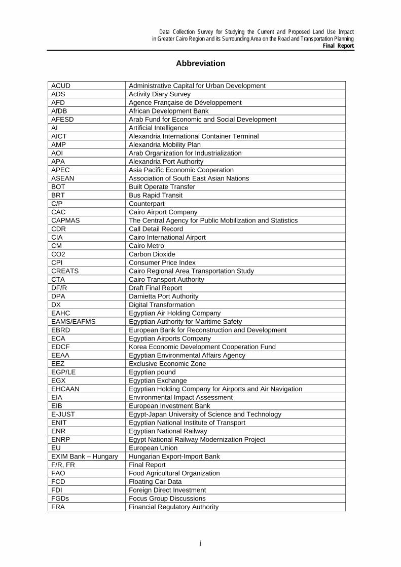
Abbreviation
ACUD Administrative Capital for Urban Development ADS Activity Diary Survey AFD Agence Française de Développement AfDB African Development Bank AFESD Arab Fund for Economic and Social Development AI Artificial Intelligence AICT Alexandria International Container Terminal AMP Alexandria Mobility Plan AOI Arab Organization for Industrialization APA Alexandria Port Authority APEC Asia Pacific Economic Cooperation ASEAN Association of South East Asian Nations BOT Built Operate Transfer BRT Bus Rapid Transit C/P Counterpart CAC Cairo Airport Company CAPMAS The Central Agency for Public Mobilization and Statistics CDR Call Detail Record CIA Cairo International Airport CM Cairo Metro CO2 Carbon Dioxide CPI Consumer Price Index CREATS Cairo Regional Area Transportation Study CTA Cairo Transport Authority DF/R Draft Final Report DPA Damietta Port Authority DX Digital Transformation EAHC Egyptian Air Holding Company EAMS/EAFMS Egyptian Authority for Maritime Safety EBRD European Bank for Reconstruction and Development ECA Egyptian Airports Company EDCF Korea Economic Development Cooperation Fund EEAA Egyptian Environmental Affairs Agency EEZ Exclusive Economic Zone EGP/LE Egyptian pound EGX Egyptian Exchange EHCAAN Egyptian Holding Company for Airports and Air Navigation EIA Environmental Impact Assessment EIB European Investment Bank E-JUST Egypt-Japan University of Science and Technology ENIT Egyptian National Institute of Transport ENR Egyptian National Railway ENRP Egypt National Railway Modernization Project EU European Union EXIM Bank – Hungary Hungarian Export-Import Bank F/R, FR Final Report FAO Food Agricultural Organization FCD Floating Car Data FDI Foreign Direct Investment FGDs Focus Group Discussions FRA Financial Regulatory Authority
Data Collection Survey for Studying the Current and Proposed Land Use Impact in Greater Cairo Region and its Surrounding Area on the Road and Transportation Planning Final Report
ii
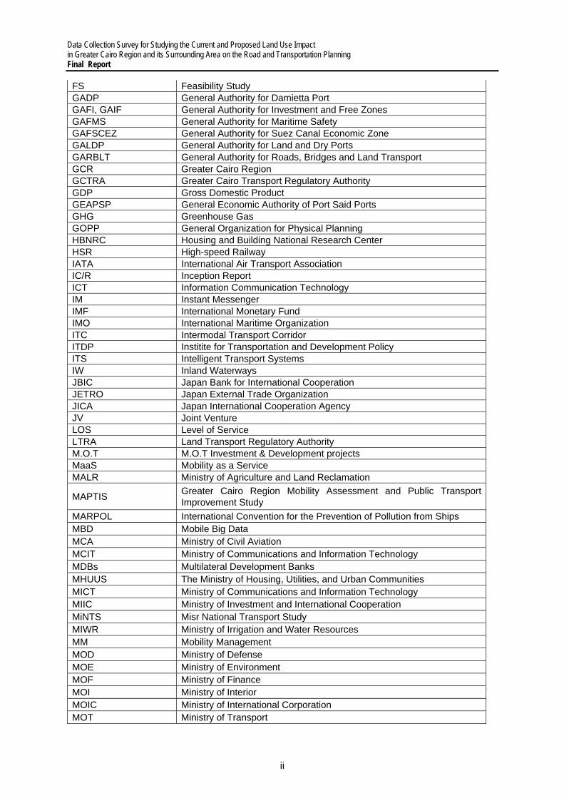
FS Feasibility Study GADP General Authority for Damietta Port GAFI, GAIF General Authority for Investment and Free Zones GAFMS General Authority for Maritime Safety GAFSCEZ General Authority for Suez Canal Economic Zone GALDP General Authority for Land and Dry Ports GARBLT General Authority for Roads, Bridges and Land Transport GCR Greater Cairo Region GCTRA Greater Cairo Transport Regulatory Authority GDP Gross Domestic Product GEAPSP General Economic Authority of Port Said Ports GHG Greenhouse Gas GOPP General Organization for Physical Planning HBNRC Housing and Building National Research Center HSR High-speed Railway IATA International Air Transport Association IC/R Inception Report ICT Information Communication Technology IM Instant Messenger IMF International Monetary Fund IMO International Maritime Organization ITC Intermodal Transport Corridor ITDP Institite for Transportation and Development Policy ITS Intelligent Transport Systems IW Inland Waterways JBIC Japan Bank for International Cooperation JETRO Japan External Trade Organization JICA Japan International Cooperation Agency JV Joint Venture LOS Level of Service LTRA Land Transport Regulatory Authority M.O.T M.O.T Investment & Development projects MaaS Mobility as a Service MALR Ministry of Agriculture and Land Reclamation
MAPTIS Greater Cairo Region Mobility Assessment and Public Transport Improvement Study
MARPOL International Convention for the Prevention of Pollution from Ships MBD Mobile Big Data MCA Ministry of Civil Aviation MCIT Ministry of Communications and Information Technology MDBs Multilateral Development Banks MHUUS The Ministry of Housing, Utilities, and Urban Communities MICT Ministry of Communications and Information Technology MIIC Ministry of Investment and International Cooperation MiNTS Misr National Transport Study MIWR Ministry of Irrigation and Water Resources MM Mobility Management MOD Ministry of Defense MOE Ministry of Environment MOF Ministry of Finance MOI Ministry of Interior MOIC Ministry of International Corporation MOT Ministry of Transport

Data Collection Survey for Studying the Current and Proposed Land Use Impact in Greater Cairo Region and its Surrounding Area on the Road and Transportation Planning
Final Report
iii
MP Master Plan MPED Ministry of Planning and Economic Development MTI The Ministry of Industry and Trade MTS Maritime Transport Sector NAT National Authority for Tunnels NCW National Council for Women NERIC The National Egyptian Railway Industries Company NGO Non-Governmental Organizations NMT Non-motorized Transport NOx Nitrogen Oxides NUCA New Urban Community Authorities O&M Operation and Management OD Origin-Destination ODA Official Development Assistance OECD Organization for Economic Cooperation and Development OECF Overseas Economic Cooperation Fund OHC Overhead Catenary OJT On-the-Job Training PM2.5 Particulate Matter 2.5 PMO Prime Minister Office PPP Public Private Partnership PR/R, PRR Progress Report PSPA Port Said Port Authority PTPA Public Transport Planning Authority PWDs People with Disabilities RIS River Information System RSPA Red Sea Ports Authority RTA River Transport Authority SCA Suez Canal Authority SCM Supply Chain Management SCZ The Suez Canal Special Economic Zone SDG Sustainable Development Goals SDMP The Strategic Urban Development Master Plan Study SDS Sustainable Development Strategy SISBEN The System of Identification of Social program Beneficiaries SNS Social Networking Service SO2 Sulfur Dioxide SOLAS Safety of Life at Sea TDM Transportation Demand Management TEU Twenty-foot Equivalent Unit TO Technical Office TOD Transit Oriented Development TPA Transportation Planning Authority TSFE The Sovereign Fund of Egypt UNDP United Nations Development Programme UN-Habitat United Nations Human Settlement Programme USD US dollar WB World Bank WDP World Dubai Ports Company WHO World Health Organization

Data Collection Survey for Studying the Current and Proposed Land Use Impact in Greater Cairo Region and its Surrounding Area on the Road and Transportation Planning Final Report
iv
Table of Contents
1 Survey Outline .............................................................................................................................. 1-1 1.1 Survey Background, Objectives and Survey Area ................................................................ 1-1
1) Background and Objectives .................................................................................................. 1-1 2) Survey Areas and Coverage ................................................................................................. 1-2
1.2 Survey Workflow and Approach ............................................................................................ 1-3 1) Survey Schedule and Workflow ............................................................................................ 1-3 2) Survey Approach ................................................................................................................... 1-4
1.3 Consultation with Stakeholders ............................................................................................. 1-8 2 Overview of the National Transportation Sector 2-1
2.1 Basic Information on the Transportation Sector .................................................................... 2-1 1) Socioeconomic Conditions ................................................................................................ 2-1 2) National Policies and Plans related to Transportation Sector ........................................... 2-3 3) Summary of Background ................................................................................................... 2-9
2.2 Roads and Road Transportation ......................................................................................... 2-11 1) Planning Administration ................................................................................................... 2-11 2) Infrastructure Development ............................................................................................. 2-17 3) Environment, Safety, and Security .................................................................................. 2-19 4) Freight Transportation and Road Safety ......................................................................... 2-20 5) Organizations, Institutions, and Human Resources ........................................................ 2-22
2.3 Railway ................................................................................................................................ 2-24 1) National Railways: Current Status (National Railways) .................................................. 2-24 2) National Railways: Issues or Concerns ........................................................................... 2-26 3) National Railways: Measures by ENR ............................................................................. 2-28 4) National Railways: Support from Foreign Donors and Private Companies’ Participation .. 2-30 5) National Railways: Recent Movements in the Railway Sector of Egypt ......................... 2-32 6) National Railways: Areas Requiring Technical Assistance ............................................. 2-33 7) Urban Railways: Current Status ...................................................................................... 2-41 8) Urban Railways: Issues or Concerns .............................................................................. 2-45 9) Urban Railways: Measures by Cairo Metro ..................................................................... 2-47 10) Urban Railways: Support from Foreign Donners and Private Companies’ Participation 2-47 11) Urban Railways: Recent Movements in the Railway Sector of Egypt ............................. 2-49 12) Urban Railways: Areas Requiring Technical Assistance ................................................ 2-51
2.4 Ports, Maritime and Inland Water Transportation ............................................................... 2-55 1) Introduction ...................................................................................................................... 2-55 2) Planning Administration ................................................................................................... 2-55 3) Infrastructure Development ............................................................................................. 2-57 4) Environment, Safety, and Security .................................................................................. 2-64 5) Transportation Industry and Services .............................................................................. 2-66 6) Financing ......................................................................................................................... 2-68 7) Organizations, Institutions, and Human Resource .......................................................... 2-69 8) Intermodality .................................................................................................................... 2-72 9) Issues and Challenges .................................................................................................... 2-76
2.5 Aviation ................................................................................................................................ 2-78 1) Planning Administration ................................................................................................... 2-78 2) Infrastructure Development ............................................................................................. 2-79 3) Transportation Industry and Service ............................................................................... 2-84 4) Relationship with Private Sector ...................................................................................... 2-90
2.6 Logistics............................................................................................................................... 2-91 1) Definition .......................................................................................................................... 2-91 2) Planning Administration ................................................................................................... 2-94 3) Infrastructure Development ............................................................................................. 2-95 4) Environment, Safety, and Security .................................................................................. 2-97 5) Logistics Industry and Services ..................................................................................... 2-100 6) Financing ....................................................................................................................... 2-102

Data Collection Survey for Studying the Current and Proposed Land Use Impact in Greater Cairo Region and its Surrounding Area on the Road and Transportation Planning
Final Report
v
7) Organizations, Institutions and Human Resource ......................................................... 2-105 8) Key Issues for the sustainable development of the logistics sector .............................. 2-108
2.7 Environment ...................................................................................................................... 2-112 1) Regulation / Institution ................................................................................................... 2-112 2) Analytical Framework: ................................................................................................... 2-113 3) Other Perspectives: Clean Mobility in Egypt ................................................................. 2-122
2.8 Gender Mainstreaming ...................................................................................................... 2-126 1) Introduction .................................................................................................................... 2-126 2) Present Situation of Gender Issues in Transport Sector ............................................... 2-126 3) Administration in Gender Mainstreaming ...................................................................... 2-131 4) Key Findings .................................................................................................................. 2-132
3 Overview of The Urban Transportation Sector ............................................................................ 3-1 3.1 Land Use and Urban Structure ............................................................................................. 3-1
1) Urban Development in the Greater Cairo Region ............................................................. 3-1 2) Entities Responsible for Land Use and Urban Structure ................................................... 3-1 3) Urban Structure of the Greater Cairo Region .................................................................... 3-2 4) Alexandria Region and Suez Canal Region ...................................................................... 3-6 5) Summary ........................................................................................................................... 3-6
3.2 Transportation Infrastructure ................................................................................................. 3-9 1) Road Infrastructure ............................................................................................................ 3-9 2) Public Transport Infrastructure .......................................................................................... 3-9
3.3 Traffic Management ............................................................................................................ 3-12 1) Current Traffic Situation and Issues in Greater Cairo Region ......................................... 3-12 2) Role of Traffic Control Center .......................................................................................... 3-25 3) The Application of ICT Technology for better traffic management .................................. 3-30
3.4 Analysis on Urban Transportation Sector ........................................................................... 3-35 1) Formal Public Transportation Mode ................................................................................ 3-37 2) Informal Public transportation Mode ................................................................................ 3-39
3.5 Institutions and Organizations ............................................................................................. 3-41 1) Administration of Urban Transportation ........................................................................... 3-41 2) Public Transportation O&M ............................................................................................. 3-43 3) System Planning .............................................................................................................. 3-44 4) Source & Finance ............................................................................................................ 3-45
3.6 Gender-related Issues ......................................................................................................... 3-46 1) Introduction ...................................................................................................................... 3-46 2) Review of Projects related to Urban Transportation by International Donors ................. 3-46 3) Preliminary Gender Analysis through FGDs ................................................................... 3-47 4) Key Findings .................................................................................................................... 3-54 5) Planning Issues ............................................................................................................... 3-54
4 Development Needs on Transportation Sector ........................................................................... 4-1 4.1 Planning Issues in National Transportation Sector ............................................................... 4-1
1) Passenger Transportation ..................................................................................................... 4-1 2) Freight Transport ................................................................................................................... 4-3 3) Summary of the Future Actions and Recommendations ...................................................... 4-7
4.2 Planning Issues in Urban Transportation Sector .................................................................. 4-9 1) Transportation Network that Supports Urban Structure ........................................................ 4-9 2) Road Traffic ........................................................................................................................... 4-9 3) Road Safety ......................................................................................................................... 4-10 4) Public Transportation .......................................................................................................... 4-11
4.3 Examination of Methodology to Update Transportation Database ..................................... 4-13 1) Recommendations for Updating the Database for Demand Forecast Modeling ................ 4-13 2) Methodologies and Supplemental Transportation Surveys ................................................ 4-15 3) Possibility to Utilize ICT on Transportation Survey ............................................................. 4-17
5 Suggestions on Transport Sector Development .......................................................................... 5-1 5.1 Review of Previous Master Plans ......................................................................................... 5-1
1) Progress of Priority Projects Proposed by MiNTS and CREATS/SDMP .......................... 5-1 2) Implementation Gap with MPs .......................................................................................... 5-3

Data Collection Survey for Studying the Current and Proposed Land Use Impact in Greater Cairo Region and its Surrounding Area on the Road and Transportation Planning Final Report
vi
3) Lessons Learned ............................................................................................................... 5-4 5.2 Country Assistance Policy by International Donors .............................................................. 5-6
1) France (Agence Française de Développement (AFD) ...................................................... 5-6 2) International Organizations ............................................................................................... 5-6
5.3 Recommendations on Transportation Sector Development ................................................. 5-9 1) Significance of an Updated Master Plan ........................................................................... 5-9 2) Scope of Work of Updating the Master Plans ................................................................. 5-10
6 Preliminary Analysis of AN Integrated Urban and Transportation Development ........................ 6-1 6.1 Summary of Urban Structure and Transportation Development Issues ............................... 6-1
1) Challenges Imposed by Urbanization and a Car-oriented Development .......................... 6-1 2) Planning Issues on Integrated Urban and Transportation Development .......................... 6-1 3) Direction of urban and spatial development and role of public transportation .................. 6-2 4) Key Features of Urban Structures and PT Patterns in Mega Cities .................................. 6-9 5) Current Development Direction and Other Options ........................................................ 6-10
6.2 Vision and Strategy ............................................................................................................. 6-11 1) Today’s Greater Cairo Region and the World ................................................................. 6-11 2) Future Urban Transportation in the GCR ........................................................................ 6-12 3) Vision and Strategy for the Updated MP ......................................................................... 6-12
6.3 Key Considerations on Urban Transportation Planning ...................................................... 6-14 1) Public Transportation Development Plan ........................................................................ 6-14 2) Road / Logistics Facility Development Plan .................................................................... 6-16 3) Traffic Management Plan ................................................................................................ 6-19
7 Proposal on Updating the Urban Transportation Master Plan ..................................................... 7-1 7.1 Outline of Project Formulation ............................................................................................... 7-1
1) Implementation Principles of the Proposed Project .......................................................... 7-1 2) Outline of the Proposed Project ........................................................................................ 7-2
7.2 Scope of Work of the Proposed Project ................................................................................ 7-4 1) Task 1: Examination of Urban Transportation MP Update ................................................ 7-4 2) Task 2: Development of a Transportation Database ......................................................... 7-7 3) Task 3: Action Plan Formulation for the Updated MP ..................................................... 7-12
7.3 Implementation Schedule and Required Organizational Setup .......................................... 7-16 1) Implementation Schedule ................................................................................................ 7-16 2) Required Organizational Setup ....................................................................................... 7-17
8 Conclusion, Recommendations, and Next Steps ........................................................................ 8-1 8.1 Conclusion and Recommendations ...................................................................................... 8-1
1) National Transportation Development ............................................................................... 8-1 2) Urban Transportation Development in Greater Cairo Region ........................................... 8-2
8.2 Next Steps ............................................................................................................................. 8-4

Data Collection Survey for Studying the Current and Proposed Land Use Impact in Greater Cairo Region and its Surrounding Area on the Road and Transportation Planning
Final Report
vii
Figures
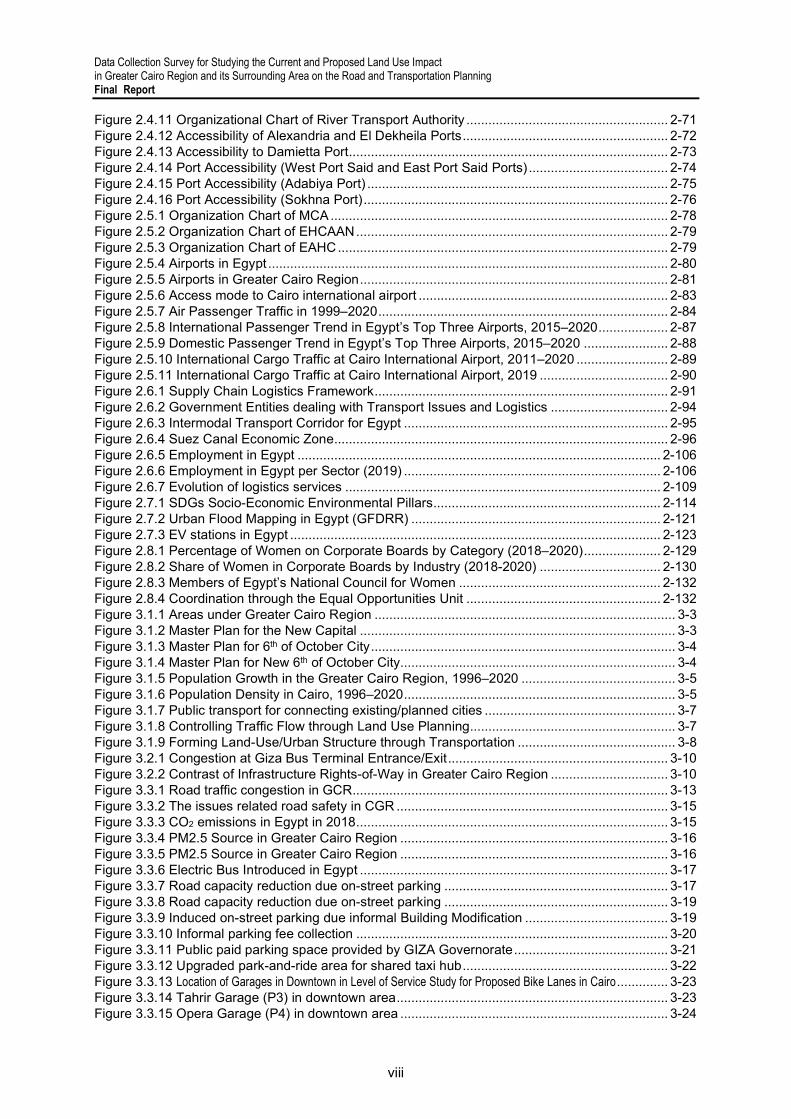
Figure 1.1.1 Survey Areas .................................................................................................................... 1-2 Figure 1.2.1 Overall Survey Workflow .................................................................................................. 1-3 Figure 1.2.2 Survey Framework and Expected Outputs on National Transportation........................... 1-4 Figure 1.2.3 Survey Framework and Expected Outputs on Urban Transportation .............................. 1-5 Figure 1.2.4 Gender Perspective in Urban Transportation Planning (Goals, Strategies, and Measures) .............................................................................................................................................................. 1-6 Figure 1.2.5 Updating Strategies of the Existing Plans by Backcasting .............................................. 1-7 Figure 1.3.1 Data Collection Method .................................................................................................... 1-8 Figure 2.1.1 GDP of Egypt, 2000–2020 ............................................................................................... 2-2 Figure 2.1.2 Gross ODA for Egypt by Donor ........................................................................................ 2-3 Figure 2.1.3 Five Axes for Economic Development ............................................................................. 2-6 Figure 2.1.4 Proposed Areas of Greater Cairo Region ........................................................................ 2-7 Figure 2.1.5 Subway Line (above) and Tram Line (below) Proposed in Cairo Vision ......................... 2-8 Figure 2.1.6 Cairo Redevelopment Proposed in Cairo Vision .............................................................. 2-9 Figure 2.2.1 Road Projects along the Intermodal Transportation Corridor ........................................ 2-12 Figure 2.2.2 Road Projects in the Cairo–Damietta–Port Said Corridor .............................................. 2-13 Figure 2.2.3 Road Projects in the Cairo–Alexandria and Cairo–Suez Corridors ............................... 2-13 Figure 2.2.4 Road Projects in the Inland Delta and Suez Canal Development Corridor ................... 2-14 Figure 2.2.5 Road Projects in the Mediterranean and Sinai Corridors .............................................. 2-14 Figure 2.2.6 Road Projects in the Red Sea Corridor .......................................................................... 2-15 Figure 2.2.7 Road Projects in the Upper Egypt Corridor .................................................................... 2-16 Figure 2.2.8 Road Projects in the East–West Corridor ...................................................................... 2-16 Figure 2.2.9 Number of Licensed Vehicles in Egypt .......................................................................... 2-17 Figure 2.2.10 Main Road and Frontage Road on Major Trunk Roads ............................................... 2-22 Figure 2.2.11 Traffic Congestion on Frontage Road .......................................................................... 2-22 Figure 2.3.1 Latest ENR Railway Network in Egypt (as of October 2021) ......................................... 2-25 Figure 2.3.2 Number of Long-distance Travel Passengers ................................................................ 2-25 Figure 2.3.3 Number of Short-distance Travel Passenger ................................................................. 2-25 Figure 2.3.4 Freight Transportation Volume by Commodity (2015–2020) ......................................... 2-25 Figure 2.3.5 Number of Accidents in 2009–2018 ............................................................................... 2-27 Figure 2.3.6 Causes of Derailments in 2009–2018 ............................................................................ 2-27 Figure 2.3.7 Bypass Railway Lines in Greater Cairo Region ............................................................. 2-29 Figure 2.3.8 Location of Railway Connections ................................................................................... 2-33 Figure 2.3.9 Schematic Pictures of Railway Connections to Major Sea Ports ................................... 2-38 Figure 2.3.10 Existing and Planned Urban Railway Lines in GCR .................................................... 2-41 Figure 2.3.11 Newly Added Signs in Line 3 ....................................................................................... 2-43 Figure 2.3.12 Construction Situation of Monorail and LRT ................................................................ 2-44 Figure 2.3.13 Planning Procedure of Urban Railway Projects (draft) ................................................ 2-45 Figure 2.3.14 Proposed Alignment of Railway Lines in Greater Cairo Region (including planned lines) ............................................................................................................................................................ 2-49 Figure 2.3.15 The Proposed Alignment of the High-speed Railway Line .......................................... 2-50 Figure 2.3.16 Construction Site of Adly Monsour Transport Hub....................................................... 2-51 Figure 2.3.17 Stakeholders in New Line Planning and Construction in Greater Cairo Region (Draft) .. 2-52 Figure 2.3.18 Status of Transport Hubs in Greater Cairo Region ...................................................... 2-54 Figure 2.4.1 Egyptian Maritime Transportation Strategy under Egypt Vision 2030 ........................... 2-56 Figure 2.4.2 Organizational Chart on Administration of Commercial Ports ....................................... 2-56 Figure 2.4.3 Geographical Location of Alexandria, Damietta, East Port Said and Sokhna Ports ...... 2-57 Figure 2.4.4 Infrastructure Development in Alexandria and El Dekheila Ports .................................. 2-58 Figure 2.4.5 Infrastructure Development in Damietta Port ................................................................. 2-59 Figure 2.4.6 Infrastructure Development in East Port Said Port ........................................................ 2-60 Figure 2.4.7 Infrastructure Development in Sokhna Port ................................................................... 2-62 Figure 2.4.8 IWT Cargo Volumes by Commodity (2010–2020) ......................................................... 2-63 Figure 2.4.9 Navigation Registration and Licensing (2006-2007, 2018-2020) ................................... 2-63 Figure 2.4.10 Organizational Chart of Maritime Transport Sector ..................................................... 2-70
Data Collection Survey for Studying the Current and Proposed Land Use Impact in Greater Cairo Region and its Surrounding Area on the Road and Transportation Planning Final Report
viii
Figure 2.4.11 Organizational Chart of River Transport Authority ....................................................... 2-71 Figure 2.4.12 Accessibility of Alexandria and El Dekheila Ports ........................................................ 2-72 Figure 2.4.13 Accessibility to Damietta Port ....................................................................................... 2-73 Figure 2.4.14 Port Accessibility (West Port Said and East Port Said Ports) ...................................... 2-74 Figure 2.4.15 Port Accessibility (Adabiya Port) .................................................................................. 2-75 Figure 2.4.16 Port Accessibility (Sokhna Port) ................................................................................... 2-76 Figure 2.5.1 Organization Chart of MCA ............................................................................................ 2-78 Figure 2.5.2 Organization Chart of EHCAAN ..................................................................................... 2-79 Figure 2.5.3 Organization Chart of EAHC .......................................................................................... 2-79 Figure 2.5.4 Airports in Egypt ............................................................................................................. 2-80 Figure 2.5.5 Airports in Greater Cairo Region .................................................................................... 2-81 Figure 2.5.6 Access mode to Cairo international airport .................................................................... 2-83 Figure 2.5.7 Air Passenger Traffic in 1999–2020 ............................................................................... 2-84 Figure 2.5.8 International Passenger Trend in Egypt’s Top Three Airports, 2015–2020 ................... 2-87 Figure 2.5.9 Domestic Passenger Trend in Egypt’s Top Three Airports, 2015–2020 ....................... 2-88 Figure 2.5.10 International Cargo Traffic at Cairo International Airport, 2011–2020 ......................... 2-89 Figure 2.5.11 International Cargo Traffic at Cairo International Airport, 2019 ................................... 2-90 Figure 2.6.1 Supply Chain Logistics Framework ................................................................................ 2-91 Figure 2.6.2 Government Entities dealing with Transport Issues and Logistics ................................ 2-94 Figure 2.6.3 Intermodal Transport Corridor for Egypt ........................................................................ 2-95 Figure 2.6.4 Suez Canal Economic Zone ........................................................................................... 2-96 Figure 2.6.5 Employment in Egypt ................................................................................................... 2-106 Figure 2.6.6 Employment in Egypt per Sector (2019) ...................................................................... 2-106 Figure 2.6.7 Evolution of logistics services ...................................................................................... 2-109 Figure 2.7.1 SDGs Socio-Economic Environmental Pillars .............................................................. 2-114 Figure 2.7.2 Urban Flood Mapping in Egypt (GFDRR) .................................................................... 2-121 Figure 2.7.3 EV stations in Egypt ..................................................................................................... 2-123 Figure 2.8.1 Percentage of Women on Corporate Boards by Category (2018–2020) ..................... 2-129 Figure 2.8.2 Share of Women in Corporate Boards by Industry (2018-2020) ................................. 2-130 Figure 2.8.3 Members of Egypt’s National Council for Women ....................................................... 2-132 Figure 2.8.4 Coordination through the Equal Opportunities Unit ..................................................... 2-132 Figure 3.1.1 Areas under Greater Cairo Region .................................................................................. 3-3 Figure 3.1.2 Master Plan for the New Capital ...................................................................................... 3-3 Figure 3.1.3 Master Plan for 6th of October City ................................................................................... 3-4 Figure 3.1.4 Master Plan for New 6th of October City........................................................................... 3-4 Figure 3.1.5 Population Growth in the Greater Cairo Region, 1996–2020 .......................................... 3-5 Figure 3.1.6 Population Density in Cairo, 1996–2020 .......................................................................... 3-5 Figure 3.1.7 Public transport for connecting existing/planned cities .................................................... 3-7 Figure 3.1.8 Controlling Traffic Flow through Land Use Planning ........................................................ 3-7 Figure 3.1.9 Forming Land-Use/Urban Structure through Transportation ........................................... 3-8 Figure 3.2.1 Congestion at Giza Bus Terminal Entrance/Exit ............................................................ 3-10 Figure 3.2.2 Contrast of Infrastructure Rights-of-Way in Greater Cairo Region ................................ 3-10 Figure 3.3.1 Road traffic congestion in GCR ...................................................................................... 3-13 Figure 3.3.2 The issues related road safety in CGR .......................................................................... 3-15 Figure 3.3.3 CO2 emissions in Egypt in 2018 ..................................................................................... 3-15 Figure 3.3.4 PM2.5 Source in Greater Cairo Region ......................................................................... 3-16 Figure 3.3.5 PM2.5 Source in Greater Cairo Region ......................................................................... 3-16 Figure 3.3.6 Electric Bus Introduced in Egypt .................................................................................... 3-17 Figure 3.3.7 Road capacity reduction due on-street parking ............................................................. 3-17 Figure 3.3.8 Road capacity reduction due on-street parking ............................................................. 3-19 Figure 3.3.9 Induced on-street parking due informal Building Modification ....................................... 3-19 Figure 3.3.10 Informal parking fee collection ..................................................................................... 3-20 Figure 3.3.11 Public paid parking space provided by GIZA Governorate .......................................... 3-21 Figure 3.3.12 Upgraded park-and-ride area for shared taxi hub ........................................................ 3-22 Figure 3.3.13 Location of Garages in Downtown in Level of Service Study for Proposed Bike Lanes in Cairo .............. 3-23 Figure 3.3.14 Tahrir Garage (P3) in downtown area .......................................................................... 3-23 Figure 3.3.15 Opera Garage (P4) in downtown area ......................................................................... 3-24

Data Collection Survey for Studying the Current and Proposed Land Use Impact in Greater Cairo Region and its Surrounding Area on the Road and Transportation Planning
Final Report
ix
Figure 3.3.16 Boston Garage (P7) in downtown area ........................................................................ 3-24 Figure 3.3.17 Radar Base Traffic Counter ......................................................................................... 3-29 Figure 3.3.18 Roxy Smart Parking ..................................................................................................... 3-30 Figure 3.3.19 Example of Signal Warrants ......................................................................................... 3-31 Figure 3.3.20 Example of Application of Detectors ............................................................................ 3-32 Figure 3.3.21 Example of Traffic Control System............................................................................... 3-32 Figure 3.3.22 Example of Processed FCD ......................................................................................... 3-33 Figure 3.3.23 Triangulated Mobile Phone Tracking System .............................................................. 3-34 Figure 3.4.1 Organization of Urban Transportation Sector in Greater Cairo Region ......................... 3-35 Figure 3.4.2 Population (Blue) and Job Opportunities (Green) Density in Greater Cairo Region ..... 3-37 Figure 3.4.3 New 12-m Buses for New Cairo City.............................................................................. 3-38 Figure 3.4.4 Informal Stops of Mini-Bus Near Metro Station .............................................................. 3-40 Figure 3.6.1 Incidence of Sexual Harassment by Transportation Mode over a Year ........................ 3-47 Figure 3.6.2 FGD Procedure with Student Group and Sample of an Accomplished Questionnaire .. 3-49 Figure 3.6.3 Separate FGDs with Female and Male Students ........................................................... 3-49 Figure 3.6.4 Signage and Design of Women-only Train Cars ............................................................ 3-50 Figure 3.6.5 Evaluation of Transportation Modes by Gender ............................................................ 3-51 Figure 3.6.6 FGD Procedure with PWD Group .................................................................................. 3-52 Figure 3.6.7 Separate FGDs with PWDs by Gender .......................................................................... 3-53 Figure 3.6.8 Elevator of Cairo Metro Station ...................................................................................... 3-54 Figure 4.1.1 National Transportation Network...................................................................................... 4-4 Figure 4.1.2 Integrated Framework for the Transportation Master Plan .............................................. 4-7 Figure 4.1.3 Essential Inter-Relations for the Greater Cairo Region Transportation Master Plan ....... 4-7 Figure 4.3.1 Concept of the Utilization of Mobile GPS Data to Update Transportation Data Base ... 4-18 Figure 5.1.1 Progress of MiNTS-proposed Priority Projects ................................................................ 5-2 Figure 5.3.1 Positioning of MP Update and Role Sharing among Relevant Organizations ................. 5-9 Figure 5.3.2 Concept of a Hierarchical Public Transportation Network (cont.) .................................. 5-10 Figure 5.3.3 Concept of a Hierarchical Public Transportation Network ............................................. 5-11 Figure 5.3.4 Major Logistics Corridors in Egypt ................................................................................. 5-12 Figure 5.3.5 Megaregion Development .............................................................................................. 5-13 Figure 6.1.1 Perspectives of Urbanization ........................................................................................... 6-1 Figure 6.1.2 Population Density in the GCR, 1996–2020 .................................................................... 6-2 Figure 6.1.3 Redistribution of Population from the Existing GCR ........................................................ 6-3 Figure 6.1.4 Regional Ring Road, New Capital, and 10th of Ramadan City as New GCR .................. 6-6 Figure 6.1.5 Increasing Land Values and Obtaining Financing for Public Transportation ................... 6-9 Figure 6.1.6 Spatial Structure of the Tokyo Metropolitan Area .......................................................... 6-10 Figure 6.2.1 Backcasting for the Urban Transportation Sector .......................................................... 6-12 Figure 6.2.2 Proposed Vision and Strategies on Urban Transportation in the GCR.......................... 6-13 Figure 6.2.3 Vision of an Integrated Urban and Transportation Development in the GCR ................ 6-13 Figure 6.3.1 Transportation Capacity and Travel Distance by Mode ................................................. 6-14 Figure 6.3.2 TOD Planning Components ........................................................................................... 6-15 Figure 6.3.3 Dry Port and Logistics Network ...................................................................................... 6-17 Figure 7.1.1 Outline of the Proposed Project on Urban Transportation MP Updating ......................... 7-2 Figure 7.1.2 Proposed Study Area ....................................................................................................... 7-4 Figure 7.2.1 Types of Logistics Flow in a Metropolitan Area ............................................................... 7-6 Figure 7.2.2 Framework to Formulate a Traffic Management Plan...................................................... 7-6 Figure 7.2.3 Methodology for Analyzing the Urban Transportation Network ..................................... 7-10 Figure 7.2.4 Example of Measuring the Effects of Low-carbon Planning through Urban Railway Development .... 7-13 Figure 7.3.1 Proposed Implementation Schedule .............................................................................. 7-17 Figure 7.3.2 Main Public Transportation Stakeholders in the GCR ................................................... 7-18
Data Collection Survey for Studying the Current and Proposed Land Use Impact in Greater Cairo Region and its Surrounding Area on the Road and Transportation Planning Final Report
x
Tables
Table 2.1.1 Short Profile of Egypt ........................................................................................................ 2-1 Table 2.2.1 Status of Road Projects Proposed in MiNTS .................................................................. 2-11 Table 2.2.2 Status of Road Projects Proposed in MiNTS (Summary) ............................................... 2-12 Table 2.2.3 Major National Road Projects in 2011–2020 ................................................................... 2-17 Table 2.2.4 Major Bridge Projects over the Nile in 2011–2020 .......................................................... 2-17 Table 2.2.5 Major Flyover Projects in 2011–2020 .............................................................................. 2-18 Table 2.2.6 Planned Major Road Projects up to 2032 ....................................................................... 2-19 Table 2.2.7 Causes of Traffic Accidents ............................................................................................. 2-19 Table 2.2.8 Location of Weighting Facilities ....................................................................................... 2-21 Table 2.3.1 Updated Strengths and Weaknesses of the ENR Railway Transport .......................... 2-28 Table 2.3.2 Recent Support for ENR from Other Donors ................................................................ 2-30 Table 2.3.3 Railway Signaling Systems Development Projects by ENR ......................................... 2-31 Table 2.3.4 Projects’ Status Proposed in MiNTS ............................................................................ 2-37 Table 2.3.5 Number of Fatal and Non-Fatal Accidents of ENR ....................................................... 2-39 Table 2.3.6 Number of Death and Injury by Accidents of ENR ....................................................... 2-40 Table 2.3.7 Status of Cairo Urban Railway/BRT Lines in GCR ....................................................... 2-42 Table 2.3.8 Roles in Planning of Urban Railway Projects .................................................................. 2-45 Table 2.3.9 Updated Strengths and Weaknesses of Cairo Metro Transport ..................................... 2-46 Table 2.3.10 Recent Support for NAT from Foreign Donors ........................................................... 2-47 Table 2.3.11 Examples of Transport Hubs in Greater Cairo Region.................................................. 2-53 Table 2.4.1 Major IWT Projects under RTA ..................................................................................... 2-64 Table 2.4.2 MTS Actions carried out for SDGs No. 6, 13 & 10 .......................................................... 2-65 Table 2.4.3 Terminal Operators in Major Container Ports in Egypt ................................................... 2-67 Table 2.4.4 Shipping Lines Calling at Major Container Ports in Egypt .............................................. 2-68 Table 2.4.5 IWT Cargo Transportation Service Providers in Egypt ................................................... 2-68 Table 2.5.1 Profile of Airports in Egypt ............................................................................................... 2-79 Table 2.5.2 List of Projects in the Aviation Sector .............................................................................. 2-81 Table 2.5.3 Current Access Modes to Airports................................................................................... 2-83 Table 2.5.4 Air Passenger Traffic in Egypt’s Top 5 Airports in 2019 and 2020 ................................. 2-85 Table 2.5.5 International and Domestic Air Passengers by Airport, 2019 ......................................... 2-86 Table 2.5.6 International Air Passengers in Egypt’s Top 10 Airports, 2015–2020............................. 2-86 Table 2.5.7 Scheduled and Non-scheduled International Flight Passengers by Airport, 2019 .......... 2-87 Table 2.5.8 Domestic Air Passengers and AAGRs in Egypt’s Top Five Airports, 2015–2020 .......... 2-88 Table 2.5.9 International Cargo Traffic at Cairo International Airport, 2009–2020 ............................ 2-89 Table 2.6.1 Principal investments for efficient logistics .................................................................... 2-105 Table 2.6.2 Logistics Master Plan concept ....................................................................................... 2-110 Table 2.7.1 Comparing Cairo to other cities (% of bus ticket of minimum wage) ............................ 2-116 Table 2.8.1 Examples of Action in Each Perspective ....................................................................... 2-126 Table 2.8.2 Results of UNFPA’s Survey on Gender-based Violence in Public Spaces (2015) ....... 2-127 Table 2.8.3 Major Gender Issues in Egypt ....................................................................................... 2-127 Table 2.8.4 Number of Employees by Gender and Sector (2016) ................................................... 2-128 Table 2.8.5 Number of Female Board Members (2020) .................................................................. 2-129 Table 2.8.6 Percentage of Women on Corporate Boards of EGX-listed Companies by Industry (2020) ...... 2-130 Table 2.8.7 Percentage of Women on Corporate Boards of Public Enterprises by Industry (2020) 2-131 Table 2.8.8 Women’s Issues in Transportation by Perspective ....................................................... 2-132 Table 3.3.1 Road Traffic Safety-Related Organization ...................................................................... 3-14 Table 3.3.2 Financial Model of the Public Garage on Al Haram Street ............................................. 3-21 Table 3.3.3 Roadside equipment used for monitoring and detecting ................................................. 3-26 Table 3.3.4 Demarcation among organizations.................................................................................. 3-27 Table 3.3.5 Detection Method of Traffic Control Center ..................................................................... 3-29 Table 3.3.6 Pros and Cons of Data Collected by Stationary Sensor VS. FCD .................................. 3-33 Table 3.4.1 Service type of each informal transportation mode ......................................................... 3-39 Table 3.5.1 Organizations Related to Urban Transportation in the Study Area ................................. 3-41 Table 3.6.1 Participants and Schedule of Group Discussion ............................................................. 3-48
Data Collection Survey for Studying the Current and Proposed Land Use Impact in Greater Cairo Region and its Surrounding Area on the Road and Transportation Planning
Final Report
xi
Table 3.6.2 Transportation Modes Used by Gender .......................................................................... 3-51 Table 3.6.3 List of Impairments of Participants .................................................................................. 3-52 Table 4.3.1 Outline of the Major Transportation Surveys in CREATS ............................................... 4-14 Table 4.3.2 Recommended Supplemental Transportation Surveys for Updating the Database ....... 4-16 Table 5.1.1 Progress of Priority Projects by Sub-Sector in MiNTS ...................................................... 5-1 Table 5.1.2 Progress of Priority Projects Proposed in CREATS / SDMP ............................................ 5-2 Table 5.2.1 Summary of Transport Projects in Egypt for the listed DFIs ............................................. 5-7 Table 6.1.1 Current Development Direction in GCR and Proposed TOD .......................................... 6-10 Table 6.3.1 Dry Port Development Plan ............................................................................................. 6-17 Table 7.1.1 Work Items of the Proposed Project on Urban Transportation MP Updating ................... 7-3 Table 7.2.1 Recommended Supplemental Transportation Surveys to Update Existing Database ...... 7-8 Table 7.2.2 Comparison of Conventional and Current Demand Forecasting Methods ..................... 7-10 Table 7.2.3 Example of Weights and Thresholds of the Evaluation Criteria ...................................... 7-11 Table 7.3.1 Proposed Working Groups .............................................................................................. 7-18
Data Collection Survey for Studying the Current and Proposed Land Use Impact in Greater Cairo Region and its Surrounding Area on the Road and Transportation Planning
Final Report
1-1
1 SURVEY OUTLINE
1.1 Survey Background, Objectives and Survey Area
1) Background and Objectives
The population of Egypt has been growing steadily in recent years, and concentration in the capital city, Cairo, has been continuing with an estimated population of 7.73 million people in city area as of 20201. Meanwhile, the Greater Cairo Region (GCR) is estimated to have exceeded 20 million people by 2018. In the long-term development strategy entitled “Sustainable Development Strategy (SDS): Egypt’s Vision 2030”, which was launched in 2016, the Government of Egypt has set a new urban development plan, which promotes the development of a new administrative capital in eastern Cairo and a special economic zone around the Suez Canal. In the transportation sector, transportation infrastructure development has been steadily progressing, mainly in road development. However, public transportation development has shown few progress, and traffic congestion, air pollution, and traffic accidents remain unsolved. Since the late 2010s, Egypt’s driving force for economic development has focused on the eastern part of Cairo. Thus, there is an urgent need to reconsider the country’s transportation strategies to meet the expected demand of the planned economic growth area.
To support the Egyptian government in solving its transportation problems, the Japan International Cooperation Agency (JICA) conducted several technical assistance projects, namely, the Cairo Regional Area Transportation Study (CREATS) in 2002, the Strategic Urban Development Master Plan Study for a Sustainable Development of the Greater Cairo Region (SDMP) in 2008, and the Comprehensive Study on The Master Plan for Nationwide Transport System in the Arab Republic of Egypt (MiNTS) in 2012. While the government has steadily developed the country’s infrastructure based on the plans formulated through these projects, it continues to face transportation problems in urban areas. In this context and with the plan to develop a new site for the capital in the periphery of Cairo and a special economic zone around the Suez Canal, one of the world’s most important shipping lanes, there is a need to update the transportation plans prepared many years ago to ensure that current and emerging issues in urban and transportation development are addressed. Toward this end, the General Organization for Physical Planning (GOPP) of Ministry of Housing, Utilities and Urban Communities (MOHUUC) requested support from JICA to update the CREATS, SDMP and MiNTS.
The objectives of this Survey therefore are:
To clarify the issues in the existing transportation plans by confirming these plans and the current situation, and the changes that have happened since the completion of CREATS, SDMP and MiNTS; and
To propose the contents of JICA's cooperation in transportation and metropolitan area development.
1 https://populationstat.com/egypt/cairo

Data Collection Survey for Studying the Current and Proposed Land Use Impact in Greater Cairo Region and its Surrounding Area on the Road and Transportation Planning Final Report
1-2
2) Survey Areas and Coverage
The Survey will cover the current transportation situation in the entire country but focusing on intercity passenger and freight transportation in the GCR, the New Capital City, Alexandria metropolitan area, and the Suez Canal Special Economic Zone (SCZ). Figure 1.1.1 shows the Survey areas. The Borg El Arab Airport and the Egypt-Japan University of Science and Technology (E-JUST), which are both supported by JICA, are located in Alexandria Metropolitan Area.
Source: Survey Team
Figure 1.1.1 Survey Areas

Data Collection Survey for Studying the Current and Proposed Land Use Impact in Greater Cairo Region and its Surrounding Area on the Road and Transportation Planning
Final Report
1-3
1.2 Survey Workflow and Approach
1) Survey Schedule and Workflow
As shown in Figure 1.2.1, the Survey has three stages, as follows:
i) Stage 1 (March 2021–August 2021): Items 1 & 2: Team Mobilization and Discussion of Inception Report
Item 3: Collection and Review of Related Documents
Item 4: Analysis of Transportation Data, Various Development Plans,
and Transportation Policies
Item 5: Examination of Methodology to Update Transportation Database
Item 6: Examination of Future Vision / Strategy on Transportation Sector
Item 7: Confirmation of Recommendations in Existing Plans and their Status
Items 8 & 9: Preparation and Discussion of the Progress Report
ii) Stage 2 (September–December 2021): Item 10: Examination of JICA Technical Cooperation Programs with Due
Consideration of Priority Projects
Item 11 & 12: Preparation and Discussion of the Draft Final Report
iii) Stage 3 (January–February 2022): Finalization of this Survey Item 13: Submission of the Final Report
Source: Survey Team
Figure 1.2.1 Overall Survey Workflow

Data Collection Survey for Studying the Current and Proposed Land Use Impact in Greater Cairo Region and its Surrounding Area on the Road and Transportation Planning Final Report
1-4
2) Survey Approach
(a) Survey Framework and Output
Policies on national and urban transportation which are related to metropolitan development will be studied as follows:
i) National Transportation:
While confirming the progress of priority projects proposed in Egypt’s Vision 2030 and MiNTS, an analysis of the status of transportation infrastructure development and industrial development trends in the 2010s will be made. Figure 1.2.2 shows the Survey framework and output. As of this writing, the output is assistance in transportation policy formulation, which mainly covers updating the transportation database which is indispensable for planning and the transportation development projects for the subsectors of road, railway, port/IWT/shipping, air aviation, logistics and environment. Based on the results of field surveys and discussions with JICA, as well as with related government agencies, a flexible survey approach will be taken to adjust to current conditions.
Source: Survey Team
Figure 1.2.2 Survey Framework and Expected Outputs on National Transportation
ii) Urban Transportation Sector:
The Survey Team will work according to the framework, as shown in Figure 1.2.3. As part of the “(1) review of existing plans,” the Survey Team will review the CREATS and SDMP plans, the Cairo Vision 2050, and various forms of assistance from other donors.

Data Collection Survey for Studying the Current and Proposed Land Use Impact in Greater Cairo Region and its Surrounding Area on the Road and Transportation Planning
Final Report
1-5
Next, it will “(2) analyze the current situation and extract issues” and “(3) examine the update of the existing plans.” For analyzing the current situation and extracting issues, it is essential to understand transportation improvements from a gender perspective. The outputs of the Survey currently being considered are shown on the right side of the figure, which is under (4) draft technical cooperation. In addition to the possibility of technical cooperation projects (including development survey types) and ODA loan projects, the Survey Team will propose cross-sectoral programs and explore a type of assistance based on both the development of transportation infrastructure and capacity of organizations.
Source: Survey Team
Figure 1.2.3 Survey Framework and Expected Outputs on Urban Transportation
(b) Gender Perspective in Urban Transportation Planning
In the past, the norm in urban transportation planning was to formulate plans that aim to (1) improve traffic congestion, (2) reduce accident fatalities, and (3) improve the environment. In recent years, providing safe and sustainable mobility has been emphasized. The gender viewpoint has become important when improving the mobility of urban populations. In this Survey, gender mainstreaming will be examined in the process of enhancing public transportation and its surrounding environment, as shown in Figure 1.2.4. Female users are vulnerable to pickpockets and sexual harassment when walking on dark roads around train stations and bus stops or when using crowded public transportation. Facility improvement and awareness-raising to improve safety and comfort are indispensable to promote a gender-sensitive environment.

Data Collection Survey for Studying the Current and Proposed Land Use Impact in Greater Cairo Region and its Surrounding Area on the Road and Transportation Planning Final Report
1-6
Source: Survey Team
Figure 1.2.4 Gender Perspective in Urban Transportation Planning (Goals, Strategies, and Measures)
(c) Utilization of JICA Studies on Measures against COVID-19
The concern of urban transportation planning in normal times, or the pre-pandemic period, was infrastructure improvement to meet increasing traffic demand, in particular, private traffic demand from automobile users. On the other hand, during abnormal times, such as that caused by COVID-19, it is necessary to realize an appropriate self-restraint level based on the situation of a city. Public transportation companies are particularly affected by the current situation. Prompt supporting measures are required for public transportation operators to meet mobility needs while reducing the risk of infection. In the transportation sector in general, providing transportation services that utilize new technologies is the key since the need for transportation becomes more diverse. As a response to the abovementioned conditions, since the JICA Survey Team has carried out the following activities, the results of which will be fully utilized in making technical proposals that meet local needs:
i) Preparatory Survey to Formulate Urban Environment Improvement Program for COVID-19: The results will be utilized to study urban transportation plans since it includes field surveys (COVID-19 impact analysis), examination of digital technologies, etc., in the Greater Cairo Region.
ii) Data Collection on the Possibility of Utilizing Technology from Private Sector for COVID-19 in Economic Sectors (logistics, transportation, urban functions, and electricity/power) in Developing Countries: The following possibilities of utilizing the technology / know-how of Japanese companies will be examined:
Bus location and congestion detection system, vehicle travel management, and
Technology of dual camera and its applications in road inventory surveys

Data Collection Survey for Studying the Current and Proposed Land Use Impact in Greater Cairo Region and its Surrounding Area on the Road and Transportation Planning
Final Report
1-7
(d) Utilization of New Technology in the Transportation Sector
In recent years, innovations in satellite imagery and ICT have been progressing. Utilizing new technologies to collect traffic conditions and update the transportation database would be expected. For this, the Survey Team will consider utilizing new technologies in the transportation sector that have been considered worldwide in recent years. When studying the use of new technologies, the Survey Team will pay close attention to security issues. The following is an overview of the technologies that could be utilized:
(1) Big Data (Satellite Image) (2) Big Data (CDR) (3) Vehicle Travel Management (4) Mapping Technology (5) Wi-Fi Packet Sensor Measurement Survey (AMP Survey) (e) Suggestions on Updating Existing Plans with Due Consideration of Priority Projects by Backcasting
In this Survey, the Survey Team will, after a timely analysis of the current situation, present the vision and the basic development policy for the transportation sector to the Egyptian side as well as propose priority projects while discussing the direction for updating the existing plans with the counterparts (C/P) soon after the start of the Survey (green arrow in Figure 1.2.5). In parallel, the Survey Team will propose a transportation demand analysis method to evaluate and validate priority projects and another method to update the existing plans through backcasting (blue arrow in Figure 1.2.5).
Source: Survey Team
Figure 1.2.5 Updating Strategies of the Existing Plans by Backcasting
Data Collection Survey for Studying the Current and Proposed Land Use Impact in Greater Cairo Region and its Surrounding Area on the Road and Transportation Planning Final Report
1-8
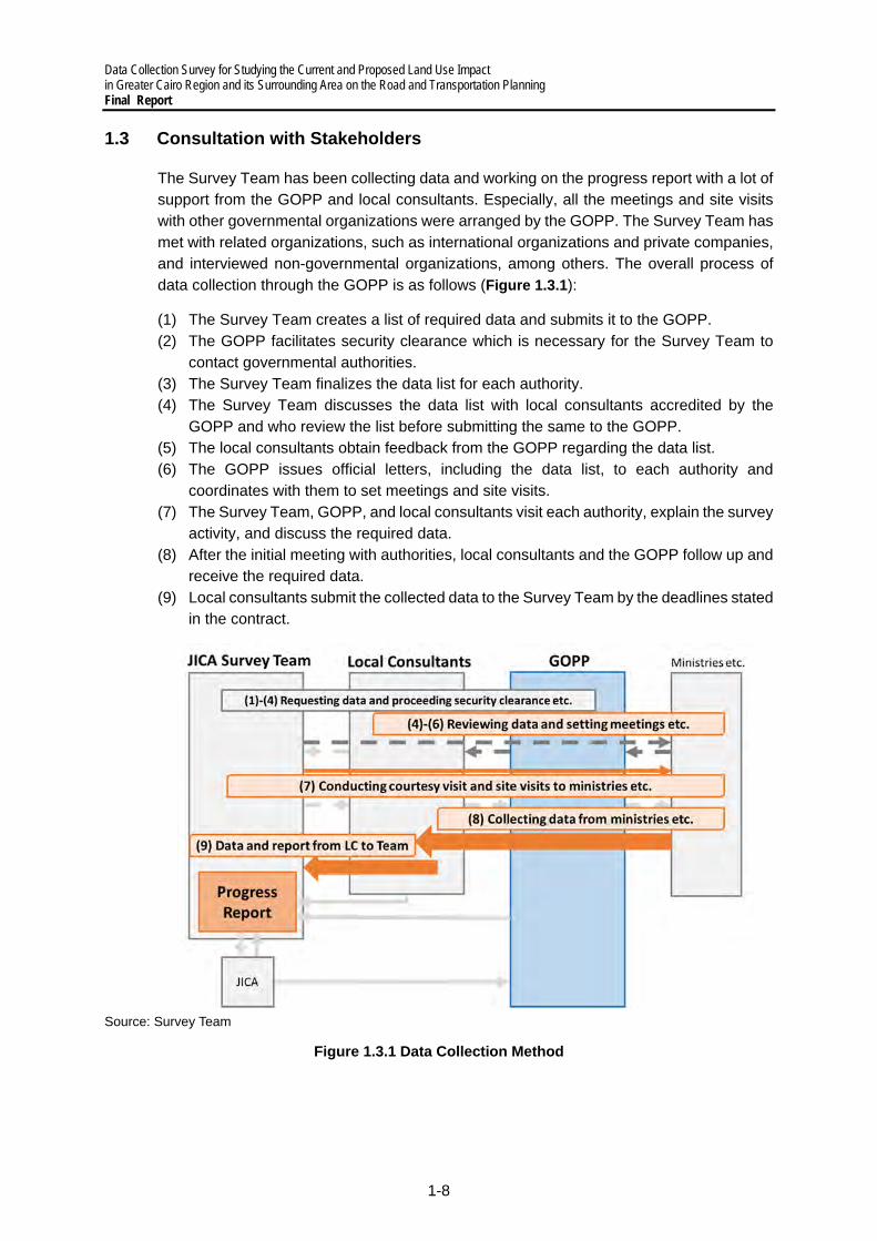
1.3 Consultation with Stakeholders
The Survey Team has been collecting data and working on the progress report with a lot of support from the GOPP and local consultants. Especially, all the meetings and site visits with other governmental organizations were arranged by the GOPP. The Survey Team has met with related organizations, such as international organizations and private companies, and interviewed non-governmental organizations, among others. The overall process of data collection through the GOPP is as follows (Figure 1.3.1):
(1) The Survey Team creates a list of required data and submits it to the GOPP. (2) The GOPP facilitates security clearance which is necessary for the Survey Team to
contact governmental authorities. (3) The Survey Team finalizes the data list for each authority. (4) The Survey Team discusses the data list with local consultants accredited by the
GOPP and who review the list before submitting the same to the GOPP. (5) The local consultants obtain feedback from the GOPP regarding the data list. (6) The GOPP issues official letters, including the data list, to each authority and
coordinates with them to set meetings and site visits. (7) The Survey Team, GOPP, and local consultants visit each authority, explain the survey
activity, and discuss the required data. (8) After the initial meeting with authorities, local consultants and the GOPP follow up and
receive the required data. (9) Local consultants submit the collected data to the Survey Team by the deadlines stated
in the contract.
Source: Survey Team
Figure 1.3.1 Data Collection Method

Data Collection Survey for Studying the Current and Proposed Land Use Impact in Greater Cairo Region and its Surrounding Area on the Road and Transportation Planning
Final Report
1-9
The meetings and site visits done by the Survey Team are shown in Table 1.3.1 Record of Meetings with GOPP and JICA (as of 2 December 2021)Table 1.3.1. There have been
nine meetings with the GOPP to discuss the data collection, progress report, and other administrative matters. There have been over 50 meetings with other organizations to collect data, while site visits were done 19 times (Table 1.3.2), which included project explanation to other international donors and related organizations.
While the meetings and site visits were done as planned, the need for security clearance delayed the schedule of the Survey Team. The GOPP also had difficulty in finding the appropriate entities, while the fragmentation within the ministries made data collection difficult. There are data gaps among the transportation subsectors of aviation, railways, and urban transportation.
In addition to the meetings and site visits, a seminar was conducted on 2 November 2021 with coordination of GOPP. In the seminar, the current status of the survey and upcoming projects were discussed with participation of various entities. The total number of attendees was 62 members, that is, 17 from JICA side (JICA (6), JICA Survey Team (6) and local consultants (5)), 4 from E-JUST, WBG and Helm, 10 from GOPP, MOHUUC and NUCA, and 31 from other Egyptian governmental entities.
Table 1.3.1 Record of Meetings with GOPP and JICA (as of 2 December 2021)
Date Type* Participants Contents
March 2021
8 M(O) JICA Kick-off meeting
18 M(O) GOPP/JICA HQ/EO Kick-off meeting
April 2021
1 M GOPP Courtesy visit and explanation and discussion on survey
6 M GOPP Discussion on survey direction and overall topics
12 M GOPP/JICA HQ/EO Survey direction and overall topics (including MoM discussion)
13 M(O) JICA EO Report of first field survey
26 M(O) JICA HQ/EO Report of first field survey
May 2021
23 M GOPP Discussion on schedule and data collection activity direction
28 M GOPP Discussion on schedule and data list
June 2021
7 M GOPP Discussion on data collection activity status
15 M GOPP/JICA HQ/EO Discussion on progress report and future project direction
17 M JICA EO Report on second field survey
29 M JICA HQ/EO Report on second field survey
30 M GOPP Discussion on progress report and data collection
July 2021
15 M(O) GOPP Discussion on findings from 2nd field survey
29 M(O) GOPP Discussion on planning issues and the proposals
August 2021
8 M GOPP Discussion on Progress Report
15 M GOPP Discussion on Progress Report
18 M GOPP Discussion on Progress Report
19 M JICA EO Discussion on findings from 3rd field survey and survey status
23 M(O) JICA HQ/EO Discussion on findings from 3rd field survey and survey status

Data Collection Survey for Studying the Current and Proposed Land Use Impact in Greater Cairo Region and its Surrounding Area on the Road and Transportation Planning Final Report
1-10
September 2021
1 M(O) GOPP Discission on transport survey and demand forecast method, and upcoming field survey and seminar preparation
7 M(O) JICA EO Report on discussion with GOPP and discussion on scope of updating master plans
13 M(O) GOPP Seminar preparation and confirmation of field survey schedule
20 M(O) JICA EO Discussion on scope of updating master plans
28 M(O) JICA EO Discussion on scope of updating master plans
29 M(O) JICA HQ/EO Discussion on scope of updating master plans
October 2021
5 M(O) GOPP、JICA EO Discussion on executive summary of progress report
11 M(O) JICA HQ/EO Discussion on survey status and scope of updating master plans
12 M(O) GOPP、JICA EO Discussion on executive summary of progress report
17 M GOPP Preparation on logistic matters for seminar
24 M GOPP Discussion on seminar contents
27 M GOPP Discussion on seminar contents
31 M GOPP Discussion on seminar contents
November 2021
2 M JICA HQ/EO Discussion on scope of updating master plans
4 M GOPP、JICA HQ/EO Report of seminar and scope of updating master plans and discussion on minutes
4 M JICA HQ/EO Discussion on scope of updating master plans and upcoming schedule
December 2021
9 M E-JUST、JICA EO Discussion on cooperation with E-JUST
*M: Meeting, M(O): Online Meeting, JICA HQ: JICA Headquarters, JICA EO: JICA Egypt Office
Source: Survey Team

Data Collection Survey for Studying the Current and Proposed Land Use Impact in Greater Cairo Region and its Surrounding Area on the Road and Transportation Planning
Final Report
1-11
Table 1.3.2 Record of Meetings and Site Visits for Data Collection (as of 2 December 2021)
Date Type* Participants Contents
April 2021
2 M&S NUCA etc. Site visit to New Cairo and New Capital
4 M UN Habitat Information sharing on survey activity and overall topics
7 M E-JUST Information sharing on survey activity and overall topics
10 M&S Ismailia governorate Site visit to Ismailia
12 M WB etc. Information sharing on survey activity and overall topics
26 M(O) Helm etc. Information sharing on survey activity and overall topics
28 M(O) E-JUST Discussion on survey direction and overall topics
28 M(O) Rakuten etc. Discussion on survey direction and overall topics
May 2021
26 M MoT WB etc. MAPTIS Workshop
27 M MoT WB etc. MAPTIS Workshop
30 M GALDP Courtesy visit and discussion on data collection
30 M PTPA Courtesy visit and discussion on data collection
30 M RTA Courtesy visit and discussion on data collection
31
M ENR Courtesy visit and discussion on data collection
M&S CM Courtesy visit and discussion on data collection, site visit on metro
M NAT Courtesy visit and discussion on data collection
June 2021
1
M LTRA Courtesy visit and discussion on data collection
M&S New Cairo City Authority
Courtesy visit and discussion on data collection, site visit on New Cairo
S Alexandria port Site visit on Alexandria port
M AICT Courtesy visit and discussion on data collection
M APA Courtesy visit and discussion on data collection
M MTS&EAMS Courtesy visit and discussion on data collection
2
S 10th of Ramadan Site visit in 10th of Ramadan
S Damietta port Site visit in Damietta port
M DC-CHC Courtesy visit and discussion on data collection
M GADP Courtesy visit and discussion on data collection
3 S Giza Site visit in Giza
6
M CTA Courtesy visit and discussion on data collection
M MCA Courtesy visit and discussion on data collection
M(O) WB Washington Information sharing on survey activity and overall topics
7 M RTA Discussion on data collection
8 M&S CM Site visit in Line 1&2
M E-JUST Focus group interviews
9
M&S ENR Site visit inn ENR
M E-JUST Focus group interviews
S Alzatya port Site visit in Alzatya port
S Suez port Site visit in Suez port
M RSPA Courtesy visit and discussion on data collection
10
S Ain-Sokhna port Site visit in Ain-Sokhna port
S Aladbia port Site visit in Aladbia port
M WDP Courtesy visit and discussion on data collection
13 M LTRA Discussion on data collection

Data Collection Survey for Studying the Current and Proposed Land Use Impact in Greater Cairo Region and its Surrounding Area on the Road and Transportation Planning Final Report
1-12
Date Type* Participants Contents S Port Said East port Site visit in industrial zone of Port Said East port
M GEAPSP Courtesy visit and discussion on data collection
S Port Said East port Site visit in Port Said East port
S Port Said West port Site visit in Port Said West port
14
M Alexandria governorate Courtesy visit and discussion on data collection
S Alexandria Site visit in Alexandria city
M MoI (Cairo Traffic Police)
Courtesy visit and discussion on data collection
M Helm Focus group interviews
15 M ECA Discussion on data collection
M GOPP Focus group interviews
16 M Mowaslat Misr Courtesy visit and discussion on data collection
M NCW Focus group interviews
22 M GARBLT Courtesy visit and discussion on data collection
30 M CAC Courtesy visit and discussion on data collection
August 2021
15 M Helm Report of 2nd field survey
October 2021
13 M NUCA Discussion on data/information collection (urban railways development, urban development methods)
14 M/S Giza Governorate
Discussion on data/information collection (informal transportation etc.)
M GARBLT Discussion on data/information collection (traffic survey etc.)
18 M ENR Discussion on data/information collection (railways accidents, status of MiNTS projects etc.)
19 M MOI Discussion on data/information collection (traffic survey etc.)
25 M GOPP Discussion on data/information collection (jurisdictions and roles)
26 M TPA Discussion on data/information collection (jurisdictions and roles)
27 M NAT
Discussion on data/information collection (jurisdictions and roles)
M CTA Discussion on data/information collection (jurisdictions and roles)
November 2021
1 S GOPP, JICA HQ/EO Site visit to 6th of October, New Cairo and New Capital area
10 M(O) WB, JICA EO Projects by WB and JICA survey team and confirmation of collaboration
22 M(O) WB, AFD, AfDB, UN Habitat, KfW, EBRD, JICA EO
Status of international supports by each donner organization
*M: Meeting, M(O): Online Meeting, S: Site Visit, JICA HQ: JICA Headquarters, JICA EO: JICA Egypt Office
Source: Survey Team
Data Collection Survey for Studying the Current and Proposed Land Use Impact in Greater Cairo Region and its Surrounding Area on the Road and Transportation Planning
Final Report
2-1
2 OVERVIEW OF THE NATIONAL TRANSPORTATION SECTOR
2.1 Basic Information on the Transportation Sector
1) Socioeconomic Conditions
(a) Population
The basic information on the current socioeconomic background of Egypt is shown in Table 2.1.1. Regarding population density, 4-6% of the country’s total area is habitable, and on the basis that 99% of the population live in 6% of the total area, the population density can be approximately 1,660 persons/km2. However, population distribution is quite heterogeneous, and the population is concentrated in GCR and in Alexandria. Even in these areas, the density is still not homogeneous, and some districts are highly dense, at more than 70,000 persons/km2 (Section 3.1).
The national census was conducted in 2017, and the numbers since then are estimates; but in 2020, the population was estimated to reach 100 million at a growth rate of around 2% on average for the past decade. Population increase has been a national issue, and even under the current regime, population control policies have been practiced such as the ‘Two is enough’ slogan. However, the overall population trend is expected to continue increasing, reaching to 160 million by 2050 (United Nations World Population Prospects in 2019).
Table 2.1.1 Short Profile of Egypt
Population, 2020 (a) 100,878,000 Area, 2018 (b) 100,145,000 ha, 1,001,450 km2
Nominal GDP, 2020 (c) USD 361,847 million Nominal GDP per person, 2020 (c) USD 3,587 Life expectancy, 2018 (a) 71.8 Rate of outstanding government obligations to GDP, 2020 (c) 90.19 %
a: WB, b: FAO, c: IMF
(b) Economy
The main industries of Egypt are oil and natural gas industries, and their share to the GDP is approximately 2/5 of the total economy, while the government sector accounts for 20–30% of the total economy. The sectors of infrastructure, electricity, water and sewage, construction, transportation, and communications account for approximately 10%. The GDP growth rate has been steady before the COVID-19 pandemic, with a rate of 4–6% per year. Due to the slowdown of the world economy and the implementation of some preventive measures, the annual GDP growth rate of 2020 shrank to 0.5%, compared with 5.6% in 2019. With steady consumption, the expected GDP growth rate for 2021 is 5.2%. (EBDR 2020) Regarding unemployment rate, it was 10.9% in 2017–2018 and 8.6% in 2018–2019. The economic slowdown due to the COVID-19 pandemic is expected to worsen the rate, especially in tourism. (EBRD 2020, IMF 2020) The currency has been stable over the past couple years, USD 1 was equivalent to 15.82 Egyptian pounds (EGP) in 2019, and the inflation rate was 5.70% in 2019, and 5.79% for 2021 in the 2021 April estimation. The Consumer Price Index (CPI) of housing and transportation in 2018–2019 were 110.20 and 123.20, respectively (May 2021), with a stable and mild increase trend.
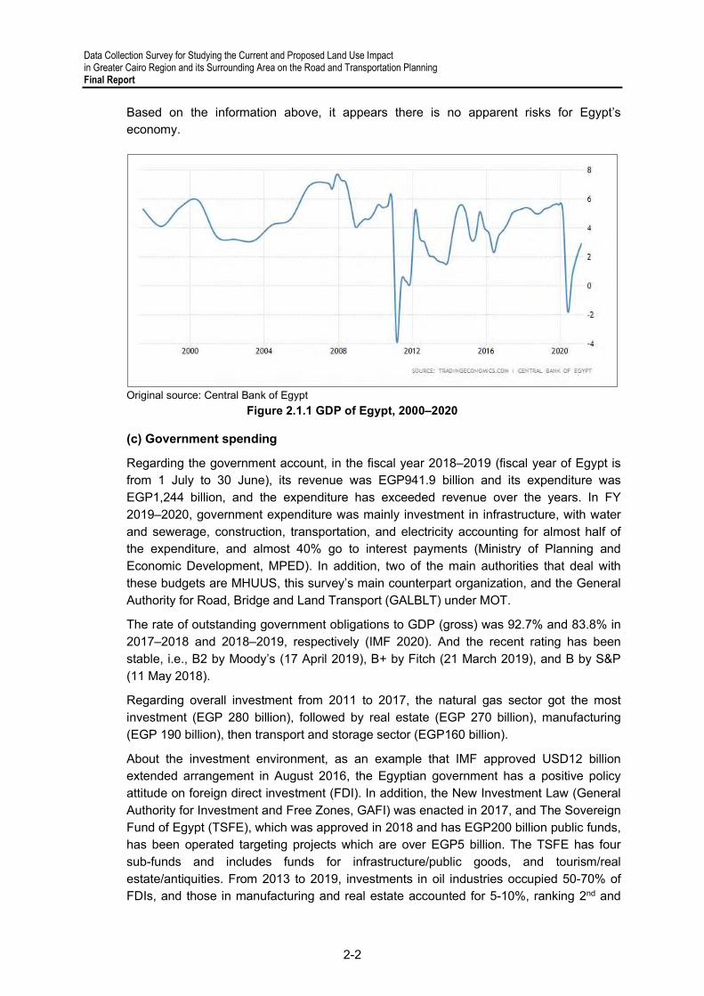
Data Collection Survey for Studying the Current and Proposed Land Use Impact in Greater Cairo Region and its Surrounding Area on the Road and Transportation Planning Final Report
2-2
Based on the information above, it appears there is no apparent risks for Egypt’s economy.
Original source: Central Bank of Egypt
Figure 2.1.1 GDP of Egypt, 2000–2020
(c) Government spending
Regarding the government account, in the fiscal year 2018–2019 (fiscal year of Egypt is from 1 July to 30 June), its revenue was EGP941.9 billion and its expenditure was EGP1,244 billion, and the expenditure has exceeded revenue over the years. In FY 2019–2020, government expenditure was mainly investment in infrastructure, with water and sewerage, construction, transportation, and electricity accounting for almost half of the expenditure, and almost 40% go to interest payments (Ministry of Planning and Economic Development, MPED). In addition, two of the main authorities that deal with these budgets are MHUUS, this survey’s main counterpart organization, and the General Authority for Road, Bridge and Land Transport (GALBLT) under MOT.
The rate of outstanding government obligations to GDP (gross) was 92.7% and 83.8% in 2017–2018 and 2018–2019, respectively (IMF 2020). And the recent rating has been stable, i.e., B2 by Moody’s (17 April 2019), B+ by Fitch (21 March 2019), and B by S&P (11 May 2018).
Regarding overall investment from 2011 to 2017, the natural gas sector got the most investment (EGP 280 billion), followed by real estate (EGP 270 billion), manufacturing (EGP 190 billion), then transport and storage sector (EGP160 billion).
About the investment environment, as an example that IMF approved USD12 billion extended arrangement in August 2016, the Egyptian government has a positive policy attitude on foreign direct investment (FDI). In addition, the New Investment Law (General Authority for Investment and Free Zones, GAFI) was enacted in 2017, and The Sovereign Fund of Egypt (TSFE), which was approved in 2018 and has EGP200 billion public funds, has been operated targeting projects which are over EGP5 billion. The TSFE has four sub-funds and includes funds for infrastructure/public goods, and tourism/real estate/antiquities. From 2013 to 2019, investments in oil industries occupied 50-70% of FDIs, and those in manufacturing and real estate accounted for 5-10%, ranking 2nd and

Data Collection Survey for Studying the Current and Proposed Land Use Impact in Greater Cairo Region and its Surrounding Area on the Road and Transportation Planning
Final Report
2-3
3rd. FDIs comes mainly from the United States, the Netherlands, United Kingdom, and Italy. (OECD 2020)
(d) Official Development Assistance and Other Related Investments
The total amount of ODA in 2018–2019 by donor are shown in Figure 2.1.2 (OECD 2020), and it shows that the ODA from European and Gulf countries was relatively large. Regarding ODA targets, education got 29%, assistance in various kinds of programs was 18%, and economic infrastructure was 16%.
Regarding the assistance and investment from China, which is excluded in the OECD-DAC statistics, the Suez Canal is considered as part of ‘The Silk Road Economic Belt and 21st Century Maritime Silk Road Development Strategy’, of which the Egyptian government signed its cooperative agreement. As a result, huge investments were poured into the Suez Canal development, infrastructure development, and urban development projects, including the new administrative capital projects and economic free zone development in Ain Sokhna. In contrast to these massive loans and construction projects, some new administrative capital projects were broken off due to financial problems. (Bloomberg, 17 December 2018, seen on 6 July 2021)
Source: OECD
Figure 2.1.2 Gross ODA for Egypt by Donor
2) National Policies and Plans related to Transportation Sector
(a) Egypt’s Vision 2030
Regarding the relationship with national-level policies and plans, the transportation policies need to be compatible with Egypt’s Vision 2030, The Strategic National Plan for Urban Development 2052, and Cairo Vision.
“Sustainable Development Strategy (SDS): Egypt’s Vision 2030” was launched in February 2016 by MPED as a national agenda, covering all areas, and it aims at comprehensive and sustainable development, and balanced regional development. In the vision, eight main axes have been set, and in the perspective of transportation, since it is a national level agenda, almost all the agendas can be related. That is, 1: Improving the quality of life and standard of living of the Egyptian citizens, 2: Justice, social inclusion and engagement, 3: Competitive and diversified economy, 4: Knowledge, innovation and

Data Collection Survey for Studying the Current and Proposed Land Use Impact in Greater Cairo Region and its Surrounding Area on the Road and Transportation Planning Final Report
2-4
scientific research, 5: Integrated and sustainable ecosystem, 6: Governance of state and community institutions, 7: Egyptian peace and security, and 8: Strengthening Egyptian leadership.
MPED has set the following projects and programs related to transportation sector for economic development until 2030:
● Improving road network, ● Developing national railway networks, ● Developing maritime transportation sectors, ● Developing river transportation sectors, and ● Promoting public private partnership to boost investment.
As one of the targeted indicators until 2030, MPED has set the growth rate of passengers using public transportation from the value in 2015 (1.9 billion passengers) as 30% and 50% for years 2020 and 2030, respectively1.
An entity was planned in accordance the SDS to monitor the implementation of policies, programs and projects and, most importantly, the fulfillment of the targeted result. In addition, they also review and update the SDS according to a specific methodology.
One of the projects that are in line with the Egypt Vision 2030 is Egypt National Railway Modernization Project (ENRP), which is funded by African Development Bank. Furthermore, the news that was published in March 2021 mentioned that Egypt has set a number of green projects to carry out within its Vision 2030. Those included 691 projects in FY 2020/2021 receiving allocations worth LE447.3 billion. The news mentioned that 30% of total planned projects are underway while the percentage is expected to reach 50% by the end of June 2025 to reach the target by 2030. In transportation sector, it is reported that the high-speed electric train extending between Alamain and Ain Sokhna passing through New Capital City, and the monorail are being constructed at USD 1.2 billion and €2.7 billion, respectively2.
In maritime transportation sector, the Egyptian Maritime Transport Strategy, Development & Increasing the Competitiveness of Ports has been formulated to support the Egypt Vision 2030. One of the main policies is to achieve the balance between the different modes including seaports, railway, river transport and road network and also its applicable regulations. Some objectives are created to achieve that policy as follows:
● Achievement of integration between Egyptian Ports within an integrated Master Plan including an investment map for Egyptian ports;
● Completion of the Geographical Coverage of Maritime Transport Services in Egypt; ● Establishment and development of infra and superstructure of seaports according to
the market economics and international criteria; ● Connecting Egyptian ports to the investment zones using the national road network
and different modes of transport; and ● The development of the Egyptian merchant fleet to enable it to transport 25% of the
Egyptian foreign trade.
(b) The Strategic National Plan for Urban Development 2052
1 Sustainable Development Strategy (SDS): Egypt Vision 2030, p. 16. 2 https://www.egypttoday.com/Article/3/99857/Overview-of-Egypt-s-green-projects-within-Vision-2030
Data Collection Survey for Studying the Current and Proposed Land Use Impact in Greater Cairo Region and its Surrounding Area on the Road and Transportation Planning
Final Report
2-5
On the other hand, regarding the national level plan, ‘The Strategic National Plan for Urban Development 2052’ (The National Plan 2052) has been set, which has been principled by General Organization for Physical Planning (GOPP) under MHUUC. The basis of The National Plan 2052 lies in several domains of social issues, such as inefficiency in urban system, inefficiency in housing system, deterioration of urban living, poverty, unemployment, global competitiveness, water, energy and administrative development. According to National Urban Development Framework in Egypt3, National and Regional Development Projects consist of four main plans:
1. Regional Plans for Developing Governorates, 2. Strategic Development plan of the Southern Egypt, 3. Extending Development to New Frontiers, and 4. Strategic Plan of GCR.
The main four plans are derivative plans to achieve the objectives of the Strategic National plan for urban development (2052), which are economic efficiency, social equity and justice as well as to cope with natural risk. It demands to maximize the economic exploitation of resources in the economic dimension, while reducing the poverty to achieve the balance of population in the social equity and justice dimension, as well as to overcome the problems that arise due to natural conditions in Egypt. Moreover, within the effort of GOPP, the four main plans are regional plans for the various governorates to cities and villages to enhance the environment in Egypt.
Regional Plans for Developing Governorates of Egypt are an agenda at the local level for planning and development of cities and villages. These measures aim at preparing strategies for developing depressed regions, control development of congested regions, attracting investments and population to new areas outside of the Nile Valley and Delta, and founding development axis along the coasts of the Mediterranean, the Red Sea and the Gulfs of Suez and Aqaba.
Strategic Development plan of the Southern Egypt focuses on the strategic plan implementation mechanisms that helps to provide a legal and procedural environment towards sustainable development. The role of this project is to modernize the planning method with emphasis on participatory planning and integration of implementation mechanism and development plan.
As for Extending Development to New Frontiers, five axes for economic development were investigated during 2007-08 as the Phase One of this program. These development regions are: the International Road in the North of the Nile Delta; the Northwestern Coast; Upper Egypt-Red Sea axis; the Cairo-Ismailia Road; and the Cairo-Alexandria Road, as shown in the figure below.
3 National Urban Development Framework in the Arab Republic of Egypt, 2014.

Data Collection Survey for Studying the Current and Proposed Land Use Impact in Greater Cairo Region and its Surrounding Area on the Road and Transportation Planning Final Report
2-6
Source: JST, based on The National Urban Development Framework, 2014
Figure 2.1.3 Five Axes for Economic Development
Strategic Plan of GCR is explained in the subsequent section.
€ Cairo Vision
As one of the four main plans and programs for national and regional development in the National Plan 2052, GCR, as shown in the figure below, is also a region that needs special attention. Considering the population and economic growth, random growth of housing and basic urban services, and environmental degradation, Cairo Vision has been set by GOPP. Cairo Vision has several key issues, and in the relationship with transportation, enhancement of living standard, which can realize social justice, providing competitive economy, which leads to knowledge-based economy, realization of economic sustainability, development of transportation infrastructure in GCR, development of new urban communities with diverse and attractive centers, development of tourism resources including preservation of historic architectural areas, and revitalization of city centers.

Data Collection Survey for Studying the Current and Proposed Land Use Impact in Greater Cairo Region and its Surrounding Area on the Road and Transportation Planning
Final Report
2-7
Source: GOPP
Figure 2.1.4 Proposed Areas of Greater Cairo Region
Thus, as one of the vision pillars is to develop the infrastructure of GCR transportation network. The strategies direction to address transportation sector problems are set into three main goals to achieve the vision:
● Solving GCR traffic congestion problems as well as providing safe and comfortable means of transportation for individuals and goods all over GCR;
● Ensuring the availability of transportation all over GCR, especially in new urban communities; and
● Reducing negative environmental effects caused by transportation such as curbing air pollution resulting from car exhaust; in addition to reducing the use of combustion- based fuel.
For solving the traffic congestion, one of the solutions to achieve is a shift to public transportation by:
1. Expanding of transportation infrastructure including subway line and tram line development; and
2. Minimizing the use of private transportation by applying policies of: converting some chosen roads to pedestrians’ path only (especially in downtown area); banning private vehicles from some downtown areas in specific days of the week; and imposing high parking fees in heavy traffic jams.

Data Collection Survey for Studying the Current and Proposed Land Use Impact in Greater Cairo Region and its Surrounding Area on the Road and Transportation Planning Final Report
2-8
Figure 2.1.5 Subway Line (above) and Tram Line (below) Proposed in Cairo Vision

Data Collection Survey for Studying the Current and Proposed Land Use Impact in Greater Cairo Region and its Surrounding Area on the Road and Transportation Planning
Final Report
2-9
Figure 2.1.6 Cairo Redevelopment Proposed in Cairo Vision
3) Summary of Background
Regarding socio-economic conditions of the country, the steady and strong growth of population and the economy can be said to be a bright future with the unsolved social issues over the years. However, under the strong political initiative, there are reasonable and clear national plans and visions, and regarding transportation and urban planning, there are many perspectives to be considered. On the other hand, some of the visions and plans remain to be examined furthermore, and the implementation methods should be carefully researched. In this section, some points that might be considered are discussed. (a) Strategic investment and policy directions for existing visions and plans
As widely known, the vigorous investment by China is expected to continue, and some investments may contradict what the country intends to achieve. Examples of investment, both in implementing and planning phase, by China in the field of urban planning are: The 385-meter-high Iconic Tower and Business Central District in New Capital City, new LRT in New Capital regions, infrastructure in China-Egypt special economic zone and related/surrounding areas, and the Ain Sokhna to Alamein high-speed electric rail. The specific perspectives to be considered in the context of transportation issues will be dealt
Data Collection Survey for Studying the Current and Proposed Land Use Impact in Greater Cairo Region and its Surrounding Area on the Road and Transportation Planning Final Report
2-10
with national level plans; however, under the political initiatives such as Egypt’s Vision 2030, it can be necessary to examine the areas that China and other authorities don’t cover, but can be covered in the context of transportation, especially fields focusing on improvement of quality of life such as inclusive transportation, high-quality transport infrastructure, resilient infrastructure, improvement of urban living condition. At the same time, as the edge of Free and Open Indo-Pacific policy, a stable and strategic investment should be examined in coordination with other countries and in consideration of the security policy of the Egyptian government.
(b) Evaluation of existing visions and plans
Based on current visions and plans, it cannot be necessarily said that the evaluation method (evaluation index, etc.) are sufficient, which is essential for evaluation and problem detection in existing visions and plans. And especially when realizing some specific values that they want to achieve, a balanced regional development as an example, the consideration and theoretical basis of evaluation should be taken into consideration as wel€(c) Consideration of theoretical background in existing visions and plans
All in all, the overall visions and plans may value its impacts, readability, clearness and these perspectives, therefore, it may lack theoretical basis. And in the existing plans, the plans inside the country have been well considered; however, there should be a relationship with cities, regions, and economies outside the country. Even inside the country, the relationship and roles among cities and regions should be carefully examined on the basis of theoretical consideration.
(d) Coordination among ministries/authorities and utilization of civil society power
As seen in the fiscal background of the country, the excess expenditure in the country has been a fait accompli, and the efficient usage of both human resources and budgeting needs to be considered always. In that respect, even though there are interdisciplinary visions and plans that cover various topics among different jurisdictions, coordination and the specific implementation structure at the higher and lower levels are not clearly stated. At the same time, it is necessary to take into consideration the political background. However, if the current conditions can be taken, i.e., that there is a limitation in budgeting and public expenditure, the power of civil society should be valued more both at the economic and public spheres, and this is not clearly stated in existing visions and p€s.
(e) Land use and transportation plans
This perspective is discussed in Section 3.1 Land use and urban structure part.

Data Collection Survey for Studying the Current and Proposed Land Use Impact in Greater Cairo Region and its Surrounding Area on the Road and Transportation Planning
Final Report
2-11
2.2 Roads and Road Transportation
1) Planning Administration
In “MiNTS - MISR National Transport Study, JICA, 2012”, 51 road projects in 11 corridors were proposed to be completed in the short term (2017), midterm (2022), and long term 2027. The status of the road projects proposed in MiNTS are shown in Table 2.2.1 and Table 2.2.2. They can be summarized as follows:
● Road development has been implemented continuously since MiNTS was prepared in 2012, in response to an increase of vehicle traffic demand (refer to Figure 2.2.9 for the number of licensed vehicles).
● Of the 13 short-term projects, 11 were already completed and one is ongoing. Short-term projects have been implemented largely as scheduled.
● Of the 26 mid-term projects, nine were already completed and 16 are ongoing. Midterm projects have been implemented largely as scheduled.
● Of the 12 long-term projects, one was already completed and two are ongoing. These three projects around Suez Canal Region have been implemented ahead of schedule.
● Of the short-term projects, only the Alexandria Bypass has not commenced. This road is not under the responsibility of the General Authority for Roads, Bridge, and Land Transport (GARBLT). Alexandria Governorate is in charge of this road.
● Although the projects in / around urban areas, such as GCR, are implemented on or ahead of schedule, some projects in rural areas have not commenced yet. It seems that priority is given to projects in / around urban areas to meet the increasing vehicle traffic demand in the region (refer to Figure 2.2.9 for the number of licensed vehicles).
Table 2.2.1 Status of Road Projects Proposed in MiNTS
No. ID Road Name Term Status 1 RD-300 3rd Cairo Alex Expressway Short Completed 2 RD-204 Cairo Alexandria Desert Expressway (Upgrade to
8-lanes) Short Completed
3 RD-301 3rd Stage Regional Ring Road (Southern Part of Expressway)
Short Completed
4 RD-998 Alexandria Bypass Short Not Commenced 5 RD-308 Cairo Ismailia Port Said Road (Expressway) Short Completed 6 RD-302 Cairo Alex Agriculture Bypass Kafr –l Zayat -
Alexandria Short Completed
7 RD-315 Shubra–elkhema - Banha Agriculture Road (Expressway)
Mid Completed
8 RD-310 Cairo -Suez Road (Expressway) Short Completed 9 RD-9–9 Cairo - Tanta Bypass Mid Ongoing
10 RD-332 –Zakaziq - Toukh Mid Not Commenced 11 RD-304 Rod El Farag Road Short Completed 12 RD-3–3 Tanta - Kafr El Sheikh Mid Completed 13 RD-334 Al–Mahalla - Kafr E– Sheikh - Damanhour Mid Ongoing 14 RD-318 Desouq Fowa Metobas Road Mid Ongoing 15 RD-319 Imbaba Qalyub Tawfekia Road Mid Ongoing 16 RD-320 El-Qanater El-Bagour Shebin El-Koum Tanta
Mahalla Matboul Road Mid Ongoing
17 RD-200 Belbeis-Banha-El Bagour-El Khatatba Regional Ring Road
Mid Completed
18 RD-214 Zaqaziq Sinbellaween Road Mid Ongoing 19 RD-215 Mansoura Talha Dekernes Mataria Road Mid Ongoing 20 RD-216 Qantara Salheya Faqous Abu Kbeir Hehya Zaqaziq Mid Ongoing

Data Collection Survey for Studying the Current and Proposed Land Use Impact in Greater Cairo Region and its Surrounding Area on the Road and Transportation Planning Final Report
2-12
Road 21 RD-317 Ismailia Suez Road (Expressway) Short Ongoing 22 RD-323 Wadi Alnatroum Saloum Road Mid Ongoing 23 RD-307 Alexandria-Saloum Road Mid Ongoing 24 RD-309 Qantara-Rafah Road Short Completed 25 RD-316 Alamein Road Mid Completed 26 RD-311 Suez Ras elnakab Road (Expressway) Short Completed 27 RD-327 Suez Canal Tunnel Ismailia Mid Completed 28 RD-328 Alawga Ismailia Road Long Not Commenced 29 RD-321 El Ain E– Sokhna - Zafarana Road Short Completed 30 RD-322 Safaga Baranis Halayeb Road Mid Ongoing 31 RD-326 Albetrol Malwa Road Long Not Commenced 32 RD-331 Qena Aswan Nile East Bank Road Long Ongoing 33 RD-3–2 Cairo - Asyut Desert Western Road (Expressway) Short Completed 34 RD-313-
1 Asyut Aswan Abu simble Desert Western Road
(Expressway) Asyut to Aswan Mid Ongoing
35 RD-225 E–-Belina - Tahta Road Long Ongoing 36 RD-298 Kalabsha Bridge (Koum Ombo) (Aswan) Mid Completed 37 RD-299 Abo Tig Bridge and Selim Coast (Asyut) Mid Ongoing 38 RD-324 Eldaba Albetrol Road Long Not Commenced 39 RD-325 ALbetrol Beni Mazar Road Long Not Commenced 40 RD-994 Fayoum-Beni Suef Bypass Mid Ongoing 41 RD-995 Wasta Bridge Connection Long Completed 42 RD-997 Helwan-Beni Suef Bridge Mid Completed 43 RD-314 Zafarana Elkoraymat Road (Expressway) Mid Ongoing 44 RD-305 Bahriya Siwa Road Long Not Commenced 45 RD-306 Bahriya Minya Road Long Not Commenced 46 RD-996 Minya Bridge Long Not Commenced 47 RD-303 Upper Egypt East Desert Red Sea Road Mid Completed 48 RD-329 Farafra Malwa Road Long Not Commenced 49 RD-330 El-Dakhla Assyuit Road Long Not Commenced 50 RD-–26 Qena - Safaga Road Mid Completed 51 RD-313-
2 Asyut Aswan Abu simble Desert Western Road
(Expressway) South part from Aswan Mid Ongoing
Source: GARBLT
Table 2.2.2 Status of Road Projects Proposed in MiNTS (Summary)
Term Completed Ongoing Not Commenced
Total
Short (by 2017) 11 1 1 13 Middle (2018-2022) 9 16 1 26 Long (2023-2027) 1 2 9 12
Total 21 19 11 51 Source: GARBLT
Source: MiNTS
Figure 2.2.1 Road Projects along the Intermodal Transportation Corridor
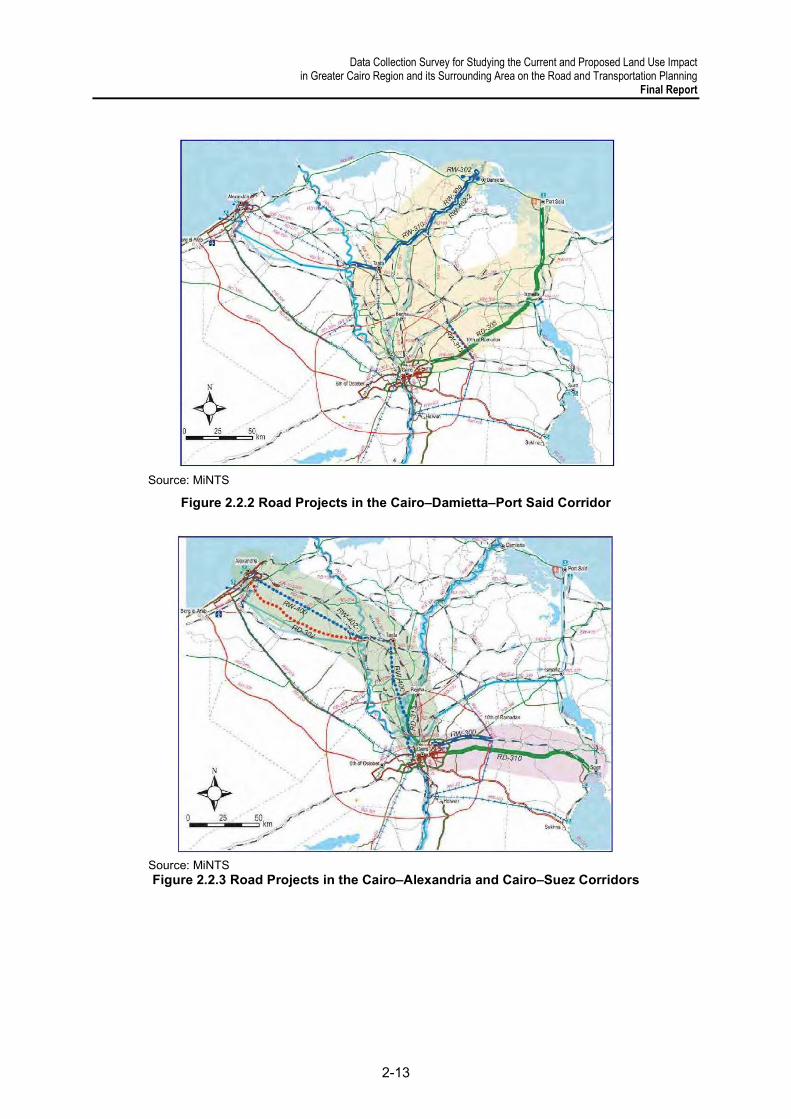
Data Collection Survey for Studying the Current and Proposed Land Use Impact in Greater Cairo Region and its Surrounding Area on the Road and Transportation Planning
Final Report
2-13
Source: MiNTS
Figure 2.2.2 Road Projects in the Cairo–Damietta–Port Said Corridor
Source: MiNTS Figure 2.2.3 Road Projects in the Cairo–Alexandria and Cairo–Suez Corridors

Data Collection Survey for Studying the Current and Proposed Land Use Impact in Greater Cairo Region and its Surrounding Area on the Road and Transportation Planning Final Report
2-14
Source: MiNTS
Figure 2.2.4 Road Projects in the Inland Delta and Suez Canal Development Corridor
Source: MiNTS
Figure 2.2.5 Road Projects in the Mediterranean and Sinai Corridors

Data Collection Survey for Studying the Current and Proposed Land Use Impact in Greater Cairo Region and its Surrounding Area on the Road and Transportation Planning
Final Report
2-15
Source: MiNTS
Figure 2.2.6 Road Projects in the Red Sea Corridor
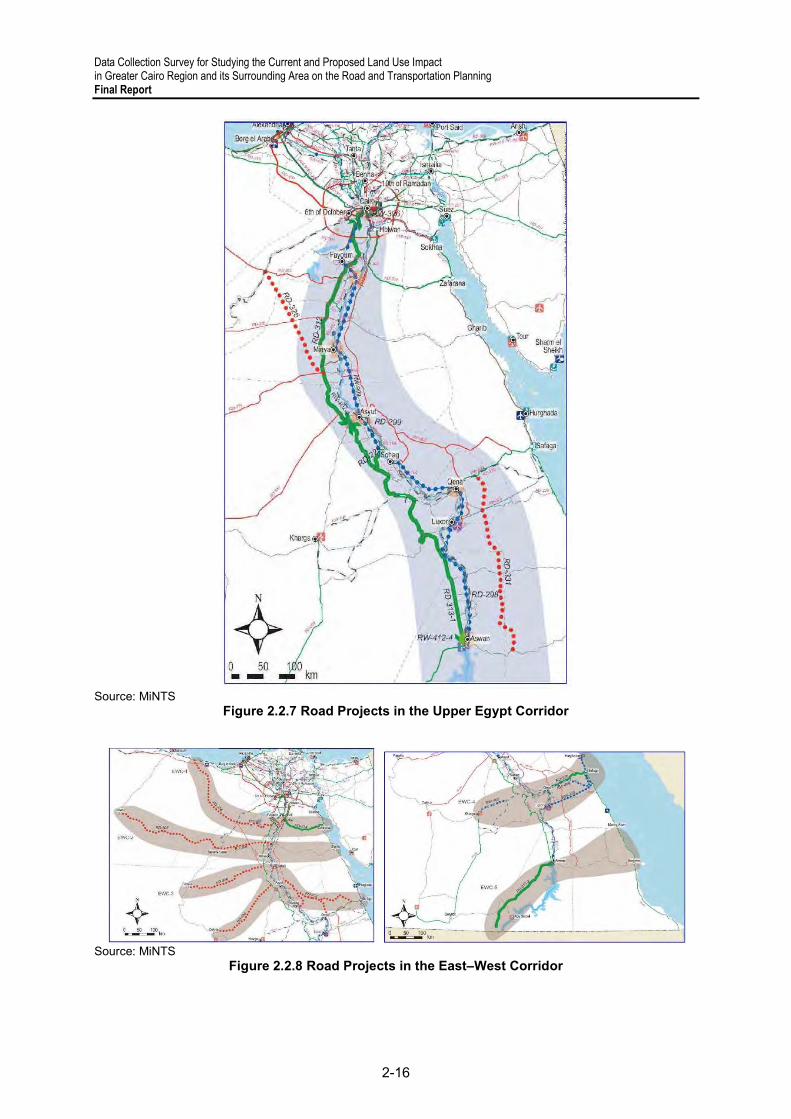
Data Collection Survey for Studying the Current and Proposed Land Use Impact in Greater Cairo Region and its Surrounding Area on the Road and Transportation Planning Final Report
2-16
Source: MiNTS
Figure 2.2.7 Road Projects in the Upper Egypt Corridor
Source: MiNTS
Figure 2.2.8 Road Projects in the East–West Corridor
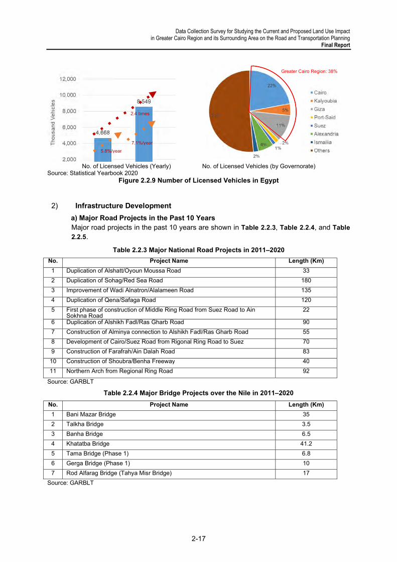
Data Collection Survey for Studying the Current and Proposed Land Use Impact in Greater Cairo Region and its Surrounding Area on the Road and Transportation Planning
Final Report
2-17
No. of Licensed Vehicles (Yearly) No. of Licensed Vehicles (by Governorate)
Source: Statistical Yearbook 2020 Figure 2.2.9 Number of Licensed Vehicles in Egypt
2) Infrastructure Development
a) Major Road Projects in the Past 10 Years Major road projects in the past 10 years are shown in Table 2.2.3, Table 2.2.4, and Table
2.2.5.
Table 2.2.3 Major National Road Projects in 2011–2020
No. Project Name Length (Km)
1 Duplication of Alshatt/Oyoun Moussa Road 33
2 Duplication of Sohag/Red Sea Road 180
3 Improvement of Wadi Alnatron/Alalameen Road 135
4 Duplication of Qena/Safaga Road 120
5 First phase of construction of Middle Ring Road from Suez Road to Ain Sokhna Road
22
6 Duplication of Alshikh Fadl/Ras Gharb Road 90
7 Construction of Alminya connection to Alshikh Fadl/Ras Gharb Road 55
8 Development of Cairo/Suez Road from Rigonal Ring Road to Suez 70
9 Construction of Farafrah/Ain Dalah Road 83
10 Construction of Shoubra/Benha Freeway 40
11 Northern Arch from Regional Ring Road 92
Source: GARBLT
Table 2.2.4 Major Bridge Projects over the Nile in 2011–2020
No. Project Name Length (Km)
1 Bani Mazar Bridge 35
2 Talkha Bridge 3.5
3 Banha Bridge 6.5
4 Khatatba Bridge 41.2
5 Tama Bridge (Phase 1) 6.8
6 Gerga Bridge (Phase 1) 10
7 Rod Alfarag Bridge (Tahya Misr Bridge) 17
Source: GARBLT
Greater Cairo Region: 38%
2.4 times
5.8%/year 7.1%/year

Data Collection Survey for Studying the Current and Proposed Land Use Impact in Greater Cairo Region and its Surrounding Area on the Road and Transportation Planning Final Report
2-18
Table 2.2.5 Major Flyover Projects in 2011–2020
No. Project Name
1 Agha Flyover Bridge over Almansorya canal
2 Dahshor Bridge over Railway
3 Kalabya Flyover Bridge
4 Airport Road extension bridge over Alkebash Road (Luxor)
5 Luxor Airport Road over Railway
6 Alabasya Flyover
7 Altawfekyah Flyover
8 Alma’ana Flyover Bridge over (Qena – Safaga) Road
9 Abo Hamad Flyover Bridge
10 Qous Flyover Brodge over Railway
11 Damnhour Flyover Bridge
12 Beshla Flyover (Benha/Mansoura Road)
13 Tanmal Flyover (Benha/Mansoura Road)
14 Sahrget Flyover (Benha/Mansoura Road)
15 Kafr Shokr Flyover (Benha/Mansoura Road)
16 Asneet Flyover (Benha/Mansoura Road)
17 109 Km Bridge over Cairo/Suez Road
18 Wadi Hagol Bridge over Cairo/Suez Road
19 Intersection Bridge of Alta’ameer Corridor with Sidi Karir connection
Source: GARBLT
In addition, many trunk roads have been constructed or are under construction in/around New Capital City (Figure 2.2.10). These roads are connected to the regional ring road and radial roads from Cairo by interchanges.
Source: Survey Team
Figure 2.2.10 New Trunk Road in/around New Capital City
Since MiNTS was prepared in 2012, many road projects other than those proposed in MiNTS have been implemented. It is necessary to re-establish the road development plan and reconsider the priority projects in consideration of the updated spatial plan as well as the increasing road traffic demand.
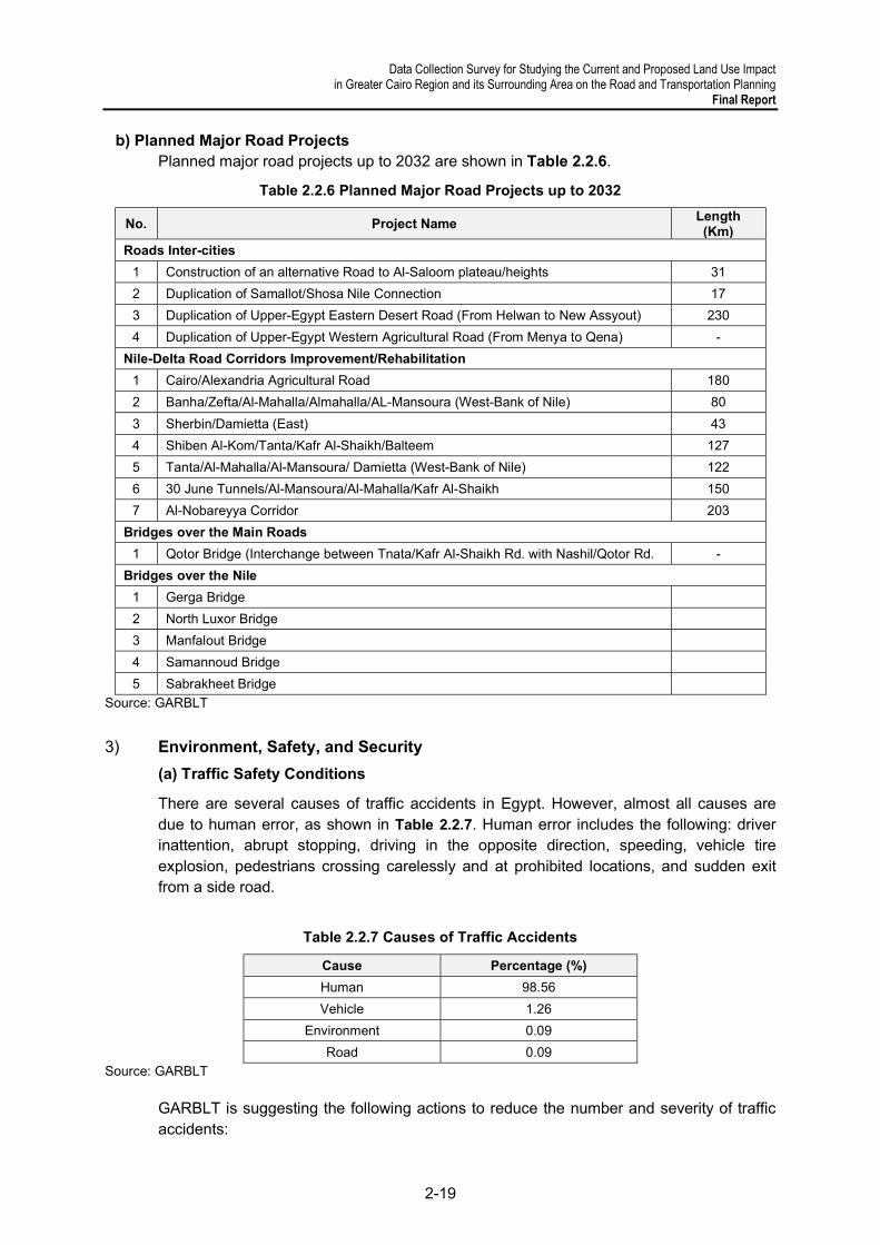
Data Collection Survey for Studying the Current and Proposed Land Use Impact in Greater Cairo Region and its Surrounding Area on the Road and Transportation Planning
Final Report
2-19
b) Planned Major Road Projects Planned major road projects up to 2032 are shown in Table 2.2.6.
Table 2.2.6 Planned Major Road Projects up to 2032
No. Project Name Length (Km)
Roads Inter-cities
1 Construction of an alternative Road to Al-Saloom plateau/heights 31
2 Duplication of Samallot/Shosa Nile Connection 17
3 Duplication of Upper-Egypt Eastern Desert Road (From Helwan to New Assyout) 230
4 Duplication of Upper-Egypt Western Agricultural Road (From Menya to Qena) -
Nile-Delta Road Corridors Improvement/Rehabilitation
1 Cairo/Alexandria Agricultural Road 180
2 Banha/Zefta/Al-Mahalla/Almahalla/AL-Mansoura (West-Bank of Nile) 80
3 Sherbin/Damietta (East) 43
4 Shiben Al-Kom/Tanta/Kafr Al-Shaikh/Balteem 127
5 Tanta/Al-Mahalla/Al-Mansoura/ Damietta (West-Bank of Nile) 122
6 30 June Tunnels/Al-Mansoura/Al-Mahalla/Kafr Al-Shaikh 150
7 Al-Nobareyya Corridor 203
Bridges over the Main Roads
1 Qotor Bridge (Interchange between Tnata/Kafr Al-Shaikh Rd. with Nashil/Qotor Rd. -
Bridges over the Nile
1 Gerga Bridge
2 North Luxor Bridge
3 Manfalout Bridge
4 Samannoud Bridge
5 Sabrakheet Bridge
Source: GARBLT
3) Environment, Safety, and Security
(a) Traffic Safety Conditions
There are several causes of traffic accidents in Egypt. However, almost all causes are due to human error, as shown in Table 2.2.7. Human error includes the following: driver inattention, abrupt stopping, driving in the opposite direction, speeding, vehicle tire explosion, pedestrians crossing carelessly and at prohibited locations, and sudden exit from a side road.
Table 2.2.7 Causes of Traffic Accidents
Cause Percentage (%)
Human 98.56
Vehicle 1.26
Environment 0.09
Road 0.09
Source: GARBLT
GARBLT is suggesting the following actions to reduce the number and severity of traffic accidents:

Data Collection Survey for Studying the Current and Proposed Land Use Impact in Greater Cairo Region and its Surrounding Area on the Road and Transportation Planning Final Report
2-20
● Educating vehicle drivers through awareness campaigns; ● Obligation to wear seat belts for vehicle passengers and helmets for motorcyclists; ● Compliance with speed limits; and ● Compilation of accurate statistics for proper road accident management
(b) Traffic Safety Works
GARBLT has been collecting traffic accident data and identifying some actions to take to reduce traffic accidents, as follows:
● Road marking with reflective traffic paint; ● Maintenance works (Reflectors- Marking – Micro surface – Crack filing); and ● Construction and maintenance of concrete barriers.
In addition, a project on intelligent transport systems (ITS) has been implemented relating to traffic safety. The objectives of the ITS project are as follows:
● Improving traffic condition and safety on the roads; ● Building a database on road traffic and establishing proper maintenance
management system; ● Raising the road security level; ● Adopting an electronic toll collection system using RFID (radio frequency
identification); and ● Reducing traffic accidents (deaths, injuries, and material losses).
The following roads are under the first phase of the ITS project and are in progress: Cairo–Alexandria Desert Road, Cairo–Suez Road, Shobra–Benha Freeway, Cairo–Ismalia Road, regional ring road, Katamya–Ain Sokhna Road, and the current ring road.
4) Freight Transportation and Road Safety
GARBLT has been managing overloaded vehicles through weigh stations installed in some major trunk roads (Table 2.2.8). However, it cannot be said that overloaded vehicles are controlled enough. This is mainly caused by higher demand of logistics, limited fleet of roads and high transportation cost.
There are transportation specifications for vehicles on the road network, as indicated in the MOT’s Decision No. 440 of 2019, which was amended by Ministerial Decision 724 of 2019.
The decision specifies the weights and dimensions allowed on the road network and the measures to be taken when vehicles exceed the maximum allowable loads. The decision is regularly updated every two or three years.
On major trunk roads, such as the Regional Ring Road and the Cairo–Alexandria Desert Road, trucks are separated from other vehicles through frontage roads (Figure 2.2.11). Trucks drive on the frontage road while other vehicles drive on the main road. Frontage roads have harder pavement to avoid damages from heavy loads. The frontage road is provided to promote traffic safety and as a measure against heavy loads. The number of car accidents on trunk roads has decreased by separating trucks and other vehicles, which significantly differ in traffic speeds.
Frontage roads have 2- or 3-lane carriageways. As traffic volume on frontage roads is currently not much, a smooth traffic flow can be maintained. However, where 1 lane is
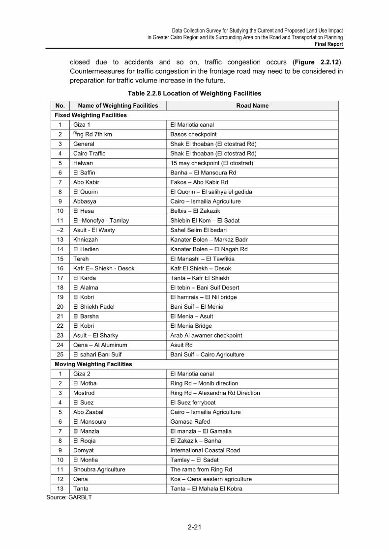
Data Collection Survey for Studying the Current and Proposed Land Use Impact in Greater Cairo Region and its Surrounding Area on the Road and Transportation Planning
Final Report
2-21
closed due to accidents and so on, traffic congestion occurs (Figure 2.2.12). Countermeasures for traffic congestion in the frontage road may need to be considered in preparation for traffic volume increase in the future.
Table 2.2.8 Location of Weighting Facilities
No. Name of Weighting Facilities Road Name
Fixed Weighting Facilities
1 Giza 1 El Mariotia canal
2 Ring Rd 7th km Basos checkpoint
3 General Shak El thoaban (El otostrad Rd)
4 Cairo Traffic Shak El thoaban (El otostrad Rd)
5 Helwan 15 may checkpoint (El otostrad)
6 El Saffin Banha – El Mansoura Rd
7 Abo Kabir Fakos – Abo Kabir Rd
8 El Quorin El Quorin – El salihya el gedida
9 Abbasya Cairo – Ismailia Agriculture
10 El Hesa Belbis – El Zakazik
11 El–Monofya - Tamlay Shiebin El Kom – El Sadat
–2 Asuit - El Wasty Sahel Selim El bedari
13 Khniezah Kanater Bolen – Markaz Badr
14 El Hedien Kanater Bolen – El Nagah Rd
15 Tereh El Manashi – El Tawfikia
16 Kafr E– Shiekh - Desok Kafr El Shiekh – Desok
17 El Karda Tanta – Kafr El Shiekh
18 El Alalma El tebin – Bani Suif Desert
19 El Kobri El hamraia – El Nil bridge
20 El Shiekh Fadel Bani Suif – El Menia
21 El Barsha El Menia – Asuit
22 El Kobri El Menia Bridge
23 Asuit – El Sharky Arab Al awamer checkpoint
24 Qena – Al Aluminum Asuit Rd
25 El sahari Bani Suif Bani Suif – Cairo Agriculture
Moving Weighting Facilities
1 Giza 2 El Mariotia canal
2 El Motba Ring Rd – Monib direction
3 Mostrod Ring Rd – Alexandria Rd Direction
4 El Suez El Suez ferryboat
5 Abo Zaabal Cairo – Ismailia Agriculture
6 El Mansoura Gamasa Rafed
7 El Manzla El manzla – El Gamalia
8 El Roqia El Zakazik – Banha
9 Domyat International Coastal Road
10 El Monfia Tamlay – El Sadat
11 Shoubra Agriculture The ramp from Ring Rd
12 Qena Kos – Qena eastern agriculture
13 Tanta Tanta – El Mahala El Kobra
Source: GARBLT
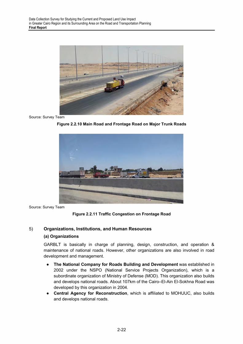
Data Collection Survey for Studying the Current and Proposed Land Use Impact in Greater Cairo Region and its Surrounding Area on the Road and Transportation Planning Final Report
2-22
Source: Survey Team
Figure 2.2.10 Main Road and Frontage Road on Major Trunk Roads
Source: Survey Team
Figure 2.2.11 Traffic Congestion on Frontage Road
5) Organizations, Institutions, and Human Resources
(a) Organizations
GARBLT is basically in charge of planning, design, construction, and operation & maintenance of national roads. However, other organizations are also involved in road development and management.
● The National Company for Roads Building and Development was established in 2002 under the NSPO (National Service Projects Organization), which is a subordinate organization of Ministry of Defense (MOD). This organization also builds and develops national roads. About 107km of the Cairo–El-Ain El-Sokhna Road was developed by this organization in 2004.
● Central Agency for Reconstruction, which is affiliated to MOHUUC, also builds and develops national roads.

Data Collection Survey for Studying the Current and Proposed Land Use Impact in Greater Cairo Region and its Surrounding Area on the Road and Transportation Planning
Final Report
2-23
● New Urban Communities Authority was established based on Law 59/1979, which mainly aims to creating new civilized centers for achieving community stability and economic prosperity. This entity develops roads inside new cities.
● Governorate Roads Departments develops local roads in each governorate.
(b) Laws and Regulations
Major laws and regulations related to the road sector and land transportation services are shown below.
● Public Roads Law No. 84 / 1968 and its amendment ● Building of Roads Law No. 229 / 1996 and its amendment ● GARBLT Law No. 334 / 2004 ● Goods Transport on Public Roads No. 64 / 1970 ● Operating Public Transport Concession Law No. 55 / 1975 ● Trucks Importation Decree No. 266 / 1970 issued by Minister of Transport ● Traffic Law No. 66 / 1973 and as amended ● Traffic Executive Regulations No. 2777 / 2000 issued by Minister of Interior ● Vehicle Compulsory Insurance Law No. 72 / 2007 ● Environment Law No. 4 / 1994 and its Executive Regulations No. 338 / 1985 ● Issuance of a decision to establish the Land Transport Regulatory Authority (LTRA)
under Law 73 of 2019
(c) Other Issues
GARBLT recognizes the following issues in road development and management: ● Lack of availability of modern software in the field of design and training; ● Lack of technological equipment to automatically collect road data, which is currently
being done manually; and the maintenance management systems programs and software available in the Authority are outdated; and
● The destructive effect of overloading on the road network.
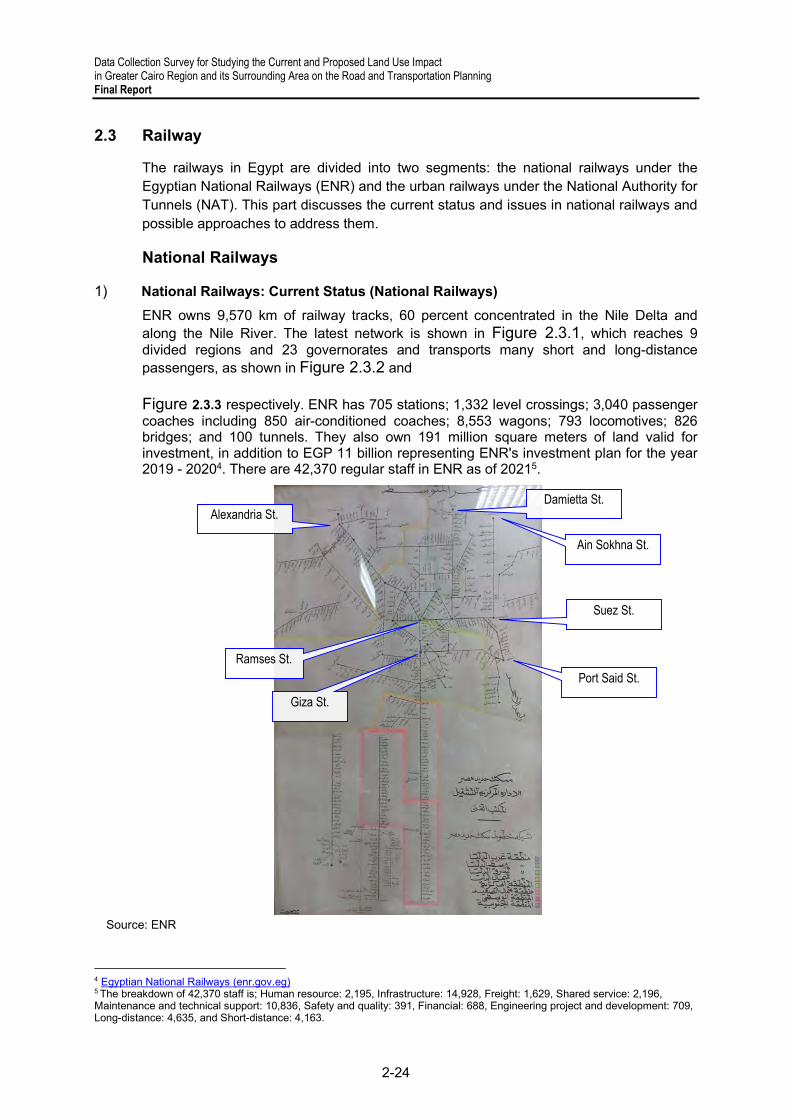
Data Collection Survey for Studying the Current and Proposed Land Use Impact in Greater Cairo Region and its Surrounding Area on the Road and Transportation Planning Final Report
2-24
2.3 Railway
The railways in Egypt are divided into two segments: the national railways under the Egyptian National Railways (ENR) and the urban railways under the National Authority for Tunnels (NAT). This part discusses the current status and issues in national railways and possible approaches to address them.
National Railways
1) National Railways: Current Status (National Railways)
ENR owns 9,570 km of railway tracks, 60 percent concentrated in the Nile Delta and along the Nile River. The latest network is shown in Figure 2.3.1, which reaches 9 divided regions and 23 governorates and transports many short and long-distance passengers, as shown in Figure 2.3.2 and Figure 2.3.3 respectively. ENR has 705 stations; 1,332 level crossings; 3,040 passenger coaches including 850 air-conditioned coaches; 8,553 wagons; 793 locomotives; 826 bridges; and 100 tunnels. They also own 191 million square meters of land valid for investment, in addition to EGP 11 billion representing ENR's investment plan for the year 2019 - 20204. There are 42,370 regular staff in ENR as of 20215.
Source: ENR
4 Egyptian National Railways (enr.gov.eg) 5 The breakdown of 42,370 staff is; Human resource: 2,195, Infrastructure: 14,928, Freight: 1,629, Shared service: 2,196, Maintenance and technical support: 10,836, Safety and quality: 391, Financial: 688, Engineering project and development: 709, Long-distance: 4,635, and Short-distance: 4,163.
Ramses St.
Alexandria St.
Giza St.
Ain Sokhna St.
Damietta St.
Suez St.
Port Said St.

Data Collection Survey for Studying the Current and Proposed Land Use Impact in Greater Cairo Region and its Surrounding Area on the Road and Transportation Planning
Final Report
2-25
Figure 2.3.1 Latest ENR Railway Network in Egypt (as of October 2021)
*1: This 2020/2021 indicates the period of 2020–2021
to May 2021.
Source: ENR
Figure 2.3.2 Number of Long-distance Travel
Passengers
Source: ENR
Figure 2.3.3 Number of Short-distance Travel
Passenger
(a) Freight Transport
The volume of freight transportation carried by the ENR is shown in Figure 2.3.4 by year and commodities. It shows that freight transportation occupied only four percent of ENR's overall traffic and one percent of all cargo movement6. To solve the situation, the ENR plans to transform the goods transportation sector into a company in partnership with the private sector in order to raise the annual volume of goods transportation from 4.5 million tons in 2019–2020 to 25 million tons by 2022. For this purpose, additional locomotives and wagons train cars are to be procured, and missing links are to be constructed with the support of foreign donors.
Source: ENR
Figure 2.3.4 Freight Transportation Volume by Commodity (2015–2020)
6 Project Information Document (PID) of Railway Improvement and Safety for Egypt, World Bank, 2020
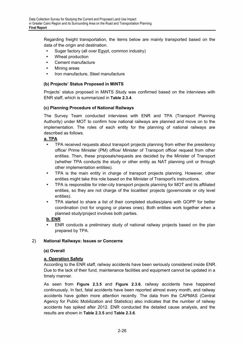
Data Collection Survey for Studying the Current and Proposed Land Use Impact in Greater Cairo Region and its Surrounding Area on the Road and Transportation Planning Final Report
2-26
Regarding freight transportation, the items below are mainly transported based on the data of the origin and destination. Sugar factory (all over Egypt, common industry) Wheat production Cement manufacture Mining areas Iron manufacture, Steel manufacture
(b) Projects’ Status Proposed in MiNTS
Projects’ status proposed in MiNTS Study was confirmed based on the interviews with ENR staff, which is summarized in Table 2.3.4.
(c) Planning Procedure of National Railways
The Survey Team conducted interviews with ENR and TPA (Transport Planning Authority) under MOT to confirm how national railways are planned and move on to the implementation. The roles of each entity for the planning of national railways are described as follows. a. TPA TPA received requests about transport projects planning from either the presidency
office/ Prime Minister (PM) office/ Minister of Transport office/ request from other entities. Then, these proposals/requests are decided by the Minister of Transport (whether TPA conducts the study or other entity as NAT planning unit or through other implementation entities).
TPA is the main entity in charge of transport projects planning. However, other entities might take this role based on the Minister of Transport's instructions.
TPA is responsible for inter-city transport projects planning for MOT and its affiliated entities, so they are not charge of the localities' projects (governorate or city level entities).
TPA started to share a list of their completed studies/plans with GOPP for better coordination (not for ongoing or planes ones). Both entities work together when a planned study/project involves both parties.
b. ENR ENR conducts a preliminary study of national railway projects based on the plan
prepared by TPA.
2) National Railways: Issues or Concerns
(a) Overall
a. Operation Safety According to the ENR staff, railway accidents have been seriously considered inside ENR. Due to the lack of their fund, maintenance facilities and equipment cannot be updated in a timely manner.
As seen from Figure 2.3.5 and Figure 2.3.6, railway accidents have happened continuously. In fact, fatal accidents have been reported almost every month, and railway accidents have gotten more attention recently. The data from the CAPMAS (Central Agency for Public Mobilization and Statistics) also indicates that the number of railway accidents has spiked after 2012. ENR conducted the detailed cause analysis, and the results are shown in Table 2.3.5 and Table 2.3.6.

Data Collection Survey for Studying the Current and Proposed Land Use Impact in Greater Cairo Region and its Surrounding Area on the Road and Transportation Planning
Final Report
2-27
Source: CAPMAS
Figure 2.3.5 Number of Accidents in 2009–2018
Source: MiNTS FR
Figure 2.3.6 Causes of Derailments in 2009–2018
b. Freight Transport Capacity Another view is, as mentioned in MiNTS, railway transportation has not been fully utilized for freight transportation since most services are concentrated in the road sector due to 1) the lack of suitable freight wagons, 2) insufficient freight train operations, 3) more cleaning of freight wagons, and 4) arrangement of wagons based on customers' schedule.
A major problem to hinder the utilization of the railway for freight transport is that railway lines are shared with passenger transport and passenger transport is currently more prioritized in ENR. There are only three specific freight lines dedicated only for freight. In addition, the passenger timetable is too tight, so there is no room for freight transportation. The current average speed is about 50km/h (the originally planned speed is 80-90km/h). Furthermore, operations in seaports and dry ports have some difficulties. Also, the priority in operations is set for passenger transport. As a result, freight transport is not scheduled, and trains depart after loading.
Another concern is the time for loading procedure and operation. Loading and unloading activities require much space, but the number of stations is limited. Also, the balance of the demand in freight transport differs between stations. Clients need to connect their facilities to the ENR line.
(b) Hardware
ENR staff pointed out that introducing automated facilities for operation and maintenance reduces human errors and provides more quality services. At present, their operation is mostly managed manually.
(c) Software (System)
For examples, regarding the simulator for drivers’ training, there are 3,600 drivers and assistant drivers in ENR. Yet, only 5 or 6 simulators installed from the US have been used at the Wardan institute. However, ENR has 6 regional training institutes (Central/Cairo, West Delta, East Delta, Mid. Delta, Mid. Upper Egypt, South Upper Egypt).
(d) Humanware (Human Resource Development)
About 70 percent of railway accidents are related to human error, especially lack ethical working practice by some railway staff, which is a severe problem. Also, due to the

Data Collection Survey for Studying the Current and Proposed Land Use Impact in Greater Cairo Region and its Surrounding Area on the Road and Transportation Planning Final Report
2-28
organization's size, it is hard to certify the quality of ENR staff (about 40 percent of them are illiterate). According to the ENR staff, several causes related to railway accidents were reported, as listed below. Drivers are overconfident and don’t follow the rules. To address the issue, a new
physiological test was introduced. ATC and signal systems were not only ignored but also deactivated by drivers since
the train operation schedule is very tight and passengers claim when the delay happens.
After these accidents, new regulations were installed, but drivers caused other problems again. To cope with the situation, drivers must cover the cost of a railway accident.
Mostly at the outside Cairo, animals and people cross the railway line randomly. Signals development projects have been currently introduced under the WB project as shown in Table 2.3.3, which will contribute to the decrease of accidents.
Table 2.3.1 summarizes the strengths and weaknesses of the ENR above, including the discussion in the MiNTS study.
Table 2.3.1 Updated Strengths and Weaknesses of the ENR Railway Transport
Strength Weakness
Hardware
Railway network covers significant parts of the country
Environmentally friendly Large transport capacity High-speed transport Punctual transport service New locomotives and wagons1
Old and obsolete systems (workshops, rolling stock, tracks, signaling system)
Access/egress transport service is poor and obsolete. Train speed is plodding except for mainlines Network too widespread to manage with proper condition
(it is costly and takes excessive time to improve it) 1 Many level crossings trigger railway accidents
Software
Systematic transport service Safe transport service Try to integrate and control
centrally (plan to develop the Centralized Traffic Control (CTC) system1)
Maintenance works are not performed well Safe operation Train diagrams (still hand-written and need to be created
via software1) Transport planning/ Database maintenance Mostly paper-based data management
Human Resource
A large number of employees Veteran staff with experience and
skill
Knowledge and experience of modern technology Inequality of ENR's staff capacity due to the size of the
organization1 Source: Survey Team based on the information from the MiNTS report
3) National Railways: Measures by ENR
(a) Accident Prevention
To address the serious railway accidents these days, ENR conducts training programs for drivers, which is 2 years for assistant drivers, including theoretical and technical exams (the passing rate is 75%). After passing the exam, a safety license is issued. Train driver license expiration is two years. Then the driver has to undergo a medical and psychological examination then pass a written and practical test on renewing the license. Also, additional training is conducted when a new locomotive or new technology is installed. Post-accident training is prepared based on the analysis of accidents and what should be done as a countermeasure. In addition, by using an operation simulator, training is conducted based on what concerned people say and what happened to recap the status

Data Collection Survey for Studying the Current and Proposed Land Use Impact in Greater Cairo Region and its Surrounding Area on the Road and Transportation Planning
Final Report
2-29
at the Wardan Institute. They need a simulator for signaling to educate employees to understand the systems.
(b) Bypass Railway Lines to New Dry Ports (6th of October city and 10th of Ramadan city)
The center of Cairo is the biggest bottleneck for freight transportation. Two bypass railway lines are being constructed to avoid entering there, as shown in Figure 2.3.7. One is to 6th of October city dry port connection from Al-Ittihad line (Almanshi) 55-60 km. The other is 10th of Ramadan city dry port connection from Cairo- Suez line Al-Robeki station.
A new dry port in 6th of October city is under construction and will start operations from 1st January 2022. There is a study to connect the dry port and the existing railway line, which will enable direct transportation of containers from Alexandria seaports to the dry port. According to city government officials, the idea is being studied by the ENR with support from the EBRD (European Bank for Reconstruction and Development), and the WB (World Bank) finances the project. Besides the difficulty in getting data, a land acquisition may have a problem since the land is owned by the other entity, which requires coordination for the new branch line construction. The new connection line near the 6th of October will serve 15 fleet transport per day though just one or two trains per day are currently operated.
10th of Ramadan city has the most significant industrial zone in Egypt, occupying 30 percent of the share in the country. A new dry port will also commence operation in 2022, financed by the AFD (Agence Française de Développement), but is still under construction. Several lines linked to the dry port are being constructed with assistance from other donors. One is the Belbes to 10th of Ramadan city freight line (app. 45 km), and the other is the Robeky to Tebeen freight line (app. 55-60 km).
Source: Survey Team
Figure 2.3.7 Bypass Railway Lines in Greater Cairo Region

Data Collection Survey for Studying the Current and Proposed Land Use Impact in Greater Cairo Region and its Surrounding Area on the Road and Transportation Planning Final Report
2-30
4) National Railways: Support from Foreign Donors and Private Companies’ Participation
(a) Support from Foreign Donors
MDBs (Multilateral Development Banks) or overseas institutes for foreign countries' developments have shown strong support to the development of Egypt. A thematic transportation sector DPG (Development Partners Group) was established in Egypt to discuss ongoing programs, planned projects, or co-financing potential. Railway projects financed by donors are listed below by the client (ENR and NAT), although not all the information was collected.
Table 2.3.2 Recent Support for ENR from Other Donors
No. Appraisal
Year/ Month
Completion Year/Month (planned)
Donor Project Name Project Description Project Cost
(million)
1 2021/03 (2028/12) AfDB Egypt National Railways Modernization Project
Upgrading of railway signaling systems from mechanical and electrical systems to the electric interlocking system
EUR 145
2 2021/03 (2027/09) WB Railway Improvement and Safety for Egypt (RISE) Project
Signal modernization and track rehabilitation on the Cairo–Beni Suef corridor
USD 440
3 2020/02 2021/06 EIB
Feasibility Study of Upgrading for Tanta- El Mansoura- Damietta railway
Study on doubling of the section El Mansoura-Damietta (65 km), the re-signaling of the whole line, investments in the railway stations, a freight yard, and a freight link to Damietta port
EUR 1.5*1
4 2019/12 - EXIM Bank - Hungary
- Import and manufacture of 1,300 new railroad cars by the most prominent Russian company
EUR 1,016
5 2016/06 - EBRD ENR-Locomotive Renewal Programme
Supply of 100 new locomotives EUR 290
6 2016/03 2020/03 EDCF
Project of modernizing signaling and communication systems on the Nag Hammadi/ Luxor Line
Signal and communication modernization on Nag Hammadi/ Luxor USD 115
7 2014/03 - EBRD Egyptian National Railways Restructuring
Supply of 6 complete trains EUR 126
8
2013/04 (2018)
AFESD Modernization of Banha– Port Said Railway Line Control and Signaling System Project
Co-finance: signal modernization along Benha–Zagazig–Ismailia–Port Said route
USD 102
9 KFED USD 150
10 2010/12
2020/12
WB Additional Financing for Railway Restructuring
1. Signal modernization on Beni Suef/ Asyut corridor 2. Signal modernization on Asyut–Nagh Hammadi corridor
USD 330
11 2009/03 WB Egypt National Railways Restructuring Project (ENRRP)
1. Signal modernization on the Cairo–Alexandria corridor 2. Track renewal of 300 km on Cairo–Aswan corridor
USD 270
Source: Survey Team based on the website information
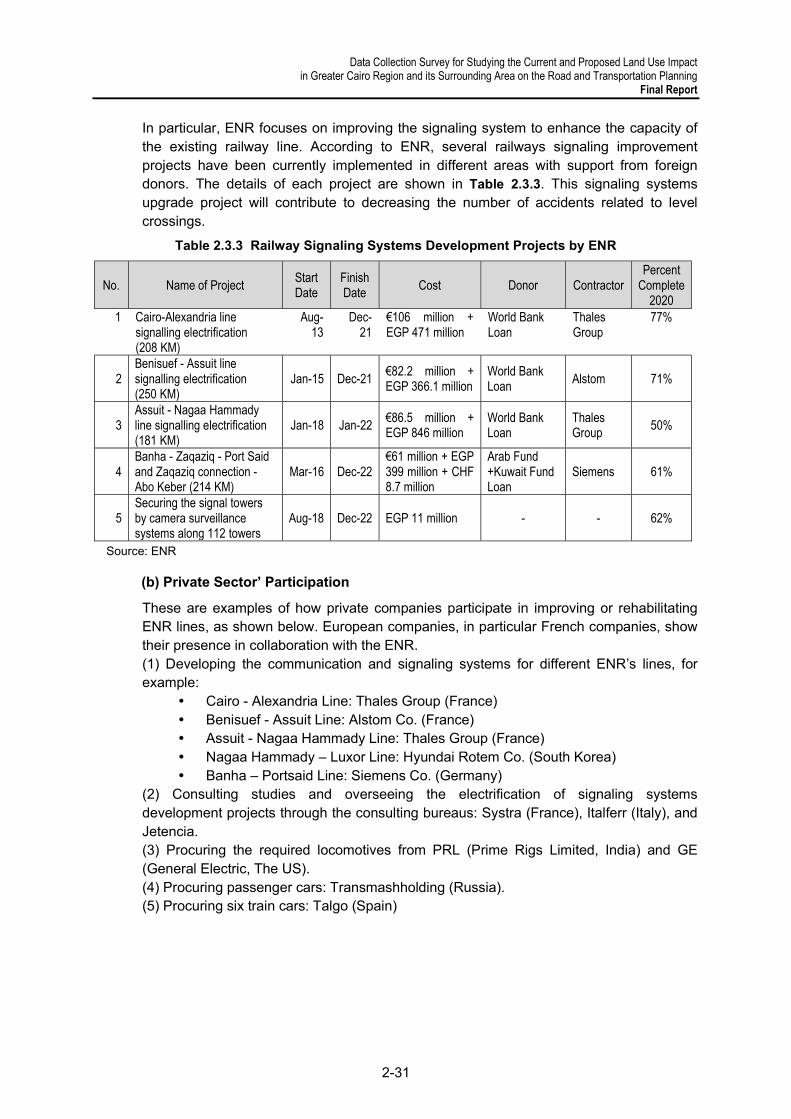
Data Collection Survey for Studying the Current and Proposed Land Use Impact in Greater Cairo Region and its Surrounding Area on the Road and Transportation Planning
Final Report
2-31
In particular, ENR focuses on improving the signaling system to enhance the capacity of the existing railway line. According to ENR, several railways signaling improvement projects have been currently implemented in different areas with support from foreign donors. The details of each project are shown in Table 2.3.3. This signaling systems upgrade project will contribute to decreasing the number of accidents related to level crossings.
Table 2.3.3 Railway Signaling Systems Development Projects by ENR
No. Name of Project Start Date
Finish Date
Cost Donor Contractor Percent
Complete 2020
1 Cairo-Alexandria line signalling electrification (208 KM)
Aug-13
Dec-21
€106 million + EGP 471 million
World Bank Loan
Thales Group
77%
2 Benisuef - Assuit line signalling electrification (250 KM)
Jan-15 Dec-21 €82.2 million + EGP 366.1 million
World Bank Loan
Alstom 71%
3 Assuit - Nagaa Hammady line signalling electrification (181 KM)
Jan-18 Jan-22 €86.5 million + EGP 846 million
World Bank Loan
Thales Group
50%
4 Banha - Zaqaziq - Port Said and Zaqaziq connection - Abo Keber (214 KM)
Mar-16 Dec-22 €61 million + EGP 399 million + CHF 8.7 million
Arab Fund +Kuwait Fund Loan
Siemens 61%
5 Securing the signal towers by camera surveillance systems along 112 towers
Aug-18 Dec-22 EGP 11 million - - 62%
Source: ENR
(b) Private Sector’ Participation
These are examples of how private companies participate in improving or rehabilitating ENR lines, as shown below. European companies, in particular French companies, show their presence in collaboration with the ENR. (1) Developing the communication and signaling systems for different ENR’s lines, for example:
Cairo - Alexandria Line: Thales Group (France) Benisuef - Assuit Line: Alstom Co. (France) Assuit - Nagaa Hammady Line: Thales Group (France) Nagaa Hammady – Luxor Line: Hyundai Rotem Co. (South Korea) Banha – Portsaid Line: Siemens Co. (Germany)
(2) Consulting studies and overseeing the electrification of signaling systems development projects through the consulting bureaus: Systra (France), Italferr (Italy), and Jetencia. (3) Procuring the required locomotives from PRL (Prime Rigs Limited, India) and GE (General Electric, The US). (4) Procuring passenger cars: Transmashholding (Russia). (5) Procuring six train cars: Talgo (Spain)

Data Collection Survey for Studying the Current and Proposed Land Use Impact in Greater Cairo Region and its Surrounding Area on the Road and Transportation Planning Final Report
2-32
5) National Railways: Recent Movements in the Railway Sector of Egypt
(a) Establishment of a New Domestic Rolling Stock Manufacturing Company
The National Egyptian Railway Industries Company (NERIC) is under construction at East Port Said. It will be a significant milestone in Egypt's strategic industrialization plan, especially in the rolling stock sector, to achieve the goal set in Egypt Vision 2030. The planned construction cost is about USD240 million, and the factory will start operation by the end of 2022. Hyundai Rotem (South Korean) will transfer its advanced technology manufacturing rolling stocks to NERIC as an MOU (Memorandum of Understanding)7. The overall projected demand from the local Egyptian market for rehabilitation and manufacturing facilities will be over 3,000 coaches over the coming 10 years. NERIC aims to shoulder 50 percent of that figure8. According to the interview with the ENR staff, the NERIC is still in the Initiation process, and ENR is ready to coordinate and share their experience, staff, and technology.
(b) Cooperation Plan with Private Sectors9
A recent bylaw grants ENR the ability to invest in its own assets (including land) and manage its contracts through an investment company (subsidiary) fully owned by ENR; this company is called "M.O.T Investment & Development projects” (M.O.T). Through MOT, ENR takes an equity share in public-private partnerships (PPPs), such as leasing terminal space to Carrefour in Ramses station and the development of Sidi Gaber station.
The EBRD is currently funding a project to develop a feasibility study to assist ENR in establishing an independent company with the prior knowledge of the German consulting bureau “Dornier”. This is to transform the freight transport sector into a company capable of flexibly establishing partnerships with the private sector and benefitting from its experience to develop this entire sector and increase its efficiency. This is considering the amendment of Law number 152 of the year 1980 that allows partnership with the private sector in running and operating railway lines concomitantly with the current procedures, including the unanimous approval to establish a freight transport company that is 100% owned by the ENR.
(c) Coordination about Planning of New Dry Ports
The infrastructure department of ENR makes daily and continuous communication with the General Authority for Land and Dry Ports (GALDP), especially regarding 6th of Ramadan city and 10th of October city dry ports. ENR will operate and manage the railway links in the dry ports.
According to ENR, other dry ports are under planning or study, as described below, so additional railway connections may need to be considered based on the estimated transport volume. A dry port in Damietta is understudy the outside of the seaport. A dry port in Al Minya Governorate is also under study. A dry port in Sadat City (a new urban community under NUCA) is also under
planning. A dry port in Helwan is also under study.
7 Egypt signs MoU to locally manufacture metro, electric trains-SIS 8 https://www.neric.com/ 9 The information is provided by ENR on 12/07/2021.

Data Collection Survey for Studying the Current and Proposed Land Use Impact in Greater Cairo Region and its Surrounding Area on the Road and Transportation Planning
Final Report
2-33
A single line will be used for freight transport between Beni Suef and Faiyum (under construction and studied in MiNTS).
(d) Extension of Railway Lines inside Ports
The ENR listed six ports connected to railway lines: 1) Alexandria Port, 2) Dekheila Port, 3) Damietta Port, 4) Literary Port, 5) Ain Sokhna Port, and 6) Port Said Port, as shown in Figure 2.3.8. The railway connection line to each port is also shown in Figure 2.3.9. Since the lines inside the six ports mentioned above will be extended and operated by the ENR, railway operations inside a port and smooth coordination with a port operator will be crucial. In the MiNTS final report, several issues about freight transport were listed, such as 1) lack of locomotives compared with the demand, and 2) unforeseeable schedule due to lack of incentive for the ENR to operate freight trains on time.
By tackling the problems above, the capacity of intermodal transportation in GCR will be enhanced, which will make freight transportation more competitive. The LTRA, which will set a new fare collection policy for the ENR in order to control the freight border crossing with the GARBLT, is a key player in managing the logistics flow in GCR.
Source: Survey Team
Figure 2.3.8 Location of Railway Connections
6) National Railways: Areas Requiring Technical Assistance
Based on interviews with authority staff and on online research, the areas requiring technical assistance for national railways in Egypt are summarized as follows:
1
2
3
6
4
5

Data Collection Survey for Studying the Current and Proposed Land Use Impact in Greater Cairo Region and its Surrounding Area on the Road and Transportation Planning Final Report
2-34
(a) Assessment of Planning Status
ENR began 12 railway projects in 2019, which will develop 424 kilometers of the new railway network to transport goods across Egypt in partnership with the private sector10. According to interviews, there is little coordination in planning among other relevant authorities of the MOT, such as the General Authority for Land and Dry Port (GALDP) or the GARBLT, if there is no specific project working together. When optimization of the transport plan in the country (particularly regarding logistics) is discussed, coordination with relevant authorities on the role of transportation modes should be clarified. According to interviews with the Transport Planning Authority (TPA) staff, there has been no integrated and informative study in the transport sector after the MiNTS study. Hence, a new strategic transport study is necessary for the entire country to contribute to the efficient and effective planning in each authority under the MOT.
(b) Asset Management of ENR's Facilities/ Equipment
Needs to update ENR's facilities or equipment has increased year by year mainly due to 1) the considerable number of recent railway accidents and 2) the aim of increasing the utilization of the railway network for freight operation, especially to connect seaports to dry ports. Regarding the safety enhancement in ENR's operation, the WB conducted the Egypt National Railways Restructuring Project (ENRRP), completed in 2020, in order to update the signaling system between Alexandria–Cairo and Beni Suef–Nag Hammadi sections. As the successor of the ENRRP, the WB commenced the Railway Improvement and Safety for Egypt (RISE) Project, which aims to realize 1) a safe and modern signaling system, 2) safe asset management, and 3) project delivery, institutional and human resource development11 . Besides this and as described above, various donors have supported the ENR to procure locomotives and wagons.
A modernized asset management system needs to be developed with assistance from other donors since most current asset management activities are paper-based. Though the actual situation should be identified through a further study, some maintenance activities, such as for rail or rolling stock, seem to be improperly done, resulting in serious railway accidents. Therefore, preventive maintenance with a digital database should be introduced, and facilities or equipment should be managed comprehensively.
(c) ENR as Commuter Railway
When it comes to commuting by ENR’s railway within GCR, there is no plan to update the existing railway to a commuter railway. The sections between El Marg and Qalyub and between Qalyub and Shibin Al Qanatir are currently used as a commuter line. Besides, as per the data received from ENR, approximately 50% of ENR lines end in/originate from GCR (Ramsis), so daily passengers depend on it to reach their destinations within GCR. The extension of Line 1, between Al-Marg and Shebein El Qanater, may be considered in the operation of the commuter line starts and ends within GCR12.
According to TPA, they also explained 2 examples of using ENR railway as an urban railway. One is the Abou Keir line in Alexandria and Qalioub-Shebin in Qalyubia, which is
10 https://egyptindependent.com/egypts-transport-ministry-to-start-work-on-12-railway-projects/ 11 Loan Agreement on Railway Improvement and Safety for Egypt Project, World Bank, April 2021 12 For the section from Al Marg to Shebein El Qanater, the number of annual passengers was 1,841,016 and 111,000,000 passengers/km for year 2020/2021.

Data Collection Survey for Studying the Current and Proposed Land Use Impact in Greater Cairo Region and its Surrounding Area on the Road and Transportation Planning
Final Report
2-35
cheap and high demand but considered 3rd grade for workers. The other is Robeki- 10th of Ramadan city, a local train stopping at each station.
(d) Utilization of Railway for Freight Transportation
As mentioned at the beginning of this chapter, freight transportation occupied only four percent of ENR's overall traffic and one percent of all cargo movement in Egypt. On the other hand, railway share in cargos in India was 36% (2019)13, in the US was 32% (2020)14, and in Asia was 30% (2020)15. According to an interview with ENR staff, the main reason recognized from the interview was that freight transport has been less prioritized than passenger one. However, ENR owns the second ancient railway network in the world, including 9,570 km rail tracks, 144 cargo stations, and 329,276 cargo vehicles16. There are demands and potential for utilizing the ENR's railway lines for more effective freight transportation, considering the impact on the environment compared with road transportation.
(e) Role Demarcations with Existing ENR Railway and High-speed Railway
The HSR in Egypt will connect Ain Sokhna and New Alamein, which will transfer passengers and cargo transport. Therefore, the role of demarcation between the current ENR freight transportation and the HSR should be considered carefully and strategically since the ENR is trying to increase the volume of freight transportation on its own. In particular, the alignment of the HSR goes through the newly constructed dry port at 6th of October city, so cargo volume from the port needs to be assessed carefully.
Also, the balance of freight transportation with other modes and the impact that the HSR will bring on intermodal transportation needs to be investigated to optimize the entire logistics network. Furthermore, the impact on sea transportation needs to be assessed as well because the volume passing through the Suez Canal will be affected by introducing the HSR. The overall freight transportation plan for the whole country needs to be reviewed, considering the expected role or function of the HSR.
The implementation of HSR, however, can be accelerated by considering the following perspectives, such as precise demand forecast, decent examination of fare systems and financial stability, and analysis on competitive transport modes. In addition to, or based on these perspectives, it is quite significant to position this HSR project in MPs, and secure legal basis for this project.
(f) Restructuring of ENR through PPP
All the sectors of ENR, such as human resources, maintenance, or supplies, have relations with the private sector. Every department and each department have an agreement with a private company.
The MiNTS final report reported that the total number of ENR staff was about 73,000, which is related to the inequality of the level of staff, triggering severe accidents or the low level of service. According to ENR staff, the ENR started investments related to real estate, logistics, advertising and commercials, and advanced station projects with M.O.T. Besides this, the WB or other international donors work with the MOT to develop a freight
13 https://shaktifoundation.in/report/full-report-increasing-rail-share-of-freight-transport-in-india/ 14 https://www.container-xchange.com/blog/rail-freight-overview/ 15 https://www.container-xchange.com/blog/rail-freight-overview/ 16 CAPMAS

Data Collection Survey for Studying the Current and Proposed Land Use Impact in Greater Cairo Region and its Surrounding Area on the Road and Transportation Planning Final Report
2-36
line through a PPP scheme17. Considering the above, whatever ENR's strengths and weaknesses need to be assessed, private sectors’ participation in the existing services need to be encouraged to provide better service.
17 Egypt Enabling Private Investment and Commercial Financial in Infrastructure, World Bank, 2018

Data Collection Survey for Studying the Current and Proposed Land Use Impact in Greater Cairo Region and its Surrounding Area on the Road and Transportation Planning
Final Report
2-37
Table 2.3.4 Projects’ Status Proposed in MiNTS
Note: A: Implemented/Under construction, B: Under planning (no yet implemented), C: Not commenced,
D: To be confirmed Source: Prepared by Survey Team based on Interviews with ENR
No. IDConsultants in chargeStatus Name Project Outline
1 RW-300 NT B Double Tracking for Ain Shams – Robekifrom Cairo - Robekki along Cairo - Suez line[Double Tracking]
2 RW-301 NT B Single Tracking for Basion Citynot in main line between Cairo - Alex. [New RailLine]
3 RW-302 NT ASingle Tracking for Kafr El-Batikh - New DamiettaCity
Damietta City only [New Rail Line]
4 RW-303 NT CSingle Tracking for Luxor - Hurghada[Electrificated]
for tourists from Hurghada to Luxor to save traveltime, max.150kph, [New Rail Line]
5 RW-304 NT BHigh Speed Railway for Cairo - Alexandria[High/Higher speed Alt-1]
connects to Alex. to Cairo (6th of October, Smartcity) along Cairo - Alex. dessert road, directly,max.speed 250kph technology, [New HSR]
6 RW-306 NT DDevelopment of Railway Bridge for Lemon -Abbasiya - Tora
runs in southern area of grater Cairo region [TrackImprovement]
7 RW-307 NT D Double Tracking for Qalyoub - El Qnaternot in main line between Cairo - Alex. [DoubleTracking]
8 RW-308 NT D Triple Tracking for Qalyoub - Benhaconnects Cairo - Qalyoub with triple tracks [TripleTracking]
9 RW-309 NT A Double Tracking for Mansoura – Damietta connects to Damietta [Double Tracking]
10 RW-310 NT AImprovement of Signaling System for Increase ofFreight Trains
connects for Tanta - Mansoura - Damietta [SignalImprovement]
11 RW-312 NT C Single Tracking for Bir El Abd - Rafah connects to Rafah along coast line [New Rail Line]
12 RW-313 NT B Railway Link for 10th of Ramadhan Cityconnects between Tel el Kebir to Robeki throughLogistics Center [New Rail Line]
13 RW-400 NT CHigh Speed Railway for Cairo - Alexandria via Tanta[High/Higher speed Alt-2]
Alternative route of Italian proposal [RW-304 Alt-1], max. speed 250kph technology<only forconfirming demands compared with RW-304>[New HSR]
14 RW-401 NT DImprovement of Track Arrangement for Cairo -Qalyub
Cairo and Qalyub Station: Rearrangement of tracklines, Qalyub Station: Construction of elevatedrailway, [Track Improvement]
15 RW-402-1 NT D Improvement of Tracks1)Track renewal, 2)New track maintenancemachines, Cairo - Tanta - Alex.
16 RW-402-2 NT D Improvement of Tracks1)Track renewal, 2) New track maintenancemachines, Damietta, Port Said line
17 RW-402-4 NT D Improvement of Tracks1) Track renewal, 2) New track maintenancemachines on Cairo - Aswan
18 RW-403 NT DDouble Tracking of Bypass Line for Cairo-NewAlexandria
for freight line (diesel) with local passenger
19 RW-406 NT A Railway Link for 6th of October Cityconnects from RW-403 and Baharia line via L-1[New Rail Line]
20 RW-407 NT C Railway Link between Robeki to Helwanforms a part of south ring railway route [New RailLine]
21 RW-408 NT B Rehabilitation of Tracks for Qena - Khargafor passenger, even the paralleled cargo line fromKharga to Qena are existed [Track Improvement]
22 RW-409 NT B Rehabilitation of Tracks for Qena - Safagafor local passenger and cargo traffic connected tored sea and Quena and Luxur [Rehabilitation]
23 RW-410 NT A Rehabilitation of Tracks for El-Kab - Bir El Abdconnects to Suez bridge, Port Said East and RW-312 [Track Improvement]
24 RW-412 NT AImprovement of Station Facilities for FreightServices (2stations)
Good intermodal connection & facilities, railwaylayout/arrangement, warehouse and station officeat Qabbary and other station
25 RW-412-4 NT AImprovement of Station Facilities for FreightServices (6 stations)
Good intermodal connection & facilities, railwaylayout/arrangement, warehouse and station officeat stations of Imbaba, Beni Suef, Minya, Asyut,Qena and Aswan
26 RW-420 NT C Railway Link between Sokhna Port to HelwanNew freight railway line for direct link from Sokhnaport to 6th of October [New Rail Line]
27 RW-999 NT B(High) Speed Railway for Cairo - Aswan[Electrificated]
New line for passenger railway (200kph) stoppingat only major cities [New HSR]
28 SW-5 NT A/B Railway Safety Initiative
modernization of railway crossing to automaticsystem (696, half of crossings in Egypt areimproved by ENR funds till 2017) and continuedimprovement.
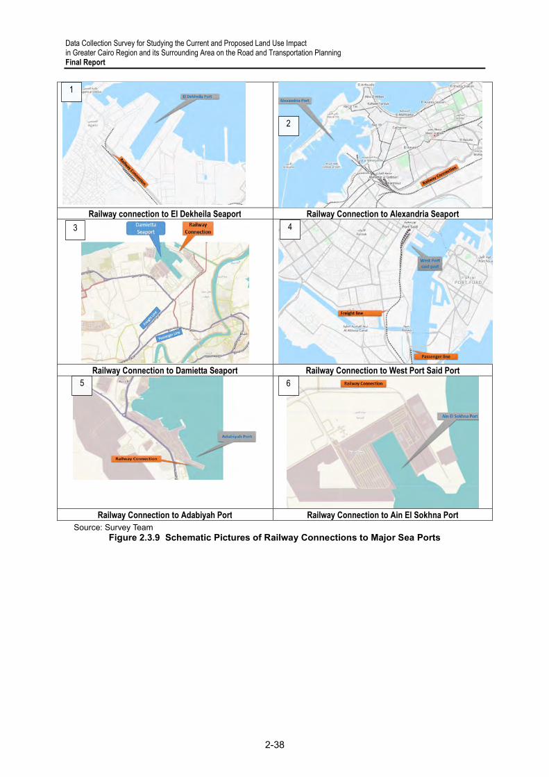
Data Collection Survey for Studying the Current and Proposed Land Use Impact in Greater Cairo Region and its Surrounding Area on the Road and Transportation Planning Final Report
2-38
Railway connection to El Dekheila Seaport Railway Connection to Alexandria Seaport
Railway Connection to Damietta Seaport Railway Connection to West Port Said Port
Railway Connection to Adabiyah Port Railway Connection to Ain El Sokhna Port
Source: Survey Team Figure 2.3.9 Schematic Pictures of Railway Connections to Major Sea Ports
2
1
3 4
5 6

Data Collection Survey for Studying the Current and Proposed Land Use Impact in Greater Cairo Region and its Surrounding Area on the Road and Transportation Planning
Final Report
2-39
Table 2.3.5 Number of Fatal and Non-Fatal Accidents of ENR
Source: ENR
Fata
lNo
n-Fa
tal
Fata
lNo
n-Fa
tal
Fata
lNo
n-Fa
tal
Fata
lNo
n-Fa
tal
Fata
lNo
n-Fa
tal
Fata
lNo
n-Fa
tal
Fata
lNo
n-Fa
tal
Fata
lNo
n-Fa
tal
Fata
lNo
n-Fa
tal
Fata
lNo
n-Fa
tal
Fall
057
173
048
111
20
107
073
352
223
027
217
Entra
pmen
t0
00
10
20
50
30
30
20
00
00
1Co
llisio
n1
10
00
00
10
11
00
00
01
01
0Co
lisio
n at
trac
k end
00
00
00
09
25
01
13
21
02
00
Imbr
icatio
n0
00
00
00
30
30
00
30
10
00
2Ob
stac
le C
ollis
ion
00
00
00
02
00
00
01
00
01
01
Cros
sing A
ccid
ents
07
00
00
01
00
01
00
00
10
00
Loco
mot
ive Fi
re0
00
30
50
70
80
100
90
20
10
0Co
ach
Fire
07
06
016
013
012
07
04
02
01
02
Sub
Tota
l1
721
830
711
153
213
91
954
744
292
323
23Fa
ll0
00
10
00
00
00
01
00
11
10
1Ob
stac
le C
ollis
ion
00
00
00
092
060
00
044
039
025
016
Accid
ents
at C
ross
ing
2055
2720
1623
2035
1644
926
1722
833
829
1113
Accid
ents
at I
llega
l Cro
ssin
g11
122
057
1350
1786
2380
965
1166
1351
869
639
Casu
al C
ross
ing f
rom
Unp
lann
ed C
ross
ing
207
8510
946
Not F
ollo
win
g Saf
ety R
ules
5613
134
79Ac
ciden
ts D
iscov
ered
on
Railw
ay T
rack
212
188
117
79EN
R W
orke
rs A
ccid
ents
759
154
411
922
133
1025
632
222
1121
153
326
723
66
131
236
284
188
181
250
302
379
606
381
782
360
614
315
714
491
917
499
764
283
404
237
356
189
264
250
373
380
759
383
921
361
709
319
788
495
946
501
796
286
427
110
320
260
417
467
275
371
332
342
310
301
Others
198
Other'sResponsibility
4816
049
217
Sub
Tota
lTo
tal
ENR's Responsibility
2018
2020
2019
2021
2012
2013
2014
2015
2016
2017

Data Collection Survey for Studying the Current and Proposed Land Use Impact in Greater Cairo Region and its Surrounding Area on the Road and Transportation Planning Final Report
2-40
Table 2.3.6 Number of Death and Injury by Accidents of ENR
Source: ENR
Deat
hIn
jury
Deat
hIn
jury
Deat
hIn
jury
Deat
hIn
jury
Deat
hIn
jury
Deat
hIn
jury
Deat
hIn
jury
Deat
hIn
jury
Deat
hIn
jury
Deat
hIn
jury
Fall
00
1912
00
00
120
10
315
410
90
023
143
Entra
pmen
t55
530
00
00
00
00
00
10
00
00
0Co
llisio
n0
00
00
00
00
050
100
00
00
013
3291
Colis
ion a
t tra
ck en
d0
00
00
00
05
112
00
057
2048
04
00
Imbr
icatio
n0
00
00
00
00
00
00
30
00
00
0Ob
stacle
Col
lisio
n0
00
00
00
00
00
00
00
00
00
0Cr
ossin
g Acc
ident
s0
80
00
00
00
00
00
00
01
01
2Lo
com
otive
Fire
00
00
00
00
00
00
00
00
00
00
Coac
h Fire
00
00
00
00
00
00
00
00
00
00
Sub T
otal
5561
1912
00
00
125
113
5010
315
102
2057
117
5623
6Fa
ll0
00
00
00
00
00
00
60
00
220
0Ob
stacle
Col
lisio
n0
00
00
00
00
00
20
40
40
10
1Ac
ciden
ts at
Cro
ssing
9167
6974
1826
2523
3340
1319
2211
1619
816
1214
Accid
ents
at Ill
egal
Cros
sing
1911
612
1724
2846
3535
1121
1310
1916
1010
713
Casu
al Cr
ossin
g fro
m Un
offic
ial C
ross
ing21
286
113
46No
t Fol
lowi
ng Sa
fety
Rules
5813
334
80Ac
ciden
ts Di
scov
ered
on R
ailwa
y Tra
ck21
719
311
880
ENR
Wor
kers
Accid
ents
759
119
544
119
2213
310
256
3222
211
211
5332
67
240
513
231
518
535
418
925
627
939
546
241
067
336
656
532
161
250
583
251
270
128
936
637
024
637
330
925
627
939
547
441
578
641
666
833
671
452
588
951
371
834
560
2Su
b Tot
alTo
tal
ENR's Responsibility
467
217
110
320
260
332
342
310
301
275
370
417
49
Others
2016
2017
2018
Other'sResponsibility
198
4816
0
2019
2020
2021
2015
2014
2012
2013

Data Collection Survey for Studying the Current and Proposed Land Use Impact in Greater Cairo Region and its Surrounding Area on the Road and Transportation Planning
Final Report
2-41
Urban Railways
This part discusses the current status and issues in urban railways in GCR owned by NAT. The operators are Cairo Metro (CM), which is under MOT, for Line 1 and 2 and RATP dev (private company) for Line 3.
7) Urban Railways: Current Status
NAT, a government authority under MOT jurisdiction, was incorporated in 1983 to implement metro projects in Egypt. NAT has completed the metro lines network (more than 83 km)18, shown in Figure 2.3.10. NAT is also in charge of both the new monorail line leading to New Capital City and the monorail leading to 6th of October city (not shown in the figure). Cairo has three operating metro lines, i.e., lines 1, 2, and 3, financed by the French government. Lines 1 and 2 are contracted with CM (public entity). Line 3 is contracted with RATP Dev, a French private operating company. The concessionaire contract includes the operation and maintenance service of Line 3 for 15 years19. Line 4 has been constructed with Japanese ODA, and the French Government also finances Line 620. In addition, the plan of Line 5 was canceled or postponed because the road network was improved compared with when the line had been planned, and 2) the planned BRT service on the Inner Ring Road plays the same role as Line 5. A concern is that the capacity of the BRT transport service is not enough when considering the speed of development and the increase of population in GCR.
Source: NAT
Figure 2.3.10 Existing and Planned Urban Railway Lines in GCR
The current status of the urban railway and BRT projects in GCR is summarized in Table
2.3.7. NAT is responsible for urban railway projects from planning to construction, while
18 http://www.nat.org.eg/english/index.html 19 https://www.ratpdev.com/en/references/egypt-cairo-metro 20 https://www.egypttoday.com/Article/1/109224/France-to-construct-Line-6-of-Cairo-Metro

Data Collection Survey for Studying the Current and Proposed Land Use Impact in Greater Cairo Region and its Surrounding Area on the Road and Transportation Planning Final Report
2-42
MOH is in charge of the BRT projects in GCR. Figure 2.3.10 does not include monorail and planned lines, as described in Figure 2.3.14 instead.
Table 2.3.7 Status of Cairo Urban Railway/BRT Lines in GCR
Responsible
Ministry Status
Year of Completion (extension)
Fund Source Contractors Operator
CM Line 1 NAT/MOT Completed 1987 French Government
French Companies
CM
CM Line 2 NAT/MOT Completed 1996
(2005) French Government
French Companies
CM
CM Line 3 NAT/MOT Completed 2012 French Government
Consortium (French and Egypt)
RATP Dev
CM Line 3 Extension
NAT/MOT Under
construction
Consists of three
phases; First phase will be
opened in April 2022
Co-financed by the French Development Agency, European partners, the European Investment Bank, and the European Union.*1
Orascom, Arab contractors, Vinci and, Bouygues
RATP Dev
CM Line 4 NAT/MOT Under
construction 2024
Japanese Government
Arab Contractors, Petrojet, Concord, Hassan Allam
TBD, but subject to bedding
CM Line 5 NAT/MOT Postponed or Canceled
CM Line 6 NAT/MOT Planned
Construction will start in mid-2022.
The year of completion
isn't declared yet
French Government
TBD, still in negotiation with construction companies
TBD, but subject to bedding
Monorail to 6th of
October city
NAT/MOT Under construction
April 2023 A loan between the NTA (as the borrower), JPMorgan Europe Limited (as the Facility Agent), JPMorgan Chase N.A. London Branch (As the first authorized lead regulator).
Bombardier, Arab Contractors, Orascom
The management and operation of the control systems will be through Alstom for 30 years
Monorail to New
Capital
NAT/MOT Under construction
2023 Bombardier, Arab Contractors, Orascom
LRT to 10th of
Ramadan city
NAT/MOT Under construction
2022 Export-Import Bank of China
Arab contractors, Chinese Companies (AICC, REC)
TBD, but subject to bedding
Ring Road BRT
MOH Under construction
The operation will
TBD*2 TBD Not determined
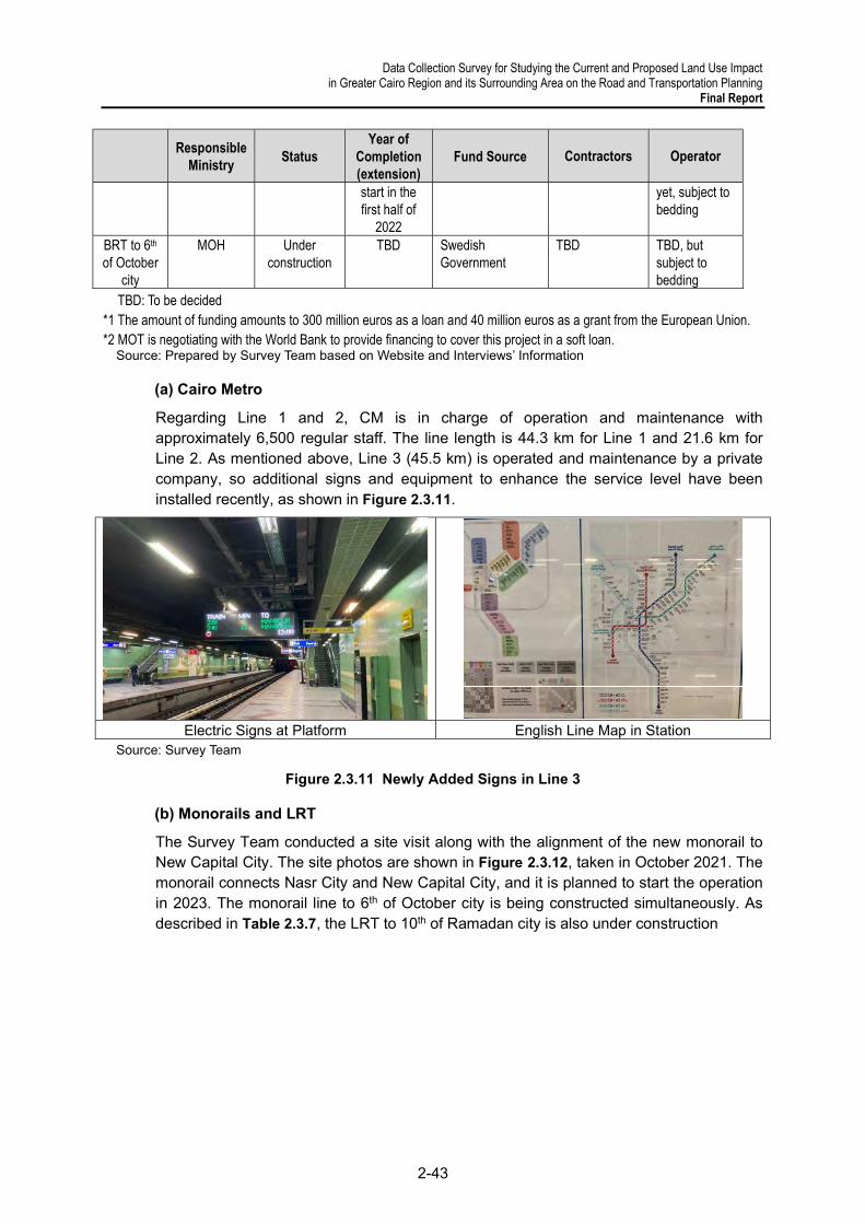
Data Collection Survey for Studying the Current and Proposed Land Use Impact in Greater Cairo Region and its Surrounding Area on the Road and Transportation Planning
Final Report
2-43
Responsible
Ministry Status
Year of Completion (extension)
Fund Source Contractors Operator
start in the first half of
2022
yet, subject to bedding
BRT to 6th of October
city
MOH Under construction
TBD Swedish Government
TBD TBD, but subject to bedding
TBD: To be decided *1 The amount of funding amounts to 300 million euros as a loan and 40 million euros as a grant from the European Union. *2 MOT is negotiating with the World Bank to provide financing to cover this project in a soft loan.
Source: Prepared by Survey Team based on Website and Interviews’ Information
(a) Cairo Metro
Regarding Line 1 and 2, CM is in charge of operation and maintenance with approximately 6,500 regular staff. The line length is 44.3 km for Line 1 and 21.6 km for Line 2. As mentioned above, Line 3 (45.5 km) is operated and maintenance by a private company, so additional signs and equipment to enhance the service level have been installed recently, as shown in Figure 2.3.11.
Electric Signs at Platform English Line Map in Station
Source: Survey Team
Figure 2.3.11 Newly Added Signs in Line 3
(b) Monorails and LRT
The Survey Team conducted a site visit along with the alignment of the new monorail to New Capital City. The site photos are shown in Figure 2.3.12, taken in October 2021. The monorail connects Nasr City and New Capital City, and it is planned to start the operation in 2023. The monorail line to 6th of October city is being constructed simultaneously. As described in Table 2.3.7, the LRT to 10th of Ramadan city is also under construction
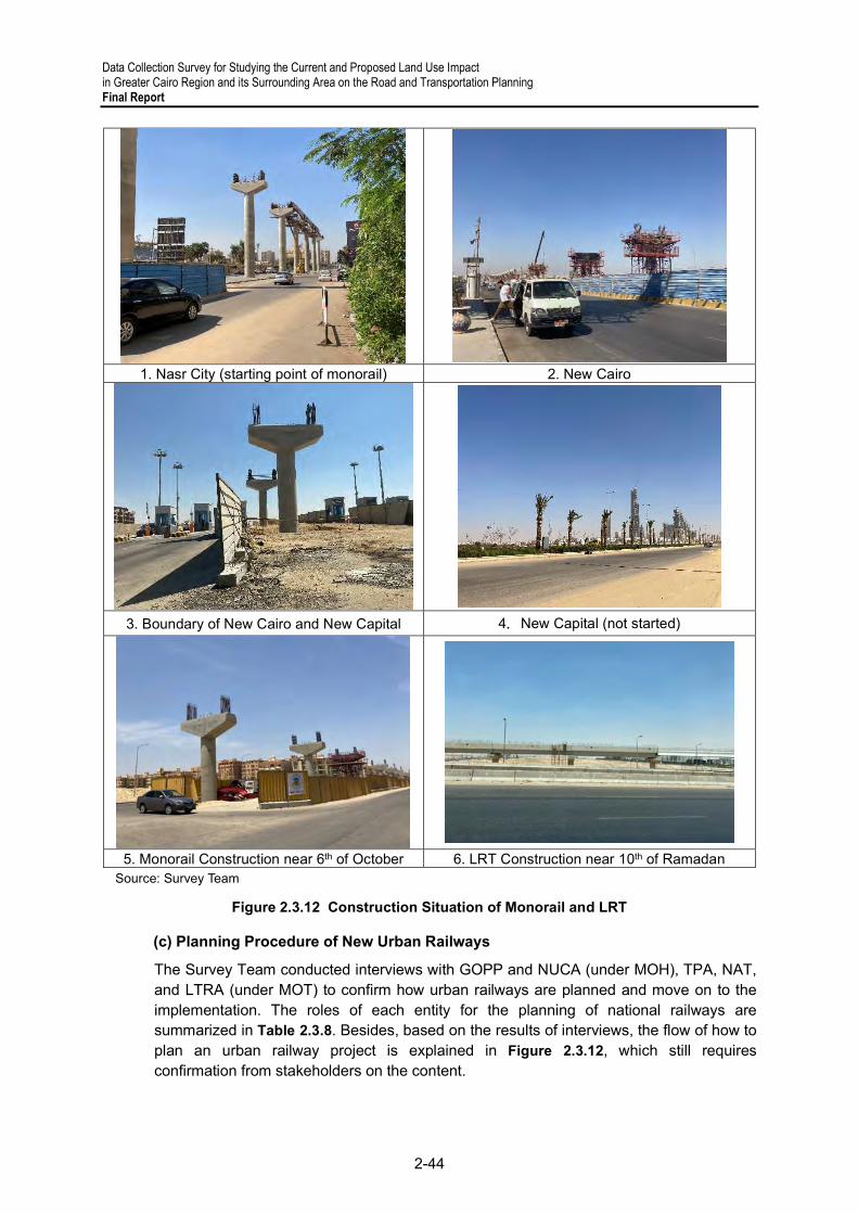
Data Collection Survey for Studying the Current and Proposed Land Use Impact in Greater Cairo Region and its Surrounding Area on the Road and Transportation Planning Final Report
2-44
1. Nasr City (starting point of monorail) 2. New Cairo
3. Boundary of New Cairo and New Capital 4.New Capital (not started)
5. Monorail Construction near 6th of October 6. LRT Construction near 10th of Ramadan Source: Survey Team
Figure 2.3.12 Construction Situation of Monorail and LRT
(c) Planning Procedure of New Urban Railways
The Survey Team conducted interviews with GOPP and NUCA (under MOH), TPA, NAT, and LTRA (under MOT) to confirm how urban railways are planned and move on to the implementation. The roles of each entity for the planning of national railways are summarized in Table 2.3.8. Besides, based on the results of interviews, the flow of how to plan an urban railway project is explained in Figure 2.3.12, which still requires confirmation from stakeholders on the content.

Data Collection Survey for Studying the Current and Proposed Land Use Impact in Greater Cairo Region and its Surrounding Area on the Road and Transportation Planning
Final Report
2-45
Table 2.3.8 Roles in Planning of Urban Railway Projects
Entity Name Roles GOPP (MOH) Plan the alignment of a new urban railway
Plan a new connecting line between existing cities and a new urban community proposed by MOH with the decision and approval of the Prime Minister
Reflect the alignment information on the master plan NUCA (MOH) Provide the information of utilities along the alignment
Provide comments on the alignment and station location in new urban communities NAT (MOT) Prepare the implementation plan when appointed by the PM TPA (MOT) Prepare the implementation plan when appointed by the PM (the HSR and new urban
railways have been planned by NAT these days.) through consultants' technical study. S&DC (MOT) Follow up the recommendations of studies and projects from the Minister
LTRA Be responsible for the integration of transport system in GCR but does not have specific roles in the planning of an urban railway project
Source: Survey Team
Source: Survey Team
Figure 2.3.13 Planning Procedure of Urban Railway Projects (draft)
8) Urban Railways: Issues or Concerns
(a) Overall
There does not seem to be an existing integrated plan for the urban railway lines in GCR. The planning and construction of new monorails, LRT, and BRT have been implemented simultaneously in GCR. This is due to the lack of the coordination between ministries and governorates. Therefore, a place to discuss and coordinate about urban railway planning between entities is considered to be prepared in the next M/P project.
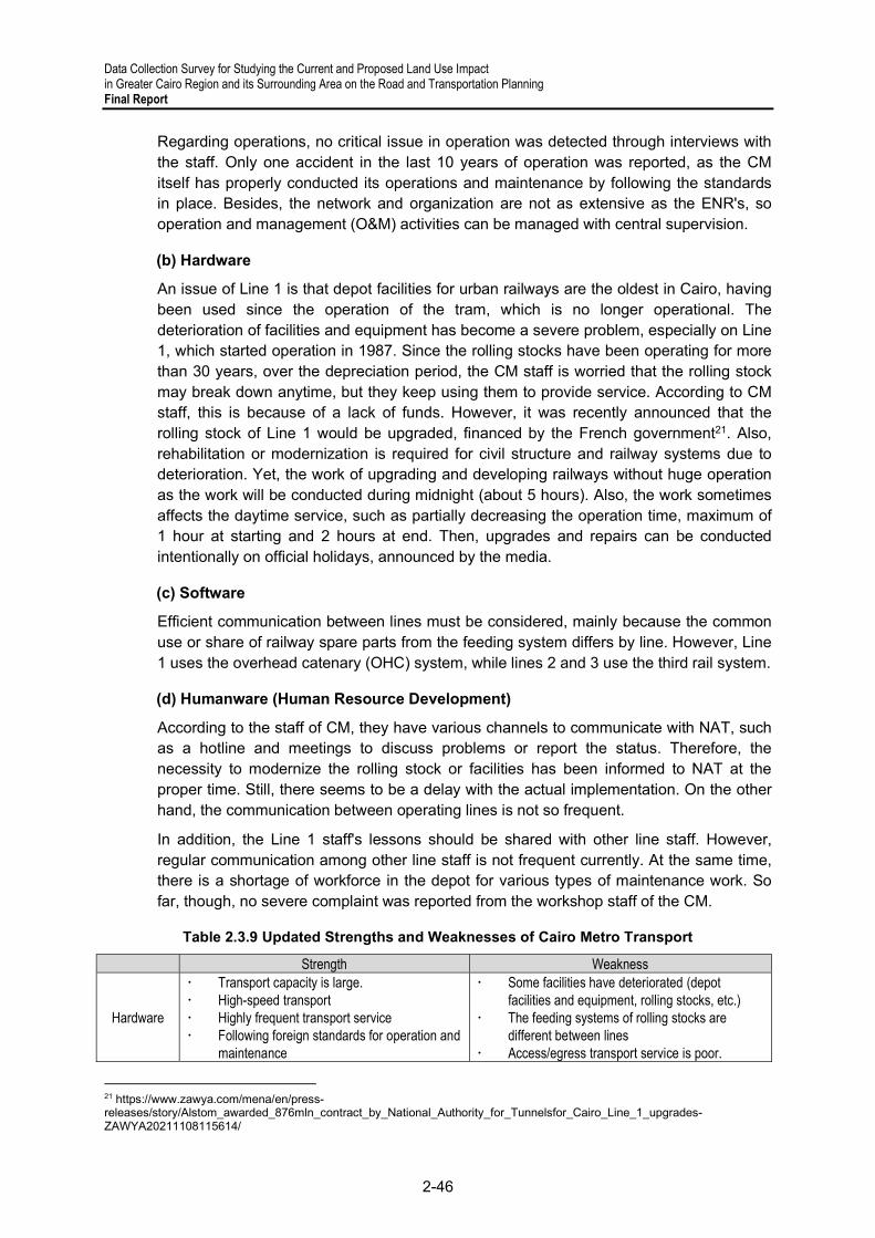
Data Collection Survey for Studying the Current and Proposed Land Use Impact in Greater Cairo Region and its Surrounding Area on the Road and Transportation Planning Final Report
2-46
Regarding operations, no critical issue in operation was detected through interviews with the staff. Only one accident in the last 10 years of operation was reported, as the CM itself has properly conducted its operations and maintenance by following the standards in place. Besides, the network and organization are not as extensive as the ENR's, so operation and management (O&M) activities can be managed with central supervision.
(b) Hardware
An issue of Line 1 is that depot facilities for urban railways are the oldest in Cairo, having been used since the operation of the tram, which is no longer operational. The deterioration of facilities and equipment has become a severe problem, especially on Line 1, which started operation in 1987. Since the rolling stocks have been operating for more than 30 years, over the depreciation period, the CM staff is worried that the rolling stock may break down anytime, but they keep using them to provide service. According to CM staff, this is because of a lack of funds. However, it was recently announced that the rolling stock of Line 1 would be upgraded, financed by the French government21. Also, rehabilitation or modernization is required for civil structure and railway systems due to deterioration. Yet, the work of upgrading and developing railways without huge operation as the work will be conducted during midnight (about 5 hours). Also, the work sometimes affects the daytime service, such as partially decreasing the operation time, maximum of 1 hour at starting and 2 hours at end. Then, upgrades and repairs can be conducted intentionally on official holidays, announced by the media.
(c) Software
Efficient communication between lines must be considered, mainly because the common use or share of railway spare parts from the feeding system differs by line. However, Line 1 uses the overhead catenary (OHC) system, while lines 2 and 3 use the third rail system.
(d) Humanware (Human Resource Development)
According to the staff of CM, they have various channels to communicate with NAT, such as a hotline and meetings to discuss problems or report the status. Therefore, the necessity to modernize the rolling stock or facilities has been informed to NAT at the proper time. Still, there seems to be a delay with the actual implementation. On the other hand, the communication between operating lines is not so frequent.
In addition, the Line 1 staff's lessons should be shared with other line staff. However, regular communication among other line staff is not frequent currently. At the same time, there is a shortage of workforce in the depot for various types of maintenance work. So far, though, no severe complaint was reported from the workshop staff of the CM.
Table 2.3.9 Updated Strengths and Weaknesses of Cairo Metro Transport
Strength Weakness
Hardware
Transport capacity is large. High-speed transport Highly frequent transport service Following foreign standards for operation and
maintenance
Some facilities have deteriorated (depot facilities and equipment, rolling stocks, etc.)
The feeding systems of rolling stocks are different between lines
Access/egress transport service is poor.
21 https://www.zawya.com/mena/en/press-releases/story/Alstom_awarded_876mln_contract_by_National_Authority_for_Tunnelsfor_Cairo_Line_1_upgrades-ZAWYA20211108115614/

Data Collection Survey for Studying the Current and Proposed Land Use Impact in Greater Cairo Region and its Surrounding Area on the Road and Transportation Planning
Final Report
2-47
Strength Weakness Barrier-free facilities are poor. The network is limited compared with the
population size.
Software
A smart card is installed (it will be integrated with other transport modes).
A digital sign is installed in each station (Line 3).
Signaling systems are controlled at the central unit.
Every station is supervised by CCTV cameras (about 2,600 in total).
Information on operation and maintenance is mostly managed manually as per Line 1 and 2.
Railway systems are not unified between lines (spare parts cannot be used in common).
Human Resource
Staff are trained based on the standard required by donor countries.
No frequent communication between lines. Operation and maintenance method is different
by line. Source: Survey Team
9) Urban Railways: Measures by Cairo Metro
(a) Staff Training
Two types of training are available for a station master and local operators, train drivers. One is training to be able to work, called regular training every 6 months, and the other is training for each expertise. A station master takes 2 weeks of training, including the follow-up of the movement of passengers in stations. The other is for local operators and train drivers, which takes 3 months. It takes 4 years to become an ordinary station staff to a master, who is in charge of the management of the entire station.
10) Urban Railways: Support from Foreign Donners and Private Companies’ Participation
(a) Support from Foreign Donors
NAT has received financial support from foreign donors since the first construction of CM Line 1. NAT has been supported in various ways, not only for the design and construction of the metro lines, but also for the planning and procurement of new rolling stocks. Figure
2.3.10 illustrates a part from foreign donors for NAT, though not all the information is covered.
Table 2.3.10 Recent Support for NAT from Foreign Donors
No. Appraisal
Year/ Month
Completion Year/Month(
planned) Donor Project Name Project Description
Project Cost
(million)
1 2021/05 2020/12 - EIB
Urban Transport Infrastructure Framework Egypt
1. Rehabilitation of the El-Raml tram 2. Rehabilitation and up-gradation of the Abu Qir-Alexandria railway into a subway 3. Rehabilitation of the CM Line
EUR 528 EUR 600
2 2020/02 - AFD CM Line 1 Modernization
Covering urgent infrastructure investments in signaling, telecoms, controls, and track works
EUR 50
3 2019/02 - EIB EUR 350
4 2018/02 - EBRD EUR 200

Data Collection Survey for Studying the Current and Proposed Land Use Impact in Greater Cairo Region and its Surrounding Area on the Road and Transportation Planning Final Report
2-48
No. Appraisal
Year/ Month
Completion Year/Month(
planned) Donor Project Name Project Description
Project Cost
(million)
5 2015/09 - EBRD CM Line 2 Purchase of trains
1. Purchase of a total of 13 air-conditioned train sets (8 cars per train) 2. A portion of the long-term outsourced maintenance contract for Line II's entire fleet covering mainly the spare parts and equipment
EUR 175
6 2016/09 2015/12 2012/11
(2023) EIB CM Line 3 (Phase 3) Extension of Line 3 (Phase 3) of the CM with 17 km of track
EUR 200 EUR 200 EUR 200
7 2012/2 (2026) JICA Greater CM Line 4 (Phase 1) Project
Construction of the underground metro, stations, and workshop buildings, including supervisory consulting services and detailed design
USD 391
8 2002/03 2005 EIB CM Line 2 Extension
2.6 km long extension to the existing Line 2 of the CM, two new stations (Sakiak Mekky and El Monib), as well as an additional 1km of track for shunting and parking trains
EUR 50
Source: Survey Team based on the website information
Due to the geographical or historical background, European and Arabic countries are the main financiers of the railway projects. These assistances are in line with or a part of the ENR's strategic development plan, one of which was announced in 2014 as a ten-year investment of USD 10 billion to modernize the railway network22. The WB has supported the ENR railway's improvement continuously since 2009, and they launched the subsequent project with a USD 440 million budget in March 2021.
Furthermore, foreign private companies such as Siemens or Bombardier actively participate in the planning, design, and construction of new lines and the provision and modernization of rolling stocks or railway systems, especially in the urban railway sector due to standard technology and the size of the market. The Egyptian government is constructing a new rolling stock factory to manufacture them domestically. However, all the rolling stocks of CM have been imported so far.
(b) Extension of Cairo Metro23
NAT has already prepared the preliminary study for the extension of the north extension of Line 2, between Shubra El kheima and Qalyub, which are illustrated in Figure 2.3.14. The Route was chosen to be, as much as possible, within the ROW of ENR (Cairo – Alexandria Line) so as to minimize the expropriation of the land in the region. The extension will continue with an additional distance of about 1.8 km to reach the intermodal station, which means that the total length of this extension will be about 8.8 km. The studies for this line will cost about EGP 25 million, whereas the construction cost will be around EGP 3 billion.
In addition, the north extension of CM Line 1 (Al Marg – Shebein El Qanater), with a length of 19 km, was proposed by MOT24.
22 https://www.railway-technology.com/features/ramping-up-railway-look-egypt-megaprojects/ 23 NAT Website (http://www.nat.org.eg/english/qalyoub.html) 24 State Information Service, https://www.sis.gov.eg/Story/159942/Transport-minister-attends-signing-of-13-deals-with-int'l-companies?lang=en-us

Data Collection Survey for Studying the Current and Proposed Land Use Impact in Greater Cairo Region and its Surrounding Area on the Road and Transportation Planning
Final Report
2-49
Source: Survey Team
Figure 2.3.14 Proposed Alignment of Railway Lines in Greater Cairo Region (including planned lines)
11) Urban Railways: Recent Movements in the Railway Sector of Egypt
(a) High-speed Railway (Ain Sokhna – Alexandria, El Alamein)
High-speed railways (HSR) in Egypt are under the jurisdiction of not ENR but NAT, based on law enforcement25. The ongoing HSR project links Ain Sokhna to New Alamein. It will pass through New Capital City and 6th of October city to New Alamein, which has a branch at Borg Al-Arab which extends to Alexandria. The planned HSR will be an electric railway line delivering three service types: 1) a high-speed service train (250 km/h), 2) a regional service train (110 km/h), and 3) a freight/ cargo transport service train26. The design and construction will be under the jurisdiction of NAT, and the HSR is estimated to be constructed by 2023. A planned alignment of the HSR is shown in Figure 2.3.15. General information on the high-speed railway is shown below.
Contractors: German and Egyptian consortium including Siemens, Orascom Construction, and the Arab Contractors
Current status: Soil investigation, surveying, and track planning have been completed. The work is underway in implementing flyover bridges and industrial works for the track and stations and fences by major Egyptian companies specialized in these fields and industrial works on roads intersecting with the train track.
25 Law No.113 for 1983: establishing law of NAT Law and No. 33 for 2018: amending to law no. 113 for 1983, stating that NAT is in charge of electrical railways and responsabile for construction of metro lines 26 Final Report, Pre-Feasibility Study for the Proposed High-Speed Railway Line (Ain Sokhna-New Alamain-Alexandria), MOT and MOH, July 2020

Data Collection Survey for Studying the Current and Proposed Land Use Impact in Greater Cairo Region and its Surrounding Area on the Road and Transportation Planning Final Report
2-50
Planned completion year: In July 2023, the Ain Sokhna - Matrouh express train will be completed.
Source: Pre-Feasibility Study for the Proposed High-Speed Railway Line (Ain Sokhna – New Alamein)
Figure 2.3.15 The Proposed Alignment of the High-speed Railway Line
(b) Integrated Smart Card System
The integration of transport smart cards has been implemented by LTRA, established in 2018, instead of the former regulatory authority, the Greater Cairo Transportation Regulatory Agency (GCTRA), to regulate urban transportation for the entire country. An integrated smart card system has been expected for a long time. However, some transportation operators, such as CM or Mwasalat Misr, a private bus operator, have already introduced their own smart cards. A study is ongoing with support from German funding 27 and will be completed within two months; the design and implementation phases will follow (public release is planned for 2023).
(c) Integrated Transport Hub
As explained in Table 2.3.11 and Figure 2.3.18, integrated transport hubs have been considered and implemented in GCR; the images of construction work are also shown in Figure 2.3.16. The rail network has been extended at the urban level to serve new urban communities directly and integrate with the integrated transport hubs, but it needs to be coordinated with public transportation.
As seen from Table 2.3.11, the problem is that each development has a different scheme and stakeholders, so the entire development is not coordinated and integrated so far. Therefore, a successful case of transport hub projects needs to be defined, and the scheme and concept are also to be shared with subsequent project stakeholders to enhance the efficiency of the development in GCR.
It should be noted that NAT does not own any land around the stations like the railway authority, but it has the right to expropriate ownership, when necessary, in coordination
27 https://aegypten.ahk.de/en/news/news-details-english/unified-card-system

Data Collection Survey for Studying the Current and Proposed Land Use Impact in Greater Cairo Region and its Surrounding Area on the Road and Transportation Planning
Final Report
2-51
with MOHUUC represented by GOPP and NUCA, such as transferring land ownership of monorail and LRT stations from NUCA to NAT.
Source: Survey Team
Figure 2.3.16 Construction Site of Adly Monsour Transport Hub
12) Urban Railways: Areas Requiring Technical Assistance
Based on interviews with authority staff and online research, the areas requiring technical assistance for national railways in Egypt are summarized as follows:
(a) Robust Planning of New Urban Railways
Through the interviews with planning entities for urban railways, the demand forecast for a new urban railway is very limited. As a result, if a planned size of the population starts to live in the targeted area, the current monorail and LRT cannot meet the demand due to the transportation capacity. On the other hand, current construction is basically conducted from scratch, so if the government fails to attract people to the designated area, the railway will not contribute to the mitigation of traffic jams in GCR. To cope with the current situation, a lead entity needs to appear and certify the future demand with scientific proof.
(b) Integrated Planning of New Urban Railway Lines
While new urban railway plans have been announced and construction projects have been seen one after another after the Arab Spring, there is no integrated plan on urban railways. According to the NAT website, the urban railway's map was prepared based on the CREATS plan and updated by MOH. This means, therefore, that each line was planned separately. Connectivity with other transportation modes was not appropriately considered even though all the plans were approved by the GOPP/MOH or the Study & Development Department/MOT. Stakeholders related to new urban railway planning and construction are shown in Figure 2.3.17. Another critical problem is that the development speed in GCR is so rapid that planning may not be able to function well and catch up with the demand.
On the other hand, the plan of the MiNTS Study is still referred to by government authorities. Once a robust plan is prepared, the plan may be followed to contribute to the integration of the urban railway network. Therefore, the GOPP/MOH and/or the Study &
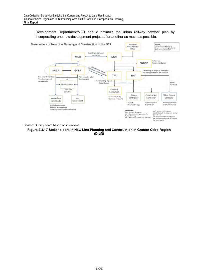
Data Collection Survey for Studying the Current and Proposed Land Use Impact in Greater Cairo Region and its Surrounding Area on the Road and Transportation Planning Final Report
2-52
Development Department/MOT should optimize the urban railway network plan by incorporating one new development project after another as much as possible.
Source: Survey Team based on interviews
Figure 2.3.17 Stakeholders in New Line Planning and Construction in Greater Cairo Region (Draft)

Data Collection Survey for Studying the Current and Proposed Land Use Impact in Greater Cairo Region and its Surrounding Area on the Road and Transportation Planning
Final Report
2-53
Table 2.3.11 Examples of Transport Hubs in Greater Cairo Region
Source: Survey Team based on Information on Website
Nam
e of
Pro
ject
Lo
catio
n Ye
ar o
f Com
plet
ion
(ext
ensi
on)
Cur
rent
Sta
tus
Fund
Sou
rce
Land
Ow
ner
Impl
emen
ting
Age
ncy
Stak
ehol
ders
Al-M
onee
b So
uth
Giz
a 20
24-2
025
Appr
oved
/ Und
er
cons
truct
ion
Loca
l/Cen
tral
Gov
ernm
enta
l C
TA s
hall
be
trans
ferre
d to
MO
H
Min
istry
of H
ousi
ng/
GO
PP,
Cen
tral A
genc
y fo
r R
econ
stru
ctio
n
Giz
a G
over
nora
te,
Min
istry
of H
ousi
ng/
GO
PP, C
entra
l Age
ncy
for R
econ
stru
ctio
n
Al-S
alam
(Adl
y M
anso
ur)
Nor
thea
st
Cai
ro
(Ism
ailia
R
oad)
Adly
Man
sour
Met
ro
stat
ion
has
been
und
er
oper
atio
n si
nce
Augu
st
2020
, LR
T fir
st a
nd
seco
nd p
hase
s an
d R
ailw
ay s
tatio
n ar
e pl
anne
d to
be
open
ed in
20
22
Parti
ally
O
pera
ted/
Und
er
Con
stru
ctio
n N
AT
NAT
N
AT a
nd E
gypt
ian
cont
ract
ing
Agen
cies
M
OT/
NAT
/EN
R
Cai
ro G
over
nora
te
Inte
grat
ed
Tran
spor
t Cen
ter
East
Cai
ro
(Sue
z R
oad)
Plan
ned
to b
e op
ened
by
the
end
of 2
021
Parti
ally
O
pera
ted/
Und
er
Con
stru
ctio
n To
be
conf
irmed
En
gine
erin
g M
ilitar
y Au
thor
ity
Engi
neer
ing
Milit
ary
Auth
ority
En
gine
erin
g M
ilitar
y Au
thor
ity/M
OT
Bash
teel
Tria
ngle
(U
pper
/Sou
th E
gypt
EN
R S
tatio
n)
Nor
th G
iza
Not
Spe
cifie
d
Und
er
Con
stru
ctio
n Lo
cal/E
NR
(4
.7 B
. LE)
EN
R
Loca
l Con
tact
ors
for
ENR
EN
R
New
Adm
inis
trativ
e
Cap
ital T
erm
inal
5
(Cen
tral B
us
Stat
ion)
New
Ad
min
istra
tive
Cap
ital
Not
Spe
cifie
d U
nder
C
onst
ruct
ion
Adm
inis
trativ
e C
apita
l for
Urb
an
Dev
elop
men
t C
ompa
ny (A
CU
D)
Adm
inis
trativ
e C
apita
l for
Urb
an
Dev
elop
men
t C
ompa
ny (A
CU
D)
Engi
neer
ing
Milit
ary
Auth
ority
, Ara
b C
ontra
ctor
s
ACU
D/M
OT/
Engi
neer
ing
Milit
ary
Auth
ority

Data Collection Survey for Studying the Current and Proposed Land Use Impact in Greater Cairo Region and its Surrounding Area on the Road and Transportation Planning Final Report
2-54
Figure 2.3.18 Status of Transport Hubs in Greater Cairo Region
Sou
rce
: P
repa
red
by
JIC
A S
tud
y T
ea
m b
ase
d o
n W
eb
site
Info
rma
tion
Bas
hte
el T
ran
spor
t H
ub:
Sh
are
d by
med
ia a
cco
rdin
g to
EN
R w
ebsi
te
Adl
y M
on
sou
r T
ran
spor
t H
ub
: F
ace
boo
k P
age
of M
inis
try
of
Tra
nsp
ort
Inte
gra
ted
Tra
nsp
ort
Hu
b:
Sh
are
d b
y m
ed
ia a
ccor
din
g t
o E
ng
ine
erin
g M
ilita
ry A
utho
rity
Ne
w A
dmin
istr
ativ
e C
apita
l: S
hare
d b
y m
edia
Mo
ne
eb T
ran
spo
rt H
ub:
Sha
red
by
me
dia
acc
ord
ing
to G
OP
P w
eb
site

Data Collection Survey for Studying the Current and Proposed Land Use Impact in Greater Cairo Region and its Surrounding Area on the Road and Transportation Planning
Final Report
2-55
2.4 Ports, Maritime and Inland Water Transportation
1) Introduction
Ports, maritime transportation, and Inland Water Transport (IWT) subsectors play important roles as international gateways and access routes connecting to foreign and domestic hinterlands which are origin and destination of production and consumption in logistics and passenger transportation.
Egyptian ports located along the most important east-west maritime trunk route which connects the Asian-Indian and European regions through Suez Canal have great geographical advantage in transporting maritime cargo. In IWT, the well-known Nile River that was assumedly used in transporting stones for the pyramids back in 2,500 B.C. has been used these days to transport dry and liquid bulk cargos such as minerals, sand, stone, coal, oils, molasses, cement, fuels, chemical products for the construction, manufacturing, food and petrochemical industries, and passengers.
The MiNTS study28 reported that Egyptian ports must have clear roles and functions and to provide intermodal transportation corridor (ITC) connecting Sokhna port and Alexandria/El Dekheila ports through 6th of October city’s dry port located in the outer Cairo ring road in order to enhance future cargo movement between Aisa and Europe. The study also pointed out that the IWT subsector needs guaranteed navigability, fleet modernization, sustainable financial sources, and water management coordination, based on an analysis of the subsector’s present situation, issues, and challenges.
Ten (10) years after the MiNTS study, there have been many changes in the subsectors with some projects either completed or ongoing. At the same time, it is observed that the suggestions in MiNTS still remain applicable and can serve as references in the establishment of strategic policy and plan for Transport Sector of the Egyptian Government. Of course, new challenges, such as being greener and smarter, and IT modernization upon transition of market trend and environment have been introduced and commenced in the said subsectors in line with the SDGs under Egypt’s Vision 2030.
This chapter generally sheds light on the need for further improvement and development of ports and maritime, as well as the IWT subsector, based on an initial analysis of the present situation, issues, and challenges.
2) Planning Administration
(a) Ports and Maritime Transportation are in principle administrated by the Maritime Transport Sector (MTS) under MOT. MTS has provided the maritime transportation strategy under the National Policy for the Development of Maritime Transport up to 2030. Its vision and mission are shown in Figure 2.4.1.
28 MiNTS- MiSr National Transport Study, The Comprehensive Study on the Master Plan for Nationwide Transport System in the Arab Republic of Egypt, Final Report, Technical Report 3 Inland Waterway Transport Sector and Technical Report 4 Maritime Sector.

Data Collection Survey for Studying the Current and Proposed Land Use Impact in Greater Cairo Region and its Surrounding Area on the Road and Transportation Planning Final Report
2-56
Source: MTS
Figure 2.4.1 Egyptian Maritime Transportation Strategy under Egypt Vision 2030
Figure 2.4.2 shows the organizational chart for commercial port administration. As seen in the figure, the MTS is responsible for 15 commercial ports and 33 specialized ports. MTS has three (3) port authorities, i.e., Alexandria Port Authority (APA), Damietta Port Authority (DPA), Red Sea Port Authority (RSPA), and a maritime authority named Egyptian Authority for Maritime Safety (EAFMS). The Port authorities are responsible for port administration, while EAFMS is responsible for maritime safety, lighthouse and navigation aids administration including their provision, O&M, registration of Egyptian vessels, licensing for maritime works, etc. With the establishment of the SCZone in 2015, the three (3) ports under Port Said Port Authority (PSPA) (i.e., West and East Port Said ports and Arish Port) and the three (3) ports under RSPA (i.e., Adabiya Port, Sokhna Port, and El Tour Port) were reorganized under SCZone. It seems that port and maritime services, as well as O&M are continuously provided to the said ports merged into SCZone by collaborative support of MTS.
Generally, each port has its own development strategy and plan to maximize profits from every port activities under the policy and vision of MTS. MTS and SEZone are supervising each port authority or port with distribution of budget allocation by MOT or the Cabinet Office.
Source: MTS and SCZone Figure 2.4.2 Organizational Chart on Administration of Commercial Ports
(b) IWT is administrated by the River Transport Authority (RTA) under MOT. Egyptian IWT has used the River Nile and its branch and manmade canals as its transportation

Data Collection Survey for Studying the Current and Proposed Land Use Impact in Greater Cairo Region and its Surrounding Area on the Road and Transportation Planning
Final Report
2-57
routes. According to MiNTS report29, the major inland waterways (IWs) in Egypt are Aswan–Cairo IW using the River Nile stream (total 1,300 km, 3 locks, and 31 bridges existing), Alexandria–Cairo IW consisting of Nubaria and Beheriy canals (total 285 km, 7 locks, and 34 bridges existing), Damietta–Cairo IW navigating Damietta branch of the River Nile (total 241 km, 3 locks, and 23 bridges), Ismailia–Cairo routing IW Ismailia canal (total 128 km, 8 locks, and 34 bridges), and Rashid–Cairo IW on Rosetta Branch (total 241 km, 3 locks, and 6 bridges).
Because IWT is using the River Nile water and its canals manmade, RTA is always facing some difficulties in coordinating with Ministry of Irrigation and Water Resources (MIWR) and Ministry of Agriculture and Land Reclamation (MALR) especially for water utilization; GARBLT and ENR for air clearance under bridges; and with APA and DPA under MOT for connection to Alexandria Port and Damietta Port. According to RTA, there was an experience that a dredging project was once denied by MIWR due to possible change of water volume balance of the Nile.
3) Infrastructure Development
In 2019 and 2020, the total cargo volumes handled in Egypt were 171.3 million and 163.9 tons, respectively, with -4.0 % annual growth, while the total container volumes in Egypt were 7.25 million and 7.56 million TEUs, respectively, with 4.4% annual growth. Despite the COVID-19 pandemic, the growth of container handing volumes was remarkable especially for East Port Said Port (16.9%), Adabiya Port (12.6%), and Sokhna Port (15.2%). In such ports, the volume of East Port Said Port was 3.51 million TEUs which was approximately half of the total volumes most likely as transshipment container cargos in 2020. Currently, major port infrastructure development projects are ongoing, particularly in Alexandria Port, Damietta Port, East Port Said Port, and Sokhna Port, as described below.
Source: Google Earth, illustrated by Survey Team Figure 2.4.3 Geographical Location of Alexandria, Damietta, East Port Said and Sokhna Ports
29 MiNTS- MiSr National Transport Study, The Comprehensive Study on the Master Plan for Nationwide Transport System in the Arab Republic of Egypt, Final Report, Technical Report 3 Inland Waterway Transport Sector, pp2-17

Data Collection Survey for Studying the Current and Proposed Land Use Impact in Greater Cairo Region and its Surrounding Area on the Road and Transportation Planning Final Report
2-58
(a) Alexandria Port (see Figure 2.4.3) does not originally have enough port hinterland because the backside of the port is already the commercial and resident areas. For this, APA bought some areas to expand the port hinterland, and is facilitating rearrangement inside the port area and relocation of cargo storage area to part of Lake Mariout to be reclaimed (see Project “B” in Figure 2.4.4). In view of the zoning inside Alexandria Port, there are many functional piers, terminals, facilities where they have been located.
Source: Google Earth, illustrated by Survey Team
Figure 2.4.4 Infrastructure Development in Alexandria and El Dekheila Ports
Similar cargo handling is not operated in the same area; some are near, others are far. Therefore, the Port gives a crowded feel. The lack of a port area may be a reason for this. Currently, a multi-purpose and container terminal development is ongoing rapidly with the capacity of 1.5 million TEUs per year (2,000 m berth length, -14 to -17 m depth, 56 ha reclamation) to be operated by CMA-CGM before 2023 (see Project “A” in Figure 2.4.4). APA describes a future master plan that will make a huge reclamation multi-purpose and container terminals to be located near the water surface along the shoreline between Alexandria and El Dekheila ports with providing new offshore breakwater (see Project “C &D” in Figure 2.4.4).
(b) Damietta Port handles all kinds of cargo such as liquid/dry bulk cargoes, container cargo, general cargoes etc. Damietta Port has enough port hinterland originally because it was developed at a green field with consideration given to certain hinterland area in advance. In terms of zoning of Damietta Port, it is well organized for such as liquid bulk area, dry bulk area, general cargo area, container cargo area. The Port has a river transportation terminal which is connected to the River Nile through a barge canal and which is adjacent to the site of Container Terminal phase 2. The phase 2 area was given to DIPCO, a Kuwait joint venture company as BOT. However, the development did not proceed in the manner as DIPCO has committed to DPA.

Data Collection Survey for Studying the Current and Proposed Land Use Impact in Greater Cairo Region and its Surrounding Area on the Road and Transportation Planning
Final Report
2-59
Source: Google Earth, illustrated by Survey Team Figure 2.4.5 Infrastructure Development in Damietta Port
DPA consequently terminated the contract. The company has made argument for the termination, so the matter was brought to ICC arbitration. Recently, ICC ordered DPA to pay USD494 million to DIPCO for the termination. According to DPA, this matter was already handed over to the Government of Egypt (GoE) to find a diplomatic solution. DPA decided that the area taken back is to be used for Container Terminal Phase 2 with a capacity of 4.5 million TEUs per year (1,970 m berth length, -18 m depth) in preparation for a new tender (Project “A” in Figure 2.4.5) with a target serviceable year by 2023. DPA has a master plan to develop more multipurpose terminals through reclamation near the entrance breakwater (Project “B” in Figure 2.4.5), as well as to extend the existing east breakwater (1,565 m) and to construct new west breakwater (3,600 m) (see Project “C” in Figure 2.4.5). There has been an issue of sedimentation at the port entrance. However, it seems that the simulation study and countermeasures were already taken by DPA to secure the needed navigational depth to vessels.
(c) East Port Said Port which handles transit container cargoes is geographically located just at the entrance and exit from/to Suez Canal to/from the Mediterranean Sea on the most important east–west maritime trunk route. This Port has currently a container terminal operated by Suez Canal Container Terminal (SCCT) with a capacity of 5.4 million TEUs per year, 2,400 m berth length, -18.5(-19) m depth, 23-unit ship to shore (STS) gantry cranes (Super-Post Panamax size) and 50-unit rubber-tired gantry (RTG) cranes (1 over 5). Regarding the handled container volumes in 2019 and 2020, transit container

Data Collection Survey for Studying the Current and Proposed Land Use Impact in Greater Cairo Region and its Surrounding Area on the Road and Transportation Planning Final Report
2-60
and local container volumes were 16% and 30%, respectively, compared to the 30% and 19%, respectively for West Port Said Port.
East Port Said Port is currently undertaking huge development projects, such as port expansion, East Port Said Industrial Zone including an industrial area (6,300 ha), and logistics areas (2,400 ha), as shown in Figure 2.4.6. The integrated development area including the port area is approximately 14,500 ha with a target serviceable year of 2023.
Source: Google Earth, SCZ, illustrated by Survey Team
Figure 2.4.6 Infrastructure Development in East Port Said Port
As seen in Figure 2.4.6, the port expansion area is demarcated currently into dedicated container terminals (3,000m berth length, -18.5 m depth and 161 ha terminal area), multipurpose terminal (900m berth length, -18.5m depth and 32 ha terminal area), RoRo
Data Collection Survey for Studying the Current and Proposed Land Use Impact in Greater Cairo Region and its Surrounding Area on the Road and Transportation Planning
Final Report
2-61
terminal (600m berth length, -18.5m depth and 21 ha terminal area), Port Reception Facility (100m berth length, -18.5 m depth and 2 ha usable area), grain terminal (500m berth length, -18.5m depth and 65 ha terminal area) and AP Muller container terminal extension (950m berth length, -18.5m depth and 48 ha terminal area). It should be noted that the Toyota Tsusho Corporation, NYK Group and Borrore Ports Joint Venture has recently made a MOU for RoRo terminal operation with SCZone according to the announcement from SCZone. The terminal able to handle 800,000 vehicles per year is to become the 1st specialized RoRo terminal in Egypt by the said Japanese and French joint venture operator.
(d) Sokhna Port was developed as a full green field project in 1998 and became operational in 2002 under concession for development, operation, and management of Sokhna Port Development Company (SPDC). By 2007, there were many achievements in the Port such as construction of Basin 1, container terminal, general cargo terminal, part of liquid bulk terminal, sugar refinery or such. In 2010, DP World Sohkna (DPWS) had 100% of shares of SPDC and made a new concession agreement for development, operation, and management of the Port with RSPA including (A) container terminal with capacity of 1.1 million TEUs per year (750 m berth length, -17m depth and 50ha terminal area) and (B) general cargo/multipurpose terminals with the capacity 20 million tons per year (750 berth length, -17m depth and 25 ha area) in Basin 1 (refer to “A” and “B” in Figure 2.4.6), extension of Basin 2 and Basin 3. The extension of Basin 2 and additional Basin 3 construction commenced in 2017 and were completed in 2020, including berth, apron, and part of the backyard at container terminal 2. Currently, DPWS provides 6-unit STS gantry cranes (4 units of Super-Post Panamax size and 2 units of Post Panamax size), 19-unit RTG cranes (1 over 5) and other cargo handling equipment such as reach stocker, empty container handler, mobile quay crane, etc.
Like East Port Said Port, Sokhna Port is rapidly undertaking huge development projects, such as port expansion; Sokna Industrial Zone including heavy industrial area, intermediate industrial area, light industrial area; Information and Communication Technology (ICT) area; and residential area, as shown in Figure 2.4.7.

Data Collection Survey for Studying the Current and Proposed Land Use Impact in Greater Cairo Region and its Surrounding Area on the Road and Transportation Planning Final Report
2-62
Source: SCZ, illustrated by Survey Team
Figure 2.4.7 Infrastructure Development in Sokhna Port
The port expansion can be categorized into ongoing and future projects. As seen in Figure 2.4.5, the ongoing projects are comprised of (D) container terminal 2 with a capacity of 1.8 million TEUs per year (1,350m berth length, -17m depth and 64ha terminal area), (E) livestock terminal (650m berth length, -17m depth and 21ha terminal area), and (F) liquid bulk terminal (40ha terminal area) with a target service year of 2023. On the
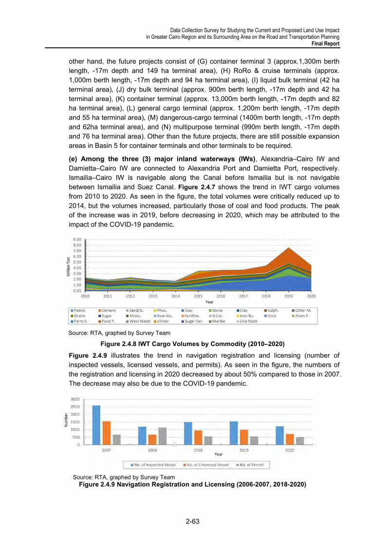
Data Collection Survey for Studying the Current and Proposed Land Use Impact in Greater Cairo Region and its Surrounding Area on the Road and Transportation Planning
Final Report
2-63
other hand, the future projects consist of (G) container terminal 3 (approx.1,300m berth length, -17m depth and 149 ha terminal area), (H) RoRo & cruise terminals (approx. 1,000m berth length, -17m depth and 94 ha terminal area), (I) liquid bulk terminal (42 ha terminal area), (J) dry bulk terminal (approx. 900m berth length, -17m depth and 42 ha terminal area), (K) container terminal (approx. 13,000m berth length, -17m depth and 82 ha terminal area), (L) general cargo terminal (approx. 1,200m berth length, -17m depth and 55 ha terminal area), (M) dangerous-cargo terminal (1400m berth length, -17m depth and 62ha terminal area), and (N) multipurpose terminal (990m berth length, -17m depth and 76 ha terminal area). Other than the future projects, there are still possible expansion areas in Basin 5 for container terminals and other terminals to be required.
(e) Among the three (3) major inland waterways (IWs), Alexandria–Cairo IW and Damietta–Cairo IW are connected to Alexandria Port and Damietta Port, respectively. Ismailia–Cairo IW is navigable along the Canal before Ismailia but is not navigable between Ismailia and Suez Canal. Figure 2.4.7 shows the trend in IWT cargo volumes from 2010 to 2020. As seen in the figure, the total volumes were critically reduced up to 2014, but the volumes increased, particularly those of coal and food products. The peak of the increase was in 2019, before decreasing in 2020, which may be attributed to the impact of the COVID-19 pandemic.
Source: RTA, graphed by Survey Team
Figure 2.4.8 IWT Cargo Volumes by Commodity (2010–2020)
Figure 2.4.9 illustrates the trend in navigation registration and licensing (number of inspected vessels, licensed vessels, and permits). As seen in the figure, the numbers of the registration and licensing in 2020 decreased by about 50% compared to those in 2007. The decrease may also be due to the COVID-19 pandemic.
Source: RTA, graphed by Survey Team
Figure 2.4.9 Navigation Registration and Licensing (2006-2007, 2018-2020)

Data Collection Survey for Studying the Current and Proposed Land Use Impact in Greater Cairo Region and its Surrounding Area on the Road and Transportation Planning Final Report
2-64
Figure 2.4.8 and Figure 2.4.9 show a unique but short trend between cargo volumes transported and the number of registered vessels in the same year: It is assumed that the increase in cargo volumes was supported by the frequent operation of barges for shorter distances, but further examination is necessary.
RTA as the responsible authority for IWT has continuously made best efforts to remove and mitigate bottlenecks on IW navigation by deepening navigation routes, protecting river banks, maintaining and improving locks, improving vessel traffic congestion, and securing navigability, among other measures. The major projects completed, ongoing, or planned for each inland waterway are described in Table 2.4.1.
Table 2.4.1 Major IWT Projects under RTA
Source: RTA
4) Environment, Safety, and Security
(a) Environment
i. Ports and Maritime Transportation subsectors in principle attach significance to efficiency in port and shipping activities. On the other hand, such activities can cause some negative environmental impacts, such as noise generated from engines and cargo handling and its equipment; suspension of dust from dry bulk cargoes, such as fertilizer, grain, coal etc.; CO2, NOx and SO2 emission from ship engines, cargo handling equipment in port, and road traffic of intermodal network at hinterland; oil and fuel leakage from ship, cargo handling equipment, and maritime machinery to port and sea surface; wastewater discharge beyond environmental standards. The shipping industry has complied with marine pollution prevention treaties such as MARPOL 73/78 since the 1970s and is rapidly increasing its efforts to help mitigate the contribution of shipping

Data Collection Survey for Studying the Current and Proposed Land Use Impact in Greater Cairo Region and its Surrounding Area on the Road and Transportation Planning
Final Report
2-65
activities to global warming under the initiative of the International Maritime Organization (IMO).
In the Egyptian maritime administration, MTS has made efforts to achieve SDGs No. 6, 10 & 13 and be internationally classified as “green ports,” as shown in Table 2.4.2. In terms of meeting SDGs No. 7&8 “Affordable and Clean Energy,” the achievement so far seems to be at stage of legislative work before actual implementation.
Based on site visits to the relevant ports under APA, DPA, RSPA, and SCZ, each port has mostly environmental mitigation plans and measures including relevant facilities, such as garbage incinerators and facilities for wastewater treatment, waste oil sludge collection, and monitoring.
Table 2.4.2 MTS Actions carried out for SDGs No. 6, 13 & 10
Source: MTS Achievements 2020 pp4-5
ii. IWT subsector has one advantage over other transportation subsectors: IW navigation is environmentally friendly. The bases for this are that IWT uses mass transportation (i.e., barges); no traffic congestion as experienced by port, road and railway subsectors; waterways are located away from urban activities. However, using barges due to restrictions in air clearance at bridge crossings can cause negative environmental impacts, such as CO2, NOx, and SO2 emission from ship engine; erosion of river or canal bank due to waves created by barges; and oil and fuel leakage, even though the scale is minor compared with the impacts of port and maritime subsector. In the case of IWT, it uses common water surfaces on the River Nile and its canals unrestrictedly like ships at sea. This is different circumstance from port activities.
There are some laws stipulated for environment concerns related to IWT, such as Law No.48/1982 Protecting River Nile and Its Waterways from Pollution, No.04/1994 Environmental Protection, Prime Minister Decree No. 294/1999 Protecting River Nile Clean, Minister Decree No. 08/1983 Protection River Nile and Its Waterways from Pollution and so on.
According to RTA, it does not have to make particular environmental initiative so far. This might be the situation when any environmental issue has not become obvious significantly and directly caused by IW activities.
(b) Safety & Security
i. Ports and Maritime Transportation subsector strictly enforces the implementation of safety and security regulations and laws legislated by the Egyptian government in compliance with international treaties and/or code established by the IMO. Especially, EAFMS is responsible for maritime safety and safety including maritime safety management and regulation, information sharing and communication monitoring to all ships, provision and updating of lighthouses and navigation aids, operation and
SDGs No.1 Updating the Records to follow up and monitor the state of the environment and to take the necessary preventive actions for the ports under APA, DPA and
RSPA2 Adopting a local emergency plan , approved by the Environmental Affairs Agency to be conducted in the ports under APA, DPA and RSPA3 Conducting a Solid and liquid wastes Management plan (for both hazardous and non-hazardous) in the ports under APA, DPA and RSPA4 Establishing an environmental observatory with standardized environmental measurements, affiliated to the Environmental Affairs Agency in Damietta Port.5 Providing adequate marine oil pollution combating equipment, according to the tier of oil pollution, in the ports under APA, DPA and RSPA6 Establishing oil pollution reception facilities (Petrotrade Company under RSPA)7 Establishing environmentally certified waste incinerators in Damietta Port8 Providing fuel and water supply services for ships in accordance with the environment protection standards and conditions in the ports under APA, DPA
and RSPA9 Providing means to protect the air from pollution such as increasing the green spaces – using dust control techniques
Actions conducted
6,13 & 10
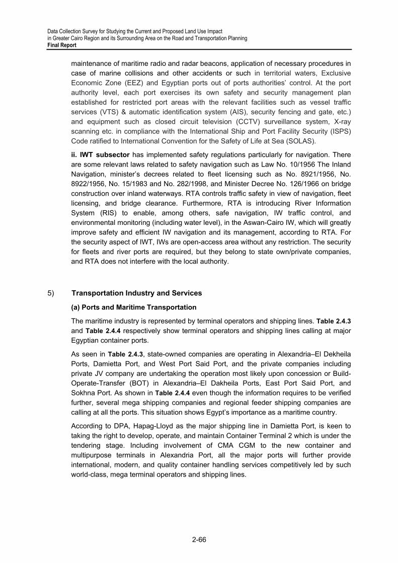
Data Collection Survey for Studying the Current and Proposed Land Use Impact in Greater Cairo Region and its Surrounding Area on the Road and Transportation Planning Final Report
2-66
maintenance of maritime radio and radar beacons, application of necessary procedures in case of marine collisions and other accidents or such in territorial waters, Exclusive Economic Zone (EEZ) and Egyptian ports out of ports authorities’ control. At the port authority level, each port exercises its own safety and security management plan established for restricted port areas with the relevant facilities such as vessel traffic services (VTS) & automatic identification system (AIS), security fencing and gate, etc.) and equipment such as closed circuit television (CCTV) surveillance system, X-ray scanning etc. in compliance with the International Ship and Port Facility Security (ISPS) Code ratified to International Convention for the Safety of Life at Sea (SOLAS).
ii. IWT subsector has implemented safety regulations particularly for navigation. There are some relevant laws related to safety navigation such as Law No. 10/1956 The Inland Navigation, minister’s decrees related to fleet licensing such as No. 8921/1956, No. 8922/1956, No. 15/1983 and No. 282/1998, and Minister Decree No. 126/1966 on bridge construction over inland waterways. RTA controls traffic safety in view of navigation, fleet licensing, and bridge clearance. Furthermore, RTA is introducing River Information System (RIS) to enable, among others, safe navigation, IW traffic control, and environmental monitoring (including water level), in the Aswan-Cairo IW, which will greatly improve safety and efficient IW navigation and its management, according to RTA. For the security aspect of IWT, IWs are open-access area without any restriction. The security for fleets and river ports are required, but they belong to state own/private companies, and RTA does not interfere with the local authority.
5) Transportation Industry and Services
(a) Ports and Maritime Transportation
The maritime industry is represented by terminal operators and shipping lines. Table 2.4.3 and Table 2.4.4 respectively show terminal operators and shipping lines calling at major Egyptian container ports.
As seen in Table 2.4.3, state-owned companies are operating in Alexandria–El Dekheila Ports, Damietta Port, and West Port Said Port, and the private companies including private JV company are undertaking the operation most likely upon concession or Build-Operate-Transfer (BOT) in Alexandria–El Dakheila Ports, East Port Said Port, and Sokhna Port. As shown in Table 2.4.4 even though the information requires to be verified further, several mega shipping companies and regional feeder shipping companies are calling at all the ports. This situation shows Egypt’s importance as a maritime country.
According to DPA, Hapag-Lloyd as the major shipping line in Damietta Port, is keen to taking the right to develop, operate, and maintain Container Terminal 2 which is under the tendering stage. Including involvement of CMA CGM to the new container and multipurpose terminals in Alexandria Port, all the major ports will further provide international, modern, and quality container handling services competitively led by such world-class, mega terminal operators and shipping lines.

Data Collection Survey for Studying the Current and Proposed Land Use Impact in Greater Cairo Region and its Surrounding Area on the Road and Transportation Planning
Final Report
2-67
Table 2.4.3 Terminal Operators in Major Container Ports in Egypt
Source: HPH, ACCHC, DCCHC, PSCCHC, SCCT and DP World Sokhna

Data Collection Survey for Studying the Current and Proposed Land Use Impact in Greater Cairo Region and its Surrounding Area on the Road and Transportation Planning Final Report
2-68
Table 2.4.4 Shipping Lines Calling at Major Container Ports in Egypt
Source: ACCHC, DCCHC, MSC, COSCO, Maersk, Hapaf-Lloyd , APM Terminals and DP World Sokhna (web site information)
The IWT subsector currently provides six (6) cargo transportation service providers, as shown in Table 2.4.5. Aside from the above, it is understood that there are other services for passengers, such as waterbus and RoRo ferry around Cairo capital and rural town areas, cruise ships as tourism on the River Nile etc.
As seen in Table 2.4.5, most of the cargo transportation services are provided by the public sector; private sector involvement is minimal. The situation may imply that the vested interests among the existing providers are already formed without an opportunity of new participation of private investment for uncertain cargo transportation potential along the line of the modal shift of the potential cargoes to other sectors.
Table 2.4.5 IWT Cargo Transportation Service Providers in Egypt
Source: RTA, NNRTC, QALAA Holdings
6) Financing
(a) Ports and Maritime Transportation
Ports and maritime transportation are generally profitable if cargo handling volumes increase. For this reason, the subsectors are aiming to develop foreign and domestic markets to collect more cargoes. Based on interviews with MTS and site visits to the relevant port authorities including the ports under SCZone, each major port seems to

Data Collection Survey for Studying the Current and Proposed Land Use Impact in Greater Cairo Region and its Surrounding Area on the Road and Transportation Planning
Final Report
2-69
have a stable financial situation even under abnormal times as now due to the COVID-19 pandemic. Also supporting by the geographical advantage aforementioned in obtaining mega terminal operators and shipping lines, the relevant port development projects are most likely to be carried out by a two-tiered system in separation of investment among general facilities such as channel, basin, quay, utilities and common buildings, etc. to be provided by the owner, particular facilities such as yard pavements, land utilities, gate, maintenance shop etc. and cargo handling equipment to be provided by operator, or by fully undertaking BOT. Therefore, sector authorities could reduce their investment and also inject the surplus into other developments, if necessary. It has been observed that all the revenues from the ports under MTS and SCZone are forwarded to the national treasury and then required budgets are re-allocated to each port through the MTS, MOT, and SCZone.
(b) IWT
The IWT subsector is currently obtaining revenues only from the registration and licensing of vessels for cargo and passage and from the training of barge operators and crew. As shown in Figure 2.4.8, the numbers of the registration and licensing tend to decrease for cargo vessels. In addition, it is presumed that some tourism boats and ship operators may have abandoned their businesses due to the COVID-19 pandemic. Considering such situation, the revenues from IWT are declining at the moment. However, the sector needs certain budgets to keep IWs operational and navigable and to promote them more attractively. The budgets come as allocations from the National Treasury. Unfortunately, the sector has no private partners able to share the investment for IWT improvement and promotion like in the ports and maritime transportation sectors.
7) Organizations, Institutions, and Human Resource
(a) Ports and Maritime Transportation
The ports and maritime subsectors have a well-organized structure under MTS. Figure
2.4.9 shows MTS organizational chart. A similar organizational function for efficient actual operation exists individually in each port authority who operates each port. In case of the Ports under SCZone, West Port Said Port, East Port Said Port and Arish Port belong to SCZone north regional office. Besides Adabiya Port, Sokhna Port and El Tour Port are under the administration of SCZone south regional office. SCZone is the General Authority for Suez Canal Economic Zone (GAFSCEZ) organized under the Cabinet Office (refer to Figure 2.4.2). APA and Port Said Port were established respectively by Law Nos. 6/1967 and 88/1980 and RSPA. DPA and EAFMS were established respectively by Presidential Decree Nos. 217/1987, 317/1985 and 399/2004. Furthermore, SCZone was established by the Prime Minister’s Decree No. 2282/2015. MTS, each port authority, and the ports under SCZone seem to have good enough human resources with periodic implementation of training programs.
(b) IW Transportation
The IWT subsector has the organization body in RTA as shown in Figure 2.4.10. Based on initial observations, the organization seems to be of the classical hierarchical type, but it still requires further examination. RTA was established by Presidential Decree No.

Data Collection Survey for Studying the Current and Proposed Land Use Impact in Greater Cairo Region and its Surrounding Area on the Road and Transportation Planning Final Report
2-70
474/1979 with its amendment No. 117/2008. The numbers of RTA staff have been reduced due to the restriction enforced by the government, according to RTA. Some internal training programs are conducted periodically.
Source: MTS
Figure 2.4.10 Organizational Chart of Maritime Transport Sector

Data Collection Survey for Studying the Current and Proposed Land Use Impact in Greater Cairo Region and its Surrounding Area on the Road and Transportation Planning
Final Report
2-71
Source: RTA
Figure 2.4.11 Organizational Chart of River Transport Authority

Data Collection Survey for Studying the Current and Proposed Land Use Impact in Greater Cairo Region and its Surrounding Area on the Road and Transportation Planning Final Report
2-72
8) Intermodality
(a) Alexandria and El Dekheila Ports
Alexandria and El Dekheila Ports have comparatively good accessibility to/from road, railway, and IW transportation as shown in Figure 2.4.12. As seen in the figure, there are two access roads to the ports. In consideration of peak congestion at the port gate and cargo growth especially to be generated from the new container/multipurpose terminal, an additional port access road is under construction along Nubaria Canal. These access roads are connecting to the Cairo–Alexandria Road and the International Coastal Road though local bypasses. Therefore, it can be said that road accessibility to/from the ports is good for freight transportation from/to the ports. In case of the railway, the infrastructure has well organized since the 1800s as shown and the accessibility is good as that of the road, provided that maintenance and safe operations are secured. IW is operational as the major IW actually has been mostly used in the Nile Delta and there is good connection to Alexandria Port even though there is a restriction on barge service such as waiting time for lock operation. It is assumed that the reason why all port access means available is that the ports do not have enough hinterland areas, and so they need to efficiently handle import/export cargoes not stored inside the ports. Comprehensively, the ports have higher potential for adopting intermodal transportation by maximizing available infrastructure.
Source: Google Earth, illustrated by Survey Team
Figure 2.4.12 Accessibility of Alexandria and El Dekheila Ports

Data Collection Survey for Studying the Current and Proposed Land Use Impact in Greater Cairo Region and its Surrounding Area on the Road and Transportation Planning
Final Report
2-73
(b) Damietta Port
Damietta Port has a generally good accessibility to/from railway and IW transportation, as shown is in Figure 2.4.13. As seen in the figure, there are looping local public roads from the International Coastal Road. The road network is not exclusively for access to the port; traffic on the road along the coastal area seems smooth, but the local road along railway may sometimes become congested because there is a three-legged rotary intersection near the entrance to the port. Furthermore, the intersection is also a rail crossing. Aside from that, railway network is well arranged and considered in the port area, as illustrated in the figure, and the accessibility is good enough as same if the system is always in available conditions. In terms of IW, the IW access to the port uses Rosetta Branch in the River Nile with provision exclusively of barge canal to barge terminal located inside the port. So, the accessibility is good enough if navigability of IW from Cairo to Damietta is well secured all year round. The port has also high potential for intermodal transportation by utilization of the said infrastructure optimally with some road access improvement.
Source: Google Earth, illustrated by Survey Team
Figure 2.4.13 Accessibility to Damietta Port
(c) West Port Said and East Port Said Ports
The West Port Said and East Port Said ports are conveniently located at the crossroad among the International Coastal Road, 30th June Axis, and Ismailia/Port Said Road as shown in Figure 2.4.14. As seen in the Figure, West Port Said Port located at the entrance of the old Suez Canal has no expandable port area as well as good access from the said major roads, so cargo trucks incoming or outgoing have to always pass the city road to enter the Port. For railway access, there is the Port Said railway station behind the Port area and two sidings are installed within the Port area connected to main line. The

Data Collection Survey for Studying the Current and Proposed Land Use Impact in Greater Cairo Region and its Surrounding Area on the Road and Transportation Planning Final Report
2-74
railway system is available and has been used to transport general cargoes and containers. No IW access exists to the Port.
On the other hand, East Port Said Port lies on a huge dredged basin along the Suez Canal with easy access for any cargo vessels coming in and going to/from the Mediterranean Sea and the Suez Canal. The Port had used an access previously of RoRo transportation from/to East Port Said Port to/from West Port Said Port to connect to the said major roads. In 2019, the 3rd July Tunnel in association with approach road connecting with 30th June Axis was completed and commenced to use for the land road access of the Port which has made inland container cargo transportation speedy and convenient in connection with Cairo and other important capital cities through 10th of Ramadan city. There is no railway linkage to this Port as well as IW. This Port has only exclusive access of road transportation so far. There are 3 ways to across the Canal from/to west bank and to/from east bank such as RoRo, tunnel, and bridge (floating, rigid, movable). According to SCZone north region office, the Suez Canal Bridge funded by JICA is now being unused due to security reasons (maybe some warships including submarines are also passing through the Canal).
Source: Google Earth, illustrated by Survey Team
Figure 2.4.14 Port Accessibility (West Port Said and East Port Said Ports)
(d) Adabiya Port
Adabiya Port located within Suez Bay currently handles dry/liquid bulk cargoes, general cargo and container cargo (by mobile crane or ship gear vessel) at multipurpose terminals (-9 to -13 m depth) demarcated to each operator leased. Within the same bay, Suez Port also handles same cargoes but the depths of berth facilities are in the range from -5 to -7.5 m, so only smaller cargo carriers or RoRo passenger vessel (used to be frequently
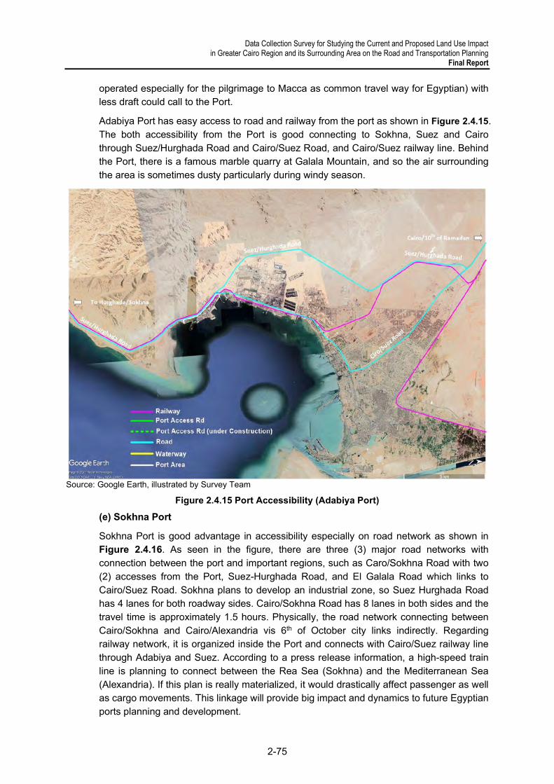
Data Collection Survey for Studying the Current and Proposed Land Use Impact in Greater Cairo Region and its Surrounding Area on the Road and Transportation Planning
Final Report
2-75
operated especially for the pilgrimage to Macca as common travel way for Egyptian) with less draft could call to the Port.
Adabiya Port has easy access to road and railway from the port as shown in Figure 2.4.15. The both accessibility from the Port is good connecting to Sokhna, Suez and Cairo through Suez/Hurghada Road and Cairo/Suez Road, and Cairo/Suez railway line. Behind the Port, there is a famous marble quarry at Galala Mountain, and so the air surrounding the area is sometimes dusty particularly during windy season.
Source: Google Earth, illustrated by Survey Team
Figure 2.4.15 Port Accessibility (Adabiya Port)
(e) Sokhna Port
Sokhna Port is good advantage in accessibility especially on road network as shown in Figure 2.4.16. As seen in the figure, there are three (3) major road networks with connection between the port and important regions, such as Caro/Sokhna Road with two (2) accesses from the Port, Suez-Hurghada Road, and El Galala Road which links to Cairo/Suez Road. Sokhna plans to develop an industrial zone, so Suez Hurghada Road has 4 lanes for both roadway sides. Cairo/Sokhna Road has 8 lanes in both sides and the travel time is approximately 1.5 hours. Physically, the road network connecting between Cairo/Sokhna and Cairo/Alexandria vis 6th of October city links indirectly. Regarding railway network, it is organized inside the Port and connects with Cairo/Suez railway line through Adabiya and Suez. According to a press release information, a high-speed train line is planning to connect between the Rea Sea (Sokhna) and the Mediterranean Sea (Alexandria). If this plan is really materialized, it would drastically affect passenger as well as cargo movements. This linkage will provide big impact and dynamics to future Egyptian ports planning and development.
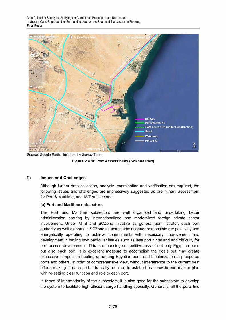
Data Collection Survey for Studying the Current and Proposed Land Use Impact in Greater Cairo Region and its Surrounding Area on the Road and Transportation Planning Final Report
2-76
Source: Google Earth, illustrated by Survey Team
Figure 2.4.16 Port Accessibility (Sokhna Port)
9) Issues and Challenges
Although further data collection, analysis, examination and verification are required, the following issues and challenges are impressively suggested as preliminary assessment for Port & Maritime, and IWT subsectors:
(a) Port and Maritime subsectors
The Port and Maritime subsectors are well organized and undertaking better administration backing by internationalized and modernized foreign private sector involvement. Under MTS and SCZone initiative as general administrator, each port authority as well as ports in SCZone as actual administrator responsible are positively and energetically operating to achieve commitments with necessary improvement and development in having own particular issues such as less port hinterland and difficulty for port access development. This is enhancing competitiveness of not only Egyptian ports but also each port. It is excellent measure to accomplish the goals but may create excessive competition heating up among Egyptian ports and bipolarization to prospered ports and others. In point of comprehensive view, without interference to the current best efforts making in each port, it is really required to establish nationwide port master plan with re-setting clear function and role to each port.
In terms of intermodarlity of the subsectors, it is also good for the subsectors to develop the system to facilitate high-efficient cargo handling specially. Generally, all the ports line

Data Collection Survey for Studying the Current and Proposed Land Use Impact in Greater Cairo Region and its Surrounding Area on the Road and Transportation Planning
Final Report
2-77
up necessary infrastructure ready for intermodality even some ports have to dissolve it as much as they can and seem to WAIT for the initiative sector to promote it. So the framework such as initiative, institution, promotion or such is urgently required to proceed to the intermodality.
(b) IW subsector
IW subsector has made best efforts to tackle long term difficulties for securing guaranteed navigability and water management with the relevant Ministries and partied concerned aside from upgrading and enhancing internal human resources. For those be resolved, RTA is conducting the projects and programs every year for improvement. As already mentioned, IW subsector is using the River Nile water also being used by other purposes for such as water supply, irrigation, agriculture or industry etc. For example, there are portions at Asyut in the River Nile as Aswan/Cairo IW, some parts in Nubaria Canal as Alex/Cairo IW, and Zifta around in Damietta Branch as Damietta/Cairo IW, becoming shallower particularly from November to February even though maintenance dredging well done. This is most likely affected by the water control by MIWRI for irrigation and agricultural purposes. In the future, it is possible to meet the situation that more water demands by growth of population and associated economic activities is increased other than the existing demands using. Therefore, it is key points how to secure 24/7 (24 hours and 7 days a week) guaranteed navigability from technical aspect and to implement water management in realistic and optimal coordination with the relevant Ministries and other parties concerned from software aspect. It is not too much to say that, without resolving the aforementioned, no relevant private sector to strength and enhance IW sector like Port & Maritime subsectors can be involved preferably. In additional to the above, it is necessary for RTA to reset up income system not only from vessel registration and licensing, and training to ship operator and crews.
For intermodality of IW sector, IWs have linkage to Alexandria Port and Damietta Port currently. Even though some bulk and general cargoes are being transported from Alexandria Port to the hinterland, it may be more improvement required in the Port to provide barge terminal like Damietta Port prepared already. Also fleet modernization is absolutely required with smaller draft and mass loading capacity to enhance the intermodality, which may be introduced by private sectors or donner aids under the RTA initiative.

Data Collection Survey for Studying the Current and Proposed Land Use Impact in Greater Cairo Region and its Surrounding Area on the Road and Transportation Planning Final Report
2-78
2.5 Aviation
1) Planning Administration
(a) Ministry of Civil Aviation
Egypt’s Civil Aviation Authority was under MOT until 2002. For accelerating airport development to cope with the high increases in passenger demand and to reform the aviation sector, the Egyptian government decided to remove the aviation division from the MOT, upgrade it to a new ministry (i.e., Ministry of Civil Aviation Authority or MCA), and established two enterprises (i.e., Egyptian Holding Company of Airports and Air Navigation or EHCAAN, and Egypt Air Holding Company or EAHC) through presidential decrees. Since then, these three entities have taken on important roles in the aviation sector. EHCAAN is responsible for airport operation and air navigation services, EHCA is in charge of airline operation and related services, and MCA supervises these two holding companies as an administrative and regulatory body. MCA was established by Presidential Decree No.154 in 2002, and is tasked to implement practical policies in the aviation sector to improve and optimize the airport operation. That is, to support Egypt’s economic growth. The figure below shows the organization chart of MCA.
Source: MCA
Figure 2.5.1 Organization Chart of MCA
MCA planned the Strategic Plan 2030 as a long-term development plan for the aviation sector. Based on this plan, MCA planned to develop the Cairo’s international airport (Katameya international airport), the Sphinx International Airport, and Berenice International Airport, and El-Meliz Airport. Four airports were already constructed. In addition, MCA is planning to develop a new airport named Egyptian International Airport and is studying possible sites for development.
(b) Egyptian Holding Company for Airports and Air Navigation
Incorporated in 2001, the Egyptian Holding Company for Airports and Air Navigation (EHCAAN) is a state holding company in charge of public airports and mandated by Presidential Decree 72. An independent company, it is operated as a self-financial support with a commercial basis. EHCAAN has aggressively implemented a series of airport developments. Figure 2.5.2 shows the organization chart of EHCAAN.
The Egyptian Airports Company (EAC) develops and operates civil airports other than the Cairo International Airport, which is under the responsibility of the Cairo Airport Company in terms of development and operation.

Data Collection Survey for Studying the Current and Proposed Land Use Impact in Greater Cairo Region and its Surrounding Area on the Road and Transportation Planning
Final Report
2-79
Source: MCA
Figure 2.5.2 Organization Chart of EHCAAN
(c) Egyptair Holding Company
Egyptair, originally named Misr Airwork, was founded on 7 May 1932 and was the seventh airline in the world to join the International Air Transport Association (IATA). After several changes in ownership, the Egyptian government finally took over Egyptair. The airline was the first IOSA (IATA Operational Safety Audit) certified airline in the Middle East and Africa, and the recipient of the TUV (Technischer Uberwachungs-Verein/Technical Inspection Association) certificate award. In order to provide customers better services and to survive the global airline competition, Egyptair changed its structure and became Egyptair Holding Company (EAHC) with several subsidiaries in 2002 through a presidential decree. EAHC is under MCA and has been operated as a self-funding company with a commercial mandate. MCA is considering merging EAHC with three companies and establish eight companies.
Source: MCA
Figure 2.5.3 Organization Chart of EAHC
2) Infrastructure Development
(a) State of Airports
The table below shows the civil airports in Egypt. There are 26 civil airports in Egypt, four of which were developed after MiNTS. Figure 2.5.4 shows airports owned by MCA.
Table 2.5.1 Profile of Airports in Egypt
No. Name ICAO Code
Operator Runway
Designation 1 Abou Simbel HEBL EAC 15/33 2 Alexandria international HEAX EAC 04/22 3 Assiut international HEAT EAC 13/31 4 Aswan international HESN EAC 17/35 5 Borg El-Arab international HEBA EAC 14/32 6 Cairo international HECA CAC 05R/23L, 05C/23C, 05L/23R, 16/34 7 Al-Dakhla HEDK EAC 15/33 8 Al-Alamein international HEAL Kato investments 13/31 9 Al-Areish HEAR EAC 16/34

Data Collection Survey for Studying the Current and Proposed Land Use Impact in Greater Cairo Region and its Surrounding Area on the Road and Transportation Planning Final Report
2-80
10 Al-Kharga HEKG EAC 18/36 11 Al-Toor HETR EAC 10/28 12 Hurghadah international HEGN EAC 16/34 13 Luxor international HELX EAC 02/20 14 Marsa Alam HEMA Khorafi Group 15/33 15 Marsa Matrooh international HEMM EAC 06/24, 15/33 16 Port Said international HEPS EAC 10/28 17 Sharm El-Shiekh international HESH EAC 04R/22L, 04L/22R 18 Sharq El-Owinat international HEOW EAC 01/19 19 Sohag international HESG EAC 15/33 20 St. Catherine HESC EAC 17/35 21 Taba international HETB EAC 04/22 22 6th October city HESX EAC 01/19 23 Sphinx international HESX EAC 16R/34L 24 Capital international HECP EAC 01L/19R 25 El-Meliz - - - 26 Berenice international - 15L/33R
Source: MCA
Source: MCA
Figure 2.5.4 Airports in Egypt
In GCR, there are Khatamya International Airport (New Capital Airport), Sphinx International Airport, and Cairo International Airport (Figure 2.5.4). The Sphinx international airport was constructed in 2018. The Capital International Airport was constructed in 2019. According to EAC, these airports were developed to meet the demand from surrounding cities. EAC plans to expand the air route to/from both airports in phases, and international flights will come into service. The Sphinx International Airport is located near tourist sites such as the pyramids, so EAC plans for it to receive tourists from the international airports in Egypt. Capital International Airport is close New Capital City, EAC plans for it receive passengers who will visit the city. The trial flights to both airports have been concluded, but they are not open yet due to the COVID-19 impact.

Data Collection Survey for Studying the Current and Proposed Land Use Impact in Greater Cairo Region and its Surrounding Area on the Road and Transportation Planning
Final Report
2-81
Source: Survey Team
Figure 2.5.5 Airports in Greater Cairo Region
(b) Airport Development Plan and Progress
The table below shows the projects announced after 2015. The information will be updated after receiving information from MCA.
Table 2.5.2 List of Projects in the Aviation Sector
Airport Project Status
Assiut international
Raise the capacity of the airport
Planning
Convert an old building into a retail area
Installing surveillance cameras
Reviewing safety procedures
Upgrading parking lots
Potentially installing solar panels
Bardawil Upgrade terminal
Planning New terminal
Hurghada international
Construction and operation of cargo complex (5,000 sq m)
expansion of the terminal to 90,000 sq m
Completed
installation of a CTX security system
install parallel runway (4,000m)
construction of 20 departure gates, 106 reservation counters, and 15 conveyor belt systems
Capital international (Kaameya Airport)
Terminal (4,500 sqm) with three lounges (one for arrivals, one for departures, and a VIP lounge)
Completed Passport and customs area, along with a restaurant and duty-free area
Main runway (length of 3,500m, width of 6m and a waiting area for aircraft)
Parking area (for more than 500 cars and an 850 sq m mosque)

Data Collection Survey for Studying the Current and Proposed Land Use Impact in Greater Cairo Region and its Surrounding Area on the Road and Transportation Planning Final Report
2-82
Six entry and six exit toll gates
2200m of green areas, along with administrative buildings, power stations and a desalination plant
Install equipment (seven baggage inspection devices, seven metal detectors, 86 in-room security cameras and 17 flight data displays)
High observation tower (36m)
Cairo international Install an integrated system for baggage reconciliation. Completed
Expansion of EgyptAir cargo storage space (15,000 sq m) Ongoing
Brog El Arab international
New terminal building (4 million passengers per year, covering 34,000-36,000 sq m.) not yet
Ras Sedr New airport development project Ongoing
Sphinx international
Terminal building (3,500 sq m)
Completed
Airport maintenance building (340 sq m)
Airport waste building (107 sq m)
Fire-fighting building (1,280 sq m)
Air traffic control tower (853 sq m)
Airfield lighting system building (240 sq m)
Airfield lighting buildings (460 sq m)
Two Substations (235 sq m)
Power station (220 sq m)
Two runways
24 service offices
St. Catherine airport
Additional runway
Ongoing Aircraft hangar
New arrival and departure terminal
Several administrative and technical facilities
Source: Survey Team

Data Collection Survey for Studying the Current and Proposed Land Use Impact in Greater Cairo Region and its Surrounding Area on the Road and Transportation Planning
Final Report
2-83
(c) Airport Access
The table below shows the current access mode to each airport. The Cairo International Airport is accessible by public transportation. Passengers can reach to Cairo Airport by CTA buses or use Metro line 3 and drop off and take a taxi to the terminal, but most passengers usually rely on private car or a taxi from their origins to the airport.
The Sphinx Airport and the New Capital International Airport have not developed access to public transportation. In addition, there is no access between each airport in GCR. On the other hand, high-speed railway stations are planned in 6th of October city and New Capital City, making the Sphinx airport and the Capital international airport easy to access.
Table 2.5.3 Current Access Modes to Airports
Airport Access Mode
Cairo International Airport Private Car/Taxi/Bus/Shuttle bus
Borg El Arab International Airport Private Car/Taxi/Bus New Capital Airport Private Car/Not yet
Sphinx international airport Private Car/Not yet Source: Survey Team
Source: Survey Team
Figure 2.5.6 Access mode to Cairo international airport

Data Collection Survey for Studying the Current and Proposed Land Use Impact in Greater Cairo Region and its Surrounding Area on the Road and Transportation Planning Final Report
2-84
3) Transportation Industry and Service
(a) Air Passenger Traffic Data
A historical air passenger traffic movement for past the 20 years is shown below. Total air passenger numbers increased from 17.7 million (2001) to 39.1 million (2019) with an AAGR of 4.4%. In 2010, the number of passengers was the largest in the past 20 years. However, it fell to 29 million in 2011 due to a change in government, although it increased to 34 million in 2015. However, the number of passengers in 2016 decreased to 75 percent that of 2010. The decline is assumed to be due to the impact of the air crashes in 2015 and 2016. The number increased to 39 million in 2019 as in 2010. However, it has decreased to 25.8 million in 2020 due to the Covid-19 impact.
Source: EHCAAN
Figure 2.5.7 Air Passenger Traffic in 1999–2020
Table 2.5.4 shows air passenger numbers in the top five airports in 2019 and 2020. In 2019, there were five international airports which handled more than one million passengers. CIA was dominant as the international gateway of Egypt, and it accommodated more than 19.0 million passengers in 2019, accounting for 48.5% of total air traffic passengers. Hurghadah and Sharm El-Shiekh were the next busiest international airports, accounting for 7.5 and 5.9 million passengers, respectively in 2019. The shares of these airports are 19.2% for Hurghadah and 15.1% for Sharm El-Shiekh. Other airports which handled more than one million passengers per annum were Borg El-Arab and Marsa Alam. It is remarkable that the total share of these five airports was over 90% of total passenger movements, as shown in Table 2.5.4. The remaining airports handled only 7.1% of total passenger movements. Moreover, the total share of Cairo, Hurghadah, and Sharm El-Shiekh was more than 80% of total passenger movements. These three airports are outstanding international airports.
While the number of passengers in 2020 in each airport decreased due to the impact of COVID-19, the airports’ shares of passengers remained nearly the same.
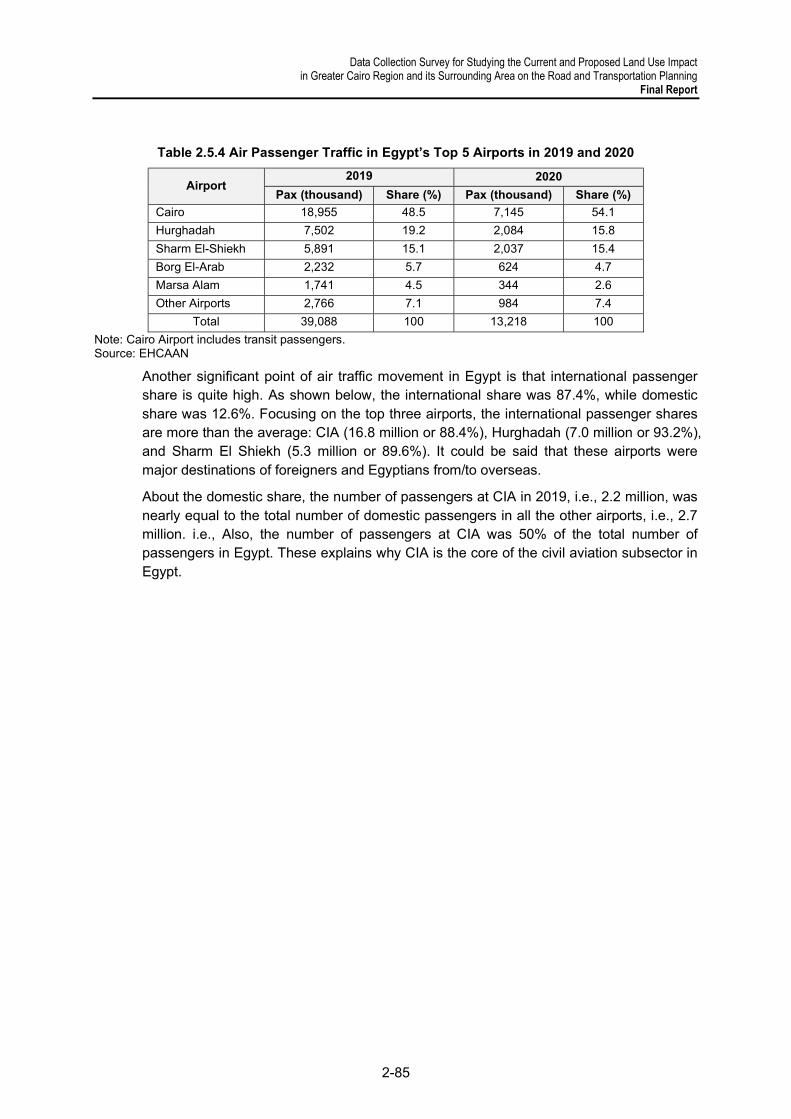
Data Collection Survey for Studying the Current and Proposed Land Use Impact in Greater Cairo Region and its Surrounding Area on the Road and Transportation Planning
Final Report
2-85
Table 2.5.4 Air Passenger Traffic in Egypt’s Top 5 Airports in 2019 and 2020
Airport 2019 2020
Pax (thousand) Share (%) Pax (thousand) Share (%)
Cairo 18,955 48.5 7,145 54.1
Hurghadah 7,502 19.2 2,084 15.8
Sharm El-Shiekh 5,891 15.1 2,037 15.4
Borg El-Arab 2,232 5.7 624 4.7
Marsa Alam 1,741 4.5 344 2.6
Other Airports 2,766 7.1 984 7.4
Total 39,088 100 13,218 100
Note: Cairo Airport includes transit passengers. Source: EHCAAN
Another significant point of air traffic movement in Egypt is that international passenger share is quite high. As shown below, the international share was 87.4%, while domestic share was 12.6%. Focusing on the top three airports, the international passenger shares are more than the average: CIA (16.8 million or 88.4%), Hurghadah (7.0 million or 93.2%), and Sharm El Shiekh (5.3 million or 89.6%). It could be said that these airports were major destinations of foreigners and Egyptians from/to overseas.
About the domestic share, the number of passengers at CIA in 2019, i.e., 2.2 million, was nearly equal to the total number of domestic passengers in all the other airports, i.e., 2.7 million. i.e., Also, the number of passengers at CIA was 50% of the total number of passengers in Egypt. These explains why CIA is the core of the civil aviation subsector in Egypt.

Data Collection Survey for Studying the Current and Proposed Land Use Impact in Greater Cairo Region and its Surrounding Area on the Road and Transportation Planning Final Report
2-86
Table 2.5.5 International and Domestic Air Passengers by Airport, 2019
Airport
International Domestic Total Pax
(thousand) Pax
(thousand) Share
(%) Pax
(thousand) Share
(%)
Cairo 16,753 88.4 2,202 11.6 18,955
Hurghadah 6,991 93.2 511 6.8 7,502
Sharm El-Shiekh 5,277 89.6 614 10.4 5,891
Borg El-Arab 2,172 97.3 60 2.7 2,232
Marsa Alam 1,716 98.6 25 1.4 1,741
Other Airports 1,266 45.8 1,499 54.2 2,766
Total 34,175 87.4 4,912 12.6 39,088
Note: Cairo Airport includes transit passengers. Source: EHCAAN
Table 2.5.6 below shows the number of international air passengers in the country’s top 10 airports in the past five years.
Table 2.5.6 International Air Passengers in Egypt’s Top 10 Airports, 2015–2020
(thosand) Airport 2015 2016 2017 2018 2019 2020 Total
1 Cairo 13,623 14,542 14,052 15,466 16,753 6,311 67,124
2 Hurghadah 6,226 2,425 4,211 6,136 6,991 1,919 21,682
3 Sharm El-Shiekh 4,919 1,115 2,363 4,085 5,277 1,827 14,667
4 Borg El-Arab 2,652 2,537 2,113 2,250 2,172 610 9,682
5 Marsa Alam 1,053 554 1,071 1,468 1,716 314 5,123
6 Sohag 688 534 483 550 547 236 2,350
7 Assiut 76 368 312 302 324 111 1,417
8 Luxor 296 260 194 202 267 70 993
9 Taba 3 0 - 5 59 13 77
10 Marsa Matrooh 25 2 9 23 43 0 77
11 Other Airports 38 40 81 39 26 9 195
Total 29,561 22,377 24,808 30,487 34,149 11,411 123,232
Source: EHCAAN
From 2015 to 2020, the top three airports, i.e., Cairo, Hurghadah, and Sharm El-Shiekh, handled more than 80% of the total number of international passengers in Egypt. The number increased to 4.3 million, which is 1.2 times bigger than the figure in 2015, 24.8 million.

Data Collection Survey for Studying the Current and Proposed Land Use Impact in Greater Cairo Region and its Surrounding Area on the Road and Transportation Planning
Final Report
2-87
Source: EHCAAN
Figure 2.5.8 International Passenger Trend in Egypt’s Top Three Airports, 2015–2020
In 2019, scheduled international flights were operated in seven airports, while non-scheduled international flights were operated in 10 airports, as shown in Table 2.5.7.
Table 2.5.7 Scheduled and Non-scheduled International Flight Passengers by Airport, 2019 (thousand)
Airport Scheduled Non-Scheduled Total
Pax % Pax %
Cairo 15,085 90.0 1,669 10.0 16,753
Borg El-Arab 2,167 99.7 5 0.3 2,172
Hurghadah 1,882 26.9 5,109 73.1 6,991
Sohag 547 100.0 0 0.0 547
Sharm El-Shiekh 217 4.1 5,059 95.9 5,277
Luxor 204 76.4 63 23.6 267
Assiut 121 37.4 203 62.6 324
Aswan 0 0.0 20 100.0 20
Alexandria 0 0.0 0 0.0 0
Taba 0 0.0 59 100.0 59
Marsa Matrouh 0 0.0 43 100.0 43
Port Said 0 0.0 0 100.0 0
Total 20,223 (62.3%)
62.3 12,230 (37.7)
37.7 32,453 (100.0%)
Source: EHCAAN Hurghadah and Sharm El-Shiekh handled more passengers on non-scheduled flights than other airports, i.e., 73.1% and 95.9%, respectively. Total non-scheduled passengers of the two airports were 10.2 million.
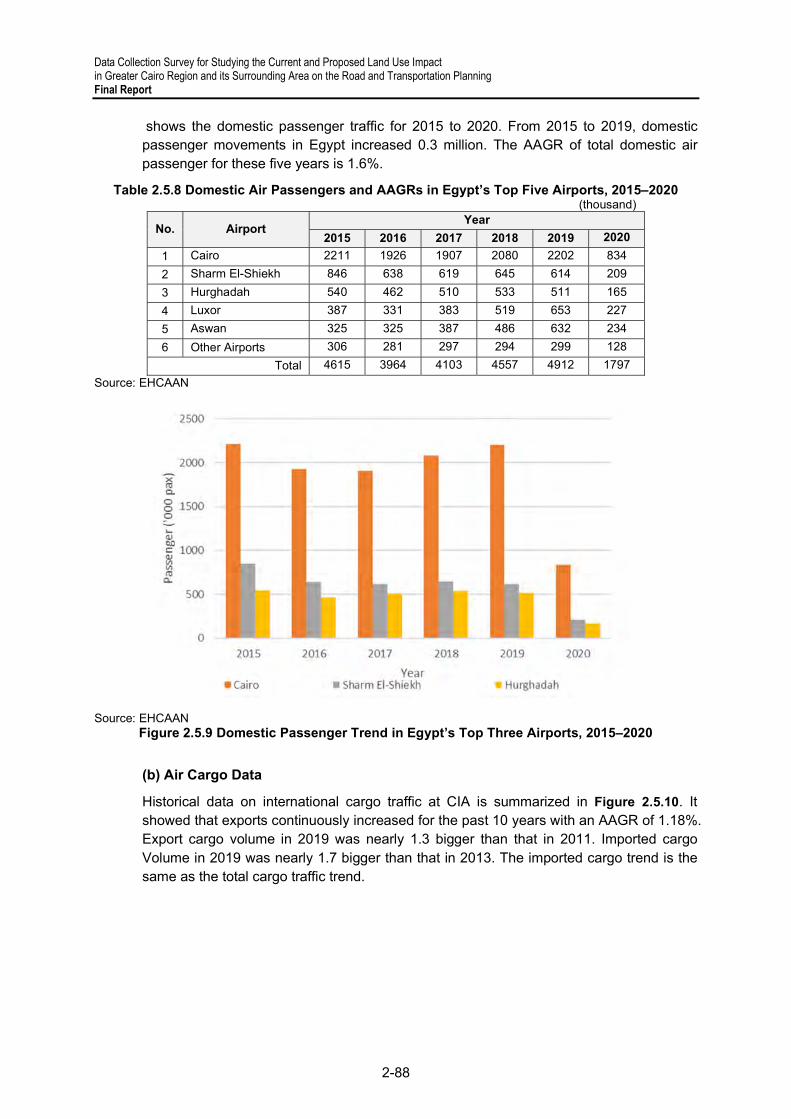
Data Collection Survey for Studying the Current and Proposed Land Use Impact in Greater Cairo Region and its Surrounding Area on the Road and Transportation Planning Final Report
2-88
shows the domestic passenger traffic for 2015 to 2020. From 2015 to 2019, domestic passenger movements in Egypt increased 0.3 million. The AAGR of total domestic air passenger for these five years is 1.6%.
Table 2.5.8 Domestic Air Passengers and AAGRs in Egypt’s Top Five Airports, 2015–2020 (thousand)
No. Airport Year
2015 2016 2017 2018 2019 2020
1 Cairo 2211 1926 1907 2080 2202 834
2 Sharm El-Shiekh 846 638 619 645 614 209
3 Hurghadah 540 462 510 533 511 165
4 Luxor 387 331 383 519 653 227
5 Aswan 325 325 387 486 632 234
6 Other Airports 306 281 297 294 299 128
Total 4615 3964 4103 4557 4912 1797
Source: EHCAAN
Source: EHCAAN
Figure 2.5.9 Domestic Passenger Trend in Egypt’s Top Three Airports, 2015–2020
(b) Air Cargo Data
Historical data on international cargo traffic at CIA is summarized in Figure 2.5.10. It showed that exports continuously increased for the past 10 years with an AAGR of 1.18%. Export cargo volume in 2019 was nearly 1.3 bigger than that in 2011. Imported cargo Volume in 2019 was nearly 1.7 bigger than that in 2013. The imported cargo trend is the same as the total cargo traffic trend.

Data Collection Survey for Studying the Current and Proposed Land Use Impact in Greater Cairo Region and its Surrounding Area on the Road and Transportation Planning
Final Report
2-89
Source: EHCAAN
Figure 2.5.10 International Cargo Traffic at Cairo International Airport, 2011–2020
Table 2.5.9 International Cargo Traffic at Cairo International Airport, 2009–2020
Year Cargo Traffic (ton) Share (%) AAGR (%)
Export Import Total Export Import Export Import Total
2009 185,325 100,514 285,839 64.8 35.2
1.18 4.1 2.29
2010 186,537 124,366 310,903 60.0 40.0
2011 166,207 114,366 280,573 59.2 40.8
2012 177,804 101,073 278,877 63.8 36.2
2013 178,677 87,864 266,541 67.0 33.0
2014 190,766 101,458 292,224 65.3 34.7
2015 197,080 121,345 318,425 61.9 38.1
2016 218,627 112,741 331,368 66.0 34.0
2017 202,353 114,044 316,397 64.0 36.0
2018 190,211 129,335 319,546 59.5 40.5
2019 208,292 150,202 358,494 58.1 41.9
Source: EHCAAN
There are five cargo companies at CIA. As shown in Figure 2.5.11, EgyptAir Cargo is the dominant carrier, handling 56.4% of throughput. The second is Cairo Airport Cargo and the third is Egypt Express FedEx. Egypt Express FedEx started cargo handling in 2019. Saudi Airlines handled cargo until 2017. Cairo Airport Company handled cargo until 2018.

Data Collection Survey for Studying the Current and Proposed Land Use Impact in Greater Cairo Region and its Surrounding Area on the Road and Transportation Planning Final Report
2-90
Source: EHCAAN
Figure 2.5.11 International Cargo Traffic at Cairo International Airport, 2019
4) Relationship with Private Sector
There are two BOT/BOOT (build-own-transfer/build-own-operate-transfer) airports in Egypt. One is Marasa Alam Airport which is operated by the Khorafi Group. The other airport is Alamain Airport which is operated by Kato investments. Alamain Airport could be transferred to military purposes. On the other hand, MCA is considering Aswit Airport to be operated by the private sector.

Data Collection Survey for Studying the Current and Proposed Land Use Impact in Greater Cairo Region and its Surrounding Area on the Road and Transportation Planning
Final Report
2-91
2.6 Logistics
1) Definition
The MiNTS study highlighted the “Need for the intrinsic linking of transport with the form and extent of the national developmental fabric, thus catalyzing a dynamic interaction between transport and Egypt’s social as well as economic evolution, while concurrently cementing the Republic’s important role in the international arena, both regional and beyond.”30.
The vision of the MiNTS study remains valid today when building a sustainable logistics system in Egypt. It is also the opinion of the General Authority for Land and Dry Ports (GALDP) that the dry ports in the country must be used for more than simply the storage of goods, but should also provide advanced logistics services and include or at least prepare for more advanced logistics services as strategic partner in the supply chain, including but not limited to participating in the industrial process such as market-specific packaging and final assembly of or new e-commerce-inspired on time and reverse logistics. One issue that must gradually be added in the logistics strategy is the emergence of new (international) policy priorities focusing sustainable mobility solutions, requiring transportation systems to become greener, smarter, and inclusive via the introduction of intelligent transport systems (ITS), alternative energy use (electric vehicles - EV), and innovative mobility solutions (including automated vehicles – AV or intelligent infrastructure and vehicles).
As suggested in Figure 2.6.1, supply chain logistics integrates all components of the transportation business, covering at the same time the hardware (infrastructure), the software (technology), and the humanware (Human Resource Development, governance).
Figure 2.6.1 Supply Chain Logistics Framework
30 MiNTS – Misr National Transport Study: “The Comprehensive Study on the Master Plan for Nationwide Transport System in the Arab Republic of Egypt”; March 2012 Final Report – Summary, p4 cit.
Source: https://www.youtube.com/watch?v=4-QU7WiVxh8

Data Collection Survey for Studying the Current and Proposed Land Use Impact in Greater Cairo Region and its Surrounding Area on the Road and Transportation Planning Final Report
2-92
The supply chain consists of two chain types: the physical chain corresponding to the movement of cargo through the supply chain and the virtual chain consisting of the information and cargo management systems:
Physical chain
− The transport chain covers the physical transport of goods. According to the supply chain principles, the chain starts with the delivery of raw materials and ends with final delivery. This chain consists of traditional “transport” that includes infrastructure, vehicles and transport operations on the one hand; and the emerging services such as reverse logistics that with e-commerce becomes increasingly dominant in the supply chain, or “last mile logistics” where smart and green solutions are introduced (use of drones; EVs and AVs; innovative storage services; urban freight consolidation centers, …) on the other hand;
− The product handling and control chain determines the efficiency of the physical transport of goods and in its wider dimension of the supply chain. This chain focuses the management of goods both during movement and storage with a focus on (cost) efficiency that stimulates process standardization and cargo unitization as well as the introduction of new principles like “smart” (such as AI and big data), “green” (zero-emission and clean energy), or inclusive (accessible to all) for meeting the increasingly complex requirements of on-time delivery, packaging and tracking; traceability and transparency, damage prevention, delivery consolidation; …;
Virtual chain
− The regulatory chain structures the framework in which logistics systems are developed and will operate. The legal framework will have mode-specific and sector-based legislation and will be national (Egypt) or integrated in an international legal framework (global, MENA/EU);
− The organization chain, The organization, the management of information and communications (telematics), and the contractual and administrative aspects related to the physical transport of goods; plans and manages the physical flow of cargo from origin to destination. The chain is virtual because no concrete cargo is moved. But the organization chain is essential for the efficiency of the supply chain because it plans the physical movement of goods through the supply chain optimizing the interconnectivity of modes and services.
− The service chain, provides supporting / complementary services indirectly related to the physical transport of goods but essential for the overall functioning of the logistics chain. There is for example the financing and assurance sector with innovative techniques and concepts to meet the increasingly complex logistics requirements or the continuous expansion of Value-Added Logistics (VAL), which is the provision of industrial services such as final assembly, market-specific packaging, warehousing, or reverse logistics.
Above summarized chain concepts must be adapted to the context of Egypt’s transport system and structural design of the sector, and incorporated into a wider framework founded on land planning and land use. This integration is essential because there is a constant interaction between land use and transport system design, given that transport functions within a given land planning policy but changing transport and economic policies

Data Collection Survey for Studying the Current and Proposed Land Use Impact in Greater Cairo Region and its Surrounding Area on the Road and Transportation Planning
Final Report
2-93
could lead to major shifts in transport needs and subsequently influence land use and ultimately change land planning. The adaptation of the chain concept to the Egyptian context is also important in light of the concrete implementation of logistics concepts in goods transport, at present still concentrated on the physical transport of goods and not on the efficient management of goods transport.
Planning the development of the logistics sector must be based upon recognized logistics concepts that are determined by the different stages of development maturity that can be divided into 5 key development phases:
− First-party Logistics (1PL): The manufacturer handles its transport with its own fleet of trucks.
− Second-party Logistics (2PL): Transport of the goods is no longer handled by the manufacturer but by trucking and shipping companies dealing only with the physical transport.
− Third-party Logistics (3PL): Outsourcing the warehousing and transport of goods to third parties, eventually including some complementary services such as market-specific packaging, final assembly or database and information management.
− Fourth-party Logistics (4PL): 4PL combines the shipping needs of multiple 3PLs to negotiate better carrier rates and will act as logistics aggregator, running a wider range of aspects of the supply chain. They now act as “consultants” to manage the logistics needs for their clients with the physical movement of goods becoming secondary. Supply chain management makes its entry and 4PL companies contract freight companies and other service providers to optimize the logistics chain.
− Fifth-party Logistics (5PL): 5PL service providers extend the service level of 4PL by negotiating and managing the mobility contracts for their clients, therewith becoming a strategic partner in the company’s supply chain, eventually taking over parts of the production process such as final assembly, or market-specific packaging, and increasingly dealing with “new” services such as return / reverse logistics or last-mile distribution.
The above evolution of logistics demonstrates that 4PL leads to the consolidation of “supply chain logistics” that consists of a shift from providing physical transport to managing the movement of freight.
Further developments are envisaged in a long(er) term future, driven by the potential of Artificial Intelligence (AI) and new policy priorities, although for the time-being, there is no clear insight into the logistics models of the future. 6PL Logistics upholds the 5PL concepts but will use Artificial Intelligence for analyzing and managing big data to proactively manage upstream activities via the analysis of company orders to create future efficiency improvement and business development opportunities. 7PL Logistics might even go further and use AI to manage simultaneously the service providers it uses and the supply chains it manages, thus connecting 3PL and 4PL (3PL + 4PL = 7PL) into a complete integrated logistics solution under a “one contract, one bill” concept. More advanced AI applications, at present still undeveloped or even unknown, might lead to supply chain management systems using “self-thinking” computer systems (referred to as 10PL), but how the sector will effectively evolve in the long term is for the moment pure speculation.

Data Collection Survey for Studying the Current and Proposed Land Use Impact in Greater Cairo Region and its Surrounding Area on the Road and Transportation Planning Final Report
2-94
Although 7PL and higher remains at present science-fiction, there is a consensus among specialists that AI and Big Data as well as “Smart” concepts will change the foundations of logistics. But for the time being, a realistic vision of future supply chain logistics is associated with the concept of 6PL, where logistics service providers are strategic partners of its clients and seek supply chain efficiency and cost optimization, while integrating environmental and social considerations to meet the growing policy pressure for green and inclusive mobility.
2) Planning Administration
When considering logistics as an integrated transport system, the authorities directly relevant for the development of the logistics sector are highlighted in Figure 2.6.2.
Source: based on MiNTS Interim Report 2, April 2011
Figure 2.6.2 Government Entities dealing with Transport Issues and Logistics
The principal Ministries relevant for developing transport and logistics in Egypt are:
− MOT for the different transport infrastructures and transit points, − Ministry of Trade and Industry (MTI) − Ministry of Investment and International Cooperation (MIIC) for the General
Authority for Investment and Free Zones,

Data Collection Survey for Studying the Current and Proposed Land Use Impact in Greater Cairo Region and its Surrounding Area on the Road and Transportation Planning
Final Report
2-95
− MIWR for river management, − Ministry of Communications and Information Technology (MICT) with Egypt Post
responsible for light parcel shipping, − MOHUUC for the planning and construction of key infrastructure within cities and
urban communities
Within MOT, several Authorities will play an essential role for developing logistics in Egypt:
− Transport Projects Planning Authority (TPPA), − LTRA − GALDP, − MTS with the different Port Authorities, − RTA.
MCA and MIWR are also present but only in a secondary role from a freight transport perspective. For MIWR, they are responsible for the maintenance of the river infrastructure but not for river transport. For the civil aviation sector, only few goods are transported by air, predominantly parcels and other small (high value) goods. And the logistics that involves aviation services are highly specialized and client dedicated, for example DHL managing the logistics of the Formula 1 © (F1) competition31.
3) Infrastructure Development
Egypt has a range of transport corridors but from a logistics point of view, there are 2 key corridors. The first is the intermodal transportation corridor already proposed in the 2012 MiNTS study. The corridor links Alexandria Port with Sokhna Port via GCR, with a dry port in 6th of October city.
Source: MiNTS, Final Report, p ES 14
Figure 2.6.3 Intermodal Transport Corridor for Egypt
31 https://www.dhl.com/global-en/home/about-us/partnerships/motorsports/formula-1.html

Data Collection Survey for Studying the Current and Proposed Land Use Impact in Greater Cairo Region and its Surrounding Area on the Road and Transportation Planning Final Report
2-96
Most logistics infrastructure on the corridor is available, many upgraded, with as principal rehabilitation and improvement works the comprehensive upgrade of the Desert Highway recently completed.
A central component of the corridor is 6th of October city dry port, a public-private partnership with DB Schenker and its local partners Elsewedy Electric Company and 3A International. The construction approved by Egyptian government end of 2020, to dry port is set to be the biggest of its kind in the African region. The platform is now under construction and expected to be operational in 2022. The European Bank for Reconstruction and Development (EBRD) was a partner in the financing of the dry port, costing in total USD 176 million to have a freight handling capacity of 720 containers (20 feet) per day, a total of about 250,000 TEU per year. The entire dry port will include container yards, communication and control systems, a solar energy system for the electricity generation, a direct railway link, and also aims to offer other facilities such as an integrated customs department headquarters, and administrative offices for involved parties such as GALDP, shipping line agents, and shipping, clearing and transportation companies.
In 2014, the Egyptian government decided on the development of a second major corridor, the Suez Canal Economic Zone (SCZone). This mega-project was initiated by Law No.330/2015 and the development and is in line with Law No. 83/2002 on the special economic zones.
Source: SCEZ Authority Figure 2.6.4 Suez Canal Economic Zone
The overall objective of the project is to establish a self-sustaining industrial corridor of 461 Km2 build around 3 principal centers, Ain Sokhna-Suez, Port Said, and Ismailia, including several free zones, the latter supported by the Law No 72 of 2017 promulgating the Investment Law that re-introduces free zones in Egypt, after all free zones in Egypt were abandoned in 2015.

Data Collection Survey for Studying the Current and Proposed Land Use Impact in Greater Cairo Region and its Surrounding Area on the Road and Transportation Planning
Final Report
2-97
The SCZone consists of two integrated areas, two development areas, and four ports:
− The two integrated areas are Ain Sokhna – including Ain Sokhna Port – and East Port Said – with East Port Said Port.
− The two development areas are Qantara West and East Ismailia. − The four ports are West Port Said Port, Adabiya Port, Al Tor Port, and Al Arish
Port.
The development of the massive new multi-purpose industrial-economic zone, still ongoing, also foresees two additional logistics terminals (dry ports), one in 10th of Ramadan city, north of New Capital City and one in in New Ismailia on the bank of the new Suez Canal as well as upgrades for the ports and the development of new cities.
4) Environment, Safety, and Security
(a) Environmental awareness
Environmental awareness is growing in Egyptian decision-making and is also increasingly visible in the development of (transportation) infrastructure and consequently, in the logistics sector.
Since 2016, legislation imposes the execution of an Environmental Impact Assessment (EIA) to ensure the protection and conservation of the environment and natural resources, including the protection of human health and the elimination of uncontrolled developments. The long(er)-term objective of the legislation is to ensure a sustainable economic development that meets present needs without compromising future generations’ ability to meet their needs. The EIA is an important tool in the integrated environmental management approach. According to standing legislation, the EIA must be performed for new establishments or projects and for expansions or renovations of existing establishments according to Law Number 4 of 1994 Promulgating the Environment Law. The protection of the environment has been reinforced since 2016 via the promulgation of Minister Decree No. 19 and No. 20 as well as CEO Decree No. 26 for year 2016 and Minister Decree No. 75 for year 2017. The introduction of intelligent and smart solutions for administration and management of logistics services is a specific domain where innovation can contribute to reducing the environmental impact, in particular the generation of (paper) waste and the carbon footprint. The government has initiated massive development programs in both domains.
In alignment with the United Nations Sustainable Development Goals (SDGs), and in accordance with Egypt’s Vision 2030. Egypt is committed to both reducing greenhouse gas emissions to curb climate change and reduce air pollution as an obligation to public health. The Egyptian government launched its “national strategy for transformation to electric vehicles” to introduce electric and hybrid vehicles in both public and private transportation. As part of the strategy, the government is planning to equip all new cities with electric car charging infrastructure and MTI is discussing the production of electric cars and their chargers in Egypt. In that context, a partnership was signed with the Chinese company Foton, for manufacturing electric buses in Egypt.
The Egyptian Reform Structure and Adjustment Program (ERSAP) is the guideline for the modernization process of Egyptian administration to create a better climate for service provision in terms of efficiency, and speed. Under the slogan, “The Government Now

Data Collection Survey for Studying the Current and Proposed Land Use Impact in Greater Cairo Region and its Surrounding Area on the Road and Transportation Planning Final Report
2-98
Delivers”, Ministry of State for administrative development and all the other ministries and government bodies are establishing a complete framework for automating the services that the government provides through the E-Government project and give companies and investors the chance to get the services directly from their offices.
Specifically important for the development of modern logistics services are the Issuing of a law for e-signature and transactions through networks, the setting of standards for e-payment and applying the public key Infrastructure mechanism. This will contribute not only to the sustainable development of logistics services, but will also be environmentally friendly as it will reduce the use of paper and reduce the physical exchange of information (transport of documents). And in the longer term, the development of modern logistics in Egypt will have major environmental benefits as 4PL will optimize the (cost of) goods transport, concentrating on smart routing focusing rail and river transport as they are cheaper than transport. Furthermore, the use of “green” technologies will also reduce the environmental effects of road transport, using e-vehicles and clean fuels for long(er) distance transport, and alternative transport modes and smart management for last-mile delivery.
(b) Safety
In 2017, safety becomes a prime objective for the government’s infrastructure development strategy. According to the World Health Organization (WHO) Global Status Report on Road Safety, Egypt was in 2013 included in the top 10 countries globally for the number of fatal road accidents. In 2016, road statistics showed an annual death toll between 25,000 and 27,000 persons, as well as between 70,000 and 80,000 recorded injuries, generating financial losses between EGP30 and 35 billion. Since then, the situation has improved thanks to the development and upgrading of road infrastructure and the implementation of new safety measures. Information published in 2020, by the Cabinet Information Center showed a dramatic decline in the number of road accident fatalities, recording 7,000 deaths in 2020 as compared to 12,000 cases in 2019, a 44% decrease over 1 year and more than 3 times less than in 4 years earlier.
It should be noted that freight transport has a share in road safety issue, or rather the lack thereof. The majority of the severe accidents are accidents involving trucks, which is partly due to the high share of road transport in freight transportation as compared to railway or river transport and the lack of safety awareness of truck and the poor quality of trucks. The government has started to take action by separating trucks from other vehicles (dedicated freight lanes) to reduce the involvement of trucks in road accidents. But to be successful, it is necessary to also address truck driver behavior and the safety of trucks, the former via more intense training and more strict licensing procedures; whereas, the latter with mandatory vehicle inspections within relatively short periods (preferably every year).
Also, Egypt's railway system has a poor safety record with figures from the official statistics agency showing there were 1,657 train accidents in 2017 up from 1,249 in the year 2016. The sector is the object of technical assistance since 2008 when the EU financed the first Twinning Project Assistance to the Egyptian MOT for reforming Railway Safety Regulation Procedures and Practices. France carried out the Twinning project from 2008 to 2010. This initiative was followed by a second project in 2013 to continue the works and consolidate achievements and initiatives from other donors followed to improve railway safety continue. The World Bank approved early 2021 a USD 440 million loan to

Data Collection Survey for Studying the Current and Proposed Land Use Impact in Greater Cairo Region and its Surrounding Area on the Road and Transportation Planning
Final Report
2-99
support Egypt’s initiatives to enhance the safety and service quality of the country’s railways via the Railway Improvement and Safety for Egypt (RISE). The total project cost is USD 681.1 million, including USD 241.1 million in contribution by ENR to continue the Egypt National Railways Restructuring Project (ENRRP) and further modernizes the signaling system holistic and systemic manner by introducing an upgraded Safety Management System. The African Development Bank also approved in April 2021 a USD176 million loan to bolster railway safety and reliability under the Egypt National Railways Modernization Project (ENRMP). One component of the safety enhancement program for the railway sector is the installation and operationalization of an automated rail network by 2024 to address the key problem for Egypt’s poor railway safety record that is “the human factor”.
Safety is a critical component for efficient logistics and affects the fundamental logistics principle of on-time goods delivery. Considering road accidents mainly occur during the road transportation part of the logistics process and may end up affecting both people and goods, road accidents bring losses both at the company level and the human level and subsequently generate (unexpected / uncontrolled) logistics costs. In order to increase the safety and therewith reduce the impact on logistics (costs), the reasons for truck accidents need to be tackled, which are the use of worn-out tires, the malfunctioning of brakes and suspensions, or driver mistakes caused by inexperience, carelessness, inattention, over-estimation of driving skills and endurance. The poor condition of trucks is further aggravated because there is no comprehensive legal framework and associated control structure to avoid the use of old and untrustworthy trucks.
(c) Security
Security has always been an strategic priority in Egypt and is particularly relevant for the Suez Canal (Economic Zone). Because the functioning of the economic zone is closely related to and intertwined with the provision of logistics services, security is also important for the logistics sector. Given the strategic, economic (and military) importance of the Suez Canal, the Canal Zone has since 1956 been a “military zone” with “controlled access”. The Canal itself is managed by the Suez Canal Authority (SCA) that, contrary to all other Authorities that are part of specific Ministries, is linked directly to the Prime Minister and has all the authorities needed for running the Canal without being limited by the laws and the systems of the government32. This is made explicit in Article 2 of Law No. 30 of 1975 on the Organization of the Suez Canal Authority that states that the “… Suez Canal Authority (SCA) is a public authority enjoying an independent juristic personality under the provisions of this law alone; whereas provisions of the Law No. 61 of 1963 promulgating the law for public authorities, and provisions of the Law 60 of 1970 promulgating the law for public institutions, are both not applicable to the SCA.” The position of the SCA was confirmed in Law No.4 of 1998 amending the provisions of Law No.30 of 1975 where it is stated that the Suez Canal Authority reports to the Prime Minister and that decisions of the SCA are to be reported to and approved by the Prime Minister alone.
Egyptian Authorities will always consider the strategic and military importance of the Suez Canal and take all measures necessary to guarantee the security of the Canal against economic and political threats. The former was dramatically highlighted when in March 2021, the Suez Canal was blocked for six days after the grounding of the “Ever Given”, a
32 SCA - SCA Overview (suezcanal.gov.eg)

Data Collection Survey for Studying the Current and Proposed Land Use Impact in Greater Cairo Region and its Surrounding Area on the Road and Transportation Planning Final Report
2-100
20,000 TEU container ship, with significant negative impact on international trade and generating disruptions in supply chains. The latter increased with the growing terrorism threat in the Sinai Peninsula. It is possible that Sinai-based jihadists have at present the capability to cause significant damage or even block the Suez Canal. For the time being, none of the recorded militant attacks in North Sinai, over 140 in the last 12 months, were within 50 km of the Suez Canal. But the canal might be(come) a priority target and the recent blockage by “Ever Given” containership might increase the intent to conduct attacks against shipping in the canal. It should be highlighted that current level of Egyptian security combining many security measures with continued (military) surveillance along the canal make any attack unlikely.
5) Logistics Industry and Services
As outlined before, the logistics industry integrates all transportation functions and “penetrates” various sectors to which it previously provided services:
- The industrial sector through value added services such as final assembly or market-specific packaging;
- The ICT sector via logistics chain management;
- The e-commerce sector with time-sensitive delivery, on-line parcel tracking, and return logistics;
- The retail sector with last-mile logistics services.
The Egyptian logistics (and warehousing) market still focuses import/export, freight forwarding, warehousing, express delivery and some value-added services such as inspection, inventory management, and stimulated by the growth of e-commerce, some 3PL services such as direct (store) delivery and reverse logistics. Larger transport companies also provide administrative services including tracking inland transportation, preparation of shipping and export documents, booking cargo space, negotiating freight charges, freight consolidation, cargo insurance, or filing of insurance claims.
But looking at the most important operators in Egypt’s logistics market, many do not have the profile of a party-logistics service provider but rather have that of freight forwarders. In spite the slow progress, the importance of the logistics sector as well as its complexity is fully recognized by Egyptian authorities, as demonstrated with the promulgation on 10 June 2019 of Law no. 73 of 2019 establishing the “Domestic and International Land Transport Regulatory Authority” that will help Egypt become a regional hub for logistics and boost the country’s position on logistics performance index. In that same context, the Government will also foresee substantial investments in Intelligent Transport Systems (ITS) as part of the country’s digitalization process, supported by the Law no. 150 of 2019 establishing the Science and Technology Development Fund.
The most important local and international players in Egypt’s transport market and could gradually be catalysts of the development of a modern logistics sector in the country are:
● International Players · DHL · Kuehne Nagel · Ceva Logistics · DB Schenker

Data Collection Survey for Studying the Current and Proposed Land Use Impact in Greater Cairo Region and its Surrounding Area on the Road and Transportation Planning
Final Report
2-101
· DSV · Aramex PJCS · Hapag-Lloyd AG · CMA CGM · Agility · Orient Overseas Container Line Limited
● Local Players · General Silos and Storage · Al-Nasr Service and Maintenance Co. (Queen Service) · International Freight Group · LATT Trading and Shipping SAE · Egyptair Cargo · El Salam Group · New Trans Shipping Company · Kadmar Shipping · ESG Shipping & Logistics SAE
The logistics sector in Egypt is still dominated by 2PL and 3PL, with 4PL only slowly emerging and 5PL yet a distant future. Much must still be done to introduce in a near future more advanced logistics services.
All conditions for developing modern logistics are present in Egypt. The development and rehabilitation of the transport infrastructure, the modernization of rolling stock and equipment, and the introduction of digitalization make solid foundations for an efficient logistics sector in Egypt. The introduction of supply chain management services by specialized companies, although only slowly emerging in Egypt, will undoubtedly grow stimulated by the industrial development in the Suez Canal Economic Zone and other industrial zones and benefiting from the geographical position of Egypt and the Suez Canal.
One key driver for the growth of modern logistics in Egypt might be open and future-oriented stimulation policy, stimulating private investment and targeting among other sectors high-tech and digitalization, preparing for an expected strong economic growth during the post-COVID-19 period. And with economic growth comes increased demand for transport and logistics services which will stimulate the modernization of transport and its and transformation towards modern logistics services to meet the increasing complexity of supply chain management.
To build a sustainable logistics sector in Egypt, it is essential to create an integrated approach to the transport / logistics sector and move away from the present situation where different authorities formulate different (transport) strategies which are subsequently implemented independently. There are modest improvements in the exchange of information on strategies and development plans between authorities but the effective integration and alignment of various plans is still not achieved. The focus on road transport for the movement of goods is / was efficient to transport goods from the point of origin to the point of destination, reflecting the 1PL, 2PL or 3PL approach to logistics. But this classic pattern is no longer valid with the globalization of trade and the growing importance of e-commerce, combined with increasingly complex production and consumption patterns, further complicated by increasingly stringent environmental and

Data Collection Survey for Studying the Current and Proposed Land Use Impact in Greater Cairo Region and its Surrounding Area on the Road and Transportation Planning Final Report
2-102
social measures that require rethinking the traditional perceptions on the transport of goods.
In that context, any delay in improving governance might constitute a serious threat to the growth perspectives of logistics in Egypt. The threat posed by uncoordinated and dispersed sector development policies and related investments can only be overcome if and when it is supported by a strong and well-organized institutional framework, where “… collaboration for investment promotion … combines legal, institutional mechanisms and Information and communications technology (ICT) tools…”33
6) Financing
A USD 12 billion loan package from IMF was approved in August 2016 and allows the Egyptian Government to maintain its drive to develop domestic infrastructure. In that context, transportation infrastructure investments contribute to improving transportation and are thus of importance for the logistics sector. Egypt channeled some USD 56.2 billion towards building infrastructure between 2013 and 2017 of which the transportation sector secured 13% of total investments34.
Rail and roads are priority projects for the transportation sector. Most transportation infrastructure are developed or under development as part of specific sub-sector investment programs such as:
● Roads:
The National Road Project was launched in August 2014 and foresees the construction of new roads and highways as well as the rehabilitation of several old ones with the aim to reduce traffic bottlenecks. The plan foresees the construction of 39 new roadways with a total length of 4,400 kilometers for an estimated cost of EGP36 billion (USD 2.3 billion). Some landmark road developments are: Sohag-Red Sea Road linking Upper Egypt to the Red Sea; 30 June axis linking Cairo to Port Said via Zagazig and Ismailia; Cairo – Suez Road rehabilitation to become a five-lane dual highway, including six bridges and a tunnel, and Cairo-Alexandria Desert Road, representing renovations of the four-lane dual highway for a total cost of EGP1.4 billion (USD 0.89 billion), including 10 vehicle bridges and five pedestrian bridges.
● Railways:
The Egyptian government started in 2017 the development plan for the railway system that includes the implementation of major projects to develop signaling systems on the main lines of the network, at a cost of USD 1 billion dollars. Considering the high number of accidents with many fatalities, most efforts target passenger transportation. A large share of the investments will be directed towards upgrading train stations and passenger transportation services, including the upgrading of rolling stock and purchase of new passenger carriages. In terms of goods transportation, Decree no. 722 of 2016 regarding the Rules of Transportation of Goods by Egyptian Railways, published in the Official Gazette on 15 February
33 Fernández, María Jesús; Blanco, Adrián; and Aranda-Larrey, Yago. 2021. National-Subnational Coordination for Investment Attraction: The Case of Spain. EFI Note-Finance. Washington, DC: World Bank Group, 2021, p4, cit. 34 African Development Bank (AfDB): “African Economic Outlook 2018”

Data Collection Survey for Studying the Current and Proposed Land Use Impact in Greater Cairo Region and its Surrounding Area on the Road and Transportation Planning
Final Report
2-103
2017 fixes the fees for transportation of the listed categories of goods, and provides the regulations applicable on the loading and unloading of goods, warehouses, arrivals, withdrawals of goods, changing the arrival port or the name of the consignee, insurance, legal liability of the Egyptian Railways Authority, and the transportation of heavy, long, hazard, toxic and polluted goods. Freight transportation via the railway network remains limited but in January 2021, ENR proposed concrete measures to increase cargo transported by rail from 3.1 million tons in 2019 to 25 million tons in 2025. The measures include the rehabilitation of 81 train engines, the supply of 140 goods wagons and 125 flatcars to transport containers. At present, double-stack container trains are allocated to transport cargo from the seaports of Alexandria, Damietta, and Dekheila. Another plan is set to develop the 60-kilometer line connecting Suez Port with Ain Sokhna Port passing through Adabeya Port on the Red Sea to expand the line’s capacity. And the ENR already started establishing a line to transport cargo from Kafr Daoud to Sadat City.
● Ports:
With the “Egyptian Maritime Transport Strategy” (2018), the Government will develop safe ports capable of adapting to local and global variables, compete regionally / globally to strengthen the country’s economic growth within the framework of sustainable development strategy (Egypt Vision 2030). The investments must triple capacity from 120 million tons now to 370 million tons by 2030. Several flagship initiatives are part of the development program. The Red Sea Port Authority building new dry bulk and container facilities at the nine ports it manages. The Master Plan for Port Said, the busiest port in Egypt, foresees a comprehensive transformation of East Port Said, complete with industrial zones, administrative zones, a tourism zone, and an agricultural zone and is one of the country’s largest planned capital expenditures. Alexandria port will complete in 2022 a cargo truck overpass, and a multi-store garage, as well as new mooring and docking facilities that include container berths on the northern side (length of 900m, depth 17.5m), on the western side (length 520m, depth 14.5m), and on the southern side (length 425m, depth of 14.5m), as well as a berth on the southern side for non-contained goods (length 505m, depth 14m) and storage yards with an area of 550,000 m2. The total investment in the port is estimated at EGP6 billion (USD0.38 billion) of which EGP5.1 billion of construction works. Finally, the Suez Canal Economic Zone and The General Authority for Roads and Bridges signed agreed in April 2021 to develop Ain-Sokhna Port, affiliated to the Economic Zone, to transform it in the largest regional and African logistic hub on the Red Sea and the Middle East region, serving the global trade movement between East and West and position Sokhna industrial area as a global platform for petrochemical industries.
● Dry ports:
There exist already different land ports that deal with cross border transport of goods and are located along the Egyptian boarders. These are Salum Port (Egypt-Libya border) created in 1998; Awja Port constructed in 1998; the port of Ras Hadraba in the Red Sea Governorate on the Egyptian border with Sudan; Rafah Port on Eg’pt's eastern border with the Gaza Strip that was renovated in 2005 and is dedicated to the transportation of individuals and the movement of humanitarian aid with Gaza; Taba Port located at the northern tip of the Gulf of Aqaba linking with Israel, recently

Data Collection Survey for Studying the Current and Proposed Land Use Impact in Greater Cairo Region and its Surrounding Area on the Road and Transportation Planning Final Report
2-104
back at full operational capacity after having its activities been severely restricted due to the COVID-19 pandemic; and the Qastal crossing and Arqine Port, linking Egypt and Sudan that were inaugurated respectively in 2014 and 2015. These dry ports act like seaports, impose the same tariffs, and are considered the ultimate point of arrival of goods in transit. Thes dry ports are in the process of being connected to the necessary facilities for a total cost estimated at about 1 EGP1.5 billion (nearly USD1 billion) and the General Authority for Land and Dry Port is also working on automating the existing land ports of Qastal, Arqine, and Taba at a cost of EGP20 million (USD1.3 million). At present, the sites have been designated for the establishment of new dry ports and logistic centers in 11 locations: a dry port and logistics center in 6th of October city (400 acres), a dry port and logistics center in the 10th of Ramadan city (250 acres), a dry port in the new city of Beni Suef (100 acres), a dry port in the new Borg El Arab (90 acres), a dry port in the city of Sadat (75 acres), a dry port in the new city of Sohag (45 acres), a dry port in the new city of Damietta (14.5 acres), a dry port in the city of El-Tor (100 acres), a logistics center in Qastal (300 acres), a logistics center in Arqin (300 acres), and a logistics center in Salloum (70 acres). Of these, the ones in 6th of October city and 10th of Ramadan city are under full development. DB Shenker is investing USD 176 million in the Dry Port in 6th of Ramadan city that is earmarked to become operational in 2022. The Dry Port in 10th of Ramadan city is under development with the feasibility study conducted by the consortium MTBS&COWI and funded by the European Investment Bank completed end of 2020. New funding was provided by the European Investment Bank to start the project. Several groups already expressed their interest, including AP Muller Capital, the investment arm of Maersk Global Line, the Egyptian-Italian-Chinese alliance that includes Samcrete and Interporto, one of the largest companies that manages (dry) ports, Dubai Ports Coalition, and the Egyptian-Kuwaiti Company. The development of the platform foresees 3 stages. The first stage has been initiated and foresees the start of operation over the period 2024–2026. The second stage will cover the period 2027–2038 and the third stage the period 2039–2053. In the first stage: about 40% of the dry port capacity will be developed to satisfy the demand for the first three years of operations. In case of achieving the expected growth, the second stage will start with further improvements and expansions of the platform.
● The Suez Canal Corridor:
The Suez Canal Economic Zone development is ongoing, surpassing now by far the USD8.6 billion public investment. The total investment until today is around USD 18 billion, for the entire corridor including the transportation infrastructure. The 461km zone holds 4 industrial zones and 6 ports. The industrial zones are East Port Said, West Qantara, East Ismailia, and Sokhna. The ports are West Port Said, East Port Said, Al Arish Port, Adabyia Port, Sokhna Port, and Al Tor Port. One landmark project is the construction of 3.56 million-square-meter facility, part of Egyptian efforts to develop an energy hub in the Eastern Mediterranean. The USD 7.5 billion investment deal between the Red Sea National Refining and Petrochemicals Company and the Suez Canal Economic Zone’s development company aims to produce value-added petroleum products to meet Egypt’s domestic needs and enable regional exports. A second high profile project is Valley of Technology Ismailia (VTI), via Presidential Decree No. 330 of 2015 incorporated in in East

Data Collection Survey for Studying the Current and Proposed Land Use Impact in Greater Cairo Region and its Surrounding Area on the Road and Transportation Planning
Final Report
2-105
Ismailia industrial area as part of the Suez Canal Area Development Project. A total area of 70 km2 will be housing hi-tech industries such as renewable energies, medical industries, software programing, electronics, microchips, communication technology, microsystems, space technology, environmental protection industries as well as advanced logistics services. The spatial proximity to the high purity silica sand in South Saini is considered a chief asset for the development of the High-Tech industry.
Some of the high-profile investments that will improve logistics are listed in Table 2.6.1.
Table 2.6.1 Principal investments for efficient logistics
Project Amount
(USD mil.) Description
6th of October Dry Port
176.00
DB Schenker, with its local partners Elsewedy Electric and 3A International, was awarded mid-2019 the 30-year public-private partnership contract. The dry port will be built on a 42ha site and handle 250,000 TEUs a year. The dry port is expecting to start operations in 2022.
Alexandria Cairo railway line upgrade
21.89 This project is part of a series of works to modernize the existing rail network, commissioned in 2019 by the Egyptian National Railways to a consortium of Rowad Modern Engineering. The works are ongoing.
Alexandria Desert Road upgrade
89 Upgrading the Cairo-Alexandria Desert Road took eight years and covered the area from the toll station opposite the Smart Village to Alexandria’s toll station. Works were completed in 2016.
Suez Canal Corridor development program
8,600 This is a massive development program, referred to also as “The Great Egyptian Dream” for a total USD8.6 billion public investment.
Source: various sources
7) Organizations, Institutions and Human Resource
(a) Human resources Employment in Egypt is regulated by 4 key laws: - Law No.47 of 1978 applies to civil servants; - Law No.48 of the sane year that organizes the rules applicable to public sector
employees; - Law No.203 of 1991, promulgated to address special requirements for employees
working in the public commercial sector; and - Law No.12 from 2003 that regulates the relationship between employers and
employees in the private sector. In line with Egypt Vision 2030, the country launched a massive program of transportation infrastructure development which will be instrumental, once the COVID-19 effects have faded, in accelerating its growth rate at a 4.2% in 2017 to around 5.5% by 2021. According to Moody’s35, construction will be one of the major contributors to this growth that will also highly benefit the freight and logistics industry thanks to massive infrastructure development programs such as New Administration City or the Suez Canal Economic Zone.
In spite the global pandemic, employment in Egypt has rebounded to the pre-COVID-19 levels (Figure 2.6.5) and unemployment is at its lowest since 2003.
35 Domestic Financing Base and International Reserves Support the Stability of Egypt's Rating in 2021

Data Collection Survey for Studying the Current and Proposed Land Use Impact in Greater Cairo Region and its Surrounding Area on the Road and Transportation Planning Final Report
2-106
Source: https://tradingeconomics.com/egypt/employed-persons
Figure 2.6.5 Employment in Egypt
The Egyptian transportation and warehousing sector represent 7.6% of employment as can be concluded from Figure 2.6.6.
Source: “Labor Force Survey – 2019”, CAPMAS, in “Egypt’s Economic Profile and Statistics”, ECES, 2020 edition
Figure 2.6.6 Employment in Egypt per Sector (2019)
In spite a 76% growth in investments comparing 2015–2016 with 2018–2019, the share in GDP of the transportation and storage (warehousing) sector declined with just over 4% over that same period36. But sector performance has been improving since 2017, from EGP165.218 billion in 2017–2018 to EGP 171.958 billion in 2018–2019.
The logistics sector thus remains a major economic player in Egypt and the latest Mordor Intelligence Report37 estimates logistics expenditure to increase to USD 50 billion by 2024, this in spite Egypt ranked 67th in the Logistic Performance Index for 2018, slipping down from its 42nd position in 2016.
As a notable economic actor, the transportation and storage (warehousing) sector provide direct employment to more than 2 million persons, not considering the indirect employment from activities indirectly related to the sector (construction, banking, IT, etc.).
On average, the salary in the logistics sector in Egypt equals some EGP 146,000 per year, equivalent to approximately USD 9,300. However, there are some serious differences in earnings. The most typical earning is only EGP 110,000 (just under USD 7,000) with
36 “Egypt’s Economic Profile and Statistics”, ECES, 2020 edition, table 3 p 23 & table 4 p 24. 37 Mordor Intelligence: “Egypt Freight and Logistics Market – Growth, Trends, COVID-19 Impacts, and Forecasts (2021 – 2026)
https://www.mordorintelligence.com/industry-reports/egypt-freight-logistics-market-study

Data Collection Survey for Studying the Current and Proposed Land Use Impact in Greater Cairo Region and its Surrounding Area on the Road and Transportation Planning
Final Report
2-107
notable differences between men and women, earning respectively an average salary of EGP 166,000 (nearly USD 9,600) and EGP35,000 (just over USD 2,200).
Different experiences affect earning as well. People with 20+ years of experience receive salaries that could amount to three times the average salary, equal to some EGP665,000 (USD 42,000) per year.
(b) Organizations and institutions
In addition to having the major global players and several local companies with international dimension operating in the sector, the logistics sector also benefits from the support from several important institutions and organizations, which contribute to the capacity development of the sector.
The Arab Academy for Science, Technology and Maritime Transport (AASTMT), an affiliate of the Arab League, is a multifaceted institution located in Alexandria and Cairo providing training, project development, research, technical assistance, and services to the transportation and logistics community. The International Transport and Logistics Institute (ITLI) is one of the specialized entities of AASTMT and was established in 1973 under the name of “The Institute of Management and Economics of Maritime Transport” to be the first specialized institute in transportation and transportation-related services in Egypt. ITLI played a pioneering and leading role in delivering post-graduate courses solely and in cooperation with leading entities in its specialization. In 2000, the Institute started referring to the International Transport and Logistics Institute (ITLI) as “the House of Supply Chain Excellence” because the institute “… adopts continuous improvement to create, preserve, and disseminate applied knowledge with excellence through graduates& education, research, training, & consultancy services in the fields of international transport, logistics & law”38. ITLI is the leading educational facility for studies of logistics and supply chain in the whole MENA region and “… the seed of developing supply chain and logistics in our society”39. The institute offers education in the field of global trade, transportation, and logistics, which lead to the delivery of the diploma certificate in International Transport and Logistics in cooperation with the Norwegian Shipping Academy and NORAD. ITLI aspires to be(come) the hub for the supply chain management in MENA & Africa on the basis of excellence and innovation using diverse team work. ITLI aims to be recognized as an acknowledged leader & innovator in consultancy, training, research and learning of the supply chain management in the region.
TASK, located in Cairo, provides certifications & courses since 2009 in supply chain management, logistics, and procurement. TASK today has grown to around 600 students per year with more than 3,500 certified professionals graduating up to date. TASK works together with international partners such as the International Purchasing and Supply Chain Management Institute (IPSCMI), the American Certification Institute (ACI), the Chartered Institute of Purchasing & Supply (CIPS), the International Association for Six Sigma Certification (IASSC), and APICS, delivering the latest versions of APICS-USA Certifications.
38 http://www.aast.edu/en/institutes/itli/ 39 Brochure available at: https://www.google.com/url?sa=t&rct=j&q=&esrc=s&source=web&cd=&cad=rja&uact=8&ved=2ahUKEwiw1rrjnrzwAhVLzoUKHQpRB-IQFjABegQIAxAD&url=http%3A%2F%2Fwww.aast.edu%2Fen%2Finstitutes%2Fitli%2Fpdf%2FITLI%25202015-catalogue.pdf&usg=AOvVaw35XWuujLxt6x_aXYYUhtgl

Data Collection Survey for Studying the Current and Proposed Land Use Impact in Greater Cairo Region and its Surrounding Area on the Road and Transportation Planning Final Report
2-108
The Chartered Institute of Logistics and Transport – CILT Egypt is the local branch of the Chartered Institute of Logistics and Transport – CILT International, the international professional body for supply chain, transportation, and logistics. CILT was established in the United Kingdom in 1919 and at present has representations in more than 30 countries. CILT Egypt works to position Egypt as a key global logistics hub and in that context supports national plans for modernizing the sector and achieving sustainable and inclusive economic welfare by addressing the needs of different stakeholders across the transportation, logistics and supply chain industry.
The Canadian Chamber of Commerce in Egypt offers also advanced courses in logistics and supply chain management. The successful completion of the advanced training will lead to obtaining a “supply chain diploma” proving the qualifications in the manufacturing and transportation, import and export as well as the logistics management industries.
EU-sponsored MedAlliance, a Euro-Mediterranean network, has been working for 10 years to improve business networking for investment promotion in the Mediterranean region. The MedAlliance is a public-private alliance that includes the main networks of business associations and economic development organizations in the Euromed zone. The alliance is supported by major players representing together around 500 full member organizations. The organization operates in the region, including in Egypt, to support the development of the logistics sector, among others, via EUROMED Invest. For Egypt, more than 700 organizations took part in the EUROMED Invest actions the focusing Agrifood, Transport & Logistics, Renewable Energies and supporting BSOs & young entrepreneurs. MedAlliance now works with 400 companies & start-ups, more than 200 BSOs, 20 clusters & techno parks, about 50 public authority representatives, 10 universities and research centers, and 100 civil society and media organizations.
8) Key Issues for the sustainable development of the logistics sector
At present, the logistics sector is not operating nor considered as a transportation system on its own but seems rather functioning as a transport service linked to international maritime transportation flows, providing warehousing and hinterland connection services rather than modern logistics services.
Only one company could be identified in Egypt that offers 4PL logistics services, namely, 4PLogistics, a sister company to 6 October Customs Storage Company (CSC). But the company offers supply chain solutions but limits its services to companies inside 6th of October Industrial Zone and to export from inside 6th of October Industrial Zone. Some companies offer 3PL services, the best known is Logistica that operates a 70,000 m2 facility in 6th of October city for dry and cold warehouse management services and complementary transportation services with or without temperature control.

Data Collection Survey for Studying the Current and Proposed Land Use Impact in Greater Cairo Region and its Surrounding Area on the Road and Transportation Planning
Final Report
2-109
Logistics services thus remain in the early stages of development in Egypt, with services only slowly evolving to effectively meet supply chain needs, this while the sector worldwide is already preparing for 5PL for optimizing the use of available resources and meeting increasingly complex customer needs and expectations, growing e-commerce (reverse logistics), and new business models that operate international from day one (Figure 2.6.7).
Source: https://www.linkedin.com/pulse/difference-between-1pl2pl3pl4pl-5pl-raihan-bin-younus/
Figure 2.6.7 Evolution of logistics services
In the complex environment of 5PL, there is no (more) room for error because businesses need to ensure great customer service and high efficiency at minimum costs. A 5PL service provider handles all the logistics needs of a company as a strategic partner, surpassing the traditional provision of specific pre-defined tasks (3PL and 4PL), and acting as a strategic partner managing independently but on behalf of its client a range critical components of the client's supply chain.
With Egypt investing massively to become a major economic hub and a global transportation player, the preparation of a comprehensive national strategy and action plan for the establishment of a modern logistics sector is imperative to meet the needs of a rapidly changing industrial and economic environment.
The development of the National Logistics Master Plan will start with a detailed assessment of “what is”, followed by a benchmark of the transport / logistics sector in Egypt with a selection of representative countries (“what could be”), to finish with concrete recommendations on how to transpose relevant logistics concepts and services into the Egyptian context (“what will or must be”).
As can be concluded from table 2.6.2, the transposition of logistics into the Egyptian context will be a critical component of the master plan because it needs to go through the difficult act of balancing the maintenance of existing professional practices to maximize acceptance and adherence with the need for drastic change that will require major changes in the way goods are handled and transported.

Data Collection Survey for Studying the Current and Proposed Land Use Impact in Greater Cairo Region and its Surrounding Area on the Road and Transportation Planning Final Report
2-110
Table 2.6.2 Logistics Master Plan concept
“What is” “What could be" “What will / must be”
- 2PL / 3PL services
- Very limited 4PL services
- Strategic position of Egypt
- Suez canal and its economic zone
- Ports and dry port development
- Increasing role of private sector
- Commitment of public authorities
- Infrastructure development
- Digitalization strategy
- Electronic signature
- 4PL and 5PL development
- Preparation of 6PL (AI and Big Data)
- Supply Chain management (strategic partnership logistics service provider – client)
- “Green” and “Smart” logistics
- Integration (modes)
- Interconnectivity (infrastructures)
- GOALS
- Generalize 4PL (short-term)
- Prepare 5PL & 6PL (medium-and long-term)
- Generalization of digitalization of services (SMART)
- 5G for advanced capacity (tracking & tracing; Big Data & AI applications; …)
- Integration and interconnectivity
- “Greening” transport
- ACTIONS
- Legal framework
- Institutional framework
- Sector consolidation
- Infrastructure development
- Training & expertise development
- Information and dissemination strategy
- Obtaining adherence and appropriation
Source: Survey Team
Based upon a benchmark of “what is” and “what could be”, the logistics master plan will, on one hand, determine the goals to achieve and on the other hand the tools that must be used to achieve these goals and these summarized in Table 2.6.2 will undoubtedly be part of the master plan.
A first goal logically is the alignment of Egypt’s logistics services with the international offer, focusing in the short term on 4PL to transfer rapidly from the physical transport of goods to the management of that physical transport. But as soon as possible, steps should be taken to move to the next service level with a focus on 5PL. The conditions to rapidly progress to 5PL and the digitalization of logistics services are present with the growth of digital applications and services and the legal framework that is in place for automation of administrative procedures. To support this movement, the deployment of 5G will be a strong catalyst. In addition to the digitalization efforts, interconnectivity of infrastructures and modal integration must be pursued to maximize the benefits from 4PL and 5PL where the use of environment-friendly and cost-efficient transport, in particular rail and river transport, is favored.
In order to achieve the master plan objectives, a regulatory and institutional framework will be necessary that recognizes logistics as a sector and ensures its functioning via an efficient governance structure that limits the division of decision-making between various authorities and streamlines the legal framework to ensure transparency and coherence. This will also be important to recognize logistics as a formal sector and therewith allow consolidating the sector and its functioning.

Data Collection Survey for Studying the Current and Proposed Land Use Impact in Greater Cairo Region and its Surrounding Area on the Road and Transportation Planning
Final Report
2-111
In addition to the further (infrastructure) investments to pursue integration and interconnectivity, obtaining adherence to the master plan and appropriation of the logistics concepts, both by the service providers as the (industrial) clients will be a critical success factor. This will be achieved via the development and implementation of a comprehensive information dissemination strategy where all stakeholders are informed about the master plan, its objectives and actions. Essential in the dissemination will be to convince the recipients of the messages that the development of modern logistics is the only way possible to successfully position Egypt as an economic, industrial, and transport hub in the MEDA region.
Considering the existing gap between “what is” in Egypt and “what could be” when looking “what is” in the world (benchmark), it is obvious that expertise building will be essential for the development of the logistics sector in Egypt. The logistics master plan must contain a very detailed repertoire of expertise development needs and compare these needs with the existing logistics (higher) education and training offer in Egypt to identify how essential expertise development partners such as the International Transport and Logistics Institute must adapt their offer to align with international best practices and ensure their full and appropriate involvement in the development of logistics in Egypt.

Data Collection Survey for Studying the Current and Proposed Land Use Impact in Greater Cairo Region and its Surrounding Area on the Road and Transportation Planning Final Report
2-112
2.7 Environment
1) Regulation / Institution
(a) Introduction:
Environmental Policies:
According to the Law 4/1994 for the Protection of the Environment, the Egyptian Environmental Affairs Agency (EEAA) was restructured and currently represents the executive arm of Ministry of Environment (MOE). The latest related policies issued are as follows:
● Sustainable Development Strategy: Egypt Vision 2030 ● The National Environmental Action Plan 2002-2017 (2001) ● Biodiversity Strategy and Action Plan (2015-2030) ● Egypt`s first Biennial update report to the United Nations Framework Convention on
Climate Change (2018) ● Egypt's Status Towards Major Negotiable Issues in Climate Change (2016) ● Egypt National Environmental, Economic and Development Study (NEEDS) for
Climate Change (2010) ● National Adaptation Strategy for Climate Change and Disaster Risk Reduction (2011) ● National Strategy for Environmental Communication (2005) ● National Strategy for Cleaner Production in Egyptian Industry (2003)
(b) Regulatory Framework
i) Environmental Regulations
Law 4/1994 for the Protection of the Environment Amended by Law 9/2009 and Law 105/2015 and its executive regulations 338/1995 (amended by Decree 1741/ 2005 beside other amendments in 2011, 2016 and 2017) define use of environmental management mechanisms and use of environmental impact assessment (EIA). It also provides the roles and responsibilities of EEAA.
ii) Environmental Impact Assessment (EIA)
The purpose of EIA is to ensure the protection and conservation of the environment and natural resources including human health aspects against uncontrolled development. EIA must be performed for new establishments or projects and for expansions or renovations of existing establishments according to Law 4/1994. The Executive Regulations of Law No. 4 identifies establishments or projects which must be subjected to an EIA based upon the following main principles:
Type of activity performed by the establishment. Extent of natural resources exploitation. Location of the establishment. Type of energy used to operate the establishment.
There are three categories of projects that require an EIA: Category A projects (with minor environmental impact), Category B projects (may result in substantial environmental impact), Category C projects (which require complete EIA due to their potential impacts), which differ in the requirements of analysis and assessment.

Data Collection Survey for Studying the Current and Proposed Land Use Impact in Greater Cairo Region and its Surrounding Area on the Road and Transportation Planning
Final Report
2-113
The EIA report should be submitted through the Competent Administrative Authority (CAA) to the Egyptian Environmental Affairs Agency (EEAA). EEAA will review the study and prepare an opinion indicating if the project can be approved.
There are EIA guidelines for the following sectors; Oil and Gas Sector, Cement Manufacturing Plants, Pharmaceutical Plants, Land Reclamation Projects, Assessment of Urban Development, Development of Ports, Harbors and Marinas, Municipal Waste Water Treatment Works, and Industrial Estates Development.
EEAA confirmed that currently there are no guidelines for Strategic Environmental Assessment (SEA) framework and EEAA refers to the WBG guideline and frameworks developed by the consultants involved in their projects.
iii) Land acquisition and resettlement
The Constitution prohibits the expropriation of private property except for public interest against compensation determined pursuant to the law. It is the Government’s policy to pay compensation or offer assistance to people whose lands and properties are affected by projects undertaken by the Government. The main related legislations and guidelines are as follow: Law 24/2018 on the amendment of some provisions of Law No. 10 of 1990 on the land acquisition, which is the fundamental regulation. Law 1/2015 on the amendment of some provisions of Law No. 10 of 1990 on the
land acquisition Law 10/1990 on Property Expropriation for Public Benefit identifies Law 577of year 1954 and Law 27 of year 1956 for land acquisition Law 27 of year 1956 The new Egyptian Constitution Civil code 131 of year 1948
Several governmental bodies are involved in land or property expropriation or resettlement. According to law 10/1990, the Egyptian Authority for Land Surveying (ESA) is mandated to do this task at the central level together with other ministries or local governmental bodies (Governorates). Law 10/1990 has some shortcomings in its formulation and application when reviewed under current domestic practices and compared with international good practice.
2) Analytical Framework:
This part introduces an analytical approach incorporating Sustainable Development Goals (SDGs) to evaluate the current situation and identify existing issues at transportation sector from different aspects. The approach consists of 4 stages; evaluate, set an approach to align achieving SDGs and its potential benefits, set indicators to measure SDGs’ impact and finally track progress and enhance reporting with stakeholders. One of the main targets related to transport sector is SDG 11.2 “Provide access to safe, affordable, accessible and sustainable transport systems for all”. Other goals related to reducing environmental impact of air pollution and strengthen resilient infrastructure. 40
40 UN, 2016, Mobilizing Sustainable Transport for Development https://www.un.org/development/desa/undesavoice/more-from-undesa/2016/11/29738.html
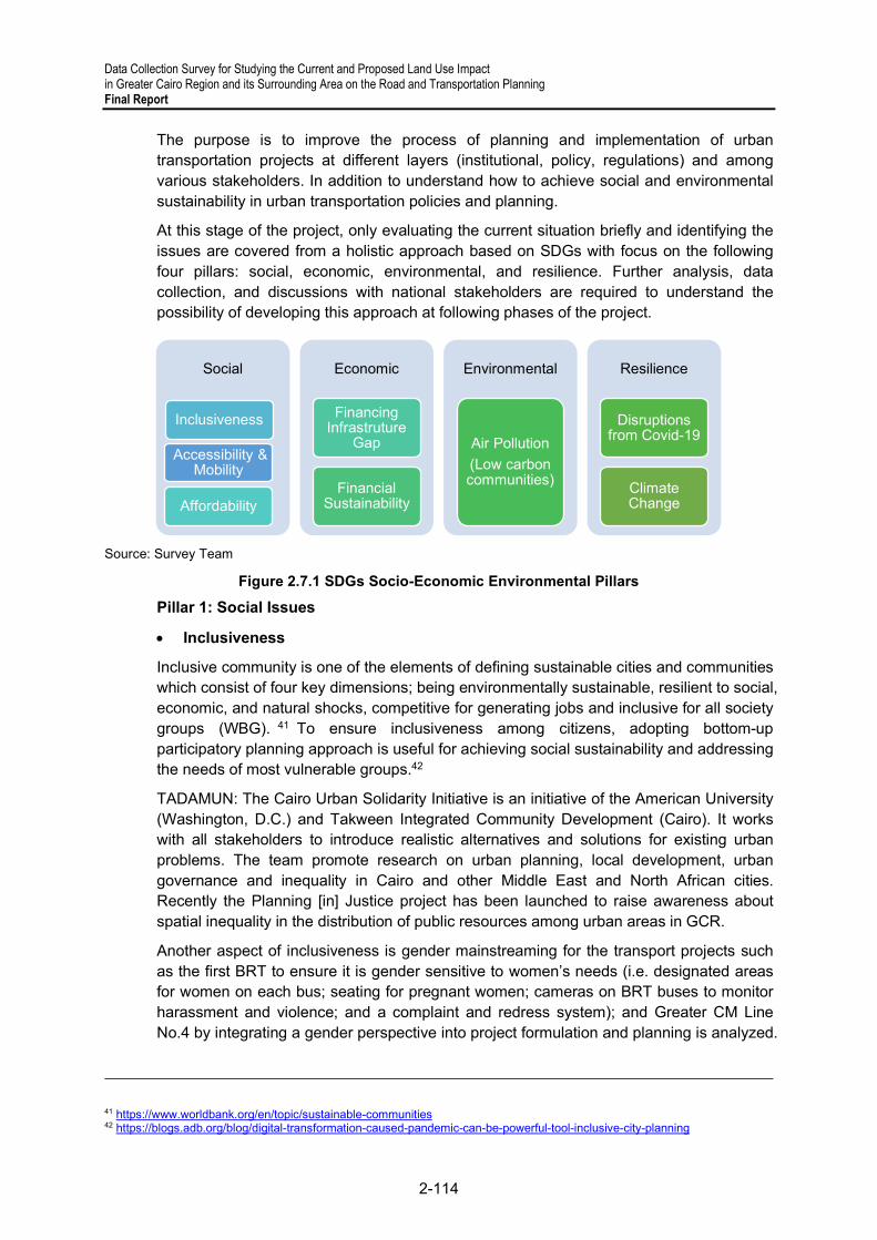
Data Collection Survey for Studying the Current and Proposed Land Use Impact in Greater Cairo Region and its Surrounding Area on the Road and Transportation Planning Final Report
2-114
The purpose is to improve the process of planning and implementation of urban transportation projects at different layers (institutional, policy, regulations) and among various stakeholders. In addition to understand how to achieve social and environmental sustainability in urban transportation policies and planning.
At this stage of the project, only evaluating the current situation briefly and identifying the issues are covered from a holistic approach based on SDGs with focus on the following four pillars: social, economic, environmental, and resilience. Further analysis, data collection, and discussions with national stakeholders are required to understand the possibility of developing this approach at following phases of the project.
Source: Survey Team
Figure 2.7.1 SDGs Socio-Economic Environmental Pillars
Pillar 1: Social Issues
Inclusiveness
Inclusive community is one of the elements of defining sustainable cities and communities which consist of four key dimensions; being environmentally sustainable, resilient to social, economic, and natural shocks, competitive for generating jobs and inclusive for all society groups (WBG). 41 To ensure inclusiveness among citizens, adopting bottom-up participatory planning approach is useful for achieving social sustainability and addressing the needs of most vulnerable groups.42
TADAMUN: The Cairo Urban Solidarity Initiative is an initiative of the American University (Washington, D.C.) and Takween Integrated Community Development (Cairo). It works with all stakeholders to introduce realistic alternatives and solutions for existing urban problems. The team promote research on urban planning, local development, urban governance and inequality in Cairo and other Middle East and North African cities. Recently the Planning [in] Justice project has been launched to raise awareness about spatial inequality in the distribution of public resources among urban areas in GCR.
Another aspect of inclusiveness is gender mainstreaming for the transport projects such as the first BRT to ensure it is gender sensitive to women’s needs (i.e. designated areas for women on each bus; seating for pregnant women; cameras on BRT buses to monitor harassment and violence; and a complaint and redress system); and Greater CM Line No.4 by integrating a gender perspective into project formulation and planning is analyzed.
41 https://www.worldbank.org/en/topic/sustainable-communities 42 https://blogs.adb.org/blog/digital-transformation-caused-pandemic-can-be-powerful-tool-inclusive-city-planning
Social
Accessibility & Mobility
Inclusiveness
Affordability
Economic
Financing Infrastruture
Gap
Financial Sustainability
Environmental
Air Pollution
(Low carbon communities)
Resilience
Disruptions from Covid-19
Climate Change

Data Collection Survey for Studying the Current and Proposed Land Use Impact in Greater Cairo Region and its Surrounding Area on the Road and Transportation Planning
Final Report
2-115
The study team targets the involvement of different stakeholders during the next phase and identify the progress of achieving inclusiveness for the communities of GCR and surrounding areas.
Accessibility and Mobility
Understanding accessibility and mobility patterns by income groups has not been inclusively studied in GCR. For instance, analyzing the needs of informal settlements communities who still remain at the inner city or being relocated to periphery areas especially the accessibility to public transportation, the usage of public or informal transport or the need for improving walkable environment. Recently the government decided the ban of microbuses on the Ring Road in GCR with the starting of BRT operations. Identifying the impact on accessibility and mobility for microbuses users is necessary.
For example, researchers in Brazil worked on identifying accessibility needs and mobility behaviors for residents in low-income communities in the City of Recife using cognitive mapping exercise. This type of approach can clarify which area the residents use transportation (whether formal or informal) or depend more on walking and cycling. The study concluded people living in the two case study communities did not travel very much outside of their own local neighborhoods and mostly go on foot. Therefore, they don`t need more public transport projects but rather micro-level interventions to reduce the cost of fares, and improving the conditions of their walking environments. This participatory approach by the residents showed better understanding of people`s needs is more important that planning for more transportation projects.43
Affordability
Affordability of public transportation by different means versus other private or informal service providers or by distance is unavailable. The CM used to adopt the flat rate of only EGP 1 for each journey, regardless of distance then it was doubled in 2017. Due to profitability issues, in May 2018 the ticket price changed to be EGP 3 for 9 stops, EGP 5 for 16 stops and EGP 7 for more than 16 stops. Understanding the impact of ticket price changes, especially for low-income groups, and the possible modal shift to other means of transport has not been covered by research yet.
CAPMAS Household income and expenditure survey estimated the percentage of annual expenditure on transportation nationwide at 6.7%, making it the fourth largest expenditure category for households after food, housing, and health services. CAPMAS divides the households by income into 10 expenditure categories by using the average share of an individual from the annual expenditure/consumption for the family. Accordingly, the lowest income category (1st) average consumption in 2019/2020 reached EGP 37,000, 6th as middle class reached EGP 57,300 and highest income category (10th) reached 103,000 EGP.
The average share of an individual from the annual household expenditure for transportation is as follows:
- 4.3% for 1st (lowest income group) - 5.5% for 6th (one of the categories for middle class) - 8.9% for 10th (highest income group)
43 Maria et al, 2016, Access to the Brazilian City—From the perspectives of low-income residents in Recife Journal of Transport Geography 55 (2016) 132–141
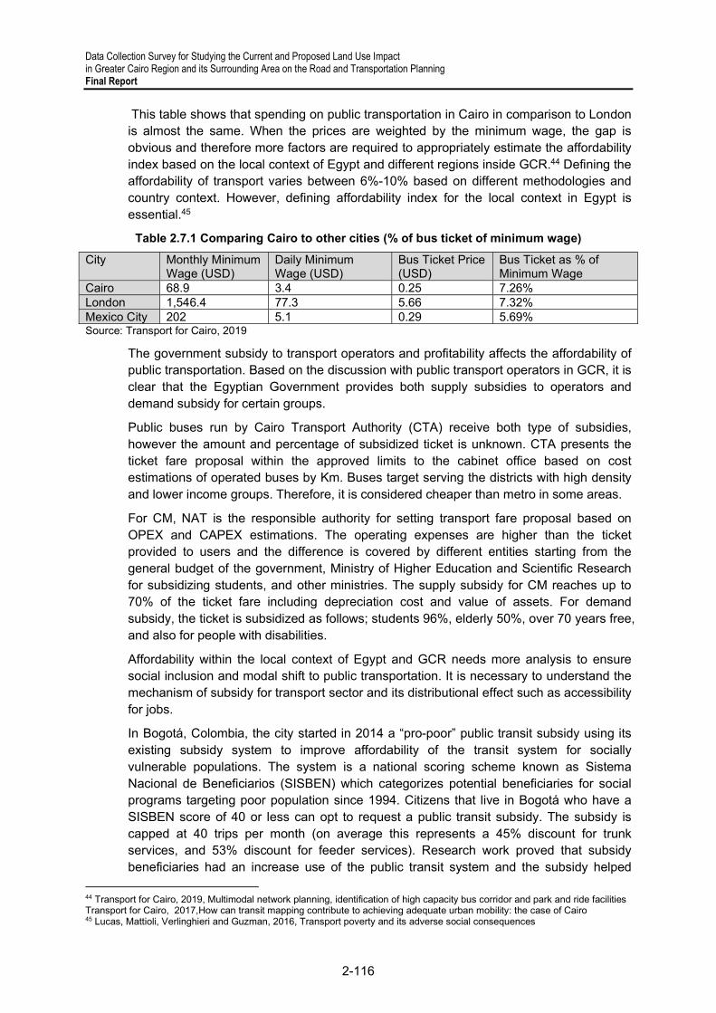
Data Collection Survey for Studying the Current and Proposed Land Use Impact in Greater Cairo Region and its Surrounding Area on the Road and Transportation Planning Final Report
2-116
This table shows that spending on public transportation in Cairo in comparison to London is almost the same. When the prices are weighted by the minimum wage, the gap is obvious and therefore more factors are required to appropriately estimate the affordability index based on the local context of Egypt and different regions inside GCR.44 Defining the affordability of transport varies between 6%-10% based on different methodologies and country context. However, defining affordability index for the local context in Egypt is essential.45
Table 2.7.1 Comparing Cairo to other cities (% of bus ticket of minimum wage)
City Monthly Minimum Wage (USD)
Daily Minimum Wage (USD)
Bus Ticket Price (USD)
Bus Ticket as % of Minimum Wage
Cairo 68.9 3.4 0.25 7.26% London 1,546.4 77.3 5.66 7.32% Mexico City 202 5.1 0.29 5.69% Source: Transport for Cairo, 2019
The government subsidy to transport operators and profitability affects the affordability of public transportation. Based on the discussion with public transport operators in GCR, it is clear that the Egyptian Government provides both supply subsidies to operators and demand subsidy for certain groups.
Public buses run by Cairo Transport Authority (CTA) receive both type of subsidies, however the amount and percentage of subsidized ticket is unknown. CTA presents the ticket fare proposal within the approved limits to the cabinet office based on cost estimations of operated buses by Km. Buses target serving the districts with high density and lower income groups. Therefore, it is considered cheaper than metro in some areas.
For CM, NAT is the responsible authority for setting transport fare proposal based on OPEX and CAPEX estimations. The operating expenses are higher than the ticket provided to users and the difference is covered by different entities starting from the general budget of the government, Ministry of Higher Education and Scientific Research for subsidizing students, and other ministries. The supply subsidy for CM reaches up to 70% of the ticket fare including depreciation cost and value of assets. For demand subsidy, the ticket is subsidized as follows; students 96%, elderly 50%, over 70 years free, and also for people with disabilities.
Affordability within the local context of Egypt and GCR needs more analysis to ensure social inclusion and modal shift to public transportation. It is necessary to understand the mechanism of subsidy for transport sector and its distributional effect such as accessibility for jobs.
In Bogotá, Colombia, the city started in 2014 a “pro-poor” public transit subsidy using its existing subsidy system to improve affordability of the transit system for socially vulnerable populations. The system is a national scoring scheme known as Sistema Nacional de Beneficiarios (SISBEN) which categorizes potential beneficiaries for social programs targeting poor population since 1994. Citizens that live in Bogotá who have a SISBEN score of 40 or less can opt to request a public transit subsidy. The subsidy is capped at 40 trips per month (on average this represents a 45% discount for trunk services, and 53% discount for feeder services). Research work proved that subsidy beneficiaries had an increase use of the public transit system and the subsidy helped
44 Transport for Cairo, 2019, Multimodal network planning, identification of high capacity bus corridor and park and ride facilities Transport for Cairo, 2017,How can transit mapping contribute to achieving adequate urban mobility: the case of Cairo 45 Lucas, Mattioli, Verlinghieri and Guzman, 2016, Transport poverty and its adverse social consequences

Data Collection Survey for Studying the Current and Proposed Land Use Impact in Greater Cairo Region and its Surrounding Area on the Road and Transportation Planning
Final Report
2-117
overcome the lower frequency of daily-motorized travel among the poor by allowing informal workers to have better mobility and accessibility to economic opportunities, and thus higher earnings.46
Pillar 2: Economic aspect
Financing Infrastructure Gap
The required infrastructure investments in Egypt stands at USD675 billion over the next 20 years. Based on WBG estimates, public financing can provide up to USD445 billion over the next 20 years, leaving a financing gap of USD230 billion. There is a shortage of funding because the formal transportation operators, as government entities are completely reliant on ministries for capital funding which is limited. Operators also focus on revenue for covering operation cost rather than strategic planning for how to finance urban public transportation services. Private sector finance in urban transport sector faces challenges such as institutional complexity and scattered roles of planning, operation and maintenance among different stakeholders. 47 The private sector participation in urban transport sector is currently exclusive for bus services in GCR such as Mwasalat Misr which started in 2017 (Joint Egyptian and Emirati company). PPP is possible for urban rail projects under construction such as monorail and LRT but not for CM. More support from the government is needed for increasing private sector participation in urban transportation field.
The government is diversifying its sources of finance as Egypt sold this year USD 750 million in five-year Green bonds as the first country in the Middle East and North Africa region. Proceeds from the debt sale will be used to finance or refinance green projects in sectors such as transportation, renewable energy and energy efficiency.48 Egypt also raised USD 3.8 billion in its first international bond sale in 2021 which was more than four times oversubscribed, with total bids of USD 16.5 billion for 40 investors.This will help the government financing its needs of the fiscal year.49
Other potential financing instruments such as TOD need to be evaluated which can play a role in supporting transport investments. 50 Currently, CM commercial activities (such as kiosks inside the station) and advertisement represents only up to 5% of the revenues.
Financial Sustainability
Profitability of public transit operators has been a real struggle. According to the WBG report in 2016, bus and rail fares covered less than 15 % of operating costs. Both the CTA and Metro are heavily dependent on the government funding. CTA transports about 4.6 million passengers per day at fares of less than 2 EGP (about USD 0.12). With operating costs of about USD 0.5 per trip, this results in the annual CTA deficit being about USD 400 million. Metro transports about 3 million passengers per day with an operating deficit of about USD 0.6 per passenger, which results in the annual Metro deficit being about
46 OECD, 2016, Balancing financial sustainability and affordability in public transport: The case of Bogota, Colombia Guzmán, Luis A. et al, 2016 Accessibility, affordability and poverty: Assessing public transport subsidies in Bogota 47 WBG , 2018, Enabling Private Investment and Commercial Financing in Infrastructure The expenses side for the budget in FY19/20, allocations for transport sector reached 26.2 billion EGP, out of which 19.6 billion EGP were allocated for investments and 1.8 billion EGP for subsidy and grants (MOF). 49 Feb 2021: https://www.bloomberg.com/news/articles/2021-02-08/egypt-returns-to-bond-market-with-three-part-dollar-offering 50 Arturo Ardila-Gomez and Adriana Ortegon-Sanchez, 2016 From Sidewalk to Subway: Achieving Sustainable Financing for Urban Transport, WBG.

Data Collection Survey for Studying the Current and Proposed Land Use Impact in Greater Cairo Region and its Surrounding Area on the Road and Transportation Planning Final Report
2-118
USD 500 million. Together, CTA and Metro incur annual financial losses approaching USD 1billion. The situation for private sector is unclear however it is financially viable despite lower quality and safety standards. In view of these institutional issues, combined
In 2017, the state-run Egyptian Company for Metro Management and Operation struggled to pay huge water and electricity bills worth about 300 million Egyptian pounds (USD 16.6 million) in addition to maintenance services. In 2020, RATIP French company is responsible for operating Line 3 for 15 years, while the government will decide about the fare system. The company will also operate a shopping mall (2nd commercial project at metro lines). In Sep 2020: RATIP French side will operate the 3rd line (currently phase 1, 2 and 4) to reduce the metro losses and provide better services for passengers. It will be for 15 years starting from 2021 with 1.138 billion Euro including the maintenance required for the trains. The Egyptian company will only be operating the 1st and 2nd line. The purpose is to equalize the revenues and expenses as a first stage then generate adequate revenues to be used for infrastructure cost to reduce the burden on the government budget. Due to unprofitability issues, the Metro company has not been able to purchase new trains to improve the first line and increase its capacity. 51
The operation of the Metro is financed by fare box revenues in addition to annual subsidy covered by the national budget in order to keep fares stable. The CTA is financed by fare revenues in addition to subsidies from the national budget to keep fares stable. Another financial source is the revenue collected from private companies through concessions from CTA to operate private mass transport buses and minibuses in Cairo Governorate.52 More data such as revenue reports are required for conducting proper analysis and propose recommendations based on other countries experiences. The survey team did not manage to obtain such information.
Pillar 3: Environmental
Air Pollution Impact
The transportation sector accounts for about 26% of the PM10 load in GCR, as well as 90% of carbon monoxide (CO) and 50% of nitrogen oxides (NOx). The impact of air pollution in Egypt costs 5% of annual GDP, around USD2.42 billion annually. During FY 2012–2013, transportation sector total energy consumption accounted for nearly 16.6 million tons oil equivalent (mtoe), representing 48% of total petroleum energy consumption. The total passengers’ activity was estimated at 1,021 million passenger-km, of which road transportation accounted for 93% compared to 7% for railways and almost 0% for river transportation. Lack of urban planning that considers the principles of sustainability over the past years and decades, led to the overlap of various activities and their impact on the quality of the environment, especially air. The WBG report indicates that energy subsidy reforms (fuel price increases) and metro line openings have had significant impacts on traffic volume in Cairo.53
A recent study by the WBG in 2019 referred to the annual average ambient PM2.5 in GCR which is higher than WHO air quality guidelines. Annual PM2.5 in GCR from 1999 to
51 https://almalnews.com/لمدة-15-عاًما- وبقيمة-1-138-مليار-يورو-تفاصيل/ https://almalnews.com/النقل-تسند-إدارة -مول-مترو-أنفاق-هليو/ https://m.akhbarelyom.com/news/newdetails/2934372/1/ خاص--رئيس-القومية-لألنفاق--عندنا- مشاكل-بالخط-األول-للمترو- ..-وهذه-حقيقة-رفع- سعر-التذكرة 52 Transport for Cairo, 2019, Multimodal network planning, identification of high capacity bus corridor and park and ride facilities 53 Egypt’s first Biennial update report to the UNFCC, 2018 SDGs report, Ministry of Environment WBG, 2019, Motor vehicle density and air pollution in greater Cairo

Data Collection Survey for Studying the Current and Proposed Land Use Impact in Greater Cairo Region and its Surrounding Area on the Road and Transportation Planning
Final Report
2-119
2016 with average concentrations of 84 μg/m3 with the lowest concentration of 66 μg/m3 in 2016. The estimated health effects stand at 12% of all deaths in GCR in 2017 from PM2.5 are 12%. The main sources of ambient PM2.5 at six sites in GCR between 1999 and 2002 is from motor vehicles by 20%.54
SDGs and Egypt’s Vision 2030: The Egyptian government set its strategic goals for environment until 2030 (according to Vision 2030) for reducing pollution and achieving an integrated waste management (with environmental performance indicators). To reduce emissions, the government has adopted several policies such as: Expanding the use of renewable energy to 20% of total energy demand by 2022., Shifting to natural gas in electricity generation, Promoting energy efficiency initiatives in all energy producing and consuming activities, and Expansion of environmentally friendly mass transport networks. 55
EEAA Efforts: EEAA has been involved in several projects related to reducing emissions from vehicles and transport sector. The agency launches the pilot projects then transfer them to designated stakeholders for implementation. To improve the quality of air, EEAA is currently involved in several projects as follows:
- Monitoring air quality: establishing monitoring stations nationwide which reached 108 in 2020 (increasing from 93 stations in 2017 when 10 stations were dedicated for monitoring emissions from traffic)
- National network for monitoring industrial emissions - Early warning system and quality forecast for air pollution for 3 days in advance https://www.eeaa.gov.eg/en-us/topics/air/airquality/airqualityforecast.aspx - A pipeline project for enhancing the air quality and addressing climate change in GCR
(got approval from the government and WBG) - Ongoing project for Air pollution management by support from the WBG - Tree plantation project - Vehicle exhaust/emissions check in collaboration with MOI, traffic control to examine
public transportation and other vehicles.
EEAA was also involved in the sustainable transport project for modal shift and also aimed at prompting the Non-motorized Transport (NMT). For example, in Fayoum City, bike share system has been launched. It also supported transforming taxis into using natural gas by supporting purchasing the taxi. 56
E-Mobility potential:
Electric Vehicles (EV) are an emerging national priority due to excess electricity supply, and Egypt’s high renewable energy potential. Private sector companies are building an EV-Charging Station (EVCS) network nationwide, while public sector industrial organizations are discussing the possibility of locally producing EV’s. A national strategy was recently commissioned but is still unpublished. Egypt is internationally committed to progress towards the Sustainable Development Goals (SDG) and is a signatory to the COP 21 Paris Agreement.
54 WBG, 2019, The cost of Environmental Degradation: Air and Water pollution 55 Egypt’s first Biennial update report to the UNFCC, 2018 State of the Environment 2017, Arab Republic of Egypt, Summary for Policymakers 56 Ministry of Environment achievements report in 2020 and based on meeting with EEAA.

Data Collection Survey for Studying the Current and Proposed Land Use Impact in Greater Cairo Region and its Surrounding Area on the Road and Transportation Planning Final Report
2-120
Passenger Transport: Increase modal share of the railways; increase the modal share of buses and paratransit, in addition to increasing the modal share of river travel.
Freight Transport: Switch from road to rail and river transport. Roads: Improve road transport efficiency through reducing traffic congestion.57
Recent research work about the potential of e-mobility in Egypt is the ongoing study by WBG Egypt office, policy paper: Low-Emission Zones (LEZs) and prerequisites for sustainable cities and clean air in Egypt; and a Policy Brief about mainstreaming electric mobility in Egypt by Freidrich Ebert Stiftung. In February 2020, Mwasalat Misr started its operation of the X-Bus electric in Cairo, from Abdel Moneim Riad square to New Cairo.58 The bus is part of pilot projects by Mwasalat Misr to examine the possibility of using imported e-buses in GCR considering the different conditions such as road condition and extreme heat. The purpose is to reach the right specifications for operating an e-bus in Egypt. For instance, the operators realized the importance of developing a cooling system. Meanwhile, CTA is receiving support from WBG Egypt for purchasing 100 e-buses as pilot project in GCR. In addition, CTA has its own plan for transferring its buses run by deiseal to natural gas.
According to EEAA, e-mobility still needs more support from the government to establish charging stations, fund R&D, and support to the operator to be able to transfer into using e-buses. For example, e-buses are expensive as tariffs imposed could reach up to 200% and this is controlled by Ministry of Finance (MOF) which represents a challenge for transport operators.
Pillar 4: Resilience Issues
COVID-19
Egyptian government followed the same preventive measures in April 2020 as services were suspended from 08:00 pm–06:00 am. Due to the lack of information, estimations of financial distress for the public transportation, private operators and informal sector is unclear. Mobility restriction for mobile workers from rural Lower Egypt area to GCR has affected the economic survival of their families. Statistics are not available to show the negative impact on informal workers from outside GCR area. According to the MOF report (Dec. 2020), about 2.3 million Egyptians lost their jobs since the outbreak in 2020. Unemployment rate increased to 9.6% in Q2 2020 from 7.7% in Q1 2020. More data is required to further discuss about financial sustainability for public transportation during disruptions and promoting NMT, such as cycling, and improving walking environment, especially in low-income neighborhoods, which contribute in reducing air pollution. 59
No further data or reports were found to investigate further the transport services disruptions impact on transport operators and users. According to CTA, the ridership dropped by 70% within 2020-2021 due to COVID-19 and currently it is estimated to be around 30% less than before. However, there are no indicators or studies done to estimate pre and post COVID-19 for analyzing the travel behavior.
57 Ali Attari et al, Friedrich Ebert Stiftung, The Mobility Transition in the MENA Region: Comparative Policy Perspectives 58 https://dailynewsegypt.com/2020/02/05/mwasalat-misr-operates-first-electric-bus-in-cairo/ https://www.egypttoday.com/Article/1/81306/Mwasalat-Misr-announces-launching-X-Bus 59 https://thedocs.worldbank.org/en/doc/375701590520360473-0190022020/original/COVID19andTransportAMobilityCrisis.pdf https://theforum.erf.org.eg/2020/05/20/daily-commuters-egypt-covid-19-pandemic/ Shorter hours, cleaner air? Egypt may extend its COVID-19 evening curfew | Reuters https://theforum.erf.org.eg/2020/05/20/daily-commuters-egypt-covid-19-pandemic/

Data Collection Survey for Studying the Current and Proposed Land Use Impact in Greater Cairo Region and its Surrounding Area on the Road and Transportation Planning
Final Report
2-121
Climate Change
The GFDRR (Global Facility for Disaster Reduction and Recovery) classified Egypt`s vulnerability with high risks to the following natural disasters: river, urban, and coastal floods; water scarcity; and extreme heat. Red spots indicate that urban flood hazard is classified as high based on modeled flood information, which is affecting GCR. This means that potentially damaging urban floods are expected to occur at least once in the next 10 years, and extreme heat is expected to occur at least once in the next five years. Such kind of risks need to be considered along the infrastructure project cycle to ensure
its resilience against climate change and natural hazards.60
More information is required about hazard mapping for transportation network in Egypt, urban resilience situation (financing, government capacity), and investing in climate-resilient infrastructure to understand more about the preparations by the Egyptian government.
Figure 2.7.2 Urban Flood Mapping in Egypt (GFDRR)
Ensuring that existing infrastructure is climate resilient needs more attention as it will help reduce the direct and indirect losses of disruption. Climate-resilient infrastructure can improve the reliability of service provision, increase asset life and protect asset returns. For example, OECD modelling of the potential impacts of a major flood in Paris found that 30% to 55% of the direct flood damages would be suffered by the infrastructure sector, while 35% to 85% of business losses were caused by disruption to the transportation and electricity supply and not by the flood itself. In order to achieve, governments need to mainstream climate risks adaptation and encourage investments in resilient infrastructure through encouraging public and private investments.61
Based on a discussion with CM operator, CM follows the international standards of resilience against natural disasters as earthquakes and floods to drain excess water. CM has a plan to upgrade the capacity of air treatment to increase the resilience to extreme heat levels which can affect the metro operations (heat can exceed 45 degrees instead of 35 degrees or less).
Egypt has institutional and policy framework for climate change adaptation such as National Strategy for Adaptation to Climate Change and Disaster Risk Reduction 2011 and Sustainable Development Strategy (SDS) — Egypt's Vision 2030’. SDS aims to
60 https://thinkhazard.org/en/report/40765-arab-republic-of-egypt/EH 61 OECD, 2018, Climate-resilient Infrastructure
Data Collection Survey for Studying the Current and Proposed Land Use Impact in Greater Cairo Region and its Surrounding Area on the Road and Transportation Planning Final Report
2-122
implement a financial reform to increase the general budget and improve the integration of adaptation into national budgeting and planning processes. A National Council of Climate Change (NCCC) was established in 2015 which is leading the NAP process in Egypt 62 and the country is working on building its national capacities.63
3) Other Perspectives: Clean Mobility in Egypt
(a) The Electric Vehicle
Egypt signed a memorandum of understanding with China’s Dongfeng Motor Co. early 2021 to manufacture the “E70” electric car in cooperation with Al Nasr Automotive Manufacturing Company, but the MoU expired and wasn’t renewed because no agreement could be reached to sufficiently reduce prices of imported parts needed to manufacture the car and also about the practical arrangements for Al Nasr Automotive Manufacturing Company to manufacture cars and offer a competitive and attractive price for consumers. The negotiations had advanced well and in August 2021, Al Nasr imported 13 EV of Dongfeng to be tested by Uber drivers before Al Nasr would begin its manufacturing early 2022.
On December 19, 2021, Bloomberg announced that Egyptian authorities instructed state-owned El Nasr Automotive Manufacturing Co. to build affordable vehicles in partnership with a Chinese firm while taking advantage of its renewable energy boom to power them. According to the company, there are discussions ongoing with three potential companies in China to partner with El Nasr Automotive Manufacturing Co. on the project that will benefit from a 2 billion pounds (USD 127 million) investment. Production is now set to begin in 2023, with output increasing to an annual 20,000 EV units for the first three years.
Egypt’s electric car, to be named either E70 or A70, is scheduled to sell for around USD 20,000, with half of buyers probably taxi or Uber drivers. That’s roughly the same price as Europe’s cheapest EV, Renault’s made-in-China Dacia Spring.
The private sector will also be offered a 40% role in a new company established to operate pay-to-use charging stations, with 10% being taken by El Nasr Automotive Manufacturing Company and 50% by a “state entity,” the name not yet made public. The first wave of 3,000 charging points will be around the cities of Cairo and Alexandria before being introduced elsewhere. The automotive industry will therewith complement the range of clean energy initiatives under development, especially the wind and solar power projects to prepare the country for a greener future.
There are already several other concrete initiatives that opened the path towards EV deployment. End of 2021, an agreement was signed with the Egyptian Brightskies Company, specialized in developing operating and control systems for electric cars, to produce the first Egyptian battery for cars.
And that same company Brightskies signed on 4 February 2021 a deal with Egyptian carmakers ‘The Engineering Automotive Manufacturing Company’ (EAMCO) and ‘El Nasr Automotive Manufacturing Company’ (NASCO) to cooperate in the electric car industry. The first protocol with EAMCO aims at the development of an electric bus prototype, while the second protocol, signed with NASCO, is to establish an R&D center for power battery
62 https://www.eeaa.gov.eg/ar-eg/موضوعاتبيئية/الهواء/التغيراتالمناخية/المجلسالوطنيللتغيراتالمناخية.aspx 63 UNDP, March 2018, National Adaptation Plans in focus: Lessons from Egypt

Data Collection Survey for Studying the Current and Proposed Land Use Impact in Greater Cairo Region and its Surrounding Area on the Road and Transportation Planning
Final Report
2-123
packs, electric powertrain systems and other automotive subsystems, expected to pave the way for the establishment of the first Egyptian R&D center for the electric car industry.
Awaiting the kick start of EV deployment in Egypt, Cabinet already formally approved EV charging tariffs. The tariffs have been set at 1.69 EGP/kWh for public charging stations and 1.89 EGP/kWh for charging stations within privately-owned establishments, says Abdel Ghaffar. The fast-charging tariff is set at 3.75 EGP/kWh for public and private establishments
The Egyptian energy company Infinity is waiting the official announce of the price grid to launch its customer payment platform for EV charging. These tariffs are due to be revised annually, allowing stakeholders to assess their gains and whether they make sense financially for operators like Infinity.
Infinity partnered with EVBox, Europe’s leader in the production of EV charging stations to manufacture and provide with exclusive rights charging stations for building a national charging network. At present more than 240 charging points have already been installed in Egypt and the company recently launched its charging mobile application to allow users to find the closest charging station from their location. As shows following figure, the charging stations are concentrated in the GCR, but are also deployed in some other key urban centers.
Source: https://infinityevcharge.com/ChargingStations
Figure 2.7.3 EV stations in Egypt
(b) Other Green Vehicle Initiatives
Egypt will also look at making hydrogen-powered EVs in the longer term and via it’s Clean Fuels Initiative will use locally produced Compressed natural gas (CNG) to fuel natural gas vehicles (NGVs).
The initiative started in 1992 with two pilot projects to ensure that Egypt's natural gas performed well as a vehicle fuel; and to demonstrate that the planned CNG fuelling station technology and deployment would reliably support this new transportation fuel segment.

Data Collection Survey for Studying the Current and Proposed Land Use Impact in Greater Cairo Region and its Surrounding Area on the Road and Transportation Planning Final Report
2-124
When the pilot projects confirmed the potential, the commercialisation of natural gas vehicles (NGVs) started with a decree from the Petroleum Ministry that required all approved CNG companies to construct and operate CNG fuelling stations, and to construct and operate vehicle conversion centres, creating a “closed circle” where vehicle conversion produced CNG fuelling station customer.
In December 1994 the first company to convert gasoline vehicles to natural gas was formed and by the end of 2005 there were six CNG companies, 93 CNG fuelling stations were set up by Government and private CNG marketing companies and 26 vehicle conversion centres were opened in the Greater Cairo area, along the Suez Canal, and north to Port Said and Alexandria. In 2005, some 63,000 CNG vehicles were operational of which 75% taxis operating mainly in Cairo.
The initiative was complemented by the USAID-sponsored Cairo Air Improvement Program to improve Cairo's air quality through reducing harmful emissions from lead smelters and vehicle exhausts. Under the program, 50 dedicated CNG public-transit buses to the CTA and GCBC. Key challenges for the government have been to fund the conversion of some 3,500 public buses operating in Cairo and a sustainability plan for after the CNG Bus Pilot Fleet was prepared.
After a rather successful start, the objective of switch Cairo's entire public transport and the Greater Cairo's 120,000 taxis to gas failed and the expansion of the NGV fleet slowed down and in 2020-21, there are (only) 360,000 CNG-powered vehicles operational in Egypt;
There are clear indications that the tide could change with the Egyptian government pledging under presidential stimulus that this number will reach 768,000 by the end of 2023, a conversion of around 400,000 vehicles in less than 2 years at an estimated cost of LE1.2 billion. The initiative would be stimulated / facilitated by an incentive program and soft loans for car owners, sponsored by the President.
The attractiveness of the conversion program will also come from the fact that replacing traditional petrol with CNG will save vehicle owners about 50% on their refuel cost. The initiative will be accompanied by an increase in the number of supply stations by 350 stations during to bring the total number of stations to 550 supply stations to service the rapidly growing number of converted cars that reached 43,000 cars during 2019-2020, the highest total annual transfer since 1995 and an increase of 30% over the previous year.
(c) Additional Clean Mobility Initiatives
There are a range of other initiatives and studies that are associated with the pursuance of cleaner cities and sustainable mobility in general with the objective of improving the quality of life of all citizens in Egypt:
1. Low Emission Zones (LEZ), promoted by Ahmed El-Dorghamy, Maha Attia, MSc. (2021) “POLICY PAPER: Low-Emission Zones (LEZs) and Prerequisites for Sustainable Cities and Clean Air in Egypt”; Centre for Environment and Development for the Arab Region and Europe (CEDARE)
2. Sustainable Urban Mobility Plan (SUMP) under development for 6th of October City as promoted by German Friedrich-Ebert-Stiftung (Egypt Office)
3. Alexandria traffic free urban centre initiatives (bicycle days, marathon, …) indicate that the necessary infrastructure, policy, and regulatory frameworks for non-motorized

Data Collection Survey for Studying the Current and Proposed Land Use Impact in Greater Cairo Region and its Surrounding Area on the Road and Transportation Planning
Final Report
2-125
transport have not been yet developed but there is an urgent need to leverage these existing opportunities.
4. Alternative mobility solutions: among others such as Carpoolworld or ride-sharing company Swvl that offer bus-hailing services, inter-city rides, and car ride-sharing services in GCR.
The Sustainable Urban Mobility Plan (SUMP) is one of the most efficient methods to work towards clean cities and zero-emission mobility. The SUMP is a strategic plan that is designed to satisfy the mobility needs of people and businesses in cities and their surroundings while at the same time providing for a better quality of life by taking due consideration of integration, participation and evaluation principles.
SUMP will:
• Ensure all residents are offered transport options that enable access to key destinations and services; • Improve safety and security; • Reduce air and noise pollution, greenhouse gas emissions and energy consumption; • Improve the efficiency and cost-effectiveness of the transportation of persons and goods; • Contribute to enhancing the attractiveness and quality of the urban environment for the benefits of residents, the economy and society as a whole. The SUMP process will achieve these benefits through: • Defining mobility policies in the context of a clear vision • Identifying measurable targets to address long-term challenges of urban mobility • Ensuring the involvement of stakeholders at appropriate stages • Achieving collaboration between relevant policy areas and authorities
SUMPs address all modes of urban transport, including alternative (electric, clean fuel vehicles) and micro-mobility solutions, and integrates various “parallel” measures such as traffic calming, traffic and parking restrictions etc.
The benefits of using SUMP for cities and its citizens are multiple:
• Improving quality of life; • Saving costs – creating economic benefits; • Contributing to better health and environment; • Making mobility seamless and improving city access; • Making more effective use of limited resources; • Moving towards a new mobility culture.
Considering the pollution problem and its solutions are centered around the cities of Egypt, Sustainable Urban Mobility Plans can be the guiding framework for cities to introduce the Government’s mobility priorities and consolidate them into a structured process whereby visions are streamlined, objectives and targets are set, and uniform measures are implemented, adapted to the city specifics.
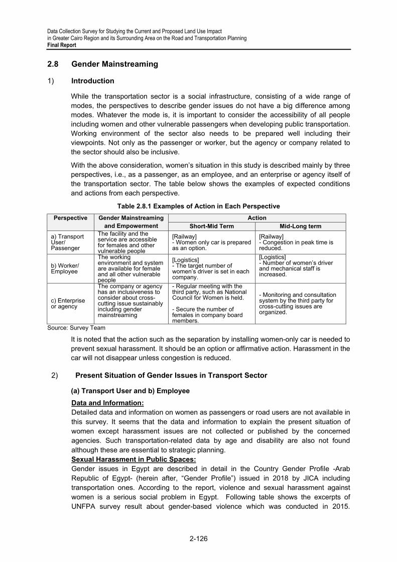
Data Collection Survey for Studying the Current and Proposed Land Use Impact in Greater Cairo Region and its Surrounding Area on the Road and Transportation Planning Final Report
2-126
2.8 Gender Mainstreaming
1) Introduction
While the transportation sector is a social infrastructure, consisting of a wide range of modes, the perspectives to describe gender issues do not have a big difference among modes. Whatever the mode is, it is important to consider the accessibility of all people including women and other vulnerable passengers when developing public transportation. Working environment of the sector also needs to be prepared well including their viewpoints. Not only as the passenger or worker, but the agency or company related to the sector should also be inclusive.
With the above consideration, women’s situation in this study is described mainly by three perspectives, i.e., as a passenger, as an employee, and an enterprise or agency itself of the transportation sector. The table below shows the examples of expected conditions and actions from each perspective.
Table 2.8.1 Examples of Action in Each Perspective
Perspective Gender Mainstreaming and Empowerment
Action Short-Mid Term Mid-Long term
a) Transport User/ Passenger
The facility and the service are accessible for females and other vulnerable people
[Railway] - Women only car is prepared as an option.
[Railway] - Congestion in peak time is reduced.
b) Worker/ Employee
The working environment and system are available for female and all other vulnerable people
[Logistics] - The target number of women’s driver is set in each company.
[Logistics] - Number of women’s driver and mechanical staff is increased.
c) Enterprise or agency
The company or agency has an inclusiveness to consider about cross-cutting issue sustainably including gender mainstreaming
- Regular meeting with the third party, such as National Council for Women is held. - Secure the number of females in company board members.
- Monitoring and consultation system by the third party for cross-cutting issues are organized.
Source: Survey Team
It is noted that the action such as the separation by installing women-only car is needed to prevent sexual harassment. It should be an option or affirmative action. Harassment in the car will not disappear unless congestion is reduced.
2) Present Situation of Gender Issues in Transport Sector
(a) Transport User and b) Employee
Data and Information: Detailed data and information on women as passengers or road users are not available in this survey. It seems that the data and information to explain the present situation of women except harassment issues are not collected or published by the concerned agencies. Such transportation-related data by age and disability are also not found although these are essential to strategic planning. Sexual Harassment in Public Spaces: Gender issues in Egypt are described in detail in the Country Gender Profile -Arab Republic of Egypt- (herein after, “Gender Profile”) issued in 2018 by JICA including transportation ones. According to the report, violence and sexual harassment against women is a serious social problem in Egypt. Following table shows the excerpts of UNFPA survey result about gender-based violence which was conducted in 2015.
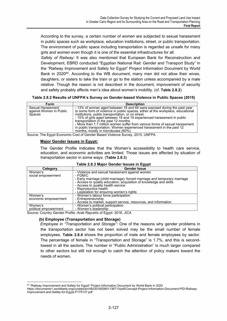
Data Collection Survey for Studying the Current and Proposed Land Use Impact in Greater Cairo Region and its Surrounding Area on the Road and Transportation Planning
Final Report
2-127
According to the survey, a certain number of women are subjected to sexual harassment in public spaces such as workplace, education institutions, street, or public transportation. The environment of public space including transportation is regarded as unsafe for many girls and women even though it is one of the essential infrastructures for all. Safety of Railway: It was also mentioned that European Bank for Reconstruction and Development, EBRD conducted “Egyptian National Rail: Gender and Transport Study” in the “Railway Improvement and Safety for Egypt” Project Information Document by World Bank in 202064. According to the WB document, many men did not allow their wives, daughters, or sisters to take the train or go to the station unless accompanied by a male relative. Though the reason is not described in the document, improvement of security and safety probably affects men’s idea about women’s mobility. (cf. Table 2.8.2)
Table 2.8.2 Results of UNFPA’s Survey on Gender-based Violence in Public Spaces (2015)
Form Description Sexual Harassment against Women in Public Spaces
- 13% of women aged between 18 and 64 were exposed during the past year to some form of violence in public spaces, either at the workplace, educational institutions, public transportation, or on street. - 15% of girls aged between 18 and 19 experienced harassment in public transportation in the past 12 months. - More than 1.7 million women suffer from various forms of sexual harassment in public transportation. Women experienced harassment in the past 12 months, mostly in microbuses (60%).
Source: The Egypt Economic Cost of Gender Based Violence Survey, 2015, UNFPA
Major Gender Issues in Egypt:
The Gender Profile indicates that the Women’s accessibility to health care service, education, and economic activities are limited. Those issues are affected by situation of transportation sector in some ways. (Table 2.8.3)
Table 2.8.3 Major Gender Issues in Egypt Category Gender Issue
Women’s social empowerment
- Violence and sexual harassment against women - FGM/C - Early marriage (child marriage), forced marriage and temporary marriage - Access to quality education, acquisition of knowledge and skills - Access to quality health service - Reproductive health - Legislation for ensuring women’s rights
Women’s economic empowerment
- Women’s labour force participation - Entrepreneurship - Access to market, support service, resources, and information
Women’s political empowerment
- Women’s political participation - Women’s leadership
Source: Country Gender Profile -Arab Republic of Egypt- 2018, JICA
(b) Employee (Transportation and Storage) Employee in “Transportation and Storage”: One of the reasons why gender problems in the transportation sector has not been solved may be the small number of female employees. Table 2.8.4 shows the proportion of male and female employees by sector. The percentage of female in “Transportation and Storage” is 1.7%, and this is second-lowest in all the sectors. The number in “Public Administration” is much larger compared to other sectors but still not enough to catch the attention of policy makers toward the needs of women.
64 “Railway Improvement and Safety for Egypt” Project Information Document by World Bank in 2020 https://documents1.worldbank.org/curated/en/482301600901136713/pdf/Concept-Project-Information-Document-PID-Railway-Improvement-and-Safety-for-Egypt-P175137.pdf

Data Collection Survey for Studying the Current and Proposed Land Use Impact in Greater Cairo Region and its Surrounding Area on the Road and Transportation Planning Final Report
2-128
Table 2.8.4 Number of Employees by Gender and Sector (2016)
Sector Female % of Female Male 1. Construction 16,300 0.5% 2,993,000 2. Transportation & Storage 31,300 1.7% 1,856,200 3. Mining (Crude, Natural Gas) 800 2% 40,200 4. Water Support, Drainage 1,600 5.2% 290,900 5. Real Estate 1,900 5.3% 34,200 6. Electric, Gas, etc. 1,200 5.9% 190,400 7. Restaurant & Hotel 48,100 7.2% 619,700 8. Manufacturing 289,000 10.0% 2,611,400 9. Administration & Support 20,000 10.0% 200,600 10. Specialized Science & Technology 58,200 15.4% 377,000 11. Whole & Retail Sale Vehicles, etc. 507,100 16.9% 2,496,900 12. Information & Communication 34,800 18.5% 153,500 13. Insurance & Finance 36,700 20.3% 144,500 14. Public Administration 396,900 23.0% 1,331,900 15. Agriculture, Hunting& Forestry 2,051,200 31.7% 4,426,600 16. Education 1,098,100 48.1% 1,184,700 17. Health & Social Work 452,700 58.1% 326,900 18. Home Service 213,500 64.6% 116,800 Total 5,345,000 - 19,986,100
Source: Country Gender Profile -Arab Republic of Egypt- 2018, JICA Employees in ENR:
It is also of note that only about 3% of the total Egypt National Railway employees are women, and most of them are in administration with few in technical roles, according to
the EBRD study included in WB document 65 . With consideration given to gender inequality, the WB proposes the following three projects should include gender issues as a component:
The third project indicates gender equality as follows:
(c) Enterprise or Agency Number of Female Board Members by Sector: The business sector’s characteristic of being male-centered is shown in the number of male and female members in corporate boards. The Women on Boards Observatory, founded in 2017 by the American University in Cairo School of Business, aims to increase female representation in corporate boards in Egypt. 66
The 2020 annual monitoring report contains the data on the companies listed on the Egyptian Exchange (EGX), the banking sector, Financial Regulatory Authority (FRA) companies, and public enterprises. Regarding transportation sector, four companies under “Shipping and Transportation Services” are listed as EGX and 16 under “Maritime
65 “Railway Improvement and Safety for Egypt” Project Information Document by World Bank in 202 https://documents1.worldbank.org/curated/en/482301600901136713/pdf/Concept-Project-Information-Document-PID-Railway-Improvement-and-Safety-for-Egypt-P175137.pdf 66 Annual Monitoring Report, 2020 Egypt Women on Boards Observatory https://egypt.unwomen.org/en/digital-library/publications/2020/12/wob-annual-monitoring-report-2020#view
1. Safe System Signaling Modernization 2. Safe System Asset Management Improvement 3. Project Delivery, Institutional and Human Resource Development.
Human resource development, including human resources polices and practice that provide equal employment and career advancement opportunities to men and women

Data Collection Survey for Studying the Current and Proposed Land Use Impact in Greater Cairo Region and its Surrounding Area on the Road and Transportation Planning
Final Report
2-129
and Land Transport” are listed as public enterprises. The overall numbers are shown below. (Table 2.8.5)
Table 2.8.5 Number of Female Board Members (2020)
Sector Number of Female Board Members
Number of Male Board Members
Total Number of Board Members
% of Female Board Members
EGX-listed Companies 214 1,628 1,842 11.6%
Banks 40 253 293 13.7% Public Enterprises 38 400 438 8.7% FRA Companies 454 2,631 3,085 14.7%
Source: Annual Monitoring Report 2020, Egypt Women on Boards Observatory
According to the report, an overall progress has been witnessed in 2020: Women on boards increased from 10% in 2019 to 13% in 2020.
The figure below summarizes female representation on boards from 2018 to 2020, indicating a positive trend across EGX-listed companies, public enterprises, and FRA companies.
Source: Annual Monitoring Report 2020, Egypt Women on Boards Observatory
Figure 2.8.1 Percentage of Women on Corporate Boards by Category (2018–2020)
Companies related to Port Industry and Land Transport;
On the other hand, the number of female board members on EGX-listed companies under “Shipping and Transportation Services” is low compared to other sectors, as shown in following figure and table. (Figure 2.8.2 and Table 2.8.6)

Data Collection Survey for Studying the Current and Proposed Land Use Impact in Greater Cairo Region and its Surrounding Area on the Road and Transportation Planning Final Report
2-130
Source: Annual Monitoring Report 2020, Egypt Women on Boards Observatory
Figure 2.8.2 Share of Women in Corporate Boards by Industry (2018-2020)
Table 2.8.6 Percentage of Women on Corporate Boards of EGX-listed Companies by Industry (2020)
Industry % of Female
Board Members
No. of EGX-listed
Companies
No. of Female Board
Members
Total No. Board
Members Energy & Support Services 30.0% 3 9 30 IT, Media & Communication Services 20.0% 7 13 65
Paper & Packaging 20.0% 6 6 30 Education Services 19.4% 4 7 36 Health Care & Pharmaceuticals 15.5% 20 25 161
Trade & Distributors 15.2% 6 5 33 Textile & Durables 14.8% 9 12 81 Travel & Leisure 13.0% 18 15 115 Banks 12.3% 12 14 114 Food, Beverages and Tobacco 11.7% 32 28 240
Non-bank Financial Services 11.4% 30 30 264
Building Materials 9.6% 15 11 114 Basic Resources 9.0% 18 13 144 Shipping & Transportation Services 8.8% 467 3 34
Contracting & Construction Engineering 8.0% 12 6 75
Real Estate 6.0% 34 15 249 Industrial Good, Services and Automobiles 3.8% 8 2 53
Utilities 0.0% 1 0 4 total 11.6% 239 214 1842
Source: Annual Monitoring Report 2020, Egypt Women on Boards Observatory
Regarding public enterprises women on boards in “Maritime and Land Transport Sector 2020” is 1 over 66 as illustrated in the following table. The number in 2019 was 7 with
same 16 companies68.
67 EGX website shows four companies’ name as follows: i) Alexandria Containers and Goods, ii) Canal Shipping Agencies, iii) Egyptian Transport, and iv) United Arab Shipping.
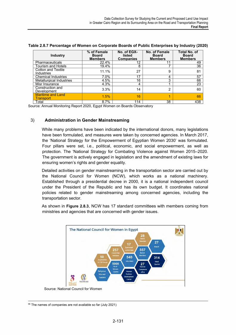
Data Collection Survey for Studying the Current and Proposed Land Use Impact in Greater Cairo Region and its Surrounding Area on the Road and Transportation Planning
Final Report
2-131
Table 2.8.7 Percentage of Women on Corporate Boards of Public Enterprises by Industry (2020)
Industry % of Female
Board Members
No. of EGX-listed
Companies
No. of Female Board
Members
Total No. of Board
Members Pharmaceuticals 22.4% 12 11 49 Tourism and Hotels 19.4% 8 7 36 Cotton and Textile Industries 11.1% 27 9 81
Chemical Industries 7.0% 17 4 57 Metallurgical Industries 4.5% 16 3 66 Misr Insurance 4.3% 4 1 23 Construction and Development 3.3% 14 2 60
Maritime and Land Transport 1.5% 16 1 66
Total 8.7% 114 38 438 Source: Annual Monitoring Report 2020, Egypt Women on Boards Observatory
3) Administration in Gender Mainstreaming
While many problems have been indicated by the international donors, many legislations have been formulated, and measures were taken by concerned agencies. In March 2017, the ‘National Strategy for the Empowerment of Egyptian Women 2030’ was formulated. Four pillars were set, i.e., political, economic, and social empowerment, as well as protection. The ‘National Strategy for Combating Violence against Women 2015–2020. The government is actively engaged in legislation and the amendment of existing laws for ensuring women’s rights and gender equality.
Detailed activities on gender mainstreaming in the transportation sector are carried out by the National Council for Women (NCW), which works as a national machinery. Established through a presidential decree in 2000, it is a national independent council under the President of the Republic and has its own budget. It coordinates national policies related to gender mainstreaming among concerned agencies, including the transportation sector.
As shown in Figure 2.8.3, NCW has 17 standard committees with members coming from ministries and agencies that are concerned with gender issues.
Source: National Council for Women
68 The names of companies are not available so far (July 2021)
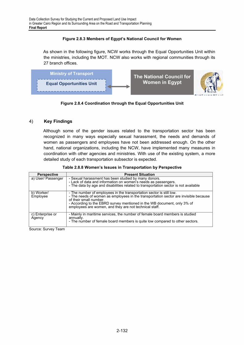
Data Collection Survey for Studying the Current and Proposed Land Use Impact in Greater Cairo Region and its Surrounding Area on the Road and Transportation Planning Final Report
2-132
Figure 2.8.3 Members of Egypt’s National Council for Women
As shown in the following figure, NCW works through the Equal Opportunities Unit within the ministries, including the MOT. NCW also works with regional communities through its 27 branch offices.
Figure 2.8.4 Coordination through the Equal Opportunities Unit
4) Key Findings
Although some of the gender issues related to the transportation sector has been recognized in many ways especially sexual harassment, the needs and demands of women as passengers and employees have not been addressed enough. On the other hand, national organizations, including the NCW, have implemented many measures in coordination with other agencies and ministries. With use of the existing system, a more detailed study of each transportation subsector is expected.
Table 2.8.8 Women’s Issues in Transportation by Perspective
Perspective Present Situation a) User/ Passenger - Sexual harassment has been studied by many donors.
- Lack of data and information on women’s needs as passengers. - The data by age and disabilities related to transportation sector is not available
b) Worker/ Employee
- The number of employees in the transportation sector is still low. - The needs of women as employees in the transportation sector are invisible because of their small number. - According to the EBRD survey mentioned in the WB document, only 3% of employees are women, and they are not technical staff.
c) Enterprise or Agency
- Mainly in maritime services, the number of female board members is studied annually. - The number of female board members is quite low compared to other sectors.
Source: Survey Team
Ministry of Transport
Equal Opportunities Unit The National Council for
Women in Egypt

Data Collection Survey for Studying the Current and Proposed Land Use Impact in Greater Cairo Region and its Surrounding Area on the Road and Transportation Planning
Final Report
3-1
3 OVERVIEW OF THE URBAN TRANSPORTATION SECTOR
3.1 Land Use and Urban Structure
1) Urban Development in the Greater Cairo Region
New urban areas have been developed under the administrative planning and construction led by the MHUUC and GCR. The characteristic urban structure of these new areas is based on mixed land-use planning, that is, cities have residential, educational, commercial, industrial, logistics zones, and these areas, such as 6th of October city, are usually located along major road corridors. In new urban areas, several types of city models have been proposed. The types appear to be as follows: (i) comprehensive city model with administrative, commercial, residential, education/research, green areas such as New Capital; (ii) academic city model with research and educational institutes, industry (R&D) and commercial areas and residential areas for a knowledge-based economy; (iii) medical city model with hospitals/medical facilities, residential and commercial areas; and (iv) resort city model with resort facilities, accommodations, residential and commercial areas. There are military areas in many cities. Looking at these models, there is compatibility and consistency with Egypt’s vision, the Strategic National Plan for Urban Development 2052, and the Cairo Vision.
In addition to these new urban areas, especially in GCR, the development of ring roads and trunk roads has been proceeding. Basically, in the desert areas, unintended sprawl may not occur, which frequently occurs in other countries, and the growth of the population may be absorbed in new cities and existing slum areas. Regarding the expansion of the cities, it is mainly based on newly built roads, and these roads can function as the main axis, the edge of cities, or their main corridors. Therefore, the development of new cities arises from these main roads, and the necessary infrastructure are eventually developed.
In addition, older cities, such as GCR, Alexandria, Banha, and Tanta, have their historical areas and slums, and the existence of these areas in crowded cities may cause traffic congestion and/or the deterioration of living standards. Therefore, the improvement of these existing areas is a must to achieve better cities.
2) Entities Responsible for Land Use and Urban Structure
Issues about land use and urban structure have been dealt with by MHUUC, especially by GOPP. MHUUC has developed new urban communities, such as the New Capital; housing projects for low-income, middle income and high-income groups; infrastructure (roads and bridges) projects, slum improvement projects; and Cairo development project as its main scope. Especially under the Sisi administration, the provision of low-income housing has been vigorously conducted.
GOPP’s power over land use and urban matters is strong. It deals with new urban community development and slum improvement projects. Its power emanates from its predecessor, Greater Cairo Planning Commission (Presidential Decree No. 1965/2102),

Data Collection Survey for Studying the Current and Proposed Land Use Impact in Greater Cairo Region and its Surrounding Area on the Road and Transportation Planning Final Report
3-2
and its mandate of setting master plans for all cities in Egypt as stipulated in Presidential Decree No. 1973/1093. Since then, amendments of the law and regulations relating to GCR have continued, and in the Construction Law in 2008 (Law119/2008), have clarified its role especially in urban planning and development, harmonious development in cities, regulations on construction, and appropriate management of real estate, with the role of setting hierarchical strategies at the national, regional, governorate, and area levels.
In addition to GCR, which mainly deals with formulating national level land use policies, there are other authorities and agencies under or related to MHUUC, which include NUCA which formulates plans for new urban communities, the Housing and Development Bank for financing, a regulatory authority for water and hygiene, and the research institute for housing and architecture.
The main task of these organizations to develop new urban communities is critical. Looking at the existing urban areas, the philosophy adopted in developing them had been consistent with the people’s needs in every period. These days, the development concern is the efficient use of energy; hence, the elements of smart cities have been implemented in the so-called fourth generation models in new urban communities. These next-generation urban communities have been proposed in 20 sites, and they are included in the approximately 30 new cities proposed in the Strategic National Plan for Urban Development 2052. These cities are quite indispensable when considering balanced regional development across the country.
Regarding the development and growth around GCR, the south-north axis has been stable including the transportation network; however, the dynamism of the west-east direction has been quite intense in both urban development and expansion. At the same time, while city development has followed specific models, interurban transportation connectivity is not that strong.
3) Urban Structure of the Greater Cairo Region
Figure 3.1.1 shows the areas covered by the GCR, and these are parts of the Cairo, Giza, and Qalyubiyya governorates. Over the years, the areas under this region have changed due to urban expansion and the reexamination of GCR’s role in the Strategic Plan for Urban Development 2052.
The beginnings of GCR can be traced to Old Cairo and the downtown areas before they expanded towards the north, covering parts of Cairo Governorate, Giza City, Shubra El-Kheima City, and Helwan City. After the 1950s, 6th of October city, New Cairo City, El-Obour City and 10th of Ramadan city developed as satellite cities. The link between these cities has been strengthened by the 120-km ring road.
At present, planning for the New Capital is ongoing. In the Cairo Vision, the following areas have been identified as development areas: Helwan in the south; New Capital, Suez, Ain-Sokhna, and Zafarana in the east; New 6th of October in the west; and the agricultural road in the northwest of GCR. Based on existing plans and visions, including the Cairo Vision, the development, especially in the west-east direction, will be continued. In the Cairo Vision,

Data Collection Survey for Studying the Current and Proposed Land Use Impact in Greater Cairo Region and its Surrounding Area on the Road and Transportation Planning
Final Report
3-3
the development of the outer ring road has been mentioned to connect these emerging satellite cities.
However, it remains unclear if the proposed urban structure targets reduced travel time and distance to/from the centers of Cairo to the satellite cities or if it promotes population transfer to satellite cities alongside a more enhanced intracity linkage to city centers.
Source: GOPP
Figure 3.1.1 Areas under Greater Cairo Region
Source: GOPP
Figure 3.1.2 Master Plan for the New Capital

Data Collection Survey for Studying the Current and Proposed Land Use Impact in Greater Cairo Region and its Surrounding Area on the Road and Transportation Planning Final Report
3-4
Source: GOPP
Figure 3.1.3 Master Plan for 6th of October City
Source: GOPP
Figure 3.1.4 Master Plan for New 6th of October City
The population of GCR has more than doubled since 1996 and is expected to continue., While GCR currently has a population of 20 million, population density is also critical. In comparison with other cities, Dhaka in Bangladesh has been said to be one of the most populated cities in the world, with a population density of approximately 50,000 people/km2. Even Tokyo’s more populated areas have a density of 20,000 people/km2. In the case of Cairo, as shown in Figure 3.1.6, the distribution of population is not homogeneous; there are some areas that have more than 50,000 people/km2, especially in the northern and western parts of the city.

Data Collection Survey for Studying the Current and Proposed Land Use Impact in Greater Cairo Region and its Surrounding Area on the Road and Transportation Planning
Final Report
3-5
Source: CAPMAS
Figure 3.1.5 Population Growth in the Greater Cairo Region, 1996–2020
Source: Survey Team
Figure 3.1.6 Population Density in Cairo, 1996–2020
1996
2020
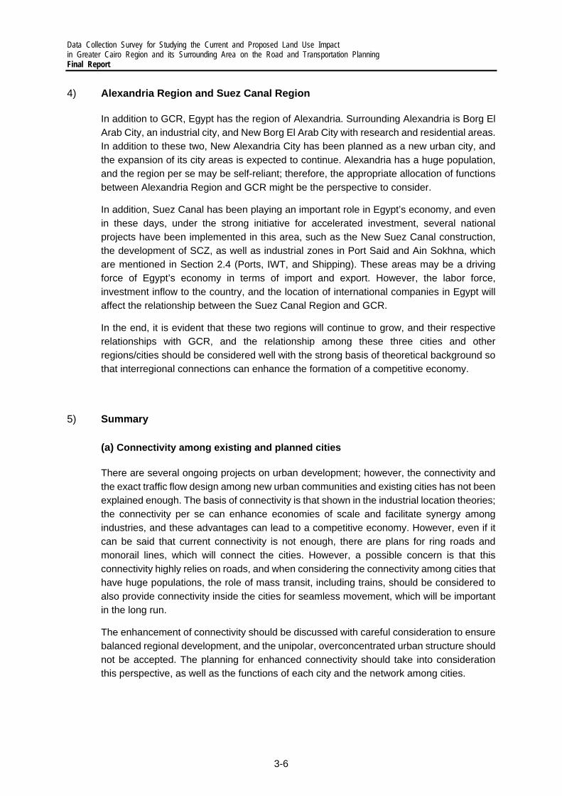
Data Collection Survey for Studying the Current and Proposed Land Use Impact in Greater Cairo Region and its Surrounding Area on the Road and Transportation Planning Final Report
3-6
4) Alexandria Region and Suez Canal Region
In addition to GCR, Egypt has the region of Alexandria. Surrounding Alexandria is Borg El Arab City, an industrial city, and New Borg El Arab City with research and residential areas. In addition to these two, New Alexandria City has been planned as a new urban city, and the expansion of its city areas is expected to continue. Alexandria has a huge population, and the region per se may be self-reliant; therefore, the appropriate allocation of functions between Alexandria Region and GCR might be the perspective to consider.
In addition, Suez Canal has been playing an important role in Egypt’s economy, and even in these days, under the strong initiative for accelerated investment, several national projects have been implemented in this area, such as the New Suez Canal construction, the development of SCZ, as well as industrial zones in Port Said and Ain Sokhna, which are mentioned in Section 2.4 (Ports, IWT, and Shipping). These areas may be a driving force of Egypt’s economy in terms of import and export. However, the labor force, investment inflow to the country, and the location of international companies in Egypt will affect the relationship between the Suez Canal Region and GCR.
In the end, it is evident that these two regions will continue to grow, and their respective relationships with GCR, and the relationship among these three cities and other regions/cities should be considered well with the strong basis of theoretical background so that interregional connections can enhance the formation of a competitive economy.
5) Summary
(a) Connectivity among existing and planned cities
There are several ongoing projects on urban development; however, the connectivity and the exact traffic flow design among new urban communities and existing cities has not been explained enough. The basis of connectivity is that shown in the industrial location theories; the connectivity per se can enhance economies of scale and facilitate synergy among industries, and these advantages can lead to a competitive economy. However, even if it can be said that current connectivity is not enough, there are plans for ring roads and monorail lines, which will connect the cities. However, a possible concern is that this connectivity highly relies on roads, and when considering the connectivity among cities that have huge populations, the role of mass transit, including trains, should be considered to also provide connectivity inside the cities for seamless movement, which will be important in the long run.
The enhancement of connectivity should be discussed with careful consideration to ensure balanced regional development, and the unipolar, overconcentrated urban structure should not be accepted. The planning for enhanced connectivity should take into consideration this perspective, as well as the functions of each city and the network among cities.

Data Collection Survey for Studying the Current and Proposed Land Use Impact in Greater Cairo Region and its Surrounding Area on the Road and Transportation Planning
Final Report
3-7
Source: Survey Team
Figure 3.1.7 Public transport for connecting existing/planned cities
(b) Strategic/Appropriate land use and connectivity
Land use and transportation go hand in hand. The importance of connectivity among existing and planned cities was discussed earlier; however, land use and the appropriate allocation of city functions should be planned because land use can affect future traffic demand.
So far, in the existing plans and visions, the function of areas inside cities and the cities themselves has been organized. However, the basis of these plans may not be sufficient if transportation is assumed to be completed inside each (satellite) city since both working and residential places cannot be moved in a short period.
Therefore, realistic conditions, such as availability of areas and others, should be studied; however, it should be considered that traffic demand is the result of redeveloping areas and developing new cities. Here, understanding the current relationship among areas, such as residential places and working places, as well as the economic activities in cities and transportation networks, is quite indispensable when considering the efficient allocation of city function.
Source: Survey Team
Figure 3.1.8 Controlling Traffic Flow through Land Use Planning
(c) Appropriate land use through transportation planning
In the two perspectives above, land use comes first, then traffic is generated by the form of land use. However, it should be noted that transportation itself can affect land use. Appropriate development of transportation can form appropriate land uses, leading to more enhanced values of the land itself.

Data Collection Survey for Studying the Current and Proposed Land Use Impact in Greater Cairo Region and its Surrounding Area on the Road and Transportation Planning Final Report
3-8
In the Cairo Vision, city centers, commercial areas, and other city functions are planned to be reallocated inside the city. Relying not only on the public sector but also on the private sector is intriguing so that the plans should be more effective. By considering the current and future transportation network, economically advantaged areas can be established.
At the same time, the transportation network should include not only inside city trips, but also inter-city trips. It can lead to a much clearer functions among cities and the formation of organic, integrated city network, which will lead to a more competitive economy.
Source: Survey Team
Figure 3.1.9 Forming Land-Use/Urban Structure through Transportation
(d) Relationship among districts, cities, and regions
Even if Egypt targets a balanced regional development, this does not mean that the same kind of cities will develop across the country. The function and role of each city and region should be considered from the perspective of national development.
(e) Another perspective: Linkage of other policies and diversity of stakeholders
The main focus shall be the relationship between land use and transportation, however, when considering land use, the sufficient understanding of socio-economic state is indispensable. As an example of the States, public transportation can be positioned as one of welfare policies in that public transportation enhances job accessibility for deprived communities and low socio-economic state citizens. For creation of more comprehensive transportation and land use planning, the related authorities and authorities in adjacent fields should form a unified team to tackle the challenges they will face.
In addition, even if there is a specific political agenda in development, planning by public authorities still has its limitations in terms of ideas, human resources, and budget due to its scale and capacity; therefore, the power of the private sector and the civil society is quite important. Under seemingly perfect and idealistic plans and visions, the public’s voice should be reflected in them. In more detailed plans, transportation and housing, which are the basic elements of a livable city, should enhance the lives of all people in Egypt with the voices of themselves.

Data Collection Survey for Studying the Current and Proposed Land Use Impact in Greater Cairo Region and its Surrounding Area on the Road and Transportation Planning
Final Report
3-9
3.2 Transportation Infrastructure
1) Road Infrastructure
In road network in GCR, there are main categories of road new work below.
Major Road: Main road along major corridor with frequent high traffic demand. Parts of those sections are elevated and flyovers are constructed to reduce the travel delay.
Minor Road: Smaller road with lower number of traffic lanes serving as local distributer and resident/minor access way.
Ring Road: The Cairo Ring Road is the most important freeway of the Greater Cairo metropolitan area in Egypt. The ring road encircles large parts of the cities of Cairo and Giza, including Cairo International Airport.
Inter City Highway: Major intercity corridor with Toll gates linking the Cairo city to other sub satellite cities and New Urban Communities.
The Ministry of Housing’s Cairo Development Agency builds most large road works (vehicle bridges, tunnels, and inner-city highways) in GCR, whilst the traffic is managed by a department of the Cairo Security Directorate, which answers to MOI, as does the National Council for Road Safety, the main body tasked with improving road safety. The Cairo’s Ring Road infrastructure falls under the remit of GARBLT – they are responsible for the design, construction, and maintenance. With regard to the urban roads, these mainly fall under the remit of the respective governorates or the new urban communities themselves.
2) Public Transport Infrastructure
The public transport network in the GCR is predominantly road and rail-based; despite the presence of the Nile River which bisects the region, water-based transport accounts for a negligible proportion of the mobility needs of its inhabitants.
(a) Road-based public transport
For the road-based modes of public transport, they are presently operating in mixed traffic and are not afforded any priority at key junctions or corridors. To this end, all road-based public transport modes are subject to the same congestion that negatively impacts the rest of the GCR’s inhabitants (Figure 3.2.1).
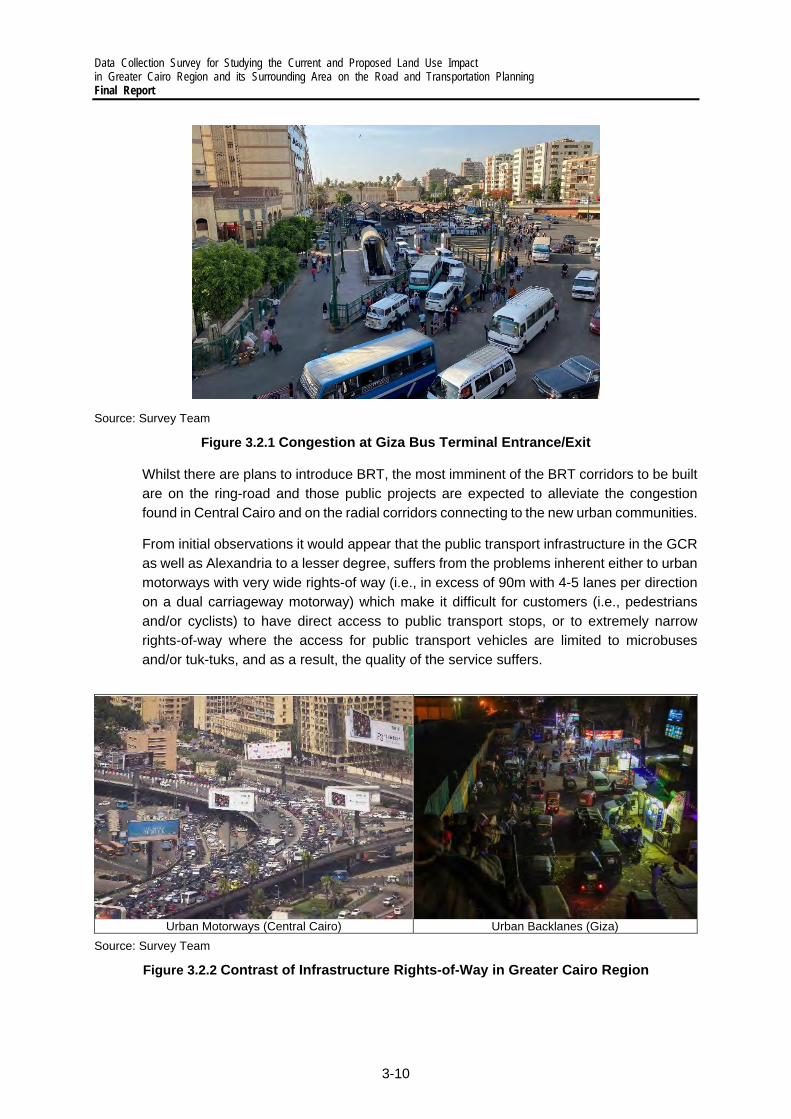
Data Collection Survey for Studying the Current and Proposed Land Use Impact in Greater Cairo Region and its Surrounding Area on the Road and Transportation Planning Final Report
3-10
Source: Survey Team
Figure 3.2.1 Congestion at Giza Bus Terminal Entrance/Exit
Whilst there are plans to introduce BRT, the most imminent of the BRT corridors to be built are on the ring-road and those public projects are expected to alleviate the congestion found in Central Cairo and on the radial corridors connecting to the new urban communities.
From initial observations it would appear that the public transport infrastructure in the GCR as well as Alexandria to a lesser degree, suffers from the problems inherent either to urban motorways with very wide rights-of way (i.e., in excess of 90m with 4-5 lanes per direction on a dual carriageway motorway) which make it difficult for customers (i.e., pedestrians and/or cyclists) to have direct access to public transport stops, or to extremely narrow rights-of-way where the access for public transport vehicles are limited to microbuses and/or tuk-tuks, and as a result, the quality of the service suffers.
Urban Motorways (Central Cairo) Urban Backlanes (Giza)
Source: Survey Team
Figure 3.2.2 Contrast of Infrastructure Rights-of-Way in Greater Cairo Region
Data Collection Survey for Studying the Current and Proposed Land Use Impact in Greater Cairo Region and its Surrounding Area on the Road and Transportation Planning
Final Report
3-11
(b) Water-based public transport
Bridges across River Nile packs with huge road traffic demand. Even though around 40 public ferries are operated by CTA as an alternative public transport mode to cross to cross the river, fleets are overcrowded with countless passengers. From evening, the purpose of water transportation changes from commuting to leisure activities. At night time, private leisure ferries/boats and floating restaurants start to cross back and forth along the river with no specific schedule pattern. However, the number of fatal river transport accidents has been constantly high (Basma El-Mahd, 2015). There are ongoing issues about the regulation of passenger/freight carriers sailing on River Nile, unlicensed boats and safety measures. For example, life jackets are not sufficiently provided for workers and passengers on the boats. Nevertheless, the standard and maintenance system of both port and ferry should be modernized.
(C) Transport intermodal hubs
Lastly, in respect of interchanges or hubs to facilitate the transfer of public transport users from one mode to another, it is evident that all the existing facilities were built at a time when the population density was much lower, and that many of these have become embedded in the congested areas of Central Cairo as the city limits continued to grow. From discussions with LTRA, it has been suggested that they agree with this view and are starting to consider the introduction of new, higher capacity facilities in the cardinal directions of the GCR (i.e., one each for the north, south, east and west), similar to larger international capital cities such as Paris, Madrid and London. This idea has been implemented in number of locations in GCR such as Bashtil and Monieb Square..

Data Collection Survey for Studying the Current and Proposed Land Use Impact in Greater Cairo Region and its Surrounding Area on the Road and Transportation Planning Final Report
3-12
3.3 Traffic Management
1) Current Traffic Situation and Issues in Greater Cairo Region
(a) Current Situation
The area of Egypt is about one million square meters but the inhabited area does not exceed 10%, so the population is highly concentrated in GCR, which are industrial, commercial and financial cities. Recently, there are approximately 4.1 million total of cars (34.17% of Egypt) in GCR, and about 3 million of daily visitors. In total, around 6 million vehicles running on GCR road every day. The population and vehicles are going to exceed 30 million and 10 million in near future, respectively (LTRA, 2020). The current traffic issues in GCR are shown below.
i) Traffic Congestion In GCR, traffic congestion is one of the most important issues. With the acceleration of birthrate and automobile development, the number of population and vehicle ownership have been rapidly increased, concentrating in GCR. At this point, transportation became stressful by many appearing problems, such as exceeding travel time, and health and psychological conditions.
Recently, there have been efforts to improve traffic management, infrastructure/facility supply and enforcement systems to mitigate traffic congestion but there is still room to improve. For example, there is a lack of application of traffic signal operation, and control the frequent on-street informal stops (by minibus, TukTuk, taxi) and road side parking violation, causing the huge reduction of road capacity, especially in the commercial area. In terms of supply, parking spaces is insufficiently being provided.
The issues related road traffic congestion: a) High annual cost of congestion
b) Reduced road capacity by informal stops and activities on the roadway
c) No efficient technology-driven traffic management
d) Lack of the application of traffic signal operation in several intersections
e) Noise pollution by honking
Previous traffic condition in Downtown of Cairo Informal stops and activities on the roadway

Data Collection Survey for Studying the Current and Proposed Land Use Impact in Greater Cairo Region and its Surrounding Area on the Road and Transportation Planning
Final Report
3-13
Traffic Congestion in Cairo Parking Violation in New Cairo City
Source: Survey Team and LTRA
Figure 3.3.1 Road traffic congestion in GCR
ii) Reduction of Road Traffic Safety Causes of the reduction of road traffic safety Driving behavior: Driving in GCR is chaotic.. Most roads have no or faded lane marking. Running vehicles are randomly packed within total road width. By this road condition, spaces between running vehicles are narrow, and lane changings are random. It can increase the chance of traffic accident, especially when mixed types of vehicle sizes are sharing the same road, especially for 2-wheel vehicle riders without helmets. However, even lane marking is painted, there is a chance that many of disobedient drivers will not follow it.
In Cairo, drivers of all vehicle types drive fast. Speed violation can be seen everywhere. “Arriving fast is better than arriving safely” has become the norm of most drivers. Along major roads, such as the section between old Cairo and 10th of Ramadan city, there are speed camera operated to prevent the speed violation in several locations. However, without speed camera, most of drivers tend to speed up again.
Vehicle: In addition, low-income group tended to purchase old vehicle models without safety facilities (e.g., air back or proper brake system) in order to reduce the cost of vehicle, which makes situation become even more dangerous. Besides, the vehicle inspection system and enforcement is still not strong enough to control this situation.
Road Traffic Accident Database in Egypt Database: The final road accident database is CAPMAS which collected road accident data from police (MOI) and hospital (MOH: for injured and fatal cases). In developed countries with stronger insurance system, insurance companies own big accident data record which can be fed to the central database. However, this system is still not completely sophisticated in Egypt. The reliability of CAPMAS is doubted since there are many missing recorded cases such as minor accidents and accident on minor roads. Many organizations get involved into the traffic accident field as below. Since the accident data record form of each organization are different, Cairo Traffic Police has plan to unify all accident database into one.
Accident Record: To improve road safety, it is important to investigate the actual cause of accident from the information recorded by investigating police staff at accident site. Cairo Traffic Police used to be trained for accident data record in Italy. Their used

Data Collection Survey for Studying the Current and Proposed Land Use Impact in Greater Cairo Region and its Surrounding Area on the Road and Transportation Planning Final Report
3-14
accident record form in the program is well developed and included detailed information such drawing of collision map. However, it is still not completely practical for all police staffs in Egypt due to the difficulty and complexity to fill up all the items in the form. The main items in recent accident record form of police are shown below.
Accident location and time Accident type (ex. rear-end) without collision map Type of vehicles involved Socio-demographic of persons involved
Severity (ex. without injury, minor injury, severe injury, fatality)In addition, when the accident occurs, local officers give the priority to clear to road to avoid traffic congestion and save the injuries. Without any awareness of accident information record before moving those collided vehicles out off the road, it makes accident investigation unclear. Only in few cases, it is possible to reobserve the accident site from CCTV camera.
The utilization of accident database: Cairo Traffic Police analyzes the blackspot from their database. Police do response to those blackspot locations by creating countermeasures such as equipping speed camera along the section with over-speed violation rate, and requesting city governorate to audit road geometric. In addition, other organizations such as GARBLT also utilize the database of police for improving traffic safety on road sections under their organizations.
In addition, traffic and pedestrian count data are also taken into the consideration of traffic police to create traffic safety policy, such as to install pedestrian crossing signal or bridge in the area with high level conflict between pedestrians and vehicle. In the future, around 30 additional pedestrian bridges (costs around 50 million EGP per unit) will be installed in Cairo city to remove those conflicts. Demarcation: The organizations getting involve with the development of road accident database and the creation of traffic safety measures are shown below.
Table 3.3.1 Road Traffic Safety-Related Organization
Task Citizens Drivers/ Traffic Hospital
(EAO) Insurance
MOT GARLBT City Prosecution
(MOJ) Victim Police company Government Accident Detection / Report O O O
Investigation O O Rescue O O Insurance O O Prosecution O O O
Accident Record O O O O Database owner O O O O Database developer O
Accident database analysis for improvement plan
(ex. black sport, cause of accident)
Policy/countermeasure formulator
O O O O
Road safety audit O Vehicle Inspector O

Data Collection Survey for Studying the Current and Proposed Land Use Impact in Greater Cairo Region and its Surrounding Area on the Road and Transportation Planning
Final Report
3-15
The issues related road safety: a) Aggressive ad reckless driving behavior (80% of accident by human factor) b) Slow accident reaction due to slow accident locating system and traffic
congestion c) Lots of old vehicles model without proper safety facilities d) Strong traffic enforcement system is not completely implemented yet e) Road traffic accident database system is need to be further developed and
utilized to eliminate the cause of accident
Traffic Accident in Cairo Roundabout without land marking in New Cairo City
Argument between driver and traffic police Motorcycle rider without helmet
Source: LTRA and Survey Team
Figure 3.3.2 The issues related road safety in CGR
iii) Air pollution Air pollution is resulted by traffic congestion in GCR. Especially, lots of old vehicles running in GCR produce more pollution than those of new models. In Egypt, 20% of total Carbon Dioxide (CO2) emission is from Transport Sector. According to the Ministry of State for Environmental Affairs, the transport segment produced 26% of PM10 load, 90% of carbon monoxide (CO), and 50% of nitrogen oxides (NOx) in GCR, For PM2.5 or less sized particles, Motor vehicles accounts for about 32%.
Source: Crippa et al. 2019
Figure 3.3.3 CO2 emissions in Egypt in 2018

Data Collection Survey for Studying the Current and Proposed Land Use Impact in Greater Cairo Region and its Surrounding Area on the Road and Transportation Planning Final Report
3-16
Source: Heger et al. 2019
Figure 3.3.4 PM2.5 Source in Greater Cairo Region
There are awareness and study of the possibility to reduce air pollution from transport sector. According to the study of World Bank by Heger et al. 2019, by applying Machine Learning algorithms based on high-resolution satellite imagery to detect the vehicle density on the street (from 2010 to 2018), comparing with the daily emission rate obtained from air monitoring stations in Cairo, it was found that the fuel subsidy removal programs helped to reduce PM10 concentrations by nearly 4%. It was also found that the opening of Cairo’s Metro Line 3 resulted in the reduction of air pollution by about 3%.
Machine Learning Algorithm Detecting Cars Location of Air Monitoring Station
Source: Heger et al. 2019
Figure 3.3.5 PM2.5 Source in Greater Cairo Region
To reduce the emission form road public transport, bus operators show their effort to introduce electric bus in urban area. In 2019, Mwasalat Misr announced its operation of the X-Bus electric in Cairo, from Abdel Moneim Riad square to New Cairo. The new bus is the cumulation of massive efforts led by the Arab Organization for Industrialization (AOI), with the cooperation from Shanghai Wanxiang, one of the largest Chinese companies specialized in the manufacture of electric buses. However, it is not completely matched with the current situation of Cairo now. The aspect of area facilities planning, such as locations of charging stations, is still challenge.

Data Collection Survey for Studying the Current and Proposed Land Use Impact in Greater Cairo Region and its Surrounding Area on the Road and Transportation Planning
Final Report
3-17
Another case outside Cairo, Alexandria governorate is encouraging green cities by raising public awareness and working to provide environmentally friendly transport and maintain sustainable development. In 2018, 15 electric buses were introduced and supplied by Chinese company BYD, the world’s leading manufacturer of electric buses. There is a future plan to replace traditional transport vehicles with electric vehicles, in order to protect the environment from pollution. The plan led by El Nasr Automotive Manufacturing Co. is to manufact the affordable electric vehicles, E70 or A70 models, with the investment around $127 million. The first stage of 3,000 charging points will be introduced around the cities of Cairo and Alexandria (Abdel Latif Wahba, 2021).
Electric Bus of Mwaslat Misr in Cairo Electric Bus of Mwaslat Misr in Alexandria
Source: Alamanauto and Egypt Independence
Figure 3.3.6 Electric Bus Introduced in Egypt
iv) Parking Issues Current parking issues in new satellite city area: The parking issues, including insufficient parking space and on-street parking, happen not only in old congested city with limited land space but also the new constructed satellite cities such as new Cairo, and 6th of October city. For on-street parking, drivers can parkfor both long time (ex. officers parking whole days) and short time (ex. shoppers parking for only 1 or 2 hours). This issue tends to be more severe surround the high density/mixed used areas such as commercial, compound area, and downtown rather than the resident area. The planning issues are shown below.
Government office of Sheikh Zayed City Commercial area of New Cairo
Figure 3.3.7 Road capacity reduction due on-street parking

Data Collection Survey for Studying the Current and Proposed Land Use Impact in Greater Cairo Region and its Surrounding Area on the Road and Transportation Planning Final Report
3-18
a) The applied Egyptian Parking Code/Standard 2008 is not reflective of actual parking demand
This standard has been applied since 2008 in every area in Egypt for the design of number of parking space per unit building (ex. 1, 1.5, 2 spaces per 200, 250-300, over 300 sqm., respectively). However, there is no parking space provided for 70 – 80 sqm. living space size, so residents living in that mansions park on the street. In addition, the actual vehicle owners ship rate is higher than those recent designed number.
In some high-income areas, other design standard can be applied, such as ITE (Institute of Transportation Engineers – US) and Dubai, if those standards provided more parking space per building unit. Recently, Housing and Building National Research Center (HBNRC) of MOHUUC is cooperating with university academia members and consultant companies to create the new parking code/standard which provides a greater number of parking spaces per floor area. In addition, the new standard considers difference in building and area categories such as;
‒ The location of the building is in old or new satellite city areas ‒ Resident are high, mid, or Low-income level
b) Informal modification of building/land use
Residents in some areas informally modified their apartments to be used for office space, small shop, restaurant and etc. It induces more people to come to those apartments. When the parking spaces are insufficient, in the park on streets surrounding those buildings. Recently, NUCA has policy to strictly monitor and enforce this issue.
c) The minimization of road and parking space of the land owner
Compound space and village owners try to minimize the road width and parking space to maximize their remaining land area to be used for other benefits, causing the insufficient parking space.
d) Lack of appropriate pricing policy, accessibility and information technology
Drivers give up to park in the formal garage due to the high parking fee, time spent to find the parking lot and inconvenient accessibility. Thus, many of them choose to continue parking on the street. To encourage people to park in that formal garage, NUCA can only encourage parking space owner to reduce the fee but cannot directly enforce them. In addition, the connectivity with other modes, location and coverage area of each garage should be reconsidered, as well as the ITS information board/application to inform those drivers the nearby available parking space.
Current parking issues in old city area: In old town area (Cairo city), it is slightly different from new satellite city because the space is very limited by congested buildings. Nowadays, short/long-time on-street and unmanaged parking are everywhere, especially in the commercial areas along the major streets (such as AL Haram and King Faisal streets, the corridors to access GIZA

Data Collection Survey for Studying the Current and Proposed Land Use Impact in Greater Cairo Region and its Surrounding Area on the Road and Transportation Planning
Final Report
3-19
Pyramid), surrounding hub of transportation area (such as GIZA and Moneeb squares), and downtown area. This issue significantly reduces the road capacities. Moreover, sidewalks are even occupied by informal parking, resulting in the reduction of Level of Service (LOS) and convenience for pedestrians. The planning issues are shown below.
GIZA Square Al Haram Street
Figure 3.3.8 Road capacity reduction due on-street parking
a) Difficulty to find land in congested city to construct garage
The available land is more difficult to find in old city rather than new satellite cities. It requires cost and time to demolish the building and rearrange the land which is very problematic from the view point of city governorate.
b) Informal modification of the use of building
When land owners want to construct the building, they submit the building drawing to the city governorate to get the approval. The number of parking spaces of building in the drawing is following the design standard. However, after the construction, the reserved parking space (usually 1st floor) are informally modified to be shop, gyp, warehouse and restaurant which induces a lot of on-street parking in front of those buildings. Governorate and police are trying to enforce and control this informal modification but it is still currently difficult.
King Faisal Street
Figure 3.3.9 Induced on-street parking due informal Building Modification
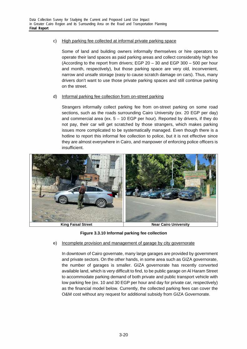
Data Collection Survey for Studying the Current and Proposed Land Use Impact in Greater Cairo Region and its Surrounding Area on the Road and Transportation Planning Final Report
3-20
c) High parking fee collected at informal private parking space
Some of land and building owners informally themselves or hire operators to operate their land spaces as paid parking areas and collect considerably high fee (According to the report from drivers; EGP 20 – 30 and EGP 300 – 500 per hour and month, respectively), but those parking space are very old, inconvenient, narrow and unsafe storage (easy to cause scratch damage on cars). Thus, many drivers don’t want to use those private parking spaces and still continue parking on the street.
d) Informal parking fee collection from on-street parking
Strangers informally collect parking fee from on-street parking on some road sections, such as the roads surrounding Cairo University (ex. 20 EGP per day) and commercial area (ex. 5 – 10 EGP per hour). Reported by drivers, if they do not pay, their car will get scratched by those strangers, which makes parking issues more complicated to be systematically managed. Even though there is a hotline to report this informal fee collection to police, but it is not effective since they are almost everywhere in Cairo, and manpower of enforcing police officers is insufficient.
King Faisal Street Near Cairo University
Figure 3.3.10 Informal parking fee collection
e) Incomplete provision and management of garage by city governorate
In downtown of Cairo governate, many large garages are provided by government and private sectors. On the other hands, in some area such as GIZA governorate, the number of garages is smaller. GIZA governorate has recently converted available land, which is very difficult to find, to be public garage on Al Haram Street to accommodate parking demand of both private and public transport vehicle with low parking fee (ex. 10 and 30 EGP per hour and day for private car, respectively) as the financial model below. Currently, the collected parking fees can cover the O&M cost without any request for additional subsidy from GIZA Governorate.

Data Collection Survey for Studying the Current and Proposed Land Use Impact in Greater Cairo Region and its Surrounding Area on the Road and Transportation Planning
Final Report
3-21
Table 3.3.2 Financial Model of the Public Garage on Al Haram Street
Item Financial Source Land acquisition and provision Subsidy from Governorate Parking space preparation and construction Subsidy from Governorate O&M Collected fee from users
Garage on Al Haram Street
Figure 3.3.11 Public paid parking space provided by GIZA Governorate
f) Obstacle to select garage location
The general criterion to select the location of city governorates are 1) Available land space and 2) Demand. It is difficult to find the available land space in the crowded city, so the selected location of current garage is still not the most efficient in terms of accessibility to the final destinations. In addition, there is lacking focus of the consideration of the connectivity to other public transport modes from the garage location. In 2015, UN-Habitat funded to study on the location of multi storage garage in the Mohandessin area but the project implementation was suspended due to several conditions such as limited land and budget.
g) Incomplete management and provision of parking hub area for informal transportations
It is difficult to secure the space for gathering shared taxi or TukTuk in congested city area. They usually find available space to create their informal parking hub area, sometimes next to the major stations or even park on the street. Since the needs of using those modes are huge, city governorate is attempting to improve the connectivity of formal and informal transportations by planning and improving of informal transport hub parking area but it is not fully completed yet.
For example, GIZA Governorate has recently upgraded the park-and-ride space for shared taxis at the end of King Faisal Street which is connecting to the upcoming BRT line on ring road. However, this upgraded park-and-ride space has not been completely systematically operated yet. There are still chaos and congestion inside. The improvement of management is needed.

Data Collection Survey for Studying the Current and Proposed Land Use Impact in Greater Cairo Region and its Surrounding Area on the Road and Transportation Planning Final Report
3-22
Upgraded Informal Public Transport Hubs in King Faisal Street
Figure 3.3.12 Upgraded park-and-ride area for shared taxi hub
h) Lacking of police manpower to enforce parking violation
Parking violation is everywhere in the city which police staffs cannot enforce all of them. Previously, traffic police spent their manpower to control the crowded traffic at at-graded intersection during both peak and off-peak time. After November 2019, 74 intersections have been upgraded into graded separated intersection with flyover or tunnel, so police can secure more manpower for enforcing parking violation but it is still not sufficient to cover every single violation in whole city.
Related studied about parking management: In 2018, SETS Consultant conducted the On-Street Parking & Pedestrian Movement Study sponsored by UN-Habitat focusing on understanding the parking situation and propose the bike lanes in downtown area as shown in the figure below.
Demand of each garage and allowed on-street parking section by time of the day, traffic and pedestrian flow are studied to examine the possibility to propose the bike lane in downtown area.
Several activities in downtown during both day time (ex. working) and night time (ex. retail shop) induce huge parking demand. There are 10 major garages in those area to accommodate those demand. In addition, drivers are allowed to park on small streets. Around 5 years ago, there were on-street parking fee machines installed along the permitted on-street parking section, but this system was substituted by informal fee collection by both formal (assigned by police) and informal (stranger) human staffs.
The typical parking fee are around EGP 8 to 10 per hours and EGP 800 to 1250 per month, depending on number of parking hours for the public garages such as Tahrir, Ramses, Opera and Attaba garages (See figure above for the garage locations). However, parking fee is more expensive up to EGP 20 to 30 per hour in private garage such as Hilton Ramses garage.
Parking facilities are various depending on the location. The newest and most sophisticated parking building is the 4-underground floor Tahrir garage near Cairo Museum with the ITS board which can inform drivers the number and location of available parking space. The simplest garage is Abdul Munim Riad which the land space under 6th of October city bridge was converted to be parking space.

Data Collection Survey for Studying the Current and Proposed Land Use Impact in Greater Cairo Region and its Surrounding Area on the Road and Transportation Planning
Final Report
3-23
Supply Demand Ratio of each parking is different, depending on various factors such as accessibility, parking fee and walking distance to destination. In some garages, they are always over capacity such as Tahrir. On the other hand, the occupancy rate or some parking buildings such as Opera and Attaba are lower in some periods. Nevertheless, on-street parking is still the most popular because it provides the shortest distance to destination.
Source: SETS
Figure 3.3.13 Location of Garages in Downtown in Level of Service Study for Proposed Bike Lanes in Cairo
Underground Entrance 4-Floor Underground Parking Lot
ITS Board and Parking Entrance Sign Parking Fee Sign
Figure 3.3.14 Tahrir Garage (P3) in downtown area

Data Collection Survey for Studying the Current and Proposed Land Use Impact in Greater Cairo Region and its Surrounding Area on the Road and Transportation Planning Final Report
3-24
Entrance 6-Floor Parking Lot
Parking Card Rooftop Parking Space
Figure 3.3.15 Opera Garage (P4) in downtown area
Entrance 7-Floor Parking Lot
Interior Cashier
Figure 3.3.16 Boston Garage (P7) in downtown area

Data Collection Survey for Studying the Current and Proposed Land Use Impact in Greater Cairo Region and its Surrounding Area on the Road and Transportation Planning
Final Report
3-25
(b) Planning in Response to Traffic Issues
Due to the current traffic issues mentioned in the previous topic, traffic management-related organizations, such as city government and traffic police, and LTRA are planning on the countermeasures to in order to cope with such traffic problems�mentioned above. The examples of key methods are shown below.
i) Road traffic management ‒ Support sufficient signalized intersections and over passes ‒ Prevent informal stops and establish sufficient legal parking lots ‒ Install road information signs ‒ Modernize traffic control and monitoring systems
ii) Traffic Demand management
‒ Reduce private car users by promote the use public transport (Such as
modernize bus fleets, introduce BRT system, expansion of metro)
iii) Traffic Safety management ‒ Raise safety awareness of road users of transportation system by
training programs, TV advertisements, school education, etc. ‒ Improve geometrical designs and maintenance, such as lane markings,
signage, traffic control barriers, lighting, etc. ‒ Enhance traffic enforcement system and public justice
iv) Parking management ‒ Revise the parking space design standard and law ‒ Improve selection of garage location to enhance the accessibility and
connectivity or garage ‒ Add multi-storage smart parking facilities in congested area, with the
application of ICT such as information sign board and parking reservation mobile application
‒ Encourage Cairo visitors to commute public transportation (such as new constructed MNR) by providing of Park & Ride area, improving connectivity improvement and conducting Mobility Management
‒ Implement large-scale enforcement by issuing parking violation ticket through violator’s mobile phone number obtained by vehicle registration database of Traffic Police and Traffic Prosecution (Ministry of Justice) of license plate.
2) Role of Traffic Control Center
Traffic Police of Cairo Security Directorate under MOI is in charge of Road Traffic Management in GCR. The homepage of traffic police provides the details of their organization’s information, is under construction. (https://traffic.moi.gov.eg/English/Pages/default.aspx)
There are three traffic control centers in GCR under the General Department of Traffic Police. Each center covers different area as below.
28,000 km of road network inside Cairo Ring Road 8,000 km of road network of new satellite cities (New Cairo, Badr and Rehad) 500 km of road network of new capital city

Data Collection Survey for Studying the Current and Proposed Land Use Impact in Greater Cairo Region and its Surrounding Area on the Road and Transportation Planning Final Report
3-26
(a) Main Duties of Traffic Control Center
a) Monitor situation of road, walkway and parking area (e.g., parking space of New Cairo Museum)
b) Detect any incident such as traffic accident, violation, gridlock and crime c) Enforce traffic violator d) React to the detected or reported (by Hotline) incident, accident and crime e) Coordinate with local police to manage traffic and control traffic signal f) Participate in road planning process with city governate, MOT, GOPP and
other related agencies. g) Count the traffic volume by case study
(b) Goals and Milestones of The Control Center
a) Smooth movement, reduction of travel time and increase of travel time reliability
b) Address traffic violation issue (e.g., parking violation) c) Reduction of accident and provision of safety condition for road user d) Automation of system and minimization of reliance on human
(c) Roadside equipment used for monitoring and detecting
The roadside equipment used for monitoring traffic situation and detecting incident are shown below.
Table 3.3.3 Roadside equipment used for monitoring and detecting Device Explanation Purpose Type
Closed-Circuit Television (CCTV)
The use of video cameras to transmit a signal to control center. Some of them can be rotated to get 360-degree view
Monitor road situation
Realtime
Count the traffic volume Non-Realtime
Traffic enforcement camera
High resolution CCTV camera with image processing technology
Capture licenses plate, wrong/opposite direction driving, unfastening seat belt driver, using mobile phone, section speed violation (by capturing car model)
Realtime
Speed camera Cameras detect the speed of vehicles by using detectors embedded into the road surface or radar technology
Capture spot speed Realtime
Police car patrol camera
360-degree HD camera mounted on police patrol car. To know the location of each patrol car, in-vehicle GPS device is installed.
Monitor road situation by running police patrol car especially in where CCTV is not installed.
Realtime
Police body camera
Bandage camera equipped with traffic police
Capture crime in the patrolling area
Non-Realtime
Portable Radar Base Traffic Counter
The use of radar wave to detect the existence of object on the roadway
Count the traffic volume Non-Realtime
(d) Communication Network
For the communication network system between local and control center, traffic police use their own Wireless Inter-operability for Microwave Access (WiMax) with interrupted Internet Protocol (IP) network. WiMax can handle a larger inter-operable

Data Collection Survey for Studying the Current and Proposed Land Use Impact in Greater Cairo Region and its Surrounding Area on the Road and Transportation Planning
Final Report
3-27
network, coverage area and data transmission per second than Wifi. The speed of data transmission of WiMax is not ideal as using cores of Optical Fiber Cable (OFC) network, but the network is stable and data security level is high.
(e) Demarcation
City Governorate is mainly in charge the procurement of contractor for the construction, installation, and maintenance of roadside facilities such as traffic signal, traffic controller and CCTV camera. Police is responsible to operate those facilities to control and manage traffic. For data storage, recorded videos (by CCTV) and incident (by hand) are saved at traffic control center. For communication network, MOI shares the role with MICT.
Table 3.3.4 Demarcation among organizations
Task City governorate MOI MICT Road management planning ○ ○
Owner of roadside facility (e.g., Traffic signal, controller, detectors)
○
Construction and maintenance of roadside facilities ○
Controlling and setting signal parameter ○
Data (e.g., recorded video) storage ○
Owner, construction and maintenance of communication network system
○ ○
(f) Automated System Applied
Automated Detection and Enforcement of Traffic Violation: Traffic polices are currently using camera and Automatic Number Plate Recognition (ANPR) camera to detect and define speed limit violation from control center. There are two types of speed detection as below.
(1) Fixed spot speed detection: Measure vehicle speed at only one spot
(2) Average section speed detection: Measure average sectional vehicle
speed (at entrance and exit points) on limited access road and tunnel
(e.g., Al Azhar Tunnel)
Car Model Recognition Software with Image Processing Technology by Artificial Intelligence (AI) is applied to enhance the accuracy of identification of traffic violator. In addition, this AI technology is currently being applied for detection of unfastening seatbelt and mobile phone using during driving.
To issue traffic violation ticket, after the car model and license plate are detected, there is double check process by human (police staffs at control center) to ensure who is the actual violators. Subsequently, information of identified violators will be sent to Traffic Offense Division, and tickets will be automatically issued to their address captured from car registration data base.
The measured speed is not only used for enforcement, but also be important input for geometric reconfiguration and speed limit redesign. In addition, the system
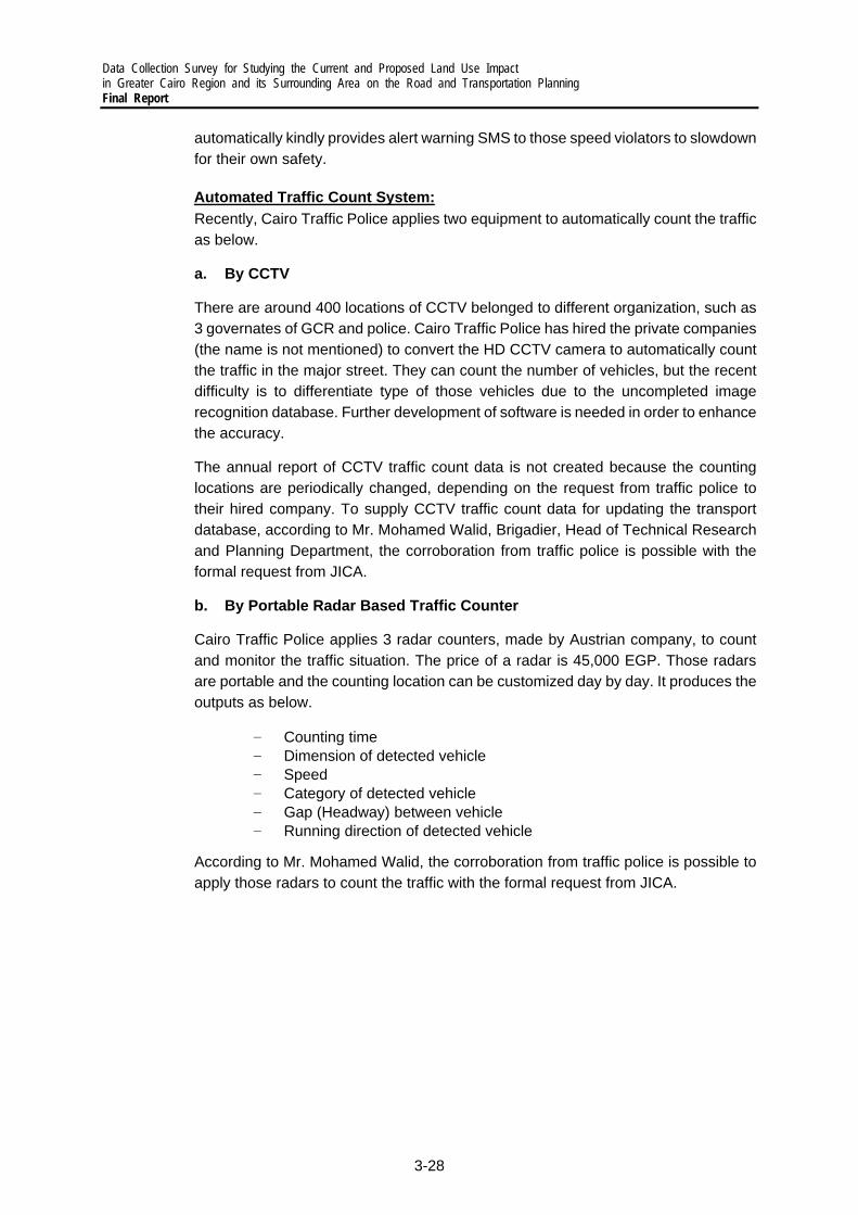
Data Collection Survey for Studying the Current and Proposed Land Use Impact in Greater Cairo Region and its Surrounding Area on the Road and Transportation Planning Final Report
3-28
automatically kindly provides alert warning SMS to those speed violators to slowdown for their own safety.
Automated Traffic Count System: Recently, Cairo Traffic Police applies two equipment to automatically count the traffic as below.
a. By CCTV
There are around 400 locations of CCTV belonged to different organization, such as 3 governates of GCR and police. Cairo Traffic Police has hired the private companies (the name is not mentioned) to convert the HD CCTV camera to automatically count the traffic in the major street. They can count the number of vehicles, but the recent difficulty is to differentiate type of those vehicles due to the uncompleted image recognition database. Further development of software is needed in order to enhance the accuracy.
The annual report of CCTV traffic count data is not created because the counting locations are periodically changed, depending on the request from traffic police to their hired company. To supply CCTV traffic count data for updating the transport database, according to Mr. Mohamed Walid, Brigadier, Head of Technical Research and Planning Department, the corroboration from traffic police is possible with the formal request from JICA.
b. By Portable Radar Based Traffic Counter
Cairo Traffic Police applies 3 radar counters, made by Austrian company, to count and monitor the traffic situation. The price of a radar is 45,000 EGP. Those radars are portable and the counting location can be customized day by day. It produces the outputs as below.
‒ Counting time ‒ Dimension of detected vehicle ‒ Speed ‒ Category of detected vehicle ‒ Gap (Headway) between vehicle ‒ Running direction of detected vehicle
According to Mr. Mohamed Walid, the corroboration from traffic police is possible to apply those radars to count the traffic with the formal request from JICA.
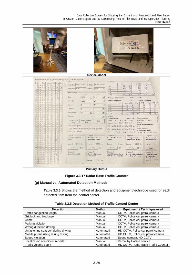
Data Collection Survey for Studying the Current and Proposed Land Use Impact in Greater Cairo Region and its Surrounding Area on the Road and Transportation Planning
Final Report
3-29
Device Model
Primary Output
Figure 3.3.17 Radar Base Traffic Counter
(g) Manual vs. Automated Detection Method:
Table 3.3.5 Shows the method of detection and equipment/technique used for each detected item from the control center.
Table 3.3.5 Detection Method of Traffic Control Center
Detection Method Equipment / Technique used Traffic congestion length Manual CCTV, Police car patrol camera Gridlock and blockage Manual CCTV, Police car patrol camera Crime Manual CCTV, Police car patrol camera Parking violation Manual CCTV, Police car patrol camera Wrong direction driving Manual CCTV, Police car patrol camera Unfastening seat belt during driving Automated HD CCTV, Police car patrol camera Mobile phone using during driving Automated HD CCTV, Police car patrol camera Speed violation Automated Speed camera, HD CCTV Localization of incident reporter Manual Verbal by Hotline service Traffic volume count Automated HD CCTV, Radar Base Traffic Counter

Data Collection Survey for Studying the Current and Proposed Land Use Impact in Greater Cairo Region and its Surrounding Area on the Road and Transportation Planning Final Report
3-30
(h) Examples of Transport Project that Traffic Police Get Involved in
As mentioned above, traffic police also got involve in study and planning process of project related to transport planning. According to the discussion, the examples of projects that they have got involved in and improvement results are shown below.
i) Examples of Project Involved by Traffic Police (1) Upgrade at-grade to separated-grade intersections by constructing fly overs along
the 22 main corridors (2) Expansion of ring road (3) (4) Introduction and expansion of Roxy Smart Parking system
ii) Examples of Result from Project Implementation that Police got Involved in By the construction of flyovers, average travel time (from all distant trips) of all vehicles reduced from 35 – 45 minutes to 20 – 25 minutes and Level of service of serval major roads improved.
About the Roxy Smart Parking system, the first phase of the Roxy Garage project, the garage is the first fully mechanized garage of its kind in Egypt, with a final capacity of 1,700 cars. It reduced congestion in a vital part of the capital. The first Roxy Garage consists of four underground floors with an area of 10000 square meters each.
Source: The Arab Contractor
Figure 3.3.18 Roxy Smart Parking
3) The Application of ICT Technology for better traffic management
According to the current situation, there is still room of improvement for traffic management by the application of ICT technology as below.
(a) Modernization of Traffic Signal Control and Monitoring System
Traffic police are focusing on detection and reaction of roadside incident or accident. However, there is lack of intention to appropriately control traffic signal to reduce traffic congestion. In GCR, there are few intersections with installed traffic signals and controller

Data Collection Survey for Studying the Current and Proposed Land Use Impact in Greater Cairo Region and its Surrounding Area on the Road and Transportation Planning
Final Report
3-31
(mostly by Peek Traffic Corporation, US Company). Traffic signal timings at signalized intersections are all currently preset and remained the same for all periods of the day which is unsuitable for dynamic traffic demand in GCR. Moreover, many of traffic signals are not in use or being operated in yellow flashing mode. The further advance system for traffic signal operation is needed.
Adaptive signal control technology, which signals are repetitively being reprogrammed to optimize the green time to allow the most vehicles through, are more suited for the roads with unpredicted traffic pattern in GCR. Multiple signal timing resolutions are essential through a typical time-of-day period.
This technology is widely used in the UK, Australia and Asia. Many studies have revealed that it improves average performance (control delay, travel time, and gasoline consumption). In the system with outdated signal timing such as Cairo, the magnitude of improvement can be more obvious.
However, the cost of software and hardware (e.g., roadside equipment, servers, and communication network), organizations to configure and maintain the system, and performance measurement can be an issue. Therefore, assistance in the planning process in important. In the case of GCR, the key points to start to apply the ITC technology for the modernization of traffic control system are shown below.
i) Increasing the Number of Signalized Intersections in the System At many intersections, traffic flows may reach signal warrants for both major and minor corridor, but traffic signals are still not installed. In addition, Cairo heavily relies on roundabout which does not perfectly fit for huge traffic demand. The plan on traffic survey for installation of additional traffic signal or upgrade of intersection (flyover or tunnel) in those locations are necessary.
Source: Warrants of Traffic Signals
Figure 3.3.19 Example of Signal Warrants
ii) Gaining Sufficient Input Data by Increasing the Utilization of Detector and
Modification of Existing CCTV To monitor traffic situation, traffic police only observe the traffic situation from video recorded from roadside CCTV camera. However, those cameras can be converted to be automatic sensors such as for Traffic Movements Counters (TMC) and approach speed measurement.

Data Collection Survey for Studying the Current and Proposed Land Use Impact in Greater Cairo Region and its Surrounding Area on the Road and Transportation Planning Final Report
3-32
Not only cameras but the utilization of other types of detectors for specific purposes, such as ultrasonic detector to detect gap of passing vehicles for actuated control at intersection, can be considered to fulfill the detection system. With the well set up communication network system between those detectors and control center. The information obtained by detectors, can be real-time transmitted to traffic control center as an input for traffic control system.
TMC by Image Processing with AI technology Gap Count by Ultrasonic Detector
Source: Avantech and Kyosan
Figure 3.3.20 Example of Application of Detectors
Source: Survey Team
Figure 3.3.21 Example of Traffic Control System
iii) Utilizing Floating Car Data (FCD) as Supplementary Data Traditional method to monitor traffic situation by using stationary detectors requires lots of installation of maintenance cost and they can monitor the traffic at only fixed-spot locations where those detectors are installed. To resolve this limitation, the possibility to apply the Floating Car (or vehicle) Data (FCD), collected by recently developed GPS Probe Data technology, which can provide real-time and area-wide traffic situation with smaller investment can be applied. However, the processed FCD has few drawbacks in the accuracy as shown in table below, but it very useful as a supplementary data for real-time traffic monitoring.
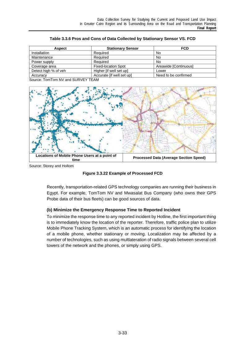
Data Collection Survey for Studying the Current and Proposed Land Use Impact in Greater Cairo Region and its Surrounding Area on the Road and Transportation Planning
Final Report
3-33
Table 3.3.6 Pros and Cons of Data Collected by Stationary Sensor VS. FCD
Aspect Stationary Sensor FCD Installation Required No Maintenance Required No Power supply Required No Coverage area Fixed-location Spot Areawide [Continuous] Detect high % of veh Higher [if well set up] Lower Accuracy Accurate [if well set up] Need to be confirmed
Source: TomTom NV and SURVEY TEAM
Locations of Mobile Phone Users at a point of time Processed Data (Average Section Speed)
Source: Storey and Holtom
Figure 3.3.22 Example of Processed FCD
Recently, transportation-related GPS technology companies are running their business in Egypt. For example, TomTom NV and Mwasalat Bus Company (who owns their GPS Probe data of their bus fleets) can be good sources of data.
(b) Minimize the Emergency Response Time to Reported Incident To minimize the response time to any reported incident by Hotline, the first important thing is to immediately know the location of the reporter. Therefore, traffic police plan to utilize Mobile Phone Tracking System, which is an automatic process for identifying the location of a mobile phone, whether stationary or moving. Localization may be affected by a number of technologies, such as using multlateration of radio signals between several cell towers of the network and the phones, or simply using GPS.
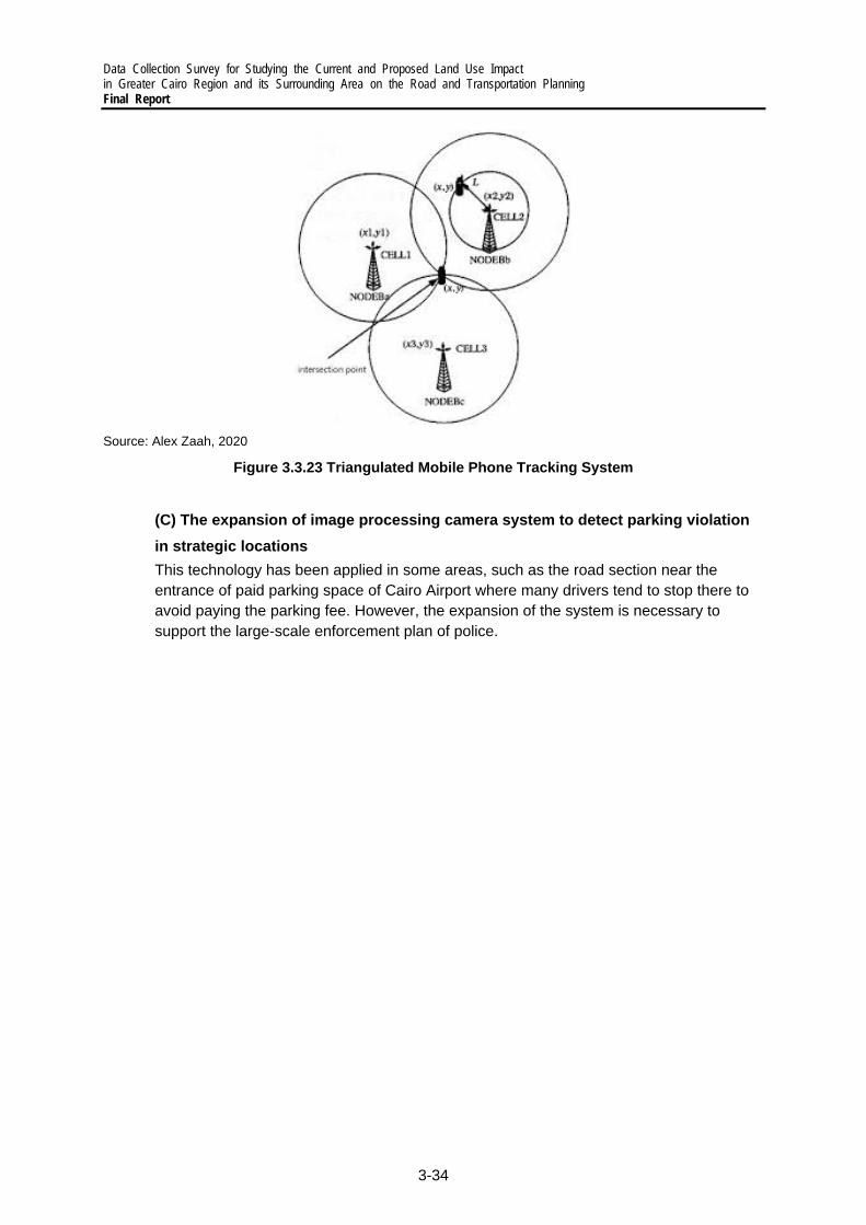
Data Collection Survey for Studying the Current and Proposed Land Use Impact in Greater Cairo Region and its Surrounding Area on the Road and Transportation Planning Final Report
3-34
Source: Alex Zaah, 2020
Figure 3.3.23 Triangulated Mobile Phone Tracking System
(C) The expansion of image processing camera system to detect parking violation in strategic locations
This technology has been applied in some areas, such as the road section near the entrance of paid parking space of Cairo Airport where many drivers tend to stop there to avoid paying the parking fee. However, the expansion of the system is necessary to support the large-scale enforcement plan of police.

Data Collection Survey for Studying the Current and Proposed Land Use Impact in Greater Cairo Region and its Surrounding Area on the Road and Transportation Planning
Final Report
3-35
3.4 Analysis on Urban Transportation Sector
At present, the GCR is served by myriad urban transportation services that collectively strives to meet the mobility needs of commuters and the wider population. These services are vastly different in nature and cannot all fall under the umbrella of public transport. They include CM and CTA buses, private bus and minibus operators and Informal transport, all with different operating characteristics and all catering to very different social classes and markets within the study area. Moreover, as depicted in the figure below, the governance of the urban transportation network and system also involves a vast array of different stakeholders and actors, often with overlapping mandates and responsibilities.
Source: Survey Team
Figure 3.4.1 Organization of Urban Transportation Sector in Greater Cairo Region
The mobility needs of the citizens of the GCR are very much driven by where they live relative to where they work and undertake other daily activities such as marketing and leisure activities. In the Cairo and the whole Egypt, CAPMAS data expresses computed population numbers. However, the boundaries of the city are unclear and constantly changing; administrative boundaries do not include many parts on the periphery which are essentially part of GCR. Moreover, agglomerations such as GCR often serve as centralized labor markets and attract sizeable numbers of out-of-city workers who commute and spend the majority of the day within the city. As Transport for Cairo points out, the estimated “commuter-adjusted population” during normal business hours therefore tends to be substantially higher than corresponding actual “register residential population”. From the latest available data such as the 2018 United Nations cities data booklet, the population of GCR is just over 20 million, making it the world’s fifth largest conurbation; the UN further estimates GCR to grow by 5 million inhabitants to 25.5 million in 2030 (UN-DESA 2018). CAPMAS estimates the 2018 population of the governorates that make up GCR, including their rural areas, to be 24.1 million.
Coordinate with

Data Collection Survey for Studying the Current and Proposed Land Use Impact in Greater Cairo Region and its Surrounding Area on the Road and Transportation Planning Final Report
3-36
Additionally, with regard to where the majority of the inhabitants live and work, the figure below, taken from a 2019 Transport for Cairo study suggests that the population continues to be highly concentrated in the historical center, and that whilst there is clearly an outward migration of the population to the new urban communities such as 6th of October city, New Cairo and 10th Ramadan city, this is proceeding at a gradual pace – Central Cairo remains the main Central Business District in GCR, with the opportunities density being higher than the residential density. All of this means that GCR remains a largely monocentric conurbation (although it is transitioning to a poly-centric model) for which the efficiency of the overall urban transportation system remains highly dependent on the performance of the system along several axes or corridors, as well as the transportation system operating in the very core of the GCR.

Data Collection Survey for Studying the Current and Proposed Land Use Impact in Greater Cairo Region and its Surrounding Area on the Road and Transportation Planning
Final Report
3-37
Source: Transport for Cairo
Figure 3.4.2 Population (Blue) and Job Opportunities (Green) Density in Greater Cairo Region
1) Formal Public Transportation Mode
The formal bus services network operating in the GCR is dominated by the CTA. According to data from Transport for Cairo, in the Cairo Governorate, the CTA operates a fleet of 3,000 buses on some 400 plus routes, but this information will need to be corroborated with the official data to be received from the authorities. Whilst there is some degree of coordination between the CTA and LTRA, the latter organization is newly formed and therefore in the nascent stages of assuming its full array of responsibilities. As such, LTRA’s role in regulating CTA’s (and other operators) performance has not started as yet.
In addition to the CTA, there are also over a dozen licensed private operators, including the likes of Mwasalat Misr, providing services on over 100 routes, with this number set to increase by the end of 2021 with new services to the New Urban Communities becoming operational in the coming months. These private buses are mostly twenty-six seater minibuses and therefore are able to provide service on narrower roads that are typically inaccessible to the CTA’s standard sized 19-meter buses – the minibuses serve the same areas as the regular twelve meter buses.. Based on discussions held with the New Urban Communities, the demand for better transportation services between Central Cairo and the New Urban Communities is growing exponentially, and therefore consideration is being given to the use of increasingly larger buses, such as the buses depicted below for New Cairo City. It means the number of minibuses should be reduced in those routes.

Data Collection Survey for Studying the Current and Proposed Land Use Impact in Greater Cairo Region and its Surrounding Area on the Road and Transportation Planning Final Report
3-38
Source: Survey Team
Figure 3.4.3 New 12-m Buses for New Cairo City
For both CTA buses and licensed private vehicles, frequency of trips varies across the different routes, with no indication of obvious clock-face based and standard departure times. The quality of these services also varies tremendously from one operator to the next, with Mwasalat Misr seemingly one of the best organized operators providing a good service using newer vehicles. More specifically, Mwasalat Misr has signed strategic partnership contracts with the Public Transport Authority in Cairo/Cairo Governorate for services being delivered using 288 buses, and two contracts with the New Urban Communities Authority, one for operating within the new cities east of Cairo (using 69 buses), and the other for operating within 6th of October city and Sheikh Zayed, west of Giza, in partnership with UNDP (using 88 buses). These lines serve six new cities (New Cairo, 10th of Ramadan city, El Obour, El Shorouk, Sheikh Zayed city and 6th of October city). Of the lines operated by Mwasalat Misr, 63 of them that are connected/integrated with 18 metro stations. About 300 12-m buses (44 seats) and micro (27 seats) operate on these lines, with a capacity to transportation up to 32 million passengers per year.
For the parts of the GCR which are within the catchment areas of CM and to a lesser degree, the heavy rail services operated by ENR, a significant proportion of the modal share is accounted for by these two rail-based modes. According to anecdotal data provided by CM in the meetings, daily patronage for the three lines is approaching 3.5 million passengers per day (COVID-19 impacts notwithstanding) and is set to grow further once CM Line 3 is fully opened and operational, alongside the feeder network comprising the monorail and tram. These two intermediate capacity systems are expected to be partially operational by the end of 2021, or Q1 2022.
The most glaring deficiency in the current urban transportation system is the potential mismatch of supply and demand. As private companies, COWI and ACE, previously pointed out in their 2016 study, there is evidently a disconnect between supply and demand because the authorities such as CTA do not perform comprehensive and sufficient demand forecasting prior to introducing new lines, and where planning is more or less carried out as a propagation of new lines in addition to already existing lines. They added that whilst the CTA includes population density and the number of economically disadvantaged people as well as surrounding roads and corridors into the planning process, there is no replicable and transparent technical or economic analysis of the conditions for operation or use of

Data Collection Survey for Studying the Current and Proposed Land Use Impact in Greater Cairo Region and its Surrounding Area on the Road and Transportation Planning
Final Report
3-39
threshold figures in the decision-making process are applied (CUTID Report, 2016). This imprecisely understanding on demand results in the unbalance between bus service supply and demand. There are number of buses competing to get passengers on some routes. On the other hands, there is lacking of feeder bus service in some minor roads.
Moreover, the CTA itself has stated that changes in operations are often decided outside the organization itself. Given the fact that local communities are influential in defining destinations, route courses and bus stops in isolation from the rest of the GCR, it is perhaps unsurprising that this process results in a large number of routes in a network that is far from logical and efficient for its users.
2) Informal Public transportation Mode
The appearance of the use of informal transportation modes in Cairo is due to the shortage of formal public transportation service and the weakness in planning process that does not sufficiently reflect the needs of citizens. In Cairo, there are various informal transport service such as Taxi, Micro-bus, Mini-bus and Tuk-Tuk, which is being operated in different characteristics. The use of informal transportation seems more expensive than formal CTA bus, but it could provide more customization of stopping location and quicker service, especially in the further suburb area.
The study of Digital Commons indicated that the absence of integration between formal modes (metro and buses) creates a gap, which can be fulfilled by informal transportation modes such as minibuses, microbuses and tuk-tuks to manage passenger needs. Drivers usually create hub or major stopping location by themselves without physical station, which the traffic lane are sometimes taken away by those informal stops. Most of Micro-bus and Mini-bus wait until the seats are almost full occupied before departing, and some stop randomly on roadside to pick passengers up, which significantly obstructs the main traffic flow on the street.
In Cairo, informal transportation modes can be categorized into two types which are 1) legal (such as minibuses and microbuses) and 2) illegal (such tuk-tuks and old means of transportation). The legal modes can generate informal stopping hub and stations at the main transport hub location, such as next to metro station exits, but the illegal modes are mostly positioned in urban settlements to cover the narrow roads and inaccessibility area. The common service type of each informal transportation mode is shown in the Table below.
Table 3.4.1 Service type of each informal transportation mode
Mode Type Stopping Location Trip Service coverage Taxis Legal / Illegal Random Unfixed path Inside city / inter sub city
Micro-bus Legal Informal Station / Random Fixed round Inside city / inter sub city
Mini-bus Legal Informal Station / Random Fixed round Inside city / inter sub city
Tuk-Tuk Legal / Illegal Random Unfixed path Inside city / Local short trip Source: Felix and Elhefnawi, 2020 and Survey Team

Data Collection Survey for Studying the Current and Proposed Land Use Impact in Greater Cairo Region and its Surrounding Area on the Road and Transportation Planning Final Report
3-40
Source: Felix and Elhefnawi, 2020
Figure 3.4.4 Informal Stops of Mini-Bus Near Metro Station
The planning issues related to informal public transportation are shown below.
Integration: To integrate formal transportation such as bus terminal and metro stations with informal transportation mode stops would be extremely effective to reflect the needs of passenger
Replanning: To reduce the route competition with formal modes, match demand and supply, the integration of planning process between formal and informal mode in terms of service route and schedule
Regulation: To regulate informal transport operators and drivers, such as stopping rule and location would reduce the chaos of on-street conflict and improve the service safety and quality
Unification: To legalize and unify all of several informal transport operators would be efficient for government side to manage and regulate the service

Data Collection Survey for Studying the Current and Proposed Land Use Impact in Greater Cairo Region and its Surrounding Area on the Road and Transportation Planning
Final Report
3-41
3.5 Institutions and Organizations
1) Administration of Urban Transportation
The planning, operation, and maintenance of the transportation system in the GCR is fragmented, involving numerous agencies and different levels of government. Previous studies, including those carried out by ACE and COWI in 2016/2017, have pointed out that there are overlapping tasks and responsibilities among the different authorities and agencies, and the overarching organizational structure is ambiguous. A direct result of the fragmented governance is the exacerbation of the challenges facing decision-makers for managing traffic and maintaining mobility in GCR. An overview of the role of each of the related organizations in the planning, operation, and maintenance of the urban transportation system in the study area is summarized in Table 3.5.1.
Table 3.5.1 Organizations Related to Urban Transportation in the Study Area
Organization Major Role in Urban Transportation Ministry of Transport The Higher Committee for Greater Cairo
Transportation Planning (H.C.) Established by a Prime Ministerial Decree in 2000, the Committee is headed by the Minister of Transport and is responsible for the overall transportation planning of the GCR. The Committee supervises the current master plan study and is expected to be responsible for its continuous updating and modifying.
Transport Planning Authority (TPA)
Although this Authority is concerned mainly with national level transportation planning, it has commissioned several studies about some transportation issues in GCR such as: - Greater Cairo Transportation Planning (1973) - Cairo Urban Transport Project (1980) - Survey of own Account Passenger Transport by
Government Agencies in GCR (1985) - The Development of the Role of the Private Sector in
Urban and Inter-city Passenger Transport (1986) - CM Interchange Coordination Study (1987) - Greater Cairo Public Transport Fare Policy Study (1992-
1995) Greater Cairo Transport Regulatory
Authority (GCTRA) The Greater Cairo Transport Regulatory Authority (GCTRA) was created through the presidential decree No. 349 of 2012, to function as the lead institution for transportation planning and regulation in the GCR. The law states that GCTRA has its own legal persona under the supervision of the MoT. Effectively, GCTRA seeks to organise, plan, monitor and evaluate the performance of all activities related to transportation sector in GCR and thus has the function to organize, plan, monitor and evaluate the performance of all activities related to transportation sector in GCR. However, it has yet to be operational.
Land Transport Regulatory Authority (LTRA)
It has the main role to organize and plan all land transportation in all Egypt, including urban, intercity, and international transportation.
Egypt National Institute of Transport (ENIT)
The Institute provides post graduate studies in the fields of transportation planning, transportation engineering and transport economics. - It provides technical training for the employee in the
transportation sector. - It conducts limited number of studies such as a study
about the effect of underground metro as a transportation mean for the limited income group.
- It maintains a library for transportation science.

Data Collection Survey for Studying the Current and Proposed Land Use Impact in Greater Cairo Region and its Surrounding Area on the Road and Transportation Planning Final Report
3-42
- The Institute is the executive agency for the Higher Committee for Greater Cairo Transportation Planning.
The National Authority for Tunnels (NAT) NAT is in charge of planning and implementation of Metro and tunneling Projects such as CM Lines 1, 2, 3, Azhar Car Tunnel, and other future plan of Metro Line 4, and Port Said Road and Railway tunnels. In addition, it is responsible for all electric railway such as monorail, LRT, and HSR.
The Egyptian National Railways (ENR) ENR is the Authority in charge of planning, implementation, operation and maintenance of the national railway network. The sections of railways within the GCR are part of the transportation system of the region.
Egyptian Company for Metro Operation and Maintenance (ECM) or CM
A public company owned by MOT to operate, maintain and manage the Greater CM
The General Authority for Roads, Bridges and Land Transport (GARBLT)
GARBLT is the Authority in charge of planning, implementation, operation and maintenance of the intercity national road network. Because the boundaries of GCR extend beyond the limits of the road departments of the three Governorates, parts of the road network of Greater Cairo are under the jurisdiction of GARBLT.
Ministry of Housing, Utilities, and Urban Communities The General Organization for Physical
Planning (GOPP) GOPP is responsible for setting the overall policy for physical planning, preparing urban development plans and the supervision of the implementation of these plans. GCR has a Regional Urban Planning Center for the GCR. GCR has prepared the development plan for the GCR which is one of the main inputs for the preparation of the long-term transportation planning for GCR. Beside its role in physical planning, GCR has planned some transport projects in the GCR such as the Ring Road, 15th of May corridor, traffic planning in Roxy area and traffic planning in Azhar Street.
New Urban Communities Authority (NUCA)
- Organizing, coordinating and exchanging advice with ministries, institutions and entities engaged in urban development activities and related fields
- In charge of the development and management of new cities, including the satellite cities around Cairo
- Integration of land use and sustainable transportation planning
- Technical and logistical support and allocation of land for the new bus terminal facilities in new satellite cities
The Development Organization for each New City or New Community
Road planning and implementation in addition to operation of the intra-city bus and microbus within the new city or the new community.
Central Agency for Reconstruction The design and construction of all major road developments in GCR
Ministry of Interior The Traffic Police Directorates for Cairo,
Giza and Qalyubia Governorates - All operations including traffic management and
enforcement - Vehicle inspection and issuance of vehicle operation
license - Issuance of driving license - Participate in the approval of traffic management scheme
Cairo Governorate Cairo Traffic Engineering Bureau (CTEB) - Licensing new land use activities and new off-street
parking facilities - Approves new traffic management scheme
Roads and Transport Directorate (RTD) Responsible for street maintenance Traffic unit under Directorate of Housing Responsible for engineering and design service for specific
project Cairo Transport Authority (CTA) Planning, operation and maintenance of buses, minibuses,
river buses and tram network in the GCR Giza Governorate Roads and Transport Directorate Planning, implementation, and maintenance of road projects
within Giza Governorate

Data Collection Survey for Studying the Current and Proposed Land Use Impact in Greater Cairo Region and its Surrounding Area on the Road and Transportation Planning
Final Report
3-43
Qalyubia Governorate Roads and Transport Directorate Planning, implementation, and maintenance of road projects
within Qalyubia Governorate Other Governmental Organizations Greater Cairo Bus Company The Company is under the Ministry of Public Enterprise
Sector and it operates bus transportation network within the GCR
Non-Governmental Organizations and Operators Mwasalat Misr Private bus operator which covers GCR Operators of Microbus Taxi Service Individual operation of Microbus taxi service Taxi Operators Operate the taxis equipped with fare meters. Operators of Special Use Buses These buses are owned by governmental or private bodies
for the exclusive transportation of its employee or tourist groups.
Operators of Limousine taxi Limousine taxis are operated by travel companies for transportation between the airport and the hotels and for hotel service.
Source: CREATS Phase I (2002), updated based on the following links: http://www.tadamun.co/urban-mobility-cairo-governance-planning/?lang=en#.YPeHDcRxdPa https://www.codatu.org/actualites/greater-cairo-and-how-the-transport-system-is-coping-with-rapid-expansion/
2) Public Transportation O&M
At present, it would appear that the O&M of the urban transportation system is transferred to the operators, who must decide on the appropriate course of action while the LTRA and responsible authorities in the governorates stay at arms-length from daily operations. A preliminary analysis of the network and findings from previous studies leads to the following observations:
(a) Network and Lines
The current public transportation network appears to be a result of the legacy of the infrastructure, rather than the outcome of proactive planning, except in the new urban communities where physical constraints are not so problematic. Moreover, with the exception of the work carried out by Transport for Cairo on behalf of the World Bank as part of the Digital Cairo campaign in 2019, even we can find some of public transportation service route maps on website or mobile application, it is very difficult to obtain an overview of all the lines and how they are interconnected to constitute the network. There are no route maps or detailed descriptions for specific lines or routes, stops and timetables for each of the lines are easily available on the internet. Furthermore, no comprehensive map shows the entire network with each line or different bus service clearly marked. Baseline data from the 2017 study by ACE and COWI shows that more than 420 lines providing services in the study area. No distinction seems to be made between heavily utilized lines (carrying many passengers) and minor lines in terms of their characteristics and numbering, not allowing for a clear separation between trunk and feeder lines nor considering the (level of) integration with the higher capacity modes such as the metro and future BRT. Moreover, to date, there has been no studies on market segmentation focusing particularly a profiled or prioritized network of lines in corridors with high passenger volumes, where CTA could focus and promote high quality services to retain the current passengers and attract new ones.
(b) Service Provision
Data Collection Survey for Studying the Current and Proposed Land Use Impact in Greater Cairo Region and its Surrounding Area on the Road and Transportation Planning Final Report
3-44
There is a general absence of guidance and policies on service headways. This problem is worsened by the fact that public transportation operates in mixed traffic and is subject to the same congestion as other transportation infrastructure users, making it difficult to plan and schedule. In 2017, COWI reported that only five lines operated by the CTA have more than 100 departures every day, corresponding to a headway of around 10-12 minutes on average. They further observed that these 5 lines are not even the most heavily utilized lines in Cairo when survey data was compared. Over 80% of the routes run with a headway as high as 30 minutes, suggesting that service quality is generally poor.
(c) Supply and Demand
Given the absence of detailed data on the demand and usage, it is not surprising that there is no correlation between supply and demand. Some lines have passengers that are 10 times or higher per operating hour than other lines do. At the same time, these lines have fewer daily departures. Likewise, there is lack of correlation between the number of passengers and number of buses on different lines and there is a remarkable variance in the utilization of the buses on different routes when considering the number of daily service hours.
The World Bank has provided the Consultants with GIS-maps showing the routes for the lines run by CTA. This information has enabled the verification that there are several overlaps in operation between different lines servicing identical locations. These overlaps are seen all over the city which strongly suggests an inefficient network. In general, overlaps should be avoided and the service should concentrate on less lines but with higher regular frequency instead.
3) System Planning
For the CTA and other operators, route and network planning does not follow any kind of planning cycle but is instead reactive with planning generally carried out on a case-by-case basis. Evidently, a proper planning cycle would not only allow for fixing stable timeframes but would also permit reviewing (parts of) the network to assess optimization opportunities. The establishment of a periodic review could also ensure that requests and plans for new lines were given the necessary attention so that they can be efficiently coordinated with and integrated in the existing network, thereby avoiding service overlaps or the cannibalization of lines. Generally, ongoing and constant changes in the routes in the network poses a significant source for confusion for passengers. To this end, a more explicit profile and higher presence of the LTRA would likely be able to fill this gap.
It is also important to consider the functioning of the CTA’s operations control center. At present, the center mainly responds to service disruptions, oversees dispatching duties or manages unplanned events. But in order to improve the functioning of the network, the control center should proactively monitor services to allow adjusting the transport offer to evolving demand and needs.

Data Collection Survey for Studying the Current and Proposed Land Use Impact in Greater Cairo Region and its Surrounding Area on the Road and Transportation Planning
Final Report
3-45
4) Source & Finance
Similar to CM and ENR, the government subsidizes the CTA but nevertheless, the CTA continues to rely heavily on farebox revenue to cover their capital and operating expenditure. There are committees and multilateral discussions in which the CTA contributes and presents a list of variables which can affect the fare policy (distance – operation and maintenance costs, etc.). For the formal private operators such as Mwasalat Misr however, they are given contracts to operate the services in return for payment but the exclusivity of their routes is not protected from informal operators such as minibuses and microbuses that operate with official approval.
Given the current operating conditions creating substantial uncertainty concerning farebox revenues, it is not surprising to observe that apart from Mwasalat Misr, an operator with international roots, other international private enterprises such as Keolis, ALSA and Arriva who are active in other North African cities, have chosen not to enter the Egyptian market.
Lastly, the affordability of the urban transportation system in the GCR needs further review. The Transport for Cairo’s 2019 study discovered that to get to Central Cairo from the new urban communities using public transportation, residents can choose between CTA buses and informal transport. And informal transport tends to be quicker and is thus preferred by many. However, CTA buses are more affordable, in part because they have higher capacity and so generate higher absolute revenue per trip. Whilst a nominal comparison of ticket prices would seem to suggest that Egyptians paying 8-10 Egyptian pounds for a single, one-way ticket is affordable, when factoring in their wages, that cost represents a higher percentage of their income than the citizens in more developed countries. According to Transport for Cairo, the average public transport ticket price in London is over 15 times that in Cairo, but when the prices are weighed by the minimum wages in the two cities, they are found to be almost the same. This highlights the need for a pricing policy that is based on the purchasing power of local residents.
Data Collection Survey for Studying the Current and Proposed Land Use Impact in Greater Cairo Region and its Surrounding Area on the Road and Transportation Planning Final Report
3-46
3.6 Gender-related Issues
1) Introduction
In general, not only men but women are also likely to move daily by public transportation in urban areas for commuting and shopping, compared to suburban areas. Based on the
statistics of CAPMAS, 24.7%1 of women in Egypt live around the GCR. The needs thus of
women for urban transportation must be significant.
While national transportation in relation to gender issues are described in Section 2.7 with
three perspectives, a) transport user and passenger, b) worker and employee and c)
company and agency, issues concerning transportation users and passengers are more focused in this chapter.
2) Review of Projects related to Urban Transportation by International Donors
International donors have conducted studies and projects to promote gender mainstreaming and empowerment in urban transportation with the cooperation of domestic agencies. The ongoing study on gender equality being conducted by UN Habitat has some common points with this JICA study. Further collaboration or sharing of outputs is expected. This and other studies are briefly described below.
(a) Safe Cities Project (2011–2021)
International Donor: UN Women
Domestic Organization: NCW, Giza Governorate, NGOs
As one of the funding programs of the initiative Global Safe Cities and Safe Public Spaces Cities participating in the UN Women Global Initiative, the National Council for Women implemented the “Safe Cities Project” from 2011 to 2021 in Cairo and Giza.
Its objective was to make cities and public spaces safe for all, especially women and girls, and to disseminate the experiences in planning new cities and developing existing ones.
The program targets three low-income districts in GCR: Imbaba, Manshiyet Nasser, and Ezbet El Haggana.
(b) Egypt Economic Cost of Gender Based Violence Survey (2015)
International Donor: UNFPA
Domestic Organization: CAPMAS, NCW
The survey aimed to support evidence-based policy making by calculating the economic loss generated by gender-based violence.
Important findings on sexual harassment in public transportation and spaces are reported. 15% of girls aged 18–19 years experienced harassment in the past 12
months in public transportation.
1 The number is shown by governorate (Cairo; 9.8 Giza: 9.0, Qalyobia5.9) CAPMAS, 2021.
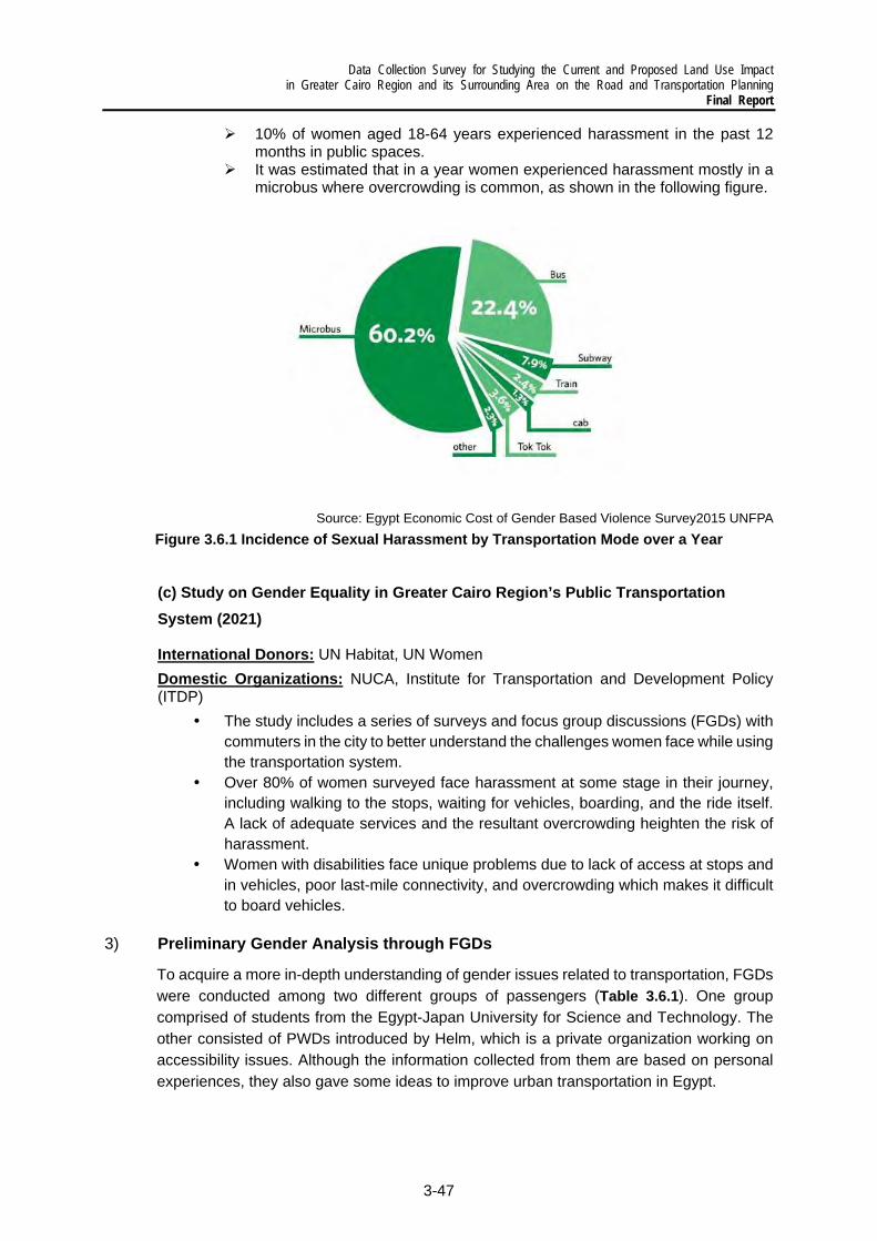
Data Collection Survey for Studying the Current and Proposed Land Use Impact in Greater Cairo Region and its Surrounding Area on the Road and Transportation Planning
Final Report
3-47
10% of women aged 18-64 years experienced harassment in the past 12 months in public spaces.
It was estimated that in a year women experienced harassment mostly in a microbus where overcrowding is common, as shown in the following figure.
Source: Egypt Economic Cost of Gender Based Violence Survey2015 UNFPA
Figure 3.6.1 Incidence of Sexual Harassment by Transportation Mode over a Year
(c) Study on Gender Equality in Greater Cairo Region’s Public Transportation System (2021)
International Donors: UN Habitat, UN Women
Domestic Organizations: NUCA, Institute for Transportation and Development Policy (ITDP)
The study includes a series of surveys and focus group discussions (FGDs) with commuters in the city to better understand the challenges women face while using the transportation system.
Over 80% of women surveyed face harassment at some stage in their journey, including walking to the stops, waiting for vehicles, boarding, and the ride itself. A lack of adequate services and the resultant overcrowding heighten the risk of harassment.
Women with disabilities face unique problems due to lack of access at stops and in vehicles, poor last-mile connectivity, and overcrowding which makes it difficult to board vehicles.
3) Preliminary Gender Analysis through FGDs
To acquire a more in-depth understanding of gender issues related to transportation, FGDs were conducted among two different groups of passengers (Table 3.6.1). One group comprised of students from the Egypt-Japan University for Science and Technology. The other consisted of PWDs introduced by Helm, which is a private organization working on accessibility issues. Although the information collected from them are based on personal experiences, they also gave some ideas to improve urban transportation in Egypt.

Data Collection Survey for Studying the Current and Proposed Land Use Impact in Greater Cairo Region and its Surrounding Area on the Road and Transportation Planning Final Report
3-48
Table 3.6.1 Participants and Schedule of Group Discussion
Type Gender / Number Hometown Date and Time
1) University Students
Men / 2 - Cairo - Saudi Arabia and Cairo
2021/06/08 12:00 – 13:30
Men / 3 - Alexandria - Aswan - Fayoum
2021/06/08 13:30 – 15:00
Women / 2
- 2 from Cairo 2021/06/09 9:00 – 10:30
Women / 4
- 4 from Alexandria (One of women is Admin staff of the Univ)
2021/06/09 10:30 – 12:00
2) People with Disabilities (PWDs)
Men / 4 - 2021/06/14 9:00 - 10:00
Women / 4 - 2021/06/14 10:00 – 11:00
Source: Survey Team
(a) Discussion with University Students
Participants: The students were selected by the administration office of the university, based on the Study Team’s criteria, i.e., gender, number, and English fluency.
Objective: It was conducted to study any differences in travel experiences and feeling against transportation among women and men students
Methodology: As shown in Figure 3.5.2, the Study Team asked the students to fill out a simple questionnaire. Students evaluated each transportation mode based on their experiences. The discussion covered many different topics, for example, preferred mode to move from the university to their hometown, aspects of the railway to be improved, differences in travel pattern between them and their parents, and so on. After the discussion about their personal experiences and ideas, the Study Team showed examples of gender empowerment or mainstreaming in transportation, such as women-only cars, promotion of women’s employment in the sector, bathrooms for PWDs and nursing rooms, by using
PowerPoint presentation. The description and photos of the Deli Metro project2 were
included as an example. Discussions followed after the presentation.
2 Phase 3 (2012-2020), Delhi Mass Rapid Transport System Project in India, JICA

Data Collection Survey for Studying the Current and Proposed Land Use Impact in Greater Cairo Region and its Surrounding Area on the Road and Transportation Planning
Final Report
3-49
Source: Survey Team
Figure 3.6.2 FGD Procedure with Student Group and Sample of an Accomplished
Questionnaire
Source: Survey Team
Figure 3.6.3 Separate FGDs with Female and Male Students
Remarkable Comments and Points: Following are the remarkable comments and points from the discussions and answers to the questionnaire. The answers are shown as chart figures.
Both men and women feel unsafe and lack of security when using public transportation. Yet, there was a difference in their responses: While men care about the high number of pickpockets and traffic accidents, women are more concerned about sexual harassment.
Most women have a driver’s license. Driving was recognized as the safest way to move around by both men and women, except in congested areas such as Cairo City.
1. Students evaluate each transportation mode by a filling
questionnaire
2. Study team and students discuss about each mode based on the
questionnaire
3. Study team shows the examples of gender mainstreaming/ empowerment
in other countries
4. Students comment on the examples

Data Collection Survey for Studying the Current and Proposed Land Use Impact in Greater Cairo Region and its Surrounding Area on the Road and Transportation Planning Final Report
3-50
Men were more positive about all the modes compared to women. This is shown in Figure 3.6.5 which reveal that women’s ratings of all modes are lower than the men’s.
Railway was the preferred mode for long-distance trips by men from Aswan City and raised in Saudi Arabia. According to them, the use of microbus needs enough experience, which they do not have.
The evaluation of the metro was different between Lines 1 and 2 on one hand, and Line 3 on the other. Line 3 was highly evaluated by both men and women. Still, women indicated that the congestion at peak time is a serious problem.
Women-only cars of the CM have recognized as a necessary facility by both men and women, which is shown in the figure below. One man and one woman suggested that it should be used as an affirmative action and is not a solution. One woman said she sometimes experienced sexual harassment even in women-only cars.
Information is not provided enough, especially about schedule and location to board.
Uber and Careem are recognized as very convenient modes by both men and women. One of the reasons given for using them was safety, especially for women. They gave high marks for the feedback system about driver behavior.
Use of bicycles, not motorbikes, by women is not common. Biking also involves a high risk of being harassed. One woman experienced serious harassment from car drivers and pedestrians when riding bicycles as a teenager.
Source: Study Team
Figure 3.6.4 Signage and Design of Women-only Train Cars
Table 3.6.2 shows which modes were used by the students. Some modes had a lower number because some of the students never used them, as of the time of the FGDs. While men wrote “tuk-tuk” in the space for “Others if any,” most of the women wrote “Uber and Careem”.

Data Collection Survey for Studying the Current and Proposed Land Use Impact in Greater Cairo Region and its Surrounding Area on the Road and Transportation Planning
Final Report
3-51
Table 3.6.2 Transportation Modes Used by Gender
Mode 1.Railway 2. Metro 3. Route bus
4. Microbus 5. Taxi
6. Others if any Tuktuk Uber/
Careem Women 6 6 6 5 5 1 5 Man 4 5 5 5 4 5 NA
Source: Survey Team
Source: Survey Team
Figure 3.6.5 Evaluation of Transportation Modes by Gender

Data Collection Survey for Studying the Current and Proposed Land Use Impact in Greater Cairo Region and its Surrounding Area on the Road and Transportation Planning Final Report
3-52
(b) Discussion with PWDs Participants: Helm, a private organization which has worked actively on accessibility issues in Egypt, introduced the participants to the FGD based on the Study Team’s criteria, i.e., with ages from 20s to 30s and have cooperated with or are being supported by Helm.
Table 3.6.3 shows the physical impairments of the FGD participants based on a list from Helm and observation by the Study Team.
Table 3.6.3 List of Impairments of Participants Gender Impairments according to
Helm Observation by Study Team
Men Hemiplegia Wheelchair user Hard of hearing Sign language user Cerebral palsy - Visual loss Walk alone
Women Amputation Artificial leg user Blindness - Polio Walking cane user Vitreous bone -
Source: Survey Team
Objective: It was conducted to study the accessibility issues PWDs face and the differences in travel experiences and feelings about transportation among women and men with disabilities.
Methodology: The Study Team interviewed the participants one by one and checked the information disability for conducting of discussion. The discussion was carried out with an Arabic-English interpreter and text exchange using a laptop computer. The examples given of gender mainstreaming and empowerment in other countries are mostly the same as those showed to the E-JUST students.
Source: Survey Team
Figure 3.6.6 FGD Procedure with PWD Group
1. Study team interview one by one and check information disability for
discussion
2. Participants and study team discuss the accessibility of each mode
3. Study team shows the examples of gender mainstreaming/ empowerment
in other countries
4. Participants comment on the examples

Data Collection Survey for Studying the Current and Proposed Land Use Impact in Greater Cairo Region and its Surrounding Area on the Road and Transportation Planning
Final Report
3-53
Source: Survey Team
Figure 3.6.7 Separate FGDs with PWDs by Gender
Remarkable Comments and Points: Following are the remarkable comments and points from the discussion:
Both men and women have experienced embarrassed by strangers in public transportation.
Very few people use public transportation for lack of accessibility, including hard infrastructure, information, and public awareness.
PWDs who are able to walk somehow use microbus occasionally to shorten their walk trips because walking on uneven pavement takes a long time.
Wheelchair users are often refused by microbus drivers. CM installed a new type of car recently. However, these new cars are still not
equipped with audio information. During serious overcrowding inside CM, people need to stand whether they
have disabilities or not. Elevators in transportation facilities (Figure 3.6.8) are often locked due to
security issues. It is hard to ask help from others due to physical distancing measures to prevent
the spread of COVID-19. Uber and Careem are very convenient. The fare system is clear, and
environment is safe. Uber and Careem can pick up passengers to the nearest place, and drivers help passengers when boarding and alighting.
Uber and Careem are expensive. Most PWDs are unemployed. Many PWDs faced traffic accidents. To avoid any accident and harassment,
families of PWDs, especially of women PWDs, sometimes do not allow them to go outside.

Data Collection Survey for Studying the Current and Proposed Land Use Impact in Greater Cairo Region and its Surrounding Area on the Road and Transportation Planning Final Report
3-54
Figure 3.6.8 Elevator of Cairo Metro Station
4) Key Findings
The FGDs support the data and information studied by the international donor’s project on some points. While a safer environment is expected in public spaces, including transportation, more women have started to drive. In addition, new services, such as Uber and Careem, have become essential.
Overcrowding in public transportation during peak hours is a serious problem. Information is also not provided enough, especially about schedule and location to board.
Use of public transportation is unsafe because of pickpockets, accidents, and harassment. Women cannot even use bicycles safely since many people tend to harass them. There is much limitation to the mobility of women.
Uber and Careem seem to be a game-changer for people including PWDs. The fare system of Uber and Careem is clear. When problems happen, users can send afeedback to Uber and Careem. This system also makes users feel safe.
Women-only cars are an essential facility but providing these cars may be not a permanent solution.
More women have started driving in consideration of the many transportation problems. On the other hand, there are people, such as women with disabilities, who are not able to have their own licenses and cars easily.
5) Planning Issues
The following issues are expected to be considered in planning each transportation subsector:
New traffic service has emerged and become popular. A policy to balance demand and supply in the transportation system is needed.
The number of issued driver’s licenses has increased among women, especially young people. There is a concern that the number of vehicles will increase further in the future.

Data Collection Survey for Studying the Current and Proposed Land Use Impact in Greater Cairo Region and its Surrounding Area on the Road and Transportation Planning
Final Report
3-55
There is still certain number of demands against public transportation. The issuessurrounding public transportation and the vulnerable sectors of society need to bestudied in planning.
Some actions to develop bicycle lanes have been observed, but many women cannotuse bicycles safely. To prevent the expansion of mobility gap by gender, measures topromote societal or behavioral change are also needed at the same time asinfrastructure development.
Data Collection Survey for Studying the Current and Proposed Land Use Impact in Greater Cairo Region and its Surrounding Area on the Road and Transportation Planning
Final Report
4-1
4 DEVELOPMENT NEEDS ON TRANSPORTATION SECTOR
4.1 Planning Issues in National Transportation Sector
Based on the current conditions and problems in national transportation sector that are described in Chapter 2, major planning issues have been identified and are summarized hereafter.
1) Passenger Transportation
Efficient and safe personal mobility is a critical economic and social imperative. It not only benefits the Egyptian population but also the millions of tourists that visit the country every year. Efficient urban, inter-city and international transportation services for passengers are critical for the sustainable mobility of people and is in Egypt guaranteed via air, road, rail, and to a lesser extent river transport, offered by both private and public operators.
Urban transportation is the short-distance passenger traffic consists of road- and rail-based services offered by private and public operators. The current situation and the future needs of urban transportation are discussed in Section 4.2 hereafter. Major efforts are also underway to improve the quality of inter-city and international passenger transportation with the development of new infrastructures and the improvement of transportation services. In spite the many efforts, there remain some serious deficiencies, especially in road and railway transportation, that must be addressed in a comprehensive manner.
Critical issues to be addressed are:
(a) For Road Transportation
Since the MiNTS study, several road projects, not proposed in the study, have been implemented in the context of new developments such as the New Capital or the Suez Canal Economic Zone. It is necessary to review the road development plan and reconsider the priority projects in consideration of an updated spatial plan as well as in light of increasing road traffic demand generated by these new developments.
Traffic safety on the roads remains an issue of serious concern with most of the accidents caused by human error. GARBLT is implementing a wide range of infrastructure-related measures (road marking works with reflective traffic paints; maintenance of reflectors, markings crack filing, etc., construction and maintenance of concrete barriers) but this seems insufficient to reverse the situation. It is therefore recommended to conduct a comprehensive study to identify exactly what the main causes of road accidents are to find concrete and sustainable solutions that will effectively and permanently reduce the number of accidents. The infrastructure-related efforts are a first concrete step and attention should be paid on how Intelligent Transport Systems (ITS) could further contribute in making the roads safer. And these practical measures should be complemented with institutional capacity building to facilitate implementation supervision, and control, and awareness building among road users (see next point). It will also be important to address the quality of all vehicles, particularly public transit vehicles, used on the roads via a mandatory (annual) technical control and road-side police control or the capacity of drivers via a more
Data Collection Survey for Studying the Current and Proposed Land Use Impact in Greater Cairo Region and its Surrounding Area on the Road and Transportation Planning Final Report
4-2
stringent process for obtaining a driver license. Finally, all these targeted efforts need to be supported by a systematic and permanent information and dissemination strategy to create adherence to the measures taken by government to and the appropriation of safe driving habits.
Institutional capacity building: road transport is still plagued by a series of management deficiencies in terms of traffic control and supervision, infrastructure maintenance and expertise in a wide range of domains of good governance. The future of national mobility master plan must be addressed. Creating good governance of the transportation sector, especially of road transport as dominant sub-sector, will require addressing issues such as the lack of available modern software for the management of traffic, of maintenance and of infrastructure planning and design as well as for the implementation of training and capacity building programs. The gradual deployment of ITS on selected roads is a valuable starting point for the introduction of smart technologies that deal with for example the automatic collection of information on the road condition and on traffic / congestion data, the development of automated road user charging systems1, to supervise truck traffic for overloads and other deficiencies that destroy road networks and increase the risk of accidents, or to install modern speed control systems to increase road safety2.
Freight and passenger transport co-existence: the government has started the separation of freight and passenger transport on key roads, the Regional Ring Road, Cairo-Alexandria Desert Road being prime examples of efficient traffic segregation. It will be very useful to set up a system to constantly monitor the impact of traffic separation using two key indicators, namely congestion levels and traffic accidents. Parallel to that, it is recommended to evaluate in more detail traffic patterns on the Egyptian road network to identify “black spots” of freight and passenger traffic interference and develop on that basis a comprehensive strategy for physically separating traffic on these black spots.
(b) For Railway Transport
Railway transport upgrading: The Egyptian railway network is one of the oldest networks in Africa and the Middle East, and has been relatively overlooked over the past 40 years. This has led to railway tracks in very poor state and vehicles, locomotives, and equipment outdated and since long due for replacement. It was only in 2014 that a Directive was issued for solutions to be developed to solve the sector’s chronic (infrastructure) problems. In March 2021, Minister of Transport declared the Government works on a plan to modernize the railway network, with a budget of EGP 225 billion (USD 14.3 billion). Considering this plan is prepared nearly 7 years after the Directive was issued, it is recommended to review what initiatives were taken the last years to improve the conditions of passenger railway transport and what were the positive impacts. This review might lead to recommendations that bring value added to the Government’s plan for the modernization of the railway network or allow certain corrections that lead to a better allocation of the earmarked budget.
1 Similar to city access control / toll systems such as in London (charging purpose) or Brussels (environmental protection – access of polluting cars prohibited) 2 in addition to the classic speed cameras attached to the ITS infrastructure, ITS can be a platform to develop point-to-point and IoT-based speed control systems

Data Collection Survey for Studying the Current and Proposed Land Use Impact in Greater Cairo Region and its Surrounding Area on the Road and Transportation Planning
Final Report
4-3
Improved safety of railway traffic: Egyptian railway transport is every year confronted with several serious accidents with high casualty levels, many caused by human error. Reducing the number of dramatic railway accidents is thus a high-priority objective for the Egyptian Government. The railway sector development project the Ministry of Transport is preparing intends to reduce the frequency of accidents, similar to the reduction that followed the implementation of the National Roads Project. It is highly recommended to assist the authorities responsible for drafting the railway modernization plan and ensure that railway safety is incorporated in the plan as a high priority objective. A detailed investigation of the reasons for the many fatal accidents could generate valuable information that might benefit the modernization plan. The analysis might call for upgrading infrastructure, replace dilapidated rolling stocks and equipment, or increase the efficiency in railway operations and management and therewith reduce the number of accidents on the railway network. But the analysis will also permit formulating in the context of the modernization plan a comprehensive capacity development plan to dramatically reduce the human error factor in railway accidents.
Capacity building program: ENR estimates some 70% of railway accidents are related to human errors, especially the lack of ethical working practices and of certified quality, with nearly 40% of ENR staff still being illiterate. As highlighted in previous point, it is essential to develop and implement a comprehensive training and expertise building program to reduce the risks of accidents and increase the efficiency of operations. Considering the magnitude of the problem, a range of long-term programs should be created and implemented, with the content focused per category of personnel and per function in the organization. However, the capacity building program should not only address the expertise of employees, but also develop and help gradually introduce an “minimum expertise grid” to guide the employment of staff and to gradually eliminate technically illiterate and less ethical personnel, and assure the presentation of competent staff.
Improved institutional efficiency: ENR started in 2019 the implementation of 12 railway projects, several in partnership with the private sector. The modernization of the railway sector must take a central place in the optimization of Egypt’s transportation system. But this effort must consider the delimitation of responsibilities and authority between various stakeholders given there is little coordination of planning and implementation among the relevant authorities. The institutional efficiency must lead to a thorough restructuring of the present ENR, reorganize the company considering a clear separation between the existing ENR Railway and the High-Speed Railway systems on the one hand, and the distinction for both railway systems between the “infrastructure manager” and the “operator(s)” on the other hand.
2) Freight Transport
With an expected GDP growth rate of 5.2% for the year 2021, the economy is rapidly recovering, driven by the development of major infrastructure development programs. The therewith associated economic and industrial growth will increase the demand for freight transport in Egypt. In order to meet the growing demand, the transportation system must improve not only its infrastructure, but also review sector functioning and governance.

Data Collection Survey for Studying the Current and Proposed Land Use Impact in Greater Cairo Region and its Surrounding Area on the Road and Transportation Planning Final Report
4-4
The review of the current situation in the transportation sector demonstrated many of the MiNTS recommendations realized or ongoing, progressing especially in the development of new infrastructure for all transport modes and of dry ports. Several other major infrastructure developments, not proposed in MiNTS, are also realized or under development and related to, landmark developments decided after the completion of the MiNTS study, such as the new Administrative Capital City, East of Cairo or the Suez Canal Economic Zone.
Once completed, the transportation infrastructure with its network and all modes integrated, will be efficient, cover the entire country and ensure the interconnectivity of industrial zones, consumption centers, and essential entry and exit points of international freight flows.
The transportation network will be composed of 2 principal corridors, the Alexandria – GCR – Ain Sokhna Corridor (the MiNTS Intermodal Transport Corridor) and the Suez Canal Zone Corridor, that interconnect at the trip of the Suez Canal and include GCR (Figure 4.1.1).
Source: Survey Team
Figure 4.1.1 National Transportation Network
This central V-shaped corridor is complemented with several regional corridors (linkages):
The Cairo-Damietta/Port Said Corridor, closely related to the Suez Canal Zone Corridor,
The Mediterranean Corridor linking Alexandria with Damietta / Port Said The Sinai Corridor, which is for a large part integrated in the Suez Canal Zone
Corridor that provides the interconnecting infrastructures

Data Collection Survey for Studying the Current and Proposed Land Use Impact in Greater Cairo Region and its Surrounding Area on the Road and Transportation Planning
Final Report
4-5
The Red Sea Corridor, which can be considered an extension of the Suez Canal Zone Corridor
The Upper Egypt Corridor, integrated with the “river transport corridor” as far as the river is used for the transport of goods
The East-West Corridor, providing several horizontal linkages in the southern part of the country.
From a transport perspective, the main problem is not the availability of infrastructure, but the quality and efficiency of freight transport operations and services as well as sector governance including but not limited to following issues:
(a) Improving infrastructure investment planning
Developments project in Egypt are financed via different structures and frameworks. There are the public participations such as ODA that includes the international donor organizations, financing institutions and individual countries and the Chinese investments within the context of their “Silk Road Economic Belt” and the “21st-century Maritime Silk Road” programs. There is also FDI that represents the private sector’s direct investments, that is increasingly complemented by PPP that rapidly increase and where public and private sector join forces to develop a specific project.
It is recommended to investigate in detail the different channels through which investments are managed and develop / propose a better structured and less complex framework to manage them. For the transport sector in particular, the key objective here would be to ensure the various public and private investments in the sector are coherent, aligned with the official sector development policy, contribute to network interconnectivity, and facilitate intermodal and multimodal transport.
(b) Improving policy implementation follow-up
The transportation sector development policy is embedded within several key policy documents, the Egypt’s Vision 2030, the National Strategic Plan for Urban Development – Vision 2052, and the Cairo Vision 2050, to name the most prominent ones. The implementation and supervision of these policies and strategies is attributed to different authorities, making it unclear to what level the implementation is effectively coordinated and concrete investments integrated / grouped to ensure a coherent development and optimized allocation of resources. Within the context of authority distribution for the implementation of the different components of the overall country development strategy, the implementation of the government’s transportation policies and strategies must benefit from a simplified but more accurately defined institutional (decision-making) framework to avoid inefficient budget allocations or uncoordinated developments that reduce the usefulness of new or rehabilitated infrastructures.
In light of previous point and more specifically for transportation infrastructure investments, it is recommended to evaluate their management to accurately determine responsibilities and domains of intervention and to detail the manner in which their implementation is organized. It is most likely that this analysis will lead to the proposal of a dedicated unit within the Ministry of Transport that by means of concrete Key Performance Indicators (KPI) determines the relevance and priority of proposed investments and can ensure the optimal investment program
Data Collection Survey for Studying the Current and Proposed Land Use Impact in Greater Cairo Region and its Surrounding Area on the Road and Transportation Planning Final Report
4-6
in light of the key performance targets, in particular to improve interconnectivity and interoperability.
(c) Improving freight transport operations As argued in Chapter 2, Section 6 on logistics, it will be important to develop a logistics master plan to improve freight transport operations because
Freight transport in Egypt remains “transport oriented” and lacks a logistics perspective. With the massive investments made to establish Egypt as a regional hub and its direct and indirect impacts on the provision of transport services, the country at present lacks expertise and operators specialized in the provision of modern logistics services. The present offer is for a large majority 2PL- and 3PL-type services, this is the provision by transport companies to transport goods and providing some complementary services. 4PL services, where a supply chain perspective is upheld and the transport offer is complemented by advanced value-added services are scarce or totally absent at present.
A strategy is missing to assess the needs for introducing a logistics sector. Particular attention should be paid to link transport with “new” logistics concepts. A second point of attention is the development of the railway sector as principal mode of freight transport in Egypt. Logistics in Europe and America are all centralized around the transport by rail, and to a lesser extent river transport. The logistics study should in particular identify the needs for infrastructure interconnectivity via the creation of railway links to existing and planned dry ports, to terminals inside the principal ports, and where relevant to river ports and terminals.
(d) Developing advanced logistics services Directly linked to previous issue is the need to facilitate the development of
advanced logistics services, an essential component to maximize the massive investments in the Egyptian industry, especially in the Suez Canal Economic Zone.
A modern logistics sector is essential to support Egypt’s economic development and maximize the benefits of the massive investments in the industrial sector, especially but not exclusively in the Suez Canal Economic Zone. The development and subsequent implementation of a comprehensive logistics master plan, introducing modern logistics services such as last mile and reverse logistics, and the use of AI and Big Data (5PL) will be an essential contributor to the sustainable economic development of Egypt.

Data Collection Survey for Studying the Current and Proposed Land Use Impact in Greater Cairo Region and its Surrounding Area on the Road and Transportation Planning
Final Report
4-7
3) Summary of the Future Actions and Recommendations
The interim results of the underlying survey suggest a generic framework for the development of a national transportation master plan must be built around a 3x3 framework as schematized in Figure 4.1.2.
Source: Survey Team
Figure 4.1.2 Integrated Framework for the Transportation Master Plan
The structural framework of hardware, software, and humanware, on which is built the functional framework that involves the transport of goods, of passengers, and urban transportation, is the foundation of the Egyptian transportation system. The structured approach is essential because the complexity of the inter-relationships can contribute to or hinder the development of an integrated, interconnected, and affordable transportation system that offers efficient (smart, responsive), sustainable (green, resilient), and inclusive (safe, secure) mobility.
Figure 4.1.3 schematizes a preliminary framework of the essential inter-relationships between the structural and functional framework, clearly demonstrating the complexity of the transportation system to be governed.
Source: Survey Team
Figure 4.1.3 Essential Inter-Relations for the Greater Cairo Region Transportation Master Plan
+ Capacity Building

Data Collection Survey for Studying the Current and Proposed Land Use Impact in Greater Cairo Region and its Surrounding Area on the Road and Transportation Planning Final Report
4-8
The first and fundamental interaction is at the structural level where the humanware, consisting of sector governance (public) and operations management (predominantly private), determines the availability and quality of transport and information and communication infrastructure as well as of the availability and accessibility of software technology (Intelligent Transport Systems, Mobility as a Service, Internet of Things, Big Data, etc.).
Each of the three structural components then shapes individually the transport of goods and of passengers as well as the functioning of urban transportation (the functional structure). The provision of transport services is conditioned by the availability of infrastructure, both transport related and technology related for the management of transport and related information (hardware). The functioning of urban, goods and persons transport will be organized and realized by (mostly private) service providers and their activities will be governed by the responsible public authorities (humanware). The overall management and functioning and more specifically the sustainability, quality and efficiency of the various types of transport services depend on an increasingly growing level upon the availability of smart technologies (software).
To ensure sustainability of recommendations and actions for the development of logistics services in Egypt, more detailed inter-relationships are to be considered in preparation of the logistics master plan. For example, efficiently dealing with gender issues in transportation, especially reducing sexual harassment and other inconveniencies for women, requires continued concertation between public governance and private operators to define the method of dealing with the issue (humanware), but the success of the measures will also depend upon the availability of ITS and smart technologies (software) and the availability of modern ICT infrastructure (hardware) to efficiently and effectively monitor and intervene.

Data Collection Survey for Studying the Current and Proposed Land Use Impact in Greater Cairo Region and its Surrounding Area on the Road and Transportation Planning
Final Report
4-9
4.2 Planning Issues in Urban Transportation Sector
Based on the current conditions and problems in urban transportation sector that are described in Chapter 3, major planning issues are summarized as follows.
1) Transportation Network that Supports Urban Structure
To make the traffic flow efficient, it is critically important to classify the road network in accordance with the function of the links so that the policy for development and improvement of the links will be rationally implemented for the traffic flow optimization in the Study Area, which is classified into several administrative or jurisdictional responsibilities in terms of road maintenance.
The urban growth management has gradually been recognized to be of the most importance in the institutional framework for the urban planning administration, and new land development and building construction activities are controlled with a permission-based institution. However, a more comprehensive planning approach to the urban growth management is needed to formulate a long-term metropolitan structure consolidated with an economically efficient and environmentally sustainable land use and transportation system.
Reducing flows of heavy trucks could be achieved by two supporting measures, namely, the relocation of industries and the reorganization of truck movements. Measures that are applied in Europe to exit industries from populated areas are relocation premiums, land price measures and in a longer-term plan penalizing tax measure. The reorganization of truck movements may include expansion of the present truck ban in the medium to long-term future and development of terminal infrastructure (truck stops) outside the Ring Road which could be transformed in value added terminals.
2) Road Traffic
Road capacity is often reduced by informal stops and activities of buses/shared taxis and on-street parking on the roadway. It is highly recommended that effective traffic education programs and campaigns should be promoted to improve drivers’ behavior in accordance with enforcement of traffic laws and regulations.
With respect to the issue of on-street parking, though it is a difficult problem that is deeply rooted in the local custom and institutions, it could be considered to update codes/standards and rigorous revisions of TIS to match with the actual parking demand. Consequently, the possibility to introduce proof-parking space policy can be studied. Other measures such as to design and implement chargeable street side parking spaces in downtown and congested areas.
Actual causes for long waiting at the signalized intersection might be a long cycle length through manual control by policemen. Manual operations are based on an assessment of traffic congestion at limited intersections through visual observations by

Data Collection Survey for Studying the Current and Proposed Land Use Impact in Greater Cairo Region and its Surrounding Area on the Road and Transportation Planning Final Report
4-10
traffic policemen and/or by information received via transceivers. Meanwhile, congested sections, causing near or over-saturated traffic conditions with traffic spill-back, are seen at many intersections. This is almost always caused by a lack of traffic capacity at signalized intersections. Such congested sections are generally concentrated on roads in the CBD area. Thus, a technical improvement of signal control systems through ITS to manage near-saturated conditions will be necessary instead of manual operation by traffic police. In addition, this kind of technology driven traffic management is needed not only for signal operation, but for a broader objective of enhancing efficiency, reliability and safety of traffic management too.
In order to prevent traffic conflict of vehicles at U-turn points and merging and diverging from/to side roads without traffic lights, the installation of signal light control at those points with high level of conflicts should be considered.
Concerning air quality and noise levels, it is highly recommended to implement mitigation measures, such as the promote of the use of public transport and electric vehicles, to improve the degraded socio-economic and physical/biological environment in Cairo, as a result of severe air pollution and high noise levels caused by traffic and traffic related activities.
3) Road Safety
The quality of effective traffic education programs and campaigns given to the current and student drivers is quite insufficient although more detailed investigation may be required in this area. More practice and classroom teaching by driving schools should be provided. As a consequence of the insufficient instruction, proper attitudes or ideas toward driving and law enforcement, that are necessary for self-discipline and social responsibility, are not adequately stressed.
Welfare is defined as the safety and well-being of a constantly growing population and the preservation of nature for the population to enjoy it. Welfare is in direct conflict with the constant increase of (road) transport. For welfare, maintaining the road and its facilities in good condition is of foremost importance.
In order to implement more stringent vehicle inspection system, all privately-owned regular passenger cars that are, for example, older than 5 years should be inspected more frequently, by vehicle inspection offices, recognized by Traffic Police. The most important element of an efficient vehicle inspection system is the introduction of standards for inspection which should be classified into three categories: chassis (including engine and brakes), body (general state of the car) and lights.
For strong traffic enforcement system, violation tickets should be charged on the driver and not on the car. Violated cars should be stopped and tickets should be written on the spot. This requires training of the policemen and increase in the use of police motorcycle for the movement of the policemen. Thus, it is important to increase the human and mechanical resources of traffic police. The concentration should be on the quality of the human resources rather than the numbers.
Data Collection Survey for Studying the Current and Proposed Land Use Impact in Greater Cairo Region and its Surrounding Area on the Road and Transportation Planning
Final Report
4-11
Independent road safety audits, the road safety performance inspection of a current or future road by an independent, multidisciplinary team which can support for qualitatively inspect and report potential road safety-related issues and recognizes chances for improvements, are needed as an integral part of the design process.
4) Public Transportation
In spite of the clear tendency toward increasing private vehicle ownership, public transportation usage retains a critical importance, and, in fact, serves as the backbone of urban mobility in Cairo. Thus, there is a compelling need to focus on the movement of persons rather than on the movements of vehicles.
Coordination among the different public transport modes and between public transport and private cars is minimal. Independent scheduling, uncoordinated route structure, and independent fare structures do not facilitate interchange among the various urban public transport modes. Two significant barriers seem to prevent such coordination. First, there seems to be little institutional cooperation among the different agencies planning and operating public transportation services, in particular, among CM, CTA and shared taxi services. Secondly, current fare policies of the individual modes do not facilitate cooperation among the various operators. Fares and subsidy structures of the different modes are set in isolation of each other.
Given the close link between the different public transportation systems, timetables should be updated in such a way that interconnectivity is optimized. Particularly for rail-based transport, the high service frequency will ensure efficient interconnectivity with a minimal burden to passengers. Integrating and improving the timetables of the public bus services and transforming mini buses and shared taxis into a feeder service will be much more difficult to realize, especially in new urban communities. A detailed study will be necessary for the main feeder lines to identify optimal frequency and time to achieve efficient integration.
From an intermodal perspective, all interconnections are important and should be considered individually to guarantee that their intermodal quality is optimized. This can only be done in the context of a full and comprehensive intermodal public transportation network study.
Formal transport operators, as government entities, are totally reliant upon federal Ministries for capital funding for fleet expansion and renewal and, along with other Ministries, departments and organizations, must compete each year for scarce domestic resources in the political arena. As a result, short- and long-term tactical as well as strategic planning for the provision of urban public transportation services is severely constrained (if not pre-empted) by uncertainties in funding. Instead, operators must focus all efforts on the day-to-day operation of the system, and procuring sufficient revenues for this task.
In spite of the worsening conditions that are mentioned earlier, it has not been possible to launch a comprehensive and multi-modal urban transportation planning effort since

Data Collection Survey for Studying the Current and Proposed Land Use Impact in Greater Cairo Region and its Surrounding Area on the Road and Transportation Planning Final Report
4-12
completion of CREATS by JICA. Despite commendable efforts by, or with the support of, the Government of Egypt, to include major projects such as public sector highway construction, private sector parking facilities developments and rail-based urban transportation development such as Cairo Metro, escalating shortfalls in transport facilities, capacity, services and operations have overwhelmed the ability to provide for the reasonable and acceptable transport of persons and goods. The need for a strategic and tactical update of the 2002 Transportation Master Plan is therefore paramount.

Data Collection Survey for Studying the Current and Proposed Land Use Impact in Greater Cairo Region and its Surrounding Area on the Road and Transportation Planning
Final Report
4-13
4.3 Examination of Methodology to Update Transportation Database
1) Recommendations for Updating the Database for Demand Forecast Modeling
(a) Urban Transportation Surveys with a Main Focus on Household Travel Survey
For urban transportation studies, many large-scale household travel surveys (HTS) were conducted as the key transportation survey to understand the existing travel movement situation in the past JICA studies including CREATS (Cairo Regional Area Transportation Study). While HTS has been conducted in Japan as well, various accuracy-related issues and problems have been raised such as: too coarse traffic analysis zone (TAZ) system; lack of cost-related information of choices such as drivers’ parking choice, transit users’ route choice, and use of monthly passes; lack of consideration in seasonal fluctuation of travel demand; complicated survey form that results in no or invalid responses leading to sampling biases; and difficulty in collecting samples from single-person households living apart from their families3.
In the past HTS conducted in CREATS, a sampling ratio of 1.5% was set in order to secure statistically effective samples involving a large number of respondents, that is, about 54,600 households in the GCR. It was thus a large-scale survey which took a period of 7 months and required a large budget that included surveyors’ training and preliminary survey periods.
Meanwhile, for transportation surveys with a main focus on HTS, the CREATS data needed to be updated after survey completion; however, in reality, the governments could not secure the necessary budget and manpower, and, at present, a more realistic method of updating data is required including much smaller-scale surveys. Furthermore, it has been widely acknowledged in the US and Europe that direct estimation of OD tables by aggregating and expanding the survey data is not realistic; hence, development and use of disaggregate transportation demand forecast models are given greater priority, and smaller-scale sampling is more common4,5.
(b) About Big Data such as CDR
Passive data such as CDR (call detail record) may be a preferable choice for a base data to estimate and update the OD matrices in the world in terms of required cost and time. In addition, the increasing diffusion of smartphones could supplement CDR data. However, problem of CDR is that the data is not attached to the demographic data and it contains neither trip purpose nor activity contents. Since profiles of the travelers are not identifiable, it cannot replace the key transportation survey such as HTS for demand modeling. Simple updating of the previous transportation database including OD matrices would only be possible if one could assume that the diffusion of cell phones had already reached a level of saturation at the time of the previous transportation survey. Thus, currently the usage is limited.
3 Kitamura, R. (2002). Modeling Travel Behavior, p.p. 63-64, Tokyo, Gihoudou. 4 Smith, M. E. (1979). “Design of Small-Sample Household-Interview Travel Surveys.” Transportation Research Record, 701, p.p. 29 35. 5 THE ON-LINE TRAVEL SURVEY MANUAL: A Dynamic Document for Transportation Professionals, Provided by the Members and Friends of the Transportation Research Board’s Travel Survey Methods Committee (ABJ40), http://www.travelsurveymanual.org/HomePage.html. Accessed August 1, 2017.

Data Collection Survey for Studying the Current and Proposed Land Use Impact in Greater Cairo Region and its Surrounding Area on the Road and Transportation Planning Final Report
4-14
In any case, obtaining CDR, though it is passive data, is often difficult because it has to go through the security clearance procedures due to the data privacy. In the case of Egypt, the University of Tokyo, the Ministry of Transport of Egypt, and Cairo University once submitted a joint proposal to NTRA for CDR data analysis for a research purpose. Though the proposal was accepted, the process and funding were halted due to unknown reasons. Thus, the research project has stopped.
(c) Full Utilization of the Existing Transportation Database
In CREATS, eight transportation surveys were conducted in 2001 in the course of the master plan study, as shown in the following table. Though the survey data are old, those are in fact so valuable as a comprehensive database of transportation surveys in GCR, some of which have never been updated since CREATS and, hence, still have a great potential of utilization for urban transportation planning with some efforts of partial updating. It should also be noted that, since some of the traffic count or interview survey locations in CREATS were also surveyed in the subsequent MiNTS in 2010, CREATS database including OD matrices could be updated using MiNTS (and MiNTS follow-up study in 2017) database though the latter is a national transportation study and the targeted survey zones are different from those of CREATS. Coming supplemental transportation surveys should also be designed in line with the existing CREATS and MiNTS transportation database.
Table 4.3.1 Outline of the Major Transportation Surveys in CREATS
Survey Main Survey Items Survey Scale and Relevance to MiNTS 1) Household
Interview Survey (HIS) and Reveled Preference Survey (RPS)
HIS: ・ Household attributes ・ Personal attributes ・ Trip information RPS: ・ Modal choice information
HIS: Sampling rate of approximately 1.5% or calculated at about 54,600 households RPS: One sample from every 55 HIS sample households or designated as 1,000 samples in traffic zones where many public transportation services are available.
2) Cordon Line Survey
・ Traffic volume by station, direction, by hour, and by vehicle type
・ Vehicle composition and average passenger occupancy
・ Cargo transportation characteristic
・ Trip information
Roadside interview: All arterial roads approaching the study area or referred as external cordon (19 locations) (9 locations were surveyed in MiNTS) ENR railway passenger interview: Three major stations based on the last JICA study. (Cairo station was surveyed in MiNTS) Intercity bus passenger interview: Five major intercity bus terminals: Torgomaan bus terminal, Abuud bus terminal, Sainai bus terminal, Muniib bus terminal and New El Marg bus terminal. The passenger counting survey will be carried out at exit and entrace of each terminal. (4 terminals were surveyed in MiNTS) Cairo Airport passenger interview: Two terminals. (Terminal 1 was surveyed in MiNTS)
3) Screen Line Survey
・ Traffic by hour, vehicle type, vehicle occupancy.
Ten (10) bridges crossing the Nile. (One bridge was surveyed in MiNTS)
4) Traffic Count Survey
・ Traffic by hour, vehicle type and direction
Survey points: 76 locations for directional traffic counts and 30 locations for turning movement counts.
5) Public Transport ・ Trip information Attitudinal survey at
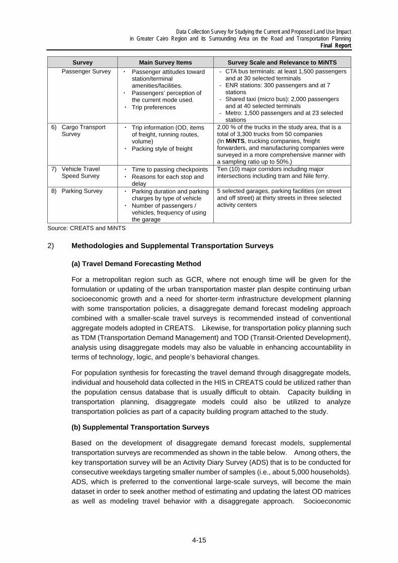
Data Collection Survey for Studying the Current and Proposed Land Use Impact in Greater Cairo Region and its Surrounding Area on the Road and Transportation Planning
Final Report
4-15
Survey Main Survey Items Survey Scale and Relevance to MiNTS Passenger Survey ・ Passenger attitudes toward
station/terminal amenities/facilities.
・ Passengers’ perception of the current mode used.
・ Trip preferences
- CTA bus terminals: at least 1,500 passengers and at 30 selected terminals
- ENR stations: 300 passengers and at 7 stations
- Shared taxi (micro bus): 2,000 passengers and at 40 selected terminals
- Metro: 1,500 passengers and at 23 selected stations
6) Cargo Transport Survey
・ Trip information (OD, items of freight, running routes, volume)
・ Packing style of freight
2.00 % of the trucks in the study area, that is a total of 3,300 trucks from 50 companies (In MiNTS, trucking companies, freight forwarders, and manufacturing companies were surveyed in a more comprehensive manner with a sampling ratio up to 50%.)
7) Vehicle Travel Speed Survey
・ Time to passing checkpoints ・ Reasons for each stop and
delay
Ten (10) major corridors including major intersections including tram and Nile ferry.
8) Parking Survey ・ Parking duration and parking charges by type of vehicle
・ Number of passengers / vehicles, frequency of using the garage
5 selected garages, parking facilities (on street and off street) at thirty streets in three selected activity centers
Source: CREATS and MiNTS
2) Methodologies and Supplemental Transportation Surveys
(a) Travel Demand Forecasting Method
For a metropolitan region such as GCR, where not enough time will be given for the formulation or updating of the urban transportation master plan despite continuing urban socioeconomic growth and a need for shorter-term infrastructure development planning with some transportation policies, a disaggregate demand forecast modeling approach combined with a smaller-scale travel surveys is recommended instead of conventional aggregate models adopted in CREATS. Likewise, for transportation policy planning such as TDM (Transportation Demand Management) and TOD (Transit-Oriented Development), analysis using disaggregate models may also be valuable in enhancing accountability in terms of technology, logic, and people’s behavioral changes.
For population synthesis for forecasting the travel demand through disaggregate models, individual and household data collected in the HIS in CREATS could be utilized rather than the population census database that is usually difficult to obtain. Capacity building in transportation planning, disaggregate models could also be utilized to analyze transportation policies as part of a capacity building program attached to the study.
(b) Supplemental Transportation Surveys
Based on the development of disaggregate demand forecast models, supplemental transportation surveys are recommended as shown in the table below. Among others, the key transportation survey will be an Activity Diary Survey (ADS) that is to be conducted for consecutive weekdays targeting smaller number of samples (i.e., about 5,000 households). ADS, which is preferred to the conventional large-scale surveys, will become the main dataset in order to seek another method of estimating and updating the latest OD matrices as well as modeling travel behavior with a disaggregate approach. Socioeconomic
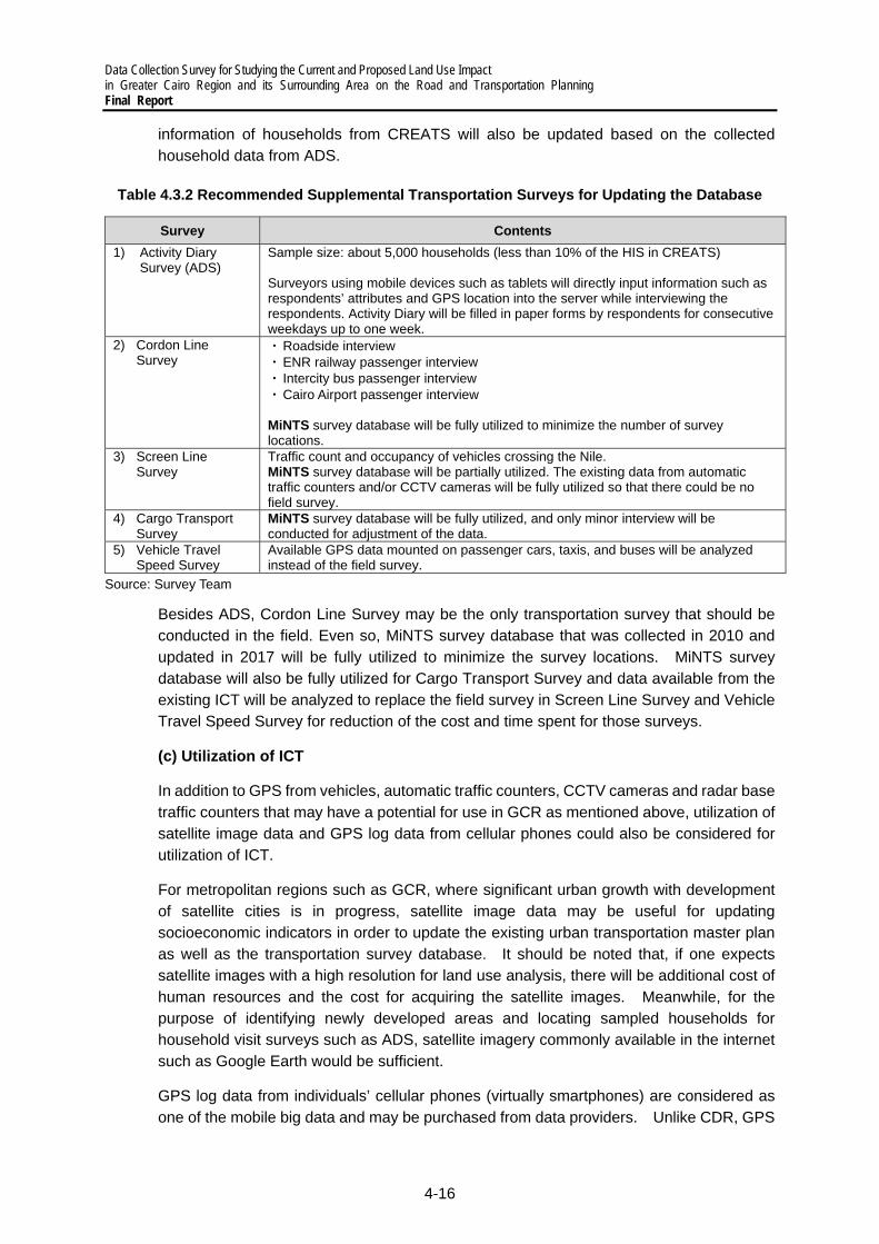
Data Collection Survey for Studying the Current and Proposed Land Use Impact in Greater Cairo Region and its Surrounding Area on the Road and Transportation Planning Final Report
4-16
information of households from CREATS will also be updated based on the collected household data from ADS.
Table 4.3.2 Recommended Supplemental Transportation Surveys for Updating the Database
Survey Contents 1) Activity Diary
Survey (ADS)
Sample size: about 5,000 households (less than 10% of the HIS in CREATS) Surveyors using mobile devices such as tablets will directly input information such as respondents’ attributes and GPS location into the server while interviewing the respondents. Activity Diary will be filled in paper forms by respondents for consecutive weekdays up to one week.
2) Cordon Line Survey
・ Roadside interview ・ ENR railway passenger interview ・ Intercity bus passenger interview ・ Cairo Airport passenger interview MiNTS survey database will be fully utilized to minimize the number of survey locations.
3) Screen Line Survey
Traffic count and occupancy of vehicles crossing the Nile. MiNTS survey database will be partially utilized. The existing data from automatic traffic counters and/or CCTV cameras will be fully utilized so that there could be no field survey.
4) Cargo Transport Survey
MiNTS survey database will be fully utilized, and only minor interview will be conducted for adjustment of the data.
5) Vehicle Travel Speed Survey
Available GPS data mounted on passenger cars, taxis, and buses will be analyzed instead of the field survey.
Source: Survey Team
Besides ADS, Cordon Line Survey may be the only transportation survey that should be conducted in the field. Even so, MiNTS survey database that was collected in 2010 and updated in 2017 will be fully utilized to minimize the survey locations. MiNTS survey database will also be fully utilized for Cargo Transport Survey and data available from the existing ICT will be analyzed to replace the field survey in Screen Line Survey and Vehicle Travel Speed Survey for reduction of the cost and time spent for those surveys.
(c) Utilization of ICT
In addition to GPS from vehicles, automatic traffic counters, CCTV cameras and radar base traffic counters that may have a potential for use in GCR as mentioned above, utilization of satellite image data and GPS log data from cellular phones could also be considered for utilization of ICT.
For metropolitan regions such as GCR, where significant urban growth with development of satellite cities is in progress, satellite image data may be useful for updating socioeconomic indicators in order to update the existing urban transportation master plan as well as the transportation survey database. It should be noted that, if one expects satellite images with a high resolution for land use analysis, there will be additional cost of human resources and the cost for acquiring the satellite images. Meanwhile, for the purpose of identifying newly developed areas and locating sampled households for household visit surveys such as ADS, satellite imagery commonly available in the internet such as Google Earth would be sufficient.
GPS log data from individuals’ cellular phones (virtually smartphones) are considered as one of the mobile big data and may be purchased from data providers. Unlike CDR, GPS

Data Collection Survey for Studying the Current and Proposed Land Use Impact in Greater Cairo Region and its Surrounding Area on the Road and Transportation Planning
Final Report
4-17
log data could be attached to individuals’ attribute data which are available for optional purchase; thus, GPS log data may replace large-scale transportation surveys for travel demand modeling. However, for actual application of GPS log data in GCR, the following questions need to be asked of local data providers and cleared beforehand:
Whether smartphones are widely spread and used by all the people from the low- to high-income households in GCR;
Whether GPS log data can be taken randomly from the target population;
The number of smartphone users who are willing to provide GPS log data, in contrast to those who are reluctant to provide GPS logs due to the privacy reasons and low battery problems; and
Eventually, the approximate market price of the GPS log data for 24/7 with individual demographic attributes.
3) Possibility to Utilize ICT on Transportation Survey
(a) Utilization of Mobile GPS data to update OD table
As mentioned above, traditional transportation survey is sometimes inefficient and
the number of samples is limited, especially in the large-scale area of GCR which
includes many cities. In addition, it seems difficult to get corporation from respondents
by face-to-face interview in Egypt due to the privacy of travel and personnel
information. Therefore, the possibility to utilize Mobile GPS data is considered.
i) Description of Mobile GPS data Mobile GPS data is actual position (latitude/longitude) of mobile phone users measured by GPS at each time. Recently, both international and local GIS companies (such as Bey2ollak) have started businesses in Egypt and it was confirmed that data is available to be purchased without the permission form government. By this situation, there is higher possibility to get GPS data from GIS company than CDR with higher data security and more procedures to get. Anyway, the use of Mobile GPS data is still under the regulation of NTRA. After receiving the data, the accuracy of the data should be confirmed before applying.
ii) The Concept Idea to Utilize Mobile GPS data In transport demand forecasting process, it can save lots of survey time by utilizing Mobile GPS data with the significantly larger number of samples than those of traditional survey as and input to update the transportation database and demand forecasting. In addition, it can reduce the issue of incorporative respondents. Mobile GPS data can supplement large amount of GPS log data, giving a chance for transport planner to estimate trip generation and distribution of each zone, as well as person’s trips change by the time. Consequently, O-D table can be more precisely calibrated and developed. However, mode use cannot be directly obtained directly by observing Mobile GPS data. It requires data processing and interpretation. For example, railways users can be
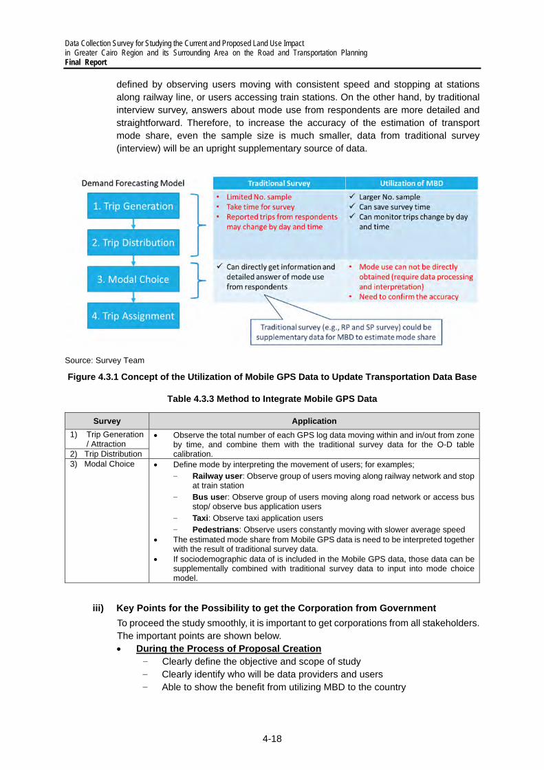
Data Collection Survey for Studying the Current and Proposed Land Use Impact in Greater Cairo Region and its Surrounding Area on the Road and Transportation Planning Final Report
4-18
defined by observing users moving with consistent speed and stopping at stations along railway line, or users accessing train stations. On the other hand, by traditional interview survey, answers about mode use from respondents are more detailed and straightforward. Therefore, to increase the accuracy of the estimation of transport mode share, even the sample size is much smaller, data from traditional survey (interview) will be an upright supplementary source of data.
Source: Survey Team
Figure 4.3.1 Concept of the Utilization of Mobile GPS Data to Update Transportation Data Base
Table 4.3.3 Method to Integrate Mobile GPS Data
Survey Application 1) Trip Generation
/ Attraction Observe the total number of each GPS log data moving within and in/out from zone
by time, and combine them with the traditional survey data for the O-D table calibration. 2) Trip Distribution
3) Modal Choice Define mode by interpreting the movement of users; for examples;
‒ Railway user: Observe group of users moving along railway network and stop at train station
‒ Bus user: Observe group of users moving along road network or access bus stop/ observe bus application users
‒ Taxi: Observe taxi application users
‒ Pedestrians: Observe users constantly moving with slower average speed The estimated mode share from Mobile GPS data is need to be interpreted together
with the result of traditional survey data. If sociodemographic data of is included in the Mobile GPS data, those data can be
supplementally combined with traditional survey data to input into mode choice model.
iii) Key Points for the Possibility to get the Corporation from Government To proceed the study smoothly, it is important to get corporations from all stakeholders. The important points are shown below. During the Process of Proposal Creation
‒ Clearly define the objective and scope of study ‒ Clearly identify who will be data providers and users ‒ Able to show the benefit from utilizing MBD to the country

Data Collection Survey for Studying the Current and Proposed Land Use Impact in Greater Cairo Region and its Surrounding Area on the Road and Transportation Planning
Final Report
4-19
‒ Simple data visualization will help stakeholders to understand the benefits Procedure to get the sample of data
‒ Focusing on providers which have the right of law and regulation that can immediately provide or sell the data which can save time to complete the procedures
(b) Further improvement of vehicle type detection software of CCTV Sensors
As mentioned in Section 3.3 of Chapter 3, Traffic Police has hired outsource company to convert some of them to be traffic counter by applying Image Processing Technology with AI. In the system, road traffic images from a CCTV camera are taken into process as an input. Then, vehicle detection by counting algorithm is implemented. The system can get the results in parameter such as traffic volume, density, and congestion length by time of the day. However, the recent difficulty is to differentiate type of those vehicles due to the uncompleted image recognition database. Further development of software is needed in order to enhance the accuracy.
Directional Vehicle Counting Data Set Synthetic Training Data
Source: Chang et al. 2020
Figure 4.3.3 Example of Application of Image Processing Technology
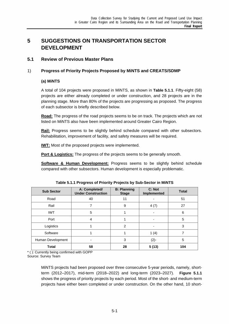
Data Collection Survey for Studying the Current and Proposed Land Use Impact in Greater Cairo Region and its Surrounding Area on the Road and Transportation Planning
Final Report
5-1
5 SUGGESTIONS ON TRANSPORTATION SECTOR DEVELOPMENT
5.1 Review of Previous Master Plans
1) Progress of Priority Projects Proposed by MiNTS and CREATS/SDMP
(a) MiNTS
A total of 104 projects were proposed in MiNTS, as shown in Table 5.1.1. Fifty-eight (58) projects are either already completed or under construction, and 28 projects are in the planning stage. More than 80% of the projects are progressing as proposed. The progress of each subsector is briefly described below.
Road: The progress of the road projects seems to be on track. The projects which are not listed on MiNTS also have been implemented around Greater Cairo Region.
Rail: Progress seems to be slightly behind schedule compared with other subsectors. Rehabilitation, improvement of facility, and safety measures will be required.
IWT: Most of the proposed projects were implemented.
Port & Logistics: The progress of the projects seems to be generally smooth.
Software & Human Development: Progress seems to be slightly behind schedule compared with other subsectors. Human development is especially problematic.
Table 5.1.1 Progress of Priority Projects by Sub-Sector in MiNTS
Sub Sector A: Completed/ Under Construction
B: Planning Stage
C: Not Implemented Total
Road 40 11 - 51
Rail 7 9 4 (7) 27
IWT 5 1 - 6
Port 4 1 - 5
Logistics 1 2 - 3
Software 1 1 1 (4) 7
Human Development - 3 (2)- 5
Total 58 28 5 (13) 104* ( ): Currently being confirmed with GOPPSource: Survey Team
MiNTS projects had been proposed over three consecutive 5-year periods, namely, short-term (2012–2017), mid-term (2018–2022) and long-term (2023–2027). Figure 5.1.1 shows the progress of priority projects by each period. Most of the short- and medium-term projects have either been completed or under construction. On the other hand, 10 short-
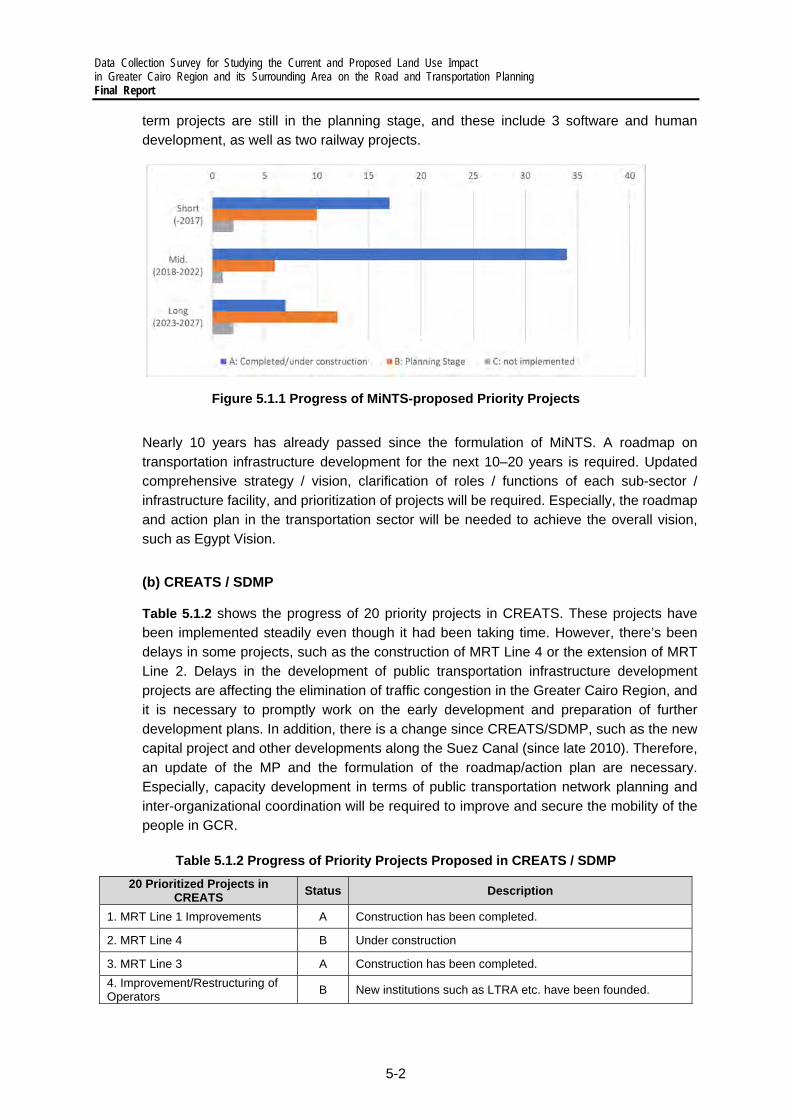
Data Collection Survey for Studying the Current and Proposed Land Use Impact in Greater Cairo Region and its Surrounding Area on the Road and Transportation Planning Final Report
5-2
term projects are still in the planning stage, and these include 3 software and human development, as well as two railway projects.
Figure 5.1.1 Progress of MiNTS-proposed Priority Projects
Nearly 10 years has already passed since the formulation of MiNTS. A roadmap on transportation infrastructure development for the next 10–20 years is required. Updated comprehensive strategy / vision, clarification of roles / functions of each sub-sector / infrastructure facility, and prioritization of projects will be required. Especially, the roadmap and action plan in the transportation sector will be needed to achieve the overall vision, such as Egypt Vision.
(b) CREATS / SDMP
Table 5.1.2 shows the progress of 20 priority projects in CREATS. These projects have been implemented steadily even though it had been taking time. However, there’s been delays in some projects, such as the construction of MRT Line 4 or the extension of MRT Line 2. Delays in the development of public transportation infrastructure development projects are affecting the elimination of traffic congestion in the Greater Cairo Region, and it is necessary to promptly work on the early development and preparation of further development plans. In addition, there is a change since CREATS/SDMP, such as the new capital project and other developments along the Suez Canal (since late 2010). Therefore, an update of the MP and the formulation of the roadmap/action plan are necessary. Especially, capacity development in terms of public transportation network planning and inter-organizational coordination will be required to improve and secure the mobility of the people in GCR.
Table 5.1.2 Progress of Priority Projects Proposed in CREATS / SDMP 20 Prioritized Projects in
CREATS Status Description
1. MRT Line 1 Improvements A Construction has been completed.
2. MRT Line 4 B Under construction
3. MRT Line 3 A Construction has been completed.
4. Improvement/Restructuring of Operators
B New institutions such as LTRA etc. have been founded.

Data Collection Survey for Studying the Current and Proposed Land Use Impact in Greater Cairo Region and its Surrounding Area on the Road and Transportation Planning
Final Report
5-3
20 Prioritized Projects in CREATS Status Description
5. Public Bus Fleet Modernization B Installment of new vehicles such as GPS equipped busses in CTA etc. There is a plan of installing electrical buses.
6. MRT Line 2 Extensions B Under construction
7. Institutional Strengthening B
Each institution’s roles, functions and authorities have been strengthened, still the actual functioning and implementation have been in developmental phase. Regarding GOPP, the roles has become clearer by the Construction Law in 2008.
8. Super tram Line 1 B Regarding some parts of the proposed lines, east and north part, are under construction in the Mono-rail Plan between East Cairo and New Capital. 9. Super tram Line 3 B
10. 6th of October Trunk Busway B Included in the on-going BRT/LRT project by UN-Habitat.
11. Accessible Public Transport for All
B Some pilot projects have been implemented such as Women-only carriages and consideration for the Disabled opinions, however, the overall implementations have been limited.
12. Central Cairo GS Plan Package
A Grade separation projects have been implemented in Cairo, however more improvements are required due to road network change and lack of access roads. 13. Shobra El Kheima GS Plan
Package A
14. Rail Wing East (Phase 1) B Not exactly the same with the proposed plans, however as the transportation methods between Cairo and 10th of Ramadan city, NAT has been planning LRT project. 15. Rail Wing East (Phase 2) B
16. Cargo Transport Sector Restructuring
A Development of ports and dry ports, and the truck transports have been steadily going up.
17. Tram / Heliopolis Metro Rehabilitation
B Renewal plans for sections between Ramsis station and the Al maza areas funded by EBRD and AFD.
18. Human resources development
B It appears that there’ve been some exercises, however also some unsolved and emerging issues.
19. River and Rail Container Terminals
A There’ve been development of logistic center in 6th of October and 10th of Ramadan, and studies for inner-water terminals in Sadat city.
20. Investment decision procedures
A Private investment has been encouraged such as Ministry of Investment and Free Zone (2004), and it appears that private investment has put in the field of ports.
A: Completed, B: Under construction, C: Delay of project Source: Survey Team
2) Implementation Gap with MPs
After supporting the formulation of MPs through JICA studies, a smooth and adequate implementation is always a critical issue. Important suggestions are identified in the following paper related to this point:
How to fill the implementation gap for inclusive growth -Case studies covering urban transport sector development in Egypt-, Hideki Matsunaga, Mayada Magdy, March 2015”1
This paper has claimed that there is the gap between MPs and their implementation. The following points will need to be taken into consideration when a revised MP is prepared:
1: https://www.brookings.edu/research/how-to-fill-the-implementation-gap-for-inclusive-growth-case-studies-covering-urban-transportation-sector-development-in-egypt/
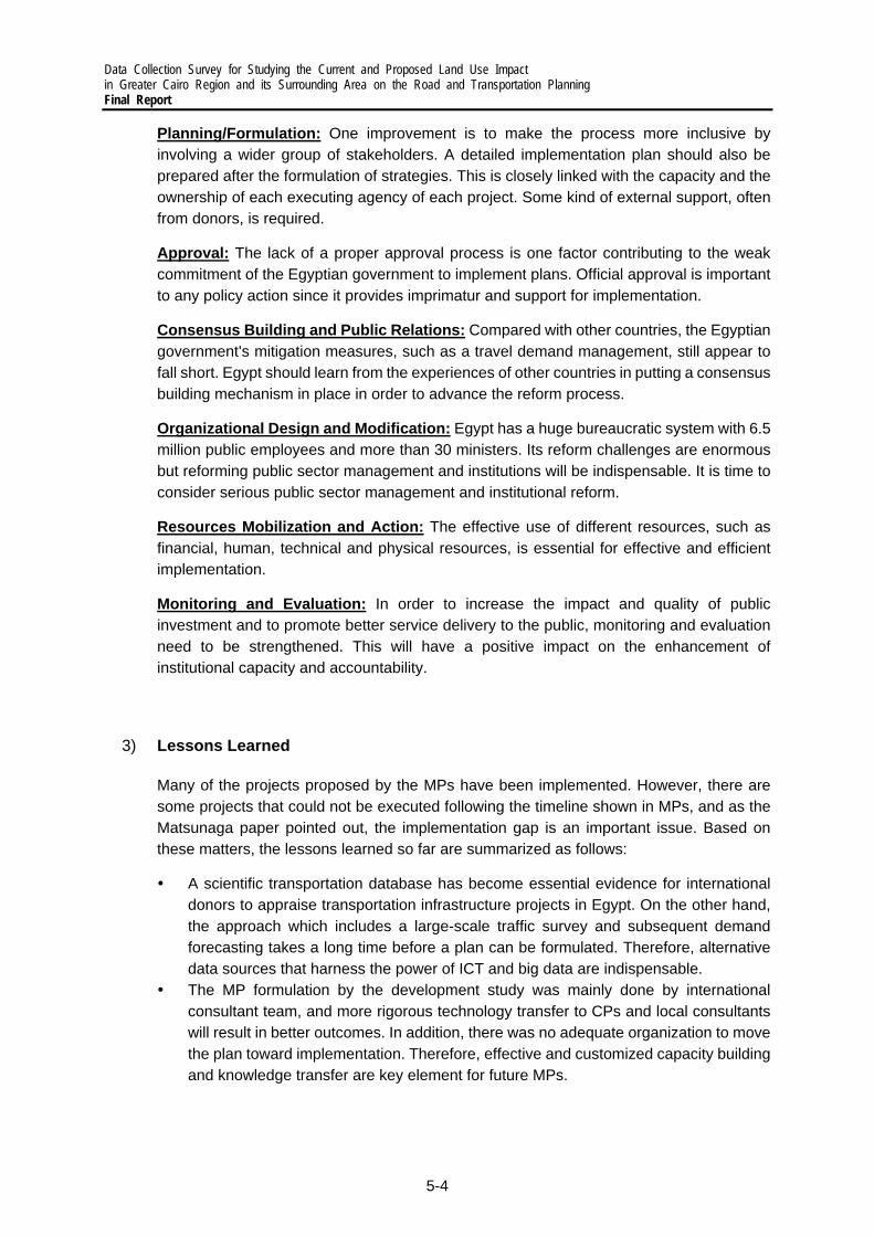
Data Collection Survey for Studying the Current and Proposed Land Use Impact in Greater Cairo Region and its Surrounding Area on the Road and Transportation Planning Final Report
5-4
Planning/Formulation: One improvement is to make the process more inclusive by involving a wider group of stakeholders. A detailed implementation plan should also be prepared after the formulation of strategies. This is closely linked with the capacity and the ownership of each executing agency of each project. Some kind of external support, often from donors, is required.
Approval: The lack of a proper approval process is one factor contributing to the weak commitment of the Egyptian government to implement plans. Official approval is important to any policy action since it provides imprimatur and support for implementation.
Consensus Building and Public Relations: Compared with other countries, the Egyptian government's mitigation measures, such as a travel demand management, still appear to fall short. Egypt should learn from the experiences of other countries in putting a consensus building mechanism in place in order to advance the reform process.
Organizational Design and Modification: Egypt has a huge bureaucratic system with 6.5 million public employees and more than 30 ministers. Its reform challenges are enormous but reforming public sector management and institutions will be indispensable. It is time to consider serious public sector management and institutional reform.
Resources Mobilization and Action: The effective use of different resources, such as financial, human, technical and physical resources, is essential for effective and efficient implementation.
Monitoring and Evaluation: In order to increase the impact and quality of public investment and to promote better service delivery to the public, monitoring and evaluation need to be strengthened. This will have a positive impact on the enhancement of institutional capacity and accountability.
3) Lessons Learned
Many of the projects proposed by the MPs have been implemented. However, there are some projects that could not be executed following the timeline shown in MPs, and as the Matsunaga paper pointed out, the implementation gap is an important issue. Based on these matters, the lessons learned so far are summarized as follows:
A scientific transportation database has become essential evidence for international donors to appraise transportation infrastructure projects in Egypt. On the other hand, the approach which includes a large-scale traffic survey and subsequent demand forecasting takes a long time before a plan can be formulated. Therefore, alternative data sources that harness the power of ICT and big data are indispensable.
The MP formulation by the development study was mainly done by international consultant team, and more rigorous technology transfer to CPs and local consultants will result in better outcomes. In addition, there was no adequate organization to move the plan toward implementation. Therefore, effective and customized capacity building and knowledge transfer are key element for future MPs.

Data Collection Survey for Studying the Current and Proposed Land Use Impact in Greater Cairo Region and its Surrounding Area on the Road and Transportation Planning
Final Report
5-5
With legal and political backbones including administrative approvals by relevant organizations, the previous MPs might have been more effective with sufficient commitment to implementation.
Due to the limitation of human capacity of counterpart organizations, there was a large gap between planning and implementation.
To address the above-mentioned issues, the following points are recommended:
Update the transportation database by utilizing results of existing surveys and utilize modern technologies, such as ICT, when conducting supplemental traffic surveys.
Examine roadmaps and action plans that will be necessary to implement projects to be proposed by an updated MP.
When preparing the revised MP, adopt the scheme used in technical cooperation projects, i.e., apply on-the-job training among counterparts, and conduct pilot projects to determine feasibility of projects.
Designate GOPP as the main counterpart in the technical cooperation project and establish a system to coordinate among related organizations of the MOT.
Ensure that the updated MP is approved officially by responsible authorities such as MHUUC and MOT, and commit it to implement the plan; Link the updated MP to the existing national plan, Egypt’s Vision 2030, to make it more effective.

Data Collection Survey for Studying the Current and Proposed Land Use Impact in Greater Cairo Region and its Surrounding Area on the Road and Transportation Planning Final Report
5-6
5.2 Country Assistance Policy by International Donors
The following part elaborates on the multilateral and regional banks, and bilateral donors work for transportation sector in Egypt.
1) France (Agence Française de Développement (AFD)
Diversified portfolio in the country with around Euro 600M allocated to the sector, especially on urban transportation with the financing of metro lines (1 and 3) in Cairo, renovation of the tramway in Alexandria, and electrification of Abukeir, Alexandria railway line electrification; Mansoura- Damietta (Delta region) railway line development beside technical cooperation with MOT. The upcoming activities will focus also on railways and providing technical support.
AFD financed a project related to sustainable transportation in Egypt with the ministry of environment related to emissions modelling.
2) International Organizations
(a) World Bank Group
World Bank Egypt`s portfolio is diversified among different transport sector at the national and urban levels.
The railways modernization project for Cairo-Giza- Beni Suef (South of Egypt) started in 2021 with USD 400 million for upgrading of track and signaling system, system asset management improvement, and human resource development.
Beside the Air Quality Management Program in GCR, component 3 which focus on introducing e-buses to support CTA with USD 40 million. The purpose is to identify opportunities and needs to electrify public transport operations, and updating e-buses strategy for the long term. In addition, there are 3 ongoing studies as follows:
Preparing for a new freight project for linking Alexandria port to 6th October city dry ports to support the 49 km missing link. The purpose is to ensure cargo delivery to the port and rehabilitation of the existing freight line. The project concept note is under preparation.
MAPTIS mobility access and public transportation improvement study in GCR which aims to understand the mobility plan in the region and identify opportunities of intervention.
Regional women mobility study which will focus on women accessibility for urban transportation system.
(b) European Bank for Reconstruction and Development (EBRD)
EBRD is focusing on rehabilitation of Cairo Metro line 1 and 2, Alexandria tram electrification (Euro 250 million) and an e-mobility strategy.
(c) UN-Habitat

Data Collection Survey for Studying the Current and Proposed Land Use Impact in Greater Cairo Region and its Surrounding Area on the Road and Transportation Planning
Final Report
5-7
UN-Habitat focus is the first BRT connecting 6th October city to Giza with 42 km corridor and introducing the first bike sharing project between Downtown area and Zamalek (500 bikes with GPS with 45 stations). In addition to a study in collaboration with UN Women for gender mainstreaming for BRT project.
(d) African Development Bank (AfDB)
African Development Bank (AfDB) also focuses on railway modernization project with Euro 150 million for supporting ENR covering 1,000 km (Alexandria- Cairo- Nagaa Hammadi at Qena Governorate in the south).
In addition to an ongoing study for river transport to analyze the regulatory framework for establishing freight and passenger lines between Uganda lake and River Nile in Egypt. AfDB is currently working on mobilizing finance for the Environmental and Social Assessment (ESA) to start phase 2 (estimated to cost USD 5 million). Other recent study with the Ministry of Electricity and Renewable Energy which covers transportation sector and e-mobility. AfDB will focus more on supporting 6th of October city dry ports, sea ports and railways for the next years.
Table 5.2.1 Summary of Transport Projects in Egypt for the listed DFIs
Project IFI C/P City Status Loan Grant Railways
Egypt National Railways Restructuring Project WB ENR
Alexandria-Cairo Beni Suef-Asyut- Nag Hammadi
Closed Dec. 2020 USD 600M
Railway Improvement and Safety for Egypt Project WB ENR
Alexandria-Nag Hammadi corridor
Ongoing- Aug. 2021
USD 440M
Egypt National Railways Modernization Project AfDB ENR
Alexandria-Nag Hammadi & Benha-Port Said corridors
Ongoing- Mar. 2021
EUR 145M
Tanta-Damietta Rehabilitation and Doubling Project
AFD ENR Tanta-Damietta corridor
Approved Jul. 2021
EUR 95M
Public Transport Greater Cairo Air Pollution Management and Climate Change Project- Component 3
WB
Cairo Governorate/CTA
Greater Cairo Area
Ongoing- Sep 2021
USD 40 M Out of USD 200 M
Urban
Upper Egypt Local Development PforR WB MOLD
Qena - Sohag - Menya - Assiut
Ongoing USD 500M
Rehabilitation and modernization of the Cairo metro line 1
AFD NAT Cairo Ongoing EUR 50 M EUR 300,000
Cairo Metro Line 3 Phase 3 AFD NAT Cairo Ongoing EUR 300 M
Abokir Metro Rehabilitation AFD NAT Alexandria Tendering
EUR 250 M
Alexandria Raml Tram Rehabilitation AFD NAT Alexandria Tendering
EUR 100 M
Cairo Metro Line No.4 Phase 1 JICA NAT Cairo-Giza
Ongoing / Tendering
JPY32,71M (1st Tranche)
TA/Analytical and Advisory Mobility Assessment and Public Transport Improvement Study (MAPTIS)
WB LTRA GCR Ongoing, $650K

Data Collection Survey for Studying the Current and Proposed Land Use Impact in Greater Cairo Region and its Surrounding Area on the Road and Transportation Planning Final Report
5-8
Regional eMobility Study (Egypt, Morocco, Jordan) WB
MOERE/ MOT
Nationwide Ongoing,
MENA Regional Gender Mobility Study WB Nationwide
To start in Q1 2022
Alexandria Raml Tram Rehabilitation AFD NAT Alexandria Tendering
EUR 8.5 M
Tanta-Damietta Rehabilitation and Doubling Project, TA and Capacity Building
AFD ENR Tanta-Damietta corridor
Approved July 2021, pre-tendering
EUR 2 M
Feasibility Studies for the Establishment of a Navigational Line between Lake Victoria and the Mediterranean Sea (VICMED) Project
AfDB MoT/MWRI
Transboundary (Nile Basin)
Appraisal USD 2 M
Data Collection Survey to assess the current situation regarding the impacts of land use on the transport network in Greater Cairo region
JICA
Min. of Housing/ General Organization for Physical Planning (GOPP)
Greater Cairo Area
Ongoing
Airports
Borg El Arab International Airport Extension Project JICA
Egyptian Airport Company EAC
Borg El Arab Ongoing, effective in 10/16/2019
18,200 M JPY

Data Collection Survey for Studying the Current and Proposed Land Use Impact in Greater Cairo Region and its Surrounding Area on the Road and Transportation Planning
Final Report
5-9
5.3 Recommendations on Transportation Sector Development
1) Significance of an Updated Master Plan
With the stable population growth in Egypt, it is indispensable to promote urban development with the development of appropriate transportation infrastructure to support the Egyptian economy. GOPP not only has a role of making suggestions on arterial transportation infrastructure plans to relevant organizations including MOT, but also has a strong commitment and control over the planning and formulation of new urban communities which determines traffic flows. And in particular, there is a need to update the MP, which enables the formulation of comprehensive transportation strategies and the appropriate evaluation to select priority projects.
According to interviews with World Bank officers, MiNTS had been an essential guide for them in appraising transportation infrastructure projects in the country for the past decade. For this reason, formulating master plans is essential to international donors in their future engagement and investment in transportation infrastructure.
Positioning of MP Update and Demarcation with Relevant Organizations:
When considering the development of the transportation sector, which contributes to the sustainable economic development in Egypt, the following two administrative responses are indispensable: One, the GOPP will be the main counterpart in updating the MPs, and, two, it will be necessary to create a strategy for transportation infrastructure development that is integrated with national land planning and new urban community development. At the same time, the role of transportation administration centered on the MOT will become more important to respond to each sub-sector issues.
Source: Survey Team
Figure 5.3.1 Positioning of MP Update and Role Sharing among Relevant Organizations

Data Collection Survey for Studying the Current and Proposed Land Use Impact in Greater Cairo Region and its Surrounding Area on the Road and Transportation Planning Final Report
5-10
2) Scope of Work of Updating the Master Plans
The key scope to examine when updating the master plans are: (a) passenger transportation, especially for public transportation (PT) network planning, (b) freight transportation planning, (c) development of a transportation database, and (d) setting of study area.
(a) Passenger Transportation
In the last two decades, the development of the new urban community and the decentralized urban structure have been promoted in the Greater Cairo Region. In passenger transportation, the formulation of a hierarchical PT network (Figure 5.3.3) which supports this urban development policy is a major issue. Currently, the construction of subways, monorails, and BRTs are underway at a rapid pace. It is necessary to maximize the effects of these projects and to have an overall picture of future passenger movements throughout the metropolitan area. Support for new city development and public transportation planning is required now. The following are proposed as specific planning study items:
PT network planning and evaluation TOD and intermodal transfer facility planning Proposal on last-mile mobility (mobility planning at neighborhood level) Proposal on PT reform and modernization Proposal on PT improvement from viewpoint of gender mainstreaming and vulnerable
persons.
Source: Prof. Morimoto, WASEDA Univ., JICA Knowledge Co-Creation Program “Comprehensive Urban Transport Planning, 2020”
Figure 5.3.2 Concept of a Hierarchical Public Transportation Network (cont.)

Data Collection Survey for Studying the Current and Proposed Land Use Impact in Greater Cairo Region and its Surrounding Area on the Road and Transportation Planning
Final Report
5-11
Source: Survey Team
Figure 5.3.3 Concept of a Hierarchical Public Transportation Network
(b) Freight Transportation
First of all, freight transportation can be the scope of updating, however, this per se is the sub-sector of updated transportation MPs.
After the formulation of the MiNTS MP, the development of ports and roads in Egypt progressed smoothly, and the development of the distribution network progressed. On the other hand, the transportation system currently depends on roads, and there are still issues regarding inland water transportation, rail freight transportation, and the efficiency of transportation services between cities / regions. It is necessary to build an intermodal transportation system to have a good modal connection to other transportation modes to improve efficiency of port operation and realize smooth logistics. Therefore, planning support, including the following considerations, is essential.
Clarification of roles and functions of rail freight and inland water transportation and examination / proposal of network development
Classification of seaport/ airport role and functions Planning of intermodal transportation connectivity projects Proposal on strengthening transportation connectivity for supply chain management
(SCM)
Major logistics corridors in Egypt are shown in Figure 5.3.4. Regarding the study of freight transportation, it is recommended that the plan be renewed for the wide-area economic zone including Alexander Cairo Region and Alexandria and Port Said Suez.
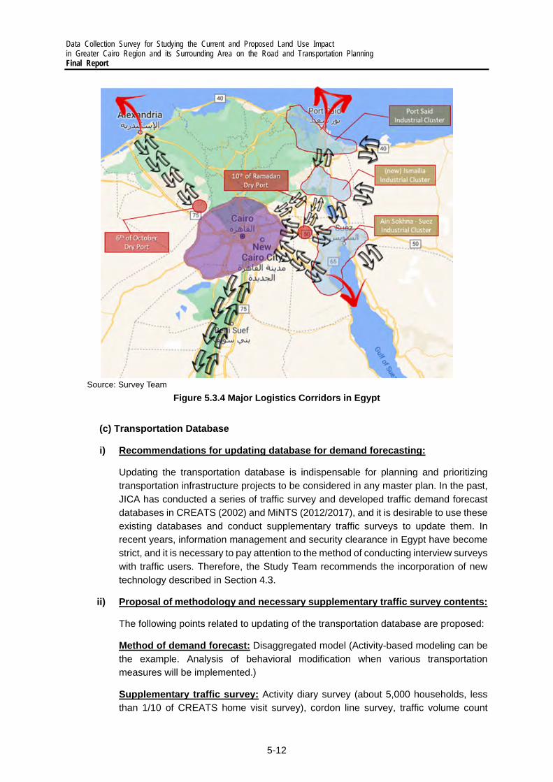
Data Collection Survey for Studying the Current and Proposed Land Use Impact in Greater Cairo Region and its Surrounding Area on the Road and Transportation Planning Final Report
5-12
Source: Survey Team
Figure 5.3.4 Major Logistics Corridors in Egypt
(c) Transportation Database
i) Recommendations for updating database for demand forecasting:
Updating the transportation database is indispensable for planning and prioritizing transportation infrastructure projects to be considered in any master plan. In the past, JICA has conducted a series of traffic survey and developed traffic demand forecast databases in CREATS (2002) and MiNTS (2012/2017), and it is desirable to use these existing databases and conduct supplementary traffic surveys to update them. In recent years, information management and security clearance in Egypt have become strict, and it is necessary to pay attention to the method of conducting interview surveys with traffic users. Therefore, the Study Team recommends the incorporation of new technology described in Section 4.3.
ii) Proposal of methodology and necessary supplementary traffic survey contents:
The following points related to updating of the transportation database are proposed:
Method of demand forecast: Disaggregated model (Activity-based modeling can be the example. Analysis of behavioral modification when various transportation measures will be implemented.)
Supplementary traffic survey: Activity diary survey (about 5,000 households, less than 1/10 of CREATS home visit survey), cordon line survey, traffic volume count
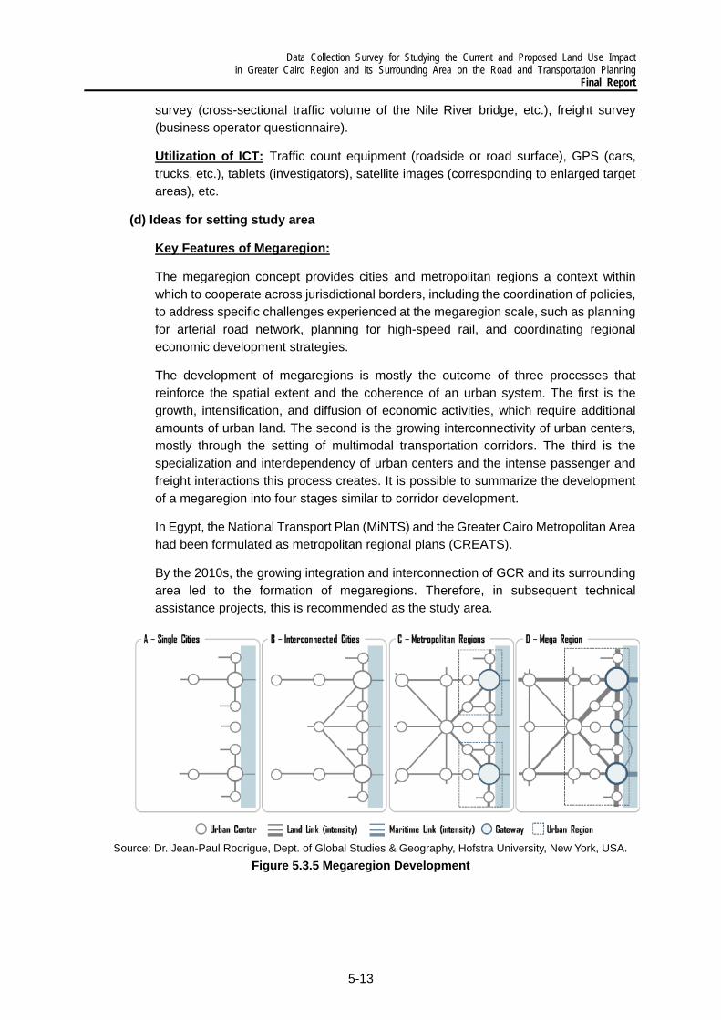
Data Collection Survey for Studying the Current and Proposed Land Use Impact in Greater Cairo Region and its Surrounding Area on the Road and Transportation Planning
Final Report
5-13
survey (cross-sectional traffic volume of the Nile River bridge, etc.), freight survey (business operator questionnaire).
Utilization of ICT: Traffic count equipment (roadside or road surface), GPS (cars, trucks, etc.), tablets (investigators), satellite images (corresponding to enlarged target areas), etc.
(d) Ideas for setting study area
Key Features of Megaregion:
The megaregion concept provides cities and metropolitan regions a context within which to cooperate across jurisdictional borders, including the coordination of policies, to address specific challenges experienced at the megaregion scale, such as planning for arterial road network, planning for high-speed rail, and coordinating regional economic development strategies.
The development of megaregions is mostly the outcome of three processes that reinforce the spatial extent and the coherence of an urban system. The first is the growth, intensification, and diffusion of economic activities, which require additional amounts of urban land. The second is the growing interconnectivity of urban centers, mostly through the setting of multimodal transportation corridors. The third is the specialization and interdependency of urban centers and the intense passenger and freight interactions this process creates. It is possible to summarize the development of a megaregion into four stages similar to corridor development.
In Egypt, the National Transport Plan (MiNTS) and the Greater Cairo Metropolitan Area had been formulated as metropolitan regional plans (CREATS).
By the 2010s, the growing integration and interconnection of GCR and its surrounding area led to the formation of megaregions. Therefore, in subsequent technical assistance projects, this is recommended as the study area.
Source: Dr. Jean-Paul Rodrigue, Dept. of Global Studies & Geography, Hofstra University, New York, USA.
Figure 5.3.5 Megaregion Development

Data Collection Survey for Studying the Current and Proposed Land Use Impact in Greater Cairo Region and its Surrounding Area on the Road and Transportation Planning
Final Report
6-1
6 PRELIMINARY ANALYSIS OF AN INTEGRATED URBAN AND TRANSPORTATION DEVELOPMENT
6.1 Summary of Urban Structure and Transportation Development Issues
1) Challenges Imposed by Urbanization and a Car-oriented Development
Urbanization has been a global trend, and despite efforts done by various levels of government, huge challenges in economic, social, environment, and governance aspects have remained. For instance, while urban areas or cities are the main centers of economic growth, in most cases, the merits of urbanization have not been spatially distributed equally, causing inequality among citizens and imperiling social justice. The concentration of population in limited areas has caused huge traffic congestion, deterioration of living standards, underdelivered public services, and other problems. At the same time, unplanned urbanization in hazardous areas has put people and infrastructure incredibly vulnerable to huge risks. Moreover, unplanned urbanization and urban sprawl have resulted in less dense areas, making it difficult to provide and access adequate public services. In most cases, this urbanization trend has led to a highly car-oriented development.
While unplanned urbanization and urban sprawl promote car-oriented development, it is also attributed to unplanned population growth, increase in household incomes, lack of public transportation and other transportation modes and infrastructure, as well as the unattractiveness of available transportation modes, spatial locations of shopping centers, huge investment and development of roads, car-based lifestyles, lower car-related expenditure such as fuels, tariffs, taxes, running costs, parking fees, etc. Car-oriented societies suffer from huge emissions of GHGs, air pollution, car accidents, increased travel costs and time, and mobility gap between those with and without cars.
Figure 6.1.1 Perspectives of Urbanization
2) Planning Issues on Integrated Urban and Transportation Development
As shown in Figure 6.1.2, the urban areas in the GCR has expanded in the past 20 years, as shown in the development of new urban communities in the east and west. It is expected that the population will continue to increase as the metropolitan area expands. It is thus

Data Collection Survey for Studying the Current and Proposed Land Use Impact in Greater Cairo Region and its Surrounding Area on the Road and Transportation Planning Final Report
6-2
important to develop a transportation infrastructure that is integrated with urban development. The planning issues from this perspective are summarized below.
Source: Survey Team
Figure 6.1.2 Population Density in the GCR, 1996–2020
Appropriate land use through transportation planning: Land use planning can be seen as a prerequisite to transportation planning. Yet, transportation planning is also an enabler to better land use planning and plot development. However, as seen in the GCR, the appropriate interaction and integration between transportation systems and land uses is not fully realized.
Connectivity among existing and planned cities: Currently, the connectivity among new urban communities highly relies on roads and road vehicles, but the role of mass transit, including trains, should be considered to provide connectivity inside cities for seamless movement and to create sustainable communities.
Relationship among districts, cities, and regions: The hierarchical delineation of jurisdiction among districts, cities, and regions when it comes to transportation planning and its interaction with land-use planning is clearly very complex especially for a region with the size and context of the GCR.
Diversity of stakeholders and varying capacities: The capacity of entities for urban and transportation planning is far from sufficient. Hence, a unified and clear organizational hierarchy among entities involved in urban transportation planning is needed. Because of the limitation of public authorities in terms of innovation, human resources, and budget, the support of the private sector and the civil society is important.
3) Direction of urban and spatial development and role of public transportation
(a) Limiting options of transportation infrastructure in the future due to too much investment in arterial roads The basic concept of creating satellite cities around the existing GCR and the redistribution of population has been shown in existing proposals, that is, to let these new cities absorb the overflow of population in the GCR. The main idea of the Cairo Vision per se lies in solving issues and challenges imposed by the huge increase in population and rapid urbanization in the existing GCR. As an example of this, areas are classified by income groups, that is, the areas for the middle-income group are around the 6th of October city,

Data Collection Survey for Studying the Current and Proposed Land Use Impact in Greater Cairo Region and its Surrounding Area on the Road and Transportation Planning
Final Report
6-3
Sheikh Zayed city, and El Shorouk city, and those for the high-income group are around New Cairo area.
Source: GOPP
Figure 6.1.3 Redistribution of Population from the Existing GCR
However, the overall design of the traffic flow within or to/from these areas has not been shown in the Cairo vision even though such flow affects the existing transportation infrastructure and should direct future projects in the sector. One of the reasons why it lacks this design might stem from an uncertainty about the future i.e., in terms of the kinds of industries that can be located in each area and where the workers of these industries can reside. It is understandable for policy makers to design the traffic flow in the main areas to be flexible for any scenario and adjustable to fit any situation. That is, the necessary transportation infrastructure is supposed to be developed in accordance with actual transportation demand.
Even so, in case of Egypt, the traffic flow design in the main areas has been quite effective to promote the preferred urban structure. That’s because actual land use and traffic flow are to some extent under the control of policy makers. For instance, the development of new urban communities is in the hands of government, i.e., the GOPP drafts national-level community plans, and the details of the land use and transportation at the local level are in the hands of relevant sections in the governorates, as indicated in the Law 119 of 2008. Even the main transportation infrastructure, such as arterial roads, which defines the boundaries of communities, cities, and regions are also in the hands of governmental authorities, and they can shape the urban structure. With this in mind, actual transportation infrastructure should be planned and decided based on future traffic demand, but the basic traffic flows should be planned with consideration given to financial requirements and time frame.
Currently, the construction of arterial roads is proceeding quite rapidly compared to urban development. If the basis of urban structure is road-oriented, then more and more people will use automobiles due to their convenience. Encouraging automobile users to shift to public transportation will become more difficult in the future. In turn, this means lower

Data Collection Survey for Studying the Current and Proposed Land Use Impact in Greater Cairo Region and its Surrounding Area on the Road and Transportation Planning Final Report
6-4
demand for public transportation, making it less attractive to invest in and construct public transportation infrastructure.
(b) Possible inter-area traffic flow design
Figure 6.1.4 shows the overall picture of the main areas in Cairo, Giza, and Qulyub governorates and the surrounding areas. The term “Greater Cairo Region,” which has been widely used, currently refers to the area inside the ring road, which is shown as ‘Area 1’ circled by a red line. Due to vigorous urban projects and the development of arterial roads, GCR now refers to the area inside the Regional Ring Road, the New Capital area, and the 10th of Ramadan city, which are all inside the dashed grey circle.
All in all, actual traffic demand or traffic flow within the GCR is not known, and even though there have been clear and well-considered plans, the target land use and traffic flow have not been realized. Under these limitations, the following are the possible ideas and concepts for each area shown in Figure 6.1.4.
Area 1, Existing Greater Cairo Region (area inside Ring Road):
The most populated area in Cairo region, and the area inside the Ring Road is the existing GCR. The population has spread to the adjacent areas, such as Maadi, which can be assumed to be the commuting zone of the existing GCR. Residents here appear to work in this region, and once the New Capital area starts to develop, some of Area 1’s population are expected to move to other areas, especially Area 3 and Area 4.
Area 2, 6th of October city and Sheik Zayed city:
This area consists of 6th of October and Sheik Zayed city as well as their extensions, New 6th of October city and Extension of Sheik Zayed city (New Sphinx city). Some residents here were assumed to commute to Area 1; however, due to the availability of jobs from industries located in 6th of October city and educational institutions (universities) in Area 2, many residents make intra-area trips only. Due probably to Area 2’s distance to Area 3 and Area 4, traffic flow between them is not significant; however, due to the spatial dispersion of families and friends, the exact situation is vague.
Area 3, New Cairo area, El Shorouk city, Badr city, and Madinaty:
Area 3 is New Cairo area and its surrounding area, including the newly planned urban communities, such as Capital Garden city. While most of the residents commute to both the existing GCR (Area 1) and New Capital (Area 4), the facilities needed for daily life and amenities are available in Area 3, thereby generating some intra-area traffic demand. The development area in Area 2 appears to be set based on housing demand.
Area 4, New Capital area:
This area is the epicenter of the urban structural change in this region. Once the operation of New Capital starts, more and more job opportunities are expected to be transferred from the existing GCR (Area 1) and be created in this area. Area 4 residents are expected to mainly commute inside this area; however, some family members may commute to adjacent areas such as Area 3 or Area 1. Because the function of this area is expected to become increasingly important, its development and the traffic demand inside this area are

Data Collection Survey for Studying the Current and Proposed Land Use Impact in Greater Cairo Region and its Surrounding Area on the Road and Transportation Planning
Final Report
6-5
likewise projected to pick up. In terms of public transportation use, since high income groups are supposed to reside in this area, car ownership will be sustained at a relatively high level, and the transition to public transportation may not be that smooth in this area. However, family members who do not drive cars, such as students or those who are reluctant to drive, can be the main users of public transportation.
Area 5, El Obour city and 10th of Ramadan city:
This area covers two existing cities, El Obour city and 10th of Ramadan city. In addition, a new urban area, New El Obour city, is already planned. The focus of this area can be its position in relation to its neighbors, such as Area 1 and Area 4. The traffic flow from this area is not certain, however, because of the physical distance from these two main areas. Area 5 is supposed to connect residential areas and workplaces, such as industrial areas, commercial areas, and those who can afford to provide jobs to the residents. Commuting trips between Area 3 and Area 5 might not be expected due to the similarity of both areas.
Area 6, Helwan city and 15th of May city:
Area 6 covers Helwan city and 15th of May city. This area is assumed to accommodate workers in the existing GCR (Area 1) and may generate trips to 6th of October city (Area 2). However, Area 6 cities are considered as independent satellite cities, so mainly intra-area traffic flow should be studied.
Area 7, Delta region:
The Delta region, which supplies agricultural products to urban areas, is also inside the regional ring road. This area’s development is relatively stable; however, in its western section, a New Delta project has already been set which aims at developing the agricultural area into a _____. Area 7 has small- to medium-sized towns and cities, such as Banha city, and the traffic demand between these cities is expected to remain in the current level by 20__.
Areas 8 and 9, Undeveloped areas:
Currently, the areas to the south of Area 2 and east of Area 6 have not been planned yet. They appear to be the buffer areas or areas to absorb any further population increase in the adjacent areas. Applying some development control can be a key approach in planning the GCR’s urban structure.

Data Collection Survey for Studying the Current and Proposed Land Use Impact in Greater Cairo Region and its Surrounding Area on the Road and Transportation Planning Final Report
6-6
Source: Original figure for this report
Figure 6.1.4 Regional Ring Road, New Capital, and 10th of Ramadan City as New GCR
(c) Balanced land use as fundamental element of inter/intra-area traffic
In addition to inter-area traffic flow design, there are three basic approaches to cope with urbanization by land use, that is, horizontal expansion, vertical expansion, and infill and redevelopment. Horizontal expansion basically means the boundary of existing cities expand, and the geographical area itself expands. This expansion is constrained by geographical conditions, such as mountains, sea, rivers, desert, and forest. This approach results in relatively sparse land use compared with vertical expansion. In vertical expansion, on the other hand, the geographical area itself is unchanged; however, by obtaining more floor space for buildings, the available spaces increase to absorb the demand for space. In general, this approach usually results in higher density. Infill and redevelopment are similar with vertical expansion, with city boundaries remaining unchanged; however, unutilized areas are revitalized, resulting in more dense areas and higher land values.
(d) Current horizontal development and necessity for vertical development and infill/redevelopment
Referencing the three development approaches mentioned above, the current state of the GCR seems to be relying on horizontal expansion, resulting in lower density. Figure 6.1.4 shows the concept and coverage of the future GCR, including both existing and planned cities. Currently, the GCR refers to the areas inside the Ring Road (Area 1). However, there is a possibility that the future GCR will cover all the areas inside the Regional Ring Road, including the New Capital area and adjacent cities, such as 10th of Ramadan City. Already, the population of GCR has spilled over to new urban communities, such as 6th of October City and New Cairo area, and this can be seen as the horizontal expansion of the current

Data Collection Survey for Studying the Current and Proposed Land Use Impact in Greater Cairo Region and its Surrounding Area on the Road and Transportation Planning
Final Report
6-7
GCR. And even inside these areas, the initial stage of the new urban communities has been extended in accordance with its growth. At the same time, main trunk roads have served as clear development boundaries for new urban communities.
However, this horizontal expansion has been causing several challenges, and vertical expansion and infill/redevelopment approaches are indispensable. In general, increased car dependency causes increased social costs, such as more energy expenditure, higher casualties, and wider disparity among socio-economic groups. In addition, the low-density development might hinder higher productivity and acceleration of economic development. Although the horizontal expansion appears to be important to absorb the huge pressure due to rapid population and economic growth, or to accommodate a preferred lifestyle which calls for car mobility, and there might be some external conditions, such as economies of scale, which deters the provision of public transportation infrastructure. However, in the long run, to diminish the negative effects of a car-dependent society, the reliance on public transportation should be emphasized. Thus, it is quite desirable to take into consideration vertical expansion in both existing and planned cities, as well as infill and redevelopment for existing cities. In addition, a compact and highly efficient land use reduces travel time, which can generate more economic activities.
(e) Enhancement of vertical development and infill/redevelopment
Need to control artificial urban sprawl and enhance concentration of population and facilities
Currently, horizontal development with low density land use has been proceeding in New Cairo area and other new urban communities. Urban development inside the Regional Ring Road has not been unanimous, and it cannot be compared with other mega cities across the globe. However, the total length of the Regional Ring Road reaches 400 km, and this is long enough in comparison with other ring roads, such as the M25 motorway, which is 188 km and covers Greater London, and Keno-do, which is 300 km and covers the main area of metropolitan Tokyo. Compared to the population and status of public transportation infrastructure, the area inside the Regional Ring Road (i.e., future Greater Cairo) and its surrounding areas, are exceptionally large and have low densities. The main centers, such as business districts and shopping malls, are difficult to access without using automobiles, and those who do not own cars have difficulties in leading a sound life.
To prevent the negative impacts of horizontal development, which can be assumed to be artificial urban sprawl, vertical development, which leads to an urban structure with increased accessibility, should be considered. Fundamentally, horizontal development can create economic benefits such as rise in land values, and vertical development can be competitive even though horizontal development might be economical in the short run compared to vertical development which requires tremendous construction cost for skyscrapers.
Consider vertical development and infill/redevelopment with PT infrastructure and appropriate land value capture
As written earlier, one of the main focuses of vertical development should be on increasing land values, and it can be done from two important perspectives, i.e., increasing the values per se and capturing land value. The former can use several methods, such as improving

Data Collection Survey for Studying the Current and Proposed Land Use Impact in Greater Cairo Region and its Surrounding Area on the Road and Transportation Planning Final Report
6-8
accessibility by providing PT infrastructure; agglomerating commercial facilities, businesses, shops, public facilities, etc. by zoning and area (re)development projects; and so on. The proximity to railway stations is shown to increase land values for both commercial and residential use. (cf. Debrezion G, Pels E, and Rietveld P. 2007) The latter perspective can be done by evaluating the economic benefits of vertical development.
Develop strategic PT infrastructure in existing cities and new urban communities
PT infrastructure can make positive impacts to the environment, social justice and equality, economic productivity, quality of life, and financial burdens. However, several challenges in terms of urban development direction remain. One challenge is the maintaining the balance between population redistribution and infrastructure investment. Once investments in public transportation is concentrated in one area, the existing GCR for instance, this area may attract more population, leading to more congestion and making it difficult to relocate the population to the surrounding areas of the GCR. It might be better to hold on to the investments until the surrounding areas are developed enough. Another challenge is the difficulty in investing and developing PT infrastructure in the early stage of urban development. That is, the provision of costly transportation infrastructure in New Cairo or New Capital may be difficult to implement in the initial phase. It can be said that the public transportation services and infrastructure enhance settlements, and in accordance with public spending capacity and actual traffic demand, transportation infrastructure should develop in stages, i.e., from low-capacity transportation services, such as buses and LRT, to high-capacity transportation infrastructure, such as heavy railways.
Examine financing for an integrated land use and transportation policy
In cases where vertical development and infill/redevelopment are considered, the appropriate financing methods are necessary. In comparison with road infrastructure, PT infrastructure, such as trains and metros, might not have enough financial sources. For example, automobile drivers pay taxes on petrol/diesel, automobiles, and consumption, and these can be a reasonable basis for public investment on roads. Trains and metros, however, might lack such financial sources to initiate for initial spending.
Taxes on land and buildings are precious financial sources for funding public transportation infrastructure; the same applies to other taxes related to urban planning and land use. In addition, PPP and other related schemes have also been important.
Data Collection Survey for Studying the Current and Proposed Land Use Impact in Greater Cairo Region and its Surrounding Area on the Road and Transportation Planning
Final Report
6-9
Source: Original figure for this report
Figure 6.1.5 Increasing Land Values and Obtaining Financing for Public Transportation
4) Key Features of Urban Structures and PT Patterns in Mega Cities
When considering the development direction for the new GCR, lessons can be derived from the experience of mega cities across the globe. However, instead of a car-oriented urban development, there is a model based on TOD, and one of the examples can be the Tokyo metropolitan area. With a population of 36.9 million (2021), it has is the main engine of Japan’s economic development.
Because of TOD, the modal shares in Tokyo metropolitan area in 2018 were 33% for rail, 3% for bus, 27% for automobiles, 1% for motorcycles, 13% for bicycles, and 23% for walking (Tokyo Metropolitan Person-trip Survey in 2018). The central part of the Tokyo metropolitan area, which covers 23 wards or special municipal-level administrative jurisdictions, has 9.48 million residents within an area of 630 km2. That is a population density of 15,109 persons per square kilometer. Tokyo has 15 metro lines, almost 40 railways, several monorails, and LRTs, and 6 high-speed railways. The history of Tokyo’s urban structure goes back to the pre-war period, which is 100 years ago. However, the development of metro lines and trains have been, to some extent, attributed to the economic development and accompanying huge traffic demand in the 1970s and 1980s.
The overall concept of this TOD model can be broken down into the five approaches shown in Figure 6.1.6. In the center of the Tokyo metropolitan area, metro and train networks cover almost the whole population in (A). While these networks connect subcenters to major centers, subcenters are connected to each other by relatively low-capacity modes, such as monorails (B). At the same time, access to/from airports, which have brought huge economic impact to both Tokyo and Japan’s economy, is via heavy railways (C). Tokyo has also helped in revitalizing suburban centers, and by introducing PT infrastructure with appropriate capacities, these centers have enhanced mobility environment (D). In the central business district, much emphasis has been made on NMT, such as walking and bicycles, due to its economic merits and environmental benefits. In recent decades, bike lane development and sharing services have been introduced and promoted, while the walking environment has become increasingly comfortable for all ages and groups.

Data Collection Survey for Studying the Current and Proposed Land Use Impact in Greater Cairo Region and its Surrounding Area on the Road and Transportation Planning Final Report
6-10
Source: Survey Team
Figure 6.1.6 Spatial Structure of the Tokyo Metropolitan Area
5) Current Development Direction and Other Options
To summarize this chapter, the characteristics of current development in the GCR, i.e., vertical and car-oriented development, are shown in Table 6.1.1, together with the proposed direction for TOD.
Table 6.1.1 Current Development Direction in GCR and Proposed TOD
Aspect Current Vertical and Car-oriented Development Proposed TOD
Transportation ・Overdependency on private cars ・Limited shares of public transportation and
NMT
・Balanced shares of PT modes ・Increased usage of NMT ・Reduced travel time
Economic
・Economic benefits to road and real estate sector
・Limited productivity due to increased travel time
・Increased productivity due to reduced travel time ・Economies of agglomerations (Concentration of
new technology and skilled labor force)
Social
・Increased mobility gap between car-owners and non-owners
・Increased traffic accidents and inhumane incidents
・Vulnerable to market effects of natural resources
・Affordable transportation for low- and middle-income groups
・Public space design is necessary to provide access to all.
Environmental ・Increased energy consumption and GHG
emissions ・Huge health burden due to heavy air pollution
・Efficient energy consumption with mass transit
Governance
・Relatively fewer stakeholders ・Funding from taxes on private cars and fuels;
revenue from land development (real estate); etc.
・More stakeholders due to the increased variety of transportation modes
・Difficulty in securing appropriate fiscal resources because of limited taxations
Living standard
・Longer travel hours and congestion may be a social loss
・Comfortability in car use
・Uncomfortable travel using public transportation ・Reduced travel time due to concentration and
accessibility of facilities ・Increased disposable income due to savings from
car-related expenses ・Less likelihood of road traffic accidents and loss of
lives ・Reduced health burden due to lesser air pollution
and increased NMT
Main challenges
・Limited environmental and social sustainability ・Reduced convenience for citizens ・Mobility gap and disparity among citizens
・Consider power balance under the current system ・Establish financial and fiscal support and related
policies on constructing PT infrastructure
Data Collection Survey for Studying the Current and Proposed Land Use Impact in Greater Cairo Region and its Surrounding Area on the Road and Transportation Planning
Final Report
6-11
6.2 Vision and Strategy
1) Today’s Greater Cairo Region and the World
To elaborate the traffic impact in the GCR, the following indicators were selected to show the current congestion and air pollution, and how these are expected to increase in light of the estimated population growth.
City Index (CPCI): According to the Global Power City Index (CPCI) 2020 which evaluates cities in six urban functions (i.e., livability, environment, accessibility, economy, R&D, culture interaction), Cairo ranks 46th out of 48 cities1.
Ranking of Congested Cities in the World: Cairo is ranked as the 30th congested city in the world in 2020 with a congestion level of 36%, according to TomTom Traffic Index. Congestion during the morning rush is 36%, while that in the evening rush is worse, reaching 67%. The time lost during rush hours per 30-minute trip is 11 minutes in the morning and 20 minutes in the evening.2
Direct Congestion Costs: In 2010, the WBG estimated that the direct cost of congestion was at EGP14 billion or about USD2.5 billion or 1.4% of Egypt’s GDP. The breakdown of direct cost covers the following: delays for both passengers and freight; travel time unreliability in passenger transportation; excess fuel consumption in vehicular transportation (diesel and gasoline); carbon dioxide (CO2) emissions due to excess fuel consumption; and the costs of the fuel subsidy. The estimated congestion cost per capita was about 15% of the total GDP per capita for Egyptians, estimated at USD2,700 in 2010
by the World Bank.3
Air Pollution: A 2019 study by the WBG referred to the annual average of ambient PM2.5 in Greater Cairo which is higher than WHO’s air quality guidelines. Annual PM2.5 in Greater Cairo from 1999 to 2016 had average concentrations of 84 μg/m3 with the lowest concentration of 66 μg/m3 in 2016. The estimated deaths from PM2.5 in Greater Cairo in 2017 was 12%.
Increase in Number of Vehicles: The total number of licensed vehicles in Egypt reached 9.9 million in 2017 increasing from 6.6 million in 2012. Out of the 9.9 million in 2017, 4.7 million are private cars versus only 0.1 million buses. The rest are trucks at 1.3 million, as well as public service vehicles and others (tuktuk, motorcycle, heavy equipment, and tractors) at 3.1 million.4 This indicates the continuous increase in using cars every year meaning more congestion and air pollution.
It is necessary to clarify the vision and strategy for urban transportation to solve the above problems.
1 https://mori-m-foundation.or.jp/pdf/GPCI2020_summary.pdf 2 https://www.tomtom.com/en_gb/traffic-index/cairo-traffic/ 3 https://documents1.worldbank.org/curated/en/650141468248419267/pdf/718450ESW0Whit0ing0Annexes00PUBLIC0.pdf 4 https://www.capmas.gov.eg/Pages/IndicatorsPage.aspx?page_id=6131&ind_id=2288

Data Collection Survey for Studying the Current and Proposed Land Use Impact in Greater Cairo Region and its Surrounding Area on the Road and Transportation Planning Final Report
6-12
2) Future Urban Transportation in the GCR
It is difficult to radically solve the traffic problem in metropolitan areas with the conventional demand-oriented approach (forecasting based on improvements). The transportation strategy for the GCR needs to align with satellite city development including the development of the new capital, which is being promoted by the Egyptian government. The Survey Team proposes to adopt a backcasting approach wherein a vision for urban transportation is set first before developing strategies that connect that vision to the current conditions.
Source: Survey Team
Figure 6.2.1 Backcasting for the Urban Transportation Sector
3) Vision and Strategy for the Updated MP
The intention of the vision and strategies is to rid the GCR and its surrounding areas of traffic congestion, traffic accidents, pollution, poorly accessible areas, and other barriers to ensure the smooth movement of people and goods. The transportation network will also be comprehensible to both domestic and international visitors and accessible especially to persons with disabilities. The proposed vision and strategies on urban transportation in the GCR is shown in Figure 6.2.2.
The key strategies on transportation planning and development should have the following characteristics:
(a) Comprehensive Approach: As many projects/actions in large urban areas are interrelated, a sectoral approach and piecemeal solutions are not sustainable. Transportation and urban development must be integrated. Transportation modes need efficient intermodal connectivity, and infrastructure without proper management by IT and human resource may not function adequately.
(b) Continuity among Short-, Medium-, and Long-term Actions: Short-term solutions must be continued over the midterm and the long term, while long-term solutions must be started during the short-term period. Integrated, coordinated, and phased actions are

Data Collection Survey for Studying the Current and Proposed Land Use Impact in Greater Cairo Region and its Surrounding Area on the Road and Transportation Planning
Final Report
6-13
important for the effective use of limited resources. To propose a transportation plan that secures the ideal urban development, the master plan will adopt 2040 as the base target year with 2030 for the short term and 2050 for the long term.
(c) Emphasis on Urban Transportation Issues in the National Transportation Policy: As the efficiency of the GCR’s urban transportation affects the country’s economy and image, central government resources must be tapped efficiently. This includes projects which strengthen the connectivity between the GCR and other regions, as well as those providing access to international gateways, such as ports and airports.
Source: Survey Team
Figure 6.2.2 Proposed Vision and Strategies on Urban Transportation in the GCR
In addition to the ideas mentioned above, the vision should focus on the integration of urban development (land use) and public transportation, as shown in Figure 6.2.3.
Source: Survey Team
Figure 6.2.3 Vision of an Integrated Urban and Transportation Development in the GCR
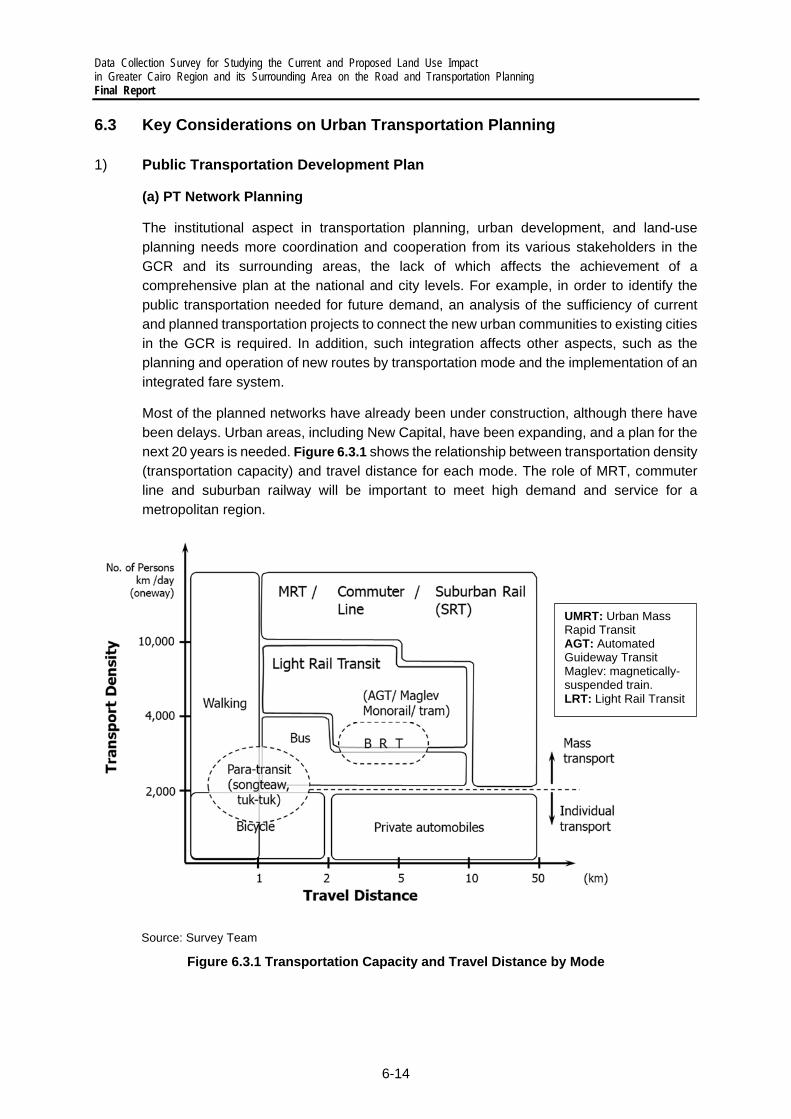
Data Collection Survey for Studying the Current and Proposed Land Use Impact in Greater Cairo Region and its Surrounding Area on the Road and Transportation Planning Final Report
6-14
6.3 Key Considerations on Urban Transportation Planning
1) Public Transportation Development Plan
(a) PT Network Planning
The institutional aspect in transportation planning, urban development, and land-use planning needs more coordination and cooperation from its various stakeholders in the GCR and its surrounding areas, the lack of which affects the achievement of a comprehensive plan at the national and city levels. For example, in order to identify the public transportation needed for future demand, an analysis of the sufficiency of current and planned transportation projects to connect the new urban communities to existing cities in the GCR is required. In addition, such integration affects other aspects, such as the planning and operation of new routes by transportation mode and the implementation of an integrated fare system.
Most of the planned networks have already been under construction, although there have been delays. Urban areas, including New Capital, have been expanding, and a plan for the next 20 years is needed. Figure 6.3.1 shows the relationship between transportation density (transportation capacity) and travel distance for each mode. The role of MRT, commuter line and suburban railway will be important to meet high demand and service for a metropolitan region.
Source: Survey Team
Figure 6.3.1 Transportation Capacity and Travel Distance by Mode
UMRT: Urban Mass Rapid Transit AGT: Automated Guideway Transit Maglev: magnetically-suspended train. LRT: Light Rail Transit

Data Collection Survey for Studying the Current and Proposed Land Use Impact in Greater Cairo Region and its Surrounding Area on the Road and Transportation Planning
Final Report
6-15
(b) TOD and Intermodal Facility Development Plan
Although past master plans have included the development of subways in the existing urban areas, the enhancement of TOD is required to develop the transportation infrastructure in new urban areas, including the New Capital.
Urban railways have a great impact on land use and define the urban spatial structure over the long term. Therefore, to enjoy the benefits of this impact, integration between urban railways and urban development is indispensable.
There is an urgent need to consider the applicability of the TOD planning components shown in Figure 6.3.2 in the GCR and its surrounding areas and thereafter to make a concept plan for each area, to wit:
In the CBD: Formulate an intermodal facility development plan.
In NUCs: Prepare regulations and formulate accessibility improvement plans through urban planning.
Source: JICA Tokyo KCCP (2021), Shigehisa Matsumura, Kwansei Gakuin University
Figure 6.3.2 TOD Planning Components
(c) Mobility Plan at the Neighborhood Level
Flexible and timely adoption of ICT and new services that have advanced in the last decade, such as MaaS, ride hailing, and cycle sharing, should be considered.
As part of identifying the sufficiency of public transportation services connecting new urban communities to each other (e.g., in the east-west corridor) and with existing cities, it is also important to understand the PT needs of new urban communities. Analyzing the mobility patterns of current and potential public transportation users (especially middle-class groups

Data Collection Survey for Studying the Current and Proposed Land Use Impact in Greater Cairo Region and its Surrounding Area on the Road and Transportation Planning Final Report
6-16
to encourage the shift from cars to public transportation) and their access to public transportation inside and outside their communities in the east and west of the GCR is essential. Understanding internal mobility patterns inside the new urban communities can also lead to different results, such as the need for improving the environment for NMT and for transforming into a low carbon community in the future, with the right infrastructure investments.
Accordingly, the Survey Team intends to conduct a household survey as part of their methodology for identifying mobility patterns and public transportation projects based on demand forecasts. In addition, the Team can include a behavioral study after consultation with different stakeholders to identify the possibility of car users shifting to public transportation.
(d) PT Modernization and Reform
Because there is a huge need for PT improvement, including informal modes, transportation administrators should take the initiative. And while the World Bank has also been engaged in this endeavor, a demarcation line needs to be confirmed in detail.
The transportation system in the GCR is diverse, from the metro lines, public and private buses, minibuses and microbuses, shared buses as Swvel, taxis, private cars, and ride hailing companies such as Uber.
Due to the complexity of the system and the diversity of transportation providers, the Survey Team has supported the planning of urban railways between the East and West corridor passing by the GCR, with a focus on extending the metro network.
In collaboration with other donors, the Team also supported bus operation integration, especially with the ongoing urban railway projects, such as the monorail and LRT, to avoid operational overlaps and to help the further integration of the transportation system.
(e) Mobility Plan in consideration of Gender Mainstreaming and Vulnerable Groups
The updated MP must include recent concepts added to city and transportation planning, such as gender mainstreaming, barrier-free transportation, and walkable-city planning. The Survey Team understands the necessity of gender mainstreaming based on group discussions and local consultations, and as specified in official requests.
To achieve social inclusion, the Survey Team has incorporated gender equality and considered the perspectives of vulnerable groups in updating the transportation plan.
2) Road / Logistics Facility Development Plan
The GCR is a complex area where population, business, and industry are intertwined, leading to chronic congestion on many urban highways and arterial roads. While this is a daily worry for the citizens of Cairo, it is also a major challenge for transportation personnel needing to pick up or deliver goods within the GCR, especially but not only inside the inner ring road.

Data Collection Survey for Studying the Current and Proposed Land Use Impact in Greater Cairo Region and its Surrounding Area on the Road and Transportation Planning
Final Report
6-17
Modern cities manage the co-existence of urban freight and passenger transportation via both mobility and land use measures which focus on the sustainability of the urban transportation system, to wit:
For urban passenger transportation, innovative PT services and alternative mobility solutions (e-mobility, shared mobility, micro-mobility, etc.) reduce the use of private cars while offering more efficient and inclusive mobility, reduce pollution, improve the urban landscape, and allow the co-existence between citizens and vehicles, leading to a higher quality of life for all.
For freight transportation, fifth party logistics, inspired by the complex needs of e-business, leverages the latest technologies to meet rising customer expectations, such as next day deliveries at no extra charge, optimized delivery processes (on-time / on demand delivery), business-integrated services (return logistics, market specific services) or cost-efficient inventory management (minimum to zero-stock). Especially for urban logistics, 5PL service providers need to work around traffic congestion, truck movement restrictions, lack of parking space, and other elements that pose major challenges to providing efficient, client-oriented services.
The government acknowledged the importance of modern logistics as a catalyst for economic growth and invests heavily in the industrial and legislative components, for example with the legalization of the electronic signature and the gradual automation of administrative procedures. Its dry-port strategy involves the creation of a national network of dry ports and logistics centers, as demonstrated in and Table 6.3.1.
Table 6.3.1 Dry Port Development Plan
Figure 6.3.3 Dry Port and Logistics Network
But the study of the transportation sector indicated that the sector itself and the industrial actors in Egypt as a whole remain reluctant to the development of a modern logistics sector. The key gaps that are detrimental to the development of a supply chain and logistics system in Egypt include the following:
1. Confusion about the definition of logistics

Data Collection Survey for Studying the Current and Proposed Land Use Impact in Greater Cairo Region and its Surrounding Area on the Road and Transportation Planning Final Report
6-18
2. Logistics service providers not aligned with their international peers 3. Resistance to the use of logistics service providers 4. Lack of an integrated vision and strategy on the development of logistics
The root causes of these key gaps are:
1. On the knowledge about logistics a. Companies position themselves as logistics companies but are in practice
freight forwarders focusing on the physical transportation of goods b. Logistics services are limited to 2PL and 3PL, with low added-value while
the development of an advanced logistics is delayed due to impediments in the transportation and industrial sectors themselves.
2. For the logistics service providers a. Predominantly 2PL and 3PL services, lacking a modern supply chain vision,
and focusing on physical transportation and cargo handling needs of clients. b. Lack of expertise, capacity, and modern technologies lead to sub-optimal
services at a high cost. 3. For the Egyptian industries
a. The industries in Egypt remain reluctant to transfer (parts of) control over the transportation of goods to external parties and remain in charge of their transportation via internal services or via outsourcing of physical transportation.
b. Complex import/export procedures and administrative obligations lack digitalization and automation and are the focus of ‘logistics services’.
c. Lack of knowledge on the benefits of 4PL feeds the resilience to change. 4. For the development of vision and strategy
a. Intermodal transportation is not developed as a concrete concept. b. Interconnectivity of transportation systems and services is not achieved. c. Smart solutions need to be introduced to further develop logistics services. d. Greening of logistics is not yet considered as a development priority.
Based on a European Commission briefer, “Compared to emerging market peers, Egypt might not yet be fully exploiting its catching-up growth potential...Fast-tracking the twin transition towards a digital and greener economy would capitalise on the digitalisation push ushered in by the pandemic and help Egypt to reap its large opportunities for a green and sustainable recovery.”5 Egypt’s industrial sector must adhere to the supply chain principles, and its logistics sector must adapt to the significant changes in supply and demand and in time must fully embrace “smart and green” if it wants to be a facilitator of growth and prosperity for Egypt.
The lack of supply chain logistics services in Egypt has led to a freight transportation in the GCR being a continuing challenge for which poorly adapted transportation service providers are not equipped nor prepared and are thus incapable of handling. Within the context of a national strategy for the development of logistics, the design of a logistics strategy for the GCR must concentrate on the principles of last mile logistics.
The GCR logistics strategy must simultaneously adhere to the characteristics of modern logistics on the one hand and, on the other, assimilate the extreme mobility challenges in
5 Uwe Böwer: “Making Egypt’s Post-COVID Growth Path More Sustainable”, European Commission’s Directorate General for Economic and Financial Affairs Economic Brief 066 | May 2021, abstract, cit.

Data Collection Survey for Studying the Current and Proposed Land Use Impact in Greater Cairo Region and its Surrounding Area on the Road and Transportation Planning
Final Report
6-19
the GCR and the (forthcoming) operationalization of two key dry ports / logistics centers, one in 6th of October and another in 10th of Ramadan.
In general, the recommended approach to GCR logistics, which is to be developed in detail in the GCR logistics master plan, concentrates around the following points:
1. Use new concepts, such as delivery lockers or in-trunk delivery and consolidation platforms, to reduce the risks of multiple delivery attempts and extra milage.
2. Consolidate less than truckload (LTL) into full truckload to reduce the total number of pickups and deliveries in dedicated dry ports or logistics centers linked to the GCR.
3. Load optimization and optimal routing to reduce empty miles for carriers.
4. Increase the use of big data analytics to gain a “control tower view” with end-to-end transportation visibility to continuously optimize routes in light of changing factors, such as traffic, delays at the distribution centers, or weather.
5. Innovate the driver experience and reduce time of administration, such as Electronic Bill of Lading (eBOL) and Electronic Proof of Delivery (ePOD) and automated invoicing.
3) Traffic Management Plan
(a) Traffic Control / Management
Modernize Traffic Signal Control and Monitoring System: In the GCR, the number of signalized intersections is insufficient, especially those intersections with high traffic flow, and the traffic signal system should be modernized. A traffic control center should be established with sophisticated traffic monitoring and signal control equipment. The application of modern ICT, such as CCTV sensors, and probe data to monitor traffic can significantly support traffic flow.
Increase the Capacity of Intersections: As mentioned in a previous chapter, the installation of flyovers at intersections with high traffic flow has significantly reduced travel delay along the corridors. A study on the prioritization of flyover or tunnel locations should be conducted.
(b) TDM
Mobility Management (MM) Program: Factors that significantly impact the modal shift from private cars to public transportation should be studied and promoted in an MM program.
(c) Traffic Safety
Implementation of 3Es Concept: Although the major cause of road traffic accidents in Cairo is inappropriate driving behavior, engineering-related aspects, such as improper road geometric, facility design, and pavement maintenance, also contribute to accidents. In addition, traffic enforcement should be improved. Therefore, the concept of the 3Es, i.e., education, engineering, and enforcement, should be introduced.
Development and Utilization of an Accident Database: Accident records from several sources, such as the police and hospitals, should be centralized. The utilization of that database to audit black spots is strongly needed.
Improvement and Enforcement of Vehicle Inspection System: People trade off vehicle safety for lower prices of vehicles. In addition, most vehicles are

Data Collection Survey for Studying the Current and Proposed Land Use Impact in Greater Cairo Region and its Surrounding Area on the Road and Transportation Planning Final Report
6-20
outdated and lack safety features, such as airbags and proper deceleration systems. The enforcement of vehicle safety inspection should be strengthened.
(d) Management of Air Pollution
Improvement and Enforcement of Vehicle Inspection System: Many vehicles running on the road are old, and they emit more GHGs than newer models do. Banning vehicles exceeding the allowed emission rates should be considered.
Mobility Management (MM) Program: To promote the use of public transportation and reduce emissions from the sector, people’s mobility should be managed.
(c) Parking Management
Revision of Parking Design Standards: The current standards do not match the current parking demand and should be revised.
Improvement of Planning for Parking Spaces: The location, financial model, and connectivity with other modes should be considered when planning parking spaces.
Enforcement of Building Codes or Land Uses: Many owners of buildings and land convert parking spaces for other purposes. The enforcement of building codes and land uses should be stricter.
Use of Technology for Large-scale Enforcement: There are many parking violations, such as on-street parking, and informal stops in the GCR which the undermanned police cannot monitor. The application of technology, such as SMS ticketing and CCTV sensors, should be considered to enable wider traffic enforcement and control of such behaviors.
Encouragement of Park and Ride Concept: It is important to encourage people to go to the old city using new public transportation modes, such as the MNR, because parking spaces in the area are very limited. However, public transportation stations in the GCR’s outskirts are few, so many people still need to use cars to access those stations. Therefore, the development of park and ride spaces next to these stations could encourage people to use public transportation, thereby decreasing the number of vehicles entering the GCR.

Data Collection Survey for Studying the Current and Proposed Land Use Impact in Greater Cairo Region and its Surrounding Area on the Road and Transportation Planning
Final Report
7-1
7 PROPOSAL ON UPDATING THE URBAN TRANSPORTATION MASTER PLAN
7.1 Outline of Project Formulation
1) Implementation Principles of the Proposed Project
The proposed project to update the master plan aims to achieve a sustainable urban transportation development based on the vision for the GCR. The proposed project will formulate comprehensive urban transportation policies and the infrastructure and software measures that will promote these policies, as well as prepare a practical action plan. and to recommend specific measures necessary for implementing the action plan. The implementation principles are as follows:
Review of Existing Plans: Consistency with the policy of the current administration and the ongoing urban development will be examined, and the urban transportation plans will be updated through close coordination with the CP organization.
Consideration of Urban Railway Development Plans: The project will consider the optimal urban rail projects that are consistent with urban spatial planning and will prepare measures to optimize the overall urban transportation network through urban rail development. The key points to study are land acquisition, landscape considerations, development along the rail lines, access, corridor traffic management, financing, operation and management, and user services. The necessity of urban railroads and the wide-ranging effects of their development will be analyzed, and the results will be presented to policymakers and the citizens for their approval, which is a different approach from conventional engineering-driven studies.
Promotion of TOD: Urban railroads have a significant impact on land use and guide the urban spatial structure over the long term. Therefore, coordination between urban railroads and urban development is essential to gain the benefits of this impact. Keeping in mind the fact that it is not easy to bring about a rail-oriented, compact urban structure in the greater Cairo metropolitan area, which is developing in a road-oriented manner, the concept of TOD will be clearly presented to stakeholders, together with an implementation plan that is based on the actual situation in Cairo.
Conduct of Supplementary Transportation Surveys and Demand Forecast: In conducting supplementary transportation surveys, it is necessary not only to update the demand forecast but also to cover the areas that were not covered by CREATS, and to confirm the changes over time from the time of the survey. Future indicators, which are expected to have a significant impact, will be reviewed.
Consideration of Priority Projects: Priority projects to improve urban transportation will include a consideration of areas where the use of Japanese technology can be maximized, taking into account the public and road transportation projects, which are being planned using the Egyptian government's own funds and the cooperation of other donors, and the Metro Line 4 which is being studied under a technical cooperation with the Japanese government and JICA. Priority projects will include not only hard infrastructure but also soft

Data Collection Survey for Studying the Current and Proposed Land Use Impact in Greater Cairo Region and its Surrounding Area on the Road and Transportation Planning Final Report
7-2
infrastructure and will show implementation targets for the short term (2030), medium term (2040), and long term (2050).
Technology Transfer to Counterpart Agencies: To deepen the discussions during the updating of the master plan and at the same time to enhance the understanding of project results by the decision makers, individual briefings and Steering Committee meetings for policy makers will be held. For the relevant government offices, they will be involved mainly through working groups, while individual meetings will be organized to promote understanding among the stakeholders. For other interested parties, seminars and various PR activities will be done to promote understanding.
2) Outline of the Proposed Project
(a) Project Outline
The proposed project, as shown below, is based on a preliminary analysis of an integrated urban and transportation development, which is described in Chapter 6 and on the implementation principles shown in Section 7.1 above.
Source: Survey Team
Figure 7.1.1 Outline of the Proposed Project on Urban Transportation MP Updating
(b) Work Items of the Proposed Project
The work items of the proposed project are shown in Table 7.1.1. In Task 1, each major transportation subsector will be examined, and the resulting proposals will be consolidated into a comprehensive urban transportation plan. The development of the transportation database under Task 2 will include supplementary surveys, demand forecasting, and project evaluation. Task 3 will examine the planning elements that are universally required, paying particular attention to future urban railway plans.
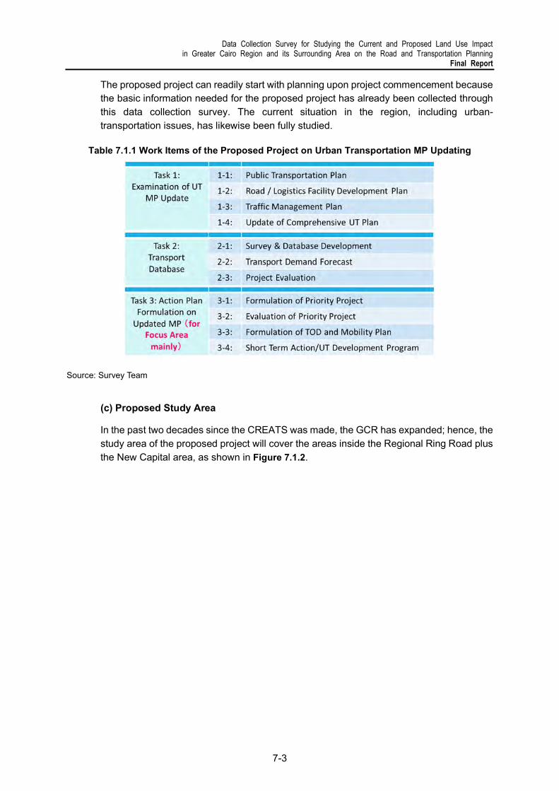
Data Collection Survey for Studying the Current and Proposed Land Use Impact in Greater Cairo Region and its Surrounding Area on the Road and Transportation Planning
Final Report
7-3
The proposed project can readily start with planning upon project commencement because the basic information needed for the proposed project has already been collected through this data collection survey. The current situation in the region, including urban-transportation issues, has likewise been fully studied.
Table 7.1.1 Work Items of the Proposed Project on Urban Transportation MP Updating
Source: Survey Team
(c) Proposed Study Area
In the past two decades since the CREATS was made, the GCR has expanded; hence, the study area of the proposed project will cover the areas inside the Regional Ring Road plus the New Capital area, as shown in Figure 7.1.2.

Data Collection Survey for Studying the Current and Proposed Land Use Impact in Greater Cairo Region and its Surrounding Area on the Road and Transportation Planning Final Report
7-4
Source: Survey Team
Figure 7.1.2 Proposed Study Area
7.2 Scope of Work of the Proposed Project
1) Task 1: Examination of Urban Transportation MP Update
(a) Task 1-1: Public Transportation Plan
In the GCR, the public transportation plan will be updated to promote urban rail transportation as the key PT system. The updated plan will be discussed with the Egyptian government, and several proposals will be presented to create a public transportation network that will guide the urban structure preferred by the stakeholders. The public transportation plan will include proposals on the gradual and systematic enhancement of public transportation in preparation for the future increase in urban transportation demand. The working principles and points to be noted are as follows:
(1) Clarify the mode sharing policy for public transportation, such as urban railways, buses, minibuses, and taxis. In the medium to long term, the ideal public transportation system with urban railway as the backbone and the stepwise approach to achieve this ideal will be shown.
(2) Having a variety of transportation modes is great in promoting public transportation, and to increase the latter’s effectiveness, transfer facilities (such as station squares) and feeder modes will be introduced. To enhance the synergy and consistency with urban development, the possibility of an integrated development of residential, commercial, and mixed-use facilities along public transportation corridors will also be examined.
Study Area

Data Collection Survey for Studying the Current and Proposed Land Use Impact in Greater Cairo Region and its Surrounding Area on the Road and Transportation Planning
Final Report
7-5
(3) Gender mainstreaming and social inclusivity will be incorporated in transportation planning. Interviews, surveys, and group discussions will be held to facilitate this.
(4) Shifting from private car to public transportation is important to control traffic demand. To this end, a unified digital platform, such as online systems or applications, to enable users to plan, reserve, and pay for multiple types of mobility services will be examined.
(b) Task 1-2: Road / Logistics Facility Development Plan
The proposed project will prepare a road logistics facility plan to show the scale of needed road facilities and location plans for dry ports and logistics center and others. The working policies and points to be noted are as follows:
(1) Roads are not only a means of transportation but also have a great impact on land use around them. They function as living and disaster prevention spaces, as well as landscape elements. They are also valuable spaces for the introduction of urban railroads and elevated roads in built-up areas.
(2) Roads should be developed as a hierarchical network, such as trunk lines, sub-trunk lines, and streets.
(3) Road space should be shared by cars, public transportation, bicycles, and pedestrians.
(4) For roads in urban areas, the performance of intersections is related to the capacity of the network and the safety of pedestrians, so the ideal intersection, including the success or failure of flyovers, will be studied.
(5) The element that should the updating work to be done on the MP is location planning for the dry ports and logistics center in the GCR. The recommended approach revolves around the following points:
(i) Freight transportation analysis should include commodity flow, freight transportation demand, transportation costs, traffic impact, and social benefits. Understanding the various types of logistics flow, as shown in Figure 7.2.1, will be a key aspect.
(ii) Examination of public policy on city logistics is recommended, such as regulations (zoning, traffic/parking control and vehicle restriction), road pricing, and incentive measures (including subsidies for innovation).
(ii) Trend in logistics land use for e-commerce should be considered.

Data Collection Survey for Studying the Current and Proposed Land Use Impact in Greater Cairo Region and its Surrounding Area on the Road and Transportation Planning Final Report
7-6
Source: JICA Tokyo KCCP (2021), Takanori Sakai, Tokyo University of Marine Science and Technology
Figure 7.2.1 Types of Logistics Flow in a Metropolitan Area
(c) Task 1-3: Formulation of a Traffic Management Plan
A traffic management plan will be formulated to cover traffic management and TDM measures. Traffic management issues in the city center tend to be more severe compared with those in satellite cities. Additionally, considering the current physical, economic, and social conditions in congested areas, the construction of new transportation facilities is not easy. Therefore, the proposed policy strategies will include traffic safety and parking management measures that are relatively possible to be implemented in the center of Cairo. The points to be noted for this task are shown in Figure 7.2.2.
Source: Survey Team
Figure 7.2.2 Framework to Formulate a Traffic Management Plan
Data Collection Survey for Studying the Current and Proposed Land Use Impact in Greater Cairo Region and its Surrounding Area on the Road and Transportation Planning
Final Report
7-7
(1) Existing traffic management plan and ongoing projects will be updated and provided by the Egyptian side. (2) Using the information above, measures to improve traffic management will be developed based on the concepts below. 3Es (Engineering, Enforcement and Education): Despite the fact that the importance of traffic management to maximize the use of existing infrastructure is always pointed out, it is difficult to properly practice it in large cities in developing countries. This is due to the fact that soft and human factors are indispensable to the 3Es, which have long been called the three major elements of traffic management. From this perspective, the proposed project will clarify the overall TM approach and identify specific policies based on implementability and reality. (3) Lists of proposed measures to improve traffic management will be presented and discussed with the relevant Egyptian government authorities in terms of their feasibility, constraints, and implementation methods. (4) Based on feedback from the discussions, the traffic management plan will be finalized.
(d) Task 1-4: Updating of the Urban Transportation Master Plan
After reviewing each plan and making necessary adjustments, the existing urban transportation master plan will be updated in accordance with the basic transportation policies and will include the items listed below. The updating work will be carried out as much as possible based on quantitative analysis and evaluation, utilizing the transportation database which is explained in Task 2.
(1) Vision of urban transportation
(2) Goals for achieving the vision with quantitative and qualitative indicators
(3) Basic strategies to achieve the goals in the sector and subsectors
(4) List and profiles of projects (or project packages) and actions based on the basic strategy.
2) Task 2: Development of a Transportation Database
(a) Task 2-1: Transportation Surveys & Database Development
Design of the Supplemental Transportation Surveys: Supplemental transportation surveys will be conducted to update the transportation database and to develop a transportation demand forecast model for the GCR. The scale of the surveys will be carefully designed by making the best use of the existing data collected in the previous studies, such as MiNTS, so that the surveys would be completed in the first year of the project with enough reliability. Table 7.2.1 presents the proposed outline of the supplemental transportation surveys to be conducted in the project, taking into account the

Data Collection Survey for Studying the Current and Proposed Land Use Impact in Greater Cairo Region and its Surrounding Area on the Road and Transportation Planning Final Report
7-8
new urban areas and targets. However, the number of survey points and the scale of the survey should be coordinated with the CP organization prior to the field surveys.
Table 7.2.1 Recommended Supplemental Transportation Surveys to Update Existing Database
Survey Content
1) Activity Diary Survey (ADS)
Sample size: about 5,000 households (less than 10% of the HIS in CREATS), about half of which should target the areas which developed after the CREATS transportation surveys in 2001 were done. Survey items: - Activities (in and outside home) and movements (origin and destination (OD) in places, travel modes, costs, etc.) for several consecutive days - Household attributes (income/expense, number of vehicles, members, etc.) - Individual attributes (age/sex, work/school type and place, number of employees, industrial category, income, vehicle availability, etc.) Surveyors using mobile devices, such as tablets, will directly input information such as respondents’ attributes and GPS location into the server while interviewing the respondents. The Activity Diary will be filled in paper form by respondents for a minimum of 3 consecutive weekdays up to one week.
2) Cordon Line Survey
・ Roadside interview: 10 locations, in addition to 9 locations surveyed in MiNTS ・ ENR railway passenger interview: 2 major stations, in addition to Cairo station
surveyed in MiNTS ・ Intercity bus passenger interview: Muniib bus terminal, in addition to 4 bus
terminals surveyed in MiNTS ・ Cairo Airport passenger interview: Terminal 2, in addition to Terminals 1 and 3
surveyed in MiNTS MiNTS survey database will be fully utilized to minimize the number of survey locations.
3) Screen Line Survey
Traffic count and occupancy of vehicles crossing the Nile. MiNTS survey database will be partially utilized. The existing data from automatic traffic counters and/or CCTV cameras will be fully utilized so that there would be no field survey.
4) Cargo Transportation Survey
MiNTS survey database will be fully utilized, and only minor interviews will be conducted to adjust the data.
5) Vehicle Travel Speed Survey
Available data from GPS devices mounted on passenger cars, taxis, and buses will be analyzed instead of conducting a field survey.
Source: Survey Team
Updating of the Urban Transportation Database: It should be noted that while it may still be possible to update the transportation survey data from MiNTS and use it as part of the transportation database for the GCR, the CREATS database is too old. However, it will certainly be used to identify changes in travel patterns in the GCR since 2001.
(b) Task 2-2: Forecasting of Transportation Demand
The following issues will be taken into account when reviewing and updating the socio-economic framework of the master plan:
Development of Socioeconomic Framework: The present socioeconomic data, such as population and the number of workers by region, as well as the future socioeconomic framework for the long term (2040) and the medium term (2030) will be examined based
Data Collection Survey for Studying the Current and Proposed Land Use Impact in Greater Cairo Region and its Surrounding Area on the Road and Transportation Planning
Final Report
7-9
on the estimates of the Central Agency for Public Mobilization and Statistics (CAPMAS). Regarding the future distribution of nighttime and daytime (workers) populations, social growth in each region is estimated from the urban development plan. Based on the socioeconomic framework and the results of the activity diary survey (ADS), present and future micro-population data will be synthesized to create input data for travel demand forecasting using a disaggregate model which is explained later in this task.
Updating of Future Transportation Network/Service Levels: The transportation network and service levels developed in CREATS will be updated, taking into account the projects that have been implemented and the cities that have developed since CREATS was completed. The updating work will also study pipeline projects on transportation and urban development together with public transportation service levels.
(1) Review and update the existing network: The level of service of the existing road network will be reviewed and updated based on the results of the supplemental transportation surveys.
(2) Review and update the future network: The future transportation network (medium term: 2030, long term: 2040) will be reviewed and updated by considering the current network, feasibility of proposed projects, new plans, and needed service levels of public transportation.
Development of a Travel Demand Forecast Model: The travel demand forecast model will be developed using a disaggregate four-step process based on the ADS results. By using disaggregate forecasting, it is possible to estimate transportation demand which considers personal attributes, such as workplace, household composition, and income level. Such forecasting method enables the evaluation of the impact on travel behavior resulting from changes in policies, such as the revision of the public transportation tariffs, introduction of an environmental tax, TDM, and TOD. A more detailed comparison between the conventional (aggregate) method and the proposed (disaggregate) method is shown in Table 7.2.2, and the contents related to model development will be summarized as a technical note. To maintain continuity after the completion of the proposed MP updating project, the local consultant team will act as trainers and conduct TOT (training of trainers) for related organizations (JCC members). Technology transfer will be carried out at each stage of model development as on-the-job training, targeting the personnel in related organizations.
Updating of the Future OD Table: Based on the updated socioeconomic framework and the CREATS individual and household data to be updated using the ADS data/information, the micro-population in the entire GCR will be synthesized with a variety of household and individual attributes to create input data for travel demand forecasting. Along with the corresponding transportation network as inputs, the current OD table (for 2022) and the OD tables for 2030 and 2040 will be estimated from the disaggregate demand forecast model.
Urban Transportation Network Analysis: By forecasting travel demand (highway and transit trip assignment) on the transportation network, various scenarios and network options will be analyzed based on multiple criteria. The basic approach is shown in

Data Collection Survey for Studying the Current and Proposed Land Use Impact in Greater Cairo Region and its Surrounding Area on the Road and Transportation Planning Final Report
7-10
Current Transportation Network
(Road, Railway, and Water Transport)
Baseline Scenario Evaluation
(Current Transportation Network + Ongoing/Budgeted Projects)
Future Travel Demand (OD)
(2030, 2040) Future Plans
Future Transportation Network Development Scenario Options (Tentative)
Road-Intensive Public Transport-
Intensive Compromise Other
Evaluation of the Network in Each Option
Recommendation
Overall Evaluation
Yes
No
Evaluation Criteria
Traffic Performance on the Network
Economic Viability Financial Viability Environmental Impact
Figure 7.2.3 Methodology for Analyzing the Urban Transportation Network
Table 7.2.2 Comparison of Conventional and Current Demand Forecasting Methods
Conventional Method Proposed Method
【advantages】 It is widely accepted in Japan and easy to explain. Experts are familiar with this implementation method. Socioeconomic framework can be predicted precisely if
the sample size is large. Applicable for both aggregate and disaggregate models.
【advantages】 Shorter survey period and costs may be lower. The number of samples can be collected and managed even
by a small company. Policy options, such as the introduction of a new transportation
mode and TOD, can be evaluated by applying a discrete choice (disaggregate) model.
Overlooking trips can be avoided by using ADS.
Statistical data
Production/ Attraction
model
Socioeconomic frame (households/populatio
n by zone, income class, worker/student
population, etc.)
Production/Attraction volume by zone
Transport network
Verification/calibration
Distribution model
Modal split model(Modal split curve, etc.)
Census
PT survey
Trips distributed between Zones
Trip volume between Zones by Mode
Traffic volume by LinkNetwork
assignment modelAssignment
parameters(VoC, etc.)
Adjusted Traffic volume by Link
Screen line survey
Vehicle travel speed survey
Cordon line survey
Statistical data
Trip frequency model
Socioeconomic frame (household/
population, income class, worker/student
population, etc.)
Micro-population data (household/ population,
income, age, workplace,)
Transport network
Verification/ calibration
Destination choice model
Mode choice model
CREATS 2001Individual Data
ADS Micro-population data (incl. trip frequency)
Micro-population data (incl. trip frequency by
destination)
Traffic volume by linkTraffic assignment
model
Assignment parameters (VoC, etc.)
Adjusted traffic volume by link
Screen line survey
Vehicle travel speed survey
Cordon line survey
Micro-population data (incl. OD by mode)
Population synthesizer
Updating with 5000 samples
Micro-population data of base year

Data Collection Survey for Studying the Current and Proposed Land Use Impact in Greater Cairo Region and its Surrounding Area on the Road and Transportation Planning
Final Report
7-11
(c) Task 2-3: Project Evaluation
To determine implementation priority, individual projects or project packages will be evaluated using the items listed below. Candidate projects (or project packages) will first be evaluated based on the magnitude of traffic volume, traffic congestion level, travel speed, and environmental impact, before they will be scored, then ranked using the Multi-criteria Assessment (MCA) tool.
When the public sector invests in transportation infrastructure projects, the purpose is to mitigate traffic congestion, and the social benefit is to provide mobility for the people. To this end, the proposed projects should be scored and ranked based on current traffic congestion levels and other criteria before prioritizing them. The criteria to be used for prioritizing the projects are the following:
(i) Traffic volume (PCU*km);
(ii) Traffic congestion ratio (V/C: vehicle / capacity);
(iii) Average travel speed (km/h);
(iv) Contribution to improve mobility for all people;
(v) Environmental and social impacts; and
(vi) Scale of project cost.
To start the prioritization, each of the above-mentioned criteria will be given a weight, which will depend on its importance relative to the other criteria. Second, the candidate projects’ values for each criterion will be estimated, and the results will be aggregated into a single rank represented by letters, as follows: five points = rank “A”, three points = rank “B,” and one point = rank “C”. The thresholds assigned to each criterion in Table
7.2.3 were based on another project. Third, to get a candidate project’s total score, its points per criterion will be multiplied by the criterion’s weight. The resulting scores will then be classified into levels of priority: “SS” for immediate priority, “S” for short-term priority, and “M-L” for medium to long-term priority.
Table 7.2.3 Example of Weights and Thresholds of the Evaluation Criteria
Criterion Weight Threshold
A (5 Points) B (3 Points) C (1 Points)
1. Traffic Volume (PCU (or Pax)*km) 0.2 x>300,000 300,000>x>200,000 200,000>x
2. Traffic Congestion Level (ave. V/C) 0.3 1.0>x 1.5>x>1.0 x>1.5
3 Ave. Travel Speed (ave. km/h) 0.2 x>20 20>x>10 10>x
4. Contribution to Improve Mobility 0.1 Big Effect Some Effect Less Effect
5. Environmental Evaluation (Negative impact) 0.1 No Impact Some Impact Serious Impact
6. Scale of Cost 0.1 Low Medium High
Total 1.0
Source: Survey Team.

Data Collection Survey for Studying the Current and Proposed Land Use Impact in Greater Cairo Region and its Surrounding Area on the Road and Transportation Planning Final Report
7-12
3) Task 3: Action Plan Formulation for the Updated MP
(a) Task 3-1: Formulation of Priority Projects
Based on the results of Tasks 1-1, 1-4, and 2, the urban railway projects that should be developed in the medium to long term will be selected as priority projects. With over 20 million population, the GCR needs to have expanded urban railways, which will be the core of the public transportation system, but this cannot fulfill its expected role unless it is developed as a network of a certain scale. Since urban railways require huge financial resources, it is important to plan a network that maximizes the effect with the minimum investment. Urban railways also have a significant impact on land use and define the urban structure of the city over the long term. When selecting individual priority routes, it is necessary to review the overall network and clarify the role and position of individual routes. The following points should be taken into consideration when selecting priority projects.
Selection of Priority Projects for Short- to Medium-term Implementation: Things to consider: the extension and connection of routes that will help increase the effect of projects currently under construction, as well as railway development based on the TOD concept.
Selection of Priority Projects for Long-term Implementation: On the premise of developing a desirable future urban railway network in the metropolitan area, select a core public transportation infrastructure project that supports urban development and urban structure promoted by the Egyptian government.
(b) Task 3-2: Evaluation of Priority Projects
Priority projects/project packages will be evaluated on the following aspects to determine their overall feasibility:
(1) Economic and Financial Feasibility: Economic and financial analyses will be conducted to evaluate the appropriateness of the projects/project packages for implementation. The financial burden in light of the capacity of central and regional governments will also be considered.
In the economic analysis, the benefits of transportation facility development will be attributed directly to the users of the facilities and indirectly to transportation operators and manufacturers through the reduction of transportation costs. While the reduced portion of total transportation cost will be measured as the first benefit, the secondary indirect benefits, such as induced effects (including the decrease in traffic accidents) and land use development, will not be included in the project cost and will be examined separately as needed.
The financial analysis can be made from various economic perspectives. In the proposed MP updating project, the financial analysis of the projects will be made to evaluate their financial soundness. Hence, the financial analysis will be made only for the projects which can make revenues such as tolls and fares.
In the economic financial analyses, a sensitivity analysis will also be added.
(2) Environmental and Social Considerations: The projects (packages) will also undergo evaluation as to whether appropriate considerations are made in accordance
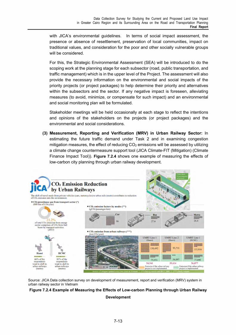
Data Collection Survey for Studying the Current and Proposed Land Use Impact in Greater Cairo Region and its Surrounding Area on the Road and Transportation Planning
Final Report
7-13
with JICA’s environmental guidelines. In terms of social impact assessment, the presence or absence of resettlement, preservation of local communities, impact on traditional values, and consideration for the poor and other socially vulnerable groups will be considered.
For this, the Strategic Environmental Assessment (SEA) will be introduced to do the scoping work at the planning stage for each subsector (road, public transportation, and traffic management) which is in the upper level of the Project. The assessment will also provide the necessary information on the environmental and social impacts of the priority projects (or project packages) to help determine their priority and alternatives within the subsectors and the sector. If any negative impact is foreseen, alleviating measures (to avoid, minimize, or compensate for such impact) and an environmental and social monitoring plan will be formulated.
Stakeholder meetings will be held occasionally at each stage to reflect the intentions and opinions of the stakeholders on the projects (or project packages) and the environmental and social considerations.
(3) Measurement, Reporting and Verification (MRV) in Urban Railway Sector: In estimating the future traffic demand under Task 2 and in examining congestion mitigation measures, the effect of reducing CO2 emissions will be assessed by utilizing a climate change countermeasure support tool (JICA Climate-FIT (Mitigation) (Climate Finance Impact Tool)). Figure 7.2.4 shows one example of measuring the effects of low-carbon city planning through urban railway development.
Source: JICA Data collection survey on development of measurement, report and verification (MRV) system in urban railway sector in Vietnam
Figure 7.2.4 Example of Measuring the Effects of Low-carbon Planning through Urban Railway
Development

Data Collection Survey for Studying the Current and Proposed Land Use Impact in Greater Cairo Region and its Surrounding Area on the Road and Transportation Planning Final Report
7-14
(c) Task 3-3: Formulation of TOD and Mobility Plans
TOD is attracting attention as a sustainable urban planning method because it maximizes project effects by developing transportation infrastructure centered on urban railways in an integrated manner with urban development. To achieve this, it is also necessary to establish an implementation scheme that includes the analysis of projects from the urban to the site level, the coordination among various stakeholders, and capacity building. Therefore, in the proposed MP updating project, it is necessary to formulate a TOD concept plan and a mobility plan which includes the development of transportation hubs.
Japanese knowledge and experience in implementing urban land readjustment, urban redevelopment, and universal design will be introduced to the stakeholders and applied as appropriate.
(1) TOD Concept Plan:
a) Designation of Potential Urban Railway-based TOD Centers: Since planning for several urban development projects is underway in the vicinity of urban railway stations, as well as along the urban railway corridor, the status of these projects will be updated and utilized for the preliminary analysis of TOD. Data on current real estate sales and leases will be collected from available sources, such as the Egyptian Real Estate Review. The potential incremental value of urban railway development and TOD, including access improvements in the catchment areas and development of feeder services, will be estimated.
b) TOD Value Capture: The benefits and beneficiaries of TOD need to be clarified to introduce a scheme of levies on developers. Since the benefits of TOD range from economic and social, to environmental aspects, they will be analyzed and categorized by type and beneficiary. The potential applicability of levies on the developers will be studied based on this analysis.
c) Implementation Structure and Mechanisms: Confirmation of the current legal system, including taxes and incentives, for the appropriate value capture mechanism, as well as a study of the necessary legal framework to be established, will be conducted by the legal advisor. Since bottom-up approaches by land owners and developers, such as business improvement districts (BIDs) are expected to become a significant driving force for TOD, their feasibility—including necessary implementation structures—will also be studied.
d) Land Availability Study: Land availability and land ownership of parcels in station catchment areas along the urban railway corridor will be reviewed by collecting the information and reviewing ongoing and planned urban development projects. In the case of limited land availability in the catchment area, changes to land uses may be proposed to open up future potential for TOD.
(2) Mobility Plan:
a) Access Improvement Plan in the Vicinity of UMRT Stations: Pedestrian movement and public transportation networks in the catchment area (a radius of approximately 800 m–1 km from each station) will be analyzed for the focal urban

Data Collection Survey for Studying the Current and Proposed Land Use Impact in Greater Cairo Region and its Surrounding Area on the Road and Transportation Planning
Final Report
7-15
railway stations (at most 3 stations). An access improvement plan proposing improvements to the connections and routes within those catchment areas will be formulated based on the analysis of pedestrian behavior and public transportation networks.
b) Concept Design of Integrated Station Areas: The content and scale of the integrated development in the station areas (a radius of 200–300 m from the station), which maximizes the impact of urban railway development will be studied based on the survey and analysis of current real estate development and its development potential. Development plans will be formulated based on the land use and zoning plan to be prepared in the proposed project. Task 3-3 will also include the preliminary estimation of construction costs and revenue, as well as the feasibility of sharing the costs of developing and managing station areas between the public and private sector.
c) Intermodal Facility Development Plan: The mobility of urban railway passengers and their access to and from the stations will be analyzed when preparing the access improvement plan to clarify the scale and type of the intermodal facilities necessary to ensure universal access. An intermodal facility layout plan to include the station plaza will be prepared based on the analyses of pedestrian and vehicular circulation while taking into account the various functions of the facility in transportation, urban amenity improvement, and disaster prevention/mitigation. He potential of using government-owned and vacant lands will be studied to secure the necessary space for these functions. Securing public open spaces through the application of land readjustment and urban redevelopment schemes, as well as the utilization of adjacent buildings as transportation facilities (e.g., parking) will also be considered in areas with limited land. The intermodal facility development plan will be prepared for the focal urban railway stations (1-2 stations) and will include preliminary cost estimates.
(d) Task 3-4: Short-term Action Plan / Public Transportation Development Program
Formulation of a Short-term Action Plan: Short-term action plans in the existing master plan will be updated to address urban transportation issues requiring immediate improvement and to identify solutions that can be implemented in three to five years. The short-term action plan should not require large investment and should be implementable under the current organization and system to ensure quick decision making. This should be thoroughly discussed by the working group members. In addition, the implementing body, implementation method, and financial sources for the projects in the action plan should be carefully considered and compiled into a roadmap to reduce the risk of implementation gaps. Necessary administrative procedures and coordination among related parties shall be carried out so that the formulated action plan will be utilized in Egypt.
Formulation of a Draft of the GCR Public Transportation Development Program: Based on the updated MP, a draft of the GCR Public Transportation Development Program will be formulated, taking into account the chronological and structural arrangement of the list of projects that can be implemented by Japan and other MDBs or IFIs.

Data Collection Survey for Studying the Current and Proposed Land Use Impact in Greater Cairo Region and its Surrounding Area on the Road and Transportation Planning Final Report
7-16
Based on the experience in urban railway development of other countries, the following tasks, besides hardware planning, should be considered early in planning to realize the desired urban railway development:
(i) Examination of business schemes for efficient project implementation,
(ii) Establishment of an implementing organization for consensus building among related organizations,
(iii) Examination of legislations to legally support land use and the establishment of business entities associated with the construction of underground and elevated structures.
7.3 Implementation Schedule and Required Organizational Setup
The draft GCR Public Transportation Development Program will indicate an implementation schedule and the necessary organizational setup based on the following four basic principles:
Veer away from conventional master-planning which spends much time and budget on field surveys;
Consider prompt implementation in line with the CP’s expectations and collaborate with relevant agencies;
Update the transportation database, which is the basis of planning, as well as forecast traffic demand and evaluate projects;
Utilize the working group as a platform for daily activities.
1) Implementation Schedule
The proposed implementation schedule is shown in Figure 7.3.2. Assuming that the actual project period is about two and a half years, the third year could be used for the approval process on the Egyptian side of the updated MP. In the first year, the Project Team will immediately work on Task 1 and Task 2, which takes time. Since it is essential to forecast traffic demand and evaluate the proposed projects based on it, Task 3 is positioned as the main activity in the second year. Setting up working groups at the beginning of the project is proposed to facilitate the conduct of all activities in close coordination with related counterpart and relevant organizations on the Egyptian side.
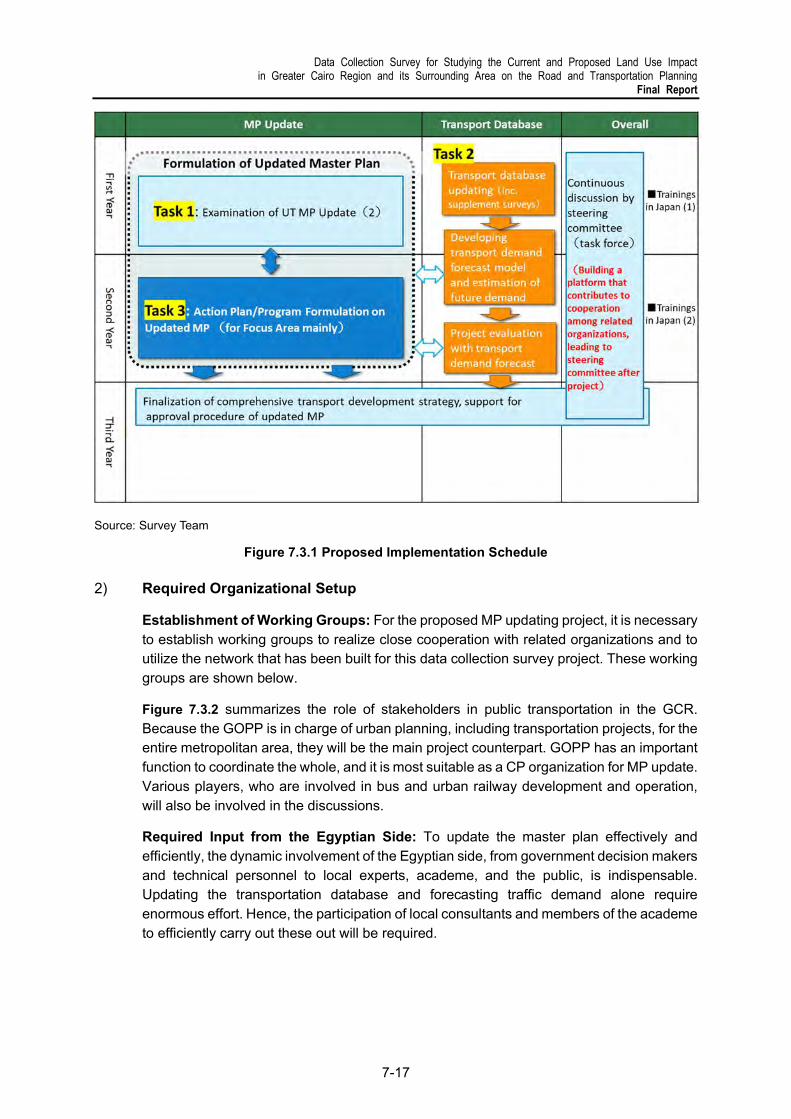
Data Collection Survey for Studying the Current and Proposed Land Use Impact in Greater Cairo Region and its Surrounding Area on the Road and Transportation Planning
Final Report
7-17
Source: Survey Team
Figure 7.3.1 Proposed Implementation Schedule
2) Required Organizational Setup
Establishment of Working Groups: For the proposed MP updating project, it is necessary to establish working groups to realize close cooperation with related organizations and to utilize the network that has been built for this data collection survey project. These working groups are shown below.
Figure 7.3.2 summarizes the role of stakeholders in public transportation in the GCR. Because the GOPP is in charge of urban planning, including transportation projects, for the entire metropolitan area, they will be the main project counterpart. GOPP has an important function to coordinate the whole, and it is most suitable as a CP organization for MP update. Various players, who are involved in bus and urban railway development and operation, will also be involved in the discussions.
Required Input from the Egyptian Side: To update the master plan effectively and efficiently, the dynamic involvement of the Egyptian side, from government decision makers and technical personnel to local experts, academe, and the public, is indispensable. Updating the transportation database and forecasting traffic demand alone require enormous effort. Hence, the participation of local consultants and members of the academe to efficiently carry out these out will be required.

Data Collection Survey for Studying the Current and Proposed Land Use Impact in Greater Cairo Region and its Surrounding Area on the Road and Transportation Planning Final Report
7-18
Table 7.3.1 Proposed Working Groups
Task Working Group
1) Examination of UT-MP updating
1-1: PT Plan Main stakeholders working group: GOPP, TPA, LRTA Other meetings to be organized for opinion sharing and inclusive discussion from different perspective (gender, environment and others) Gov. level: NUCA, NAT, CTA, NCW, Ministry of social solidarity,
EEAA, CAPMAS, GCR governorates Other entities: Mwasalat Misr (possible BRT operator), ride-hailing
and shared bus companies (Uber, Swvel) Donors: WBG and Un-Habitat (share updates separately)
1-2: Road/ logistics plan
GOPP, NUCA, LTRA, GARBLT, GALDP, ENR, GCR governorates, Cairo chamber of commerce (International transport and logistics services division)
1-3: Traffic management plan
GOPP, MOI (Traffic control), GARBLT Governorates, EEAA
1-4: Updating of comprehensive UT plan
All stakeholders mentioned above and Central agency for reconstruction
2) Transportation database development
GOPP, TPA, LTRA, E-Just, universities, local consultants, (WBG team), Central agency for reconstruction
3) Action plan formulation Same stakeholders as those for Task 1-1
Note: Current projects by other donors such as MAPTIS WBG (LTRA), Air pollution WBG (CTA) and BRT by UN-Habitat.
Source: Survey Team
Figure 7.3.2 Main Public Transportation Stakeholders in the GCR

Data Collection Survey for Studying the Current and Proposed Land Use Impact in Greater Cairo Region and its Surrounding Area on the Road and Transportation Planning
Final Report
8-1
8 CONCLUSION, RECOMMENDATIONS, AND NEXT STEPS
8.1 Conclusion and Recommendations
To clarify the issues in the existing transportation plans and infrastructure developments, the Study Team conducted a field survey and a series of discussions with the GOPP and relevant agencies to confirm these plans and their status, as well as the changes that have happened since the completion of CREATS, SDMP, and MiNTS. As a result, the Study Team explains below the scope that should be covered when updating the existing transportation plans.
1) National Transportation Development
The role of the national transportation sector is not limited to supporting socio-economic activities and economic growth to confirm the position of the country as a regional hub. Under the development context of Egypt, transportation must take on a greater role in physically unifying the country and promoting balanced national development. Therefore, a radial structure centered on the GCR is recommended to provide alternative routes with high resiliency and redundancy in the network. It should be noted that the transportation system is a multifaceted asset of the country which can help solve various development problems. For instance, transportation can expand the coverage of the digital economy and enhance environmental sustainability. Thus, transportation can be the driving force in turning Egypt into a high-income, developed country.
(a) Road: Over the last decade, the inter-governorate road network in Egypt has been developed well compared to other transportation subsectors. Because an adequate density of national highways is required to guide and serve urban and industrial development, it is suggested that national highways be designed together with large-scale urban and industrial developments.
(b) Railway: Measures against the deterioration of railway infrastructure owned by the ENR are needed urgently. Currently, the MOT has embarked on a project to address this issue, and some international donors are also supporting through infrastructure development.
There are various planning issues regarding the development of the future urban railway network in the GCR and its expansion to the surrounding areas. In particular, as new urban developments in the GCR continue steadily, it is essential to formulate a railway network plan that will meet huge passenger demand between cities.
(c) IWT, Ports, and Shipping: In the development of IWT, investment in IWT fleet, riverports, and IWT ICDs has been insufficient, with an aging fleet being a major issue. Government funds must be tapped into funding the more delicate aspects of the subsector, such as waterway improvement and maintenance, removal of bottlenecks such as the replacement of old and low-clearance bridges, and use of river information system for safe operation and management, among others.

Data Collection Survey for Studying the Current and Proposed Land Use Impact in Greater Cairo Region and its Surrounding Area on the Road and Transportation Planning Final Report
8-2
Common development issues in IWT are the need to increase the productivity of port facilities and improve port access. The beneficiary-pays principle will be kept to improve daily port operation.
(d) Aviation: Airport development will also adopt the beneficiary-pays principle. The Study Team believes the damage brought about by the COVID-19 pandemic could be undone within a couple of years, the Team suggests that airport facilities for passengers be developed on schedule. In addition, there are still many steps to take for air freight services to become a full-fledged industry, such as establishing air cargo villages around the gateway airports, a cold-chain system to store and distribute air cargo, and exclusive air freight service on domestic routes.
(e) Logistics: Containerization and multimodal transportation will be essential to domestic freight services in Egypt. Truck service is convenient because it has no first-mile/last-mile arrangement required, and it is expected to become more competitive in the future because of the development of a nationwide expressway network. To avoid too much truck dependency, the Study Team suggests that the government should strongly support alternative transportation modes, such as IWT, coastal shipping, and especially freight rail, the central part of global logistics and supply chains. The Team proposes direct freight rail connection to gateway port terminals, the development of IWT ICDs plus the removal of low-clearance bridges, and the introduction of RORO shipping services together with existing container ships, which will complement each other.
(f) Environment: Each transportation subsector is also required to respond to issues that have been attracting attention in recent years, such as the need to respond to SDGs, promote a low-carbon society, mainstream gender perspectives, and consider vulnerable groups.
2) Urban Transportation Development in Greater Cairo Region
While road development is progressing smoothly in the Greater Cairo metropolitan area, the urgent issue for urban transportation is the formulation of PT development strategies that meet huge mobility needs. The current road-oriented development cannot sustainably respond to economic losses and climate change nor can it provide good mobility to all, including women and vulnerable people. As the metropolitan area expands and economic activity becomes more active, people's travel needs become more complex and travel distances increase. Road development alone cannot meet the travel needs of an entire population. While the Egyptian government is proceeding with the development of a new city, there are places where it initially envisioned that life would be complete, but even if roads are built, traffic congestion will not be solved. On the contrary, the problem will get worse. Based on this situation, the Study Team proposes the following steps:
(a) Formulation of a Public Transportation Development Strategy Integrated with Urban Development: Although the urban railway network in the existing plan is behind the original schedule, most sections are under construction. As the metropolitan area, including the new capital, expands further, it is essential to plan for the next 20 years. In the past MP (CREATS), railway development was planned only for the existing urban areas. However,

Data Collection Survey for Studying the Current and Proposed Land Use Impact in Greater Cairo Region and its Surrounding Area on the Road and Transportation Planning
Final Report
8-3
it is important to plan based on the TOD concept, which connects the transportation infrastructure to new urban development areas, such as the new capital.
(b) Planning and Implementation of Traffic Management Measures to Contribute to Smooth and Safe Movement within the GCR: Frequent stops of buses and shared taxis anywhere, intersections near saturation, and on-street parking which occupies road space are some of the challenges facing traffic management in the GCR. Many of these require the continued implementation of measures by the MOI, road administrators, and governorates. Regarding parking demand, sweeping reforms, including the revision of the city planning system, are also required.
(c) Gender Mainstreaming / Mobility Improvement Program Considering Vulnerable People and Pursuit of a Low-carbon Society: The Study Team recommends the inclusion of recent concepts in urban and transportation planning, such as gender mainstreaming, provision of barrier-free transportation, and development of walkable urban environments. Regarding low-carbon societies, COP27 is scheduled to be held in Egypt in 2022, and it is expected that the attention to be given to this matter will be high. Therefore, it is expected that the Egyptian government will favor an environment-friendly infrastructure development that will ensure CO2 reduction in each transportation subsector.
(d) Creating a Roadmap for the Realization of the Formulated Plan: In order for the strategies and plans proposed above to be put into practice more than just formulation, it is necessary to create content that is widely understood by many stakeholders, including Egyptian decision makers. In creating the roadmap, it is suggested that visualized content be created. At that time, it is essential to establish and operate the working group proposed in Chapter 7.
Data Collection Survey for Studying the Current and Proposed Land Use Impact in Greater Cairo Region and its Surrounding Area on the Road and Transportation Planning Final Report
8-4
8.2 Next Steps
This data collection survey started in March 2021 and has been carried out for approximately one year under a pandemic while maintaining close communication with the GOPP and other Egyptian organizations. Instead of going through the conventional MP formulation process, the Study Team conducted field surveys (in 6th of October, New Cairo, and New Capital), seminars, and individual discussions with the GOPP to build a common understanding with the stakeholders regarding the needs of Egypt’s transportation sector, and that is to develop transportation strategies that support urban development currently being promoted by the GOPP with the aim of solving traffic problems in the GCR.
In Japan, the government has responded to the needs of its citizens for mobility by improving public transportation along with decentralizing cities and connecting them through urban railroads. All these have been realized by integrating urban and transportation development based on TOD.
In Egypt, urban development has significantly changed the GCR over the last decade. The current administration has also announced its move to the new capital in 2022. Now is the time to provide technical assistance to urban transportation to support Egypt’s urban development plans. In particular, the Study Team recommends the early implementation of the proposed project on formulating sustainable urban transportation strategies and implementation support, which is described in Chapter 7.
In providing technical cooperation in urban transportation, strengthening cooperation among donors is also essential. At the meeting held at the AFD office on 22 November 2021, donors exchanged information on their ongoing cooperation in the transportation sector, which at that time included BRT development, survey of public transportation for LTRA, introduction of eco buses, rehabilitation of the existing ENR, and this JICA-funded survey. The donors also indicated their direction of cooperation to enhance each other's efforts. In particular, the donors expressed their readiness to cooperate more closely regarding railway development. For this, the Study Team believes it can create an environment where it can demonstrate the presence supported by JICA by emphasizing with other donors.