Annexes – Chapter 5 - Overseas Private Investment Corporation
149
CBG Mine Expansion Project ESIA: Annexes – Chapter 5 5 ANNEXES - CHAPTER 5 Annexe 5-1 Volume I (Annexes 1 to 15)
-
Upload
khangminh22 -
Category
Documents
-
view
2 -
download
0
Transcript of Annexes – Chapter 5 - Overseas Private Investment Corporation

CBG Mine Expansion Project ESIA: Annexes – Chapter 5
5 ANNEXES - CHAPTER 5
Annexe 5-1 Volume I (Annexes 1 to 15)

1
APPENDICES
APPENDIX 1: COUNT SHEET .................................................................................... 2!
APPENDIX 2: HOUSEHOLD QUESTIONNAIRE .............................................................. 3!
APPENDIX 3: SURVEY CODE ................................................................................. 13!
APPENDIX 4: LAND TENURE, CASE STUDY NO. 1, THE VILLAGE OF BOULLERÉ ............. 15!
APPENDIX 5: LAND TENURE, CASE STUDY NO. 2, THE VILLAGE OF PARAWI ................. 29!
APPENDIX 6: LAND TENURE AND A RAPID REVIEW OF CHANGES IN CUSTOMARY LAW IN THE TOWN OF SANGARÉDI ................................................... 36!
APPENDIX 7: BRIEF REVIEW OF LAND RIGHTS IN PK-14, THE AREA AFFECTED BY THE RAILROAD SIDING .................................................................... 42!
APPENDIX 8: FISHING IN THE DREDGING ZONE ...................................................... 46!
APPENDIX 9: AGRICULTURE, BREEDING AND GATHERING NATURAL RESOURCES ......... 72!
APPENDIX 10: STATISTICS OBTAINED FROM THE HOUSEHOLD SURVEY ..................... 111!
APPENDIX 11: STATISTICS ON EDUCATION IN THE TOWN OF SANGARÉDI ................. 120!
APPENDIX 12: STATISTICS ON EDUCATION IN THE RURAL PART OF THE CONCESSION ZONE ....................................................................... 122!
APPENDIX 13: STATISTICS ON EDUCATION IN KAMSAR ........................................... 123!
APPENDIX 14: STATISTICS ON THE HEALTH-CARE INFRASTRUCTURE IN THE TOWN OF SANGARÉDI .............................................................................. 126!
APPENDIX 15: ARCHEOLOGY ................................................................................ 127!

2
APPENDIX 1: COUNT SHEET
Count&sheet&–&November&2013&
Name of interviewer: ………………………………………………………………
1. Location
1.1 Commune
1.2 District
1.3 Village/locality
1.4 Household code
2. Composition of household (including those absent for less than 6 months)
2.1 First name, second name and surname of household head
2.2 Ethnic group (see codes) 1. Fula; 2. Malinké; 3. Landouma; 4. Guerzé; 5. Soussou; 6. Diakanké; 7. Other (specify)
2.3 Total number of persons in the household 2.4 Total number of male persons aged 15 and over 2.5 Total number of male persons under age 15 2.6 Total number of female persons aged 15 and over 2.7 Total number of female persons under age 15
3. Migration 3.1 Was your father already settled in the village? (1. yes / 2. no) 3.2 Date of household head’s arrival in the village (see codes)
1.Less than 1 year ago; 2. 1 to 10 years ago; 3. More than 10 years ago; 4. Always
3.3 Period when the family settled in the area (household head’s ascendant) (see codes except if 3.2 = 4) 1. Before CBG; 2. Between CBG’s arrival and 2000; 3. Since 2000

3
APPENDIX 2: HOUSEHOLD QUESTIONNAIRE
Name of interviewer: _______________________ Name of locality:______________________Date: ____________
IDENTIFIERS 1. Locality I____I 2. Household code I___I I___I I___I 3. Name of household head __________________________ 4. Replacement household (1. yes / 2. no) I____I 5. Which ethnic group does the household head belong to?
Circle the answer
1 2 3 4 5 6 9
Fula Malinké Landouma Guerzé Soussou Diakanké Other
6. How long has your household lived in the village ? (If 4, go to Q8.)
Circle the answer
1 2 3 4
Less than 1 year 1 to 10 years More than 10
years Always
7. Why did you settle here?
Circle the answer
1 2 3 4 5 6 7
Work with CBG or subcontractor
Other work Family Cropland Health services
Other services
Other reason
8. Period when the family (household head or household head’s ascendant) settled in the area (see codes)
Circle the answer 1 2 3
Before CBG From 1970 to 2000 Since 2000
MEMBERS OF THE HOUSEHOLD
First names of the members of the household who are present or have been absent for less than 6 months (household head to be put in the first column)
01 02 03 04 05 06 07 08
______________________________
______________________________
______________________________
______________________________
______________________________
______________________________
______________________________
______________________________
9. Sex (1. Male 2. Female) I___I I___I I___I I___I I___I I___I I___I I___I
10. Relationship to household head (see codes)
I___I I___I I___I I___I I___I I___I I___I I___I
11. Age (For children under 7, go to Q32.)
I___I I___I I___I I___I I___I I___I I___I I___I
12. Religion (see codes) I___I I___I I___I I___I I___I I___I I___I I___I
EDUCATION 01 02 03 04 05 06 07 08
13. Does (name) know how to read and write French?
(1. yes 2. no) I___I I___I I___I I___I I___I I___I I___I I___I

4
14. Does (name) know how to read and write Arabic?
(1. yes 2. no) I___I I___I I___I I___I I___I I___I I___I I___I
15. Has (name) attended school? (1. yes 2. no) If no, go to Q19.
I___I I___I I___I I___I I___I I___I I___I I___I
16. Highest year completed? (See codes)
I____I I____I I____I I____I I____I I____I I____I I____I
17. Highest diploma obtained? (See codes)
I____I I____I I____I I____I I____I I____I I____I I____I
18. Still attending school? (1. yes 2. no)
I___I I__I I___I I___I I___I I___I I___I I___I
19. Complementary training? (1. yes 2. no)
I___I I__I I___I I___I I___I I___I I___I I___I
20. If so, trade learned? (Use activity code)
I____I I____I I____I I____I I____I I____I I____I I____I
MAIN ACTIVITIES AND SOURCES OF INCOME 01 02 03 04 05 06 07 08
21. What is the main activity? (See codes) If code 1 to 8, go to Q24.
I____I I____I I____I I____I I____I I____I I____I I____I
22. How long did (name) carry out this activity last year?
(*See time unit codes) I___I *I__I I___I *I__I I___I *I__I I___I *I__I I___I *I__I I___I *I__I I___I *I__I I___I *I__I
23. How much, in wages or salary, did (name) earn for this activity?
(*See time unit codes)
________GNF per *I___I
________GNF per *I___I
________GNF per *I___I
________GNF per *I___I
________GNF per *I___I
________GNF per *I___I
________GNF per *I___I
________GNF per *I___I
24. Did (name) carry out other activities during the year?
(1. yes 2. no) If no, go to Q28. I___I I___I I___I I___I I___I I___I I___I I___I
25. Which other activities were carried out?
(See codes) If code 1 to 8, go to Q28. I___I I___I I___I I___I I___I I___I I___I I___I
26. For how long did (name) carry out this activity last year?
(*See time unit codes) I___I *I__I I___I *I__I I___I *I__I I___I *I__I I___I *I__I I___I *I__I I___I *I__I I___I *I__I
27. How much wages or salary did (name) earn for this activity?
(*See time codes)
________GNF per *I___I
________GNF per *I___I
________GNF per *I___I
________GNF per *I___I
________GNF per *I___I
________GNF per *I___I
________GNF per *I___I
________GNF per *I___I
28. Did (name) receive a pension? (1. yes 2. no)
If no, go to Q30. I___I I___I I___I I___I I___I I___I I___I I___I

5
29. How much income does this pension represent per quarter? GNF GNF GNF GNF GNF GNF GNF GNF
30. Have you received one or more transfers of money this year? (1. yes 2. no) I___I If no, go to Q32.
31. If yes to question 30, how much do you estimate the transfer(s) will contribute this year? _________GNF
HEALTH
01 02 03 04 05 06 07 08
32. Has (name) been sick in the past three months?
(1. yes 2. no) If no, go to the next member.
I___I
I___I
I___I
I___I
I___I
I___I
I___I
I___I
33. Did (name) obtain a consultation for this illness?
(1. yes 2. no) If no, go to Q35.
I___I
I___I
I___I
I___I
I___I
I___I
I___I
I___I
34. Who was consulted first? (See codes)
I___I
I___I
I___I
I___I
I___I
I___I
I___I
I___I
35. Did you purchase drugs for this illness? (1. yes 2. no) If no, go to Q37.
I___I
I___I
I___I
I___I
I___I
I___I
I___I
I___I
36. Where did you purchase the drugs? (See codes)
I___I
I___I
I___I
I___I
I___I
I___I
I___I
I___I
37. Did you make the drugs yourself (pharmacopeia) ? (1. yes 2. no)
I___I
I___I
I___I
I___I
I___I
I___I
I___I
I___I
38. Have the children in your household been vaccinated? (1. yes 2. no) I____I (If no, go to Q40.)
39. How many children under the age of 15 have been vaccinated? I____I 40. Have you heard about HIV/AIDS? (1. yes 2. no) I____I
If no, go to Q 42.
41. If so, how is HIV/AIDS transmitted?
- Circle the answer(s)
1 2 3 4 5 6
Unprotected sexual relations
Contact with contaminated blood
Mother-child during pregnancy
Breast-feeding
Popular misconceptions
Don’t know
42. How many mosquito nets do you use in your household? I____|
WATER AND SANITATION 43. Is there a connection to the system in the concession (tap)? (1. yes / 2. no) I____I

6
44. What is the main source of water? (Codes below; specify if other.)
Drinking water Water used by adults to bathe Water for laundry/dishes
I__I________________ I__I________________ I__I________________
Supply codes 1 Tap 3 Well 5 Other (Specify above)
2 MOP (pump) 4 River / pond / spring
45. How do you pay for your drinking water? (Circle the answer(s)) 1 2 3 4 Free access Regular payment According to volume used Occasional payment
46. How satisfied are you with the quality of your drinking water? (Circle the answer)
1 2 3 4 5
Very dissatisfied Somewhat dissatisfied
Neither satisfied nor dissatisfied
Somewhat satisfied Very satisfied
47. What type of sanitary facilities do the adults in your household use? (Circle the answer) 1 2 3 4 5 (Specify below) Open defecation
Traditional latrines Improved latrines Toilet (with
water seal) Other __________________________
HOUSING, CONVENIENCES, VEHICLES 48. What is the occupancy status of your dwelling?
Circle the answer(s)
1 2 3 4 5
Owner Tenant Free housing (on loan) Company housing Other
49. In the past year, did you offer for rent buildings or rooms in the commune (CR) to one or more households? (1. yes 2. no) I____I If no, go to Q52.
50. For how many months did you rent out the rooms and/or buildings? I____I 51. In total, how much rent did you receive per month? _______________GNF 52. How many buildings are used to house your household? I____I 53. For each building, how many rooms are used by your household? I__I I__I I__I I__I I__I I__I I__I
54. How many buildings are made of mud brick (adobe brick)? I____I
55. How many buildings are made of stabilized-earth brick? I____I
56. How many buildings are made of baked-earth brick? I____I
57. How many buildings are made of cement brick (concrete)? I____I
58. How many buildings are made of other materials? _____________ I____I
59. How many buildings have a thatch/straw roof? I____I
60. How many buildings have a sheet-iron roof? I____I
61. How many buildings have a roof made of another material? _________________ I____I
62. How many buildings have a dirt floor? I____I
63. How many buildings have a cement floor? I____I
64. How many buildings have a tile floor? I____I

7
65. Do you have access to the CBG power system in your dwelling? (1. yes 2. no) I____I
66. How many of the following does your household own?
Radio I I Cellular phone I I
Generator I I Foam mattress I I
Television set I I Bicycle I I
67. How many of the following does your household own?
If none, go to the next possession.
68. Have you rented out them out?
(1. yes 2. no) If no, go to the next possession.
69. How many days did you rent them out last year?
70. What is the daily rental income?
Motorbike I I I I I I ___________GNF
Car I I I I I I ___________GNF
Truck I I I I I I ___________GNF
AGRICULTURAL LAND HOLDINGS 71. Did you have access to cropland in the past year?(1. yes 2. no) If no, go to Q106. I____I
72. How much did it cost you in money? _______________GNF 73. How much did it cost you in kind?
(*See unit codes; **See crop codes) I____I *I__I of **I___I If another crop, specify________________
I____I *I__I of **I___I If another crop, specify________________
74. Did you make parcels available to other households? (1. yes 2. no) If no, go to Q82. I____I
75. In total, now much did you earn in this way last year? _______________GNF 76. How much did you earn in kind?
(*See unit codes; **See crop codes) I____I *I__I of **I___I If another crop, specify________________
I____I *I__I of **I___I If another crop, specify________________
77. How many plantation parcels did you own last year? I____I
AGRICULTURAL WORKERS 78. Did you hire workers for agricultural operations last year ? (1. yes 2. no) I____I
If no, go to question 82.
79. For which agricultural operations? (Circle the answer(s))
1 Clearing 12 Harvesting / pulling-up
2 Burning 13 Hulling
3 Burnbeating 14 Drying
4 Plowing 15 Threshing
5 Digging 16 Winnowing
6 Ridging/ hilling 17 Slashing (plantation)
7 Sowing 18 Transport (of output)
8 Thinning (rice) 19 Staking/pitting of a new plantation

8
9 Transplanting 20 Transplanting (plantation)
10 Weeding 21 Other (specify) _____________________________
11 Monitoring
80. What was the total cost of the operations last year in francs? _____________GNF 81. Total cost in kind?
(*See unit codes; ** crop codes) I____I *I___I of **I___I If other specify_____________
I____I *I___I of **I___I If other specify_____________
I____I *I___I of **I___I If other specify_____________
MEANS OF PRODUCTION
82. Last year, did your household use the following? (1. yes 2. no) If no, go to the next
tool.
83. Does your household own this tool? (1. yes 2. no) If no,
go to Q91.
84. Did you rent out your (name of tool) last year?
(1. yes 2. no)
85. In total, how much income did it generate for you last year?
86. For non-owners: Did you pay to use this tool last year?
(1. yes 2. no)
87. In total, how much did it cost you last year?
Tractor I__I I__I I__I ___________GNF I__I _______GNF
Rototiller I__I I__I I__I ___________GNF I__I _______GNF
Sprayer I__I I__I I__I ___________GNF I__I _______GNF
Chainsaw I__I I__I I__I ___________GNF I__I _______GNF
Peanut mill I__I I__I I__I ___________GNF I__I _______GNF
Husker I__I I__I I__I ___________GNF I__I _______GNF
88. Did you purchase these agricultural inputs last year? (1. yes 2. no) If no, go to the next input.
89. Cost of inputs (if purchased directly)
90. Cost of the provision of service (If cost of product includes provision
of service, leave blank.)
Seedlings / young plants I__I ______________GNF ______________GNF
Chemical fertilizers I__I ______________GNF ______________GNF
Herbicides I__I ______________GNF ______________GNF
Pesticides (fungicide, insecticide, etc.) I__I ______________GNF ______________GNF
Other_________________________ I__I ______________GNF ______________GNF
AGRICULTURAL OUTPUT
91. Crops grown last year (1. yes 2. no). If no, go to the next crop.
92. Quantity harvested last year 93. Did you sell
a portion of the harvest? (1. yes 2. no)
94. Quantity sold 95. Selling price per unit
Quantity Unit (see codes)
Crop Quantity Unit (see codes)

9
ANNU
AL C
ROPS
Upland rice I__I I____I I__I I__I I____I I____I I____I _________GNF
I____I I____I I____I _________GNF
Swamp rice I__I I____I I__I I__I I____I I____I I____I _________GNF
I____I I____I I____I _________GNF
Cassava I__I I____I I__I I__I I____I I____I I____I _________GNF
I____I I____I I____I _________GNF
Peanuts I__I I____I I__I I__I I____I I____I I____I _________GNF
I____I I____I I____I _________GNF
Corn I__I I____I I__I I__I I____I I____I I____I _________GNF
I____I I____I I____I _________GNF
Eggplant I__I I____I I__I I__I I____I I____I I____I _________GNF
I____I I____I I____I _________GNF
Peppers I__I I____I I__I I__I I____I I____I I____I _________GNF
I____I I____I I____I _________GNF
Okra I__I I____I I__I I__I I____I I____I I____I _________GNF
I____I I____I I____I _________GNF
Tomatoes I__I I____I I__I I__I I____I I____I I____I _________GNF
I____I I____I I____I _________GNF
Greens I__I I____I I__I I__I I____I I____I I____I _________GNF
I____I I____I I____I _________GNF
Cowpeas I__I I____I I__I I__I I____I I____I I____I _________GNF
I____I I____I I____I _________GNF
Sweet potatoes I__I I____I I__I I__I I____I I____I I____I _________GNF
I____I I____I I____I _________GNF
Taro I__I I____I I__I I__I I____I I____I I____I _________GNF
I____I I____I I____I _________GNF
Millet I__I I____I I__I I__I I____I I____I I____I _________GNF
I____I I____I I____I _________GNF
Sesame I__I I____I I__I I__I I____I I____I I____I _________GNF
I____I I____I I____I _________GNF
Fonio I__I I____I I__I I__I I____I I____I I____I _________GNF
I____I I____I I____I _________GNF
Other __________ I__I I____I I__I I__I I____I I____I I____I _________GNF

10
I____I I____I I____I _________GNF
96. Crops grown last year (1. yes 2. no) If no, go to the next crop.
97. Quantity produced last year
98. Did you sell some of the harvest? (1. yes 2. no)
99. Quantity sold
100. Unit selling price
Quantity Unit (see codes)
Crop Quantity
Unit (see codes)
PERE
NNIA
L CR
OPS
Cashews I__I I____I I__I I__I
I____I I____I I____I _________GNF
I____I I____I I____I _________GNF
Mangoes I__I I____I I__I I__I
I____I I____I I____I _________GNF
I____I I____I I____I _________GNF
Oranges I__I I____I I__I I__I
I____I I____I I____I _________GNF
I____I I____I I____I _________GNF
Palm bunches (including wild) I__I I____I I__I I__I
I____I I____I I____I _________GNF
I____I I____I I____I _________GNF
Palm oil (including wild) I__I I____I I__I I__I
I____I I____I I____I _________GNF
I____I I____I I____I _________GNF
Palm nuts I__I I____I I__I I__I
I____I I____I I____I _________GNF
I____I I____I I____I _________GNF
Bananas I__I I____I I__I I__I
I____I I____I I____I _________GNF
I____I I____I I____I _________GNF
Plantains I__I I____I I__I I__I
I____I I____I I____I _________GNF
I____I I____I I____I _________GNF
Cola nuts I__I I____I I__I I__I
I____I I____I I____I _________GNF
I____I I____I I____I _________GNF
Other _______ I__I I____I I__I I__I
I____I I____I I____I _________GNF
I____I I____I I____I _________GNF
HERDING
101. Did you engage in herding last year? (1. yes 2. no) If no, go to the next type of animal.
102. Total earnings from sales
103. Number of animals consumed last year
104. Number of animals purchased
105. Total cost of animals purchased
Cattle I__I ________GNF I____I I____I _________GNF
Sheep I__I ________GNF I____I I____I _________GNF

11
Goats I__I ________GNF I____I I____I _________GNF
Chickens I__I ________GNF I____I I____I _________GNF
Ducks I__I ________GNF I____I I____I _________GNF
Pigs I__I ________GNF I____I I____I _________GNF
Other ________ I__I ________GNF I____I I____I _________GNF
106. For these animals, did you pay for ... 107. ...veterinary care?
(1. yes 2. no) 108. Cost of care
Cattle I____I ________GNF
Sheep I____I ________GNF
Goats I____I ________GNF
Chickens I____I ________GNF
Other ________ I____I ________GNF
FISHING 109. Do you or the members of your household engage in fishing? (1. yes 2. no) If no, go to Q130. I____I 110. Do the women in your household engage in fishing? (1. yes 2. no) If no, go to Q122. I _ I 111. For how many weeks did the women fish in the dry season? I _ I 112. Was all or a portion of their catch sold? (1. yes 2. no) If no, go to Q119. I _ I 113. What was the estimated income from their fishing per week during the dry season? _________GNF
114. How many weeks did the women fish during the rainy season? I _ I 115. Was all or a portion of their catch sold? (1. yes 2. no) If no, go to Q122. I _ I 116. What was the estimated income from their fishing per week during the rainy season? _________GNF 117. Do the men in your household engage in fishing (1. yes 2. no) If no, go to Q129. I _ I 118. How many weeks did the men fish during the dry season? I _ I 119. Was all or a portion of their catch sold? (1. yes 2. no) If no, go to Q126. I _ I 120. Can you estimate the income from their fishing per week during the dry season? _________GNF 121. How many weeks did the men fish during the rainy season? I _ I
122. Was all or a portion of their catch sold? (1. yes 2. no) If no, go to Q129. I _ I 123. Can you estimate the income from their fishing per week during the rainy season? _________GNF 124. In general, what portion of the catch is consumed by the household?
Circle the answer
1 2 3 4 5
All Three-quarters One-half One-third One-quarter

12
HARVESTING OF NATURAL RESOURCES
125. Did you or the members of your household harvest these natural resources in the past year? (1. yes 2. no) If no, go to the next item.
126. Quantity harvested last year 127. Did
you sell a portion? (1. yes 2. no)
128. Quantity sold
129. Selling price per unit
Quantity Unit
(see codes)
Quantity Unit
(see codes)
Agouti I__I I_____I I__I I_____I I__I ___________ GNF
Deer I__I I_____I I__I I_____I I__I ___________ GNF
Monkey I__I I_____I I__I I_____I I__I ___________ GNF
Partridge I__I I_____I I__I I_____I I__I ___________ GNF
Porcupine I__I I_____I I__I I_____I I__I ___________ GNF
Warthog I__I I_____I I__I I_____I I__I ___________ GNF
Wild honey I__I I_____I I__I I__I I_____I I__I ___________ GNF
Firewood I__I I_____I I__I I__I I_____I I__I ___________ GNF
Wood for charcoal I__I I_____I I__I I__I I_____I I__I ___________ GNF
Timber I__I I_____I I__I I__I I_____I I__I ___________ GNF
Other ____________________
I__I I_____I I__I I__I I_____I I__I ___________ GNF

13
APPENDIX 3: SURVEY CODE
Connection to household head Consultation / drugs1 Male household head 1 Healer 1 Muslim2 Female household head 2 Marabout 2 Christian3 Wife 3 Fetish healer 3 Animist4 Ascendant of household head 4 Herbalist 4 No religion5 Other relative of household head 5 Visiting pharmacist6 Children of household head 6 Pharmacist7 Children entrusted to household 7 Visiting practitioner 1 No diploma8 Unrelated adults 8 Independent nurse 2 Primary school certificate (CEP)
9 Independent doctor 3 Middle school certificate (BEPC)Highest grade completed 10 Health post (district) 4 BAC
1 First 11 Health center (subprefecture) 5 BTS2 Second 12 Hospital 6 DEUG3 Third 13 Private health-care centre or private person7 Licence4 Fourth 14 NGO / association 8 Maîtrise5 Fifth 15 Other 9 Master's6 Sixth 16 No one 10 DES7 Seventh 11 Doctorate8 Eighth 12 Diploma/degree obtained abroad9 Ninth 1 Cigarette (half juice can) 13 Other
10 Tenth 2 Poti gloria (can of gloria)P Eleventh 3 Poti kilo12 Twelfth 4 Kilogram 1 Paddy rice13 Thirteenth 5 Sariarè 2 Cargo rice14 Technical training 6 Palm bunch 3 Precooked rice15 University 7 Sadere (pile) 4 Manioc16 Koranic school 8 Habhere (attache de feuilles) 5 Peanuts17 No schooling 9 Pani (panière) 6 Corn
10 Sachet 7 Eggplant11 Bundle 8 Peppers
1 Day 12 50 kilo bag 9 Okra2 Week 13 60 kilo bag 10 Tomatoes3 Month 14 Litre 11 Greens4 Quarter 15 Spa 12 Cowpeas5 Year 16 5 L can 13 Sweet potatoes
17 10 L can 14 Taro18 20 L can 15 Millet19 Barrel 16 Sesame seeds20 Foot 17 Fonio21 Piece/unit 18 Cashews22 Koroun tossokoun 19 Shelled cashews23 Koroun diannoun 20 Mangoes25 Vat 21 Oranges26 Small pail 22 Palm nuts27 Penteguele 23 Palm oil28 Plank 24 Shelled palm nuts29 Bunch 25 Cola nuts30 Other (specify) 26 Bananas
27 Plantains28 Other (specify)
Units of time
Religion
Highest diploma obtained
Units of measurement
Crops

14
123 Harvesting of natural resources (hunting, fishing, gathering, logging)456789 Food artisan (seller of rice, doughnuts, baker, etc.)
10 Construction artisan (brick maker, carpenter, mason)11 Textile artisan (tailor, dressmaker, weaver, dyer)12 Traditional artisan (mats, baskets, nets, wickerwork.etc.)13 Ironsmith14 Carpenter15 Mechanic (auto, motorcycle, bicycle, etc,)16 Electronics repairer, electrician, plumber, welder, tinsmith17 Other artisans18 Small retail business19 Wholesaler20 Broker / intermediary / manufacturer's agent21 Other merchants22 Transportation occupations23 Healer / herborist / marabout / fetish healer24 Nurse / health agent / midwife25 Doctor / pharmacist26 Independent teacher27 Dance-hall / video-club owner28 Griot / artist / photographer, etc.29 Agricultural laborer30 Cutter oil palm bunches31 Agricultural product processor (except oil and shucker)32 Other independent occupations33 Government employee (administration)34 Agent - DNEF, herding, agricultural extension35 Soldier / gendarme / police officer36 Nurse / health agent employed by the government37 Doctor / pharmacist employed by the government38 Teacher / educational personnel employed by the govt.39 Other salaried public-sector activities40 Mining company employee / subcontractor41 CBG employee42 Salaried worker agriculture sector and/or agricultural processing43 Salaried worker transportation (driver, coxeur, etc.)44 Unskilled worker (housekeeper, cook, guard, handler)45 NGO employee46 Private-sector teacher47 Other salaried private-sector work
Person with no activity for other reasons (including housewife)
Ed11. & Ac1. & Ac5. ActivitiesFarmerHerder
StudentApprenticeElderly person no activityHandicapped person no activity
INDE
PEND
ENT
ACTI
VITI
ES
ARTISANAT
COMMERCE
OTHERINDEPENDENT
ACTIVITIES
SALA
RIED
ACT
IVIT
IES PUBLIC SECTOR
PRIVATE SECTOR

15
APPENDIX 4: LAND TENURE, CASE STUDY NO. 1, THE VILLAGE OF BOULLERÉ
The two villages selected in the expansion project’s footprint are Wossou and Boulleré, because they are among the oldest, having been founded in the mid-19th century.
Even though initially they were independent customary territories, during the colonial period they were combined into a single canton, of which Boulleré was the center. After mining operations began, the Guinean government reorganized the area, placing emphasis on Sangarédi, which was designated a subprefecture, whereas Boulléré merely became the capital of one of its districts. Even so, the customary authorities in Boulléré have long exercised power that goes beyond the authority recognized by the current administration.
1 ELEMENTS OF LOCAL SOCIO-LAND HISTORY
1.1 FOUNDING PEOPLE Two cousins, who were members of a Bah de Labé lineage, set out to find agricultural and pasture land. They first tried to settle in the village of Doghol Goro in the district of Télimélé; but they themselves wanted to exercise power, and their coexistence with another village community became conflict-ridden. The two cousins and their households therefore moved on until they reached what is now the territory of Boulleré. The land was unoccupied, the group had encountered no villages on their journey and the environment was suitable for agriculture and herding. The Bah lineage settled there. After several years, a Diallo arrived and asked whether he too could settle in the area. The Bah agreed, and the lineages allocated the arable land.
1.2 LINEAGES INVOLVED IN THE FOUNDING The members of the two lineages built a mosque, an initiative now regarded as an event marking the founding of the village of Boulleré. On completion of the mosque, they set out to find an imam to lead prayers and provide a Koranic education for the children in the village. In the village of Ley Bhogol, in Tanéné subprefecture, they

16
found the man who would fulfill this religious role. The imam was welcomed to Boulleré, and the cofounding lineages encouraged him to choose land that they would exploit on his behalf. Today, the village’s imams are still chosen from among his descendents.
When the colonial regime carried out an administrative reorganization of the territory, Boulleré became the capital of the canton. At first, two local villagers succeeded each other as the head of this administrative unit, but they were replaced by a scholarly French-speaking Fula from Boké. Initially, this public servant was lent parcels of land already developed by the founders. It was only in the generation of his children, who were established in the village and married to women from the community, that the lineage of the canton chief created its own patrimony by clearing new land.
The villagers from the Bah lineage (divided between the two founding relatives) and from the Diallo lineage are considered the cofounders of Boulleré. The lineages of the imam and the canton chief also have settlement seniority. The current elders of each lineage form a council that is consulted about all matters concerning the village. The eldest of them is the ultimate customary authority who approves their decisions.
1.3 DENSIFICATION OF THE AREA AND CHANGES TO THE ACCESS PROCEDURES
Early in the 20th century, the region began to be settled more densely. A few decades earlier, the wars fought by Samory Touré had increased the slave trade. Captives from Upper Guinea were sold to the Fula people of Fouta, which contributed to the development of agriculture in the Fula communities. In this way, the founders of Boulleré were able to occupy vast tracts of agricultural land and create their patrimonies. The establishment of the first villages led to an in-migration of Fulas who wanted to settle on land where they could combine herding and agriculture.
When a group of individuals wants to settle on a new site, certain settlement procedures must be observed. In particular, they must obtain the prior agreement of the first occupiers. The founders of Boulleré were involved in the settlement of most of the Fula villages in the area today. These villages are still involved in tutorship arrangements with the customary authorities in Boulleré; even though

17
they have relative autonomy over land management in their territory (the tutors having assigned them the full bundle of land rights), they continue to respect the moral authority of their tutors, involving them in important village matters and events, such as construction of major infrastructure, celebrations and religious sacrifices. Tutorship obliges the newcomer to respect the tutor’s moral authority, and in return the tutor serves as a guarantor of the newcomer’s morals. Tutors are therefore involved in resolving matters affecting the village, especially intervillage disputes.1
After the country’s independence put an end to slavery in 1958, former captives founded their own villages. Once again, the process was based on relationships similar to land tutorship with preexisting localities. Whether these village communities were founded by people of Fula descent or by former slaves, the tutors refer to them as wernougol, meaning “the one we settled.”
The same process took place when new lineages were accepted into the village community. The expressions used are wernougol, “the one we settled,” or kodhoan, meaning “our outsider.” In theory, when an outsider was welcomed into the village, the founders assigned him an area to clear and a parcel where he could build his houses. Gradually, as new lineages were accepted and nearby localities were settled, the available land in the territory of Boulleré became limited, leading to changes in the access procedures for new arrivals.
Until recent years, the Council of Elders met to designate a referral lineage that handled the settling of outsiders. This lineage not only served as guarantor of the outsiders’ morals, but also assigned them rights to the land in its patrimony. Their relationship was usually strengthened by family relationships (marriage to a woman from the host lineage). In this way, the lineage maintained control over the land it assigned. Only at the end of the prolonged tutorship was the outsider deemed to have been integrated into the village community. At that point, he could avail himself of simplified land-access procedures and create his own patrimony: by clearing land, he received a complete bundle of rights.
The allocation of land in the territory of Boulleré took place in two noteworthy phases. 1 At the time of the survey, Boulléré’s customary authorities were involved in resolving a land dispute between two villages, one of which (Kahel Mbody) was under their tutorship.

18
• The first phase took place at the end of the 19th century and corresponds to the time of the founding people, during which access to land was fairly easy. Investment in new land was even encouraged because it contributed to the creation and expansion of the village territory. The oldest lineages created their patrimonies during this phase.
• The second phase took place early in the 20th century and followed the settlement of neighboring villages. The available land in the village territory had become limited, so the access procedures became more stringent. The outsiders who arrived after this phase were systematically subject to tutorship, which enabled the old lineages to control a territory that had become limited.
This land organization corresponds to the social organization of the village: the accounts attribute the founding and creation of the territory to a group of individuals. As for the current representatives, one individual serves as the customary authority figure, but all have inherited administrative rights over the territory. For the village, the socio-land reference unit is therefore the Council of Elders, consisting of descendents of the founding people.
2 RESOURCE SPACES The seniority of the lineages alone does not determine the land rights whereby the territory of Boulleré is organized. Criteria such as the history of the land, the characteristics of the soil, the means of exploitation and the organization of the users help define the variable rights and statuses according to resource space. In this section, we propose a typology of the main resource spaces in Boulleré.
The territory of Boulleré extends over a vast area of small valleys interspersed with bauxite plateaus. Three major watercourses cross the territory, fed by drainage basins whose terrain provides various types of cultivated land. The Fulas were originally herders but took advantage of the slave trade to develop agricultural land. Today, the villagers combine agriculture with herding. Conflicts between farmers and herders occur but are minimized by a rotation of resource spaces and a strict agricultural calendar.

19
2.1 UPLANDS, DJOLOL, AND VALLEY LOWLANDS, NDANTARI
2.1.1 Types of use
The use of these two resource spaces is based on a seven-year agricultural rotation.
• Djolol (plural, djoli): The literal translation of this Fulani word refers to a riverbed but, for arable land, the word djolol designates exploited uplands alongside a watercourse. A drainage basin comprises several djoli, generally considered a single lot (lot (lieu-dit)). A djolol is used to grow rice, corn, sesame and millet. Spontaneous oil palms grow on the lower portion of the slope. Market gardens are planted around temporary shelters built for the period when agricultural work is carried out.
• Ndantari: This Fulani word means flat land along a watercourse. The soil is usually damp silty clay with a relatively dense cover of trees if the land has not been exploited. If ndantari are exploited, they are used to grow annual crops (rice, millet, corn, cassava, sweet potato, etc.) and perennial crops on the banks of watercourses (pineapples, bananas, lemons, oranges, mangoes, kola nuts, cashews, and planted and spontaneous oil palms).
2.1.2 Clearing and acquisition of rights All the djolol and ndantari in Boulleré apparently were cleared by lineages established during the period of its founding. No territorial boundaries had been defined; occupancy of new land was not subject to any restrictions and was even encouraged because it expanded the territory.
Today, all the ndantari are occupied, but if a member of the village community finds a djolol, he may clear it without any specific authorization. Even so, he is obliged to inform the community, mainly to ensure recognition of his status as the first clearer. A djolol is defined by the natural boundaries of the drainage basin, the crest and the watercourse. Between these two lines, the efforts of the first clearer determine the extent of his land. Another individual may clear land in the extension of the drainage basin, but only with authorization from the first user.
The household head takes the initiative of clearing land; he identifies a small valley and organizes agricultural work in order to obtain his own parcel and to allocate one to each of his cospouses. At the time of founding, a parcel was also reserved for

20
captives. Each wife manages her own output and has her own granary from which she provides for her children. The household head stores his output (and also stored that of his slaves during the founding years); in this way, his output is not touched until that of his cospouses has been used up.
The same process applies to investment in a ndantari. The portion used for annual crops is fragmented between the man who cleared it and his cospouses (with a parcel assigned to the slaves in the early years). The area used for perennial crops is also shared. The terms of the sharing are variable: in some cases, the surface of the plantation is fragmented, in others, the trees are allocated among the rights holders, and in still others rights of usufruct are allocated in such a way that each cospouse takes a turn.
In the case of djolol and ndantari alike, the first clearing is an individual act that involves only the person who carries it out: he is not subject to any obligation to the lineage he comes from. An individual who takes the initiative of clearing land receives a complete bundle of rights to his new patrimony. He acquires:
• operational rights whereby he may exploit the land, derive income from its output and develop all or a portion of it; and
• administrative rights whereby he coordinates its exploitation between his cospouses and children, and is free to lend, lease and even sell all or a portion of it.
2.1.3 Transmission of rights • Inheritance: This is the most common type of transmission and also the
most codified, because the rights holders must be organized in such a way as to permit common management of a patrimony. On the father’s death (understood here as the person who cleared the land), land that was subject to individual management becomes a collective resource. As the generations succeed one another, all the descendents of the first occupier are deemed to have rights to the land. Even so, they do not all individually receive a complete bundle of rights: collective exercise of the rights involves the allocation of various administrative and operational rights. Below we present the processes whereby land goes from individual management to collective management.
• Assignment: Clearing the land gives rise to a complete bundle of rights to the parcel, but assignment places the outsider under the control of his tutor.

21
We have already explained how outsiders are accepted by a village under a tutorship arrangement. Assignment of land from the patrimony of a founding lineage was a step leading to the outsider’s integration into the village community and the condition that enabled him to clear new land.
• Lending: Lending of land is frequent, whether between members of a village community or with neighboring communities. In theory, it implies no payment, even though the recipient of the loan generally offers moral recognition by paying symbolic compensation to the lender. The lent parcel is always part of the land exploited the same year. Such a loan does not go beyond one growing season, not only because the quality of the soil does not allow it, but also because an extended loan, like the loan of an isolated parcel, could create confusion for the rights holders. Moreover, for the same reason a parcel is never lent to the same individual for two successive rotation cycles: children who see their father cultivate the same land for several consecutive years could forget that the land is lent and try to appropriate the parcel on their father’s death. For the past five to 10 years, such loans have involved the exchange of money, as a result of the increased land pressure in the territory of Boulleré. The conditions for access to land have been tightened and have led to the emergence of another practice: the sale of land.
• Sale: Even though the alienation of land is still infrequent, it seems to be developing in the territory of Boulleré. The new land dynamics may be due to several factors:
! Conditions for access to land are becoming more difficult: in theory, when a patrimony becomes too small for a lineage, the eldest brothers are encouraged to create their own patrimonies. These initiatives result in the formation of new socio-land units (lineage segments) and may also give rise to the founding of new localities. The current context is not conducive to the creation of new land patrimonies: most of the land has already been cleared and is managed by lineages. Buying land is the only way for a new household to create its own patrimony. The transaction must be approved by the elders of the two lineages involved, but it is subject to statutory law, with the purchaser obtaining a deed of sale. In theory, this procedure frees him of any obligation toward the seller,

22
although some characteristic principles of tutorship continue to affect the relationship after the transaction, such as the seller’s involvement in resolving land disputes related to the parcel.
! The proliferation of such sales is also due to a change in land use. For about 10 years, the villagers in Boulleré have been investing in oil-palm and cashew plantations. These perennial crops lock in land normally used for rotation cycles, unless they are planted on land purchased for that purpose. In Boulleré, the villagers seem to be increasingly using land to develop such cash crops.
! The transmission of acquired parcels introduces the principles of collective management. When a parcel of land is used to grow annual crops, transmission by inheritance is based on the traditional terms and conditions of lineage-based management (it is fragmented among groups of brothers of the cospouses). But if the parcel is used for cash crops, the eldest coordinates maintenance of the plantations, and income from the sale of crops is shared between all the rights holders.
2.1.4 Lineage and intralineage collective management Management of inherited land is therefore a collective matter. The eldest of all the sons is primarily responsible for decisions concerning the patrimony inherited from their father. Even so, he does not make decisions alone, but approves them and takes responsibility for decisions discussed by the group of brothers. On his death, his younger brother inherits his responsibility, and so on until the generation is exhausted. The eldest of the sons of all the brothers then inherits this status. Management of a patrimony is collective on several levels:
• collective management by groups of brothers with the same mother: In most cases, the first occupier fragmented his land to allocate operational rights (use and usufruct) to each of his cospouses. One parcel was also reserved for him. Conveyance by inheritance involves the allocation of operational and administrative rights among the groups of brothers on the parcel exploited by their mother. All the brothers have operational rights, and the eldest holds a portion of the administrative rights (he coordinates exploitation between his brothers and may lend parts of the parcel);

23
• collective management by groups of brothers with the same father (different mothers): Even when a parcel of land has been fragmented among the sons of cospouses, it continues to be subject to lineage-based collective management.2 All the descendents of the first occupier (without distinction between the cospouses) have operational rights (use and usufruct) on land cleared by their common ancestor. The eldest brother coordinates exploitation of the entire patrimony. He respects the initial fragmentation among the cospouses, but may ask for loans between the groups of brothers. He may also coordinate exploitation of the parcels that were reserved for the father. Lastly, he is the ultimate authority for matters involving assignment of land, including any sale of it.
The diagram below (only in French) shows this arrangement, from the clearing of the land (generation 1: the household head has a complete bundle of rights to the entire patrimony and allocates operational rights to parcels) until the following generations (generations 2 and 3: the domain is subject to lineage-based collective management.
2 Here, lineage is considered a socio-land unit that corresponds to the descendents of the first occupier.

24
Conveyance by inheritance and collective management of land tenure
rights to a patrimony
The founders created substantial patrimonies that they willed to their descendents. For these lands, the reference socio-land unit is the lineage, even though an allocation of collective rights obtains on several levels.
2.2 HOUNSIRÉ: A POCKET OF DENSE, SHRUBBY VEGETATION
2.2.1 Types of use Hounsiré is a Fulani word that refers to an area of vegetation on the upper portion of hills or surrounded by a bauxite plateau (bowal). It is cleared for annual crops, such as rice, corn, millet, sorghum, fonio and okra. The land has limited fertility and, apart from a few herbs, cannot be used to grow market garden crops. A fallow period lasting a minimum of six years is necessary before a parcel can be used again.

25
2.2.2 Clearing and acquisition of rights The members of the village community may clear a hounsiré without any specific authorization. Investment in a parcel of hounsiré also gives rights to the neighboring parcels. This concept is referred to as “exploitation priority”: a new user must obtain authorization from the first occupier who cleared the land if he wants to invest in a portion of the same hounsiré. Investment in a hounsiré is not systematically included in the seven-year rotation cycle used for the resource spaces described above.
Founding lineages that already have extensive patrimonies develop a hounsiré when a one-time need arises for additional arable land. Around its main land (djolol and ndantari), a lineage will frequently take advantage of rights to a parcel of hounsiré that it previously cleared. In this way, a hounsiré serves as a land reserve for the lineage and can be reallocated on a one-off basis to members of the lineage. Even if only a small portion has been developed, the principle of exploitation priority enables a lineage to reserve a parcel of hounsiré in its entirety. This resource space is used to create a patrimony for a young household that leaves the lineage.
As with the resource spaces described above, clearing the land is an individual act that gives the first occupier operational rights (to exploit, to derive income from and to develop the land) and administrative rights (to coordinate exploitation, lending, assignment, leasing or sale of the land). For recently settled lineages that were not able to create a patrimony with ndantari and djoli, a hounsiré is often the only arable land available.
2.2.3 Conveyance of rights • Inheritance: With respect to the surface of a hounsiré, exploitation may be
organized in different ways. In the case of a large tract of hounsiré, the land is fragmented among the household head and his cospouses. Transmission by inheritance involves fragmentation of the hounsiré between groups of half-brothers (brothers with the same mother). If the size of the hounsiré is modest, it is exploited collectively by the members of the household, including the cospouses. Transmission involves collective management by all the descendents of the household head. Even so, a transmission rule that is specific to hounsiré provides for the transmission of more specific rights to the youngest of all the sons. He receives priority with respect to implementation of operational rights (exploitation and development) and

26
basic administrative rights (coordination between the members of his household).
• Assignment, loan: A hounsiré is rarely lent or assigned. If a household needs land, the strong lineages arrange to make a portion of their main land (djolol and ndantari) available to it, either by a loan that lasts no more than one season or by assignment subject to a tutorship arrangement. Once an outsider is assigned land by a tutor, he obtains status authorizing him to clear land, which is often a hounsiré.
• Sale and the emergence of new economic strategies involving hounsiré: In theory, a hounsiré is not a coveted resource space, and no sales involving it were reported during the survey. This trend could reverse itself, however, because in recent years villagers have been investing in hounsiré in order to grow cash crops. For about 10 years, cashew-tree plantations have been proliferating on hounsiré, gradually excluding them from the land reserves of the villages and the lineages. These new uses are recent and, at the time of the study, had not affected the management of the land, which continued to be collective. Income from the sale of the land was to be shared between all the rights holders, under the administration of the elder.
2.3 DONGHOL: A POCKET OF SPARSE VEGETATION AND BOWAL / (PLURAL, BOWÉ): BAUXITE PLATEAU
These resource spaces must be understood in relation to the practice of herding.
2.3.1 Types of use The Fula people of Boulleré describe themselves as cattle herders, and their herds seem to consist of 25 to 250 head. A household head may own his own herd, and his cospouses may also own their own livestock. The women are free to keep the proceeds from any sales, even though they must first obtain the household head’s agreement to sell livestock. Livestock is not the collective property of a lineage.
The creation of a herd is generally initiated through inheritance from a father or mother. According to Islamic principles, a boy must receive twice the inheritance of a girl: if a son receives two head, his sister receives only one. A woman may therefore inherit livestock, but generally the largest portion of her herd comes from her dowry.

27
The practice of agriculture and herding calls for strict management of schedules and resource spaces. In Boulleré, the herding schedule is divided into four periods:
• roumirgo, from July to December: a six-month period that corresponds to the growing season. The animals are left on donghol, where they graze on sparse, shrubby vegetation;
• dabirgo, January, February and March: a three-month period that corresponds to the cassava-growing season. The other crops are harvested during this period, with cassava harvested last. Fences cannot adequately protect the plants from the cattle, so they are moved by transhumance across bowé;
• sedhirgo, April and May: a period when all the crops have been harvested and the herds have returned from transhumance. They are released on ndantari, where they take advantage of the watercourses until they dry up; and
• settirgo, June: a period when the watercourses have dried up and the animals have dispersed. The villagers set off to look for them in the village territory in preparation for a new cycle, when the cattle will be taken to donghol.
2.3.2 Access to and management of pasture land In theory, pastureland is subject to collective management by the village because rights are secured by the act of clearing, a condition that does not apply to land used for herding.
Access to bowé during periods of transhumance provides a good illustration of this type of management. Herders from other villages may take their herds across Boulleré’s bowé, provided that they simply inform the customary authorities. This access procedure is quite informal, and the transhumants are all from villages settled by the founders of Boulleré. Within this extensive territory, the circulation of herds on the bowé is facilitated. In contrast, access to donghol is more restricted. Even though it has never been cleared, some donghol are associated with lineage-based patrimonies. There are several reasons: the donghol chosen by the herders is near the land they exploit, so that the same users can be found from one cycle to another. This regularity gives them a degree of recognition and priority access to the space. Lastly, it is possible to secure rights to a donghol by making it arable.

28
Donghol soil is too poor for crops, but if it is used for several years for the penning of livestock, their manure fertilizes the soil, such that another, more dense, type of vegetation develops. What was designated a donghol becomes a hounsiré, a plateau covered with dense, shrubby vegetation that can be cleared and exploited. A small parcel can be exploited, with the rest of the plateau still used for livestock. According to a principle that allows for priority use of space adjacent to a hounsiré, some plateaus are incorporated in this way into a household’s patrimony.
2.3.3 New land dynamic and tenure security strategies As with the other resource spaces in the territory, management of donghol and bowé is subject to new land dynamics.
Donghol is scarce, because most of have been converted into hounsiré, cleared and included in the land reserves of the households and lineages.
With increasing land pressure come new strategies, such as advance clearing of a hounsiré: knowing that they do not have the ability to exploit it, some households will clear a hounsiré to reserve it for future exploitation.
The cashew market is also bringing about a profound change in the land status of bowé. This undemanding crop can be grown in the poor soil of bowé. The rapidly expanding market around Sangarédi has considerably increased the land pressure on the common space used for crops (ndantari, djoli and hounsiré), and bowé seem to be the only space still available. The matter of investment in bowé has never gone beyond the collective village level. For the past five to 10 years, villagers have been investing in bowé by planting perennial crops on them to obtain individual rights. Even though cashew trees are undemanding, they do not produce especially attractive yields when planted on bowé. Such plantations appear to be an economically ineffective strategy for tenure security.

29
APPENDIX 5: LAND TENURE, CASE STUDY NO. 2, THE VILLAGE OF PARAWI
The resource spaces identified in the territory of Parawi correspond to those described in the typology set out in case study no. 1. We will not describe them again in this section. Even so, the case study made in Parawi sheds light on the various land processes that are typical of the area. Several localities are scattered along the Parawi River, from which they took their name. They form hamlets consisting of two to 20 households. The dispersion of villages into satellite localities is a type of organization common to the entire area, but is particularly prevalent in Parawi. This specific configuration leads us to examine the processes that have determined the terms and conditions for land use.
3 CREATION OF THE TERRITORY: PARENT VILLAGE AND SATELLITE LOCALITIES
3.1 FOUNDING PEOPLE Parawi is a village founded by people from the Malinke ethnic group who fled Samory Touré’s troops to avoid being kidnapped and enslaved. During the second half of the 19th century, such brutality was frequent in the area inhabited by the Malinké (Upper Guinea), and some of the people living in the area sought refuge to the west. The hunted people were trying to cross large rivers to reach areas inaccessible to the horses used by Samory’s troops. The area that is known to have served as a refuge for the Malinké who arrived from the east is called Gadha Kilélouma, meaning “on the other side of the Kilélouma River.” It was thought to be home to groups of cannibals: opting for the lesser evil, the fleeing villagers took advantage of calm periods to retrace their steps and try to settle a little more to the east. These events are the origin of the first settlements of Parawi, thought to have taken place in about 1880.
Two main periods contributed to the settlement of Parawi.

30
• The first was initiated by the founding lineage on the site referred to as Roundé Parawi.3 The first occupier founded a hamlet and then was joined by eight other lineages; some of them were fleeing Samory Touré’s troops, while others were simply looking for arable land.
• In about 1930, a fire ravaged the village of Roundé Parawi, and the inhabitants dispersed to various sites. In this way, several hamlets were founded along the Parawi River. Those founded by members of the founding lineage are called Parawi Saléah,4 some simply use the name Parawi or Féto Parawi5 and a few that were founded later gave rise to new village territories.6
This dispersion of the people into hamlets helped extend the area under the control of the founders of Parawi.7
3.2 ACCEPTANCE OF OUTSIDERS At the time of Roundé Parawi, outsiders were settled on the edges of the territory occupied by the first lineages. Occupation of the edges was a strategy to ensure tenure security. Outsiders were accepted under a tutorship arrangement whereby they agreed to certain obligations toward the host village. That was the case of the localities of Fasseli Belenderé, Fasseli Fouta Bé and Féto Parawi. The founders designated an area where they could settle and grow crops. In return, the newcomers undertook to:
• involve the founders of Parawi in major decisions concerning their village (construction of a mosque, a school, etc.);
• consult the founders of Parawi in the event of conflicts in their area, whether social or land-related;
3 Literally the “Parawi of the slaves.”
4 The term refers to the unusual architecture of the founding lineage’s huts.
5 The “Parawi rock,” an area that takes its name from a rocky bar across the river.
6 This is the case of the neighboring village of Parawol, which is now independent but was created by a split from Roundhé Parawi.
7 The intravillage territory of Parawi extends from east to west from the hill of the current village of Hamdalay to the Kewewol watercourse, and from north to south it is bounded by Fasselli and Kalinko.

31
• inform the founders of Parawi if outsiders settled on their land;
• invite the founders of Parawi to take part in social events, such as the distribution of sacrificial meat; and
• consult the founders of Parawi about crop coordination, such as the schedule of rotation areas and agricultural activities.
3.3 SPLITTING-OFF FROM THE PARENT VILLAGE As the density of the initial village increased, households were obliged to move away to find new land to clear. They often built temporary hamlets near cultivated areas. If the land was suitable, they planted perennial crops, and their buildings became more permanent until the occupation of the hamlet became sustainable. These small localities are generally referred to as sintiourou, which means “new foundation.” They continued to be subject to management by the parent village in terms of land tenure as well as from the social and religious standpoints (coordination of agrarian schedules, conflict management, prayers and more broadly involvement in village events). In Parawi, more than 10 hamlets were created as a result of a split from the parent village.
3.4 RELATIVE AUTONOMY OF SATELLITE LOCALITIES Some satellite localities gradually took on the attributes of a village, with such features as infrastructure, an independent prayer place and improved accessibility. Some ultimately acquired more infrastructure than the parent village itself. Some former hamlets even have administrative recognition and are considered sectors on the same basis as the parent village. Even so, these localities are still bound to the host village under the tutorship arrangement made when they were first settled. Superimposing administrative and customary statuses in this way may lead to conflict, notably when a village subject to tutorship becomes dominant over its customary tutor from the administrative standpoint, giving rise to prerogatives that may become contradictory within the territory.

32
4 COLLECTIVE MANAGEMENT BY VILLAGERS
The current representatives of the lineages that were present before the fire in Roundé Parawi all have land patrimonies created by their ancestors. Operational and administrative rights are allocated among the descendents of the first occupier who cleared the land, according to the collective exercise of rights described in the case of Boulleré. Even though management of cropland depends on lineage-based patrimonies, it is also subject to collective management by the village: the lineage-based patrimonies are on lots (lieux-dits) whose exploitation is coordinated by a village council.
4.1 FORMATION OF LINEAGE-BASED PATRIMONIES DOMAINES LIGNAGERS ON LOTS (LIEUX-DITS)
A lot (lieu-dit) corresponds to the subdrainage basin of a watercourse. It consists of several hills that are managed primarily by various lineages. A lineage has rights to several hillsides, in different lieux dits. That is what forms its land patrimony. The exploitation of these various patrimonies is based on crop rotation: a patrimony is used one year by the members of one lineage and then is left fallow for several years (ideally the villagers leave the land fallow for seven years). As a result, the lineages must have a land reserve large enough for such rotation: seven times the area cultivated in one year, according to the average cited by the villagers.
The founders opened up drainage basins by clearing one or more slopes. Even though they did not clear each hillside, they established settlement seniority that gave them control over the entire area. The first outsiders accepted by the founders received authorization to clear the hills next to those of the founders.
As a result of this system of occupancy, the drainage basins were divided into a series of typical lineage-based patrimonies.

33
4.2 ORGANIZATION OF CROP ROTATION The lots (lieux-dits) consist of several djoli, which are subject to lineage-based collective management.8 The complete bundle of rights is allocated among all the rights holders, but a portion of the administrative rights is subject to collective village management. In the customary system, the Council of Elders is responsible for coordinating the crop rotation cycle among the lots (lieux-dits). On the same basis as the ancestors who opened up the land, their current representatives are responsible for “starting” agricultural years on the spaces. From the social standpoint, their involvement serves to reactivate the land hierarchies created at the time of settlement. They also oversee the agricultural cycle, such as by prohibiting the use of land whose soil has not been sufficiently regenerated. They may also be involved in coordinating the lending of surplus land held by the lineages.
The territory of Parawi comprises three main lots (lieux-dits) where the old lineages shared out most of their patrimonies. The exploitation of these lots (lieux-dits) was combined with that of ndantari along watercourses, particularly in the bottom of Parawi Valley.
As a result of land pressure, this arrangement gradually had to be modified. The fallow time was shortened, obliging farmers to find alternatives to using lots (lieux-dits) that had become less productive. With these changes, farmers became scattered throughout the territory, and the conditions for use of the uplands had to be changed.
8 In reality, this involves combining two levels of intralineage collective management (cf. case study no. 1).

34
5 CHANGING LAND USE AND THE TREND TO INDIVIDUALIZATION OF TENURE STATUS
5.1 NEW TYPES OF LAND USE In the customary land configuration, the uplands of drainage basins were used for perennial crops, especially rice. In this way, each lineage had several hillsides in its patrimony and alternated its use of them. An increasing portion of this space is now used for cash crops, mainly cashew plantations.
At the time of the survey, the uplands of djolol parawi had just been planted with cashews. This change in land use is driven by what appears to be a promising market, but also by the lower yields from the annual crops grown on this land: with the shorter fallow time, the fertility of the soil has decreased to the point where it is suitable only for undemanding crops such as cashew trees. The new planters wanted to grow annual crops for one more year before putting in their plantations. By preventing the practice of burning, the presence of young plants excludes the parcel from the crop-rotation cycle.
The same practices have been observed on parcels of hounsiré (a pocket of dense vegetation), even though they served as a land reserve in the customary system. The cashew plantations also extend onto bowé and donghol (bauxite plateaus and pockets of sparse vegetation, respectively), gradually making herding a marginal practice. The diminishing numbers of herds has in turn caused the amount of land used for annual crops to decline; the presence of livestock helps regenerate the soil, and in its absence the fertility has deteriorated. Fewer herds, combined with land pressure and a decrease in fallow time, are conducive to a transition to cash crops that are less labour-intensive and supposedly more profitable than annual crops, whose output is declining.

35
Fragmentation / individualization of rights to lineage-based patrimonies on djolol (uplands)
The redefinition of land use has been accompanied by a redefinition of land status. The customary system provides for the fragmentation of rights on parcels of djolol. Households receive land status that gives them the right to develop, i.e. to plant, the land. When the land is used for perennial crops, whether they are subsistence or cash crops, this principle allows the household head to secure rights to the parcel. It then becomes subject to individual management. The parcels become appropriated plantations and are no longer reallocated among the members of the lineage. They are no longer included in common management of the lending of the lineages’ surplus land.
Even though such a case has not yet arisen in Parawi, the villagers said they were aware that these changes would affect the procedures for access to land: in the absence of a land reserve and surplus land that can be lent, young households will have no choice but to purchase land if they want their own patrimonies.

36
APPENDIX 6: LAND TENURE AND A RAPID REVIEW OF CHANGES IN CUSTOMARY LAW IN THE TOWN OF SANGARÉDI
1 HOW VILLAGES WERE FOUNDED AND BECAME PART OF A TOWN
We focused our study on the urban area corresponding to the current district of Lavage, specifically the localities of Samayabé, Ndantari Goundodji and Paragogo.
Samayabé is recognized as the oldest village in the area, having been founded in 1909. Its founders settled localities on the edges of their territory, first Sefadou-Goundudji, from which came the locality of Ndantari, and then Paragogo.
The founders of Sefadou-Goundodji were making their way from their village of Kémou toward Boké when they arrived on the territory controlled by the founders of Samayabé, which was then an insignificant hamlet. They proposed that the Kémou group settle there with them. The group consisted of an influential chief accompanied by his large family. After finding a suitable site in Sefadou, they accepted the proposal. Their settling was recognized officially by the authorities in Wossou, the capital of the canton until it was moved to Boulleré. They were given territory bounded on the south by a pond, on the north by a path, and on the west by a large tree that marked the boundary with Samayabé. To the east, no villages had yet been established, so the new territory could extend as far as the men’s efforts took it. After planting crops on the edge of the pond in Goundodji, the group decided to settle there permanently. Sefadou has continued to be a lot (lieu-dit) used for crops.
Ndantari was founded by a son of the founder of Sefadou-Goundodji, within the territory provided by the founders of Samayabé. It was first a satellite locality founded by a household on its arable land. When the population increased, the village acquired social and territorial autonomy vis-à-vis Sefadou-Goundodji.
The founders of Paragogo have common origins with those of Samayabé, who took part in their settlement in the region. At that time, Boulleré was the capital of the canton, and its authorities were involved in delimiting the territory of Paragogo. Their territory began where the land exploited by Goundodji ended and extended as far as the land cultivated by the villagers of Hamadallaye.

37
Instrumentalization of customary law
The diagram above outlines the makeup of territories that are now combined to form a portion of the current district of Lavage. It can be seen that the customary boundaries between territories 1 and 2 are clearly defined, whereas they are undefined between territories 2 and 3. The origins of this configuration are found in the settlement process: the tutor placed the new locality on the edges and indicated the direction in which it could extend. The cultivated areas of Goundodji extended to

38
the east, without any clearly defined customary boundaries. The villagers in Paragogo arrived later and occupied the vacant land between the spaces cultivated by Goundodji. As a result, strictly speaking there are no territorial boundaries between the two villages; the territories overlap and are distinguished only on the basis of the socio-land history of each pocket of vegetation scattered throughout the bowal.
2 FROM CUSTOMARY LAW TO STATUTORY LAW: CHRONOLOGY OF LAND CHANGES WITH SEFADOU-GOUNDODJI AS THE EXAMPLE
Samayabé’s tutorship arrangement obliged the villagers in Sefadou-Goundodji to fulfill certain moral obligations, such as taking part in and contributing to the social life of the parent village and providing settlement information to the tutors, but left them free to administer the territory allocated to them.
During the colonial period, the representatives of the founders of Sefadou-Goundodji welcomed several lineages that wanted to settle on the fertile land of the lot (lieu-dit) of Séfadou. The territory was sparsely settled, so the land was assigned without any particular conditions. Each new settlement was allocated arable land where the hosted lineage could plant perennial crops and build houses. The land assigned in this way was demarcated by trees, rocks and watercourses.
Early in the 1970s, CBG’s arrival changed the nature of the requests: the newcomers no longer asked for arable land but land to build on. In this way, many parcels were assigned in the lot (lieu-dit) of Séfadou, simply on the basis of a few kola nuts.
From the 1970s to the 1990s, the village’s land reserve was depleted considerably, not only because CBG had frozen the use of bowé, preventing access to the pockets of vegetation (hounsiré) that served as lineage and village land reserves (cf. case study no. 1, Boulleré), but also because the settlement requests proliferated, which again resulted in occupancy of the village’s land reserves.

39
In the 1990s, it became apparent that the land management method had begun to reach its limits. Customary law could no longer absorb such high densities without a regulatory public policy, which was then nonexistent. The new generations no longer benefited from CBG’s work sites, access to arable land became limited in the territory and, with overexploitation, productivity plummeted. As a result of land pressure, a market for land was gradually created. Parcels of land began to be traded, at first informally between descendents of the founders, who had become more numerous and who needed to increase their land and/or financial patrimony.
The decade also began with the first instances of land speculation, initiated by people from outside the village community. Two notable examples were cited in Goundodji.
• The first concerns a merchant from Sangarédi who asked for the assignment of land to plant perennial crops. With the agreement of the Goundodji authorities and for a few kola nuts, a lineage assigned him the requested land. He did not maintain the site until 2012, when he began fragmenting the plantation to sell building lots. The Goundodji authorities opposed such sale, arguing that the land had been assigned on the condition that it be used for a plantation. Thus far the customary authorities in Goundodji have succeeded in preventing the sale.
• The second concerns a CBG employee who apparently was informed of the advisability of making an investment near Sangarédi and said he was purchasing the land to create his own concession. Even so, he left it vacant, secured by landmarks, until 2013, when he began fragmenting it to sell parcels. Although the customary authorities in Goundodji consider his action unjust, they had no recourse to prevent the sale, which was formalized by the administrative authorities.
The sale of land to this CBG employee was the first in a long series of monetized land transactions between the descendents of the founders of Goundodji and outsiders.
The villagers’ subsistence could no longer be assured, so the lineages reorganized the system to allow for land decapitalization: patrimonies were fragmented among household heads to facilitate their sale. The customary land system had to be eased in this way to facilitate transactions and to permit the use of an administrative instrument to secure land rights in a context that openly threatened them

40
(formalization and the cadastral system). The allocation of collective rights to patrimonies was thus reinterpreted as parcels of land subject to the individual management by households. The members of the lineage are involved in the decision to sell, but the income goes to the individual who held the rights to the parcel.
The case of Goundodji shows the urbanization of a village territory that was subject to customary land management. At the outset, demographic growth was facilitated by a customary system that assigned rights to land so as to encourage settlement. With urbanization and densification, the system reached its limits, and land pressure gave the land a new market value.
3 BALANCING CUSTOMARY AND STATUTORY LAND LAW
Administrative authorities frequently also have customary authority: members of the founding lineage hold the position of sector chief, and district presidents are the headmen in an intravillage territory. A central figure ensures mediation between the two systems, which can facilitate coexistence of the two land tenure systems. Whether in rural or urban areas, these mediators are cited when it is necessary to identify resource persons who should be involved in handling land-related matters. Even so, the administrative boundaries rarely coincide with the customary territories. This discrepancy may become an important issue a urbanization continues. With the monetization of land, conflicts of interest are proliferating and it is necessary to find a balance between the two systems of rights.
This process has often been seen in Sangarédi, where local authorities have both customary and administrative status. These two statuses legitimize the exercise of their authority over both customary territories and administrative units. For example, the President of the District of Lavage is also the customary authority figure in Samayabé.
Only a portion of the town of Sangarédi is represented here, but the entire prefecture is affected by this complex overlapping of the two systems of rights.
Several localities have been included in these districts/territories. They are designated “sectors” by the administration but continue to be referred to as

41
“villages” in common parlance. Statutory law barely recognizes such sectors, but customary law recognizes these localities, especially those that were settled under a tutorship arrangement. Even though the localities had autonomy over the land before the town became urbanized, the new issues create the need to reconsider the connection between them and their tutor villages.
Tutorship arrangements are central to land-dispossession and –recovery strategies. In initially, within a village these relationships enabled outsiders to be assigned rights to land. Aware of their new market value, the current representatives of the host lineages are trying to renegotiate such assignment, most often on a financial basis. Moreover, the host villages have cited their customary status to appropriate portions of a territory to which they had assigned a complete bundle of rights. Some hosted localities have been obliged to give back a portion of their customary land, which was fragmented and sold without their knowledge. Thus the hosted localities complied with the moral authority of their tutors under customary law, but the tutors recovered the land under statutory law.

42
APPENDIX 7: BRIEF REVIEW OF LAND RIGHTS IN PK-14, THE AREA AFFECTED BY THE RAILROAD SIDING
The land study made it possible to update the hierarchies prevailing in the organization of the land in the footprint.
1 DESCRIPTION OF THE ZONE The railroad siding at PK-14 is an area populated by Nalous, an ethnic group whose first representatives arrived in the area at the end of the 19th century. The Nalous in Kamakoloun acted as tutor for several villages, some of them settled by Nalous, others by various other ethnic groups.
In the area of PK-14, a vast mangrove plain was developed early in the 20th century.9 Several village communities took part in the work, but all under the supervision of the customary authorities in the village of Kamakoloun. The descendants of the first founders, who are the customary authorities for this entire Nalou area, still live in the village.
The ethnic identity of the villages subject to tutorship is a factor to be taken into account for an understanding of the land configurations in the area. The villages settled by Kamakoloun are based on two types of land tenure.
• Localities that are not Nalou (villages where Fulas, Soussou and Bbagas live and hamlets where Diakanké live), which were settled in the territory of Kamakoloun and continue to fulfill certain obligations toward their tutor. Their members have a complete bundle of rights only to the land that they have developed, which implies the lending of land, but also the conveyance of rights by inheritance, assignment and even sale. In contrast, for the acceptance of a new lineage, the consent of the tutor is required. The sale of cropland is not systematically associated with the purchaser’s integration into the village community. Most of the transactions involve members of neighboring villages, also on the edge of the plain. In contrast, hosting a new lineage in the village goes hand-in-hand with its integration into the host community, a process that requires the tutor’s consent. Finally, the localities that are not Nalou generally have poorly defined territorial
9 To combat soil salinity, a diversion canal was built in 1996.

43
boundaries: even though some of them have the administrative status of a sector, from the customary standpoint they are often considered satellite localities of their Nalou tutor. For example, that is the case of the villages of Sossoya and Heremakono (Soussou) as well as Foutéba (Fula). None of these localities are affected by the railroad siding.
• On the territory that was assigned to them by Kamakoloun, the Nalou village communities have, however, a complete bundle of rights on the assigned territory. The extent of the territory is known, and within these boundaries the Nalou may accept new households or settle new villages without consulting their tutor. The area affected by the PK14 railroad siding crosses the territory of two Nalou villages: Katomou and Toumbeta. The Nalous in Toumbeta were hosted by the founders of Kamakoloun and they in turn hosted a Nalou lineage near the site of Katomou10 in the vicinity of PK15.
It can be said that the land relations in the Nalou territory have become ethnicized. This principle today takes the form of an intertwining of territories: within the territory of Kamakaloun, the hosted Nalou villages in turn hosted new villages. Those designated as Nalou were able to create territories within the territories already allocated by Kamakoloun. The people who are not Nalous continue to be subject to tutorship and tend to be considered satellite localities partially under the administration of their tutor.
2 RESOURCE SPACES CONCERNED The proposed railroad siding affects three Nalou localities, and each is affected in several ways.
This area contains cropland (haré and plantations) as well as a built-up area (an inhabited area and public infrastructure).
10 The locality of Katomou is an exception in that it was cofounded by a Nalou lineage hosted by Toumbeta and by a Nalou lineage hosted by the neighboring village of Kantou. The founding of the current locality of Katomou is therefore based on two customary territories that have been combined. The area where the railroad siding is to be built involves only that portion associated with the territory of Toumbeta.

44
Haré is used for agroforestery, perennial crops (palm, orange, kola and cashew trees) and spontaneous varieties (spontaneous palms) as well as for market garden crops grown on the basis of agricultural rotation. Most of the haré was cleared and planted by the first occupiers, then conveyed by inheritance to their descendents, who share operational rights (exploitation and development) under the supervision of the elder (administrative rights). Ideally, parcels of haré are found between a lineage’s rice fields and its inhabited area (concession). All of this strip of land is subject to collective, lineage-based management. The extent of haré varies considerably. For the oldest lineages, it represents not only their own land reserve (for exploitation or housing), but it can also be allocated if a new lineage is settled. When a new lineage was accepted by the village, the hosts allocated it a strip of land that included an area on the plain that could be developed and the haré in the extension of it. Several of these lineage-based patrimonies have been identified in the space corresponding to the railroad siding, in the territories of Katomou and Toumbeta).
Land configuration around PK14
Over the past 10 years, these lineage-based patrimonies have been fragmented and portions of them sold separately. In the area affected by the project, haré that is

45
part of Toumbeta was sold to a Kamsar resident who used it to plant cashew trees and oil palms. The management of this plantation is no longer subject to lineage-based management, because it is the property of the purchaser, as a result of a transaction formalized by the administrative authorities.
It can also be seen that there is a soccer field in the footprint. This is a public facility created on the initiative of the President of Kamakoloun District, who is also the customary chief of the area.
3 RECOMMENDATIONS The proposed railroad siding has a relatively limited spatial footprint, so it is possible that the built-up areas will simply be moved toward the haré that constitutes the lineages’ land reserve. Even so, the concessions affected are all caught between the mangrove plain and the railroad, which gives them little space to expand or to relocate. If the concessions are moved toward the haré, it will be necessary to take into account that the new areas used for housing mean that less land is available for agriculture. Even though such relocation can be facilitated by a land reserve for housing, the impact of such displacement on the agrarian system must not be overlooked.
Between the villages of Kamakoloun, Toumbeta and Katomou, land tutorship is recognized and subject to certain moral practices (essentially obeisance); but all the villages are Nalou, and none are subject to land obligations toward their tutor. Each of these localities can therefore negotiate with CBG without the involvement of higher customary authorities.

46
APPENDIX 8: FISHING IN THE DREDGING ZONE
1 DREDGING ZONE The port dredging zone is in the mouth of the Rio Nuñez, one of the largest rivers on Guinea’s north coast. From the mouth, during the dry season salt water is found as far as 100 km north of Boké (Rossi et al. 2000).
The coastline is bordered by mangrove, leaving fairly extensive tidal zones covered in places by sand or mud and occasionally rock.
Like all Guinea’s coastal rivers, the Rio Nuñez receives considerable flows from continental tributaries (freshwater during the rainy season) and carries large amounts of organic debris, which is the main source of nutrition for the marine organisms of the country’s continental shelf. This area is therefore conducive to the reproduction and growth of various fish species.
These natural attributes, combined with Kamsar’s industrial expansion, have led to the development of significant artisanal fishing in the area and the creation of Port Néné in Kamsar, Guinea’s second artisanal fishing port after Boulbinet. It attracts artisanal and industrial fishers to the area.
The dredging zone is therefore a fishing zone despite a prohibition11 on any commercial fishing activity in the area. It is coveted by both artisanal and industrial fishers, who often come into conflict over the use of the area.
The baseline study of fishing activities in the dredging zone was made to obtain a proper understanding of the use of this space, which is shared by CBG and the local fishers, so as to qualify the possible impacts of the expansion project and to propose any necessary mitigation measures.
11 Environmental Protection and Development Code (1989) and Maritime Fishing Code (Law L/95/13/CTRN of May 15, 1995)

47
2 ECONOMIC WEIGHT OF FISHING IN GUINEA
The population of Guinea obtains most of its animal protein from fish. Fishing helps provide a balanced diet and generates revenue for the government while also providing employment. Development of the sector is therefore a priority for the government (CNSHB, 2013).
Achieving food security by increasing per capita fish consumption is one of the strategic priorities of Guinea’s Ministère en charge de la Pêche et de l’Aquaculture. The emphasis is on increasing the population’s access to fish products. Annual per capita fish consumption was estimated at 13 kg in 2007. The amount consumed varies widely throughout the country: consumption is about 20 kg in Maritime Guinea but can be less than 5 kg in Upper and Forested Guinea. The objective was to reach per capita consumption of 17 kg a year in 2010 (CNSHB, 2013).
The economic importance of this sector is measured by the number of jobs it generates. With 12,000 fishers and 100,000 indirect jobs, total employment in the sector is estimated at 112,000 jobs, including fishing and fishing-related activities, or less than 4% of the active population, which numbered 3,074,915 in 2003 (MPA, 2009).
The fishing sector also generates considerable income for the people involved in it. The available data on fishing indicate that the monthly net income of an artisanal fisher varies by vessel type. At the Boulbinet wharf in Conakry, this income may be as much as GNF 533,397 a month, which is comparable to the base salary of a public servant with a ranking of “B” in the hierarchy (MPA, 2009).
Guinea’s exports continue to be dominated by the mining sector (70% of total revenues). N’Dia estimates that in 2004 exports of fresh and frozen fish products represented 3% of total export income (CNSHB, 2013).
Fishing’s contribution to public finances was estimated in 2004 at €5 million (an amount that is still current), or 2.5% of public revenues. This amount is provided by revenue from fishing licences, fishing agreements, fishing-related fines and direct income taxes on large fishing companies (CNSHB, 2013).
In 2008, the fisheries management plan of the Ministère de la pêche et de l’aquaculture set the following fees: US$1,500 for a artisanal licence to fish for

48
sharks, US$750 for foreign artisanal fishing, GNF 200,000 for national artisanal fishing and GNF 50,000 for other types of fishing. It should be noted that monoxyles are exempt from paying any fee. Taking into account these figures and the information available on the dugout fleet, the annual revenues from artisanal fishing total GNF 750 million.
Despite fishing’s contribution to the country’s socioeconomic development, a new issue faces the sector: smaller catches, an increase in the dugout fleet, destruction of the fishing environment and higher fish prices on the local market.
Several studies have examined overexploitation of Guinea’s fish resources, especially that of the Sciaenidae family (Diallo 1999, Sidibé 2003, Etc.). On the same matter, Enda and WWF (2007) pointed out that competition for the same species is gradually increasing in the same areas of Guinea’s fish sector. They link the situation to international demand for fish products. Opening up the market seems to emphasize the foreign market (currency market) at the expense of the local consumer, whose currency has been subject to significant inflation. Export fishing has increased the pressure on species with a high market value and created disproportionate competition between the various actors. The outcome is competition based on irresponsible fishing techniques.
These changes are therefore due to the sector’s inclusion in an international system that has intensified trade in fish products and is controlled by foreign markets. From this standpoint, for a large number of actors in the countries of West Africa, exploitation and promotion of fish products is a national development issue that is both economic and social. Fishing is therefore central to development policies and part of an increasingly complex institutional debate.
3 FISHERIES MANAGEMENT IN THE ZONE: HIERARCHICAL TYPOLOGY OF ACTORS
The decentralization of production sectors under the Local Governments Code involves various actors, such as occupational organizations, in the management and development of the fishing sector. In Guinea, this approach adopted by the government, in cooperation with international organizations, has made it possible to

49
put in place many occupational organizations and national NGOs, whose coalitions have given rise to the following organizations: the Union Nationale des Pêcheurs Artisans de Guinée (UNPAG) and the Confédération Nationale des Pêcheurs artisans de Guinée (CONAPEG).
In Kamsar rural commune, the various actors at the Kamsar wharf are:
• Direction préfectorale des pêches;
• Centre National de Surveillance et de Protection des Pêches (CNSP);
• Service de Contrôle de qualité et Normes;
• Direction Communale des Pêches;
• Organisation régionale des pêcheurs artisans;
• Agence Nationale de Navigation Maritime (ANAM);
• Direction Sous Préfectorale de la Douane;
• Gendarmerie Maritime;
• Police Nationale;
• Comité de Développement de Débarcadère (CDD);
• portmasters;
• wholesalers;
• tradespeople and others carrying out fishing-related activities (boat owners, fishers, mechanics, boat builders, processors, wholesalers, etc.);
• ice producers: one government-owned, five private and eight for wholesalers.
• fuel-pumping stations.
The involvement of the various actors in the development of fisheries in the dredging zone will be examined in depth. We shall describe the main role of several categories.
3.1 DIRECTION PRÉFECTORALE DE LA PÊCHE DE BOKÉ The Direction préfectorale de la pêche de Boké is the first local authority overseen by the Ministère de la Pêche et de l’Aquaculture and it defines policies for the sector in relation to the various actors involved. It plays the role of a coordinator and general overseer of the entire sector with responsibility for fisheries development in the administrative region. It is based at the artisanal fishing wharf in Kamsar. It works with the technical services under its jurisdiction, units of the Ministère des Transports

50
(ANAM), occupational organizations (Union régionale des pêcheurs), wholesalers and safety services.
3.2 CENTRE NATIONAL DE SURVEILLANCE ET DE PROTECTION DES PÊCHES: KAMSAR BASE
The Centre National de Surveillance des Pêches (CNSP) primarily oversees industrial fishing.
3.3 DIRECTION PRÉFECTORALE DE L’AGENCE NATIONALE DE NAVIGATION MARITIME (ANAM)
ANAM is a unit of the Ministère du Transport. It is financially independent and is funded by the provision of services to, and tax receipts from, the various users of the sea (registration of motorized vessels, navigation taxes, transport taxes, etc.). It is governed by the wharf management code and the merchant marine code, according to its director.
3.4 COORDINATION REGIONALE DES PECHEURS ARTISANS DE BOKE
Local actors are very much involved in fisheries management in Guinea. The best-structured local organizations were created after the sector was liberalized in 1985.
Coordination régionale des pêcheurs is an umbrella for the organizations formed by artisanal fishers. It coordinates the basic organizations (cooperatives and CDDs) and acts as a liaison between government authorities, wholesalers and artisanal fishers. It plays a major role in managing conflicts between artisanal fishers and between artisanal and industrial fishers. Lastly, it is involved in management of the Mutuelle de Crédit des Pécheurs artisans de Guinée (MECREPAG).
3.5 ARTISANAL FISHING COOPERATIVES A total of 21 cooperatives of all kinds are found at the Kamsar wharf. It should be noted that the fishers in the dredging zone did not state that they were organized into any groups.

51
3.6 FISHERS UNDER CONTRACT TO A WHOLESALER Fishers under contract to wholesalers are widespread in the zone. Where they are not present, traditional fishers from the locality can sell products of interest to wholesalers during fishing periods favorable for species targeted by traditional fishing.
In most cases, the chief of the locality’s port is under contract and in turn may create groups. They are given refrigerators to store their catch, which is collected by dugouts.
4 DEVELOPMENT PROJECTS FOR THE PORT OF KAMSAR
The Vice-Chairman of the CDD has announced several projects for the Kamsar wharf:
• construction of a cold-storage room for fish;
• renovation of the ice-production unit owned by the government;
• renovation of the roof of the fish-smoking center;
• construction of a shed (stand) for the sale of fish;
• construction of a second pier to ease congestion;
• creation of a space for maintenance of net and vessels;
• purchase of equipment for the health post at the wharf;
• asphalting of the Kamsar wharf.
The projects listed above have not started for lack of funds.
5 FISHING ACTIVITIES IN THE DREDGING ZONE
Fishing is carried out on a regular basis all along the Rio Nuñez and near the villages on the coast (Taïgbé and Taïdy, among others, in the zone that concerns us). These villages were settled far before CBG arrived in the area.
Fishing was originally a complementary activity, practised first by sedentary villagers on the coast, in response mainly to one-off needs: additional food during the hunger gap, for ceremonies, etc. This type of activity is still carried out but in recent decades others have taken on increasing importance. People now engage in specialized

52
artisanal fishing on a full-time basis or on a seasonal basis to meet immediate economic needs. This became possible with the liberalization of production sectors, which began in 1985. As already noted, fishing is a major issue in the production systems of the coastal populations of Guinea and of the government.
5.1 POPULATION STUDIED The population studied is in the area where dredging will take place and therefore includes the villages and encampments in the following areas:
• the mouth of the Rio Nuñez: Taïdy and its fishing camps north of Kamsar (Dahomet). The Rio Nuñez extends more than 100 km inland;
• the ports in Kamsar centre, the village of Taïgbé and the neighboring camps;
• along the coast in the middle section of the channel (Dapiare); and
• at the entrance to the channel farther offshore, with respect to the villages south of Kamsar at Yongonsale point (Sintimodia and Yongonsale).
Location of the fishing study area

53
The choice of these locations made it possible to eliminate the well-equipped artisanal fishers usually found in the area beyond the dredging zone and those in the upstream portion of the Rio Nuñez. Even so, they are exposed to all the impacts of disruption of the fishing environment and the turbidity caused by tides.
The exhaustive count of the vessels in the localities in this area covered two main villages (Taïgbé and Taïdy), 10 encampments and two ports in Kamsar, for a total of 307 vessels (all types included).

54
No. Camps / villages Monoxyle Salan with a
sail Motorized salan Total
1 Dapiare 1 4 3 3 10 2 Balaya (Memessincrin) 4 0 0 4 3 Kassoussou 5 4 0 9 4 Terekinet 1 0 0 1 5 Yongonsale 0 38 12 50 6 Nfakinet 1 0 7 8 7 Traoreya 5 0 0 5 9 Diguibongna 4 0 1 5 10 Dapiare 2 7 3 0 10 11 Sintamodia 2 1 0 3 12 Taidy 5 30 0 35 13 Taigbé 22 2 0 24 14 Kamsar Port Néné 15 20 16 51 15 Kassane 8 0 0 8 16 Kamsar Port Fory 2 6 32 40 17 Dahomedy 3 3 0 6 18 Dahomet 7 18 25 19 Tissaly 13 0 0 13 108 128 71 307 35.18 41.69 23.12 100
Localities studied, number and types of vessel
On the basis of their production tools, as defined by Chavance et al. (1994), Guinea’s artisanal fisheries carry out three types of fishing: pelagic fishing (on the surface), benthic fishing (in the depths) and demersal fishing (in open water).
In the three areas that concern us, demersal fishing and coastal pelagic fishing predominate. This fishing targets the Sciaenidae family and coastal pelagic fish (bonga, mullet, etc).
The number of dugouts, all types included, appears to be relatively high (307 vessels) for a relatively small fishing area. The two wharves in Kamsar (Port Néné and Port Fory) and the wharf in Yongonsale are used by almost half the boats.
On the basis of information on the number and type of vessels in the three areas described above, sampling was done to collect more information from the fishers. The table below shows the breakdown of the sample by zone and vessel type (with about 30% in each category).

55
Zone Monoxyle Salan with a sail
Motorized salan
Total
Yongonsale/Sintimodia (downstream from the port)
1 1 8 10
Dapiare 1 and 2 (median) 7 2 4 10 Kamsar Port (Port) 2 2 6 10
Taidy Dahomet (expansion port)
3 3 4 10
Total 40 Breakdown of sample
Only populations that spend the entire year in the villages and encampments took part in the conversations because the migration season had not begun. Even though the seasonal migrants were not taken into account, all the statements collected indicate that the population doubles when the seasonal migrants arrive.
6 TYPES OF FISHING IN THE DREDGING ZONE
6.1 TAÏGBÉ AND TAÏDY: TWO NATIVE VILLAGES OF BAGA RICE GROWERS
The native villages of Taïgbé and Taïdy were settled long before CBG arrived on the scene. They consider rice growing to be their main activity and they practice subsistence fishing with monoxyles30 in the channels and the areas affected by the tidal zones. The liberalization of the sector prompted a large number of rice growers to take up fishing more seriously on a seasonal basis after the rice harvest and occasionally on a full-time basis.
In these two localities, fishers do not make substantial investments: the motorization rate is nil, and their investments in fishing inputs are fairly low but quite diversified (two boats per fisher and four types of net per fisher). Their strategy is to fish during favorable periods of the year for the subsistence of their households and to sell any surplus on the market.
Taïdy (type of vessel)
Average purchase
price (GNF)
Average number of people on
board
Average number of vessels per fisher
Average number of nets per fisher
Monoxyle 825,000 3 2.4 3.6

56
Salan 2,400,000 3.4 Sail 140,000 -
Some characteristics of boats used in Taïdy
No migrant fishers have settled in these two localities, except in the Dahomet camp (generally considered a fishing camp under the responsibility of Taïdy islanders), which currently plays host to a number of migrants in the process of forming settlements. Even so, some rice growers from the two villages move to fishing camps after the harvest. This activity is therefore practiced mainly by rice growers/fishers who fish on a seasonal basis, although there are some full-time fishers among them.
6.2 Migrant professional fishers in the process of sedentarization in the camps and ports of Kamsar
This group consists mainly of people from Boké and Boffa prefectures, but some from as far away as Sierra Leone, in the process of settling in the area. Their arrival in the camp was often recent. Some had been there only a few weeks (40% in Yongonsale and 10% in Dapiare), but most had been there for one to five years (60% in Dapiare). The oldest fishers in the zone settled on the Kamsar peninsula (50% have been there for more than 30 years). For the fishers who have recently arrived in the camps, settling/sedentarization is possible, depending on the quality and quantity of the fishing.
Zones A few weeks 1 to 5 years
6 to 10 years 11 to 30 years All their lives
(native) Yongonsale 40% 20% 20% 20% 0%
Dapiare 10% 60% 20% 10% 0%
Port Kamsar 0% 30% 10% 50% 10% Residence time of inhabitants of the camps and ports of Kamsar
The fishers surveyed in these camps and the port of Kamsar differ from the villagers in that their equipment is slightly better. Almost half of them (47%) have salans,31 and 33% of their boats are motorized.
Camp Monoxyle Sail-powered salan
Motorized salan
Total
Yongonsale 0 38 12 50 Sintimodia 2 1 0 3 Dapiare 1 4 3 3 10

57
Dapiare 2 7 3 0 10 Kamsar, Port Néné 15 20 16 51 Kamsar, Port Fory 2 6 32 40 Dahomet 7 18 0 25 Total 37 89 63 189 % 19.58 47.09 33.33 100.00
Distribution of fishing vessel fleet in the camps and port of Kamsar
Compared with the villages, the camp communities use the same number of nets per operator (three on average, but not at the same time). But the number of boats per fishers is lower in the camps than in the native villages.
Zone Number of vessels per fisher Number of nets per fisher Yongonsale 1.3 1.7 Kamsar port 1.4 2.0 Dapiare 1.3 3.3 Dahomet 1.8 3.8 Number of fishing vessels and nets per fisher in the camps and ports of
Kamsar
Their equipment is far more expensive (salans and motors) and therefore more advanced than that of the villages.
This group of fishers can therefore be considered professional fishers, although they remain poorly equipped in relation to the large artisanal fishers.
6.3 SEASONAL MIGRANT RICE GROWERS/FISHERS Rice growers from nearby villages migrate to the various camps. The seasonal migrants arrive in the camps and the ports during the busy season, generally after the rice harvest, starting in December, until the beginning of the salt-production season in February and sometimes until the start of the unproductive fishing period (the time of the dantèfoyè,12 a wind that blows from March until May). For a large number of them, fishing activities continue until the beginning of the rainy season and are interrupted only by the summer monsoon, accompanied by winds that signal the start of work in the fields.
12 Dantèfoyé is the sea wind that blows during the salt-production season (February to early May).

58
Generally speaking, they are villagers (rice growers/fishers) from the surrounding localities who come to meet short-term economic needs. During peak periods, the number of migrants may be equal to the number of permanent residents in most of the localities.
Because of their geographic location and limited vessels, which are usually not motorized, the migrants tend to fish near the markets where they sell their catch. Accordingly, villagers from the north (upstream from the channel) fish near the Dahomet area and the Kamsar ports, and those from the south fish in the Yongonsale area as far as north Dapiare (middle area).
It comes as no surprise that fishers follow the course of fish migrations. In the channel, the water’s salinity is regulated by the amount of rainfall. In low-salinity periods (the rainy season), the more halophilic (salt-tolerant) fish move downstream to the channel’s inlet at the mouth of the Rio Nuñez. Conversely, during high-salinity periods (the dry season), the fish head up the channel. This pattern is also reflected in the nomadic movements of the migrant fishers.
6.4 FISHERS DEPENDENT ON FISH MIGRATION The camps are also a transit place for many fishers. As they often say, they “camp for one tide.” They generally spend no more than a week in these conditions. Users of this type are therefore different from the seasonal migrants in terms of their short stays in the camp and their dependence on fish migration. Their nomadic travels, as already stated, reflect the seasonal fish migrations.
All categories of fishers engage in this practice, although it is more prevalent among fishers from Kamsar and includes artisanal motorized boats sometimes equipped with ice.
6.5 THE ROLE OF WOMEN IN FISHING In Maritime Guinea, fishing is a traditional activity for most rural households. Women are involved in all links of the production chain: fishing itself, fish processing and marketing.
The raised, cone-shaped net (tètèyèlè) is commonly called a woman’s net. The output of women is infrequently sold, however, as it is most often used for home consumption. The largest fish harvests—notably shrimp—are the domain of the men,

59
although women do play a part in processing any surpluses and taking them to market for the household.
In the urban areas, women who are not from fishing families are also active in the market for both fresh and frozen fish. They buy their supplies from refrigerated centers and wharves to serve the various surrounding markets.
The fish, which is primarily sourced from the islands, is smoked by the women, who then sell it from wharves in the country and to neighboring nations, and sometimes even to the United States, in the case of smoked and packaged fish. The most ambitious women go so far as to finance production inputs by purchasing outboard motors and boats. They occasionally hire people to work for them.
The smoking is still chiefly traditional, making use of Banda ovens,13 although these are increasingly being replaced by new and improved processes, such as the chorchor oven, which is more fuel-efficient. The main fuel used, mangrove wood (rhizophora), is cut by the men. The smokehouses, for their part, are run by the women, who sometimes organize into cooperatives.
The active role played by women can be seen from the many organizations (such as cooperatives of women engaged in fish smoking, wholesalers and associations) that they have been able to use to develop their activities. Even so, the illiteracy rate is very high among women in fish smoking and wholesaling, and their lack of education prevents them from structuring their organizations more effectively. This situation adversely affects their ability to manage capital and their organizations or to promote their initiatives in the industry.
7 FISHING IN THE DEVELOPMENT AREA The entire area is fished except for the channel used by ore carriers. The fishing techniques differ according to location and equipment: the type of vessel (monoxyle or salan) and its mobility (motor or sail). Ideally, professional fishers want to catch fish with a high commercial value (referred to as “good fish” or “large species”). To do so,

60
they must go farther out to sea, because such fish are becoming scarce near the coast.
By and large, one could say that the entire area is fished in one or more of the following ways:
• In the secondary channels that wend their way through the mangrove close to the villages, fishers tend to use a cast net (kassinety) and/or a net barrage, or bambanyi yèlè.
• The same goes for the tidal zone hard by the seaboard (dredging zone) featuring a muddy bottom (barafoui) or a hard-pan bottom (latara), and in the area of the sand banks (benki). This is also subsistence, or more simply, “resourceful,” fishing by less-well-equipped occasional fishers. For beach fishing off the sand banks (benki), drifting gillnets (founfounyi yèlè) are most popular.
• Both ends of the channel bed, the strip along the marker buoys set up for the ore-carrier channel, the bateau gare (ore-carrier port) where the ore carriers berth, and the spot where a shipwreck is found (bateau koby) are all reserved for professional fishers. The main devices used here are anchored gillnets (legotine or yamban or bobo yèlè) and longlines with hooks.
• In the Rio Nuñez (upstream from the port of Kamsar), the entire zone is fished, and every type of fishing device inventoried in the area is used.
Generally speaking, the strategy of these fishers is to commute as little as possible from their landing places in a bid to save time, fuel and effort.
Although we could not determine the boundaries precisely, we did observe the following:
• Fishers in the camps (downstream and middle zones) go everywhere in the vicinity, even beyond the dredging zone.
• Fishers from the port of Kamsar go to the area near the entrance to the channel, which is quite a long distance even for a 15-hp boat, and the upstream portion of the channel (mouth of the Nuñez).
• The fishers from Taïdy and Dahomet fish on the seaboard; they usually fish between the port of Kamsar and Sourigbé and go up the Nuñez as far as Kanfarandé.

61
8 FISHING NET CASTING TECHNIQUES The different fishing techniques have given their names to the various fishing tools used in the area. By focusing on the fishing net’s position in the water, we can differentiate between stationary and mobile fishing nets.
The movement of nets in the mobile category is determined by the effect of the tide. Fishers using this technique take advantage of the tidal current to pull their nets toward a predetermined spot predicated on whether the tide is rising or falling. This saves the fisher a lot of rowing effort.
This technique is best for catching coastal pelagic species: ethmalosa (bonga fish) and small mullet are caught with drifting gillnets, whereas the founfounyi and sèki yèlè net types are limited to seine fishing on the beach.
As the fishers from Taïdy and Dahomet do not have outboard motors on their boats, they make use of this technique in the channel of the Rio Nuñez. The nets drift along with the tides between the Port of Kamsar and Sourigbé all the way to Kanfarandé.
Although this technique is also used throughout the area, the difference in how it is used lies in the length and depth of the nets used.
In the stationary net category are the anchored gillnets (legotines) and longlines. Nets are hung in the water and held in place at either end with anchors on the bottom.
This technique is used to catch coastal groundfish (demersal species), i.e., the “good” fish, notably bobo, konkoé, macreni, sinapa, koulé yèkhè, sèrèki, kouta and fouta.
Whether stationary or mobile, the fishing nets are very long, usually measuring 166 to 1,853 m, but reaching 2,700 m, with depth of about 4 m, with a maximum of about 6 m.
Fishing net type Local equivalent
Average length (m) Depth (m) Average cost in
GNF Lines bendounyi 166.67 - 216,667 Anchored gillnet bobo yèlè 950.00 4.11 3,756,250 Longline dalbane/kongni 1,853.64 - 2,067,857 Drifting gillnet founfounyi 822.86 4.44 3,178,857 Anchored gillnet legotine 645.26 3.92 5,397,368 Drifting gillnet sèki yèlè 293.75 3.88 938,750
Purchase price and technical features of different fishing net types in the area

62
The longest nets are of the stationary type, notably the longlines and the bobos yèlè (legotine), which exceed the length of the mobile net types, at an average of 822 m.
Average length of fishing nets by category
In the course of fishing expeditions, a certain compromise or, failing that, a safety distance is observed between different types of fishers so as to avoid any contact that could lead to any of their tackle being lost or damaged.
Rate of use of different fishing net types
0!200!400!600!800!1000!1200!1400!1600!1800!2000!
bendounyi! sèki!yèlè! lego5ne! founfounyi! bobo!yèlè! dalbane!
Length&of&n
et&
Fishing&net&category&
Average&length&(m)&
20.8%!
20.8%!
20.8%!
20.8%!
12.5%!
4.2%!
Bobo!yèlè!
Kongni!
Founfounyi!
Lego5ne!
Sèki!yèlè!
Bendoungni!

63
There are four main types of fishing net used, in an equal proportion of close to 20.8% each. They are the longline (or kongni), drifting gillnets (founfounyi or bonga yèlè), anchored gillnets (legotines, yamban or bobo yèlè). The sèki yèlè (drifting gillnets, 12.5%) and regular lines (bendoungni, 4.2%) account for a small percentage of total use.
9 TIMING AND LENGTH OF FISHING PERIOD
Some times of the year are more propitious for catching fish that respond to a lunar cycle (tidal effects), but the strategy used by these estuarine fishers has been adapted to serve them well throughout the year. This is made possible by the diversity of fishing nets that can be used at high and low tides (bimbingni and mayengni) and makes it possible for fishers to go out fishing every day.
During the peak fishing period, after the rainy season, depending on the type of net used and the species targeted, fishers will put out to sea two or three times a day.
The only obstacle preventing them from going to sea is the weather: sea winds (the dantèfoyè in February and the wind at the beginning and end of the rainy season) and intense rain during periods of high tide (August).
During the farming season, rice growers/fishers take advantage of calm periods to fish if the farming schedule allows.
10 COMMERCIAL CHANNELS BY PRODUCT TYPE
The Port Néné wharf in Kamsar is the main market where the fish caught in the zone is offloaded. It also serves as a redistribution point to some of the country’s markets (the Boké market and, to a lesser extent, the Conakry market) and some foreign markets (the dried salted fish market in Senegal, exports of frozen and smoked fish).
The vessel-owning fishers do not handle the sale of their catch themselves. This situation brings other players into the commercial channel, with women playing an important role.

64
10.1 FRESH FISH Fresh products are sold mainly at the Kamsar wharf rather than in the fishing camps. When sales take place in the camps, they usually involve catch that is purchased by wholesalers in places where they have installed ice crates, or as they make their way through camps where there are no crates.
Fishers who are under contract to wholesalers and therefore specialize in certain types of fish are obliged to sell their catch to the wholesaler. This practice was observed only in Taïdy and Dahomet, where ice-crate facilities have been installed by the wholesalers.
As soon as independent fishers arrive at the wharf, they sell their catch to wholesaling companies or other buyers. In the case of wholesalers, the wives are served first, before anyone else who may also be a regular customer. Some wholesalers prefinance fishing inputs for vessel-owning fishers to ensure a source of supply.
Fresh products can be kept only for a very short time, even when ice is used, and they are sold on a retail basis by women at the Kamsar wharf and in the surrounding markets (Sahara, Boké, Koumbia, Gaoual, Sangarédi, etc.). Unsold fish is kept in a cold room or freezer for the following day or is smoked in an oven called a tangalanyi.14
10.2 SMOKED PRODUCTS The smoking of fish, whether carried out in the camps or at the Kamsar wharf, is done by women. Apart from the procurement of fuel, in the form of wood, which is done by men, the entire sales cycle is overseen by women, all the way to the consumer.
At the Kamsar wharf, the women involved in fish smoking are well organized, and their business goes beyond products from the fishing zone. They collect products and supply a commercial network that may be national and even international, far exceeding the catch provided by the fishers in the estuary. They have benefited from the development, construction and equipping of sheds for fish smoking in the port of Kamsar. The ovens they use (chorchor) are referred to as “improved” because they allow for considerable savings of fuel.
14 A tangalanyi is a cut-off barrel used by households to smoke small quantitites of fish.
65
In the camps, fish smoking is a traditional practice. The ovens, referred to as banda, have a very simple design—a grill supported by four brick or wood pillars. They consume a large quantity of wood, which is usually cut in the vicinity by the women’s husbands, except in Yongonsale, where there is a wood market. In the camps, the women do not belong to groups, and each operates independently.
Area Number of traditional ovens (banda)
Source of wood fuel
Taidy 35 Mangrove wood cut on site
Dahomet 4 Dapiare 1 5 Dapiare 2 9 Port Kamsar (Port Fory) 15 Wood purchased at the Kamsar
market or collected on the beach Yongonsale 50 Wood purchased at the Yongonsale
market Number of smoking ovens per camp
Working alongside the wives of camp-based fishers, “outsider” wholesalers also live in the camps during the week of favorable tides. They fish they smoke is purchased on site.
Most of the smoked products are sent to the Kamsar market each week. A boat from Kamsar calls at the main camps twice a week to collect the fish.
Other weekly markets in the surrounding localities are also targeted (Filima, Kolaboui, Boké, Kolia Sanamato, etc.) These wholesalers sometimes go as far as Conakry or Sangarédi. They sell their products on a wholesale basis (second-largest wholesalers, after the fishers). These products help supply Guinea’s national smoked-fish market.
10.3 DRIED SALTED FISH Dried salted fish is sold in Senegal (Yaoubé in the Tambacounda region) and generates an important source of foreign currency (CFA francs) for the fishers throughout the zone. The salting and drying process is carried out exclusively by men. Overall, 37.5% of fishers are involved in this activity. They use local salt obtained from salt producers in the surrounding communities.
The fish species processed in this way are removed from the catch before the rest are sold in commercial operations. They are salted, dried and stockpiled until the quantity is large enough to be sold. This fish constitutes an inventory for most of the fishers in

66
the zone. This practice enables them to generate substantial revenue during one period of the year, namely GNF 8 million to GNF 15 million for each sales operation.
Occasionally, if the quantity is small, the fishers sell their output to buyers of dried salted fish from Kamsar or give it to colleagues making the trip to the Yaoubé market in Senegal. But usually the fishers make the trip themselves because it gives them the opportunity to purchase inputs, such as nets and outboard motors, at a lower cost.
11 FISHERS’ OTHER ACTIVITIES More than half of the fishers surveyed in the zone are involved in this activity on a full-time basis (60% of the fishers sampled).
Fishers’ other activities
Fishers who carry out more than one activity represent 40% of the sample. Although there are various activities associated with fishing, they remain principally agricultural.
12 PERCEPTIONS OF PREVIOUS DREDGING OPERATIONS IN THE AREA
The perceptions of the area’s stakeholders about the dredging operations are colored by the consequences of previous dredging. At this stage, they are unaware of all of the
60.0%!17.5%!
7.5%!
5.0%!5.0%!
2.5%! 2.5%! Fulltime!fishermen
Fishermen!–!rice!farmers!from!zone
Fishermen!–!boat!builders
Fishermen!–!farmers!out!of!zone
Fulltime!fishermen!funding!agricultural!activities!
Fishermen!–!healers
Fishermen!–!rice!farmers!–!cattle!breeders!

67
project’s technical details, notably the duration of dredging and the place where dredging sludge will be deposited. If the sludge were dumped at sea, it would go into suspension and contaminate the intertidal zone.
12.1 NEGATIVE IMPACTS: • Schools of fish that will move to the open sea to avoid the turbidity caused
by sludge and dredging noise;
• Loss of fishing tackle, such as nets and hooks, as sludge levels rise;
• Increase in wave amplitudes in the channel because of increased depth, which could increase the risk of drowning and aggravate coastal erosion, which is already considerable in Taidy;
• Saltwater intrusion above fresh surface water;
• Smaller fishing zone for estuarine fishers;
• Hydrocarbon pollution during dredging operations;
• Loss of salt-pan perimeter and rice fields to flooding;
• Rapid oxidation of soils caused by very salty sludge (bola-bola);
• Dredging sludge (bola-bola) hindering germination of mangrove seeds;
• Destruction of shell-collecting areas by rising sludge;
• Destruction of submarine flora.
12.2 LIST OF POSITIVE IMPACTS • Dredging gradually eliminates sand banks and facilitates navigation, at both
high and low tide;
• The dredged channel is a major corridor for large fish entering the mouth of the Rio Nuñez.
13 CONCLUSION As part of CBG’s Expansion Project, the baseline study of fishing in the dredging zone was carried out to develop a sound understanding of the issues stemming from the use of space shared by CBG and the local fishers so that the Project can coexist more harmoniously with the people who make their living from the resources in the zone.

68
The natural characteristics of the Study Area are conducive to diversity and considerable abundance of fish resources. The area is of interest to a large community of fishers, most of whom are sedentary and poorly equipped (limited ability to travel).
The communities carry out fishing in various places to make the most of their physical and financial capabilities.
Different types of net are used to enable fishers to operate regardless of the conditions. Outside the ore-carrier channel, the fishers set out their nets as a function of fish-migration patterns.
Fish products supply a commercial network in which women play an important role.
It is impossible to accurately quantify the income generated by fishing or its importance for the community. Even so, the number of jobs that this activity creates and the importance of both fresh and processed products make it a key activity in the Study Area, and any disruption of the industry may give rise to major losses for the population in terms of both income and food security.
The strategy adopted must make it possible to:
• prevent the destruction of the marine ecosystem;
• foster the conservation of resources in fish-spawning areas; and
• avoid placing low-mobility fishers, who are more vulnerable to local impacts, in a precarious social and economic situation.

69
14 LIST OF REFERENCES Chavance P., C. Bangoura, et A. Diallo, 1994, La pêche artisanale maritime guinéenne en 1992, Types d’engins et types de pêche, doc scientifique, CNSHB.
CNSHB, 2013, La recherche halieutique guinéenne, Plan d’action stratégique, 20013/2018) Document interne CNSHB, Guinée, 12p.
Diallo, M.M., 1999, Appréhension et identification d'un système de gestion du secteur halieutique guinéen. Mémoire de D.E.S.S. Gestion et Dynamisation du Développement, Université Pierre Mendès France - Grenoble II, soutenu le 01/10/99. 50 pages + annexes http://www.mpl.ird.fr/weblefur/GetInfo.html?id=0358 ; consulté le 15/02/2010.
Enda diaol et WWF 2007, Libéralisation du commerce et gestion durable du secteur halieutique en Afrique de l’Ouest, Etude de cas de la Guinée, Etude et Recherche, n°262, Enda édition, Dakar, 132p,
Guinée, Ministère de l’administration du territoire et de la décentralisation, Texte de Loi Portant Code des Collectivités Locales En République de Guinée.
Guinée, Ministère de la Pêche et de l’Aquaculture, 2009, Lette de Politique de Développement de la pêche et de l’aquaculture (LPDPA), bilan et stratégie. CNSHB, Conakry.
Guinée, Ministère de l’environnement des eaux et forêts et du développement durable, 2010, Plan d’action national pour la gestion des ressources environnementales marines et côtière de la Guinée, Rapport final, novembre 2010.
Guinée, Ministère de l’administration du territoire et de la décentralisation (2005), Loi fixant le régime des associations en république de Guinée. Edition, Documentation Territoriale EDT.
Guinée, Ministère de l’administration du territoire et de la décentralisation (2005), Loi régissant les groupements économiques à caractère coopératif, les mutuelles à caractère non financier et les coopératives. Edition, Documentation Territoriale EDT.
Guinée, Ministère de l’Economie et des Finances/ SPSRP, 2013, Document de Stratégie de Réduction de la Pauvreté, DSRP3 (2013 – 2015). Ministère de l’Economie et des Finances/SPSRP.

70
Guinée, Présidence de la République, 1985, Discours programme du Président Lansana Conté du 22 décembre 1985.
Rossi G., Bazzo D., Lauffer M., Moreau N., Fontana A., Sow M., Diallo I., (2000) : Atlas Info géographique de Guinée Maritime –REGARDS – CNRS – IRD, Édition IRD, 180pp
Sidibé A., 2003, Les ressources halieutiques démersales côtières de la Guinée : exploitation, biologie et dynamique des principales espèces de la communauté à Sciaenidés. Thèse de Doctorat Halieutique, Ensa-Rennes, 320 p.

71
15 LIST OF PEOPLE SURVEYED No. Camp First and last
name Status Contact
1 Balaya (memesincrin)
Abou Bangoura Portmaster 669 73 82 58
2 Dahomedy Daouda Bangoura Portmaster 664926691
3 Dahomet Yakouba Camara Portmaster 628973310/669004551
4 Dapiare 1 Aboubacar Touré
Portmaster 664948403
5 Dapiare 2 Ousmane Camara
Portmaster 662306316
6 Diguibongna Mamadouba Camara
Portmaster 622434373
7 Kamsar Port Morlaye Foté Soumah
Regional coordinator for fishers from Boké
664423700
8 Kamsar Port M Camara Prefecture director for fishing in Boké
657424588/621574921
9 Kamsar Port Fory Fodé Keita Portmaster 620238376/666015020 10 Kamsar Port Nènè Salifou Camara
(Pablo) Portmaster
11 Kassane Seny Camara Portmaster 664998718 12 Kassoussou Fodé Keita
(Mansaré) Portmaster 664579270/666379511
13 Nfakhinet Antoine Touré Portmaster 666834694/621919394 14 Sintamodia Dady Camara Portmaster 15 Taidy Manga Thiam
Keita Portmaster 664680196
16 Taigbé Ibrahima Camara
Portmaster 666162548
17 Terekinet Moussa Bangoura
Portmaster -
18 Traoreya Lansana Camara
Portmaster -
19 Yongossalé Ibrahima sory Bangoura
Portmaster 631296244

72
APPENDIX 9: AGRICULTURE, BREEDING AND GATHERING NATURAL RESOURCES
16 AGRICULTURE
16.1 CLASSIFICATION OF AGRICULTURAL SPACES AND CROP TYPES
According to local classification, there are five ecological types in the Study Area:
• Djolol: This term literally means “streambed.” It designates both an area formed by a watercourse and the slope of a hill. Parcels of land in this ecotype are used for all types of agriculture. Some villagers believe that the part of a djolol nearest the watercourse is best for growing rice or corn.
• Ndantari: This term means a flat parcel of land although, locally, it designates generally flat or nearly flat terrain along a watercourse. It may be adjacent to a djolol, in which case it basically forms the link between it and the water’s edge. As it is close to water, this terrain is very highly valued for planting. All annual crops are grown on such land and it is also used for market gardening.
• Hounsiré: This word designates terrain on the crest of a djolol, sometimes linking two djolols. It can also mean terrain on a plateau of sorts, surrounded by a bowal. All forms of agriculture are practiced there, although some farmers feel that it is best for peanuts. In other words, the crop yields and related income are both attractive.
• We should also define the concept of donghol, which is terrain that is not suited to farming but, because it has sparse tree cover, can be used for penning cattle. Such terrain may be farmable during the season immediately after the herd is led away. This happens most often in cases where the donghol is adjacent to a hounsiré. In effect, the donghol becomes a hounsiré, which means it can be used for the same crops as a hounsiré. If the soil is damp enough, a donghol may even be used for market gardening.
• The last terrain type is the bowal, characterized by poor soils and reserved exclusively for pasturing cattle. Even so, some appropriation of such land for

73
so-called agricultural use is occasionally observed, particularly in Boulleré, where cashew trees have been planted.
16.2 SLASH-AND-BURN AGRICULTURE
16.2.1 Agricultural practices In every type of agrarian setting described above, the chief agricultural method is slash-and-burn farming. The various stages are described below.
The slash-and-burn agricultural schedule
Choice of growing site: The choice of growing site is made by the head of the household in February, or sometimes a few days before the current crops are harvested. By and large, the choice of optimal growing area will be based on two main criteria: first, the vegetation present and, second, the soil available (black earth, rocky soil, etc.). The planting of rice or peanut crops in different areas of cleared land reflects a certain strategy aimed at maximizing production. Several possibilities have been encountered. When the farmed area is a djolol, the rice is generally planted at the bottom of the slope, near the watercourse, where the field is dampest. Peanuts, on the other hand, are planted higher up the slope. Rice seeds are also sown in the

74
central portion of such fields, near the watchman’s hut, while the peanuts end up on the periphery. This positioning enables better monitoring of the field. As rice is more susceptible to destruction by pest species, it is placed closer to the watchman, where it is additionally protected by the peanut crop, which is deemed less vulnerable (as it is more likely to bounce back from an attack by pests). In some cases, notably in hounsirés, rice is sown on the part of the land that was densest with vegetation before clearing, and peanuts are planted on the rest of the field.
Clearing: Brush is most often cleared between February and April. Shrubs are cleared with a machete, large trees with an axe. Larger trees around the perimeter of a field are spared, especially Erythrophleum guineense, Pterocarpus erinaceus, Afzelia africana, Parinari excelsa and Parkia biglobosa. Oil palms (Eleais guineensis) also grow sporadically in the middle of fields and abundantly along the bottom of the slope along streams, where other types of plants are also spared. It was noted, however, that there were many fields in the Study Area with scarcely any trees, most likely because of the increased pressure to develop agricultural land. Large trees are, or used to be, spared because they are very difficult to chop down with a machete or even an axe, but there are other possible reasons. Alluding to the trees spared along watercourses, some villagers mentioned the need to protect the ponds from drying out. Palm trees and some other tree species are spared because they provide food. A few of the villagers use the wood from brush clearing as firewood; others use it to fence off their market garden plots or to build outhouses.
Slash and burn: The slashing and burning of cropland starts in April, two to three weeks after clearing. It is done in one fell swoop on the entire field to be cultivated. In cases where the operation is not completed, a second burn is sometimes required, whereby all the larger logs from trees too large to be entirely consumed in the first burn are piled and burned. This burn is carried out collectively by all the growers, who ensure the fire does not spread. To control the burn, the villagers may isolate the field by fully clearing a strip of grassy plants around it. Less frequently, some villagers wait for the earth to be dampened by the first rain before starting this burn, which reduces the fire risk and intensity. Note that the slash and burn is a key operation; when it is done improperly, crop yields may be negatively affected.
Seeding: Most of the seeding is done from May to July, although it may extend into August. The main thing to remember, however, is that the growth of crops will not begin until the first heavy rains. It may not rain heavily enough until mid-May or even

75
early June. There are two types of seeding practiced in the Study Area: direct sowing and broadcasting. Rice seeds are broadcast at the same time as other cereals, such as fonio (acha, or hungry rice), corn, millet, rice and sorghum, as well as sesame and sugar cane. Beans, cowpeas, squash, cucumber, gumbo, long or round eggplants, spinach and peppers are also broadcast at the same time as rice. Direct planting of seeds is used for peanuts. Tubercle cuttings of peanut are planted, whereas potatoes are planted on a mound. When peanuts are planted on dry soil, some surficial soil reworking may be necessary beforehand. Otherwise, they are planted directly with a seed drill. It was found that seeding is always done in crop combinations, such that rice will be planted in association with all other cereals except fonio. Both rice and peanuts are grown with cereals such as corn, millet, sesame and sorghum. Also, rice and peanuts are never planted together but rather on adjacent plots of land.
Access to seeds: In the CBG mine Study Area, rice and peanut seeds are obtained in one or more of four different ways: direct purchase, purchase on credit, donation from a project or collection of one’s own seeds.
Credit may be obtained from the local farm credit union (crédit rural) which is repayable at harvest time at a 30% rate of interest. Other farmers obtain credit from Sangarédi’s merchants and then repay it in kind. At harvest time, they get GNF 50,000 to GNF 60,000 of credit for a bag of unshelled peanuts, and GNF 70,000 to GNF 100,000 for a bag of paddy rice. During the harvest period, bags of unshelled peanuts usually sell at market for GNF 80,000 to GNF 100,000, and bags of paddy rice fetch GNF 130,000. Loans in kind are also contracted between different producers from the same or neighboring villages. The loans are repayable at harvest time, but at 100% interest: in other words, two bags of product for one bag of seed borrowed, or two kilos in payment of one.
Donations take place when projects are organized in the area, although they are reserved for farming cooperatives. These donations are made in cash or in kind. The projects of this kind are carried out by Alcan-Alcoa, Global Alumina Corporation (GAC) and PADER-BGN. The first of these, the Alcan-Alcoa project, is taking place in the village of Hore Lafou, where the company also has a literacy project. Alcan-Alcoa also makes donations for the purchase of peanut seedlings, as well as other farming essentials such as fertilizer.

76
GAC supports farming groups not only in Boulleré but also in 20 other villages in the Study Area. It also donates rice seeds, notably the early varieties imported from Ivory Coast, as well as peanut seedlings.
PADER is involved in the country’s national program to combat poverty, which it supports in Kalinko Roundé, Kourawel, Lopé and Souka. This program does not actually donate seeds and seedlings, but makes in-kind loans of rice seeds repayable with 100% interest at harvest time. Even so, other production inputs, such as fertilizer and implements (watering cans, wheelbarrows, shovels, etc.), are donated to the same farming collectives.
The chief seed-procurement method for growers is to collect it themselves from the previous year’s crop. Selection is based on two important criteria: variety and quality. The best ears of grain are collected individually with a knife.
Several local varieties of rice grown in the Study Area: Grand moulin, Thiana or Djoulkémé, Moromi and Cogna.
Hoeing: Hoeing or weeding is done during two months of the growing season, August and September, once or twice per field. The main implement used is a hoe, at times supplemented with manual weeding. Households that initiate the activity very early, at the beginning of August, may need to return to the field a second time. Growers who start later, in the second half of August, will usually do it only once, although at much greater expense of effort. Some growers may not even be able to finish hoeing their fields because they started the weeding process too late or their surface areas are just too big for the available labor force. An important factor is that the villagers understandably consider hoeing to be the most laborious of their activities.

77
A togorou in the Hafia region
Keeping watch over crops: The time when crops need to be monitored is closely linked to the seeding schedule. Growers generally start watching over their crops after seeding and do so until the harvest. This monitoring ends only after the crops are threshed and transported to the village. It therefore extends from June to November. The main reason crops need to be watched over is bird predation on seedlings (shoot pulling), although the crops are also vulnerable to monkeys, bushpigs, agoutis and squirrels.
Farm fields farthest from the houses are most exposed to larger pest species such as warthogs, which is why they need to be watched more consistently. Domestic livestock such as cattle are an important group of predators that often causes a great deal of difficulty for growers. This is the main cause of conflicts between growers and breeders during the wet season. Despite the constant presence of cattle, the fields are not fenced in, particularly since fencing is not consistent with the more “mobile” slash-and-burn farming technique. The job of crop watching usually falls to the children and women of the household, although at times the entire family is mobilized. Many farmers lay out traps in their fields to catch small animals such as agoutis, which, when caught, become a valuable addition to the household’s diet. Crop-watching is one of the rare stages of farming that requires no additional outlay in cash or in kind

78
by the grower. In all growing fields, there are small huts or shelters set up for the crop watchers. This type of shelter is called a togorou in the Fulani language and is usually built immediately after the land is cleared.
Harvesting, threshing and transport: Harvest times vary from one crop to another, but they all generally take place from mid-August to late November. Starting in early August, when some of the crops are just being weeded, the growers can being harvesting fonio. At the same time, they may start on some of the earlier rice varieties, chiefly local varieties such as balima, congna and walli bheydho, which all mature in about three months. The same holds true for some varieties introduced by the farming group support projects, such as nenken 6 and kandingue. There is a second harvest period in September, mostly for peanuts, corn and some varieties of early rice. The last crops harvested are rice, millet and sorghum, usually from November to December. The rice is harvested by machete, but is collected more carefully with a knife if destined for seed stock. This latter method of harvesting is called kentoiugol in the Fulani language.
Threshing rice in Parawi
After the harvests, the first phases of food processing take place on site in the field. In a well-cleared, clean area of the field, the rice is threshed and winnowed, and the peanuts are freed of their stems and leaves. The corn is de-kernelled by threshing in a bag. The cobs are placed in a bag, which is tied off then flailed with sticks. Millet and sorghum are also threshed in the field. Sesame, for its part, is baled before being

79
taken to the village, where it is pestled in a mortar. Once the threshing is completed, the crops are bagged and taken to the village. People carry them on their heads or transport them by motorcycle or car. Once at the village, the bags may be stored in a separate hut, or in one of the household’s rooms, even the living room, which often doubles as a granary.
Bales of rice set aside as next year’s seed stock are carried unthreshed.
16.2.2 Yields According to the villagers, the yields vary depending on the crop varieties planted and the cropland cultivated. For a number of reasons, however, it is quite difficult to assess the reliability of any such information.
The general quality of farmland is definitely classified, but that is not the case for most individual fields. The fields in the Study Area quite often extend over all three types of land: hounsiré, djolol and ndantari. This means that the crop eventually yielded by such terrain cannot be classified by type of land, but rather assessed as a whole, which makes it difficult to differentiate among the various yields obtained.
When it comes to rice, for example, the crops are not harvested individually by variety, with the exception of seed stock gathering. Moreover, several growers were surveyed as to the classification of farmland and the main varieties of rice in terms of yield. The results obtained appear in descending order in the table below.
Order Type of farmland
Rice variety
1 Ndantari Grand moulin
2 Djolol Thiana or Djoulkémé
3 Hounsiré Moromi 4 Doghol Cogna
Local classification of yields based on farmland type and rice variety
The first two varieties of rice are deemed to be more weed-resistant, which is why the villagers rate them highest. Peanut crop yields, for their part, reflect the order shown in the table for farmland type.
In the course of the study, we also measured the surface areas of the rice fields (20 parcels of land) and peanuts (18 parcels) using a GPS device. Further to conversations with the growers, we determined the yields obtained on those fields.

80
These two parameters enabled us to estimate the yields produced, according to the following formula:
Yield = quantity produced ÷ field surface area
The resulting average yield calculations are summarized in the table below:
Product Sangarédi Télimélé
Raw peanuts 2.9 t/ha 2.8 t/ha Paddy
rice 2.2 t/ha 2.02 t/ha
Raw millet 0.2 t/ha 0.2 t/ha
Average yield by type of crop
The figures in the table clearly show that there is no significant difference in yields between Sangarédi and Télimélé. When we examined parcels of land individually, we noticed major differences from one village to the next. There are a number of factors at play in terms of yield, though, and there is quite possibly some uncertainty in terms of estimating yields, as crops are sometimes baled and sometimes bagged in irregular-sized bags. Generally, however, in the towns closest to Sangarédi (Sambou, Ndanta Fongné, Sakidjé, etc.), where fallow periods are very short (three years) we can report clearly lower yields than in the rest of the Study Area.
16.2.3 Taking produce to market
Produce sold
There is always a portion of the crop that can be sold. The main cash crop is peanuts. “Peanuts are the meat and the gravy,” say the villagers, because they can store it for their own use and sell it for income. Beans, corn, millet and cassava are usually destined for the market when quantities permit. Rice is generally sold only by default, when the other crops fail to cover expenses. Villagers who harvest a lot of rice will sell only a small portion of their other produce; those whose crop was small will have to sell more of it to buy rice for home consumption.
A number of growers provided estimates of their sales of a few representative crops, based on an average harvest:
• Peanuts: 50% of production sold, 30% processed into sauce, and 20% kept as seed stock.

81
• Corn: 75% of production sold, with the rest kept for seed and personal consumption.
• Sesame seeds: 75% of production sold, with the remainder kept for seed or eaten in the home.
• Cassava: 75% of the crop is sold to a major producer; otherwise, most of the production is essentially kept for personal consumption.
Peanuts are most often sold unshelled by the producers. Rice is sold almost exclusively after husking and parboiling. Unhusked rice is rarely sold.
Crop-selling periods
There are two main product-selling periods. The first is just before or during the harvest; the second is after the harvest. The second market season can extend into the next year’s season, during the seeding stage.
Before the harvests, merchants from Sangarédi Centre often place their orders with the different villages in the mine area. These orders involve depositing the entire purchase price for the quantity of product desired, even before the crop is harvested. The produce is then sold at a higher price to villagers during the dry season and at seeding time.
After the harvests, produce may be sold during three different periods. The first selling season is right after the harvest, when small quantities are sold for making sauce in the home. The second comes during back-to-school time, when some more reserves are sold to buy school supplies. The third period is the dry season, when the lion’s share of the crop—kept in storage until then—is sold.
Markets for crops
The produce grown in the Study Area is sold on several levels. They are first sold at the village market, where produce is bought and sold among people from the same village. Some villagers have formed associations, and taking farm produce to market is one of their activities, notably in Parawol Malassi. It is at these markets that they can buy peanuts, rice and other cash crops for resale in larger centers.
At the subprefecture, prefecture and national levels, buyers also make the trip from Sangarédi Centre, Kamsar, Boké and Conakry. The weekly markets in Boulleré (Tuesdays) Tinguilinta (Saturdays) and Sangarédi (Sundays) are the main stops on the circuit.

82
Internationally, according to interviewees from Kagnaka and Parawol, the trade in peanuts—particularly peanut paste—extends into neighboring countries, such as Gambia, Guinea-Bissau and Senegal.
16.3 MARKET GARDENING Market gardening is most often found in the villages near watercourses. Land with naturally damp soil on the banks of ponds (often of the ndantari type) is used for this activity.
During the rainy season, some vegetable nurseries are also set up in the middle of fields otherwise used for peanuts or rice. The main crops grown in these market gardens are peppers, long and round eggplant, okra, Guinea sorrel, tomatoes, cassava and sweet potatoes.
In some villages where the local growers’ associations enjoy project-related support, the list of seeds available is quite a bit longer and includes cabbage, carrots and potatoes, as is the case in Boulleré, Nyalé, Horé Lafou and other villages in the area.
Immediately after the main harvests, between October and December, the women select small parcels of land on the bank of a pond for clearing and cleanup. They may enrich the soil by using composted peanut tops, by plowing peanut tops under or by fertilizing the earth with cereal-bran, straw or rice-husk ash, or with cow dung.
Market garden timetable

83
We were told that in some rare cases chemical fertilizers were used by growers who had formed an association with the support of projects operating in the Sangarédi area. This was the case in Boulleré, Horé Lafou, etc. This stage is followed by the installation of fences by the men.
Once such fields are fenced in and the earth plowed, the field-grown seedlings are transplanted, and some direct seeding takes place in the market garden parcel.
The market garden is regularly maintained and watered every day, morning and evening, with a watering can. The resulting produce can be harvested two or three months after seeding. The larger part of this harvest coincides with the hillside farming harvest, namely between May and June.
Parcel of land used for market gardening near the Cogon River in Doumoun Cogon
The marketing of cash crops is rather well developed in the Study Area. It is first transacted internally within villages, where produce is exchanged commercially among neighboring villages. The produce is also taken by women to the various weekly markets, particularly the one in Sangarédi, which is the market most often cited by the producers surveyed. Although most of the output is sold fresh, small quantities are kept for personal consumption.

84
16.4 PERENNIAL CROPS Many plantation crops are grown in the Study Area although, in the vicinity of Sangarédi and Télimélé, the largest and most common seem to be oranges, cashews and mangoes. In some places, grapefruit, pineapples, bananas, kola nuts, lemons, tangerines, avocados, etc. are also grown.
Plantation timetable
Oil palms should also be added to the list, even though the plantations encountered are mainly spontaneous. According to the locals, the seeds from the improved strains of oil palm do not taste as good.
16.4.1 Orange trees To develop an orange plantation, the first step is to set up a nursery, which is usually planted in damp soils near a watercourse. The nurseries are set up by the planters themselves with seeds they have collected, or they simply buy seedlings. The soils of orange nurseries are enriched with humus made from decomposed peanut tops, with manure or sometimes with compost (by the few growers who are adept at this technique).
Seedlings are mature enough for replanting within a year. Plantation owners will keep the saplings in the nursery for up to three years if they are unable to use them or sell them. In any case, the saplings are transplanted to their final spots during the heavy
Oct
ober
Nove
mber December January February M
arch
Septem
ber August July June
M
ay
A
pri
l
Cashews
MangoesOranges
Palm trees

85
rain season in August to ensure intensive watering and to prevent transplant shock. They are usually transplanted onto ndantari, which reduces the watering required when the plantation is new.
Depending on the size of the transplanted saplings, the trees will produce fruit in three to four years. Oranges can be picked as early as November, but the largest harvests are from December to January.
The marketing of the area’s oranges has been closely studied and has been found to extend beyond the local level. During the peak picking season, buyers come from all directions: Sangarédi Centre, Boké and Kamsar. These wholesalers start by scouting out the villages to determine where the large orchards are before striking deals with the local growers. Once the deals have been made, trucks are dispatched to transport the produce.
In Parawol Malassi, we were told about orders placed from Guinea-Bissau and Senegal. During the growing season, buyers sometimes arrange to purchase standing crops amounting to the production of as many as 200 trees. The value of one tree’s production is estimated at GNF 80,000 to GNF 100,000.
16.4.2 Cashews The cultivation of cashews is definitely on the rise in the Study Area. On the great majority of the plantations, the trees are grown directly in the orchard, without going through the nursery stage. Only one cashew nursery was pointed out to us. This particular nursery, in Boulleré, had been on the ndantari by the pond, just like an orange tree nursery, for at least one year and at most three. Once the seedlings mature, they are transplanted during the rainy season, as is the case for direct planting without benefit of a nursery. Today, almost all young cashew plantations occupy fields where annual crops were once grown. The same is true for most mature plantations, which were planted on land once used to grow peanuts and rice.
Even so, cashew trees are also found on ndantaris as well as other types of farmland, such as djolols, doghols and even some bowals with impoverished soils (in Boulleré and Parawi). When plantations are first developed, the underbrush is cleared twice a year. The first clearing operation takes place early in the rainy season during Setto, the seeding time for annual crops. The second occurs shortly after the Ndabbhoudè harvest, toward the end of the rainy season. The trees start bearing fruit after three to four years of growth in the field, and the nuts are picked from March until May.

86
Cashew plantation in Missira (Télimélé)
Marketing: Like oranges, cashew nuts are sold throughout the Study Area. The main market for this product seems to be the one in Sangarédi Centre, which also attracts producers from the rural commune of Télimélé. In Sangarédi, a single wholesaler seems to have a monopoly on buying cashew nuts. The product is essentially sold unshelled by the growers in one of two ways: in kind, namely a kilo of husked rice for a kilo of unhusked cashews, or for cash. The price of cashews basically reflects the price of rice, which currently ranges from a minimum of GNF 3,000 to a maximum of GNF 5,000 per kilo.
16.4.3 Palm trees Both dwarf palms and spontaneous palms, known locally as “natural palms,” are found in the mine’s footprint.
As in the case of oranges, growing palms starts with cultivation in a nursery on damp soils for one to three years. The nursery is enriched with locally obtained fertilizer or, occasionally in some villages, chemical fertilizer. When the trees mature, they are transplanted during the rainy season into the plantation field, which is usually of the ndantari type or, more infrequently, a hounsiré or djolol. The plantations may be near the village or deep in the bush. Plantations require maintenance, however, which takes the form of semiannual clearing of the underbrush. The brush clearing is done at the beginning and end of the rainy season, generally with a machete.

87
The first palm bunches are produced after three to four years of growth, and they are harvested almost all year. The peak harvesting period is during the dry season, particularly from January to June, although some villagers report that it extends into July.
The palm trees found in the area are most often of the “natural” variety, namely of the local type. Although some are planted after being started in a nursery, the vast majority are spontaneous palms that grow along watercourses and therefore do not require any particular maintenance.
Most of the palm bunches are processed into palm oil in the village. The palm oil waste and nuts are also processed into oil, and the remaining pulp is used as fuel. People in Ndiarindé Missidé estimate that a single palm tree can produce as much as 10 liters of reddish oil, which is pressed out of seven to eight bunches a year.
During the major harvests, palm oil extraction creates a focal point in villages with relatively large palm plantations. During this period, the women from neighboring villages start heading toward the hub villages, where they buy palm bunches and process them on site. The red oil produced is then transported to the Sangarédi market for sale from the villages of Ndantari (Télimélé) and Cogon Lengué (Sangarédi). It should be noted that the oil of local palms is much preferred to that of dwarf palms.
88
Palm plantation growing spontaneously in a djolol at Kalinko Roundé
The main commercial destination of the women processing palm oil is the weekly market at Sangarédi, although the markets in Boulleré and Tinguilinta are also supplied with this product by some villages in the Sangarédi area, notably Parawi.
For villages farther from the center of Sangarédi, the price of a palm bunch ranges from GNF 1,500 to GNF 2,000, and reflects the cost of hiring labor to harvest the product. In some villages closer to the center of Sangarédi, such as Cogon Lengué, these prices fluctuate from GNF 3,000 to GNF 5,000. During harvest time, a liter of red oil costs GNF 7,000 to GNF 8,000 at market. During the dry season, the price may climb to GNF 10,000. As a final note on palm oil, some of the palm nutmeat and oil is kept for personal consumption, most often as sauce graine (palm butter).
16.4.4 Mangoes There are three main varieties of mango grown in the Study Area, but the most highly prized is the one locally known as Koumi yendè. Growing mangoes requires a grafting process, for which workers are hired from nursery operators in Sangarédi Centre. For example, planters from Domain Cogon pay a nursery up to GNF 50,000 in travel expenses and a further GNF 5,000 per plant grafted. Other villagers simply buy the grafted plants from the nursery at GNF 7,000 apiece.
During the harvest in the Study Area, between April and July, large amounts of mangoes are consumed and sold. Many villages known for heavy mango production are visited by buyers from Sangarédi, Boké, Kamsar, Conakry and even Senegal. As opposed to the trade in oranges, we did not find instances of fruit being bought as a standing crop. Once purchased, the mangoes are bagged or bulk-loaded onto trucks for transport to the markets. According to our interviewees in Parawol Malassi, a 100-kg flour bag filled with mangoes costs from GNF 15,000 to GNF 30,000 at this time of year. Basins of mangoes sell for GNF 3,000 to GNF 4,000 apiece, and toward the end of the harvest period three mangoes cost GNF 1,000 .
The other perennial crops grown in the Study Area are also of some commercial interest. They are retailed in the villages, usually by women—most often by the bag—at the area’s weekly markets (Sangarédi, Boulleré and Tinguilinta). Such crops include avocadoes, plantains, kola nuts, two varieties of lemon, guavas, tangerines, grapefruit and papayas.

89
16.4.5 Access to perennial crop seeds and plants There are multiple sources of seeds in the mine’s Study Area. The area’s first cashew plantation growers started off by importing seeds from Guinea-Bissau. Others got them from Boké, the apparent source of the first seeds for oil palms, avocadoes, mangoes and oranges.
Today, inasmuch as these crops are fairly widespread in the region, seed procurement happens on a smaller, more local scale. There are now seed distributors in the Study Area itself or in proximity.
There are several nursery operators and planters in the Study Area, particularly in Boulleré, Parawol Aliou, Kalinko Guessoré, Samayabhé and Parawol Malassi. In most cases, cashew nut seeds are purchased at stores in Sangarédi Centre. There are also a number of traveling nursery resellers operating out of Sangarédi, and others were reported to work out of Cogon Lengué.
Outside the Study Area, the producers most often mentioned were those from Tinguilinta, Tanéné (Boké), Mobhi and Bambaya de Daramagnaki.
Some of the seedling prices reported to us were as follows: cashew tree (GNF 7,000), lemon tree (GNF 7,000), orange tree (GNF 7,000), oil palm (GNF 7,000), tangerine tree (GNF 7,000), mango tree (GNF 5,000) and grafted mango tree (GNF 7,000).
Nursery in Boulleré

90
Mango, palm, cashew, orange and other seeds or seedlings can also be collected from the floor of plantations and used by other growers to develop their own nurseries in preparation for planting. Such plants are also exchanged or donated among villagers interested in developing their own cottage plantations of perennials.
16.5 MOBILIZING LABOR Outside the family or household, the labor force is available to employers in two forms: the kilé and paid labor.
The kilé: Under the kilé system, crews of five to 10 villagers are mobilized as farm workers for a household with work to be done. During the kilé, the organizer does not pay the laborers, although he or she needs to keep them supplied with food, tea and even cigarettes. Growers who fall ill after putting in a crop may avail themselves of a kilé from the entire village. Although the work is done free of charge, the kilé may end up costing the employer a lot in expenses incurred to prepare the workers’ meals. The expenditure drops dramatically if the work is performed by friends and family, for which reason this type of kilé is most often used.
Paid labor: Paid labor is commonly practiced in all villages and involves young men and women, adults and, less frequently, the elderly, who are tasked with less demanding work, such as seeding. These workers are mainly from the village itself but also come from neighboring areas and even farther away. This type of activity is mostly practiced by young people who walk from village to village looking for work during the growing season. The need for outside labor can be readily quantified by typical farmers for all stages of the growing process, from clearing to harvesting, threshing and the transport of the produce to the villages. Exceptions to these activities are burning the fields after the harvest and monitoring during the growth period.
For a typical work day ranging from eight to 14 hours, the wages paid to outside manual labor for each of the growing stages are as follows:
• Land clearing: GNF 25,000 to GNF 30,000 per person.
• Seeding of peanuts: GNF 4,000 to GNF 5,000 per kilo seeded, which is the equivalent of the market price of a kilo of shelled peanuts.
• Seeding of rice: GNF 6,000 to GNF 10,000 per kilo seeded.
• Hoeing: GNF 20,000 to GNF 25,000 per day (peanuts and rice).

91
• Harvesting of rice: GNF 20,000 per day, or GNF 1,000 per bale harvested, or 1/10, 2/10 or 3/10 of the bales harvested. In the case of select harvests, i.e. sheaves of rice for seed stock, employees are paid by the day (GNF 20,000). In other villages near the railroad, the payment is GNF 1,500 to GNF 2,000 per sheaf harvested.
• Harvesting of peanuts: GNF 15,000 to GNF 25,000 per day.
• Threshing of rice: GNF 1,000 for threshing one bale of rice, or 1/10 of the bales threshed.
• Threshing of peanuts: GNF 15,000 to GNF 25,000 per day.
• Transport of rice to the village: 1/10 of a bag for each bag taken to the village. For transporting any sheaved rice, the labor is compensated in the same fashion, namely 1/10 of the sheaves transported.
• Transport of peanuts to the village: 1/10 of each bag taken to the village. The cash equivalent of a full bag of rice may also be paid.
When it comes to perennial crops, some cases of outside labor were also noted. The wage for picking oil palm bunches varies depending on the village. In villages close to Sangarédi Centre, the daily wage is GNF 3,000 to GNF 5,000. In more remote villages, it might be GNF 1,500 to GNF 2,000. Clearing underbrush pays GNF 20,000 to GNF 25,000 a day. Picking plantation crops is not remunerated under any specific arrangement. Instead, payment for such work is determined by discussion between the producer and the buyer.
We estimated the total cost of producing annual crops for two types of field, rice and peanuts, using two villages as examples, Kalinko Roundé (Sangarédi) and Ndantari (Télimélé). The cost of producing rice in three different fields is outlined in the table below:
Ndantari: 2.42 hectares Kalinko Roundé: 1.39 hectares Kalinko Roundé: 1.3 hectares
Activity Days Unit cost Total cost Activity Days Unit cost
Total cost Activity Days Unit cost
Total cost
Clearing 7 20,000 150,000 Clearing 10 25,000 250,000 12 25,000 300,000 Seeds 0 180,000 360,000 Seeds 0 0 0 Seeds 0 0 0 Seeding 1 5000 35,000 Seeding 10 25,000 250,000 Seeding 10 25,000 250,000 Hoeing 10 10,000 100,000 Hoeing 6 20,000 240,000 Hoeing 5 20,000 200,000 Harvesting 10 50,000 500,000 Harvesting 0 0 0 Harvesting 6 0 0 Threshing and transport 0 0 0
Threshing and transport 5 30,000 150,000
Threshing and transport 2 0 0

92
Total/GNF 1,145,000 890,000 750,000 Cost/ha GNF 473,141 640,288 576,923 Cost/kg GNF 305 574 226
Comparative production costs of three rice fields in two villages
The second table below outlines production costs for peanuts in two different fields.
Ndantari: 0.32 hectares Kalinko Roundé: 0.29 hectares
Activity Days Unit cost Total cost Activity Days
Unit cost Total cost
Clearing 7 20,000 140,000 Clearing 10 25,000 250,000 Seeds 3,sacs 120,000 360,000 Seeds , 0
Seeding 0 0 0 Seeding
3,000 GNF x
35 , 105,000 Hoeing 7 10,000 70,000 Hoeing 8 20,000 160,000 Harvesting 10 0 0 Harvesting 6 20,000 120,000
Threshing and transport 0 0 0
Threshing and transport 2 25,000 50,000
Total/GNF
570,000
685,000 Cost/ha GNF 1,781,250 2,362,068 Cost/kg GNF 335 761 Comparative production costs of two peanut fields in two villages
16.6 FARMING GROUPS Farming groups have formed in many of the Study Area’s villages. The two main types are market gardening associations comprised mainly of women and annual-crop farming groups comprised essentially of men.
Market gardening groups: Almost all market garden crops are grown, including cassavas and potatoes. The vegetables are grown on common parcels of land not belonging to the group, but borrowed from a landowner—generally a relative or a member of the group. The produce is sold and the revenue is kept by a member of the group or deposited in a bank. The proceeds are available strictly to members of the group in need of a loan, although any loans are repayable with 100% interest. Only group members who are recently bereaved are entitled to a donation from the group. Even so, some groups are considering investments that would be of general benefit to the village, as is the case in Boulleré and Horé Lafou.

93
In market gardening groups comprising both men and women, the work on the crops is divided along gender lines. For example, the men cut wood for fencing and turn the soil. As a final note on market gardening, in the village of Kahel Mbodi we encountered a group of women who grow peanuts and rice in addition to their market garden produce. In their case, however, the plot of land they use is cleared free of charge by each of their husbands in turn.
Annual crop farming groups: Most of the groups involved in annual crops are recently formed and for now are growing only one crop: either peanuts or rice. Any such groups encountered did say that they intended to expand their operations to both crops.
In this group, two subtypes were surveyed: the one works collectively and the other works mostly individually.
The first subtype works collectively on every stage of the growing process, from brush clearing to harvesting, and then from threshing the crop to transporting it to the village. The only job they do not take care of is monitoring the fields, which is done by each member in turn. Because the groups do not own the parcels, the fields are laid out on land borrowed from a group member or a member’s relative. Such loans of land are made freely, although we did come across one case, in Parawol Malassi, where the land parcels were rented by the group even though they belonged to one of them. Renting such land costs GNF 250,000 to GNF 300,000 per parcel.
After the harvest, the crops are sold by a group member chosen for the task by the rest of the group. The proceeds are kept by a member who is essentially the treasurer. The money is intended primarily for the personal use of individual members who request it, in which case they can take out a loan repayable with interest. If there is a death in any group member’s family, money is taken out of the fund and donated to that member.
The second subtype of market gardeners is the subsistence crop group. Such groups are found in Kalinko Roundé as well as Kourawel, Lopé and Souka (outside the Study Area).
This type of market gardening group operates in a virtually independent way. Group members grow crops separately, the produce is stored in separate granaries and the proceeds are not aggregated but are used individually by each group member, who works independently from the others. The only relationship between the members of

94
such groups is that they are backed by a common project, such as PADER BGN. This project, currently in development in the Study Area under the Programme National de la Lutte contre la Pauvreté (national program to fight poverty), helps these groups with donations of plant material (such as rice and peanut seeds). The material is usually entrusted to the group member acting as its president, who then distributes it among the group’s members. Such groups as well as the aforementioned also enjoy support from the projects operating in the Study Area.
16.7 PROJECTS UNDER WAY IN THE STUDY AREA’S AGRICULTURAL SECTOR
Several projects are involved in rural development in the Study Area. We identified four of them: Alcan-Alcoa, GAC, PADER-BGN and PGCT.
• Alcan-Alcoa: This mining project’s involvement in the agricultural environment came to our attention in Horé Lafou. Initially, the project was actively developing community literacy in that village. The village subsequently requested support for agricultural development as well. After the project’s approval, a growers group was selected to receive support from Alcan-Alcoa for four years. The material support provided includes shovels, hoes, wheelbarrows, watering cans, fertilizer and funds for seeds.
• GAC: This is also a mining project, based in Tinguilinta. It began providing agricultural support in 2007 but withdrew it in 2010. GAC was involved in the agricultural development of the 20 villages in its entire footprint area, including Boulleré. The groups supported by GAC receive fertilizer as well as seeds and seedlings for growing rice, beans, cabbages, onions, carrots, potatoes, okra, peppers and eggplants. In agreement with local groups, GAC also enabled and supported the implementation by group members of nurseries (for both domestic and wild species) for the reforestation of its former sand quarries. The project also provided a training program on production techniques for members of farming groups.
• PADER-BGN: This project is part of the Programme National de la Lutte contre la Pauvreté (national program to fight poverty). It operates in the villages of Kalinko Roundé, Kourawel and Lopé, as well as in Souka, which is outside the Study Area. PADER-BGN lends its support to the village agricultural groups with materials such as tarps for drying crops, scales for

95
weighing produce, fertilizer, herbicides, sprayers and rice seeds. It also provides training courses on production techniques.
• PGCT (a branch of the PACV): This community land-management project is also involved in the Study Area’s agricultural sector. It supports the groups primarily with donations of seeds for market gardening. PGCT also offers training to enhance the skills of producers. This project operates in several villages, including Nyalé.
16.8 PUBLIC TECHNICAL DEVELOPMENT SERVICES FOR SANGARÉDI RURAL COMMUNE
This unit comprises three administrative agents, including Fara Nestor Leno, the area’s Rural Development Chief, and five extension agents from ANPROCA (National Agency Promoting Rural and Agricultural Consulting).
This unit is in charge of agricultural extension for the main purpose of assisting rural development projects. It also plays a role in managing conflicts between herders and farmers. In situations like these, many conflicts are likely to arise, but only those that cannot be settled amicably are escalated to outside arbitration by technical services. Whether dealing with a herder or a farmer, the rural development department personnel’s impression is always the same: “They want money!”
The department is also involved in settling complaints people file with CBG, generally because of land degradation as a result of mine-related boring and exploration. In the absence of a Resettlement Action Plan provided by CBG, and thus a complaint-management mechanism, complaints are handled on a case-by-case basis, and a team that includes the Subprefecture’s head of Rural Development is involved.
This team starts by conducting an investigation on site to ascertain the facts, then assesses the damage to estimate the cost of compensation.
16.9 LAND REPLANTED BY CBG The lands in the mining zone that are no longer used by CBG are in limbo as to whether they belong to the company or the local community. Almost all the parcels of land mined by CBG may be mined a second or third time by the company, depending on their bauxite content. This mining system implies that the lands are never returned to or reappropriated by the community. It seems that the cashew plantations that

96
have been established can be freely harvested, but indigenous varieties are protected and cannot be cultivated.
Area on the Bidikoun plateau recently replanted with cashews
As for reforestation, CBG subcontracts to microbusinesses selected on the basis of a tender call.
Area reforested in 2007
In the past, replanting took place on black earth (topsoil stripped and set aside before mining operations and reapplied afterward) with local varieties or fast-growing trees (Acacia oriculiformis, Acacia mangium and Tectona grandis, and occasionally Mangifera indica or Erytrophleum guineensis). Nurseries were set up by the successful bidders on land set aside by CBG in the Lavage district of Sangarédi.
Today, most of the planting involves cashew trees, although without added topsoil. It seems that adding topsoil encourages the growth of grasses, which helps brush fires spread more quickly.

97
In any tree-planting operation, CBG prepares the soil by spreading topsoil (although in diminishing amounts), then plowing furrows with a bulldozer.
There are no plans to maintain the lands, to return them to the communities or to create official rights to the lands once this work is done. A large proportion of the plantations in question is burned during the dry season, and some are even reexploited by CBG several years after rehabilitation.
17 LIVESTOCK Livestock herding in the mine area is of the traditional extensive type, which entails a number of major difficulties because of its uneasy cohabitation with CBG’s mining operations and the substantial demographic and agricultural pressures. The livestock found in the Study Area include cattle, sheep, goats and poultry.
17.1 CATTLE HERDING Before CBG arrived, the Sangarédi area, particularly Thiankounaye district, was an excellent pasture zone. The quality of the land made it a destination of choice for the region’s cattle herders. In fact, local herders called the area Tchiankoun Naye, which means “small watering hole for cattle” in Fulani, because of the water and pasture land readily available there.
Today, a good number of herders, some with very large herds, still travel through or have even settled in the area.
17.1.1 Managing the herd A herd of cattle is usually managed by an entire family or household, with specific tasks assigned to men and women. The women are in charge of the dairy aspect of the operation: milking, curdling and making cream and butter. They are also in charge of keeping the camp, known as a woro, clear of dung.
The men are in charge of driving the herd into the proper pastures, building fences, and administering veterinary care. They also manage the buying and selling of cattle.

98
Branding cattle near Hafia
In the dry season, the cattle often stray onto land previously used for crops, and they need to be kept away from market gardening sites, to prevent damage and conflict.
In the rainy season, the herders build wooden pens where the animals spend the night. During this season, herders make sure to use pasture lands far from the hills to minimize interference with farmers’ crops. They often set up a small field near the pens for that purpose.
The larger ranchers, whose main activity is herding cattle, are often entrusted with cattle by villagers who need to concentrate on raising crops. They may take on a maximum of two to four head of cattle, and although they are not paid for this service, they may keep any milk the cows produce.
It is important to note that cattle rustling is a very common problem for herders in the Study Area.
17.1.2 Livestock penning areas The places where herds are kept or cattle are penned depend on the time of year. Herders have two main seasons, the sedhougol and the roumougol:

99
• Sedhougol is the dry season, during which period the cattle are penned somewhere in the lowlands, generally near a watercourse. On such land—ndantari—the dampness and availability of water offset the lack of rain.
• Roumougol is the wet season, a time of abundant rainfall. As ndantari are deemed too muddy for cattle at this time, the herders prefer to pasture their livestock upland, on the hillsides of the doghol ecotype. In either case, however, the camp they set up is called a woro in Fulani. Before setting up camp, outside herders ask the local village authorities who own the land for permission. Such authorization usually involves no payment but helps prevent conflicts with any growers in the area.
A woro in Pétoum Koloni
17.1.3 Driving cattle to find pasture land The herders in the Study Area use two types of transhumance, or cattle drives. The first is a short drive between villages. The second is a long drive that takes the herd out of the Study Area.
Short-distance transhumance
Short-distance transhumance is the driving of cattle between the territories of neighboring villages. These drives are limited to the territory of villages in the Study Area and mostly involve smaller herds. The cattle are driven to different destinations. Examples are the pasture land in Lougal territory, which plays host to herders from many surrounding villages: NDiarindè, Hafia, Horé Lafou, Kagneka, Lafou MBaila and Parawol Malassi. The last of these in turn becomes a destination itself during the rainy

100
season for herds from a number of villages, including Gaika Diaberè, Guémé, Nyangaba, Hafia, Kagneka, Kalinko, Lafou, Saton, Thiankowe and Wossou.
In other words, there is a rotation between villages. In the past, according to some cattle owners, before the CBG railroad was built, the area along the pond extending from Parawol Malassi to Pora was very popular among cattle owners as pasture land. Today, they feel that since the railroad was built, this corridor is no longer safe for them because of the many hazards associated with passing trains. As a result, most of the herds are now taken much farther away, to Boké and Wendou Mbour.
Long-distance transhumance
Long-distance transhumance is practiced mainly by owners of large herds. Among this group, we surveyed some herders from the Study Area, but also a number from Télimélé and even from places outside the area, including Missira and Guemé. During the dry season, many herds start out from these areas and make the journey to Boffa, Boké or Gaoual.
The longest cattle drives are those that leave from Télimélé. These usually take the Doumoun Cogon trail, which crosses a bridge over the river. This part of the area seems to be a crossroads for long cattle drives between the towns of Télimélé and Sangarédi and their destination pasture lands in Bigori, (Boffa) Kaboye, Saton, Tanéné (Boké) and Wendou mbour (Gaoual). These places feature huge expanses of pasture land on vast alluvial plains. This terrain’s abundance makes the area a favorite destination of the Study Area’s large cattle owners. As already stated, they usually head out to these lands in the dry season, not only because pasture becomes scarce in their home villages, but also to get away from the many market gardens operating at that time. Damage to such crops by cattle creates conflict between herders and growers. Cattle are therefore driven farther away toward the Baga, which is short for bagataye, but also to the alluvial zone closer to the coast.
17.1.4 Cattle products and byproducts All cattle herders produce milk, although in quantities that vary depending on the size of the herd. Milking is done by the women once a day in the morning. The milk is more abundant during the rainy season, when cows produce one to two liters a day. In the dry season, production drops to half a liter to one liter a day, but the milk has a higher fat content. The quantity of butter per liter of milk is therefore greater.

101
Other than a small quantity set aside for family consumption, the milk is mostly sold by the women at the various weekly markets in the Study Area, especially the one in Sangarédi Centre. In the case of some herders, if the head of the household is unable to plant a field of crops for any reason, the entire household becomes dependent on the income from their milk production.
Another byproduct of herding is animal excrement, which can accumulate in the woro. This byproduct is usually picked up at no charge by people from outside the herder’s household.
17.1.5 The cattle market There is no cattle market in the Study Area or Sangarédi Regional Commune. The largest and closest market for cattle is in Wendou Mbour in Gaoual Prefecture. Trading in cattle nevertheless takes place in the villages or in the woro. At these makeshift cattle markets, buyers—sometimes from far away, possibly outside the Study Area—make deals involving cattle.
Beyond buyers from Kamsar, most of the customers are from Sangarédi Centre, especially butchers. In places such as Kagnaka, we also came across villagers who wanted to increase their cattle herding activities. They do so by reinvesting almost all of their earnings from corn production in the purchase of cattle. The reason for this strategy is that arable land is gradually being taken over for mining operations. They feel that if their village is relocated, they can move their herds, but not their land.
The male calves are sold young, as herders keep only a small number of bulls per herd. These sales often take place in the context of a special occasion, such as a house-raising or a wedding, or any other large household expense. The animal may also be slaughtered as a sacrifice at a funeral. In the event of an emergency or financial difficulty, female calves may be given up as well, starting with the cull individuals.
17.1.6 Animal health care In the Study Area, vaccination campaigns by the technical services have not taken place since 1986. Only small ruminants are occasionally vaccinated against the peste des petits ruminants (contagious pustular stomatitis), so the responsibility for treating animals is strictly up to the individual herder.
In the 1980s, the Food and Agriculture Organization supported a program to train veterinary auxiliaries (veterinarian technicians) from local herder groups in animal-

102
treatment techniques. Since then, the auxiliaries have become gradually more familiar with their work, and they can often treat their animals without having to call on veterinary services.
This situation has been facilitated by access to private veterinary pharmacies, which is why the technical agents provided by public services are rarely needed anymore. The herders are satisfied with their own expertise in animal health care. Even so, some herders still use the public services, especially for occasional antibiotic injections. Such shots cost GNF 3,000 each, not including the veterinary agent’s travel costs, which are paid by the herder and negotiated separately according to the distance traveled. The most common cattle diseases are telluric (soil-borne) diseases, such as pasteurellosis and blackleg.
17.2 SHEEP AND POULTRY Smaller ruminants, such as goats and sheep, are also raised in the Study Area. These flocks are almost entirely limited to the villages. During the dry season, they graze freely during the day but are penned in a shelter at night. In the rainy season, when crops are being grown, they are closely watched by their owners to prevent any damage to the fields. At that time of year, sheep and goats are tied up near the village to graze but are taken back to the village and penned up at night.

103
Sheep walking toward the mine
When diseases occur, goats and sheep are usually sent to the veterinary agents who work for Sangarédi’s public services. Note that the herders from Missira (Télimélé) Subprefecture, which is adjacent to Sangarédi, use the same veterinary services. These small ruminants are susceptible to several diseases, particularly peste des petits ruminants, skin infections and parasitosis. Sangarédi lacks a real goat and sheep market; the closest equivalent is a place next to the weekly market, where about five to 10 head are sold.
Laying hens at the poultry farm in Sangarédi
The poultry farming that takes place in the Study Area involves mainly chickens but also some ducks. Poultry barns have been built in the village to raise chickens. For some families, these operations provide a considerable source of protein and income. The main diseases afflicting poultry in the Study Area are avian influenza and fowl pox, although poultry breeders rarely spend anything on treatment.
It is important to note the presence of a poultry farm in Sangarédi Centre. With a total of 11 employees, the farm has 4,000 layers and 6,000 started chicks imported from Belgium. Added to this production are about 30 sheep. The farm also runs a starter-feed, growth-ration and laying-feed plant, the raw material of which is local corn and occasionally corn imported from Lola Prefecture, soybean cake imported from Belgium, seashells and fish from Boffa, local rice bran and mineral poultry feed supplement.

104
The poultry farm has a minimum and maximum daily production capacity of 1,950 and 4,500 eggs (30 to 150 trays). The local demand for eggs is about 2,000 a week, so the surplus is sold out of town, especially in Kolaboui.
17.3 CONFLICTS BETWEEN HERDERS AND FARMERS Conflicts between herders and farmers are a major factor in all villages in the Study Area. They arise in the dry season, over market gardens, and in the rainy season, over large annual crops. When a crop is predated on by cattle, the herd owners are usually obliged to pay sizeable, and sometimes unreasonable, fines. Because the villages have no management committees, the conflicts are handled by local authorities, such as sector chiefs, district presidents and elders. If an agreement cannot be reached, they are escalated to the development department. Herders and farmers have shown considerable mistrust of this department; both accuse it of favoritism and corruption. Note that conflicts arise not only with herders from outside the area but also among the locals.
17.4 BEEKEEPING The traditional harvesting of honey is practiced in the Study Area on a small scale. We did not come across any beekeepers ourselves, although there are operations supported by the GAC project in Boulleré district. This project provides honey harvesters with donations of beekeeping suits, complete with masks, thus updating harvest methods that previously used fire and sometimes insecticides. Some of the honey is eaten by family households but most is sold at the weekly markets.
17.5 PUBLIC TECHNICAL SERVICES FOR LIVESTOCK IN SANGARÉDI PREFECTURE
The department employs three agents, including a station head.
Their jurisdictional area covers Sangarédi’s 11 districts, and their activities are limited mainly to the medical treatment of livestock, which they carry out only on request from breeders. Some breeders take sheep and goats directly on site for medical treatment.
The latest survey of the Area’s livestock was done in 2000 and reported 16,441 head of cattle, 4,101 head of goats and 2,019 head of sheep.

105
18 SOIL FERTILITY In the Study Area, farmers restore fertility mainly by fallowing farmland and, to a lesser extent, by letting cattle graze on fallow land. Fertilizer is almost never used.
The current agrarian system, based on allowing the earth to rest, has become ineffective in the area around the town and the mine, such that it exhausts or depletes the soil.
Mining operations, urban sprawl and plantations have reduced the farmable surface area. Moreover, the increasing population is placing greater pressure on defined fields, and herders avoid the noise of the mine and conflicts with growers. All these factors affect the area’s agrarian balance.
19 FISHING The fishing in the Study Area is mostly of the subsistence variety and is usually carried out by men. Few fishing techniques were reported in the rainy season, because fishing takes place primarily during the dry season.
The fishers sometimes use small monoxyles (in the Cogon River, for example), but most often fish while standing in the water or along the shoreline.
The main fishing techniques used are Ndolin, Diala and Hoggo, and sometimes poisoning.
Ndolin is the standard hook-and-line technique for catching one fish at a time. The only material required is a fishing line several meters long and a baited hook.
Diala is a technique practiced by men and is very popular, for it was reported in all villages surveyed. It involves setting out nets in a pond transversally (in the dry season) or longitudinally (in the rainy season). Each end of the net is anchored to a tree or a wooden stake driven into the ground. The net is laid in the water in the evening, just before sunset, and is hauled out with the night’s catch the next morning.
Hoggo literally means “fence” in Fulani. This technique involves building a dam of wooden stakes in the pond and reinforcing it with palm fronds. Fish traps are then fastened to each end and the middle of the dam. The fish are first blocked in their movement, then steered toward the fish traps, which they cannot escape. Inside the

106
fish traps are palm nut fibers that act as bait to lure the fish. In the dry season, these dams are set up transversally in the pond. In the rainy season, when the pond or the river is overflowing, they are installed longitudinally.
Hoggo technique for fishing near Carrefour Parawol (Télimélé)
A fish trap used with the hoggo technique

107
Poisoning, although rarely used in the Study Area, was reported solely in the village of Sakidjé (Télimélé territory). It involves using extracts of certain plants, such as the pods of the African locust bean, without the beans, and the leaves of a local malvaceous plant called Bamba. These products are then submerged in a part of the pond sectioned off by leaf-lined dams made of wooden stakes. The mixture of the two compounds knocks the fish unconscious and they float to the surface, where the fishers can pick them off with a bow and arrow.
20 FOOD GATHERING Food is gathered not only from spontaneous palms, but also from wild fruit trees. Picking wild fruit is not as widely practiced, however, because the activity does not seem to attract any outside labor to help local pickers. The wild plants most valued in the Study Area are, in Fulani, Nété (Parkia biglobosa, or African locust bean, or Néré in French), Koura (Parinari excelsa or Guinea plum), Mècko (Dialium guineense, or velvet tamarind) and Kansi (Anisophylla laurina, or monkey apple). The fruit, most often obtained by casual picking, is used mainly for personal consumption. There is nevertheless a small-scale trade in this produce on the Sangarédi market, especially for locust beans, which can be eaten raw or processed into soumbara, which the locals eat with rice.
A great deal of firewood is cut in the Study Area, particularly in the villages around Sangarédi Centre. Large quantities of wood are cut and trucked to Sangarédi, where there is a market for wood. The logging is improper in that it generally takes place on fallow lands of different villages by both locals and outsiders without approval from local authorities, who seem to turn a blind eye to it. Wood can also be sourced from brush clearing, which takes places all year.
21 FORESTRY
21.1 TIMBER Owing to enormous pressure from local residents, the Study Area is fairly deficient in timber, which is increasingly scarce in the villages near the centre of Sangarédi. Logging is almost exclusively practiced in villages farther afield, where some woodlots with large trees remain, such as in Nyalé, Kahel Mbodi and Ndantari Timbi (Télimélé).

108
These villages organize wood cutting by hiring chainsaw operators who generally come from Sangarédi. The same is true for Cogon Lengué, a village that is close to the center of town yet still has a small woodlot that no doubt benefits from its proximity to the Cogon River.
As opposed to gathering wood for home fires, logging is theoretically fairly regulated. Loggers must not only have a permit issued by the local forest ranger unit, but also approval from the local authorities on site before they can start work. Trees can be felled at the request of the villages or at the request of jobbers who come and lobby the villagers.
Almost all the wood cut in the Study Area ends up in Sangarédi, which is also home to most of the loggers.
Loggers cutting wood in Ndantari (Télimélé)
All large tree species are logged, but the main ones are Daniellia oliveri and Pterocarpus erinaceus. The highly prized Afzelia africana is also harvested.
The wood is often chain-sawed into boards and planks on site. In the absence of powered vehicles, this practice greatly facilitates transport, although it produces a lot more waste.

109
21.2 CHARCOAL AND FIREWOOD Both locals and outsiders engage in making charcoal in the mine area. According to the conversations conducted, more charcoal than lumber is extracted. Previously, only a few species were used to make charcoal. Today, given the scarcity of large trees, all tree species are used.
A wood pile at a charcoal-making site in Ndantari (Télimélé)
In theory, charcoal makers must have a permit issued by the local forest ranger unit before they can harvest any wood. In the villages, however, if a charcoal maker is an outsider, he merely needs to report to the local authorities to obtain this approval. Once the work is done, the village does not receive any of the charcoal. The producer may, if he wishes, compensate his tutor in the village with some of the charcoal. In the Study Area, most charcoal makers bag their charcoal and transport it to Sangarédi for sale.
The need for firewood also places a lot of pressure on the area’s resources. Although some of the firewood for home use in Sangarédi is gathered from the fields after slashing and burning, there is some relatively intensive logging to supply the city with firewood. Apart from families, the largest users of wood are brickmakers and bakeries.

110
21.3 WATER AND FORESTRY TECHNICAL SERVICES DEPARTMENT, OR FOREST RANGER UNIT FOR SANGARÉDI SUBPREFECTURE
The water and forestry technical services department comprises eight members, as listed in the table below:
Name Position Fodé Mamadou Sacko Head of the forest ranger unit Saliah Bah Agronomist, Assistant head of the forest ranger unit
Sponsor for the district of Boulleré Alpha Mamoudou Diallo CTA,* Sponsor for the district of Balandougou Mamadou Bhoye Bah Technical assistant, Sponsor for the district of Aïkoye Mamadou Lamarana Sow Technical assistant, Sponsor for the district of Kourawel Mamadou Aliou Diallo Agricultural technical assistant, Sponsor for the district
of Soucka Mohamed Lamarana Camara
CTA,* Sponsor for the district of Wossou
Ahmed Sidi Diallo Agronomist, Sponsor for the district of Guildhé * Technical Centre for Agricultural and Rural Cooperation
List of members of Sangarédi’s water and forestry technical services department
In each district, there is an eco-guard representing the forest ranger unit.
The purpose of such groups is to monitor any pressure on the community’s natural resources. They would also like to become a preferred partner of CBG’s program to reforest the bauxite mine’s reclaimed areas.
In addition to monitoring activities and the issuance of permits, the eco-guard service took part in many reforestation programs with various institutions under the PACV (village support program) in 2013 (four hectares in the villages of Hafia and Hor Lafou), under the Global Alumina Corporation (GAC) project in 2008 in Boulleré, particularly with species such as Afzelia africana, Khaya senegalensis and Parinari excelsa, and with the Institut Jean Godal (seven hectares in Balandougou). The Club des Amis du Monde, an NGO, also received technical assistance with the reforestation of one hectare per district in Balandougou, Soucka, Kourawel and Boulleré, and also with the PADER BGN project (five hectares of cashew trees in Balandougou district).

111
APPENDIX 10: STATISTICS OBTAINED FROM THE HOUSEHOLD SURVEY
Population
Number'of'women'per'male'household'head
%'women'household'heads
Number'of'children'per'household
Consumption''units/'household
Muslim Christian 'Animist No'religion
AREA average percentage average average percentage percentage percentage percentage 'Less'than'1'yr 1'to'10'yr More'than'10'yr AlwaysRural'area 1.64 1.50 4.69 3.94 100.0 0.0 0.0 0.0 0.00 2.65 11.50 85.84Urban'area 1.22 1.67 3.90 3.50 95.9 4.0 0.0 0.1 0.93 20.70 52.33 26.05Both 1.30 1.63 4.06 3.60 96.7 3.2 0.0 0.1 0.74 16.94 43.83 38.49
URBAN'DISTRICT average percentage average average percentage percentage percentage percentage 'Less'than'1'yr 1'to'10'yr More'than'10'yr AlwaysLavageQU 1.26 1.44 4.32 3.99 94.0 6.0 0.0 0.0 0.00 18.48 47.83 33.70ThiankounayQU 1.41 1.92 4.12 3.45 99.7 0.3 0.0 0.0 0.00 19.12 51.47 29.41Bapa'Sergent 1.07 2.00 3.31 3.06 96.0 3.7 0.1 0.2 1.01 22.22 50.00 26.77SilidaraQU 1.38 1.04 4.78 4.15 95.0 5.0 0.0 0.0 2.78 20.83 65.28 11.11
Breakdown0of0male0population0by0age0group
Age'group 0 5 10 15 20 25 30 35 40 45 50 55 60 65 70 75 80 85 90 95 100 105Rural'area 19.7 17.1 16.4 13.6 5.9 9.4 3.5 1.6 1.9 2.8 1.2 2.3 2.3 0.7 0.9 0.2 0.0 0.2 0.0 0.0 0.2 0.0Urban'area 13.5 15.2 13.8 15.7 9.1 8.6 6.2 5.6 3.4 2.8 1.8 1.4 1.4 0.5 0.6 0.3 0.1 0.1 0.0 0.0 0.0 0.0Both 14.9 15.6 14.4 15.3 8.4 8.7 5.6 4.7 3.1 2.8 1.7 1.6 1.6 0.5 0.7 0.3 0.1 0.1 0.0 0.0 0.1 0.0
Age'group 0 5 10 15 20 25 30 35 40 45 50 55 60 65 70 75 80 85 90 95 100 105LavageQU 13.4 15.8 11.7 15.8 13.4 9.0 5.4 5.2 3.0 1.6 1.1 1.4 1.6 0.5 0.3 0.3 0.3 0.3 0.0 0.0 0.0 0.0ThiankounayQU 17.7 18.6 16.5 12.2 5.9 5.5 4.6 6.3 3.4 0.8 2.5 1.7 2.5 0.8 0.8 0.0 0.0 0.0 0.0 0.0 0.0 0.0Bapa'Sergent 11.8 13.3 12.3 17.4 8.5 10.3 7.7 5.7 3.3 3.6 1.8 1.6 1.3 0.5 0.7 0.2 0.0 0.0 0.0 0.0 0.0 0.0SilidaraQU 13.8 15.8 17.4 15.1 7.6 6.9 5.3 5.3 4.3 3.9 2.3 0.7 0.3 0.0 0.7 0.7 0.0 0.0 0.0 0.0 0.0 0.0
Breakdown0of0female0population0by0age0group
Age'group 0 5 10 15 20 25 30 35 40 45 50 55 60 65 70 75 80 85 90 95 100 105Rural'area 17.1 16.4 11.0 11.9 9.5 5.9 6.1 7.0 3.2 4.1 3.4 1.4 1.6 0.2 0.2 0.2 0.7 0.0 0.2 0.0 0.0 0.0Urban'area 13.3 16.4 13.1 13.4 9.6 10.5 5.9 5.8 3.2 2.9 1.4 1.5 1.1 0.8 0.4 0.2 0.1 0.0 0.0 0.1 0.0 0.0Both 14.2 16.4 12.6 13.1 9.6 9.4 5.9 6.1 3.2 3.2 1.9 1.4 1.2 0.7 0.3 0.2 0.3 0.0 0.1 0.1 0.0 0.0
Age'group 0 5 10 15 20 25 30 35 40 45 50 55 60 65 70 75 80 85 90 95 100 105LavageQU 11.9 13.4 13.1 12.8 11.0 9.1 8.2 5.5 3.7 2.7 3.7 1.2 2.1 0.6 0.3 0.0 0.0 0.0 0.0 0.6 0.0 0.0ThiankounayQU 15.2 19.0 10.4 16.0 6.1 10.8 3.0 4.8 3.0 5.6 1.3 2.2 1.7 0.9 0.0 0.0 0.0 0.0 0.0 0.0 0.0 0.0Bapa'Sergent 13.3 16.6 12.7 13.3 11.8 11.0 5.6 5.6 3.2 2.5 0.7 1.5 0.5 0.8 0.3 0.2 0.3 0.0 0.0 0.0 0.0 0.0SilidaraQU 13.6 17.6 16.5 12.1 6.2 11.0 6.2 7.7 2.9 1.8 0.4 1.1 0.4 1.1 0.7 0.7 0.0 0.0 0.0 0.0 0.0 0.0
Date'household'head'settled

112
Education
Literate'in'French
Literate'in'French
Literate'in'French
Literate'in'Arabic
Literate'in'Arabic
Literate'in'Arabic
Primary'education
Primary'education
Primary'education
%'male %'female %'total %'male %'female %'total %'male %'female %'totalRural'area 23.9 7.4 15.4 40.2 5.0 22.1 78.9 96.6 86.6Urban'area 52.2 35.0 43.9 34.9 15.3 25.4 96.7 95.0 95.9Both 46.5 28.8 37.9 35.9 13.0 24.7 94.3 95.2 94.7
URBAN'DISTRICT %'male %'female %'total %'male %'female %'total %'male %'female %'totalLavageMU 54.9 38.1 46.9 26.0 13.3 19.9 97.9 94.0 95.9ThiankounayMU 30.1 23.7 26.9 32.8 9.2 21.0 93.9 94.1 94.0Bapa'Sergent 59.3 37.5 48.8 38.7 17.0 28.2 97.5 95.4 96.4SilidaraMU 50.2 34.7 43.0 39.1 18.8 29.6 96.9 96.0 96.5
Last,diploma
'no'diploma 'no'diploma 'no'diploma other other other foreign'higher'diploma
foreign'higher'diploma
foreign'higher'diploma doctorate doctorate doctorate DES DES DES mast
er'smaster's
master's
maîtrise
maîtrise
maîtrise
licence
licence
licence DEUG DEUG DEUG BTS BTS BTS BAC BAC BAC BEPC BEPC BEPC CEP CEP CEP
AREA %''M %''F %''total %''M %''F %''total %''M %''F %''total %''M %''F %''total %''M %''F %''total%''M %''F %''total%''M %''F %''total%''M %''F %''total%''M %''F %''total %''M %''F %''total%''M %''F %''total%''M %''F %''total%''M %''F %''totalRural'area 56.4 74.1 62.2 0.0 0.0 0.0 0.0 0.0 0.0 0.0 0.0 0.0 0.0 0.0 0.0 0.0 0.0 0.0 0.0 0.0 0.0 0.0 0.0 0.0 0.0 0.0 0.0 1.8 0.0 1.2 1.8 0.0 1.2 9.1 11.1 9.8 30.9 14.8 25.6Urban'area 23.0 43.5 30.9 0.3 0.0 0.2 0.5 0.0 0.3 0.3 0.0 0.2 4.5 0.0 2.8 1.1 0.8 1.0 9.8 2.1 6.8 4.2 3.0 3.7 0.5 0.4 0.5 7.9 6.3 7.3 2.1 1.3 1.8 15.9 12.2 14.5 29.9 30.4 30.1Both 27.3 46.6 34.6 0.2 0.0 0.1 0.5 0.0 0.3 0.2 0.0 0.1 3.9 0.0 2.4 0.9 0.8 0.9 8.5 1.9 6.0 3.7 2.7 3.3 0.5 0.4 0.4 7.2 5.7 6.6 2.1 1.1 1.7 15.0 12.1 13.9 30.0 28.8 29.6
URBAN'DISTRICT %''M %''F %''total %''M %''F %''total %''M %''F %''total %''M %''F %''total %''M %''F %''total%''M %''F %''total%''M %''F %''total%''M %''F %''total%''M %''F %''total %''M %''F %''total%''M %''F %''total%''M %''F %''total%''M %''F %''totalLavageMU 17.9 49.2 29.9 0.0 0.0 0.0 1.1 0.0 0.6 0.0 0.0 0.0 6.3 0.0 3.9 0.0 0.0 0.0 7.4 3.4 5.8 4.2 3.4 3.9 1.1 0.0 0.6 12.6 3.4 9.1 2.1 3.4 2.6 11.6 8.5 10.4 35.8 28.8 33.1ThiankounayMU 50.0 69.0 58.2 0.0 0.0 0.0 0.0 0.0 0.0 0.0 0.0 0.0 5.3 0.0 3.0 0.0 0.0 0.0 0.0 0.0 0.0 0.0 0.0 0.0 0.0 0.0 0.0 10.5 0.0 6.0 0.0 0.0 0.0 10.5 6.9 9.0 23.7 24.1 23.9Bapa'Sergent 17.6 40.2 26.6 0.6 0.0 0.4 0.6 0.0 0.4 0.0 0.0 0.0 3.5 0.0 2.1 1.8 0.9 1.4 12.9 1.8 8.5 2.9 1.8 2.5 0.6 0.0 0.4 4.1 7.1 5.3 2.9 0.0 1.8 20.6 13.4 17.7 31.8 34.8 33.0SilidaraMU 28.0 24.3 26.8 0.0 0.0 0.0 0.0 0.0 0.0 1.3 0.0 0.9 4.0 0.0 2.7 1.3 2.7 1.8 10.7 2.7 8.0 9.3 8.1 8.9 0.0 2.7 0.9 9.3 13.5 10.7 1.3 2.7 1.8 13.3 18.9 15.2 21.3 24.3 22.3
Health
Morbidity'three'months %''consultation %'purchase'of'
drugsUse'pharmacopeia
Vaccination'under'age'15 Knowledge'AIDS Mosquito'nets
AREA percentage percentage percentage percentage 'ratio percentage rate'of'useRural'area 42.3 73.9 93.1 21.2 30.02% 97.2972973 91.2Urban'area 35.1 87.7 96.6 13.4 40.96% 97.20930233 86.7Both 36.7 84.2 95.7 15.4 38.22% 97.22735675 84.0
URBAN'DISTRICT percentage percentage percentage percentage 'ratio percentage rate'of'use
LavageMU 35.7 85.8 95.1 17.6 39.55% 94.56521739 90.2ThiankounayMU 32.5 82.9 97.4 16.4 34.87% 98.52941176 91.2Bapa'Sergent 37.6 89.0 97.3 12.1 52.14% 97.47474747 90.4SilidaraMU 31.4 91.2 96.2 8.2 27.95% 98.61111111 90.3

113
First&consultation
AREA $Healer Marabout Fetish$healer HerbalistVisiting$pharmacist
PharmacistVisiting$practitioner
Independent$nurse
Independent$doctor
Health$post Health$center Hospital
Private$center
Association
Rural$area 2.7 6.2 0.0 1.2 0.8 5.4 0.4 4.7 2.7 23.6 36.4 7.4 8.1 0.4Urban$area 2.4 0.7 0.0 0.2 0.1 2.4 0.3 2.6 0.3 3.7 46.6 11.5 28.7 0.2Both 2.5 1.9 0.0 0.4 0.3 3.1 0.3 3.0 0.9 8.1 44.3 10.6 24.2 0.3
URBAN$DISTRICT Healer Marabout Fetish$healer herbalistVisiting$pharmacist
PharmacistVisiting$practitioner
Independent$nurse
Independent$doctor
Health$post Health$center Hospital
Private$center
Association
LavagePU 1.4 0.5 0.0 0.5 0.0 2.8 0.0 3.8 0.5 5.2 40.8 8.5 36.0 0.0ThiankounayPU 2.4 0.0 0.0 0.0 0.8 4.0 0.8 6.3 0.0 4.8 58.7 4.8 17.5 0.0Bapa$Sergent 4.0 1.0 0.0 0.3 0.0 1.8 0.0 1.0 0.5 2.3 46.2 14.8 27.4 0.5SilidaraPU 0.0 0.6 0.0 0.0 0.0 2.4 1.2 1.8 0.0 4.2 45.8 12.7 31.3 0.0
Sanitation
Connection$water$system
AREA percentage $Tap Pump Well River Other$source $Very$dissatisfiedSomewhat$dissatisfied
Neither$satisfied$nor$dissatisfied
Satisfied Very$satisfied Open$defecation
Traditional$latrine
Improved$latrine
Toilet
Rural$area 0.0 0.0 33.0 14.3 52.7 0.0 0.9 10.6 32.7 43.4 12.4 72.6 21.2 6.2 0.0Urban$area 37.2 73.4 8.6 17.2 0.5 0.2 1.9 1.4 18.0 64.9 13.8 1.4 11.6 76.6 10.4Both 29.5 58.2 13.7 16.6 11.3 0.2 1.7 3.3 21.1 60.4 13.5 16.7 13.6 61.6 8.1
URBAN$DISTRICT percentage $Tap Pump Well River Other$source Very$dissatisfiedSomewhat$dissatisfied
Neither$satisfied$nor$dissatisfied
Satisfied Very$satisfied
LavagePU 45.7 83.7 10.9 5.4 0.0 0.0 1.1 0.0 11.2 78.7 9.0 2.2 11.2 73.0 13.5ThiankounayPU 4.4 16.2 10.3 73.5 0.0 0.0 2.9 4.4 61.8 30.9 0.0 3.0 14.9 82.1 0.0Bapa$Sergent 39.9 86.3 4.1 8.1 1.0 0.5 2.5 1.0 10.1 65.7 20.7 0.0 10.2 82.9 7.0SilidaraPU 50.0 79.2 16.7 4.2 0.0 0.0 0.0 1.4 6.9 77.8 13.9 2.8 12.5 59.7 25.0
Housing&conditions
AREAConveniences$index
Housing$index%$Access$electricity
Owner Tenant Free$housingCompany$housing
Rural$area 2.7 2.4 0.9 94.0 0.9 5.1 0.0Urban$area 4.1 4.7 85.7 45.6 42.5 7.5 4.4Both 3.9 4.0 68.8 56.0 33.6 7.0 3.5
URBAN$DISTRICTConveniences$index
Housing$index percentage Owner Tenant Free$housingCompany$housing
LavagePU 4.0 4.7 91.3 48.4 37.6 9.7 4.3ThiankounayPU 4.0 4.6 66.2 49.3 40.3 10.4 0.0Bapa$Sergent 4.0 4.8 91.3 42.6 48.2 6.2 3.1SilidaraPU 4.3 4.6 81.9 46.6 35.6 5.5 12.3
percentage$use$of Satisfaction$with$water$supply Sanitary$facilities
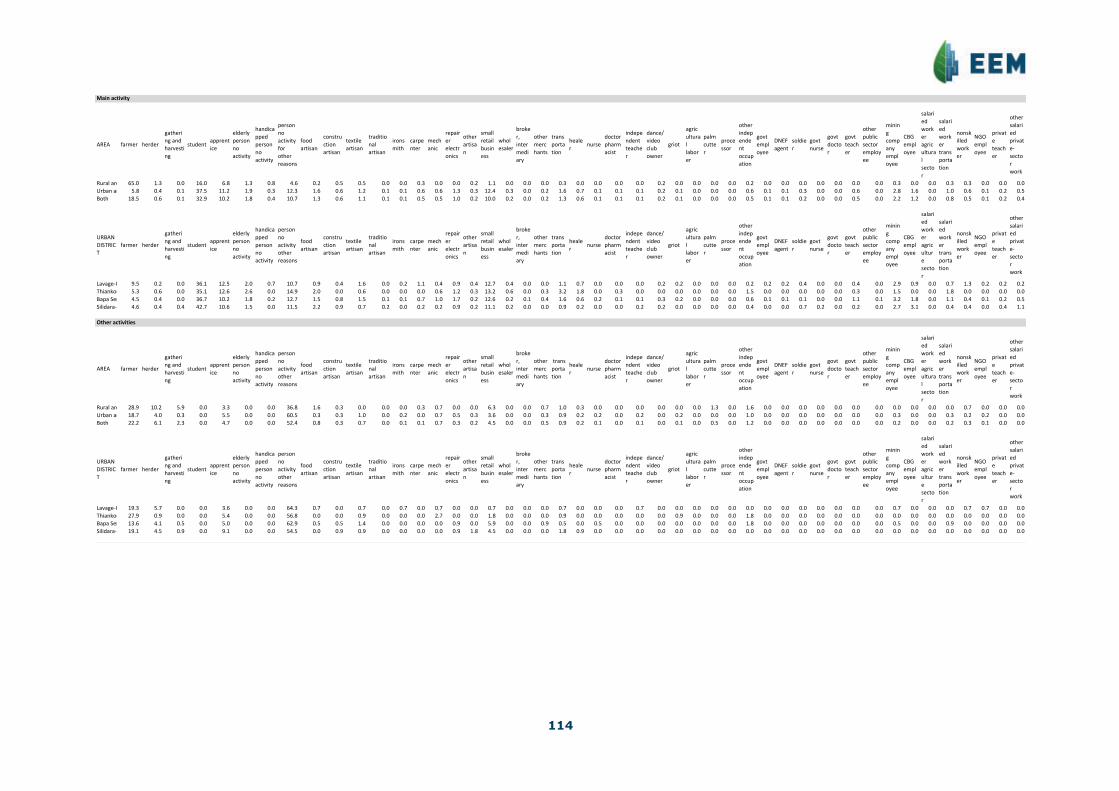
114
Main%activity
AREA $farmer herder
gatheri
ng$and$
harvesti
ng
studentapprent
ice
elderly$
person$
no$
activity
handica
pped$
person$
no$
activity
person$
no$
activity$
for$
other$
reasons
food$
artisan
constru
ction$
artisan
textile$
artisan$
traditio
nal$
artisan
irons
mith
carpe
nter
mech
anic
repair
er$
electr
onics
other$
artisa
n
small$
retail$
busin
ess
whol
esaler
broke
r,$
inter
medi
ary
other$
merc
hants
trans
porta
tion
heale
rnurse
doctor$
pharm
acist
indepe
ndent$
teache
r
dance/
video$
club$
owner
griot
agric
ultura
l$
labor
er
palm$
cutte
r
proce
ssor
other$
indep
ende
nt$
occup
ation$
govt$
empl
oyee
DNEF$
agent
soldie
r
govt$
nurse
govt$
docto
r
govt$
teach
er
other$
public$
sector$
employ
ee
minin
g$
comp
any$
empl
oyee$
CBG$
empl
oyee
salari
ed$
work
er$
agric
ultura
l$
secto
r
salari
ed$
work
er$
trans
porta
tion
nonsk
illed$
work
er
NGO$
empl
oyee
privat
e$
teach
er
other$
salari
ed$
privat
eE
secto
r$
work
Rural$area 65.0 1.3 0.0 16.0 6.8 1.3 0.8 4.6 0.2 0.5 0.5 0.0 0.0 0.3 0.0 0.0 0.2 1.1 0.0 0.0 0.0 0.3 0.0 0.0 0.0 0.0 0.2 0.0 0.0 0.0 0.0 0.2 0.0 0.0 0.0 0.0 0.0 0.0 0.0 0.3 0.0 0.0 0.3 0.3 0.0 0.0 0.0
Urban$area 5.8 0.4 0.1 37.5 11.2 1.9 0.3 12.3 1.6 0.6 1.2 0.1 0.1 0.6 0.6 1.3 0.3 12.4 0.3 0.0 0.2 1.6 0.7 0.1 0.1 0.1 0.2 0.1 0.0 0.0 0.0 0.6 0.1 0.1 0.3 0.0 0.0 0.6 0.0 2.8 1.6 0.0 1.0 0.6 0.1 0.2 0.5
Both 18.5 0.6 0.1 32.9 10.2 1.8 0.4 10.7 1.3 0.6 1.1 0.1 0.1 0.5 0.5 1.0 0.2 10.0 0.2 0.0 0.2 1.3 0.6 0.1 0.1 0.1 0.2 0.1 0.0 0.0 0.0 0.5 0.1 0.1 0.2 0.0 0.0 0.5 0.0 2.2 1.2 0.0 0.8 0.5 0.1 0.2 0.4
URBAN$
DISTRIC
T
$farmer herder
gatheri
ng$and$
harvesti
ng
studentapprent
ice
elderly$
person$
no$
activity
handica
pped$
person$
no$
activity
person$
no$
activity$
other$
reasons
food$
artisan
constru
ction$
artisan
textile$
artisan$
traditio
nal$
artisan
irons
mith
carpe
nter
mech
anic
repair
er$
electr
onics
other$
artisa
n
small$
retail$
busin
ess
whol
esaler
broke
r,$
inter
medi
ary
other$
merc
hants
trans
porta
tion
heale
rnurse
doctor$
pharm
acist
indepe
ndent$
teache
r
dance/
video$
club$
owner
griot
agric
ultura
l$
labor
er
palm$
cutte
r
proce
ssor
other$$
indep
ende
nt$
occup
ation
govt$
empl
oyee
DNEF$
agent
soldie
r
govt$
nurse
govt$
docto
r
govt$
teach
er
other$
public$
sector$
employ
ee
minin
g$
comp
any$
empl
oyee$
CBG$
empl
oyee
salari
ed$
work
er$
agric
ultur
e$
secto
r
salari
ed$
work
er$
trans
porta
tion
nonsk
illed$
work
er
NGO$
empl
oyee
privat
e$
teach
er
other$
salari
ed$
privat
eE
secto
r$
work
LavageEU 9.5 0.2 0.0 36.1 12.5 2.0 0.7 10.7 0.9 0.4 1.6 0.0 0.2 1.1 0.4 0.9 0.4 12.7 0.4 0.0 0.0 1.1 0.7 0.0 0.0 0.0 0.2 0.2 0.0 0.0 0.0 0.2 0.2 0.2 0.4 0.0 0.0 0.4 0.0 2.9 0.9 0.0 0.7 1.3 0.2 0.2 0.2
ThiankounayEU5.3 0.6 0.0 35.1 12.6 2.6 0.0 14.9 2.0 0.0 0.6 0.0 0.0 0.0 0.6 1.2 0.3 13.2 0.6 0.0 0.3 3.2 1.8 0.0 0.3 0.0 0.0 0.0 0.0 0.0 0.0 1.5 0.0 0.0 0.0 0.0 0.0 0.3 0.0 1.5 0.0 0.0 1.8 0.0 0.0 0.0 0.0
Bapa$Sergent 4.5 0.4 0.0 36.7 10.2 1.8 0.2 12.7 1.5 0.8 1.5 0.1 0.1 0.7 1.0 1.7 0.2 12.6 0.2 0.1 0.4 1.6 0.6 0.2 0.1 0.1 0.3 0.2 0.0 0.0 0.0 0.6 0.1 0.1 0.1 0.0 0.0 1.1 0.1 3.2 1.8 0.0 1.1 0.4 0.1 0.2 0.5
SilidaraEU 4.6 0.4 0.4 42.7 10.6 1.5 0.0 11.5 2.2 0.9 0.7 0.2 0.0 0.2 0.2 0.9 0.2 11.1 0.2 0.0 0.0 0.9 0.2 0.0 0.0 0.2 0.2 0.0 0.0 0.0 0.0 0.4 0.0 0.0 0.7 0.2 0.0 0.2 0.0 2.7 3.1 0.0 0.4 0.4 0.0 0.4 1.1
Other%activities
AREA $farmer herder
gatheri
ng$and$
harvesti
ng
studentapprent
ice
elderly$
person$
no$
activity
handica
pped$
person$
no$
activity
person$
no$
activity$
other$
reasons
food$
artisan
constru
ction$
artisan
textile$
artisan$
traditio
nal$
artisan
irons
mith
carpe
nter
mech
anic
repair
er$
electr
onics
other$
artisa
n
small$
retail$
busin
ess
whol
esaler
broke
r,$
inter
medi
ary
other$
merc
hants
$trans
porta
tion
heale
rnurse
doctor$
pharm
acist
indepe
ndent$
teache
r
dance/
video$
club$
owner
griot
agric
ultura
l$
labor
er
palm$
cutte
r
proce
ssor
other$
indep
ende
nt$
occup
ation$
govt$
empl
oyee
DNEF$
agent
soldie
r
govt$
nurse
govt$
docto
r
govt$
teach
er
other$
public$
sector$
employ
ee
minin
g$
comp
any$
empl
oyee$
CBG$
empl
oyee
salari
ed$
work
er$
agric
ultura
l$
secto
r
salari
ed$
work
er$
trans
porta
tion
nonsk
illed$
work
er
NGO$
empl
oyee
privat
e$
teach
er
other$
salari
ed$
privat
eE
secto
r$
work
Rural$area 28.9 10.2 5.9 0.0 3.3 0.0 0.0 36.8 1.6 0.3 0.0 0.0 0.0 0.3 0.7 0.0 0.0 6.3 0.0 0.0 0.7 1.0 0.3 0.0 0.0 0.0 0.0 0.0 0.0 1.3 0.0 1.6 0.0 0.0 0.0 0.0 0.0 0.0 0.0 0.0 0.0 0.0 0.0 0.7 0.0 0.0 0.0
Urban$area 18.7 4.0 0.3 0.0 5.5 0.0 0.0 60.5 0.3 0.3 1.0 0.0 0.2 0.0 0.7 0.5 0.3 3.6 0.0 0.0 0.3 0.9 0.2 0.2 0.0 0.2 0.0 0.2 0.0 0.0 0.0 1.0 0.0 0.0 0.0 0.0 0.0 0.0 0.0 0.3 0.0 0.0 0.3 0.2 0.2 0.0 0.0
Both 22.2 6.1 2.3 0.0 4.7 0.0 0.0 52.4 0.8 0.3 0.7 0.0 0.1 0.1 0.7 0.3 0.2 4.5 0.0 0.0 0.5 0.9 0.2 0.1 0.0 0.1 0.0 0.1 0.0 0.5 0.0 1.2 0.0 0.0 0.0 0.0 0.0 0.0 0.0 0.2 0.0 0.0 0.2 0.3 0.1 0.0 0.0
URBAN$
DISTRIC
T
$farmer herder
gatheri
ng$and$
harvesti
ng
studentapprent
ice
elderly$
person$
no$
activity
handica
pped$
person$
no$
activity
person$
no$
activity$
other$
reasons
food$
artisan
constru
ction$
artisan
textile$
artisan$
traditio
nal$
artisan
irons
mith
carpe
nter
mech
anic
repair
er$
electr
onics
other$
artisa
n
small$
retail$
busin
ess
whol
esaler
broke
r,$
inter
medi
ary
other$
merc
hants
trans
porta
tion
heale
rnurse
doctor$
pharm
acist
indepe
ndent$
teache
r
dance/
video$
club$
owner
griot
agric
ultura
l$
labor
er
palm$
cutte
r
proce
ssor
other$
indep
ende
nt$
occup
ation$
govt$
empl
oyee
DNEF$
agent
soldie
r
govt$
nurse
govt$
docto
r
govt$
teach
er
other$
public$
sector$
employ
ee
minin
g$
comp
any$
empl
oyee$
CBG$
empl
oyee
salari
ed$
work
er$
agric
ultur
e$
secto
r
salari
ed$
work
er$
trans
porta
tion
nonsk
illed$
work
er
NGO$
empl
oyee
privat
e$
teach
er
other$
salari
ed$
privat
eE
secto
r$
work
LavageEU 19.3 5.7 0.0 0.0 3.6 0.0 0.0 64.3 0.7 0.0 0.7 0.0 0.7 0.0 0.7 0.0 0.0 0.7 0.0 0.0 0.0 0.7 0.0 0.0 0.0 0.7 0.0 0.0 0.0 0.0 0.0 0.0 0.0 0.0 0.0 0.0 0.0 0.0 0.0 0.7 0.0 0.0 0.0 0.7 0.7 0.0 0.0
ThiankounayEU27.9 0.9 0.0 0.0 5.4 0.0 0.0 56.8 0.0 0.0 0.9 0.0 0.0 0.0 2.7 0.0 0.0 1.8 0.0 0.0 0.0 0.9 0.0 0.0 0.0 0.0 0.0 0.9 0.0 0.0 0.0 1.8 0.0 0.0 0.0 0.0 0.0 0.0 0.0 0.0 0.0 0.0 0.0 0.0 0.0 0.0 0.0
Bapa$Sergent13.6 4.1 0.5 0.0 5.0 0.0 0.0 62.9 0.5 0.5 1.4 0.0 0.0 0.0 0.0 0.9 0.0 5.9 0.0 0.0 0.9 0.5 0.0 0.5 0.0 0.0 0.0 0.0 0.0 0.0 0.0 1.8 0.0 0.0 0.0 0.0 0.0 0.0 0.0 0.5 0.0 0.0 0.9 0.0 0.0 0.0 0.0
SilidaraEU 19.1 4.5 0.9 0.0 9.1 0.0 0.0 54.5 0.0 0.9 0.9 0.0 0.0 0.0 0.0 0.9 1.8 4.5 0.0 0.0 0.0 1.8 0.9 0.0 0.0 0.0 0.0 0.0 0.0 0.0 0.0 0.0 0.0 0.0 0.0 0.0 0.0 0.0 0.0 0.0 0.0 0.0 0.0 0.0 0.0 0.0 0.0

115
No.$of$$activities$that$households$engage$in$(%)
AREA 1%activity 2%activities 3%activities 4%activities 5%activities 6%activities 7%activities 8%activities%or%+Rural%area 0.0% 3.0% 6.0% 32.3% 33.8% 17.3% 6.0% 1.5%Urban%area 43.2% 27.4% 14.6% 7.5% 3.3% 2.3% 1.3% 0.4%Both 34.4% 22.4% 12.9% 12.6% 9.5% 5.4% 2.3% 0.6%
1%activity 2%activities 3%activities 4%activities 5%activities 6%activities 7%activities 8%activities%or%+LavageEU 36.4% 25.6% 17.4% 7.4% 4.1% 5.0% 3.3% 0.8%ThiankounayEU 34.9% 33.7% 20.5% 7.2% 1.2% 2.4% 0.0% 0.0%Bapa%Sergent 50.0% 26.1% 12.4% 7.3% 2.8% 0.9% 0.5% 0.0%SilidaraEU 43.3% 26.8% 11.3% 8.2% 5.2% 2.1% 2.1% 1.0%
Income
$Total$agricultural$income
Annual%crops
Annual%crops
Perennial%crops
Perennial%crops
Operating%costs
Operating%costs
Net%agricultura
Net%agricultura
AREA average%per%
average%per%cu
average%per%
average%per%cu
average%per%
average%per%cu
average%per%
average%per%cu
Rural%area 8,266,373 2,096,275 5,469,534 1,387,023 646,809 164,025 ######## 3,319,273Urban%area 1,215,055 347,275 718,939 205,480 222,436 63,574 1,711,557 489,180Both 2,693,346 749,813 1,714,889 477,416 311,405 86,693 4,096,830 1,140,536
URBAN%DISTRICTaverage%per%
average%per%cu
average%per%
average%per%cu
average%per%
average%per%cu
average%per%
average%per%cu
LavageEU 2,138,768 536,295 404,409 101,405 349,717 87,691 2,193,459 550,009ThiankounayEU1,184,534 343,636 1,396,017 404,988 245,815 71,311 2,334,737 677,313Bapa%Sergent 656,351 214,087 371,729 121,250 180,767 58,962 847,313 276,374SilidaraEU 1,595,049 387,282 1,446,774 351,281 149,114 36,205 2,892,709 702,357
Details(by(annual(crop
Rural%area Rural%area Rural%area Urban% Urban% Urban% Both Both Bothaverage%per%
average%per%cu
percentage
average%per%
average%per%cu
percentage
average%per%
average%per%cu
percentage
Upland%rice 2,314,170 586,852 28.0 289,044 82,612 23.8 713,606 198,664 26.5Swamp%rice 1,327 337 0.0 7,042 2,013 0.6 5,844 1,627 0.2Cassava 222,100 56,323 2.7 48,069 13,739 4.0 84,554 23,539 3.1Peanuts 1,735,209 440,033 21.0 335,012 95,750 27.6 628,560 174,988 23.3Corn 713,736 180,997 8.6 25,435 7,270 2.1 169,736 47,254 6.3Eggplants 653,643 165,758 7.9 169,991 48,585 14.0 271,388 75,553 10.1Peppers 723,791 183,547 8.8 141,534 40,452 11.6 263,603 73,386 9.8Okra 977,222 247,814 11.8 54,900 15,691 4.5 248,262 69,115 9.2Tomatoes 466,843 118,387 5.7 52,887 15,116 4.4 139,672 38,884 5.2Greens 108,367 27,481 1.3 52,716 15,067 4.3 64,383 17,924 2.4Cowpeas 12,642 3,206 0.2 2,018 577 0.2 4,245 1,182 0.2Sweet%potatoes 87,174 22,107 1.1 17,994 5,143 1.5 32,497 9,047 1.2Taro 93,796 23,786 1.1 9,401 2,687 0.8 27,094 7,543 1.0Millet 106,564 27,024 1.3 4,841 1,384 0.4 26,167 7,285 1.0Sesame 9,195 2,332 0.1 423 121 0.0 2,262 630 0.1Fonio 33,212 8,422 0.4 3,166 905 0.3 9,465 2,635 0.4Other 2,602 660 0.0 582 166 0.0 1,006 280 0.0
Details(by(perennial(crop
Rural%area Rural%area Rural%area Urban% Urban% Urban% Both Both Bothaverage%per%
average%per%cu
percentage
average%per%
average%per%cu
percentage
average%per%
average%per%cu
percentage
Shelled%cashews115,121 29,194 2.1 34,815 9,950 4.8 51,651 14,379 3.0Mangoes 453,277 114,947 8.3 187,750 53,661 26.1 243,417 67,766 14.2Oranges 832,854 211,204 15.2 150,504 43,015 21.0 293,557 81,725 17.1Regime%de%palme1,322,708 335,426 24.2 22,433 6,412 3.1 295,032 82,135 17.2Palm%oil 1,351,895 342,828 24.8 85,147 24,336 11.9 350,718 97,638 20.5Palm%nuts 94,425 23,945 1.7 10,587 3,026 1.5 28,163 7,841 1.6Bananas 1,102,889 279,682 20.2 206,773 59,098 28.8 394,642 109,866 23.0Plantains 19,469 4,937 0.4 1,291 369 0.2 5,102 1,420 0.3Kola%nuts 135,584 34,383 2.5 10,129 2,895 1.4 36,430 10,142 2.1Other 33,945 8,608 0.6 8,742 2,498 1.2 14,025 3,905 0.8

116
Monetary)agricultural)income
Annual&agriculture
Annual&agriculture
Perennial&agriculture&
Perennial&agriculture&
AREAaverage&per&
average&per&cu
average&per&
average&per&cu
Rural&area 4,475,655 1,134,984 3,005,571 762,185Urban&area 720,594 205,953 367,324 104,985Both 1,507,833 419,773 920,426 256,242
URBAN&DISTRICT
average&per&
average&per&cu
average&per&
average&per&cu
LavageIU 1,312,620 329,139 109,620 27,487ThiankounayIU636,985 184,791 1,219,118 353,669Bapa&Sergent 344,867 112,488 34,592 11,283SilidaraIU 1,075,757 261,197 810,214 196,722
Details(by(annual(crop
Rural&area Rural&area Rural&area Urban& Urban& Urban& Both Both Bothaverage&per&
average&per&cu
percentage
average&per&
average&per&cu
percentage
Upland&rice 144,965 36,762 3.2 32,981 9,426 4.6 56,458 15,718 3.7Swamp&rice 16,991 4,309 0.4 9,155 2,617 1.3 10,798 3,006 0.7Cassava 99,646 25,269 2.2 28,803 8,232 4.0 43,655 12,153 2.9Peanuts 1,172,434 297,318 26.2 209,228 59,799 29.0 411,161 114,465 27.3Corn 365,345 92,648 8.2 2,845 813 0.4 78,842 21,949 5.2Eggplant 568,743 144,228 12.7 148,216 42,362 20.6 236,378 65,807 15.7Peppers 595,681 151,059 13.3 115,211 32,929 16.0 215,941 60,117 14.3Okra 873,088 221,407 19.5 37,664 10,765 5.2 212,809 59,245 14.1Tomatoes 415,885 105,465 9.3 47,864 13,680 6.6 125,019 34,805 8.3Greens 87,434 22,172 2.0 30,887 8,828 4.3 42,742 11,899 2.8Cowpeas 5,973 1,515 0.1 3,089 883 0.4 3,694 1,028 0.2Sweet&potato 33,850 8,584 0.8 7,594 2,170 1.1 13,098 3,647 0.9Taro 16,814 4,264 0.4 4,718 1,349 0.7 7,254 2,020 0.5Millet 27,566 6,991 0.6 10,023 2,865 1.4 13,701 3,814 0.9Sesame 10,487 2,659 0.2 0 0 0.0 2,199 612 0.1Fonio 20,398 5,173 0.5 14,085 4,025 2.0 15,408 4,290 1.0Other 20,354 5,162 0.5 18,230 5,210 2.5 18,675 5,199 1.2
Details(by(perennial(crop
Rural&area Rural&area Rural&area Urban& Urban& Urban& Both Both Bothaverage&per&
average&per&cu
percentage
average&per&
average&per&cu
percentage
average&per&
average&per&cu
percentage
Shelled&cashews103,407 26,223 3.4 28,777 8,225 7.8 44,423 12,367 4.8Mangoes 242,354 61,459 8.1 107,383 30,691 29.2 135,679 37,772 14.7Oranges 658,717 167,044 21.9 119,131 34,049 32.4 232,254 64,658 25.2Regime&de&palme370,354 93,918 12.3 7,042 2,013 1.9 83,210 23,165 9.0Palm&oil 1,020,336 258,748 33.9 70,563 20,168 19.2 269,681 75,078 29.3Palm&nuts 1,858 471 0.1 0 0 0.0 390 108 0.0Bananas 363,460 92,170 12.1 11,667 3,334 3.2 85,419 23,780 9.3Plantains 24,779 6,284 0.8 775 221 0.2 5,807 1,617 0.6Kola&nuts 120,239 30,491 4.0 13,263 3,791 3.6 35,690 9,936 3.9Other 100,066 25,376 3.3 8,723 2,493 2.4 27,873 7,760 3.0
Personal)consumption)crops
AREAaverage&per&
average&per&cu
percentage
Rural&area 5,941,780 1,506,780 45Urban&area 825,702 235,994 47Both 1,898,275 528,470 46
URBAN&DISTRICT
average&per&
average&per&cu
percentage
LavageIU 1,365,424 342,379 61ThiankounayIU576,566 167,263 25Bapa&Sergent 565,012 184,294 63SilidaraIU 1,088,306 264,243 38
Income)from)herding)(net)

117
Income'from'herding'(net)
net$income
net$income
personal$consumpti
personal$consumpti
personal$consumpti
AREA average$per$
average$per$cu
average$per$
average$per$cu
percentage
Rural$area 1,196,197 303,344 160,929 40,810 13Urban$area 223,141 63,776 54,381 15,543 24Both 427,140 118,914 76,719 21,358 18
URBAN$DISTRICT
average$per$
average$per$cu
average$per$
average$per$cu
percentage
LavageJU 200,192 50,198 94,076 23,590 47ThiankounayJU252,853 73,353 69,377 20,126 27Bapa$Sergent 136,258 44,444 20,703 6,753 15SilidaraJU 467,713 113,562 81,944 19,896 17
Income'from'fishing
total$income
total$income
personal$consumpti
personal$consumpti
AREA average$per$
average$per$cu
average$per$
average$per$cu
percentage
Rural$area 1,071,622 271,753 452,596 114,774 73Urban$area 6,690 1,912 1,796 513 37Both 229,951 64,017 96,305 26,811 72
URBAN$DISTRICT
average$per$
average$per$cu
average$per$
average$per$cu
percentage
LavageJU 0 0 0 0 0ThiankounayJU 0 0 0 0 0Bapa$Sergent 1,071 349 536 175 100SilidaraJU 37,714 9,157 9,429 2,289 33
Income'from'gathering'and'harvesting
AREA average$per$
average$per$cu
average$per$
average$per$cu
percentage
Rural$area 3,152,396 799,418 2,396,188 607,651 24Urban$area 228,000 65,165 168,906 48,275 26Both 841,093 234,156 635,850 177,017 24
URBAN$DISTRICT
average$per$
average$per$cu
average$per$
average$per$cu
percentage
LavageJU 301,703 75,652 184,616 46,292 39ThiankounayJU401,044 116,344 224,926 65,252 44Bapa$Sergent 66,163 21,581 61,694 20,123 7SilidaraJU 416,179 101,049 394,036 95,673 5

118
Income'from'land
agricultural agricultural housing housing total-land total-land
AREA average-per-household
average-per-cu
average-per-household
average-per-cu
average-per-household
average-per-cu
Rural-area 1,416 359 12,743 3,232 14,159 3,591Urban-area 423 121 3,136,831 896,538 3,137,254 896,659Both 631 176 2,481,874 690,941 2,482,505 691,116
URBAN-DISTRICT
average-per-household
average-per-cu
average-per-household
average-per-cu
average-per-household
average-per-cu
LavageJU 0 0 732,391 183,647 732,391 183,647ThiankounayJU 0 0 280,882 81,485 280,882 81,485Bapa-Sergent 918 300 6,119,490 1,996,039 6,120,408 1,996,339SilidaraJU 0 0 719,857 174,783 719,857 174,783
Miscellaneous'income
rental-tools rental-tools
commerce-and-wages
commerce-and-wages
public-sector
public-sector mines mines
other-private-sector
other-private-sector
AREA average-per-household
average-per-cu
average-per-household
average-per-cu
average-per-household
average-per-cu
average-per-household
average-per-cu
average-per-household
average-per-cu
Rural-area 0 0 1,535,392 389,361 0 0 226,195 57,361 270,184 68,516Urban-area 206,808 59,108 12,656,340 3,617,310 566,405 161,884 4,495,677 1,284,910 1,310,469 374,545Both 163,451 45,504 10,324,861 2,874,387 447,660 124,626 3,600,591 1,002,385 1,092,376 304,112
URBAN-DISTRICT
average-per-household
average-per-cu
average-per-household
average-per-cu
average-per-household
average-per-cu
average-per-household
average-per-cu
average-per-household
average-per-cu
LavageJU 0 0 14,155,216 3,549,414 678,245 170,070 4,322,261 1,083,805 1,594,022 399,700ThiankounayJU 141,324 40,998 18,077,002 5,244,181 264,706 76,792 1,047,157 303,783 1,302,941 377,986Bapa-Sergent 382,092 124,630 10,792,744 3,520,349 732,092 238,792 4,633,083 1,511,207 1,326,888 432,801SilidaraJU 51,429 12,487 10,638,675 2,583,098 248,571 60,354 7,688,851 1,866,873 899,143 218,314
Income'from'transfers'and'pensions
Pension Pension Transfer Transfer Total Totalavg-per-householdaverage-per-cuavg-per-householdaverage-per-cuavg-per-householdaverage-per-cu
Rural-area 7,788 1,975 1 0 7,790 1,975Urban-area 245,493 70,165 2 0 245,495 70,165Both 195,659 54,470 1 0 195,661 54,471
URBAN-DISTRICTavg-per-householdaverage-per-cuavg-per-householdaverage-per-cuavg-per-householdaverage-per-cuLavageJU 413,044 103,571 1 0 413,045 103,571ThiankounayJU 417,648 121,161 2 0 417,650 121,161Bapa-Sergent 105,000 34,249 2 1 105,002 34,249SilidaraJU 251,429 61,048 2 0 251,431 61,048
Total'income
AREA avg-per-householdaverage-per-cuRural-area 20,563,032 5,214,593Urban-area 24,787,837 7,084,615Both 23,902,117 6,654,223
URBAN-DISTRICTavg-per-householdaverage-per-cuLavageJU 24,590,535 6,166,065ThiankounayJU24,520,295 7,113,396Bapa-Sergent25,143,114 8,201,116SilidaraJU 24,312,271 5,903,084
PercentageContribution-(%)Contribution-(%)Contribution-(%) Contribution-(%)Contribution-(%)Contribution-(%)Contribution-(%)Contribution-(%)
AREA Agriculture Herding Fishing Gathering/harvestingLand Rental Misc. TransferRural-area 63.7 5.8 5.2 15.3 0.1 0.0 9.9 0.0Urban-area 6.9 0.9 0.0 0.9 12.7 0.8 76.8 1.0Both 17.1 1.8 1.0 3.5 10.4 0.7 64.7 0.8
URBAN-DISTRICTAgriculture Herding Fishing Gathering/harvestingLand Rental Misc. TransferLavageJU 8.9 0.8 0.0 1.2 3.0 0.0 84.4 1.7ThiankounayJU 9.5 1.0 0.0 1.6 1.1 0.6 84.4 1.7Bapa-Sergent 3.4 0.5 0.0 0.3 24.3 1.5 69.5 0.4SilidaraJU 11.9 1.9 0.2 1.7 3.0 0.2 80.1 1.0

119
Average'per'household
AREA Agriculture Herding Fishing Gathering/harvestingLand Rental Misc. TransferRural;area 13,089,098 1,196,197 1,071,622 3,152,396 14,159 0 2,031,770 7,790Urban;area 1,711,557 223,141 6,690 228,000 3,137,254 206,808 19,028,892 245,495Both 4,096,830 427,140 229,951 841,093 2,482,505 163,451 15,465,488 195,661
URBAN;DISTRICTAgriculture Herding Fishing Gathering/harvestingLand Rental Misc. TransferLavagePU 2,193,459 200,192 0 301,703 732,391 0 20,749,744 413,045ThiankounayPU2,334,737 252,853 0 401,044 280,882 141,324 20,691,806 417,650Bapa;Sergent 847,313 136,258 1,071 66,163 6,120,408 382,092 17,484,806 105,002SilidaraPU 2,892,709 467,713 37,714 416,179 719,857 51,429 19,475,240 251,431
Average'per'cu
AREA Agriculture Herding Fishing Gathering/harvestingLand Rental Misc. TransferRural;area 3,319,273 303,344 271,753 799,418 3,591 0 515,238 1,975Urban;area 489,180 63,776 1,912 65,165 896,659 59,108 5,438,650 70,165Both 1,140,536 118,914 64,017 234,156 691,116 45,504 4,305,510 54,471
URBAN;DISTRICTAgriculture Herding Fishing Gathering/harvestingLand Rental Misc. TransferLavagePU 550,009 50,198 0 75,652 183,647 0 5,202,988 103,571ThiankounayPU 677,313 73,353 0 116,344 81,485 40,998 6,002,742 121,161Bapa;Sergent 276,374 44,444 349 21,581 1,996,339 124,630 5,703,149 34,249SilidaraPU 702,357 113,562 9,157 101,049 174,783 12,487 4,728,640 61,048
Personal)consumptionAgriculture Herding Fishing Gathering/harvesting
AREA avg;per;householdaverage;per;cupercentage percentage percentage percentageRural;area 8,951,492 2,270,015 66 2 5 26.8Urban;area 1,050,786 300,325 78 5 0 15.9Both 2,707,149 753,656 70 3 4 23.4
URBAN;DISTRICTavg;per;householdaverage;per;cupercentage percentage percentage percentageLavagePU 1,644,116 412,261 82 6 0 11.1ThiankounayPU 870,869 252,641 65 8 0 25.3Bapa;Sergent 647,944 211,345 86 3 0 9.4SilidaraPU 1,573,714 382,102 69 5 1 25.0
Income'breakdown
Bracket;(millions;GNF)Rural;area Urban;area Both Bracket;(millions;GNF)LavagePU ThiankounayPUBapa;SergentSilidaraPU0 6.2 9.4 8.7 0 7.6 11.8 11.2 4.33 13.3 8.5 9.5 3 4.3 8.8 10.2 8.66 11.5 9.4 9.8 6 8.7 5.9 12.2 5.7
9.0 13.3 13.6 13.5 9.0 9.8 20.6 13.3 12.912 11.5 9.6 10.0 12 13.0 10.3 7.1 11.415 8.0 4.7 5.4 15 6.5 2.9 5.1 2.918 5.3 6.3 6.1 18 4.3 7.4 5.6 10.021 2.7 4.0 3.7 21 4.3 5.9 3.1 4.324 8.8 5.6 6.3 24 3.3 4.4 6.6 7.127 1.8 3.5 3.2 27 5.4 0.0 3.1 5.730 1.8 3.5 3.2 30 4.3 2.9 3.1 4.333 2.7 2.6 2.6 33 2.2 2.9 3.6 0.036 0.9 2.6 2.2 36 3.3 2.9 1.5 4.339 1.8 1.6 1.7 39 1.1 0.0 2.6 1.442 0.9 3.8 3.2 42 6.5 1.5 2.6 5.745 1.8 1.6 1.7 45 1.1 0.0 2.0 2.948 1.8 0.9 1.1 48 2.2 1.5 0.0 1.451 0.9 0.7 0.7 51 1.1 0.0 0.5 1.454 0.9 1.2 1.1 54 1.1 1.5 1.5 0.057 0.0 1.4 1.1 57 0.0 1.5 2.0 1.460 0.9 0.0 0.2 60 0.0 0.0 0.0 0.063 0.0 0.5 0.4 63 1.1 0.0 0.5 0.066 0.0 0.7 0.6 66 2.2 1.5 0.0 0.069 0.0 0.2 0.2 69 0.0 0.0 0.5 0.072 0.0 0.5 0.4 72 1.1 0.0 0.0 1.475 0.0 0.5 0.4 75 1.1 0.0 0.5 0.078 0.0 0.0 0.0 78 0.0 0.0 0.0 0.081 0.9 0.0 0.2 81 0.0 0.0 0.0 0.084 0.0 0.0 0.0 84 0.0 0.0 0.0 0.087 0.0 0.2 0.2 87 0.0 0.0 0.0 1.490 0.0 0.2 0.2 90 0.0 0.0 0.5 0.093 0.0 0.0 0.0 93 0.0 0.0 0.0 0.096 0.0 0.0 0.0 96 0.0 0.0 0.0 0.099 0.0 0.0 0.0 99 0.0 0.0 0.0 0.0102 0.0 0.0 0.0 102 0.0 0.0 0.0 0.0105 0.0 0.2 0.2 105 0.0 0.0 0.5 0.0108 0.0 0.0 0.0 108 0.0 0.0 0.0 0.0111 0.0 0.2 0.2 111 1.1 0.0 0.0 0.0114 0.9 0.0 0.2 114 0.0 0.0 0.0 0.0117 0.0 0.0 0.0 117 0.0 0.0 0.0 0.0120 1.8 1.6 1.7 120 1.1 5.9 0.5 1.4

120
APPENDIX 11: STATISTICS ON EDUCATION IN THE TOWN OF SANGARÉDI
PRIMARY'SCHOOLS
DistrictName'of'school
Principal's'contact'informati
on
Accredited
Franco@Arab
Cycle'Double'shifting
Total'no.'students'2012@2013
No.'of'girls
Took'exams'2013
Passed'exams'2013
No.'of'girls
Ratio'students'/'
class
Ratio'students'/'teacher
Ratio'students'/'
table'bench
Registration'fee
School'fees/'month
Bapa$ Sangarédi$ Aly$ yes no full no 1304 468 218 191 78 100.3 59.3 4.4 8000Lavage Bakoutou Rujatatou$ yes no full yes 1004 476 113 91 38 111.6 55.8 6.9 5000Bapa$ Minel N'Faly$ yes no full no 856 449 164 164 53 95.1 50.4 4.2 8000Bapa$ Ambroise$ Chérif$ yes no full yes 713 384 83 79 41 79.2 47.5 3.2 3000Bapa$ Ambroise$ Ablaye$ yes no full yes 692 332 150 146 68 76.9 49.4 2.6 NR
4569 2109 728 671 278 93.2 53.1 4.0
Lavage Rassoulou Rassoulou yes yes full no 304 128 34 32 8 50.7 50.7 2.8 NR NRSilidara Alpha$ Mary$ yes no full no 245 115 26 26 11 40.8 40.8 2.0 10000 30000Silidara Syndicat Lancinet$ yes no full no 309 165 43 43 24 51.5 51.5 2.5 30000 40000Silidara Diaraye$ Abdoulay yes no full no 382 153 19 19 15 34.7 38.2 1.9 20000 40000Bapa$ Djouldé$ Constanti yes no full no 380 161 57 57 25 54.3 54.3 2.2 25000 40000Bapa$Sergent
Ta$Awoun$Islamiya
Mamadou$Hady$BAH$ yes yes full no 256 115 36 36 20 42.7 23.3 2.1 25000 30000
Bapa$ Mamadou$ Boubacar$ yes no full no 464 225 87 87 40 51.6 51.6 2.4 10000 36000Silidara La$fleur Alpha$ yes no full no 322 160 51 51 32 53.7 40.3 1.3 20000 60000Silidara La$fleur$ Ernest$ yes no 1/2/3/4 no 73 33 36.5 36.5 1.6 10000 15000Thiankou Marie$ Youssouf$ yes no 1/2/3/4/5 yes 243 85 81.0 48.6 3.2 15000 25000Thiankou Simathor Ibrahima$ yes no 1/2/3/5 yes 67 41 22.3 16.8 1.4 15000 25000Thiankou Fofodoro Lamarana$ yes no full no 506 294 43 43 29 50.6 50.6 2.3 15000 35000Lavage Elhadj$ Sory$Bailo$ yes no full yes 182 87 19 16 6 36.4 30.3 2.6 15000 35000Bapa$ Pépinière NR yes no full no 200 93 15 13 7 33.3 33.3 4.4 15000 20000Bapa$ Bambino Ousmane$ no no 1/2 no 78 47 39.0 39.0 3.1 10000 20000Bapa$Sergent
Elhadj$Souleyma
Salifou$CAMARA$ no no 1/2/3/4/5 no 53 26 26.5 26.5 3.1 10000 20000
Lavage Marcelyn Nouhou$ no no 1/2 no 35 12 17.5 17.5 1.9 15000 20000Thiankounaye Pas$à$pas
Ousmane$Major$ no no 1/2/3/4/6 yes 140 50 9 9 5 70.0 46.7 3.5 25000 15000
4239 1990 439 432 222 45.1 40.4 2.28808 4099 1167 1103 500 61.6 46.1 2.9TOTAL
Public'schools
Total'public'schoolsPrivate'schools
Total'private'schools

121
DistrictName+of+school
Contact+information+for+director
Accreditation
Franco5Arabe
Cycle+Double+shifting
Total+no.+students+201252013
No.+of+girls
Took+exams+2013
Passed+exams+2013
No.+of+girls
No.+students+/+
class
No.+students+/+teacher
No.+students+/+
table+bench
Registration+fee
School+fees
nomiddle(school no 746 253 205 174 65 93.3 27.6 2.6 10000
nohigh(school no 401 82 237 123 25 44.6 14.9 2.1 10000
nomiddle(school no 1429 521 383 352 101 95.3 38.6 3.1 10000
nohigh(school no 553 134 214 141 21 92.2 14.9 1.2 10000
Silidara Collège( Amadou( yes no middle( no 592 156 121 69 15 39.5 39.5 2.4 10000
2767 930 709 595 181 72.8 35.0 2.8954 216 451 264 46 63.6 14.9 1.4
yes no middle( no 231 126 92 91 45 38.5 11.0 2.0 10000 60000yes no high( no 326 164 112 98 48 46.6 15.5 2.0 10000 65000yes no middle( no 265 96 96 96 55 44.2 8.8 1.5 20000 60000yes no high( no 153 64 80 80 37 25.5 5.1 0.9 20000 60000yes no middle( no 407 176 73 73 32 50.9 17.0 2.0 25000 60000yes no high( no 143 52 37 36 9 15.9 6.0 1.5 25000 70000
Silidara Syndicat Lancinet( yes no middle( no 117 62 24 24 12 29.3 9.8 1.7 30000 60000Silidara Ta(awoun( Mamadou( yes yes 7/8/9 no 44 18 14.7 4.4 0.8 10000 50000Lavage Rassoulou Rassoulou yes yes middle( no 59 28 16 14 10 11.8 3.9 0.7 NR NR
1123 506 301 298 154 35.1 10.0 1.6622 280 229 214 94 28.3 8.3 1.43890 1436 1010 893 335 55.6 20.4 2.31576 496 680 478 140 42.6 11.3 1.4
Total+public+high+schools
SECONDARY+SCHOOLS
Public+schools
LavageLycée(UNESCO
Mamourou(Mémé(KONE(664(
yes
Bapa(Sergent
Lycée(Général(Lansana(
MamadouSaïdou(SALL(628(
yes
Total+public+middle+schools
Private+schools
SilidaraAlpha(Yaya(
Mary(KONE(666(
Silidara La(fleurAlpha(Saliou(
TOTAL+HIGH+SCHOOLS+
SilidaraDjaraye(Diallo
Abdoulaye(
Total+private+middle+schoolsTotal+private+high+schoolsTOTAL+MIDDLE+SCHOOLS++

122
APPENDIX 12: STATISTICS ON EDUCATION IN THE RURAL PART OF THE CONCESSION ZONE
CR District Village School Comment Boys Girls Total %4girls Pass4rate S/room S/tbl4bench S/teacherDiandian public perm.4shelter 37 30 67 45% 4 33.5 4.2 33.5Pora4Hodho community perm.4shelter 58 54 112 48% 4 112.0 2.8 112.0Sintiourou4Daroul4Diandian community shed 37 17 54 31% 4 54.0 0.0 54.0Madina4Dian public perm.4shelter 38 35 73 48% 4 36.5 3.7 36.5Missira community shed 10 16 26 62% 4 26.0 3.7 26.0
Balandougou Lougal community shed 7 18 25 72% 4 25.0 4.2 25.0Boulleré4centre public new4building 87 51 138 37% 52% 23.0 1.0 46.0Boulleré4centre FrancoMArab perm.4shelter 43 17 60 28% 4 20.0 1.7 30.0Fassely4Belenderé community mud4and4thatch 27 15 42 36% 4 42.0 3.5 42.0Guegueré public under4construction 35 15 50 30% 4 50.0 4.2 25.0Mbouroré community shed 0 0 0 0% 4 0.0 0.0 0.0Kahel4Mbody pubic perm.4shelter 25 8 33 24% 4 16.5 1.8 33.0Kourawel4centre public perm.4shelter 20 20 40 50% 4 40.0 4.0 40.0
Nyalé4Moussa public perm.4shelter4(24class4rooms,414operational33 17 50 34% 4 50.0 2.0 50.0Wossou Kagnéka community shed4(1st4yr) 0 0 0 0% 4Lavage4 Hamdallaye public perm.4shelter 62 45 107 42% 100% 35.7 2.2 35.7
Boundou4Wande public perm.4shelter 29 16 45 36% 4 15.0 3.0 45.0Hafia41 community mud4and4thatch 35 35 70 50% 4 70.0 4.1 70.0Hore4Lafou public perm.4shelter 30 25 55 45% 4 18.3 2.8 27.5
Soucka Kalinko4Roundé community mud4and4thatch 26 11 37 30% 4 37.0 0.0 37.0
639 445 1084 41% 74% 30.1 2.4 37.4
Students
Daramagnaki
Diandian
Madina4Dian
Sangarédi
Boulleré
Kourawel
Thiankounnaye

123
APPENDIX 13: STATISTICS ON EDUCATION IN KAMSAR
PRIMARY'SCHOOLS
District Name'of'schoolTotal'no.'
students'2012C2013
No.'of'girls %'girls No.'of'classesNo.'of'students'
/'classNo.'of'teachers
No.'of'students'/'teacher
No.'of'table'benches
No.'of'students'/'table'bench
Filima N'Pame 1,747 830 47.5 13 134.4 22 79.4 248 7.0Filima Kadiatou:Seth 215 74 34.4 6 35.8 10 21.5 75 2.9Kassongoni Kaleyiré2 561 209 37.3 6 93.5 10 56.1 124 4.5Kassongoni Kassongoni1 1,315 609 46.3 9 146.1 17 77.4 260 5.1Madina:Borbof Kayenguissa 1,047 507 48.4 9 116.3 12 87.3 152 6.9Kassongoni Kassongoni2 842 466 55.3 16 52.6 16 52.6 130 6.5Madina:Borbof Madina:Borbof 345 144 41.7 6 57.5 7 49.3 98 3.5Filima Lintagna 140 70 50.0 3 46.7 1 140.0 60 2.3Filima Filima:centre 120 60 50.0 3 40.0 2 60.0 60 2.0Kawass Kawass 152 69 45.4 8 19.0 3 50.7 140 1.1Kamsar:Centre Kamsar:centre:Bora 1,151 530 46.0 14 82.2 22 52.3 221 5.2Kamsar:Cité Kamsar:cite 1,606 808 50.3 26 61.8 34 47.2 650 2.5Kamsar:Cité K.:N'krumah 412 241 58.5 11 37.5 13 31.7 152 2.7Kamsar:Centre Maman:H.:Conté 1,398 682 48.8 8 174.8 17 82.2 165 8.5Kamsar:Cité OFAB:franco:arabe 605 209 34.5 7 86.4 17 35.6 115 5.3Total'public'schools 11656 5508 47.3 145 80.4 203 57.4 2650 4.4
PRIMARY'SCHOOLS
Public'schools

124
District Name+of+schoolTotal+no.+
students+201282013
No.+of+girls %+girls No.+of+classesNo.+of+students+
/+classNo.+of+teachers
No.+of+students+/+teacher
No.+of+table+benchs
No.+of+students+/+table+bench
Madina&Borbof Dauphin 84 10 11.9 12 7.0 6 14.0 84 1.0Kassongoni Nid&des&innocents 336 206 61.3 10 33.6 6 56.0 107 3.1Madina&Borbof Nozomi&village 228 128 56.1 6 38.0 7 32.6 126 1.8Filima Hadja&Sayon&Diallo 156 71 45.5 9 17.3 6 26.0 175 0.9Kawass UNESCO&P&Kakandé 74 36 48.6 6 12.3 6 12.3 150 0.5
Odia&Berete 136 55 40.4 9 15.1 6 22.7 110 1.2Filima Celine&Yante&Camara 228 99 43.4 8 28.5 6 38.0 66 3.5Kawass Nasouroul&Islami 615 225 36.6 11 55.9 6 102.5 181 3.4Filima Cdt&Lansana&Camara 205 107 52.2 6 34.2 6 34.2 97 2.1Kamsar&Centre Maranatha 107 49 45.8 3 35.7 4 26.8 84 1.3Kassongoni Mamadama&Soumah 70 31 44.3 2 35.0 3 23.3 18 3.9Kassongoni Elhadj&Bemba&Toure 169 82 48.5 6 28.2 6 28.2 135 1.3Kassongoni Sainte&Rosalie 356 196 55.1 6 59.3 6 59.3 284 1.3Filima Ibrahima&Sory&Tounkara 76 38 50.0 3 25.3 3 25.3 16 4.8Filima Lintagna&Hamouya 65 24 36.9 3 21.7 3 21.7 126 0.5Filima Maman&Sayon&Diallo 151 72 47.7 6 25.2 6 25.2 109 1.4Kassongoni Les&&Castors NR NR NR NR NR NR NR NR NRKassongoni Aly&Pam 41 29 70.7 4 10.3 3 13.7 44 0.9Kamsar&Cité Anastasis 363 180 49.6 6 60.5 8 45.4 132 2.8Kamsar&Cité Charlotte 136 76 55.9 6 22.7 10 13.6 140 1.0Kamsar&Centre Enfant&noir 469 224 47.8 6 78.2 6 78.2 190 2.5Kassongoni Espoir&de&Kamsar 309 160 51.8 6 51.5 6 51.5 200 1.5Kamsar&Centre Hafia&Kassapo 552 281 50.9 10 55.2 12 46.0 250 2.2Kassongoni Kassopo&francoParabe 136 62 45.6 3 45.3 3 45.3 78 1.7Kamsar&Centre La&paix&francoParabe 45 21 46.7 6 7.5 8 5.6 102 0.4Kamsar&Cité Roi&Mohamed&VI 286 151 52.8 6 47.7 9 31.8 398 0.7Kamsar&Cité N'Dama 729 373 51.2 18 40.5 21 34.7 422 1.7Kamsar&Centre Roi&Hassane&II 166 87 52.4 6 27.7 7 23.7 94 1.8Kamsar&Cité Saint&JeanPBatiste 435 206 47.4 9 48.3 13 33.5 83 5.2Kassongoni Sainte&Suzane&II 308 163 52.9 6 51.3 8 38.5 194 1.6Kamsar&Centre Soya 78 40 51.3 2 39.0 2 39.0 64 1.2Kamsar&Centre Villette 138 71 51.4 4 34.5 3 46.0 36 3.8Kamsar&Cité Victor&Hugo 179 77 43.0 6 29.8 8 22.4 105 1.7Kamsar&Cité Zeze&Onivogui 82 35 42.7 2 41.0 2 41.0 48 1.7
7508 3665 48.8 212 35.4 215 34.9 4448 1.719164 9173 47.9 357 53.7 418 45.8 7098 2.7
Private+schools
Total+private+schoolsTOTAL+PRIMARY+SCHOOLS

125
District Name+of+schoolTotal+no.+
students+201282013
No.+of+girls %+girls No.+of+classesNo.+of+students+
/+classNo.+of+teachers
No.+of+students+/+teacher
No.+of+table+benchs
No.+of+students+/+table+bench
Kassongoni College+Kassongoni 1561 599 38.4 18 86.7 22 71.0 500 3.1Filima Lycée++Filima 3069 1079 35.2 37 82.9 68 45.1 688 4.5Filima Lycée+Hamdallaye 1264 459 36.3 20 63.2 25 50.6 478 2.6Kamsar+Cité A.+M.+M'Bow 2686 812 30.2 34 79.0 51 52.7 1070 2.5Kamsar+Cité College+francoGarabe 333 67 20.1 4 83.3 16 20.8 138 2.4Total+public+schools 8913 3016 33.8 113 78.9 182 49.0 2874 3.1
Kawass Nasouroul+Islami 310 110 35.5 9 34.4 24 12.9 190 1.6Kassongoni Cdt+Lansana+Camara 272 127 46.7 9 30.2 24 11.3 180 1.5Kawass UNESCO+G+Kakandé 144 62 43.1 5 28.8 18 8.0 108 1.3
Sainte+Rosalie 5 4 80.0 1 5.0 7 0.7 8 0.6Albert+Einstein 213 99 46.5 6 35.5 27 7.9 108 2.0
Kamsar+Cité Roi+Mohamed+VI 309 139 45.0 11 28.1 5 61.8 177 1.7Kamsar+Cité N'Dama 916 420 45.9 25 36.6 5 183.2 875 1.0Kassongoni Sainte+Suzanne+II 100 4 4.0 4 25.0 1 100.0 35 2.9Kamsar+Cité Victor+Hugo 195 95 48.7 10 19.5 6 32.5 169 1.2
2464 1060 43.0 80 30.8 117 21.1 1850 1.3
TOTAL+SECONDARY+SCHOOLS 11377 4076 35.8 193 58.9 299 38.1 4724 2.4
Public+schools
Private+schools
Total+private+schools
SECONDARY+SCHOOLS

126
APPENDIX 14: STATISTICS ON THE HEALTH-CARE INFRASTRUCTURE IN THE TOWN OF SANGARÉDI
Quarter Type*of*establishmentName*of*
etablishmentAccreditation Year Status*director Hospital*rooms No.*of*beds
No.*of*mosquito*
netsServices*available
Price*
consultation*
child
Price*
consultation*
adult
Statistics*
avg./month
No.*of*
physicians
No.*of*other*
medical*
personnel
Waste*
mgmt.
Bapa$Sergent Health$center CSA$Sangarédi yes 1980 Physician yes 19 35
GM/P/S/Lab/G/HIV/E/
Delivery/$Morgue 1,000 2,000 NA 3 7 Incineration
Silidara Health$post PS$Silidara yes 2011
Technical$health$
agent no 4 4 GM/E 1,000 1,000 400 0 3 CBG
Silidara $CBG$dispensary Departement$18 yes 1973 Physician yes 130 0
GM/P/S/G/E/D/Lab/HI
V/Delivery/
Endoscopy/Cardiology/$
Radiology/Morgue
+$1$once$a$month:$
Dermatology/ENT/
Ophthalmology/Neurol
ogy/$Orthopedics
600
+$300$
hospitalizatio
ns
5 18 Incineration
Bapa$Sergent Private$medical$office Bowé yes 2006 Physician yes 4 0 GM/Lab 3,000 5,000 250 1 1 CBG
Bapa$Sergent Private$medical$office CB7$Sangaredi yes 2011 Physician yes 6 0 GM 3,000 5,000 150 1 1 CBG
Bapa$Sergent Private$medical$office Cabinet$Minel yes Physician no 2 0 GM 1,500 3,000 NA 1 2 CBG
Lavage Private$medical$office Hafia$+ yes 2013 Physician yes 12 0 GM/P/S/G/Lab/E 10,000 10,000 150 1 2 Incineration
Lavage Private$medical$office Médina no NA Physician yes 7 0 GM/P 2,000 5,000 120 1 5 CBG
LavagePrivate$medical$office
Infirmerie$du$camp no NA Serviceman yes 3 0 GM/P/D/E NA NA 150 0 3 CBG
Silidara Private$medical$office Lamena$+ no NA Nurse no 3 0 GM/P/Lab/E 8,000 8,000 350 1 3 CBG
Silidara Private$medical$office Aribat$Boubacar yes NA Physician yes 9 0 GM/P/G/Lab/E 5,000 5,000 NA 1 3 CBG
Silidara Private$medical$office Christophe no 2013
Traditional$
practitioner yes 4 4 Traditional$practitioner 0 0 100 0 1 Incineration
SANGAREDI*HEALTHHCARE*ESTABLISHMENTS
GM:$8,500
Specializations:$17,500

127
APPENDIX 15: ARCHEOLOGY
22 IDENTIFICATION FORM FOR ARCHEOLOGICAL SITES

128

129
23 FORMER VILLAGES
23.1 LIST OF VILLAGES Name Photo No. X-coordinate Y-coordinate Details and problems encountered
Sabèrè Kaporèhi 1 – 4 06°24’92.1” 12°16’02.7”
Some traces of housing remain visible (stones in circular or sometimes quadrangular patterns). No visible artifacts. This site is in a very dense woodlot, making access difficult.
Fammèrè Horè Ndiaridè 54 06°24’63.6” 12°16’89.0” One large room and three interconnected smaller rooms. Scattered ceramic fragments and a stone flake.
Sabèrè Horè Ndiaridè 5,6 06°23’98.7” 12°17’06.0” Some traces of housing are visible (stones in circular patterns). No artifacts visible. This site is on the periphery of dense vegetation.
Sabèrè M'barigui 7 06°24’33.7” 12°16’18.8” Some traces of housing are visible (stones in circular patterns). No artifacts visible. This site is in a dense, wooded setting.
Ndiaridè Kafounaghè Dow 9,10 06°26’86.2” 12°18’14.0” Some traces of housing are visible (stones in circular patterns). Shrubby vegetation.
Hounssirè Baréwotata 11,12 06°27’73.6” 12°18’20.5” Some traces of housing are visible (stones in circular patterns). The plant cover is wooded on the site, which is adjacent to the bowal.
Pobadjel Ndama 13,14 06°27’42.5” 12°17’01.0” Some traces of housing are visible (stones in circular patterns) and agriculture. This site is in shrubby vegetation on the shore of the Ndama River.
Ndiaridè Garankebhè Gaanin 15,16 06°26’99.7” 12°19’42.2”
Traces of housing visible (stones in circular patterns, occasional ceramics shards). This site’s setting is a cashew and palm plantation amid shrubby vegetation on the slope of the Ndiaridèwol River.
Sabèrè Katouguihi Horèfetoré 17,18 06°19’42.4” 12°29’93.8”
On the edge of the Koni amid shrubby vegetation, the site is poorly preserved, as it is used for agriculture. Some traces of housing are visible, but only in two places, which are choked with weeds.
Sabèrè Missikoun 29,30 06°18’01.7” 12°28’14.6” Traces of housing are barely visible (stones in circular

130
Name Photo No. X-coordinate Y-coordinate Details and problems encountered Guegueré patterns). Located in a rice field.
Sabèrè Dabaa 31,32 06°15’16.2” 12°26’34.4” Traces of housing are barely visible (stones in circular patterns). Located in wooded vegetation.
Sabèrè Dara 36 06°17’68.2” 12°35’05.0” Traces of housing are barely visible (stones in circular patterns). The site is in a one-year-old fallow north of today’s village of Daara. The vegetation is shrubby.
Gany bowal 52,53 06°14’88.9” 12°21’22.7” This site is on the northern edge of the Gany bowal and lies amid shrubby vegetation.
Sabèrè Bilaly 51 06°30’17.9” 12°21’90.0” Traces of housing are barely visible (stones in circular patterns). The site is on three-year-old fallow amid shrubby vegetation.
Mowrèkadjèden kapétounlouggal 8 06°23’49.4” 12°15’72.6”
Residents of Louggal village say it is a very old Koran-reading site. This site is on the Louggal bowal at the top of the valley.
Guerou Fassely Fouta Bé 24 06°19’14.4” 12°24’87.1” The villagers report this is a prayer site formerly used by their ancestors.
The photographs referenced in the table are listed below with their corresponding numbers.

131
23.2 PHOTOS OF FORMER VILLAGES
Photo1
Photo 2

132
Photo3
Photo 4

133
Photo 5
Photo 6
Photo 7

134
Photo 8
Photo 9

135
Photo 10
Photo 11

136
Photo 12
Photo 13

137
Photo 14
Photo 15

138
Photo 16
Photo 17
Photo 18

139
Photo 24
Photo 29
Photo 30

140
Photo 31
Photo 32
Photo 36

141
Photo 51
Photo 52
Photo 53

142
24 LIST OF CAVES The map below gives the location of the caves visited as well as those identified by the Cultural Heritage teams but not inventoried during the archeological field work.
The table below lists the caves visited, with a brief description of each.

143
Name Type X-coordinate Y-coordinate Details and problems encountered Fammèrè Sadjouma 1 Shelter 06°24’20.5” 12°21’35.2” Amid wooded vegetation. Fammèrè Sadjouma 2 Shelter 06°24’20.0” 12°21’51.4” Amid wooded vegetation.
Fammèrè Horè Ndiaridè Cave 06°24’63.6” 12°16’89.0”
One large room and three interconnected smaller rooms. Scattered ceramic fragments and one stone flake found on the site.
Fammèrè Sarè M'bourorè Shelter 06°19’76.6” 12°27’55.1” The villagers make sacrifices and pray to the site’s genie.
Fammèrè Mamadilo Shelter 06°19’73.6” 12°28’56.8” Amid wooded vegetation. Fammèrè Kognen Cave 06°20’76.1” 12°26’84.5” Located on the edge of the M'bouroré bowal, in a thorny bush. Fammèrè Pètè Foufa Cave 06°18’75.9” 12°25’28.4” In a palm plantation east of the Fassaly River.
Fammèrè Kounssigaly Cave 06°15’69.8” 12°28’77.2” On the slope of the Bandodji River amid wooded and shrubby vegetation.
Fammèhoun Djolol Kogna Cave 06°18’79.4” 12°29’50.4” In a rice field on the eastern slope of the Kogna Valley.
Fammèrè Djolol Kogna Cave 06°18’95.4” 12°29’34.5” In a rice field on the eastern slope of the Kogna Valley.
Fammèrè Tenkora Cave 06°18’77.0” 12°29’18.0” In a rice field on the eastern slope of the Tenkora Valley. The opening to the site is blocked by lianas (gnadè baggui).
Fammèrè Gniby Cave 06°20’19.1” 12°35’67.8” On the western slope of the Gnyby River amid shrubby vegetation (a two-year-old fallow).
Fammèrè M'bodiwol Cave 06°21’35.7” 12°34’85.5” This site features two openings and lies amid wooded vegetation.
Souloukou Pammè Cave 06°21’45.6” 12°32’89.1” In wooded vegetation next to a fallow field on the slope of the Woupilili River.
Fammèrè SoulouKou Cave 06°25’09.7” 12°28’59.4” On the periphery of the Souloukou bowal.
Fammèrè Lenthè Shelter 06°19’12.3” 12°19’68.9”
This cave became a shelter when the roof came off. Detached stones are visible. The site was not accessible because the villagers maintained that visitors had to sacrifice a black cow and 100 bowls of rice.
Fammèrè Dowbowoun Bonodji Cave 06°22’05.2” 12°17’37.1” Comprises several rooms. Found in wooded vegetation in the
form of shrubs, on the northern slope of the Kankiran stream.
Fammèrè Kankiran 1 Cave 06°21’76.6” 12°17’12.5” Located in a rice field on the northern slope of the Kankiran seasonal stream.
Fammèrè Kankiran 2 Cave 06°21’68.9” 12°16’97.7” Located in a rice field on the shore of the Kankiran seasonal stream. The vegetation is shrubby and access is blocked by lianas of Mucuna truriens (Niadè baggui in Fulani).
Fammèrè Kankiran 3 Cave 06°21’75.4” 12°16’70.3” Located in a rice field on the shore of the Kankiran seasonal

144
Name Type X-coordinate Y-coordinate Details and problems encountered stream. The vegetation is shrubby and access is blocked by lianas of Mucuna truriens (Niadè baggui in Fulani).
Fammèrè Kangneka Ley Bowounbono 1 Cave 06°21’66.5” 12°17’21.9”
Located in a rice field on the shore of the Kagneka seasonal stream. The vegetation is shrubby and access is blocked by lianas of Mucuna truriens (Niadè baggui in Fulani).
Fammèrè Kangneka Ley Bowounbono 2 Cave 06°21’64.2” 12°17’34.0”
Located in a rice field on the shore of the Kagneka seasonal stream. The vegetation is shrubby and access is blocked by lianas of Mucuna truriens (Niadè baggui in Fulani).
Fammèrè Kangneka Ley Bowounbono 3 Cave 06°21’70.8” 12°17’40.3”
Located in a rice field on the shore of the Kagneka seasonal stream. The vegetation is shrubby and access is blocked by lianas of Mucuna truriens (Niadè baggui in Fulani).
Fammèhoun Tötö Cave 06°15’00.2” 12°21’46.5” On the edge of the Gany bowal under vegetation that is occasionally wooded and occasionally shrubby.
Fammèrè Youloukouhi Cave 06°31’76.7” 12°19’92.5” On the edge of the Nene Sangaré bowal under some bushes.
Fammèrè Sitakodji Cave 06°33’57.8” 12°21’45.9” Under a bush in a two-year-old fallow, on the eastern slope of the Sitakodji River.
Fammèrè Kourakossèdjè Cave 06°26’90.5” 12°34’79.9” Under a bush amid shrubby vegetation on the eastern slope of
the Nyalè River.
Fammèrè Gogoron Dabhoun Cave 06°24’34.9” 12°35’60.3”
Located under bushes amid shrubby vegetation, on the northwest slope of the Gogoron pond. The survey had to be called off due to an attack by ants inside the cave.
Fammèrè Dabbhelhoun Cave 06°29’21.2” 12°20’12.3” Located under bushes amid shrubby vegetation on the northwest
slope of the Dabhelhoun pond.

145
25 PHOTOS OF CERAMIC FRAGMENTS COLLECTED
Items 1 to 6 were found in Fammèrè Horè Ndiaridè. The last item, number 7, was found in Ndiaridè Garankebhè Gaanin.
The fragments are decorated with fine crisscross incisions forming a diamond pattern. The incisions are made with a sharp blade, whereas the horizontal incisions are made with two different combs, the one with five teeth and the other with six.

146
The decorations on this pot take the form of parallel horizontal incisions inscribed by a seven-tooth comb.
This fragment features an unusual black coloring seemingly unrelated to postfiring of the ceramic in a reducing atmosphere.
This fragment features impressions made with a roller, most likely a combination tool consisting of ropes braided around several cores.

147
This last item (No. 7) is decorated with a crisscross pattern possibly made with a cord-wound twig.
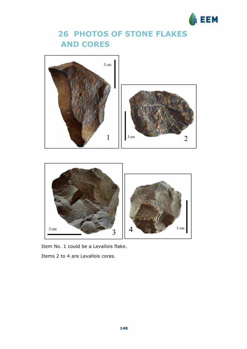
148
26 PHOTOS OF STONE FLAKES AND CORES
Item No. 1 could be a Levallois flake.
Items 2 to 4 are Levallois cores.