An integrated coastal modeling system for analyzing beach processes and beach restoration projects,...
16
Computers & Geosciences 33 (2007) 916–931 An integrated coastal modeling system for analyzing beach processes and beach restoration projects, SMC M. Gonza´lez , R. Medina, J. Gonzalez-Ondina, A. Osorio, F.J. Me´ndez, E. Garcı´a Ocean & Coastal Research Group, Dpto. Ciencias y Tecnicas del Agua y del Medio Ambiente, Universidad de Cantabria, E.T.S. Ingenieros de Caminos, C. y P., Av. de los Castros, s/n. 39005 Santander, Spain Received 21 March 2006; received in revised form 1 December 2006; accepted 11 December 2006 Abstract A user-friendly system called coastal modeling system (SMC) has been developed by the Spanish Ministry of Environment and the University of Cantabria. The system includes several numerical models specifically developed for the application of the methodology proposed in the Spanish Beach Nourishment and Protection Manual. According to this methodology, the SMC is structured into five-modules: (1) Pre-process module; (2) Short-term module; (3) Long-term module; (4) Coastal terrain module; and (5) Tutorial module. The pre-process module allows the processing of a database of morphodynamic information used as input for the different programs and models of the SMC. Short-, Long-term modules include numerical models to analyze coastal systems on different scales of variability (hours–months–years) and are composed of morphodynamic evolution models in cross-profile 2DV and beach plan 2DH. The coastal terrain module allows the user to modify the working bathymetry and to combine bathymetries from different sources in only one working bathymetry. The tutorial module includes a comprehensive collection of coastal engineering design and analysis software. The SMC has a dynamic design and allows the incorporation of future new databases and morphodynamic models. The SMC system is freely distributed to coastal practitioners and has already been implemented in several countries. r 2007 Elsevier Ltd. All rights reserved. Keywords: Coastal modeling; Coastal numerical model; Littoral GUI; Beach project design; Beach nourishment 1. Introduction Spain with more than 6000km of coastline is a country strongly linked to the sea. The coastal area is one of the basic sources of Spanish economy and is subject to a broad range of land uses. There is also a significant natural diversity in shore types through- out Spain (spits, littoral barriers, long-straight and pocket beaches) and different kinds of beaches (sandy, cohesive, shingle beaches, micro and macro- tidal beaches), with four different marine climates (with different winds, waves and currents) and water levels (spring tidal ranges between 0.1 and 5.0 m). The Direccio´n General de Costas (DGC) (State Coastal Office) of the Spanish Environmental Ministry has been conducting an integrated pro- gram since 1993 to restore existing beaches and build new ones in a so-called ‘‘Coastal Plan’’. ARTICLE IN PRESS www.elsevier.com/locate/cageo 0098-3004/$ - see front matter r 2007 Elsevier Ltd. All rights reserved. doi:10.1016/j.cageo.2006.12.005 Corresponding author. Tel.: +34 942 201810; fax: +34 942 201860. E-mail address: [email protected] (M. Gonza´lez).
-
Upload
independent -
Category
Documents
-
view
1 -
download
0
Transcript of An integrated coastal modeling system for analyzing beach processes and beach restoration projects,...

ARTICLE IN PRESS
0098-3004/$ - se
doi:10.1016/j.ca
�Correspondfax: +34942 20
E-mail addr
Computers & Geosciences 33 (2007) 916–931
www.elsevier.com/locate/cageo
An integrated coastal modeling system for analyzing beachprocesses and beach restoration projects, SMC
M. Gonzalez�, R. Medina, J. Gonzalez-Ondina, A. Osorio, F.J. Mendez, E. Garcıa
Ocean & Coastal Research Group, Dpto. Ciencias y Tecnicas del Agua y del Medio Ambiente, Universidad de Cantabria,
E.T.S. Ingenieros de Caminos, C. y P., Av. de los Castros, s/n. 39005 Santander, Spain
Received 21 March 2006; received in revised form 1 December 2006; accepted 11 December 2006
Abstract
A user-friendly system called coastal modeling system (SMC) has been developed by the Spanish Ministry of
Environment and the University of Cantabria. The system includes several numerical models specifically developed for the
application of the methodology proposed in the Spanish Beach Nourishment and Protection Manual. According to this
methodology, the SMC is structured into five-modules: (1) Pre-process module; (2) Short-term module; (3) Long-term
module; (4) Coastal terrain module; and (5) Tutorial module. The pre-process module allows the processing of a database
of morphodynamic information used as input for the different programs and models of the SMC. Short-, Long-term
modules include numerical models to analyze coastal systems on different scales of variability (hours–months–years)
and are composed of morphodynamic evolution models in cross-profile 2DV and beach plan 2DH. The coastal terrain
module allows the user to modify the working bathymetry and to combine bathymetries from different sources in only one
working bathymetry. The tutorial module includes a comprehensive collection of coastal engineering design and analysis
software. The SMC has a dynamic design and allows the incorporation of future new databases and morphodynamic
models.
The SMC system is freely distributed to coastal practitioners and has already been implemented in several countries.
r 2007 Elsevier Ltd. All rights reserved.
Keywords: Coastal modeling; Coastal numerical model; Littoral GUI; Beach project design; Beach nourishment
1. Introduction
Spain with more than 6000km of coastline is acountry strongly linked to the sea. The coastal area isone of the basic sources of Spanish economy and issubject to a broad range of land uses. There is also asignificant natural diversity in shore types through-
e front matter r 2007 Elsevier Ltd. All rights reserved
geo.2006.12.005
ing author. Tel.: +34 942 201810;
1860.
ess: [email protected] (M. Gonzalez).
out Spain (spits, littoral barriers, long-straight andpocket beaches) and different kinds of beaches(sandy, cohesive, shingle beaches, micro and macro-tidal beaches), with four different marine climates(with different winds, waves and currents) and waterlevels (spring tidal ranges between 0.1 and 5.0m).
The Direccion General de Costas (DGC) (StateCoastal Office) of the Spanish EnvironmentalMinistry has been conducting an integrated pro-gram since 1993 to restore existing beaches andbuild new ones in a so-called ‘‘Coastal Plan’’.
.
ARTICLE IN PRESSM. Gonzalez et al. / Computers & Geosciences 33 (2007) 916–931 917
Presently, the Spanish Government invests around200 million h/year, only in beach restorations andmonitoring, with more than 3 million m3/yr of sandfills distributed along the coast.
In order to properly respond to this demand, TheDGC has developed a Beach Nourishment andProtection Manual which includes a design and eva-luation methodology and a coastal modeling system(SMC). The aim of this paper is to present theSMC developed by the Ocean and Coastal ResearchGroup (GIOC) of the University of Cantabria,and the DGC of the Spanish Ministry of Environ-ment. The paper is organized as follows: first, ageneral description of the New Spanish BeachNourishment and Protection Manual is performed.Then, the structure, modules and numericaltools included in the SMC are described. Finally,the dissemination plan for the SMC system ispresented.
2. Spanish beach nourishment and protection manual
(SBM)
From 1995 to 2003, DGC and GIOC developed aset of documents which are known as ‘‘SpanishBeach Nourishment and Protection Manual’’, SBM.The objective of SBM is: to develop a methodologyfor the design, execution and monitoring of coastalprojects; to establish a strategy in order to preventcoastal erosion and estimate flooding risks of low-lying Spanish littoral zones; and finally, to compilethe Spanish experience in the coastal engineeringfield.
SPANISH BEACH NOURISH
Scie
nce-b
ased
do
cu
men
ts
Coastal
Hydrodynamics
Coastal Littoral
Processes
Coastal
Structures
Design
Coastal
Environmental
Impact
Annexes En
gin
eeri
ng
-based
do
cu
men
ts
Nou
Des
Eva
Meth
Littora
Atla
Span
Fig. 1. Structure of Spanish Beach
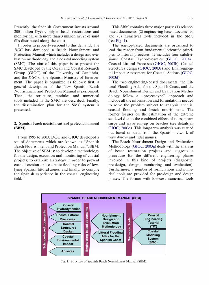
This SBM contains three major parts: (1) science-based documents; (2) engineering-based documents;and (3) numerical tools included in the SMC(see Fig. 1).
The science-based documents are organized tolead the reader from fundamental scientific princi-ples to littoral processes. It includes four subdivi-sions: Coastal Hydrodynamics (GIOC, 2003a),Coastal Littoral Processes (GIOC, 2003b), CoastalStructures design (GIOC, 2003c) and Environmen-tal Impact Assessment for Coastal Actions (GIOC,2003d).
The two engineering-based documents, the Lit-toral Flooding Atlas for the Spanish Coast, and theBeach Nourishment Design and Evaluation Metho-dology follow a ‘‘project-type’’ approach andinclude all the information and formulations neededto solve the problem subject to analysis, that is,coastal flooding and beach nourishment. Theformer focuses on the estimation of the extremesea-level due to the combined effects of tides, stormsurge and wave run-up on beaches (see details inGIOC, 2003e). This long-term analysis was carriedout based on data from the Spanish network ofwave-buoys and tidal gauges.
The Beach Nourishment Design and EvaluationMethodology (GIOC, 2003g) deals with the analysisof beach restoration projects and suggests aprocedure for the different engineering phasesinvolved in this kind of projects (diagnostic,pre-design, design, monitoring and evaluation).Furthermore, a number of formulations and nume-rical tools are provided for pre-design and designphases. The former with low-cost numerical tools
MENT MANUAL (SBM)
rishment
ign and
luation
odology
l Flooding
s for the
ish Coast Nu
meri
cal
To
ols
Coastal
Engineering
Tutorial
(TIC)
Coastal
Modeling
System
(SMC)
Nourishment Manual (SBM).
ARTICLE IN PRESSM. Gonzalez et al. / Computers & Geosciences 33 (2007) 916–931918
and minimum input data in order to allow thegeneration of a great number of potential projectalternatives. Once an alternative is selected by thecoastal managers, the solution is then analyzed in adesign level using more computational–expensivetools that require more elaborated input data. Foreach of these levels, the proposed tools allow theuser to analyze the functionality and stability ofany alternative at long-term time scales (years todecades) and afterwards, to verify the functionality atshort-term time scales (e.g. under extreme stormevents). All these tools are included in the user-friendly system called Coastal Modeling System(SMC).
3. Coastal modeling system (SMC)
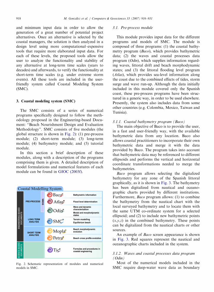
The SMC consists of a series of numericalprograms specifically designed to follow the meth-odology proposed in the Engineering-based Docu-ment: ‘‘Beach Nourishment Design and EvaluationMethodology’’. SMC consists of five modules (theglobal structure is shown in Fig. 2): (1) pre-processmodule; (2) short-term module; (3) long-termmodule; (4) bathymetry module; and (5) tutorialmodule.
In this section a brief description of thesemodules, along with a description of the programscomprising them is given. A detailed description ofmodel formulations and numerical features of eachmodule can be found in GIOC (2003f).
Fig. 2. Schematic representation of modules and numerical
models in SMC.
3.1. Pre-process module
This module provides input data for the differentprograms and models of SMC. The module iscomposed of three programs: (1) the coastal bathy-metry program (Baco), which provides bathymetricdata; (2) the waves and coastal processes dataprogram (Odin), which supplies information regard-ing waves, littoral drift and beach morphodynamicstates; and (3) the littoral flooding level program(Atlas), which provides sea-level information alongthe coast due to the combined effects of tides, stormsurge and wave run-up. Although the data initiallyincluded in this module covered only the Spanishcoast, these pre-process programs have been struc-tured in a generic way, in order to be used elsewhere.Presently, the system also includes data from someother countries (e.g. Colombia, Mexico, Taiwan andTunisia).
3.1.1. Coastal bathymetry program (Baco)
The main objective of Baco is to provide the user,in a fast and user-friendly way, with the availablebathymetric data from any location. Baco alsoallows coastal practitioners to incorporate their ownbathymetric data and merge it with the dataprovided by Baco. The program takes into accountthat bathymetric data may be referenced to differentellipsoids and performs the vertical and horizontalcoordinate transformations needed to merge thebathymetries.
Baco program allows selecting the digitalizedbathymetry for any zone of the Spanish littoralgraphically, as it is shown in Fig. 3. The bathymetryhas been digitalized from nautical and oceano-graphic charts provided by different institutions.Furthermore, Baco program allows: (1) to combinethe bathymetry from the nautical chart with thelocal surveyed bathymetry and to locate them withthe same UTM co-ordinate system for a selectedellipsoid; and (2) to include new bathymetric points(x,y,z) in the combined bathymetry. These pointscan be digitalized from the nautical charts or othersources.
An example of Baco screen appearance is shownin Fig. 3. Red squares represent the nautical andoceanographic charts included in the system.
3.1.2. Waves and coastal processes data program
(Odin)
Most of the numerical models included in theSMC require deep-water wave data as boundary

ARTICLE IN PRESS
Fig. 3. Coastal bathymetry program (Baco) and SMC interface.
M. Gonzalez et al. / Computers & Geosciences 33 (2007) 916–931 919
input condition. These input conditions varydepending on the type of model and the time orspatial scales of the processes to be solved. Theobjective of Odin program is to characterize and toprovide the wave data that users need for theutilization of the numerical tools included in SMC.By means of simple coastal formulations, Odin alsoallows us to estimate several coastal parameters andvariables such as: rate of littoral alongshore sedi-ment transport or beach morphodynamic states.Odin program includes a database of visual obser-vations of waves reported by ships of the VoluntaryObserving Fleet. The wave data was obtained fromthe comprehensive ocean atmospheric data set
(COADS), data supplied through the US NationalCenter for Atmospheric Research (NCAR) and theNational Ocean and Atmospheric Administration(NOAA). This offshore wave data set (visual waveheight and period) has been calibrated using themeasured wave data set (significant wave heightand peak period) supplied by the Spanish buoynetwork.
As stated previously, Odin provides the wavedata that users need for the utilization of thenumerical tools included in SMC and severalcoastal parameters and variables. Regarding wavedata, the supplied information is summarized asfollows: (1) the directional long-term wave climate

ARTICLE IN PRESSM. Gonzalez et al. / Computers & Geosciences 33 (2007) 916–931920
distributions in deep-water and at a user-definedtarget location near the coast (see Fig. 4). In orderto estimate the wave climate at the target location,Odin assumes straight parallel bathymetry topropagate the wave data set from deep-water usingSnell approximation. The program is also capableof reading a transfer matrix or function generatedby a propagation numerical model to propagatethe waves from deep-water to the target location;(2) a list of selected wave cases to be propagatedfrom deep-water (wave height, period, directionand sea-level elevation) in order to better charac-
Fig. 4. Waves and coastal proce
terize the coastal process at the target location.This list of selected wave conditions are automati-cally exported to the wave propagation modelsthat will be described in the next sections. Theselection of these wave conditions are carriedout taking into account the recommendationsgiven in the engineering-based document for aspecific case-study (Beach Nourishment Designand Evaluation Methodology, GIOC, 2003g);(3) long-term extreme value wave climate distribu-tions obtained from the Spanish wave network ofbuoys; (4) time series of waves for evolution models
sses data program (Odin).
ARTICLE IN PRESSM. Gonzalez et al. / Computers & Geosciences 33 (2007) 916–931 921
in plan (2DH) and profile (2DV); (5) the direction ofthe mean energy flux of the waves in deep-waterand the target point, the significant wave heightexceeded 12 hours per year (Hs12) and the closuredepth, h* (Birkemeier, 1985) in the study area. Thisinformation is used as input data for long-term scalemodels (years to decades), models included insidethe SMC.
Regarding beach morphodynamic features, Odinprovides the following information: (1) the meanmonthly rate of alongshore sediment transport(total and net littoral drift), using Kamphuis(1991) and CERC (1984) formulations; (2) thecharacterization of the modal beach states (annualand monthly beach state distributions). The deter-mination of the morphodynamic state is carried outby employing Wright and Short (1984) in beacheswithout tides and Masselink and Short (1993) inmesotidal and macrotidal beaches.
3.1.3. Littoral flooding level program (Atlas)
Several long-term models included in SMC (e.g.equilibrium beach models, evolution models, coast-al structures design) require information regardingthe sea-level where the marine dynamics are acting(upper and lower bounds). In a similar way, someshort-term models (e.g. wave propagation, wave-induced currents, sediment transport and bottomevolution models) also require information on sea-level.
The criteria for establishing the appropriate ‘‘sea-level’’ input for the different time-scale analysis andprograms are defined in the Beach NourishmentDesign and Evaluation Methodology (GIOC,2003g). The information about those ‘‘sea-levels’’can be obtained from Atlas program. This programprovides the information regarding the statistics andparticularly the maximum flooding levels reachedby joint action of the astronomical tide, meteor-ological tide, and the run-up of waves on abeach for any given point of the Spanish littoral,(see Fig. 5).
It is remarked that the littoral flooding level is arandom variable that must be obtained as a sum ofthe above-mentioned deterministic and randomvariables (astronomical tide, meteorological tide,and the run-up of waves on a beach). In theengineering-based document titled ‘‘FloodingLevels’’ (GIOC, 2003e), a detailed calculationmethodology for the calculation of this floodinglevel is presented.
The mean and maximum flooding levels aredefined in terms of: the exceedance of number ofwaves in a year (long-term distribution), returnperiod (extreme value distribution), local orienta-tion of the coastline, and average bottom slope(cross-shore). With this information in any givenpoint at the coast, the user is able to define, forexample: the level of the berm associated with beachprofiles, the elevation associated with the tidal level,the freeboard elevation for coastal structures or theelevation for a side walk.
3.2. Short-term module
This module includes several numerical models toanalyze coastal systems on a short-term scale(hours–days). It is composed of morphodynamicevolution models in cross-profile 2DV (PETRA)and beach plan 2DH (MOPLA). This moduleallows the practitioner to analyze the beach changesin response to a storm event and to verify thatthe stability and functionality requirements of abeach restoration project have been met. Themodule also provides information about coastalprocesses (current system, potential transport)allowing the practitioner to better understand beachmorphodynamic, to carry out a diagnosis and topropose alternative solutions for a specific beachproblem.
3.2.1. PETRA model (2DV)
PETRA is a cross-shore process-based beachmodel, which does not establish any ‘‘a priori’’ finalprofile (open-loop). The model evaluates the sedi-ment transport along the beach profile due to localhydrodynamic and computes the conservation ofsand within the beach profile. PETRA allows theusers to determine the profile shape response to astorm event and, in particular, to estimate coastlinerecession (see example in Fig. 6).
PETRA model consists of four main modules: thewave transformation module, the wave-inducedcurrent module, the sediment transport module,and the morphology module: (1) The wave trans-formation module is a phase-averaged model whichincludes refraction, shoaling and energy dissipation.Two coupled stationary differential equations aresolved to obtain wave height and wave-induced set-up (wave action equation and the time-averagedmomentum balance equation, respectively). In orderto solve these equations, a closure relation isrequired for wave energy dissipation. Battjes and

ARTICLE IN PRESS
Long-term and extreme value distributions of coastal flooding levels
FLReferente Level
Tidal LevelMT RU
AT
AT : Astronomical tide MT: Meteorological tide RU: Run-up FL: Flooding level
Wave data
Tidal gauge
Tidal gauge
Tidal gauge
Flooding level zones according with the distribution of tidal gauges and wave buoys
I aI bI cII a
III a
IV a
IV bIV c V a
V b
VII a
VIII a
Fig. 5. Littoral flooding level program (Atlas).
M. Gonzalez et al. / Computers & Geosciences 33 (2007) 916–931922
Janssen (1978), Thornton and Guza (1983); Larson(1995), and Rattanapitikon and Shibayama (1998)are the formulations included in PETRA model.(2) The wave-induced currents are obtained as avertical distribution of the mean velocity, which isdetermined locally by the following 1DV formula-tions proposed by De Vriend and Stive (1987), andRanasinghe et al. (1999). (3) The sediment transportis calculated as a function of the local conditions, itis obtained by means of the energetic approachformulations: Bailard (1981) and Ranasinghe et al.
(1999). The sediment transport in the swash zone isalso calculated using Wise et al. (1996) formulation.(4) The morphology module used in PETRA updatethe water depths on a fixed grid by solving theconservation of sediment transport equation for aninfinite beach.
The four modules of PETRA model have beenvalidated against field measurements and physicalmodel tests in a flume and wave basin. The data setsources to verify the model are summarized asfollows: (1) Field data: Data from Egmond Beach

ARTICLE IN PRESS
Fig. 6. PETRA model (short-term evolution model 2DV). Storm event simulation in Palamos Beach, Spain (Hs ¼ 3.4m, Tp ¼ 12 s,
Dir ¼ E, Duration ¼ 26 h, Soulsby).
M. Gonzalez et al. / Computers & Geosciences 33 (2007) 916–931 923
and Haringvliet Estuary, The Netherlands, reportedby Battjes and Stive (1985); Data from Torrey PinesBeach reported by Guza and Thornton (1985); Datafrom Trabucador Beach (Spain) undertow data setcollected by Rodrıguez et al. (1994); Data fromDELILAH CERC Project (Duck Experiment onlow-frequency and incident-band alongshore andacross-shore hydrodynamics) in Duck Beach (NorthCarolina), reported by Larson (1995); and finally,data collected at Duck Beach and reported byRanasinghe et al. (1999). (2) Laboratory datareported by Battjes and Stive (1985), Nairn andSouthgate (1993), Mase and Kirby (1992), Okayasuand Katayama (1992), Roelvink and Broker (1993)tests carried out in the Hannover big channel; theSUPERTANK laboratory tests reported by Larson(1995), and Ranasinghe et al. (1999). Details aboutthe formulations used in PETRA, the numericalimplementation and model validation can be foundin (GIOC, 2003l).
It is worth noting that PETRA model is fullyintegrated in SMC system. Users can obtain inputdata for PETRA, such as the bathymetry of theinitial profile from SMC interface. The inputhydrodynamic parameters, waves and tidal range,are supplied by the 2DH propagation modelMOPLA (which is described in the next section),and by the Atlas program, respectively.
3.2.2. MOPLA model (2DH)
MOPLA is a morphological evolution model forcoastal areas. It is a short-term process-based
numerical model with a similar scope and structurethat PETRA model, but in a 2DH version instead ofa 2DV. MOPLA consists of three coupled modules:the wave transformation module (Oluca), thedepth-averaged currents module (Copla), and thesediment transport and morphological evolutionmodule (Eros).
(1) The wave transformation module (Oluca) is aweakly nonlinear combined refraction and diffrac-tion model, which simulates the behavior ofmonochromatic waves (Oluca-mc version) and arandom sea (Oluca-sp version), over irregularbottom bathymetry. These models include the effectof shoaling, refraction, energy dissipation (bottomfriction and wave breaking), diffraction and wave–current interaction (see Fig. 7a). Both Oluca
versions are based on the parabolic approximationsolution to the mild-slope equation (MSP). TheOluca-mc and the Oluca-sp were initially based onREF/DIF 1 (Kirby and Dalrymple, 1992) and REF/DIFS (Kirby and Ozkan, 1994) models, respec-tively. Oluca versions include several improvementsthat make the code more robust for coastalengineering applications. These new features in-clude: improvements in the boundary conditions(thin film and structures), improvements in thenumerical stability having into account the gridsize (Dy), the water depth (h) and the wavelength (L) expressed by the dimensionless para-meters (Dy/L, Dy/h) and improvements in reducingtime computational efforts by mean of codenumerical optimization. Also, new algorithms are

ARTICLE IN PRESS
a Wave propagation (Oluca Model)
b Wave induced currents (Copla Model)
c Sea bottom Evolution (Eros model)
Erosion (m)
Accumulation (m)
Fig. 7. MOPLA model (short-term evolution model 2DH).
Storm event simulation in Pineda Beach, Spain (Hs ¼ 4m,
Tp ¼ 12 s, Dir ¼ SE, Duration ¼ 72 h).
M. Gonzalez et al. / Computers & Geosciences 33 (2007) 916–931924
included for calculation of wave direction, diffrac-tion and wave breaking (in the surf-zone and infront of structures). Finally, some features areincluded, such as: different dissipation formula-tions, input spectral waves and models outputs.A detailed description about all of these aspects,
formulations, numerical scheme and validationcan be found in GIOC, 2003h, j). The wavebreaking dissipation model included in the mono-chromatic version is the one presented by Dallyet al. (1985). For the spectral version severaldissipation models can be chosen: Battjes andJanssen (1978), Thornton and Guza (1983), andRattanapitikon and Shibayama (1998). Oluca-sp
includes the effect of frequency spectrum (TMA orfield measurements) and directional spreading.Oluca models are extremely cost-efficient andrequire very low computational efforts, beingapproximately 50 times faster than the elliptic mildslope models for the same set up.
(2) The depth-averaged current module (Copla)solves the vertically integrated equations of con-servation of mass and momentum in two horizontaldimensions (see Fig. 7b). Wave gradient of radiationstresses obtained from Oluca model is used as inputforcing for Copla. The model is capable ofoperating with a wave–current space and time-varying hydraulic roughness and turbulent fluctua-tions (eddy viscosity). A detailed description aboutthe formulations and numerical implementation canbe founded in GIOC, (2003i, j).
Finally, (3) the sediment transport and morpho-logical evolution module (Eros) includes a determi-nistic intra-wave period model for non-cohesivesediment (see Fig. 7c). It solves the sediment fluxesequation in the surf-zone, and the bathymetrychanges associated to the spatial variations of thesediment transport. The input conditions aresupplied by the SMC system as an output of theOluca and Copla models. The sediment transport iscalculated using (Bailard, 1981; Soulsby, 1997).Some details about Eros can be founded in GIOC(2003k). In order to avoid recalculations of thewave and currents fields with Oluca and Coplaevery time step, the perturbed equations proposedby Mendez and Medina (2001) have been imple-mented in Eros to estimate the wave and currentfield. This method reduces CPU time when evaluat-ing wave and current fields for sediment transportcalculations.
The three modules of MOPLA model havebeen validated against field measurements, phy-sical model tests in flume and wave basin, andcompared with other similar numerical models.The data set used to validate the model were: (1)field data: DELILAH Project, measurements car-ried out by the Coastal Engineering ResearchCenter, in the field research facility in Duck, NC

ARTICLE IN PRESSM. Gonzalez et al. / Computers & Geosciences 33 (2007) 916–931 925
(Birkemeier, 1991); Trabucador Beach (Spain)undertow data set collected by Rodrıguez et al.(1994); The Puntal Beach (Santander, Spain), with amorphodynamic field campaign in 1992 (FLTQ,1992) and the 2004 field campaign carried outunder the frame of the COASTVIEW Europeanproject. (2) laboratory data reported by Mase andKirby (1992), Chawla (1995), Vincent and Briggs(1989), Berkhoff (1982), and Stive (1985). (3)comparison with other numerical models: Nichol-son et al. (1997). A detailed description about theMOPLA validation can be founded in GIOC,(2003h,i,j,k).
MOPLA model is an element integrated inthe SMC. It receives from SMC interface thenecessary input data (e.g. bathymetry, wave data,sea-level). MOPLA allows: (1) to characterize thebehaviour of local coastal dynamics (wave andcurrent patterns); (2) to analyze the beach’sresponse due to a short-term events (storm, surge);and (3) to estimate design conditions for coastalstructures.
3.3. Long-term module
The objective of long-term analysis is to deter-mine the final shape of a beach and/or the tem-poral evolution of that shape on a scale of yearsin order to assure that the beach functionalitycontinues throughout its useful life. The existingformulations for this long term analysis do notfocus on the processes (for example, wave-to-wave sediment transport), but on magnitudesaggregated to them. The two most widely usedmodels for the analysis of beaches are thosebased on equilibrium hypothesis (Capobiancoet al., 2002; Kraus, 2001) and those based on thediffusion equation (Hanson, 1999). An overview ofavailable numerical model types and differentapproximations to the long-term analysis is pre-sented by Hanson et al. (2003) and De Vriend et al.(1993).
3.3.1. Equilibrium beach programs
SMC includes a graphical user interface moduleto test stability or to design new equilibrium bea-ches taking into account the equilibrium planform and profile shape (see Fig. 8). This methodol-ogy has been applied to various Spanish beacheson the Atlantic and Mediterranean coasts withgood results constituting a practical easy-to-useengineering tool in beach regeneration projects
(see Gonzalez and Medina, 2001). The systempermits the design of equilibrium beaches applyingdifferent equilibrium profile and plan form for-mulations. Related with the equilibrium profile,several formulations have been included in thesystem, such as Dean (1991), the bi-parabolicprofile proposed by Medina et al. (2000), theequilibrium profile in reef-protected beaches Mu-noz-Perez et al. (1999), the equilibrium profileaffected by refraction–diffraction Gonzalez andMedina (1997). Concerning with the equilibriumplan form, the SMC includes: the parabolicformulation of Hsu and Evans (1989) and themodification proposed by Gonzalez and Medina(2001). The input data for all of these equili-brium formulations are supplied by Odin, Atlas
and Baco pre-process programs. A detailed descrip-tion about the long-term module can be found inGIOC (2003f, g).
3.4. Coastal terrain module
This module allows the user to modify theworking bathymetry including or excluding rigidstructures such as breakwaters, jetties, groins orwalls, and bathymetry alterations such as sand fillsor pits, see Fig. 9(A) and (B). The module is a veryuseful tool for the design and evaluation of coastalprojects. For nourishment projects, for instance,the equilibrium beach (plan and profile) can bedesigned using the long-term equilibrium toolsdescribed in the previous section; next, the bathy-metry module permits updating the original bathy-metry with the new equilibrium beach. Requiredsand fill volume is evaluated by the module andreported to the user. This module also permitscombining bathymetries from different sources inone working bathymetry to be used in the differentmodules of SMC.
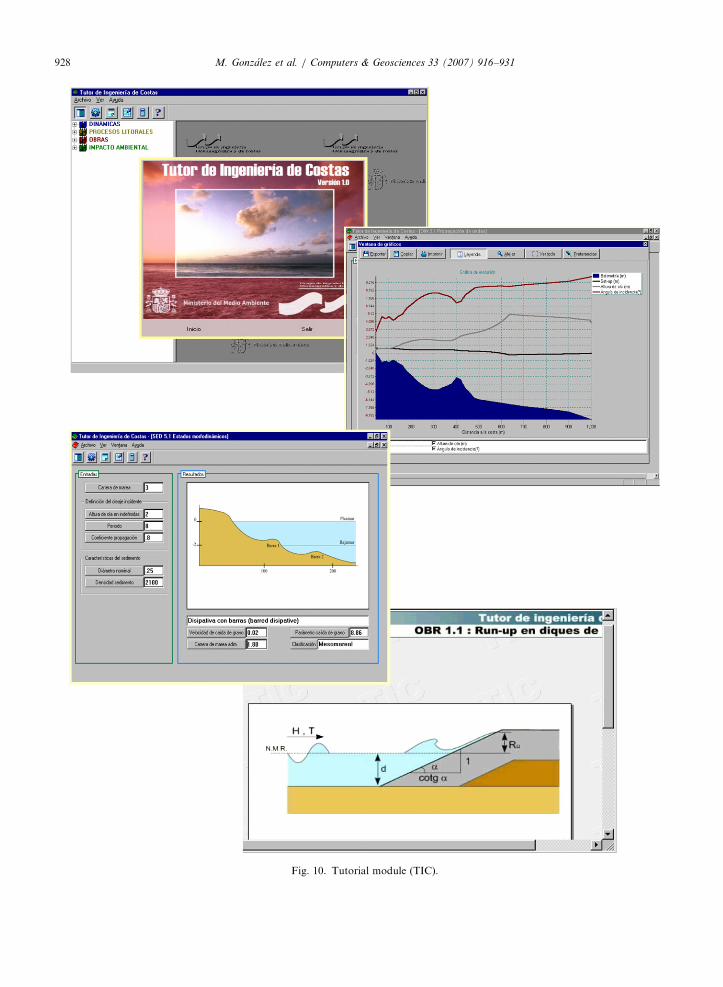
3.5. Tutorial module (TIC)
TIC is an interactive module integrated in theSMC that includes a comprehensive collection ofcoastal engineering design and analysis software(see Fig. 10). Basically, this module has foursections, with the following contents: (1) dynamics:wave prediction, wave theory, wave transfor-mation, wave statistical and spectral analysis,long waves and sea-level; (2) littoral processes:sediment transport, sediment characterization,beach plan and profile, morphodynamic states

ARTICLE IN PRESS
Fig. 8. Equilibrium beach (equilibrium profile+equilibrium plan form). Long-term analysis at Barceloneta Beach, Spain.
M. Gonzalez et al. / Computers & Geosciences 33 (2007) 916–931926
and inlet process; (3) structural design: wave–struc-ture interaction (wave runup, transmission, andovertopping), stability analysis (vertical and rubble-mound breakwaters); and (4) coastal environmentalimpact assessment. Details about formulationsincluded in TIC module can be found in GIOC(2003m).
4. Dissemination plan
In 2002 the Spanish Ministry of the Environmentand the University of Cantabria began a dissemina-tion and distribution plan of the new BeachNourishment and Protection Manual, including thedesign and evaluation methodology and the coastalmodeling system (SMC). The distribution of thesystem including numerical tools has been carriedout for free delivery to National and Regionaladministration practitioners (coastal office andharbors authorities), coastal consultant firms, and
researchers (universities and institutes). The uniquerequirement is to attend a 40-h training course aboutthe SMC, courses given in the EnvironmentalMinistry in Madrid. Information about the system,updates, courses, etc. can be found in the followingweb page: http://www.smc.unican.es.
At present, the Spanish Ministry of Environmentand the University of Cantabria has signed colla-boration agreements for the free delivery of thesystem to other countries (e.g. Colombia, CostaRica, Tunisia, Taiwan y). These agreementsestablishes four kinds of actors at each country:(1) collaborative institution; which provides thecoastal information to be included in the local pre-process modules (Baco, Odin and Atlas) of thatcountry; (2) dissemination institution; which isresponsible of the dissemination courses of SMCin that country; (3) developer; which improvesnumerical codes or adapt the codes to the specificcountry; (4) users.

ARTICLE IN PRESS
Fig. 9. Bathymetry renovation module permits to modify original digital bathymetry, generating different Project alternatives to be
analyzed by the models.
M. Gonzalez et al. / Computers & Geosciences 33 (2007) 916–931 927
5. Future lines
The SMC is a non-static system. On one hand, itshould evolve by completing and incorporating newdatabases, thus allowing the improvement of thesystem pre-processing programs. On the other, it
must incorporate new scientific knowledge thatcould be included in the system by means of directusage applications. As for the pre-processingprograms, it is important to include new datasources for offshore waves. Nowadays, there areother more complete sources of data, such as the
ARTICLE IN PRESS
Fig. 10. Tutorial module (TIC).
M. Gonzalez et al. / Computers & Geosciences 33 (2007) 916–931928
ARTICLE IN PRESSM. Gonzalez et al. / Computers & Geosciences 33 (2007) 916–931 929
hindcast wave series, with long-term series (50years) to a high resolution data (every hour). Thesedatabases supply very important information that inthe future will allow us to include the wavepersistence effect (duration of exceedance of a givenwave height, an important aspect in morphody-namic beach evolution models from the middle-termscale (months) to the long-term scale (years–ecades).
6. Conclusions
The coastal modeling system (SMC) consists of aseries of numerical programs specifically designed tofollow the methodology proposed in the engineering-based document: ‘‘Beach Nourishment Design andEvaluation Methodology’’, SBM. SMC consists offive modules; (1) pre-process module; (2) short-termmodule; (3) long-term module; (4) bathymetrymodule; and (5) tutorial module.
The SBM deals with the analysis of beachrestoration projects and suggests a procedure forthe different engineering phases involved in thiskind of projects (diagnostic, pre-design, design,monitoring and evaluation). For each of theselevels, the SMC allows the user to analyze thefunctionality and stability of any alternative at long-term time scales (years–decades) and afterwards, toverify the functionality at short-term time scales(e.g. under extreme storm events).
The SMC is not a static system and it allows thefuture incorporation of new databases and mor-phodynamic models. The distribution of the systemincluding numerical tools is being carried out forfree delivery to coastal practitioners and scientistsworldwide. The SMC system has already beenimplemented in several countries.
Acknowledgments
This work has been supported by the SpanishMinistry of Environment. M. Gonzalez gratefullyacknowledges the financial support provided by theSpanish Comision Interministerial de Ciencia yTecnologıa (CICYT) under research GrantREN2003-9640/MAR and the Spanish Ministeriode Educacion y Ciencia under the Program formobility of professors in foreign centers. F.J.Mendez wishes to express their thanks to theSpanish Ministry of Science and Technology underthe Ramon y Cajal Program.
References
Bailard, J.A., 1981. An energetics total load sediment transport
model for a plane sloping beach. Journal of Geophysical
Research 86, 10938–10964.
Battjes, J.A., Janssen, J.P.F.M., 1978. Energy loss and set-up due
to breaking of random waves. In: Proceedings 16th Interna-
tional Conference Coastal Engineering, Vol. 1, Houston, TX,
ASCE, New York, pp. 569–589.
Battjes, J.A., Stive, M.J.F., 1985. Calibration and verification of
dissipation model for random breaking waves. Journal of
Geophysical Research 90 (C5), 9159–9167.
Berkhoff, J.C.W., 1982. Verification computations with linear
wave propagation models. Report W 154-VIII, Delft
Hydraulics Laboratory.
Birkemeier, W.A., 1985. Field data on seaward limit of profile
change. Journal of Waterway, Port, Coastal, and Ocean
Engineering 111 (3), 598–602.
Birkemeier, W.A., 1991. DELILAH Investigator’s Report
(draft). Technical Report, Coastal Engineering Research
Center, US Army Corps of Engineers Waterways Experiment
Station, Vicksburg, MS.
Capobianco, M., Hanson, H., Larson, M., Steetzel, H., Stive,
M.J.F., Chatelus, Y., Aarninkhof, S., Karambas, T., 2002.
Nourishment design and evaluation: applicability of model
concepts. Coastal Engineering 47, 113–135.
CERC, 1984. Shore Protection Manual, fourth ed., US Army
Engineer Waterways Experiment Station. US Government
Printing Office, Washington, DC.
Chawla, A., 1995. Wave transformation over a submerged
shoal. MS Thesis, University of Delaware, Newark, Del.,
86pp.
Dally, W.R., Dean, R.G., Dalrymple, R.A., 1985. Wave height
variation across beaches of arbitrary profile. Journal of
Geophysical Research 90 (C6), 11917–11927.
Dean, R.G., 1991. Equilibrium beach profiles: characteristics and
applications. Journal of Coastal Research 7, 53–84.
De Vriend, H.J., Stive, M.J.F., 1987. Quasi-3D model-
ling of nearshore currents. Coastal Engineering 11 (5/6),
565–601.
De Vriend, H.J., Capobianco, M., Chesher, T., de Swart, H.E.,
Latteux, B., Stive, M.J.F., 1993. Approaches to long-term
modelling of coastal morphology: a review. Coastal Engineer-
ing 21, 225–269.
FLTQ, 1992. Evolution analysis and monitoring plan in the
Loredo–El Puntal beach and navigation channel in Santan-
der, 1990–1992. Final Report to the Santander Harbor
Authority, Universidad de Cantabria.
GIOC, 2003a. Reference Document, vol. I: Coastal Hy-
drodynamics. State Coastal Office-Spanish Environ-
mental Ministry and University of Cantabria, 512 (in
Spanish).
GIOC, 2003b. Reference Document, vol. II: Coastal Littoral
Processes. State Coastal Office-Spanish Environmental Min-
istry and University of Cantabria, 397 (in Spanish).
GIOC, 2003c. Reference Document, vol. III: Coastal Pro-
tection Structures. State Coastal Office-Spanish Environ-
mental Ministry and University of Cantabria, 290 (in
Spanish).
GIOC, 2003d. Reference Document, vol. IV: Environmental
Impact Assessment for Coastal Actions. State Coastal

ARTICLE IN PRESSM. Gonzalez et al. / Computers & Geosciences 33 (2007) 916–931930
Office-Spanish Environmental Ministry and University of
Cantabria, 164 (in Spanish).
GIOC, 2003e. Methodological Document, Littoral Flooding
Atlas for the Spanish Coast. State Coastal Office-Spanish
Environmental Ministry and University of Cantabria, 160
(in Spanish).
GIOC, 2003f. Coastal Modelling System (SMC)– Reference
and User Manual. State Coastal Office-Spanish Environ-
mental Ministry and University of Cantabria, 82 (in
Spanish).
GIOC, 2003g. Methodological Document, Beach Regene-
ration Manual. State Coastal Office-Spanish Environ-
mental Ministry and University of Cantabria, 201 (in
Spanish).
GIOC, 2003h. Spectral Wave Propagation Model (Oluca-SP).
State Coastal Office-Spanish Environmental Ministry and
University of Cantabria, 170 (in Spanish).
GIOC, 2003i. Wave Induce Currents Model in the Surf
Zone (Copla-SP). State Coastal Office-Spanish Environ
mental Ministry and University of Cantabria, 61 (in
Spanish).
GIOC, 2003j. 2DH-Morphodynamic Evolution Model for Near
Shore Areas (MOPLA). State Coastal Office-Spanish Envir-
onmental Ministry and University of Cantabria, 262
(in Spanish).
GIOC, 2003k. Erosion and Sedimentation Evolution Model
(Eros). State Coastal Office-Spanish Environmental Ministry
and University of Cantabria, 55 (in Spanish).
GIOC, 2003l. 2DV-Process-based Cross-shore Evolution Model.
State Coastal Office-Spanish Environmental Ministry and
University of Cantabria, 80 (in Spanish).
GIOC, 2003m. Coastal Engineering Tutorial (TIC). State Coastal
Office-Spanish Environmental Ministry and University of
Cantabria, 182 (in Spanish).
Gonzalez, M., Medina, R., 1997. Equilibrium beach profiles:
effects of refraction. In: Proceedings of the Coastal
Dynamics’97. ASCE (American Society of Civil Engineer),
pp. 933–942.
Gonzalez, M., Medina, R., 2001. On the application of static
equilibrium bay formulations to natural and man-made
beaches. Coastal Engineering 43, 209–225.
Guza, R.T., Thornton, E.B., 1985. Velocity moments in
nearshore. Journal of Waterway, Port, Coastal and Ocean
Engineering 111 (2), 235–256.
Hanson, H., 1999. Economic optimization of beach fill transi-
tions using a shoreline change model. SAFE Report, Final
Overall Workshop, Commission of the European Commu-
nities, Venezia, Italy.
Hanson, H., Aarninkhof, S., Capobianco, M., Jimenez, J.A.,
Larson, M., Nicholls, R.J., Plant, N.G., Southgate, H.N.,
Steetzel, H.J., Stive, M.J.F., De Vriend, H.J., 2003. Modelling
of coastal evolution on yearly to decadal time scales. Journal
of Coastal Research 19 (4), 790–811.
Hsu, J.R.C., Evans, C., 1989. Parabolic bay shapes and
applications. In: Proceedings of the Institution of Civil
Engineers 87 (Part 2), 556–570.
Kamphuis, J.W., 1991. Alongshore sediment transport rate.
Journal of Waterway, Port, Coastal, and Ocean Engineering
117, 624–640.
Kirby, J.T., Dalrymple, R.A., 1992. Combined refraction/
diffraction model REF/DIF 1, version 2.4. Documen-
tation and User’s Manual. Research Report CACR-
92-04, Center for Applied Coastal Research, University of
Delaware.
Kirby, J.T., Ozkan, H.T., 1994. Combined refraction/diffr-
action model for spectral wave conditions. Ref/Dif s version
1.1. Documentation and user’s manual. Report No. CACR-
94-04, Center Applied Coastal Research, University of
Delaware.
Kraus, N.C., 2001. On equilibrium properties in predictive
modeling of coastal morphology change. In: Proceedings of
the Coastal Dynamics’01. ASCE (American Society of Civil
Engineers), Lund, Sweden, pp. 1–15.
Larson, M., 1995. Model for decay of random waves in the surf
zone. Journal of Waterway, Port, Coastal, and Ocean
Engineering 121 (1), 1–12.
Mase, H., Kirby, J.T., 1992. Modified frequency–domain KdV
equation for random wave shoaling. In: Proceedings of the
23rd International Conference on Coastal Engineering,
Venice, pp. 474–487.
Masselink, G., Short, A.D., 1993. The effect of tide range on
beach morphodynamics and morphology: a conceptual
model. Journal of Coastal Research 9 (3), 785–800 Proc.
IEEE 70, 1055–1056.
Medina R., Bernabeu A.M., Vidal C, Gonzalez M., 2000.
Relationship between beach morphodynamics and equili-
brium profiles. In: Proceedings of the 27th International
Conference on Coastal Engineering. ASCE (American Society
of Civil Engineers), Sydney, Australia.
Mendez, F.J., Medina, R., 2001. A perturbation method for wave
and wave-induced current computations in beach morphology
models. In: Proceedings of the Coastal Dynamics 2001, Lund
(Suecia), pp. 393–402.
Munoz-Perez, J.J., Tejedor, L., Medina, R., 1999. Equilibrium
beach profile model for reef-protected beaches. Journal of
Coastal Research 15 (4), 950–957.
Nairn, R.B., Southgate, H.N., 1993. Deterministic profile
modelling of nearshore processes: part 2. Sediment tran-
sport and beach profile development. Coastal Engineering 19,
57–96.
Nicholson, J., Broker, I., Roelvink, J.A., Price, D., Tanguy, J.M.,
Moreno, L., 1997. Intercomparison of coastal area morpho-
dynamics models. Coastal Engineering 31, 97–123.
Okayasu, A., Katayama, H., 1992. Distribution of undertow and
longwave component velocity due to random waves. In:
Proceedings of the 23rd International Conference on Coastal
Engineering, Venice, pp. 883–893.
Ranasinghe, R., Pattiaratchi, C., Masselink, G., 1999. A morpho-
dynamic model to simulate the seasonal closure of tidal inlets.
Coastal Engineering 37, 1–36.
Rattanapitikon, W., Shibayama, T., 1998. Energy dissipation
model for regular and irregular breaking waves. Coastal
Engineering 40 (4), 327–346.
Rodrıguez, A. Sanchez-Arcilla, A., Collado, F.R., Gracia, V.,
Coussirat, M.G., Prieto, J., 1994. Waves and currents at the
Ebro delta surf zone measurements and modeling. In:
Proceedings of the 24th International Conference on Coastal
Engineering, Kobe, pp. 2442–2556.
Roelvink, J.A., Broker, I., 1993. Cross-shore profile models.
Coastal Engineering 21, 163–191.
Soulsby, R., 1997. Dynamics of Marine Sands. Thomas Telford
Publications, London, 249pp.
Stive, M.J.F., 1985. A scale comparison of waves breaking on a
beach. Coastal Engineering 9, 151–158.

ARTICLE IN PRESSM. Gonzalez et al. / Computers & Geosciences 33 (2007) 916–931 931
Thornton, E.B., Guza, R.T., 1983. Transformation of wave
height distribution. Journal of Geophysical Research 88,
5925–5983.
Vincent, C.L., Briggs, M.J., 1989. Refraction–diffraction of
irregular waves over a mound. Journal of Waterway, Port,
Coastal, and Ocean Engineering, ASCE 115 (2), 269–284.
Wise, R. A., Smith, S. R, Larson, M., 1996. SBEACH: numerical
model for simulating storm-induced beach change. Report 4:
cross shore transport under random waves and model vali-
dation with supertank and field data. Technical Report
CERC-89-9, US Army Engineer Waterways Experiment
Station, Coastal Engineering Research Center, Vicksburg, MI
USA.
Wright, L.D., Short, A.D., 1984. Morphodynamic variability of
surf zones and beaches: a synthesis. Marine Geology 56,
93–118.