An Exploration of Engagements of the Research Community ...
29
Citation: Grinberger, A.Y.; Minghini, M.; Yeboah, G.; Juhász, L.; Mooney, P. Bridges and Barriers: An Exploration of Engagements of the Research Community with the OpenStreetMap Community. ISPRS Int. J. Geo-Inf. 2022, 11, 54. https://doi.org/ 10.3390/ijgi11010054 Academic Editor: Wolfgang Kainz Received: 9 November 2021 Accepted: 5 January 2022 Published: 12 January 2022 Publisher’s Note: MDPI stays neutral with regard to jurisdictional claims in published maps and institutional affil- iations. Copyright: © 2022 by the authors. Licensee MDPI, Basel, Switzerland. This article is an open access article distributed under the terms and conditions of the Creative Commons Attribution (CC BY) license (https:// creativecommons.org/licenses/by/ 4.0/). International Journal of Geo-Information Article Bridges and Barriers: An Exploration of Engagements of the Research Community with the OpenStreetMap Community A. Yair Grinberger 1, * , Marco Minghini 2,† , Godwin Yeboah 3 , Levente Juhász 4 and Peter Mooney 5 1 Department of Geography, The Hebrew University of Jerusalem, Mt. Scopus, Jerusalem 919051, Israel 2 European Commission, Joint Research Centre (JRC), 21027 Ispra, Italy; [email protected] 3 Institute for Global Sustainable Development, University of Warwick, Coventry CV4 7AL, UK; [email protected] 4 GIS Center, Florida International University, Miami, FL 33199, USA; ljuhasz@fiu.edu 5 Department of Computer Science, Maynooth University, W23 F2H6 Maynooth, Co. Kildare, Ireland; [email protected] * Correspondence: [email protected]; Tel.: +972-2-588-3445 † The views expressed are purely those of the author and may not in any circumstances be regarded as stating an official position of the European Commission. Abstract: The academic community frequently engages with OpenStreetMap (OSM) as a data source and research subject, acknowledging its complex and contextual nature. However, existing literature rarely considers the position of academic research in relation to the OSM community. In this paper we explore the extent and nature of engagement between the academic research community and the larger communities in OSM. An analysis of OSM-related publications from 2016 to 2019 and seven interviews conducted with members of one research group engaged in OSM-related research are described. The literature analysis seeks to uncover general engagement patterns while the interviews are used to identify possible causal structures explaining how these patterns may emerge within the context of a specific research group. Results indicate that academic papers generally show few signs of engagement and adopt data-oriented perspectives on the OSM project and product. The interviews expose that more complex perspectives and deeper engagement exist within the research group to which the interviewees belong, e.g., engaging in OSM mapping and direct interactions based on specific points-of-contact in the OSM community. Several conclusions and recommendations emerge, most notably: that every engagement with OSM includes an interpretive act which must be acknowledged and that the academic community should act to triangulate its interpretation of the data and OSM community by diversifying their engagement. This could be achieved through channels such as more direct interactions and inviting members of the OSM community to participate in the design and evaluation of research projects and programmes. Keywords: OpenStreetMap; mapping community; research community; community engagement; re- view 1. Introduction OpenStreetMap (OSM), a collaborative mapping initiative which started in 2004 to create an open and free editable digital map of the world, has become the pinnacle of volunteered and crowdsourced geographic information (VGI) [1]. Multiple studies of OSM suggest that the data produced through the initiative are characterized by several biases such as the geopolitical and socio-technical impact on data [2,3], gender imbalances [4], socio-cultural issues [5], variation of context-based association rules [5], influences by large corporations [6], institution and community dimensions [7,8], geolinguistic local influences [9], and carto-vandalism [10], among others. Accordingly, OSM, as a type of VGI, is portrayed as a social product in which data are tightly connected to the backgrounds of contributors and contributor communities, e.g., their personal and socio-cultural worlds ISPRS Int. J. Geo-Inf. 2022, 11, 54. https://doi.org/10.3390/ijgi11010054 https://www.mdpi.com/journal/ijgi
-
Upload
khangminh22 -
Category
Documents
-
view
2 -
download
0
Transcript of An Exploration of Engagements of the Research Community ...
�����������������
Citation: Grinberger, A.Y.; Minghini,
M.; Yeboah, G.; Juhász, L.; Mooney, P.
Bridges and Barriers: An Exploration
of Engagements of the Research
Community with the OpenStreetMap
Community. ISPRS Int. J. Geo-Inf.
2022, 11, 54. https://doi.org/
10.3390/ijgi11010054
Academic Editor: Wolfgang Kainz
Received: 9 November 2021
Accepted: 5 January 2022
Published: 12 January 2022
Publisher’s Note: MDPI stays neutral
with regard to jurisdictional claims in
published maps and institutional affil-
iations.
Copyright: © 2022 by the authors.
Licensee MDPI, Basel, Switzerland.
This article is an open access article
distributed under the terms and
conditions of the Creative Commons
Attribution (CC BY) license (https://
creativecommons.org/licenses/by/
4.0/).
International Journal of
Geo-Information
Article
Bridges and Barriers: An Exploration of Engagements of theResearch Community with the OpenStreetMap CommunityA. Yair Grinberger 1,* , Marco Minghini 2,† , Godwin Yeboah 3 , Levente Juhász 4 and Peter Mooney 5
1 Department of Geography, The Hebrew University of Jerusalem, Mt. Scopus, Jerusalem 919051, Israel2 European Commission, Joint Research Centre (JRC), 21027 Ispra, Italy; [email protected] Institute for Global Sustainable Development, University of Warwick, Coventry CV4 7AL, UK;
[email protected] GIS Center, Florida International University, Miami, FL 33199, USA; [email protected] Department of Computer Science, Maynooth University, W23 F2H6 Maynooth, Co. Kildare, Ireland;
[email protected]* Correspondence: [email protected]; Tel.: +972-2-588-3445† The views expressed are purely those of the author and may not in any circumstances be regarded as stating
an official position of the European Commission.
Abstract: The academic community frequently engages with OpenStreetMap (OSM) as a data sourceand research subject, acknowledging its complex and contextual nature. However, existing literaturerarely considers the position of academic research in relation to the OSM community. In this paperwe explore the extent and nature of engagement between the academic research community and thelarger communities in OSM. An analysis of OSM-related publications from 2016 to 2019 and seveninterviews conducted with members of one research group engaged in OSM-related research aredescribed. The literature analysis seeks to uncover general engagement patterns while the interviewsare used to identify possible causal structures explaining how these patterns may emerge withinthe context of a specific research group. Results indicate that academic papers generally show fewsigns of engagement and adopt data-oriented perspectives on the OSM project and product. Theinterviews expose that more complex perspectives and deeper engagement exist within the researchgroup to which the interviewees belong, e.g., engaging in OSM mapping and direct interactions basedon specific points-of-contact in the OSM community. Several conclusions and recommendationsemerge, most notably: that every engagement with OSM includes an interpretive act which mustbe acknowledged and that the academic community should act to triangulate its interpretation ofthe data and OSM community by diversifying their engagement. This could be achieved throughchannels such as more direct interactions and inviting members of the OSM community to participatein the design and evaluation of research projects and programmes.
Keywords: OpenStreetMap; mapping community; research community; community engagement; re-view
1. Introduction
OpenStreetMap (OSM), a collaborative mapping initiative which started in 2004 tocreate an open and free editable digital map of the world, has become the pinnacle ofvolunteered and crowdsourced geographic information (VGI) [1]. Multiple studies of OSMsuggest that the data produced through the initiative are characterized by several biasessuch as the geopolitical and socio-technical impact on data [2,3], gender imbalances [4],socio-cultural issues [5], variation of context-based association rules [5], influences bylarge corporations [6], institution and community dimensions [7,8], geolinguistic localinfluences [9], and carto-vandalism [10], among others. Accordingly, OSM, as a type of VGI,is portrayed as a social product in which data are tightly connected to the backgrounds ofcontributors and contributor communities, e.g., their personal and socio-cultural worlds
ISPRS Int. J. Geo-Inf. 2022, 11, 54. https://doi.org/10.3390/ijgi11010054 https://www.mdpi.com/journal/ijgi
ISPRS Int. J. Geo-Inf. 2022, 11, 54 2 of 29
interacting with each other [11]. This marks OSM as a possible “boundary object” withits own evolving “social world” [12] which may be further thought of as a community ofcommunities [13]. Boundary objects are information and entities which are open to variousinterpretations and needs within the different social worlds in which they are utilized whileremaining vigorous enough to maintain common identity across sites [14]. Social worldsare “networks of regular activity and mutual response whose boundaries are set by lines ofcommunication and participation” and may be subdivided further into sub-worlds basedon factors such as formal organization allegiances, access to resources and power, ideology,or professional identities [12].
Motivations and reasons for contribution to the OSM project do vary which in turnmay introduce biases in how data are produced. For example, highly engaged mappers aremore oriented to community and research while casual mappers are aligned to “generalprinciples of free availability of mapping data” [15]. The utility of OSM data and thebiases, which place severe limitations on the usability of the data, have led to a surge ofacademic interest in the project [4,16–23]. Yet, OSM is more than a study object—it is awell-developed project with which every individual, including researchers, can interact.In fact, some researchers are active contributors to the project through mapping andparticipating or organizing related activities (such as the authors of this paper) and othersinteract with it through communications with mappers or through analyzing its data. Suchinteractions may range from using the OSM data without creating an OSM account and/orwithout once contributing data to the OSM project (an account is required before one canedit the map) to presenting research outputs during conferences of the OSM communitycalled ‘State of the Map’ (SotM) [24]. In the same way that mappers’ backgrounds shapeOSM contribution, it is probable that these interactions will shape OSM research. Whilebeing quick in identifying the contextual nature of OSM data, the research communityhad ironically paid little attention to the extent and nature of its relationships with theOSM community and to how these changing and evolving interactions affect research.For example, many literature reviews of OSM papers have been made in the past, allfocused on specific OSM-related aspects, such as quality [25] and research topics [26], yetnone has addressed community-research interactions and the biases they create. Suchbiases may be reflected in how a particular collaborative mapping initiative, such asOSM, is described [27]. OSM, as a boundary object, embraces different world views andconceptualizations: it may be seen as a collaborative mapping platform, as an epistemicobject, as a database, as a concept, as a community or communities, as a social practice,among others. These different viewpoints have informed various forms of academicresearch, adding a subjective dimension to the study of OSM (subjectivity in researchdefined “as the way research is influenced by the perspectives, values, social experiences,and viewpoint of the researcher” [28]). Subjectivity in OSM research may be partly dueto produsage and identity building phenomena underlying the mapping practices andevolution of interactions [12].
The question of the researcher’s position (personal characteristics, experiences, culturalbackground, etc.) and subsequent effects on the research itself is not a new one [29],emphasizing that it may affect one’s initial knowledge and access to the field, one’s relationswith the research subject, and one’s perspective and conceptualization of it. In the case ofactive participation, this issue is frequently discussed in the context of academic activism,raising questions regarding how such activities affect or create hierarchies and powerrelations within the process of knowledge production [30]. Yet, interaction with OSM isnot necessarily motivated by academic activism and may be the product of utilitarianconsiderations (e.g., the availability of the data) or of personal interest (e.g., engaging inmapping regardless of or before studying OSM). Even if unintended, interactions are still atype of research engagement, i.e., ‘engagement as relationship’ [31], that may affect both theresearcher and the project. Interestingly, we have found only limited consideration of thesetwo effects in the literature about VGI and other crowdsourced projects such as Wikipedia.A few papers consider issues such as how scientific work affects entries in Wikipedia [32]
ISPRS Int. J. Geo-Inf. 2022, 11, 54 3 of 29
or how the editing of entries affects the perception of scientific knowledge [33]. Issues morefrequently studied include the use and contribution of data to academic teaching [34–36]or the role of projects within academic-activism initiatives [37,38]. Yet to the best of ourknowledge, the literature has not produced much knowledge regarding the effects ofengagement of researchers with crowdsourced projects, and specifically OSM, on theprojects or on research itself.
The aim of this paper is to present a first exploration of the latter issue, focusing onhow the position of academics (i.e., their characteristics, conceptions, and experiences)affect OSM research and examining questions such as: What are the relations betweeninteractions, understanding of OSM, and research? When and how interactions are neededand beneficial? When do they have an adverse effect? Should the research communityreconsider the ways and extent to which it interacts with the OSM community? We baseour study on the premise that there are two communities (social worlds) interacting withOSM as a boundary object, namely: (i) the OSM community; and (ii) part of the wideracademic research community forming the OSM research community. The concept of OSMcommunity (OSM-C), which will be used throughout this paper, is defined, in a very broadsense, as the whole group of people from everywhere in the world who are involved in theOSM project, comprising the OSM Foundation (the not-for-profit organization supportingthe OSM project, including its Working Groups) [39], OSM map contributors, users ofOSM data, (open source) communities around OSM-specific software (project managers,developers and users), OSM educators, members of OSM communities and groups activeat specific geographic scales (local, regional, national and international) and/or linkedby domain-specific interests and/or formed by specific individuals (e.g., gender-basedcommunities). Unlike OSM-C, the ultimate goal of the OSM research community (OSM-R)is to adopt OSM in/for academic research. These communities have different objectivesand orientations to how OSM is perceived or used although there are instances where someoverlaps exist (e.g., when individuals are members of both communities). These overlapsindicate that these communities are not entirely separate, hence, while considering OSM-Ras a unique community, we also explore in this paper the question of the separation betweenthe two communities, focusing on the notion of dual/mixed identities. Considering thesize and diversity of these communities, we attempt here to provide initial answers tothe questions above, ones that focus on the individual experiences of researchers within aspecific organizational context and that will serve to provide intuitions to future studies.To do so, we first analyze OSM-related papers published from 2016 to 2019 with the aim ofuncovering evidence of interactions and link those to perspectives on the mapping commu-nity and the type of research undertaken. To better understand the causal structure behindthe patterns identified by the review, we enrich the analysis by interviewing researchersinvolved in OSM-related studies, focusing on their individual experiences as members ofOSM-R (and possibly also of the OSM-C). These interviews allow us to explore when andhow researchers interacted with OSM-C, how it affected their conceptualization of OSM-C,and whether it affected their research. Based on these results we hypothesize about thecurrent state of interaction between the communities and consider possible steps requiredfor the future of OSM research. Curiously, the early work leading to this paper was firstpresented by the authors to OSM-C during the 2019 SotM conference.
This study is structured as follows: Section 2 describes the data collection proceduresalong with the analysis approaches for both the paper review and the interviews; Section 3presents, using two separate subsections, the results from analyses of publications and ofthe interviews; Section 4 discusses the results, linking between the insights emerging fromthe two analyses and identifying possible bridges and barriers for engagement; Section 5summarizes the paper and presents its main conclusions for OSM-related research.
2. Materials and Methods
To answer the questions above we have followed two distinct but complementaryapproaches. The first included a systematic literature review of OSM-related papers

ISPRS Int. J. Geo-Inf. 2022, 11, 54 4 of 29
published in the years from 2016 to 2019, representing the recent trends in OSM research.The papers were classified across various dimensions, including disciplines of the authors,publication venue, topic, geographical origins of the authors and geographical locationsof study areas, perspective on OSM-C and evidence of interaction with it (see Section 2.1).Relying on this system of classification, we identified patterns within the data throughanalyses and visualizations of co-occurrences of values across categories.
This approach provides results that are complete (or close to complete) in termsof scope but limited in terms of depth, providing only descriptions of the current statethrough correlations. These may be sufficient for identifying hypotheses that may explainthe observations (i.e., abductive reasoning [40]) but not for establishing clear causal relations(e.g., through deductive or inductive reasoning). As an exploratory attempt at uncoveringpossible causal structures, the paper review was complemented with in-depth interviewswith researchers involved with the study and utilization of OSM (see Section 2.2). Wechose to interview scholars belonging to one established Geographical Information Science(GIScience) research group, to control for institutional context, hence shedding light onindividual experiences within a specific context. While this had limited our ability inunderstanding how disciplinary and geographical contexts affect OSM research, it didprovide a unique glimpse into the variance within the same group. We conducted seveninterviews in English with members of the group at different positions. Analyzing thecentral themes and the similarities and differences between the interviewees allowed us toidentify possible causal structures that animate some of the patterns identified through theanalysis of publications.
2.1. Paper Review
The OSM-related papers published between 2016 and 2019 were extracted usingGoogle Scholar, a popular search and indexing engine for scholarly literature [41]. A querywas performed to extract all records with at least one of the keywords “OpenStreetMap”and “OSM” in the title. Since Google Scholar indexes various sources of academic literaturewhich may also include records such as abstracts, reports and presentations, the extractedrecords were further filtered to only keep papers having a minimum length of 4 pagesand published in academic journals or conference proceedings. In addition, irrelevantpapers (e.g., using “OSM” as an acronym for another purpose) and non-English paperswere removed from the dataset. Each of the remaining papers was then analyzed andmanually classified against the attributes shown in Table 1 and explained in the following:
• Authors’ discipline(s): The list of disciplines of authors of the paper, which explainswhere the domain(s) authors of the OSM-related paper come from. A total of 7allowed values were defined (see Table 1) which broadly covered the whole spectrumof research disciplines. For each author, the discipline was directly derived from theaffiliation. For example, an affiliation of ‘Department of Environmental Engineering’was assigned the value ‘engineering’, while in the case of less obvious classifications,the website of the author’s organization/department was also checked. Only onediscipline was assigned to each affiliation (i.e., to each author having a single affiliationin the paper) and, in case of two or more authors whose disciplines were classifiedwith the same value, this value was counted only once. Hence, the multiplicity of theattribute is 1:7 (see Table 1);
• Journal’s discipline: The discipline of the journal or conference proceedings wherethe paper was published, which explains the domain of the publication venue of theOSM-related paper. The same set of 7 allowed values used for the authors’ disciplineswas re-used, the only difference being that the multiplicity of this attribute is 1 (seeTable 1), i.e., only one discipline is chosen as the one which best characterizes thepublication venue. While in some cases the classification was easy (e.g., the ISPRSJournal of Geo-Information is assigned to ‘geo-information’), in other cases it requireda check of the aim and scope of the journal or conference;
ISPRS Int. J. Geo-Inf. 2022, 11, 54 5 of 29
• Geographic location(s) of authors’ affiliation (countries) and Geographic location(s)of authors’ affiliation (continents): The list of countries and the list of continents cor-responding to the affiliation(s) of all paper authors, respectively. One country and onecontinent were assigned to each affiliation; countries and continents occurring morethan once were counted once. Hence, the multiplicity of these two attributes is 1:n (seeTable 1);
• Geographic location(s) of study area(s) (countries) and Geographic location(s) ofstudy area(s) (continents): The list of countries and the list of continents of the studyareas in the paper, respectively. The study areas are the areas (usually the cities) whereOSM data are used in practice. In the simplest case the values of these attributes are alist of countries and the corresponding list of continents, again considering the samecountries and continents only once. However, other cases are possible. If OSM datafrom the whole world were used, both the attributes were classified as ‘Global’; if OSMdata from only one or more continents were used, both the attributes were classifiedwith the list of such continents; finally, in case a paper had no case study (e.g., forreview papers or papers which only present a theoretical approach) both the attributeswere classified as ‘NA’ (not available);
• Correspondence between geographic location(s) of authors’ affiliation and geo-graphic location(s) of study area(s) (countries): The degree of correspondence be-tween the list of countries of the authors’ affiliations and the list of countries of thecase studies in the paper. The multiplicity is 1 and there are five possible values: ‘nocorrespondence’, if there were no common countries in the two lists or if the locationof the study areas was classified as ‘Global’ or as one continent or a list of continents;’partial affiliation/partial location’, if the two lists showed a correspondence of coun-tries for at least one of the authors and at least one of the study areas, but not for all thestudy areas; ‘partial affiliation/full location’, if the two lists showed a correspondenceof countries for all study areas and for at least one of the authors, but not for all theauthors; ‘full correspondence’, if the two lists included exactly the same countries; and‘NA’, if the list of countries and continents of the study areas were previously classifiedas ‘NA’;
• Topics: The subject and/or type of the paper. A total of 10 allowed values weredefined as part of a process in which an initial set of values was refined and validatediteratively using a subset of the papers. These topics together cover the whole spectrumof OSM-related topics, i.e.,: ‘application’, if the paper described a domain-specificapplication based on OSM data; ‘data quality’, if the paper analyzed OSM quality;‘contribution behaviors’, if the paper focused on the behavioral patterns/practices ofOSM contributors; ‘analyzing contributions’, if the paper analyzed the development ofOSM data in a non-data quality context, including the OSM wiki and other elements;‘contributors’, if the paper studied the epistemologies, motives, intentions, etc. of OSMcontributors; ‘shaping contributions’, if the paper offered a tool/approach for assistingor guiding OSM contributions; ‘OSM effects’, if the paper studied how OSM affectedother areas (e.g., education); ‘data enrichment’, if the paper described a method foradding OSM data but not via interactions with OSM contributors (e.g., creation of tagsinstead of suggestions); ‘development’, if the paper presented a software applicationwith a specific relation to OSM (i.e., a tool for analyzing OSM data or for producingOSM-derived products or metrics); and ‘review’, if the paper offered a review of OSMresearch (including specific OSM-related tools or aspects) and/or introduced the OSMproject/community (see Table 1). The multiplicity is 1:10 since more than one valueis allowed, e.g., a paper studying OSM quality through the intrinsic analysis of OSMcontributions and their categorization based on mapping practices is classified withthe values ‘data quality’, ‘contribution behaviors’ and ‘analyzing contributions’;
• Authors’ perspective on the community: The perspective on OSM-C adopted by theauthors in the paper. This attribute measures the degree to which authors proved tounderstand or show the complexity of OSM-C in the paper. The multiplicity is 1 (i.e.,

ISPRS Int. J. Geo-Inf. 2022, 11, 54 6 of 29
only one value is to be chosen) and the allowed values are—in increasing order fromthe lowest to the highest understanding: ‘OSM as a data source’, if the paper was data-centric and failed to mention OSM contributors (or mentioned them in a one-sentenceway); ‘data produced by contributors’, if the paper was data-centric, acknowledgingthat the data were produced by humans and the related issues without losing focus onthe data; ‘a collaborative project based on contributors’, if the paper looked at OSM notjust as data but as a project, yet not putting much stress on the contributors themselves;‘contributors producing data’, if the paper was user-centric, with focus on the dataoutputs; ‘a unified community’, if the paper was community-centered, identifyingthe OSM governing and structuring elements, and less focused on the actual data;‘a diverse community’, if the paper was community-centered, while identifying thatOSM is made of multiple communities coming together and interacting; and ‘a socialproduct’, if the paper perceived the entire OSM (data, community, product, project) asa product of social interactions, structures, political relations, etc.;
• Evidence of community engagement: The degree of evidence to which the authorsconsidered or involved OSM-C in the paper. A total of 8 possible values were definedthat were not mutually exclusive, i.e., the multiplicity of this attribute is 1:8. The valueswere: ‘none’, if the paper did not show clear signs of interaction with OSM-C; ‘ac-knowledgement’, if the paper acknowledged the contribution of OSM-C; ‘meaningfuldevelopment’, if the paper discussed future plans or possibilities of using the researchfor the good of OSM-C; ‘occasional development’, if the paper briefly mentioned thepossibility of the research to contribute back to OSM-C; ‘object of study-direct’, if thepaper studied OSM contributors by direct interactions, e.g., interviews or surveys;‘object of study—indirect’, if the paper studied OSM contributors by analyzing theircontributions; ‘contribution’, if the work described in the paper was undertaken forthe good of OSM-C; ‘participation’, if authors explicitly identified themselves as OSMcontributors.
In addition to the classification of all these attributes, for each paper a short summaryof the content and goal was added to complement the analysis and provide some referenceinformation to both the authors of this paper and the future users of the dataset produced.
Finally, to enrich the analysis on the correspondence between the areas of authors’affiliations and those of case studies, and to further understand which study areas aremost chosen by which authors, a continent-level analysis was performed. Each paper wasassigned a total value of 1, which was then divided (and associated to a set of to–frompairs of continents) according to the continents of authors’ affiliations and the continentsof case studies. For example, a paper with authors from European institutions and withcase studies only in Asia would add 1 point to the Europe–Asia pair. Similarly, a paperpublished by authors from European and North American institutions with case studiesin North America would add 0.5 points to both pairs, Europe–North America and NorthAmerica–North America. A paper from Asian and African institutions with case studies inAfrica and Europe would add 0.25 points to the pairs Asia–Africa, Asia–Europe, Africa–Africa and Africa–Europe for a total of 1. Once this was conducted for each paper, thepoints associated with each continent pair were added together to calculate their finalcumulative score.

ISPRS Int. J. Geo-Inf. 2022, 11, 54 7 of 29
Table 1. Attributes, with their multiplicity and allowed values, manually classified for each OSMpaper published between 2016 and 2019.
Attribute Multiplicity Allowed Values
Authors’ discipline(s) 1:7computer science, informatics, social
sciences, geo-information, engineering,exact sciences, interdisciplinary
Journal’s discipline 1computer science, informatics, social
sciences, geo-information, engineering,exact sciences, interdisciplinary
Geographic location(s) ofauthors’ affiliation (countries) 1:n [list of countries]
Geographic location(s) ofauthors’ affiliation
(continents)1:n [list of continents]
Geographic location(s) ofstudy area(s) (countries) 1:n [list of countries], [list of continents],
Global, NA
Geographic location(s) ofstudy area(s) (continents) 1:n [list of continents], Global, NA
Correspondence betweengeographic location(s) ofauthors’ affiliation and
geographic location(s) ofstudy area(s) (countries)
1
no correspondence, partialaffiliation/partial location, partial
affiliation/full location, fullcorrespondence, NA
Topic(s) 1:10
application, data quality, contributionbehaviors, analyzing contributions,contributors, shaping contributions,
OSM effects, data enrichment,development, review
Authors’ perspective onOSM-C 1
OSM as a data source, data produced bycontributors, a collaborative projectbased on contributors, contributors
producing data, a unified community, adiverse community, a social product
Evidence of engagement withOSM-C 1:8
none, acknowledgement, meaningfuldevelopment, occasional development,
object of study—direct, object ofstudy—indirect, contribution,
participation
2.2. Interviews
As mentioned above, all respondents worked within the same institution. All wereselected based on personal acquaintance with them and their work. Admittedly, the smallnumber of interviewees and them belonging to one research group focused on GIScienceconstrained the ability to generalize over the results, especially because of the relationto only 6 of the topics used in the analysis of publications and one of the disciplines.However, this also allows controlling for the organizational context and better exposeshow individual experiences and backgrounds impact the interactions thus providing adeep, even if local, explanation. Hence, we have strived to capture the potential diversityof individual experiences—perspectives, relations, and engagements—existing within thegroup, through diversity among respondents. This diversity is evident across severaldimensions: career stage, gender, activity in OSM, and research topic (see Table 2). Interms of engagement with OSM-C, we classified the respondents as either ‘less-engaged’ or‘more-engaged’ (see Section 3.2), while research topics were determined based on personalacquaintance and verified by interviews; values for this category sum up to more than 7 as

ISPRS Int. J. Geo-Inf. 2022, 11, 54 8 of 29
some respondents indicated they study more than one research topic (see Table 2).Giventhe size of the research group, we contain that the diversity among the 7 respondentsforms a representative sample. The interviews, lasting anywhere between 40 and 75 min,were semi-structured in the sense that they included questions related to the same set ofpredefined themes, yet the order and the exact wording changed across interviews. Thesethemes included:
• The scope and general objectives of the interviewee’s research (not necessarily theirOSM-specific objectives);
• Their definition of OSM and of OSM-C, and the significance of these for their research;• The extent and nature of their past and current interactions with OSM-C, and the
effects of these on their research;• General knowledge regarding interactions and perspectives with OSM-C and norma-
tive views regarding these interactions (e.g., should the mapping community activelysuggest research topics, should the interactions change in any way);
• Self-reflection on the topic of interactions and on the prospect of missed opportunities;and,
• Reflections on the future of OSM-C, the future of OSM research, and its contributionsto issues relevant to the future of the project.
Table 2. Respondents’ characteristics.
Category Values Number of Respondents
Career stage
Recent MA graduate (stillemployed at the group) 3
PhD student 2Post-doctoral researcher/research
associate 2
GenderFemale 3Male 4
Engagement withOSM-C
More-engaged 3Less-engaged 4
Research topic
Applications 1Data quality 2
Analyzing contributions 1Shaping contributions 1
Data enrichment (using OSM toenrich other datasets) 2
Developing tools for OSM mappersand users 4
Due to the small number of interviews, we did not follow a full thematic analysisapproach [42]. The analysis, based on multiple readings of all transcriptions, focusedon identifying the central themes emerging in each interview, summarizing them andlocating quotes which best represent them. These themes were then compared across allinterviews to assess which themes repeated often and where the various respondents werepositioned in relation to them. For example, the theme of objectivity in research and theextent of integration between the communities was discussed by most respondents, withrespondents discussing a clear separation (generally or at the individual level), relating toit as a dilemma and a challenge to be addressed, or as a given state in which separation isnot attainable (see Section 3.2).
To ensure that the privacy of the respondents was not violated as much as possible,in all extracts and quotes below we have used the female form and replaced identifyinginformation (e.g., project names/topics, names of individuals, organizations, tools, places)with generic values surrounded by brackets (for example [colleague] instead of the name ofthe colleague). In some places, these were removed entirely and replaced with three dots.This has been used also to remove irrelevant or unimportant information so to better convey

ISPRS Int. J. Geo-Inf. 2022, 11, 54 9 of 29
the message of the quote/extract. For the sake of space, clarity, and brevity, we providehere only commentary highlights of the interviews instead of lengthy direct quotations.
3. Results3.1. Paper Review
The query performed in Google Scholar returned 220 papers published between 2016and 2019. A total of 20 records (9.1%) were removed from the analysis. These included 7abstracts or short papers with less than 4 pages, one presentation, one poster, 3 documentsavailable online but not published in any scientific journal or conference proceedings (oneof them was a master thesis), 4 non-English papers, 3 papers not pertaining to OSM, andone paper whose full text was not accessible. The raw dataset including metadata ofthe remaining 200 papers which were further analyzed as described in Section 2.1 waspublished by the authors [43] as well as the code used to produce the outputs below [44].The results found from the review of the attributes listed in Table 1 are described in thefollowing.
3.1.1. Characteristics of Papers
Authors contributing to OSM-R come from diverse backgrounds, yet with a tendencytowards technical disciplines such as geo-information, engineering, and computer science(see Table 3). Most papers were written by authors from one discipline (118, 59.0% of thetotal), yet interdisciplinary collaborations were not rare with 68 papers (34.0%) writtenby authors from two distinct disciplines, 10 by authors from three disciplines (5.0%), and4 by authors from four disciplines (2.0%). The distribution of disciplines for publicationoutlets shows however a somewhat different—although not surprising—picture, withthe majority of OSM research outputs appearing in geo-information outlets (see Table 3).In fact, the volume of research related to geo-information or GIScience (which we useas synonyms here) may be underestimated here as some researchers in the field of geo-information are affiliated to geographic departments, classified under social sciences,and many geographic publication venues also publish GIScience-related content. This isreflected in the observation that only a small yet distinct group of papers classified undersocial sciences did present the kind of critical/social analyses of OSM expected for thiscategory (the papers in this group were characterized by conceptualizing OSM as a socialproject and frequently by direction interaction with OSM-C). This suggests that OSM asa research subject is mainly interesting to GIScience. It has to be noted that the extent towhich OSM is used by disciplines not closely related to GIScience is likely underestimatedby our query, which only looked for an explicit mention of OSM in the publication title.This is in-line with what has been found for another collaborative project, Wikipedia. Asystematic review found that 65% of publications (294 out of 450) cover computer scienceand information systems, which are the disciplines most closely related to Wikipediaresearch [45]. In OSM research, ‘application’ is the most popular topic for papers (seeTable 3), attesting to the high use of OSM data in a variety of disciplines. Data quality,being the second most popular, still remains a core research topic as found in [26] forpapers published in the years 2007–2016. The analytic perspective also attracts attention, asevident in the number of papers related to analyzing contributions, contribution behaviors,and contributors (see Table 3). Research oriented towards contributing to the project(e.g., shaping contributions, data enrichment) is rather rare, perhaps with the exception ofdevelopment of tools (see Table 3).

ISPRS Int. J. Geo-Inf. 2022, 11, 54 10 of 29
Table 3. Distribution of category values over all publications.
Category Values Number of papers % Papers
Author’s discipline(s)
computer science 49 24.5%engineering 56 28.0%
exact sciences 20 10.0%geo-information 95 47.5%
informatics 25 12.5%interdisciplinary 10 5.0%
social sciences 45 22.5%
Journal’s discipline
computer science 15 7.5%engineering 8 4.0%
exact sciences 4 2.0%geo-information 116 58.0%
informatics 19 9.5%interdisciplinary 22 11.0%
social sciences 16 8.0%
Topic
analyzing contributions 25 12.5%application 85 42.5%
contribution behaviors 23 11.5%contributors 16 8.0%
data enrichment 16 8.0%data quality 46 23.0%
development 23 11.5%OSM effects 4 2.0%
review 8 4.0%shaping contributions 9 4.5%
Author’s location(continent)
Africa 4 2.0%Asia 50 25.0%
Australia and Oceania 5 2.5%Europe 126 63.0%
North America 43 21.5%South America 6 3.0%
Study area (continent)
Africa 15 7.5%Asia 52 26.0%
Australia and Oceania 12 6.0%Europe 91 45.5%
North America 33 16.5%South America 10 5.0%
Global 13 6.5%NA (no case study) 23 11.5%
GeographicalCorrespondence
no correspondence 60 30.0%partial affiliation/partial location 27 13.5%
partial affiliation/full location 25 12.5%full correspondence 65 32.5%NA (no case study) 23 11.5%
Perspective
OSM as a data source 74 37.0%data produced by contributors 57 28.5%
a collaborative project 9 4.5%contributors producing data 28 14.0%
a unified community 5 2.5%a diverse community 7 3.5%
a social product 20 10.0%
Engagement
acknowledgement 24 12.0%contribution 16 8.0%
meaningful development 17 8.5%none 110 55.0%
object of study (direct) 12 6.0%object of study (indirect) 30 15.0%occasional development 24 12.0%
participation 3 1.5%
The emphasis on data is also evident in the finding that the majority of papers arenot concerned with the organic community behind OSM, but rather adopt a ‘simplistic’perspective, conceptualizing OSM as a data source or acknowledging that the data areproduced by contributors without assigning significance to it. An example of this ‘simplistic’

ISPRS Int. J. Geo-Inf. 2022, 11, 54 11 of 29
perspective would be referring to OSM’s uneven data completeness related to the cyclinginfrastructure, without trying to understand the community’s interest in mapping thosefeatures. Perhaps a better, but incompatible data source exists in one city but not inanother, which prompted the community to fill in the gap where data were missing. Of theperspectives that reflect a high-level understanding of the community, only ‘social product’appears to be adopted regularly (10% of the papers), while other perspectives appear onlysporadically in the literature. An example of the ‘social product’ perspective would be ananalysis of the evolution of OSM data in a certain region, where results are interpretedthrough an understanding of the varying patterns and bias of the OSM community in thatregion and their link to historical or political events. A possible explanation for this couldbe the limited engagement, or at least evidence of it, shown in Table 3—more than half ofthe papers do not discuss engagement in any way and evidence for direct engagement aremuch more rare, with acknowledgement being the most common form, accounting for just12.0% of the papers. In fact, the papers almost never included evidence for researchers thatalso identify as members of OSM-C (e.g., participation).
In terms of geographic locations, 142 papers were authored by researchers located inthe same country; the remaining 58 papers (28.9% of the total) were written by authorswith affiliations in more than one country: 2 countries (44, 22.0%), 3 countries (9, 4.5%),4 countries (4, 2.0%) and 5 countries (1, 0.5%). Authors were predominantly affiliated toinstitutions in Europe, followed by Asia, with little representation to other continents (seeTable 3). When looking at authors’ affiliation countries, Germany leads with 52 papers (i.e.,26% of the total) with at least one author’s affiliation from it, followed by United Statesof America (36), China (23), Italy and United Kingdom (14 each), Austria (12), India andIreland (10 each); all other countries scored less than 10 papers. A visual representation ofthis distribution is provided in Figure 1. Although the analysis has not specifically lookedat the authors’ names (but just at their affiliations), the country distribution found is overallin line with the list of authors publishing the highest number of OSM-related papers in theyears 2007–2016 found in [26].
Figure 1. Country map based on the number of OSM-related papers with at least one author withaffiliation in those countries.
Similar to the result for authors’ affiliations, the majority of papers (117, i.e., 58.5% ofthe total) consider study areas in only 1 country, 17 papers (8.5%) in 2 countries, 6 papers(3.0%) in 3 countries, 5 papers (2.5%) in 4 countries, 5 papers (2.5%) in 5 and in 6 countries,and 9 papers (4.5%) in more than 6 countries. The highest number of countries considered

ISPRS Int. J. Geo-Inf. 2022, 11, 54 12 of 29
in a single paper is 34. Five papers used entire continents as their study areas—4 usedEurope as their case study (2.0%) and 1 used Asia (0.50%). As evident in Table 3, paperswhich do not include case studies are more common than papers which use data from thewhole world (i.e., ‘Global’), but the volumes of both phenomena are not very large. WithinEurope, which is the most commonly studied continent (see Table 3), the focus is mostlyon western European countries such as Germany, France, United Kingdom, Italy, Spain,and Austria (see Figure 2). The only other countries chosen in more than 10 papers arethe United States of America (24 papers) and China (18), highlighting again that interest isclustered to specific countries within the most studied continents.
Figure 2. Country map based on the number of OSM-related papers with case studies in thosecountries.
The similar patterns in Figures 1 and 2 suggest that authors tend to choose study areasin their vicinity. Comparing authors’ affiliations and case study locations at the countrylevel shows that full correspondence happens for approximately a third of the papers,with 56.0% showing partial correspondence, if any (the remaining papers are those withno case study; see Table 3). When the analysis is expanded to the continental level (seeFigure 3), it becomes evident that while authors may not choose their home country, theywill tend to study areas within their own continent. In line with the previous findings onthe continents of authors’ affiliations and study areas, the pair Europe–Europe is the mostcommon one, followed by Asia–Asia and North America–North America; Australia andOceania, Africa, and South America remain relatively understudied with authors fromthese continents tending also to study their own areas. Interestingly, while the results hererelate to researchers rather than contributors, they still echo geographic patterns foundin crowdsourced projects, e.g., Wikipedia where authors/contributors from developedregions are responsible for the representation of less developed ones [46].

ISPRS Int. J. Geo-Inf. 2022, 11, 54 13 of 29
Figure 3. Graphical representation of the number of OSM-related papers based on the continents ofauthors’ affiliations and the continents of study areas. Arrows indicate a flow from the affiliationcontinent to the case study continent. The radial axis indicates the number of papers.
3.1.2. Cross-Category Relations
So far, we have analyzed each category independently of other variables (with theexception of geographic correspondence between affiliation and study area). Yet, as dis-cussed in Section 1, it is possible that engagement with OSM-C (or lack thereof) will biasresearch towards certain directions. To explore this, this section analyzes the relationsbetween the values of several pairs of variables to extract meaningful linkages betweenthe measured values. This is undertaken in a qualitative way through the use of alluvialdiagrams [47], which link values of one variable with values of another using lines, withthe thickness of the line representing the number of observations (papers) classified usingthe specific pair of values. (All figures in this section were created using the online interfaceof RAWGraphs [48]). Notice that since it was possible to classify a paper using multiplevalues for some of the variables, some papers are ‘double-counted’ in these figures andhence the proportion of certain values change between figures. The CSV files upon whichthese figures are based are available at [44].
An alluvial diagram linking the values between the authors’ perspective on OSM-Cand the evidence of engagement with OSM-C is shown in Figure 4. Clearly, most of thepapers adopting the ‘OSM as a data source’ perspective do not include any evidence ofengagement. In contrast, the authors of papers adopting more community-centered viewstypically engage OSM-C, mainly as a direct or indirect object of study. It is significantto see that in all cases where OSM is simply seen as a data source, OSM-C engagementnever happens in the form of ‘meaningful development’, ‘contribution’, ‘object of study

ISPRS Int. J. Geo-Inf. 2022, 11, 54 14 of 29
(direct)’ and ‘participation’. This suggests that there is a direct link between the extent ofengagement with OSM-C and how complex is the authors’ understanding of it.
Figure 4. Alluvial diagram connecting authors’ perspective on OSM-C (left) with OSM-C engagement(right).
The diagrams in Figure 5 link the values of the paper topics with those of the au-thors’ perspective and evidence of engagement, respectively. Perhaps not surprisingly,data-oriented perspectives and minimal engagement characterize papers which studytopics that seemingly do not require a deep understanding of OSM-C: domain-specificapplications of OSM data, which make the largest fraction of papers, mostly show no signsof engagement and are linked to the ‘simplest’ perspectives, i.e., ‘OSM as a data source’and ‘data produced by contributors’; papers focusing on data quality still mostly show noevidence of engagement but more frequently adopt the ‘data produced by contributors’perspective and add the third data-oriented perspective of ‘contributors producing data’.For most of the other topics, data-centric perspectives become rare and may be missingentirely. For example, the data source perspective does not exist for ‘contribution behaviors’and ‘contributors’ topics, with the latter also not being linked at all to the ‘data produced bycontributors’ perspective (see Figure 5a). While in terms of engagement all topics includepapers which show no signs of engagement, higher fractions of the papers classified underthese two topics (‘contributors’ and ‘contribution behaviors’) and under the ‘analyzingcontributions’ topic corresponding to the ‘object of study (indirect)’ form of engagement(see Figure 5b). This suggests topics that require accepting the complex nature of dataproduction processes are linked to some form of engagement, even if an indirect one. Anexception to these patterns is the ‘development’ topic which, despite intensively engagingwith OSM data through developing tools that specifically relate to them, is still very muchdata-oriented and shows little signs of engagement. This suggests that possibly someimportant developments do not consider enough the needs and wants of OSM-C or arecarried based on a less-than-full understanding of it and its relations to the data. Whilethe extent of engagement is certainly underestimated in our data (it is quite possible thatauthors will not give a full account of their engagements within a paper), the links weidentify support the hypothesis that there is a tight relation between how researchers
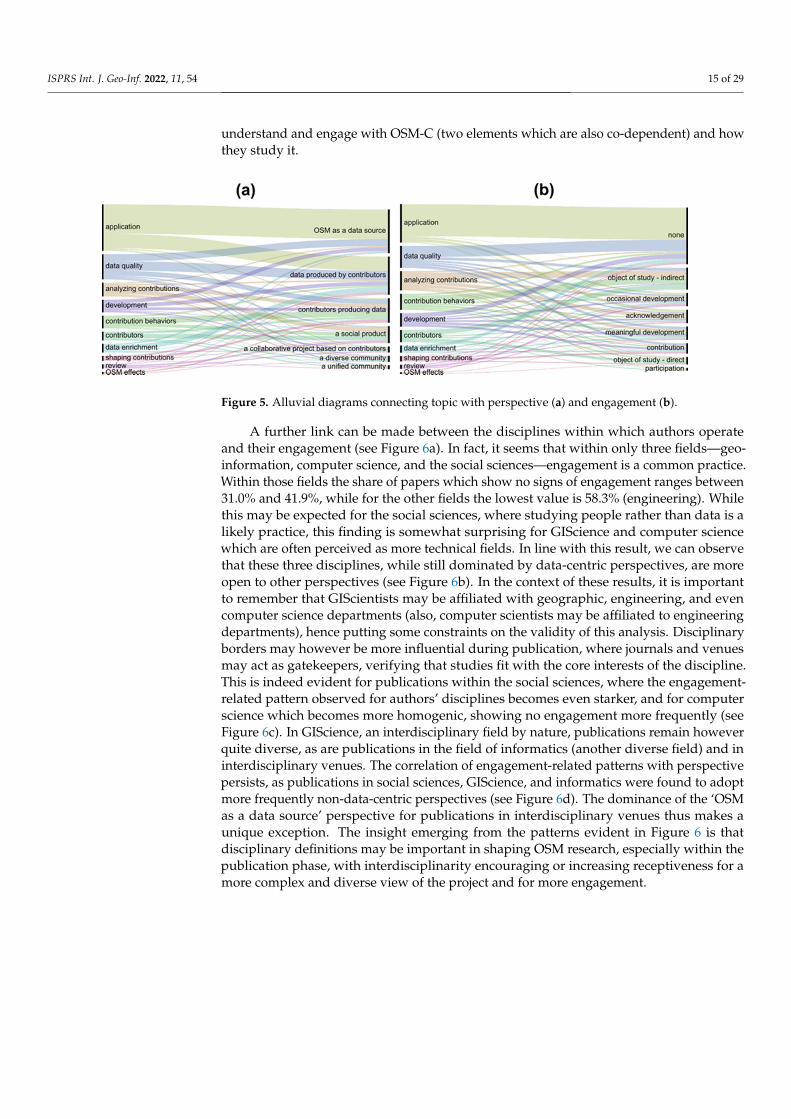
ISPRS Int. J. Geo-Inf. 2022, 11, 54 15 of 29
understand and engage with OSM-C (two elements which are also co-dependent) and howthey study it.
Figure 5. Alluvial diagrams connecting topic with perspective (a) and engagement (b).
A further link can be made between the disciplines within which authors operateand their engagement (see Figure 6a). In fact, it seems that within only three fields—geo-information, computer science, and the social sciences—engagement is a common practice.Within those fields the share of papers which show no signs of engagement ranges between31.0% and 41.9%, while for the other fields the lowest value is 58.3% (engineering). Whilethis may be expected for the social sciences, where studying people rather than data is alikely practice, this finding is somewhat surprising for GIScience and computer sciencewhich are often perceived as more technical fields. In line with this result, we can observethat these three disciplines, while still dominated by data-centric perspectives, are moreopen to other perspectives (see Figure 6b). In the context of these results, it is importantto remember that GIScientists may be affiliated with geographic, engineering, and evencomputer science departments (also, computer scientists may be affiliated to engineeringdepartments), hence putting some constraints on the validity of this analysis. Disciplinaryborders may however be more influential during publication, where journals and venuesmay act as gatekeepers, verifying that studies fit with the core interests of the discipline.This is indeed evident for publications within the social sciences, where the engagement-related pattern observed for authors’ disciplines becomes even starker, and for computerscience which becomes more homogenic, showing no engagement more frequently (seeFigure 6c). In GIScience, an interdisciplinary field by nature, publications remain howeverquite diverse, as are publications in the field of informatics (another diverse field) and ininterdisciplinary venues. The correlation of engagement-related patterns with perspectivepersists, as publications in social sciences, GIScience, and informatics were found to adoptmore frequently non-data-centric perspectives (see Figure 6d). The dominance of the ‘OSMas a data source’ perspective for publications in interdisciplinary venues thus makes aunique exception. The insight emerging from the patterns evident in Figure 6 is thatdisciplinary definitions may be important in shaping OSM research, especially within thepublication phase, with interdisciplinarity encouraging or increasing receptiveness for amore complex and diverse view of the project and for more engagement.

ISPRS Int. J. Geo-Inf. 2022, 11, 54 16 of 29
Figure 6. Alluvial diagrams connecting authors’ disciplines with engagement (a) and perspective (b);journals’ disciplines with engagement (c) and perspective (d).
Another variable that may be linked to perspective and engagement is a geographicalone, specifically the correspondence between authors’ locations and the location of theirstudy area. It is possible that researchers working outside of their comfort zone may beexposed to a wider set of practices, hence developing a more complex understanding ofOSM-C, and may strive for engagement as a means towards collecting more knowledge.Our results (see Figure 7) provide some support for this hypothesis: the frequency ofdata-centric perspectives seems to increase the greater the correspondence, as evident in thelarger fractions the ‘OSM as a data source’ and ‘data produced by contributors’ perspectivestake for papers showing full or partial/full correspondence (see Figure 7b). Interestingly,papers which include no case studies show, along with the ‘no correspondence’ papers, thegreatest tendency to adopt community-oriented perspectives such as ‘a social product’. Thismay be explained by the bird’s-eye view typical to reviews and conceptual explorations ofOSM. The results for engagement are not as conclusive, yet the general finding that lessercorrespondence and no case studies are associated with more engagement persists (seeFigure 7a). Hence, ‘where’ the research is taking place seems to be a meaningful factor notonly in terms of disciplinary boundaries, but also in geographic terms.

ISPRS Int. J. Geo-Inf. 2022, 11, 54 17 of 29
Figure 7. Alluvial diagrams connecting geographical correspondence with engagement (a) andperspective (b).
3.2. Interviews
As mentioned in Section 1, the results above only provide hypotheses explaining thereasons behind the patterns of engagement of OSM-R with OSM-C. The analysis of theinterviews in this subsection complements this by exposing concrete reasons promotingand constraining engagement. While the explanations this provides are local, i.e., relatingto a specific environment, we present them here as a source for intuitions when interpretingthe patterns witnessed in Section 3.1.
In Section 1, we mention our premise that two distinct social worlds exist, OSM-Cand OSM-R, yet that these are not independent from each other. Hence, before turning todiscuss themes that may explain the patterns identified above and in order to contextualizethe discussion and verify that respondents truly perceive the two communities as distinct,we first turn to explore where respondents place themselves in relation to OSM-C. Tworespondents explicitly placed themselves outside of it—respondent C, a PhD studentworking on data enrichment, and respondent F, a PhD student studying participatorymethods. Three respondents—respondent B, an active mapper and research associatedeveloping data analysis and visualization tools, and respondents D and E, MA graduatesdeveloping tools supporting mapping activities—discussed belonging to both communities(respondent B is unique in consciously attempting to separate these two identities). Thesethree respondents are differentiated from the others by their tendency to discuss theirexperiences as mappers and members of the community, not necessarily in the context ofresearch. Overall, we identify this group of respondents as individuals involved in OSM-C,i.e., the ‘more-engaged’ group in Table 2. We use the term ‘less-engaged’ to describe theother group since all respondents engaged with OSM-C in one manner at least (see below).
The level of engagement does not necessarily reflect general perceptions regardingthe extent of integration between OSM-C and OSM-R. Some respondents identified afuzzy boundary between the communities. Respondents did identify differences betweenthe communities in terms of interests, needs and expectations, communication style andsources of knowledge. However, respondents’ ability to identify such differences, whileperhaps stressed by the topic and focus of the interviews, points to the existence of twounique, yet interrelated, social worlds drawing on OSM as a boundary object.
This separation means that awareness of OSM is not self-evident and warrants aninspection into the respondents’ motivations for engaging with OSM as a research sub-ject. Responses uncovered three sources—OSM’s utility, personal experiences, and theprofessional environment—affecting two decisions: choosing to engage with OSM and thechoice of a specific research topic. These decisions could be directed by the same source orby a mix of sources. For example, respondent A noted that the professional environment(project and colleagues), along with utility, affected both choices. Respondent F also men-tioned the prominence of OSM in the academic curriculum at the university, along with

ISPRS Int. J. Geo-Inf. 2022, 11, 54 18 of 29
it being an updatable basemap, as motivating factors. A specific seminar was mentionedby respondents D and E yet respondent E’s personal experiences when mapping directedher choice of topic. Respondent D also mentioned meeting members of OSM-C during aconference and the realization that she could contribute to these members’ needs as anotherfactor behind choosing OSM.
The responses discussed above expose two flavors of utility: utility for OSM-C (re-spondents D and E) and utility for research (respondent F). Interestingly, less-engagedrespondents mentioned only the latter (with the exception of respondent G whose focuson utility for OSM-C was driven by collaborations with more-engaged members) whilethe first was discussed, along with personal experiences, by more-engaged ones. Thisuncovers two distinct causal paths—research topic leading to the choice of OSM (e.g.,respondent C below) vs. personal experiences creating a need answered by developments(e.g., respondent E below):
“I thought that OpenStreetMap, for example, is actually a great data source which couldhelp improve a lot of the mapping algorithms, for example, with specific perspectives.”(Respondent C)
“ . . . my research question was what I felt is needed at that moment, also for the commu-nity” (Respondent F)
Respondent B is unique by engaging in developing tools even before being exposed toOSM as a research topic.
Even before interacting with colleagues and members of OSM-C, working with OSMdata can also be a form of knowledge-producing engagement, as discussed in Section 1.Respondent A, for example, felt that she was learning “about the data and much more byworking with the data itself, but also by interacting with other colleagues of mine“, while respon-dent C described a conscious effort towards understanding “what is the meaning of the OSMtags and how it changes over space and how to quantify those uncertainties that are attached tothose data sets”, and respondent F explicitly discussed how exploring the data changed herperspective on the pros and cons of everyone contributing. In these respondents’ answers,data analysis was accompanied by other forms of engagement—reading Wikipedia pagesand literature or interacting with colleagues. More-engaged respondents stress howeverdeeper forms of engagement, such as mapping and direct interactions, when discussingthe same connection between engagement and understanding the data (albeit from theperspective of potential errors in research). Several respondents indicated that they haveseen many cases where the researchers made some basic mistakes or assumptions aboutmapping practices which were incorrect. Both situations could be mitigated by having abetter understanding about the mapping community and their practices. Only one respon-dent (respondent G) explicitly discussed mapping “to understand the concepts and better . . .design research”.
Mapping as a perspective-changing experience was a common theme among less-engaged respondents who participate in mapping, yet within an already existing researchframe. For example, one respondent indicated the positive influence on one’s own researchfrom having practical and personal experiences of OSM in teaching, mapathons, personalmapping, and so on. This is highlighted by a response from Respondent D who indicatedthat having a sense of what mappers do changed her entire approach to OSM research.
Several respondents pointed to the positive influence of personally knowing or en-gaging with members of the community or organizations working with OSM. This canhelp “find what the open research points are and actually find out what would be worthinvestigating” (respondent D). This more-engaged respondent adds that in her mind herresearch worked “ . . . because I was in close contact with the guys from [an organization] andwe really had time to get to know each other and to learn the problem from the other side”. Directcontact hence also affects research, sometimes even without involving a specific contactperson.

ISPRS Int. J. Geo-Inf. 2022, 11, 54 19 of 29
A common thread among the respondents who engage in mapping, even to a smallextent, is that their definition of OSM already included OSM-C members, i.e., mappers andpeople involved in the organization of activity in OSM. Less-engaged respondents howevertended to do so while discussing effects on data, e.g., “a high diversity of contributors and thiscan also be seen in the data” (respondent C) or “a strong community, because as we already saw inmany analyses and research there’s a tendency that it’s male-dominated, and many academics arecontributing, and more in the northern hemisphere.” (Respondent F).
In contrast, more-engaged respondents related also to the structure of the community,conceptualizing it as a “do-ocracy (“an organizational structure in which individuals chooseroles and tasks for themselves and execute them. Responsibilities attach to people whodo the work, rather than elected or elected officials.” [49]) where someone putting more effortwould have more influence” (Respondent B) or “different kinds of communities” with “differentorganizations, different companies that are contributing” (Respondent E). It was noticed thatresearch interests and questions are also affected by engagement, meaning that the researchperspective cannot be entirely divorced from the researcher’s experiences. This is perhapsmost evident in the case of respondent D, who, despite claiming that the social perspectiveis not represented in her research, still discusses her intent on putting the mapper at thecenter of their research.
The discussion of means of engagement also hints towards the platforms whichfacilitate it (i.e., bridges between OSM-R and OSM-C)—indirect engagement through dataanalysis and community resources or direct access to members of the community. Otherresources include the “Research/Ideas” Wikipedia page [50] which lists potential researchtopics and the OSM-science mailing list [51], a mailing list dedicated for communications onscientific topics related to OSM. A third platform mentioned by respondents are conferencesand meetings, specifically SotM and its academic track being a “point where you get theexchange [between mappers and researchers]” (Respondent C) but given that there arelimitations related to its annual frequency (Respondent D) and the limited number ofparticipants (Respondents D and E), it is not surprising that some of the respondents alsodiscussed the need for building more bridges. It should be noted that at the time of theinterviews, only one edition of the Academic Track was held and hence most respondentshad not attended it yet and mainly discussed their expectations of it.
One possible bridging factor is the mediating role that OSM-R can assume, acting as abridge by itself between OSM-C and user communities:
“I think the research community has to position itself in this larger context of interactionsbetween the community and different groups of users” (Respondent A)
“ . . . we can be there to better, to help data users but also data creators to better understandwhat is happening . . . And just we are also kind of an enabler that translates betweenthese worlds” (Respondent E on activity within the research group).
Promotion and especially translation or meditation however introduce their own diffi-culties, as there might be a discrepancy between the expectations of external communitiesand those of OSM-C (a notion discussed by respondent B).
A more direct answer to the need for more bridges could be sharing research throughmailing lists, the WeeklyOSM [52], OSM diaries, and blogs, as done by respondents D andE. However, they, along with respondent B also expressed their feeling that this does nothappen often enough and that communication is not extensive enough. Respondent Bsuggests that a possible barrier for sharing could be the style of communication with theOSM community. First, certain types of information may be ill-received by OSM-C:
“But, on the other hand, it is always a bit hard to communicate because when you talkabout data quality, you always talk about good or bad and you don’t want to say—OkayOSM data quality in your area is of poor quality. So, the thing I’m no more doing istalking about research itself, but I always, if I’m in contact with other people from theOSM community, through GitHub and forums, I tell them more that we have this tooland you can use it for different purposes”

ISPRS Int. J. Geo-Inf. 2022, 11, 54 20 of 29
Respondent B also notes that the direct style of communication mentioned earlier inthis section “makes it also a bit hard for people, for external people to come in and, orit might be a bit scary if it’s your first experience with the community.” This is indeedreflected in the experiences of respondents C and F who were involved in a university-ledmapping effort which sparked a discussion within the local mailing list, exposing them toan unfamiliar side of OSM-C which included very harsh criticism and led to demotivationamong involved students and a temporary pausing of the initiative. Interestingly, respon-dents D, E, and G, working on projects related to another, non-local community, reportedmostly positive experiences and close collaboration.
Hence there are many points of contact with OSM-C and their nature is crucial indetermining the manner and extent of interactions. This fragmentation within OSM-C isalso a possible barrier for engagement and communication. Respondent D, for example,notes that “there’s not a formal way, place, or space where you just communicate . . . ” and thatfor her “ . . . it’s not so easy to really find out what are the problems and what is interesting for thecommunities in different places.” Respondent B notes this also, highlighting this as an issuefor OSM-C as well. Unfortunately, the result may be confusion even among more-engagedresearchers regarding where to share their research, leading to preference for familiar andreactive environments:
“ . . . I’m oftentimes not sure if this is the right place to share my [domain] research hereor is it okay if I just share it on the [organization] mailing list, for example, and maybe itshould be just OSM-science mailing list.” (Respondent E)
Therefore, locating a suitable point of contact is imperative. Less-engaged membersespecially emphasize one point of contact, relating to more-engaged colleagues in terms of‘point of contact’ (Respondent C) or ‘link’:
“I think it’s good to have someone from the community because then . . . you can discussdirectly with someone working in the community but also here, so a person in both sides,so that’s good to also interact directly, to ask questions—how do you think, how wouldyou respond to that in the forum for example. Like, and then you have someone in thegroup, because, as you said, maybe it’s like this kind of division—we have academics, wehave the community, and there’s no proper link and so it’s good to have someone who hasthe link.” (Respondent F)
Respondent G states that the presence of these ‘produser’ (in the context of social mediaand collaborative projects, this concept relates to a person for whom the roles of producer,of data in the case of OSM, and user are merged or blurred [53]) colleagues minimizesher need for further interactions with members of OSM-C. In such cases less-engagedresearchers may become ‘trapped’ within a specific and subjective view of OSM-C. Theimportance of this possible barrier becomes stark given other constraints for engagementfrom the OSM-R side identified by respondents. For example, respondents A and C identifya boundary that science cannot or should not cross in intervening with the project:
“You shouldn’t change the paradigm and say—listen OSMappers, let’s do it like theresearchers like you to do, or let’s do it like a certain community of users would like youto do.” (Respondent A)
“There’s a certain boundary people try to interfere with the project . . . I guess that’s thepoint where the community would not be so willing because then it would also changethe character of the project.” (Respondent C).
Other issues include perceptions regarding how the research topic favors certaintypes of interactions (“I’m focusing on data-driven methods where I guess more likethis qualitative information that you get from meeting people will be hard to integrate”Respondent C) and the issue of objectivity in research. While engagement was largely seenas a positive practice, almost all participants discussed the prospect of it biasing research.One reaction to this concern was to strive for separation between the two identities andpractices:

ISPRS Int. J. Geo-Inf. 2022, 11, 54 21 of 29
“ . . . the value of research in society is that [researchers] identify themselves the relevantresearch questions and define what is interesting to be researched . . . researchers shouldbe independent to some extent from the outside” (Respondent A; respondent B alsorelates to this but on the personal level, see above)
Others accepted this bias but solved it by presenting their engagement as extremelylimited or treated it as something that cannot be avoided yet needs to be controlled:
“But oftentimes people say why they don’t want, for example, to be involved in theOpenStreetMap community is because they’re a researcher and they should be unbiasedabout what they’re doing. And I think that’s oftentimes for me a bit difficult because I’mpart of this community, so I know a little bit how it works. So I’m trying not to let it takeover . . . ” (Respondent E)
In fact, only respondent D fully embraced the situation, saying that when doingresearch “I’m not a different person then . . . I don’t know really how to distinguish . . . ” Thissuggests that the fear of losing objectivity may have adverse effects on engagements,hence increasing the dependence on other colleagues. This only stresses the prospect of‘perspective traps’ in which produsers act as a bridge, but only towards specific nodeswithin the community.
4. Discussion
In this paper we assessed the relationships between OSM-R and OSM-C, the extentto which they exist, and their influences. We did so first by analyzing OSM-related litera-ture published from 2016 to 2019, focusing on the relations of research topics, disciplines,geographic locations with the perspective on OSM-C reflected in the paper and evidencefor engagement with it. This analysis exposes descriptive patterns which call for a deeperexplanation. To provide such an explanation, we complemented this work with seveninterviews of members of the OSM-R belonging to one research group. The extent to whichthe interviews can reflect the full extent of interactions between the communities and theirsources and motivations is limited, mainly due to their small number and the homogeneityamong respondents in terms of their workplace. Yet, their utility lies in focusing on theindividual experiences of the respondents while controlling for the organizational context,hence exposing possible patterns and causal paths that operate at the individual level andthus may help to explain the results from the analysis of OSM-related publications. Natu-rally, diversifying the organizational context would have exposed additional explanations.Yet, given that this research is the first attempt of its kind towards analyzing relationsbetween the two communities, a full exploration, one that may additionally consider theexperiences of non-academic members of the OSM-C when interacting with OSM-R, isbeyond the scope of this work.
The first significant set of relations we identify is between the perspective on OSM-Cwithin a paper, evidence of engagement with OSM-C, and research topic, where studiesfocusing on the data product adopt more data-centric perspectives and show fewer signsof engagement. While this may seem natural, it is not mandatory—one can embrace thecomplexity of data production processes and still strive to better understand the community,even if the core interest is the final product. In fact, such a practice may minimize errorsin interpretation (as more-engaged interviewees noted). Interviews with members of oneresearch group expose a clear causal direction with engagement, either with the data,resources, colleagues, or OSM-C itself, changing perspectives. The interviews exposed twopossible causal directions that explain the relations between research topic and engagementwithin the research group—either the workplace environment, i.e., the research project,leads to engagement with OSM, or that being a member of OSM-C directs one towardschoosing a topic. In the latter case, a high-level of engagement is inherent to the research,while in the former the researcher determines the extent of engagement. It is possible thatthe current study did not capture other causal structures existing within other contexts. Yet,the directions that were identified serve as a useful starting point for future engagements

ISPRS Int. J. Geo-Inf. 2022, 11, 54 22 of 29
and reflection on OMS-related research. We contain that the same is true for the insightswe offer below.
The interviews indicate a few routes for engagement. One such route is within theprofessional sphere, where the researcher begins to explore community resources, consultsmore-engaged colleagues, or even gathers direct knowledge through participation inmeetings such as SotM. The other route is within the personal sphere, where the researchermay decide to engage in mapping while, or even because of, working with the data,which can lead to further interactions with OSM-C. Yet, the interviews also pointed toelements constraining engagement. One issue was the possibility that researchers willlimit themselves to interactions with produser colleagues, hence becoming dependent onmediation when interpreting the OSM project. Another is the fear of losing objectivity, stilla component which is perceived as fundamental to research in some fields, constrainingthe researcher from ‘diving too deep’. A third route is connected to communication withOSM-C, i.e., its fragmented nature, the contradicting needs of the two communities, and thedirect and sometimes unforgiving style of communication. Hence, a possible explanation(yet probably not the only one) for the patterns identified from the papers is the existenceof certain bridges fostering engagement and impacting perspectives and of barriers whichserve to constrain these. Below we interpret the results of the paper review in light of thispossible explanation.
From the trends visible in the analysis of publications, it seems that barriers act morestrongly than bridges yet with variations related to the disciplines within which authorsoperate and publish and to their choices of study areas. On the one hand, our results showthat within OSM-R there exists an infrastructure for research-related engagements thatpromotes exposure to different views and practices: more than one third of the papers arebased on interdisciplinary collaborations, international collaborations are common as well,and choosing study areas beyond authors’ home countries is a common practice. Paperspublished in interdisciplinary venues or undertaken by researchers within fields of aninterdisciplinary nature were found to adopt more complex perspectives and show greatersigns of engagement. The same is true for papers in which there was little correspondencebetween authors’ locations and case study locations. Yet, these bridges are internal toOSM-R, and do not appear to foster interactions with OSM-C. Furthermore, their impact isconstrained by disciplinary borders enforced to a certain extent by publication venues andby authors’ tendency to study OSM data within their own continent, focusing on specificcountries, e.g., Germany, China, and the United States. As all interviewees belong to thesame research group, we cannot explore here the impacts of disciplinary boundaries andinterdisciplinary collaborations. However, the interviews do shed light on the importance ofdiversity in interactions. Respondent F, for example, explicitly mentioned how working ina foreign country and cultural environment affected her perspective on the project. Furtherevidence for this is how respondents who engaged with non-local communities reportedmore positive experiences when interacting with OSM-C members than respondents intouch with the local community, suggesting that diversity is important for finding the rightchannel of interaction. Even interaction with external user communities, e.g., when OSM-Rtakes the position of mediator/translator between these and OSM-C or promotes use ofOSM data, can act as a channel which fosters engagement. Yet this is also constrained byconflicting interests, where data users may prefer tools or frameworks that produce simplebottom-line results, while OSM-C members may prefer more nuanced outputs.
The results presented in Section 3 along with the discussion above expose multiplebridges—elements which provide infrastructure for increased engagement and integrationbetween OSM-R and OSM-C. Some exist within the professional sphere and relate to experi-ences one gains as part of research-related activities, i.e., utility for research, the workplaceenvironment, colleagues, produser colleagues, data analysis, using community resources,and attending conferences. Others relate to the personal sphere, reflecting experiencesas a contributor or member of OSM-C: utility for the project, mapping, participation innon-mapping activities such as development of tools, interaction with other members, and

ISPRS Int. J. Geo-Inf. 2022, 11, 54 23 of 29
promotion of OSM. It is important to note here that while utilizing a bridge may requireincreased interactions with OSM-C members (e.g., the produsers and interaction bridges)this is not mandatory for all bridges (e.g., data analysis, community resources, and evenmapping). Alongside these bridges, we identify three barriers inhibiting engagement-communication with the outer world, subjectivity (mainly, the fear of losing objectivity),and communication with OSM-C (fragmentation, directness, framing). This is a completedescription of the factors inhibiting and fostering engagement within the specific researchgroup to which our interviewees belonged. Our experiences within OSM-R reveal that itis also relevant in general to OSM-R, although our focus on one disciplinary context mayrender it incomplete.
Bridges and barriers relate to different social worlds—the external world, OSM-R,and OSM-C, which itself consists of three layers (data, members, and the project). Weformalize this in a visual manner in Figure 8, where disks represent social worlds. Wechoose the form of disks towards representing the possible overlap of these worlds, i.e.,that OSM-R may participate in data creation, may include OSM-C members and may evenbe involved in the project itself. Disk borders are positioned by their degree of proximityto the core of OSM-C (also represented by the graduation in color saturation). Beinglocated further away from the center of the diagram (the project disk) represents a simplerperspective with limited awareness to the inner disks. Red dotted lines represent thebarriers mentioned above, separating between the external world and OSM-R (the outercommunication barrier), between OSM-R and the data (subjectivity), and between OSM-Rand OSM-C (inner communication barrier). Blue polygons represent the bridging elementswhich allow crossing between social worlds by breaking these barriers. The bridges aregrouped according to the two spheres mentioned above—the professional sphere (left-handside) and the personal sphere (right-hand side).
The bridges differ in the extent of integration they promote, a fact represented bypolygons’ inward boundaries, e.g., participation, utility for the project, and interaction withproduser colleagues hold the potential for leading researchers to engage with the core ofOSM itself (a potential that certainly exists even if not entirely captured by our observations)and hence these bridges touch the boundary of the project disk. Other bridges are not likelyto foster such deep engagement and accordingly end at the boundaries of one of the externaldisks, e.g., data analysis is unlikely to foster engagement beyond the border between thedata and OSM-R disks. This situation produces continuums of bridges where one bridgecan serve as an entry point to another (represented in Figure 8 by black arrows and letters).For example, the initial engagement fostered by data analysis may create the need for betterunderstanding of the data, thus leading researchers to further engage with the communityby using community resources and later on attending conferences (continuum A). Anothercontinuum is related to a common theme among less-engaged respondents where theprofessional sphere enables and fosters engagement, first via awareness, then throughinteraction with colleagues, some of which may be from different fields hence fosteringfurther interchange, and finally by interaction with produser colleagues, acting as links orcontact persons between the two communities (if such colleagues are available; continuumB). While these continuums have a clear one-way inward direction, the third continuumis more complex, including multiple paths and also movement sideways, e.g., mappingleading to a better understanding of the data and OSM-C (continuum C); promotionactivities encouraging mapping (continuum D); mapping encouraging participation (e.g.,engaging in development and management; continuum E), which can then lead to moreinteraction (continuum F). Mapping, interaction, and participation increase awareness ofthe needs of OSM-C, i.e., to the utility of research for the project (continuums I, H, and Gaccordingly), thus creating a connection to the research sphere (continuum J). This kind ofinter-sphere movement also exists for mapping and data analysis, albeit in both directions(continuum C)—mapping can influence research and research can motivate individuals tostart mapping.

ISPRS Int. J. Geo-Inf. 2022, 11, 54 24 of 29
Figure 8. A model of bridges and barriers in engagement between the OSM-R and OSM-C.
Bridges are connecting elements, yet, as in real-life, they may facilitate the creation ofbottlenecks. These bottlenecks are evident in the perspective traps mentioned in Section 3.2—the nature of bridges critically depends on the point of contact forming them and hencemay lead to interaction and exchange with only specific segments of OSM-C (colleagues,members of a certain sub-community, attendees of SotM), therefore providing a relativelynarrow understanding of its complexity. Hence, each sphere, while including multiplebridges, is also potentially surrounded by a barrier in Figure 8 (the same way a road bridgemay be surrounded by water). However, the intra-sphere movement mentioned abovefacilitates movement between traps and introduces more diversity into one’s experience,thus somewhat limiting the influence of traps.
Given the importance of the professional sphere and trap, and especially the identitiesof colleagues, the membership of produsers in the research group studied in this paper mayhave led to an increased saliency of certain modes of engagement in this research, possiblyon the expanse of other modes not witnessed in the interviews. Furthermore, it possiblyoveremphasized interaction (beyond data analysis) as a common practice, as the resultsof the paper review analysis attest. However, the personal experiences of respondentsand the bridges and barriers we identify provide the grounds for hypothesizing regardingpossible outcomes in other organizational contexts. For example, the professional trapsuggests that researchers operating within a working environment lacking in the presence

ISPRS Int. J. Geo-Inf. 2022, 11, 54 25 of 29
of produsers or even more-engaged researchers may not consider or be even aware of theability to interact with OSM-C. The same is true for environments which stress objectivity asa critical component of academic research. On the other hand, when seeking out interaction,researchers with no access to more-engaged colleagues may become reliant on directinteractions with non-academic members of OSM-C and the probability of them movingfrom the professional sphere to the personal sphere by becoming produsers themselves willincrease (a process not entirely witnessed here). These hypotheses require further and morecomprehensive research, one that may expose bridges and barriers not witnessed here, thatmay include also non-academic OSM-C members and inquire regarding perceptions andexperiences on ‘the other side’. Such comprehensive research may give more prominenceto the role of the OSM Foundation as an entity which represents OSM-C and supportsits interests. As such, it may foster further engagement between OSM-R and OSM-C ifthis aligns with the interests of OSM-C, as happened in the past with the addition of anAcademic Track to the SotM conferences or the establishment of the OSM-science mailinglist. However, if there will be no common interest for interactions, its activities may(indirectly) further divide the two communities, e.g., by emphasizing mapping as part ofits membership classes (a practice that is followed only to a limited extent currently as onecan become a member of any class without being an active mapper [54]).
5. Conclusions
Awareness of OSM and OSM-C by OSM-R is not self-evident or endemic. Inspectingand reflecting upon the motivations of those in OSM-R for engaging with OSM-C isa complex but fascinating topic for research consideration. Extracting or formulatingconclusions around these discussions on the means of engagement, platforms (bridges)that facilitate it, barriers that prevent it, and interactions developed is a complex task. Thispaper significantly adds to the literature by delivering a robust discussion of the extent andnature of the relationships in OSM-R and more specifically relations between OSM-R andOSM-C. Of course, in a study of this type, there are many limitations (discussed below) andwe acknowledge these wholeheartedly. Researchers’ acknowledgement of their own biases,prejudices, and stereotypes in a scientific inquiry (designing, conducting and reportingresearch) is the best way to incorporate subjectivity into a research study which in turnallows interpretive openness and reflexivity [28]. As mentioned in the introduction to thispaper, it is ironic that OSM-R has failed to look introspectively at biases formed withinitself as well as in the evolving interactions with OSM-C and other communities (such asthe general public).
For those in OSM-R, there is an interpretative act in each kind of engagement. Thisstudy shows that, at least within one prominent research group, the researcher is the onedoing the interpretation when engaging directly with the data. When done through en-gagement with the community, communication is crucial in the act of interpretation. Thereare circles of interpretation-social worlds with more-engaged researchers and produsersbeing in direct contact with OSM-C and acquiring first-hand knowledge while less-engagedmembers continue relying on limited experience and external feedback. In this case thebridges cause an interpretative bottleneck—the interpretation of one person is inherited byothers relying on them, leading to a false sense of objectivity. Engaging with the communityor crossing between professional and personal spheres allows for triangulation—beingexposed to multiple perspectives and comparing them in order to produce a more nuancedimage of reality. Researchers should be aware of their subjective perspective when engagingin OSM research and act to triangulate. The questions which arise, for further investigation,are when are these different modes of engagement needed? Are there situations whereengagement through observation of data (data analysis) is enough? Which situations callfor all modes of engagement and communication? Or why should either OSM-R or OSM-Ctruly care about engagement and communication at all?
Based on our findings, we can offer initial answers to these questions by relating tothe notion of triangulation (see our discussion below regarding the limitation in the context

ISPRS Int. J. Geo-Inf. 2022, 11, 54 26 of 29
of generalization emerging from our focus on one prominent research group). We do notsuggest that every little application of OSM in OSM-R should include or strive for deepengagement with OSM-C. However, authors of academic research papers should be awareof their subjective view; authors should be transparent regarding their position; authorsshould act to diversify their experiences using the bridges that best facilitate them andconsider engaging OSM-C members when designing and assessing research projects (goodexamples of papers, among those reviewed, where this happened include [16,55]); peer-review journal editors should invite reviewers that are familiar with OSM, even if OSMis just a data source. We close by emphasizing the continued need for cross-communityevents such as State of the Map Academic Track [24] to continue in future years as a simple,yet effective platform, for bringing two communities together.
There are a number of limitations and potential improvements to this work whichwe shall now acknowledge. We acknowledge that the use of Google Scholar as the sourceplatform for the literature review, which was done for simplicity reasons, may have ledto biases, e.g., not all the papers might have been found (Google Scholar does not indexeverything, etc.). However, although the work can be in principle improved using othersources—either to substitute or complement Google Scholar—we believe that the resultshave fully captured the main trends. Our choice to restrict the papers to the time periodfrom 2016 to 2019 was done to only capture recent OSM literature. Of course, there are noclear temporal boundaries for the concept of ‘recent’. Considering e.g., also papers fromadditional years (e.g., 2015 and/or 2020) may have changed the results, we still believe thatthe results generated are representative of the main existing patterns. The paper review wascarried out by the five authors of this paper and considering the workload of reviewing thelarge number of papers it was decided that each paper would be reviewed by one personwith only few exceptions (e.g., papers co-authored by any of the authors of this paper werealso double-checked by them). Despite many consistency checks and subsequent roundsof improvement, which made the analysis last several months, the classification was stilla manual process executed by different people and therefore it inherently carries biasesdue to the subjectivity of the exercise. However, once again we believe that the results arerobust enough to highlight the main trends and patterns. We acknowledge that the numberof interviews is too small to make any definitive claims, but only expose possible causalinfluences and relations. This means that there are other processes that we may be missing.Interview respondents came from the same institution and this does not allow for studyingdisciplinary differences, e.g., how relations change in research oriented towards qualitativemethods and social theory (yet this is still a rare approach within OSM research). Moreover,it means that all less-engaged respondents had access to produser colleagues. While wecan hypothesize regarding which forms of engagement and interaction take place whenresearchers do not have access to more informed colleagues (see Section 4), we cannot offera definitive answer on the matter and more research is required. The topic of interviews, aspresented to the interviewees, and the emphasis on the notion of two communities mayhave biased responses towards differences between them rather than the commonalities.Personal acquaintance with the interviewers and being aware that interviews would beused in publication may have made respondents more cautious in their answers. Finally,we openly acknowledge that the analysis is certainly influenced by our bias as individualsinvolved in both communities. Moreover, we note here that our research tells only half ofthe story—that of OSM-R. It is possible that exploring the same issue with non-academicmembers of OSM-C will uncover different bridges and barriers. Such an exploration thusforms a fascinating direction for future research.
Author Contributions: Conceptualization, A. Yair Grinberger, Marco Minghini, Godwin Yeboah,Levente Juhász and Peter Mooney; Data curation, A. Yair Grinberger, Marco Minghini and LeventeJuhász; Investigation, A. Yair Grinberger; Methodology, A. Yair Grinberger and Levente Juhász;Writing—original draft, A. Yair Grinberger, Marco Minghini, Godwin Yeboah, Levente Juhász andPeter Mooney; Writing—review & editing, A. Yair Grinberger, Marco Minghini, Godwin Yeboah,

ISPRS Int. J. Geo-Inf. 2022, 11, 54 27 of 29
Levente Juhász and Peter Mooney. All authors have read and agreed to the published version of themanuscript.
Funding: This study commenced during A. Yair Grinberger’s postdoctoral research, which wasfunded by the Alexander von Humboldt foundation. The APC was funded by the ISPRS InternationalJournal of Geo-Information.
Institutional Review Board Statement: Not applicable.
Informed Consent Statement: Informed consent was obtained from all subjects involved in thestudy.
Data Availability Statement: The raw dataset including metadata of the 200 papers included in thepaper review was published by the authors and is available at https://zenodo.org/record/4474588#.YYegv2BBxaQ (1 January 2022). The CSV files and the code used to produce the outputs in Section 3are available at https://github.com/yair-grinb/OSMPaperReview (1 January 2022).
Acknowledgments: The authors would like to express their appreciation to all members of theOpenStreetMap community who work tirelessly to produce a high-quality open map of the world,and to the authors of the papers analyzed in this study, all contributing important knowledge onOpenStreetMap. Additionally, the authors would like to thank the anonymous reviewers for theirhelpful comments on an earlier version of this paper. Finally, the authors would like to extend theirgratitude towards the respondents for their openness and sincere contributions to this work. Anearlier version of this work was presented at the Academic Track at State of the Map 2019.
Conflicts of Interest: All authors are engaged with the OpenStreetMap community, either throughorganizing the Academic Track at the 2018, 2019, 2020 and 2021 State of the Map conferences, throughmembership in different groups and organizations, or through mapping activities. The funder hadno role in the design of the study; in the collection, analyses, or interpretation of data; in the writingof the manuscript, or in the decision to publish the results.
References1. Bertolotto, M.; McArdle, G.; Schoen-Phelan, B. Volunteered and Crowdsourced Geographic Information: The OpenStreetMap
Project. J. Spat. Inf. Sci. 2020, 65–70. [CrossRef]2. Glasze, G.; Perkins, C. Social and Political Dimensions of the OpenStreetMap Project: Towards a Critical Geographical Research
Agenda. In OpenStreetMap in GIScience: Experiences, Research, and Applications; Jokar Arsanjani, J., Zipf, A., Mooney, P., Helbich,M., Eds.; Lecture Notes in Geoinformation and Cartography; Springer International Publishing: Cham, Switzerland, 2015; pp.143–166. ISBN 978-3-319-14280-7.
3. Bittner, C. OpenStreetMap in Israel and Palestine—“Game Changer” or Reproducer of Contested Cartographies? Polit. Geogr.2017, 57, 34–48. [CrossRef]
4. Gardner, Z.; Mooney, P.; Dowthwaite, L.; Foody, G. Gender Differences in OpenStreetMap Contributor Activity, Editing andTagging Behaviour. In Proceedings of the GISRUK 2018, Leicester, UK, 17–20 April 2018; p. 6.
5. Ludwig, C.; Fendrich, S.; Zipf, A. Regional Variations of Context-Based Association Rules in OpenStreetMap. Trans. GIS 2020, 25,602–621. [CrossRef]
6. Anderson, J.; Sarkar, D.; Palen, L. Corporate Editors in the Evolving Landscape of OpenStreetMap. ISPRS Int. J. Geo-Inf. 2019, 8,232. [CrossRef]
7. Juhász, L.; Hochmair, H. OSM Data Import as an Outreach Tool to Trigger Community Growth? A Case Study in Miami. ISPRSInt. J. Geo-Inf. 2018, 7, 113. [CrossRef]
8. Fast, V.; Rinner, C. A Systems Perspective on Volunteered Geographic Information. ISPRS Int. J. Geo-Inf. 2014, 3, 1278–1292.[CrossRef]
9. Quinn, S. A Geolinguistic Approach for Comprehending Local Influence in OpenStreetMap. Cartogr. Int. J. Geogr. Inf. Geovisual-ization 2016, 51, 67–83. [CrossRef]
10. Juhász, L.; Novack, T.; Hochmair, H.H.; Qiao, S. Cartographic Vandalism in the Era of Location-Based Games—The Case ofOpenStreetMap and Pokémon GO. ISPRS Int. J. Geo-Inf. 2020, 9, 197. [CrossRef]
11. Sieber, R.E.; Haklay, M. The Epistemology(s) of Volunteered Geographic Information: A Critique. Geo Geogr. Environ. 2015, 2,122–136. [CrossRef]
12. Lin, Y.-W. A Qualitative Enquiry into OpenStreetMap Making. New Rev. Hypermedia Multimed. 2011, 17, 53–71. [CrossRef]13. Brovelli, M.A.; Ponti, M.; Schade, S.; Solís, P. Citizen Science in Support of DigitalEarth. In Manual of Digital Earth; Guo, H.,
Goodchild, M.F., Annoni, A., Eds.; Springer: Singapore, 2020; pp. 593–622. ISBN 978-981-329-914-6.14. Star, S.L.; Griesemer, J.R. Institutional Ecology, ‘Translations’ and Boundary Objects: Amateurs and Professionals in Berkeley’s
Museum of Vertebrate Zoology, 1907–1939. Soc. Stud. Sci. 1989, 19, 387–420. [CrossRef]
ISPRS Int. J. Geo-Inf. 2022, 11, 54 28 of 29
15. Budhathoki, N.R.; Haythornthwaite, C. Motivation for Open Collaboration: Crowd and Community Models and the Case ofOpenStreetMap. Am. Behav. Sci. 2013, 57, 548–575. [CrossRef]
16. Minghini, M.; Frassinelli, F. OpenStreetMap History for Intrinsic Quality Assessment: Is OSM up-to-Date? Open Geospat. DataSoftw. Stand. 2019, 4, 9. [CrossRef]
17. Sehra, S.; Singh, J.; Rai, H. Assessing OpenStreetMap Data Using Intrinsic Quality Indicators: An Extension to the QGIS ProcessingToolbox. Future Internet 2017, 9, 15. [CrossRef]
18. Yang, A.; Fan, H.; Jing, N. Amateur or Professional: Assessing the Expertise of Major Contributors in OpenStreetMap Based onContributing Behaviors. ISPRS Int. J. Geo-Inf. 2016, 5, 21. [CrossRef]
19. Hacar, M.; Kilic, B.; Sahbaz, K. Analyzing OpenStreetMap Road Data and Characterizing the Behavior of Contributors in Ankara,Turkey. ISPRS Int. J. Geo-Inf. 2018, 7, 400. [CrossRef]
20. Thebault-Spieker, J.; Hecht, B.; Terveen, L. Geographic Biases Are ‘born, Not Made’: Exploring Contributors’ SpatiotemporalBehavior in OpenStreetMap. In Proceedings of the 2018 ACM Conference on Supporting Groupwork, Sanibel Island, FL, USA,7–10 January 2018; pp. 71–82.
21. Fan, H.; Yang, A.; Zipf, A. The Intrinsic Quality Assessment of Building Footprints Data on OpenStreetMap in Baden-Württemberg.In Flächennutzungsmonitoring VIII Flächensparen-Ökosystemleistungen-Handlungsstrategien; RHOMBOS: Berlin, Germany, 2016; pp.253–260.
22. Almendros-Jimenez, J.M.; Becerra-Teron, A. Analyzing the Tagging Quality of the Spanish OpenStreetMap. ISPRS Int. J. Geo-Inf.2018, 7, 323. [CrossRef]
23. Barron, C.; Neis, P.; Zipf, A. A Comprehensive Framework for Intrinsic OpenStreetMap Quality Analysis. Trans. GIS 2014, 18,877–895. [CrossRef]
24. SotM State of the Map. Available online: https://stateofthemap.org/ (accessed on 15 January 2021).25. Kaur, J.; Singh, J.; Sehra, S.S.; Rai, H.S. Systematic Literature Review of Data Quality within OpenStreetMap. In Proceedings of
the 2017 International Conference on Next Generation Computing and Information Systems (ICNGCIS), Jammu, India, 11–12December 2017; pp. 177–182.
26. Sehra, S.S.; Singh, J.; Rai, H.S. Using Latent Semantic Analysis to Identify Research Trends in OpenStreetMap. ISPRS Int. J. Geo-Inf.2017, 6, 195. [CrossRef]
27. Yan, Y.; Feng, C.-C.; Huang, W.; Fan, H.; Wang, Y.-C.; Zipf, A. Volunteered Geographic Information Research in the First Decade:A Narrative Review of Selected Journal Articles in GIScience. Int. J. Geogr. Inf. Sci. 2020, 34, 1765–1791. [CrossRef]
28. Research Reports, Subjective. In The SAGE Encyclopedia of Communication Research Methods; SAGE Publications, Inc.: ThousandOaks, CA, USA, 2017; ISBN 978-1-4833-8143-5.
29. Berger, R. Now I See It, Now I Don’t: Researcher’s Position and Reflexivity in Qualitative Research. Qual. Res. 2015, 15, 219–234.[CrossRef]
30. Blomley, N.K. Activism and the Academy. Environ. Plan. Soc. Space 1994, 12, 383–385. [CrossRef]31. Fransman, J. Charting a Course to an Emerging Field of “Research Engagement Studies”: A Conceptual Meta-Synthesis. Res. All
2018, 2, 185–229. [CrossRef]32. Marashi, S.-A.; Hosseini-Nami, S.M.A.; Alishah, K.; Hadi, M.; Karimi, A.; Hosseinian, S.; Ramezanifard, R.; Mirhassani, R.S.;
Hosseini, Z.; Shojaie, Z. Impact of Wikipedia on Citation Trends. EXCLI J. 2013, 12, 15–19.33. Wilson, A.M.; Likens, G.E. Content Volatility of Scientific Topics in Wikipedia: A Cautionary Tale. PLoS ONE 2015, 10, e0134454.
[CrossRef]34. Filho, H.F.; Leite, B.P.; Pompermayer, G.A.; Werneck, M.G.; Leyh, W. Teaching VGI as a Strategy to Promote the Production of
Urban Digital Cartographic Databases. In Proceedings of the Joint Urban Remote Sensing Event 2013, Sao Paulo, Brazil, 21–23April 2013; pp. 222–225.
35. Gaspari, F.; Stucchi, L.; Bratic, G.; Jovanovic, D.; Ponti, C.; Biagi, L.G.A.; Brovelli, M.A. Innovation in Teaching: The PolimappersCollaborative and Humanitarian Mapping Course at Politecnico Di Milano. Int. Arch. Photogramm. Remote Sens. Spat. Inf. Sci.2021, XLVI-4/W2-2021, 63–69. [CrossRef]
36. Aibar, E.; Lladós-Masllorens, J.; Meseguer-Artola, A.; Minguillón, J.; Lerga, M. Wikipedia at University: What Faculty Think andDo about It. Electron. Libr. 2015, 33, 668–683. [CrossRef]
37. Coetzee, S.M.; Minghini, M.; Solis, P.; Rautenbach, V.; Green, C. Towards understanding the impact of mapathons-reflecting onYouthMappers experiences. The International Archives of the Photogrammetry. Remote Sens. Spat. Inf. Sci. 2018, XLII-4/W8, 35–42.[CrossRef]
38. Solís, P.; McCusker, B.; Menkiti, N.; Cowan, N.; Blevins, C. Engaging Global Youth in Participatory Spatial Data Creation forthe UN Sustainable Development Goals: The Case of Open Mapping for Malaria Prevention. Appl. Geogr. 2018, 98, 143–155.[CrossRef]
39. OSM-F OpenStreetMap Foundation. Available online: https://wiki.osmfoundation.org/wiki/Main_Page (accessed on 15 January2021).
40. Miller, H.J.; Goodchild, M.F. Data-Driven Geography. GeoJournal 2015, 80, 449–461. [CrossRef]41. Google Scholar. Available online: https://scholar.google.com/ (accessed on 3 December 2020).42. Saldaña, J. The Coding Manual for Qualitative Researchers, 3rd ed.; SAGE: Los Angeles, CA, USA; London, UK, 2016; ISBN
978-1-4739-0248-0.

ISPRS Int. J. Geo-Inf. 2022, 11, 54 29 of 29
43. Grinberger, A.Y.; Minghini, M.; Yeboah, G.; Juhász, L.; Mooney, P. Review of OpenStreetMap Research Publications from 2016 to2019. Zenodo 2021. [CrossRef]
44. Grinberger, A.Y.; Minghini, M.; Yeboah, G.; Juhász, L.; Mooney, P. OSMPaperReview: A Repository for Analyzing OSM-RelatedPublications from the Years 2016–2019. Available online: https://github.com/yair-grinb/OSMPaperReview (accessed on 7January 2022).
45. Okoli, C.; Mehdi, M.; Mesgari, M.; Nielsen, F.Å.; Lanamäki, A. The People’s Encyclopedia under the Gaze of the Sages: A SystematicReview of Scholarly Research on Wikipedia; Social Science Research Network: Rochester, NY, USA, 2012.
46. Graham, M.; Straumann, R.; Hogan, B. Digital Divisions of Labor and Informational Magnetism: Mapping Participation in Wikipedia;Social Science Research Network: Rochester, NY, USA, 2015.
47. Alluvial_Diagram Alluvial Diagram. Wikipedia. 2020. Available online: https://en.wikipedia.org/wiki/Alluvial_diagram(accessed on 7 January 2022).
48. RAWGraphs. The Missing Link between Spreadsheets and Data Visualization. Available online: https://rawgraphs.io/ (accessedon 25 January 2021).
49. CommunityWiki: Do Ocracy. Available online: https://communitywiki.org/wiki/DoOcracy (accessed on 27 January 2021).50. OSM-Research-Ideas-page Research/Ideas-OpenStreetMap Wiki. Available online: https://wiki.openstreetmap.org/wiki/
Research/Ideas (accessed on 15 January 2021).51. OSM-Science-List OSM Science—Discuss Anything Science Related in the OpenStreetMap Ecosystem. Available online: https:
//lists.openstreetmap.org/listinfo/science (accessed on 15 January 2021).52. WeeklyOSM. Available online: https://wiki.openstreetmap.org/wiki/WeeklyOSM (accessed on 7 November 2021).53. Chandler, D.; Munday, R. A Dictionary of Social Media; Oxford University Press: Oxford, UK, 2016; ISBN 978-0-19-180309-3.54. Active OSM Contributor? You Can Now Easily Join the OpenStreetMap Foundation. Available online: https://blog.
openstreetmap.org/2020/08/20/active-osm-contributor-membership-program/ (accessed on 26 December 2021).55. Anderson, J.; Soden, R.; Anderson, K.M.; Kogan, M.; Palen, L. EPIC-OSM: A Software Framework for OpenStreetMap Data
Analytics. In Proceedings of the 2016 49th Hawaii International Conference on System Sciences (HICSS), Hawaii, HI, USA, 5–8January 2016; pp. 5468–5477.