An Archaeological Intervention at Middle Way, Oxford
30
JOHN MOORE HERITAGE SERVICES AN ARCHAEOLOGICAL INTERVENTION AT WALLED GARDEN, MIDDLE WAY OXFORD SP 5045 0902 On behalf of Henry Chopping March 2007
Transcript of An Archaeological Intervention at Middle Way, Oxford
JOHN MOORE HERITAGE SERVICES
AN ARCHAEOLOGICAL INTERVENTION
AT
WALLED GARDEN, MIDDLE WAY OXFORD
SP 5045 0902
On behalf of
Henry Chopping
March 2007
John Moore HERITAGE SERVICES Walled Garden, Middle Way, Oxford OXMWWG06 An Archaeological Intervention
REPORT FOR Chopping Partnership
Begbroke Manor Spring Hill Road Begbroke Oxon OX5 1SH
PREPARED BY Gwilym Williams FIELDWORK 17th – 24th July 2006 & 2nd – 5th January 2007 REPORT ISSUED 3rd May 2007 ENQUIRES TO John Moore Heritage Services Hill View Woodperry Road Beckley Oxfordshire OX3 9UZ Tel/Fax 01865 358300 Email [email protected] JMHS PROJECT NO. 1576 ARCHIVE LOCATION Oxfordshire Museum Accession Number OXCMS : 2006 : 59
John Moore HERITAGE SERVICES Walled Garden, Middle Way, Oxford OXMWWG06 An Archaeological Intervention
CONTENTS
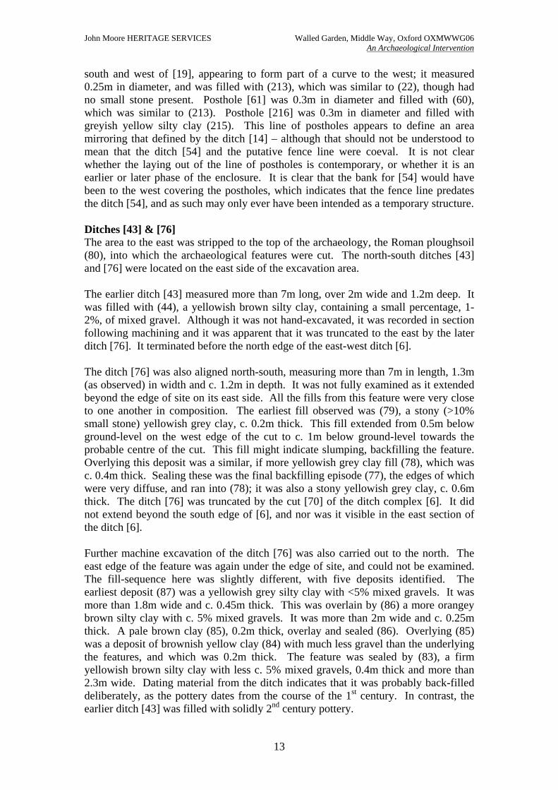
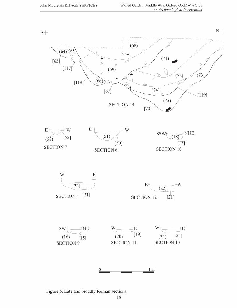
Page SUMMARY 1 1 INTRODUCTION 1 1.1 Site Location 1 1.2 Planning Background 1 1.3 Archaeological Background 1 2 AIMS OF THE INVESTIGATION 1 3 STRATEGY 3 3.1 Research Design 3 3.2 Methodology 3 4 RESULTS 4 4.1 Late Iron Age to early Roman period 4 4.2 Early Roman period 9 4.3 Middle Roman period 12 4.4 Late Roman period 16 4.5 Broadly Roman features 19 5 FINDS 22 5.1 The ‘Belgic’ Pottery by Frances Raymond 22 5.2 The late Iron Age and Roman Pottery by Daniel Stansbie 23 6 CONCLUSIONS 26 7 BIBLIOGRAPHY 27 FIGURES Figure 1 Site Location Plan 2 Figure 2 Plan of archaeological features according to phasing 5 Figure 3 Late Iron Age and early Roman sections 7 Figure 4 Middle Roman sections 11 Figure 5 Late and broadly Roman sections 18
John Moore HERITAGE SERVICES Walled Garden, Middle Way, Oxford OXMWWG06 An Archaeological Intervention
1
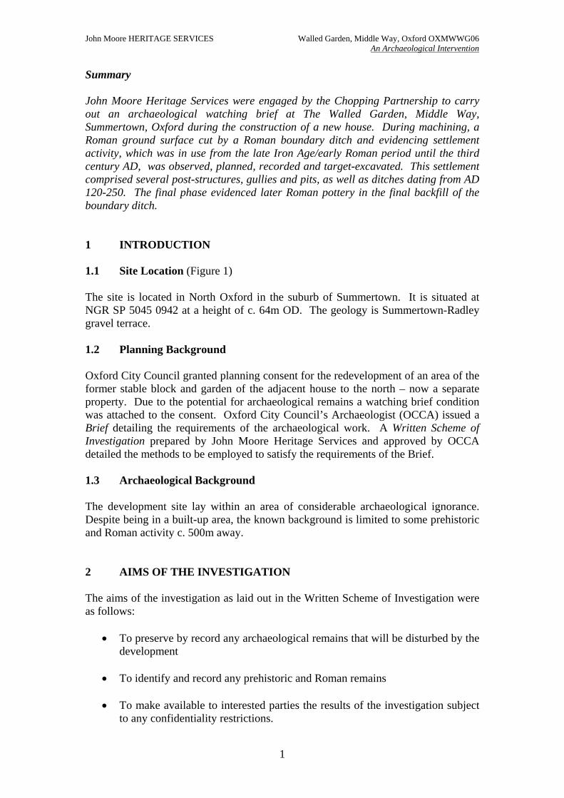
Summary John Moore Heritage Services were engaged by the Chopping Partnership to carry out an archaeological watching brief at The Walled Garden, Middle Way, Summertown, Oxford during the construction of a new house. During machining, a Roman ground surface cut by a Roman boundary ditch and evidencing settlement activity, which was in use from the late Iron Age/early Roman period until the third century AD, was observed, planned, recorded and target-excavated. This settlement comprised several post-structures, gullies and pits, as well as ditches dating from AD 120-250. The final phase evidenced later Roman pottery in the final backfill of the boundary ditch. 1 INTRODUCTION 1.1 Site Location (Figure 1) The site is located in North Oxford in the suburb of Summertown. It is situated at NGR SP 5045 0942 at a height of c. 64m OD. The geology is Summertown-Radley gravel terrace. 1.2 Planning Background Oxford City Council granted planning consent for the redevelopment of an area of the former stable block and garden of the adjacent house to the north – now a separate property. Due to the potential for archaeological remains a watching brief condition was attached to the consent. Oxford City Council’s Archaeologist (OCCA) issued a Brief detailing the requirements of the archaeological work. A Written Scheme of Investigation prepared by John Moore Heritage Services and approved by OCCA detailed the methods to be employed to satisfy the requirements of the Brief. 1.3 Archaeological Background The development site lay within an area of considerable archaeological ignorance. Despite being in a built-up area, the known background is limited to some prehistoric and Roman activity c. 500m away. 2 AIMS OF THE INVESTIGATION The aims of the investigation as laid out in the Written Scheme of Investigation were as follows:
• To preserve by record any archaeological remains that will be disturbed by the development
• To identify and record any prehistoric and Roman remains
• To make available to interested parties the results of the investigation subject
to any confidentiality restrictions.
MID
DL
EW
AY
HYDE
PLACE
48
Martin
Court
55
53
22
304
67
59
16 to 2
7
21
1 to 11
13
20
4
63.8
m
El
Sub Sta
Crown Copyright. All rights reserved. Licence Number 100020449
2
John Moore HERITAGE SERVICES
An Archaeological Intervention
0 50 m
Walled Garden, Middle Way, Oxford OXMWWG 06
Figure 1. Site location
INTERVENTION
AREA094
505
John Moore HERITAGE SERVICES Walled Garden, Middle Way, Oxford OXMWWG06 An Archaeological Intervention
3
3 STRATEGY 3.1 Research Design In response to a Brief issued by Oxford City Council’s Archaeologist, a scheme of investigation was designed by JMHS and agreed with OCCA and the developer. The work was carried out by JMHS and involved the excavation of the 19th century garden overburden to the level of the archaeological horizon across the site (Fig. 1). This was achieved in two strip and record phases. The former was undertaken in mid-July 2006, the latter in January 2007. Site procedures for the investigation and recording of potential archaeological deposits and features were defined in a Written Scheme of Investigation agreed with the OCCA. The work was carried out in accordance with the standards specified by the Institute of Field Archaeologists (1994) and the principles of MAP2 (English Heritage 1991). 3.2 Methodology The area was stripped with a 13-ton machine to the level of the archaeological horizon. The area of machine-stripping was dictated by the footings for the proposed building; therefore the southern area of the site was fully stripped and excavated, whereas to the west and to the north a floating platform was the preferred method of construction. Access to the archaeology was limited here to surface recording, recovering finds from the tops of archaeological features and very limited excavation. The resultant surfaces were cleaned by hand prior to limited hand excavation of the identified archaeological features. Following site visits by Brian Durham, Oxford City Archaeologist, it was agreed to excavate as many of the exposed features as possible, where there was to be an impact on them from the development, to better understand the archaeological sequence. The limited amount of excavation time dictated a targeting of features for investigation; this was based on the potential for an understanding of the putative structural remains balanced against the need to understand fully the layout of the settlement. Between the first phase of works in July and the second in December, an area measuring 5m (north-south) by 15m (east-west) was machine-stripped and excavated without archaeological supervision of the groundworks. This prevented a full understanding of the relationship between the putative buildings found in each of the areas. Nonetheless, certain hypotheses concerning the nature of the site can be advanced. Standard John Moore Heritage Services techniques were employed throughout, involving the completion of a written record for each deposit encountered, with scale plans and sections drawings compiled where appropriate. A photographic record was produced.
John Moore HERITAGE SERVICES Walled Garden, Middle Way, Oxford OXMWWG06 An Archaeological Intervention
4
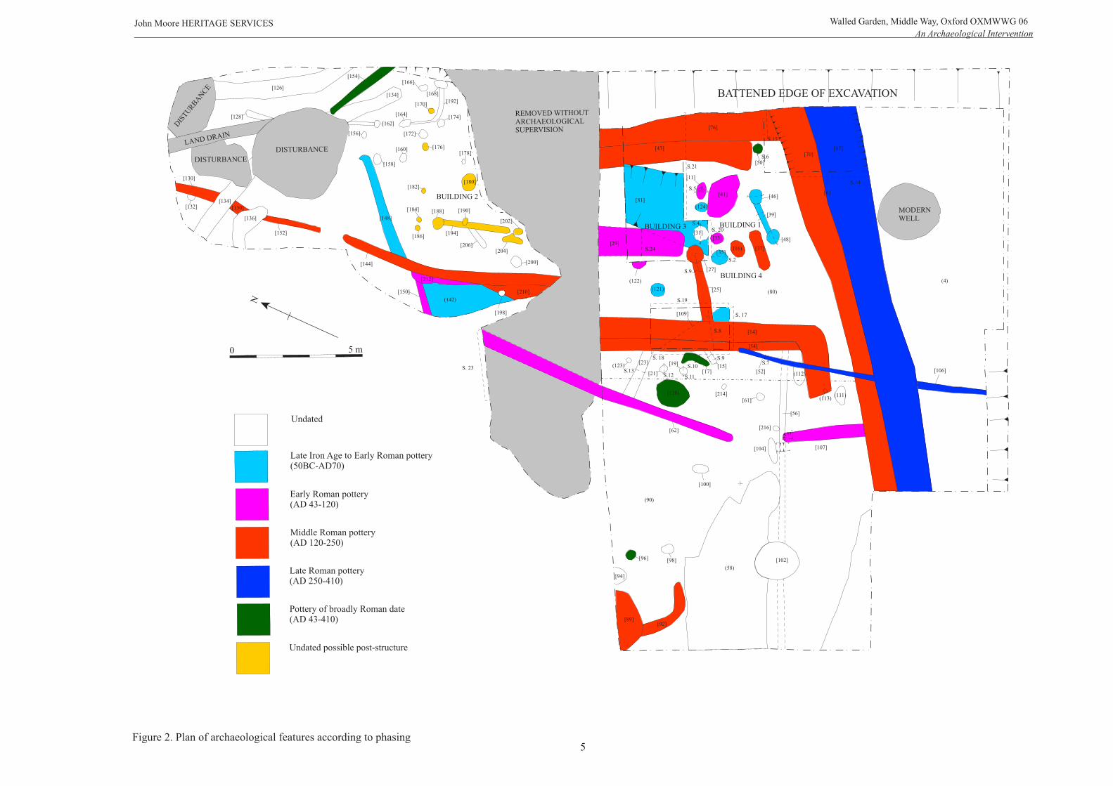
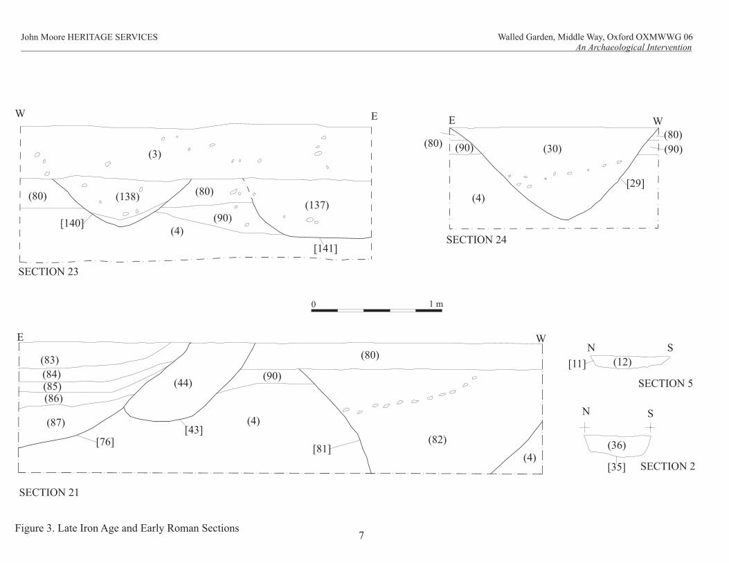
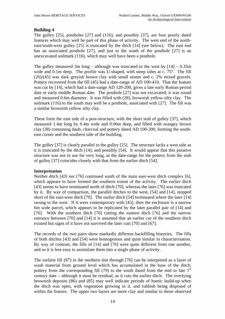
4 RESULTS (Figure 2) All deposits and features were assigned individual context numbers. Context numbers in [ ] indicate features i.e. cuts; while numbers in ( ) show feature fills or deposits of material; in certain cases, namely soil discolourations observed during the surface recording, numbers in ( ) also refer to putative features. All measurements are given in metres. A general description of the feature fills is given. CBM refers to ceramic building material (daub and tile). THE ROMAN GROUND SURFACE Overlying the Summertown-Radley gravels (4) was a mottled yellowish grey clay silt subsoil (90), with c. 2% mixed gravels, which was up to 0.2m thick. The mottling observed can probably be attributed to bioturbation. The west side of the site was stripped to the top of the subsoil (90), as visibility was poor at the level of the overlying Roman ground surface (80), with no features being easily identifiable. The areas on the east and north parts of the site were stripped to the top of the archaeology, a Late Iron Age/early Roman ground surface (80), through which the majority of the archaeological features were observed to have been cut. This overlay the subsoil (90), which was observed to have extended across to the east side of the site. The subsoil was not observed on the north part of the site, as no excavation was carried out here. The ground surface (80) was a firm yellow mottled grey to orange mottled brown silty clay containing c. 15% gravel, which extended across the site and was 0.2m thick. The layers (80.1) and (80.2) refer to particular areas of the ground surface for the purposes of finds’ location; to which end, (80.1) refers to the area in the vicinity of Building 1, and (80.2) refers to the area at the end of the gulley [148]. The layer (58) on the west side of the excavation area was a thicker deposit of the Roman ploughsoil (80), and numbered for finds collection. Undated features On the west side of the site were a number of undated features, which were only observed during machining through the Roman ground surface (80) onto the subsoil (90). Some of these such as the gulley [56] may be part of the earliest phase of activity. Enclosure gulley [56] which was only observed cut into (90) was an east-west aligned feature measuring 0.25m wide and possibly more than 11m long. It was only excavated where it was cut by the north-south ditch/gulley [107]. It was filled by (57) a yellow/orange grey silty clay containing more than 5% mixed gravels. It does not appear to be easily relatable to any other features in the immediate vicinity. LATE IRON AGE TO EARLY ROMAN PERIOD (50BC – AD70) (FIGS 2 & 3) South area of investigation In the east part of the site, cutting (90) and poorly visible within the top of the ground-surface (80), were two late prehistoric features, [81] and [109]. The former, [81], was the better investigated of the two; it was initially believed during the site-investigation that these features were ditches, although it is equally possible that they were borrow pits. The broad cut [81] measured more than 1.85m wide and 0.8m deep. It was observed during machining of (80) over a north-south distance of at least 3m; consequently, a box-slot was excavated for a section through it. The east side was a moderately convex edge at c. 75°, whereas the angle of the west side of the ditch was at c. 45°, but was not fully observed. It was filled with stiff brownish yellow to pale
Undated
Late Iron Age to Early Roman pottery(50BC-AD70)
Early Roman pottery(AD 43-120)
Middle Roman pottery(AD 120-250)
Late Roman pottery(AD 250-410)
Pottery of broadly Roman date(AD 43-410)
BUILDING 4
DIS
TUR
BA
NC
E
LAND DRAIN
DISTURBANCE
DISTURBANCE
[168]
[174]
[172]
[164]
[160]
[162]
[158]
[156]
REMOVED WITHOUT ARCHAEOLOGICALSUPERVISION
[204]
[202]
[180]
[188]
[194]
[170]
[176]
[182]
[184]
[186][48]
[46]
[35]
[124]
[39]
[33]
[41]
[11]
(122) (4)
[14]
[54]
[43]
S. 17
S.19
[29]
0 5 m
N
[150]
[212]
[190]
[206]
[126]
[128]
[132]
[130]
[134][130]
[136]
[144]
[148]
[154]
[134]
[166]
[178]
[200]
[198]
(90)
(80)
(123)
(121)
(142)
[76]
[6]
MODERNWELL
[81]
[37]
[25]
[106]
[31]
[27]
[50]
[17]
[92][89]
[94]
[96] [98]
[10 ]0
(58)
[102]
[61](111)
[104]
[15]
[21]
(120)(113)
(112)
[19]
[52]
S. 18[23]
[107]
[56]
[62]
BATTENED EDGE OF EXCAVATION
[214]
[216]
[109]
Undated possible post-structure
[210]
S. 20
S.21
[152]
BUILDING 2
BUILDING 1BUILDING 3
[41]
(116)
S. 23
John Moore HERITAGE SERVICES An Archaeological Intervention
Walled Garden, Middle Way, Oxford OXMWWG 06
Figure 2. Plan of archaeological features according to phasing
[192]
5
[70][67]
[6]
S.14S.5
S.4
S.6
S.15
S.2
S.24
S.13
S.7
S.12
S.10
S.11
S.9
S.8
S.9
John Moore HERITAGE SERVICES Walled Garden, Middle Way, Oxford OXMWWG06 An Archaeological Intervention
6
grey yellow silty clay (82); a spread of stone within the fill ran from west to east which may indicate the existence of a bank to the west that slumped into the feature, or merely have been part of the backfilling of the borrow pit. Pottery recovered from the fill (82) yielded a Late Iron Age or early Roman date. To the west of this feature, a second cut [109] was also observed, though was less well examined. It was not possible to investigate the western extent of the feature at all, as this extended beyond the edge of the excavation area. The feature was at least 3m wide and c. 0.8m deep; its length is unknown, but was greater than 3m. The cut was flat-bottomed with sides at c. 45° and appeared to lie across the site on a north-northwest/south-southwest orientation. The fill (110) was brownish yellow silty clay with c. 5% gravel. No finds were recovered during the excavation. Both of these features were sealed by (80), the Roman ground surface. This layer, (80), was a 0.2m thick layer of yellow silty clay and gravel with much mottling, indicating a former ploughsoil. Pottery recovered from this layer dated from the first half of the first century AD through to the second century. On the west side of the excavation area pottery and bone were also recovered from the surface of this layer, (58); the pottery also dated from the first century AD. Building 1 Postholes [48] and [46] were linked by a short gulley [39]. Both postholes [48] and [46] were 0.45m in diameter and c. 0.1m deep, with concave sides and base. Filled with (49) and (47), respectively, a mid orangey brown sandy clay with charcoal and daub flecking, these postholes were paired, and linked by the gulley [39]. The fill (47) contained pottery dating from the late Iron Age/early Roman period. The gulley [39] was c. 1.4m long, c. 0.2m wide and c. 0.1m deep. The fill (40) was the same as that for the associated postholes, the pottery was dated to broadly Roman, and so was not diagnostic. To the north, the pair of postholes [35] and (124) form the opposing side of a putative structure. The posthole [35] was circular and measured 0.65m in diameter and 0.15m deep, it was filled with (36), a mottled orangey brown silty clay with 1% mixed gravels. The circular feature (124) which was observed, but not excavated, measured c. 0.4m in plan and was filled with yellowish brown silty clay with orangey brown mottling, and c. 1% charcoal. This group of features may be a four-posted granary or similar structure such as a gable-end of a small out-building. It is possible that the structure may have extended further northwest and that (121), which had a similar fill to (47) and (49), was part of a larger building, with the corresponding post of the pair to the east, which was not seen during the surface recording. As such, it may indicate a six-posted structure. Although few of the features contained finds, [35] did contain CBM. The finds (80.1) refer to pottery from the immediate area of the building, and date from the Late Iron Age or early Roman period. North area of investigation Further to the north and cut into (80) was a gulley [148] as well as an area of hardstanding (142), which may be associated with the undated structure to the east, Building 2. The feature [148], an approximately east-west oriented length of gulley,
(12)[11]
SN
SECTION 5
(30) (90)
(80)
[29]
(80)(90)
E W
0 1 m
(83)
(84)
(85)
(86)
(87)
[76] (82)
(80)
[81]
(44)(90)
(4)
(4)
SECTION 21
(36)
[35]
N S
SECTION 2
W E
(80) (138)
[140]
(80)
(90)
(137)
[141]
(4)
E W
John Moore HERITAGE SERVICES
An Archaeological Intervention
Figure 3. Late Iron Age and Early Roman Sections7
Walled Garden, Middle Way, Oxford OXMWWG 06
SECTION 23
SECTION 24
(3)
[43]
(4)
John Moore HERITAGE SERVICES Walled Garden, Middle Way, Oxford OXMWWG06 An Archaeological Intervention
8
measured c. 4m long and 0.35m wide. The fill was moderately compact to hard mid reddish brown clay silt, with 1-2% mixed gravels and 1% charcoal. The feature was sampled for dating and pottery was recovered from the terminal of this feature, yielding a date in the late Iron Age or Early Roman period. The finds (80.2) came from the ground surface in the vicinity of the terminal, and were recovered during machining. The feature was cut at the west end by the north-south linear feature [144]. On the west side of the north part of site an area of hardstanding (142), comprising very indurated sandy clay, yielded dating material, and may possibly be related to Building 2. This surface was cut by the later gulley [150] to the north, while to the south, the hardstanding (142) was cut by the feature [210], itself cut by the gulley [144] (see below). Building 2 A number of features, ten postholes and a gulley, form the observed remains of a structure, Building 2. Four postholes from the north side of the building were recorded in plan [184], [182], [176], [170]. The posthole [186] may also form part of the structure. These postholes were aligned west-northwest/east-southeast. The building extended to the east and to the south beyond the edge of excavation. The fills (183), (181), (175), (169) and (185) of the postholes were homogenous mid orangey brown silty clay. At the west end of the building a north/south aligned linear feature [194]/[208] was surface recorded, which was considered to be a slot for a beam. The beam-slot was oriented north-northeast/south-southwest and measured approximately 2.5m long and c. 025m wide. It was filled with dark brownish grey mottled yellowish brown silty clay (193)/(207), with c. 2% charcoal and 1-2% mixed gravels. The beam-slot cut a northeast/southwest oriented undated gulley stub[206], measuring 1m long and 0.4m wide filled with grey brown silty clay (205). At the north end of the gulley was the posthole [188], which was filled with a similar fill (187) to the postholes above, at the south end was posthole [202], also filled with a similar fill (201) to the postholes above. Posthole [180] was a large circular feature measuring c. 0.6m in diameter, located 1.25m east of the gulley [194]/[208] and approximately halfway along it. It was filled with (179) dark brownish grey silty clay with c. 2% charcoal flecking. The greater diameter of the posthole may well indicate that this was a roof-bearing posthole. It is possible that the posthole [190], which cuts the gulley [194]/[208], may be a later repair to the structure. It measured 0.3m by 0.4m and was located west of the post-bearing posthole [180]; it was filled with a similar fill (189) to the other postholes described in this section. Similarly, the irregularly shaped feature [204] located between and to the west of [194]/[208] may equally indicate repairs to the structure. The fill was the same as the above postholes, but as the feature was unexcavated, it is not clear whether its surface shape indicates two phases to the siting of a post here at the gable-end of the building. No dating material was recovered from any of the features associated with the building. The structure, as observed, measured at least 4m in width and at least 5m in length. Due to unsupervised machining to the south it is not possible to reconstruct the southern wall of the building, which appears to have been a rectangular structure with
John Moore HERITAGE SERVICES Walled Garden, Middle Way, Oxford OXMWWG06 An Archaeological Intervention
9
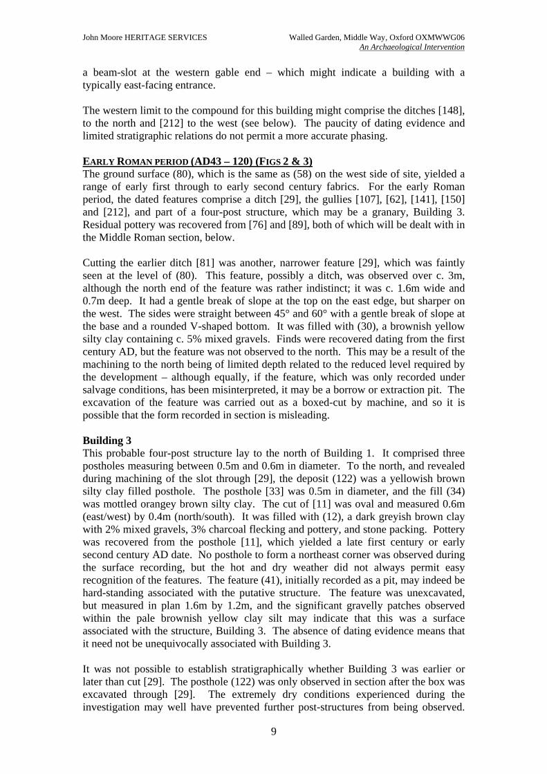
a beam-slot at the western gable end – which might indicate a building with a typically east-facing entrance. The western limit to the compound for this building might comprise the ditches [148], to the north and [212] to the west (see below). The paucity of dating evidence and limited stratigraphic relations do not permit a more accurate phasing. EARLY ROMAN PERIOD (AD43 – 120) (FIGS 2 & 3) The ground surface (80), which is the same as (58) on the west side of site, yielded a range of early first through to early second century fabrics. For the early Roman period, the dated features comprise a ditch [29], the gullies [107], [62], [141], [150] and [212], and part of a four-post structure, which may be a granary, Building 3. Residual pottery was recovered from [76] and [89], both of which will be dealt with in the Middle Roman section, below. Cutting the earlier ditch [81] was another, narrower feature [29], which was faintly seen at the level of (80). This feature, possibly a ditch, was observed over c. 3m, although the north end of the feature was rather indistinct; it was c. 1.6m wide and 0.7m deep. It had a gentle break of slope at the top on the east edge, but sharper on the west. The sides were straight between 45° and 60° with a gentle break of slope at the base and a rounded V-shaped bottom. It was filled with (30), a brownish yellow silty clay containing c. 5% mixed gravels. Finds were recovered dating from the first century AD, but the feature was not observed to the north. This may be a result of the machining to the north being of limited depth related to the reduced level required by the development – although equally, if the feature, which was only recorded under salvage conditions, has been misinterpreted, it may be a borrow or extraction pit. The excavation of the feature was carried out as a boxed-cut by machine, and so it is possible that the form recorded in section is misleading. Building 3 This probable four-post structure lay to the north of Building 1. It comprised three postholes measuring between 0.5m and 0.6m in diameter. To the north, and revealed during machining of the slot through [29], the deposit (122) was a yellowish brown silty clay filled posthole. The posthole [33] was 0.5m in diameter, and the fill (34) was mottled orangey brown silty clay. The cut of [11] was oval and measured 0.6m (east/west) by 0.4m (north/south). It was filled with (12), a dark greyish brown clay with 2% mixed gravels, 3% charcoal flecking and pottery, and stone packing. Pottery was recovered from the posthole [11], which yielded a late first century or early second century AD date. No posthole to form a northeast corner was observed during the surface recording, but the hot and dry weather did not always permit easy recognition of the features. The feature (41), initially recorded as a pit, may indeed be hard-standing associated with the putative structure. The feature was unexcavated, but measured in plan 1.6m by 1.2m, and the significant gravelly patches observed within the pale brownish yellow clay silt may indicate that this was a surface associated with the structure, Building 3. The absence of dating evidence means that it need not be unequivocally associated with Building 3. It was not possible to establish stratigraphically whether Building 3 was earlier or later than cut [29]. The posthole (122) was only observed in section after the box was excavated through [29]. The extremely dry conditions experienced during the investigation may well have prevented further post-structures from being observed.
John Moore HERITAGE SERVICES Walled Garden, Middle Way, Oxford OXMWWG06 An Archaeological Intervention
10
The pottery from the two features, however, points to Building 3 being a little later than the feature [29]. To the north, truncated by the later gulley [144] was a short length, c. 2.5m, of gulley [212] which was also dated to the early Roman period. It was not excavated. It is possible that [144] is a later re-cut and extension of the ditch [212]. Unfortunately, due to the constraints on excavation-levels, it did not prove possible to further investigate the features, nor their stratigraphic relationships. A number of postholes were also observed which cannot be associated with any other features. These were observed across the northern investigation area. Most were undatable. The posthole [132] was stratigraphically earlier than the Middle Roman period, however, and was round with c. 0.3m diameter, truncated to the east by [130]. It was filled with mid orangey brown silty clay (131). No finds were recovered from the fill. Enclosure gulley [107], [62], [141] & [150] The gulley [107] was 0.3m wide and approximately 3m long – it was truncated to the south by the ditch complex [6] – and was filled by (108), a deposit of yellowish brown silty clay with c. 5% mixed gravels. The pottery recovered from the fill provided a rather wide date-range of AD 43-410; however, if the date-range for (5B) is applied to that part of [6] which cuts [107], then the gulley probably is earlier than the 2nd century AD. The gulley [107] cut the east/west gulley [56], which is already provisionally dated to the earlier part of the first century AD. The gulley [107] appeared to form the opposing side to an enclosure, with the gulley [62] forming the north arm. A two-metre gap existed between the two arms, which may have been an entrance to the enclosure. To the north of the gap was the corresponding gulley [62], c. 0.4m wide and at least 5.2 m long, oriented southwest/northeast. The gulley [62] was filled with yellowish brown silty clay (59) containing c. 2% mixed gravels. No surface finds were recovered. The limited quantity, and ambiguous nature, of the finds means that it is hard to associate these two gullies with other features observed to the north. Nonetheless, it is possible that [62] may well be part of [150], and possibly [148] (see above), in the northern area of investigation. The gulley [150] to the north, which yielded no dating material during pick-up, and which was itself cut by the gulley [212] was oriented north-east/south-west, measured 1.3m (observed length) by 0.25m wide, and was filled with mid grey brown silty clay (149) containing 2% mixed gravels and c. 1% charcoal. This may also be the gulley [141], which was observed in the north section of the western part of unsupervised disturbance (S. 23). Although this was only partially seen, the fill (137) is not dissimilar. The linear feature [23] was only faintly visible to the northwest, although it appeared to be truncated by [62], to the east it was cut by [54]. The feature was not excavated. It measured more than 1m in length, 0.36m in width and at least 0.05m in depth. The fill (24) was yellowish grey clay with c. 5% small stone. Although it is not easily interpretable, it is at a right angle to [62], which may indicate that it functioned as part of the enclosure. Its relationship with [62] is uncertain, as it was not excavated during the investigation, since it lay at the reduced level for construction work. Certainly, by the time [54] was excavated, it had fallen out of use.
0 1 m
(45)(13)
(55)
[14]
[25][54]
W E
SECTION 8
[25]
SN
SECTION 19
[109]
(80)
(77)
(78)
(79)[76]
SECTION 15
EW
Figure 4. Middle Roman sections
John Moore HERITAGE SERVICES
An Archaeological Intervention
11
Walled Garden, Middle Way, Oxford OXMWWG 06
(4)
(45)
(26)
[25]
W E
(36)
[35]
SECTION 1
John Moore HERITAGE SERVICES Walled Garden, Middle Way, Oxford OXMWWG06 An Archaeological Intervention
12
MIDDLE ROMAN PERIOD (AD120 – 250) (FIGS 2, 3 & 4) The middle Roman period was the best-represented phase of activity evidenced on the site, with second-century pottery dominating the assemblage. The features from this period were all cut through the ploughsoil (80), and were observed during the initial phase of machining. The features are dominated by four north-south ditches which were observed in the southern area of investigation, carried out in July 2006, but were not subsequently seen in January 2007 in the north area. The north-south ditches [54] & [14] and [43] & [76] Ditches [54] & [14] On the west side of the south area of investigation, a pair of north-south oriented ditches [54] and [14], parallel to [43] and [76], were observed. These two ditches were cut through layer (80) into the top of the putative ditch or borrow pit [109]. The earlier cut was a north-south V-shaped ditch [54], which measured at least 7.5m long, 0.9m wide (as observed) and 0.6m deep. The break of slope was gently rounded at the top and the base with relatively straight sides at c. 45° and a rounded V-shaped base. It was filled with (55), a firm yellowish to orangey grey silty clay fill with c. 5% mixed gravels. It appears to have been swiftly recut as [14]. Ditch [14] cut the ditch [54], following the same north-south alignment, and appeared to swing to the west at the south end of the ditch. The ditch was a shallower feature than [54], measuring more than 8.5m long, c. 0.9m wide and c. 0.25m deep. It was filled with dark grey brown silty clay (13) which contained more than 30% mixed gravels, 4-5% charcoal and burnt clay or daub. The feature extended beyond the edge of excavation and may well be the ditch [210] observed in January 2007. It was not possible to ascertain the shape of [210], as it was truncated to the east, and extended beyond the edge of excavation to the south and west, with only the northwest edge of the feature observed. The fill was sampled for dating, but none was recovered. The fill of [210] was mid greyish brown clay silt loam (209) containing 3% mixed gravels, 3% charcoal, 2% burnt clay and 2% yellow clay. The fill moreover appears to resemble strongly that of [14]. The pottery from [54] and [14] was chronologically quite tight – the former dated c. AD 100-200, whereas the latter was dated AD 120-200 – suggesting backfilling of [54] followed by a rapid re-excavation and backfilling of [14]. As no dating was recovered from [210], it is not possible to further refine the date-range. To the west of these ditches were a number of postholes – seen during the machining of the area onto (80). The postholes (123), [21], [19], [214], (216), (61) may well be a fence line associated with the ditch [14], which also curves round to the west at the south end. No dating was recovered from these postholes, although a number of the features in this group of postholes were excavated. From north to south, posthole (123) was 0.25m diameter, and was filled with stiff yellowish brown silty clay. To the south was posthole [21], a round feature measuring 0.45m diameter and 0.12m deep. The break of slope was sharp at the top and gentle at the bottom; the base was flat. It was filled with (22), greyish yellow clay with c. 5% small stone. Posthole [19] was 0.3m diameter and 0.04m deep. The break of slope at the top was gentle, at the bottom it was sharp. The base was flat. The posthole was filled with (20), which was similar to (22). Posthole [214] was located
John Moore HERITAGE SERVICES Walled Garden, Middle Way, Oxford OXMWWG06 An Archaeological Intervention
13
south and west of [19], appearing to form part of a curve to the west; it measured 0.25m in diameter, and was filled with (213), which was similar to (22), though had no small stone present. Posthole [61] was 0.3m in diameter and filled with (60), which was similar to (213). Posthole [216] was 0.3m in diameter and filled with greyish yellow silty clay (215). This line of postholes appears to define an area mirroring that defined by the ditch [14] – although that should not be understood to mean that the ditch [54] and the putative fence line were coeval. It is not clear whether the laying out of the line of postholes is contemporary, or whether it is an earlier or later phase of the enclosure. It is clear that the bank for [54] would have been to the west covering the postholes, which indicates that the fence line predates the ditch [54], and as such may only ever have been intended as a temporary structure. Ditches [43] & [76] The area to the east was stripped to the top of the archaeology, the Roman ploughsoil (80), into which the archaeological features were cut. The north-south ditches [43] and [76] were located on the east side of the excavation area. The earlier ditch [43] measured more than 7m long, over 2m wide and 1.2m deep. It was filled with (44), a yellowish brown silty clay, containing a small percentage, 1-2%, of mixed gravel. Although it was not hand-excavated, it was recorded in section following machining and it was apparent that it was truncated to the east by the later ditch [76]. It terminated before the north edge of the east-west ditch [6]. The ditch [76] was also aligned north-south, measuring more than 7m in length, 1.3m (as observed) in width and c. 1.2m in depth. It was not fully examined as it extended beyond the edge of site on its east side. All the fills from this feature were very close to one another in composition. The earliest fill observed was (79), a stony (>10% small stone) yellowish grey clay, c. 0.2m thick. This fill extended from 0.5m below ground-level on the west edge of the cut to c. 1m below ground-level towards the probable centre of the cut. This fill might indicate slumping, backfilling the feature. Overlying this deposit was a similar, if more yellowish grey clay fill (78), which was c. 0.4m thick. Sealing these was the final backfilling episode (77), the edges of which were very diffuse, and ran into (78); it was also a stony yellowish grey clay, c. 0.6m thick. The ditch [76] was truncated by the cut [70] of the ditch complex [6]. It did not extend beyond the south edge of [6], and nor was it visible in the east section of the ditch [6]. Further machine excavation of the ditch [76] was also carried out to the north. The east edge of the feature was again under the edge of site, and could not be examined. The fill-sequence here was slightly different, with five deposits identified. The earliest deposit (87) was a yellowish grey silty clay with <5% mixed gravels. It was more than 1.8m wide and c. 0.45m thick. This was overlain by (86) a more orangey brown silty clay with c. 5% mixed gravels. It was more than 2m wide and c. 0.25m thick. A pale brown clay (85), 0.2m thick, overlay and sealed (86). Overlying (85) was a deposit of brownish yellow clay (84) with much less gravel than the underlying the features, and which was 0.2m thick. The feature was sealed by (83), a firm yellowish brown silty clay with less c. 5% mixed gravels, 0.4m thick and more than 2.3m wide. Dating material from the ditch indicates that it was probably back-filled deliberately, as the pottery dates from the course of the 1st century. In contrast, the earlier ditch [43] was filled with solidly 2nd century pottery.
John Moore HERITAGE SERVICES Walled Garden, Middle Way, Oxford OXMWWG06 An Archaeological Intervention
14
Building 4 The gulley [25], postholes [27] and (116), and possibly [37], are four poorly dated features which may well be part of this phase of activity. The west end of the north-east/south-west gulley [25] is truncated by the ditch [14] (see below). The east end has an associated posthole [27], and just to the south of the posthole [27] is an unexcavated soilmark (116), which may well have been a posthole. The gulley measured 3m long – although was truncated to the west by [14] – 0.35m wide and 0.1m deep. The profile was U-shaped, with steep sides at c. 75°. The fill (26)/(45) was dark greyish brown clay with small stones and c. 2% mixed gravels. Pottery recovered from the fill (45) had a date-range of AD 100-410. That the feature was cut by [14], which had a date-range AD 120-200, gives a late early Roman period date or early middle Roman date. The posthole [27] was not excavated; it was round and measured 0.6m diameter. It was filled with (28), brownish yellow silty clay. The soilmark (116) to the south may well be a posthole, associated with [27]. The fill was a similar brownish yellow silty clay. These form the east side of a post-structure, with the short stub of gulley [37], which measured 1.4m long by 0.4m wide and 0.06m deep, and filled with orangey brown clay (38) containing daub, charcoal and pottery dated AD 100-200, forming the south-east corner and the southern side of the building. The gulley [37] is clearly parallel to the gulley [25]. The structure lacks a west side as it is truncated by the ditch [14], and possibly [54]. It would appear that this putative structure was not in use for very long, as the date-range for the pottery from the stub of gulley [37] coincides closely with that from the earlier ditch [54]. Interpretation Neither ditch [43] nor [76] continued south of the main east-west ditch complex [6], which appears to have formed the southern extent of the activity. The earlier ditch [43] seems to have terminated north of ditch [70], whereas the later [76] was truncated by it. By way of comparison, the parallel ditches to the west, [54] and [14], stopped short of the east-west ditch [70]. The earlier ditch [54] terminated where the later [14] swung to the west. If it were contemporary with [43], then the enclosure is a narrow 6m wide parcel, which appears to be replicated by the later parallel pair of [14] and [76]. With the southern ditch [70] cutting the eastern ditch [76] and the narrow entrance between [70] and [14] it is assumed that an earlier cut of the southern ditch existed but signs of it have not survived the later cuts [70] and [67]. The records of the two pairs show markedly different backfilling histories. The fills of both ditches [43] and [54] were homogenous and quite similar in characterisation. By way of contrast, the fills of [14] and [76] were quite different from one another, and so it is less easy to assimilate them into a single phase of activity. The earliest fill (87) in the northern slot through [76] can be interpreted as a layer of wash material from ground level which has accumulated in the base of the ditch; pottery from the corresponding fill (79) to the south dated from the mid to late 1st century date – although it must be residual, as it cuts the earlier ditch. The overlying brownish deposits (86) and (85) may well indicate periods of humic build-up when the ditch was open, with vegetation growing in it, and rubbish being disposed of within the feature. The upper two layers are more clay and similar to those observed
John Moore HERITAGE SERVICES Walled Garden, Middle Way, Oxford OXMWWG06 An Archaeological Intervention
15
to the south, where the backfilling of the feature is overall more homogenous. It is noticeable that more humic or loamy deposits were observed to the north, whereas at the junction of [70] and [76] the fills were more leached. Enclosure gullies/ditches and pits On the west side of the northern extension to the site, investigated in January 2007, three lengths of north/south ditches [144], [152] and [130] were observed and recorded. All three lengths of gulley had markedly different morphologies and fills; nonetheless, despite the relationships between them being irresolvable, it may be not unreasonable to associate them with one another. These may, moreover, be associated with Building 2. From the south beyond the edge of excavation, the linear feature [144] extended north, measuring c. 9m long, before ending with a rounded terminal; it was between 0.4m and 0.5m wide. Although it was not excavated, it was sampled for dating material and the uppermost part (c. 0.2m) of the feature appeared to have straight sides and perhaps a flat bottom. The various fill numbers for [144], (143), (145) and (195) describe a dark greyish brown almost black clay loam with up to 15% charcoal flecking, c. 5% daub or burnt clay flecking, and c. 3% mixed gravel. The date-range for the feature is AD 50-200. The gulley truncated a number of earlier features, including [210], which is the extension of [14] into the north area of investigation. Approximately 1m north of [144] was a narrower linear feature [152], c. 2.3m long and 0.15m wide. This was filled with (151), dark orangey brown clay sand, with c. 2% charcoal flecking. The later undated feature [136], possibly an area of gravelly hard standing, to the north overlay or truncated [152], concealing, or having removed in antiquity, any relationship between the gullies [152] and [130]. The gap between the gullies [144] and [152] appeared to be real, rather than being due to the shallowness of [152], although as the gulley [152] was not excavated this cannot be asserted unequivocally. Nonetheless the marked dissimilarity in the fills of the two gullies would seem to strengthen rather than refute such an interpretation. The fill of ditch [130] was, again, quite dissimilar from [152] and [144]. The fill (129) was dark orangey brown silty clay containing c. 10% gravel and c. 2% charcoal flecking; no finds were recovered from the fill (129), nor from (151). The cut [130] truncated a small posthole [132] to the west, which was rounded and measured 0.3m diameter. The fill (131) was mid orangey brown silty clay, and contained no apparent inclusions. These linear features are part of a single enclosure, although it is not possible, given the limited remains, to establish what they were enclosing. In the northwest corner of the west area of investigation was a possible pit [89], which was sub-circular and extended beyond the edge of excavation. It was at least 2m long (east-west) and 1m (north-south). It was not excavated. The fill (88) was a light brownish grey silty clay with c. 10% gravel and c. 2% charcoal. Pottery recovered from the feature yielded a date-range of AD 43-70. The pit, however, cut the linear feature [92], dated mid/late 2nd century. The curved L-shaped feature [92], which was truncated by [89] to the north, measured 1.8m (north-south) and c. 1.2m (east-west); the gulley was 0.6m wide. It was filled with light brownish grey silty clay (91) with
John Moore HERITAGE SERVICES Walled Garden, Middle Way, Oxford OXMWWG06 An Archaeological Intervention
16
c. 40% gravel and c. 2% charcoal flecking. Pottery was recovered with a date-range in the middle Roman period. The presence of features on the west side of site appears to indicate that occupation might extend beyond the west edge of investigation area. The postholes [94], [96] and [98] (see below), which were only broadly dated to the Roman period, and the curved gulley [92] and pit [89] seem to indicate that further farmstead activities may have continued under the housing estate located at Bishop Kirk Place, the site of the former Bishop Kirk School. LATE ROMAN PERIOD (FIGS 2 & 5) Ditch complex [6] On the south side of the stripped area was a broad east-west complex of ditches [6] (Fig. 3). This feature-complex largely defined the southern extent of the main archaeological remains. A single gulley [106] was observed to extend south of the ditch [6], but no further archaeological remains were present. The gulley [106] was also seen north of the ditch [6], where it was numbered [52]. The ditch complex [6] cut the earlier north-south aligned ditch [76], although the other ditches [43], [14] and [54] all stopped short of it. The investigation of the feature was limited to a single slot through the ditch [6], the pottery from which was bagged up as coming from the upper 0.6m of the slot (as context 5) or from the lower 0.6m (5B). It appeared to comprise two main phases of activity – 3rd/4th century AD and 2nd century AD, respectively. Subsequently the section drawn of the feature demonstrated a more complex stratigraphy of gullies, ditches and ditch recuts. The ditches were apparently cut and recut on a number of occasions. Six ditch cuts were recorded during excavation ([70], [119], [63], [118], [117] and [67]), and these contained a total of ten fills – (75), (73), (74), (72), (71), (64), (66), (65), (69) and (68). Pottery was recovered from three sealed contexts; (71), (74) and (75), the first two contexts are associated with a later phase ditch [119], the last context with an earlier ditch [70]. The date-range for the assemblages from [119] and [70] was AD 43-410. By way of contrast, the date-range for the two groups of undifferentiated collection gave a more precise date-range than that from the sealed contexts. A date of AD 100-150 was extrapolated for the lower and earlier pottery (5B), while the later, upper assemblage (5) yielded a date-range of AD 240-300. As a consequence, the ditch can be said to have been in use over much of the period as the rest of the site. The ditch was cut by the gulley [52]/[106], which yielded date-ranges of AD 240-410/43-410, appearing to postdate the final backfilling of the ditch [67]. The cut [118] lay on the south side of the ditch-complex [6]. Most of it was truncated to the north by the final phase ditch [67]; additionally, it had previously been truncated by the gulley or ditch [117]. The gulley [118] was at least 0.48m wide and 0.4m deep. Its extent is unknown, but it was filled with greyish yellow sandy clay (66) with more than 5% mixed gravels. Cutting this feature was [117], a probable linear feature measuring 0.14m wide and 0.15m deep and filled with greyish brown silty clay (65) with more than 5% mixed gravels, which also cut the linear feature [63], which was more than 0.19m wide and 0.1m deep. This group of three gullies
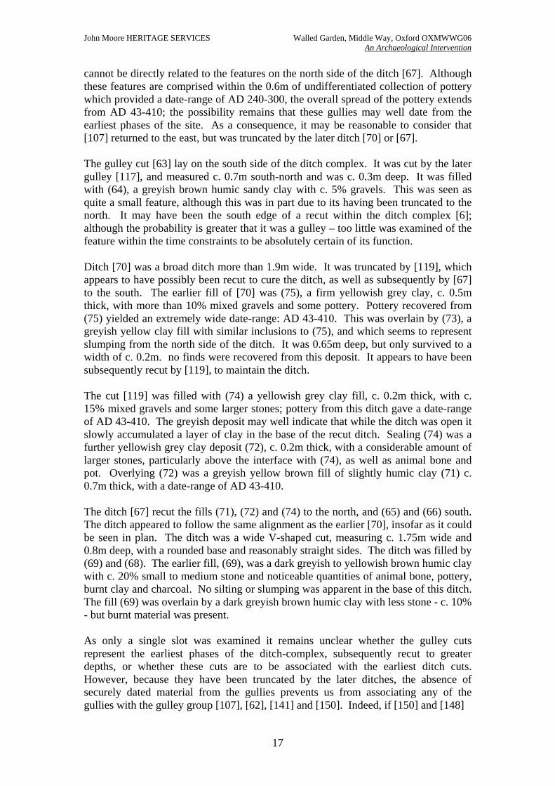
John Moore HERITAGE SERVICES Walled Garden, Middle Way, Oxford OXMWWG06 An Archaeological Intervention
17
cannot be directly related to the features on the north side of the ditch [67]. Although these features are comprised within the 0.6m of undifferentiated collection of pottery which provided a date-range of AD 240-300, the overall spread of the pottery extends from AD 43-410; the possibility remains that these gullies may well date from the earliest phases of the site. As a consequence, it may be reasonable to consider that [107] returned to the east, but was truncated by the later ditch [70] or [67]. The gulley cut [63] lay on the south side of the ditch complex. It was cut by the later gulley [117], and measured c. 0.7m south-north and was c. 0.3m deep. It was filled with (64), a greyish brown humic sandy clay with c. 5% gravels. This was seen as quite a small feature, although this was in part due to its having been truncated to the north. It may have been the south edge of a recut within the ditch complex [6]; although the probability is greater that it was a gulley – too little was examined of the feature within the time constraints to be absolutely certain of its function. Ditch [70] was a broad ditch more than 1.9m wide. It was truncated by [119], which appears to have possibly been recut to cure the ditch, as well as subsequently by [67] to the south. The earlier fill of [70] was (75), a firm yellowish grey clay, c. 0.5m thick, with more than 10% mixed gravels and some pottery. Pottery recovered from (75) yielded an extremely wide date-range: AD 43-410. This was overlain by (73), a greyish yellow clay fill with similar inclusions to (75), and which seems to represent slumping from the north side of the ditch. It was 0.65m deep, but only survived to a width of c. 0.2m. no finds were recovered from this deposit. It appears to have been subsequently recut by [119], to maintain the ditch. The cut [119] was filled with (74) a yellowish grey clay fill, c. 0.2m thick, with c. 15% mixed gravels and some larger stones; pottery from this ditch gave a date-range of AD 43-410. The greyish deposit may well indicate that while the ditch was open it slowly accumulated a layer of clay in the base of the recut ditch. Sealing (74) was a further yellowish grey clay deposit (72), c. 0.2m thick, with a considerable amount of larger stones, particularly above the interface with (74), as well as animal bone and pot. Overlying (72) was a greyish yellow brown fill of slightly humic clay (71) c. 0.7m thick, with a date-range of AD 43-410. The ditch [67] recut the fills (71), (72) and (74) to the north, and (65) and (66) south. The ditch appeared to follow the same alignment as the earlier [70], insofar as it could be seen in plan. The ditch was a wide V-shaped cut, measuring c. 1.75m wide and 0.8m deep, with a rounded base and reasonably straight sides. The ditch was filled by (69) and (68). The earlier fill, (69), was a dark greyish to yellowish brown humic clay with c. 20% small to medium stone and noticeable quantities of animal bone, pottery, burnt clay and charcoal. No silting or slumping was apparent in the base of this ditch. The fill (69) was overlain by a dark greyish brown humic clay with less stone - c. 10% - but burnt material was present. As only a single slot was examined it remains unclear whether the gulley cuts represent the earliest phases of the ditch-complex, subsequently recut to greater depths, or whether these cuts are to be associated with the earliest ditch cuts. However, because they have been truncated by the later ditches, the absence of securely dated material from the gullies prevents us from associating any of the gullies with the gulley group [107], [62], [141] and [150]. Indeed, if [150] and [148]
(53)
E W
[52]
SECTION 7
SN
SECTION 14
(68)
(71)
(72) (73)
(74)
(75)
[70]
(64) (65)
(66)
(69)
[67]
0 1 m
E W
(51)
[50]
SECTION 6
(18)
[17]
NNESSW
SECTION 10
W E
(32)
[31]SECTION 4
(16) [15]
SW NE
SECTION 9
(20)[19]
W E
SECTION 11
E W(22)
[21]SECTION 12
(24) [23]
W E
18
John Moore HERITAGE SERVICES
An Archaeological Intervention
Figure 5. Late and broadly Roman sections
Walled Garden, Middle Way, Oxford OXMWWG 06
SECTION 13
[119]
[117]
[118]
[63]
John Moore HERITAGE SERVICES Walled Garden, Middle Way, Oxford OXMWWG06 An Archaeological Intervention
19
are part of the one single feature, then these would have been parallel to the gullies within the ditch [6]. Gulley [52]/[106] A narrow north-south gulley [52] was observed which is in line with the gulley [106] on the south side of the ditch [6]. The gulley [52] was at least 4.7m long, 0.2m wide and 0.06m deep. The cut was a shallow U-shape with gentle break of slope at the top and base of the feature. It was filled with (53) dark grey brown clay. This feature contained pottery dating from the 3rd century AD onwards. The gulley [106] was not investigated. The feature [52]/[106] probably post-dates the ditch complex [6]. Ditch [134] & features [136] & [198] The ditch [134] cut across the north part of the northern investigation area. It cut [130], which may have been part of the middle Roman ditch [144], and was also cut by [154], which yielded only a broadly Roman date. The cut [134], which extended beyond the edge of site, was a northwest/southeast oriented linear feature observed over a length of 9.5m and 0.6m wide. The ditch was filled with dark greyish brown silty clay (133) which became paler and more yellowish to orangey brown (196) to the south. Charcoal flecking and gravel inclusions were also observed within the fill, but no finds were recovered. Just to the south of this ditch was feature [136], a curved possible linear feature, measuring 1.8m long – and extending beyond the edge of site – with a maximum width of 0.8m. It was not sampled for finds, due to time constraints, and so it is not clear whether this hard orangey brown clay/sandy clay area with more than 50% gravels and charcoal flecking was a fill or an area of hardstanding. To the east, truncating both (142) and [210] was the posthole [198], a round cut measuring 0.2m diameter, and filled with (197) dark brown clay silt loam containing charcoal flecking. This singe posthole could not be associated with any other feature in the northern investigation area. BROADLY ROMAN FEATURES (FIGS 2 & 5) On the north side of the west part of site was feature [96], a possible posthole; it was sub-circular measuring 0.34m by 0.3m. The fill (95) was pale greyish brown clay with c. 10% mixed gravels and c. 2% charcoal. The pottery was dated as broadly Roman, and it may be associated with the nearby posthole [98], which, centre-to-centre, is 1.5m distant; these features may represent part of a fence-line, although the limited remains does not preclude different interpretations. The posthole [98] was a larger feature measuring 0.55m by 0.37m and filled with a similar fill (97) to (95). No dating was recovered from posthole [98]. The unexcavated feature (120) was located in the eastern investigation area, east of the enclosure gulley [62] and west of ditch [54]. The possible pit measured c. 1.2m in diameter and was filled with yellowish brown silty clay, which had c. 4% mixed gravels spread through the deposit. The pottery from this feature could only be identified as broadly Roman. The feature [17] was an L-shaped linear feature, measuring 1m northeast-southwest by 0.3m northwest-southeast. It was 0.08m deep. It had a sharp break of slope at the
John Moore HERITAGE SERVICES Walled Garden, Middle Way, Oxford OXMWWG06 An Archaeological Intervention
20
top of the cut, which was rounded at the bottom; the base was flat. It was filled with (18) dark greyish brown clay with c. 5% small stone. At the south terminus of ditch [43] was a single posthole [50], a round feature measuring 0.48m diameter and 0.18m deep, with a sharp break of slope at the top and more gentle at the base. The fill was brownish yellow grey clay with no inclusions. The pottery was dated as broadly Roman, but no other features could be associated with it. In the northern area of investigation a northwest/southeast oriented gulley [154] or narrow ditch was recorded. It extended beyond the east edge of site, but was observed to measure at least 2.5m long and 0.3m wide. It was observed to cut the southern part of [134], but was not excavated although it was sampled for finds. These yielded a broadly Roman date. The fill (153) was mid brownish grey clay silt with c. 4% mixed gravels, and c. 3% both charcoal and daub. UNDATED FEATURES In the centre of the most dense archaeology on the east side of the investigation area was a single posthole [31], which could not be dated nor easily associated with any of the other features or structures. The posthole [31] was round, measured 0.6m diameter and was 0.1m deep. The excavator recorded that it cut [33], and had shallow sides and a flat base. The fill (32) was dark greyish brown clay with orange mottling. Daub and gravel were present in the fill. It was later than the feature [81] and may be associated with Building 1, although the lack of dating precludes its being phased. To the west, the linear feature [15] was a short stub of gulley 0.6m long, 0.26m wide and 0.08m deep. The break of slope was gentle at the top, sharp at the bottom with a flattish base. It was cut by ditch [54] to the east. The gulley was filled with (16), dark yellow grey clay and c. 2% charcoal. No finds were recovered from the gulley, nor can it be easily associated with any feature in the vicinity. The undated feature [104] lay to the northwest of the junction of the gullies [107] and [56]. It was an elongated feature, measuring c. 1m long and c. 0.4m wide. It was not excavated, nor were finds recovered from it. The fill was greyish brown mottled orange clay containing some small rounded gravel and daub. No features could be associated with it. Further undated features on the west side of the investigation area which cannot be associated with any others also include [94], [100], (111), (112) and (113). The pit [94] was located on the north side of the west part of the area, and extended beyond the edge of investigation. As observed it was sub-rounded, appearing to have a diameter of at least 0.9m and filled with pale grey brown clay containing c. 5% gravel and charcoal flecking. It was not excavated. To the southeast of [94] was a sub-rounded to oval feature [100], roughly aligned southeast/northwest. It measured 0.65m by 0.5m and was filled with mid grey brown clay mottled orange (99). It contained c. 10% gravel, but was not excavated and no finds were recovered during the walkover recording. To the south of [100], all three stains (111), (112) and (113) were similar soilmarks comprising yellowish brown silty clay and up to 2% gravel. The two larger features, (111) and (112), measured c. 0.7m by 0.5m and oriented roughly southeast/northwest. The stain (113), which only measured 0.2m diameter, may well have been a small posthole.
John Moore HERITAGE SERVICES Walled Garden, Middle Way, Oxford OXMWWG06 An Archaeological Intervention
21
The pit [102], which lay to the west, was a large feature c. 1.3m by 1.4m. It was not excavated, although it was apparent that it cut the gulley [56]. The fill (101) was light brownish grey silty clay with c. 30% mixed gravels, and a small quantity of daub, c. 2%. No finds were recovered. In the north section of the west side of the disturbed area in addition to the gulley [141] was a second gulley [140], measuring 1.1m wide by 0.38m deep. It was filled with pale grey brown silty clay (138) containing 5-10% gravel and dark brownish grey silty clay (139). The feature was only observed in section, and although it was sampled for finds, none were forthcoming. The feature could not be associated with any feature observed in July 2006. On the north side of the investigation area, examined in January 2007, were a number of linear features – ditches and gullies – and postholes, none of which yielded dating evidence. None of these were excavated as they were not to be disturbed by the development. Some were slightly sampled in an attempt to recover dating evidence. These can be divided into two groups: those which can be associated with one another, and those which cannot. This report will deal with the latter group first and subsequently the former which appear to form a fence line or structure. On the east side of the northern investigation area was a northwest/southeast oriented ditch [126], which measured c. 5m long and 0.7m wide. Although it was not excavated, during sampling it was noted that the top of the cut had vertical edges and the base appeared to be flat. The fill (125) was orangey brown silty clay containing c. 2% gravel and less than 1% charcoal; no finds were recovered. To the west of [126] was a short stub of gulley terminal [128], c. 1m long and 0.2m wide, oriented north/south. It was filled with (127) orangey brown silty clay with no apparent inclusions. The gulley was truncated by a large tree root-plate, which also removed the relationships between [126] and [134] as well as their relationships with the gulley [192] (see below). To the east of [198] was a further posthole [200] measuring 0.4m diameter, filled with grey brown silty clay (199) containing c. 2% gravel and CBM. To the east, and just north of the southern edge of the northern area of investigation was [178] a round posthole measuring 0.2m diameter filled with orange brown silty clay (177). To the south of [154] was posthole [166], a sub-rounded to oval feature measuring 0.35m by 0.25m, filled with (165), the same as (177). A further number of postholes and gullies were observed during the intervention which appeared to be associated. These comprise several postholes and two lengths of gulley, seemingly forming a small enclosure. Although all these features were sampled for dating material, none was recovered. The postholes [162], [164] and [168] measured between 0.3m diameter and 0.3m by 0.5m and were filled with (161), (163) and (167), respectively, mid brownish grey silty clay. The gulley [192] measured between 0.1m and 0.25m wide, and was a total of 3.2m long; the fill (191) was greyish brown very clean clay sand. This complex of postholes and gulley-lengths may indicate the presence of a small enclosure or light building. The limited investigation of the possible structure – due to it lying on the east edge of the investigation area at the formation-level required for construction prevents a more detailed analysis of its function.

John Moore HERITAGE SERVICES Walled Garden, Middle Way, Oxford OXMWWG06 An Archaeological Intervention
22
A number of postholes were clustered in the vicinity of this enclosure, [156], [158], [160], [172] and [174], which measured between 0.25m diameter and 0.25m by 0.4m and were filled with (155), (157), (159), (171) and (173), respectively, which was orangey brown silty clay. The relationship, if any between the two groups of postholes is unclear. 5 THE FINDS 5.1 The ‘Belgic’ Pottery by Frances Raymond A small assemblage of ‘Belgic’ grog tempered pottery (13 sherds, weighing 331 grams) was recovered from the Roman plough soil (80.2) – 11 sherds, weighing 270 grams) and a pre-Roman ditch (82) – two sherds, weighing 61 grams). The majority of fragments from the ground surface are in fresh condition (including one with a charred food residue) and are likely to be derived from a single vessel (nine sherds, weighing 242 grams). This is handmade and has thick walls (12 to 15 mm.), a base diameter of 16 cm., and is probably a jar although unfortunately there is insufficient evidence to allow for a reconstruction of its profile. The vessel is represented by three featured sherds: two from the base and lower walls; and one wall fragment decorated with two horizontal grooves set 24 mm. apart. The surfaces have been roughly smoothed and the exterior is oxidised to a mid-brown hue, while the core and interior are unoxidised. The fabric (FGglS/1) is soft and is tempered with common amounts of coarse grog (up to 3.0 mm.). This occurs alongside common fine to coarse rounded quartz sand (0.125 to 0.8 mm.), with sparse crushed burnt flint (up to 5.0 mm) and well rounded glauconite in the same size range as the sand. Two other contemporary vessels are represented in the ground surface assemblage, each by a single heavily abraded sherd. One is a wall fragment (weighing 18 grams) made from a hard ware (GS/1) tempered with very common coarse grog (up to 5.0 mm) that also contains sparse medium grained angular quartz sand (0.25 to 0.5 mm.). The exterior has been fired black and the core and interior are a uniform pale grey. The other sherd (weighing 10 grams) is from the base of a vessel with a slightly protruding foot. In this case the fabric is hard (GS/2), mid-grey throughout and contains moderate quantities of fine rounded quartz sand (0.125 to 0.25 mm.) and sparse fine grog (up to 1.0 mm.). Both of the fragments from the ditch are featureless wall sherds. The largest (50 grams) is lightly abraded and is made from a hard ware (G/1) with mid-grey surfaces and a pale grey core, tempered with abundant coarse grog (up to 5.0 mm.). The second sherd is moderately abraded, but retains traces of exterior sooting and a charred food residue on the interior. The fabric is wheel thrown or finished and is soft with oxidised surfaces and a pale grey core (GS/3). The ware contains common amounts of fine grog (up to 1.5 mm.) and sparse medium grained rounded sand composed of a mixture of quartz and quartzite (0.25 to 0.5 mm.). The limited evidence for vessel style and decoration means that the dating of the assemblage is largely dependent on the fabric characteristics. Fortunately these particular grog tempered wares had a confined currency spanning the end of the Iron Age and the decades following the Roman Conquest. The fabrics compare with the
John Moore HERITAGE SERVICES Walled Garden, Middle Way, Oxford OXMWWG06 An Archaeological Intervention
23
OAU general category E80, which Booth has suggested may have appeared in the Upper Thames region around AD 20/30 and continued to be produced and used until the later part of the first century AD (Booth 1996). This dating is consistent with the grooved decoration on the sherd from the plough soil, which is one of the common motifs used on ceramics with ‘Belgic’ affinities. 5.2 The late Iron Age and Roman Pottery by Daniel Stansbie Introduction The excavations at Middle Way produced 413 sherds of late Iron Age and Roman pottery, weighing 5554 g (including 13 sherds, 331 g, originally the subject of a separate report by Frances Raymond). The assemblage spans the late Iron Age to late Roman periods, but the bulk of the material dates to the 2nd century AD. The average group weighs 145 g and the average sherd weight is 13 g. Following a discussion of the methodology employed and the condition of the material, this report describes the pottery and briefly discusses the nature of pottery supply to the site. Methodology The pottery was recorded using Oxford Archaeology’s standard system (Booth 2004). The assemblage was sorted macroscopically into fabric groups based on surface appearance and major inclusion types. A binocular microscope at x20 magnification was employed to aid fabric identification where necessary. Where possible, fabrics have been referenced to the National Roman Fabric Collection (NRFC; Tomber & Dore 1998) where fuller descriptions are given (Table 2). Each fabric was recorded by weight, sherd number and estimated vessel equivalents (EVEs) for every excavated context and the data entered into an Access database. Vessel forms were also classified using the Oxford Archaeology system, with occasional reference to Young’s typology of the Oxfordshire industry (Young 1977), apart from Samian forms, which were identified using Webster (1996). Condition With an average sherd weight of 13 g the condition of the pottery is generally good and the surfaces of the sherds are fairly well preserved. Identifiable rim sherds are often present and decoration has survived well, as have surfaces. Period summaries Late Iron Age to early Roman pottery (50 BC-AD 70) A relatively small amount of pottery, comprising 35 sherds, weighing 737 g, dates to the late Iron Age to early Roman period, between 50 BC and AD 70. This material is dominated by grog-tempered ware (E80), which accounts for 86% by weight, the remainder being made up principally of shell-tempered fabrics (E40) and sand-tempered fabrics (E30). A rim sherd from a bead-rimmed jar, in grog-tempered ware, is the only indication of vessel form during this phase. Early Roman pottery (AD 43-120) The early Roman pottery assemblage is also relatively small, comprising 19 sherds weighing 282 g, but is more diverse in terms of fabric types and vessels forms. The assemblage is dominated by shell-tempered ware (C10), which accounts for 59%, by weight. This is supplemented by a range of fabrics, including Oxfordshire sandy grey ware (R21) and fine sandy grey ware, with occasional black iron grains (R37). Some residual grog-tempered ware (E80) is also present. Vessel forms include a medium-
John Moore HERITAGE SERVICES Walled Garden, Middle Way, Oxford OXMWWG06 An Archaeological Intervention
24
mouthed jar in shell-tempered ware (C10), a bead rimmed jar in a limestone-tempered fabric (E70) and a bag-shaped beaker in Oxfordshire sandy grey ware (R21). Middle Roman pottery (AD 120-250) The middle Roman pottery represents the largest and most diverse assemblage, comprising 218 sherds, weighing 3284g, the bulk of which dates to the 2nd century. No one fabric type dominates, with fine Oxfordshire grey ware (R11) providing the largest contribution by weight, at 15% once coarse-tempered pottery (R90) at 23% has been discounted. Oxfordshire products are prominent in general, as might be expected from a site in this area and include Oxfordshire sandy grey ware (R21), fine sandy grey ware, with occasional black iron grains (R37), sandy and fine Oxfordshire oxidised ware (O21 and O11), Oxfordshire sandy white ware (W22), Oxfordshire fine white ware (W12), Oxfordshire parchment ware (W11) and Oxfordshire white ware mortaria (M22). These are supplemented by a range of fine and sandy wares, both reduced and oxidised, coarse-tempered ware (R90) and Savernake ware (R94). In addition, there is some residual grog-tempered ware (E80) and late Iron Age/early Roman sandy ware (E20/E30). Locally produced fine ware comprises two sherds of early Oxfordshire colour-coated ware (F59) and a single intrusive sherd of Oxfordshire colour-coated ware (F51). Imported material is restricted to central Gaulish Samian (S30) and Dorset black-burnished ware (B11). A breakdown of vessel class for the middle Roman assemblage shows that it is dominated by jars, which account for 67% of EVEs. Among these, medium-mouthed jars are most prominent, with several narrow necked jars and two storage jars also present. These are supplemented by several necked bowls of Young’s types R38 and O27, two plain rimmed dishes in black-burnished ware, two Drag form 18/31 dishes in Central Gaulish Samian ware, a bead and flanged Oxfordshire white ware mortarium and an imitation Drag 27 cup in sandy white ware. Late Roman pottery (AD 250-410) Late Roman pottery (85 sherds, weighing 846 g) was largely recovered from the fill of ditch 6, with the exception of a single sherd of Oxfordshire colour-coated ware from gulley 52. The material from ditch 6 comprises a range of fabrics, dominated by shell-tempered fabrics (C10), medium sandy grey ware (R30), sandy grey ware (R20) and fine Oxfordshire grey ware (R11), which together account for 45.9% of the assemblage by weight. These are supplemented by a range of Oxfordshire products, including fine and sandy reduced wares (R11/R21), oxidised wares (O11/O21), white wares (W12/W22) and mortaria (M22). Fine ware comprises Oxfordshire colour-coated ware (F51) and imports include residual central Gaulish Samian (S30) and Dorset black-burnished wares (B11). Vessels within this group are dominated by jars, which account for 66% of EVEs. These include medium-mouthed and wide-mouthed types, and a single Young type R15, narrow-necked jar. Two plain-rimmed dishes in black-burnished ware are also present, along with two residual Drag type 18/31s. Pottery of broadly Roman date (AD 43-410) Pottery which could only be assigned a very broad Roman date range (56 sherds, weighing 405g) largely reflects the composition of the rest of the assemblage, although there are fewer Oxfordshire products and only three medium mouthed jars and a single lid.
John Moore HERITAGE SERVICES Walled Garden, Middle Way, Oxford OXMWWG06 An Archaeological Intervention
25
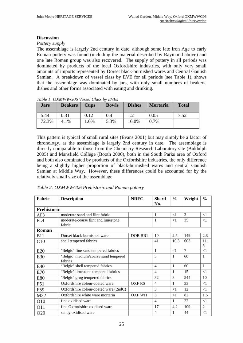
Discussion Pottery supply The assemblage is largely 2nd century in date, although some late Iron Age to early Roman pottery was found (including the material described by Raymond above) and one late Roman group was also recovered. The supply of pottery in all periods was dominated by products of the local Oxfordshire industries, with only very small amounts of imports represented by Dorset black-burnished wares and Central Gaulish Samian. A breakdown of vessel class by EVE for all periods (see Table 1), shows that the assemblage was dominated by jars, with only small numbers of beakers, dishes and other forms associated with eating and drinking. Table 1: OXMWWG06 Vessel Class by EVEs
Jars Beakers Cups Bowls Dishes Mortaria Total
5.44 0.31 0.12 0.4 1.2 0.05 7.52 72.3% 4.1% 1.6% 5.3% 16.0% 0.7%
This pattern is typical of small rural sites (Evans 2001) but may simply be a factor of chronology, as the assemblage is largely 2nd century in date. The assemblage is directly comparable to those from the Chemistry Research Laboratory site (Biddulph 2005) and Mansfield College (Booth 2000), both in the South Parks area of Oxford and both also dominated by products of the Oxfordshire industries, the only difference being a slightly higher proportion of black-burnished wares and central Gaulish Samian at Middle Way. However, these differences could be accounted for by the relatively small size of the assemblage. Table 2: OXMWWG06 Prehistoric and Roman pottery Fabric Description NRFC Sherd
No. % Weight %
Prehistoric AF3 moderate sand and flint fabric 1 <1 3 <1 FL4 moderate/coarse flint and limestone
fabric 1 <1 35 <1
Roman B11 Dorset black-burnished ware DOR BB1 10 2.5 149 2.8 C10 shell tempered fabrics 41 10.3 603 11.
5 E20 ‘Belgic’ fine sand tempered fabrics 1 <1 7 <1 E30 ‘Belgic’ medium/coarse sand tempered
fabrics 5 1 60 1
E40 ‘Belgic’ shell tempered fabrics 4 1 60 1 E70 ‘Belgic’ limestone tempered fabrics 4 1 15 <1 E80 ‘Belgic’ grog tempered fabrics 32 8 544 10 F51 Oxfordshire colour-coated ware OXF RS 4 1 33 <1 F59 Oxfordshire colour-coated ware (2ndC) 3 <1 12 <1 M22 Oxfordshire white ware mortaria OXF WH 3 <1 82 1.5 O10 fine oxidised ware 4 1 22 <1 O11 fine Oxfordshire oxidised ware 17 4.2 109 2 O20 sandy oxidised ware 4 1 44 <1
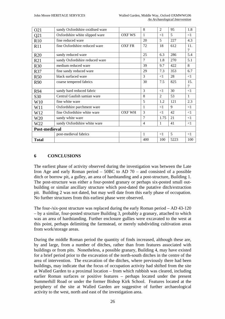
John Moore HERITAGE SERVICES Walled Garden, Middle Way, Oxford OXMWWG06 An Archaeological Intervention
26
O21 sandy Oxfordshire oxidised ware 8 2 95 1.8 Q21 Oxfordshire white slipped ware OXF WS 1 <1 5 <1 R10 fine reduced ware 20 5 227 4.3 R11 fine Oxfordshire reduced ware OXF FR 72 18 612 11.
7 R20 sandy reduced ware 25 6.3 286 5.4 R21 sandy Oxfordshire reduced ware 7 1.8 270 5.1 R30 medium reduced ware 39 9.7 422 8 R37 fine sandy reduced ware 29 7.3 353 6.7 R50 black surfaced ware 3 <1 28 <1 R90 coarse tempered fabrics 30 7.5 825 15.
7 R94 sandy hard reduced fabric 3 <1 30 <1 S30 Central Gaulish samian ware 8 2 53 1 W10 fine white ware 5 1.2 121 2.3 W11 Oxfordshire parchment ware 1 <1 9 <1 W12 fine Oxfordshire white ware OXF WH 3 <1 42 <1 W20 sandy white ware 7 1.75 21 <1 W22 sandy Oxfordshire white ware 4 1 41 <1 Post-medieval post-medieval fabrics 1 <1 5 <1 Total 400 100 5223 100 6 CONCLUSIONS The earliest phase of activity observed during the investigation was between the Late Iron Age and early Roman period – 50BC to AD 70 – and consisted of a possible ditch or borrow pit, a gulley, an area of hardstanding and a post-structure, Building 1. The post-structure was either a four-posted granary or perhaps six-posted small out-building or similar ancillary structure which post-dated the putative ditch/extraction pit. Building 2 was not dated, but may well date from this early phase of occupation. No further structures from this earliest phase were observed. The four-/six-post structure was replaced during the early Roman period – AD 43-120 – by a similar, four-posted structure Building 3, probably a granary, attached to which was an area of hardstanding. Further enclosure gullies were excavated to the west at this point, perhaps delimiting the farmstead, or merely subdividing cultivation areas from work/storage areas. During the middle Roman period the quantity of finds increased, although these are, by and large, from a number of ditches, rather than from features associated with buildings or from pits. Nonetheless, a possible granary, Building 4, may have existed for a brief period prior to the excavation of the north-south ditches in the centre of the area of intervention. The excavation of the ditches, where previously there had been buildings, may indicate that the focus of occupation activity had shifted from the site at Walled Garden to a proximal location – from which rubbish was cleared, including earlier Roman surfaces or positive features – perhaps located under the present Summerhill Road or under the former Bishop Kirk School. Features located at the periphery of the site at Walled Garden are suggestive of further archaeological activity to the west, north and east of the investigation area.
John Moore HERITAGE SERVICES Walled Garden, Middle Way, Oxford OXMWWG06 An Archaeological Intervention
27
Although some of the ditches recorded in the southern area of the site do not appear to have extended into the northern investigation area, it is possible that a western boundary to the main activity of the farmstead was identified. The proposed farmstead may well have been located to the east, under the present Summerhill Road. The presence of at least one post-structure extending beyond the limits of investigation, as well as the granaries or barns in the southern area of investigation is indicative of further settlement activity in the immediate vicinity. The late Roman period is evidenced by the silting up of the southern boundary ditch, and the subsequent cutting of a north-south gulley across the top of the ditch, which are the only sources of later pottery on site. No other archaeological features were identified from the 3rd century AD onwards. This may well indicate a shift, or cessation, in the occupation of the farmstead. The site at Walled Garden, Middle Way, Oxford revealed the periphery of a farmstead which was in use from the late Iron Age/early Roman period through to the 2nd/3rd centuries AD, with an assemblage typical of other sites recently excavated in Oxford, such as the Chemistry Research Laboratory (Biddulph, 2005) and Mansfield College (Booth, 2000). At these sites, the archaeological remains have been argued to illustrate a sequence of shifting settlement, rather than a static villa site. It is reasonable to see the site at Walled Garden falling within a similar frame, with the possibility of further occupation activity occurring to the east, beneath the present Summerhill Road, or to the west beneath the housing estate at Bishop Kirk Place. 7 BIBLIOGRAPHY Biddulph, E, 2005 Roman pottery, in P Bradley, B Charles, A Hardy and D Poore, Prehistoric and Roman activity and a civil war ditch: excavations at the chemistry research laboratory, 2-4 South Parks Road, Oxford, Oxoniensia 70, 155-167 Booth, P., 1996, ‘The pottery and other ceramic finds’, in C. Mould et. al., “An Archaeological Excavation at Oxford Road, Bicester, Oxford”, Oxoniensia, 61 Booth, P, 2001 Roman pottery, in P Booth and C Hayden, A Roman settlement at Mansfield College, Oxford, Oxoniensia 65, 307-317 Booth, P, 2004 Oxford Archaeology Roman pottery recording system: an introduction, Oxford Archaeology English Heritage 1991 Management of Archaeological Projects Evans, J, 2001 Material approaches to the identification of different Romano-British site types, in S James and M Millett, Britons and Romans: advancing an archaeological agenda, CBA Res Rep 125, 26-35, York Institute of Field Archaeologists. 1994 Standard and Guidance for Archaeological Field Evaluations. Tomber, R, and Dore, J, 1998 The national Roman fabric reference collection: a handbook, Museum of London Archaeology Service, London