al-Дamrā and Birkat al-Mawz - NTU > IRep
370
Urban Pattern and Architecture of Traditional Omani Foothill Settlements: al-Дamrā and Birkat al-Mawz by Haitham Najeem Sulaiman Al-ΚAbrī A THESIS Submitted in Partial fulfilment of the requirement of Nottingham Trent University for the degree of Doctor of Philosophy in Architecture November 2014
-
Upload
khangminh22 -
Category
Documents
-
view
0 -
download
0
Transcript of al-Дamrā and Birkat al-Mawz - NTU > IRep

Urban Pattern and Architecture of
Traditional Omani Foothill Settlements:
al-Дamrā and Birkat al-Mawz
by
Haitham Najeem Sulaiman Al-ΚAbrī
A THESIS
Submitted in Partial fulfilment of the requirement of Nottingham
Trent University for the degree of
Doctor of Philosophy in Architecture
November 2014

In the name of Allah,
The Compassionate, the Merciful,
Praise be to Allah, Lord of the Universe,
and Peace and Prayers be upon
His Final Prophet and Messenger

To the source of Courage & Love in my life:
My source of wisdom and role model in life, my father, the great
man who taught me the deep meaning of patience, success and
achievement in life
My Lovely mother who taught me how to appreciate knowledge, life
and work with love
My Beautiful wife who supported me all the way with
encouragement, believe and love
My Brave Brother Hashim who taught me how to face life with
persistence, courage and smile
My Amazing Brothers and Sisters who taught me the meaning of
hard work, devotion and excellence

i
Contents Abstract: .............................................................................................................................. iii
Acknowledgment ................................................................................................................ vi
List of Tables .................................................................................................................... viii
List of Figures ..................................................................................................................... ix
List of Plates ...................................................................................................................... xv
Glossary of Abbreviations .............................................................................................. xviii
Abbreviations used in names, places and maps ................................................................ xix
Translation of Arabic Words ............................................................................................ xix
Glossary of Arabic Terms .................................................................................................. xx
Chapter-1: Research Introduction ........................................................................................ 1
1.1: Introduction ............................................................................................................... 1
1.2: Rationale ................................................................................................................. 11
1.3: Methodology ........................................................................................................... 19
1.4: Research Development ........................................................................................... 33
1.5: Literature and Supporting Considered Disciplines ................................................. 39
Chapter-2: Āl-Дamrā & Birkat al-Mawz: The Setting ...................................................... 46
2.1: Introduction ............................................................................................................. 46
2.2: The Environmental Setting of the Interior .............................................................. 47
2.3: Al-Дamrā ................................................................................................................ 65
2.4: Birkat al-Mawz ....................................................................................................... 73
2.5: Epilogue .................................................................................................................. 79
Chapter-3: Дārat al-Дamrā and as-Saybānī urban Pattern and Architecture ..................... 83
3.1: Introduction ............................................................................................................. 83
3.2: Topography and urban pattern ................................................................................ 83
3.3: Fortification .......................................................................................................... 118
3.4: Epilogue ................................................................................................................ 128
Chapter-4: al-Дamrā and Birkat al-Mawz tribal pattern and settlement structure ........... 132
4.1: Introduction ........................................................................................................... 132
4.2: al-Дamrā ............................................................................................................... 133
4.3: Дarat al-WisΓa tribal Pattern and Structure ........................................................... 155
4.4: Birkat al-Mawz: .................................................................................................... 178
4.5: Дarat as-Saybanī tribal Pattern and Structure ....................................................... 192
4.6: Epilogue ................................................................................................................ 227
Chapter-5: Al-Дamrā & Birkat al-Mawz Dwellings and architecture: ............................ 232
ii
5.1: Introduction ........................................................................................................... 232
5.2: Description of Space organisation in an Omani foothill Dwellings ..................... 233
5.3: Topography, dwellings level and space structure ................................................. 239
5.4: Epilogue ................................................................................................................ 274
Chapter-6: Epilogue: ........................................................................................................ 278
6.1: The dawn of research on traditional Omani settlements ....................................... 278
6.2: The traditional foothill settlements ....................................................................... 282
6.3: Diversity and unity ................................................................................................ 286
6.4: Sacred relation ...................................................................................................... 289
6.5: Areas of future research ........................................................................................ 290
Appendix-I: Interview Transcripts ................................................................................... 292
Appendix-II: Large-scale Drawings ................................................................................. 335
Appendix-III: Bibliography ................................................................................................. 339

iii
Urban Pattern & Architecture of Traditional Omani Foot-hill
Settlements: al-Дamrā and Birkat al-Mawz
PhD dissertation
by
Haitham Najeem Sulaiman Al-Abri
Abstract:
Outside of Yemen, Oman arguably contains the most significant, active vernacular
heritage within the Arabian Peninsula. While some research exists on settlement
pattern and architecture of large settlements on the plains (e.g., Manah, Nizwa, Bahla
World Heritage Site and ΚIbra), little research has taken place on the nature of Omani
foothill settlements. The thesis makes an important contribution to Oman studies by
addressing this gap through the study of the urban pattern and architecture of two
vernacular foothill settlements – Дarāt al-Дamrā and Дarāt as-Saybānī in Birkat al-
Mawz in the Dākhliya (Interior) region of central Oman. The two oasis towns evolved
during the YaΚariba Imamate (mid-17th century CE onwards) and served the purpose
of harnessing the tribal support of two important groups in the process of consolidation
– the ΚAbriyīn and the Banī Riyām. This thesis argues that the two settlements – new
towns by Omani standards – were unique additions to Omani settlement hierarchy,
introducing a new category in between the larger settlements of the plains and the
small, dispersed settlement pattern of the Oman Mountains. The settlements have been
studied by analysing their morphology, or how they were established and evolved over
time shaped by the key factors of topography, geology and tribal movement. The thesis
extends the discussion by demonstrating how such factors also contributed to the
development of dwellings types, distinct in their form and spatial organization. This is
accomplished through an interdisciplinary approach to the survey, documentation,
analysis and interpretation of the settlements’ morphology.
The research has focused on two principal factors of settlement formation: the physical
influence of topography and geology, and the social influence of the evolving tribal
pattern. Moving from the regional scale to the local, the topographic aspects identify
the wider factors, as well as the more immediate impact of the incline and the

iv
distinctive rock structure on urban pattern. The steeper incline and sudden shifts at
Дarāt as-Saybānī in Birkat al-Mawz had impacted on the irregular street pattern and
dwelling cluster formation. At Дarāt al-Дamrā, however, the relatively gentle slope
had resulted in a more legible order of larger dwelling clusters and wider – more
orthogonal – street pattern. Here, the comparatively large open spaces act for the wider
community, while at Дarāt as-Saybānī communal space is more semi-private and
distributive in nature.
The social history aspect discussed the revival of the ΚAbriyīn and the Banī Riyām
tribes; both these significant political transformations took place under the YaΚariba
Imamate and were actively supported by them to ensure control over the mountain
hinterland. The coalescing of the ΚAbriyīn tribe and the establishment of their own
tribal capital (dar) at al-Дamrā was distinctive from the creation of the Banī Riyām
tribal confederation, which established their capital at Tanuf. Birkat al-Mawz, for the
Banī Riyām, was important, where the YaΚariba Imamate had co-invested heavily in
agricultural infrastructure – but it was not their capital. The confederated nature and
gradual migration of groups had evidently affected Birkat al-Mawz; in contrast, al-
Дamrā evolved more cohesively. The dwellings at al-Дamrā accommodated the
topographic shift by introducing loftier ground floor spaces, which often
accommodated a mezzanine level, adding to their grandeur. In Birkat al-Mawz the
sharp shifts resulted in numerous split-levels and stretched out dwellings.

v
COPYRIGHT STATMENT
This work is the property of the author. No copies of any kind for commercial purposes
are permitted unless authorised by the author. You may copy up to 5% of this work for
private study, or personal, non-commercial. Any reuse of the information contained
within this document should be fully referenced, quoting the author, title, university,
degree level and pagination. Queries or requests for any other use, or if a more
substantial copy is required, should be directed in the owner of the Intellectual Property
Rights.
DECLARATION
I hereby declare that no portion of the work that appears in this study has been used in
support of an application of another degree in qualification to this or any other
university or institutions of learning. I also declare that the work in this thesis was
carried out in accordance with the regulations of Nottingham Trent University.
Signed: ………………
Date: ………………..

vi
Acknowledgment
First and foremost, praise be to Allah Almighty, who with all his blessings and the
prayers of my parents the completion of this thesis would not have been achieved.
Great deep thanks go to my role model and source of wisdom in life, my father, who
gave me not only all the support, advice and encouragement, but also an exceptional
and valuable insight in understanding the deep meaning of life in the traditional Omani
settlements.
Throughout my PhD journey, many great colleagues, institutions, friends, relatives and
others too numerous to mention provided their valuable help and advice. Without their
invaluable assistance, support and encouragement this thesis would never come to
reality. Here, I wish to extend my deep appreciation and acknowledgment to all of
them.
Firstly, I owe a great debt of gratitude to my Director of Studies and supervisor,
Professor Soumyen Bandyopadhyay who believed in my ability and enthusiasm to do
the research, and for his meticulous and thorough supervision of the research and
writing, and for giving me the opportunity to work on his research projects. Also my
Director of Studies Professor Mike Hoxely, and my co-supervisors Professor Paul
Collins and Professor Steve Goodhew who all encouraged me with their valuable
supervision and enthusiasm.
Diwan of Royal Court for providing me with the financial and logistical support, which
has enabled me to complete my research. My gratitude also extends to the Cultural
Attaché of the Embassy of the Sultanate of Oman in London and his staff for their
limitless care and assistance.
School of Architecture, Design and Built Environment at Nottingham Trent University
for funding all my fieldworks in Oman over the past years.
Special thanks go to Dr.Giamila Quattrone and Dr.Martin Goffriller who contributed
in developing my research skills and for their support and encouragement.

vii
Support from Oman came from many Omani officials from various ministries and
government organisations. Director and staff of National Survey Authority of Ministry
of Defence (NSA) who kindly provided all the necessary aerial photos and CAD
drawing of all the oasis settlements included in this dissertation.
His Excellency Ali b.Mohammed b.Zaher Al-ΚAbrī, the undersecretary of water
resource at Ministry of Regional Municipalities and water resource, who showed
limitless support in providing all material published related to the study of traditional
settlements in Oman.
His Excellency Hamad b.Hilal Al-MaΚmari, the undersecretary of culture at Ministry
of Heritage and Culture, who showed limitless support in providing all material
published related to the study of traditional settlements in Oman.
Thanks also extends to the research centre of Architecture, Heritage and Global
Difference (AHGD), and Architecture and Cultural Heritage of India, Arabia and the
Maghreb (Archiam) at Nottingham Trent University; for making me a member of the
research team and including me in all research projects in Oman which contributed in
enriching my skill as a researcher.
The office and Library of the Office of His Majesty’s Cultural Advisor who gave me
access to all the material of their library.
The help in understanding the structural, the social, and the tribal mosaic of the
settlements of al-Дamrā and Birkat al-Mawz came from the previous old and young
inhabitants whom I have great deal of gratitude.
The local library of Al-Дamrā who gave me access to all publications related to the
history of al-Дamrā.
Abdullrahman b.Ali b.Sulaman Al-Abri, my cousin, who helped me during the
fieldwork of al-Дamrā in taking measurements and photos.

viii
List of Tables
Table 1: summary of comparison between Дarāt Al-Wistā and Дarāt As-Saybani ............... 15
Table 2: The tribes in Дarāt al-WisΓā in al-Дamrā. .............................................................. 160
Table 3: Summery of tribal dwelling distribution in the Дarāt. ........................................... 175
Table 4: The possible descent groups from Awād Rāshid of Banī Riyām. ......................... 194
Table 5: The descent tribal groups who are considered part of Awlād Rāshid. ................... 195
Table 6: The descent tribal groups as followers of the Banī Riyām. ................................... 195
Table 7: The tribes of Дarāt as-Saybānī in Birkat al-Mawz. ............................................... 198
Table 8: Summery of tribal dwelling distribution in the Дarāt as-Saybānī. ........................ 224
Table 9: Detailed list of the surveyed dwelling in Дarāt al-Дamrā with reference to Figure-
106. ...................................................................................................................................... 240
Table 10: Detailed list of the surveyed dwelling in Дarāt as-Saybānī with reference to
Figure-107. ........................................................................................................................... 240

ix
List of Figures
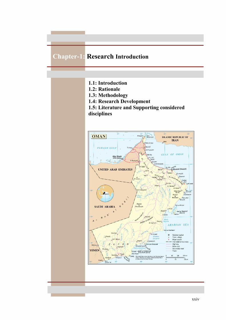
Figure 1: The Sultanate of Oman (Nations, 2004). .................................................................. 4
Figure 2: Settlement locations of al-Дamrā and Birkat al-Mawz. ........................................... 5
Figure 3: The location of foothill settlements of al-Дamrā and Birkat al-Mawz in the Jawf
region with respect to the surrounding oasis settlements. ...................................................... 14
Figure 4: Research Methodology design ............................................................................... 22
Figure 5: Example of RP theory (linear, grid, radial and enclosed)....................................... 35
Figure 6: The central geographical location of the Dakhliyah governorate (Jawf region) with
the natural mountain and hill boundaries surrounding it, modified by author, (after Luedeing
& Buerkert 2007:vo112, 1184, Figure 2). .............................................................................. 49
Figure 7: The main geographical regions defined by Schloz in Oman, note: the Ramlat al
Wahiba in the east region of Oman has changed by a Sultani Decree to Rimal ash-Sharqiyah
(after Bandyopadyay 2011, Scholz 1977: PartII, 8, map 1). .................................................. 51
Figure 8: Section crossing through Jabal al-AkhΡar and Jawf region showing the topographic
diversity, (I) north coast, (II) north foot-fills, (III) Jabal al-AkhΡar, (IV) inner foot-hills, (V)
wadī catchment area, (VI) desert region, (after Bandyopadyay 2011, after Scholz 1977:
PartII, 8, Figure 1). ................................................................................................................. 52
Figure 9: The sub-division of the mountain zone topography: bowls (SaΉtan and Mastal),
plateaus (Sīq), karst holes (Missfat Al-‘Abriyīn and al-KhawaΓr) and hills (after google
maps terrain). ......................................................................................................................... 52
Figure 10: The arrows show the wadī discharge route southward from the mountain zone to
the lower hill zone, (Bandyopapahyay, 2011, p. 23, Figure-6) (after Wilkinson 1977: 11,
Figure 3). ................................................................................................................................ 55
Figure 11: The geological structure of northern Oman, (El-Baz 2002:10, map). .................. 57
Figure 12: The division of internal zone (Jabal al-AkhΡar, Jabal Nakhal and SaiΉ ДΓaΓ) and
external zone (Adam Mountain Chain and Дawasina foreland fold and thrust belt), (Matter
2001:35, Figure 1-3). ............................................................................................................. 57
Figure 13: Sketch showing the stratigraphy of the Дajar mountain of Oman (Hanna, 1995, p.
43). ......................................................................................................................................... 58
Figure 14: The main anticline sets of Jabal AkhΡar, (1) northeast to southwest, (2) west-
northwest to east-southeast, (after google maps terrain). ....................................................... 59
Figure 15: The main geological units in the Jawf region, (Matter 2001: 34, Figure 1-4). ..... 60
Figure 16: Geological cross section showing the main lithological layers from Jabal al-
AkhΡar to the Adam Mountains, (Matter 2001: 36, Figure 1-4). ........................................... 60
Figure 17: Wind pattern over Oman along the year, modified by author (El-Baz 2002: 14). 62
Figure 18: Rainfall map of north Oman (MRMEWR 2005: 26, map). .................................. 62
Figure 19: The hierarchy and relation of the environmental settling factors from Jabal al-
AkhΡar to the settlement’s location. ...................................................................................... 63
Figure 20: Location of al-Дamrā in ad-Dākhliya governorate. .............................................. 66
Figure 21: Āl-Дamrā positioned in landward side within a mountain fold. .......................... 67
Figure 22: Regional Character of al-Дamrā ........................................................................... 68
Figure 23: the natural protection of the low hill chain in the southwest side, modified by
author. (after Scholz 1977:vol2, 94, Figure 38). .................................................................... 69
Figure 24: (A) arable land, (W) central joint wadī flow, (L) al-Дabil low hill mountain chain,
(D) Small mountain near al-‘ĀriΡ and Dhat Khail, (K) Дurat Kudam mountain and their role
in insuring the diverging of the wadī flow to the south. ........................................................ 70

x
Figure 25: The geological map of al-Дamrā, wadī Ghul and Jabal Shams (after Hanna
1995:145). .............................................................................................................................. 71
Figure 26: The division of the Дajar Super Group (A) with brief descriptions (Hanna
1995:53). ................................................................................................................................ 72
Figure 27: Birkat al-Mawz location in ad-Dākhliya governorate. ......................................... 74
Figure 28: Birkat al-Mawz positioned in landward side within a mountain pocket. ............. 75
Figure 29: (A) arable land, (W) wadī catchment area, (L1) low hill mountain chain in the W,
(L2) low hill mountain chain in the SE, (L3) low hill mountain chain in the E (J) Jabal al-
AkhΡar mountain and its role in insuring the diverging of the wadī flow to the southwest. . 75
Figure 30: The geological map of Birkat al-Mawz and wadī Mu’aydin (after Hanna
1995:136). .............................................................................................................................. 77
Figure 31: The sedimentary rock layers of strata (Sidr formation), which is the geological
foundation structure of Ήarat as-Saybanī. .............................................................................. 78
Figure 32: The varying scale of the rock layers in Дarat as-Saybani. ................................... 78
Figure 33: The presence of fossils in the sedimentary rock layers in Ήarat as-Saybanī. ....... 79
Figure 34: The Digital Elevation Model (DEM) map of al-Дamrā territory generated by the
Global Mapper v.14 software................................................................................................. 86
Figure 35: The Digital Elevation Model (DEM) map of Birkat al-Mawz territory generated
by the Global Mapper v.14 software. ..................................................................................... 86
Figure 36: The overlap of the contour lines illustrating the topography levels of Дarāt al-
Дamrā site in al-Дamrā on top of it aerial photo (after a 1993 Aerial photo of al-Дamrā from
NSA of scale 1:20000, 2011). ................................................................................................ 89
Figure 37: The contour lines density pattern in Дarāt al-Дamrā site in al-Дamrā on top of it
aerial photo (after a 1993 Aerial photo of al-Дamrā from NSA of scale 1:20000, 2011). .... 89
Figure 38: The contour lines density pattern in Дarāt as-Saybānī site in Birkat al-Mawz on
top of its aerial photo (after a 1993 Aerial photo of al-Дamrā from NSA of scale 1:20000,
2011). ..................................................................................................................................... 90
Figure 39: The contour lines density pattern in Дarāt as-Saybānī site in Birkat al-Mawz on
top of it aerial photo (after a 1975 Aerial photo of Birkat al-Mawz from NSA of scale
1:10000, 2011). ...................................................................................................................... 91
Figure 40: A vertical section (north to south) across the site of Дarāt al-Дamrā in al-Дamrā
showing the topographical levels and the slope angles along with the changing level points.
............................................................................................................................................... 92
Figure 41: A vertical section (north to south) across the site of Дarāt as-Saybānī in Birkat al-
Mawz showing the topographical levels and the slope angles along with the changing level
and angle points. .................................................................................................................... 92
Figure 42: The gradual reduction in the terrace stone foundation height in the less steeper
levels of the slope. .................................................................................................................. 99
Figure 43: The varying height levels of the stone foundation walls influenced by the
steepness of the slope and the advanced construction technique of the dwellings in Дarāt as-
Saybānī. .................................................................................................................................. 99
Figure 44: The stone foundation walls in the dwellings of Дarāt al-WisΓā maintain the same
height level with reference to the height of the upper stone foundation in the upper level. 100
Figure 45: Cross section through phase-3 & 4; showing the terrace and double stone wall
technique. ............................................................................................................................. 101
Figure 46: The natural grid fractures pattern of the stone slope surface structure in al-Дamrā.
............................................................................................................................................. 102

xi
Figure 47: The contour lines pattern in the lower centre part of Дarāt al-Дamrā site in al-
Дamrā on top of it aerial photo (after a 1993 Aerial photo of al-Дamrā from NSA of scale
1:20000, 2011). .................................................................................................................... 104
Figure 48: The contour lines pattern in the lower east part of Дarāt al-Дamrā site in al-Дamrā
on top of it aerial photo (after a 1993 Aerial photo of al-Дamrā from NSA of scale 1:20000,
2011). ................................................................................................................................... 105
Figure 49: The contour lines pattern in the lower west part of Дarāt al-Дamrā site in al-
Дamrā on top of it aerial photo (after a 1993 Aerial photo of al-Дamrā from NSA of scale
1:20000, 2011). .................................................................................................................... 107
Figure 50: The contour lines pattern in the upper central part of Дarāt al-Дamrā site in al-
Дamrā on top of it aerial photo (after a 1993 Aerial photo of al-Дamrā from NSA of scale
1:20000, 2011). .................................................................................................................... 108
Figure 51: The contour lines pattern in the upper east part of Дarāt al-Дamrā site in al-Дamrā
on top of it aerial photo (after a 1993 Aerial photo of al-Дamrā from NSA of scale 1:20000,
2011). ................................................................................................................................... 110
Figure 52: The contour lines pattern in the upper west part of Дarāt al-Дamrā site in al-
Дamrā on top of it aerial photo (after a 1993 Aerial photo of al-Дamrā from NSA of scale
1:20000, 2011). .................................................................................................................... 111
Figure 53: Summary diagram of the topographic influence to the Дarāt formation. ........... 117
Figure 54: The inter-relation factors to form a fortified settlement. .................................... 119
Figure 55: The five outer defensive zones around the territory of Дarāt al-Дamrā. ............ 119
Figure 56: The outer defence zones before reaching Дarāt al-Дamrā. ................................ 120
Figure 57: The seven outer defensive zones around the territory of Дarāt as-Saybānī in
Birkat al-Mawz. ................................................................................................................... 121
Figure 58: The outer defence zones before reaching Дarāt as-Saybānī. .............................. 122
Figure 59: The sniper posts (defensive zone-7) hidden in the upper hills behind Дarāt as-
Saybāni in Birkat al-Mawz. ................................................................................................. 122
Figure 60: The inner defensive features of Дarāt al-Дamrā................................................. 124
Figure 61: The connection between the inner and outer defensive features and zones in al-
Дamrā. .................................................................................................................................. 125
Figure 62: The inner defensive features of Дarāt as-Sybānī. ............................................... 127
Figure 63: Rock Art sites in al-Дamrā and Birkat al-Mawz: (26) Ghul wadī al-Nakhur, (27)
Ghul wadī Ghul, (28) wadī al-Mid’am, (29) Ghamur Bilad Sait Exotics, (30) Jabal al-Qal’a,
(31) Dhat Khail, (32) Jabal al-Qal’a, (39) Mu’aydin in wadī Mu’aydin, (40) Tawī SadΉ in
wadī Mu’aydin, (after Preston 1976: 18-19, Figure-1). ....................................................... 134
Figure 64: The bas-relief Rock art of Дasat bin Salt in al-Дamra, site (23, Figure 6), (Rice
1994: 261, Figure 8.22). ....................................................................................................... 135
Figure 65: Location of Дafit and Um-Nār sites in al-Дamrā (after NSA, al-Дamrā Aerial
photo, 1993). ........................................................................................................................ 136
Figure 66: Location of Early and Late Iron Age sites in al-Дamrā (after NSA, al-Дamrā
Aerial photo, 1993). ............................................................................................................. 137
Figure 67: Location of Islamic Period sites in al-Дamrā, (after NSA, al-Дamrā Aerial photo,
1993). ................................................................................................................................... 138
Figure 68: The gradual concentration density, overlap and extensions of the archaeological
sites locations in al-Дamrā, (after NSA, al-Дamrā Aerial photo, 1993). ............................ 140
Figure 69: Historical Morphology of the area (after NSA, al-Дamrā Aerial photo, 1993).. 143
Figure 70: The Azd genealogy structure (Wilkinson 1977: 172, Figure 30). ...................... 144

xii
Figure 71: The Imran branch shaikhly structure of ΚAbriyīn (Wilkinson 1987: 105, Figure 5).
............................................................................................................................................. 145
Figure 72: Dispersed small settlements of the ΚAbriyīn before reforming into one dār. ..... 146
Figure 73: The tribal territories of ΚAbriyīn in central Oman, modified by author (after
Wilkinson 1977: 157, Figure 25). ........................................................................................ 149
Figure 74: Falaj āl-Дamrā from the source to the oasis. ..................................................... 152
Figure 75: The components of Дārat āl-Дamrā and its sub- Дārat; (H1) Дarat al-WisΓā, (H2)
Дarat al-Sharqiya, (H3) Дarat al-ΚĀlī, (H4) Дarat al-Дaditha, (S) souq al-Qadeem, (P1 & P2)
two water pools, (T) Burj mall ad-Dākhil, (T1) Burj al-ShriΚa, (T2) Burj muΒalā al-Eid, (T3)
Burj Dak al-Waljah, (T4) Burj al-Maqbara, (T5) Burj ShaΚāsh’, (T6) burj al-Дjīra, (T7) burj
al-Дalaw, (T8) burj Shwaīn, (F1) falaj al-Blād, (F2) falaj as-SuΉmah, (G1) date palm
gardens, (G2) seasonal planted gardens, and (G3) extended mixed plants gardens. ........... 154
Figure 76: Дarāt al-WisΓā spatial distribution of tribes. W1. Al-ΚAbriyīn, W2. Al-SharāmΉa,
W3. Al-ΚAziziyīn, W4. Al-KhawāΓr, W5. Al-Riyāmiyīn, W6. Al-Dhuhul, W7. Al-HaΓāΓla,
W8. Al-Shukour, W9. Al-NuΚb, W10. Al-Mughiriyīn, W11. Al-NawāΒr, W12. Al-YaΚāribh,
W13. Al-Bimāniyīn, W14. No nisbah. ................................................................................ 163
Figure 77: Дarāt al-WisΓa structure. D. dwellings, G1. main gates (sabaΉ), G2. secondary
access points, T. towers, M. mosques, Q. Qurān school, S. (sabla) male communal meeting
halls, P1. Female public bathing, P2. Female private bathing (elite), K. communal storage
and production of traditional vinegar (khal), J. communal storage for traditional well
equipment (manjour), R. communal wheat grinding structure (raΉā), L. Female communal
latrine, F. Falaj. ................................................................................................................... 163
Figure 78: The colour code phasing structure (from Phas-1 to Phase-5) of of Дarāt al-Дamrā
with reference to Figure-46 & 47. ........................................................................................ 164
Figure 79: Phase-1 of Дarat al-Дamrā (first constructed dwellings): D1. Bait aΒ-Сafāh, D2.
Bait al-Qadīm, D3. Bait ΚAlī b.Khamis Al-ΚAbrī, D4. Bait aΒ-СabāΉ, M1. Masjid aΒ-Сalaf,
M2.Masjid al-Дadith, S1.1. sablat aΒ-Сalaf, S1.2. sablat al-Ghāarbī, S1.3. sablat Awlād
Rashid b.MusΚud, P2. mujazat al-Jufrah, P1.2. mujazat aΒ-Сafāh, P1.3. mujazat al-ghraifah.
............................................................................................................................................. 164
Figure 80: Phase-1 & Phase-2 (second possible constructed dwellings) of Дarat al-Дamrā:
M2.Masjid al-Дadith, S1.1. sablat aΒ-Сalaf, S1.2. sablat al-Ghāarbī, S1.3. sablat Awlād
Rashid b.MusΚud, P2. mujazat al-Jufrah, P1.2. mujazat aΒ-Сafāh, P1.3. mujazat al-ghraifah,
J: communal storage for traditional well equipment (manjour). .......................................... 166
Figure 81: The extension of phase-3 of Дarat al-Дamrā, following after phase-1 in figure-49
and phase-2 in figure-50. ..................................................................................................... 169
Figure 82: The extension of phase-4 of Дarat al-Дamrā, following after phase-1 in figure-49
and phase-2 in figure-50 and phase-3 in figure-51. ............................................................. 171
Figure 83: The extension of phase-5 of Дarat al-Дamrā, following after phase-1 in figure-49,
phase-2 in figure-50, phase-3 in figure-51, and phase-4 in figure-52. ................................. 173
Figure 84: The extension of phase-6 of Дarat al-Дamrā, following after phase-1 in figure-49,
phase-2 in figure-50, phase-3 in figure-51, phase-4 in figure-52 and phase-5 in figure-53. 174
Figure 85: The location of the possible pre-existing defensive structures (BM-A to BM-A4)
and cultivated land (C1), (after google maps). ..................................................................... 179
Figure 86: The tribal territories of Bani Riyām in central Oman, (after Wilkinson 1977: 157,
Figure 25). ............................................................................................................................ 180
Figure 87: Falaj al-Khatmeen from the source to the oasis. ................................................ 182
Figure 88: The B.Riyām descent from Mahra (Carter, 1982, p. 59). ................................... 184
Figure 89: The classical descent of B.Riyām (Carter, 1982, p. 116). .................................. 185

xiii
Figure 90: The Hajar Mountain divided into tribal section and showing the territory of
B.Riyām in J.Riyām (Wilkinson 1977: 244, Figure 33). ..................................................... 186
Figure 91: The components of Birkat al-Mawz oasis (after 1975 Aerial photo of Birkat al-
Mawz from NSA, 2011). ..................................................................................................... 188
Figure 92: Дarāt as-Saybānī in Birkat al-Mawz. ................................................................. 189
Figure 93: Дarāt as-Saybānī aerial photo (1975 Aerial photo of Birkat al-Mawz from NSA,
2011). ................................................................................................................................... 189
Figure 94: Дarāt al-Maqāseer east of Дarāt as-Saybanī in Birkat al-Mawz. ....................... 190
Figure 95: Дarāt al-MaqāΒeer aerial photo (1975 Aerial photo of Birkat al-Mawz from NSA,
2011). ................................................................................................................................... 190
Figure 96: Дarāt al-Wadī, view of the souq from inside the Дarāt. ..................................... 191
Figure 97: Дarāt al-Wādī aerial photo (1975 Aerial photo of Birkat al-Mawz from NSA,
2011). ................................................................................................................................... 191
Figure 98: The early structures of phas-1 behind the apex of Дarāt as-Saybānī.................. 199
Figure 99: The geological layer structure of the foot-hill of Дarāt as-Saybānī. .................. 199
Figure 100: Tribes spatial distribution of Дarāt as-Saybānī. SA1. Banī Riyām, SA2: Banī
Tubah, SA3. Al-Fuhud, SA4. Al-Сuqur, SA5. Al-ΚAbriyīn, SA6. An-NāΚb, SA7. Al-
ДaΡramah, SA7. As-Siyābiyīn. ............................................................................................ 200
Figure 101: Дarāt as-Saybānī structure: SD. dwellings, SG1. main gates (sabaΉ), SG2.
secondary access points, ST. towers and defensivt structures, SM. mosque, SQ. Qurān
school, SS. (sabla) male communal meeting halls, SP1. Female public bathing, SP2. Female
private bathing (elite), SJ. communal wheat grinding structure (raΉā), SH. Sheap herder
structures, SO. Shop (dikān), SF. Falaj channel, SW. water well. ...................................... 201
Figure 102: The colour code phasing structure (from Phas-1 to Phase-6) of Дarāt as-Saybānī
with reference to Figure-61 & 62. ........................................................................................ 202
Figure 103: Detail colour code phasing and structure codes (from Phase-1 to Phase-8) of the
development of Дarāt as-Saybānī with reference to Figure-71 & 72. ................................. 203
Figure 104: Sablat al-Fouq (SD10, summer use) in phase-3. .............................................. 210
Figure 105: A view from the tower showing the linear dwelling pattern of phase-3 aligned
with the large rock layer south edge of phase-2. .................................................................. 210
Figure 106: The extension of the west edge of phase-5 by the linear interlock dwelling
pattern of Awlād Thanī. ....................................................................................................... 216
Figure 107: Equalities of spacing in Дarāt as-Saybānī (1975 Aerial photo of Birkat al-Mawz
from NSA, 2011). ................................................................................................................ 226
Figure 108: Bait al-Fouq in Дarāt al-Дamrā showing its outstanding height compared to the
surrounding dwellings. ......................................................................................................... 234
Figure 109: A section cutting through the Bait al-Fouq (D72) from north to south from the
first entrance; 2. dahreez at the entrance; 4. suffah; 5. darss; 6. majlis; 10.arshah; 11.
terrace; 12. gurfah; 13. Kitchen; 14. Overhead shade. ........................................................ 238
Figure 110: Plan of Дarāt al-Дamrā showing the location of the selected surveyed dwellings
for comparison. .................................................................................................................... 239
Figure 111: Plan of Дarāt as-Saybānī showing the location of the selected surveyed
dwellings for comparison. .................................................................................................... 241
Figure 112: Section through dwelling SD30 in Дarāt as-Saybānī; 1. Entrance door; 2. First
dahrīz; 3. Second dahrīz; 4. suffah; 8. Κarshah; 9.gurafah. ................................................. 256
Figure 113: The ground floor of the Sawwaqiyin dwelling cluster in Дarāt al-Bilād in
ManaΉ; 1. Covered passage; 2. Courtyard; 3. Entrance to dwelling A; 4. Lounge; 5. Room; 6.
Store; 7. Pen; 8. Pit for latrine; 9. Entrance to dwelling B; 10. Entrance to dwelling C; 11.

xiv
Sabla, 12; loggia; 13. Well and bathing area; S111; Sikkat al-Ghuwayr. (after
Bandyopadhyay, 2011, Figure-42, p.122). ........................................................................... 256
Figure 114: Дarāt al-ΚAqr in Nizwa; 1. Nizwa (or al-ΚAqr) Fort; 2. Settlement fortification; 3.
Gateways; 4. street 100; 4s. street 100s; 5. street 200; 6. Street 300; 6s. street 300s; 7. street
400; 7s. street 400s; 7t. street 400t; 8. Street 500, 8s. street 500s; 8sl.street 500sl; 9. Street
600; 9s. street 600s; 9t. street 600t; 10. Street 700; 10s. street 700s; 100-700: dwelling zones
(after Bandyopadhyay, 2011, Figure-42, p.175). ................................................................. 260
Figure 115: Masjid ash-Shawadhinah and Zone 5001. Masjid ash-Shawadhinah; 2. Street
500; 3. Street 500 s1; 4. The now-truncated north-south lane; 5. Zone 400; 6. Zone 600; 7.
Street 600t1; 8. Street 700t2; 9. Street 500t2; 10. ZaraΚat al-Bustan; 11. The falaj channel,
F2; 12. Madrasat al-Jaljlan and the sablah (after Bandyopadhyay, 2011, Figure-23, p.178).
............................................................................................................................................. 261
Figure 116: Дārat al-Bilad in ManaΉ: reconstructed settlement plan showing streets and lanes
Main streets: M1. KaΚb al-Bilad; M2. Sikkat al-ΚUqud; M3. Sikkat Дārat al-ΚAyn; Streets off
M1: S11. Sikkat az-Zalam (Sikkat ar-Ruh); S12. Lane leading to Sablat al-Wali;
S13/S15/T11. Sikkat al-ΚAli; S14. Sikkat al-Bayadir; S16. Sikkat Abu/Awlad
Rawashid/Rashid; S17. Sikkat at-Tawi/ Sikkat Hawd ad-Darb; S18/ S23. Sikkat bin Qasim;
S19. Sikkat al-Karjah/ Awlad Karjah; S110. Sikkat ash-Sharah/ Sikkat Nus Sudus; S111.
Sikkat al-Ghuwayr; S112/ S25. Sikkat ad-Dahmash;Streets off M2: S21 & S114/ T22. Sikkat
al-Qasabah; S22. Sikkat al-Gharabah; S23/ S18. Sikkat bin Qasim; S24. Dead-end lane; T21
& S25/ S112. Sikkat ad-Dahmash.Gates: G1. Bab al-Burj/ Bab ar-Rawlah; G2. Bab Дārat al-
ΚAyn; G3. Bab an-Nasr; G4. Bab ad-DaΚnayn/ DaΚnin (after Bandyopadhyay, 2011, Figure-
16, p.69). .............................................................................................................................. 262
Figure 117: Bahla oasis: plan of core settlement area or al-Harah Quarter1. The fort; 2.
Friday Mosque; 3. al-Harah Quarter; 4. The souq (after Bandyopadhyay, 2011, Figure-16,
p.177). .................................................................................................................................. 263
Figure 118: Floor plans of ΚAbdali shaikh’s dwelling, a. ground floor; b. first floor; 1.
Entrance; 2 & 4. Ground floor storage, pen and water well; 3. Staircase; 5. Blacksmith’s
workshop; 6. Burj al-Juss; 7. Sentry room and observation space in Burj al-Juss; 8. Sablat al-
Burj; 9. Sleeping rooms; 10. Loggia; 11. Terrace; 12. Kitchen; 13. Latrine (after
Bandyopadhyay, 2011, Figure-47, p.124). ........................................................................... 273

xv
List of Plates
Plate 1: (a) Hārat al-Yemen, Izkī’, (b) Hārat al-Bilad, Manah, (c) Hārat Al-‘Aqr, Bahla, (d)
Hārat al-Дujra, Bidbid/Fanjā (aerial photo, courtesy of NSA). ............................................. 17
Plate 2: Examples of sketches and interviews made during fieldwork; a. Ground floor plans
of dwellings D30 and D31 (cf. Chapter 5), b. A cross section sketch of the lower part of
Дarāt as-Saybānī, c. Interview with a younger previous inhabitant of Дarāt al-Дamrā (Jabir
Al-ΚAbrī), d. Interview with the falaj waqil of Дarāt as-Saybānī (ΚAbdullah al-Saqrī). ........ 27
Plate 3: Wadī pattern types in Oman (1); a. Braided drainage pattern, b. Dendritic drainage
pattern (after El-Baz 2002, 19). ............................................................................................. 53
Plate 4: Wadī pattern types in Oman (2); c. Meandering drainage pattern, d. Rectlinear
drainage pattern (after El-Baz 2002, 20). ............................................................................... 54
Plate 5: Digital Elevation Model (DEM) of both territories, a. bird view of al-Дamrā from
the south, b. bird view of al-Дamrā from the east, c. bird view of Birkat al-Mawz from the
south, d. bird view of Birkat al-Mawz from the east. ............................................................ 87
Plate 6: Stone foundation of the dwellings of Дarāt al-WisΓā in al-Дamrā, a. the lower
dwellings with low height stone foundations and large scale stones, b. the central level and
more steeper slope dwellings with increase in the stone foundation height, c. the upper level
dwellings with full height stone walls. ................................................................................... 93
Plate 7: The early structures behind the tower (phase-1) showing the stone foundation and
construction technique: a. half berried walls from the back side, b. using the natural stone
surface structure as a preliminary anchoring foundation for the structure, c. the construction
of terrace foundation. ............................................................................................................. 96
Plate 8: The stone foundation and construction technique (phase-2): a. using the natural stone
surface structure as a preliminary anchoring foundation for the structure for the tower, b.
using the same technique for other structures, c. the large scale of some natural stone surface
structure which is still used as an anchor foundation for dwellings....................................... 97
Plate 9: The stone foundation and construction technique (phase-3): a. the combined
technique using the natural steep stone surface structure as a preliminary anchoring
foundation at the upper level for and terrace foundations at the lower levels, b. side views of
the terrace foundations, c. half berried foundation wall from the back side of the dwellings,
d. the development from half berried to terrace foundations, c. clear view showing the
development of the technique, f. combination of the three techniques in the upper communal
male meeting hall. .................................................................................................................. 98
Plate 10: Phase-1 and Phase-2 dwellings of Дarat al-Дamrā: a. D1 left and D5 right, b. D2
right, D6 and D7 left, c. D4 middle, D28 left abd D37 right, d. D3 left, D12 middle, D5 and
D7 right. ............................................................................................................................... 165
Plate 11: Phase-1 mosques and gates: a) G1.1 ΒabāΉ as-Sāfil, b) G1.2 ΒabāΉ an-NuΚb, c & d)
M1 masjid aΒ-Сalaf, e) M2 masjid al-Дadith. .................................................................... 167
Plate 12: Phase-1 & 2 female communal bathing structures and falaj access points of Дarat
al-Дamrā: a. P1.2 mujāzat aΒ-Сafāh, b. P2 mujāzat al-Juffrah (private), c. P1.3 mujāzat al-
Дjirah with a falaj access point next to it, d. falaj access point near ΒabāΉ as-Sāfil, e. falaj
access point on the right of ΒabāΉ an-NuΚb, f. falaj access point on the left of ΒabāΉ an-NuΚb
which is mostly used to open the branching channel for irrigation to the date gardens. ..... 168
Plate 13: Phase-2 of Дarāt as-Saybānī, a. the tower and the boundary wall constructed behind
it, b. natural rock formation used as an anchor for the structure foundation, c. the large rock
layer forming the south edge of phase-2. ............................................................................. 207

xvi
Plate 14: Phase-3 of Дarāt as-Saybānī, a. the passage between the two sbalas, b. the vertical
passage between SD10 and SD11, c. the horizontal passage aligned with large rock layer, d.
the steps connecting the different levels in the open space, c. the passage between SD17 and
SD19 leading to the main access gate, d. the neatly done rock steps to the main gate of
phase-3. ................................................................................................................................ 211
Plate 15: Phase-4 of Дarāt as-Saybānī, a. the stone steps in the passages, b. the small space
leading to the entrance of dwelling SD21, c. the over-head of SD22, d. the narrow private
passage of SD25. .................................................................................................................. 213
Plate 16: Phase-5 of Дarāt as-Saybanī, a. the neatly done stone steps on the west passage, b.
the straight stone steps on the west passage, c. the decorated ceiling in SD33, d. the carved
decorated door of dwelling SD34, d. the private sabla with its own access in dwelling SD33,
e. the second access point leading to outside the Дarāt from the back of dwelling SD33. .. 217
Plate 17: Phase-6 of Дarāt as-Saybānī, a. the passage leading to gate SG1, b. the male
communal sabla in SD52, c. the structures aligned with falaj channel, d. the gate (SG2,
sabāΉ ad-Dākhil). ................................................................................................................. 219
Plate 18: Phase-7 of Дarāt as-Saybānī, a. Private narrow passage of SD56, b. Over-head of
SD60 above the falaj, c. decorated wall in SD57, d. remains of SD55, e. The dwellings SD58
and SD56. ............................................................................................................................. 221
Plate 19: Phase-8 of Harāt as-Saybānī, a. Masjid al-Waljah SM1 and ΒabāΉ al-Sharqī SG4,
b. ΒabāΉ al-Gharbī SG3 and sablat al-Сukuwr, c. Dwelling SD62, d. Dwelling SD63 attached
to the gate. ............................................................................................................................ 223
Plate 20: Floor plan of Bait al-fouq; a. Ground floor; b. Mezzanine level; c. First floor; d.
Roof level; 1. main entrance door; 2. First dahreez; 3. Second dahreez; 4. suffah; 5. darss;
6.sblah; 7.small sablah; 8. sark; 9. guest room; 10.arshah; 11 terrance; 12.gurafah; 13.
kitchen; 14. shade; 15. roof .................................................................................................. 236
Plate 21: Floor plan of D183; a. Ground floor; b. Mezzanine level; c. First floor; d. Roof and
second floor; 1. main entrance door; 2. First dahreez; 3. Second dahreez; 4. suffah; 5. Κaqid;
6. darss; 6.sblah; 7. sablah; 8. Κarshah; 9.gurafah; 10. shade; 11. Kitchen. ........................ 245
Plate 22: Plate 23: Individual dwelling D183 in Дarāt al-Дamrā; a. Front elevation; b. Mud
decorative high reliefs framing the doors; c. central column (naqΒa) in the living area
(Κarsha). ................................................................................................................................ 246
Plate 24: Floor plan of SD9; a. Ground floor; b. First floor; 1. main entrance door; 2. First
dahreez; 4. suffah; 6. darss; 8. Κarshah; 9.gurafah; 11. Kitchen. ........................................ 247
Plate 25: Individual dwelling SD9 in Дarāt as-Saybānī; a. Front elevation perspective; b.
Animal pin accessed from outside the dwelling. ................................................................. 248
Plate 26: Floor plan of dwelling cluster D85, D89, D92 & D94; a. Ground floor; b.
Mezzanine level; 1. main entrance door; 2. First dahreez; 3. Second dahreez; 4. suffah; 5.
Κaqid; 6. darss; 6.sblah; 7. sablah; 8. Κarshah; 9.gurafah; 10. shade; 11. Kitchen. ............. 252
Plate 27: Continue of floor plans from Plate-19 of dwelling cluster D85, D89, D92 & D94; c.
First floor; d. Roof and second floor; 1. main entrance door; 2. First dahreez; 3. Second
dahreez; 4. suffah; 5. Κaqid; 6. darss; 6.sblah; 7. sablah; 8. Κarshah; 9.gurafah; 10. shade; 11.
Kitchen store ; 12. Kitchen. ................................................................................................. 253
Plate 28: Floor plans of dwelling cluster SD46, SD50 & SD51; a. Ground floor; b. First
floor; d. Roof and second floor; 1. main entrance door; 2. First dahreez; 3. Second dahreez;
4. suffah; 5. Κaqid; 6. darss; 8. Κarshah; 9.gurafah; 11. Kitchen store ; 12. Kitchen; 14.
Latrine. ................................................................................................................................. 254
Plate 29: Floor plans of dwelling cluster SD29, SD30 & SD49; a. Ground floor; b. First
floor; d. Roof and second floor; 1. main entrance door; 2. First dahreez; 3. Second dahreez;

xvii
4. suffah; 5. Κaqid; 6. darss; 7. Sablah; 8. Κarshah; 9.gurafah; 11. Kitchen store ; 12. Kitchen;
14. Latrine; 16. Light shaft. ................................................................................................. 255
Plate 30: Floor plans of dwelling cluster SD46, SD50 & SD51; a. Ground floor; b. First
floor; d. Roof and second floor; 1. main entrance door; 2. First dahreez; 3. Second dahreez;
4. suffah; 5. Κaqid; 6. darss; 8. Κarshah; 9.gurafah; 11. Kitchen store ; 12. Kitchen; 14.
Latrine. ................................................................................................................................. 267
Plate 31: Floor plans of open space dwelling cluster D180, D182, D183 & D49; c. First
floor; d. Second floor & Roof mezzanine; 1. main entrance door; 2. First dahreez; 3. Second
dahreez; 4. suffah; 5. Κaqid; 6. darss; 7. Sablah; 8. Κarshah; 9.gurafah; 11. Kitchen store ; 14.
Latrine. ................................................................................................................................. 268
Plate 32: Floor plans of open space dwelling cluster SD9, SD16, SD17 & SD18; a. Ground
floor; b. First floor; 1. main entrance door; 2. First dahreez; 3. Second dahreez; 4. suffah; 6.
darss; 8. Κarshah; 9.gurafah; 11. Kitchen ; 12. Kitchen; 14. Latrine. .................................. 269
Plate 33: Floor plans of dwelling SD43; a. Ground floor; b. First mezzanine floor; c. First
floor; d. Second mezzanine floor; e. Third floor and roof; 1. main entrance door; 2. First
dahrīz; 3. Second dahrīz; 4. suffah; 5. Κaqad; 6. darss; 8. Κarshah; 9.gurafah; 10. Overhead
shade; 11. Kitchen store; 12. Kitchen; 13. Falaj bath; 16. Sky light. ................................... 271
Plate 34: Floor plans of dwelling SD52; a. Ground floor; b. First floor; c. Second floor; 1.
main entrance door; 2. First dahrīz; 3. Second dahrīz; 4. suffah; 6. darss; 7. sablah; 8.
Κarshah; 9.gurafah; 11. Kitchen store ; 13. Falaj bath; 14. Latrine; 15. Courtyard. ............ 272

xviii
Glossary of Abbreviations
ADGD Centre for Architecture, Design and Global Difference
ARCHIAM Centre for the Study of Architecture and Cultural Heritage of
India, Arabia and the Maghreb
DEM Digital Elevation Model
GIS Geographic Information System
HMP Heritage Management Plan
JOS Journal of Oman Studies
MHC Ministry of Heritage and Culture, Oman
MRMWR Ministry of Regional Municipalities and Water Resource,
Oman
MOT Ministry of Tourism, Oman
NRAA National Records and Archive Authority, Oman
NSA National Survey Authority
NTU Nottingham Trent University
PEC Pre-Existing Concept
PACI Public Authority for Craft Industry, Oman
PSAS Proceeding of the Seminar for Arabian Studies
RP Reference Point
UNESCO United Nations Educational, Scientific and Cultural
Organization
cm Centimetres
km Kilometres
km² Kilometres square (Area unit)
m Meter
mamsl Meters Above (mean) Sea Level

xix
Abbreviations used in names, places and maps
A. ابو Abu (the father of)
b. بن bin (the son of)
B. بني Banī (sons of a tribe)
H. حارة Дāra(t) (tribal quarter of)
Translation of Arabic Words
All words and phrases from Arabic written in non-Roman alphabets will be
transliterated according to the system set as follows:
ā ا Ξ ظ
b ع ‘ ب
t ت gh غ
th ث f ف
j ج q ق
Ή ح k ك
kh خ l ل
d د m م
dh ذ n ن
r ر w و
z ز h ه
s س y ى
sh ش ū ؤ
Β ص ī ي
Ρ ض aw َو
Γ ط ay َي
xx
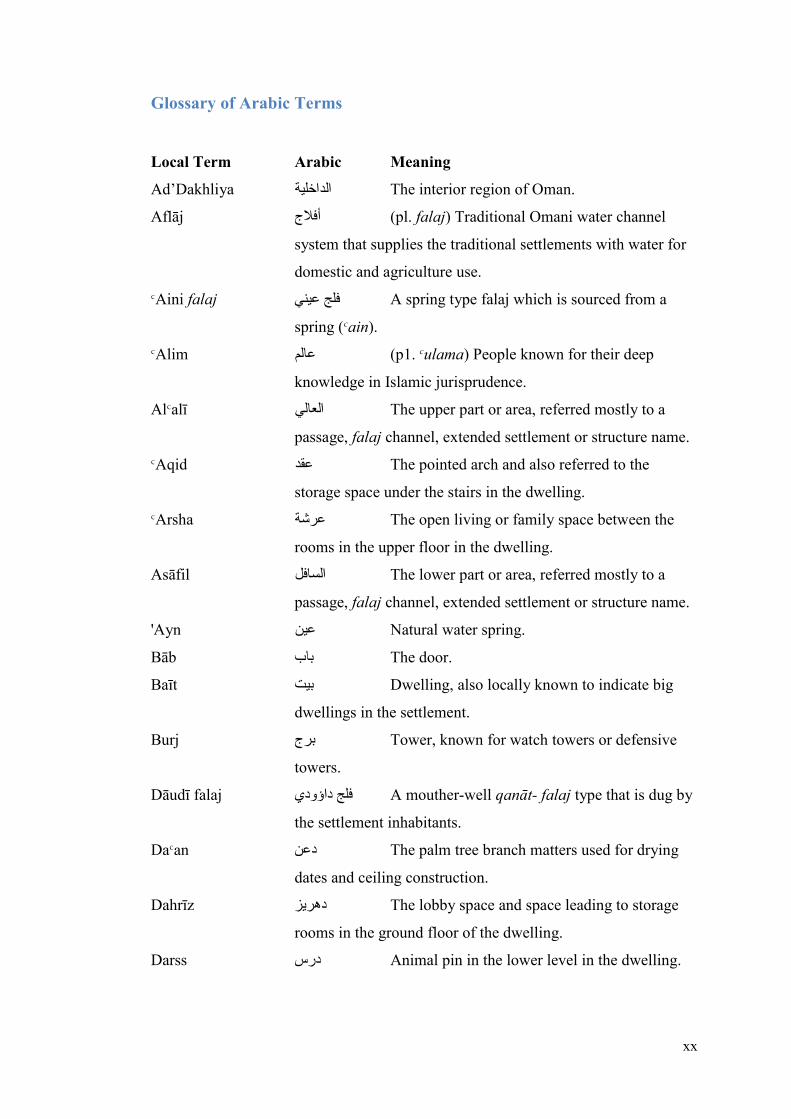
Glossary of Arabic Terms
Local Term Arabic Meaning
Ad’Dakhliya الداخلية The interior region of Oman.
Aflāj أفالج (pl. falaj) Traditional Omani water channel
system that supplies the traditional settlements with water for
domestic and agriculture use.
ΚAini falaj عينيَفلج A spring type falaj which is sourced from a
spring (Κain).
ΚAlim عالم (p1. Κulama) People known for their deep
knowledge in Islamic jurisprudence.
AlΚalī العالي The upper part or area, referred mostly to a
passage, falaj channel, extended settlement or structure name.
ΚAqid عقد The pointed arch and also referred to the
storage space under the stairs in the dwelling.
ΚArsha عرشة The open living or family space between the
rooms in the upper floor in the dwelling.
Asāfil السافل The lower part or area, referred mostly to a
passage, falaj channel, extended settlement or structure name.
'Ayn عين Natural water spring.
Bāb باب The door.
Baīt بيت Dwelling, also locally known to indicate big
dwellings in the settlement.
Burj برج Tower, known for watch towers or defensive
towers.
Dāudī falaj داؤوديَفلج A mouther-well qanāt- falaj type that is dug by
the settlement inhabitants.
DaΚan دعن The palm tree branch matters used for drying
dates and ceiling construction.
Dahrīz هريزد The lobby space and space leading to storage
rooms in the ground floor of the dwelling.
Darss درس Animal pin in the lower level in the dwelling.

xxi
Eid عيد An important religious festive day celebrated
by Muslims after the Holy month of Ramadan and the 10th
day of Thu al-Дijjah.
Falaj فلج (pl., aflāj) The traditional irrigation system of
water flow throw over ground and underground channel
networks.
Fowq قفو Up, located in upper level.
FurΡa فرضة Communal bathing and ablution structure for
males. It can be found inside or outside the mosque.
Gharbī غربي Western, located west.
Ghailī falaj غيليَفلج A falaj type that is sources from diverted water
of the wadī (ghail).
Ghurfa غرفة Sleeping room in the upper floor of the
dwelling.
Дuşin حصن Fort, fortified area.
Imam امام The leader of central government authority and
of the lbadi community.
JaΉla جحلة Clay pot water cooler used for drinking in the
dwelling and mosque.
Jidh’a جذع The palm tree trunk used for ceiling
construction.
Māll مال The orchard date palm gardens.
Masjid مسجد Mosque ,place of worship.
MiΒbah مصباح Window of the dwelling.
Mirzab مرزاب Water spout from roof.
Mujaza مجازة Female communal bathing structure with a
prayer room inside.
Muqāmrah مقامرة The room in the mezzanine level, between floor
levels.
MqīΡha مقيضة The small dwelling in the orchard date palm
gardens.
Mrāq مراق Small narrow opining in a wall.
MuΒala مصلى Prayer area smaller than a mosque.
MuΓbakh مطبخ Kitchen, the cooking space in the dwelling.

xxii
Mutrab مترب Latrine, traditional toilet.
NaΞd نضد Date storage room in the ground level of the
dwelling.
NuqΒa نقصة (pl., naqaΒ) column.
QunΓra قنطرة Any cover over the falaj to provide access to
both sides.
Rwzna روزنة The niches in the wall.
Rashīd رشيد The leader of family groups within the tribe.
RufΒah رفصة One riser step up.
SabaΉ صباح Gate with a room on top used for male
meetings or watching the movement inside and out the
settlement.
Sabla سبلة (pl., sbal) Social meeting place for males, can
be private for one tribe or communal for mixed tribes.
Salat صالة One of five daily prayers.
Shrī’a شريعة The local name of the first appeared flow
location of the falaj channel, the place for collecting drinking
water.
Sharqī شرقي Eastern, located east.
Sheikh شيخ Tribal leader.
Sidra سدرة A type of tree in Oman known to grow in
wādīs.
Sikah سكة Passage, lane or route.
Sīqaya سيقية The channel of the falaj.
Сorja صورجة The storage room in the dwelling.
Sraj سراج Single niche in the wall.
Sufah صفة The storage room in the dwelling.
Souq سوق The traditional market for trading exchange
which can refer to a structure or open area known locally.
SuΓΉ سطح The roof in the dwelling.
Tamimah تميمة Principal sheikh of a tribal grouping.
Tanowr تنور The deep fire hole in the ground used to cook
traditional meat in festive occasions.
Tawi طوي Water well.

xxiii
Wādī وادي Dry Rivers which discharge storm rain water
from the mountains to the lower flat lands.
Wakil وكيل Islamic agent, administrating falaj affairs
(wakil al-falaj).
Waqf وقف Islamic mortmain for charitable purposes.
Wilayat والية Administrative region.
Qal’a قلعة Castle or fort
Burj برج Tower
Дarah حارة Дāra(t) (tribal quarter of)
Siyab سيب Small stone structures
xxiv
Chapter-1: Research Introduction
1.1: Introduction
1.2: Rationale
1.3: Methodology
1.4: Research Development
1.5: Literature and Supporting considered
disciplines

1
Chapter-1: Research Introduction
1.1: Introduction
The richness of the traditional built environment of Oman1 is presented by the diversity
and spread of defensive structures - castles, forts and watchtowers - and traditional
settlement quarters (Figure-1). The distinguished character of the Omani heritage has
generated a research gravity for many scholars over the past four decades within their
discipline especially archaeology, history, anthropology, social studies, hydrology,
agriculture and architecture. Much of this research was undertaken independently or
funded by the Ministry of Heritage and Culture (MHC), especially in the field of
archaeology. It also attracted international organisations of the United Nations
Educational, Scientific and Cultural Organization (UNESCO), which inscribed aflāj2,
forts3 and archaeological sites4 on the world heritage site list. Much of that work has
been published in the Journal of Oman Studies (JOS)5 by MHC, but sadly, most of the
work was contributing to archaeology or as governmental reports.
In the last few years, the growth of urban development and neglect of the settlement’s
previous inhabitants has increased the threat of losing these traditional settlements
1 Oman, officially known as the Sultanate of Oman, is an Arabian Islamic country located in the
southwest of the continent of Asia, on the southeast coast of the Arabian Peninsula facing the Indian
Ocean. 2 In 2006 the UNESCO listed falāj Daris in Nizwa, falāj al-khatmīn in Birkat al-Mawz, falāj al-Malki
in Izkī, falāj al-Mayassar in Rustāk and falāj al-Jeela in Sur in the world heritage site (MRMWR, 2008,
p. 10). These alflāj were listed on the basis of; (a) being the oldest water channels with significant
engineering technique, (b) gave rise to ancient human settlements; (c) contributed in establishing
cohesive system of social solidarity and water managements in shares and distribution. 3 In 1987 the UNESCO listed Bahla fort as a world heritage site, which was later extended to include
the entire oasis as a socio-economic and cultural entity. 4 In 1988 the UNESCO listed the archaeological sites of Bat, al-Khutm and al-Ayn in the world heritage
list. 5 The journal was established and has been managed by MHC since 1974 to publish in Arabic and
English research on Oman’s heritage, culture, history, archaeology and traditional architecture in
particular and historical and cultural studies on the Arabian Peninsula, Middle East, Asia and Africa, in
general.

2
altogether, which today mostly lie deserted and at least in partial ruins. These threats
alongside the increase in tourist visits, has driven the MHC to give particular attention
to traditional settlements. They started first by conducting statistical surveys of all
traditional settlements and categorising them with respect to their historical
importance in each region. Following this the documentation and production of a
heritage management plan was awarded to the centre for the study of Architecture and
Cultural Heritage of India, Arabia and the Maghreb (ArCHIAM)6 at Nottingham Trent
University (NTU).
Although the MHC is trying to document and preserve or conserve the settlements in
accordance with their priority list, capacity and limitations, the long-term vision is
somewhat unclear in relation to how best these settlements should be preserved
physically, historically, culturally and economically. It is important that there is the
much-needed production of knowledge from these traditional settlements and its
contribution to future research, education and design practice in Oman and worldwide.
“Traditional dwellings and settlements are the built expression of a
heritage that continues to be transmitted from one generation to another”
(Bourdier, 1989, p.5).
The key to studying traditional settlements is to understand the way they formed and
evolved in terms of urban morphology and architecture. Although some work has been
6 The research group focuses on the humanities based study of architecture, material culture and the
built environment within a fast evolving context of simultaneous globalisation and heightened
awareness of difference. It also understands the practice of design as essentially a discipline of
negotiation and dialogue between the wide spectrum of theoretical, social, cultural, political, practical
and technological concerns and determinants (www.archiam-centre.com).

3
done - Manah7, Ibrā’8, MuΡayrib9, Nizwa and Bahla to name some of these – which
have been limited in scope in that these focus mainly on large oasis settlements on the
plains of interior Oman but also pay uneven attention to urban morphology and
dwelling pattern. Hence, this research aims to investigate the morphology and dwelling
types of the foothill settlements of al-Дamrā and Birkat al-Mawz in inner Oman
(Figure-2).
7 Soumyen Bandyopadhyay in 1998 studied ManaΉ as part of his PhD dissertation in terms of its
architecture, archaeology and social history, later published in 2011 as ManaΉ: an Omani Oasis, an
Arabian Legacy, Architecture and Social History of an Omani Settlement. 8 Ibrā in the Sharqiyah Region has been studied fairly thoroughly by Colette Le Cour Grandmasion in
terms of its setting (Bonnenfand, 1977, pp. 91-94), and the special organisation, tribal groupings and
Kingship (Le Cour-Gandmasion, 1977, pp. 95-106). 9 MuΡayrib in the Sharqiyah Region has been studied in terms of its setting by Paul Bonnenfant and
Colette Le Cour-Grandmasion (Bonnenfand, 1977, pp. 91-94), and its architecture and social History
by Paul and Guillemette Bonnenfant and Salim b.Дamad al-Дarthī (Bonnenfand, 1977, pp. 107-136).

4
Figure 1: The Sultanate of Oman (Nations, 2004).

5
Figure 2: Settlement locations of al-Дamrā and Birkat al-Mawz.

6
Statement of the Problem
The JOS publications have contributed knowledge in the different disciplines; have
concentrated on the archaeology – Umm an-Nar settlements (3rd millennium B.C.) for
example, and some inner oasis and coastal settlement quarters. There, however, is
often a lack of a holistic approach to settlement analysis. Moreover, they suffer the
problem of generalization and are fundamentally descriptive works. The closest to a
detailed analysis was those of Grandmasion (1977) in Ibrā’ and Bandyopadhyay (2011)
in ManaΉ. Following extensive research on traditional Omani built environments;
Bandyopadhyay acknowledged the problematic aspects of synthesis and interpretation
in that field and emphasized that:
“… The key reason for the study of the built environment is to pursue
and develop historical knowledge … and to theorise on the relationship
between people, their society, and their material culture and that analysis and
speculative interpretation is a key to unlocking that knowledge … for a
contextual interpretation as an important means of historical investigation into
meaning and knowledge production. Context can indeed be of temporal, spatial,
environmental, physical, social, cultural, political, behavioural, disciplinary or
textual nature – with their differing, often overlapping, scales of operation ...”
(Bandyopadhyay, 2002, p.16).
The problem is that there has been no clear contribution in understanding the
traditional settlements through addressing the strong bond between people and people,
people and environment, people and buildings, and buildings and environment. This,
I contend, can only be achieved through addressing the urban morphology and
dwelling types. Addressing these two aspects will contribute to providing a holistic

7
understanding to traditional settlements and establish ways of achieving continuity
between traditional and contemporary architecture. In doing so, it will attempt to
investigate the foothill settlements by acknowledging all contributing factors. This in
turn is intended to develop a fuller analytical and theoretical construction of settlement
morphology and dwellings typology in central Oman.
Research aims
The key research aims are to understand:
The distinctive characteristics of foothill settlements in relation to other
settlement types.
How the inhabitants adapted to the ambient natural environment, especially the
topography.
The impact of the tribe’s revival and unity to the settlement’s social
organisation and solidarity.
How the dwelling types reflect a distinctive identity in relation to other
settlements.
Research Questions
To fill the gap in research on traditional settlements quarters, this investigation will
focus on the two aforementioned foothill settlements to understand their formation
both at settlement and dwelling levels. To accomplish this, the key questions could be
established at two levels, relating to settlement morphology and dwelling types:
Q1: Settlement’s morphology: What factors contributed to the formation
of the foothill settlements?
What made these sites available? What factors influenced the urban pattern of the two
settlements and how did the inhabitants adapt and shape them? How did topography
and the urban fabric contribute to the scale of the dwelling clusters and the variety of

8
dwelling forms? Was there a defined structure or organisation in its pattern? Did the
settlements clarify a sense of core and edge? How did communal institutions (e.g.,
mosque, sablah, gates, the Qur’an school, public bathing areas and the suq) contribute
to their ordering?
Although Bandyopadhyay addressed the setting and townscape of Harāt al-Bilād in
ManaΉ, he did not address what made the site available. Additionally, he defined the
natural geographic external edge but did not explain their influence on the morphology
(Bandyopadhyay 2011). His morphological hypothesis - gradual transformation of
successive settlements edges - addressed its evolution as blocks giving rise to street
hierarchy resulting from accessibility of the blocks, but did not define, for example,
how they relate to each other, their diversity in scale and the detailed evolution of
individual blocks.
In Al-cAqr in Nizwa, Bandyopadhyay’s morphological hypothesis – street extension
with linear structures – addressed its evolution starting from an assumed core around
Masjid ash-Shawadhnia (an ancient mosque) and in relation to the Nizwa fort but did
not explain why and how the factors influenced its linear formation. In Bahla, he
argues that its ring form clustered around a hillock occupied by the fort and the great
mosque was driven by the expansion of back-to-back dwellings to form a lozenge-like
shape with arced peripheral streets culminating in small squares. Although this might
explain its form, it does not fully address the location selection of the core settlement
(Al-cAqr) and the relation between the falāj network and successive expansions
(Bandyopadhyay 2005).
In the case of Ibrā’, Grandmasion argues that terrain and water resources have more
influence on the distribution of people and the organization of their activities. He states
that falāj, security and social organization are the main structural factors affecting the

9
spatial organization of the oasis. Although he studied the land area, its structure, the
population, organization of inhabited areas, the neighbourhoods and the structural
elements that shaped them, it did not address their interrelation and their contribution
to the settlement’s morphology (Grandmasion 1977).
In the above cases of ManaΉ, Nizwa, Bahla and Ibrā’, though some valuable work has
been done, the issue of historical morphology has been given uneven attention. The
present research builds on their work as useful secondary material and approach the
main settlement of āl-Hamrā oasis with a holistic and detailed analysis.
Q2: Dwellings: How did the settlement’s morphology contribute to the
dwelling types, forms and space organisation?
Did the space organisation in the dwellings vary with respect to its location within the
settlement as a whole and the cluster block in specific? Did the social and socio-
political status contribute to the dwelling location, scale, form and architectural
feature? How did different dwelling types respond to challenging climatic,
environmental and topographic features and convey social and cultural ideas at the
same time? How did the dwellings relate to the communal institutions?
Bandyopadhyay’s discussion on ManaΉ also covered the dwelling types based on the
study of resident tribal groups, followed by a later discussion on their typology through
space organization driven by the deconstructed courtyard concept. However, he did
not explain how space organization and dwelling location contribute to their form.
Additionally, he did not explain how continuous dwelling influence each other’s
formation (Bandyopadhyay, 2011).
In Mudayrib Grandmasion describes the dwellings to have the concept of courtyard –
often known as the ‘Arab-style’- to assure privacy. He addressed the concept as being
constituted of an interior courtyard surrounded on one or more sides by a covered

10
gallery decorated with archways to which several rooms open. Although the work
addressed the basic concept of space organization, it did not explain how this concept
negotiated with change in location and other factors to introduce other forms and types
(Grandmasion 1977).
To the north of the Bātina coast, in Şuhār, Kervran describes the traditional Şuhāri
houses oriented to the north-east, facing the sea, with a rectangular form core, the
hawsh (courtyard) and enclosed by rooms on one or two sides. He adds, that the liwān
– open arched gallery enclosed from three sides – attached to private living quarters
are always facing the entrance on the west side (Kervran 1976). Although Kervran
addressed the main principle of form and space organization, she did not explain how
it evolves with change in location and its relation to other houses.
In the south at Zafār, Costa addressed the dwelling types based on each settlement’s
dwelling space organization concept. In Mirbāt, he describes starting with a walled
forecourt in front and the shamsiyah (i.e., light and ventilation shaft) to be the core of
the house and rooms clustered around it in the first level while the storage in the lower.
In Salālah in al-Hāfah quarter, describes them to be similar to Mirbāt dwellings without
a forecourt in front and the core is mahādhara (i.e., one of the main focuses and living
room in the dwelling). Although Costa addressed space organization in each type
based on climatic factors, but, didn’t consider social and morphological influences.
From the above dwelling types studies of Manah, Mudayrib, Şuhār, Mirbāt and
Salālah, it seems that there is a lack of considering the topography challenge, how
people engage with space and how dwelling relate to each other in specific and in the
settlement as a whole. Hence, this investigation will build up on their studies as second
hand data and will also study all dwellings typology (scale, form, individual, cluster
blocks and space organisation) that evolved in relation to the settlement's morphology.

11
Research Objectives:
To document the traditional foothill settlements from a historical, social and
architectural perspective, and study how they interrelated.
To study the social, geographical and political pre-settling factors that
contributed in the settlement’s formation.
To analyse the cohesive relation between geography, setting and topography.
The highlight the political influence of the YaΚrubah Imamate (17th century) in
the settlement’s development and social organisation of the tribes.
To analyse the influence of topography and geology on the formation of the
urban fabric and dwelling clusters.
To analyse the dwellings regarding their space organisation and location and
its relation to other structures.
1.2: Rationale
Rationale of studying traditional settlements
According to the first phase of the settlement survey undertaken in 2009 by MHC,
there were over 800 traditional settlements in Oman, of which 32.9% were located in
the Dakhliya (Interior) region. These settlements also vary according to their
geographical location: 43% were on the plains, 37% in the foothill areas, 14% in the
mountains and 2% on wadī (seasonal river) beds. Within these settlements, MHC
assesses that 50% were made of mud bricks, 24% of stone and 26% were made of a
composite stone and mud-brick construction. These statistics indicate the richness and
diversity of types of traditional settlements in Oman that has remained till the present
day. When visiting these settlements, looking at its structures, walking through its

12
empty passages and entering its deserted dwellings, one realises that the remains of
material culture and the formation of the settlements have a long story to tell. Looking
into how the falaj channels penetrate the settlements and how the palm groves integrate
with life in the settlements, one realises the bigger context of the idea of ‘dwelling’. It
is the story of the sacred relationship between people and people, between people and
buildings, and between building and the environment – one that reveals the
significance of these settlements and the formation over time of their identity. The
morphological content reveals the social unity and solidarity reflecting a sustainable
way of living driven by continuity.
Rationale of Choosing Foothill settlements
Over the last four decades many research publications and scholars from various
disciplines have conducted research on traditional settlements addressing their history,
anthropology, archaeology, agriculture, socio-cultural, socio-political, architecture
and urban pattern. Most of these studies have focused on discipline-specific studies of
the costal (e.g, BaΓinah region oases) or inner oasis settlements (e.g., Nizwa, ManaΉ,
Bahla & Izkī) 10 addressing each discipline individually. However, the foothill
settlements, which, as mentioned above, although cover 37% of the total types of
traditional settlements in north Oman due to long stretch of the Дajar Mountains, have
been neglected in research. The foothill settlements are striking in their amazing
physical containment which embrace the mountains, and in turn are embraced by the
palm groves and falaj channels. The whole context is like a dawn of life shedding
10 These settlements were considered the oldest in the Dakhliya region (Jawf) and were the Islamic
and capital centre for the Imamate in their time which may indicate the reason for attracting scholars.
For example, the oasis of Bahla was the capital of the Nabāhina Imamate in the 15th and 16th century,
which was known as the Dark Age in Oman history. Nizwa was the capital and Islamic centre during
the YaΚrubah Imamate, known as the golden age, starting from Imam Nasir b.Murshid 1624-1629 AD.

13
layers of sky, mountain, settlement, people, water, and palm grove in a perfect poetic
picture of life. They are clearly significant in their setting and formation from the
walled inner oasis settlements reflecting efficiency in investing the land with limited
built space and resources resulting in uniqueness in their patterns, both social and
physical. The study of foothill settlements will contribute in understanding (a) the
geographical setting and topographic challenge, (b) design solution emerging from
topography challenge and resource limitations, (c) the inhabitants’ interaction with,
perception of and reaction to the environment, (d) their urban and architectural
characteristics, (e) the morphology in comparison to other settlements types (e.g.
Nizwa, ManaΉ, Bahla & Izkī).
Rationale of Selecting Case Studies
Дārat al-Дamrā – currently known as Hārat al-WisΓā11 – in al-Дamrā oasis is chosen
as the main case study with Hārat as-Saybānī in Birkat al-Mawz oasis as the
comparative settlement, both in the Dakhliya region. The two traditional foothill
settlement quarters were established in the mid-seventeenth century – during the
YaΚaribah Imamate period of Sultan b. Saif (1649-80 AD) – both located on hills
overlooking the palm gardens and surrounded by watchtowers on the surrounding hills.
They are both located at the foot of the two most important mountains in the ad-
Dhāliyah (also known in earlier times as the Jawf) region: al-Дamrā by Jabal Shams
and Birkat al-Mawz by Jabal al-AkhΡar. Their strategic location indicates their
importance geographically and politically for the resident tribes who emerged as
strong groupings in the seventeenth century and the Imamate of the time. Al-Дamrā is
17 km north of Bahla while Birkat al-Mawz is located equidistant between Nizwa in
11 It was known as Дārat al-Дamrā but after the extension of the Ήārat from east by Дārat as-
Sharquiyah, west by Дārat al-ΚAlī and north by Дārat al-Дaditha, it became known as Дārat al-WisΓā.

14
the west and Izkī in the east (Figure-3). The close proximity of al-Дamrā and Birkat
al-Mawz from the aforementioned older and larger settlements is also evidence of their
political and geographical importance.
Figure 3: The location of foothill settlements of al-Дamrā and Birkat al-Mawz in the Jawf region with
respect to the surrounding oasis settlements.
However, there are also a number of differences. Дārat al-WisΓā is inhabited by the
ΚAbriyīn tribe, while as-Saybānī by mainly the mixed tribes of Banī Riyām
confederation with a small ΚAbriyīn presence. The street network is more complex in
al-WisΓā, although the scale of the dwelling clusters is larger in as-Saybānī. The latter
evolved at the same location while in as-Saybānī the the expansion created a number
of satellite settlements, the more prominent ones being Дārat al-Wādī and Дārat al-
Makasir. Al-WisΓā has one falaj channel passing through it (siqyat al-Bilād / falaj al-
Дamrā) while as-Saybānī has two (siqyat al-ΚAlī and as-Sāfil12 / falaj al-KhaΓmeen).
The top edge of al-WisΓā is marked by two towers with an approximately straight street
leading through the built up area while as-Saybānī is marked with one tower at the
apex of the hill. Al-ΚAbriyīn were scattered in Rustāq, ΚIbrī, Nizwa and Shinas and
12 Siqyat al-ΚAlī means the upper channel and as-Sāfil meaning the lower channel in respect to
topographic levels.

15
some came from the Jabal Shams Mountain before settling in al-Дamrā; the latter were
the main supporters and allies of the Ya’ariba who settled in Birkat al-Mawz. Most of
the tribes in as-Saybānī came from Jabal al-AkhΡar Mountains, and from Izkī and
Nizwa.
The table below summarizes the differences and similarities between the two
settlements:
Settlement Дārat Al-WisΓā Дārat as-Saybānī Location āl-Hamrā Birkāt Al-Mawz
Settlement
type
Foothill Foothill
Dwellings 140 65
Gates 4 4
Towers 10: 2 in the settlement and 8
surrounding
8: 1 in the settlement and 7
surrounding
Mosques 4 1
Extended
settlements
3 (AlΚAlī, Al-Дadītha & As-
Sharqiya)
2 (Maqaseer and Al-Wādī)
Falaj (falāj al-Дamrā) : 2 channels,
Al-Bilād and AsseΉmah
(falāj Al-khatmain): 2
channels, al-ΚAlī (upper) and
as-Sāfil (lower)
Tribes Main: ΚAbriyīn
Others: Khatrī – HaΓalī –
NāΚabī – SharmaΉī – Dhulī –
ΚAzizī – YaΚrubī – NāΒrī –
Riyāmī – Shukrī - Bimanī
Main: Banī Riyām
Others: Сaqrī – Fahdī – Tobī –
Siyabī – ΚAbrī – NaΚabī –
ДaΡramī - Shariqī
Importance Gateway to Jabal Shams and
main settlement for Abriyin
Gateway to Jabal Al-Akhdar
and main settlement for Bani
Riyam and Ya’rbi Imam in
Bait Al-Ridadh
Wādīs 3: wādī Ghul, wādī Milh and
wādī Al-Muaidin
1: wādī al-Mid’am
Main Enemies Bani Hinah Bani Rawaha
Allais Bani Ghafir and Bani Jabir All sub-tribes under Banī
Riyām Table 1: summary of comparison between Дarāt Al-Wistā and Дarāt As-Saybani
Rationale of Selecting Other Compared Cases:
Throughout the literature review, analysis and discussion of the research, former and
on-going settlement research, documentation projects and studies will be

16
acknowledged as supportive and comparative case studies and as secondary material
to build up an empirical understanding of settlement morphology and architecture in
central Oman. The considered work is of Bandyopadhyay in Дārat al-Bilād in ManaΉ
and al-ΚAqr in Nizwa (Bandyopadhyay, 2011), and the Ibrā’ and Mudayrib study by
Grandmasion in 1977. Additionally, the HMP projects by ArCHIAM research centre
on Дārat al-ΚAqr in Bahla, Дārat al-Yemen in Izkī’, Дārat As-Sulaif in ΚIbrī and Дārat
al-Hujra in Bidbid / Fanjā, all undertaken in 2012-13 will also be referred to (Plate.3).
These selected settlements share in common their walled nature, yet they vary in their
geographical location, their political influence, their structure and the tribal mosaic.
The comparison with their morphological content and formation factors will contribute
towards a better understanding of how diverse influences have shaped the foothill
settlements, both socially and physically. The geographical location, topography and
tribal mosaic and power dynamics are key influences in shaping the foothills. The oasis
settlements selected for comparison are politically important in the sense of being
Islamic centres of learning and the capital of the Imamate (e.g. Bahla and Nizwa).
They are also unique in their pattern with other important formatory influences of the
mixed tribe mosaic, the Friday or Great Mosque and the fort (i.e. Bahla, Nizwa and
ManaΉ).

17
a. b.
c.
d.
Plate 1: (a) Hārat al-Yemen, Izkī’, (b) Hārat al-Bilad, Manah, (c) Hārat Al-‘Aqr, Bahla, (d) Hārat al-
Дujra, Bidbid/Fanjā (aerial photo, courtesy of NSA).

18
Interdisciplinary study:
The traditional settlements have attracted scholars of geography, archaeology, history,
anthropology, social studies, hydrology, agriculture and architecture, who have often
tended to work in disciplinary isolation. The importance of these disciplines to the
study of traditional settlements is evident through the disciplinary knowledge these
bring in; however, the sum is greater than its parts - the many factors not only
contribute but interact in shaping the settlement. Kent has highlighted the importance
of interdisciplinary research:
“… [i]nterdisciplinary research provides more alternatives with which
to view data. Awareness of different disciplines allows one to introduce
novel approaches not considered before, to have access to different data
base which may enhance a discipline’s pre-existing one, and to avoid
mistakes already made and corrected in other disciplines” (Kent, 1990,
p. 1).
Bandyopadhyay, likewise, in his research on Дārat al-Bilād in ManaΉ in 1998
highlighted the importance of a more holistic approach to integrating other disciplines
in the study of traditional Omani settlement:
“… [n]ow a holistic picture can only be painted when the colours are
drawn from a palette of all possible related disciplines. There often
seems to be a distinct reluctant to do this, especially when the drawing
of experiences from such “unscientific” disciplines as mythology and
folklore become necessary. This also calls for radically different and
much more complex methodology than the “scientific” approach would
normally warrant” (Bandyopadhyay, 1998, p. 387).

19
The contributions from the considered disciplines will develop the supporting
evidence base for a better understanding of settlement formation.
1.3: Methodology
Research Method:
To undertake the holistic approach, this author studied three methods: phenomenology,
Environment-Behaviour Relations (EBR) and environmental psychology. Seamon and
Mugerauer argue that the phenomenology of environment and place examines three
major themes: first, the essential quality and interconnections of human environmental
experience; secondly, the qualities of environment, such as sound, topography, light,
and special qualities, which promote a particular character of place and landscape;
thirdly, the extended context of social and symbolic environments fundamental to
place (Seamon, 2000, p. 5). Rapoport, in proposing EBR, suggests that an approach
should involve analysing a broad body of evidence that provide a large amount of
material (Rapoport, 1990, p. 12). He argues that the environment is best conceptualised
as the organisation of space, time, meaning, and communication, or, alternatively, as
the relation between people and people, people and things, and things and things (ibid,
p. 11).
“……the domain must include human behaviour, the relation between the
behaviour and the built environment, and the relationship among the
components (or elements) of the built environment. Moreover, the latter must
go beyond buildings – they need to include systems of setting of which
buildings form only a part; they also need to include fixed, semi-fixed, and
nonfixed feature elements…”(Rapoport, 1990, p.11).

20
Environmental psychology, considered by many as a relatively new field of intellectual
inquiry, is necessarily a multidisciplinary field of inquiry focused on human behaviour
in relation to the physical setting (Proshansky, 1967, p. 7). However, Proshansky also
highlights a problem with this method when considering the human behaviour and the
physical setting: “… the environmental psychology is confronted with the special
problem of deciding which of the various levels of human or social organization should
be undertaken to conceptualise the study (ibid, p. 8).
This research has considered adapting Seamon and Magerauer, and Rapoport’s method
in study the notion of place, relation between man and environment, man and built
environment, and interpreting them with the urban and architectural analysis in
understanding to the urban morphology and dwellings types. This is due to the fact
that traditional settlements form in a context of interrelation between man and
environment.
The author shall approach the research with the grounded theory (Hunter, 2008, p. 86).
This approach asks the researcher not to begin with a theory and not to have any
preconceived ideas but allows the theory to emerge (ibid, p. 87). The theory will be
generated through varying sources, which includes case studies, field observation,
interviews, historical records and documents. It is approached in three phases, data
collection, data preparation and analysis and theory or concept development. Phase
one, data collection, is based on fieldwork conducted in the selected settlements
(survey drawings, notes, photos), interviews (recordings, notes, transcripts) and all
existing literature and reports. Phase two, data preparation and analysis will be through
various methods to be discussed later. Phase three, the generation of the conceptual

21
theory of the settlement’s morphology and dwelling types which will be a result of the
analysis and combination of literature, observations, common sense and experience.

22
Figure 4: Research Methodology design
1st Fieldwork
2nd Fieldwork
3rd Fieldwork
Data
Analysis
Background
Study
Interviews
and
Historical
Records
Other related
disciplines
Literature
Review
Interpret
Review and
Interpret
Grounded Theory
Emerging
Results
+
Theoretical
Insights
Built-up
Theory
Hypothesis
Address
Settlement
Morphological
formation and
Dwelling
Types
Urban
Pattern Dwellings
Thesis
Writing
Methodology
Phenomenology and Environmental Behaviour Relations

23
Empirical Methodology Adopted:
To achieve these aims, I approaches the research employing the grounded theory
which has allowed me to collect and investigate a large body of material form diverse
disciplines and sources (Hunter, 2008, p. 86). The key method adopted here in relation
to traditional settlements is fieldwork data collection. This was collected in phases over
a three-year period, the two most comprehensive fieldwork seasons were between
November 2010 and March 2011 (Birkat al-Mawz / Дarāt as-Saybanī)13 – as part of
the Nottingham Trent University collaborative research project with MHC to
document and produce an HMP on Дarāt as-Saybāī, and in 2011 February (al-Дamrā
/ Дarāt al-WisΓā). This was followed by another phase of fieldwork in al-Дamrā in
February 2013 for the completion of any outstanding documentation. Background
literature was collected from 2008 onwards and was continually reviewed. The HMP
project made it possible to have a full documentation of not only all the structures of
Дarāt as-Saybānī but the NTU research team managed to document some parts of the
constituent Ήarāt of al-Maqaseer and al-Wadī. This was due to the relatively small
number of dwellings and other communal and defensive structures (about 65) in as-
Saybānī. However, the large scale and number of dwellings and other communal and
defensive structures in al-Дamrā (over 200) resulted in a more selective documentation.
Revisiting the settlement - Дārat al-Дamrā – after being raised in my grandfather’s
dwelling (may Allah rest his soul in peace) for fieldwork brought back memories.
Memories when the settlement was well populated and alive with its social traditions.
Being raised in that time, I gained a great deal of experience and perspective to the
13 It was an intensive full documentation of Birkat al-Mawz covering the three constituent settlements
of Дarat al-Wadī, Дarat al-Maqaseer and mainly on Дarat as-Saybanī. The documentation included
the townscape, the layouts of all structure types, photos, tribal information and history of the oasis.
24
way of life in the settlement. The simplicity reflected the true meaning of settlement
in the inhabitants view, and their strong social ties gave me a sense of solidarity and
intimate belonging. Their devotion to their livelihood reflected the sacred relation
between people and the surrounding environment. This devotion is driven towards the
prosperity of their families.
Walking through the silent passages in the deserted settlement triggered these
memories back and every element in the settlement echoed a meaning. I can still hear
the steps of older inhabitants in the passages, I can smell the aroma of cooking from
the dwellings, I can hear the women chatting during their coffee break, and I can hear
the auction from the souq. I realized with that my fieldwork will be walking with these
memories and that I shall ask the settlement once more to share it with me. I spent the
first two days walking through the settlements passages, entering random unlocked
dwellings, and through the palm groves. In following days, I started to select the
dwellings to be documented and arranged to interview some of the previous inhabitants.
To ensure getting the most reliable and historic tradition, I arranged to interview
Shaikh Jaber b.Mohammed Al-ΚAbrī – owner of Bait as-Сafah and known for his
significant historic knowledge. I also interviewed Hilal b.Shikhan Al-ΚAbrī – the last
remaining master builder and the current falaj wakil – who contributed by identifying
the owners of most of the dwellings and the falaj management system. Shaikh
Abdullah b.Mohammed Al-ΚAbrī – one of the last known religious scholars of his
generation and Imam of al-Дadith mosque – who also contributed with great insight
on the settlement’s history. SΚoud b.Sulaiman Al-ΚAbrī – the producer of traditional
vinegar for the settlement – also shared experiences of his life in the settlement. I have

25
also interviewed Shaikh Mohammed Al-SubΉī – the rashid of Banī SubΉ – who
contributed in giving a wider historic record of the oasis. All these interviews were
recorded on videos, and voice recorders and by taking notes.
Due to the fact that I had to conduct the fieldwork in al-Дamrā alone, I had to seek my
cousin’s assistance in taking the measurements. The survey of the selected dwellings
was divided, with sketches followed by photographs taken from morning till noon, and
measurements taken in the afternoon until sunset. Permission from some of the
previous inhabitants had to be taken to unlock and access their dwellings. This process
continued for the first two fieldwork visits to al-Дamrā. The fieldwork experience in
as-Saybānī was different from that of al-Дamrā. There was no memory to be revisited
which gave the work a more sense of curiosity and pleasure of exploring the unknown.
Soon after conducting the interviews with previous as-Saybānī inhabitants, their
memory and story of the settlements became our memory, which introduced a new
sense of continuity to the settlement’s legacy.
The collection of this material would not have been possible without the help of the
previous inhabitants of Дarāt al-WisΓā – some of whom are sadly no longer alive –
who are acknowledged at the beginning of this thesis. The interviewees were unable
to identify the erstwhile inhabitants of a small number of dwellings due to many
reasons. While the identification of the original inhabitant was certain but the change
in ownership and the possibility that the properties might have been sold afterwords
made it difficult in these cases. This reason, and the evacuation in the mid-1980s -
more than 25 years ago - made the memory fade and owners are long forgotten except
for the well-known dwellings.

26
Data Collection Process:
The fieldwork documentation of both settlements consisted of:
Survey drawings (plans, elevations and sections) of archaeological remains,
townscape, defensive and other architectural components, selected
dwellings/clusters and architectural features.
Photographic survey cataloguing urban and architectural spaces and features,
and archaeological sites, using digital photography and recorded on separate
catalogue.
Catalogue entry using standard pro-forma, all descriptions cross-referenced
with photographs and drawings.
Interviews with present and previous residents of the settlement to identify
tribal and settlement pattern and record oral history. This has contributed in
understanding the social and cultural values of all structure types and functions,
and addresses the group and tribal organisation (Plate-2).
Aerial photographs and large-scale topographic maps of the region and oasis,
obtained courtesy of National Survey Authority NSA/ ministry of defence
MOD, were appropriately enlarged (scale 1:100/ 1:200) and shadow corrected.
These provide the base map to locate, orientate, configure structures and
produce detailed plans.
Documents and reports of surveys, project management, heritage plans or
touristic proposal from various Omani government bodies, wherever available,
were collected.
Collecting Arabic and English language literature from local and specialist
libraries in Oman and the UK.

27
a.
b.
c. d. Plate 2: Examples of sketches and interviews made during fieldwork; a. Ground floor plans of
dwellings D30 and D31 (cf. Chapter 5), b. A cross section sketch of the lower part of Дarāt as-
Saybānī, c. Interview with a younger previous inhabitant of Дarāt al-Дamrā (Jabir Al-ΚAbrī), d.
Interview with the falaj waqil of Дarāt as-Saybānī (ΚAbdullah al-Saqrī).

28
Data Preparation Method:
The aerial photos and topographic maps collected on both oasis settlements
contributed as follows:
Phase 1: Base Map
To be used and employed as base map in the sketching up process of the whole
settlement.
To establish the land use in the whole oasis.
Define the location of the settlement with respect to the surrounding natural
environment and the built environment.
Define the settlements form as a whole and the form of each individual
structure and the streets hierarchy.
Understand the topography contribution to the settlements form, location and
scale as a whole and individual structure.
Phase 2: Analysis
The map analysis method of Worthington and Robert was adapted, which is
description, analysis and interpretation of the physical features and settlement patterns
based upon the 1:10000 scales Aerial photo and large scale topography map
(Worthington, 1975, p. 7). He process was as follows:
1) Description: will include written description on physical and cultural features
and supported by map evidence. Such description will consist:
An assessment of the position of the higher and lower ground
with possibility to divide the area in to physical zones (built up
zone, vegetation, piedmont, wādī…etc.).

29
Each zone will then be described in more details (higher zones,
lower zones, edge zones, core zones…etc.).
2) Analysis: each zone will be analysed in relation to its location, function and
pattern with respect to the topographic influence and supported by
diagrammatic evidence.
3) Interpretation: from the two previous stages, it can be interpreted as follows:
The special feature of each zone.
The relation between the zones.
The factors that contributed to their location, function and
pattern.
Data Analysis and Interpretation Method:
Urban and Architectural Preparation for Analysis:
Settlement Patterns
After drafting the whole settlement in details, a code pattern will be produced to mark
all the dwellings and communal and defensive structures. From the interpretation of
the interviews and personal observation on the field, the following drawings can be
prepared for analysis:
Settlements components: defining all structure types with colour codes in
which similar structures have the same colour code.
Settlements communal structures: colour coding all the communal structures
with respect to function and the gender of users.
Tribal pattern: colour coding each dwelling according to the owners tribe.
Street rout hierarchy: the street routs will be coded according to their category
of width, function, orientation and location.

30
Dwelling cluster block scale: colour coding the cluster blocks from individual
to two attached dwellings to bigger clusters according to their regularity,
complexity and density of the blocks.
Topography dwelling pattern: colour coding all dwellings with respect to the
contour line.
Access points: marking the main and secondary access points in the settlement
as a whole and those for the dwellings.
Edge and central: colour coding the edge and central dwellings.
Special architectural feature: marking the dwellings with special architecture
features (central column, sky light, courtyard…etc.).
Dwellings
The detailed draft of the settlement will be followed by drafting the selected dwellings
floor plans individually and in cluster blocks in which the following drawings can be
prepared for analysis:
Dwelling space code: coding all the spaces in the dwelling according to their
function and organisation.
Double walls: marking the back to back double walls in the selected dwelling
cluster block.
Stone walls: marking the full height stone wall in each dwelling if any.
The foundation scale: marking the stone foundation scale in all the dwelling in
the cluster block.
Urban and Architectural Analysis:
The three interrelated methods addressed by Trancik (1986) will be adapted to analyse
the urban pattern and dwellings:

31
Figure-Ground method: This theory will establish the relation between the
solid mass (dwelling cluster) and open voids (street passages and open spaces).
The objective of this manipulation is to clarify the structure of urban spaces in
the settlement by establishing a hierarchy of spaces of different sizes that may
be individually enclosed but ordered directionally in relation to each other. It
will also contribute in defining the built up ratio and structure density (Trancik,
1986, p. 98).
Linkage method: This theory is derived from the ‘line’ in connecting one
element to another. The lines in the settlement will be reflected by the gates,
falāj, the main streets, passages between dwellings and open spaces….etc. This
will contribute to understanding the relation and connection between these
elements (ibid, p. 106).
The Place method: this method focuses on the component of human needs
and cultural, historical, and natural context. In place theory, inhabitants require
a relatively stable system of places in which to develop themselves, their social
lives, and their culture and other activities. These needs give manmade space
an emotional content – a presence that is more than physical (ibid, p. 112).
The author will also consider the possibility of employing the generative syntax
method (Hillier, 1984) which sees the settlements as a bi-polar system arranged
between the primary cells or buildings (dwellings, etc.) and the carrier (surroundings
outside the settlement). Despite the contribution these analysis, the author is also
depending on his own analysis of observation, experience and common sense.

32
Challenges and Limitations:
As expected, data collection fieldwork was faced with many challenges throughout.
The first challenge was the hot arid climate of Oman which made fieldwork possible
during the winter months of relatively cooler weather (between October and March).
In some cases it was not possible to define the original dwelling owners due to a
number of reasons. Firstly, many older previous inhabitants, who had in-depth
knowledge of the settlement, are sadly no longer alive. Secondly, the change in
dwelling ownership through time had made it difficult to identify the original owners.
Thirdly, the memory of the current older inhabitants is also fading with time and the
younger generation have limited knowledge. Fourthly, parts of the settlements lie in
ruins, which made it difficult to identify plans, property boundaries and consequently,
ownership. And finally, the settlement is now encroached by modern development at
the expense of the traditional dwellings, erasing the original traces and in some cases,
parts of the settlement. These challenges made it necessary to conduct as many
interviews as possible to ensure identification of the settlement components and
dwelling owners. The interviews included the older inhabitants who possibly knew
most about the settlements, the falaj keepers (waqil), family heads, tribal group heads
(rashīd), the imam of the mosque, some of the inhabitants who still reside in the
settlement as well as members of the younger generation.

33
1.4: Research Development
Theoretical Insights:
Studying in detail the former contributions done in the traditional settlements in central
Oman has contributed in highlighting some theoretical insights. Geographically, these
oasis settlements share the natural resources of Al-Дajar Mountains especially the
wadī channels. From a social point of view, these settlements are settled in varying
numbers by the same tribes. From a historical perspective, the oasis settlement of
Nizwa, Bahla and ManaΉ had a political, religious and economic influence in the Jawf
Region. The foothill settlement of al-Дamrā and Birkat al-Mawz share these
geographical, social, and historical interest with the other oasis settlements. These
theoretical insight will contribute in forming a connection and clear understanding on
the similarity and differences between the foothill settlements and the plain oasis
settlements. These theoretical insight are as follows:
Most of the settlements in Inner Oman (Jawf region) were rather located within
the Al-Дajar Mountains or clustered around it (in the piedmonts).
The settlements type had a gradual and historic sequence (i.e., evolved
morphology), wādī edge settlement (i.e., al-Yemen in Izkī’ and Al-ΚAqr in
Bahla), piedmont settlements (i.e., al-Bilād in ManaΉ), wādī settlements (i.e.,
Nizwa), mountain settlements (i.e., Balad Seet in Jabal al-AkhΡar and Misfāt
al-ΚAbriyīn in Jabal Shams) and finally the later foothill settlements (i.e., Birkat
al-Mawz and al-Дamrā).
The external edge of the settlements was mostly defined naturally either by
wādī channel, mountain, and topography or built environment by falaj
channels or palm groves (e.g. Дārat al-Bilād in ManaΉ, Дārat al-ΚAqr in Bahla,
and Дārat as-Sulaif in ΚIbrī).

34
There seems to be a sense of core extension and edge transformation through
the settlement evolution life time.
The falaj, security and social organization were common factors among the
settlements and were the main structural factors affecting the spatial
organization of the oasis.
There are three types of edges, the internal core of the settlement (i.e., core
block), and the edge of the settlement itself (i.e., wall, gate, dwelling and
towers) and the oasis edge.
The falaj and topography define the regularity or irregularity in the street
hierarchy and settlements formation.
The early settlements (i.e., Bahla, Izkī’, ManaΉ and Nizwa), were walled and
protected by a fort and associated with Great Friday Mosque. These settlements
were highly dense inhabited with mix-tribes indicating their importance
politically and religiously.
The watchtowers around the oasis were not only for defence purpose but, also
to state a sense of territoriality (i.e., oasis boundaries) spotted from afar.
The consistency and inconsistency between the dwelling blocks indicate the
settlements evolution direction.
The consistency and inconsistency between the side-by-side and back-to-back
dwelling walls indicates the dwellings block or street line evolution direction.
Built-up Theory:
From the theoretical insights on the former studied settlements above, the author has
noticed the strong influence the geographical location, the nature of surrounding
environment and the inhabitants needs (i.e., water, security and social organization) on

35
the oasis and settlements formation. Hence, the author has developed a new theory
called the reference-point (RP) method. This method can be applied starting from a
regional scale to the smallest space in a structure inside the settlement (Figure-5). The
RP can be considered to be anything (i.e., mountain, wādī, highest or lowest
topography level, falāj channel, street, open square, a mosque…..etc.) that may have
a connection or influence in the morphology. The idea is that the main RP (A) leads to
another reference point (B) and the intersection with another RP (C) will create a new
RP (D). Each RP in the RP network is considered a factor and an evolution starting
point in each zone in the settlement. This theory will contribute not only in addressing
the morphology of the settlement but also the relation between all the factors and the
settlements components.
Main RP
Figure 5: Example of RP theory (linear, grid, radial and enclosed)
Hypothesis:
From the previous discussion with the implementation of the initial analysis, author’s
observation, oral historical records (i.e., interviews), and applying of RF theory in āl-
Hamrā and Barkāt al-Mawz, the author has built up his hypothesis on the pre-existing
concept (PEC) and RF network. The PEC in āl-Hamrā was the central well feeding
the arable land which lead later to the settlements location selection and the falāj
channel to be the spine reference line to its linear and directional evolution. In as-
A
C D
1
E
2
3
4
5 6 7
4
Linear
Grid
Radial Enclosed
Distant
B

36
Saybānī in Birkat al-Mawz, the PEC were the tower and small structures behind it ,at
the top, to be the core of the settlement’s radial evolution with topography negotiation.
Contribution to Knowledge:
The research aims to achieve a discrete contribution towards the knowledge of the
Omani traditional built environment and the study of settlements in the field by
establishing, (a) the appropriate approach to studying traditional settlements in general
and its morphology and dwellings in specific. This will define lessons that can be
learned in urban morphology and design and its implication on future research, design
and practice. (b) A detailed interdisciplinary investigation on the traditional settlement
morphology and dwellings. This will be contributed in parallel with an appropriate
documentation (drawn – historical – social - cultural) to these case studies. (c) An
understanding of the inhabitants’ perception to their natural environment and built
environment. Their perception will also contribute in establishing whether the
morphology, form of the settlement and dwelling types reflects the specific identity of
the inhabitants.
Research Organization and Layout:
This research starts by introducing the problem and the theoretical background, and
then moves on to introduce the settlements and address the factor that contributes to
their formation. The research is divided into six main chapters: research introduction;
al-Дamrā and Birkat al-Mawz: the setting; al-Дamrā and Birkat al-Mawz: urban
pattern and architecture; al-Дamrā and Birkat al-Mawz: tribal pattern and settlement
structure; al-Дamrā and Birkat al-Mawz: dwellings and architecture; and finally, the
conclusion.

37
Chapter-1 (Research Introduction): This chapter consists of five main headings,
Introduction, rational, methodology, research development and literature and
supporting disciplines. The introduction provides a statement of the problem, the
research aims, questions and objectives. This is then followed by a rational for
studying traditional Omani settlements, and especially, choosing the foothill
settlements, and the specific case studies. The methodology illustrates the key research
methods for data collection, preparation, analysis and interpretation and their
challenges and limitations. This is followed by a discussion on research development,
which includes the theoretical insights, research hypothesis, contribution to knowledge
and the research organisation and layout. This chapter is concluded by a discussion on
the multidisciplinary literature which illustrates the present state of knowledge in
relation to traditional settlement studies.
Chapter-2 (al-Дamrā and Birkat al-Mawz: the setting): This chapter focuses on
the environmental setting of the interior of Oman, and the two settlements under
consideration, al-Дamrā and Birkat al-Mawz. The discussion on the environmental
setting of the interior describes the geological setting, the topography, the hydrology
and wadī drainage system, the geology and structure, the climate and the
environmental pattern and settlement location. This is subsequently treated in more
detail in relation to al-Дamrā and Birkat al-Mawz.
Chapter-3 (al-Дamrā and Birkat al-Mawz: urban pattern and architecture): This
chapter discusses the close relationship between topography and urban pattern, which

38
includes the topographic influence on both al-Дamrā and Birkat al-Mawz in settlement
formation and ensuing urban pattern.
Chapter-4 (al-Дamrā and Birkat al-Mawz: tribal pattern and settlement
structure): This chapter discusses the social history of al-Дamrā, which also includes
a short overview of the archaeology of early human settlements and movement in al-
Дamrā region, and the seventeenth century revival of the ΚAbriyīn tribe and the
consequent emergence of al-Дamrā, the falaj and the settlement beginnings, and
finally the setting and components of Baldat al-Дamrā. It is followed by a detailed
discussion on the tribal pattern of Дarāt al-WiΒtā. The pattern is mirrored in the case
of Birkat al-Mawz which materialised contemporaneous to al-Дamrā following the
revival of the Banī Riyām tribal confederation in central Oman. The focus at Birkat al-
Mawz is on the settlement quarter of Дarāt as-Saybānī.
Chapter-5 (al-Дamrā and Birkat al-Mawz: Dwellings and architecture): This
chapter focuses on dwelling spatial organisation, its relationship to topography. The
foothill settlement dwellings illustrate a variety of space types and functions. The
discussion then moves to the relationship between topography and dwelling level and
space structure which include individual dwellings, dwelling cluster, and communal
space related to dwelling clusters. And finally, the epilogue summarises the findings
of this chapter.
And finally, Chapter-6 (epilogue) summarises the key conclusion of the research and
findings, and proposes recommendations.

39
1.5: Literature and Supporting Considered Disciplines
The Omani renaissance of 1970 was the dawn that opened the country’s economy to
the outside world with increased interaction, which also resulted in attracting
international research institutions, organisations and individual researchers. The
diverse topography and historic and cultural wealth generated a research gravitas for
scholars from many disciplines. In spite of this, the research on traditional Omani
architecture of the interior in specific, but also Oman in general, exhibits limited
research compared to its Arab counterparts. The important recipient has been the
disciplines of archaeology, hydrology, geography, geology and social anthropology.
The research effort of many scholars of diverse backgrounds in the last four decades,
although focused and dedicated to their own disciplines, are useful in terms of
understanding the influence of such disciplinary studies on the built environment and
settlement morphology. In this present study, the discussion will consider the
disciplinary contributions of both pre- and post-1970 activities, which have a direct
relation to the context of traditional settlements.
A notable contribution in socio-political studies and the Omani traditional irrigation
system (aflāj) came from the work of John, C. Wilkinson. In his first work14, he
attempted to construct an understanding of the historical geography of Oman. This was
followed by his D.Phill thesis (1969)15 , which expanded on Oman’s significantly
complex social history, social organisation and political ideology. In 1977 he managed
to connect and develop further the work of his D.Phill. His 1977 thesis on methods of
14 Before his thesis, he published a journal paper on the historical geography of the Trucial States.
Wilkinson, J. C., “A Sketch of the Historical Geography of the Trucial Oman Down to the Beginning
of the Sixteenth Century”, Geographical Journal, Vol. cxxx, 1969, pp. 337-349. 15 Wilkinson, J. C., Arab settlement in Oman: The Origins and Development of the Tribal Pattern and
its Relationship to the Imamate, unpublished D.Phill, University of Oxford, 1969.

40
water exploitation and its close relationship to social organisation and its influence to
land was published as, “Water and Tribal Settlement in South-East Arabia: A Study of
the Aflaj of Oman”. This work discussed at length the origins, nature and management
system of the aflāj which was explained through the tribal social structure (Wilkinson,
1977). Wilkinson’s other major work, the Imamte Tradition of Oman, was the result
of further research16 after 1977 on the Islamic water laws and the concept of territory.
This work focuses on the Ibadi Imamate, tracing its presence through history and its
influence in the Imamate through defined periods (the ‘Imamate cycle’) along with a
lengthy discussion on tribal and Imamate structures. Between this and his latest
milestone publication of 2010, Ibadism: Origins and Early Development in Oman,
where he deconstructs the origins and evolution of Ibadism into a madhhab (school)
through a historical perspective incorporating the tribal dimension (Wilkinson, 2010).
Other social-anthropological, historical and economic works were contributed by
Carter, Birks, Dale and Christine Eickleman, and Peterson. Birks highlighted the deep
transition of the Shawawi groups in Northern Oman from semi-nomadic way of life to
the modern Sultanate (Birks, 1976). The Shawawi groups tend to live outside the
settlements but in close proximity, and more oriented towards hearding than
agriculture. In another work, Birks describes the role of the ΚAwāmr tribe, the
experienced well and falaj excavators (Birks, 1976)17. Lorimer’s18 gazetteer was the
first of its kind in recording historical and genealogical information of the Arabian
16 Wilkinson, J. C., “Islamic Water Law with Special Reference to Oasis Settlements”, Journal of Arid
Environment, vol. I, pp. 87-96. Additionally, “Traditional Concepts of Territory in South East
Arabia”, Geographical Journal, Vol. CXLIX, pp. 301-315. 17 Published in the same Journal under “The Awamr: Specialists well and falaj diggers in Northern
Interior Oman”, JOS, Vol. 2, 1976, pp. 93-100. 18 Lorimer, J.G., Gazetteer of the Persian Gulf, Oman and Central Arabia, Vol. i (Historical and
Genelogical), Vol. ii (Geographical), 1908 (Vol. ii), 1915 (Vol. i), Superintendent of Government
Printing, Calcutta, Gregg reprint, 1970.

41
Peninsula, followed by the work of Miles which consisted of a semi-historical record
of Oman Peninsula (Miles, 1919), starting from Arab migration to the Al Bu Saidi
Sulatns. A broad contribution on the tribes of Oman was by Carter which updates and
completes the record collected by Lorimer and Miles (Carter, 1982). Both works
contributed to the understanding of the social and tribal structure, and the political
power of traditional Oman.
The contribution towards understanding the traditional Omani culture and society was
marked by Dale and Christine Eickelman’s work in understanding the women’s social
and economic role in the family and settlement scale. Christine’s work was more
focused on the role and position of women in the settlement, focusing her study on the
women of al-Дamrā19. While Dale, has contributed to the understanding of Ibadi
theocracy and religious knowledge in inner Oman20. Another important contribution
in understanding the segregation of women and the graceful quality of social relation
is by Wikan in Suhar (Wikan, 1982).
Most of the archaeological excavation reports in Oman were published in the Journal
of Oman Studies (JOS), which is sponsored by MHC. The journal has published over
the last 35 years descriptions of digs and surveys, catalogues of finds and speculations
on dating. The first to be published was by the Harvard Archaeological Survey21 , and
19 Eickelman, C., (1) “Women and Community in Oman”, New York University Press, New York and
London, 1984. (2) “Fertility and Social Change in Oman: Women’s Prespectives”, The Middle East
Journal, Vol. 47. No. 4, 1993, pp. 652-666. 20 Eickelman, D.F., (1) “Religious Knowledge in Inner Oman”, JOS, Vol. 6, Part 1, 1983, pp. 163-72.
(2) “From Theocracy to Monarchy: Authority and Legitimacy in Inner Oman, 1935-1957”,
Inernational Journal of Middle East Studies (IJMES), Vol. 17, 1985, pp. 3-24. (3) “Ibadism and the
Sectarian Prespective”, in, Pridham, B.R., (ed.), op. cit., 1987, pp. 31-50. 21 Hastings, A., Humphires, J.H., Meadows, R.H., “Oman in the Third Millennium BC”, JOS, Vol. 1,
1975, pp. 9-56.

42
then followed by the contribution from the Danish archaeological team22 . Many
archaeological excavation and digs took place along the coastal area and on and around
the al-Hajar mountain region and dated the early settled life to the 3rd millennium BC.
Orchard and Stanger confirmed this date on their work on oasis towns in al-Дajar
Mountains by studying Umm an-Nar settlements (Orchard & Stanger, 1994). The
archaeological results of Jutta Haser survey camping in Wādī Bani Awf and al-Дamrā
in (1999) and (2000) contributed in understanding the pre-historical context of the
area23. The complete archaeological work of Cleuziou and Tosi on the prehistoric
civilizations in Oman gave a clear picture of the early human activities and settled
areas (Cleuziou, 2007).
The scholars agree that the falaj (traditional irrigation system) came from Iran during
their political influence around 1000 BC, which was the dawn of Iron Age settlements
(ibid, p. 152). According to Omani folklore, Sulayman b. Dawood commanded his
servant to dig 10,000 falaj channels in 10 days to facilitate his trip from Persepolis and
Jerusalem. In the present day over a 1000 falāj are spread all over Oman. It has also
had a great share of research devoted to it since it is considered to be the backbone of
life for all the settlements and agriculture land in the region. First contribution was by
Wilkinson (1977), he studied the afalāj origin, organisation and traditional techniques
of water-exploitation (Wilkinson, 1977). The work of Costa (1994) also added great
value of understanding architecture of afalāj, their features and distribution system
(Costa, 1994). A broad study on the star gazing system in falaj management was
22 Frifelt, K., “A Possible Link between the Jemdat Nasr and the Umm an-Nar Grves of Oman”, JOS,
Vol. 1, 1975, pp. 57-80. Additionally, “Evidence of a Third Millennium BC Town in Oman”, JOS,
Vol. 2, 1976, pp. 57-74. 23 Haser, J., “Formation and Transformation processes of oasis settlements in the Sultanate of Oman:
preliminary report on the new field project”, Proceedings of the Seminar of Arabian Studies, Vol. 30,
2000, pp. 115-118.

43
undertaken by Nash, where she described in details the technique of using stars in falaj
distribution (Nash, 2007). In recent years a great deal of research on falaj management
system and sustainability was contributed by Al-Ghāfrī24.
The research on the СuΉāri houses by the coast of СuΉār in the BāΓinah region by
Kervran et al was a documentation focused on describing the al-Hajra houses and
construction materials with a general description of the old town25. These dwellings
tend to form in a single-story courtyard structure, made of palm fronds or fired mud
bricks. Kervran has also highlighted the historical importance of СuΉār through the
findings of pre-Islamic and Islamic levels of her archaeological research in СuΉār
(Kervran, 2004). The construction material used in the СuΉāri houses reflects the
diversity of the built environment of the BāΓinah region which was also suggested by
Costa in 1985 (Costa, 1985). Costa has discussed the built environment of the BāΓinah
at length, which in his words reflects the ethnic and cultural complexity of its
population. He refers the superior quality of the palm-frond houses to two main factors;
technological and environmental. The first adopts the dynamic principle of allowing
24 Al-Ghafri, A., Norman, W., Shayya, W., & McCann, I., “Aflaj irrigation and on-farm water
management in northern Oman”, Irrigation and Drainage Systems, Kluwer Academic Publisher,
Netherlands, Vol. 12, 1998, pp. 35-48.
Al-Ghafri, A., Norman, & Shayya, W., “Irigation Water Costs and Management Practices Among
Farms in Northern Oman”, Agricutural Services, Sultan Qaboos University, Vol. 3, 1998, pp. 1-8.
Al-Ghafri, A., McCann, I., Al-Lawati, A., & Shayya, H., “Aflaj: the challenge of preserving the past
and adapting to the future”, Oman Internation Conference on the development and management of
water conveyance Systems (Aflaj), Ministry of Regional Municipalities, Environmental and water
resource, 2002.
Al-Ghafri, A., Inoue, T., & Nagasawa, T., “Daudi Aflaj: the Qanats of Oman”, Proceedings of the
Third Symposium on Xinjang, China, 2003, pp. 29-36.
Al-Ghafri, A., Norman, W., & McCann, I., “On farm labour allocation and water use in smallholder
irrigation systems: lessons from Africa and Arabia, Transition on Ecology and Environment, Vol. 80,
2005.
Al-Ghafri, A., “al-Aflāj al-Omania: manΞumat Дayat Muhaddadah”, Regional Conference for the
protection of groundwater, Trablus, 2006. 25 Kervran, M., Le Cour-Grandmaison, C., Soubeyran, M. & de Pemille, A.V., “СuΉāri Houses”, JOS,
Vol. 6, Part 2, 1983, pp. 307-316, plus plates.
Kervran, M., “Archaeological Research at СuΉār 1980-1986”, JOS, Vol. 13, 2004, pp. 263-381.

44
air ventilation through the walls, giving full advantage of sea breeze. The second in a
socio-anthropological of economy, were the fishermen tends to invest more in the boat
and fishing rather than a house (Costa, 1985, p. 119). The study done in Ibrā’ and
Mudayrib area by Bonnenfant and Le Cour-Grandmaison highlights the ration
between kingship spatial organisation geographically (Bonnenfand, 1977). This work
is extended farther addressing the spatial organisation, tribal groupings and kingship
in Ibrā’ by Grandmasion (Le Cour-Gandmasion, 1977). While the architectural and
social history at MuΡayrib was addressed by Guillemette et al gave a more detailed
analysis in traditional settlements studies (Bonnenfand, 1977).

45
2.1: Introduction
2.2: The Environmental Setting of the Interior
2.3: Al-Дamrā
2.4: Birkat al-Mawz
Chapter-2: Al-Дamrā & Birkat al-Mawz: The Setting

46
Chapter-2: Āl-Дamrā & Birkat al-Mawz: The Setting
2.1: Introduction
The relationship between mankind and earth has always been a sacred one and has
provided the fundamental source of resources for all human needs. The environment
was not only a dwelling place but also a source of inspiration and challenges to learn
from and develop. This understanding of the environment along with the human social
behaviour led to the emergence of human settlements. The physical environmental
diversity influences the evolution of settlements and urban patterns. Hence, it is
necessary to discuss the environmental setting (i.e. geography, geology, regional
character, topography, climate, hydrology) to emphasise their special characteristics
and influences on settlement formation.
This chapter therefore aims to describe in a holistic way the setting of the foothill
settlements of Дarāt āl-WisΓā in āl-Дamrā and as-Saybānī in Birkat al-Mawz. This will
be achieved by describing the physical setting, starting with the regional setting of the
interior as a whole and moving to the setting of al-Дamrā and Birkat al-Mawz. This
description will include the regional, geographical, geological structural setting of
each Ήarat. By doing so, it will define the pre-existing physical factors in the case of
both settlements. This chapter will also provide the foundation that supports the
analysis in Chapter-4 and contribute in building-up and developing a clear argument
as to the formation of both Ήarat and the possible factors that influenced their
formation and development.

47
2.2: The Environmental Setting of the Interior
Introduction
An understanding of the traditional settlement’s setting and behaviour starts by looking
at it from the larger contextual perspective. This context is presented by the geography,
topography, geology, hydrology and climate. Defining the character of each
environmental element, along with their influence and interrelation to each other, will
contribute in understanding the environmental influence from a regional level to the
oasis territory level, and so to the settlement setting and behaviour. The regional
context will cover Jabal Akhdar in general – the south face of it more specifically
(Landward face) – also known in the past as the Jawf region. This will contribute in
addressing the impetus provided by these environmental contents to the settlement’s
inhabitants with which they existed in harmony over centuries.
Geographical Setting
The Dakhliyah (Interior) governorate26 is neighboured by five governorates: to the
north by Muscat and BaΓinah, to the east by Sharqiyah, to the south by WisΓa and to
the west by Нāhira (Figure-6). It embraces within its diverse topography the important
historical centres of Izkī, Bahla, Nizwa, Manah and Adam. The extension of the Дajar
Mountain chain from northern (Ruūs al-Jibāl) to eastern (Rās al-Дadd) Oman has
provided a natural reference and a boundary – a physical core (Wilkinson, , 1977, p.
6) – between the coast line (Maritime face) and the Dakhliyah governorate (Landward
face), (cf. Chapter-2). The Landward face can be divided into two main topographical
categories: the mountain fold zone and the plain desert foreland (ibid, p. 12). To the
26 Dakhliyah governorate consist of eight wilayats (districts), Nizwa (the capital of Dhakhliyah
Governorate), Bahla, Izkī, al-Дamra, Adam, ManaΉ, Samāil and Bidbid.

48
north the interior is bounded by the south flank of the largest structural domain in the
western Дajar Mountains (Дajar al-Gharbī), Jabal al-AkhΡar (Hanna, 1995, p. 47). The
southern boundary is marked by the curved range of the Adam Mountains27. To the
east the interior is bounded by the Samāil Gap28 and Jabal Sufra (Wilkinson, , 1977, p.
7), and on the west limited by the dissected low hills of Дamrat ad-DuruΚ and Jabal al-
Kawr (Figure-6). These natural boundaries describe a settled area of about 8000 km²
in the interior, mainly within traditional oasis settlements, also known historically as
the Jawf29 region (Wilkinson, , 1977, p. 14).
The Jawf with its natural boundaries, form an isolated centre, or an inner ‘bight’
(Wilkinson, 1987, p. 29). These boundaries of Jabal al-AkhΡar, Samāil Gap, Adam
Mountains chain, Jabal al-Kawr and the hills of Дamrat ad-DuruΚ form natural shields
and gateways into the Jawf region. Geographically, Wilkinson in 1987 divided the
Jawf settlements setting into three groups according to the morphology of the drainage
basins (ibid, p. 29). First, those within the mountains up the wadīs heights (e.g. al-
Дamrā, Tanuf, Birkat al-Mawz, ImΓī). Secondly, those in the major wadī drainage
channel - fortified settlements - in the piedmonts (e.g. Bahla, Nizwa and Izkī) and
finally, the settlements in the outer open-land (wadī catchment) area (e.g. Jibrīn, Bisya,
ManaΉ and Adam).
27 Named after the oasis of Adam, which is located between two of these mountains. 28 It is also known historically and locally as wadī B.RawaΉa. 29 Jawf, in classic Arabic means: the hollow open land in the middle, the inwardly vacuum or space,
the wadī, the resource and capacity, the easy widening of the earth. All these meaning fulfil the big
context meaning of; a wealthy inner open land with natural settling resources.

49
Figure 6: The central geographical location of the Dakhliyah governorate (Jawf region) with the
natural mountain and hill boundaries surrounding it, modified by author, (after Luedeing & Buerkert
2007:vo112, 1184, Figure 2).

50
Topography
The Jawf region contains a gradual gradient, from the lowest piedmont desert plain of
270 m amsl at Adam to the southern flank of Jabal al-AkhΡar (2980 m amsl), and to
its highest peak (Scholz, 1977, p. 47) (i.e. Jabal Sham)30 of 3141m31 amsl (ibid, p. 7).
This is structured into four topographical zones (ibid , pp. 6-10): mountain region (III),
north inner foot-hill and wadī zone (IV), wadī catchment zone (V) and finally the
desert zone (Figure-7 & 8). The mountain zone (III) is sub-divided into bowls (e.g.
SaΉtan bowl and Mastal bowl), plateaus (e.g. Sīq plateau), karst holes (e.g. Missfat al-
‘Abriyīn and Missfat al-KhawaΓr) and foothills (i.e. al-Дamrā and Birkat al-Mawz)
(Figure-9). The inner foothill (piedmont) zone (IV) is sub-divided into the dissected
low hills and the wadī drainage channels, which dwindle in scale when moving further
south.
The limestone-dolomite massif of Jabal al-AkhΡar is divided into two mountains: the
long 70 km stretch of Jabal Nakhal on the northeast face (Samāil Gap) and the 30 km
long south face of Jabal al-AkhΡar, with its highest peaks of 25 km long of Jabal Shams
(or Jabal al-Qannah) at the southwest. Attached to Jabal Shams further south is Jabal
Ghul and Jabal al-Kawr respectively. Jabal al-Kawr forms a massif mountain rising to
1800 m amsl covering 600 km² (Wilkinson, 1977, p. 12). Opposite to Jabal al-Kawr in
the south are the dissected low hills of Дamrat ad-Duru’ which form part of the
Дawasina group32. 80 km to the south of Jabal Al-AkhΡr is the Adam Mountain chain
30 Jabal Shams is also locally known as Jabal al-Qannah, and Qannah is classic Arabic means; the solo
mountain high in the sky. 31 It has also been highlighted as 3000 m high (El-Baz, 2002, p. 5), while al-Adawi stated the height to
be 3,035 m (Al-Adawi, 2006, p. 12). But all sources agree that Jabal Shams is the highest peak in
Oman. 32 Named after wadī Дawasina basin, which extends from Дamrat ad-Duru’ hills in the in the west to
Сufrat Adawh in the east. Its formation also extends along the south face of Jabal al-AkhΡar. It is
divided in to three groups: the Umar Group, Al-‘Aridh/Kawr Group and the Sumeini/ Дamrat ad-
Duru’ Group (Matter, 2001, p. 13).

51
(arc-shaped), which consists of Jabal Qusybah, Jabal Nihaydah, Jabal Salakh, Jabal
Hinaydil and Jabal Madamar,33 respectively from west to east (Al-Kindi, 2010, p. 8).
The dissected low hill (south of Bahla and Nizwa) south of Jabal al-AkhΡar are known
locally as Jabal Дammah (F. Bechennec et al 1990, p. 220).
Figure 7: The main geographical regions defined by Schloz in Oman, note: the Ramlat al Wahiba in
the east region of Oman has changed by a Sultani Decree to Rimal ash-Sharqiyah (after
Bandyopadyay 2011, Scholz 1977: PartII, 8, map 1).
33 The oasis of Adam is located south Jabal Madamar.

52
Figure 8: Section crossing through Jabal al-AkhΡar and Jawf region showing the topographic
diversity, (I) north coast, (II) north foot-fills, (III) Jabal al-AkhΡar, (IV) inner foot-hills, (V) wadī
catchment area, (VI) desert region, (after Bandyopadyay 2011, after Scholz 1977: PartII, 8, Figure 1).
Figure 9: The sub-division of the mountain zone topography: bowls (SaΉtan and Mastal), plateaus
(Sīq), karst holes (Missfat Al-‘Abriyīn and al-KhawaΓr) and hills (after google maps terrain).
Hydrology and Wadīs
The wadīs (s. wadī) – dry river beds which discharge storm rainfall - form an important
factor in the topographical context and landscape pattern. The local geology and
climate are the main factors in defining the location, shape and nature of the wadī in
each region. The wadī flow channels are divided into four main types, braided
(interwoven channels), dendritic (tree-like patterns), meandering (sinuous course) and
rectilinear patterns (El-Baz, 2002, p. 18). The braided pattern mostly forms in plain
areas or flood plains and evolve when the discharge reaches its capacity (Plate-3). The

53
dendritic pattern is more branching and characterised by the uniform underlying
bedrock (e.g. massive igneous rocks or flat-lying sedimentary layers), (Plate-3). The
meandering patterns are similar to the braided patterns in forming in plains but they
differ in sense of the discharge sweeping bends through creating sinuous course (Plate-
4). The rectilinear pattern is the most commonly found in south flank of Jabal al-
AkhΡar, were it results from significant structural influences (i.e., faults or fractures),
mainly in bedrocks (Plate-4).
a.
b.
Plate 3: Wadī pattern types in Oman (1); a. Braided drainage pattern, b. Dendritic drainage pattern
(after El-Baz 2002, 19).

54
c.
d.
Plate 4: Wadī pattern types in Oman (2); c. Meandering drainage pattern, d. Rectlinear drainage
pattern (after El-Baz 2002, 20).
There are nine wadīs discharging down from the top of the south flank of Jabal al-
AkhΡar and Samāil Gap through gorges and flows to the final main wadī catchment
area of the Jawf (Wilkinson, 1977, p. 12). Wilkinson listed them from a socio-political

55
perspective (Figure-10): wadī Sayfam, wadī Bahla, wadī AbyaΡ, wadī Mu’aydin, wadī
Дalfayīn, wadī Andām and wadī Samad Hanna (1995, p.47). Wadī Mu’aydin, wadī
Tanuf, wadī Ghul and wadī Nakhr are some of the major wadīs on the southern flank.
However, these wadīs patterns are categorised as curve-linear pattern in the mountain
created by the faults, fractures and joints and changes to dendritic pattern when
reaching lower gradient reflecting the change in topography and wider landscape (El-
Baz, 2002, p. 18).
Figure 10: The arrows show the wadī discharge route southward from the mountain zone to the lower
hill zone, (Bandyopapahyay, 2011, p. 23, Figure-6) (after Wilkinson 1977: 11, Figure 3).
Suspended sediment in these water courses are deposited at the base of the mountain
as alluvium. The significant decrease in the gradient at the bottom of the mountain
contributes in settling the sediments out, known as alluvial fans, creates fertile soil (El-
Baz, 2002, p. 18). The alluvial plain south of Jabal al-AkhΡar dissected by low hills,

56
along with the rectilinear paths contributes in joining the wadī drainage into two main
wadī flows, wadī Дalfayin - consisting of wadīs Дalfayin, Mu’aydin and Abyadh, and
wadī Bahla - consisting of wadīs Bahla and Sayfam (Matter, 2001, p. 6). This fertile
arable soil in the alluvial plains consists of a combination of sand, gravel, silt and clay
(Al-Jahwari, 2008, p. 22).
Geology and Structure
The central mountains comprise an internal zone, of Jabal al-AkhΡar, Jabal Nakhal and
SaiΉ ДΓaΓ, and an external zone (foreland) of the Дawasina foreland fold, the Adam
Mountain Chain, and the thrust belt (Matter, 2001, p. 6), (Figure-12). The southern
flank of Jabal al-AkhΡar dips at an angle of 20º to 40º under the alluvial plain (Figure-
15 & 16). The northern flank of the Adam Mountains anticlines at 60º and at 35º on
the southern limb. They are grey in colour and consist of limestone and dolomite
massifs. It is categorised into four groups known as AkhΡar, SaΉtan, Kahmah and
Wasia, respectively from the base to the top. Between the Jabal al-AkΡar and Adam
Mountains anticlines, is the extension Дawasina foreland folds and thrust belt which
extends over 240 km (Matter, 2001, p. 6).

57
Figure 11: The geological structure of northern Oman, (El-Baz 2002:10, map).
Figure 12: The division of internal zone (Jabal al-AkhΡar, Jabal Nakhal and SaiΉ ДΓaΓ) and external
zone (Adam Mountain Chain and Дawasina foreland fold and thrust belt), (Matter 2001:35, Figure 1-
3).

58
Figure 13: Sketch showing the stratigraphy of the Дajar mountain of Oman (Hanna, 1995, p. 43). The structure of the main anticline formed by the succession of the thick limestone of
Jabal al-AkhΡar is strong and deeply fractured, faulted and partly karstified34 (Matter,
2001, p. 9). These inclines display a set of primary and secondary fractures parallel to
34 An area of irregular limestone formed by dissolution and characterised by sinkholes, caves and
underground drainage streams.

59
its axis. Two principle sets on the southeast incline (i.e, Sīq Plateau and Jabal Ghul) of
Jabal al-AkhΡar are defined, the first set inclines from northeast to southwest (1,
Figure-14) and the second inclines from west-northwest to east-southeast (2, Figure-
14). The dominant fracture set on the southwest to western anticline inclines from
west-northwest to east-southeast. This anticline landscape is patterned by joints and
fractures, which are found in two sets, vertical and perpendicular to the dipping surface
plain.
Figure 14: The main anticline sets of Jabal AkhΡar, (1) northeast to southwest, (2) west-northwest to
east-southeast, (after google maps terrain).

60
Figure 15: The main geological units in the Jawf region, (Matter 2001: 34, Figure 1-4).
Figure 16: Geological cross section showing the main lithological layers from Jabal al-AkhΡar to the
Adam Mountains, (Matter 2001: 36, Figure 1-4).

61
Climate
The geographical location of Oman at southeast of the Arabian Peninsula defines its
hot arid climate positioning it as part of the inter-tropical convergence zone (ICTZ)35
(El-Baz, 2002, p. 13). This zone produces the seif36 precipitation over the peaks of
Jabal al-AkhΡar caused by the extra-tropical systems in winter. Additionally, the
winter high pressure zone (WHPZ) over Caspian Sea contributes in producing the
prevalent north-western winds in Oman (ibid, p.13). These two factors (ICTZ and
WHPZ), results in three wind patterns over Oman in the course of the year (Figure-
17). The two main seasons in Oman are summer (June to September) and winter
(November to April). The annual mean temperature is 17°C in the Jabal al-AkhΡar
mountains, 11.6°C at its peaks in Jabal Shams (2003-2010 records)37, and 25 - 28°C
in the alluvial plains south of Jabal al-AkhΡar (Matter, 2001, p. 19).
The annual mean rainfall is 90 mm in the alluvial plain (ibid, p.19) and 300 mm in the
Jabal al-AkhΡar mountain (El-Baz, 2002, p. 13). Most of the rainfall in the mountains
with maximum monthly mean of 60 mm happens during two periods: between January
and April and between July and August (Figure-18). Homogeneously, the alluvial
plains also get the most rainfall between January and April with a maximum monthly
mean of 23 mm (Matter, 2001, p. 20). The average daily sunshine is 10 hours, except
for the mountain with low humidity of 40% compared to that of the north coast of 60%
and south of 70% (El-Baz, 2002, p. 13). The low humidity and high temperature in
35 The inter-tropical convergence zone is also known as the doldrums by sailors, which is the zone that
circles the earth near the equator, where the trade winds of the northeast and southwest hemispheres
meet together. Its location over land varies and moves back and forth depending on sun’s zenith point. 36 It means in classic Arabic: the coast of the sea or wadī, and in geology it means: the plain area in
the continent which follows the sea. 37 Records of monthly means air temperature from January 2003 to December 2012, from the
Directorate General of Metrology and air Navigation, of the Civil Aviation and Air Navigation, of
the Ministry of Transport and Communication, Sultanate Oman.

62
central Oman contribute in high evaporative effect exceeding 12 mm per day which
makes the interior a hot and dry region in (ibid, p. 13).
Figure 17: Wind pattern over Oman along the year, modified by author (El-Baz 2002: 14).
Figure 18: Rainfall map of north Oman (MRMEWR 2005: 26, map).

63
Environmental Pattern and Settlement location setting
From the above discussion the environmental factors in the Jawf region it is clear that
Jabal al-AkhΡar is the main contributing factor and source to defining the settled
landscape in the region (Figure-19). Its role, as a reference point to the production of
the other factors, contributes in understanding their hierarchy and interrelation. The
close correlation with rainfall provided the principal source of existence in the region:
water and fertile soil generated from the wadī flow. Such environmental factors not
only provided the source of living but, it also gave the region a significant landscape
pattern and territorial identity. Hence, it contributes defining the natural factors and
patterns influencing the formation and morphology of each settlement.
Figure 19: The hierarchy and relation of the environmental settling factors from Jabal al-AkhΡar to the
settlement’s location.
Jabal al-AkhΡar
Inclines
Plateau Fractures
Wadīs
Rainfall
Water + Fertile Soil
Settling Location
Settlement
Landscape
(Terrain)
Natural
Territory

64
“The one feature which above all has determined the settlements
pattern in Oman is the distribution of fresh water resources. Neither physical
difficulties, such as the terrain and the paucity of the soil, nor human problems,
such as cost of investment or the isolation of communities, have impeded the
development of the few favoured areas where reliable water supply existed.”
(Wilkinson, 1977, p. 36)
Wilkinson also argues that finding a reliable water supply was the main settling
concern for the early inhabitants and their ability to adapt and develop their settlements
with the challenges of the terrain. This adaptation shaped the settlement pattern and
introduced various typologies along with the social and tribal influence. The
established settlements including the surrounding wadī and mountains were later
designated names according to their location and the tribes who settled in them, as
Miles states:
“The names of many other powerful and distinguished tribes have come
down to us by tradition from antiquity, and some of them have left their mark
in the name of the valley, town or district where they resided; for in Oman, as
in Arabia generally, they called the land after their own name.” (Miles, 1919,
p. 5)
The availability of these sites goes back to the early settlement evolution in the Jawf
region, which was influenced by Arab migration, the Imamate power and socio-
political power dynamics provided by the tribal organisation. Some archaeological and
toponymic evidence points towards Izkī as the oldest settled area in the Jawf followed
by Samail and Nizwa (Bandyopapahyay, 2011, p. 32). By the advent of Islam all areas

65
currently inhabited had been settled, which included the larger oasis settlements of
Manah and Bahla. In the Nabahina period further changes took place in settlement
hierarchy but the essential distribution of settlements remained unaltered. Later in the
peak of YaΚāribah dynasty was the dawn of the foothill settlement of al-Дamrā and
Birkat al-Mawz.
2.3: Al-Дamrā
Introduction
The Wilayat of Al-Дamrā38 - the capital dār39 of the ΚAbriyīn tribe – is located in the
Dākhlīya governorate, 220 km from Muscat 40 (Figure-20). The al-Дamrā
administrative district boundaries adjoin Nizwa on the east, ΚIbrī on the west, Bahla on
the south and Rustāq on the north, extending from behind Jabal Shams41 to the north
flank of Jabal al-AkhΡar. It stretches between the low hills and the northwest outskirts
of Jabal al-AkhΡar, providing the main gateway to the main natural access to Jabal
Shams. In 2010 it was inhabited by 19,509 people (Omancensus, 2010) scattered
across more than 76 villages within an area of 200 km² (Al-Adawi, 2006, p. 12). This
makes it the fifth largest wilayat after Nizwa, Samail, Bahla and Adam. Al-Дamrā
region was previously (before the YaΚāribah ruling 1624 C.E) known as Kudam,42
mentioned in some of the old state trading documents and manuscripts (twelfth century
A.H. / nineteenth century C.E.) as al-Дawza al-Kudamiya. Later it gained its name āl-
38 Also known as Дamrā Al-‘Abriyīn, approximately extends between longitudes 23º 03’ N and 23º 23’
N, and between latitudes 57º 06’ E and 57º 25’ E. 39 It is a local Arabic term used when pointing to a traditional settlement designated as a capital
settlement for one tribe. 40 It is the Capital of the Sultanate of Oman in Muscat governorate, located in the north coast facing the
Omani sea. 41 The highest peak in Hajar mountain chain (3035 m) in Oman and in the Arab Gulf Peninsula. 42 In reference to a small mountain called known as Дurat al-Qal’a with a peak at its west end called
Qarn Kudam, meaning the collision in the body, subcutaneous blood clotting from injury & heavy
fighting.

66
Дamrā from the red soil and rocks in the low hill chains surrounding it from the
southeast – an area known locally as al-Дabil (Al-Adawi, 2006, p. 14). Some of the
well-known villages in āl-Дamrā are Baldat āl-Дamrā, Qaryat B.Subh43, Al-ΚAriΡ44,
Misfat Al-ΚAbryīn45, Dhat Kail46 and Al-QalΚa47.
Figure 20: Location of al-Дamrā in ad-Dākhliya governorate.
Regional Characteristics of al-Дamrā
Al-Дamrā is positioned in the landward side of the Дajar al-Gharbi Mountains,
embraced within a mountain fold by Jabal Shams (Figure-21). Its geographical
location shows that it is surrounded by mountains on all four sides: Jabal Sharqī from
the east, Jabal Shams (or Jabal al-Qannah) from the north, Jabal Gharbī (al-AkhΡar)
from the west and low hill chain (al-Дabil) from the southeast. It is also surrounded
and crossed by five main wādī channels of Wādī Ghul48 from the west discharging
43 It was established in 2nd century A.H. /8th century C.E. and was divided in to two settlements, Дarat
al-‘Alī and Дarat as-Safil (Al-Adawi, 2006, p. 16 and p.104). 44 Known as ‘AriΡ B.’Adaī and was established in 4nd century A.H./10th century C.E. and was famous
for Jam’a al-‘AriΡ which was built in the time of the ‘alim A. Said Al-Kudamī. This Jam’a was one of
the biggest in Dakhlyia governrate in its time. It can fit 1000 prayers and contains 15 cylindrical columns
(Al-Adawi, 2006, p. 16 and p.105). 45 ‘Abriyīn used come down from Missfa Al-Abriyīn to grow, irrigate and harvest the Arable land before
the establishment of al-Дamrā. 46 It was called Dhat Kail because that area was used for tying horses, and its history goes back to Дisn
al-Khawr which was used for tying horses, it was also known as fajat al-Khail. 47 Known as Qa’at al-MsalΉ and was established from 5th to 7th century A.H (Al-Adawi, 2006, p. 19). 48 W.Ghul is a combination of two wadis, W.Anakher from N and W.al-Minthar from NE, and know to
be the biggest discharges wadī in the from the west side of the settlement, which is located 2 km from
the centre of the settlement.

67
from Jabal al-Gharbī and Jabal Shams, Wādī as-Slīl49 from the north behind the
settlement, Wādī al-MidΚam (a combination of three discharge wadīs, Wādī ΚAmir,
Wādī al-MidΚam and Wwādī MaΚqal) from the north discharging from Jabal Shams
and Missfa, Wādī al-MilΉ50 from the east and Wādī ShaΚma51 discharging northeast
from Jabal al-Sharqī (Figure-22). All five wādīs meet and flow towards the south as
Wādī Bahla towards the oasis of Bahla, 17 km south. The big discharge flow of Wādī
Ghul in the catchment area has divided the piedmont land into wādī (W) area to the
southwest and arable land (A) to the northeast (Figure-22).
Figure 21: Āl-Дamrā positioned in landward side within a mountain fold.
49 It is also known as al-Munabik, discharging from the north behind the settlement and flow from its
east side. 50 Gained its name from the presence of sediment flowing from the rocks bordering the wādī from both
sides and these deposits originally are calcareous deposits. 51This wādī passes first near Qaryat B.Subh, then Џhat Khail then to al-‘ĀriΡh and finally combines
with W.Ghul.

68
Figure 22: Regional Character of al-Дamrā
.
Although the altitude of the arable land is 655 masml and that of the wadī is 662 masml
with 12 m deference in level between them, yet, the location of the oasis had an
important impact in protecting the arable land. The location of the arable land (A) is
significant in the sense of being embraced by the Jabal Shams to the north and the east
side, and the low hill chain from the southwest side. These mountains along with the
Дurat al-QalΚa Mountain (Qarn Kudam) on the southeast worked as a natural shield,
(a) protecting the oasis from the discharge of the central wadī flow (Wādī Ghul) which
was diverted away to the south towards Bahla, and (b) the sandy winds blown from
the desert, and (c) providing a visual protection from the south, east and west sides
(Figure-23 & 24).

69
Figure 23: the natural protection of the low hill chain in the southwest side, modified by author. (after
Scholz 1977:vol2, 94, Figure 38).

70
Figure 24: (A) arable land, (W) central joint wadī flow, (L) al-Дabil low hill mountain chain, (D)
Small mountain near al-‘ĀriΡ and Dhat Khail, (K) Дurat Kudam mountain and their role in insuring
the diverging of the wadī flow to the south.
Geological Structure of al-Дamrā
The location of al-Дamrā on the south flank of the foothills of Jabal Shams / Jabal al-
AkhΡar divides its area into an internal zone facing the higher altitudes of Jabal Shams
and al-AkhΡar, and an external or foreland zones of hills and wadīs, (Figure-12).
Geologically, the zones are categorized as Super-sequence ‘A’, and Super-sequence
‘B’, respectively (Figure-13). The foothill of al-Дamrā (the natural base of the
settlement) forms under the Natih formation (Nt) (Figure-25 & 26). The Natih belongs
to the shallow marine platform carbonates, which appears as a thick grey limestone.

71
This formation is very rich in prealveolina52 fossils located in thick dark grey colour
beds and characterised as cliff-forming limestone with lime mudstone on top.
Figure 25: The geological map of al-Дamrā, wadī Ghul and Jabal Shams (after Hanna 1995:145).
The foreland in al-Дamrā contains the arable land, wadī channels and low dissected
hills, which are all categorized under two geological groups, the Aruma Group (Ar) -
an intervening group between Super-sequences A and B - and Super Group (B),
(Figure-13). The Aruma is syntectonic sediment resulting from weathering of the
52 A white elliptical or elongated foraminifera that can been seen by naked eye varying in scale from
under 2 mm to over 3 cm in white circular or ring-like form, which is also found in wadī Mu’aydin
(Hanna 1995, pp.140-149).

72
ophiolite and other rocks. This syntectonic sediment formed over time results in the
fertile soil of the areas. The fertile soil varies in thickness overlaying a layer of bed
rock, which has contributed in defining the location of palm groves and other crops.
The palm trees are grown in the deeper soil deposit areas, while the other crops can
grow in a shallower soils. This has defined the location and perimeter of the palm
groves, and so the access points from the settlement.
Figure 26: The division of the Дajar Super Group (A) with brief descriptions (Hanna 1995:53).

73
2.4: Birkat al-Mawz
Introduction
The nīyāba of Birkat al-Mawz 53 is one of the sub-districts that falls under
administrative district of Wilayat Nizwa54, located in ad-Dakhlīya governorate, 140
km from Muscat and 23 km from the centre of Nizwa. Birkat al-Mawz boundaries are
neighboured on the east by Izkī, on west by Nizwa, on south by ManaΉ and on the
north by the Jabal AkhΡar. Similar to al-Дamrā, it stretches between the low hills and
the northeast outskirts of Jabal al-AkhΡar, guarding the main natural access to upper
reaches of the mountain. It was previously known (i.e., before the falaj Khatmeen was
excavated) as Birkat al-КalΉ (Al-Siyabi, 2012, p. 104), (it means in classic Arabic:
bananas or what remained in the pelvis and the lake from the water chagrin during
drought times). It gained its name Birkat al-Mawz (meaning: Banana lake) during the
Imamate of Sultan b. Saif b. Malik al-YaΚrubi (1059 – 1090 AH / 1649 – 1680 AD)
after he excavated falaj al-Khatmeen sourced from the discharge of the biggest wadī
(wadī MuΚaidin) from the Jabal Akhdar running past that area, he ordered to continue
to grow bananas55 alongside date palms and called the area Birkat al-Mawz. It contains
three main settlements, Дarāt as-Saybanī, Дarāt al-Wadī and Дarāt al-MaqaΒīr (Figure-
27).
53 It stretches approximately between longitudes 22º 55’ 42” N and 22º 53’ 42” N, and between
latitudes 57º 39’18.16” E and 57º 41’50.90” E 54 The capital of Dakhlīya governorate and the starting point of the Ya’ruba dynasty starting from
Imam Nassir b.Murshid b.Malik al-Ya’rubi (1624 - 49). 55 Bananas need water every two to three days in warm weather, which indicates the rich source of
water reflecting the Imams decision in growing them here.

74
Figure 27: Birkat al-Mawz location in ad-Dākhliya governorate.
Regional Characteristics of Birkat al-Mawz
Birkat al-Mawz is positioned in the landward side of the Дajar al-Gharbī Mountains,
embraced within a mountain fold between the outskirts of Jabal AkhΡar and the
catchment area Wādī al-MuΚaidin (Figure-28). The observation on its geographical
location shows that it is bounded by mountain edge of Jabal AkhΡar from the north,
east and the southeast sides. Two low hills, 500 m apart, from the south, and Wādī
MuΚaidin (a combination Wādī al-MuΚaidin and Wādī B.Дabib) define its edge from
the west and southwest side. Although the altitude of the arable land is 566 msml and
that of the wadī is 572 msml with 6 m in level difference, the location of the arable
land (A) was significant in the sense of being embraced by the Jabal AkhΡar from
north, east and southeast side, and the low hill chain from the west and south side, and
the natural discharge path of the wadī in the mountain oriented southwest (Figure-29).

75
Figure 28: Birkat al-Mawz positioned in landward side within a mountain pocket.
Figure 29: (A) arable land, (W) wadī catchment area, (L1) low hill mountain chain in the W, (L2) low
hill mountain chain in the SE, (L3) low hill mountain chain in the E (J) Jabal al-AkhΡar mountain and
its role in insuring the diverging of the wadī flow to the southwest.

76
Geological Structure of Birkat al-Mawz
Similar to al-Дamrā, the geographical location of Birkat al-Mawz on the south flank
foothill fold of Jabal al-AkhΡar divides its area into internal zone (Jabal al-AkhΡar)
and external or foreland zone (hills and wadīs), (Figure-12). The geological
significance of this location is marked by Wadī MuΚaidin where three rock groups are
exposed: Mesozoic carbonates of Super-sequence (Ac), Дamrat ad’DuruΚ group (HD)
and the Aruma sediments (Ar) (Hanna, 1995, p. 135). The foothill geological structure
of Birkat al-Mawz falls under a thin dark chert known as the Sidr Formation (Si), (ibid,
p. 135). The thinly bedded tributes represent the final top layer known as the Nayid
Formation (Na), (Figure-30). The rock used for constructing the settlement is the same
as Natih having the same colour as the foothill with close colour proximity to the mud
bricks used. This made the visibility of the settlement on the foothill difficult from a
distance. Although this possibly could not have been intentionally considered by the
inhabitants, it served them well in enhancing the defence strategy (cf. Chapter 3). In
al-Дamrā, the geological character of dark grey colour of the foothill made a clear
contrast and hence a clear visibility, the low foothills in the south play a major role in
hiding the settlement from visual exposure (cf. Chapter 3).
Дārat as-Saybānī is constructed on top of the Sidr Formation (Si) bedrock, which is a
sedimentary structure that appears in stratified formation. They are bedded in parallel
layers of rock in a uniform texture and lithology (Figure-31). These layers appear in a
scale of less than a few centimetres known as lamination. Their sedimentary rock
structure appear under Дarat as-Saybanī in the form of parallel lamination56, with
varying scales from as small as 2 cm up to 30 cm in thickness and a dipping angle of
56 Geological term referring to the sedimentary rock layers that usually appear less pronounced in a
few centimetres thick.

77
40 to 60 degrees (Figure-31 & 32). These layers revealed existence of organic presence,
burrows, preserved tracks and fossils which indicate the layers formed after deposition
and so are categorised as secondary sedimentary structure (Figure-33). Further
analysis of the topography will be undertaken showing its influence on the settlement
formation in chapter-3.
Figure 30: The geological map of Birkat al-Mawz and wadī Mu’aydin (after Hanna 1995:136).

78
Figure 31: The sedimentary rock layers of strata (Sidr formation), which is the geological foundation
structure of Ήarat as-Saybanī.
Figure 32: The varying scale of the rock layers in Дarat as-Saybani.

79
Figure 33: The presence of fossils in the sedimentary rock layers in Ήarat as-Saybanī.
2.5: Epilogue
In this chapter, I have discussed the environmental setting of the Interior (i.e. Jawf)
from geographical, topographical, hydrological and geological perspective. The
location of the Jawf region, embraced by the Дajar Mountains, in the heart of Oman
made it the political pulse and economic destination for other surrounding regions. The
natural isolation of the Jawf by the topography (i.e. mountains) gave it advantage of
natural resource isolation for their own benefit. This isolation gave the settlements a
sense of controllability on their territory and resources. The divers’ topography from
mountain fold to the plain desert foreland gave the opportunity for the many
settlements to gain from the wadī flow (e.g. Manah benefits from Wādī al-Abydh from
Nizwa, and Bahla benefits from the wadīs of al-Дamrā). The wadī gorge (i.e. deep
mountain fractures) in the mountains has provided routes to connect with other
settlements and herding grounds.
80
The divers in topography have contributed in introducing topography zones; mountain
region, north inner foothill and wadī zone, wadī catchment zone, and finally the desert
zone. Each settlement established in each zone has gained a topographic identity,
which contributed in the settlement’s formation. Each zone has also been influenced
geologically along with the climate resulting in to four wadī flow channels types,
braided (interwoven channels), dendritic (tree-like patterns), meandering (sinuous
course) and rectilinear patterns. These types had a major influence in defining the
catchment areas and the sediment areas, which in return contributed the defining the
land use (i.e. herding, agriculture and construction).
The rigidity and majesty of the mountains gave the settlement’s inhabitants a strong
sense of power and control that goes beyond the physical meaning. The mountain is
considered the main factor as living source for the whole region. The incline of the
mountains, textured with the fractures and plateaus, gave the opportunity for the wadī
to flow dawn with fresh water and sediments for agriculture soil. This rich context of
natural resources contributed in defining the landscape and natural territory which
resulted in selecting the settling location and later establishing the settlement.
The discussion then moved to focus on the environmental setting of al-Дamrā and
Birkat al-Mawz. The isolation concept has transformed from the large scale of the Jawf
to the settlements scale, where both al-Дamrā and Birkat al-Mawz were located in a
mountain pocket. The containment of both oasis by the mountain and low hills, and
the defined natural wadī flow routes contributed in protecting the settlement naturally.
The crossing of some of the wadīs in al-Дamrā contributed in a natural internal division
and land use (cf. Chapter 4). While the complete diversion of wadī Mu’aidin in Birkat

81
al-Mawz contributed in the division of the agriculture land based on falaj water shares
(cf. Chapter 4). Geologically, the thick grey carbonates limestone of Jabal Shams in
al-Дamrā (i.e. Natih formation Nt) contributed as a natural base for the settlement’s
foundation. While the varying thickness of the syntectonic sediment of the Aruma
Group ‘Ar’ in the agriculture field, contributed in the defining the location of the palm
trees and crops. In Birkat al-Mawz in the other hand, the Nayid Formation (Na)
presents the geological structure of Дārat as-Saybānī foothill. The Na forms in a
peculiar thick light grey parallel layers used for constructing the settlement, which
made the visibility of the settlement difficult from far distance. These rock layers were
also useful in developing the construction technique during the settlement’s
development (cf. Chapter 5).

82
Chapter-3:
3.1: Introduction
3.2: Topography and urban pattern
3.3: Fortification
3.4: Epilogue
Дarāt al-Дamrā & as-Saybānī: urban pattern
and architecture

83
Chapter-3: Дārat al-Дamrā and as-Saybānī urban Pattern
and Architecture
3.1: Introduction
The discussion on the environmental setting (cf. Chapter 2) reflected the physical pre-
settling factors for the two Ήārat. These factors continued to influence the development
of the new settlements throughout their evolution.
This chapter will analyse the settlements’ components and how the formatory factors
influenced them. The analysis will first address the topography and its influence on
the urban pattern in the context of the rock structure, slopes and altitude, moving on to
describe the impact of direction, and orientation. And finally, it will discuss the
fortification system (gates, wall, tower, mosques and dwellings) and urban patterns
(passages and dwelling blocks). The analysis in this chapter will support the discussion
on dwellings and architecture in Chapters 5.
3.2: Topography and urban pattern
Introduction:
Kostof describes the influence of topography in shaping human settlements “… [T]he
siting and spread of human settlements responds so fatefully to the sculpture of the
land that it is impossible to isolate the urban experience from earth-induced affect”
(Kostof, 1991, p. 53). The previous discussion on the Jawf regional geographical,
topographical, and hydrological setting and geological structure have provided the

84
broad characteristics of the two foothill settlements (cf. chapter 3) and highlighted the
influence of topography in shaping them.
The influence of topography has continued to influence considerations and guidelines
for settlements and housing design. Abbott and Kimball (1980), for example, have
described the careful attention needed on the part of the architect in designing on hill
sites:
“Sloping and hill sites must be developed by intelligent and sensitive planning,
integrating the existing dwellings with new. The design of hill housing requires
a keener perception by the architect of the existing forms and patterns with an
appreciation of the local social and environmental factors”. (Abbott & Kimball,
1980, p. 3)
The topographic characteristics of both sites will be discussed in terms of their surface
rock structure, the different altitude of developed settlement phases and the varying
nature of the inclines on which the settlements are situated. This will be achieved
through analysis of the contours extracted from the Digital Elevation Model (DEM)
AutoCAD format.57 These contour lines were found to be most useful in understanding
the topographic structure of both sites especially in reading sudden change in altitude.
Although, the two Ήārat were established at the same time and both are positioned on
the foothills of the same mountain (at the foot of the south flank of Jabal al-AkhΡar)
guarding two important wadīs (Ghul and MuΚaidin) and routes to the mountain, there
is a small level difference between them. Дārat al-Дamra in al-Дamrā is positioned in
57Global Mapper v.14 is a geographic information system (GIS) data processing software by Blue
Marble Geographics, which includes all GIS features of vector, raster, conversion and elevation data,
(www.bluemarblegeo.com).

85
an altitude between 600 and 700 amasl while Дarāt as-Saybānī is positioned in an
altitude between 500 and 600 amasl (Figure-34 & 35).
The location on the foothill of both sites is shown in a 3D aerial view from south and
east in more detail through the DEM maps (Plate-5). It shows that Дarāt as-Saybānī is
located in the south foothill of the branching hill that diverts wadī MuΚaidin. It is
exactly positioned on a wash out form projecting from that hill when looking at it from
the south or from aerial photo. Дarāt al-Дamrā, on the other hand, is positioned in the
southern semi-projecting58 foothill of the mountain in a long stretched right-angled
triangle form. The structural shape and their positions reflect the possibility of both
flexible extension and limitations (edges), which have eventually influenced their
formation. The long stretch of the right-angled triangle shaped foothill is distinctive in
al-Дamrā, while the wash out form of Birkat al-Mawz, although the largest, was
repeated in a pattern extending along the southern mountain edge. This could possibly
explain the location and spacing between the Дarāt in Birkat al-Mawz and
consequently the extended nature of the falaj channel, except in the quarter of Дarāt
al-Wādī, which sat at the lower garden level. The Ήarāt resulting from settlement
expansion in al-Дamrā were contiguous to Дarāt al-Дamrā due to the availability of
the extended triangular site.
58 The foot-hill is part of the mountain but there is a big mountain fracture behind it causing a small
wadī to flow called wadī as-Silīl.

86
Figure 34: The Digital Elevation Model (DEM) map of al-Дamrā territory generated by the Global
Mapper v.14 software.
Figure 35: The Digital Elevation Model (DEM) map of Birkat al-Mawz territory generated by the
Global Mapper v.14 software.
Дarāt al-Дamrā
Дarāt as-Saybānī

87
a.
b.
c.
d. Plate 5: Digital Elevation Model (DEM) of both territories, a. bird view of al-Дamrā from the south, b.
bird view of al-Дamrā from the east, c. bird view of Birkat al-Mawz from the south, d. bird view of
Birkat al-Mawz from the east.
Дarāt as-Saybānī
Дarāt as-Saybānī
Дarāt al-Дamrā
Дarāt al-Дamrā

88
Converting the DEM into contour lines (in AutoCAD format) and overlapping those
with the aerial photos of the two sites illustrate the terrain direction and the change in
levels. The converted contour lines of 50 cm level difference were overlapped on top
of a 1993 aerial photo of the territory of al-Дamrā and a 1975 aerial photo of the
territory of Birkat al-Mawz (Figure-78 & 79). The highest altitude in Дarāt al-Дamrā
at its north edge is 680 m amsl and the lowest altitude by the south edge is 661 m amsl
with 19 m in level difference and 120 m distance between them (Figure-80). In Дarāt
as-Saybānī, the highest altitude by the old structures in phase-1 is 606 m amsl and the
lowest altitude by the south edge in phase-8 is 571 m amsl, with 35 m in level
difference and a distance of 180 m (Figure-81). The distance between the highest and
lowest altitude in Дarāt as-Saybānī is greater than that of al-Дamrā, indicating that
Дarāt as-Saybānī had a steeper slope than al-Дamrā.
The contours reveal more than just the altitudes. In the case of Дarāt al-Дamrā, the
contour lines are spaced wider apart in the central lower part of the Дarāt (phase-1 &
2) and less so on the flanks (lower east and west), while they are closer at the upper
centre and becomes dense to the east and even more so on the opposite western side
(Figure-36 & 37). While in Дarāt as-Saybānī the contour lines reveal a level change
from highly denser lines at the top (north edge) to gradually less dense while
descending to the upper centre, and further descending to widen up at the lower centre,
and finally to be the widest at the south edge (Figure-38 & 39). This highlights the
relatively flatter nature of the Дarāt al-Дamrā site (about 7 degrees) in the lower part
along the falaj channel and steeper (starting from about 9 degrees and increase to 11
degrees) in the upper parts (Figure-40). Similarly, in Дarāt as-Saybānī, the slope tends
to be steeper at the top (about 45 degrees) and becomes less steep (decreasing from

89
about 23 to 17 to 15 to 6 degrees) while descending to the bottom (south edge), (Figure-
41).
Figure 36: The overlap of the contour lines illustrating the topography levels of Дarāt al-Дamrā site in
al-Дamrā on top of it aerial photo (after a 1993 Aerial photo of al-Дamrā from NSA of scale 1:20000,
2011).
Figure 37: The contour lines density pattern in Дarāt al-Дamrā site in al-Дamrā on top of it aerial
photo (after a 1993 Aerial photo of al-Дamrā from NSA of scale 1:20000, 2011).
Lower centre Lower east Lower west
Upper centre Upper east Upper west

90
Figure 38: The contour lines density pattern in Дarāt as-Saybānī site in Birkat al-Mawz on top of its
aerial photo (after a 1993 Aerial photo of al-Дamrā from NSA of scale 1:20000, 2011).

91
Figure 39: The contour lines density pattern in Дarāt as-Saybānī site in Birkat al-Mawz on top of it
aerial photo (after a 1975 Aerial photo of Birkat al-Mawz from NSA of scale 1:10000, 2011).
North Edge
Upper Centre
Lower Centre
South Edge

92
Figure 40: A vertical section (north to south) across the site of Дarāt al-Дamrā in al-Дamrā showing
the topographical levels and the slope angles along with the changing level points.
Figure 41: A vertical section (north to south) across the site of Дarāt as-Saybānī in Birkat al-Mawz
showing the topographical levels and the slope angles along with the changing level and angle points.
The steep topography presented by the contours and the rocky surface becomes clearer
in relation to the dwellings in the context of their construction technique, distribution,
scale and patterns. Onsite observations and terrain sections (Figure-40 & 41) on both
sites reveal that although the construction material was extracted from each Дarāt site,
these were applied in deferent techniques as a result of the incline of the site. In Дarāt
al-Дamrā, the construction material in all dwellings is stone foundations, some stone
but mainly mud brick walls and date palm roofing components. However, the lower
dwellings in the less steep slope tends to have bigger scale foundation stones
increasing in height from 60 cm to one meter, and its height increases up to about 1.5
m when rising up the slope to the central level. The horizontal branching passages and
communal spaces are positioned at points to benefit from flat contours and change in
the incline, respectively, which contributes to the increase in the dwelling stone

93
foundation height (Figure-40). They tend to rise in the area of steeper slope to about
two meters with average size of stones employed increase further in the subsequent
steeper (upper level) to form a full height stone wall. This is evidence of a harmonious
relationship with topography, in that, the less steep the slope, the larger the stones with
less height, and the stepper the slope, the higher the stone foundation wall becomes
and the smaller the scale of stone (Plate-6).
a. b.
c. Plate 6: Stone foundation of the dwellings of Дarāt al-WisΓā in al-Дamrā, a. the lower dwellings with
low height stone foundations and large scale stones, b. the central level and more steeper slope
dwellings with increase in the stone foundation height, c. the upper level dwellings with full height
stone walls.
60 – 100 cm
100 - 150 cm
150 - 200 cm
200 – 300 cm 200 – 300 cm

94
This relation has also appeared in Дarāt as-Saybānī site but in the opposite direction
of that of Дarāt al-WisΓā in al-Дamrā, from the top to the bottom of the slope with
more influence of the natural surface stone structure of the slope rather than the
horizontal passage, marking the change in the slope steepness, and presenting a
different foundation construction technique (Figure-41). The construction material is
similar to that of Дarāt al-Дamrā. However, the surface structure of stone and the
varying steepness of the slope have presented distinctive challenges to foundation
construction at different locations. First, the older structures behind the tower (phase-
1) lying in a valley hidden behind the tower, were constructed entirely of very neat
layers of dry stone construction, with likely low ceiling heights (the walls standing are
approximately between 90 - 180 cm high). These stone layers varied in thickness from
approximately 1 cm to 15 cm, which gave such easiness and flexibility of construction
on the natural stone surface of the valley (Plate-7). These also showed the use of stone
foundation for earth in-filled levelling terraces in areas of steeper slope. It seems that
the stone foundation construction technique developed from the top level (less steep
slope) to the lower southeast (steeper slope), from half buried stone walls (SD1) to
natural stone surface structure as a preliminary anchoring foundation for the structure
(SD2), to stone terrace foundation (SD3), (Plate-8). These structures constructed of
dry stone layers, while primitive in form, reflect sophisticated construction knowledge
and aesthetic sense on the part of the early inhabitants and their understanding of the
physical environment, evident from the construction technique and the architectural
features.
The foundation of the structures in the second steep slope (phase-2) has followed the
same technique of using the existing natural stone surface as a preliminary anchoring

95
for the structures, which clearly explains the distance between the structures (Plate-8).
However, the dwellings in the next level (phase-3) followed the same foundation
construction techniques of phase-1 but has developed to be anchored on the steep large
rock layer and combined all three techniques together - half buried stone walls,
preliminary anchoring foundation on top of the natural stone surface structure, and the
stone terrace foundation - in each individual structure. Starting with being anchored
on the steep large rock layer and partly half berried from the upper level of the slope
and descending in the lower level in the form of terrace foundations (Plate-9).
Structures of the next level (phase-4) has followed the same technique used in phase-
3 but have developed further these techniques by using the terrace foundation wall of
the previous dwellings in the upper level as a reference point to attach the foundation
wall (at the upper level), introducing double-walls between them and continued with
the terrace foundation in the lower levels (Figure-45). The terrace stone foundation
and wall attachment relation reveals the reason of having full height front (south lower
level) and back (north upper level) stone walls in most of the dwellings. The reduction
in the slope steepness in the lower level reveals a reduction also in the stone foundation
height (Figure-42). However, the height of the stone foundation on the east and west
side in most dwellings does not necessarily depend on the height of the terrace
foundation wall or stone bearing wall in the lower level (Figure-43), while in al-Дamrā
the height of the lower level (south side) the foundation wall depends on the height of
the upper level north one (Figure-44).

96
a.
b.
c. Plate 7: The early structures behind the tower (phase-1) showing the stone foundation and
construction technique: a. half berried walls from the back side, b. using the natural stone surface
structure as a preliminary anchoring foundation for the structure, c. the construction of terrace
foundation.

97
a. b.
c. Plate 8: The stone foundation and construction technique (phase-2): a. using the natural stone surface
structure as a preliminary anchoring foundation for the structure for the tower, b. using the same
technique for other structures, c. the large scale of some natural stone surface structure which is still
used as an anchor foundation for dwellings.

98
a. b.
c. d.
e. f. Plate 9: The stone foundation and construction technique (phase-3): a. the combined technique using
the natural steep stone surface structure as a preliminary anchoring foundation at the upper level for
and terrace foundations at the lower levels, b. side views of the terrace foundations, c. half berried
foundation wall from the back side of the dwellings, d. the development from half berried to terrace
foundations, c. clear view showing the development of the technique, f. combination of the three
techniques in the upper communal male meeting hall.

99
Figure 42: The gradual reduction in the terrace stone foundation height in the less steeper levels of the
slope.
Figure 43: The varying height levels of the stone foundation walls influenced by the steepness of the
slope and the advanced construction technique of the dwellings in Дarāt as-Saybānī.
Level-3
Level-1
Level-2
Stone surface structure
+ Slope

100
Figure 44: The stone foundation walls in the dwellings of Дarāt al-WisΓā maintain the same height
level with reference to the height of the upper stone foundation in the upper level.
One Level
Reference Point (upper
level
Smooth Slope

101
Figure 45: Cross section through phase-3 & 4; showing the terrace and double stone wall technique.
Al-Дamrā Topographic influence
There seems to be a harmonious relation between the scale of the dwellings and slope
steepness, especially where the big dwellings are found to be constructed on the less
steep slopes (the lower part of the Дarāt). On both sites, the average scale dwellings
mostly form within the steep slope levels (the central part of the Дarāt), and the smaller
dwellings are constructed in the steeper parts (the upper part of the Дarāt). In the case
of Дarāt al-Дamrā, the natural ‘gridded’ fracture pattern of the stone surface (Figure-
46), when looked at combining aerial photographs with contour lines, illustrates not
only the steepness of the slope (Figure-37) but also unveils its influence on dwelling
scale and pattern. It also shows the fractured surface influenced in defining the edge
of individual dwellings and dwellings cluster. The main vertical north-south fractures
along the slope resulted in north-south passages (south-north) while the branching
horizontal fractures (east-west) became the transverse ones, their intersection denoting
the transition points with the steeper north-south passages (Figure-46).

102
Figure 46: The natural grid fractures pattern of the stone slope surface structure in al-Дamrā.
Within the lower part of Дarāt al-Дamrā along the falaj channel, although less steep
in the slope angle, has the lower central part (phase-1) in a higher level than the lower
eastern and western parts (Figure-36 & 37). It rises to the level of about 669.5 m which
is about two meters higher than the east part and about six meters higher than the west
part, which possibly gave it the advantage of being chosen for the early established
dwellings. The influence of the topography of this less steep part is the resultant widest
horizontal level, creating a more favourable, smoother slope for construction purposes.
First, the individual dwellings are large scale of two to three floors with back-to-back
Main vertical fracture Branching horizontal fracture
The slope dipping point with earth

103
dwelling clusters with wide vertical passages between them of approximately between
2.5 m and 3 m in width (Figure-47). Additionally, these early dwellings marked the
dipping line of the rock slope with the earth as a reference point for the lower south
rock foundation wall which reflects the early inhabitants’ advanced construction
technique in using the rock slope as a preliminary natural anchor for their dwellings
which also reflects their respect for the surrounding environment and existing
resources. The influence of the less steep slope also becomes clear where the lower
main horizontal passage is in its widest (approximately between 5.5 m and 6.5 m).
This may be evident in giving flexibility of choosing the establishing location for the
early dwellings which is the less steep slope and the slope dipping point as the limit of
the lower south rock foundation wall which also explains why the early dwellings are
not aligned from the south side along the lower main passage.
The wide north-south passages may however be a result of the natural widening of the
rock fracture which is less wide further uphill. The following developed dwellings and
transvers horizontal passages in the upper level are linked homogeneously with the
topographic level (i.e. the level 671 m). These horizontal passages are filled with earth
in some parts which also indicates that not only the terrace filling technique was mostly
practiced in the horizontal passages but also reflected a measure of social importance
in relation to the privacy hierarchy.
The width of these horizontal passages varies between approximately two and three
metres, the impact of which is evident in their role in the social function and hierarchy.
When one considers the tribal pattern (Figure-76, cf. Chapter 4) and social cohesion
(Figure-79, cf. Chapter 4), along with the topographic influence, their combined
impact becomes in shaping the urban pattern of lower central part becomes evident.

104
Figure 47: The contour lines pattern in the lower centre part of Дarāt al-Дamrā site in al-Дamrā on top
of it aerial photo (after a 1993 Aerial photo of al-Дamrā from NSA of scale 1:20000, 2011).
The change in topographic levels in the descending direction in the lower east part of
the Дarāt resulted in yet another influence on its formation than that of the lower
central part. The level descends towards the east, which is clearly reflected in the
topographic alignment of the dwellings in the lower part along the falaj channel and
the east gate, to some extent. However, the change in the topographic levels has
influenced the alignment of the dwelling clusters to align towards the gate. These two
alignments influenced by topography resulted in creating a triangular open space shape
at the lower east part of the Ήārat. Moreover, the influence is reflected in the closeness
of the dwelling clusters which are more cohesive due to the narrowness of the vertical
passages which are approximately one meter. Further, this wide gradual descent level
decadence gave the opportunity of the alignment and attachment of the mosque,
Quranic school (madrasah), ladies communal bathing structure (mujaza), male

105
communal meeting hall (sabla al-WisΓā) and the gate (ΒabāΉ ΚArish as-Sidrah) all
together in one place. This feature is not found anywhere else in the Ήārat, which
possibly indicates that the former inhabitants gave importance to this part of the Ήārat,
given its closeness to the souq and considered it being more communal in nature than
the other lower parts.
Looking holistically at this part with its gradual topographic incline, the triangular
open space form, the dwelling clusters on both sides and the gate at the far east,
connections begin to unveil. The open triangular space tends to reflect two radiating
directions from the gate: one leading to the lower wide main communal passage and
the other leading to the upper semi-private passage. This radiation also tends to reflect
the hierarchy in the scale of dwelling clusters from east to west, and also the width of
the passages between them. Finally, this gradual dropping level also fulfils the
direction and smooth flow of the falaj channel.
Figure 48: The contour lines pattern in the lower east part of Дarāt al-Дamrā site in al-Дamrā on top
of it aerial photo (after a 1993 Aerial photo of al-Дamrā from NSA of scale 1:20000, 2011).

106
The lower west part of the Ήārat has a similar descending topographic level as that of
the lower east part but directed toward the west and to some extent steeper. The
influence on this part was not only from the topographic incline, but also from the
change in the dipping points of the natural grid fractures of the rock surface. First, the
development of average scale individual dwellings between the levels of 664.5 m and
668 m compared to the ones in the central and east lower part dwellings. Additionally,
the development of the large scale dwellings between the levels 664 m and 662 m,
anchored on the natural rock slope and, diverted the passage around it. Moreover, the
change in the passage level at two points, by a descending passage facing the gate
(ΒabāΉ al-Mughrī) and few stone steps rising up to the other horizontal passage leading
to the west edge gate (ΒabāΉ al-ΚĀlī). Further, the influence on the dwellings and
passage levels also resulted in the formation of two open spaces, one between the
levels of 664 m and 665.5 m, and the other in the lower passage level at level 662 m.
Furthermore, there seems to be an alignment between the dwelling clusters and the
topographic levels which resulted in the emergence of a wide passage of about 6.5 m
at the far west. Additionally, the sudden change in the passage level resulted in the
dwellings above the falaj channel to be in leaner pattern resulting in providing
communal access to the falaj through undercrofts of dwellings. Again, the change in
the topographic level of the lower passage will have contributed in all the entrances of
the dwellings aligned to it to face it, which reflected a sense of a semi-private passage.
Finally, the topographic descent from 668 m to 662 m has clearly evident in defining
the location of the west gate to be at the lowest descending level.

107
Figure 49: The contour lines pattern in the lower west part of Дarāt al-Дamrā site in al-Дamrā on top
of it aerial photo (after a 1993 Aerial photo of al-Дamrā from NSA of scale 1:20000, 2011).
The impact of the change in steepness of the slope is clearly reflected in the upper
central part of the harāt (Figure-50). First, the scale of the dwellings are smaller and
the dwelling cluster blocks are larger in scale and in dwelling numbers compared to
that of the lower level. Additionally, the north-south passages are aligned with the
topographic levels reflecting a strong harmony. Moreover, the smother the steepness
of the levels the narrower the passages become, and the change in the direction of the
topographic levels the wider the east-west passages become to form an open space.
The smother the steepness the levels are the smaller the dwelling scale and form in a
clustered linear pattern, and the change in the direction of level steepness the bigger
the dwelling scale and form with large dwelling cluster. In addition, the large dwelling
cluster blocks resulting from the change in the direction of the horizontality of the
levels has influenced two types of irregular dwelling cluster formation. The first
irregular form tends to appear with the dwelling projections and recesses within the
dwelling cluster block resulting with irregular edge pattern. While the second irregular
form appears within the cluster resulting from the natural fracture grid surface structure
giving a more organic form of the block. However, it is important to emphasise that

108
the irregular form of the dwelling clusters are also influenced by the neighbouring
clusters. Moreover, the extension of the dwelling cluster through dwellings that
developed later – and were a product of different social forces – may have also
contributed to the irregularity of the block form. The combination of the tribal pattern
(Figure-76) with the asymmetric topography in this part (Figure-50) tends to reflect
social cohesiveness and solidarity of the ΚAbriyīn dwellings in the east part than the
mixed clan groups with ΚAbriyīn in the west part, which reflects more randomness and
smaller dwelling clusters. Finally, the form of the early established dwelling in the
lower part of each block aligned with the topographic level, become a reference point
for the following developed dwellings.
Figure 50: The contour lines pattern in the upper central part of Дarāt al-Дamrā site in al-Дamrā on
top of it aerial photo (after a 1993 Aerial photo of al-Дamrā from NSA of scale 1:20000, 2011).

109
The increase in the steepness of the slope in the upper east part of the Ήārat continues
with similar influence to that of the upper central part but with slightly different results
(Figure-51). First, the alignment with dwelling cluster block in the lower east part
(Figure-48) was a reference line edge influence for the lower dwellings of the upper
east part to align with. The slope in this part of the Ήārat is steeper than the lower part
which changes in the slope direction towards the southwest. The influence of the east-
west topographic level resulted in small scale dwellings, forming longitudinally in
leaner pattern, while the change of direction of horizontality in the lower part resulted
in large dwelling cluster blocks, similar to that of the upper central part (Figure-50).
The alignment of the passages along with the dwelling clusters reflect a regularity in
its formation and a strong sense of cohesiveness and organisation in its patterns. Again,
the increase of the closeness of the topographic contours tends to reflect the hierarchy
in the scale of dwelling clusters from east to west, which is similar to that of the lower
east part. The wide horizontal open space passage is always associated with the small
access door to the souq at the east edge which reflects a social function transition from
communal passage in the souq to private ones for the dwellings. Finally, the increase
in the change in the slope steepness has contributed to the development of the linear
north-south cluster pattern of dwellings on the eastern edge.

110
Figure 51: The contour lines pattern in the upper east part of Дarāt al-Дamrā site in al-Дamrā on top
of it aerial photo (after a 1993 Aerial photo of al-Дamrā from NSA of scale 1:20000, 2011).
The increase in the steepness of the slope in the upper west part of the Ήārat continues
with similar influence to some extent to that of the upper east part but with different
results (Figure-52). First, the scale and proportion of the individual dwellings and
dwelling clusters tends to vary as does the number of floors from that of the upper east
part. Next, the horizontal passages not only vary in scale and length creating open
spaces in some parts and narrow passages in others, but also appear in an irregular
pattern. Additionally, the dwellings forming the clusters not only vary significantly in
their number but also in their irregular formation which is clearly not influenced by
the topographic levels or rock fracture patterns but more to do with tribal and social
factors which is discussed in the next chapter. Moreover, the dwelling clusters in this
part also tends to be smaller in proportion in comparison to the other clusters in other
parts of the Ήarāt. The dwellings in the west and north of this part form in a linear
north-south and east-west cluster pattern respectively forming the west and north edge

111
of the Ήarāt. Finally, the formation of the passages, individual dwellings, and dwelling
clusters tends to reflect a sense of randomness and break down the strong cohesiveness
and unity of the upper central and east part of the Ήārat. This is possibly due to the
change in the tribal pattern to more mixed clan groups alongside the ΚAbriyīn (Figure-
76).
Figure 52: The contour lines pattern in the upper west part of Дarāt al-Дamrā site in al-Дamrā on top
of it aerial photo (after a 1993 Aerial photo of al-Дamrā from NSA of scale 1:20000, 2011).
The early discussion on the influence of the topographic levels and rock fracture
pattern in each part of the Ήārat has reflected the main topographic physical influence
on the urban pattern resulting in the combined relation between them. However, the
change in the slope steepness and rock fracture has reflected a transformation in the
Ήārat urban pattern. This physical transformation from lower level to upper level and
from less steep to steeper slope also reflects a transformation in scale, form, pattern
and direction of the individual dwellings and clusters. It has also contributed in the
social hierarchy of the passages from communal to semi-private to private passages.
Similarly, the hierarchy of the open spaces from large longitudinal spaces at the lower

112
part to smaller open spaces in the upper parts also reflects a social hierarchy in function
and privacy.
The change in the direction of the open spaces from east-west in the upper and lower
central and east parts to north-south in the west indicates a later period in the Ήārat
formation. The long east-west passages in the upper and lower east part has contributed
towards developing a regularity in the dwelling cluster formation and a strong social
connection within the north-south passages. The projection of the linear dwelling
cluster on both east and west edge is evidence of the consistency in the Ήārat
development. The result of the social and tribal transformation was also homogenous
with that of the physical transformation from closeness to solidarity and from the
cohesiveness of ΚAbriyīn to less cohesive with the mixed part of ΚAbriyīn and other
clan groups. The scale of the dwellings clearly transformed from large individual
dwellings in the lower less steep levels to back to back dwellings in steep levels to
cluster dwelling on the steeper levels to leaner clusters in the steepest levels.
Дarāt as-Saybānī topographic influence
In the case of Дarāt as-Saybānī, the aerial photo overlaid with the contour lines
illustrate the steepness and levels (Figure-38) and unveils the influence of the steepness
on dwelling scale and pattern. It also shows the rock structure influence in defining the
location and edge as a reference point for the individual dwellings and the dwellings
cluster blocks from all four sides. The large rock layer projection from the slope
surface clearly indicates the east-west passages, which also form the transitions
between the steeper levels (Plate-9). This rock projection also indicate to be the east-
west passages between the dwelling cluster blocks.

113
The upper part of the north edge behind the tower (phase-1) in Дarāt as-Saybānī –
higher at the centre (606 m) than at the east (594 m) – is influenced more by the slope
rock structure and its direction than the steepness of the slope (Figure-98 & 99). The
SD1 building at the top is large in scale due to the flattened topographic surface
(platform like) than those in the steeper slope which are of average scale and tend to
form a linear pattern (Figure-103, cf. Chapter 4). However, the lower part of the north
edge (phase-2) has been influenced slightly differently due to the change in the rock
surface structure, its scale and distribution. The large parallel rock layer projections on
the surface in the north behind the tower and in the south contributed towards a natural
defensive edge. The scattered distribution of the parallel rock layer projections on the
surface contributed in the location of the structures and their scale, which was used as
natural preliminary foundation (cf. Chapter 4).
The developed structures in the less steep slope of the upper central part of the Ήārat
(Figure-39) tend to respond more to the natural rock layer formation. It is clear that
their pattern is derived by the large south edge rock layer of the north edge part of the
Ήārat, which is considered as a reference line. The wall alignment between the
dwellings indicate how the dwellings in the lower topographic level used the upper
ones as reference point. This consistency not only indicates their construction
technique but also the social cohesion between the constituent Banī Riyām tribes. The
steepness and alignment with the topography has also influenced the dwellings
develop in regular forms.

114
The developed structures in the lesser steep slope of the lower central part of the Ήarāt
(Figure-39) tends to align with the topographic levels in some parts, but mostly
developed through the terrace construction technique. The dwellings developed in a
larger scale than the previous ones and formed interlocking relationship, which is
possibly due to the presence of a single tribe in each dwelling cluster (e.g., Banī Tubah,
Fuhud and Awlād Thānī, and so on). While the less steep slope of the south edge
continued with similar social and physical features to that of the previous part but with
larger scale dwellings. However, their alignment was defined more by the two (upper
and lower) falaj channels resulting in wider passages, making the lower channel more
communal than the upper one.
It appears that while the slope of both site al-Дamrā and as-Saybānī although vary in
steepness but the physical influence on their formation principally came from the
nature of the surface stone structure (Figure-53). Additionally, the whole natural form
of each rock slope and its limits also contributed in the dwelling clusters’ density,
cohesiveness and regularity. Moreover, the steepness of the topography and their level
of smoothness also influenced the scale and form of regularity. The degree of flatness
of the slope and natural surface stone structure has also influenced the development of
the stone foundations.
The results of the topographic influence on the physical features of the Ήarāt have also
contributed towards a great social impact. The early dwellings established in the
central lower level part in al-Дamrā played a point of social gravity for the later

115
dwellings to cluster around them, which in turn gave them their social power. It
reflected this dwelling formation as the core pattern for the Ήarāt (cf. chapter 4).
The importance of the settlements’ origins has remained even after the complete
formation of the Ήarāt. The development in the dwellings clusters formation and their
regularity emphasises the strong solidarity in the urban cohesiveness of a tribe. The
challenge of the steep slope only made them socially closer and more regular in their
development. However, this coherence in urban behaviour gradually started to break
down with the joining of the clan groups in the upper west part of the Дarāt. However,
within such developments the early inhabitants managed to benefit efficiently from the
topographic structure that served their social life. This will be discussed further in
chapter 5.
In Дarāt as-Saybānī, the early dwellings were established at the top of the slope
because they had little option otherwise in their site location due the rock formation;
consequently, it reflected a strong social cohesion between the mixed tribes of Banī
Riyām. Similar to al-Дamrā, the steepness of the slope made them spatially and
socially closer and more regular in their urban pattern. The inhabitants of as-Saybānī
has also managed to maintain that strong social ties with the change in the topographic
level through the dwelling interlocking pattern. However, the change in the slope
steepness and the joining of Banī Riyām tribes resulted in larger scale dwellings with
a social influence that gave the latter settlers more power than the early ones. This was
possibly due to their location along the falaj channel where dwellings were clusters of
the same family and wealth. However, the early inhabitants managed to benefit

116
efficiently from the topographic structure along with advanced construction technique
that served their social life. This will also be further be discussed later in chapter 5.

117
Figure 53: Summary diagram of the topographic influence to the Дarāt formation.
Topography
Terrain stone surface
structure Abrupt Rigid and smooth
Construction
Material More Stone Stone & Mud bricks
Construction
Technique
Natural stone
formation used as a
foundation, half
berried walls, full
stone walls, low
ceilings and small
doors
Stone fill terraces,
stone foundation,
mud bricks walls,
high ceilings, big
doors, more than one
door, stair cases, and
decorations
Dwellings Smaller scale Bigger scale
Urban Pattern
Leaner pattern,
interlocking pattern
and cluster blocks
Individual, leaner
pattern and small
back to back cluster
block
Slope Steeper Less Steep
Дarāt Formation
Increase in
topographic level
and character
Decrease in
topographic level
and character

118
3.3: Fortification
The time when these settlements were establishment is known in local tradition as, the
time of fear (ayām el khawf) in the 17th century CE, which indicates the necessity of
developing their Ήarāt defensively (Figure-54). But to understand these influences, we
must first highlight the defensive zones associated with the settlement. The onsite
observation and analysis of geographical setting (cf. chapter 2) reveals that there could
be two types of defensive zones: the outer zone surrounding the settlement before
reaching it and the inner defensive zone within the oasis settlement itself.
In al-Дamrā, the outer defensive zone sub-divides into five areas. The wadīs form
defensive zone-1which contribute in providing openness for clear observation from
any distant threats to the territory and a natural passage for any traveller approaching
of leaving the Ήarāt. The low hills make up defensive zone-2, which protects the
settlement from the wadī flow and flash floods and create a visual block for the
outsiders. The towers on top of these hills form defensive zone-3 which are posts for
scanning the surrounding landscape around the settlement. The external mosques are
social defensive zone-4 which represents the first outer ring of communal structure for
any stranger or visitor approaching the settlement. And finally, Husin Mall ad-Dākhil
forms defensive zone-5 at the centre of the date palm gardens (Figure-55 & 56). These
five defence zones emphasise the significant harmony the early inhabitants managed
to achieve between the natural and their built environments. It reflects how the
inhabitants used the existing wadī as a reference for their visual defensive horizon and
as passage of control, while the apex of low hills employed the towers and the north
lower edge provided alignment with the falaj channel and the mosques.

119
Figure 54: The inter-relation factors to form a fortified settlement.
Figure 55: The five outer defensive zones around the territory of Дarāt al-Дamrā.
Zone-2
Zone-3
Zone-4
Low hills
Towers
Mosque
Zone-5
Husin
Дarāt
Al-Дamrā
Zone-1
Wadīs
Environment
Socio-political
Power Socio-cultural
Location Urban
pattern
Tribes and
clan groups
Defensive
Settlement
Foot-hill
Defensive structures
and Dwelling clusters
Social ties

120
Figure 56: The outer defence zones before reaching Дarāt al-Дamrā.
In Birkat al-Mawz, the outer defensive zones are similar to that of al-Дamrā, but has
extra and to some extent distinctive defensive sub-zones (Figure-57). It has seven
defensive zones starting with the wadī MuΚaidin as defensive zone-1 which discharges
from Jabal al-AkhΡar and provides openness for clear observation aginst any distant
threats on the territory and a natural passage for any traveller approaching o leaving
the mountain (Figure-101). Zone-2 is formed by Husin Bait al-Rudaidah at the point
where wadī MuΚaidin leaves the mountains close to the point where falaj al-Khatmeen
surfaces next to the YaΚribah mosque. The wall (defensive zone-3) extends from Husin
Bait al-Rudaidah and connects the low hills, enclosing the oasis to principally protect
it from the floods of the wadī. The low hills as defensive zone-4 protects the settlement
territory from by diverting the wadīs flow and block the view block against any
Zone-1 (wadī) Zone-2 (Low hills)
Zone-3 (Tower) Zone-5 (Husin)
Zone-4 (Mosque)

121
outsiders. The towers on top of these hills are defensive zone-5, which are posts for
scanning the landscape surrounding the settlement. The mosques as social defensive
zone-6 are the first outer communal structure for any stranger or visitor approaching
the settlement. And finally, the three sniper positions as defensive zone-7, which are
hidden in the upper hills behind Дarāt as-Saybānī (Figure-58 & 59). These defence
zones not only reflect similar combined harmony between the natural physical existing
environment and their built environment to that of al-Дamrā but also a statement of
control and political power. The location of the Дusin, the close proximity tower and
sniper posts all is an echo of political territorial and power.
Figure 57: The seven outer defensive zones around the territory of Дarāt as-Saybānī in Birkat al-
Mawz.
Wall
Zone-7
Tower
Low Hills
Zone-1
Wadī
Zone-4
Zone-5
Mosque
Sniper
Birkat
al-Mawz
Zone-6
Zone-2
Zone-3
Husin

122
Figure 58: The outer defence zones before reaching Дarāt as-Saybānī.
Figure 59: The sniper posts (defensive zone-7) hidden in the upper hills behind Дarāt as-Saybāni in
Birkat al-Mawz.
Zone-6 (Mosque)
Zone-1 (Wadī) Zone-2 (Husin) Zone-3 (Wall)
Zone-4 (Low hills) Zone-5 (Tower) Zone-7 (Sniper)
Sniper post

123
The outer defensive zones for both settlements show similarities but vary slightly in
number and type. They clearly reflect the early inhabitants intention to not only protect
the Ήarāt, but also their living resources of water and agricultural land. However, its
relation to the inner defensive zone in each Ήarāt is slightly different, as is its impact
on the urban pattern. In the case of Дarāt al-Дamrā, the inner defensive features have
five main elements. Its location on the rocky foothill is considered the first inner
defensive feature and the most important one, which gives it a strong position
overlooking the oasis. The outward facing dwellings have contributed in making the
inhabitants monitor anyone passing through the rocky passages. The clustered pattern
of the smaller dwellings on the north, east and west edges of the Ήarāt contributed to
creating a secured boundary without walls. The passages social and functional
hierarchy from the lower main, to the north-south passages to the east-west passages
resulted in a transition from communal, to semi-communal, and to semi-private
respectively.
The location of the mosques, gates and sbal (pl. sabla, male communal meeting hall)
at the lower main passages are also considered inner social defensive structures. They
also share the factor of being male social meeting points. The open space in front of
the east and west gate ensures clear visibility for anyone approaching the Ήarāt. The
location of the falaj access points facing the north-south passages for the women
secure and direct accessibility. The location of the towers at the upper east and west
corner of the Ήarāt contributes as communication posts with the other surrounding
towers. The discharge of the storm water along the north-south passages to the falaj
channel without affecting the dwelling structures.

124
The hidden indirect secondary access points through narrow east-west passage with a
door on the east and west edge of the Ήarāt is only known and used by the inhabitants.
Finally, the establishment of the souq outside on the east side of the Ήarāt ensures the
women can collect water from the shariΚa59 of the falaj on the west side and the souq
can be open all day for traders and merchant convoys without affecting the privacy of
the Ήarāt.
Figure 60: The inner defensive features of Дarāt al-Дamrā.
The location of the Дarāt al-Дamrā with its inner defensive features in connection to
its outer defensive zones starts to unveil. The two towers on the east and west corner
of the Ήarāt are equally distant from the ShariΚa tower in the far west and the al-
Mogubrah tower in the far east of approximately 575 m. The three strategic east,
central and west gates lead directly to the three towers (i.e. ShariΚa tower, al-Mogubrah
tower and MuΒala al-ΚEid). The slit curve of the north-south and east-west passages
ensures privacy through blocking direct view lines and the projections and recesses of
the dwelling clusters also provide cover for a defender (the inhabitants) as well as
breaking the line of sight of the attacker. The north-south passages and gates are
59 Derived from the word sharaΚa, meaning the location of the first surfacing flow of the falaj on the
channel.

125
aligned with the external agricultural passages to give direct access and security for
the inhabitants. Finally, the outer and inner defensive features and zones together
contribute in protecting the water resources and agricultural land to secure their
livelihood. The protection of the agricultural land not only ensures the inhabitants
safety and economic prosperity but also gives protection to the mountain routes
connecting with their allies and other friendly clans in mountain settlements.
Figure 61: The connection between the inner and outer defensive features and zones in al-Дamrā.
In the case of Дarāt as-Saybānī, the inner defensive features could be addressed under
eight main elements. Similar to al-Дamrā, its location on the steep rocky foothill is
considered the first inner defensive feature and the most important one, which makes
it a strong place of refuge and a place to build a settlement overlooking the oasis.
Moreover, the natural rock structure is also considered a natural defensive feature
which contributed by giving altitude to the edge dwellings and the stone walls. The
guard posts are in the rock structures hidden behind the tower and the slope. The

126
location of the single tower at the apex of the hill of the Ήarāt contributes as a
communication post with the other surrounding towers. The location of the communal
open space associated with the mosque, gates and sbal at the lower level are also
considered an inner social defensive zone, which again share the quality of being male
social meeting points.
The passages social and physical hierarchy change, from open space to the north-
south passage, to the zigzag passages, to narrow dwelling passages, provided a
transition from communal, to semi-communal, to semi-private to private respectively.
The stone wall formed a defensive boundary on the north edge behind the tower. The
hidden, indirect secondary access points on the eastern and western edges of the Ήarāt
were only known and used by the inhabitants. The linear pattern of the dwellings along
the north, south, east and west edges contributed in creating a secured boundary
without walls. Similarly, the north-south and east-west hidden passages through the
dwellings were only known by the inhabitants. The only connection that could possibly
be detected between Дarāt as-Saybānī’s location and its inner and outer defensive
features is the tower at the top of the hill projecting into the sky. The location and high
altitude of the tower contributed towards providing a visual connection with all
surrounding towers and the ability to scan the whole oasis. This is due to the
challenging topography with scattered low hills. However, the inhabitants did manage
to ensure the security of the oasis with the inner and outer defence zones. But more
importantly, they managed to secure the natural passage of wadī MuΚaidin to Jabal al-
AkhΡar, which ensured the protection of their clan group settlements and whole
resources and agriculture land in the mountain.

127
Figure 62: The inner defensive features of Дarāt as-Sybānī.

128
3.4: Epilogue
In this chapter I have highlighted and discussed the influence of the topography and
fortification on the territory of Дarāt al-Дamrā and Дarāt as-Saybānī. In particular, the
purpose was to identify the influence of the topography on the Ήarāt formation in the
context of the foothill configuration, the natural rock structure, its incline and altitude.
The fortifications were discussed to define the influence of the location, urban pattern
and tribal power in producing a defensive settlement in the context of the inner and
outer defensive features and zones.
The general structural shape of the foothills reflect the possibility of flexible extension
and limitations at the same time which eventually influenced settlement form and
pattern. It also reveals the relationship between the degree of change in the steepness
of the slope and its surface characteristics, which is clearly reflected in the foundation
construction technique. In Дarāt al-Дamrā, the harmonious relationship between the
steepness of the slope and the scale and height of the stone foundation starts from the
less steep slope with larger stones and less height, and develops to smaller stones and
more height when ascending up the slope. However, in Дarāt as-Saybānī the
challenging steep hill revealed the early inhabitants’ understanding of appropriate
construction techniques from half buried stone walls, to natural stone surface structure
(stone platform) as a preliminary anchoring foundation for the structure, to stone
terraced foundations.
The natural slope of the rock surface at both sites had a significant impact on the Ήarāt
formation. In the slope of Дarāt al-Дamrā, the natural grid structure formed by the rock
fractures clearly contributed to the urban pattern. The early inhabitants used the

129
fractures as reference points to define the extent of the individual dwellings and
dwelling clusters. They used the main north-south fractures as north-south passages,
while the branching east-west fractures as east-west passages between the dwelling
clusters. In Дarāt as-Saybānī, however, the natural projecting rock surface was the
principle factor in the Ήarāt urban pattern. The distribution, direction and scale of these
rock layers had a direct impact on the dwellings scale, form and cluster size.
Although the physical influence of the topography was clearly presented though both
the Ήarāt urban patterns, it unveiled significant social impact. In the case of al-Дamrā,
the density of the dwelling clusters in Дarāt al-Дamrā reflected a stronger social
cohesion and solidarity in comparison to that of the extended Дarāt around it. In Birkat
al-Mawz, however, the harmony of the dwelling clusters, their mass and scale at Дarāt
as-Saybānī reflected not only social cohesiveness and solidarity but also a prominence
in its social power. The smoothness of the slope and the falaj channel in Дarāt al-
Дamrā has also contributed in defining the communal structures along the lower main
passage which the main public passage. The sudden change in steepness and with two
levels of falaj channels in Дārat as-Saybānī also resulted in the emergence of two
communal passages, the lower to be socially communal and the upper to be semi-
communal strictly for the inhabitants.
The establishment of a defensive settlement was crucial to the early inhabitants which
was influenced by the geographical location. It played a major role in the location,
urban pattern and tribal power through establishing inner and outer defensive zones.
The physical environment of each geographical location of each site has contributed
in defining the hierarchy of the outer defensive zones and the inner defensive features

130
of the Дarāt. The early inhabitants’ knowledge of the land reflected in their efficient
and effective use of the coherent relation between the mountain and the low hills in
embracing al-Дamrā through the outer defensive zone. The defensive zones in al-
Дamrā revealed a sense of hierarchy and each element is not only a defensive zone by
itself, but also relies and refers to the others. The inhabitants rely on the low hills to
divert the wadī flow and block the view from the outsiders. The guards on the towers
also rely on the wadī for clear visual openness, the tower relies on the altitude of the
low hills. In turn the falaj also relies on the foot of the low hills for the channel
alignment, and the mosques aligns with the channel. By comparison in Birkat al-Mawz,
the disconnection between the mountain and the low hills and between the low hills
themselves has contributed to having gaps and blind defensive spots which resulted in
developing new outer defence zone types. This has not only resulted in the increase in
the number of towers but also in connecting the low hills defensively through stone
walls and having sniper posts in hidden in the mountain behind the settlement.

131
Chapter-4:
4.1: Introduction
4.2: al-Дamrā
4.3: Дarāt al-WisΓā tribal pattern and structure
4.4: Birkat al-Mawz
4.5: Birkat al-Mawz tribal pattern and structure
4.6: Epilogue
Al-Дamrā & Birkat al-Mawz: tribal pattern
and settlement structure
132
Chapter-4: al-Дamrā and Birkat al-Mawz tribal pattern
and settlement structure
4.1: Introduction
This chapter aims to describe first the prehistory of both settlements before discussing
the tribal pattern and its relationship to the Ήārat structure. It will first map the
archaeological evidence of early human settlements followed by the historical
geographical settling in each territory. It will then discuss the origins of ΚAbriyīn tribe
in al-Дamrā and Banī Riyām confederation in Birkat al-Mawz and the history of the
excavation of the falaj al-Дamrā in al-Дamrā and al-Khatmeen in Birkat al-Mawz.
The tribal history is addressed in a detail account in the context of tribal origins,
migrations, dispersal and unit. It will highlight the spatial distribution of the tribes that
resided in Дarat al-WisΓā in al-Дamrā (still partly inhabited) and as-Saybānī in Birkat
al-Mawz prior to its abandonment in the mid-1980s. Followed by, a discussion on the
early residing tribe, the early core urban pattern established, and emphasis on their
social, architectural and locational features.
The discussion will then move to describe the Ήarat structure of al-WisΓā and as-
Saybānī in the context of residential types, communal structures (i.e. sabla, public
bathing structures, falaj access points), mosques, shops and defensive structures (i.e.
gates, towers). This chapter will also include the mapping of the tribal distribution in
each Дarāt which will define the human social settling character through tribal cluster
formation, and so the cohesiveness of the faction of each tribe and its influence on the
Ήarāt formation. The discussion of the tribal pattern and harāt structure in this chapter
will contribute towards understanding the impact of evolving human habitation on

133
harāt development. Hence, this will support the analysis and discussion on the
architecture and urban pattern of the dwelling in Chapter-5.
4.2: al-Дamrā
Archaeology of early human settlements and movements in al-Дamrā
Humans have always established a sense of territoriality and legacy, and this was
marked by the Rock Art carved and painted in Jabal Al-AkhΡar mountain region in
central Oman. In the case of al-Дamrā, seven Rock Art sites have been identified along
the wadī edge (Preston, 1976, pp. 17-38), (sites 26-32, Figure-63). The most interesting
among them was a bas-reliefs of Coleman’s Rock site (32, Figure-63), known locally
as Дasat bin Salt60 (Clarke, 1975, p. 114). It included four figures with the largest up
to 2 m high (Rice, 1994, p. 262), possibly dated to the Bronze Age (Al-Adawi, 2006,
p. 18), (Figure-64). The Rock Art in Wadī Ghul site (27, Figure-63) in Husin Wadī
Ghul, is possibly older than the 2nd half millennium BCE (Al-Adawi, 2006, p. 59).
Another rock art consisting of animal forms of camels, donkeys or horses were marked
on the edge of Wadī Sha’mā, site (28) near Qaryat B. СubΉ, dates back to the 2nd and
3rd millennium B.C., reflecting early human activity in that area (ibid, p. 104).
60 It is not known why it is called Hasat bin Salt, but the inherited story say: When bin Salt migrated
from the south, he jumped on this rock and marked the art on it by his face (Al-Adawi, 2006, p. 18).

134
Figure 63: Rock Art sites in al-Дamrā and Birkat al-Mawz: (26) Ghul wadī al-Nakhur, (27) Ghul wadī
Ghul, (28) wadī al-Mid’am, (29) Ghamur Bilad Sait Exotics, (30) Jabal al-Qal’a, (31) Dhat Khail, (32)
Jabal al-Qal’a, (39) Mu’aydin in wadī Mu’aydin, (40) Tawī SadΉ in wadī Mu’aydin, (after Preston
1976: 18-19, Figure-1).
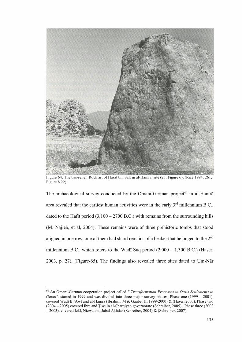
135
Figure 64: The bas-relief Rock art of Дasat bin Salt in al-Дamra, site (23, Figure 6), (Rice 1994: 261,
Figure 8.22).
The archaeological survey conducted by the Omani-German project61 in al-Дamrā
area revealed that the earliest human activities were in the early 3rd millennium B.C.,
dated to the Дafit period (3,100 – 2700 B.C.) with remains from the surrounding hills
(M. Najieb, et al, 2004). These remains were of three prehistoric tombs that stood
aligned in one row, one of them had shard remains of a beaker that belonged to the 2nd
millennium B.C., which refers to the Wadī Suq period (2,000 – 1,300 B.C.) (Haser,
2003, p. 27), (Figure-65). The findings also revealed three sites dated to Um-Nār
61 An Omani-German cooperation project called " Transformation Processes in Oasis Settlements in
Oman", started in 1999 and was divided into three major survey phases. Phase one (1999 – 2001),
covered Wadī B.’Awf and al-Дamra (Ibrahim. M & Gaube. H, 1999-2000) & (Haser, 2003). Phase two
(2004 – 2005) covered Ibrā and Кiwī in al-Sharqiyah governorate (Schreiber, 2005). Phase three (2002
– 2003), covered Izkī, Nizwa and Jabal Akhdar (Schreiber, 2004) & (Schreiber, 2007).

136
period (2,700 – 2000 B.C.) with tombs (Figure-65), (Ibrahim. M & Gaube. H, 1999-
2000, pp. pp.115-118).
Figure 65: Location of Дafit and Um-Nār sites in al-Дamrā (after NSA, al-Дamrā Aerial photo, 1993).
This was followed by an increase in settlement activity in the Early Iron Age II (1100-
600 B.C.), which reflects the earliest settling occupation evidenced by the presence of
tombs in the area (Al-Jahwari, 2008, p. 228). These are located on the surrounding
hills, situated in small groups of ten to twenty tombs (Haser, 2003, p. 27). The
archaeological findings revealed two settlements in this period (Figure-66). The first
were six large houses and a double row of stones contained within a large enclosure,
based on the ruins found south of the current location of the traditional settlement of

137
al-Дamrā on a hill near Dhāt Khail (ibid,. p.27). The walls were found in two layers,
the lower part was built with large stones while the upper was built with small loose
piled stones, which are not connected to the lower. The later wall (younger wall) does
not appear to be substantial and seems that these structures were not used as houses
but for defence (ibid,. p.27). The second settlement, located south to al-Дamrā near
Bilād Sayt, consists of small houses built on a hill slope, containing some walls
constructed with large stones rising up to 1.2 m high (ibid. p.27). The following period
of Late Iron Age (300 B.C.- 660 A.D.) was evident by few pottery shards and
subterranean tombs located in one cairn (Al-Jahwari, 2008, p. 228).
Figure 66: Location of Early and Late Iron Age sites in al-Дamrā (after NSA, al-Дamrā Aerial photo,
1993).

138
Human settlement re-emerged in the Early Islamic Period (660-1155 A.D.), based on
the pottery found scattered near Дusin al-Khawr, located east to Wādī al-Khawr on a
small mountain hill in the centre of āl-Дamrā oasis (Figure-67) (Ibrahim. M & Gaube.
H, 1999-2000, p. 10). Ruins of another old settlement were also found on the slope of
Дusin al-Khawr hill dated to the Late Islamic Period (1500-1750 A.D.), with an old
mosque at the bottom of the hill. Also, a site near Дusin al-Khawr revealed two
settlements with glazed sgraffito ware bowls of the eleventh and twelfth century A.D.
(de Cardi, B., Collier, S. & Doe, D. B., 1976, p. 144), dated to the Middle Islamic
Period (1155-1500 A.D.), located on the apex and slopes of the hills, indicating an
increase in the settlement activity during that period (Al-Jahwari, 2008, p. 228).
Figure 67: Location of Islamic Period sites in al-Дamrā, (after NSA, al-Дamrā Aerial photo, 1993).
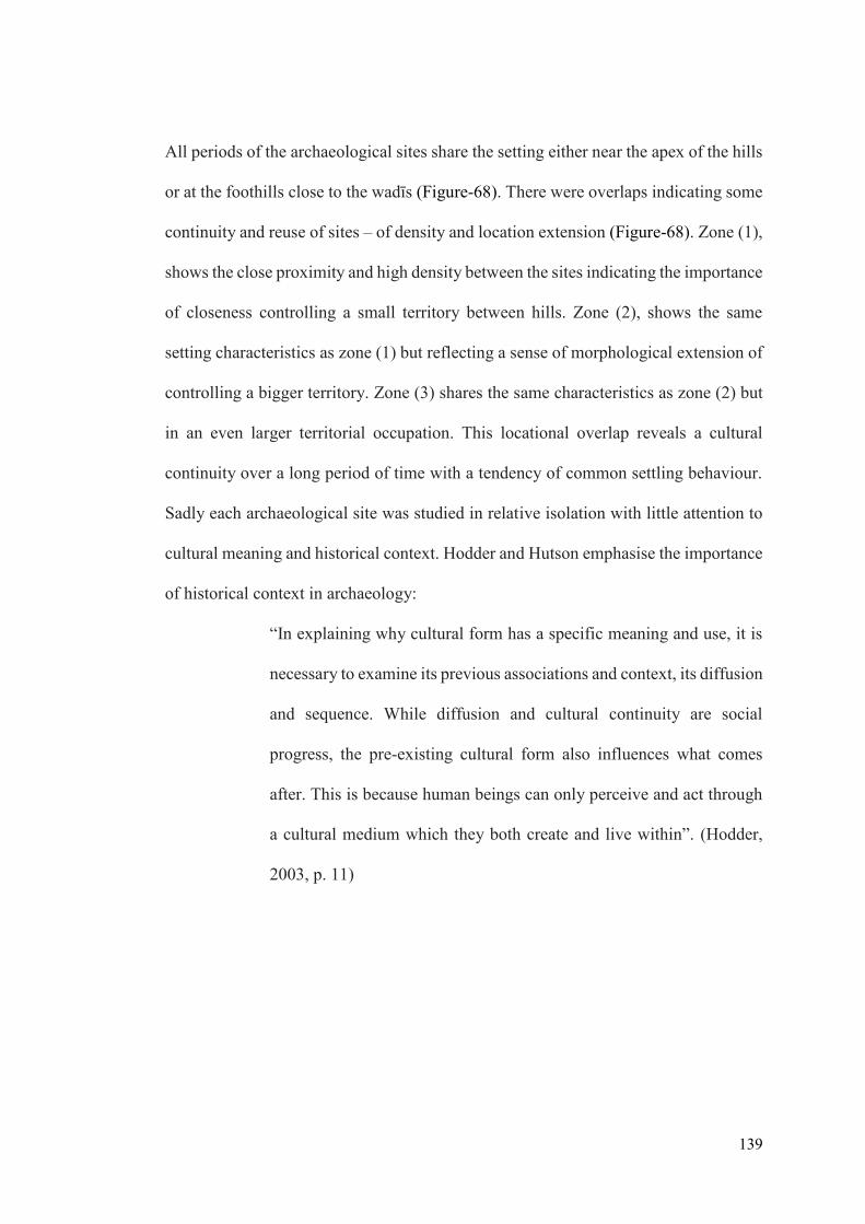
139
All periods of the archaeological sites share the setting either near the apex of the hills
or at the foothills close to the wadīs (Figure-68). There were overlaps indicating some
continuity and reuse of sites – of density and location extension (Figure-68). Zone (1),
shows the close proximity and high density between the sites indicating the importance
of closeness controlling a small territory between hills. Zone (2), shows the same
setting characteristics as zone (1) but reflecting a sense of morphological extension of
controlling a bigger territory. Zone (3) shares the same characteristics as zone (2) but
in an even larger territorial occupation. This locational overlap reveals a cultural
continuity over a long period of time with a tendency of common settling behaviour.
Sadly each archaeological site was studied in relative isolation with little attention to
cultural meaning and historical context. Hodder and Hutson emphasise the importance
of historical context in archaeology:
“In explaining why cultural form has a specific meaning and use, it is
necessary to examine its previous associations and context, its diffusion
and sequence. While diffusion and cultural continuity are social
progress, the pre-existing cultural form also influences what comes
after. This is because human beings can only perceive and act through
a cultural medium which they both create and live within”. (Hodder,
2003, p. 11)
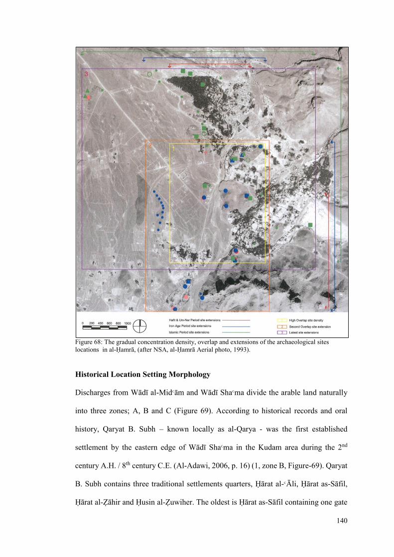
140
Figure 68: The gradual concentration density, overlap and extensions of the archaeological sites
locations in al-Дamrā, (after NSA, al-Дamrā Aerial photo, 1993).
Historical Location Setting Morphology
Discharges from Wādī al-MidΚām and Wādī ShaΚma divide the arable land naturally
into three zones; A, B and C (Figure 69). According to historical records and oral
history, Qaryat B. Subh – known locally as al-Qarya - was the first established
settlement by the eastern edge of Wādī ShaΚma in the Kudam area during the 2nd
century A.H. / 8th century C.E. (Al-Adawi, 2006, p. 16) (1, zone B, Figure-69). Qaryat
B. Subh contains three traditional settlements quarters, Дārat al-ΚĀli, Дārat as-Sāfil,
Дārat al-Нāhir and Дusin al-Нuwiher. The oldest is Дārat as-Sāfil containing one gate

141
from the south, a souq near the gate, a tall tower known as Burj al-Khaba, a few wells
and two main passages with dwellings clustered and aligned with it (Al-Subhi,
interview, 2011). Дārat al-ΚĀli contains two gates, one from the south and the other
from the west. Дusin al-Нuwiher was the governing point of Bahla during the Imamate
of Nassir b. Murshid al-YaΚrubī, but sadly today it sits in ruins with only foundations
left marking its history (Al-Adawi, 2006, p. 16) and (Al-Subhi, interview, 2011).
Then came Дusin Al-Khawr (2a, zone A, Figure-69) and Dhat Khail settlement (2b,
zone A), which were contemporaneous. As mentioned, Дusin Al-Khawr is located east
to Wādī al-Khawr on a small hill in the centre of present settlement of āl-Дamrā.
According to local folklore related by Shaikh Mohammed, the tribal leader of B. Subh,
it was constructed during the 4th century A.H./10th century C.E, about 416 A.H / 995
C.E, which was used for tying the horses (Al-Subhi, 2011). Dhāt Khil, also known as
fājat al-khail (‘place for horses’), contains Дusin Dhat Khail with three towers (burj
Tawī al-Bilād, burj al-Mad and burj al-Qutt), a gate, a few wells and some dwellings.
Oral history tells us that the inhabitants of Дusin Al-Khawr used to tie their horses in
Dhāt Khil (Al-Adawi, 2006, pp. pp.49-50).
Then followed the establishment of al-ΚAriΡ (known as ΚAriΡ B. ΚUdaī), a traditional
settlement in the oasis in the 4th century A.H./10th century C.E (Al-Adawi, 2006, p. 19)
(3, zone A, Figure-69). It contains Дusin al-ΚAriΡ, burj Дusin al-ΚAriΡ, Jam’ al-ΚAriΡ,
some dwellings and a well. The oasis extended then to zone B (4, zone B, Figure-69)
with the settling of al-QalΚa settlement during the 5th to 7th century A.H./eleventh and
twelfth C.E. century on a foot-hill with similar characteristics as al-ΚAriΡ (Al-Adawi,
2006, p. 19). This was followed by the settling of ΚAbriyīn in al-Misfat (5, Figure-69)

142
who were using the available arable-land (6, zone C) for seasonal date harvesting and
growing crops.
From analysing the arable land and the location of all settlements in that area, it is clear
that the availability of the arable land and the low hill chain were the main factors for
settling. The hill provided a visual protection from the south and west side, and an
anchor for the settlement’s foundation. The establishment of the settlement on the hill
also provided an opportunity to maximise the arable land, which also protected the
settlement from Wādī MidΚam and Wādī Sha’ma by diverting around it and Wādī Ghul
crossing behind it. This shows how the natural wadī channels and the distribution of
the low hills contributed in the historical morphology of the area hierarchically from
(1) Qaryat B. Subh, (2) Дusin Al-Khawr and Dhat Khail, (3) al-ΚAriz, (4) al-QalΚa, (5)
Misfat al-ΚAbriyīn to (6) al-Дamrā. (Figure-69).

143
Figure 69: Historical Morphology of the area (after NSA, al-Дamrā Aerial photo, 1993).
The Revival of ΚAbriyīn and Emergence of āl-Дamrā
In order to understand the tribe’s behaviour, distribution, reformation and settlement,
it is necessary to determine their tribal associations during their migration to Oman
and trace their dispersal pattern and factors of reformation. The ΚAbriyīn tribe descends
from Azdi Qahtanī tribes who lived in Yemen in Saba and migrated to Oman through
the southeast coast. Their nisba (origin/ surname) refers to ΚAbra b.Zahran b.KaΚb
b.Harith b.Abdullah b.Malik b.Nasir b.Azd b.al-Ghawth b.Nabat b.Malik b.Zaid
b.Kahlān b.Saba b.Yashjub b.YaΚrub b.QaΉtan (Al-Abri, 1958, pp. pp.1-2). Wilkinson

144
has focused his studies on the ΚAbriyīn as an important example of a tribe that was
scattered in a dispersed settlement pattern in north Oman to an important tribe who
come together from small groups to a united tribe and played an effective role in the
YaΚāribah Imamate period and settled later in their own dār. He described their
genealogical descent from Azd (Wilkinson, 1977, pp. pp.171-8) and the Imran branch
shaikhly structure (Wilkinson, 1987, pp. pp.103-6), (Figure-70 & 71).
Figure 70: The Azd genealogy structure (Wilkinson 1977: 172, Figure 30).

145
Figure 71: The Imran branch shaikhly structure of ΚAbriyīn (Wilkinson 1987: 105, Figure 5).
The first of the ΚAbriyīn in Oman is said to be in Tiwi62 on the coast, where a wadī was
named after them (Wadī Al-ΚAbriyīn), which in time changed to be known today as
Wadī Al-ΚArabiyīn (Al-Abri, 1958, p. 5), (Figure-72). The other attested scattered
settlements were in a place called Shimiliya in BāΓina in a village called Sur Al-
ΚAbriyīn near a village called Дsifīn (ibid, p. 5). They also settled in Jabal Дuddan in
a settlement they owned called Al-ΚAqair from the Sharmahī clan. Some also settled
in the Sirr in Al-Џahira in Al-ΚAraqi settlement, which became their principle
settlement then, owned also by SharmaΉī clans (Wilkinson, 1987, pp. 111-15).
62 A coastal village in the northeast of Oman in As-Sharqiya governorate under the administration of
Wilayat Sur.

146
Additionally, they settled in the Wādī Nakher63, Wādī SaΉtan and ΚAwābī in Ghadaf
(Wilkinson, 1977, p. 205).
Although the ΚAbriyīn before re-forming were categorised as a tribe that owned
individual settlements under the protection of more than one tribe and never had an
exclusive dār (Wilkinson, 1977, p. 205), yet, they managed to settle in an organised
pattern alongside their clans (Shanu’a Azd), expand their knowledge on the
geographical setting in northern Oman, and establish trust and allies with other tribes
which contributed in growing a sense of unity and encouraged them to reform as one
tribe as and when the proper circumstances appeared.
Figure 72: Dispersed small settlements of the ΚAbriyīn before reforming into one dār.
63 Located in the west Jawf side of the Jabal Akhdar. Very well-known wadī in āl-Дamrā which its
discharge flow joins with wadī Ghul.

147
The ΚAbriyīn were known among tribes as awlad saif wa Ρaif (‘the sons of swords and
hospitality’), because of their skills as strong warriors who had never been defeated in
war, yet friendly, peaceful people, which led many tribes to be their allies 64 and
sometimes ask for their help (Al-ΚAbri, interview, 2011). Their fortunes grew at the
end of the Nabāhina dynasty rule, when they helped Imam Nassir b. Murshid Al-
YaΚrubī (1034 – 1059 AH / 1624 – 1649 AD) to break the power of foreign groups
who controlled the Upper Jawf and Sirr (Wilkinson, 2008, p. 18). Imam Nassir
rewarded them by appointing them walis (governor) and qādies (judge), for example,
appointing Shaikh Mohammed b. ΚAlī b. MasΚud b. Lahī b. Qasim Al-ΚAbrī walī of Al-
Qarya and the area surrounding Kudam, indicating their growing impotence politically
and geographically (Al-Abri, 1958, p. 8).
They continued their support for the YaΚāribah Imamate during the rule of Imam Sultan
b. Saif b. Malik Al-YaΚrubi65 (1059 – 1090 AH / 1649 – 1680 AD), who rewarded
them by allowing them to develop a new settlement, choosing between the Kudam
area (āl-Дamrā) or Birkat al-Mawz, from which they selected the Kudam area to settle
as their new ΚAbriyīn dār (Al-Abri, interview, 2011). This came through a partnership
agreement in the falaj share between the section of Awlad Ali b. Mas’ud of Sharamha
clan in ΚAraqī in Sirr and the Imam in 1066 AH / 1656 AD (Wilkinson, 1987, p. 112).
By the second half of the 18th century, as the YaΚaribah Imamate started to weaken, the
ΚAbriyīn (led by Awlad Talib section) claimed by agreement66 their share of the falaj,
64 Such allies were B.Jabir and B.Shukail (Al-Abri, 2011). 65 The Ya’rub Imam who brought wealth and prosperity in his Imamte periode and as a result he
constructed the Nizwa fort and reconstructed Birkat al-Mawz. 66 They claimed their share in the falaj in settlement for 3600 Mohammadi silver coin (Wilkinson,
2008, p. 112).

148
and in 1742 AD they claimed the rest of the territory including Misfat al-ΚAbriyīn and
the property67 of B. Lamk in Wādī SaΉtan (Wilkinson, 2008, p. 18). So with the
collapse of the YaΚāribah Imamate, the ΚAbriyīn were independent with ownership of
a major exclusive dār and incorporating settlements of Wādī SaΉtan and ΚAraqī. The
Imam’s support and partnership agreement indicates not only their political success in
winning the ΚAbriyīn as strong allies but also the YaΚāribh interest in negotiation in
expanding their wealth and interest. This was evident when the Imam gave the ΚAbriyīn
to choose between Kudam and Birkat al-Mawz, both locations secure access to Jabal
Shams and Jabal al-AkhΡar, which gave safe access to the trading ports at the BāΓina
coast.
In progressing with the establishment of their new dār, they were joined by the leading
group of ΚArāqī in Sirr, Awlad ‘Imran, to whom eventually the leadership passed
(Wilkinson, 1987, p. 112). The ΚArāqī shaikhly family resided there till Zahran b.
Mohammed moved to āl-Дamrā. Hence, the united groups of Awlad Talib and the Sirr
branch marked the dawn of new era of a strong tribe with their exclusive “capital”
settlement, reckoned amongst the Ghāfrī alliance. Furthermore, this joining not only
put the ΚAbriyīn firmly on the political map of Oman but also showed how they built
their dār and extensions within a short time (Figure-73).
The pre-eminence of ΚAbriyīn in establishing a dār and expanding their territory came
with three main factors. First, a great deal of fighting with B. Shukail (in the northern
Jawf) and B. Subh (the main settlers in the environs of āl-Дamā). Secondly, Nassir b.
67 Property in the ‘Amq Bowl that Imam Saif b.Sultan-I (known as Qaid Al-ArΡ) developed
(Wilkinson, 1987).

149
Murshid’s confiscation of the B. Hina’s68 arms following their opposition to him, and
thirdly, the wisdom and role of three ΚAbriyīn Κulama in binding and strengthening the
tribe and supporting and restoring the Imamate. Such Κulama were Shaikh Majid
b.Khamis, (ca.1837 – 1927), and his father Shaikh Khamis b.Rashid Al-ΚAbrī, (ca.
1854 – 1837), known as Џhu al-Ghubairā, had played an important role in promoting
the Imamate. And so, āl-Дamrā became a political and cultural centre, especially in
the time of Shaikh Muhsin b.Zahran Al-ΚAbrī (1826 – 1873) which extended its
territory with the support of ΚAttab, to B.Kharus and B.Ghafir territories (Wilkinson,
2008, p. 18). The allies with ΚAbriyīn who did not descend from ΚAbra were B.Dhuhl69,
B.Subu70, B.ΚAudī, B.Hutal, al-Sharyanī, al-MayaΉī71, al-Khatrī and al-Nasrī (Al-Abri,
1958, p. 79).
Figure 73: The tribal territories of ΚAbriyīn in central Oman, modified by author (after Wilkinson
1977: 157, Figure 25).
68 They were one of the most powerful tribes in the beginning of the Ya’ruba Imamte and were against
Nassir b.Murshid who as a result forbidden them to bear arms. 69 A small group (of Wa’il stock) who consider themselves notably ‘Abriyīn, living in the upper part
of āl-Дamrā. They are from ‘Awabi, B.Dhuhul b.Shayban, and according to al-Siyabi (1965,p. 47),
they had a settlement called Tawi al-Sayh (Wilkinson, 1987). 70 They came originally from Batinah, from Sawadi and W.Al-AbyaΡ (Al-Subhi, interview, 2011). 71 They descend from MaiyaΉ b.Mus’ab from B.Riyam and B.Khuzair.

150
The Falaj and the settlement beginnings
Before the ΚAbriyīn resided in āl-Дamrā, the pre-existing arable land (5, zone C,
Figure-69) was partly cultivated by ΚAbriyīn who settled in Misfah and Wādī Nakhur,
for seasonal harvesting, and depended on scattered traditional wells (zīgra) 72 for
irrigation. The most well-known and reliable zīgra was called Кawī al-Нāhra al-Kabīra
and Кawī Mall ad-Dākhil, located almost in the centre of the agricultural land (Al-Abri,
interview, 2011). The location of a spring in āl-Дamrā was already known, however,
its flow was weak, not enough to supply a settlement and irrigate the arable land
because of its tendency to dry up from the first drought. Accordingly, the Imam Sultan
b.Saif b.Malik Al-Ya’rubī helped them to excavate the falaj73 spring to increase the
water flow. The excavation began on the 1st of Jamad al-Ākhr 1066 AH / 1st November
1656 AD in the time of Shaikh Khalaf b.Talib al-‘Abrī and Shaikh Mohammed b.Yusif
b.Talib al-‘Abrī74 (Al-Abri, 1958, p. 11).
During the falaj excavation, the first settlers to arrive were the Awlad MasaΚud b.
Rashid group of the ΚAbriyīn, who comprised about 70 men, and initially settled in the
centre of the garden by constructing a small defensive settlement known as Mall ad-
Dākhil with a ДuΒin within it known as ДuΒin Mall ad-Dākhil (Al-Abri, interview,
2011). The settlement was first established by MasaΚud b. Rashid Al-ΚAbrī in c. 1116
A.H / 1695 C.E (Al-Adawi, 2006, p. 54). It contained three towers, six dwellings, two
72 This type of agriculture well employs cattle to draw water as opposed to human operated ones
(tawi). 73 According to Wilkinson (1977), falaj (pl. aflāj), is a generic term used in Oman for the traditional
irrigation system which mean in classical Arabic to divide property into shares. In Omani
encyclopaedia the term falaj mean the water channel that divides its way through the mountain or
ground, used as a traditional irrigation system. 74 Was from the first ΚAbriyīn leading group who agreed with the Imam Sultan b.Saif al-Ya’rubī and
first settled in āl-Hamrā. He was appointed walī in Sirr area by the Imam and constructed the first
house in āl-Hamrā settlement, Bait aΒ-Сafāh (Al-Abri, 1958, p. 17).

151
wells, administrative structure, rooms for guards, two public bathing structures for
ladies and surrounded by a wall with two access gates. This gave them the time to
gradually excavate the falaj and construct their new settlement at the foothills.
The falaj spring was excavated gradually, first in the time of Awlad Talib b.ΚAli
b.MasaΚud al-ΚAbrī with the help of the Imam, and second, under the leadership of
Shaikh Malik b.Rashid al-ΚAbrī in the beginning of the 13th century A.H. with a new
spring flow called the Qumī75 flow, and finally, more excavation in the time of MuΉsin
b.Zahran b.Mohammed al-ΚAbrī who employed a man known as RaΚi Lekhshaba76 in
the seventh decade of the 13th century A.H., who succeeded in adding a new source
(sāΚid al- Khashba) and increased the flow and channel size of the falaj and therefore,
extended the settlement and the falaj which has never dried up since (Al-Adawi, 2006,
p. 112).
Falaj āl-Дamrā is an active dāwūdī77 falaj which its main qanāt78 feeds from four
main SawāΚd79 (pl. saΚd, main springs with channels feeding into the qanāt), sāΚid al-
Сlīla, sāΚid al-Κwr, sāΚid al- Khashba and sāΚid al-Дadith. It extends 2.26 km long from
the mother spring to SharīΚa80, with a water flow average of 50 L/s (MRMWR, 2009,
75 Because the flow came from the hand of a man from B.Qium (Al-Abri, 1958, p. 12). 76 This was his knickname. 77 It is one out of three aflāj types - dāwūdī, ghaīlī and ‘aynī – and represents 23% of total aflāj in
Oman. It derives it water source from deep wells and it flow continues without getting affected by
drought periods. 78 A local term means: the main underground channel from the mother spring to the
first surface of water flow. 79 The additional water sources that were excavated gradually in different times. 80 The name of the first access point of the falaj which is exclusively used for collecting drinking water.
The word Sharī’a refers to the true way or purity, is a term used to distinguish the Islamic principles in
general and provincially a technical term to describe the first access point to pure water (Wilkinson,
1978).

152
p. 60). The falaj channel (Sīqya)81 divides into two channel, Sīqyat al-Bilad directed
east towards the settlement of approximately 1.5 km long and Sīqya al-SuΉma directed
southeast to the opposite side of the settlement of approximately 1.9 km long known
as al-SuΉma. The two channels embrace the gardens as a boundary, of 1.5 km², from
an altitude of 658 mamsl from both sides and irrigate the cultivated land descending
gradually from that altitude to 644 mamsl (Figure-74).
Figure 74: Falaj āl-Дamrā from the source to the oasis.
The setting and Components of Baldat āl-Дamrā
Baldat āl-Дamrā (zone C, Figure-69) - the latest and biggest settlement in the oasis -
developed enveloping the orchard lands (5, Figure-69) in the centre and clustering
around it. It consist mainly of Дārat āl-Дamrā, Mall ad’Dakhil, as’SuΉma, al-Munsur
and Дail al-ShaΒ. Дārat āl-Дamrā sits at the south of the limestone outskirts of Jabal
81 It is generated and derived from the word Saqī, in classic Arabic it means to irrigate and drink. In
local Omani terms, it refers to the exposed falaj channel.

153
Shams approximately between latitudes of 23º 07’ 12. 38” N and 23º 07’ 18. 28” N,
and longitudes of 57º 16’ 38. 08” E and 57º 17’ 07. 71” E. It extends in a gradual
elevated position on the foothill between the altitudes of 658 mamsl and 680 mamsl,
edging overlooking the orchard land from the north. As’SuΉma sits along the red low
foothill mountain chain of al-Дabil, which is edging the orchards from the south and
southeast, facing Дārat āl-Дamrā in the opposite side. Дail al-ShaΒ - a small village
and known route to Jabal Shams - is located north to Дārat āl-Дamrā. Mall ad’Dakhil
sits in the centre of the orchards between Дārat āl-Дamrā and as’Suhma. Al-Munsur
sits in the south end of the orchards after as’SuΉma.
Дārat āl-Дamrā consists of: (a) the Дarat itself (traditional settlement quarter), (b) the
Ήarat old souq (S), (c) al-Нāhra al-Kabīra and Mall ad-Dākhil wells in Mall ad-Dākhil,
(d) the falaj channels, (e) the cultivated land, and (f) the towers. The Дārat itself
divides into four sub-Дarat, (H1) Дarat al-WisΓā (the core settlement and main case
study), (H2) Дarat al-Sharqiya (located east to H1), (H3) Дarat al-ΚĀlī (located west
to H1), and (H4) Дarat al-Дaditha (located north to H1), (Figure-75). The souq (S) -
known as souq al-Qadeem – was built by Zahran b.Mohammed b.Muhsin Al-ΚAbrī,
140 years ago, containing 44 shops, located east to H1. Al-Нāhra al-Kabīra well in
Mall ad-Dākhil was used as a communal public well – with no private water shares –
and connects to two pools (P1 & P2) near the current location of Дarat al-WisΓa for
drinking. There are 11 towers in baldat āl-Дamrā, five surrounding the perimeter of
the oasis, three in the centre of the cultivated land, and three within the Дarāt al-WisΓā.
The three towers (T) known as Burj mall ad-Dākhil in the centre of the cultivated land
are part of Дarat Mall ad-Dākhil (H). The five towers surrounding are (T1) Burj al-
ShriΚa, (T2) Burj muΒalā al-Eid, (T3) Burj Dak al-Waljah, and (T4) Burj al-Maqbara

154
and Burj ShaΚāsh’ (T5). The three towers within Дarat al-WisΓā are (T6) burj al-Дjīra,
(T7) burj al-Дalaw and (T8) burj Shwaīn. The two falaj channels that divides equally
from one main spring qanāt are (F1) falaj al-Blād and (F2) falaj as-SuΉmah. The
cultivated land divides into three zones, date palm gardens (G1), seasonal planted
gardens (G2), and extended mixed plants gardens (G3) (Figure-75).
Figure 75: The components of Дārat āl-Дamrā and its sub- Дārat; (H1) Дarat al-WisΓā, (H2) Дarat al-
Sharqiya, (H3) Дarat al-ΚĀlī, (H4) Дarat al-Дaditha, (S) souq al-Qadeem, (P1 & P2) two water pools,
(T) Burj mall ad-Dākhil, (T1) Burj al-ShriΚa, (T2) Burj muΒalā al-Eid, (T3) Burj Dak al-Waljah, (T4)
Burj al-Maqbara, (T5) Burj ShaΚāsh’, (T6) burj al-Дjīra, (T7) burj al-Дalaw, (T8) burj Shwaīn, (F1)
falaj al-Blād, (F2) falaj as-SuΉmah, (G1) date palm gardens, (G2) seasonal planted gardens, and (G3)
extended mixed plants gardens.

155
4.3: Дarat al-WisΓa tribal Pattern and Structure
Introduction
The early discussion on the ΚAbriyīn tribal history from their origins, migrations,
dispersed existence leading to gradual unity, to settling in their dār, is present in
various publications which were used as supporting material. The earliest detailed
records on the ΚAbriyīn was contributed by Shaikh Ibrahim b.SaΚid Al-ΚAbrī82 (Al-Abri,
1958) in TubΒert al-MuΚtabirīn fi Tārikh al-ΚAbriyīn, who recorded the tribes
genealogy, groups, clans, early settled areas after migration, unity and Κulama and their
relation to Imamate and political power. The second tribal information was briefly
listed by Scoville’s gazetteer (Scoville, 1979 – 1995) who described briefly the
ΚAbriyīn tribe as a Nizarī descent tribe, of IbaΡī religion, belonging to the Ghāfrī
political affiliation (Scoville, 1979, p. 18). He also described their dispersal pattern
and areas of settlement: in Нāhra at ΚArāqī, in western Дajar at ΚAwābī, in ΚAqair at
Wadī SaΉtan, at HaΓ and Zammah in Wadī Bani.ΚAwf, at Wādī al-Qarn in wadī Fara,
at Кbāqa in Wādī Bani Ghāfir, and at ΚAmq, Fashsh, Maqāmma and Mabu in Wadī
SaΉtan. They also resided in al-Дamrā, Farq, Ghamer and Bahla in Oman Proper with
estimated number of 6,500 persons (ibid, p. 18). He describes them:
“They cultivate dates and corn and are generally a well-behaved peaceable
tribe. They are the masters of Awabi, but Bahla is their main capital and Дamrā
their largest separate village” (ibid, p. 18).
82 Shaikh and Κālim Ibrahim b.SaΚid b.MuΉsin b.Zahran b.Mohammed Al-ΚAbrī, born in 11th of
December 1896 AH, and was appointed QaΡī in Rustāq by his mentor Shaikh Majid b.Khamis Al-ΚAbrī
during the Imamate of Salim b.Rashid Al-KharoΒī. He was appointed tamimah Shaikh for ΚAbriyīn in
1924 AH for 16 years then appointed QaΡī in Suhar, then appointed by Imam al-Khalilī walī on Ibrī. In
the time of Sultant SaΚid b.Taymur he was appointed Qadī and president of Court of legitimacy and then
President of the Court of Appeal in Muscat. In 1972 AH, he was appointed Mufti of Oman and died in
1975 AH (Al-Adawi, 2006, p. 34).

156
Their settlement in ΚArāqī (between Ghabbī and Bait Al-ΚAinain, approximately 6 km
north ΚIbrī, on the right bank of Wadī Sanaisal) consisted of 100 dwellings for ΚAbriyīn,
90 dwellings for Banī Rashid (nisbah, al-Rāshdī) and 35 dwellings for Balushis
(nisbah, al-Blushī) (Scoville, 1979, p. 249). In ΚAwābī (approximately 15 km east
Rusāq and about 30 km west Nakhal, on the left bank of wadī Bani KharuΒ) the
ΚAbriyīn settlement consisted of 300 dwellings:
“The population is 2,500 souls, belonging chiefly to the ΚAbriyīn (120 houses),
Banī Kharus (70 houses), Banī ДarraΒ and Dhahul; but there are also some
Siyābiyīn, Banī BaΉrī and Banī ΚAwf.” (ibid, p. 364).
The importance of ΚAwābī lies in its strategic location on Wadī Banī Kharus which is
the main route from the north to Jabal al-AkhΡar and the ΚAwābī fort83 which defends
that access. Although the control of that area was constantly in dispute between the
ΚAbriyīn and Banī Riyām but the political influence of ΚAbriyīn in that territory was
predominant and thus gave them control of the fort (ibid, p. 364). This route is called
Кariq as-ShaΒ (after Дil as-ShaΒ, located north of Дarāt al-Дamrā); it is a direct
mountain passage connecting ΚAwābī (Ghadaf, north) over Jabal al-AkhΡar to al-
Дamrā to Wadī Tanuf (Jawf, south). This indicates the extension of the territorial and
political power the ΚAbriyīn possessed in northern Oman, especially in the Дajar
mountain region.
Wilkinson (Wilkinson 1977, 1987 and 2008) incorporates important information and
maps of the tribal history and structure. He used the ΚAbriyīn model to illustrate how
small tribal groupings coalesced under specific political conditions to form a unified
tribe – and in this case become one of the most important tribes in central Oman. Much
83 It is also known as Bait al-ΚAwābī which in 1900 AH the ΚAbriyīn transferred its possession to the
Sultan of Oman (Scoville, 1979, p. 364).

157
of this information on the ΚAbriyīn tribe, it should be noted, came from TubΒert al-
MuΚtabirīn fi Tārikh al-ΚAbriyīn by Shaikh Ibrahim b.SaΚid Al-ΚAbrī in 1958 AH.
Another source on tribes is Carter’s study (Carter, 1982), although it only includes
information on the silversmiths of ΚAbriyīn. However, he described in some detail the
Bani Riyām group, which contributes in our later discussion on the tribal pattern at
Дarāt as-Saybanī in Birkat al-Mawz. Another brief record on the ΚAbriyīn was by
Chauncy in 1951 A.D, who described them to be of 2000 people, living in Bahlā,
ΚAwābī and al-Дamrā, who were “[n]ormally peaceful................…. They are fairly
intelligent people” (Chauncy, 1988, p. cii).
Miles has also listed the number, distribution and briefly description of the Omani
tribes (Miles, 1988). He recorded the ΚAbriyīn to be of 8000 people, describing them
to be peaceable and well behaved (Miles, 1988, p. lxxxv). A study on the tribes and
Imamate by George Rentz lists the tribes in connection with the Imamate and their
classification in relation to settlement and affiliation to either the Ghafrī or Hinawī
political moiety, providing brief history on the tribes (Rentz, 1997). He describes the
ΚAbriyīn as:
“The tribe of the ΚAbriyīn is one of the influential tribes in the border area
along the western edge of the Imamate, where it shares with independent
Baluchis of the Dhahirah possession of the town of al-ΚArāqī up the valley from
ΚIbrī” (ibid, p. 89).
Some of the information collected on tribal client groups was always challenged by
getting their name without nisba (tribal name) due to being out of the Arab tribal

158
genealogy (known as mawlā), which mostly was the case prior to the 1970s. Other
ΚAbrī clans that resided with the ΚAbriyīn as Wilkinson lists them:
“… those families that which consider themselves members of the ΚAbrī clan
by no means all live in the ΚAbrī dār , whilst conversely a number of groups
who consider themselves ΚAbriyīn, notably the B.SubΉ and the Dhuhul of al-
ΚAwabī, are not considered of the true ΚAbra descent.” (Wilkinson, 1987, p.
106).
The other tribes who resided with ΚAbriyīn are the B.SubΉ and the Dhuhul are the
B.ΚAdī, the B.Khiyār, the B.HaΓāl, the Sharyānī, the MayāΉīs, the KhawāΓr and the
NawāΒir (Al-Abri, 1958, p. 79). The ΚAbriyīn tribal groups who are considered to
descend genealogically from ΚAbra area Awlād Alī b.MusΚud b,Lahī (who consists of
Awlād Malik, Awlād Кālib and Awlād Khalaf) (Al-Abri, 1958, p. 6), the SharāmΉa,
Āl ΚAziz, Awlād SrāΚ, Al-GhΡābiyīn, Al-Wurud, Awlād Al-ΚAthim, Awlād Nassir,
Awlād Salim b.MusΚud, Awlād Rashid b.MusΚud and Awlād Khamis b.MusΚud whom
all are known as Awlād ΚAmrān (Al-Hinai, 2010, p. 402). It becomes clear when
looking at all the above ΚAbrī tribalal groupings how complicated the socio-political
structure is within a tribe in Oman, and yet managed to settle in one dār in unity and
harmony. They resided in their new dār with factions united under one common tribe
name, ΚAbrī.
Al-Дamrā oasis consists of other constituent harāt and areas that were mentioned
earlier in the historical morphology description of each area. Дarāt Qaryat B.SubΉ
(also known as al-Qarya) is resided by the al-SubΉī tribe, Дarāt QulΚat al-MuΒalΉ (also
known as al-QulΚah) is resided by the al-MuΒalΉī tribe, the settlements of Wādī Nakhir
are resided by ΚAbriyīn and SharamiΉa, Misfāt al-ΚAbriyīn is resided by ΚAbriyīn, and
159
ΚAriΡ B.ΚAudai (also known as al-ΚAriΡ) is resided by the al-ΚAdawī and al-NāΚbī tribes.
The following discussion will focus on the tribes who resided in Дarāt al-WisΓā
discussing their distribution and impact on the settlement’s evolution.
Дarāt al-WisΓā tribal Pattern
The tribes, clans and allies that inhabited Дarāt al-WisΓa till it was completely
evacuated in 2001 is listed in Table-2. The spatial distribution of these inhabitants and
the structure of Дarāt al-WisΓā is mapped in Figure-76 & 77, with the same detailed
maps of the developed phases of the Ήarāt (from phase-1 to phase-6) is presented in
(Figure-78 to 84). Although some of the dwelling owners could not be identified for
reasons mentioned earlier, the tribal mosaic gives a fairly clear understanding of tribal
dwellings and their distribution. This will be discussed in detail in terms of each tribe’s
distribution, location, characteristics and pattern, starting with the establishing tribe,
Al-ΚAbriyīn. The settlement has been divided in phases according to its development
and each phase will be discussed in the context of its social structure and tribal
distribution (Figure-78).

160
Tribe Nisbah Dār Political
affiliation
Tribal origin
Al-ΚAbriyīn Al-ΚAbrī Jabal al-AkhΡr,
al-Дamrā
Ghāfrī ΚAbra b.Zahrān
b.KaΚb, QaΉΓān
Al-SharāmΉa SharmaΉī Jabal al-AkhΡr
(Wādī Nakher),
al-Дamrā
Al-ΚAbrī / Ghāfrī ΚAbra b.Zahrān
b.KaΚb, QaΉΓān
Al-ΚAzizyīn Al-ΚAzizī Jabal al-AkhΡr
(Wādī Nakher),
al-Дamrā
Al-ΚAbrī / Ghāfrī ΚAbra b.Zahrān
b.KaΚb, QaΉΓān
Al-NāΒriyīn Al-NāΒrī Jabal al-AkhΡr,
al-Дamrā Al-ΚAbrī / Ghāfrī ΚAbra b.Zahrān
b.KaΚb, QaΉΓān Al-KhāΓriyīn Al-KhāΓrī Jabal al-AkhΡr,
al-Дamrā, Џunk Al-ΚAbrī /Ghāfrī NuΚm b.ΚAbd
Shams b.Дddān Al-NāΚb Al-
NāΚbī
al-Дamrā, Nakhal Al-ΚAbrī / Ghāfrī NāΚib b.Ibn adīn
b.al-Muhra, QaΉΓān
Al-Dhuhul Al-
Dhuhlī
al-Дamrā,
al-Rustāq Al-ΚAbrī / Ghāfrī Dhuhl b.LuqiΓ
b.alДarith, QaΉΓān Al-HaΓāΓla Al-HaΓālī al-Дamrā Al-ΚAbrī / Ghāfrī QaΉΓān Al-Shukoor Al-Shukrī Џunk Unclear ΚAdnānī Al-Riyāmiyīn Al-
Riyāmi
Jabal al-AkhΡr Ghāfrī Riyām b.Qamar
b.al-Umarā,
QaΉΓān Al-Mughiryīn Al-
Mghirī Ibrā Ghafrī Al-Mughīrah
b.SaΚd b.СāmΓ,
QaΉΓān
Al-Bimāniyīn Al-
Bimāni
Bahlā Ghafrī Дmā b.ΚAthmān
b.Nasr, QaΉΓān
Al-YaΚāribh Al-
YaΚrubī
al-Rustāq, Nakhal Ghafrī QaΉΓān
Table 2: The tribes in Дarāt al-WisΓā in al-Дamrā.
By far the most dominant tribe in Дarāt al-WisΓā were the ΚAbriyīn (nisbah, al-ΚAbrī),
who not only owned numerous dwellings on the main street (aligned with the falaj
channel), but also the most substantial dwellings and occupied much of the Ήarāt,
except for few dwelling at the upper part (north edge) (Figure-76). They were not only
the owners but also the sole and founders of it, after whom the oasis was named, Дamrā
al-ΚAbriyīn84. Their early constructed dwellings of the shaikhly ΚAbriyīn (discussed
earlier) on the lower edge of the foothill gave them the advantage of choosing the
location to construct large dwellings, which gave them the socio-political power.
84 This toponymy was similarly found in the other constituent settlements in al-Дamrā such as;
Missfat Al-ΚĀbriyīn for the Al-ΚĀbriyīn, Qaryat B.SubΉ is resided by the al-SubΉī tribe, QulΚat al-
MuΒalΉ is resided by the al-MuΒalΉī tribe, and ΚAriΡ B.ΚAudai is resided by the al-ΚAdawī.

161
Oral history and historical records kept by the Κulama indicates that during the
excavation of falaj āl-Дamra, and the temporary settling of ΚAbriyīn in Mall ad-Dākhil,
they decided to start constructing their dār and relied on the two pools they constructed
(P1 & P2, Figure-75) which were supplied with water by Al-Нāhra al-Kabīra and Mall
ad’Dākhil wells (W, Figure-75). They chose to construct their settlement on the Βafāh
(term used in Oman to refer to the smooth rigid layer of the mountain rock, in this case
the rock at the foothill of Jabal Shams), which acted as a strong foundation for their
settlement (Al-Abri, interview, 2011).
The first dwellings to be constructed were Bait aΒ-Сafāh (D1) (Figure-79) by Shaikh
Mohammed b.Yosuf b.Talib b.Rashid Al-ΚAbrī (Al-Abri, 1958, p. 20), Bait al-Qadīm
(D2) by Shaikh Salim b.Khamis b.ΚAmar b.ΚEissa Al-ΚAbrī (ibid, p. 22), Bait aΒ-СabāΉ
(D4) by his brother Rashid b.Khamis b.ΚAmar Al-ΚAbrī, and the dwelling (D3)
northeast of Bait al-Сafā by his other brother Ali b.Khamis b.ΚAmar Al-ΚAbrī (Al-Abri,
interview, 2011), (Figure-78 & 79) & (Plate-10). The first three mosques constructed
at the same time as the first dwellings – with similar layouts – were Masjid as-SuΉma
(also known as Masjid as-Сarooj)85 in as-SuΉma near the ShariΚah of the falaj, Masjid
as-Salaf86 (M1) southwest Bait aΒ-Сafāh, and Masjid al-Hadith87 (M2) (the oldest
mosque in the Дarāt) southeast Bait al-Qadīm (Figure-78 & 79). These two mosques
(M1 & M2) marked the edge of the early establishing Ήarāt from the west and east side
and consists of public bathing, ablution and drinking points for males (Plate-11). The
85 It was constructed by the funding of ΚAiysha b.Mohammed b.Yusif al-ΚAbrī (the wife of Shaikh
Salim b.Khamis al-ΚAbrī, one of the establishers constructing a house in the Дarāt) who requested the
mosque to be built by Sarooj and so it gained its name (Al-Adawi, 2006, p. 76). 86 Was built at the same time of masjid al-Дadith, and there was a will found by Shaikh Salim
b.Khamis al-ΚAbrī instructing to give any remains of his land and water share legacy to the mosque,
and also his wife ΚAiysha did the same with the remain of her dates legacy for the mosque (Al-Adawi,
2006, p. 78). 87 Was built by Shaikh Salim b.MusΚud Al-ΚAbrī with similar layout design as masjid aΒ-Сalaf but
without the small minaret (booma) (Al-Adawi, 2006, p. 75).

162
evolution of the Ήarāt following the dwellings and the two mosques were the
communal structures of two gates SabāΉ as-Sāfil88 (G1.1) and SabāΉ an-NuΚb89 (G1.2).
There are three female communal bathing structures of mujazat al-ghraifah (P1.2) and,
mujazat aΒ-Сafāh (P1.1), and the private one is mujazat al-Jufrah (P2), (Figure-77 &
79) & (Plate-12). There were also three male communal meeting halls; sablat aΒ-Сalaf
(S1.1) is associated with masjid aΒ-Сalaf , sablat al-Ghārbī (S1.2) and sablat Rashid
b.MasaΚud (S1.3), (Figur-79). This early Дarāt (Phase-1) was established by Awlād
Rashid b.MasaΚud Al-ΚAbrī, which is considered the core of the Дarāt. This core had
one main passage (east-west axis) aligned with the falaj channel (sīqiyat al-Blād) with
four falaj communal access points (mishrāΚ).
Although the early established dwellings (Phase-1) were owned by one family group
of the ΚAbriyīn tribe (Awlād Rashid), yet, they were constructed in an individual
pattern facing each other (D1, D2 & D3) except for one (D4), indicting an early
existence of a shared square between them (Figure-79). The positioning of the two
mosques (M1 & M2) as an early edge of the Ήarāt along the falaj channel defined the
location of the communal structure in between. Hence, these early structures identify
the early core that was established and so, the early core pattern which will be
discussed in Chapter-5.
88 As-Sāfil locally means the lower part or referring to the east side which is also used in some cases to
name passages or falaj channels and named after Bait as-Sāfil (D30). 89It was constructed by the Al-NuΚb tribe and so it was named after them.

163
Figure 76: Дarāt al-WisΓā spatial distribution of tribes. W1. Al-ΚAbriyīn, W2. Al-SharāmΉa, W3. Al-
ΚAziziyīn, W4. Al-KhawāΓr, W5. Al-Riyāmiyīn, W6. Al-Dhuhul, W7. Al-HaΓāΓla, W8. Al-Shukour,
W9. Al-NuΚb, W10. Al-Mughiriyīn, W11. Al-NawāΒr, W12. Al-YaΚāribh, W13. Al-Bimāniyīn, W14.
No nisbah.
Figure 77: Дarāt al-WisΓa structure. D. dwellings, G1. main gates (sabaΉ), G2. secondary access
points, T. towers, M. mosques, Q. Qurān school, S. (sabla) male communal meeting halls, P1. Female
public bathing, P2. Female private bathing (elite), K. communal storage and production of traditional
vinegar (khal), J. communal storage for traditional well equipment (manjour), R. communal wheat
grinding structure (raΉā), L. Female communal latrine, F. Falaj.

164
Figure 78: The colour code phasing structure (from Phas-1 to Phase-5) of of Дarāt al-Дamrā with
reference to Figure-46 & 47.
Figure 79: Phase-1 of Дarat al-Дamrā (first constructed dwellings): D1. Bait aΒ-Сafāh, D2. Bait al-
Qadīm, D3. Bait ΚAlī b.Khamis Al-ΚAbrī, D4. Bait aΒ-СabāΉ, M1. Masjid aΒ-Сalaf, M2.Masjid al-
Дadith, S1.1. sablat aΒ-Сalaf, S1.2. sablat al-Ghāarbī, S1.3. sablat Awlād Rashid b.MusΚud, P2.
mujazat al-Jufrah, P1.2. mujazat aΒ-Сafāh, P1.3. mujazat al-ghraifah.

165
a. b.
c. d. Plate 10: Phase-1 and Phase-2 dwellings of Дarat al-Дamrā: a. D1 left and D5 right, b. D2 right, D6
and D7 left, c. D4 middle, D28 left abd D37 right, d. D3 left, D12 middle, D5 and D7 right.

166
Figure 80: Phase-1 & Phase-2 (second possible constructed dwellings) of Дarat al-Дamrā: M2.Masjid
al-Дadith, S1.1. sablat aΒ-Сalaf, S1.2. sablat al-Ghāarbī, S1.3. sablat Awlād Rashid b.MusΚud, P2.
mujazat al-Jufrah, P1.2. mujazat aΒ-Сafāh, P1.3. mujazat al-ghraifah, J: communal storage for
traditional well equipment (manjour).
Further influx of the ΚAbriyīn, initially from the same family group, resulted in the
construction of phase-2 (Figure-80). The alignment of the communal structures along
the falaj channel between the two mosques (M1 & M2) had defined the southern edge.
While the establishment of the early dwellings gave a social and physical core
attraction to the newly constructed dwellings to develop clustering around them. The
facing relation between the dwellings (D1, D2 & D3) reflected a social relation of
closeness and solidarity, due to the fact that all four dwellings are relatives of the same
family. The facing of dwellings D1 and D2 reflected a sense of linearity while the
connection and location between dwellings D3 and D4 reflected strong solidarity and
an influence for a new direction of urban development. Hence, these social and
physical factors from phase-1 contributed in the direction and extension of phase-2 as
a reference point. These closeness relation introduced initially open spaces resulting
from dwellings facing each other clustering around that space resulting later to a

167
solidarity of attachment between them. This relation tends to shift according to
physical a social factors discussed earlier.
a. b.
c. d.
e. Plate 11: Phase-1 mosques and gates: a) G1.1 ΒabāΉ as-Sāfil, b) G1.2 ΒabāΉ an-NuΚb, c & d) M1
masjid aΒ-Сalaf, e) M2 masjid al-Дadith.

168
a. b.
c. d.
e. f. Plate 12: Phase-1 & 2 female communal bathing structures and falaj access points of Дarat al-Дamrā:
a. P1.2 mujāzat aΒ-Сafāh, b. P2 mujāzat al-Juffrah (private), c. P1.3 mujāzat al-Дjirah with a falaj
access point next to it, d. falaj access point near ΒabāΉ as-Sāfil, e. falaj access point on the right of
ΒabāΉ an-NuΚb, f. falaj access point on the left of ΒabāΉ an-NuΚb which is mostly used to open the
branching channel for irrigation to the date gardens.
The early dwellings (D1, D2 & D3) introduced the open space between them giving
opportunity for the construction of D5 facing D1 resulting in giving another
construction opportunity for D6 & D7 facing D2, (Figure-80). In the same pattern, the
closeness of D2 and D22 resulted in the open space between them leading to the further
construction of the new dwellings to fill that space through the facing relation

169
introducing the north-south passages between them, and the solidarity of the attached
dwelling reflecting a change in the dwelling patterns from individual to cluster blocks.
While the attached dwellings (D3 & D4) continued in the same social and physical
pattern of (D1 & D2) but the linearity has changed depending on the lower dwelling
blocks. This change from closeness to solidity pattern explains the change in dwellings,
from individual to cluster blocks, and from low to high dwellings density, and from
linearity with a passage to alignment with dwellings blocks. The passage between D1
and D5 aligned with (G1.1, ΒabāΉ as-Sāfil) which is considered the main access to the
date gardens was the main reference in locating the communal storage (Βuffat al-Īyal)
for traditional well equipment (manjour, s.manājīr).
Figure 81: The extension of phase-3 of Дarat al-Дamrā, following after phase-1 in figure-49 and
phase-2 in figure-50.
The development of Phase-3 (Figure-81) had a significant impact on the Ήarāt social
and physical structure. It continued with the influence of the closeness and solidarity
concept resulting in new urban patterns. First, it introduced a new urban pattern of
attached aligned dwellings along the main lower passage (D43, D44, D45, D46 & D47).

170
Then, the extension of the passages changed from short north-south passages (phase-
1 & 2) to long east-west ones (e.g. between D52 & D54 or between D72 & 82).
Additionally, the scale of the dwellings reduced (e.g. D53, D51, D68 & D80) but the
scale of the clusters increased. Moreover, it introduced open spaces (between D69,
D70, D71, D72 & D74), and enclosed spaces (between D53, D55, D60, D61 & D62).
The orientation of the cluster blocks started to change from east and west (phase-1 &
2) to the north-south which resulted in the beginning of long passages in the Ήarāt. A
new social pattern appeared with the joining of al-SharāmaΉ (nisbah, al-SharmaΉī)
group of ΚAbriyīn in (D71, D76 & D80) who previously resided with the ΚAbriyīn in
Wādī Nakhur and Misfāt al-ΚAbriyīn, and the Āl ΚAziz (nisbah, al-ΚAzizī) in (D75 &
D79), another ΚAbrī group, and the NuΚb (nisbah, an-NāΚbī) who resided in D73 and
contributed in the excavation of the falaj which gave them a good share (raddah an-
NuΚb) and constructed G1.2, ΒabāΉ an-NuΚb, which was named after them. The NuΚb
previously resided in Rustāq, al-ΚĀriΡ and later Birkat al-Mawz. Also the NawāΒir
(nisbah, al-NāΒrī) group of the ΚAbriyīn who resided with the ΚAbriyīn in D66 seeking
security and livelihood who previously resided in a village in al-Дamrā called al-
ΚAiyshī, the Џuhul (nisbah, al-Џuhlī) in D66 who previously resided in Rustāq and
ΚAwābī90, and the YaΚāribah (nisbah, al-YaΚrubī) in D78 who were allies with ΚAbriyīn
from Rustāq and Nizwā since the Imamate of Nassir b.Murshid (Figure-76 & 81).
Additionally, the extension of the masjid al-Дadith M2 through the attached Qurān
school and the waqf91 shops opposite to it, attached to D27. Finally, the extension of
the communal structures; (a) shifting its location from being aligned with the falaj
90 ΚAwābī was historically known as al-Sawnī (Al-Hinai, 2010, p. 275) and B.Dhuhl owned 10 percent
of falaj ΚAwabī shares (Wilkinson, 1987, p. 337). 91 This waqf was used to store dates which is distributed to the poor and for the ifΓār in masjid al-Дadith
during the holy month of RamaΡān.

171
channel at the lower passage to be part of the dwelling cluster blocks, and (b)
introducing three types of new communal structures of a falaj shop (dikān falaj)92, a
communal grinding wheat (raΉā) attached to D51, and a communal storage and
production for traditional vinegar (Βuffat al-khal)93 between (D24 & D53).
Figure 82: The extension of phase-4 of Дarat al-Дamrā, following after phase-1 in figure-49 and
phase-2 in figure-50 and phase-3 in figure-51.
The construction of the Дarāt continued to extend further introducing phase-4
clustering around phase-3 (Figure-82). The Дarāt has developed clearly in this phase
through shaping its edges and passages. The linear pattern of the dwelling in phase-3
has repeated again in this phase shaping the east edge (D91, D93, D95 & D96), the
northeast edge (e.g. D110, D111, D112,D114, D115, D116 & D117) and extending
the south edge to the west (D145, D148, D149 & D171). The east edge result in the
92 Is a shop managed by the falaj manager (wakīl falaj) who is responsible of all falaj affairs from
organising the time table of the falaj flow to the falaj share owner to falaj properties (waqf falaj) to the
maintenance of the channel and excavating the mother well if necessary. 93 This communal storage produce and distribute the traditional vinegar (khal) to all the inhabitant in all
festive occasions of Eid al-FiΓr and Eid al-AΡΉā. This process is normally funded by the tamimah Shaikh
of ΚAbriyīn.

172
construction of a small access door (between D50 & D91), the east gate (G1.3, sabāΉ
ΚArish as-Sidrah)94 and the male communal meeting hall above it (S1.4, sablah al-
WisΓā) which is named after Дarāt al-WisΓā. The extension on the south edge to the
west introduced a third gate (G1.4, sabāΉ al-Mughrī) which was named after the
dwelling next to it (D145, Bait al-Mughrī), and another female communal bathing
(P1.1, mujazah). Additionally, the extension shaped the passages clearly to be
identified in the context of length and width reflecting a hierarchy in function and
privacy. Moreover, the influence of closeness and solidity in the extension transformed
the dwelling pattern from individual to cluster block to cluster with a bigger cluster
(e.g. from D58 individual to a cluster block of D58, D88, D89, D92, D94 to be
embraced within a bigger dwelling cluster of D59, D57, D54, D86, D90, D97, D103,
D107, D113, D104 & D169).
The influence also reflected a small scale densely ordered dwellings pattern on the half
east of the Дarāt, and reflected a bigger scale but less dense dwellings with some sense
of randomness in the other half of the west side. Furthermore, this phase had a social
extension in its structure from similar tribes of phase-3 such as; the SharāmΉa in (D117
& D166) and the NawΒir in (D95, D103, D140 & D67). But, this phase witnessed more
tribes especially in the northwest extension which might contributed the sense of
randomness discussed earlier. These tribes are the B.Riyām (nisbah, al-Riyāmī) who
resided in (D100 & D123) who were allies with the ΚAbriyīn under the same political
affiliation of B.Ghāfir. Also the KhawāΓer (nisbah, al-KhāΓrī) who resided in (D127 &
D137) who were seeking security and livelihood with the ΚAbriyīn and considered
notable ΚAbriyīn like the NawāΒer. Moreover, the Mughāriyīn (nisbah, al-Mughairī)
94 It was named after the tree sider near the sabaΉ in the souq which was used frequently for souq and
male social meetings.

173
who resided in D147 who original resided in Ibrā, and the Shukur (nisbah, alShukrī)
who resided in D156 who resided in Џunk of ΚAdnānī origins. There was only one
dwelling resided by Āl Bumān (nisbah, al-Bimānī) who resided in D142 who original
resided in Bahlā. There were only two dwelling (D143 & D163) of owners with no
nisbah whom are considered client group that work for the ΚAbriyīn.
Figure 83: The extension of phase-5 of Дarat al-Дamrā, following after phase-1 in figure-49, phase-2
in figure-50, phase-3 in figure-51, and phase-4 in figure-52.
The formation of the north, east and south edges by the leaner dwellings pattern in
phase-4 has derived the extension of the Дarāt to the west forming phase-5 (Figure-
83). This phase developed dwellings aligned vertically facing phase-4 forming a new
passage in the lower half (between D178 & D146) then opining to a space clustered
by individual (D183) and block dwellings (D180,D181, D182, D184, D185, D186,
D187 & D172). The construction of the large dwellings (D174, D176 & D177) in the
lower horizontal passage (west extension of the main lower passage) is a continued
tradition of the social structure (from phase-1) of Shaikhly ΚAbriyīn living near the

174
falaj channel. This extension also shed the dawn on a new mosque (M3, masjid al-
ΚAqid)95 and a fourth female communal bathing structure (P1.5, mujazah). It also
introduced a new type of communal structure, a female communal latrine (north of
D115 & D116) known locally as al-Дdidah, which is a first to be witnessed in a Дarāt
structure in the Dākhliyah governorate. This phase also highlighted a new type social
connection between dwellings and cluster blocks reflected in (D176 & D177), a bridge
connecting between them from the first floor, both of one family. It also emphasized
the influence of one dwelling D183 on the form of a whole dwelling block (D185,
D186, D187 & D172). Finally, the orientation of one dwelling D175 defining the end
of passage and so the edge of the Ήarāt which was similar to D33 in phase-2. This
phase was completely inhabited by ΚAbriyīn similar to phase-1 & 2.
Figure 84: The extension of phase-6 of Дarat al-Дamrā, following after phase-1 in figure-49, phase-2
in figure-50, phase-3 in figure-51, phase-4 in figure-52 and phase-5 in figure-53.
The following extension after phase-5 that defined the west edge of the Ήarāt is phase-
6 (Figure-84). This phase was the last jigsaw piece that completed the Ήarāt edge and
95 Constructed by Shaikh Salim b.MusΚud Al-ΚAbrī under his dwellings so he can pray there by the end
of his life, and so it was named al-ΚAqid meaning locally the under or below (Al-Abri, 1958, p. 29).

175
so its whole shape. This was marked by the constructing of the mosque (M4, masjid
al-ΚĀlī)96 and the west gate (G1.5, sabāΉ al-ΚĀlī). The dwelling pattern formed in a
large scale (D195, D196 & D197) near the mosque with a wide vertical passage
between them, then changed to compacted small dwelling cluster block (D202, D203,
D204, D205, D206, D207 & D208), and then another block extending in a leaner
pattern (D209, D210, D211, D212 & D213) forming the northwest edge. Also another
small access door similar to that of phase-4 appeared on the west edge (between D208
& D209). This edge is anchored by the second defensive tower (Burj Shuwain)97 which
was named after the person who constructed it, Shuwain. The last social extension of
the Shukur in D195 and the NuΚb in D209, and one client group in D207 with no nisbah.
Tribe Phase Developed No. Dwellings Location Al-ΚAbriyīn 1 - 6 187 The whole Дarāt
Al-SharāmΉa 3, 4 4 Centre and east edge Al-ΚAzizyīn 3 2 North Al-NāΒriyīn 3, 4 4 North and east edge Al-KhāΓriyīn 4 2 North edge Al-NāΚbiyīn 4, 6 2 North and west edge Al-Dhuhul 3 1 Centre Al-Shukoor 4, 6 2 North and west edge Al-Riyāmiyīn 4 2 North edge Al-Mughiryīn 4 1 West Al-Bimāniyīn 4 1 North edge Al-YaΚāribh 3 1 Centre Client group 4, 6 3 North and west edge
Table 3: Summery of tribal dwelling distribution in the Дarāt.
The development of the Ήarat from phase-1 to phase-6 reflected the complete shaping
of the settlement’s social and physical structure through identifying all its components.
The settlement from the establishing period was known as Дarāt al-Дamrā, and with
the deferent phases of development, the phases-1, 2, 3 & 4 were known among the
inhabitants as Дarat al-WiΒtā while the phases-5 & 6 as Дarat al-ΚĀlī, but, together
96 Al-ΚĀlī locally means the upper part or referring to the west side which is also used in some cases to
name passages or falaj channels. 97 It was constructed through the funding of Muhana b.Khamis Al-ΚAbrī in 1809 A.H. in the ruling
time of Sayid SaΚid b.Sultan Al-BusaΚidī (Al-Adawi, 2006, p. 44).

176
known to present day as Дarāt al-Дamrā. With the shape completion of the Ήarāt, it is
more clear to understand its structure holistically from social and architectural
prospective (Figure-84).
The five main gates on the main lower passage along the falaj channel, sabāΉ al-ΚĀlī
(G1.5), sabāΉ al-Mughrī (G1.4), sabāΉ as-Sāfil (G1.1), sabāΉ an-NuΚb (G1.2) and
sabāΉ ΚArīsh as-Sidrah (G1.3) respectively from west to east can be categorised
according to their location into two, external and internal (Figure-83 & 84). The two
edge gates of sabāΉ al-ΚĀlī in the west and sabāΉ ΚArīsh as-Sidrah in the east are
aligned with the falaj oriented west-east are considered external gates, while the other
internal gates (sabāΉ al-Mughrī sabāΉ as-Sāfil, sabāΉ an-NuΚb) are more perpendicular
to the falaj channel and so to the main lower passage and the date gardens. All these
gates are associated with falaj access points for the inhabitants and branches to irrigate
the gardens, and aligned with vertical (north to south) routs branching from the main
lower passage (east to west axis). Some of these gates are associated with sablas (s.
sabal: male communal meeting halls) such as; sablat al-WisΓā (S1.4) on top of sabāΉ
ΚArīsh as-Sidrah. The distance between sabāΉ al-ΚĀlī gate and sabāΉ al-Mughrī is
equal to that of sabāΉ an-NuΚb and sabāΉ ΚArīsh as-Sidrah of about 65 m apart.
Similarly, the secondary access points (with small doors), one in the east edge
(between D50 & D91) near the souq and the other in the west edge (between D208 &
D209) are both equally distant from the nearest main gate by approximately 24 m and
to some extent in the same alignment to each other (Figure-43 & 44).
The two mosques of phase-1 (M1 & M2) are equally distant from the centre of possible
open square existed (between D1, D2, D3 & D4) by 65 m. Similarly, the two gates

177
(G1.3 & G1.4) are also equally distant from that square by approximately 100 m.
Furthermore, the two gates (G1.1 & G1.2) are equally distant from the two near
mosques (M1 & M2) from both sides by approximately 32 m. Moreover, the two edge
gates are equally distant to their nearest mosque of the distance of about 40 m. These
remarkable distance equality between these structures emphasize the fact that there
was a clear organised pattern to some extant in the Ήarāt development.
The communal structures can be categorised according their location into two, those
who function base on the falaj which are aligned by the main lower passage, and those
who function depending on the inhabitants (related to agriculture and food production)
which are part of the dwelling cluster blocks. Although the main establishing dwellings
and mosques were known, however, it seems that the falaj channel played a significant
role in defining the main passage, the main communal structures and so the social
structure of the Ήarāt. First, the construction of the big dwellings of the important ΚAbrī
families along the lower passage near the falaj. Secondly, the construction of most of
the communal structures along the falaj gave a social gathering attraction for males
(through prayers in the mosque & sablas), for female through the communal bathing
structures, and for all through the main gates which leads to the gardens and other
livelihood sources. Thirdly, providing falaj access points which attracts all the
inhabitants especially the ladies for daily falaj chores (wash cloths and dishes, bathing
the children & getting water for cleaning the dwelling and watering the domestic
animals). Finally, the inhabitants continues meetings for the water share and flow cycle
for irrigation, and channel maintenance which is a of social tradition. Such structures,
social activities and attractions contributed in defining the main lower passage as the
principal public social passage in the Ήarāt. This feature and other factors on the

178
formation of the Ήarāt in relation to its urban pattern will be further discussed in
chapter-5.
4.4: Birkat al-Mawz:
Archaeology of early human settlements and movements
Most of the archaeological excavation missions took place around Birkat al-Mawz, in
Jabal al-Akhdar, Nizwa and Izkī. The only archaeological evidence documented in the
vicinity of Birkat al-Mawz area are the two Rock art sites (39 & 40, Figure-63)
identified in Wadī MuaΚaydin (Preston, 1976, pp. 18-19). These sites could not be
clearly dated but contains inscriptions in South Arabian dating back at least 1500 years
(ibid, p. 17). Some ruins of structures in dry stone masonry at the apex of the hills
around Birkat al-Mawz bear similarity to settlements of ancient origin (cf. Chapter-5).
Numerous fossils were also found around the hill apex area of the main settlement,
Дārat as-Saybanī (Bandyopadhyay S., 2011, p. 14).
Historical Geographical Setting Morphology
From the geographical setting it is evident that the arable land area was originally
limited and the inhabitants had to establish their settlement on the foothill to maximize
the cultivated area up to the foothill edge. Before the excavation of Falaj al-Khatmeen
by the Imam Sultan b.Saif b.Malik al-YaΚrubī, the area was possibly inhabited which
the Imam had to re-colonise first (Wilkinson, 1987, p. 112). The settlement was
developed starting with first securing a dependable source of water. It is possible that
Birkat al-Mawz area was inhabited previously with few defensive structures (BM-A)
at the apex guarding a small settlement behind it (BM-A1 to BM-A4). It probably

179
performed the same role as the more recent settlemnent of overlooking and guarding
the wadī gorge – the route to the Jabal AkhΡar – a territory under the control of the
B.Riyām tribe98 in Jabal Riyām (Figure-86 & 90). This was evident from the fact that
B.Riyām joined and supported Imam Nassir b.Murshid on his way back from Џank
which gave him full access to the routes through Jabal al-AkhΡar (Bathurst, 1967, p.
62). This support resulted in the Imam gaining proceeds from the aqueduct of Birkat
al-Mawz, resources which were used to build Nizwa fort99 (ibid, p. 77). The structures
behind the hills in Birkat al-Mawz share similarity and simplicity in scale, form and
traditional construction technique (cf. Chapter 5). The inhabitants of these structures -
which are more likely to be shawawi groups (goat herders) - may have survived on a
small cultivated land (C1, Figure-85) and a well.
Figure 85: The location of the possible pre-existing defensive structures (BM-A to BM-A4) and
cultivated land (C1), (after google maps).
98 One of the main powerful tribes who settled in the core of Jabal Akhdar on the western side (known
as Jabal Riyām) and controlled the Jawf region (Wilkinson, 1987, p. 386). 99 The Imam decided to build the new fort in al-ΚAqr in Nizwa to replace the one constructed by al-СalΓ
b.Mālik in the ninth century. The construction of the new fort was in response of two main reasons,
first, to the expelling of the B. Bu Said in al-ΚAqr who intended to rebill against him, and they sought
refuge with the Imam main enemy, Saif b.Mohammed al-Hinaī in Bahla. Second, Mani b. Sinan in
Samail broke the pact with the Imam by accepting the B. Bu Said (Bathurst, 1967, p. 59)

180
Figure 86: The tribal territories of Bani Riyām in central Oman, (after Wilkinson 1977: 157, Figure
25).
The Falaj and the settlement beginnings
The Imam Sultan b.Saif b.Malik al-YaΚrubī started to redevelop the area by excavating
a new falaj channel in the gorge of Wādī al-MuΚaidin. Local oral history recounts that
when the Imam decided to excavate the falaj, he relied on the inhabitant of Jabal al-
AkhΡar, who were known to be experts in falaj excavation in that time (MRMWR,
2009, p. 31). During the excavation through the wadī and before finishing, a collapse
in the qanāt gallery construction resulted in seven deaths, and the workers abandoned
the excavation and fled back to Jabal AkhΡar. The Imam followed them to a place
between Qaryat al-MuΚaidin and a place called al-QaΒud, with seeds of sidr100 in his
hands, which he spread while calling them. They agreed to continue excavating the
100 Local name for tree in Oman aslo known as nubq , and later after the spreading of the seeds by the
Imam, a sidr tree grow which is known till today as sidrat Imam.

181
falaj under the condition of having a share in it, and the Imam agreed to give them one
share while retaining two shares for him. After the successful excavation and water
flow, the falaj was divided into three equal channels to fulfil the agreement (ibid, p.
31).
Oral history and old records also relates that the reason for naming the falaj as al-
Khatmeen refers to another falaj in ManaΉ of the same name (MRMWR, 2009, p. 31).
The success in excavating a new falaj for the oasis of Birkat al-Mawz resulted in
reducing the flow of falaj al-Khatm in ManaΉ. The inhabitant of ManaΉ requested
compensation from the Imam for their affected falaj flow. The Imam fulfilled the
ManaΉī people’s request and excavated a new falaj for them and all the water shares
are for them (ibid, p. 31). And so the falaj in Birkat al-Mawz came to be known as
Falaj al-Khatmeen for two reasons, first, referring its effect on falaj al-Khatm, and
secondly the word khatm also means the blocking or holding (ibid, p. 31).
Falaj al-Khatmeen is an active dāwūdī falaj; its main qanāt feeds from one single saΚd
only, saΚd al-Ridīda. It extends 2.45 km from the mother spring (19 m deep) to the
Sharī’a, with water flow average of 800 L/s (MRMWR, 2009, p. 32). The falaj channel
divides into three channels based on the three share agreement with the Imam, two
channels combine in one and flow east towards and beyond the settlement in the upper
part of the oasis for approximately 2.93 km, and the other channel flows to the lower
part of the oasis for approximately 1.5 km directed south and southeast. The upper
channels embrace the agricultural land as a boundary between the mountain edge and
cultivated land, while the lower channel crosses through the cultivated land. These two
channels irrigate approximately of 0.9125 km², starting from an altitude of 577 mamsl

182
from both sides and irrigates the cultivated land descending gradually from that
altitude to 562 mamsl (Figure-87).
Figure 87: Falaj al-Khatmeen from the source to the oasis.

183
The Revival of B.Riyām in Central Oman
The Riyāmī tribe descends from Azdī Qahtanī tribes who migrated to Oman under the
QudaΚa group from the south from Yemen along the coast. Their tribal nisba (origins
of name) refers to Riyam b.Qamar b.al-Umarā b.al-Дarith b.ΚAbd al-Mudān b.RaΚīn
b.Zaid b. al-Ghawth (Al-Hinai, 2010, p. 268). The classical descent of B. Riyām tribal
tree from Mahra and QudaΚa has been studied thoroughly by Carter in 1982 (Figure-
88 & 89). Miles also described the B. Riyām origins and territory:
“[t]he Kamar ‘Moon’ tribe was a large and important one in South Arabia in
remote times, and gave its name to the Kamar Bay, and also, it is supposed, to
the Comoro Island on the east coast of Africa; the tribe now is represented in
Oman by the Bani Ryam, who occupy Jabal Akhdar…” (Miles, 1919, p. 5)
Their early settlement extended to the south in Jabal al-Qamr in Нafār and Jabal al-
AkhΡar in the north. It appears that their centre mainly in the early time was in JaΚlān
in a port called RuΡa (known today as Sur). Their power started to develop in central
Oman after the civil war at the end of 9th century AD and began to claim control of
settlements at the outskirts of Jabal AkhaΡar (Wilkinson, 1977, pp. 245-6). Their
power grew thereafter as an independent tribe with the weakening and collapse of the
YaΉmad confederation in the 12th century (Wilkinson, 1977, p. 237).

184
Figure 88: The B.Riyām descent from Mahra (Carter, 1982, p. 59).

185
Figure 89: The classical descent of B.Riyām (Carter, 1982, p. 116).
They became the most influential tribe in the Ghāfrī moiety, settled and controlled
Jabal AkhΡar as a signature of their political and territorial power. Their territory in
the Jabal extended to the entire western side and the Jawf region and that area was
known then as Jabal Riyām (Figure-90). The tribal descent groups under B. Riyām are
those of the lineage of Awlād Rashid amongst whom them are the Munir and the
Masarir. Also the Banī.Tubah, the Fuhud and Сukuwr, whom are considered the true

186
and direct descent of B.Riyām (cf. Chapter 5). The tribal descent groups settled in the
foot of Jabal AkhΡar at Tanuf, Birkat al-Mawz and Izkī.
Figure 90: The Hajar Mountain divided into tribal section and showing the territory of B.Riyām in
J.Riyām (Wilkinson 1977: 244, Figure 33).

187
The Setting and Components of Birkat al-Mawz Oasis
Birkat al-Mawz oasis consist mainly of Дārat as-Saybānī (second case study, BM1),
Дārat al-Wadī (BM2), Дārat al-Maqaseer (BM3), falaj al-Khatmeen, Bait al-Ridaida
(BM-BR), Masjid al-YaΚariba (BM-Y), the cultivated land (MB-G1, BM-G2, BM-G3
& BM-G4), the souq (BM-S) and the towers surrounding it (Figure-91). Дārat as-
Saybānī sits at the south of the limestone outskirts of Jabal AkhΡar, approximately
between latitudes of 22º 55’ 32. 15” N and 22º 55’ 27. 62” N, and longitudes of 57º
40’ 22. 63” E and 57º 40’ 26. 56” E. It extends in a gradual elevated position on the
incline between the altitudes of 572 mamsl at the bottom and 588 mamsl at the apex,
defining and overlooking the agricultural land from the north (Figure-92 & 93).
Дārat al-Maqasaīr sits on a small platform in the foothill at altitude 584 mamsl, ,
located about 190 m to the east of Hārat as-Saybanī. Hārat al-Maqaseer gained its name
from overlooking the more than one maqsura (the low date palm gardens), (Figure-94
& 95). Дārat al-Wadī sits at the centre of the oasis, about 110 m south of Дārat as-
Saybanī (Figure-96 & 97). Дārat al-Wadī gained its name from the flow of the wadī
behind it, which at times reached up to its back walls. The souq sits on the north side
of Дārat al-Wadī and forms part of it with its own gate. Bait al-Ridaida101 is considered
to be the beginning of the oasis since it sits and marks the Sharī’a of Falaj al-Katmeen
followed by Masjid al-Ya’ariba, all aligned with the falaj channel by the edge of the
mountain. There are two towers within the Ήārat and six towers surrounding the oasis.
The surrounding ones are Burj al-ΚAqaba (BM-T2), Burj al-СāfiΉ (BM-T4), Burj al-
Sharī’a (BM-T1), Burj al-Дail (BM-T6), Burj al-Khazina (BM-T7) and Burj al-Wadī.
101 Ridaida is derived from the word rudaid, meaning in classic Arabic: continues flow or inflection of
water.

188
The towers within the Ήārats are Burj al-Maqaseer (BM-T5) in Дārat al-Maqaseer,
Burj al-Subabra (BM-T3) in Дārat as-Saybanī (Figure-91).
Figure 91: The components of Birkat al-Mawz oasis (after 1975 Aerial photo of Birkat al-Mawz from
NSA, 2011).

189
Figure 92: Дarāt as-Saybānī in Birkat al-Mawz.
Figure 93: Дarāt as-Saybānī aerial photo (1975 Aerial photo of Birkat al-Mawz from NSA, 2011).

190
Figure 94: Дarāt al-Maqāseer east of Дarāt as-Saybanī in Birkat al-Mawz.
Figure 95: Дarāt al-MaqāΒeer aerial photo (1975 Aerial photo of Birkat al-Mawz from NSA, 2011).

191
Figure 96: Дarāt al-Wadī, view of the souq from inside the Дarāt.
Figure 97: Дarāt al-Wādī aerial photo (1975 Aerial photo of Birkat al-Mawz from NSA, 2011).

192
4.5: Дarat as-Saybanī tribal Pattern and Structure
Introduction
The earliest records on the B. Riyām was contributed by Wilkinson in 1977, who
described them as one of the first tribe who migrated to Oman and settled latter in the
Jabal al-AkhΡar and the dawn of their power was at the end of the YaΉmad
confederation in the 12th century AD. He describes their villages located at the entrance
of the Wādīs discharging from Jabal al-AkhΡar with Tanuf being their capital village
(Wilkinson, 1977, p. 12), and their economy relying on growing fruits and exporting
them (ibid, p. 28). He described their early settlement and control in Jabal al-AkhΡar
region reflecting the naming of the territory: Jabal Riyām in the Jawf section (south
limb) of the mountain, while the Ghadaf section (north limb) as Jabal YaΉmad (Figure-
90) belonging to the Yahmad confederation. He considered the Banī Riyām and
ΚAbriyīn to be one of the virtual tribes of the interior (ibid, p. 68). He also discussed
the unclear tamimah (principle tribal leader) division and definition in descending
from their own eponymous ancestor (internal Shaikh) or from an incorporated clan
(external) between the ΚAbriyīn and Banī Riyām, were he argues:
“ Such division is obviously artificial, for the incorporation criterion is clearly
vague, whilst the use of the word tamima, for say, the Shaikh of the ΚAbriyīn
as well as the Bani Riyām indicated an overlap in the role and status of tribal
and supra-tribal leaders. In reality, the ΚAbriyīn Shaikh is so designated because
the tribe is large and powerful and the ‘government’ has tamm,
recognised/confirmed, his position (this may be a rationalisation of the use of
the word), whilst the Nabāhina family, which controls the Bani Riyām and
more or less headed the Ghafri confederation in recent times, is not really seen

193
as a Shaikh at all by the tribesmen (the Shaikhly clan is from Alwad Rashid)
but more as an amir”. (Wilkinson, 1987, p. 124)
The second tribal information was briefly listed by Scoville’s gazetteer (Scoville, 1979)
who describes briefly the Banī Riyām tribe and their territory’s geographical structure
and its great natural importance. She also emphasised on the important role of Jabal
al-AkhΡar in providing important routes, such routes is the one called Кarīq as-ShaΒ
conneting ΚAwābī to Sīq to Sharjah (where it descends to wadī MuΚaidin and so to
Birkat al-Mawz) to wadī Tanuf (Scoville, 1979, p. 162).She highlights that most of
Jabal al-AkhΡar is inhabited by Banī Riyām and Дubus tribes (nisba, al-Дabsī). They
reside in Banī Дabīb, Sīq (north of Birkat al-Mawz), Sharjah and Musairah, and
MuΚaidin and Missfat in wadī MuΚaidin (near Birkat al-Mawz) (ibid, p. 163).
Carter’s study (Carter, 1982) indicates that the Mahra group to which the Banī Riyām
originally belonged, were the first ΚArabs to migrate to Oman from the eastern part of
Нafār (Jabal al-Qamar) into the north Oman. They first settled in Izkī proper (following
the steps of the eponymous Malik b.Fahm) which includes the villages of MuΓΓī (or
ImΓy), Qārrut al-ΚĀli (shimāliyah) and Qārrut al-Sāfil (al-Janubiyah). He briefly
describes them as follows:
“Ghāfrī Ibādis settled around the Jabal AkhΡar were the main towns are Izkī,
Birkat al-Mawz, Tanuf and Nizwā”. (Carter, 1982, p. 114)
The complex tribal structure relies on the fact that there are some tribes who lived in
the settlements of Banī Riyām but do not follow them. This however reflected
positively in their political power as Carter argues:

194
“The multiplicity of descent groups which have either joined the Banī Riyām
or became their followers reflects the strong nature of the leadership they
received form the Al-Nabāhinah Shaikhs. This in turn provided them with the
power base which enabled them to wield such influence on the Ghāfiry side of
Omani politics”. (ibid, p. 114)
He also highlighted that Awlād Rāshid were the main section of Banī Riyām, but also
listed the possible descent groups (Table-4), which are considered part of Awlād
Rāshid (Table-5), and the core followers of the Banī Riyām (Table-6). The complexity
of the Banī Riyām structure becomes clear from these tables. It also explains their
ability to control such large a territory as Jabal al-AkhΡar mountain region (from
Ghadaf to Jawf, and from Sir to wadī Banī RawāΉa) with the support of their tribal
groups, descent groups and followers. Leading such a large and complex tribal
structure and being the ‘lord’ of Jabal al-AkhΡar fell in the hands of what locals called
an amir.
Tribe Nisbah Dār Political
affiliation
Tribal origin
Awlād Muniyr Al-Riyāmi Jabal al-AkhΡr Ghāfrī Riyām b.Qamar
b.al-Umarā, QaΉΓān Banī Tubah Al-Tubī Jabal al-AkhΡr Riyāmi /Ghāfrī Riyām b.Qamar
b.al-Umarā, QaΉΓān
Mughtasiyīn Al-Mughtsī Jabal al-AkhΡr Riyāmi /Ghāfrī Riyām b.Qamar
b.al-Umarā, QaΉΓān
Al-Dawāhinah Al-DayΉānī Jabal al-AkhΡr Riyāmi /Ghāfrī Riyām b.Qamar
b.al-Umarā, QaΉΓān
Table 4: The possible descent groups from Awād Rāshid of Banī Riyām.

195
Tribe Nisbah Dār Political
affiliation
Tribal origin
Awlād Thānī Awlād Thānī Jabal al-
AkhΡr, al-
Sharijah
Originally from
Salāhammah of Banī
Hinā!
Сalīm b.Sharik
b.Malik b.ΚAmr,
Azd
Al-Masārīr Al-Musrurī Izkī, JaΚlān
Banī Bu Дasan Ghāfrī ΚUthmān b.NaΒr,
QaΉΓān, originally
to be Sulaimāniyīn Bahlāniyīn Al-Bahlānī Jabal al-
AkhΡr, Smāil
Ghāfrī RawāΉa b.LaqiΓa
b.ΚAmr, QaΉΓān,
tribal group of Banī
RawāΉa Al-Fuhud Al-Fahdī Jabal al-
AkhΡr, Nizwā
Ghāfrī Riyām b.Qamar
b.al-Umarā, QaΉΓān
Al-Сukuwr Al-Сukrī Jabal al-AkhΡr Riyāmi /Ghāfrī Riyām b.Qamar
b.al-Umarā, QaΉΓān
Al-Halāhila Al-Hilālī unclear unclear Found in wadī Hājir
Nabāhinah Al-Nabhāni Nizwā Ghāfrī Al-ΚAtiq b.Asad
b.ΚOmran,QaΉΓān
Table 5: The descent tribal groups who are considered part of Awlād Rāshid.
Tribe Nisbah Dār Political
affiliation
Tribal origin
Banī
ДaΡramī
Al-ДaΡramī Izkī Ghāfrī RawāΉa b.LaqiΓa b.ΚAmr,
QaΉΓān, tribal group of Banī
RawāΉa
Al-Kunuwd Al-Kindī Nizwā Ghāfrī Kindah b.ΚAfair b.ΚAudai,
QaΉΓān Banī BaΉrī Al-BaΉrī Wadī Banī
Kharus, Jabal al-
AkhΡar (Qaryat
al-ΚAlyā)
Ghāfrī Branching tribe from al-
YaΉmad b.Abdullah, QaΉΓān
Banī
Sulaimah
Al-Sulaimī MuΓΓī and
MuΓraΉ
Ghāfrī QaΉΓān
Banī KharuΒ Al-KharuΒī Jabal al-AkhΡr,
Nizwā, wadī
Banī KharuΒ
Ghāfrī KharuΒ b.Shārī b.al-YaΉmad
Ghabābrah Al-Aghbarī Jabal al-AkhΡr,
Izkī
Ghāfrī Decsends from Banī Hilāl
Al-MΒālΉa Al-MΒlΉī Al-Дamrā,
Tanuf, Nizwā
and Bahlā
Hinawī Abdullah b.Zubair b.al-
ΚAwām, Nizarī
Al-Sawālim Al-Sālmī Sharwiyah at
Mintrib, Bidiyah
and Nizwā
Hinawī Nizarī
Al-Wuruwd Al-Wardī Samad,Izkī Hinawī YaΉmad, QaΉΓān
Al-Fuzārah Al-Fuzarī Wahibah Hinawī Nizarī
Al-RuājiΉ Al-RajΉī Nizwā, Bahla
and Nakhal
Ghāfrī Branching group descending
from Banī Riyām
Al-Сabābrah Al-Сabārī Nizwā unclear unclear
Al-Дirth Al-Дārthī Al-Qābil Ghāfrī Al-Дārth b.KaΚb b.al-
YaΉmad, QaΉΓān
MaΉārīq Al-MaΉrūqī Adam Ghāfrī MaΉraq b.ΚAmar b.Maziqā,
QaΉΓān
Table 6: The descent tribal groups as followers of the Banī Riyām.

196
A brief description on the Banī Riyām was also contributed by Chauncy in 1951 AH,
who described them as exceeding 15,000 people, living in the Jabal al-AkhΡar:
“The Banī Riyām is the largest tribe in Oman, the population now exceeding
fifteen thousand. As a whole they are civilised and peaceably inclined, and
have few rifles, possibly less than a thousand. In comparison with others their
intelligence is high. They live mainly in the mountain region of the Jabal al-
AkhΡar, were they have over fifty villages”. (Chauncy, 1988, p. cvii)
Miles has also listed the number, distribution and brief description of the Omani tribes
(Miles, 1988). He recorded the Banī Riyām to be of 14,000 people, describing them to
be the earliest immigrant to Oman (Miles, 1988, p. lxxxvii). A study on tribes and
Imamate by George Rentz listing the tribes in connection to the Imamate and
classification in relation to settled and affiliation to Ghafrī or Hinawī tribe with brief
history on the tribes (Rentz, 1997). He describes the Banī Riyām as:
“Banī Riyām hold a place of signal prominence in the Imamate and throughout
the mountains of Oman as the supporters of their chief the Amir of the Green
Mountains” (ibid, p. 98)
The data was collected in phases, which was discussed earlier at the same fieldwork
time of al-Дamrā. The collection of this material would not be possible without the
help of the previous inhabitants of Дarāt as-Saybānī, some are sadly no longer alive,
are acknowledged at the beginning of this thesis. The interviewees were unable to
identify the individual who lived in that specific dwelling due to many reasons. The
identification of the original inhabitant was certain but the change in heirs and possibly
sold after words made it difficult is small cases. This reason with the evacuation in the

197
mid-1980s, more than 25 years ago, made the memory fade and owner long forgotten
except for the well know dwellings.
In the case of Birkat al-Mawz a great deal of the settlement’s tribal and structural
information was clearly identified, starting from early sheep-herding structures which
developed into dwellings, to the evolution of the settlement and their occupiers. This
came as a result of owners maintaining their estates for their future generations,
instilling family and social values, and most importantly establishing strong social and
tribal connections, which allowed them to live as one big family despite of their tribal
complexity. Today only two dwellings remain inhabited, one by agricultural labourers
and the other by one local inhabitant. As I shall discuss later, there is a great deal of
homogenous relation between the Banī Riyām’s complex tribal structure (tribe groups,
followers, and allies), social status and the urban pattern, and to the density of the
structures.
Дarat as-Saybānī tribal Pattern and structure
The tribes, groups, clans, sub-clans, allies that inhabited Дarāt as-Saybanī till it was
completely evacuated is listed in Table-7. The spatial distribution of these inhabitants
in Дarāt as-Saybanī is mapped in Figure-100, with the same detailed mapping
presented in Figure-101 to Figure-103. The tribal mosaic gives a clear understanding
in terms of their numbers and distribution (Figure-100). The settlement has been
divided in phases (from phase-1 to phase-7) according to its development and each
phase will be discussed in the context of its social structure and tribal distribution
(Figure-100).

198
Tribe Nisbah Dār Political
affiliation
Tribal origin
Al-ΚAbriyīn Al-ΚAbrī Jabal al-AkhΡr,
al-Дamrā
Ghāfrī ΚAbra b.Zahrān
b.KaΚb, QaΉΓān
Al-NuΚb Al-NāΚbī al-Дamrā, Izkī Al-ΚAbrī / Ghāfrī NāΚib b.Ibn adīn
b.al-Muhra, QaΉΓān Banī Riyām Al-Riyāmi Jabal al-AkhΡr Ghāfrī Riyām b.Qamar
b.al-Umarā, QaΉΓān Banī Tubah Al-Tubī Jabal al-AkhΡr,
Izkī, Nizwā,
Samāil
Riyāmi /Ghāfrī Riyām b.Qamar
b.al-Umarā, QaΉΓān
Al-Fuhud Al-Fahdī Izkī, Jabal al-
AkhΡr, Nizwā,
ManaΉ and
Samāil
Riyāmi /Ghāfrī Riyām b.Qamar
b.al-Umarā, QaΉΓān
Al-Сukuwr Al-Сukrī Jabal al-AkhΡr Riyāmi /Ghāfrī Riyām b.Qamar
b.al-Umarā, QaΉΓān
Al-Siyabiyīn Al-Siyābī BidBid &
Samāil
Ghāfrī Shihāb b.Nuwairah
b.ΚAmr, Nizār
Shariqiiyīn Al-Shariqī Jabal alAkhΡr,
ΚAwābī,
Nakhal
Ghāfrī Sharq b.Sharik
b.Mālik, QaΉΓān
Al-
ДaΡramah
Al-ДaΡramī Izkī, Nizwā,
ManaΉ &
Samāil
Ghāfrī Branch tribe from
Banī RawāΉa,
QaΉΓān
Table 7: The tribes of Дarāt as-Saybānī in Birkat al-Mawz.
The dominant tribe in Дarāt as-Saybānī was the Banī Riyām (nisbah, al-Riyāmī), who
not only owned most of the dwellings, but also the largest structures, and occupied the
whole of the Ήarāt except for a few dwellings in the upper part (north edge) (Figure-
100). They were not only the owners but also the lords of it, they are the territory and
mountain itself, which the south limb of the mountain was named after, Jabal Riyām
(Figure-90). Their control on Jabal al-AkhΡar in general and wadī MuΚaidin in
particular, along with the early defensive structures hidden in the pockets of the foot-
hills (discussed earlier), gave them the advantage of choosing the location and time to
construct the Ήarāt. The pre-existence of these early structures gave them advantage
not only to secure one of the most important routes to Jabal al-AkhΡar (wadī MuΚaidin
route) but also to secure the construction of their new Ήarāt. Hence, the location of
these early structures and the geological structure of the foothill became a reference
point for the following dwelling and communal constructions (Figure-98 & 99). The

199
influence of the early structures and the geological layer structure of the foothill shall
be discussed in details in chapter-5.
Figure 98: The early structures of phas-1 behind the apex of Дarāt as-Saybānī.
Figure 99: The geological layer structure of the foot-hill of Дarāt as-Saybānī.

200
Figure 100: Tribes spatial distribution of Дarāt as-Saybānī. SA1. Banī Riyām, SA2: Banī Tubah,
SA3. Al-Fuhud, SA4. Al-Сuqur, SA5. Al-ΚAbriyīn, SA6. An-NāΚb, SA7. Al-ДaΡramah, SA7. As-
Siyābiyīn.

201
Figure 101: Дarāt as-Saybānī structure: SD. dwellings, SG1. main gates (sabaΉ), SG2. secondary
access points, ST. towers and defensivt structures, SM. mosque, SQ. Qurān school, SS. (sabla) male
communal meeting halls, SP1. Female public bathing, SP2. Female private bathing (elite), SJ.
communal wheat grinding structure (raΉā), SH. Sheap herder structures, SO. Shop (dikān), SF. Falaj
channel, SW. water well.

202
Figure 102: The colour code phasing structure (from Phas-1 to Phase-6) of Дarāt as-Saybānī with
reference to Figure-61 & 62.

203
Figure 103: Detail colour code phasing and structure codes (from Phase-1 to Phase-8) of the
development of Дarāt as-Saybānī with reference to Figure-71 & 72.

204
The local inherited oral history indicates that the oldest structures in the Ήarāt are the
those located behind the apex of Дarāt as-Saybānī, phase-1 (SD1, SD2 & SD3; Figure-
98 & 103), which appear in simple form and neatly constructed in fine dry stone
masonry, and the mosque (MS1, masjid al-Waljah) at the bottom of the foothill which
was originally used as an agriculture mosque (Figure-103). These structures were for
the Shariqiyīn (nisbah, al-Shariqī) who original resided in ΚAwābī and Nakhal (Qaryat
aΒ-Сafāh102 and Qaryat al-Missfāh103), and in some villages in Jabal Jabal al-AkhΡar
(wadī Дabib and Qaryat al-MuΒairah), and in Nizwā (al-ΚAlāyah). This indicates the
general movement down from the Jabal al-AkhΡar of semi-nomadic shawawi groups
who in this case settled close to Дarāt as-Saybānī. They worked as goat herders (one
branch of Shariqiyīn known as Awlād Ghbaish) (Carter, 1982, p. 116). These early
structures were known locally as siyab (pl. saibah), which means, ‘of homogeneous
form’ or ‘herding’. These structures, not visible from a distance, share similar form
and construction techniques to those existing in the surrounding hills of Birkat al-
Mawz (BM-A1 to BM-A4, Figure-85). It seems that these siyab functioned originally
as guard posts to watch over territory and changed with the development of the Ήarāt
to be used by the Shariqiyīn. Hence, the hidden location and the simple structures
hosted different functions over time. Their simplicity of form gave flexibility of
function in relation to human needs and expansion.
The beginning of extending the Ήarāt (Phase-2, Figure-103) was marked by the
construction of the tower (DS4, Burj aΒ-Sbābrah). Sbābrah (pl. sabir; ‘the ability to
withstand hardships, the defender, the bird of prey (eagle) and lion’; Plate-13). Such
102 It is located near Qaryat Hijār (approximately 17 km south of ΚAwābī in the wadī George) which is
also known as Hijār Banī KharuΒ (Al-Hinai, 2010, p. 291). 103 Also kown as Missfāt Al-Shariqiyīn, located east of Qaryat Hijār.

205
meanings emphasise the general role of the tower as a defender of the Дarāt and the
plural (sbābrah)104 usage by the inhabitants suggests invincibility. The tower was
associated with another structure (SD5), likely to have been for the guards. With time
a wall developed embracing Phase-2 on the north forming a defensive zone with a
natural defensive edge on the south by a large rock layer dipping at about 45 degree
slope (Plate-13). Within the zone, a big walled space on the west edge with internal
wall remains indicate the existence of additional structures (SD6 & SD7), which
followed the simplicity of form but were more developed in terms of scale. The walled
space (SD6) developed to extend to (SD8), the east edge was marked by (SD9). The
access to this defensive zone was only through (SD8) or from a narrow passage in
front of (SD9). It seems that with time the defensive structures have changed function
into dwellings at a later time.
The dwelling SD8 was resided by Banī ДaΡramī (nisbah, al-ДaΡramī) who were a
branch of Banī RawāΉa105 and originally resided in Izkī (in villages known as Qārut,
ImΓī and Sīmā), and Nizwā (in Farq and Karshā), in ManaΉ (in ΚIzz), and in Smāil (in
Manāl in wadī al-Gharbī), (Table-7). The dwelling SD7 was resided by Fuhud (nisbah,
al-Fahdī) who were a descent group of Banī Riyām who are considered part of Awlād
Rāshid (Table-5). They resided in Izkī (in a village called Qaryat souq al-Qadim),
Jabal al-AkhΡar (in Sīq), Nizwā (in al-ΚAlāya, KarshΚ and Farq), ManaΉ (in ΚIzz) and
Samāil (in Sufālah). The dwelling SD9 was resided by Al-Siyabiyīn106 (nisbah, al-
104 Some inhabitants prunance it as Сabābrah (pl. Βaber), which means in classic Arabic; showing
patience and holding, which reflects the same principle of defending. 105 Banī RawāΉa resides in wadī al-Gharbī in Manāl (localy known as wadī Banī RawāΉa), who
decsents from RawāΉa b.QaΓiΚa b.LahiΚa, and their tribal groups are: Banī Hishām, Rawāshid,
Kawāmil, Banī Hamim, Bahlāniyon and ДΡramiyīn. 106 Al-Siyabiyīn has many tribal groups of Awlād al-ΚAthum, Awlād Najeem b.Abdullah, Awlād Ali,
al-Buzaiqiyīn, Awlād ΚUmrān, Awlād Thaī, al-Thawālith, al-MaΚābil, al-Mahalil, al-Ghaithiyīn and
KhaΒbān (Al-Hinai, 2010, p. 352).

206
Siyābī) who are descent of Shihāb b.Nuwairah b.ΚAmr who also resided in Bibbid, in
Nizwā (in al-ΚAqr) and ManaΉ (in ΚIzz) by their tribal group BurΓumānī and Samāil (in
Safālah).
Phase-2 has reflected a significant shift in the Дarāt social, physical and functional
development. First, the change from simple, half buried, and hidden structures to a
visible, walled and clearly defended zone of structures. Secondly, the defensive shift
from hidden surveillance to a visible one, which is clearly stated by the tower. Thirdly,
the social patterns change from one tribe (i.e. Shariqiyīn) to three tribes (i.e. Banī
ДaΡramī, Fuhud and Al-Siyabiyīn), which reflect the beginning of social unity and
settling solidarity between the tribes. The change in the construction technique, which
moved from using stone only in phase-1 to a composite stone and mud bricks in phase-
2 (Plate-13) shows the conscious use of existing rock formations as an anchor for the
structures, explains the distance between the individual structures and others while
descending from the tower to the east (from SD5 to SD7 to SD9), (Figure-103) and
(Plate-13). The emergence of controlled access points in phase-2, with associated
entrance steps, as well as, considerable attention to accessing this hilly terrain through
levelling and staircases is also significant in phase-2, especially in (SD8 and SD9).
The dwellings also show development single storeyed in phase-1 to two floors in
phase-2 (i.e. SD8 and SD9). Finally, the rock layer structure in phase-2 is more visible,
with dips and steeper angles, which influenced phase-2 formation (Plate-13).

207
a.
b.
c. Plate 13: Phase-2 of Дarāt as-Saybānī, a. the tower and the boundary wall constructed behind it, b.
natural rock formation used as an anchor for the structure foundation, c. the large rock layer forming
the south edge of phase-2.

208
The dipping level of the large steep rock layer at the south edge of phase-2, which
extends between SD8 and SD9, marked the beginning of the extension into phase-3
(Plate-13). This phase presented the first communal meeting hall (SD10, sablat al-
Fowq107, for summer use) creating a narrow passage between it and the sudden drop
in rock layer to the north (Figure-105). Followed by the dwelling SD11 which was
resided by Fuhud, and then attached from east by the dwelling SD12 which was resided
by Banī ДaΡramī (Figure-100 & 103). The west edge of phase-2 is extended further
south from SD8 by another Fuhud dwelling SD13 in approximately the same
alignment with (SD10, SD11 and SD12).
The construction develops further by the introduction of the second communal meeting
hall (SD14, sablat al-Fowq, for winter use) which is then neighboured from north by
SD10 (sablat al-Fowq, for summer use) and attached from the west by (SD11 & SD15)
by another Fuhud dwelling (SD15) which the three marked the first possible north-
south passage between the structures in the Дarāt (Figure-104). The development
continues at the east access point of phase-2 (between SD9 & SD10) with the
emergence of dwellings SD16, SD17 and SD18 for the Siyābiyīn, and SD19 for the
Сukur. The Сukur are also considered part of Awlād Rāshid of Banī Riyām who
originally resided in Jabal al-AkhΡar (in Sīq). While the Siyābiyīn dwellings are facing
each other sharing an irregularly formed open space at different levels connected by
stone steps. From this open space radiates the most important passages in all directions
and introduces the main access to that phase between SD17 and SD19 with a long
curved set of stone steps descending towards the northeast (Plate-14).
107 Al-Fouq in classic Arabic means; up, and the local inhabitant mean the upper level in the Дarāt.

209
Phase-3 highlights further shifts in the Ήarāt social, physical and functional
development following phases 1 & 2. Beginning with the change of closeness from
close individual structure solidarity in phase-2 to be closely attached and clustered
structures in phase-3. Next, the influence of the rock layer structure has changed from
natural stone foundation in phase-2 to constructing retaining foundation terrace walls
in phase-3. Then, the influence of the large steep rock layer at the south edge of phase-
2 is not only introducing the first natural linear east-west passage but also the first
linear dwelling and communal pattern (SD10, SD11 and SD12), (Figure-105) and
(Plate-14). Additionally, the establishment of the early sablah (SD10 and SD14)
indicates the persistence of the early inhabitants to settle for long term. In time, the
emergence of the open space and cluster pattern (SD16, SD17, SD18 and SD19) which
reflects the similar closeness relation discussed previously in al-Дarāt al-Дamrā, but
with Siyābiyīn of one family in as-Saybānī. Moreover, the change from access points
in phase-2 (SD8 and in front of SD9) to a main access gate (between SD17 and SD19)
with neatly constructed stairs in phase-3. The clear social pattern that started to develop
from phase-2 to phase-3 and form the basis of tribal solidarity and closeness with Banī
ДaΡramī (SD8 and SD12), through the closeness to attached solid linear pattern with
the Fuhud (SD7, SD11 and SD15), and space cluster pattern with the Siyābiyīn (SD16,
SD17 and SD18). The joining of another Banī Riyām descent tribe, the Сukuwr (SD19)
added a new member to the tribal pattern to the Дarāt. Finally, the construction and
urban pattern has developed a new direction of linear clustering in the Дarāt formation
which eventually developed further over time. These features contributed towards
influencing the social, physical and functional formation of the following phases.

210
Figure 104: Sablat al-Fouq (SD10, summer use) in phase-3.
Figure 105: A view from the tower showing the linear dwelling pattern of phase-3 aligned with the
large rock layer south edge of phase-2.

211
a. b.
c. d.
c. d. Plate 14: Phase-3 of Дarāt as-Saybānī, a. the passage between the two sbalas, b. the vertical passage
between SD10 and SD11, c. the horizontal passage aligned with large rock layer, d. the steps
connecting the different levels in the open space, c. the passage between SD17 and SD19 leading to
the main access gate, d. the neatly done rock steps to the main gate of phase-3.

212
The features of phase-3 have significantly influenced the formation of phase-4, which
continued as a linear attachment but at a new, lower topographic level. This was
initiated with the construction of the two back-to-back Fuhud and Сukuwr dwellings
(SD20 & SD21), (Figure-100 & 103). The Fuhud dwellings extend with the concept
of closeness relation with the dwellings (SD22 and SD23), which each of their form
indicates the construction to be developed in two different periods of time, which will
be discussed later (cf. chapter-5). The development of the Fuhud dwellings (SD24 and
SD25) continue with similar back-to-back relationship but on a descending
topographic condition, which possibly indicates differing periods of construction.
Phase-4 has emphasised a significant impact on the Ήarāt social, physical and
functional features following the development of phase-3. Beginning with the
emergence of a one-tribe dwelling cluster (the Fuhud block) resulting from its social
closeness (Figure-70), it joined with a Сukuwr (SD22) dwelling that indicates
encouragement and strong supra-clan social ties following the settling of the Сukuwr
(SD19). Next, the development in the urban pattern from linear pattern in phase-3 to
interlocking block pattern (SD20, SD21, SD34 and SD25) in phase-4 (Figure-103).
The change in the passage form and direction is also worth noting, from narrow
longitudinal and irregular open spaces in phase-3, to zigzagging small, connected
spaces directed south (e.g. between SD23 and SD24, and between SD21 and SD22).
Change was also in the dwelling form and scale, from small regular forms in phase-3,
to big irregular formed dwellings in phase-4. Also the change from simple steps in the
open spaces in phase-3 to neatly constructed stone steps in the zigzag passage in phase-
4, which created small open spaces with steps leading to the entrance of the dwellings
(i.e. SD20 and SD21). Furthermore, the emergence of the narrow east-west private

213
passages leading to a specific dwelling (i.e. SD24 and SD25), indicates the important
of having the access to the dwellings from the east side, as a result of topography
negotiation and marking the phase edge (Plate-15). This phase is marked with the
emergence of overhead connections between dwellings to provide private (i.e. SD25)
or communal (i.e. SD22) access beneath it. Finally, the emergence of dwellings (SD24
and SD22) with more than two access points connecting two different spaces or
passage which might indicate the possibility of using these dwellings communally to
cross and connect between the two sides.
a. b.
c. d.
Plate 15: Phase-4 of Дarāt as-Saybānī, a. the stone steps in the passages, b. the small space leading to
the entrance of dwelling SD21, c. the over-head of SD22, d. the narrow private passage of SD25.

214
The construction of phase-5 (Figure-103) started with the development of the Awlād
Thanī (nisbah, Awlād Thanī or al-Riyāmī) dwelling (SD26) attached to the Fuhud
dwelling (SD22) (Figure-100 & 103). The Awlād Thanī are considered part of Awlād
Rāshid of Banī Riyām who resided in Jabal al-AkhΡr (in al-Sharijah), although some
scholars indicate that they originally descended from Salāhammah108 of Banī Hinā
(Carter, 1982, p. 115) and (Al-Hinai, 2010, p. 397), which conflicts with the local
inhabitants’ opinion. Also the development of three more Fuhud dwellings (SD27,
SD29 and SD31) in constructing near and attached to the Fuhud dwelling cluster block
of phase-4 indicates the cohesiveness of one tribe cluster. Also the joining of Banī
Tubah (nsbah, al-Tubī) in dwellings (SD28 and SD30) who resided in Jabal al-AkhΡar
(in Sīq al-ΚAin and Kamah), Izkī (ImΓī, Zikīt, Risis and wadī al-widī), Samāil (Safālah)
and Nizwā (al-ΚAqr), has marked their beginning in the settlement. The formation of
the west edge and passage was developed by the dwellings of Awlād Thanī (SD28,
SD32, SD33 and SD34) which formed an interlocking linear pattern. Moreover, the
joining of the NuΚb (nisbah, an-NāΚbī) tribe with the dwellings (SD29 and SD36) and
the Shariqiyīn (nisbah, al-Shariqī) dwelling SD35, both in small scale indicates they
had social influence in the settlement. The NuΚb are a QaΉtānī tribe that descents from
NāΚib b.Ibn adīn b.al-Muhra, and they originally resided in al-Дamrā (in al-ΚĀriΡ) and
Rustāq (in al-Lājāl), and also resided in Izkī. Additionally, the СbiΉiyon (nisbah, al-
СbiΉī) are a branch group of NuΚb who resided in Birkat al-Mawz and wadī MuΚaidin
(ibid, p. 396).
108 Salāhammah meaning they are descendants of Сalīm b.Sharik b.Malik b.ΚAmr b. Malik b.Fahm al-
Azdī of the Banī Hinā (Al-Hinai, 2010, p. 397).

215
Phase-5 emphasised a significant impact on the Дarāt social, physical, functional and
urban pattern following the development of phase-4. Beginning with the passages that
has developed from zigzag mini spaces in phase-4 to straight narrow stone steps in
phase-5 (Plate-15). The formation of the west edge with linear interlocking dwelling
pattern and a passage which is considered to be the widest with stone steps done neatly
and artistically all the way up. The joining of two Banī Riyām descendants (Awlād
Thanī and Banī Tubah), and the NuΚb which reflects the extending strong social tribal
ties among them, and the emergence of a new tribal dwelling block and passage
(Awlād Thanī). The development of the scale, form and the interlock pattern,
especially in the west edge (i.e. Awlād Thanī). The development of the dwellings floor
levels from two floor levels in phase-4 to increase to three floor levels in phase-5 (e.g.
SD33, SD30 and SD29). Then the emergence of private sabla within the dwellings (i.e.
SD30 and SD33) which had socio-political dimension in the settlement. The
development of two access points connecting two passages (e.g. SD24) in phase-4, to
two access points connecting between the passage and outside the Ήarāt (e.g. SD28,
SD29, SD33 and SD34) in phase-5. The emergence of the decorated doors, ceilings
and walls in phase-5 dwellings (e.g. SD30 and SD33) which also indicates the wealth
and social status of the owners. And finally, the development of a new type of
dwellings of large scale located by the edge of the falaj associated with communal
ladies bathing structures (SD28 and SD33) which reflects the wealth of some tribes.

216
Figure 106: The extension of the west edge of phase-5 by the linear interlock dwelling pattern of
Awlād Thanī.

217
a. b.
c. d.
d. e. Plate 16: Phase-5 of Дarāt as-Saybanī, a. the neatly done stone steps on the west passage, b. the
straight stone steps on the west passage, c. the decorated ceiling in SD33, d. the carved decorated door
of dwelling SD34, d. the private sabla with its own access in dwelling SD33, e. the second access
point leading to outside the Дarāt from the back of dwelling SD33.

218
The significant development of the social, physical and urban features of phase-5 has
influenced the continuous extension of phase-6 in alignment with the falaj channel
(Figure-103). The formation of the west edge in the previous phase, along with the two
falaj channels (upper and lower), had encouraged an eastward extension with the
development of the dwellings, SD37 to SD42, owned by Awlād Thanī, Fuhud, NuΚb,
Banī Tubah and Siyābiyīn (Figure-100). This extension transferred the extension to
take place between the two channels through the development of dwellings, SD43,
SD44 and SD45, for the Fuhud and Сukuwr, which resulted in a passage leading to a
new gate (SG1) near the lower channel. Over time, a similar extension took place along
the channel with dwellings SD46 to SD54 for Awlād Thanī, Fuhud, Banī Tubah and
ΚAbriyīn, which resulted in another passage leading to gate, SG2. This gate, SabaΉ ad-
Dākhil,,led to the mosque and the extended women’s communal and private bathing
structures (mujaza) (attached to SD38, SD42, SD50, SD46 and part of SD38).
Moreover, the increase in the number of inhabitants and development also resulted in
the mosque’s (SM2) extension to increase its capacity.
The development of phase-6 along the falaj channels has marked a new dimension in
the Ήarāt social, physical features and urban pattern after phase-5 (Figure-103). First
of all, the development of the dwellings along the upper falaj channel resulted in the
emergence of a wide passage aligned with the curving channel. Additionally, the
emergence of the ladies communal bathing gave the passage a private and communal
purpose. Moreover, the new passages descending from the upper channel to the gates
(aligned with lower channel) defined the south edge of the Ήarāt. Furthermore, the
form of the dwellings along the channel was significantly influenced by the channel
curvature, which gave them a unique clustered formation (e.g. SD42, SD46, SD50 and

219
SD51). Additionally, the two side access points (SD43 & SD45) re-emerged again in
the dwellings that has developed south of the upper channel but in two different levels
than that of phase-5 (SD24) (Figur-103). The development of the two interlocking
attached dwellings (SD43 and SD44) extending above the passage compared to the
one over-head of a single dwelling (SD22) in phase-3 is also evident of the social
solidarity in sharing the passage beneath. Finally, the establishment of a new male
communal meeting hall (sabla al-Ghurfah) attached to dwelling (SD52, Bait al-Kabir),
Plate-17) indicates the increase in the settled inhabitant and need for a bigger sabla.
a. b.
c. d. Plate 17: Phase-6 of Дarāt as-Saybānī, a. the passage leading to gate SG1, b. the male communal
sabla in SD52, c. the structures aligned with falaj channel, d. the gate (SG2, sabāΉ ad-Dākhil).

220
The construction continues to introduce phase-7 that had added social, physical and
urban features to the settlement (Figure-103). The formation of the west and south
edge in the previous phase along with the two falaj channels (upper and lower) has
encouraged the extension to resume further east forming the east edge of the Дarāt.
This was achieved through the development of the continuous extension of the
dwellings of Banī Tubah (SD55, SD56, SD57, SD58, SD60 and SD61) and the NuΚb
(SD59) dwellings along the falaj channel toward the east homogenously with that of
phase-6 (Figure-100 & 103). With these dwelling came the development of more
ladies communal (attached to SD56) and private (also attached to SD56) bathing
structures and a communal wheat grinding structure (attached to SD55).
The continuous development of phase-7 along the falaj upper channel on the east side
has reflected on the Ήarāt social, physical features and urban pattern after phase-6
(Figure-103) & (Plate-18). The extension of the dwellings towards the eastwards has
contributed to the formation of the Ήarāt east edge. The two side access points re-
emerged in the dwellings that developed south of the upper channel at two different
levels than that of phase-6, of which the lower access point leads directly to the
gardens. The lower linear dwelling pattern from the upper channel consist of private
passages (i.e. SD55 and SD56) from the dwelling opposite to them, which gave direct
access to the agriculture fields. The boundary wall re-emerged in the lower dwellings
(SD55, SD56 and SD59) from the falaj channel. The over-head rooms emerged again
by the dwellings (SD55 and SD60) on top of the falaj channel to provide water access
to all inhabitants. Finally, the emergence of linear dwelling pattern of one tribe (Banī
Tubah) than the dwelling cluster block of the same tribe in phase-5 and 6 which
indicates the social and urban development of one tribe in deferent settling stages.

221
a. b.
c. d.
e. Plate 18: Phase-7 of Дarāt as-Saybānī, a. Private narrow passage of SD56, b. Over-head of SD60
above the falaj, c. decorated wall in SD57, d. remains of SD55, e. The dwellings SD58 and SD56.

222
With the development of phase-7 and the completion of the formation of the east edge,
the last extension of the Ήarāt was directed towards the space near the mosque (MS1,
Masjid al-Waljah) introducing phase-8 (Figure-103). The extension of this phase was
through the development of two Сukuwr dwellings (SD62 and SD63), which resulted
in the construction two new gates (SG3, SabāΉ al-Gharbī) and (SD4, SabāΉ al-Sharqī)
with a sabla for the Сukuwr on top of the later one accessed rather from the mosque or
from direct stairs (Plate-19). Additionally, there was the development of a Qurān
School (SQ) with a possible passage that existed behind it (between SD48 and SD55).
Finally, the enclosure of the open space of phase-8 with a wall extending from the
Qurān school to the mosque and another extending from the dwelling, SD63 to the
gate, SG4.
According to oral history, the passage at the upper falaj channel starting from SD46 to
the east is called Sikkat al-Qāwa, based on the previous existence of a Qāwa tree in
that passage. Additionally, the passage SD51 to the west is called sikkat al-Limbajah,
which is similarly named after a Limbajah tree that once existed there. The older
dwellings in the upper part of the Ήarāt (from phase-1 to phase-5) are known as the
Дarāt al-Fouq, alluding to the altitude but also the distinct development of an older
settlement. Moreover, there were dwellings with well-known names by the inhabitants
such as; ΚAbriyīn dwelling (SD52, Bait al-Kabir) which had the male communal
meeting hall (sablat al-Ghurfah) attached to it, and Banī Tubah dwelling (SD30, Bait
al-Rās), which indicates the social importance of these dwellings in the Harāt.
Furthermore, the Сukuwr dwelling SD63 in phase-8 is known as Bait al-Дadith based
on being the last constructed dwelling in the Ήarāt. Finally, the gardens surrounding
the Ήarāt were also known by names by the inhabitants. The area and gardens east to

223
phase-1, 2 and 3 is known as al-Gininah, while the gardens behind the mosque (SM1)
is known as al-Waljah which the mosque was named after.
a.
b. c.
d. Plate 19: Phase-8 of Harāt as-Saybānī, a. Masjid al-Waljah SM1 and ΒabāΉ al-Sharqī SG4, b. ΒabāΉ
al-Gharbī SG3 and sablat al-Сukuwr, c. Dwelling SD62, d. Dwelling SD63 attached to the gate.

224
The earlier discussion on the Ήarāt structure and the summary of tribal distribution in
Table-8 clearly shows that the Fuhud (nisbah, al-Fahdī) were the most dominant tribe
with 17 dwellings, which started from phase-2 and continued into phase-6. This was
followed by the Banī Tubah (nisbah, al-Tubī) with 13 dwellings who resided in phases
5 to 7. Then the Banī Riyām (nisbah, al-Riyāmī) with seven dwellings who mostly
resided in Phase-5. The factor in common between these three tribes is that they
resided in most of the older settlements surrounding Birkat al-Mawz in Izkī, Nizwā,
Samāil and villages of the Jabal al-AkΡar), especially the Fuhud, which might explain
their substantial presence in Дarāt as-Saybānī. Most of these tribes who congregated
in as-Saybānī had already resided with each other before in other settlements in the
Jawf region which emphasise their strong social ties, culture and common interest.
Although some of these tribes are direct descendants of Banī Riyām (Table-4), some
are considered part of Banī Riyām (Table-5), and some are considered followers
(Table-6), yet, these social and pre-settling factors contributed in the formation of
Дarāt in a strong interlocking pattern reflecting the tribal unity of the Banī Riyām.
Tribe Phase Developed No. Dwellings Location Al-ΚAbriyīn 6 1 The south edge of the Дarāt
Al-NuΚb 3, 5, 7 4 The east and west edge of the
Дarāt Banī Riyām 5, 6 7 The west and southeast edge of
the Дarāt Banī Tubah 5, 6, 7 13 The centre and east edge of the
Дarāt Al-Fuhud 2, 3, 4, 5, 6 17 In the centre, and the north and
south edge of the Дarāt Al-Сukuwr 3, 6, 8 7 In the centre, and the east and
south edge of the Дarāt Al-Siyabiyīn 2, 3 5 The east edge of the Дarāt Al-Ruqishiyī 1, 5 5 The north edge of the Дarāt Al-ДaΡramah 2, 3 2 The west edge of the Дarāt
Table 8: Summery of tribal dwelling distribution in the Дarāt as-Saybānī.
When looking at the structure of Дarāt as-Saybānī in a holistic prospective observing
the distance connection between these structure, it revels symmetric dimensions

225
(Figure-107). First, the distance between the gates (SG1) and (SG2) is equal to that
between (SG3) and (SG4) of approximately 30 m. Additionally, the distance from the
branching north-south passage (leading to gate SG2) to the east and west edge are
equal of approximately 72 m. Moreover, the distance of three north-south passages
starting from the large horizontal rock layer (in phase-2) to the passage of the upper
falaj channel of approximately 45 m. Furthermore, the distance from the curving falaj
channel (between SD51 and SD52) to the east and west edges and the edge of the large
horizontal rock layer are equally distant of approximately 65 m. And finally, the length
of the falaj channel from the west edge (SD33) to the eat edge (SD61) is equal to the
Ήarāt north boundary parameter (extending from SD33 to SD61) of approximately 140
m. Hence, these equalities in spacing might be a coincidence driven by the topographic
structure of the territory or it could possibly consider the fact that the inhabitants
intentionally done it during the development of the Ήarāt. However, one must consider
that fact that these tribes joint in this Ήarāt after they resided earlier in older settlement
which gained them proper construction knowledge which makes the topographic
challenge in as-Saybānī easily handled.
The observation into the distribution of the structures through the different
development phases could possibly mark some structure categories. Beginning with
the access points to the Ήarāt, they could be categories as main gates (SG1 to SG4) and
secondary access points (access between SD17 and SD19, and the access through the
dwellings along the west edge). The main gates could be further sub-divided into
external gates (SG1 and SG2) and quasi-internal ones (SG3 and SG4). The location,
formation and function of the passages also remarks on a sense of hierarchy in their
social function. The passage along the upper falaj channel and the north and south

226
branching passages from it were the main semi-public passage and their branches are
secondary. The secondary passages could be sub-divided into public passage leading
to the gates, and semi-private passage leading to the dwellings. The latter could be
further sub-divided into private passages or open spaces and passage leading to single
private dwellings (cf. chapter-5).
Figure 107: Equalities of spacing in Дarāt as-Saybānī (1975 Aerial photo of Birkat al-Mawz from
NSA, 2011).
65 m
30 m
45 m

227
4.6: Epilogue
In this chapter I have discussed the early human settlements in both territories through
the archaeological evidence of all periods discovered. In the case of al-Дamrā, these
evidence revealed a site overlap, closeness and re-use of the existing structures of
different periods which indicates the continued reuse of pre-existing sites or structures
and is treated as a resource. While in the case of Birkat al-Mawz, the only evidence
found of prehistoric habitation are the rock art in the gorge of Wadī MuΚaidin,
indicating the importance of the wadī to the early settlers. Over time reliance on this
key environmental factor persisted, which became part of the inherited culture
influencing their habitation at the apex and slopes of the hills and near to the wadīs.
The discussion on the geography of the two sites contributed towards better
understanding of the evolving settling locations and their physical characteristics. The
early settling of the ΚAbriyīn in Missfāh and Nakher and their use of the arable land
along with the important mountain routes connecting their villages in Jabal Shams, all
contributed as pre-settling factors for the emergence of Дarāt al-Дamrā. Similarly, the
settling of all Banī Riyām tribes in the older settlements around Birkat al-Mawz and
their control of Jabal al-AkhΡar with Sīq being their capital along with their small
structures behind and on top of the hills surrounding Birkat al-Mawz contributed as
pre-settling factors for the emergence of Дarāt as-Sybānī. Hence, the closeness of
earlier settlements of these tribal groups within a similar geographical environment
plays an important role as a pre-settling factor as encouragement and choice of their
settling location.
The discussion that followed on tracing both tribes origins, migration pattern and final
settling contributed towards understanding their tribal behaviour. Being one of the first

228
tribes to migrate to Oman – as was the case with Banī Riyām – and early settling in
the Jawf region gave them the advantage of expanding and controlling the Jawf and
Jabal al-AkhΡar regions, and most importantly, being allies with the ruling Nabāhinah
amirs, who were the original settlers in that region of Oman. The rise in their power
following Nabāhinah rule resulted in their settling in the whole Jawf region. This was
helped by their support of the YaΚāribah Imamate and their well-known intelligence
gathering reputation among tribes.,In the case of the ΚAbriyīn, it is clear that their
gradual revival and socio-political background through time contributed in building
up their power and thus resulting in their settling down in their own dār. This power
was presented through making allies during their dispersal and settling pattern, the
knowledge of the Κulama within the tribe, their reputation as strong warriors, and also
their support to the YaΚāribah Imamate. All of this resulted in them gaining wide
knowledge of the geography of northern Oman, and self-confidence and independence.
The establishment of al-Дamrā started with first relying on the agricultural wells along
with the joining of the ΚAbrī branches, and the excavation of the falaj, with YaΚāribah
help, all of which explains the speed of the settlement’s evolution. This was marked
first by their settling in the centre of the orchards and eventually to their final
settlement which was first marked by small number of dwellings. Similarly, the Banī
Riyām also initially depended on a well near the mosque and later with the help of the
YaΚāribah excavated their falaj, which gave rise to their settlement. It underscores the
political importance of both settlements in YaΚāribah eyes based on their important
location as gateways to Jabal al-AkhΡar and beyond, to the routes connecting the
GhaΡaf region and eventually the coast.

229
The tribal spatial distribution and structuring through the different development stages
of both Ήarāt reflected a clear understanding of the social processes, but also physical
features, which influenced its formation. The six developing phases of Дarāt al-Дamrā
demonstrates how a core pattern formed a reference point which transformed through
phases. This transference developed with the increasing closeness of relations and
solidarity within the tribe, which impacted on the urban pattern. This pattern develops
from individual closeness, to facing relation dwellings, to dwelling cluster blocks, to
linear dwelling patterns till the complete formation of the Ήarāt, although the pattern
may in some cases have a sense of randomness caused by tribal factors. However, the
development in the dwelling patterns results in the development of the passages and
the communal structure. This formation in al-Дamra started from the falaj channel and
extended north, while in Дarāt as-Saybānī it was from north towards the falaj channel.
The seven developing phases of as-Saybānī emphasised the influence of the
topographic structure of the territory on the development of the construction technique,
the urban pattern and passages. The topographic structure became a reference point for
the construction development from hidden half barred structures, to visible close
individual structures, to linear dwelling pattern, to back to back dwelling cluster block,
to interlocking dwelling blocks till the complete formation of the Ήarāt. These dwelling
forms and block patterns possibly suggest the development of individual spaces within
one dwelling in different times caused by need and necessity for family extension, the
challenge of topography and affordability.
Finally, the discussion of the tribal spatial distribution in both Ήarāt prior to their
evacuation in the context of its tribal mosaic with the developing phases reflected it
impact on the social, functional and physical evolution of each Ήarāt. Both tribes the
ΚAbriyīn (Awlād Rashid b.MusΚud) and Banī Riyām (Fuhud, Banī Tubah and Awlād

230
Thānī) were the most dominant tribes but their impact on the Ήarāt evolution was to
some extent different. The ΚAbriyīn in Дarāt al-Дamrā chose the establishing location
near the falaj channel and developed from there dominating the main passage,
designated sablas and communal structures, which all developed from the main
reference point of the whole Ήarāt evolution. While in Дarāt as-Saybānī, the Banī
Riyām resided in the early phases after the Shiriqiyīn (of Jabal al-AkhΡar) with the
ДaΡramah (of Banī RawāΉa) and Siyābiyīn (originally from Bidbid) which both are
considered followers. Although the Banī Riyām were dominanat but the communal
sabals were of Siyābiyīn (sablat al-Fouq) and the other sabla (sablat al-Ghufah) is
part of a ΚAbriyīn dwelling, which Banī Riyām claims both to be communal. Without
a doubt, the private or semi-private sablas of Banī Riyām (SD30 and SD33) could
have been used as communal sbal for them, based on the fact that their Сukuwr sabla
was developed it in the last phase above gate (SG4). These debated however may
suggest the possible social ties between the tribes and transformation of function with
Дarāt evolution.

231
Chapter-5:
5.1: Introduction
5.2: Description of space organisation in an
Omani foothill dwelling
5.3: Topography, dwelling levels and space
structure
5.4: Epilogue
Chapter-5: Al-Дamrā & Birkat al-Mawz: Dwellings and
architecture

232
Chapter-5: Al-Дamrā & Birkat al-Mawz Dwellings and
architecture:
5.1: Introduction
The discussion on the topography and geological structure along with the outer and
inner fortification zones and features (cf. Chapter 3), have constructed an
understanding of their physical and social impact on the Дarāt formation. These factors
continued to influence the individual dwelling formation in accordance with their
location and altitude. Within the fieldwork scope of this research, the HMP
documentation project on Дarāt as-Saybānī in 2011 made it possible to have a
complete survey on all the dwellings, but in al-Дamrā, it was clearly not possible due
to the scale of the Дarāt, shortage of time and doing it alone. Hence, the objective in
Дarāt al-Дamrā was to survey selective dwellings reflecting different types, scale,
location and social status. Many dwelling in al-Дamrā have remained locked or have
collapsed to ruins, which could not be accessed.
This chapter will continue to discuss how the topography and surface structure
influenced dwelling types, their orientation, levels, space organization and structure,
and the passage widths and intersections associated with them. These will be discussed
in the context of change in topographic level, the hierarchy and connection between
spaces and the access points to dwellings. The discussion will then continue to address
the dwelling types emerging in the context of their location and social status. It will
then move to address the passage widths and intersections and their influence on
dwelling formation. This will contribute to the understanding of the dwelling’s
architectural features and space organisation and so its environmental and social
impact on the inhabitants’ life and harāt formation.

233
5.2: Description of Space organisation in an Omani foothill
Dwellings
Before comparing the dwellings of both Дarāt, it is important to first introduce in
general the space organisation in a traditional Omani foothill dwelling in ad’Dākhliya
region. The dwelling that was chosen from Дarāt al-Дamrā is recognized to be one of
the largest dwellings surveyed, called Bait Al-Fouq (owner: ΚAbdullah b.SaΚid Al-
ΚAbrī, D72, Figure-51; numbers in parenthesis in the following two paragraphs refer
to figure legend), which stands in a good condition till today. Bait Al-Fouq acquires
its name (Fouq: the high or upper) from its location, its altitude and height, which
stands higher than any dwelling in the Дarāt (Figure-108).
In general, the dwellings in the Ήarāt vary widely in height, some of them rise up to
three or four floors and some are humble single storeyed houses. And for some
exceptional dwellings, they tend to have basement level. The initial observation and
analysis of the dwelling forms revealed that dwellings in Дarāt al-Дamrā have only
small or no courtyards at all. They present a compact house type with an interior
staircase and ventilation shafts in adaptation to the area’s extreme summer
temperatures for which even the classical courtyard house is inadequate. As for the
divisions of the levels of the dwelling according to function, ground floor is principally
used for storage, first floor for family living and second floor is for living if any and
the roof level was the kitchen.

234
Figure 108: Bait al-Fouq in Дarāt al-Дamrā showing its outstanding height compared to the
surrounding dwellings.
The ground floor had a dark, cool and humid atmosphere that was used for different
types of storage and to keep their animals as in cows, goats and chicken. Bait al-Fouq
had two main doors: one from the east and the other from the west. The main entrance
(1), a wide double-leaf door set within a recessed arch, leads to a space called dahrīz,
and is classified into two parts as follows:
1) The first dahrīz, which is the first room after entering through the main door (Plate-
20; 2). This space is considered to be an intermediate space leading to two more spaces:
one, through a door to a bigger dahrīz (Plate-20; 3), and second, to a staircase that
directs to the upper level. The space below the staircase is shaped by the supporting
arch and is known locally as the Κakad. This space is used as storage mostly for
firewood for cooking. In some of the bigger dwellings, there can be another staircase
that leads to a room larger in size compared to others, and it is six to twelve risers high

235
on the first flight of steps leading to a landing giving access to a mezzanine-level room
(Plate-20; 6). This room functions as a majlis or sablah to welcome male gusts and it
is locally known as sablah. Most often, this room is found complete with niches,
shelves, weapons display and men’s clothing items. It can also be found decorated
sometimes with artefacts made out of wood and copper. Moreover, there were often
big wooden chests (mundoos) that were decorated with copper nails and curved
wooden stands for the Holy Quran. Within the space of the majlis there is a niche
called al-qāmra, a small lockable shelving with doors, ornamented with big steel nails.
The locking device for the qāmra (murjam) allowed it to be used by men to store
money and important papers within it. At the same level of the sablah, there was
another room called sārk (Plate-20; 8) with smaller openings than the dahrīz that could
be reached from any staircase, which was used as a winter room. The sārk could be
found at the mezzanine level of most large dwellings.
The second dahrīz (Plate-20; 3) was accessed from the first dahrīz, and this space was
bigger than the first one with and more rectangular in proportion. This space contained
tall niches with intermediate shelves for storing household items. From this space,
many doors led to smaller rooms which are called Сuffah (sl. Βfif) (Plate-20; 4), which
are as follows: Сuffah for keeping the cows which is known as Darss (Plate-20; 5) or
Сorjah, for storing the dates which is called Al-Nathed, and Suffah al-khars to store
food with large clay jars (khars). To clarify the nomenclature of rooms, the ones on
the ground floor were called Βuffah, and those on the first floor were called ghurfah.

236
Plate 20: Floor plan of Bait al-fouq; a. Ground floor; b. Mezzanine level; c. First floor; d. Roof level;
1. main entrance door; 2. First dahreez; 3. Second dahreez; 4. suffah; 5. darss; 6.sblah; 7.small
sablah; 8. sark; 9. guest room; 10.arshah; 11 terrance; 12.gurafah; 13. kitchen; 14. shade; 15. roof
As for the division of spaces on the first floor, they were categorized as follows:
1) Al-Κarshah, which was the first space after arriving at the top of the stairs and is
considered to be a wide corridor (Plate-20; 11). This space was mostly used as a living
space for the family and to have coffee and their main traditional meals. Additionally,
it was used as a majlis for welcoming female gusts. In some of the dwellings the
Κarshah leads to a terrace (Plate-20; 11). The terrace was sometimes prepared from the
construction stage to be an additional room in the future as a possible extension
according to the family’s needs.

237
2) As for the rooms (ghurf,), they featured a series of high level pointed-arched niches
(Plate-20; b). The niche was divided by wooden shelves into three tiers, called ruff or
roozna (Figure-109; 12). The first from the bottom was often a big window (miΒbāΉ),
the second was a smaller window and the third top was a small opining (mrāq). This
variation in opening size provided good ventilation and daylight into the room. There
were normaly three rooms, but sometimes two or even more. When there were three
rooms, the first room was for the father alone, the second was for the mother and
women and the third was used by the boys, an arrangement followed the Islamic
instructions for separating the boys from the girls. If it were to be two rooms, then the
boys shared their father's room. Within the Κarshah there were pointed-arched recesses
in the wall, one of which often contained a small rectangular trough rendered with
sarooj,109 placed about one meter above floor level. About one and a half meter above
the trough there was a long piece of wood which usually had three or more hooks to
hang the porous spherical clay water jars (jaΉla), suspended from the piece of wood
by rope made from palm trees (leef). At the open mouth of the jaΉla, was placed a clay
cup (kabul), which the drinker used as a cup and if he had poured more than what he
needed, he would pour the rest in the trough which could be used for other purposes
later.
109 Aljus or Sarooj, which is prepared by mixing the mud soil with water then left to dry till three
quarter of water, is absorbed. Then they shape out of it round shape which will be aligned on the date
tree trunk which is called Juthua (pl.4).while they are positioned horizontally on the ground and so
they will be put on fire for one whole night. After burning it, they take the round shapes which will be
found in two colors, brown and white. The brown ones are Sarooj while the white ones are called
Noorah which is used in traditional medicine in repairing broken bones. They take the Sarooj and mix
it with more water till it is ready for construction. This type of mud or Sarooj is mostly used on the
exterior render of the foundations of the house because it protects the building from corrosions
aspects. The Sarooj is considered to be an expensive material because the process of preparing it
requires buying date tree trunks which is called guthua from any farmer who has cut down his date
tree. The sarooj was considered an expensive material because of the high expense of the jutha. The
charge for jutha was one kersh which is equal to 10 rials nowadays. The guthua was used in this
process because it can last on fire for more than one day. The best two palm date trees that were
preferred to extract juthua from the farth and khusab.

238
From the Κarshah there was a staircase that directed the person to the roof where the
kitchen was, and in the big dwellings there could be covered space which was used as
living room. The kitchen was located on the roof for many reasons: to limit damage in
case of a fire, but also to get rid of the smoke from the fireplace and the black marks
the smoke left behind (halak). The fireplace had a small rim base on the kitchen floor
to place the cooking pots on (tafiyah). There was an opining close to the centre of the
kitchen ceiling (farkhah) that had two main functions: to provide daylight (also found
in the room, ghurfah and Κarshah), but also to ensure that the sun's penetration acted
as a sterilizer. The other function of the farkhah was to provide ventilation as it allowed
enhanced air movement. It was important to highlight that some dwellings had the
kitchen on the first floor terrace, performing a similar function.
Figure 109: A section cutting through the Bait al-Fouq (D72) from north to south from the first
entrance; 2. dahreez at the entrance; 4. suffah; 5. darss; 6. majlis; 10.arshah; 11. terrace; 12. gurfah;
13. Kitchen; 14. Overhead shade.

239
5.3: Topography, dwellings level and space structure
The dwellings in Дarāt al-Дamrā and Дarāt as-Saybānī, although established in the
same period, varied according to respective topographic influences and social needs
(cf. chapter 3). They also varied in scale but also in function – from three-floor large
dwellings to single storeyed ones. The dwellings selected between the two harāt are as
comparable as possible in location and altitude. The location of the selected dwellings
in Дarāt al-Дamrā are shown in Figure-110 and in Table-9, while the location of the
selected dwellings in Дarāt as-Saybānī are shown in (Figure-111) and in Table-10.
These selected dwellings share similarity in location and formation types of individual
dwellings, cluster dwellings, open spaces clusters and linear dwellings. The details in
Table-9 & 10 reveals that Дarāt al-Дamrā has an extra dwelling functionality of animal
pen house (AP). It is presented in a single story forming individually (D83) or in cluster
(D63 & D89) indicating the wealth of the inhabitants in animal stock and space
availability. These, however, form part of the lower level of dwellings.
Figure 110: Plan of Дarāt al-Дamrā showing the location of the selected surveyed dwellings for
comparison.

240
Surveyed Dwellings Details of Дarāt al-Дamrā
No Tribe location formation No. floors function No.
access
D1+D37 ΚAbrī Lower centre Cluster G+1+2 R+AP 4
D28 ΚAbrī Upper centre Cluster G+1 R+AP 1
D29 ΚAbrī Upper centre Cluster G+1 R+AP 1
D30 ΚAbrī Lower centre Cluster G+1+m+2 R+AP 1
D31 ΚAbrī Lower centre Cluster G+1+2 R+AP 1
D36 ΚAbrī Lower centre Cluster G+M+1+2+m R+AP 4
D38 ΚAbrī Lower centre Cluster G+1 R+AP 1
D43 ΚAbrī Lower east Leaner G+M+1+m+2 R+AP 3
D58 ΚAbrī Upper east Cluster G+1+M R+AP 1
D63 ΚAbrī Upper centre Cluster G+M+1 R+AP 2
D68 ΚAbrī Upper centre Cluster G AP 1
D71 SharmΉī Upper centre Cluster G+1 R+AP 1
D72 ΚAbrī Upper centre Individual G+M+1+m+2 R+AP 2
D83 SharmΉī Lower centre Individual G AP 1
D88 ΚAbrī Upper east Cluster G+M+1+m R+AP 1
D89 ΚAbrī Upper east Cluster G AP 1
D92+D94 ΚAbrī Upper east Cluster G+M+1+m R+AP 2
D152 ΚAzizī Upper west Cluster G+M+1+m R+AP 2
D180 ΚAbrī Upper west Space cluster G+1 R+AP 1
D182 ΚAbrī Upper west Space cluster G+1+2 R+AP 2
D183 ΚAbrī Upper west Space cluster
+Individual
G+M+1+2 R+AP 1
D184 ΚAbrī Upper west Space cluster G+M+1+m R+AP 2
Note: G: Ground floor, M: Mezzanine (1), 1: First floor, 2: Second floor, m: Mezzanine (2)
R: Residential, AP: Animal pin Table 9: Detailed list of the surveyed dwelling in Дarāt al-Дamrā with reference to Figure-106.
Surveyed Dwellings Details of Дarāt as-Saybānī
No Tribe location formation No. floors function No. access
DS9 Siyābī Upper edge Space cluster
+ Individual
G+1 R + AP 2
DS16 Siyābī Upper edge Space cluster G+1 R + AP 1
DS17 Siyābī Upper edge Space cluster
+ Individual
G+1 R + AP 1
DS18 Siyābī Upper edge Space cluster G+1 R + AP 1
DS29 Fahdī Centre Cluster G+M+1 R + AP 1
DS30 Tubī Centre Cluster M+G+m+1+2 R + AP 1
DS46 Tubī Centre Cluster G+1+M R + AP 2
DS49 Tubī Centre Cluster G+M+1 R + AP 1
DS50 Tubī Centre Cluster G+1 R + AP 3
DS51 Сakrī Centre Cluster G+1 R + AP 2
DS52 ΚAbrī South edge Leaner G+1+2 R + AP 4
Note: G: Ground floor, M: Mezzanine (1), 1: First floor, 2: Second floor, m: Mezzanine (2)
R: Residential, AP: Animal pin Table 10: Detailed list of the surveyed dwelling in Дarāt as-Saybānī with reference to Figure-107.

241
Figure 111: Plan of Дarāt as-Saybānī showing the location of the selected surveyed dwellings for
comparison.

242
The selected dwelling have mezzanine levels which in many instances indicate the
influence of topography. As a result, in Дarāt as-Saybānī the mezzanine levels were
clearly a product of limitations in built-up area, while in Дarāt al-Дamrā, it was more
an optional extra, reliant on the owner’s wealth. Yet, both managed to reflect efficiency
in space use and negotiation with topography. The tables also reveal that the open
space dwelling clusters in Дarāt as-Saybānī (SD9, SD16, SD17, & SD18) are
constructed on a natural rock foundation were without mezzanine levels. The
predominant dwelling type in both Ήarāt tends to be of two floors or more with some
containing mezzanine levels. The dwelling types and space organisation is compared
below highlighting their main features and their social impact on Ήarāt formation.
The isolated dwelling type
The isolated dwellings compared here are the ΚAbriyīn dwelling D183 form Дarāt al-
Дamrā and the Siyābiyīn dwelling SD9 from Дarāt as-Saybānī (Figure-110 & 111).
From the locational perspective, the individual dwelling in Дarāt al-Дamrā tended to
be located at the centre of the Ήarāt between other dwelling clusters, while that of Дarāt
as-Saybānī were present on the edge of the Ήarāt (i.e., on the north edge, cf. Chapter
4). This locational factor played an important role in the orientation and form of the
dwellings. In Дarāt al-Дamrā, the D183 was shaped in alignment with surrounding
dwellings and passages (Plate-21). While in Дarāt as-Saybānī, the orientation and form
of SD9 is more influenced by the steepness of the slope and rocky structure (Plate-24).
The locational factor also extends its influence on to dwelling accessibility. There was
more flexibility in choosing access points in D183, although the pre-existence of
communal open space made it desirable to be accessed from that direction. The access
for SD9 was predetermined by the only access passage, which was from the south side
from the lowest level. From constructional and scalar perspective, individual dwellings

243
in al-Дamrā had double height ceilings, rising up to three floors, while at as-Saybānī
they were mostly of lower height and of two floors.
From functional and social point of view, the ground floor was devoted to the
household storage of date (naΡid), food (khars, pl. khurus) or (Βuffah, pl. Βufif),
equipment110 and animal pens (darss or Βorjah) for domesticates (housh)111. This is
also found in as-Saybānī dwellings, but the significant topographic incline in as-
Saybānī contributed towards externally accessible animal pens, usually from a lower
topographic level (i.e., SD9). The dahreez not only functioned as a transitory space,
but also consist of divers architectural features of stairs (durjah, pl. draj), large arches
and openings, and deferent niches which clearly indicate is use also as multi-storage
space. These features indicate the multi-purpose nature of the space used by men and
women ‘… to carry out daily chores, for toddlers to play, for the storage of agricultural
produce and fodder, and also importantly, as the space for the women of the
neighbourhood to meet during their ritual coffee meets (duhá and taΚasir)’
(Bandyopadhyay, Quattrone & Al-ΚAbrī, 2013, p. 32). The transition also extends to
be in the amount of light (from lighter to darker space), and in function (from general
to specific) in each space, which also reflects the social transition in privacy. This
ground floor spatial organisation was also found in some dwellings of Дarāt al-Bilād
in ManaΉ, Дarāt al-ΚAqr in Bahla and Дarāt as-Sulaif in ΚIbrī. However, it is absent
dwellings in al-Yemen in Izkī, were the courtyard is a distinctive feature accessed
110 The equipment are mostly for farming and they are normally stored by hanging them in the
wooden pols projecting from the wall (watad, pl. awtād), and some are placed under the stairs niche
(Κaqid, pl. Κauqad). The other equipment for handcraft are usually stored in the room niches in the
upper floor. 111 Hoosh is a local term which includes all types of domesticates, mainly of goats (ghanam) and cows
(baqar) whom are placed in separate rooms.

244
directly from the main entrance and the upper floors of dwellings are accessed through
large terraces (ibid, p. 33).
The upper floors at al-Wista (Plate-21) contain the living accommodation, which as
already noted, consist of the living space (Κarsha) and rooms (ghuraf). The first floor
layout was considered in terms of the staircase location to ensure more privacy:
‘…The positioning, alignment and design of the staircase ensures that the upper
level is hidden from view from the entrance area on the ground floor. The
rooms on the first floor are generally organised around a terrace, normally
situated above the ground floor multi-purpose room’ (Bandyopadhyay,
Quattrone & Al-ΚAbrī, 2013, p. 33).
The dwelling scale of al-Дamrā is large (e.g., D183), this is evident from the
introduction of a column in the middle of the living space (Κarsha) on the first floor (8,
Plate-21). The kitchen in D183 formed part of the roof with a shaded spaces connecting
it to the stairs on the second floor, while it was located in the first floor in SD9 with
small ventilation openings in the wall. The double height celling in D183 provided
opportunity for the introduction of a mezzanine level (muqāmrah) for a private male
meeting hall (sabla) above the animal pen. The double height celling also presented
openings at the top of the walls near the celling narrow slit-like openings in the ground
floor and porthole-like openings in the first floor, both for ventilation (2, Figure-109).
The dwelling D183 is also signified by having two dahreez (2 & 3, Plate-18 & Plate-
19) on the ground floor which reflects the dwelling’s scale and the owner’s wealth.
Additionally, D183 was enriched with not only painted and decorated ceilings with

245
varied motifs112, but also mud decorative reliefs which framed the doors (Plate-22).
The multi-shelved high niches with double windows also signified another important
architectural feature of Дarāt al-Дamrā dwellings; these contribute to the better
ventilation of the inside space (Plate-22).
Plate 21: Floor plan of D183; a. Ground floor; b. Mezzanine level; c. First floor; d. Roof and second
floor; 1. main entrance door; 2. First dahreez; 3. Second dahreez; 4. suffah; 5. Κaqid; 6. darss; 6.sblah;
7. sablah; 8. Κarshah; 9.gurafah; 10. shade; 11. Kitchen.
112 The paint helps to preserve the palm timber (JithaΚ; pl.juthuΚ) from deterioration from termites. The
decoration varies from simple geometric patterns, to more elaborate geometries and floral motifs to
Arabic inscriptions.
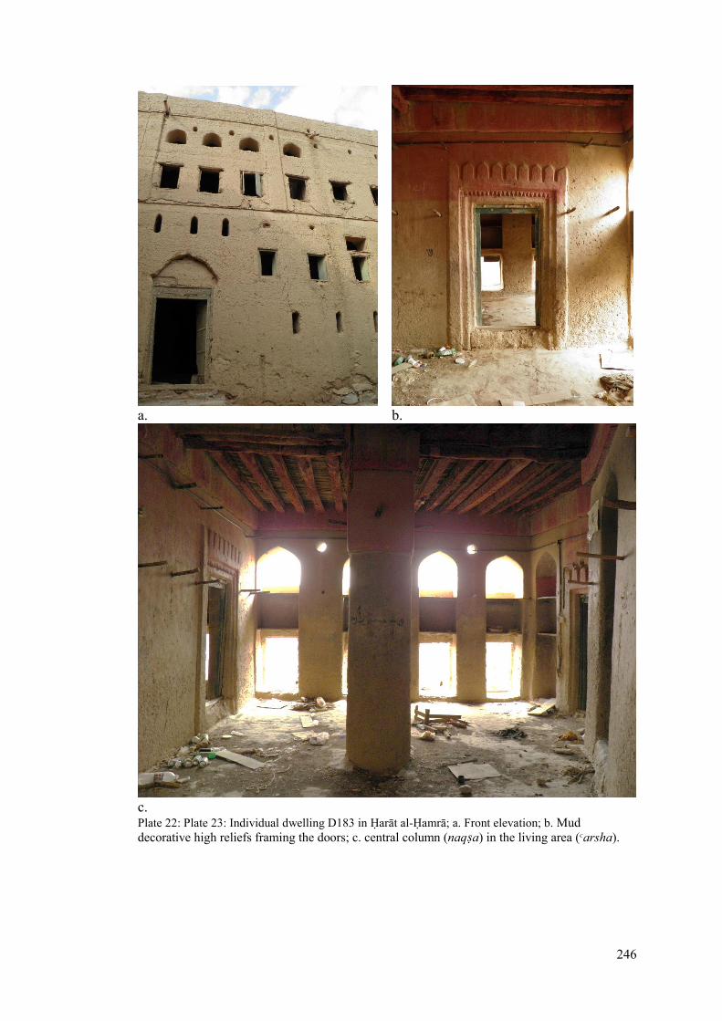
246
a. b.
c. Plate 22: Plate 23: Individual dwelling D183 in Дarāt al-Дamrā; a. Front elevation; b. Mud
decorative high reliefs framing the doors; c. central column (naqΒa) in the living area (Κarsha).

247
Plate 24: Floor plan of SD9; a. Ground floor; b. First floor; 1. main entrance door; 2. First dahreez; 4.
suffah; 6. darss; 8. Κarshah; 9.gurafah; 11. Kitchen.

248
a.
b. Plate 25: Individual dwelling SD9 in Дarāt as-Saybānī; a. Front elevation perspective; b. Animal pin
accessed from outside the dwelling.

249
Dwelling Cluster
Dwelling clusters consist of two or more dwellings attached back-to-back or on the
side forming a block of dwellings. The dwelling cluster selected for comparison are
the ΚAbriyīn dwellings (D85, D89, D92 & D94) from Дarāt al-Дamrā, and the cluster
of the Tobī (SD30, SD46, SD49 & SD50), Fahdī (SD29), and Сaqrī (SD51) dwellings
from Дarāt as-Saybānī (Figure-108 & 109; the Дarāt as-Saybānī dwelling cluster is
presented in two separate drawings due to the change in level). The dwellings SD29,
SD30 & SD49 are in the upper level (Plate-26), while dwellings SD46, SD50 & SD51
are in a lower level (Plate-25). The dwelling cluster in Дarāt al-Дamrā had more
flexibility in forming without constrains given that these were surrounded by passages,
which resulted in the grid-like pattern (Plate-26 & 27). The dwelling cluster in Дarāt
as-Saybānī is more constrained by the pre-existing dwellings (i.e. SD30 & SD49),
topographic restrictions and the configuration of the falaj channel, which produced the
fan-like pattern, producing the interlocking between dwellings (Plate-28). The scale of
the dwelling clusters and the width of the passages surrounding them in al-Дamrā is
evident from the flexibility and space availability.
The floor levels function similarly to the individual dwellings, but the space
organisation tends to distribute and connect differently. The space organisation in the
ground floor of dwellings D85, D89, D92 & D94 tended be connected through a
transitory space (dahrīz) which also had stairs leading to the upper floor, and there
were two dahrīz113 connected by an arch (Κaqid, pl. Κauqud) in bigger dwellings (i.e.,
D94). While the space organisation in the ground floor in as-Saybānī dwelling cluster
tended to be in longitudinal of deep space transition corridor-like connected through
113 The second dahrīz mostly tends to be bigger and darker than the first one (i.e. D94).

250
arches (i.e. SD46, SD49, SD51 & SD51), (Plate-28). The steep incline in as-Saybānī
had also influenced the deep transition, were there were steps under arches
characterising transitions. The resultant spatial depth in as-Saybānī had resulted in the
use of roof lights shafts from internal (i.e. SD46, SD49 & SD51) or external (i.e. SD30)
first floor terraces, shedding light into some of the deep dark rooms on the ground
floor. The steep incline has also influenced the individual rooms on the ground floor,
which resulted in enhanced height of door and arched openings as thresholds
associated with steps (Figure-112).
The smooth incline in al-Дamrā made it possible to have a shared but private sabla
between D92 and D94, which were both owned by the same family. While the steep
incline in as-Saybānī made the sabla have direct access with its own stairs from the
dahrīz (i.e. SD30), or have access from outside the dwelling (i.e. SD49) through a
semi-private space, and indicating the stairs being constructed at a later time (Plate-
29). The early type of sabla in as-Saybānī is also found in the Sawwaqiyin dwelling
cluster in Дarāt al-Bilād in ManaΉ (10, dwelling C, Figure-113). The stairs as discussed
in the individual dwellings are also located the in the first dahrīz in the ground floor
of the dwelling clusters. While in as-Saybānī they were found in two forms, one similar
to al-Дamrā (i.e. SD46, SD50 & SD51), and in the other it was present in the second
dahrīz (i.e. SD29, SD30 & SD49). The latter type resulted in the introduction of roof
lights providing daylight into the dark space in the ground floor. The smooth incline
in al-Дamrā also made dwelling cluster height approximately similar which
contributed in making the women easily exchange visits from the roof, and also as a
defence strategy by becoming an escape route if necessary. The steep incline in as-

251
Saybānī, on the other hand, created substantial height differences between dwellings
making it difficult to connect through the roofs.

252
Plate 26: Floor plan of dwelling cluster D85, D89, D92 & D94; a. Ground floor; b. Mezzanine level;
1. main entrance door; 2. First dahreez; 3. Second dahreez; 4. suffah; 5. Κaqid; 6. darss; 6.sblah; 7.
sablah; 8. Κarshah; 9.gurafah; 10. shade; 11. Kitchen.

253
Plate 27: Continue of floor plans from Plate-19 of dwelling cluster D85, D89, D92 & D94; c. First
floor; d. Roof and second floor; 1. main entrance door; 2. First dahreez; 3. Second dahreez; 4. suffah;
5. Κaqid; 6. darss; 6.sblah; 7. sablah; 8. Κarshah; 9.gurafah; 10. shade; 11. Kitchen store ; 12. Kitchen.

254
Plate 28: Floor plans of dwelling cluster SD46, SD50 & SD51; a. Ground floor; b. First floor; d. Roof
and second floor; 1. main entrance door; 2. First dahreez; 3. Second dahreez; 4. suffah; 5. Κaqid; 6.
darss; 8. Κarshah; 9.gurafah; 11. Kitchen store ; 12. Kitchen; 14. Latrine.

255
Plate 29: Floor plans of dwelling cluster SD29, SD30 & SD49; a. Ground floor; b. First floor; d. Roof
and second floor; 1. main entrance door; 2. First dahreez; 3. Second dahreez; 4. suffah; 5. Κaqid; 6.
darss; 7. Sablah; 8. Κarshah; 9.gurafah; 11. Kitchen store ; 12. Kitchen; 14. Latrine; 16. Light shaft.

256
Figure 112: Section through dwelling SD30 in Дarāt as-Saybānī; 1. Entrance door; 2. First dahrīz; 3.
Second dahrīz; 4. suffah; 8. Κarshah; 9.gurafah.
Figure 113: The ground floor of the Sawwaqiyin dwelling cluster in Дarāt al-Bilād in ManaΉ; 1.
Covered passage; 2. Courtyard; 3. Entrance to dwelling A; 4. Lounge; 5. Room; 6. Store; 7. Pen; 8. Pit
for latrine; 9. Entrance to dwelling B; 10. Entrance to dwelling C; 11. Sabla, 12; loggia; 13. Well and
bathing area; S111; Sikkat al-Ghuwayr. (after Bandyopadhyay, 2011, Figure-42, p.122).

257
In comparison to other traditional settlements, the dwelling clusters in Дarāt al-Bilād in
ManaΉ is the most dominant type forming in a plain topography arable land (Figure-
116). These dwelling clusters tend to form in regular large and dense blocks and
reflecting clear tribal mosaic clusters (Bandyopadhyay, 2011, p. 133). These large
clusters are the result of settlement formation around mosques114 and key passage ways
and gates, and the reorganisation leading to the disappearance of earlier passages,
giving rise to very deep back-to-back developments (ibid, p. 173). Bandyopadhyay
describes the settlement’s morphology in a sequence of shift and transformation in
passages and courtyards which eventually resulted in the large dwelling clusters.
“The gradual transformation of open streets to covered passages and
their eventual incorporation within private properties could be
evidenced in many places in Дārat al-Bilad. The covering over of an
open street along the northern wall (originally an open space) … and
the gradual conversion of a communal passage into a courtyard within
an Al Bu SaΚid dwelling cluster (Chapter 5: fig. 23), are examples of
such transformations” (Bandyopadhyay, 2011, p. 167).
The impact on the settlement’s evolution (gradual shift and transformation) has
emerged from the continuous arrival and settling of major tribal groupings - the Banī
Riyam, Hubus, Banī Ruwahah, ΚAwamir, Hirth, Banī Hinah, ΚAbriyīn and the Bani
Kharus. This reflected in their tribe cluster dwellings, male meeting halls (sabla), and
communal water wells (Γawī) and associated facilities.
114 This principle in development starting with the mosque is found in most of the Islamic settlement,
which is ideally guided by the first Islamic settlement in the world by the Prophet Mohammed in 662
AD. The Prophet started his planning by constructing a mosque in the centre of the city, they followed
by distributing the quarters and dwellings to the immigrants, tribes and other people. Hence, this
urban pattern became a planning standard for later traditional Islamic settlements (Mortada, 2003, p.
58). The mosque not only is a religious centre but also becomes the focus for more social and political
activities (Bandyopadhyay, 2011, p. 178).

258
Дarāt al-ΚAqr in Bahla oasis115 (comprised of three urban nuclei, al-ΚAqr, al-Ghuzailī
and al-Дawiya), forms a ring embraced around a hillock (Figure-117), which is
crowned in its apex by the Дusin116 and the Great Mosque117 (Bandyopadhyay, 2005,
p. 24). The Ήarāt (3) forms a linear arrangement with the Great Mosque (2), Дusin (1)
and the suoq (4) (Figure-117). These three nuclei integrate forming dwelling clusters
in a more or less homogeneous sickle-shape forming a ring around the mosque and
extends in two prongs on the eastern and southern foot of the fort (Bandyopadhyay et
la, 2013, p. 28). This dwelling cluster formation is influenced by the foothill form of
the Great Mosque and fort, hemmed by the palm groves and multi-level falaj channels
on the lower hill side (ibid, p. 29).
While in Дarāt al-ΚAqr in Sufālat (Lower) Nizwa which developed similarly to Bahla
within a walled agriculture land, the dwelling cluster tends to integrate in a shallow
linear pattern to retain and protect the agriculture land (Bandyopadhyay, 2011, p. 173).
Their core settlement formation seemed to be influenced also in a similar way to
ManaΉ around the oldest mosque (Masjid ash-Shawadhinah) 118 , (1, Figure-115),
dating back to 14 AH / 1529 AD (Bandyopadhyay, 2005, p. 28). Bandyopadhyay
describes the linear formation extending from the dense and complex clusters, core
settlement (area 500, Figure-114) resulting from the existence of older tribes, complex
115 A large walled oasis in a defensive setup and one of the most important historic pre-Islamic
settlements and listed in the World Heritage Site (WHS) in UNESCO since 1988 (Bandyopadhyay S.,
2013, p. 11). The oasis was thriving with prosperity during the Nabhina (dominant tribe) ruling from
the 12th to the end of the 15th century (UNESCO, 1987). 116 The fort was developed in different stages of 9th , 17th and 19th centuries CE (Bandyopadhyay S.,
2013, p. 48). The miΉrāb is richly decorated dating back to 917 AH/ 1511 AD crafted by Abdullah
b.Qasim al-Humaini (Bandyopadhyay S., 2013, p. 31). 117 Historical mosque that dates back to the 12th century, and recent archaeological surveys revealed a
3rd millennium rectangular pit full of bones and items under the eastern wall of the mosque (Cleuziou
& Tosi, 2007, p. 130). 118 The mosque is also known as Majid al-Qiblatay and it consist of a magnificently detailed decorated
miΉrāb crafted by ΚIsa b.Abdullah b.Yusif in 936 AH / 1529 AD (Bandyopadhyay, 2011, p. 178).

259
property ownership and several contiguous linear structures (Bandyopadhyay, 2011,
p. 178).
It is clear that Masjid ash-Shawadhinah was the core that evolved the streets around it
and the compacted dwelling clusters. The streets then extend like a spine forming the
linear dwelling patterns on both sides, possibly influenced by the pre-existing
agricultural formation and associated falaj channels to connect at the end to a main
street or a gate. The extension of the Nizwa fort119 in the north part of the settlement
also contributed in the linear formation of the dwellings extending there and redefining
the north wall of the settlement. Hence, the influence in shaping the dwelling clusters
may vary from one settlement to another, although they might share similar site
characteristics (i.e. al-ΚAqr in Bahla and al-Bilād in ManaΉ).
The Ήarāt of as-Saybānī and al-Дamrā, although formed in the foothill region during
the same Imamate period, the site limits and topographic influences shaped the
dwelling clusters differently, and there were more localised differences too even within
each Ήarāt. Given that both were the late settlement developments in the YaΚrubah
Imamate, they both developed within a relatively short time and unlike Дarāt al-Bilād
in ManaΉ without significant shifts and transformations. Additionally, the socio-
political solidarity of the tribal groupings of the ΚAbriyīn in al-Дamrā or the Riyami
tribe confederation in as-Saybānī contributed in shaping respective social and physical
patterns. This was evident in Дarāt al-Дamrā, through first the gradual joining of the
ΚAbriyīn groups, secondly, the continuous extension of the settlement’s clusters, and
119 The fort is also known as Дusin al-ΚAqr and built in the Imamte period of aΒ-СulΓ b.Malik al-
KharuΒī (237-272 AH / 851-886 AD). It contains therr main parts: the round tower, the rectilinear
block contiguous with western edge of the tower and an agglomeration of small structures and
courtyard on the southern side of the tower integrating into the settlement (Bandyopadhyay, 2011, p.
175).

260
thirdly, the extension of the later Ήarāt (i.e. al-ΚAlī, al-Sharqiya and al-Дaditha) next to
Дarāt al-WisΓā. In Дarāt as-Saybānī, the steep incline and tribal groups of the Banī
Riyām maintained strong cohesiveness through, first, the tribal mosaic represented in
tribal clusters, secondly, the overlap between the dwellings spaces, thirdly, the
presence of dwellings with two access points from the east and west side for communal
use, and finally, the sablah associated with the dwellings which indicate social and
political solidarity. The form of the dwelling cluster, rather regular, or complex, , sickle
shape, or linear form, all reflect tribal unity and social solidarity.
Figure 114: Дarāt al-ΚAqr in Nizwa; 1. Nizwa (or al-ΚAqr) Fort; 2. Settlement fortification; 3.
Gateways; 4. street 100; 4s. street 100s; 5. street 200; 6. Street 300; 6s. street 300s; 7. street 400; 7s.
street 400s; 7t. street 400t; 8. Street 500, 8s. street 500s; 8sl.street 500sl; 9. Street 600; 9s. street 600s;
9t. street 600t; 10. Street 700; 10s. street 700s; 100-700: dwelling zones (after Bandyopadhyay, 2011,
Figure-42, p.175).

261
Figure 115: Masjid ash-Shawadhinah and Zone 5001. Masjid ash-Shawadhinah; 2. Street 500; 3.
Street 500 s1; 4. The now-truncated north-south lane; 5. Zone 400; 6. Zone 600; 7. Street 600t1; 8.
Street 700t2; 9. Street 500t2; 10. ZaraΚat al-Bustan; 11. The falaj channel, F2; 12. Madrasat al-Jaljlan
and the sablah (after Bandyopadhyay, 2011, Figure-23, p.178).

262
Figure 116: Дārat al-Bilad in ManaΉ: reconstructed settlement plan showing streets and lanes Main
streets: M1. KaΚb al-Bilad; M2. Sikkat al-ΚUqud; M3. Sikkat Дārat al-ΚAyn; Streets off M1: S11.
Sikkat az-Zalam (Sikkat ar-Ruh); S12. Lane leading to Sablat al-Wali; S13/S15/T11. Sikkat al-ΚAli;
S14. Sikkat al-Bayadir; S16. Sikkat Abu/Awlad Rawashid/Rashid; S17. Sikkat at-Tawi/ Sikkat Hawd
ad-Darb; S18/ S23. Sikkat bin Qasim; S19. Sikkat al-Karjah/ Awlad Karjah; S110. Sikkat ash-Sharah/
Sikkat Nus Sudus; S111. Sikkat al-Ghuwayr; S112/ S25. Sikkat ad-Dahmash;Streets off M2: S21 &
S114/ T22. Sikkat al-Qasabah; S22. Sikkat al-Gharabah; S23/ S18. Sikkat bin Qasim; S24. Dead-end
lane; T21 & S25/ S112. Sikkat ad-Dahmash.Gates: G1. Bab al-Burj/ Bab ar-Rawlah; G2. Bab Дārat
al-ΚAyn; G3. Bab an-Nasr; G4. Bab ad-DaΚnayn/ DaΚnin (after Bandyopadhyay, 2011, Figure-16,
p.69).

263
Figure 117: Bahla oasis: plan of core settlement area or al-Harah Quarter1. The fort; 2. Friday
Mosque; 3. al-Harah Quarter; 4. The souq (after Bandyopadhyay, 2011, Figure-16, p.177).
Communal Space Dwelling Clusters
Communal spaces within dwelling clusters were formed through the shared use of
open courtyards or open spaces between dwellings. The communal spaces in dwelling
clusters selected for discussion are the ΚAbriyīn dwellings (D180, D182, D183 & D184)
from Дarāt al-Дamrā (Plate-30 & 31) and Siyābiyīn dwellings (SD9, SD16, SD17 &
SD18) from Дarāt as-Saybānī (Plate-32). Most of the communal spaces were located
at the centre of Дarāt al-Дamrā, while those at as-Saybānī were at the northeastern
edge. The as-Saybānī communal space was associated with the boundary wall, the
secondary gate in the north and the male meeting hall (sabla). The smooth incline in
al-Дamrā contributed in forming regular communal open spaces – partially earth-filled,

264
which also resulted in their approximate orthogonal alignment. The steep incline and
rocky surface of as-Saybānī created irregular spaces connected with stone steps
resulting in dwelling clusters of differing orientations and irregular passages. This
emphasises the significant topographic influence on communal space in as-Saybānī.
This also points out that the communal space in al-Дamrā also functions as a social
activity space, rather as an assembly point for women’s coffee breaks, or for practicing
traditional crafts, or simply for men and women to carry out their daily chore. The
communal space in as-Saybānī, on the other hand, were also transitory spaces
connecting the passages
These characteristics of the communal space contributed in defining the accessibility
to the dwelling cluster; in al-Дamrā the dwellings’ main access were directly from the
communal space, while in as-Saybānī they were indirectly accessed through different
levels and connected passages. The space organization of the open communal dwelling
cluster in al-Дamrā was similar to the individual and cluster discussed earlier, the only
difference was that they consisted of large first dahrīz. The other additional difference
was the presence of private male meeting hall (sabal) in each dwelling, where the sabla
in dwelling D182 was located in the mezzanine level with a separate access from the
passage and connected with the first floor. The other private sabla type was D184,
where the sabla was attached to the dwelling but only accessed from outside from the
passage. For example, the private sabla in D183 was accessed from the first dahrīz
through stairs to it mezzanine level. The communal cluster dwellings of as-Saybānī
were devoid of private sabla and shared a communal sabla instead, associated with
the communal open space, indicative of the space limitations there. The communal
cluster dwellings of al-Дamrā were large and rose to three floors compared to those of

265
as-Saybānī, which were limited to a maximum of two floors, possibly indicating the
wealth and of the ΚAbriyīn and the geographical centrality of the Ήārat Vis a Vis their
dar. The influence of these communal spaces on the dwellings clustering around them
was that the dwellings and the passages leading to them became well known. For
example, the south-north passage leading to the communal space in al-Дamrā was
known as Sikkat al-WisΓā and each dwelling and its sabla was known by a name (e.g.
D182 is known as Bait al-Aswad and its sabla known as sablat al-Kuwait). This
indicates that communal spaces were landmarks in the Ήarāt urban pattern giving
significance to the dwellings clustering around it.
Looking at other settlements, the communal spaces in Дarāt al-Bilād in ManaΉ was
always associated with a communal facility or element for the public, rather than
communal for all the inhabitants or for specific tribe. These regular shaped communal
spaces were scattered in the Ήarāt included communal water wells, or a bathing
structure, or agricultural well, or a tannur or a male meeting hall (sablat).
Bandyopadhyay describes the importance of these communal spaces in relation to
water access:
“Just as the sbal were designated for the use of particular tribes, so also
the communal water facilities were the property of groups of dwellings,
usually of the same tribal affiliation. Their wider catchments and easier
access made them distinct from the private water points located within
dwellings. These communal water wells also incorporated bathing –
and at times prayer facilities, and are either located next to a route or
within a courtyard offering easy communal access” (Bandyopadhyay,
2011, p. 152).

266
Similarly, the communal spaces in Дarāt al-ΚAqr in Bahla were also associated with
communal facilities of water access points (mishrāΚ), or male meeting halls (sabla), or
a tannur120 or a mosque. The only difference was that they tended to form at the tip of
the sickle shape-like dwelling clusters, resulting in an open space of irregular form and
also function as a smooth level transition points. Other settlements, for example Дarāt
al-Yemen in Izkī consisted of one large communal space in front of the Darmakī
quarter associated with a male meeting hall (sabla, sablat al-ΚAlī) and a gate.
According to local informants, the large communal space was used for making mud
bricks for construction, for celebrating festive occasions of Eid hosting many events
including traditional singing and dancing with sword, rifle shooting on targets and
horse racing on the wide passage connecting to the space (Bandyopadhyay S., 2013,
p. 39). While Дarāt al-Дujra in Fanjā even today consists of a large communal festive
space near the main west gate (Bab al-Gharbī) in a defensive area referring to Persian
origins, for hosting what is known locally al-ΚAzwah during Eid (Bandyopadhyay S.,
2013, p. 19). The al-ΚAzwah consists of large-scale gathering of men, women and
children participating in celebrating events mainly singing and dancing with the ΚAzī121,
which it is named after. It also includes the events of firing cannons, traditional fighting,
rifle shooting, blowing on traditional horn (al-barghoom), trading and poetry readings
(al-Rawahi, 2012, p. 44). Hence, these communal spaces, beyond hosting communal
facilitates or crafts or festive celebrations, consist of activities of great social and
historic value for the dwellings and structures clustering around it.
120 Tunnor is a local term referring to a hole in the ground used to cook meat in a traditional way
especially during festive times of Eid al-FiΓr (after Ramadan) and Eid al-AΡΉā. 121 The ΚAzī is the man leading the ΚAzwa and the leading the singing and dancing of the men with
swords by with his loud voice of recited poems of glory for Oman and His Majesty the Sultan (al-
Rawahi, 2012, p. 24).

267
Plate 30: Floor plans of dwelling cluster SD46, SD50 & SD51; a. Ground floor; b. First floor; d. Roof
and second floor; 1. main entrance door; 2. First dahreez; 3. Second dahreez; 4. suffah; 5. Κaqid; 6.
darss; 8. Κarshah; 9.gurafah; 11. Kitchen store ; 12. Kitchen; 14. Latrine.

268
Plate 31: Floor plans of open space dwelling cluster D180, D182, D183 & D49; c. First floor; d.
Second floor & Roof mezzanine; 1. main entrance door; 2. First dahreez; 3. Second dahreez; 4.
suffah; 5. Κaqid; 6. darss; 7. Sablah; 8. Κarshah; 9.gurafah; 11. Kitchen store ; 14. Latrine.

269
Plate 32: Floor plans of open space dwelling cluster SD9, SD16, SD17 & SD18; a. Ground floor; b.
First floor; 1. main entrance door; 2. First dahreez; 3. Second dahreez; 4. suffah; 6. darss; 8. Κarshah;
9.gurafah; 11. Kitchen ; 12. Kitchen; 14. Latrine.

270
Linear Dwellings
Linear dwellings are those sandwiched between two dwellings or any other structure
type. The selected linear dwellings discussed are both ΚAbriyīn dwellings: D43 from
Дarāt al-Дamrā (Plate-33) and SD52 from Дarāt as-Saybānī (Plate-34). Both dwellings
were located at the south edge of the their respective Ήarāt and associated with the falaj
channel, but the falaj in al-Дamrā extended in a straight line and integrated D43 from
the front and the lower channel in as-Saybānī integrated SD52 from the back. This was
due to the location of the falaj in relation to the main passage in al-Дamrā, while in as-
Saybānī the curved trajectory of falaj channel was wide and the passage narrow, which
made it difficult to integrate with SD52. The smooth incline of al-Дamrā gave D43 the
advantage of having three access points from the ground floor: two at the front and
one from the back. The steep incline in as-Saybānī resulted in access points at two
different levels: the two entrances in the front access SD52 from the first floor, and the
one in the back provide access from the ground level.
The dwelling D43 is attached from west by another dwelling D44 and from the east
side by Masjid al-Дadith, which gained its name from Bait al-Дadith (al-Дadith:
meaning the new). While SD52 was compressed by various structures: from west by
dwelling SD45, from east by dwellings SD62 and SD64 and the internal gate SG2
(sabah ad-Dākhil). Dwelling SD52 was the biggest dwelling in the Ήarāt and was the
largest communal meeting hall (sablat ad-Dākhil) with its own devoted space for
coffee preparation and so the dwelling was known as Bait al-Kabir (al-Kabir: meaning
the large). The integration of the falaj with the D43 had introduced internal access
point from the darīz and bathing room, while in SD52 the falaj bathing room was
accessed from outside the dwelling. The space organization was similar to other types

271
discussed earlier, the only difference was that the stairs in SD52 was located at the
dahrīz of the rear entrance and consist of an internal terrace on the first floor with a
loggia.
Plate 33: Floor plans of dwelling SD43; a. Ground floor; b. First mezzanine floor; c. First floor; d.
Second mezzanine floor; e. Third floor and roof; 1. main entrance door; 2. First dahrīz; 3. Second
dahrīz; 4. suffah; 5. Κaqad; 6. darss; 8. Κarshah; 9.gurafah; 10. Overhead shade; 11. Kitchen store; 12.
Kitchen; 13. Falaj bath; 16. Sky light.

272
Plate 34: Floor plans of dwelling SD52; a. Ground floor; b. First floor; c. Second floor; 1. main
entrance door; 2. First dahrīz; 3. Second dahrīz; 4. suffah; 6. darss; 7. sablah; 8. Κarshah; 9.gurafah;
11. Kitchen store ; 13. Falaj bath; 14. Latrine; 15. Courtyard.

273
In comparison to other settlements, the linear dwellings tended to form on the edge
along the wall (i.e. Дarāt as-Sulaif in ΚIbrī, Дarāt al-Bilād in ManaΉ and Дarāt al-ΚAqr
in Bahla). This indicates the influence of the edge condition in shaping the linear
pattern in the settlement. The only exception was in Дarāt al-ΚAqr in Nizwa, where the
linear dwellings were integrated within the agriculture land. However, the space
organization was different from one settlement to another. For example, the ΚAbdalī
Shaikh’s dwelling in Дarāt al-Bilād in ManaΉ was a deep complex plan where the
ground floor was divided into two separate entities, connected only on the first floor
through an overhead stepped bridge (Figure-118). The first floor in addition to the
rooms, consisted of large open terraces, a tower (Burj al-JuΒΒ) and the male meeting
hall (Sablat al-Burj). This indicated how social status contributed in the scale and space
variety and organisation of the dwelling.
a. b.
Figure 118: Floor plans of ΚAbdali shaikh’s dwelling, a. ground floor; b. first floor; 1. Entrance; 2 &
4. Ground floor storage, pen and water well; 3. Staircase; 5. Blacksmith’s workshop; 6. Burj al-Juss;
7. Sentry room and observation space in Burj al-Juss; 8. Sablat al-Burj; 9. Sleeping rooms; 10.
Loggia; 11. Terrace; 12. Kitchen; 13. Latrine (after Bandyopadhyay, 2011, Figure-47, p.124).

274
5.4: Epilogue
This chapter has introduced the dwelling space organisation normally found in Omani
foothill settlements. The functions of the floor levels were similar to multi-level
dwellings in other settlements but the foothill ones had additional characteristics not
present in houses of the settlements of the plains. The topography played a key factor
in the space organization by introducing hierarchy in depth and levels. The ground
floor depth of al-Дamrā dwellings was organised through a first transitory space
(dahrīz) and then another bigger and deeper second transitory space (dahrīz). The
storage spaces were also found to be well identified functionally, Βuffah, khars, Κaqid
and naΡid. Some as-Saybānī dwellings are similar to al-Дamrā organization and some
others have a deep corridor-like transitory space. This deep transition was not only in
space but also in room level and the level of light penetration. The ground floor in al-
Дamrā was also double-height, which resulted in a mezzanine level for storage or for
an optional mail meeting hall (sabla). While in as-Saybānī the steep incline introduced
splitting functions into different levels.
The first floor in al-Дamrā dwellings were also organised through another intermediate
family living space (Κarsha), which connected all rooms. The first floor of as-Saybānī
mostly consisted of a loggia and an internal terrace and in some cases an open terrace
connected the rooms. Additionally, as-Saybānī introduced latrines and light shafts into
the first floor, absent from al-Дamrā. The smooth incline in al-Дamrā contributed in
roof level connections between dwellings, while the steep incline in as-Saybānī created
a substantial level deference which made it difficult to connect through the roofs.
Although both settlements are on foothill with different degree if incline, yet, they both
negotiated efficiently to fulfil their needs.

275
This chapter also discussed the dwelling types generated from the topographic
challenge, which included the individual or isolated dwelling, the dwelling cluster, the
communal space dwelling cluster and the linear dwellings. The individual dwellings
of al-Дamrā were found to be located at the centre of the Ήarāt in large scale and owned
by wealthy households and located by choice. While that of as-Saybānī were located
at the edge of the Ήarāt shaped and limited by the rocky surface structure. The dwelling
cluster in al-Дamrā forms in a regular grid-like shape due to the smooth incline, while
as-Saybānī tends to fan out shaped by the topography and curved profile of the falaj
channel in the lower end creating an interlocking pattern between the dwellings. This
resulted in internal terraces in as-Saybānī dwellings and light apertures.
The regularity of the communal space in al-Дamrā has also reflected in its clustered
dwellings in terms of accessibility, alignment and space organisation. While
irregularity in shape and level in as-Saybānī clearly indicated their function as a
transition for connecting the passages at different levels, also affecting the indirect
access of dwellings around it and diverse dwelling orientations. Other settlements
introduced a new type of large festive communal spaces (i.e. Дarāt al-Дujra in Fanjā
and Дarāt al-Yemen in Izkī), which were not found in foothill settlements. The
communal dwelling cluster is a unique type in giving social significance not only to
the dwellings but also in creating a landmark within the settlement. The linear dwelling
type tended to form at edge of the settlements, rather by the falaj channel in the case
of al-Дamrā and as-Saybānī or by the settlement’s wall (i.e. Дarāt al-Bilād in ManaΉ
and Дarāt al-ΚAqr in Bahla). One exceptional linear type is that of Дarāt al-ΚAqr in
Nizwa were it integrated linearly through the agriculture land. The falaj position and

276
the level of incline plays an important role in the accessibility and space organisation
in dwellings.

277
Section III: Epilogue
Chapter-6: Conclusion
6.1: The dawn of research on traditional Omani
settlements
6.2: The traditional foothill settlements
6.3: Diversity and unity
6.4: Sacred relation
6.5: Areas of future research

278
Chapter-6: Epilogue:
6.1: The dawn of research on traditional Omani settlements
Oman became a research magnet over the past four decades as massive breakthroughs
have been achieved in Oman studies, undertaken often on behalf of the Ministry of
Heritage and Culture (MHC). Major excavations led by eminent archaeologists have
unveiled the elusive cultural history of Oman and opened the corridor of the past back
to the 3th millennium BC and beyond, to indicate the beginning of settled life in the
Peninsula. Walking through the corridor of the past, important historical facts have
surfaced, one of which is the successful tracing the origins of the aflāj irrigation system
back to c. 1000 BCE, the spine of the oasis settlements in Oman. The archaeological
findings soon radiated beyond to attract more research in the fields of ethnography,
history, architecture and religion, and so Oman became well known for its distinctive
history, religion, culture and tribal system. The MHC continued its effort successfully
to collect old manuscripts from all over Oman through the department of national
records and archives which has recently become an independent authority. The
ministry also conducted documentation and restoration of traditional and defensive
structures – forts and castles – of significance. The Journal of Oman Studies (JOS) has
contributed in shedding light on Oman’s past through the archaeological finings,
traditional and defensive architecture, study of flora and fauna, and the traditional
irrigation system 122 . The MHC in recent years, shifted its focus on traditional
settlements by awarding projects to the ArCHIAM research centre at NTU to produce
comprehensive documentation and heritage management plans (MHPs) for these.
122 Details are in Chapter 1: Sources are at Literature and Supported Considered disciplines, where I
have discussed the research and disciplines conducted in understanding the traditional built
environment in Oman.

279
Accomplished HMPs for the settlement are: Дārat as-Saybānī in Birkat al-Mawz, al-
Yaman in Izkī, al-ΚAqr in Bahla, as-Sulayf in ΚIbrā and al-Дujra in Fanja. This first
step is considered an important achievement towards protecting, encouraging and
providing a data base for research on traditional settlement in Oman.
Many publications on Oman flourished from other disciplines, but sadly they tend to
be more descriptive with less synthesis and interpretation towards understanding the
history and culture of Oman. Most studies were in disciplinary isolation and thus lack
being properly contextualised. Archaeology for example, lacked historical context and
cultural meaning.123 Lately, discussions in archaeology has revealed three distinct
areas of debate:
“These are (1) the relationship between material culture and society – how
material culture relates to people, (2) the causes of change – what causes social
and economic and cultural change, and (3) epistemology and inference – how
archaeologists interpret the past” (Hodder, 2003, pp. 13-14).
Other works of related disciplines also share similar challenges as archaeology to
understand the Omani culture. The outstanding work of Wilkinson in exploring the
tribal system and water exploitation in Oman, and Cleuzious and Tosi’s work on
tracing the early Arabian civilisation in Oman, sits at the apex of achievements in
Omani studies. However, the author agrees with Bandyopadhyay that the work of
Wilkinson by no means provide a holistic picture of the Omani culture – as far as its
spatial nature is concerned, and the same falls with Cleuzious and Tosi’s work.
Wilkinson’s major work, for example, came from the Arabic sources124, and focused
123 Details are in Chapter 4: Sources are at al-Дamrā, where I have discussed archaeology of early
human settlements in al-Дamrā in discussing all periods found evident in that area. 124 Details are in Chapter 4: Sources are at Дarāt al-WisΓā tribal pattern and structure, where
Wilkinson’s source of discussion on the ΚAbriyīn.

280
on the geographical setting and the Imamate tradition in Oman without emphasising
their influence on the settlements social and physical formation. The archaeologists,
on the other hand, extracted the remains from its historical context and created a gap
in understanding its cultural continuity.
The work on the traditional architecture of Oman has always suffered from being
selective, descriptive or specific to glorified forts and palaces as a signature of the so-
called ‘golden age’. Other works, which tried to study the traditional settlement, had
again lacked the holistic approach, which eventually were unsuccessful in
understanding the traditional architecture from a cultural a social perspective 125 .
Others studied the traditional settlements in regions or disciplinary isolation which
disconnected the culture and architectural relation from the other parts of Oman126.
Bandyopadhyay’s work on Дarāt al-Bilād in ManaΉ could be considered, to some
extent, the most complete in understanding the traditional settlements in Oman, in the
sense of including the historical, social, religious, and architectural factors in shaping
the settlement127. However, the geographical and locational factor were absent which
are considered highly important none the less.
The Omani traditional settlement quarters, like any ancient city on earth, has a story
about its origins. An origin that might have begun with migration and dispersal, a
dispersal that developed a spiritual unity, a unity that evolved to political power. The
125 Details are in Chapter 1: Sources are at Literature and Supported Considered disciplines, where I
have discussed the СuΉāri houses by the coast of СuΉār in BāΓinah region by Kervran, and the Ibrā and
MuΡayrib settlements in Sharqiyah region by Bonnenfant and Le Cour-Grandmaison. 126 Details are in Chapter 1: Sources are at Literature and Supported Considered disciplines, where I
have discussed Costs’s work on the traditional built environment of the BāΓinah region. 127 Details are in Chapter 1: Sources are at Literature and Supported Considered disciplines, where I
have discussed the work of Bandyobadhyay in Дarāt al-Bilād in ManaΉ.

281
power that grew to a settling ambition, and an ambition that led to selecting a location.
From location the emergence of a settlement begins, a settlement that became a way
of living, a way of living became local tradition. The tradition that became a legacy, a
legacy passing from generation to another till it rested in our hands today. Through
this time span, the transformation evolves and develops with time, events and other
influencing factors. In order to understand settlement evolution, it is necessary to re-
visit the past to trace the roots of the original inhabitants who settled there and the
events associated in that time, and in turn the morphology of the settlement. By doing
so, it will explore the historical settlement morphology and synthesise the factors that
influenced it through time.
It is now clearly recognised that the formation of the traditional settlements are
influenced by internal and external factors. The external factors are determined by the
geographical location, environment (climate and natural resources), and security
(defence and accessibility). The internal are defined by topography, the falaj channels
and accessibility. The settlement’s formation is a result of balance between the external
and internal factors through the social, tribal and religious cohesiveness of the
inhabitants. Each factor influences the other. Hence, the large context of the traditional
settlements indicate how crucial it is to approach their study in a holistic and
interdisciplinary manner 128 . The fields of archaeology, anthropology, religion,
hydrology, geography, geology, history, sociology and architecture, should all be
considered together when studying the traditional settlements. Kent has emphasised
the importance of the interdisciplinary research:
128 Details are in Chapter 1: Sources are at rational of acknowledging other disciplines and
methodology, where I have discussed the importance of combining other disciplines and the
interdisciplinary research approach.
282
“Interdisciplinary research provides more alternatives with which to view data.
Awareness of different disciplines allows one to introduce novel approaches not
considered before, to have access to a different data base which may enhance a
discipline’s pre-existing one, and to avoid mistakes already made and corrected
in other disciplines” (Kent, 1990, p. 1).
6.2: The traditional foothill settlements
The traditional foothill settlements are the most outstanding types in reflecting
harmony with the environment and being prominent majestically to the viewer. Their
location centred on the foothills between the older oasis settlements (Nizwa, ManaΉ
and Bahla) on the plains and the mountain settlements (Misfat al-ΚAbriyīn, Bilād Sait
and Sīq) gained them political importance. The fact that these foothill settlements were
newly established and located centrally between the older settlements defines them as
intermediate settlements. Hence, the two foothill settlements studied in this
dissertation developed political and geographical power as exercising control over
dispersed small settlements within the Oman Mountains. Unlike the oasis settlements
on the plains, the foothill ones are mainly challenged by topography and space
availability. Hence, it was essential and logical to investigate the topography’s
physical and social impact on the settlement formation. The decision of establishing
the settlements on the foothills was the result of political and functional decision. The
political climate came in the form of support and appreciation from the YaΚrubi Imam
to the tribes for their loyalty, and to extend Imamate investment (water shares and palm
grove products) into these areas at the same time. This political influence is considered
to be the cornerstone supporting the internal and external factors for both settlements.
This gave the Imam control over the main two mountain routes (Jabal Shams and al-

283
AkhΡar) and safe access to gain allies with other tribes on the other side of the
mountain. This also provided alternative routes to the coast, which supported trade and
exchange. The functional element of locating the settlements on the foothills was to
maximise the agricultural land and to overlook the surrounding area as a security
measure. The positioning, however, was done in coordination with the surrounding
hills for security measures, and the feasibility of excavating the falaj channel129.
The discussion on the topography of both settlements has revealed four principal
influences on their physical pattern, (1) the foothill shape, (2) the steepness of slope,
(3) change in altitude, and (4) the rocky surface structure. The foothill shape
contributed in defining the site limitations and extension opportunities, the direction
of expansion, and the accessibility of the site. The slope contributed towards defining
the development in phases using different or appropriate construction techniques. In
Дarāt al-Дamrā, the smooth incline and the dwelling stone foundations revealed a
direct correlation between the increase in the slope steepness and the height of the
stone foundation. In Дarāt as-Saybānī, the steep hill revealed the early inhabitants’
knowledge of a wide range of advanced masonry construction techniques (it could be
safely assumed that the site was occupied in some form from very ancient times). The
change in altitude provided opportunities of communal open spaces and defining the
phases of development and structure types. The influence of the rocky surface structure
varied between the two sites too. In al-Дamrā, the surface fractures formed an
approximate natural grid, which contributed in defining the scale and form of the
dwelling clusters and so the urban pattern. It also contributed in defining the
passageways and the falaj access points along the main lower passage. In Birkat al-
129 Details are in Chapter 3: Sources are at topography and urban pattern, where I have discussed the
topography influence in the formation of the two settlements.

284
Mawz, the layered rock structure of various thicknesses contributed in defining, (a) the
settlement’s edge, (b) becoming preliminary anchoring foundation for the structures,
(c) the beginning and the end of some developed phases, and (d) the orientation of the
individual and dwelling clusters130.
The topography also had a major impact on the falaj distribution system in both
settlements. The defined straight (to some extent) south edge and smoothness of the
slope in Дarāt al-Дamrā contributed a having one main falaj channel along the main
lower passage. The falaj channel has also contributed in defining the communal
structures along the lower main passage which emphasise one communal public
passage. The sudden change in steepness in Дarāt as-Saybānī and the agreed shared
water and palm groves between the Imam and the inhabitants resulted in having two
falaj channels crossing through the settlement at two different levels. The two levels
of falaj channels resulted in the emergence of two communal passages, the lower more
social and public than the upper one, whose semi-communal nature was strictly
reserved for the inhabitants. The steepness at both sites had contributed in the overlap
between dwelling and overhead rooms straddling passages shared between two
dwellings. This sense of sharing, along with dwellings providing two access points
from both sides to be used communally, and the sbal associated in the dwellings for
communal use, confirms the tribal unity and adds more solidarity and cohesiveness to
the settlement.
The establishment of the two settlements at a time known as “the time of fear” made
it crucial to develop a defensive settlement pattern and the key element was their
130 Details are in Chapter 3: Sources are at topography and urban pattern, where I have discussed the
topography influence in the formation of the two settlements.

285
geographical location. The physical environment of each geographical location of each
site has contributed in defining the hierarchy of the outer and the inner defensive
features of the Дārat. The early inhabitant’s knowledge of the land reflected in their
efficient and effective use of the coherent relation between the mountain and the low
hills in embracing al-Дamrā through the outer defensive zone. The defensive zones in
al-Дamrā revealed a sense of hierarchy and each element was not only a defensive
zone by itself, but also relied and connected with the others. The inhabitants relied on
the low hills to divert the wadī flow and block the view from the outsiders. The guards
on the towers also relied on the wadī for clear views out, the towers relied on the
altitude of the low hills. In turn, the falaj also relied on the foot of the low hills for the
channel alignment, and the mosques aligned with the channels. The disconnection
between the mountain and the low hills, and rhythm of the low hills themselves in
Birkat al-Mawz contributed to having gaps and blind defensive spots, which resulted
in developing new outer defence zones. This not only resulted in the increase in the
number of towers but also in connecting the low hills defensively through stonewalls
and having sniper posts hidden in the mountain behind the settlement. This shows how
the diversity of the natural setting of each geographical location influenced the
settlement location and defensive strategy131.
The positioning of the settlement on the foothill gave significant advantages that were
absent from the other settlement types. The foothill settlements had the advantage of
(1) being positioned in a defensive location supported by the mountain, (2)
overlooking the whole oasis, (3) maximizing the use of available land for agriculture,
and (4) forming a natural pattern of development with respect to the foothill rock
131 Details are in Chapter 3: Sources are at topography and urban pattern, where I have discussed the
fortification internal and external zones of both settlements.

286
structure. These advantages gave the foothill settlements an outstanding territorial and
formational identity.
6.3: Diversity and unity
Revisiting the past on both sites has revealed the early human settlements in both
territories through the archaeological evidence of all periods discovered. In al-Дamrā,
these evidence suggests (1) site overlap, (2) closeness, and (3) re-use of the existing
structures of different periods, which indicates a sense of spatial – if not cultural –
cultural continuity. In Birkat al-Mawz, although the only evidence that were found
were the Rock Art in the gorge of wadī MuΚaidin, it nevertheless indicated the
importance of the wadī from the early human settlers. The change over time unveils
man’s settling nature and understanding of the environment. This continuity becomes
part of the inherited culture, which was clearly evident in their habitation at the apex
and the slopes of the low hills and near or in the wadīs, which are still evident within
the traditional settlements132.
The positing of the settlements within a big oasis and surrounded by other constituent
settlements and the natural environment, highlights the fact that oasis settlements were
formed within large contextual settings. This emphasises the importance the historical
settling geography of the region. The early settling of ΚAbriyīn in Missfāh and Nakher
and their use of arable land along with the important mountain routes connecting their
villages in Jabal Shams region, all contributed towards the eventual emergence of
Дarāt al-Дamrā as the capital (dar) of the tribe. Similarly, the settling of all Banī Riyām
132 Details are in Chapter 4: Sources are at al-Дamrā and Birkat al-Mawz tribal pattern and settlement
structure, where I have discussed the archaeology and the early human settlements and movements in
of al-Дamrā and Birkat al-Maws.

287
tribes in the older settlements around and above Birkat al-Mawz and their control of
Jabal al-AkhΡar with Sīq being their older capital, along with their small structures
behind and on top of the hills surrounding Birkat al-Mawz, contributed to the
emergence of Дarāt as-Sybānī. The physical closeness of settlements from the same
tribal group within the shared geographical environment played an important role in
the choice of the settling locations133.
Both the tribes’ origins, migration and final settling contributed in understanding their
tribal behaviour. The gradual revival, cohesion and evolved socio-political role of the
ΚAbriyīn over time contributed in them building-up their power and their desire to
settle in their own dār. This power was presented through (1) making allies during
their early dispersed settling pattern, (2) the religious and temporal knowledge of the
Κulama within the tribe, (3) their power as strong warriors, and (3) their support to the
YaΚāribah Imamate. All of this resulted in them gaining wide knowledge of the
geography of the Jawf region and self-confidence and independence, and thus to agree
to settle in their own independent capital dār. The Banī Riyām, on the other hand, had
the advantage of being one of the first tribes to migrate to Oman and settled early in
the Jawf region. This gave them the opportunity to, (1) expand and control the Jawf,
(2) settle in Jabal al-AkhΡar, and (3) became allies with the Nabāhinah who were the
original settlers of Oman in that time. The expansion of their power after the
Nabāhinah and later supporting the YaΚāribah Imamate, along with their well-known
intelligence reputation among tribes, resulted in settling in the entire Jawf region134.
133 Details are in Chapter 4: Sources are at al-Дamrā and Birkat al-Mawz tribal pattern and settlement
structure, where I have discussed the historical location settling morphology of al-Дamrā and Birkat
al-Mawz. 134 Details are in Chapter 4: Sources are at al-Дamrā and Birkat al-Mawz tribal pattern and settlement
structure, where I have discussed the tribal pattern and settlement structure of Дarāt al-WisΓā and
Дarāt as-Saybānī.

288
The tribal spatial distribution and structure through the different developed stages of
both Дārat reflected a clear understanding on the social, physical features and urban
pattern. The developing phases of Дārat al-Дamrā show a core settlement established
as a reference point, which transformed from one phase to another over time. This
transferring reference develops with the tribal solidarity, along with the natural grid
surface of the foothills, which eventually develops the urban pattern. The formation in
Дarāt al-Дamra started from the falaj channel and extended north, while in Дarāt as-
Saybānī it was the opposite, from north down towards the falaj channel. The
developing phases of as-Saybānī emphasised the influence of the topographic structure
of the territory on the development of the construction technique, the urban pattern and
passages. These dwelling forms and block patterns possibly suggest the development
of individual spaces within one dwelling at different times caused by need and
necessity for family extension, along with the challenge of topography and
affordability135.
It is now recognised that the traditional settlements may be positioned in a diversity of
geographical locations but they tend to be connected through tribal solidarity and unity.
This sense is driven by the spirit of sharing between all inhabitants in all living matters
in and out of the settlement. The sharing is not only evident in the water shares of the
falaj or date palms, but extends to shared responsibilities towards protecting the
settlement, sharing dwelling storage and access, sharing a terrace or roof, and even
sharing ones traditional wheat grinder (raΉā). The sharing is also evident in the
135 Details are in Chapter 4: Sources are at al-Дamrā and Birkat al-Mawz tribal pattern and settlement
structure, where I have discussed the tribal pattern and settlement structure of Дarāt al-WisΓā and
Дarāt as-Saybānī.

289
provision of communal structures for both genders. The sharing was also associated
with caring for each other in the sense that everyone knew everyone in the settlement,
much like one big family. This was clear through the daily coffee breaks of the women,
the women countless social visits to each other, the gathering of the men five times a
day for prayers, the gathering of the men in the souq, and the gathering of the men in
the sbal. Even with diverse dwelling scales and social status, all inhabitants dressed
the same, eat the same food, worked on their own livelihood and practiced the same
traditions.
6.4: Sacred relation
The research on the traditional foothill settlements has revealed that the inhabitants
have managed to face the topographic challenge and resource limitations with
ingenuity and respect. This respect is a sacred relation defined as, (1) respect for the
surrounding environment, (2) respect for the available and limited resources, (3)
respect for the tribe and social ties, (4) respect for equality in front of Allah, (5) respect
to the neighbours, and (5) respect for their livelihood. This sacred relation gave these
settlements the ability to develop in a simple and efficient manner over a long period
of time, reflecting a strong sense of cultural continuity. This sacred relation gave the
inhabitant a strong bond with their settlement and tribe, it gave them the true meaning
of dwelling. This sense and way of living made the inhabitants live in solidarity and
work with devotion.
This sacred relation should continue to develop the scholars understanding towards the
study of the traditional Omani settlements. It is crucial to consider all factors, external
and internal, influencing the formation of the settlement with the inhabitant’s deep

290
connection to them. Today’s studies on the traditional settlements are faced with an
often neglected fact that scholars have to make do with deserted settlements, missing
therefore the perception of the inhabitants towards their settlements. Every part or even
a small object, or space had meaning and value to the inhabitants.
The MHC and MOT today is trying to approach these deserted settlements through
documentation to achieve a touristic and economic perspective. The settlements,
however, are still inhabited with history and memory, and the worry is that all these
will be neglected just to achieve such tangible projects. Therefore, it is crucial that
these settlements are first thoroughly studied by researchers in the field to maintain
that valuable knowledge and to share it with the present and future generations. A
study with an interdisciplinary approach to understand the settlement is thus crucial.
6.5: Areas of future research
This dissertation is an early attempt at understanding the traditional foothill settlements
of one of its first in Oman and the less researched areas of the world. The value of this
work lies on the multidisciplinary approach in trying to understand the subject from a
holistic perspective. Without doubt, the assertions made in this dissertation have to be
further analysed and refined in future by taking an even wider set of evidence into
consideration. A closer scrutiny of some of the arguments will probably challenge
some of the conclusions along with new developments and findings in other disciplines.
In this dissertation I have discussed the socio-political relation between Imamate and
tribes and highlighted their influence to the settlement. The political influence of the
Imamate as a cornerstone in established the settlement emphasise the importance of

291
further research on their politics and investments on the settlements. In order to have
a fuller understanding of Imamate wealth and influence on the settlement, it is essential
to study their external and internal connection in and out of Oman. The other important
and interesting political factor that needs further research and lies within the settlement
is the influence of the Shaikh families on the settlement. The Shaikh families play a
leading role in all settlements affairs of tribal, religious, economic matters. In order to
have a clear understanding of the settlements internal political system, it is crucial to
study the role of the Shaikh families in the settlement. The agriculture in the oasis
forms an income for every family and structure in the settlement which plays a
principle role in the settlement economic and possibly political prosperity. In order to
have a full understanding of the agricultural economic and political influence on the
settlement, it is important of conduct research on the landownership and its relation to
the Imamate and Bait al-Mall. It will be interesting to note how politics in the context
of Imamate and Shaikh influence, and agriculture management, contribute in
understanding the architecture of the traditional settlement.

292
Appendix-I: Interview Transcripts
These interviews were conducted during the fieldwork season of Birkat al-Mawz in
Дārat as-Saybānī in April 2011. The interviewees were five formor inhabitants of the
settlement; Khamis Bin Mansur Al-Dighashi, Mubarak Bin Salam Bin Hilal Al-Tubi,
Mousa Bin Mukhtar Bin Issa As-Saqri, Humud Bin Saif Bin Jaroof As-Siyabi and
Abdullah Bin Salim Bin Rashid As-Saqri.
First Interview:
Interview with: Khamis Bin Mansur Al-Dighashi & Mubarak Bin Salam Bin
Hilal Al-Tubi
Date: 06, Feb 2011
Location: Дārat Al-Sibani
Interviewer & voice recorder: Haitham Al-Abri
Note recorder: Prof. Soumyen Bandyopadhyay
Video recording: Dr.Giamila Quattrone
Time period: 63:35 min
Mubarak Khamis
Introduction:
The interview started with a brief history on the hara near the gates. Then proceeded
recording the name and house owner of each houses by walking through the harah
starting from the small outside gate and passing in front of each house. The interview
walk ended near the two gates and mosque and recorded the history of the falaj and
general idea of the whole settlement. The house codes in the interpretation are based
on a numbering system done after documenting the settlement to easily reference the
house during the interview which is attached with this document. Below are some
photos during the interview walk through the Sibani settlement.

293
Notes in reading the interpretation:
The interview interpretation has been written in a transcript style. The questions are
written in bold and preceded by the initials of the interviewer or any other person
asking the question. The answers are in Italic on a new line and proceeded by the
initials of interviewee. The codes of the structures can be found at the end of the
transcript in a code map of the settlement.
Interview Interpretation:
KD: The settlement was constructed starting from here in Burkat Al-Mouz since
approximately 400 years ago and it evolved a lot with the expanding of number of
houses and conserving them. The settlement expanded vertically from bottom to top.
The houses are owned and the ownership changed from one to another but some
houses are still owned by their originals. There are principal remaining houses owned
by specific tribes although the inhabitants were within limited number of tribes of one
or two. The components of the settlement are: the inhabitant’s houses, the mosque,
public majlis, falaj that crosses through, three main vertical accesses sekik (passages,
editor's note), and three gates.
MT: four gates.
KD: That were closed at night by the order set for it for the settlement. There are only
two settlements, this one and that one (pointing at Al-Wādī settlement) that were
inhabited till the mid 1970s and there are still remains of the electricity lines. Now
none lives in the harah except this man (pointing at Mubarak, editor's note).
HA: When did the people start moving from the harah? KD: They started approximately in 1976 and 75.
HA: What were the tribes that inhabited the harah?
KD: Bani Tubah, Al-Fuhud and Bani Riyam. These are the main principal inhabitants.
Bani Riyam and their clans. Al-Fuhud and Sukur were also under Bani Riyam.
SB: Masarir? KD: No they didn’t have Masarir.
HA: You have mentioned that the harah was constructed vertically bottom to top?
KD: Yes as I heard alongside with the newly expansion.
294
HA: What about the tower at the top? KD: The tower was there before with its attached structures around and behind it.
However, the harah was constructed in a very short period, started from the bottom
and in short time continued upward to the top. It didn’t take 300 or 400 year to build
up the harah and it was inhabited with limited number of people. The houses were
increasing gradually one next to another and some of the houses in the bottom and top
are overlapping with each other.
HA: how many houses are approximately in the harah? KD: It’s difficult to count but approximately 50 to 60 houses.
HA: Can we start walking in the settlement to point out the names, history and
owners of each house? KD: Yes, that’s fine and we can start from the gates. Old men accompany me to the
gate (talking to Mubarak, editor's note). Each house was inhabited by four to five
families (saying on the way to the gate). The houses were very close that the ground
level of one house was on the first floor of the neighbouring house. The ground level
of one house was for one family and the first was for another and they all entered from
the same door. They were all corporative with no disagreement of one saying this is
my house against each another.
HA: What’s the name of the owner of this house? (H3, editor's note) KD: Said Bin Sulaiman Bin Mohammed Al-Saqri.He has passed away and now it is
inherited by his sons Shaikh Saif and Nassir.
HA: how old is the house and was it constructed with the harah? KD: A bout the same time, no, it was built after the harah by Mohammed Bin Sulayim
because before this area was date orchards. So the orchards started after these gates?
Yes.
HA: These gates do they have names? (H1 & H4, editor's note) KD: Sabah Al-Sharki (H1, editor's note), Sabah Al-Gharbi (H2, editor's note) and the
third gate is on that side (pointing at gate opposite to the car parking, editor's note).
There are two falaj channels that enters the harah which divides from one falaj, the
lower one here (pointing at the one the crosses next the mosque, editor's note) and the
upper one.
HA: Where does the falaj divide? KD: It divides far next to the Sharia (head of falaj) but enters the harah in two
channels.
MT: The falaj has three flows
HA: Dose the entry point of the falaj to the settlement close? KD: No, it’s not close. It flows under the gate and the houses. This house is one
example (G8, editor's note); and one crosses at the top which we saw. The mosque was
her (G4, editor's note); and there was a Quran school her (G7, editor's note).
MT: The school is next to that wood.
KD: A Quran School and a water well, which is still exists. It is still there next to that
Sidrah (local tree, editor's note). In the past at war time, the inhabitants close the harah
and use the well, none enters or exist. At night time after nine or sunset none enters

295
the harah except for known guests. The harah was totally enclosed for its habitants
only. There was a guard by the gate from a long time.
HA: What about the mosque? (G4, editor's note) KD: This mosque is called Waljah mosque and it was the main and only one for the
harah. There were two public sablas, this is one above the Al-Sharki gate which was
less used by a specific group and the other located upper near the vertical access for
the whole harah.
HA: Was the sabla on top of the Al-Sharki gate used by a specific tribe? KD: No, It was for all the inhabitants and also the other big sabla.
HA: Was there a house in the ruin area between the mosque and that house? KD: Yes, there was a house. It was our house. That whole area was enclosed with the
harah. I had to demolish the house to reconstruct the falaj channel. I had to sacrifice
the house to reconstruct the falaj channel. The houses were affected by the leakage
from the falaj channel which caused collapse in some of the houses. The houses were
already old and week and the falaj leak were affecting them more.
HA: Is the path of the reconstructed falaj the same as the old one? KD: Yes, the
same. Some bits have changes, like the change of sarooj material and location of the
majasah (public bathing and ablution cubes, editor's note) which we didn’t rebuilt.
HA: Where there specified majasahs between the houses? KD: Yes, there were some specified for men and some for ladies along the falaj path.
HA: Who is this house attached to the gate? (G8, editor's note)
KD: Khafan Bin Sulaiman Al-Handaly but I don’t know who he bought it originally
from. He is not the original owner. The harah was evolving and there was a lot of
buying and selling. In the old times, the house remaind for the same family inherited
one after another but now it has changed. Then they started to expand and who doesn’t
have ability to construct will buy one. Are the new owners who buy the houses from
the settlement or outsiders? No, they are all from the settlement. All the inhabitants of
the harah are from the settlement.
HA: Shall we go to the other gate? KD: Yes, let’s go.
HA: What’s the name of this falaj? KD: It’s the same falaj Al-Khatman. It divides in to two channels, upper and lower.
HA: It seems that the original arch was big. I think they reduced it and I am not
sure why. KD: Some of the arch openings of the falaj were reduced and blocked in the 1950s
and 1940s when there were problems.
HA: Was there a relation between blocking the arch openings of the falaj with
the expansion of the houses? KD: No, it was a security issue and some of the arches, openings and window gets
blocked or closed. As you see there are houses at upper levels and houses at lower

296
levels, majasahs at lower levels and her (pointing at the one next to the gate, editor's
note) and the houses evolves upward.
HA: Was this gate known by any name? KD: No, it wasn’t.
HA: What about this house? (G10, editor's note)
KD: It is for Salim Bin Sulaiman Al-Abri and it was one of basic principal houses.
HA: Is it still owned by him? KD: It is owned by his sons.
HA: Where is he now? KD: He passed away but his sons and grandsons are still here. But the house is old
and none live there anymore. One the house is known as Bait Al-Ras which is also one
of the main principal houses. There are two or three main principal houses: Bait Salim
Bin Sulaiman Al-Abri which was for his father Sulaiman Bin Salim, Bait Al-Sukur
which we passed by earlier and Bait Al-Ras for Said Bin Jarruf Bin Sulaiman Al-Tubi
who lived in it with his family, about three or four families together. There is another
house called Bait Al-Sharqi which is also a main principal house and it inhabited six
families.
HA: six families! KD: That’s because of the size of house and family and strong social ties within the
families.
HA: We also heard from one of the old people about a house called Bait Al-Kabir? KD: It is for Said Bin Sulaiman Al-Abri.
HA: What about this house? (G11, editor's note)
MT: For Rashid known as Bu Khuluf.
KD: For Rashid Bin Salim Al-Sakri.
MT: This house (G14, editor's note); is for Ali Bin Said Al-Fahdi. I wasn’t there in the
inhabitant’s life time of most of the houses in the harah. This opposite (G12, editor's
note); was sold and I don’t know the new owner but it was originally owned by the
brother of (G14, editor's note); Al-Fadi, Hasan Bin Said the brother of Ali Bin Said
(Mubarak continued). I remember them starting from the 1970s. That is Bait Al-Ras
(C1, editor's note); for Said Bin Jarruf Bin Sulaiman Al-Tubi. That’s the vertical
access that goes up till the tower.
HA: Was this access known by any name? KD: No, I don’t remember that it was known by a name. The whole harah is known by
Al-Sibani.
KD: What is the other access?
MT: Burj Al-Sababirah.
KD: No, I mean the access.
MT: No, it doesn’t have a name.
HA: What is Burj Al-Sababirah?

297
KD: It’s the tower at the top by the end of the stairs. The name Sabairah comes from
the word sibir or Khibir (meaning: defend, editor's note); when they used to defend
against enemies.
GQ: Haitham ask him if this was a shop because someone told us so yesterday. KT: This is the house of Salim Bin Sulaiman Al-Abri, this is the upper entrance and
the other lower one is from the back.
HA: Was this a shop? KD: That was the location for raha to grain or mill the wheat which is done by women.
Then the owner Rashid Bin Salim (G11, editor's note); changed it to a shop selling
coffee, sugar and other goods.
HA: Who was the owner on the raha time? (Flat circular stone used to grain
wheat, editor's note) KD: None, it was for the use of all inhabitants. They go there and grain there wheat
themselves. We had a place for the wheat and another for Khall. Then they shifted the
location to grain wheat to that location (attached to E3, editor's note).
MT: There is another one next to your house (G3, editor's note).
HA: What about this house? (G12, editor's note) KD: It was owned by Saif Bin Said Al-Fahdi and it has been sold and we don’t know
the new owner. As I told you the tribes that inhabited the hara were the Fuhud, Sukur,
Bani Tubah and Al-Abriyin.
HA: What about this house? (C5, editor's note)
KD: It is for Khamis Bin Salim Al-Saqri. This was that sabla that I was telling you
about (G10, editor's note). It is called Al-Ghurfah and used for meetings, receiving
condolences and to host travellers and guests.
HA: Is this sabla part of the house? (G10, editor's note) KD: Yes, attached to the house but the house is separate.
HA: Where is the entry to the sabla? KD: From here (pointing at the location we were standing next to the falaj, editor's
note).
HA: The sabla was longitudinal? MT: Yes, it was. This room was for preparing coffee and they enter from here to then
enter to the sabla.
HA: What about the space beneath the sabla? KD: It was for storing stock for Salim Bin Sulaiman (G10, editor's note), until the
sabla.
HA: Is this all part of his house? KD: Yes, his house and family is one of the biggest in the harah. As I told you, the
lower level is for animal stock and storage and the upper level is for the family. I some
house you will find the lower level for one family the upper for another. This is the
main falaj channel for the harah.
HA: Dose the lower falaj channel branch from the upper one? KD: No, that is a branch and this is a branch but the upper one is bigger. This is two
divides in one. If you go the shriaah (mother source of falaj, editor's note).
MT: The water flow channel divides into three flows. Two are for the upper and one
for the lower.

298
KD: The channel of this upper falaj was raised up but now we have lowered it a bit.
You see it high because of the filling of the compacted ruins but before, this path was
low to that level (pointing to the gate next to G8, editor's note), and there was a stone
steps rising from the gate to her. HA: HA: If the channel was high, how did the
inhabitant of the houses next to the falaj enter to their houses? KD: No, I mean that the existing level now was high in the old time and the ground
next to it was low. They had a system before that if the flow of the falaj stopped; there
will still be water in the channel for other uses like fire, ablution or other.
HA: That means that the flow pushes itself through the harah tell it exits.
KD: Yes, it was.
HA: What about this house? (C4, editor's note) KD: Mukhtar Bin Issa Al-Saqri but I don’t know if it is still owned by his sons or sold.
HA: What about this house? (G6, editor's note) KD: Mohammed Bin Said Bin Jarruf Al-Tubi, it was originally for his wife but for him.
HA: What about this house? (G5, editor's note) KD: Humud Bin Hamad Bin Mhana Al-Fahdi but now it is for his sons.
KD: This was the remains of the original falaj channel it was wide under the houses.
HA: Since there was a stairs rising up from the gate, where was the entry to these
houses? (G5, G6 & G8, editor's note) KD: They were entered from the lower level, through the stairs path. These ruins that
you see are the upper level. This house (C2, editor's note) is for Ibrahim Bin Salim Al-
Tubi.
HA: For who was this sabla? (Attached to C2, editor's note) KD: It was for us but then used by this house (C2, editor's note).
HA: Was it constructed with the house (C2, editor's note) or came later? KD: No, it came later.
HA: Was it a sabla? KD: Used as a sabla by the family of the house (C2, editor's note).
HA: What about the space under the sabla? MT: It was used to grain wheat it was previously her next to the falaj.
HA: Did the inhabitants grow a lot of corps? KD: Yes, all the time and that was the original location for a room to grain wheat and
Khall and it gone now.
MT: This is the house (D5, editor's note) of Said Bin Salim Al-Dughaishi, the Shaikh
(settlement leader, editor's note). This house (G1, editor's note) is for Humud Bin
Hamad Al-Fahdi.
HA: What about this house? (D1, editor's note) MT: That house is from below.
KD: It is not part of the settlement.
HA: What about the house (D4, editor's note) which is behind this house? (D5,
editor's note) KD: That house is part of the settlement and it ends her at the edge of (D5, editor's
note). There are other house expanding on that side but the settlement ends her.

299
HA: was there any specific function on the shaded space of falaj under a room
expansion above it? KD: No, it was just a shaded path and along the falaj there were mujasas (public cubic
rooms for bathing, ablution and other uses, editor's note). The woman gets drinking
water from Shiria (water source, editor's note).
MT: Two women mujaza next to each other were in front of my house (D6, editor's
note).
HA: What about that house? (G3, editor's note) KD: That is two houses attached, the first is for Khalfan Bin Abdullah and the second
is for Saif Bin Abdullah Bin Salih Al-Tubi and the next is main, Monsur Bin Khamis
Al-Tubi and his brothers. This house (D6, editor's note) is for Mubarak Bin Salam Al-
Tubi.
HA: The houses on this edge were they entire from outside the settlement? MT: No, they don’t. The only access to all the houses is through the main gates. What
you see now on this level is the upper level and below is all service. You enter them
from the upper level and go down by stairs to the lower level. The settlement is
enclosed and only entered through the gates. There is another gate up the settlement
next to the house (D3, editor's note) of Nassir Bin Khusaib.
KD: The original stairs starting from the gate by (G8, editor's note) was similar to
this stairs between (D8, editor's note) and (C2, editor's note) but wider and two or
three times longer.
HA: Did the discharge water affect the paths between the houses? KD: No, it
comes down to collect in the falaj and discharges outside the settlement without
affecting the houses.
HA: What about this house? (D8, editor's note) MT: It is for my uncle Rashid Bin Khamis Bin Rashid Al-Tubi. The house behind it
(D7, editor's note) is for Ali Bin Issa Al-Saqri, but now been bought by Said Bin
Sulaiman.
KD: Some has passed away and some has sold their houses.
HA: What about this house? (C3, editor's note)
KD: Khalfan Bin Sulaiman Al-Hundhaly.
HA: The paths are not straight upward, is that done on purpose? KD: Because of topography, the nature of the houses and the stairs.
HA: Which came first, the houses or the paths? KD: I don’t know. If one house collapses, ten houses will collapse with it because the
all support each other.
HA: What about this house? (D9, editor's note) KD: For Abdullah Bin Zaher but sold it to Khalfan Bin Obid, no, Humud Bin Hamad
Al-Fahdi.
HA: What about this house? (B5, editor's note)

300
KD: For Abdullah Bin Zaher Bin Saif Al-Fahdi but sold it to Khalfan Bin Obid Al-
Hundhaly.
HA: Was this a separate house? (B5, editor's note) KD: This was part of this house (B5, editor's note), it was a big house. The inhabitants
used to sleep on the roofs and terraces overlooking each other. HA: Is this a stair
path continuing her? (Between B5 and D10, editor's note) KD: Yes, there is stairs continuing up.
HA: What about this house? (D10, editor's note) KD: For Hasan Bin Hamad Bin Khamis Al-Fahdi. The stair path turns and crosses in
front of the houses. This house (B4, editor's note) is for Humud Bin Saif Al-Siyabi.
MT:This house (D2, editor's note) is for Nassir Bin Khusaib Al-Siyabi, my uncle .
HA: What about this house? (D1, editor's note) KD: For Ali Bin Jarruf Al-Siyabi.
HA: Are these houses at the top the oldest? MT: They are the oldest.
KD: You mean latest.
MT: No, the oldest.
HA: you mean the houses descending from the tower downwards are older? KD: Yes, older.
HA: what about the big houses by the falaj and upward? MT: They are later houses.
KD: The hara didn’t seem to be constructed in a long period of time. Yes.
HA: Is that the reason of having gates? MT: In the old times, there was fear, that’s why the constructed gates. This is one gate
that I told you about. This is a small gate, not a main one.
HA: Does the gate have a name? KD: This gate and area is called Al-Ginanah and this is the owner’s current house of
this house (D4, editor's note).
HA: so, this gate is called Al-Ginanah? MT: Yes. That is the location of the children’s graveyard (pointing at the area next to
the small mosque, editor's note).
HA: Is there another graveyard near the hara?
MT: No, this is the only near one. What about that stone structure? I don’t remember
seeing them inhabited.
HA: Did these structures exist before settlement? KD: Yes and the tower.
HA: Do you know who constructed the tower? Did the elder people mention? KD: No, we don’t know, this was four generations ago, approximately 400 years ago.
See the channel path of the falaj extends until it connects to the next hara.
HA: What is the name of this garden area? KD: Al-Waljah and the next hara was called Burj Al-Makaseer. It is called Burj Al-
Makaseer because the tower overlooks all the makaseer (gardens, editor's note) in the
area.

301
HA: What about this house? (D3, editor's note) KD: For Musoud Bin Saif Bin Mubarak Al-Sakri.
HA: What was her next to the entrance door? (D3, editor's note) KD: A ruin, this area was a path. During the fear time in the past, the inhabitants used
to jump cross from her downward through the house of Said Bin Salim to our house
till they reach the bottom of the hara.
HA: Do they escape from top to bottom or opposite? On their house while people were asleep, they inform each other through the roofs and
terraces of the houses during an attack or fire or any other issues. HA: What about
that house (D5, editor's note)? MT: This is Said Bin Salim Al-Dughashi, these are two overlapping houses, and this
one (D7, editor's note) is for Saif Bin Abdullah Al-Tubi. They are all cousins of one
man of one family. After that house is the house of Issa Bin Salim then my house all
enters from one entrance door. There was a stairs path her (Between 3a and 3b,
editor's note). That tower is called Burj Al-Sababrah.
HA: The structure next to the tower, Is it part of the tower or a house? KD: That is a house but if you mean the one at the top, I don’t know.
HA: Do you know the owners of these houses? (B1, B2 & B9, editor's note) KD: No, I was not born when these houses were inhabited. I only recall 5 to 6
inhabitants in my time and I remember living in our house when I was a child but you
moved out since then. I was 5 to 6 years old when we move out. The settlement deserted
and if one house collapses, other houses will collapse with it.
HA: This was the house (A7, editor's note) that I was asking you about. Is this the
oldest part of the harah? (B1, B2 & B9, editor's note) and (F1, F2 & F3, editor's
note)
KD: Yes, according to Mubarak. We think that this is the oldest houses according the
buildings features and materials compared to the houses below because the ratio of
stone used is more. That means the more the stone the older the building. The
structures behind the tower are all stone made and scale is smaller. It seems whenever
the go down they found mud to use for their construction. Maybe it was difficult to
carry the mud to the top.
HA: What was the reason that the ratio of stone increase from bottom to top? KD: because of the mountain, most of the stone is in the top and the more you go down,
the less the stone. This is another stairs path (Between B8 & E2, editor's note).
HA: Is there a function for open spaces between the houses? KD: No, there was no function.
HA: Did the inhabitant create them in purpose or just naturally came with the
construction of the houses? KD: It was through the construction and division of the houses and these spaces were
not big, they were used to give access to the houses. For example, there was a stair
structure her leading to each house through this space. You will always find the ceiling
height in most of the houses low.
HA: Was there a reason for low ceilings and small doors? KD: Every one constructs his house according to his needs.

302
HA: What about this house? (E6, editor's note) KD: I don’t know. But it has collapsed and it seems it habited more than one family
and abundant more than 40 years ago.
HA: What about this top path? (Between E2 and E6, editor's note)
KD: That belongs to this house connecting to the upper level. (E2, editor's note)
HA: What about this house? (B7, editor's note) KD: I don’t know.
HA: What about this house? (B6, editor's note)
KD: This house is called Bait Al-Ras for Said Bin Jurrof Bin Sulaiman Al-Tubi. HA:
What are these openings used for? KD: To discharge water.
HA: What about this house? (B5, editor's note) KD: I don’t know.
HA: What about this house? (E3, editor's note) KD: It is for Khalfan Bin Ali Bin Jurrof Al-Siyabi. I remember when it was still
inhabited.
HA: What about this house? (C1, editor's note)
KD: I seem to mix up between the two houses. This is Bait Al-Rra for Said Bin Jurrof
Bin Sulaiman Al-Tubi and it seems to be called that name for some importance, mybe
they were one of the leaders but the biggest house is for Salim Bin Sulaiman called
Baith Al-Kabir. Most of the settlement was inhabited by Bani Riyam and Bani Tubah
but Bani Tubah had the leadership of the oasis. You will find most of the houses are
for them.
HA: The other person (Mubarak) informed us that D5 was the Shaikhs house, the
Al-Dughaishi. KD: Dughaishi and Tubi is the same tribe. The Dughaishi is a tribe branch from Tubi.
They are the same, some write Dughaishi and some write Tubi but they are all the sons
of the same man.
HA: Why there was a change in the name to Dughaishi? KD: because of the war time. During the war time before the renaissance, there were
allies with the Imam which caused three houses to be destroyed by dynamite which
where for the head of the tribes. Then they were not allowed to travel so any Bani Tuba
is not allowed which made them change their tribe name to Dughaishi to work for their
families. For example, some of my family members have chosen different tribe names.
This was in the early 1950s during the Jabal war in 1952. They changed and travelled
and when they came back in the early 1970s in His Majisty’s time, some returned to
the original tribe name and some didn’t. Two to three houses didn’t change back, one
of them was my father.
HA: Can we go from her to ask you about this sabla? KD: This house (F6, editor's note) is a big house for Bader Bin Saif Bin Hashm Awlad
Thani now Riyami which are the same. His father was a Kadhi (judge, editor's note)
in the previous governance of the Shaikhs.

303
HA: What is this space? (Attached to D17, editor's note) KD: I am not sure; it seems like a restroom or a majlis.
HA: Which settlement was the oldest? Al-Sibani, Al-Makaseer or Al-Wādī? KD: I far is I know, Al-Sibani was the first and oldest, but the Imam’s house was the
oldest which collapsed and the only part left it the majlis and it is in the size of a house
because it was the governor’s majlis. The first mosque ever constructed in this area
was located by the joining point of the wādīs outside the two settlements. Three wādīs
join there, wādī Al-Hail, wādī Al-Khasina and wādī Al-Muaidin. That area is rich of
water and fertile soil. The water collects like Birkah (big pool) and the first thing the
Imame grow there was bananas which was the reason for calling the settlement Birkat
Al-Mouz. Two years ago you could was in Birkat Al-Mouz and find it full of bananas
but now the number of farmers reduced and people got busy with other things, I think.
HA: Is the mosque you mentioned in the wādī joining point known by any name? KD: They called Al-Kadeem mosque (the old mosque, editor's note), constructed by
the Imame about 400 years ago or more and it was constructed by stone.
HA: When the Imame gave the orders to dig the Khatmmen falaj spring, how did
they locate it? KD: Generally, 60% of the aflaj in Oman were found by the Ya’ariba. Omani people
know the location of aflaj through the Sidir tree. If they see a green Sidir tree and it
has very long big routs go deep in earth, then they know that there is water there. They
also have people experts in water. There were Bussar for aflaj and also wisdom.
Omani people were very well knowledge in aflaj. See the wisdom, the falaj spring is
18 m underground level and the falaj flows on the top of the mountain. The Imam was
hoping to then turn the path of the falaj back to its source but he passed away before
achieving it. It starts 18 m below ground level and rises up self flow to the top of the
mountain, it is an amazing accurate engineering levelling system and I am responsible
for the falaj.
HA: that’s great, it will ensure the maintenance of the falaj. KD: Know we have managed to make addition to support the flow the falaj in the same
way the Ya’ariba did in the traditional way. There are other settlements her in Birkat
Al-Mouz. There is Ήārat Al-Rungsin and haraht Al-mdana which came later in small
scale of 4 to 5 house in the mountain because the lower land was for agriculture and
some houses are within the gardens which they used them in the summer.
HA: When the settlement got supplied by electricity? KD: In 1981, early 1980s but some of the inhabitants already moved out. They already
started to construct houses outside the hara. This house (H3, editor's note) was still
inhabited five years ago. When the old man got week, he went to live with his sons.
HA: What is the name of the old man that was walking with us? KD: His name is Mubarak Bin Salam Bin Hilal Al-Tubi. The only one left in the
settlement today and this mosque (G4, editor's note) is called Al-Waljah mosque.
HA: Did the children go to Quran School in the mosque?

304
KD: They were learning in this school (G7, editor's note) her and after it collapsed,
they were learning in that one in the parking area which was originally constructed in
mud.
HA: Where did the woman learn Quran? KD: The boys and girls lean together in the same school, rather in the old and the new
one.
HA: Did they have a male or female teacher? KD: They had a Mualam (male teacher, editor's note).
HA: Was there specific timing for the school? KD: They had two periods a day. One in the morning and the other in the afternoon.
This was for Mualam Khlafan in the morning, correct?
MT: No, first was Mualam Saif Bin Salim Al-Nabi her in (G7, editor's note) in the
morning and there by the Mugasal (place for wasing the dead, editor's note) in the
afternoon. Then came Mualam Khalfan Al-Sakri and then the school was located out
and the Mualam was Salih Bin Salim. It was in mud and the boys and girls learned
together. That time there was respect between them, not like what we see nowadays.
Everyone cares for everyone that time. That was the old location (G7, editor's note)
and every Thursday morning we give the Mualam two baisa as help from our side and
he didn’t have a salary. Sometime we give him coffee or dates, anything that was useful
that time for him.
HA: Where did you pray the Friday prayer? KD: We didn’t do the Friday prayers that time. They only started to pray Friday 10
years ago in the Jama but no pary before that time.

305

306
Second Interview:
Interview with: Mousa Bin Mukhtar Bin Issa As-Saqri
Date: 19, Feb 2011
Location: Дārat Al-Sibani
Interviewer & voice recorder: Haitham Al-Abri
Video recording: Dr.Giamila Quattrone
Time period: 53:31 min
Mousa As-Saqri
Introduction:
The interview started at the gates by recording the name and house owner of each
house around it. Then proceeded by walking through the harah starting from the inner
gate and passing in front of each house. The interview walk ended near the two gates
and mosque and recorded the history of the falaj and general idea of the whole
settlement. The house codes in the interpretation are based on a numbering system
done after documenting the settlement to easily reference the house during the
interview which is attached with this document. Below are some photos during the
interview walk through the Sibani settlement.
Notes in reading the interpretation:
The interview interpretation has been written in a transcript style. The questions are
written in bold and preceded by the initials of the interviewer or any other person
asking the question. The answers are in Italic on a new line and proceeded by the
initials of interviewee. The codes of the structures can be found at the end of the
transcript in a code map of the setllment.

307
Interview Interpretation:
HA: Can you please introduce your self?
MS: Mousa Bin Mukhtar Bin Issa As-Saqri.
HA: Can you take us a walk through the harah and tell us its components, history,
owners and age of each house? MS: The old original owners are possible but the new owners are difficult because
some we sold. Do you need the name for the purpose of conservation and
compensation for the owners or other reasons?
HA: We need to know the original owner and the current owner for
documentation purpose. Would you like us to start from this gate (Sabah)?
MS: Yes, this is the main Sabah access called Sabah Al-Gharbi (H2, editor's note) and
the opposite is called Sabah A-Sharqi (H1, editor's note) and above it is Sablat As-
Sabah and this house is known as Bait Al-Hadith (H3, editor's note) for Said Bin
Sulaiman Bin Mohammed As-Saqri.
HA: Was he a trader? MS: His grandfather was a big trader with Africa.
HA: We noticed that this house is the only one projecting out the harah boundaries.
Why? MS: Because there is a garden behind it that extends to the suq. It is called Kitat As-
Sumrah.
HA: Did the house come later?
MS: The house and garden came together.
HA: I mean was the house constructed with the harah? MS: No, this house came later.
HA: Do you know how old it is? MS: About 300 years old.
HA: What was in its location before? Was there a wall? MS: Yes, there was a wall and this was the only harah her and there was no harahs
on the other side. It was the main harah.
HA: What about the mosque? MS: This was the old mosque (Al-Jama), known as al-Walja mosque.
HA: Did they pray the Friday prayers in it? MS: No, they didn’t. They only did the five daily prayers.
HA: How old is it? MS: It was constructed with the harah. It’s very old and it had be conserved.
HA: Did the mosque remain in the same original size after conservation? MS: Yes, the same as the original size.
MS: This is the house of Ali Bin Issa Bin Sulaiman As-Sakri (G9, editor's note), my
uncle and this one (H3, editor's note) is also my other uncle.
HA: Is this house (G9, editor's note), older than this house (H3, editor's note)? MS: Yes, it older because it was constructed with the Sabah gates and the other house
(H3, editor's note) was constructed later. This is our house (G8, editor's note), Zaher
Bin Issa Bin Sulaiman As-Sakri and here (G7, editor's note), was the Quran School.
HA: Was the Quran School for boys and girls? MS: Yes, it was for boys and girls.

308
HA: What about this access? (Between G8 & G6, editor's note), MS: This was the second Sabah, similar to this Sabah (H4, editor's note) but they
removed it.
HA: Where dose it lead to?
MS: It takes you all the way through the harah. Access through the two harahs, Ήārat
Al-Lembjah and Ήārat Al-Qawa. This harah divides in to two haras, Al-Lembjah and
Al-Qawa.
HA: It divides in to two haras! Дārat al-Kahwa (meaning: coffee, editor's note)? MS: No, Qawa is a tree. Don’t you know the Qawa tree?
HA: Yes, I do.
MS: That’s the one I mean. It had a Qawa tree on one side and Al-Lambjah tree on
the other side. Al-Lambjah is small like the olive tree.
HA: Can you show us where did it divide? MS: Yes, I will show you.
MS: This is our house (G6, editor's note).
HA: What is the name of this Sabah? MS: This was the secure Sabah, after it closes, no one can enter the harah in the
evening because out side it was some service and falaj but from here none is allowed.
HA: That means there was a door gate here? MS: Yes, there was a door and they took it out when they were making a movie of
Oman in History.
HA: What about the Sabah Sharqi and Gharbi? MS: These two Sabahs were always left open like an access through to the East
gardens and only closed if something very important happened. But this gate was a
daily closed defence gate (gate between G8 & G6, editor's note).
HA: The two Sharqi and Gharbi Sabahs are always open while this gate is closed
every night? MS: Yes, because you have the falaj, the gardens and the mosque on that side.
HA: Any person passing through can only access that area between the Sabahs
only? MS: Yes, to use the falaj and mosque. And that room attached to the mosque was used
for preparing the dead for funeral.
HA: So, they used the falaj to wash the dead? MS: Yes, everything was recorded for specific use and property. The Kafan (cloth use
to cover the dead for funeral, editor's note) has gardens Amwal (meaning: date palm
tree gardens, editor's note). The Jama’a (the wise people or leaders, editor's note)
opinion also has Amwal. Also the Khall that they use for Eid and the Jama’a opinion.
Also the mualim of the Quran School in the mosque evening time and the mosques.
Also the Orifah and the Sabil for the poor people. And they all gathered in the mosque.
HA: They didn’t gather in the sabla? MS: Sabla was for coffee but the mosque was for all local matters.
MS: Here is sablat Al-Gurfah on this house (G10, editor's note), Bait Al-Kabir which
extends towards that direction (pointing to the north, editor's note).
HA: Dose the sablah have a separate entrance or is it accessed from inside the
Bait Al-Kabir?

309
MS: No, the sablah has its own separate entrance and the Bait Al-Kabir has two
entrances one from this side and one from the opposite side (pointing at the south and
north directions, editor's note).
MS: Look here, the falaj crosses through inside the house (G8, editor's note). For
example this house that we lived in, you can’t imagine that 10 people lived here. That
space is called Nathad for storing the dates and that was the stair to the upper floor
and that space was the darss for cows. That access is to the woman’s musala (prayer
room, editor's note), mujasah in other words where the falaj crosses there inside. The
house door is kept open and the woman comes and goes to pray here.
HA: What is the name of the space after the entrance door? MS: It is called dahrris and we sometime tie the goats in this space and that space is
called mutabekh as a small kitchen and the access to it is called mukhatif. This room
is for winter and that room is for summer and this one on top of the access is for the
guests.
HA: What is special about the winter room? MS: It has a farkha (opining in the ceiling, editor's note) at the ceiling and no openings
in the wall. They put on the fire in the afternoon and by evening there will be no smoke.
HA: What about the summer room? MS: It has windows and openings from every side possible.
HA: What do you call the space in the upper level between the rooms? MS: We call it arsha.
HA: Was there a space used as a bathroom?
MS: Yes, there was. Some call it bishrona, and some call it matrab, others call it
kaneef and others call it makan elkala or makan eladab. It was known by many
names.
HA: Was it available in every house?
MS: Yes, in every house.
HA: What about draying the dates?
MS: It was done on the roof of the house.
HA: Do they do it on the ground?
MS: They use the da’an which the place it on the roof and spread the dates on top of
it to dry.
HA: Was the area next to the school enclosed?
MS: No, there was an access that leads to the mall garden. It was enclosed to the
mosque.
HA: Can someone access from here?
MS: No, there is no access from there. The only access to the hara is from this sabah
(gate between G8 & G6, editor’s note).
HA: Does that mean that all these houses have no access from outside?
MS: No access from outside, there access is from inside the hara.
MS: This house (G6, editor’s note) is three floors and inhabited by a lady, her name
was Salma Bin Othman Ar-Riyamiya and she is a Shaykhah and wealthy woman with
many garden properties that she inherited from her father Othman. She inherited

310
from more than one person. The house remained under her name till she passed
away.
MS: That is winter room that I told you about with the farkha in the ceiling for the
smoke exit.
MS: We also bought that house (C4, editor’s note) which was owned by Hasan Bin
Said Ad-Dighashi who was the only Dlghashi.
HA: Are the Dighashi and Tubi the same tribe?
MS: Yes, the same and they changed the name back to Tubi except this man. His
name was Hasan Bin Said Bin Hasan Ad-Dighashi. We bought it from him.
HA: So now it owned by your family?
MS: No, my father gave its ownership to his wife, which then got inherited by her
daughter.
HA: How was the access after entering through this gate?
MS: There was a stairs rising up from the gate up word. Horses and donkeys also
claim up these stairs. Donkeys used to claim up the stair from here to the Burj Es-
Sbabra and Siyabiyin houses which were about five houses.
MS: The path is not accessible form here, can you access?
HA: We can access from here but we can go around if you want.
MS: Let go around. This is sablat al-ghurfah which is part of this house (G10, editor's
note) called Bait al-Kabir.
HA: Is this the biggest sabla in the hara? MS: Yes, this one and the sabla by the sabah but there is also another sabla up hill
(B3a and B3b, editor's note) called sablat As-Siyabiyin.
HA: So the sabla by the sabah (H1, editor's note) is for the Sukur and this one is
called sablat Al-Ghurfah (G10, editor's note) is for all the inhabitants? MS: Yes.
HA: Is the Sukur sabla only used by Sukur? MS: It is only for Sukur.
HA: What about the Siyabiyin sabla? MS: It is only for Siyabiyin (B3a and B3b, editor's note) but this sabla (sabla in G10,
editor's note) is for public.
HA: Was this sabah (sabah between G8 and G6, editor's note) known by any name? MS: It was known as sabah al-dakhili. It is similar to the other sabahs, Sharki and
Gharbi, and the one on the other side. Did you see the other one?
HA: We saw it but the door is not there. MS: All these doors are made of strong Joos wood.
HA: Where did they get this wood from? KD: They get it from Jabal Al-Akhdar and the carpenters were available everywhere.
MS: This orchard which is for Bait el-mall was previously owned by Shaykh Sulaiman
Bin Hamiyar and now it is for Bait el-mall for the government.
MS: this orchard area is called el-Walja.
HA: Was this edge enclosed?

311
MS: This edge was enclosed and extends and ends at the Quran School. It ends next
to this house (G5, editor's note) for Mohammed Bin Yousif Al-Fahdi. Next to it is the
house of Said Bin Ali Al-Fahdi. This house (G3, editor's note) is for Mansour Bin
Khamis Al-Digashi and the next house (G2, editor's note) to it is for Rashid Bin Khamis
Bin Rashid Al-Tobi the uncle of Mansour. After it comes the house (G1, editor's note)
of Ali Bin Issa Bin Sulaiman Al-Sakri. He has two houses, one next to sabah and this
one.
HA: Why did he have two houses?
MS: He had two wives.
MS: After the house of Ali Bin Issa Bin Sulaiman Al-Sakri (G1, editor's note) come the
house of Saif Bin Abdullah Bin Salih Al-Tobi and after it is the house of Khalfan Bin
Nassir Bin Salih Al-Tobi, his cousin. After that comes the house of Humod Bin Hamad
al-Fahdi. Then the house of Salim Bin Sulaiman An-Na’abi then the house of Said Bin
Salim Bin Salih al-Tobi Then this house for Rashid Bin Khamis al-Tobi (D5, editor's
note) then the after it is for Khamis Bin Rashid Bin Khamis al-Tobi there grandfather.
HA: Are you sequencing the names upward? MS: No, we are naming the owners of the houses of this area down. The upper hara
known as Дārat el-Fouq is different and this one is Дārat el-Qawa and the opposite
is called el-Lembjah.
MS: Now we come back to the houses. This house is for Ibrahim Bin Salim Bin Salih
HA: Let us go back to this house (D5, editor's note), who is the owner?
MS: Rashid Bin Khamis al-Tobi
HA: Was he the sheikh of the hara? MS: No, he wasn’t. His father was the sheikh. Khamis Bin Rashid Bin Khamis al-Tobi
there grandfather was a wealthy man.
HA: Was Khamis Bin Rashid Bin Khamis al-Tobi considered to be the sheikh of
the hara? MS: No, not him. Before the hara Shaikh and the whole area was Shaikh Sulaiman
Bin Hamyar and no other. But these others came later after the establishment of the
government as shaikhs and rashids. The principal man sheikh was Sulaiman Bin
Hamyar.
HA: Where was his house? MS: It was Bait Ar-Ridadah. There was one Tobi his name was Said Bin Humod Al-
Tobi, he was given a house in Дārat Al-Wādī and he was assigned as deputy wali as
shaikh for the hara in the Bilad.
HA: Remind us of the name of this house (D5, editor's note)? KD: That house (D5, editor's note) is for Rashid Bin Khamis al-Tobi and the house
before it (D4, editor's note) is for Issa Bin Salim Bin Salih Al-Tobi after the house of
Said Bin Salim (G1, editor's note). Yes, Said Bin Salim (G1, editor's note) and Issa Bin
Salim (D4, editor's note) and Rashid Bin Khamis (D5, editor's note) and Khamis Bin
Rashid (D6, editor's note) and this house is for Ibrahim Bin Salim (D7, editor's note).
HA: Were they all Tobiyin? MS Yes, they were all Tobiyin.
HA: Were they all from the same family? MS: Yes, all from the same family.
MS Should we go up, where is the stairs?

312
HA: It is this way.
MS I was wrong; this was the house (D8 editor's note) of Rashid Bin Khamis Al-Tobi.
The previous house (D5 editor's note) was for Said bin Salim and the house before it
(D4, editor’s note) was for Issa Bin Salim. And this house (C3, editor’s note) was for
Ibrahim Bin Salim Bin Salih Al-Tobi and the house after it (C4, editor’s note) was for
Hasan Bin Said Bin Hasan Ad-Dighashi. Do you want us to go around from here or
go up the stairs?
HA: What ever suits you. For who is this sabla (attached to C3 and C2, editor’s
note)? MS: It is For Khamis Bin Rashid. This sabla is for Bani Toba Jama’a. It was a small
special private sabla.
HA: Dose this sabla has a name? KD: No, it doesn’t. It known as sablat Khamis Bin Rashid.
MS: This was an old house (C2, editor’s note) known as Bait Mathla but I don’t know
who her father was but many bought the house. The orginal owner was from Izki. This
stairs is known as the Fowq stairs and it takes you to Дārat el-Fowq. This house (D9,
editor’s note) is for Musoud Bin Saif As-Sakri.
HA: What about that house? (B5, editor's note) MS: It is for Said Bin Saif Bin Jarrof As-Siyabi.
HA: The Siyabiyin houses starts from here? MS: Yes, and this is his fathers house.
HA: You mean, these were two houses in one house?
MS: No, there was a path that crosses here. That’s the path (pointing at the stairs in
B5, editor’s note).
HA: You mean, this is a path not a house? MS: No, this was the house.
HA: Was this the entrance?
MS: Yes, this was part of the latest conservation.
HA: This path takes you up. MS: Yes, there were houses up there.
HA: That means this was left open to be accessible for public. MS: Yes, a path as I am aware.
HA: Who uses this space? (Lobby space by the entrance of B5, editor’s note) MS: It was his son’s house, Said, and this part for Said Bin Jarrof. Oh, there is no
path from here, where is the path? The path is blocked from here.
HA: There are a lot of ruins blocking this access. MS: That means the path is from there.
HA: We should go around from there. MS: This was the path and there was no path from here (through B5, editor’s note).
HA: So, Where does his son’s house start from? MS: It starts from here (B5, editor’s note). This was the path and it takes you to Burj
Al-Subabrah (The tower A6, editor’s note).
HA: What about this house? (D10, editor's note) MS: For Hasan Bin Hamad Bin Hasan Al-Fahdi.

313
HA: What about this house? (D2, editor's note) MS: For Khusaiyib Bin Jarruf Al-Siyabi.
HA: What about this house? (D4, editor’s note) MS: For Ali Bin Jarruf Al-Siyabi, his brother.
HA: They were all brothers living in the same area? MS: Yes, all brothers and they have a sabla here up.
HA: Inside the house (D4, editor’s note)? MS: No, outside behind the house. It is a big sabla form this path.
HA: It is the one behind the house (D4, editor’s note)? MS: Yes.
MS: This path leads to an area called al-Ginana and there was a small gate here.
HA: Can you show us the gate? MS: Yes. This is the stairs that drops down. This house (D1, editor’s note) is for Nassir
Bin Khamis al-Fahdi. He lately bought it but I don’t remember the original owner.
This is the path to Ginana.
HA: What about this house? (D3, editor’s note)
MS: This house is Musoud Bin Saif As-Sakri. The previous house that I mentioned for
him was wrong.
HA: Dose this access has a name? MS: This whole area is known as Ginana.
HA: What about the mosque? MS: It is known as Ginana mosque by the name of the area.
HA: Was there a door in the gate? MS: It was a small door left open as a small opening.
HA: Was there a cemetery there? MS: Yes, it was for the childern. If we get Humod Bin Saif, he knows more.
HA: What about the structures behind the tower? (A1, A2, A3 & A4, editor's note) MS: They are called siyab, which protects the whole area. Siyab were for the guards
that sit on the tower. Some were on the tower and other guards lived in the siyab. If
there is any important issue, they keep them watching from the siyab to scan the whole
area.
HA: So, they watch from the tower and siyab? MS: To watch for thieves or enemies.
HA: Do you know when were they constructed? MS: The same time the hara was constructed. The tower was the oldest; it was older
than the hara.
HA: How old is the tower? MS: They approximated it to 450 years but now it is more than 500 years.
HA: So, the oldest part of the hara is the tower. MS: Yes, Burj As-Sbabrah. Do you want to go down from there? (Pointing toward the
tower area, editor’s note)
HA: Any were you like. MS: This is the stairs that takes you upward (Between B4 & BD1, editor’s note)
between the houses.
HA: What about this house? (D1, editor’s note) MS: I told you that’s for Ali Bin Jarrof As-Siyabi.
314
HA: Was this the sabla? (B3d, editor’s note) MS: This was the sabla (B3a, editor’s note), isn’t that the tower?
HA: Yes. MS: Yes, the sabla location was below it.
HA: Sablat As-Siyabin?
MS: They didn’t call it sabalt As-Siyabin, it was known as sablat el-Fowq.
HA: What about this structure? (B3b, editor's note) MS: That is a house for Nassir Bin Khamis Al-Fahdi.
HA: What about this house? (B9, editor's note)
MS: I don’t remember.
HA: Do you know for which tribe? MS: No.
HA: What about this house? (B2, editor's note) MS: I don’t know.
MS: There is no stairs here, just a natural path. This house (A7, editor’s note) is for
Issa Bin Sanour Al-Hathrami.
HA: So, his the only Hathrami in the hara?
MS: Yes.
HA: Where did he come from? MS: He came from Farq.
HA: What about that structure there? (A5, editor’s note) MS: That is all part of the tower structure.
HA: What do you called the structures that are part of the tower? MS: They are called siyab.
HA: So, all structures around and behind the tower are called siyab? MS: Yes.
HA: What about this house? (B1, editor’s note) MS: I think this house is for Issa Bin Sanour Al-Hadrami. That upper house is for
Sbabrah.
HA: What about that house? (A7, editor’s note) MS: For someone from Farq, he is dead now.
HA: The houses at the top, are they the oldest in the hara? MS: Yes, approximately. The whole hara is old, there is no before and after. Who had
money, started to construct his house.
HA: But, the hara was not constructed at once? MS: No.
MS: Here the houses are a bit more complex. This house (E2, editor’s note) is for
Khalfan Bin Mohammed Bin Said An-Na’bi , next to it is the house (B7, editor’s note)
of Salih Bin Mohammed Bin Said An-Na’bi and after it is the house (F3, editor’s note)
of Saif Bin Salim Bin Saif An-Na’bi. So, this is the house (F3, editor’s note) of Saif

315
Bin Salim Bin Saif An-Na’bi and the house next to it (F4, editor’s note) is for Saif
Bin Majid As-Sakri.
HA: Is it the house on our right while going down this path? MS: Yes, there is a path there called Bani Ufshah.
HA: What about this house? (F3, editor’s note) MS: That is the house for Saif Bin Salim Bin Saif An-Na’bi and this is the house (E6,
editor’s note) of Khalfan Bin Mohammed Bin Said An-Na’bi, then the house (B7,
editor’s note) of Salih Bin Mohammed Bin Said An-Na’bi. This house (B8, editor’s
note) is for a ‘ulama’, his name is Mohammed Bin Rashid Bin Mohammed As-Sakri.
MS: Now the hara here divides in two parts, here is a path and her is another, two
stairs.
HA: Dose this path has a name? (Next to F4, editor’s note) MS: It is called Ginana path.
HA: What about this path? (Through E2, editor’s note) MS: It dosen’t have a name but it near a ‘alim’ house, his name was Zahir Bin Saif
Al-Fahdi. I will show you his house on the way. Which path should we go through?
There are two paths.
HA: As you prefer.
MS: Let’s go from here (Path next to F4, editor’s note).
HA: We wanted to ask you, the stairs that leads to this house (F3, editor’s note)?
MS: That shayb Saif Bin Salim An-Na’bi.
HA: Where did the Na’biyin come from to the hara?
MS: These Na’biyin came from Nafa.
HA: Where is this place? Which wilaya?
MS: It is near from her, near Bidbid. In wilayat Sumail.
HA: What about this house? (F4, editor’s note) MS: For Salim Bin Khamis Bin Mohammed Ar-Riyami and the house after it (F5,
editor’s note) is for Saif Bin Majid As-Sakri. That house (F6, editor’s note) is for
Said Bin Marhun Bin Uthman Ar-Riyami.
HA: Is that the judge house?
MS: No, he is just a wealthy man. This house (E5, editor’s note) is for Bader Bin
Saif Bin Hashim Awlad Thani.
HA: What about this house? (E6, editor’s note)
MS: That house we mentioned it, it is for Khalfan Bin Mohammed Bin Said An-
Na’bi.
MS: There is a path through this house (B7, editor’s note) to Ginana.
HA: Is this path for the use of the family of the house?
MS: No, it is for all inhabitants of the hara, public use. That’s the door access to the
path. There is a stairs there. This house (F6, editor’s note) is for Said Bin Marhun
Bin Uthman Ar-Riyami and this house (E5, editor’s note) is for Bader Bin Saif Bin
Hashim Awlad Thani. This was his father’s house, we don’t need to record it, and it
was destroyed during the war by dynamite.
HA: Why was this house destroyed then others? (E5, editor’s note) MS: It was during the war and he was a Qadi in Rustaq with the shaikhs and it was
destroyed.
HA: So, they didn’t reconstruct it later.
MS: No, they didn’t. Also attacked was Bait Al-Ridadah and some watch towers.

316
HA: After the house was destroyed, did they use that space for any activity?
MS: No, they didn’t.
MS: This was a mujazah (Next to the entrance of house F6, editor’s note) for public
and there is another one inside that house (F6, editor’s note) open for public as well.
This is a big house (F6, editor’s note) with path access through it.
HA: Remind us the owner’s name?
MS: Said Bin Marhun Bin Uthman Ar-Riyami.
MS: This house (G16 & G17, editor’s note) is for Said Bin Nassir Al-Fahdi and this
house (G15, editor’s note) is for Khalaf Bin Said As-Subahi.
HA: What about this house (G17, editor’s note)? Is it part of this house (F6,
editor’s note)?
MS: No, that is the house of Said Bin Nassir. This is one big house (G16 & G17,
editor’s note).
MS: This house (E4, editor’s note) is for an old woman; her name is Marhunah Bint
El-Abd.
MS: That house (G14, editor’s note) is for Said Bin Ali Al-Fahdi and the opposite
house (G12, editor’s note) is for Saif Bin Said Bin Ali Al-Fahdi, his son. That last
house (G11, editor’s note) is for Salim Bin Rashid As-Sakri. This house (G13,
editor’s note) is for a woman; her name is Al-Bash Al-Fahdi. This house (C1,
editor’s note) is for Said Bin Jarrof Bin Sulaiman Al-Tobi.
HA: Was the house known by any name?
MS: No, no name.
HA: What about this house? (C6, editor’s note)
MS: That house is for Mohammed Bin Abdullah Al-Tobi, the son in law of Said Bin
Jarrof. This house (E3, editor’s note) is for a Ruwaihi, his name is Sulaiman Bin
Mohammed Ar-Ruwaihi.
GQ: What about the Indians house? MS: We already recorded that house, for the old woman Marhunah but now it is
owned by Khalfan Bin Ali Bin Jarrof As-Siyabi.
MS: You see, this is another path, one her (Next to C1, editor’s note) and one there.
That house after Said Bin Jarrof is for Zaher Bin Saif Al-Fahdi.
HA: Between this house (C1, editor’s note) and that house (B6, editor’s note),
there is a path to another house (B5, editor’s note).
MS: Yes, that big house is for Zaher Bin Saif Al-Fahdi and the house next to it (B6,
editor’s note) is for him as well. The house facing us (E2, editor’s note) is for
Mohammed Bin Rashid As-Saqri. The house of Khalfan Bin Mohammed An-Na’bi is
the one on the left side (E6, editor’s note).
HA: Dose this path has a name? (Next to C1, editor’s note)
MS: Only the hara has names, this one Lembgah and that one Qawa.
HA: What about the name of the upper hara?
MS: Дārat el-Fowq to Burj As-Sbabrah. We have finished that side to the sabah.
HA: Dose that sabah have a name?
MS: No, it doesn’t have a name.
HA: The one down stairs?
MS: No.
HA: But, it did have a door?

317
MS: Yes, it did. The whole hara was defensive. It had strong door gates. The Bait Al-
Kabir starts from here (Opposite to G12, editor’s note). The sharia of the falaj starts
from here (In front of G10, editor’s note). Before, it started from here and not from
the shops area by Bait Al-Ridadah.
HA: You mean that the falaj was covered? And starts from here?
MS: There it was accessible and they only used it when necessary and work on it.
But all the precautionary defences were here in the hara including the falaj. If you
wanted for drinking, you can take it from her. It is called sharia because it’s the
beginning of the hara or the beginning of the Bilad. The other part of the falaj was
considered like wādī al-Muaidin.
HA: The Khatmain falaj channel from the mother spring till the hara, was it all
covered?
MS: Yes, it was covered.
HA: So, the falaj appears for usage from the hara?
MS: Yes. This was 500 to 600 years ago. This house (G10, editor’s note) was called
Bait Al-Kabir because it was in by the sharia. This house (C5, editor’s note) is for
Khamis Bin Salim Bin Ali As-Sakri. He inherited it from his grandfather.
HA: What about this entrance? (Between G11 & G12, editor’s note)
MS: We recorded that house (G11, editor’s note). It is for Salim Bin Rashid As-
Sakri. This is a small entrance and the other is the main one.
GQ: Haitham, the small shop?
HA: What about this small shop?
MS: That small shop is for this house (G11, editor’s note).
HA: What did they sell in it? MS: They sold simple things, candy and cookies.
HA: What about that shop? (Next to E3, editor’s note)
MS: There was no shop there. That was a mutrab (traditional toilet, editor’s note).
GQ: Was this the only shop in the settlement?
HA: Was this the only shop in the hara?
MS: It was the only one, it was small, but all the inhabitants relay on the suq down
(Дārat al-Wādī, editor’s note). Before they bring the goods from Muscat and Mutrah,
called Bandar, and they distribute it to all the inhabitants. Then later Дārat al-Wādī
was constructed.
HA: You mean, the first hara was constructed was Saybani?
MS: Yes. The rest are all new.
HA: So, the al-Wādī and Makaseer were constructed later?
MS: Yes. All came later, alongside with others.
MS: This house was called Al-Kabir because next to it was the sharia. Then the hara
started to extend and many people came from Izki and other places. This is sablat Al-
Ghurfah (Part of G10, editor’s note), its entrance was from here and the rest is part
of Bait Al-Kabir for Salim Bin Sulaiman Al-Abri.
HA: Is this the woman’s house? (G6, editor’s note)
MS: Salmah Bint Uthman Ar-Riyami.
MS: Here were some mujazahs but they were demolished (Pointing at the public
bathing room by the falaj channel next to C5, editor’s note).
HA: What about this house? (G5, editor’s note)

318
MS: That house is for Humod Bin Said Al-Fahdi. He inherited it from his father. It is
a big house and it ends here.
HA: What about this house? (C4, editor’s note)
MS: That house is for Hasan Bin Said Bin Hasan Ad-Dighashi. And we bought the
house from him, Mukhtar Bin Issa Bin Sulaiman As-Sakri.
HA: Is the path of the new falaj the same as the original one? Is it the same
level?
MS: Yes, the same path but a bit lower but the channel was wide big. They used to
bath the horses of the shaikhs on it. The water accessibility for use and drink was
here, all people came here. The hara was populated with inhabitants.
HA: Was the falaj divided in to two channels, up and down?
MS: Yes, there is one flow down and one up.
HA: You have mentioned to us that the hara divides in sub-haras, where dose it
divide?
MS: From here (Path between G10 & G6, editor’s note), this is one stair path. It
ends here (In front of C4, editor’s note) with a space. The other stair path is there by
the sabah. This path from here to the house of Saif Bin Said is flat with no risers. The
stair starts from the other sabah (Next to G14, editor’s note).
MS: The entrance doors of these houses (G5 & G6, editor’s note) were high until
you reach the Na’bi houses, until the house of Salim Bin Sulaiman An-Na’bi.
MS: I was born in that house (G8, editor’s note) then we bought this house (C4,
editor’s note).
HA: How many years did you live in the hara?
MS: More than 50 years, before 1952, before the war, six years before the war.
MS: If you need more details, I can contact Hmoud Bin Saif for you. He is from hrart
el-Fowq. He helped in some maintenance work. If you need to do something small, or
are you not planning to do anything?
HA: We don’t know yet.
HA: Is there a door or gate at the exit of the falaj flow from the hara?
MS: No, there is Okat al-Waljah. The Okah is in hight level above the palm gardens,
around 10 m high, along the whole settlement to al-Jazeera, until it exits at al-Hail.
Didn’t you pass there?
HA: Not yet.
MS: You will get surprised to know that the falaj level is 10 m here in the hara and
drops 30 m deep there by the source, amazing levelling.
HA: You mean, its 30 m deep there underground and 10 m high above ground
here?
MS: Yes. Go check it out. It is amazing engineering done. In the old days, during the
work on the falaj, they were beaten. They dig and work on the falaj but the wādī
water discharge demolishes it. They do the work again and wādī demolishes it again
and they were coming back defeated and seven workers were killed from Al-Jabal Al-
Akhdar. The Imam asked them what they want. They answered, we want half the
Bilad and he agreed. They took the sudoor, meaning uphill and the Imamate
administration took the bottom lands during Said Bin Sultan al-Ya’rubi.
HA: So the Bilad is half owned by inhabitants and half by administration. MS: That was before, but now it changed and they buy and sell their shares.

319
MS: He made a great invention. He got a gizlah of dates and placed it on the peak of
Al-Jabal Al-Akhdar called Ras Al-Sa’id, its hight is 10,700 ft. He told a person to put
it there and fill it up with sand and place the ring upside-down on the gizlah and
check the weather. Whenever a wind blows, and when part of the ring appears and
keep me updated till it reached the bottom of the ring, the fass. When it reached the
fass, he informed the workers to precede the work on the falaj. They worked on the
falaj and closed it and the wādī came and didn’t affect the falaj. They stayed working
for years to do so. They dug the well for the falaj but trying to dig the channel for the
falaj to reach the hara but the wādī, keeps coming and demolish it.
HA: How long did take to accomplish the work?
MS: I don’t remember. But this amazing invention that he made of using the wind
and showing parts of the ring till its fass and gave them the order, like weather
forecast.
HA: That was the Imam idea?
MS: Yes, he was a alam. They were already coming back defeated and unable to
work. They we tired and seven people died. They we buried by the wādī. There is a
furtha called furthat al-musa’la, where they pray.
HA: where is this furtha?
MS: Here near by. There are a lot. We have furthat al-musa’la, furthat al-rubkhi,
furthat al-mtarih, furthat khamis bin twair, many names which are recorded.
MS: Shall we go?
HA: Do you want us to go to Дārat al-Wādī?
MS: We can’t do it now. Let us do it some other time.
HA: What about Makaseer?
MS: I will arrange it for you with Humud? Will you give him something?
HA: It is OK.
MS: I will call him and arrange it the meeting. Do you want him to come tomorrow?
HA: Tomorrow will be fine. I will follow it up with you.
MS: When the people finished their prayers, they sat on this wall, called mumsha, a
sarooj wall that externds to the Quran School. Some of them sit on the wall and
others in the sabah (H4, editor’s note).
HA: Can you tell us about the people’s daily life, how it was?
MS: They start their day by the salat el-fajer (dawn prayer, editor’s note) then return
back home and prepare coffee and take it to the sabla and some coffee is prepared in
the sabla and they meet in the sabla and have their coffee, then everyone heads to his
orchards, some to falah (shepherding, editor’s note), some go to collect wood, some
to collect charcoal, some collect honey, some hunt gazelle, some collect forage for
livestock. In date season, some collect dates and some do other tasks on date palm
trees. They spread on earth, some to filaha (gardening, editor’s note) and some to
falah (shepherding, editor’s note). Then they return at 11 am for coffee then go for
lunch at home. They first have lunch then go to pray. After finishing prayers at 1 pm,
the head to the suq (the market, editor’s note). After the market, the return to have
coffee, it is called qahwat tulua es-suq (the coffee of market exit, editor’s note). Then
they go back to their orchards and havest some clover.
HA: So, first they go to their orchards, then after lunch at noon they head to the
market. That means the market only opens at that time.
MS: Yes, there was no suq in the morning.

320
HA: Is it because some of the inhabitants had suqs there, so they can sell their
good in the afternoon? MS: Yes. The trading was in the afternoon. Before the suq was only from 4 pm to 6
pm then they close. Only 2 to 3 hours.
MS: This is Bait el-Hadith (H3, editor’s note) and there is a house for my uncle,
Khalifa Bin Issa Bin Sulaiman as-Saqri.
HA: Is it after out the sabah (H1, editor’s note)?
MS: Yes. My uncle’s name is Khalifa Bin Issa Bin Sulaiman as-Saqri. This is Bait el-
Kabir (G10, editor’s note), see how long it extends, from her to the other gate. It is a
big house and this back garden also belongs to it.
HA: What about this Quran School (next to the parking, editor’s note) did it
come later?
MS: Yes, it came later. This area is called Khaboor. There was the School, a place
to juice the sugar straws and a tunoor (fire hole to cook meat in the Eid feast,
editor’s note).
HA: It was out side the harah?
MS: Yes, it was here.
HA: Where did they do the Eid prayer in the old days?
MS: It was here in this area before making it in the existing location now. The
important thing is to be done outside the harah. They didn’t pray fare because there
was fear in the old days. There were tribal matters and other things not like today,
you can pray where ever you want, sleep any where, go anywhere and do what ever
you want.
MS: Shall we go.
HA: Yes.

321

322
Third Interview:
Interview with: Humud Bin Saif Bin Jaroof As-Siyabi
Date: 20, Feb 2011
Location: Дārat Al-Sibani
Interviewer & voice recorder: Haitham Al-Abri
Video recording: Dr. Giamila Quattrone
Time period: 18:40 min
Humud As-Siyabi
Notes in reading the interpretation:
The interview interpretation has been written in a transcript style. The questions are
written in bold and preceded by the initials of the interviewer or any other person
asking the question. The answers are in Italic on a new line and proceeded by the
initials of interviewee. The codes of the structures can be found at the end of the
transcript in a code map of the setllment.
Interview Interpretation:
HA: Can you please introduce your self?
HS: Humud Bin Saif Bin Jaroof As-Siyabi.
HA: Can you take us a walk through the harah and tell us its components, history,
owners and age of each house?

323
HS: I will tell what I know. Let’s go.
HS: This house (G9, editor's note) is for Ali Bin Issa As-Saqri and that house (H3,
editor's note) is for Said Bin Sulaiman As-Saqri. This is the mosque (G4, editor's note)
called Al-Walja mosque. That collapsed house (G5, editor's note) is for a person who
died, Mohammed from the Jabal (mountain, editor's note), he is not Saqri, But Fahdi.
That house (G3, editor's note) is for Mansor Bin Khamis Al-Tobi. This house (G6,
editor's note) is for Said Bin Marhon Bin Othman Ar-Riyami and this house (G8,
editor's note) is for Mukhtar Bin Issa As-Saqri.
HS: We start to rise from her.
HA: What is this sabah called? HS: It is called Mitla’a al-hijra (The rise of the hijra, editor's note), Mitla’a Дārat As-
Saybani.
HS: This is the sabla (Big hall in G10, editor's note) of Дārat As-Saybani and the house
(G10, editor's note) is for Sulaiman Al-Abri.
HA: What is the name of the sabla? HS: That is the sabla of Дārat As-Saybani.
HA: What about this house (C4, editor's note)? HS: This house (C4, editor's note) is for Hassan Bin Said Ad-Dighashi and this house
(G5a, editor's note) is for Humud Bin Said Al-Fahdi and this house (C3, editor's note)
is for Ibrahim Bin Salim Al-Tobi.
HA: What about the sabla? (sabla attached to C3, editor's note)
HS: It is for this house (C3, editor's note) and this house (G3b, editor's note) is for
Khamis Bin Rashid Al-Tobi and that house (G3a, editor's note) is for Khalfan Bin
Nassir Al-Tobi and here was a raha (communal space to grain wheat, editor's note)
but now it is demolished.
HA: What about that house (D5, editor's note) at the end of the falaj?
HS: That house (D6, editor's note) is for Salam, this house (D5, editor's note) is for
Said Bin Salim Al-Tobi and this house (D6, editor's note) is for Salam Bin Hilal Al-
Tobi.
HA: Did these passages going up have any name?
HS: They take you up to the houses as-Saybani.
HS: This house (D8, editor's note) is for Rashid Bin Khamis Al-Tobi and you know
this owner of this house (C2, editor's note).
HA: Can you remained us please of this house (C2, editor's note)?
HS: This is for a women from Izki, her name is Methla and this house (D9, editor's
note) is for Abdullah Bin Thuhai and this house (B5, editor's note) is for Zaher Bin
Saif Al-Fahdi. This house (D10, editor's note) is for my brother Said Bin Saif Bin Jarruf
As-Siyabi and that house (B4, editor's note) is for Humud Bin Saif Bin Jarruf As-Siyabi
for me and that house (D2, editor's note) is for my uncle Khsaiyb Bin Jarruf As-Siyabi
and that house (D1, editor's note) is for Ali Bin Jarruf As-Siyabi.
HA: You are all a family living in one place.
HS: Yes, in one place.
HA: What about that house? (D3, editor's note) HS: That house (D3, editor's note) is for Msoud As-Saqri and there was a door here.
In the time of war, the door was close but we don’t remember it. This is as we were
tooled that during war it was closed.
HA: Did this path have any name?
HS: It is a path going down leading to the orchards.
HA: What about that mosque? (Mosque outside the harah near the back gate,
editor's note)

324
HS: That is a mosque called al-Waljah and the houses around it are for the orchards.
Those houses (A1, A2, A3 & A4, editor's note) are very old and we don’t remember
their owners.
HA: Were they built before the harah?
HS: Yes, older than the harah. It is all constructed with stone without mud.
HA: What about the tower? (A6, editor's note)
HS: The tower is with the harah.
HA: I mean, was the tower constructed in the same time with these old structures?
(A1, A2, A3 & A4, editor's note). HS: God only knows.
HS: This is a sabla (B3a, editor's note); the place that we are standing on is a sabla
for as-Saybani.
HA: Was this sabla known by any name?
HS: Sablat Дārat As-Sybani Fouq, for Siyabiyin, written for the Siyabiyin.
HA: What about this structure? (B3b, editor's note)
HS: That is also a sabla (B3b, editor's note) used during the winter and this sabla
(B3a, editor's note) is for the summer.
HS: That house (B2, editor's note) is for Ubaib Bin Mattar.
HA: What is his family name?
HS: I don’t remember his family name, give him any name.
HA: What about that house? (B9, editor's note)
HS: That house is for Nassir Bin Khamis Al-Fahdi.
HS: These are very old houses (B1, editor's note) and none knows their owners.
HA: Even when you were still living in the harah?
HS: None knows. In our generation, none recall them inhabited. They were very old.
HA: You mean these and the tower are very old.
HS: Yes, they were abundant long time ago.
HS: This house (F2, editor's note) is for Siaf Bin Salim Al-Fahdi and this house (A7,
editor's note) is for someone from Farq known as the Najar. He lived here and then
passed away. That area is called Rengsain (The area before the harah, editor's note)
and also known as al-Lemdanah.
HA: What about this house? (F3, editor's note)
HS: This house is for Salim Bin Khamis Ar-Riyami and this house (E6, editor's note)
is for Zaker Bin Abdullah Al-Fahdi and this house (F4, editor's note) is for Saif Bin
Abdullah As-Saqri and this house (F6, editor's note) is for Mohammed Bin Bader Al-
Thani.
HA: What about this house? (E5, editor's note)
HS: It is also for him and this part of the house was destroyed during the war.
HA: When was that?
HS: long time ago.
HS: This house (G16, editor's note) is for Said Bin Nassir Al-Fahdi.
HA: Is this all one house?
HS: Yes, this house (E4, editor's note) is for Khalfan Bin Ali as-Siyabi and this house
(G15, editor's note) is for Khalaf Bin Said an-Na’abi. That house (G14, editor's note)
is for Said Bin Ali Al-Fahdi and this house (G12, editor's note) is for his son Saif Bin

325
Said Bin Ali Al-Fahdi and that house (G11, editor's note) is for Rashid Bin Salim As-
Saqri.
HS: This house (G13, editor's note) is for Humud Bin Nassir Al-Tobi and this house
(C1, editor's note) is for Said Bin Jarruf Al-Tobi and this house (C6, editor's note) is
for Mohammed Bin Abdullah Al-Tobi and this house (E3, editor's note) is for Said Bin
Nassir Al-Fahdi the same owner of that house (G16, editor's note) and that house (B7,
editor's note) is for Ali Bin Saif Al-Fahdi.
HA: What about that house? (B5, editor's note)
HS: I told you that house is for Zaher Bin Saif Al-Fahdi.
HA: What about this house? (B6, editor's note)
HS: For Ali Bin Saif Al-Fadi and this house (E6, editor's note) is for Saleh Bin
Mohammed Awlad Thani and that house (E2, editor's note) is for Abdullah, he is dead
now, Abdullah Bin Mohammed Al-Fahdi.
HA: Can we continue down aligned with the falaj?
HS: Let’s go.
HS: This harah is very old not like your harah.
HA: How old is this harah?
HS: I don’t know. But not like your harah. Yours is more resent in al-Дamrā.
HA: What about is this house? (G12, editor's note)
HS: I told you for Saif Bin Said Al-Fahdi and this house (C6, editor's note) is for
Mohammed Bin Abdullah Al-Tobi and this house (G11, editor's note) is for Rashid Bin
Salim As-Saqri.
HA: What about this structure?
HS: That is a shop for him (owner of G11, editor's note).
HA: What did sell?
HS: Pepsi and other new goods not like the old times.
HS: This is the house (G10, editor's note) of Sulaiman Bin Salim Al-Abri.
HA: Is this the house they call Bait Al-Kabir?
HS: Yes, this is the one.
HA: What about this house? (C5, editor's note)
HS: It is for Khamis Mraif as-Saqri and this is a mujazah for men (communal bathing
cube near C4, editor's note).
HA: So, all the mujazah on the falaj line are for men excpt that one (C6, editor's
note).
HS: Yes.
HS: Here was a raha and there was a mujazah.
HA: Do you know how the harah was constructed? Was it from top to bottom or
bottom to top?
Hs: It was constructed from top to bottom. They started from the top and on there way
down.
HA: Do you know how long did it take to construct the harah?
HS: No, I don’t know. I only say what I know.
HS: There is a well here, made after the rise of the harah but there is no water now.

326
HA: Did Дārat al-Wādī and Burj Al-Makaseer were built at the same time as as-
Saybani or later?
HS: None knows. We don’t know if they were before or after. We can’t say what we
don’t know.

327
Fourth Interview:
Interview with: Abdullah Bin Salim Bin Rashid As-Saqri
Date: 24, Feb 2011
Location: Дārat Al-Sibani
Interviewer & voice recorder: Haitham Al-Abri
Video recording: Dr. Giamila Quattrone
Time period: 57:48 min
Abdullah As-Saqri
Notes in reading the interpretation:
The interview interpretation has been written in a transcript style. The questions are
written in bold and preceded by the initials of the interviewer or any other person
asking the question. The answers are in Italic on a new line and proceeded by the
initials of interviewee. The codes of the structures can be found at the end of the
transcript in a code map of the setllment.

328
Interview Interpretation:
HA: Were you the keeper of the falaj?
AS: It changes with time, I was the keeper 40 years ago then other people took over
and now I am again the falaj keeper for the last 7 years on the general upper level and
then a left it and one of my sons is taking care of the falaj.
HA: Can you tell us the history of the falaj? AS: I can only tell you what I know, but there was nothing written on it and I followed
it but it is about 400 years old in the same time of falaj al-Дamrā as our grandfathers
informed us. Both falaj al-Дamrā and this one were made at the same time.
HA: Where did the falaj start in the harah? Starting from which dwelling? Where
did the Shria start?
AS: This falaj here (the lower falaj, editor's note) its shria is here, it stops here and
don’t go any further and the other one (The upper falaj, editor's note) its shria was
here in the place were you met me.
HA: Some previous inhabitants informed us that the shria started in front of Bait
Al-Kabir. AS: Yes, after the harah has formed all together but before it was were you met me.
After the harah was completed and the dwellings formed and clustered around it, the
shria was then agreed to be by Bait Al-Kabir.
HA: Was the falaj divided from the beginning to be one up and one down? AS: Yes, it has been divided to five divisions, three divisions for the upper falaj and
two divisions for the lower falaj. Didn’t you go and see the giyaz (The section where
the falaj divides, editor's note)?
HA: No, we didn’t go there yet.
AS: Shria?
AS: It is opposite to Mosa’s shop by the big sidrah.
HA: Is it near the mosque?
AS: No, after the mosque it is there divided into three channel, two channels are
counted for three divisions and one channel is counted for two divisions. The lower
falaj is counted for two divisions so it sometime is directed to the piedmont lands and
sometimes to here. Yes, it is five divisions. Didn’t you see it till now?
HA: We were busy documenting the harah.
AS: The division is there near the big sidrah next to the shops by the shria, three for
the upper falaj and two for the lower.
HA: Dose all the falaj shares belong to the inhabitants?
AS: Yes, but half is for the government. In the “reded” they change going around, if
we say starting from today, it will last for nine days and change around in the tenth
day. First al-qa’adah, then mabda bait al-mal, then baqi bait al-mal, and then radat
bin Ismail, then thalathet Arba’a, then redah wi tisah, then mukhalaf Saif, then comes
Ar-Ridadah in the beginning, the first orchards ar-rud al-fouqi. Then al-qa’adah for
the whole day is for the falaj and the rest eight days are for the inhabitants and the
government and it’s divided everyone has his share. Radat mabda bait al-mal and baqi
bait al-mal are for the government to irrigate the east orchards.
HA: Is the orchards around al-Makaseer owned by the government?
AS: No, it is divided and also the water of the falaj is divided.
HA: Were the three harahs, As-Saybani, Wādī and Makaseer built at the same
time?
AS: No, As-Saybani is the oldest one.

329
HA: What came after As-Saybani?
AS: Houses in Makaseer were not as you see them today as dwellings; they were small
structures for livestock owners.
HA: Were they for the Shawawi? AS: For the Shraqiyin and Bani Tobah whom are from this oasis. But they were
livestock owners.
HA: What about Дārat al-Wādī?
AS: Дārat al-Wādī has its own people, when this harah got full of inhabitants; they
extended by making harah al-Wādī.
AS: I remember this harah; their inhabitants didn’t reach 300 souls. Nowadays they
are more than 3000 and up to 9000 souls. When there is no space, they extend
gradually.
HA: So Дārat al-Wādī came later after as-Saybani?
AS: Yes.
HA: When the Дārat al-Wādī came, was the suq already there or came later?
AS: The suq and the dwellings formed together, but I didn’t follow its history or
questioned about it because that time there was no writing or paper but we inherited
this knowledge form our fathers whom inherited it from our grandfathers and so on
which was the way to record history then.
HA: What can you tell us about the history of Дārat As-Saybani? Does anyone
know the history of the stone structures (A1, A2 , A3 & A4, editor's note) behind
the tower(A6, editor's note)?
AS: These small structures (sfif) were also for livestock owners, shu’wan. They were
shraqiyin as they are known today, but before they were known as awlad Ghbash and
it is not good to talk about them because they will not like it. Their tribe was awlad
Ghbash who lived there, the same Shraqiyin today also livestock owners. In the same
place you met me the other day, they lived in that top hill area.
HA: You mean all structures made of stone?
AS: Yes, all from stone. I also was told from one of the older people who owned one
of the stone structures (sufah) to build a mosque which you saw at the back side of the
harah. He told me that this is my sufah, demolish it and you the stone to construct the
mosque.
AS: The livestock owners always have dogs, and these dogs started to come down to
the falaj near the spring and the inhabitants of the harah complained about them.
These dogs were always on the falaj when the weather is hot. So, all the livestock
owners were requested to come down and they lived on the small structures that you
see aligned with the street. One constructed, then the other next to him and so on. And
their livestock were kept where you see the suq now. This is what I was told and not
what I witnessed.
HA: These sfif that you mentioned, are they the oldest structures in the harah?
AS: No, they formed together with the harah. But when they came down, the livestock
owners are not allowed to live in the harah. As you know, they are liveable with people.
That time the inhabitant relied on the livestock. Not much of agriculture land and
livelihood was limited.

330
HA: What about the domestic livestock in the dwellings of the harah? Were they
collected in a known place for herding?
AS: Yes, they were.
HA: Where were they collected?
AS: They were collected by the sidrah on the path from here, opposite to Дārat al-
Wādī near the house with towers. They were collected there and then the sheepherder
takes them for herding. And for this hara they were collected by this sidrah here and
the sheepherder takes them all together. And he brings them back by noon time after
Thuhur prayer and everyone takes back his livestock to his house. Everyone depends
on the livestock that time in the production of milk, meat and fertilisers.
HA: What about these two gates? (H1 & H4), you mentioned that they were not
here before.
AS: Yes, as I was told by my father. When this house (H3 , editor's note) was built by
my grandfather, there was no gates (H1 & H4 , editor's note) on both sides. There was
only these two gates: this one (gate between G8 & G6a , editor's note) next to the falaj
and opposite to the mosque and the Quran school is outside near it. And that gate (gate
between G11 & G14 , editor's note). So, when this house (H3 , editor's note) got
constructed, these two gates (H1 & H4 , editor's note) were constructed too. This is
was I was told by my father. The harah was only edged to these gates (gate between
G11 & G14 & gate between G8 & G6a , editor's note) but after this house came (H3 ,
editor's note), it was included within the harah.
AS: In those old times, these gates had guards and they guard and close them day and
night.
HA: You mean these two gates (H1 & H4, editor's note) ?
AS: Yes, as you know that time was a lot of fights. So the harah depends on the guard.
AS: This gate (H4 , editor's note) had a big wood pillar to lock the gate by fixing it
both ends horizontally on these hole on the sides of the gate wall. It is done in a way
so the guard can lock and open the gate while he is sitting on the bench.
HA: Is it the same with the other gate (H1, editor's note)? AS: No, only one gate was open for access. This gate was open for inhabitants to go
to their orchards or any other livelihood means.
HA: Before these gates where here (H1 & H4 , editor's note), when did they open
the inner gate (gate between G8 & G6a , editor's note)?
AS: That gate(gate between G8 & G6a , editor's note) didn’t have a defined location
like this gate (H4 , editor's note) with place for sitting and guarding but that gate (gate
between G8 & G6a , editor's note) was open in day time and closed at night. The older
gates (gate between G8 & G6a , editor's note) didn’t have fixed guarding positions
like these gates (H1 & H4 , editor's note).
HA: Tell us about the inhabitant’s way of life in that time, like their daily
activities from early morning to sunset.
AS: Everyone goes to and takes care of his livelihoods, collecting wood, harvesting
for livestock and working in their orchards. Everyone is working in his own livelihood
and living day by day. We worked like that in those times. In the time of harvesting the
dates, we used to make the traditional baskets from date palm leaves, some had a
donkey for carrying anything, and some had bulls for mixing the orchard soil for
planting. That is how it was, when the date harvest comes, some is stored, some is

331
eaten, some used for other date productions and some are sold for the rich people.
Some people work as orchard labour.
HA: What about the women? What do they do?
AS: Women are responsible for all house activities, grass harvesting, collecting wood,
taking care of domestic livestock, grinding the wheat and all relative cooking activities.
HA: What about al-Waljah mosque?
AS: Al-Walja mosque goes back to the Ya’riba period. It was a small mosque with one
column with four prayer rows and two zones. Constructed with stone and sarooj from
bottom to top in the Ya’riba period. Formed with the harah, in the same time with this
oldest house that I told you about (G10, editor's note). There was no space enough
after the population of inhabitants increased so they had to expand the mosque with
another three columns and the one who built it is still alive, Saif b.Said Al-Fahdi, he
is ill now in bed and can’t go out. It was done during my life time, they demolish the
old one and constructed the new one, with more space of four columns.
HA: Did they also make the new one with stone and mud bricks?
AS: Yes, at the bottom was the stone and sarooj and the top with mud bricks. As you
see it today, it only got plastered with cement and paint now.
HA: When did they do this extend the mosque?
AS: Since 1375 .A.H (58 years ago, editor's note).
HA: How many sablas do we have in the harah? We have here sablat as-Suqur.
AS: This sabla was used as a watching location and done by the owners of this house
(H3, editor's note) ,our family. Saif b.Said, the one who opened the door for you, we
are cousins. My grandparents and his grandparents lived together in this house. But
my grandfather left the house and built a house where you met me the other day and
then my father bought a house in the harah.
HA:Is the path of the falaj channel the same as it was before?
AS: Yes, the same. To fit the equilibrium of altitude with respect to the falaj’s long
path through the harah and orchards. If you like, I can demonstrate to you the plan on
the floor.
HA: That will be great if you can.
AS: This is the falaj channel; this is where it inters (between G16b and F6, editor's
note) the harah and this is where is exits (between D4 and G1, editor's note). This is
the location of this house (H3, editor's note). The falaj channel (The upper falaj
channel, editor's note) is considered as a passage and for the falaj. This is one passage
(The passage that starts between F6 and E5 (P1), editor's note) that branches from the
falaj path and this is the other passage branch (The passage that starts between D8
and C2(P3), editor's note). And this is the centre passage (The passage that starts
between E3 and C1(P2), editor's note).
This passage (P1, editor's note) goes up to the tower (A6, editor's note) and this
passage (P2, editor's note) continues up and turns around the houses and meets with
the tower. This passage (P3, editor's note) goes up till the sablas (B3a & B3b, editor's
note) you saw up and meets with this passage (P2, editor's note) then meets with this
passage (P1, editor's note) which connects to the tower (A6, editor's note).

332
HA: Do you mean the Siyabiyin sablas?
AS: These sablas are for the whole harah not only Siyaniyin. They were the only sablas
in the hara that time.
HA: Were these passages known by any names?
AS: Yes, this passage (P3, editor's note) is known as sikat al-Qawa and this passage
(P1, editor's note) is known as sikat al-Lambjah and the central passage (P2, editor's
note) wasn’t known by any name.
AS: Now the houses:
This house (C1, editor's note) is for Said b.Jaroof Al-Dighashi,
This house (B6, editor's note) was for the Suqur but now it is for Abdullah b.Zaher Al-
Fahdi,
This house (B7, editor's note) is for Saif b.Shikhan,
This house (B8, editor's note) is for Mohammed b.Rashid As’Saqri, ower house,
This house (E2, editor's note) is for Salih b.Mohammed,
This house (E3, editor's note) was for one or our tribal group (Saqri, editor's note)
and now is for Nassir b.Said Al-Fahdi, this square house.
This house (B1, editor's note) is for Said b.Abdullah b. Shikhan As’Saqri.
These houses (B2 & B9, editor's note) at the top that I told you they don’t have anyone
inheriting them are for Mohammed b Qassan and Azzan b.Qassan As’Saqri.
Here I told you, this is the tower (A6, editor's note) and this house (A7, editor's note)
is for Salim b.Saif An’Nabi.
This house (F3, editor's note) is for Salim b.Khamis Ar’Riyami,
This house (F4, editor's note) is for Saif b.Majid As’Saqri,
This house (F5, editor's note) is for awlad Othman (Said Bin Marhun Bin Othman Ar-
Riyami, editor's note), before it was not for them but I don’t remember the original
owner.
This house (F6, editor's note) was for awlad Othma (Said Bin Marhun Bin Othman
Ar-Riyami, editor's note) but now it is for Bader Bin Saif Bin Hashim Awlad Thani
(Ar’Riyami, editor's note).
This house (G16a, editor's note) is for Nassir b.Said Al-Fahdi,
This house (G16b, editor's note) is for Saif b.Mubarak Al-Fahdi,
This house (G15, editor's note) is for Rasheed,
This house (G14, editor's note) is for Said b.Ali Al-Fahdi,
This house (G12, editor's note) is for Saif b.Said Al-Fahdi,
This house (G16b, editor's note) is for Rashid b.Salim As’Saqri, my brother.
AS: On thiat side alongside the falaj from the other end is the house (D4, editor's note)
of Sulaiman Bin Salim An’Na’abi and the opposite house (G1, editor's note) to it from
the falaj below is for Hamad b.Mahana Al-Fahdi.
This house (G2, editor's note) is for Khalfan Bin Nassir Al-Tobi.
This house (G3a, editor's note) is for Abdullah Bin Salih Al-Fahdi.
This house (G3b, editor's note) is for Khamis b.Rashid.
This house (D5, editor's note) is for Said b.Salim Al-Tobi.
This house (D6, editor's note) is for Mohammed b.Marhoon Al-Tobi.
This house (D7, editor's note) is for Mubarak Bin Salam Bin Hilal Al-Tobi.
This house (D8, editor's note) is for Rashid Bin Khamis Bin Rashid Al-Tobi.
This house (D9, editor's note) was for Abdullah b.Thuhai, now it is for Saif b.Ali Al-
Fahdi.

333
This house (B5, editor's note) was for Zaher Bin Saif Al-Fahdi, now it is for Khalfan
Bin Obaid Al-Hundhaly.
This house (D10, editor's note) was for Hamad b.Khamis, now it is for Said Bin Saif
Bin Jarruf As-Siyabi.
This house (B4, editor's note) is for Humud Bin Saif Bin Jarruf As-Siyabi.
This house (D2, editor's note) is for Nassir Bin Khusaib Bin Jarrof Al-Siyabi.
This house (D3, editor's note) is for Musoud Bin Saif Bin Mubarak Al-Sakri.
This house (D1, editor's note) is for Salim Bin Ali Bin Jarruf Al-Siyabi.
AS:On this path, this lower structure is sablat Ashit’a (B3b, winter meeting hall,
editor's note) for the whole hrarh and this upper structure is sablat As’Saif (B3a,
summer meeting hall, editor's note).
AS: This house is for (A5, editor's note) is for Obaid b.Matar As’Saqri and this house
(A6, editor's note) Nassir b.Khamis Al-Fahdi.
HA: These two sablas (B3a & B3b, editor's note) at the top, were they for all the
inhabitants? AS: Yes, they were.
HA: What were their names?
AS: They were known as sablat Al-Fouq.
HA: Was Дārat As’Saybani known by this name from the beginning? Or was it
known by any other names before?
AS: It was known as As’Saybani and I didn’t know of any other names to it.
HA: We came to know by some of the inhabitants that it was divided in three
name: part was harar al-Qawa, part was Дārat al-Limdjah and the upper part
was called Дārat al-Fouq.
AS: Yes, This route (Between C4 and G5d towards the East, editor's note) was called
sikat al-Qawa and this route (Between C6 and G512 towards the West, editor's note)
was called sikat al-Limbjah. The naming starts from the beginning alongside the falaj
channel.
AS: As my mother told me, there was no houses below the falaj channel. When the
inhabitants needed to expand, they built the houses below the falaj. My mother told me
and she is from Tanuf.
HA: What about Al-Jinanh mosque at the back of the harah?
AS: I constructed that mosque not long ago. Everyone used to come down to this
mosque (al-Walja mosque, editor's note), so someone gave me 100 RO to construct the
mosque.
HA: Did the inhabitants pray the Friday prayer in this mosque (al-Walja mosque,
editor's note)?
AS: There was no Friday prayer, Only in Nizwa.
HA: What about the Eid prayer? Where did they pray?
AS: In the same prayer location, next to Husin Ar’Ridadh.
HA: What about the tunoor (fire hole in the ground for cooking meat in
traditional way, editor's note) of the harah?
AS: It is located near the sidra ouside near the car park. But before the tunoor was
located at the top behind the wall, behind the house of Salim b.Ali As’Siyabi. But after
people expanded and it became safer, they made it down to be easier for them. You
know how it is, you are from al-Дamrā. I have been to al-Дamrā and seen it all and

334
been to the sabla for giving my condolences, visiting Muhsin b.Zahran who was living
in his farm that time.
AS: If you need me to show you the houses and define their owners, I would will do it
house by house. Humud b.Saif who showed you around was originaly from here, born
here. But In the time of Imam Mohammed, they left to Ibri and they only came back in
my life time. He came here and he doesn’t know much about the harah and the houses.
AS: I told you everything you want to know about the harah and the houses on this
drawing on the floor. If you need change the owners and update the owner’s names, I
can tell you and guide you on every house again.

335
Appendix-II: Large-scale Drawings
1. Cross-section of Дārat as-Saybānī in Birkat al-Mawz
2. Ground Floor plan of Дārat as-Saybānī in Birkat al-Mawz
3. First Floor plan of Дārat as-Saybānī in Birkat al-Mawz

Burj Al-Subabrah
Siyab
Bait Al-Ras
Al-Jnainah
1. Cross Section of Harat as-Saybani in Birkat al-Mawz
Upper falaj channel
Lower falaj channel 336

1:200
337
2. Ground Floor Plans of Harat as-Saybani in Birkat al-Mawz

1:200
3. First Floor Plans of Harat as-Saybani in Birkat al-Mawz
338

339
Appendix-III: Bibliography
Abbott, D. a. K. P., 1980. Hill Housing: A Comparative Study. London: Granada Publishing
Limited.
Al-Abri, H. b., 2011. Al-Hamra [Interview] (3 10 2011).
Al-Abri, I. b., 1958. Tarikh Al-Abriyin. s.l.:photocopy of Al-Hamra local library.
Al-Abri, J. b., 2011. al-Hamra history [Interview] (13 10 2011).
Al-Adawi, A., 2006. Ashwag Al-qura Li Ziyarat Wilayat Al-Hamra. Muscat: Vision
Foundation for Press and Publication.
Al-Hinai, M. b., 2010. Al-Tarikh wal Bayan Fi Ansab Qabaeil Oman. London: Dar Al-
Hikma.
Al-Jahwari, N., 2008. Settlement Patterns, Development and Cultural Change in Northern
Oman Peninsula:A multi-tiered approach to the analysis of longterm settlement trends, s.l.:
Durham University, Unpublished Thesis.
Al-Kindi, M., 2010. Structural Evolution of Salakh Arch. AL-Hajar, Volume 16, pp. 8-11.
al-Rawahi, S., 2012. Al-Azwah: Omani traditional Art in Fanja. A'Seeb: Al-Dharmi
Bookshop for Publishing and distribution, Oman.
Al-Siyabi, A. b., 2012. Al-Wasit fi Al-Tarikh Al-Omani. A'Seeb - Oman: Al-Dhamiri Press
and Publication.
Al-Subhi, M. b., 2011. Qaryat Bani Subh [Interview] (08 10 2011).
Bandyopadhyay S., A.-A. H. G. M. R. H. &. Q. G., 2011. Heritage Management and
Development Plan for Дārat as-Сaybanī, Birkat al-Mawz. Muscat: MHC.
Bandyopadhyay S., A.-A. H. G. M. R. H. &. Q. G., 2013. Bahla: Harat Al-'Aqr,
Documentation and Heritage Management Plan , Muscat: MHC.
Bandyopadhyay S., A.-A. H. G. M. R. H. &. Q. G., 2013. Fanja: Harat al-Hujra,
Documentation and Heritage Management Plan, Muscat: Ministry of Hritage and Culture.
Bandyopadhyay S., A.-A. H. G. M. R. H. &. Q. G., 2013. Izki: Harat al-Yemen,
Documentation and Heritage Management Plan, Muscat: Ministry of Heritage and Culture.
Bandyopadhyay, B., 1998. Manah: the architecture, archaeology and social history of a
deserted Omani Settlement. Liverpool: Unpublished PhD Thesis.
Bandyopadhyay, S., 2005. Diversity in unity: an analysis of the settlement structure of Harat
al-Aqr, Nizwa (Oman). London, Proceedings of the Seminar for the Arabian Studies, pp. 19 -
36.
Bandyopadhyay, S., 2011. Manah: An Omani Oasis, an Arabian Legacy ; Architecture and
Social History of an Omani Settlement. Liverpool: Liverpool University Press.

340
Bandyopapahyay, B., 2011. Manah: Omani Oasis, Arabian Legacy Architecture and Social
History of an Omani Oasis Settlement. Liverpool: Liverpool university press.
Bathurst, R., 1967. The Ya'rubi Dynasty of Oman. Oxford: unpublished D.Phil thesis.
Birks, J., 1976. The Awamr: Specialists well and falaj diggers in Northern Interior Oman.
Journal of Oman Studies, Volume 2, pp. 93-100.
Birks, J., 1976. The Shawawi Population of Northern Oman: a Pastoral Society in Transition.
Journal of Oman Studies, Volume 2, pp. 9-16.
Bonnenfand, P. &. G. &. a.-H. S., 1977. Architecture and Social History at Mudayrib. The
Journal of Oman Studies, Volume 3, Part 2, pp. 107-136.
Bonnenfand, P. &. L. C.-G. C., 1977. The Ibra and Mudayrib Area. The Journal of Oman
Studies, Volume 3, Part 2, pp. 91-94.
Buerkert, E. L. a. A., 2008. Typology of oases in northern Oman based on Landsat and
SRTM imagery and geological survey data. Remote Sensing of Environment, Volume 112,
pp. 1181-1195.
Carter, J. R. L., 1982. Tribes in Oman. London: Peninsular Publishing.
Chauncy, F., 1988. Annexe: Notes on the tribes of Sultanate of Muscat and Oman. In:
Records of Oman (1867-1947). s.l.:Archive Edition, pp. xcii-cxix.
Clarke, C., 1975. The Rock Art of Oman 1975. The Journal of Oman Studies , Volume 1, pp.
113-122.
Cleuziou, S. &. T. M., 2007. In The Shadow of the Ancestors: The Prehistoric Foundations
of The Early Arabian Civilization in Oman. Muscat: Ministry of Heritage and Culture,
Oman .
Cleuzious, S. T. M., 2007. In The Shadows of The Ancestors: The Prehistoric Foundations of
the Early Arabian Civilisations in Oman. Muscate: Ministry of Heritage and Culture.
Costa, M., 1985. The palm-frond house of the Batinah. The Journal of Oman Studies,
Volume 8, Part 2, pp. 117-120.
Costa, P., 1985. The Batinah and its built environment. The Journal of Oman Studies,
Volume 8, Part 2, pp. 109-116.
Costa, P., 1994. Studies in Arabian Architecture. Variorum: s.n.
de Cardi, B., Collier, S. & Doe, D. B., 1976. Excavations and Survey in Oman, 1974-1975.
JOS, Volume 2, pp. 101-199.
El-Baz, F., 2002. Wadis of Oman: Satellite Image Atlas. Muscat: Office of the Advisor to
His Majesty The Sultan for Cultural Affairs.
F. Bechennec, J. L. M. D. R. C. B.-d.-G. P. d. W. M. B. a. M. V., 1990. The Hawasina
Nappes: stratigraphy, palaeogeography and structural evolution of a fragment of the south-
Tethyan passive continental margin. Geological Society, London, Volume 49, pp. 213 - 223.

341
Glennie, K. W. B. M. G. H.-C. M. H. W. M.-S. M. P. W. F. R. B. M., 1974. Geology 0/ the
Oman Mountains. s.l.:Koninklijk Nederlands Geologisch mijnbouwkundig Genootschap:
Delft..
Hanna, S. S., 1995. Field Guide to The Geology of Oman. s.l.:The Historical Association of
Oman.
Haser, J., 2003. Archaeological Results of the 1999 and 2000 Survey Campaigns in Wadi
Bani 'Awfand the Region of al-Hamra' (Central Oman). s.l., s.n., pp. 21-30.
Hillier, B. ,. H. J., 1984. The Social Logic of Space. Cambridge: Cambridge University Press.
Hodder, I. &. H. S., 2003. Reading The Past: Current Approaches to Interpretation in
Archaeology. Third ed. Cambridge: Cambridge University Press.
Hunter, K. ,. K. J., 2008. Advanced Reseach Methods in the Built Environment.
s.l.:Blackwell Publishing Ltd.
Ibrahim. M & Gaube. H, 1999-2000. OASIS SETTLEMENT IN OMAN: PILOT STUDY, s.l.:
German Archaeological Institute, Berlin.
Kent, S., 1990. Domestic architecture and the use of space: an interdisciplinary cross-
cultural study. Cambridge: Cambirdge University Press.
Kent, S., 1990. Domestic Architecture and the use of Space: An interdisciplinary cross-
cultural study. Cambridge: Cambridge University Press.
Kervran, M., 2004. Archaeological Research at Suhar 1980-1986. Journal of Oman Studies,
Volume 13, pp. 263-381.
Kostof, S., 1991. THE CITY SHAPED: Urban Patterns and Meanings Through History.
London: Thames & Hudson Ltd.
Le Cour-Gandmasion, C., 1977. Spacial Organisation, Tribal Groupings and Kingship in
Ibra. The Journal of Oman Studies, Volume 3, Part2, pp. 95-106.
M. Najieb, et al, 2004. Settlement History of Mountain Oasis in Northern Oman - Evidance
from Land-use and Archaeological Studies. 135(1), pp. 81-106.
Matter, J. M., 2001. Geochemical Evolution and Hydrodynamics of Groundwaters in the
Alluvial Aquifer of Dakhiliya Area, Sultanate of Oman, Swiss Federal Institute of
Technology Zurich: Unpublished PhD thesis.
Miles, S., 1988. Rocord of Oman (1867-1947),Annexe F: Note on the tribes of Oman. In: R.
Bailey, ed. Buckinghamshire, England: Archive Editions, pp. lxxv-lxxxix.
Miles, S. B., 1919. The Countries and Tribes of the Persian Gulf. s.l.:Harrison and Sons,
London.
Mortada, H., 2003. Traditional Islamic Principles of Built Environment. New York:
RoutledgeCurzon.
MRMEWR, 2009. Water Resources in Oman. Muscat: MRMEWR.

342
MRMWR, 2008. Aflaj Oman in the world Heritage list. Muscat: Ministry of Rogional
Municipalities and Water Resources.
MRMWR, S. o. O., 2009. al-Mulkiyat wa al-A'raf wa al-Sunan wa al-Bayanat al-Muta'aliqa
bi al-Aflaj, Aflaj Documentation Project. Muscat: The Ministry of Regional Municipalities
and Water Resources.
Nash, H., 2007. Stargazing in Traditional Water Management: A Case Study in Northern
Oman. Proceedings of Seminar of Arabian Studies, Volume 37, pp. 157-170.
Nations, U., 2004. www.un.org. [Online]
[Accessed 15 January 2013].
Omancensus, 2010. www.omancensus.net. [Online]
Available at: http://www.ncsi.gov.om/documents/Census_2010.pdf
[Accessed 24 January 2013].
Orchard, J. S. G., 1994. Third Millennium Oasis Towns and Environmental Constrains on
Settlements in the Hajar Region. British Institution for the study of Iraq, Volume 56, pp. 63-
100.
Potts, D., 1990. The Arabian Gulf in Antiquity: From Alexander The Great to The Coming of
Islam. s.l.:Oxford Univeristy Press.
Preston, K., 1976. An introduction to the Anthropomorphic Content of the Rock Art of Jebel
Akhdar. The Journal of Oman Studies, Volume 2, pp. 17-38.
Proshansky, H. ,. I. W. ,. R. L., 1967. Environmental Psychology: Man and His Physical
Setting. New York: Holt, Rinehart and Wanston, INC.
Rapoport, A., 1977. Human Aspects of Urban Form. s.l.:Pergamon Press.
Rapoport, A., 1990. History and Precedent in Environmental Design. New York: Plenum
Press.
Rentz, G., 1997. Oman and the Southern Shore of the Persian Gulf. First ed. Berkshire, UK:
Garnet Publishing Limited.
Rice, M., 1994. The Archaeology of The Arabian Gulf. London: s.n.
Robertson A. H. F., S. M. P. a. R. C., 1990. The Geology and Tectonics of the Oman Region.
Geological Society of London, Volume 49, p. 845.
Scholz, F., 1977. Sultanate of Oman, Aerial Photographic Atlas: Natural Regions and Living
Areas in Text and Photographs. s.l.:Geographical Institute of Gottingen University.
Schreiber, J., 2004. Archaeological Reconnaissance at Izki and the Jebel
Akhdar:Transformation Processes of Oasis Settlement in Oman 2004, Third Stage: A
Preliminary Report. s.l., s.n., pp. 6-11.
Schreiber, J., 2005. Archaeological Survey at Ibra in the Sharqiyah, Sultanate of Oman. s.l.,
s.n., pp. 255-270.

343
Schreiber, J., 2007. Transformation Processes in oasis settlements in Oman, 2005:
Archaeological survey at the oasis of Nizwa, a preliminary report. s.l., s.n., pp. 263-275.
Scoville, S., 1979. Gazetteer of Arabia, a geographical and tribal history of the Arabian
Peninsula. Graz, Austria: Akademische Druck - u.Verlagsanstalt.
Scoville, S., 1995. Gazetteer of Arabia, a geograpgical and tribal history of the Arabian
Peninsual. Graz, Austria: Akademische Druck - u.Verlagsanstalt.
Seamon, D. ,. M. R., 2000. Dwelling, Place and Environment: Towards a phenomenology of
person and world. Malabar, Florida: Krieger Publishing Company.
Trancik, R., 1986. Finding lost space : theories of urban design. New York: Van Nostrand
Reinhold.
UNESCO, 1987. www.unesco.org. [Online]
Available at: http://whc.unesco.org/en/list/433/
[Accessed 24 7 2014].
Wikan, U., 1982. Behind the veil in Arabia: Women in Oman. Baltimor: Johns Hopkins.
Wilkinson, J., 2010. Ibadism: Origins and Early Development in Oman. Oxford: Oxford
University Press.
Wilkinson, J. C., 1977. Water and Tribal Settlement in South-East Arabia: A Study of Aflaj
in Oman. s.l.:Oxford University Press.
Wilkinson, J. C., 1978. Islamic water law with special reference to oasis settlement. Journal
of Arid Environments, Volume 1, pp. 87-96.
Wilkinson, J. C., 1987. The Imamate Tradition of Oman. s.l.:Cambridge University Press.
Wilkinson, J. C., 2008. Oman 1965. s.l.:Hatim Al Taie.
Worthington, B. G. R., 1975. Techniques in map analysis. London: Macmillan.