Aksoum (Ethiopia)
342
HAL Id: tel-01341824 https://tel.archives-ouvertes.fr/tel-01341824 Submitted on 4 Jul 2016 HAL is a multi-disciplinary open access archive for the deposit and dissemination of sci- entific research documents, whether they are pub- lished or not. The documents may come from teaching and research institutions in France or abroad, or from public or private research centers. L’archive ouverte pluridisciplinaire HAL, est destinée au dépôt et à la diffusion de documents scientifiques de niveau recherche, publiés ou non, émanant des établissements d’enseignement et de recherche français ou étrangers, des laboratoires publics ou privés. Aksoum (Ethiopia) : an inquiry into the state of documentation and preservation of the archaeological and heritage sites and monuments Hiluf Berhe Woldeyohannes To cite this version: Hiluf Berhe Woldeyohannes. Aksoum (Ethiopia) : an inquiry into the state of documentation and preservation of the archaeological and heritage sites and monuments. Archaeology and Prehistory. Université Toulouse le Mirail - Toulouse II, 2015. English. NNT: 2015TOU20126. tel-01341824
-
Upload
khangminh22 -
Category
Documents
-
view
1 -
download
0
Transcript of Aksoum (Ethiopia)

HAL Id: tel-01341824https://tel.archives-ouvertes.fr/tel-01341824
Submitted on 4 Jul 2016
HAL is a multi-disciplinary open accessarchive for the deposit and dissemination of sci-entific research documents, whether they are pub-lished or not. The documents may come fromteaching and research institutions in France orabroad, or from public or private research centers.
L’archive ouverte pluridisciplinaire HAL, estdestinée au dépôt et à la diffusion de documentsscientifiques de niveau recherche, publiés ou non,émanant des établissements d’enseignement et derecherche français ou étrangers, des laboratoirespublics ou privés.
Aksoum (Ethiopia) : an inquiry into the state ofdocumentation and preservation of the archaeological
and heritage sites and monumentsHiluf Berhe Woldeyohannes
To cite this version:Hiluf Berhe Woldeyohannes. Aksoum (Ethiopia) : an inquiry into the state of documentation andpreservation of the archaeological and heritage sites and monuments. Archaeology and Prehistory.Université Toulouse le Mirail - Toulouse II, 2015. English. �NNT : 2015TOU20126�. �tel-01341824�
et discipline ou spécialité
Jury :
le
Université Toulouse - Jean Jaurès
Hiluf BerheWoldeyohanneslundi 7 décembre 2015
AKSUM (ETHIOPIA): AN INQUIRY INTO THE STATE OF DOCUMENTATION ANDPRESERVATION OF THE ARCHAEOLOGICAL AND HERITAGE SITES AND
MONUMENTS
ED TESC : Anthropologie sociale et historique
UMR 5608 TRACES
Claire Bosc-Tiessé, Chargée de Recherche, CNRS (IMAF - Université de Paris I), ExaminatriceDeresse Ayenachew, Associate Professor (Debre Berhan University, Ethiopia), Rapporteur
Florent Hautefeuille, MCF Habilité (TRACES - UT2J), ExaminateurBertrand Hirsch, Professeur (Université de Paris I Panthéon-Sorbonne), Rapporteur
François-Xavier Fauvelle, Directeur de Recherche, CNRS (TRACES - UT2J)

vi
To My Mother and Rebqa Hiluf

viii
AKSUM (ETHIOPIA): AN INQUIRY INTO THE STATE OF
DOCUMENTATION AND PRESERVATION OF THE
ARCHAEOLOGICAL AND HERITAGE SITES AND MONUMENTS
BY:
HILUF BERHE WOLDEYOHANNES
DOCTORAL SCHOOL: TESC (TEMPS, ESPACES, SOCIÉTÉS, ET CULTURES)
SPECIALITY: ARCHAEOLOGY
RESEARCH UNIT: UMR 5608 TRACES (TRAVAUX ET RECHERCHES
ARCHÉOLOGIQUES SUR LES CULTURES, LES ESPACES ET LES
SOCIÉTÉS)
DISSERTATION SUBMITTED IN FULFILLMENT OF THE REQUIREMENTS FOR
THE DOCTORATE DEGREE IN ARCHAEOLOGY, UNIVERSITY OF TOULOUSE
JEAN-JAURÉS
7TH DECEMBER 2015

ix

x
DECLARATION
This thesis is my own work, that has not previously been published or presented for a degree in
any other university and that all sources of materials used for the thesis have been duly
acknowledged.

xi
ACKNOWLEDGEMENTS
My sincere gratitude goes to the French Embassy in Ethiopia for my PhD study in France. I
enjoyed and benefited from the scholarship. I was provided round-trip air ticket every year. I
thank the French Center for Ethiopian Studies (CFEE) in Addis Abeba, and Toulouse University
for funding for my field work. I would like to extend my gratitude to Aksum University for
guaranteeing my job in the university as an academic staff during my study leave for the last four
years.
My deepest gratitude goes to my research supervisor Dr. Francois-Xavier Fauvelle-Aymar. His
efforts to train me as an archaeologist began in 2009 when the office he directed at CFEE,
sponsored me to participate in an excavation in France from August 15 to September 15, 2009.
He was instrumental in arranging my scholarship for my PhD study and for my admission to
Toulouse University. His comments and suggestions of the thesis drafts throughout my thesis
work were constructive. I was honored and fortunate to have him as a research supervisor.
I would like to express my deep gratitude to my father Berhe Woldeyohannes(priest), my mother
Tinsae Hagos, my brothers Haftom Berhe, Ashenafi Berhe, and Woldeyohannes Berhe, my
sisters Berhane Berhe, Akeza Berhe, Fitaw Berhe and Harfe Berhe for their love and unreserved
financial, material and moral support throughout my studies from bachelor through doctorate
degrees. To be who I am today all began with my family support. To my family, I owe
everything to my life. I cannot thank my parents, brothers and sisters enough. I am also very
much indebted to my grandmother, aunt, uncles, and all my relatives for their overall support.
I am deeply indebted to Professor John McK Camp II and Professor Elizabeth Fisher for their
contributions to my training in field archaeology and cultural heritage management. My
acquaintance with them began in early 2008 at Aksum during their visit to Aksum. They didn‟t
hesitate to invite me to Greece for visit in June 2008. That was the beginning of my travel
outside Ethiopia to see what the other world looks like. They also invited and sponsored me to
visit the US in 2010. Their effort to train me in field archaeology continued in 2011 and 2014 in
Greece. I have benefited immensely from my visits to different sites in Greece and USA, and
archaeological excavations in Thebes and Athens.

xii
To the family of Ato Teklay Mawcha in Aksum, Aradech Desalegn, Melat Teklay, Lidya Teklay
and Michaele Teklay, I owe a lot for their love, hospitality and unreserved support for the last
four years. I cannot thank them enough on paper for everything they did to me. They always
treated me as their brother and father, and best friend. We shared unforgettable experiences.
Many friends and colleagues have contributed throughout my doctoral research. Many thanks to
Elizabeth Fisher, John Mck Camp II, Andrew Henry, Laura Gawlinski, Jacke Phillips and others
for proof-reading and editing different chapters and sections of the thesis, and Bertrand
Poissonnier for his comments and suggestions of part of the draft. My French friends, Francois
Bon, excavation director during my field excavation in 2009 in France and director of our
doctoral school, Marina Redondo, a friend since 2009 and who helped me settle myself and
introduced me to Toulouse during my first arrival in October 2011 for my doctoral studies,
Ethiopian friends in Toulouse Alihayat Ali and Tizita Nesibu for their wholehearted support and
friendship, and other French students and Ethiopian community in Toulouse are warmly
acknowledged.
My colleague at Aksum University, Berhan Teka and, my friend and colleague Bantalem
Tadesse share my heartfelt thanks for their material contribution to my thesis and friendship.
Many thanks to Berhanu Tadesse, my good friend, for his vital help, encouragement and
excellent hospitality. Heartfelt thanks should go to all my friends who encouraged and welcomed
me whenever I needed most their help and advice.
Last, but not least, I would like to express my indebtedness to my colleagues in the Culture and
Tourism Office (my former office), Aksum, for their company and friendship, for their assistance
during my fieldwork to Aksum, and for providing access for me to the archives in the office.

xiii
ABSTRACT
Aksum is the capital of ancient Aksumite Kingdom and one of the most important archaeological
site in Ethiopia. It has been registered on World Heritage List in 1980. Its archaeological and
cultural heritage continues to be a victim of urbanization, development, erosion and deposition.
Despite increased awareness and issues within the field of archaeology, the destruction of
archaeological and cultural heritage sites of Aksum has been staggering. Although considered as
an outstanding universal heritage site, very little focused cultural heritage management has been
undertaken in Aksum. All archaeological excavations conducted thus far in Aksum focused on
unearthing elite tombs and palaces. Both acts of destruction are relevant to current research on
the cultural heritage management aspect in Aksum in general.
This research provides an analysis of the destruction of the archaeological and heritage sites and
monuments in Aksum based on ancient documents, archaeological excavations and field
observation. It examines the extent the sites have been excavated, documented and preserved.
Three sites have been selected for case study for the present research. The research revealed that
the archaeological and heritage sites in Aksum have been deeply affected by urbanization in
general. Evidently, the absence of integrated development planning by the municipality, lack of
professionals in the field of archaeology and lack of public education have contributed
significantly to the loss of the archaeological record. This thesis attempts to evaluate the current
state of documentation and preservation of the cultural heritage resource in Aksum.
Key words: Documentation, preservation, landscape archaeology, cultural heritage management,
excavation, monuments, archaeological and cultural sites.

xiv
LIST OF ACRONYMS
AkU = Aksum University
ARCCH = Authority for Research and Conservation of Cultural Heritage
BIEA = British Institute in Eastern Africa
CFEE = Centre Français des Etudes Ethiopiennes
CHM = Cultural Heritage Management
DAE = Deutsch Aksum-Expedition
ECHP = Ethiopian Cultural Heritage Project
EEF/AkU = Ethiopian Exploration Foundation/Aksum University
EIA = Ethiopian Institute of Archaeology
ESTDP = Ethiopian Sustainable Tourism Development Project
ETB = Ethiopian Birr
GA = Gudguad Agazen
GIS = Geographical Information Systems
GSF = Gudit Stelae Field
HAMA = Hamburg Archaeological Mission to Axum
ICOMOS = International Council on Monuments and Sites
IUO/BU = Istituto Universitario Orientale/ Boston University
LIL = Learning and Innovation Loan
MSF = Main Stelae Field
MSP = Main Stelae Park
NRSAf = National Regional State of Afar
NRSAm = National Regional State of Amhara
NRSH = National Regional State of Hareri

xv
NRST = National Regional State of Tigray
NUPI = National Urban Planning Institute
OAZ = Ona Enda Aboi Zewge
ON = Ona Negest
QA = Qelqel Asba
SNNPR = Southern Nations, Nationalities and Peoples Region
SP = Stelae Park
TE = Tikul Emni
TPLF = Tigray Peoples‟ Liberation Front
UNESCO = United Nations Educational, Scientific and Cultural Organization
USAID = United States Agency for International Development
WHC = World Heritage Committee
WHL = World Heritage List
WHS = World Heritage Site

xvi
TABLE OF CONTENTS
List of Figures ............................................................................................................................. xxii
List of Maps .............................................................................................................................. xxvii
List of Tables ........................................................................................................................... xxviii
List of Appendixes ....................................................................................................................... xix
CHAPTER ONE
INTRODUCTION TO THE RESEARCH .............................................................1
1.1 Introduction ................................................................................................................................1
1.2 Context and Problem .................................................................................................................3
1.3 Objective, Significance, Scope and, Limitation of the Research ...............................................4
1.4 Documentation and preservation: a theoretical synopsis ...........................................................7
CHAPTER TWO
GEOGRAPHICAL SETTING AND HISTORICAL SURVEY OF AKSUM AND AKSUMITE KINGDOM ...........................................................................................................12
2.1 A geographical summary .........................................................................................................12
2.2 History of the Aksumite Kingdom: origin and development ...................................................13
2.3 The Decline of the Aksumite Kingdom ...................................................................................32
2.4 The status of Aksum after the 7th century AD .........................................................................35
CHAPTER THREE
HISTORY OF LITERARY DOCUMENTATION OF AKSUM AND ITS MONUMENTS ............................................................................................................................39

xvii
3.1 Introduction ..............................................................................................................................39
3.2 The works of Cosmas...............................................................................................................40
3.3 Liber Aksumae (Book of Aksum) ............................................................................................44
3.4 Francisco Alvares.....................................................................................................................61
3.5 Pedro Paez ................................................................................................................................72
3.6 Manoel de Almeida ..................................................................................................................72
3.7 James Bruce .............................................................................................................................76
3.8 Henry Salt ................................................................................................................................78
3.9 Theodore Bent ..........................................................................................................................86
CHAPTER FOUR
BRIEF HISTORY OF ARCHAEOLOGICAL EXCAVATIONS AT AKSUM ...91 4.1 Introduction ..............................................................................................................................91
4.2 The excavation at the Grave of Menelik I ...............................................................................94
4.3 The DAE excavations ..............................................................................................................95
4.3.1 Enda Michael Efoy ............................................................................................................97
4.3.2 Enda Semʿon ......................................................................................................................99
4.3.3 Ta‟aka Maryam ................................................................................................................100
4.3.4 Grave of Menelik I ...........................................................................................................101
4.3.5 Ruin A ..............................................................................................................................103
4.3.6 Ruin B ..............................................................................................................................103
4.3.7 Ruin C ..............................................................................................................................104
4.3.8 Ruin D .............................................................................................................................104
4.3.9 Ruins E and F ...................................................................................................................104
4.3.10 Statue Base .....................................................................................................................104
4.3.11 Tombs of Kaleb and Gebre Mesqel ...............................................................................105
4.3.12 Stone thrones ..................................................................................................................107

xviii
4.3.13 Northern stelae field .......................................................................................................109
4.3.14 Southeast stelae field ......................................................................................................109
4.3.15 Western stelae field ........................................................................................................109
4.3.16 Tomb of Nefas Mewcha.................................................................................................110
4.3.17 Maryam Tsion Church ...................................................................................................110
4.3.18 Inscriptions .....................................................................................................................111
4.3.19 Miscellaneous works of the DAE ..................................................................................111
4.4 Archaeological excavations and survey during the Italian occupation of 1930s ...................113
4.5 The Ethiopian Institute of Archaeology (EIA) excavations ..................................................115
4.5.1 Central area ......................................................................................................................116
4.5.1.1 Main stelae group .......................................................................................................116
4.5.1.2 Church enclosure .......................................................................................................120
4.5.2 Southeast stelae field ........................................................................................................122
4.5.3 North area.........................................................................................................................124
4.5.3 West area ..........................................................................................................................124
4.6. The British Institute in Eastern Africa (BIEA) excavations from 1972-74 .........................128
4.6.1 Kaleb site .........................................................................................................................128
4.6.2 Northern stelae field ........................................................................................................129
4.6.3 Hawelti site .....................................................................................................................131
4.6.4 Enda Semʿon site .............................................................................................................132
4.6.5 IW site ..............................................................................................................................133
4.6.6 May Lahlah site ................................................................................................................133
4.6.7 GSF ..................................................................................................................................133
4.6.8 The Tomb of Brick Arches ..............................................................................................135
4.6.9 Tomb of False Door .........................................................................................................136
4.6.10 Nefas Mewcha ...............................................................................................................138

xix
4.6.11 The Stelae Park (SP) ......................................................................................................138
4.6.12 Gobo Dura Rock shelter .................................................................................................140
4.7 Archaeology at Aksum during the revolution period (1974-1991) .......................................142
4.8 The 1993-7 BIEA excavations ...............................................................................................142
4.8.1 Tomb of Brick Arches .....................................................................................................143
4.8.2 Stela 2 site excavations ....................................................................................................145
4.8.3 The Mausoleum ...............................................................................................................147
4.8.4 GSF ..................................................................................................................................148
4.8.5 D site at Kidane Mehret ...................................................................................................148
4.8.6 K site in Maleke Aksum ...................................................................................................150
4.8.7 Anqar Ba‟ahti rock shelter ..............................................................................................151
4.8.8 Ba‟ahti Nebait ..................................................................................................................151
4.9 The works of Istituto Universitario Orientale (IUO) and Boston University (BU) 1993-2002
......................................................................................................................................................152
4.10 Excavations by Authority for Research and Conservation of Cultural Heritage (ARCCH)......................................................................................................................................................155
4.11 The works of Hamburg Archaeological Mission to Axum (HAMS) ..................................157
4.12 Excavations by the Ethiopian Cultural Heritage Project .....................................................159
4.13 Excavations by Aksum University (AkU) ...........................................................................161
4.14 Excavations by Ethiopian Exploration Foundation and Aksum University (EEF/AkU) ....161
CHAPTER FIVE
DESCRIPTION, ANALYSIS AND INTERPRETATION OF THE CHANGES ON THE ARCHAEOLOGICAL AND HERITAGE LANDSCAPE AND MONUMENTS AT AKSUM: CASE STUDY OF THREE SELECTED SITES ............................................167
5.1 Introduction ............................................................................................................................167
5.2 The May Hejja Archaeological Site .......................................................................................170

xx
5.2.1 Ancient written documents, maps, photographs and legend............................................171
5.2.2 The DAE archaeological records .....................................................................................178
5.2.3 The Heritage and Archaeological landscape during the Italian occupation ....................182
5.2.4 The Archaeological landscape and monuments during the 1950s ...................................185
5.2.5 Landscaping and re-erecting stelae at the MSF during early 1960s ................................187
5.2.6 The landscape and stelae during the 1970s BIEA excavations ........................................188
5.2.7 The landscape and stelae during the 1990s ......................................................................190
5.2.8 The landscape of the May Hejja archaeological area post-1997 BIEA excavations to
present ..........................................................................................................................................192
5.2.9 Reconstruction of the ancient landscape based on archaeological and geo-archaeological results ..........................................................................................................................................200
5.3 The site of Tombs of Kaleb and Gebre Mesqel: changes in the landscape based on ancient
documents, archaeological excavations and field observation .............................................206
5.3.1 Ancient literary documents ..............................................................................................206
5.3.2 Archaeological excavations .............................................................................................208
5.3.2.1 The DAE ....................................................................................................................209
5.3.2.1.1 The superstructure of the tombs ..........................................................................209
5.3.2.1.2 The terrace walls ..................................................................................................211
5.3.2.1.3 The steps ..............................................................................................................211
5.3.2.1.4 The entrances to the tombs ..................................................................................212
5.3.2.1.5 The courtyards .....................................................................................................212
5.3.2.1.6 The tomb of Kaleb ...............................................................................................212
5.3.2.1.7 The tomb of Gebre Mesqel ..................................................................................212
5.3.2.2 BIEA ..........................................................................................................................213
5.3.2.3 HAMA .......................................................................................................................214
5.3.2.4 Aksum University, Department of Archaeology ......................................................214
5.3.3 The site of Kaleb and Gebre Mesqel at present ...............................................................215

xxi
5.4 The site of stone thrones: changes on the landscape and the thrones based on ancient
documents and field work ....................................................................................................217
5.4.1 Ancient literary documents and legend ............................................................................218
5.4.2 The DAE and subsequent research ..................................................................................222
5.4.3 Present condition of the thrones and pillars, and their landscape ....................................228
5.4.4 Detail description of the thrones, pillars, and their associated features ...........................230
5.5 Agents for the change of archaeological landscape, monuments and structures ...................240
5.5.1 Human factors .................................................................................................................240
5.5.2 Natural factors ..................................................................................................................243
CHAPTER SIX
ARCHAEOLOGICAL AND CULTURAL HERITAGE MANAGEMENT AND THE QUESTION OF HERITAGE OWNERSHIP IN AKSUM ............................................. 246
6.1 Introduction ............................................................................................................................246
6.2 Cultural Resource Management: an overview .......................................................................247
6.3 Cultural Heritage Management (CHM) in Aksum World Heritage Property ........................250
6.4 Heritage types in Aksum .......................................................................................................262
6.5 Heritage ownership and protection mandate in Aksum .........................................................263
6.6 Tourism promotion or heritage preservation? The question of priority ...............................269
CHAPTER SEVEN
DISCUSSION AND CONCLUSION ........................................................................... 276 Appendix 4.1 ................................................................................................................................283
Appendix 5.1. ..............................................................................................................................296
References ....................................................................................................................................297

xxii
LIST OF FIGURES
Fig. 3.1 Sketch of the city of Adulis .............................................................................................43
Fig. 3.2 Water wells near Dungur palace .....................................................................................48
Fig. 3.3 Water well closed with granite stones slabs brought from the ancient ruins of Aksum ..49
Fig. 3.4 Ruined structure of Arbaʿetu Ensesa church at Guanga Edaga east of Abreha we
Atsbeha School ..................................................................................................................51
Fig. 3.5 Plan of Mausoleum ..........................................................................................................52
Fig. 3.6 Aksumite coins and rondel ..............................................................................................56
Fig. 3.7 Stone throne at the outer enclosure of the Cathedral of St. Maryam Tsion (Menagesha
area) ..................................................................................................................................64
Fig. 3.8 Location of the market during the Italian occupation in the 1930s .................................65
Fig. 3.9 Partial view of Alvares‟ water tank from northwest .......................................................68
Fig. 3.10 Illustration of Ezana inscription with the Greek script ..................................................83
Fig. 3.11 (a) Stela 7 with the relief of “house”; two stone thrones at the church enclosure and
throne 9; base plate of stela 4; and base of column .......................................................84
Fig. 3.11 (b) View of Aksum Maryam Tsion from west as illustrated by Salt in 1805 ................84
Fig. 3.12 (a) View of stela 3 from south-west ..............................................................................85
Fig. 3.12 (b) View of stela 3 and the church of Maryam Tsion from north-east .........................85
Fig. 3.12 (c) Closer view of stela 3 as seen in 1805 ......................................................................85
Fig. 4.1 (a) Ground plan of Enda Michael ....................................................................................98
Fig. 4.1 (b) Reconstructed plan of Enda Michael .........................................................................98
Fig. 4.2 Cornerstones of the southwestern corner of the southeastern tower of Enda Michael Efoy ..................................................................................................................................99
Fig. 4.3 Plan of Enda Semʿon .....................................................................................................100

xxiii
Fig. 4.4 Ground plan of Taʾaka Maryam .....................................................................................102
Fig. 4.5 Reconstructed plan of Grave of Menelik I .....................................................................103
Fig. 4.6 Plan of the superstructures of Kaleb and Gebre Mesqel as discovered in 1906 by the DAE ................................................................................................................................106
Fig. 4.7 The excavation of wall M1, viewed from east ............................................................... 117
Fig. 4.8 Contenson‟s excavation between stela 1, wall M1, and Nefas Mawcha ......................120
Fig. 4.9 Plan of three levels of the construction of Aksum Maryam Tsion church .....................123
Fig. 4.10 (a) Ground plan of Dungur palace ...............................................................................127
Fig. 4.10 (b) Reconstructed plan of Dungur palace ....................................................................127
Fig. 4.11 Horseshoe-shaped brick doorways of the Tomb of Brick Arches ................................136
Fig. 4.12 (a) Plan of the underground Tomb of False Door .......................................................137
Fig. 4.12 (b) Entrance to the sarcophagus room the Tomb of False Door .................................137
Fig. 4.13 Chittick‟s excavation of Stelae Park ............................................................................141
Fig. 4.14 General plan of Tomb of Brick Arches ........................................................................144
Fig. 4.15 (a) Portal monumental doorway on the east of the Mausoleum ...................................147
Fig. 4.15 (b) Interior view of the Mausoleum from east ............................................................147
Fig. 4.16 Circular structure in the middle of a ruined structure on Biete Giorgis, possibly granary ...........................................................................................................................153
Fig. 4.17 “Original location of Stela 2: section AB (SS0-NNE) .................................................156
Fig. 4.18 Ruined Aksumite palace at Enda Azay excavated by HAMA from January through March, 2003 ..................................................................................................................158
Fig. 4.19 Steps and drainage in area S at Ta‟aka Maryam re-exposed by EEF/AkU in 2014 .....162
Fig. 4.20 Plan of the excavated areas at Ta‟aka Maryam by EEF/AkU in 2014 .........................162
Fig. 5.1 Plan of the Mausoleum ..................................................................................................172
Fig. 5.2 Bruce‟s illustration of stela 3..........................................................................................174
Fig. 5.3 Top of stela 5 as photographed by Bent in 1893, fallen on the stream bed ...................176
Fig. 5.4 Stela 1 in 1893 ................................................................................................................177
Fig. 5.5 Stela 3 photographed by Bent in 1893 ...........................................................................177

xxiv
Fig. 5.6 Stela 1 photographed in 1906 .........................................................................................179
Fig. 5.7 Stela 3 and its surrounding in 1906, view from northeast s ...........................................179
Fig. 5.8 Plan of northern stelae field ...........................................................................................180
Fig. 5.9 Section of stela 3 and its surrounding ...........................................................................180
Fig. 5.10 May Shum water reservoir (left) in 1906 before it was reinforced with cement, and
Gheleb Emni stelae field (right) ....................................................................................181
Fig. 5.11 Aerial photograph of stela 3 and its surrounding in 1930s...........................................183
Fig. 5.12 Comparison of the condition of stela 3 between 1805 and 1974 .................................185
Fig. 5.13 Aerial view of the Stelae Park and its surrounding in the early1950s ........................186
Fig. 5.14 Excavations in the stela 1 and Nefas Mawcha area .....................................................187
Fig. 5.15 The steps east of stela 3 as originally exposed by Doresse .........................................187
Fig. 5.16 A reconstruction of the SP with the stelae, underground tombs, terrace walls, and steps at lower right corner ............................................................................................188
Fig. 5.17 The SP during 1970s ...................................................................................................189
Fig. 5.18 BIEA excavations during the 1990s on the stela 2 site ...............................................190
Fig. 5.19 Plan of the SP showing the distribution of the stelae and limit of the park ................191
Fig. 5.20 May Hejja Archaeological area ...................................................................................194
Fig. 5.21 May Hejja archaeological area ....................................................................................194
Fig. 5.22 (a) Apex of stela 5 photographed in 1893 by Bent, view from north ...........................195
Fig. 5.22 (b) Apex of stela 5 photographed in 1906 by DAE, view from west ..........................195
Fig. 5.23 Two fragments of stela 5 ..............................................................................................196
Fig. 5.24 SP between 2005 and 2007 .........................................................................................198
Fig. 5.25 General view of the SP from east during the re-erection of stela 2 in 2008 .................199
Fig. 5.26 Closer view of stelae 2 and 3 from southeast during re-erection of stela 2 in 2008 ....199
Fig. 5.27 Sites in the old town before and after relocation of residents ......................................201
Fig. 5.28 Sketch of ancient Aksum before the erection of the church and expansion of settlement into the stelae area ......................................................................................205
Fig. 5.29 Section drawing of the SP ...........................................................................................205

xxv
Fig. 5.30 Chittick‟s compressed section of the SP .....................................................................206
Fig. 5.31 Excavation at the tombs of Kaleb and Gebre Mesqel .................................................210
Fig. 5.32 The column and a stepped column-base at the tombs of Kaleb and Gebre Mesqel .....210
Fig. 5.33 Plan of the tombs of Kaleb and Gebre Mesqel .............................................................210
Fig. 5.34 The tombs of Kaleb and Gebre Mesqel and their surrounding today ..........................213
Fig. 5.35 Plan of the superstructures and the BIEA trenches ......................................................214
Fig. 5.36 The joined column-base and pillar now standing at the Ezana Park, a column-base
in situ as photographed in 1906 .....................................................................................216
Fig. 5.37 The tombs of Kaleb and Gebre Mesqel, view from southwest ....................................217
Fig. 5.38 Plan of the king‟s and bishop‟s thrones ........................................................................219
Fig. 5.39 Plan of the judges‟ thrones ..........................................................................................220
Fig. 5.40 Ge„ez inscription on a judge‟s throne ..........................................................................221
Fig. 5.41 The King‟s throne and its pillars ..................................................................................222
Fig. 5.42 The king‟s and bishop‟s thrones, with the judges‟ thrones behind them ....................224
Fig. 5.43 The judges‟ thrones; view from east .............................................................................224
Fig. 5.44 The bishop‟s and king‟s throne, view from north .........................................................224
Fig. 5.45 The bishop‟s and king‟s thrones; view from northwest ...............................................225
Fig. 5.46 Aerial view of the thrones site in the 1930s ................................................................227
Fig. 5.47 Aerial view of the thrones in early 1950s.....................................................................227
Fig. 5.48 The stone thrones during 1990s ...................................................................................228
Fig. 5.49 The thrones site in 2010, view from east ......................................................................229
Fig. 5.50 The thrones, view from west .......................................................................................229
Fig. 5.51 The trees provide good shade for the people during mass prayers; the thrones serve as comfortable seats in the shade .........................................................................230
Fig. 5.52 King‟s throne originally in the center no longer visible ..............................................231
Fig. 5.53 Throne 3, view from west .............................................................................................232
Fig. 5.54 Throne 4, view from east ..............................................................................................232
Fig. 5.55 Throne 5, view from north ...........................................................................................233
Fig. 5.56 Throne 6; this throne retained its three cornerstones ...................................................233

xxvi
Fig. 5.57 Throne 7 .......................................................................................................................234
Fig. 5.58 Throne 9, view from south ...........................................................................................235
Fig. 5.59 Throne 14 .....................................................................................................................237
Fig. 5.60 Throne 15 .....................................................................................................................237
Fig. 5.61 The pillars at the King‟s throne, facing east .................................................................239
Fig. 5.62 Pillar 5, facing north .....................................................................................................239
Fig. 5.63 Pillar 6, top view ..........................................................................................................239
Fig. 5.64 A possible reconstructed throne showing the steps, pillars, basal stone, seat block,
side and back rests, and canopy ....................................................................................242
Fig. 5.65 Schematic representation of reburial of Pillar 1 between 1840 and 2014 ....................245
Fig. 5.66 King‟s and Bishop‟s thrones in 1906 and 2012 ............................................................245
Fig. 6.1 The tomb of Brick Arches ..............................................................................................255
Fig. 6.2 The new archaeological museum ...................................................................................256
Fig. 6.3 The new Church Museum building ................................................................................260
Fig. 6.4 View of the Maryam Tsion church area from May Koho before and after the
construction of the new church museum building ........................................................261
Fig. 6.5 The oval-shaped object and the object with “xm” letters ...............................................266

xxvii
LIST OF MAPS
Map 2.1 Location of Aksum .........................................................................................................14
Map 2.2 Location and distribution of Da‟amat period sites in the present Tigray Regional
Administration State and Eritrea ...........................................................................18
Map 2.3 Location and distribution of Aksumite period sites in the present Tigray Regional
Administration State and Eritrea ......................................................................................27
Map 3.1 The location of old town of Aksum, its quarters and the three palaces remains as seen
in 1906 by the DAE ........................................................................................................47
Map 3.2 Plan of Alvares‟ water tank, the masonry wall, and stone thrones at the foot of May
Koho hill based on Alvares‟ description ........................................................................67
Map 3.3 Plan of Aksum in 1805 by Henry Salt. ...........................................................................82
Map 4.1 Location of the stone thrones ........................................................................................108
Map 4.2 IUO/BU archaeological research project on top of Biete Giorgis hill .........................154
Map 4.3 Location of sites and other landmarks in the town .......................................................165
Map 4.4 Location of sites outside the main town center. ............................................................166
Map 6.1 Archaeological map of Aksum .....................................................................................252

xxviii
LIST OF TABLES
Table 2.1 Summary of terminological frameworks of the “pre-Aksumite”, Aksumite and post-
Aksumite periods ............................................................................................................24
Table 4.1 Category of major sites by zone in Aksum and its vicinity mentioned in chapter 4 ...163
Table 4.2 Chart depicting the number of sites in each zone as classified in table 4.1. ...............164
Table 6.1 Cultural and Natural Sites of Ethiopia on WHL ........................................................249
Table 6.2 Chart summarizing the classification of Cultural Heritage ........................................264

xxix
LIST OF APPENDIXES
Appendix 4.1 Chronological summary of sites excavated, cleared and recorded from 1905 to
2014 in Aksum and its vicinity mentioned in chapter 4 .......................................283
Appendix 5.1 An updated inventory of the thrones and pillars in the church enclosure. ...........296

1
CHAPTER ONE
INTRODUCTION TO THE RESEARCH
This chapter introduces to the background of the research, objective, scope, methodology, and
limitation of the present study. It also attempts to give a synopsis on theory of Cultural Heritage
Management in general.
1.1 Introduction
The Aksumite kingdom was one of the powerful kingdoms of ancient world; it based its capital
at Aksum. The Persian philosopher Mani (quoted in Munro-Hay 1991) considered the Aksumite
kingdom one of four great world powers alongside Rome, Persia, and China. Historical
documents began to mention Aksumite kingdom since the 1st century AD. The Egyptian monk
Cosmas (Cosmas, ed. McCrindle, 1929) left us his account of the kingdom in the 6 th century AD
with its port at Adulis. Information about the kingdom beginning from about the 3rd century AD,
however, largely comes from archaeological evidence. The kingdom reached its zenith during
the reign of king Kaleb in the 6th century AD.
This ancient kingdom of African civilization is possibly the least known to the outside scholars.
European missionaries and travelers visited Aksum only since the early 16 th century AD and
wrote their observations about the extant remains and monuments of the kingdom at Aksum. The
works of James Bruce, Henry Salt and Theodore Bent in the 18th and 19th century, respectively,
have stirred up interest in Aksumite studies. This was ensued by the first scientific
archaeological excavation in Aksum in 1906, during which the Deutsch Aksum-Expedition
(DAE) cleared large number of sites in Aksum and documented the ancient monumental
buildings, inscriptions, stone thrones, obelisks, and the general topography of Aksum extant and
uncovered as of 1906. Although the result was published in German language in four volumes, it
has remained the monumental work on Aksum as the town has dramatically changed during the
last ten decades.
No further archaeological research was conducted until 1939 when Italian colonial archeologists
continued excavation in the old town of Aksum. Following the expulsion of Italy from Ethiopia
in the 1941, the Imperial Ethiopian government invested in large scale archaeological

2
excavations in Aksum with the help of French experts. This project continued from the early
1950s to the 1970s with the objective of reconstructing the culture history and chronology of the
Aksumite kingdom. Their archaeological works have remained incompletely published; those
preliminary reports were all in French. Though still in French language, the excavation of
Dungur palace by Anfray from 1966-8 has only recently been published (Anfray, 2012) after
more than four decades.
The British Institute in Eastern Africa (BIEA) further intensified the study of Aksumite
chronology during their 1972-4 and 1993-7 excavations. The projects explored large area of the
town-center and, in the outskirts by which domestic and cemetery sites were largely investigated.
The complete publication of the works of the former mission was interrupted by the death of
Neville Chittick in 1984, whose results were later published by Munro-Hay in 1989 (Munro-
Hay, 1989). The results of the BIEA project of 1993-7 were finally published in 2000 in two
volumes (Phillipson, 2000). A joint project of the Istituto Universitario Orientale (Naples
University, Italy) and Boston University (USA), commonly abbreviated IUO/BU, investigated
from 1993 to 2002 On top of Biete Giorgis hill. The Hamburg Archeological Mission to Axum
(HAMA) began an excavation to the north of Aksum center in 2000. The main objective of this
project was to construct the transitions from pre-Christianity to Christianity of Aksumite
kingdom in Aksum. Other excavations carried out in Aksum by local institutions were mainly as
part of preventive or rescue archaeology.
This research attempts to investigate and document the nature and deposition sequence of the
remains, and the transformation of the archaeological landscape, with a special focus at three
selected sites: the stone thrones in the church enclosure, the May Hejja archaeological site, and
the Tombs of Kaleb and Gebre Mesqel. No excavation has been carried out by the researcher;
rather it is based on review of ancient documentary sources, previous archaeological excavations
by different projects, and field walking for personal observation on the current state of each site
and feature, the subjects in the research. In order to see the gap in heritage documentation and
preservation between the excavation periods and present, the researcher has visited each site
every year and documented the changes as much as possible. Previous experience while working
in the Culture and Tourism Office of Aksum has greatly helped in identifying the problems and

3
challenges to the heritage management in Aksum in general. It is, therefore, hoped that this study
will be a significant contribution to our understanding of the state of heritage documentation and
preservation in Aksum, and encourage interest on the topic when one wishes to study further on
sites in Aksum and elsewhere. It can awaken the responsible government offices and the general
public in Aksum on the current status of Aksum World Heritage Site in terms of documentation
and preservation of Aksum archaeological and heritage sites and monuments.
This thesis is organized in seven chapters. Chapter One deals with the introductory part, which
includes the statement of the problem, objective, significance, methodology, scope and
limitations and theoretical summary on documentation and preservation of cultural heritage in
general. Chapter Two introduces the geographical setting and historical background of Aksum
and Aksumite kingdom. Chapter Three deals with the history of literary documentation of
Aksum and its monuments; this chapter provides detail presentation of ancient documents
starting from the works of Cosmas in the 6th century AD to the works of Theodore Bent in 1893,
all of which deal with description of Aksum and its monuments. Chapter Four presents the
history of all archaeological excavations carried out in Aksum from 1906 to 2014. This chapter
documents the history of excavations from published books, articles, reports, and personal
participation in some of the excavation projects since 2002. It updates on the state of each site
during the post-excavation period. Chapter Five is devoted to description, analysis and
interpretation of the changes on the archaeological and heritage landscape and monuments in
Aksum based on ancient literary documents of travelers, archaeological excavations and, field
work. Chapter Six attempts to scrutinize archaeological and cultural heritage management aspect
and heritage ownership in Aksum. It tries to point out the prevailing problems of heritage
management and preservation and the gap in the heritage proclamation of the nation. The last
and conclusive chapter, i.e., Chapter Seven, deals with discussion of the present research result
and provides framework for future consideration on cultural heritage management at Aksum in
general.
1.2 Context and problem
At Aksum, all the excavation projects focused on unearthing elite structures in the center of the
town. The excavated sites, particularly those excavated prior to 1991, were left open without
4
conservation works and most of them were occupied and obscured by settlement in the 20th
century. On top of this, the publications were incomplete, and those published were in non-
Ethiopian languages, mainly in German, French, Italian and Russian which are not accessible to
English-speaking scholars; publications of the archaeological excavations, if completed at all,
were not made in the languages of Ethiopia, and the publications have never been available
within Ethiopia1. No proper documentation and monitoring of all the excavations and excavated
sites has been made so far. The sites were left open being exposed to natural and cultural
(human) hazards. The conservation of the structures, monuments, and the general landscape was
ignored. Later proper research excavations were not possible because of the total damage of most
of the sites in Aksum and its surroundings as well as problem of source, and access to
documents, on previous excavation works. These have created bottlenecked problems to study
the excavated sites and further research on Aksumite archaeology and heritage management in
general.
The excavated sites have not been revisited to update their general condition in the post-
excavation period. The town is expanding rapidly before the archaeological sites are properly
documented and heritage buffer zone defined. The absence of resident archaeologist in Aksum
who could be responsible for the safeguarding of heritage and carry on continuous inventory and
documentation work is another gap in the cultural heritage management at Aksum.
1.3 Objective, Significance, Scope, and Limitations of the Research
The present research area and topic was selected for three main reasons. Firstly, Aksum has very
special place in the history of ancient Ethiopia. The town today has immense concentration of
archaeological and heritage sites which deserve protection and preservation to be transferred to
posterity. Aksum is one of top tourist destination towns in Ethiopia. Since 1906, Aksum attracted
many international archaeological missions. Thus by conducting an intensive survey on the
previous archaeological research work at and around Aksum helps us to understand about the
depth and breadth of research done in Aksum. Secondly, the study of this subject enables to see
the extent to which the sites were excavated and documented in the published literature, as well 1 Reports published in the Annales d’Ethiopie have always been available in the French Center for Ethiopian Studies library, Addis Abeba; all the archaeological excavations reports are in French language.

5
as the destruction they have been subjected to due to various factors. An inventory and
monitoring of sites that have been investigated since 1906 is very paramount issue to see the
extent the heritage resource diminishes as a result of human and natural agents. Thirdly, the
present research seeks to point out the potential threats and challenges to the heritage
management in Aksum in general, and builds a theoretical framework for future management
and conservation mechanisms of the heritage resource.
Aksum was placed in UNESCO World Heritage List in 1980 for its outstanding universal value;
the present study tries to examine the state of the heritage documentation and preservation in
Aksum. Ancient documents since the 6th century work of Cosmas up to Theodore Bent in 1893
have described the ancient town and its major obelisks, depicting what the settlement pattern and
the topography looked like. The town then expanded dramatically since the mid-1930s during
which new town plan with modern roads has appeared. The present research tries to investigate
and document all the changes that took place over time in the landscape and the impacts on the
archaeological and heritage sites and monuments.
All available publications on Aksum have been evaluated to compare and contrast the
transformation of sites and the general archaeological and heritage landscape in Aksum. The
research makes an attempt to revisit the excavated sites to assess their present state. Another
major town planning took place in the 1960s when grid roads were developed all passing through
the archaeological sites. None of the town development schemes that took place over time has
documented and preserved the heritage property. The present research attempts to see the extent
the heritage resource is impacted as a result of settlement and town development. It also seeks to
investigate the heritage management practice in Aksum as a World Heritage Site.
The change on the archaeological landscape will be evaluated based on previous archaeological
and geo-archaeological researches. This will enable us to recognize and to rectify the
consequences, and thereby identify appropriate solutions as future enquiry. In some of the sites
no information could be retrieved from any literature or oral history on the landscape
transformation. Thus, the present research tries to put the maximum effort to analyze and
reconstruct how a certain site would have looked like in the past. The rapid disappearance of the
archaeological and heritage landscape and monuments in the three selected sites is quantified in

6
detail; such would help to see how rapidly the heritage resource is diminishing and that cultural
heritage management is neglected.
The division of heritage resource in Aksum will be discussed in detail. Construction
developments ongoing in the main archaeological site and their ramifications on the monuments
and the general archaeological and heritage landscape will be evaluated. A detailed discussion of
the problem of heritage management in Aksum that led to the warning of the UNESCO to
include Aksum into the World Heritage Endangered List is presented. The research attempts to
addresses the responsibility of different government and non-government bodies towards the
heritage resource management in Aksum to help save and preserve the heritage for posterity and
economic development through tourism.
The evaluation of the previous work also helps to put together the literature in this thesis so as to
make it available and easily accessible to local researchers. By putting all available material in
this thesis, including those published in French, the present study will ease the reading and future
research on Aksumite Archaeology in general. It is also hoped that the present study will be a
contribution to the regional and federal heritage agencies as well as the town administration to
understand the general condition of the heritage in Aksum so that they would be inspired to take
a lead in the heritage documentation and conservation in collaboration with national academic
higher institutions. It will be used as a document to start with for future researches on similar
topic in Aksum and elsewhere in the country.
The present study focuses its investigation on three main selected Aksumite sites. It attempts to
make a comprehensive analysis of the previous materials available in English, French, Italian
and German languages in order to see the development and transformations of the archaeological
landscape and the heritage sites from ancient to the present. These sites (the Stone Thrones in the
church enclosure, the May Hejja Stelae Site, and the Tombs of Kaleb and Gebre Mesqel) have
caught the attention of many travelers and archaeologists from the 16 th century AD to the
present. As a result, fairly adequate data for background information is available to work on
these aforementioned sites. The selection of these sites for the present study is also dictated by
the fact that they are less inhabited currently and that they have represented three different types
of sites: stelae site, tombs and structures site, and stone thrones (“coronation”) site.

7
Apart from descriptive and archaeological excavation works on the sites, the absence of extant
research on documentation and preservation of archaeological and heritage landscape and
cultural heritage management makes the present study difficult and limited. Using the present
research as a point of departure, therefore, a lot more needs to be done on the rest of the sites of
the town in the future.
1.4 Documentation and preservation: a theoretical synopsis
In the ancient sites of classical Greece, China and Pharaonic Egypt and Rome, rulers protected
their past sites and monuments, but these were only unconscious attempts of heritage
management. In Europe, appreciation and learning about the values of the past began during the
Renaissance period. Surveying and recording of sites continued from that time forward
throughout Europe which contributed to the modern heritage preservation movement (Cleere,
accessible at: http://www.eolss.net/Eolss-sampleAllChapter.aspx).
The history of modern heritage management goes back to the early 18 th century. Its development
was associated with the concern for safeguarding the past from further destruction. Such public
interests gradually got the attention of central authorities which led to the establishment of
national heritage protection offices and the drafting of legal frameworks. In the Netherlands, this
started in the early first quarter of 19th century with the establishment of National Museum of
Antiquities, whose appointed director was later involved in the documentation and inventory of
archaeological sites. This was followed by the emergence of regional organizations which were
actively involved on research, documentation and preservation of archaeological sites. In the late
19th century, heritage policy appeared at national level in Netherlands (Willems, 2000). There
are, however, countries which had heritage proclamation since 17 th centuries (Swedish Royal
Proclamation, 1666, Kingdom of Naples, 1738, Greece, 1834). In the rest of Europe, heritage
legislation appeared towards the end of 19th century AD (Cleere, http://www.eolss.net/Eolss-
sampleAllChapter.aspx).
The issue of cultural heritage management in general is a global concern today due to the
continuous threat of heritage from both natural and man-made causes. In most developed
countries, such as the countries of Europe and the United States, the concern for documentation

8
and preservation of the archaeological resources has increased especially since the 1970s.
Archaeology profession now tends to focus on preservation of the past due to imminent threats.
Since the mid-1980s, abundant literature has been made available about general cultural heritage
management ‒ an indication of growing concern and awareness about archaeological sites
management (Willems, 1998).
The post-WWII period witnessed a dramatic change in the attitude of governments towards
heritage management. Cultural heritage resource was more threatened than ever before due to the
massive construction program post-WWII. This even partly affected developing nations (Cleere,
http://www.eolss.net/Eolss-sampleAllChapter.aspx). Towards the African Year of Independence
(1960) African nations were engaged in investments in big projects such as roads, health
institutions, town and city expansions, hydroelectric installations, and communication systems.
Such constructions increasingly threatened and destroyed archaeological sites before any
documentation activities were carried out (Kankpeyeng and DeCorse, 2004).
The documentation of cultural heritage is of paramount importance in cultural heritage
management. Everything, from small artifact to large monumental structures must be
documented before they are damaged. During documentation, every aspect of the heritage needs
to be detailed, such as “architectural, artistic, historical, scientific and social” parameters (Patias
and Santana, 2011).
The identification and documentation of sites before destruction is a first step in heritage
preservation and research. Archaeological sites are often hidden in sub-surface, most of them
still unknown, and therefore difficult to protect. To take measures toward heritage preservation,
archaeologists need to have adequate information about a certain site’s type, location, dimension
and condition. Such information could be retrieved from legend, surface survey (field walking)
and sub-surface detectors. But the quickest and lowest cost method is the field walking
reconnaissance method. The significance of documentation could be put as follows:
“The first and most important step in the conservation of any cultural site is to
collect and analyze information about its physical history and present condition.
Documentation plays a critical role as a tool for decision making, particularly in
9
relation to the often insurmountable deterioration problems that affect cultural
sites. Confronted by these threats, the limitations of many physical conservation
interventions are apparent, though often only after ineffective interventions have
been made. The main aim of documentation should be to provide information that
can forestall such mistaken interventions in the future by identifying, if possible,
exact sequences and rates of decay over time, thus helping to establish what can
and cannot be safely treated in the long term” (Rickerby, 1997: 62).
Documentation is a preventive measure before the cultural heritage is endangered as a result of
natural and anthropogenic causes. Timely documentation is very essential; as cultural heritage
resource is an irreplaceable resource, documentation should not be too late. The documentation
of an archeological site “allows an immediate, reasonable, and rationally argued response when
any policy is formed that may endanger it” (Prott, 1993: 10).
Sometimes the question of what to preserve becomes an issue between heritage managers and
political authorities. We may not be able to save every piece of piece of artifact that is scattered
everywhere; a representative sample of the “material archaeological heritage of all recognized
periods” should be preserved in order to hedge “against future shifts of ideological paradigm by
preserving for future society a diverse archaeological resource from which significant heritage
can be selected” and to insure “archaeological knowledge against the development of techniques
of research able to make use of data of no apparent value in the present day” (Wenban-Smith,
1995: 144). In the assessment of a site’s significance to estimate its value, in-depth knowledge of
its overall aspect – material content, social history and architectural history must be thoroughly
understood to make a reasonable decision about its preservation in general. The significant site
should be also helpful in understanding the past, giving lessons to present, and serving as a
valuable to future generations.
English heritage proclamation has set some criteria on which heritage sites are worthy of
preservation: “extent of survival; current condition; rarity; representativity; either through
diversity or because of one important attribute; importance of the period to which the monument
dates; fragility; connection to other monuments, or group value; potential to contribute to our

10
information, understanding and appreciation; extent of documentation enhancing the
monument’s significance” (Greene and Moore, 2010: 297). The identification and documentation
of an archaeological site is an important step to the characterization and preservation of the
heritage. This paves the way for an effective cultural heritage management.
Conflicts over archaeological and heritage sites arise as well in decisions about whether they
should be preserved or excavated. In North America, Native Indians challenged archaeologists
that their cultural and archeological sites must be preserved, an argument against archaeologists
who wish to excavate them in search of new information. Some such sites have no
archaeological traces as they are linked to Tribal public gatherings or ritual centers used since
ancient or recent times. “Their continued existence is thus important to Indians, and they often
have far-reaching cultural values” (Winter, 1980: 123). Our cultural heritage is constantly threatened before appropriate documentation and preservation
measures are completed. The threats to cultural heritage may vary from country to country and
from site to site. The common ones are, however, development of big infrastructures such as
road construction, urbanization and town planning, dam construction, industrialization, rural
settlement expansion, agricultural developments etc. For example, the site of Abu Simbel in
Egypt, famous for its complex temples and monuments, was to be submerged forever during the
construction of Aswan High Dam in the beginning of 1960s. The intervention of UNESCO to
save this universal heritage later led to the development of a UNESCO convention in 1972 on the
protection of sites of outstanding universal value (Prott, 1993). A large percentage of excavations
carried out between 1960s and 1980s was to save sites that were about to be destroyed by
development activities. The last few decades witnessed the destruction of more sites “than in the
rest of human history” (Grant et al., 2008). The high demand for antiquities in the West has
dramatically worsened the vandalism of archaeological sites in the Latin America. Similarly, war
in Bosnia, Afghanistan and Iraq created a market for heritage smugglers. Despite the presence of
international conventions on the prohibitions of heritage trafficking, archaeological sites are still
illegally dug and antiquities smuggled to, mainly, the west and Japan (Grant et al., 2008; Parks et
al., 2006).

11
On the other hand, in some ancient historical sites, the development of tourism has caused
problem of preservation on already identified sites. Scholars argue that even if a site has been
already documented, uncontrolled tourist flow erodes the heritage. Developments following
tourism access to a certain site may put the heritage resource itself in danger and disfigure the
surrounding landscape. A program of cultural heritage preservation is an essential need after
documentation. Preservation in this case includes not only the heritage itself but also its
associated and surrounding landscape. At the Petra, Jordan, archaeological site, for example,
Akasheh (2012, 133) pointed out:
“In the 1980s, only two hotels were known in Petra, the Government Rest House
and the Forum. Both were built in a discrete manner using stone that fitted
reasonably well with the natural environment. In the early 1990s, several new and
modern hotels started cropping up on the Al Taybeh Road. They directly
overlooked the Petra site and some of them could be seen directly from the
archaeological site again infringing on the natural and geologic beauty of the
site.”
The theory of documentation and preservation is an almost unknown practice in Aksum.
Despite the rich archaeological and cultural heritage of Aksum, documentation and
preservation has been and continues to be a neglected practice. All previous
archaeological excavations in Aksum have largely been involved in unearthing known
elite structures. As will be shown in Chapters Three through Six, Aksum archaeological
and heritage sites suffered from absence of documentation and preservation. The present
research will point out the need for documentation and preservation, including
management and monitoring practices during post-excavation periods.

12
CHAPTER 2
GEOGRAPHICAL SETTING AND HISTORICAL SURVEY OF AKSUM AND
AKSUMITE KINGDOM
“...we have erected statues…, one of gold, one of silver, and three others of brass, to his glory” (King Ezana‟s inscription in Greek, Sabean and Geʿez scripts, erected in Aksum).
2.1 A geographical summary
The modern nation of Ethiopia is located in the east Africa bordered by Djibouti, Somalia,
Kenya, South Sudan, Sudan, and Eritrea (map 2.1). Since 1991 it has become a land-locked
country when Eritrea seceded after the protracted civil war which lasted for over twenty years.
The ancient geographical region, which is the main concern of this study, includes present day
Eritrea, most of Tigray province, and parts of Gonder. Although the ancient territorial
demarcation of the Aksumite Kingdom is just conjectural, archaeological evidence suggests that
this region represented the ancient civilization of the Aksumite Kingdom (Anfray, 1970; Conti
Rossini 1931; Munro-Hay, 1993, 1991).
This great Aksumite Kingdom, which flourished during the first seven centuries of our era, was
centered in Aksum (Munro-Hay, 1991; Fattovich, 1994). Today, Aksum is small town, not even
the capital of the province of Tigray – the northernmost region of the country. However,
although Aksum has diminished to such lower status in modern times, its past glory occupies the
greatest place in the history, archaeology and legend of the country. Aksum was the capital of
Aksumite kings, and today the holiest place for the Ethiopian Orthodox Christians. It is
traditionally believed that Aksum was the capital city of the queen of Sheba, and the resting
place of the True Ark of Covenant – the original stone tablets on which God inscribed the Ten
Commandments and gave to Moses at Mount Sinai. A text in Munro-Hay (1991: 9) calls Aksum
the “royal throne of the kings of Zion, mother of all lands, pride of the entire universe, jewel of
kings”.

13
The topography in which the ancient Aksumite kingdom lies is characterized by diverse
geographical features ranging from high mountains to lowlands (Mesfin, 1972). The lowlands
are found in the east, west and northwest. With the highest mountain of Ras Dashen in north
Gonder rising to a height of 4620m and, one of the lowest depression in the world found in the
present Afar region measuring around 120m below sea level, the ancient region of the kingdom
is bisected by three great rivers – Blue Nile (Abay), Tekeze and Mereb. Most of the rivers flow
through deep gorges draining into the Mediterranean Sea and Indian Ocean (Mesfin, 1969).
Climate is controlled by the variation in altitude. The highlands have a temperate climate while
the lowlands are hot and dry. The geology of Tigray region in which Aksum is situated, is the
result of volcanic activity with a topography generally ranging between 1000 and 3100m in
altitude (Ethiopian Mapping Agency, 1988). The geographical situation of the region has a variety
of environments that created conducive climate for grazing and crop growing. In such cases, it
contributed to the development of complex societies in the long history of the region
(Kobishchanov, 1979; Pankhurst, 1997, 1961; Connah, 1987).
2.2 History of the Aksumite Kingdom: Origin and development
There has been long debate and ambiguity on the origin of an indigenous Ethiopian state and the
role of contacts with the western part of the South Arabian domain. Such debates and
ambiguities arose partly from lack of sufficient data and from biased interpretation of the
available archaeological and epigraphic sources. Those early interpretations mainly focused on
the theory that external contacts, with the opposite regions of the southern Arabic Peninsula
across the Red Sea, were the main constituting factors for Ethiopian cultural and technological
origins and achievements (e.g. Conti Rossini, 1928; Phillipson, 2009a; Fattovich, 2004).
It has been suggested that migrants from Southwestern Arabia settled in the highlands of Tigray
and Eritrea during the 1st millennium BC and intermingled with the local inhabitants. Gradually
Semitic immigrants imposed their elaborated culture of architecture, agricultural techniques,
writing and worship on the inhabitants (Conti Rossini, 1928). The result of such contact has been
called an Ethio-Sabean state, identified with the specific name of a state known as Daʿamat (the
vocalized form of D‟MT) that emerged in northern Ethiopia and central Eritrea (Fattovich and
Bard, 2001; Contenson, 1981; Anfray 1968, 1967). The name Daʿamat – representing a kingdom

14
Map 2.1 Location of Aksum (Drawing: Hiluf Berhe, 2015).

15
– was widely attested in inscriptions at several places in Tigray dated from about the middle of
the 1st millennium BC (Munro-Hay, 1991; see also Gajda and Yohannes, 2009; Leeman, 2009;
Drewes and Schneider, 1991; Phillipson, 2009a).
It seems that these earlier views were influenced not only by the cultural similarity on both sides
of the Red Sea region but also by the occurrence of southwestern Arabian material culture
predating those of Ethio-Sabeans in Ethiopia (Pirenne, 1956; Beek 1967). The existence of
cultural contacts between the two regions is inevitable especially due to their geographical
setting. At the Straits of Bab el-Mandeb, Ethiopia and the southwestern Arabia are separated
only by about 20 km (Dubois, 2003). This narrow passage has probably been used from the most
ancient times up to present for shipping between Persian Gulf, Red Sea, Indian Ocean and the
Arabian Sea. Apart from this, the geography of the two regions on both sides of the Red Sea
coast share a similar environment mainly identified by the identical rainfall, flora and fauna
(Beek, 1967). The beginning of the contact between Ethiopia and southwestern Arabia has generally been
accepted as dating to between 10th and 5th centuries BC (e.g. Beek, 1967; Fattovich, 2004;
Munro-Hay, 1991); this range tells us that the conclusions were just speculative and do not show
clear evidence for the date of the contact. Archaeological research is an ongoing process and
never stops at one point with just first findings. It is disproportionate to conclude from one side,
as this may also be considered bias in interpretation. Most scholars on the contacts between
ancient Ethiopia and southwestern Arabia have viewed them from the perspective of the Sabean
domination on Ethiopia in terms of civilization if not political influence.
For the early dates proposed for the contact between Ethiopia and southwestern Arabia,
archaeological evidence is lacking on both regions. Similarly, no epigraphic source in
southwestern Arabia indicates the migration of Sabean people to Ethiopia (Curtis, 2004; Beek,
1967; Leeman, 2009). Despite the fact that the monumental architecture and script use in south
Arabia are much earlier than those in Ethiopia (Robin and Maigret, 1998), most of the views that
the ancient Ethiopian civilization is the result of southern Arabians seem to have been developed
from an overlooked research by archaeologists and historians instead of considering the
indigenous cultural developments at the lower strata in Ethiopia (Phillips, 2004). The presumed

16
Sabean influences on Ethiopia are exhibited in script, elaborate architecture, statuary, and belief
system. Such materials have shown a tremendous resemblance with materials in southwestern
Arabia (Contenson, 1981). These remarkable resemblances in the cultures of the two regions
have long since been identified in many sites in Ethiopia and south Arabia. The influences were
mainly on the elite society and all appeared suddenly at some big centers like in Yeha
(Contenson, 1981; Conti Rossini, 1928; Robin and Maigret, 1998). Obviously these
resemblances would have led scholars to the conclusion that contacts have occurred between the
two sides of the Red Sea region (Fattovich 1989; Schneider, 1978, 1976a, 1976b,; DiBlasi,
2005).
The South Arabian elements appeared suddenly during the middle of 1st millennium BC; but the
rulers were evidently local. Yeha, Addi Gelamo and Hawlti-Melazo were generally identified as
large elite sites of the “Pre-Aksumite”1 period (Phillipson, 1998; Curtis, 2004), while Fattovich
(1990) has generally reported the existence of some ninety Da‟amat sites in present Tigray and
Eritrea. Recent archaeological excavations and surveys have extended our knowledge of the
existence of other potential Da‟amat sites with south Arabian elements (e.g. Hiluf Berhe, 2011,
2009; Gajda, et al., 2009; Wolf and Nowotnick, 2010). Yeha, believed to be a major centre of the
Daʿamat kingdom (Anfray, 1990; Conti Rossini, 1928; Fattovich, 1990; Phillipson, 1998), and
situated some 50km northeast of Aksum, is identified by the presence of a standing but roofless
temple, ruins of a palace structure, rock-cut tombs, many stones bearing Sabean inscriptions, and
art works. The temple of Yeha was also generally assumed to have exhibited similarity in
masonry work and form with temples in south Arabia. Similarly, the monolithic pillars found at
Grat Beʿal Gebri (Yeha), Kaskese (Eritrea) and Hawlti-Melazo (about 12 km southeast of
1 The material culture of communities during the “pre-Aksumite period”, which exhibited similar feature to those in
south Arabia, has generally been termed as “Ethio-Sabean”(Anfray, 1968; Contenson, 1981; Fattovich, 1990). These characteristics are assumed to be the identity of the “Ethio-Sabean”, though their existence is limited only to the elite centers in Tigray and Eritrea (see also Curtis, 2009; Bard, et al., 2000). The period “pre-Aksumite”, however, lacks its bottom strata of chronological boundary besides its limitation of geographical distribution (see also Phillipson, 2009a: 257-258; Finneran, 2007: 117-118). On the other hand, another intermediate period between “pre-Aksumite” and Aksumite is termed as “proto-Aksumite” ranging from about ca.400-100 BC (Bard and Fattovich, 1995, 1993; Fattovich and Bard, 1994). Here the name “Da‟amat” period instead of “pre-Aksumite” will be used throughout as has also been proposed by Phillipson (2009a) and Finneran (2007). This D‟MT name appears in many of the inscriptions discovered within the present Tigray (Phillipson, 2009a: 266) confirming that the capital of this D‟MT kingdom was most probably Yeha. The ruler is heard declaring himself as the king of D‟MT (e.g. Gajda and Yohannes, 2009; Phillipson, 2009a) which is no doubt that the name D‟MT represents a certain kingdom.

17
Aksum) resemble the monumental temple near Marib, called the Awam temple (south Arabia)
(Curtis, 2004).
As can be understood from the above discussion, almost all researches have focused exclusively
on the elite centers, and were attributed to the South Arabian people for the genesis and
development of Da‟amat civilization. These were only superficial and do not represent the
general non-elite society and its material culture. If the immigrations were on large scale (as
believed by Conti Rossini, 1928), then, the Sabeans would have influenced the general culture of
the society as well; but when the contacts were on small scale (as thought by Anfray, 1990,
1967; Fattovich, 1989) the influence has remained only among the elite society.
The previously established assumptions that south Arabians had influenced the Ethiopians for the
rise and development of the civilization were reversely argued. Pirenne (1988) for example
argued that the cultural expansion did not take place from Yemen to Ethiopia, but conversely,
from Ethiopia to Yemen. This theory accepts the presence of Sabeans in Ethiopia whose reason
of entering Ethiopia was differently postulated. These Sabeans would have then left for Yemen
taking with them the technique of architecture and writing system which they had mastered in
Ethiopia. On the other hand, Isaac and Felder (1988) postulate that cultural developments may
have occurred concurrently on both sides of the Red Sea region. Similar dating of some
monuments falling in the 5th century BC in Ethiopia and South Arabia on the basis of
palaeographical study (Munro-Hay, 1991), and the contemporaneous dating of between 7th-5th
centuries BC of the Yeha Great Temple and some of South Arabian Temples (Robin and
Maigret, 1998) may strengthen the view of Isaac and Felder.
It has been believed by some scholars (e.g. Fattovich, 2004) that the Sabeans had also influenced
the Da‟amat state by means of direct political control. Some inscriptions from Da‟amat sites of
Ethiopia may, however, help to disprove this notion. The translation of an inscription on an
incense burner from Addi Akaweh relates that a king known as Rd’m was “King of Da‟amat, its
East and its West, its Sabaeans and its immigrants, its Red and its Dark” (Gajda and Yohannes,
2009: 52). It can evidently be deduced from this inscription that the Sabeans had no political
control over Ethiopians, and even rather it seems that the land of Saba and its people was under
the control of the king of Da‟amat, as the phrases “its East”, “its Sabaeans…”, and “its Red” are

18
Map 2.2 Location and distribution of Da‟amat period sites in the present Tigray Regional Administration State and
Eritrea (after Anfray, 2012: 16).

19
most likely referring to the people of South Arabians and Sabeans across the Red Sea region. So
far, there is no proof of south Arabian political domination on the Ethiopians (Munro-Hay,
1991).
From the translation of the inscription, the phrase “its immigrants” must be considered
cautiously, since other inscriptions from Gobo Shela and Yeha (e.g. RIÉ 26, 27, and 39;
Schneider, 2003 in Phillipson, 2009a) which mention the employment of Sabean architects and
masons, would help to confirm the former view that there were few Sabeans residing west of the
Red Sea. This idea can also be reinforced by the fact that the “influence over the kingdom of
D‟MT is a phenomenon of limited overlying „veneer‟, apparently „political‟ rather than „cultural‟
in force and nature, recognizable and distinguishable only amongst certain elements within an
otherwise wholly indigenous culture” (Phillips, 2004: 84). Had the Sabeans been living among
the general public for long time, the result of their influence would have also been appeared
everywhere or at least within a defined geographical area but among ordinary society. Thus the
existence of few Sabean elements in a few elite sites (Munro-Hay, 1991) suggests that there were
no Sabean immigrants or colonizers (Keall, 2004) but the elite could have either copied these
elements from Sabeans for political reasons (if we accept the justification of Phillips, 2004), or
would have employed architects and masons as can be understood from the inscriptions RIÉ 26,
27, and 39.
Ethiopia, a cradle for prehistoric cultures, could have continued without interruption until the
civilization of Ethiopian Da‟amat and Aksumite period. The vastly increased researches on
Ethiopian archaeology in the past few decades have added significantly to the knowledge of the
existence of an earlier indigenous civilization in the Ethiopian region (see Phillips, 2004; Curtis,
2004; Fattovich, 2009, 2004). This knowledge in turn provided a framework within which the
indigenous civilization among the earlier small community residing in Eritrea and Tigray can be
reconsidered and interpreted.
More recent archaeological research has demonstrated that indigenous cultural developments
were well established by early communities identified mainly by their domestic subsistence
economy and technology, high degree of socio-political organization as well as some art works
since at least the beginning of the 1st millennium BC (Finneran, 1998; Curtis, 2004; Boardman

20
and Phillipson, 2000; Boardman, 2000; Fattovich 1990, 1989). The study of the subsistence
economy and the lithic tools of the ordinary society helped reconstruct the indigenous cultural
history in Tigray and Eritrea. This has been usually underrepresented in archaeological research
and literature (L. Phillipson, 2009a). The previous assumption that wheat and barley were
introduced to Ethiopia during the first millennium BC from south Arabia (Conti Rossini, 1928) is
now disproved by the expanded studies of palaeobotanical material.
Although detailed studies on plant domestication and agricultural practices in the northern
highland plateau of Ethiopia had been poor, it is now proved that there was long history of
indigenous agricultural origin. The region is now found to be a center of origin for certain crops
endemic to Ethiopia such as tef (Eragrostis teff) and noog (Guizotia abyssinica). In addition,
crops assumed to have originated in the Near East have an even longer history – cultivated with
local agricultural techniques and even genetically diversified in Ethiopia (Brandt, 1984;
Phillipson, 1993; Harlan, 1992, 1982, 1969; Ehret 1980; Vavilov 1951, 1926).
It is appropriate to consider the legacy of Punt for the continued existence of communities with
developed socio-political organization in the present Eritrea and Tigray regions and the origin of
indigenous culture. Egyptian sources state that Egyptian Pharaohs had very strong relationship
with the land of Punt since the first-quarter of the 3rd millennium BC during which records of
Ethiopian products are available in Egypt (Pankhurst, 1997, 1961). Contacts with the Land of
Punt were continued throughout the fifth Dynasty during King Sehure (c. 2458-2446 BC) which
lists the products from the Land of Punt. But the most illustrative record of Punt comes from the
period of Queen Hatshepsut (1473 -1458 B.C) from her temple at Deir el-Bahri (Phillips, 1997;
Pankhurst, 1997, 1961; Munro-Hay, 1991; O'Connor, 1982).
Expeditions to the Land of Punt to get frankincense and other natural resources were made first
by land (south from Egypt following the Nile) and later by sea (south, following the Red Sea).
The travels to the Land of Punt by sea involved a huge number of vessels which carried many
different products from Punt. The harbor for Egyptian vessels in Egypt after crossing the eastern
desert has been discovered recently at Wadi Gawasis on the Red Sea coast (Fattovich and Bard,
2007). It is, however, probably due to scant archaeological research thus far that the center of
ancient Punt has not yet been located. Most convincingly, the origin of ancient centers

21
discovered in Eritrea and Tigray predating the period identified with material cultures with
affinities in south Arabia (e.g. Curtis, 2004; Phillips, 2004), must be linked to the Puntite state
(Munro-Hay, 1991). Puntites were also seen as being involved in trade with Egypt and possessed
their own vessels. They also carried back to their land manufactured goods from Egypt
(Pankhurst, 1997; O'Connor, 1982). People during the Puntite period seem to have been involved
in commercial activities along the adjacent coasts of the Red Sea while still supplying enormous
natural products to the Egyptian traders (Sleeswyk, 1983, in Munro-Hay, 1991). No port on the
Ethiopian Red Sea coast is exactly located dating back to the Puntite period2; but the discovery
of a stela written in Greek language and belonging to Ptolemy III Eurgetes (246-221 BC) at the
port Adulis (Pankhurst, 1997; Phillips, 1997; Beeston, 1980) may tell us that the missing link
from the Puntite period is either due to a bias of archaeological preservation or less
archaeological research which we would hope to be rectified in the future.
The period immediately preceding the rise of Aksumite Kingdom and after the decline of
Da'amat Kingdom is generally a missing link which Munro-Hay (1991) called “Dark Age”.
Other terminological frameworks have been designated for this period by different authors as
“intermediate” and “late pre-Aksumite” period (Anfray, 1968; Michels, 2005; table 2.1), but the
time span varies greatly among the different periods. So far, there is no conclusive evidence for
the decline of Da'amat kingdom. On the other hand, the transition from Da'amat to the Aksumite
kingdom still remains vague. It is, however, highlighted that after the fall of the major Da'amat
kingdom, there were still petty states in Eritrea and around Aksum centered in Kidane Mehret,
Medogue, Biete Giorgis and probably others around Aksum (Contenson, 1961; Fattovich, 2004;
Phillips, 2004; Curtis, 2004).
The shift was generally conceived to have taken place westward to the plateau of Aksum. The
cause for the decline and collapse of Da‟amat is argued by some scholars as due to the
disintegration of Sabean trade states and the eventual fall of Red Sea commerce under the
Ptolemaic Egypt by the 4th century BC. Such changes could have curtailed the socio-historical 2 This period can now be generally understood ranging between 3rd millennium BC and the Twenty-sixth Dynasty (664 -525 B.C.). The Persian king, Darius also mentioned Punt in his inscription 486-5 BC when he controlled Egypt. Thus our knowledge about ancient Punt comes from Egypt recorded on bas-reliefs and inscriptions dating from as early as first-quarter of 3rd millennium BC to the 5th century BC (Pankhurst, 1997; Phillips, 1997; Munro-Hay, 1991).

22
and economical prestige of the Da‟amat. In addition to the above mentioned reasons, the growing
power of Meroe in Nubia by the 4th century BC and eventual control of the Nile River area have
possibly established a trade contact with the plateau of Aksum region (DiBlasi, 2005; Connah,
1987; Phillipson, 1998; Finneran, 2007).
After about 400 BC no known site near Yeha reveals monumental inscriptions, elite buildings
and sculptural art as were famous during the Yeha period prior to 400 BC (Anfray, 1990). Only
few sites near Aksum, namely Hawlti, Melazo, Seglamen and Addi Ataro were found with small
center and some Da‟amat period elements. All centers after the demise of Da‟amat state were
governed by independent local rulers. This confirms the collapse of the Da‟amat state and
absence of major administration center (Munro-Hay, 1993; Michels, 2005, 1988). Michels‟ 1974
Aksum-Yeha region survey recorded that many nucleated residential centers existed west of
Aksum which later would have become incorporated into the Aksumite kingdom (Michels,
2005).
Recent archaeological excavation on top of Biete Giorgis confirmed that a polity existed that
originated after the collapse of Da‟amat. The excavation further revealed that the occurrence of
imported material and bronze seal demonstrated the power of the polity that later gave rise to
Aksum by about mid 2nd century BC (Fattovich and Bard, 2001). Archaeological excavations
carried out at Yeha itself hinted the possibility of destruction of Yeha by a conflagration,
evidenced by the discovery of a vestiges of burned wood – timber wood possibly originally used
for horizontal beam of the Grat Be‟al Gebri building (Schnelle, 2011; Anfray, 1972). Later on, all the polities which continued to survive after the collapse of the Da'amat state both
in Eritrea and Tigray regions were finally engulfed by the Aksumite kingdom (Munro-Hay,
1991), whose archaeological evidence is usually identified by the name “Aksumite culture”
(Fattovich, 2010).
The origins of Aksumite kingdom are still poorly understood due to the so far insufficient
archaeological data. However, luckily enough, we have detailed information in present Eritrea
and Ethiopia of this largest political entity. Many features of the Aksumite kingdom have their
origin within the period of the kingdom, and still certain characteristics inherited from the earlier
23
civilization are observed mainly in religion and language (Munro-Hay, 1991; Conti Rossini
1928; Sergew 1972; Kobishchanov 1981, 1979; Anfray 1981; Fattovich and Bard, 2001;
Fattovich, 2001; Sutton, 1989).
Recent excavations at the summit of Biete Giorgis have revealed that during the period preceding
the presumed emergence of the Aksumite kingdom and after the decline of the Da‟amat
kingdom, there existed some petty states which had contacts with Ptolemaic Egypt, Upper Nubia
and possibly southern Arabia, – evidence obtained from fragments of imported vessels and glass
beads (Manzo, 2004, 1998; Fattovich, 2010, 2004). Recently available archaeological evidence
demonstrates that the origin of Aksum can be dated to the mid-2nd century BC (Michels, 2005;
Fattovich, 2010, 2004; Fattovich and Bard, 2001; Fattovich et al., 2001; Bard et al., 2000;
Finneran, 2007; Phillipson, 2009a). The region of Aksum and its surroundings have been
inhabited by communities since prehistoric times (Phillipson 1982, 1977; Finneran, 2007, 2000a,
2000b; L. Phillipson, 2009a, 2009b), and more recent habitation sites at Kidane Mehret and Biete
Giorgis confirm this continuation until Aksum emerged as major center of the Aksumite
Kingdom (Phillipson, 2000; Fattovich, 2010, 1989; Finneran, 2007; Phillips, 2004). There is only speculation for the possible reason of the Aksumite choice of Aksum as a center in
this place. Different scholars have put forward their idea that the environmental factor and
strategic position can be considered as convincing hypotheses. The central plateau of Tigray
encompassing Aksum is located in the fertile area suitable for food production. The surrounding
region is also generally rich in natural resources (Manzo, 1999). Aksum itself lies at an altitude
of 2100m above sea level which experiences a sub-tropical climate. The plain surrounding
Aksum is known for its fertility even to this day where tef is highly produced without fallow.
The fertility of the vertisols of this plain area has been categorized as top soil type in fertility
(Michels, 2005; Butzer, 1981; Bard et al., 2000). The plateau of the Aksum region is located far
from the coastal areas and Aksum could have enjoyed this geographical location as a natural
fortress. In addition to the environmental advantages, the site of Aksum seems to have been
chosen for its convenience for trade routes. It is situated between the Nile, Adulis, Berbera
(Somalia coast for incense) and the south for gold trade towards Sasu (Munro-Hay, 1991;
Kobishchanov, 1979; Schoff, 1912; Fattovich, 2010; McCrindle, 1929). This location helped

24
Aksum exploit the natural resources like gold and others found further inland, and the incense-
producing area of the Tekeze region.
Table 2.1 Summary of terminological frameworks of the “pre-Aksumite”, Aksumite and post-Aksumite periods.
Anfray (1968) Michels (2005) Fattovich (various) Phillipson (2000)
AD
1000 ?
900 Late post-Aksumite
800 Early post-Aksumite Post-Aksumite Post-Aksumite
700
600 Aksumite period Late Aksumite Late Aksumite Late Aksumite
500 Middle Aksumite
400 Classical Aksumite
300 Early Aksumite
200 Classic Aksumite
100 Early Aksumite
0 Late pre-Aksumite Early Aksumite
100 Intermediate period
200 Proto-Aksumite
300 Middle pre-Aksumite Proto-Aksumite
400 Ethio-Sabean period
500 Early pre-Aksumite Pre-Aksumite
600 Pre-Aksumite
700
800
BC
Whatever the reasons for the location of Aksum and the contributing factors for its origin,
historical sources record a kingdom with its capital at Aksum since the 1st century AD. So far,
the first known written document of the classical period, in which Aksum is mentioned, is the
25
Periplus of the Eritrean Sea – a document used as a guide-book for merchants and sailors around
the Red Sea and the Indian Ocean. It was written in Greek by an anonymous author, probably
Egyptian Greek (Schoff, 1912). According to this document, Aksum, also mentioned by the
same document as “the metropolis of the Aksumites”, is located inland from the Red Sea coast
eight days journey from the port Adulis. The ruler of the Aksumites is mentioned in the
document by the name Zoscales – a powerful ruler and greedy man, who had good knowledge of
Greek (Ibid). The date of the Periplus of the Eritrean Sea has been debated; it is most probably
written in the year AD 60 based on the interpretation that Pliny the elder consulted the work of
the Periplus around AD 77, and the name of Zoscales was included in the chronological list of
Abyssinian kings as reigning during the second-half of the 1st century AD (Gardner, 1977; Salt,
1814; Schoff, 1912). By the 1st century AD, according to the Periplus of the Eritrean Sea, the Aksumite kingdom had
already been involved in international trade engaged on exporting and importing different
products through the port Adulis. The ability of king Zoscales to speak Greek tells us something
about the long history of international contact of Aksumite kingdom with the Hellenic world. It
is hard to believe that Aksum originated and developed during the 1st century AD. We must give
some time for the origin and consolidation of the kingdom before it became involved in
international trade with its port at Adulis as witnessed by the Periplus of the Eritrean Sea. Adulis
could have also been used as a port for local trade before it was used by the Aksumite Kingdom
as its main port for international trade. The discovery of hippopotamus canines at “D” site
(Phillipson, 2000; Cain, 2000) in Aksum proves that products made their way through Aksum to
the Red Sea for trade long ago before the Periplus of the Eritrean Sea mentions similar items in
the 1st century AD. The same document mentioned many items that the Aksumites imported
through Adulis while exports were summed as ivory, tortoiseshell and rhinoceros-horn (Schoff,
1912). Similarly, Pliny the elder mentioned three other items among the exports of the
Aksumites: hippopotamus-hides, apes and slaves (Rackham, 1947-56). Pliny adds that Adulis
was the greatest town of traffic which hosted traders from different countries. Archaeological
excavations at Adulis, on the other hand, have revealed Aksumite architectural remains and
artifacts, which may demonstrate that Adulis could also have been a kingdom on its own
(Fauvelle-Aymar, 2009).

26
The Aksumite kingdom was a highly expansionist state whose boundaries remained imprecise. It
seems that the motivation for territorial expansion of the kingdom by war was to control areas
rich in resources, as can be referred from the ancient writers (e.g. Page et al., 1917; McCrindle,
1929) and to secure the trade route (McCrindle, 1929; Dewing, 1914). Aksumite territorial
control was extended in different directions: over the Beja lands to the north, the Kasu and Noba
areas to the northwest, and the Agaw to the south (Munro-Hay, 1991) and across the Red Sea
over the western coast of the south Arabian lands (Robin, 1981). Though the highest
concentration of Aksumite cultural traces has been discovered in the present Eritrea and Tigray
regions, some reported sites indicate that Aksumite traces to the southeast existed as far as
Enderta (Conti Rossini, 1931) and even Wello (Fauvelle-Aymar et al., 2011; Anfray, 1970).
The period between the end of 2nd and beginning of 4th century AD is probably the earliest
known Aksumite period for which abundant written records of Aksumite military conquest to the
west and east are available. According to stone inscriptions, the Aksumite armies were sent
across the Red Sea to southwestern Arabia by the end of the 2nd century AD. There, an
inscription recorded in Sabean script and language mentions an Aksumite king named GDRT,
vocalized as Gadarat (Munro-Hay, 1991). Their military intervention in southwestern Arabia had
both territorial and strategic benefits (Dewing, 1914). Sabean inscriptions from southwestern
Arabia report that the Aksumite kings had first made a military intervention allying themselves
with Saba in the latter's war against Himyar. Himyar was then defeated by the united forces, but
the latter's alliance seems to have lasted short as Aksumite kingdom launched a military attack
on Saba itself by breaking the former military treaty. As a result Aksumite kingdom subdued the
territories of both Saba and Himyar, and set up its garrison in southwest Arabia with its city at
Zafar (Robin, 1989, 1981; Caquot, 1965); thus the Aksumite kingdom increased its export trade
and politico-military importance. This was the period during which the kingdom reached “a new
zenith in its power” (Munro-Hay, 1991: 72-3). Recently, Some Himyarite coins were discovered
in Aksum which tell of the relationship between Aksum and South Arabia dating even probably

27
Map 2.3 Location and distribution of Aksumite period sites in the present Tigray Regional Administration State
and Eritrea (after Anfray, 2012: 115).

28
to the 1st century AD based on the estimated date of issuance of the coins (Breton and Munro-
Hay, 2002). However, the reliability remains questionable as they were found in the hands of
individuals in the town, out of archaeological provenance.
A Geʿez3 inscription of King Ezana from Aksum (Littmann et al., 1913, IV: no. 11) points to a
military invasion of the Aksumite kingdom on Noba and Kasu in the confluence of Nile and
Tekeze rivers during the 4th century AD (Bernand et al., 1991, I; Munro-Hay, 1991; Conti
Rossini, 1928; Shinnie, 1996, 1978a, 1967; Adams 1977). Another inscription in Greek relating
the military campaign of Aksumite kingdom on Meroe has been discovered in Meroe itself. The
attribution of this inscription is not certainly known due to serious damages which eliminated the
name of the person but most probably belongs to King Ezana before his conversion to
Christianity (Bersina, 1984; Hagg, 1984; Munro-Hay, 1991; Kobishchanov, 1979). On the
inscription, the king proclaims himself as king of Aksum and the Himyarites which tells us that
the Aksumite kingdom seems to have still controlled the entire south Arabian population of the
Himyarite territory (Bernand, 2000).
The Aksumite military conquest is also illuminated by the most informative inscription of Adulis
known as Monumentum Adulitanum – a designation by Henry Salt for the first time in 1814
(Fauvelle-Aymar, 2009), which Cosmas copied in the 6th century AD (McCrindle, 1929). The
anonymous sovereign author of the inscription declares that he has carried out many military
campaigns in different directions: to the 'mountains of difficult access and covered with snow
(probably referring to Semien high mountains)‟(Pankhurst, 1997); to the west as far as the
territories bordering Egypt; to the southeast he subdued the barbarous people residing in the
frankincense country; to the east across the Sea to the land of Arabia after which he made both
the land and sea trade routes safe. The inscription mentions „Samene people who live beyond the
Nile in inaccessible mountains covered with snow…‟, but Semien mountains are found before
the Nile river; thus Tekeze river is proposed as a right candidate, since the Semien mountains,
the highest peak in Ethiopia, are found beyond Tekeze river (Fauvelle-Aymar, 2009).
3 The earliest known unvocalized Geʿez inscription on monumental stone dates from the late 3rd or early 4th century
AD. It is the root for the present Tigrigna and Amharic languages spoken in the most-northern and northwestern part of Ethiopia. They both also use same script as Geʿez. It‟s today liturgical language of the Ethiopian Orthodox Church.

29
By the 3rd Century AD, the fame of the power of Aksumite kingdom had already reached the
Middle East. The Persian religious leader, Mani, who lived between AD 216 and 276, mentioned
the Aksumite kingdom as one of the four great powers of the contemporary world: the kingdom
of Persia, the kingdom of Rome, the kingdom of the Aksumites, and the kingdom of the Chinese
(Polotsky, 1940). The 4th century AD during the reign of King Ezana is a remarkable point in the history of the
Aksumite Kingdom. The period witnessed the introduction of Christianity, the appearance of
two types of coinage – with Christian and pre-Christian symbols, and the availability of abundant
royal inscriptions of King Ezana (DAE, 4,6,7,9,10,11) (Littmann et al., 1913, IV; Munro-Hay,
1991; Finneran, 2007; Phillipson, 1998; Kobishchanov, 1979). Two of the most famous
inscriptions of Ezana in Greek, Sabean and Geʿez scripts are found in Aksum at the northern and
eastern gates of the ancient town, which record the details of Ezana's war campaigns, particularly
against the Bejas. In the inscriptions he declares himself as the King of Aksum, Kasu, Beja, the
Ethiopians, Tiyamo, the Himyarites, Raeidan, and the Sabaeans (Bernand, 2000, 1982; Bernand
et al., 1991, II).
The growing importance of international trade of the Aksumite kingdom was demonstrated by
the issuance of coinage by the second-half of the 3rd century AD. Before the minting of
Aksumite coins, Roman, Kushana and south Arabian coins were in circulation for international
trade. Such coins were also in use by the Aksumite kingdom (Munro-Hay, 1991; Kobishchanov,
1979; Contenson, 1963) and the kingdom was probably influenced by the south Arabian
(Dembski, 1988) and Roman coinage (Mattingly, 1952) to mint its own currency starting from
about AD 270. Indian gold coins of Kushan Kings, dated to about the earlier 3rd century AD,
have been discovered in Debre Damo monastery which confirm the trade relationship between
the Aksumite Kingdom and India and the use of Indian coins by the Aksumites (Mordini, 1967;
Pankhurst, 1974). The minting of coins had political significance; in the ancient world the
Romans, Persians and Kushan emperors minted gold coins. Only sovereign, powerful and rich
states were able to mint their own coin in gold. The Aksumite kingdom was then the fourth state
to mint its own coins in gold, silver and copper (Kobishchanov, 1979). It was “...the only African
state in ancient times, outside the Roman dependencies, to issue its own national coinage”
(Munro-Hay, 1991: 180). The Aksumite coins were circulating in international trade. A few

30
coins have been discovered in Jerusalem, Caesarea, Aqaba, Hebron, Tiberias, and Yemen (Hahn,
2000; Barkay, 1981; Meshorer, 1965-66; Anfray, 1991:19, note) though the discovery of
Aksumite coins in the latter was probably related to the occupation by King Kaleb (Hahn, 2000).
The Aksumite kingdom officially converted to Christianity in the first half of the 4th century AD
through Frumentius after he was consecrated by St. Athanasius, Patriarch of Alexandria, as the
first bishop of the Kingdom. During the early 6th century AD the new faith was further carried on
among the general public and monastic life was introduced by the Nine4 Saints who arrived from
the Byzantine Empire toward the end of the 5th century AD (Sergew, 1972; Munro-Hay, 1991;
Pankhurst, 1997, 1961; Phillipson, 2004). The most primary material evidence for the
chronology of Christianity on coins and stone inscriptions is found in Aksum attributed to King
Ezana. They bore the Christian phraseology and symbols (Schneider, 1976c).
Information from inscriptions and other sources for the period between Ezana and Kaleb is
scarce; the sources of information for this period are coins and Roman-Byzantine authors who
visited the Aksumite kingdom. The issuing of coins in gold, silver and bronze was still
maintained while the foreign authors recorded that Adulis was a port through which many
merchants traveled to the Indian ocean which confirms that the kingdom was active in
international trade through its port Adulis. It was only with the advent of Kaleb to power that
sources of information from stone inscriptions appeared again in addition to coins and references
in Roman-Byzantine authors (Kobishchanov, 1979; Munro-Hay, 1991).
The Aksumite garrison in south Arabia was further intensified during the reign of Kaleb during
the first-half of the 6th century AD with the expansion of Christianity. Christian churches were
even established at the Himyarite capital called Zafar, and a viceroy to the Aksumite king was
appointed there. Kaleb made two punitive war campaigns against the local ruler Dhu Nuwas who
was persecuting the Christians in Himyarite. Kaleb was able to mobilize war ships for his
expedition. Though the first expeditions led by the king himself were successful in defeating and
4 The Ethiopian Orthodox Church believes that these Nine Saints (Abune Liqanos, Abune Pentelewon, Abune
Gerima, Abune Aftse, Abune Aregawi, Abune Tsahma, Abune Yem‟ata, Abune Allef and Abune Guba) translated the bible from Greek into the vernacular language – Geʿez; preached the general public about the new faith, and established monasteries and monastic life. These Saints are believed to have lived in Aksum during which they learned the Ethiopian language (Geʿez) for some years before their dispersal to different parts of Tigray. Today there are nine monasteries dedicated to each of the saints, some of them located on rocky mountains to which accessibility is with great difficulty.

31
finally killing the ruler – Dhu Nuwas, later campaigns under commanders of the king failed to
subdue the local rulers. A great crisis occurred to the Christians at Zafar and Nagran where many
Christians were massacred brutally (Yule, 2013; Yule et al., 2007; Christides, 1972; Dewing,
1914; Beek, 1967). The protracted war between the Aksumites and South Arabians gradually led
to the decline of access of the Aksumite kingdom to the trade route to India and Byzantine
Empire. The request of the Byzantine Empire to ally with the Aksumite kingdom against the
Himyarites was not implemented but only ships were supplied by the Byzantines. The Aksumite
kingdom bore all the burdens of subduing the south Arabians, and it must have required huge
amounts of resources to put down the repeated rebellions (Kobishchanov, 1979).
The power of the post-Kaleb period of the Aksumite kingdom was very weak; the Aksumite
kingdom began declining both economically and politically. Coins not only declined in quantity
but also in type; the type of coin minted during the period under discussion was bronze and few
of silver but gold was debased since its importance in international trade is now blocked by the
Persians and the rising south Arabians. It seems that subsequently the birth of Mohammed the
prophet was the culminating stage for the occupation of south Arabia by the Aksumite kingdom
as the region was soon afterwards totally recovered under the followers of the new Muslim faith.
Access by sea to the Byzantine world was cut-off and the inland route to Egypt was also insecure
due to the Bejas and Nubians in the present north of Eritrea and Sudan, respectively (Conti
Rossini, 1928; Beek, 1967; Kobishchanov, 1979; Munro-Hay, 1991). It seems that the kingdom
finally abandoned minting coins by the first-half of the 7th century AD – the last coins being
identified with the name Armah (Hahn, 2000; Munro-Hay, 1984; Munro-Hay and Juel-Jensen
1995). For these reasons, the Aksumite kingdom ceased to be an important figure in the
international trade and political scene.
During its golden age period between late 3rd and 6th centuries AD (Phillipson, 2004; Pankhurst,
1997) the Aksumite kingdom reached its greatest prosperity. Its material evidence revealed in the
capital and other ancient centers indicates that the kingdom enjoyed high prosperity, and
probably possessed high technology during the time to exploit resources and conquer its rivals.
The monolithic monuments of Aksum – huge stelae carved out of a single granite rock, the ruins
of palaces, underground tombs, and ruins of churches in Aksum are clear testimony for the
technological prosperity and organization of the Aksumite kingdom. Cosmas, during his stay at

32
Adulis in the early 6th century AD, described (possibly he got information from merchants or the
local ruler in Adulis, but also see chapter three for another hypothesis) a palace of four storeys in
Aksum (Schoff, 1912) which Pankhurst (1997) thinks was probably the palace of Michael Efoy,
later reconstructed by the DAE (Littmann et al., 1913, II). Though it may have been largely
restricted to the clergy and elite class of Aksumite society, literacy was maintained in three
languages – Sabean, Greek and Geʿez as evidenced from stone inscriptions and coins.
2.3 The Decline of the Aksumite Kingdom
There is no clear-cut information about the proximate causes for the decline of the Aksumite
kingdom, which began in the early 6th century AD as discussed above. Evidence for political
upheaval includes the shift of the capital city to the still unrevealed center until it appeared at
Lalibela – the center of the Zagwe Dynasty. The political period between Aksum and Lalibela
has remained unknown as the later is now considered to have appeared by the mid-12th century
AD according to contemporary sources of the Alexandrian Metropolitan and accounts of Geʿez
documents (Munro-Hay, 1997). However, an archaeological method applied on Lalibela to
provide an outline of the sequence of the churches in terms of function and architecture has
pointed out that an earlier sequence existed, visible in terms of both architecture and function
(Bosc-Tiessé et al., 2014; Fauvelle-Aymar et al., 2010). This would probably answer the
enduring quest for the missing link between Aksum and Lalibela: the site could have served as
political center before its modification into gigantic rock-cut churches.
Wherever the capital was centered after Aksum, several possible reasons for the decline of the
Aksumite kingdom are postulated. The westward expansion of the Persians during the late 6 th
century AD may have driven the Aksumites out of their south Arabian possessions (Sutton,
1989; Munro-Hay, 1991). Consequently, the Arabian coast of the Red Sea came under the
control of the Persians. Access to international trade for the Aksumite kingdom by sea was
curtailed (Conti Rossini, 1928) while the land route to Egypt fell into the hands of hostile groups
of people who had previously been subject to the Aksumites (Pankhurst, 1997; Munro-Hay,
1991). The loss of the Aksumite kingdom‟s control over its southwest Arabian military colonies
and subsequently over the maritime trade must have brought about serious economic, military,
and political decline, contributing to the breakup of the Aksumite kingdom.

33
The Aksumite kingdom lost access to raw materials, such as gold and salt, which were among
the most important sources of revenue for the kingdom from international trade. Additionally,
the loss of previously conquered territories meant the loss of tribute, and this must have had its
role in the decline of the economy of the kingdom by the 7th century AD. The royal inscriptions
in Aksum attest to the importance of tribute to the Aksumite kingdom from newly conquered
territories5 (Munro-Hay, 1991; Phillipson, 2004).
When the Aksumite kingdom became cut off from the international trade and lost the income
from tributes, it could no longer maintain the large army which had subdued rivals and
conquered strategic territories. The loss of revenues from the export trade and tribute no doubt
crippled the kingdom to be militarily left weak, exposed to both external pressures and internal
rivalries. For instance, the Aksumites were unable to halt the invasion of the restless Beja tribes
from the north (Sergew Hableselassie, 1972).
The Aksumite kingdom may possibly have also suffered from the plague epidemic that started in
Egypt around 541 AD, and soon spread eastward to Byzantium. The plague was disastrous, with
deaths of 5000 to 10,000 people per day reported (Dewing, 1914: 451ff). Other primary sources,
such as epigraphic evidences, Byzantium, Syriac and Greek textual sources, Arab and Ethiopian
oral and textual sources relate the origin of a pestilence in the first-half of the 6th century AD and
its recurrence. Although the sources indicated a varied geography of origin of the pestilence,
some of them even suggested Ethiopia, as well as its environs, like Sudan. Wherever its origin
was, the plague killed sizable Aksumite population in south Arabia during the reign of the
Viceroy of King Kaleb, Abraha. Then the Aksumites in South Arabia might have carried the
disease to Aksum thereby transmitting it among the general population (Yohannes Gebreselassie,
2011). There are no sources, however, which report the plague in Aksum, but if the Aksumite
kingdom was affected by the epidemic, then it is an additional factor for the failure of the
kingdom to control the south Arabian territories successfully, and the demise of the civilization.
The decrease in the number of Aksumite population (Phillipson, 2004) may be due to the
outbreak of plague. Military defections added to the decrease in the Aksumite population.
5 For example, the inscription of Monumentum Adulitanum, DAE 8, Meroe inscription (Munro-Hay, 1991: 222-232)

34
Another possible factor, though not primary, for the decline of Aksumite kingdom was the
expansion of Islam during the first-half of the 7th century. It probably further aggravated the
existing problems by occupying the Dahlak Islands (Sergew Hableselassie, 1972; Tadesse
Tamrat, 1977). The expansion of Islam to Egypt, Palestine, and then its gradual expansion
southward from Egypt contributed to the isolation of the Aksumite kingdom from the outside
world, within the ripple sea of Islam. Not only the Aksumite trade was totally hampered but also
its territory shrunk. Added to this, increasing piracy along the Arabian coast and the Muslims
attacks on Adulis substantially weakened the Aksumite kingdom (Conti Rossini, 1928).
Evidences for some ecological changes were observed in the ancient capital of the kingdom. The
clearance of trees on the hills around the city whether for charcoal or for farmland caused erosion
and aggravated agricultural problem (Butzer, 1981). The area of Aksum and its vicinity has been
under progressive human pressure on the vegetation and the land. Towards the beginning of the
second-half of the 1st millennium AD, the carrying capacity of the environment was less because
of demographic increase, deforestation, exhaustive soil, and soil erosion (Bard et al., 2000). A
recent study in Aksum archaeological area from plough marks confirmed that erosion has
prevailed where up to 79cm plough mark height is recorded (Ciampalini et al., 2008). The
curiosity on the history of eco-environment in Tigray in particular in northern Ethiopia in general
has attracted many researches dealing with the Paleoenvironment studies and its contribution to
the rise and demise of states. Such paleoenvironmental studies have reinforced that the Tigray
plateau was highly deforested that caused land degradation and soil erosion (Tsige Gebru et al.,
2009; Darbyshire et al., 2003; Berakhi et al., 1998). According to Procopius (ed. Dewing, 1914)
the military expeditions of King Kaleb against the South Arabian local ruler mobilized a huge
army but after the mission was over, the majority of the army refused to go back home country
and preferred to settle in South Arabia, since the land there was so rich. This may confirm the
severe ecological change in Aksum and it‟s environ.
Not least, another issue is the problem of the power shift from Kaleb to his successor. A
contemporary source tells us that Kaleb has retired to a monastery near the capital city of the
kingdom after being consecrated as a monk (Christides, 1972; Schlumberger, 1886). If we accept
its truth, the legend asserts that King Kaleb retired to the monastery of Abune Pentelewon, which
still stands to the present day near Aksum, after he was consecrated as monk by Abune

35
Pentelewon. The legend goes on to say that Kaleb had not assigned an heir to the throne and thus
a power vacuum was created during the resultant struggle for power.
Archaeological evidence for the decline of the Aksumite kingdom is provided by coins. The last
coins were minted from copper and inscribed in Geʿez showing that their circulation was for the
local market. The mottoes that appeared on the coins became totally changed from previous
time: “Mercy and Peace to the People” – probably indicating that the prevailing condition of the
kingdom and its people was getting worse (Munro-Hay, 1991). Even these copper coins seem to
have deteriorated in quality and finally the minting of coinage ended entirely by the first-half of
the 7th century AD as the thus far known evidence indicates.
Towards the end of the 7th century AD, The History of the Patriarchs could be considered as one
important source about the situation of the kingdom. It is recorded that Isaac, the Alexandrian
patriarch (686-9 AD), sent letters to both the kings of Nubia and Ethiopia urging them to make
an agreement. But it is not clear whether this is to mean that they were fighting each other
(Shinnie, 1978b) or they should form an alliance as Christian states to defend the rapidly
expanding Muslim conquest. It seems, however, clear that the kingdom was under threat from
many factors.
But when some literary documents appeared since the second-half of the 9th century AD by Arab
writers, it seems clear that the Aksumite kingdom still survived and was located in the present
highland areas of Eritrea and Tigray (Tadesse Tamrat, 1977) although the Aksumites faced
challenges from different directions as discussed above.
2.4 The status of Aksum after the 7th century AD
The period between 7th and 12th centuries is poorly understood until a new center appeared at
Lalibela. The picture for this period is further confused by the relatively untrustworthy sources
(Tadesse Tamrat, 1977, 1972), comprising books of different periods, such as the Book of Aksum
(Conti Rossini, 1910), Kebre Negest (Budge, 2000) and Synaxarium (Budge, 1928). Among
external sources worth-mentioning are the historical accounts of Arabs during the 9th through
13th centuries (Vantini, 1975). It is not certainly known whether there was immediate power shift
from the Aksumites to the Zagwe dynasty, and whether Aksum ceased to be a capital after the 7th

36
century. So far, no other center that could be considered a seat for a king is identified before
Lalibela. Thus it appears that there is still a need for research to fill in the gap between Aksum
and Lalibela. According to Munro-Hay (1991) Aksum was no more a capital city by around the mid-7th
century AD although its ecclesiastical importance continued to the present. On the other hand,
the Arab historian Al Yaqubi, writing in 872 – the so far available earliest written source after
the decline of the Aksumite kingdom, tells us that the najashi (king) of the kingdom was still a
ruler of extensive domain with many important cities and received tribute from his subject local
rulers. He goes on to say that the capital of this najashi is called Kubar. The territory of the
realm stretched as far as the Red Sea coast and included the Dahlak islands there. Al Yaqubi's
description is important in that it informs us the trade relationship between the najashi of
Habashat (Aksumites) and the Yamani king, with Dahlak as the main outlet for this trade
(Vantini, 1975; Tadesse Tamrat, 1977). Kubar is still an unidentifiable name (Munro-Hay, 1991;
Kobishchanov, 1979; Pankhurst, 1961) but Conti Rossini (1928) believed that this may be a
distorted name for Aksum.
The Arab sources of the 9th century AD could be largely reliable while other Arab sources
written late after 9th century about the kingdom are comprised of repeated story and their strength
for piecing together the history of the period under discussion is not without question (Tadesse
Tamrat, 1977; Munro-Hay, 1991).
At Aksum, a stone inscription of the period in discussion records of a military conquests made
by a certain ruler named Hatsani Daniel. This inscription, the only reliable information about this
period from archaeological sources, was recorded as DAE 12, 13, and 14, and is located on the
eastern gate of the ancient town of Aksum. At the time of Hatsani Daniel, Aksum was invaded
by people from Wolqayt6, but the attackers were repulsed, killed and their booty captured by
Daniel. The inscription also relates that Hatsani Daniel fought against another Hatsani, Karuray,
and many other tribes. The inscription also tells us that the power of the Aksumite king was
weakened and confined to Aksum while the power of defending enemy was in the hands of the
6 Today the people of Wolqayt are found in the present western part of Tigray Regional State Administration, close
to the northern border of Amhara Regional State Administration.

37
ruler (Munro-Hay, 1991; Munro-Hay and Nosnitsin, 2003: I; Bernand et al., 1991, I and II, RIÉ
193 and 194). Based on epigraphic and linguistic grounds, the inscription can be dated to the 9th
century AD (Littmann et al., 1913; Sergew, 1972; Schneider, 1988). From the inscription of
Hatsani Daniel, we can infer that nothing was changed as regarding the capital but the power
seems to have been instable.
Legend relates the final and serious destruction of Aksum to the legendary Queen of Gudit.
When she arrived in Aksum, she sacked the city, overthrew the obelisks, burnt churches, killed
priests, and the then reigning king was forced to leave the city with the Ark of the Covenant. She
is believed to have reigned for forty years. This legend could partially be confirmed from the
records of the Arab historian Ibn Hawqal, writing in the 970s or 980s, about the account of the
queen, who observed a woman ruling over the kingdom (Kramer and Wiet, 1964 in Munro-Hay,
1991; Tadesse Tamrat, 1977). Another important source about the attack of the queen on the
Aksumite kingdom is available from the biographers of the Alexandrian Patriarchs during the
late 10th century AD. It is reported that the Ethiopian king had displeased the Alexandrian
patriarch and thus the church had been left without a Patriarch for nearly seven decades due to
the refusal of the Alexandrian church to ordain and send a patriarch to Ethiopia. When the king
sent a request for a patriarch, he is said to have mentioned the attacks he had suffered from a
pagan queen. He had been unable to repulse this pagan attack (Shinnie, 1978b; Tadesse Tamrat,
1977). Thus Aksum was probably still a capital of the weakened kingdom until at least the late-
10th century AD.
Aksum, however, maintained its ecclesiastical importance ever since due to the church of Aksum
Tsion Maryam. Aksum even existed without changing its name (Phillipson, 2004). During the
medieval period, the Ethiopian kings felt the need to legitimize their line of the Solomonic
dynasty. Thus Zera Yaqob (r. 1434-1468) was the first king to renew the coronation ceremony at
Aksum according to the tradition of the ancient Aksumite kings (Hirsch and Fauvelle-Aymar,
2001; Finneran, 2007). The Liber Aksumae (Conti Rossini, 1910) recorded that this tradition has
continued until the reign of Sertse Dengel (r. 1563-1597). The coronation of King Susenyos
(r. 1607-1632) held on 18th March 1608, was recorded by Pedro Pa„ez after the eyewitness of the
Portuguese captain Joao Gabriel. The later Ethiopian kings who claimed themselves as

38
descendants of the Solomonic dynasty made Aksum the site of their ceremonial coronation to
exploit its ancient glory of religion and history (Munro-Hay, 1991).
The absence of archaeological evidence in Aksum that dates after the 7 th century AD (Munro-
Hay, 1991) could be discerned as due to uneven coverage of the archaeological research, or
could be evidence that the economy and socio-political power of the Aksumites had seriously
declined. Probably the kings had built and lived in simple houses which do not survive in the
archaeological record, since the construction of costly and elaborate palaces as in the former
times required both political stability and the large-scale mobilization of human resources.

39
CHAPTER THREE
HISTORY OF LITERARY DOCUMENTATION OF AKSUM AND ITS MONUMENTS
“It [Aksum] is situated on the edge of very broad meadows in a gap where they come in between two hills. Today it is a place of about a hundred inhabitants. Everywhere there ruins are to be seen, not of walls, towers, and splendid palaces, but of many houses of stone and mud which show that the town was formerly very large” (Manoel de Almeida, eds. Beckingham and Huntingford, 1954: 90).
3.1 Introduction: The earliest information about Ethiopia could be credited to the
Egyptians when they recorded the region's resource and trade contact with Punt since the 3rd
millennium BC. (Phillips, 1997; Pankhurst, 1997, 1961). Following the Egyptians, the ancient
Greeks, Romans, and other explorers and missionaries made historical descriptions of ancient
Ethiopia motivated by the search for the far kingdom located south of Egypt and west of the Red
Sea. Later travelers were also more stimulated by the former works about the kingdom. Since the
opening of our new era, many travelers, merchants and missionaries have described the
Aksumite kingdom as the result of trade contact along the Red Sea (Page, 1917; Schoff, 1912).
In the 6th century AD, the kingdom was described as most powerful on the African coast of the
Red Sea region whose capital – Aksum, was also functioning as trade center and seat of the
kingdom with fascinating palace towers (Cosmas, ed. McCrindle, 1929; Christides, 1972). The
Book of Aksum (in the Middle Ages, discussed below) has recorded an inventory of monuments
and the ruined churches in Aksum (Conti Rossini, 1910). This book is the only known earliest
local source about the documentation of the monuments and churches in Aksum.
Later in the 16th century, Portuguese missionaries and soldiers entered the country with the aim
of assisting Ethiopia during the war against Ahmad b. Ibrahim al-Gazi (b. ci. 1506, d. ci. 1543),
commonly known as Ahmed Gragn (left handed) (Muth, 2003). The missionaries produced a
wide description of the history of the country and the people, as well as a detailed narrative of
the city of Aksum and its monuments shortly before Ahmed Gragn invaded it in AD 1535
(Beckingham and Huntingford, 1961). In the aftermath of the closed-door policy of king
Fasiledes that lasted for about a century from 1632, travellers notably James Bruce (1790),

40
Viscount Valentia (1809), Henry Salt (1814), Bent (1893) have left us important descriptions of
the city of Aksum and its ruined structures, monuments and Maryam Tsion church. The works of
such travellers and missionaries have stimulated later scholars to be involved in the
archaeological research at Aksum in particular and in the northern part of the country in general.
These early literary documentation works on Aksum and its archaeological sites have served as a
springboard for later archaeological researches on Aksumite Archaeology. Their information on
the archaeoloigcal sites and landscape, and the structures of Aksum which have subsequently
obscured and altered due to human and natural factors, was very helpful in understanding what
has been lost and what is extant since then. The following is a detailed discussion of each of
those early works on the documentation of Aksumite archaeological sites, structures and the
landscape.
3.2 THE WORK OF COSMAS
Cosmas Indicopleustes, the Egyptian monk, traveled to the Red Sea coast during the early 6th
century AD. In his book, The Christian Topography (Cosmas, ed. McCrindle, 1929: 55), Cosmas
explains that he was at the Red Sea coast of the present Eritrean region at the particular place
called Adulis during the early years of the reign of the Roman Emperor Justinus (r. 518-527), and
during which the Aksumite king, mentioned by Cosmas as Elesbaan (referring to Elle Atsbeha or
Kaleb), was preparing to make a war campaign against the rebellious leader of the Himyarites in
south Arabia. Cosmas had described the geography of the area, the trade contact between
Ethiopians, Indians, Persians, Alexandrians and the Himyarites particularly mentioning Adulis as
the principal meeting point for traders from different areas. He has also described the most
eastern part of Ethiopia (around Berbera and Cape Guardafui) which is renowned as an important
source of frankincense – traded to Adulis, the land of Himyarites, India and Persia (Ibid: 51).
Furthermore, Cosmas gives us an account of the bartering system of gold in Sasu1. The Aksumite
1 Cosmas erroneously described the geography of Sasu as near to the coast of Indian Ocean close by the region of the source of frankincense. The Adulis inscription (Cosmas, ed. McCrindle, 1929: 65) tells that the king had conquered Sasu and Ethiopia which formed the western boundary of his dominion. Another hint from Cosmas which helps to argue about the geography of Sasu is that, the Aksumite king had sent his caravan to Sasu through the governor of the Agew (Ibid: 52). Today Agew people are found east and west of Lake Tana – in Lasta and Awi zones, respectively. Thus the location of Sasu is possibly near Lake Tana (which Cosmas most likely misunderstood as ocean). Munro-Hay (1991:174) places Sasu some 200km to the south-south-west of Lake Tana. The exact

41
king sends his caravan to the gold field of Sasu through the protection of the governor of Agew
to get gold. Gold was exchanged for meat, salt, and iron. Most of Cosmos’ sources come from
merchants who had been to those areas and partly from his own observation. This information is
important for the knowledge on how and from where the Aksumites had obtained gold in
addition to other gold fields in the present Tigray and Eritrea (Kobishchanov, 1979: 136). Objects
of gold material were discovered in Aksum2 and the royal inscription of king Ezana narrates that
statues made of gold, silver and bronze were erected at Aksum for the god Ares (Munro-Hay,
1991: 224-5, DAE 4; Bernand, 2000: 6).
From the description of Cosmas about the live and dead animals in the Aksumite territory, it
appears that he had visited Aksum and seen a four-towered royal palace; he goes on: “In Ethiopia
I once saw a live rhinoceros while I was standing at a far distance, and I saw also the skin of a
dead one stuffed with chaff, standing in the royal palace, and so I have been able to draw him
accurately” (Cosmas, ed. McCrindle, 1929: 359). Cosmas continues: “I have seen four brazen
figures of him (Unicorn animal) set up in the four-towered palace of the king of Ethiopia. From
these figures I have been able to draw him…” (Ibid: 360-361). This description is based on first-
hand information and possibly travelled as far south as the gold trading route of Sasu for he told
us that the information about the gold trading expedition to Sasu comes partly from his own
observation. In Kirwan’s (1972: 170) opinion, Cosmas “…must have gained admittance to the
palace for he made a drawing of a stuffed rhinoceros which he saw there”. Unfortunately no
drawing of the then reigning king nor the palace he saw is included in his work except sketches
of the animals, the Adulis throne, the stela of Ptolemy III Euergetes and the city of Adulis. This
building which Cosmas had described as “four-towered palace” was possibly what is called
today the ruined palace of Enda Michael Efoy3 (Pankhurst, 1961) located at the center of the old
town of Aksum. It was later reconstructed by Daniel Krencker (Litmann et al., 1913, II) and
Buxton and Matthews (1974). In addition to the above discussed description, one of the most credited works of Cosmas in the geographical location of Sasu is still awaiting future research. 2 For details, see Phillipson, 2000, vols. I and II; Munro-Hay, 1991, 1989; Kobishchanov, 1979. 3 Today only big corner stones at three corners of the palace are visible, the rest being obscured by recent settlement. In 2003 the Hamburg Archaeological Mission to Axum (HAMA) re-exposed some of the corners and side walls of the palace but then refilled as they were inside private compounds (for history of excavation, see chapter 4).
42
preservation of information related to archaeological documentation is the recording and full
description of the Adulis throne and Ptolemy's stela, both of which were inscribed with Greek
script4. These materials have subsequently been obscured and the search is continuing to
discover them though still in vain. Fortunately, however, thanks to the knowledge of the
Aksumite king who ordered the governor of Adulis – named Asbas – to ask Cosmas to copy and
send him the inscription on the throne and the stela, and the careful, committed, and genuine
work of Cosmas, the full information on the throne and the stela are preserved to this day.
Cosmas tells that when he was asked by Asbas to copy the inscription, he did so with his
companion monk named Menas and submitted one copy to Asbas while keeping one copy for
himself with the objective that the content of the inscription may contribute to the understanding
of the “...country, its inhabitants, and the distances of the several places” (Cosmas, ed.
McCrindle, 1929: 56) mentioned in the inscription. Had Cosmas had not kept a copy for himself,
the whole evidence of the subject under discussion would have completely been lost. So far there
is no information whether the copy given to Asbas survives or not. The inscriptions both on the
throne and the stela have greatly helped our knowledge about the resources, commercial
activities, political situation of the period, the territorial extent of the kingdom, the power of the
subjugator who erected this throne, the relationship between the Ptolemy and the Ethiopians, and
the sovereignty of the realm. The inscription of Ptolemy III Euergetes recounts that he had
subdued the whole region of Asia with the assistance of fleet of Troglodaites and Ethiopian
elephants for his war campaign. But there is no information why Ptolemy erected or left this
inscribed stela in the Aksumite territory. The inscription of Ptolemy even does not make any
mention of Adulis (Fauvelle-Aymar, 2009).
The documentation work of Cosmas was not limited to the copying of the inscriptions both on
the throne and stela; he also recorded the material type from which the throne and the stela were
made, their overall size, their location, and their form in a detailed drawing (fig. 3.1).
4 For full content of the inscription, see Bernand, 2000: 33-34; Cosmas, ed. McCrindle, 1929:59-60; Munro-Hay, 1991:222-3;

43
Fig. 3.1 Sketch of the city of Adulis (top, left); an Ethiopian leaving Adulis for Aksum (top, right); the stela of Ptolemy III Euergetes (bottom, left); and the Adulis throne (bottom, right) (Redrawing: Hiluf Berhe, 2015, after Cosmas, ed. McCrindle, 1929).
According to the description of Cosmas, the throne and the stela were erected at the western
entrance to Adulis from Aksum – the former itself being situated some 3.2 km off from the Red
Sea shore. The throne measures about two and half (? height, length or width) cubits in the shape
of “Bishop's throne”. Carved out of a single white marble, the throne had five pillars which
support the armrest, the seat and the back. The fifth pillar at the middle was specially carved in
the spiral form. On the other hand, the stela located behind the throne, found fallen and broken at
one side of the base, was made of marble stone, with height measuring three cubits. The shape of
the main body of the stela was flat and rectangular with its top in the shape of a quadrangle
tapering toward the topmost, and on which was mounted statue of a man holding shield and
spear.
Thus the earliest known documented archaeological evidence and that still survived to this day is
the work of Cosmas in Adulis in the early 6th century A.D. He had copied and documented the
inscription with the intention that he and his succeeding generations will be able to get
knowledge of the country, the general population, and the distance and detail information of the
subject territories both mentioned in the inscription of the throne. Cosmas’ work helped to
reconstruct that the stone thrones in Aksum whose sides rests and backs are missing could have
been bearing inscriptions like that of the Adulis throne. Cosmas’ glimpse of four-towered palace
and stuffed animals in Aksum confirms the vivid life of the Aksumite kingdom during the early
6th century AD.

44
3.3 LIBER AKSUMAE (BOOK OF AKSUM) James Bruce had procured many books from the prince of Showa – Amha Eyesus, while Ras
Michael Sehul – the governor of Tigray, gave him a book, which Bruce called Chronicle of Axum
(Bruce, 1790, I: 501). Conti Rossini (1910) later edited, translated into French and published by
the name Liber Aksumae which contained three categories (Hirsch and Fauvelle-Aymar, 2001).
These three categories of Liber Aksumae of Conti-Rossini, each subdivided into several sections,
are categorized under: the city and the cathedral of Aksum; acts of royal donations to Aksum St.
Mary Tsion church; and documents of historical and legal. In Aksum, the clergy do not cite this
book as “Liber Aksumae” (Book of Aksum). Bruce had possibly named it after the content of the
book which begins with history of foundation of Aksum and its monuments, the foundation of
the church of St. Mary Tsion by kings Abreha and Atsbeha, and the donations to the same church
made by Ethiopian kings from the time of Abreha and Atsbeha through the late 19th century AD.
I have here also employed the name Liber Aksumae throughout this work to maintain consistency
with the publication of Conti Rossini, since the first two sections of the publication are the main
concern of this chapter.
Fixing the date of the Liber Aksumae is very important for this chapter in order to understand, as
described in the Liber Aksumae, the condition of Aksum and its heritage during a certain period.
The dating of Liber Aksumae is uncertain and we can only hypothesize based on the different
narratives included in the text. Beckingham and Huntingford (1961: 521-25) have included an
English translation of the two sections of category I of Liber Aksumae under a title: “A
seventeenth-century Ethiopian description of Aksum”. The Liber Aksumae mentions four
Ethiopian kings of the medieval period namely – Zer’a Yaqob (r. 1434-1468), Beʿede Maryam (r.
1468-1478), Lebne Dengel (r. 1508-1540) and Sertse Dengel (r. 1563-1597) who have renewed
and promulgated the regulation of entry into Aksum and ordained the honors of their forefathers
(Conti-Rossini, 1910: 4-5).
The whole content of the Liber Aksumae was not written at the same time; rather many texts
were added over many centuries. On one page of this book, for example, a precise date of 1824
is given during which such a specific topic was written. Since king Zer’a Yaqob is the first king
to be mentioned in the book, we may be inclined to suppose that king Zer’a Yaqob may have first

45
initiated the compilation of the text in the Liber Aksumae. According to Hirsch and Fauvelle-
Aymar (2001) the ideological objective of Zer’a Yaqob in Aksum was to legitimate his link to the
Christian political history of Aksum as a Christian king and reign over the Christian kingdom
with coronation in, and recognition from, the Aksum St. Mary Zion. If this is accepted, then it is
very likely that king Zer’a Yaqob may have ordered the compilation of the first section of
category I which describes the history of foundation of Aksum, its ruined churches, underground
tombs (“houses” in Liber Aksumae), and the inventory of monuments and springs to glorify what
his ancestors have done in Aksum as Christian kings, and so that the medieval period Ethiopian
kings would reconsider the forgotten city and its history.
On the other hand the detailed description of the main church of Aksum Tsion Maryam remained
to be the topic of section II of category I. Here there is no clear indication whether the
description was made before Ahmed Gragn destroyed the church in 1535 or during the aftermath.
However, from the last phrase of this section, which reads “...the world is a sleep and a shadow.
Nothing is added: rather (all) is diminished” (Beckingham and Huntingford, 1961: 525) seems
that the writer feels sad about the forgotten glory of Aksum. Munro-Hay (2005) argues that the
dating of this description may refer to the ruined church of Aksum Tsion Maryam by Ahmed
Gragn in 1535. Here it should be noticed that had the text been written after the destruction of
1535, it would have described the war and state of the destruction. In addition to this, the writer
could have mentioned the church5 which was built after the destruction and later replaced by the
present cathedral – which king Fasiledes of Gonder built in the early 17th century AD. Thus most
possible dating of this section falls in the pre-1535.
The Liber Aksumae of Conti Rossini starts with the narrative of the foundation of the ancient city
of Aksum. According to this text the city was first founded at Mezber where the tomb of Etiopis,
son of Kush – son of Kam, is located6. The city was then transferred to Asba7 by queen of Sheba,
also called Azeb. For the third time, the city was built by Abreha and Atsbeha where the
5 This church was described, though scantly, by Manoel de Almeida as presented below (see also Beckingham and Huntingford (eds.), 1954: 82-96. 6 Today the tomb of Etiopis and Mezber are different places, the former located at the western edge of the old town, and the latter some 2km far to the north of the old town. 7 Located north-west of the old town, it is today identified by the presence of a stela and slabs. Here at Asba, a test excavation has been carried out in 2002 by the Istituto Universitario Orientale/Boston University (IUO/BU). The test excavation revealed ancient remains of wall structure.

46
sanctuary of the cathedral of Aksum is still located.
The ancient record of the foundation of Aksum city in this document helped greatly for later
archaeological search to confirm the chronology. Fattovich et al. (2000: 84) assert that the
traditions told to this day about the topography of Aksum are found to be the same as those
recorded in the Liber Aksumae. The authors also confirmed that the archaeological sequence for
settlement centers is Mezber→Asba→Aksum. However, this does not mean that the legends
were all true whether the center was at the places mentioned above or not. The acknowledgement
to the legend is that all the places have been at least able to reveal remains of ancient structures,
not to mention the size of the settlement centers.
Liber Aksumae also documented the legend about the construction of the cathedral of Maryam
Tsion. It narrates that the construction was challenging to the kings Abreha and Atsbeha because
of a great lake. Then these just kings are said to have climbed to a mountain called Mekyedi
Egzeʿene8, and prayed there so that God might reveal and tell them where to build the sanctuary.
As a result, the Lord is believed to have descended and stood between them; and filled up the
lake with earth where the remains of the ancient church is visible today. Finally, a column of
light was said to have stood above the earth as guide, where the kings then built the sanctuary.
Today, only the remains of this ancient cathedral is clearly noticeable after archaeological
excavation revealed during the late 1950s (discussed in chapter 4).
Unless this tradition could have been partly exaggerated, the location of the ancient cathedral
might have been a flooded area as it is located at the western bank of May Hejja stream (map
3.1). The tank of the so-called Queen of Sheba’s bath, also known as Mai Shum (water of the
chief), may had also flooded it. Mai Shum gets its source from a run-off from the hills of north
and east side of May Koho and the southern side of Abune Liqanos. Steps cut into the rock above
it give access to the main reservoir of Mai Shum. The reservoir also gets water from an ancient
well located in the middle of the main reservoir which can be seen when the reservoir dries. The
Holy water of Aba Metae in the present Abune Aregawi church might have significantly added to
the volume of the flood down to the May Hejja stream. 8 Literally, pathway of Our Lord; this may refer to the hill of May Koho – located to the east of the old town of Aksum.

47
Map 3.1 The location of old tow
n of Aksum
, its quarters and the three palaces remains as seen in 1906 by the D
AE. The cathedral Tsion in D
abtera quarter is located in the valley of M
ay Hejja stream
. Note also that tom
b of Etyopis is at the western corner of the old tow
n just at the foot of Biete G
iorgis hill. The names
capitalized (for example, A
KO
RO
) indicate quarters of the old town. O
n the map, the southeast stone thrones are labeled w
ith letter “T”; the location of the three largest carved stelae are indicated w
ith 1, 2, 3 near Nefas M
awcha (R
edrawing: H
iluf Berhe, 2015, after Littm
ann, et al., 1913, I). 47

48
The Liber Aksumae also tells about an inventory of water springs in Aksum. According to this
text, there were seventy-two sources of water, most probably referring to the water wells found
in private compounds. It is possible to say that the ancient city of Aksum got its water supply
from individual water wells besides the common water tank – Mai Shum, which the town
inhabitants use to this day as their water supply. Since there is no perennial river within Aksum
and its vicinity that flows to the town itself, the only means of water supply for the inhabitants in
the past may have been the private water wells. The abundance of such water wells was also
confirmed by Alvares during his visit to Aksum in 1520 which he explained them as “...very
good wells of water, of [very beautiful] worked masonry...” (Beckingham & Huntingford, 1961:
155). Today, however, almost all the wells are closed or refilled with stones and earth as they are
no longer in use due to the supply of pipe water by the municipality and /or due to the fact that
the wells have become so filthy, full of water worms and insects, as can also be confirmed from
travelers’ accounts (for example, Pearce, 1831) who witnessed that the people do not clean the
wells. However, three wells just within less than fifty meters to the west of Dungur palace are
still used as drink water for animals, despite their uncleanness, and to water plants (fig. 3.2).
Fig.3.2 Water wells near Dungur palace. Notice some of the water wells so filthy, full of seaweeds (photo: Hiluf
Berhe, 21/03/2009)

49
The inventory of obelisks in Aksum by the Liber Aksumae was another contribution in the
documentation. According to this document, there were fifty-eight obelisks some fallen and
others standing. This inventory was probably made mainly in the main stelae field, where the
largest stelae are located, and around the Enda Yesus church wherein stelae number six forms the
northern limit of the decorated obelisks. Today, data shows that the actual number of obelisks in
Aksum found in three main categories, namely: northern, western, and south-eastern stelae
fields, exceeds five hundred (Litmann, et al., 1913; Phillipson, 1997; Munro-Hay, 1989). One
important fact can be extracted from the description of Liber Aksumae that some obelisks have
already been fallen in the 15th century. The Liber Aksumae is the first known ancient document
on the inventory of large number of obelisks. Later travelers like Father Francisco Alvares and
Fig. 3.3 Water well closed with granite stones slabs brought from the ancient ruins of Aksum. This is found near the northern limit of the ruined Ta’aka Maryam palace complex (photo: Hiluf Berhe, 23/07/2012). Manoel de Almeida have put smaller figure and incomplete count of the obelisks. Alvares states
that he has seen more than thirty of the non-decorated and three large decorated obelisks
(Beckingham and Huntingford, 1961). Manoel de Almeida on the other hand puts the figure as
twenty standing and seven or eight fallen (Beckingham and Huntingford, 1954).
One of the most noteworthy inventories made by the Liber Aksumae is the documentation on the
ancient churches of Aksum. No other source mentions them in detail but the Liber Aksumae.
Eleven churches are mentioned in the document (the cathedral of St. Mary Tsion is not included

50
in this list) some of which have not so far been identified archaeologically; some are identified9
by their remains and one is still standing. The document not only inventoried the churches but
also indicated their location within the different quarters of the old city of Aksum. Their names
are hence presented as follows:
1. Michaʿel Efoy, in the quarter of Maleke Aksum
2. Gebez Taʾaka, in the quarter of Wolde Kuduki
3. Simon in Maye Semaʿet, in the quarter of Wolde Akoro, Sodo (?)
4. Meʿeraf, tomb of the mother of Abba Samuel
5. Biete Maryam, in the quarter of Wolde Nefas
6. Biete Arba’etu Ensesa (the Four Celestial Animals), in the quarter of Wolde Mebhi
7. Biete Michaʿel in Mekyedi Egzeʿene, in the quarter of Wolde Nefas
8. Biete Abba Amoni of Nahso, in the quarter of Maleke Aksum
9. Biete Denagel in Enda Tsiray, in the quarter of Dabtera
10. Biete Megdelawit in Enda Gual Menday, in the quarter of Dabtera
11. Biete Arba’etu Ensesa, in the quarter of Dabtera
Michael Efoy and Gebez Taʾaka were cleared and their plans reconstructed in 1906 by the DAE
(Littmann et al., 1913; map 3.1) though it appears that the ruined structures rather indicate these
were palaces. However, future archaeological investigations may reveal remains of the churches
nearby the palaces. Meʿeraf of Sodo, located east of the road that leads to the cathedral of Aksum
Tsion Maryam from the south-east direction just where the south-eastern thrones are, is the most
recently excavated structure in 2006 after which a large Aksumite church building was
discovered dated to between 6th and 7th centuries AD (Tekle Hagos, 2008). In 1974, Michels also
confirmed the presence of a structure in this site (Michels, 2005). In 2001 the researcher
collected legend about the site that there was a church dedicated to the Arbaʿetu Ensesa. When,
in the past, the area was covered with dense forest, it was so risky for women to go to church at
night time and as a result the church was transferred to the present Arbaʿetu Ensesa in the quarter
of Dabtera where it still stands. Another Arbaʿetu Ensesa church may have been standing at the
Dabtera quarter according to the list indicated on number 11. It is in this church that we have
rock-cut underground tombs of pre-Christian period. 9 Arbaʿetu Ensesa, Michaʿel Efoy, and Taʾaka Maryam.

51
Fig 3.4 Ruined structure of Arbaʿetu Ensesa church at Guanga Edaga east of Abreha we
Atsbeha school on the right side of the road that leads to the church of Maryam Tsion. Excavated
by Tekle Hagos in 2006 and funded by the Ethiopian Cultural Heritage Project, this church remains is today well protected with steel roofing (photo: Hiluf Berhe, 17/02/2008).
Liber Aksumae also described about an underground room found at the foot of a great stela; this
was documented as a great “house” with four corners. According to this book, at these four
corners are four other “houses”: the first facing east goes as far as Mai Shum; the other facing
west goes as far as Enda Tseray; the third facing north reaches as far as Nahso; and the fourth
facing south reaches as far as the church [Maryam Tsion]. The description continues that if
people enter with light, wind blows off the light and becomes dark. As the name explains, this
description of underground “house” is most likely relating to what is today called Nefas Mawcha
(Nefas Mawcha – literally a place where wind blows out) in the main stelae park with unfinished
largest dolmen. The DAE drew its plan (Littmann et al., 1913, II), and the first excavation was
carried out in 1954, 1955, 1956 and 1957 under the auspices of the Ethiopian Institute of
Archaeology directed by J. Doresse, P. Pironin, J. Leclant, and Henri de Contenson, respectively
(Leclant, 1959; Contenson, 1959). On the other hand, the Mausoleum could also be candidate for
this description as it has ten rooms with a long central chamber and three shaft holes (Chittick,
1974). From the central shaft hole, one can see to four directions: north, south, east and west as
described in the Liber Aksumae. It could possibly be assumed that the central shaft hole may
have been open at the time of writing of the Liber Aksumae, through which people could look
down into the underground rooms. One may also suggest that the Liber Aksumae could have had
this information from legend; but the description is in the form of first-hand knowledge. Thus in
terms of location and description of the four “houses” found in different directions, the
Mausoleum is more expounding as it is located under the great stela (stela 1) while the Nefas
Mawcha is located where the top section of this great stela rests. The plan of Nefas Mawcha
doesn’t exactly fit for the description in the Liber Aksumae (fig. 3.5).

52
The book also recorded about a footprint of Our Lord according to which was found on one of
the rocks on May Koho hill (Conti Rossini, 1910: 4). The book added that the footprint was in
existence until the writing of the document. Today however, this has become legend although the
residents still confidently say that there is a footprint of Our Lord; but in reality this footprint
doesn't exist – either destroyed or it is not truth at all. No one dares to show its location to
confirm what is told about this footprint. It is most likely an apocryphal story or this could meant
the Mekyedi Egzeʿene – ancient steps cut into the rock on the northwestern side of May Koho
leading up to the top of the hill (see also Littmann et al., 1913, II: 70; Valentia, 1809).
Fig. 3.5 Plan of Mausoleum (A) and Nefas Mawcha (B). In the plan of Mausoleum, there are three shaft holes (S). The central shaft (shaded) may have been open, as discussed earlier, enabling people to see to the directions of A, B, C, and D as the shaft is directly on the corridor of the two rooms (C and D). The area along which the shaft holes are and that runs east-west is the chamber. The main entrance to this underground Mausoleum marked by granite portal is located at the eastern end of the chamber. Stela 1 fell on SSE direction. Excavation revealed that the Mausoleum has ten rooms and continues to the west with another portal. The plan of Nefas Mawcha indicates that the entrance is only at the west, the whole room being covered by large block (dolmen). The rooms in the Nefas Mawcha are all located to the east of the entrance (Redrawing: Hiluf Berhe, 2015, after Phillipson, 2000, I; and Munro-Hay, 1989, respectively).
One most untraceable story recorded in the Liber Aksumae is the story of 12 stones of different
colors. It continues: “…the first is the stone of Kaleb; the second, the stone of Maya Bazo; the
third, the stone of Nahso; the fourth, the stone of Mezber; the fifth, stone of Aksum; the sixth, the

53
stone of Meʿeraf; the seventh, the stone of Wagra Samarat; the eighth is the stone of Maye
Kuakueha; the ninth is the Tsewa Berenna; the tenth is the stone of Rom; the eleventh is the
black slabs; the twelve is the white slabs”10 (Ibid: 4). Furthermore, gold, silver and pearl were
mentioned in the book as “precious”. It was recorded in this book that there were people who say
in Aksum it rained gold, silver and pearl for eight days and eight nights. The latter legend seems
miraculous.
So far there is no clue as to what these twelve stones of different colors might be. They cannot be
the stone thrones as they are, but one, of granite stone; only one (base of throne number 14) is
coarse sandstone. The description is mentioning a place where these different colors of stones are
located. But what could be these stones? Could these be stones bearing inscriptions? Or stone
thrones? So far the only traceable site with stone thrones and inscriptions is Meʿeraf – where
stone throne numbers 21-25 are located; the three script Ezana inscription, currently at Ezana
park, was also standing at Meʿeraf before the Italians relocated it in 1937 (Monneret de Villard,
1938; Littmann et al., 1913, IV; Salt, 1809). But Hirsch and Fauvelle-Aymar (2001) suggested
that these twelve stones could be of good material quality brought from different parts of Tigray
and used for the construction of Aksumite buildings. Liber Aksumae gives a clue that for the
reconstruction of the cathedral of Aksum, different areas of Tigray were assigned to bring
different materials: Adet would cook and bake clay bricks; Zangui would bring stone bells; Emba
Seneyti would bring black slabs; Ger’arlta would bring stone called Rome; and Wemberta would
bring cedar wood…(Conti Rossini, 1910: 11).
The figure “12 stones of different colors” is very ambiguous; if the stones were for construction
in Aksum as Hirsch and Fauvelle-Aymar (2001) suggested, then the number of stones would be
unknown and would have meant 12 kinds of stones of different color brought from different parts
of Tigray. Another suggestion is that at the time of the reconstruction of the cathedral these 12
stones could have already been in the places mentioned above. There cannot be conclusive
statement that these stones do not exist or is just mere legend, as still the ancient city and its
vicinity is left largely unexplored. Thus the description about these twelve stones with regard to
their location in Aksum and color would be a point of interest for future research.
10 Translation from French

54
We also find another interesting story of an object mentioned in Liber Aksumae. According to
this document, the object was round shaped, flat copper bearing a portrait of the head of John the
Baptist on the obverse and a cross on the back side. It was also believed, according to this book,
that the rain caused it fall on the ground when it rained for three days and three nights during the
time of king Wedem11 (Conti Rossini, 1910: 4). In order to suggest what this object might be, the
focus on few clues from this description will be helpful: the portrait of the head of John the
Baptist, representation of cross on the backside, and that rain caused the object fall on the
ground. Finally, though least helpful, is that the period was during the time of king Wedem.
There are no archaeological evidences with name of John the Baptist. However, one possible
(though not the only) suggestion is that this description is possibly relating to the Aksumite
coins. The coins are evidently found with the bust of the king on obverse and the cross on the
reverse12. Coins of pre-Christian period are very rare as Christianity was introduced (4th century
AD) not so late after the beginning of minting of coins in Aksum (3rd century AD) (Munro-Hay,
1991). John the Baptist is also one of the icons of Orthodox Christianity whose annual
commemorative day is also the new year of Ethiopian Orthodox Christians (Ethiopian calendar).
The Orthodox Church recognizes John the Baptist as one of the martyrs of the faith who was
beheaded by King Herod. Thus it is not surprising if people associate John the Baptist with the
Christian coins and not with the pre-Christian ones, for the history that John’s head has been
beheaded is in the mind of Christians. The inhabitants of Aksum still call the coins reʿesi
Yohannes (head of John) in the Tigrigna language; it is so compelling to consider that this is a
misnaming of the beheaded St. John the Baptist, whose life and act is narrated in the Bible, to the
bust of Aksumite kings stamped on the coins (fig. 3.6).
The other clue is the rain which caused the object fall on the ground. As time goes, oral traditions
usually leave out the truth while still keeping some. Sometimes they are exaggerated and
rumored to glorify the history or surprise the folk with miracle. As regard to this object, the clue
“rain” is important. The coins in Aksum lands are mainly found buried; but during raining
11 This is possibly Anbessa Wedem, believed to be the last king of Aksum who reigned before and after the Gudit war (Finneran, 2007). In Liber Aksumae, he is mentioned as one of the three Aksumite kings (Abreha and Atsbeha, Gebre Mesqel and Anbessa Wedem) who donated fief to the cathedral of Aksum (C. Rossini, 1910: 20-23). 12 For details and further information on Aksumite coins, see Munro-Hay, S.C.H. (1984). The Coinage of Aksum. New Delhi; Munro-Hay, S.C.H and Jue1-Jensen, B. (1995). Aksumite Coinage. London.

55
period, the rain caused the coin detach from the soil and as the soil is washed away from the
body of the coins, the people easily recognize them. Even today, it is common scene in Aksum
and its vicinity that people go to the farm lands in search of coins immediately after rain. This
has also been recorded by Francisco Alvares during the early 16th century AD (discussed in this
chapter). At present, the motive of collecting coins is to sell them to tourists and souvenir shop
owners as well as to gold smith. From the description of Liber Aksumae on this context we can
infer that Aksumite coins were being collected since ancient times though their final destination
would have been the gold smith shops. The number of Aksumite coins collected for at least the
last six centuries based on the date of the Liber Aksumae would be so large.
Others have suggested differently with regard to the object. Hirsch and Fauvelle-Aymar (2001),
have suggested that the object under discussion could have been something of Christian object
that had strong attachment to the people. But it is not easy to trace such object among the
ecclesiastical treasures of the church. They even suggested that the rondel, a round disc made of
brass, whose only partial fragments has been discovered in the Tomb of Brick Arches
(Phillipson, 2000, I: 97-100) would possibly fit the description in the Liber Aksumae. The rondel
is a round object with human face at the center and Geʿez letters around. Based on the form of
the letters, Roger Schneider suggested a date in the second-half of 3rd century AD. Judging from
its shape and size, as well as some hole marks around it, Phillipson suggested that it could have
been fixed at the apex of one of the decorated stelae in Aksum (Ibid) on which some pegs, and
holes for pegs, are still evident. However, no sign of cross is found on the rondel as it predates
the introduction of Christianity. The tomb in which the rondel was found is dated to between 3rd
and 4th centuries AD. No Christian symbol was discovered in this tomb (Ibid: 128-29). Although
there is no ascertaining absolute confidence to disprove, for the justifications discussed above,
reliance on the rondel as good candidate fitting to the description in Liber Aksumae seems very
disputable.
The Liber Aksumae has simply put the number of thrones at Meftaye Hatsin (today specifically
known as Godef Maryam or Menagesha) in the following way: “There are nine thrones of Nine
Saints; and three other thrones: the first is of king Kaleb; the second is of Gebre Mesqel, his son;

56
a b
c
Fig. 3.6 Aksumite coins (a, b, not to scale) and rondel (c). Note the bust and cross on the coins. The rondel was reconstructed after the fragments discovered in the tomb of Brick Arches (coins photo: Hiluf Berhe, May 2011; rondel reconstruction adapted from Phillipson, 2000, I: 100). and the third is of Ker Iyefareh; in all twelve thrones”13 (Conti Rossini, 1910: 5). The inventory
seems incomplete compared to the actual number of the stone thrones at this site, which are 15
(see chapter 4 for detail). It is not clear also which throne belongs to whom from among the
twelve thrones. The extant thrones today in this church enclosure are actually found on two
groupings: in the first group, located close to the gate of the inner church enclosure, are two
thrones, known as bishop’s throne and king’s throne. The second group of thrones is located
northwest of the first group. The second group is further classified into two lines: the longest line
consists of eleven thrones while on the second line there are two thrones. The second group
thrones are commonly known as judges’ Thrones.
Two double thrones of the second group are each counted as one. There is no absolute evidence
why the number of thrones in the Liber Aksumae is only twelve. We can only suggest that, since
there are historical evidences for the coronation of medieval period Ethiopian kings at Aksum
(e.g. Munro-Hay, 1991), some of the thrones could have been added later by different reigning
13 Translation from French

57
kings after the Liber Aksumae was written. The 16th century traveler Father Francisco Alvares
has also counted “twelve chairs” (Alvares, ed. Beckingham and Hantingford, 1961). Alvares
didn’t provide us with detail information whether he personally counted the thrones or just
received the information (since we have the same figure as in the Liber Aksumae) from the
residents. But in 1906, the DAE produced detail drawings and photographs of two thrones in the
first group and thirteen thrones in the second group (Phillipson, 1997: 123-137), totally fifteen
thrones.
Another point which the Liber Aksumae failed to record is whether the thrones were still intact
with their complete chairs or not. Today there are twenty-five known thrones in Aksum scattered
in the church enclosure and on the right side of the road that leads to the old cathedral along the
foot of May Koho hill.
May Kirah (spelt in Liber Aksumae as Kirwah; located north of Aksum about 2 kilometers) is
mentioned in the Liber Aksumae as the meeting place of St. Yared14 of Aksum, Abba Heryakos –
bishop of Behnesa, and Abba Labhawi – the Syrian, both believed to have been sent to this place
by Our Lady Mary, Mother of God. The book further narrates that here they sat together and the
latter two persons were ordered by Our Lady Mary to give St. Yared the Praise (Wudase) and the
liturgy. The book continues stating that these Just persons stayed with St. Yared three days and
three nights teaching him, and returned to their countries in peace (Conti Rossini, 1910: 5).
According to the Ethiopian Orthodox Church, St. Yared was born in Aksum towards the close of
5th century AD. Unsuccessful in his Church education, he left the school and went to May Kirah.
There was a big tree, and St. Yared made it his home for several years. He is believed to have
spent years praying until God's miracle was revealed to him. The liturgy and Praise of St. Mary
were revealed to St. Yared, and thus he composed the writings and Orthodox Church hymns
which are in use by the Church to this day without any change. Today May Kirah is a sacred
place; a beles (fig) tree stands at the site; there is also water spring just at the foot of the tree. It
is, therefore, a Christian heritage that deserves protection and promotion as sacred site. 14 St. Yared is a legendary Saint who is believed to have composed the liturgical hymn of the Ethiopian Orthodox Church. Lived in the 6th century AD contemporary of King Gebre Mesqel, St. Yared wrote many books that the Church mainly depends on to present day. In the 6th century, it is said that St. Yared was chanting in front of King Gebre Mesqel; the king, being highly impressed by the chant of St. Yared, pierced his spear on St. Yared's foot and both the king and the Saint never noticed what was going on the Saint’s foot.

58
Still archaeologically unconfirmed but interesting historical description of an object is the berete
eben15 described in the Liber Aksumae (Conti Rossini, 1910: 5). Its location is described as “near
a throne”, and its name and fame was known even in Jerusalem. The Liber Aksumae described
the shape of this object that it is “completely round like a shield; at the center, it is red and round
like a dish”. This object could have served as sign of recognition and symbol of the identity of
Aksum (Hirsch and Fauvelle-Aymar, 2001). According to the Liber Aksumae, when someone
travels to Jerusalem, they ask him: “where is your country”? Then if he says he is from Aksum,
they ask him if he knows the berete eben. But if he says “I don't know”, they say to him, “you
are not an Aksumite” (Conti Rossini, 1910: 5). This implies that the fame of the berete eben
reached Jerusalem. But according to a priest in Aksum, the berete eben is one of the most
precious heritage believed to have been used for carving all the monuments in Aksum, and which
is still hidden somewhere in Aksum. Sometimes the material used to carve all the monuments is
locally known as ebne admas. It is clear that so far no object that has been used for carving the
monuments is discovered. The clue that it is located near a throne is interesting; we know the
location of the existing thrones in Aksum and almost in all the thrones no excavation has been
carried out. It is appropriate to assume that the location of the object, described as “near the
thrones” may refer to those thrones in the church enclosure due to their continued function, and
better protection by the church as well as their proximity to the main stelae and other
monumental buildings. Hirsch and Fauvelle-Aymar (2001: 90) have also raised a possible
suggestion that the scholars in Aksum could have been inspired to write about their city –
Aksum, after Ezkiel’s description of the future Temple of Jerusalem and who mentioned Berota,
as one of the cities along the borders of Israel. Archaeology may reveal this historical description
by carrying out excavations on the thrones in the church enclosure, assuming that all the thrones
are in their original position.
Another description of sites by Liber Aksumae is the famous tombs of kings Kaleb and Gebre
Mesqel. It tells us that there:
“…are the houses of Kaleb and his son Gebre Mesqel, built in the heart of the
ground with stone pillars; it is seen from outside to this day. It is said that inside is
full of gold and pearl. There are persons who say ‘we have seen with our own eyes 15 Literally, stone as hard as iron or metal; beret (spelt berota in Liber Aksumae) means iron; eben means stone.

59
pearls coming out through holes on pushing grass inside’. One of its gates is
Aksum, and the other Matara. Another house similar to this is found at the foot of
obelisk, with a number of gates to the right and left, to the west and east” (Ibid: 5-
6).
From this description, there is no doubt that tombs were full of precious grave goods and must
have been looted continually because of the information that tombs are full of “gold”. The
description fits to the tombs of Kaleb and Gebre Mesqel, respectively, based on the legends told
to this day and the general ground plan on the ground. The obelisk mentioned here is perhaps
referring to the column (now at Ezana Garden, discussed in chapter 5) originally on top of the
tomb of Gebre Mesqel.
Liber Aksum also has described that the location of the tomb of Etiopis, the eponymous “father
of the Ethiopians, son of the son of Kam, after whom Ethiopia is named”, is at Mezber, in the
quarter of Melake Aksum. It continues telling us that “there was an obelisk standing as high as
the height of a man, but today it is ruined. Now they want to erect a big stone there like in the
past times. If, during the evening, they throw dung there, they find that it has become ash by the
morning; so that if they throw down rags they are burnt” (Ibid, 6). This legend is partly still alive
in Aksum: they say in the past it was possible to see fire at a raised ground but when people
approach the place, the fire disappears from sight. They also say that if people stand at the place
and bump the ground or hop on it, they can hear a sound of hollow thing implying that there is a
vacuum space in the underground. Although, according to the present legend, the location of
Mezber and the tomb of Etiopis are not at same place, there seems to be one central truth
according to the description that there was an obelisk standing there. This is probably relating to
one of the statues erected by king Ezana as recorded in his royal inscription and whose statue
base was discovered by the DAE in 1906 (see Phillipson, 1997). This statue was standing on a
high ground near the so called tomb of Etiopis. It could have been looted or buried in the high
mound where the statue base was found.
The imprint of a shadow of Abba Selama’s (revealer of light) cross at Baʿeti Barya (cave of a
slave) is described in the Liber Aksumae. It says that when Abba Selama rested and sat very close
by the stone, the shadow of his cross became printed (drawn) on the stone (Conti-Rossini, 1910:
6). The name Baʿeti Barya could have changed through time into Baʿeti Abba Selama as it is

60
called today. This cave is located north of the Dungur palace on the southern slope of Biete
Giorgis hill among big rocks facing south. Guards of the Dungur palace say that there is an
engraving of the cross of Abba Selama in this cave. However, it is not possible to differentiate
the original one from many recent drawings of a cross by local residents.
Section II, category I of Liber Aksumae solely deals with the description of the cathedral of
Aksum Maryam Tsion. The description goes on like this:
“We haven’t found the foundation beyond 15 cubit (emet16). The pavement is
raised by 9 cubits from the earth until the gate of Maryam Tsion. The thickness of
the wall is 7 cubits, and 125 cubits long from east to west; and the length from
north to south is 92 cubit. Its height from ground to the vault is 32 cubit. There are
30 brick columns and 32 stone columns, in all 62. There are 4 shutters of doors on
wood, 4 in the outside facing west and 4 from inside. In the chamber is one; in the
north side, one; in the south side, one; in the Biete Giorgis, one; in the Biete
Yohannes, one; in the treasury, two; in the Biete Gerbriel, two; in the house of the
community, one; in the Biete Mary Magdalene, one; in all 20 shutters. There are
also 461 shutters of cedar. There are 168 windows. The menkorakur17 (wheels)
are 780 in number. The qeste demena18 (rainbow) are ten in number; the reʿese
hibey19 (monkey heads) are 3815; and the meshrebi may (water spouts) are 91”
(Ibid, 7).
The measurement of the church in Liber Aksumae is recorded in detail: its windows, doors and
architectural form such as the monkey heads, the arches and the wheels. During the
reconstruction of the ruined structure, the DAE, and Buxton and Matthews found the figures for
the overall dimensions of the church (125 cubits long and 92 cubits wide) given in the Liber
16 Emet, also called kurnae, in Tigrigna language, is the length from elbow to fingertip. In ancient times and still in rural Ethiopia, people use emet or kurnae as a unit of linear measure. Beckingham and Huntigrord (1961:525, note 2) suggested that Aksumite cubit is equal to about 46 centimeters.
17 This probably refers to hinge, still common technique in most churches in rural areas of Ethiopia for wooden doors. 18 This refers to windows or doors with arch shape 19 Literally, baboon's head; this refers to the projecting ends of wooden ceiling or on windows and doors, only due to their resemblance when seen from a distance. See also Phillipson, 2012, 1997; Munro-Hay, 1989.

61
Aksumae to be accurate (Phillipson, 1997: 169-178; Buxton and Matthews, 1974: 66-76, figs. 19-
31). In the attempt to reconstruct some parts of the church such as upper structures, Biete
Medhane’alem and Biete Amanuel of Lalibela rock hewn churches as well as Debre Damo
monastery were used as references, since these mentioned churches could have copied most of
their forms from the ancient cathedral of Aksum Maryam Tsion (Buxton and Matthews, 1974).
As indicated in the Liber Aksumae, the overall dimension of the ancient church is found to be
42.5 x 60 meters while its height is estimated to be 15.5 meters. The thickness of the wall (3.4
meters - though varies at different parts) and the height of the podium (4.3 meters) was found to
be very likely same as the figure put by Liber Aksumae (Ibid, 67).
In general the Liber Aksumae is the first local source to have described sites and documented the
history of Aksum in the medieval period. It adds a lot to the picture of Aksum’s topography
before the medieval period. The document also indicated that archaeology in Aksum has to do a
lot in the documentation and reconstruction of the long forgotten history and glory of Aksumite
kingdom and the search for the buried city of ancient Aksum.
3.4 FRANCISCO ALVARES
Francisco Alvares is the first European to have described Aksum in so much detail and accuracy
in 1520. His description about the heritage before it was sacked by Ahmed Gragn some fifteen
years later is so accurate. Alvares’ work is not only being of a detailed but also its dating is
precisely known (he was in Aksum in AD 1520). The documentation by Alvares encompassed
almost every aspect of the heritage of Aksum in 1520 – the church, houses, monuments, thrones,
water wells, and underground tombs. The topography of Aksum in 1520 is clear from Alvares’
description.
Alvares starts his description of Aksum with the history of Queen of Sheba and Queen Candace.
He relates that their capital was Aksum itself. He even recounts the journey of Queen of Sheba to
visit king Solomon of Jerusalem, that she had a son from him – called Menelik – the founder of
the Aksumite kingdom and who brought the Ark of the Covenant with him from Jerusalem. Here
Alvares tells from legend that Queen Candace, who became the first Christian through her
eunuch, caused all her kingdom to become Christian and also built very noble church, named St.
62
Mary of Tsion, the first church in Ethiopia20 (Alvares, eds. Beckingham and Huntingford, 1961,
I).
His description of the church of Aksum St. Mary Tsion was totally based on his eyewitness. He
goes on:
“...This church is very large; it has five aisles of good width and of great length,
vaulted above, and all the vaults closed, the ceiling and sides all painted. Below,
the body of the church is well worked with handsome cut stone; it has seven
chapels, all with their backs to the east, and their altars well ornamented. It has a
choir after our fashion, except that it is low, and they reach the vaulted roof with
their heads; and the choir is also over the vault, and they do not use it. This church
has a very large circuit, paved with flagstones like the lids of tombs. This consists
of a very high wall and it is not covered over like those of the other churches, but
it is left open. This church has a large enclosure, and it is also surrounded by
another larger enclosure, like the enclosing wall of a large town or city. Within
this enclosure are handsome groups of one storey buildings, and all spout out their
water by strong figures of lions and dogs of stone21. Inside this large enclosure
there are two mansions, one on the right hand and the other on the left, which
belong to two rectors of the church; and the other houses are of canons and
monks. In the large enclosure, at the gate nearest to the church, there is a large
ruin, built in a square, which in other times was a house, and it has at each corner
a big stone pillar, squared and worked [very tall, with various carvings. Letters
20 This contradicts with the legend recorded by Liber Aksumae on the history of construction of the first church in Aksum. Legend has it that the first church built by Abreha and Atsbeha in the first half of 4th century AD was first destroyed by a legendary queen Gudit (also known as Esato in Amhara and Gaewa among the Afar people) in the 9th or 10th century AD. King Anbesa Wedem then rebuilt it on the previous foundation after his return from where he has been hiding himself together with the Ark of the Covenant. This church, seen by Alvares in 1520, was again destroyed in 1535 by Ahmed Gragn. This magnificent church had never been set up again like the former one. As can be understood from Almeida's description (detail follows) written about 1628, there was a church of stone and mud, thatched, built among earlier ruined structure whose walls were visible during his visit to Aksum. This fact tells us that there was a simple church building until it was replaced by the huge building built by king Fasiledes of Gonder in the first half of the 17th century and which is still standing. This latter church is built some twenty meters away to the south of the remains of the ancient church, and is built on a much raised platform. 21 Such water spouts with figurine of lion's head were also observed later by Bent and the DAE. Today there are many of such figurines in the Aksum Archaeological Museum and Stelae Park. Some are also still in situ in the Dungur palace. No dog figurine is so far discovered; thus it may refer to the same lion figurines.

63
can be seen cut in them, but they are not understood, and it is not known in what
language they are. Many such epitaphs are found]. This house is called
Ambasabete, and which means house of lions (Alvares, eds. Beckingham and
Huntingford, 1961, I: 151).
Alvares described the stone thrones at the Menagesha area in the present outer enclosure and the
information is more detailed than that in the Liber Aksumae. Alvares, in his book, put it like this:
“...Before the gate of this great enclosure there is a large court, and in it a large
tree, which they call Pharaoh's fig tree, and at each end of it there are some very
new-looking pedestals of masonry well worked, laid down. Only where they
reach the foot of the fig tree, they are injured by the roots, which raise them up.
There are, on top of these pedestals, twelve22 stone chairs [arranged in order, one
after the other] as well made with stone as though they were of wood, with their
seats and rests for the feet. They are not made out of the block, but each one from
its own stone and separate piece. They say these belong to the twelve judges who
at this time serve in the court of the Prester John” (Alvares, eds. Beckingham and
Huntingford, 1961, I: 153-155).
Today these stone thrones are left with only pedestals and bases but no side and back rest nor
foot rest survived. Round most of the stone thrones, remains of blocks with holes which were
once supporting pillars are still visible. Round the king’s throne are still standing four pillars in
situ. It is believed that these pillars were supporting a vault to shelter the person sitting on the
throne (Phillipson, 1997). It is apparent, from Alvares’ description that the thrones were without
any side and back rests in AD 1520. It is then possible to suggest that they could have been
destroyed through time following the decline of the kingdom and when eventually Aksum ceased
as political center. One can also guess that Alvares could have been dependent on informants for
the number of the thrones rather than counting down what is on the ground. Today these throne
pedestals and bases are suffering from negligence, as can be discussed elsewhere in one of the
following chapters; large trees are grown among the thrones and expand their size and roots from
time to time thereby causing damage on the pedestals and bases. Alvares had observed a large
22 This figure is the same as that recorded by the Liber Aksumae; but Alvares was informed that these thrones belonged to twelve judges, while the Liber Aksumae said nine of them belong to the Nine Saints, the others to Kaleb, Gebre Mesqel and Ker Iyefareh.

64
Fig. 3.7 Stone throne at the outer enclosure of the Cathedral of St. Maryam Tsion (Menagesha area) (Photo: Hiluf
Berhe, 28/09/2014). tree whose roots were lifting the thrones up; similar problem to the thrones is still apparent today.
The present tree is also at the same place as where the large tree had been standing in 1520 as can
be evidenced from a dry stem still standing there23.
We are also informed from Alvares’ description of Aksum that outside the enclosure of the
Aksum church of Maryam Tsion the size of the town was reasonably large with very good houses
to which no other place compared. He has also observed many wells of water of very good
masonry work. Alvares mentioned figurines of lions, dogs and birds24 which he saw in the town
(Alvares, eds. Beckingham and Huntingford, 1961, I: 155).
Alvares described that behind the church of Aksum Maryam Tsion, there was a water reservoir at
the foot of a hill, near a market place. He gives a clue that around this water tank were many
other stone thrones like those in the enclosure of the church (Ibid, 155). According to this
reference, Alvares is possibly referring to a water reservoir other than Mai Shum (Munro-Hay,
1991: 112), since he gives additional clues that this water tank was located near a market place,
and nearby were stone thrones. We know until present that other groups of stone thrones are
23 The trees were probably intentionally planted by the inhabitants as the former died out. Today also, as the trees between the thrones are very old and nearly dry, another large growing warka tree is planted; the people possibly wanted to maintain the history of the growing of warka tree at this specific site. 24Alvares didn’t make clear what these figurines of dogs and birds were for; their general size and location is also unknown. So far, no figurine of such animals is discovered in Aksum.

65
found on the south-eastern gate of the ancient town, east of the road, all facing west, at the foot of
May Koho hill, stretched from the southern edge to the western side of the hill. According to
legend in Aksum, the ancient market place was at the present Guangua Edaga (the word Edaga in
Tigrigna language means market) – opposite the Abreha and Atsbeha elementary school. The
market could have been located at or near the same site (Tekle Hagos, 2008). This ancient market
place is also called Enda Sendedo. The inscriptions of Ezana (DAE 4 and 11) tell the erection of
memorial throne at Shado (or Sado), which possibly indicates similarity between the two names:
Sendedo and Shado (Sado). On the other hand, historical documents (e.g. Barradas, in Monneret
de Villard, 1938: 68-71; Salt, 1814; Bent, 1896) and archaeological surveys and excavations (e.g.
Littmann et al., 1913, II; Michels, 2005; Tekle Hagos, 2008) ascertain that the site was very
ancient dating back to the Middle Pre-Aksumite period (300-150 BC) (Michels, 2005: 94-95).
Bent also gives a hint that the market in 1893 was “…on the flat space below the hill near the
(a) (b)
Fig. 3.8: Location of the market during the Italian occupation in the 1930s. (a) May Koho hill with a tree at the top
is visible on the background; (b) On the map (in circle) “Piazza del Mercato” (Market square) is indicated. Around
this square many shops have been constructed during the Italian occupation and are still extant. This square was a
market place until it was relocated to the present market place more than 15 years ago. Most possibly the market
place may have been pushed downward to the square from the foot of the hill as following the construction of road
and some buildings by the Italians along the southeastern stone thrones. This square is now open air market for
baskets every Saturday as well as during the feasts of Hidar Tsion and Palm Sunday (source: (a) Girmay Berhe:
History of Tigray in Pictures, on facebook; (b) adapted from: Africana Orientale Italiana, Guida d’Italia della
Consociazione Turistica Italiana, 1938. Milano. Available online at: http://www.xedizioni.it/s/wp-
content/uploads/2013/Area_download/Guida-AOI-X.pdf (accessed on 23/06/2015).
66
sacred enclosure,…where the peasants “…held their stalls on and around the ancient stone
monuments…”(Bent, 1896: 169). These “ancient stone monuments” “below the hill” according
to Bent may refer to the stone thrones found below the May Koho hill. A photo and a map from
the 1930s also show that the market was at or near the aforementioned site (fig. 3.8).
Just northeast of Guanga Edaga and west of the so-called Tomb of Bazen, there was a large water
retaining area which, until recent years, has been quite swampy. Since the last five years, a new
hotel enterprise is expanding its construction projects to drain out this water. This swampy area
stretches until the opposite of the church of Maryam Tsion. A survey, combined with historical
documents, revealed that the lower part of May Koho hill has been artificially cut to create large
water reservoir that stretched from opposite the church of Maryam Tsion to the west of Bazen
tomb. In order to maintain the water, a retaining wall-like structure has been formed. It resembles
man made wall, but was deliberately designed in such way to retain the water from flowing to the
fields.
To Alvares, this natural wall seemed a masonry work, which he described as: “…a very
handsome tank [or lake of spring water] of masonry, [at the foot of hillock where is now a
market] and upon this masonry are as many other chairs of stone such as those in the enclosure of
the church” (Beckingham and Huntingord, 1961: 156). Alvares’ masonry wall was also described
by Bruce as “a wall of red marble”. At the beginning of the 19th century AD, Salt carefully
examined this natural formation wall and has described as:
‘…line of regular rock, in part resembling a rough wall, which is probably the
same that Bruce has described as a wall of red marble surmounted by
pedestals,…We were not however able in any portion of it to trace the
workmanship of art. It seemed to be a regular stratum of rock left by nature, as I
have often before seen, forming the very base of the hill. It is of loose, soft,
chalky nature; but the influence of the air, and the mosses growing up on it, have
formed a reddish coat on the surface. It is very irregular in its measurement, in
some places being twelve feet high, and in others not two, and is from ten to five
feet across. There is no appearance of pedestals upon it, but a little to the south are
lying five pedestals or altars…which are at present evidently removed from their
proper situations’ (Valentia, 1809: 96).

67
This line of wall-like rocks was used as a path as evidenced from DAE’s and Salt’s maps. The
thrones observed by Alvares and Salt, are not on top of the wall-like rock but DAE thrones
numbers 19 and 20 are just at foot of the rock while thrones 16, 17 and 18 are on a slope but also
at the foot of the rock. At present, this water retaining area and wall-like rock are obscured by the
forestation program – as the result of which many trees have grown up and covered the area,
settlement, the Aksumite Heritage Foundation Library, the prison center, and the Aksum water
Map. 3.2: Plan of Alvares’ water tank, the masonry wall, and stone thrones at the foot of May Koho hill based on Alvares’ description (the letter T stands for Thrones). The road along the “wall” is no more functional since the Italian occupation due to the construction of buildings and as a result of construction of modern road along the Ezana inscription. The inscription was relocated to the Ezana Park (Drawing: Hiluf Berhe, 2015, after Valentia, 1809; Alveres’ description, eds. Beckingham and Huntingord, 1961; and other data).
supply and construction enterprises. As a consequence, it was not possible to take any
measurement of the overall size to confirm Salt’s measurement and update with new data.
Between the two groups of thrones on this area (throne numbers 16 to18 and 19 to 20) residents
have cut the ancient wall-like rock in order to create an access way to the ancient water tank area

68
near which they built some houses. The water tank has still water although less volume due to
the growth of eucalyptus trees, bushes and much other vegetation. The people have also
constructed a small canal to drain out the water to the direction of May Metere (see map 3.1). It
is, therefore, very likely that Alvares’ water tank of the 1520 corresponds to this area. It is also
possible to think that the water could have been clean, since it directly comes down from the
rocky slope of May Koho hill (map. 3.2).
During Alvares’ visit to Aksum, the town was located between two hills (Biete Giorgis and Mai
Koho) north of the plain. He has observed that the rest of this plain (obviously to the southeast
and west of Tsion Maryam church) was full of ruins, including the thrones, and pillars bearing
inscriptions (of unknown language) (Beckingham and Huntingord, 1961, 155).
Another major category of Alvares’ description is the Aksum obelisks that are located north of
the town. He classified them as those standing up and those lying on the ground. The obelisks,
according to Alvares’ observation are:
“...very large and beautiful, and worked with beautiful designs, among which is
one raised upon another, and worked like an altar stone, except that it is of very
great size, and it is set in the other as if enchased. This raised stone is 64
Fig. 3.9 Partial view of Alvares’ water tank from northwest. The water is usually absorbed by different trees and shrubs, especially the eucalyptus trees (Photo: Hiluf Berhe, 02/10/2014).

69
covados25 in length, and six wide; and the sides are three covados wide. It is very
straight and well worked, made with arcades below, as far as a head made like a
half moon; and the side which has this half moon is towards the south. There
appear in it five nails, which do not show more on account of the rust;...And that
it may not be asked how so high a stone could be measured, I have already said
how it was all in arcades as far as the foot of the half moon, and these are all of
one size; and we measured those we could reach to, and by those reckoned up the
others, and we found sixty covados, and we gave four to the half moon, although
it would be more, and so it made sixty-four covados. This very long stone, on its
south side, where the nails in the half moon are, has, at the height of man, the
form of a portal carved in the stone itself, with a bolt and a lock, as if it were shut
up. The stone on which it is set up is a covado thick, and is well worked; it is
placed on other large stones, and surrounded by other smaller stones, and no man
can tell how much of it enters the other stone, or if it reaches to the ground. [Near
these] there are endless other stones raised above the ground [, very beautiful] and
very well worked [; it seemed as if they had been brought there to be put to use,
like the others that are so big and are standing up]; some of them will be quite
forty covados long, and others thirty. There are more than thirty of these stones,
and they have no patterns on them; most of them have large
inscriptions26,....There are two of these stones, very large and beautiful, with
designs of large arcades, and tracery of good size, which are lying on the ground
entire, and one of them is broken into three pieces27, and each of these exceeds
eighty covados, and is ten covados in width. Close to them are stones, in which
these had been intended to be, or had been enchased, which were bored and very
well worked” (Ibid, 155-158).
25 Covado is equivalent to 27 inches (Munro-Hay, 1991: 113). 26 It is very doubtful that the rough obelisks had inscriptions. Alvares has probably mistaken the chisel marks on the rough obelisks as inscriptions. It is very common to hear in Aksum and elsewhere in the remote monasteries that scratches are perceived as inscriptions and tend to reason out that they are unreadable, since they are written in Hebrew language. On the other hand, if we accept Alvares’ description as truth, then we can say that there were more inscriptions in 1520 than subsequent periods whose number could have been decreased due to human and natural factors. 27 This possibly refers to stela number 2, which was looted by the Italians in 1937, and was returned home in 2005. Finally it was re-erected in 2008 on its original place.

70
It appears that Alvares has not counted all the obelisks but only those found in the stelae park.
From his description he presents unfixed number of stelae – “more than thirty”, and three of the
largest stelae (obviously stelae 1, 2, and 3). The overall size of these three largest stelae
described in Alvares’ book exceeded the actual size.
Further to the north-east of the town, Alvares described about two underground houses
(undoubtedly these are the tombs of kings Kaleb and Gebre Mesqel, located about 1.9 km far
from the church of Maryam Tsion). He had entered the underground tombs as can be understood
from his description. He described their architectural style in the following way:
“These houses are not vaulted, but of a very good straight masonry, both the walls
and the roof. The blocks are free on the outside. The walls may be 12 covados
high; the blocks are set in the walls so close one to the other, that it all looks like
one stone [for the joins are not seen]....In the doorways are holes for the bars and
for the sockets for the doors” (Beckingham and Huntingford, 1961: 158).
According to Alvares’ observation, in one of the rooms of the underground tombs, there existed
two28 very large chests (the sarcophagi), “...each one four covados in length, and one and a half
broad, and as much in overall height, and in the upper of the inner side are hollowed at the edge,
as though they had lids of stone, as the chests are also of stone” (Ibid, 158-159). This is relating
to the tomb of Gebre Mesqel, but the reason why Alvares mentioned only two of the stone
sarcophagi is that the third (not possible to guess which one) sarcophagus might have been
covered with earth, or he simply undermined the broken one if it was already damaged during
the 1520.
“In the other house, which is broader, has only got a portico and one room. From the entrance of
one house to that of the other will be a distance of a game of Manqual29 and above them is a
field” (Ibid, 159). This description is not clear; if Alvares is referring to the tomb of Kaleb, then
he might have overrated the size of the room which by no means could be larger than that of
Gebre Mesqel. In fact there are three rooms in the tomb of Kaleb rather than one. It could be
suggested that two of the rooms might have been filled up with sediment; if so, then Alvares 28 They are actually three and one of them is broken into four pieces. 29 A game somewhat resembling skittles (Beckingham and Huntingord, 1961, note 3: 159).

71
could have seen the portico of the main entrance to the tomb and one room inside. Alvares also
seemed to have reached the other underground tomb through an underground tunnel; today,
however, no tunnel is visible at all except that there are more rooms in the tomb of Gebre Mesqel
(totally five) and three in the tomb of Kaleb. One important part of Alvares’ description of these
underground tombs, however, is that they were already open before the 16th century AD and thus
their treasures may have been robbed prior to the 1520. From the description, it is very clear that
no structure was visible on surface above the underground tombs.
After rain, according to Alvares, people (women and men, children and boys) came out to look
for gold, during which he himself also participated although unlucky to find any. This is
undoubtedly to refer to the collecting of Aksumite gold coins after rain as coins become exposed
by the rain, which is still very common scene in Aksum, as was discussed earlier in this chapter.
It is very important to note here that the beginning of tradition of coin collecting in Aksum and
its vicinity has long history.
Alvares also described churches on top of Biete Giorgis, Abba Liqanos and Abba Pentelewon as
well as the now disappeared church of Michael Efoy in the Melake Aksum quarter. On the west
edge of the top of the plateau (Biete Giorgis) Alvares tells there was large plain area of vineyards
where both black and white grapevine were produced. By standing on the southern edge of this
hill overlooking the western quarter of the old town of Aksum, Alvares wrote: “…there is a very
handsome building; it is a tower of very fine masonry; and much of this tower is ruined (from
ages), and with its masonry a church of St. Michael has been built...” (Ibid, 161). It appears very
likely that the large part of the tower of Michale Efoy (as it is called today, and which was
probably seen by Cosmas, as discussed in the preceding section) was visible in 1520 before it is
entirely destroyed, only some corner stone of which are today visible above ground. From the
description of Alvares, however, a church of St. Michael seems to have been standing in 1520,
possibly built after the tower whose masonry was reused by the church. Then the church could
have been destroyed by the devastative war of Ahmad Gragn, which reminds archaeology to
work a lot to reveal the obscured glory of Aksum.
Alvares’ record of the churches of Abba Liqanos and Abba Pentelewon is very useful to know
their condition in the 16th century AD. He described that on the east [of Aksum] on top of a peak
72
was found the church of Abba Liqanos. To the east of this church on another peak was located
the church of Abba Pentelewon ascended by three-hundred steps. Surrounding it was a very steep
cliff and on top around the church building there was very narrow space (Ibid, 161-162). The
later description refers to the monastery of Abba Pentelewon where still we have small building
at the peak of a small hill. The space between the church building and the edge of the sheer cliff
is not more than two meters; the steps are still in place.
3.5 PEDRO PAEZ
Pedro Paez was one of the 17th century visitors to Aksum who arrived in Ethiopia in 1603. One
of the contributions of Paez on the documentation of Aksum is the detailed description of the
coronation of king Susenyos at Aksum on 18 March 1608. He received this information from the
eyewitness of Joao Gabriel, captain of the Portuguese in Ethiopia. Paez tells that the coronation
ceremony was accompanied by large number of both infantry and cavalry soldiers (Munro-Hay,
1991: 22-23, 161). This description on the coronation ceremony helps us gain a good picture of
the coronation process and ceremony of ancient Aksumite kings at Aksum. One thing might have
taken place during coronations of the medieval period Ethiopian kings after the Aksumite kings,
that the thrones might have been displaced or changed their position when later kings held their
coronations on the ancient thrones. Paez has also prepared a drawing of the tomb of Kaleb with
three rooms (Monneret de Villard, 1938: 68), while Alvares reported that there was only one
room. If, as suggested earlier, the other rooms missing in Alvares’ description were covered with
earth, then it is not possible to think that they could have been exposed during subsequent
periods by erosion effect. Rather, the possibility could be that the inhabitants may have cleared
what could have been in the rooms and left them exposed and visible to later visitors.
3.6 MANOEL DE ALMEIDA
Manoel de Almeida was in Ethiopia for nine years from 1624 to 1633. He begins his description
of Aksum with the ancient history that Aksum is an ancient place – the seat and court of Queen
of Sheba. He adds that Aksum has served as the seat of Aksumite emperors for many
generations, and during his visit, Abyssinian emperors were crowned in Aksum (Almeida, eds.
Beckingham and Huntingford, 1954). Almeida describes the geographical setting of Aksum, its

73
distance from Fremona (the Jesuit camp in Adwa where there was a beautiful church but later
destroyed, whose ruin is still visible) and its latitudinal coordinates. His description of Aksum is
very important that it is one of the best descriptions and documentations after the devastation by
Ahmed Gragn in AD 1535.
During Almeida’s visit, Aksum was occupied by about one-hundred inhabitants. The former
glory of the town described by Alvares before the war of 1535 is now diminished after the
destruction. Almeida observed in the town that “Everywhere there ruins are to be seen, not of
walls, towers and splendid palaces, but of many houses of stone and mud which show that the
town was formerly large” (Ibid, 90). There is no doubt that the number of inhabitants and the
town size may have decreased after it was sacked by Ahmed Gragn in 1535. The former elegant
church of Maryam Tsion described by Alvares no more existed during Almeida's visit to Aksum.
Instead, he has seen a “...church of stone and mud, thatched,...built amid the ruins and the walls
of another, ancient one, the walls of which are still visible...”(Ibid, 90). It can certainly be
understood that a simple church was built on the ruins of the former church after the war until it
was replaced by the present rectangular church which king Fasiledes built in the first half of the
17th century AD.
The size of the former church based on what was visible at the time was described by Almeida as
a church with five aisles and measured 50 x 22 meters of length and width, respectively, which is
much smaller than what Alvares has observed (60 x 42.5 meters). Almeida also tells that the
enclosure of the church was very big wall of stone and had “…very handsome courtyard paved
with large, well cut stones, ending, on the side where the church is, in a flight of eight or nine
steps, also made of large cut stones. At the top is a platform of ten or twelve covados in the space
before the facade and principal door of the church” (Ibid, 90). The position of the church in
relation to the destroyed former church has remained untraceable; but, since Almeida was able to
see the aisles of the former church, the eastern section of the former church may have been
unoccupied by any building. According to the reconstruction of this church by DAE, the aisles
were found on the eastern end of the church. Almeida also speaks of large flights of steps.
According to Orthodox Church, the main gate of a church is always from west while the holiest
room is on the eastern end of the church for rectangular-shaped and at the most center for
circular-shaped church building. From this history, it could be suggested that the small church

74
which Almeida described may have been on the western end of the former destroyed church.
Almeida, however, gives us a very poor description of the thrones located in the outer church
enclosure. He reports that there were “five or six big pedestals of black stone”. He also counted
four standing columns of 10 or 12 spans30 high round the king’s throne (Ibid, 90). Almeida does
not seem to have been interested about the thrones for detailed investigation and description. He
further ignored to record the number of thrones as enumerated by his predecessors. Thus the
information on the thrones from Almeida is not an updated, but rather, is confusing. At some
point he recalls Alvares’ description that the thrones were almost intact and there were 12 stone
chairs as counted by Alvares during the early 16th century AD. But during his visit, Almeida
neither confirmed nor refuted Alvares’ report on the number of the thrones.
Almeida also included a very short description of the obelisks at Aksum. He has described that
there were about twenty standing and seven or eight lying on the ground broken into many pieces
(Ibid, 91). It has been discussed elsewhere in the preceding section that the Liber Aksumae has
counted fifty-eight, and Alvares said there were more than thirty-three obelisks. But Almeida’s
count is even much less. This may not be due to a decrease in the number of the stelae after Liber
Aksumae, but most possibly either Almeida made the counting from a distance while focusing on
the stelae found nearby the church area (main stelae field) or many of them could have been
obscured by settlement. In this case, a hypothesis that the inhabitants might have concentrated
around the church and the great carved stelae after the destruction by Ahmed Gragn would be
plausible, justified somewhere in chapter five.
Almeida’s description of the “tallest of those standing” (stela 3) stela is perfect; its height,
“…if measured by its shadow, is a hundred and four spans. Its width at the base is
ten spans. It becomes thinner as it goes up, like a pyramid, but it is not square; it
has two sides broader and two narrower, than the other two. It is carved as though
in small panels, each of which is like a square of two spans. This is the style of all
those that have this carving, which are the taller ones” (Ibid, 91).
His observation that the other carved stelae lying on the ground are bigger than the largest 30 A span is the space from the thumb to the end of the little finger when extended, which is equivalent to 9 inches; hence the height of the standing columns is roughly 2.28 or 2.75 meters

75
standing is correct, though his estimation of their height to be “over two-hundred spans” is
exaggerated. He added that others whose height range from 30 to 40 spans are rough and
unshaped (Ibid, 91).
Almeida also described that “A bombard shot away...” from the largest stelae (main stelae park)
was a stone inscription of almost man’s height with Greek and Latin letters (Ibid, 91). But he was
not able to identify in what language it was, nor did he indicate the direction of this monumental
inscription from the largest stelae.
Following Almeida, there were other Portuguese visitors during the 17th century: Emmanuel
Barrades, Alfonso Mendes, and Balthasar Telles. Their contribution to the literary documentation
of Aksum is, however, less significant as some of them focused on the general history, and
Telles’ work almost repeats the work of Almeida. Barrades relatively describes better about
Aksum and its heritage. He described the monuments as ‘very large and notable majesty’ and
‘high and beautiful columns and pyramids’, (undoubtedly the stelae). He also mentions
inscriptions with “letters on one side in ‘Amharic’ of an ancient style, and on the other letters
which appeared to be Greek or Latin”. In addition to these, Barrades described the stone thrones
and the tombs of Kaleb and Gebre Mesqel (Munro-Hay, 1991: 23; Monneret de Villard, 1938). It
appears that Barrades has seen one of Ezana’s inscriptions with three scripts (Geʿez, Greek and
Sabean). But he failed to mention specific location and direction of the inscription. As the Ezana
inscription, which is today at the Ezana park, has been on the edge of a pathway until it was
relocated in 1937 from its original place, Barrades’ description of an inscription might refer to
this (see maps 3.1 and 3.2 for original location).
Alfonso Mendes, who arrived in 1625 in Ethiopia, summarized his description of Aksum as:
‘and the place where she “(the Queen of Sheba)” had her court still exists today,
with monuments of remarkable magnificence, as well as the town where they say
she was born and which still today preserves her name, the land being called Saba
by the Abyssinians, all of which I saw and traversed on several occasions’ (quoted
in Munro-Hay, 1991: 23).

76
3.7 JAMES BRUCE
The Scottish explorer James Bruce arrived in Ethiopia in 1769 and reached at Axum on 18
January 1770. Of his five volume publications entitled Travels to discover the source of the Nile
in the years 1768, 1769, 1770, 1771, 1772 and 1773, published in 1790, Bruce devoted a few
pages for the description of Aksum and its antiquities.
During his brief stay at Aksum, he saw forty obelisks in one square (evidently in the main stelae
park), all carved out of one piece of granite stone, and without any inscription. Among the
obelisks Bruce described that three are largest decorated obelisks, and two of them, larger than
the tallest standing, are found fallen. He illustrated the largest standing stele (stela 3) with
geometrical elevation; though this illustration lacks accuracy, as Munro-Hay (1991: 24) put, it
“…does give an impression of the stelae”. The position of the stela 3 – that it faces south
direction and is on vertical position, and that it has representations of lock and bolt on its door, is
also described (Bruce, 1790, III: 129).
Bruce generally counted one hundred and thirty-three pedestals whose tops were seen with
marks where statues once stood. He also assured that he saw “two figures” of dogs still in their
place. He commented that though most of the statues could have been of granites, some seemed
to him to have been in metal (Ibid, 130). Unfortunately, Bruce failed to give us a detailed
location of these pedestals as their number is greater than those previously reported by
Portuguese visitors and the Liber Aksumae as well as the present actual number. It is also not
clear whether these figures of dogs, mentioned by Bruce, are the water spouts with figures of lion
which are still preserved at Aksum. However, the description on the general number of pedestals
is very important clue for future archaeological search at Aksum.
The present building of the church of Aksum Maryam Tsion, which is believed to have been built
by king Fasiledes and dedicated in AD 1655 (Munro-Hay, 1991: 21), was described by Bruce as
“...a mean, small building, very ill kept and full of pigeons dung”. Bruce described the raised
podium where the present building of the church stands as remain of an ancient temple with two
“magnificent flight steps” of each reasonably very wide. In the outer enclosure, Bruce describes
the existence of “...three small square enclosures, all of granite, with small octagon pillars in the

77
angles... on the top of which formerly were small images of the dog-star, probably of metal.
Upon a stone, in the middle of one of these, the king sits, and is crowned...; and below it where
he naturally places his feet, is a large oblong slab like a hearth, which is not of granite, but of free
stone.” This description relates to the king’s throne and the pillars round it. Here at the king's
throne, Bruce tells he has found an (? Greek) inscription badly damaged but he tried to
reconstruct it as (king Ptolemy Euregetes),
(Bruce, 1790, III: 132).
This was later refuted by Salt; he is of opinion that Bruce may have not found it on the king’s
throne, it may be the same inscription that Salt found on one of the judges’ thrones, but Bruce
could have falsely converted it into Greek, for Salt couldn’t find any trace of it in the king’s
throne and believed that the area may not have been affected during the short interval periods
between 1770 and 1805 – the years Bruce and Salt visited Aksum, respectively. Today there is
no confirming evidence about the existence of this inscription with Greek characters. It is also
not clear how it got here in Aksum. Bruce didn’t give any explanation about its origin and
connection to the Aksumite history. If Bruce’s record is true, could this fragment of inscription
with an Egyptian king’s title and Greek characters be part of the monumental inscription of
Ptolemy III Euregetes of Adulis that Cosmas saw and copied during the 6th century AD?
Although it is immature hypothesis without any picture of what this fragment looked like (since
Bruce didn’t provide any sketch of it), it would inspire future archaeology on the search for, and
interpretation of, this fragment.
During his visit to Aksum in 1770, Bruce estimated the number of houses in Aksum to be about
six hundred. He added that the town was watered by a stream that flows into a water reservoir
and that had a fountain near where the main obelisks are found (Ibid, 132). The latter description
is poorly understood; the reservoir could possibly be the May Shum while the “fountain” of
Bruce may refer to the well found at the center of the same reservoir. But it is not clear which
stream he is referring to. As will be discussed, Henry Salt sketched that a stream had its source at
May Shum. Alvares also described that a water tank then was at the foot of May Koho hill. Thus
these pictures may help to guess Bruce’s poor description that the stream might had its source at
the well in May Shum and flowed into the Alvares’ water tank.

78
Most of the descriptions of Bruce are very poorly presented and mixed-up. Neither the remains
in Aksum nor the town itself is accurately described. Phillipson (1998: 28) commented on
Bruce's visit to Aksum as “…producing a disappointingly cursory and manifestly inaccurate
account of what he saw”. Finneran (2007: 26) adds that Bruce’s work published in 1790 “…is a
mass of poor observation and often prejudice”. Even some of his descriptions seem to be totally
unreliable, and oddly attributed all Aksumite works to Egyptians. Though, however, his work
stimulated Europeans on Aksum antiquities that he was soon followed by other European
explorers and visitors such as Henry Salt.
3.8 HENRY SALT
The beginning of the 19th century AD was a turning point in the documentation and description
of Aksum and its antiquities when the British traveler Henry Salt visited it twice – in 1805 and
1809. He was in Ethiopia first in 1805 accompanying Viscount Valentia as a secretary and
draftsman, and again in 1809 as British envoy. During his stay in Aksum, Salt left us excellent
lithographs of the largest standing stela, the church of Aksum Maryam Tsion, the rock cut steps
and unfinished cave of May Koho hill, the stone thrones, the famous Ezana inscription, and other
features of the town. He also produced a map of Aksum and its vicinity showing the location of
the southeastern and main stelae groups, the church, the stone thrones, Mai Shum water
reservoir, rock cut steps and cave, the location of the surrounding hills, and the tombs of Kaleb
and Gebre Mesqel. His work was then published in 1814 and he had also contributed one chapter
in volume three of Valentia’s publication of 1809.
His first description was about the tombs of Kaleb and Gebre Mesqel. Salt tells us that his
voyage from Adwa to Aksum took place from the north of the town and thus this route brought
him first to the aforementioned tombs. He said that the tombs (which he called them caves)
oriented east-west, are located on a hill. A large granite slab used as a cover for one of these
tombs was found to have measured about 2.65 x 3.56 meters. He had even entered the tomb of
Gebre Mesqel, though almost closed as the result of the earth that filled it. Here he described that
the doorway is very beautifully built; in a room there were three ‘plain tombs’31 with covers but
the center one. The cover of the center was seen broken and displaced (Valentia, 1809, III). This 31 These are the three coffin boxes carved of granite stone and are well fashioned.

79
description of the coffin boxes during the early 19th century is very interesting that today we have
three of them without any cover although marks at the top edge indicate that they had covers.
This description of Salt is also completely different from what Alvares described during the early
16th century as discussed above.
Salt has precisely documented the stelae in the form of illustration rather than being interested
with their number. His three popular lithographs of the largest standing stela (stela 3) are very
informative about the general view around the stela as well. One illustrated with a view from
north-east (fig. 3.12, b) shows the stela number three, nearby it some medium-sized stelae in
leaning position and a big tree, and further south-south-east is seen Aksum Maryam Tsion church
at a raised platform. Another illustration of the stela from south-west (fig. 3.12, a) shows stelae
one, two, and three, other small stelae behind stela number three to the north-east direction, the
hill above May Shum and Biete Giorgis to the north-east and north-west directions, respectively,
a big tree, and huts to the north and north-west of the stela. The third lithograph (fig. 3.12, c)
shows the close-up view of stela three, and a big tree around which three other stelae are partially
visible. Of the decorated ones, Salt has counted seven largest stelae which are “...all ornamented
nearly on the same manner as the one now standing; the smallest32 is thirty-six feet long, but the
dimensions of the largest considerably exceed the erect one”. On the opposite side of the water
reservoir, the existence of great number of undecorated stelae, fallen on ground, is described
(Ibid, 181).
The southeastern stelae group is also described for the first time by Salt with perfect direction
and accuracy. He reported that the standing stela there is about six meters high and there were
fourteen stelae more to the east of this standing stela but all lying on the ground. Salt completely
overturned the work of Bruce with the illustration of the largest standing stela (stela 3) and the
location of the southeastern stelae.
Salt described the church of Aksum Maryam Tsion as no less than twelve meters in height, the
colonnade in the western side of the church being supported by four large columns built of small
stones and covered with white plaster. Salt adds that ‘…the church, which Bruce has most 32 This refers to DAE stela number 7 which is decorated with relief of “house” on one side and column with capital on the other. Today it is found fallen lying on top of stela number 36.

80
unjustly depreciated, since, when compared with all others in Tigre, it has no rival (except
Chelicut)33 with respect to size, richness, nor sanctity’ (Ibid, 87-8). According to Salt’s
observation, the church was accessed by two flights of steps from the western direction; ‘...the
lower flights consist of twelve steps, one-hundred and eighty feet in length, and the upper one of
eight steps, thirty-six feet in length, with an interval of sixteen feet between the two flights: from
the uppermost step to the church porch is thirty-eight feet’ (Ibid, 96). He has measured the
church to be one-hundred and eleven feet long and fifty-one feet wide (Ibid, 90) (fig. 3.11, b).
The stone thrones (though their number unidentified) were well described, illustrated and located
on Salt’s map of Aksum. Salt tells that the judges’ thrones were found ‘scattered about different
directions’. On his ground plan (marked C, map 3.3) the thrones were arranged in two main
lines, while three thrones were out of the line, a total of twelve thrones. Today there are thirteen
although one of them is very short probably due to burial by sediment. It is not clear whether the
thirteenth was brought here after Salt or has been obscured by earth. Salt’s sketch of these
thrones to be twelve throws light back to the works of Liber Aksumae and Alvares who reported
that there were twelve thrones. These latter works were probably excluding the king’s and
bishop’s thrones. On one of these thrones, Salt has found a short Geʿez inscription34 highly
defaced that posed him difficulty of deciphering it.
On the other hand, the existence of remain of a structure is for the first time reported by Salt
which he described to have been located south-west of the south-eastern stelae group (marked A
on the plan). Salt described this as ‘...large stones of granite regularly cut, piled two and two, and
placed at regular distances, evidently appear to have formed part of the foundations of some
ancient edifice’. Some one-hundred and eighty meters south of this mentioned place, Salt was
shown, in a compound of house, a structure which he believed to be an entrance to a
subterranean building (Ibid, 180). Unfortunately today this feature doesn’t exist on surface as it
may have either been totally destroyed or overlaid by later settlements.
The rock cut steps and cave at the northern and north-western slope of May Koho, respectively,
33 The church in Cheleqot is called Selassie (Trinity) Cheleqot. Cheleqot, located south of Mekelle, was the seat of Ras Woldeselassie, governor of Tigray during early 19th century. 34 This is still visible on DAE throne number 7. It is highly defaced as the result of people sitting and stepping on it. It was copied and deciphered by the DAE in 1906 (see chapter 5 for detail).

81
are carefully sketched in their location on Salt’s map of Aksum. From the map, it appears that
there must have been numerous steps, which since have decreased and defaced due to the quarry
activities there today. On the other hand, two rock cut caves are visible on the map of Salt which
so far was known only one. Hydrologically, the water reservoir of May Shum was the source of a
stream flowing southward passing east of the church of Maryam Tsion, where past the church
forms a marshy area and still further to the south was a very extensive valley (map 3.3). Today
there is a clue near the present market area that this area was marshy and formed a shallow
valley.
One of the most exhaustively described and documented work by Salt is on the famous three
script inscription of king Ezana. Salt never simply described the existence of this inscription like
the visitors and explorers before him, but he thoroughly examined it, carefully traced the letters,
illustrated the stone with its inscription, and translated the Greek version into English. Salt tells
that, since the inscription has been badly exposed to rain and sun, much of the text on the
exposed side was unrecognizable; even the characters on the more protected side, as the result of
its leaning position to the north, were captured after repeated checking and reading until it gives
him some sense of meaning. Located on the right side of the south-eastern entrance to the ancient
town, this monumental inscription was standing to a height of about 2.4 meters, 1.06 meters long
and 0.3 meters wide. Salt even has carried out an excavation of some forty-five centimeter deep
to expose the bottom lines of the inscription. In addition to this, Salt recorded and translated an
inscription that still stands at the western side of the 17th century church of Maryam Tsion (on the
left side when approaching the church from the flight of steps from west (Salt, 1814). Had the
Ezana inscription been lost subsequently, Salt’s detail documentation would have been the only
credited work like that of Cosmas for the Adulis inscription.

82
Map 3.3 Plan of A
ksum in 1805 by H
enry Salt. Letters stand for: A= structure seen by Salt; B
= king’s throne; C= stone thrones; H
= western gate of the outer church enclosure;
L= standing stela (DA
E 3); M= fallen stela (D
AE 1); N
= fallen stela (DA
E 2); O= Flights of steps of the church; P= sum
mit of M
ay Koho hill; R
= Ezana inscription; S= standing stela at the B
azen tomb area; T= The road from
/to Adw
a; V= the w
all-like rock; Y= valley; Z= valley (adapted from
Valentia, 1809, III). 82

83
Fig. 3.10 Illustration of Ezana inscription with the Greek script. Salt tells that he has dug about forty-five centimeter deep to expose the lower lines of the inscription. Today this monumental inscription stands at the Ezana Park since 1937 (adapted from Salt, 1814).

84
(a)
Fig. 3.11 (a) Stela 7 with the relief of “house” (top, left); two stone thrones at the church enclosure (top, center) and throne 9 (top, right); base plate of stela 4 (lower, left); and base of column (lower, right) (adapted from Salt, 1814); (b) view of Aksum Maryam Tsion from west as illustrated by Salt in 1805. Behind the church at the background stands the hill of May Koho while the standing stela of the south-east stelae field can be seen at the right lower edge of the hill (adapted from Valentia, 1809). (b)

85
(a)
(b)
(c)
Fig. 3.12: (a) view of stela 3 from south-west. Stelae one and two are visible on the foreground (lower, left corner). To the right side of the big tree are some stelae on leaning position; right side on the background is the hill above May Shum water reservoir. The background on the left side can be seen the hill of Biete Giorgis. Notice also the huts on the hillside to the left side of the stela and the big tree; (b) View of stela 3 and the church of Maryam Tsion from north-east; some rough stelae on leaning position (lower, left corner and in front of the big tree) can be seen. The stela on which the seated people are seen is most probably stela 31; (c) closer view of stela 3 as seen in 1805. The big tree was no longer extant when the DAE arrived at Aksum in 1906 (adapted from Salt, 1814).

86
3.9 THEODORE BENT
Following Henry Salt, a considerable number of European travelers have visited Aksum and left
us accounts of their observations. Noteworthy examples include Nathaniel Pearce, Ruppell
(1830s), Lefevbre (1840s), Ferret and Galinier (1840s), and Von Heuglin (1860s) (Phillipson,
1998). The Napier expedition, which had entered the country with the objective of relieving
British prisoners at Meqdela detained by King Tewodros of Ethiopia in 1867, had carried out
some excavations in Agulae and Adulis, but was not allowed to visit Aksum and thus made no
account of it (Munro-Hay, 1989).
Toward the close of the 19th century, however, another traveler with great passion and scholastic
interest, Theodor Bent, visited Aksum in 1893 and produced detailed work on Aksum and its
antiquities. He spent ten days at Aksum accompanied by his wife, supporting his descriptions and
documentation of Aksum with excellent illustrations and the first photographs of the antiquities
(Bent, 1896).
The stelae, according to Bent, were found grouped at three separate areas: on the plain area, on
the south-eastern, and up the valley (of May Hejja). He also divided their type into highly
finished and decorated, and unhewn rough stones. He also found some fallen on the ground and
some still standing. Overall, he reported more than fifty standing in all the stelae fields
mentioned above; as the fallen ones were hidden among ruins and buried in the ground, Bent
tells that counting them formally would take long time and would be a tedious search (Ibid).
The largest standing stela (stela 3) was described by Bent as the largest of all those standing,
with a height of 18.28 meters, and width (at the base) of 2.61 meters. Bent has beautifully
illustrated this stela from its back and photographed from its front side (both backside illustration
and front side photograph are the first of their kind). Its base plate, having four bowls carved out
of it, is also illustrated in detail and was measured to be 3.47 x 4.21 meters. Still larger than this
standing obelisk was recorded by Bent to have been found fallen and broken in large fragments
located in an adjoining garden of the house35 of Ras Alula. The extreme front width of one of
these fallen large stelae (Bent did not exactly indicate, but may refer to stela 1) was measured by
35 This is no longer extant (see chapter 5 for detail history).

87
Bent to be 3.87 meters. He also photographed the fragments of the lower and top of stela 1 and 5.
The latter was found fallen in the stream, and Bent adds that he was able to confirm that the
holes on the stela for metal plaques were not cross as supposed to be by the Jesuits. He has also
described about two non-decorated stelae marked by rounded and pointed tops. The one with a
rounded top is described to have a flat altar base (Ibid). Their position in reference to stela 3 is
not indicated, but judging from his photograph of stela 3 together with two other non-decorated
stelae on page 184/185, this may possibly refer to the right and left (stelae 21 and 19),
respectively, when viewed from front side of stela 3.
Another stela which got the attention of Bent was the stela 7. Its height was measured to be 8.48
meters and its width at its base 1.98 meters. Bent removed some soil to expose the buried body
of the stela. Finally he produced a very detail illustration of the stela with its relief of a “house”
and a column (Ibid: 188).
Bent photographed the church of Aksum Maryam Tsion from the west and described that it stood
on a high area of a probably ruin of an ancient temple. He adds that he was able to observe many
fragments built into the church which would have been reused from the former church destroyed
by Gragn. Its roof was described to be flat and has battlements and a bell-tower. Bent also
thought that the stone for the flight of steps on the western side of the church had probably been
brought from another earlier structure (Ibid: 162-5). He also recorded other ancient objects
collected in this church yard, such as two figures of lion's head, which he believed were used as
water spouts in former times but during his visit were simply displayed for decoration; a
fragment of the top of a stela with windows and two lances36; and other finely worked stone
slabs (Ibid: 192-3). Besides this, Bent recorded a small round church where all men and women
worshiped, and it was a church for the baptismal of children. Bent tells that the stone-bowl
wherein the children were baptized bore a Ge’ez “inscription round it” (Ibid: 168). This round
church may refer to Arbaʾetu Ensesa church which was later enlarged; children’s baptism still
takes place in the same church.
Bent was probably less interested in the pedestals in the coronation area of the outer enclosure of
36 This fragment, commonly known as “stela of lances”, was identified to be the upper section of stela 4 (Plant, 1985: 215).
88
the church of Aksum Maryam Tsion. He simply reported that there were twelve pedestals in a
row which he thought were probably originally used as bases for metal statues. Here he reported
the presence of a Geʿez inscription though in a bad state of preservation – undoubtedly the
inscription which Salt recorded and tried to interpret as discussed earlier. Apart from the twelve
pedestals, Bent scantly described that there were, “before the porch leading into the inner
enclosure”, columns amongst which was also found a stone slab “probably supposed to be the
throne on which the emperors of Abyssinia are crowned” (Ibid: 192). This latter description
refers to the king’s throne round which are standing four columns. The bishop’s throne is not
included in his description.
Further north of the town about 1.9km, Bent reported that he had visited tombs called by the
people as tombs of Kaleb. Here what he has observed as the existence of three chamber rooms, is
correct; while nearby it in another tomb37 he has described that there were stone coffins in one
chamber room, “...and in the rocks around are cut several tombs...”(Ibid: 194). Although the
latter description corresponds to Gebre Mesqel’s tomb, Bent supposed that the rooms around the
main room with coffins were cut into a rock. Most likely, as the rooms are always dark, Bent
might have been unable to differentiate between carved and built feature.
To the west38 of Aksum, Bent documented an engraving of a lioness on a big granite boulder at
the hillside of Gobo Dura. Bent tells us that as the line of the engraving was so faint that it could
not be identified for a photograph, so he thickened the lines with charcoal. This engraving of
lioness, according to Bent, measured to be 3.25 meters long from the tail to the nose. Just in front
of it few centimeters from the nose, was recorded the presence of a “circular disc with rays,
probably intended to indicate the sun...”39. At Gobo Dura, Bent also recognized some big flakes
and stressed that the monolithic stelae found in the town were quarried from there (Ibid: 195-6).
He was the first traveler to record the existence of several sites outside the center and to notice
that Gobo Dura is the quarry site for the obelisks in the town.
Bent’s another achievement, unlike his predecessors, in the description and documentation of
37 This is commonly called the tomb of Gebre Mesqel, son and successor of king Kaleb. 38 Bent (1896:195) erroneously put it as north-west. 39 This is definitely a cross within a circle.

89
Aksum and its heritage is that he conducted a survey and described some new sites surrounding
the town center. One of these new sites was found “...up the valley, beyond the line of the
monoliths...” where there were seen “...foundations of several ancient buildings, huge blocks of
stones carefully cut and placed together without mortar...”(Ibid: 193). This description most
likely refers to the site of Kidane Mehret just north of May Shum water reservoir, which was
excavated by the BIEA, directed by David Phillipson from 1993-7 (Phillipson, 2000, 2 volumes).
Before BIEA excavated the site, Michels had already recorded it during his survey in 1974
(Michels, 2005). Although the site was refilled after excavation and farmers continued
cultivating on the fields, some structures are still visible on the western edge of the site exposed
by erosion. The road to the tombs of Kaleb and Gebre Mesqel passes through this site. Although
the present road to the tombs follows the same way as that shown on Salt’s map, Salt didn’t mark
the presence of any structure there. It is possible to suggest, therefore, that much of the structures
we see today could have been exposed after Salt’s visit and already visible during Bent’s visit.
To the west of the town near the western stelae field, Bent reported that there was a large mound
which he thought might be a tomb. He even wished to excavate it but the prevailing unstable
situations40 prevented him from doing so (Ibid: 195). This mound possibly refers to the Dungur
palace which was excavated by Anfray from 1966-68. Anfray’s report shows that before the
excavation, the palace was marked by mound with flat top (Anfray, 2012). Apart from these, in
the center of the town, Bent described that there were “...mounds and rubbish heaps...” within the
outer enclosure of the church of Aksum Maryam Tsion. Today this area is called Godef Maryam
(Godef in Tigrigna language means rubbish). It is believed that after the church of Maryam Tsion
was burnt by Ahmed Gragn, the ash and other burnt material was damped here and formed heap.
Today, however, the heap is cleared away and only the name survived (discussed in chapter 5).
For fear of the sacredness of the area, Bent never dared to carry out an excavation within the
enclosure.
The water reservoir (May Shum) was also described in Bent’s work as a great tank and very
ancient, so evident that there exist rock-cut steps leading to this reservoir. He has also reported
40 During his stay in Aksum in 1893, Bent reported that Ethiopians were already on campaign against the Italians who were then preparing their logistic to cross the Mereb River and invade Ethiopia. Bent was then advised to leave Ethiopia for Eritrea; consequently he left Adwa together with an Italian consul in Adwa.

90
that there were many other rock-cut steps and paths leading up to the hill above41 (Bent, 1896:
193).
Bent described ruins of ancient buildings “...with large stone foundations,…structures of
considerable size...”, found to the west edge of the town on the plain (Ibid, 195). Here the
geographical description “west edge of the town” clearly indicates that Bent’s description relates
to the structures close to the May Lahlah stream which came to be known as Puglisi’s “villa”
after Puglisi excavated thereon in 1939 (Puglisi, 1941).
Bent’s other focus during his visit to Aksum was on the inscription of king Ezana found at the
south-eastern entrance of the ancient town. He made impression of the text on both sides of the
stone, and Muller translated it. Muller proved that the inscription is a bilingual, rather than
trilingual as presumed by Bent. According to Muller the back side of the Greek text is all in
Sabean script of latest form. A second inscription of Sabean script containing twenty-nine lines
was described by Bent and all its text was copied by impression. Muller has dated this inscription
as falling in the period after the famous Ezana inscription and before the two Geʿez inscriptions
(discussed below) based on the justifications of absence of Greek translations of this script,
abandonment of older Sabean characters, and the adoption of Geʿez script in the later Geʿez
inscriptions. On the other hand, though the inscription was found to have been fragmented, and
thus created difficulty for proper dating, there is, according to Muller, a possibility that the
inscription might have been erected by Ela Amida, father of king Ezana (Muller, 1896: 231-254).
Bent described two more Geʿez inscriptions and took their impressions. The first of them
(Muller, no. 1) was one of the three inscriptions discovered by Henry Salt in 1805 near the Ezana
inscription. It was later copied by Ruppell in 1833 and d'Abbadie in 1838 and 1842. The second
inscription (Muller, no. 4) has also been copied by Ruppell and d'Abbadie. Both inscriptions
being in Geʿez script, the second inscription has fifty-two lines. According to Muller, both these
inscriptions, although some characters missing, belong to the famous king Ezana (Ibid: 256-270).
41 This is not clear whether he mean the hill above the water reservoir (May Shum) or May Koho; many rock-cut steps lead to the top of the latter, but the rock-cut steps in the former do not reach the top of the hill.

91
CHAPTER FOUR
BRIEF HISTORY OF ARCHAEOLOGICAL EXCAVATIONS AT AKSUM
4.1 INTRODUCTION: In the preceding chapter, it has been discussed that ancient
explorers, travelers, visitors and missionaries had contributed in the description and
documentation of Aksum and its heritage. Of these records, Bruce (1790), Salt (1814) and Bent
(1896), who illustrated the monument and other features in the town, were particularly
noteworthy. Beyond description and documentation, Salt had even conducted, although
unsystematically, the first archaeological excavation when he cleared the lower part of the three
script Ezana inscription in order to expose the buried part of the inscription on the stone (Salt,
1814). With this, we can certainly say archaeological excavation had its first step in Aksum by
Henry Salt in 1805 (Munro-Hay, 1991; Phillipson, 2012). Such works had contributed to the
popularization of Aksum and its antiquity in Europe and opened a gate for the flow of later
researchers to Aksum (Munro-Hay, 1991, 1989; Finneran, 2007; Fattovich, 2001).
The works of ancient travelers, visitors, explorers and missionaries were simple description and
documentation without further interpretation on the origin of the monuments, political and
economic history of the kingdom, and the town of Aksum. However, since the outset of the 20th
century, particularly with the beginning of the scientific archaeological expedition by German
team in 1906, archaeological research studies aimed at interpretation and reconstruction of the
culture-history and chronology of Da’amat and Aksumite states (Kassaye, 1994; DiBlasi, 2005).
Although Aksum witnessed the longest history in the archaeological research in Ethiopia, the
nature of the development of archaeological research on Aksum and its heritage could be
categorized into three main phases: “exploratory, (1520-1900), descriptive (1900-1950) and
interpretative (1950 – present)” (Fattovich, 2001). Following the ancient records, two key steps
have dramatically changed the scale of the archaeological research at Aksum: the DAE project of
1906 and, the establishment of the Ethiopian Institute of Archaeology (EIA) in 1952 (Michels,
1979).
The DAE, directed by Enno Littmann, was the first scientific and well organized research team
composed of multidisciplinary professionals that arrived in Aksum in AD 1906. The team carried
out a systematic clearing for illustration, planning, drawing, and photographing. The result was

92
published in 1913 in four volumes and remained the most monumental work for all subsequent
archaeological research works at Aksum (Munro-Hay, 1989; Phillipson, 1998).
Following the DAE, there was a research gap at Aksum due to the turmoil of the First and
Second World Wars. It was only in the late 1930s that colonial archaeologists appeared. During
the Italian occupation of Ethiopia from 1935-1941 for an attempt of colonization, Puglisi carried
out some excavations on the western outskirts of the old town (Chittick, 1974), and Monneret de
Villard, who came to Aksum for the arrangement of the removal of stela 2 to Rome, conducted a
topographical study of Aksum (Monneret de Villard, 1938; Phillipson, 1998; Munro-Hay, 1989).
The expulsion of Italy from Ethiopia in 1942 was also followed by some years of research gap. A
turning point in the archaeological research of Aksum then came in 1952 when the government
of Ethiopia established the EIA, assisted by the French government on the provision of experts.
All excavations were sponsored by the Ethiopian Imperial Government while the excavation and
direction of the work was under French experts1. An archaeological research at Aksum directed
by the French experts lasted from 1954 to the early 1970s. The preliminary reports of the
research was then published in Annales d'Ethiopie whose first publication appeared in 1955 and
continued intermittently for some decades, which has now become an annual journal (Kebbede
and Leclant, 1955; Caquot and Leclant, 1956; Phillipson, 1998; Munro-Hay, 1989; Michels,
1979).
From 1972-74 just before the outbreak of Ethiopian revolution, the BIEA, directed by Neville
Chittick, undertook an archaeological expedition thereby opening many trenches in the main
stelae group, Geza Agumai, Gudit Stelae Field (GSF)2 and around the Tombs of Kaleb and Gebre
Mesqel (Chittick, 1974; Munro-Hay, 1989). In 1974, an impact assessment has been conducted
at a site where the state planned construction of Yeha hotel (Eric Godet, e-mail comm., July
9/2014). However, the outbreak of a revolution in Ethiopia in 1974 soon curtailed this project.
Consequently, a protracted civil war between the military government and Tigray People's
Liberation Front (TPLF) that lasted from 1975 to 1991 in Tigray completely discouraged
international archaeological researchers from entering Aksum until it was resumed again in 1993
1 The French experts who excavated and directed the EIA mission in Aksum from 1954 to 1974 are Jean Doresse, Francis Anfray, Henri de Contenson, J. Pirenne, Jean Leclant, Eric Godet and Richard Wilding. 2 Also called Western Stelae field (see map 3.1).

93
by two prominent projects: the BIEA and the IUO/BU.
BIEA resumed its archaeological research in 1993, this time directed by David W. Phillipson, to
complete the works of Neville Chittick. During five years of excavation from 1993-97, this
project opened many new sites including the “Domestic site of Kidane Mehret”, located north of
May Shum water reservoir (Phillipson, 2000, 1994). On the other hand, the IUO/BU, directed by
Rodolfo Fattovich and Kathryn Bard, respectively, centered its research on the top of Biete
Giorgis which formerly has been identified by Lanfranco Ricci in 1974 immediately before the
outbreak of the revolution (Bard and Fattovich, 1993; Fattovich, 1995; Fattovich et al., 2001).
The excavation on Biete Giorgis continued well until 2002; preliminary reports of each
excavation season appeared regularly on Nyame Akuma and intermittently on Rassegna di Studi
Etiopici, although the later are always in Italian language.
In 1998 the Authority for Research and Conservation of Cultural Heritage (ARCCH), first led by
Yonas Beyene and later by Tekle Hagos, took up the previous work of Phillipson at stela 2 site.
As the negotiations on the return of stela 2 from Italy were still undergoing, the preparation of
the site was of paramount issue. During the later excavation, Bertrand Poissonnier, from French
Center for Ethiopian Studies (CFEE), Addis Abeba, became involved as a technical advisor. In
1999, at the request of the Ethiopian government, Poissonnier led another team for the same
mission. He excavated deep beneath the foundation of the stela and even synthesized the
installation and collapse of the same stela. Though, work was interrupted due to the war between
Ethiopia and Eritrea (Poissonnier, 2012).
ARCCH carried out another excavation in December 2000 in order to assess the archaeological
potential of Enda Azay Wondimhunegn site, north of Michael Efoy site, before any development
activity takes place on the site. Directed by Tekle Hagos, the team was composed of French
experts of different discipline (discussed in the following sections) (Tekle Hagos, 2000).
HAMA, directed by the late Helmut Ziegert, was a German team from Hamburg University that
started its research further to the north of the town at May Melahso and Berik Awdi, the latter
about five-hundred meters north of the Tombs of Kaleb and Gebre Mesqel (Ziegert, 2001). The
mission had later shifted its attention to the center of the town at Enda Azay Wondimhunegn and

94
Dungur palace, and then to the Tombs of Kaleb and Gebre Mesqel.
The Ethiopian Cultural Heritage Project (ECHP), directed by Tekle Hagos, conducted some test
excavations in 2005 in the area of the present new Aksum Archaeological Museum, and full-
scale excavation at Guangua Edaga – where the southeastern throne bases are located. In the
latter site, the excavation exposed a ruin of ancient church structure (Tekle Hagos, 2008).
In January 2013, the Department of Archaeology of Aksum University conducted a rescue
excavation 18m north of the Tombs of Kaleb and Gebre Mesqel following the fracture of a
massive slab by vehicle. The adjacent area was also surveyed, by which many other cruciform
and regular pit graves were identified (Walker et al., 2013).
The most recent excavation in Aksum is a joint project of Aksum University and Ethiopia
Exploration Foundation (Korea). Directed by SeJin Koh, this project opened some trenches at the
main Ta’aka Maryam palace from February 17 through March 15/2014, with the aim of re-
opening the sites and applying heritage management with scientific methodology. As the sites
have already been assessed and drawn by the DAE, the present project goes deep beyond the
DAE stratigraphic level (Koh, 2014). The project is anticipated to resume its excavation by the
end of 2015.
The Following is a presentation of archaeological expeditions in Aksum conducted since the
beginning of the 20th century to the present. Maps 4.2 and 4.3 summarize the location and
distribution of sites mentioned in the chapter.
4.2 THE EXCAVATION AT THE GRAVE OF MENELIK I
Although a famous legend exists in Aksum about king Menelik I, son of king Solomon of
Jerusalem and Queen of Sheba, as the founder of the Solomonic dynasty and who is believed to
have brought the True Ark of the Covenant to Aksum from Jerusalem (Munro-Hay, 1991;
Budge, 2000; Finneran, 2007; Phillipson, 1998, note 155), his residential center and burial area
is still archaeologically unconfirmed. At the western side of the town of Aksum, about 3km from
the church of Aksum Maryam Tsion, and east of the northern end of Gobo Dura hill, lays a
ruined structure on a plain, locally known as Grave of Menelik I.

95
An unsystematic excavation had been carried out at this site in 1904/1905 under the direction of
the then governor and Nebureʿed of Aksum, Dejjazmach Gebreselassie Baryagaber, after orders
from Emperor Menelik II to excavate it. This order was passed after the visit of Dr. Rosen to the
site who arranged for the expedition of the DAE 1906 under Enno Littmann. The governor was
said to have told the DAE team later in 1906 that the excavation has revealed the bones3 of
Menelik I, and was removed to the church of Aksum Maryam Tsion church under great religious
ceremony. This unsystematic excavation greatly damaged the ruined structure; upon the arrival
of the DAE in 1906, the governor approached the team and requested to carry out further
excavation on the same site. The DAE then accepted this request and intensively excavated the
site only to see the complete ground plan (fig. 4.5) (Phillipson, 1997: 89-92). Since the site is
regarded as sacred, the people had probably conducted this unsystematic excavation before it
was “destroyed” by the foreigners – expected to arrive in Aksum soon after the visit of Dr.
Rosen. No record of the excavation by the local people is available except that of DAE’s report,
and legend in Aksum.
4.3 THE DAE EXCAVATIONS
The DAE, led by Enno Littmann and assisted by Daniel Krencker and Theoedor von Lupke,
arrived in Aksum on 12 January 1906 and stayed for eighty-four days. The team was composed
of experts in paleography, ethnography, archaeology, architecture, technical drawing,
photography, and mapping (Michels, 1979; Phillipson, 1998). The excavation by DAE, which
focused on clearing structures for planning, drawing and photographing, and revealing partially
buried stelae, was the first detailed, comprehensive, and accurate work on Aksum archaeology,
and all information was elaborately published in four volumes in 1913 in German language. This
work of the DAE in Aksum remained to be “...the foundation of all the later work” (Chittick,
1974: 159; Finneran, 2007). All subsequent researches in Aksum until the major excavation of
BIEA in the 1970s were conducted on the sites already identified and recorded by DAE. The
DAE has made plans and drawings, photographed all cleared features and artifacts, and
conducted extensive survey in and around Aksum. Phillipson (2009b: 75) expressed the work of 3 It is still believed by the clergy of the town that the bones of Menelik I, sealed in wooden box, is found in the treasure room in the ground floor of the building of the Ark of Covenant. Although it is not possible for the general public to examine or visit the relic because of its sanctity, the researcher has seen nothing related to this story in the said treasure room during the inventory of the Church treasures in 2002.
96
DAE as “...the first major field research...”, while the publication of the DAE was appreciated in
Munro-Hay’s (1988: 89) book as “...the last major book on Aksumite Archaeology...”, on which
the BIEA itself has also depended for plans and drawings.
The architectural reconstruction of church of Aksum Maryam Tsion and Enda Michael palace
were fully based on Krencker’s drawing of 1906 that Buxton and Matthews (1974: 53)
acknowledged as “genius”. Phillipson (1997: 2) adds that all drawings by Krencker, particularly
the stelae and throne bases, are of best quality for which no improvement of architectural
drawing has been made by later experts, and have been, and still are, only reproduced. The only
error detected in the work of DAE was its failure to recognize the ‘stela of Lances’, now in the
precinct of the church of Aksum Maryam Tsion, as part of stela 4. This has only been correctly
reconstructed by the BIEA during the 1972-1974 excavations (Chittick, 1974; Phillipson, 1997:
162).
The expedition meticulously worked on palace structures, stelae, inscriptions, thrones bases and
coins. Inscriptions in Geʿez, Greek, and Sabean were translated; Enno Littmann, as a linguist,
developed an interest on the inscriptions of monumental stones and coins. Such large coverage
along with sketch maps generated valuable information and steered later scholars to carry out
archaeological research at Aksum. The DAE work is worthy not only because of its precision
but also of its enormous breadth, since much of what has been recorded is subsequently
damaged, looted, displaced and/or reburied. Among the factors which accelerated such problems
were the Italian occupation of 1936-41 and the expansion of the town. The Italians removed
many features from their original places, such as that of the famous inscription of Ezana, and
damaged ancient remains of structures, such as the palace of Taʾaka Maryam, during road
construction (Phillipson, 1998; Monneret de Villard, 1938).
On the other hand, most part of the old town was occupied after 1906 as the result of which
features were removed, overlaid by new houses, and reused for construction purpose. The
excavation by the DAE team was less impeded as most of the recorded palace structures were
unoccupied, and Geza Agumai ‒ where the northern stelae field is found, was only partially
occupied. This helped the team produce accurate drawings and plans, and clear photographs.
Thus the publication of DAE is the only complete reference about the great palace structures and

97
other features that have subsequently been lost and displaced.
The following discusses separately all the sites and features which the DAE excavated and
recorded in 1906 (maps 4.2 and 4.3). Unless another citation is otherwise indicated, this
summary is based on the book entitled The Monuments of Aksum, 1997, which is a partial
translation and annotation of the DAE publication by David W. Phillipson.
4.3.1 Enda Michael Efoy: clearing this elite structure took place from 5 to 15 February
and 5 to 17 March 1906. The site of Enda Michael was not fully occupied in 1906 and thus
excavations, plan drawing, and photographing were easy for the DAE team thereby increasing
the accuracy and certainty of the overall layout of the structure. By then much of the wall, less
than 1m below the surface, was well preserved; the wall was recessed at every side, and finely-
dressed, large blocks were used for corners. This ruined structure was square in shape measuring
27 x 27 meters. On the north-west and south-east of the structure were found large steps which
the DAE thought were the main entrances of the palace. Based on these features, Krencker
reconstructed the palace on his plan drawing as a four towered building with four storeys.
Enda Michael, located at the center of western half of the then modern town of Aksum, was
named after St. Michael church believed to have been standing in the same place or nearby it.
The terrain was sloping to the south – as the foundations of the wall were found to be 10 to 15cm
below the surface in the north and 0.5m to 1m in the south. Some cornerstones in the southern
half were visible above the surface4 in 1906. Of the twelve outer corners of the palace, only the
north-east corner of the north-east tower was not excavated by the DAE due to the presence of a
hut immediately on that corner. Those corners on the southern wall were wholly uncovered while
the rest were exposed only partially. On the northern side, at the center of the wall were found
six steps which were remains of flight steps, originally totaling about ten, leading to the central
floor of the building. The steps were 80cm high. On the other hand, on the southern side of the
wall, in between the western and eastern towers, some steps and slabs for floor pavements were
found in a bad state of preservation due to construction of latter building. The DAE team
believed that the presence of paved floor may indicate the existence of room for entrance. The
4 The south-east corner of the south-west tower is still visible on the edge of the road; the rest portion of the ruin is completely overlaid by modern houses (figs. 4.1 and 4.2).

98
stones were found at 3.55m and 7m away from the wall of the palace building, further
confirming to the team that there were flights of steps on this side as well.
The northern half of Enda Michael building yielded that 10cm to 20cm below the floor were
stone blocks that originally served as base of pillars, with all sides measuring 53cm in size and
having 30cm to 40cm of thickness. On the south side, at the middle of the outer wall, eight
foundation walls for pillar support were found. Further in the east and west rooms, other eight
squared column-support were found. The north room was relatively better preserved in which all
mortar and column foundations were found intact. In each room were eight column foundations.
The central rooms varied in size and thus had a different number of columns: the northern one
was found with seven column foundations out of eight while the southern one was found with
four columns. On the other hand, the corner rooms revealed traces of foundations for column
support: nine each in the north-west and south-east corner rooms. In the rest of the rooms, traces
for staircases were recognized.
Fig. 4.1 Ground and reconstructed plan of Enda Michael; (a) ground
plan; (b) reconstructed drawing. Each side of the tower and the wall
connecting them measures 9m, hence 27m x 27m large (adapted from
Littmann et al., 1913, II: 107, 109).
(a)
(b)
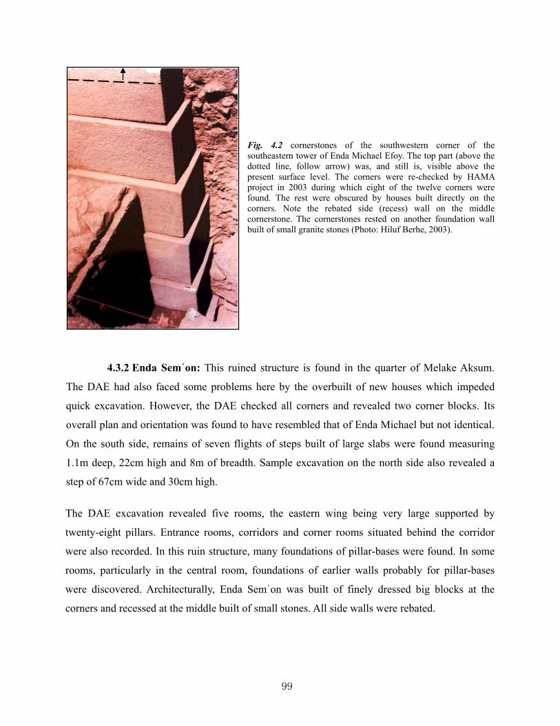
99
Fig. 4.2 cornerstones of the southwestern corner of the southeastern tower of Enda Michael Efoy. The top part (above the dotted line, follow arrow) was, and still is, visible above the present surface level. The corners were re-checked by HAMA project in 2003 during which eight of the twelve corners were found. The rest were obscured by houses built directly on the corners. Note the rebated side (recess) wall on the middle cornerstone. The cornerstones rested on another foundation wall built of small granite stones (Photo: Hiluf Berhe, 2003).
4.3.2 Enda Semʿon: This ruined structure is found in the quarter of Melake Aksum.
The DAE had also faced some problems here by the overbuilt of new houses which impeded
quick excavation. However, the DAE checked all corners and revealed two corner blocks. Its
overall plan and orientation was found to have resembled that of Enda Michael but not identical.
On the south side, remains of seven flights of steps built of large slabs were found measuring
1.1m deep, 22cm high and 8m of breadth. Sample excavation on the north side also revealed a
step of 67cm wide and 30cm high.
The DAE excavation revealed five rooms, the eastern wing being very large supported by
twenty-eight pillars. Entrance rooms, corridors and corner rooms situated behind the corridor
were also recorded. In this ruin structure, many foundations of pillar-bases were found. In some
rooms, particularly in the central room, foundations of earlier walls probably for pillar-bases
were discovered. Architecturally, Enda Semʿon was built of finely dressed big blocks at the
corners and recessed at the middle built of small stones. All side walls were rebated.

100
Fig. 4.3 Plan of Enda Semʿon (Drawing: Hiluf Berhe, 2015, after Phillipson, 1997: 99).
4.3.3 Taʾaka Maryam: located at the south-west outskirt of the old town of Aksum,
Taʾaka Maryam is the largest palace recorded so far measuring 80m x 120m. During the
clearance from 26 February to 4 April, 1906, the progress of the DAE was impeded by the
presence of about forty huts on the central and eastern side of the palace ruins. However, it was
the best record and the only document we have as the palace ruin was subsequently affected
during the Aksum-Shire road construction by the Italians in 1937 which passes through the
middle of the palace structure (Fattovich et al., 2000).
Although Taʾaka Maryam was assumed to be surrounded by large complex walls, the DAE
recognized a central building with two flights of steps leading up to the building from north and
south. This central building was reconstructed and appeared to be similar in architectural style to
those of Enda Michael and Enda Semʿon. The DAE designated the inner compound of the palace
as central yard, north yard and front yard, while the building divisions of the palace was
designated as central building, north-west corner building, north-east corner building, north
wing, south wing, central wing, and side wing (fig. 4.4). The main entrance to the palace was,

101
assumed by the DAE, located on the west and east of the front yard. The central building
measured 24m x 24m; the north yard, 27.5m x 43m, while the south wing measured 21m from
north to south. The complex was found to be full of beautiful stepped pillar-bases, well dressed
cornerstones, pillar-bases for portico, flat slabs for floor and court pavement, and stepped bases.
The palace was not built on a flat area; the DAE discovered evidence of steps leading down to
the front yard from central yard, and that the south side was built four meters high of eight steps
suggesting that the palace was built on terraced area. The central building itself was built on
separate foundations of four steps about two meters higher than the surrounding area of the
central and north yards. The whole complex was surrounded by buildings of recessed wall most
of which were concentrated in the south, north-east and north-west corner buildings. A channel
(fig. 4.20) was discovered to drain water from the central yard to outside. A portico of 2.16m
deep and 7.2m wide was discovered with two steps and three pillar-bases in situ. Based on the
shape of the pillar-bases for the portico, the DAE team suggested that the pillars were wood.
4.3.4 Grave of Menelik I: As discussed above, this site has been excavated by the
governor and Nebureʿed of Aksum immediately before the arrival of the DAE. The DAE, upon
the request of the governor, again carried out an excavation from 26 February to 10 March 1906.
Coins were reported to have been discovered here during the excavation by the governor but sent
to the Emperor before any documentation was made. The Grave of Menelik I was built of very
small stones of simple wall without the use of cornerstone like those palaces in the center of the
town.
The building measured 13.2m x 12.7m and had rooms with recessed wall. On the other hand, the
excavation of DAE has also revealed that three lateral rooms on the east side were built over the
main older building. The DAE team was told by the governor that the bones of Menelik I was
removed from a room located at the center of the building. Some steps leading to different rooms
of the building were found though in bad state of preservation. It appeared to the DAE team that
the main entrance of the building was from the east; and a pack of stones 2.2m wide and 6m long
oriented east-west was found on the east side of the building.
The DAE reported that no find was discovered in the building except one strange stone slab

102
Fig. 4.4 Ground plan of Taʾaka Maryam. Walkway was discovered at (P) while the steps (T) lead up to this walkway (Drawing: Hiluf Berhe, 2015, after Littmann et al., 1913, II: 113).
bearing four holes at its four corners which the team thought was probably a stand for a tabot.
This was found in the east side of the building (fig.4.5); the holes measured 20cm deep and 10cm
wide in diameter. The team also believed that if the information of the governor could be trusted,
N.E. corner building
N.W. corner building
Side wing
Central building
South wing
North wing
Side wing

103
Fig. 4.5 Reconstructed plan of Grave of Menelik I. Note: the four small holes are visible on the eastern side of the plan, to the left of the line (Drawing: Hiluf Berhe, 2015, after Littmann et al., 1913, II: 134).
then on top of this tomb could have been built a shrine like the one on the Tombs of Kaleb and
Gebre Mesqel. Today, the tomb of Menelik I has completely disappeared as the result of removal
of the stone by the town people for construction.
4.3.5 Ruin A: North of Taʾaka Maryam just after crossing the road, the DAE found
another ruin of a palace designated “Ruin A” (maps 3.1 and 4.2). It is located on a higher
ground; at the south and east side of this ruin the DAE carried out excavations by which a
stepped cornerstone of the wall was found. In the south-west corner, six big stepped cornerstones
forming the foundation of the building were revealed. A fragment of pillar was also found in this
ruin. Wall plaster was found still in place, while discovered remains of steps and stone
pavements led the DAE team to the assumption that another latter building had overlaid the
ancient one. Excavations at the east side added some data which led the team to assume that the
building might have been destroyed by fire. Further excavation of the ruin was impeded by
modern houses built over the ruin.
4.3.6 Ruin B: This area was recorded to have been located east of Enda Semʿon on a
mound full of stone debris. Over this pile a modern house has been built which hindered the
DAE from conducting full investigation of the site. The DAE recorded three big cornerstones by
then visible at the south-east side protruding out from the pile. The DAE also reported that one
of the cornerstones bore very strange marks unseen anywhere else whose flat top was believed

104
to have been used as base of pillar.
4.3.7 Ruin C: The DAE has also discovered another ruin located between Enda
Sem’on and Enda Michael, which was labeled as “ruin C”. Here only “two or three stones” of a
corner were recorded to have been still in their original position.
4.3.8 Ruin D: This ruin is located at Cheʾanadug, at the foot of the hill of Biete Giorgis
along a stream called May Lahlah. It seems that the DAE has not conducted excavation on this
ruin but recorded an already exposed wall by the gully erosion measuring 15m long and 3m
high. According to the DAE report the exposed wall was marked by a six-stepped wall and in
the middle had a recess. It was also recorded that the wall suffered great damage from erosion
due to lack of corner stone.
4.3.9 Ruins E and F: The DAE located the existence of ruins on the southern edge of
the top of Biete Giorgis hill overlooking the western outskirt of the old town of Aksum. Located
west of the stream of May Lahlah at its upper course, the DAE designated these ruins as “Ruin
E” and “Ruin “F”5.
4.3.10 Statue Base: The DAE came across another ruin which was designated as “Hill
of Ruins”, located south of “Ruin B”. Topographically, this hill is the highest place of the town.
It was at the northern side of this hill that the DAE revealed a base6 with holes for feet of huge
statue, and its foundation. The holes measured 5cm in depth and 92cm in length. The parallel
orientation of the holes to each other implied to the DAE team that the statue was standing
upright position. The size of the holes for the feet being 92cm long gave the DAE a hint that the
overall size of the statue could have been as tall as 5m. Although the DAE team suspected that
there may be sacred remains beneath the mound, no further excavation was conducted for
unknown reasons.
The famous three script inscription of Ezana (DAE, IV: 4-7) (Munro-Hay, 1991: 224-5) speaks
that Ezana had erected statues one in gold, one in silver and three in brass for the glory of his
god, Ares . So far neither statue of metal nor other traces has been discovered in Aksum except
5 These were later excavated by Ricci (see under section 4.6 in this chapter). 6 This is no longer extant.

105
the statue base mentioned above. This is the only evidence for the proof of what has been
mentioned on the inscription of Ezana.
4.3.11 Tombs of Kaleb and Gebre Mesqel: to the north of the town at the so-called
Tombs of Kaleb and Gebre Mesqel, the DAE carried out an excavation from 15 January to 17
March 1906. The excavation revealed two remains of large buildings built immediately over
each of the underground tombs. They are parallel to each other and oriented east-west. The
northern one designated “K” measured 13m x 32.5m, while the southern building designated
“G” measured 14m x 35m. They are 12.5m apart and are similar to each other. Like the palace
buildings in the center of the town as discussed above, the buildings of “K” and “G” also
exhibited stepped foundation walls, big finely smoothed cornerstones, and recessed walls. As the
topography was sloppy on which the buildings rest, they were leveled by terraced walls. Thus
terracing was recorded on the rear side of the buildings, on the front side, and further on the west
outside the buildings.
The DAE has also uncovered a lower courtyard7 (fig. 4.6 c) from which steps8 leading to the
entrances of the tombs on the left and right diverged (fig. 4.6 (a) and (b)). Above this lower
courtyard, other seven steps leading to the central courtyard between the two buildings were
found. The two buildings had open colonnades facing each other. In each building, rooms for
staircases were recorded, located at the western edge over looking the lower courtyard. Each of
the buildings had three aisles and one apse with two rectangular rooms on either side. At the
center was one big pillared room in each case under which the underground burial chambers are
found. Other important discoveries of DAE at the site was a stepped pillar-base9 originally on the
southern side of the “K” building; an octagonal pillar10 broken into two pieces, originally at the
northern colonnade of the “G” building; and three holes in the big room of the “G” building cut
onto the pavement slabs, which the DAE assumed was probably for something with four leg on
which a tabot was placed. According to the DAE, the floors of the buildings were fully paved
7 No pavement is seen on this courtyard today. 8 These are no longer extant. The front walls are today reconstructed. Entry to the tombs of Kaleb and Gebre Mesqel is from south and north, respectively, across the western edge of the central courtyard. 9 This is no longer present on the site. As will be discussed under chapter 5, this pillar-base is possibly the one now at the Ezana Park inversely mounted on a pillar. 10 This pillar is undoubtedly the one now standing at the Ezana park restored and re-erected there by the Italians in the 1930s, discussed under chapter 5.

106
with stone slabs.
To the east of the buildings at the eastern lower terrace, the DAE conducted some excavations
but was left incomplete. It was also reported that north of the outer terrace wall was a room
entered from west. Besides the excavation, the DAE produced very detailed and accurate plan
drawings and photographs of the buildings, the courtyards, steps, the pillar, and a stepped
column-base; as well as plan and section drawings of the underground tombs with detailed
description, accuracy and professionalism.
Although the underground tombs are still in situ since the ancient descriptions by Liber Aksumae
and Alvares, the buildings and their terrace walls, and the courtyards have been destroyed after
the DAE; others have been restored with complete changes to their original form during the
subsequent excavation and restoration works.
Fig. 4.6 Plan of the
superstructures of
Kaleb (north) and
Gebre Mesqel (south)
as discovered in 1906
by the DAE (after
Anfray, 1990: 98).

107
4.3.12 Stone thrones: the DAE recorded twenty-six thrones found scattered at different
sites in the town and its vicinity. Fifteen of them are located in the outer enclosure of the church
of Maryam Tsion, ten others at the foot of May Koho hill just east of the road leading to the
church of Maryam Tsion from south-east, and one was located further north of the town east of
the road leading to the Tombs of Kaleb and Gebre Mesqel. All the stone thrones are designated
by the DAE from 1 to 26, the designation by which they are still identified.
The DAE photographed, sketched and drew both plan and section of all the stone thrones. The
first group of the thrones in the church compound was also identified by the DAE as judges’
thrones, king’s throne and bishop’s throne. The king’s throne was designated as throne 1, the
bishop's throne as number 2, and the judges’ thrones were designated from 3 to 13 starting from
south-west to north-east for the main row and 14 to 15 for the second row. Thrones 16 to 20 are
located at the western foot of May Koho hill north of the original position of the three script
Ezana inscription. Throne 21 to 25 are all located east of the original position of the
aforementioned inscription, while throne 2611 was located north of the town east of the road
leading to the Tombs of Kaleb and Gebre Mesqel.
Excavation at the thrones in the church compound was not possible due to the sacredness of the
area. But detail examinations have been made. Particularly the photographs and plan drawings
provided by the DAE are of immense value for all later comparisons on what has been going on
the thrones. Records of the DAE on the thrones including their surrounding landscape also
clearly showed the position and layout of the thrones and nature of the topography around them.
All dimensions (width, height, depth of the seats and groves of back and side rests) of the seats,
base and pillars of the thrones are also meticulously measured.
Another achievement of the work of the DAE on the thrones was the attempt to reconstruct what
the original thrones might have looked-like. This was done with the help of the remains of pillar-
bases still visible on the judges’ thrones, the still standing pillars at the king’s throne, and the
sketch of Cosmas of the Adulis throne. The only missing sample was the vault of the throne. The
team also made great effort in associating which inscription might have belonged to which
11 No subsequent research has updated the status of this throne. Phillipson also confirms that it has not been possible to indicate the existence of this throne (Phillipson, 1997: 149, n. 223).

108
throne after the Adulis inscription and Ezana inscription DAE 4 and 11 that thrones had
inscriptions on their back and side rests. This was done by comparison of the size of a stone
bearing inscription and the size of a seat of a throne.
From 15 to 20 January 1906 the DAE team devoted its work on examining the thrones near the
Ezana inscription. Here five thrones were recorded, and conducted excavation at the throne
number 23 by which foundations, and seat of the throne bearing inscription, was revealed. The
rest were found on the surface and detailed recordings of photograph and plan drawings were
done by the team.
Map 4.1 Location of the stone thrones. The black point at the Ezana Park is Ezana’s stone inscription. The two
squares with big trees (center and left on plan) are called Daero Piazza and Daero Ella, respectively (Drawing: Hiluf
Berhe, May, 2015).
Maryam Tsion church
T: Stone thrones

109
4.3.13 Northern stelae field: one of the greatest achievements of the DAE team in
Aksum was the record on the stelae. The DAE designated three main stelae groups: the northern,
western and south-eastern stelae fields. Northern stelae field of DAE extends from the main
stelae group where the largest stelae are located, to the northernmost stelae area in Geza
Agumai. The team recorded seventy-eight12 stelae in this stelae group and on some of them
carried out whole or partial excavation to reveal buried stelae. Particularly the seven decorated
stelae were drawn in very detail, and photographed. The drawing and reconstruction of the stelae
by the team was the first and last work as no subsequent researchers are able to update it. The
location and distribution of each of the stelae was indicated on plan, and all sketched. Full
measurement was also made on the stelae numbers 1 to 21.
Recording stelae 1 and 2 was challenging for the DAE as huts were built over them;
nevertheless, the team produced an accurate measurement and reconstruction. Excavation was
conducted on stela 6 to reveal any associated graves. It also cleared around the stela itself for
drawing and photographing. Stela 4 was also another stela where excavation was carried out by
which the apex of the stela (now in the Ezana Park), was discovered. Minor excavations were
also carried out on stelae 1, 7, and 31 to clear partially covered parts for drawing and
photographing.
4.3.14 South-east stelae field: this stelae field was among those recorded by DAE.
Here the DAE recorded only four stelae designated from 1 to 4; the largest in this stelae field
and still standing, is designated stela 1. The team reported that there were many other stelae
smaller in size measuring less than 1.3m and undressed13. The four stelae were sketched, and
stela 1 was photographed.
4.3.15 Western stelae field: at this stelae field (today commonly known as Gudit
Stelae Field) the DAE never carried out an excavation. Here, the DAE recorded forty-four stelae
presenting their state of position and measurement above surface for those then standing.
12 DAE stela 15 is, however, fragment of stela 2 which was then lying at Nefas Mawcha. Since then the fragment has been moved to the precinct of the church of Maryam Tsion. The BIEA has also designated this fragment as “stela number 100” during the 1972-4 excavation (Plant, 1985; Munro-Hay, 1989; Phillipson, 1997). 13 DAE stela 2 of this stelae group is now standing at Ezana Park, possibly brought there by the Italians. One stela is also standing in the compound of the former Axum Touring Hotel – about hundred meters south-east of the same stelae field. So far, there is no information the whereabout of the other stelae from this stelae field.

110
Although there are over two hundred stelae in this field, they could have been buried in the
ground during the DAE expedition in 1906 due to the farming activity as continues today.
However, the DAE has indicated all the recorded stelae in this field with sketches and plan
drawing, and photographs which helps to avoid repetition during subsequent researches.
4.3.16 Tomb of Nefas Mewcha: between 15 January and 10 February 1906 the DAE
team devoted its excavation and recording at the Nefas Mawcha. Here excavation was carried
out at the west and south side of the gigantic block thereby revealing buried blocks believed to
be part of the blocks forming rows to support the gigantic block. Besides this, the DAE made a
detailed record of Nefas Mawcha with photographs; section, plan and reconstruction drawings.
Every block here, including the size of the passage to the underground room, was thoroughly
measured.
4.3.17 Maryam Tsion church: The DAE carried out detail investigation in the precinct
of Maryam Tsion church without any excavation as the sacredness of the church prohibited the
team to do so. According to the DAE, the podium on which the 17th century cathedral stood is
ancient where a shrine could have once stood. This was very evident for the DAE by observing
materials some built into the church building and others laid on the precinct. On the other hand,
fragments of pillars and capitals as well as other blocks found scattered in the precinct were
assumed by the DAE to have been moved from other buildings as they have nothing to do where
the cathedral is.
The DAE has illustrated the church of Maryam Tsion with detailed plan and section drawing, as
well as photographed the different sides of the building and its terrace wall. The plan of the
church was so detailed and elaborate that it included all the terrace and inner enclosure walls, the
building itself, the bell-towers, the flights of steps, and plans of other four rectangular buildings
to the north of the church. Besides, the DAE produced reconstruction plans of the ancient church
of Maryam Tsion destroyed by Ahmed Gragn in 1535. The team also used the description of
Alvares who had visited and described the church in 1520 shortly before its destruction. The
description of the church of Maryam Tsion by the DAE gives a complete picture to make
comparisons to this day.

111
Within the precinct of this church, the DAE has recorded two thrones, one located at the western
side and the other at the eastern side of the 17th century cathedral building. The throne on the
western side contained a small seat and large round-shaped foot-plate. The other throne was,
according to DAE, set up with pillar-base from Taʾaka Maryam palace while the stones for the
side were pillar stumps. The top section of the terrace wall of the church formed the back side of
the throne. A decorated fragment built into the entrance hall of the church was found by Von
Lupke which he thought was piece of the back side of a throne. He photographed it and made
detailed drawing. The fragment contained designs of leaf and vine. In the same place, Lupke
found a fragment of pillar with decoration of leaves, fruit and cross which he suggested was a
fragment of a pillar supporting a vault for a throne.
Outside the church precinct, the DAE found another pillar in the Godef Maryam in about 30m
south-west of the king’s throne. Pillars believed to have belonged to St. Yared were also recorded
– illustrated with plan drawing, and described. Located outside the outer enclosure of the church
of Maryam Tsion, they were two small pillars ‒ the bigger measuring 51cm in diameter and
31cm in height.
4.3.18 Inscriptions: The DAE recorded about twenty-six inscriptions in Aksum, Abba
Pentelewon and Abba Liqanos. The DAE has copied, photographed and translated all the
inscriptions. Three of the inscriptions were discovered at Abba Pentelewon, one at the church of
Abba Liqanos and the rest in Aksum. The most important of them which yielded great
information about the past history of Aksum were DAE inscriptions 4, and 6 to 14. The rest of
those from Aksum were mere graffiti ranging from two to five words. DAE inscriptions 4, 6, and
7 refer to the three script Ezana inscription which the DAE designated each script with separate
number.
4.3.19 Miscellaneous works of the DAE: apart from the main features in the center of
the town and its vicinity, the DAE has recorded May Shum water reservoir with photographs,
plan drawings, measurements and complete description. In the plan drawing, the water reservoir
is shown with two long rows of steps cut in the rock itself leading from south to north, and other
vertical steps leading from the reservoir up to the top of the hill after crossing the horizontal

112
steps. At the south, access to the reservoir is provided with built steps14.
Further south of the May Shum, on the north-western side of May Koho hill, and facing the main
stelae group, were recorded other rock-cut steps. Here the DAE made only detailed drawing and
description. The DAE plan drawing showed that two lines of rock cut-steps lead up to the top of
the hill, the northern line having four levels of steps and making their way further to the
monastery of Abba Liqanos. The southern rock-cut steps have two levels of steps which lead to
the Mekyedi Egzeʿene – at the summit of the hill of May Koho from where view of the town is
clear and according to the DAE, where remains of an ancient church was visible15.
South of the May Koho rock-cut steps, at the steep rock face of the hill, the DAE has recorded
unfinished rock-cut tomb16 with plan, section and profile drawing, and photographed. It also
recorded all the unfinished rooms and the overall dimension of the rock-cut tomb in great detail.
Further west of the town of Aksum, the DAE has recorded the lioness of Gobo Dura with
photographs. This engraving of a lioness on a big rock was measured to be 3.27m from the tail to
the tip of the nose. The DAE has also attempted to interpret the meaning and comparative dating
of this engraving. It also reached the conclusion, based on the nature of carving, that the cross
engraved 50cm away in front of the head of the lioness, was of later age.
To the north-west of Aksum opposite the hill of Biete Giorgis, at a place called Addi Tsehafi17,
the DAE recorded rock-cut tanks called fruit presses. At this place two rock-cut fruit presses
were recorded. The largest was recorded to be with two shallow and one deep bowls, with some
holes in the shape of lion’s head. The DAE provided detailed plans, section drawings, and
photographs of this fruit press tank in addition to the detailed description and interpretation about
the function in comparison with Syrian wine. About 2km south of this fruit press was found
another fruit press containing two bowls cut out of a single rock. Though neither photographs nor 14 These built steps and the edge of the whole reservoir, except at the north side, has since been rebuilt with cement there by enlarging the size of the reservoir. The rock-cut steps on the side of the hill are still visible. 15 No remains of church at this summit of the hill can be seen today; there is rather a cross carved on the rock though it is almost faded due to weathering by nature and people. The rock-cut steps of May Koho are endangered by the quarrying activity and disfigured by the expansion of Yeha Hotel. 16 Legend has it that this was began by Abba Libanos intended for rock-cut church. But when Abba Libanos was not happy about the people of Aksum, he left it incomplete and went to Dereqa ‒ about 10km south of Aksum and carved there a church out of a rock. Today there is a rock-cut church at Dereqa dedicated to Abba Libanos. 17 In many sources this place name is misspelled as “Ashafi”

113
plans were produced for the latter, the DAE described that this fruit press is rectangular in shape,
with the northern bigger and the southern smaller; at the center was a hole connecting the two.
Between the sites of the two fruit presses, in a church ruin, a rectangular bowl of 12cm deep and
1.89m x 1.22m large was discovered. Plans and descriptions of this bowl by the DAE show that
it was broken into two at the bottom base and there were marks for metal clamps to fix the two
pieces together. The DAE also discovered a stone slab next to the southern fruit press. Its top was
worked smooth and bore four joint holes.
To the north-east of Aksum, the monastery of Abba Pentelewon caught the attention of the DAE
team. During the DAE investigation at the monastery, there was a small building standing at the
summit of the peak. The DAE recorded traces of an ancient temple from which remains of walls
and inscriptions were discovered. Many slabs – some of them bearing holes of unknown
function, were recorded. About twenty steps built of ancient stone slabs give access to this peak.
The DAE reported that there were many slabs of finely worked reddish sandstone which the then
building has re-used in most parts and some were also used for the upper steps.
Two stones bearing Sabean and Greek inscriptions18 were found built into the church on the
western and eastern sides, respectively. According to Littmann, the Sabean inscription was the
oldest of all found in the country, and the Greek inscription spoke of the dedication of the ancient
shrine there to the god Ares. Among other recorded objects in this monastery by the DAE were a
small stone slab with palm leaf, stone bowl then used for baptism, an alabaster slab whose back
was smoothly worked, water spout in the shape of lion's head, and a fragment of red sandstone
slab with relief of crosses and holes. Plan drawing of the peak and its foot together with its
associated cultural and natural features, and the movable objects, was provided by the DAE
along with a photograph of a partial view of the church and remains of an ancient wall.
4.4 ARCHAEOLOGICAL EXCAVATIONS AND SURVEY DURING THE
ITALIAN OCCUPATION OF 1930s.
Archaeological research at Aksum was discontinued after the DAE in 1906 until it was resumed
18 They are now housed in the museum of Maryam Tsion church.

114
during the Italian occupation in the 1930s. During this period two notable Italians exploited the
opportunity of dealing with archaeological excavation and survey when Italy was in occupation
of Ethiopia from 1936-41. These were: Monneret de Villard and Salvatore M. Puglisi (Fattovich
et al., 2000; Munro-Hay, 1989; Phillipson, 1998).
Monneret de Villard was in Aksum in 1937 to arrange for the removal of the second largest stela
of Aksum (stela 2) to Rome. However, he conducted a noteworthy archaeological survey dealing
with the first geo-archaeological investigation, and updated the topographic map of Aksum after
the DAE. By that time in 1937, the town of Aksum had grown larger than it was in 1906. The
geo-archaeological survey of Monneret de Vaillard was also important because it inspired
scholars such as Karl Butzer to resume in the early 1970s (Michels, 1979). The geo-
archaeological observations of Monneret de Villard yielded the identification of two major soil
accumulations of erosion: one phase of the accumulation predating the erection of the great
Aksum obelisks at May Hejja, and the second accumulation took place in the late post-Aksumite
period. Monneret de Villard recorded that in the western part of the ancient town, remains were
found buried circa 4m below the modern surface remarking that this sector of the ancient town
was built at a very lower slope than it was in the 1937 (Monneret de Vaillard, 1938: 8)
Monneret de Villard also recorded and described a mound at the southeast zone near the former
position of the inscription of Ezana, and the water reservoir of May Shum. He has also attempted
to see the change of the townscape of Aksum between present day and ancient based on ancient
documents, including the Liber Aksumae. During his presence at Aksum in 1937, Monneret de
Villard has recorded the process of destruction on monuments and sites by the Italian military
during road constructions (Ibid, 1938). He also included, in the appendix of his book, all ancient
documents or their specific topic related to Aksum.
Another Italian archaeologist, Salvatore Puglisi, was in Aksum in 1939 for an archaeological
excavation and survey. His survey resulted in the record of the existence of lithic tools in Gobo
Dura, remains of ancient structures in Dungur, Grave of Menelik I, and GSF. The greatest
achievement of his work was, however, the excavation in the western edge of the old town. Here
at an area called Addi Kelte, Puglisi carried out an excavation and discovered a palace ruin
located west of the May Lahlah stream, north of the Aksum-Shire road, south of Biete Giorgis

115
hill (Puglisi, 1946, 1941). The palace ruin was similar in style to, but smaller than, Dungur
palace excavated by Anfray from 1966 to 68 (Anfray, 2012; Munro-Hay, 1989).
Architecturally, Puglisi’s palace was built of rebated wall from outside; side walls were recessed,
while corners were built of small masonry wall compared to those at Taʾaka Maryam, Enda
Michael, Enda Semʿon, etc. Puglisi’s excavation revealed a large ruined building of 15m square
in size, containing nine rooms and circular built column-bases in some of the central rooms. One
of the best achievements of Puglisi’s work was his attempt to record the stratigraphic sondages
for the first time (Puglisi, 1941).
In this excavation Puglisi recorded seven levels: the first level of 2.6m - 3.0m deep was the
bottom level found lying directly on the natural bed predating the building. This level contained
lithic tools and some pottery. The second level ranged from 2.2m – 2.6m and still predated the
building. Here too, lithic tools and pottery were discovered; animal bones and charcoal were also
discovered which led Puglisi to suggest that this was an occupation level. Overlying this level,
which ranged between 1.7m and 2.2m, marked the construction of the building, and pottery still
similar to those in the preceding levels existed. The next level was from 1.4m to 1.7m. This level
contained bone, charcoal, undecorated pottery and, large vessels. The level 1.0m-1.4m was found
to be full of large vessels in situ and stone debris of the structure. In the level 0.6m – 1.0m
vessels in situ were also discovered. Another important discovery in this level was a silver coin
of Ebana at 0.6m depth, dated to 5th century AD, and another coin, at 0.8m depth, of king
Ouazebas of late 4th or early 5th century. The top level was ranged from surface to 0.6m; stones
and some coarse pottery were recorded (Munro-Hay, 1989: 30).
Puglisi also opened some excavation units at the May Hejja area where he recorded five levels
(Michels, 1979). Further to the south-east of the Aksum Maryam Tsion church where the present
Daero Piazza square is located, Puglisi is said to have found rock-cut tombs of up to five meters
deep, and some walls also recorded (Fattovich et al., 2000).
4.5 THE ETHIOPIAN INSTITUTE OF ARCHAEOLOGY (EIA) EXCAVATIONS
A decade and half elapsed without any archaeological excavations in Aksum after Puglisi until
the EIA launched its first excavations in 1954 though the institute was established two years

116
earlier. All the excavations carried out by the EIA from 1954-72 were published in French
language; hence their access to Ethiopians has been very negligible due to this language barrier.
An attempt is, therefore, made here to present more detailed compilation of the works to ease the
access to Ethiopian and other researchers and readers.
4.5.1 Central area: this area is split into main stelae group and church enclosure
excavation sites.
4.5.1.1 Main Stelae Group: The first excavation of the institute under the direction
of Jean Doresse was conducted in 1954 by Jean Doresse, accompanied by Kebede Mikael and
André Caquot, during which trenches were opened immediately west of the giant fallen stela 1
and of the Nefas Mewcha. Some coins and potsherds were discovered in this sector of excavation
(Leclant, 1959; Anfray, 1990; Kebede and Leclant, 1955; Caquot and Leclant, 1956). East of
stela 3, Doresse has also cleared the top part of the roof slabs of the Tomb of Brick Arches19, and
exposed five steps immediately west of its entrance. These steps that run north-south between the
eastern face of the terrace wall M120 and western face of the wall of the entrance to the Tomb of
Brick Arches, lead up to the platform of the main stelae area. They are 0.20m high, 0.40m deep
and 3.20m wide (Leclant, 1959).
In 1955, Pironin directed the EIA’s second season of excavation in Aksum. During this season of
excavation, the focus was on the west and south-west of the giant stela 1 and Nefas Mawcha.
Some clearing was also carried out to the east of the platform of stela 3. A long wall, designated
by the archaeologists M1, running east-west for a length of 114 meters and overlaid across by the
giant stela 1, was partially exposed by Pironin (Caquot and Leclant, 1956; Leclant, 1959).
In 1956 the archaeological research of the EIA was resumed under the direction of Jean Leclant.
The work continued in the previously explored areas by Pironin in the west of the giant stela 1,
south-west of the Nefas Mawcha and east of the platform of stela 3. Particularly in the west and
south-west of stela 1 and the Nefas Mawcha, respectively, the focus of the work was to descend
deep on the already opened trenches by Pironin in 1955 (Leclant, 1959). The great terrace wall
M1 with a southerly facade was fully exposed, traced for 114 meters long, aligned almost
19 Doresse didn’t recognize the tomb of Brick Arches; it was the BIEA which located and partially excavated during the 1972-74 excavation under the direction of Chittick. It was fully excavated during the 1993-97 BIEA project under Phillipson (Chittick, 1974; Phillipson, 2000, I). 20 In later excavations by the BIEA, this wall is designated “east wall” (Munro-Hay, 1989: 28).

117
straight east-west until it turns north a little further east of stela 3 where it extends for about 16.8
meters. This terrace wall mainly supported the platform of the three giant stelae (stelae 1-3).
Built of small granite stones in the Aksumite construction style, the terrace wall M1 has rebated
wall of 60cm-75cm high. At the east corner of M1, another terrace wall of higher level,
designated M'1 was revealed two meters away to the north of M1 and oriented east-west parallel
to M1 (Caquot and Leclant, 1956). M'1 was built of re-entrants having 40cm deep at about 10m
intervals on average. This wall was generally traced for 40m until it became unclear whether it is
ruined, turned north or just stopped there. M1 was found highly damaged; at parts where it
survived well, the wall was revealed built of four stages of rebates with a total height of about
3m. Further to the east, Leclant cleared the area of stela 4 (Leclant, 1959).
Several discoveries were reported from the sector west of stela 1, south-west of Nefas Mawcha
and south of M1. The excavation proved that M1 was built on sterile yellowish clay soil. 8m to
15m south of M1 was found a compacted area with irregular stones, 0.80m deep and run parallel
to M1. At 9.30m south of M1 another line of wall with dressed north face, rough south face,
flattened top, and running parallel to M1 was found surmounted by another wall, designated by
the archaeologists M2. Beyond M2, the excavation revealed a less compacted area mixed with
Fig. 4.7 The excavation of
wall M1, viewed from east
(adapted from Leclant,
1959).

118
soil. West of the monumental slab of Nefas Mawcha was discovered wall M3, which is 2.30m
wide, 1.75m deep, and extending for 7.65m west of the monumental slab of Nefas Mawcha.
Further south of M3 at about 1.4m far was located another wall designated M4. At 40m south of
M1, wall M5 was located aligned parallel to M1 (Leclant, 1959).
The report of Leclant (1959) also recorded that during the course of the excavation, seventeen
burials full of human skeleton were uncovered mainly in the west of stela 1 and south-west of
Nefas Mawcha (Leclant, 1959). Pironin also discovered human-headed clay terra cottas near the
monumental slab of Nefas Mawcha. Other plentiful collections of pottery, usually in broken
state, vases and bowls with incised decoration of vertical lines crossed by horizontal lines, v-
shaped lines ending at a big single line going round the neck, diamond-shaped lines, and large,
deeply-incised points were discovered in the sector under discussion (Caquot and Leclant, 1956;
Anfray, 1965).
The following season, in 1957 from early January to early April for twelve weeks, the EIA
continued its archaeological research in the main stelae group, this time under the supervision of
Henri de Contenson (Contenson, 1959). Assisted by Gezaw Hailemariam and Georges Cayla
(topographer and photographer of the mission), Contenson’s excavation focused on the area
south of M1, north of Nefas Mawcha monumental slab, east of the giant stela 1, and west of the
pile of rubble from the 1955-1956 excavations at the east of Nefas Mawcha (fig. 4.8). This area
of excavation measured 40m east-west and 38 meters north-south. On the other hand, Contenson
opened few trenches to the west of stela 1 between walls M1 and M2 thinking that the previous
excavations have not reached the bottom level of the surface. For the first time, the method of
grid system was laid out by Contenson during this excavation season. Contenson divided the
grids into squares of five meters, and units were labeled with capital letters A-H from west to
east while north-south was labeled A1, A2...B1, B2,...and so on. Square units A and B were laid
west of stela 1, unit C was laid immediately below stela 1, while the rest units were laid east of
stela 1. Contenson followed the 1955 and 1956 excavations for the datum point located at the
northwest corner of the Nefas Mawcha monumental slab (Leclant, 1959).
Vertically, Contenson divided his excavation into three levels, each containing several layers.
Level I: This level comprised layers six and seven. This is the earliest level which rises from

119
1.10m deep in the A, B units to 0.3m deep in H1 in the east. This is generally marked by yellow
clay on which many structures, including walls M1 and M9 rested. The wall M9, which extends
for 17m from square units E-H, is found 2.0m to 2.2m away south of wall M1 and is 1m wide
and 1.5m high. In layer seven of this level, many blocks of stones, fragments of red pottery, a
pottery with decoration of disc and crescent, crescent-shaped ear-ring of bronze, flint scrapper of
yellow color, pieces of glass, and bronze nails were discovered. Layer six was virtually sterile
soil fill on top of wall M2 and between walls M1 and M9. Contenson thought that this sterile
layer represents either period of abandonment of the site or an attempt of artificial leveling,
marking the end of the use of walls M2 and M9.
Level II: This level is composed of layers three to five. It is represented by the discovery of
rich assemblages: human-headed jars, figurine of bird in clay, pottery with cross incision, clay
models of house with Aksumite windows, bowls made of clay, fragment of bracelet, gilded
bronze plaque inlaid with glass. In addition, thirty-five Christian bronze coins were discovered in
this level between 0.70m and 1.50m depth, attributed to Kaleb, Ouasebas, Wazena, Hataz, Armah
and other anonymous kings. A fragment of stela 1 was revealed from this level which Contenson
thought might have been sunk as the result of the impact of collapse on soft soils. Based on the
coinage assemblage, Contenson proposed a dating for this level to fall between the 5th and 8th
centuries AD.
Level III: This level is the topmost with layers of one and two. It is marked by stone debris
fallen from the terrace wall M1, remains of recent buildings, and brown, white and red soils. The
largest concentration of this level was the presence of seventy-five burials of recent period which
are the continuation of the western sector previously discovered by Pironin (Leclant, 1959). Only
in two of the burials, Contenson found objects – an iron axe in one burial and a finger-ring in
another. No significant dating assemblage was discovered from this level; however, based on the
presence of a Turkish-origin hexagonal red glass bead, Contenson suggested that this level could
have been used as cemetery area in the 17th century after it has been abandoned for a long period
(Contenson, 1959).

120
Fig. 4.8 Contenson’s excavation between stela 1, wall M1, and Nefas Mawcha (the central area on the right side) (adapted from Leclant, 1959).
4.5.1.2 Church enclosure: In the enclosure of the church of Maryam Tsion, just
north of the 17th century cathedral, Doresse opened some trenches in 1954 (Caquot and Leclant,
1956; Michels, 1979). In the same site, Leclant carried out some clearing works with the fear
that ongoing construction of a new church would destroy the site before systematic
archaeological investigations were conducted. As a result, some walls similar to the old
Aksumite buildings were revealed by the excavation (Caquot and Leclant, 1956).
Between 08 January and 12 March, 1958, Contenson, in collaboration with Gezaw Hailemariam,
continued excavation in the same site that Doresse had started in 1954 (Contenson, 1963).
Contenson’s area of excavation covered 50m x 20m east-west and north-south, respectively. The
report of the excavation indicated that the virgin soil was reached between 4.5m and 5.5m deep.
Contenson’s result indicated that he has discovered three levels of construction of the church:
two Aksumite levels and one post-Aksumite level, all based on architectural style, coinage and
pottery assemblages.
The earliest level, with thickness of about 50cm, was found consisting of dark-brown soil with
stones, charcoal and cattle bones. In addition to these, ten pre-Christian bronze coins of three
Aksumite kings, namely Ousanas (2 coins), Wazeb (2 coins)) and Ezana (3 coins) were found in

121
this level. According to Contenson, the first two kings reigned during the late 3rd or early 4th
century AD while Ezana’s coins were dated to the early 4th century AD before his conversion to
Christianity. Pottery found here was burnished red, black or gray. At this level, a well-built wall
was found which has rebated and recessed wall. Contenson doubted this site could have been
occupied since early Aksumite times as the coins of Endybis and Aphilas were missing from this
site; though, he adds, this site could have had public buildings (Ibid).
Contenson exposed a second level of construction overlying the first level – with pre-Christian
coins. At this level about four-hundred coins of Christian kings were discovered some of which
were made of silver. The coins were grouped into four and dated to between end of 4th and 8th
centuries AD21. The second level was found entirely covered with buildings, which Contenson
grouped into two phases based on architectural styles.
The first architectural phase was dated to between ends of 4th and 6th centuries AD (Contenson,
1963). According to Contenson, the stratigraphic study of coins suggests that this phase began
shortly after the conversion to Christianity in the second-half of the 4th century AD and lasted
until the reign of Ioel, in the late 6th century AD. This level was reported to have been
constructed with Aksumite feature of a stepped wall of about 45cm high while corners were
reinforced with large blocks, each having the height of the stepped wall. Such cornerstones were
mainly visible at the north-west edge of the ruined structure. Another feature of this phase was
the discovery of drainage system leading from rooms and courts to the exterior.
The second architectural phase, dated to between 7th and 10th centuries AD (Contenson, 1963)
was marked by a series of re-arrangements of the feature of the architecture and the buildings
were small built of small stones. Great use of irregular slabs was also another characteristic of
this architectural phase. A monumental staircase which Contenson has only partially cleared,
occupied the south-west corner of the site. Using the collected coins, Contenson dated such
changes to have taken place during the decline of the Aksumite kingdom from the 7th century
AD.
At the second level, different pottery of local and imported was reported by Contenson. Pottery 21 The chronology of coinage has been revised as archaeological research progressed in Aksum (see Munro-Hay, 1991, 1989, 1984)

122
with typical Aksumite decoration such as vertical and horizontal incisions, as well as cross were
abundantly discovered during the course of excavation. Among the imported pottery, the
common one was a white ribbed amphora. Many other terra cotta objects were also discovered
in this site.
The third level, dated to post-Aksumite period, was marked by black or gray pottery with incised
decoration, and recent burials covered with stone slabs. Here a statue of human head on black
basalt was also discovered (Contenson, 1963).
In 1962, under the auspices of the EIA, a small excavation was conducted by Anfray from March
22 to April 5, 1962 at the ancient remains of the church of Maryam Tsion previously excavated
by Contenson in 1958 (Munro-Hay, 1989; Anfray et al., 1965). The excavation of Anfray
focused on the western part of the structure. Anfray found that the building of level II of
Contenson extended towards the west whose main entrance, built of monumental staircase, was
also from the west. In this excavated sector, Anfray collected several pottery – some of them
decorated with a cross, and sixty-three coins (Anfray et al., 1965). No further detail report of the
work has been published.
4.5.2 Southeast Stelae Field: at this site, Doresse excavated an underground,
subterranean and shaft tombs. The underground tomb is cut in the soft rock and is accessed by
seventeen rock-cut adits. The subterranean tombs, some of them left unfinished, are nine in
number cut in a rock at the foot of May Koho hill. All the tombs were, however, found empty
and thus no evidence was discovered to ascertain their dating (Doresse, 1956; Phillipson, 1997:
193-4). No complete report of this 1954 excavation of Doresse has been published (Fattovich et
al., 2000: 36; Phillipson, 1997: 193-4), and thus the information and knowledge about the
excavated sites remains poorly understood. Today according to local legend in Aksum this tomb
is commonly known as the “Tomb of Bazen22”, although there is no justification and concrete
22 The legendary king Bazen was believed to have reigned for seventeen years – eight years before the birth of Jesus Christ and nine years after. Tradition also depicts him as the one who tried to go to Bethlehem. On his way to Bethlehem, king Bazen is said to have climbed to a peak in present Eritrea and prayed unto God. When Christianity was officially introduced to Aksum in the 4th century AD, a monastery was established at the peak, named Monastery of Debre Bizen, named after the name of the king. The monastery stands to this day; but the pronunciation of the name seems to have been changed through time. Today at the 17th century cathedral of Aksum Maryam Tsion church there is a granite stone inscription bearing the same name in Geʿez, which reads ‘This is the sepulchral stone of Bazen’. There is no clear-cut date as to when this inscription was carved, but it has been there at

123
(a)
(b)
(c)
Fig. 4.9 Plan of three levels of the construction of Aksum Maryam Tsion church; (a) first (bottom) level, (b) second (middle) level, (c) 3rd (upper, post-Aksumite period) level (adapted from Contenson, 1963).
least since 1805 AD, since Henry Salt had copied it.

124
evidence why it is attributed to Bazen.
4.5.3 North area: Further north near the tombs of Kaleb and Gebre Mesqel, a site on
top of a hill called Addi Guatiya, Contenson excavated a cruciform shaft tomb from 07 to 16
April 1958 after it was spotted by Gezaw Hailemaryam (Contenson, 1963). The underground
tomb was built of big granite blocks similar to those in the tomb of Kaleb. The shaft tomb has
four passages to four directions (oriented north-south, east-west) with a length of 0.75m, while
the central shaft tomb was 2m wide. The southern burial room measured 2m east-west by 1.5m
north-south; the rest have almost identical size: 2.50m east-west by 2m north-south. The whole
shaft tomb measured 8.50m east-west by 7m north-south. Though the depth of the shaft tomb
varies as it rests on big bed rocks, in places it reached 3.60m. The vault was covered with big
flat granite slabs. Contenson’s report indicated that the tomb was found empty except few
ancient potsherds (Ibid).
In January 1958, Contenson collected some pottery from Geza Agumai near the church of Enda
Yesus. Among the collected pottery were a cylindrical cup and a globular bowl. Contenson
suggested that the decoration style of these pottery belonged to the pre-Christian period of
Aksum thereby indicating that the area north of Aksum had been densely inhabited (Ibid).
At the lower slope of north-east of the hill of Biete Giorgis and north of Geza Agumai, at a site
called Meʿelan Debbas, Contenson conducted two days of test excavation from 30 to 31 January
1958 during which he collected some pottery on poor condition and which he thought could
belong to a collapsed tomb. A bowl with handles and decoration of horizontal lines, and a
globular jar decorated with a pair of small nipples were discovered (Ibid). On the north side of
the aforementioned site, Contenson discovered a small round block bearing unvocalized Geʿez
inscription of three lines, and each line containing four letters.
4.5.4 West area: About 5km to the west of the town of Aksum, Contenson excavated
an Aksumite building from February 10 to March 6, 1958 (Contenson, 1961). Contenson
exposed an Aksumite classic building in its architectural feature with dimension of the main
building 12.65m north-south by 10.80m east-west. The building exhibited features of recesses of
20cm deep on each facade while angles were reinforced by four bastions. Many features of the
building were still intact when Contenson excavated it; thresholds, steps, pavements and facades

125
were clearly visible. Contenson also reported that the whole building can be divided into main
and annex building, the later found to the west of the main building.
During the course of excavation, Contenson collected fourteen bronze coins, mainly belonging to
those kings of Ioel, Armah and Hataz of the Christian period. He also collected black bowl
pottery with decoration of incision, another bowl with decoration of the cross, basalt mortar, as
well as a small glass bead. Based on the coinage assemblage, Contenson proposed a dating for
the building to between 7th and 8th centuries AD – the period during which the building was also
abandoned. Contenson interpreted that the whole appearance and content of the building doesn't
seem to be a private building; rather the presence of raised thresholds, water tank at the very
center of the building, a slab oriented north and used as an altar or a base for altar, bench
possibly for receiving offerings, the presence of standing but rough stelae, and two rooms –
which Contenson recorded as one more accessible consisting of two corridors, and another
sacred, elevated and with difficult access, indicated that the building was a Christian sanctuary.
Though, Contenson remarked that the existence of stelae near the Christian building is not
paralleled by any Christian worshiping site in Ethiopia which is the custom of the pre-Christian
period as in the case of Yeha temple – where a rough stela, together with a small sacrificial altar,
stands in front of the temple.
Anfray excavated at a site called Dungur23 at the western outskirt of the town for three
consecutive seasons from 1966 to 1968 (Michels, 1979; Munro-Hay, 1989; Anfray, 2012, 1990,
1968). Located north of the GSF and south of the hill of Biete Giorgis, Dungur palace was fully
excavated during the seasons of 1966, 1967, and 1968 by which a complex structure measuring
57m x 56.50m was revealed. In 1966 the excavation was carried out from January to March, and
in 1967 from May to June, for a total of five months (Anfray, 2012, 1990, 1968). Anfray
discovered about forty rooms in this ruined palace, four court yards, and a central separate
building with three entrances from west, south, and east – the latter with triple flights of steps
built of seven monumental steps of granite stones. The whole mansion has two entrances – one
from east and another from south, the eastern one as the principal entrance. The south entrance
23 The area west of May Lahlah stream, south of Biete Giorgis hill, and north of the GSF is locally known as Dungur, a Tigrigna word for stone debris. This area is full of stones from ancient ruined buildings. Anfray, then, adapted this local name to his excavation site.

126
has double flights of steps facing west and east. In one of the rooms to the west of the central
building, Anfray discovered three ovens built of red bricks (Anfray, 2012).
In some rooms, including the central building, Anfray also discovered round-shaped remains of
built pillar-bases with a flat stone slab on top, which Anfray thought were possibly supporting
either monolith stone or wooden pillar. In some rooms such pillar-bases built of small masonry
were found up to four. According to Anfray, the mansion was built in Aksumite architectural
features with recesses and rebates on all walls, while the central building has large cornerstones.
Anfray (1968) recorded that the surviving wall measured from 2m to 3m high and even up to 5m
high in the western walls. Although Anfray reflected on his worries about the precision of the
dating of this mansion, he estimated that it falls between 6th and 7th and even probably 8th
centuries AD based on the architectural features, the nature of objects found during the course of
excavation (ceramic and coins), and the situation of its location being at the western periphery
area. Anfray also supposed, based on different soil layers, that this edifice could have been
inhabited by four or five generations. According to Anfray, the Dungur mansion could have
served as an elite residence castle.
In the mansion, some water spots are still visible intact at the western entrance of the central
building and the southern facade wall of the main mansion. Drainage systems are also clearly
traced – one leading out through the southern wall (labeled A) and another through the western
wall that originates from the central building (labeled D) (fig. 4.10, a). In the central building,
there are small stone slabs which were possibly used as bases for stone or wooden pillars. The
monumental steps of the eastern entrance of the central building exhibits the incorporation of
different stones such as roughly worked long slab and base of stela, which could have been
brought from the nearby GSF.
Today in Aksum this mansion is commonly known as the “palace of Queen of Sheba”, converted
immediately after it was excavated (Munro-Hay, 1989; Chittick, 1974: 192, n. 28). No source
before the excavation in 1966-1968 referred to this mansion as “palace of Queen of Sheba”; even
Anfray himself never mentioned this legend. It is, therefore, a fabric of post-excavation which
now is becoming almost popular legend even in Ethiopia in general. This mansion is the best
preserved in Aksum; a protective wall has since its excavation been built and a guard assigned

127
for day time.
Anfray has also opened some test trenches to the north, north-east and east of the Dungur
mansion where accumulation of rubble is observed. All these test excavations proved the
existence of ruins of buildings with Aksumite architectural features (Anfray, 2012; Michels,
1979). Walls, bowl with inscription, and pottery of Aksumite type, all from this test excavation,
were dated to the 4th century AD (Anfray, 2012; Munro-Hay, 1989).
(a)
Fig 4.10 Plan (a) and reconstruction (b)
of Dungur palace (adapted from Anfray,
1990: 102-3).
(b)

128
4.6 THE BRITISH INSTITUTE IN EASTERN AFRICA (BIEA) EXCAVATIONS FROM 1972-74
After the EIA, the first archaeological mission to work in Aksum was the BIEA. It was directed
by Neville Chittick, and conducted a large scale archaeological excavation at many sectors of the
town. After a quick visit to Aksum and small test excavation in the northwestern side of the main
stelae group in 1972, Chittick continued the work in 1973 and 1974 intensively and extensively,
each year from mid-January to early May (Chittick, 1974). The result of all the excavations has
been made available with detailed photos, maps, drawings and illustrations in the publications of
Chittick (1974) and Munro-Hay (1989). In addition to his preliminary report of the 1974,
Chittick was writing his final report but passed away in 1984 before publishing his book. Since
then, the book was brought to its final content and publication by Munro-Hay in 1989. In the
following discussion, therefore, the summary is mainly based on the publication of Munro-Hay
due to its detailed and inclusion of additional material from Chittick’s excavation. It is, by far,
much more detailed than that of Chittick’s preliminary report of 1974.
Chittick opened several trenches around the tombs of Kaleb and Gebre Mesqel; at the northern
stelae group around Geza Agumai, Gheleb Emni24 and Enda Yesus – all associated with stelae;
north of the main stelae group between the modern north wall of the stelae park and the foot of
Biete Giorgis hill; at the platform of the stelae park itself and adjacent sectors such as the Nefas
Mawcha, Tomb of False Door, a shaft tomb west of the Tomb of False Door, a Brick vaulted
structure east of the Tomb of False Door, the Tomb of Brick Arches, west of the Mausoleum at
the western end of wall M1; GSF; Addi Kelte area in the west near the DAE palace of Enda
Sem’on; and May Lahlah stream-bed. Each of the excavated area and its results is summarized
below.
4.6.1 Kaleb site: at the tombs of Kaleb and Gebre Mesqel, Chittick opened four
trenches. This site was designated KAL. The first trench KAL I and KAL Ia was opened to the
east of the superstructure of Kaleb measuring 21m x 4m and oriented close to SW-NE. Six rooms
with rebated Aksumite wall structure were partially revealed by the excavation at depth of
between 3.3m and 3.7m. Varied local pottery, few glass fragments, potsherds of imported
24In many sources, including Munro-Hay's 1989 publication, this site is commonly misspelled as “Ghele Emmi”. The correct spelling for the name of the area, “Gheleb Emni” is used throughout this work.

129
amphorae, iron knife, copper nails, a stone ear-plug, coins of Ioel, and so on were collected from
this trench. These artifacts led Chittick to suppose that the earliest construction was dated to
early 5th century AD, then the building being abandoned by late 6th century AD, and a possible
continuation of occupation of the site until the 7th century AD.
KAL II was located south of the superstructure of Gebre Mesqel. The excavation revealed a
rebated wall running parallel to the wall of the tomb of Gebre Mesqel.
KAL III was located outside the tombs of Kaleb and Gebre Mesqel about 95m north-north-west
of the north-west corner of Kaleb superstructure. Here Chittick discovered an underground shaft
tomb with three chambers flanked to south, east and west. This tomb, with 1m square size of
shaft, was built of small stones while the chambers were cut from the rock. Each of the gates to
the chambers was found sealed by stone slab. The chambers were filled with burials, including
the central chamber. Stone slabs from the roof of the tomb were found at 2.2m to 2.6m below the
modern surface level, which Chittick interpreted that the tomb was disturbed.
The forth trench, KAL IV was located north of the tomb of Kaleb about 58m from the north-west
and 56m from the north-east corners. The size of this trench was 2.1m x 2.2m and was dug to the
depth of 2.4m. The report indicated that some mixed local pottery, fragments of glass and a lamp
in coarse red Aksumite ware were collected from this trench.
4.6.2 Northern Stelae Field: the stelae field to the north of the church of Maryam
Tsion, which is commonly called May Hejja stelae field to distinguish it from the Western Selae
Field (GSF) and Southeastern Stelae Field (Tomb of Bazen area), was further divided by Chittick
into two main groups: Northern Stelea Field – the area encompassing between stela 4 and the
northernmost stelae at Geza Agumai, and MSF – the area west of the southern gate of Enda
Yesus church where the three largest stelae 1, 2, and 3 are located. Chittick further classified the
Northern Stelae Field into Enda Yessus, Gheleb Emni and Geza Agumai stelae fields, after the
local names for each of the site25.
25 For location of each site and the stelae, see Chittick, 1974: fig. 2; Munro-Hay, 1989: 34-40, figs. 4.1-4.7
130
At Geza Agumai, Chittick opened five trenches and designated them GA I, GA II, GA III, GA IV
and GA V each of which was excavated against stelae numbers 71, 77, 73, 67, and 69,
respectively. He found the trench GA I much disturbed with intruded materials of later period.
The bed rock of this trench was reached at a depth of 3.7m. At the bottom layer of this trench,
Chittick found some coarse red Aksumite ware pottery which led him to date the site earlier than
the deposits of the 4th century Tomb of Brick Arches. Chittick recorded that the site was covered
by very thick deposits and found 2.2m of the 4.2m stela buried in the ground.
At GA II, Chittick outlined six levels; in the first two levels, he found modern period materials,
and in levels three and four were found human heads from a pot, and red Aksumite ware similar
to 4th century materials from the Tomb of Brick Arches. The sixth level was excavated to see the
end of the stela; accordingly, he found the length of the stela to be 5.2m, only 80cm of which was
visible above surface.
Against stela 73, Chittick opened trench GA III and excavated it to the depth of 7.7m. At 5.4m
depth, he found bones, while walls were revealed at 7.7m deep. Based on the collected materials
from this trench, such as glass fragments, he proposed a date of 1st century AD. From the same
trench, Chittick collected pottery fragments, which he analyzed were similar to 4th century
materials collected from the Tomb of Brick Arches.
Chittick laid out a fourth trench, GA IV; at 1.36m below the modern surface level, he uncovered
a base-plate of stela 67 fitted to it. He collected glass fragments, red Aksumite ware with
decoration and painting, and found a wall at about 3.1m depth. In this trench, the excavation
revealed a completely buried stela, designated stela 139 by the BIEA. Chittick laid out trench GA
Northern Stelae Field
Northern stelae Field Main Stelae Field
Enda Yesus Gheleb Emni Geza Agumai

131
V on the southern side of stela 69. His report indicated no detail from this trench.
The other site of the northern stelae field is Gheleb Emni. It is located between Geza Agumai and
Enda Yesus, all located on the western bank of the Mai Hejja stream. The BIEA project opened
only a single trench at Gheleb Emni between stelae 40 and 41, immediately north of the
decorated stela 6. Three levels were recognized in this trench, and on the side of stela 41 stone
packing was uncovered. Red and undecorated pottery was collected from this trench in large
quantity. On the other hand, the excavation collected red ware of some decorated from the side of
stela 40. In the third level, four house models of red Aksumite pottery type were discovered. The
sterile soil in this trench was reached at 1.8m depth.
Enda Yesus site is located between the southern gate of the church of Enda Yesus and stela 6.
The excavation of BIEA laid out four trenches all associated with stelae, and the site was
designated EY. The first trench, EY I, was opened around stela 32; the excavation revealed a
granite block, stone rubbles and some sherds at the top levels. It was also reported that the
pottery from this trench was red Aksumite ware, including ‘classical decoration and shapes’.
Chittick laid out trench numbers EY II and EY IV to excavate an access to the underside of stela
7 in order to fully expose the relief of a column engraved on the same stela.
Further north, Chittick laid out trench number EY III at the base of stela 6. Base-plate of the stela
with ‘a central Kylix-shaped cup and guilloche pattern border’ was discovered at depths between
1.3m and 2.1m. The excavation also revealed stone rubble which, Chittick interpreted that it had
existed before the erection of the stela.
4.6.3 Hawelti site: This site is located between the northern fence wall of the MSF and
the hill of Biete Giorgis. Here Chittick opened two trenches in order to investigate the
stratigraphy. He laid out two L-shaped trenches of 1.5m x 5m. In the first trench, which he
designated HAW I, Chittick recognized eight levels. Some sherds similar to materials found in
3rd to 4th century Tombs of GSF and Brick Arches were collected. Chittick recorded the presence
of crude wall and, clay and ash in most of the levels until the excavation was stopped at 5m
depth. In his second trench, HAW II, Chittick discovered crude and red Aksumite ware in most
of the levels of the trench.

132
From evidences revealed by his excavation, Chittick remarked that trees on the hillside of Biete
Giorgis were cut down during the Early Aksumite period followed by the cultivation of the
hillside and house constructions on the slopes. He further analyzed that such human activities
caused soil erosion of the hillside to be accumulated on the lower area. Based on pottery analysis
from his excavation, Chittick proposed that the accumulation of colluvium ceased before the
Late Aksumite period. He observed another layer of accumulation of colluvium in this area that
took place in the last one century or so.
4.6.4 Enda Semʾon site: The BIEA has conducted some test excavations in the western
suburb of the ancient town of Aksum at the place called Addi Kelte. This is located north-east
and east of the Taʾaka Maryam and Enda Semʾon, respectively. Chittick’s objective of
conducting the test excavation here was to investigate the stratigraphy. At the site of Enda
Semʾon, designated by Chittick as ES, five trenches were laid out which resulted in the discovery
of large structure. Although the trenches were far apart from each other, Chittick was optimistic
that the rooms and walls revealed in each of the trench may belong to one large building. His
report indicated that the structure has contained rebated and recessed walls with several instances
of timber slots, column bases, paved courts, many rooms, doorways, dressed cornerstones and
drainage systems.
Chittick opened trenches, designated ES I to ES V, and in each trench he recorded different
cultural levels. His excavation in this site revealed a large quantity of artifacts, including red and
brown Aksumite wares, imported fragments of amphorae, copper, iron, glass fragments,
soapstone, stone flake, flints, quartz, obsidian, iron hooks, part of stone mortar, brick fragments,
iron slag, charcoal, bone, shell, ivory and bone objects, attachments for hanging lamp, pottery
cross and cones, pottery with incised cross motifs, copper nails, three complete pots – one of
them dated to the 4th century AD due to its resemblances to pottery from the Tomb of Brick
Arches of same date. In addition, coins of Ebana of mid-5th century, late 6th century coin of Hataz
and three of Ioel, late 4th century of Ouazebas, a silver coin issued in the late 4th century, nine
bronze coins of the late 6th/early 7th centuries, Anonymous coin AE 2 of 5th century were
discovered in the ES trenches. According to Chittick, the discovery of such coins and pottery
helped him to date the building to between late 4th and early 7th centuries AD, occupied until the
period of Hataz.

133
4.6.5 IW site: Chittick laid out four trenches with designation IW I to IW IV at 125m
north of Taʾaka Maryam and south-east of Enda Semʾon. Chittick assumed that this structure
could be part of an extended outer wing of the DAE palace of Enda Semʾon. His excavation here
revealed a large burnt structure. A charcoal was also found which Chittick believed could be
either from fallen tree or beam of the building. This was dated C-14 to the first two centuries AD.
According to Chittick the structure was built of rebated and stepped walls, and beam and
‘monkey-head’ construction were recorded at many instances. Chittick remarked that in many
trenches at IW site, fragile and loose nature of the structure due to the burning hampered his
excavation.
Like in ES site, several varieties of artifacts were collected from the IW site: iron objects, yellow
glass, red and brown Aksumite ware pottery, bricks, bronze fragments, iron nails, iron knife-
blade, glass, bone, crystal fragment, bronze ring, bead, copper, imported sherds, a coin of Armah
of late 6th or early 7th century, a coin of Anonymous AE 1 class and Anonymous AE 2 type first
issued in the early 5th century, and so on. Based on the discovery of coins, the building appeared
to Chittick to have been destroyed in the late 6th or early 7th centuries AD.
4.6.6 May Lahlah site: This is located at the western bank of May Lahlah stream
opposite the Tomb of Etiopis. Chittick opened two trenches here but found only a coin of Ioel
and some glasses.
4.6.7 GSF: This is the site of stelae at the western outskirt of the town in a plain field
just south of the mansion of Dungur excavated by Francis Anfray. The road to Shire passes
between the Dungur mansion and GSF. The DAE referred to this site as Western Stelae Field,
and inventoried and numbered the stelae visible by then on surface. The BIEA project referred to
this site as Gudit Stelae Field and the numeration of stelae by the DAE is also retained.
Chittick laid out ten trenches at GSF, designated GT, close-by individual stela to confirm the
dating of erection and function of the stelae and any of their associated structures in the
underground.
GT I: Chittick laid out this trench at the eastern side of the stelae field on the south side of the
foot of stela 1. He categorized the trench into several levels based on the vertical change of

134
deposition of cultural material. Among the finds from this trench were brown, gray and red
Aksumite ware pottery, iron fragments, glass, copper fragments, iron spear-head, copper split
pin, painted vessels, painted heads, foot washer, and so on.
GT II: Chittick opened this trench against stelae 19, 20, and 21. In most of the upper levels of
theses trenches, he uncovered coarse black, black and brown burnished, red, orange-red, pink
ware pottery, pottery head, post-Aksumite beaker, glass, iron, copper/bronze objects, bead,
pottery bird, and so on. As he dug down into other levels, he came across pits, shafts and
chambers in which he uncovered human teeth, jaw fragments, and other complete pots embedded
in walls. Based on a glass from the tomb, Chittick dated the tomb to around the middle of the 3rd
century AD.
GT III: Chittick laid out this trench at the western extreme of the stelae field, westward from the
foot of stela 6, and exposed an embankment wall of the field. Other objects such as light gray,
red orange and red Aksumite ware pottery were found.
GT IV: Chittick opened this trench with the aim to reveal the overall dimension and layout of
stela 6. He found it to have been broken into three pieces and its base-plates were also found one
overlying and the other underlying it. Among other small finds from this trench were bronze
plate, glass, iron objects, bricks, pottery head fragments, coarsely tempered red ware, and some
gray and dark-red sherds.
GT V: The expedition checked at the foot of stela 3 with this trench number. The excavation
revealed a wall oriented east-west and exposed on its north facade, a deep pit with dressed
granite slab on it, and other small finds like copper rivet, fragments of shale, red, brown, and
gray Aksumite ware sherds and two head fragments.
GT VI: Chittick opened this trench against stela 4 and appeared to him that the stela fell before
the process of erection was completed. He recorded from this trench very few objects, such as
Anonymous AE 1 coin, bronze fragments, copper rim, iron knife, and few sherds.
GT VII: Chittick’s excavation of this trench at the side of stela 9 did not yield much interesting
finds except that he found the traces of two pits (though he thought that one of them may be a

135
stela pit) and an iron bar.
GT VIII: Chittick opened this trench to expose the broken end of stela 1. He exposed the broken
end after removing the topsoil to a depth of 80cm.
GT IX: Near the base of stela 6, Chittick laid out this trench to see whether the wall in GT III
continues to this new trench or not. Finally he exposed two walls running parallel, which he
thought were continuations of walls from GT III.
GT X: His last trench in this field was opened at the eastern sector of the field north of GT VIII
to test whether the original position of stela 1 was there. But the absence of any feature in the
trench proved to him that the original position of stela 1 is at GT I.
4.6.8 The Tomb of Brick Arches: it has been discussed in the preceding section that the
top section of the entrance to the Tomb of Brick Arches was first cleared by Doresse in 1954.
Then in 1973-74, the BIEA’s archaeological exploration in the MSF included many sectors
mentioned above, one of which was the Tomb of Brick Arches. This is located east of stela 3 on a
lower ground surrounded by terrace walls to the west and north which formed the higher
platform of the stelae field (fig. 4.13).
Chittick designated this area as DA after its first excavator – Doresse. Chittick’s excavation at the
Tomb of Brick Arches first cleared the roof slabs of the entrance of the tomb and then the
stairway. He found seven granite roof slabs in situ at the south central, and one at the north end
of the roofing. He fully cleared the stairway, and side walls of the stairway were revealed, the
western wall being significantly damaged. The tomb was accessed by eighteen steps and three
landings. Chittick further excavated the interior part of the tomb by which he discovered
doorways of horseshoe-shaped arches of burnt red bricks. The doorways lead to antechambers
cut in the rock. Three main chamber rooms were revealed by the excavation, each accessed by
arched, brick doorways (figs. 4.11, 4.14).
Chittick collected about 300 labeled objects from this tomb, including glass, copper, decorated
and non-decorated red Aksumite ware pottery, a silver amulet case, metal work, ivory, gold glass
bead, wood, leather, human skull and so on. He also collected charcoal from one of the chambers
radiocarbon dated to the 3rd or first-half of 4th century AD.

136
(a) (b)
Fig. 4.11 Horseshoe-shaped brick doorways of the Tomb of Brick Arches. (a) The first doorway of the tomb; (b)
closer view of the second doorway of the tomb visible behind the first doorway in (a) (Photo: Hiluf Berhe,
20/08/2008)
4.6.9 Tomb of False Door: at the western end of the MSF (fig. 4.13) lays what is called
the Tomb of False Door. This was so called after the presence of a carved granite stone with an
imitation of door similar to those on the three great stelae 1-3. Before this was excavated in
1973-74 by the BIEA expedition, the carved stone was first exposed in 1965 when a bulldozer
was leveling the area for a new road passing to houses located north of the tomb. Since then until
it was excavated, it was partially visible on the road (Munro-Hay, 1989).
Chittick laid out about thirty-nine trenches at the area of the Tomb of False Door and its adjacent
structures, such as the shaft tomb to the west and the Brick Vaulted Structure to the east. He
designated these trenches THA in 1973 and THC in 1974. The excavation of Chittick brought to
light the Tomb of False Door with an antechamber, a burial chamber, a large room going round
the burial chamber and ending against the eastern end of the antechamber, a courtyard paved
with stone slabs, and a superstructure on top of the tomb with clearly visible traces of wall; a
shaft tomb; and a Brick Vaulted Structure. The tomb is accessed by staircases of finely dressed
granite stones. According to Chittick’s report, the tomb was found empty ascribed to robbing in

137
(a) (b)
Fig. 4.12 The Tomb of False Door. (a) Plan of the underground tomb; not to scale; (b) entrance to the sarcophagus room (Drawing, Hiluf Berhe, 2015; photo: Hiluf Berhe, May 2011). ancient times (fig. 4.12).
Chittick found this Tomb of False Door highly damaged at many parts, including the removal of
a roof slab, part of the courtyard pavement and the tomb structure. As a result the tomb was
found empty except some objects which Chittick interpreted them as on secondary deposition
rested there due to a wash down from Biete Giorgis hill. Such objects included red Aksumite
ware, coarse gray Aksumite ware, amphorae sherd, coins of Anonymous AE 1 type, glass, stone
tools, cowrie shell, brick fragment and so on. Due to the absence of any sign of cross and other
indicative materials, Chittick thought that the tomb could belong to the pre-Christian period.
Immediately west of the Tomb of False Door, Chittick excavated a shaft tomb. He left it
unfinished but recorded that this tomb was also completely robbed in ancient times. To the east
of the Tomb of False Door, he discovered a Brick Vaulted Structure. He also left this unfinished
after excavating a small portion of it. He exposed an Aksumite wall type with recesses and
rebates within which were also found horseshoe-shaped and round brick arches. Chittick’s
excavation confirmed that the Brick Vaulted Structure and the Mausoleum are not connected.
138
At the western end of the terrace wall M1, the BIEA expedition laid out four trenches designated
as PW after the first excavator around that area – Pironin. It has been discussed elsewhere in this
chapter that the terrace wall M1 was traced for a length of about 114m by the French
archaeologists. The BIEA’s aim of excavation was thus to check if the wall continues further
west beyond what the French have recorded. Chittick finally found out that the wall disappeared
after a total length of about 120m. Chittick did not check out whether the wall turns north or just
finished there.
4.6.10 Nefas Mewcha: The BIEA expedition laid out several trenches (designated NM),
at this giant structure with the objective of checking Krencher’s theory on the construction.
Chittick cleared the whole structure and was able to reconstruct this underground tomb to have
been contained of central chamber and two ambulatory chambers. He also found the tomb
completely filled up with deposits from washed-in and, traced activities of robbery evidenced by
the missing of some slabs. Chittick recorded that some stones at the north-western side of the
northern chamber have been pushed down as the result of the fall of stela 1 (fig. 3.5, B).
Chittick collected some objects from an undisturbed context of this tomb, such as fragment of
clay figurine, pottery house-model, bronze nails, glass inlay, copper and gold foil. Although he
was not able to find evidence for precise dating, he thought that the tomb possibly belonged to
the 3rd century AD.
4.6.11 The Stelae Park (SP): within the MSF, Chittick excavated the SP which
comprised the area bounded by the terrace wall M1 to the south, the Tomb of Brick Arches to the
east, the church of Enda Yesus to the northeast, the Tomb of False Door to the west, and the
modern fence wall to the north and northwest (fig. 4.13). He designated the trenches at the SP as
ST. Chittick’s interest for laying out the first test trench in 1972 was to find out dating evidence
for the stelae. He subsequently extended his excavation by which he finally discovered tunnels,
shaft tombs, buried stelae, and located the underground tombs of the Mausoleum and East Tomb,
the former being entered and planned after partial clearing.
Chittick’s first test excavation in 1972 in the SP was carried out against stela 102 and stela 10326.
26 The numeration of stelae from 1-78 was made by the DAE, and 100-141 by the BIEA during the 1972-74

139
The BIEA excavations during the 1973-74 laid out about 25 trenches most of which were opened
against stelae. Most of the trenches were concentrated north of stela 3. Chittick found many
stelae buried but upright standing in the underground – the base of some of which was reached at
3.50m below the present surface level. Close by most of the investigated stelae he also came
across pits. Chittick’s excavation at the SP revealed three shaft tombs comprising many
chambers. Tunnels connected the chambers of each shaft tomb. On the other hand the expedition
discovered robbers’ tunnels.
West of stela 1, Chittick opened an underground tomb which he designated Mausoleum. He
indicated in his plan, after partial clearance, that it has ten antechambers and long central
chamber oriented east-west measuring 16m by 2m. Three shaft holes were also indicated while at
its eastern end was found the main entrance with dressed monumental door way (fig. 3.5, A).
Chittick indicated that the trenches at the Stelae Park were at most cases disturbed due to
deposition of washed-in from the hill of Biete Giorgis and recent movements during the 1960s
when an attempt has been made by Ras Mengesha Seyoum, the then regional governor, to set up
the SP and re-erect fallen stelae. However, Chittick collected some objects from the bottom
levels, including red, brown, and gray Aksumite ware pottery; coins of Anonymous AE 2 type,
Hataz type 2, Ioel, Ezana of pagan type, Wazena; foot washer, pottery head, painted and
decorated pottery, painted crosses in black color, fragments of ostrich egg shell, bronze ibex
figurine, glass, stove fragment, beads, iron, copper objects, bird head in pottery, gold link, bronze
relief plaque, beaker in pottery, and iron knife. In many trenches Chittick discovered human
bones and graves which he interpreted were of a recent period. Some of the objects found in the
SP indicated Chittick a dating to between 4th to 6th century AD though he remarked that their
original deposition is highly debatable.
Another achievement of the BIEA expedition was the attempt of the reconstruction of stela 4 and
the inventory of the stelae including those unearthed by the excavation. About fourteen stelae
were discovered by the BIEA in the SP which have not been recorded by the DAE possibly
obscured by houses, and others being buried in the ground. The inhabitants in the SP were
relocated during the 1960s and landscaping of the SP was subsequently done.
expedition.

140
4.6.12 Gobo Dura Rock shelter: about 3km to the west of Aksum, the BIEA conducted
a test excavation on rock shelter at the slope of the southern side of Gobo Dura hill. This rock
shelter, excavated under the supervision of David Phillipson, yielded a pre-historic record with
abundant lithic assemblages from a lower phase dating to as early as 10,000 BC. In the upper
phase, animal bones and seeds were collected dated to the early 1st millennium BC (Phillipson,
1977).

141
Fig. 4.13 C
hittick’s excavation of Stelae Park. The shaft tomb and brick vaulted structure are located w
est and east of the Tomb of False D
oor, respectively (D
rawing: H
iluf Berhe, 2015, after M
unro-Hay, 1989, 34-5
Key

142
4.7 ARCHAEOLOGY AT AKSUM DURING THE REVOLUTION PERIOD (1974-1991)
Other brief archaeological excavations have been carried out in Aksum in 1974. At the southern
edge of the top of Biete Giorgis, the DAE ruins “E” and “F” were excavated by an Italian
archaeologist, Ricci, in 1974. Here two basilica Aksumite churches were uncovered with
recessed wall and smoothly dressed big cornerstones. He also conducted a survey on the top of
the same hill and recorded the existence of residential settlement and evidence of stelae
quarrying located to the north-west of the ruins (Ricci, 1990, 1974; Ricci and Fattovich, 1988).
During the same year, Joseph Michels, from United States of America, conducted a detailed
archaeological survey between Aksum and Yeha with the objective of illustrating the settlement
pattern. The area surveyed was about 500km square. As a result, he recorded over 250 Da’amat
and Aksumite period sites (Michels, 2005, 1988, 1979). The last archaeological investigation of
the 1970s in Aksum was carried out by Richard Wilding and Eric Godet in the mid 1970s as part
of a rescue excavation where the state-owned Yeha hotel27 was to be built at the north-west slope
of the hill of May Koho at the opposite side of the MSF. However, the result of the rescue
excavation was never published28.
4.8 THE 1993-97 BIEA EXCAVATIONS
As noted above, the 1970s archaeological excavations were curtailed by the revolution that
erupted during the end of 1974 and the civil war that began by the beginning of 1975. Not only
international archaeological missions to Aksum were suspended, but also the EIA withered.
When the new party took power in 1991 and restored peace and order, foreign-based
archaeological researches resumed in 1993 at Aksum.
The BIEA, under the direction of David Phillipson, was the first and one of the largest
archaeological research projects of the post-1991 era which began its extensive excavation in
27 In 2009, this hotel was leased to private entrepreneur. 28 Eric Godet submitted a report of the excavation to the Ministry of Culture. Chittick also participated for few weeks in the excavation during which he discovered glassmaking furnace and provided a sketch of it. Later Godet sent the document to Munro-Hay with the anticipation that it will appear in the 1989 edition of Chittick’s work. But for unknown reason, it never appeared on the book and in any other publication (Eric Godet, e-mail received on July 09, 2014).

143
Aksum in 1993 with a five year plan as a resumption of the 1972-74 BIEA project (Phillipson,
1994).
During the five seasons (1993-1997), the BIEA conducted extensive excavations at Mausoleum
and adjacent area (excavated from 1993-1995), the Tomb of Brick Arches (from 1993-1996),
East Tomb (in 1993), D site at Kidane Mehret (from 1994-1996), GSF (from 1994-1996), K site
in Maleke Aksum (1996), Stela 2 site (1994 and 1997), below Yeha Hotel (1994), near Tomb of
Bazen (1995), opposite Ghenet Hotel (1995), Anqar Ba’ahti rock-shelter (1996), May Lahlah
bridge near Tomb of Etiopis (1997), and Ba’ahti Nebait rock-shelter (1997). The project also
conducted survey of the old cathedral of Aksum Maryam Tsion (1994) and a record of the
ancient stelae quarries at Gobo Dura (1997). Although preliminary reports of each excavation
season have been published in different journals and magazines, the summary here is taken from
the final publication of the project which appeared in 2000 in two volumes (Phillispon, 2000,
vols. I and II).
The 1993 BIEA project commenced its work in the MSF mainly at the Tomb of Brick Arches,
Mausoleum, East Tomb and the original position of stela 2.
The BIEA project carried out a survey of 10km radius from Aksum town excluding the top of
Biete Giorgis hill where a separate project was undertaken by the IUO/BU (discussed below)
from 1993-2002. In terms of specialists, the project was composed of lithic specialist, ceramist,
archaeobotanist, archaeozoologist, osteologist, quarries specialist, object conservator, glass/beads
specialist, surveyor, conservation architect, and draftsman. The locally employed workforce of
the project was respectively, 65, 84, 91, 107, and 70 from 1993 to 1997. The following is a brief
of each excavated site by the BIEA project.
4.8.1 Tomb of Brick Arches: This tomb, which the BIEA had earlier opened in 1973-74
as has been discussed, was re-opened in 1993 by the BIEA and excavated the four chambers
which were found between 9.5m and 10m deep from the modern surface level (Fig. 4.14).
During the 1993 BIEA excavation of this tomb, only the three chambers (A, B, and D) were
completely excavated; Phillipson informs us that chamber C was not re-opened as the Tigray
authorities were afraid that its excavation might be a risk to the stability of stela 3.
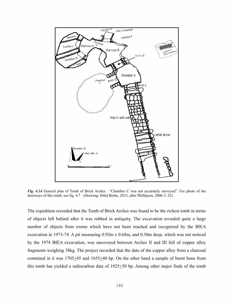
144
Fig. 4.14 General plan of Tomb of Brick Arches. “Chamber C was not accurately surveyed”. For photo of the doorways of this tomb, see fig. 4.7 (Drawing: Hiluf Berhe, 2015, after Phillipson, 2000, I: 32). The expedition recorded that the Tomb of Brick Arches was found to be the richest tomb in terms
of objects left behind after it was robbed in antiquity. The excavation revealed quite a large
number of objects from rooms which have not been reached and recognized by the BIEA
excavation in 1973-74. A pit measuring 0.92m x 0.68m, and 0.30m deep, which was not noticed
by the 1974 BIEA excavation, was uncovered between Arches II and III full of copper alloy
fragments weighing 38kg. The project recorded that the date of the copper alloy from a charcoal
contained in it was 1705+45 and 1655+40 bp. On the other hand a sample of burnt bone from
this tomb has yielded a radiocarbon date of 1925+50 bp. Among other major finds of the tomb
Arch III

145
collected by the expedition included a large spearhead; over one hundred intact or fragmentary
ivory plaques; beautifully decorated ivory throne component with relief of grapes; large quantity
of pottery intact and fragmented; wood remains and about 199 nails and tacks; iron objects;
fragments of gold and silver; foot-washer basins; yoked animal model basins; foot-ring pots;
human-headed jars; bird-shaped vessel; over one thousand glasses of various colors; fragmented
globe; 1139 beads of different size, color and type; copper alloy mirror; rondel, made of brass
and measuring 38cm in diameter with a relief of human face at the center (fig. 3.6 (c)); glass
goblet; human skull; complete jars; numerous metals, etc.
The excavation revealed that the largest number of objects were discovered from chamber B.
Phillipson interpreted that the discovery of only few fragments of gold and silver in this tomb
was an implication that the tomb was robbed focusing on the valuable items such as gold and
silver. He also suggested that a robbery activity in the tomb was recognized by the disorderly
thrown away door blocking and the disturbance and movement of artifacts within the tomb. On
the other side, Phillipson noted that the absence of coins, imported materials (with exceptions of
few glass and beads), animal bones, food debris, flaked stone artifacts, and agricultural tools may
reflect that the tomb was interred with the body of persons on high status. He adds that all the
uncovered objects from the tomb “could be regarded as purely grave goods...which also reflected
the status and activities of those who were interred there”. In addition to this, “the pottery from
the tomb was made especially to serve a funerary purpose”.
4.8.2 Stela 2 site excavations: The 1993 BIEA expedition was involved on ascertaining
the original position of stela 2 before it was re-erected as negotiations were ongoing between
Ethiopia and Italy on the restitution of the stela which had been taken to Rome in 1937.
Preliminary excavation on this site was first carried out in 1994 after delineating a 10m by 10m
area of excavation. According to the expedition this excavation was mainly conducted upon the
request of Ethiopian authorities to check the exact former position of stela 2. Accordingly, in
1994 the excavation cleared the top layer and revealed an extensive disturbance from the 20th
century activities such as demolishing the domestic houses which have been built in the area, and
the landscaping of the stelae park in the 1960s. During the excavation, the team clearly observed
substantial disturbances occurred as the result of the removal of the stela in 1937.

146
Once the original position of stela 2 has been located, the BIEA 1994 excavation in this area did
not continue further into the bottom layers. Such objective was rescheduled for the 1997
excavation. The expedition recorded that as excavation continued deep, loosely packed stone
rubble mixed with 20th century objects were uncovered. In the excavated area an intact base-plate
which measured 2.02m x 1.54m was brought to light which was believed to have belonged to
stela 12. Deeper in the ground, a large stone slab was uncovered at depth of between 2.2m and
2.4m which, according to Phillipson’s suggestion, was used as a base of the socket for stela 2. A
fragment of stela 2 in three pieces was discovered during the 1997 excavation. The 1997 BIEA
excavation resulted in the discovery of subterranean structure of 6m wide and extending beyond
the excavation limit both in the northern and southern edges. It appeared clear to the
archaeologists that the stela “had formerly stood directly over the northern end of the
substructure” (Ibid, I: 143).
Furthermore, the excavation revealed a rock-cut shaft defined by remains of Aksumite walls. It
was found at 7.65m depth from the modern surface level. Robbing activities were observed
during the excavation evidenced from robbers’ tunnels. Phillipson suggested that an ancient
trench on the south side of the stela had been dug to intentionally destabilize the stela which
finally could have caused its destruction at some distant time. He also confirmed from the results
of the excavation that the three largest stelae were erected on straight line, stela 2 being 31.5m
and 26m far from stela 1 and stela 3, respectively.
Based on the typological analysis of some pottery from the original deposits of the substructure
and the shaft, Phillipson recorded a date of the 3rd and 4th centuries AD. On the other hand,
pottery from secondary context deposits was dated to Late Aksumite, post-Aksumite and 20th
century AD. Based on the evidences revealed by the excavation, the expedition finally remarked
that any attempt to re-erect the stela would cause destruction to associated archaeological
materials, and would also hamper future investigations around and beneath the stela29. This was
suggested as a response to the Ethiopian authorities’ request to the project to ascertain whether it
would be safe to re-erect the stela on its original position or not.
29 At the time of the BIEA expedition to Aksum from 1993-1997, negotiation between Ethiopia and Italy was hot issue on the restitution of stela 2. Thorough surveys on the strength and underground composition of the area around the original position of stela 2 have been conducted before the stela was erected. Finally this was successfully accomplished without any major risk although it affected stela 3 to be tilted some 0.9 degrees more.

147
4.8.3 The Mausoleum: This tomb was re-entered in 1993 by the BIEA expedition and
excavation continued from 1993 to 1995. During these consecutive excavation seasons, the
expedition completely excavated the central chamber and four side chambers while others were
partially cleared. The excavation revealed a built arch at the western end of the main Mausoleum
(i.e., another western portal leading to another unexcavated chamber west of the main
Mausoleum), and seventeen dressed massive slabs covering the roof of the chamber of the
Mausoleum. This Mausoleum was recorded to be 5.9m deep from the modern surface level. The
expedition also recorded that the side chambers were between 6.3m and 6.6m long and between
1.7m and 1.9m wide, with an entrance of each side chamber built of bricks in arch shape (fig.
4.15).
Although the expedition found the tomb to have been totally robbed and all remains in disturbed
deposition, it collected charcoal which was radiocarbon dated to 1745+30 bp. Objects collected
during the 1993-1995 excavation from untrusted order of deposition due to robber activities
include metal and shell, fragments of colored glass inlay, copper alloy nails, iron spearhead, glass
beads, human-headed jars, coin of Armah (of 7th century), gold fragments, silver items, iron
objects, pottery fragments, very few flake stones, human bones and teeth.
Fig. 4.15 The Mausoleum
today; (a) portal monumental
doorway on the east; (b) view
of the interior from east. Note:
the natural light enters through
the shaft holes. At the
background, the western portal
monumental doorway leading
to another yet unexcavated
underground structure can be
seen (photo: Hiluf Berhe, May
2011).
a b

148
East of the Mausoleum and still immediately east of the fallen stela 1, the BIEA opened the East
Tomb which, as explained above, has been located by the BIEA during the 1972-1974
expedition. During the 1993 excavation of this tomb, the team encountered difficulty of
continuing excavation after only 2.4m of distance was excavated from the entrance; it was
reported that the tomb was in bad condition of preservation which may cause danger during
excavation. This tomb was found at a depth of 6.4m from the modern surface level, and was
reported to have been less disturbed as compared with the Mausoleum. For the reason mentioned
above, the BIEA quit the excavation in this tomb and, therefore, the overall extent and plan of the
tomb remained unknown. From the excavated area of the tomb, the expedition collected artifacts
from original deposition, such as jars, a pedestal vessel, bowls, basins, glass fragments,
fragments of gold foils, copper alloy nails and iron tang.
4.8.4 GSF: This was excavated from 1994-1996 by opening three trenches, two at the
north and one at the west side of the field. The expedition opened the trenches here to “evaluate
the hypothesis that the GSF represented the burial ground of the middle/or lower strata of
Aksumite society” (Ibid, I: 226). In one of the trenches, the excavation revealed a stone platform
and four steps leading down to it. A wall, preserved to a height of 1.3m, was found here with a
single rebate. In another trench, two pit graves were recorded. Human skeletal material was
found associated with potsherds, glass beads and iron; while a human skull was found associated
with glass and pottery fragments, glass beads and iron knife. Based on charcoal samples
collected from human burials, two dating results were recorded by the expedition – lower strata
dated to 1825 + 40 bp and higher strata to 1780 + 40 bp.
From the evidences revealed by the excavation, Phillipson suggested some conclusions: it
appeared to him that some stelae in this field were erected as grave markers; the graves were
marked by pits, where as built and rock-cut tombs were uncommon. He also interpreted that the
GSF could have served as burial place for wealthy members but non-elite Aksumite society.
Finally Phillipson put the chronology of the field to earlier than those burials at the MSF in the
town, the GSF being dated to between the 2nd and 3rd centuries AD.
4.8.5 D site at Kidane Mehret (Phillipson, 2000, II): This is located north of the town,
about 1km from the MSF, and east of the road that leads to the tombs of Kaleb and Gebre

149
Mesqel. The site gently slopes down to south and, nearby it but immediately west of the road is
found the monumental inscription of Ezana exposed by farmers in 1981.
One of the largest investigated sites by the project was the D site of Kidane Mehret. This was
excavated from 1994-1996. The expedition’s objective of investigating this site was in order to
get a site with domestic occupation belonging to the ordinary Aksumite society for an
understanding of the everyday living condition and economic practices by such society. The
excavation revealed two different components of occupation: a Da’amat period settlement dated
to between 800-400 BC and a Late-Aksumite period settlement dated to between late 5th and
early 8th centuries AD. The two phases of settlement were found to have been separated by
abandonment of the site for long period of time. It was recorded, based on different reliable
evidences, that the site was occupied by a food processing society.
The expedition opened about twenty-three trenches on both sides of the road, the major
discoveries being recorded from trenches to the east of the road. At the settlement of Late-
Aksumite period, two distinct structures were observed – a short-lived elite structure with
monumental steps, and lower-status structure. The site yielded evidence of cultivation and
livestock: wheat, barley and tef were collected while cattle was recorded to be the principal
livestock. In addition to this, in situ grindstone was discovered as a good evidence for food-
processing activities.
Imported vessels, vessels bearing inscriptions and crosses, fragments of glass, glass beads, stone
beads, fragments of gold foil, iron, ivory, copper alloy, clay stamp-seals, five stone seals – some
of them bearing cross and letters, coins of Ioel, Hataz, Gersem and Armah, grindstones,
fragments of cotton textile, charred plant remains (domesticated and wild), animal bones, human
skeletal remains, and so on were collected from the site.
Phillipson concluded that the subsistence economy during the pre-Aksumite period continued to
the Late-Aksumite period and all the way to the present time. He added that the D site at Kidane
Mehret was abandoned by about the 8th century AD and never been occupied subsequently30.
30 Today the site is used for cultivation of cereals mainly tef, wheat, and barley.

150
4.8.6 K site in Maleke Aksum: at the foot of the south side of Biete Giorgis hill, and
west of the church of Maryam Tsion about 600m, the expedition conducted an exploratory
excavation in 1996 on four trenches at a site designated “K”. This site was located within the
built area of the ancient town as opposed to the “D” site which is a peripheral area. The
exploratory excavation at “K” site revealed remains of Aksumite buildings, pottery, glass, metal,
slag, ash and charcoal layers, baked clay hearth, coins of Hataz, 6th century coins of Ioel and
Wazena, beads (of glass, stone and clay), copper alloy cosmetic instruments, and imported
vessels. It was reported that evidence from this site was dated to between the late 5th and late 6th
centuries AD. A charcoal sample recovered from the site was radiocarbon dated to 1585+ 50 and
1590 + 50 bp.
According to Phillipson, the site was abandoned by the early 7th century AD. He was convinced
according to the evidence from the site that “K” site was a manufacturing and residential site
occupied by a middle-rank population. A comparative analysis between the sites K and D
indicated that the former was located at the center of the town with an economic activity largely
based on industrial, and the latter, located at the peripheral area of the town, based on the
production and processing of food
The BIEA expedition has, other than its plan, also explored sites at different areas in the town at
the request of the Ethiopian authorities to check whether the sites contain archaeological features
or not before being affected by any development activity. One such site was the site designated
as “P”. This was located below the Yeha hotel, at the eastern bank of the May Hejja stream31.
The expedition excavated five test trenches here in 1994 which finally resulted in the absence of
any archaeological significance.
Another site where the expedition conducted test excavation in 1995 was located east of the then
Health center (which now is demolished and where large private building is under construction),
opposite of Ghenet Hotel. This site was designated H. The report indicated that three test
trenches of 1m square each were laid out in a private compound. Here again no archaeological
31 This site is owned by the Orthodox Church, and a building has since been built, known as Menbere Patriark (residence of the patriarch). Although the patriarch’s residence and office is located in Addis Abeba, the Menbere Partriark is a guesthouse for the Patriarch during his visits to Aksum, such as for the festivals of Palm Sunday and Hidar Tsion.

151
significance that would be detrimental to any development activity was discovered. During the
same season, a site designated X, located about 30m south of the Tomb of Bazen and 70m east of
Ezana garden, was explored on five test trenches of each 1m square. However, it was reported
that at about 0.5m bed rock was reached without any archaeological significance.
In 1997, in response to residents’ report about an exposed slab at the bed of May Lahlah stream
close by the Tomb of Etiopis, the expedition cleared the area around the slab. As this slab was
found at the bottom of retaining wall of track way that crosses the stream to the west of the town,
it was reported that the slab could have been brought here to stabilize the track way, and was left
where it was. This site was designated L.
4.8.7 Anqar Baʾahti rock shelter: To the east of the town about 5km from the church of
Maryam Tsion, at a site known as Anqar Baʾahti, the expedition excavated on a pre-historic rock
shelter in 1996. The excavation revealed lithics of blade industry, Da’amat and Aksumite period
potsherd, and intruded faunal and floral remains.
4.8.8 Baʾahti Nebait: another pre-historic rock shelter site was excavated by the
expedition in 1997 at Baʾahti Nebait. It is located west of the town of Aksum, at the foot of
south-west side of Biete Giorgis hill. The excavation revealed blade industry dated to 10th
millennium BP, microliths, and pottery of thin coarse ware.
Besides the extensive excavations from 1993-1997, the BIEA expedition also conducted a
detailed survey, recorded and sketched major quarry sites and inventoried the worked blocks
within each quarry site. At Gobo Dura hill, the expedition recorded five quarry sites and one at
Addi Tsehafi. In addition to this, the expedition conducted a detailed survey with the aim of
tracing the possible ancient route for the transportation of the giant stelae erected at Aksum, and
a site of working place of the stelae where the people could have minimized the unnecessary
weight of the stelae. Accordingly, it was reported that the possible route from Gobo Dura to
Aksum could have been located along the eastern foot of Gobo Dura right up to the north-eastern
point of the same hill and then followed east direction across the plain south of Biete Giorgis hill
to the stelae park in the town.

152
4.9 THE WORKS OF ISTITUTO UNIVERSITARIO ORIENTALE (IUO) AND
BOSTON UNIVERSITY (BU) 1993-2002
Another post-1991 archaeological research project that conducted extensive excavation on the
top of Biete Giorgis hill was the joint project of IUO and BU directed by Rodolfo Fattovich and
Kathryn Bard, respectively (Bard and Fattovich, 1993). This project carried out an excavation for
nine seasons from 1993 to 2002 with one season (i.e., 1999) interruption because of the outbreak
of a war between Ethiopia and Eritrea in May 1998 (Fattovich et al., 2001). Researches in
paleoethnobotany, archaeozoology, geology, geomorphology, ethnography, ethnoarchaeology,
ethnohistory, and mapping were also included as part of the project (Fattovich et al., 2000).
The IUO/BU archaeological investigations on top of Biete Giorgis were carried out between
May and June every year for one month on average. The preliminary archaeological report of
each excavation season was published in Nyame Akuma and Rassegna di Studi Etiopici, the latter
in Italian language. The following summary of the archaeological excavation of the IUO/BU is,
therefore, summarized from Bard and Fattovich, 1993; Fattovich, 1995; Bard and Fattovich,
1995; Bard et al., 1996; Bard and Fattovich, 1997; Bard et al., 1998; Fattovich et al., 2001; Bard
et al., 2001; Bard et al., 2002 (see also bibliography).
The IUO/BU archaeological expedition has fully investigated the top of Biete Giorgis during nine
excavation seasons from 1993 to 2002. The whole site was also surveyed; as a result, from a
landscape survey, the expedition identified different man-made features which included
agricultural terraces and fields, cisterns, dams, roads and paths. On the other hand, the expedition
recorded four types of sites: rock-shelters, open sites, stelae quarries, and sites with rock
inscriptions. Residential structures were discovered to the south-west and north side of the hill of
Biete Giorgis at Ona Negest (ON), Qelqel Asba (QA), Tikul Emni (TE), and Gudguad Agazen
(GA); while at the central sector of the hill at a place called Ona Enda Aboi Zewge (OAZ) many
rock-cut tombs and stelae were recorded.
The expedition excavated over sixteen rock-cut tombs although the archaeologists assumed that
there could be between 2000 and 3000 burials. At the central sector, the expedition also reported
over one-hundred roughly hewn stelae with rounded tops. Here one very strange stela was what

153
the archaeologists called a “double stela”, with a total length of 9.3m. The expedition made some
archaeological investigations around the stelae where tombs were discovered associated with
them. The rock-cut tombs were over 3m deep below the present surface level and many of them
were identified to have many chambers. It was also reported that few of the tombs were found
with human bones and artifacts. This central sector was thought to be the main cemetery of Biete
Giorgis site used for several centuries.
Structures at ON, GA, QA, and TE were found at very low height and exhibited a rebated wall of
Aksumite architectural feature. At QA, the excavation revealed a round, plastered feature in the
center of the structure (fig. 4.16) which the archaeologists suggested that its purpose could be a
storage rather than water reservoir. In most of the excavated structures, remains of different
objects were discovered suggesting that they were residential buildings.
During the nine excavation seasons, the expedition collected a large and varied amount of objects
from the site of Biete Giorgis. Among such finds included: black-topped red ware sherds of fine
fabric, large sherds and bowls, five whole red ware pots, small cups, imported wares of
Mediterranean origins, sherds of Late-Meroitic wares, sherds of imported glass vessels, sherds of
imported amphorae from Upper Egypt, Late-Roman/Byzantine glass fragments dating from the
1st to 6th centuries AD, sherds of Late-Roman ribbed wine amphorae, lithics, brick fragments and
charcoal, orange ware with orange paste, brick-red ware with a red paste, small bronze bracelet,
bronze artifacts, a model axe and a large bracelet, clear glass beads with gold foil, carnelian
beads, fragments of glass vessels, model axes in iron, beads of colored glass, human teeth,
Fig. 4.16 Circular structure in the middle of a ruined structure on Biete Giorgis, possibly granary. Notice the plastering (follow the arrow) which survived only at the lower level of the structure (photo: Hiluf Berhe, 2002).

154
grinding stones, coins of Kaleb and Armah, a short, and unvocalized Geʿez inscription of one
word recorded on a stela. From one of the excavated tombs, 236 glass beads were collected,
which according to the archaeologists, were most likely produced in Egypt in the 2nd to 1st
centuries B.C.
The IUO/BU expedition has also conducted research on paleoethnobotany and archaeozoology.
Analysis of collected faunal remains indicated that the dominant animal was domesticated cattle.
Goat and sheep were also identified from a large number of bones. On the other hand, flotation
techniques from different excavation units have yielded large number of samples of emmer
wheat (Triticum dicoccum), free-threshing wheat (Triticum durum/aestivum), hulled barley
(Hordeum vulgare), tef (Eragrostis teff) and flax (Linum usitatissimum), as well as legumes and
grape seed (Vitis vulgare) dated to between 90 BC and 700 AD.
The expedition’s analysis of ceramics, coins, imported objects, and architectural features of the
tombs and structures gave the result that the site of Biete Giorgis was occupied since the
Da’amat period (5th century BC) and continued up until the early 7th century AD. The cemetery
area was also thought to have been first used during the 1st millennium BC and was still used in
the early Aksumite period (2nd – 4th centuries AD). It was also ascertained that the tombs and
stelae at Biete Giorgis site dated to the 1st century BC or earlier were much earlier than those
tombs and stelae in the town of Aksum.
Map 4.2 IUO/BU archaeological research project on top of Biete Giorgis hill (adapted from Fattovich et al. (2000). “IUO/BU joint archaeological expedition at Bieta Giyorgis (Aksum, Ethiopia): 2000 field season”. Technical report to CRCCH, Addis Abeba. Napels-Boston, 2000).

155
4.10 EXCAVATIONS BY AUTHORITY FOR RESEARCH AND CONSERVATION
OF CULTURAL HERITAGE (ARCCH)
A team from ARCCH, led by Yonas Beyene, carried out excavation in January 1998 to finalize
the preparation for the re-erection of stela 2 – then in Rome. As mentioned above, this stela 2 site
has been excavated by Phillipson to confirm the exact location of the stela and prepare the
ground for the re-erection. Assisted by an engineer, Tadele Betul, the team removed stones so as
to continue excavating deep. In the same year, in October 1998, another team from ARCCH
under the direction of Tekle Hagos, and Bertrand Poissonnier from CFEE, Addis Abeba, as an
advisor, carried out excavation on the same site. The intended objective was not attained during
this mission (Poissonnier, 2012).
In 1999, excavation on stela 2 site continued, this time under the direction of Poissonnier. The
mission also documented the installation and collapse of stela 2 in ancient time. Although the
mission was interrupted by war, it had progressed a lot in revealing the underground layout.
While excavating deep, Poissonnier reached bedrock on which the bottom built structure
supporting the stela rested. In addition, two pits were discovered, more than 7m deep below the
present surface level. Although the pits were found to have been robbed in ancient times, the
team collected objects, like a glass bead, fragments of imported glass and pottery containers and a
variety of metal objects. Based on stratigraphical analysis, Poissonnier believed that the pits
possibly postdate the erection of stela 2 (Ibid).
From November 2 to 28/2000, a team led by Tekle Hagos, from ARCCH, and experts32 from
CFEE, conducted a test excavation at Enda Azay. The objective of this mission was to check the
site whether any significant archaeological site exists or not before any development construction
takes place there. The team opened six trenches, some of them 1m x 30m large and, excavated to
the depth of up to 3m below the present surface level (Tekle Hagos, 2000).
The test excavation resulted in the discovery of a ruined Aksumite building at 1m depth from the
32 They were John Phillip Delaxa (archaeologist), Allan Whitman (Ceramist), Liyo Yoyo (Topographer), Bertrand Poissonnier (archaeologist), Albert Hiss (Geophysict), Patrice Berjer (Geophysict). According to the report, the expenses of daily laborers for the last weeks were financed by Yoyo and Delaxa (Tekle Hagos, 2000). HAMA again excavated this site in 2003, during which, the researcher has participated through the excavation season as representative of the Culture and Tourism office and trainee.

156
present surface level. The team also came across five steps surrounded by Aksumite walls to
north, south, west and northeast directions. The steps were found at 1.7m deep from surface
level. Among other finds were iron slag, bricks, beads, glass fragment, coins, lion figurine on red
limestone, and a stone bowl with two handles (Ibid).
Fig. 4.17 “Original location of Stela 2: section AB (SS0-NNE). 1: Current ground level; 2: contemporary support wall; 3: boundary of the excavation; 4: not detailed; 5: resistant substrate; 6: base plate; 7: wedge slab; 8:”footing slab”; 9: Stela 2 redrawn (after Littmann et al., 1913; the altitudes are given in metres above sea-level; topography: L. Fadin, CFEE; drawing: J.-M. Bryand and B. Poissonnier, CFEE; synthesis: B. Poissonnier, CFEE)” (Poissonnier, 2012: 66) (modified after Poissonnier, 2012).

157
4.11 THE WORKS OF HAMBURG ARCHAEOLOGICAL MISSION TO AXUM
(HAMA)
The HAMA project began its archaeological excavation in 2000 at May Melahso at the foot of
the eastern side of Biete Giorgis hill, and at Berik Awdi – north of the Tombs of Kaleb and Gebre
Mesqel, under the direction of the late Helmut Ziegert.
The 2000 season archaeological excavation at May Melahso revealed a large building complex.
During the same season through 2002, excavations carried out at Berik Awdi yielded much
information (Ziegert, 2002, 2001; Wendowski and Ziegert, 2003). At Berik Awdi, two phases of
monumental palace buildings were discovered – a first phase palace containing a royal grave,
evidences of pre-Christian human sacrifices, and remnants of a Christian church. The site was
reused during the Christian period during which a church was built over the royal grave. The
entrance of the church was found to have been built of monumental staircases and contained a
baptistery basin (Wendowski and Ziegert, 2003).
A second phase palace at Berik Awdi survived to a height of 4m below the modern surface level
and exhibited an Aksumite rebated wall. The excavations at Berik Awdi during the 2001 and
2002 seasons yielded important information concerning metal smelting and fabrication. Here a
1m heap of iron slag was discovered on the surface; a copper ore, and smelted iron poured on the
ground was also revealed by the excavation. It was hypothesized that the site of Berik Awdi was
first abandoned during the pre-Christian period and the people moved to the town of Aksum
where they constructed the first church and palace in the present Aksum Maryam Tsion church
compound (Wendowski and Ziegert, 2003).
In 2003, the project opened trenches at the center of the town west of the church of Maryam
Tsion at a site called Enda Azay33. This was an open site where stone rubble from ancient ruins
could still be seen on the surface. Excavation here was carried out for about three months as the
result of which a ruined large Aksumite building with a recessed and rebated wall was
uncovered. It survived to a height of about 2m below the present surface level. Artifacts were
33 The researcher was involved in the excavations of Berik Awdi during the 2002 season and at Enda Azay in 2003 as antiquity officer of the Aksum Culture and Tourism office. Information about HAMA’s excavation of 2003 is thus based on the researcher’s participation and personal note.

158
collected from this site though publication of the excavation is still unavailable.
In 2008 the HAMA project conducted some test excavations at the Dungur palace with the
objective of investigating an earlier structure below the structure excavated by Francis Anfray.
Such test trenches were mainly laid out at the courtyard east of the central building, and some
other trenches northeast corner of the Dungur palace immediately outside the fence wall, east of
the present watching tower. Some earlier wall structures were revealed below the Aksumite
building of Anfray’s mansion (Ziegert, per. Comm. during on-site explanation, February, 2008;
personal observation). Again no publication is still accessible for this excavation.
The excavations of HAMA project was continuing with interruptions; after some years of
discontinuity the project carried out an excavation in 2010 at the Tombs of Kaleb and Gebre
(a) (b)
Fig. 4.18 Ruined Aksumite palace at Enda Azay excavated by HAMA from January through March, 2003. This structure is about 2 meter high in the underground. Once the excavation season (2003) was completed, the structure was refilled back with earth and stones (photo: Hiluf Berhe, 2003).
Mesqel. Immediately to the east of the tomb of Gebre Mesqel, a shaft tomb was uncovered with
burial (?) rooms located to the east and west of the shaft. The rooms are built of granite stones
and are low in height. Although there was a plan to continue the excavation in April 2013, it was
interrupted because of the untimely death of Helmut Ziegert on 30 March 2013.

159
4.12 EXCAVATIONS BY THE ETHIOPIAN CULTURAL HERITAGE PROJECT34
The first excavation of the ECHP under the direction of Tekle Hagos was conducted at a site
located north of the northern wall of the MSF, in the compound of the residence of Dejjazmach
Gebreselassie Baryagaber. This excavation was initiated as an impact assessment to check the
site for its archaeological significance before its destruction by the new Aksum Archaeological
Museum to be built there. The test excavation was carried out between June 5 and July 15/2005
as the construction of the new museum was planned to be started in November 2005 (Tekle
Hagos, 2008).
During the brief period of excavation, Tekle opened six trenches – all 4m x 1m large – and
designated them as “HAW” to match with the designation of trenches by Chittick in the same
area during the 1972-74 BIEA excavations. Tekle’s excavation revealed the presence of rock-cut
underground tombs buried at least 4m below the modern surface level whose age were estimated
to fall in the 3rd century AD. Four out of the six opened trenches were reported to have contained
rock-cut tombs, in some of the trenches being found more than one rock-cut tomb (Ibid). Tekle’s
excavation also pointed out that in some of the trenches roughly worked stelae associated with
tombs were discovered. He found some of them fallen while others on standing position but
buried at least 2m below the modern surface level.
Abundant artifacts of varied types, dated to between the 3rd and 4th centuries AD were collected
from the trenches and the tombs, including local and imported pottery sherds with varied pattern
and colors, human and animal bones, beads of different types and colors, iron knife, iron dagger,
iron spearheads, human teeth, glass fragments, and bronze bracelets (Ibid).
In the same compound, Tekle cleared up and exposed some buried stelae where they were
afterwards re-erected in the area. His excavation confirmed the existence of archaeological
features and material in the deep underground where the new museum was planned to be
constructed. Tekle then recommended the possibility of constructing the new museum around the
excavated trenches instead of directly on the trenches where archaeological features were
34 This was huge project with financial loan from the World Bank for Aksum, Gonder, Lalibela and Harer World Heritage Sites. The proposal was to work on heritage conservation and site management, training of personnel on the field, training of artisans and development of community-based tourism in each of the World Heritage Sites.

160
uncovered (Ibid)35.
At the southeastern thrones around the original position of the stone inscription of king Ezana,
the ECHP excavated the mound at Guangua Edaga whose existence has formerly been recorded
(Littman et al., 1913; Monneret de Villard, 1938; Michels, 2005). After two consecutive
excavations in 2006 and 2007 between February and March each year, Tekle exposed a ruin of
large Aksumite church (fig. 3.4) that measured 26m x 13m (Tekle Hagos, 2008). This ruin of an
Aksumite church was called Arbaʾetu Ensesa. The excavation on this ruined structure was carried
out with the objectives of identifying the ruin, to establish a relationship between the ruin and the
stone thrones, and to justify a proposal by EHCP on fencing the site. The site was then excavated
to a depth of 2.5m below the present surface level and revealed such large ruined structure of an
ancient church (Ibid).
The church was built of rebated wall with finely dressed cornerstones from outside, and
contained eight rooms and eight piers. The rooms were reported to have been in different sizes
and used for different functions; one room was built particularly deep in the ground accessed by
seven staircases, which Tekle interpreted as a treasure room. Some artifacts were collected from
the ruined structure, including glasses, metals, coins, beads, grinding stones, polishing stones,
bricks, bronze cross, iron fragments, metal nails, bones of domestic animals, lithic artifacts, local
and imported pottery sherds. Comparisons based on the artifact typology and architecture of the
Aksumite churches produced dating of the church to between the mid-6th and 7th centuries AD
(Ibid).
On the same site, the project conducted some clearance works on the site of throne 23. This
throne was made of two separate stones and both the throne-base and the seat contained Geʿez
inscription which the DAE designated as inscription 12, 13 and 14. The throne-base was split
into two and each piece was designated inscription number 12 and 13, while the seat was
35 Recent observations on the result of the excavated test trenches of Tekle and the newly built Aksum Archaeological Museum could be added here. Tekle’s proposition did not save the underground rock-cut tombs from destruction as a consequence of the construction of the new museum. The new museum was constructed soon after the test excavation was completed, and some of the trenches were incorporated inside the museum display room. The trenches were left open so that tourists would be able to see from atop. As the western wall of the museum building rested on the edge of the trenches, the trenches became at risk: the earth on the western side of the trenches fell down, and the trenches are subsequently completely backfilled.

161
designated inscription 14 (Phillipson, 1997). The seat has since been obscured in the ground by
deposits until it was cleared up and fully exposed again by the EHCP in February 2006 (Tekle
Hagos, 2008). In the post excavation, the throne was fully sheltered by newly constructed house
by the same project. A large shelter of metal sheet was also constructed to shelter the excavated
church of Arbaʾetu Ensesa. Both are now open to the public while a short fence around the whole
site was built to keep children and animals away.
4.13 EXCAVATIONS BY AKSUM UNIVERSITY (AkU)
In January 2013, AkU received a report that an opening was exposed after a vehicle broke a large
stone slab 18 meters directly north of the tombs of Kaleb and Gebre Mesqel. Following this, a
rescue excavation was conducted by the Department of Archaeology, by which a cruciform shaft
tomb was uncovered. Subterranean burial chambers were discovered in this tomb. This was cut
in the volcanic tuff bedrock. To the northwest and northeast of this shaft tomb, other tombs were
partially cleared up and left for further excavation program. East of the northeastern corner of the
Kaleb and Gebre Mesqel tombs fence wall, immediately south of the pathway to Abba Liqanos,
the team exposed a monumental staircase that possibly leads to an elite structure on the platform
above it (Walker et al., 2013).
4.14 EXCAVATIONS BY ETHIOPIA EXPLORATION FOUNDATION AND
AKSUM UNIVERSITY (EEF/AkU)
This is a joint project of EEF (Korea) and AkU that began the first season of excavation at
Ta’aka Maryam ruined palace. The objective is to re-expose the previously cleared and planned
ruined palaces by DAE, so as to contribute to heritage management and the promotion of
Aksum’s heritage endowment for international tourism. The site of Ta’aka Maryam has been
completely overlaid by houses after 1906. Only recently, the Culture and Tourism office
relocated the people and all houses demolished in order to prepare the site for excavation and
heritage management. Fence wall was built round the whole site.
At the western edge of Ta’aka Maryam, the project opened three areas, designated C, S, and W
(fig. 4.21). Within these were laid out seven squared trenches. The excavation was carried out
from February 17 through March 15, 2014. Accordingly, structures began to appear after 30cm

162
of excavation down from the present surface level. At area S, steps (two complete, and a third
step partially missing), and a drainage carved out of granite stone were revealed. Possibly in their
original context, Endybis silver coin, and two other bronze coins came to light (Koh, 2014).
In area C, recent wall structures and rooms built at different periods, ash pits, brick structures and
small finds were discovered. This area is entirely found to be from recent period (Ibid). Perhaps,
the ancient structure is located deep below this recent structure.
Area W was also marred by modern period constructions. Different periods of walls, paved floor,
and rooms were revealed indicating that the site has undergone immense destruction as the result
of continued settlement on it (Ibid).
Fig. 4.19 Steps and drainage in area S at Ta’aka Maryam re-exposed by EEF/AkU in 2014 (view from north) (photo: Hiluf Berhe, 27/09/2014).
Fig. 4.20 plan of the excavated areas at Ta’aka Maryam by EEF/AkU in 2014 (adapted from Koh, 2014)
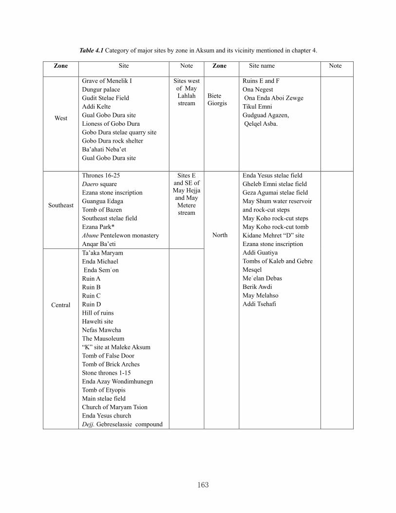
163
Table 4.1 Category of major sites by zone in Aksum and its vicinity mentioned in chapter 4.
Zone Site Note Zone
Site name Note
West
Grave of Menelik I Dungur palace Gudit Stelae Field Addi Kelte Gual Gobo Dura site Lioness of Gobo Dura Gobo Dura stelae quarry site Gobo Dura rock shelter Ba’ahati Neba’et Gual Gobo Dura site
Sites west of May Lahlah stream
Biete Giorgis
Ruins E and F Ona Negest Ona Enda Aboi Zewge Tikul Emni Gudguad Agazen, Qelqel Asba.
Southeast
Thrones 16-25 Daero square Ezana stone inscription Guangua Edaga Tomb of Bazen Southeast stelae field Ezana Park* Abune Pentelewon monastery Anqar Ba’eti
Sites E and SE of May Hejja and May Metere stream
North
Enda Yesus stelae field Gheleb Emni stelae field Geza Agumai stelae field May Shum water reservoir and rock-cut steps May Koho rock-cut steps May Koho rock-cut tomb Kidane Mehret “D” site Ezana stone inscription Addi Guatiya Tombs of Kaleb and Gebre Mesqel Meʿelan Debas Berik Awdi May Melahso Addi Tsehafi
Central
Ta’aka Maryam Enda Michael Enda Semʿon Ruin A Ruin B Ruin C Ruin D Hill of ruins Hawelti site Nefas Mawcha The Mausoleum “K” site at Maleke Aksum Tomb of False Door Tomb of Brick Arches Stone thrones 1-15 Enda Azay Wondimhunegn Tomb of Etyopis Main stelae field Church of Maryam Tsion Enda Yesus church Dejj. Gebreselassie compound

164
0
5
10
15
20
25
Number of Sites 10 9 21 14 6
West Southeast Central North Biete Giorgis
Table 4.2 Chart depicting the number of sites in each zone as classified in table 4.1.
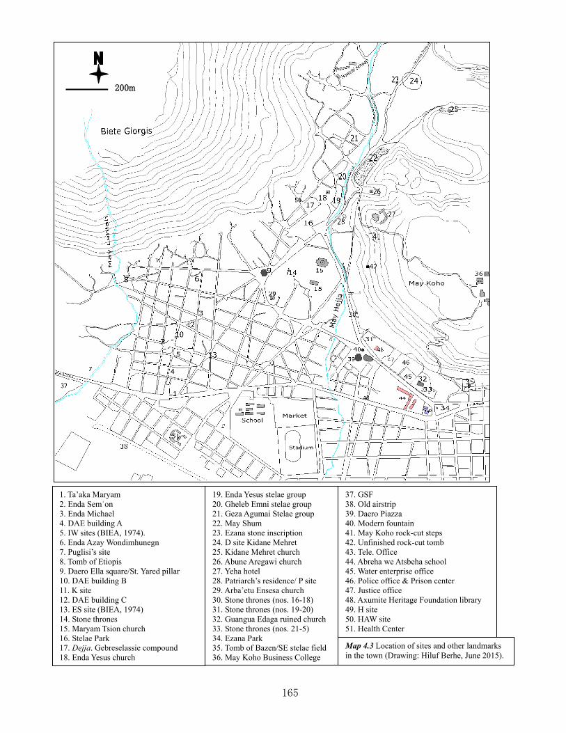
165
200m
1. Ta’aka Maryam 2. Enda Semʿon 3. Enda Michael 4. DAE building A 5. IW sites (BIEA, 1974). 6. Enda Azay Wondimhunegn 7. Puglisi’s site 8. Tomb of Etiopis 9. Daero Ella square/St. Yared pillar 10. DAE building B 11. K site 12. DAE building C 13. ES site (BIEA, 1974) 14. Stone thrones 15. Maryam Tsion church 16. Stelae Park 17. Dejja. Gebreselassie compound 18. Enda Yesus church
19. Enda Yesus stelae group 20. Gheleb Emni stelae group 21. Geza Agumai Stelae group 22. May Shum 23. Ezana stone inscription 24. D site Kidane Mehret 25. Kidane Mehret church 26. Abune Aregawi church 27. Yeha hotel 28. Patriarch’s residence/ P site 29. Arba’etu Ensesa church 30. Stone thrones (nos. 16-18) 31. Stone thrones (nos. 19-20) 32. Guangua Edaga ruined church 33. Stone thrones (nos. 21-5) 34. Ezana Park 35. Tomb of Bazen/SE stelae field 36. May Koho Business College
37. GSF 38. Old airstrip 39. Daero Piazza 40. Modern fountain 41. May Koho rock-cut steps 42. Unfinished rock-cut tomb 43. Tele. Office 44. Abreha we Atsbeha school 45. Water enterprise office 46. Police office & Prison center 47. Justice office 48. Axumite Heritage Foundation library 49. H site 50. HAW site 51. Health Center Map 4.3 Location of sites and other landmarks in the town (Drawing: Hiluf Berhe, June 2015).
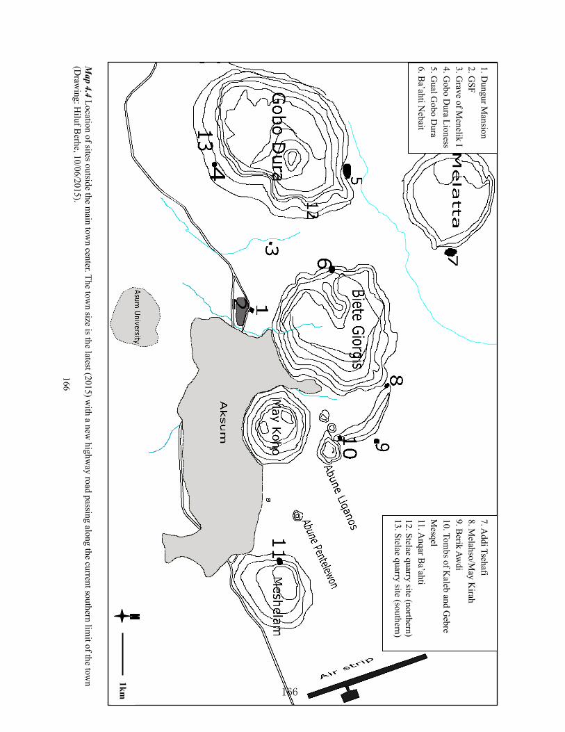
166
Map 4.4 Location of sites outside the m
ain town center. The tow
n size is the latest (2015) with a new
highway road passing along the current southern lim
it of the town
(Draw
ing: Hiluf B
erhe, 10/06/2015). 166
7. Addi Tsehafi
8. Melahso/M
ay Kirah
9. Berik Aw
di 10. Tom
bs of Kaleb and G
ebre M
esqel 11. A
nqar Ba’ahti
12. Stelae quarry site (northern) 13. Stelae quarry site (southern)
1. Dungur M
ansion 2. G
SF 3. G
rave of Menelik I
4. Gobo D
ura Lioness 5. G
ual Gobo D
ura 6. B
a’ahti Nebait
1km

167
CHAPTER FIVE
DESCRIPTION, ANALYSIS AND INTERPRETATION OF THE CHANGES ON THE
ARCHAEOLOGICAL AND HERITAGE LANDSCAPE AND MONUMENTS AT
AKSUM: CASE STUDY OF THREE SELECTED SITES.
“Because of combined natural and cultural factors the
archaeological area of Aksum is the result of a long process of
landscape modification on a regional scale, and deposition
formation on a site scale, and thus requires careful preservation.
The entire area is also exposed to environmental hazard that
must be carefully investigated to assure a proper management of
the archaeological resources” (Fattovich et al., 2000: 45). 5.1 Introduction: The general Landscape changes constantly through natural-transforms and
human-transforms, whether these occur gradually or precipitously (Aston, 2002). Landscape
change is a continuous process but very gradual; some landscapes are shaped by nature when
humans abandon them, while others are dominantly shaped by man. Their result is then often
seen in landscape pattern (Küster, 2004).
Landscape is a general term that may include different features of a given space, such as
historical geography, cultural ecology, settlement patterns, regional and environmental
archaeology. Recently, however, this approach has become a more specific discipline, commonly
termed “landscape archaeology”. This new approach was widely used in Britain, and to some
extent in North America (Grzymski, 2004). The social and cultural product of landscape is “a
pictorial way of representing, structuring or symbolizing surroundings”. It is also “a way of
seeing projected onto the land and having its own techniques and compositional forms; a
restrictive way of seeing that diminishes alternative modes of experiencing our relations with
nature” (Cosgrove 1984: 269). The study of landscape archaeology enables us to see the
multilayered human occupation in a given space; it always deals with a visual construct
(Porteous, 1990: 4). Humans have influenced their surrounding landscape during their interaction
with the environment; landscape archaeology also studies such variables of human-environment
interaction (Ingold, 1993).

168
The definition of landscape archaeology differs among different scholars (Hu, 2011). Some
scholars define it more specifically relating to the physical landscape, while others define it
holistically. Probably the most all-encompassing definition of landscape has been forwarded by
Shanks:
“…landscape is a syncretic field. The space of landscape is at once cultural and
natural, connecting values, modes of perception and representation, experiences,
artifacts, histories, natural histories, dreams, identities, narratives, memories in
networks of cultural ecology. …landscape is a multitemporal and complicated,
folded cultural topology” (Shanks, 2001: 293).
In their definition, some scholars see landscape as quantifiable, while others see it as qualitative
(Tilly, 1994: 14). Recently, many literatures have appeared on the theory and practice of
landscape archaeology, whose popularity has attracted the use of different methodologies, such
as Geographical Information Systems (GIS) (Hu, 2011; Grzymski, 2004).
Landscape archaeology critically observes what lies beyond a site. Humans have interacted with
their landscape, and thus some traces are left on the site. Landscape archaeology thinks of the
successive layers of human settlement in a given site holistically (Johnson, 2005: 116). The layer
of landscape revealing the history of human occupation can also be defined as:
“a document that has been written on and erased over and over again; and it is the
business of the field archaeologist to decipher it. The features concerned are of
course the roads and field boundaries, the woods, the farms and other habitations,
and all the other products of human labor; these are the letters and words
inscribed on the land. But it is not easy to read them because, whereas the vellum
document was seldom wiped clean more than once or twice, the land has been
subjected to continual change throughout the ages” (Crawford, 1953: 51). Landscape reflects temporal change. As a result, its preservation and continuous restoration is an
essential part of archeological study. The cumulative effect of its neglect may seriously result in
the instability of structures and monuments in particular and the composite landscape in general
(Grant et al., 2008; Küster, 2004).

169
Relatively large-scale survey projects carried out in Tigray with the objective of understanding
the settlement pattern of early communities and distribution of sites were those Axum-Yeha
Region (Michels, 2005), Eastern Tigray (D’Andrea et al., 2008), and Western Tigray (Finneran,
2005).
However, more specific researches targeting the investigation of landscape archaeology have
been carried out on top of Biete Giorgis hill (northwest of Aksum) and at Lalibela. In the former
place, the IUO/BU has investigated the “ancient land use pattern” (Fattovich et al., 2000: 41). In
Lalibela, a recent archaeological landscape investigation seems to have answered the search for
the occupational history of Lalibela. The research revealed that a wall existed before the carving
of the monolithic churches of Lalibela. The wall was found overlaid by a spoil heap of two
phases clearly separated by soil deposit. The authors added:
“While in numerous places we cannot distinguish what was there before, there
remain certain “anomalies” or superimpositions that correspond to the last marks
left by the previous carving phases which enable us to affirm that the site of
Lalibela never ceased to evolve through time. The apparently logical and simple
observation that the Lalibela of today does not resemble the site as it would have
been in the 13th, 16th or early 20th centuries is an essential step in the construction
of our methodology. We are not dealing with a site that was occupied only during
a single period and was then abandoned. The occupation was continuous and the
adaptation of the spaces was therefore also continuous. In addition, the struggle to
preserve the monuments has been a constant concern, as is reflected by numerous
redevelopments, particularly the deepening of courtyards and trenches” (Bosc-
Tiessé et al., 2014: 143).
At Aksum, the investigation in archaeological landscape is still unknown practice (Fattovich et
al., 2000: 41); excavations there have been largely involved in unearthing known elite structures
(Phillipson, 2000, I). The Aksum archaeological landscape is comprised of different components,
such as settlement patterns, ceremonial and worship centers, burial and cemetery areas, ancient
and modern pathways, modern vehicular roads, small streams, cisterns and wells, and
agricultural terraces and fields. All these are the results of temporal change, and reflect land-use

170
patterns at least for the last two millennia by successive generations. However, no attempt has so
far been made to study the history of archaeological landscape of Aksumite archaeology, except
that of the IUO/BU that conducted landscape investigation at the top of Biete Giorgis (Fattovich
et al., 2000: 41).
The archaeological area of Aksum is the result of a long process of modification due to natural
and cultural factors, including archaeological excavations. Its continuous recording and
description is indispensable, since natural and cultural changes are inevitable (Phillipson, 1997).
This chapter gives a detailed description, discussion and analysis of changes in the
archaeological landscape, monuments and associated features that have occurred since the
remote past. It is not easy to imagine and reconstruct what the modified landscape looked like,
but an attempt will be made as a springboard for future research on the same topic and area. Data
for this study is mainly extracted from old accounts (descriptions, maps, sketches, photographs),
archaeological excavations carried out by different archaeological projects at different periods,
current fieldwork and personal observation by the present author during the last eight years of
work experience in the town.
This case study focuses on three selected sites with the conjecture that great change could have
occurred to such sites due to their location and rich content of cultural remains such as in tombs;
these selected sites also represent different archaeological features – stelae and cemetery sites,
cemetery and palace or church sites, and coronation sites. We have great deal of sources for these
sites, such as ancient literary documents, legends, and archaeological and geo-archaeological
studies helpful for recording and description. Although ancient literary sources exist for each
site, no archaeological excavation has been carried out on the coronation site as it is located
within the sacred enclosure of the church of Maryam Tsion. This study attempts to provide
qualitative and quantitative analyses of the results.
5.2 The May Hejja Archaeological Site: The landscape complex of the May Hejja
archaeological area ranges from a small stream, scattered and rows of trees, the church area,
rows of monuments, a cemetery area, a settlement area and a cistern, to a hill on the opposite
side of the MSF. For reasons of time and space, this section excludes the cistern of May Shum
and the hill of May Koho. The grouping of the May Hejja archaeological area into MSF, Enda
171
Yesus, Gheleb Emni, and Geza Agumai is adapted from Chittick (Chittick, 1974; Munro-Hay,
1989).
5.2.1 Ancient written documents, maps, photographs and legend: One ancient written
document about Aksum recording the inventory of stelae and other archaeological remains as
well as the church of Maryam Tsion is the Liber Aksumae (Conti Rossini, 1910: 1). It is not
possible to clearly understand how the ancient landscape of the MSF might have looked like
during the 15th century AD, when this document is believed to have been written. This document
tells us that there were 58 stelae – some lying on the ground and others still standing. Although
this inventory is not supported by maps or detailed descriptions of the location and arrangement
of the stelae1, it helps greatly to have an impression of their condition during the 15th century
AD. We can infer from the description that destruction of stelae had already occurred by that
time.
Based on the description in the Liber Aksumae, archaeologists can sketch the stelae to envision
their possible appearance and condition. Those standing during the 15th century could have fallen
subsequently and movement of monuments could have been very minimal, but it is unimaginable
that those already fallen during the period under discussion would have been re-erected
subsequently, except some (discussed below) in the mid-20th century. We are unsure whether the
MSF was protected as a stelae field or occupied by inhabitants2.
The document also gives the description of an underground “house” (? tomb), stating that a great
“house” is located at the base of the great but broken obelisk. The document informs us that the
great “house” has four corners leading to four different directions and at each corner are also four
other great “houses” (Ibid, 4) (see chapter 3 for detail). This most likely refers to the recently
excavated underground tomb found at the base of the great stela (stela 1) first located and
1 The document refers to an obelisk as “…great obelisk which is broken…” (Conti Rossini, 1910: 4). This possibly
refers to the great obelisk (stela 1), discussed in this section. 2 It is very logical to say that the burials discovered around the Nefas Mawcha could belong to Muslim people killed
during Ahmed Gragn’s war in 1535, since it is not customary to bury Orthodox Christians outside a church graveyard. If the assumption is true, then it appears that the MSF may have been unoccupied because, had it been (as clearly seen during the early 20th century), people would not have been buried there. Thus, occupation could have taken place some generations after the 1535 war. Photographs by the DAE show that the Nefas Mewcha area (where the burials are located) was used for fence walls and gatehouses while the houses were built on the platform. Jacke Phillips suggested that the burials probably date between 15th and 19th centuries, ceasing to be used as cemetery before the end of 19th century (Phillipson, 2000, II: 519). Detail interpretation is presented in the following sections to support the idea that MSF was already occupied in 1893.
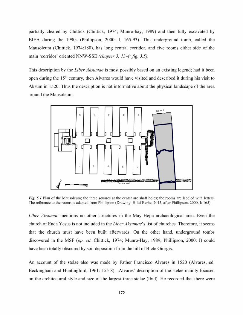
172
partially cleared by Chittick (Chittick, 1974; Munro-hay, 1989) and then fully excavated by
BIEA during the 1990s (Phillipson, 2000: I, 165-93). This underground tomb, called the
Mausoleum (Chittick, 1974:180), has long central corridor, and five rooms either side of the
main ‘corridor’ oriented NNW-SSE (chapter 3: 13-4; fig. 3.5).
This description by the Liber Aksumae is most possibly based on an existing legend; had it been
open during the 15th century, then Alvares would have visited and described it during his visit to
Aksum in 1520. Thus the description is not informative about the physical landscape of the area
around the Mausoleum.
Fig. 5.1 Plan of the Mausoleum; the three squares at the center are shaft holes; the rooms are labeled with letters. The reference to the rooms is adapted from Phillipson (Drawing: Hiluf Berhe, 2015, after Phillipson, 2000, I: 165).
Liber Aksumae mentions no other structures in the May Hejja archaeological area. Even the
church of Enda Yesus is not included in the Liber Aksumae’s list of churches. Therefore, it seems
that the church must have been built afterwards. On the other hand, underground tombs
discovered in the MSF (op. cit. Chittick, 1974; Munro-Hay, 1989; Phillipson, 2000: I) could
have been totally obscured by soil deposition from the hill of Biete Giorgis.
An account of the stelae also was made by Father Francisco Alvares in 1520 (Alvares, ed.
Beckingham and Huntingford, 1961: 155-8). Alvares’ description of the stelae mainly focused
on the architectural style and size of the largest three stelae (Ibid). He recorded that there were

173
over 30 other stelae when he was at Aksum, and three largest were carved and decorated.
Alvares recorded that most stelae, and particularly stelae 1 and 2, were lying on the ground. This
description of the largest stelae during the specific year 1520 provides a perfect picture of how
such stelae appeared in early 16th century.
Although Alvares records only a small number of stelae, his description that some stelae lay on
the ground and a few still stood confirms that their destruction is not solely a recent phenomena,
but rather already had occurred before 1520. On the other hand, Alvares never mentioned other
structures in the May Hejja stelae field. Thus this does not help to provide a clear picture of how
the landscape of the MSF surrounding the stelae appeared in 1520.
A century after Alvares, Manoel de Almeida visited Aksum during his stay in Ethiopia from
1624-1633. Almeida presents us with a much smaller count of stelae than his predecessors. He
recorded some 20 stelae standing and “seven or eight” broken and lying on the ground (Almeida,
ed. Beckingham and Huntingford, 1954: 91). Although Almeida’s figure on standing stelae is
very précised than the preceding documents recorded, it is not clear whether they were all
located in the May Hejja archaeological area or his count includes stelae from the southeastern
and western (GSF) stelae fields. If the count includes only the former, then he may have visited
the entire archaeological area of May Hejja which may not have been covered by houses during
his visit. According to the DAE, and as updated by the BIEA in the 1970s, the number of
standing stelae of May Hejja archaeological area is 27 (Littmann et al., 1913: II, 1-43; Plant,
1985: 215-20; Munro-Hay, 1989: 340-6).
Almeida also confirmed Alvares’ record of the condition of the largest stelae that they were
fallen and broken into pieces. His record, though still too brief, gives an idea of the distribution
and condition of the stelae in the May Hejja archaeological area as can be seen today. Almost all
the standing stelae recorded by DAE were found to be in a similar condition (but two have fallen
since then) by the 1970s’ BIEA project. Those updated by the BIEA during the 1970s were
revealed by excavation, and others have been obscured by houses and fence wall; almost all
discovered by the BIEA lay on ground (Plant, 1985: 215-20; Munro-Hay, 1989: 340-6;
Phillipson, 1997: 11-59).

174
James Bruce, the Scottish explorer, was another traveler who visited Aksum in January 1770
(Bruce, 1790, III). His contribution to the understanding of the archaeological landscape of the
May Hejja area is very poor. Bruce recorded that he has seen 40 obelisks in a square in front of
the church of Maryam Tsion; no additional information is given about their condition and their
surrounding landscape, except that the two largest carved stelae were lying on the ground. His
illustration of the third largest stela (stela 3) was even illustrated without its surrounding
landscape and stelae.
Henry Salt, a British traveler, was in Aksum in 1805 and 1809 (Valentia, 1809, III; Salt, 1814).
His record of the archaeological area of May Hejja was the earliest to include both illustrations
and a plan. His inventory of the stelae was limited to the first seven decorated stelae, and
although he did not describe them, he produced three lithographs of the third largest stela (stela
3) and its surrounding landscape as viewed from three different directions (fig. 3.12).
Fig. 5.2 Bruce’s illustration of stela 3 (adapted from Bruce, 1790: 130/1)
From Salt’s illustration and map, the landscape of the May Hejja archaeological area included
the stelae, the May Hejja stream, a path to the tombs of Kaleb and Gebremesqel, and the May
Shum reservoir (map 3.3). From illustration (fig. 3.12: a), viewed from the southwest, it appears
clear that the May Hejja archaeological site was then free of houses and the present church of

175
Enda Yesus. The stelae area was dominated by a big warka3 tree which is seen right beside the
largest carved standing stela (stela 3). The stelae north of stelae 3 are visible both erect and
leaning. In the foreground of illustration, stelae 1 and 2 are visible lying on the ground, but no
houses are can be seen on or around them.
The illustration also shows that the area dominated by the stelae was relatively flat in AD 1805.
Houses were extant on the hillside of Biete Giorgis, north-west of the May Hejja stelae area. On
the other hand, the May Hejja stream that today passes close by the stelae near the Enda Yesus
church and erodes their bases may have been a recent development. On Salt’s map, the then
small stream springing from the May Shum reservoir also was further east of the May Hejja
stelae field. When the stream possibly was completely blocked afterwards and when the reservoir
was enlarged in recently4 (Munro-Hay, 1991: 106; Phillipson, 1997: 159, note 244), the force of
the resulting flood must have created a new stream between the stelae area and the reservoir. A
photograph of the May Hejja area taken by DAE in 1906 (Phillipson, 1997, figs. 11,14, 22,72,75)
shows that the beginning of the stream was forming a very shallow path. On both Salt’s
illustration and DAE’s photographs, the May Hejja area along the stream was bare and relatively
flat.
Illustration (b), with a view from the northeast to the church of Maryam Tsion (left, center),
shows that the stela on which people are standing (foreground) is most likely stela 5, since stelae
33-35 are visible on the foreground, left edge of the illustration. If this is so, then the illustration
confirms that the church of Enda Yesus was not extant by then, and that the stelae area around
the present same church was free of any built feature. The archaeological landscape of May Hejja changed considerably sometime between AD 1805
and 1893 – the latter being the year when Theodore Bent visited Aksum (Bent, 1896). Bent
stayed in Aksum for ten days recording and documenting its antiquities. His description,
illustrations, and photography of the archaeological area help greatly to understand changes in
the landscape after AD 1805.
3 This is very large tree indigenous to Ethiopia and whose perimeter of stem reaches up to 20 meters. It has largely
expanding branches, big leaves and edible fruit liked by both humans and animals (especially monkeys and birds). It grows abundantly at altitudes between 2000 and 2300 meters above sea level.
4 DAE photographs from 1906 show that the wall of the reservoir was built of dry masonry, but subsequently it was plastered with cement.

176
Bent’s 1893 record shows that the stream that once sprung from the May Shum reservoir as
recorded in 1805 by Salt had already changed its course. Bent tells us that the stream was
flowing close by the stelae and he even opines that soil erosion caused by the stream could have
been the reason for the fall of some stelae along its bank. According to Bent’s record, the top part
of stela 5 (fig.5.3) already had fallen into the stream (Ibid, 190). Thus it appears plausible that
sometime after AD 1805 the stream of May Hejja gained another source of water and changed its
course.
The MSF was already occupied by houses before AD 1893, including that of Ras Alula5 (Ibid,
187). Houses were already built west of stela 3 sometime after AD 1805. Bent’s photographic
record shows that walls have been built beside and on top of stela 1 (fig. 5.4). Bent ornately
described Ras Alula’s house as built just beside stela 2.
Fig. 5.3 Top of stela 5 as photographed by Bent in 1893, fallen on the stream bed. Note: the stream was still shallow and the stela fragment was still fully visible compared to its recent condition, as discussed in the following section. The slope of the stream bank behind the stela to the left was gentle and the mainstream bed with rocks and seated people behind the stela was comparatively leveled (adapted from Bent, 1896:189).
5 Ras Alula was the renowned Ethiopian hero of the 19th century who is also nicknamed the “General of Africa”. He
fought in many battles for Ethiopian independence against the Egyptians, Sudanese Mahdists, and Italians. After the greatest victory of Adwa in March 1/1896, Ras Alula was wounded in the fight against Ras Hagos in Shire and died in February 1897.

177
(a) (b)
Fig. 5.4 Stela 1 in 1893: (a) top view of the lower part with the portal of the false door; (b) side view of the mid-part. Walls seen on this photograph existed until 1906, when it was photographed by the DAE team, discussed in the following section (adapted from Bent, 1896: 187,191). On the other hand, Bent’s photograph of stela 3 shows that the big warka tree illustrated by Salt
in 1805 no longer existed in 1893. It could have been intentionally cut down or fallen naturally
within the 85 years between 1809 (during Salt’s second visit to Aksum, when he produced
another illustration of the stela) and 1893.
Unfortunately, the effect of this warka tree on the
stelae when it fell down is not recorded.
Fig. 5.5 Stela 3 photographed by Bent in 1893. Note: the area surrounding the stela is clear of any tree and house; for comparison, see fig. 3.12 (a), (b) (adapted from Bent, 1896).

178
Bent’s general description of the stelae in the May Hejja archaeological area provides additional
data for understanding the landscape and condition of the stelae at that time. According to his
record most of the stelae, once in open fields during Salt’s visit, were hidden amongst buildings
and some also buried in the ground, which made counting them difficult. It appears evident that
many houses were built in the MSF around Enda Yesus church, Gheleb Emni and Geza Agumai
after Salt’s visit.
5.2.2 The DAE archaeological records: in 1906, the DAE made the major record of the
May Hejja archaeological area (in terms of photography, measured reconstructions of the stelae,
drawings and maps) (Littman et al., 1913: II; Phillipson, 1997). The position, appearance and
condition of each stela enumerated by the team was drawn, sketched, photographed and mapped.
The team also made clearances around some stelae6. Most importantly, their panorama of the
town in general and of the May Hejja archaeological area in particular provided very accurate
and detailed information about the landscape and townscape of Aksum at that time.
To start with, description and photographs of the MSF by the DAE in 1906 indicated that houses
were still dominating the area west of stela 3, as had already been described by Bent some
thirteen years earlier. The team photographed and sketched many stelae partly obscured by
houses. Only the immediate surrounding area of stela 3 and the area to its east and northeast had
been spared from any construction. Stela 3 was separated by high walls from houses built on and
beside stela 1 and stela 2 as well as by a large building and by the church of Enda Yesus located
to its west, north, and northeast, respectively (fig. 5.8). Walls built on stela 1 and beside stela 2
seen by Bent were also seen by the DAE team in 1906.
6 For example, stelae 4, 6, 7, and 31 (see, respectively, Phillipson, 1997: figs. 22 and 24, 14, 56 and 58, and 72).

179
(a) (b)
Fig. 5.6 Stela 1 photographed in 1906; (a) wall built on and beside stela 1; (b) top view of lower and second part; view from southeast and northwest, respectively (adapted from Krencker, 1913, II).
Fig. 5.7 Stela 3 and its surrounding in 1906, view from northeast (adapted from Phillipson, 1997: 26, fig. 29)

180
Fig. 5.8 Plan of northern stelae field. Numbers 1 to 7 indicate the carved stelae. Notice the wall separating stela 2
and stela 3. Stela 3 and some other small stelae were scattered outside the enclosures indicated with letters A and C
(Drawing: Hiluf Berhe, 2015, after Krencker, 1906, II: 6).
Fig. 5.9 Section of stela 3 and its surrounding. In front of the houses on the left foreground is Nefas Mawcha. The two gatehouses on the left side lead to enclosures A and B. The wall on the right side close by the trees is the fence wall of the church of Enda Yesus (Drawing: Hiluf Berhe, 23/06/2015).
The DAE team sketched and photographed the church of Enda Yesus, but was not mentioned
before by other travelers. Although Bent was the last visitor to Aksum in the 19th century, his
record of Aksum does not mention the church. It is hard to suppose that the church was not
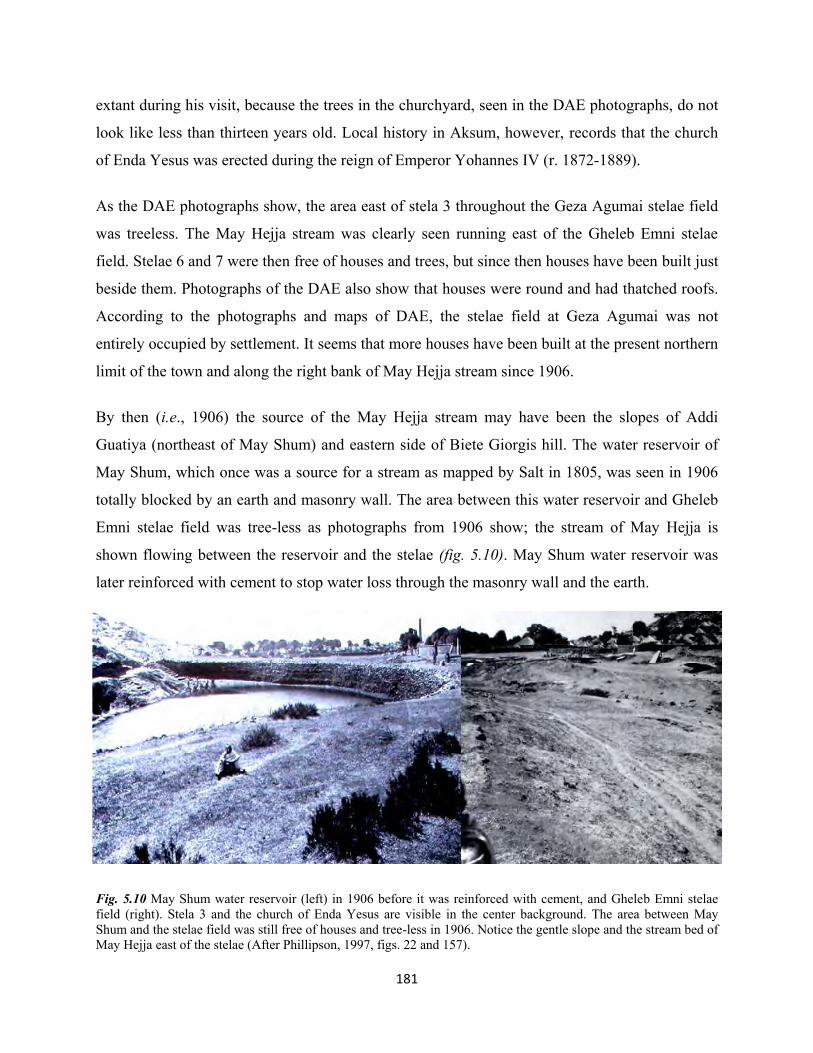
181
extant during his visit, because the trees in the churchyard, seen in the DAE photographs, do not
look like less than thirteen years old. Local history in Aksum, however, records that the church
of Enda Yesus was erected during the reign of Emperor Yohannes IV (r. 1872-1889).
As the DAE photographs show, the area east of stela 3 throughout the Geza Agumai stelae field
was treeless. The May Hejja stream was clearly seen running east of the Gheleb Emni stelae
field. Stelae 6 and 7 were then free of houses and trees, but since then houses have been built just
beside them. Photographs of the DAE also show that houses were round and had thatched roofs.
According to the photographs and maps of DAE, the stelae field at Geza Agumai was not
entirely occupied by settlement. It seems that more houses have been built at the present northern
limit of the town and along the right bank of May Hejja stream since 1906.
By then (i.e., 1906) the source of the May Hejja stream may have been the slopes of Addi
Guatiya (northeast of May Shum) and eastern side of Biete Giorgis hill. The water reservoir of
May Shum, which once was a source for a stream as mapped by Salt in 1805, was seen in 1906
totally blocked by an earth and masonry wall. The area between this water reservoir and Gheleb
Emni stelae field was tree-less as photographs from 1906 show; the stream of May Hejja is
shown flowing between the reservoir and the stelae (fig. 5.10). May Shum water reservoir was
later reinforced with cement to stop water loss through the masonry wall and the earth.
Fig. 5.10 May Shum water reservoir (left) in 1906 before it was reinforced with cement, and Gheleb Emni stelae field (right). Stela 3 and the church of Enda Yesus are visible in the center background. The area between May Shum and the stelae field was still free of houses and tree-less in 1906. Notice the gentle slope and the stream bed of May Hejja east of the stelae (After Phillipson, 1997, figs. 22 and 157).

182
Photographs from 1906 show that few years before the arrival of the DAE, erosion around stela 5
may have been intense. The erosion was later aggravated between 1906 and 1960s until an
attempt to control erosion was made towards the end of the latter year (Phillipson, 1997). The
apex of stela 5 was still above the ground in 1906. Similarly, the photographs show that the area
from Geza Shum Wossen all the way up the May Melahso along the May Hejja stream was free
of houses, and tree-less.
5.2.3 The heritage and archaeological landscape during the Italian occupation: the
archaeological area of Aksum in general and the archaeological landscape under discussion in
particular suffered another change in 1937 due to the presence of Italians. New roads have been
built over archaeological sites, monuments were displaced from their original positions and
many archaeological features were destroyed, including the ruined palace of Ta’aka Maryam
when the Italians built the Aksum-Shire road by cutting through the ruined structure (Monneret
de Villard, 1938: 4, 6; Fattovich et al., 2000: 46). The major known change in the MSF was the
removal of stela 2 to Rome in 1937 (Fattovich et al., 2000: 47). Not only was the stela itself
removed, but in the process of arranging the stela for removal and transport many houses and
other features surrounding it may have been cleared away without documentation.
The 1937 topographic map of Monneret de Villard and a photograph believed to be from the
mid-1930s show that the landscape of the MSF has been re-aligned since 1906: houses in the
MSF, as shown on topographic map and photographs of the 1906, had still separate compound
surrounded by high fence wall but some houses were built after 1906 east and north of stela 3. A
pathway passing immediately west of stela 3, and another further west of stela 1 are visible on
Monneret de Villard’s map and a photograph of the 1930s, unchanged from 1906. The
photograph from the 1930s shows a small house at the southwestern corner of the fence wall of a
vast compound (fig. 5.8, enclosure C) with a large house at its eastern corner and a one-storeyed
house attached to the middle of its southern wall7. To the east of stelae 20 and 21, other houses
could be seen which do not exist on the photographs of 1906, and a tree is clearly visible
obscuring stela 21.
7 Based on the location and architecture, this is most possibly the present restored tukul, called Dejjazmach
Gebreselassie house, which, since the establishment of the SP in the 1960s, has become outside the northern fence wall of the MSF.

183
No further detail information can be interpreted about any change on the archaeological
landscape of the rest of the May Hejja archaeological area during the 1930s, and the topographic
map of Monneret de Villard appears to show little difference from that of the 1906 topographic
map of DAE.
Fig. 5.11 Aerial photograph of stela 3 and its surrounding in 1930s. The houses and the tree east of stela 3 were not extant in 1906. The big house to the left of stela 3 is most likely Ras Alula’s house, described by Bent. Nefas Mawcha can be seen at the foreground in front of the gatehouse (source: available at:
http://www.ebay.it/itm/Axum-gli-Obelischi-Axum-Obelisks-Guerra-dEtiopia-1935-36
Ethiopian-war-/201368957890?pt=LH_DefaultDomain_101&hash=item2ee28673c2 (accessed on 16/06/2014).
We are almost ignorant of the condition of the May Hejja archaeological area due to lack of data
between 1937 and 1954; the later date was the beginning of EIA excavations under the supervi-
sion of French archaeologists. Before excavations began by the EIA, the first available photo is
that of Jean Doresse taken from the air with the help of the Archaeology Section and Imperial
Ethiopian Air Force (Doresse, 1956: 44-45). The aerial photo clearly shows that the houses west
and southwest of stela 3 have been cleared away except one big house left at the northwest cor-
ner of the stelae field, and another small house north of stela 1 (fig. 5.12). The pathways and
fence walls mentioned earlier in this section were still extant. A documentary film8 of the site
aired in 19 September 1959 also revealed that even during the process of excavation in the Nefas
Mawcha and stela 1 area, the area between stela 1 and stela 3 was used for cultivation9.
Doresse’s photograph shows that the area southeast of stela 3 was still open and clear, but one
development is visible in this photo: that many trees grew larger during the course of nearly fifty 8 I am grateful to Bertrand Poissonnier for this video, which is almost unknown. 9 Reportage sur les fouilles archéologiques du site d'Aksoum, antique royaume chrétien d'Ethiopie et sur le palais de
Gondar, capitale des empereurs d'Ethiopie au 17ème siècle. Producteur ou co-producteur: RADIODIFFUSION TELEVISION FRANCAISE, directed in 19 September 1959; available at: http://www.ina.fr/video/CPF86642672

184
years between 1906 and 1954. The warka tree is visible on Doresse’s photo partly covering stela
21. This tree is the same species to, and grew on the same place where the big warka tree seen in
the lithograph of Salt (fig. 3.12 (a) and (c)) had grown partly covering the same stela. The tree on
Doresse’s photograph appears to have grown between stelae 21 and 24. The photographs and
sketches of Bent and DAE in 1893 and 1906, respectively, show no tree between these stelae.
Other trees also grew larger northeast and west of stela 1, shown on Doresse’s photograph. No
concrete evidence exists when and by whom the houses, shown in the 1906 photograph of DAE,
have been cleared away. Elders in Aksum say the houses were demolished by the order of
Dejjazmach Gebreselassie Baryagaber soon after the DAE team left Aksum, while others say
they were demolished by the order of Ras Mengesha Seyoum during the early 1950s shortly
before the EIA excavations began. It is clear, however, from the photographs that the houses
were demolished during the period after the mid 1930s and before 1954 (cf. fig. 5.11 and 5.13).
Although it is very unfortunate that no concrete information is available on how and when stela
34 fell which was seen erect in 1906 on a photograph by DAE, Doresse’s photograph also shows
that it most likely still stood in the early 1950s. During the 1972-74 archaeological excavations,
the BIEA had found this stela already fallen (Plant, 1985: 217) as it is still today. The stela most
likely fell during the period between late 1950s and before 1972 with the decorated side
uppermost.
Some twenty years later, a photograph taken in 1974 (fig. 5.12 (e)) shows that the tree (fig. 5.13:
A) seen during the 1950s has been removed but many other trees grew to the west, southwest,
and southeast of stela 1; north of stela 3; and east of the Tomb of Brick Arches (fig. 5.13).
The churchyard wall of Enda Yesus was re-aligned after 1906, most likely during the 1960s
when the SP was set up by Ras Mengesha Seyoum. According to the description of DAE, some
stelae (for example, stelae 4, 27 and 28) were located within the churchyard. Stela 4 was partly in
the churchyard and partly outside and overlaid by the wall (Phillipson, 1997: 22, 51). After the
wall has been re-aligned, these above mentioned stelae are now located within the SP. Today
stela 4 is entirely outside but very close to the fence wall of the church and falls in the category
of Enda Yesus Stelae Field. Stelae 27 and 28 are today found within the SP.

185
(a) (b) (c) (d) (e)
Fig. 5.12 Comparison of the condition of stela 3 between 1805 and 1974; (a) Lithograph of stela 3 in 1805. Stela 21 is visible partly covered by the big warka tree; (b) Stela 3 in 1906, photographed by DAE. Stela 21 is standing to the right of stela 3; the tree is no longer extant; (c) aerial photograph taken by Italians during the 1930s. Notice the houses north and east of stela 3, and a tree again grew obscuring stela 21; (d) stela 21, visible to the right of stela 3 partly covered by the warka tree in the early 1950s photographed by Doresse; (e) in this photograph, taken by Munro-Hay in March 1974, the warka tree seen on pictures (c) and (d) has already been removed. Stela 21 is clearly visible.
5.2.4 The archaeological landscape and monuments during the 1950s
As discussed in the preceding section, the first major archaeological excavation in the MSF was
conducted by the EIA under the direction of French experts in 1954-1957 (op. cit. Leclant, 1959;
Anfray, 1990; Kebede and Leclant, 1955; Caquot and Leclant, 1956; Contenson, 1959). The first
was conducted by Jean Doresse in 1954 east of stela 3. He cleared the top part of the entrance of
the Tomb of Brick Arches and exposed five steps west of the tomb’s entrance (Leclant, 1959).
Another season of excavation exposed the long M1 terrace wall aligned east-west and extending
about 114 m. south of the line of stela 1 (Caquot and Leclant, 1956; Leclant, 1959).
As excavation continued, another wall – M’1 was discovered north of M1. During the 1957
excavation around the Nefas Mawcha and east and west of the fallen stela 1, other short walls
and a cemetery of human skeletons was discovered (Leclant, 1959). Such excavations greatly
altered the landscape around stela 1 and Nefas Mawcha; all overburden soil in the Nefas
Mawcha area was removed, and the terrace walls M1, M’1 and M2 were exposed, completely
changing the appearance of the landscape. After terrace wall M1 was fully exposed by the EIA,
two levels of platforms were created there, one above the terrace wall with the main stelae group
and another below the terrace wall with the Nefas Mawcha area, thereby transforming the gentle
slope into a terraced landform (fig. 5.14).
As a result of these excavations, the earlier landscape was totally altered, with soil removed, new

186
Fig. 5.13 A
erial view of the Stelae Park and its surrounding in the early1950s. N
otice the warka tree (A) and the w
all (B), to the right and left side of stela 3, respectively.
Another w
all to the left of stela 1 and large trees (D and G
) were still visible in the 1950s. N
orthwest of the N
efas Maw
cha (C) a hut and tree are visible. Further w
est corner of the stelae park (E) a large building stands. (F) indicates a pathw
ay that was later closed w
hen erosion exposed the top part of the Tomb of False D
oor that subsequently w
as excavated by Chittick in 1973-74 (after D
oresse, 1956: 44-45). 186
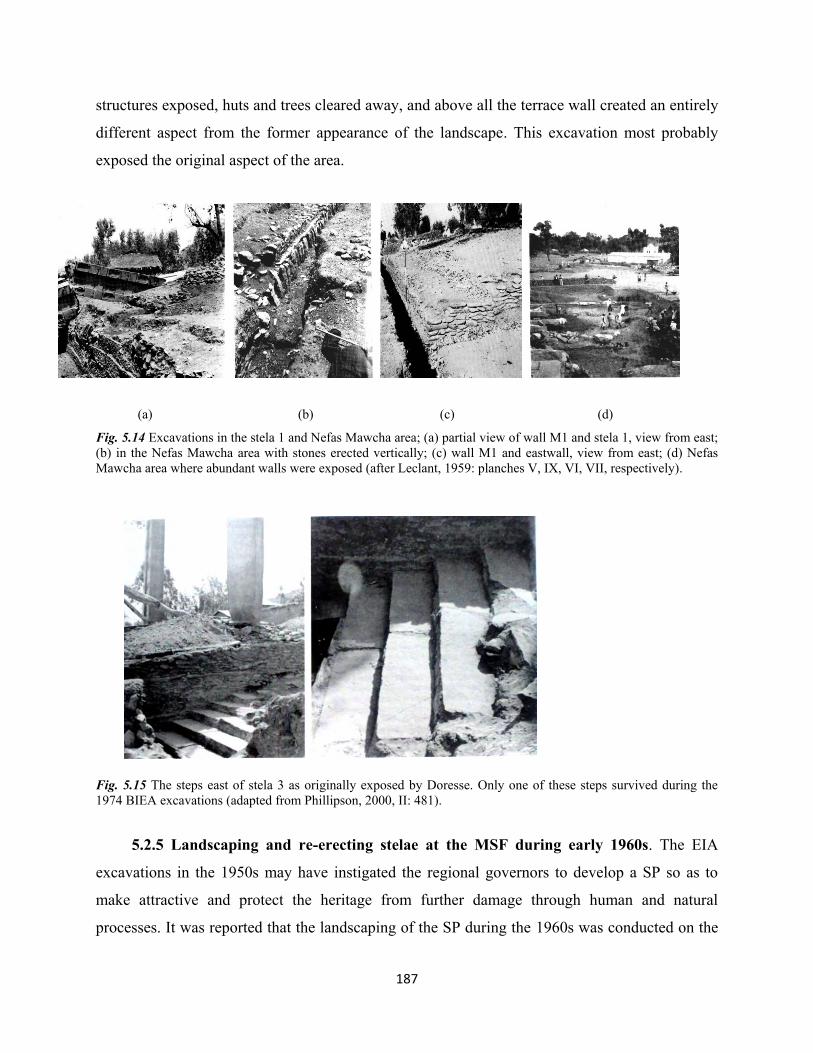
187
structures exposed, huts and trees cleared away, and above all the terrace wall created an entirely
different aspect from the former appearance of the landscape. This excavation most probably
exposed the original aspect of the area.
(a) (b) (c) (d)
Fig. 5.14 Excavations in the stela 1 and Nefas Mawcha area; (a) partial view of wall M1 and stela 1, view from east; (b) in the Nefas Mawcha area with stones erected vertically; (c) wall M1 and eastwall, view from east; (d) Nefas Mawcha area where abundant walls were exposed (after Leclant, 1959: planches V, IX, VI, VII, respectively).
Fig. 5.15 The steps east of stela 3 as originally exposed by Doresse. Only one of these steps survived during the 1974 BIEA excavations (adapted from Phillipson, 2000, II: 481).
5.2.5 Landscaping and re-erecting stelae at the MSF during early 1960s. The EIA
excavations in the 1950s may have instigated the regional governors to develop a SP so as to
make attractive and protect the heritage from further damage through human and natural
processes. It was reported that the landscaping of the SP during the 1960s was conducted on the

188
orders of the then Governor-General of Tigray, Ras Mengesha Seyoum. Some stelae have also
been re-erected at this time. On the other hand, the top part of the Tomb of False Door was
exposed by a bulldozer while grading a road (fig. 5.13: F). This originally lay just on the road
outside the western wall of the SP (Chittick, 1974: 162, 175, 180; Munro-Hay, 1989: 104;
Phillipson, 2000, I: 140, 150; 1997: 10, 186 n.207). This may be why the Tomb of False Door
was not reported by the DAE in 1906 and the EIA in the 1950s.
Another change that took place in the 1960s was the re-erection of a stone originally believed to
have been one of the shaft covers of the Mausoleum, and that the original square hole had been
extended either side along the length. It was re-erected upright on top of the Mausoleum and
remains to this day. The base of stela 3 has been reinforced with concrete, and short but fence-
like concrete work placed round it. A series of concrete steps was placed in front of the same
stela, from the lower surface right up to its base. All these appear in the 1970s BIEA plan, but
not in the 1950s EIA photographs or Doress’s aerial photo (see fig. 4.13). 5.2.6 The landscape and stelae during the 1970s BIEA excavations
In 1972 the BIEA began excavations in the MSF and continued for two more seasons in 1973
and 1974. This project unearthed a large area of the SP and exposed many stelae that have been
buried in the ground. It also fully opened the Tomb of False Door, discovered the Mausoleum,
East Tomb and the Tomb of Brick Arches (op. cit. Chittick, 1974; Munro-Hay, 1989: 47-120).
They also exposed a retaining wall north of the Tomb of Brick Arches. The landscape east of
stela 3 was then totally changed from flat surface to a complex arrangement of walls, tomb
entrance, and the surviving steps of its adit.
Fig. 5.16 A reconstruction of the SP with the stelae, underground tombs, terrace walls, and steps at lower right corner, shown in fig. 5.15. Note: the decreasing order of size of the stelae is from left to right (adapted from Phillipson, 2000, II: 478).

189
The 1972-74 BIEA excavations greatly enlarged our knowledge of the ground below the present
surface level of the SP, while exposure of the underground tombs greatly changed the
appearance of its pre-1972 archaeological landscape.
A new plan of the SP (fig. 4.13) was provided by the BIEA project; the western edge of the plan
clearly shows that the western wall of the SP was located east of the present Tomb of the False
Door. It appears, according to the plan, that after the 1950s EIA excavations, Ras Mengesha
Seyoum could have exerted much effort in re-aligning the fence wall of the SP such as the
northern wall in front of Dejjazmach Gebreselassie Baryagaber’s house, the southwest enclosure
of Enda Yesus church (northeast corner on the plan), establishing a new fence wall for the Nefas
Mawcha area, western side of the SP, and demolishing the remaining houses in the SP.
Nonetheless, photographs of by the BIEA indicate that many trees still remained within the SP
area in the early 1970s.
Fig. 5.17 The SP during 1970s. Trees can be seen east, west and north of stela 3. The wall on the east side that turns north was built in the post-EIA excavations, perhaps during the establishment of the SP (adapted from Munro-Hay, 1989: 15).
According to the BIEA plan and photo (figs. 4.13 and 5.17), a new fence wall must also have
been built at the eastern edge of the SP after the EIA excavations. The wall was not found in the
EIA excavation, nor did it exist earlier; it is, therefore, reasonable to say that this fence wall must
have been built between 1957 when the EIA last excavated in the SP and 1972 when the BIEA
excavations began. The 1970s BIEA plan of the SP clearly shows that the appearance of the
landscape had totally changed since the 1950s. Although many trenches were opened by the
BIEA in the MSF during the 1970s, most were backfilled except the Mausoleum, Tomb of False

190
Door, and Tomb of Brick Arches. Their plan was the first detailed work on the layout of the SP
and its features. It has greatly aided in comparing all the changes that took place in the SP before,
during and after the 1970s.
5.2.7 The landscape and stelae during the 1990s
The BIEA excavations of 1993-97 under the direction of David W. Phillipson made some minor
changes to the SP landscape. No attempt is made in this section to repeat and emulate details of
the excavation which has already been discussed in the preceding chapter. The project excavated
the Tomb of Brick Arches after some restoration and conservation work10. A shelter, roofed with
metal sheet and barred adit entrance, was then constructed to protect the tomb from rain.
Fig. 5.18 BIEA excavations during the 1990s on the stela 2 site (center foreground) (after Phillipson, 2000, I: 27, fig. 19).
10 Chamber C was left for future investigation, while E and F where unsafe to excavate and were abandoned (fig.
4.14).

191
Fig. 5.19 Plan of the SP show
ing the distribution of the stelae and limit of the park (D
rawing: H
iluf Berhe, June 2015, after Phillipson, 2000, I: 28, fig. 20).
191

192
The project also excavated the original place of stela 2 in 1993, 1994 and 1997, and left it
exposed where the stela (then in Rome) would later be re-erected upon its return (Phillipson,
2000, I: 139-156). The landscape of the SP, therefore, included such a large excavated area
between 1993 and 2008 – the latter date when stela 2 was finally re-erected. The site was
covered with a corrugated sheet metal shelter after the 1998 excavation until it was removed in
2007 (fig. 5.19).
The Mausoleum was another landmark re-excavated by the BIEA in 1993-95 (Ibid, 165-193). By
this excavation, a large area of the Mausoleum was cleared and a vertical entrance accessed by
wooden ladder opened slightly west of the lower part of stela 1. This entrance was covered by a
metal roof to protect the tomb from rain and erosion. The western entrance to the Mausoleum
and its three shaft holes also were opened and then separately covered with a small metal and
glass roof.
The post-1970s plan of the SP prepared by David Phillipson (fig. 5.19) shows that the western
fence wall of the SP aligned east of the Tomb of False Door visible in the 1970s plan (fig. 4.13)
had been expanded further west to incorporate the Tomb of False Door. Although omitted in the
plan, photographs in the 1990s show many trees existed between rows of stelae and the northern
fence wall of the SP. No major changes were made to the form of fence wall and boundary of the
SP after the 1997 BIEA excavations ended, except a small space west of Nefas Mawcha. 5.2.8 The landscape of the May Hejja archaeological area post-1997 BIEA excavations
to present
One of the changes made in the SP was the installation of a huge shelter for the Tomb of False
Door in 2000. This shelter, a metal roof and posts, is open on all sides to let in air and natural
light and fully covers the Tomb of False Door and its courtyard. Excavations by ARCCH in 1998
and 1999 on the site of stela 2 (Poissonnier, 2012) made very few changes to the overall external
appearance following the BIEA excavations. The site of stela 2 was then covered with a shelter
until it was removed in 2007 to prepare the ground for re-erection of the same stela.

193
The researcher11 made some changes in the SP in late 2004 and early 2005, i.e., sweeping away
many of the living and dried trees north of the rows of stelae. These were very old trees, shrubs,
and climbing trees totally disfiguring the view of the stelae and obstructing visitor movement.
Such trees had neither historical nor archaeological significance to the site. Obviously they must
have been planted recently but the Culture and Tourism Office (Aksum) officials always resisted
any attempt to cut down such trees, and still challenged and opposed their clearance in
2004/2005. Only trees along the north-eastern side of the SP are preserved, since all are olive
trees thought to belong to the church of Enda Yesus. Although the fence wall has been re-
aligned, the trees and some stelae are located within the compound of the SP. Such trees are left
protected to this day not because they are sacred trees themselves, but because they belong to a
sacred place – the church.
From 2003 onwards, some changes took place on the archaeological landscape of May Hejja
archaeological area generally. This was the year when the ECHP began its conservation and
renovation work on archaeological sites in Aksum. Formerly the Enda Yesus and Gheleb Emni
stelae sites had been separately fenced with barbed wire and iron posts. A pathway used to walk
along the southeastern side of the fence wall of SP, followed the right bank of the May Hejja
stream, then turns north between Enda Yesus and Gheleb Emni stelae sites past stela 35 and
immediately west of stela 7. Formerly this track also passed between the two fragments of stela
34 (fig. 5.20).
The project re-aligned the fence of the Enda Yesus and Gheleb Emni stelae sites and regrouped
them within a single fenced enclosure, replacing the earlier barbed wire fence with a fence wall.
The pathway formerly passing between the two stelae sites was blocked and re-directed to the
left bank of the May Hejja stream, then turning north behind the Gheleb Emni stelae site where a
small bridge was constructed. A new walkway was then paved with cobblestone for tourists,
beginning at the SP, crossing its eastern fence wall via a small gate. It then crosses the pathway
to the Enda Yesus church entrance before entering the stelae site of Enda Yesus and continues
south of stela 4 and stela 34 to the stelae site of Gheleb Emni and ending at its northeastern fence
wall (fig. 5.21).
11 From July 2004 to September 2005 the researcher worked as expert in Heritage protection and conservation in
Aksum Culture and Tourism Office, Aksum.

194
Fig. 5.20 May Hejja
Archaeological area; (1)
Enda Yesus stelae field;
(2) Gheleb Emni stelae
field. Notice the pathway
passing between the two stelae
fields (Drawing: Hiluf Berhe,
24/06/2015).
Fig. 5.21 May Hejja archaeological area; the two stelae fields indicated in fig. 5.20 are merged together after the public pathway was re-directed to the left bank of May Hejja. The left bank of May Hejja was then planted trees and protected (Drawing: Hiluf Berhe, 25/06/2015).
200m
200m

195
The municipality fenced the area left of the road leading to the tombs of Kaleb and Gebre
Mesqel with barbed wire, although a pathway passes through this protected area along the left
bank of the May Hejja stream (fig. 5.21). Both banks of the stream and the area beginning at the
bridge, on the left side of the road near the southeast fence wall of the SP until the May Shum
reservoir, was planted shrubs, trees, and grass. It is a protected area since 2003, and the trees
have now grown larger to totally block the view of the Enda Yesus and Gheleb Emni stelae sites.
The ECHP had built a diversion canal to avoid the river from flowing directly on the two
fragments of stela 5 which lie on the stream bed, but the sifted deposit gradually covered the
fragments. As the stream increased in depth and enlarged in width, the fragments were buried by
the deposit and grass over the past 12 years. Ill-advised attempts to re-excavate the fragments by
Culture and Tourism Office personnel have found no significant solution except to clear the
deposit away to temporarily expose it. The diversion canal also proved to be useless; as a
consequence, the river now flows over the two fragments. From time to time, stream erosion
along the banks during intense flooding has finally caused the fragments to go deep into the
stream bed (fig. 5.23).
(b)
Fig. 5.22 Apex of stela 5; (A) photographed in 1893 by Bent, view from north (after Bent, 1893: 189); (B) photographed in 1906 by DAE, view from west ((Littmann et al., 1913, II: 17, fig. 33). Note: the stream bed was very shallow on both images.
A B

196
Fig. 5.23 Two fragments of stela 5; (A) the middle part of the stela (follow arrow) was almost perpendicular to the stream bed in 1906, i.e., it had not fallen yet on the stream bed in 1906 (after Littmann et al., 1913, II: 17); (B) in early 2000s, the middle part of the stela has already come down of the slope and completely rested on the stream bed (after Fattovich, n.d); (C) and (D) photographed in July 2008, the two fragments were covered by deposit as the result of intense flooding (photo: Hiluf Berhe, 2008); (E) and (F), photographed in September 2014, the stream bank is eroded, the stream enlarged due to intense flooding; although diversion canal was constructed, it did not save the fragments from flooding. The trees on either banks of the stream grew large, and the surrounding area is now completely forested. The fragments are now drowning in the stream bed as erosion and flooding are intense. The fragments have now touched each other when the middle part is pushed down the stream bed (photo: Hiluf Berhe, 2014).
A B
C
D
E
F
197
A new archaeological museum was built by the ECHP just north of the northern fence wall of the
SP in 2005. Its southern entrance was created by cutting the SP fence wall, and it also has a
second entrance to its north. The view of the stelae is now completely changed by the shining
building of this museum standing behind them. The project also created a new tourist entrance
for the Mausoleum tomb by cutting through the M1 wall on its south side. The Mausoleum’s
shaft holes also were covered with glass shelter to protect it from rain and allow light to its
interior. Since 2005 the Mausoleum is open to visitors.
The ECHP has built a small ticket office near the tree indicated as G (fig. 5.24). Since April 2005
– when stela 2 returned to Aksum, temporary shelters of corrugated metal sheeting were built in
front of the SP for its fragments (fig. 5.24: C and D), and later a storeroom has been built to
house contractor’s equipment for re-erection of stela 2 (E). The earlier entrance to the SP with
many concrete steps in front of stela 3 was then closed and new temporary entrance created near
the ticket office. In 2007, a temporary fence of corrugated metal sheeting was erected around the
site of stela 2 and stela 3 during preparation for the ground foundation for the re-erection of stela
2.
While the re-erection of stela 2 was in progress, stela 3 was then tied and stretched with strong
iron poles, to avoid any risk of shaking as the result of vibration from the big erection machinery
brought to raise the fragments of stela 2. Very high scaffolding was built round the site of stela 2
for its erection. In July 2008, re-erection was successfully accomplished, and an inauguration
ceremony was colorfully and cheerfully celebrated in Aksum on August 3, 2008 in the presence
of the Late Abune Paulos, then Patriarch of Ethiopian Orthodox Church, the Late Meles Zenawi,
then Prime Minister of Ethiopia, and other high government officials.
Re-erection of stela 2, standing 26m west of stela 3, has again changed the appearance of the SP
landscape in July 2008. Stela 3 has remained tied and stretched to the time of writing the present
thesis. The scaffolding, temporary fence around stela 2 and temporary shelters in front of the SP
were dismantled and cleared away in 2009. A strong overnight wind that felled the non-
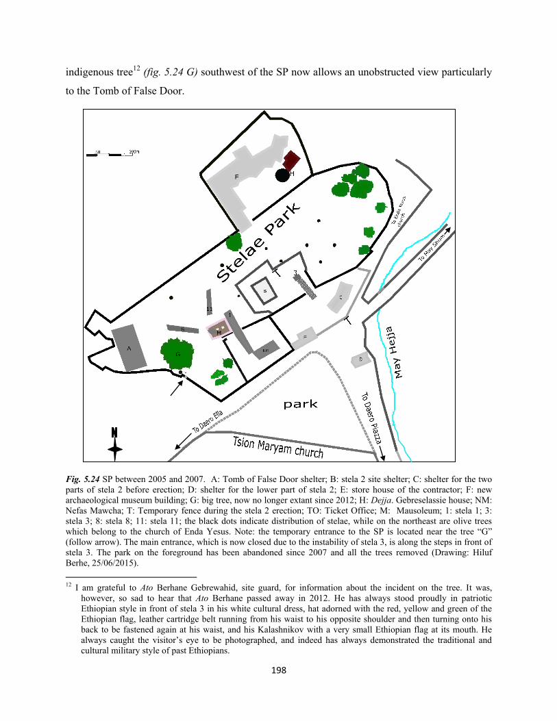
198
indigenous tree12 (fig. 5.24 G) southwest of the SP now allows an unobstructed view particularly
to the Tomb of False Door.
Fig. 5.24 SP between 2005 and 2007. A: Tomb of False Door shelter; B: stela 2 site shelter; C: shelter for the two parts of stela 2 before erection; D: shelter for the lower part of stela 2; E: store house of the contractor; F: new archaeological museum building; G: big tree, now no longer extant since 2012; H: Dejja. Gebreselassie house; NM: Nefas Mawcha; T: Temporary fence during the stela 2 erection; TO: Ticket Office; M: Mausoleum; 1: stela 1; 3: stela 3; 8: stela 8; 11: stela 11; the black dots indicate distribution of stelae, while on the northeast are olive trees which belong to the church of Enda Yesus. Note: the temporary entrance to the SP is located near the tree “G” (follow arrow). The main entrance, which is now closed due to the instability of stela 3, is along the steps in front of stela 3. The park on the foreground has been abandoned since 2007 and all the trees removed (Drawing: Hiluf Berhe, 25/06/2015). 12 I am grateful to Ato Berhane Gebrewahid, site guard, for information about the incident on the tree. It was,
however, so sad to hear that Ato Berhane passed away in 2012. He has always stood proudly in patriotic Ethiopian style in front of stela 3 in his white cultural dress, hat adorned with the red, yellow and green of the Ethiopian flag, leather cartridge belt running from his waist to his opposite shoulder and then turning onto his back to be fastened again at his waist, and his Kalashnikov with a very small Ethiopian flag at its mouth. He always caught the visitor’s eye to be photographed, and indeed has always demonstrated the traditional and cultural military style of past Ethiopians.

199
Fig. 5.25 General view of the SP from east during the re-erection of stela 2 in 2008. Notice the temporary fence that encircled stela 2, stela 3, and the crane (Photo: Hiluf Berhe, July 2008).
Fig. 5.26 Closer view of stelae 2 and 3 from southeast during re-erection of stela 2 in 2008 (Photo: Hiluf Berhe, August 2008).
200
Further north at Geza Agumai stelae site, the ECHP is working to relocate residents to a place
free of archaeological significance. An extensive area of the site already has been cleared after
residents were compensated from the UNESCO budget financed to relocate residents occupying
the main archaeological area of the town, chiefly at Geza Agumai, Geza Shum Wossen, around
Ta’aka Maryam, Enda Michael Efoy, Enda Sem’on and Melake Aksum. This relocation scheme
was not, however, easily managed due to residents’ complaints of unfair and insufficient
compensation. The issue remains ongoing for this reason, except some people who view the
site’s significance for the general public positively and prefer a new location with well-
established modern infrastructures such as water pump, paved road, and electricity services and
ample space available as compensation.
5.2.9 Reconstruction of the ancient landscape based on archaeological and geo-
archaeological results.
The transformations in the now buried ancient archaeological landscape of the SP can be
reconstructed based on archaeological studies. Archaeology could be the best means (and of
course the only discipline) for studying the superposition of different layers of the ancient
platforms in the SP with which we do not have direct physical contact. Such changes layered
below ground surface can only be viewed through the mirror of archaeology.
Archaeological and geo-archaeological studies have brought to light layers of soil accumulation
beneath the present surface of the SP. The first person to notice the existence of such layered soil
deposition of different periods was Monneret de Villard (Monneret de Villard, 1938:7-8). He
recorded two major soil accumulations occurring along the May Hejja archaeological area, the
bottom layer predating the erection of the great carved stelae and the second layer dated to the
post-stelae erection period. Such early and initial observation of the geo-archaeology of the May
Hejja archaeological area was later studied by Butzer in 1973, with additional sample data from
Chittick’s excavation of 1972-1974 (Butzer, 1981:478).
Butzer again recognized two episodes of soil erosion. The first aggradations occurred between
100 and 350 AD, leaving up to two meters of soil accumulation. The level of the lower valley

201
50m
Fig. 5.27 Sites in the old town before and after relocation of residents; (a) and (b)sites of Ta’aka Maryam, Enda Sem’on and DAE ruin A; (c) and (d), center in black line, is Geza Agumai stelae field. Note: in the right foreground on image (b) buildings within square line are shelters constructed by Aksum University, department of Archaeology following the excavation of early 2014 (source: Google image).
between Biete Giorgis and May Koho consequently was raised, and the first church of Maryam
Tsion was built atop this soil deposit during the 4th century AD due to unusually heavy rains and
flooding. The second flooding period occurred between AD 650 and 800, when the hillslopes
were washed even more heavily and exposed rocks. He also observed another soil deposit some
a b
c d 50m

202
2 m. thick at the foot of Biete Giorgis hill. Debris from ruined houses had washed down and
accumulated over the archaeological area below the hillslope (Butzer, 1982:35).
Archaeological excavations also confirm the existence of this soil accumulation due to erosion
from the Biete Giorgis hillside. Chittick encountered a deposit of 2.5m to 4 m. thick in the SP
and 4m to 4.5 m. thick at the HAW site located between the MSF and Biete Giorgis hill (Chit-
tick, 1974:164,191). Excavations at the site of stela 2 revealed that its foundation structure had
been packed to a thickness of 4.5 m. from the modern surface, cutting through loose deposits.
Here also, pit graves having a vertical shaft were discovered to a total depth of about 7 m. below
the present surface level (Phillipson, 2000: I, 139-156; Poissonnier, 2012: 62-68). Recent exca-
vations in the compound of the present Archaeological Museum revealed rock-cut tombs and
rough monolithic stelae up to 4.8 and 3.9 m. deep, respectively, below the present surface level
(Tekle Hagos, 2008: 91-95). Such excavations allow interpretation of how the ancient landscape
of the MSF may have appeared.
The Mausoleum was also found with five phases of deposition spanning from ancient to recent
times (Phillipson, 2000, I: 180-3), indicating continuous soil erosion from Biete Giorgis hill. In
addition to the archaeological record, contemporary observation confirms soil from the slope of
Biete Giorgis accumulates whenever it rains in Aksum, although the degree of erosion varies due
to the settlement just below the hillslope, a reforestation program here since the late 1970s, the
numerous rocks on the slope exposed after the loam eroded down, and the construction of
modern drainage systems to prevent water from running directly into the MSF.
It appears, based on both archaeological and geo-archaeological results, that different phases of
stelae erection can be recognized, and thus different landscape forms and layers exist in the
MSF. Chittick found buried stelae below the present surface level, some found completely buried
but still erect (Chittick, 1974: 166, fig. 5). In the compound of the present Archaeological
Museum, excavation also has revealed buried rough stelae, some fallen and others still erect
(Tekle Hagos, 2008: 91-95). Retaining walls have been recorded in the MSF itself that may have
been built to level the irregular platform of a natural bedrock layer below the present surface
level. Some stelae were erected atop the bedrock and later became buried by sediment. Further
retaining walls subsequently were constructed and other stelae erected again, thereby forming
another surface level. These lateral stelae also were buried. The final activity in the MSF

203
sequence was the erection of the giant carved stelae and construction of the terrace wall M1 to
their south (Chittick, 1974: 166; Butzer, 1981: 481-2, fig. 4).
The giant carved stelae may have been erected by digging into the deposit washed down from
Biete Giorgis hill. Such holes must have then been filled with stone rubble to stabilize the
platform where these stelae would be erected. According to Butzer’s synthesis of this landform:
“The original surface was deeply rotted bedrock, mantled with an unknown thickness
of soil…. The B horizon, probably a non-calcareous brown clay loam, was stripped
off to form part of a complex of artificial terraces during Early Axumite times (A.D.
100-350). Variable concentrations of local rock rubble, much of it partly
decomposed, were first mixed into the artificial fills…and a number of short, rough-
hewn stelae then set on top of these low, 1.5-m terraces. Eventually, a level, built-up
surface, as much as 2m thick, had been created in the western part of Stela Park.
Tall, plain but dressed stelae, associated with base plates hollowed out for offerings,
were set on this surface. Later still, large masses of rocky fill, derived from fresh,
angular quarry rock, were piled up behind walls over 3m high. The largest decorated
stelae were prominently mounted on top of these. Then, thick masses of brown
vertisolic clay were trapped in front or behind these foundation structures, where
they are mixed with dispersed rock rubble” (Butzer, 1981: 481-2).
Pit graves and shaft tombs found in the MSF were cut through the bedrock to a depth of 8 m.
below the present surface level (Chittick, 1974: 169). On the other hand, the later complex
constructed tombs such as Mausoleum and Tomb of False Door were built by cutting through
these earlier deposits and their bottom level stopped at the bedrock. The former is 5.9 m. below
the present surface level (Phillipson, 2000, I: 170). The Tomb of Brick Arches partly comprises a
constructed wall at the entrances with the chamber rooms cut into the rock to a total depth of
between 9.5 and 10 m. below present surface level (Ibid, 31).
The possibility of an ancient platform with the earliest stelae existing below the present SP plat-
form also is supported by the typological evolution for the stelae and by C-14 dating. Excava-
tions by Chittick in 1972-4 and Tekle Hagos in 2005 within the SP and museum compound, re-
spectively, have recovered new information on the existence of deeply buried rough stelae, un-
derground shaft tombs and pit graves (Chittick, 1974: 169-172; Tekle Hagos, 2008: 91-95). At
204
Geza Agumai, too, Chittick’s excavations revealed that stelae were buried deep in the ground up
to 2 m. below present surface level. Of the total 4.2 m. height of stela 71, for example, 2.2 m.
was found buried below the ground. A pit beside stela 73 was dug to the depth of 7.7 m., from
which bone was collected at 5.4 m. depth and walls discovered at the depth of 7.7 m. A 1st centu-
ry AD glass fragment was collected here (Munro-Hay, 1989: 47, 50).
The stelae generally rough and/or undressed and small in size are identified as the earliest type,
and collectively dated to the Proto-Aksumite period (4th - late 1st century BC) (Fattovich and
Bard, 2001: 4; Bard et al., 2000: 77; Fattovich, 1987: 47; Chittick, 1974: 166). Ancient traditions
of pit graves and shaft tombs also have been documented in Yeha (Anfray, 1963), on top of Biete
Giorgis (Fattovich and Bard, 2001: 15), and in the church of the Four Celestial Animals at Ak-
sum (Fattovich et al., 2000: 52-3). The rough stelae, and the pit and shaft tombs, found in the
MSF also could be categorized as the earliest type (Munro-Hay, 1989: 47) of the largest and
carved stelae, and the built complex underground tombs of the Mausoleum, False Door and
Brick Arches.
Chittick had collected five samples for C14 laboratory analysis, four from lower deposits from
SP trenches and the fifth from a tomb beneath them. The result for trench XXIIA was 30-50 AD
+ 50. Another sample from an accumulated deposit produced a much later date, 390 AD + 40.
The earliest date corresponds to the earliest platform during which the earliest stelae in this field
could have been erected and the shaft tombs cut. The latter date generally corresponds to the
erection of the giant carved stelae (Chittick, 1976: 180).
It appears, therefore, that according to the archaeological and geo-archaeological results the
landscape of the SP has changed greatly throughout the ancient periods, the earliest platform
being buried up to 4 m. below the present surface level. In the past, the MSF extended right up to
the foot of Biete Giorgis hill and stretched further north to the Geza Agumai stelae field. No
evidence for ancient settlement was recorded in the stelae field, except the remains of walls
undoubtedly from the 19th century AD (Chittick, 1974: 164; Tekle Hagos, 2008: 87-105). This
indicates that the ancient settlement area of the town was located west and further northeast (D
site at Kidane Mehret) of the stelae field. As has been discussed in the preceding section, few
huts already were extant just above the stelae field on the eastern hillside of Biete Giorgis, as

205
indicated on Salt’s 1805 map of Aksum (map 3.3; fig. 3.12 (a)), but during the late 19th century
settlement expansion invaded the entire site of the stelae field, as recorded by Bent in 1893 and
Fig. 5.28 Sketch of ancient
Aksum before the erection of the
church and expansion of
settlement into the stelae area.
Here it is assumed that May Hejja
stream was created after the
medieval period (Drawing: Hiluf
Berhe, 24/06/2015).
Fig. 5.29 Section drawing of the SP. (A) The SP with three levels of stelae erection in the valley between Biete Giorgis and May Koho hills. All the loam was washed down the hillslope. This loam was then deposited on the lower ground, where the stelae are. When hillslope 1 was washed down and rocks exposed (hillsope 2) as a consequence of soil erosion, the loam buried the earliest stelae group in the field. On the right side of the stelae field, retaining walls have been built to level the field for the second phase stelae erection. Hillsope 2 was again washed down that resulted in further exposing the rocks in hillslope 3; this soil was carried down the stelae field and buried the second phase stelae (level 2). Then an Aksumite wall was built as a retaining wall; on this level, the last stelae – the giant carved, were erected on top of the first two phases of stelae erection. (B) Section of the SP. Note: some stelae were found erect and others fallen below the present surface level by the 1970s BIEA excavations. May Hejja stream bed is becoming deeper and wider east of the stelae group. After this stream to the right is the hillslope of May Koho hill (Drawing: Hiluf Berhe, June 2015, not to scale).
A
B

206
Fig. 5.30 Chittick’s compressed section of the SP (Drawing: Hiluf Berhe, June 2015, after Chittick, 1974: 167, fig. 5)
the DAE in 1906, both supported with photographs.
5.3 The site of Tombs of Kaleb and Gebre Mesqel: changes in the landscape based on
ancient documents, archaeological excavations, and field observation
5.3.1 Ancient literary documents: The so-called Tombs of Kaleb and Gebre Mesqel are
located at the southeastern end of a ridge that divides the Tekeze and Mereb drainage systems
(Butzer, 1981: 478), some 1.9 km from the church of Maryam Tsion of Aksum. The hills of Aba
Liqanos and Addi Guatiya are located, respectively, east and west of the tombs (map 4.3). The
mountains northwards in the present Eritrean territory and northeast to Adwa are clearly visible
from these tombs. The site, situated on high ground outside the ancient town centre of Aksum,
may have been chosen for such strategic reasons. As briefly discussed in Chapter 3, these tombs
have been described in many ancient sources.

207
However, the descriptions have focused just on their interiors and failed to describe the external
appearance of the landscape. The first information about the tombs comes from the Liber
Aksumae, which informs us that these tombs already were known, and a legend recounting their
content and richness already existed. However, according to this document (Conti Rossini, 1910:
5-6) the tombs apparently were not frequently entered by people, but it also tells us nothing
about the exterior landscape or details of their internal forms and contents. Nonetheless, we can
deduce that they were partly opened and accessible. The lack of information on their exterior
may confirm that the area was covered by earth and no structure was visible at that time. Thus
the contribution of this document to an understanding of details of their surrounding landscape is
very limited.
The second available document about the tombs is that of Alvares (Alvares, ed. Beckingham and
Huntingford, 1961). He visited and entered the tombs, and elaborately described both the internal
form and content of the tombs (see Chapter 3).
Alvares described the tombs’ exterior as “above (them is) a field” (Ibid, 159). It makes sense that
the tombs could have been covered by soil downwash as a consequence of an eastward run-off
from the hill of Aba Liqanos just above them. Since Alvares mentioned no structure above the
tombs but just a field, we can confidently conclude that all the terrace walls, ruined structures,
steps and courtyard visible today were by then covered by earth.
Paez sketched the tomb of Kaleb in the early 17th century, as depicting three rooms (Monneret de
Villard, 1938: 68) exactly as they are today, but no information about the outer landscape was
provided. There is no available information how Paez became able to see the full size and layout
of the three rooms that helped him draw the plan, since previous documents say the tombs were
at least partially filled with earth.
In 1805, Salt also plainly confirmed the underground tomb had three tombs, i.e., the stone coffin
boxes in the so-called tomb of Gebre Mesqel, was filled with earth and that had difficulty
creeping into the tomb due to the earth. At the very heart of the tomb, Salt clearly saw the portal
door of the central room and the three stone coffin boxes within it (Valentia, 1809: III, 82). Salt
was also silent about the exterior landscape of the tombs, corroborating Alvares’ description.

208
Lefebvre visited the underground tombs and left a short description. He had entered both tombs
and reportedly saw three chambers in each underground tomb. He described the top of one tomb
(based on his description of the interior, most likely of Kaleb) as a large platform of 25 x 15 m.
where there were ruins around13 (Lefebvre, 1845-51:433) and it appears from his description that
granite stones visibly cluttered this platform. He might have been more curious about the
scattered stones on the platform than his predecessors who mentioned nothing; or such stones
could have been exposed by natural or human agents after the last visitor before him.
Bent was the last 19th century visitor to Aksum, visiting the tombs in 1893 and leaving his
impressions. He entered the so-called Tomb of Kaleb, describing its approach as a “sloping”
passageway and saw three chamber rooms of equal size (Bent, 1896:194). The word “sloping”
again confirms that its access was most likely covered by earth obscuring the steps built of huge
granite stones.
Both Salt and Bent were silent on the condition of the exterior of the tombs. Salt even called the
tombs “caves” since, due to the earth fill, they appeared to him as if dug into the ground. This
helps to judge that the area outside the tombs was just a field with no other visible remarkable
structure. As is true today on fields just outside the fence wall, the ancient field atop the tombs
may possibly have been used for cultivation.
5.3.2 Archaeological excavations
Archaeological excavations have been conducted at the site of the Tombs of Kaleb and Gebre
Mesqel at different periods. Such excavations are very important for the reconstruction and
documentation of their original construction, associated structures and related landscape. They
were recorded by professionals, their work being supported by photography, detail sketches and
drawings. They are chronologically presented below.
13 According to the DAE (discussed in the next section of this chapter) a few large granite blocks jutted from the
ground around the entrance to the tomb of Kaleb. These may have been the stones seen by Lefebvre. The rest of the platform was found by the DAE totally covered by earth.
209
5.3.2.1 The DAE
This is the first archaeological mission to clear the bulky overburden of the tombs and produced
a large quantity of photographs, sketches, and plan and section drawings. For simplicity of
discussion and easier comprehension, each feature is discussed separately.
5.3.2.1.1 The superstructure of the tombs: The DAE photographs and plans show that
the entire superstructure was covered by earth, with the tomb entrances being open. Only the
granite blocks around the tomb entrances protruding from the ground would have been visible in
1906, as also had been observed by Lefebvre in the early 1840s. The team cleared the entire
overburden and, as discussed in Chapter 4, two superstructures designated “K” for Kaleb and
“G” for Gebre Mesqel were discovered (Phillipson, 1997: 73-88). The area appears to have been
covered by earth over 1.5 m. thick, since a column base well over 1.5 m. high and still erect at
that time also was completely buried by the deposit (fig. 5.33).
The DAE exposed foundation walls on the east and west sides of both superstructures above the
underground tombs, and on the south and north sides for “G” and “K”, respectively. The wall
was built of re-entrants and rebated with large smoothly-worked granite blocks at the corners and
then adjoined by a wall of small stones. The northern foundation wall for “K” was found ruined,
with cornerstones lying on the ground14, while that of “G” was in good condition. The
cornerstones of four steps at the southwestern corner of the foundation wall for “K” were found
in situ, but the small-stoned wall was in ruins15. The floor of both the “G” and “K”
superstructures was stone-paved16, and both had colonnades facing each other. These colonnades
rose two17 steps from the courtyard floor. A stepped column-base18 was found at the edge of the
colonnade of “K” while a pillar19, broken and the upper part lying on the ground, was recovered
at the edge of the colonnade of “G” (figs. 5.33 and 5.34).
14 This wall has now been rebuilt following its original position and architectural style. 15 This is also since rebuilt with the cornerstones in their original place. 16 Only some of those at “G” survive today, but the floor of “K” is totally disfigured as a result of the stone rubble
and soil covering it. Whether the pavement slabs were removed or are still below the rubble and soil has not been ascertained.
17 Both steps at “G” but only one at “K” still survive. 18 This is no longer present. It is probably the one in the Ezana Park fixed on top of a column (discussed below). 19 This pillar is undoubtedly that re-erected by the Italians in the Ezana Park during the 1930s (fig. 5.37).

210
Fig. 5.31 Excavation at the tombs of Kaleb and Gebre Mesqel; the steps lead to the central courtyard from west. Note: the cornerstone (follow arrow) was partly exposed before the excavation; this was probably one of the stones described by Lefebvre then protruded (after Phillipson, 1997: 73, fig. 94).
Fig 5.32 The column (center) and a stepped column-base (right foreground) (after Phillipson, 1997: 83, fig. 109)
Fig. 5.33 Plan of the tombs of Kaleb and Gebre Mesqel. The original steps (in circle on left and right foreground) leading to the underground tombs are no longer extant. Note: the broken column and a column-base are visible east of the steps leading up to the central courtyard (center) (after Phillipson, 1997: 75, fig. 97).

211
Three stone beams discovered at the entrance to the tomb of Gebre Mesqel were originally used
for roofing, but then were displaced to atop the staircase. As it appears clear from the DAE plan
(fig. 5.34), these stone beams may have rested atop the staircases and thus entry most likely was
behind them to the east. Alternatively, these underground tombs may have remained partly open
although the staircases may have been covered by earth. Thus the entrance to the underground
tomb of Gebre Mesqel may have been through a narrow tunnel just below the displaced roofing
slabs. The descriptions of both Salt and Bent confirm that entry to the tombs was not without
difficulty due to the earth infill.
In the middle of the main building of both superstructures, the DAE found two rows of four
pillar bases. The eastern side of the superstructures included many smaller rooms built of small
stones, which the DAE left without completing excavations (see fig. 4.6 for plan after
excavation).
5.3.2.1.2 The terrace walls: The DAE excavation exposed a terrace wall20 constructed
on the western side, as the area west and north slopes somewhat. It was originally built in
Aksumite architectural style with re-entrants and recessed outside. This wall was connected to
the northwest and southwest corners of “K” and “G”, respectively. On the eastern side of both
superstructures, the southern side of “G” and the northern side of “K”, this wall also served as a
foundation and terrace wall for the main buildings. In the case of “K”, the northern side of the
wall rested on a short straight masonry terrace wall. The DAE reports also indicate that a room
entered from the west was discovered north of northwestern corner of the outer terrace wall.
5.3.2.1.3 The steps: The DAE exposed seven steps21 leading from the west up to a
courtyard between the two superstructures, extending horizontally as far as the walls. The steps
were constructed of smooth granite stones and sprang from a lower courtyard. The top of the
steps is level with a central stone slab-paved courtyard. They also discovered two22 other steps
leading up to the same courtyard from the east (fig. 5.34)
20 Today this wall is entirely rebuilt, now appearing like a simple fence wall detached from the northwestern and
southwestern corners of “K” and “G”, respectively. The southern side of this wall is extended south of the southern wall of “G”.
21 Some stones have been removed since, but all steps still survive. 22 Five steps are visible today.

212
5.3.2.1.4 The entrances to the tombs: The DAE also discovered separate exterior
entrance steps23 to the tombs. They sprung from the lower courtyard at the west. From this
courtyard, the steps diverge north and south to the tomb of Kaleb and Gebre Mesqel,
respectively. Four steps to the tomb of Kaleb lead to a small courtyard paved with flat stone slabs
in front of the tomb entrance. The steps to the tomb of Gebre Mesqel, built at the centre of the
western wall of the superstructure, lead directly up to the tomb across the paved courtyard in
front of it. The steps to the latter tomb face north and lead to a small courtyard paved with stone
slabs in front of the tomb entrance. Both exterior steps of the tombs were built between the
western terrace wall and the western walls of their respective superstructures (fig. 5.34).
5.3.2.1.5 The courtyards: The DAE team exposed three courtyards: one paved
courtyard at the centre between the colonnades of the superstructures and two others, unpaved,
on the lower ground east and west of it. The DAE also hypothesised the existence of exterior
steps leading up to the western courtyard through the western terrace wall.
5.3.2.1.6 The tomb of Kaleb: The DAE recorded that the underground tomb was found
without threshold and upper staircases. Inside, the lintels in the central and northern chamber
rooms were found cracked. As earlier, they noted each chamber had a threshold, but their floors
lacked stone slabs. The rest of the tomb was well preserved.
5.3.2.1.7 The tomb of Gebre Mesqel: According to the DAE record, only the top four
of the 19 steps were exposed, the rest being covered by earth. The top three stone beams of the
roof also were found displaced and had fallen in disorder near the tomb threshold. The DAE then
cleared out the earth infill to expose five chambers, three on the east side and two on the west.
Inside the central chamber (opposite the steps), they found three empty and lidless sarcophagi,
the southernmost in four fragments. The southern chamber of the eastern group also was filled in
with earth and rubble, with crosses engraved on one wall. The team also recorded the other
chambers but did not mention another sarcophagus in the southern chamber room of the western 23 This entire entrance no longer exists today. The present entrance to each tomb is from the top of the seventh step across the courtyard. No trace of the original entrance steps remained. The western wall of each superstructure has been rebuilt by deforming the original shape of the wall. The northwestern corner of the terrace wall also has been demolished and is now fenced with barbed wire and iron poles. The entrance to the compound also is through this modern fence.

213
group. Presumably it was covered by earth as it actually was found below the room’s threshold
level. Fig. 5.34 The tombs of Kaleb and
Gebre Mesqel and their
surrounding today. G: Gebre
Mesqel; K: Kaleb; H: HAMA
excavation; A: Aksum University
excavation; GH: site guard house;
CT: Cruciform tomb; P: peasant
house. All are covered by shelter.
The surrounding area contour
indicates the terraces of fields.
Arrow indicates the entrance to the
compound of the tombs. The wall
is modern (Drawing: Hiluf Berhe,
24/06/2015).
5.3.2.2 BIEA Although the BIEA had carried out excavations within and outside the tomb enclosures, this
section focuses only on the interior excavation. The BIEA opened a long almost SW-NE trench
east of the superstructure above Kaleb’s tomb that partially exposed six rooms (Munro-Hay,
1989: 43). Their topmost surface reportedly was filled with earth dumped by the DAE in 1906,
above rubble and earth that may have been a building that had collapsed in antiquity (Ibid).
Another trench was opened immediately south of the southern wall of the Gebre Mesqel
superstructure (Ibid).
The BIEA plans (fig. 5.36) relate their trenches to the main tomb superstructures, but they lack
details of the general landscape and the condition of the superstructures. On the other hand, the
plan indicates the entrance steps of the Gebre Mesqel tomb but without explaining whether the
steps as recorded by DAE in 1906 still existed in 1973, or re-drawn only from the DAE plan
(Munro-Hay, 1989: 42-7; Chittick, 1974:193-4). Some BIEA photographs (Munro-Hay, 1991,
fig. 30) show five steps leading up to the central courtyard from the east whereas, as mentioned
above, the DAE exposed only two steps. The BIEA did not open a trench in this area in 1973, yet

214
its photographs show five so the circumstances are unclear. Thus the BIEA excavations do not
elucidate the underground tombs, their superstructures or their surrounding features at that time.
Fig. 5.35 Plan of the superstructures and the BIEA trenches (Drawing: Hiluf Berhe, June 2015, after Munro-Hay, 1989: 42, fig. 5.1)
5.3.2.3 HAMA
HAMA discovered a shaft tomb at the easternmost side of the superstructure above the tomb of
Gebre Mesqel (fig. 5.35). It was then left open since excavation was in progress, but a shelter
was built over the tomb to protect it from rain. This shelter is smaller than the shelter over the
superstructures (discussed below). The HAMA excavations changed the previous landscape of
the area, in that this area was full of small open rooms.
5.3.2.4 Aksum University, Department of Archaeology
Eighteen meters north of the northern wall of the Kaleb superstructure (fig. 5.35), a low shelter
roofed with metal sheet covers a cruciform shaft tomb excavated by Aksum University,
Department of Archaeology as part of rescue excavations after a vehicle broke a large stone slab
originally covering the shaft tomb (Walker et al., 2013). The shelter is low and completely

215
sealed the tomb entrance to withstand strong winds and prevent people and animals from
entering.
5.3.3 The site of Kaleb and Gebre Mesqel at present: The site of the tombs of Kaleb and
Gebre Mesqel has completely transformed its appearance over the period of available recorded
evidence. A new fence wall (51.63m (north side), 60.3m (east side), 54.7m (south side), 40.8m
(southwest side), and 32m (northwest side)) now surrounds the tombs. The original northern
Aksumite terrace wall recorded by DAE is no longer extant, and the present fence wall extends
further south, east and west. The original northern wall of the superstructure above Kaleb’s tomb
still functions as the original wall of the superstructure and the fence wall.
Many small rooms are visible east of both superstructures24, with only a few accessible. The
western sides of both superstructures have been rebuilt25, with the original entrance steps to both
tombs now built with a re-entrant wall. Access to the tombs is across the topmost step of the
western steps leading up to the central courtyard. Stones at the northern side of the topmost two
steps of these western steps are now missing, although they were in position when first exposed
by the DAE (fig. 5.32), and some stone slabs in the central courtyard have been removed since
1906. The floor of the superstructure above Kaleb’s tomb is entirely unpaved, while some stone
slabs remain in place that of Gebre Mesqel.
The present barbed wire and iron pole fence between the northwestern corner of Kaleb
superstructure and the northern side of the fence wall includes the main compound entrance.
Between the western side of the superstructures and the western fence wall is a wide flat
platform.
A noteworthy feature discovered and photographed by the DAE, which has since disappeared, is
the six-stepped column-base originally at the southern edge of the colonnade of Kaleb’s
superstructure (figs. 5.32-5.34). This column-base very likely is now in the Ezana Park, turned
24 The excavator of these rooms is unknown, possibly unrecorded. During the 1973 BIEA excavation, Chittick
himself remarked “there are extensive and substantial buildings on the east and perhaps southern side of the Kaleb structure, whose excavation would be a major undertaking (Chittick, 1974: 194)”. This confirms the rooms were exposed after 1973.
25 Restoration works had been carried out on the superstructures of Kaleb and Gebre Mesqel; however, concrete information is unavailable.

216
upside down and placed atop the pillar from Gebre Mesqel’s superstructure (fig. 5.37). However,
the Italians probably cut off its topmost sixth step in order to widen its mouth to fit the top of the
pillar, as it now has only five steps. This argument is supported by DAE photographs showing
two corners of the stepped column-base damaged (northwest and northeast corners as seen in situ
(fig. 5.33). The present stepped column-base atop the Ezana Park pillar also has two damaged
corners (fig. 5.37 (a)), confirming it most likely is the same column-base.
The pillar has six sides but the stepped column-base has only four, confirming that the pillar and
stepped column-base now joined together do not originally have same purpose and history.
Fig. 5.36 (a) The joined column-base and pillar now standing at the Ezana Park, showing the damaged edges of the column-base; (b) The column-base turned upside down, showing the undamaged side; (c) the column-base in situ as photographed in 1906. Note: the pillar was originally broken into three pieces (compare the restored one with the in situ in fig. 5.33 (Photo: (a) and (b) Hiluf Berhe, May 2011; (c) after Phillipson, 1997: 85, fig. 112).
Inside the underground tombs, mortar walls recently were added to support the cracked lintels in
the tomb of Kaleb, each at the centre of all three room entrances, so that entering each room is
now difficult. A roughly worked sarcophagus carved out of single granite rock remains in the
southern chamber room of the western group in the tomb of Gebre Mesqel. This is very rarely
mentioned in the literature, perhaps due to its burial by deposit as it is found lower than the level
of the threshold of the same chamber room.
a b
c

217
The tombs and their overlying superstructures are now covered by two separate shelters of sheet
metal roofing and iron poles (fig. 5.38). They rest on the floors and edges of the superstructures,
installed without excavating into the ground. Each pole is bolted, and welded where necessary.
Metal water spouts direct all the water from the roof beyond the superstructure walls.
Outside the current enclosure, the ancient room located and exposed by DAE immediately north
of the northwestern corner of the Kaleb superstructure is no longer extant. However,
archaeological features to the north and east of the enclosure are still clearly visible, including
cruciform shaft tombs, elite structures, walls, and a hole possibly leading to an underground
tomb.
Fig. 5.37 The tombs of Kaleb and Gebre Mesqel, view from southwest (Photo: Hiluf Berhe, May 2011).
5.4 The site of stone thrones: changes on the landscape and the thrones based on ancient documents and observation As has already been discussed under Chapter 4, the stone thrones are scattered within the outer
enclosure of the Maryam Tsion cathedral and along the western side of the hill of May Koho.
The present chapter will focus discussion on the stone thrones in the church enclosure to see the
effect of human and natural processes upon them. They may have withstood human activity, as
they are located within a church enclosure. All inferences for this analysis are based on
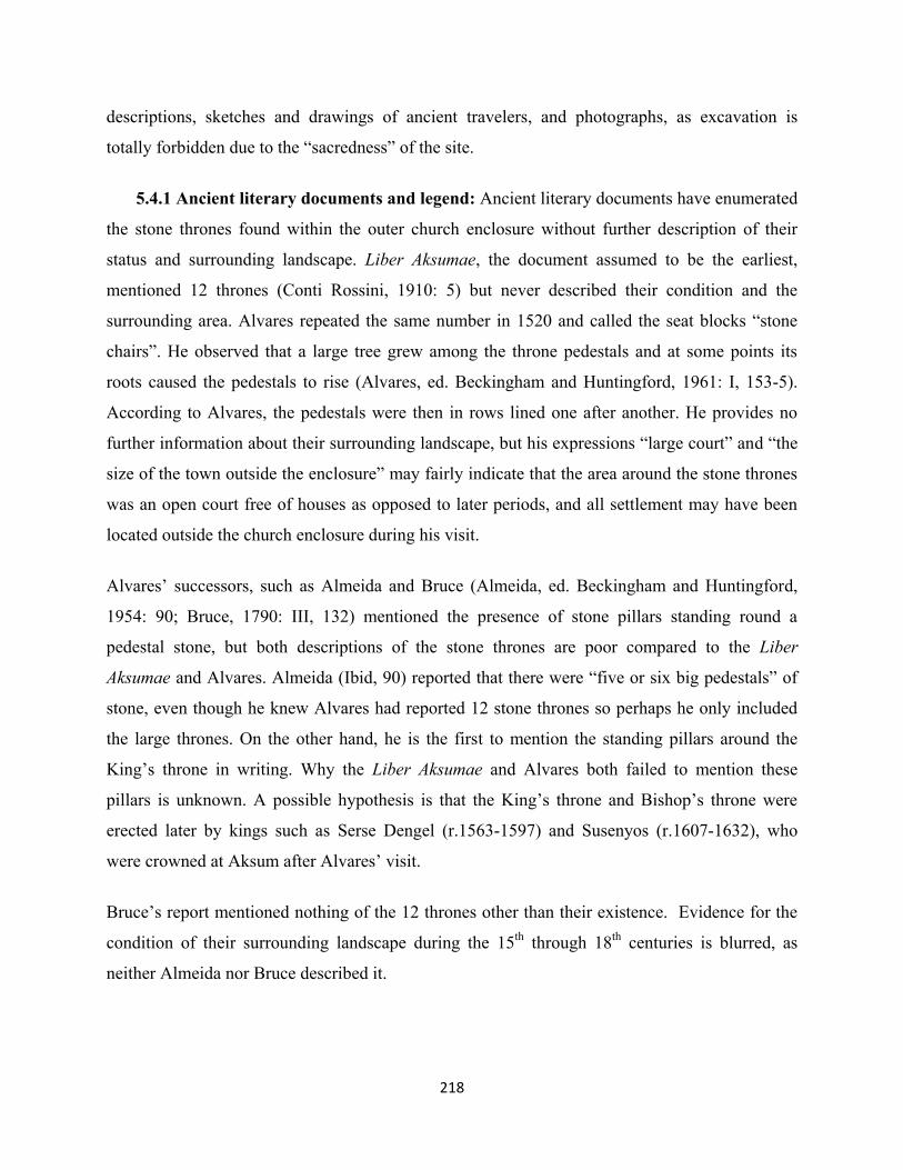
218
descriptions, sketches and drawings of ancient travelers, and photographs, as excavation is
totally forbidden due to the “sacredness” of the site.
5.4.1 Ancient literary documents and legend: Ancient literary documents have enumerated
the stone thrones found within the outer church enclosure without further description of their
status and surrounding landscape. Liber Aksumae, the document assumed to be the earliest,
mentioned 12 thrones (Conti Rossini, 1910: 5) but never described their condition and the
surrounding area. Alvares repeated the same number in 1520 and called the seat blocks “stone
chairs”. He observed that a large tree grew among the throne pedestals and at some points its
roots caused the pedestals to rise (Alvares, ed. Beckingham and Huntingford, 1961: I, 153-5).
According to Alvares, the pedestals were then in rows lined one after another. He provides no
further information about their surrounding landscape, but his expressions “large court” and “the
size of the town outside the enclosure” may fairly indicate that the area around the stone thrones
was an open court free of houses as opposed to later periods, and all settlement may have been
located outside the church enclosure during his visit.
Alvares’ successors, such as Almeida and Bruce (Almeida, ed. Beckingham and Huntingford,
1954: 90; Bruce, 1790: III, 132) mentioned the presence of stone pillars standing round a
pedestal stone, but both descriptions of the stone thrones are poor compared to the Liber
Aksumae and Alvares. Almeida (Ibid, 90) reported that there were “five or six big pedestals” of
stone, even though he knew Alvares had reported 12 stone thrones so perhaps he only included
the large thrones. On the other hand, he is the first to mention the standing pillars around the
King’s throne in writing. Why the Liber Aksumae and Alvares both failed to mention these
pillars is unknown. A possible hypothesis is that the King’s throne and Bishop’s throne were
erected later by kings such as Serse Dengel (r.1563-1597) and Susenyos (r.1607-1632), who
were crowned at Aksum after Alvares’ visit.
Bruce’s report mentioned nothing of the 12 thrones other than their existence. Evidence for the
condition of their surrounding landscape during the 15th through 18th centuries is blurred, as
neither Almeida nor Bruce described it.

219
During his visit in 1805, Henry Salt produced the first sketch map of Aksum including the
location and alignment of the stone thrones (Valentia, 1809: III, 78-83). Salt’s sketch (map 3.3)
indicated that the judges’ thrones were aligned SW-NE direction. A total of 12 thrones were
arranged in two rows, although the second-to-last throne at the northeastern end of the western
row is out of line farther northwest. Two thrones are shown on the eastern row (Valentia, 1809:
III, 90). The King’s throne and Bishop’s throne are perfectly indicated, together with their
surrounding pillars, four for the King’s throne and two others as they remain today. On Salt’s
map also includes a large tree east of the thrones near the eastern row. It is uncertain if this is the
same tree described by Alvares in 1520, since visitors to Aksum between 1520 and 1805 did not
mention such a tree.
Salt he also depicts no other features around the thrones, such as houses and other trees. Thus we
cannot conclude what the landscape of the thrones and their surrounding area may have looked
like at that time. We now have two rows of thrones of Judges’ thrones, the second row on the
east being comprised of two thrones. Salt informs us that he has seen some remains (?) scattered
around the King’s throne (Ibid, 90) without further describing them, their concentrations,
distribution and exact location with respect to each other and the King’s throne. Only the large
features, the King’s throne and the four standing pillars around it, are included on his map. No
other remains are now visible around the King’s throne except the four standing pillars, although
the DAE also sketched two large and two small slabs immediately north and south of the King’s
throne, respectively (fig. 5.39).
Fig. 5.38 Plan of the king’s and bishop’s thrones (after Littmann et al., 1913, II: 50)

220
Fig. 5.39 Plan of the judges’ thrones. The numbering given by the DAE is from left to right. In front of the main row of thrones are thrones 14 and 15. Note: on the right edge is throne 13 which is at present completely buried by deposit (after Phillipson, 1997: 130-1, fig. 180).
Salt found short Ge ‘ez inscription (fig. 5.41 (a)) on one of the judges’ thrones26. On the other
hand, he also confirmed that the Greek inscription, which Bruce reported found on the King’s
throne (Bruce, 1790: III, 132), was no longer extant (Valentia, 1809: III, 90). This inscription
could have either been covered by earth (if it was engraved on the basal stone of the throne) or
looted (if it was on small stone slab).
In the early 1840s, Lefebvre left some records of the stone thrones, supported with a drawing.
Lefebvre observed the existence of four stones set at the corners of the basal stones of the
thrones recessed to receive pillars, adding that three thrones were then intact27. He also noticed
an inscription on one throne, without copying its content. Lefebvre described the King’s throne
as having four pillars around the corners and the Bishop’s throne with a single pillar (Lefebvre,
1845-54: III, 431), but does not give a clear picture of their surrounding area. However, his
drawing of the King’s throne and its four pillars is very helpful to know their appearance in the
1840s, and their subsequent burial by deposit over the last 170 years.
On Lefebvre’s drawing, the King’s throne is seen with its basal stone and four corner pillars. The
Bishop’s throne, with its beautifully carved basal stone, is visible in the foreground to the right of
the pillars. Just in front of the trees at the right side is a partial view of the rows of Judges’
26 Salt found it on one of the Judges’ thrones, but did not identify which one. He also tried to restore and translate
the text, but this includes too many errors either due to the poor clarity of the characters or a limited knowledge of Ge‘ez. The DAE later copied and translated it. The inscription is found on the basal stone of Throne 7, but is now badly defaced due to human activities.
27 This vague explanation does not indicate the specific thrones, and what “intact” may imply.

221
(a) (b) (c)
(d) Fig. 5.40 (a) The Ge‘ez inscription found and copied by Salt with some attempts to reconstruct it (after Valentia,
1809: III, 91); (b) The Greek inscription found at the King’s stone throne by Poncet and Bruce (after Bruce, 1790:
III, 132); (c) The inscription first seen by Salt (a) and later mentioned by Lefebvre, and copied by the DAE (after
Littmann et al., 1913: IV, inscription no.19); (d) the inscription at present (photo: Hiluf Berhe, 28/09/2014).
thrones. The hut at the centre in the background is the gatehouse28 of the outer enclosure of
Maryam Tsion cathedral. Lefebvre’s drawing of the King’s throne and its pillars indicates that
both were still clearly visible in the 1840s, although it should be noted that they already were
partly buried, as their bases appear to be partly below the surface.
Lefebvre’s drawing also demonstrates that the area immediately surrounding the thrones in both
directions was not a built upon, as opposed to later photos (see below) with visible buildings
there. Although it is very uncertain, the heap of earth visible on the left side of the thrones may
be the historic ash at Godef Maryam (discussed above) dumped there from the burnt church of
Maryam Tsion. As will be discussed later, the landscape of the thrones and pillars again is
entirely different today. The King’s throne is now completely buried, as is much of the lower 28 This gatehouse is still in place, but a corrugated metal sheet has replaced its roof.

222
part of the pillars, and only the topmost squared seat block of the Bishop’s throne is partially
visible.
Bent provides no information on the condition of the thrones themselves or their landscape. He,
like his predecessors, of course also saw a defaced Ge‘ez inscription on one of the thrones. When
Yohannes IV (r. 1872-1889) celebrated his coronation at Aksum in 1872, some alterations may
have been made on the stone thrones for the coronation ceremony. Bent’s arrival at Aksum in
1893 was so perfectly timed for documenting any possible alterations to the thrones since
Lefebvre’s visit, had he fully described them, but his description, photograph and drawing are all
on a single page of his notebook.
Fig. 5.41 The King’s throne and its pillars (adapted from Lefebvre, 1845-54: III).
5.4.2 The DAE and subsequent research:
The DAE provided the first relatively detailed description of the thrones, their condition and
especially their surrounding landscape, as their 1906 photographs and drawings illustrate. No
previous data presenting the exact arrangement of the Judges’ thrones, their status and the nature
of their surrounding landscape is known. Their photograph (fig. 5.44), and detailed plan and
section drawings (fig. 5.40), shows the thrones as one long line of 11 thrones and a second line
having only two thrones east of the long line, both aligned SW-NE direction.

223
Every throne has disintegrated due to a lengthy period of human and natural processes (discussed
below). Only the seat block and basal stone remain intact to this day, while the associated
cornerstones, steps and other slabs are dismantled. The photograph (fig. 5.44) shows that trees
grew between thrones 8 to 11. The area immediately north and northwest of the thrones was
occupied by housing. The photograph also shows that the thrones were less buried than today.
Thus it seems the thrones continuously reburied rather than through continuous erosion or
exposure.
The King’s throne and Bishop’s throne are located southeast of the Judges’ thrones. Another
standing pillar, of sandstone, is found southeast of the Bishop’s throne, and another very short
erect stone jutting from the ground is south of this pillar (fig. 5.43). It appears that the sandstone
pillar may not belong, as it is located far from the corner of the thrones. Another feature
suggestively had existed between the sandstone pillar and the short stone, which may have been
buried in the remote past.
The DAE photographs show that the King’s throne and the Bishop’s throne were not entirely
buried in 1906. Much of the basal stone of the King’s throne was visible at that time, while its
seat block was fully visible. Other slabs north of this throne also fitted into the side of its basal
stone. The basal stone protruded about 85 cm in front of the seat block but its base, behind this
basal stone, was not visible. The DAE assumed that more steps may have been buried below the
basal stone. A large portion of the Bishop’s throne was above the ground in 1906, with its basal
stone 36 cm thick (Phillipson, 1997: 129).
In 1906, the DAE measured the square pillar bases as 50.5 x 50.5cm in cross section. Another
narrower shaft above it measured 38 x 38 cm. All four pillar corners have concave bevels, and its
top is flat. The base of the northwestern pillar is not visible in the DAE photograph (fig. 5.45),
nor in Lefebvre’s drawing. Therefore, the pillar either originally had no base or was covered by
earth. No description of the short rough stone (fig. 5.43) southeast of the pillars is available, but
it is labeled on Salt’s 1805 map and, although photographed in 1906 by the DAE, they provided
no measurements.
Houses surrounded by high fence walls (figs. 5.45 and 5.46) were located south and northeast of

224
Fig. 5.42 The king’s and bishop’s thrones, with the judges’ thrones behind them. Note: houses can be seen on the background (adapted from Phillipson, 1997: 125, fig. 169).
Fig. 5.43 The judges’ thrones; view from east. Notice the big tree grown on the right edge covering thrones mainly thrones 8 – 11 (photo: adapted from Phillipson, 1997: 169, fig. 170).
Fig. 5.44 The bishop’s and king’s throne, view from north. Houses can be seen on the background, while a gatehouse to the inner enclosure is visible on the left edge. Note: the throne with basal and seat block on the foreground is the bishop’s throne. Compare this with recent pictures below (photo: adapted from Phillipson, 1997: 126, fig. 171).

225
Fig. 5.45 The bishop’s and king’s thrones; view from northwest. The gatehouse and the cathedral are visible on the center background, while houses are visible on the left and right of the thrones (photo: adapted from Phillipson, 1997: 126, fig. 172).
the King’s and Bishop’s thrones. Although the date of the earliest settlement within the church
enclosure is unclear, Bent tells us that he and his wife stayed in a hut within the outer enclosure.
Bent added that he visited the bishop, who lived within the enclosure, but his wife Mabel was not
allowed since it is a monastery, and that the bishop never leaves unless some political issues
oblige him to be present29 (Bent, 1896: 154-60). The bishop clearly lived within the inner
enclosure, and thus both the inner and outer enclosures already were occupied in 1893, as later
photographs (discussed below) also demonstrate. The inner enclosure gatehouse visible behind
the thrones (fig. 5.46) already had been mentioned by Alvares in 1520, and still remains.
The DAE photographs and drawings also show a small mound at Godef Maryam, southwest of
the King’s throne and Bishop’s throne. Some also show that the outer enclosure was fully settled
by people (fig. 5.47). A photograph, taken by Doresse in the 1950s (fig. 5.48), shows that almost
29 The bishop most likely was residing within the inner enclosure, where women are not allowed to enter. Today, the
Nubreid resides near the southern gate within the outer enclosure.

226
all houses where the new church would be built30 already had been demolished, but some ruins
are still visible. Houses southwest of the thrones site and others west of the Judges’ thrones still
existed in the 1950s. On the other hand, large trees also can be seen immediately north of the
King’s throne and Bishop’s throne, as well as near and west of the Judges’ thrones. The
photograph also shows another large tree also is visible southwest of the thrones site.
Despite the increased archaeological research in Aksum, documentation of the thrones has been
neglected after the DAE. Subsequent modern archaeological research focused on excavation
around the elite structures and the church area, the latter only considering impact assessment
while planning construction of the new Maryam Tsion cathedral.
A photograph, possibly taken between 1993 and 1997 by David Phillipson (fig. 5.49) shows that
northwest of the Judges’ thrones is clear except for some small trees, but large trees can be seen
growing amongst the thrones. The King’s throne and the Bishop’s throne were deeply buried.
Only the top of the seat block of the King’s throne is visible, while the basal stone of the
Bishop’s throne completely buried. The same photograph shows that the pillars on the right
facing the church’s gate, are buried as far as the top of their base, and the entire shaft of the
northwest pillar is completely buried while that of the northeast is half-buried. Only the top of
the small erect stone seen in DAE photograph is visible.
30 The new Maryam Tsion church was built by Emperor Haileselassie I (r.1930-1974). Its foundation stone was laid
in 1952 and, after 12 years of construction, it was formally inaugurated in 1965 in the presence of Emperor Haileselassie I and Queen Elizabeth II of England.

227
Fig. 5.46 Aerial view of the thrones site (in circle, right center) in the 1930s. The surrounding area of the sites was completely a built up area (Photo: available at: http://www.ebay.it/itm/Axum-Veduta-Aerea-Aerial-View-1935-36-Fotografia-Originale-Original/190826514657?pt=Fotografie_e_Stampe&hash=item2c6e2588e1).
Fig. 5.47 Aerial view of the thrones site (in circle, center) in early 1950s (Photo: after Doresse, 1956: 44-5).
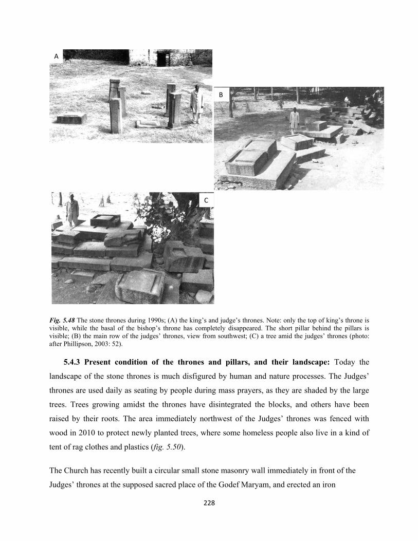
228
Fig. 5.48 The stone thrones during 1990s; (A) the king’s and judge’s thrones. Note: only the top of king’s throne is visible, while the basal of the bishop’s throne has completely disappeared. The short pillar behind the pillars is visible; (B) the main row of the judges’ thrones, view from southwest; (C) a tree amid the judges’ thrones (photo: after Phillipson, 2003: 52). 5.4.3 Present condition of the thrones and pillars, and their landscape: Today the
landscape of the stone thrones is much disfigured by human and nature processes. The Judges’
thrones are used daily as seating by people during mass prayers, as they are shaded by the large
trees. Trees growing amidst the thrones have disintegrated the blocks, and others have been
raised by their roots. The area immediately northwest of the Judges’ thrones was fenced with
wood in 2010 to protect newly planted trees, where some homeless people also live in a kind of
tent of rag clothes and plastics (fig. 5.50).
The Church has recently built a circular small stone masonry wall immediately in front of the
Judges’ thrones at the supposed sacred place of the Godef Maryam, and erected an iron
A
B
C

229
Fig. 5.49 The thrones site in 2010, view from east; note: the king’s throne (follow arrow and cirle) had already disappeared in 2010 (Photo: Berhan Teka, 2010).
candlestick within. A wooden fence south of it protects a living tree from animals and people
(fig. 5.51). In a photo of 2014 (fig. 5.52) the fence immediately west of the Judges’ thrones was
removed, since the trees have grown tall enough to avoid from being eaten by animals and cut
easily by children. The wooden fence for the tree in front of the thrones has been replaced with
short wooden poles, painted blue and nailed with horizontal wooden beams. The number and size
of the trees around and on the thrones has substantially increased.
Fig. 5.50 The thrones, view from west. The wooden circle fence in front of the pillars (right background) is now replaced with wooden pole and painted blue (Photo: Berhan Teka, 2010).

230
Fig. 5.51 The trees provide good shade for the people during mass prayers; the thrones serve as comfortable seats in the shade. Notice the circular masonry wall, and blue-painted fence on the foreground (photo: Hiluf Berhe, 28/09/2014).
The King’s throne and Bishop’s throne have been reburied by deposition, when compared with
earlier photographs at different times. The King’s throne now is completely obscured by
deposits. The seat block of the Bishop’s throne is still visible although much of it has been buried
since 1906. The pillar bases around the King’s throne, still visible in the 1990s, are now
completely buried on fig. 5.50. The top of the small erect stone is still visible southeast of them.
The new Saint Yared Theological School building now stands about 50 m. south of the thrones
site. The historic Godef Maryam is no longer extant and the area is now paved with concrete.
The entire area surrounding the thrones site is filled with large trees and provides good shade for
people, so the thrones are used as a playground and resting places, and for religious ceremonies.
5.4.4 Brief description of the thrones, pillars, and their associated features
Fifteen thrones are found within the Maryam Tsion cathedral compound, with Thrones 3-13 in
one long line while Thrones 14-15 form another line in front of it and thrones 1-2 are farther east
next to each other. The thrones are totally neglected and disordered. Although their location is
stable, reburial by deposits, human activity and tree growth have caused great damage. A recent
(September 2014) detailed description of the thrones and pillars is presented here.

231
Throne 1: The King’s throne; now totally obscured by earth together with the base and other
slabs around it. Its pillars round it are, however, still in place.
Throne 2: The Bishop’s throne; only 28 cm of the total height31 of the seat block is visible now,
the rest being buried in the ground. Its original seat block and base had been entirely visible a
century ago (op. cit. Phillipson, 1998: 128-9).
Fig. 5.52 King’s throne originally in the center (circle), is no longer visible. Only top of the seat block of Bishop’s throne on the foreground is visible; view from north. The food stuff on the seat block was left by the pilgrims for birds. A truck can be seen on the background (photo: Hiluf Berhe, April 2012).
Throne 3: This is the southwestern of the long row of the thrones. It has double seat blocks
sharing one huge piece of basal stone. Three stones with worked inner angles to fit to the edge of
the basal stone are still visible on three corners of the basal stone but are disordered; the fourth,
on the northwest corner, is missing. The throne inclines towards the south resting most of its
weight on the southeastern cornerstone. These cornerstones are L-shaped but exhibit no
depression to support a pillar (see fig. 5.40). The basal stone seems to have been supported by
roughly worked granite stone, now visible on its northern side. The throne is raised above the
ground, partly resting on the ground and partly on its southern cornerstone. Its underside surface
is rough, implying that it had stood on an earthen surface or on steps.
31 DAE recorded 42 cm as the height of the seat block (Phillipson, 1998:128).

232
In front of the seat blocks is a large shallow depression cut into the basal stone, possibly intended
for footrests for both thrones. Although now very defaced, it measures 35 x 148 x 0.5 cm, and is
positioned 30 cm from the left and right sides and 40 cm from the front of the basal stone. This
throne therefore may originally not have had a canopy, as none of the cornerstones reveals a
pillar support.
Fig. 5.53 Throne 3, view from west (photo: Berhan Teka, 2010).
Throne 4: Only its seat block and base now survive. It rests entirely on the surface, with no
visible indication of other steps below ground unless excavation is carried out. Footrests are
positioned in front of the seat block, as with most thrones.
Fig. 5.54 Throne 4, view from east
(photo: Berhan Teka, 2010).
233
Throne 5: The seat block, basal stone and grooves for footrests survive. It rises 50cm above
ground and rests on one front cornerstone that originally had been used as a pillar support, and
on two small blocks in the northwest corner positioned one above the other. The cornerstone and
the other blocks were pushed underneath the throne. The cornerstone may have been moved
from Throne 6, because its shape and size is identical to those of throne 6. A fourth cornerstone
is missing from Throne 6, which implies that the one at Throne 5 belongs to Throne 6. If so, then
Throne 5 has no cornerstones and thus would have had no pillar for a canopy.
Fig. 5.55 Throne 5, view from north (photo: Hiluf Berhe, September 2014)
Throne 6: Its seat block and basal stone survive. The southeastern cornerstone retains traces of a
pillar support for a canopy. Two other cornerstones of similar shape and size are on the
southwest and northwest corners, although 70 cm away from the throne itself. Another long
granite block on its southern side is positioned east-west and originally part of a stair possibly
brought from the ruined elite buildings. Its visible measurements are 4.06 x 64 x 36 cm. It is now
reversed, as if detached from Throne 5 beside it. All of Throne 6 rests entirely on the ground,
with traces for a footrest but local people have pounded two large deep depressions exactly
where footrests should be positioned. Its basal stone is broken in two. Damage also is clearly
visible on the edges of the back and southern side grooves.
Fig. 5.56 Throne 6; this throne retained its three cornerstones. The long slab originally part of a monumental stair is visible at the back (photo: Hiluf Berhe, September 2014).

234
Throne 7: Both seat block and basal stone are cut from a single granite block. This is the most
elevated throne, retaining its most steps and three cornerstones in situ and marks for pillar
support. Only the northwestern cornerstone is missing. Three main steps encircle three sides of
the throne (the western side has only two), while the cornerstones and basal stone form the
topmost step. A fourth ordinary step constructed of reused lateral blocks is visible at the front,
one roughly worked and another with wide but shallow grooves shaped like a wide rectangular
plate. Their shape clearly shows they were moved from elsewhere.
The cornerstone depressions for canopy pillars are cut deep into the block. These cornerstones
are right-angled with a 34 x 36 x 5 cm depression at the outer angle. It has two traces of
footrests, in front of which is a Ge‘ez inscription, discussed elsewhere.
The throne has sustained some damage on the northern and front edges of the northern side
groove of the seat block. The outer edges of the grooves for pillars on the cornerstones are also
damaged. Another cause of damage to the throne is the growth of large tree at the northern edge
immediately between Thrones 7 and 8, which has caused some blocks disintegrate from their
original positions, and some blocks also have been raised above the ground by living tree roots.
Fig. 5.57 Throne 7. Left: front view from east (photo: Berhan Teka, 2010); right: view from north (photo: Hiluf Berhe, 28/09/2014).
Throne 8: Its seat block and basal stone remain, with all four cornerstones preserved. The
cornerstones for pillars have been worked similar to Throne 7, measuring 34 x 34 x 10 cm. The
throne is accessed by two steps on the front, now displaced from their original position by a large
tree growing among the thrones. Little physical damage is visible, at the northern edge of the

235
side groove of the seat block, and the edges of three of the cornerstones, except the still intact
northwestern corner.
In front of this throne are three cornerstones, one with a depression for pillar and the other two
just smoothly worked. One of the latter is half broken. The cornerstone with the depression very
likely may have been displaced from Throne 7 as its shape suggests and since one cornerstone of
this throne is missing. The two L-shaped cornerstones may have been moved here from another
throne and could be moved to their original position after detailed investigation and
reconstruction work.
Throne 9: A seat block and basal stone cut from a single granite block. Only one cornerstone
with a depression for a pillar has survived at its original position, fitting perfectly at the southeast
corner of the throne. The northeastern cornerstone is visibly displaced by a large tree, whose
only dry stem stands today. The throne is accessed by two steps, its basal stone and the
cornerstone forming the topmost step. This step, however, either disappears at the back or been
covered by earth. Two grooves for a footrest are still intact. It is supported by large blocks on the
front and south sides, and northwest corner.
The seat block is damaged, except the back. Much the cornerstone is damaged, including the
edge of the square pillar depression that measures 40 x 40 x 10cm.
Fig. 5.58 Throne 9, view from south. Dry stem can be seen on the background and foreground of the throne (photo: Hiluf Berhe, September 2014).

236
Throne 10: Preserved are the seat block, basal stone and two front cornerstones. It is accessed
by two lines of steps at the front. The southeastern cornerstone has an intact pillar depression,
measuring 42 x 43 x 9 cm. The northeastern cornerstone is badly defaced, with a circular
depression created by the local people on the original squared depression. The original squared
depression for a pillar measures 35 x 35 cm with a very shallow depth. The cornerstones are
displaced from their original position. A large tree also has separated the throne from its steps
and cornerstones. Other damage is visible at the southern, western and northern corners of the
seat block.
Throne 11: Another double throne like Throne 3, except Throne 11 has two basal stones. The
southern seat block and its basal stone are cut from a single block with an extended space on the
basal stone to accommodate a second seat block. The northern seat block also rests partly on a
separate basal stone and partly on a second basal stone so that both seat blocks fit together side
by side. The southern throne has a footrest in front of the seat block measuring 67 x 33 x and
only 4 cm, implying that another block was also placed on this large depression. For the second
throne, the footrest includes the typical two grooves. Only the southwestern cornerstone is
preserved on the throne. Its square pillar depression measured 40 x 40 x 5 cm. Another
cornerstone with square pillar depression is located 170 cm away in front of the throne, although
it may or may not belong to this or another throne.
This double throne rests on another block on its northern side, with more blocks lying on the
ground north of it. The cornerstone depression has been rounded and deepened by the local
people for lateral activities. The front cornerstone is only partially visible as it is covered by
earth. Today the double throne is unstable, with several dispersed elements.
Throne 12: The seat block of this throne is visible only 20 cm above surface. Everything else
presumably has been buried since 1906.
Throne 13: No trace of this throne is now visible. It is entirely below ground.
Throne 14: This throne is located on the second row in front of Thrones 7 and 8, with its seat
block and basal stone still preserved. The basal stone is carved of coarse sandstone while the seat

237
block is granite. No other features such as a cornerstone, steps and support blocks are visible.
The southwest corner of the seat block is partly damaged (fig. 5.60).
Fig. 5.59 Throne 14, view from west (photo: Hiluf Berhe, 28/09/2014)
Throne 15: This throne is north of Throne 14 on the same row, in front of Thrones 8 and 9, and
consists of a seat block and basal stone. It is raised and then supported by an upright cornerstone
on its front.
Fig. 5.60 Throne 15, view from west (photo: Hiluf Berhe, 28/09/2014).
Pillars: The DAE did not give number to the pillars, so the following enumeration is created for
the present thesis, and independent of earlier records (see fig. 5.62)

238
Pillar 1: At the southeastern corner of king’s throne: it stands 143 cm tall, with a concave bevel
along the edge that extends 20 cm above ground level and 24 cm from the top. Its four sides each
measure 25 cm, the bevels (grooves) are 10 cm in width. The pillar measures 39 x 39 cm at the
top. It is the only pillar having an incised cross, on its top west side.
Pillar 2: At the southwestern corner. It stands 133 cm, with a top surface of 38 x 38 cm, and 24
cm on each side of the shaft itself. Corner bevelling begins 10 cm above ground level and 18 cm
from the top, and has a width of 9.5 cm.
Pillar 3: At the northeastern corner. It stands 135 cm, with its bevel 10 cm above ground and 16
cm from its top. All four sides measure 25 cm, the top 39 x 39 cm, and the bevels 10 cm wide.
Pillar 4: At the northwestern corner. This is the shortest pillar, only 123 cm in height. The
bottom of the beveling lies below the surface and 31 cm from the top. Its top itself measures 38 x
38 cm, and the shafts 10 cm.
Pillar 5: The isolated pillar east of the Bishop’s throne, carved of fine (?Tekeze) sandstone. It is
so far from both thrones and in such bad condition that it cannot be associated with any throne. It
is 128 cm tall, although the shape is somewhat regular, with four sides differentially measuring
43, 45, 52 and 53 cm. Its top area also varies, measuring 38 cm north-south and 53 cm east-west,
so actually is rectangular in section. This pillar now has a large crack some 2 cm wide generally
aligned southwest-northeast. Due to the sandstone material, the entire pillar may be endangered
by water entering into the crack.
Pillar 6: Another stone south of Pillar 5, presumably a pillar buried, with only its top part only 6
cm visible above ground. It is also carved out of fine sandstone, and measures 54 x 68 cm in
section. The many small shallow holes which can now be visible on the top were made by boys
for playing a traditional game, called gebeta. The proximity and similar material suggests Pillars
5 and 6 may have been erected to canopy over a common throne but obviously not the Bishop’s
throne. However, only excavation will confirm the overall size of Pillar 6 and the existence of
other surrounding features.

239
Fig. 5.61 The pillars at the King’s throne, facing east (photo: Hiluf Berhe, 29/09/2014).
Fig. 5.62 Pillar 5, facing north. Note, the crack Fig. 5.63 Pillar 6, top view (photo: Hiluf Berhe, 28/09/2014)
can be seen at the center of the pillar running
from top to bottom (Photo: Hiluf Berhe,
28/09/2014).
3 4
1 2 3 4

240
5.5 Agents for the change of archaeological landscape, monuments and structures
As this study has revealed, changes in the archaeological landscape and heritage can be broadly
divided into two types.
5.5.1 Human factors
The archaeological landscape and heritage has changed considerably through human activity
such as settlement, agricultural activity, deliberate destruction (robbery), ignorance, negligence
and scientific research. The archaeological landscape also has changed through both formation
and destruction. While a generation leaves traces behind that later form an archaeological
landscape, succeeding generations also destroy it and form another landscape with its own
unique cultural traces. In Aksum, such change has occurred without proper documentation.
In the case of the tombs of Kaleb and Gebre Mesqel, the archaeological landscape has
experienced a variety of changes, from built area with structures both above and below ground,
robbery and destruction of the visible structures, burial by natural deposition, agricultural
activity, excavation and removal of overburden, and reconstruction to parts of the ruined
structure to re-landscaping and construction of huge shelters. No doubt much has been destroyed,
changed position (e.g., the terrace wall), stolen and moved elsewhere as it changed over several
centuries. Many structures and artifacts outside the fence wall in the fields east of the site remain
threatened by agricultural activity, confirming much remains to be excavated and protected here.
As agricultural activities exposed structures and artefacts, people began to collect artefacts to sell
and to loot worked stones for their private houses. These activities then encouraged them to
deliberately dig illegally for more treasures elsewhere.
On the other hand, scientific excavation and conservation have both greatly contributed in
reforming the original layout of the structures without proper documentation, even though they
intended to stabilise the archaeological landscape and its heritage. Many fence walls have been
created only recently, and have totally distorted the original terrace wall and entrances to the
underground royal tombs.

241
The May Hejja archaeological landscape and its monuments have also been damaged and
changed. As has already been discussed elsewhere in this chapter, the May Hejja archaeological
area has been occupied by settlement that obscured, reused and destabilised the monuments.
Such damage, due both to ignorance and deliberate action, involve worked monuments and
stones for construction or household purposes. Many monuments in private compounds are in
poor condition and others have been overlaid by roads and paths due to ignorant actions.
Particularly in the case of the MSF, recorded human activity used the site both as a cemetery and
for house construction. Photographs demonstrate that stela 3 was used as public gathering space.
stelae 1 and 2 supported a high fence wall that in turn must have caused pressure on the
underground tombs below. When people began to settle there, stela baseplates likely were
removed for reuse as flooring and thresholds. In doing so, the stela could be destabilised and
consequently even collapsed. Deliberate human activity has been recorded archaeologically in
the toppling of stela 2 (Phillipson, 2000, I: 147) in the 6th century AD. Based on recent
excavation and synthesis, Poissonnier (2012) argued that the stela was destabilized when robbers
dug a hole beneath the basement structure of the stela in search of precious object, but not
intended to topple the stela. Whatever the intention of the robbers was, the conclusion is that
human factor caused great damage on the stela that finally led to its destruction. Removed to
Rome in 1937, it was returned in 2005 and re-erected on its original (pre-sixth century toppling)
position in 2008.
The underground robbers’ tunnels must have had great impact, destabilising the ground on which
the stelae stood (op. cit. Chittick, 1974; Munro-Hay, 1989; Phillipson, 2000: I and II). Tomb
robbery has resulted in an incomplete archaeological record. Later archaeological excavations
(and destruction) have changed the MSF archaeological landscape entirely, revealing the terrace
walls and underground tombs, new reconstruction work has been conducted and then formed a
stable platform. New fence walls have been created and ancient ones realigned. The re-erection
of a shaft cover above the Mausoleum and other stelae in the MSF, and the damage done during
an attempt to erect stelae in the 1960s are also recent memories.

242
Residents were relocated from the northernmost stelae field, while the eucalyptus forest
remains32. Pathways have been re-directed and roads previously passing through the Geza
Agumai area north of the town have been closed.
The site of stone thrones at the cathedral enclosure also has suffered continuous damage. The
thrones themselves were exposed to human looting and destruction because they were always
visible aboveground. All the thrones have disintegrated except for their basal stones and seat
blocks, and all other features there also are highly disintegrated. As some traces indicate, the
thrones originally had pillars, and probably side and back rests (fig. 5.65). Today, none of the
thrones has a single side or backrest visible on the surface. Only the King’s throne still has all
four pillars intact. Such great losses obviously are due to human agency.
Most throne cornerstones are displaced, in most cases only three are now preserved while none
survive on others, and all four survive only on Throne 8. It is unclear whether all thrones
originally had their own pillars or re-used existing pillars removed from a previous throne. Some
thrones lack any trace of step and cornerstone, retaining only the basal stone and seat block.
Fig. 5.64 A possible reconstructed throne showing the steps, pillars, basal stone, seat block, side and back rests, and canopy (after Littmann et al., 1913, II: 63).
32 Eucalyptus tree was planted in Aksum during the Derg regime in the 1970s as part of the forestation program of
that time. Since then, the northern stelae fields and the hillslope of Biete Giorgis are covered with the aforementioned tree species. In the Geza Agumai stelae field, there is no doubt that the trees could have caused damage on the stelae and possibly on other underground structures due to the largely expanding roots.

243
Texts are thought to have been inscribed on now-lost throne sides and backrests (Fattovich et al.,
2000: 55). Many plaques found in Aksum and one in Matara were thought to originally belong to
thrones (Phillipson, 1997: 123). This assumption was supported by the text inscribed on the
white marble33 throne as recorded at Adulis by Cosmas Indicopleustes in the 6th century
(Fauvelle-Aymar, 2009). The famous inscription of King Ezana also mentions the erection of a
throne (Littmann et al., 1913: IV, inscriptions 10 and 11) implying that “inscribed plaques
formed parts of such thrones” (Phillipson, 1997: 123).
Some features reveal that human processes have also affected the thrones in many other ways.
Some pillar depressions on cornerstones have been subjected to pounding, enlarging and
deepening the original depression. The edges of some cornerstones and seat blocks have broken
off, the edges of some seat blocks defaced, and inscriptions lost or effaced. The basal stone of the
Bishop’s throne likely has been turned “back-to-front” (Phillipson, 1997: 129), implying that
throne movement and reuse have occurred from ancient times. Thrones and pillars have also
been used as dumps for leftover food to feed birds (fig. 5.53). This is very common during the
monthly St. Mary’s commemoration day.
The thrones site also serves as public gathering during every church service, with worshippers
standing and sitting on the thrones, and women are taught the Gospel here as they are not
allowed to enter the inner enclosure. Archaeological excavation at the thrones site hopefully may
be permitted in the near future, to see what lies underneath and how the landscape evolved to
present times. Excavation at the thrones site always has been prevented (Bent, 1896: 193;
Phillipson, 1997: 129) because the area is so sacred. However, this is exacerbated by rigid church
administration in general and the conservative attitude of the clergy at Aksum in particular, the
latter always claiming that even the Patriarch has no power to force them to accept orders
concerning Maryam Tsion church. Excavation was conducted in the 1950s immediately beside
the church treasury, yet the thrones site is neither near a cemetery nor both cathedrals.
5.5.2 Natural factors: All sites discussed in this chapter have been subjected to natural
processes, with continuously different stages in patterns of archaeological landscape change.
33 Inscribed white marble stones are housed in the Aksum Archaeological Museum and the Aksum Tsion Maryam
cathedral museum. Their origins need to be carefully examined to ascertain if they have any link to the thrones.

244
Recent landscape change by natural processes appears stable at the moment, in the case of the
tombs of Kaleb and Gebre Mesqel and May Hejja, due to human intervention, especially
conservation. However, the process remains active at the thrones site.
As this study reveals, and as discussed earlier in this chapter, the main natural process to
continuously change the landscape is reburial by deposit. All sites under discussion have been
subjected to reburial by deposition as the result of soil downwash from their respective slopes.
Erosion and flooding has not, or minimally, exposed sites and heritage.
The Kaleb and Gebre Mesqel site was entirely covered by deposit from the hill above. Such
deposition has been cleared away by excavation at different times. Excavations have cleared
away the deposit to the structures’ original floor level both above and below the surface. Study
has revealed that the earliest site in the May Hejja archaeological area is up to 4m. below the
present surface, and this has remained as the present surface (particularly in the MSF)
comprising another layer of human activity that may never be cleared away like other deposits.
The thrones site is under continuous reburial due to negligence and ignorance. Photographic and
illustrative evidence from the early 1840s shows that the lower levels of many thrones (mainly
the King’s throne and Bishop’s throne and their pillars) have been covered by earth and the
process still continues. In the early 17th century, Almeida guessed the height of the pillars as
within 2.28-2.75 m. (Almeida, ed. Beckingham and Huntingford, 1954: 90). Unfortunately, no
successive traveller or recent researcher has recorded their height to compare the frequent burials
by deposition. Their present aboveground heights are 1.43m (Pillar 1), 1.33m (Pillar 2), 1.35m
(Pillar 3), 1.23m (Pillar 4) and 1.28m (Pillar 5).
The DAE (Phillipson, 1997:129) records the pillar bases are cubic, measuring 50.5 cm, while the
shafts above are 25cm. Today only small portion is visible of the shaft above the cuboid base
visible on three of the pillars, with the height as cited above, so it is possible to obtain the total
height covered by earth since 1906 although still excluding the portion already covered by earth
at that time. DAE documentation (Littmann et al., 1913, II: 50) indicates the pillars were 201 cm
tall, meaning the ground level has risen about 77 cm since 1906 (fig. 5.66).

245
The King’s throne and Bishop’s throne pose a similar problem. The King’s throne, now entirely
covered by earth, was nearly 64 cm high in 1906. The Bishop’s throne was 78 cm high, of which
only 28 cm is visible today. The seat block of Throne 13 was visible in 1906, with a total height
of 42 cm aboveground (Ibid, 49), but now is completely covered by earth. Its basal stone must
have been buried before the DAE arrived in 1906, but some throne steps and cornerstones clearly
visible in 1906 are now partly or entirely covered by earth.
Trees also have been identified as threats to the thrones. Although they seem to have been
planted intentionally, the natural growth of their roots and stem is lifting up and disintegrating
the thrones and their associated features.
It is, therefore, clear that the present Aksum is meters higher than the earliest ancient level, and
that even the succeeding landscape is continuous being buried. It can be envisaged also that
unless protective measures are taken to halt further human and natural actions on the heritage in
general, the present landscape also will soon disappear.
Fig. 5.65 Schematic representation of reburial of Pillar 1 between 1840 and 2014. All the shaded area above the 1840 surface level indicates the buried part since (Drawing: Hiluf Berhe, June, 2015).
Fig. 5.66 King’s and Bishop’s thrones in 1906 (left) (Phillipson, 1997) and 2012 (right) (Hiluf Berhe, 2012).

246
CHAPTER SIX
ARCHAEOLOGICAL AND CULTURAL HERITAGE MANAGEMENT AND THE
QUESTION OF HERITAGE OWNERSHIP IN AKSUM
“The cultural and natural heritage is among the priceless and irreplaceable assets, not only of each nation, but of humanity as a whole. The loss, through deterioration or disappearance, of any of these most prized assets constitutes an impoverishment of the heritage of all the peoples of the world. Parts of that heritage, because of their exceptional qualities, can be considered to be of “outstanding universal value” and as such worthy of special protection against the dangers which increasingly threaten them” (UNESCO Operational Guidelines, 2008: 2).
6.1 Introduction: Situated between two hills – Biete Giorgis and May Koho – Aksum is located
in the Central Zonal administration of the National Regional State of Tigray. The old town of
Aksum is mainly known for its monolithic giant stelae, underground monumental tombs built of
granite, ruins of palaces, and stone thrones. As it was a major center of civilization and
administration for the Aksumite kingdom, it is also believed to be the resting place of the Ark of
the Covenant and home to the first church ever erected in Ethiopia. Thus it is an important town
for ancient Ethiopian history and the Ethiopian Orthodox Church. As a result, Aksum was
included on the World Heritage List (WHL) on 5 September 1980 during the fourth session of
the UNESCO World Heritage Committee (WHC) held in Paris, France, 1-5 September 1980
(UNESCO, 1980). The immovable archaeological heritage at Aksum combined with the
architecture and living history of the Church is now considered an outstanding universal value
under criteria (i)1 and (iv)2.
1 “represent a masterpiece of human creative genius” (UNESCO, 1972 World Heritage Convention).
2 “be an outstanding example of a type of building, architectural or technological ensemble or landscape which illustrates (a) significant stage(s) in human history” (UNESCO, 1972 World Heritage Convention).

247
Despite such outstanding universal value, the site and its heritage have been, and still are, under
continuous preservation and security risk as a result of poor management, the lack of a proper
master plan, the absence of a defined heritage buffer zone, and the detrimental outlook of bureau
officials towards young, trained professionals who could do proper site management, scientific
documentation, and the presentation of finds in museums. UNESCO WHC reports show that
Aksum was repeatedly recommended for an appraisal for the establishment of a buffer zone, a
master plan, and proper management in compliance with the criteria and evaluation methods of
the World Heritage Site (WHS).
In this chapter, the main problems concerning the preservation, conservation and management of
the site and its heritage will be examined. The mandate of protecting this material heritage, both
ecclesiastical and non-ecclesiastical, will be discussed. The administration of this site is by two
different bodies and there is no clearly defined proclamation for authority of one over the other;
how that situation impairs the sustainability of the heritage in particular, and the archaeological
and cultural landscape in general, will be the focus of this chapter.
6.2 Cultural Resource Management3: an overview
Cultural resources are important components of archaeological sites and cultural landscapes that
need special attention in order to ensure the sustainability of their scientific and historical value
(Comer, 2012: 9). Cultural resources are also sources of national pride for a nation, while
archaeology plays a crucial role in the making of a glorious and long history (Trigger, 1984) by
digging out the deeply-buried history using scientific methods of excavation and interpretation
(Tanyeri-Erdemir, 2006).
Africa has very few cultural sites on the WHL in light of its cultural diversity and size (Connah,
1998, 1987; Phillipson, 1993a). The main reasons for such under-representation and obstacles to
heritage protection and management are a lack of awareness about heritage preservation,
protracted civil wars, political instability, a lack of heritage policy and legislation, an absence of
professionals trained in heritage management, a lack of funding, and the complicated nature of 3 “Cultural Heritage Resource refers to sites, structures, and remains of archaeological, paleontological, historical, religious, cultural, or aesthetic values” (Mabulla, 2000).

248
the UNESCO application for heritage registration on WHL. Although there have been some
developments in the training of African heritage professionals in some African countries very
recently, the number and skills are still inadequate to fulfill the needs of the diverse and
numerous historic sites in Africa (Breen, 2007; Mabulla, 2000). Most African regions were
mainly viewed as a fertile ground for research and exploration by Europeans and Westerners, but
the preservation of historic sites for the future has been largely ignored (Breen, 2007). Even in
this modern era, investing in heritage management is usually regarded as a low priority; at worst,
the institutions that are supposed to take charge of the protection and management of priceless
heritage are the weakest and lack influence (Mabulla, 2000).
Absence of a clearly defined statute, lack of space for storage and restoration of archaeological
collections, and lack of trained heritage professionals and museum curators are also among the
acute problems in Africa (Kibunjia, 1997). In some countries, like Somalia, for example, cultural
heritage resources are being destroyed because of the civil war that has lasted for more than two
decades. It should be born in mind that cultural heritage that is unregistered and unprotected
could even have added a significant amount to our knowledge about the ancient history of the
eastern African coast (Mire, 2011).
UNESCO WHC reports during its 38th session in 2014 indicated that 39 percent of the ‘World
Heritages in Danger’ are located in Africa (UNESCO, 2014). Threats to African heritage sites
also stem from combined activities of humans and nature, such as road and factory construction,
agricultural activities, erosion, flooding, and deforestation (UNESCO, 2003: 47). The boost in
construction in Africa to catch up with the rest of the world is a major threat to cultural heritage
resources. In addition, the careless development of tourism is greatly affecting African cultural
heritage. In this case, the focus is usually to get the maximum amount of revenue from tourism
without caring for the sustainability and long-term survival of cultural heritage resources. Similar
consequences have been recorded in Jordan, where plans of doubling the tourism economy
greatly damaged archaeological heritage at Petra (Comer, 2012: 174).
Lately, some countries have taken initiatives to protect and present their cultural heritage
resources to the world community. Ethiopia is also showing some steps forward on the cultural
heritage management very recently (Finneran, 2007: 265). However, compared to the long

249
history of archaeological excavation and the abundant number of sites, the move could be judged
as very sluggish. It was in 2002 that Ethiopia launched its first higher education training program
in cultural heritage management at Addis Abeba University (Worku Derara, 2010). This
professional training was at the graduate level and admitted five students every year. In 2007,
Aksum University launched its undergraduate program at the historic town of Aksum to relieve
the acute problem of heritage professionals in Ethiopia. Two years later, this undergraduate
training of heritage professionals was followed by Addis Abeba University while the graduate
program still operates.
Ethiopia ratified the UNESCO Convention concerning the Protection of the World Cultural and
Natural Heritage on 6 July 1977 and has already registered nine (table 6.1) sites (one is a natural
site) on the WHL since 1978. Ethiopia also has a heritage proclamation, the most recent revision
being the heritage proclamation number 209/2000 (Negarit Gazeta, 2000). Despite the good
move towards training heritage professionals in higher education to address the need of the
country in the field, and the presence of a heritage proclamation, the structure of the culture and
tourism office of the nation is a bottleneck for young graduates in the field of archaeology and
heritage management. Culture and Tourism offices of the country have a demand for history,
tourism, literature, and other fields while Archaeology and Heritage Management seems to be
deliberately ignored to keep away the right professionals. As a result, the heritage resources of
the country are still the least known and most poorly managed. The heritage proclamation is
usually seen as ineffective without professionals to implement it.
Table 6.1 Cultural and Natural Sites of Ethiopia registered on WHL.
Site name Location Year registered Criteria Reference number Lalibela Rock-hewn churches NRSAm 1978 i, ii, iii 18 Semien National Park (Natural heritage) NRSAm 1978 vii, x 9 Fasil Ghebbi, Gonder NRSAm 1979 ii, iii 19 Aksum NRST 1980 i, iv 15 Tiya SNNPR 1980 i, iv 12 Lower Valley of Awash NRSAf 1980 ii, iii, iv 10 Lower Valley of Omo SNNPR 1980 iii, iv 17 Harer Jegol, the Fortified Historic Town NRSH 2006 ii, iii, iv, v 1189rev Konso Cultural Landscape SNNPR 2011 iii, v 1333rev (Source: http://whc.unesco.org/en/statesparties/et (accessed on 2/7/2015)).
250
6.3 Cultural Heritage Management (CHM) in Aksum World Heritage Property
Aksum has been the focus of international scientific archaeological research since the early 20th
century, mainly from Europe. Those excavations have unearthed a large part of the ancient town,
usually leaving the structures exposed to human and natural agents. The excavations of the early
1900s up until the 1950s have dedicated almost none of their resources for the conservation of
heritage sites. It is clear that archaeological heritage is better preserved in the ground than after
their exposure to a new environment. Thus archaeological excavation should not be a priority
(Aalund, 1985: 36). Listing and documenting sites for better protection and planned excavation
for research should be a prime focus; it should be born in mind, however, that sites which do not
reveal any traces on surface can only be located through archaeological excavation. If excavation
is inevitable for any reason, then any archaeological research project should incorporate the plan
of conservation as part of the project. In Aksum, few large structures have been covered with
protective shelters since the 1990s.
Ancient Aksum was totally overlaid by settlement mainly since the 1900s, which has obscured
most of the archaeological sites. Settlements were concentrated around the church of Maryam
Tsion and to its west while the remains of big palaces – Ta’aka Maryam, Enda Semʿon, and
Michael Efoy – were still partially or wholly visible; on the other hand, the northernmost part of
the stelae field was totally free of settlement (Littmann et al., 1913: I). In the subsequent period
of settlement on such archaeological sites, it is obvious that remarkable archaeological remains
must have been lost in the process of construction by digging into the ground for basements.
Even if Aksum were registered in the WHL in 1980, the problem of heritage management would
still be there: it was registered without a buffer zone or a site management plan. UNESCO WHC
documents indicated that repeated requests to the Ethiopian authorities to submit a master plan of
a heritage site and buffer zone for Aksum were without success until 2013. In 2013 there was a
small team composed of three experts – an archaeologist from Aksum University, a GIS expert
from Tigray, and a lawyer from the Authority for Research and Conservation of Cultural
Heritage (ARCCH) – working on an Aksum buffer zone and management plan. The result of
such work is, however, still unavailable, and the archaeologist does not know anything about the

251
result of the assignment after the report was submitted (Berhan Teka, e-mail communication,
December 2014).
On the other hand, in 2000 the National Urban Planning Institute (NUPI) has worked on Aksum
master plan. As part of this project, NUPI requested CFEE to work on the archaeological aspect
of the town. In response to this request, Bertrand Poissonnier and his colleagues carried out an
intensive survey in Aksum in order to develop an archaeological map4. Accordingly, three
archaeological zones have been outlined on a map. The first two sections (map. 6.1) are strict
archaeological zones into which no construction would be allowed. Construction may be allowed
within the third section; however, as the survey has indicated possible occurrence of
archaeological sites (numbers 47, 52, and 58), the follow up of the heritage administration office
was recommended. It is true that this map has contributed in prohibiting development activities
in the old town (sections I and II on the map); nevertheless, as will be shown below, uncontrolled
constructions are common today.
From early on, the UNESCO WHC has reminded the concerned Ethiopian bureau to carry out
scientific documentation on the site, which is a basic pre-requisite to enhance the management
and conservation plans (UNESCO, 1997: 51). In 1998 there was a mission by the World
Heritage Center to make town heritage boundaries for conservation purposes, but it was soon
suspended because of the Ethio-Eritrean war. In that same year, the Ethiopian Orthodox Church
posed a major threat to the heritage site when it planned to construct a residence for the Patriarch
just on the left bank of the May Hejja stream (UNESCO, 1999: 20-21). This was the result of the
absence of a defined heritage boundary and poor communication among the municipality that
allotted the land for the construction, the Culture and Tourism bureau, and the Orthodox Church.
UNESCO WHC at its twenty-second session (UNESCO, 1998: 41) made a note about sending a
letter to the Orthodox Church and the ARCCH with a suggestion to postpone the construction.
Problems with CHM in Aksum have become worse from time to time with the population
increase and the high demand for more construction. UNESCO was aware of the prevailing
4 I am grateful to Poissonnier for this information. He was active participant of the project in developing the map, surveyed the sites, and conducted a test excavation (Poissonnier, email communication, 17/3/ 2015).
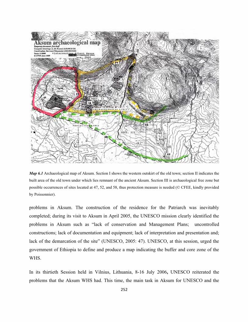
252
Map 6.1 Archaeological map of Aksum. Section I shows the western outskirt of the old town; section II indicates the
built area of the old town under which lies remnant of the ancient Aksum. Section III is archaeological free zone but
possible occurrences of sites located at 47, 52, and 58, thus protection measure is needed (© CFEE, kindly provided
by Poissonnier). problems in Aksum. The construction of the residence for the Patriarch was inevitably
completed; during its visit to Aksum in April 2005, the UNESCO mission clearly identified the
problems in Aksum such as “lack of conservation and Management Plans; uncontrolled
constructions; lack of documentation and equipment; lack of interpretation and presentation and;
lack of the demarcation of the site” (UNESCO, 2005: 47). UNESCO, at this session, urged the
government of Ethiopia to define and produce a map indicating the buffer and core zone of the
WHS.
In its thirtieth Session held in Vilnius, Lithuania, 8-16 July 2006, UNESCO reiterated the
problems that the Aksum WHS had. This time, the main task in Aksum for UNESCO and the

253
country was the re-erection of stela 2. It was greatly feared that the re-erection of stela 2 might
put stela 3 at risk. As a consequence, much effort was focused on the engineering to minimize
any risks; the Italian government allocated a reasonably large part of the budget – USD $5.07
million – by the Italian Funds-in-Trust for the “Aksum Archaeological Site Improvement
Project: Preparatory studies for the reinstallation of the Obelisk and capacity building for
archaeological conservation - Phase 1”, “Reinstallation of the Obelisk - Phase 2” and
“Consolidation of Stele III” (UNESCO, 2006: 98-100; 2013: 75). Despite such efforts, the
stability of stela 3 was finally affected by the reinstallation of stela 2 and is now tilting 2.24
degrees (UNESCO, 2013: 75).
Every year, the UNESCO WHC has identified the main threats to the Aksum World Heritage
property. At its thirty-second session held in Quebec City, Canada, 2-10 July 2008, the WHC
noted the following problems:
“a) Insufficient delimitation of this serial property;
b) Lack of conservation and management plans;
c) Lack of appropriate urban planning and building regulations;
d) Lack of cartography documentation and equipment” (UNESCO, 2008b: 73).
On top of these serious existing problems, a new work of the World Bank funded project has
posed a threat to the World Heritage property: a new museum was built behind the SP. The
WHC has explained this threat thusly:
“… plans of the World Bank project shown to UNESCO in January 2006 were
implemented with a change in the original design: the height of the museum
entrance has been raised to two stories instead of the foreseen one storey; this is
regrettable since the museum was built inside the Stelae Park. In addition, with
increasing tourism, the location of the entrance in the back of the Stelae Park will
transform the latter into a crossing area to access the museum” (Ibid: 74).
In the same report, the country was further reminded to work on the heritage buffer zone and a
detailed road map of the heritage area to be submitted to the UNESCO WHC for examination at
its thirty-third session in 2009.

254
At the thirty-fourth session held in Brazil from 25 July to 3 August 2010, UNESCO WHC had
strongly stressed the aggravating problems at the Aksum World Heritage Site and the silence of
the country in taking protective measures in Aksum. A joint World Heritage Centre/ICOMOS
reactive monitoring mission had visited Aksum from 4-8 February 2010. From that visit, the
mission identified more problems in addition to those already existing. The main ones reported
by the mission to the WHC were “the need for the definition of boundaries, for a retrospective
Statement of Outstanding Universal Value, for a Memorandum of Understanding on governance
arrangements, for qualified staff, for planning controls, for a Management Plan, and to address
the structural instability of Stele 3 and related rising water table issues” (UNESCO, 2010: 115).
The mission also underlined that there would be a red signal on the Aksum WHS as a result of
the uncontrolled encroachment and development, and in particular the planned construction of a
museum by the Ethiopian Orthodox Church in the compound of the Aksum Maryam Tsion
church. Such developments had never been reported in advance to the UNESCO WHC and
construction was taking place within the property.
According to the UNESCO WHC report, the country was not active in taking immediate action
in response to the repeated requests by the WHC. The country gave several reasons for its delay
to take action: that it would work with Aksum University, lack of funding, lack of expertise, and
that the country is waiting for a draft proclamation to protect the site to be adopted by
Parliament (Ibid). It was also reported to the WHC that the rising water table in the Tomb of
Brick Arches was related to the structural instability of stela 3, which was in turn affected by the
stela 2 reinstallation works in 2008. This is, however, completely false: after the tomb was
excavated in the 1990s by BIEA (see chapter four), the tomb had always been under threat from
the rising water table. The researcher is a primary eyewitness for the fact that the rising water
table was drained out by laborers every year during his four years of work from August 2001 to
September 2005 as an expert in heritage protection and conservation in the Aksum Culture and
Tourism Office. It can, therefore, be discerned here that the cause cannot be related to the
instability of stela 3 after 2008. This is just a pretext of the authorities that shows their ignorance
and underestimation of the reports about the problem years before 2008. Of course this problem
of the rising water table in the Tomb of Brick Arches and the Tomb of Bazen has been regarded

255
Fig. 6.1 The tomb of Brick Arch: (A) water filled up to the level indicated with broken lines. A plastic tube visible
in the water was used to drain out the water. (B) View from upper stairs towards the interior; here a wet area can be
seen when rainwater entered through the entrance and leaked through the side wall (upper right corner). A plastic
tube used to drain out the water can be seen on the stairs (photo: Hiluf Berhe, 18/8/2008). by the authorities as minor. The researcher stresses here that the cause was rainwater entering
directly through the entrance due to poor conservation works, and the rising ground water
during the winter season due to its depth5. The incident of this problem after the 1990s BIEA
excavations and the recurrence of the problem every winter season justify this observation.
UNESCO was so sorry about the newly built archaeological museum within the SP by the
World Bank funded project. The problem of construction within the World Heritage property in
Aksum doesn’t come only from the residents, as will be discussed elsewhere, but also from the
institutions (the Church and ARCCH) as well. Through 2010, UNESCO had already reported
5 Tekle Hagos (2008: 130) also observed that the water comes from underground during the rainy season. Some Ethiopian architects have suggested planting large trees near the tomb so that the roots can absorb the ground water permanently, but they did not consider that the roots also can penetrate into the structures and make them disintegrate. The tomb is also found 10 meters below the present surface level – so deep that only the roots of extremely large trees (such as warka) can reach the depth.
B A

256
the problems of two completed constructions (the residence for the Patriarch and the
Archaeological Museum) and the newly planned construction of a large museum by the Church.
No measure was taken by UNESCO when all these constructions were carried out except it felt
sorry.
At its thirty-fourth session in its closing discussion about Aksum, UNESCO underlined the
urgent need to address, through the adoption of a law on urban planning, the exposure of the
property to uncontrolled construction developments. It also requested the country further
investigate the root causes of the rising water table in the Tomb of Brick Arches and reiterated
the need to submit an appropriate map of the heritage property and a report on the state of
conservation for the next session of UNESCO WHC (Ibid).
Fig. 6.2 The new archaeological museum, visible behind the stelae, and residence of the Patriarch, right corner; view from May Koho (Photo: Hiluf Berhe, 17/2/2009).

257
The threats to the Aksum WHS continued without being halted or minimized. Although the
country submitted a map about a buffer zone, it was rejected by UNESCO at its 2012 session for
failing to comply with the required format and level of detail by UNESCO. During this session,
UNESCO also highlighted that the construction of the church museum continued and already
had reached the first floor level. This four-storey museum was planned by an Italian architect.
UNESCO had requested the submission of the plan for review during the 2010 session, but the
plan was not submitted for review nor was the construction delayed. UNESCO still requested
that the construction be halted until some revisions of the plan were made (UNESCO, 2012: 86).
During the 2012 UNESCO session, the country presented further reasons for the delay of the
implementation of the above plans. Among others, excuses included the establishment of a site
office in Aksum for management, the delay of the Parliament in endorsing the draft document on
the legal protection for the Aksum WHS, further technical study in collaboration with national
universities for the final solution of the rising water table in the Tomb of Brick Arches, and
blaming the company that reinstalled stela 2 as responsible for the destabilization of stela 3 (Ibid,
2012). The country was again requested to consider and act accordingly in response to all the
recommendations and information forwarded by UNESCO. The construction of the Church
Museum was a major concern as it might negatively affect the World Heritage Site. In its
statement to the nation, UNESCO requested and warned the:
“…State Party (country) to submit to the World Heritage Centre, by 1 February
2013, a detailed report on the state of conservation of the property and the
implementation of the above, for examination by the World Heritage Committee at
its 37th session in 2013, with a view to considering, if the Orthodox Church Museum
construction is not halted until the project is comprehensively assessed by a high
level reactive monitoring mission, and until appropriate solutions to ensure that the
Outstanding Universal Value of the property is fully preserved have been identified
and agreed upon, the possible inscription of the property on the List of World
Heritage in Danger” [emphasis by UNESCO] (Ibid: 88).
A joint committee of the WHC-ICOMOS mission visited Aksum from 20-27 January 2013 to
inspect the conservation status of the Aksum World Heritage Property. The mission was mainly

258
there to evaluate the negative impacts of the construction of the Church Museum on the World
Heritage property. In addition to this objective, the mission also had to check the existence of a
management plan and delineated buffer zone for the Aksum World Heritage Property (Cummins
et al., 2013).
As the report indicated, it seems that the mission was wisely welcomed by the Church and
government authorities with apologies from the Church and the office of the mayor of Aksum for
the construction of the new Church Museum building without submitting a report to the
UNESCO WHC due to their ignorance about paragraph 1726 of the UNESCO Operational
Guidelines. Although the mission realized that no change had been made to the design of the
new Church Museum, it considered its construction positively and had the opinion that the
construction would not impair the view of the three church buildings of Aksum Maryam Tsion
nor would it have any impact on the World Heritage property. This was totally contrary to the
previous reports of UNESCO WHC about the prevailing threat of the size of the Church
Museum.
There is no doubt that the Church Museum will have a positive role in saving the ecclesiastical
treasures in jeopardy today due to adverse space, poor management, and the lack of trained
personnel in heritage protection and management. All treasures donated by believers and
Ethiopian kings, as well as artefacts believed to have been brought to Aksum together with the
Ark of the Covenant, are currently housed in the ground room of the small Chapel of the Ark of
the Covenant. If properly utilized, the new Church Museum building could also be an excellent
center for archives for researchers about the faith and the history of the Orthodox Church. As the
State and the Church were also together (Tadesse Tamrat, 1972), the archives in the Aksum
6 UNESCO Operational Guidelines, paragraph 172 reads: “The World Heritage Committee invites the States Parties to the Convention to inform the Committee, through the Secretariat, of their intention to undertake or to authorize in an area protected under the Convention major restorations or new constructions which may affect the outstanding universal value of the property. Notice should be given as soon as possible (for instance, before drafting basic documents for specific projects) and before making any decisions that would be difficult to reverse, so that the Committee may assist in seeking appropriate solutions to ensure that the outstanding universal value of the property is fully preserved” (UNESCO, 2008a: 45-46).
259
Maryam Tsion church will offer a great opportunity for national and international researchers to
access information about the Church-State relationship in the past.
But should we put the older heritage at risk in order to build this new Church Museum for the
aforementioned advantages? What would be the benefit of this new Church Museum after all if
we negatively affect heritage, thereby causing chaos for heritage protection and sustainability?
The researcher does not have any objection to the construction of the new Church Museum, but
the actual size of the building, as opposed to the size that was claimed, shows the negligence of
the authorities of the heritage protection bureaus to this World Heritage property. The ARCCH is
officially mandated by law to take care of the heritage of the nation. The request of apologies by
the Church authorities to the mission clearly shows that the ARCCH has not created awareness
among the Church officials about the UNESCO rules and regulations for a World Heritage Site.
It also means that the ARCCH does not follow up on any development plans and construction
affecting the WHS, and there was and still is a lack of communication among ARCCH, the
Orthodox Church, and the municipality about the protection of this World Heritage property.
The visit of the mission has also confirmed that there was a problem with a management plan
and the lack of a buffer zone for the Aksum World Heritage property; they also observed the
problem of the rising water table in the Tomb of Brick Arches and the destabilized stela 3. All
these problems had been there for a few years prior to the visit of the mission in 2013, and
particularly the lack of a defined boundary, buffer zone, and management plan for Aksum was
reported immediately after the year of registration; however, none had been executed. Despite
the threats to the Aksum World Heritage property as reported by UNESCO WHC, the mission
report of 2013 concluded “…that there are no major threats to the property and therefore the
conditions to place the property on the List of World Heritage in Danger have not been met”
(Cummins et al., 2013: n.p). This overlooked all the previous reports about the problems in
Aksum that were still in place by the time the mission was in Aksum in 2013: the residence of
the Patriarch was already built; the construction of the new Church Museum was progressing
without any mitigation in the plan for the size of the building; stela 3 was still stretched with a
temporary security system consisting of stabilizing cables to avoid further inclination; the rising
water table in the Tomb of Brick Arches was still in place; the Archaeological Museum was

260
regrettably built without consulting the UNESCO WHC; the delineation of a heritage boundary
and buffer zone was still incomplete; and uncontrolled construction developments were taking
place in the main heritage center. For these and other human and natural reasons, the World
Heritage property remains highly vulnerable.
Although UNESCO WHC recommended a minor revision to the size of the new Church
Museum in order to avoid a visual impact on the ensemble of three church buildings of Aksum
Maryam Tsion (UNESCO, 2013: 74), the construction has progressed according to the original
design without any mitigation to the plan. This four-storey building (fig. 6.3) has now negatively
affected the view of the churches, not only when standing closer to the new building, but also
even from the top of the hill of May Koho. The rescue excavations on this site are also very
controversial; the impact assessment made on the site allowed HAMA’s simple drilling down to
a depth of 4 meters on the western side and 2.5 meters on the eastern side. But as the building
needs very deep foundations covering a large area, test excavations should have been carried out.
Results of the drilling test of HAMA 20037 show that the western side was filled with the
dumped soil from Contenson’s excavation of the ancient church of Maryam Tsion during the late Fig. 6.3 The new Church Museum building; (top left) front view of plan of the new museum, and (top right) south side view (after Cummins et al., 2013: n.p); (bottom left) front view of the constructed new museum, view from May Koho hill, and (bottom right) south side view (Photo: Hiluf Berhe, 28/09/2014). Note: the view of Chapel of the Ark of Covenant is already obscured by the new museum building. Only the top part of the 17th century Cathedral is still visible. One can also judge how the view of the whole surrounding area is negatively affected by this four-storey museum building.
7 The researcher participated in this drilling test as an antiquity officer and field trainee.

261
Fig. 6.4 View of the Maryam Tsion church area from May Koho; (top) before construction of the new church museum; (below) after the construction of the new church museum. Note: the warka tree visible on the foreground (top image) was removed (Photo: Hiluf Berhe, 2009, 2014, respectively).

262
1950s; while on the eastern side, the drilling indicated an undisturbed profile with the presence
of ashes and deposits of the Mai Shum water basin.
The thirty-seventh session of UNESCO (2013) in its discussion on Aksum was concluded with
requests to the country to submit a report if there were any changes in the plan of the new
Church museum, especially a slight modification of its façade; to implement the management
plan; work on the review of Aksum Master Plan in terms of heritage management; and to clarify
urgently the heritage boundary and buffer zone and submit it to the WHC by 1 February 2015. At
the time of writing and visit to the site in early October 2014, construction of the Church
Museum was completed according to the original plan (fig. 6.3 and 6.4) without any mitigation
as requested by UNESCO WHC. Unfortunately, no updated information is available about
Aksum in the document of UNESCO WHC of the thirty-eighth session, held at Doha, Qatar, 15-
25 June 2014.
6.4 Heritage types in Aksum
The heritage type found in Aksum is broadly categorized under cultural heritage according to the
classification of “heritage” by UNESCO8. Its cultural heritage is further classified into tangible
and intangible. Aksum is primarily known for its composition of cultural heritage. The objective
of this sub-topic is not to deal in detail with the definition of cultural heritage; rather it is to
discuss the heritage of Aksum under the control of the State and the Church. Accordingly there
are two types of heritage in Aksum in terms of control and administration: ecclesiastical and
secular heritage. Aksum is believed to be the holiest place for the Ethiopian Orthodox Church
because it is where the first church was believed to have been built and is also believed to be the
resting place of the Ark of the Covenant. 8“ – monuments: architectural works, works of monumental sculpture and painting, elements or structures of an archaeological nature, inscriptions, cave dwellings and combinations of features, which are of outstanding universal value from the point of view of history, art or science; – groups of buildings: groups of separate or connected buildings which, because of their architecture, their homogeneity or their place in the landscape, are of outstanding universal value from the point of view of history, art or science; – sites: works of man or the combined works of nature and man, and areas including archaeological sites which are of outstanding universal value from the historical, aesthetic, ethnological or anthropological point of view” (Article1; UNESCO Convention concerning the Protection of the World Cultural and Natural Heritage; Adopted by the General Conference at its seventeenth session Paris, 16 November 1972. 2005 Edition).

263
In the compound of the Aksum Maryam Tsion church, there are three church buildings still
holding services; a forth one is represented by the remains of the first church revealed by
archaeological excavations as discussed in chapter four. The oldest of the three church buildings
was built during the 17th century, the newest one completed in 1965 by Emperor Haileselassie I
of Ethiopia (r. 1930 – 1974), and the third is the small Chapel of the Ark of the Covenant of
1945. The Church has housed a great number of liturgical objects and other memorial objects
donated by individuals, local rulers, and emperors, as well as archaeological objects9. Among the
objects in possession by the Church are parchment manuscripts. Currently all sorts of heritage
found in the church compound – including objects discovered by fortuitous and archaeological
excavations – is under the possession of the Church administration.
On the other hand, archaeological sites and monuments, burial places, remains of palaces and
other buildings, stone inscriptions, archaeological museums, and any other cultural heritage
outside the church compound is owned and administered by the State. A third category is the
private houses located in the old town that contained typical Aksumite architecture. Such houses
are worthy of protection and preservation with the help of the Culture and Tourism Office for
their architectural representation of ancient Aksum. Although owned by individuals, the office
intercedes with professional advice for the preservation of such old houses as living testimonies
of the architecture of Aksum.
6.5 Heritage ownership and protection mandate in Aksum
The Heritage Proclamation number 209/2000 of Ethiopia states that “cultural heritage may be
owned by the state or any person” (Article 14 (1)). Under sub-article 2 of same article, any
cultural heritage discovered by exploration or excavation could be owned only by the State. Here
the place of the ecclesiastical objects is not indicated; the State can own any cultural heritage
discovered by excavation, exploration or even fortuitous, while individuals can own heritage
inherited from their predecessors and deemed to be expressive of specific society in terms of
historical context, architecture, art or tradition. The Church is a separate institute possessing most
9 The preservation and conservation status of the ecclesiastical heritage in Aksum is discussed in the following sub-topics.
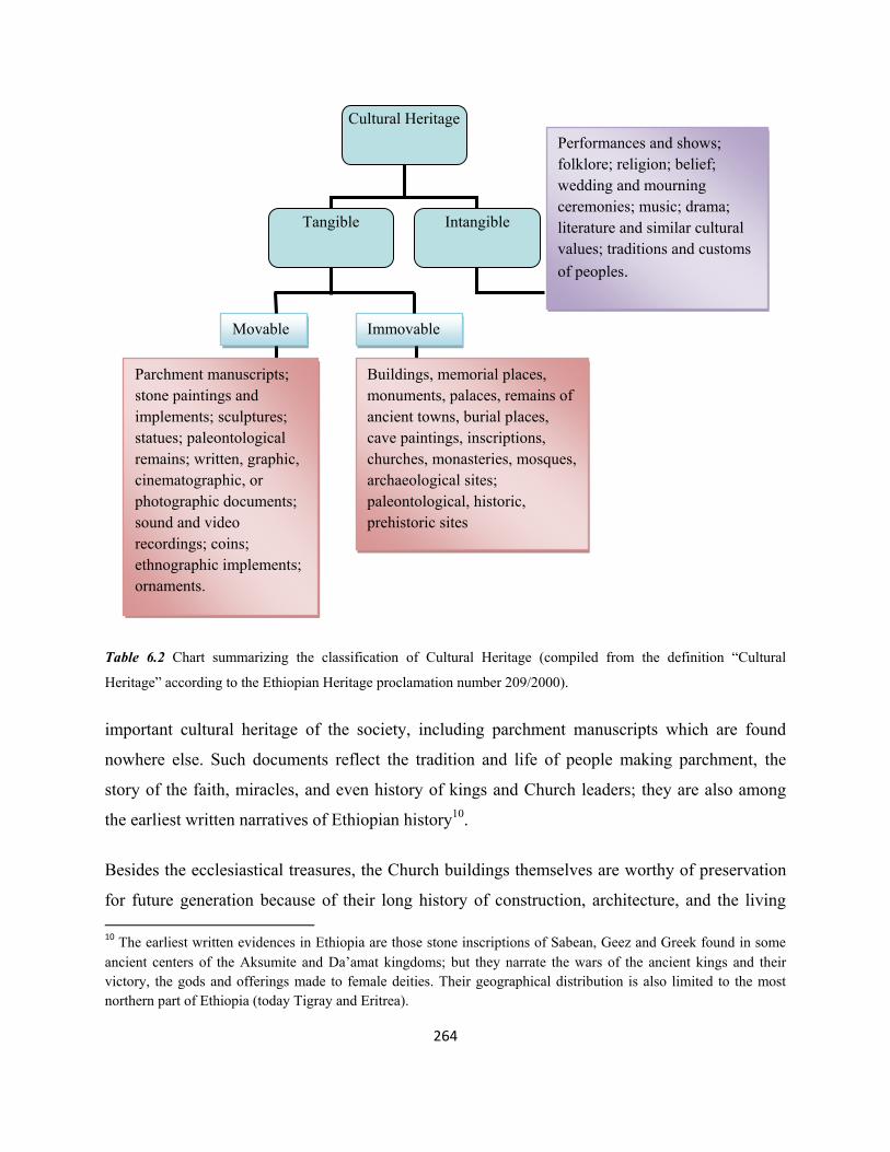
264
Table 6.2 Chart summarizing the classification of Cultural Heritage (compiled from the definition “Cultural
Heritage” according to the Ethiopian Heritage proclamation number 209/2000).
important cultural heritage of the society, including parchment manuscripts which are found
nowhere else. Such documents reflect the tradition and life of people making parchment, the
story of the faith, miracles, and even history of kings and Church leaders; they are also among
the earliest written narratives of Ethiopian history10.
Besides the ecclesiastical treasures, the Church buildings themselves are worthy of preservation
for future generation because of their long history of construction, architecture, and the living 10 The earliest written evidences in Ethiopia are those stone inscriptions of Sabean, Geez and Greek found in some ancient centers of the Aksumite and Da’amat kingdoms; but they narrate the wars of the ancient kings and their victory, the gods and offerings made to female deities. Their geographical distribution is also limited to the most northern part of Ethiopia (today Tigray and Eritrea).
Cultural Heritage
Tangible Intangible
Movable Immovable
Parchment manuscripts; stone paintings and implements; sculptures; statues; paleontological remains; written, graphic, cinematographic, or photographic documents; sound and video recordings; coins; ethnographic implements; ornaments.
Buildings, memorial places, monuments, palaces, remains of ancient towns, burial places, cave paintings, inscriptions, churches, monasteries, mosques, archaeological sites; paleontological, historic, prehistoric sites
Performances and shows; folklore; religion; belief; wedding and mourning ceremonies; music; drama; literature and similar cultural values; traditions and customs of peoples.

265
service they render every day to believers. In the past periods, the only institute for the protection
and preservation of such immense ecclesiastical treasures was the Church, and still is most
responsible institute for the protection. Nevertheless, the growth of tourism and the effect of
globalization (modern education) as well as the selfish desire of people for business is weakening
the wealth of the Church. Although the property is common wealth and history of the humanity
in general, the heritage proclamation of Ethiopia has a great gap in this regard.
The State has an annual budget to carry on heritage preservation, while the source of fund of the
Church is generally the unpredictable donations (alms) from the society. The State is exclusively
responsible for the heritage conservation.
The church of Aksum Maryam Tsion is one of the richest churches in Ethiopia in terms of
heritage possession due to its long history and, for more than a millennia, according to legend, it
was center of kings’ coronation place. Crowns (of kings) and crosses made of gold, silver and
bronze; parchment and paper manuscripts; clothes belonging to kings and royal family, and
many other objects are stored in the underground room of the Chapel of the Ark of Covenant.
Besides church objects, Aksum Maryam Tsion church has possessed many of stone inscriptions
of Aksumite kings, and few objects discovered by archaeological excavation in 1993 at the top of
Biete Giorgis.
The stone inscriptions ended up there when the former small archaeological museum was in the
compound of the church in the early days of its construction in 1973. Since then, objects
discovered by excavation, particularly the excavations of BIEA 1972-74, were housed in the
aforementioned museum. According to informants, the entrance to the museum was from the
west until another gate was opened from the east during later periods. When the new gate was
opened, the former entrance to the museum was closed; as a consequence the museum came
under the direct administration and control of the then Culture and Information office, but the
Church kept some of the resourceful stone inscriptions. The objects from Biete Giorgis, around
140 crystal bead-like objects together with one object of oval shape, bigger in size (fig. 6.5) and,
another object with letters “xm” (possibly a seal?) are under the custody of the guardian of the

266
Ark of Covenant. These objects were handed over to the Church to be kept in the most sacred
and secret place – the Chapel of the Ark of Covenant, for their security.
Today, these archaeological objects are not accessible for any research as the Church is supposed
to be separate from the State. The law of the heritage proclamation doesn’t have any power to
interfere unless the Church officials are willing to admit any formal request, despite the heritage
proclamation number 209/2000 under article 43 (1 and 2) states that the authority has the right to
enter “any place” for inspection where there is believed to be a cultural heritage. In reality, the
Fig. 6.5 The oval-shaped object (right) and the object with “xm” letters (left). The researcher had the chance to see them during the inventory of the Church treasures in 2002 (© Yedneqachew).
ARCCH, the authorized federal government institute, has faced problems to enter “any place”
unless equipped with letters from the high Patriarch or when the Church authorities are easy
going persons and willing to welcome any representative from the authority. So today there is no
way of taking these objects out of the Church and make them available for research and tourism
in the archaeological museum.
The gap in the heritage proclamation on the heritage ownership has generally affected the
wellbeing of cultural heritage owned by the Church. The construction of the residence of the
Patriarch and the new church museum without any permission from, and the knowledge of, the
ARCCH are the results of this gap which in turn affected the whole Aksum World Heritage
property. The Church appeals to the ARCCH generally when it needs professional and technical,
as well as financial help with the justification of “historical building”, or “important cultural

267
heritage”, etc. Experiences tell that whenever there is a problem in the Church buildings in
Aksum Maryam Tsion, the Church requests, in writing, to the Culture and Tourism local office
in Aksum for any restoration works.
On the contrary, the Church itself is an obstacle to allow any person from the ARCCH or Culture
and Tourism Office for follow up on the preservation situation of the cultural heritage without a
request from the Church. The site of coronation area is one best example which is sadly in grave
deterioration as the Church always prohibits any conservation or excavation works due to its
“sacredness”.
The objects in the ground room of the Chapel of the Ark of Covenant are in jeopardy of adverse
protection due to lack of space, lack of trained professional, and absence of regular follow-up
about their wellbeing. The situation was exposed in 2002 during which a team of eight members
formed by representatives from the Patriarch office, Addis Abeba (two persons); Culture and
Tourism office of Aksum represented by the researcher; Police office of Aksum town (one
person); the Diocese office of Aksum Maryam Tsion Church (two persons); and residents of
Aksum town (two persons) inspected and inventoried. During the inventory, many of the objects
were found badly damaged due to lack of space and air and, put one over the other. Some objects
were also not found after the inventory of 1983 and 199811. The report of the inventory was
spread among the residents of Aksum and, the priest was imprisoned. At the time of inventory,
the inevitability of the construction of a new museum was highly recommended, after which, in
November 2002, the Patriarch laid the foundation stone while he was in Aksum for the
celebration of Hidar Maryam Tsion.
The heritage proclamation number 209/2000 under article 17(2) reads “The Authority shall
register Cultural Heritage using codes appropriate for their custody and preservation”. If the
Authority is mandated to protect, register and inventory Cultural Heritage, then this general term
11 An inventory of the Church objects had been made in 1983 and 1998 by the Culture, Tourism and Information Bureau of National Regional State of Tigray. The researcher found the inventory document of 1983 messed in a store room among other old equipments and tools. It was then properly rearranged, filed and, now available as an archive in the Aksum Culture and Tourism Office. The inventory document of 1998 was used as best reference for the 2002 inventory mission.

268
“Cultural Heritage” includes the ecclesiastical objects and living worship places as well, as all
are cultural heritage. But the right and power of the Authority in the case of registration and
protection of the ecclesiastical heritage is still ambiguous. Practically the Authority interferes in
the protection and conservation works of the ecclesiastical heritage if the Church accepts the
“offer” or when the Church requests for same objective.
The cultural heritage ownership in Aksum is also complicated in the case of souvenir shops
owners and, children selling objects to tourists on streets. It is common in Aksum to see boys
selling ancient Aksumite coins to tourists on the streets claiming that they have found them by
chance. During the rainy season, many young people in Aksum and its vicinity go out to the
fields in search of ancient coins as the coins become exposed by the rain drop. There is no legal
body then to stop these people from selling the coins to tourists. Nor were the tourists checked at
airports for antiquities from taking such cultural heritage out of the country. Souvenir shops are
also believed to be repository places for cultural heritage objects from neighboring villages
acquired by illicit excavation or found by chance. An organized illicit excavation on
archaeological site has been reported from Mai Adrasha (Finneran, 2007: 268-7; Asamerew et
al., 2002) near Shire Endaselassie, about 60 km west of Aksum.
Medebay-Welel, an Aksumite site some 12 km north of Aksum, was dug during daylight by
villagers in search of archaeological objects to be supplied to souvenir shops. The site
particularly where only potteries and coins were found, was entirely destroyed before any
information was documented by professionals (Hiluf Berhe, 2004). The Pre-Aksumite site of
Hawelti, some 10 km east of Aksum, is also victim of the antiquities black market in Aksum.
Many people have privately possessed objects they discovered from the site during cultivation
and even by organized illegal excavation (ECHP, 37: 2) and negotiate with any visitor to the site.
This clearly shows that the people negotiate for better price with visitors to the site than
supplying the objects to souvenir shops in Aksum.
The researcher has experienced that the souvenir shop owners in Aksum never allow a tourist
guide or any employee from the Culture and Tourism Office to enter into their “innermost” room
except the tourists who could buy “souvenir” objects. This trick of souvenir shop owners is a

269
common scene in many tourist destination archaeological sites in the most centers of ancient
civilizations that souvenir shop owners keep original objects “out of view” of concerned
employees and other visitors who could possibly disclose secrets of the shops (Comer, 2012:
181).
In 2005 a research has revealed that villagers around Aksum present objects acquired by chance
or illicit excavation to souvenir shop owners in Aksum. Representatives from police office, local
and district justice offices, and Aksum Yohannes IV Airport confessed that they do not have any
idea about the heritage law for protection and the knowledge to differentiate between original
cultural heritage and fake objects (Hiluf Berhe, 2005). This implies that those cultural heritages
are taken out of Aksum due to lack of awareness and the selfish desire of businessmen. ARCCH
is usually weak in working together with community and creating awareness about the meaning
and significance of heritages and means of protection. Sometimes, people even negotiate with
the Culture and Tourism office in Askum to be compensated if they point out the whereabouts of
a cultural heritage object. Article 41 (1-4) of the heritage proclamation 209/2000 encourages
people to ask for compensation. Any person discovering an object by chance is entitled by the
Authority to be rewarded and, reimbursed for any expense if the person has spent money for the
upkeep of the object. In this sense, ‘fortuitous discovery’ is very general one if the issue of
financial reward has to be raised. Otherwise, it gives people a direction to acquire cultural
heritage objects by illegal excavation in order to claim for financial compensation. This is the
other way of official cultural heritage trafficking. It appears clear, from this discussion, that
heritage is owned by the Sate, individuals and the Church in Aksum, but the heritage protection
mandate is left to the ARCCH, though inefficient.
6.6 Tourism promotion or heritage protection? The question of priority
Tourism is a catalyst to economic and social benefit for a society. While cultural heritage
resources are endowments, tourism is generally a consumer – although the profit from tourism is
usually controlled by few entrepreneurs. The worst is its negative consequence on the cultural
heritage resources: unmanaged tourism development damages the fragile archaeological sites.
Archaeological resources are so fragile and nonrenewable; once any physical damage occurred

270
on the heritage resources, it is not possible to put the heritage back nor recover the original
information (Comer, 2012: 12-16). If the driving motor for tourism is the Endowment, then the
preservation of the Endowment should be a priority issue before planning any tourism
development.
Apart from physical damage on the cultural heritage resources, despite a general economic
growth, uncontrolled tourism development exposes the host community to diffused political and
social change. The propaganda on tourism with a list of attraction potentials before paving the
ground for the sustainability of the archaeological heritage, and without creating awareness
among the society, easily erodes the archaeological heritage and the culture of the society, since
tourism means exploiting the heritage resources (Cleere, 2012: vii-viii). Tourism has both
negative and positive consequences on both the archaeological resources and the society.
One possible reason for some important tourist destination sites to prioritize on tourism
development than heritage preservation is the problem of funding. International funding
organizations have usually encouraged a loan for tourism development projects to augment the
flow of capital; such developments, however, helped few individuals (businessmen) rise their
capital while leaving the general community disadvantaged. Plans for doubling tourist numbers
and revenue from tourism under “A strategic Approach to Doubling the Tourism Economy of
Jordan, 2004-2010, funded by United States Agency for International Development (USAID) has
damaged Petra archaeological heritage. The USAID’s fund was not concerned on heritage
management; as a consequence the heritage resource of Petra received huge number of tourists
that sadly irretrievably damaged the archaeological heritage (Comer, 2012: 174).
The issue of Aksum archaeological heritage is not different from that of Petra. In the previous
sections of this chapter, it has been discussed that Aksum had even been warned of the
possibility of inclusion in the “World Heritage in Danger” for failure of the country to have
heritage management plan, heritage buffer zone and boundary. Among the main problems of the
country to undertake proper heritage management was lack of fund and heritage professionals.
On the contrary the World Bank has funded the country through the Learning and Innovation

271
Loan (LIL) in 2003 implemented by the Ministry of Culture and Tourism under a temporarily
established office – ECHP. This fund was mainly for few sites, of which Aksum was one.
The project had four general components:
“i). Site Planning and Conservation
ii). Inventory and Documentation Development
iii). Support for the development of Artisan Crafts, and
iv). Support for Project Management”
The Aksum sub-component of this project began its preparation phase with short meetings and
site assessments in Aksum in late 2003. Although the project was supposed to be a pilot project,
it also hastily incorporated on the construction of the archaeological museum, the rehabilitation
of the old house of Ras Seyoum Mengesha12 as artisans’ training center, and the rehabilitation of
the old house of Dejjazmach Gebreselassie Baryagaber13 (found in the compound of the present
archaeological museum). The project, run by an international consultant company HYDEA,
outlined some objectives which were minor tasks for a supposedly big project. The objectives
mainly focused on “interpretation panels” and “identification/orientation/direction panels”
(ECHP, 2007: 6). All the effort of this project was to design signage panels so as to ease the
communication of information for tourists about sites (location, type) and also about post-visit
entertainments and activities (shopping places, cafeteria).
The necessity of site interpretation was regarded as one of top priorities for tourism development
in Aksum. In drive behind developing site interpretation was to bring the local community and
the tourist together to share culture, ideas, aesthetics, etc by directing and encouraging the
12 The quality of the rehabilitation work was irresponsibly carried out that soon the grass was blown away by wind, the whole compound turned to be play ground for children and even animals, and the intended objective failed as the people refused to be in group work in order to keep the secret of their art work. In Aksum, although products are
displayed in shops and open markets, the technique of art is always private and secret carried out in individual houses. This house was again rehabilitated under second World Bank fund project (discussed in the following sections) with the objective of converting it into four star hotel.
13 This 19th century old house was rehabilitated with the objective of converting it into coffee house in the museum. But it was neither used for the intended objective nor responsibly rehabilitated. Soon again this house began to deteriorate; it is also rehabilitated in 2014 by a second World Bank Fund project.

272
tourists go around the old town and meet the community. In order to achieve this, the effort
towards access to the sites was envisaged as most important. This would help the tourists admire
the living culture and architecture of the society, and in turn would help the host community to
create awareness that their culture deserves preservation (ECHP, 2007: 6-7).
The interpretation panels, in aluminum material, were supposed to include a photograph,
drawing or sketch design of each of a palace remain or monuments and underground tombs. But
not surprisingly, the question of where to put the signage panels is vague since most of the palace
remains are completely occupied by later constructions. Furthermore, the information (text) on
the signage panel is not more than just the name of the site or monument. There is a general
argument in Aksum that if more details of the history of a site or monument are put on a
brochure or signage panel, then tourists would not hire a guide which in turn encourages
unemployment for guides in Aksum. In order to create job for guides, any detail information on
brochure or signage panel is not supported, and thus the information remains hidden from the
tourist only to be explained by the tour guide person.
In this way the idea of working toward site interpretation before presenting the sites properly is a
total negligence toward the archaeological heritage resources. Preservation and conservation of
the sites should have come first before any tourism development. Under this project, only minor
activities have been carried out on the archaeological heritage, such as the survey and
documentation of the archaeological sites, and clearance and maintenance on some underground
tombs and stone thrones. The excavation on ancient church remains at Guanga Edaga (fig. 3.4)
can be considered the best achievement of the project. The signage panels erected on the clearly
visible archaeological sites are of poor quality, small in size, and whose purpose is already
forgotten. The project terminated its duration without any significant change for the
archaeological site and tourism development.
Aksum received another fund for tourism development in 2009 from National Regional State of
Tigrai, implemented by Culture and Tourism Agency of Tigrai. The project was carried out on
paper to develop a “Thematic Master plan for the Historic Town of Aksum”. The National
Regional State of Tigrai had made an economic reform in 2007 by which tourism development
was considered as a pivotal factor to achieve this goal. Aksum was then selected for a pilot

273
project. The project ambitiously planned to double tourist number in Aksum from 15,000 to
30,000 in 2009/2010. The project also targeted to boost tourist number in Aksum to 120,000 per
year in four years from 2010. According to this project study, Aksum was planned to be center of
attractions within a 100km radius. Aksum itself was planned to be five-day visit.
The master study plan proposed around twenty-five interpretation centers in Aksum with ten
character areas worthy of visit. The renovation of Enda Raesi (i.e., Ras Seyoum Mengesha
house) into four-star hotel, the upgrading of Yeha hotel, construction of new conference hall at
the foot of May Koho hill, construction of refreshment centers, cafes, and restaurants in all part
of the old town, children play ground and Botanical Garden, and amphitheatre on the foothill of
May Koho with the stelae as backdrop are among the proposed plans of this project.
Following the “tourism development” projects in Aksum, many hotels have been constructed and
are still under construction to accommodate the forecasted tourist flow. While carrying on such
projects for tourism development, nothing is concerned about the archaeological heritage into
which the tourists are to be directed. There is no management plan for the sustainability of the
cultural heritage resources.
A second loan for Aksum from the World Bank, under a project name “Ethiopian Sustainable
Tourism Development Project (ESTDP)”, is currently working to meet the objectives set out in
the Master Plan project study. This five year project, with total fund of 6.5 million Ethiopian Birr
(ETB) is on its final stage of duration14. This project also did not plan any regarding the
archaeological and cultural heritage resources; instead, it is working on expansion and decoration
of squares such as those two big warka tree squares, paving the squares and streets with
cobblestone by removing the former asphalt; paving the area between the SP and Maryam Tsion
church with cobblestone, and covering the May Hejja stream in front of the Maryam Tsion
church with concrete cement. One of the interpretation centers in the office of Culture and
Tourism and, restoration work on Dejjazmach Gebreselassie Baryagaber house are in progress.
14 Tewodros Abreham: Coordinator of the ESTDP Aksum Site Management Unit, personal communication; September 2014, Aksum.

274
Unfortunately, the archaeological heritage resource and, the old houses in the old town, are in
desperation state. The old houses in the old town are deteriorating, because some of them are
already abandoned as some owners preferred to shift to the new settlement quarters for better
space and infrastructure while others are simply waiting without any rehabilitation work in
anticipation of support from the Culture and Tourism Office due to their selection as “important
cultural houses”. The houses represented a transitional culture and architecture between the
present and the lost glory of Aksum. The old houses are living testimonies of the day-to-day life
of Aksum people; they also housed several ethnographic objects that are not yet diffused with the
modern objects. Therefore, the old houses already selected by the Culture and Tourism Office
deserve conservation and protection before they fall apart completely as most of them are already
abandoned and falling in ruin. Very few of them are luckily enough in good state as their owners
have the financial capacity to maintain them and good awareness about their significance in
teaching the life and architecture of Aksum to the present and future generation.
The ambitious “Tourism Development” projects, coupled with the establishment of Aksum
University since 2007, have attracted many small business speculators especially bar and night
clubs in the old quarter of the town. The effect of such businesses in the old town is that the
houses were renewed and refurbished colorfully thereby disfiguring the former decent view and
architecture of the area. As the old town is very poor in infrastructure, the lack of private and
public toilets led people to use the streets for pee and excrement. The streets are so untidy to
recommend tourists visit the old town before improving the area. Once the houses are well
maintained and ensured their protection and sustainability and, the hygiene of the old town
properly maintained, tourists will then be attracted to see the real life and architecture of Aksum
people represented by the old town.
The SP, the northern stelae field, southeastern throne sites, Bazen tomb area, Gudit stelae field,
the compound of Kaleb and Gebre Mesqel tombs, Dungur palace, and other structures are always
covered with grass and weed during winter season; while there are huge projects for “Tourism
Development” as has already been discussed earlier, the budget lacks when it comes to the
Endowments. The growing grass and weed in the archaeological heritage sites creates humidity
in the underground tombs, and when the rain water is retained by the grass and weeds for long
275
time, it leaks into the underground thereby making structures loose and weak from moisture. In
some structures, like in those Dungur palace and Kaleb and Gebre Mesqel tombs, the coping is
very poor; as a result rain water directly goes into the main wall. Every winter again weeds grow
larger on the walls, and any attempt of removing them by hand after the rain season causes the
structure to lose its mortar and gradually the wall becomes exposed to irreversible danger. The
water inside the tombs of “Bazen” and Tomb of Brick Arches is persistent.
The main eye-caching heritage – the third largest standing stela is at risk mainly destabilized
during the re-erection of stela 2 in 2008. Since then, stela 3 is still stretched with securing system
cables to avoid further inclination and from eventual fall. The Italian government had funded for
the consolidation of this stela, together with the re-erection of stela 2, with a total budget of USD
5.07 million. But once stela 2 was re-erected in 2008, the consolidation work on stela 3 was left
unfinished as the Italian government rejected the extension of the project duration beyond the
end of December 2009 (UNESCO, 2013: 75).
Almost the whole percentage of the archaeological and cultural heritage in Aksum is in disarray.
Great attention with immediate and practical decision toward their sustainable protection is
needed. The development of tourism before ensuring the protection and preservation of the
Endowments would be short-term business. It is not that much difficult and costly to maintain
and protect the heritage before falling in problem, but once the heritage is destroyed the issue
would not be just about cost, rather it would be about the loss of identity: it cannot be possible to
recover the heritage once destroyed, and would cause eternal regret.

276
CHAPTER SEVEN
DISCUSSION AND CONCLUSION
The destruction of archaeological sites occurs globally today, largely because of fast growing
industrialization, accompanied by mega projects such as urbanization, hydroelectric installations,
road construction, etc. These developments take place at a rapid pace thereby negatively
impactingthe archaeological heritage resources. The intervention to save cultural heritage
resourceshas proceeded slowly in general for several reasons: insufficient financial and labor
resources, lack of awareness, negligence, and absence of prior documentation practice. As a
result, non-renewable archaeological resources are too often damaged, and “when material
remains are destroyed, damaged, or removed from the context, the information that might have
been produced through their proper analysis is lost forever” (Comer, 2012, 28).
Although there is a growing attention to the registration and preservation of international cultural
heritage resources by UNESCO, its practicality is not yet fully realized. The promotion of World
Heritage listed sites of outstanding universal significance may expose them to dangers linked
with the consequences of tourism. The preservation of archaeological sites is essential to
understand the beliefs, values and practices of past societies. Tangible material culture helps us
understand the intangible; equally the intangible helps to piece together, and give form to, the
tangible material culture. Properly preserved archaeological sites are sources of economic and
social development. To foster the advantages of cultural heritage resources, their authenticity
must be protected and preserved by establishing legislative measures and heritage site buffer
zones.
While industrialization is unstoppable, archaeology professionals should, in collaboration with
local residents, hasten to document and protect sites before development activities destroy them
forever. It should be understood that an absence of visible archaeological traces on the surface of
any particular site doesn’t mean it has no archaeological significance, it is just not yet confirmed.
Thus, whenever any development activity takes place on a site that looks non-archaeological
when just viewed from the surface, archaeologists must keep an eye during construction to
salvage information before destruction.

277
Destruction of archaeological sites is more evident in developing countries. This may be ascribed
to several reasons: protracted civil war, lack of trained professionals in the field of heritage
management, poverty, financial problems, and issues of national consensus are among the
factors. The recent rapid increase in various constructions is detrimental to the heritage of
humanity. Almost all world nations have drafted national legislations and many have ratified the
UNESCO Convention concerning the Protection of the World Cultural and Natural Heritage.
Despite a global move towards heritage protection, heritage Proclamations and Acts are more
often good ideas on paper rather than implemented programs. Almost always, therefore, the pace
of construction surpasses the level of heritage protection.
As has been outlined in chapters five and six, Aksum, a designated World Heritage Site, is
highly susceptible to several threats. The ancient site of Aksum is found below the modern
settlement; it has already diminished in overall size due to the uncontrolled constructions and
destruction of the ancient archaeological and cultural landscape. The landscape surrounding the
largest standing stelae in the SP is largely crowded with new buildings and a reforestation
program. The notion of heritage protection and preservation is an almost unknown practice;
heritage administration is carried out by tradition rather than by professionals. Uncontrolled
construction in the old town and surrounding the SP has negatively affected the ancient cultural
landscape.
While the construction developments close by the visible archaeological sites in Aksum is a
disappointing to the archaeology society, the archaeological community should be even more
concerned about the potential damage to as yet unexcavated sites in Aksum. As the ancient town
is found several meters below the modern settlement, the southern outskirts of the ancient town
should not be considered free of any archaeological sites. Soil washed down the hill of Biete
Giorgis and May Koho may have covered the southern and southwestern part of the town.
Fattovichet al. (2000: 47) noted that:
“The test excavations by Monneret de Villard and Puglisi in western Kuduku and
Nefas areas, between May Qoho hill and the May Matare, revealed a sterile
sediment, 3m to 4m thick, covering the archaeological remains. This suggests that
buildings may be buried to the southwest and south of Aksum under meters of
sediment, without any evidence on the surface. In particular, the Liber Aksumae
278
(Book of Aksum, 15th century) quotes two areas, Ahoro to the south of May Qoho
and Farhaba, in the area of present old airport, where no evidence of an earlier
occupation has been recorded. These areas might be quarters of the ancient capital
city that are presently buried under meters of sediments”.
The present area of the old airport is today covered by big buildings of up to seven storys tall.
Yet no archaeological assessment has been carried out in the area. The absence of heritage
preservation laws and professionals to protect the ancient town is another gap. The national
heritage proclamation is lacking professionals to implement the protocols. ARCCH, the federally
empowered office for the safeguarding of archaeological and cultural heritage and research, is
still poorly organized. Its newly recruited young archaeology graduates are mainly there to
facilitate administration of foreign projects and to serve as antiquity office representatives on
such projects. They are not at liberty to spend the necessary time on heritage documentation,
protection and preservation. In short they are not engaged in general heritage management.
The present research has tried to pinpoint the main factors threatening the Aksum archaeological
and cultural heritage site. Both natural and anthropogenic factors have highly affected the sites
under discussion. Destruction of the heritage resources is still taking place and almost no attempt
is made to stop it, let alone assessing and documenting the invisible sites. Both those sites in the
underground (as the result of uncontrolled construction and continued settlement) and on surface
are highly vulnerable. The result of the research showed also the continuous loss of sites and
features due to settlement expansion and lack of documentation. Many sites and obelisks
recorded in the 1940s, 1970s and 1990s have already disappeared; the cultural heritage in general
is vanishing and deteriorating, a proof that heritage preservation and management in Aksum is
neglected. Sites and obelisks are in bad state of preservation. Yet the Culture and Tourism Office
receives huge amount of fund for tourism development; this is totally a paradox: while the
heritage endowment is vanishing and deteriorating, the focus of the above mentioned office is on
tourism. Tourism is a consumer; it is a demand for resource. The supply resource is the
archaeological and cultural heritage; thus the sustainability of the later is a priority and
mandatory issue. A percentage of the fund for the Tourism Development Project should be
redirected to site maintenance and site identification and protection.

279
Chapters three and five have demonstrated that the ancient cultural landscape has significantly
disappeared and altered. Chapter four revealed that sites excavated since 1906 have undergone
several transformations affected by nature and man. All excavated sites in the western quarter of
the old town are completely overlaid by lateral settlement; settlements even today occupy
excavated sites. The site of Enda Azay Wondimhunegn is a good example: this was excavated in
2003 by HAMA, but was then occupied hoping that an excavation project would continue and
compensate them for being relocated. This is a common business in the old town in Aksum. A
hiatus has occurred on the excavated sites because management and monitoring system on sites
in the post-excavation period is unknown practice. As a consequence, the excavated sites and
structures have fallen into ruin.
It is not surprising that cultural heritage management in Aksum is a neglected task; the office of
Culture and Tourism is suffering from absence of true professionals (archaeologists). Cultural
heritage management is not always a question of funds; it is first a question of professionals,
concern and commitment. Some universities in the country are at present graduating many
archaeologists who could work on public archaeology; on the contrary Culture and Tourism
Offices all over the country are still suffering from lack of professionals.
In Tigray, where there is the highest concentration of archaeological sites, there are three
universities: Aksum University in Aksum, Meqelle University in Meqelle, and Adigrat
University in Adigrat. All of these above mentioned Universities have launched archaeology
program; Aksum University was the first to launch a program in 2007. It means that there are
abundant professionals in the country in general, and in Tigray in particular as most of the
students who join the department are from Tigray However, in the whole Tigray region, only one
archaeology graduate with a degree in archaeology has been employed, and he was hired in
Meqelle (not even in Aksum ‒ the only World Heritage Site in Tigray).
Research has indicated that much more extensive work needs to be done for a more
comprehensive understanding of what is going on in the sites outside the case studies for the
present thesis. Intervention in assessment and heritage preservation measures is urgent. If the
destruction continues at this pace, and the ancient resources are irrevocably damaged before they
are documented, little to nothing will be left to transfer to posterity. Archaeological sites and
280
monuments are irreplaceable, sensitive and fragile and thus need continued care and
preservation. Once their sustainability is ensured, they can be used for reconstructing history of
the past society, building our identity and national unity. If properly promoted, they may also
bring about economic development.
Excavation alone cannot guarantee the heritage preservation in Aksum. So far, the focus of all
projects in Aksum was excavation, not documentation and preservation. Excavated sites hardly
leave little advantage to succeeding generation. Sites should, as often as possible, be
documented, preserved and transferred to posterity so that new generation can enjoy and learn
from the untouched and well preserved sites. Succeeding generations will undoubtedly have
different research methodologies and technologies to research archaeological sites. Therefore,
the most ethical and responsible action is to preserve and save uncontaminated sites for
generations to come. The priority task of every present generation must be documentation and
preservation to save the cultural heritage resource from destruction by the rapid uncontrolled
constructions and heritage vandalism.
Public archaeology should be actively practiced in Aksum and its surrounding areas in order to
enhance the level of awareness of the general public. Educating the public can take place at
different levels of schools (elementary, junior, and high school), universities, within the
municipality, and through government offices. In addition, brochures and flyers must be
produced inTigrigna language and distributed to the public. These kinds of papers may have
different form and category, i.e., for children, adults, the educated and non-educated society.
Archaeologists can broaden the level of knowledge of the general public about heritage
management and involve the public in some professional heritage management tasks. It is not
possible to achieve heritage management without the general public. Heritage resources are
found on both public and private land, under state and private ownership. Thus no archaeological
and heritage site is out of public sight. In this regard, Aksum University should work in
collaboration with the Aksum Culture and Tourism Office, ARCCH, the town municipality, and
the general public by organizing public forums. Collaboration should also be sought with the
UNESCO regional and international office, ICOMOS, and international projects towards
salvaging, documenting, preserving and managing the universally significant heritage resource in
Aksum.

281
Ideally the Aksum municipality, the Ethiopian Orthodox Church, and the Culture and Tourism
Office should work together in any activity that might take place in the town. The municipality
must develop the habit of informing the appropriate office responsible for safeguarding heritage
resources in order to make an assessment before any damage occurs. In turn, the Culture and
Tourism Office should be able to rely on Aksum University for technical assistance on any
rescue, documentation, excavation, or heritage management in general. Rules and regulations
during construction developments in the town in particular and in the nation in general should be
developed. At present, no impact assessment can be made during any construction. The case of
the construction of the four-storey new church museum in Aksum in the old town is a sad
example. The Orthodox Church administration assumes that it is free to build any kind of
building within the church’s compound as long as it can afford it financially. But a distinction
must be made according to where the church is located. If a church is located upon an ancient
site, further construction must be limited and regulated to protect the authenticity and originality
of an archaeological or heritage site. The current structure of the Ministry of Culture and Tourism in the country would benefit from
revision. The federal and regional offices of Culture and Tourism do not have archaeologists.
Previously, this has been allowed on the grounds that there were no archaeologists in the nation.
However, since the last one decade, Addis Abeba, Aksum, Debre Berhan, and Mekelle
Universities have launched a Masters Degree program, followed by Aksum, Addis Abeba,
Meqelle and Adigrat Universities in training at undergraduate degree program. Despite such
progress in manpower training by the universities in the field of Archaeology and Heritage
Management, offices of Culture and Tourism in the country in general couldn’t exploit the
opportunity. New graduates of the archaeology and heritage management programs at the
nation’s universities should be recruited by the Culture and Tourism department. We should
work together as allies in documenting and preserving our irreplaceable cultural resources.
The Ethiopian Archaeologists and Paleontologists Association (EAPA) should lead actively in
drafting rules and regulations on impact assessment and rescue archaeology in time of
development plans. It should oversee the Ministry of Culture and Tourism Office, ARCCH, and
Urban and Town Planning Offices, Municipalities, and Urban and Rural Land Administration

282
Offices to make sure that an archaeological impact assessment is considered whenever any
construction is planned. The cost for impact assessment should be covered by the developers on
private property or by universities on public property, as the association is formed by
archaeologists and paleontologists working in universities. The most important concern is to save
the cultural heritage for the benefit of all humanity.

283
Appendix 4.1 Chronological summary of sites excavated, cleared and recorded from 1905 to 2014 in Aksum and its vicinity mentioned in chapter 4. S.No Year Excavation project Excavated/recorded
site Excavated by Summary of finding Reference Note
1 1904/1905 Dejjazmach Gebreselassie Baryagaber, Nubreʿed of Aksum
Grave of Menelik I
Bones of Menelik I (unconfirmed)
Phillipson, 1997: 89-92;
2
1906
Deutsche Aksum-Expedition
Littmann
Enda Michael
Wall structure, corner stones, bases of pillars (monolith and built), eight squared column-bases, traces for stair cases, large steps
Littmann et al., 1913, II: 107-10; Phillipson, 1997: 94-7
Cleared, photographed, and ground plan drawn
Littmann
Enda Semʿon
Corner stones, wall structure, foundations of pillar-bases, five rooms, ruined flights of steps.
Littmann et al., 1913, II: 110-2; Phillipson, 1997: 98-102
Cleared, photographed, and ground plan drawn
Littmann Taʾaka Maryam The whole palace structure exposed; flights of steps, stepped pillar-bases, portico, a channel, corner stones, slabs for pavement.
Littmann et al., 1913, II: 112-9; Phillipson, 1997: 103-20
Cleared and photographed from 26 February to 4 April, 1906
Littmann Grave of Menelik I
Ruined building of 13.2m x 12.7m large; steps leading to different rooms; large slab with four holes; a pack of stones.
Littmann et al., 1913, II: 134-6; Phillipson, 1997: 89-92
Cleared, photographed and plan drawn from 26 February to 10 March 1906
Littman Ruin A Six stepped cornerstones, wall plaster, a fragment of pillar, steps and stone pavements.
Littmann et al., 1913, II: 122-3; Phillipson, 1997: 120-1
Cleared, photographed, plan and section drawn
Littman Ruin B Three big cornerstones at the south-east side protruding out from a pile
Littmann et al., 1913, II: 123-4; Phillipson, 1997: 121-2
Plan drawn; not excavated
Littman Ruin C Two or three stones of one corner
Littmann et al., 1913, II: 124; Phillipson, 1997: 122
Not excavated, no plan drawn

284
Lupke Ruin D A six stepped wall of 15m long and 3m high and recessed in the middle
Littmann et al., 1913, II: 124; Phillipson, 1997: 122
Not excavated, photographed.
Lupke Ruins E and F
Ruins of churches with cornerstones
Littmann et al., 1913, II: 125-7
Not excavated; topographic and plan drawn
Krencker Hill of ruins Base with holes for statue, and its foundation. The holes measured 5cm in depth and 92cm in length
Littmann et al., 1913, II: 44-5; Phillipson, 1997: 155-6
Partially cleared; photographed, and plan drawn
Krencker Tombs of Kaleb and Gebre Mesqel
Ruins of two buildings 12.5m apart and each measuring 14m x 35m and 13m x 32.5m; paved courtyard, and steps leading to it, a stepped pillar-base, an octagonal pillar, paved floors in the buildings, steps leading to the underground tombs from the west, and terrace walls of the tombs.
Littmann et al., 1913, II: 127-34; Phillipson, 1997: 73-89
Excavated from 15 January to 17 March 1906; photographed, plan and section drawn.
Krencker Stone thrones Recorded 26 stone thrones
Littmann et al., 1913, II: 45-60; Phillipson, 1997: 123-49
Excavated at stone throne 23 and revealed the throne foundation, and a seat bearing Geʿez inscription.
Krencker Stelae Recorded 126 stelae in three locations; revealed the apex of stela 4, now at the Ezana Park
Littmann et al., 1913, II: 1-43; Phillipson, 1997: 11-65
Cleared at 1, 6, 7, 31; sketched and photographed the stelae
Krencker Nefas Mawcha Cleared west and south side
Littmann et al., 1913, II: 94-5; Phillipson, 1997, 67-71
Cleared from 15 January to 10 February 1906 ; Photographed;

285
plan and reconstruction drawn
Krencker Maryam Tsion church compound
Recorded some thrones and fragments of pillars; plan of the ruined ancient church of Tsion drawn
Littmann et al., 1913, II, 62-7; Phillipson, 1997: 169-78
Photographed, plan drawn
Littmann Inscriptions Recorded 26 inscriptions in and around Aksum
Littmann, 1913, IV:1.94;
Photographed, copied and translated.
Lupke May Shum water reservoir
Photographed, plan drawn Littmann et al., 1913, II: 70-3; Phillipson, 1997: 156-60
Lupke May Koho rock-cut steps
Photographed, plan drawn Littmann et al., 1913, II: 69-71; Phillipson, 1997: 156
Lupke Lioness of Gobo Dura
Photographed Littmann et al., 1913, II: 73-4; Phillipson, 1997: 160-2
Lupke Addi Tsehafi Recorded rock-cut tanks; discovered deep stone bowl of 12cm deep and 1.89m x 1.22m large.
Littmann et al., 1913, II: 75-7; Phillipson, 1997: 162-5
Photographed, plan and section drawn
Lupke Abune Pentelewon monastery
Discovered traces of ancient temple; stone inscriptions of Sabean and Greek script; a small stone slab with palm leaf; stone bowl for baptism; an alabaster slab, water spout in the shape of lion's head; and a fragment of red sandstone slab with relief of crosses and holes.
Littmann et al., 1913, II: 90-4; Phillipson, 1997: 165-8
Photographed, plan drawn

286
3 1937 Monneret di Villard May Hejja, western sector of the town, May Shum and mound at Guangua Edaga
Carried on geo-archaeological observation at May Hejja and western sector of the town; recorded a mound at Guangua Edaga and May Shum reservoir
Monneret de Vaillard, 1938; Fattovich, et al., 2000a
Observed two phases of soil accumulation at May Hejja that took place pre-and post-erection of the giant stelae. No excavation was carried out.
1939 Salvatore Puglisi Addi Kelte, May Hejja and daero square
Discovered a palace ruin at Addi kelte; found rock-cut tombs at near daero square; recorded five levels at May Hejja; surveyed Gobo Dura, GSF, Dungur area, and Grave of Menelik I
Puglisi, 1941, 1946; Michels, 1979; Fattovich, et al., 2000a
Recorded seven levels in the excavation of Addi Kelte palace
4 1954-72 EIA Jean Doresse Nefas Mawcha area; east of DAE stela 3; Tomb of Bazen; Tsion Maryam church compound
Coins, potsherd; slabs, steps; underground, subterranean and shaft tombs;
Caquot and Leclant, 1956; Michels, 1979 Doresse, 1956; Phillipson, 1997: 193-4; Leclant, 1959; Anfray, 1990; Kebede and Leclant, 1955
Excavated in 1954
J. Pironin Nefas Mawcha area; east of stela 3
Wall M1, 114m long; Human-headed clay terra cotta
Caquot and Leclant, 1956; Leclant, 1959
Excavated in 1955
Jean Leclant Nefas Mawcha area; east of stela 3; cleared DAE stela 4; Tsion Maryam church compound
16.8m long all east of stela 3; wall M’1 traced for 40m long north of M1; fully exposed wall M1; walls M2, M3, M4 and M5 in the Nefas Mawcha area; 17 burials full of human skeleton at Nefas Mawcha area; decorated pottery, vases and bowls.
Leclant, 1959; Caquot and Leclant, 1956; Caquot and Leclant, 1956; Anfray, 1965
Excavated in 1956

287
Henri de Contenson South of M1, north and east of Nefas Mawcha, west of stela 1;
bronze nails, flint scrapper of yellow color; pottery with decoration of disc and crescent; crescent-shaped ear-ring of bronze; pieces of glass; fragments of red pottery; thirty-five Christian bronze coins; human-headed jars; figurine of bird in clay; pottery with cross incision; clay models of house with Aksumite windows; bowls made of clay; fragment of bracelet, gilded bronze plaque inlaid with glass; finger-ring; iron of axe; seventy-five burials.
Contenson, 1959 Leclant, 1959
Early January to early April 1957 for twelve weeks; grid method applied for the first time
Enclosure of the church of Maryam Tsion
Revealed ruined church of three levels of construction; pre-Christian bronze coins; Pottery burnished red, black or gray; pottery with vertical and horizontal incisions and cross; terra cotta objects; statue of human head on black basalt
Contenson, 1963 From 08 January to 12 March, 1958
Addi Guatiya cruciform shaft tomb Contenson, 1963 07 to 16 April 1958
Meʿelan Debbas Collapsed tomb; bowl with handles and decoration of horizontal lines, a globular jar decorated with a pair of small nipples
Contenson, 1963 30 to 31 January 1958
Gual Gobo Dura site
Aksumite building 12.65m x 10.80m large; collected glass bead; black bowl pottery; basalt mortar; fourteen
Contenson, 1961 February 10 to March 6, 1958

288
bronze coins Francis Anfray Tsion Maryam
church enclosure Exposed steps on the west of the ruined church; pottery; sixty-three coins
Anfray, et al., 1965 Excavated from March 22 to April 5, 1962
Dungur palace Palace complex of 57m x 56.50m large with forty rooms, four court yards, and a central separate building with three entrances from west, south, and east; built pillar-bases
Anfray, 2012, 1990, 1968
Excavated from 1966 to 1968
Dungur area test excavation
ruins of Aksumite buildings Anfray, 2012; Michels,1979; Munro-Hay, 1989
Excavated during under same mission
5 1972-4 BIEA Neville Chittick Kaleb Site Six rooms of Aksumite wall; coins of Ioel; pottery; glass fragments; imported amphorae; iron knife; copper nails; stone ear-plug; lamp; underground shaft tomb.
Munro-Hay, 1989 Opened four trenches within and outside the enclosure of the tombs.
Geza Agumai coarse red Aksumite ware pottery, bones, human heads, red Aksumite ware, walls, glass fragments
Munro-Hay, 1989 Excavated against stelae 69, 71, 77, 73, and 67, and recorded the buried part of stela.
Gheleb Emni stone packing, decorated and undecorated red ware,
Munro-Hay, 1989 Excavated between stelae 40 and 41
Enda Yesus Stone rubbles and red Aksumite ware,
Munro-Hay, 1989; Chittick, 1974
Opened four trenches at stelae 6, 7, and 32.
Hawelti site crude wall, ash, clay, red Aksumite ware
Munro-Hay, 1989; Chittick, 1974
Recognized eight levels and dug to the depth of 5m below surface level

289
Enda Sem’on Found large structure with indications of timber slots, column bases, paved courts, many rooms, doorways, dressed cornerstones and drainage systems; many artifacts including coins; the building was dated to between late 4th and early 7th c AD.
Munro-Hay, 1989; Chittick, 1974
Five trenches opened here, designated from ES I to ES V.
IW site Found large burnt structure; many artifacts including coins of different period; possibly destroyed late 6th or early 7th c AD.
Munro-Hay, 1989 Opened four trenches, designated from IW I to IW IV.
May Lahlah coin of Ioel, some glasses Munro-Hay, 1989 Opened two trenches
GSF Brown gray and red Aksumite ware pottery, iron fragments, glass, copper fragments, iron spear-head, copper split pin, painted vessels, painted pottery heads, foot washer, post-Aksumite beaker, pottery bird; complete pots embedded in walls, bricks; bead, glass, iron, copper/bronze objects, bronze plate, iron knife; pits, shafts and chambers; human teeth, jaw fragments; coins iron knife.
Munro-Hay, 1989 Opened ten trenches, designated from GT I to GT X

290
The Tomb of Brick Arches
Discovered underground tomb with doorways of horseshoe-shaped arches of burnt red bricks, antechambers cut in the rock; also collected glass, copper, pottery, a silver amulet case, metal work, ivory, gold, glass bead, wood, leather, human skull
Munro-Hay, 1989; Chittick, 1974
Tomb of False Door The tomb with antechamber, burial chamber, storage room; paved courtyard; shaft tomb; Brick Vaulted Structure; objects on secondary context
Munro-Hay, 1989; Chittick, 1974
Laid out thirty-nine trenches
Nefas Mawcha Traced evidences of robbery tunnel, noticed the effect of the fall of stela 1, collected fragment of clay figurine, pottery house-model, bronze nails, glass inlay, copper, gold foil.
Munro-Hay, 1989; Chittick, 1974
Opened this tomb to further check the work of DAE
Stelae Park Discovered pits, shaft tombs, tunnels, buried stelae, Mausoleum, East Tomb, robbers’ tunnels; red, brown and gray Aksumite ware pottery, coins of Anonymous AE 2 type, Hataz type 2, Ioel, Ezana of pagan type, Wazena, foot washer, pottery head, painted and decorated pottery, painted crosses in black color, fragments of ostrich egg
Munro-Hay, 1989; Chittick, 1974
Opened around 25 trenches most of them against stelae; all trenches were designated ST; discovered fourteen stelae which have not been recorded by DAE.

291
shell, bronze ibex figurine, glass, stove fragment, beads, iron, copper objects, bird head in pottery, gold link, bronze relief plaque, beaker in pottery, iron knife.
David Phillipson Gobo Dura rock-shelter
Prehistoric lithic assemblages from lower phase, and animal bones and seeds form upper phase.
Phillipson, 1977 The lithics dated to 10,000 BC, and the bone and seed to early 1st millennium BC.
6 1993-7 BIEA David Phillipson Tomb of Brick Arches
Three chamber rooms; copper alloy of 38kg; spearhead; ivory throne component with relief of grapes; ivory plaques; pottery; wood remains; nails; tacks; iron objects; fragments of gold and silver; foot-washer basins; yoked animal model basins; foot-ring pots; human- headed jars; bird-shaped vessel; glasses of various colors; fragmented globe; 1139 beads; copper alloy mirror; rondel; complete jars; human skull; glass goblet.
Phillipson, 2000, I This tomb is still closed although there were several attempts to open it to the public (see chapter 6 for the reasons).

292
Stela 2 site excavations
Base-plate stela 12; large stone slab; fragment of stela 2; subterranean structure; rock-cut shaft; robbers’ tunnels; Aksumite, post-Aksumite and 20th c pottery; discovered that the stela was intentionally destabilized.
Phillipson, 2000, I Traces of other activities, such as the Italians and the landscaping, were observed in the excavation strata.
The Mausoleum Further exposed central and side chambers (rooms); western portal doorway in damaged state;17 roofing slabs; a few objects including one coin of Armah (7th c AD)
Phillipson, 2000, I
GSF Two pit graves; iron knife; Human skeletons and skull associated with potsherds, glass beads, iron nail, glass beads.
Phillipson, 2000, I
“D” site at Kidane Mehret
Da’amat and Aksumite period of occupation by food processing society; elite and lower-status structure of the Aksumite period. Evidences of cultivation and livestock, such as wheat, barley, tef, cattle; objects of varied type, including coins and objects bearing cross and letters; imported vessels.
Phillipson, 2000, II

293
“K” site at Melake Aksum
Aksumite period buildings and objects including coins; radiocarbon dated 4th-5th centuries AD, and abandoned by 7th century AD. “K” site is an industrial site.
Phillipson, 2000, II Imported vessels also recognized
Anqar Baʾahti rock-shelter
Blade industry; Da’amat and Aksumite period pottery
Phillipson, 2000, I; Finneran, 1998, 2001
Baʾahti Nebait rock-shelter
Blade industry, pottery Phillipson, 2000, I; Finneran, 2001, 1998
7 1993-2002 IUO/BU Rodolfo Fattovich and Kathryn Bard
Biete Giorgis Surveyed and recorded agricultural terraces and fields, cisterns, dams, roads and paths;
Recorded four types of sites: rock-shelters, rock inscriptions, stelae quarries and open sites Excavated residential structures and tombs at Ona Negest, Ona Enda Aboi Zewge, Tikul Emni, Gudguad Agazen, and Qelqel Asba. Discovered 16 rock-cut tombs, over 100 stelae, residential buildings, a round plastered hole inside a ruined structure, pottery of different period and origin, lithics, brick fragments, bronze objects, 236 glass beads, gold foil, model axe, traces of agriculture (domestic animal bones, domesticated plant
Bard and Fattovich, 1993; Fattovich, 1995; Bard and Fattovich, 1995; Bard et al., 1996; Bard and Fattovich, 1997; Bard et al., 1998; Fattovich, et al., 2000b; Bard et al., 2001; Bard et al., 2002.
The site of Biete Giorgis was occupied since the 5th century BC and continued up until 7th century AD. The stelae and tombs predate those at the town of Aksum.

294
remains.
8 1998-2000 ARCCH Yonas Beyene Stela 2 site Excavated to locate the exact position; removed large stones to ease excavation.
Poissonnier, 2012
Tekle Hagos Stela 2 site Excavation continued on the same place with the same objective.
Poissonnier, 2012
Bertrand Poissonnier Stela 2 site Foundation structure; pit graves; glass bead, imported glass and pottery as well as metal object; synthesized the installation and collapse of stela 2.
Poissonnier, 2012
Tekle Hagos Enda Azay Ruined Aksumite building; five steps; iron slag, bricks, beads, glass fragment, coins, lion figurine on red limestone, a stone bowl with two handles.
Tekle Hagos, 2000
9 2000-2012 HAMA Helmut Ziegert May Melahso Ruined building Ziegert, 2001, 2002; Wendowski and Ziegert, 2003.
Berik Audi Two phases of monumental palace buildings – royal grave, remnant of Christian church; heap of iron slag; metal smelting and fabrication area; copper ore, smelted iron.
Ziegert, 2001, 2002; Wendowski and Ziegert, 2003.
Enda Azay Ruined Aksumite building Information is based on personal note taken during the excavation

295
Dungur palace Earlier wall structure below Anfray’s mansion
On-site explanation by Helmut Ziegert, and personal observation
Kaleb and Gebre Mesqel
Shaft and burial rooms Shaft and burial rooms
10 2005-7 ECHP Tekle Hagos Dejjazmatch Gebreselassie compound
Four rock-cut underground tombs; deep buried stelae – some fallen and others on erect position; pottery sherds, beads, iron knife, iron dagger, iron spearheads, glass fragments, bronze bracelets, human and animal bones.
Tekle Hagos, 2008
Guangua Edaga Ruined Aksumite church building; glasses, pottery sherds, coins, beads, grinding stones, polishing stones, bricks, bronze cross, iron fragments, metal nails, lithic artifacts, local metals, bones of domestic animals.
Tekle Hagos, 2008
Throne 23 Re-exposed the two pieces of the seat which was buried by deposition since after 1906
Tekle Hagos, 2008 DAE designated it inscription 12 and 13
11 2013 AkU Walker et al. Kaleb and Gebre Mesqel
Shaft tomb, monumental steps
Walker et al., 2013 Unpublished report, in AkU
12 2014 EEF/AkU Koh Taʾaka Maryam Steps, drainage, coins Koh, 2014 Unpublished report, in AkU

296
Appendix 5.1: An updated inventory of the thrones and pillars in the church enclosure Throne
number
Basal
stone
Seat block Cornerstone
/Pillar bases
Pillars Steps Note
1 (king’s
throne)
buried* buried* buried* 4 none* DAE seat block, basal stone and
pillar bases
2
(bishop’s
throne)
buried* 1 none* 1 (?) none* It is unclear whether this pillar belongs to the
Bishop’s throne.
DAE basal stone
3 1 2 3 none* none* One of two thrones with double seat blocks
resting on a single basal stone. It is counted as a
single throne.
4 1 1 none* none* none*
5 1 1 1 none* none* The DAE recorded one more
cornerstone lying in front of the throne
6 1 1 3 none* none*
7 1 1 3 none* 4 It has four steps at the front, three on the north
and south sides, and two on west side.
DAE three steps on the front
8 1 1 4 none* 2 DAE: three steps on the front
9 1 1 2 none* 2 DAE: three steps on the front
10 1 1 2 none* 2 DAE: three steps on the front, and
four cornerstones
11 2 2 (?) 2 none* none*
12 buried* 1 none* none* none* DAE basal stone, one cornerstone
13 buried* none* none* none* none* DAE seat block
14 1 1 none* none* none*
15 1 1 1 none* none*
Pillars
Pillar
number
Shaft to
groove
in cm
Top to
groove in
cm
Bevel groove
width in cm
Top
surface
in cm
Four sides
dimension
in cm
Total
height
in cm
Note
1 20 24 10 39 x 39 each side 25 143 Southeastern pillar
2 10 18 9.5 38 x 38 each side 24 133 Southwestern pillar
3 10 16 10 39 x 39 each side 25 135 Northeastern pillar
4 buried* 31 10 38 x 38 each side 24 123 Northwestern pillar
5 - 16 - 38 x 53 45, 53,52
and, 43
128 The sandstone pillar southeast of
the Bishop’s throne
*Not visible on the surface; only excavation can reveal the complete information on the thrones.
** Some features documented by the DAE and must have been covered by earth since.

297
REFERENCES
Aalung, Flemming (1985). “Master Plan for the Preservation and Presentation of Cultural
Heritage. Operational action for the safeguarding of the immovable cultural heritage and
its reintegration into modern life”. Technical report RP/1984-1985/XI.1.4 of UNESCO
to the Ethiopian Government, 28 June 1985. Paris.
Adams, W. Y. (1977). Nubia: Corridor to Africa. London.
Akasheh, Talal S. (2012). “The Environmental and Cultural Heritage Impact of Tourism
Development in Petra–Jordan”, in Comer, Douglas(ed.). Tourism and Archaeological
Heritage Management at Petra. Driver to Development or Destruction? Pp.131-144.
Anfray, Francis (2012). Le site de Dongour, Axum, Ethiopie. Hamburg.
Anfray, Francis (1991). «Introduction», in : E. Bernand, et al. (1991). Recueil des inscriptions de
l'Ethiopie des periodes Pre-Axoumite et Axoumite. Academie des inscriptions et belles-
lettres, Tome 1, Paris. Pp. 19-64.
Anfray, Francis (1990). Les Anciens Éthiopiens: siècles d’histoire. Paris: Arnand Colin.
Anfray, Francis (1981). “The Civilization of Aksum From the First to the Seventh Century”, in
G. Mokhtar (ed.) UNESCO General History of Africa: Ancient Civilisations of Africa,
vol. 2: 362-380. Paris.
Anfray, Francis (1972). “L' Archeologie d'Axoum en 1972”. Paideuma, XVIII. Pp. 60-78.
Anfray, Francis (1970). “Notes archéologiques”, Annales d’Éthiopie, tome 8: 31-56.
Anfray, Francis (1968). “Aspects de L'Archeologie Ethiopienne ”. Journal of African
History, 9(3): 345-366.
Anfray, Francis (1967). "Matara," Annales d'Ethiopie, 7: 33-53.
Anfray, Francis (1965). “Note sur quelques poteries axoumites”. Annales d'Ethiopie, 6: 217-
220.
Anfray, Francis (1963). “Une champagne de fouilles a Yeha (Fevrier – Mars, 1960)”. Annales
d’Ethiopie, 5: 171-192.
Anfray, Francis et al. (1965). “Chronique archéologique, 1960-1964”. Annales d'Ethiopie, 6: 3-
48.

298
Asamerew Desie et al. (2002). “Combating the destruction of Ethiopia’s archaeological
heritage”. Antiquity, 76: 955-6.
Aston, Michael (2002). Interpreting the Landscape: Landscape Archaeology and Local History.
London: Routledge.
Bard, K. A. and Fattovich, R. (1997). “The 1997 B.U./I.U.O Excavations at Bieta Giyorgis,
Aksum: A preliminary report”. Nyame Akuma, 48: 22-28.
Bard, K. A. and Fattovich, R. (1995). “The I.U.O/B.U. Excavation at Bieta Giyorgis
(Aksum): An Interim Report”. Nyame Akuma, 44: 25-27.
Bard, K. A. and Fattovich, R. (1993). “The 1993 Excavations at Ona Enda Aboi Zague
(Aksum, Tigray)”. Nyame Akuma, 40: 14-17.
Bard, K. A. et al. (2002). “The IUO/BU Archaeological Expedition at Bieta Giyorgis
(Aksum), 2002 Field Season: A Preliminary Report”. Nyame Akuma, 58: 2-6.
Bard, K. A. et al. (2001). “The BUIIUO Joint Expedition at Bieta Giyorgis (Aksum,
Ethiopia), 2001 Field Season: A Preliminary Report”. Nyame Akuma, 56: 11-13.
Bard, K. A. et al. (2000). “The Environmental History of Tigray (Northern Ethiopia) in
the Middle and Late Holocene: A Preliminary Outline”. African Archaeological
Review, Vol. 17, No. 2. Pp. 65-86.
Bard, K. A. et al. (1998). “The IUO and BU Archaeological Expedition at Bieta Giyorgis
(Aksum): 1998 Field Season”. Nyame Akuma, 50: 10-12.
Bard, K. A. et al. (1996). “The B.U./I.U.O. Archaeological Excavations at Bieta Giyorghis
(Aksum, Ethiopia): a preliminary report on the 1996 field season”. Nyame Akuma, 46:
21-23.
Barkay, R. (1981). “An Aksumite coin from Jerusalem”, in Israel Numismatic Journal,V. Pp:
57-59.
Beckingham C. F. & Huntingford, G. W. B. (1961) (eds.). The Prester John of the Indies: A True
Relation of the Lands of the Prester John being the narrative of the Portuguese
Embassy to Ethiopia in 1520 written by Father Francisco Alvares. Cambridge: Hakluyt
Society, (2 vols).
Beckingham, C.F, and Huntingford, G.W.B (1954) (eds.). Some Records of Ethiopia, 1593-
1646, being extracts from The History of High Ethiopia or Abassia, by Manoel de
Almeida. London: Hakluyt Society.

299
Beek, Gus W. van (1967). “Monuments of Axum in the Light of South Arabian Archeology”.
Journal of the American Oriental Society. Vol. 87, No. 2. (Apr. - Jun., 1967), pp. 113
-122.
Beeston, A. F. L. (1980). “The Authorship of the Adulis Throne Text”. Bulletin of the School of
Oriental and African Studies. University of London, Vol. 43, No. 3. pp. 453-458.
Bent, Theodore (1896). The Sacred city of the Ethiopians, being a record of travel and research
in Abyssinia in 1893. London.
Berakhi, O. et al. (1998). “The Mai Maikden sedimentary sequence: a reference point for the
environmental evolution of the Highlands of Northern Ethiopia”. Geomorphology, 23:
127–138.
Bernand, E. (2000). Recueil des inscriptions de l’Éthiopie des périodes pré-Axoumite et
Axoumite. Tome III: Traductions et commentaire. Paris: Académie des inscriptions et
belles-lettres.
Bernand, E. (1982). “Nouvelles versions de la campagne du roi Ezana contre les Bedja”.
Zeitschrift fur papyrologie und Epigraphik', Band 45, pp. 105-114.
Bernand, E. et al. (1991). Recueil des inscriptions de l’Éthiopie des périodes pré-Axoumite et
Axoumite. Tome I: Les documents, with introduction by Francis Anfray. Paris: Académie
des inscriptions et belles-lettres.
Bernand, E. et al. (1991). Recueil des inscriptions de l’Éthiopie des périodes pré-Axoumite et
Axoumite. Tome I: Les documents, with introduction by Francis Anfray. Paris: Académie
des inscriptions et belles-lettres
Bersina, S.Ya. (1984). “An inscription of King of Axumites and Himyarites from Meroe”,
Meroitic News letter, 23, p.1-9.
Boardman, S. (2000). “Contributions on Archaeobotany”, in: D.W. Phillipson (ed.). Archaeology
at Aksum, Ethiopia, 1993-97. Pp: 268-270, 363-368, 412-414. London.
Boardman, S., and Phillipson, D. W. (2000). “Archaeobotany”, in: Phillipson, D.W. (ed.).
Archaeology at Aksum, Ethiopia, 1993-97. Pp: 468-470. London.
Bosc-Tiessé, C. et al. (2014). “The Lalibela Rock Hewn Site and its Landscape (Ethiopia):
An Archaeological Analysis”. Journal of African Archaeology, 12 (2), 141-164.

300
Brandt, S. A. (1984). “New perspectives on the origins of food production in Ethiopia”, in:
Clark, J. D. and Brandt, S. A. (eds.). From Hunters to Farmers. The Causes and
Consequences of Food Production in Africa. University of California Press, Berkeley.
Pp. 173–205.
Breen, Colin (2007). “Advocacy, international development and World Heritage Sites in sub-
Saharan Africa”. World Archaeology, 39(3), 355 – 370.
Breton, Jean-Francois and Munro-Hay, S. C. H. (2002). “New Himyaritic coins from Aksum
(Ethiopia)”. Arabian Archaeology and Epigraphy, 13: 255–258.
Bruce, James (1790). Travels to discover the source of the Nile in the years 1768, 1769, 1770,
1771, 1772 and 1773 (Five volumes). Edinburgh.
Budge, E. A. W. (2000). The Queen of Sheba and Her Only Son Menyelek (Kebre Nagast) (tran).
Cambridge.
Budge, E. A. W. (1928). The Book of the Saints of the Ethiopian Church. (trans.), 4 vols.
Cambridge.
Burstin, S. M. (1994). “Sayee's Axumite Inscription from Meroe: Observations on a New
Edition”. Meroitic Newsletter, 25: 39-43.
Butzer, Karl (1982). “Empires, capitals and landscapes of ancient Ethiopia”. Archaeology, 35(5):
30-37.
Butzer, K. W. (1981). “Rise and Fall of Axum, Ethiopia: A Geo-Archaeological Interpretation”.
American Antiquity, 46 (3): 471-495.
Buxton, David and Matthews, Derek (1974). The reconstruction of vanished Aksumite buildings.
Rassegna di studi Etiopici, vol. XXV-1971-1972. Roma: Istituto per L'Oriente.
Cain, C.R. (2000). “Archaeozoology”, in: Phillipson, D. W. (ed.). Archaeology at Aksum,
Ethiopia, 1993–7. London. Pp. 369-379.
Caquot, André (1965). “L'inscription éthiopienne de Mārib”. Annales d'Ethiopie. Volume 6. Pp.
223-227.

301
Caquot, André and Leclant, Jean (1956). “Rapport sur les récents travaux de la section
d'archéologie de l'Institut éthiopien d'études et de recherches”. Comptes rendus des
séances de l'Académie des Inscriptions et Belles-Lettres, 100e année, N. 2, pp. 226-235.
Chittick, H. N. (1976): “Radiocarbon dates from Aksum”. Azania: Archaeological Research in
Africa, 11(1): 179-181
Chittick, Neville (1974). “Excavations at Aksum, 1973-4: a Preliminary Report”. Azania, journal
of the British Institute in Eastern Africa. Vol. IX. Pp: 159-205.
Christides,Vassilios (1972). “The Himyarite-Ethiopian war and the Ethiopian occupation of
South Arabia in the Acts of Gregentius (ca. 530 A.D.). Annales d'Ethiopie, 9: 115-146.
Ciampalini, R. et al. (2008). “Plough marks as a tool to assess soil erosion rates: A case study in
Axum (Ethiopia)”. Catena, 75: 18-27.
Cleere, Henry (2012). “Series foreword”, in: Comer, Douglas C. (2012). Tourism and
Archaeological Heritage Management at Petra. Driver to Development or Destruction?
New York. Pp. vii-viii.
Cleere, Henry (N.D). “Preserving Archaeological Sites and Monuments”. Available at:
http://www.eolss.net/Eolss-sampleAllChapter.aspx (accessed on 20/10/2015).
Comer, Douglas C. (2012). “Petra as a Bellwether Archaeological Site on the World Heritage
List”, in Comer, Douglas C. (2012). “Petra as a Bellwether Archaeological Site on the
World Heritage List”, in Comer, Douglas C. (2012). Tourism and Archaeological
Heritage Management at Petra. New York. Pp. 3-28.
Comer, Douglas C. (2012). “The Tourism Juggernaut: A Retrospective on Profit and
Preservation at Petra”, in Comer, Douglas C. (ed.). Tourism and Archaeological Heritage
Management at Petra. New York. Pp. 169-87.
Connah, G. (1998) (ed.). Transformations in Africa: Essays on Africa’s Later Past.
London: Leicester University Press.
Connah, G. (1987). African Civilizations: An Archaeological Perspective. Cambridge:
Cambridge University Press.
Contenson, Henri de (1981). “Pre-Aksumite Culture”, in : G. Mokhtar (ed.). General History of
Africa: Ancient Civilizations of Africa. vol. 2. Paris. Pp. 341-361.

302
Contenson, Henri de (1963). “Les fouilles à Axoum en 1958- Rapport préliminaire”. Annales
d'Ethiopie, 5: 3-40.
Contenson, Henri de (1961). « Trouvailles fortuites aux environs d'Axum (1957-1959)».
Annales d'Ethiopie, 4: 15-23.
Contenson, Henri de (1959). “Les fouilles a Axoum en 1957 - rapport preliminaire”. Annales
d'Ethiopie, 4: 3-16.
Conti Rossini, C. (1931). “Antiche rovine sulle rore eritree”. Rassegna di Studi Etiopici, ser. 6,
fasc. 2, 1931: 241-278.
Conti Rossini, C. (1928). Storia d’Etiopia, vol. 1. Bergamo.
Conti Rossini, C. (1910). Liber Axumae. CSCO, Script. Aeth. Series altera, VIII.
Cosgrove, D. (1984). Social Formation and Symbolic Landscape. London: Croom Helm.
Crawford, O.G.S. 1953. Archaeology in the Field. London: Phoenix House.
Cummins, A. et al. (2013). “Report of the High Level Reactive Monitoring Mission to Aksum”.
Mission undertaken from 20th to 27th January 2013 (UNESCO document:WHC-
13/37.CO M/7B). Available at: file:///C:/Users/Hiluf/Downloads/mis15-2013.pdf
(accessed online: December 2014).
Curtis, Matthew C. (2004). “Ancient interaction across the southern Red Sea: new suggestions
for investigating cultural exchange and complex societies during the first millennium
BC”, in: Lunde, P. and Porter, A. (eds.). Trade and Travel in the Red Sea Region. Oxford
Archaeopress. Pp. 57-70.
D'Andrea , A. Catherine et al. (2008). “The Pre-Aksumite and Aksumite Settlement of NE
Tigrai, Ethiopia”. Journal of Field Archaeology. 33: 151-76.
Dembski, G. (1988). “The Coins of Arabia Felix”, in W. Daum (ed.). Yemen: 3000 Years of Art
and Civilization in Arabia Felix. Frankfurt: 125-128.
Darbyshire, I. et al. (2003). “Forest clearance and regrowth in northern Ethiopia during the last
3000 years”, The Holocene 13,(4): 537–546.
Dewing, H. B. (ed. and trans.) (1914). Procopius: History of the Wars. London.

303
DiBlasi, Michael C. (2005). “Forward”, in: Michels, Joseph W. (2005). Changing settlement
patterns in the Aksum – Yeha region of Ethiopia: 700 B.C - AD 8500. Bar International
Series 1446. Cambridge Monographes in African Archaology, 64. Pp: ix-xvii.
Doresse, Jean (1956). Au Pays de la reine de Saba: l'Ethiopie antique et moderne. Paris.
Drewes, A.J. And Schneider, R. (1991). “Les Inscriptions de la period pre-Axoumoite”, in : E.
Bernand et al. (1991). Recueil des inscriptions se l'Ethiopie des periodes Pre-Axoumite et
Axoumite. Academie des inscriptions et belles-lettres. Tome 1 : 65-213. Paris.
Dubois, Colette (2003). “Bab al-Mandab”. Encyclopaedia Aethiopica, 1: 427-428.Wiesbaden:
Harrassowitz.
ECHP (2007). “Site Planning & Conservation Activities in Gondar and Axum. Axum Sub
component: Volume B3 – Site Interpretation Design Report”. Unpublished report;
file in Aksum Culture and Tourism Office.
Ehret, C. (1980). “On the Antiquity of Agriculture in Ethiopia”. Journal of African History. vol.
20: 161-77.
Ethiopian Mapping Agency (1988). National Atlas of Ethiopia. Addis Ababa.
Fattovich, R. (2010). “The Development of Ancient States in the Northern Horn of
Africa, c. 3000 BC–AD 1000: An Archaeological Outline”. Journal of World
Prehistory, 23:145–175.
Fattovich, R. (2009). “Reconsidering Yeha, c. 800-400 BC”. African Archaeological
Review, 26: 275-290.
Fattovich, R. (2004). “The 'pre-Aksumite' state in northern Ethiopia and Eritrea reconsidered”,
in: Lunde, P. and Porter, A. (eds.). Trade and Travel in the Red Sea Region. Oxford
Archaeopress. Pp. 71-77
Fattovich, R. (2001). “The Horn of Africa”, in: Murray T. (ed.). The encyclopedia of archeology
2: History and discoveries, I: 35–43). Santa Barbara (CA): ABC–Clio.
Fattovich, R. (1995). “Archaeological excavations at Bieta Giyorgys (Aksum, Tigray): A
preliminary report on the 1994 field season”. Nyame Akuma, 43: 34-37.
Fattovich, R. (1994a). “Archaeology, history and development in Ethiopia: The Environmental
History of Tigray Project”. IES Bulletin, 2: 9–12.
Fattovich, R. (1990). “Remarks on the Pre-Aksumite Period in Northern Ethiopia”. Journal of
Ethiopian Studies, 23: 1-31.

304
Fattovich, R. (1989). “Remarks on the Late Prehistory and Early History of Northern Ethiopia”.
Proceedings of the Eighth International Conference of Ethiopian Studies. Addis Ababa:
IES, 1: 85-104.
Fattovich, R. (1987). “Some remarks on the origins of the Aksumite Stelae”. Annales d'Ethiopie,
14: 43-69.
Fattovich, R., & Bard, K. A. (eds.). (2007). Mersa/Wadi Gawasis 2006–2007: Harbor of the
Egpytian Pharoahs.
Fattovich, R. and Bard, K.A. (2001). “The Proto-Aksumite Period: An Overview”. Annales
d'Ethiopie, 17: 3-24.
Fattovich, R. et al. (2001). “IUO/BU Joint archaeological expedition at Bieta Giyorghis (Aksum,
Ethiopia): 2000 Field season”. Nyame Akuma, 55: 15-22.
Fattovich, R. et al. (2000a). The Aksum Archaeological Area: A Preliminary Assessment. Naples:
Istituto Universitario Orientale.
Fauvelle-Aymar, F.-X. (2009). “Les inscriptions d’Adoulis (Érythrée): Fragments d’un royaume
d’influence hellénistique et gréco-romaine sur la côte africaine de la mer Rouge”.
Bulletin de l’institut Franҫais d’Archéologie orientale, tome 109: 135-160.
Fauvelle-Aymar, F.-X., et al. (2011). “Le lion de Kombolcha et le léopard d’Aksum : des félins
rupestres paléochrétiens ?” Annales d’Éthiopie, 26: 269-289.
Fauvelle-Aymar, F.-X. et al. (2010). “Rock-cut stratigraphy: sequencing the Lalibela churches”.
Antiquity, 84: 1135–1150.
Finneran, N. (2007). The Archaeology of Ethiopia. London: Routledge.
Finneran, Nial (2005). “The Archeological Landscape of the Shire Region, Western Tigray,
Ethiopia”. Annales d'Ethiopie. 21: 7-29.
Finneran, N. (2001). “The Aksum long blades: A Late Pleistocene/EarlyHolocene (Mode 4)
lithic industry from Northern Ethiopia”. Nyame Akuma, 55: 23-31.
Finneran, N. (2000a). “A new perspective on the Late Stone Age of the Northern Ethiopian
highlands: Excavation at Anqqer Baahti, Aksum, Ethiopia 1996”. Azania, 35, 21–51.
Finneran, N. (2000b). “Excavations at the Late Stone Age Site of Baahti Nebait, Aksum,
Northern Ethiopia”. Azania, 35, 53–73.

305
Finneran, N. (1998). “Investigating the earliest Food-producing communities of the northern
Ethiopian Highlands: A case study from Aksum, Tigray”. Nyame Akuma, 49: 35-42.
Gajda, Iwona & Yohannes Gebreselassie (2009). “Pre-Aksumite inscribed incense burner and
some architectural ornaments from Addi Akaweh (Tigrai, Ethiopia)”. Annales
d’Éthiopie, 24: 49-61.
Gajda, Iwona et al. (2009). “Pre-Aksumite Inscriptions from Maqaber Gaewa (Tigrai, Ethiopia)”.
Annales d'Ethiopie, XXIV: 33-48.
Gardner, J. W. (1977). “Blameless Ethiopians and Others”. Greece & Rome, Second Series,
24(2): 185-193. Cambridge University Press.
Grant, J. et al. (2008). The Archaeology course book. An introduction to themes, sites, methods
and skills. Third Edition. London.
Greene, Kevin and Moore, Tom (2010). Archaeology: an introduction. London.
Grzymski, Krzysztof (2004). “Landscape Archaeology of Nubia and Central Sudan”. The
African Archaeological Review, Vol. 21, No. 1 (Mar., 2004): 7-30:
Hagg, T. (1994). “Sayee's Axumite Inscription from Meroe –Again”. Meroitic Newsletter, 25:
45-8.
Hagg, T. (1984). “A new Axumite Inscription in Greek from Meroe; a preliminary report”.
Meroitica 7: 436-41. Meroitistiche Forschungen 1980.
Hahn, Wolfgang (2000). “Aksumite Numismatics: a critical survey of recent research”. Revue
numismatique, 6e série - Tome 155: 281-311.
Harlan, J. (1992). “Indigenous African agriculture”, in: Cowan, C. W., and Watson, P. J. (eds.).
The Origins of Agriculture, an International Perspective. Smithsonian Institution Press,
Washington, DC. Pp. 59–70.
Harlan, J. (1982). “The origins of indigenous African agriculture”, in: Clark, J. D. (ed.).
Cambridge History of Africa. From Earliest Times to c. 500 BC. Vol. I. Cambridge:
University Press. Pp. 624–657.
Harlan, J. (1969). “Ethiopia: A center of diversity”. Economic Botany 23: 309–314.
Hiluf, Berhe (2011). “Newly Discovered Archaeological Sites from Feresmay Area (Tigray,
Ethiopia)”. Nyame Akuma, 76: 15-22.

306
Hiluf, Berhe (2009). “Preliminary Report on the Archaeological Excavation of Meqaber Gaewa
at Addi Akaweh (Tigrai, Ethiopia)”. Annales d'Ethiopie, 24: 15-31.
Hiluf Berhe (2005). “Heritage protection and the law” (unpublished). Paper presented on
public awareness creation in Aksum. Archive in Culture and Tourism Office, Aksum.
Hiluf Berhe (2004). “Report on the archaeological sites of Medebay-Welel” (unpublished), a
report submitted to the Culture and Tourism Office, Aksum. Archive in Culture and
Toursim Office.
Hirsch, B. & Fauvelle-Aymar, F.-X. (2001). “Aksum après Aksum: Royauté, archéologie et
herméneutique chrétienne de Ménélik II (r. 1865-1913) à Zâr'a Ya'qob (r. 1434-1468)”.
Annales d'Ethiopie, 17: 57-107.
Hu, Di (2011). “Advancing Theory? Landscape Archaeology and Geographical Information
Systems”. PIA, 21: 80-90.
Ingold, T. (1993) “The Temporality of Landscape”. World Archaeology 25 (2): 152-74.
Isaac, E., and Felder, C. (1988). “Reflections on the Origins of the Ethiopian Civilization”.
Proceedings of the 8th international conference of Ethiopian Studies, 1: 71-83. Addis
Abeba.
Jim, Grant et al. (2008). The Archaeology Course Book. An Introduction to Themes, Sites,
Methods and Skills. Third Edition. London and New York.
Johnson, Matthew (2007). Ideas of Landscape. Blackwell Publishing.
Johnson, Matthew (2005). “Thinking about Landscape”, in: Bahn, Paul and Renfrew, Colin
(eds.). Archaeology. London. Pp. 116-119.
Kankpeyeng, Benjamin W. and DeCorse, Christopher R. (2004). “Ghana's Vanishing
Past: Development, Antiquities, and the Destruction of the Archaeological Record”. The
African Archaeological Review, 21(2). Pp. 89-128.
Kassaye Begashaw (1994). “Archaeological research in Ethiopia: progress and current situation”.
International Conference of Ethiopian Studies, 1: 95-103. Paris.
Keall, Edward J. (2004). “Possible connections in antiquity between the Red Sea coast of Yernen
and the Horn of Africa”, in: Lunde, P. and Porter, A. (eds.). Trade and Travel in the Red
Sea Region. Oxford Archaeopress. Pp. 43-55.

307
Kebbédé Mikaël and Leclant, Jean (1955). “La Section d'Archéologie (1952-1955)”. Annales
d'Ethiopie, 1: 1-8.
Kibunjia, Mzalendo (1997). “The Management of Archaeological Collections and
Resources in Africa”. African Archaeological Review, 14(3): 137-141.
Kirwan, L. P. (1972). “The Christian Topography and the Kingdom of Axum”. The
Geographical Journal, 138(2): 166-177.
Kobishchanov Y.M. (1981). "Aksum: political system, economics and culture, first to fourth
century", in: G. Mokhtar (ed.). General History of Africa II: Ancient Civilizations of
Africa. Berkeley. Pp. 381-400,
Kobishchanov, Yuri M. (1979). Axum. The Pennsylvania state university press.
Koh, SeJin (2014). “A Joint Archaeological Expedition by Ethiopia Exploration Foundation,
Korea, and Aksum University, Ethiopia: Preliminary Report on the First Season of
Excavations at Taka’a Maryam in Aksum, Ethiopia”. Unpublished report, 18 pages, file
at Department of Archaeology and Heritage Management, Aksum University.
Küster, Hansjörg (2004). “Cultural Landscapes”, in: Martin Dieterich and Jan Van der Straaten
(eds.). Cultural Landscapes and Land Use. Netherlands: Kluwer Academic Publishers.
Pp: 1-11.
Leclant, J. (1959). “Les fouilles a Axoum en 1955-1956. Rapport preliminaire”. Annales
d'Ethiopie, 3: 3-24.
Leeman, Bernard (2009). “The Sabaean inscriptions at Adi Kaweh – evidence supporting the
narrative of the Sheba – Menelik cycle of the Kebra Nagast”. A paper presented at the
African Studies Association of Australasia and Pacific Conference, University of
Queensland, St Lucia, Brisbane, Australia, Friday 2 October 2009.
Lefebvre, Théophile (1845-51). Voyage en Abyssinie. Exécuté pendant les années 1839, 1840,
1841, 1842 et 1843. Volume three. Paris.
Levine, D. (1974). Greater Ethiopia: the Evolution of a Multi-Ethnic Society. Chicago and
London.
Littmann, E. et al. (1913). Deutsche Aksum-Expedition. 4 volumes; Berlin.
Mabulla, Audax Z. P. (2000). “Strategy for Cultural Heritage Management (CHM) in Africa: A
Case Study”. The African Archaeological Review, 17(4): 211-233.

308
Manzo, A. (2004). “Late Antique evidence in Eastern Sudan”. Sudan & Nubia, 8: 75–83.
Manzo, A. (1999). “Echanges et contacts le long du Nil et de la Mer Rouge dans l’epoque
protohistorique (IIIe et IIe millénaires avant J.-C.)”. Oxford: B.A.R.
Manzo, A. (1998). “The dynamics of external contacts of northern Ethiopia and Eritrea from
Proto-historical to Aksumite times, late 2nd millennium BC–Late 1st millennium”.
Ethiopia and its Neighbors. Frankfurt: The Archaeological Museum in Gdansk. Pp. 35–
52.
Mattingly, H. (1952). A Guide to the Exhibition of Roman Coins in the British Museum:
Corrected Version. London.
McCrindle, J. W. (1929). The Christian Topography of Cosmas, an Egyptian Monk. London:
The Hakluyt Society.
Mesfin Woldemariam (1972). An Introductory Geography of Ethiopia. Addis Ababa.
Mesfin Woldemariam (1969). An Atlas of Ethiopia. Il Poligrafico Priv. Ltd. Co., Asmara.
Meshorer, Y. (1965-66). “An Aksumite coin from Caesarea”. Israel Numismatic Journal, III.
Michels, Joseph (2005). Changing settlement patterns in the Aksum – Yeha Region of Ethiopia,
700BC – AD850. Oxford: Archaeopress.
Michels, Joseph (1988). “The Aksumite Kingdom: a settlement archaeology perspective”.
Proceedings of the ninth international congress of Ethiopian studies. Moscow. Pp: 173-
183.
Michels, Joseph (1979). “Axumite archaeology: an introductory essay”, in: Kobishchanov, Y.M
(1979). Axum. Pennsylvania University State. Pp:1-34.
Mire, Sada (2011). “The Knowledge-Centred Approach to the Somali Cultural Emergency and
Heritage Development Assistance in Somaliland”. African Archaeological Review, 28:
71–91.
Monneret de Villard, Ugo (1938). Aksum: Ricerche di Topografia Generale. Roma.
Mordini, A. (1967) “Gold Kushana coins in the convent of Dabra Dammo”. Journal of the
Numismatic Society of India, 29: 19-25.

309
Muller, David Heinrich (1896). “On the inscriptions from Yeha and Aksum”, in Bent, T. (1896).
The Sacred city of the Ethiopians, being a record of travel and research in Abyssinia in
1893. London. Pp: 231-285.
Munro-Hay, S. C. H. (2005). The Quest for the Ark of the Covenant. The True History of the
Tablets of Moses. London: I.B. Tuaris.
Munro-Hay, S. C. H. (1997). Ethiopia and Alexandria: The Metropolitan Episcopacy of
Ethiopia. Wiesbaden.
Munro-Hay, S. C. H. (1993). “State Development and Urbanism in Northern Ethiopia”, in:
Shaw, T. et al. (eds.) Archaeology of Africa: Food, Metals and Towns. London. Pp. 609-
621.
Munro-Hay, S. C. H. (1991). Aksum: An African Civilization of Late Antiquity. Edinburgh.
Munro-Hay, S. C. H. (1989). Excavations at Aksum: An Account of Research at the Ancient
Ethiopian Capital Directed in 1972-’74 by the Late Dr. Neville Chittick. Memoirs of the
BIEA, No. 10. London.
Munro-Hay, S. C. (1988). “The British Institute in Eastern Africa's excavations at Aksum,
Northern Ethiopia”. International Conference of Ethiopian Studies, 1: 89-93. Paris.
Munro-Hay, S. C. H. (1984). The Coinage of Aksum. New Delhi.
Munro-Hay, S. C. H. and Nosnitsin, D. (2003). “Danәʼel, Ḥaṩani”. Encyclopaedia Aethiopica, 1:
84-5 Wiesbaden: Harrassowitz.
Munro-Hay, S. C. H. and Juel-Jensen, B. (1995). Aksumite Coinage. London.
Muth, Franz-Christoph (2003). “Ahmad b. Ibrahim al-Gazi”, Encyclopaedia Aethiopica, 1: 155-
58. Wiesbaden: Harrassowitz.
Negarit Gazeta (2000). “Research and Conservation of Cultural Heritage Proclamation number
209/2000”. Federal Negarit Gazeta of the Federal Democratic Republic of Ethiopia, 6th
year, no. 39: 1345-1355. 27th June 2000, Addis Abeba.
O'Connor, David (1982). “Egypt, 1552—664 BC”, in: Clark , J. Desmond (ed.). The Cambridge
History of Africa: from the Earliest Times to c. 500 BC. Volume I. Cambridge University
Press. Pp. 830-940.
Page, T. E. et al. (eds.) (1917). The Geography of Strabo. Vols. I, VII, and VIII. London.

310
Pankhurst, R. (1997). The Ethiopian border lands. Essays in Regional History from
Ancient Times to the end of the 18th century. The Red Sea Press, INC.
Pankhurst, R. (1974). “The History of Ethiopia's Relations with India prior to the 19th century”,
IV, Congresso Internazionale di studi Etiopici, 1: 205-311.
Pankhurst, R. (1961). An Introduction to the Economic History of Ethiopia from ancient
times to 1800, with a forward by K.M. Panikkar. England: Lalibela House.
Parks, Shoshaunna, et al. (2006). “The Conservation of Maya Cultural Heritage: Searching for
Solutions in a Troubled Region”. Journal of Field Archaeology, 31(4). Pp. 425-432.
Patia, P. and Santana, M. (2011). “Introduction to Heritage Documentation”, in Stylianidis, E.,
Patias, P., and Santana, M. Quintero (eds.). CIPA heritage documentation best practices
and applications, volume XXXVIII-5/C19. Pp. 9-13.
Pearce, Nathaniel (1831). The Life and Adventures of Nathaniel Pearce, written by himself
during a residence in Abyssinia from the year 1810 to 1819. London: Colburn and
Bentley.
Phillips, Jack (2004). “Pre-Aksmite Aksum and its neighbours”, in: Lunde, P. and Porter, A.
(eds.). Trade and Travel in the Red Sea Region. Oxford Archaeopress. Pp.79-85.
Phillips, Jacke (1997). “Punt and Aksum: Egypt and the Horn of Africa”. Journal of African
History, 38: 423-457. Cambridge University Press.
Phillipson, D. W. (2012). Foundations of an African Civilization. Aksum and the northern Horn
of Africa 1000BC-AD1300. James Currey.
Phillipson, D. W. (2009a). “The first millennium BC in the Highlands of Northern Ethiopia and
South-Central Eritrea: A Reassessment of Cultural and Political Development”. African
Archaeological Review. 26: 257-274.
Phillipson, D. W. (2009b). “Aksumite Civilization, its connections and descendants”.
Mitteilungen der Sudanarchaeologischen Gesellschaft Zu Berlin E.V. Heft 20. Pp: 75-91.
Phillipson, D. W. (2004): “The Aksumite roots of Medieval Ethiopia”. Azania: Archaeological
Research in Africa, 39(1): 77-89.
Phillipson, D. W. (2003). “Aksum. An Archaeological Introduction and Guide”. Azania:
Archaeologcal Research in Africa, 38 (1): 1-68.

311
Phillipson, D. W. (2000). Archaeology at Aksum, Ethiopia, 1993–7. 2 volumes. London.
Phillipson, D. W. (1998). Ancient Ethiopia: Aksum, its antecedents and successors. London:
British Museum.
Phillipson, D. W. (1997). The Monuments of Aksum. Based on the work in 1906 of the Deutsch
Aksum-Expedition by Enno Litmann, Daniel Krencker, and Theodor Von Lupke (Berlin,
1913), translated by Rosalind Bedlow.
Phillipson, D. W. (1994). “The B.I.E.A. Aksum Excavations, 1993”. Nyame Akuma, 41: 15-25.
Phillipson, D. W. (1993a). African Archaeology. Cambridge: Cambridge University Press.
Phillipson, D. W. (1993b). “The antiquity of cultivation and herding in Ethiopia”, in: Shaw, T.,
Sinclair, P., Andah, B., and Okpoko, A. (eds.), The Archaeology of Africa, Food, Metals
and Towns. Routledge, London. Pp. 344–357.
Phillipson, D. W. (1982). “The Later Stone Age in sub-Saharan Africa”, in Clark, Desmond
(ed.). The Cambridge History of Africa. Volume I: From the Earliest Times to c. 500 BC.
Cambridge University Press. Pp. 410-477.
Phillipson, D. W. (1977). “The excavation of Gobedra rock-shelter, Axum”. Azania, 12, 55–60.
Phillipson, L. (2009a). “Lithic artefacts as a source of cultural, social and economic information:
the evidence from Aksum, Ethiopia”. African Archaeological Review, 26, 45-54 .
Phillipson, L. (2009b). Using stone tools: The evidence from Aksum, Ethiopia. Oxford:
Archaeopress.
Pirenne, J. (1988). “The Chronology of Ancient South Arabia-Diversity of Opinion”, in: Daum
W. (ed.). Yemen: 3000 Years of Art and Civilization in Arabia Felix. Frankfurt. Pp. 116-
122.
Pirenne, J. (1956). “Paléographie des inscriptions sud-arabes. Contribution à la chronologie et à
l’histoire de l’Arabie du sud antique”, Verhandelingen van de Koninklijke Vlaamse
Academie van België, Kl. der Letteren, No. 26. Bruxelles.
Plant, Ruth (1985). Architecture of the Tigre, Ethiopia. Worcester : Ravens.
Poissonnier, Bertrand (2012). “The giant stelae of Aksum in the light of the 1999 excavations”,
in: Fauvelle-Aymar, François-Xavier (ed.). Palethnology of Africa. Bilingual review of
prehistory. Pp. 49-86.
312
Polotsky, I. (1940). Kephalaia. Sttutgart.
Porteous, J. D. (1990). Landscapes of the Mind: Worlds of Sense and Metaphor. Toronto:
University of Toronto Press.
Prott, Lyndel V. (1993). “The Impact of Policy on Cultural Heritage Protection”, in
Margaret G. H. Mac Lean (ed.). Cultural Heritage in Asia and the Pacific: Conservation
and Policy. Proceedings of a Symposium held in Honolulu, Hawaii, September 8-I3,
I99I. Pp. 1-14.
Puglisi, Salvatore M. (1941). “Primi risultati delle indagini compiute dalla Missione archeologica
di Aksum”. Africa Italiana 8: 95-153.
Puglisi, Salvatore M. (1946). “Industria litica di Aksum nel Tigrai occidentale”. Rivista di
Scienze Preistoriche 1: 284-90.
Rackham, B. H. (1947-56) (ed. and trans.). Plinius Secundus. Natural History. London.
Ricci, Lanfranco (1990). “Appunti archeologici”. Rassegna di Studi Etiopici, 32:129-165.
Ricci, Lanfranco (1974). “Scavi archeologici in Etiopia”. Africa (Rome), 29:435-441.
Ricci, Lanfranco, and Fattovich, Rodolfo (1988). “Scavi archeologici nella zona di Aksum, B.
Betegiorgis”. Rassegna di Studi Etiopici, XXXI: 123-197.
Rickerby, Stephen (1997). “The Role of Documentation in Defining Conservation Strategies at
Grotto Sites”, in Agnew, Neville (ed.). Conservation of Ancient Sites on the Silk Road.
International Conference on the conservation of Grotto Sites, 1993, China. Pp. 62-66.
Robin, C. (1989). “La première Intervention Abyssins en Arabie Méridionale (de 200 a 270 de
l’ère chrétienne environ)”, in : Taddesse Beyene (ed.). Proceedings of the Eighth
International Conference of Ethiopian Studies, 2: 147-62. Addis Ababa.
Robin, C. (1981). “Les Inscriptions d’al-Mis’al et la chronologie de l’Arabie méridionale au IIIe
siècle de l’ère chrétienne”. Comptes rendus: Académie des Inscriptions et Belles-Lettres
(Avril-Juin): 315-339.
Robin, C. and de Maigret, A. (1998). “Le grand temple de Yeha (Tigray, ethiopie) apres la
premier campagne de fouilles de la mission francaise (1998)”. Comptes-rendus des
seances de l'Academie des Inscriptions et Belles -Lettres. 737-798.

313
Salt, H. (1814). A Voyage to Abyssinia and Travels to the Interior of that Country, Executed
Under the Orders of the British Government in the Years 1809 and 1810. London.
Schlumberger, Gustave (1886). “Une nouvelle monnaie royale éthiopienne, monnaie d'or du
Négus Kaleb, roi d'Aksum, conquérant de l'Yémen au VIe siècle”. Comptes-rendus des
séances de l'Académie des Inscriptions et Belles-Lettres. 30e année, N. 2, p. 231.
Schneider, R. (1988). “A New Aksumite Chronology”. Journal of Ethiopian Studies, 21: 111-
120.
Schneider, R. (1978). “Documents épigraphiques de l’Éthiopie - VI”. Annales d’Éthiopie, 11:
129-132.
Schneider, R. (1976a). “A propos de ‘L’imbroglio de trois siècles de chronologie Aksumite”.
Documents pour servir a l’histoire de la Civilisation Éthiopienne, Facs. 7: 22-32
Schneider, R. (1976b). “Les débuts de l’histoire Éthiopienne”. Documents pour servir a l’histoire de la Civilisation Éthiopienne, Facs. 7: 47-54.
Schneider, R. (1976c). “L’inscription chrétienne d’Ezana en écriture Sudarabe”. Annales
d’Éthiopie, 10: 109-117.
Schnelle, Mike (2011). “Grat Be`al Gebri – a Monumental Half Timber Complex of the Early 1st
Millennium B.C. in the Ethiopian Highland: Comparisons with Constructions in South
Arabia and the Near East and the Continuation of the Construction Techniques with
Wood in the Ethiopian Building Tradition”. Paper read at the 18th International
Conference on Ethiopian Studies, Dire Dawa, Ethiopia, November 2011.
Schoff, Wilfred (1912). The Periplus of the Erythrean Sea. New York.
Sergew Hableselassie (1972). Ancient and Medieval Ethiopian History to 1270. Addis ababa.
Shanks, M. (2001). “Culture/archaeology. The dispertion of a discipline and its objects”, in:
Hodder, I. (ed.), Archaeological Theory Today. Cambridge, UK, pp. 284-306.
Shinnie, P. L. (1996). Ancient Nubia. London.
Shinnie, P. L. (1978a). “The Nilotic Sudan and Ethiopia, c. 660 BC to c. AD 600”, in: Fage, J. D.
and Oliver, Roland (eds.). The Cambridge History of Africa: c. 500 BC to AD 1050, vol.
2, Cambridge University Press: 210-271.

314
Shinnie, P. L. (1978b). “Christian Nubia”, in: Fage, J. D. and Oliver, Roland (eds.). The
Cambridge History of Africa: c. 500 BC to AD 1050. vol. 2, Cambridge University
Press: 556-588.
Shinnie, P. L. (1967). Meroe: A Civilization of the Sudan. London.
Sutton, J. E. G. (1989). “Aksum, the Eritrean Sea and the world of late antiquity: a forward”, in:
Munro-Hay, S. C. H. (1989). Excavations at Aksum: An Account of Research at the
Ancient Ethiopian Capital Directed in 1972-74 by the Late Dr. Neville Chittick. Memoirs
of the BIEA, No. 10: 1-6. London.
Tadesse Tamrat, (1977). “Ethiopia, the Red Sea and the Horn”, in: Olive, Roland (ed.). The
Cambridge History of Africa, from c. 1050 to c. 1600. Volume 3. Cambridge
University press. Pp: 98-182.
Taddesse Tamrat (1972). Church and State in Ethiopia: 1270-1527. Oxford.
Tanyeri-Erdemir , Tuğba (2006). “Archaeology as a Source of National Pride in the Early Years
of the Turkish Republic”. Journal of Field Archaeology, 31(4): 381-393.
Tekle Hagos (2008). Archaeological Rescue Excavations at Aksum, 2005-2007. Addis Ababa:
The Ethiopian Cultural Heritage Project.
Tekle Hagos (2000). “Preliminary report on the archaeological expedition of Enda Azay
Wondimhunegn”, unpublished report submitted to ARCCH, December 22/2000, Addis
Abeba, in File no. -/- -/03 in “Excavation at Berik Awdi and road to Kaleb site”,
page 54-60, Aksum Culture and Tourism Office archive.
Tilley, C. (1994). A Phenomenology of Landscape: Places, Paths and Monuments. Oxford.
Trigger, Bruce (1984). "Alternative Archaeologies: Nationalist, Colonialist, Imperialist". Man
19: 355-370.
Tsige Gebru et al. (2009). “Holocene palaeovegetation of the Tigray Plateau in northern
Ethiopia from charcoal and stable organic carbon isotopic analyses of gully sediments”.
Palaeogeography, Palaeoclimatology, Palaeoecology, 282: 67–80.
UNESCO (2014). “World Heritage in Danger”. URL: http://whc.unesco.org/en/danger
(accessed: December 2014).
UNESCO (2013). “Convention concerning the protection of the world cultural and natural
heritage”. World Heritage Committee. Thirty-seventh session, Phnom Penh, Cambodia,

315
16 -27 June 2013. Document: WHC-13/37.COM/7B. URL:
http://whc.unesco.org/archive/2013/whc13-37com-7B-en.pdf (accessed, December 2014)
UNESCO (2012). “Convention concerning the protection of the world cultural and
natural heritage”. World Heritage Committee. Thirty-sixth session, Saint- Petersburg,
Russian Federation, 24 June – 6 July 2012. Document: WHC-12/36.COM/7B. URL:
http://whc.unesco.org/archive/2012/whc12-36com-7B-en.pdf (accessed: December
2014).
UNESCO (2010). “Convention concerning the protection of the world cultural and natural
heritage”. World Heritage Committee. Thirty-fourth session, Brasilia, Brazil, 25 July – 3
August 2010. Document: WHC-10/34.COM/7B. URL
:http://whc.unesco.org/archive/2010/whc10-34com-7Be.pdf (accessed: December 2014).
UNESCO (2008a). “Operational Guidelines for the Implementation of the World Heritage
Convention”. Document: WHC.08/01 (accessed, December 2014).
UNESCO (2008b). “Convention concerning the protection of the world cultural and natural
heritage”. World Heritage Committee; thirty-second session, Quebec City,
Canada, 2 –10 July 2008. Document: WHC-08/32.COM/7B.Add. URL:
http://whc.unesco.org/archive/2008/whc08-32com-7B.Adde.pdf (accessed:
December 2014).
UNESCO (2006). “Convention concerning the protection of the world cultural and natural
heritage”. World Heritage Committee. Thirtieth Session, Vilnius, Lithuania, 8-16 July
2006. Document: WHC-06/30.COM/7B. URL:
http://whc.unesco.org/archive/2006/whc06-30com-7bE.pdf (accessed: December 2014).
UNESCO (2005). “Convention concerning the protection of the world cultural and natural
heritage”. World Heritage Committee; Twenty-ninth Session, Durban, South Africa, 10-
17 July, 2005. World Heritage 29 COM. Document: WHC-05/29.COM/7B.Rev
URL: http://whc.unesco.org/archive/2005/whc05- 29com-07BReve.pdf (accessed:
December 2014).
UNESCO (2003). “Periodic report, Africa”. World Heritage Reports 3. Paris: UNESCO. URL:
http://whc.unesco.org/document/3183 (accessed, December 2014).
UNESCO (29 January 1999). “Convention concerning the protection of the world
cultural and natural heritage”. World Heritage Committee, twenty-second session,

316
Kyoto, Japan, 30 November - 5 December 1998. Document: WHC-
98/CONF.203/18. URL: http://whc.unesco.org/archive/repcom98.pdf (accessed:
December 2014).
UNESCO (1998).” Convention concerning the protection of the world cultural and natural
heritage”. World Heritage Committee, twenty-second session, Kyoto, Japan, 30
November - 5 December 1998. Document: WHC-98lCONF.20318.Rev. URL:
http://whc.unesco.org/archive/1998/whc-98-conf203-8reve.pdf (accessed, December
2014).
UNESCO (10 March, 1997). “Convention concerning the protection of the world cultural
and natural heritage”. Report of the World Heritage Committee at its twentieth
session, 2-7 December 1996, Merida, Mexico. Document: WHC-96/CONF.201/21
.URL: http://whc.unesco.org/archive/1996/whc-96-conf201-21e.pdf (accessed:
December 2014).
UNESCO (1980). “Convention concerning the protection of the world cultural and natural
heritage”. World Heritage Committee Fourth Session. Paris, 1-5 September 1980”.
URL: http://whc.unesco.org/archive/repcom80.htm#15 (accessed: 24/12/2014)
Valentia, George Viscount (1809). Voyages and Travels to India, Ceylon, the Red Sea,
Abyssinia, and Egypt in the years 1802, 1803, 1804, 1805, and 1806. In Three volumes
(vol. III). London.
Vantini, G. (1975). Oriental Sources Concerning Nubia. Heidelberg and Warsaw.
Vavilov, N. I. (1951). “The Origin, Variation, Immunity and Breeding of Cultivated Plants”.
Chronica Botanica, 13: 1-364.
Vavilov, N. I. (1926). Studies on the Origin of Cultivated Plant. Leningrad.
Walker, S, C. et al. (2013). “Report from Phase II Analysis of the Necropolis and Elite Structure
Adjacent to the Tombs of Kaleb and Gebre Meskel: presentation on the survey findings
of the newly identified archaeological sites north and east of the Kaleb and Gebre Mesqel
tomb complex”, (unpublished). Aksum University – Department of Archaeology: Aksum,
Tigray, Ethiopia.

317
Wenban-Smith, Francis (1995). “Square pegs in round holes. Problems of managing the
Palaeolithic heritage”, in Malcolm A. Cooper, Antony Firth, John Carman and David
Wheatley (eds.). Managing Archaeology. London. Pp. 142-157.
Wendowski, Marlies and Ziegert, Helmut (2003). “Aksum at the transition to Christianity”.
Annales d'Ethiopie, 19: 215-230.
Willems, Willem J.H (2000). “The management of the archaeological heritage in the
Netherlands”. Arcbaeologia Polona, vol. 38, 153-168.
Willems, Willem J.H (1998). “Archaeology and heritage management in Europe: trends
and developments”. European Journal of Archaeology, 1(3), 293-311.
Wilson, R. T. (1977). “The vegetation of Central Tigre, Ethiopia, in relation to its land use”.
Webbia 32(1): 235–270.
Winter, Joseph C. (1980). “Indian Heritage Preservation and Archaeologists”. American
Antiquity, 45(1). Pp. 121-131.
Wolf, Pawel and Nowotnick, Ulrike (2010). “The Almaqah temple of Meqaber GaΚewa near
Wuqro (Tigray, Ethiopia)”. Proceedings of the Seminar for Arabian Studies 40: 367–
380.
Worku Derara (2010). “Training in Archaeology and Heritage Management in Higher
Education Institutions in Ethiopia”. Proceedings of the First Annual Workshop of the
Ethiopian Archaeologists’ Association (EAA). Addis Abeba. Pp. 59-72.
Yohannes Gebreselassie (2011). “Plague as a Possible Factor for the Decline and Collapse of the
Aksumite Empire: a New Interpretation”. Ityopis, 1: 36-61.
Yule, Paul (2013). “A Late Antique Christian king from Zafar, southern Arabia”. Antiquity 87: 1124–1135. Yule, P. et al. (2007). “Zafar, Capital of Himyar, Ibb Province, Yemen First Preliminary Report:
1998 and 2000, Second Preliminary Report: 2002, Third Preliminary Report: 2003,
Fourth Preliminary Report: 2004”. ABADY 11: 479–547
Ziegert, Helmut (2002). Archaeology as History. Hamburg.
Ziegert, Helmut (2001). “Preliminary Report on the Hamburg Archaeological Mission to Axum
2000”. Annales d'Ethiopie, 17: 25-33.