
AIP AMDT - Civil Aviation Authority of Bangladesh
176
PEOPLE’S REPUBLIC OF BANGLADESH AERONAUTICAL INFORMATION SERVICES CIVIL AVIATION AUTHORITY, BANGLADESH HEADQUATERS, KURMITOLA, DHAKA-1229, BANGLADESH AIP AMDT Publication date : 28 AUG 2019 Effective date : 10 OCT 2019 1. SIGNIFICANT INFORMATION AND CHANGES: a) Approach Charts for some airports in AD section have been reviewed. b) Few Charts of ENR section have been reviewed. c) Spellings of five locations have been corrected for concerned pages. d) ENR 3 has been fully revised. e) Due to installation of New DVOR-DME at Saidpur Airport, Saidpur and Jashore Airport, Jashore new procedures were published by AIP SUPP 04/18 and SUPP 05/18. All IACs have been now incorporated to concern AD sections. f) The page number for IAC of VGJR has been revised. 2. The existing chart of RNAV (GNSS) RWY14 for VGHS has been changed to RNP RWY14 in accordance to the Procedures for Air Navigation Services–Aircraft Operations (Doc 8168, PANS-OPS) and the ICAO Circular 353. 3. INSERT THE ATTACHED REPLACEMENT PAGES, WHICH ARE MARKED WITH ASTERISKS IN THE CHECKLIST OF PAGES-GEN 0.4-1 TO GEN 0.4-4 4. NEW OR REVISED INFORMATION IS INDICATED EITHER BY HORIZONTAL ARROW OR A VERTICAL LINE. 5. RECORD ENTRY OF AMENDMENT ON PAGE GEN 0.2-1. 6. THIS AMENDMENT INCORPORATES INFORMATION CONTAINED IN THE FOLLOWING WHICH ARE HERE BY SUPERSEDED: 6.1 NOTAMs: A0210/19, A0211/19, A0212/19, A0213/19, A0238/19, A0239/19, A0253/19, A0260/19, A0261/19. 6.2 AIP SUPPs: 02/18, 03/18, 04/18, 05/18, 06/18. TEL: +88-02-8901904-13 ext: 4065, 4172 FAX:+88-02-8901411 AFS:VGHQYOYX Email: [email protected] AIP AMENDMENT NR. 02/19 10 OCT 2019
-
Upload
khangminh22 -
Category
Documents
-
view
5 -
download
0
Transcript of AIP AMDT - Civil Aviation Authority of Bangladesh

PEOPLE’S REPUBLIC OF BANGLADESH AERONAUTICAL INFORMATION SERVICES
CIVIL AVIATION AUTHORITY, BANGLADESH HEADQUATERS, KURMITOLA, DHAKA-1229, BANGLADESH
AIP AMDT
Publication date : 28 AUG 2019
Effective date : 10 OCT 2019
1. SIGNIFICANT INFORMATION AND CHANGES:
a) Approach Charts for some airports in AD section have been reviewed.
b) Few Charts of ENR section have been reviewed.
c) Spellings of five locations have been corrected for concerned pages.
d) ENR 3 has been fully revised.
e) Due to installation of New DVOR-DME at Saidpur Airport, Saidpur and Jashore Airport, Jashore new procedures were published by AIP SUPP 04/18 and SUPP 05/18. All IACs have been now incorporated to concern AD sections.
f) The page number for IAC of VGJR has been revised.
2. The existing chart of RNAV (GNSS) RWY14 for VGHS has been changed to RNP RWY14 in accordance to the Procedures for Air Navigation Services–Aircraft Operations (Doc 8168, PANS-OPS) and the ICAO Circular 353.
3. INSERT THE ATTACHED REPLACEMENT PAGES, WHICH ARE MARKED WITH ASTERISKS IN THE CHECKLIST OF PAGES-GEN 0.4-1 TO GEN 0.4-4
4. NEW OR REVISED INFORMATION IS INDICATED EITHER BY HORIZONTAL ARROW OR A
VERTICAL LINE.
5. RECORD ENTRY OF AMENDMENT ON PAGE GEN 0.2-1.
6. THIS AMENDMENT INCORPORATES INFORMATION CONTAINED IN THE FOLLOWING WHICH ARE HERE BY SUPERSEDED:
6.1 NOTAMs: A0210/19, A0211/19, A0212/19, A0213/19, A0238/19, A0239/19, A0253/19, A0260/19,
A0261/19.
6.2 AIP SUPPs: 02/18, 03/18, 04/18, 05/18, 06/18.
TEL: +88-02-8901904-13 ext: 4065, 4172 FAX:+88-02-8901411 AFS:VGHQYOYX Email: [email protected]
AIP AMENDMENT
NR. 02/19
10 OCT 2019


AIP GEN 0.2-1 BANGLADESH 10 OCT 2019
CIVIL AVIATION AUTHORITY AIP AMDT 02/19
GEN 0.2 RECORDS OF AIP AMENDMENTS
NR/Year Effective Date Date Inserted Inserted by NR/Year Effective Date
Date Inserted Inserted by
01/2011 30 JUN 2011 30 JUN 2011
NIL 15 DEC 2011
01/2012 08 MAR 2012 08 MAR 2012
02/2012 18 OCT 2012 18 OCT 2012
01/2013 04 APR 2013 04 APR 2013
02/2013 17 OCT 2013 17 OCT 2013
01/2014 03 APR 2014 03 APR 2014
02/2014 16 OCT 2014 16 OCT 2014
01/2015 02 APR 2015 02 APR 2015
02/2015 12 NOV 2015 12 NOV 2015
01/2016 23 JUN 2016 23 JUN 2016
02/2016 08 DEC 2016 08 DEC 2016
01/2017 07 DEC 2017 07 DEC 2017
01/2018 24 MAY 2018 24 MAY 2018
01/2019 28 MAR 2019 28 MAR 2019
02/2019 10 OCT 2019

INTENTIONALLY LEFT BLANK

AIP GEN 0.3-1 BANGLADESH 10 OCT 2019
CIVIL AVIATION AUTHORITY AIP AMDT 02/19
GEN 0.3 RECORD OF CURRENT AIP SUPPLEMENTS
NR/Year Subject
AIP Section(s) affected
Period of validity (From/To) Cancellation record
02/2015 Effect: 15 Oct 2015
Procedure for activation of BAF Firing Range at Shah Amanat International Airport, Chattogram.
AD Temporary Nil

INTENTIONALLY LEFT BLANK

AIP GEN 0.4-1
BANGLADESH 10 OCT 2019
CIVIL AVIATION AUTHORITY AIP AMDT 02/19
GEN 0.4 CHECKLISTS OF PAGES
PAGE DATE
PART-1 GENERAL (GEN)
GEN 0
0.1-1 24 MAY 2018
0.1-2 24 MAY 2018
0.1-3 03 JUN 2010
*0.2-1 *10 OCT 2019
*0.3-1 *10 OCT 2019
*0.4-1 *10 OCT 2019
*0.4-2 *10 OCT 2019
*0.4-3 *10 OCT 2019
*0.4-4 *10 OCT 2019
0.5-1 03 JUN 2010
0.6-1 03 JUN 2010
0.6-2 03 JUN 2010
0.6-3 03 JUN 2010
GEN 1
*1.1-1 *10 OCT 2019
*1.1-2 *10 OCT 2019
1.2-1 02 APR 2015
1.2-2 02 APR 2015
1.2-3 17 OCT 2013
1.2-4 17 OCT 2013
1.2-5 03 JUN 2010
1.2-6 03 JUN 2010
1.3-1 23 JUN 2016
1.3-2 23 JUN 2016
1.3-3 03 JUN 2010
1.3-4 03 JUN 2010
*1.4-1 *10 OCT 2019
*1.4-2 *10 OCT 2019
1.5-1 03 JUN 2010
1.6-1 03 JUN 2010
1.7-1 23 JUN 2016
1.7-2 23 JUN 2016
1.7-3 23 JUN 2016
1.7-4 23 JUN 2016
1.7-5 23 JUN 2016
GEN 2
2.1-1 23 JUN 2016
2.1-2 23 JUN 2016
2.1-3 28 MAR 2019
2.2-1 12 NOV 2015
2.2-2 12 NOV 2015
PAGE DATE
*2.2-3 *10 OCT 2019
*2.2-4 *10 OCT 2019
2.2-5 03 JUN 2010
2.2-6 03 JUN 2010
*2.2-7 *10 OCT 2019
*2.2-8 *10 OCT 2019
2.2-9 03 JUN 2010
2.2-10 03 JUN 2010
*2.2-11 *10 OCT 2019
*2.2-12 *10 OCT 2019
2.2-13 03 JUN 2010
2.3-1 14 NOV 2013
2.3-2 14 NOV 2013
2.4-1 23 JUN 2016
*2.5-1 *10 OCT 2019
2.5-3/Chart 28 MAR 2019
2.6-1 03 JUN 2010
2.6-2 03 JUN 2010
2.6-3 03 JUN 2010
*2.7-1 *10 OCT 2019
*2.7-2 *10 OCT 2019
GEN 3
3.1-1 07 DEC2017
3.1-2 07 DEC2017
3.1-3 03 JUN 2010
3.1-4 03 JUN 2010
*3.1-5 *10 OCT 2019
*3.1-6 *10 OCT 2019
3.2-1 03 APR 2014
3.2-2 03 APR 2014
*3.2-3 *10 OCT 2019
*3.2-4 *10 OCT 2019
*3.3-1 *10 OCT 2019
*3.3-2 *10 OCT 2019
*3.3-3 *10 OCT 2019
3.4-1 24 MAY 2018
3.4-2 24 MAY 2018
*3.4-2-1 *10 OCT 2019
3.4-3 23 JUN 2016
3.4-4 23 JUN 2016
3.4-5 23 JUN 2016
3.4-6 23 JUN 2016
3.4-7/diagram 02 APR 2015
PAGE DATE
3.4-8/diagram 02 APR 2015
3.5-1 28 MAR 2019
3.5-2 28 MAR 2019
3.5-3 28 MAR 2019
3.5-4 28 MAR 2019
3.5-5 24 MAY 2018
*3.6-1 *10 OCT 2019
*3.6-2 *10 OCT 2019
3.6-3 23 JUN 2016
3.6-4 23 JUN 2016
GEN 4
4.1-1 23 JUN 2016
4.1-2 23 JUN 2016
4.1-3 17 OCT 2013
4.1-4 17 OCT 2013
4.2-1 17 OCT 2013
PART-2 EN-ROUTE (ENR)
ENR 0
0.6-1 03 JUN 2010
0.6-2 03 JUN 2010
0.6-3 03 JUN 2010
ENR 1
1.1-1 23 JUN 2016
1.1-2 23 JUN 2016
1.1-3 24 MAY 2018
1.1-4 24 MAY 2018
1.1-5 24 MAY 2018
1.1-6 24 MAY 2018
1.2-1 16 OCT 2014
1.3-1 16 OCT 2014
1.4-1 30 JUN 2011
1.4-2 30 JUN 2011
1.4-3 30 JUN 2011
1.4-4 30 JUN 2011
*1.5-1 *10 OCT 2019
*1.5-2 *10 OCT 2019
1.5-3 14 NOV 2013
1.5-4 14 NOV 2013
1.6-1 23 JUN 2016
1.6-2 23 JUN 2016
1.6-3 04 APR 2013
1.6-4 04 APR 2013
1.6-5 03 JUN 2010

GEN 0.4-2 AIP
10 OCT 2019 BANGLADESH
AIP AMDT 02/19 CIVIL AVIATION AUTHORITY
PAGE DATE
1.7-1 23 JUN 2016
1.7-2 23 JUN 2016
1.7-3 23 JUN 2016
1.7-4 23 JUN 2016
1.7-5 30 JUN 2011
1.8-1 03 JUN 2010
1.8-2 03 JUN 2010
1.8-3 03 JUN 2010
1.8-4 03 JUN 2010
1.8-5 23 JUN 2016
1.8-6 23 JUN 2016
1.8-7 23 JUN 2016
1.8-8 23 JUN 2016
1.8-9 23 JUN 2016
1.8.10 23 JUN 2016
1.8-11 23 JUN 2016
1.8-12 23 JUN 2016
1.8-13 03 JUN 2010
1.8-14 03 JUN 2010
1.8-15 03 JUN 2010
1.8-16 03 JUN 2010
1.8-17 03 JUN 2010
1.8-18 03 JUN 2010
1.8-19 03 JUN 2010
1.8-20 03 JUN 2010
1.8-21 03 JUN 2010
1.9-1 03 JUN 2010
1.9-2 03 JUN 2010
1.9-3 03 JUN 2010
1.9-4 03 JUN 2010
1.9-5 03 JUN 2010
1.9-6 03 JUN 2010
1.9-7 03 JUN 2010
*1.10-1 *10 OCT 2019
*1.10-2 *10 OCT 2019
*1.11-1 *10 OCT 2019
1.12-1 23 JUN 2016
1.12-2 23 JUN 2016
1.12-3 03 JUN 2010
1.12-4 03 JUN 2010
1.13-1 03 JUN 2010
1.14-1 03 JUN 2010
1.14-2 03 JUN 2010
1.14-3 03 JUN 2010
1.14-4 03 JUN 2010
PAGE DATE
1.14-5 03 JUN 2010
1.14-6 03 JUN 2010
1.14-7 03 JUN 2010
1.14-8 03 JUN 2010
1.14-9 03 JUN 2010
1.14-10 03 JUN 2010
ENR 2
2.1-1 28 MAR 2019
2.1-2 28 MAR 2019
2.2-1 03 JUN 2010
ENR 3
*3.1-1 *10 OCT 2019
*3.1-2 *10 OCT 2019
*3.1-3 *10 OCT 2019
*3.1-4 *10 OCT 2019
*3.1-5 *10 OCT 2019
*3.1-6 *10 OCT 2019
*3.1-7 *10 OCT 2019
*3.1-8 *10 OCT 2019
*3.1-9 *10 OCT 2019
*3.1-10 *10 OCT 2019
*3.1-11 *10 OCT 2019
*3.1-12 *10 OCT 2019
*3.1-13 *10 OCT 2019
*3.1-14 *10 OCT 2019
*3.1-15 *10 OCT 2019
ENR 4
*4.1-1 *10 OCT 2019
4.2-1 03 JUN 2010
*4.3-1 *10 OCT 2019
*4.4-1 *10 OCT 2019
ENR 5
5.1-1 28 MAR 2019
5.1-2 28 MAR 2019
*5.1-3 *10 OCT 2019
*5.1-4 *10 OCT 2019
5.1-5 28 MAR 2019
5.1-6 28 MAR 2019
5.1-7 28 MAR 2019
5.1-8 28 MAR 2019
5.1-9 28 MAR 2019
5.1-10 28 MAR 2019
*5.1-11/Chart *10 OCT 2019
*5.2-1 *10 OCT 2019
*5.2-2 *10 OCT 2019
PAGE DATE
5.2-3/Chart 28 MAR 2019
5.3-1 03 JUN 2010
5.4-1 03 JUN 2010
5.5-1 03 JUN 2010
5.6-1 03 JUN 2010
ENR 6
*6-1/Chart *10 OCT 2019
6-3/Chart 28 MAR 2019
6-5/Chart 28 MAR 2019
6-7/Chart 28 MAR 2019

AIP GEN 0.4-3
BANGLADESH 10 OCT 2019
CIVIL AVIATION AUTHORITY AIP AMDT 02/19
PAGE DATE
PART 3 AERODROMES (AD)
AD 0
*AD 0.6-1 *10 OCT 2019
*AD 0.6-2 *10 OCT 2019
AD 0.6-3 18 OCT 2012
AD 0.6-4 18 OCT 2012
AD 0.6-5 18 OCT 2012
AD 0.6-6 18 OCT 2012
AD 0.6-7 18 OCT 2012
AD 1
1.1-1 03 JUN 2010
1.1-2 03 JUN 2010
1.1-3 03 JUN 2010
1.1-4 03 JUN 2010
1.1-5 03 JUN 2010
1.2-1 03 JUN 2010
*1.3-1 *10 OCT 2019
1.3-3/Chart 28 MAR 2019
*1.4-1 *10 OCT 2019
AD 2
VGHS AD 2-1 23 JUN 2016
VGHS AD 2-2 23 JUN 2016
VGHS AD 2-3 08 DEC 2016
VGHS AD 2-4 08 DEC 2016
VGHS AD 2-5 08 DEC 2016
VGHS AD 2-6 08 DEC 2016
VGHS AD 2-7 28 MAR 2019
VGHS AD 2-8 28 MAR 2019
*VGHS AD 2-9 *10 OCT 2019
*VGHS AD 2-10 *10 OCT 2019
VGHS AD 2-11.1 28 MAR 2019
VGHS AD 2-11.2 28 MAR 2019
VGHS AD 2-11.3 28 MAR 2019
VGHS AD 2-12 28 MAR 2019
VGHS AD 2-13 23 JUN 2016
VGHS AD 2-15/Chart 24 MAY 2018
VGHS AD 2-16/Chart 28 MAR 2019
VGHS AD 2-17/Chart 28 MAR 2019
VGHS AD 2-19/Chart 23 JUN 2016
VGHS AD 2-21/Chart 28 MAR 2019
VGHS AD 2-23/Chart 23 JUN 2016
VGHS AD 2-25/Chart 07 DEC2017
VGHS AD 2-27/Chart 28 MAR 2019
VGHS AD 2-29/Chart 23 JUN 2016
VGHS AD 2-31/Chart 28 MAR 2019
PAGE DATE
VGHS AD 2-33/Chart 28 MAR 2019
VGHS AD 2-35/Chart 23 JUN 2016
VGHS AD 2-37/Chart 23 JUN 2016
VGHS AD 2-39/Chart 23 JUN 2016
VGHS AD 2-41/Chart 08 DEC 2016
*VGHS AD 2-43/Chart *10 OCT 2019
*VGHS AD 2-45/Chart *10 OCT 2019
*VGHS AD 2-47/Chart *10 OCT 2019
*VGHS AD 2-49/Chart *10 OCT 2019
*VGHS AD 2-50 *10 OCT 2019
*VGEG AD 2-1 *10 OCT 2019
*VGEG AD 2-2 *10 OCT 2019
*VGEG AD 2-3 *10 OCT 2019
*VGEG AD 2-4 *10 OCT 2019
VGEG AD 2-5 23 JUN 2016
VGEG AD 2-6 23 JUN 2016
*VGEG AD 2-7 *10 OCT 2019
*VGEG AD 2-8 *10 OCT 2019
*VGEG AD 2-9.1 *10 OCT 2019
*VGEG AD 2-9.2 *10 OCT 2019
VGEG AD 2-9.3 28 MAR 2019
VGEG AD 2-10 28 MAR 2019
*VGEG AD 2-11/Chart *10 OCT 2019
*VGEG AD 2-13/Chart *10 OCT 2019
*VGEG AD 2-13.1/Chart *10 OCT 2019
*VGEG AD 2-15 (Blank) *10 OCT 2019
VGEG AD 2-17/Chart 28 MAR 2019
VGEG AD 2-19/Chart 28 MAR 2019
*VGEG AD 2-21 (Blank) *10 OCT 2019
VGEG AD 2-23/Chart 28 MAR 2019
VGEG AD 2-25/Chart 28 MAR 2019
*VGEG AD 2-27/Chart *10 OCT 2019
*VGEG AD 2-29/Chart *10 OCT 2019
VGSY AD 2-1 28 MAR 2019
VGSY AD 2-2 28 MAR 2019
VGSY AD 2-3 28 MAR 2019
VGSY AD 2-4 28 MAR 2019
VGSY AD 2-5 28 MAR 2019
VGSY AD 2-6 28 MAR 2019
*VGSY AD 2-7 *10 OCT 2019
VGSY AD 2-9/Chart 07 DEC2017
VGSY AD 2-10/Chart 12 NOV 2015
VGSY AD 2-11/Chart 28 MAR 2019
VGSY AD 2-13/Chart 28 MAR 2019
VGSY AD 2-15/Chart 28 MAR 2019

GEN 0.4-4 AIP
10 OCT 2019 BANGLADESH
AIP AMDT 02/19 CIVIL AVIATION AUTHORITY
VGSY AD 2-17/Chart 28 MAR 2019
*VGSY AD 2-19/Chart *10 OCT 2019
*VGSY AD 2-21/Chart *10 OCT 2019
*VGBG AD 2-1 *10 OCT 2019
*VGBG AD 2-2 *10 OCT 2019
*VGBG AD 2-3 *10 OCT 2019
*VGBG AD 2-4 *10 OCT 2019
*VGBG AD 2-5 *10 OCT 2019
*VGBG AD 2-6 *10 OCT 2019
*VGBR AD 2-1 *10 OCT 2019
*VGBR AD 2-2 *10 OCT 2019
*VGBR AD 2-3 *10 OCT 2019
*VGBR AD 2-4 *10 OCT 2019
*VGBR AD 2-5 *10 OCT 2019
*VGBR AD 2-7/Chart *10 OCT 2019
*VGBR AD 2-9/Chart *10 OCT 2019
*VGBR AD 2-11/Chart *10 OCT 2019
*VGCB AD 2-1 *10 OCT 2019
*VGCB AD 2-2 *10 OCT 2019
VGCB AD 2-3 28 MAR 2019
VGCB AD 2-4 28 MAR 2019
VGCB AD 2-5 28 MAR 2019
VGCB AD 2-7/Chart 08 DEC 2016
VGCB AD 2-9/Chart 28 MAR 2019
VGCB AD 2-11/Chart 28 MAR 2019
VGCB AD 2-13/Chart 28 MAR 2019
VGCM AD 2-1 28 MAR 2019
VGCM AD 2-2 28 MAR 2019
*VGCM AD 2-3 *10 OCT 2019
*VGCM AD 2-4 *10 OCT 2019
*VGCM AD 2-5/Chart *10 OCT 2019
VGIS AD 2-1 18 OCT 2012
VGIS AD 2-2 18 OCT 2012
VGIS AD 2-3 02 APR 2015
VGIS AD 2-4 02 APR 2015
VGIS AD 2-5 03 JUN 2010
VGIS AD 2-7/Chart 23 JUN 2016
VGIS AD 2-9/Chart 08 DEC 2016
VGIS AD 2-11 Chart 08 DEC 2016
VGJR AD 2-1 28 MAR 2019
VGJR AD 2-2 28 MAR 2019
*VGJR AD 2-3 *10 OCT 2019
*VGJR AD 2-4 *10 OCT 2019
*VGJR AD 2-5 *10 OCT 2019
*VGJR AD 2-6 *10 OCT 2019
*VGJR AD 2-7 *10 OCT 2019
*VGJR AD 2-9/Chart *10 OCT 2019
*VGJR AD 2-11/Chart *10 OCT 2019
*VGJR AD 2-13/Chart *10 OCT 2019
*VGJR AD 2-15/Chart *10 OCT 2019
*VGJR AD 2-17/Chart *10 OCT 2019
*VGJR AD 2-19/Chart *10 OCT 2019
*VGRJ AD 2-1 *10 OCT 2019
*VGRJ AD 2-2 *10 OCT 2019
*VGRJ AD 2-3 *10 OCT 2019
*VGRJ AD 2-4 *10 OCT 2019
*VGRJ AD 2-5 *10 OCT 2019
VGRJ AD 2-7/Chart 23 JUN 2016
VGRJ AD 2-9/Chart 07 DEC2017
VGRJ AD 2-11/Chart 08 DEC 2016
VGRJ AD 2-13/Chart 08 DEC 2016
VGRJ AD 2-15/Chart 08 DEC 2016
*VGSD AD 2-1 *10 OCT 2019
*VGSD AD 2-2 *10 OCT 2019
*VGSD AD 2-3 *10 OCT 2019
*VGSD AD 2-4 *10 OCT 2019
*VGSD AD 2-5 *10 OCT 2019
VGSD AD 2-7/Chart 28 MAR 2019
*VGSD AD 2-9/Chart *10 OCT 2019
*VGSD AD 2-11/Chart *10 OCT 2019
VGSD AD 2-13/Chart 08 DEC 2016
VGSD AD 2-15/Chart 08 DEC 2016
VGSH AD 2-1 03 JUN 2010
VGSH AD 2-2 03 JUN 2010
VGSH AD 2-3 03 JUN 2010
VGSH AD 2-4 03 JUN 2010
VGSH AD 2-5/Chart 14 NOV 2013
VGTJ AD 2-1 03 JUN 2010
VGTJ AD 2-2 03 JUN 2010
VGTJ AD 2-3 28 MAR 2019
VGTJ AD 2-4 28 MAR 2019
*VGTJ AD 2-5 *10 OCT 2019
*VGTJ AD 2-6 *10 OCT 2019
VGTJ AD 2-7/Chart 23 JUN 2016

AIP GEN 1.1-1 BANGLADESH 10 OCT 2019
CIVIL AVIATION AUTHORITY AIP AMDT 02/19
GEN 1 NATIONAL REGULATIONS AND REQUIREMENTS
GEN 1.1 DESIGNATED AUTHORITIES
The addresses of the designated authorities concerned with the facilitation of international air navigation are as follows: 1. CIVIL AVIATION
Chairman Civil Aviation Authority of Bangladesh Headquarters, Kurmitola, Dhaka-1229, Bangladesh
Telephone : +88-02- 8901400 Fax : +88-02-8901411 AFS : VGHQYAYX E-mail : [email protected]
The details of other sections in CAAB HQ are given in the table below:
Name of the sections Telephone Nr. Fax Nr. E-mail Flight Safety & Regulations +88-02-8901406 +88-02-8901418 dfsr @caab.gov.bd Air Traffic Services +88-02-8901404 +88-02-8901428 [email protected] Communications +88-02-8901403 +88-02-8901428 [email protected]
2. METEOROLOGY
Director Bangladesh Meteorological Department, Abhawa Bhaban, Agargaon, Dhaka-1207, Bangladesh.
Telephone : +88-02-8144968, +88-02-9123838 Fax : +88-02-8118230, +88-02-9119230, +88-02-9103908 AFS : VGHSYMYX E-mail : [email protected], [email protected]
3. CUSTOMS
Commissioner of Customs Customs Excise & Vat Dhaka South, 160/A IDEB Bhaban, Kakrail, Dhaka-1000. Bangladesh.
Telephone : +88-02-8355964 Fax : +88-02-8315459 AFS : NIL
4. IMMIGRATION
Director General Immigration and Passports, Agargaon, Dhaka-1207, Bangladesh. Telephone : +88-02- 8159878, 9123399 Fax : +88-02-9142210 AFS : NIL

GEN 1.1-2 AIP 10 OCT 2019 BANGLADESH
AIP AMDT 02/19 CIVIL AVIATION AUTHORITY
5. HEALTH
Secretary Ministry of Health and Population Control, Health Division, Govt, of the People’s Republic of Bangladesh, Bangladesh Secretariat Dhaka-1000.
Telephone : +88-02-7166979 Telefax : +88-02-8619077 AFS : NIL
6. AIRPORT CHARGES
Chairman, Civil Aviation Authority of Bangladesh Headquarters, Kurmitola, Dhaka-1229.
Telephone : +88-02-8901400 Telefax : +88-02-8901411 AFS : VGHQYAYX E-mail : [email protected]
7. PLANT QUARANTINE
Director, Plant Protection Wing, Department of Agricultural Extension, Khamar Bari, Dhaka, Bangladesh.
Telephone : +88-02-9131295 Telefax : +88-02-9111554 E-mail : [email protected] AFS : NIL
8. AIRCRAFT ACCIDENTS INVESTIGATION
Chairman, Civil Aviation Authority of Bangladesh Headquarters, Kurmitola, Dhaka-1229, Bangladesh.
Telephone : +88-02-8901400 Telefax : +88-02-8901411 AFS : VGHQYAYX E-mail : [email protected]

AIP GEN 1.4-1 BANGLADESH 10 OCT 2019
CIVIL AVIATION AUTHORITY AIP AMDT 02/19
GEN 1.4 ENTRY TRANSIT AND DEPARTURE OF CARGO
REGULATIONS CONCERNING: IMPORTATION, TRANSSHIPMENT AND EXPORTATION OF
CARGO.
1 Customs requirements concerning cargo and other articles.
2 Carriage of Arms and Explosives.
2.1 The carriage in aircraft of any arms, ammunition, explosives, and military stores of articles of a highly
inflammable nature is prohibited under the Bangladesh Aircraft Rules except explosives or other articles required exclusively for the working an aircraft and such arms and ammunition as may reasonably be required for private use.
2.2 No civil registered aircraft, whether national or foreign shall carry ammunition of war or implements of war
in or across the territories of Bangladesh. 2.3 Personal and sporting arms ammunition accompanied or unaccompanied may be imported, exported of
transited by air into, out of or through Bangladesh subject to the condition that such arms and ammunition are kept in the custody of the Pilot-in-Command and stored in a place not accessible to passengers.
2.4 A license for firearms to be carried on aircraft must be obtained from the appropriate authorities (Deputy
Commissioners at Dhaka and Chattogram are the licensing authorities). In all cases the bore of the arms and amount of ammunition which it is intended to carry should be specified. It must be noted that the importation into Bangladesh of arms and ammunition of .303 and .450 bores, of 6.5 MM, 8 MM or 9 MM calibre, or muskets of .410 bore, or rifles of any other bore containing important components of the aforesaid rifles or pistols or revolvers of .411, .455 or any intermediate bore of .38 bore or 9 MM calibre, or parts of , or fittings for , rifles ,muskets , pistols or revolvers of such bores, of ammunition which can be fired from such firearms, or of appliances the object of which is the silencing of firearms, is prohibited.
2.5 Sporting arms and ammunition, explosives (other than those which are used for handling and operating an
aircraft), poisons, corrosive liquids or irritant gases, as aesthetic gases, liquids and compounds, flammable solids, liquids or gases, oxidizing materials shall not be carried in bulk on any passenger carrying aircraft, whether national or foreign in or across the territory of Bangladesh except in such quantities as may be notified from time to time.
2.6 When any of the articles mentioned in above is carried, the carrier shall ensure that:
(a) The quantity is within the prescribed limits;
(b) It is properly and securely packed and correctly labeled showing the content of the package with appropriate instructions for handling;
(c) It is stored in such a place that if the container is damaged, the crew, passenger and the main structure of the aircraft is not likely to be endangered by its effects.

GEN 1.4-2 AIP 10 OCT 2019 BANGLADESH
AIP AMDT 02/19 CIVIL AVIATION AUTHORITY
2.7 (a) Articles mentioned in para 2.5 may be transited in bulk through Bangladesh on a foreign registered aircraft provided the owner of the aircraft has obtained prior permission of its Government for conveyance of the cargo on board and 24 hours advance notice of the arrival of aircraft is given to the Airport of intended landing in Bangladesh.
(b) National Operator in Bangladesh shall not undertake to remove any of the articles mentioned in para 2.5 in bulk unless prior permission of the Government has been obtained.
2.8 A list of articles which are classified as “Prohibited Cargo” or “Dangerous Cargo” is available at all civil Aerodromes. 3. Plant Quarantine Requirements
3.1 Importation of Plants and Seeds
The importation and plants or seeds into Bangladesh is governed by special rules. In every case where it is intended to carry plants or seeds on aircraft entering Bangladesh, enquiries should first be made from the Department of Plant Protection, Ministry of Agriculture, Agricultural Complex, Farmgate, Dhaka, Bangladesh.
4. Customs Duty on Airport
4.1 No customs duty is levied on an aircraft which is in transit or is to make a temporary stay in Bangladesh for
a period of less than six months. However, declaration must be supplied to the Customs Officer at the Airport of entry that the aircraft is in transit or that it is intended to re-export the aircraft within this period.
5. Wireless Apparatus.
5.1 In conformity with the provisions of the International Telecommunications Convention (Atlantic City, 1947)
aircraft entering Bangladesh carrying radio transmitting apparatus are required to have a license for the apparatus and the operator must hold a certificate of competency. If an aircraft equipped with wireless apparatus arrives in Bangladesh and does not carry the required license and certificate issued by the State in which it is registered, a license for the apparatus and a certificate for the operator must be obtained from the General Manager, Telephones (Wireless Branch), Dhaka, before proceeding.

AIP GEN 2.2-3 BANGLADESH 10 OCT 2019
CIVIL AVIATION AUTHORITY AIP AMDT 02/19
CC Cirrocumulus CRZ Cruise CCA (to CCB, CCC... etc, in
sequence) Corrected meteorological message (message type designator)
CS Call sign
CD Candela CS Cirrostratus CDN Co-ordination (Message type
designator CTA Control area
CF Change frequency to… CTAM Climb to and maintain CFM Confirm or I Confirm (to be
used in AFS as a procedure signal)
CTC Contact
CGL Circling guidance light(s) CTL Control CH Channel CTN Caution CHG Modification (Message type
designator) CTR Control Zone
CI Cirrus CU Cumulus CIDIN Common ICAO data CUF Cumuliform CIT Near or over large towns CUST Customs CIV Civil CVR Cockpit Voice Recorder CK Check CW Continuous wave CL Center line CWY Clearway CLA Clear type of ice formation D
CLBR Calibration D Danger area(followed by identification)
CLD Cloud DA Decision altitude CLG Calling D-ATIS (to be pronounced "DEE-ATIS"
Data link automatic terminal information service
CLR Clear(s) cleared to... or clearance
DCD Double Channel Duplex
CLSD Close or closed or closing DCKG Docking CM Centimeter DCS Double Channel Simplex CMB Climb DCT Direct (in relation to flight plan
clearance) CMPLC Completion or completed or
complete DEC December
CNL Cancel or cancelled DEG Degrees CNL Flight plan cancellation
(message type designator) DENEB Fog dispersal operations.
CNS Communications, navigation and surveillance
DEP Depart or departure
COM Communications DEP Departure (message type designator)
COT At the Coast DES Descend to or descending to COV Cover or covered or covering DEST Destination CPDLC Controller Pilot data link
communication DETRESFA Distress phase
CPL Current flight Plan (Message type designator)
DEV Deviation or deviating
CRC Cyclic redundancy check DFTI Distance from touchdown indicator DH Decision height

GEN 2.2-4 AIP 10 OCT 2019 BANGLADESH
AIP AMDT 02/19 CIVIL AVIATION AUTHORITY
DIF
Diffuse
EMBD
Embedded in a layer (to indicate cumulonimbus embedded in layers of other clouds)
DIST Distance EMERG Emergency DIV Divert or diverting END Stop-end(related to RVR) DLA Delay(message type designator) ENE East north east DLA Delay or delayed ENG Engine DLY Daily ENR * En-route (AIP part) DME Distance measuring equipment
ENRT En-route DNG Danger or dangerous EOBT Estimated off-block time DOM Domestic EQBT Equipment DP Dew point temperature ER Here... or herewith DPT Depth ESE East south east DR Dead reckoning EST Estimate or estimated or estimate (as
message type designator) DR Low drifting (followed by DU-dust
SA=Sand or SN=Snow.) ETA
Estimated time of arrival or estimating arrival
DRG During ETD
Estimated time of departure or estimating departure
DS Dust storm ETO Estimated time over significant point DSB Double sideband EV Every DTAM Descend to and maintain EXC Except DTG Date-time group EXER Exercises or exercising or to exercise DTRT Deteriorate or deteriorating EXP Expect or expected or expecting DTW Dual tandem wheels EXTD Extend or extending DU Dust DUC Dense upper cloud F
DUR Duration F* Degrees Fahrenheit D-VOLMET Data Link VOLMET F Fixed DVOR Doppler VOR FAC Facilities DW Dual Wheels FAF Final approach fix DZ Drizzle F Facilitation of international air transport E FALS Full approach lighting system E East or eastern longitude FAP Final approach point EAT Expected approach time FATO Final Approach Point EB Eastbound FAX Facsimile transmission. EET Estimated elapsed time FBL
Light (used to qualify icing, turbulence, interference or static reports)
EHF Extremely high frequency (30,000 to 300 000 MHz)
FC Funnel cloud
ELBA Emergency location Beacon- aircraft FCST Forecast ELEV Elevation FEB February ELR Extra long range FG Fog EM Emission FIC Flight information center

AIP GEN 2.2-7 BANGLADESH 10 OCT 2019
CIVIL AVIATION AUTHORITY AIP AMDT 02/19
LNG Long (used to indicate the type of
approach desired or required locator, outer)
MHDF Medium, and high frequency direction finding stations (at the same location)
LNAV Lateral navigation MHVDF Medium high and very high frequency direction finding stations (at the same location)
LO Locator, outer MHZ Megahertz LOC Local or locally or location or located MID Mid-point (related to RVR) LONG Longitude MIFG Shallow fog LORAN Long range air navigation system MIL Military LRG Long range MIN Minutes LSQ Line squall MKR Marker radio beacon LTD Limited MLS Microwave landing system LTT Landline teletypewriter LV Light and
variable (relating to wind) MM Middle marker
LVE Leave or leaving MNM Minimum
LVL Level MNPS Minimum navigation performance specifications
LVR Layer or layered MNT Monitor or monitoring or monitored M MNTN Maintain M Mach number (followed by figures) MOC Minimum obstacle clearance (required) M Meters (preceded by figures) MOD Moderate (used to indicate the intensity of
weather phenomena, interference or static reports)
MAA Maximum authorized altitude MON Above mountains MAG Magnetic MON Monday MAINT Maintenance MOTNE
Meteorological operational Telecommunications Network Europe
MAP Aeronautical maps and charts MOV Move or moving or Movement MAPT Missed approach point MPH* Statute miles per hour MAR At sea MPS Meters per second MAR March MRA Minimum reception altitude MAS Manual Al simplex MRG Medium range MAX Maximum MRP ATS/MET reporting point MAY May MS Minus MCA Minimum crossing altitude MSA Minimum sector altitude MCW Modulated continuous wave MSG Message MDA Minimum descent altitude MSL Mean Sea Level MDF Medium frequency direction-finding
station MT Mountain
MDH Minimum descent height MTU Metric units MEA Minimum En-route altitude MTW Mountain waves MEHT Minimum eye height over threshold for
visual approach slope indicator systems) MVDF Medium and very high frequency
direction-finding stations (at the same location)
MET Meteorological or meteorology MWARA Major World Air Route Area METAR Aviation routine weather report (in
aeronautical meteorological code) MWO Meteorological watch Office
MF Medium frequency 300 to 3000 kHz MX Mixed type of ice formation (White and clear)

GEN 2.2-8 AIP 10 OCT 2019 BANGLADESH
AIP AMDT 02/19 CIVIL AVIATION AUTHORITY
N OCA Obstacle clearance altitude N North or northern latitude OCA Oceanic Control area NALS No approach lighting system OCC Occulting (Light) NAT North Atlantic OCH Obstacle clearance height NAV Navigation OCL Obstacle clearance limit NB Northbound OCNL Occasional or occasionally NBFR Not before OCS Obstacle clearance surface NC No change OCT October NDB Non-directional radio beacon OFZ Obstruction Free Zone NE North-east OHD Overhead NEB North-eastbound OM Outer Marker NEG No or negative or permission not granted
or that is not correct OPA Opaque, white type of ice formation
NGT Night OPC The control indicated is operational control
NIL None or I have nothing to send to you OPMET Operational meteorological (information)
NM Nautical miles OPN Open or opening or opened NML Normal OPR
OPS Operator or operate or operative or operating or operational Operational
NNE NNW NOF
North north-east North north-west International NOTAM Office
O/R On request
NOSIG No significant change (used in trend-type landing forecasts)
ORD Indication of an order
NOTAM A notice containing information concerning the establishment, condition or change in any aeronautical facility, service, procedure or hazard, the timely knowledge of which is essential to personnel concerned with flight operations.
OSV Ocean station vessel
NOV November OTP On top NR Number OTS Organized track system NRH No reply heard OUBD Outbound NS Nimbostratus OVC Overcast NSC Nil significant cloud
P
NW North-west P...... Prohibited area (followed by
identification) NWB North-westbound PALS Precision approach lighting system
(Specify category) NEXT Next PANS Procedures for air Navigation services
O
PAPI Precision approach path indicator.
OAC Oceanic area control center. PAR Precision approach radar OAS Obstacle assessment surface PARL Parallel OBS Observe or observed or observation PAX
PCD Passenger (s) Proceed or proceeding. OBSC
OBST Obscure or obscured or obscuring Obstacle

AIP GEN 2.2-11 BANGLADESH 10 OCT 2019
CIVIL AVIATION AUTHORITY AIP AMDT 02/19
SIGWX
Significant weather
STA
Straight in approach.
SIMUL Simultaneous or simultaneously STAR Standard instrument arrival SIWL Single isolated wheel load STD Standard SKC Sky clear STF Stratiform SKED Schedule or scheduled STN Station SLP Speed limiting point STNR Stationary SLW Slow
STOL Short take-off and landing
SMC Surface movement control STS Status SMR Surface movement radar STWL Stop way light(s) SN Snow SUBJ Subject to SNOWTAM A special series NOTAM notifying the
presence or removal of hazardous conditions due to now, ice, slush or standing water associated with snow, slush and ice on the movement area, by means of special format.
SUN Sunday
SNSH Snow showers SUP Supplement (AIP Supplement) SPECI Aviation selected special weather report (in
aeronautical meteorological code) SUPPS Regional supplementary procedures
SPECIAL Special meteorological report (in abbreviated plain language)
SVC Service message
SPL Supplementary flight plan(message type designator)
SVCBL Serviceable
SPOT Spot wind SW South-east SQ Squall SWB South-westbound SR Sunrise SWY Stop way SRA Surveillance radar approach T SRE Surveillance radar elements of precision
approach radar system. T Temperature
SRG Short range TA Transition altitude SRR Search and rescue region TACAN
UHF tactical air navigation aid
SRY Secondary TAF Aerodrome forecast SS Sandstorm TAIL Tail wind SS Sunset TAR Terminal area surveillance radar SSB Single Sideband TAS True airspeed SSE South south-east TAX Taxiing or taxi SSR Secondary surveillance radar TC Tropical Cyclone SST Supersonic transport TCU Towering cumulus
SSW South south-west TDO Tornado ST Stratus. TDZ Touchdown zone. TECR Technical reason TEL Telephone

GEN 2.2-12 AIP 10 OCT 2019 BANGLADESH
AIP AMDT 02/19 CIVIL AVIATION AUTHORITY
TEMPO Temporary or temporarily UHF Ultra high frequency.[300 to 3000 MHz] TEND Trend or tending to UIC Upper information center TFC Traffic UIR Upper flight information region TGL Touch-and-go landing ULR Ultra long range TGS Taxiing guidance system UNA Unable THR Threshold UNAP Unable to approve THRU Through UNL Unlimited THU Thursday UNREL Unreliable TIL Until U/S Unserviceable
TIP Until past.....(Place) UTA Upper control area. TKOF Take off UTC Coordinated universal time TMA Terminal control area V
THA Turn altitude. VAC Visual approach chart TNH Turn height VAL In valleys TO To....(place) VAN Runway control van TOC Top of climb VAR Magnetic variation TODA Take-off distance available VASIS Visual approach slope indicator system TOP Cloud top VCY Vicinity TORA Take-off run available VDF Very high frequency direction-finding
station TP Turning point VER Vertical TR Track VFR Visuals TRA Temporary reserved airspace VHF Very high frequency [30 to 300 MHz] TRANS Transmits or transmitter VIP Very important person TRL Transition level. VIS Visibility TROP Tropopause VLF Very low frequency [3 to 30 KHz] TS Thunderstorm VLR Very long range TT Teletypewriter VMC Visual meteorological conditions. TUE Tuesday VNAV Vertical Navigation TURB Turbulence VOLMET Meteorological information for aircraft in
flight TVOR Terminal VOR VOR VHF Omni directional radio range TWR Aerodrome control tower or
aerodrome control VORTAC ROR and TACAN combination
TWY Taxiway VOT VOR Airborne equipment test facility variable
TWYL Taxiway-link VSA By visual reference to the ground TYP Type of aircraft VSP Vertical speed TYPH Typhoon VTOL Vertical take-off and landing U W
UAB Until advised by........ W West or western longitude UAC Upper area control centre W White UAR Upper air route WAC World Aeronautical Chart-ICAO
1: 1000000 UDF Ultra high frequency direction-finding
station WAFC World area forecast center
UFN Until further notice WB Westbound

AIP GEN 2.5-1 BANGLADESH 10 OCT 2019
CIVIL AVIATION AUTHORITY AIP AMDT 02/19
GEN 2.5 LIST OF RADIO NAVIGATION AIDS
1. Alphabetical list of Navigation aids by Identification.
ID STATION FACILITY PURPOSE
1 2 3 4
BL Barishal NDB AE
CB Cox’s Bazar NDB AE
CML Cumilla DVOR/DME AE
CTG Shah Amanat Intl, Chattogram DVOR/DME AE
DA Hazrat Shahjalal Intl, Dhaka LO A
DAC Hazrat Shahjalal Intl, Dhaka DVOR/DME AE
DCN Hazrat Shahjalal Intl, Dhaka NDB AE
DHA Hazrat Shahjalal Intl, Dhaka ILS/LLZ RWY 32 A
IDA Hazrat Shahjalal Intl, Dhaka ILS/LLZ RWY 14 A
ICG Shah Amanat Intl, Chattogram ILS/LLZ/DME RWY 23 A
IS Ishurdi NDB AE
JR Jashore NDB AE
JSR Jashore DVOR/DME AE
RAJ Shah Mokhdum, Rajshahi DVOR/DME AE
RJ Shah Mokhdum ,Rajshahi NDB AE
SD Saidpur NDB AE
SDP Saidpur DVOR/DME AE
SY Osmani Intl, Sylhet NDB AE
SYL Osmani Intl, Sylhet ILS/LLZ/DME RWY 11 A
SYT Osmani Intl, Sylhet DVOR/DME AE
A= Aerodrome, E= En-route, AE=Both.

INTENTIONALLY LEFT BLANK

AIP GEN 2.7-1
BANGLADESH 10 OCT 2019
CIVIL AVIATION AUTHORITY AIP AMDT 02/19
GEN 2.7 SUNRISE/ SUNSET TABLES
INTENTIONALLY KEPT BLANK

GEN 2.7-2 AIP
10 OCT 2019 BANGLADESH
AIP AMDT 02/19 CIVIL AVIATION AUTHORITY
INTENTIONALLY LEFT BLANK

AIP GEN 3.1-5 BANGLADESH 10 OCT 2019
CIVIL AVIATION AUTHORITY AIP AMDT 02/19
Pre-flight Information Bulletins (PIB), which contains a recapitulation of current NOTAM and other information of urgent character for the operator/flight crews, are available at the aerodrome AIS units. 3.6 Aeronautical Information Circulars (AIC)
The Aeronautical Information Circulars (AIC) contain information on the long-term forecast of any major change in legislation, regulations, procedures of facilities, information of a purely explanatory or advisory nature liable to affect safety, and information or notification of an explanatory of advisory nature concerning technical, legislative or purely administrative matters.
Each AIC is numbered consecutively on a calendar year basis the year, indicated by two digits, is a part of the serial number of the AIC, e,g. AIC 01/10 . A checklist of AIC currently in force is issued as an AIC at least once in a year or as required.
3.7 Checklist and summary of NOTAM
A checklist of valid NOTAM is issued monthly via AFS. The checklist is followed by a printed summary f NOTAM distributed by mail to all recipient of the Integrated Aeronautical Information Package. It contains a plain language (in English) presentation of the valid NOTAM and information about the number of the latest issued AIP AMDT, AIRAC AIP AMDT, AIP SUP and AIC as well as numbers of the elements issued under the AIRAC that will became effective or, if none, the NIL AIRAC notification.
3.8 Sale of Publications
3.8.1 All publications of the Aeronautical Information Services are available from the AIS Headquarters. These
documents are available to international aeronautical authorities and ICAO on a reciprocal basis free of charge. For other subscribers these documents are available on advance payment in the following rates (including postage):
Sl Nr Name of the documents Local Rate Overseas Rate
1 AIP BANGLADESH Taka 4000/- only (each copy) US $100 (one hundred) only (each copy)
2 AIP Amendments Service including AIP Supplement and AIC (Per annum)
Taka 3000/- only (each copy) US $70 (seventy) only (each copy)
3 AIP Supplement & AIC (Per annum)
Taka 2500/- only (each copy)
US $50 (fifty ) only (each copy)
4 AIP (CD-ROM) Taka 2000/- only (each copy) US $50 (fifty ) only (each copy)
NOTAM are available free of charge to all subscribers to the AIP Amendment service (if requested)
4. AIRAC System
4.1 In order to control and regulate the operationally significant changes requiring amendments to charts, route-manuals etc., such changes, whenever possible, will be issued on predetermined dates according to the AIRAC SYSTEM. This type of information will be published as an AIRAC AIP AMDT or an AIRAC
AIP SUP. If an AIRAC AMDT or SUP cannot be produced due to lack of time, NOTAM clearly marked AIRAC will be issued. Such NOTAM will immediately be followed by an AMDT or SUP.

GEN 3.1-6 AIP 10 OCT 2019 BANGLADESH
AIP AMDT 02/19 CIVIL AVIATION AUTHORITY
4.2 The table below indicates AIRAC effective dates for the coming years. AIRAC information will be issued so that the information will be received by the user not later than 28 days, and for major changes not later than 56 days, before the effective date. At AIRAC effective date, a trigger NOTAM will be issued giving a brief description of the contents, effective date and reference number of the AIRAC AIP AMDT or AIRAC AIP SUP that will become effective on that date. Trigger NOTAM will remain in force as a reminder in the PIB until the new checklist/summary is issued.
If no information was submitted for publication at the AIRAC date, a NIL notification will be issued by NOTAM not later than one AIRAC cycle before the AIRAC effective date concerned.
Schedule of AIRAC effective dates:
2017 2018 2019 2020
05 JAN
02 FEB
02 MAR
30 MAR
27 APR
25 MAY
22 JUN
20 JUL
17 AUG
14 SEP
12 OCT
09 NOV
07 DEC
04 JAN
01 FEB
01 MAR
29 MAR
26 APR
24 MAY
21 JUN
19 JUL
16 AUG
13 SEP
11 OCT
08 NOV
06 DEC
03 JAN
31 JAN
28 FEB
28 MAR
25 APR
23 MAY
20 JUN
18 JUL
15 AUG
12 SEP
10 OCT
07 NOV
05 DEC
02 JAN
30 JAN
27 FEB
26 MAR
23 APR
21 MAY
18 JUN
16 JUL
13 AUG
10 SEP
08 OCT
05 NOV
03 DEC
5. Pre –flight information service at aerodrome/heliports
Pre-flight information is available at aerodromes as detailed below:
Aerodrome Briefing coverage
Hazrat Shahjalal International Airport, Dhaka (HSIA) All route segment emanation from Bangladesh.
Shah Amanat International Airport, Chattogram
Limited coverage, local unit providing co-ordination service on the basis of Aeronautical Information received from Dhaka NOF and PFIU at HSIA.
Pre-flight Information Bulletins (PIB) – PIB are available from aerodrome AIS units and NOF at HSIA. The aerodrome AIS unit at HSIA is connected to the central NOTAM data bank. At HSIA, pre-flight information in the form of PIB may be obtained at computer terminals in the aerodrome AIS unit. Post – flight information forms, for annotation by aircrews of information concerning the state and operation of air navigation facilities, etc., are available at aerodrome AIS units or Control Tower where Pre-flight information unit is not located. A flight crewmember or the designated flight operations officer of the airline is filed and submit Post-flight information form within ONE HOUR of the arrival of the flight.

AIP GEN 3.2-3
BANGLADESH 10 OCT 2019
CIVIL AVIATION AUTHORITY AIP AMDT 02/19
GEN 3.2.5 LIST OF AERONAUTICAL CHART AVAILABLE
Title of Series Scale Name and/or number Price Date
Instrument Approach
Charts (IAC)
1:250,000
VGHS
In AIP
NDB 14 23 JUN 2016
NDB/ILS 14 28 MAR 2019
VOR 14 23 JUN 2016
VOR/DME 14 07 DEC 2017
VOR DME ILS 14 28 MAR 2019
DA LOCATOR 14 23 JUN 2016
DA/ILS 14 28 MAR 2019
VOR DME-ARC ILS 14 28 MAR 2019
RNP 14 10 OCT 2019
VOR 32 23 JUN 2016
VOR/DME(1) 32 23 JUN 2016
VOR/DME-ARC 32 08 OCT 2016
VOR/DME/ILS(1) 32 10 OCT 2019
VOR/DME/ILS(2) 32 10 OCT 2019
VOR/DME-ARC/ILS 32 10 OCT 2019
VGEG
VOR 23 28 MAR 2019
VOR/DME-ARC 23 28 MAR 2019
VOR ILS DME 23 10 OCT 2019
VOR ILS DME-ARC 23 10 OCT 2019
VOR 05 28 MAR 2019
VOR/DME-ARC 05 28 MAR 2019
VGSY
NDB 11 28 MAR 2019
VOR 11 28 MAR 2019
VOR/ILS/DME 11 10 OCT 2019
VGSY/VOR/DME/ARC 11 10 OCT 2019
NDB 29 28 MAR 2019
VOR 29 28 MAR 2019
VGBR
NDB 17 10 OCT 2019
NDB 35 10 OCT 2019
VGCB
NDB 17 28 MAR 2019
NDB 35 28 MAR 2019
VGIS
NDB 15 08 DEC 2016
NDB 33 08 DEC 2016
1:300,000
VGJR
VOR X 16 10 OCT 2019
VOR X 34 10 OCT 2019
VOR Y 16 10 OCT 2019
VOR Y 34 10 OCT 2019
VOR Z 16 10 OCT 2019
VOR Z 34 10 OCT 2019

GEN 3.2-4 AIP
10 OCT 2019 BANGLADESH
AIP AMDT 02/19 CIVIL AVIATION AUTHORITY
Title of Series Scale Name and/or number Price Date
Instrument Approach
Charts (IAC)
1:250,000
VGRJ
NDB 17 07 DEC 2017
VOR 17 08 DEC 2018
NDB 35 08 DEC 2016
VOR 35 08 DEC 2016
VGSD
NDB 16 08 DEC 2016
NDB 34 08 DEC 2016
1:350,000
VOR W 16 10 OCT 2019
VOR X 34 10 OCT 2019
Aerodrome Chart–
ICAO (AD) 1:15,000
Hazrat Shahjalal Intl. VGHS AD 2-15
In AIP
24 MAY 2018
Shah Amanat Intl. VGEG AD 2-11 24 MAY 2018
Osmani Intl Airport VGSY AD 2-9 07 DEC 2017
All other Aerodrome (see respective
Aerodrome’s page)
Aerodrome
Obstacle Chart
Type A (AOC)
1:15,000 Hazrat Shahjalal Intl. 14/32 VGHS AD 2-17
In AIP 28 MAR 2019
Shah Amanat Intl 23/05 VGEG AD 2-13 10 OCT 2019
FIR and Terminal
Area (TMA) Chart
Prohibited, Restricted & Danger Area ENR
5.1-11 In AIP 28 MAR 2019
DHAKA TERMINAL ENR 6-7 28 MAR 2019

AIP GEN 3.3-1 BANGLADESH 10 OCT 2019
CIVIL AVIATION AUTHORITY AIP AMDT 02/19
GEN 3.3 AIR TRAFFIC SERVICES
1. Responsible service
1.1 The Member Operation & Planning of Civil Aviation Authority of Bangladesh acting under the authority of
the Chairman Civil Aviation Authority of Bangladesh is the responsible authority for the provision of air traffic services within the area indicated under 2 below.
Postal Address : Member Operation & Planning
Civil Aviation Authority of Bangladesh Headquarters, Kurmitola, Dhaka-1229, Bangladesh.
Telephone : +880-2-8901405 (Office) Fax : +880-2-8901428 AFS : VGHQYAYO Telegram : Civilair, Dhaka.
1.2 Air Traffic Services in Bangladesh are provided by the Civil Aviation Authority of Bangladesh administered
by the Director, Air Traffic Services and Aerodromes at Civil Aviation Authority, Headquarters.
Postal Address : Director (ATS/Aero) Civil Aviation Authority of Bangladesh
Headquarters, Kurmitola, Dhaka-1229, Bangladesh.
Telephone : +880-2-8901404 (Office), Fax : +880-2-8901428, +880-2- 8901411 AFS : VGHQYAYS Telegram : Civil air, Dhaka.
1.3 Enquiries, suggestions or complaints regarding any Air Traffic Services should be referred to relevant Station
Air Traffic Officers at each international airport or to the Chairman, Civil Aviation Authority of Bangladesh as appropriate.
1.4 The services are provided in accordance with the provisions contained in the following ICAO documents.
Annex 2—Rules of the Air Annex 11—Air Traffic Services Annex 15—Aeronautical Information Services Doc 4444—Procedures for Air Navigation Services–Air Traffic Management (PANS-ATM) Doc 8168—Procedures for Air Navigation Services–Aircraft Operations (PANS-OPS) Doc 7030—Regional Supplementary Procedures
1.5 Differences to these provisions are detailed in subsection GEN 1.7

GEN 3.3-2 AIP 10 OCT 2019 BANGLADESH
AIP AMDT 02/19 CIVIL AVIATION AUTHORITY
2 Area of responsibility
2.1 Air Traffic Services are provided for the entire territory of Bangladesh, including territorial waters of
Bangladesh as well as the airspace over the high seas within the Dhaka FIR except that portion which has been delegated to Kolkata for provision of Air Traffic Services.
2.2 In some cases, in accordance with the regional air navigation agreement, air traffic services are provided,
under the delegated authority, in airspace within another bordering FIR. Details of such services are provided in section ENR 2.
3 Types of services
3.1 The following types of services are provided:
– Air Traffic Control Service (ATCS), Flight Information Service (FIS) and Alerting service (ALRS).
3.2 With the exception of services provided at military air bases, the following types of services are provided at
aerodromes:
– Aerodrome Control Service; – Aerodrome Flight Information Service (AFIS); and – Automatic Terminal Information Service (ATIS), at certain aerodromes.
3.3 Air Traffic Control is exercised:
a) On airways covering the main ATS routes b) In terminal control area, control zones and at controlled aerodromes.
3.4 Except ACA/Dhaka Control Zone as appropriate, Chattogram control zone and other domestic Aerodromes,
Flight Information Services and Alerting Services within Dhaka FIR are provided by Dhaka Area Control Center.
3.5 Radar service is an integral part of the ATS system during the notified hours of operation. A description of
Radar service and procedures is provided in part ENR 1.6. 3.6 The description of the airspace designated for Air Traffic services is available in several tables, all forming
part of ENR 2.1. 3.7 In general, the air traffic rules and procedures in force and the organization of Air Traffic Services are in
conformity with ICAO Standard, Recommended Practices and Procedures. Differences between the National and International rules and procedures are given in part GEN 1.7. The regional supplementary procedures and altimeter setting procedures have been reproduced in full with the indication wherein there is a difference in part ENR 1.8
3.8 A few prohibited areas, restricted areas and danger areas are established within the Bangladesh Airspace.
These areas shown in subsection ENR 5.1. Activation of areas subject to intermittent activity is notified well in advance by NOTAM, giving reference to the area only by its identification.

AIP GEN 3.3-3 BANGLADESH 10 OCT 2019
CIVIL AVIATION AUTHORITY AIP AMDT 02/19
4 Co-ordination between the operator and ATS
4.1 Co-ordination between the operator and ATS is affected in accordance with 2.15 of ICAO Annex-11, and
2.1.1.4 and 2.1.1.5 of Part VIII of the Procedures for Air Navigation Services – Rules of the Air and Air Traffic Management (Doc 4444, PANS-ATM).
5 Minimum flight altitude
5.1 The minimum flight altitude on the ATS routes, as presented in section ENR 3, have been determined so as
to ensure at least 300 m (1000 ft) vertical clearance above the highest obstacle within 18 km (10 NM) on each side of the centre line of the route. However, where the angular divergence of the navigational air signal, in combination with the distance between the navigation aids, could result in an aircraft being more than 18km on either side of the centre line, the 18 km protection limit is increased by the extent to which the divergence is more than 18 km from the centre line.
6 ATS units address list
Units name Postal address Telephone Nr Tele-fax Nr
Telex Nr AFS address
1 2 3 4 5 6 DHAKA ACC Area Control Centre,
Operation Building, Hazrat Shahjalal International Airport, Kurmitola, Dhaka- 1229, Bangladesh
+880-2-8901462 +880-2-8901904-13 Extn. 3465 Fax: +880-2-8901924
Nil VGHSZQZX
DHAKA APP Approach Control Office, Operation Building, Hazrat Shahjalal International Airport, Kurmitola, Dhaka-1229 Bangladesh
+880-2-8901463 +880-2-8901904-13 Extn. 3410
Nil Nil VGHSZAZX
DHAKA TWR Dhaka Tower, Operation Building, Hazrat Shahjalal International Airport, Kurmitola, Dhaka-1229 Bangladesh
+880-2-4896 4462 +880-2-8901904-13 Extn. 3513, 3494
Nil Nil VGHSZTZX
CHATTOGRAM TWR
Chattogram Tower, Shah Amanat Intl. Airport, Chattogram, Bangladesh
+880-02-41350105
Nil Nil VGEGZTZX
SYLHET TWR Sylhet Tower, Osmani Int’l Airport, Sylhet, Bangladesh
+880-821718459 Nil Nil VGSYZTZX

INTENTIONALLY LEFT BLANK

AIP GEN 3.4-2-1 BANGLADESH 10 OCT 2019
CIVIL AVIATION AUTHORITY AIP AMDT 02/19
AUTOMATIC TERMINAL INFORMATION SERVICE (ATIS) BROADCASTS
STATION CALL SIGN/ IDENTIFICATION
FREQ MHz
HOURS UTC REMARKS
1 2 3 4 5
Hazrat Shahjalal Intl Airport, Dhaka
Dhaka Information 127.4 H24
ALPHABETICAL REFERENCE
All ATIS broadcasts will include Alphabetical reference for identification in the ATIS message, beginning each day with the alphabet letter `ALFA’ at 0001UTC, then following up with letter `BRAVO’ at the next broadcast at 0030UTC until the last alphabet `ZULU’ is reached, after which subsequent broadcast will start again with the letter `ALFA’.
Shah Amanat International Airport, Chattogram
Chattogram Information 127.6 HO ATIS
3.4 Language used
The language used is English. 3.5 Where detailed information can be obtained
3.5.1 Details of the various facilities available for the en-route traffic can be found in section ENR 4.
3.5.2 Details of the facilities available at the individual aerodromes can be found in the relevant sections of AD. In cases where a facility is serving both the en-route traffic and the aerodromes, details are given in the relevant sections of ENR and AD.
4 Requirements and conditions
The requirements of civil Aviation Authority of Bangladesh and the general conditions under which the communication services are available for international use, as well as the requirement for the carriage of radio equipment, are contained in the Air Navigation (Radio) Regulations of Bangladesh.

INTENTIONALLY LEFT BLANK

AIP GEN 3.6-1 BANGLADESH 10 OCT 2019
CIVIL AVIATION AUTHORITY AIP AMDT 02/19
GEN 3.6 SEARCH AND RESCUE
3.6.1 Responsible Service.
The search and rescue service in Bangladesh is organized in accordance with the Standards and Recommended Practices of ICAO Annex 12, by the Civil Aviation Authority in collaboration with Armed forces and other Department/ Organizations. Postal & telegraphic addresses of the Civil Aviation Authority of Bangladesh are given on Page GEN 1.1-1.
Postal Address: Rescue Co-ordination Centre (SAR point of contact).
Area Control Centre, Hazrat Shahjalal International Airport, Kurmitola, Dhaka-1229.
Telephone : +880-2-8901462, 8901463 +880-2-8901904/ Ext: 3465 & 3410. Telefax : +880-2-8901924 AFS : VGHSYCYX, VGHSZQZX Email : [email protected]
3.6.1.1 Applicable ICAO Documents.
Annex 12 – Search and Rescue Annex 13 – Aircraft Accident Investigation Doc 7030 – Regional Supplementary Procedures for Alerting, Search and Rescue Services Applicable in the
MID/ ASIA Region. PANS ATM (DOC 4444) Procedure for Air Navigation Services-Air Traffic Management DOC- 9731- IAMSAR.
3.6.1.2 Difference to these provisions are detailed in subsection GEN 1.7
3.6.2 Area of Responsibility
3.6.2.1 The boundaries of Search and Rescue areas are coincident with the boundaries of Dhaka Flight Information
Region (Dhaka FIR) covering the whole territory of Bangladesh and adjacent waters. Area Control Center serves as the central points for collecting information relating to the State of emergency of an aircraft operating within its search and rescue area.
3.6.2.2 Within Bangladesh no land areas have been designated in which search and rescue would be especially difficult.
3.6.3 Types of Services and Procedures
3.6.3.1 Aerial Search and rescue service shall be provided by Bangladesh Air Force when requested. Airlines &
private operators may be requested for aerial search if necessary. Marine Search and Rescue Service shall be provided by Bangladesh Navy & other Marine authorities when requested. Ground Search & Rescue service shall be provided by the Police, Army, Border Guard Bangladesh and other Department/ Organization when requested. Information on distressed aircraft shall be communicated to the rescue co-ordination center and or nearest rescue units. Details of the rescue co-ordination center and related rescue units are given on Page 3.6-3.
3.6.3.2 The effectiveness of the Search and Rescue Organization requires prompt and accurate advice regarding all aircraft movements. Pilots are requested in their own interest to ensure that the ground organization is immediately made aware of the initiation, any variation, and conclusion of the planned flight.
3.6.4 SAR Agreements
3.6.4.1 The Memorandum of Understanding (MOU) between CAAB and Bangladesh Air Force (BAF) has been signed on 9 June 2014.

GEN 3.6-2 AIP 10 OCT 2019 BANGLADESH
AIP AMDT 02/19 CIVIL AVIATION AUTHORITY
3.6.4.2 Requests for the entry of aircraft, equipment and personnel from other states to engage in search for aircraft in distress or to rescue survivors of aircraft accidents should be made to the Civil Aviation Authority, Bangladesh. Instructions as to the control which will be exercised on entry of such aircraft and/ or personnel will be given by the Rescue Co-ordination Center in accordance with a standing plan for the conduct of search and rescue operations in Bangladesh.
3.6.4.3 For the purpose of SAR, the authorities of the other State who wish their SAR units to enter the territory of Bangladesh shall transmit a request, giving full details of the projected mission and the need for it to:
Chairman Civil Aviation Authority of Bangladesh Headquarters, Kurmitola, Dhaka-1229, Bangladesh
Telephone : +880-2-8901400 Fax : +880-2-8901411 AFS : VGHQYAYX E-mail : [email protected] Website : www.caab.gov.bd
Instructions as to the control which will be exercised on entry of such aircraft and/or personnel will be given by Rescue-Coordination Center in accordance with the standing plan for the conduct of Search and Rescue operations in Bangladesh.
3.6.5 The SAR Service and Facilities in Bangladesh are available without charge to neighboring states upon request to the Civil Aviation Authority at all times when they are not engaged in search and rescue operations in their own territory.
3.6.5.1 ACCIDENT NOTIFICATION AND ACCIDENT INQUIRY
3.6.5.2 All accidents shall be reported to the nearest Airport, Aerodrome, Police Station or Military Authority.
3.6.5.3 The competent authority to conduct inquiries concerning in incidents or accidents of Civil Aircraft is the Civil Aviation Authority.
3.6.5.4 The issuance of the incident/ accident inquiry reports, their evaluation and publication of the experience derived therefore will be affected by the Civil Aviation Authority.
3.6.5.5 Dhaka ACC/RCC has been designated as the SAR point of contact for the receipt of Cospas-Sarsat distress data. Postal Address of SAR point of contact:
Dhaka Area Control Centre, HSIA International Airport, Kurmitola, Dhaka-1229, Bangladesh.
Telephone : +880-2-8901462, 8901463 +880-2-8901904/ Ext: 3465 & 3410. Telefax : + 880-2-8901924 AFS : VGHSYCYX, VGHSZQZX Email : [email protected]
3.6.5.6 SAR Manager (Contact details):
Director (ATS and Aerodromes), Room Nr. 301, 2nd Floor, ATS and Aerodromes Division, CAAB Headquarters, Kurmitola, Dhaka-1229, Bangladesh.
Telephone : + 880-2-8901404 Fax : + 880-2-8901411 Email : [email protected]
Web site : www.caab.gov.bd
3.6.6 Procedures and Signals Used.
3.6.6.1 PROCEDURES
3.6.6.2 Procedures for Pilot-in-Command observing an accident or intercepting a distress call and /or message are outlined in Annex 12 Chapter 5.

AIP ENR 1.5-1 BANGLADESH 10 OCT 2019
CIVIL AVIATION AUTHORITY AIP AMDT 02/19
ENR 1.5 HOLDING, APPROACH AND DEPARTURE PROCEDURES
1. General
The Holding, Approach and Departure procedures in use are based on those contained in the latest edition of ICAO Doc 8168-OPS/611 (PANS-OPS).
2. Landing Flights (Arriving Flights)
2.1 IFR Flight entering and landing within a Terminal control Area/Control zone will be cleared to a specified
holding point and instructed to contact Tower at a specified time, level or position. The terms of this clearance shall be adhered to until further instructions are received from Tower. If the clearance limit is reached before further instructions have been received, holding procedure shall be carried out at the level last authorized.
2.2 Due to the limited airspace available, it is of importance that the approaches to the pattern and the holding
procedures are carried out as exactly a possible. Pilots are strongly requested to inform ATC if for any reason the approach and / or holding cannot be performed as required.
3. Departing Flights
3.1 IFR flights departing from controlled aerodromes will receive initial ATC clearance through Aerodrome
control Tower. The clearance will normally be limited to the controlled airspace. 3.2 Detailed instructions will be issued with regard to routes and turns etc., before take-off. 3.3 IFR flights departing from outside controlled airspace shall file flight plan with the ATC Unit unless filed
earlier and shall follow ATC instructions.
4 Air Traffic Services Procedures
4.1 GENERAL
4.1.1 ICAO Standards and Recommended practices contained in ANO (Rules of the Air) A.1; ANO (ATS) A.1
and Rules of the Air and Air Traffic Services Procedures contained in Doc 4444(PANS -ATM) and Regional Supplementary Procedures contained in Doc 7030 for MID Asia Region are applicable. Differences are enumerated in GEN 1.7
4.1.2 The Semi Circular system of Cruising levels is followed in Bangladesh (ENR 1.7-4 and 1.7-5). 4.1.3 Aircraft shall operate along the ATS routes as applicable in accordance with ENR-3 if not otherwise cleared. 4.1.4 The data shown in ENR 1.5 and GEN 3.2.3 charts conform to the following:
a) Bearings - degrees magnetic b) Distance (longitudinal) - Nautical miles c) Distance (vertical) - feet related to MSL d) Rate of turn - Degrees per second
Turns will be made at rate 1 (3 degrees per second) unless otherwise specified.
e) Rate of descent - feet per minute 500 FPM (Plus or minus 100 FPM) for standard instrument approach procedures.

ENR 1.5-2 AIP 10 OCT 2019 BANGLADESH
AIP AMDT 02/19 CIVIL AVIATION AUTHORITY
4.1.5 Plan & procedure diagrams for holding and approach charts are designed on the basis of the following values.
(a) Tangible values (holding arc)
(1) Maximum TAS of 240 KTS (2) Minimum TAS of 90 KTS (3) Still air condition. (4) Tolerance for ground and airborne equipment as prescribed in Annex 10. (b) Intangible values.
(1) Pilot proficiency. (2) Width of ambiguity at heights above beacons. (3) Effects of Turbulence. (4) Corrections by pilot for wind effect. Note: Pilots are expected to know the current holding, approach & departure procedures (although ATC will provide this information on request).
4.2 Holding Procedures
4.2.1 Initial approach tracks and holding patterns associated with Hazrat Shahjalal International Airport, Dhaka; Shah Amanat International Airport, Chattogram; Osmani International Airport, Sylhet and other domestic aerodromes are detailed in AD-2 on specific charts prepared for the purpose along with approach procedures.
4.2.2 Holding patterns are race track and the following procedures apply:
(a) Follow the prescribed track inbound to the holding point. (b) Execute a 180 deg. turn in the direction specified so as to fly outbound on a track parallel to the inbound
track. (c) Continue outbound for the time specified, and (d) Execute a 180 deg. turn so as to realign on to the inbound track.
4.2.3 Commencement of timing. Outbound timing should start from abeam the fix or on attaining the outbound
heading, whichever comes later.
4.2.4 Outbound timing. The outbound timing should be one minute up to and including 4250 m (14000 ft) and one and half minutes above 4250 m(14000 ft). However, it may be increased provided the protected airspace is adjusted in accordance with the principles contained herein. With DME available the outbound timing may be expressed in terms of distance. Where this is done care should be taken to ensure that at least thirty seconds should be available on the inbound track after completion of the turn to inbound and that slant range is taken into account.

AIP ENR 1.10-1 BANGLADESH 10 OCT 2019
CIVIL AVIATION AUTHORITY AIP AMDT 02/19
ENR 1.10 FLIGHT PLANNING
1. Flight Plan
1.1 Flight Plan Form as prescribed by ICAO in latest DOC-4444 (PANS- ATM) is used for the preparation and
submission of flight plans. 1.2 Flight Plan Form shall be filled as per the guidance in Amendment-1 to the 15th Edition of ICAO Doc.4444. 1.3 The simultaneous mode of addressing ATS messages is used. The step by step mode will not be followed. 1.4 Multiple flight plans in lieu of a “THROUGH FLIGHT PLAN” will be accepted only in respect of flights
whose first departure point is in Bangladesh. An intermediate stop flight plan for the next individual stage will be accepted only when filed within 2 hours before ETD.
2. Procedures for the submission of a flight plan
2.1 Requirement to submit a Flight Plan
Written Flight plan shall be filed with the appropriate ATS units for all flights prior to departure.
Exceptions and special procedures
a) Local flights:
i) Local flights at all uncontrolled aerodromes in control zones and at all controlled aerodromes must file a flight plan prior to departure by any available means with the appropriate ATS unit;
ii) Local flights at all uncontrolled aerodromes outside control zones may be undertaken without a flight plan provided they are operated during day in VMC below 1,000 feet;
Note: A local flight is a flight conducted wholly in the vicinity of an aerodrome i.e. take-off from an aerodrome, remain in the traffic circuit and land back at the same aerodrome.
(b) Flight departing from aerodrome (controlled or uncontrolled) in accordance with the multiple flight
plan previously filed at a controlled aerodrome i.e. separate flight plan for each stage of the flight through intermediate stops filed at the aerodrome of first departure need not re-submit a flight plan.
(c) Other flights departing from an uncontrolled aerodrome may file a flight plan prior to departure by
any available means of communication with the FIC or a controlled aerodrome.
Note: Flight departing from an uncontrolled aerodrome within a control zone, shall operate in accordance with instructions from the appropriate ATC unit. Such instructions shall be obtained prior to departure by any available means of communication.
(d) Under exceptional circumstances submission of Flight Plan during a flight may be accepted by the appropriate ATS unit at least ten minutes prior to estimated entry to controlled airspace.

ENR 1.10-2 AIP 10 OCT 2019 BANGLADESH
AIP AMDT 02/19 CIVIL AVIATION AUTHORITY
2.2 Submission of Flight Plans before departure:
Flight Plans will be accepted within two hours prior to departure. Flight Plans should be submitted at least sixty minutes before departure.
In the event of delay of one hour in excess of the proposed departing time of flight for which a Flight has been submitted, the flight plan should be amended or a new flight plan submitted.
2.3 Meteorological Briefing:
Requirement for submitting flight plan at Chattogram Airport by Bangladesh registered aircraft originated from HSIA may be waived provided that the aircraft is returning to HSIA within 8 (eight) hours. It will however, be incumbent upon the Pilot-in-Command or his designated representative to obtain meteorological briefing for the return flight also, before departure from Dhaka. It will be imperative, however, for the Pilot-in-Command to obtain and satisfy himself with necessary meteorological information when:
a) The return flight is delayed beyond the stipulated eight hours, irrespective of weather.
b) Bad weather prevails en-route or at destination, irrespective of stipulated eight hours.
2.4 From Para 2 to 2.3 above are the difference from ANNEX 2. 2.5 PROCEDURES FOR AIR NAVIGATION SERVICES, RULES OF THE AIR AND AIR TRAFFIC
SERVICES (DOC 4444- ATM) Reference Difference
Part VIII 2.5.1 Flight plans i. e. separate Flight Plans for each stage of the flight through intermediate stops may be filed at
the aerodrome of first departure only in respect of flights whose first departure point is in Bangladesh. 3. Repetitive Flight Plan System
Not introduced.

AIP ENR 1.11-1 BANGLADESH 10 OCT 2019
CIVIL AVIATION AUTHORITY AIP AMDT 02/19
ENR 1.11 ADDRESS OF FLIGHT PLAN MESSAGES
2. Flight movement messages relating to traffic into or via Dhaka FIR shall be addressed as stated below in
order to warrant correct relay and delivering.
Category of flight (IFR, VFR or both)
Route (into or via FIR and/or TMA Message Address
All flights
Transiting Dhaka FIR (VGFR) VGFRZQZX, VGHSZAZX
Inbound to Hazrat Shahjalal International Airport, Dhaka (VGHS). VGFRZQZX, VGHSZQZX, VGHSZAZX
Outbound from Hazrat Shahjalal International Airport, Dhaka (VGHS). VGFRZQZX, VGHSZQZX, VGHSZAZX
Inbound to Shah Amanat International Airport, Chattogram (VGEG). VGFRZQZX, VGEGZTZX, VGHSZAZX
Outbound from Shah Amanat International Airport, Chattogram (VGEG). VGFRZQZX, VGEGZTZX, VGHSZAZX
Inbound to Osmani International Airport, Sylhet (VGSY). VGFRZQZX, VGSYZTZX, VGHSZAZX
Outbound from Osmani International Airport, Sylhet (VGSY). VGFRZQZX, VGSYZTZX, VGHSZAZX

INTENTIONALLY LEFT BLANK

CIVIL AVIATION AUTHORITY
AIP BANGLADESH
ENR 3.1-1 10 OCT 2019
AIP AMDT 02/19
Route Designator Name of Significant Points Co-ordinates
TrackMAG (GEO)VOR RDLDIST (COP)
Upper LimitsLower LimitsMFAAirspace Classification
LateralLimits(NM)
Direction of Cursing Levels
Remarks Controlling Unit Frequency
Odd Even
1 2 3 4 5 6
L507 [RNP 10]
AVPOP 221809N 0890050E
20 Airway
The portion of Route L507 between AVPOP and ESDOT from FL280 to FL460 is delegated to Kolkata ACC/FIC for the provision of Air Traffic Services only. However control of aircraft at or above FL130 shall remain with Kolkata ATCC for provision of ATS.
Kolkata ACC 120.7/125.9 MHz
124°
304° 103 NM
FL 460FL 280 4000 ft Class D
ESDOT 212045N 0903250E
A201
VOR AAT 235322.4N 0911423E
10 Airway
Minimum cruising Level FL 270
Dhaka ACC 126.7/125.7 MHz
Military training area (VGR7) below airway
285°
105° 47 NM
FL 460FL 265
2000 ft Class BBOGEP
(ABM DAC VOR) 240408N 0902450 E
285°
105° 103 NM
VOR RAJ 242620.36N 0883654.83E
295°
115° 35 NM
TEBID 244102N 0880150 E

AIP BANGLADESH
CIVIL AVIATION AUTHORITY
ENR 3.1-2 10 OCT 2019
AIP AMDT 02/19
Route Designator Name of Significant Points Co-ordinates
TrackMAG (GEO)VOR RDLDIST (COP)
Upper LimitsLower LimitsMFAAirspace Classification
LateralLimits(NM)
Direction of Cursing Levels
Remarks Controlling Unit Frequency
Odd Even
1 2 3 4 5 6
A462
VOR DAC 234927.42N 0902446.52E
10 Airway
FIS below Airway
Dhaka TWR 118.3 MHz within Dhaka CTR
Dhaka Approach 121.3 MHz within ACA
Dhaka ACC 126.7/125.7 MHz outside Dhaka CTR
237°
057° 25 NM
FL 4602000 FT Class C
AKEVO 233603N 0900250E
237°
057° 25 NM
FL 460FL 055 2000 FT Class C
IKOGU 232239N 0893850 E
237°
057° 30 NM
FL 460FL 075 2000 FT Class BABM DVOR JSR
231206.37N 0890910.37E
237°
057° 20 NM
BEMAK 225539N 0885356 E
A599
VOR CTG 221527.90N 0914938.98E
10 Airway outside Chattogram CTRATAS: below FL 245 and above FL 150FIS at or below FL150Dhaka ACC 126.7/ 125.7 MHz outside Chattogram CTRCTG TWR 122.2MHz (HO)within Chattogram CTRAircraft are to make simultaneous board-cast of LASHIO Position to Kolkata and Yangon
082°
262° 25 NM
FL 4603500FT/FL145 3000 FT Class C/B
25 DME CTG
082°
262° 28 NM
FL 460FL 245 3000 FT Class B
20
CHILA 222303N 0924456E

CIVIL AVIATION AUTHORITY
AIP BANGLADESH
ENR 3.1-3 10 OCT 2019
AIP AMDT 02/19
Route Designator Name of Significant Points Co-ordinates
TrackMAG (GEO)VOR RDLDIST (COP)
Upper LimitsLower LimitsMFAAirspace Classification
LateralLimits(NM)
Direction of Cursing Levels
Remarks Controlling Unit Frequency
Odd Even
1 2 3 4 5 6
B209
AVNAK 242143.54N 0882844.35E
10 Airway
FIS below Airway
Dhaka ACC 126.7/ 125.7 MHz
059°
239° 9 NM
FL 460FL 115 2700 ft Class B
VOR RAJ
242620.36N 0883654.83E
B 465
SUMAG 223539N 088526E
10 Airway BTN FL 460 & FL 115
Dhaka ACC 126.7/ 125.7 M Hz outside Chattogram CTR
CTG TWR 118.4MHz (HO)within Chattogram CTR
Military training area (VGR26) below airway
277°
097° 139 NM
FL 460FL 115 2000 ft Class B
DAKID 221833N 0912250E
277°
097° 25 NM
FL 4602000 ft 2000 ft Class C/BVOR CTG
221527.90N0914938.98 E
094°
274° 25 NM
AVDAX 221333N 0921625E
094°
274° 22 NM
FL 460FL 245 3500 ft Class B
20 Airway BTN FL 460 & FL 245
ATAS: below FL 245 and above FL 150
FIS at or below FL150
Dhaka ACC 126.7/ 125.7 M Hz
APAGO 221211N 0924013E

AIP BANGLADESH
CIVIL AVIATION AUTHORITY
ENR 3.1-4 10 OCT 2019
AIP AMDT 02/19
Route Designator Name of Significant Points Co-ordinates
TrackMAG (GEO)VOR RDLDIST (COP)
Upper LimitsLower LimitsMFAAirspace Classification
LateralLimits(NM)
Direction of Cursing Levels
Remarks Controlling Unit Frequency
Odd Even
1 2 3 4 5 6
B 593
NOKAT 224727N 0885630E
10 Airway BTN FL 460 & FL 075
Dhaka ACC 126.7/ 125.7 M Hz
Dhaka Approach 121.3 MHz within ACA
Military training area (VGR25) below airway
Route segment between CML VOR to AAT VOR under KOLKATA FIR
Route segment between VOR (AAT) and IBAPA bidirectional between FL 300 & FL460. FL290 & below route available for North bound aircraft only and aircraft to maintain Odd Level (East bound) between VOR (AAT) & VOR (GGT).
073°
253° 61 NM
FL 460FL 075 2000 FT Class B
BAVAN 230528.72N 0895838.36E
073°
253° 27 NM
FL 460FL 075 2000 FT Class C
AGUNU 231315.37N 0902633.48E
073°
253° 42 NM
FL 460FL 075 2000 FT Class C
VOR CML 232600.03N 0911124.93E
007°
187° 28 NM
FL 460FL 075 2000 FT Class C
VOR AAT 235322.4N 0911423.0E
009°
189° 77 NM
FL 460FL 075 2000 FT Class B/C
IBAPA 251102N 0912609E

CIVIL AVIATION AUTHORITY
AIP BANGLADESH
ENR 3.1-5 10 OCT 2019
AIP AMDT 02/19
Route Designator Name of Significant Points Co-ordinates
TrackMAG (GEO)VOR RDLDIST (COP)
Upper LimitsLower LimitsMFAAirspace Classification
LateralLimits(NM)
Direction of Cursing Levels
Remarks Controlling Unit Frequency
Odd Even
1 2 3 4 5 6
G 463
TEBID 244102N 0880150E
10 Airway
FIS below Airway
Dhaka ACC 125.7 MHz/ 126.7 MHz
115°
295° 35 NM
FL 460FL 115 2000 ft Class B
VOR RAJ 242621.18N 0883654.10E
110°
290° 55 NM
FL 460FL 075 2000 ft Class B
BATEL 240642N 0893456E
110°
290° 25 NM
FL 460FL 055 2000 ft Class C
Airway
ATCS Within Dhaka TMA & Dhaka CTR.
Dhaka ACC 125.7 MHz/ 126.7 MHz outside Dhaka CTR.
Dhaka Approach 121.3 MHz within ACA.
Dhaka TWR 118.3 MHz within Dhaka CTR.
OLPAS 235732N 0900005E
110°
290° 25 NM
FL 460FL 055 2000 ft Class C
VOR (DAC) 234927.42N 0902446.52E
141°
321° 25 NM
FL 4602000 ft 2000 ft Class C
KANDI 233013N 0904205E
141°
321° 25 NM
FL 460FL 055 2000 ft Class C
ADMIL 231051N 0905926E
Airway
Dhaka ACC 125.7 MHz/ 126.7 MHz outside Chattogram CTR
141°
321° 25 NM
FL 460FL 075 2000 ft Class B

AIP BANGLADESH
CIVIL AVIATION AUTHORITY
ENR 3.1-6 10 OCT 2019
AIP AMDT 02/19
Route Designator Name of Significant Points Co-ordinates
TrackMAG (GEO)VOR RDLDIST (COP)
Upper LimitsLower LimitsMFAAirspace Classification
LateralLimits(NM)
Direction of Cursing Levels
Remarks Controlling Unit Frequency
Odd Even
1 2 3 4 5 6
75 DME DAC 10 Airway
Dhaka ACC 125.7 MHz/ 126.7 MHz outside Chattogram CTR.
ATCS within Chattogram CTR.
Chattogram TWR 118.4 MHz within Chattogram CTR.
141°
321° 23 NM
FL 460FL 115 3000 ft Class B
ONEKA 223448N 0913214E
141°
321° 25 NM
FL 460FL 145 3500 ft Class CVOR CTG
221527.90N 0914938.98E
141°
321° 25 NM
TANAP 215627N 0920637E
141°
321° 21 NM
FL 460FL 245 4500 ft Class B
20 Airway
Dhaka ACC 125.7 MHz/ 126.7 MHz.
ATAS below FL 245 and above FL 150.
FIS at or below FL150.
AVLED 214003N 0922049E
R344
REDAP 245400N 0881115E
10 Airway
Dhaka ACC 125.7 MHz/ 126.7 MHz.
Route segment between KTM VOR to RAJ VOR is unidirectional.
140°
320° 36 NM
FL 460FL 115 2000 ft Class B
VOR RAJ 242621.18N 0883654.10E

CIVIL AVIATION AUTHORITY
AIP BANGLADESH
ENR 3.1-7 10 OCT 2019
AIP AMDT 02/19
Route Designator Name of Significant Points Co-ordinates
TrackMAG (GEO)VOR RDLDIST (COP)
Upper LimitsLower LimitsMFAAirspace Classification
LateralLimits(NM)
Direction of Cursing Levels
Remarks Controlling Unit Frequency
Odd Even
1 2 3 4 5 6
R472
AGODA 241920N 0883606E
10 Airway
FIS below Airway.
Dhaka ACC 126.7/ 125.7 MHz.
Route segment between ATOGA-VOR (GGT)- BIPUL is within KOLKATA FIR.
Guwahati ACC.
Route segment between VOR (GGT ) to DOXAG via VOR (SYT) is unidirectional.
Aircraft to Flight Plan and maintain Even Level from GGT VOR to AAT VOR via R472.
Dhaka ACC 125.7 MHz/ 126.7 MHz
005°
185° 6 NM
FL 460FL 115 2000 ft Class BVOR RAJ
242620.36N 0883654.83E
057°
237° 91 NM
ATOGA 251600N 0900112E
20
059°
239° 100 NM
FL 460FL 245 8000 ft Class E
VOR (GGT) 260802.75N 0913552.52E
169° 59 NM
FL 280FL 120 9500 ft Class D
BIPUL 251010.70N 0914855.74E
169° 13 NM
FL 280FL 075 6000 ft Class B
10
VOR (SYT) 245747.75N 915142.06E
208° 40 NM
FL 280FL075 2000 ft Class B
PAPLI 242222.30N 0913105.62E
208° 27 NM
FL 280FL075 2600 ft Class B

AIP BANGLADESH
CIVIL AVIATION AUTHORITY
ENR 3.1-8 10 OCT 2019
AIP AMDT 02/19
Route Designator Name of Significant Points Co-ordinates
TrackMAG (GEO)VOR RDLDIST (COP)
Upper LimitsLower LimitsMFAAirspace Classification
LateralLimits(NM)
Direction of Cursing Levels
Remarks Controlling Unit Frequency
Odd Even
1 2 3 4 5 6
DOXAG 235824.73N 0911715.74E Route segment
between DOXAG to VOR (AAT) is within KOLKATA FIR.
208° 06 NM
FL 280FL075 2600 ft Class B
VOR (AAT)
235322.4N 0911423E
R598
AGODA 241920N 0883606E
10 Airway
FIS below Airway
Dhaka ACC 126.7/ 125.7 MHz
005°
185° 6 NM
FL 460FL 115 2000 ft Class B
VOR RAJ 242621.18N 0883654.10E ATAS below FL 245
and above FL 150.
FIS at or below FL150
Dhaka ACC 126.7/ 125.7 MHz
If no contact with Dhaka ACC aircraft to contact Saidpur TWR.
Saidpur TWR 128.9 MHz.
012°
192° 46.7 NM
FL 460FL 095 2000 ft Class F/GMIGOP
251220N 0884708E
012°
192° 10 NM
VINAD 252214N 0884920E
012°
192° 24 NM
VOR SDP 254551.96N 0885433.95E
043°
223° 26.7 NM
VANTU 260530N 0891450E

CIVIL AVIATION AUTHORITY
AIP BANGLADESH
ENR 3.1-9 10 OCT 2019
AIP AMDT 02/19
Route Designator Name of Significant Points Co-ordinates
TrackMAG (GEO)VOR RDLDIST (COP)
Upper LimitsLower LimitsMFAAirspace Classification
LateralLimits(NM)
Direction of Cursing Levels
Remarks Controlling Unit Frequency
Odd Even
1 2 3 4 5 6
W 1
VOR (DAC) 234927.42N 902446.52E
10 ATCS within Dhaka TMA and Dhaka CTR.
Dhaka TWR 118.3MHz within Dhaka CTR.
Dhaka APP 121.3MHz within Dhaka ACA.
Dhaka ACC 125.7/126.7 MHz outside Dhaka CTR.
050°
230° 34 NM
FL 4602000 ft 2000 ft Class C
LATIM 240530N 0904545E
050°
230° 9 NM
FL 460FL 055 2000 ft Class C
NIKLI 241145N 0905300E
Air way
FIS below Air way
Dhaka ACC 125.7/126.7 MHz outside Sylhet ATZ
Sylhet TWR 122.9 MHz within Sylhet ATZ
050°
230° 72 NM
FL 255FL 075 4000 ft Class B
VOR (SYL) 245747.7N 0915143.23E
W 2
VOR (DAC) 234927.42N 902446.52E
10 ATCS within Dhaka TMA and Dhaka CTR.
Dhaka TWR 118.3MHz within Dhaka CTR
Dhaka APP 121.3MHz within Dhaka ACA.
Dhaka ACC 126.7/ 125.7 MHz outside Dhaka CTR
243°
063° 25 NM
FL 4602000 ft 2000 ft Class C
MIMAR 233730N 0900110E
243°
063° 25 NM
FL 460FL 055 2000 ft Class C
IBANU 23251N 0893724E
Airway
Dhaka ACC 126.7/ 125.7 MHz outside Jashore ATZ.
Jashore TWR 123.2 MHz within Jashore ATZ.
243°
063° 28.8 NM
FL 255FL 075 2000 ft Class B
VOR JSR 231206.37N 0890910.37E

AIP BANGLADESH
CIVIL AVIATION AUTHORITY
ENR 3.1-10 10 OCT 2019
AIP AMDT 02/19
Route Designator Name of Significant Points Co-ordinates
TrackMAG (GEO)VOR RDLDIST (COP)
Upper LimitsLower LimitsMFAAirspace Classification
LateralLimits(NM)
Direction of Cursing Levels
Remarks Controlling Unit Frequency
Odd Even
1 2 3 4 5 6
W 3
VOR (DAC) 234927.42N 902446.52E
10 ATCS within Dhaka TMA and Dhaka CTR.
Dhaka TWR 118.3MHz within Dhaka CTR
Dhaka APP 121.3MHz within Dhaka ACA.
Dhaka ACC 126.7/ 125.7 MHz outside Dhaka CTR
305°
125° 25 NM
FL 4602000ft 2000ft Class C
MEXIV 240240N 0900315E
305°
125° 14 NM
FL 460FL 055 2000 FT Class C
TEGAK 241040N 0895015E
Airway
FIS below Airway
Dhaka ACC 125.7/126.7 MHz outside Saidpur ATZ.
Saidpur TWR 128.9 MHz within Saidpur ATZ
305°
155° 14.3 NM
FL 255FL 075 2000 ft Class B
BELKU 242002N 0893650E
336°
156° 93.7 NM
FL 255FL 125 2000 ft Class B
VOR SDP 254551.96N 0885433.95E
W 4
VOR (CTG) 221527.90N 0914938.98E
10 ATCS within Chattogram CTR & Cox’s Bazar ATZ.Route available when VGR20 is not active.ATAS Above FL150. FIS at or below FL150.CTG TWR 118.4MHz within Chattogram CTR. Dhaka ACC 125.7/126.7MHz outside Chattogram CTR & Cox’s ATZ.Cox’s TWR 129.5 MHz within Cox’s Bazar ATZ.
170°
350° 25 NM
FL 2552000 ft
2000 ft Class C
UBLIN 215003N 0915349E
170°
350° 24 NM
FL 2554000 ft 4000 ft Class F/G
NDB CB 212710.29N 0915756.70E

CIVIL AVIATION AUTHORITY
AIP BANGLADESH
ENR 3.1-11 10 OCT 2019
AIP AMDT 02/19
Route Designator Name of Significant Points Co-ordinates
TrackMAG (GEO)VOR RDLDIST (COP)
Upper LimitsLower LimitsMFAAirspace Classification
LateralLimits(NM)
Direction of Cursing Levels
Remarks Controlling Unit Frequency
Odd Even
1 2 3 4 5 6
W 5
VOR (CTG) 221527.90N 0914938.98E
10 ATCS within Chattogram CTR, Jashore ATZ & Barishal ATZ.
ATAS above FL 150.
FIS at or below FL150.
Chattogram TWR 118.4 MHz within Chattogram CTR.
Dhaka ACC 126.7/ 125.7 MHz outside Chattogram CTR, Jashore ATZ & Barishal ATZ.
Barishal TWR 128.1 MHz within Barishal ATZ.
Jashore TWR 123.2 MHz within Jashore ATZ.
292°
112° 25 NM
FL 2552000ft 2000ft Class C
VINET 222528N 0912435E
292°
112° 65.9 NM
FL 2552000 ft 2000 ft Class F/G/DNDB BL
224752.17N 0901752.23E
291°
111° 67.8 NM
VOR (JSR) 231206.37N 0890910.37E
W 6
VOR SDP 254551.96N 0885433.95E
10 Airway
FIS below Air way.
Saidpur TWR 128.9 MHz within Saidpur ATZ
Dhaka ACC 126.7/ 125.7MHz outside Saidpur ATZ and Rajshahi ATZ
Rajshahi 128.3 MHz within Rajshahi ATZ
156°
336° 32.6 NM
FL 255FL 125 2000 ft Class B/G/DSARAR
251602N 0890923E
211°
031° 57.6 NM
VOR RAJ 242620.36N 0883654.83E

AIP BANGLADESH
CIVIL AVIATION AUTHORITY
ENR 3.1-12 10 OCT 2019
AIP AMDT 02/19
Route Designator Name of Significant Points Co-ordinates
TrackMAG (GEO)VOR RDLDIST (COP)
Upper LimitsLower LimitsMFAAirspace Classification
LateralLimits(NM)
Direction of Cursing Levels
Remarks Controlling Unit Frequency
Odd Even
1 2 3 4 5 6
W 7
NIKLI 241145N 0905300 E
10 Dhaka ACC 125.7/126.7 MHz.
077°
257° 57 NM
FL 2553000 ft 3000 ft Class G
SHAMSHER NAGAR NDB (SN)
W 8
KANDI 233013N 0904205E
10 ATCS BTN FL055/ FL255.
FIS Below FL 055.
Dhaka ACC 125.7126.7 MHz.
Dhaka APP 121.3MHz within Dhaka ACA.
097°
277° 25 NM
FL 255FL 055 2000 ft Class C/G
VOR CML 232600.03N 0911124.93E
W 9
VOR DAC 234927.42N 0902446.52E
10 ATCS within Dhaka TMA and Dhaka CTR.Dhaka ACC 125.7/126.7 MHz outside Dhaka CTR and Barishal ATZ.Dhaka TWR 118.3MHz within Dhaka CTR.Dhaka APP 121.3MHz within Dhaka ACA.
ATAS above FL 150.FIS at or below FL 150. Barishal TWR 128.1 MHz within Barishal ATZ.
187°
007° 25 NM
FL 2552000 ft 2000 ft Class C
GURSO 232403N 0902050E
187°
007° 25 NM
FL 255FL 055 2000 ft Class C/G
KAKBO 230003N 0901850E
187°
007° 11 NM
FL 2552000 ft 2000 ft Class G/F
NDB BL 224752.17N 0901752.23E

CIVIL AVIATION AUTHORITY
AIP BANGLADESH
ENR 3.1-13 10 OCT 2019
AIP AMDT 02/19
Route Designator Name of Significant Points Co-ordinates
TrackMAG (GEO)VOR RDLDIST (COP)
Upper LimitsLower LimitsMFAAirspace Classification
LateralLimits(NM)
Direction of Cursing Levels
Remarks Controlling Unit Frequency
Odd Even
1 2 3 4 5 6
W 10
BATEL 240640N 0893506E
10 ATAS above FL 150
FIS at or below FL 150
Dhaka ACC 125.7/ 126.7 MH outside Ishurdi ATZ
Ishurdi TWR 129.1 MHz within Ishurdi ATZ
278°
098° 29 NM
FL 2553000 ft 3000 ft Class G/F
NDB IS
24903N 0890156E
W 11
VOR SDP 254551.96N 0885433.95E
10 ATAS above FL 150.
FIS at or below FL 150.
Dhaka ACC 125.7/126.7 MHz.
304°
124° 35 NM
FL 2553000 ft 3000 ft Class G/F
THAKURGAON
W 12
OLPAS 235732N 0900005E
10 ATCS within Dhaka TMA.ATAS above FL 150.FIS at or below FL 150.Dhaka ACC 125.7/126.7 MHz
FL 2553000 ft 3000 ft Class G/F
LALMONIRHAT
W 13
VOR RAJ 242621.18N 0883654.10E
10 ATCS within Ishurdi ATZ and Rajshahi ATZ.ATAS above FL 150.FIS at or below FL150.Dhaka ACC 125.7/126.7 MHz outside Ishurdi ATZ and Rajshahi ATZ.Rajshahi TWR 128.3 MHz within Rajshahi ATZ.Ishurdi TWR 129.1 MHz within Ishurdi ATZ.
125°
305° 29 NM
FL 2553000 ft 3000 ft Class G/F
NDB IS 240910.25N 0890241.43E

AIP BANGLADESH
CIVIL AVIATION AUTHORITY
ENR 3.1-14 10 OCT 2019
AIP AMDT 02/19
Route Designator Name of Significant Points Co-ordinates
TrackMAG (GEO)VOR RDLDIST (COP)
Upper LimitsLower LimitsMFAAirspace Classification
LateralLimits(NM)
Direction of Cursing Levels
Remarks Controlling Unit Frequency
Odd Even
1 2 3 4 5 6
W 14
VOR DAC 234927.42N 0902446.52E
10
ATCS within Dhaka TMA and Dhaka CTR.Dhaka TWR 118.3MHz within Dhaka CTR Dhaka APP 121.3MHz within Dhaka ACA.Dhaka ACC 125.7/126.7 MHz outside Dhaka CTR.
150°
330° 25 NM
FL 4602000 ft 2000 ft Class C
SETAR 232749N 0903823E
150°
330° 25 NM
FL 460FL 055 4000 ft Class C
NUPUR 230608N 0905156E
Airway
FIS below FL 150.
Dhaka ACC 125.7/126.7 MHz.
150°
330° 55 NM
FL 460FL 075 3500 ft Class B
DAKID 221833N 0912250E
W15
TANAP 215627N 0920637E
10 ATCS within Cox’s Bazar ATZ.
ATAS above FL150.
FIS at or below FL 150.
Dhaka ACC 125.7/126.7MHz outside Cox’s Bazar ATZ.
CXB TWR 122.9 MHz within Cox’s Bazar ATZ.
141°
321° 25 NM
FL 255FL 075 4000 ft Class G/F
PABAN 215141N 0921024E
204°
024° 26 NM
NDB CB 212710.29N 0915756.70E

CIVIL AVIATION AUTHORITY
AIP BANGLADESH
ENR 3.1-15 10 OCT 2019
AIP AMDT 02/19
Note:
1) All aircraft departing from Tejgaon Airport will turn right after take-off from RWY 17
and will turn left after take-off from RWY 35.
2) The departing aircraft proceeding to Thakurgaon, Lalmonirhat shall intercept outbound track
from Dhaka VOR (DAC) when 10 NM north-west of Tejgaon (over Savar) or as instructed by
Dhaka Tower. Similarly aircraft coming from Thakurgaon and Lalmonirhat after entering control
zone shall report 10 miles North-West of Tejgaon (over Savar) or as instructed by Dhaka Tower.
3) In-coming / outgoing aircraft to and from Shamshernagar operation within control
zone shall operate as instructed by Dhaka Tower so as to avoid traffic to and from Hazrat
Shahjalal International Airport.
4) FIS will be provided to all aircraft operating outside controlled airspace.
5) All routes shall originate from DAC VOR except W4, W5 , W6, W7, W8, W10, W11, W13
& W15.
6) All aircraft shall intercept track when clear of traffic from Hazrat Shahjalal International
Airport or as advised by Dhaka ATC.
7) All aircraft having R/T failure shall follow standard R/T failure procedure for VFR aircraft.

INTENTIONALLY LEFT BLANK

AIP ENR 4.1-1 BANGLADESH 10 OCT 2019
CIVIL AVIATION AUTHORITY AIP AMDT 02/19
ENR 4 RADIO NAVIGATION AIDS/SYSTEMS
ENR 4.1 RADIO NAVIGATION AIDS EN-ROUTE
Name of station ID Frequency Hours of operation
Coordinates of the transmitting antenna
ELEV Antenna Remarks
DHAKA, DVOR DAC 112.7 MHz H24 234927.42N 0902446.52E DHAKA, DME DAC 1161 MHz H24 234927.42N 0902446.52E DHAKA, NDB DCN 298 KHz H24 235034.32N 0902503.67E CHATTOGRAM, DVOR CTG 113.4 MHz H24 221527.90N 0914938.98E
CHATTOGRAM, DME CTG 1168 MHz H24 221527.90N 0914938.98E
SYLHET, DVOR SYT 116.4 MHz HO 245747.75N 0915142.06E SYLHET, DME SYT 1198 MHz HO 245747.75N 0915142.06E SYLHET, NDB SY 372 KHz HO 245719.58N 0915220.76E SYLHET ILS DME 1013 MHz HO
BARISHAL, NDB BL 368 KHz HO 224752.17N 0901752.23E COX’S BAZAR, NDB CB 396 KHz HO 212710.29N 0915756.70E
CUMILLA, DVOR CML 115.5 MHz HO 232600.03N 0911124.93E CUMILLA, DME CML 1189 MHz HO 232600.03N 0911124.93E ISHURDI, NDB IS 350 kHz HO 240910.25N 0890241.43E JASHORE, DVOR JSR 113.0 MHz HO 231206.37N 0890910.37E JASHORE, DME JSR 1164 MHz HO 231206.37N 0890910.37E RAJSHAHI, DVOR RAJ 114.6 MHz H24 242620.36N 0883654.83N
RAJSHAHI, DME RAJ 1180 MHz H24 242620.36N 0883654.83N RAJSHAHI, NDB RJ 228 kHz H24 242632.88E 0883649.37E SAIDPUR, DVOR SDP 115.8 MHz HO 254551.96N 0885433.95E SAIDPUR, DME SDP 1192 MHz HO 254551.96N 0885433.95E SAIDPUR, NDB SD 268 KHz HO 254552.27N 0885434.86E

INTENTIONALLY LEFT BLANK

AIP ENR 4.3-1 BANGLADESH 10 OCT 2019
CIVIL AVIATION AUTHORITY AIP AMDT 02/19
ENR 4.3 NAME CODE DESIGNATOR FOR SIGNIFICANT POINTS
Name code designator Coordinates ATS Route or Other Route ADMIL 23 10 51 N 090 59 26 E G 463 AGODA 24 19 20 N 088 36 06 E R472 AGUNO 23 13 15 N 090 26 33 E B593 AKEVO 23 36 03 N 090 02 50 E A462 APAGO 22 12 11 N 092 40 13 E B465 ATOGA 25 16 02 N 090 01 02 E R472 AVDAX 22 13 33 N 092 16 25 E B465 AVLED 21 40 03 N 092 20 49 E G463 AVNAK 242143.54N 0882844.35E B209 AVPOP 22 18 09 N 089 00 50 E L507 BATEL 24 06 42 N 089 34 56 E G463 BAVAN 23 05 28 N 089 58 38 E B593 BELKU 24 20 02 N 089 36 50 E W3 BEMAK 22 55 39 N 088 53 56 E A462 BIPUL 251010.70N 0914855.74E R472 BOGEP 24 04 08 N 090 24 50 E A201 CHILA 22 23 03 N 092 44 56 E A599 DAKID 22 18 33 N 091 22 50 E W14 DOXAG 235824.73N 0911715.74E R472 ESDOT 21 20 45 N 090 32 50 E L507 GURSO 23 24 03 N 090 20 50 E W9 IBANU 232550.26N 0893644.44E W2 IBAPA 25 11 02 N 091 26 09 E B593 IKOGU 23 22 39 N 089 38 50 E A462 KAKBO 23 00 03 N 090 18 50 E W9 KANDI 23 30 13 N 090 42 05 E G463 LATIM 24 05 30 N 090 45 45 E W1 MEXIV 240347.87N 0900223.17E W3 MIGOP 25 12 20 N 088 47 08 E R598 MIMAR 233740.72N 0 900043.34E W2 NIKLI 24 11 45 N 090 53 00 E W1 NOKAT 22 47 27 N 088 56 30 E B593 NUPUR 23 06 08 N 090 51 56 E W14 OLPAS 23 57 32 N 090 00 05 E G463 ONEKA 22 34 48 N 091 32 14 E G463 PABAN 21 51 41 N 092 10 24 E W15 PAPLI 242222.30N 0913105.62E R472 REDAP 24 54 00 N 088 11 15 E R344 SARAR 251601.94N 0890922.84E W6 SETAR 23 27 49 N 090 38 23 E W14 SUMAG 22 35 39 N 088 56 26 E B465 TANAP 21 56 27 N 092 06 37 E G463 TEBID 24 41 02 N 088 01 50 E A201 TEGAK 241150.820N 0894944.71E W3 UBLIN 21 50 03 N 091 53 49 E W4 VANTU 26 05 32 N 089 14 40 E R598 VINAD 25 22 14 N 088 49 20 E R598 VINET 222427.81N 0912428.67E W5

INTENTIONALLY LEFT BLANK

AIP ENR 4.4-1 BANGLADESH 10 OCT 2019
CIVIL AVIATION AUTHORITY AIP AMDT 02/19
ENR 4.4 AERONAUTICAL GROUND LIGHTS-EN-ROUTE
NAMES OF AIRPORT TYPE CHARACTERISTICS /
CODE HOURS CANDELAS CO-ORDINATES
1 2 3 4 5 6
DHAKA/ Hazrat Shahjalal International
ABN Altn G.W. every 5 seconds
HN & VIS<5 km
W 500 G 75
235057.18N 0902413.24E
CHATTOGRAM/ Shah Amanat International
ABN Altn G.W. every 5 seconds
HN & VIS< 5 km
W 500 G 73
221446.10N 0914901.64E
JASHORE ABN Altn G.W. every 5 seconds
HN & VIS< 5 km --- 231055.28N
0890926.44E

INTENTIONALLY LEFT BLANK

AIP ENR 5.1-3 BANGLADESH 10 OCT 2019
CIVIL AVIATION AUTHORITY AIP AMDT 02/19
DANGER, RESTRICTED AND PROHIBITED AREAS Identification, name and lateral limits Upper Limit
Lower Limit Remarks
(Time of activity, Type of restriction, nature of hazard, risk of interception)
1 2 3 VGD 1
(Rasulpur)
A Circle of 7NM radius centered on 244002N 0900650 E
UNL GND
Air to ground firing Active : HJ
VGD 2
(Kutubdia)
Area Bounded by lines joining successively the following points 2155 00 N 0914249 E 2130 03 N 0914249 E 2130 03 N 0912250 E 2155 00 N 0912250 E 2155 00 N 0914249 E
FL 300 WATER
Air to Air Firing Active : Date and period of activity will be notified by NOTAM
VGD 3
(Monoharpur)
In the western half of Jashore ATZ
2000 ft GND
Practice ground Firing Active : HJ
VGR 4
(Mymensingh)
Area Bounded by lines joining successively the following points 241302 N 0903850 E 2438 02N 0911149E 250002 N 0911449 E 250002 N 0902150 E 243802 N 0895350 E 241502 N 0901450E 241302 N 0903850 E
UNL GND
Military Jet Flying Active : H24
VGR 5
(Bogura)
Area Bounded by lines joining successively the following points 242402 N 0885950 E 254102 N 0885950 E 254702 N 0892450 E 250002 N 0895350 E 250002 N 0902150 E 243802 N 0895350 E 241502 N 0901450 E 242402 N 0885950 E
UNL FL 260
Military Jet Flying Active : H24

ENR 5.1-4 AIP 10 OCT 2019 BANGLADESH
AIP AMDT 02/19 CIVIL AVIATION AUTHORITY
Identification, name and lateral limits Upper Limit Lower Limit
Remarks (Time of activity, Type of restriction, nature of hazard, risk of interception)
1 2 3
VGR 6
( Dhaka)
Area Bounded by a circle of 1KM radius centered the following point : 234324 N 0902500 E
FL 050 GND
President’s House Active : Permanent
VGR 7
(Dhaka)
Area Bounded by lines joining successively the following points 241702 N 0911050 E 233103 N 0910550 E 232803 N 0905350 E 234103 N 0904350 E 235502 N 0904350 E 241702 N 0911050 E
FL 250 GND/ WATER
Military Jet Flying Active : HJ
VGD 10
(Hathazari, Chattogram )
Area Bounded by lines joining successively the following points 223327 N 0914143 E 223657 N 0914404 E 223527 N 0914744 E 223223 N 0914749 E 222923 N 0914819 E 222953 N 0914259 E 223327 N 0914143 E
FL 350 GROUND
Practice Firing Active : H 24

AIP ENR 5.2-1 BANGLADESH 10 OCT 2019
CIVIL AVIATION AUTHORITY AIP AMDT 02/19
ENR 5.2 MILITARY EXERCISE AND TRAINING AREAS AND AIR DEFENCE IDENTIFICATION
ZONE (ADIZ)
1. General
1.1. Military exercise and training areas are all enclosed within prohibited, restricted or danger areas. These areas including their times of activity are listed in ENR 5.1
2. System and method of activation
2.1. NOTAMs are issued to notify activation of areas which are activated on a non-schedule basis.
2.2. Remarks
Civil aircraft may be allowed to fly within restricted areas established inside TMA & CTR. provided prior co-ordination is effected with military authority.
3. AIR DEFENCE IDENTIFICATION ZONE OVER BANGLADESH
3.1 INTRODUCTION
Bangladesh established an Air Defence Identification Zone (ADIZ) to form the first line of defence against aerial intrusions into Bangladesh airspace as this is vital to the national security. The ADIZ is known as the Bangladesh ADIZ. The ADIZ will cover the airspace over the entire territory of Bangladesh as defined by its international border with India and Myanmar, and will be extended over the adjoining sea to the south as delineated by the following coordinates.
a) 210744.80N 891356.50E b) 181554.12N 892147.56E c) 164328.74N 892554.37E d) 175234.06N 901504.66E e) 200332.00N 915031.80E f) 201306.30N 920007.60E The map shown in ENR 5.2-3 shows the Bangladesh ADIZ boundary.
3.2 PROCEDURE FOR BANGLADESH ADIZ FLIGHTS
All flights of aircraft civil/military, Bangladeshi or foreign originating within the ADIZ and those penetrating the Bangladesh ADIZ shall obtain prior permission and Air Defence Clearance (ADC).
3.2.1 PROCEDURES FOR AIR DEFENCE CLEARANCE
a) Aircraft intending to operate into, through or within the Bangladesh ADIZ shall obtain ADC number from the appropriate ATS unit before takeoff, except that the local flights conducted at any airport within, Dhaka FIR and within the relevant ATZ at or below 1000 ft AGL shall not be required to get ADC number.
b) All aircraft intending to overfly Bangladesh ADIZ or land in any airfield within Dhaka Flight Information Region (FIR) shall obtain ADC 10 minutes before entering the Bangladesh ADIZ. In case of departures from adjacent FIRs, where the prerequisites of 10 minutes advance notice are not feasible, ADC number shall be obtained before departure. The local flights at an airport having Control Zone when required/approved by ATC to operate beyond 05 NM but within the Control Zone shall not be required to get ADC number.
c) ADC number shall be valid for the entire route, irrespective of intermediate halts for flight originating in and transiting through the Bangladesh ADIZ/Dhaka FIR.
d) When departure is delayed by more than 02 (two) hours at the aerodrome of departure or at intermediate halts, a fresh ADC number shall be obtained.
e) In the event of communication difficulties at the place of departure, or delay in receipt of ADC number, the aircraft equipped with appropriate radio equipment may be allowed to take off with instructions to obtain ADC number immediately after airborne from the appropriate ATS unit.

ENR 5.2-2 AIP
10 OCT 2019 BANGLADESH
AIP AMDT 02/19 CIVIL AVIATION AUTHORITY
f) General Aviation/Chartered aircraft intending to operate to and from an airfield where no Air Traffic
Services are available, shall obtain ADC number from the nearest BAF ATC Unit. The BAF ATC Unit
will advise the appropriate ATS unit regarding the movement of that aircraft.
g) For the time being domestic flights and flights of state aircraft and general aviation aircraft of
Bangladesh shall not be required to obtain ADC number.
h) Flight operating on ATS routes P646, N895, M770, L524 and W112 shall not be required to obtain
ADC number unless deviated towards the land mass of Bangladesh.
i) Aircraft approaching Bangladesh ADIZ off the ATS routes shall provide the estimated time over the
ADIZ boundary at least 10 minutes in advance.
j) If unable to establish and maintain radio communication with appropriate ATS unit, the pilot shall
contact the nearest Air Defence Unit on 6826 Hz/500 Hz for positive identification prior to entering
Bangladesh ADIZ.
k) Aircraft flying without a valid ADC number or failing to comply with any restriction or deviating from
flight plan will be liable to interception by Bangladesh Air Force Interceptor aircraft according to ICAO
Standard Interception Procedure.
l) Aircraft intending to operate into, through or within Bangladesh ADIZ shall obtain ADC number from
the following contact details:
Telephone : +880 2 8901081
Fax : +880 2 8901364
Mobile : +8801769993467
E-mail : [email protected]
AFTN : VGHSZQZX
HF : 6826 Hz/500 Hz

0
6
18
27
0
6
18
27
0
6
18
27
0
6
18
27
0
6
18
27
0
6
18
27 0
6
18
27
0
6
18
27
0
6
18
27
0
6
18
27
ENR 5.1-1110 OCT 2019
AIPBANGLADESH
88° 89° 90° 91° 92°
26°
21°
20°
26°
21°
20°
88° 89° 90° 91° 92°
PROHIBITED RESTRICTED AND DANGER AREA - CHART
LALMONIRHATTHAKURGAON
SYLHETOSMANY
SAIDPUR
DME 1192MHz SDNDB 268KHz SD
DVOR 115.8MHz SDP
COOCH BEHAR
KOLKATA FIR
FL 265(INCLUDING)UNL
GAUHATI FIRFL 265(EXCLUDING)
GAUHATI
CUMILLAVOR 115.5MHz CML
CHATTOGRAMTWR 118.4MHzDVOR 113.4MHz CTGDME 1168MHzNDB 287KHz EG
RAJSHAHI
DVOR 114.6MHz RAJ
NDB 228KHz RJ
TWR 128.3MHz
KOLKATA FIR
KOLKATA
NDB 323KHz EAVOR 112.5MHz CEA
KAKBO
BARISHALTWR 128.1MHzNDB 398KHz BL
W1135
124°
BELK
U146
FL 2
55
FL 1
25
SARAR
W3/
W6
32
W3
155°
60R59
8
45
221°
VANTU
190R472
99
240°
ATOGA
91
057°
79
MIGOP
VINAD
R59
801
1°
192°
IBAPA
050°
106
W1
230°
72
257°57
077°
AGARTALA
NIK
LIBOGEP
UNLFL 260
VGR5
FL 460
FL 115
FL 2
55FL
075
87
W6
55
031°
FL 4
60FL
095
RED
AP
R344320°
G463
A201
TEBID
FL 460FL 075
FL 460
FL 115
56
320°
KATHIH
AR
W12
141
166°
116
346
TEGAK125°
14
MEXIV
205°
OLPAS
A20 150
MIMAR
103105°
G463 105
55
110W13
125° 28
FL 460
FL 075
W1029
278°
R59
818
5°
107
R47
200
5° BEMAK
FL 220GND/WATER
VGR 23
ALT 3000ft.GND/WATER
VGR 24
ALT 2000ft.GND
VGD 3
JESSORE
W5
A462
79
242°
130
056°
073°28
158 61
NOKAT
SUMAG
69108°
W2
BAVAN
FL 060GND/WATER
VGR 25
25NM
B59329
CTR
40
W9
GURSO
61007°
187°
285°
FL 250GND/
VGR 7
WATER
102°LASHIO
A201
KAND
I
FL 050GND
VGR 6
W14
130
50NMTMA NUPUR
ADMIL
G463
123
75 DME
ONEKA
VINET
DAKID
B465 191
288°
111°
W5
6590FL 255ALT 3500
66
116°
256° 291°277°
FL 100GND/WATER
VGR 26FL 60
GND/WATER
VGR 27
FL 300WATER
VGD 2
FL 100WATER
VGD 30
124°
L507 103
TO YANGON (BGO VOR)
FL 460FL 280
DHAKA FIR
KOLKATA FIR
ESDOTFL 400WATER
VGD 21
COX'S BAZAR
FL 400WATER
VGD 34
FL 100WATER
VGD 35
FL 400WATER
VGD 31
FL 100WATER
VGD 33
FL 400WATER
VGD 32
FL 530VGD/WATER
VGD 29
FIRYANGON
AVLED
AVPOP
FL 460FL 115
139
28097°
FL 220GND/WATER
VGD 14 FL 460FL245
B465094° MANDALAYAPAGO
FL 080VGD 28
GND
FL 300GND
VGR 19
FL 350GND
VGD 10
082° A599
CHILA LASHIO
25NM
CTR
W4
49
170°
COX'S BAZAR
NDB 396KHz CBTWR 129.5MHz
G463
TANAP
21
FL 460
FL245
FL 220GND/WATER
VGR20
141°
253°
150°141°
W897°
25FL 460
FL 075
23FL460
FL115133°
ALT 1500ft.GND
VGR 16
FL 460
FL 075
B593
5818
3°
135
77
FL 255
FL 075
FL 4
60FL
075
DHAKA FIRUNL
UNLGND
VGR 4UNLGND
VGD 1
ALT 2000ft.GND
VGR 37
3000 ft.GND
VGR 15
B593
AKEVO
290°
SHAMSHERNAGAR
LO 375
AVDAX
20 0
040 40 80 120 160KM
20 40 60 80NMSCALE
YANGON (BGO VOR)
MAY
ANM
AR
CIVIL AVIATION AUTHORITY AIP AMDT 02/19
009°
UBLIN
295°
IKOGUIBANU
ALT2000 ft.GND
VGP 36
FL060GND
VGP 22
ALT 2000ftGND
VGR 38
ALT 2000ftGND
VGR 39
ALT 2500ftGND
VGR 40
FL080GND
VGR41
FL080GND
VGR42
DME 1180 MHz
BATEL
DME 1189MHz CM
DVOR 116.4 MHz SYL
NDB 372 KHz SYDME 1198MHz
TWR 122.9 MHz
ILS/GP 332.9MHzILS/LLZ 111.5MHz
ILS/DME 1013 MHz
PABAN
W1526
024°
2100N09200E
2138N08910E
223503N0885551E
39
25°
24°
23°
22°
25°
24°
23°
22°
LATIM
DHAKA
DME 1161MHzNDB 298 KHz DCNRWY-14: ILS/LLZ 109.5MHz
ILS/GP 332.6 MHz
APP(Radar) 121.3 MHz, 120.3MHz
ACC(Upper) 125.7MHz, 129.7MHzTWR 118.3MHz, 119.3MHz
DVOR 112.7MHz DAC
ILS/DME 993MHz
ACC(Lower) 126.7MHz, 130.7MHz
RWY-32: ILS/LLZ 108.5MHzILS/GP 329.9 MHzILS/DME 983MHz
FL2553000ft
JASHORETWR 123.2MHz
DVOR 113.0MHz JSRNDB 280KHz JR
TWR 128.9MHz
DME 1164MHz JSR
BIPU
L
FL280FL120
59
13169°
DOXAG
PAPLI
40
27
FL28
0FL
075
6
208°
R472
W7
AVNAK
B209
09
059°
239°
FL460
FL115
AGODA
ATS
RO
UTE
B59
3 U
NID
IREC
TIO
NAL
FL
290
& BE
LOW
GND/WATER
R472


0
6
18
27
0
6
18
27
0
6
18
27
0
6
18
27
0
6
18
27
0
6
18
27
INTERNATIONAL & DOMESTIC ATS ROUTES
ENR 6-110 OCT 2019
AIPBANGLADESH
FIRYANGON
COX'S BAZAR
NDB 396KHz CBTWR 129.5MHz, 128.5MHz
49350°
170°
UBLIN
CHATTOGRAMTWR 118.4MHz, 119.4MHzDVOR 113.4MHz CTG
DH
AKAFIR
FIRG
AUH
ATI
DME 1168MHz
CUMILLADVOR 115.5MHz CMLDME 1189MHz
SYLHETOSMANY
FIRDHAKA
UNLGND/WATER
DHAKA FIRKOLKATA FIR/GAUHATIW
12
141
FL 460
FL115
346°
FL 255 FL 075BELK
U
125°
335°
146
W 3
RAJSHAHI
DVOR 114.6MHz RAJ
DME 1180MHz
FL 2
55
FL 1
25
SARAR
W3/
W6
155°
32
123 G463 FL460
FL115
FL460
FL075
75 DME
ONEKA
VINET
DAKID
25NM
CTR
W4
FL460
FL145
321°
291°277°
296°
6665
ADMIL
FL460
ALT3500/FL075
90
NUPUR
KAKBO
W 5116°
105
W9
KANDI
FL460FL265
NIK
LI
LATIM
141°150°
MEXIV
305°
290°
243°
79
W 2
OLPAS
MIMAR
IKOGU
LO 375 DA
TEG
AK
BARISHAL
NDB 398KHz BL
W 825
97°
69W 5 FL255ALT3500288°
108°
TMADHAKAFL460FL055
50NM
TMA
TWR 128.3MHz
ISHURDITWR 129.1MHz BATEL
063°
FL255
FL07525NM
CTR
GURSO
111°
330°
SETAR187°
050°
106
W 1
FL25
5FL
075
W 757
077°
257°
230°
G463105
110°W1329
125°FL255ALT 3000
W6
8755
031°
FL25
5FL
075
SAIDPUR
DVOR 115.8MHz SDP
NDB 268KHz SD
TWR 128.9MHz
W11
124°THAKURGAON16
6°
14
DHAKA
FIR
W1029
88° 89° 90° 91° 92°
26°
25°
24°
23°
22°
21°
26°
25°
24°
23°
22°
21°
88° 89° 90° 91° 92°
DHAKA FIRKOLKATA FIR
ATZ
20 0
040 40 80 120 160KM
20 40 60 80NMSCALE
KOLKATA FIR
0
6
18
27
0
6
18
27
06
18
27
041°
Air Traffic Service is provided by
NOTE
Kolkata ACC Between CEA and TEBOV including the portion of
1. Aerodrome Traffic Zone -------(ATZ)
LEGEND
2.Terminal Control Area
3. Distance in nautical mile
5. Control Zone (CTR)
7. Reporting points
8. Aerodrome 9. FIR Boundary
11. International Boundaryfollows FIR boundary
4. Transit Routing
6. Reporting points(Compulsory)
(On Request)
10. Sub FIR Boundary
12. Diversion Routing
R47
210
7R
598
185°
005°
AGODA
IBAN
U
G463
R344320°295°
A201
TEBID
FL460
FL11536
RED
AP
KATHIHAR 140°
FL460FL075 R59
879
011°
FL46
0FL
095
MIGOP
VINAD
60R59
845FL
100
COOCH BEHAR
VANTU221°
031°
R59829
211°
PARO
35 27
057°
237°AKEVO
A462130
30
20FL460
FL075 ABM
073°28
61
190R472
ATOGA
91
99
237°
GAUHATI
B593
135
FL46
0FL
075
77
58IB
APA
189°
009°
BOGEPA201 150
B59329 158
FL255ALT3500
AGUNO
007°
W 14
B465 191KOLKATA
NDB 323KHz EAVOR 112.5MHz CEA
29
NOKAT
SUMAG
FL460FL11522 35 03N
088 55 51E
AVPOP
097°
124°
057°30
L507103FL460FL280
21 38N089 10E
ESDOT
1 TO YANGON (BGO VOR)21 00N
092 00E
21 40 03N091 20 49E
AVLED
MAY
ANM
AR
TANA
P
G463
APAG
O
LASHIO
MANDALAY
CH
ILA
FL460
FL245
AVDAX094°
082°B465
A599
FL460FL245
FL460FL245
53
21
141°
BAVAN
BEMAK
55
105° 103
KOLKATA FIRUNL
FL265(INCLUDING)
GAUHATI FIRFL265(EXCLUDING
GND
INDIA
AGARTALAVOR116.1 MHz AATNDB 237 KHz AT
102°A201 LASHIO
Aircraft to report positions toDHAKA CONTROL also
1
007°
B593
28
40
139
(TMA)
191°
NDB 228KHz RJ
the route within Dhaka FIR
PABA
N
5W
152602
4°FL
255
ALT3
500
JASHORETWR 123.2MHz
123.9MHzDVOR 113.0MHz JSR
28
39
253°
35
NDB 350KHz IS
23
61
124°
DHAKA
DME 1161MHzNDB 298 KHz DCNRWY-14: ILS/LLZ 109.5MHz
ILS/GP 332.6 MHz
APP(Radar) 121.3 MHz, 120.3MHz
ACC(Upper) 125.7MHz, 129.7MHzTWR 118.3MHz, 119.3MHz
DVOR 112.7MHz DAC
ILS/DME 993MHz
ACC(Lower) 126.7MHz, 130.7MHz
TWR 128.1MHz, 129.3MHz
1'-9"
CIVIL AVIATION AUTHORITY AIP AMDT 02/19
0
6
18
27
LALMONIRHAT
FL 2
55
3000
ft
FL2553000ft
RWY-32: ILS/LLZ 108.5MHzILS/GP 329.9 MHzILS/DME 983MHz
DME 1192MHz SD
DME 1164MHz JSRBI
PUL
FL280FL120
59
13169°
DOXAG
PAPLI
40
27
FL28
0FL
075
6
208°
R472
AVNAK
B209
09
059°
239°
FL460
FL115
TWR 122.9 MHz, 122.5MHzDVOR 116.4 MHz SYLDME 1198MHzNDB 372 KHz SYILS/LLZ 111.5MHzILS/GP 332.9MHzILS/DME 1013 MHz
ATS
RO
UTE
B59
3 U
NID
IREC
TIO
NAL
FL
290
& BE
LOW
SHAMSHER NAGAR
R472


AIP AD 0.6-1 BANGLADESH 10 OCT 2019
CIVIL AVIATION AUTHORITY AIP AMDT 02/19
PART 3 – AERODROMES (AD)
AD 0
AD 0.1 PREFACE Not applicable
AD 0.2 RECORD OF AIP AMENDMENTS Not applicable AD 0.3 RECORD OF AIP SUPPLEMENTS Not applicable AD 0.4 CHECKLIST OF AIP PAGES Not applicable AD 0.5 LIST OF HAND AMENDMENTS TO THE AIP Not applicable AD 0.6 TABLE OF CONTENTS TO PART 3
AD 1. AERODROMES-INTRODUCTION Page AD 1.1 Aerodrome Availability AD1.1-1 AD 1.1.1 Introduction AD1.1-1 AD 1.1.2 Applicable ICAO Documents AD1.1-5 AD 1.1.3 Maintenance of Aerodrome movement area AD1.1-5 AD 1.1.4 Dissemination of information on runways affected by standing water AD1.1-6 AD 1.2 Rescue and Fire Fighting Services and Snow plan AD 1.2-1
AD 1.3 Index to Aerodromes AD 1.3-1 CHART Aerodrome index AD 1.3-2/Chart
AD 1.4 Grouping of Aerodromes AD 1.4-1 AD 1.5 Status of certification of aerodromes AD 1.4-1 VGHS AD2.1 Aerodrome Location indicator and name VGHS AD 2.-1 VGHS AD 2.2 Aerodrome geographical and administrative data VGHS AD 2.-1 VGHS AD 2.3 Operational hours VGHS AD 2-1 VGHS AD 2.4 Handing services and facilities VGHS AD 2-2 VGHS AD 2.5 Passenger facilities VGHS AD 2-2 VGHS AD 2.6 Rescue and fire fighting services VGHS AD 2-3 VGHS AD 2.7 Seasonal availability clearing VGHS AD 2-3 VGHS AD 2.8 Aprons, taxiways and check locations data VGHS AD 2-3 VGHS AD 2.9 Surface movement guidance and control system & marking VGHS AD 2-4 VGHS AD 2.0 Aerodrome obstacles VGHS AD 2-4 VGHS AD 2.11 Meteorological information provided VGHS AD 2-5 VGHS AD 2.12 Runway physical characteristics VGHS AD 2-5 VGHS AD 2.13 Declared distances VGHS AD 2-6 VGHS AD 2.14 Approach and runway lighting VGHS AD 2-6 VGHS AD 2.15 Other lighting, secondary power supply VGHS AD 2-6 VGHS AD 2.16 Helicopter landing area VGHS AD 2-7 VGHS AD 2.17 ATS airspace VGHS AD 2-7 VGHS AD 2.18 ATS communication facilities VGHS AD 2-8 VGHS AD 2.19 Radio navigation and landing aids VGHS AD 2-9 VGHS AD 2.20 Local traffic regulations VGHS AD2-10 VGHS AD 2.21 Noise abatement procedures VGHS AD2-10 VGHS AD 2.22 Flight procedures VGHS AD2-10
VGHS AD 2.23 Additional information VGHS AD2-10 List of obstacle around Hazrat Shahjalal Intl. Airport VGHS AD2-11 SID’s Hazrat Shahjalal Intl. Airport VGHS AD2-12.1
VGHS AD 2.24 Charts related to an Aerodrome VGHS AD2-12.1

AD 0.6-2 AIP 10 OCT 2019 BANGLADESH
AIP AMDT 02/19 CIVIL AVIATION AUTHORITY
VGEG AD 2.1 Aerodrome location indicator and name VGEG AD 2-1 VGEG AD 2.2 Aerodrome geographical and administrative data VGEG AD 2-1 VGEG AD 2.3 Operational hours VGEG AD 2-1 VGEG AD 2.4 Handling services and facilities VGEG AD 2-2 VGEG AD 2.5 Passenger facilities VGEG AD 2-2 VGEG AD 2.6 Rescue and fire fighting services VGEG AD 2-2 VGEG AD 2.7 Seasonal availability clearing VGEG AD 2-3 VGEG AD 2.8 Aprons, taxiways and check locations data VGEG AD 2-3 VGEG AD 2.9 Surface movement guidance & control system & markings VGEG AD 2-3 VGEG AD 2-10 Aerodrome obstacles VGEG AD 2-4 VGEG AD 2-11 Meteorological information provided VGEG AD 2-4 VGEG AD 2-12 Runway physical characteristics VGEG AD 2-5 VGEG AD 2-13 Declared distances VGEG AD 2-5 VGEG AD 2-14 Approach and runway lighting VGEG AD 2-6 VGEG AD 2-15 Other lighting, secondary power supply VGEG AD 2-6 VGEG AD 2-16 Helicopter landing area VGEG AD 2-6 VGEG AD 2-17 Air traffic services airspace VGEG AD 2-7 VGEG AD 2-18 Air traffic services communications facilities VGEG AD 2-7 VGEG AD 2-19 Radio navigation and landing aids VGEG AD 2-8 VGEG AD 2-20 Local traffic regulations VGEG AD 2-8 VGEG AD 2-21 Noise abatement procedures VGEG AD 2-8 VGEG AD 2-22 Flight procedures VGEG AD 2-8
VGEG AD 2-23 Additional information List of high obstacle around Chattogram Int’l Airport
VGEG AD 2-8 VGEG AD 2-9
VGEG AD 2-24 Charts related to an Aerodrome VGEG AD 2-10/Chart VGSY AD 2.1 Aerodrome location indicator and name VGSY AD 2-1 VGSY AD 2.2 Aerodrome geographical and administrative data VGSY AD 2-1 VGSY AD 2.3 Operational hours VGSY AD 2-1 VGSY AD 2.4 Handling services and facilities VGSY AD 2-2 VGSY AD 2.5 Passenger facilities VGSY AD 2-2 VGSY AD 2.6 Rescue and fire fighting services VGSY AD 2-2 VGSY AD 2.7 Seasonal availability clearing VGSY AD 2-2 VGSY AD 2.8 Aprons, taxiways and check locations data VGSY AD 2-2 VGSY AD 2.9 Surface movement guidance & control system & markings VGSY AD 2-3 VGSY AD 2.10 Aerodrome obstacles VGSY AD 2-3 VGSY AD 2.11 Meteorological information provided VGSY AD 2-4 VGSY AD 2.12 Runway physical characteristics VGSY AD 2-4 VGSY AD 2.13 Declared distances VGSY AD 2-5 VGSY AD 2.14 Approach and runway lighting VGSY AD 2-5 VGSY AD 2.15 Other lighting, secondary power supply VGSY AD 2-5 VGSY AD 2.16 Helicopter landing area VGSY AD 2-5 VGSY AD 2.17 ATS airspace VGSY AD 2-6 VGSY AD 2.18 ATS communication facilities VGSY AD 2-6 VGSY AD 2.19 Radio navigation and landing aids VGSY AD 2-6 VGSY AD 2.20 Local traffic regulations VGSY AD 2-7 VGSY AD 2.21 Noise abatement procedures VGSY AD 2-7 VGSY AD 2.22 Flight procedures VGSY AD 2-7 VGSY AD 2.23 Additional information VGSY AD 2-7 VGSY AD 2.24 Charts related to an Aerodrome VGSY AD 2-7

AIP AD 1.3-1 BANGLADESH 10 OCT 2019
CIVIL AVIATION AUTHORITY AIP AMDT 02/19
AD 1.3 INDEX TO AERODROMES
AERODROME INDEX
1 2 3
AERODROME I=International D=Domestic IFR/VFR
S=Scheduled NS=Non-Scheduled P=Private
AIP Page (AD-2)
Hazrat Shahjalal Intl Airport, Dhaka I, D IFR/VFR S, NS, P VGHS
Shah Amanat. Intl Airport, Chattogram I, D " " VGEG
Osmani Intl Airport, Sylhet I, D " " VGSY
Barishal Airport D " " VGBR
Bogura Airport D " " VGBG
Cumilla Airport (STOL) D " " VGCM
Cox’s Bazar Airport D " " VGCB
Ishurdi Airport D " " VGIS
Jashore Airport D " " VGJR
Lalmonirhat D " " VGLM
Shah Mokhdum Airport, Rajshahi D " " VGRJ
Saidpur Airport D " " VGSD
Shamshernagar Airport (STOL) D " " VGSH
Thakurgaon Airport (STOL) D " " VGSG
Tejgaon Airport, Dhaka D " " VGTJ

INTENTIONALLY LEFT BLANK

AIP AD 1.4-1 BANGLADESH 10 OCT 2019
CIVIL AVIATION AUTHORITY AIP AMDT 02/19
AD 1.4 GROUPING OF AERODROMES
1. The criteria applied by Bangladesh in grouping aerodromes for the provision of information in this AIP is as follows:
1.1 Primary/Major international aerodromes
1.1.1 The aerodrome of entry and departure for international air traffic, where all formalities concerning customs, immigration, health, animal and plan quarantine and similar procedures are carried out and where air traffic services are available on a regular basis.
1.2 Secondary/Other international aerodrome
1.2.1 Another aerodrome available for the entry of departure of international air traffic, where the formalities concerning customs, immigration, health and similar procedures and air traffic services are made available, on a restricted basis, to flights with prior approval only.
1.3 National aerodrome
1.3.1 An aerodrome available only for domestic air traffic.
AD 1.5 STATUS OF CERTIFICATION OF AERODROMES
A list of aerodromes in Bangladesh including the status of certification, including
1) aerodrome name and ICAO location indicator,
2) date if applicable, validity of certificate and remakes if any.
LIST OF INTERNATIONAL AERODROMES
Sl Nr Name of aerodrome
ICAO Location indicator
Date of certificate issue /renewal date
Certificate validity Remark
From To
1 Hazrat Shahjalal
International Airport, Dhaka
VGHS 27/10/2018 27/10/2018 26/10/2020 Renewal
2 Shah Amanat
International Airport, Chattogram
VGEG 31/10/2017 31/10/2017 30/10/19 Renewal
3 Osmani International Airport, Sylhet VGSY Nil Nil Nil

INTENTIONALLY LEFT BLANK

AIP VGHS AD 2-9 BANGLADESH 10 OCT 2019
CIVIL AVIATION AUTHORITY AIP AMDT 02/19
VGHS AD 2.19 RADIO NAVIATION AND LANDING AIDS
Type of aid Ident Freq Opr hr
Coordinates Elev of DME Transmitting antenna
Remarks
1 2 3 4 5 6 7
DVOR DAC 112.7 MHz H24 234927.42N 0902446.52E
50 ft AMSL 1440 MAG, 1012 m FM THR RWY 32 EM: A2
DME DAC 1161 MHz H24 234927.42N 0902446.52E
50 ft AMSL 1440 MAG, 1012 m FM THR RWY 32 EM: A9
NDB DCN 298 kHz H24 235034.32N 0902503.67E
100 ft AMSL 0460 MAG, 1795 FM THR RWY 32 EM: A2
ILS/LLZ RWY 14
IDA 109.5 MHz H24 234940.04N 0902436.49E
1450 MAG, 550 m FM THR RWY 32 EM: A2
ILS/GP RWY 14
- 332.6 MHz H24 235112.67N 0902328.62E
50 ft
Glide slope 30, 130 m off set to east of Rwy central line and 300 m inward FM Rwy THR 14. RDH 52 ft, EM:A3
ILS/DME RWY 14
-
RX-1056 MHz, RPLY-993 MHz
H24 235112.67N 0902328.62E
Co-located With GP-14
LO DA 375 kHz H24 235558.39N 0901936.52E
3240 MAG, 5.8 NM FM THR RWY 14 EM:A2
ILS/LLZ RWY 32
DHA 108.5 MHz H24 235126.7N 0902312.0E
3240 MAG AND 310 m FM THR RWY 14 EM: A2
ILS/GP RWY 32
- 329.9 MHz H24 235004.59N 0902422.75E
50 ft
Glide slope 30, 130 m off set to east of RWY central line and 305 m inward FM THR 32. RDH 52 ft, EM:A3
ILS/DME RWY 32
- RX-1046 MHz, RPLY-983 MHz
H24 235004.59N 0902422.75E
Co-located With GP-32

VGHS AD 2-10 AIP 10 OCT 2019 BANGLADESH
AIP AMDT 02/19 CIVIL AVIATION AUTHORITY
VGHS AD 2.20 LOCAL TRAFFIC REGULATIONS
Prior approval to be obtained from ATC
VGHS AD 2.21 NOISE ABATEMENT PROCEDURES
1. SIDs are designed to make all take-off noise abated.
VGHS AD 2.22 FLIGHT PROCEDURES
NIL
VGHS AD 2.23 ADDITIONAL INFORMATION
1. Bird Concentrations:
Bird concentrations may exist on or in the vicinity of Hazrat Shahjalal International Airport, Dhaka due to low lying area around the airfield, during the period from December to May of the year. Bird shooters are posted on the maneuvering area to reduce the bird hazard. Moreover, necessary information about the location of birds, if visible, is transmitted to the pilots by Aerodrome Control Tower. However, pilots are requested to exercise caution while approaching to land & takeoff.

90°20'E 90°30'E 90°40'E90°10'E
23°5
0'N
24°0
0'N
23°4
0'N
23°5
0'N
24°0
0'N
23°4
0'N
VGHS AD 2-43
DHAKA, BANGLADESHHAZRAT SHAHJALAL INTERNATIONAL AIRPORT
AIP
INSTRUMENTAPPROACH
ELEV 27 FTHEIGHTS RELATEDTO AD ELEV
BANGLADESH 10 OCT 2019
VAR
1°W
TejgaonVGTJ
Do not mistakefor VGHS
90°20'E 90°30'E 90°40'E90°10'E
DVOR/DME112.7 DAC1161
324°
132° A B
126° C D
118°
298°
1930(1903)
VGR65000GND
BEARINGS ARE MAGNETICALTITUDES, ELEVATIONSAND HEIGHTS IN FEET
TRANSITION LEVEL FL 060TRANSITION ALTITUDE 4000FT
MISSED APPROACH
DAC3000(2973)
0 1 2 3 4 5 6 7 8123456
CIVIL AVIATION AUTHORITY AIP AMDT 02/19
126° CAT C & D132° CAT A & B
324°
2000(1973)GP 3°
6 ILS-DME
9 10 NM
DCB
310300
A
OCA(OCH)
CATEGORY OF ACFT
GP OUT
320 330
350 350350
FULL
350
D
180
DCBA
SPEED
CAT
955RATE OF DESCENT
KNOTS
FT/MIN
15012090
480 635 795(280)(270) (290) (300)
MET MINIMA (m)
CLIMB TO 2000FT/610M ON TRACK 324° TURN LEFT TO `DAC' AND CONTACT ATCFOR FURTHER INSTRUCTION
RIVERR
IVER
ROAD
RIVER
VOR/DME/ILS(1) RWY 32
6 ILS-DME
10NM
FAP 8.5 D
ME
LLZ108.5 DHA
VGP362000GND
CHART - ICAO
8.5DME
1930(1903)
2000
(1973
)
FAP
VOR
DME:RX-1046 MHz,GP:329.9 MHz
REPLY-983MHz
50(23)
453
(338)
(426)
(200)
217(190)
342(315)
223(196)
432(405)
683(656)
213(186)
218(191)
263(236)
217(190)
365
267(250)
265(238)
227(200)
166(139)
194(167)
230(203)
219(192)
232(205)
GND 121.8
227
ATIS 127.4ACC(U) 125.7
TWR 118.3APP 121.3ACC(L) 126.7
2000'
MSA 25NM DAC VOR
Hazrat Shahjalal International Airport
1200m1400m2000m(CAT A &B) & 2400m (CAT C &D)
BALS
GP OUTNALS
SCALE 1:2500001 0 1 2 3NM
01 1 2 3 4 5KM


90°20'E 90°30'E 90°40'E90°10'E
23°5
0'N
24°0
0'N
23°4
0'N
23°5
0'N
24°0
0'N
23°4
0'N
VGHS AD 2-45
DHAKA, BANGLADESHHAZRAT SHAHJALAL INTERNATIONAL AIRPORT
AIP
INSTRUMENTAPPROACH
ELEV 27 FTHEIGHTS RELATEDTO AD ELEV
BANGLADESH 10 OCT 2019
VAR
1°W
TejgaonVGTJ
Do not mistakefor VGHS
90°20'E 90°30'E 90°40'E90°10'E
696(669)
DVOR/DME112.7 DAC1161
324°
1930(1903)
VGR65000GND
BEARINGS ARE MAGNETICALTITUDES, ELEVATIONSAND HEIGHTS IN FEET
TRANSITION LEVEL FL 060TRANSITION ALTITUDE 4000FT
MISSED APPROACH
DAC
0 1 2 3 4 5 6 7 8123456
CIVIL AVIATION AUTHORITY AIP AMDT 02/19
324°
2000(1973)GP 3°
6 ILS-DME
9 10
DCB
310300
A
OCA(OCH)
CATEGORY OF ACFT
GP OUT
320 330
350 350350
FULL
350
D
180
DCBA
SPEED
CAT
955RATE OF DESCENT
KNOTS
FT/MIN
15012090
480 635 795(280)(270) (290) (300)
MET MINIMA (m)
CLIMB TO 2000FT/610M ON TRACK 324° TURN LEFT TO `DAC' AND CONTACT ATCFOR FURTHER INSTRUCTION
RIVERR
IVER
ROAD
RIVER
VOR/DME/ILS(2) RWY 32
6 ILS-DME
10NM
FAP8.5
DME
LLZ108.5 DHA
VGP362000GND
CHART - ICAO
1930(1903)
2000
(1973
)
FAP
VOR
324° HOLD
ING
3000 144°
12 DME
11 12 13 14 NM
3000(2973)
12 DME
DME:RX-1046 MHz,GP:329.9 MHz
REPLY-983MHz
50(23)
453(426)
(200)
365
217(190)
342(315)
223(196)
432(405)
683(656)
213(186)
218(191)
263(236)
217(190)
(338)
267(250)
265(238)
227(200)
166(139)
194(167)
230(203)
219(192)
232(205)
227
ATIS 127.4ACC(U) 125.7
TWR 118.3GND 121.8
APP 121.3ACC(L) 126.7
2000'
MSA 25NM DAC VOR
Hazrat Shahjalal International Airport
1200m1400m2000m(CAT A &B) & 2400m (CAT C &D)
BALS
GP OUTNALS
SCALE 1:2500001 0 1 2 3NM
01 1 2 3 4 5KM


90°20'E 90°30'E 90°40'E90°10'E
23°5
0'N
24°0
0'N
23°4
0'N
23°5
0'N
24°0
0'N
23°4
0'N
VGHS AD 2-47
DHAKA, BANGLADESHHAZRAT SHAHJALAL INTERNATIONAL AIRPORT
AIP
INSTRUMENTAPPROACH CHART
ELEV 27 FTHEIGHTS RELATEDTO AD ELEV
BANGLADESH 10 OCT 2019
TejgaonVGTJ
Do not mistakefor VGHS
90°20'E 90°30'E 90°40'E90°10'E
DVOR/DME112.7 DAC1161
324°
1930
(1903)
VGR65000GND
BEARINGS ARE MAGNETICALTITUDES, ELEVATIONSAND HEIGHTS IN FEET
TRANSITION LEVEL FL 060TRANSITION ALTITUDE 4000FT
MISSED APPROACH
VOR
0 1 2 3 4 5 6 7 8123456
CIVIL AVIATION AUTHORITY AIP AMDT 02/19
6 ILS-DME
9 10
DCB
310300
A
OCA(OCH)
CATEGORY OF ACFT
GP OUT
320 330
350 350350
FULL
350
D
180
DCBA
SPEED
CAT
955RATE OF DESCENT
KNOTS
FT/MIN
15012090
480 635 795(280)(270) (290) (300)
MET MINIMA (m)
CLIMB TO 2000FT/610M ON TRACK 324° TURN LEFT TO `DAC' AND CONTACT ATCFOR FURTHER INSTRUCTION
RIVERR
IVER
ROAD
RIVER
VOR/DME-ARC/ILS RWY 32
6 ILS-DME
10N
M
FAP
LLZ108.5 DHA
VGP362000GND
CHART-ICAO
062°
057°
12 DME
3000
10 DME ARCA 462
R 242
R 237
R 050
9 DME
2000
2000
2000
HOLDING
3000
237°HOLDING
12 D
ME
IAF
IAF3000
110°
290°
R 290
050°
HOLDING3000
12 D
ME
IAF
R 15
2
R 134
12 D
ME
12 DME
242°
3000
230°HOLD
ING
3000
GP 3°
3000(2973)
1930(1903)
FAP
VAR
1°W
2000(1973)
11 12 NM
DAC
DME:RX-1046 MHzGP:329.9 MHz
REPLY-983MHz
50(23)
453(426)
(200)
217(190)
342(315)
223(196)
432(405)
683(656)
213(186)
218(191)
263(236)
217(190)
365(338)
267(250)
265(238)
227(200)
166(139)
194(167)
230(203)
219(192)
232(205)
227
ATIS 127.4ACC(U) 125.7
TWR 118.3GND 121.8
APP 121.3ACC(L) 126.7
2000'
MSA 25NM DAC VOR
Hazrat Shahjalal International Airport
1200m1400m2000m(CAT A &B) & 2400m (CAT C &D)
BALS
GP OUTNALS
SCALE 1:2500001 0 1 2 3NM
01 1 2 3 4 5KM


AIP VGEG AD 2-1 BANGLADESH 10 OCT 2019
CIVIL AVIATION AUTHORITY AIP AMDT 02/19
AD 2 AERODROMES
VGEG AD 2.1 AERODROME LOCATION INDICATOR AND NAME
VGEG –SHAH AMANAT INTERNATIONAL AIRPORT, CHATTOGRAM
VGEG AD 2.2 AERODROME GEOGRAPHICAL AND ADMINISTRATION DATA
1 ARP and its site 221525.28N 0914919.95E, on the RWY 2 Direction and distance from city South of City Railway Station; 10 NM
3 AD elevation and reference temperature ELEV : 14 ft T : 32° C (April)
4 MAG VAR 10 W in 1985 ( Annual change negligible)
5 AD Operator, address, telephone, telefax , AFS
Civil Aviation Authority of Bangladesh Postal Address: Shah Amanat International Airport, Chattogram, Bangladesh. Telephone : APM : +88 02 41350100 Control Tower : +88 02 41350105 Fax : +88 02 41350101 E-mail : [email protected] AFS :VGEGYDYX
6 Types of traffic permitted IFR/VFR 7 Remarks Nil
VGEG AD 2.3 OPERATIONAL HOURS
OPERATIONAL HOURS
Sl. Nr Service Hours 1 Aerodrome Operator 0900 LT to 1700 LT except FRI, SAT and public holidays 2 Custom and Immigration HO 3 Health and sanitation HO 4 AIS briefing office HO 5 ATS reporting office (ARO) HO 6 MET briefing office H24 7 Air Traffic Service HO 8 Fuelling HO 9 Handling HO
10 Security HO 11 De-icing NIL 12 Remarks NIL

VGEG AD 2-2 AIP 10 OCT 2019 BANGLADESH
AIP AMDT 02/19 CIVIL AVIATION AUTHORITY
VGEG AD 2.4 HANDLING SERVICES AND FACILITIES
1 Cargo-handling facilities Manual handling
2 Fuel and Oil types SAG 100/130, JET A-1, AVGas 100 LL, Limited Quantity stored in drums.
3 Fuelling facilities and capacity Hydrant dispenser, Bowser refuelling,
4 De-icing facilities NIL requirement
5 Hangar space for visiting aircraft NIL
6 Repair facilities for visiting aircraft NIL
7 Remarks NIL
VGEG AD 2.5 PASSENGER FACILITIES
1 Hotels at or in the vicinity of the AD Nil at the Airport, AVBL in Chattogram city.
2 Restaurant at or in the vicinity of the AD AVBL
3 Transportation possibilities Yes
4 Medical facilities First aid treatment AVBL
5 Bank and Post Office at or in the vicinity of the AD AVBL
6 Tourist office AVBL
7 Remarks Nil
VGEG AD 2.6 RESCUE AND FIRE FIGHTING SERVICES
1 AD Category for fire fighting CAT: 7 AVBL: 7
2 Rescue equipment AVBL to meet the ICAO requirement for CAT 7 and CAT 8
3 Disabled Aircraft Removal Nil
4 Remarks AD CAT 8 for firefighting is maintained as and when required.
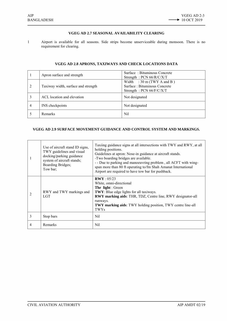
AIP VGEG AD 2-3 BANGLADESH 10 OCT 2019
CIVIL AVIATION AUTHORITY AIP AMDT 02/19
VGEG AD 2.7 SEASONAL AVAILABILITY CLEARING
1 Airport is available for all seasons. Side strips become unserviceable during monsoon. There is no
requirement for clearing.
VGEG AD 2.8 APRONS, TAXIWAYS AND CHECK LOCATIONS DATA
1 Apron surface and strength Surface : Bituminous Concrete Strength : PCN 66/R/C/X/T
2 Taxiway width, surface and strength Width : 30 m (TWY A and B ) Surface : Bituminous Concrete Strength : PCN 66/F/C/X/T
3 ACL location and elevation Not designated
4 INS checkpoints Not designated
5 Remarks Nil
VGEG AD 2.9 SURFACE MOVEMENT GUIDANCE AND CONTROL SYSTEM AND MARKINGS.
1
Use of aircraft stand ID signs, TWY guidelines and visual docking/parking guidance system of aircraft stands; Boarding Bridges; Tow bar;
Taxiing guidance signs at all intersections with TWY and RWY, at all holding positions. Guidelines at apron: Nose-in guidance at aircraft stands. -Two boarding bridges are available. - - Due to parking and manoeuvring problem , all ACFT with wing-span more than 80 ft operating to/fm Shah Amanat International Airport are required to have tow bar for pushback.
2 RWY and TWY markings and LGT
RWY : 05/23 White, omni-directional Thr light : Green TWY: Blue edge lights for all taxiways. RWY marking aids: THR, TDZ, Centre line, RWY designator-all runways. TWY marking aids: TWY holding position, TWY centre line-all TWYs
3 Stop bars Nil
4 Remarks Nil

VGEG AD 2-4 AIP 10 OCT 2019 BANGLADESH
AIP AMDT 02/19 CIVIL AVIATION AUTHORITY
VGEG 2.10 AERODROME OBSTACLES
1 2
In approach/ Take off area In circling area RWY affected
Obstacle type elevation
Position Marking/LGT Remarks Obstacles in the circling area at aerodrome are shown on page VGEG AD 2-9. All obstruction are provided with day marking and obstruction lighting where necessary and feasible.
23 Hill 132 ft
064°M, 2100 m, FM THR RWY 23
No River Karnaphully flows around approach Rwy 23. Masts of ships and boats may constitute mobile obstructions on approach.
VGEG AD 2.11 METEOROLOGICAL INFORMATION PROVIDED
1 Associated MET office Shah Amanat Intl. (VGEG)
2 Hours of service H24
3 Office responsible for TAF preparation Periods of validity (Hours)
Shah Amanat Intl. (VGEG) 12
4 Type of landing forecast Interval of issuance
TREND ½ hourly
5 Briefing /consultation provided P,D,T
6 Flight documentation languages used
C, PL English
7 Charts and other information available for briefing of consultation S, U
8 Supplementary equipment available for providing information ATIS
9 ATS units provided with information TWR
10 Additional information Tel : 031-2500988, 2500962 : 02-4135011-21 Ext: 3138, 3139

AIP VGEG AD 2-7 BANGLADESH 10 OCT 2019
CIVIL AVIATION AUTHORITY AIP AMDT 02/19
VGEG AD 2.17 AIR TRAFFIC SERVICES AIRSPACE
1 Designation Chattogram Control Zone
Lateral limits A circle of 25 NM radius centered at Chattogram VOR (221527.90N 0914938.98E)
2 Vertical limits GND to ft 145 AGL 3 Airspace Classification C
4 ATS unit call sign Language (S)
Chattogram Tower English
5 Transition altitude 4000 ft 6 Remarks Nil
1 Designation Air Traffic Zone (ATZ)
Lateral limits ATZ is oval shaped area joining outer tangents of 5 NM (9 km) radius circles centred at the RWY centre and both ends of RWY.
2 Vertical limits 4000 ft ALT 3 Airspace Classification C
4 ATS unit call sign Language (S)
Chattogram Tower English
5 Transition altitude 4000 ft 6 Remarks Nil
VGEG AD 2.18 AIR TRAFFIC SERVICES COMMUNICATIONS FACILITIES
Service designator Call Sign Frequency Hours of operation Remarks
1 2 3 4 5 Aerodrome and Approach Control (Non-radar )
Chattogram Tower 118.4 MHz (PRI) 119.4 MHz (SRY) HO EMERG 121.5 MHz
EM:A3
Surface Movement Control (SMC) Chattogram Ground 121.8 MHz HO EM : A3
ATIS Chattogram Information 127.6 MHz HO

VGEG AD 2-8 AIP 10 OCT 2019 BANGLADESH
AIP AMDT 02/19 CIVIL AVIATION AUTHORITY
VGEG AD 2.19 RADIO NAVIGATION AND LANDING AIDS
Type of aid variation Ident Frequency Opr hr Coordinates
Elev (FT) of DME Transmitting antenna
Remarks
1 2 3 4 5 6 7
DVOR CTG 113.4 MHz H24 22°15'27.90" N 91°49'38.98" E --- 373 m FM THR
RWY 23, EM: A2 DME (En-route) CTG 1168 MHz H24 22°15'27.90" N
91°49'38.98" E 44 Co-located with D/VOR, EM : P9
NDB --- --- --- --- --- Dismantled
ILS/LLZ RWY 23 ICG 110.5 MHz HO 22°14'20.94" N
91°48'02.18" E --- 280 m FM THR RWY 05
ILS/GP RWY 23 --- 329.6 MHz HO 22°15'20.49" N
91°49'20.45" E --- Glide slope 30, 120 m off set to east of RWY center line and 355 m inward FM THR 23, RDH 61ft
ILS DME RWY 23 ICG 1003 MHz HO --- --- Co-located with GP
VGEG AD 2.20 LOCAL TRAFFIC REGULATIONS
Prior approval to be obtained from ATC
VGEG AD 2.21 NOISE ABATEMENT PROCEDURES
NIL
VGEG AD 2.22 FLIGHT PROCEDURES
As directed by ATC
VGEG AD 2.23 ADDITIONAL INFORMATION
Smoke from brick fields on short final runway-23
There are few brick fields on the eastern side of karnafuli river which falls on the approach path of RWY-23, occasional smoke from the brick fields might reduce visibility on the approach. All pilots are, therefore, advised to exercise caution during approach on RWY-23.

AIP VGEG AD 2-9.1 BANGLADESH 10 OCT 2019
CIVIL AVIATION AUTHORITY AIP AMDT 02/19
LIST OF HIGH MAST/ TOWER/HILL/CHIMNEY/ BUILDING/ BARRIER/ ANTENNA AROUND SHAH
AMANAT INTERNATIONAL AIRPORT, CHATTOGRAM
SL Nr.
Name of the significant obstacles/obstructions
Co-ordinates of the Obstacle
True Bearing FM REF point
Dist (m) FM ref Point
Elevation AMSL (ft) LGT
1. Control Tower 22°14'41.74" N 91°48'48.42" E 214° 1611 120.52 YES
2. Water Tank 22°14'46.10" N 91°49'01.64" E 203° 1315 150.73 YES
3. Radar Antenna 22°14'33.10" N 91°48'50.13" E 208° 1815 124.37 YES
4. GP Antenna, RWY-23 22°15'20.49" N 91°49'20.45" E 174° 148 63.36 YES
5. NDB Mast Dismantled
6. DVOR Mast 22°15'27.90" N 91°49'38.98" E 081° 556 43.77 YES
7. GCA Radar 22°15'11.21" N 91°48'54.80" E 239° 833 61.67 NO
8. Boat Club 22°15'54.95" N 91°49'44.84" E 038° 1167 75.08 YES
9. C&E Squadron Building 22°15'29.86" N 91°49'01.47" E 285° 557 134.08 YES
10. Robi Antenna, Laldiarchar
22°15'25.77" N 91°49'47.71" E 089° 796 125.08 YES
11. Grameen Antenna, Bijoy Nagar
22°14'53.65" N 91°49'27.20" E 168° 1000 150.05 YES
12. Radar Mast, Naval Academy
22°13'38.22" N 91°48'01.88" E 214° 3982 180.05 YES
13. High Tension Grid Line, Salt Gola Crossing
22°18'11.82" N 91°47'47.90" E 332° 5760 343.52 YES
14. High Tension Grid Line, Char Lakkha
22°18'04.96" N 91°48'13.40" E 339° 5260 338.82 YES
15. BTCL Tower, T&T Head Office
22°19'29.18" N 91°48'41.15" E 351° 7575 393.78 YES
16. Radisson Blue 22°20'54.18" N 91°49'23.15" E 0.52° 10112 353.65 YES
17. BTCL Tower, Paradise Hill
22°20'20.33" N 91°50'02.89" E 007° 9167 409.94 YES
18. Wide Mobile Tower, Crossing, Patia
22°17'34.99" N 91°52'22.51" E 052° 6575 211.63 YES
19. Prilling Tower, Anwara 22°13'03.21" N 91°49'37.68" E 173° 4389 278.03 YES
20. High Tension Grid Line, Approach Funnel Area, Fakirnir Hat, Karnafuly
22°16'25.05" N 91°50'52.98" E 049 2759 126.05 YES

VGEG AD 2-9.2 AIP 10 OCT 2019 BANGLADESH
AIP AMDT 02/19 CIVIL AVIATION AUTHORITY
Sl.Nr. Name of the Critical
Points/Obstacles/
Structures
WGS-84 Co-ordinates Elevation
Feet Meter Latitude Longitude
21. AWOAS Antenna, SAIA, Patenga, Chattogram. 22°15'20.45" N 91°49'19.24" E 48.25 14.71
22. Naval Hanger, SAIA, Airport road, South Patenga, Chattogram.
22°15'15.22" N 91°49'26.08" E 54.72 16.68
23. Mobile Tower, BAF Shaheen College, Airport road, Patenga, Chattogram
22°15'56.60" N 91°48'51.58" E 110.07 33.55
24. Baraka Patenga Power Ltd., Chinees Gate, Patenga, Chattogram.
22°14'19.24" N 91°48'47.26" E 116.08 35.38
25. Academic Building BangaBondhu Complex, Naval Academy, Patenga, Chattogram.
22°13'46.68" N 91°48'01.44" E 131.75 40.15
26. PDB Tower, Inside TSP Complex Area, EPZ, Chattogram.
22°16'22.32" N 91°47'50.80" E 146.87 44.76
27.
15 Storied building (Oporajita), 53, GCO Quarter, Nabik Colony-1, Freeport, EPZ, Chattogram.
22°17'32.82" N 91°46'53.52" E 180.16 54.91
28. Mobile Tower at Steel Mill Bazar, Narikel Tala, Patenga, Patenga, Chattogram.
22°16'32.71" N 91°47'09.82" E 144.21 43.95
29. Tower of Port Authority, Rubi Cement Factory, 7No.Gate, EPZ, Patenga, Chattogram.
22°16'42.35" N 91°47'50.90" E 120.41 36.70
30. CO2Stripper, ChattogramUreaFertilizerLtd., Anwara, Anwara, Chattogram.
22°12'55.83" N 91°49'36.20" E 249.50 76.04
31. High Tension Grid Line, Approch Fanel Area, Fakirnir Hat, Karnafuly, Chattogram.
22°16'14.40" N 91°50'53.18" E 102.82 31.34
32. High Tension Grid Line, Approch Fanel Area, Fakirnir Hat, Karnafuly, Chattogram.
22°16'17.66" N 91°50'46.81" E 115.57 35.23
33. High Tension Grid Line, Approch Fanel Area, Fakirnir Hat, Karnafuly, Chattogram.
22°16'20.66" N 91°50'39.78" E 99.21 30.24
34. High Tension Grid Line, Approch Fanel Area, Fakirnir Hat, Karnafuly, Chattogram.
22°16'23.66" N 91°50'33.60" E 107.94 32.90
35. High Tension Grid Line, Approch Fanel Area, Fakirnir Hat, Karnafuly, Chattogram.
22°16'27.97" N 91°50'24.40" E 106.77 32.54

0 200 400 900300100
SCALE 1:10,000METRES
K L M N o p
2 30 5
RWY EDGE LIGHTS WIHITE
RWY END ANDTHR LIGHTS
GREEN RED
LIGHTING AIDS
THR LIGHTS
GREENRED
RWY 05 / 23
AND EXIT TWY
MARKING AIDS
RWY 05 / 23
AND EXIT TWY
500 600 700 800 1000
SHAH AMANAT INTERNATIONAL AIRPORT, CHATTOGRAM
AIPBANGLADESH
VGEG AD 2 - 11
CIVIL AVIATION AUTHORITY AIP AMDT 02/19
K L M N o p
2305
SIMPLE APPROACH LIGHTINGSYSTEM
ILS LIZ110.5 MHZ (ICG)
PAPI
STRIP 3210 m x 300 m
OPERATION CENTERCONTROL TOWER
FIRE STATION
BUILDINGCARGO TERMINAL
BOARDING BRIDGE
TERMINAL BUILDING
APRON
ARPPAPI
ILSGP 329.6TDME 10 1003
DVOR / DME
PRECISION APPROACH CAT I LIGHTING SYSTEM
TO C
HATTO
GRAM
RWY END TURNING PADS :
Turning pads of length 120m and width 80mare available at both ends of Rwy. A circle ofdiameter 80m is possible within each pad
10 OCT 2019
AERODROME CHART-ICAO
RWY 2940 m x 45 m
RESA 90m x 90m
CWY 450 m x 150m
RESA 90m x 90m
SWY 150m x 45m
CWY 450 m x 150m
SHAH AMANAT INTERNATIONAL AIRPORT, CHATTOGRAM
MAGNETIC VARIATION 1° W
RWY 2940 m x 45 m
RWY 2940 m x 45 m


23
05
STRIP 3210m x 300m
049°
BAY OF BENGAL 1
AIPBANGLADESH
VGEG AD 2 - 13
CIVIL AVIATION AUTHORITY AIP AMDT 02/19
0 500 1000 1500 2000 2500
0 1000 2000 3000 4000 5000 6000 7000 8000
HORIONTAL SCALE: 1:15,0000METRES
FEET
SLOPE 1.2%
3840m 3540m 3240m 00
2940m
30m(100ft)
60m(200ft)
4.27
m (1
4 ft)
100
50
25
00
50
100
150
200
250
300
FEET
75
METRES
VERTICALSCALE1: 1500
SLOPE 1.2%
3840m3540m3240m0
2940m
30m(100ft)
60m(200ft)
4.27
m (1
4 ft)
04140m
DECLARED DISTANCESRWY 05/23
RWY 05 RWY 23
2940m TAKE -OFF RUN AVAILABLE 2940M
3390m TAKE -OFF DISTANCE AVAILABLE 3390M3090m ACCELERATE STOP DISTANCE AVAILABLE 2940M
2940m LANDING DISTANCE AVAILABLE 2940M
AERODROME OBSTACLE CHART - ICAO TYPE A SHAH AMANAT INTERNATIONAL AIRPORT, CHATTOGRAM
DIMENSIONS AND ELEVATIONS IN METERS / FEET
MAGNETIC VARIATION 1° W
IDENTIFICATION NUMBERLEGEND
LARGE RIVER
TREE MOBILE OBSTRUCTION
1
10 OCT 2019
RESA 90m x 90m
CWY 450 m x 150m
RESA 90m x 90m
SWY 150m x 45m
CWY 450 m x 153m
PAPI
PAPI
RWY 2940 m x 45 m
--


BANGLADESHVGEG AD 2 - 13.1
CIVIL AVIATION AUTHORITY AIP AMDT 02/19
PARKING AND DOCKING CHART SHAH AMANAT INTERNATIONAL AIRPORT, CHATTOGRAM10 OCT 2019
AIP
MAGNETIC VARIATION 1° W
23 05RWY 2940 m x 45 m
OFSHAH AMANAT INTERNATIONAL AIRPORT, CHITTAGONG.
BAY-1
D R I V E W A Y
BAY-2 BAY-3 BAY-4 BAY-5 BAY-6
BAY-
7BA
Y-8
APRON SAFETY WHITE LINE
BAY 1-22°14'51.16"N, 091°48'58.14"EBAY 2-22°14'49.60"N, 091°48'56.25"EBAY 3-22°14'48.03"N, 091°48'54.35"EBAY 4-22°14'46.46"N, 091°48'52.46"EBAY 5-22°14'45.05"N, 091°48'50.75"EBAY 6-22°14'43.64"N, 091°48'49.05"E
TEXIWAY CENTER LINE
HEL
IPAD
BAY 7-22°14'43.21"N, 091°48'47.63"EBAY 8-22°14'44.08"N, 091°48'46.80"E
Mast-1Mast-2Mast-3Mast-4Mast-5
BB-5BB-4
BB 4-22°14'46.98"N, 091°48'51.72"EBB 5-22°14'45.60"N, 091°48'51.12"E
Electrical Mast Hight 25m
Mast 5-22°14'47.94"N, 091°48'54.36"EMast 4-22°14'46.80"N, 091°48'53.04"EMast 3-22°14'45.42"N, 091°48'51.12"EMast 2-22°14'44.28"N, 091°48'50.04"EMast 1-22°14'43.20"N, 091°48'48.42"E
Shou
lder
Shoulder
ShoulderShoulder
TWY
A
TWY
B
Shou
lder
Shou
lder
Shou
lder
Shou
lder
PARKING & DOCKING CHART
20'-0"46'-6" 239'-0" 238'-6" 238'-6" 215'-0" 215'-0" 83'-0" 130'6"


AIP VGEG AD 2-15 BANGLADESH 10 OCT 2019
CIVIL AVIATION AUTHORITY AIP AMDT 02/19
INTENTIONALLY LEFT BLANK


AIP VGEG AD 2-21 BANGLADESH 10 OCT 2019
CIVIL AVIATION AUTHORITY AIP AMDT 02/19
INTENTIONALLY LEFT BLANK


VOR ILS DME RWY 23
TRANSITION LEVEL FL060TRANSITION ALTITUDE 4000FT
MISSED APPROACHCLIMB TO 2000FT/610m ONTRACK 229° CONTACT ATCFOR FURTHER INSTRUCTION
CTGDVOR3500
(3486)
2500(2486)
067°-CAT C&D061° -CAT A&B
229°
GP3°
FAF
VGEG AD 2-27AIPBANGLADESH 10 OCT 2019
ELEV 14 FTHEIGHTS RELATEDTO AD ELEV
INSTRUMENTAPPROACHCHART-ICAO
CHATTOGRAM, BANGLADESHSHAH AMANAT INT'L. AIRPORT
CIVIL AVIATION AUTHORITY AIP AMDT 02/19
A B C D A B C D
314(300) 326(312) 334(320) 345(331)
430(416)
1342 1024 704 384
(1328) (1010) (690) (370)
CATEGORY OF ACFT
OCA (H)FULL 90 120 150 160
400 635 795 955
4:06 3:04 2:27 2103
1000 (800)
1400
2400
FULL
GP OUT
CAT
SPEEDRATE OF
DESCENT/GS
MET MINIMA(M)VIS (RVR)
GP OUT
1980 1660
(1966) (1646)
DISTANCE
ALTITUDE
(HEIGHT)
KNOTS
FT/MIN
MIN:SFAF TO THR 236 NM
ALS OUT
4 DME 3 DME 2 DME 1 DME6 DME 5 DME
012345678 1 2 3 49101112 5 6 7 8 9 10 DME CTG
229°
6 DME ICG
91°40'E
91°50' 92°00'91°40'E
12NM
BAY OF BANGAL
067°
247°
C D 067°A B 061°
RIVER
SCALE 1:250000
1 0 1 2 3NM
01 1 2 3 4 5KM
LLZ110.5 ICG
ILSGP 329.6
ILSDME 10033
MM
229°
DVOR/DME113.4 CTG
1168
10 DM
E CTG
229°
BEARINGS ARE MAGNETICALTITUDES, ELEVATIONSAND HEIGHTS IN FEET
VAR
1° W
22°20'N
22°10'N
22°20'N
22°10'N
91°50' 92°00'
POWER LINE
TWR 118.4(PRI)119.4(SRY)
350018NM140°
2000 310°
MSA 25NM FM CTG VOR
2500
278
354
394
344 212
126
151
180
1980
FAF6 DME ICG


91°40'E 91°50'E 92°00'E
91°40'E 91°50'E 92°00'E
VGEG AD 2-29
ELEV 14 FTHEIGHTS RELATEDTO AD ELEV
AIP
INSTRUMENTAPPROACHCHART-ICAO VOR ILS DME-ARC Rwy 23
BANGLADESH 10 OCT 2019
CLIMB TO 2000FT/610M ONTRACK 229° CONTACT ATCFOR FURTHER INSTRUCTION
10 DME CTG ARC
321°141°
2500
DVOR/DME113.4 CTG
1168
BAY OF BENGAL
12 DMEIAF
R 321
BEARINGS ARE MAGNETICALTITUDES, ELEVATIONSAND HEIGHTS IN FEETVAR
1°W
291°
111° 12 D
ME
IAF
B 465
R 277
R 291
IAF
12 D
ME
12 DMEIAF
TRANSITION LEVEL FL 060TRANSITION ALTITUDE 4000FT
RIVER
RIVER
277°
170°350°
IAF
321°
R 141
R 1
70
2500
CHATTOGRAM, BANGLADESHSHAH AMANAT INT'L. AIRPORT
12 D
ME
141°
229°
R 02
5
IF
097°
LLZ110.5 ICG
3500
3500(3486)
229°
GP3°
6 DME ICG
MAPt
R 049IFR 075R 025
IAF
SCALE 1:250000
1 0 1 2 3NM
01 1 2 3 4 5KM
ILSGP 329.6TDME 1003
MM
CIVIL AVIATION AUTHORITY AIP AMDT 02/19
A B C D A B C D
314(300) 326(312) 334(320) 345(331)
430(416)
CATEGORY OF ACFT
OCA (H)FULL 90 120 150 160
400 635 795 955
4:06 3:04 2:27 2103
1000 (800)
1400
2400
BALS
GP OUT
CAT
SPEEDRATE OFDESCENT/GS
MET MINIMA(M)VIS (RVR)
GP OUT
DISTANCE
ALTITUDE
(HEIGHT)
KNOTS
FT/MIN
MIN:SFAF TO THR 236 NM
NALS
4 DME 3 DME 2 DME 1 DME6 DME 5 DME
2500(2486)
2500(2486)
IF
10 DM
E CTG
ARC
R 075
CTGDVOR
0123456 1 2 3 4 5 6 7 8 9 10 11 12 13 DME CTG
1342 1024 704 384
(1328) (1010) (690) (370)
1980 1660
(1966) (1646)
229°
9 DME CTG
POWER LINE22°20'N
22°10'N
22°30'N
22°20'N
22°10'N
22°00'N
22°30'N
22°00'N
91°40'E 91°50'E 92°00'E
TWR 118.4(PRI)119.4(SRY)
22°20'N
350018NM140°
2000 310°
MSA 25NM FM CTG VOR
2500
278
354
394
344 212
126
151
180
1980
FAF6 DME ICG
FAF


AIP VGSY AD 2-7
BANGLADESH 10 OCT 2019
CIVIL AVIATION AUTHORITY AIP AMDT 02/19
VGSY AD 2.21 NOISE ABATEMENT PROCEDURES
NIL
VGSY AD 2.22 FLIGHT PROCEDURES
INTENTIONALLY BLANK
VGSY AD 2.23 ADDITIONAL INFORMATION
There is an overhead electrical distribution line (Electric poles) of approximate height 50 ft across the approach path
of RWY 29, approximate distance from the THR 29 is 550 m.
VGSY AD 2.24 CHARTS RELATED TO OSMANI INT’L AIRPORT, SYLHET
ICAO CHARTS
CHART TYPE PAGE NR. (VGSY)
1 AERODROME CHART AD 2-9
2 PARKING CHART AD 2-10
3 INSTRUMENT APPROACH
CHART AD 2-11 to AD 2-21

INTENTIONALLY LEFT BLANK

91°40'E
BEARINGS ARE MAGNETICALTITUDES ELEVATIONSAND HEIGHTS IN FEET
92°00'E
24° 50'N
25°00'N
MISSED APPROACHCLIMB TO 2000FT / 610m ONTRACK 114° CONTACT ATCFOR FURTHER INSTRUCTION
CIVIL AVIATION AUTHORITY AIP AMDT 02/19
DCB
240230
A
OCA
CATEGORY OF ACFT
TRANSITION LEVEL FL 060TRANSITION ALTITUDE 4000FT
VOR/ILS/DME RWY 11
24° 50'N
25° 00'
N
91°40'E 92°00'E
276°
282°
VOR
GP OUT
250 260
350 350350
116.4 SYT
91°50'E
NDB372 SY
RIVER
ROAD
ROAD
ROAD
RIVER
ROAD
301(251)
ROAD
91°50'E
RIVER
KHAL
276°CD
AB
114°
8 DM
E SY
T20
00
DISTANCE
ALTITUDE
(HEIGHT)
FULL
6 DME 5 DME
2000 1685
(1950) (1635)
350
4DME
1366
(1316)
3DME
1048
(998)
2 DME
730
(680)
1 DME
411
(361)
D
260
350
DCBA
SPEED
CAT
180
955
FAF TO THR11
MET MINIMA (m)
RATE OF DESCENT/GS
KNOTS
FT/MIN
MIN:S
15012090
1:572:202:553:54
480 635 795
LLZ111.5 SYL
10 NM
VGSY AD 2 - 19AIPBANGLADESH 10 OCT 2019INSTRUMENTAPPROACHCHART- ICAO
ELEV 50FTHEIHGTS RELATEDTO AD ELEV
SYLHET, BANGLADESH
OSMANI INTERNATIONAL
RAIL ROAD
SCALE 1:2500001 0 1 2 3NM
01 1 2 3 4 5KM
FULL
GP OUT
VIS: 800m, RVR: 800m
2000m(CAT A,B) & 2800m(CAT C,D)ALS OUT VIS: 1400m
TWR 122.9(PRI)122.5(Stand by)
VAR
1° W
MSA 25NM SYT VOR
7500
4600
2000
8NM120° 250°
16NM
096°
FAF
133 195 215
499
143
226
226
88
416
243
Caution:-Due to Hill at a distance of 0.3NM fromTHR29, caution should be exercisedduring missed approach.
Remain all the time withinDHAKA FIR while holding andcommencing approach.
6.2
DME
SYL
TO THR 11(NM) 0 5 NM4
MAPt
CAT C&D -276°
CAT A&D -282°
114°
2000(1950)
DVORSYT 3000
(2950)
567 3 2 1
ILS RDH 43
43218
GP 3°
FAF6.2 DME SYL
TO ILS-DME 0 5 NM4567 3 2 1 43218
114°
AutoCAD SHX Text
55


91°40'E
BEARINGS ARE MAGNETICALTITUDES ELEVATIONSAND HEIGHTS IN FEET
92°00'E
24° 50'N
25° 00'N
CIVIL AVIATION AUTHORITY AIP AMDT 02/19
DCB
240230
A
OCA
CATEGORY OF ACFT
VOR/ILS/DME-ARC RWY 11
24° 50'N
25° 00'
N
91°40'E 92°00'E
VOR
GP OUT
250 260
350 350350
116.4 SYT
91°50'E
RIVER
445(395)
ROAD
ROAD
ROAD
RIVER
ROAD
ROAD
91°50'E
RIVER
114°
10 D
ME
SYT
2000
DISTANCE
ALTITUDE
(HEIGHT)
FULL
6 DME 5 DME
2000 1685
(1950) (1635)
350
4DME
1366
(1316)
3DME
1048
(998)
2 DME
730
(680)
1 DME
411
(361)
D
260
350
DCBA
SPEED
CAT
180
955
FAF TO THR11
MET MINIMA (m)
RATE OF DESCENT/GS
KNOTS
FT/MIN
MIN:S
FULL
GP OUT
15012090
1:572:202:553:54
480 635 795
LLZ111.5 SYL
050°
IAF
12 D
ME
3000
VGSY AD 2 - 21AIPBANGLADESH 10 OCT 2019INSTRUMENTAPPROACHCHART- ICAO
ELEV 50FTHEIHGTS RELATEDTO AD ELEV
SYLHET, BANGLADESH
OSMANI INTERNATIONAL
RAIL ROAD
SCALE 1:2500001 0 1 2 3NM
01 1 2 4 5KM
230°HOLDING
3000W1
VIS: 800m, RVR: 800m
2000m(CAT A,B) & 2800m(CAT C,D)ALS OUT VIS: 1400m
MSA 25NM SYT VOR
TWR 122.9(PRI)122.5(Stand by)
VAR
1° W
7500
4600
2000
8NM120° 250°
16NM
3
R284
R270
050°
IAF
12 D
ME
SYT
3000
IF
230°HOLDING
3000W1
FAF
6.2
DM
E SY
L
133 195 215
499
143
226
226
88
416
243
Caution:-Due to Hill at a distance of 0.3NM fromTHR29, caution should be exercisedduring missed approach.
Remain all the time withinDHAKA FIR while holdingand commencing approach.
MISSED APPROACHCLIMB TO 2000FT / 610m ONTRACK 114° CONTACT ATC
0 5 NM
TRANSITION LEVEL FL 060TRANSITION ALTITUDE 4000FT
114°
3000(2950)
67
ILS RDH 43
81012NM
2000(1950)
2000
FAF6.2 DME SYL
12 DME SYT
10 DME SYT
43214 3 2 15911
GP 3°
0 5 NM4567 3 2 1 43218
MAPt
SYTDVOR
114°
TO ILS-DMETO THR 11(NM)
NDB372 SY
AutoCAD SHX Text
55


AIP VGBG AD 2-1 BANGLADESH 10 OCT 2019
CIVIL AVIATION AUTHORITY AIP AMDT 02/19
VGBG AD 2.1 AERODROME LOCATION INDICATOR AND NAME
VGBG–BOGURA AIRPORT, BOGURA
VGBG AD 2.2 AERODROME GEOGRAPHICAL AND ADMINISTRATION DATA
1 ARP coordinates and its site 24 51 59N, 089 19 01E, Intersection Point or Runway with Central Taxiway.
2 Distance and Direction from City. 7 km North West of Town Bogura.
3. AD Elevation/Reference Temperature.
ELEV: 59 ft T: 400C (April)
4. MAG Variation 45ʹ W in 1967 (Annual Change Negligible)
5. AD Administration, Address, telephone, telefax, telex, AFS
Bangladesh Air force TWR: +880-2-8753420-25 Ext. 4966
6. Type of Traffic Permitted IFR/VFR
7. Remarks Operator: Bangladesh Air force. Civil Aircraft can operate prior approval & in co-ordination with CAAB & BAF.
VGBG AD 2.3 OPERATIONAL HOURS
1. AD Administration 0730 LT to 1400 LT.
2. Customs and Immigration Nil
3. Health and Sanitation HO
4. AIS Briefing Office Nil
5. ATS Reporting Office (ARO) HO
6. Met briefing Office HO
7. Air Traffic Services HO
8. Fuelling Nil
9. Handling Nil
10 Security H24
11 De-Icing Nil Requirement
12. Remarks Nil.

VGBG AD 2-2 AIP 10 OCT 2019 BANGLADESH
AIP AMDT 02/19 CIVIL AVIATION AUTHORITY
VGBG AD 2.4 HANDLING SERVICES AND FACILITIES
1. Cargo-handling facilities Nil 2. Fuel/ Oil Type JET A-1/LMS
3. Fueling Facilities/ capacity AVBL/LIMITED
4. De-icing Facilities Nil requirement 5. Hangar space for visiting aircraft Nil 6. Repair facilities for visiting aircraft. Nil 7. Remarks Nil.
VGBG AD 2.5 PASSENGER FACILITIES
1. Hotel Nil at airport, available in the Bogura Town
2. Restaurant Nil at airport, available in the Bogura Town. 3. Transportation possibilities Taxi/Rickshaws
4. Medical Facilities Nil at airport, available in the Bogura Town. 5. Bank and Post Office Nil at airport, available in the Bogura Town. 6. Tourist Office Nil at airport, available in the Bogura Town. 7. Remarks Nil.
VGBG AD 2.6 RESCUE AND FIREFIGHTING SERVICES
1 AD Category for firefighting required/Avbl CAT: 1/1
2 Rescue equipment Avbl
3. Disabled aircraft removal Nil
4. Remarks The operators, Local Fire Services & Defence Department and BAF will share responsibility of firefighting & rescue.

AIP VGBG AD 2-3 BANGLADESH 10 OCT 2019
CIVIL AVIATION AUTHORITY AIP AMDT 02/19
VGBG AD 2.7 SEASONAL AVAILABILITY CLEARING
The airfield is available for all seasons. Side strips become unusable during monsoon. There is no requirement for clearing.
VGBG AD 2.8 APRONS, TAXIWAYS AND CHECK LOCATIONS/POSITIONS DATA
1 Apron surface and Strength Surface : Concrete Strength : PCN 13 F/C/Y/T
2 Taxiway Width, Surface and Strength Width: 50 ft. Surface : Bituminous Concrete Strength : PCN 13 F/C/Y/T
3. ACL and elevation Not designated 4. VOR Checkpoints Nil 5. INS Checkpoints Nil 6. Remarks Nil
VGBG AD 2.9 SURFACE MOVEMENT GUIDANCE AND CONTROL SYSTEM AND MARKINGS
1 Stand Identification signs, Taxiway Guide Lines & Visual Docking/ Parking Guidance.
Taxing Guidance Markings and Apron Guide Lines, Marshalling guidance provided.
2 RWY and TWY Markings and LGT
RWY Marking aids : THR, Center Line, RWY Holding Markings and RWY. Designators all runways. TWY Marking Aids: RWY holding position and TWY Centre Line.
3. Stop bars Nil 4. Remarks Nil
VGBG 2.10 AERODROME OBSTACLES
In approach/ TOKF area
RWY Affected Obstacle Type WGS-84
Co-ordinates Position Ref to ARP
Elevation (ft.)
Markings/ lighting
RWY 30 BT&T Microwave Tower Banani, Bogura
24 49 08N 089 23 00E
128° 4.6 NM (8.5 km) 247 Yes/Yes
RWY 12 Kahalu RF Fadiating Mast
24 51 56N 089 16 11E
269° 2.6 NM (4772 m) 466 Yes/Yes
In Circling Area
RWY-30/12 BRU LOS Tower 24 53 05N 089 20 49E
056° 1.97 NM (3648 m) 374 Yes/Yes

VGBG AD 2-4 AIP 10 OCT 2019 BANGLADESH
AIP AMDT 02/19 CIVIL AVIATION AUTHORITY
VGBG 2.11 METEOROLOGICAL INFORMATION PROVIDED
Weather information and Met briefing are provided by BAF Met section at the Airfield in co-ordination with Regional Meteorological Office, Bogura and Meteorological Squadron BAF Base Basher, Dhaka.
VGBG 2.12 RUNWAY PHYSICAL CHARACTERSTICES
RWY Designator True BRG Dimensions of
RWY (Feet)
Strength (PCN) and Surface of RWY &
SWY
THR Coordinates
THR Elevation
Slope of RWY &
SWY 1 2 3 4 5 6 7
12 119.610(T) 3000 X 100 PCN 13/F/C/Y/T Bituminous Concrete
24 52 07N 08 91 846E 59 ft --
30 299.610(T) 3000 X 100 PCN 13 F/C/Y/T Bituminous Concrete
24 51 53N 089 19 13E 59 ft --
RWY Designator
SWY Dimensions
(Feet)
CWY Dimension
(Feet)
Strip Dimensions
(Feet) OFZ Remarks
8 9 10 11 12
12 500 X 100 1000X300 5000X300 Within the CWY At Both the Undershoot
Areas there are small Cluster of Villages. 30 500 X 100 1000 X 300 5000 X 300 Within the
CWY
VGBG AD 2.13 DECLARED DISTANCES
RWY
Designator TORA (Feet) TODA (Feet) ASDA (Feet) LDA (Feet) Remarks
1 2 3 4 5 6
12 3000 4000 3500 3000 Nil 30 3000 4000 3500 3000 Nil

AIP VGBG AD 2-5 BANGLADESH 10 OCT 2019
CIVIL AVIATION AUTHORITY AIP AMDT 02/19
VGBG AD 2.14 APPROACH AND RUNWAY LIGHTING
Nil
VGBG AD 2.15 OTHER LIGHTING, SECONDARY POWER SUPPLY
Apron lightings are available without secondary power supply.
VGBG AD 2.16 HELICOPTER LANDING AREA
As directed by ATC
VGBG AD 2.17 AIR TRAFFIC SERVICES AIRSPACE
Designation Aerodrome Traffic Zone (ATZ)
1 Lateral Limits ATZ is an oval shaped area joining outer tangents of 5 NM (9.3 km) radius circles centered at the RWY centre and both ends of the RWY
2 Vertical Limits Altitude 4000 feet 3 Airspace Class D
4 ATS Unit Language Bogura Tower English
5 Transition altitude 4000 feet 6 Remarks Nil
VGBG AD 2.18 AIR TRAFFIC SERVICES COMMUNICATIONS FACILITIES
Service
designation Call Sign Frequencies
Hours of operation
Remarks
1 2 3 4 5
Aerodrome Control Service
Bogura Tower 128.7 MHz (PRI) 121.8 MHz (Grd) HO
1) Service provided by Bangladesh Air Force.
2) HF/RT 6826 kHz for Coordination.

VGBG AD 2-6 AIP 10 OCT 2019 BANGLADESH
AIP AMDT 02/19 CIVIL AVIATION AUTHORITY
VGBG AD 2.19 RADIO NAVIGATION AND LANDING AIDS
Type of Aid & MAG Variation
Identification Frequency Ops
Hours Coordination
Elevation of DME
Transmitting Antenna
Remarks
1 2 3 4 5 6 7
NDB BG 336 KHz HO -- N/A Nil
VGBG AD 2.20 LOCAL TRAFFIC REGULATIONS
Prior approval to be obtained from ATC
VGBG AD 2.21 NOISE ABATEMENT PROCEDURES
Not yet established
VGBG AD 2.22 FLIGHT PROCEDURES
1. FLIGHT PLAN
The procedure mentioned in ENR 1:10 (Flight Plan) AIP, Bangladesh is to be followed . 2. ARRIVAL/DEPARTURE AND COORDINATION PROCEDURE.
2.1 Departure.
Aircraft departing from Bogura will be handed over to Dhaka control while leaving the jurisdiction of Bogura Tower.
2.2 Arrival.
Dhaka control shall hand over all aircraft to Bogura Tower before the aircraft enters the jurisdiction of Bogura Tower.
VGBG AD 2.23 ADDITIONAL INFORMATION
Nil
VGBG AD 2.24 CHARTS RELATED TO BOGURA AIRFIELD
NR Type of Chart PAGE NR
1 Aerodrome Chart NIL
2 Aerodrome obstacle Chart NIL
3 Instrument Approach Chart. NIL

AIP VGBR AD 2-1 BANGLADESH 10 OCT 2019
CIVIL AVIATION AUTHORITY AIP AMDT 02/19
AD 2 AERODROMES
VGBR AD 2.1 AERODROME LOCATION INDICATOR AND NAME
VGBR – BARISHAL AIRPORT, BARISHAL
VGBR AD 2.2 AERODROME GEOGRAPHICAL AND ADMINISTRATION DATA
1 ARP coordinates and site at AD 224756.19N 0901804.45E, In the RWY 2 Distance and direction from city 08 NM North of Barishal Town 3 AD elevation/reference temperature 10 ft/290C 4 MAG VAR 10 W (Annual change negligible)
5 AD administration, address, telephone, telefax, telex, AFS
Civil Aviation Authority of Bangladesh Postal address: Airport Manager , Barishal Airport, Barishal, Bangladesh. Telephone: APM : +880 2 55061662 Control TWR : +880 2 55061673
6 Types of traffic permitted IFR/VFR 7 Remarks Nil
VGBR AD 2.3 OPERATIONAL HOURS
SL Nr. Services Hours 1 Aerodrome Administration 0900 L T to 1700 L T; FRI & SAT closed 2 Custom and Immigration NIL 3 Health and Sanitation HO 4 AIS briefing office NIL 5 ATS reporting office (ARO) HO 6 MET briefing office HO 7 Air traffic service HO 8 Fuelling NIL 9 Handling NIL 10 Security HO 11 De-icing NIL 12 Remarks NIL

VGBR AD 2-2 AIP 10 OCT 2019 BANGLADESH
AIP AMDT 02/19 CIVIL AVIATION AUTHORITY
VGBR AD 2.4 HANDLING SERVICES AND FACILITIES
Manual Handling
VGBR AD 2.5 PASSENGER FACILITIES
1 Hotels Nil at airport available at town 2 Restaurant accommodation Limited at the airport, unlimited at town 3 Transportation available Buses, Rickshaws, tempo 4 Medical facilities Only first Aid avbl. 5 Banks and Post Office AVBL near airport (Khanpura, Babugonj) 6 Tourist office AVBL at town 7 Remarks NIL
VGBR AD 2.6 RESCUE AND FIRE FIGHTING SERVICES
1 AD Category for fighting CAT : 5 AVBL : 5
2 Rescue Equipment Limited 3 Disabled Aircraft Removal NIL 4 Remarks NIL
VGBR AD 2.7 SEASONAL AVAILABILITY CLEARING
2.7.1 The airport is available for all seasons. Side stripes become unusable during monsoon. There is no requirement for clearing.
VGBR AD 2.8 APRONS, TAXIWAYS AND CHECK LOCATIONS DATA
1 Apron surface and strength Surface : Bituminous Concrete Strength: PCN 17/F/C/Y/T,
2 Taxiway width, surface and strength Width : 75 ft Surface : Bituminous Concrete Strength: PCN17/F/C/Y/T,
3 ACL location and elevation Not designated 4 Remarks Nil
VGBR AD 2.9 SURFACE MOVEMENT GUIDANCE AND CONTROL SYSTEM AND MARKINGS
1 Stand identification/taxiway guidelines/ visual docking/parking guidance
Taxiing guidance signs at intersection with TWY and RWY, nose-in parking guidance avbl.
2 RWY and TWY markings and LGT
RWY marking aids: THR, Centre line RWY designator all runways. TWY marking aids: TWY centerline, RWY Holding Position
3 Stop bars NIL 4 Remarks NIL

AIP VGBR AD 2-3 BANGLADESH 10 OCT 2019
CIVIL AVIATION AUTHORITY AIP AMDT 02/19
VGBR AD 2.10 AERODROME OBSTACLES
List of high mast/ tower/hill/chimney/ building/ barrier/ antenna around Barishal Airport, Barishal
SL Nr.
Name of the significant obstacles/obstructions
Co-ordinates of the Obstacle
True Bearing FM REF point
Dist (m) FM ref Point
Elevation AMSL (ft)
LGT
1. GP Tower, Batajor, Gournadi 225436.22N 0901450.16E 336° 13475 175.95
2. Banglalink Tower, Sanuhar bus Stand, Uzirpur 225234.05N 0901552.42E 336° 9320 141.71
3. Old Electric Pole, Baherchar Hospital, Babuganj 224937.30N 0901827.20E 012° 3155 209.31
4.
Banglalink Tower, Dhaka-Barishal Road, Sikarpur, Babuganj
224921.53N 0901604.10E 307° 4308 169.52
5. Electric pole, Doarika Bridge (North), Babuganj 224836.04N 0901644.34E 307° 4285 195.47
6. Electric pole, Doarika Bridge (South), Babuganj 224821.59N 0901652.38E 290° 2192 203.47
7. GP Tower, Dhaka-Barishal Road, Rampotti, Babuganj 224804.28N 0901703.12E 277° 1764 147.46
8. Robi Tower, Doarika, Rakudia, Babuganj 224911.05N 0901737.24E 341° 2409 145.40
9. Brick Field Chimney, Doarika, Babuganj 224935.03N 0901736.20E 345° 3124 86.34
10. Banglalink Tower, Bakultola, Babuganj 224901.34N 0901854.08E 035° 2435 141.42
11. Citycell/Airtel Tower, Bakultola, Babuganj 224852.93N 0901818.49E 013° 1769 129.76
12. DLR Office Tower, Khanpura, Babuganj 224821.49N 0901811.14E 006° 1689 100.88
13. Veterinary College, Khanpura, Babuganj 224819.58N 0901832.60E 049° 1063 111.77
14. Ali Bricks Chimney-2, Babuganj 224734.90N 0901823.92E 105° 2657 90.16
15. Control Tower 224755.39N 0901757.03E 257° 217 69.52 16. NDB Mast 224752.17N 0901752.23E 247° 378 63.66 17. Parking Area Light Post 224755.30N 0901755.61E 259° 257 99.74
18. GP Tower, Above DBBL ATM Booth, Rahmatpur Bazar, Babuganj
224726.08N 0901752.09E 200° 1012 109.68
19. Sheba Telcom, Madhobpasha, Ujirpur 224623.71N 0901559.72E 231° 4569 200.04
20. High Tension Line Tower, Koladema 224515.26N 0901835.26E 170° 5050 170.57
21. Robi Tower, Goriarpar, Kasipur 224501.89N 0901913.92E 160° 5739 145.43
22. Robi Main Tower, Gonopara 224405.64N 0902015.37E 152° 8035 250.84
23. DGFI Office Tower, Gonopara 224353.06N 0901953.86E 152° 8037 265.24
24. Airtel Tower, Isakathi, Kashipur 224334.19N 0901958.98E 158° 8717 168.32
25. Radio Bangladesh Tower, Rupatoli 224026.39N 0902013.12E 165° 14336 405.15

VGBR AD 2-4 AIP 10 OCT 2019 BANGLADESH
AIP AMDT 02/19 CIVIL AVIATION AUTHORITY
VGBR AD 2.11 METEOROLOGICAL INFORMATION PROVIDED
2.11.1 Weather observation will be collected from Meteorological observatory on phone 0431-62811, Barishal (Location 15 km from the airport).
VGBR AD 2.12 RUNWAY PHYSICAL CHARACTERISTICS
Designator RWY NR
True & MAG BRG
Dimensions of RWY (m)
Strength (PCN ) and surface of RWY
THR Coordinates
THR elevation (ft)
Slope of RWY-SWY
1 2 3 4 5 6 7
17 1740 1829X 30 PCN 17/F Bituminus concrete
224833.89N 0901800.14E 10 0.0%
35 3540 1829X 30 PCN 17/F Bituminus concrete
224734.83N 0901806.92E 10 0.0%
Designator RWY NR
Stop way Dimensions (m)
CWY Dimensions (m)
RESA (m)
Strip Dimensions (m)
OFZ Remarks
8 9 10 11 12 13 14
17 61X30 153X150 90X60 2060X150 Within the CWY
35 50X30 153X150 90X60 2060X150 Within the CWY
VGBR AD 2.13 DECLARED DISTANCES
RWY TORA (M) TODA (M) ASDA (M) LDA (M) Remarks 1 2 3 4 5 6 17 1829 1982 1890 1829
RESA introduced 35 1829 1982 1879 1829
VGBR AD 2.14 APPROACH AND RUNWAY LIGHTING
PAPI AVBL FOR BOTH RWY
VGBR AD 2.15 OTHER LIGHTING, SECONDARY POWER SUPPLY
1. During main power supply failure, automatic standby generator power supply available within 10 seconds.
VGBR AD 2.16 HELICOPTER LANDING AREA
As directed by ATC
VGBR AD 2.17 AIR TRAFFIC SERVICES AIRSPACE
1 Designation Aerodrome Traffic Zone (ATZ)
Lateral limits ATZ is oval shaped area joining outer tangents of 5 NM (9 km) radius circles centred at the RWY centre and both ends of RWY.
2 Vertical limits 4000 ft (AMSL) 3 Airspace D
4 Unit Language
Barishal Tower English
5 Transition altitude 4000 ft 6 Remarks Nil

AIP VGBR AD 2-5 BANGLADESH 10 OCT 2019
CIVIL AVIATION AUTHORITY AIP AMDT 02/19
VGBR AD 2.18 AIR TRAFFIC SERVICES COMMUNICATIONS FACILITIES
Service designator Call sign Frequency Hours of operation Remarks
1 2 3 4 5 Aerodrome Control
Service Barishal TWR Main 128.1 MHz Sdby 129.3 MHz HO Nil
VGBR AD 2.19 RADIO NAVIGATION AND LANDING AIDS
VGBR AD 2.20 LOCAL TRAFFIC REGULATIONS
Prior information to ATC is needed
VGBR AD 2.21 NOISE ABATEMENT PROCEDURES
Nil
VGBR AD 2.22 FLIGHT PROCEDURES
1. Coordination Procedure:
1.1 Departure:
Before passing information required by start-up of engines, Barishal information will co-ordinate with Dhaka area control center regarding flight level. Aircraft will not climb higher than 300 ft if co-ordination cannot be made for higher altitude by Barishal information or by the aircraft with Dhaka Area Control Center.
1.2 Arrival:
Dhaka area control center will not issue clearance to the aircraft to descend below 400 ft without coordination with Barishal Tower (through HF or through aircraft). Dhaka ACC will allow the aircraft to change to Barishal Tower when aircraft establish contact with Barishal and is ready to change over.
VGBR AD 2.23 ADDITIONAL INFORMATION
1. Pilots to exercise caution of high-tension power lines and river crossing Towers while approaching to land RWY 17 and take off from RWY 35.
2. Security Operators are responsible for security of aircraft during operation and while in parked position.
VGBR AD 2.24 CHARTS RELATED TO BARISHAL AIRPORT
ICAO CHARTS NR TYPE OF CHARTS PAGE NR 1 AERODROME VGBR AD 2-7 2 INSTRUMENT APPROACH CHARTS VGBR AD 2-9 & 2-11
Type of aid variation Ident Frequency Opr hr Coordinates Elevation of NDB
transmitting antenna Remarks
1 2 3 4 5 6 7
NDB BL 368 kHz HO 224752.17N 0901752.23E 63.66 ft
EM: A2H 1050 ft FM center line and 1800 ft FM THR RWY 35

INTENTIONALLY LEFT BLANK

BANGLADESHAIP
TYPE-A
VGBR AD 2 - 7
BARISHAL AIRPORT, BARISHAL10 OCT 2019
CIVIL AVIATION AUTHORITY AIP AMDT 02/19
AERODROME CHAART - ICAO TYPE-AELEV 10 FEET
BEARIN
G AR
E MAG
NETIC
HEIG
HTS R
ELATEDTO
AD ELEVATIO
N
ELEVATION
AND
HEIG
HTS IN
FEET
R I V E R
TERMINAL BUILDING
SWY 50mX30m
FIRE STATION
17
35
TO BARISHAL
SCALE = 1:30000
TO FARIDPUR
TO BABUGONJ
SWY 61mX30m
500
15000 0
1500
500
3000ft
1000m
MAGNETIC VARIATION 1°W
SWY 1829mX30mSWYSWY
PAPI
PAPI


VGBR AD 2-9
BARISHAL, BANGLADESH
AIPBANGLADESHINSTRUMENTAPPROACH
ELEV 10 FT HEIGHTS RELATED TWR 128.1
CHART-ICAO TO AD ELEV
VAR 55'W
BEARINGS ARE MANGNETICALTITUDES, ELEVATIONSAND HEIGHTS IN FEET
ELEVATION 165HEIGHT (155)
TRANSITION LEVEL FL 060TRANSITION ALTITUDE 4000FT
ELEV 10 FT
CIVIL AVIATION AUTHORITY AIP AMDT 02/19
SCALE 1:250,0000 1 2 3NM
01 2 3 4 5KM
90° 10' 00E 90° 20' 00E 90° 30' 00E
22° 50' 00
22° 40' 00
90° 10' 00 90° 20' 00 90° 30' 00
22° 50' 00N
22° 40' 00N
180°
342°
BARISHALNDB RWY 17
2000
BXCJXHZHZDADGBNMNBBMNCBBXGD
1
1
RIVER
342°
C &
D
348°
A &
B
1 M
IN
FROM NDB BLMSA 25 NM
MISSED APPROACHCLIMB TO 2000 FT/610 m ONTRACK 180° AND CONTACT ATCFOR FURTHER INSTRUCTION
START TURN ATCAT A & B : 3 MINCAT C & D : 2 MIN
MET MINIMA
CATEGORY OF ACET A B C
O C A ( O C H )
SPEED KNOTS
V I S (m)
91
2000
91-120
2400
121-140
2800
D
500(490)
141-165
2800
500(490)500(490)500(490)
1200(1190)
BL
0 1 2 3 4 5 6 7 8 NM1234567
180°
342° CAT C & D
NDB
348° CAT A & B2000
(1990)
NDB70
(60)368 BL 162°
10NM
MAPt.
10 OCT 2019
165(155)
165(155)
ROAD
RIVE
R
RIVE
R
RIVERROAD
RO
AD
180°
Stand by 129.3


VGBR AD 2 - 11AIPBANGLADESH
VAR 55'W
BEARINGS ARE MANGNETICALTITUDES, ELEVATIONSAND HEIGHTS IN FEET
ELEVATION 165HEIGHT (155)
TRANSITION LEVEL FL 060TRANSITION ALTITUDE 4000FT
ELEV 10 FT
CIVIL AVIATION AUTHORITY AIP AMDT 02/19
SCALE 1:250,0000 1 2 3NM
01 2 3 4 5KM
CAT C & D 182°1200(1190)
BLNDB
90° 10' 00E 90° 20' 00E 90° 30' 00E
22° 50' 00
22° 40' 00
90° 10' 00 90° 20' 00 90° 30' 00
22° 50' 00N
22° 40' 00N
002°
344°
NDB RWY 35
ROAD
BXCJXHZHZDADGBNMNBBMNCBBXGD
RIVE
R
RIVE
R
RIVERROAD
1
1
RIVER
C &
D 1
82°
A &
B 17
6°
1 M
IN
NDB368 BL
70(60)
RO
AD
FROM NDB BL.MSA 25 NM
MISSED APPROACHCLIMB TO 2000 FT/610 m ONTRACK 344° AND CONTACT ATCFOR FURTHER INSTRUCTION
START TURN ATCAT A & B : 3 MINCAT C & D : 2 MIN
MET MINIMA
CATEGORY OF ACET A B C
O C A ( O C H )
SPEED KNOTS
V I S (m)
91
2000
91-120
2400
121-140
2800
D
500(490)
141-165
2800
500(490)500(490)500(490)
0 1 2 3 4 5 6 7 8 NM1234567
344°
CAT A & B 176°
TFJDXMCKCMMNCZGHCVHNUJHCVZB
INSTRUMENTAPPROACH
ELEV 10 FT HEIGHTS RELATED
CHART-ICAO TO AD ELEV
10 OCT 2019
MAPt.
10NM
165(155)
165(155)
182°
2000(1990)
344°
TWR 128.1
2000
Stand by 129.3
BARISHAL, BANGLADESHBARISHAL


AIP VGCB AD 2-1 BANGLADESH 10 OCT 2019
CIVIL AVIATION AUTHORITY AIP AMDT 02/19
VGCB AD 2.1 AERODROME LOCATION INDICATOR AND NAME
VGCB –COX’S BAZAR AIRPORT, COX’S BAZAR.
VGCB AD 2.2 AERODROME GEOGRAPHICAL AND ADMINISTRATION DATA
1 ARP coordinates and site at AD 212658.28 N 915753.58 E , Centre of the RWY. 2 Distance and direction from city 02 km from city centre 3 AD elevation/reference temperature 12 ft/ 340C 4 MAG VAR 50’’ W
5 AD administration, address, telephone, telefax ,telex,AFS
Civil Aviation Authority of Bangladesh Postal address: Airport Manager Cox’s Bazar Airport, Cox’s Bazar Bangladesh Telephone : APM : +88- 0341-64479 (Off), 0341-64075 (Res) TWR : +88-0341-62010
6 Types of traffic permitted IFR/VFR IFR/VFR 7 Remarks Nil
VGCB AD 2.3 OPERATIONAL HOURS
SL. Nr. Services Hours 1 Aerodrome Administration 0900 LT to 1700 LT except FRI & SAT 2 Custom and Immigration Nil 3 Health and Sanitation HO 4 AIS briefing office Nil 5 ATS reporting office (ARO) HO 6 MET briefing office HJ 7 Air traffic services HO 8 Fuelling Nil 9 Handling Nil
10 Security HO 11 De-icing Nil 12 Remarks Nil

VGCB AD 2-2 AIP 10 OCT 2019 BANGLADESH
AIP AMDT 02/19 CIVIL AVIATION AUTHORITY
VGCB AD 2.4 HANDLING SERVICES AND FACILITIES
NIL
VGCB AD 2.5 PASSENGER FACILITIES
1 Hotels AVBL 2 Restaurant AVBL 3 Transportation available Taxi, Microbus, Auto -rickshaws and Rickshaws. 4 Medical facilities AVBL 5 Banks and Post Office AVBL 6 Tourist office AVBL
7 Remarks Cox’s Bazar is the most important tourist spot in Bangladesh and longest sea beach in the world.
VGCB AD 2.6 RESCUE AND FIRE FIGHTING SERVICES
1 AD Category for fire fighting CAT: 7 AVBL: 7
2 Rescue Equipment AVBL 3 Disabled Aircraft Removal Nil 4 Remarks Nil
VGCB AD 2.7 SEASONAL AVAILABILITY CLEANING
2.7.1 The airport is available for all seasons, Side strips become unusable during monsoon. There is no requirement for clearing.
VGCB AD 2.8 APRONS, TAXIWAYS AND CHECK LOCATIONS DATA
1 Apron surface and strength Surface: Bituminous Concrete Strength: PCN 63/R/C/W/T
2 Taxiway width, surface and strength Width:15 M Surface: Bituminous Concrete Strength: PCN 63/R/C/W/T
3 ACL location and elevation Not designated 4 Remarks NIL
VGCB AD 2.9 SURFACE MOVEMENT GUIDANCE AND CONTROL SYSTEM AND MARKINGS
1 Stand identification/taxiway guide lines/visual docking/parking guidance
Taxiing guidance signs at all intersections TWY and RWY at all holding positions. Guidelines at apron. Nose- in guidance at aircraft stands.
2 RWY and TWY markings and LGT
RWY markings : THR, Centre line RWY designator : Both runways TWY markings : RWY holding position and TWY centre line RWY LGT : Edge LGT, THR LGT and End LGT TWY LGT : Edge LGT
3 Stop bars NIL 4 Remarks NIL

AIP VGJR AD 2-3 BANGLADESH 10 OCT 2019
CIVIL AVIATION AUTHORITY AIP AMDT 02/19
VGJR AD 2.10 AERODROME OBSTACLES
SI.Nr Name of the Critical
Points/Obstacles/Structures WGS-84 Co-ordinates Elevation
Remarks Latitude Longitude Feet
1. DVOR 23°12'06.37" N 89°09'10.37" E 50 2. NDB 23°10'30.57" N 89°09'42.31" E 79 3. Control Tower 23°10'38.17" N 89°09'38.85" E 127
4. Robi Mobile Tower (On the roof of Ms Orchid Centre), 44 M K Road
23°09'54.35"N 89°12'48.26"E 222
5. Civil Apron Mast Light 1 23°10'37.42" N 89°09'39.81" E 103 6. Civil Apron Mast Light 2 23°10'34.43" N 89°09'41.26" E 104 7. Civil Apron Mast Light 3 23°10'31.30" N 89°09'42.88" E 104 8. Police Line Mast 23°10'25.16" N 89°11'42.16" E 227
9. DGFI Mast, Jashore Cantonment 23°10'27.47" N 89°11'08.49" E 181
10. Wind Socks RWY-34 23°10'35.06" N 89°09'48.12" E 42 11. Wind Socks RWY-16 23°11'31.10" N 89°09'29.52" E 46 12. Noapara Radio Mast 23°02'55.91" N 89°22'47.00" E 400
13. Arresting Barriers --- --- 31 386 ft fm RWY 16, 94 ft fm THR RWY 34
14. VDF Aerial Mast --- --- 110 1730 MAG fm THR RWY 16
15. GCA Radar --- --- 60
1179 m (SE) fm THR RWY 16 and 132.08 m off set fm RWY centre line
16. Rajarhat Mast 230830.60N 891432.46E 318 5NM on BRG 1110
M fm Control TWR
17. Garrison Mosque --- --- 115
0500 MAG fm Control TWR1.7 km (approx)
VGJR AD 2.11 METEOROLOGICAL INFORMATION PROVIDED
1 Associated MET office Jashore Airport (VGJR) 2 Hours of service HJ
3 Office responsible for TAF preparation Periods of validity (Hours) Hazrat ShahjalalIntl (VGHS)
4 Type of landing forecast Interval of issuance (Hours)
5 Briefing/ consultation provided P, D, T
6 Flight documentation languages used
C,PL English
7 Charts and other information available for briefing or consultation S, U
8 Supplementary equipment available for providing information 9 ATS units provided with information TWR
10 Additional information Tel: Nil

VGJR AD 2-4 AIP 10 OCT 2019 BANGLADESH
AIP AMDT 02/19 CIVIL AVIATION AUTHORITY
VGJR AD 2.12 RUNWAY PHYSICAL CHARACTERISTICS
Designator RWY NR
TRUE & MAG BRG
Dimensions of RWY (m)
Strength (PCN) and surface of RWY & SWY
THR Coordinates
THR elevation (FT)
Slope of RWY-SWY
1 2 3 4 5 6 7
16 1570 TRUE 2438X45 PCN 18F/C/Y/T Bituminous concrete
231137.94 N 890922.92 E 20 0%
34 3370 TRUE 2438X45 231025.65 N 890955.32 E 20 0%
Designator RWY NR
SWY dimensions (m)
CWY dimensions (m)
RESA Strip dimensions (m)
OFZ Remarks
8 9 10 11 12 13
16 NIL 150 X 150 90X90 2618 X 150 Within the CWY Nil
34 60 X 45 210 X 150 90X90 2618 X 150 Within the CWY Nil
VGJR AD 2.13 DECLARED DISTANCES
RWY TORA (m) TODA (m) ASDA (m) LDA (m) REMARKS
1 2 3 4 5 6 16 2438 2588 2438 2438 Due to introduction of
RESA 34 2438 2648 2498 2438
VGJR AD 2.14 APPROACH AND RUNWAY LIGHTING
RWY designator APCH THR PAPI TDZ RWY
centre RWY edge
END & WBAR STWL Remarks
1 2 3 4 5 6 7 8 9 10
16
Simple Approach lighting system
Six green LGT
PAPI NIL NIL
60 m apart 73 Nr White Omni-directional with fixed intensity END: Avbl
6 Red LGT Unidirectional
NIL Kerosene flares avbl
34 NIL Six green LGT
PAPI NIL NIL
60 m apart 73 Nr White Omni-directional with fixed intensity
NIL

AIP VGJR AD 2-5 BANGLADESH 10 OCT 2019
CIVIL AVIATION AUTHORITY AIP AMDT 02/19
VGJR AD 2.15 OTHER LIGHTING, SECONDARY POWER SUPPLY
1 ABN/IBN Location, characteristics and hours of operation Altn W/ G every 5 sec Hours: HO, near NDB
2 LDI location and LGT Anemometer location and LGT
Nil Atop control TWR, LGT
3 TWY edge and centre line lighting Edge: AVBL Centre line: Nil
4 Secondary power supply switch-over time During main power supply failure, Automatic standby generator power supply available within 30 seconds
5 Remarks Kerosene flares avbl
VGJR AD 2.16 HELICOPTER LANDING AREA
As directed by ATC
VGJR AD 2.17 AIR TRAFFIC SERVICES AIRSPACE
1
Designation Aerodrome Traffic Zone (ATZ)
Lateral limits ATZ is an oval shaped area joining outer tangents of 5 NM (9 km) radius circle centered at the Runway centre and both ends of the Runway.
2 Vertical limits 4 000 ft (ALT) 3 Airspace D
4 Unit Language
Jashore Tower English
5 Transition Altitude 4000 ft 6 Remarks NIL
VGJR AD 2.18 AIR TRAFFIC SERVICES COMMUNICATIONS FACILITIES
Service designator Call Sign Frequency Hours of operation Remarks 1 2 3 4 5
Aerodrome Control Service Jashore Tower 123.2 MHz (PRI)
123.9 MHz (SRY) HO EM: A3
Surface Movement Control (SMC) Jashore Ground 121.8 MHz HO EM : A3
VGJR AD 2.19 RADIO NAVIGATION AND LANDING AIDS
Types of aid variation
Ident Frequency Hours of operation Coordinates
Elevation of DME Transmitting antenna
Remarks
1 2 3 4 5 6 7
NDB -- -- -- -- Dismantled
D/VOR JSR 113.0 MHz HO 231206.37N 0890910.37E
DME JSR 1164 MHz HO 231206.37N 0890910.37E

VGJR AD 2-6 AIP 10 OCT 2019 BANGLADESH
AIP AMDT 02/19 CIVIL AVIATION AUTHORITY
VGJR AD 2.20 LOCAL TRAFFIC REGULATIONS
Prior approval to be obtained from ATC
VGJR AD 2.21 NOISE ABATEMENT PROCEDURES
NIL
VGJR AD 2.22 FLIGHT PROCEDURES
NIL
VGJR AD 2.23 ADDITIONAL INFORMATION
NIL
VGJR AD 2.24 CHARTS RELATED TO JASHORE AIRPORT
ICAO CHARTS
Nr TYPE OF CHART PAGE NR (VGJR)
1. AERODROME CHART AD 2-7
2. INSTRUMENT APPROACH CHART AD 2-9 to AD 2-15

34
16
AIPBANGLADESH
VGJR AD 2 - 710 OCT 2019
MARKING AIDSRWY 16/34
LIGHTINGS AIDSRWY 16/34
100 0 100 200 300 400 500 600 700 800 900METRES
SCALE 1:8000
PAPI
PAPI
GCA
BAF APRON APRON
RQO S
T.BTWR
RWY 2438m x 45m (8000' x 150') Bituminous Concrete
ARP23 11 01.50N089 09 9.21ENM
P P
APPROCH ROAD
34 CWY 150m x 150m
ELEV 20FT
500 400 300 200 100 0 500 1000
METRESSCALE 1:12000
SWY 60m x 45m
ELEV 20FT
STRIP 2618m x 150m
16
SIMPLE APPROCH LIGHTING SYSTEM
CIVIL AVIATION AUTHORITY AIP AMDT 02/19
AERODROME CHART-ICAO JASHORE AIRPORT, JASHORE
TYPE-A
CWY 210m x 150m
MAGNETIC VARIATION 1°W


AIP VGRJ AD 2-1 BANGLADESH 10 OCT 2019
CIVIL AVIATION AUTHORITY AIP AMDT 02/19
VGRJ AD 2.1 AERODROME LOCATION INDICATOR AND NAME
VGRJ –SHAH MOKHDUM AIRPORT, RAJSHAHI
VGRJ AD 2.2 AERODROME GEOGRAPHICAL AND ADMINISTRATION DATA
1 ARP co-ordinates an site at AD 242614.47N 0883659.52E 2 Distance and direction from city 07 km North of Town 3 AD elevation / reference temperature 55ft/400C 4 MAG VAR 50' W
5 AD administration, address, telephone
Civil Aviation Authority of Bangladesh Postal address: Airport Manager Shah Mokhdum Airport, Rajshahi. Bangladesh Telephone: APM: +880-2-47800053 TWR: +800-2-47800157
6 Types of traffic permitted IFR/VFR IFR/VFR 7 Remarks Nil
VGRJ AD 2.3 OPERATIONAL HOURS
SL. Nr. Services Hours 1. Aerodrome Administration 0900 LT to 1700 LT, FRI closed. 2. Custom and Immigration HO 3. Health and Sanitation HO 4 AIS briefing Office NIL 5 ATS reporting Office (ARO) HO 6 MET briefing Office HO 7 Air traffic service HO 8 Fuelling NIL 9 Handing NIL 10 Security HO 11 De-icing NIL 12 Remarks NIL
VGRJ AD 2.4 HANDLING SERVICES AND FACILITIES
Manual cargo handling services
VGRJ AD 2.5 PASSENGER FACILITIES
1 Hotels Nil 2 Restaurant Nil at airport avbl within 1 km 3 Transportation available Buses, Rickshaws and Taxies. 4 Medical facilities Only first aids avbl. 5 Banks an post Offices Nil at airport avbl at town 6 Tourist office Nil at airport avbl at town 7 Remarks Nil
VGRJ AD 2.6 RESCUE AND FIRE FIGHTING SERVICES
1 AD Category for Fire Fighting CAT: 5 AVBL: 5
2 Rescue Equipment AVBL 3 Disabled Aircraft Removal Nil 4 Remarks Nil
VGRJ AD 2.7 SEASONAL AVAILABILITY CLEARING
2.7.1 The airport is available for all seasons. Side strips become unusable during monsoon. There is no requirement for clearing.

VGRJ AD 2-2 AIP 10 OCT 2019 BANGLADESH
AIP AMDT 02/19 CIVIL AVIATION AUTHORITY
VGRJ AD 2.8 APRONS, TAXIWAYS AND CHECK LOCATIONS DATA.
1 Apron surface and strength Surface: Bituminous Concrete Strength: PCN 12/R/C/Y/T
2 Taxiway width, Surface and Strength 3 ACL location and elevation Not designated 4 Remarks. NIL
VGRJ AD 2.9 SURFACE MOVEMENT GUIDENCE AND CONTROL SYSTEM AND MARKINGS
1 Stand identification/taxiway guide lines/visual docking/parking guidance
Guidance at apron: Nose- in guidance at aircraft stands.
2 RWY and TWY markings and LGT RWY marking aids: THR, Centre line, RWY designator-all runways.
3 Stop bars NIL 4 Remarks NIL
VGRJ AD 2.10 AERODROME OBSTACLES
List of high mast/ tower/hill/chimney/ building/ barrier/ antenna around Shah Mokhdum Airport, Rajshahi
SL Nr.
Name of the significant obstacles/obstructions
Co-ordinates of the Obstacle
True Bearing FM REF point
Dist (m) FM ref Point
Elevation AMSL (ft)
LGT
1. D/VOR 242620.36N 0883654.83E 286° 109 79.81 YES 2. NDB Mast 242632.87N 0883649.37E 003° 415 104.40 3. Control Tower 242641.30N 0883650.07E 341° 716 111.44
4. Flood Light Mast, Shah Makhdum Airport 242641.27N 0883648.46E 337° 731 134.57
5. Baghata Mobile Tower, Nawhata 242651.16N 0883644.40E 338° 1056 129.06
6. GP Mobile Tower, Duari, Nawhata 242708.43N 0883605.17E 315° 2131 186.43
7. Banglalink Mobile Tower, Duari, Nawhata 242658.88N 0883557.96E 306° 2096 191.65
8. Bayabazar Mobile Tower, Nawhata 242542.08N 0883631.07E 214° 1385 155.62
9. Bhogroil Mobile Tower, Nawhata, 242507.82N 0883636.16E 196° 2290 217.22
10. BTCL Tower, Natore 242446.69N 0885953.24E 094° 38830 403.06 11. BTV Tower, Natore 242525.12N 0890004.18E 092° 39068 534.08 12. Radio Tower, Binodpur, Boalia 242154.38N 0883823.95E 192° 7320 456.05 13. Nagar Bhaban Tower, Boalia 242226.77N 0883604.17E 192° 7319 264.05
14. Wireless Tower, Rajshahi Police Line, Rajpara 242148.72N 0883405.46E 210° 9651 319.82
15. Sachha Tower, Shekher Chak, Ghoramara, Boalia 242145.33N 0883619.14E 187° 8506 250.90
16. GP Tower, Railway Station, Boalia 242233.15N 0883619.30E 192° 7320 227.61
17. Paba Model Police Station, Nawhata 242729.44N 0883645.13E 350° 2189 125.92
18. Mobile Tower, Nawhata 242542.07N 0883631.07E 214° 1385 188.27
19. Hotel Star, Boro Bangram, Sopura, Boalia 242425.91N 0883651.30E 183° 3497 188.28

AIP VGRJ AD 2-3
BANGLADESH 10 OCT 2019
CIVIL AVIATION AUTHORITY AIP AMDT 02/19
VGRJ AD 2.11 METEOROLOGICAL INFORMATION PROVIDED
1 Associated MET office Rajshahi airport VGRJ
2 Hours of service HO
3 Office responsible for TAF preparation
Periods of validity (hours)
Hazrat Shahjalal Int’l (VGHS)
6
4 Type of landing forecast
Interval of issuance --
5 Briefing/consultation provided Provided at VGHS
6 Flight documentation
Languages used
C, PL
English
7 Charts and other information available for
briefing or consultation --
8 Supplementary equipment available for providing
information --
9 ATS units provided with information TWR
10 Additional information Tel: NIL
VGRJ AD 2.12 RUNWAY PHYSICAL CHARACTERISTICS
Design-
ator
RWY
NR
TRUE &
MAG BRG
Dimensions of
RWY (m)
Strength (PCN)
and surface of
RWY & SWY
THR
Coordinates
THR
elevation
(FT)
Slope of
RWY-
SWY
1 2 3 4 5 6 7
17 1730 TRUE 1829X30 PCN 17/R/C/Y/T
Bituminous
concrete
242643.78N
0883653.91E 55 0%
35 3530 TRUE 1829X30 242545.16N
0883705.13E 55 0%
Designator
RWY NR
SWY
dimensions m)
CWY dimensions
(m)
Strip
dimensions(m) RESA OFZ Remarks
8 9 10 11 12 13
17 --- 150X150 1981X150 90x60 Within the
CWY Nil
35 60X30 210X150 1981X150 90x60 Within the
CWY Nil
VGRJ AD 2.13 DECLARED DISTANCES
RWY TORA (m) TODA
(m) ASDA (m) LDA (m) RESA(m) REMARKS
1 2 3 4 5 6 7
17 1829 1979 1829 1829 90 Due to introduction of RESA
35 1829 2039 1889 1829 90
Golam Mortoza
Line
Golam Mortoza
Line

VGRJ AD 2-4 AIP 10 OCT 2019 BANGLADESH
AIP AMDT 02/19 CIVIL AVIATION AUTHORITY
VGRJ AD 2.14 APPROACH AND RUNWAY LIGHTING
RWY designator APCH THR PAPI TDZ RWY
centre RWY edge END & WBAR SWY Remarks
1 2 3 4 5 6 7 8 9 10 17 Nil Six
green LGT
PAPI AVBL
Nil NIL 56 Nr 60 M apart white omni directional with fixed intensity
END: Avbl 6 Red LGT Unidirectional WBAR :Nil
NIL Kerosene flares avbl
35 NIL Six green LGT
PAPI AVBL
Nil NIL 56 Nr 60 M apart white omni directional with fixed intensity
NIL
VGRJ AD 2.15 OTHER LIGHTING, SECONDARY POWER SUPPLY
1 ABN/IBN Location, characteristics and hours of operation Nil
2 LDI location and LGT Anemometer location and LGT
Nil Atop control TWR,
3 TWY edge and centre line lighting Edge: AVBL Centre line: Nil
4 Secondary power supply switch-over time During main power supply failure, Automatic standby generator power supply available within 15 seconds
5 Remarks Kerosene flares avbl
VGRJ AD 2.16 HELICOPTER LANDING AREA
As directed by ATC
VGRJ AD 2.17 AIR TRAFFIC SERVICES AIRSPACE
1
Designation Aerodrome Traffic Zone (ATZ)
Lateral limits ATZ is an oval shaped area joining outer tangents of 5 NM (9 km) radius of circle, centered at the Runway centre and both ends of the Runway.
2 Vertical limits 4000 ft (ALT) 3 Airspace D
4 Unit Language
Rajshahi Tower English
5 Transition Altitude 4000 ft 6 Remarks NIL

AIP VGRJ AD 2-5 BANGLADESH 10 OCT 2019
CIVIL AVIATION AUTHORITY AIP AMDT 02/19
VGRJ AD 2.18 AIR TRAFFIC SERVICES COMMUNICATIONS FACILITIES
Service designator Call Sign Frequency Hours of operation Remarks 1 2 3 4 5
Aerodrome Control Service Rajshahi Tower 128.3 MHz EM: A3 HO Nil
VGRJ AD 2.19 RADIO NAVIGATION AND LANDING AIDS
Types of aid variation Ident Frequency Hours of
operation Coordinates
Elevation of DME
Transmitting antenna
Remarks
1 2 3 4 5 6 7
NDB RJ 228 kHz H24 242632.88E 0883649.37E EM : A0/A2
DVOR RAJ 114.6 MHz H24 242620.36N 0883654.83E EM: A2
DME RAJ 1180 MHz H24 242620.36N 0883654.83E Co-located
with VOR
VGRJ AD 2.20 LOCAL TRAFFIC REGULATIONS
Prior approval to be obtained from ATC
VGRJ AD 2.21 NOISE ABATEMENT PROCEDURES
NIL
VGRJ AD 2.22 FLIGHT PROCEDURES
NIL
VGRJ AD 2.23 ADDITIONAL INFORMATION
NIL
VGRJ AD 2.24 CHARTS RELATED TO RAJSHAHI AIRPORT
ICAO CHARTS
NR TYPE OF CHART PAGE NR. (VGRJ)
1 AERODROME CHART AD 2-7
2 INSTRUMENT APPROACH CHART AD 2-9 TO AD 2-15

INTENTIONALLY LEFT BLANK

AIP VGSD AD 2-1 BANGLADESH 10 OCT 2019
CIVIL AVIATION AUTHORITY AIP AMDT 02/19
VGSD AD 2.1 AERODROME LOCATION INDICATOR AND NAME
VGSD-SAIDPUR AIRPORT
VGSD AD 2.2 AERODROME GEOGRAPHICAL AND ADMINISTRATION DATA.
1 ARP co-ordinates an site at AD 254545.037N 885427.34E 2 Distance and direction from city 02 NM South of Town 3 AD elevation / reference temperature 125 ft/410C 4 MAG VAR 52' W
5 AD administration, address, telephone telefax, telex, AFS
Civil Aviation Authority of Bangladesh Postal address: Airport Manager, Saidpur Airport, Saidpur Bangladesh Telephone: APM: 05526-72384 TWR: 05526-72044
6 Types of traffic permitted IFR/VFR IFR/VFR 7 Remarks Nil
VGSD AD 2.3 OPERATIONAL HOURS.
Sl. Nr Service Hours 1 Aerodrome administration 0900LT to 1700LT 2 Custom & Immigration HO 3 Health & Sanitation HO 4 AIS briefing office NIL 5 ATS reporting Office (ARO) HO 6 MET briefing Office HO 7 Air traffic service HO 8 Fuelling NIL 9 Handling NIL 10 Security HO 11 De-icing NIL 12 Remarks NIL
VGSD AD 2-4 HANDLING SERVICES AND FACILITIES.
NIL
VGSD AD 2.5 PASSENGER FACILITIES
1 Hotels Nil at airport avbl at town 2 Restaurant accommodation Avbl 3 Transportation available Rickshaws 4 Medical facilities Only fast aid avbl 5 Bank & Post office Avbl within 1 KM 6 Tourist office Nil 7 Remarks Nil
VGSD AD 2.6 RESCUE AND FIRE FIGHTING SERVICES
1 AD category for fire fighting CAT: 6 Avbl: 6
2 Rescue equipment Avbl 3 Disabled aircraft removal Nil 4 Remarks Nil

VGSD AD 2-2 AIP 10 OCT 2019 BANGLADESH
AIP AMDT 02/19 CIVIL AVIATION AUTHORITY
VGSD AD 2.7 SEASONAL AVAILABILITY CLEARING
2.7.1 The airport is available for all seasons. Side strips become unusable during monsoon. There is no requirement
for clearing.
VGSD AD 2.8 APRONS, TAXIWAYS AND CHECK LOCATIONS DATA
1 Apron surface and strength Surface : Concrete Strength: PCN/17/F/Y/T
2 Taxiway width, surface and strength Width : 75 ft Surface: Bituminous Concrete Strength: PCN 17/F/C/Y/T
3 ACL location and elevation Not designated 4 Remarks Nil
VGSD AD 2.9 SURFACE MOVEMENT GUIDANCE AND CONTROL SYSTEM AND MARKINGS
1 Stand identification/taxiway guide lines/Visual docking/parking guidance
Taxiing guidance signs at intersection with TWY and RWY holding positions. Guidelines at apron: Nose-in guidance at aircraft stands.
2 RWY and TWY marking and LGT RWY marking aids: THR, Centre line, RWY designator All runways TWY marking aids: TWY holding position, TWY centre line.
3 Stop bars NIL 4 Remarks NIL
VGSD AD 2.10 AERODROME OBSTACLES
List of high mast/ tower/hill/chimney/ building/ barrier/ antenna around Saidpur Airport, Saidpur
SL Nr.
Name of the significant obstacles/obstructions
Co-ordinates of the Obstacle
True Bearing FM REF point
Dist (m) FM ref Point
Elevation AMSL (ft) LGT
1. D/VOR 254551.96N 0885433.95E 012° 460 162.69 YES
2. NDB mast 254552.27N 0885434.86E 015° 474 185.65 YES
3. Control Tower 254547.60N 0885433.80E 016° 328 190.43 YES
4. Mobile Mast (1200 ft East of Th-16), Nichu Colony
254605.94N 0885432.89E 004° 882 258.69 YES
5. Mobile Mast, Munsipara 254650.46N 0885409.24E 345° 2326 260.90 YES
6. Mobile Mast, Royal Tower, Sonapotti
254649.93N 0885350.11E 333° 2501 227.76 YES
7. Mobile Mast, New Babupara
254650.56N 0885336.48E 326° 2709 229.98 YES
8.
Mobile Mast, Hotel Arafat International, Zikrul Haque road
254650.99N 0885343.22E 330° 2621 249.91 YES
9. Mobile Mast, AB Bank 254651.66N 0885344.69E 331° 2619 254.48 YES

AIP VGSD AD 2-3 BANGLADESH 10 OCT 2019
CIVIL AVIATION AUTHORITY AIP AMDT 02/19
VGSD AD 2.11 METEOROLOGICAL INFORMATION PROVIDED
1 Associated MET office Saidpur (VGSD) 2 Hours of Service HO
3 Office responsible for TAF preparation Periods of validity
HAZRAT SHAHJALAL INTL (VGHS) 6
4 Type of landing forecast Interval of issuance -
5 Briefing/consultation provided Provided at VGHS
6 Flight documentation Languages used
C PL English
7 Charts and other information avbl for briefing or consultation -
8 Supplementary equipment avbl for providing information -
9 ATS units provided with information TWR 10 Additional information Tel: Nil
VGSD AD 2.12 RUNWAY PHYSICAL CHARACTERISTICS
Designator RWY NR
TRUE & MAG BRG
Dimensions of RWY (m)
Strength (PCN) and surface of RWY & SWY
THR Coordinates
THR elevation (ft)
Slope of RWY- SWY
1 2 3 4 5 6 7
16 156° 1829 X 30
PCN17/F/C/Y/T Bituminous Concrete
254600.57N 0885420.93E 125 NIL
34 336° 254504.74N 0885443.93E 125 NIL
Designator/ RWY NR
SWY Dimensions
(M)
CWY Dimensions
(m)
Strip Dimensions (m)
RESA
Remarks
8 9 10 11 12 16 30X30 180X150 2039X150 90X60 RWY transverse
Slope is 1% 34 60X30 210X150 2039X150 90X60
VGSD 2.13 DECLARED DISTANCES
RWY TORA (m) TODA (m) ASDA (m) LDA (m) RESA (m) Remarks 1 2 3 4 5 6 7
16 1829 2009 1859 1829 90 Due to introduction of RESA 34 1829 2039 1889 1829 90
Golam Mortoza
Line

VGSD AD 2-4 AIP 10 OCT 2019 BANGLADESH
AIP AMDT 02/19 CIVIL AVIATION AUTHORITY
VGSD AD 2-14 APPROACH AND RUNWAY LIGHTING
RWY Designator APCH THR PAPI TDZ RWY
Centre RWY edge
END & WBAR STWY Remarks
1 2 3 4 5 6 7 8 9 10
16 Nil Six Green LGT
2 BAR PAPI NIL NIL
60 m apart White omni- directional with fixed intensity
6 Nr Red non-directional WBAR NIL
NIL NIL
34
Simple approach Lighting system 240 m
Six Green LGT
2 BAR PAPI NIL NIL
60M apart White omni directional With fixed intensity
6 Nr Red mom-directional WBAR NIL
NIL NIL
VGSD AD 2.15 OTHER LIGHTING, SECONDARY POWER SUPPLY
1 AB/IBN location, characteristics and hours of operations NIL
2 LDI location and LGT Anemometer location and LGT
NIL Atop Control TWR
3 TWY edge and centre line lighting
Edge: Avbl Centre line: Nil
4 Secondary power supply switch-over time During main power supply failure, automatic standby generator power supply available within 15 seconds
5 Remarks Apron lights: avbl
VGSD AD 2.16 HELICOPTER LANDING AREA
As directed by ATC
VGSD AD 2.17 AIRTRAFFIC SERVICES AIRSPACE
1 Designation Lateral limits
Aerodrome Traffic Zone (ATZ) ATZ is an oval shaped area joining outer tangents of 5 NM (9 km) radius circle centered at the runway centre and both ends of the runway.
2 Vertical limits 4000 ft (AMSL)
3 Airspace D
4 Unit Language
Saidpur Tower English
5 Transition Altitude 4000 ft
6 Remarks Nil

AIP VGSD AD 2-5 BANGLADESH 10 OCT 2019
CIVIL AVIATION AUTHORITY AIP AMDT 02/19
VGSD AD 2.18 AIR TRAFFIC SERVICES COMMUNICATIONS FACILITIES
Service designator Call Sign Frequency Hours of operation Remarks 1 2 3 4 5
Aerodrome Control Service Saidpur Tower 128.9 MHz EM: A3 HO Nil
VGSD AD 2.19 RADIO NAVIGATION AND LANDING AIDS
Type of aid variation Ident Frequency Hours of
operation Coordinates
Elevation of DME transmit-ting antenna
Remarks
1 2 3 4 5 6 7
D/VOR SDP 115.8 MHz
HO
254551.96N 0885433.95E - EM-A2
DME SDP 1192 MHz 254551.96N 0885433.95E - EM-A2
NDB SD 268 kHz 254552.27N 0885434.86E - EM-AG/A2
VGSD AD 2-20 LOCAL TRAFFIC REGULATIONS
Prior approval to be obtained from ATC
VGSD AD 2.21 NOISE ABATEMENT PROCEDURES
NIL
VGSD AD 2.22 FLIGHT PROCEDURES
INTERNATIONALLY BLANK
VGSD AD 2.23 ADDITIONAL INFORMATION
NIL
VGSD 2.24 CHART RELATED TO SAIDPUR AIRPORT
ICAO CHART
NR TYPE OF CHART PAGE NR
1 AERODROME VGSD AD 2-7
2 INSTRUMENT APPROACH VGSD AD 2-9 to AD 2-15

INTENTIONALLY LEFT BLANK

CHART - ICAOAPPROACHINSTRUMENT
25°:40’
25°:50’
26°:0’
25°:40’
25°:50’
26°:0’
88°:40’88°:50’ 89°:0’ 89°:10’
88°:40’ 88°:50’ 89°:0’ 89°:10’
VOR
SDP 115.80
156°
156°
11.3
292°
1500’
348
IAS 2
20 Kt 2.5
0 M
IN
176°
356°
10.0 N
M V
OR
VOR
SDP
THR ELEV 125’
3000’
SDP
IAF
560’
MAPT
2.5%156
1500’
0 2 4 6 8 10246TO THR 16 (NM)
AD ELEV 125 (ft)OCH RELATED TOTHR RWY 16-ELEV 125(ft)
2017
5NMKm
5
0 SCALE 1:350000
Civil Aviation Authority
128.9MHzSAIDPUR AIRPORT
SAIDPUR, BANGLADESH
VOR W RWY 16
DRAFT
AND HEIGHTS IN FEETALTITUDES, ELEVATIONSBEARING ARE MAGNETIC
BANGLADESH
AIP
SAIDPUR TWR
2000
MSA 25 NM SDP VOR
VA
R 0
°W
CA
T.A,B IA
S 1
40 Kt 3.0 M
IN
356
1 M
INMINIM
UM A
LT 3
000’
3000’IAF
156
265’
570’
255’
235’185’
CAT.A,B IAS 140 Kt 3.0 MINCAT.C,D IAS 220 Kt 2.50 MIN
NO TURN BEFORE MAPt.
TRANSITION ALTITUDE 4000 FTTRANSITION LEVEL FL060
156°
HOLDING OR AS DIRECTED BY ATC.PROCEED DIRECT TO SDP VOR FORTURN LEFT,CLIMB TO 3000FT AND CLIMB TO 1500FT ON TRACK156 THENMISSED APPROACH:
User
Typewritten Text
User
Typewritten Text
VGSD AD 2-9 10 OCT 2019
User
Typewritten Text
AIP AMDT 02/19
User
Typewritten Text


CHART - ICAOAPPROACHINSTRUMENT
25°:40’
25°:50’
25°:40’
25°:50’
26°:0’
88°:40’ 88°:50’ 89°:0’ 89°:10’
88°:40’ 88°:50’ 89°:0’ 89°:10’
VOR
SDP 115.80344°
344°
127°
1500’
152°
324°
144°
10.0 NM VOR
VOR
SDP
THR ELEV 125’
3000’
SDP
IAF
530’
MAPT
2.5%
2.5%344°
1271500’
0 2 4 6 8 102468TO THR 34 (NM)
AD ELEV 125 (ft)OCH RELATED TOTHR RWY 34-ELEV 125(ft)
2017
5NMKm
5
0SCALE 1:350000
Civil Aviation Authority
128.9 MHz
144°
CAT. A,B IA
S 140 K
t 3.0 MIN
CAT. C,D IA
S 220 K
t 2.50 MIN
1 MIN
MINIM
UM A
LT 3000F
T
CAT. A,B IAS 140 Kt 3.0 MIN
CAT. C,D IAS 220 Kt 2.50 MIN
3000’IAF
265’
255’235’
185’
BANGLADESHAIP
SAIDPUR AIRPORTSAIDPUR, BANGLADESH
VOR X RWY 34
2000
AND HEIGHTS IN FEETALTITUDES, ELEVATIONSBEARING ARE MAGNETIC
VA
R 0
° W
TRANSITION ALTITUDE 4000FTTRANSITION LEVEL FL060
344°
344°
144°
SAIDPUR TWR
NO TURN BEFORE MAPt.
MSA 25NM SDP VOR
344°
HOLDING OR AS DIRECTED BY ATC.PROCEED DIRECT TO ’ SDP’ VOR FOR THEN TURN LEFT, CLIMB 3000FT AND CLIMB TO 1500FT ON TRACK 344
MISSED APPROACH:
570’
26°:0’
User
Typewritten Text
AIP AMDT 02/19
User
Typewritten Text
VGSD AD 2-11 10 OCT 2019


AIP VGCM AD 2-3 BANGLADESH 10 OCT 2019
CIVIL AVIATION AUTHORITY AIP AMDT 02/19
VGCM AD 2.13 DECLARED DISTANCES
RWY TORA(m) TODA(m) ASDA(m) LDA(m) REMARKS 1 2 3 4 5 6 16 914 974 974 914 NIL 34 914 1214 974 914 NIL
VGCM AD 2.14 APPROACH AND RUNWAY LIGHTING
NIL
VGCM AD 2.15 OTHER LIGHTING, SECONDARY POWER SUPPLY
NIL
VGCM AD 2.16 HELICOPTER LANDING AREA
NIL
VGCM AD 2.17 AIR TRAFFIC SERVICES AIRSPACE
NIL
VGCM AD 2.18 AIR TRAFFIC SERVICES COMMUNICATIONS FACILITIES
NIL
VGCM AD 2.19 RADIO NAVIGATION AND LANDING AIDS
Type of aid variation
Ident Frequency Operation Hour Coordinates
Elevation of transmitting antenna
Remarks
1 2 3 4 5 6 7
D-VOR CML 115.5 MHz 0001 TO 1600
232600.03N 911124.93E 47 to meet the
requirement of over flying traffic. EM : A2 DME CML 1189 MHz 232600.03N
911124.93E 47
NDB -- --- -- -- Not available
VGCM AD 2.20 LOCAL TRAFFIC REGULATIONS
NIL

VGCM AD 2-4 AIP 10 OCT 2019 BANGLADESH
AIP AMDT 02/19 CIVIL AVIATION AUTHORITY
VGCM AD 2.21 NOISE ABATEMENT PROCEDURES
NIL
VGCM AD 2.22 FLIGHT PROCEDURES
NIL
VGCM AD 2.23 ADDITIONAL INFORMATION
NIL
VGCM AD 2.24 CHARTS RELATED TO CUMILLA STOL PORT
ICAO CHARTS
NR TYPE OF CHARTS PAGE NR
1 AERODROME VGCM AD 2-5

AERODROME CHART-ICAO
AIPBANGLADESH
VGCM AD 2-510 OCT 2019
CUMILLA STOLPORT, CUMILLA
VAR 1° W
34
16
APRON T.B
TWR
DVORTWY
500 METRES 0 500 1000 METRES
105(80)
CIVIL AVIATION AUTHORITY AIP AMDT 02/19
1500 3000FT050010001500
TYPE-A
16
CWY 300mx75m(1000'x246')
STRIP 11154m x 150m(3785'x500')CWY 60mx75m(200'x246')SWY 60mx30m(200'x100')SWY 60mx30m(200'x100')
RWY 914mx30m (3000'x100')


AIP VGTJ AD 2-5 BANGLADESH 10 OCT 2019
CIVIL AVIATION AUTHORITY AIP AMDT 02/19
VGTJ AD 2.19 RADIO NAVIGATION AND LANDING AIDS
Types of aid
variation Ident Frequency Hours of
operation Coordinates
Elevation of DME
Transmitting antenna
Remarks
1 2 3 4 5 6 7
NDB DC 252 kHz HO 234702.94N 0902313.38E N/A NIL
LANDING AIDS -NIL
VGTJ AD 2.20 LOCAL TRAFFIC REGULATIONS
Prior approval to be obtained from ATC.
VGTJ AD 2.21 NOISE ABATEMENT PROCEDURES
NIL
VGTJ AD 2.22 FLIGHT PROCEDURES
1. FLIGHT PLAN:
All operators will submit their flight plans at least one hour before ETD from Tejgaon for both proceeding to destination and arriving from that place to Tejgaon. Tejgaon PFIU unit will pass the flight plans to P.F.I.U. at Hazrat Shahjalal Intl. Airport HAZRAT SHAHJALAL(P.F.I.U) will check the flight plans and will inform Tejgaon whether those flight plans are established procedures followed at Hazrat Shahjalal International Airport. Only those flights will be allowed to operate whose flight plans have been cleared.
2. ARRIVAL/DEPARTURE AND COORDINATED PROCEDURE.
2.1 DEPARTURE
Before permitting to start engines of any aircraft Tejgaon will coordinate Dhaka Tower. Tejgaon Tower will clear flight as per the clearance prescribed by Dhaka Tower. Departure aircraft while passing through 1000 feet or leaving Tejgaon circuit whichever is earlier will be released for take-off if confirmed by Tejgaon Tower that required visibility exists at the place of destination. All operation to/from Barishal will be subject to prior coordination between Tejgaon & Dhaka Tower due to presence of Training Area VGR 25 & VGR 26. Army Aviation aircraft proceeding to training area south. Dhaka tower shall coordinate with Tejgaon Tower before clearing any flight. Tejgaon Tower will ensure separation between Military aircraft and civil traffic in the training area VGR 25/VGR26 in coordination with appropriate Military Authority.
If aircraft encounters IMC in control zone, it will proceed to Hazrat Shahjalal International Airport for landing (following existing Instrument procedures). While in contact with HSIA the aircraft has Tejgaon airfield in sight and if weather condition permits, the aircraft may be handed over to Tejgaon for visual landing subject to traffic condition.

VGTJ AD 2-6 AIP 10 OCT 2019 BANGLADESH
AIP AMDT 02/19 CIVIL AVIATION AUTHORITY
2.2 Arrival:
Once ETA of any flight from airport outside Dhaka is received, the same will be passed by Dhaka Tower to Tejgaon Tower and vice versa without delay, once Tejgaon Tower and vice versa without delay, once Tejgaon Tower receives ETA of flights arriving from Barishal, it will ensure that adequate separation exist between such flights and other military aircraft in the training VGR25/VGR26 in coordination with appropriate Military authority. Coordination regarding any STOPL aircraft arriving Tejgaon will be effected by Dhaka Tower at five miles west of Tejgaon/passing through 2000 feet while descending or at a place/time/level as agreed by both controllers. Tejgaon Tower will pass all the arrival message to the port of departure.
3 AIRCRAFT RECOVERY WHEN IMC
If aircraft encounts IMC in control zone, it will proceed to Hazrat Shahjalal International Airport for landing (following existing instrument procedures). While in contact with HSIA the aircraft has Tejgaon airfield in shight and if weather condition permits, the aircraft may be handed over to Tejgaon for visual landing subjet to traffic condition.
VGTJ AD 2.23 ADDITIONAL INFORMATION
Security: Operators are responsible for ensuring safe operation of flights and also ensure safety of their aircraft when the aircraft are at parked position. Civil Aviation Authority will assist the operators regarding security.
VGTJ AD 2.24 CHART RELATED TO AN AERODROME
ICAO CHART NR TYPE OF CHART PAGE NR 1 AERODROME VGTJ AD 2-7