AERAGRAM Volume 10, No. 2
17
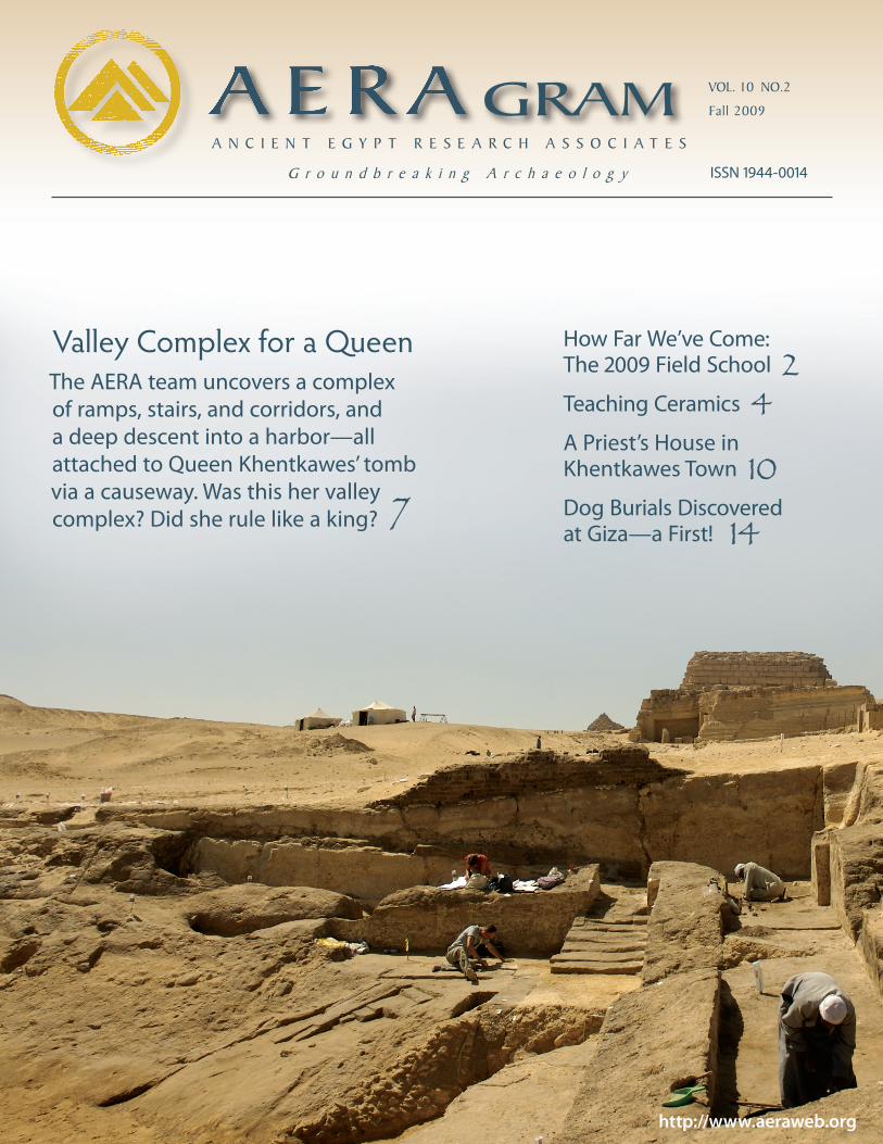
How Far We’ve Come: The 2009 Field School 2 Teaching Ceramics 4 A Priest’s House in Khentkawes Town 10 Dog Burials Discovered at Giza—a First! 14 GRAM VOL. 10 NO.2 Fall 2009 ANCIENT EGYPT RESEARCH ASSOCIATES Groundbreaking Archaeology http://www.aeraweb.org ISSN 1944-0014 Valley Complex for a Queen The AERA team uncovers a complex of ramps, stairs, and corridors, and a deep descent into a harbor—all attached to Queen Khentkawes’ tomb via a causeway. Was this her valley complex? Did she rule like a king? 7
Transcript of AERAGRAM Volume 10, No. 2
How Far We’ve Come: The 2009 Field School 2Teaching Ceramics 4A Priest’s House in Khentkawes Town 10Dog Burials Discovered at Giza—a First! 14
GRAM VOL. 10 NO.2
Fall 2009
A N C I E N T E G Y P T R E S E A R C H A S S O C I A T E S
G r o u n d b r e a k i n g A r c h a e o l o g y
http://www.aeraweb.org
ISSN 1944-0014
Valley Complex for a QueenThe AERA team uncovers a complex of ramps, stairs, and corridors, and a deep descent into a harbor—all attached to Queen Khentkawes’ tomb via a causeway. Was this her valley complex? Did she rule like a king? 7

AERAGRAM 10/22
School back in 2005. Our students have come a long way, and so have we at AERA.
We selected this year’s 40 trainees from a large pool of over 180 applicants, with a growing percentage of women. The eight-week training session was in-tegrated, as always, into our standard excavation season. This time, however, we were proud, and very fortunate, to be able to include in the team ten Egyp-tian supervisors—each a graduate of one of our previous Field Schools. The pres-ence of such “seasoned” members made a huge contribution to the success of the Advanced session.
These well-trained and enthusias-tic individuals participated as assistant instructors, working side by side with the foreign teaching staff, in each of our areas of specialization: excavation, sur-vey, osteology, ceramics, and archaeo-logical illustration. Highly involved, they helped plan and implement the course work and regularly liaisoned between the students and foreign instructors, making operations flow smoothly for students and teaching staff alike, and, of course, for us Field School directors (Ana Tavares and myself).
The situation remains a win-win: these supervisors, and many of our other
This year we launched the fifth in our series of Field Schools for Egyptian
inspectors of the Supreme Council of Antiquities (SCA), financially sponsored by the American Research Center in Egypt. Held at Giza from February 6 to April 2, 2009, our session was an Ad- vanced Field School—a kind of “grad school” designed for graduates of our prior Beginners sessions.
Looking back now at our sequence of training programs, it is immensely grati-fying to recognize the positive change that has taken place since our first Field
The 2009 Advanced Field School: How Far We’ve Come
Survey student Hadir Morgan uses the total station to take elevations and coordinates for a map of the area at the southern end of the KKT operations (see article on page 7). Photo by Jason Quinlan.
AERAGRAM 10/22

Fall 2009 3
graduates, are now capable of managing their own excavations independently. Moreover, they are often called upon for their expertise at various Egyptian sites throughout the country. Osteology supervisor Afaf Wahba’s recent work at Saqqara, for example, brought the commendation of nearby foreign mis-sions and of SCA Chairman Dr. Zahi Hawass himself. Excavation supervisor Rabea Eissa says, “Thank you for all that AERA has done for us. Please convey our thanks to everyone who made the Field School possible and gave us this chance to improve our careers and our lives.”
Such first-hand confirmation of our progress is so very encouraging and meaningful to us as we continue to pro-vide excellent training to our students. In this year’s Advanced Field School, Excavation instructors James Taylor and Freya Sadarangani, together with their Egyptian assistants, led trainees through all stages of the excavation process—excavation, recording, analysis, and report writing. Because the excava-tion area was embedded in our site, the students worked shoulder to shoulder with AERA archaeologists. Many of these students, like their predecessors, will go on to manage their own excavations in Egypt, such as our Field School graduate and (now) Excavation supervisor Essam Shihab, who is currently directing an SCA excavation around Menkaure’s Pyramid.
Survey Instructor (and co-director) Ana Tavares emphasized how to survey the whole range of terrains and struc-
tures her students are apt to encounter in the course of their careers. Using both low-tech and high-tech methods, stu-dents practiced surveying and recording various sites in and around the Giza Pla-teau, and even a modern building to al-low them to gain experience in an urban setting—a survey predicament Egyptolo-gists often encounter today. Ana proudly reports that Survey supervisor Mohamed Abd el-Basit took on a significant portion of the teaching responsibilities.
It is an unfortunate reality that os-teology training is virtually impossible to obtain in Egypt short of attending medical school. In the course of this year’s Field School, however, Osteology students received intensive training un-der instructors Jessica Kaiser and Scott Haddow, with the help of three Egyp-tian supervisors, Afaf Wahba, Ahmed Gabr, and Zainab Hashish, who created a student-instructor ratio of nearly one-to-one. The students excavated some 40 intrusive Persian burials that were effectively blocking excavation at our site. And it is gratifying to know that the knowledge and training we provide is spreading far beyond the boundaries of the Field School. Supervisor Ahmed Gabr has been called upon to assist in the excavation of human burials at an SCA excavation at Abydos.
This year we are very fortunate to have had for our Ceramics course guest instructors Janine Bourriau and Hans-Åke Nordström, who helped develop the
well-known Vienna System of Pottery-Fabric Classification. (See their articles starting on the next page.)
Advanced Ceramics student Mohamed Naguib Reda went far beyond the call of duty in translating the Vienna System into Arabic. An impressive accomplish-ment indeed! His translation, which is to be published, will be available to all SCA inspectors. With the help of computer-savvy supervisor Yassir Mahmoud, Ar-chaeological Illustration instructor Will Schenck was able to incorporate in this year’s instruction the use of computers and digital drawing programs. Moreover, Yassir Mahmoud, a graduate of our 2006 Field School, who excavates at an SCA site in Abydos, has been recruiting his fellow Field School graduates to help excavate, record, and date human burials and ceramic findings there.
Examples such as these—demonstra-tions of how our students and graduates are applying their training throughout Egypt—show that we at AERA have good reason to feel proud of what our Field Schools have accomplished during the short five years since they began. One can imagine how the face of Egyptian ar-chaeology will continue to improve with each successive session. What better way to help than to equip today’s guardians of one of the world’s most important ancient cultures with the know-how to protect their heritage?
• Mohsen Kamel Co-Field School Director
Facing page: Left: Drawing supervisor Yassir Mahmoud (center) shows Hazem Salah Abd Allah (left) and Hassan Ramadan Mamoud how to copy reliefs on a tomb. Right: Excavation Supervisor Rabea Eissa (right) helps student Mohamed Abd el Rahman take measurements for mapping his excavation square. Photos by Will Schenck (left) and Jason Quinlan (right).
Egyptian Osteology supervisor Afaf Wahba (right) discusses her burial form with Field School instructor Scott Haddow. Photo by Jason Quinlan.

AERAGRAM 10/24 AERAGRAM 10/24
Fun, Fellowship, and Fabrics: Teaching Ceramics in the AERA-ARCE AFSGuest instructors Janine D. Bourriau and Hans-Åke Nordström, eminent ceramicists, reflect on their experiences teaching in the ceramics course of the AERA-ARCE Advanced Field School (AFS) at Giza.
When Ana Tavares and Will Schenck came to visit me at Saqqara in
spring 2008 to ask for suggestions for a ceramicist for the Advanced Field School in 2009, I should have realized that I was being set up, in a nice way, of course. The three of us were very old friends, having worked together at Memphis, and as they talked to me about the field school, I became more and more excited until I could not stop myself from asking if I could come and join in the fun. It turned out to be very hard work, but fun as well, and it gave me the opportunity to do things that I had never, in my thirty years working in Egypt, done before.
I have always specialized in ceram-ics, covering Middle Kingdom to Late
Roman times and have worked at Mem-phis/Saqqara, Deir el-Bersheh in Middle Egypt, and at Buto in the Nile Delta. I have never worked on Old Kingdom material and never at Giza so that was my first learning curve. Teaching I had done before at Cambridge University and to students on excavations in which I had taken part. My second learning curve was being faced with eight stu-dents, bubbling with enthusiasm and energy and hanging upon my every word. The great difference was that they were not like students I was used to, simply completing course work; they were trained inspectors from all over Egypt who had already experienced, like me, the difficulties of coping with the mountains of sherds that every excava-tion in Egypt produces. Moreover we
were not in a library, but in a tent near the Wall of the Crow, fac-
ing bags of sherds awaiting sorting.
Luckily I had help. Teodozja Rzeuska had already introduced the students to the Old Kingdom pottery at Giza and to the basic tenets of ceramic record-ing. Another great friend, Hans-Åke Nordström, came to join me for ten days and together we were able to introduce the students to the hardest problem a ceramicist faces: the identification and recording of fabrics, the fired raw mate-rial of pottery. Hans-Åke demonstrated a system of fabric classification that we had helped to devise with three other archaeologists, Dorothea Arnold, Man-fred Bietak, and Helen Jacquet, in the 1980s. It had been published in 1993, but, like all such systems, was easiest to communicate in person, with examples, rather than from a book. Hans-Åke was on his way to Aswan where he was to participate in the anniversary celebra-tions of the UNESCO campaign to save the monuments of Nubia in which he had taken part.

Fall 2009 5
The set-up was inviting. The tent near the Wall of the Crow was comfortably close to the facilities where tamiya sand-wiches and tea were served. Outside there were mats and washing basins for the processing of the abundant sherd material. Inside, the walls were yellow; there was a big table with a laptop for teaching and a small table with a micro-scope—a somewhat dusty, but very nice classroom.
But most important and most inspiring of all, there was a small, selected group of young, attentive Egyptian students, already well trained as inspectors, who wanted to know every-thing about pottery, how to record it, how to classify it, how to use it for archaeological research. In addition, two SCA super-visors, Mohamed Aly Abd el-Hakiem Ismail and Sherif Abd el-Monem, acted as skillful translators and assistant teachers.
For me these intensive ten days at Giza will always stay in the bright side of my memory. Indeed, atmosphere is not only about air, it is also about people. The impressive organization, the professionalism, the warm and generous hospitality, the marvelous response from the students—all this created an am-bience that I believe is exceptional.
My task was to explain the complicated recording of pot-tery fabrics using a microscope. Thanks to Janine we got a rather good teaching collection of sherds and this enabled us to explain the secrets and the diagnostic features of the Vienna System, a reference classification of ancient Egyptian pottery fabrics.
What is a fabric? In a ceramological context this term is used for all technical properties of the pottery, type of clay, the nature and composition of non-plastic inclusions (e.g., sand,
So there we were, in a tent, with a microscope and computer while outside the tent were mats full of sherds in various stages of washing, drying, sorting, and weighing. We had in fact to telescope the processing of the sherds and the fabric analysis, which would normally have taken place in the workroom after the excavation. The drawing of selected sherds had been taught by Will Schenck in an earlier part of the Field School.
What was exhilarating for me was the informality of the teaching. I openly preached the value of ceramics recording, knowing that it is laborious, often tedious, and expensive in time and therefore money. Too often, as a result, archaeolo-gists record only the best preserved pieces. We had to show the value of dealing with all pottery systematically and used the sherds in front of us, however broken, to demonstrate evi-dence: of date of course, but also of provenance, showing links to other parts of Egypt and even to countries beyond, of func-tion, ethnicity, and standard of living. The students’ response was intense and inspired me to scour Giza for pottery of later periods to enlarge the scope of our evaluations. For the next field school we will have a teaching collection to help us.
In addition to the ceramic specialists, we were able to lec-ture to the whole Field School and to bring other ceramicists working in Egypt to share their experience with the school. This seems to me the most important aspect of the relationship, to put our experience at the service of the present generation of young archaeologists so that they can build on it. So much must be taught by example and by demonstration because books do not provide it—what they give is the tidy, cleaned-up version, the end product. How many archaeologists tell you why they do their work in the way they do, in addition to the results of what they do?
My abiding memories? Cold mornings, tamiya sandwiches, laughter, and fellowship. Oh yes, and there were pyramids on the horizon. • Janine Bourriau
Teaching in a Yellow Tent
Advanced Field School ceramics students draw pottery in the yellow tent. From left: Ceramics instructor Teodozja Rzeuska, Ilham Ahmed M. el Taweil, Nermeen Shaban Hassan, and Mohamed Naguib Reda. Photo by Jason Quinlan.
Facing page: The Advanced Field School ceramics team in front of the teaching lab (the yellow tent—yellow inside). The Wall of the Crow and Khufu�s pyramid rise behind them. From left: Ilham Ahmed M. el Taweil, Nermeen Shaban Hassan, Shaimaa Mohamed Abd el-Rahman, Mohamed Abd el Moniem Migahed, Janine Bourriau, Mahmoud Mohamed el Shafy, Hans-Åke Nordström, Sherif Mohamed Abd el-Monem (supervisor), Mohamed Aly Abd el-Hakiem Ismail (supervisor), Yasmeen Hassan Mustafa, and Mohamed Naguib Reda. Photo by Jason Quinlan. (continues on next page)
Janine Bourriau studied Egyptology at University College, London, and subsequently worked in the Metropolitan Museum of Art, New York, and the Fitzwilliam Museum, Cambridge. She is now based at the McDonald Institute for Archaeological Research at the University of Cambridge. She has taken part in excavations in Egypt on an annual basis since 1973, working at Saqqara, Memphis, Deir el-Bersheh, North Sinai, and Tell Fara’in in the Delta. She has published numerous books and articles on Egyptology but is best known for her work on Egyptian ceramics. .
Fun, Fellowship, and Fabrics: Teaching Ceramics in the AERA-ARCE AFS

AERAGRAM 10/26
Hans-Åke Nordström is a prehistorian, trained initially in European archaeology, now retired Associate Professor at Uppsala University, Sweden. He came to Sudanese Nubia nearly 50 years ago to participate as a field archaeologist in the famous international rescue campaign connected with the construction of the High Dam. His work there and subsequent research resulted in a specialization in ceramology and in Nubian prehistory and early history. His collaboration with Janine Bourriau and other scholars started in 1974 and led to the classification of the ancient Egyptian pottery fabrics called the Vienna System (1993).
als and techniques of manufacture very carefully, in order to suit the purpose and the function of the pots they made, and they followed rather strict traditions from generation to generation. One can often use, therefore, the variations of pottery fabrics as cultural markers, as reflections of craft traditions restricted by time or space, but also for the identi-fication of the geographical origin of the pottery.
• Hans-Åke Nordström
The preliminary report on Field Seasons 2006–2007 is now in print as the third volume in our Giza Occasional Papers series. The 223-page vol-ume includes a report on the excavations at our flagship Lost City of the Pyramids site (Heit el-Ghurab site) and at the Khentkawes Town by Mark Lehner, Mohsen Kamel, and Ana Tavares; a ground-penetrating radar study of the area east of the Khentkawes Town and Menkaure Valley Temple by Glen Dash; a geomorphology study of the Giza Plateau area by Judith Bunbury, Catherine Lutley, and Angus Graham; a laser scanning survey of the Khentkawes monument by Yukinori Kawae; and Mark Lehner's discus-sion of the Old Kingdom floodplain from Abu Roash to Memphis, Nile floods, the basin irrigation system, and ancient harbors at Giza. Forty-seven color plates, 32 black and white photos, and 33 line drawings illustrate the text. The book is perfect bound with a soft cover.
It can be purchased from David Brown Books (http://www.oxbowbooks.com/home.cfm/Location/DBBC) and downloaded from www.aeraweb.org.
crushed rock, organic material, grog), fir-ing temperature, porosity, hardness, and color of the fired paste. A strict and sus-tainable terminology is essential.
The recording of fabrics is part of a comprehensive, ceramological ap-
proach where the analyses of technology, surface treatment, decoration, function, shape, and size together form the back-bone of a classification. Fabric is always there, even when the surfaces are plain or eroded, or when the potsherds are too small for any other analysis, often serv-ing as a starting point in modern pottery classifications.
It is well known that pre-industrial potters were basically rather conserva-tive people—they hardly ever used what-ever raw material they happened to find on the spot. On the contrary, they tend-ed to choose clays and tempering materi-
Teaching in a Yellow Tent (continued from page 5)
Cross-section of a pot sherd viewed under the micro-scope. Sand and straw inclusions
show clearly. Photo by Hans-
Åke Nordström.
Straw Sand
Some the of technical properties of these sherds—what makes up their
“fabric”—can be seen in the photo, such as the color of the paste, the porosity, and materials added to
the clay (inclusions). Photo by Jason Quinlan.
Acknowledgements
Giza Occasional Papers 3 Is Out!
The 2009 Advanced Archaeology Field School was supported by the American Research Center in Egypt (ARCE) USAID grant (No. 263-A-00-04-00018-00) and the Charles Simonyi Fund for Arts and Sciences and other AERA donors. We thank Charles Simonyi and Susan Hutchison for their ongoing support of the Field School. We are grateful to Dr. Gerry Scott, ARCE Director, and Michael Jones, Egyptian Antiquities Conservation (EAC) Project Director, and Janie Abdul Aziz and Laura Shawky of ARCE for their assistance.

Fall 2009 7
Queen Khentkawes' Tomb
Khentkawes Town
Khentkawes Valley Complex (hidden behind trees)
M u s l i m Ce m e t e r y
The Giza Plateau. View to the northwest. Photo by Jason Quinlan.
Old Kingdom Egyptians interred their dead pharaohs under huge pyramids
attached to an upper temple at the end of a long causeway leading up from a valley temple that may have fronted a harbor, where the royal body and offer-ings could be delivered.
Egyptians buried their queens less grandly under mastabas (giant bench-shaped superstructures) or small pyra-mids alongside the king’s. For Queen Khentkawes I* they built an unusual stepped mastaba the size of a queen’s pyramid, standing alone, far from the kings’ pyramids. A causeway, with a town attached, ran 150 meters (492 feet) due east. Queens normally did not get their own causeways or towns.
A Queen Who Would Be King?
Ever since Selim Hassan excavated her complex in 1932, Egyptologists have sus-pected Khentkawes was not an ordinary queen. Her ambiguous title can be read
either “Mother of the Two Kings of Upper and Lower Egypt” or “Mother of the King of Upper and Lower Egypt and King of Upper and Lower Egypt.” Was Khentkawes one of those rare queens who, sometimes at the end of a dynasty, took the throne as king in their own right? She may have ruled for a time between, or after, the two last kings of the 4th Dynasty: Menkaure, who might have been her father or husband, and Shepseskaf, who might have been her husband.
Pyramid Towns and Temple Service
Hieroglyphic texts indicate that priests and others who served the king’s mem-ory lived in pyramid towns adjacent to the royal funerary complex. But the Khentkawes Town (KKT) is one of the very few examples actually excavated, which unfortunately, turned up no texts about this pyramid town.
However, sources such as the Abusir Papyri inform us of permanent overseers, priests, and workers who rotated in and out of service in the pyramid temples of the 5th Dynasty rulers of Abusir, carrying out daily rituals, such as “opening the mouth” of the royal statues and offering ritual meals and libations.
* A Khentkawes with the same titles was buried at Abusir during the 5th Dynasty. She is designated II.
Was this continuous ritual the pur-pose of the KKT and its inhabitants? Probably, in part. Although the Abusir Papyri date after Khentkawes I, the ear-lier ritual service involved most, if not all, the same staff.
Overseers and priests may have lived in the houses of the KKT with their fami-lies. Rotating staff may have stayed in houses outside the main KKT or in settle-ments on the flood plain.
A permanent population around 100 would agree with estimates for towns of smaller 5th Dynasty pyramids and with an estimate of about six people per house in the KKT. Many more might have come and gone from other settle-ments nearby for periods of service.
Khentkawes as Landlord
The economics of ritual involved far more people and a greater scale. The tombs of the most prominent Egyptians were landlords in their own right, claiming produce and goods from farms, estates, and whole villages in the provinces. At KKT, scribes prob-ably accounted for all that was due the queen’s estate. By sustaining the queen
Since 2005 we have been working at the pyramid town of Queen Khentkawes on the Giza Plateau. Here we report our major discovery this season.
(continues on page 9)
Queens' pyramids
Khafre upper temple
Khafre causeway
Valley Complex for a Queen Who Would Be King

AERAGRAM 10/28
3) BEDROCK – left by quarrymen, extends 2.62 meter (5 cubits, 8.6 feet) east beyond the eastern KKT Enclosure Wall.
15) CAUSEWAY – opens through the Eastern Enclosure Wall, 1.60 meters (5.3 feet) wide. It and its opening replaced an earlier entrance.
1) TOWN ON A SLOPE – The Khentkawes Town is founded on a natural geological plane, exposed by quarrying, which slopes southeast at 6.° From the northwestern corner to the Lower Terrace the surface drops 3 to 4 meters (9.8 to 13.1 feet).
13) SOUTHERN LATERAL RAMP (SLR) – built in three stages:a) Corridor filled with limestone debris to
make a slope 14° from the doorway through the eastern wall up to below the causeway threshold.
b) Doorway blocked, ramp lengthened and raised to slope 11° up to a level just below the causeway threshold.
c) Ramp raised and lengthened to slope
8° to 10° up to same level as the causeway threshold.
12) SOUTH BOUNDARY OF BASIN? – Wall continues east, according to 1932 excavation map.* It probably bounded the Khentkawes Valley Complex and its basin.
2) STAIRS – built of mudbrick, 96 centimeters (3 feet) wide and 1.06 meters (3.5 feet) long, descending 70 centimeters (2.3 feet).
11) CUTS IN BEDROCK – exposed by erosion of terrace. Notches might indicate where a ramp descended into the basin. The location is spaced about the same distance from the causeway entrance as the steep ramp to the north, and thus would be symmetrical with it.
Khentkawes Town
Khentkawes Valle
y Complex
Original isometric drawing by
Mark Lehner
Corridor
Corridor
11
12
13
1415
10
* Hassan, Selim. 1943. Excavations at Giza, 1932–1933. Vol. IV. Cairo: Government Press.
Causeway
Doorway
14) NORTHERN LATERAL RAMP (NLR) – reconstruction. The NLR sloped up at an angle of around 4°. Builders filled the cor-ridor with mud to support the roadbed; then prepared the ramp surface with crushed limestone, topped by alluvial silt, and a pav-ing of desert marl clay. Built after the SLR.

Fall 2009 9
3) BEDROCK – left by quarrymen, extends 2.62 meter (5 cubits, 8.6 feet) east beyond the eastern KKT Enclosure Wall.
4) OLD ENTRANCE – cut through the Northern Enclosure Wall. Filled and blocked when accretion added.
5) ACCRETION – added to the northern Enclosure Wall to repair bowing and collapsing of southern face.
1) TOWN ON A SLOPE – The Khentkawes Town is founded on a natural geological plane, exposed by quarrying, which slopes southeast at 6.° From the northwestern corner to the Lower Terrace the surface drops 3 to 4 meters (9.8 to 13.1 feet).
6) NORTHERN CORRIDOR – continues east beyond excavations. The floor level slopes slightly to the east.
10) BASIN – cut into bedrock, possibly filled with water during the annual Nile flood via a channel running from the east and the Nile floodplain.
2) STAIRS – built of mudbrick, 96 centimeters (3 feet) wide and 1.06 meters (3.5 feet) long, descending 70 centimeters (2.3 feet).
9) RAMP – slopes 1.45 meters (4.8 feet) at 20° into the basin. We did not find the bottom. At the top, were three or four steps with a low banister. Additional steps probably wore away. 8) BEDROCK STEPPED – or ter-
raced, a hypothesis based on stepped bedrock exposed under lower ramp, and hit at bottom of boreholes, marked with .
7) WATER LEVEL – (blue dotted lines) estimated during peak of the annual Nile flood at 14.00 to 14.50 meters above sea level. At this level, water would have filled the basin to a depth of 1.5 to 2 meters (4.9 to 6.6 feet).
Basin
in the Afterlife, the personnel of Khentkawes I sustained peo-ple living in the town as well as in households and villages in the countryside.
Discovering the Khentkawes Valley Complex
This season we found evidence that the Khentkawes funerary complex included other components reserved for kings: a val-ley complex and harbor (shown on the cover), which we illus-trate here in an isometric drawing.
The Khentkawes Town ends abruptly on the east, where it turns to the south (map on page 11). In 2007 we discovered why: the town’s eastern enclosure wall runs flush along the up-per edge of a deep vertical drop in the bedrock that quarrymen left as they removed limestone to the east. In 2008 we found a southern lateral ramp (SLR) against the bedrock face. This last season, 2009, excavation supervisors Daniel Jones and Kasia Olchowska excavated more ramps, stairs, and corridors along the western and northern sides of a deep basin.
The Complex in Use
In the earlier phases people evidently approached the KKT from its southeastern corner, whence they could proceed into the town through the corridor leading directly west. Or they could climb the southern lateral ramp (SLR), turn left to go up the causeway 150 meters (492 feet) to the Khentkawes chapel and to houses along the way. We don’t know if they used the northern corridor at this time. If so, it led them to a dead end at the back northern retaining wall of the SLR. People might have ascended via the stairs into the northern corridor from the lower terrace.
Later, builders made the northern lateral ramp (NLR) upon Nile silt they used to fill the corridor. The pair of ramps allowed people to approach and exit the queen’s causeway from north or south around the basin.
We believe the basin may have been a functioning harbor. The bottom is at least as low as our best estimate of the level of the Old Kingdom floodplain. If there was a connection to the floodplain, Nile water could have filled the basin at least during the inundation season. The point of the valley complex might well have been to bring people via land (the corridors stretch-ing east) or water to the town and tomb, up on terraces that rose high above the floodplain.
Khentkawes as Ruler
The gigantic size of her tomb and its isolation from a king’s pyramid, her long causeway, her own pyramid town, and now, her own valley complex and harbor, only reinforce the impres-sion that Khentkawes I reigned as a supreme sovereign in her own right.
• Mark Lehner
Valley Complex for a Queen (continued from page 7)
1
2
3
4
5
6
78
9
10

AERAGRAM 10/210
A House Through Time: Building, Abandonment, and Intermingling
We have learned from three seasons of work at the Khentkawes Town
(KKT) that the phases of occupation and remodeling are much more complex than those shown in the map Selim Hassan published in 1943.1
In 2009 we decided to excavate fully House E, one of the better preserved structures. Although Hassan had ex-cavated it, we were still able to retrieve much valuable information, as we have with all of our work in the KKT. We re-vealed a sequence of modifications and rebuilds and an unexpected period of abandonment and reoccupation.
A Street of Priests’ Houses
The standard layout of the houses and their location along the causeway leading east from Queen Khentkawes’ funerary monument suggest that here lived priests in charge of keeping alive the funerary cult of the Queen.
In two brief paragraphs Hassan1 re-fers to the wealth of information from his excavation of the six houses A to F. He simplifies the plans of these houses
and conflates walls of all phases together. The apparent standardization led him to assign functions common to similar rooms in all the houses across all phases.
Based on the information Hassan published, Felix Arnold2 sees the KKT houses designed for the owner's roles as priest, official host, and private person. The southern entrance into the cause-way was for the priestly role, the north-ern access and living area were for the roles of host and official, and the west-ern rooms for retreat into privacy.
Hassan removed most of the occupa-tion deposits and floors, so our work provides information primarily on the original structure and its subsequent modifications. Here we summarize broadly four major changes in House E over time.
The Original House
House E covers about 189 square meters (2,034 square feet). Originally it included four elongated, north-south
rooms (68–73) and one transversal room (74). An open courtyard (79) took up most of the width of the house on the north and extended into House F to the east. An entrance on the southeast opened to a zigzag succession of small chambers (76, 77, 80), which provided privacy for the inner chambers and was typical of Old Kingdom houses and shrines. These led to a vestibule (74), possibly left unroofed, which merges with an L-shaped room (73), evidently the kitchen. Substantial burning left thick ash over the floor and scorched and damaged the western wall. Room 73 may have been unroofed or only par-tially covered to allow smoke to escape.
From the vestibule (74) a doorway opened to Room 71, which led in turn to Rooms 68 and 69, the more private chambers. Room 71, which Hassan de-scribed as the “living room,” could have been a bedroom. At the southern end, pilasters define a niche, the width of the room. A house in our Lost City site had
House E excavations. The trench in the foreground cuts through the causeway. In the background, a rock-cut tomb looks over the house. Beyond, the Sphinx head stands above the landscape. View to the northeast. Photo by Mark Lehner.

Fall 2009 11
a similar large, central room configured with two pilasters defining a niche that included a bed platform.3 Felix Arnold suggested the house owner would receive guests here.
Hassan designated Rooms 68 and 69 as bedrooms. A niche in Room 68 could have contained a bed platform. We found a bed platform in such a niche in the Eastern Town House at our Lost City site.4
In Room 69 we found evidence of a number of hearths against the eastern wall, opposite an open passage from House D, suggesting that the inhabitants of the two houses shared cooking facili-ties in this room.
Caption
Rooms 74 and 71 both lead to the open courtyard at the back of the house. Two doorways in the northern wall open from the court into the narrow street along the north of the town.
“A Turn About”
Minor modifications (shown on the next page) drastically altered the house and the flow of space. People blocked the two northern entrances of the house and partitioned off a small room (70) in the
69
74
Causeway
Kitc
hen
Cook
ing
area
?
0 10 50 meters
Khentkawes Town
Khentkawes
Tomb
Khentkawes
Valley Complex
Menkaure Valley Temple
Chapel
Causeway
Above: House E based on our 2009 excavations. The adjacent house plans are from the map published by Selim Hassan.1
Right: Digitized version of Hassan's map showing the Khentkawes Town and part of the Menkaure Valley Temple. The letters indicate Houses. The Khentkawes Valley Complex at the far right is based on discoveries of the 2009 season.
Ante-TownResidential structures invading the temple
North Street
Northern Enclosure Wall
Southern Enclosure Wall
Khentkawes’ chapel
Open courtyard
79
70
68
71
80
77
73
76
House F
House D
Vestibule
Niche
Bed platform?
North Street
House E
North Enclosure Wall

AERAGRAM 10/212
northwest corner. The courtyard (79) continued east to span the entire width of House F. The only access to North Street was now through the neighbors’ courtyard!
About this time, the builders put up an east-west wall cre-ating a double street to the south of the houses. The narrow passage fronting the houses formed a causeway about 1.71 meters (5.6 feet) wide running straight from the queen’s chapel to the valley complex, while the broader street to the south fed into the southern part of the town.
A House Sequestered
Subsequent modifications (facing page) blocked the northern courtyard (79) from the rest of House E, leaving this space exclusive to House F. An L-shaped wall framed four silos, probably granaries, built with small bricks quite different from the large Nile alluvium bricks used in the original lay-out. People blocked both entrances through the southern wall of the court into rooms 71 and 74. The court and silos now effectively belonged to House F.
Perplexing Public Causeway
Instead of a secluded corridor between an upper and lower temple as we see in king’s pyramid complexes, Khentkawes’ causeway is a narrow passage along the very fronts of a series of houses. The doorways, and possibly windows, of the north-ern houses, open into the causeway. At least 12 doorways with limestone thresholds pierce the southern causeway wall, off-axis of the doorways into the houses. The southern wall, which would have provided protection from the heat and sun, seems almost like an extra frontage to the houses. However, the narrow passage lines up directly with the doorway of the queen’s chapel, so it must have functioned in part like the causeways of kings’ pyramids.
Abandonment and Reoccupation
We have found much evidence that peo-ple abandoned KKT for some period and later reoccupied the town. Such evidence was particularly striking in House E dur-ing its final phase.
When House E was reoccupied, people repaired and rebuilt walls employing different techniques than their predeces-sors and using small, reddish mudbricks, very distinct from the original large silty bricks. They cut back the original faces of older walls, probably to remove decayed, weathered, or broken bricks. Or they rebuilt walls from the base up, indicating
that some walls might have been robbed of the original bricks, down to floor level. The later occupants repaired major parts of the walls in the small chambers (76, 77, 80) inside the south-east entrance, and the walls of Room 73, the kitchen, which might have suffered heat damage from long contact with cook-ing fires.
The occupants resurfaced the streets to the south at least three times and rebuilt the southern town enclosure wall, 2.2 meters (7.2 feet) thick.
“Intermingled” Houses
The glimpse of House E through time forces us to rethink the history and function of the entire town. One of the most significant discoveries of our Season 2009 is that house plans “intermingled.” What we have long perceived as separate houses actually included rooms that were more easily acces-sible, or only accessible, from the house next door. If we look at House E in isolation, Room 69 is the most private. An indi-vidual would have to wind his way through six doorways to reach it from the southern entrance. But a doorway open to House D allowed quick access from the southern entrance of this house.
The courtyard (79) extended east from House E across the width of House F. After the doorways on the north were blocked, people could only access North Street via House F.
House E with the first set of modifications, shown in orange. After the doors on the north in Rooms 70 and 79 were blocked, the only access to North Street was through the courtyard in House F.
69
74
Causeway
Kitc
hen
Cook
ing
area
?
Open courtyard
79
70
68
71
80
7773
76
F
D
Vestibule
Niche
North StreetE
North Enclosure Wall
Street
Courtyard
Blocked doors
New wall
Partition
Khentkawes' chapel

Fall 2009 13
After the granaries were built in the courtyard (79), only the residents of House F could access them. The silos effectively belonged to House F, and this must have had implications for the economic and social status of the residents.
When people reoccupied House E, they could only enter and leave from the doorway in the southeast corner or from House D to the west via its northern entrance, courtyard, ves-tibule, and doorway into Room 69.
A Second Occupation
House E adds to the mounting evidence of a hiatus and reoccupation at KKT. We can relate this evidence to George Reisner's discoveries (1908–1910) in the Menkaure Valley Temple,5 lying just south of the KKT (map on page 11). During the 5th Dynasty people began building mudbrick houses, grain silos, and small bins up against the eastern wall of the temple and then in the temple court before a flash flood severely damaged the sturcture and most probably its "town." Following a hiatus, people began rebuilding during the reign of Pepi II, the last pharaoh of the 6th Dynasty. Until the end of the Old Kingdom, nearly 300 years after Menkaure, they built and rebuilt their houses and grainaries in the Ante-town and inside the main temple courtyard over the decay and demoli-
tion of the original structures. Our work indicates a similar sequence in the KKT, but one that involved much reuse of original walls.
Life returned to the Menkaure Valley Temple probably when Pepi II re-endowed the cult of Menkaure. This dedica-tion and tax exemption no doubt encouraged people to move back into the deserted pyramid town and temple. Perhaps the same happened for the considerably larger town of Khent-kawes; the royal house may have granted a tax-exemption or re-endowed Khentkawes I's funerary cult. Or, perhaps the two towns and their cults were inseparable.
• Ana Tavares and Lisa Yeomans
1. Hassan, Selim. 1943. Excavations at Giza, 1932–1933. Vol. IV. Cairo: Government Press.
2. Arnold, Felix. 1998. Die Priesterhäuser der Chentkaues in Giza. Mitteilungen des deutschen archäologischen Instituts, Kairo. 54: 2–18.
3. Daily Life of the Pyramid Builders. AERAGRAM 10/1. Spring 2009. pp. 14–15.
4. Behind Mudbrick Walls: Life in an Eastern Town House. AERA-GRAM 7/2. Fall 2004 . pp. 6–7.
5. Reisner, George. 1931. Mycerinus, the Temples of the Third Pyramid at Giza. Cambridge, MA: Harvard University Press.
Lisa Yeomans and Hanan Mahmoud supervised the meticulous excavation of House E during the 2009 season. Mohsen Kamel is writing his Ph.D. dissertation on houses from the Lost City site.
69
74
Causeway
79
70
68
71
80
7773
76
F
D
E
North Enclosure Wall
Street
Courtyard
House E with later modifications prior to aban-donment (shown in orange). The dotted line shows the area that effectively was House F (F and Room 79 with the silos). The dashed line shows House E with its new configuration (which excluded Rooms 70 and 79), and House D, onto which it opened from Room 69. Upon reoccupation the house was repaired and renovated (layout changes shown in rose).
Silos
Blocked doors
New wall
Partition(reoccupation)
Wall (reoccupation)
Blocked door(reoccupation)
Wall
Courtyard
Vestibule
North Street

AERAGRAM 10/214
Initially, we saw only two dogs, but eventually uncovered eight canines, layered on top of each other in the burial pit.
The topmost dogs (blue and green in the drawing), both adults, showed evidence of mummification. A black substance with imprints of linen wrappings, possibly the remains of soft tis-sue and balms, enveloped their skeletons. The body positions also suggested mummification, in that they appear to have been tightly wrapped. The back legs of both dogs were drawn up with the tail between and the front legs extended along the chest, similar to some dog mummies in the Cairo Museum.
The third and fourth dogs (purple and red), young adults, were not tightly wrapped. However, a grey substance adhering to the bones of both may suggest that they received some sort of cursory treatment for burial.
The remains of four small puppies (in orange) lay at the bot-tom of the burial pit. They appear to have been deposited one on top of the other, perhaps wrapped in one piece of cloth. The gray substance also covered them.
We originally assumed that the dogs were associated with the Late Period human graves in the excavation square where they were found. However, the dog burial pit truncated two of the human graves, which tells us that the dogs were buried later than at least these two human interments. The dog mum-mies could be contemporary with other adjacent burials.
Ancient Egyptians mummified animals for a variety of reasons, the most common being for votive offerings. Various levels of mummification were available, one for every budget. If the Giza dogs were indeed intended as votive mummies, the heterogeneous methods of mummification could perhaps be explained by the fact that the donor was not able to afford more than two properly wrapped votives. This is not surpris-ing, considering the comparatively poor human burials in this cemetery. The other dogs may have been treated with a cheap-er method of mummification, which could account for the grey powdery substance adhering to the bones.
• Jessica Kaiser
As often happens in archaeology, one of our most interesting dis-coveries of the 2009 season turned up during the final days of exca-vation: a Late Period burial pit with a cache of dogs. Our osteology team has excavated hundreds of human graves in the Late Period cemetery sunk into the ruins of the Old Kingdom settlement. But this was their first dog burial. It was the first canine burial for Giza as a whole, except for that of a hunting dog, recorded in a relief on a chapel block reused in tomb G 2188 but never actually located. During the Late Period, or 26th Dynasty, ancient Egyptians buried thousands of mummified animals of all sorts at other sites. Jessica Kaiser, head of the AERA osteo team, presents the group's initial observations of the dog burials. With the season ending, they had to postpone formal analysis until next year.
Dog burial at beginning of excavation. Photo by Ayman Damarany.
AERAGRAM 10/214
“Due to their number, it is more likely that they were a sort of votive offer-ing to Anubis or Wepwawet, gods of the dead, mummification, and travel between this world and the next, rather than pets. Such votive offerings are very common from the 26th Dynasty onward, as is seen by the number of animal cemeteries scattered throughout Egypt from that era. …Pre-sumably this deposit dates to the Late Period as well, and the dogs were intended to attract the blessings of Anubis and to help the people who dedicated the burials to arrive safely in the afterworld.”
DR. SALIMA IKRAM, author of Divine Creatures: Animal Mummies in Ancient Egypt (2005) and Professor of Egyptology at the American University in Cairo, offered these comments on the dogs:
Going to the Dogs: Giza's First Canine Burials Discovered
Drawing by Ahmed Gabr and Ayman Damarany showing each dog in a different color.
0 0.5 1 meter

Fall 2009 15
Request AERA's E-Bulletin Keep up with AERA by signing up for our E-Bulletin, sent out periodi-cally. Please e-mail [email protected]. In the subject line type: “E-Bulletin.”
AERAGRAMVolume 10 Number 2, Fall 2009
Editor: Dr. Wilma WetterstromAssistant: Alexandra Witsell
AERAGRAM is published by AERA, Ancient Egypt Research Associates, Inc.,a 501(c) (3), tax-exempt, non-profit organization.
Ancient Egypt Research Associates26 Lincoln St. Ste. 5, Boston, MA 02135E-mail: [email protected]. Website: http://www.aeraweb.org.
AERA Board Members President and Treasurer: Dr. Mark LehnerSecretary: Glen DashDr. James AllenEd FriesJon JerdeBruce LudwigAnn LurieMatthew McCauleyPeter NortonDr. Richard Redding
© Ancient Egypt Research Associates 2009
AERA on Tour in “Lost Egypt: Ancient Secrets, Modern Science”AERA’s work features in this interactive, immersive exhibit as exem-plary for how modern archaeologists use science and technology to understand the people and culture of Ancient Egypt. “Lost Egypt,” created and produced by COSI (the Center of Science and Industry in Columbus, Ohio) and built by the Science Museum of Minnesota, opened in Columbus on May 30, 2009.
During our 2009 field season, the Lost Egypt production team spent a week filming our excavations and field lab and interviewing team members Dr. Mark Lehner, Dr. Mary Anne Murray, Dr. Anna Wodzińska, Dr. Richard Redding, Ana Tavares, Jessica Kaiser, and John Nolan. The exhibit is now open at the Cincinnati Museum Center and will be traveling among members of the Science Museum Exhibit Collaborative next year.
Preview the show at:http://www.lostegypt.org/
See the show at:The Cincinnati Museum Center Oct 3, 2009, to Jan 3, 2010http://www.cincymuseum.org/
Follow AERA on Twitter @AERA_EGYPT
Visit AERA's Websitehttp://www.aeraweb.org
earth Updates GizaThis summer Google updated their satellite shots of Giza in Google Earth (http://earth.google.com/) and on the Google Maps website (http://maps.google.com/). The buried walls and some other features of our Lost City of the Pyramids settlement appear in the images. But they are not nearly so distinct as the clear, sharp lines of our replica Eastern Town House (ETH), which we built in 2005 over the original, ancient house, bur-ied under a thick layer of sand (AERAGRAM 8/1, 2006).
ETH
Wall of the Crow
0 10 50 100 meters
Enclosure
Wall
Main Street
Royal Administrative
Bldg
Western Town Workers Cemetery
(Supreme Council of Antiquities Excavations)
The Chute
Soccer Field
Muslim Cemetery
Coptic Cemetery

AERA-Egypt CenterWe announced in the last news-letter our purchase of a villa near the foot of the Pyramids for a per-manent AERA-Egypt Center.
Soon after signing the papers in February, we began renovating the derelict structure, which had been empty for 20 years. Here we share our progress to date.
We replaced the entire plumbing system and plastered all the walls as the cast-iron plumbing had rusted through over the years, draining water out onto walls and floors. We built a new kitchen, equipped with modern ap-pliances, to accommodate cooking for a large team. As we rehabbed rooms, we modified them to meet our needs. Shelving went into the library/archive. We reworked space on
the ground level to create a large dining room.
We replaced the old, damaged wir-ing, which could not support modern electronics. We installed Ethernet cables to connect every room to our server.
While we upgraded the villa to the 21st century and adapted it to our needs, we tried to preserve the character of the build-ing and save some of the beautiful archi-tectural details. When we renovated the bathrooms, we restored the original porcelain tile floors. We managed to preserve and refinish the parquet hardwood floors that had suffered water damage.
In May we moved our equipment, library, archive, and computers from our rented headquarters. Over the next few years we will build dormitories on the property
to house our crew and the household staff. Jon Jerde, AERA board member, and his Jerde Partnership are working on plans for a complex that we can build in phases.
We are grateful to generous donors whose major gifts made it possible for us to establish a permanent home for AERA in Giza: the Waitt Family Foundation, the Ann and Robert H. Lurie Foundation, the David H. Koch Foundation, the Charles Simonyi Fund for Arts and Sciences, the Peter Norton Family Foundation, Dr. Marjorie Fisher, and the Urban Land Institute tour members on behalf of Bruce Ludwig.
UPDATE

JOIN AERA TODAY
Your membership directly supports the main pillars of our mission at Ancient Egypt Research Associates: archaeological excavation, analysis, publication, and educational outreach.
Donors who contribute at the level of basic member ($55) or senior/student member ($30) receive our AERAGRAM newsletter twice a year and the AERA Annual Report hot off the presses, months before we post these publications to our website. Donors also receive invitations to special events and regional lectures, as well as firsthand updates on research from the field.
By contributing to AERA, you’ ll receive the benefit of knowing that you’ve made a valuable investment in us all, helping to broaden our knowledge of the past, make an impact in the education of our students, and strengthen the future of our global community.
Please join or contribute online at: http://www.aeraweb.org/support. Or send your check to the address below. AERA is a 501(c)(3) tax exempt, nonprofit organization. Your membership or donation is tax deductible.
Be Part of our Global Past, Present, and Future
MEMBERSHIPS: Basic: $55 Student/Senior: $30 Non-US: $65 Egyptian National: LE100 Supporting $250
Name ________________________________________________
Address ______________________________________________
_____________________________________________________
Phone _______________________________________________
Email address _________________________________________
Please make check payable to AERA.
Or charge your membership to a credit card:
Name on card _________________________________________
Card number _________________________________________
Verification Security number (on back) _____________________
Expiration date ________________________________________
Signature _____________________________________________
Please send application with payment to AERA at:26 Lincoln Street, Suite 5, Boston MA, 02135 USA
Zip Country