Advanced Draft - Forest Carbon Partnership Facility
323
1 Emission Reductions Programme to The Carbon Fund (CF) of the Forest Carbon Partnership Facility (FCPF) CHILE (Advanced Draft) Ministry of Agriculture Corporación Nacional Forestal (CONAF) [National Forestry Corporation] Management Office on Forest Support and Development (GEDEFF) Climate Change and Environmental Services Unit (UCCSA) 17 July 2016
-
Upload
khangminh22 -
Category
Documents
-
view
0 -
download
0
Transcript of Advanced Draft - Forest Carbon Partnership Facility
1
Emission Reductions Programme to The Carbon Fund (CF) of the Forest Carbon
Partnership Facility (FCPF)
CHILE
(Advanced Draft)
Ministry of Agriculture
Corporación Nacional Forestal (CONAF) [National Forestry Corporation]
Management Office on Forest Support and Development (GEDEFF)
Climate Change and Environmental Services Unit (UCCSA)
17 July 2016
2
UCCSA Team
Angelo Sartori, Forestry Engineer, Diploma and Master’s in Business and Administration (MBA) in Sustainable Management.
Osvaldo Quintanilla, Forestry Engineer. MSc in Social Ethics and Human Development and Diploma in Government and Public Management.
Javier Cano, Graduate in Geography and Regional Planning. Master`s Degree in Geographic Information Technologies for Regional Planning. S.I.G. (Sistemas de Información Geográfica [Geographic Information Systems]) and Remote Sensing. Doctorate in Regional Planning and the Environment.
Wilfredo Alfaro, Forestry Engineer. Master of Science in Engineering Hydrology.
Gabriela Soto, Veterinarian. Master of Science and Masters in Wildlife Areas and Nature Conservation.
Nuvia Briceño, Forestry Engineer.
Alejandra Arochas, Environmental Engineering and Ecologist-Landscaper Diploma in Water Contamination.
External consultants: Pablo Honeyman, Forestry Engineer, Master`s Degree in Environment and Sustainable Development.
Nelson Urra Pardo. Renewable Natural Resources Engineer. Doctor in Agroforestry and Veterinary Sciences. Expert consultant. [email protected].
Equipo de la Unidad de Asuntos Indígenas y Sociales (UIAS) [Indigenous and Social Affairs Unit Team].
Guido Aguilera, Forestry Engineer, Master’s Degree in Economics and Regional Management.
María Victoria Colmenares, Graduate in International Studies, Master’s Degree in Integrated Environmental Planning.
Pamela Duhalde, Forestry Engineer.
Valentina Letelier, Psychologist on Social Community Counselling, Diploma in General Skills Management and Diploma in Social and Environmental Studies.
Pamela Hidalgo, Geographer.
Kenia Neira, Forestry Engineer, Forestry Technician.
Support Teams Technical consortium: OTERRA Universidad Mayor [Oterra Mayor University], Ernst Basler + Partner (EBP), Centro de Información de Recursos Naturales (CIREN) [Natural Resources Information Centre], Agrupación de Ingenieros Forestales por el Bosque Nativo (AIFBN) [Native Forest Engineers Association]. Technical consortium: Winrock International, Instituto Forestal (INFOR) [Forestry Institute], Universidad Austral [Austral University].
Technical consortium: Teco Group, Sud Austral, Climate Focus. Technical consortium: Sud Austral, CERTFOR, Winrock International
3
INDEX
1. ORGANIZATIONS RESPONSIBLE FOR THE MANAGEMENT AND IMPLEMENTATION OF THE PROPOSED PROGRAMME .............................................................................................................................. 9
1.1 ER Entity expected to sign the Emissions Reduction Purchase Agreement (ERPA) with the FCPF Carbon Fund. .............................................................................................................................................. 9
1.2 Organisation (s) responsible for managing the ER Programme. ..................................................... 9
1.3 Associated entities and other organisations participating in the ER Programme. ......................... 9
2. STRATEGIC CONTEXT AND JUSTIFICATION FOR THE ER PROGRAMME ............................................. 12
2.1 Current status of the Readiness Package and summary of additional achievements on readiness activities in the country. ........................................................................................................................... 12
2.2 Ambition and strategic justification for the ER Programme ......................................................... 14
2.3 The political commitment ............................................................................................................. 17
3. LOCATION OF THE ER PROGRAMME ................................................................................................... 22
3.1 Accounting for the ER Programme ............................................................................................... 22
3.2 Environmental and social conditions within the accounting area of the ER Programme ............ 24
4. DESCRIPTION OF THE PROPOSED ACTIONS AND INTERVENTIONS OF THE ER PROGRAMME .......... 40
4.1 Analysis of the direct and underlying causes of Deforestation, Forest Degradation, and no Enhancement of forest carbon Stocks (DDnAE) ....................................................................................... 41
4.2 Evaluation of the main barriers to REDD + ................................................................................... 71
4.3 Description and justification of the actions and interventions scheduled within the framework of the ER Programme that leading to emission reductions and increase in stocks. ................................ 74
4.4 Evaluation of the tenure of the land and the resources in the accounting area ....................... 110
4.5 Analysis of the legislative and institutional framework related to the ER Programme .............. 116
4.6 Duration of the proposed ER Programme .................................................................................. 122
5. CONSULTATION AND PARTICIPATION OF INTEREST GROUPS ......................................................... 123
5.1 Description of the process for consulting interest groups.......................................................... 123
5.2 Summary of the comments received and the way in which these viewpoints were taken into consideration when designing and implementing the ER Programme .................................................. 126
6. OPERATIONAL AND FINANCIAL PLANNING ...................................................................................... 130
6.1 Institutional provisions and those for implementation .............................................................. 130
6.2 Budget for RE programme .......................................................................................................... 140
7. CARBON RESERVOIRS, SOURCES AND SINKS .................................................................................... 141
7.1 Description of the sources and sinks selected ............................................................................ 141
7.2 Description of the reservoirs of carbon and greenhouse gases selected ................................... 142
8. REFERENCE LEVEL .............................................................................................................................. 143
4
8.1 Reference Period ......................................................................................................................... 144
8.2 Definition of forest used in the Reference Level ........................................................................ 146
8.3 Mean historic annual emissions during the reference period .................................................... 147
8.4 Positive or negative adjustments of the historic mean annual emissions during the reference period (if applicable) ............................................................................................................................... 162
8.5 Estimation of the Reference Level .............................................................................................. 162
8.6 Relationship between the reference level, the development of a FREL/FRL (Forest Reference [Emission] Levels) for the CMNUCC and the inventory of greenhouse gases existing in the country ... 180
9. APPROACH FOR MONITORING, REPORTING AND VERIFICATION ................................................... 184
9.1 Approach for Monitoring, Reporting and Verification in order to estimate the emissions produced within the framework of the RE Programme in the Accounting Area ................................... 184
9.2 Institutional structure for the MRV ............................................................................................ 189
9.3 Relationship and consistency with the National Forest Monitoring System .............................. 190
10. MOVEMENT .................................................................................................................................... 191
10.1 Identification of risks of movement ............................................................................................ 191
10.2 Elements of the ER Programme to prevent and minimise the potential for displacement ....... 193
11. REVERSIONS .................................................................................................................................... 195
11.1 Identifying risks of reversion ....................................................................................................... 195
11.2 Aspects of the ER Programme aimed at preventing and minimising the potential for reversions 197
11.3 Mechanisms to manage reversions ............................................................................................ 198
11.4 Monitoring and reporting emissions associated with reversions ............................................... 199
12. UNCERTAINTY CONCERNING THE CALCULATION OF EMISSIONS REDUCTION ............................ 200
12.1 Identifying and evaluating sources of uncertainty ..................................................................... 200
12.2 Calculating the uncertainty of adjustments to the reference level ............................................ 204
13. EMISSIONS REDUCTION CALCULATION ......................................................................................... 208
13.1 Ex-ante forecast of emission reductions under the programme ................................................ 208
14. SAFEGUARDS .................................................................................................................................. 210
14.1 Description of how the ER Programme complies with the social and environmental safeguards of the World Bank and promotes and supports the safeguards associated with REDD+ contained in the Framework Convention .......................................................................................................................... 210
15. BENEFIT-SHARING ARRANGEMENTS ............................................................................................. 245
15.1 Description of benefit-sharing arrangements ............................................................................. 245
15.2 Summary of the design process for benefit-sharing arrangements ........................................... 250
15.3 Description of the legal context of the benefit-sharing arrangements ...................................... 251
16. NON-CARBON BENEFITS (CO-BENEFITS) ........................................................................................ 252
5
16.1 Potential non-carbon benefits scheme and identifying priority benefits for the ER Programme 252
16.2 Approach for providing information on prioritised non-carbon benefits .................................. 256
17. OWNERSHIP OF EMISSIONS REDUCTIONS .................................................................................... 257
17.1 ER Programme Authorisation ..................................................................................................... 257
17.2 Transfer of title to emission reductions ...................................................................................... 260
18. DATA MANAGEMENT AND REGISTRY SYSTEMS............................................................................ 269
18.1 Participation in other GHG initiatives ......................................................................................... 269
18.2 Data management and registry systems to avoid double-entry ................................................ 270
ANNEX 1: SUMMARY OF FINANCIAL PLAN ................................................................................................ 272
APPENDIX 2. COMPLETE LIST OF INSTITUTIONS SUPPORTING THE ER PROGRAMME ............................ 274
APPENDIX 3: LISTS OF FLORA AND FAUNA SPECIES WITH CONSERVATION STATUSES IN THE ACCOUNTING AREA .................................................................................................................................... 276
APPENDIX 4. METHODOLOGY FOR THE CHARACTERISATION OF THE CAUSES OF DEFORESTATION, DEGRADATION AND NON-INCREASES OF FOREST STOCK, AND ACTION MEASURE PROPOSALS ........... 283
APPENDIX 5. ACTIVITY DATA AND EMISSION FACTORS USED FOR CALCULATING THE HISTORICAL ANNUAL MEAN EMISSION DURING THE REFERENCE PERIOD .................................................................. 296
APPENDIX 6. PLAN TO IMPROVE CHILE’S SUBNATIONAL FREL/FRL ......................................................... 321
6
ACRONYMS AFOLU: AGRICULTURE, FORESTRY AND OTHER LAND USE. DNA: DESIGNATED NATIONAL AUTHORITY. BUR: BIENNIAL UPDATE REPORT. CIREN: CENTRO DE INFORMACION DE RECURSOS NATURALES [NATURAL RESOURCES INFORMATION CENTRE]. CBD: CONVENTION ON BIOLOGICAL DIVERSITY. UNFCCC: UNITED NATIONS FRAMEWORK CONVENTION ON CLIMATE CHANGE. UNCCD: UNITED NATIONS CONVENTION TO COMBAT DESERTIFICATION. CONAF: CORPORACIÓN NACIONAL FORESTAL [NATIONAL FORESTRY CORPORATION]. COP: CONFERENCE OF THE PARTIES. SDC: SWISS AGENCY FOR DEVELOPMENT AND COOPERATION. CLP: PESO, LEGAL CURRENCY IN CHILE. DDNAE: DEFORESTACIÓN, DEGRADACIÓN Y NO AUMENTOS DE EXISTENCIAS DE CARBONO FORESTAL [DEFORESTATION, DEGRADATION AND NO INCREASES IN FOREST CARBON STOCKS] ENCCRV: NATIONAL STRATEGY FOR CLIMATE CHANGE AND VEGETATION RESOURCES. ERPA: EMISSIONS REDUCTION PURCHASE AGREEMENT. FCPF: FOREST CARBON PARTNERSHIP FACILITY. FREL/FRL: FOREST REFERENCE EMISSION LEVEL/FOREST REFERENCE LEVEL. GCF: GREEN CLIMATE FUND. GEF: GLOBAL ENVIRONMENT FACILITY. GHG: GREENHOUSE GASES. NDC: NATIONALLY DETERMINED CONTRIBUTIONS. INFOR: INSTITUTO FORESTAL DE CHILE [FORESTRY INSTITUTE OF CHILE]. ICEF: INVENTARIO CONTINUO DE ECOSISTEMAS FORESTALES [CONTINUOUS INVENTORY OF FOREST ECOSYSTEMS]. NGGI: NATIONAL GREENHOUSE GAS INVENTORY. IPCC: THE INTERGOVERNMENTAL PANEL ON CLIMATE CHANGE. ISGEI: INVENTARIO SECTORIAL DE GASES DE EFECTO INVERNADERO [SECTORAL GREENHOUSE GAS INVENTORY]. MINAGRI: MINISTRY OF AGRICULTURE. MINREL: MINISTERIO DE RELACIONES EXTERIORES [MINISTRY OF FOREIGN AFFAIRS]. MMA: MINISTERIO DE MEDIO AMBIENTE [MINISTRY OF THE ENVIRONMENT] MRV: MONITORING, REPORTING AND VERIFICATION. NAMA: NATIONAL APPROPRIATE MITIGATION ACTIONS. OECD: ORGANISATION FOR ECONOMIC CO-OPERATION AND DEVELOPMENT. ILO: INTERNATIONAL LABOUR ORGANIZATION. UN-REDD: UNITED NATIONS PROGRAMME ON REDUCING EMISSIONS FROM DEFORESTATION AND FOREST DEGRADATION IN DEVELOPING COUNTRIES PES: PAYMENT FOR ECOSYSTEM SERVICES. NWFP: NON-WOOD FOREST PRODUCTS REDD+: REDUCING EMISSIONS FROM DEFORESTATION AND FOREST DEGRADATION AND THE INCREASED EXISTENCE OF CARBON. SAFF: SISTEMA DE ADMINISTRACIÓN Y FISCALIZACIÓN FORESTAL [FORESTRY ADMINISTRATION AND CONTROL SYSTEM]. SIDCO: SISTEMA DE INFORMACIÓN DIGITAL PARA EL CONTROL DE OPERACIONES [DIGITAL INFORMATION SYSTEM OPERATIONS CONTROL]. SIT: TERRITORIAL INFORMATION SYSTEM. SNASPE: SISTEMA NACIONAL DE ÁREAS SILVESTRES PROTEGIDAS POR EL ESTADO [THE NATIONAL SYSTEM OF PROTECTED WILDLIFE AREAS OF THE STATE]. NFMS: NATIONAL FOREST MONITORING SYSTEM. UAIS: UNIDAD DE ASUNTOS INDÍGENAS Y SOCIALES DE CONAF [CONAF SOCIAL AFFAIRS AND INDIGENOUS PEOPLES UNIT]. UCCSA: UNIDAD DE CAMBIO CLIMÁTICO Y SERVICIOS AMBIENTALES DE CONAF [CONAF CLIMATE CHANGE AND ENVIRONMENTAL SERVICES UNIT]. LULUCF: LAND USE, LAND USE CHANGE AND FORESTRY
7
EXECUTIVE SUMMARY Since 2010, Chile has been making progress in the design of a National Strategy for Climate Change and Vegetation Resources (ENCCRV, acronym in Spanish). Its objectives are focused on the definition and implementation of strategic actions of mitigation and adaptation to Climate Change (CC), developing a carbon accounting and environmental metric services system, including a social and environmental safeguard system, which complies with the technical-political requirements of the United Nations Framework Convention on Climate Change (UNFCCC) and the United Nations Convention to Combat Desertification (UNCCD), with the National Forestry Corporation (CONAF, acronym in Spanish) acting as the National Focal Point for the latter, as well as for REDD+ under the UNFCCC. This strategy also looks at the implementation of a plan for the diffusion, creation and strengthening of skills at a national level, as well as the development of institutional and inter-institutional arrangements to strengthen and facilitate its implementation. The ENCCRV consists of three main phases, with the first being preparation, where all the elements and interrelations thereof are conceptually designed. A second phase for pilot projects and implementation, in which actions related to the management, restoration and formation of forests and other vegetation formations are realised.1. Finally, a third phase, generically referred to as payment per results based on performance, seeks to remunerate public and private stakeholders in whose territories improvements are verified with regard to with vegetation resource management, and the maintenance or increase of ecosystem services that they provide to society, including carbon storage, water system regulation, land protection, preservation of biodiversity, amongst others. Within this context, this document contains the proposal for the Emissions Reduction Programme (ER) that Chile has developed to submit to the Forest Carbon Partnership Facility (FCPF), and that will be a significant part of the Implementation and Payment for results phases of the ENCCRV. The main goal of the Chile Programme is to support and strengthen compliance with all the Strategy objectives, but with a special emphasis on the implementation of enabling measures to adapt forestry development instruments and/or to generate new mechanisms that value environmental services, compliance with environmental and social safeguards and the strengthening of the country’s vegetation resource monitoring system, especially the degradation processes that affect them. It is hoped that this Programme will have a transformational effect on policies, legislation and practices associated with the management of vegetation resources in Chile, generating a trigger effect of strategic actions and sustainable action measures, which will support the mitigation and adaptation of the country to climate change. From a methodological point of view, the drafting of this proposal was based on the results of many studies and participatory processes, which generated the necessary inputs to design a Programme with a strong technical foundation, which in turn incorporates the vision and needs of the different stakeholders in society, and which is also consistent with national commitments regarding the reduction and removalsof emissions. The main studies and processes used for the construction of the ER Programme [Emissions Reduction Programme] were:
“Support in the generation and analysis of the causes of deforestation, forest degradation and no increase in forestry carbon stocks, identifying the strategic options for dealing with them within the context of the ENCCRV”
“Forest Reference Emission Level/Forest Reference Level (FREL/FRL) for the five REDD+ activities in the ER Programme”, which was given to the UNFCCC Secretariat to start the formal review process during 2016 by international experts who have been brought in for this process.
“Social and Environmental Safeguard Plan for the formulation, consultation and validation of the ENCCRV”
1 As well as forests, the ENCCRV also covers xerophytic formations and other relevant surface shrub formations and biodiversity.
8
“Drafting of an analysis of the required technical and legal elements and procedures, for the preparation and future implementation of the Transfer of Carbon Reduction Rights and Profit-Sharing system, associated with the payment of Ecosystem Services, with an emphasis on carbon, under the ENCCRV”
“Support with the drafting of technical, political and strategic provisions, for incorporation of the key elements on administration and payment schemes for environmental services developed under the ENCCRV led by CONAF in the new forestry development law and other regulatory and sectoral development instruments”.
Despite being independent projects, these studies and processes were closely linked during their implementation, thanks to various work processes and coordination generated by CONAF’s UCCSA, such as technical workshops, participatory workshops, expert meetings, presentations on progress, amongst others. In these instances, various public and private national stakeholders associated with the forestry and natural resources sector were brought together, who were instrumental in the strengthening, improvement and validation of each of the studies and processes described above. The proposed Programme, which is set out within this document, was drafted for an area of sub-national accounting that includes 5 of the 15 administrative regions of the country, in which a significant part of the native forests and the greater diversity of these is focused. Under the context of REDD+, the ER Programme will focus on the Native Forests of Chile, and does not consider the flows of CO2e that are produced on those surfaces with industrial exotic forest species plantations for timber production. New plantations will be included within the Programme, provided that these are with native species and are intended for permanent cover. Under this framework, the ER Programme for the accounting area proposes the implementation of 6 Strategic Activities associated with prioritised grounds of Deforestation, Forest Degradation and no increases in forest carbon stocks, and a transversal Strategic Activity. As a whole, these activities will involve the implementation of 12 measures of direct mitigation, and 16 facilitation measures, which cover the spheres of Institutional Management, Operational Implementation, Legislation, Monitoring and Development, Regional Planning, Training and/or the transfer of skills, Environmental Education and Awareness and Research. The operational direct mitigation action measures also have a proposal for territorial distribution, according to prioritisation at a community level, and that was generated from an analysis of the current status of the vegetation resources and the cost/benefit ratio of its implementation, with regard to emissions reductions or sequestrations. The Strategic Activities of the ER Programme implemented in the accounting areas, are expected to mitigate emissions by 19.4 million tonnes of CO2e within the ERPA period, of which 16.5 million could be transferred to reclaim payments for results to the CF [Carbon Fund], considering the fact that there are buffers for uncertainty and risks of reversals. For this, a total budget of USD 174 million is required, of which USD 52 million (30%) is already part of the actual ENCCRV budget via donations and allocated fiscal resources, and USD 121 million (70%), which will be processed as part of the Strategy, via application to international funds, bilateral negotiations and the redirection of fiscal expenditure. Finally, a system for the transfer of rights and the distribution of benefits aimed at defining the fairest and most efficient possible way of allocating potential payments for results associated with compliance with the goals established in the ERPA, and which will be determined via a national MRV system.
9
1. ORGANIZATIONS RESPONSIBLE FOR THE MANAGEMENT AND IMPLEMENTATION OF THE PROPOSED PROGRAMME
1.1 ER Entity expected to sign the Emissions Reduction Purchase Agreement (ERPA) with the
FCPF Carbon Fund.
1.2 Organisation (s) responsible for managing the ER Programme.
1.3 Associated entities and other organisations participating in the ER Programme. The main bodies associated with the implementation of the ER Programme are the following:
No. Name of partner Contact name,
telephone and email Core capacity and role in the ER Program
International donors for financial support
1 World Bank Peter Jipp, Support of the ENCCRV via technical and financial support from the UN REDD Programme.
2 Swiss Agency for Development and Cooperation (SDE)
Jürgen Blasser, Global Advisor
Support of the ENCCRV via technical and financial support from the Forestry NAMA with the Swiss Government.
3 Inter-American Development Bank (IADB)
Francisco Arango, Infrastructure and Environment Sector
Support of the ENCCRV via technical and financial support.
4 FAO Lucio Santos, Technical Advisor
Support of the ENCCRV via technical and financial support from the UN REDD Programme.
5 UNDP Pierre Yves, Technical Advisor
Support of the ENCCRV via technical and financial support from the UN REDD Programme.
6
Regional UNEP [United Nations Environment Programme])
Gabriel Labbate, Technician
Support of the ENCCRV via technical and financial support from the UN REDD Programme.
Key Public Agencies and Services for Implementation
1
Dirección de Medio Ambiente y Asuntos Marítimos (DIMA) Department of
Waldemar Coutts, Director of the Department of Environment and
Political Focal Point of Chile under the UNFCCC. Financial, accounting and international bilateral and multilateral cooperation body for various corporations, which are processed under the framework of the National Strategy for Climate
Name of entity National Forestry Corporation (CONAF) of the Ministry of Agriculture for the State of Chile.
Type and description of organization
Public entity subject to private law under the Ministry of Agriculture. National Focal Point in Chile for REDD+ under the United Nations Framework Convention on Climate Change secretariat (UNFCCC) and the United Nations Convention to Combat Desertification (UNCCD).
Main contact person Aaron Cavieres
Title Executive Director
Address Paseo Bulnes 285, Office 501
Telephone +56 2 26630217
E-mail [email protected]
Website www.CONAF.cl www.enccrv-chile.cl
Same entity as ER Program Entity identified in 1.1 above?
YES
10
Environment and Maritime Affairs, and Agencias de Cooperación Internacional y Desarrollo (AGICD) [International Co-operation and Development Agencies], Ministry of Foreign Affairs.
Maritime Affairs (DEMA). Ricardo Herrera, Director of the International Cooperation and Development Agencies (AGICD).
Change and Vegetation Resources (ENCCRV).
2 Office for Climate Change, Ministry of the Environment.
Fernando Farias, Head of the Office for Climate Change.
Technical Focal Point of Chile under the UNFCCC. Member of the Technical Group of Experts from the Bureau of Forests and Climate Change and Head of the Office for Climate Change at the Ministry of the Environment.
Ministry of Agriculture
3
Oficina de Desarrollo de Politicas Agrarias (ODEPA) [Bureau for the Development of Agricultural Policies]
Angelina Espinoza
Institution of the Ministry of Agriculture, in charge of analysing and generating public policies in the agroforestry sector. In charge of negotiation within the UNFCCC in matters concerning agroforestry. Coordinator of the Inter-ministerial Committee for Climate Change of the MINAGRI. Member of the Forests and Climate Change Board.
4 Forestry Institute of Chile (INFOR), Ministry of Agriculture
Fernando Rosselot, Executive Director INFOR
Institution of the Ministry of Agriculture, in charge of Forestry research and statistics in Chile. Institution that is a member of the Consortium in charge of the drafting of the FREL/FRL. Member of the Forests and Climate Change Board. Member of the Inter-ministerial Committee on Climate Change for the MINAGRI
5
Fundación de Innovación Agraria (FIA) [Foundation for Agricultural Innovation], Ministry of Agriculture
Aquiles Neueschwander Institution of the Ministry of Agriculture, in charge of delivering developments to projects in the agricultural, livestock and forestry sector.
6
Instituto De Desarrollo Agropecuario (INDAP) [National Institute of Agricultural Development], Ministry of Agriculture
Katherine Schuster, Professional
Institution under the Ministry of Agriculture, responsible for agricultural promotion and development in Chile. Member of the Inter-ministerial Committee on Climate Change for the MINAGRI
Institutions providing technical support and assistance.
International
1 Winrock International Felipe Casarim University that is a member of the Consortium in charge of drafting the FREL/FRL, and other monitoring studies within the ENCCRV framework.
2 Climate Focus Charlotte Streck International Consultant responsible for providing support in the development of the Benefits Distribution System (BDS) within the ENCCRV framework.
3 Ernst Basler + Partner, Switzerland
Joachim Sell, Head of Climate Change Projects
International Consultant in charge of providing support in the early implementation of Pilot Projects and the preparation of preliminary supplies for the FREL/FRL within the ENCCRV framework.
4 VCS David Antonioli, CEO Certification standard for carbon projects with which CONAF holds a formal technical cooperation agreement under the ENCCRV.
11
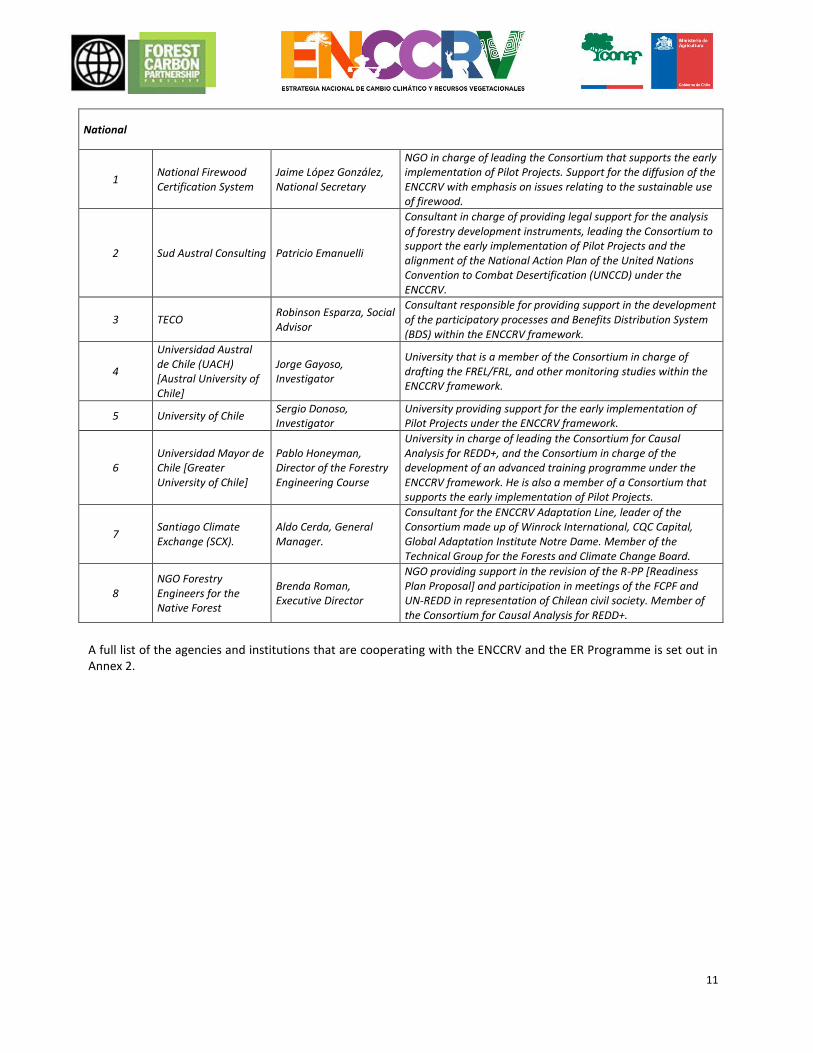
National
1 National Firewood Certification System
Jaime López González, National Secretary
NGO in charge of leading the Consortium that supports the early implementation of Pilot Projects. Support for the diffusion of the ENCCRV with emphasis on issues relating to the sustainable use of firewood.
2 Sud Austral Consulting Patricio Emanuelli
Consultant in charge of providing legal support for the analysis of forestry development instruments, leading the Consortium to support the early implementation of Pilot Projects and the alignment of the National Action Plan of the United Nations Convention to Combat Desertification (UNCCD) under the ENCCRV.
3 TECO Robinson Esparza, Social Advisor
Consultant responsible for providing support in the development of the participatory processes and Benefits Distribution System (BDS) within the ENCCRV framework.
4
Universidad Austral de Chile (UACH) [Austral University of Chile]
Jorge Gayoso, Investigator
University that is a member of the Consortium in charge of drafting the FREL/FRL, and other monitoring studies within the ENCCRV framework.
5 University of Chile Sergio Donoso, Investigator
University providing support for the early implementation of Pilot Projects under the ENCCRV framework.
6 Universidad Mayor de Chile [Greater University of Chile]
Pablo Honeyman, Director of the Forestry Engineering Course
University in charge of leading the Consortium for Causal Analysis for REDD+, and the Consortium in charge of the development of an advanced training programme under the ENCCRV framework. He is also a member of a Consortium that supports the early implementation of Pilot Projects.
7 Santiago Climate Exchange (SCX).
Aldo Cerda, General Manager.
Consultant for the ENCCRV Adaptation Line, leader of the Consortium made up of Winrock International, CQC Capital, Global Adaptation Institute Notre Dame. Member of the Technical Group for the Forests and Climate Change Board.
8 NGO Forestry Engineers for the Native Forest
Brenda Roman, Executive Director
NGO providing support in the revision of the R-PP [Readiness Plan Proposal] and participation in meetings of the FCPF and UN-REDD in representation of Chilean civil society. Member of the Consortium for Causal Analysis for REDD+.
A full list of the agencies and institutions that are cooperating with the ENCCRV and the ER Programme is set out in Annex 2.
12
2. STRATEGIC CONTEXT AND JUSTIFICATION FOR THE ER PROGRAMME
2.1 Current status of the Readiness Package and summary of additional achievements on readiness activities in the country.
2.1.1. Status of the Readiness Fund Chile drafted a document called the Readiness Preparation Proposal (R-PP), which was approved at the 14th meeting of the Committee of Participants of the FCPF that took place between 19 and 21 March of 2013 in Washington D.C., USA. This facilitated access to the assigned donation of USD 3.8 million, which is being used to fund a large part of the participatory and consultation activities for the formulation and validation of the ENCCRV, together with a number of essential technical works based on the requirements set out by REDD+, both within the context of the UNFCCC as well as voluntary bodies such as the FCPF itself. One of the early implementation measures that is being funded with the aforementioned resources, is the establishment of learning areas to improve the production cycle and use of biomass. Specifically, 4 pilot projects will be established in the regions of La Araucanía, Los Lagos, Los Ríos and Aysén that explore and test improvements related to sustainable forest management, aspects related to the organisation, the formalisation and professionalisation of the territorial biomass supply networks via processes that enable the production of a certified product at collection centres and ultimately provides a trade facility to improve the sales networks. On the other hand, and based on the need to generate updated information at a national level as a determining part of the definition of the ENCCRV and the requirements established by the FCPF, a document was drafted called “Support in the generation and analysis of deforestation, forest degradation and no increases in forest carbon stocks, identifying strategic activities for dealing with these under the ENCCRV framework for Chile”. CONAF is implementing this jointly with the Universidad Mayor, EBP, the Natural Resources Information Centre (CIREN,
acronym in Spanish), and the Native Forest Engineers Association (AIFBN, acronym in Spanish). This document is central in terms of collecting, analysing and proposing the specific activities that must be taken for each cause that is identified, with the respective cost-benefit analyses, potential carbon removals in various periods until 2030 and potential implementation risks, as well as prioritising possible locations for implementation (hotspots) to focus efforts in order to maximise the environmental and social benefits, as well as meeting targets for the reduction and removals of emissions put forward by Chile to the international community. Similarly, a quantitative analysis is being developed regarding the tenure of the land at a national level, the repercussions that this entails for the transfer of carbon rights, and designing the so-called Benefits Distribution System. In practice, this seeks to be fair and transparent, as required by the international donors, in order to fairly compensate those instances where there is a confirmed forest emission reduction or removals. Technical and legal contributions have been made to this work by the consortium made up of the consultancy company Teco Group, Sud Austral Consulting SpA and the international enterprise Climate Focus, a body with global experience in the transfer of carbon rights. As the planning for a new draft law on forestry development and the regulation of plantations is under way, which also includes working on proposals for the modification of Law no. 20,283 on native forest recovery and forestry development, it was deemed appropriate to identify key inputs for these processes, which are set forth in a document called: “Support for the drafting of technical, political and strategic inputs, for incorporation of the key elements regarding administration and payment schemes for environmental services developed under the ENCCRV in the new forestry development law and other regulatory and sectoral development instruments”. This CONAF document is being drafted with the support of SudAustral Consulting SpA., Ugarte & Hernández Abogados, CERTFOR Chile and Winrock International. One crosscutting aspect that is supported by the FCPF and which has entailed the cooperation and alignment of the other international counterparts who support the ENCCRV, is the handling of the environmental and social safeguards that apply to the ENCCRV. Thus, a general framework has been formulated called “Social and Environmental Safeguards Plan for the Formulation, Consultation and Self-Assessment of the ENCCRV”, which is
13
being implemented with the Social Affairs and Indigenous Peoples Unit (UAIS, acronym in Spanish), the Public Prosecutor and Environmental Audit and Assessment Management for CONAF. This plan, during the participatory formulation of the ENCCRV, considered a process that included many stakeholders associated with vegetational resources of various sectors, and with various levels of territorial representation, focused on the strengthening of governance and dialogue with local communities and social organisations in each of the regions of the country. The various groups of interest put forward their viewpoints with regard to those strategic activities that were deemed priorities in order to stop deforestation, forestry degradation and to identify the barriers preventing increases in forestry cover by new forests. This input would then subsequently be submitted to a more specialist technical and legal analysis. In practical terms, the participatory process considered the conduct of regional workshops throughout the country and a national workshop to obtain and validate the input that would then form the basis for the definition of the strategic activities considered by the ENCCRV. For the remainder of 2016, the conduct of a public consultation is being considered by means of face-to-face processes and virtual platforms, as well as a so-called self-assessment process, where various individuals will rate the manner in which the different aspects of this initiative meet with their expectations. An immediate operational aspect of the above-described process is that the implementation of pilot experiences to test and improve new forestry management models. Intervention schemes agreed in a participatory manner in accordance with the general guidelines of the ENCCRV will be incorporated. Similarly, a Mechanism for the Resolution of Complaints, Disputes and Suggestions will be defined and be available to the community. This will improve the exchange of opinions between CONAF and the public, aspects that are considered within the design of the Safeguard Information System (SIS), which will respond to the need for regular reports that the countries have undertaken to provide under the UNFCCC and other international bodies. Based on the progress mentioned previously, CONAF requested additional financial resources from FCPF, which was formalised with the submission of a document called Medium Term Report (MTR). The aim of this report was to inform on the progress made by Chile with the FCPF donation for the preparation of REDD+, providing a general overview of the progress in the implementation of the activities that had been scheduled. The Chile MTR was approved in the 20th meeting of the FCPF Committee of Participants that took place between 4 and 6 of November 2015 in San José, Costa Rica. At this meeting, an additional amount of funding of USD 5 million was obtained for the 2016–2019 period, which will be used for key actions in the preparation and early implementation phase of REDD+ in Chile. Examples of these actions include the development of all the elements and systems for the correct accounting of carbon and valuation of environmental services, the strengthening of CONAF’s institutional capacities, the establishment of new learning areas (pilot projects) that deal with the causes of deforestation and forestry degradation in an operational and concrete manner, as well as the conduct of activities required for compliance with the requirements established in the social and environmental safeguards. Finally, with regard to the phases considered by the FCPF Preparation Fund, the plan is to submit the document called REDD+ Preparation Package (R-Package) at the 22nd Meeting of the FCPF Participants Committee to be held in October 2016. This is an important milestone that precedes the formal completion of the Preparation Phase of the ENCCRV for the FCPF, where the progress that the country has recorded in the key preparation elements is documented, and which also sets out what has been learned and assesses any outstanding deficiencies. Furthermore, the activities that are required to progress transition towards the application of the strategic implementation activities are identified. Progress in each of the phases of the Preparation Fund, complying with national, international and FCPF requirements, will enable the ENCCRV to reinforce the following aspects: (i) Demonstrate the national commitment to the UNFCCC and REDD+; (ii) Progress and demonstrate transparency in the preparation for REDD+; (iii) Ensure the participation of the stakeholders involved at a regional and national level in a process endorsed internationally with the aim of avoiding or mitigating possible social and environmental risks; (iv) Receive feedback and technical guidance from international counterparts; and (v) Expand the possibilities of receiving technical and financial support from additional funds for the extension of the activities. 2.1.2. Progress for the Carbon Fund CONAF submitted and approved its ER-PIN [Emission Reductions Programme Idea Note] to the Carbon Fund on 9 April 2014 in the city of Bonn, Germany, which enabled the actions for early implementation of the ENCCRV to be
14
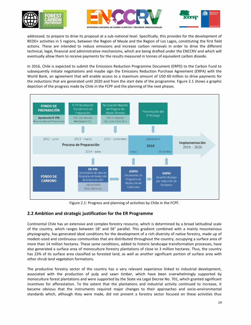
addressed, to prepare to drive its proposal at a sub-national level. Specifically, this provides for the development of REDD+ activities in 5 regions, between the Region of Maule and the Region of Los Lagos, constituting the first field actions. These are intended to reduce emissions and increase carbon removals in order to drive the different technical, legal, financial and administrative mechanisms, which are being drafted under the ENCCRV and which will eventually allow them to receive payments for the results measured in tonnes of equivalent carbon dioxide. In 2016, Chile is expected to submit the Emissions Reduction Programme Document (ERPD) to the Carbon Fund to subsequently initiate negotiations and maybe sign the Emissions Reduction Purchase Agreement (ERPA) with the World Bank, an agreement that will enable access to a maximum amount of USD 60 million to drive payments for the reductions that are generated until 2020 and from the start date of the programme. Figure 2.1 shows a graphic depiction of the progress made by Chile in the FCPF and the planning of the next phases.
Figure 2.1: Progress and planning of activities by Chile in the FCPF.
2.2 Ambition and strategic justification for the ER Programme Continental Chile has an extensive and complex forestry resource, which is determined by a broad latitudinal scale of the country, which ranges between 18° and 56° parallel. This gradient combined with a mainly mountainous physiography, has generated ideal conditions for the development of a rich diversity of native forestry, made up of modest-sized and continuous communities that are distributed throughout the country, occupying a surface area of more than 14 million hectares. These same conditions, added to historic landscape transformation processes, have also generated a surface area of monoculture forestry plantations of close to 3 million hectares. Thus, the country has 23% of its surface area classified as forested land, as well as another significant portion of surface area with other shrub land vegetation formations. The productive forestry sector of the country has a very relevant experience linked to industrial development, associated with the production of pulp and sawn timber, which have been overwhelmingly supported by monoculture forest plantations and were supported by the State via Legal Decree No. 701, which granted significant incentives for afforestation. To the extent that the plantations and industrial activity continued to increase, it became obvious that the instruments required major changes to their approaches and socio-environmental standards which, although they were made, did not prevent a forestry sector focused on these activities thus
15
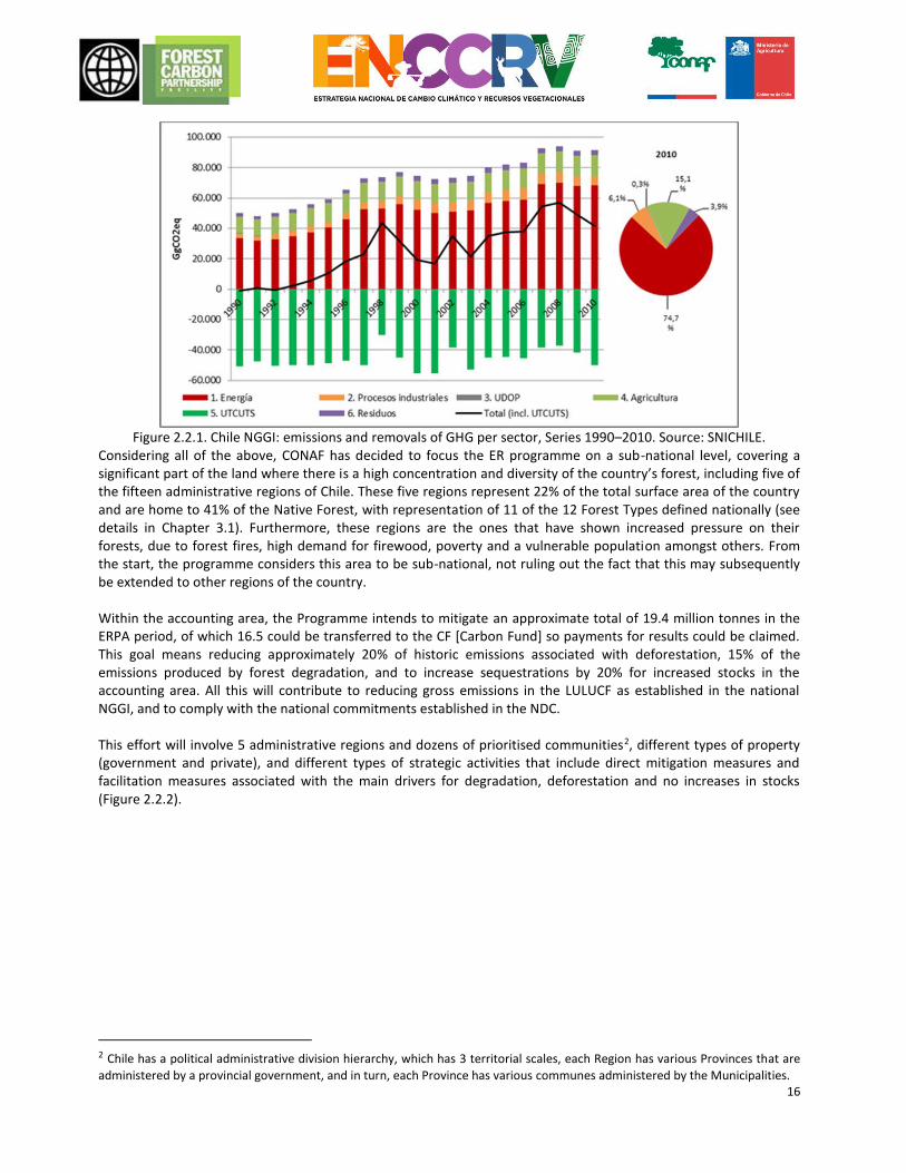
limiting progress towards other areas that would acquire international relevance and interest, such as the environmental services that forests provide. In the nineties, the country began an intense process of adapting to the approaches of its environmental policy, which was reflected in the adjustments of its internal policy and legislation to a number of international commitments focused on safeguarding its natural heritage, and encouraging progress in various areas where greater government efforts are required, such as the forestry sector. Thus, in 2008, and after a long parliamentary discussion, Law 20,283 was enacted for the Native Forest Recovery and Forestry Development, one of the outstanding debts of the Chilean forestry sector. The enactment of this law was a milestone in forestry history, since it set out the political, legislative and technical basis for progressing in the sustainable development of this resource, including amongst its instruments an unprecedented development fund for the management of forests and another fund for research. After almost 9 years since its launch, this Law has not had the expected impact, and it is currently in the process of being revised and amended, seeking to improve the conditions for generating a real development that will encourage forest owners in the sustainable management and preservation of native forests. Thus, the ENCCRV includes the promotion of amendments and adjustments of a technical and administrative nature, which will drive a paradigm shift toward the valuation of environmental services in the existing regulatory and encouragement instruments and that are in the process of renewal. It is within this context that since 2010, Chile has been progressing in the Readiness phase established for REDD+. Within the Emissions Reductions Programme that will be submitted to the FCPF Carbon Fund, Chile is seeing an important opportunity to progress by piloting a mechanism of payments based on performance by means of new activities contained in the instruments for promotion within the context of international commitments that the country has signed as its Nationally Determined Contribution (NDC). In this, the ENCCRV plays a key role as a viable tool validated by the Council of Ministers for Sustainability and Climate Change, for those commitments that have been defined for the Land Use, Land Use Change and Forestry (LULUCF) sector. According to the first Biennial Update Report (BUR) by NGGI of Chile under the UNFCCC, generated in 2014, the LULUCF sector is the only sector that consistently removes CO2 in the country. In 2010, the GHG balance recorded removalsof -49,877.4 GgCO2e. The main causes for the removals are the biomass increases in forest plantations and in native forest saplings. Toward the end of the period, there is an increase in the removalof GHG due to the increased surface of forest plantations (increase in biomass) and a decrease in harvest. With regard to categories and in absolute terms, 96.0% of the GHG balance corresponds to the forested lands category, followed by 2.3% to Pastures, 1.2% to Farmlands and 0.6% corresponds to the remaining categories (Figure 2.2.1).
16
Figure 2.2.1. Chile NGGI: emissions and removals of GHG per sector, Series 1990–2010. Source: SNICHILE.
Considering all of the above, CONAF has decided to focus the ER programme on a sub-national level, covering a significant part of the land where there is a high concentration and diversity of the country’s forest, including five of the fifteen administrative regions of Chile. These five regions represent 22% of the total surface area of the country and are home to 41% of the Native Forest, with representation of 11 of the 12 Forest Types defined nationally (see details in Chapter 3.1). Furthermore, these regions are the ones that have shown increased pressure on their forests, due to forest fires, high demand for firewood, poverty and a vulnerable population amongst others. From the start, the programme considers this area to be sub-national, not ruling out the fact that this may subsequently be extended to other regions of the country. Within the accounting area, the Programme intends to mitigate an approximate total of 19.4 million tonnes in the ERPA period, of which 16.5 could be transferred to the CF [Carbon Fund] so payments for results could be claimed. This goal means reducing approximately 20% of historic emissions associated with deforestation, 15% of the emissions produced by forest degradation, and to increase sequestrations by 20% for increased stocks in the accounting area. All this will contribute to reducing gross emissions in the LULUCF as established in the national NGGI, and to comply with the national commitments established in the NDC. This effort will involve 5 administrative regions and dozens of prioritised communities2, different types of property (government and private), and different types of strategic activities that include direct mitigation measures and facilitation measures associated with the main drivers for degradation, deforestation and no increases in stocks (Figure 2.2.2).
2 Chile has a political administrative division hierarchy, which has 3 territorial scales, each Region has various Provinces that are
administered by a provincial government, and in turn, each Province has various communes administered by the Municipalities.
17
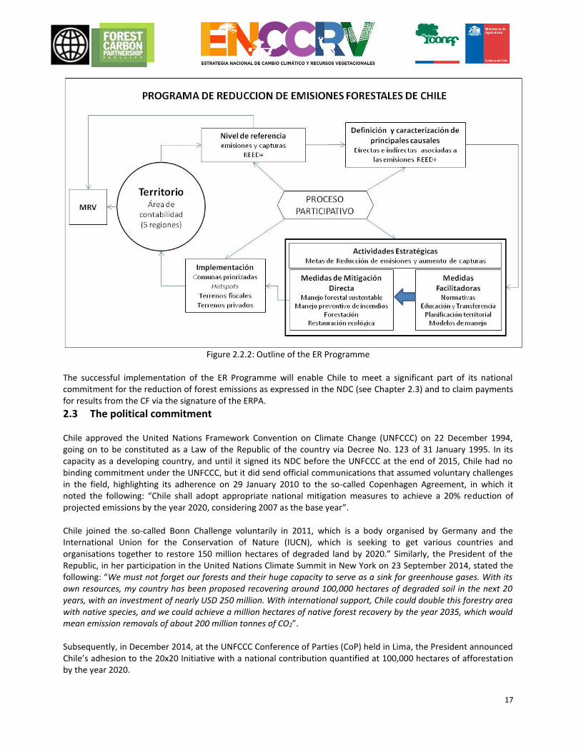
Figure 2.2.2: Outline of the ER Programme
The successful implementation of the ER Programme will enable Chile to meet a significant part of its national commitment for the reduction of forest emissions as expressed in the NDC (see Chapter 2.3) and to claim payments for results from the CF via the signature of the ERPA.
2.3 The political commitment Chile approved the United Nations Framework Convention on Climate Change (UNFCCC) on 22 December 1994, going on to be constituted as a Law of the Republic of the country via Decree No. 123 of 31 January 1995. In its capacity as a developing country, and until it signed its NDC before the UNFCCC at the end of 2015, Chile had no binding commitment under the UNFCCC, but it did send official communications that assumed voluntary challenges in the field, highlighting its adherence on 29 January 2010 to the so-called Copenhagen Agreement, in which it noted the following: “Chile shall adopt appropriate national mitigation measures to achieve a 20% reduction of projected emissions by the year 2020, considering 2007 as the base year”. Chile joined the so-called Bonn Challenge voluntarily in 2011, which is a body organised by Germany and the International Union for the Conservation of Nature (IUCN), which is seeking to get various countries and organisations together to restore 150 million hectares of degraded land by 2020.” Similarly, the President of the Republic, in her participation in the United Nations Climate Summit in New York on 23 September 2014, stated the following: “We must not forget our forests and their huge capacity to serve as a sink for greenhouse gases. With its own resources, my country has been proposed recovering around 100,000 hectares of degraded soil in the next 20 years, with an investment of nearly USD 250 million. With international support, Chile could double this forestry area with native species, and we could achieve a million hectares of native forest recovery by the year 2035, which would mean emission removals of about 200 million tonnes of CO2”. Subsequently, in December 2014, at the UNFCCC Conference of Parties (CoP) held in Lima, the President announced Chile’s adhesion to the 20x20 Initiative with a national contribution quantified at 100,000 hectares of afforestation by the year 2020.
18
This was the last Conference of Parties (CoP21), held in Paris in December 2015, the aforementioned Paris Agreement was approved, a proceeding that would be a relevant milestone in environmental negotiation and in combating climate change. This agreement was signed by 196 nations, including Chile, which means a commitment for the country to implement and report measures for climate change, in order to comply with what is set out in its NDC3. The NDC sets forth obligations for Chile, which must be taken as binding goals after the year 2020, being subject to assessment every 5 years from the year 2023, requiring the level of attainment of these goals to be progressively increased. The above becomes relevant, upon considering that the Secretary of the UNFCCC decided that the goals proposed for all the countries jointly, were insufficient to meet the objectives of the Agreement. For the forestry component included in Chile’s NDC, the country is officially committed to the sustainable management and recovery of 100,000 hectares of native forest, which will represent the removals and reductions of Greenhouse Gases by about 600,000 annual equivalent tonnes of CO2 from 2030. Similarly, Chile commits to reforest 100,000 hectares, mostly with native species, which represent removals between 900,000 and 1,200,000 of annual equivalent tonnes of CO2 from 2030. This commitment is subject to the extension of Legislative Decree No. 701 and the approval of a new law on forestry development. In this context, the Paris Agreement generates a relevant political undertaking for Chile’s forestry sector, in terms of linking national goals for the management of native forest and forestry with the services that provide these ecosystems with regard to mitigation and adaptation to climate change, which to a certain extent have been relegated to legislation and instruments for sectoral development and has operated to date. Thus, national actions associated with expected contributions, will constitute an important element for the modification, targeting and generation of new sector legislation, with these actions being the core value that guides these national processes, including the process for drafting a National Forestry Policy, which is currently ongoing. Specifically, and as one of the core values that guide the ENCCRV, there is the UNFCCC Reducing Emissions from Deforestation and Forest Degradation and Increase in Carbon Existence initiative, better known as REDD+, which was specifically included in the Paris Agreement, acknowledging the importance of adequate and foreseeable financial resources, including payments based on results for reduction and carbon removal associated with the national strategy for REDD+. The Ministry of Foreign Affairs (MINREL, acronym in spanish) is the Policy Focal Point for this Convention and the Ministry of the Environment (MMA, acronym in spanish) is the Technical Focal Point for the proceeding itself, with the National Forestry Corporation (CONAF), belonging to the Ministry of Agriculture, via the Climate Change and Environmental Services Unit (UCCSA), being the Focal Point for the REDD+ initiative, and for the various cooperation initiatives that have been established to support it. CONAF’s main role is to act as a link between Chile, the Ministry and other relevant UNFCCC offices, to coordinate the implementation of activities, plans or strategies that are contained within REDD+. Moreover, in 1995 it was appointed as the Focal Point for the United Nations Convention to Combat Desertification (UNCCD), where it acts as a link between the Executive Secretariat for the Convention and the organisations related to issues of desertification, land degradation and drought in Chile and to coordinate the activities that are required for compliance by Chile with its obligations with the Convention (National Reports and other tasks that have been handed down by the CoP), and to coordinate the implementation of the National Action Programme amongst others. With the creation of the Green Climate Fund (GCF) as the financial mechanism of the UNFCCC and to operate for initiatives under the REDD+ framework, Chile proposes to ensure that the processes undertaken with this fund should be channelled through the Ministry of Finance as the Designated National Authority (DNA) and accredited bodies to receive payment for results. The proceedings between CONAF and the Ministry of Finance shall commence in early 2016, in order to agree, as soon as possible, an association between the ENCCRV and the GCF to strengthen financial aspects that are in favour of strengthening the implementation phases and payments for results
3 Chile’s Nationally Determined Contribution (NDC) for the Climate Agreement Chile 2015. Government of Chile, 2015.
http://portal.mma.gob.cl/wp-content/uploads/2015/09/NDC_1609c1.pdf
19
considered by the Strategy. In addition to the GCF funds for actions based on results that are monitored, reported and verified, it is important to assess various sources of funding other than the GCF, both for investments in REDD+ actions and Payment for Results, which can be channelled via the financial structure that will be designed in the country under the ENCCRV, and which, in a complementary way, could supply the Forest Environmental Fund (FFA, acronym in spanish) that CONAF will begin to design and test as a pilot from 2016. All the previous processes and undertakings occurred under the administration of different governments and under various lines of policy, which reflects the continuity and cross-country commitment to its strategy for addressing climate change. There are various proceedings that directly or indirectly support the preparation for REDD+ in Chile. The main ones are: Express Forestry Policy for the 2015–2035 period. The Government of Chile, via the Ministry of Agriculture and the Forestry Policy Council led by CONAF, signed the Forestry Policy (PF, acronym in spanish) document for the next 20 years at the start of 2016. The aim of this long-term policy is to outline the strategic key points, define general and specific objectives, draft plans and programmes, identify instruments, and specify mechanisms to achieve Sustainable Forestry Development. This is understood, in terms of challenges and vision, as the contribution of the Chilean forestry sector to the economic-productive, ecological and social-cultural development of the country, via the conservation, holistic management and exploitation and rational use of the resources, forest basins and ecosystems, all of this under a scenario of Climate Change. Forestry policy has been structured around four strategic areas, each of which is disaggregated into impact and result objectives and have a summary of the baseline or initial situation (in 2015) as well as the expected situations in the short, medium and long term, these being fixed at periods of four (2020), ten (2025) and twenty years (2035), respectively. The points from which the objectives are formulated and the FP goals and its association with the ENCCRV, are summarised in the following table:
Strategic Area Description Goals for the year 2035 directly associated with the ENCCRV
Form of association
Forest Institutional Framework
Establish a public forestry institutional framework according to the strategic importance of the sector, organised and all encompassing, equipped with financial resources, professional and operational capacity for the conduct and implementation of forestry policy and its orientation toward sustainable forestry development.
Public forestry institutional framework, according to the strategic importance of the sector, developing the functions of inter-institutional policy and technical coordination, planning, protection, development, inspection, investigation and innovation, as well as the design, implementation and evaluation of sectoral public policies.
In this new institutional framework, the coordination and planning required to implement the ENCCRV will be strengthened significantly, like the resources required for this.
Productivity and economic growth
Promote forestry, industrialisation and the comprehensive use of forest resources, so that they contribute to the increase of productivity and the production of goods and services, as a significant contribution to the financial and social development of the country.
Afforestation of a half a million hectares on land belonging to small and medium landowners or government property.
These FP goals include and vastly exceed the NDC forestry commitments (100,000 ha of plantations, and 100,000 ha of managed Native Forests to 2030), and they give support to other ENCCRV goals and specific action measures.
One million ha of native forest has been incorporated into sustainable forestry management for production purposes.
The forestry sector, by means of biomass, provides an effective contribution of 30% to the primary energy matrix.
This goal requires and promotes the sustainable use of firewood from native forests, which will contribute significantly to the formalisation and
20
improvement of practices and processes associated with the use of firewood, which is currently one of the main drivers of emissions worldwide.
Inclusion and social equality
Generate the necessary conditions and instruments so that forestry development can reduce social and technological gaps, improve conditions and quality of life for forestry workers and their families, and respect the tradition and culture of the rural and indigenous communities living in or embedded within the forest ecosystems.
Forestry development in Chile is effectively inclusive.
The ENCCRV has been designed within a framework of permanent social participation and inclusion, a logic that will continue during its implementation phase. This reality is and will be a significant contribution to meeting these FP targets.
The state and the forestry productive sector is formally related to indigenous and rural communities, using institutional mechanisms that are globally accepted, applying the agreements and undertakings based on compliance with standards established in international treaties that are recognised within country.
Protection and Restoration of the Forest Asset.
Preserve and increase the country’s forest asset, develop environmental goods and services and restore and protect the biodiversity offered by the forest resources and ecosystems.
200,000 hectares have been restored with new tree and shrub cover mainly with native species in areas regarded as being prioritised, as identified by the State Forest Service.
These FP targets also contribute to compliance with the forest commitments in the NDC, and provide support to various goals and specific action measures of the ENCCRV. A surface area of about 450,000 ha of native
forest has been incorporated into being managed, for protection and conservation purposes.
In Chile, there is an efficient prevention, detection and control system for forest fires and statistics show that both the occurrence and the damaged surface area has been reduced to manageable levels.
These goals are directly linked to various action measures in the ENCCRV, related to the prevention of forest fires, which are the main drivers associated with the country’s forest emissions. 100% of the municipalities defined as being
critical communities due to the risk of the occurrence of forest fires have land management plans in the interface areas and with cooperation agreements with the State Forest Service.
Table 2.3: Association between Chile’s Forestry Policy and the ENCCRV Institutional Arrangements
Council of Ministers for Sustainability and Climate Change: The council is presided over by the Minister for the Environment (MMA) and constituted by the Ministers for Agriculture, Finance, Health, Economy, Development and Reconstruction, Energy, Public Works, Housing and Urban Planning, Transport and Telecommunication, Mining and Planning. It meets regularly once a month and the main functions of this Council are the following: to submit policies for the management, use and sustainable utilisation of renewable natural resources to the President of the Republic and to propose sustainability criteria for drafting Ministerial policies and planning processes. In addition, the Protected Wildlife Areas of the State has been created, to propose sectoral policies that should be subjected to strategic environmental assessment and the criteria and mechanisms under which citizens should participate in Environmental Impact Statements. This Council was responsible for approving the new “Adaptation to Climate Change in Biodiversity Plan”, in which the ENCCRV was included as one of the action measures the focus of which, is the country’s forests. It is important to note that this council was the last approval step for the NDC that was submitted to the Secretary of the UNFCCC, which also contains the ENCCRV as one of its main ways of achieving the National Contribution forestry target.
Advisory Committee on Climate Change: Created in 2013 from the "Inter-ministerial Committee on Climate Change", this committee has a more operational nature than the inter-ministerial committee that it replaced. The new committee is presided over by the Minister for the Environment and as a general rule includes a representative from each ministry. The committee's main functions are to: Advise the Minister for Foreign Affairs about the national position with regard to the UNFCCC and other international
21
proceedings that are related to climate change, to advise the Minister for the Environment on topics related to climate change in the country and the national implementation of policies, plans, programmes and plans of action, as well as to give a coherent, efficient and effective response to the phenomenon of climate change. Perform the necessary actions to comply with Chile’s commitments under the UNFCCC and the resulting instruments. This advice will be one of the validation procedures for the ENCCRV document, which will be formalised in 2016.
Forest Policy Council (FPC): this Council is a joint management agency, formed in early 2015 and is presided over by CONAF via its Executive Director. The Council’s mandate is to draft guidelines for the forestry sector during the 2015–2035 period, with 16 members representing different stakeholders in the sector, involving public services, businesses, social organisations, academia, and environmental NGOs. The main functions of this authority are to propose a new forestry policy to the Minister of Agriculture, develop a proposal with regard to the instruments of the policy and any amendments, identify areas and propose working committees and ways of working, as well as to approve activities and plans submitted by the chairman of the Council. It should be noted that in 2015, the Council requested the creation of a Forests, Water and Plantations Commission as this is one of the most pressing issues in the country given the recurrent episodes of drought and social criticism of the damage caused by plantations to exotic species and water availability. Due to the proximity to the issue of climate change, the Head of UCCSA was asked, upon petition by CONAF regarding the ENCCRV, to act in this Commission as the Technical Secretary, managing to highlight the important role of this initiative to the Council. This should have been included within the Forestry Policy for Chile document that was published in April 2016, and approved by the Ministry of Agriculture.
Comité Técnico Interministerial de Cambio Climático del Ministerio de Agricultura (CTICC-MINAGRI): [Technical Inter-Ministerial Committee for Climate Change of the Ministry of Agriculture] This ministerial proceeding, which is aimed at ensuring that MINAGRI departments are able to participate and cooperate in a technical committee in order to coordinate national and international proposals and plans at a Ministerial level in relation to climate change, which affects the management performance at a national level. In this procedure, the ENCCRV was exhibited twice, including the planned contributions and inputs, for which ongoing communication has been pledged regarding its design and implementation via the Bureau for the Development of Agricultural Policies (ODEPA), which is leading this procedure. It is promptly outlined that CTICC should have its respective approvals in each region of the country, with the Secretaría Regional Ministerial (SEREMI, acronym in spanish) de Agricultura [Regional Ministerial Secretariat [SEREMI] of Agriculture] very probably acting as the entity in charge, including the participation of representatives of agricultural services of regional representation.
Instrumental Proceedings
Law 20,283 regarding Native Forest Recovery and Forestry Development: effective regulation that considers the provision of direct financial incentives for the implementation of forestry management and preservation, in native forests and xerophytic formations. This regulation has an annual fund of USD 8 million to deliver for development, and another smaller annual fund for research in relation to issues related to the native forest. This law will come into force in 2016, which is being amended and adjusted to improve its impact factors, a process in which UCCSA participates actively, generating via consultancy, the necessary supplies to include within the ENCCRV as a central area of this legislative amendment.
New Law on Forestry Development for plantations: A Law that will replace Legislative Decree 701 that expired in 2012, and which, for 40 years was the main instrument for forestry development in the country. This new law is expected to be discussed and enacted in 2017, which will be within the context of Forestry Policy 2015-2035, and will include the mitigation of Climate Change as one of its key elements. In this process, UCCSA will also participate actively by generating inputs for the legal formulation.
22
Forestry National Dendroenergy Strategy: Lately, CONAF has driven a number of actions aimed at strengthening institutional positioning in the firewood and biomass sector at a country level. In this context, there have been specific actions such as the development of a Dendroenergy strategy, creating a specialised unit and socialisation within the different regional bodies with expertise in the issue. The target for 2016 is to generate a supply of dry firewood of a sustainable origin, which is equivalent to 10% of residential urban consumption in the cities of Rancagua, Talca, Curicó, Chillán, Los Ángeles, Concepción, Temuco, Valdivia, Osorno and Coyhaique, all declared as areas saturated by atmospheric contamination. As part of the strategy, MINAGRI, INDAP (National Institute of Agricultural Development) and the INFOR (Forestry Institute) are also participating with complementary actions. Whilst at an inter-ministerial level, the Ministry of Energy and the Ministry of the Environment are participating. In turn, within the private sector and civil society, alliances have been forged with the Sistema Nacional de Certificación de Leña (SNLC) [National Firewood Certification System] and with consumer associations, which has enabled an increase in the supply of dry firewood of a sustainable origin as well as the implementation of initiatives for dissemination and exchange.
3. LOCATION OF THE ER PROGRAMME
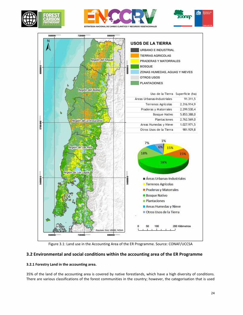
3.1 Accounting for the ER Programme CONAF has decided to focus its efforts on the generation of a sub-national Level of Reference, in the area with the second greatest forest concentration in the country, and which is the most diverse when it comes to existing types of forest. Moreover, this area is where most forest emissions are produced according to the NGGI. The Accounting Area (AC, acronym in spanish) includes five of the fifteen administrative areas, from the Maule Region to the Los Lagos Region, which cover a total surface area of approximately 15,300,000 ha. Of this total surface area, 5,853,388 ha corresponds to native forests, 2,299,530 ha to forest plantations, 2,316,914 ha to land for agricultural use, 2,299,530 ha to scrub land and grasslands, 1,027,971 ha to snow, water bodies and wetlands, 91,311 ha to urban and industrial use, and 981,929 ha to other land uses such as uplands are [sic]
vegetation (Figure Error! Reference source not found.3.1).
Of these uses, those that have actual and potential forest emissions accounting, and are therefore part of the Accounting Area for the ER Programme are:
23
Native forests: They currently generate emissions and removals and possess the potential for new capture as a result of restoration and conservation.
Forest plantations: Potential removals due to transformation of plantation to native forest.
Land for agricultural use: Potential removals due to transformation of agricultural land to native forest.
Shrub land and grasslands: Potential removals due to forestation. Given this, the Accounting Area for the ER Programme has a total surface area of 13,232,401 ha. The surface areas for 4 voluntary carbon market projects that exist in these regions to date will be discounted from this area, which put together do not amount to more than 6,000 ha (see Chapter 18.1).
24
Figure 3.1: Land use in the Accounting Area of the ER Programme. Source: CONAF/UCCSA
3.2 Environmental and social conditions within the accounting area of the ER Programme 3.2.1 Forestry Land in the accounting area. 35% of the land of the accounting area is covered by native forestlands, which have a high diversity of conditions. There are various classifications of the forest communities in the country; however, the categorisation that is used
25
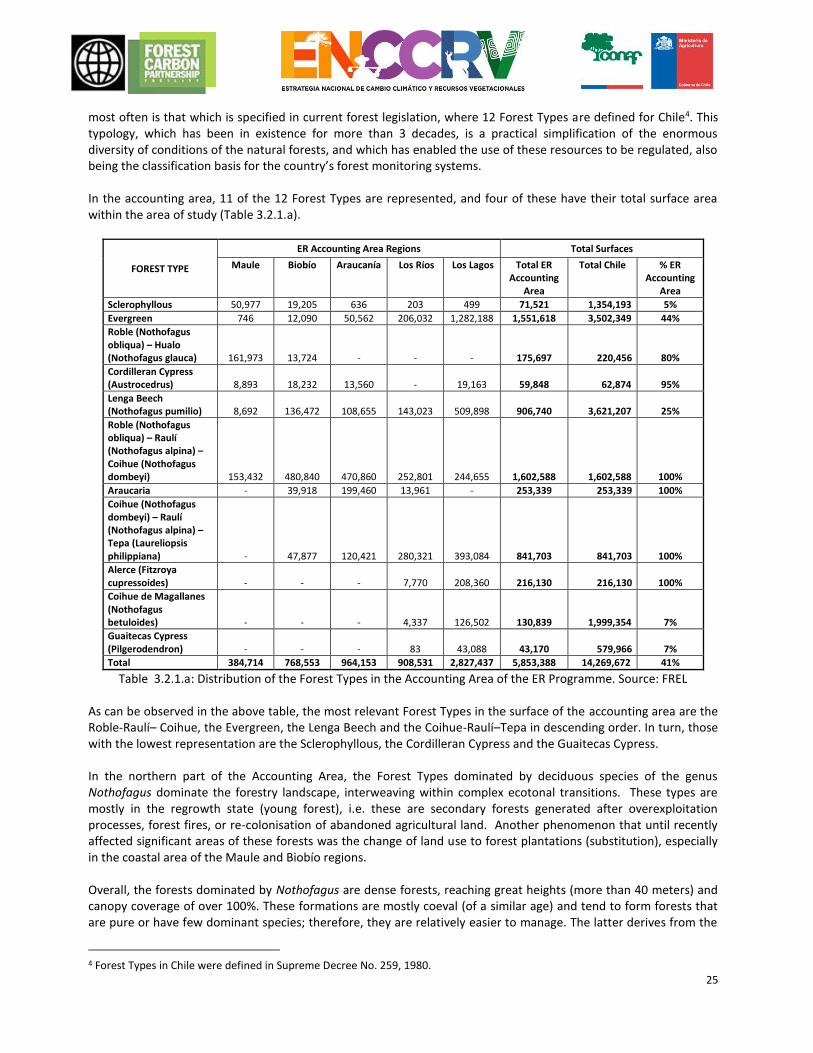
most often is that which is specified in current forest legislation, where 12 Forest Types are defined for Chile4. This typology, which has been in existence for more than 3 decades, is a practical simplification of the enormous diversity of conditions of the natural forests, and which has enabled the use of these resources to be regulated, also being the classification basis for the country’s forest monitoring systems. In the accounting area, 11 of the 12 Forest Types are represented, and four of these have their total surface area within the area of study (Table 3.2.1.a).
FOREST TYPE
ER Accounting Area Regions Total Surfaces
Maule Biobío Araucanía Los Ríos Los Lagos Total ER Accounting
Area
Total Chile % ER Accounting
Area
Sclerophyllous 50,977 19,205 636 203 499 71,521 1,354,193 5%
Evergreen 746 12,090 50,562 206,032 1,282,188 1,551,618 3,502,349 44%
Roble (Nothofagus obliqua) – Hualo (Nothofagus glauca) 161,973 13,724 - - - 175,697 220,456 80%
Cordilleran Cypress (Austrocedrus) 8,893 18,232 13,560 - 19,163 59,848 62,874 95%
Lenga Beech (Nothofagus pumilio) 8,692 136,472 108,655 143,023 509,898 906,740 3,621,207 25%
Roble (Nothofagus obliqua) – Raulí (Nothofagus alpina) – Coihue (Nothofagus dombeyi) 153,432 480,840 470,860 252,801 244,655 1,602,588 1,602,588 100%
Araucaria - 39,918 199,460 13,961 - 253,339 253,339 100%
Coihue (Nothofagus dombeyi) – Raulí (Nothofagus alpina) – Tepa (Laureliopsis philippiana) - 47,877 120,421 280,321 393,084 841,703 841,703 100%
Alerce (Fitzroya cupressoides) - - - 7,770 208,360 216,130 216,130 100%
Coihue de Magallanes (Nothofagus betuloides) - - - 4,337 126,502 130,839 1,999,354 7%
Guaitecas Cypress (Pilgerodendron) - - - 83 43,088 43,170 579,966 7%
Total 384,714 768,553 964,153 908,531 2,827,437 5,853,388 14,269,672 41%
Table 3.2.1.a: Distribution of the Forest Types in the Accounting Area of the ER Programme. Source: FREL As can be observed in the above table, the most relevant Forest Types in the surface of the accounting area are the Roble-Raulí– Coihue, the Evergreen, the Lenga Beech and the Coihue-Raulí–Tepa in descending order. In turn, those with the lowest representation are the Sclerophyllous, the Cordilleran Cypress and the Guaitecas Cypress. In the northern part of the Accounting Area, the Forest Types dominated by deciduous species of the genus Nothofagus dominate the forestry landscape, interweaving within complex ecotonal transitions. These types are mostly in the regrowth state (young forest), i.e. these are secondary forests generated after overexploitation processes, forest fires, or re-colonisation of abandoned agricultural land. Another phenomenon that until recently affected significant areas of these forests was the change of land use to forest plantations (substitution), especially in the coastal area of the Maule and Biobío regions. Overall, the forests dominated by Nothofagus are dense forests, reaching great heights (more than 40 meters) and canopy coverage of over 100%. These formations are mostly coeval (of a similar age) and tend to form forests that are pure or have few dominant species; therefore, they are relatively easier to manage. The latter derives from the
4 Forest Types in Chile were defined in Supreme Decree No. 259, 1980.
26
fact that many formal management forestry activities are performed on these saplings, supplying an internal market for native woods and the chipboard industry. Nevertheless, its commercial use is marginal compared to the industry associated with rapid growth exotic species. At the altitudinal borders of the forests in the Southern Area, the Lenga Forest Type dominates, forming forests of this deciduous species also belonging to the Nothofagus genus, which grows in a stumpy shape (shrub land habitat) as adaptation to the complex environmental conditions. As the latitude increases, the Lenga begins to decrease in height and acquires dominance in the austral formations until almost reaching sea level. In the Southern Area there are also forestry formations dominated by ancient conifers like Araucaria Araucana (Monkey Puzzle), the Fitzroya cupressoides (Larch)5, and Pilgerodendron uviferum (Guaitecas Cypress), species that give rise to three Forest Types. Two of these three species are currently protected under law, due to their critical conservation status after decades of over-exploitation, driven by the high quality and durability of their wood. There is a surface area of about 500,000 ha that is under a form of legal protection, but even now there is still illegal exploitation of this species to supply the black market. Continuing south, there is the Evergreen Forest Type, one of the 2 most important on the surface area, and which is dominated by perennial species of different genera and families, forming what is known as the Valdiviana Rainforest, given its high biodiversity and stratification. These are large forests, generally of a high density and coverage, accumulating high levels of biomass per hectare. They are extensive ecosystems, complex and with great variability, which is why there are 5 subtypes, forests on Ñadis soils, the forests of Olivillo Costero, evergreen forests with emerging shade-intolerant trees, shade-tolerant evergreen forests, and the saplings of Canelo. All of these cover large surface areas in the Region of Los Lagos, especially in the coastal area of canals and archipelagos. The evergreen formations also show significant states of anthropic alteration, processes caused by over-exploitation, fires, overgrazing and change of use, there are also instances of substitution by forest plantations and agricultural and livestock allotments. Despite their complexity, these forests are also managed for the extraction of wood and non-wood products, mainly firewood, although there is also a frequent practice of selective extraction of the best quality and largest individuals (nationally known as Floreo [high grading]) intended for the wood industry. Like the previous types, informality of use is a significant issue in the context of resource management and conservation. Finally, in the upland areas and in the southernmost part of the Accounting Area, the Lenga (Nothofagus pumilio) Forest Type gains importance, relatively pure forests that have lower biodiversity than the previous forest types. They can achieve great sizes and high coverage, but at higher altitudes, they take on a stumpy form. To summarise, despite the fact that Chile has an extensive and diverse native forest resource, its current use does not represent a significant contribution for the Gross Domestic Product (GDP) (only 3% of the country’s forestry export), and the exact size of this use or its exploitation is unknown, because there is a high level of informality that could exceed 80% according to unofficial data. The main use of forests is for firewood extraction and as shelter and food for livestock, actions, which, added to other causes such as fire, have resulted in degradation processes over a significant surface area. This phenomenon that has been occurring for decades, has led to an important loss of the ecological and economic value of these forests, losing their capacity to provide goods and services, including the removals and storage of carbon and therefore, generating a substantial loss of the country’s natural capital with its respective emissions of associated GHG. Furthermore, this has promoted the abandonment of forests, and in some cases, its deforestation and definitive change to other productive uses of greater private profitability, further increasing the emissions associated with the misuse of the resource.
5 Species included into the Convention on International Trade in Endangered Species of Wild Fauna and Flora (CITES) since 1987.
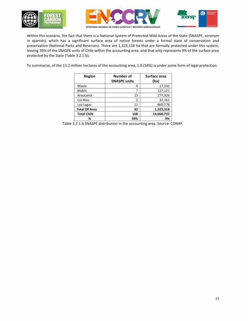
27
Within this scenario, the fact that there is a National System of Protected Wild Areas of the State (SNASPE, acronym in spanish), which has a significant surface area of native forests under a formal state of conservation and preservation (National Parks and Reserves). There are 1,323,318 ha that are formally protected under this system, leaving 39% of the SNASPE units of Chile within the accounting area, and that only represents 9% of the surface area protected by the State (Table 3.2.1.b). To summarise, of the 13.2 million hectares of the accounting area, 1.8 (14%) is under some form of legal protection.
Region Number of
SNASPE units Surface area
(ha) Maule 9 17,532
Biobío 7 127,121
Araucanía 13 277,326
Los Ríos 2 32,161
Los Lagos 11 869,178
Total ER Area 42 1,323,318
Total Chile 108 14,660,732
% 39% 9%
Table 3.2.1.b SNASPE distribution in the accounting area. Source: CONAF.
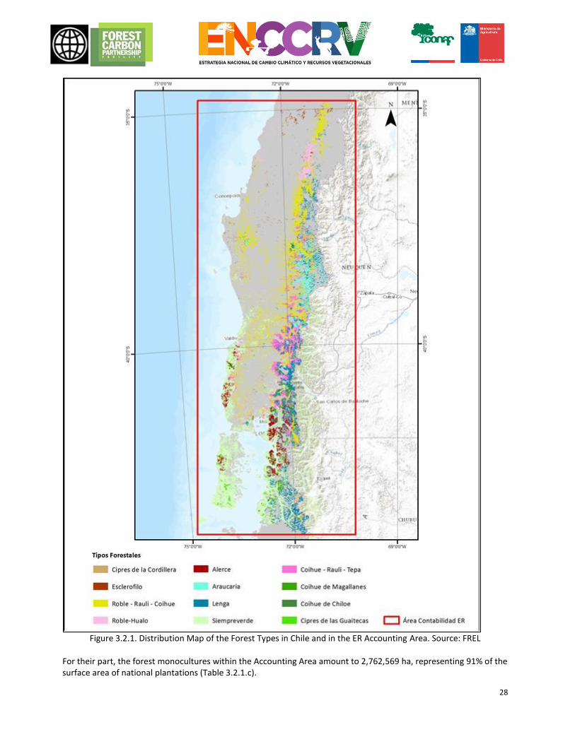
28
Figure 3.2.1. Distribution Map of the Forest Types in Chile and in the ER Accounting Area. Source: FREL
For their part, the forest monocultures within the Accounting Area amount to 2,762,569 ha, representing 91% of the surface area of national plantations (Table 3.2.1.c).
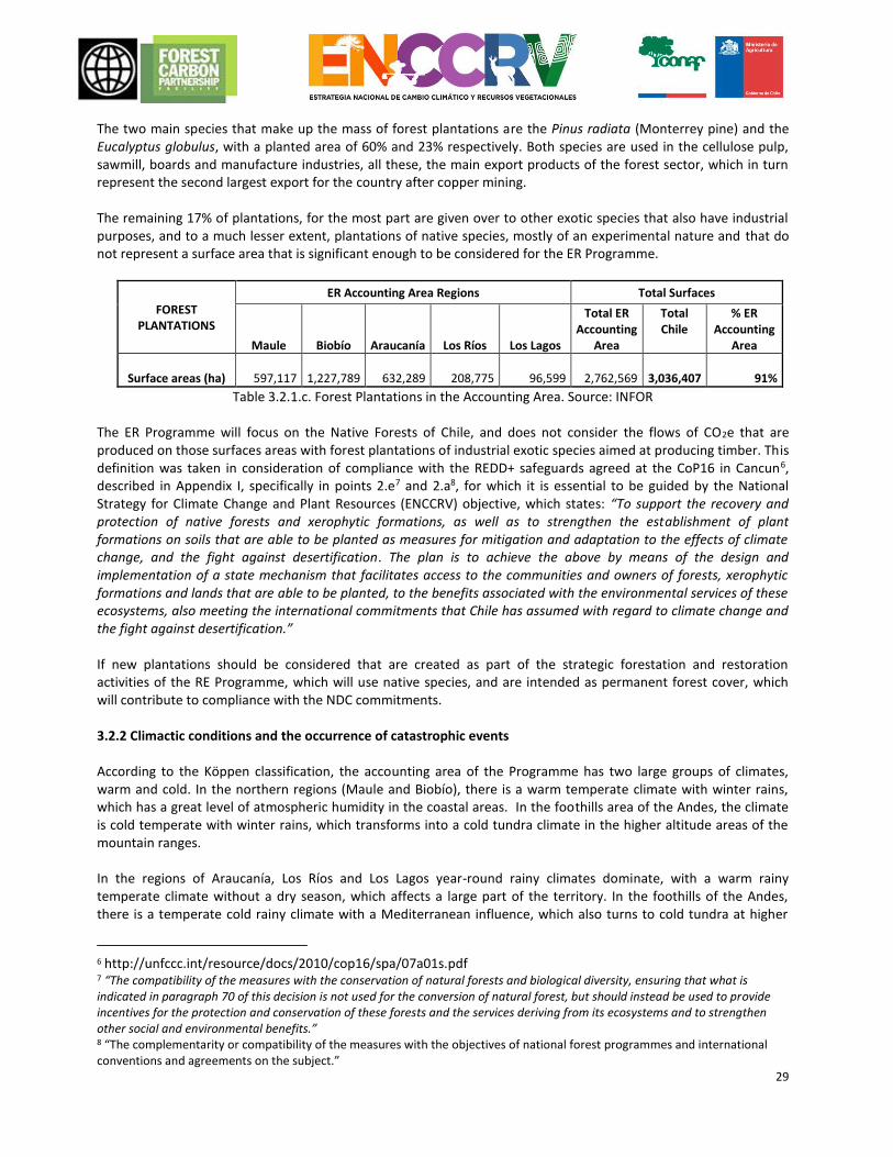
29
The two main species that make up the mass of forest plantations are the Pinus radiata (Monterrey pine) and the Eucalyptus globulus, with a planted area of 60% and 23% respectively. Both species are used in the cellulose pulp, sawmill, boards and manufacture industries, all these, the main export products of the forest sector, which in turn represent the second largest export for the country after copper mining. The remaining 17% of plantations, for the most part are given over to other exotic species that also have industrial purposes, and to a much lesser extent, plantations of native species, mostly of an experimental nature and that do not represent a surface area that is significant enough to be considered for the ER Programme.
FOREST PLANTATIONS
ER Accounting Area Regions Total Surfaces
Maule Biobío Araucanía Los Ríos Los Lagos
Total ER Accounting
Area
Total Chile
% ER Accounting
Area
Surface areas (ha)
597,117
1,227,789
632,289
208,775
96,599
2,762,569
3,036,407 91%
Table 3.2.1.c. Forest Plantations in the Accounting Area. Source: INFOR
The ER Programme will focus on the Native Forests of Chile, and does not consider the flows of CO2e that are produced on those surfaces areas with forest plantations of industrial exotic species aimed at producing timber. This definition was taken in consideration of compliance with the REDD+ safeguards agreed at the CoP16 in Cancun6, described in Appendix I, specifically in points 2.e7 and 2.a8, for which it is essential to be guided by the National Strategy for Climate Change and Plant Resources (ENCCRV) objective, which states: “To support the recovery and protection of native forests and xerophytic formations, as well as to strengthen the establishment of plant formations on soils that are able to be planted as measures for mitigation and adaptation to the effects of climate change, and the fight against desertification. The plan is to achieve the above by means of the design and implementation of a state mechanism that facilitates access to the communities and owners of forests, xerophytic formations and lands that are able to be planted, to the benefits associated with the environmental services of these ecosystems, also meeting the international commitments that Chile has assumed with regard to climate change and the fight against desertification.” If new plantations should be considered that are created as part of the strategic forestation and restoration activities of the RE Programme, which will use native species, and are intended as permanent forest cover, which will contribute to compliance with the NDC commitments. 3.2.2 Climactic conditions and the occurrence of catastrophic events According to the Köppen classification, the accounting area of the Programme has two large groups of climates, warm and cold. In the northern regions (Maule and Biobío), there is a warm temperate climate with winter rains, which has a great level of atmospheric humidity in the coastal areas. In the foothills area of the Andes, the climate is cold temperate with winter rains, which transforms into a cold tundra climate in the higher altitude areas of the mountain ranges. In the regions of Araucanía, Los Ríos and Los Lagos year-round rainy climates dominate, with a warm rainy temperate climate without a dry season, which affects a large part of the territory. In the foothills of the Andes, there is a temperate cold rainy climate with a Mediterranean influence, which also turns to cold tundra at higher
6 http://unfccc.int/resource/docs/2010/cop16/spa/07a01s.pdf 7 “The compatibility of the measures with the conservation of natural forests and biological diversity, ensuring that what is indicated in paragraph 70 of this decision is not used for the conversion of natural forest, but should instead be used to provide incentives for the protection and conservation of these forests and the services deriving from its ecosystems and to strengthen other social and environmental benefits.” 8 “The complementarity or compatibility of the measures with the objectives of national forest programmes and international conventions and agreements on the subject.”
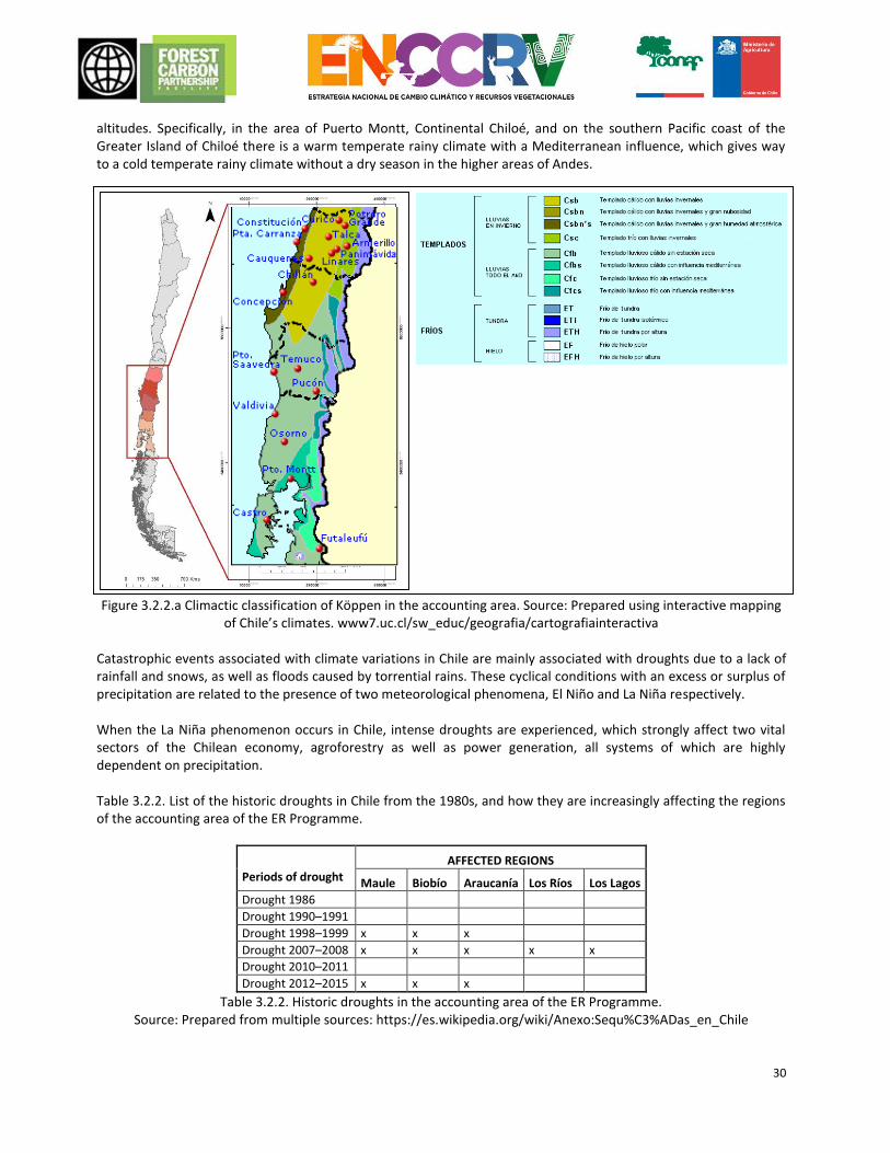
30
altitudes. Specifically, in the area of Puerto Montt, Continental Chiloé, and on the southern Pacific coast of the Greater Island of Chiloé there is a warm temperate rainy climate with a Mediterranean influence, which gives way to a cold temperate rainy climate without a dry season in the higher areas of Andes.
Figure 3.2.2.a Climactic classification of Köppen in the accounting area. Source: Prepared using interactive mapping of Chile’s climates. www7.uc.cl/sw_educ/geografia/cartografiainteractiva
Catastrophic events associated with climate variations in Chile are mainly associated with droughts due to a lack of rainfall and snows, as well as floods caused by torrential rains. These cyclical conditions with an excess or surplus of precipitation are related to the presence of two meteorological phenomena, El Niño and La Niña respectively. When the La Niña phenomenon occurs in Chile, intense droughts are experienced, which strongly affect two vital sectors of the Chilean economy, agroforestry as well as power generation, all systems of which are highly dependent on precipitation. Table 3.2.2. List of the historic droughts in Chile from the 1980s, and how they are increasingly affecting the regions of the accounting area of the ER Programme.
Periods of drought
AFFECTED REGIONS
Maule Biobío Araucanía Los Ríos Los Lagos
Drought 1986
Drought 1990–1991
Drought 1998–1999 x x x
Drought 2007–2008 x x x x x
Drought 2010–2011
Drought 2012–2015 x x x
Table 3.2.2. Historic droughts in the accounting area of the ER Programme. Source: Prepared from multiple sources: https://es.wikipedia.org/wiki/Anexo:Sequ%C3%ADas_en_Chile
31
Recent studies conducted by the Faculty of Forest Sciences and Natural Resources of the UACh9 (Universidad Austral de Chile [Austral University of Chile]), demonstrate that a reduction in summer precipitation due to effects of climate change, will lead to relevant changes in terms of water flow and the composition and structure of the forest in the regions of Los Ríos and Los Lagos. For instance, the study shows that evapotranspiration (water taken from the ground by trees to later evaporate from them) will decrease by 15%, having an impact of up to 27% on forest biomass, this would indicate that a quantity of biomass will be lost, which translates into the release of carbon and will also impact upon the composition of species. Volcanic eruptions and the subsequent flow of lava, sometimes burn large swathes of forest. Chile is considered to be the second largest volcanic chain with the greatest activity worldwide, with more than 2,000 volcanoes, and 500 of these are considered to be “geologically active”. In the area covered by the ER Programme, there are approximately 31 active volcanoes and more than 50 inactive volcanoes, Figure 3.2.2.b. According to the Servicio Nacional de Geología y Minería de Chile [National Geology and Mining Service of Chile] (2016)10 an active volcano is defined as any volcanic centre that is able to erupt in the future. From a geological point of view, a volcano is considered active when it has had at least one eruption in the last ten thousand years, or rather, when uncertain about the latter, it shows quantifiable signs of activity, such as degassing, seismic activity or surface deformation. One example of the consequent loss of native forest as a result of volcanic eruptions is the reduction of native forest surface of 1,580 and 10,711 hectares in the 2000–2015 period in the regions of Los Ríos and Los Lagos, respectively (CONAF, 2015)11. There were other catastrophic events in the accounting area of the ER Programme that resulted in adverse effects for the native forests, such as earthquakes and the generally subsequent tsunamis, landslides, mass land movements and floods, but no statistics have been found regarding the loss of forests at a national or regional level.
9 Article in the Plos One Journal, Increased drought impacts on temperate rainforests from southern South America: results of a
process-based, dynamic forest model. Alvaro G. Gutiérrez , Juan J. Armesto, M. Francisca Díaz, Andreas Huth. 10 National Geology and Mining Service of Chile. 2016. Basic glossary to understand volcanic eruptions and the dangers thereof, online at [http://www.sernageomin.cl/pdf/mapa-geo/Glosario-volcanes.pdf] 11 National Forestry Corporation. 2015. Criteria and indicators for the conservation and sustainable management of temperate and boreal forests. Second national report 2003–2015 period. The Montreal Process. Chile. Page 24
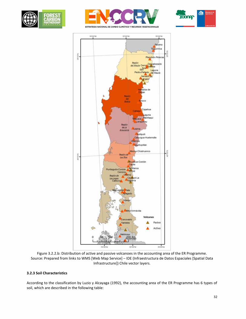
32
Figure 3.2.2.b: Distribution of active and passive volcanoes in the accounting area of the ER Programme.
Source: Prepared from links to WMS [Web Map Service] – IDE (Infraestructura de Datos Espaciales [Spatial Data Infrastructure]) Chile vector layers.
3.2.3 Soil Characteristics According to the classification by Luzio y Alcayaga (1992), the accounting area of the ER Programme has 6 types of soil, which are described in the following table:
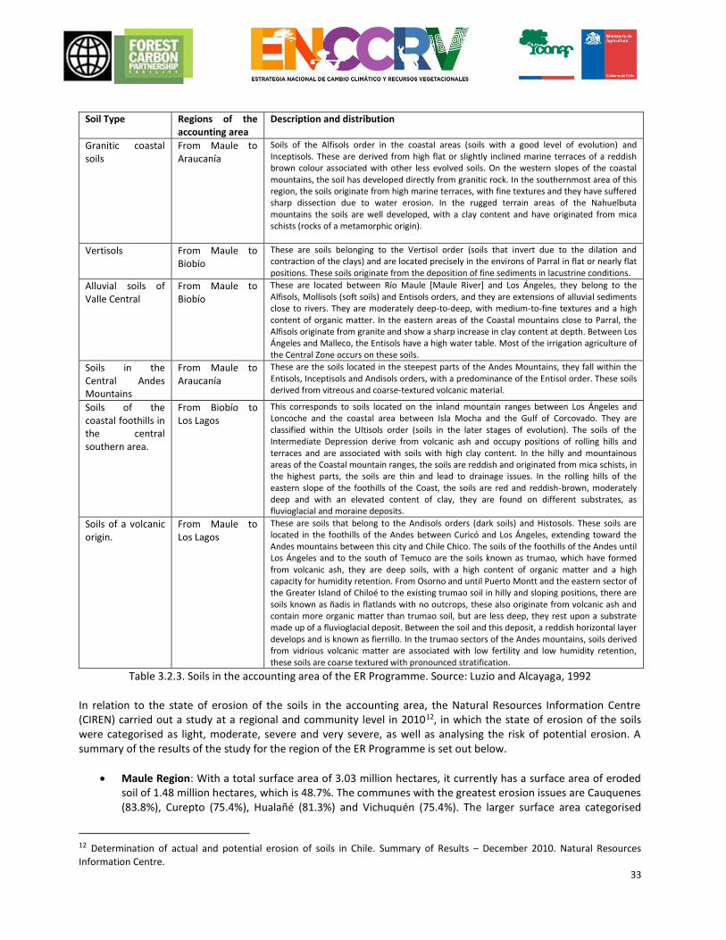
33
Soil Type Regions of the
accounting area Description and distribution
Granitic coastal soils
From Maule to Araucanía
Soils of the Alfisols order in the coastal areas (soils with a good level of evolution) and Inceptisols. These are derived from high flat or slightly inclined marine terraces of a reddish brown colour associated with other less evolved soils. On the western slopes of the coastal mountains, the soil has developed directly from granitic rock. In the southernmost area of this region, the soils originate from high marine terraces, with fine textures and they have suffered sharp dissection due to water erosion. In the rugged terrain areas of the Nahuelbuta mountains the soils are well developed, with a clay content and have originated from mica schists (rocks of a metamorphic origin).
Vertisols From Maule to Biobío
These are soils belonging to the Vertisol order (soils that invert due to the dilation and contraction of the clays) and are located precisely in the environs of Parral in flat or nearly flat positions. These soils originate from the deposition of fine sediments in lacustrine conditions.
Alluvial soils of Valle Central
From Maule to Biobío
These are located between Río Maule [Maule River] and Los Ángeles, they belong to the Alfisols, Mollisols (soft soils) and Entisols orders, and they are extensions of alluvial sediments close to rivers. They are moderately deep-to-deep, with medium-to-fine textures and a high content of organic matter. In the eastern areas of the Coastal mountains close to Parral, the Alfisols originate from granite and show a sharp increase in clay content at depth. Between Los Ángeles and Malleco, the Entisols have a high water table. Most of the irrigation agriculture of the Central Zone occurs on these soils.
Soils in the Central Andes Mountains
From Maule to Araucanía
These are the soils located in the steepest parts of the Andes Mountains, they fall within the Entisols, Inceptisols and Andisols orders, with a predominance of the Entisol order. These soils derived from vitreous and coarse-textured volcanic material.
Soils of the coastal foothills in the central southern area.
From Biobío to Los Lagos
This corresponds to soils located on the inland mountain ranges between Los Ángeles and Loncoche and the coastal area between Isla Mocha and the Gulf of Corcovado. They are classified within the Ultisols order (soils in the later stages of evolution). The soils of the Intermediate Depression derive from volcanic ash and occupy positions of rolling hills and terraces and are associated with soils with high clay content. In the hilly and mountainous areas of the Coastal mountain ranges, the soils are reddish and originated from mica schists, in the highest parts, the soils are thin and lead to drainage issues. In the rolling hills of the eastern slope of the foothills of the Coast, the soils are red and reddish-brown, moderately deep and with an elevated content of clay, they are found on different substrates, as fluvioglacial and moraine deposits.
Soils of a volcanic origin.
From Maule to Los Lagos
These are soils that belong to the Andisols orders (dark soils) and Histosols. These soils are located in the foothills of the Andes between Curicó and Los Ángeles, extending toward the Andes mountains between this city and Chile Chico. The soils of the foothills of the Andes until Los Ángeles and to the south of Temuco are the soils known as trumao, which have formed from volcanic ash, they are deep soils, with a high content of organic matter and a high capacity for humidity retention. From Osorno and until Puerto Montt and the eastern sector of the Greater Island of Chiloé to the existing trumao soil in hilly and sloping positions, there are soils known as ñadis in flatlands with no outcrops, these also originate from volcanic ash and contain more organic matter than trumao soil, but are less deep, they rest upon a substrate made up of a fluvioglacial deposit. Between the soil and this deposit, a reddish horizontal layer develops and is known as fierrillo. In the trumao sectors of the Andes mountains, soils derived from vidrious volcanic matter are associated with low fertility and low humidity retention, these soils are coarse textured with pronounced stratification.
Table 3.2.3. Soils in the accounting area of the ER Programme. Source: Luzio and Alcayaga, 1992 In relation to the state of erosion of the soils in the accounting area, the Natural Resources Information Centre (CIREN) carried out a study at a regional and community level in 201012, in which the state of erosion of the soils were categorised as light, moderate, severe and very severe, as well as analysing the risk of potential erosion. A summary of the results of the study for the region of the ER Programme is set out below.
Maule Region: With a total surface area of 3.03 million hectares, it currently has a surface area of eroded soil of 1.48 million hectares, which is 48.7%. The communes with the greatest erosion issues are Cauquenes (83.8%), Curepto (75.4%), Hualañé (81.3%) and Vichuquén (75.4%). The larger surface area categorised
12 Determination of actual and potential erosion of soils in Chile. Summary of Results – December 2010. Natural Resources
Information Centre.
34
under the erosion categories of “severe” and “very severe” are the communities of Colbún, San Clemente, Romeral and Cauquenes (400,000 hectares, overall). The soils of the Maule region mostly have a current moderate riskexcept the coastal and inland dry land sectors, such as Hualañé, Curepto and Pencahue, which have a severe risk of erosion. The risk of potentially severe and very severe erosion is about 50% of the regional surface area, which is considered a high figure.
Biobío Region: It has a total surface area of 3.71 million hectares, of which 1.18 million is actually eroded (31.9%). There are surface areas categorised as non-apparent erosion (plant coverage over 75%), which are not insignificant (38.9%). The most affected communities are San Fabián (62.7%), Quirihue (53.3%), Pinto (52.3%) and Ninhue (51.7%). Pinto, San Fabián, Antuco and Alto Biobío are found to be the communities with the greatest surface area of “severe” and “very severe” erosion (180,000 hectares, overall). The surface areas with a regional risk of current and potentially severe, and very severe erosion are 11.2% and 47.2%, respectively.
Araucanía Region: Soil erosion in this region covers an area of 911,000 hectares, representing 28.6% of the regional area. The most affected counties from soil erosion in the region are Purén (64.3%), Lonquimay (61.4%) and Puerto Saavedra (56.6%). The counties with the largest area under erosion classes “severe” and “very severe” are Lonquimay, Los Sauces and Lumaco (200,000 hectares altogether). The counties with increased risk for current erosion are Lumaco, Carahue, Traiguén and Los Sauces. Whereas the counties with increased risk for potential erosion (over 75%) are Curarrehue, Lumaco, Lonquimay and Angol.
Los Ríos Region: It has 545,000 hectares that are eroded, which represents 29.7% of the total 1.84 million hectares of the region. The communities with the most eroded soils are Panguipulli (40.1%), Lanco (38.9%) and Corral (36.7%). The communities that have the greatest surface area with “severe” and “very severe” erosion are Panguipulli and La Unión (29 thousand hectares). With regard to the fragility of soils (potential erosion), this is moderate in the sectors of the intermediate depression, whilst in the mountainous areas of the region the fragility increases, especially in the communities of Panguipulli, Corral and Futrono. Productive configuration and land use (of forests for agricultural and livestock use) causes serious erosion problems towards the coastal sectors. There is a considerable regional surface area in the current class of low risk of erosion (50.9%), but there is a surface area (615 thousand ha), which is not insignificant, with a moderate risk (33.4%). The reduction of current plant cover increases the surface areas with high indices of fragility, and could reach 55% of the regional surface area.
Los Lagos Region: With a total surface area of 4.83 million hectares, it currently has a surface area of eroded soils of 1.17 million hectares, which represents 24.3%. The areas with the highest indices of erosion are Fresia, Río Negro, Purranque and Los Muermos. Whilst the communities of the Island of Chiloé such as Castro and Quellón jointly exceed 500,000 ha of eroded soils. Fresia, Chaitén and Quellón are constituted as the communities that have the greatest surface area with classes of erosion that are “severe” and “very severe”. The region of Los Lagos has the lowest levels of severe and very severe erosion (<5%) and the current regional risk of erosion is low.
3.2.4 Species in Categories of Conservation within the accounting area Under the auspices of the International Union for Conservation of Nature (IUCN), various lists of threatened species in Chile have been drafted. To unify these lists and the classification criteria nationally, Law 19,300 on General Environmental Bases legally defined the obligation to draft a scientific-technical procedure, to determine the conservation category of native species. In March 2005 via Supreme Decree No. 75 of the General Ministry of the Presidency, the Regulation for the Classification of Wildlife Species was signed, complying with the requirement of Law 19,300. According to these processes, in Chile there are 950 species with some status of conservation assigned to them, and 900 in any category that means threatened (Extinct, Endangered, Vulnerable or Insufficiently Known) or rare (Rare).
35
In the accounting area of the ER Programme, there are 48 species of tree and shrub flora that have some conservation category according to the current classification, of which 2 are in Critical Danger, 15 are Endangered, 8 are Vulnerable, 8 are Almost Threatened, and 15 have a status of Least Concern. Furthermore, in the accounting area there are 89 species of land and amphibious fauna, which have some category of conservation according to current classification, of which 9 are in Critical Danger, 24 are Endangered, 25 are Vulnerable, 9 are insufficiently known, and 10 are rare. The lists of species associated with these categories are set out in Annex 3. 3.2.5 General description of the interested parties and the right holder included from a point of view of linguistic and sociocultural diversity. The social and environmental safeguard plan for the formulation, consultation and validation of the ENCCRV identified a map of the relevant stakeholders for all the regions of the country. These were the basis for the design of the consultation process and validation of the strategy. On this map, the stakeholders (individuals, institutions, organisations, etc.) were grouped into Focus Groups each representing a certain sector of society with similar interests, visions and/or rights and culture. With this logic, it is hoped to generate an analytical and deliberative participation that helps to obtain the collective opinion of those who directly or indirectly participate and will be affected with the implementation of the ENCCRV and the ER Programme. The Focus Groups identified in the regions of the accounting area were:
No. Focus Group Description Main direct or indirect role in the
implementation of the ER Programme
1 Academics Representatives of the Universities and other centres of professional technical training in areas and disciplines related to vegetation resources.
Participation in the technical workgroups associated with carbon accounting, formulation of action measures and wildlife regulations, amongst others.
2 Trade Union Representatives of productive trades related to forestry and agricultural activities or others with an impact on vegetation resources.
Dissemination and promotion of the ENCCRV and the ER Programme amongst the different productive sectors.
3 Consultants and Extension Workers
Independent professionals and state-dependant professionals, dedicated to the operational technical support of forest owners.
Support to the forestry extension and advice to owners and communities who depend on the forests in the area of the Programme, to support the implementation of strategic measures.
4 Institutional Representatives of the public services related directly or indirectly with the vegetation resources.
Coordination, promotion and cooperation in piloting activities (early implementation) and the implementation of the ER Programme.
5 Indigenous Women
Women belonging to ethnic groups from the country.
Implement direct action measures in the forests and vegetation resources, intended to reduce emissions under the framework of the ER Programme, and to ensure gender parity and the inclusion of the indigenous worldview of the forests and ecosystems in the design and implementation of the programme.
6 Indigenous Populations
Representatives from communities belonging to original ethnic groups in the country.
7 NGOs
Representatives of non-government organisations whose aims and functions are related, directly or indirectly with the vegetation resources.
Support the implementation of the ER Programme within the sphere of social dissemination and awareness, and within the sphere of the care of the environment.
8 NGO Women Representatives of non-government organisations whose objectives and functions are related to gender equality.
Ensure gender equality in the design and implementation of the ER Programme.
9 Small and Medium Owners
Owners of forests and rural lands, whose property is classified as small or medium according to current legislation.
Implement direct action measures on forests and vegetation resources, intended to reduce emissions under the framework of the ER Programme.
10 Political Representatives
Representatives of political parties and government representatives.
Integrate the experiences obtained with the implementation of the Programme on public policies and similar programmes (for instance procedures for draft laws for the forestry sector that are currently in
36
force).
11 Private sector
Representatives of enterprises and owners of forests and rural lands, whose property is classified as large according to current legislation.
Implement direct measures of action in the forests and vegetation resources, intended to reduce emissions under the framework of the ER Programme and provide resources to facilitate the implementation of the ENCCRV.
Table 3.2.5. General characterisation of the relevant stakeholders in the ER Programme. 3.2.6 Demography According to the National Institute of Statistics (INE, acronym in spanish), in the accounting area regions there is a total population of 5.3 million inhabitants, with an average density of 32 inhabitants per square kilometre. The most populated region and with the greatest density according to its surface area is Biobío. At the other extreme, the region of Los Lagos is the least densely populated with only 16.9 inhabitants per square kilometre.
Estimated population at 201213
Region Inhabitants Regional Surface Area (km2)
Density (Inhabitants/km2)
Maule 1,020,830 30,296 33.7
Biobío 2,073,349 37,068 55.9
Araucanía 970,722 31,842 30.5
Los Ríos 395,924 18,429 21.5
Los Lagos 822,299 48,583 16.9
Total 5,283,124 166,218 31.8
Table 3.2.6.a. Population density in the accounting area. Source:www.ine.cl According to the population census measurements carried out, in all the regions of the accounting area except that of Los Lagos, there was a reduction in the population growth rate during the 1992–2002 period, compared to the previous decade (Table 3.2.6.b). This means that the population of these regions continues to grow, but at a decreasing rate. The region of Los Lagos in turn, had higher growth rates in this measurement period, probably due to the expansion in this area of the salmon industry over this decade.
Average annual intercensal population
growth rate (per 100 inhabitants)
Region 1982-1992 1992-2002
Maule 1.34 0.83
Biobío 1.33 0.71
Araucanía 1.13 1.07
Los Ríos 0.70 0.77
Los Lagos 1.33 1.47
Table 3.2.6.b. Population growth in the accounting area. Source:www.ine.cl The distribution per type of population shows that in the accounting area, the population is mainly urban (74%), with this number being more significant in the region of Biobío, where the rural population is only 18%.
Total population per type at 2012
13 There is no updated demographic information since 2012, the need for updated information about the population in Chile, its
regions and its rate of growth, has compelled the National Institute of Statistics (INE) to draft an update and projection (until 2020) using the methods for population calculation indicated in Manual III of the United Nations (Manuals about population calculation methods. ST/SOA/Series A. Population studies No. 25. New York, 1956) awaiting the abbreviated census of 2017.
37
Region Inhabitants Urban % Rural %
Maule 1,020,830 732,927 68% 329,736 32%
Biobío 2,073,349 1,709,190 82% 364,159 18%
Araucanía 970,722 662,151 68% 308,571 32%
Los Ríos 395,924 272,392 69% 123,532 31%
Los Lagos 822,299 572,549 70% 249,750 30%
Total 5,283,124 3,949,209 71% 1,375,748 29%
Table 3.2.6.c. Urban/rural population ratio in the accounting area. Source:www.ine.cl The National Statistics Institute has projected the demographic increase that the country will experience in 2020, where it can be observed that in the regions of the accounting area the population will increase on average by 5.4% compared to 2012.
Estimated population at 2020
Region Inhabitants Regional Surface Area (km2)
Density (Inhabitants/km2)
% Increase compared to
2012
Maule 1,078,202 30,296 35.6 5.6
Biobío 2,177,274 37,068 58.7 5.0
Araucanía 1,018,736 31,842 32.0 4.9
Los Ríos 417,989 18,429 22.7 5.6
Los Lagos 870,815 48,583 17.9 5.9
Total 5,563,016 166,218 33.5 5.4
Table 3.2.6.d. Urban/rural population ratio in the accounting area. Source:www.ine.cl
According to the analyses conducted by the INE in the period from 1960 to 200214, some regions have evolved from a mostly rural population in the 1960s, as is the case for the following regions: VII Del Maule (59.6% of the total population), IX of Araucanía (59.4%) and X of Los Lagos (59.3%) to a largely urban character at present. The relation between the accelerated process of urbanisation with its expansion and migratory attraction component, together with the lack of land, work and/or educational opportunities especially for the youngest in rural areas, has affected the expulsion of a large population contingent from their places of origin. On the other hand, the region of Biobío has experienced an increase in its urbanisation process during the past 50 years. In accordance with data from CASEN 201315, Indigenous Peoples are 9.1% of the total population of the country. Within the accounting area, Indigenous People are concentrated in Araucanía Region (32.0%), Los Lagos Region (24.8%) and Biobío Region (5.2%) (Percentages calculated over total national population of Indigenous Peoples). Maule Region has the smallest presence of indigenous population among those regions that are part of the Programme with only 2.0%. 3.2.7 Main livelihoods and economic activities in the Accounting Area and the dependence of local populations on the forest resources. The INE determines the Indicator of Regional Economic Activity Regional Economic Activiti (INACER, acronym in spanish) for the whole country on an annual basis. Figure 3.2.7., shows the growth tendencies of the main economic activities of the country and the regions of the accounting area during the fourth quarter of 2015, where the agroforestry sector plays a significant role.
14 National Institute of Statistics for Chile (INE). 2008. Population and society: demographic aspects. Period of Information 1950–
2004. Santiago, Chile. 15 Source available at: http://observatorio.ministeriodesarrollosocial.gob.cl/documentos/Casen2013_Pueblos_Indigenas_13mar15_publicacion.pdf
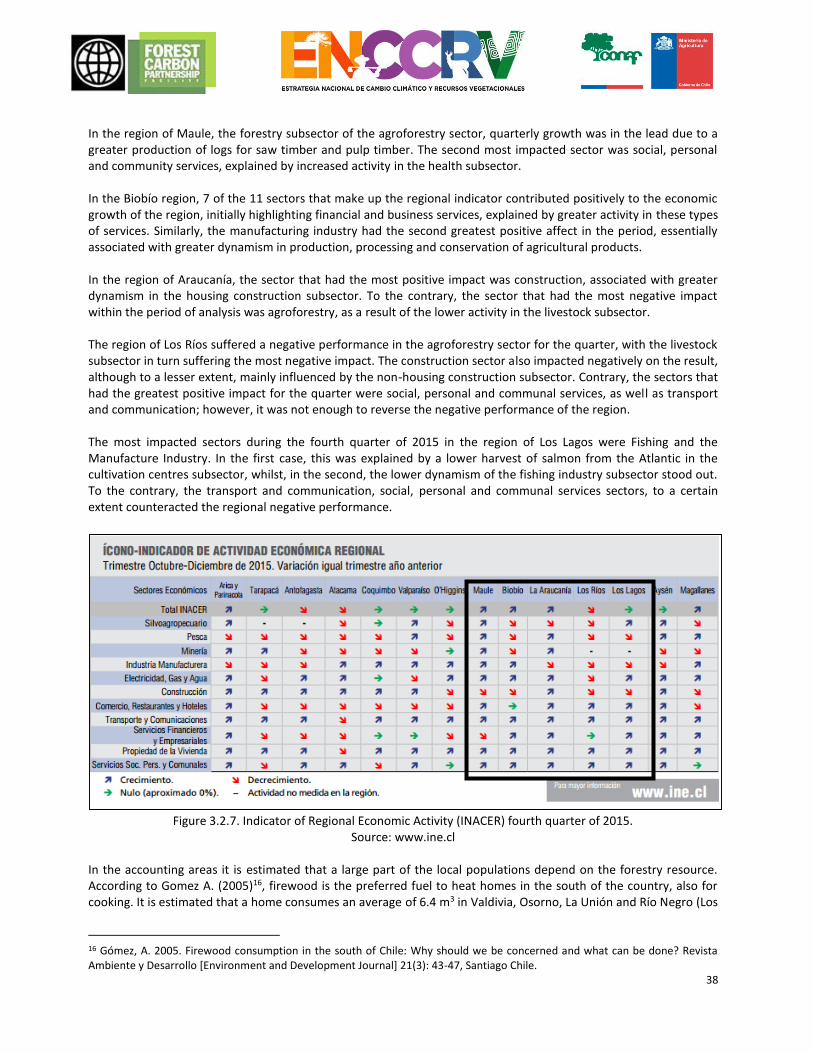
38
In the region of Maule, the forestry subsector of the agroforestry sector, quarterly growth was in the lead due to a greater production of logs for saw timber and pulp timber. The second most impacted sector was social, personal and community services, explained by increased activity in the health subsector. In the Biobío region, 7 of the 11 sectors that make up the regional indicator contributed positively to the economic growth of the region, initially highlighting financial and business services, explained by greater activity in these types of services. Similarly, the manufacturing industry had the second greatest positive affect in the period, essentially associated with greater dynamism in production, processing and conservation of agricultural products. In the region of Araucanía, the sector that had the most positive impact was construction, associated with greater dynamism in the housing construction subsector. To the contrary, the sector that had the most negative impact within the period of analysis was agroforestry, as a result of the lower activity in the livestock subsector. The region of Los Ríos suffered a negative performance in the agroforestry sector for the quarter, with the livestock subsector in turn suffering the most negative impact. The construction sector also impacted negatively on the result, although to a lesser extent, mainly influenced by the non-housing construction subsector. Contrary, the sectors that had the greatest positive impact for the quarter were social, personal and communal services, as well as transport and communication; however, it was not enough to reverse the negative performance of the region. The most impacted sectors during the fourth quarter of 2015 in the region of Los Lagos were Fishing and the Manufacture Industry. In the first case, this was explained by a lower harvest of salmon from the Atlantic in the cultivation centres subsector, whilst, in the second, the lower dynamism of the fishing industry subsector stood out. To the contrary, the transport and communication, social, personal and communal services sectors, to a certain extent counteracted the regional negative performance.
Figure 3.2.7. Indicator of Regional Economic Activity (INACER) fourth quarter of 2015.
Source: www.ine.cl In the accounting areas it is estimated that a large part of the local populations depend on the forestry resource. According to Gomez A. (2005)16, firewood is the preferred fuel to heat homes in the south of the country, also for cooking. It is estimated that a home consumes an average of 6.4 m3 in Valdivia, Osorno, La Unión and Río Negro (Los
16 Gómez, A. 2005. Firewood consumption in the south of Chile: Why should we be concerned and what can be done? Revista Ambiente y Desarrollo [Environment and Development Journal] 21(3): 43-47, Santiago Chile.
39
Lagos region), 3.2 m3 in Temuco and Padre Las Casas (Araucanía region), and somewhat less in Chillán (Maule region). One cubic meter of firewood is approximately equivalent to 700-900 kg, depending on the type of firewood and its humidity. The study by the National Energy Commission and the Department of Economics of the University of Chile estimated that total consumption in the residential areas of the region of Los Lagos is 1.3 million m3 per year. Ábalos (2001)17 estimated that in the region of La Araucanía and in the region of Los Lagos the felling of solid wood for producing firewood is 3.5 million m3 per year, equivalent to 8,750 hectares. It is estimated that at least 61% of this consumption originates from native forest. Callieri (1996)18 in the mid-1990s already estimated the national level of felling of the native forest to be 6.1 million m3 per year. Currently there is no precise quantification of how this extraction affects the native forest in the south of the country. Nevertheless, the consumption of firewood is probably a factor that puts a great deal of pressure on this resource these days. It is true that the extraction of firewood is more selective and on a lower scale in rural areas, which probably means that the degradation of the native forest is lower than extraction or felling for industrial purposes. However, the extraction of firewood on a large scale or over prolonged periods of time in a single area could cause great environmental damage. Ábalos in 2001, estimated that felling for the extraction of firewood exceeds the felling of wood for the production of kindling by 2.7 times and the felling of native wood for sawn wood by 10 times. As a result, in general terms the impact caused by the extraction of firewood is greater than that of other activities. For instance, Lara et al. (2003)19, in the Country Report on the State of the Environment in Chile 2002, estimated the consumption of native wood to be 83.9% in 2000 (estimated at 9,695,356 m3) corresponding to the consumption of firewood (Gómez A. 2005).
17 Ábalos, M. 2001. “Case study on forest fuel: Chile”. Information and Analysis Project for Sustainable Forest Management: Integrating National and International Efforts in 13 tropical countries in Latin America. FAO, GCP/RLA/133/EC, May. 18 Callieri, C. 1996. Degradation and deforestation of the native forest by firewood extraction. Environment and Development 12 (1): 41-48. 19 Lara, A., C. Echeverría and R. Reyes. 2002. “Native Forests”. In: Instituto de Asuntos Públicos [Institute of Public Affairs], U. de Chile [University of Chile] Country Report. State of the Environment in Chile 2002. University of Chile, University Publication. Santiago, Chile.
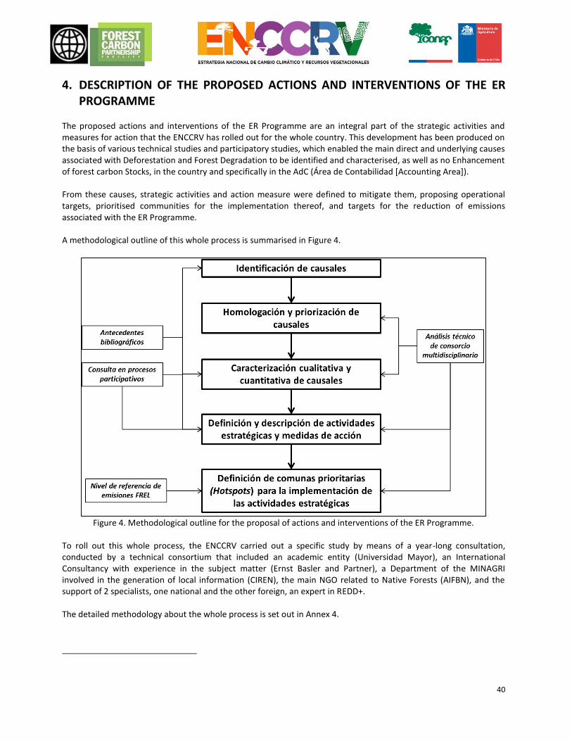
40
4. DESCRIPTION OF THE PROPOSED ACTIONS AND INTERVENTIONS OF THE ER PROGRAMME
The proposed actions and interventions of the ER Programme are an integral part of the strategic activities and measures for action that the ENCCRV has rolled out for the whole country. This development has been produced on the basis of various technical studies and participatory studies, which enabled the main direct and underlying causes associated with Deforestation and Forest Degradation to be identified and characterised, as well as no Enhancement of forest carbon Stocks, in the country and specifically in the AdC (Área de Contabilidad [Accounting Area]). From these causes, strategic activities and action measure were defined to mitigate them, proposing operational targets, prioritised communities for the implementation thereof, and targets for the reduction of emissions associated with the ER Programme. A methodological outline of this whole process is summarised in Figure 4.
Figure 4. Methodological outline for the proposal of actions and interventions of the ER Programme.
To roll out this whole process, the ENCCRV carried out a specific study by means of a year-long consultation, conducted by a technical consortium that included an academic entity (Universidad Mayor), an International Consultancy with experience in the subject matter (Ernst Basler and Partner), a Department of the MINAGRI involved in the generation of local information (CIREN), the main NGO related to Native Forests (AIFBN), and the support of 2 specialists, one national and the other foreign, an expert in REDD+. The detailed methodology about the whole process is set out in Annex 4.
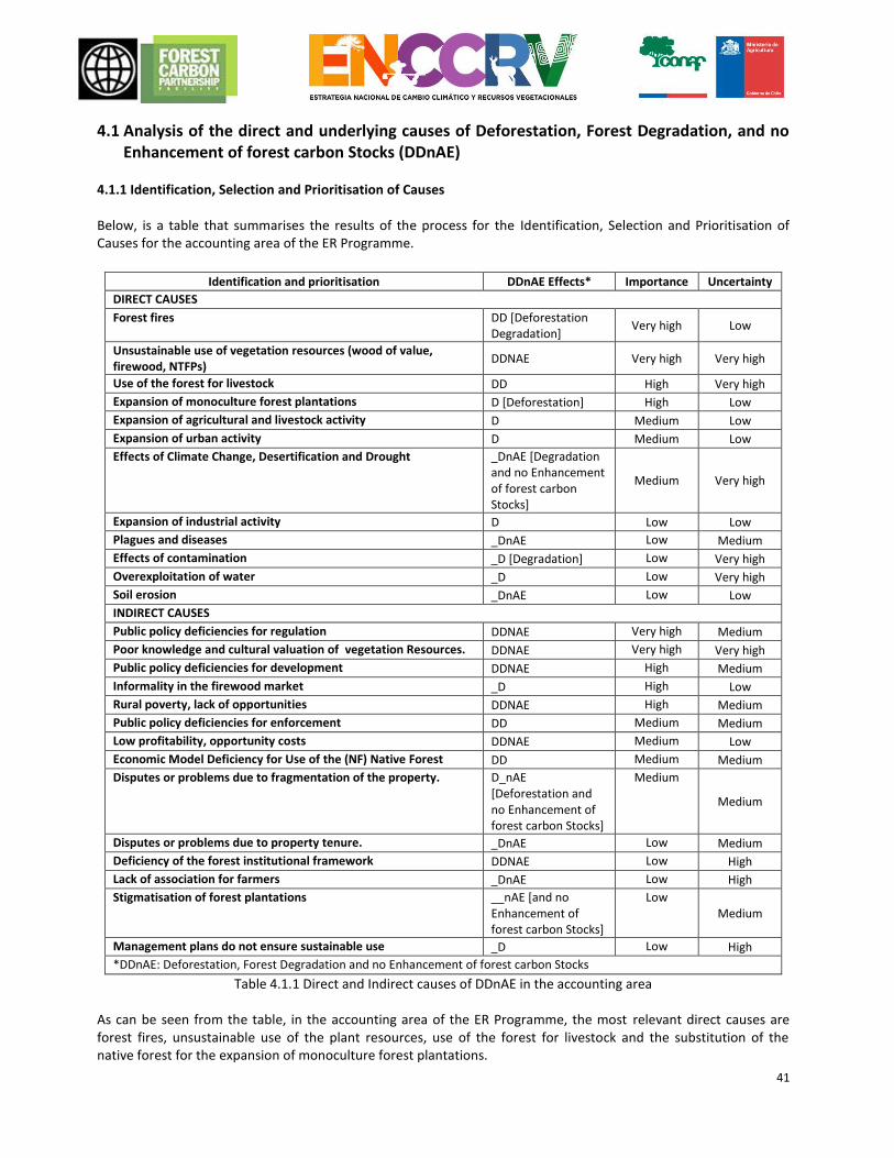
41
4.1 Analysis of the direct and underlying causes of Deforestation, Forest Degradation, and no Enhancement of forest carbon Stocks (DDnAE)
4.1.1 Identification, Selection and Prioritisation of Causes Below, is a table that summarises the results of the process for the Identification, Selection and Prioritisation of Causes for the accounting area of the ER Programme.
Identification and prioritisation DDnAE Effects* Importance Uncertainty
DIRECT CAUSES
Forest fires DD [Deforestation Degradation]
Very high Low
Unsustainable use of vegetation resources (wood of value, firewood, NTFPs)
DDNAE Very high Very high
Use of the forest for livestock DD High Very high
Expansion of monoculture forest plantations D [Deforestation] High Low
Expansion of agricultural and livestock activity D Medium Low
Expansion of urban activity D Medium Low
Effects of Climate Change, Desertification and Drought _DnAE [Degradation and no Enhancement of forest carbon Stocks]
Medium Very high
Expansion of industrial activity D Low Low
Plagues and diseases _DnAE Low Medium
Effects of contamination _D [Degradation] Low Very high
Overexploitation of water _D Low Very high
Soil erosion _DnAE Low Low
INDIRECT CAUSES
Public policy deficiencies for regulation DDNAE Very high Medium
Poor knowledge and cultural valuation of vegetation Resources. DDNAE Very high Very high
Public policy deficiencies for development DDNAE High Medium
Informality in the firewood market _D High Low
Rural poverty, lack of opportunities DDNAE High Medium
Public policy deficiencies for enforcement DD Medium Medium
Low profitability, opportunity costs DDNAE Medium Low
Economic Model Deficiency for Use of the (NF) Native Forest DD Medium Medium
Disputes or problems due to fragmentation of the property. D_nAE [Deforestation and no Enhancement of forest carbon Stocks]
Medium
Medium
Disputes or problems due to property tenure. _DnAE Low Medium
Deficiency of the forest institutional framework DDNAE Low High
Lack of association for farmers _DnAE Low High
Stigmatisation of forest plantations __nAE [and no Enhancement of forest carbon Stocks]
Low Medium
Management plans do not ensure sustainable use _D Low High
*DDnAE: Deforestation, Forest Degradation and no Enhancement of forest carbon Stocks
Table 4.1.1 Direct and Indirect causes of DDnAE in the accounting area As can be seen from the table, in the accounting area of the ER Programme, the most relevant direct causes are forest fires, unsustainable use of the plant resources, use of the forest for livestock and the substitution of the native forest for the expansion of monoculture forest plantations.
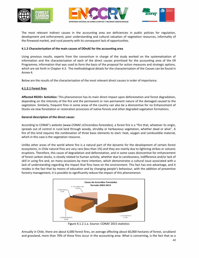
42
The most relevant indirect causes in the accounting area are deficiencies in public policies for regulation, development and enforcement, poor understanding and cultural valuation of vegetation resources, informality of the firewood market, and rural poverty with its consequent lack of opportunities. 4.1.2 Characterisation of the main causes of DDnAE for the accounting area Using previous results, experts from the consortium in charge of the study worked on the systematisation of information and the characterisation of each of the direct causes prioritised for the accounting area of the ER Programme, information that was used to form the basis of the proposal for action measures and strategic options, which are set forth in Chapter 4.3. The methodological details for the characterisation of the Causes can be found in Annex 4. Below are the results of the characterisation of the most relevant direct causes in order of importance. 4.1.2.1 Forest fires
Affected REDD+ Activities: This phenomenon has its main direct impact upon deforestation and forest degradation,
depending on the intensity of the fire and the permanent or non-permanent nature of the damaged caused to the vegetation. Similarly, frequent fires in some areas of the country can also be a disincentive for no Enhancement of Stocks via new forestation or restoration processes of native forests and other degraded vegetation formations. General description of the direct cause: According to CONAF’s website (www.CONAF.cl/incendios-forestales), a forest fire is a “fire that, whatever its origin, spreads out of control in rural land through woody, shrubby or herbaceous vegetation, whether dead or alive”. A fire of this kind requires the combination of three basic elements to start: heat, oxygen and combustible material, which in this case is the vegetation resource. Unlike other areas of the world where fire is a natural part of the dynamic for the development of certain forest ecosystems, in Chile natural fires are very rare (less than 1%) and they are mainly due to lightning strikes or volcanic eruptions. Therefore, this cause of degradation and deforestation, and in some cases disincentive for enhancement of forest carbon stocks, is closely related to human activity, whether due to carelessness, indifference and/or lack of skill in using fire and, on many occasions by mere intention, which demonstrates a cultural issue associated with a lack of understanding regarding the impact that fires have on the environment. This fact has one advantage, and it resides in the fact that by means of education and by changing people’s behaviour, with the addition of preventive forestry management, it is possible to significantly reduce the impact of this phenomenon.
Figure 4.1.2.1.a. Source: CONAF 2015 statistics
Annually in Chile, there are about 6,000 forest fires, on average affecting about 60,000 hectares of forest, scrubland and grassland, more than 70% of these fires occur in the accounting area. What is concerning, is the fact that as a
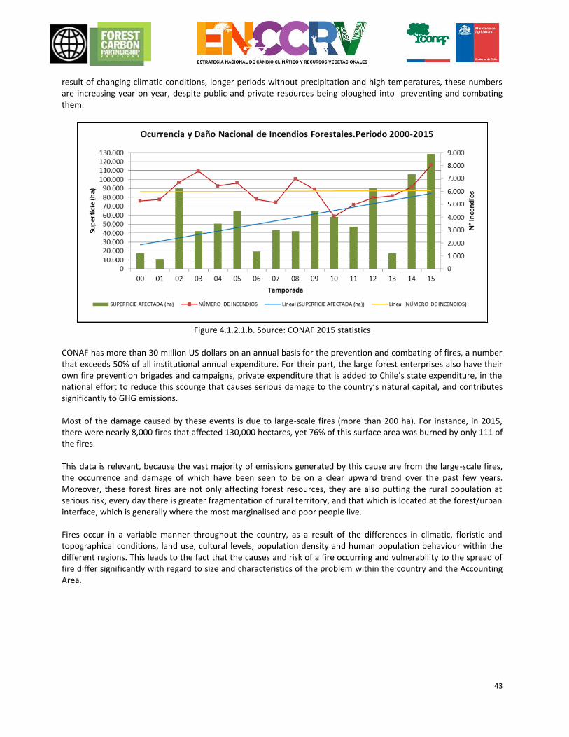
43
result of changing climatic conditions, longer periods without precipitation and high temperatures, these numbers are increasing year on year, despite public and private resources being ploughed into preventing and combating them.
Figure 4.1.2.1.b. Source: CONAF 2015 statistics
CONAF has more than 30 million US dollars on an annual basis for the prevention and combating of fires, a number that exceeds 50% of all institutional annual expenditure. For their part, the large forest enterprises also have their own fire prevention brigades and campaigns, private expenditure that is added to Chile’s state expenditure, in the national effort to reduce this scourge that causes serious damage to the country’s natural capital, and contributes significantly to GHG emissions. Most of the damage caused by these events is due to large-scale fires (more than 200 ha). For instance, in 2015, there were nearly 8,000 fires that affected 130,000 hectares, yet 76% of this surface area was burned by only 111 of the fires. This data is relevant, because the vast majority of emissions generated by this cause are from the large-scale fires, the occurrence and damage of which have been seen to be on a clear upward trend over the past few years. Moreover, these forest fires are not only affecting forest resources, they are also putting the rural population at serious risk, every day there is greater fragmentation of rural territory, and that which is located at the forest/urban interface, which is generally where the most marginalised and poor people live. Fires occur in a variable manner throughout the country, as a result of the differences in climatic, floristic and topographical conditions, land use, cultural levels, population density and human population behaviour within the different regions. This leads to the fact that the causes and risk of a fire occurring and vulnerability to the spread of fire differ significantly with regard to size and characteristics of the problem within the country and the Accounting Area.
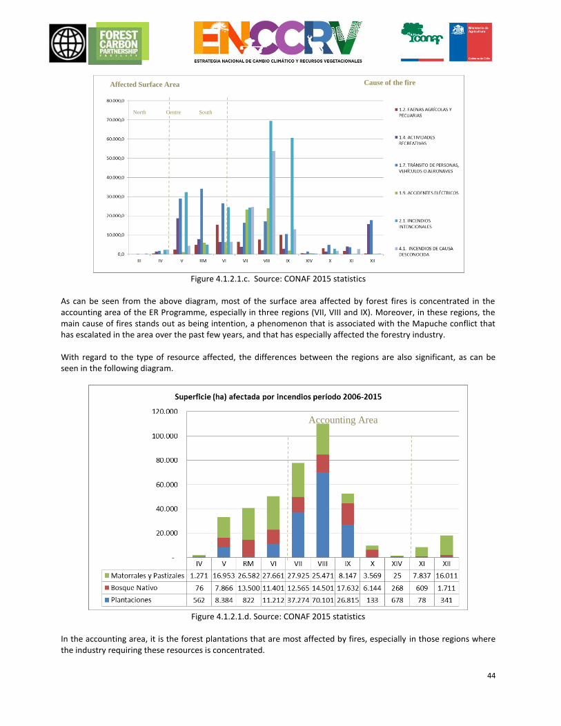
44
Figure 4.1.2.1.c. Source: CONAF 2015 statistics
As can be seen from the above diagram, most of the surface area affected by forest fires is concentrated in the accounting area of the ER Programme, especially in three regions (VII, VIII and IX). Moreover, in these regions, the main cause of fires stands out as being intention, a phenomenon that is associated with the Mapuche conflict that has escalated in the area over the past few years, and that has especially affected the forestry industry. With regard to the type of resource affected, the differences between the regions are also significant, as can be seen in the following diagram.
Figure 4.1.2.1.d. Source: CONAF 2015 statistics
In the accounting area, it is the forest plantations that are most affected by fires, especially in those regions where the industry requiring these resources is concentrated.
Affected Surface Area
(ha)
North Centre South
Cause of the fire
Accounting Area
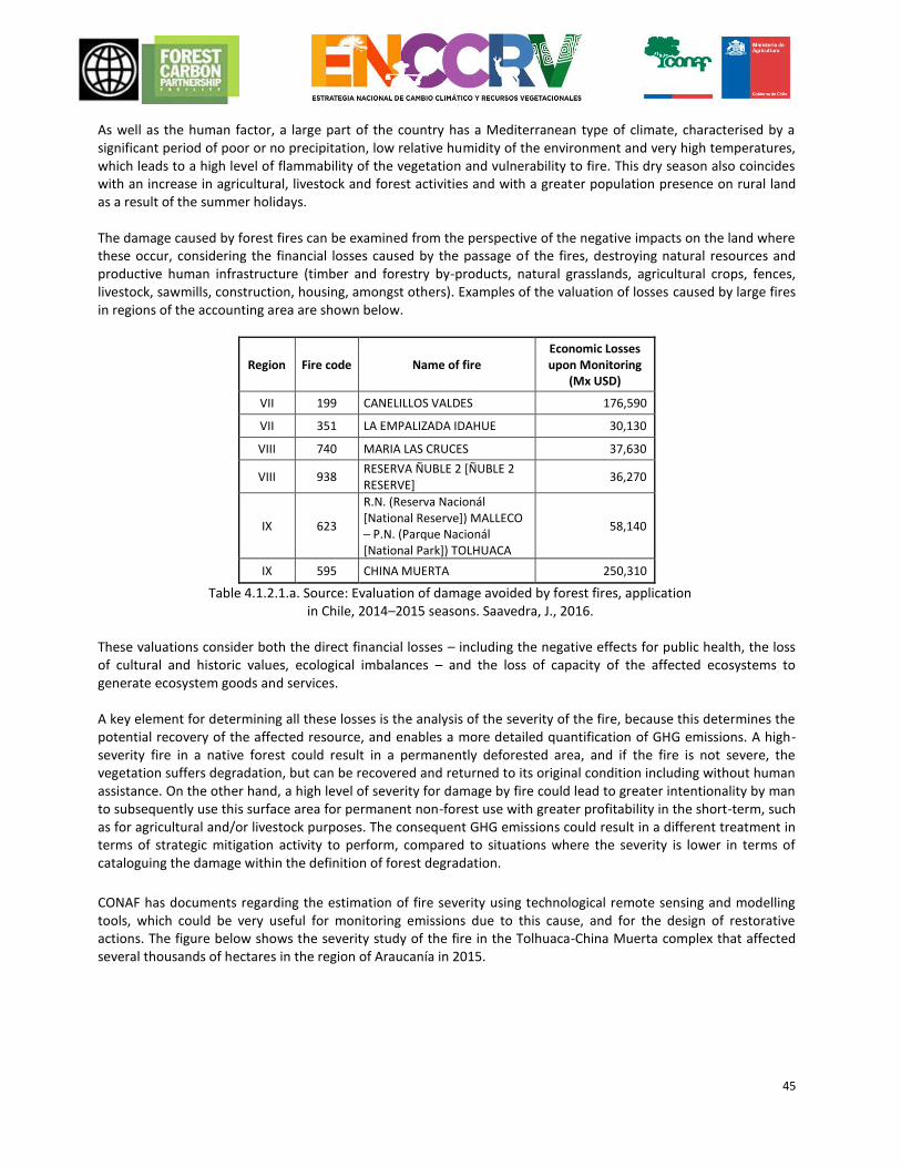
45
As well as the human factor, a large part of the country has a Mediterranean type of climate, characterised by a significant period of poor or no precipitation, low relative humidity of the environment and very high temperatures, which leads to a high level of flammability of the vegetation and vulnerability to fire. This dry season also coincides with an increase in agricultural, livestock and forest activities and with a greater population presence on rural land as a result of the summer holidays. The damage caused by forest fires can be examined from the perspective of the negative impacts on the land where these occur, considering the financial losses caused by the passage of the fires, destroying natural resources and productive human infrastructure (timber and forestry by-products, natural grasslands, agricultural crops, fences, livestock, sawmills, construction, housing, amongst others). Examples of the valuation of losses caused by large fires in regions of the accounting area are shown below.
Region Fire code Name of fire Economic Losses upon Monitoring
(Mx USD)
VII 199 CANELILLOS VALDES 176,590
VII 351 LA EMPALIZADA IDAHUE 30,130
VIII 740 MARIA LAS CRUCES 37,630
VIII 938 RESERVA ÑUBLE 2 [ÑUBLE 2 RESERVE]
36,270
IX 623
R.N. (Reserva Nacionál [National Reserve]) MALLECO – P.N. (Parque Nacionál [National Park]) TOLHUACA
58,140
IX 595 CHINA MUERTA 250,310
Table 4.1.2.1.a. Source: Evaluation of damage avoided by forest fires, application in Chile, 2014–2015 seasons. Saavedra, J., 2016.
These valuations consider both the direct financial losses – including the negative effects for public health, the loss of cultural and historic values, ecological imbalances – and the loss of capacity of the affected ecosystems to generate ecosystem goods and services. A key element for determining all these losses is the analysis of the severity of the fire, because this determines the potential recovery of the affected resource, and enables a more detailed quantification of GHG emissions. A high-severity fire in a native forest could result in a permanently deforested area, and if the fire is not severe, the vegetation suffers degradation, but can be recovered and returned to its original condition including without human assistance. On the other hand, a high level of severity for damage by fire could lead to greater intentionality by man to subsequently use this surface area for permanent non-forest use with greater profitability in the short-term, such as for agricultural and/or livestock purposes. The consequent GHG emissions could result in a different treatment in terms of strategic mitigation activity to perform, compared to situations where the severity is lower in terms of cataloguing the damage within the definition of forest degradation.
CONAF has documents regarding the estimation of fire severity using technological remote sensing and modelling tools, which could be very useful for monitoring emissions due to this cause, and for the design of restorative actions. The figure below shows the severity study of the fire in the Tolhuaca-China Muerta complex that affected several thousands of hectares in the region of Araucanía in 2015.
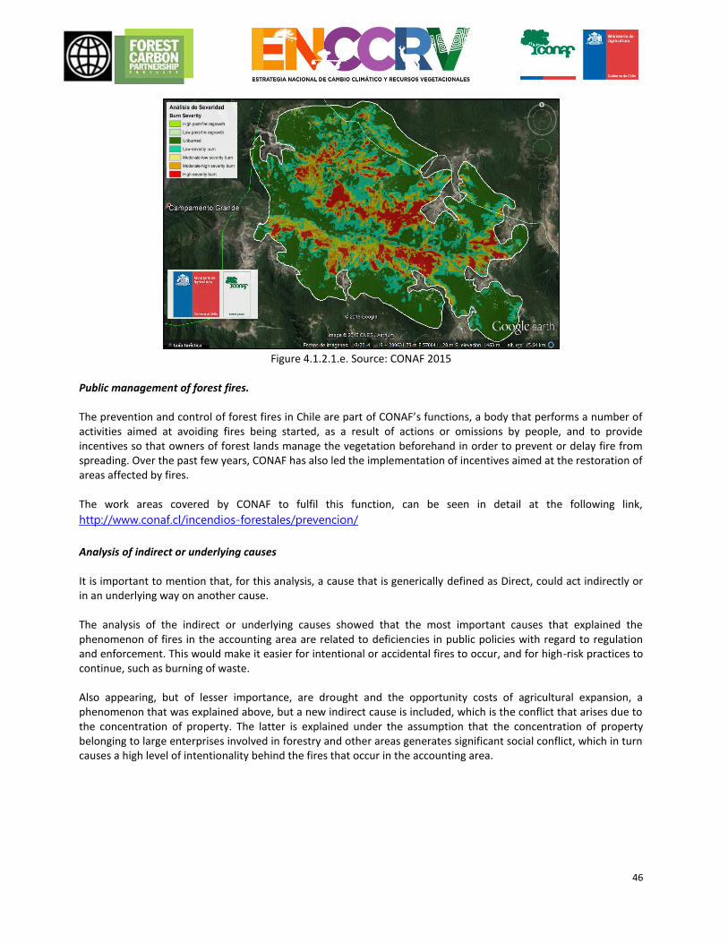
46
Figure 4.1.2.1.e. Source: CONAF 2015
Public management of forest fires. The prevention and control of forest fires in Chile are part of CONAF’s functions, a body that performs a number of activities aimed at avoiding fires being started, as a result of actions or omissions by people, and to provide incentives so that owners of forest lands manage the vegetation beforehand in order to prevent or delay fire from spreading. Over the past few years, CONAF has also led the implementation of incentives aimed at the restoration of areas affected by fires. The work areas covered by CONAF to fulfil this function, can be seen in detail at the following link,
http://www.conaf.cl/incendios-forestales/prevencion/
Analysis of indirect or underlying causes It is important to mention that, for this analysis, a cause that is generically defined as Direct, could act indirectly or in an underlying way on another cause. The analysis of the indirect or underlying causes showed that the most important causes that explained the phenomenon of fires in the accounting area are related to deficiencies in public policies with regard to regulation and enforcement. This would make it easier for intentional or accidental fires to occur, and for high-risk practices to continue, such as burning of waste. Also appearing, but of lesser importance, are drought and the opportunity costs of agricultural expansion, a phenomenon that was explained above, but a new indirect cause is included, which is the conflict that arises due to the concentration of property. The latter is explained under the assumption that the concentration of property belonging to large enterprises involved in forestry and other areas generates significant social conflict, which in turn causes a high level of intentionality behind the fires that occur in the accounting area.
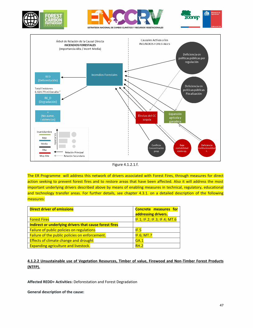
47
Figure 4.1.2.1.f.
The ER Programme will address this network of drivers associated with Forest Fires, through measures for direct
action seeking to prevent forest fires and to restore areas that have been affected. Also it will address the most
important underlying drivers described above by means of enabling measures in technical, regulatory, educational
and technology transfer areas. For further details, see chapter 4.3.1. on a detailed description of the following
measures:
Direct driver of emissions Concrete measures for addressing drivers.
Forest Fires IF.1; IF.2; IF.3; IF.4; MT.6
Indirect or underlying drivers that cause forest fires
Failure of public policies on regulations IF.5
Failure of the public policies on enforcement. IF.6; MT.7
Effects of climate change and drought GA.1
Expanding agriculture and livestock. RH.2
4.1.2.2 Unsustainable use of Vegetation Resources, Timber of value, Firewood and Non-Timber Forest Products
(NTFP).
Affected REDD+ Activities: Deforestation and Forest Degradation General description of the cause:
48
The dynamic by which this cause leads to degradation and deforestation in a sequence, in which the forests are first used for the extraction of raw materials without consideration for the ecosystem requirements for its conservation, where conservation means using without deteriorating. This action, sustained over time, brings the forest mass to a state of degradation such that its recovery would need a high level of effort in terms of time and financial cost. It is important to consider that there is a significant opening in Chile for promoting products and services originating from Chilean native forests and other vegetation resources, creating a scenario of low economic profitability for these. Therefore, the degradation process that is described, can be deemed to be the dismantling of a low yield productive unit (forest), in which the movable assets, the trees, are taken out and sold as a raw material of little value (mainly firewood), and the soil is used for a use that gives greater yield. In all regions, based on participation workshops, the “Low profitability and opportunity costs of the forest” was mentioned as an indirect cause, as a cause that impacts upon the Unsustainable Use of the Native Forest. In the accounting area, another very significant direct cause that participates in degradation is the Use of forests for livestock. Therefore, it might be thought that at the same time as extracting the trees, the forest is used to feed and shelter livestock. There are several recommendations by specialists who promote agroforestry that should be examined on a case-by-case basis according to the level of forest degradation, whenever there are situations, such as forests in a primary state of succession of sclerophyllous forest, such as the Argentine Espinal, from which the forest could be recovered, but which by being treated as agroforestry units in the first instance for livestock, could be lost forever as a forest surface area. Considering that the degradation process described is mostly an illegal activity, it is extremely hard to characterise how this is operating within the forest. It can be assumed that the illegal extractions are mainly for timber of value (an offence colloquially called “high-grading” in Chile) and for firewood. Therefore, its effects on the forest could be assumed as being the same, but this is not the case for the accounting of emissions, because the biomass has different destinations of use. This is a relevant aspect for proposing action measures, given that the market is complex, because of its informality, and there are no true numbers of what is used for products of value, such as for instance logs and less processed products such as firewood. According to national statistics (CNE, 2012), firewood is the third source of energy for the country, with an indication that in 2001 20.3 million cubic metres were used, of which half comes from forests and the rest from monoculture forest plantations. Although it has been mentioned as one of the causes of deforestation and forest degradation, various specialists maintain that the sale of firewood, managed properly, is an important stimulus for promoting sustainable forestry management. As there are no possibilities for the sale of raw materials, whether as logs and/or firewood, the importance of the cause referred to as “Low profitability of the forest and Opportunity costs” is heightened. Within this framework, efforts have been made in the country to improve the authorisation and production chain systems associated with firewood. As background, we can mention the existence of the National Firewood Certification System (SNLC, acronym in spanish) that operates in Chile and that stimulates the use of firewood obtained from forests that have a management plan and that comply with the respective tax measures set by the Servicio de Impuestos Internos (SII) [Internal Revenue Service]. This system originated in 2003 as an initiative by the Native Forest Engineers Association (AIFBN) NGO. Another aspect of the cause [sic], is related to what the technical players consulted in the participatory processes repeatedly mentioned, which is that the interventions carried out with a Management Plan (PM, acronym in spanish) approved by CONAF could also be causing degradation in the forests. In the opinion of the focus groups, there are deficiencies related to the efficacy of the PM as an instrument to control the sustainable use of the forest, and with regard to gathering the technical scientific background, it is worth mentioning two relevant facts. The first: an evaluation of the first period of Law 20.283, from 2009 to 2011. Regarding the capacity of the instrument to achieve the sustainable management proposed by this Law, it shows that studies of the management models led to the conclusion that it is more profitable not to carry out sustainable forest management, but instead to strip the forest assets within the legal framework (Cruz et al 2012). This Law contains provisions for the implementation of sustained yield by means of Forest Planning, nevertheless, the models tested in this same report show that this incentive achieves up to 2% of the total cost of a project, in the best-case scenario.
49
There are at least two official revisions of the enactment of Law 20.283, and in both cases it is indicated that there is no interest amongst individuals to take advantage of the incentives and in general the most frequent reasons given are the low contributions that the Law grants for each requested activity, added to the fact that the payments take a long time to be made. It is interesting to note that the mechanism that the Law has for the payment of incentives is not common, given that it grants payments for partial management and not for a comprehensive proposal for the forest. This leads to bureaucratisation and complexity of application, a lack of representation of the contributions in relation to the national situation (table of costs), and a reduction in the importance of the overall project that each owner has in relation to their forests. The second background fact is the study by Cruz et al (2005), which, by examining the databases for the submission of CONAF Management Plans over a 20 year period, indicates that it is estimated that forestry only took place on 1.8% of the total surface area. As an additional background fact, it should be mentioned that CONAF’s technical assistance programme via its extension workers is the current major driver in the use of the benefits of Law 20.283, and that if it were not for this, private individuals would be even less interested than they are now. In the ENCCRV participatory consultation processes it was clear that current forest extension activity still has important failings, with one of the most relevant being the lack of land planning with which to focus these public efforts, in prioritised areas with environmental, social and financial criteria. Emphasis has also been added to working on property held by small landowners, which, although representing an important social benefit, does not amount to a relevant surface area for achieving any impact on environmental services, as would be wished. Similarly, the support of extension workers funded by CONAF is focussing on small landowners, leaving it to owners who have larger forest surface areas, which could make a substantial contribution to Chile’s emissions reductions and removals by sinks targets, to decide at their own discretion whether to participate or not. In short, degradation as a consequence of Unsustainable Use of Vegetation Resources could be divided into two: a) Illegal logging, motivated by the value of the products, firewood and timber of value, in which case the offence is informally known as ‘high-grading’; and b) Surface area operated under the management plan, in which there is no component of sustainability. The degradation that occurs in forests is the sum of multiple causes such as unsustainable use, which act in a diffuse way. All these generate permanent degradation processes over time that in many cases end in a second phase where there is such a change in the composition and structure, that it crosses the coverage threshold for defining a forest according to law, and then the conversion of degraded forests to other ground uses occurs, such as for instance to scrubland. In these cases, unsustainable use is a cause of deforestation. According to JBD Bosques Mediterráneos (2015) [JBD Mediterranean Forests], this process is the main cause of deforestation in the central area of Chile. Since there is no strategy for the restoration of these scrublands, the final consequence of this process is the replacement of this scrubland by high yield crops driven by the pressure of a growing agricultural, urban and monoculture forest plantation expansion. These causes are examined in other sections of this report. Experiences related to sustainable management. The implementation of planning and sustained yield criteria in Chile, for the management of forests has an approximate date of 20 years. Basically, under CONAF initiatives such as the Proyecto de Conservation y Manejo Sustentable del Bosque Nativo (PCMSBN) [Conservation and Sustainable Management of Native Forest Project] at the end of the 1990s and in early 2000, various related initiatives were executed, including the Plan de Ordenación Forestal en la Reserva Nacional Valdivia (CONAF/GTZ) [Forest Management Plan for the Valdivia National Reserve], the Plan de Ordenación Forestal de la Reserva Malleco (CONAF/ONF) [Forest management plan of the Malleco Reserve]; the Plan de Ordenación Forestal de la Reserva Nacional Mañihuales (CONAF/UMAYOR) [Forest management plan of the National Mañihuales Reserve]. The aforementioned projects proposed a management plan for national forests including the component of sustained yield. These initiatives served to understand essential aspects of the theory, but none was implemented due to various reasons. The discussion, enactment and subsequent implementation of Law 20.283 and its respective regulation from 2009, has also been an important national effort in promoting sustainable management and the recovery of native forests.
50
As has already been mentioned, this process has not had the expected impact, and today the amendment and improvement of the Law is being discussed. In this context, the ENCCRV is making the necessary provisions to incorporate elements of mitigation and for adaptation to Climate Change in this legal amendment. In addition to this, the ENCCRV is promoting various initiatives aimed at improving understanding and driving processes that contribute to improving the sustainable management of the native forests. Notable amongst these are:
“Diagnosis of measures, standards and players involved in the marketing of firewood nationwide”. An initiative that aims to develop a traceability model for firewood in order to reduce the rate of illegal extraction of the forest biomass, via a characterisation and diagnosis of the formal and informal mechanisms via which the sale of firewood takes place, including a characterisation of the products, according to geographic localisation and the capacities established for the conduct of this activity in the different study areas.
“Design and drawing up of key information to deal with the causes of deforestation and forest degradation due to unsustainable use of biomass, by means of commercial extension and facilitation that promotes sustainable use by vulnerable rural and urban peoples as a mitigation measure for the National Strategy for Climate Change and Vegetation Resources (ENCCRV)”. This initiative intends to examine the production and unsustainable use of firewood and biomass as a cause of deforestation and degradation in a quantitative and qualitative form at a macro-regional level, analysing the potential of Greenhouse Gases (GHG) mitigation, and the costs and financial implications of enabling measures. For this, a team of biomass and climate change extension workers will be hired, to set up 32 pilot experiences of enabling measures, and 4 centres for the collection and processing of firewood.
“Support in the design and pilot implementation of an Early Warning System of a change of native vegetation and biodiversity, as an element of National Forest Monitoring, extending to other land uses in the Pilot Areas of the Manejo Sustentable de Tierras (MST) [Sustainable Land Management] Project and sectors with the greatest potential for reduction of Greenhouse Gas (GHG) emissions due to illegal logging within the context of the National Strategy for Climate Change and Vegetation Resources (ENCCRV)”.
“Consultation to examine, collect, geo-reference, and input the Management Plans into a SIG (Sistemas de Información Geográfica [Geographic Information Systems]) platform capable of inputting the NRF (niveles de referencia forestales [Forest Reference Levels]) of Sustainable Management within the context of the definitions obtained for the 5 REDD+ activities, government work carried out under the National Strategy for Climate Change and Vegetation Resources (ENCCRV)”. This will enable the identification of CO2 flows in the surface areas under forestry management during the period of reference, which will generate information about the efficiency of management, via the analysis of the capacity for regeneration of small managed areas, as well as a comparative analysis between the forestry proposal and its actual implementation.
Moreover, there are other national inactives that can provide relevant supplies to adjust a model for sustainable management of forests, for instance, in 2016 a pilot project is expected to be commenced in Region V, promoted by 5 private owners, the Consejo de Producción Limpia (CPL) [Clean Production Council], CONAF, and the technical support of the OTERRA Centre of the Universidad Mayor. A management model will be designed with Forest Planning criteria, which will be implemented in 5 medium sized estates, one of which belongs to SNASPE and which will total about 3,000 hectares of Mediterranean forest. The main results of the project is to design a Management Plan model with Forest Planning criteria for CONAF, to implement it experimentally on the estates, strengthen the marketing of the products, and commit to the management of the indicated surface area for a period of 10 years. It is hoped that the model generated will enable CONAF to promote new estates for the process and to thereby achieve the implementation of sustained low-yield forest activity in the region. Forest Planning, suitable management instrument for the ENCCRV.
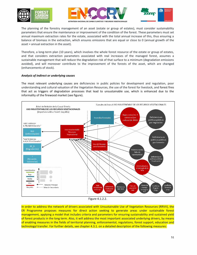
51
The planning of the forestry management of an asset (estate or group of estates), must consider sustainability parameters that ensure the maintenance or improvement of the condition of the forest. These parameters must set annual maximum extraction rates for the estate, associated with the total annual increase of this, thus ensuring a balance of biomass in the extraction, which ensures emissions that are equal or close to 0 (annual growth of the asset = annual extraction in the asset). Therefore, a long-term plan (10 years), which involves the whole forest resource of the estate or group of estates, and that considers extraction parameters associated with real increases of the managed forest, assumes a sustainable management that will reduce the degradation risk of that surface to a minimum (degradation emissions avoided), and will moreover contribute to the improvement of the forests of the asset, which are changed (enhancements of stock). Analysis of indirect or underlying causes The most relevant underlying causes are deficiencies in public policies for development and regulation, poor understanding and cultural valuation of the Vegetation Resources, the use of the forest for livestock, and forest fires that act as triggers of degradation processes that lead to unsustainable use, which is enhanced due to the informality of the firewood market (see figure).
Figure 4.1.2.2.
In order to address the network of drivers associated with Unsustainable Use of Vegetation Resources (RRVV), the ER Programme proposes measures for direct action seeking to generate areas under sustainable forest management, applying a model that includes criteria and parameters for ensuring sustainability and sustained yield of forest products in the long term. Also, it will address the most important associated underlying drivers, by means of enabling measures in the fields of territorial planning, enforcementol, regulations, forest support, education and technologyl transfer. For further details, see chapter 4.3.1. on a detailed description of the following measures:
52
Direct driver of emissions Concrete measures for addressing drivers.
Unsustainable use of vegetation resources US.1;US.2;US.3;US.4
Indirect or underlying drivers that cause unsustainable use
Low knowledge and cultural valorization of vegetation resources
MT.6
Deficiencies in public policies on regulations. MT.2
Defficiencies in public policies on forest support. MT.2
Defficiencies in public policies on enforcement. MT.7
Rural poverty and lack of opportunities. US.5; MT.2; MT.3
Informal market for firewood. US.6; MT.3
Use of the forests for livestock production. MG.1
Forest fires. IF.1; IF.2; IF.3; IF.4;
Bibliography Data from the CNE (Comisión Nacional de Energia [National Energy Commission]) 2012 (BNE) (Balance Nacional de Energía [National Energy Balance]), Ministry of Energy Cruz, P., Cid, F., Rivas, E., Neira, E., Ladrón de Guevara, J. 2012. Tender No. 1590. 29LE11: Evaluation of Law No. 20.283 regarding the recuperation of the native forest and forestry development, for the Undersecretary of Agriculture. CONAF Report. Cruz, P. Lobo, E and Leyton, G. 2005. Analysis of the proposals for use of the native forest contained in the management plans of Legislative Decree 701, for the period 1974 to 2010. Native Forest Journal, 37. 10-15 p.
4.1.2.3 Use of the forest for livestock Affected REDD+ Activities: Forest degradation, no Enhancement of forest carbon Stocks. General description of the cause: The incompatibility existing between livestock practices and forest management in the rural sector is deemed to be one of the main threats against the conservation of forest ecosystems and other vegetation resources in the accounting area. The intensive breeding of livestock and agriculture for self-consumption and sale at local markets are the main livelihood for peasant families and are practices strongly rooted in their traditions, whilst the forest and its products are not a relevant productive component on the estate, because its contribution in the generation of income has historically not been very significant and long-term, therefore it does not correspond to their immediate financial requirements. Extensive livestock farming is a generalised practice that affects the forests of the accounting area, preventing their regeneration and impacting on their structure and composition. It is not possible to determine with any certainty, the forest surface area that is affected by livestock, given the fact that the animal load is distributed across the land in different intensities, varying seasonally depending on the availability of resources. Studies have documented an effect on the forests that is as damaging as that caused by the extraction of firewood, a practice recognised as being within the main ones responsible for the degradation of the native vegetation. The use of the forest for livestock farming was identified by the focus groups and experts who participated in the participatory process to formulate the ENCCRV, as being one of the activities responsible for forest degradation, as well as being a cause that prevents the enhancement of forest carbon stocks due to the effect that the livestock has on the natural regeneration of the vegetation.
53
In the southern area of Chile, extensive livestock farming is a generalised practice that affects the forests and vegetation resources of these regions. It is characterised by low efficiency and low technology given that it does not have the necessary structure for the adequate breeding of livestock. This condition creates high mortality per season, especially in areas where winter temperatures are more extreme. As a way of compensating for these losses, the strategy that is assumed has been the breeding of a large number of animals. Traditional livestock practices Although with differences between regions, livestock farming shares a number of characteristics such as nomadism, seasonal migration, droving, summer grazing, etc. All these activities are mostly related to the breeding of animals, the search for pasture and water sources. Seasonal migration and specifically summer grazing are practices established by the Spanish and even today they continue to be of vital importance for current shepherds or smallholders who continue practising them. This is a seasonal movement that seeks to ensure forage for the livestock during the summer season, specifically the season between October and April and generally these are located in areas or sectors of the Andes Mountains, which very often are over 2,500 miles above sea level. (Guerra, 2005). Summer grazing areas are natural grasslands that extend throughout the country, in the north they are associated with wetlands, in the centre of the country they are much related to livestock use, and in the south of the country as extensive pastures, associated with use by sheep from large ranches in the regions of Aysén and Magallanes. The use of these areas can reduce pressure on forests and ensure the survival of livestock, however, in some sectors, they are located on basin headwaters and therefore, they are very vulnerable areas, considering that they are lands that are not under any state of regulation and protection (Bustamante, 2007). Impact of livestock on regeneration For the southern regions, forest degradation is strongly associated with the selective felling of species, a practice also known as “high-grading”. The effect of these practices is intensified even further by the damage caused by the livestock due to browsing and trampling over the forest. According to study carried out by Zamorano et al. (2014), the effect of livestock on the regeneration of the vegetation is more damaging than the effect of selective logging, especially in adult forests and on small properties. The forests have species that are highly palatable and, therefore, more susceptible to being consumed by livestock. This factor affects the establishment and exchange of species, determining the structure and composition of the forests. Although the relation between livestock and the forest dates back to the colonial period, the historical development of agriculture and urban settlements and, more recently, the establishments of large areas of forest monoculture plantations has resulted in a landscape characterised by remnants of native forest that are increasingly distant and reduced, and because of this they would be subject to greater pressure by livestock. In relation to this, Catalán and Ramos20 mention that the traditional Mapuche practice of grazing cattle in the natural forests did not significantly affect its development as it was carried out over extensive areas of forest, however, with the reduction process that has been occurring, this has now switched to livestock farming over small forest surfaces causing considerable damage to natural regeneration, the undergrowth and compacting of the soil. Currently, most native forests that are in the Mapuche-Huilliche communities are degraded as a result of over-grazing. Under the proposal of strategic activities mentioned in the participatory workshops to formulate the ENCCRV there was repeated mention of the need to promote holistic planning and estate management. Analysis of indirect or underlying causes The use of the forest for livestock was considered by the focus groups consulted within the context of the ENCCRV as being an activity of “high” significance for the accounting area. Despite being recognised as a cause of
20 The native forest in the south of Chile and the Mapuche people (available at: http://wrm.org.uy/oldsite/plantations/information/Catalan.html)
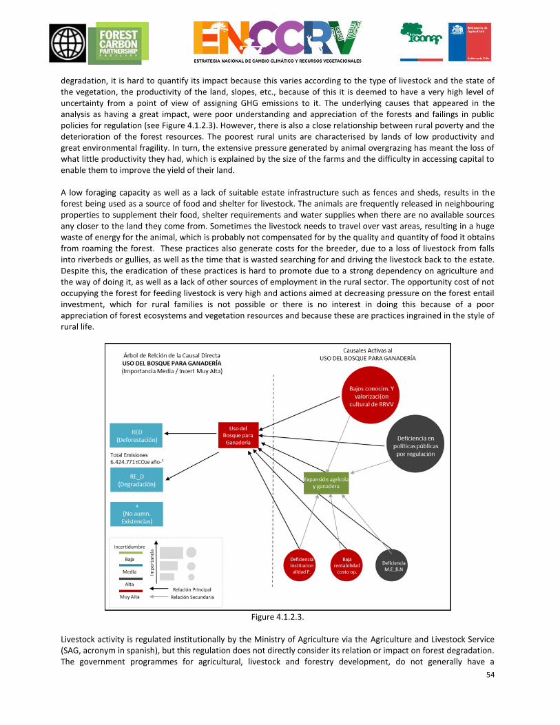
54
degradation, it is hard to quantify its impact because this varies according to the type of livestock and the state of the vegetation, the productivity of the land, slopes, etc., because of this it is deemed to have a very high level of uncertainty from a point of view of assigning GHG emissions to it. The underlying causes that appeared in the analysis as having a great impact, were poor understanding and appreciation of the forests and failings in public policies for regulation (see Figure 4.1.2.3). However, there is also a close relationship between rural poverty and the deterioration of the forest resources. The poorest rural units are characterised by lands of low productivity and great environmental fragility. In turn, the extensive pressure generated by animal overgrazing has meant the loss of what little productivity they had, which is explained by the size of the farms and the difficulty in accessing capital to enable them to improve the yield of their land. A low foraging capacity as well as a lack of suitable estate infrastructure such as fences and sheds, results in the forest being used as a source of food and shelter for livestock. The animals are frequently released in neighbouring properties to supplement their food, shelter requirements and water supplies when there are no available sources any closer to the land they come from. Sometimes the livestock needs to travel over vast areas, resulting in a huge waste of energy for the animal, which is probably not compensated for by the quality and quantity of food it obtains from roaming the forest. These practices also generate costs for the breeder, due to a loss of livestock from falls into riverbeds or gullies, as well as the time that is wasted searching for and driving the livestock back to the estate. Despite this, the eradication of these practices is hard to promote due to a strong dependency on agriculture and the way of doing it, as well as a lack of other sources of employment in the rural sector. The opportunity cost of not occupying the forest for feeding livestock is very high and actions aimed at decreasing pressure on the forest entail investment, which for rural families is not possible or there is no interest in doing this because of a poor appreciation of forest ecosystems and vegetation resources and because these are practices ingrained in the style of rural life.
Figure 4.1.2.3.
Livestock activity is regulated institutionally by the Ministry of Agriculture via the Agriculture and Livestock Service (SAG, acronym in spanish), but this regulation does not directly consider its relation or impact on forest degradation. The government programmes for agricultural, livestock and forestry development, do not generally have a
55
sufficiently aligned political framework that results in integrated guidance for property owners in this context, demonstrating gaps in coordination both at a local and national level, which consequently leads to a lack of efficacy and complementarity in public policies for the agroforestry sector as a whole (see figure). One specific example is Law No. 20.283 regarding Native Forest Recovery and Forestry Development that considers a subsidy for establishing wire fences in order to restrict the entry of animals into the forest and to facilitate the regeneration of the vegetation, but the incentives are insufficient, because they do not include the opportunity cost of not letting animals into the forest, therefore in practice the overall improvement of the production systems for rural families and the conservation of the forest resources on their properties are not compatible. The development programmes have focused mainly on promoting the management of productive units individually and as part of a larger project aimed at promoting economic growth, without considering territorial aspects, nor dealing with and solving environmental problems. One notable case, which can be adopted as a lesson learned within sector public policies, is the work that the Ministry of Agriculture carries out via the National Institute of Agricultural Development (INDAP). INDAP’s actions have been focused on driving the modernisation of one part of family farming, via productive and financial development. However, the aim was to work with rural families with the possibility of transferring the technological productive line and turn them into small agricultural businesses. From this point of view, a significant part of the rural population has been left out, those who do not fulfil the requirements to be beneficiaries of its programmes (Baeriswyl, 2003). This public policy approach also does not fit the characteristic production method of the rural family, the main objective of which is consumption and not necessarily to generate financial income, under rural logic, family work ceases when their basic needs are covered. The recovery of forest ecosystems that are degraded by extensive livestock farming must tackle the issue of rural poverty with a territorial and community management focus. The programmes that are implemented must consider the spatial aspect of the land and the relationship between current and future use, especially in areas of difficult sustainable production. The same occurs with the application of instruments for development, which have a territorial impact. The involvement of the municipal administration as the manager and coordinator of the multiple sectoral instruments associated with use of the land and natural resources, is an alternative to consider to ensure better rural management, given that current legislation enables this (Baeriswyl, 2003). In order to address the drivers associated with Use of the Forests for Livestock Production, the ER Programme proposes a direct action focused on buffer areas and enabling measures in the fields of territorial planning, regulations, environmental education and research. For further details, see chapter 4.3.1. on a detailed description of the following measures:
Direct driver of emissions. Concrete measures for addressing drivers.
Use of the forests for livestock production. MG.1;MG.2;MG.3
Indirect or underlying drivers that cause use of the forests for livestock production.
Low knowledge and cultural valorization of vegetation resources.
MT.6; MG.3
Deficiencies in public policies on regulations. MT.2; RH.2
Expanding agricuture and livestock. RH.2
Bibliography
Baeriswyl, F. 2003. Vision of the land planning in Chile and its relation to rural development. Document prepared for the Latin American Workshop on “Land and Sustainable Development”, Cali, Colombia 17-20 June 2003.
56
Bustamante, P. 2007. Summer Grazing, current situation and outstanding issues. DAS - Diocese of Temuco Environmental Programme. 22 pages
Frene, C., G. Ojeda, J. Santibanez, C. Donoso, J. Sanzana, C. Molina, P. Andrade and M. Nunez-Avila. 2014. Water in Chile. Territorial diagnoses and proposals to face the water crisis. 58 pages
Guerra, J.P. 2005. Seasonal migration grazing in Valle del Aconcagua. Thesis to obtain the title of Anthropologist, Universidad Academia de Humanismo Cristiano [Academy of Christian Humanism University].
Morales, C. 2005. Poverty, desertification and degradation of soil. In: Poverty, desertification and degradation of the natural resources. Morales C and Parada S (Edit). CEPAL (Comisión Económica para Américal Latina y el Caribe [The Economic Commission for Latin America and the Caribbean]) books.
Zamorano-Elgueta, C., Cayuela, L., Rey Benayas, J.M., Donoso, P.J., Geneletti, D., Hobbs, R.J. 2014. The differential influences of human-induced disturbances on tree regeneration community: a landscape approach. Ecosphere 5 (7), 5-17. 4.1.2.4 Expansion of forest monoculture plantations Affected REDD+ Activities: Given that forest plantations are deemed to be “Forest Lands” according to the categories defined by the IPCC, the surface areas of native forest that are transformed into forest plantations of exotic species cannot be classified as Deforestation. Under this logic, within the FREL/FRL that it reported to the UNFCCC, the ENCCRV has established that, “Any change of land use from Native Forest to Forest Plantation will be deemed to be degradation”. General description of the cause In the Idea Notes from the Emissions Reduction Programme submitted by CONAF to the FCPF in 2014 the change of native forest to exotic forest plantation is identified as being a powerful cause of degradation in the accounting area. In a study conducted recently by Pliscoff (2015), the conservation status of Chile’s terrestrial ecosystems was assessed, applying the methodological criteria proposed by the IUCN. The results of this exercise show that the most threatened ecosystems, especially those identified under the sub-criterion “recent loss”, were located in the coastal sector between the VII and IX Region and were related to the dynamic associated with the forestry sector. The above is consistent with regional and local analyses carried out by Echeverría et al. 2006, Echeverría et al. 2008, Altamirano and Lara 2010, Altamirano et al. 2013, and Miranda et al. 2015, amongst other authors. Background of the Productive Forest Sector The increase of forest plantations of exotic species and the export of forest products commenced in the mid-1970s as a result of a development policy for the forestry sector that considered, amongst other benefits, the granting of subsidies for tree planting. Currently, this industry mostly supplies wood originating from forest plantations. The forest industry is structured on the basis of the production of cellulose, paper and paper products, these are the most important activities in terms of their contribution to national GDP, given that it is the main forestry export product. About 750 enterprises sell their products overseas, however this is a market that is quite concentrated, only two companies account for half of forest exports and six companies make up three quarters of the sector’s export (UCO, 2009). The ownership of the land is strongly concentrated into three large business groups: ARAUCO21, CMPC22 and MASISA23, which overall account for assets in Chile of 1,303,387 ha of forest plantations, with only two species dominating forest activity Pinus radiata and Eucaliptus sp.
21 ARAUCO. Sustainability Report 2014 (725,005 ha of forest plantations) 22CMPC. Integrated Report 2014. CMPC S.A. enterprises (521,707 ha of forest plantations) 23MASISA. Annual Report, Integrated Report 2014. (56,675 ha of forest plantations)
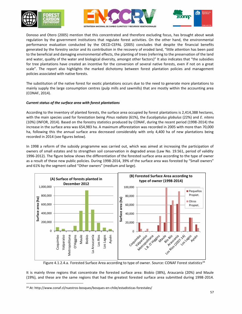
57
Donoso and Otero (2005) mention that this concentrated and therefore excluding focus, has brought about weak regulation by the government institutions that regulate forest activities. On the other hand, the environmental performance evaluation conducted by the OECD-CEPAL (2005) concludes that despite the financial benefits generated by the forestry sector and its contribution in the recovery of eroded land, “little attention has been paid to the beneficial and damaging environmental effects, the planting of trees (referring to the preservation of the land and water, quality of the water and biological diversity, amongst other factors)” It also indicates that “the subsidies for tree plantations have created an incentive for the conversion of several native forests, even if not on a great scale”. The report also highlights the marked dichotomy between forest plantation policies and management policies associated with native forests. The substitution of the native forest for exotic plantations occurs due to the need to generate more plantations to mainly supply the large consumption centres (pulp mills and sawmills) that are mostly within the accounting area (CONAF, 2014). Current status of the surface area with forest plantations According to the inventory of planted forests, the surface area occupied by forest plantations is 2,414,388 hectares, with the main species used for forestation being Pinus radiata (61%), the Eucalyptulus globulus (22%) and E. nitens (10%) (INFOR, 2014). Based on the forestry statistics produced by CONAF, during the recent period (1998-2014) the increase in the surface area was 654,983 ha. A maximum afforestation was recorded in 2005 with more than 70,000 ha, following this the annual surface area decreased considerably with only 4,400 ha of new plantations being recorded in 2014 (see figures below). In 1998 a reform of the subsidy programme was carried out, which was aimed at increasing the participation of owners of small estates and to strengthen soil conservation in degraded areas (Law No. 19.561, period of validity 1996-2012). The figure below shows the differentiation of the forested surface area according to the type of owner as a result of these new public policies. During 1998-2014, 39% of the surface area was forested by “Small owners” and 61% by the segment called “Other owners” (medium and large).
Figure 4.1.2.4.a. Forested Surface Area according to type of owner. Source: CONAF Forest statistics24
It is mainly three regions that concentrate the forested surface area: Biobío (38%), Araucanía (20%) and Maule (19%), and these are the same regions that had the greatest forested surface area submitted during 1998-2014.
24 At: http://www.conaf.cl/nuestros-bosques/bosques-en-chile/estadisticas-forestales/
0
200,000
400,000
600,000
800,000
1,000,000
Co
qu
imb
o
Val
par
aíso
Met
rop
olit
ana
O'H
iggi
ns
Mau
le
Bio
bío
La
Ara
uca
nía
Lo
s R
íos
Lo
s La
gos
Ays
én
Surf
ace
are
a (h
a)
(A) Surface of forests planted in December 2012
0
20,000
40,000
60,000
80,000
100,000
Surf
ace
are
a (h
a)
(B) Forested Surface Area according to type of owner (1998-2014)
PequeñosPropiet.
OtrosPropiet.
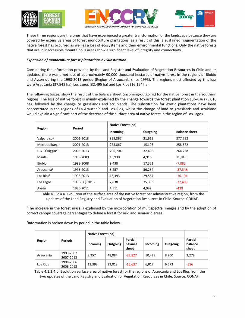
58
These three regions are the ones that have experienced a greater transformation of the landscape because they are covered by extensive areas of forest monoculture plantations, as a result of this, a sustained fragmentation of the native forest has occurred as well as a loss of ecosystems and their environmental functions. Only the native forests that are in inaccessible mountainous areas show a significant level of integrity and connectivity. Expansion of monoculture forest plantations by Substitution Considering the information provided by the Land Register and Evaluation of Vegetation Resources in Chile and its updates, there was a net loss of approximately 90,000 thousand hectares of native forest in the regions of Biobío and Aysén during the 1998-2013 period (Region of Araucanía since 1993). The regions most affected by this loss were Araucanía (37,548 ha), Los Lagos (32,495 ha) and Los Ríos (16,194 ha). The following boxes, show the result of the balance sheet (incoming-outgoing) for the native forest in the southern regions. The loss of native forest is mainly explained by the change towards the forest plantation sub-use (75.016 ha), followed by the change to grasslands and scrublands. The substitution for exotic plantations have been concentrated in the regions of La Araucanía and Los Ríos, whilst the change of land to grasslands and scrubland would explain a significant part of the decrease of the surface area of native forest in the region of Los Lagos.
Region Period Native Forest (ha)
Incoming Outgoing Balance sheet
Valparaíso1 2001-2013 399,367 21,615 377,752
Metropolitana1 2001-2013 273,867 15,195 258,672
L.B. O´Higgins1 2005-2013 296,704 32,436 264,268
Maule 1999-2009 15,930 4,916 11,015
Biobío 1998-2008 9,438 17,321 -7,883
Araucanía2 1993-2013 8,257 56,284 -37,548
Los Ríos2 1998-2013 13,393 29,587 -16,194
Los Lagos 1998(06)-2013 2,838 35,333 -32,495
Aysén 1996-2011 4,511 4,942 -430
Table 4.1.2.4.a. Evolution of the surface area of the native forest per administrative region, from the updates of the Land Registry and Evaluation of Vegetation Resources in Chile. Source: CONAF.
1The increase in the forest mass is explained by the incorporation of multispectral images and by the adoption of correct canopy coverage percentages to define a forest for arid and semi-arid areas. 2Information is broken down by period in the table below.
Region Periods
Native Forest (ha)
Incoming Outgoing Partial balance sheet
Incoming Outgoing Partial balance sheet
Araucanía 1993-2007 2007-2013
8,257 48,084 -39,827 10,479 8,200 2,279
Los Ríos 1998-2006 2006-2013
13,393 23,013 -15,637 6,017 6,573 -556
Table 4.1.2.4.b. Evolution surface area of native forest for the regions of Araucanía and Los Ríos from the two updates of the Land Registry and Evaluation of Vegetation Resources in Chile. Source: CONAF.
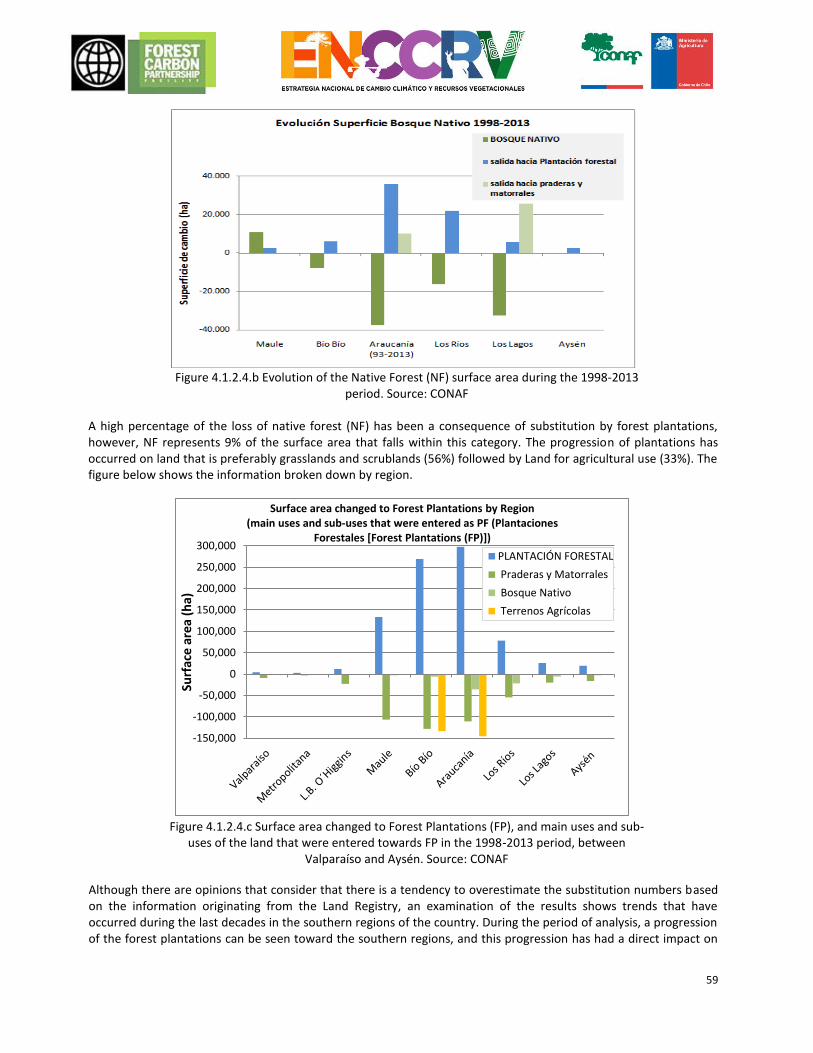
59
Figure 4.1.2.4.b Evolution of the Native Forest (NF) surface area during the 1998-2013
period. Source: CONAF A high percentage of the loss of native forest (NF) has been a consequence of substitution by forest plantations, however, NF represents 9% of the surface area that falls within this category. The progression of plantations has occurred on land that is preferably grasslands and scrublands (56%) followed by Land for agricultural use (33%). The figure below shows the information broken down by region.
Figure 4.1.2.4.c Surface area changed to Forest Plantations (FP), and main uses and sub-
uses of the land that were entered towards FP in the 1998-2013 period, between Valparaíso and Aysén. Source: CONAF
Although there are opinions that consider that there is a tendency to overestimate the substitution numbers based on the information originating from the Land Registry, an examination of the results shows trends that have occurred during the last decades in the southern regions of the country. During the period of analysis, a progression of the forest plantations can be seen toward the southern regions, and this progression has had a direct impact on
-150,000
-100,000
-50,000
0
50,000
100,000
150,000
200,000
250,000
300,000
Surf
ace
are
a (h
a)
Surface area changed to Forest Plantations by Region(main uses and sub-uses that were entered as PF (Plantaciones
Forestales [Forest Plantations (FP)])
PLANTACIÓN FORESTAL
Praderas y Matorrales
Bosque Nativo
Terrenos Agrícolas
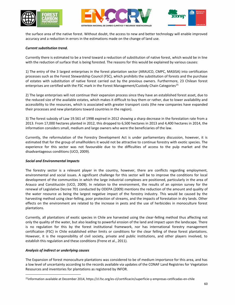
60
the surface area of the native forest. Without doubt, the access to new and better technology will enable improved accuracy and a reduction in errors in the estimations made on the change of land use. Current substitution trend. Currently there is estimated to be a trend toward a reduction of substitution of native forest, which would be in line with the reduction of surface that is being forested. The reasons for this would be explained by various causes: 1) The entry of the 3 largest enterprises in the forest plantation sector (ARAUCO, CMPC, MASISA) into certification processes such as the Forest Stewardship Council (FSC), which prohibits the substitution of forests and the purchase of estates with substitution of native forest carried out by the previous owners. Furthermore, 23 Chilean forest enterprises are certified with the FSC mark in the Forest Management/Custody Chain Categories25 2) The large enterprises will not continue their expansion process since they have an established forest asset, due to the reduced size of the available estates, which makes it difficult to buy them or rather, due to lower availability and accessibility to the resources, which is associated with greater transport costs (the new companies have expanded their processes and new plantations toward countries in the region). 3) The forest subsidy of Law 19.561 of 1998 expired in 2012 showing a sharp decrease in the forestation rate from a 2013. From 17,000 hectares planted in 2012, this dropped to 6,500 hectares in 2013 and 4,400 hectares in 2014, the information considers small, medium and large owners who were the beneficiaries of the law. Currently, the reformulation of the Forestry Development Act is under parliamentary discussion, however, it is estimated that for the group of smallholders it would not be attractive to continue forestry with exotic species. The experience for this sector was not favourable due to the difficulties of access to the pulp market and the disadvantageous conditions (UCO, 2009). Social and Environmental Impacts The forestry sector is a relevant player in the country, however, there are conflicts regarding employment, environmental and social issues. A significant challenge for this sector will be to improve the conditions for local development of the communities in which the large industrial complexes are positioned, particularly in the area of Arauco and Constitución (UCO, 2009). In relation to the environment, the results of an opinion survey for the renewal of Legislative Decree 701 conducted by ODEPA (2009) mentions the reduction of the amount and quality of the water resource as being the largest negative impact of the forestry industry. This would be caused by the harvesting method using clear-felling, poor protection of streams, and the impacts of forestation in dry lands. Other effects on the environment are related to the increase in pests and the use of herbicides in monoculture forest plantations. Currently, all plantations of exotic species in Chile are harvested using the clear-felling method thus affecting not only the quality of the water, but also leading to powerful erosion of the land and impact upon the landscape. There is no regulation for this by the forest institutional framework, nor has international forestry management certification (FSC) in Chile established either limits or conditions for the clear felling of these forest plantations. However, it is the responsibility of civil society, private and public institutions, and other players involved, to establish this regulation and these conditions (Frene et al., 2011). Analysis of indirect or underlying causes The Expansion of forest monoculture plantations was considered to be of medium importance for this area, and has a low level of uncertainty according to the records available via updates of the CONAF Land Registries for Vegetation Resources and inventories for plantations as registered by INFOR.
25information available at December 2014, https://cl.fsc.org/es-cl/certificacin/superficie-y-empresas-cetificadas-en-chile
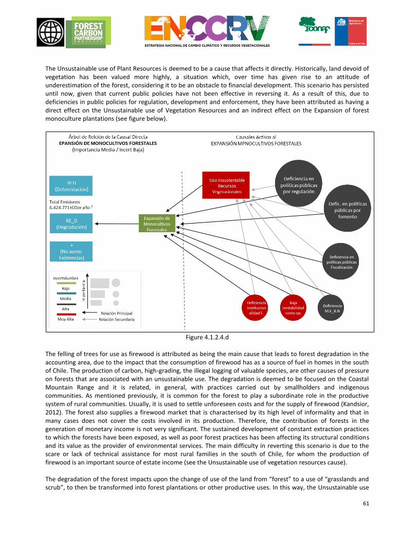
61
The Unsustainable use of Plant Resources is deemed to be a cause that affects it directly. Historically, land devoid of vegetation has been valued more highly, a situation which, over time has given rise to an attitude of underestimation of the forest, considering it to be an obstacle to financial development. This scenario has persisted until now, given that current public policies have not been effective in reversing it. As a result of this, due to deficiencies in public policies for regulation, development and enforcement, they have been attributed as having a direct effect on the Unsustainable use of Vegetation Resources and an indirect effect on the Expansion of forest monoculture plantations (see figure below).
Figure 4.1.2.4.d
The felling of trees for use as firewood is attributed as being the main cause that leads to forest degradation in the accounting area, due to the impact that the consumption of firewood has as a source of fuel in homes in the south of Chile. The production of carbon, high-grading, the illegal logging of valuable species, are other causes of pressure on forests that are associated with an unsustainable use. The degradation is deemed to be focused on the Coastal Mountain Range and it is related, in general, with practices carried out by smallholders and indigenous communities. As mentioned previously, it is common for the forest to play a subordinate role in the productive system of rural communities. Usually, it is used to settle unforeseen costs and for the supply of firewood (Kandsior, 2012). The forest also supplies a firewood market that is characterised by its high level of informality and that in many cases does not cover the costs involved in its production. Therefore, the contribution of forests in the generation of monetary income is not very significant. The sustained development of constant extraction practices to which the forests have been exposed, as well as poor forest practices has been affecting its structural conditions and its value as the provider of environmental services. The main difficulty in reverting this scenario is due to the scare or lack of technical assistance for most rural families in the south of Chile, for whom the production of firewood is an important source of estate income (see the Unsustainable use of vegetation resources cause). The degradation of the forest impacts upon the change of use of the land from “forest” to a use of “grasslands and scrub”, to then be transformed into forest plantations or other productive uses. In this way, the Unsustainable use
62
of Vegetation Resources cause directly impacts upon the expansion of monoculture forest plantations. In fact, the information provided by the land registry of Vegetation Resources notes that the progression of forest plantations has taken place preferably on “Grasslands and scrub” lands (56%). This is consistent with information originating from various scientific studies in which the changes in the coverage of land use are analysed between the different reference times. The results show that the loss of native forest to monoculture plantations is a process that takes place gradually, a first stage covers its degradation to grasslands and scrubland and it subsequently continues its transformation to forest plantations. The information provided by these studies is valuable because it provides understanding about the process for change of use of land over a greater time scale, than is possible to analyse using the updating period of the land register for vegetation resources. The forestry development policies that promote the expansion of fast growing exotic species further highlighted the lack of appreciation of the native forest. The absence of a formal and profitable market for products originating from the native forest was accelerating the degradation process, leaving it subject to conversion to other more productive uses of the land. Currently, the management issues for many native forests are explained by a market problem. The reformulation of the forestry development policy must reverse this situation, promoting forest activity associated with native forests and strengthening this via long-term development instruments that encourage diversified production, the participation of many players in the market and to ensure the fair distribution of benefits. A lack of enforcement and regulation in the recent past allowed native forest to be substituted by plantations. Land use should be regulated by reconciling environmental, social and economic objectives. The ER Programme will address the network of drivers associated with Expansion of Monoculture of Forest Plantations over Native Forests, through enabling measures for action in the fields of territorial planning, enforcement and regulations. For further details, see chapter 4.3.1. on a detailed description of the following measures:
Direct driver of emissions. Concrete Measures for addressing drivers.
Expanding monoculture of forest plantations. RS.1
Indirect or underlying drivers that cause expansion of monocultures.
Deficiencies in public policies on regulations. MT.1; MT.2
Deficiencies in public policies on enforcement. MT.7
Deficiencies in public policies on forest support. MT.1; MT.2
Unsustainable use of vegetation resources. US.2
Bibliography
Frene, C., Donoso, S., Donoso, P., Romero, J. (eds). 2011. Towards a new forest model. Proposals for the sustainable development of the native forest and the forest sector in Chile. Native Forest Engineers Association - AIFBN
Altamirano, A., Lara, A. 2010. Deforestation in temperate ecosystems in the Andes foothills in south-central Chile. Forest, 31(1), 53–64.
Altamirano, A., Aplin, P., Miranda, A., Cayuela, L., Algar, A. C., Field, R. 2013. High rates of forest loss and turnover obscured by classical landscape measures. Applied Geography, 40, 199–211.
CONAF. 2014 Emission Reductions Program Idea Note (ER-PIN). ER Program Name: Reduction of Emissions with emphasis on Degradation in Chile’s Temperate Forests.
CONAF. “Forest Plantations 1998 to 2014 per region and community” Report. Forest Statistics At: http://www.CONAF.cl/nuestros-bosques/bosques-en-chile/estadisticas-forestales/
Donoso, P., Otero, L.A. 2005. Towards a definition of forested country: Where is Chile located? Bosque (Valdivia), 26(3), 5-18.
63
Echeverria, C., Coomes, D. A., Hall, M., Newton, A. C. 2008. Spatially explicit models to analyse forest loss and fragmentation between 1976 and 2020 in southern Chile. Ecological modelling, 212(3), 439-449.
INFOR. Forestry Yearbook 2014. Statistical Bulletin No. 144. Forestry Institute. 166 pp.
Kandsior, A. 2012. The conceptual framework for the participatory forestry extension. In: Rivas E. (Edit.) Forest extension and native forest in Chile: concepts, practices and proposals. Forestry NGOs for the Native Forest. 73 pp.
Miranda, A., Altamirano, A., Cayuela, L., Pincheira, F., Lara, A. 2015. Different times, same story: Native forest loss and landscape homogenization in three physiographical áreas of south-central of Chile. Applied Geography, 60, 20-28.
OECD-CEPAL. 2005. Evaluations of environmental performance - CHILE. 246 pp.
ODEPA. 2009. Opinion survey for the renewal of Legislative Decree 701. Publication by the Oficina de Estudios y Políticas Agrarias – ODEPA [Office of Agricultural Studies and Policies] Ministry of Agriculture. 8 pages.
Forestry NGOs for the Native Forest. 2014. Evaluation of Law No. 20.283 regarding the recuperation of the native forest and forestry development. Summary of the Final Report. Tender No. 1590-29-LE11: Evaluation of Law No. 20.283 on the recuperation of the native forest and forestry development, for the Undersecretary of Agriculture.
Pliscoff, P. 2015. Application of the criteria for the International Union for Conservation of Nature (IUCN) for the risk evaluation of soil ecosystems in Chile. Technical Report drafted for the Ministry of the Environment. 63 p. Santiago, Chile.
4.1.2.5 Agricultural and livestock expansion Affected REDD+ Activities: Deforestation General description of the cause Agricultural and livestock expansion has historically been the main cause of the deforestation of Chile’s forests, as well as in the rest of the world. This replacement process was part of the state’s policies to provide food for the population and also in many cases as a source of income thanks to the export of these foods (as occurred in Chile in the 19th century with the export of wheat during the gold rush in California). In this way, the main cause of agricultural and livestock expansion was its high profitability and a high opportunity cost for the owners by maintaining the original forests, which pressed for its replacement. Historically clearance by fire was the most used mechanism, mainly during the agricultural and livestock expansion in the mid nineteenth century, where this method of clearing forests was intensified by the export boom in wheat to Peru, California and Australia. Specifically for the Accounting Area, one of the main transformation forces of the landscape was also agricultural activity. Various authors have noted that the loss of native forests was as a result of the clearing of agricultural fields at the expense of the slash and burning of the vegetation that covered a large part of the territory (Donoso & Lara 1996, Cisterna et al. 1999). In the coastal mountain ranges extensive surfaces of wheat replaced the native forest, and in the central valley and the Andean mountain range the natural vegetation was used as fuel and cut for the establishment of crops and grasslands for livestock (Millán & Carrasco 1993). This phenomenon mostly occurred some decades ago, therefore there are not many records or much quantitative background that enables an accurate measurement of the real impact of these transformations. However, the fact that the current areas of remaining native forest are mostly located in areas of difficult access, steep slopes, altitudes of 800 miles above sea level, or within protected forested areas, is a reflection of the pressure for change that agricultural and livestock pressures exerted over the native ecosystems Within this historic context there were half-hearted attempts to establish a policy for the regulation of the replacement of the forests by the Governments of the time. This situation remained until the middle of the
64
twentieth century, when the negative impact that this policy had in reducing the surface area of forests and the damage associated with the soil asset, became obvious. According to the Monitoring of changes and updates of the land registry of the native vegetation resources of Chile (CONAF, 2011), the agricultural land of the accounting area plus the regions of Aysén and Magallanes add up to a total of 2,340,566 hectares representing 68.5% of the national agricultural surface and the annual replacement of forests over the past few years has been approximately 1,000 hectares, a much lower number than occurred in the past and that has currently stabilised. Current regulation Law 19.561 of 1998 that modified Legislative Decree 701, established in its Article 22, and in the second paragraph of Article 33 of the General Regulation, an exemption from reforesting when land that has been exploited extractively is recovered for agricultural purposes. This reforesting exemption is an obvious incentive to replace the forest with agricultural crops. For its part, Law 18.450 considers financial support by means of tender, for irrigation works to improve the efficiency and productivity of the agricultural activity. In paragraph 9 of Article 1, the Law notes: The National Irrigation Commission will consider environmental objectives in projects subsidised by the law, with investments that have production systems for preventing the degradation of soil, biodiversity or any type of environmental damage being eligible for subsidy, according to the conditions set out by Law 19.300 and the Regulation of Law No. 18.450. However, Article 15 of the Regulation, named “concerning Environmental safeguards” reiterates the previous wording, not providing any further information about how the inclusion of environmental safeguards are implemented in practice in the Tender phase. This regulatory ambiguity, is not actually ensuring these environmental safeguards for irrigation projects and this is encouraging the agricultural clearing of forests. Despite the fact that the rates of deforestation as a result of agricultural and livestock activity have decreased over the past few years, the fact that there is a growing expansion of agricultural farming on hilly lands, as a result of improved technology and the aforementioned public encouragement for the establishment of irrigation systems, is a concern. Olive trees, citrus trees and vines are some of the main crops that are being set up on hills and ridges on soils that would have a preferred use for forests, especially in the regions that are further north of the accounting area. This expansion of the agricultural barrier is becoming a new threat for forests and other native vegetation formations, which are currently in advanced conditions of degradation and that are candidates to be replaced in the absence of appropriate regulation and enforcement efforts. Finally, it is important to mention that the Sistema de incentivos para la sustentabilidad agroambiental de los suelos
agropecuarios (Ex Sirsd) [System of incentives for agro-environmental sustainability of agricultural lands], of Law
20.412/2010 in its Component 5, funds: Rehabilitation Practices for Land for Agricultural Use. This component
stimulates the elimination, cleaning or confinement of stumps, dead tree trunks, scrub with no foraging value or
other physical or chemical impediments, on land that is suitable for agricultural purposes by means of an incentive
of up to 50% of the net costs of these works, set out in the annual table of costs. As mentioned previously,
technological advancements have provided flexibility to the limitations posed by hills with land that is Class VI and
VII that are preferential for forestry use, which has led to them being occupied for agricultural crops and therefore
likely to qualify for the incentives of Law 20.412. This regulation leaves the definition of what is understood by scrub
without foraging value open to interpretation, which are often valuable native vegetation formations and also
degraded forests, which are cleared with state encouragement.
Analysis of indirect or underlying causes According to the analysis conducted using an R-tree, deforestation by agricultural and livestock expansion in the accounting area has as its main indirect causes, the unsustainable use of vegetation resources and fires, given that
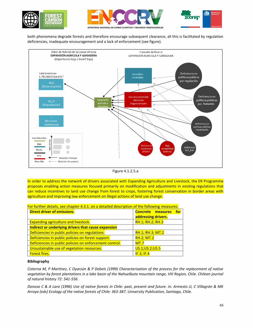
65
both phenomena degrade forests and therefore encourage subsequent clearance, all this is facilitated by regulation deficiencies, inadequate encouragement and a lack of enforcement (see figure).
Figure 4.1.2.5.a
In order to address the network of drivers associated with Expanding Agriculture and Livestock, the ER Programme proposes enabling action measures focused primarily on modification and adjustments in existing regulations that can reduce incentives to land use change from forest to crops, fostering forest conservation in border areas with agriculture and improving law enforcement on illegal actions of land use change. For further details, see chapter 4.3.1. on a detailed description of the following measures:
Direct driver of emissions. Concrete measures for addressing drivers.
Expanding agriculture and livestock. RH.1; RH.2; RH.3
Indirect or underlying drivers that cause expansion
Deficiencies in public policies on regulations. RH.1; RH.3; MT.2
Deficiencies in public policies on forest support. RH.2; MT.2
Deficiencies in public policies on enforcement control. MT.7
Unsustainable use of vegetation resources. US.1;US.2;US.5
Forest fires. IF.3; IF.4
Bibliography
Cisterna M, P Martínez, C Oyarzún & P Debels (1999) Characterisation of the process for the replacement of native vegetation by forest plantations in a lake basin of the Nahuelbuta mountain range, VIII Region, Chile. Chilean journal of natural history 72: 541-556.
Donoso C & A Lara (1996) Use of native forests in Chile: past, present and future. in: Armesto JJ, C Villagrán & MK Arroyo (eds) Ecology of the native forests of Chile: 363-387. University Publication, Santiago, Chile.
Fomento
66
Millán J & P Carrasco (1993) Forestation in region VIII. EULA [Environmental Sciences Centre in Chile] Series cognitive elements about the land resource and general considerations about agro-forestry planning. Publication Universidad de Concepcion [Concepcion University], Concepcion, Chile. 105 pp.
4.1.2.6 Effects of Climate Change, Drought Affected REDD+ Activities: Forest degradation and no Enhancement of forest carbon Stocks General description of the direct cause United Nations Framework Convention on Climate Change (UNFCCC) defines climate change as the change in climate attributed, directly or indirectly to human activity, which changes the composition of the world’s atmosphere and that is added to the natural variability of the climate observed during comparable periods of time. United Nations Convention to Combat Desertification (hereinafter UNCCD) defines drought as the phenomenon that occurs naturally when precipitation has been considerably less than the normally recorded levels, causing an acute water imbalance that damages the production systems of the land resources. The dynamic in which the drought cause, leads to the degradation and no enhancement of forest carbon Stocks, is understood as being a phenomenon that directly affects floristic structure and composition, as well as the development of vegetation formations, restricting access of plants to water and nutrients from the soil, affecting the natural ecosystem functions of forests and limiting its development by means of regeneration or natural succession, as well as making it difficult to establish new plantations. Additionally, drought promotes the occurrence of forest fires of different intensities, which degrade the forests and can cancel out any enhancement in forest carbon stocks. In short, the cause of the drought as an effect of climate change reduces the capacity of forests to provide environmental assets and services. The Centre for Climate Research and Resiliency (hereinafter CR226) in the report entitled “The mega drought 2010-2015: A lesson for the future” defines the fact that more than half of the rainfall deficit during the extensive drought that occurred in Chile in that period, was the result of naturally occurring climate changes that vary over time. However, climate change of an anthropic origin is responsible for at least 25% of the rainfall deficit observed, (drought) during that period, a fraction that is expected to increase in the future. During this drought, substantial impacts were detected upon the flows of surface water and groundwater, the coastal areas, the spread of fires and degradation of the vegetation cover nationally. According to the regional general scaling circulation models that examine the global climate, Chile will experience an increase of temperatures over the whole country, which are associated with significant reductions in precipitation in the accounting area (from the region of Maule until Los Lagos). These climate effects will have significant implications for the water cycle, mainly on the availability of water resources, seasonality and the flow volume. In fact, the average annual precipitation has clearly decreased over the past 70 years, with levels that vary between 20% in La Serena to 15% in Concepcion. (Santibáñez, cited by World Bank 2010). The bioclimatic stress suffered by the vegetation formations affected by drought, is estimated as being one function of the differences between the average weather conditions observed in the past versus the weather conditions projected over the mid and long-term. In this sense, considering summer temperatures, winter temperatures and the level of aridity as being climate variables, AGRIMED (2013), has identified the three vegetation belts 27 that will probably be most affected by the future climate to 2050, all of which are present in the accounting area:
26 CR2 is a centre of excellence funded by the CONICYT FONDAP programme in which about 60 scientists associated with the Universidad de Chile, the Universidad de Concepcion and the Universidad Austral de Chile participate. 27 Vegetation belts: is the space characterised by group of zonal plant communities with a uniform structure and physiognomy, located within homogeneous mesoclimate conditions, which occupy a certain position across an elevation gradient, over a specific time scale.
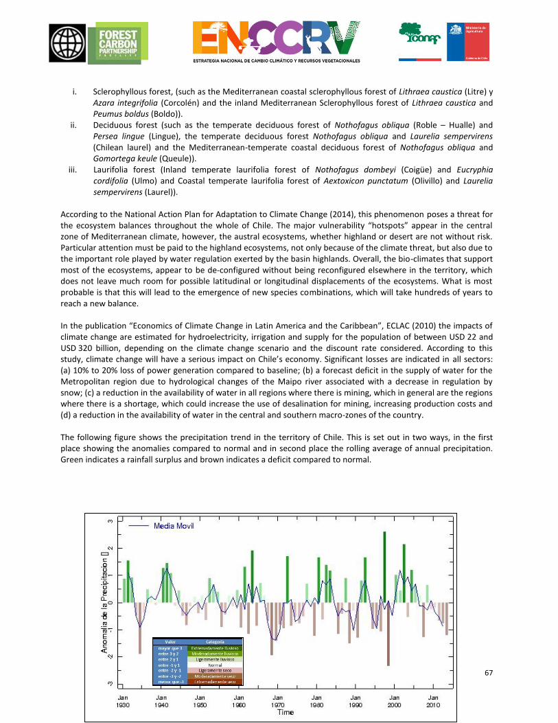
67
i. Sclerophyllous forest, (such as the Mediterranean coastal sclerophyllous forest of Lithraea caustica (Litre) y
Azara integrifolia (Corcolén) and the inland Mediterranean Sclerophyllous forest of Lithraea caustica and Peumus boldus (Boldo)).
ii. Deciduous forest (such as the temperate deciduous forest of Nothofagus obliqua (Roble – Hualle) and Persea lingue (Lingue), the temperate deciduous forest Nothofagus obliqua and Laurelia sempervirens (Chilean laurel) and the Mediterranean-temperate coastal deciduous forest of Nothofagus obliqua and Gomortega keule (Queule)).
iii. Laurifolia forest (Inland temperate laurifolia forest of Nothofagus dombeyi (Coigüe) and Eucryphia cordifolia (Ulmo) and Coastal temperate laurifolia forest of Aextoxicon punctatum (Olivillo) and Laurelia sempervirens (Laurel)).
According to the National Action Plan for Adaptation to Climate Change (2014), this phenomenon poses a threat for the ecosystem balances throughout the whole of Chile. The major vulnerability “hotspots” appear in the central zone of Mediterranean climate, however, the austral ecosystems, whether highland or desert are not without risk. Particular attention must be paid to the highland ecosystems, not only because of the climate threat, but also due to the important role played by water regulation exerted by the basin highlands. Overall, the bio-climates that support most of the ecosystems, appear to be de-configured without being reconfigured elsewhere in the territory, which does not leave much room for possible latitudinal or longitudinal displacements of the ecosystems. What is most probable is that this will lead to the emergence of new species combinations, which will take hundreds of years to reach a new balance. In the publication “Economics of Climate Change in Latin America and the Caribbean”, ECLAC (2010) the impacts of climate change are estimated for hydroelectricity, irrigation and supply for the population of between USD 22 and USD 320 billion, depending on the climate change scenario and the discount rate considered. According to this study, climate change will have a serious impact on Chile’s economy. Significant losses are indicated in all sectors: (a) 10% to 20% loss of power generation compared to baseline; (b) a forecast deficit in the supply of water for the Metropolitan region due to hydrological changes of the Maipo river associated with a decrease in regulation by snow; (c) a reduction in the availability of water in all regions where there is mining, which in general are the regions where there is a shortage, which could increase the use of desalination for mining, increasing production costs and (d) a reduction in the availability of water in the central and southern macro-zones of the country. The following figure shows the precipitation trend in the territory of Chile. This is set out in two ways, in the first place showing the anomalies compared to normal and in second place the rolling average of annual precipitation. Green indicates a rainfall surplus and brown indicates a deficit compared to normal.
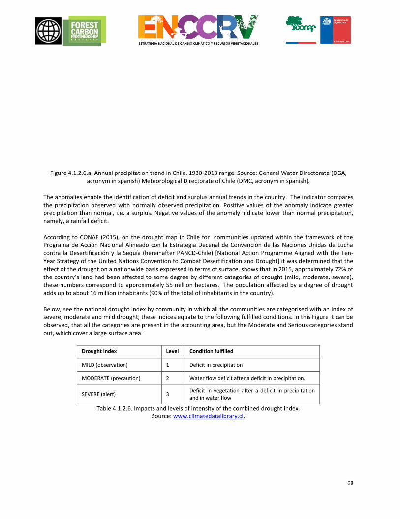
68
Figure 4.1.2.6.a. Annual precipitation trend in Chile. 1930-2013 range. Source: General Water Directorate (DGA, acronym in spanish) Meteorological Directorate of Chile (DMC, acronym in spanish).
The anomalies enable the identification of deficit and surplus annual trends in the country. The indicator compares the precipitation observed with normally observed precipitation. Positive values of the anomaly indicate greater precipitation than normal, i.e. a surplus. Negative values of the anomaly indicate lower than normal precipitation, namely, a rainfall deficit. According to CONAF (2015), on the drought map in Chile for communities updated within the framework of the Programa de Acción Nacional Alineado con la Estrategia Decenal de Convención de las Naciones Unidas de Lucha contra la Desertificación y la Sequía (hereinafter PANCD-Chile) [National Action Programme Aligned with the Ten-Year Strategy of the United Nations Convention to Combat Desertification and Drought] it was determined that the effect of the drought on a nationwide basis expressed in terms of surface, shows that in 2015, approximately 72% of the country’s land had been affected to some degree by different categories of drought (mild, moderate, severe), these numbers correspond to approximately 55 million hectares. The population affected by a degree of drought adds up to about 16 million inhabitants (90% of the total of inhabitants in the country). Below, see the national drought index by community in which all the communities are categorised with an index of severe, moderate and mild drought, these indices equate to the following fulfilled conditions. In this Figure it can be observed, that all the categories are present in the accounting area, but the Moderate and Serious categories stand out, which cover a large surface area.
Drought Index Level Condition fulfilled
MILD (observation) 1 Deficit in precipitation
MODERATE (precaution) 2 Water flow deficit after a deficit in precipitation.
SEVERE (alert) 3 Deficit in vegetation after a deficit in precipitation and in water flow
Table 4.1.2.6. Impacts and levels of intensity of the combined drought index. Source: www.climatedatalibrary.cl.
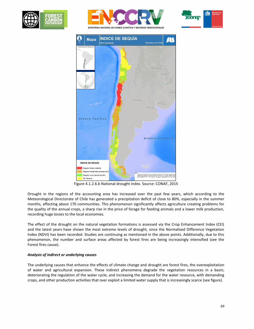
69
Figure 4.1.2.6.b National drought index. Source: CONAF, 2015
Drought in the regions of the accounting area has increased over the past few years, which according to the Meteorological Directorate of Chile has generated a precipitation deficit of close to 80%, especially in the summer months, affecting about 170 communities. This phenomenon significantly affects agriculture creating problems for the quality of the annual crops, a sharp rise in the price of forage for feeding animals and a lower milk production, recording huge losses to the local economies. The effect of the drought on the natural vegetation formations is assessed via the Crop Enhancement Index (CEI) and the latest years have shown the most extreme levels of drought, since the Normalised Difference Vegetation Index (NDVI) has been recorded. Studies are continuing as mentioned in the above points. Additionally, due to this phenomenon, the number and surface areas affected by forest fires are being increasingly intensified (see the Forest fires cause). Analysis of indirect or underlying causes The underlying causes that enhance the effects of climate change and drought are forest fires, the overexploitation of water and agricultural expansion. These indirect phenomena degrade the vegetation resources in a basin, deteriorating the regulation of the water cycle, and increasing the demand for the water resource, with demanding crops, and other production activities that over exploit a limited water supply that is increasingly scarce (see figure).
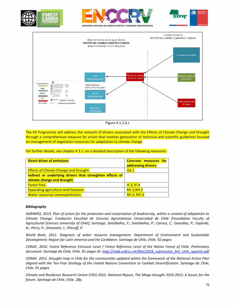
70
Figure 4.1.2.6.c
The ER Programme will address the network of drivers associated with the Effects of Climate Change and Drought through a comprehensive measure for action that involves generation of technical and scientific guidelines focused on management of vegetation resources for adaptation to climate change. For further details, see chapter 4.3.1. on a detailed description of the following measures:
Direct driver of emissions Concrete measures for addressing drivers.
Effects of Climate Change and Drought. GA.1
Indirect or underlying drivers that strenghten effects of climate change and drought.
Forest fires. IF.3; IF.4
Expanding agriculture and livestock. RH.1;RH.3
Water resources overexploitation. RH.2; MT.6
Bibliography
AGRIMED, 2013. Plan of action for the protection and conservation of biodiversity, within a context of adaptation to Climate Change. Fundación Facultad de Ciencias Agronómicas Universidad de Chile [Foundation Faculty of Agricultural Sciences University of Chile]; Santiago. Santibañez, F.; Santibañez, P.; Caroca, C.; González, P.; Gajardo, N.; Perry, P.; Simonetti, J.; Pliscoff, P.
World Bank, 2011. Diagnosis of water resource management. Department of Environment and Sustainable Development; Region for Latin America and the Caribbean. Santiago de Chile, Chile. 92 pages
CONAF, 2016. Forest Reference Emission Level / Forest Reference Level of the Native Forest of Chile. Preliminary document. Santiago de Chile, Chile. 81 pages At: http://redd.unfccc.int/files/2016_submission_frel_chile_spanish.pdf
CONAF, 2015. Drought map in Chile for the communities updated within the framework of the National Action Plan aligned with the Ten-Year Strategy of the United Nations Convention to Combat Desertification. Santiago de Chile, Chile. 91 pages
Climate and Resilience Research Centre (CR2) 2015. National Report, The Mega-drought 2010-2015: A lesson for the future. Santiago de Chile, Chile. 28p.
71
UNCCD. ICCD/COP(10)/INF.9, 2011. Revised glossary of terms with regard to the examination of the performance and evaluation of the application of the Convention. Changwon (Republic of Korea) 56 P. At: http://www.unccd.int/Lists/OfficialDocuments/cop10/inf9spa.pdf
Economic Commission for Latin America and the Caribbean (ECLAC), 2010. Economics of Climate Change in Latin America and the Caribbean. Summary 2010. United Nations, CEPAL, Santiago de Chile, Chile.
FCCC, 1992. The United Nations Framework Convention on Climate Change. New York, USA. 27 p. At: http://unfccc.int/resource/docs/convkp/convsp.pdf
INFOR, 2014. Preparation of Supplies for the Development of the Plantation Type of Forage Species and for Multiple Use in Norte Chico (TP 2). Concepción, Chile. 322p.
Ministry of the Environment, 2014. National Plan for Climate Change Adaptation Prepared under the framework of the National Action Plan on Climate Change. Santiago de Chile, Chile. 80 p. At: http://portal.mma.gob.cl/wp-content/uploads/2016/02/Plan-Nacional-Adaptacion-Cambio-Climatico-version-final.pdf
4.2 Evaluation of the main barriers to REDD + The ER Programme designed by the ENCCRV, has identified the following barriers to its implementation:
Type Barrier Impact in the implementation of the ER Programme
Measures to deal with the barrier.
Economic Financial
Lack of resources to fund the ER Programme.
CONAF as a REDD+ focal point in Chile, does not have all the resources required to implement the ER Programme in its current annual budget, based on what is granted to the institution under Budget Law. The programme overall exceeds 20 million USD per year of incremental cost, an amount that represents almost 80% of the CONAF’s annual total costs.
The redirection and targeting of fiscal resources, in a coordinated and cooperative manner between the MINAGRI departments and other similar public bodies. The contribution of international funds such as the CF, the GCF, the UN-REDD Programme, cooperation with SDC and any bilateral agreements, amongst others. Legal and regulatory adjustment to focus resources assigned to agro-forestry and environmental matters in line with Chile’s commitments listed in the NDC.
Lack of a business model adapted to the reality of the native vegetation resources, which considers the valuation of all the services that these ecosystems provide to society as a whole.
The lack of instruments that consider payment for environmental services of forests and other ecosystems, means that the management of these resources by private parties has a very high opportunity cost compared to other production activities, which is the motivation behind deforestation and forest degradation, over-exploitation, and also the abandonment of land. Current instruments for forestry development appear to be insufficient to promote action measures for the mitigation and adaptation of the ENCCRV, and are a significant barrier to achieve the national commitments under the NDC.
Generate a system of payments for environmental services via the modification of the current instruments for the development of forest regulation. Assess the forests’ environmental services and position its relevance with robust information to the decision makers in Chile, both for the executive and legislative power. This is to show the role of national vegetation resources in carbon storage, better availability of water resources around the frequent episodes of drought affecting primary economic activities, amongst others.

72
Institutional
Lack of intra and inter-ministerial interaction.
The implementation of the ER Programme, necessarily requires cooperation between public bodies from different sections of MINAGRI, and other ministries such as the MMA and the Ministry of Energy. Currently weaknesses are recognised in this respect, showing potential difficulties in coordinating interactions within the framework of the ENCCRV, there are also incompatible objectives between departments that have joint advocacy in the territory.
Alienation of institutional objectives within the Climate Change framework, through the strengthening of the coordinating authorities described in the institutional arrangements in Chapter 2.3. Promote operational coordination between programmes that ultimately have compatible objectives such as those of the Ministry of Environment, Energy and Finance.
Uncertainty in the restructuring process of the Forestry Service in Chile.
A process that aims to strengthen the role of CONAF as a 100% public service. Although in practice as CONAF’s actual status is as a private law public corporation it also carries out development and forestry control, amongst other roles set out in the ER Programme, it is assumed that in order to submit new legal projects to the legislature, first CONAF must be a public body, which could delay key regulatory and development elements that are intended to be included in the draft new Forestry Development Act and plantation regulation.
Work to ensure awareness amongst decision makers has already commenced, so that the Forest Service bill can be approved in 2016, alluding to the key factor of meeting the forest targets contained in the NDC, and which are related to the purpose of the ER Programme. The bill is currently being examined by the Ministry of Finance, a department with which a proposal is also being worked on to apply to the GCF, meaning that specific arrangements in this sphere can be seen and similarly dialogue has been opened up with parliament members who will subsequently have to approve the project.
Legislation.
Uncertainty in the process for the formulation of the new Forestry Development Act.
Conditional upon the fact that first CONAF is constituted as a forest 100% public service, and adding the level of traditional uncertainty of projects for the formulation of bills, this barrier would suggest a delay until Chile has a law to facilitate the implementation of forestry activities considered by the ENCCRV and the ER Programme. This entails budgetary constraints since the new law has to consider direct incentives for forestation mainly with native species, as provided within the NDC, as well as adding a payment component based on results in terms of maintaining permanent vegetation cover.
Like for the previous barrier, an awareness campaign has started with decision makers to show the importance of having the new law, whenever Chile puts international commitments in place via its NDC. Additionally, with contributions by the FCPF into the readiness fund, a detailed technical document was drafted that provides the inputs that the bill should contain in order to be constituted as a real action measure to facilitate the strategic activities included in the ENCCRV and its ER Programme.
Uncertainty in the amendment process for Law 20.283.
Similarly, this process considers the usual uncertainties with regard to the velocity with which the respective arrangements to be included in the law are managed, given the large number of entities and persons who must agree the main elements to be considered within the modification.
Just as indicated for the process for the formulation of the new Forestry Development Act with contributions by the FCPF, a detailed technical document was drafted, which provides the specifications for each proposal for modification of the law and its regulations in line with the strategic activities of the ENCCRV and its respective ER Programme.
73
Property ownership titles that are not properly documented, for forest owners.
There is an indefinite number of forest owners in communities prioritised by the ENCCRV, which are not properly documented when it comes to the property ownership title, a situation that does not enable them to participate in forestry development, and would make any system for the transfer of rights and distribution of benefits difficult.
On the one hand, regulatory amendments should be made that enable the inclusion of not properly documented ownership in the ENCCRV, and on the other to give targeted support to and strengthen the INDAP programme called “Consolidation of the Land Tenure”, where the interested parties can apply for, either collectively or individually, support in the regularisation of their ownership titles.
Technical and technological capacities
Technical and technological gaps in the Monitoring of the ER Programme.
During the drafting of the FREL/FRL associated with the context of the Programme, several technical and technological gaps were identified when performing an adequate update of emissions in the accounting area by means of the MRV. These gaps could make it difficult to do a correct and efficient quantification of the emissions avoided and the new removals associated with the programme’s measures.
As part of the facilitating measures in the Programme, proposals are included for the adjustment and improvement of the institutional skills associated with the MRV, many of which are already being implemented in coordination with the Management of Environmental Audit and Assessment Management, the GEDEFF and INFOR Departments for the Monitoring of Forestry and Native Forest Ecosystems via the GEF Project called SIMEF.
Gaps in the specific technical skills of CONAF officers, who will play a part of the implementation of the ER Programme.
Many of the technical elements associated with the ENCCRV are new, and in some cases are difficult for professionals from the public services and other collaborating institutions to internalise. This could create difficulties in the implementation of the ER Programme.
As part of the skill training efforts that the ENCCRV is implementing, there are basic and advanced training programmes aimed at different key players in the implementation of the programme, which include technical courses up to postgraduate programmes.
Shortage of vegetation material
One potential barrier in the programme, especially for the strategic forestation and restoration activities, is the lack of vegetation material (plants and seeds) of a suitable amount and quality, to implement these actions.
Focus on plant production programmes at CONAF administered nurseries, according to the ENCCRV objectives. Look for long-term associations with local nurseries in the implementation areas.
Gaps in the specific technical skills of forestry operators and a lack of skilled labour.
Another significant barrier is the low levels of technical skills of some of the parties involved in the management of the forests and other vegetation resources. Various forestry practices associated with the action measures for the programme are new and in many cases are different to the usual practices that people have learned. This could make it hard to implement the measures and increase the risk of these failing, with a subsequent impact on the removal and reduction of CO2.
As part of the skill training efforts being made by the ENCCRV, there are operational training programmes that include technical courses on forest operations under the REDD+.
Understanding and culture
A lack of understanding and value of vegetation resources as instruments to
The complexity of these shortcomings is that some of those invited to participate in REDD+, do not understand or know the associated contexts and processes, and they resist participation in something they
The ENCCRV has considered the implementation of an extended programme of environmental education as being within the most relevant strategic activities, with a
74
mitigate climate change, by some of the players in the territory.
do not understand or that they misinterpret. The latter is associated with the generation of expectations of financial improvement, which then doesn’t happen. These shortcomings are also obvious in issues related to the management of resources, which is made even more difficult with the existence of traditional practices that are rooted in rural culture, and which go against REDD+ objectives, such as extensive livestock farming in forests.
focus on Climate Change and the ENCCRV. Similarly, and as part of the environmental and social safeguarding plan of the ENCCRV, a permanent dialogue is being considered with various local players, seeking to improve their level of understanding and therefore facilitating the implementation of the Programme.
Environmental
Prolonged periods of drought
Having considered the drought events that have affected the accounting area over the past few years (Chapter 3.2.2), it is feasible to suppose that there is a considerable risk that this situation will be repeated during the implementation of the ER Programme. This situation could affect forestation and restoration actions, reducing the successful establishment of plants, increasing maintenance costs and decreasing plant growth, and therefore, the associated CO2 removal. Similarly, drought, soil degradation and desertification are relevant factors that stimulate pressure for use of vegetation resources, added to the fact that they also result in better conditions for the occurrence and spread of forest fires.
Operational design and suitable selection of species within a scenario of water shortfalls. Programming of forestation and restoration actions, considering climate projections and events such as El Niño or La Niña. Stimulate actions to prevent forest fires and territorial planning, considering the climate projections for the country regarding precipitation and temperatures.
Table 4.2. Barriers for REDD +
4.3 Description and justification of the actions and interventions scheduled within the framework of the ER Programme that leading to emission reductions and increase in stocks.
In this phase, the consortium’s technical team (see description in Chapter 4.1.), worked on the definition and description of actions to mitigate the effects of each of the direct causes characterised previously, and in addition to this, the definition and description of mitigation actions that are transversal to all the causes. For this, the technical team used the following as relevant supplies: the characterisation of the aforementioned causes; the results of participatory workshops, where there was also a consultation regarding action measures (Regional Workshops, National Experts Workshop and a Macrozonal Workshop); and new specific technical and bibliography background facts collected for these purposes. The consortium initially worked the proposals for each cause separately, according to the expertise of each institution and professional, to then conduct a number of joint work sessions, where each of the proposed measures were discussed, adjusted, supplemented and validated, seeking integrity, efficiency and greater impact of the ER Programme. After the technical team made the preliminary proposal, the measures were validated in technical political consultancies by MINAGRI through the UCCSA. This Unit sent the proposals to different departments, management bodies and other specific CONAF units or other services, which have an impact on one or more of the proposed measures. For instance, the proposed measures related to the Forest Fires cause, were validated with the
75
Management office of Forest Fire Protection (GEPRIF, acronym in spanish) within the strategic political sphere, and with the Analysis and Prediction Forest Fire Section, for the technical operational sphere. This logic was replicated for all the proposed measures. This process ended with the design of a proposal for strategic activities and national action measures, including within this, the ER Programme for the Accounting Area, which is set out below. 4.3.1 Strategic Activities Proposal ER Programme for the Accounting Area. In the first place it is important to define several concepts that make up the structure of the programme, for a better understanding thereof. The following will be meant by: Strategic Activity: These are those particular activities, consistent with local realities to improve vegetation resources proposed by the stakeholders to be carried out in the implementation phase of the ENCCRV and that are part of the public and private management that drives the ER Programme. Each strategic activity considers a set of action measures for mitigation of one or more DDnAE causes, plus other facilitation measures. Measure of action: General definition for the actions that make up a Strategic Activity. These measures may have a specific impact on one of the causes, or may be of a transversal nature or various or all of them. The action measures can also be:
Direct Mitigation Measure: Those that generate reductions of emissions or direct removals in the territory.
Facilitating Measure: Those that facilitate or strengthen the implementation of the direct mitigation measures.
For the definition of the measures, the following areas of action were considered under the framework of the ENCCRV:
- Institutional management: Coordination and interaction of the public services to facilitate implementation.
- Operative: Implementation of actions in the field under established practices and schemes. - Legislation: Improvements, modifications and inclusions in regulation that is in force and under
development. - Inspection: Improvements, modifications and inclusions in the public enforcement instruments. - Development: Improvements, modifications and inclusions in the public development instruments. - Land Planning: Improvements in the management of landscapes and territories. - Training and/or transfer of skills: Decreased gaps in technical and technological skills. - Environmental Education and Awareness: Decreased gaps in information and uncertainty change in
attitude and perceptions. - Investigation: Generation of knowledge and decrease in information and uncertainty gaps.
The ER Programme for the Accounting Area is part of the ENCCRV, which has proposed the conduct of 6 Strategic Activities associated with prioritised direct causes, and a transversal Strategic Activity to all causes. Overall, these activities involve the implementation of 28 action measures, 8 of which are direct mitigation measures, and 20 are facilitating measures, in various spheres (See figure 4.3.1). For each of these action measures, operational targets to be met within the ERPA period have been defined (2017-2025), and these targets have been classified as: UNCONDITIONAL TARGETS (I): Those operational targets of the ENCCRV that will definitely be conducted given that they have funding assigned.

76
CONDITIONAL TARGETS (C): Those operational targets of the ENCCRV the compliance of which is conditional upon additional funding being achieved. The operational targets and the budget associated with these measures are set out in detail in Chapter 6. Below, is a detailed description of each Strategic Activity and its action measures for the ER Programme.
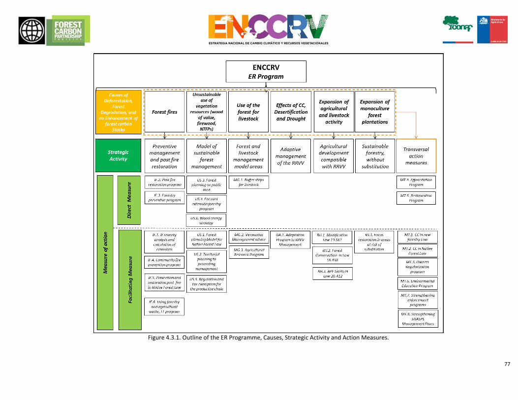
77
Figure 4.3.1. Outline of the ER Programme, Causes, Strategic Activity and Action Measures.
78
STRATEGIC ACTIVITY 1. TRANSVERSAL ACTION MEASURES TO FACILITATE THE IMPLEMENTATION OF THE ENCCRV (TM)
AC
TIO
N
MEA
SUR
E
SPH
ERE
OF
AC
TIO
N
DESCRIPTION PROGRESS OF THE ENCCRV, ROUTES, MECHANISMS AND INSTITUTIONAL ARRANGEMENTS
FOR THE IMPLEMENTATION OF THE MEASURE
MT.
1.
Ne
w F
ore
stry
De
velo
pm
en
t A
ct, i
ncl
ud
ing
ele
me
nts
of
mit
igat
ion
an
d a
dap
tati
on
to
Clim
ate
Ch
ange
.
Legi
slat
ive
and
dev
elo
pm
en
t co
nte
xts.
The following elements will be included in the draft of the new law and its respective regulations: a) Development in addition to forestation and replanting using native species recommended by the “Adaptation Programme for the Management of vegetation resources in the context of climate change (measure AM.1.)” of the ENCCRV (see strategic activity “management of vegetation resources to adapt to the effects of climate change”). b) Development in addition to forestation and replanting that undertakes to leave permanent cover in the planted area. c) Development in addition to forestation and replanting that is done under a Plan de Manejo con Criterio de Ordenación Forestal (PMCOF) [Management Plan with Forestry Planning Criteria], according to what is established by measure SU.4. of the ENCCRV (see strategic activity “implementation of a public management model for the sustainable use of forests”). d) Include areas that have no rating as Preferably Suitable for Forestry, but which are earmarked for forestation or replanting under the logic of points a) and b) as possible areas for reclamation, for instance agricultural and livestock lands, very degraded forests that have current coverage of less than 30%, wetlands, amongst others. e) Commensurate incentives system in terms of encouraging owners to access what is set out in letters a), b) c) and d) in terms of permanent payments (for instance annual) and inclusion of financial contributions from private persons and international bodies.
During 2016-2017, a process is being developed to draft the New Forestry Development Act, a procedure that will incorporate the elements set forth. UCCSA as the unit that is responsible for the ENCCRV, participates actively in all internal and participatory processes for the drafting of the New Forestry Development Act. The ENCCRV is working on the analysis and drafting of these elements by means of a specialist consultation, and considering the input of the participatory process for the formulation and consultation of the ENCCRV with relevant players, and sectoral experts, which are being documented as key inputs for this petition. Additionally, a financial analysis is being developed to value those environmental attributes that result from these measures, as technical key inputs to submit the bills to the Ministry of Finance, which supports those initiatives that have a robust cost-benefit analysis.
79
AC
TIO
N
MEA
SUR
E
SPH
ERE
OF
AC
TIO
N
DESCRIPTION PROGRESS OF THE ENCCRV, ROUTES, MECHANISMS AND INSTITUTIONAL ARRANGEMENTS
FOR THE IMPLEMENTATION OF THE MEASURE
MT.
2. M
od
ific
atio
n a
nd
str
en
gth
en
ing
of
the
Law
No
. 20
.28
3 o
n N
ativ
e F
ore
st R
eco
very
an
d
Fore
stry
De
velo
pm
en
t.
Legi
slat
ive
and
dev
elo
pm
en
t co
nte
xts.
Proposal for modification of the technical and regulatory elements of Law No. 20.283 on Native Forest Recovery and Forestry Development according to the following considerations: a) For estates or groups of estates that are managed under a PMCOF, according to what is established in measure SU.4., the logic of the payment of incentives for activity and the table of costs must be removed. Payments must be of a fixed amount per hectare, which has been managed annually according to planning and with the ex post result having been verified. This ex post result will have its evaluation in terms of reduction and/or removal of emissions based on the forestry reference levels, other variables that have a quantifiable measure associated with the provision of environmental services (for instance connectivity of the landscape, reduction of soil erosion, social aspects, amongst others). b) The fixed base amount per hectare to be paid as an incentive to estates or groups of estates managed under a PMCOF, must at least be 20 UTM (Unidad Tributaria Mensual [Chilean currency unit to calculate taxes, fines and custom duties]). c) The PMCOFs that cover ecological restoration activities will have an additional incentive for each hectare being restored. This extra will be to a factor of 2 (namely, double) over the 20 UTM base. d) The PMCOFs that consider fire prevention management activities will have an additional incentive for each hectare under this scheme. This extra will be to a factor of 1.5 over the 20 UTM base. e) For estates or groups of estates that are managed under a PMCOF, linked loans will be provided to cover the costs for the implementation of initial planning activities.
Throughout 2016-2017 there will be a process for the modification of Law No. 20.283 and its regulations, a process intended to incorporate the necessary changes and improvements in this context. The ENCCRV is working on the analysis and drafting of these elements by means of a specialist consultation, and considering the input of the participatory process for the formulation and consultation of the ENCCRV. UCCSA as the unit that is responsible for the ENCCRV, participates actively in all internal and participatory processes for the modification of Law No. 20.283 on Native Forest Recovery and Forestry Development and its regulations. Given that the available management Fund in Law No. 20.283 on Native Forest Recovery and Forestry Development is not used in full in annual tenders, this measure does not require incremental funding, it only requires political and institutional will to ensure that the proposed amendments are actually incorporated. There has been previous work between CONAF, national banks and INDAP in terms of generating loans for owners of forested land to facilitate their access to instruments for forestry development (for instance, with Legislative Decree No. 701 on forestation). Additionally, between CONAF and INDAP there is a framework agreement of cooperation where alliances of this kind can be included, provided that this topic should progress once the formal process for the proposal of modifications to Law No. 20.283 commences.
80
AC
TIO
N
MEA
SU
RE
SPH
ERE
OF
AC
TIO
N
DESCRIPTION PROGRESS OF THE ENCCRV, ROUTES, MECHANISMS AND INSTITUTIONAL ARRANGEMENTS
FOR THE IMPLEMENTATION OF THE MEASURE
MT.
3. A
dju
stm
en
ts f
or
the
incl
usi
on
of
ow
ne
rs w
ith
po
or
lega
l se
curi
ty o
f te
nu
re o
n t
he
lan
d.
Legi
slat
ive
and
dev
elo
pm
en
t co
nte
xt.
Considering that there is a percentage of rural owners who are in an improperly documented situation regarding the ownership title of a property, but who have the intention and potential to incorporate themselves into any of the management, forestation and/or restoration programmes associated with the ENCCRV, a measure was designed so that producers in this improperly documented situation would be able to participate in the development instruments and the programmes that drive the strategy. This measures considers two procedures:
Adjustments to current legislation and regulation: Involves an analysis of the different conditions of improper documentation, and the design of the regulatory modifications that will enable the inclusion of an improperly documented owner into the ENCCRV. A technical legislative feasibility analysis will be carried out, and an amendment process proposal will be carried out at the corresponding bodies. There are international experiences with regard to this type of measure, which will be examined to assess their potential ratification to the Chilean case.
Targeted programme for the rectification of ownership titles: Forest owners from communities prioritised by the ENCCRV, who are in an improperly documented situation regarding the ownership title for the property, and who intend to join any of the management, forestation and/or restoration programmes associated with ENCCRV will receive free legal support to rectify the situation, as part of the technical assistance provided by CONAF. This support for the owner will be conditional to specific technical requirements and criteria that will be defined for the Strategy, so that the permanence and continuity of the owners’ commitment to mitigation actions can be assured, once the land tenure has been sorted out.
For the design of the legislative and regulatory amendments, the ENCCRV will carry out a specialist legislative technical consultation. In the processes for the formulation of the New Forestry Development Act and modification of the Law on the Recovery of the Native Forest and Forestry Development 2016-2017, the designed regulatory modifications will be incorporated. UCCSA as the unit that is responsible for the ENCCRV, participates actively in all internal and participatory processes for the modification of Law No. 20.283 on Native Forest Recovery and Forestry Development and its regulations, and those for the drafting of the New Forestry Development Act. This programme to rectify the ownership titles will be designed and implemented by a team of lawyers employed by the Ministry of Agriculture in alliance with previous programmes that have been developed in this sphere by INDAP. CONAF has a framework agreement for cooperation with INDAP, which is developing the so-called “Consolidation Programme for Land Tenure” where the interested parties apply for support in the regularisation of land tenure either collectively or individually. In that sense under this programme a specific line of work would be generated for people located in priority areas under the framework of the ENCCRV.
81
AC
TIO
N
MEA
SUR
E
SPH
ERE
OF
AC
TIO
N
DESCRIPTION PROGRESS OF THE ENCCRV, ROUTES, MECHANISMS AND INSTITUTIONAL ARRANGEMENTS
FOR THE IMPLEMENTATION OF THE MEASURE
MT.
4. F
ore
stat
ion
pro
gram
me
in c
om
mu
nit
ies
pri
ori
tise
d b
y th
e E
NC
CR
V
Op
erat
ion
al a
nd
inst
itu
tio
nal
man
agem
en
t ar
eas.
Forestation programme on public and private land, focused on communities prioritised by the ENCCRV, and under the framework of the NDC targets. These afforestations would have the following main objectives, the formation of permanent native vegetation coverage, which in the future will generate provisioning, regulating, supporting and cultural ecosystem services. Forestation projects will be prioritised in areas that: • Have degraded soils with active erosion processes and risks of landslide. • Have fragmented forests without ecosystem and landscape continuity. • Are under a PMCOF (measures SU.3. and SU.4.). • Improve the quality of life and estate value of small and medium rural owners. This programme must initially encourage species that are recommended by the local players in macrozonal workshops, and subsequently, native species recommended by the “Adaptation programme for the management of vegetation resources within the framework of climate change” (measure AM.1.). The way in which private owners participate in this programme, is set out in Chapter 15.
To fulfil this measure of action, a permanent forestation Programme will be generated with environmental purposes under the auspices of the New Forestry Development Law (See TM.1.). As a trigger action for this measure, the ENCCRV is implementing a number of forestation projects under the aforementioned logic, which will be key inputs for the expansion of the programme. These projects will be implemented in the Coquimbo Region and the Metropolitan Region to assess arid and semi-arid conditions, and in two southern regions to be defined, to assess conditions of greater water availability. As part of this programme, the ENCCRV will manage national and international funds to implement a significant surface area of afforestation that will be complementary to those being driven by the new law. The principal institutional arrangement associated with the achievement of this measure is the creation of the New Forest Service that will strengthen CONAF’s powers and budgets to administer amongst various things, the New Forestry Development Act. This arrangement is a priority for the current government, which in May 2016 also launched the Forestry Policy for Chile for the 2015-2035 period, having as one of its purposes, the facilitation of the following processes for the processing of the law creating the State Forestry Service, the new Forestry Act and amendments to Law No. 20.283. 283.
82
AC
TIO
N
MEA
SUR
E
SPH
ERE
OF
AC
TIO
N
DESCRIPTION PROGRESS OF THE ENCCRV, ROUTES, MECHANISMS AND INSTITUTIONAL ARRANGEMENTS FOR THE
IMPLEMENTATION OF THE MEASURE
MT.
5. E
colo
gica
l re
sto
rati
on
pro
gram
me
in c
om
mu
nit
ies
pri
ori
tise
d b
y th
e E
NC
CR
V
Op
erat
ion
al a
nd
inst
itu
tio
nal
man
agem
en
t ar
eas.
Active ecological restoration programme on public and private land, focused on communities prioritised by the ENCCRV, NDC. The main objectives of these actions will be the recovery and valuing of the forests and other native vegetation formations that are subject to degradation processes. The prioritised areas will be those that: • Generate provisioning, regulating, supporting and cultural ecosystem services. • Have poor vegetation and/or species formations that are within a conservation category. • Reduce the fragmentation of forests, enabling the connectivity of landscapes. . • Improve the quality of life and estate value of rural owners and public land. • Are under a PMCOF (measures SU.3. and SU.4.). This programme must initially encourage species that are recommended by the local players in macrozonal workshops, and subsequently, native species recommended by the “Adaptation programme for the management of vegetation resources within the framework of climate change” (measure AM.1.). This measure is in addition to the one for restoration in areas affected by forest fires (Measure FF.2.), because it is associated with other degradation processes that are less visible to people (for instance invasive exotic species, misuse of vegetation resources due to unsustainable extraction, amongst others). The way in which private owners participate in this programme, is set out in Chapter 15.
A first mechanism to activate this measure is the National Ecological Restoration Programme, created in 2016 aimed at: a) Internally defining and coordinating technical teams for analysis, evaluation and proposals in relation to ecological mitigation, rehabilitation and restoration in native forests, xerophytic formations and forest plantations that are not part of SNASPE, which have been affected by natural and/or anthropic disturbances; b) Implement actions of ecological restoration in SNASPE, originating from an Ecological Restoration Plan validated by GASP; c) Define and coordinate work networks with external interested parties; d) Collect, arrange and disclose bibliography and technical/documentary information; e) Drafting of technical reports for the respective institutional decision petitions; f) Encourage and validate initiatives related to this matter arising within CONAF; g) Propose the applicable actions, with regard to design and implementation. Currently, the ENCCRV is implementing 4 restoration projects, which are aimed at increasing stocks of carbon, improving the availability of water resources, the conservation and/or recovery of the land and biodiversity, the connectivity of the landscape, amongst other benefits of a social nature. Additionally, these projects generate relevant information in relation to implementation costs for restoration, effective practices, indicators for the monitoring of avoided emissions and sequestrations, amongst others, in order to obtain a viable management model to be escalated nationally. To fund this measure, public money will be used from the recently created National Restoration Programme, public and private regional funds, funds from Law No. 20.283, and contributions from international funds such as the Carbon Fund, the Green Climate Fund (GCF). Ongoing coordination between UCCSA and the National Ecological Restoration Programme, both bodies are dependants of the Development Management and Forestry Development (GEDEFF) of CONAF. The Regional Offices of CONAF Coquimbo, Metropolitana, Biobío Los Ríos and Magallanes were brought in for the development of projects associated with the ENCCRV, having financial contributions of about US 960,000 from the Fondo de Restauration de Ecosistemas Forestales (FERI) [Restoration Fund for Forestry Ecosystems] and the UN-REDD, as well as other contributions from CONAF Offices and bodies such as the Fondo Nacional de Desarrollo Regional (FNDR) [National Regional Development Fund] of the Undersecretary for Regional and Administrative Development under the Ministry of Interior and Public Security of Chile. The leverage of financial resources from the private sector is also considered, for which there is previous experience based on cooperation agreements to implement operative forest activities, which enterprises value in terms of their voluntary commitments for certification and sustainability reports.
83
AC
TIO
N
MEA
SU
RE
SPH
ERE
OF
AC
TIO
N
DESCRIPTION PROGRESS OF THE ENCCRV, ROUTES, MECHANISMS AND INSTITUTIONAL ARRANGEMENTS
FOR THE IMPLEMENTATION OF THE MEASURE
MT.
6.
Envi
ron
me
nta
l Ed
uca
tio
n P
rogr
amm
e
Envi
ron
men
tal e
du
cati
on
co
nte
xt.
Awareness programme and environmental education aimed at all society players, including public services, private agencies, universities, colleges and especially rural communities focused on communities prioritised by the ENCCRV. This programme should educate about the existence and value of native forests, considering local criteria for this, and also, to highlight the ecosystem services that forests provide, for example, associating it with the production of water, protection of biodiversity, and the mitigation and adaptation to Climate Change. Similarly, inform and educate citizens with regard to the advantages and benefits of good forestry management practices and the consequences of degradation and deforestation. Given the importance of the indigenous population a specific context will be considered aimed at the enhancement of understanding of indigenous cultures in relation to ecosystem services such as water production, protection of biodiversity, amongst others, duly incorporating the indigenous vision associated with forest protection and the valuing of indigenous culture and the importance of vegetation resources. Specifically, a targeted action focused on the implementation of a programme valuing ancestral understanding of natural resources (related to biodiversity, forests and water) and the dissemination of characteristics of indigenous management will be incorporated. The programme includes educational and awareness actions such as: • Workshops and chats for owners and social groups, using community bodies. • Educational tours for owners and social groups. • Programme to strengthen environmental education in rural schools as well as technical training. • Implementation of environmental fairs aimed at rural families.
Technical training programmes by means of courses.
Inclusion of ENCCRV topics in undergraduate training at Colleges and courses on Forestry Engineering and other related courses.
Post-graduate programmes in subjects for public service professionals nationwide.
There is progress in the ENCCRV for the development of this action measure. Work on the design of the details and budget of the full Environmental Education Programme is commencing. This design will show initial specific educational activities, which already have funding. This formulation is being carried out with the support of a National University within the context of a graded thesis in the forestry engineering course. Furthermore, a technical training programme is being developed on stocks of Greenhouse Gases (GHG), and a Masters programme in Vegetation Resources and Climate Change for CONAF officers and other persons involved in the Strategy, furthermore national and international courses, which for more than 4 years have been run by UCCSA, complementing virtual training spaces. There will be coordination between UCCSA Department for the Monitoring of Ecosystems and the CONAF Unidad de Asuntos Indígenas y Sociales (UAIS) [CONAF Indigenous and Social Affairs Unit]. This will include the active participation of different players in the area of education and skills training, including the 5 Universities that are cooperating with the ENCCRV, which contribute academics, undergraduate and postgraduate students and an educational infrastructure to implement the Environmental Education Programme. Cooperation with local bodies such as municipalities, rural schools, social groups, neighbourhood councils, social centres, radios, channels and community digital media, amongst others will also be key. In addition to the association with the Ministry for the Environment and the Ministry of Education, there is practical experience to implement a Programme of this kind nationally, giving respective emphasis on issues regarding the valuing of environmental services. It is considered necessary to establish a specific cooperation agreement in this area with the aforementioned Ministries to channel public resources to this area. This programme will be jointly financed with public funds, such as Fondos Nacionales para el Desarrollo Regional (FNDR) [National Regional Development Funds], Fondos de Protection Ambiental (FPA) [Environment Protection Funds], Explora and international contributions, amongst others
84
AC
TIO
N
MEA
SUR
E
SPH
ERE
OF
AC
TIO
N
DESCRIPTION PROGRESS OF THE ENCCRV, ROUTES, MECHANISMS AND INSTITUTIONAL ARRANGEMENTS FOR THE IMPLEMENTATION OF THE MEASURE
MT.
7.S
tre
ngt
he
nin
g o
f p
rogr
amm
es
on
fo
rest
an
d e
nvi
ron
me
nta
l
law
en
forc
em
en
t.
Are
as o
f in
stit
uti
on
al m
anag
eme
nt,
regu
lati
on
s, e
nfo
rcem
en
t, e
du
cati
on
and
so
cial
aw
aren
ess
.
This measure includes 3 specific actions to implement: a) To strengthen the institutional capacity of CONAF, improving its powers on law enforcement to ensure protection of vegetation resources. Technological improvements will be developed to this purpose. b) Improve the Grievance Redress Mechanism currently in force, strengthening the role of municipalities through training of human resources, as an example. c) To encourage involvement of citizens and civil society to support law enforcement and monitoring of malpractices over vegetation resources. This action is linked to the comprehensive measure for action on Environmental Education and Outreach.
CONAF has a significant experience in these matters through its Managing Office on Law Enforcement and Environmental Assessment (GEF, acronym in Spanish) and dependences at each of the provincial and regional offices of the institution. Under the framework of the proposal for a new law on forest support and for amendments to the Law N° 20,283 and its regulations, it is foreseen to include provisions to strengthen the control role of CONAF on law enforcement. Currently, as an integral part of the ENCCRV, it is under design an Early Warning System (SAT) on illegal logging, as an integral tool to strengthen the enforcement system in CONAF. The design of the SAT is funded with contributions from The Forest Carbon Partnership Facility (FCPF) and technical support from several national and international universities.
MT.
8. S
tre
ngt
he
nin
g an
d u
pd
atin
g th
e M
anag
em
en
t P
lan
s o
f th
e
SNA
SPE
are
as, i
n t
he
co
nte
xt o
f th
e E
NC
CR
V.
Are
as o
f o
per
atio
nal
an
d in
stit
uti
on
al m
anag
eme
nt,
ed
uca
tio
n
and
so
cial
aw
aren
ess
.
This measure includes design and incorporation of key elements on Climate Change, Desertification, Land Degradation and Drought (DLDD) in existing Management Plans of the units belonging to the SNASPE. Specifically, this action involves inclusion of several direct measures of the ENCCRV on planning at short, medium and long term for these units, considering at least:
- To include education and outreach elements of the ENCCRV (MT.6.) in the information centres of the SNASPE and its public education programmes and guided tours. - To develop Forest Management Plans in National Reserves for sustainable use of native forests with productive potential (See US.1.) - To carry out activities of reforestation and restoration of ecosystems in National Parks, Reserves and Sanctuaries, according to those activities established in MT.4 and MT.5. - To develop studies and scientific research focused on long-term monitoring of existing native vegetation in the SNASPE, focusing on specific issues defined in measure of action GA.1. - To include buffer areas to reduce emissions, counteracting the risks of reversals.
Currently, the SNASPE is under administration of CONAF through the Managing Office on Wildlife Protected Areas (GASP, acronym in Spanish) and its Department of Administration of ASP. This Department is responsible for implementing an efficient management system in Wildlife Protected Areas (ASP, acronym in Spanish) considering its capabilities on human and budgetary resources. This Department is also responsible for monitoring implementation of the Management Plans for the ASP through annual operational programmes. Also, this Department is in charge of the Park Keepers and Security Section of the SNASPE. Currently, there are 101 units in the SNASPE system, which correspond to: • 36 National Parks (9.141.200 ha). • 49 National Reserves (5.428.980 ha) • 16 Natural Monuments (34.429 ha) Of these units, 27 National Parks, 43 National Reserves and 16 Natural Monuments have Management Plans. However a number of these plans are no longer in force and even outdated about information on the current area for the respective unit. From Valparaiso Region to Los Lagos Region there are a total of 53 units of the SNASPE with specific reference level of emissions for each of these areas. The ENCCRV through the UCCSA will set coordination with GASP to promote new initiatives and strengthen existing ones, in order to achieve 100% of ASP´s Management Plans updated and aligned with issues concerning Climate Change, Desertification, Land Degradation and Drought.
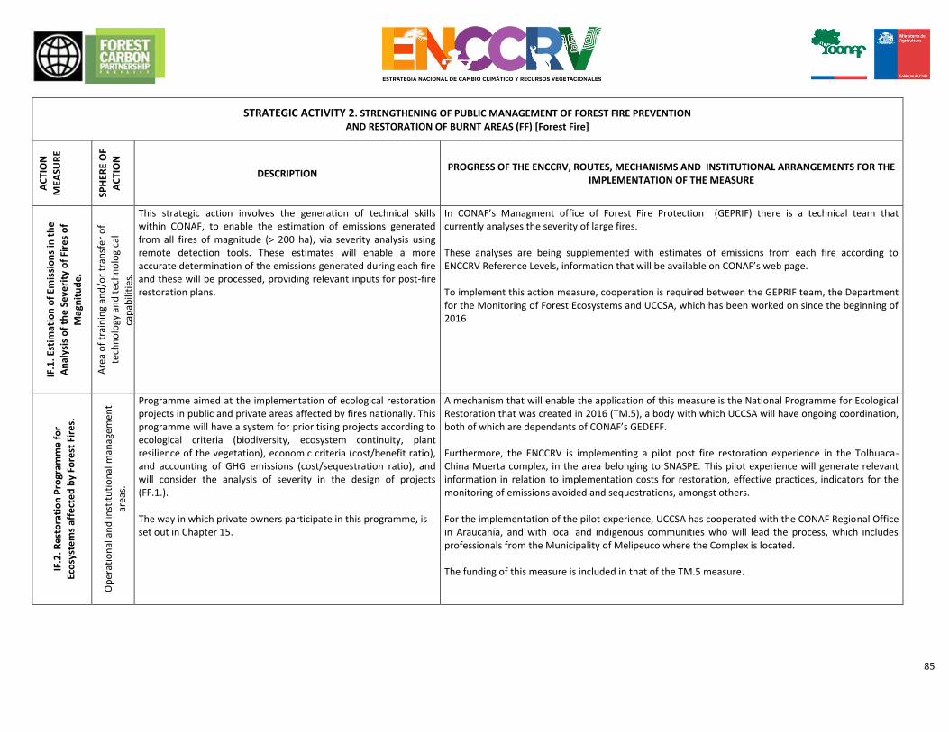
85
STRATEGIC ACTIVITY 2. STRENGTHENING OF PUBLIC MANAGEMENT OF FOREST FIRE PREVENTION
AND RESTORATION OF BURNT AREAS (FF) [Forest Fire]
AC
TIO
N
MEA
SUR
E
SPH
ERE
OF
AC
TIO
N
DESCRIPTION PROGRESS OF THE ENCCRV, ROUTES, MECHANISMS AND INSTITUTIONAL ARRANGEMENTS FOR THE
IMPLEMENTATION OF THE MEASURE
IF.1
. Est
imat
ion
of
Emis
sio
ns
in t
he
An
alys
is o
f th
e S
eve
rity
of
Fire
s o
f
Mag
nit
ud
e.
Are
a o
f tr
ain
ing
and
/or
tran
sfe
r o
f
tech
no
logy
an
d t
ech
no
logi
cal
cap
abili
ties
.
This strategic action involves the generation of technical skills within CONAF, to enable the estimation of emissions generated from all fires of magnitude (> 200 ha), via severity analysis using remote detection tools. These estimates will enable a more accurate determination of the emissions generated during each fire and these will be processed, providing relevant inputs for post-fire restoration plans.
In CONAF’s Managment office of Forest Fire Protection (GEPRIF) there is a technical team that currently analyses the severity of large fires. These analyses are being supplemented with estimates of emissions from each fire according to ENCCRV Reference Levels, information that will be available on CONAF’s web page. To implement this action measure, cooperation is required between the GEPRIF team, the Department for the Monitoring of Forest Ecosystems and UCCSA, which has been worked on since the beginning of 2016
IF.2
. Re
sto
rati
on
Pro
gram
me
fo
r
Eco
syst
em
s af
fect
ed
by
Fore
st F
ire
s.
Op
erat
ion
al a
nd
inst
itu
tio
nal
man
agem
en
t
area
s.
Programme aimed at the implementation of ecological restoration projects in public and private areas affected by fires nationally. This programme will have a system for prioritising projects according to ecological criteria (biodiversity, ecosystem continuity, plant resilience of the vegetation), economic criteria (cost/benefit ratio), and accounting of GHG emissions (cost/sequestration ratio), and will consider the analysis of severity in the design of projects (FF.1.). The way in which private owners participate in this programme, is set out in Chapter 15.
A mechanism that will enable the application of this measure is the National Programme for Ecological Restoration that was created in 2016 (TM.5), a body with which UCCSA will have ongoing coordination, both of which are dependants of CONAF’s GEDEFF. Furthermore, the ENCCRV is implementing a pilot post fire restoration experience in the Tolhuaca-China Muerta complex, in the area belonging to SNASPE. This pilot experience will generate relevant information in relation to implementation costs for restoration, effective practices, indicators for the monitoring of emissions avoided and sequestrations, amongst others. For the implementation of the pilot experience, UCCSA has cooperated with the CONAF Regional Office in Araucanía, and with local and indigenous communities who will lead the process, which includes professionals from the Municipality of Melipeuco where the Complex is located. The funding of this measure is included in that of the TM.5 measure.
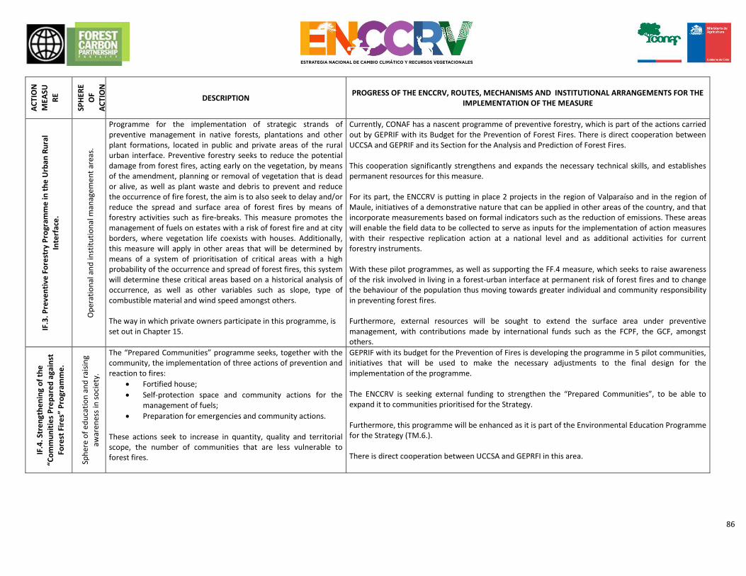
86
AC
TIO
N
MEA
SU
RE
SPH
ERE
OF
AC
TIO
N
DESCRIPTION PROGRESS OF THE ENCCRV, ROUTES, MECHANISMS AND INSTITUTIONAL ARRANGEMENTS FOR THE
IMPLEMENTATION OF THE MEASURE
IF.3
. Pre
ven
tive
Fo
rest
ry P
rogr
amm
e in
th
e U
rban
Ru
ral
Inte
rfac
e.
Op
erat
ion
al a
nd
inst
itu
tio
nal
man
agem
en
t ar
eas.
Programme for the implementation of strategic strands of preventive management in native forests, plantations and other plant formations, located in public and private areas of the rural urban interface. Preventive forestry seeks to reduce the potential damage from forest fires, acting early on the vegetation, by means of the amendment, planning or removal of vegetation that is dead or alive, as well as plant waste and debris to prevent and reduce the occurrence of fire forest, the aim is to also seek to delay and/or reduce the spread and surface area of forest fires by means of forestry activities such as fire-breaks. This measure promotes the management of fuels on estates with a risk of forest fire and at city borders, where vegetation life coexists with houses. Additionally, this measure will apply in other areas that will be determined by means of a system of prioritisation of critical areas with a high probability of the occurrence and spread of forest fires, this system will determine these critical areas based on a historical analysis of occurrence, as well as other variables such as slope, type of combustible material and wind speed amongst others. The way in which private owners participate in this programme, is set out in Chapter 15.
Currently, CONAF has a nascent programme of preventive forestry, which is part of the actions carried out by GEPRIF with its Budget for the Prevention of Forest Fires. There is direct cooperation between UCCSA and GEPRIF and its Section for the Analysis and Prediction of Forest Fires. This cooperation significantly strengthens and expands the necessary technical skills, and establishes permanent resources for this measure. For its part, the ENCCRV is putting in place 2 projects in the region of Valparaíso and in the region of Maule, initiatives of a demonstrative nature that can be applied in other areas of the country, and that incorporate measurements based on formal indicators such as the reduction of emissions. These areas will enable the field data to be collected to serve as inputs for the implementation of action measures with their respective replication action at a national level and as additional activities for current forestry instruments. With these pilot programmes, as well as supporting the FF.4 measure, which seeks to raise awareness of the risk involved in living in a forest-urban interface at permanent risk of forest fires and to change the behaviour of the population thus moving towards greater individual and community responsibility in preventing forest fires. Furthermore, external resources will be sought to extend the surface area under preventive management, with contributions made by international funds such as the FCPF, the GCF, amongst others.
IF.4
. Str
en
gth
en
ing
of
the
“Co
mm
un
itie
s P
rep
are
d a
gain
st
Fore
st F
ire
s” P
rogr
amm
e.
Sph
ere
of
edu
cati
on
an
d r
aisi
ng
awar
enes
s in
so
ciet
y.
The “Prepared Communities” programme seeks, together with the community, the implementation of three actions of prevention and reaction to fires:
Fortified house;
Self-protection space and community actions for the management of fuels;
Preparation for emergencies and community actions. These actions seek to increase in quantity, quality and territorial scope, the number of communities that are less vulnerable to forest fires.
GEPRIF with its budget for the Prevention of Fires is developing the programme in 5 pilot communities, initiatives that will be used to make the necessary adjustments to the final design for the implementation of the programme. The ENCCRV is seeking external funding to strengthen the “Prepared Communities”, to be able to expand it to communities prioritised for the Strategy. Furthermore, this programme will be enhanced as it is part of the Environmental Education Programme for the Strategy (TM.6.). There is direct cooperation between UCCSA and GEPRFI in this area.
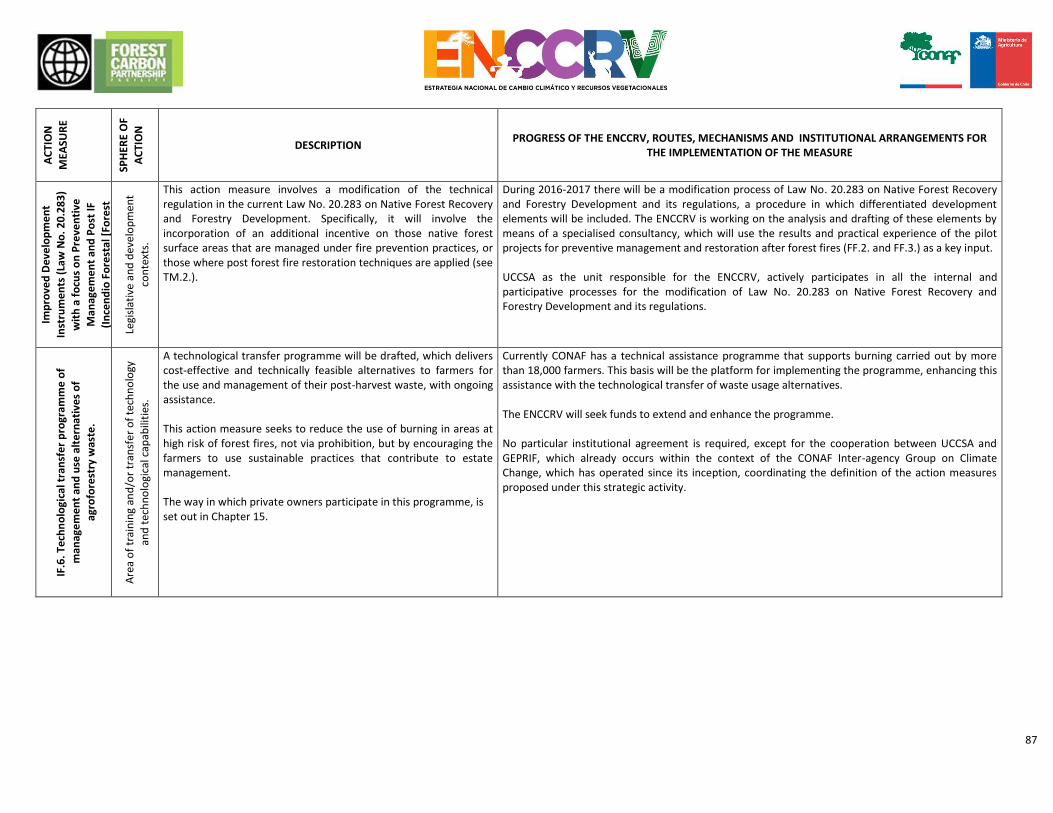
87
AC
TIO
N
MEA
SUR
E
SPH
ERE
OF
AC
TIO
N
DESCRIPTION PROGRESS OF THE ENCCRV, ROUTES, MECHANISMS AND INSTITUTIONAL ARRANGEMENTS FOR
THE IMPLEMENTATION OF THE MEASURE
IF.5
. Im
pro
ved
De
velo
pm
en
t
Inst
rum
en
ts (
Law
No
. 20
.28
3)
wit
h a
fo
cus
on
Pre
ven
tive
Man
age
me
nt
and
Po
st IF
(In
cen
dio
Fo
rest
al [
Fore
st
Fire
]) R
est
ora
tio
n.
Legi
slat
ive
and
dev
elo
pm
en
t
con
text
s.
This action measure involves a modification of the technical regulation in the current Law No. 20.283 on Native Forest Recovery and Forestry Development. Specifically, it will involve the incorporation of an additional incentive on those native forest surface areas that are managed under fire prevention practices, or those where post forest fire restoration techniques are applied (see TM.2.).
During 2016-2017 there will be a modification process of Law No. 20.283 on Native Forest Recovery and Forestry Development and its regulations, a procedure in which differentiated development elements will be included. The ENCCRV is working on the analysis and drafting of these elements by means of a specialised consultancy, which will use the results and practical experience of the pilot projects for preventive management and restoration after forest fires (FF.2. and FF.3.) as a key input. UCCSA as the unit responsible for the ENCCRV, actively participates in all the internal and participative processes for the modification of Law No. 20.283 on Native Forest Recovery and Forestry Development and its regulations.
IF.6
. Te
chn
olo
gica
l tra
nsf
er
pro
gram
me
of
man
age
me
nt
and
use
alt
ern
ativ
es
of
agro
fore
stry
was
te.
Are
a o
f tr
ain
ing
and
/or
tran
sfe
r o
f te
chn
olo
gy
and
tec
hn
olo
gica
l cap
abili
ties
.
A technological transfer programme will be drafted, which delivers cost-effective and technically feasible alternatives to farmers for the use and management of their post-harvest waste, with ongoing assistance. This action measure seeks to reduce the use of burning in areas at high risk of forest fires, not via prohibition, but by encouraging the farmers to use sustainable practices that contribute to estate management. The way in which private owners participate in this programme, is set out in Chapter 15.
Currently CONAF has a technical assistance programme that supports burning carried out by more than 18,000 farmers. This basis will be the platform for implementing the programme, enhancing this assistance with the technological transfer of waste usage alternatives. The ENCCRV will seek funds to extend and enhance the programme. No particular institutional agreement is required, except for the cooperation between UCCSA and GEPRIF, which already occurs within the context of the CONAF Inter-agency Group on Climate Change, which has operated since its inception, coordinating the definition of the action measures proposed under this strategic activity.
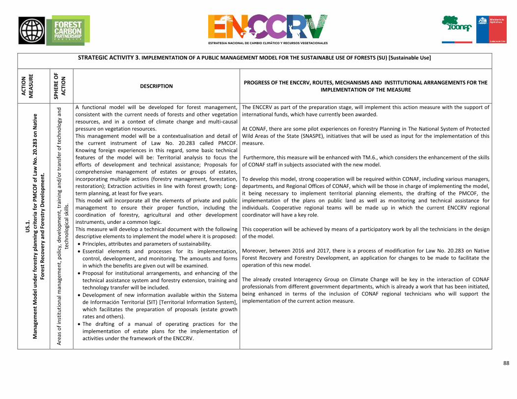
88
STRATEGIC ACTIVITY 3. IMPLEMENTATION OF A PUBLIC MANAGEMENT MODEL FOR THE SUSTAINABLE USE OF FORESTS (SU) [Sustainable Use]
AC
TIO
N
MEA
SUR
E
SPH
ERE
OF
AC
TIO
N
DESCRIPTION PROGRESS OF THE ENCCRV, ROUTES, MECHANISMS AND INSTITUTIONAL ARRANGEMENTS FOR THE
IMPLEMENTATION OF THE MEASURE
US.
1.
Man
age
me
nt
Mo
de
l un
de
r fo
rest
ry p
lan
nin
g cr
ite
ria
for
PM
CO
F o
f La
w N
o. 2
0.2
83
on
Nat
ive
Fore
st R
eco
very
an
d F
ore
stry
Dev
elo
pm
en
t.
Are
as o
f in
stit
uti
on
al m
anag
eme
nt,
po
licy,
dev
elo
pm
en
t, t
rain
ing
and
/or
tran
sfer
of
tech
no
logy
an
d
tech
no
logi
cal s
kills
.
A functional model will be developed for forest management, consistent with the current needs of forests and other vegetation resources, and in a context of climate change and multi-causal pressure on vegetation resources. This management model will be a contextualisation and detail of the current instrument of Law No. 20.283 called PMCOF. Knowing foreign experiences in this regard, some basic technical features of the model will be: Territorial analysis to focus the efforts of development and technical assistance; Proposals for comprehensive management of estates or groups of estates, incorporating multiple actions (forestry management, forestation, restoration); Extraction activities in line with forest growth; Long-term planning, at least for five years. This model will incorporate all the elements of private and public management to ensure their proper function, including the coordination of forestry, agricultural and other development instruments, under a common logic. This measure will develop a technical document with the following descriptive elements to implement the model where it is proposed:
Principles, attributes and parameters of sustainability.
Essential elements and processes for its implementation, control, development, and monitoring. The amounts and forms in which the benefits are given out will be examined.
Proposal for institutional arrangements, and enhancing of the technical assistance system and forestry extension, training and technology transfer will be included.
Development of new information available within the Sistema de Información Territorial (SIT) [Territorial Information System], which facilitates the preparation of proposals (estate growth rates and others).
The drafting of a manual of operating practices for the implementation of estate plans for the implementation of activities under the framework of the ENCCRV.
The ENCCRV as part of the preparation stage, will implement this action measure with the support of international funds, which have currently been awarded. At CONAF, there are some pilot experiences on Forestry Planning in The National System of Protected Wild Areas of the State (SNASPE), initiatives that will be used as input for the implementation of this measure. Furthermore, this measure will be enhanced with TM.6., which considers the enhancement of the skills of CONAF staff in subjects associated with the new model. To develop this model, strong cooperation will be required within CONAF, including various managers, departments, and Regional Offices of CONAF, which will be those in charge of implementing the model, it being necessary to implement territorial planning elements, the drafting of the PMCOF, the implementation of the plans on public land as well as monitoring and technical assistance for individuals. Cooperative regional teams will be made up in which the current ENCCRV regional coordinator will have a key role. This cooperation will be achieved by means of a participatory work by all the technicians in the design of the model. Moreover, between 2016 and 2017, there is a process of modification for Law No. 20.283 on Native Forest Recovery and Forestry Development, an application for changes to be made to facilitate the operation of this new model. The already created Interagency Group on Climate Change will be key in the interaction of CONAF professionals from different government departments, which is already a work that has been initiated, being enhanced in terms of the inclusion of CONAF regional technicians who will support the implementation of the current action measure.
89
AC
TIO
N
MEA
SUR
E
SPH
ERE
OF
AC
TIO
N
DESCRIPTION
PROGRESS OF THE ENCCRV, ROUTES, MECHANISMS AND
INSTITUTIONAL ARRANGEMENTS FOR THE IMPLEMENTATION OF THE
MEASURE
US.
2. T
err
ito
rial
pla
nn
ing
for
the
de
velo
pm
en
t o
f fo
rest
ry
man
age
me
nt.
Sph
ere
of
Terr
ito
rial
Pla
nn
ing.
This consists in boosting the function of Territorial Planning for native forests and other vegetation resources within the CONAF Regional Offices, to generate information and management at a community level. The information that is generated will provide feedback to the community authorities, and about the development and technical assistance programmes, so that decisions can be taken from a technical basis. This function will permanently generate relevant information for taking decisions, for instance: • Community prioritisation regarding the potential removal of carbon or reduction of the level of GHG emissions, according to the analysis of the most vulnerable areas drafted by the ENCCRV. • Definition of the minimum forest threshold surface area of forests at a community level, as a regulation and land management instrument to avoid deforestation, degradation and to promote forestation and replanting. • Identification of communal public forests with potential for forest management. • Community maps with forest growth rates. • Focusing of technical assistance in communities and prioritised areas with environmental, social and economic criteria. • Community demand for vegetation resource goods and services. • Potential offer of goods and services from vegetation resources, when new PMCOF are implemented in the region. • Coordinate chain events for products originating from PMCOF. Similarly, ancestral knowledge from the original culture has been considered for inclusion into this measure in relation to forestry management and to draft programmes to address sustainable management in areas with indigenous communities.
This function will be part of the management model defined in SU.1., and its creation or formalisation in the CONAF Regional Offices, because it is considered in the implementation of this model. To develop this measure, close cooperation is required by UCCSA with the Regional Offices, processes in which the regional coordinator of the ENCCRV has a key role.
US.
3. P
erm
ane
nt
pro
gram
me
of
Fore
stry
Pla
nn
ing
on
pu
blic
lan
d.
Op
erat
ion
al a
nd
inst
itu
tio
nal
man
agem
ent
area
s.
Chile’s forestry service will have a permanent programme for the management of public forests, which must be carried out using the PMCOF form. This programme will have the following advantages: • These will be the management cores for triggering production chain processes associated with native forest goods and services, promoting investment, infrastructure improvements, rural associations, amongst others. • These will be model PMCOF areas that will serve as a technical reference for interested private parties. • These will be training processes for the state technical teams who will have to draft, execute and monitor the PMCOF. • Permanent source of public resources generated with the sustainable management of public forests. The proposal is for the net benefit of this management to be redirected to the action measures that the ENCCRV is implementing. The programme will commence in the areas that have been prioritised by the ENCCRV, focusing on the management of public lands in community hotspots.
There is some experience of public forestry management in SNASPE, initiatives that will be used as inputs for the implementation of this measure. This programme will be implemented in each region, by the teams arranged according to what is set out in action measure SU.1.
90
AC
TIO
N
MEA
SUR
E
SPH
ERE
OF
AC
TIO
N
DESCRIPTION
PROGRESS OF THE ENCCRV, ROUTES, MECHANISMS AND
INSTITUTIONAL ARRANGEMENTS FOR THE IMPLEMENTATION OF THE
MEASURE
US.
4. F
ocu
sed
Ext
en
sio
n in
th
e P
MC
OF
Op
erat
ive
and
dev
elo
pm
ent
con
text
s.
The forestry service will drive the Forestry Planning in private forests, by means of the provision of technical assistance to owners and groups of owners who wish to enter the system under the logic of the PMCOF, respecting its principles and restrictions. CONAF will draft estate or supra-estate management plans for 10 years of planning, for free for these owners, and will assist them during the whole implementation, including the technical transfer of good practice. Those owners who have management plans in place and/or a history of positive technical assistance, according to the experience of local extension workers, will have priority when it comes to this assistance. The programme will commence in areas that are prioritised by the ENCCRV, focusing the planning of private estates in the community hotspots. For estates or groups of estates that are managed under a PMCOF, linked loans will be provided to cover the costs for the implementation of initial planning activities. The way in which private owners participate in this programme, is set out in Chapter 15.
CONAF has an extension programme in operation over most of the regions of the country, which will be driven and strengthened by the ENCCRV according to what is established in SU.1, SU.2. and TM.6. The drafting of these PMCOF will be part of the technical assistance conducted by the assembled regional teams, considering what is established in action measures SU.1. and SU.2.
US.
5.
Inte
grat
ed
reg
ula
tory
an
d t
ax e
xem
pti
on
sys
tem
fo
r th
e
pro
mo
tio
n o
f a
pro
du
ctiv
e c
hai
n.
Legi
slat
ive
and
dev
elo
pm
en
t co
nte
xts.
The technical, legal and economic feasibility of generating tax exemptions and other regulatory mechanisms that drive the production chain of timber and non-timber products generated by the sustainable management of forests under planning schemes, will be designed and assessed. These mechanisms go from estate production until the sale of the products in the retail market, and the aim is to improve the profitability of the owners and all the players in the value chain, in part matching the competitive conditions to the predominant informal market. A preliminary proposal of concrete mechanisms would be: • Forest owners may have a tax reduction on the sale of the whole estate (agricultural, livestock and forestry), equivalent to the % of estate surface area under PMCOF. • VAT will not be paid on raw material originating from the PMCOF throughout the whole production chain. • Taxation system for native forest products at the points of sale to the public, requiring traceability of the products by means of a document that certifies the origin and the existence of a management plan. • Regulatory mechanism that encourages the use of native forest biomass in the generation of energy for estate management. • Regulatory mechanism that encourages the use of wood originating from the PMCOF by public services. • Regulatory mechanism that encourages the use of wood originating from the PMCOF in new buildings in the community in which the forestry management plan or plans are implemented.
Chile, and specifically CONAF, has a history of tax exemptions as mechanisms of forestry and agricultural promotion, therefore, there is technical and legal background data for the basic design of this measure. The ENCCRV will have the support of a specialist technical regulatory consultancy to implement this measure. The feasibility studies will involve the Ministry of Finance and the Internal Revenue Service (SII) of the country, institutions with which UCCSA must cooperate.
91
AC
TIO
N
MEA
SUR
E
SPH
ERE
OF
AC
TIO
N
DESCRIPTION PROGRESS OF THE ENCCRV, ROUTES, MECHANISMS AND INSTITUTIONAL ARRANGEMENTS FOR THE
IMPLEMENTATION OF THE MEASURE
US.
6. D
en
dro
-En
erg
y st
rate
gy f
or
the
man
age
me
nt
and
pro
du
ctio
n c
ha
in o
f fi
rew
oo
d
Op
erat
ion
al s
ph
ere
Within the framework of CONAF’s Dendro-Energy Strategy, integrated forest management projects are being implemented, where the main objective is the generation of certified firewood to meet the demand of consumption centres of communities prioritised by the ENCCRV. The following actions are included amongst the aspects contained in this action measure: the development of estate plans for the sustainable management of forests under planning criteria (SU.1.); implementation of centres for the gathering and drying of firewood; development of a production chain and fair trade systems and, certification of firewood. This measure contains various projects and activities that are aimed at combating the unsustainable use of biomass, being constituted as a highly significant instrument for the development of the new “Policy for the sustainable use of firewood and its derivatives for heating”. The way in which private owners participate in this programme, is set out in Chapter 15.
ENCCRV advances to drive this action measure include two specific projects, which are being implemented: - “Firewood Pilot Projects”, which include the design and raising of key information to deal with the
causes of deforestation and forest degradation due to the unsustainable use of firewood, by means of commercial extension and facilitation that promotes its responsible use in vulnerable rural and urban populations. These pilot projects will provide key inputs for the expansion of the Dendro-Energy Strategy.
- “Firewood Traceability” that will generate a diagnosis of means, standards and players involved in the sale of firewood nationally, specifically aspects regarding the monitoring, auditing and information about the market associated with forest products.
- Since 2016 there have been the so-called “Advocates of Dendro-Energy” who have a specific role
in terms of implementing the Strategy in regions. In total there are 7 promoters, one per region from Maule to Aysén, directly funded by CONAF.
The Dendro-Energy Strategy joins together UCCSA, the Wood Energy Unit, the Native Forest Department all belonging to the same Management Office at CONAF, whilst the technical assistance programme involves cooperation with the Department of Forestry Control of the Environmental Audit and Evaluation Management and with the various CONAF Regional Offices. The Dendro-Energy Strategy is funded using fiscal resources from the technical assistance programme, and from the fund of Law No. 20.283, and with supplementary contributions from international funds.
92
STRATEGIC ACTIVITY 4. IMPLEMENTATION OF PUBLIC-PRIVATE MANAGEMENT MODEL AREAS TO ENABLE COORDINATION
OF FOREST AND LIVESTOCK MANAGEMENT (MM) [Management Model]
AC
TIO
N
MEA
SUR
E
SPH
ERE
OF
AC
TIO
N
DESCRIPTION PROGRESS OF THE ENCCRV, ROUTES, MECHANISMS AND
INSTITUTIONAL ARRANGEMENTS FOR THE IMPLEMENTATION OF THE MEASURE
MG
.1. B
uff
er
zon
es
for
live
sto
ck a
ctiv
ity
Op
erat
ion
al a
nd
inst
itu
tio
nal
man
agem
en
t ar
eas.
The aim of this measure is to regulate the use of public sites commonly used for grazing, in order to minimise the impact of livestock on sites that are important for their conservation value or as a carbon sink. The implementation of these management areas includes an assistance programme aimed at owners of properties located adjacent to protected areas or public lands. At an estate level, holistic technical assistance should be provided by means of the management and coordination of promotion instruments available for forest management and livestock (e.g. improvement of grasslands, estate management, health management, etc.) enabling the improved availability of forage, the protection of the forest ensuring access to water sources within the estate. At an estate level it is intended to generate a management model enabling the administration and management of the consensual buffer zone between the players both from the public sector, as well as from the private sector, who are involved in the territory. Pilot zones will be implemented on land adjacent to public areas that are under the permanent Forestry Planning on public land programme SU.3. The implementation of the management areas considers various specific activities: • Permanent technical assistance and the generation of capacities. • Involvement of players and strengthening of social and community organisations • Management and coordination of development instruments to tackle forest and livestock management in an integrated way.
An experience of this kind took place via the GEF SIRAP project, between the Reserva Costera Valdiviana [Valdiviana Coastal Reserve] (TNC [The Nature Conservancy]) and smallholders bordering this unit. These experiences will serve as a model to design and implement this measure.
To finance the implementation of the pilot zones, CONAF’s usual extension budget will be used, which will be boosted by international funds.
To carry out the specific actions of this measure an INDAP and CONAF team of extension workers must be assembled, in order to involve the owners concerned and carry out technical studies for the implementation of the zones. This measure will require institutional commitment at a regional and provincial level, to focus part of the technical assistance efforts in these areas.
There is a framework cooperation agreement between CONAF and INDAP that includes these issues.
93
AC
TIO
N
MEA
SUR
E
SPH
ERE
OF
AC
TIO
N
DESCRIPTION PROGRESS OF THE ENCCRV, ROUTES, MECHANISMS AND INSTITUTIONAL ARRANGEMENTS FOR THE
IMPLEMENTATION OF THE MEASURE
MG
.2. S
tre
ngt
he
nin
g an
d e
xpan
sio
n o
f A
dvi
ce f
or
the
man
age
me
nt
of
sum
me
r gr
azin
g.
Sph
ere
of
inst
itu
tio
nal
man
agem
ent.
Summer grazing is a tradition that is deeply rooted amongst livestock breeders throughout the country. This rotation system (summer grazing-winter grazing) enables a reduction of pressure on the forest during the summer season and to ensure the subsistence of cattle mainly in the northern sector of the country, which is strongly affected by drought. The aim of this measure is to standardise and promote management practices in the summer grazing areas, given the elevated animal load in the summer and the weak legal framework that exists for its regulation and management, thus mitigating the serious damage that these practices cause to the vegetation resources. This measure aims to coordinate civil society players, the public sector and owners associated with the management of summer grazing at a local level to promote a public-private work network, aimed at generating actions associated with the administration and management of these areas, enhancing and expanding the already existing basic organisations.
In the community of Lonquimay (region of Araucanía) an initiative of this kind has been carried out for years. The Pro-defence of Summer Grazing Committee of Ranquil has carried out a pilot project with state organisations and the municipality, generating work agreements with the Ministry of National Assets in order to obtain a concession for free use of the public estate of Ranquil to be administered by the sector’s settlers. As a result of this work, a Community Council for Summer Grazing has been put together, which is attempting to replicate this successful model in other sectors of the community.
The management model established in Lonquimay will be the basis for the design of a programme that will be replicated in other areas of the country, considering the social-cultural and environmental specifics of each sector. New Community Councils for Summer Grazing will be established in municipalities prioritised by the ENCCRV. To carry out this measure, the coordination of the community players will be supported so that they can set up and implement community summer grazing councils. The assembled regional technical team that is established in action measure SU.1., must be encouraged to be a permanent part of the Community Councils for Summer Grazing.
MG
.3. A
gro
fore
stry
Re
sear
ch P
rogr
amm
e
Sco
pe
of
the
Res
earc
h.
This Programme will conduct studies that deliver relevant information as technical support for measures MM.1. and MM.2. The thematic research lines will at least be: 1. Implementation of studies about the forage balance in order to determine the nutritional requirements of cattle from a point of view of the quantity and quality of forage. This will enable an estimation of the amount of investment required for the implementation of programmes aimed at nutritional improvement for livestock in prioritised areas of intervention (high degradation). This will make it possible to adapt the existing instruments for development and complementary programs, or to explore alternatives to meet the nutritional needs of cattle. This action as linked to the Plan for Adaptation of Climate Change of the Agroforestry Sector (2008-2012) currently being updated, which includes, as part of its strategy, the promotion of social development in the most vulnerable agricultural groups and to enhance the current mechanisms of the SIRSD Programme. 2. Design of low cost technology for the fitting out of watering equipment for livestock, as well as the evaluation of funding strategies for its implementation according to existing development programmes. This is aimed at providing support for family agriculture water requirements, especially in areas where water resources are scarce. The aim is to avoid the use of natural water courses inside the forest and the free transit of livestock for this purpose.
To carry out this measure, the topics noted within the research lines of Law No. 20.283 will be incorporated, and cooperation efforts will be made with other similar research bodies of the Ministry of Agriculture (MINAGRI). There is no progress.
94
STRATEGIC ACTIVITY 5. ADAPTIVE MANAGEMENT OF VEGETATION RESOURCES AGAINST THE EFFECTS OF CLIMATE CHANGE, DESERTIFICATION, DEGRADATION OF THE LAND AND DROUGHT (AM) [Adaptive Management]
AC
TIO
N
MEA
SUR
E
SPH
ERE
OF
AC
TIO
N
DESCRIPTION PROGRESS OF THE ENCCRV, ROUTES, MECHANISMS AND INSTITUTIONAL ARRANGEMENTS FOR THE
IMPLEMENTATION OF THE MEASURE
95
GA
.1. A
dap
tati
on
pro
gram
me
fo
r th
e m
anag
em
en
t o
f ve
geta
tio
n r
eso
urc
es
un
de
r cl
imat
e
chan
ge, d
ese
rtif
icat
ion
, de
grad
ati
on
of
the
lan
d a
nd
dro
ugh
t.
Sph
eres
of
op
erat
ion
, in
stit
uti
on
al m
anag
eme
nt,
res
earc
h, a
nd
tra
nsf
er o
f te
chn
olo
gy a
nd
tech
no
logi
cal c
apab
iliti
es.
CONAF, as the focal point in Chile for the REDD+ approach to the United Nations Framework Convention on Climate Change (UNFCCC) and the focal point for the United Nations Convention to Combat Desertification (UNCCD), will coordinate the implementation of an adaptation programme for the management of vegetation resources in the context of climate change, which will design relevant inputs for the design and implementation of programmes for forestry, restoration and sustainable forest management under the ENCCRV. This programme is based on the coordination and enhancing of various existing national bodies, which will focus efforts on the following objectives: • Creation of a permanent monitoring system on the effects of the drought on native vegetation formations. This monitoring will assess the specific effects of the drought on populations and specific vegetation associations and also the effects on the landscape, monitoring the changes and modelling potential shifts of vegetation communities. • Drafting of studies focused on water cycles in native vegetation communities in areas of water scarcity, analysing the impact of human activity, and the effects on the degradation of ecosystems. • Enhancement and expansion of ex situ conservation programmes, genetic selection and improvement of vegetation resources for adaptation to climate change. • Enhancement and expansion of programmes for the generation and evaluation of forestry methods and schemes for forestation, restoration and productive management, adapted to climate change. To this extent the LDN-TSP project will contribute with the identification of national targets on Land Degradation Neutrality (LDN) in line with the targets of the NDC and the ENCCRV.
Initial actions that drive this measure are the development of two studies that will generate the following documents:
Programa de Acción Nacional contra la Desertificación (PANCD-Chile) [National Action Programme against Desertification - Chile] in line with the CNUL Ten Year Strategy, the target on land degradation neutrality and the ENCCRV.
National UNCCD 2016 Report to be submitted before the UNCCD Executive Secretariat, including information generated under the ENCCRV about the strategic and operational objectives of the UNCCD Ten-Year strategy.
Another key input to strengthen this measure will be the results of the “Design of a protocol to measure the attributes of climatic adaptation and non-carbon environmental services for initiatives that reduce and/or remove GHG emissions” project, which is being implemented by the ENCCRV. The contribution by this study will be related to the determination of a protocol for general monitoring, useful for determining the degree of reduction of vulnerability to climate change by implementing forest/plant actions at a territorial level, such as reforestation with native flora in river basins. To this end, a number of effective and easily measured indicators will be established in the field, focused on the evaluation of non-carbon environmental services that forests and xerophytic formations provide, with a specific focus on indicators regarding water resources, soil resources, biodiversity, social indicators and resilience. In a first stage, a baseline will be created to subsequently measure the performance of activities used to reduce vulnerability at a project level. This programme requires cooperation efforts in multiple inter-ministerial initiatives, including: • National Action Programme for the Fight against Desertification, Degradation of the Land and Drought in Chile (PANCD-Chile 2016 - 2030). • Plan for Adaptation to Climate Change in the Agroforestry Sector. • Land Degradation Neutrality Project LDN-TSP, which will contribute to the identification of national targets on land degradation neutrality (LDN) in line with the targets of the INDC [Intended Nationally Determined Contributions] and ENCCRV. • Conservation and genetic improvement strategy. Forestry Institute (INFOR). • Plan for Adaptation to Climate Change for Biodiversity. • Plan for Adaptation to Climate Change for Water Resources. • Research Fund for the Native Forest Law. This coordination will enable existing resources to be focused on this programme, which will also be complemented by support from international funds such as the FCPF and GCF.
STRATEGIC ACTIVITY 6. LEGISLATIVE ADJUSTMENTS TO PROGRESS TOWARD A COMPATIBLE AGRICULTURAL DEVELOPMENT
WITH NATIVE VEGETATION RESOURCES (RH)
96
AC
TIO
N
MEA
SUR
E
SPH
ERE
OF
AC
TIO
N
DESCRIPTION PROGRESS OF THE ENCCRV, ROUTES, MECHANISMS AND INSTITUTIONAL ARRANGEMENTS FOR THE
IMPLEMENTATION OF THE MEASURE
RH
.1. M
od
ific
atio
n L
aw 1
9.5
61
th
at e
xem
pts
agr
icu
ltu
ral c
lear
ing
fro
m r
efo
rest
atio
n.
Legi
slat
ive
and
dev
elo
pm
en
t co
nte
xts.
The reforesting exemption that the 1998 Law 19.561 provides for agricultural clearance is an incentive to replace the forest. The elimination of this exemption, or its limitation, could reduce the loss of forests for this cause. Article 22 of Law 19.561 and the second paragraph of Article 33 of the General Regulations have to be modified. The modifications must remove the exemption from reforesting when there is recovery for agricultural purposes of land that is being exploited extractively. In addition to removing the exemption, it is proposed to establish other constraints for agricultural forest clearance: • Allow agricultural clearance only once: this means that the authorisation will not be able to be given more than once. This limitation will apply to the land that, for different reasons, once recovered for agricultural purposes, was abandoned for a period thus allowing for the recovery of native plant life. This land will not be able to be recovered for agricultural purposes once again. • Plans for the closure of fruit orchards: not only the exemption of reforesting, but the absence of closure plans for agricultural farms on Preferably Suitable for Forestry (APF, acronym in spanish) lands. These generate an incentive for the replacement of forests, because the environmental costs that this replacement entails are not internalised. Therefore, it is necessary for the project for agricultural clearance of forest land, to internalise the environmental costs of its operation. Amongst these should be the requirement of a closure plan to ensure soil conservation in those situations where, due to profitability, pests or other reason, agricultural crops have not continued. This closure plan must consider measures for soil conservation and recovery of the existing vegetation prior to change of use.
To implement this measure, the ENCCRV will have the support of a specialist consultancy, for the evaluation of legal, technical and economic feasibility of the modifications. After this process, amendments will be submitted to the relevant ministerial bodies. There is no progress.
97
AC
TIO
N
MEA
SUR
E
SPH
ERE
OF
AC
TIO
N
DESCRIPTION
PROGRESS OF THE ENCCRV, ROUTES, MECHANISMS AND INSTITUTIONAL
ARRANGEMENTS FOR THE IMPLEMENTATION OF THE MEASURE
RH
.2. I
nco
rpo
rate
var
iab
les
for
the
co
nse
rvat
ion
of
fore
sts
to
Law
18
.45
0.
Legi
slat
ive
and
dev
elo
pm
en
t co
nte
xts.
Law 18.450 covers financial support by means of tender, for irrigation works to improve the efficiency and productivity of agricultural activity. When considering variables of forest conservation on the estates that apply for it, an incentive could be generated to reduce deforestation. In paragraph 9, the Law states: The National Irrigation Commission will consider environmental objectives in projects that are reimbursed under the law, with investments in production systems that prevent soil degradation, biodiversity or any other kind of environmental damage being eligible for reimbursement, according to the conditions determined by Law No. 19.300 and the Regulation of Law No. 18.450. In turn, Article 15 of the Regulation called Environmental Safeguards reiterates the previous wording, but does not provide additional information on how the incorporation of environmental safeguards at the Tender stage are implemented in practice. Only Article 9 of the Regulation, which lists the technical background data that an irrigation project must contain, includes two requirements: g) Resolution of Environmental Classification, where applicable. h) In the case of Projects that require sectoral authorisation by a state body or service according to current legislation, when submitting the application this must be accompanied by copies of the corresponding sectoral permits. These requirements are insufficient to safeguard the biodiversity of land, as stated in Article 1, paragraph 9 of the Law. Therefore, taking advantage of the existence of these legal clauses, environmental safeguards will be defined that are associated with the existence of forests on the estates submitting applications for legal tenders. For this, the Law does not require modification, only Article 15 of the Regulation. The following preliminary modifications are proposed: • The tender will favour those projects that carry out concrete actions of conservation or restoration of existing forests on their estates, thus favouring the protection of biodiversity and preventing the degradation of the land, in accordance with what is established in Article 1 of the Law. • To apply for the tender, the area of existing forests on the estate must be declared, and a commitment to keep it this way must be signed.
To implement this measure, there will be a specialist consultancy under the ENCCRV that will assess the legal, technical and economic feasibility of the modifications. After this process, the amendment proposals will be submitted to the relevant ministerial bodies. There is no progress.
RH
.3.
Lim
it t
he
ap
plic
atio
n o
f La
w
20
.41
2 o
n A
PF
soils
.
Legi
slat
ive
and
dev
elo
pm
en
t
con
text
s.
The system of incentives for agro-environmental sustainability of agricultural lands (Ex SIRSD), of Law No. 20.412/2010 funds the following in its component 5: Rehabilitation Practices for Land for Agricultural Use. This component stimulates the elimination, cleaning or confinement of stumps, dead tree trunks, scrub with no foraging value or other physical or chemical impediments, on land that is suitable for agricultural purposes by means of an incentive of up to 50% of the net costs of these works, set out in the annual table of costs. Technological advancements have provided flexibility on the limitations posed by hills with land in Class VI, which in turn has led to them being occupied for agricultural crops and therefore are likely to qualify for the incentives of Law 20.412. The application of this incentive to Class VI and VII soils that has any natural vegetation formation without forage value, such as shrubs or xerophytic formations.
To implement this measure, the ENCCRV will have the support of specialist consultancy that will assess the legal, technical and economic feasibility of the modifications. After this process, amendments will be submitted to the relevant ministerial bodies. There is no progress.
98
STRATEGIC ACTIVITY 7. SUPPORT FOR A SUSTAINABLE FOREST SECTOR, WITH NO REPLACEMENT (RS)
AC
TIO
N
MEA
SUR
E
SPH
ERE
OF
AC
TIO
N
DESCRIPTION PROGRESS OF THE ENCCRV, ROUTES, MECHANISMS AND INSTITUTIONAL ARRANGEMENTS FOR THE
IMPLEMENTATION OF THE MEASURE
RS.
1. F
ocu
sin
g o
n r
est
ora
tio
n
pro
gram
s in
are
as t
hat
are
like
ly
to b
e r
ep
lace
d.
Sph
ere
of
Terr
ito
rial
Pla
nn
ing
This measure is aimed at avoiding substitution in degraded native forests. It should be included as a criterion for prioritising the areas to be restored with native species, sectors where forestry activity has a greater influence and therefore is likely be replaced by an expansion of exotic species. This measure is added as part of the SU.2 and TM.5 action measures. Y MT.5
The ENCCRV has an initial prioritisation of communities for restoration actions, a process that will be supplemented by the inclusion of this criterion. Those corresponding to action measures SU.2 and TM.5. Y MT.5
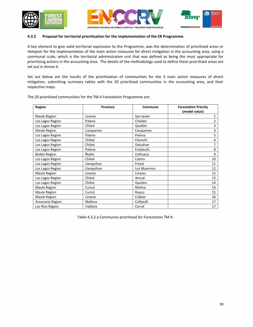
99
4.3.2 Proposal for territorial prioritisation for the implementation of the ER Programme. A key element to give valid territorial expression to the Programme, was the determination of prioritised areas or Hotspots for the implementation of the main action measures for direct mitigation in the accounting area, using a communal scale, which is the territorial administrative unit that was defined as being the most appropriate for prioritising actions in the accounting area. The details of the methodology used to define these prioritised areas are set out in Annex 4. Set out below are the results of the prioritisation of communities for the 3 main action measures of direct mitigation, submitting summary tables with the 20 prioritised communities in the accounting area, and their respective maps. The 20 prioritised communities for the TM.4 Forestation Programme are:
Table 4.3.2.a Communes prioritised for Forestation TM.4.
Region Province Commune Forestation Priority (model value)
Maule Region Linares San Javier 1
Los Lagos Region Palena Chaitén 2
Los Lagos Region Chiloé Quellón 3
Maule Region Cauquenes Cauquenes 4
Los Lagos Region Palena Palena 5
Los Lagos Region Chiloé Chonchi 6
Los Lagos Region Chiloé Dalcahue 7
Los Lagos Region Palena Futaleufú 8
Biobío Region Ñuble Coihueco 9
Los Lagos Region Chiloé Castro 10
Los Lagos Region Llanquihue Fresia 11
Los Lagos Region Llanquihue Los Muermos 12
Maule Region Linares Linares 12
Los Lagos Region Chiloé Ancud 13
Los Lagos Region Chiloé Queilen 14
Maule Region Curicó Molina 14
Maule Region Curicó Rauco 15
Maule Region Linares Colbún 16
Araucanía Region Malleco Collipulli 17
Los Ríos Region Valdivia Corral 17
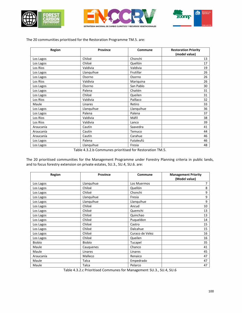
100
The 20 communities prioritised for the Restoration Programme TM.5. are:
Region Province Commune Restoration Priority
(model value)
Los Lagos Chiloé Chonchi 13
Los Lagos Chiloé Quellón 17
Los Ríos Valdivia Valdivia 19
Los Lagos Llanquihue Frutillar 26
Los Lagos Osorno Osorno 26
Los Ríos Valdivia Mariquina 26
Los Lagos Osorno San Pablo 30
Los Lagos Palena Chaitén 31
Los Lagos Chiloé Queilen 31
Los Ríos Valdivia Paillaco 32
Maule Linares Retiro 33
Los Lagos Llanquihue Llanquihue 36
Los Lagos Palena Palena 37
Los Ríos Valdivia Máfil 38
Los Ríos Valdivia Lanco 39
Araucanía Cautín Saavedra 41
Araucanía Cautín Temuco 44
Araucanía Cautín Carahue 46
Los Lagos Palena Futaleufú 46
Los Lagos Llanquihue Fresia 48
Table 4.3.2.b Communes prioritised for Restoration TM.5. The 20 prioritised communities for the Management Programme under Forestry Planning criteria in public lands, and to focus forestry extension on private estates, SU.3., SU.4, SU.6. are:
Region Province Commune Management Priority
(Model value)
Los Lagos Llanquihue Los Muermos 7
Los Lagos Chiloé Quellón 8
Los Lagos Chiloé Chonchi 9
Los Lagos Llanquihue Fresia 9
Los Lagos Llanquihue Llanquihue 9
Los Lagos Chiloé Ancud 10
Los Lagos Chiloé Quemchi 13
Los Lagos Chiloé Quinchao 13
Los Lagos Chiloé Puqueldon 14
Los Lagos Chiloé Castro 15
Los Lagos Chiloé Dalcahue 15
Los Lagos Chiloé Curaco de Velez 16
Los Lagos Chiloé Queilen 16
Biobío Biobío Tucapel 35
Maule Cauquenes Chanco 41
Maule Linares Linares 45
Araucanía Malleco Renaico 47
Maule Talca Empedrado 47
Maule Talca Pelarco 47
Table 4.3.2.c Prioritised Communes for Management SU.3., SU.4, SU.6
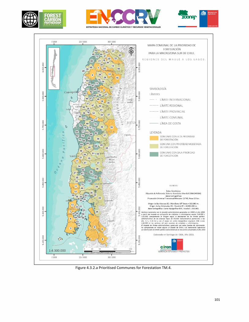
101
Figure 4.3.2.a Prioritised Communes for Forestation TM.4.
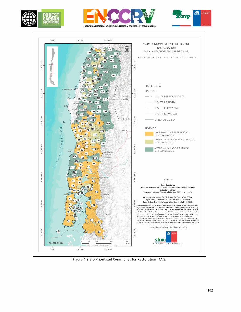
102
Figure 4.3.2.b Prioritised Communes for Restoration TM.5.
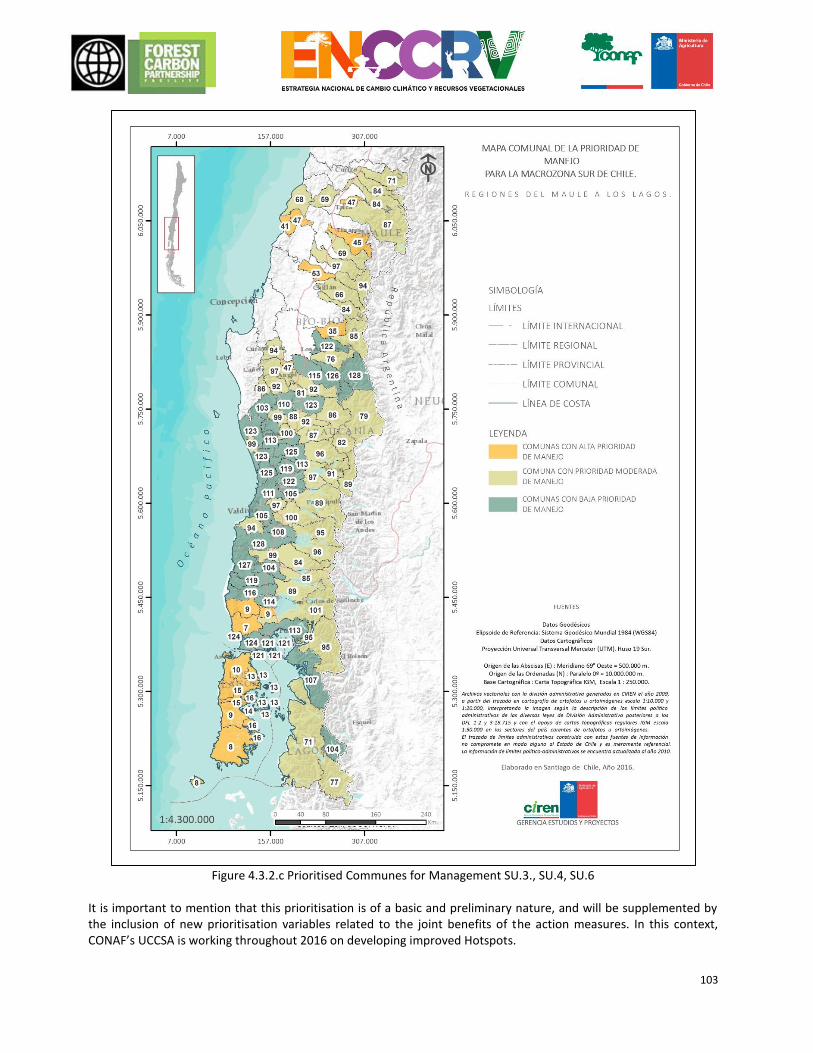
103
Figure 4.3.2.c Prioritised Communes for Management SU.3., SU.4, SU.6
It is important to mention that this prioritisation is of a basic and preliminary nature, and will be supplemented by the inclusion of new prioritisation variables related to the joint benefits of the action measures. In this context, CONAF’s UCCSA is working throughout 2016 on developing improved Hotspots.
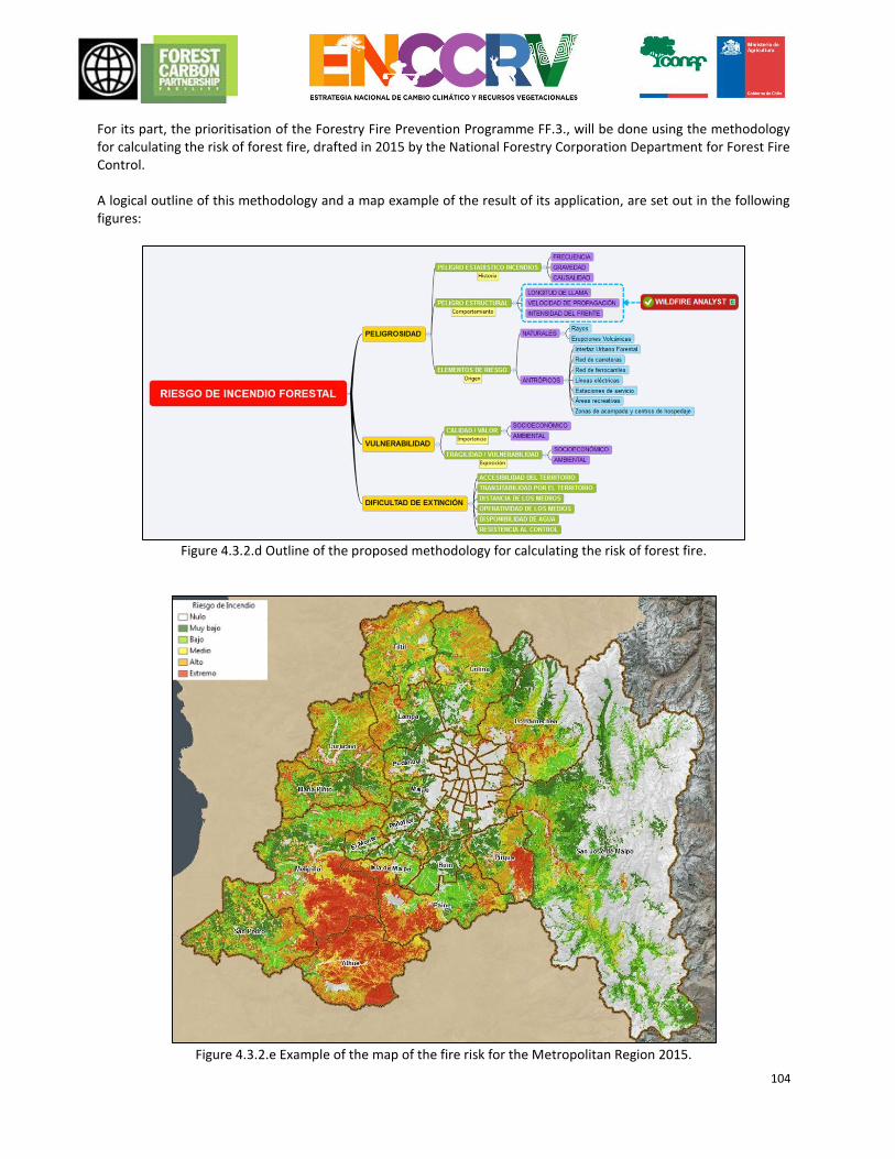
104
For its part, the prioritisation of the Forestry Fire Prevention Programme FF.3., will be done using the methodology for calculating the risk of forest fire, drafted in 2015 by the National Forestry Corporation Department for Forest Fire Control. A logical outline of this methodology and a map example of the result of its application, are set out in the following figures:
Figure 4.3.2.d Outline of the proposed methodology for calculating the risk of forest fire.
Figure 4.3.2.e Example of the map of the fire risk for the Metropolitan Region 2015.
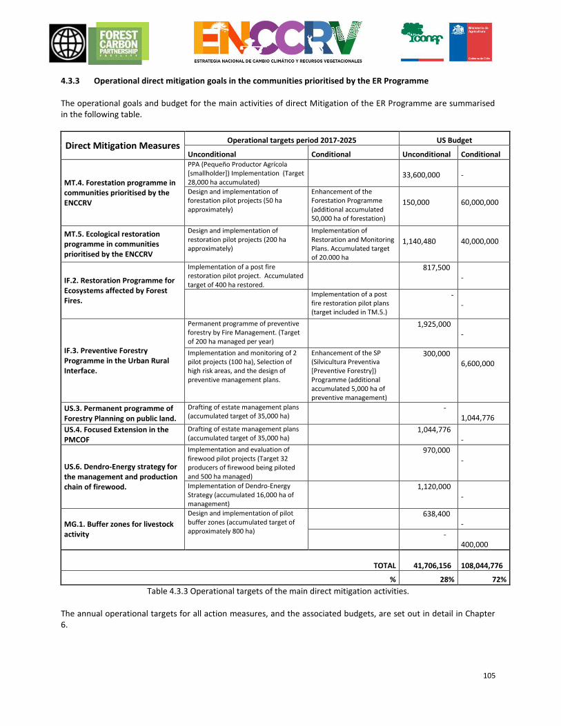
105
4.3.3 Operational direct mitigation goals in the communities prioritised by the ER Programme The operational goals and budget for the main activities of direct Mitigation of the ER Programme are summarised in the following table.
Direct Mitigation Measures Operational targets period 2017-2025 US Budget
Unconditional Conditional Unconditional Conditional
MT.4. Forestation programme in communities prioritised by the ENCCRV
PPA (Pequeño Productor Agrícola [smallholder]) Implementation (Target 28,000 ha accumulated)
33,600,000
-
Design and implementation of forestation pilot projects (50 ha approximately)
Enhancement of the Forestation Programme (additional accumulated 50,000 ha of forestation)
150,000
60,000,000
MT.5. Ecological restoration programme in communities prioritised by the ENCCRV
Design and implementation of restoration pilot projects (200 ha approximately)
Implementation of Restoration and Monitoring Plans. Accumulated target of 20.000 ha
1,140,480
40,000,000
IF.2. Restoration Programme for Ecosystems affected by Forest Fires.
Implementation of a post fire restoration pilot project. Accumulated target of 400 ha restored.
817,500 -
Implementation of a post fire restoration pilot plans (target included in TM.5.)
- -
IF.3. Preventive Forestry Programme in the Urban Rural Interface.
Permanent programme of preventive forestry by Fire Management. (Target of 200 ha managed per year)
1,925,000 -
Implementation and monitoring of 2 pilot projects (100 ha), Selection of high risk areas, and the design of preventive management plans.
Enhancement of the SP (Silvicultura Preventiva [Preventive Forestry]) Programme (additional accumulated 5,000 ha of preventive management)
300,000 6,600,000
US.3. Permanent programme of Forestry Planning on public land.
Drafting of estate management plans (accumulated target of 35,000 ha)
- 1,044,776
US.4. Focused Extension in the PMCOF
Drafting of estate management plans (accumulated target of 35,000 ha)
1,044,776 -
US.6. Dendro-Energy strategy for the management and production chain of firewood.
Implementation and evaluation of firewood pilot projects (Target 32 producers of firewood being piloted and 500 ha managed)
970,000 -
Implementation of Dendro-Energy Strategy (accumulated 16,000 ha of management)
1,120,000 -
MG.1. Buffer zones for livestock activity
Design and implementation of pilot buffer zones (accumulated target of approximately 800 ha)
638,400 -
- 400,000
TOTAL 41,706,156 108,044,776
% 28% 72%
Table 4.3.3 Operational targets of the main direct mitigation activities. The annual operational targets for all action measures, and the associated budgets, are set out in detail in Chapter 6.
106
4.3.4 Feasibility analysis of the action measures of the ER Programme Below, there is a short summary of the main conclusions of a “Feasibility Analysis of CONAF’s Strategic Actions to Reduce Greenhouse Gases (GHG)”, drafted by a technical consortium within the context of strategic actions and action measures proposed by the ENCCRV for the ER Programme. The full feasibility study is in a technical document that can be downloaded from the following link: www.xxxx General evaluation of technical feasibility The analysis took the description of the strategic activities, the current regulatory framework and the quantifications reported as baseline, as its main source of information. The feasibility study included the EX-ANTE evaluation of the intervention proposed to mitigate GHG emissions aimed at assessing its utility and helpfulness, as compared to leaving the situation as it is. The coherence, relevance, losses and barriers are initially discussed, due to the fact that the scope of the intervention is both technical and political. Coherence Overall, the set of strategic activities with their corresponding action measures represents a common prioritised aim, consistent with the National Climate Change Strategy of the country and intended to reduce GHG emissions of the (native) forest sector. The mitigation measures are grouped into three strategic points consistent with the primary objective: reduce rates of deforestation and forest degradation and to strengthen the recovery of degraded forests. Furthermore, the specific aims intended with each measure are consistent and some of them are complementary to each other. Relevance The strategic core values and measures are estimated to be totally relevant because they correspond to the main findings determined within the historic reference level (FREL), this is both with regard to the main sources of emissions identified as well as in their quantification. The main emissions from the Chilean forestry sector correspond to the degradation of the native forest as a result of unsustainable use and deforestation precipitated by subsistence economies or the clearance of land for agriculture and livestock. This occurs notwithstanding all the efforts that have been made by means of policies for development and regulations, therefore it is estimated that the deforestation and forest degradation rates will continue unchanged, in the absence of action on the regulatory front, for control and incentives that limit or motivate a change in land use decisions by the owner. Even the increase in economic activity reflected in a significant increase in GDP is a sign of even greater pressure for non-forest land use (urbanisation, infrastructure). This justifies the relevance and timeliness of strategic activities proposed by the ERPD and its corresponding measures, which are mostly aimed at minimising the main sources of emissions, identified and located spatially in the FREL. Losses The sub-national programme encompasses a large area of territory comprising five contiguous regions of the country, therefore, it is unlikely that there should be a drain of activities to other areas, for example, to the Aysen region or to the O’Higgins Region except for the boundary conditions. The main reason is because the new regulations that could restrict land clearance and the implementation of PMCOF will apply to the entire country. The problem would be if some programmes were voluntary to sign up to or in those cases where, for instance, it is difficult to detect forest degradation. Relocation is possible within the jurisdiction, but this is accounted for by the designed MRV system. Common barriers Under the assumption that a significant part of degradation and deforestation occurs around smallholders, there are two kinds of barriers that can pose resistance to the measures being proposed. One, derived from a socio-economic status of poverty in rural forestry areas with low educational levels, a lack of management skills, a lack of access to financing and shortages of all kinds, who in seeking to make a livelihood, leads them to clear land for farmland and
107
livestock. Another is based on the low quality of the forest, the net negative income of which leads to unsustainable use of the forest resource to generate short-term revenues. Both conditions lead to mistrust or at least to not ensuring social acceptance of additional regulatory schemes that could limit their income or could mean additional costs for them. Furthermore, the increase in economic activity in the country increases pressure for farmland and leads to an increase in the price of land for these purposes. In this context the proposed measures seek to provide a comprehensive approach, devoting significant efforts to transfer actions or assistance for the owner and to seek compensation mechanisms, such as payment for environmental services (PES). Below, the main technical aspects are examined:
Component
Ex-ante evaluation
Design of the strategy
The sub-national approach to establish Chile’s participation in the REDD+ initiative, is seen as being appropriate for addressing both deforestation as well as forest degradation, in consideration of the fact that the forest is mostly in private hands, smallholder estate owners, in different climate areas, under different forest types and structures, in multiple socio-economic and cultural conditions, all of which makes it difficult to establish individual or associated REDD+ projects. It is agreed that public intervention models, such as the ones being proposed, may be more effective and efficient to achieve a higher level of adoption within the short-term. Although the strategy was designed from the top down, when implemented it will be inverted and will be used for feedback on the design. The implementation of concrete actions enables a chain of objectives from the bottom (the owner) up (the state) to be built. The owner modifies their actions in the territory (access to PMOCF, extracts biomass in a legal and sustainable manner, restores degraded areas, preserves, etc.) as a result emissions are avoided, which in aggregate allow the policy targets to be achieved and finally the owner receives the benefits of their participation (PES or other incentive). The incentive can also be positioned at the start of the chain by signing the undertaking.
Available information
The quality of the basic information is ensured with the instruments that the country has and their standardisation (updated land registry of vegetation resources, FREL, MRV System, registration of management plans, firewood traceability - under development, etc.).
Targets of the programme
Assuming that the emissions of the following period will be similar to those of the previous period determined by FREL, the maximum potential reduction for the jurisdiction is known. The targets set by the strategic activities are realistic, achieving approximately 2.1 million tCO2e/year, this is between 5% and 20% of the maximum annual potential, depending on the REDD+ Activity. A situation that is concordant with experience in the implementation of other policies aimed at the native forest, where it has not been easy to interest the owners. The reasons could be many, from socio-economic conditions, a lack of training and access to technology, lack of funding or simply the high opportunity cost of alternative use. The targets will depend largely on the resources allocated to offset the opportunity costs of the owners, a resource that is expected to come from the sale of carbon credits.
Effectiveness of implementation
To see the results of the implementation of the proposed measures in terms of carbon benefits will take time. The measures that require constitutional legal regulatory changes require time for the design of the policy and its instruments, discussion and consultation with interested parties, parliamentary discussion and a decision about the funding sources. Once the legislation is approved, the implementation will be gradual and will depend on the owner’s interest. Furthermore, the implementation of restrictions via regulations requires increased enforcement levels, as proposed in the records. It is estimated that PES programmes with voluntary sign-up could simplify control and increase the adoption rate.
108
Intended population, beneficiaries and impacts
Although deforestation and forest degradation goes across various types of owners and sizes of property, the main target population are the communities and small and medium owners of native forest, located between the region of Maule and Los Lagos Sur. The beneficiaries are both the community in general, which receives the environmental goods and services, and the owners who receive compensation when ascribing the consequences of the different measures. Depending on the cause, the application of restrictive measures for change of use (clearing) will have an impact on subsistence economies. Whilst the introduction of PMOCF will moderate the intensity of interventions, it will lengthen the times of subsequent crops and will generate some additional costs.
Resources, management and funding system
The CONAF institution in charge of carrying forward the policies to ensure the stability, organisational level, national presence and capacity of human resources to move the management thereof forward. There is a central highly skilled core that has developed the ENCCRV in cooperation with other similarly associated players (NGGI, INFOR, Universities). It will now be necessary to ensure equal capacities are brought to the regions involved in the programme. It is estimated that the manuals and procedural guidelines for the management and better implementation (application and implementation) of the measures will be gradually developed in line with the progress of the regulatory framework and development of PES systems. For proper implementation it will be necessary to establish mechanisms for interaction and coordination amongst management agencies, implementers and beneficiaries. Funding will be a critical factor for carrying forward the measures. Although the country has committed its own resources, international cooperation and participation in the carbon market will be essential. The proposed budgets are estimated to be small for achieving the objectives and must be complemented by incentives to offset the opportunity costs of the owners.
Table 4.3.4.a Ex-ante technical evaluation per analysis component. Analysis of policy and social feasibility. The evaluation includes different aspects such as the legislative framework, transparency, benefits, social participation and validation, permanence and follow-up, based on what is set out in the description of strategic mitigation activities. Overall there is a coherent legislative framework that requires adjustments and a well organised institutional framework, although it is weak in field skills to supervise compliance with the regulations. Although the modifications are feasible to implement, they would require social validation, a process that would lead to negotiations. In the following Table, the proposed measures will be analysed in an aggregate manner.
109
Component
Ex-ante evaluation
Legislative Framework
The policy is relevant, consistent between sectoral measures and policies. However, there are some incentives for the agricultural sector that require harmonisation with the proposed measures or other modifications that involve taxation (VAT and transfer exemption) and the instigation of development mechanisms (financial instruments). An instigation that will take quite some time until its enactment.
Transparency The system for the distribution of benefits will be non-discriminatory between the participants, whatever instrument is used.
Benefits
The main benefits achieved with the implementation of the different measures proposed, achieve both the reduction of emissions, as well as other joint benefits, amongst which are conservation of the water resource, wildlife, biodiversity and quality of the landscape, a reduction in urban areas and infrastructures being affected by forest fires, as well as a reduction in illegal logging. This translates into an environmental safeguard and into a better quality of life, aspects that are especially valued by the REDD+ mechanism.
Social participation and validation
Before the implementation of the measures it will be necessary to include the participation of the interested parties (beneficiaries, owners, communities, politicians, NGOs) in order to make adjustments, to obtain agreements on the proposed measures, their importance and consistency with the requirements of the target population. As a mechanism a Delphi or analytic hierarchy process (AHP) may be implemented to define priorities and preferred fields of action. This remains explicit in nearly all the measures as mechanisms of cooperation both within CONAF as well as with other players in the public and private sector, as well as the proposals for the implementation of a management model for the sustainable use of forests and land planning.
Permanence
It is estimated that the permanence of the policy can be guaranteed for the effective period of the legislation and adequate enforcement by CONAF. Moreover, the presence of a society that is increasingly concerned for the environment and climate change contributes to the security of the permanence. On the other hand, in the case of PES agreements, these should be guaranteed by means of a public instrument and long-term contracts. Nevertheless, there would always be the risk of abandonment of voluntary sign-up to management plans. The line that divides MFS (Manejo Forestal Sustenable [Sustainable Forestry Management]) from that which is not sustainable may be blurred and very changeable according to each particular situation, so it is difficult to monitor.
Monitoring
The monitoring system, yet to be developed, will correspond to any public policy, will include mechanisms and procedures to collect information, process indicators and outcome indicators to measure the impact of the measures, which will be implemented in three stages (before, during and once a period has ended). For instance, the measure of physical progress (hectares with PMCOF, number of beneficiaries), analysis of cost benefit (such as reduced emissions and at what cost), fulfilment of targets (quotient between achieved target and projected target). However, one of the issues will be to isolate the effect of the measures over other existing ones that have already been implemented in the country.
Table 4.3.4.b. Ex-ante evaluation social and policy components Analysis of financial feasibility An estimation was made of the marginal costs of GHG mitigation, and the income from alternative land use by capacity for use and by region, was estimated. Incomes decrease in line with the reduction of soil quality. In Class of Use VIII, the income is negative, whilst higher incomes are in the agricultural use classes (I to IV). In general, in the 5 regions under study, agricultural use is shown to be more competitive in classes I to IV, whilst livestock is more
110
competitive in classes IV to VI depending on the region, forest plantations are competitive in classes VI and VII. The native forest is overcome by alternative uses in all the classes of use, which implies opportunity costs other than zero for this resource. In this context, public promotion under a PES logic, is seen as the only alternative for avoiding most causes of deforestation, degradation and no enhancement of stocks.
4.4 Evaluation of the tenure of the land and the resources in the accounting area 4.4.1 Categories of right holders in the accounting area According to Chilean current legislation in the accounting area of the programme, various categories of land ownership rights can be identified, finding figures such as Owner, Holder, and other tenure subjects such as Lessee, Lessor, Subject with a revocable tenure and Beneficial owner. Specifically, for the category of Owner, three large groups can be identified within the accounting area. 1) Public Owner or National Assets National assets are those assets belong to the whole nation. If its use belongs to all the citizen of the nation, these are called national assets for public use. If their use does not generally belong to all inhabitants, they are called state assets or government assets. The estates administered by CONAF and the Ministry of National Assets are in principle, of interest for carrying out activities that reduce and/or remove emissions, given the level of feasibility for proving ownership of the land and consequent certainty for the transfer of carbon rights. 2) Private Owner The rest of the owners and will as a rule to be a subject of tenure. Depending on the number of people who hold ownership rights over all of a property, we can identify the following:
Individual: There is just one holder of the ownership of the property.
Joint Owner: There are 2 or more holders of the ownership of a property. Any act/contract entered into regarding the estate, requires the joint participation of all the holders.
Meanwhile, the existing forestry regulations define owners of forest land according to the size of the property, with those who meet the following requirements being defined as Pequeño Propietario Forestal (PPF) [Small Forest Owner]:
The person who has ownership of one or more rural estates with an overall surface area that does not exceed 200 hectares, or 500 hectares when these are located between regions I and IV, including XV, or 800 hectares for estates located in the community of Lonquimay, in region IX, in the province of Palena, in region X, or in regions XI and XII, and
That their assets do not exceed the equivalent of 3,500 units of development; and
That their income comes mainly from agriculture or forestry and they work the land directly, on their estate or another property belonging to third parties.
Other small forest owners:
The agricultural communities regulated by Decree by Force of Law No. 5, of the Ministry of Agriculture, dated 1968,
Indigenous communities regulated by Law No. 19.253,
The communities on common properties resulting from the Agrarian Reform process.
Dryland societies established according to Article 1 of Decree Law No 2,247, of 1978, and
111
The societies referred to in Article 6 of Law No. 19.118, provided that, at least 60% of the share capital of these companies is in the possession of the original partners or those people who have the status of small forest owners, as certified by the Agriculture and Livestock Service.
This division is relevant for the Programme given that the forestry development instruments in force have separate tenders according to this categorisation of property size, differentiating the grants and benefits of technical support. 3) Special categories
Indigenous Owner: is the property right holder of lands listed in Article 12 of Law 19.253. “Annex No. 1 Land Tenure” provides the list of indigenous lands according to Law 19.253. It has restrictions upon transfer and encumbrance of the land, except where this concerns people of the same ethnicity. Similarly, authorised by CONADI, these can be taxed or traded with third parties. But they have no restrictions on the use of natural resources on their properties.
Indigenous Communities: Regulated by Law 19.253, like any group of people belonging to one indigenous ethnic group who are in one or more of the following situations: a) Come from the same single family tree; b) Recognise a traditional leadership; c) They own or have owned common indigenous lands, and d) Come from a single ancient settlement. They can be holders of property rights, generally, by the purchase made by CONADI via the land fund established in this Law.
Void or ambiguities in the legal rules of Tenure. The Chilean land registry system has a record of all the properties in the country and keeps a history of these, which is obtained from a nationwide registry28 with simple, accurate, complete, updated, secure and public information about the property, including any liens and prohibitions on any property. Thus, there is certainty as to the ownership of the property, which can be found in the registry. However, at the time of implementation of the registration system, all owners were not obliged to register their property titles, instead the legislator left this registration to the discretion of the individuals, and therefore it was usually when the property was subject to a legal act, which required registration. As a result, in Chile there are a low percentage of properties that have not been entered into the registry system. On the other hand, in some cases the system has shortcomings because the Real Estate Registrar does not have the legal authority to review or verify the titles properly prior to registration; therefore there is the likelihood of errors, parallel and overlapping registrations. Consequently, there are cases of properties with an unclear legal background, due to defects in the title itself or in the registration. Succession as a result of death and subdivision of property, are some of the causes that has made it necessary to enact laws to ratify titles29. Notwithstanding the foregoing, the basis of the Chilean registration system, widely advertised, has sufficient legal certainty and security regarding the registration of property, encumbrances and prohibitions. Common Law Common laws are not written down, but they are fulfilled because time has allowed an obligation to fulfill them done. These norms have also been called uses or customs and have a particular relevance in the application of the interests of indigenous people who governments have often neglected or have not respected. International law is based substantially on customs, as relations are regulated by international practices and principles in the absence of
28 There is a Real Estate Registrar in each community or group of communities constituted by the territorial jurisdiction of the court of first instance. The Registrar is in charge of the registration of properties that are in his/her territory. 29 Legislative Decree 2695 of 1979.
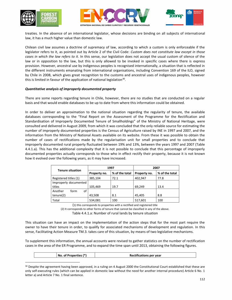
112
treaties. In the absence of an international legislator, whose decisions are binding on all subjects of international law, it has a much higher value than domestic law. Chilean civil law assumes a doctrine of supremacy of law, according to which a custom is only enforceable if the legislator refers to it, as pointed out by Article 2 of the Civil Code: Custom does not constitute law except in those cases in which the law refers to it. In this sense, our legislation does not accept the usual custom of silence of the law or in opposition to the law, but this is only allowed to be invoked in specific cases where there is express provision. However, ancestral use by indigenous peoples is recognised internationally, a situation that is reflected in the different instruments emanating from international organisations, including Convention 169 of the ILO, signed by Chile in 2008, which gives great recognition to the customs and ancestral uses of indigenous peoples, however this is limited in favour of the application of national legislation30. Quantitative analysis of improperly documented property There are some reports regarding tenure in Chile, however, there are no studies that are conducted on a regular basis and that would enable databases to be up to date from where this information could be obtained. In order to deliver an approximation to the national situation regarding the regularity of tenure, the available databases corresponding to the “Final Report on the Assessment of the Programme for the Rectification and Standardisation of Improperly Documented Tenure of Smallholdings” of the Ministry of National Heritage, were consulted and delivered in August 2009, from which it was concluded that the only reliable source for estimating the number of improperly documented properties is the Census of Agriculture raised by INE in 1997 and 2007, and the information from the Ministry of National Assets available on its website. From these it was possible to obtain the number of cases of rectifications made by the regularisation unit for small properties and to conclude that improperly documented rural property fluctuated between 19% and 13%, between the years 1997 and 2007 (Table 4.4.1.a). This has the additional complexity that it is not possible to conclude that this percentage of improperly documented properties actually corresponds to those who in effect rectify their property, because it is not known how it evolved over the following years, as it may have increased.
Tenure situation 1997 2007
Property no. % of the total Property no. % of the total
Registered titles (1) 385,104 72.1 402,947 77.8
Improperly documented titles 105,469 19.7 69,249 13.4
Another form of tenure(2) 43,508 8.1 45,405 8.8
Total 534,081 100 517,601 100
(1) this corresponds to properties with a rectified and registered title
(2) It corresponds to other forms of tenure that cannot be classified in any of the above.
Table 4.4.1.a: Number of rural lands by tenure situation This situation can have an impact on the implementation of the action steps that for the most part require the owner to have their tenure in order, to qualify for associated mechanisms of development and regulation. In this sense, Facilitating Action Measure TM.3. takes care of this situation, by means of two legislative mechanisms. To supplement this information, the annual accounts were revised to gather statistics on the number of rectification cases in the area of the ER Programme, and to expand the time span until 2013, obtaining the following figures.
No. of Properties (*) Rectifications per year
30 Despite the agreement having been approved, in a ruling on 4 August 2000 the Constitutional Court established that these are only self-executing rules (which can be applied in domestic law without the need for another internal procedure) Article 6 No. 1 letter a) and Article 7 No. 1 final sentence.
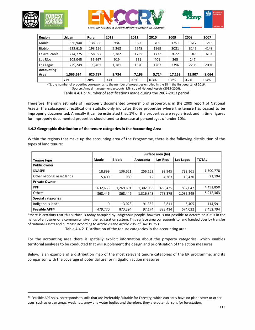
113
Region Urban Rural 2013 2011 2010 2009 2008 2007
Maule 336,940 138,586 984 922 705 1251 1617 1215
Biobío 622,615 193,156 2,268 2545 1569 3031 3245 4148
La Araucanía 274,775 158,927 3,782 1755 1772 3022 1046 610
Los Ríos 102,045 36,667 919 651 401 365 247
Los Lagos 229,249 93,461 1,781 1320 1267 2396 2205 2091
Accounting Area 1,565,624 620,797 9,734 7,193 5,714 17,153 15,907 8,064
72% 28% 0.4% 0.3% 0.3% 0.8% 0.7% 0.4% (*): the number of properties corresponds to the number of properties enrolled in the SII in the first quarter of 2016.
Source: Annual management accounts, Ministry of National Assets (2013-2006).
Table 4.4.1.b: Number of rectifications made during the 2007-2013 period Therefore, the only estimate of improperly documented ownership of property, is in the 2009 report of National Assets, the subsequent rectifications statistic only indicates those properties where the tenure has ceased to be improperly documented. Annually it can be estimated that 1% of the properties are regularised, and in time figures for improperly documented properties should tend to decrease at percentages of under 10%. 4.4.2 Geographic distribution of the tenure categories in the Accounting Area Within the regions that make up the accounting area of the Programme, there is the following distribution of the types of land tenure:
Tenure type
Surface area (ha)
Maule Biobío Araucanía Los Ríos Los Lagos TOTAL
Public owner
SNASPE 18,899 136,621 256,152 99,945 789,161 1,300,778
Other national asset lands 5,400 989 12 4,363 10,430 21,194
Private Owner
PPF 632,653 1,269,691 1,302,033 455,425 832,047 4,491,850
Others 868,446 868,446 1,316,843 773,379 2,085,249 5,912,363
Special categories
Indigenous land* 0 13,023 91,352 3,811 6,405 114,591
Feasible APF31 479,770 873,394 97,174 328,434 674,022 2,452,794
*there is certainty that this surface is today occupied by indigenous people, however is not possible to determine if it is in the hands of an owner or a community, given the registration system. This surface area corresponds to land handed over by transfer of National Assets and purchase according to Article 20 and Article 20b, of Law 19.253.
Table 4.4.2. Distribution of the tenure categories in the accounting area. For the accounting area there is spatially explicit information about the property categories, which enables territorial analyses to be conducted that will supplement the design and prioritisation of the action measures. Below, is an example of a distribution map of the most relevant tenure categories of the ER programme, and its comparison with the coverage of potential use for mitigation action measures.
31 Feasible APF soils, corresponds to soils that are Preferably Suitable for Forestry, which currently have no plant cover or other
uses, such as urban areas, wetlands, snow and water bodies and therefore, they are potential soils for forestation.
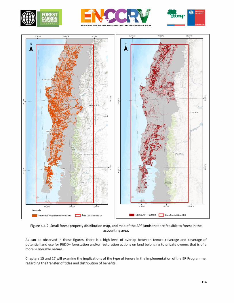
114
Figure 4.4.2. Small forest property distribution map, and map of the APF lands that are feasible to forest in the
accounting area.
As can be observed in these figures, there is a high level of overlap between tenure coverage and coverage of potential land use for REDD+ forestation and/or restoration actions on land belonging to private owners that is of a more vulnerable nature. Chapters 15 and 17 will examine the implications of the type of tenure in the implementation of the ER Programme, regarding the transfer of titles and distribution of benefits.
115
4.4.3 Analysis of the implications of the Chilean/Mapuche conflict in carrying out activities within the framework of the ENCCRV. The south of Chile and specifically the accounting area of the ER Programme, has since ancient times, had an indigenous population presence, particularly in the regions of Biobío, Araucanía, Los Ríos and Los Lagos. Currently there are some areas that are in conflict in the accounting area, a situation that could have implications for the implementation of the ENCCRV. There are three conflicts with potential impact for the ER Programme.
1. Conflicts for projects regarding natural resources (especially hydroelectricity). This type of conflict does not directly question the ownership of the land, but can create practical difficulties (by legal actions or in fact in REDD+ activities) for instance in forest compensation for controversial projects or others, or activism against REDD+ projects by owners of those projects, which could raise questions for these projects as a whole.
2. Conflicts against CONAF; there are territories that certain communities claim as their own and of ancestral use, natural spaces that are within the SNASPE, under the guise of a national park or forestry reserve. However, given the nature of the activities that could be developed (aimed at the sustainable management or preservation of the forest) it is quite improbable that even though these areas should exist, there might be some conflict about these activities. In any way it is advisable to be careful when it comes to measures that might affect access to natural resources for the communities or their livestock, in areas where SNAPE has borders with indigenous communities or are part of ancestral territory.
3. Territorial conflicts over land claims by the Mapuche people. This type of conflict may be an obstacle to the conduct of REDD+ activities, given that it questions the tenure and property of the land, it is also going to question the implementation of REDD+ projects and the distribution of those benefits. However, it is relevant to note that, due to the dynamics of the macro conflict itself, where it exists, especially at a communicational and rhetorical level, a general land claim over the whole territory of Biobío to the south, specifically claims on lands, occur in a precise, territorial dynamic around a certain estate and are construed on the basis of history or elements that exist within this estate and that establishes the land claim that the communities are making on it.
Under this logic it could be confirmed that this so-called “Mapuche conflict” generally expresses itself to be against the forestry industry, but that in its specific dynamic it is explicitly referenced on certain estates, regarding specific land claims. By the same token and in response to this dynamic, it is not possible to determine an exclusion area a priori in which it is not viable to carry out a REDD + project, but rather each intervention and its particular circumstances should be examined on a case-by-case basis. In this sense, it is possible that even in areas where there are conflicts, there are some activities considered in the ENCCRV due to their nature, which may be very well received by these communities, especially those linked to ecosystem restoration and conservation. The fact that many of the ENCCRV initiatives are aimed at reforestation with native trees also acts as a mitigating element, as this is a situation that is valued by the communities. This situation is also examined in Chapter 14 on safeguards.
Dispute Resolution Grievance Redress Mechanism: Programme on regularization of land tenure and others. In cases of conflict concerning indigenous lands, the Law on Indigenous Peoples (Article 55, Law N° 19,253) states that the parties can voluntarily resolve their dispute through mediation carried out by CONADI and be represented by an attorney especially appointed to this effect.
116
Those conflicts arising as a consequence of the implementation of any of the measures for action of the Strategy can be resolved through alternative mechanisms for dispute resolution. To this purpose, it is proposed incorporation of a clause for dispute resolution to withdraw from and / or to prevent trial processes. This clause is incorporated into the contract on right transfers from the owner to the institution in charge. So, this clause resolves any contention between parties with respect to any dispute, claim or controversy arising from the agreement or its breach, termination, execution, interpretation or validity. In this regard, it is under evaluation the mechanism most appropriate and feasible to be implemented. On one hand, it is proposed to include a mediation clause in order that both parties deal in good faith to resolve any dispute with the help of a mediator (a professional), as an impartial third-party, without decision-making powers, which guides the parties to seek a solution by themselves to the conflict and its effects. On the other hand, an arbitration clause may be added, which is intended to withdraw the contentious issue from the knowledge of the Ordinary Courts of Justice and take it to an arbiter judge appointed by the parties, who resolves definitively the contention, and the parties (res judicata effect) cannot ignore its resolution. Actually, both clauses are not incompatible by establishing a mediation process prior to the arbitration form. Content of the clauses and means of implementation are under assessment, subject to resource availability.
4.5 Analysis of the legislative and institutional framework related to the ER Programme 4.5.1 Institutional framework From its ratification in Chile in 1994 by the UNFCCC, subsequently becoming part of its Kyoto Protocol 2002, the institutional framework on climate change in the country has recorded significant progress that has been reflected in the implementation, in 2014, of the Council of Ministers for Sustainability and Climate Change. Since 2010, when the Ministry of Environment was established in Chile, this department was appointed as the Focal Point for the UNFCCC, which has enabled government actions to be better coordinated and guided in addressing the challenges and opportunities imposed by climate change from a public policy point of view32. Prior to the establishment of the Ministry of Environment and shortly after Chile ratified the UNFCCC, the so-called National Advisory Committee for Global Change made up of representatives from both the public sector and academia was established, which in 2006 developed the National Strategy on Climate Change33 which establishes the adaptation, mitigation, promotion and creation of skills as being the core values that are implemented via the National Climate Change Action Plan (PANCC, acronym in spanish) 2008-2012, currently being updated for the 2016-2021 period34. To support inter-institutional work, particularly within the framework of international negotiations on climate change and national commitments that are evoked from these, in 2010, since the Ministry of the Environment was formed, the Climate Change Office was created under the auspices of the Undersecretary for this Ministry. In this context, and due to the complexity of the topics covered under the UNFCCC on the Land Use, Land-Use Change and Forestry Sector Uso (LULUCF), and those related specifically to the decisions of the Convention that promote the development of national strategies for REDD+, the National Forestry Corporation of Chile (CONAF, acronym in spanish) was appointed by the UNFCCC, institution of the Ministry of Agriculture (MINAGRI), as a Focal Point for REDD+35. CONAF specifically fulfils this role via the Climate Change and Environmental Services Unit
32 Law 20.417, in Article 70, letter h, specifically states that “(…) the proposal of policies and formulation of plans, programs and plans of action on climate change, will correspond especially to the MMA. 33 National Climate Change Action Plan, http://www.bcn.cl/carpeta_temas_profundidad/temas_profundidad.2007-04-11.5841476988/Estrategia%20nacional%20_2006.pdf 34 Proposed structure and content for the National Climate Change Action Plan 2016-2021. http://portal.mma.gob.cl/wp-content/uploads/2015/08/Propuesta-contenidos-PANCC-2016-2021-Fase-II-Licitacion_con-anexos.pdf 35 This appointment was on the basis of the decision taken at CoP19 in Warsaw, where countries were invited to appoint National Focal Points or National Designated Entities for REDD+, via Official Notice No. 99 of 19 February 2014 by the Minister of
117
(UCCSA, acronym in spanish) of the Development Management and Forestry Development (GEDEFF, acronym in spanish). CONAF was also appointed as the Focal Point of the United Nations Convention to Combat Desertification (UNCCD), broadening the scope of its efforts and ordering this institution to integrate the actions required to meet the commitments of both Conventions into its work, as well as the obligations under its institutional role as technical advisor to MINAGRI, in cooperation with other ministerial institutions that have jurisdiction over forests in Chile. For this reason, in 2014 the Inter-ministerial Technical Committee on Climate Change (CTICC, acronym in spanish) was created, which is coordinated by the Office of Agricultural Studies and Policies (ODEPA, acronym in spanish), which brings together the various institutions that make up the MINAGRI36. It is hoped that CTICC will soon have representation in the 15 regions of the country, presumably being presided over by the Regional Ministerial Secretariat (SEREMI) of Agriculture with participation of representatives from the various public services associated with the agroforestry sector. With regard to the main commitments on climate change that this institutional framework must meet, is that registered in September 2015 to the Secretariat of the UNFCCC called Nationally Determined Contributions (NDC), the details of which were already set out in Chapter 2.3. As indicated in the NDC document, the achievement of these commitments will be supported by means of the implementation of the National Strategy for Climate Change and Vegetation Resources (ENCCRV) driven by CONAF in collaboration with various actors at a national and regional level, who are key part in the forestry sector, as well as the relevant competent state bodies. Such is the case of the Natural Resources Information Centre (CIREN), which will cooperate in the definition of deforestation and native forest degradation precursors for every country, and the Forestry Institute (INFOR), which is supporting the drafting of Chile’s Forest Reference Levels, as well as the improvement of the required mechanisms for monitoring, reporting and verification (MRV). The aim of the ENCCRV is to “support the recovery and protection of the native forest and xerophytic formations, as well as strengthening the establishment of vegetation formations on land that is able to be planted, as measures of mitigation and adaptation to climate change. For this purpose the intention is to design and implement a state mechanism to facilitate access of communities and owners to the benefits associated with environmental services generated by these recovered ecosystems.” The ENCCRV considers key elements in the context of adaptation to climate change and the fight against desertification, degradation of the land and drought provided by the UNCCD, developing in depth and in full, all aspects covered by the decisions for UNFCCC’s REDD+, for which, under the framework of this initiative the elements that will support the achievement of the goals defined in the NDC for the LULUCF sector are being developed, and to implement the actions and adjustments to its information and management systems that will enable the forest reservoirs of Greenhouse Gases (GHG) to be maintained and increased, as well as avoiding emissions by stabilising or reducing their rates of deforestation and degradation of native forests, to eventually receive the benefits associated with the positive results of such actions, which in the context of REDD+ will enable the receipt of payments for results, and for which, in CoP 21, progress is already being made with regard to a definition of the international financial architecture to support and provide sustainability over time to these national initiatives such as the Green Climate Fund (GCF). It is in this context that the work associated with ENCCRV coordinated by CONAF, becomes relevant, by establishing itself as an element for driving national technical and financial mechanisms that will be required to progress and
Agriculture Mr Luis Mayol, addressed to his counterpart in the Ministry of Foreign Affairs, who formalised this appointment to the Secretariat of the Convention. 36 Other MINAGRI institutions that have responsibility for forests are the Office of Agricultural Studies and Policies (ODEPA), National Institute of Agricultural Development (INDAP), Foundation for Agricultural Innovation (FIA), Agricultural Research Institute (INIA), Forestry Development (INFOR), Natural Resources Information Centre (CIREN), Agricultural and Livestock Service (SAG).
118
give certainty to the conditions and elements to be developed when considering payment per results schemes, which can then be replicated nationally and be equally valid in various international bodies. 4.5.2 Legislative framework associated with the ER Programme In Chile’s recent history, different legislation has been related directly and indirectly with the use and protection of forests. The application and enforcement of these legal bodies has had significant and different impacts on the country’s development, and have determined the current status of the forest resource in the accounting area, which was summarised in Chapter 3.2.1. The first significant body of regulations for the forestry sector, which still has current elements is the Forest Act (Legislative Decree No. 656 of 1925 according to the consolidated text as set by Supreme Decree No. 4363 of 1931 of the Ministry of Land and Colonisation). This law emphasised the importance of forests for the protection and improvement of soils, for the regulation of river water flows for the conservation of water resources in general, as a source of raw materials for many industries, and as a source of health for the population. It additionally substantially improved the rules on use of fire, the sanctioning system and standards on National Parks and Forestry Reserves. But, the most relevant part of this law was the incorporation of prohibitions that are maintained in force to date, and that are related to a ban on the cutting down of trees and native shrubs located close to springs or on slopes of more than 45%. The Forest Act maintained the ban on the use of fire to clear forest lands, and on protected forestry areas and enshrined the President’s power to create National Tourism Parks and Forestry Reserves. This subject matter is currently being developed and supplemented by the Washington Convention and by Law No. 18.362 that creates the National System of Protected Wild Areas of the State (SNASPE). The second body of regulations, and probably the one that has been more relevant to the forestry sector, is Decree Law No. 701 about Forestry Development. It was enacted in 1974 launching a new forest policy based on two large pillars, incentives for forestation and protection of forest resources. The Preferably Suitable for Forestry (APF) soils rating is created as a technical-legal act where a forest engineer must justify that the land, due to its climate and soil conditions, should not be ploughed on a permanent basis and that by being used for agriculture, fruit farming or livestock, may suffer degradation. Upon approval of the rating by the authority, the owner gets rights such as tax exemptions and the possibility of receiving a grant for forestation, also giving rise to obligations as set out in Article 22, which sets out obligations to reforest after the cutting down or exploitation of forests. Moreover, another technical and legal instrument called the Management Plan, which was incorporated as a concept emerges in 1979 by Legislative Decree No. 2,565, which went on to amend Legislative Decree No. 701 of 1974. It is defined in Article 2 of Legislative Decree No. 701 as the instrument that regulates the use and rational exploitation of renewable natural resources from a certain land, in order to obtain the maximum benefit from them, while ensuring the preservation, conservation, improvement and enhancement of these resources and their ecosystem. This instrument is the core value of the system and is understood as being a programme of rational exploitation of forest resources, which can be native forests or plantations. The management plan is technical because it must be prepared by a forest engineer or specialist agronomist who must at least highlight the nature of the site and forest resource, defining management objectives, forestry treatment, amongst others, and is legal, because once approved it empowers and obliges the owner to implement it, imposing sanctions in the event of default. For its part, the legal definition of the aforementioned Forest Types for the Chilean native forest, was incorporated in the technical regulation of Decree No. 701 by means of Supreme Decree No. 259 of 1980, which also establishes the forestry methods that are possible to use for each type.
119
Legislative Decree No. 701 envisaged three types of incentives, those that guaranteed the right of property, those of a tax nature and those of an economic nature. The latter were a novelty in Legislative Decree, and consisted of a bonus granted by the State for the forestation and initial management of plantations, on land rated as APF in accordance with the previously approved management plan. The state provides a subsidy only once for each surface area, a percentage of the net costs for the various activities such as forestation on fragile and degraded soils, soil remediation or stabilisation of dunes, establishment of wind shelters, and for the first pruning or thinning by small forest owners, amongst others. This law does not include incentives for the management of native forests. Legislative Decree No. 701 of 1974 with its various modifications meant that Chile became one of the countries with the highest rate of forestation, in relation to its size and population, and from this heritage one of the largest industries in the country was created around pulp and sawn timber associated with exotic fast-growing tree species. In 1996 the forestry grant of Legislative Decree No. 701 expired, which was extended in 1998 with the ordering of Law 19.561 until 2011, the date on which a new extension was achieved that lasted until 2012, the last year of the validity of the instrument that included the incentives component. From 2013 to date, Chile has no incentives for plantations, and work is being conducted on the design of a new development law that has a different focus, focusing enforcement efforts on plantations with native species, for permanent coverage, balancing industrial aspects with the provision of environmental services. It is hoped that in 2016 substantial progress will be achieved in the formulation and parliamentary process of the new development law. Of a more recent date is Law 20.283 on the Recovery of the Native Forest and Forestry Development. This law went through an extensive procedure and caused a great deal of controversy amongst all the parties related to the native forest, as a result of the different perspectives and interests of each party. The project was discussed in congress for more than 16 years, until it was finally enacted in 2008. The objectives of this law express the intention to ensure the protection, recovery and enhancement of native forests, in order to ensure forest sustainability and environmental policy. In its articles it has 26 definitions of concepts and elements contained within the law, aimed at unifying criteria and standardising the understanding of the body of legislation. Many of these definitions come from previous regulations and were amended. Amongst the most important are the definition of Forest, Native Forest, Small Forest Owner, Management Plan and Environmental Services. Regarding the definition of Forest Types and the management methods applicable to them, the law uses what is established in Legislative Decree No. 701 as the basis, but indicates that a new typology based on scientific and technical studies and validated in a consultation of the public and private bodies with competence in the field. Six years after the enactment of the law, this update does not end here. Law 20.283 also establishes that CONAF will maintain a permanent forestry registry, in which the existing Forest Types in each region of the country will be identified and established, at least cartographically, as well as their status and those areas where there are ecosystems with the presence of native forests of special interest for conservation or preservation, according to the criteria established in the regulation of this law. The forest register must be updated at least every ten years and its information will be public, an instruction that to date has been mostly achieved via the website for the Territorial Information System (SIT, acronym in spanish) that CONAF has. The Management Plan figure is supplemented in this law with regard to Legislative Decree No. 701, with the appearance of the preservation management plan, as an alternative instrument for those forests where the main objectives are the preservation and recuperation of the native forest, and the management plan under Planning criteria, where they will receive a special supplementary incentive, projects that incorporate methodologies of forest planning to ensure sustainable long-term management of the asset. With regard to the rules of environmental protection, the law maintains restrictions for logging and productive activities for certain conditions
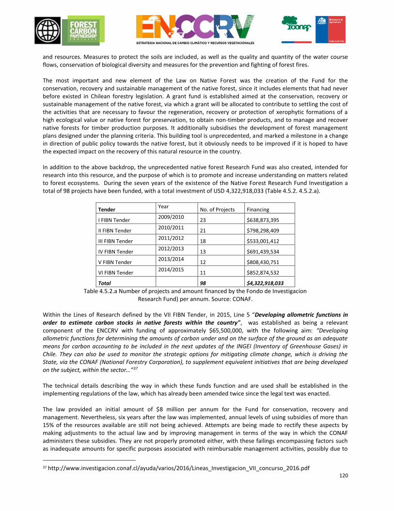
120
and resources. Measures to protect the soils are included, as well as the quality and quantity of the water course flows, conservation of biological diversity and measures for the prevention and fighting of forest fires. The most important and new element of the Law on Native Forest was the creation of the Fund for the conservation, recovery and sustainable management of the native forest, since it includes elements that had never before existed in Chilean forestry legislation. A grant fund is established aimed at the conservation, recovery or sustainable management of the native forest, via which a grant will be allocated to contribute to settling the cost of the activities that are necessary to favour the regeneration, recovery or protection of xerophytic formations of a high ecological value or native forest for preservation, to obtain non-timber products, and to manage and recover native forests for timber production purposes. It additionally subsidises the development of forest management plans designed under the planning criteria. This building tool is unprecedented, and marked a milestone in a change in direction of public policy towards the native forest, but it obviously needs to be improved if it is hoped to have the expected impact on the recovery of this natural resource in the country. In addition to the above backdrop, the unprecedented native forest Research Fund was also created, intended for research into this resource, and the purpose of which is to promote and increase understanding on matters related to forest ecosystems. During the seven years of the existence of the Native Forest Research Fund Investigation a total of 98 projects have been funded, with a total investment of USD 4,322,918,033 (Table 4.5.2. 4.5.2.a).
Tender Year
No. of Projects Financing
I FIBN Tender 2009/2010
23 $638,873,395
II FIBN Tender 2010/2011
21 $798,298,409
III FIBN Tender 2011/2012
18 $533,001,412
IV FIBN Tender 2012/2013
13 $691,439,534
V FIBN Tender 2013/2014
12 $808,430,751
VI FIBN Tender 2014/2015
11 $852,874,532
Total
98 $4,322,918,033
Table 4.5.2.a Number of projects and amount financed by the Fondo de Investigacion Research Fund) per annum. Source: CONAF.
Within the Lines of Research defined by the VII FIBN Tender, in 2015, Line 5 “Developing allometric functions in order to estimate carbon stocks in native forests within the country", was established as being a relevant component of the ENCCRV with funding of approximately $65,500,000, with the following aim: “Developing allometric functions for determining the amounts of carbon under and on the surface of the ground as an adequate means for carbon accounting to be included in the next updates of the INGEI (Inventory of Greenhouse Gases) in Chile. They can also be used to monitor the strategic options for mitigating climate change, which is driving the State, via the CONAF (National Forestry Corporation), to supplement equivalent initiatives that are being developed on the subject, within the sector…”37 The technical details describing the way in which these funds function and are used shall be established in the implementing regulations of the law, which has already been amended twice since the legal text was enacted. The law provided an initial amount of $8 million per annum for the Fund for conservation, recovery and management. Nevertheless, six years after the law was implemented, annual levels of using subsidies of more than 15% of the resources available are still not being achieved. Attempts are being made to rectify these aspects by making adjustments to the actual law and by improving management in terms of the way in which the CONAF administers these subsidies. They are not properly promoted either, with these failings encompassing factors such as inadequate amounts for specific purposes associated with reimbursable management activities, possibly due to
37 http://www.investigacion.conaf.cl/ayuda/varios/2016/Lineas_Investigacion_VII_concurso_2016.pdf
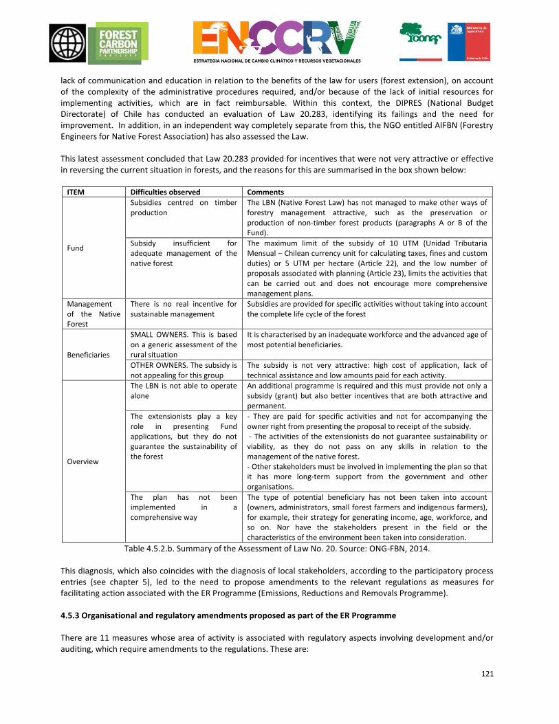
121
lack of communication and education in relation to the benefits of the law for users (forest extension), on account of the complexity of the administrative procedures required, and/or because of the lack of initial resources for implementing activities, which are in fact reimbursable. Within this context, the DIPRES (National Budget Directorate) of Chile has conducted an evaluation of Law 20.283, identifying its failings and the need for improvement. In addition, in an independent way completely separate from this, the NGO entitled AIFBN (Forestry Engineers for Native Forest Association) has also assessed the Law. This latest assessment concluded that Law 20.283 provided for incentives that were not very attractive or effective in reversing the current situation in forests, and the reasons for this are summarised in the box shown below:
ITEM Difficulties observed Comments
Fund
Subsidies centred on timber production
The LBN (Native Forest Law) has not managed to make other ways of forestry management attractive, such as the preservation or production of non-timber forest products (paragraphs A or B of the Fund).
Subsidy insufficient for adequate management of the native forest
The maximum limit of the subsidy of 10 UTM (Unidad Tributaria Mensual – Chilean currency unit for calculating taxes, fines and custom duties) or 5 UTM per hectare (Article 22), and the low number of proposals associated with planning (Article 23), limits the activities that can be carried out and does not encourage more comprehensive management plans.
Management of the Native Forest
There is no real incentive for sustainable management
Subsidies are provided for specific activities without taking into account the complete life cycle of the forest
Beneficiaries
SMALL OWNERS. This is based on a generic assessment of the rural situation
It is characterised by an inadequate workforce and the advanced age of most potential beneficiaries.
OTHER OWNERS. The subsidy is not appealing for this group
The subsidy is not very attractive: high cost of application, lack of technical assistance and low amounts paid for each activity.
Overview
The LBN is not able to operate alone
An additional programme is required and this must provide not only a subsidy (grant) but also better incentives that are both attractive and permanent.
The extensionists play a key role in presenting Fund applications, but they do not guarantee the sustainability of the forest
- They are paid for specific activities and not for accompanying the owner right from presenting the proposal to receipt of the subsidy. - The activities of the extensionists do not guarantee sustainability or viability, as they do not pass on any skills in relation to the management of the native forest. - Other stakeholders must be involved in implementing the plan so that it has more long-term support from the government and other organisations.
The plan has not been implemented in a comprehensive way
The type of potential beneficiary has not been taken into account (owners, administrators, small forest farmers and indigenous farmers), for example, their strategy for generating income, age, workforce, and so on. Nor have the stakeholders present in the field or the characteristics of the environment been taken into consideration.
Table 4.5.2.b. Summary of the Assessment of Law No. 20. Source: ONG-FBN, 2014. This diagnosis, which also coincides with the diagnosis of local stakeholders, according to the participatory process entries (see chapter 5), led to the need to propose amendments to the relevant regulations as measures for facilitating action associated with the ER Programme (Emissions, Reductions and Removals Programme). 4.5.3 Organisational and regulatory amendments proposed as part of the ER Programme There are 11 measures whose area of activity is associated with regulatory aspects involving development and/or auditing, which require amendments to the regulations. These are:
122
Measures of direct mitigation US.4. Extension focused on PMCOF (Programme for Managing Forestry Planning Criteria) Facilitating measures IF.5. Improvement of Development Instruments (Law No. 20.283) focusing on Preventive Management and post-Fire Recovery US.1. Management Model subject to Planning criteria for the PMCOF instrument of Law 20.238 US.5. Comprehensive system for developing and regulating the production chain MT.1. Inclusion of aspects of mitigation and adaptation to Climate Change (CC) in the Nueva Ley de Fomento Forestal (New Forest Development Law) MT.2. Modification and strengthening of the Law No. 20.283 of Native Forest Recovery and Forestry Development. MT.3. Adjustments to include owners with little legal security in relation to land tenure RH.1. Amendment to Law 19.561, which exempts land for agricultural clearance from reforestation RH.2. Incorporate variables for the conservation of forests to Law 18.450. RH.3. Limit the application of Law 20.412 on APF soils. RS.3. Reinforcement of Planning in order to reduce replacement Within this aspect, there are five measures that involve redirecting the efforts of institutional management by changing the way in which civil servants operate, and/or creating new technical teams within the CONAF, which will be responsible for implementing the measures. These are: Measures of direct mitigation MG.1. Buffer zones for livestock activity Facilitating measures US.1. Management Model subject to Planning criteria for the PMCOF instrument of Law 20.238 MT.5. Environmental Education Programme MT.6. Adjustments to include owners with little legal security in relation to land tenure RS.3. Reinforcement of Planning in order to reduce replacement The breakdown of all these amendments relating to both organisations and legislation A detailed analysis of these measures and their implications is provided in Chapter 4.3.2, together with the description and means of implementing each measure.
4.6 Duration of the proposed ER Programme The ER Programme for the accounting area has a time frame of nine years, starting with its implementation in 2017 and ending in 2025, coinciding with the ERPA (emissions reduction purchase agreement) period. The detailed annual planning is provided in Chapter 6.
123
5. CONSULTATION AND PARTICIPATION OF INTEREST GROUPS
5.1 Description of the process for consulting interest groups 5.1.1 Context and general framework of the participatory process for formulating plans within the ENCCRV The policy for formulating the ENCCRV has been based on a participatory process, which includes conducting workshops in all areas of the country, including a variety of FG (Focus Groups) representative of society that have a direct or indirect connection to vegetation resources, either because they depend on them, or are connected or linked with them. Consequently, attempts are being made to prioritise, in a consensual manner, the main guidelines that this national initiative should contain in order to guarantee that the strategic activities implemented in the future do not affect, among other aspects, the rights of the indigenous communities, the rights of the local communities or vulnerable groups and the active and effective participation of women. These points are all in line with national provisions, the requirements of the United Nations Framework Convention on Climate Change (UNFCCC) and other international authorities, one of which is Chile, to which it has made undertakings. In line with the UNFCCC, the ENCCRV fully incorporates all its decisions directed at reducing the emissions associated with Deforestation, Forest Degradation and those that contribute to Increasing Carbon Stocks, commonly known by the name REDD+ (Reducing Emissions from Deforestation and Forest Degradation and the Increased Existence of Carbon). This makes it essential for countries wishing to implement its strategy by using this mechanism to fulfil a series of social and environmental protective measures in order to avoid, mitigate and minimise potential negative social and environmental impacts, as well as maximise benefits for local communities that are directly and indirectly involved in its implementation. In the same way, incorporating these social and environmental protective measures will produce benefits and minimise the risks that might be involved in implementing the “strategic activities”, prioritised in order to avoid degradation, deforestation and promote forestation/replanting as well as the recovery of forests and other vegetation formations. In the case of Chile, these protective measures will be dealt with in the context of a participatory process, which includes the application of multi-stakeholder, multisector and multi-level focus groups throughout the country. In the process of formulating the ENCCRV, it was considered a priority to ensure the effective and inclusive participation, within an ethical framework, of all the groups and key stakeholders associated with vegetation resources, placing special emphasis on local communities, the indigenous population, women and vulnerable people. More specifically, small-, medium- and large-sized producers, social organisations (Neighbourhood Councils, Drinking Water Committees, Farmers Trade Associations, among others), associations and groups from civil society, universities and educational centres, companies, NGOs (Non-Governmental Organisations), government authorities, local governments and any aspect involved in the efforts for formulating and carrying out the future implementation of the ENCCRV were taken into consideration. After gathering together all the information that needs to be incorporated by the key stakeholders and representatives of the various FG when formulating the Strategy, with particular reference to local communities and indigenous peoples, the process of social and environmental assessment must be carried out. This will generate guidelines and inputs for a more polished version of the national initiative. This must be validated in a subsequent stage, after reviewing the main topic areas to be implemented and the follow-up system, which will allow achievements to be measured in the future as far as the Strategy’s social and environmental implications are concerned.
124
In terms of a document, the Plan for Implementing Social and Environmental Safeguards is: Public and Indigenous38 Consultation and Self-Assessment of the National Strategy on Climate Change and Vegetation Resources (ENCCRV) is the guide for implementing the whole of the participatory process. This period began in 2015, and will be completed, it is hoped, by the end of 2016 (link: http://www.enccrv-chile.cl/). 5.1.2 Description of the participatory process for compiling the ENCCRV as an input for the ER Programme The participatory process for formulating the ENCCRV involves three consultation activities, which are described below: 5.1.2.1 SESA (Strategic Environmental and Social Assessment) Regional workshops In the famework of ENCCRV have been conducted 15 workshops, one in each administrative region of the country including the five regions of the AdC (Conservation Area). The methodology to be used in the regional workshops begins with a process of stakeholder mapping. These stakeholders must then be convened in accordance with the multi-actor, multi-sector, multi-level criterion, encouraging in particular the participation of the indigenous peoples, local communities and women at all levels. These workshops were provided using a standardised method designed by the UAIS (Indigenous and Social Affairs Unit) within CONAF and included all the requirements and perspectives that had emerged from the participatory process. The salient features of the methodology used in the workshops are:
Compilation of the Map of Regional Stakeholders: This relates to the process whereby the Regional Coordinators of Climate Change39 and the Regional Managers of the Indigenous and Social Affairs Unit extract information about key stakeholders.
Definition of Focus Groups (FG): the groups are constituted by stakeholders or representing a given sector of the society with similar interests, viewpoints, culture and/or rights. As a result of these common bonds, the aim is to generate participation in decisions and analysis, which will be able to obtain, even if this is not completely consensual, an idea of the thoughts, feelings, perceptions, opinions and collective proposals of those who are directly or indirectly affected by the measures that the ENCCRV implements. 11 focus groups will be defined for Chile (section 3.2.5).
Matters for consultation and discussion with the FG: The most important element of the consultation workshops was to define the topics to be tackled with the Focus Groups. These topics will define the inputs for the ER Programme delivered by the extended participatory process (Table 5.1.2.1).
Topic Description
1 Reasons for degradation, deforestation, and non-forestation (increase of stock). A consultation was carried out to identify the major direct and indirect causes for each territory (region).
2 Activities and measures intended to reduce degradation and deforestation and to increase forestation or replanting in each region. The proposals must be correlated with the reasons indicated under Topic 1.
3 Actions/aspects to be taken into consideration in order to mitigate, avoid and minimise the potential risks of the proposed activities. At the end of the discussion on the topic, a consultation was carried out to identify the types of channels of communication that would be needed in order to make suggestions and observations, pass on to and/or request information from CONAF.
4 Actions/aspects that need to be taken into consideration in order to maximise the benefits of the proposed activities. At the end of the discussion about the topic, a consultation was carried out in relation to which ideas to take into
38 This involves a public (citizen) consultation and an indigenous consultation in accordance with the Operational Policies of the World Bank (OP 4.10) United Nations guidelines for UN-REDD. 39 As part of implementing the ENCCRV in each of the 15 administrative regions of the country, CONAF has appointed an
employee from the organisation to act as Regional Coordinator for Climate Change.
125
consideration so that the potential benefits generated by these strategic activities are distributed justly and fairly.
5 Actions that help to maintain and increase biological diversity and ecosystem services.
Table 5.1.2.1. Consultation topics involved in the participatory process
The information generated by the Focus Groups in the regional workshops was standardised by transcribing cards and/or documents written in support of responses, classifying these notes or opinions using the participants’ exact words. In addition, each Group moderator/facilitator added the supplementary information generated within the context of the dialogue to allow the responses provided by the stakeholders involved in the respective Focus Group to be more clearly understood, discussed with supporting evidence and/or improved. A narrative report was produced as the final result of each regional workshop, containing all the inputs generated in a standard format. The Regional Workshop Report contains a brief description of what occurred in the workshop, an account of the important aspects to be interpreted in relation to the results obtained and the general conclusions. In addition, this report includes an analysis in the form of an “assessment”, presenting all the conclusions for each Focus Group, retaining the order of the questions associated with the five topic areas consulted. In addition, the information is completed with the inputs obtained from a virtual investigation conducted by employees in the Regional Departments of CONAF throughout Chile. The process of standardising and analysing the information generated by the FG and the key stakeholders in the regional workshops was fundamental for designing and compiling the ER Programme (see section 4.3), and when carrying out the subsequent social and environmental assessment of each region as well as the whole country. These bodies then aim to identify the main negative impacts that the ENCCRV may have when it is implemented. 5.1.2.2 Expert National Workshops In a complementary way to the regional workshops, an expert national workshop was also delivered as part of the consultation process. This followed the same methodology as the regional workshops, but in this case, academic and technical experts from the public services at central level took part, as well as representatives of NGOs, and representatives of national and international consultants, with experience with the ENCCRV. 5.1.2.3 Macrozonal Workshops This consultation activity involved regional technical stakeholders, including professionals from the public services, academics and consultants. These workshops were given the name of “Macrozonal workshops”, and involved participants from each region in the following way:
Macrozonal Workshop – North: I, XV, II, III and IV regions, delivered in the city of La Serena.
Macrozonal Workshop – Centre: V, VI, VII, and metropolitan Region, delivered in Santiago.
Macrozonal Workshop – South (includes the whole of the AdC): VIII, IX, X, XI, XIV and XII regions, delivered in the city of Temuco.
These workshops employed a different methodology and their aim was to generate the following inputs:
Target input Contribution to ER Programme
Determining the geographical distribution and the territorial importance of each causal factor.
Determining the importance of each causal factor, in order to establish its priority.
Identification of the specific local stakeholders responsible for the causes of degradation and deforestation.
Qualitative characterisation of the causal factors, and input for designing strategic activities.
Identification of the potential areas for reforestation, replanting and recovery.
Input for designing strategic activities, and definition of common priorities for implementing action measures (hotspots).
126
Table 5.1.2.3. Inputs from Macrozonal workshops
For these inputs to be successful, methodology based on work with maps was implemented, as described in Annex 4.
5.2 Summary of the comments received and the way in which these viewpoints were taken into consideration when designing and implementing the ER Programme
Generally speaking, throughout the accounting area there was substantial similarity between the results of the consultation carried out in the regional workshops and the one conducted in the national experts’ workshop. The main causal factors identified were similar in all the regions and in the country as a whole, with the expected specific aspects relating to the different areas. Results were also consistent with regard to the measures for mitigation and their risks and benefits, and this facilitated the subsequent approval process. A summary of the results of the regional workshops in the accounting area of the ER Programme is provided in the following table:
Region Date and locality Persons attending
Main results
Maule Villa Alegre, 27 August 2015
88 people from 10 FG
The total inputs obtained in the Region of Maule included a large number of contributions relating to of agriculture and stock farming. They also revealed the importance of generating incentives for forestation. Suggestions ranged from formulating regulations having local relevance to actually auditing them, in order to avoid the risk of the incentives being granted without being distributed in a just and fair way. Among the inputs, anthropogenic causal factors of deforestation and degradation of vegetation resources took precedence, with natural causes such as flooding, volcanoes and forest fires being less important. It is also important to point out that the Focus Groups with the most support were those for women’s organisations and small- and medium-sized owners. Both Focus Groups presented viewpoints associated with the agricultural and stock farming sectors. Generally speaking, the predominant reasons for degradation and deforestation, as well as those creating difficulties with increasing vegetation resources, given as the spontaneous response of the participants were: lack of environmental education, illegal and indiscriminate felling of trees, poor water resources, agricultural and livestock farming, forest fires, lack of profitability associated with the forestation of native forests, lack of incentives, lack of regularisation, auditing and penalties.
Biobío 06 October 2015 110 people in 10 FG
The reasons for degradation and deforestation expressed by those attending the workshop are both anthropogenic and natural. Most of these are anthropogenic, such as change in land use for agricultural purposes or livestock farming or for infrastructures related to urban expansion. Forest plantations containing exotic species were also mentioned as reasons for degradation and in turn, these are linked with the scarcity of water resources. Forest fires, poor forest management, overgrazing, and so on were also mentioned. The predominant natural cause was drought. Indirect causes of degradation and deforestation include social and cultural aspects, such as the recognition of Mapuche peoples, regulatory aspects such as compiling a new forestry development law that would be participatory from the outset, and organisational aspects such as improvements in planning and auditing Those attending the workshops stated that difficulties in increasing the forest cover included soil erosion, shortage of water, lack of governance, lack of legislation, lack of subsidies, and so on. Consistency in regulations
127
relating to land tenure for owners is an important theme for workshop attendees, as is access to incentives for forestation. Together with a lack of environmental education, these are the reasons mentioned most frequently.
Araucanía Temuco 26 July 2013
105 people in 10 FG
A proposal-orientated review of the situation at issue was produced. This stated the need to boost the State’s sectoral policy, which the authorities are pursuing with the various programmes and management and development mechanisms they are implementing. Attention was drawn to an absence of cultural relevance across the board and the need to define and incorporate a view of the ecosystem in a culturally acceptable way. A similar observation was made in respect of the definitions and concepts related to forestry resources such as forest, native forest and other vegetation resources. People were willing to engage in dialogue with a clear need to be considered as being involved in the process. They need to be given additional tools to reinforce their ability to analyse and identify the causes of degradation, deforestation and non-forestation and the potential solutions required to tackle the challenges presented. Review and adaptation of the programmes that have an impact on solving REDD+ causes include: better economic support in the way of direct grants resulting from development resources; better facilities for accessing these subsidies; review of the forestry production chain and its secondary resources; identification of how the forests can be used as well as the benefits of their ecosystems from the point of view of the indigenous population; and review of the forestry environmental policies from a comprehensive point of view in order to safeguard their environmental, social and eco-cultural impact in indigenous regions.
Los Ríos 22 October 2015 95 people in 13 FG
Among the causes of degradation, those taking part in the workshops highlighted agricultural and livestock farming, as well as urban expansion, which indicates changes in land use. Likewise, those attending the workshops mentioned differences between the guidelines of the public policies in existence within the Ministry of Agriculture, when there ought to be only one guideline offering finance across the board. On the other hand, inadequate policies for regulating the management and development of the native forest is another of the causes mentioned by workshop attendees, as well as unsustainable forest-grazing, contaminated water, the presence of pests, drought and mono-cropping. These were the reasons highlighted for the Region of Los Ríos. Participants stated that the causes of deforestation included the Dendro-energy matrix, agricultural clearing, uncontrolled burning, indiscriminate felling, scarcity of water, energy expansion, and the lack of incentives, amongst others. Reference was made to regulatory, social, educational, economic, political, cultural, institutional problems and so on. It is worth mentioning that there are causal factors that apply both to deforestation and to degradation, as well as the difficulties encountered.
Los Lagos 20 October 2015 35 people The direct causes of degradation are mainly anthropogenic, involving
indiscriminate felling in order to generate income for the family, plus illegal cutting, change of land use for agricultural, livestock, mining and industrial activities, forest fires, the presence of uncontrolled pests, contamination and mono-cropping, unsustainable forest management, scrubland, foraging, overgrazing, and so on. Those attending the workshop stated that the causes underlying degradation include lack of environmental education, lack of legislation for developing the forests, incompatibility between the view of the State and the indigenous worldview, rural poverty and the lack of any agro-ecological culture, among other reasons.
128
As far as the diversity of causes of deforestation expressed by workshop attendees is concerned, we can highlight climate change, forest fires, clearing for agricultural purposes and livestock farming, collecting wood and firewood, mining, electricity lines, run-of-river plants, illegal and indiscriminate felling, uncontrolled burning, lack of education and industrialisation of the land among other reasons mentioned. Among the difficulties associated with forestation, workshop attendees mentioned difficulties with auditing, lack of environmental education, lack of knowledge, lack of regulatory frameworks applicable to local situations, bureaucracy within organisations, lack of economic incentives, lack of a forestry market, lack of fairness in distributing water rights, lack of an effective forestry policy, the need for better research and innovation, lack of labour for the island of Chiloé, lack of technical assistance, and lack of follow-up for management plans among other difficulties. As can be seen, some of the causes of degradation and deforestation are the same, such as the subject of firewood, ranging from its unsustainable collection to forest fires, illegal cutting and indiscriminate felling. Changing the use of the land for livestock farming, agriculture, urban development and industry also have effects that go across the board in terms of degradation and deforestation.
Table 5.2. Results of regional workshops involved in the participatory process The detailed results of the participatory workshops in the accounting area can be found in the respective regional reports accessed via the following links.
Maule Region: http://www.CONAF.cl/wp-content/files_mf/1446219418informeMaulerevisadoVB.pdf
Biobío Region: http://www.CONAF.cl/wp-content/files_mf/1452526208InformeBiob%C3%ADo.pdf
Araucanía Region:http://www.CONAF.cl/wp-content/files_mf/1384958150Anexo1MemoriaTallerMacroZonaBiobioAraucania.doc
Los Ríos Region: http://www.CONAF.cl/wp-content/files_mf/1450110007InformeLosR%C3%ADos.pdf
Los Lagos Region: http://www.CONAF.cl/wp-content/files_mf/1450110007InformeLosL%C3%ADos.pdf The way in which the results of the consultation process with the Focus Groups has been incorporated in the design of the ER Programme has been described in detail in sections 4.1, 4.3, and in Annex 4. With regard to how the participatory process will continue in the phase for implementing the ENCCRV and the ER Programme, in the first instance a consultative process and self-assessment will take place. This way, all the key stakeholders who previously took part in the formulation process described in this section can validate the National Strategy and all its component parts, in a participatory way. In the first instance, they will be looking for feedback from participants, and secondly, validation of the ENCCRV guidelines, including strategic activities, mitigation measures, benefits, framework of socio-environmental indicators, and the monitoring system among others. The targets proposed by the consultation process and self-assessment are:
To interact with the key representatives who attended the compilation process, informing them of the results of the participatory process at national level concerning: i) the reasons for deforestation, degradation and difficulties in developing activities that increase the carbon stock, such as forestation; ii) the strategic activities to combat the above causes; iii) the inputs for designing the mechanism for resolving complaints and making suggestions; iv) the inputs for designing a just and fair system for distributing benefits; v) the action to maintain and/or increase biodiversity; and vi) the framework of socio-environmental indicators for following-up and monitoring safeguards.
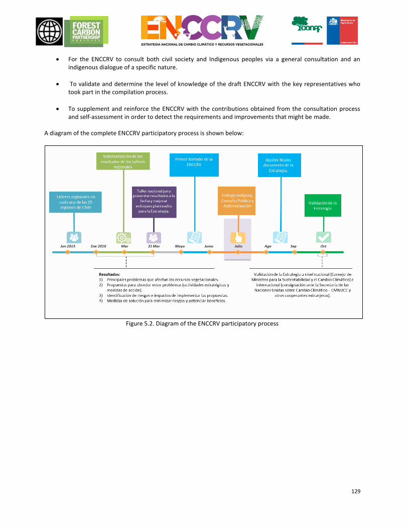
129
For the ENCCRV to consult both civil society and Indigenous peoples via a general consultation and an indigenous dialogue of a specific nature.
To validate and determine the level of knowledge of the draft ENCCRV with the key representatives who took part in the compilation process.
To supplement and reinforce the ENCCRV with the contributions obtained from the consultation process and self-assessment in order to detect the requirements and improvements that might be made.
A diagram of the complete ENCCRV participatory process is shown below:
Figure 5.2. Diagram of the ENCCRV participatory process
130
6. OPERATIONAL AND FINANCIAL PLANNING
6.1 Institutional provisions and those for implementation 6.1.1 Institutional provisions
The breakdown of the specific institutional provisions for implementing each action measure and the description of these measures are provided in Section 4.3.
As far as the general operational arrangements for implementing the programme are concerned, these are as follows: Operation Entity responsible and institutional arrangements
Operational supervision of the Programme
Operational supervision of the programme will be carried out by the ordinary CONAF as far as approving the forestry management plans is concerned. The CONAF will also have the task of auditing and environmental assessment that is applicable to this organisation, deploying its own human and financial resources in all the regions and provinces involved in the Programme for the Reduction of Emissions. In parallel, and after commissioning the MRV (Monitoring, Reporting and Verification) and SIS (Safeguards Implementation System), the programme will be overseen in terms of the provision of environmental and social safeguards including the permanence of forestry sinks. More specifically with regard to this aspect, the UCCSA (Unit of Climate Change and Environmental Services) interacts on a permanent basis with the Department of Monitoring Forestry Ecosystems in terms of carbon accountability and with the UAIS, the Executive Secretariat of CONAF, the GEF (Environmental Audit and Assessment Management) and the Attorney General’s Office. The above will be carried out by the technical management departments of CONAF, which constitute the Inter-managerial Committee on Climate Change, and occasionally by the GEDEFF (Management Office on Forest Support and Development), the GEF and the GEPRIF (Management Office of Forest Fire Protection) in those operational tasks related to matters associated with forest fires and the GASP (Management office of Protected Wildlife Areas) linked with action measures considered to fall within the remit of the SNASPE (National System of Protected Wild Areas of the State.) or sectors similar to these units. The respective approved units described above, operating within the Regional Departments of the CONAF, will also supervise all the organisations that will be set up in the regions covered by the Programme.
Operational implementation
Implementation is based on prior experience that has been used to design mechanisms for developing forests in Chile, as well as projects with international financing. Work is carried out with extensionists directly supporting operational work in the field and training, as well as with the private forestry operators present in Chile with experience in work specific to forestation, recovery and forestry management. These entities are fairly robust on account of the range of forestry resources in the area covered by the Programme. At institutional level, the necessary coordination will be carried out between GEDEFF, GEF, GEPRIF and GASP in accordance with the appropriate ENCRRV action measure, with the respective regional and provincial strategy reflecting the same distribution as that in existence in both the Regional Departments and the Provincial Offices of CONAF.
FREL (Forest Reference Emission Level) and SNMB (National Forest Monitoring System)
As has already been mentioned, and in accordance with the FREL structure and the SNMB design, the role of the CONAF is considered of key importance in terms of updating data about activities on a permanent basis, together with information generated within the framework of the Dendro-Energy and Forest Carbon Monitoring Collaboration Project and other information available in the SIT (Territorial Information System) and forestry administration systems run by the Corporation.
131
operations In addition, and with support from projects currently underway (for example, with GEF resources such as MST (Sustainable Land Management Project) and SIMEF (Integrated National Monitoring and Assessment System on Forest Ecosystems), the organisation and coordination for the FREL and SNMB operation run by the INFOR (Forest Institute) is regarded as being permanently in place, under the responsibility of the CIREN (Natural Resources Information Centre) run by IDE-MINAGRI (Ministry of Agriculture – Spatial Data Infrastructure), together with the specific cooperation agreements that already exist within this field. In CONAF, this activity is performed in a coordinated way between the UCCSA and the Forest Ecosystems Monitoring Department, both under the umbrella of the GEDEFF, together with information obtained from the management plans, regulated by the GEF.
Financial management
It is essential for any international money coming into Chile to be officially approved by the Ministry of Finance, and this is covered in the Programme. In operational terms, it is felt that the money can be managed directly by CONAF under the heading of “third-party funds”, as has been the case with various donations associated with REDD+ and/or with input from the AGCI (International Cooperation Agency) of the Ministry of Foreign Affairs, which provides a substantial contribution in Chile in terms of handling financing associated with environmental topics. At institutional level, all the financial management that needs to take place in CONAF will be administered by permanent staff from the GEFA (Management office of Finance and Administration), the authority carrying out accounting on behalf of the institution. Payments are made to suppliers and acquisition processes (tenders) are carried out in compliance with the regulations governing all public institutions in Chile.
MDB (Benefit-sharing Mechanism) and MGAS (Framework for Environmental and Social Safeguards) operation
CONAF will be responsible for organising the participatory and technical formulation of both mechanisms, in accordance with the provisions indicated for this. The participatory and technical members constituting these mechanisms will include the GEF and the Attorney General’s Office, supported by the UAIS under the overall responsibility of the UCCSA.
FGRM (Feedback and Grievance Redress Mechanisms )
As above, and given that that the law also gives CONAF the role of looking after the OIRS (Office of Information, Complaints and Suggestions), this will be the entity running the FGRM. The operational administration of the OIRS is carried out by the SECOM (National Communications Secretariat) under CONAF. Consequently, the FGRM falls under this heading, which is governed by law in Chile in relation to all public institutions.
Notifications and dissemination
Via the SECOM, CONAF is responsible for this aspect, supported by other notification and dissemination authorities under the Ministry of Agriculture, such as the Foundation of Communications, Training and Agriculture, (FUCOA, acronym in Spanish) www.fucoa.cl The technical relevance of the communications and dissemination time lines will be guaranteed by the UCCSA and the Inter-managerial Committee on Climate Change, as appropriate for each topic.
Table 6.1.1 Institutional provisions for implementation
6.1.2 Operational goals Annual operational goals have been defined for each action measure in the ER Programme, and these take into account the ERPA time frame defined as being between 2017 and 2025. These goals are also associated with a specific budget for each year, details of which appear in section 6.2 and in Annex 1. The Programme contains goals described as Unconditional. These already have a budget allocated for their implementation, which is taken from fiscal resources, or originates from donations and contributions from preparation and early implementation funds operated by donor countries or other authorities involved in the
132
collaboration. Conditional goals have also been defined, and these are subject to new state budgets and/or international donations. It is important to mention that CONAF, via the UCCSA, is managing national and international resources in order to fulfil the operational goals that are conditional on financing, and some significant progress has already been made with this:
MINAGRI (Ministry of Agriculture) Programme presented to the FCV (Green Climate Fund): In 2016, the Funding Proposal is under preparation, whereby the MINAGRI of Chile will put forward to the Green Climate Fund a programme that contains 4 complementary projects, with the key role being held by the CONAF project for implementing the ENCCRV, an initiative that seeks to win a donation of USD 170 million to carry out action measures for direct mitigation in priority municipalities.
Support from COSUDE (Swiss Agency for Development and Cooperation) Phase II: Donation funds amounting to USD 1.5 million are being managed in order to implement action measures for direct mitigation as well as activities to facilitate this.
Private contributions: The UCCSA is making efforts with national companies and business associations within the forestry and other sectors, in order to win support in the form of financing for the ENCCRV. There are still no concrete commitments in this regard.
The operational targets of the ER Programme during the ERPA period (2017–2025) are listed in Table 6.1. The targets highlighted in green are the unconditional ones and the targets highlighted in orange are the conditional ones requiring new budgets.
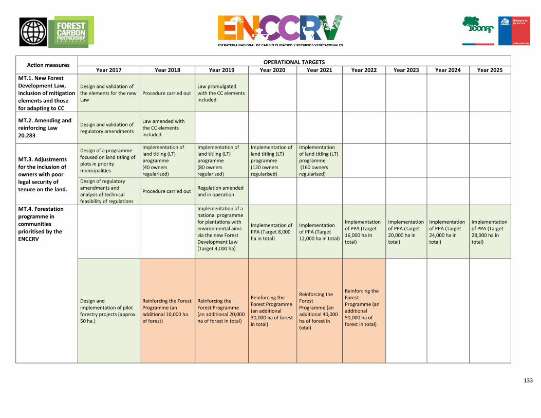
133
Action measures OPERATIONAL TARGETS
Year 2017 Year 2018 Year 2019 Year 2020 Year 2021 Year 2022 Year 2023 Year 2024 Year 2025
MT.1. New Forest Development Law, inclusion of mitigation elements and those for adapting to CC
Design and validation of the elements for the new Law
Procedure carried out Law promulgated with the CC elements included
MT.2. Amending and reinforcing Law 20.283
Design and validation of regulatory amendments
Law amended with the CC elements included
MT.3. Adjustments for the inclusion of owners with poor legal security of tenure on the land.
Design of a programme focused on land titling of plots in priority municipalities
Implementation of land titling (LT) programme (40 owners regularised)
Implementation of land titling (LT) programme (80 owners regularised)
Implementation of land titling (LT) programme (120 owners regularised)
Implementation of land titling (LT) programme (160 owners regularised)
Design of regulatory amendments and analysis of technical feasibility of regulations
Procedure carried out Regulation amended and in operation
MT.4. Forestation programme in communities prioritised by the ENCCRV
Implementation of a national programme for plantations with environmental aims via the new Forest Development Law (Target 4,000 ha)
Implementation of PPA (Target 8,000 ha in total)
Implementation of PPA (Target 12,000 ha in total)
Implementation of PPA (Target 16,000 ha in total)
Implementation of PPA (Target 20,000 ha in total)
Implementation of PPA (Target 24,000 ha in total)
Implementation of PPA (Target 28,000 ha in total)
Design and implementation of pilot forestry projects (approx. 50 ha.)
Reinforcing the Forest Programme (an additional 10,000 ha of forest)
Reinforcing the Forest Programme (an additional 20,000 ha of forest in total)
Reinforcing the Forest Programme (an additional 30,000 ha of forest in total)
Reinforcing the Forest Programme (an additional 40,000 ha of forest in total)
Reinforcing the Forest Programme (an additional 50,000 ha of forest in total)
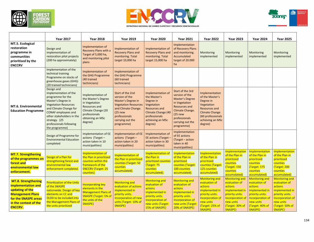
134
Year 2017
Year 2018
Year 2019
Year 2020
Year 2021
Year 2022
Year 2023
Year 2024
Year 2025
MT.5. Ecological restoration programme in communities prioritised by the ENCCRV
Design and implementation of restoration pilot projects (200 ha approximately)
Implementation of Recovery Plans with a Target of 5,000 ha, and monitoring pilot plans
Implementation of Recovery Plans and monitoring. Total target 10,000 ha
Implementation of Recovery Plans and monitoring. Total target 15,000 ha
Implementation of Recovery Plans and monitoring. Accumulated target of 20.000 ha
Monitoring implemented
Monitoring implemented
Monitoring implemented
Monitoring implemented
MT.6. Environmental Education Programme
Implementation of the technical training Programme on stocks of greenhouse gases (GHG) (20 trained technicians)
Implementation of the GHG Programme (40 trained technicians)
Implementation of the GHG Programme (60 trained technicians)
Design and implementation of the programme for the Master’s Degree in Vegetation Resources and Climate Change for CONAF employees and other stakeholders in the strategy. (25 professionals following the programme)
Implementation of the Master’s Degree in Vegetation Resources and Climate Change (20 professionals obtaining an MSc degree)
Start of the 2nd version of the Master’s Degree in Vegetation Resources and Climate Change. (25 new professionals carrying out the programme)
Implementation of the Master’s Degree in Vegetation Resources and Climate Change (40 professionals achieving an MSc degree)
Start of the 3rd version of the Master’s Degree in Vegetation Resources and Climate Change. (25 new professionals carrying out the programme)
Implementation of the Master’s Degree in Vegetation Resources and Climate Change (60 professionals achieving an MSc degree)
Design of Programme for Environmental Education completed
Implementation of EE actions (Target – action taken in 10 municipalities)
Implementation of EE actions (Target – action taken in 20 municipalities)
Implementation of EE actions (Target – action taken in 30 municipalities)
Implementation of EE actions (Target – action taken in 40 municipalities)
MT.7. Strengthening of the programmes on forest and environmental law enforcement.
Design of a Plan for strengthening forest and environmental law enforcement completed.
Implementation of the Plan in prioritized counties within the framework of the ENCCRV (Target: 25 counties).
Implementation of the Plan in prioritized counties (Target: 50 counties accumulated).
Implementation of the Plan in prioritized counties (Target: 75 counties accumulated).
Implementation of the Plan in prioritized counties (Target: 100 counties accumulated).
Implementation of the Plan in prioritized counties (Target: 125 counties accumulated)
Implementation of the Plan in prioritized counties (Target: 150 counties accumulated)
Implementation of the Plan in prioritized counties (Target: 175 counties accumulated)
Implementation of the Plan in prioritized counties (Target: 200 counties accumulated)
MT.8. Strengthening implementation and updating of the Management Plans for the SNASPE areas in the context of the ENCCRV.
Prioritization of the Units of the SNASPE nationwide. Design of key elements on CC and DLDD to be included into the Management Plans of the units prioritized
Incorporating key elements in the Management Plans of SNASPE (Target: 5% of the units of the SNASPE)
Monitoring and evaluation of actions implemented in priority units. Incorporation of new units (Target: 10% of SNASPE)
Monitoring and evaluation of actions implemented in priority units. Incorporation of new units (Target: 15% of SNASPE)
Monitoring and evaluation of actions implemented in priority units. Incorporation of new units (Target: 20% of SNASPE)
Monitoring and evaluation of actions implemented in priority units. Incorporation of new units (Target: 25% of SNASPE)
Monitoring and evaluation of actions implemented in priority units. Incorporation of new units (Target: 30% of SNASPE)
Monitoring and evaluation of actions implemented in priority units. Incorporation of new units (Target: 40% of SNASPE)
Monitoring and evaluation of actions implemented in priority units. Incorporation of new units (Target: 50% of SNASPE)
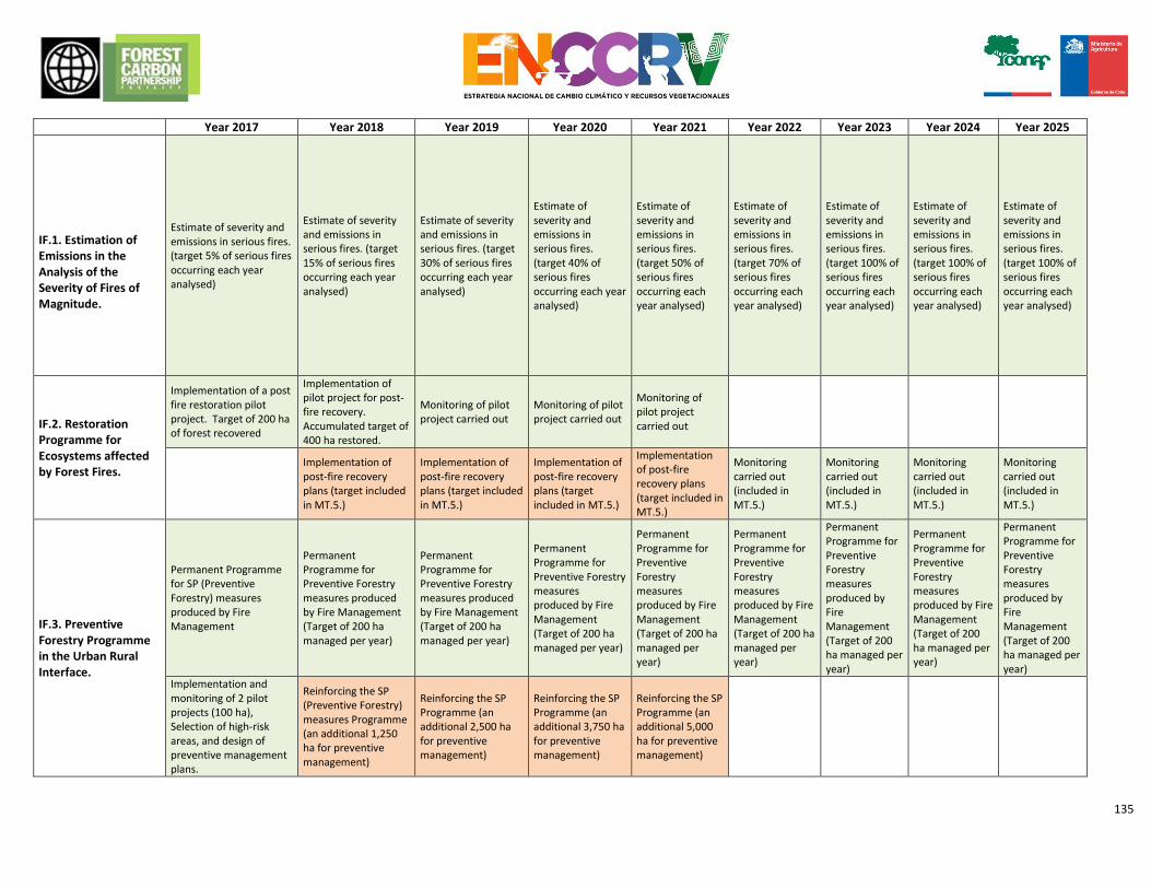
135
Year 2017 Year 2018 Year 2019 Year 2020 Year 2021 Year 2022 Year 2023 Year 2024 Year 2025
IF.1. Estimation of Emissions in the Analysis of the Severity of Fires of Magnitude.
Estimate of severity and emissions in serious fires. (target 5% of serious fires occurring each year analysed)
Estimate of severity and emissions in serious fires. (target 15% of serious fires occurring each year analysed)
Estimate of severity and emissions in serious fires. (target 30% of serious fires occurring each year analysed)
Estimate of severity and emissions in serious fires. (target 40% of serious fires occurring each year analysed)
Estimate of severity and emissions in serious fires. (target 50% of serious fires occurring each year analysed)
Estimate of severity and emissions in serious fires. (target 70% of serious fires occurring each year analysed)
Estimate of severity and emissions in serious fires. (target 100% of serious fires occurring each year analysed)
Estimate of severity and emissions in serious fires. (target 100% of serious fires occurring each year analysed)
Estimate of severity and emissions in serious fires. (target 100% of serious fires occurring each year analysed)
IF.2. Restoration Programme for Ecosystems affected by Forest Fires.
Implementation of a post fire restoration pilot project. Target of 200 ha of forest recovered
Implementation of pilot project for post-fire recovery. Accumulated target of 400 ha restored.
Monitoring of pilot project carried out
Monitoring of pilot project carried out
Monitoring of pilot project carried out
Implementation of post-fire recovery plans (target included in MT.5.)
Implementation of post-fire recovery plans (target included in MT.5.)
Implementation of post-fire recovery plans (target included in MT.5.)
Implementation of post-fire recovery plans (target included in MT.5.)
Monitoring carried out (included in MT.5.)
Monitoring carried out (included in MT.5.)
Monitoring carried out (included in MT.5.)
Monitoring carried out (included in MT.5.)
IF.3. Preventive Forestry Programme in the Urban Rural Interface.
Permanent Programme for SP (Preventive Forestry) measures produced by Fire Management
Permanent Programme for Preventive Forestry measures produced by Fire Management (Target of 200 ha managed per year)
Permanent Programme for Preventive Forestry measures produced by Fire Management (Target of 200 ha managed per year)
Permanent Programme for Preventive Forestry measures produced by Fire Management (Target of 200 ha managed per year)
Permanent Programme for Preventive Forestry measures produced by Fire Management (Target of 200 ha managed per year)
Permanent Programme for Preventive Forestry measures produced by Fire Management (Target of 200 ha managed per year)
Permanent Programme for Preventive Forestry measures produced by Fire Management (Target of 200 ha managed per year)
Permanent Programme for Preventive Forestry measures produced by Fire Management (Target of 200 ha managed per year)
Permanent Programme for Preventive Forestry measures produced by Fire Management (Target of 200 ha managed per year)
Implementation and monitoring of 2 pilot projects (100 ha), Selection of high-risk areas, and design of preventive management plans.
Reinforcing the SP (Preventive Forestry) measures Programme (an additional 1,250 ha for preventive management)
Reinforcing the SP Programme (an additional 2,500 ha for preventive management)
Reinforcing the SP Programme (an additional 3,750 ha for preventive management)
Reinforcing the SP Programme (an additional 5,000 ha for preventive management)
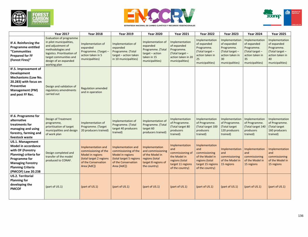
136
Year 2017 Year 2018 Year 2019 Year 2020 Year 2021 Year 2022 Year 2023 Year 2024 Year 2025
IF.4. Reinforcing the Programme entitled “Communities Prepared for FF (Forest Fires)”
Evaluation of programme in pilot municipalities, and adjustment of methodologies and logistics. Prioritisation of target communities and design of an expanded working plan
Implementation of expanded Programme. (Target – action taken in 5 municipalities)
Implementation of expanded Programme. (Total target – action taken in 10 municipalities)
Implementation of expanded Programme. (Total target – action taken in 15 municipalities)
Implementation of expanded Programme. (Total target – action taken in 20 municipalities)
Implementation of expanded Programme. (Total target – action taken in 25 municipalities)
Implementation of expanded Programme. (Total target – action taken in 30 municipalities)
Implementation of expanded Programme. (Total target – action taken in 35 municipalities)
Implementation of expanded Programme. (Total target – action taken in 40 municipalities)
IF.5. Improvement of Development Mechanisms (Law No. 20.283) with focus on Preventive Management (PM) and post FF Rec.
Design and validation of regulatory amendments carried out
Regulation amended and in operation
IF.6. Programme for alternative treatments for managing and using forestry, farming and livestock waste
Design of Treatment programme, prioritisation of target municipalities and design of work plan
Implementation of Programme. (Target 20 producers trained)
Implementation of Programme. (Total target 40 producers trained)
Implementation of Programme. (Total target 60 producers trained)
Implementation of Programme. (Total target 80 producers trained)
Implementation of Programme. (Total target 100 producers trained)
Implementation of Programme. (Total target 120 producers trained)
Implementation of Programme. (Total target 140 producers trained)
Implementation of Programme. (Total target 160 producers trained)
US.1. Management Model in accordance with OF (Forestry Planning) criteria for Programme for Managing Forestry Planning Criteria (PMCOF) Law 20.238
Design completed and transfer of the model produced to CONAF.
Implementation and commissioning of the Model in regions (total target 2 regions of the Conservation Area [AdC])
Implementation and commissioning of the Model in regions (total target 5 regions of the Conservation Area [AdC])
Implementation and commissioning of the Model in regions (total target 8 regions of the country)
Implementation and commissioning of the Model in regions (total target 11 regions of the country)
Implementation and commissioning of the Model in regions (total target 15 regions of the country)
Implementation and commissioning of the Model in 15 regions
Implementation and commissioning of the Model in 15 regions
Implementation and commissioning of the Model in 15 regions
US.2. Territorial Planning for developing the PMCOF
(part of US.1) (part of US.1) (part of US.1) (part of US.1) (part of US.1) (part of US.1) (part of US.1) (part of US.1) (part of US.1)
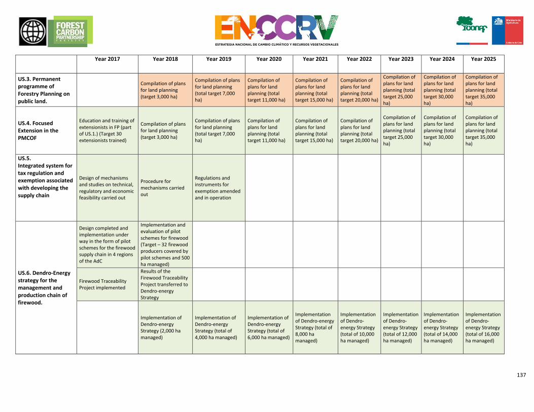
137
Year 2017 Year 2018 Year 2019 Year 2020 Year 2021 Year 2022 Year 2023 Year 2024 Year 2025
US.3. Permanent programme of Forestry Planning on public land.
Compilation of plans for land planning (target 3,000 ha)
Compilation of plans for land planning (total target 7,000 ha)
Compilation of plans for land planning (total target 11,000 ha)
Compilation of plans for land planning (total target 15,000 ha)
Compilation of plans for land planning (total target 20,000 ha)
Compilation of plans for land planning (total target 25,000 ha)
Compilation of plans for land planning (total target 30,000 ha)
Compilation of plans for land planning (total target 35,000 ha)
US.4. Focused Extension in the PMCOF
Education and training of extensionists in FP (part of US.1.) (Target 30 extensionists trained)
Compilation of plans for land planning (target 3,000 ha)
Compilation of plans for land planning (total target 7,000 ha)
Compilation of plans for land planning (total target 11,000 ha)
Compilation of plans for land planning (total target 15,000 ha)
Compilation of plans for land planning (total target 20,000 ha)
Compilation of plans for land planning (total target 25,000 ha)
Compilation of plans for land planning (total target 30,000 ha)
Compilation of plans for land planning (total target 35,000 ha)
US.5. Integrated system for tax regulation and exemption associated with developing the supply chain
Design of mechanisms and studies on technical, regulatory and economic feasibility carried out
Procedure for mechanisms carried out
Regulations and instruments for exemption amended and in operation
US.6. Dendro-Energy strategy for the management and production chain of firewood.
Design completed and implementation under way in the form of pilot schemes for the firewood supply chain in 4 regions of the AdC
Implementation and evaluation of pilot schemes for firewood (Target – 32 firewood producers covered by pilot schemes and 500 ha managed)
Firewood Traceability Project implemented
Results of the Firewood Traceability Project transferred to Dendro-energy Strategy
Implementation of Dendro-energy Strategy (2,000 ha managed)
Implementation of Dendro-energy Strategy (total of 4,000 ha managed)
Implementation of Dendro-energy Strategy (total of 6,000 ha managed)
Implementation of Dendro-energy Strategy (total of 8,000 ha managed)
Implementation of Dendro-energy Strategy (total of 10,000 ha managed)
Implementation of Dendro-energy Strategy (total of 12,000 ha managed)
Implementation of Dendro-energy Strategy (total of 14,000 ha managed)
Implementation of Dendro-energy Strategy (total of 16,000 ha managed)
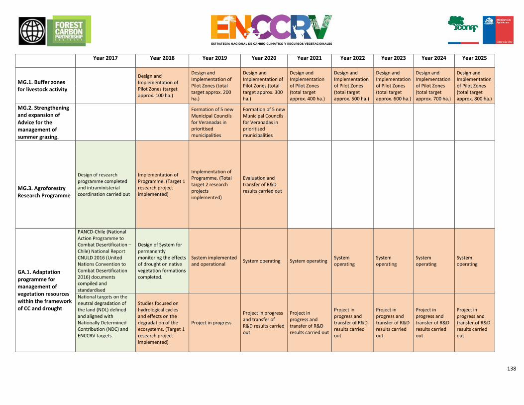
138
Year 2017 Year 2018 Year 2019 Year 2020 Year 2021 Year 2022 Year 2023 Year 2024 Year 2025
MG.1. Buffer zones for livestock activity
Design and Implementation of Pilot Zones (target approx. 100 ha.)
Design and Implementation of Pilot Zones (total target approx. 200 ha.)
Design and Implementation of Pilot Zones (total target approx. 300 ha.)
Design and Implementation of Pilot Zones (total target approx. 400 ha.)
Design and Implementation of Pilot Zones (total target approx. 500 ha.)
Design and Implementation of Pilot Zones (total target approx. 600 ha.)
Design and Implementation of Pilot Zones (total target approx. 700 ha.)
Design and Implementation of Pilot Zones (total target approx. 800 ha.)
MG.2. Strengthening and expansion of Advice for the management of summer grazing.
Formation of 5 new Municipal Councils for Veranadas in prioritised municipalities
Formation of 5 new Municipal Councils for Veranadas in prioritised municipalities
MG.3. Agroforestry Research Programme
Design of research programme completed and intraministerial coordination carried out
Implementation of Programme. (Target 1 research project implemented)
Implementation of Programme. (Total target 2 research projects implemented)
Evaluation and transfer of R&D results carried out
GA.1. Adaptation programme for management of vegetation resources within the framework of CC and drought
PANCD-Chile (National Action Programme to Combat Desertification – Chile) National Report CNULD 2016 (United Nations Convention to Combat Desertification 2016) documents compiled and standardised
Design of System for permanently monitoring the effects of drought on native vegetation formations completed.
System implemented and operational
System operating System operating System operating
System operating
System operating
System operating
National targets on the neutral degradation of the land (NDL) defined and aligned with Nationally Determined Contribution (NDC) and ENCCRV targets.
Studies focused on hydrological cycles and effects on the degradation of the ecosystems. (Target 1 research project implemented)
Project in progress
Project in progress and transfer of R&D results carried out
Project in progress and transfer of R&D results carried out
Project in progress and transfer of R&D results carried out
Project in progress and transfer of R&D results carried out
Project in progress and transfer of R&D results carried out
Project in progress and transfer of R&D results carried out
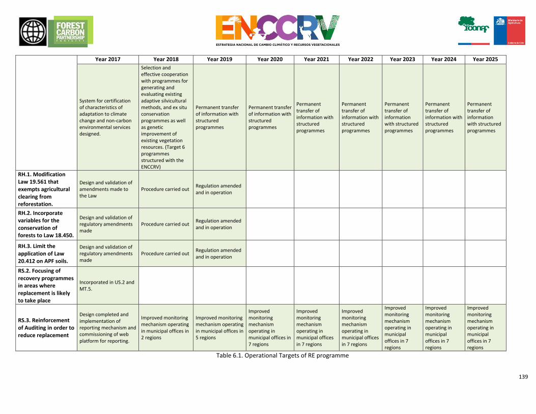
139
Year 2017 Year 2018 Year 2019 Year 2020 Year 2021 Year 2022 Year 2023 Year 2024 Year 2025
System for certification of characteristics of adaptation to climate change and non-carbon environmental services designed.
Selection and effective cooperation with programmes for generating and evaluating existing adaptive silvicultural methods, and ex situ conservation programmes as well as genetic improvement of existing vegetation resources. (Target 6 programmes structured with the ENCCRV)
Permanent transfer of information with structured programmes
Permanent transfer of information with structured programmes
Permanent transfer of information with structured programmes
Permanent transfer of information with structured programmes
Permanent transfer of information with structured programmes
Permanent transfer of information with structured programmes
Permanent transfer of information with structured programmes
RH.1. Modification Law 19.561 that exempts agricultural clearing from reforestation.
Design and validation of amendments made to the Law
Procedure carried out Regulation amended and in operation
RH.2. Incorporate variables for the conservation of forests to Law 18.450.
Design and validation of regulatory amendments made
Procedure carried out Regulation amended and in operation
RH.3. Limit the application of Law 20.412 on APF soils.
Design and validation of regulatory amendments made
Procedure carried out Regulation amended and in operation
RS.2. Focusing of recovery programmes in areas where replacement is likely to take place
Incorporated in US.2 and MT.5.
RS.3. Reinforcement of Auditing in order to reduce replacement
Design completed and implementation of reporting mechanism and commissioning of web platform for reporting.
Improved monitoring mechanism operating in municipal offices in 2 regions
Improved monitoring mechanism operating in municipal offices in 5 regions
Improved monitoring mechanism operating in municipal offices in 7 regions
Improved monitoring mechanism operating in municipal offices in 7 regions
Improved monitoring mechanism operating in municipal offices in 7 regions
Improved monitoring mechanism operating in municipal offices in 7 regions
Improved monitoring mechanism operating in municipal offices in 7 regions
Improved monitoring mechanism operating in municipal offices in 7 regions
Table 6.1. Operational Targets of RE programme
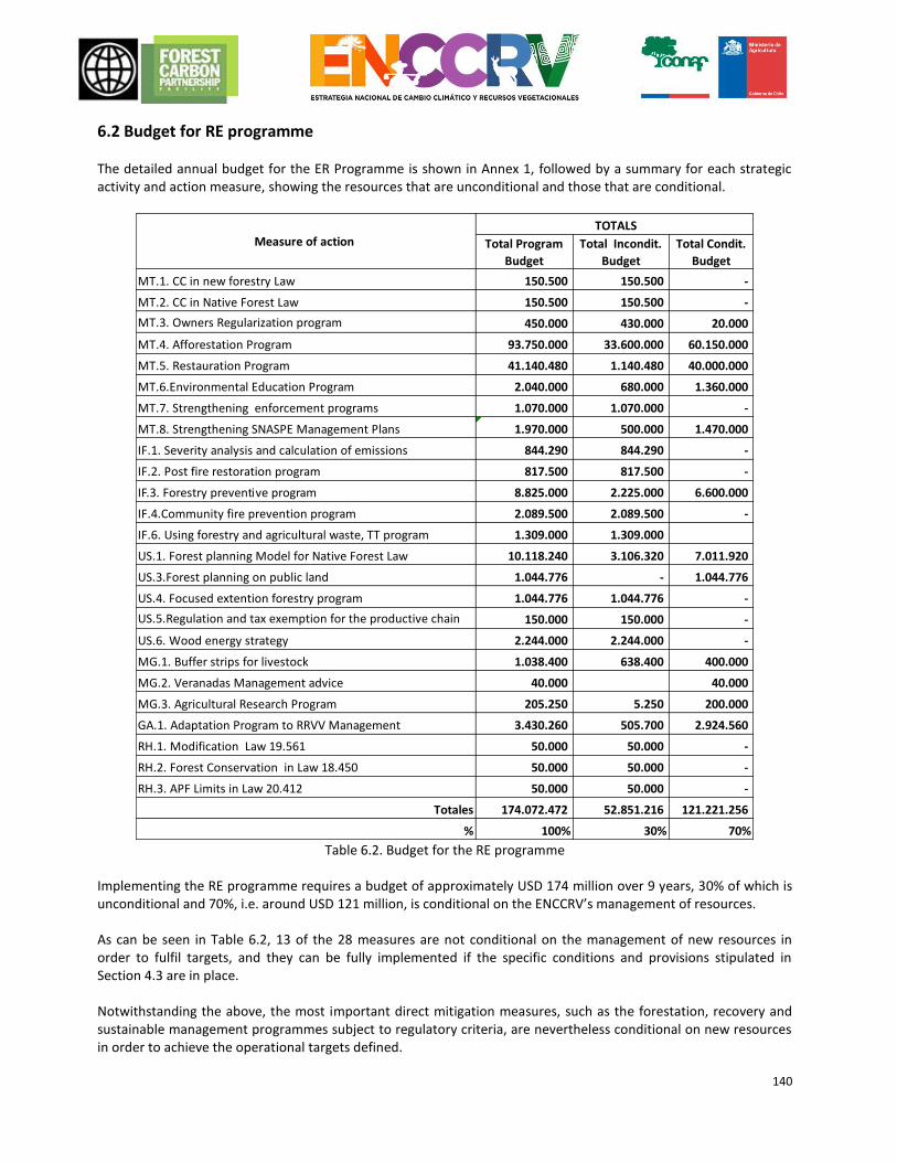
140
6.2 Budget for RE programme The detailed annual budget for the ER Programme is shown in Annex 1, followed by a summary for each strategic activity and action measure, showing the resources that are unconditional and those that are conditional.
Table 6.2. Budget for the RE programme
Implementing the RE programme requires a budget of approximately USD 174 million over 9 years, 30% of which is unconditional and 70%, i.e. around USD 121 million, is conditional on the ENCCRV’s management of resources. As can be seen in Table 6.2, 13 of the 28 measures are not conditional on the management of new resources in order to fulfil targets, and they can be fully implemented if the specific conditions and provisions stipulated in Section 4.3 are in place. Notwithstanding the above, the most important direct mitigation measures, such as the forestation, recovery and sustainable management programmes subject to regulatory criteria, are nevertheless conditional on new resources in order to achieve the operational targets defined.
Total Program
Budget
Total Incondit.
Budget
Total Condit.
Budget
MT.1. CC in new forestry Law 150.500 150.500 -
MT.2. CC in Native Forest Law 150.500 150.500 -
MT.3. Owners Regularization program 450.000 430.000 20.000
MT.4. Afforestation Program 93.750.000 33.600.000 60.150.000
MT.5. Restauration Program 41.140.480 1.140.480 40.000.000
MT.6.Environmental Education Program 2.040.000 680.000 1.360.000
MT.7. Strengthening enforcement programs 1.070.000 1.070.000 -
MT.8. Strengthening SNASPE Management Plans 1.970.000 500.000 1.470.000
IF.1. Severity analysis and calculation of emissions 844.290 844.290 -
IF.2. Post fire restoration program 817.500 817.500 -
IF.3. Forestry preventive program 8.825.000 2.225.000 6.600.000
IF.4.Community fire prevention program 2.089.500 2.089.500 -
IF.6. Using forestry and agricultural waste, TT program 1.309.000 1.309.000
US.1. Forest planning Model for Native Forest Law 10.118.240 3.106.320 7.011.920
US.3.Forest planning on public land 1.044.776 - 1.044.776
US.4. Focused extention forestry program 1.044.776 1.044.776 -
US.5.Regulation and tax exemption for the productive chain 150.000 150.000 -
US.6. Wood energy strategy 2.244.000 2.244.000 -
MG.1. Buffer strips for livestock 1.038.400 638.400 400.000
MG.2. Veranadas Management advice 40.000 40.000
MG.3. Agricultural Research Program 205.250 5.250 200.000
GA.1. Adaptation Program to RRVV Management 3.430.260 505.700 2.924.560
RH.1. Modification Law 19.561 50.000 50.000 -
RH.2. Forest Conservation in Law 18.450 50.000 50.000 -
RH.3. APF Limits in Law 20.412 50.000 50.000 -
Totales 174.072.472 52.851.216 121.221.256
% 100% 30% 70%
Measure of action TOTALS
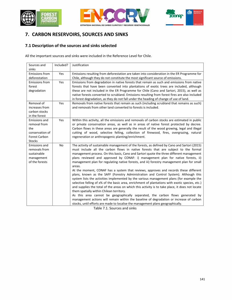
141
7. CARBON RESERVOIRS, SOURCES AND SINKS
7.1 Description of the sources and sinks selected All the important sources and sinks were included in the Reference Level for Chile.
Sources and sinks
Included? Justification
Emissions from deforestation
Yes Emissions resulting from deforestation are taken into consideration in the ER Programme for Chile, although they do not constitute the most significant source of emissions.
Emissions from forest degradation
Yes Emissions from degradation in native forests that remain as such and emissions from native forests that have been converted into plantations of exotic trees are included, although these are not included in the ER Programme for Chile (Cano and Sartori, 2015), as well as native forests converted to scrubland. Emissions resulting from forest fires are also included in forest degradation, as they do not fall under the heading of change of use of land.
Removal of increases from carbon stocks in the forest
Yes Removals from native forests that remain as such (including scrubland that remains as such) and removals from other land converted to forests is included.
Emissions and removal from the conservation of Forest Carbon Stocks
Yes Within this activity, all the emissions and removals of carbon stocks are estimated in public or private conservation areas, as well as in areas of native forest protected by decree. Carbon flows in these areas are generally the result of the wood growing, legal and illegal cutting of wood, selective felling, collection of firewood, fires, overgrazing, natural regeneration or anthropogenic planting/enrichment.
Emissions and removals from sustainable management of the forests
No The activity of sustainable management of the forests, as defined by Cano and Sartori (2015) must include all the carbon flows in native forests that are subject to the formal management process. On this basis, Cano and Sartori quote the three different management plans reviewed and approved by CONAF: i) management plan for native forests, ii) management plan for regulating native forests, and iii) forestry management plan for small areas. At the moment, CONAF has a system that reviews, approves and records these different plans, known as the SAFF (Forestry Administration and Control System). Although this system lists the activities implemented by the various management plans (for example the selective felling of x% of the basic area, enrichment of plantations with exotic species, etc.) and supplies the total of the areas on which this activity is to take place, it does not locate them spatially within Chilean territory. As this area cannot be geographically separated, the carbon flows generated by management actions will remain within the baseline of degradation or increase of carbon stocks, until efforts are made to localise the management plans geographically.
Table 7.1. Sources and sinks
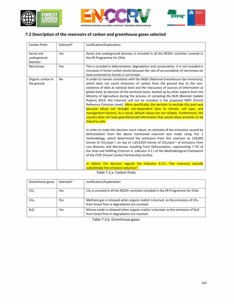
142
7.2 Description of the reservoirs of carbon and greenhouse gases selected
Carbon Pools Selected? Justification/Explanation
Aerial and underground biomass
Yes Aerial and underground biomass is included in all the REDD+ activities covered in the ER Programme for Chile.
Necromass Yes This is included in deforestation, degradation and conservation. It is not included in increases in forest carbon stocks because the rate of accumulation of necromass on land converted to forests is not known.
Organic carbon in the ground
No In order to remain consistent with the INGEI (National Greenhouse Gas Inventory), which does not count emissions of carbon from the ground due to the non-existence of data at national level and the inaccuracy of sources of information at global level, by decision of the technical team, backed up by other experts from the Ministry of Agriculture during the process of compiling the BUR (Biennial Update Report) 2014, this reservoir will not be included in the proposed NREF (Forest Reference Emission Level). More specifically, the decision to exclude this pool was because values are strongly site-dependent (due to climate, soil type, and management factors). As a result, default values are not reliable. Furthermore, the country does not have georeferenced information that would allow activities to be linked to soils. In order to make this decision more robust, an estimate of the emissions caused by deforestation from the above mentioned reservoir was made using Tier 1 methodology, which determined the emissions from this reservoir as 128,005 tonnes of CO2/year-1, on top of 1,653,819 tonnes of CO2/year-1 of emissions from Live Biomass and Necromass resulting from Deforestation, representing 7.7% of the total and fulfilling Criterion 4, indicator 4.1.i of the Methodological Framework of the FCPF (Forest Carbon Partnership Facility). In adition this decision regards the indicator 4.2.ii: “the reservory exclude subestimate the emission reduction”.
Table 7.2.a. Carbon Pools
Greenhouse gases Selected? Justification/Explanation
CO2 Yes CO2 is counted in all the REDD+ activities included in the ER Programme for Chile.
CH4 Yes Methane gas is released when organic matter is burned, so the emissions of CH4 from forest fires in degradation are counted.
N20 Yes Nitrous oxide is released when organic matter is burned, so the emissions of N2O from forest fires in degradation are counted.
Table 7.2.b. Greenhouse gases
143
8. REFERENCE LEVEL All the NREF/NRF details about Chile can be downloaded from the following site: https://www.dropbox.com/sh/1lvlusocafkotm0/AACRy5RH2HbkYwIfkW2flwsPa?dl=0 The NREF/NRF for Chile describes the emissions and removals produced in Native Temperate Forests during the reference period for the activities of Deforestation, Forest Degradation, Forest Conservation and Increase in Carbon Stocks. Sustainable forest management activity could not be incorporated because at the moment there is no official data allowing the area subject to this condition to be spatially delimited. However a programme is being designed for this purpose, so that this activity can be incorporated in the future. The following definitions, agreed by an extensive discussion with the partipation of national and international experts from UCCSA and the Department of Forest Ecosystems Mointoring, from CONAF; INFOR; Universidad Austral de Chile, Universidad Mayor, Winrock International, the Worldbank and CONAFOR from México40, apply in this context: Deforestation: Conversion of forest areas, to a different use of the land, when this is either permanent or where there is no certainty about how and when the forest would be restored when the change of use took place. Deforestation is not considered to be a change of use of the forestland (according to the definition stated previously) into plantations. This change of use of the land will be recorded under the heading of Degradation activity, in order to maintain consistency with the INGEI. Nor will areas which are temporarily without stock or where trees have been removed be considered to be areas of deforestation, provided that a natural or assisted regenerative activity is planned, recorded and documented. Degradation: Any reduction in the Carbon content of a forest, brought about by man, whose intensity means that ceasing forestry activity is advisable, even though it has not resulted in a change of use of the land. The NREF/NRF does not view as degradation emissions produced in forests which remain unchanged subject to formal conservation procedures, since they are counted in another of the 5 defined activities. Any change of use of the land from Forest to Forestry Plantation (also known as Sustitution) will be considered forest degradation. The carbon stock in plantations after the substitution will be consider as “0” regarding to the process of clearing necessary for the establishment of a plantation. Accounting from carbon flows in plantations not be held in the REDD + reference level, but in the NGGI. Increase of Stocks: Increase in forest carbon stocks in areas subject to a change of land use from non-forest to forest and increase of forest carbon stock in forests which remain unchanged. Stock increases produced in forests which remain unchanged subject to formal conservation procedures will not be considered in the Increase of Stocks activity since they are counted in another of the activities defined. No increase produced in areas which have been converted from Forest to Forestry Plantation will be considered to be an Increase of Stocks, as this is considered to fall within the definition of degradation as explained above. Any change of use from Forestry Plantation to Forest (also known as Restitution) will be considered to be an Increase of Stocks which maintains consistency with the concept of substitution applied in forest degradation activity. Considering that restitution is a process that occurs after harvesting, shall be deemed to carbon stock prior to the restitution it is "0". Conservation: Accounting of Forest Degradation and Enhancement of Carbon Stock in areas of Native Forest subject to formal conservation procedures. In terms of practical application and subject to the constraints of the information available, Native Forests subject to formal conservation procedures are considered to be those identified as containing Forest Conservation Species (Chilean Palm, Larch and Araucaria [monkey puzzle]), as well as the forested areas which form part of the SNASPE and those registered as APP (Private Protected Areas) for forestry conservation. It may still be possible to incorporate those areas which are characterized as Native Forests subject to
40 More detailes in Anexo_Definiciones_REDD+ and Anexo_Acta_Taller_NR
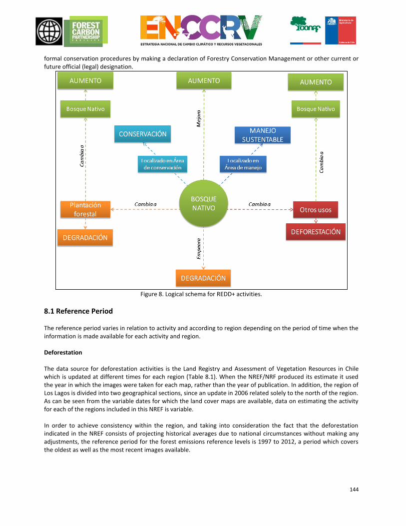
144
formal conservation procedures by making a declaration of Forestry Conservation Management or other current or future official (legal) designation.
Figure 8. Logical schema for REDD+ activities.
8.1 Reference Period The reference period varies in relation to activity and according to region depending on the period of time when the information is made available for each activity and region. Deforestation The data source for deforestation activities is the Land Registry and Assessment of Vegetation Resources in Chile which is updated at different times for each region (Table 8.1). When the NREF/NRF produced its estimate it used the year in which the images were taken for each map, rather than the year of publication. In addition, the region of Los Lagos is divided into two geographical sections, since an update in 2006 related solely to the north of the region. As can be seen from the variable dates for which the land cover maps are available, data on estimating the activity for each of the regions included in this NREF is variable. In order to achieve consistency within the region, and taking into consideration the fact that the deforestation indicated in the NREF consists of projecting historical averages due to national circumstances without making any adjustments, the reference period for the forest emissions reference levels is 1997 to 2012, a period which covers the oldest as well as the most recent images available.
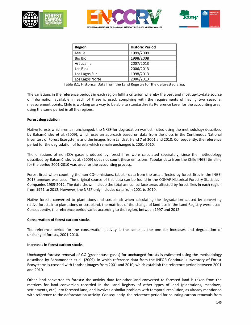
145
Region Historic Period
Maule 1999/2009
Bío Bío 1998/2008
Araucanía 2007/2013
Los Ríos 2006/2013
Los Lagos Sur 1998/2013
Los Lagos Norte 2006/2013
Table 8.1. Historical Data from the Land Registry for the deforested area. The variations in the reference periods in each region fulfil a criterion whereby the best and most up-to-date source of information available in each of these is used, complying with the requirements of having two seasonal measurement points. Chile is working on a way to be able to standardize its Reference Level for the accounting area, using the same period in all the regions. Forest degradation Native forests which remain unchanged: the NREF for degradation was estimated using the methodology described by Bahamóndez et al. (2009), which uses an approach based on data from the plots in the Continuous National Inventory of Forest Ecosystems and the images from Landsat 5 and 7 of 2001 and 2010. Consequently, the reference period for the degradation of forests which remain unchanged is 2001-2010. The emissions of non-CO2 gases produced by forest fires were calculated separately, since the methodology described by Bahamóndez et al. (2009) does not count these emissions. Tabular data from the Chile INGEI timeline for the period 2001-2010 was used for the accounting process. Forest fires: when counting the non-CO2 emissions, tabular data from the area affected by forest fires in the INGEI 2015 annexes was used. The original source of this data can be found in the CONAF Historical Forestry Statistics - Companies 1985-2012. The data shown include the total annual surface areas affected by forest fires in each region from 1971 to 2012. However, the NREF only includes data from 2001 to 2010. Native forests converted to plantations and scrubland: when calculating the degradation caused by converting native forests into plantations or scrubland, the matrices of the change of land use in the Land Registry were used. Consequently, the reference period varies according to the region, between 1997 and 2012. Conservation of forest carbon stocks The reference period for the conservation activity is the same as the one for increases and degradation of unchanged forests, 2001-2010. Increases in forest carbon stocks Unchanged forests: removal of GG (greenhouse gases) for unchanged forests is estimated using the methodology described by Bahamondez et al. (2009), in which reference data from the INFOR Continuous Inventory of Forest Ecosystems is crossed with Landsat images from 2001 and 2010, which establish the reference period between 2001 and 2010. Other land converted to forests: the activity data for other land converted to forested land is taken from the matrices for land conversion recorded in the Land Registry of other types of land (plantations, meadows, settlements, etc.) into forested land, and involves a similar problem with temporal resolution, as already mentioned with reference to the deforestation activity. Consequently, the reference period for counting carbon removals from
146
other types of land converted into forested land is the most comprehensive, as activity data does exist, and this runs from 1997 to 2012. Extrapolation from a specific mean regional annual area is applied for years in which the regions do not have data activity (as was the case with deforestation).
8.2 Definition of forest used in the Reference Level
The definition of Law 20.28341 concerning the recovery of Native Forest and Forestry Development defines Forests
as a “site populated with vegetation formations in which trees predominate, occupying a surface area of at least 5,000 square metres, with a minimum width of 40 metres, with tree crown cover in excess of 10% of said total surface area in arid and semiarid conditions and 25% in more favourable circumstances”. The same Law 20.283 establishes the following definition for Native Forest: “forest formed by native species, which have been generated naturally, are the result of natural regeneration or which takes the form of a plantation under the tree canopy, involving the same species in existence in the original area of distribution, where there may be the accidental presence of exotic species distributed at random”. For adequate counting of carbon for the respective reference levels the concept of Other forested land, as defined
by the National Report for Chile in the Global Forest Resources Assessment for 2015 42(FRA2015) as “Land not
defined as forest which extends over more than 0.5 hectares; with trees of a height in excess of 5 m and a tree canopy cover of 5 to 10 per cent, or trees capable of reaching these minimum limits; or with a mixed cover of bushes, scrubland and trees in excess of 10 per cent must be included. Land subject to use which is predominantly agricultural or urban must be included”. The concept of Other forested land attempts to adjust the registers in the System for Monitoring changes of use of land and plants (Land Registry), which up to 2014 included the parameter of mean height in order to differentiate between native forest and scrubland, to the legal definition of native forest established by Law 20.283, in which the parameter of mean height is not taken into consideration. Based on the updates of the Land Registry in 2015, which include technological and design-based improvements in order to adjust the operational parameters to the legal definition, the land previously qualified as Other forested land will be incorporated in the category of native forest. Law 20.283 does not provide any definition for Forestry Plantations. According to the FAO (Food and Agriculture
Organization) (2015)43 Forestry Plantations or Planted Forests will be considered as: “forests predominantly
composed of trees established as a result of planting and/or sowing in a deliberate way”, taking into account the fact that: “1) Predominantly means that it is hoped that the trees which have been planted or sown will consist of over 50% of the mass when they are mature; 2) It includes the regrowth of trees which were originally planted or sown; 3) It includes plantations of rubber, cork and Christmas trees 4) It excludes trees from species which have been introduced but which have become naturalized”. In the same document FAO describes Exotic Forest Plantations,“as being those Forest Plantations which in their adult stages consist of over 50% of exotic species”. The above definitions should combine to indicate the total cover at national level, including Native Forests, of both natural forests and Plantations, as well as forests which have been sown or planted containing a subcategory of Forestry Plantations of Exotic Species and Forestry Plantations of Native Species. At the moment almost all the Forestry Plantations in Chile are mono-specific plantations involving exotic species whose purpose is to produce timber, as the numbers and dimensions of Native Forestry Plantations are poorly
represented44.
41 http://www.conaf.cl/cms/editorweb/transparencia/potestades/Ley-20283_bn.pdf 42 http://www.fao.org/3/a-az185s.pdf 43 http://www.fao.org/docrep/017/ap862e/ap862e00.pdf 44 According to the INFOR Continuous Inventory (2014) 2.7% of the plantations relate to Other species, in which both exotic and native species must be taken into consideration. Source: INFOR
http://mapaforestal.infor.cl/phocadownload/Informe_Inventario_Continuo_2014.pdf
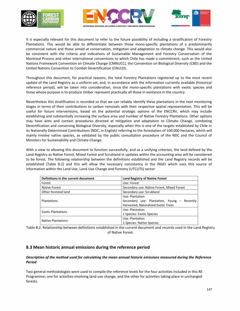
147
It is especially relevant for this document to refer to the future possibility of including a stratification of Forestry Plantations. This would be able to differentiate between those mono-specific plantations of a predominantly commercial nature and those aimed at conservation, mitigation and adaptation to climate change. This would also be consistent with the criteria and indications of Sustainable Management and Forestry Conservation of the Montreal Process and other international conventions to which Chile has made a commitment, such as the United Nations Framework Convention on Climate Change (CMNUCC), the Convention on Biological Diversity (CBD) and the United Nations Convention to Combat Desertification (CNULD). Throughout this document, for practical reasons, the total Forestry Plantations registered up to the most recent update of the Land Registry as a uniform set, and, in accordance with the information currently available (historical reference period), will be taken into consideration, since the mono-specific plantations with exotic species and those whose purpose is to produce timber represent practically all those in existence in the country. Nevertheless this stratification is recorded so that we can reliably identify these plantations in the next monitoring stages in terms of their contributions to carbon removals with their respective spatial representation. This will be useful for future interventions, based on the potential strategic options of the ENCCRV, which may include establishing and substantially increasing the surface area and number of Native Forestry Plantations. Other options may have aims and contain procedures directed at mitigation and adaptation to Climate Change, combating Desertification and conserving Biological Diversity, especially when this is one of the targets established by Chile in its Nationally Determined Contributions (NDC, in English) referring to the forestation of 100,000 hectares, which will mainly involve native species, as validated by the public consultation procedure of the NDC and the Council of Ministers for Sustainability and Climate Change. With a view to allowing this document to function successfully, and as a unifying criterion, the land defined by the Land Registry as Native Forest, Mixed Forest and Scrubland in updates within the accounting area will be considered to be forest. The following relationship between the definitions established and the Land Registry records will be established (Table 8.2) and this will allow the necessary consistency in the INGEI which uses this source of information within the Land Use, Land-Use Change and Forestry (UTCUTS) sector
Definitions in the current document Land Registry of Native Forest
Forest Use: Forest
Native Forest Secondary use: Native Forest, Mixed Forest
Other forested land Secondary use: Scrubland
Plantations Use: Plantation Secondary use: Plantation, Young – Recently Harvested, Naturalized Exotic Trees
Exotic Plantations Use: Plantation 1 Species: Exotic Species
Native Plantations Use: Plantation 1 Species: Native Species
Table 8.2. Relationship between definitions established in the current document and records used in the Land Registry of Native Forest.
8.3 Mean historic annual emissions during the reference period Description of the method used for calculating the mean annual historic emissions measured during the Reference Period Two general methodologies were used to compile the reference levels for the four activities included in this RE Programme; one for activities involving land-use change, and the other for activities taking place in unchanged forests.
148
Land-use change Deforestation The methodology for calculating the deforestation NREF in Chile is based on the IPCC 200645 equations for forested land converted to other types of land, which the INGEI also uses to calculate the emissions from forests converted to other land uses. This includes reservoirs of aerial biomass, underground biomass and necromass. The following equation is used to calculate the NREF in tonnes of CO2e, :
FREL𝐷𝑒𝑓 =∑ Δ𝐶𝐵𝑡,𝐷𝑒𝑓𝑡
𝑝 ∗
44
12
Eq. 8.1 Where: FRELDef = annual mean losses of carbon stocks from forested land converted to non-forest land during the reference period, in tonnes of CO2e year-1
Δ𝐶𝐵𝑡,𝐷𝑒𝑓 = change in carbon stocks in forested land converted to non-forested land in year t of the reference
period, in tonnes of C. Reference is made to the reservoirs included below. p = years in the reference period 44
12 = factor for converting carbon to carbon dioxide equivalent , tonnes of CO2e tonnes of C-1
Tier 3 of the IPCC methodology is used in the estimates of emissions caused by deforestation, since the carbon stocks for land uses before and after conversion are specific to Chile, and the conversion areas are broken down per type of cover of the original ground (Sidman et al., 2015). As recommended in the IPCC (2006), Equation 2.15 is used to calculate the annual change of carbon stocks of forested land converted to other categories of land use (in the case of deforestation, any forested area converted to a non-forested area):
Δ𝐶𝐵𝑡,𝐷𝑒𝑓= Δ𝐶𝐺𝑡
+ ΔC𝐶𝑂𝑁𝑉𝐸𝑅𝑆𝐼𝑂𝑁𝑡− Δ𝐶𝐿𝑡
Eq. 8.2 (Eq. 2.15 IPCC, 2006)
Where: Δ𝐶𝐵𝑡,𝐷𝑒𝑓
= annual change of carbon stocks in forested land converted to non-forested land for the year t because of
the activity of deforestation (Def), in tonnes of C Δ𝐶𝐺𝑡
= annual increase of carbon stocks due to the growth in forested land converted to non-forested land in the
year t, in tonnes of C ΔC𝐶𝑂𝑁𝑉𝐸𝑅𝑆𝐼𝑂𝑁𝑡
= initial change in carbon stocks in biomass in forested land converted to non-forested land in the
year t, in tonnes of C Δ𝐶𝐿𝑡
= annual loss of carbon stocks in biomass due to timber harvesting, collection of firewood and disturbances in
forested land converted to non-forested land in the year t, in tonnes of C In this equation, the change in carbon stocks from the gains and losses due to any activity apart from conversion are added (ΔCG and ΔCL) to the net gain and loss due directly to the conversion (ΔCCONVERSION; in the case of deforestation, this generally results in a negative value given the loss of carbon stocks from the forest) in order to calculate the total change in carbon stocks.
45 Intergovernmental Panel on Climate Change (IPCC) (2006). Guidelines for National Greenhouse Gas Inventories, Volume 4: Agriculture, Forestry and Other Land Use.
149
For the NREF of deforestation in Chile, ΔCG which represents carbon acquisitions from non-forestry uses following the conversion (agricultural, urban, other) is included. This variable will be left at a value of zero, since it does not affect the analysis of the loss through deforestation. Equation 8.3 (IPCC,2006 Equation 2.16) calculates the parameter ΔCCONVERSION for inclusion in Equation 8.2:
Δ𝐶𝐶𝑂𝑁𝑉𝐸𝑅𝑆𝐼𝑂𝑁𝑡= ∑ (𝐵𝐴𝐹𝑇𝐸𝑅 𝑖
− 𝐵𝐵𝐸𝐹𝑂𝑅𝐸 𝑖) ∗ ΔATOOTHERS𝑖,𝑡
∗ 𝐶𝐹
𝑖
Eq. 8.3 (Eq. 2.16 IPCC, 2006)
Where: Δ𝐶𝐶𝑂𝑁𝑉𝐸𝑅𝑆𝐼𝑂𝑁 = initial change of carbon stocks from biomass in forested land converted to non-forested land, in tonnes of C per year-1
𝐵𝐴𝐹𝑇𝐸𝑅 𝑖 = existence of biomass in the type of use of non-forested land i after conversion, in tonnes of dry biomass
per hectare 𝐵𝐵𝐸𝐹𝑂𝑅𝐸 𝑖
= existence of biomass in the type of forest prior to conversion, in tonnes of dry biomass per hectare
ΔATOOTHERS𝑖,𝑡 = area of type of forest i converted to non-forested land in the year t, in ha
CF = fraction of carbon in dry biomass, in tonnes of carbon per tonnes of dry biomass In the case of deforestation, these equations can be represented with two essential inputs: the area of forest converted to other uses (ΔATO_OTHERSi), frequently referred to as data activity (DA), and the quantity of carbon stocks emitted due to the conversion (BAFTERi - BBEFOREi), frequently referred to as emissions factors (EF). The parameters BAFTERi and BBEFOREi only include aerial and underground biomass, and necromass is included by adding the parameter ΔCDOM calculated in accordance with equation 8.4:
ΔCDOMt=
(𝐶𝑛 − 𝐶𝑜) ∗ 𝐴𝑜𝑛𝑡
𝑇𝑜𝑛
Eq. 8.4 (Eq. 2.23 IPCC, 2006)
Where: ΔCDOMt
= change in carbon stocks in necromass in the year t, tonnes of C
𝐶𝑛 = carbon stocks from dead wood and necromass in the use of the non-forested land after conversion, tonnes of C per year-1
𝐶𝑜 = carbon stocks from dead wood and necromass from forest prior to conversion to non-forest, tonnes of C year-1
𝐴𝑜𝑛𝑡 = area converted from forest to non-forest in the year t, hectares
𝑇𝑜𝑛 = period of time of the transition from forest to non-forest In this equation, 𝐴𝑜𝑛 corresponds to the activity datum, or ΔATOOTHERS𝑖
, in accordance with the parameter of
equation 8.3, described above. In order to simplify the accounting process the emissions from necromass will be counted in the year of the conversion (which means that it is assumed that Ton has a value of 1). In order to remain consistent with the INGEI, which does not count emissions of carbon from the ground due to the existence of data at national level and the inaccuracy of existing sources of information at global level, this reservoir will not be included in the proposed NREF. In order to make this decision more robust an estimate of the emissions caused by deforestation from the above mentioned reservoir was made using Tier 1 methodology, which determined the emissions from this reservoir as 128,005 tonne CO2e/year-1, on top of 1,653,819 tonne CO2e/year-1 of emissions from Live Biomass and Necromass resulting from Deforestation, representing 7.7% of the total and fulfilling Criterion 4, indicator 4.1.i of the Methodological Framework of the FCPF (Forest Carbon Partnership Facility).
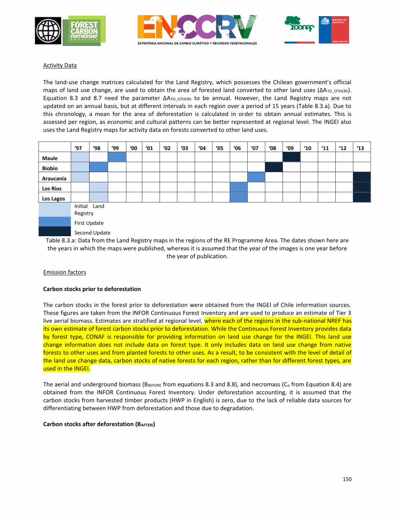
150
Activity Data
The land-use change matrices calculated for the Land Registry, which possesses the Chilean government’s official maps of land use change, are used to obtain the area of forested land converted to other land uses (ΔATO_OTHERS). Equation 8.3 and 8.7 need the parameter ΔATO_OTHERS to be annual. However, the Land Registry maps are not updated on an annual basis, but at different intervals in each region over a period of 15 years (Table 8.3.a). Due to this chronology, a mean for the area of deforestation is calculated in order to obtain annual estimates. This is assessed per region, as economic and cultural patterns can be better represented at regional level. The INGEI also uses the Land Registry maps for activity data on forests converted to other land uses.
‘97 ‘98 ‘99 ‘00 ‘01 ‘02 ‘03 ‘04 ‘05 ‘06 ‘07 ‘08 ‘09 ‘10 ‘11 ‘12 ‘13
Maule
Biobío
Araucanía
Los Rios
Los Lagos
Initial Land Registry
First Update Second Update Table 8.3.a: Data from the Land Registry maps in the regions of the RE Programme Area. The dates shown here are
the years in which the maps were published, whereas it is assumed that the year of the images is one year before the year of publication.
Emission factors
Carbon stocks prior to deforestation The carbon stocks in the forest prior to deforestation were obtained from the INGEI of Chile information sources. These figures are taken from the INFOR Continuous Forest Inventory and are used to produce an estimate of Tier 3 live aerial biomass. Estimates are stratified at regional level, where each of the regions in the sub-national NREF has its own estimate of forest carbon stocks prior to deforestation. While the Continuous Forest Inventory provides data by forest type, CONAF is responsible for providing information on land use change for the INGEI. This land use change information does not include data on forest type. It only includes data on land use change from native forests to other uses and from planted forests to other uses. As a result, to be consistent with the level of detail of the land use change data, carbon stocks of native forests for each region, rather than for different forest types, are used in the INGEI. The aerial and underground biomass (BBEFORE from equations 8.3 and 8.8), and necromass (Co from Equation 8.4) are obtained from the INFOR Continuous Forest Inventory. Under deforestation accounting, it is assumed that the carbon stocks from harvested timber products (HWP in English) is zero, due to the lack of reliable data sources for differentiating between HWP from deforestation and those due to degradation. Carbon stocks after deforestation (BAFTERi)
151
In the INGEI, IPCC 2006 default values are used for B AFTERi, but it is assumed that these values are the growth of non-forest land use which actually corresponds to ΔCG, not BAFTERi.46i. For the NREF estimates, it will be assumed that the carbon stocks in deforested land directly after deforestation are zero. Changes of carbon stocks separate from the event of deforestation (ΔCG and ΔCL) The carbon stocks post-deforestation (ΔCG) are determined in one of two ways:
Values taken from a literary review of non-forested carbon stocks, preferably studies conducted within Chile (such as Gayoso 200647). If these are not available, data from other regional studies can be used (temperate South America with similar management systems). This is the preferred method and represents a Level 2 or 3 approach.
If these values are not available, IPCC 2006 default values can be used. This is the method currently used by the INGEI, but it represents a Level 1 method.
It is also assumed that losses due to harvesting timber, collection of firewood, and disturbances (ΔCL) are zero in areas of deforestation, using the same INGEI assumption. Degradation in native forests which are converted to scrubland and plantations In order to estimate degradation of native forests converted into plantations (replacement) or scrubland, the IPCC 2006 Equation 2.8 is used, which is recommended for flows in the use of land which remains unchanged:
Δ𝐶𝐵𝑡,𝐷𝑒𝑔𝐹𝑁𝐹=
(𝐶𝑡2− 𝐶𝑡1
)
(𝑡2 − 𝑡1)
Eq. 8.6 (IPCC, 2006) Eq. 2.8 (IPCC, 2006)
Where: Δ𝐶𝐵𝑡,𝐷𝑒𝑔
= annual change in carbon stocks in forested land which is converted to scrubland and plantations, taking
into consideration the total area, subject to the degradation activity (DegFNF), tonnes of C 𝐶𝑡2
= total carbon from forest in year t2, tonnes of C
𝐶𝑡1= total carbon from forest in year t1, tonnes of C
This equation is used due to the decision, justified above, to include scrubland as forest, which means that the changes identified by the Land Registry caused by conversion from native forest to scrubland are considered as “degradation” and not “deforestation”. However, in order to count the flows involved in these changes, the methodology associated with the conversion of land use is utilized since it is the recording of the updates in the Land Registry which allow this process to be reliably identified. In the future it is planned to change the methodology used for the conversions from scrubland to native forest, as described and justified in the improvement Plan presented in Annex 6. Activity Data
In order to determine the activity data of native forest converted to plantation or scrubland and of scrubland which is converted to a plantation, the surface area of change is estimated using the Land Registry change matrices.
46 In the INGEI calculations, ΔCG is was calculated by multiplying BBEFOREi by the fraction of carbon in dry biomass (the value of 0.5 was used). In a similar way, ΔCL was calculated by multiplying BAFTERi by 0.5. It was assumed that the values of BAFTERi are the carbon stocks resulting from the uses of non-forested land after one year of growth. 47 Gayoso JA (2006) Inventory of carbon in meadows and scrub for the Project SIF Regions VII and VIII baseline study. Universidad Austral de Chile, Valdivia.
152
Emission factors
The estimates of carbon stocks from the plots in the continuous forest inventory as well as other studies on carbon stocks resulting from other uses of the land are utilized to obtain the removal factors for changing from native forest or scrubland to plantations. Estimates of the existence of biomass in plantations assume this value to be zero (0), since Chile does not include plantations in its REDD+. programme
Increase in stocks in other land converted to forests As in the other activities, the methodology for the NRF of increases in other land converted to forests is consistent with the methodology used in the INGEI. This is based on IPCC (2006) equations 2.9, 2.10 and 2.15. In order to calculate the annual change in carbon stocks in aerial and underground biomass (the only reservoirs included in the estimated increases) and in land converted to other land uses (in this case, non-forested to forested), the general equation which corresponds to Tier 2 and 3 is IPCC (2006) eq 2.15
Δ𝐶𝐵𝑡,𝐴𝑁𝐹𝐹= Δ𝐶𝐺𝑡
+ ΔC𝐶𝑂𝑁𝑉𝐸𝑅𝑆𝐼𝑂𝑁𝑡− Δ𝐶𝐿𝑡
Eq. 2.7 (IPCC, 2006) Eq. 2.15)
Where:
Δ𝐶𝐵𝑡,𝐴𝑁𝐹𝐹 = change in carbon stocks in year t, resulting from non-forested land converted to forest during the
reference period, under the activity of stock increases (A), in tonnes of C Δ𝐶𝐺𝑡
= increase in carbon stocks due to growth in non-forested land converted to forest in year t, in tonnes of C
ΔC𝐶𝑂𝑁𝑉𝐸𝑅𝑆𝐼𝑂𝑁𝑡= initial change in carbon stocks in non-forested land converted to forest in year t, in tonnes of C
Δ𝐶𝐿𝑡 = annual reduction in carbon stocks due to timber harvests, collection of firewood and disturbances in non-
forested land converted to forest in year t, in tonnes of C. In the NRF of increases, it is assumed that ΔCL is zero, due to the lack of adequate data to quantify losses in non-
forested areas which are converted to forest. For parameter ΔCCONVERSION the Equation 2.1648 of the IPCC is used
(2006):
Δ𝐶𝐶𝑂𝑁𝑉𝐸𝑅𝑆𝐼𝑂𝑁𝑡= ∑ (𝐵𝐴𝐹𝑇𝐸𝑅 𝑖
− 𝐵𝐵𝐸𝐹𝑂𝑅𝐸 𝑖) ∗ ΔATOOTHERS𝑖,𝑡
∗ 𝐶𝐹
𝑖
Eq. 2.8 (Eq. 2.16 (IPCC 2006)
Where: Δ𝐶𝐶𝑂𝑁𝑉𝐸𝑅𝑆𝐼𝑂𝑁𝑡
= initial change of carbon in non-forested land converted to forest in year t, tonnes of C
𝐵𝐴𝐹𝑇𝐸𝑅 𝑖 = biomass stocks in the type of forest i immediately after conversion, tonnes d.m. (dry matter) ha-1
𝐵𝐵𝐸𝐹𝑂𝑅𝐸 𝑖= biomass stocks in the type of forest i prior to conversion, tonnes of d.m. ha-1
ΔATOOTHERS𝑖,𝑡= usable surface of non-forested land converted to forest in a year t, ha
CF = carbon fraction of dry matter, tonnes of C (ton d.m.)-1
For parameter ΔCG (the increase due to forest growth), the INGEI uses the IPCC 2006 Equation 2.9 for a Tier 2-3 calculation. However, the INGEI only uses it for land converted to forest in the year of conversion. Afterwards, this land moves into the category of land which remains unchanged, and its amounts are counted in this category. Increases which come from areas which are converted into forest during the reference period must continue to be counted In the NRF of increases for the whole period. For example, an area which is converted to forest in the first year of the reference period continues to increase its carbon stocks in the second, third and the rest of the years in
48 In the INGEI, the loss of carbon stocks due to the use of non-forested land lost during the conversion to forest is counted as ΔCL, not ΔCCONVERSION. However, the GL2006 defines ΔCL as a loss solely due to timber harvesting, collection of firewood, and disturbances, and the loss of carbon stocks from non-forested areas is counted under ΔCCONVERSION.
153
the reference period. The increases in the second year which comes from the areas which have been sown/restored in the first year are counted in the second year, together with the increases from the areas which were sown/restored in the second year. In this way, increases continue to accumulate, and are always counted under the activity of increases in stocks, and they do not move into the category of forests which remain unchanged in the INGEI. However, the next update of the INGEI will count acquisitions from areas converted to forest in previous years (up to 20 years before the accounting year) under a category of “forests in transition”.
IPCC (2006) Equation 2.9 calculates annual carbon increases. However equation 2.9 does not take into consideration acquisitions which continue to accumulate in stratum “i” converted in previous years. So IPCC (2006) equation 2.9 needs to be amended in the following way for the stocks to be counted correctly:
𝛥𝐶𝐺𝑡 = ∑ ∑(𝐴𝑖,𝑥 ∗ 𝐺𝑇𝑂𝑇𝐴𝐿𝑖
∗ 𝐶𝐹)
𝑥𝑖
Eq. 8.9 (adapted from IPCC, 200 Eq. 2.9 6)
Where:
𝛥𝐶𝐺𝑖,𝑡 = increase in carbon stocks in year t, due to growth in non-forested land converted to forested type i during
the reference period, in tonnes of C 𝐴𝑖,𝑥= Area converted to forest i in year x of the reference period, ha 𝐺𝑇𝑂𝑇𝐴𝐿𝑖
= annual mean growth of biomass in non-forested land converted to forest type i, tonnes of d. m. ha-1 year-1
CF = carbon fraction of dry material, tonnes of C (tonne d.m.)-1
Equation 8.9 takes into account the fact that in order to calculate 𝛥𝐶𝐺𝑖,𝑡in year t, the acquisitions which come from
areas converted in each year x before the year t of the reference period must be added to acquisitions from areas converted in year t. If a forest reaches adult age and stops acquiring CO2 from the atmosphere, it should be eliminated from the process of counting increases. However, it is assumed that this does not occur during the reference period as this is a short period.
Activity Data The estimate of parameters ΔATO_OTHERSi in equation 8.8 and A in equation 8.9 for estimating non-forested areas converted to forests was produced by analysing the Land Registry matrices of change using the same method as that applied in the INGEI. As far as non-forested areas converted to native forest are concerned, the Land Registry does not make any distinction between natural regeneration and areas converted to forest under an afforestation/reforestation (A/R) programme so it will not be possible to distinguish between these activities in the reference level and the specific A/R mitigation efforts could be compared with similar historical activities during the reference period. However, national experts state that the above activities have had little relevance in Chile’s recent history. Acquisition factors In equation 8.8, it is assumed that the value of BAFTERi is zero for agricultural land and urban and industrial areas, given that carbon stocks from using non-forested land converted to forest were eliminated before the forests were established. In terms of natural uses of the land, mainly meadows and scrubland, it is assumed that BAFTER is the same as BBEFORE, as it is assumed that no procedures for clearing or cleaning this land are carried out prior to establishing the forest but that it converts naturally to forest without losing the initial carbon stocks. The BBEFOREi carbon stocks are equivalent to the carbon stocks from using non-forested land. Regional or national scientific reports will be used to obtain these stocks, such as the one produced by Gayoso (2006) which estimated carbon stocks in non-forested land.
154
In equation 8.9, GTOTAL, the mean annual growth of the biomass per hectare for each type of forest is calculated using Equation 2.10 (amended from (IPCC 2006) Equation 2.10).
GTOTAL = i(IVi BCEFi (1+Ri)) Eq. 8.10 (IPCC, 2006) Eq. 2.10)
Where: GTOTAL = mean annual growth of aerial and underground biomass, tonnes d. m. ha-1 year-1 I i = net mean annual increase for a forest type, m3 ha-1 year-1 BCEFI = biomass conversion and expansion factor for conversion of the net annual increase by volume (including cutting) in the growth of aerial biomass for a forest type, tonnes of growth of aerial cutting (m3 mean annual increase)-1
R = relationship between underground and aerial biomass for a forest type in tonnes d.m. of underground biomass (tonnes d.m. of aerial biomass)-1. The values for the net mean annual increase, I, are collected in the INGEI data set, based on data from the INFOR forestry inventory, which estimates values for forest types: Larch, Ciprés de las Guaitecas (Cypress of the Guaitecas), Araucaria, Ciprés de la Cordillera (Cypress of the Cordillera), Lenga, Coihue de Magallanes, Roble Hualo (Hualo Oak), Roble-Rauli-Coihue (Rauli-Coihue Oak), Coihue-Rauli-Tepa, (sclerophyll), and evergreens. Equation 2.11 is used to calculate the BCEFI, :
BCEFI = BEFI Di Eq. 8.11
Where: BEFI = Expansion factor of biomass from a forest species. This factor increases the total volume of aerial biomass in order to compensate for the non-marketable constituents of the increase (no dimensions used) D = value of basic density of timber, tonne m-3
The biomass expansion factor, BEFI, and the value of basic density of timber, D, are taken from the INGEI data set, as a BEFI value for native forests, not broken down per forest type, is indicated by Gayoso et al (2002). Likewise, there is only a timber density value for native species, without INGEI defining the originating source, which is used to ensure consistency with the INGEI.
The relationship between the underground and aerial biomass for native forests, R, was estimated by Gayoso et al (2002) and can be found in the INGEI data set.
Forests which remain unchanged Forest degradation Counting CO2 emissions
IPCC (2006) Equation 2.8 is used to estimate the change in carbon stocks in forest land which remains unchanged due to degradation:
Δ𝐶𝐵𝑡,𝐷𝑒𝑔𝐹𝐹=
(𝐶𝑡2− 𝐶𝑡1
)
(𝑡2 − 𝑡1)
Eq. 2.12 ([IPCC 2006] Eq. 2.8)
Where:
155
Δ𝐶𝐵𝑡,𝐷𝑒𝑔 = annual change in carbon stocks on unchanged forest land, taking into consideration the total area,
subject to the activity of degradation (DegFF), tonne C
𝐶𝑡2= total carbon from forest in year t2, tonnes of C
𝐶𝑡1= total carbon from forest in year t1, tonnes of C
It is also used to count the reference level described by Bahamondez et al. (2009)49. This methodology counts the carbon stocks at different points of time when the difference in carbon stocks in forest land is considered to be degradation in the event of losses. However, the INGEI uses a gain-loss method, applying Equation 2.7 of the IPCC (2006) rather than the stock difference method in equation 8.12 ( IPCC 2006 equation 2.8) which incorporates INFOR tabular data in order to estimate the volume extracted as a result of selective felling, INFOR and MINENERGIA statistics for firewood, and CONAF tabular data for the surface area affected by fires in the native forest and forest plantations. According to national experts, data about collection of firewood is not very reliable or representative of degradation as a whole. The methodology used in the NREF is able to obtain results for Approach 3. This data is spatially explicit, and is based on reliable and independent sources of information. Although it does not allow emissions to be counted per type of degradation in a direct way as utilised in the INGEI, having spatially accurate data has allowed hotspots and reasons for forest degradation to be identified, as well as the emissions associated with these reasons to be estimated as described in chapter 4 of this document. Equation 8.13 is used to calculate the carbon stocks at the initial and final point of the reference period (C1 and C2 in equation 8.12):
Ct = 𝐴𝐷𝑒𝑔 ∗ 𝐸𝐹 ∗ 𝐶𝐹
Eq. 8.13 (IPCC, 2006) Eq. 2.8)
Where: 𝐶𝑡,𝑖= total carbon from the forest in year t, tonnes of C 𝐴𝐷𝑒𝑔= area of degradation in unchanged forest, ha
𝐸𝐹= carbon stocks in unchanged forest, tonnes of biomass ha-1
𝐶𝐹= carbon fraction, t carbon t biomass-1
Counting non-CO2 emissions from forest fires Bahamondez’s methodology only estimates emissions of CO2, so Equation 2.27 is used in order to calculate non-CO2 emissions from forest fires IPCC (2006):
𝐿𝑓𝑖𝑟𝑒 = 𝐴 ∗ 𝑀𝐵 ∗ 𝐶𝑓 ∗ 𝐺𝑒𝑓 ∗ 103 Eq. 8.14 (IPCC, 2006) Eq. 2.27)
Where: 𝐿𝑓𝑖𝑟𝑒 = quantity of emissions of greenhouse gases caused by the fire, tonnes of each greenhouse gas year-1
𝐴 = surface area burned, ha year-1
𝑀𝐵 = mass of fuel available for combustion, tonnes ha-1. 𝐶𝑓 = combustion factor, no dimensions used
𝐺𝑒𝑓 = emission factor, g kg-1 of dry material burned
Equation 8.15 is used to convert Lfire to CO2e, which is necessary for equation 8.12:
49 Bahamóndez, C., Martin, M., Muller-Using, S., Rojas, Y., Vergara, G., 2009. Case Studies in Measuring and Assessing Forest Degradation: An Operational Approach to Forest Degradation. (Forest Resources Assessment Working Paper). Forestry Department, Food and Agriculture Organization of the United Nations.
156
𝐺𝐸𝐼𝑓𝑖𝑟𝑒 = 𝐿𝑓𝑖𝑟𝑒 ∗ 𝐶𝐹
Eq. 8.15 Where: CF = conversion factor of non-CO2 to CO2e, tonnes of non-CO2 gas tonnes of CO2e-1
Activity Data
The degraded area is calculated using the methodology based on the continuous inventory and spatial data which includes Landsat images. This methodology detects degraded areas (≥1ha) between two points of time: 2001 to 2010 (years corresponding to the years in the continuous inventory). The methodology establishes that each plot in the inventory can be located within the range of the stocking charter produced by Gingrich et al. (196750, according to its basal area, trees per hectare, and the squared mean diameter (Figure 8.3.b). Using the extrapolation algorithm K-nn each pixel (with a spatial resolution of 1 ha) is allocated a mosaic of satellite images corresponding to the surface area studied (in this case, the native forest extension in the RE Programme Area) basal values of areas and number of trees per hectare, according to the spectral response from the images and other auxiliary data. Thresholds of resilience for a plot were established on the basis of the Gingrich stocking chart, as described in Bahamondez and Thompson (2016). The crosses in Gingrich stocking charts, as illustrated in Figure 8.3b, represent different forest plots. The thresholds of resilience include the C-line (referred to as the degradation stage), the B-line (referred to as the boundary management line), and the A-line (referred to as the line of maximum density). Below the C-line, plots are considered to be in a state of degradation requiring management activities and monetary investment for them to recover their capacity for natural resilience. Between the C-line and the B-line are the plots where the recommendation is to cease production activity in order to avoid affecting its resilience capacity. Those forests found between the B-line and A-line represent resilient forests that are susceptible to management (Figure 8.3.b). It is assumed that the degradation process begins the B-line in the direction towards the C-line or when a plot crosses de B-line in the direction towards the C-line. The loss and gain flows are detected at 1-hectare pixels according to Figure 8.3.b. The close-up of Figure 8.3b (Figure 8.3c) illustrates possible paths of transition going towards the origin (red arrow) and going away from the origin (green arrow). These transitions are recognized as the processes of degradation (red arrow) and enhancements (green arrow). These flows are identified and estimated by looking at the differences in carbon stocks of each 1-hectare pixel between two time periods. Thresholds of resilience for a plot were established on the basis of the Gingrich stocking charter, as described in Bahamondez and Thompson (2016). These are identified with the C-line, for those plots in a state of degradation requiring management activities for them to recover their capacity for natural resilience, and with the B-line for those plots where the recommendation is to cease production activity in order to avoid affecting its resilience capacity (Figure 8.3.b).
50 Gingrich, S. F. 1967. Measuring and evaluating stocking and stand density in Upland Hardwood forests in the Central States. For. Sci. 13:38-53.

157
Figure 8.3.b.: Example of a stocking charter used for the degradation methodology.
Figure 8.3.c.: Examples of flows of gains (green arrow), losses (red arrow) and natural (grey arrow) between periods
Given these assumptions, it is determined that any of the plots and pixels that have moved towards the origin of the stocking chart over the reference period, reducing their number of trees per hectare and basal area, and falling below the threshold established for the B-line will be considered to be degraded, as summarised in Table 8.3.b.
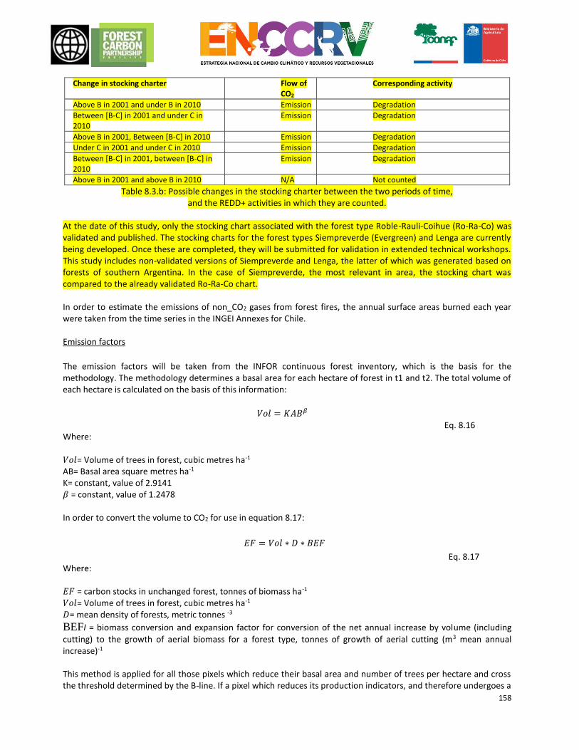
158
Change in stocking charter Flow of CO2
Corresponding activity
Above B in 2001 and under B in 2010 Emission Degradation
Between [B-C] in 2001 and under C in 2010
Emission Degradation
Above B in 2001, Between [B-C] in 2010 Emission Degradation
Under C in 2001 and under C in 2010 Emission Degradation
Between [B-C] in 2001, between [B-C] in 2010
Emission Degradation
Above B in 2001 and above B in 2010 N/A Not counted
Table 8.3.b: Possible changes in the stocking charter between the two periods of time, and the REDD+ activities in which they are counted.
At the date of this study, only the stocking chart associated with the forest type Roble-Rauli-Coihue (Ro-Ra-Co) was validated and published. The stocking charts for the forest types Siempreverde (Evergreen) and Lenga are currently being developed. Once these are completed, they will be submitted for validation in extended technical workshops. This study includes non-validated versions of Siempreverde and Lenga, the latter of which was generated based on forests of southern Argentina. In the case of Siempreverde, the most relevant in area, the stocking chart was compared to the already validated Ro-Ra-Co chart. In order to estimate the emissions of non_CO2 gases from forest fires, the annual surface areas burned each year were taken from the time series in the INGEI Annexes for Chile. Emission factors
The emission factors will be taken from the INFOR continuous forest inventory, which is the basis for the methodology. The methodology determines a basal area for each hectare of forest in t1 and t2. The total volume of each hectare is calculated on the basis of this information:
𝑉𝑜𝑙 = 𝐾𝐴𝐵𝛽 Eq. 8.16
Where: 𝑉𝑜𝑙= Volume of trees in forest, cubic metres ha-1 AB= Basal area square metres ha-1 K= constant, value of 2.9141 𝛽 = constant, value of 1.2478 In order to convert the volume to CO2 for use in equation 8.17:
𝐸𝐹 = 𝑉𝑜𝑙 ∗ 𝐷 ∗ 𝐵𝐸𝐹
Eq. 8.17 Where: 𝐸𝐹 = carbon stocks in unchanged forest, tonnes of biomass ha-1
𝑉𝑜𝑙= Volume of trees in forest, cubic metres ha-1 𝐷= mean density of forests, metric tonnes -3
BEFI = biomass conversion and expansion factor for conversion of the net annual increase by volume (including
cutting) to the growth of aerial biomass for a forest type, tonnes of growth of aerial cutting (m3 mean annual increase)-1
This method is applied for all those pixels which reduce their basal area and number of trees per hectare and cross the threshold determined by the B-line. If a pixel which reduces its production indicators, and therefore undergoes a
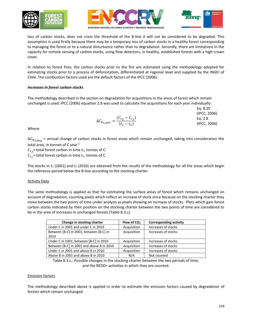
159
loss of carbon stocks, does not cross the threshold of the B-line it will not be considered to be degraded. This assumption is used firstly because there may be a temporary loss of carbon stocks in a healthy forest corresponding to managing the forest or to a natural disturbance rather than to degradation. Secondly, there are limitations in the capacity for remote sensing of carbon stocks, using flow detectors, in healthy, established forests with a high crown cover. In relation to forest fires, the carbon stocks prior to the fire are estimated using the methodology adopted for estimating stocks prior to a process of deforestation, differentiated at regional level and supplied by the INGEI of Chile. The combustion factors used are the default factors of the IPCC (2006). Increases in forest carbon stocks
The methodology described in the section on degradation for acquisitions in the areas of forest which remain unchanged is used. IPCC (2006) equation 2.8 was used to calculate the acquisitions for each year individually:
Δ𝐶𝐵𝑡,𝐴𝐹𝐹=
(𝐶𝑡2− 𝐶𝑡1
)
(𝑡2 − 𝑡1)
Eq. 8.20 (IPCC, 2006) Eq. 2.8 (IPCC, 2006)
Where: Δ𝐶𝐵𝑡,𝐷𝑒𝑔
= annual change of carbon stocks in forest areas which remain unchanged, taking into consideration the
total area, in tonnes of C year-1 𝐶𝑡2
= total forest carbon in time t2, tonnes of C
𝐶𝑡1= total forest carbon in time t1, tonnes of C
The stocks in t1 (2001) and t2 (2010) are obtained from the results of the methodology for all the areas which begin the reference period below the B-line according to the stocking charter. Activity Data
The same methodology is applied as that for estimating the surface areas of forest which remains unchanged on account of degradation, counting pixels which reflect an increase of stock since because on the stocking charter they move between the two points of time under analysis as pixels showing an increase of stocks. Plots which gain forest carbon stocks indicated by their position on the stocking charter between the two points of time are considered to be in the area of increases in unchanged forests (Table 8.3.c).
Change in stocking charter Flow of CO2 Corresponding activity
Under C in 2001 and under C in 2010 Acquisition Increases of stocks
Between [B-C] in 2001, between [B-C] in 2010
Acquisition Increases of stocks
Under C in 2001, between [B-C] in 2010 Acquisition Increases of stocks
Between [B-C] in 2001 and above B in 2010 Acquisition Increases of stocks
Under C in 2001 and above B in 2010 Acquisition Increases of stocks
Above B in 2001 and above B in 2010 N/A Not counted
Table 8.3.c.: Possible changes in the stocking charter between the two periods of time, and the REDD+ activities in which they are counted.
Emission factors
The methodology described above is applied in order to estimate the emission factors caused by degradation of forests which remain unchanged.
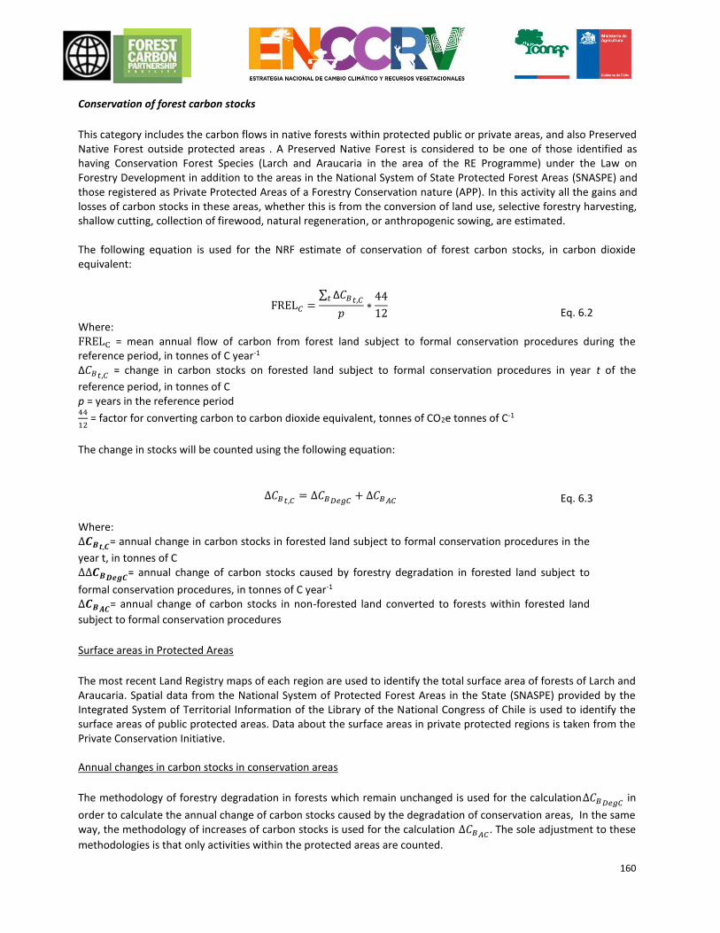
160
Conservation of forest carbon stocks
This category includes the carbon flows in native forests within protected public or private areas, and also Preserved Native Forest outside protected areas . A Preserved Native Forest is considered to be one of those identified as having Conservation Forest Species (Larch and Araucaria in the area of the RE Programme) under the Law on Forestry Development in addition to the areas in the National System of State Protected Forest Areas (SNASPE) and those registered as Private Protected Areas of a Forestry Conservation nature (APP). In this activity all the gains and losses of carbon stocks in these areas, whether this is from the conversion of land use, selective forestry harvesting, shallow cutting, collection of firewood, natural regeneration, or anthropogenic sowing, are estimated. The following equation is used for the NRF estimate of conservation of forest carbon stocks, in carbon dioxide equivalent:
FREL𝐶 =∑ Δ𝐶𝐵𝑡,𝐶𝑡
𝑝∗
44
12
Eq. 6.2 Where: FRELC = mean annual flow of carbon from forest land subject to formal conservation procedures during the reference period, in tonnes of C year-1
Δ𝐶𝐵𝑡,𝐶 = change in carbon stocks on forested land subject to formal conservation procedures in year t of the
reference period, in tonnes of C
p = years in the reference period 44
12 = factor for converting carbon to carbon dioxide equivalent, tonnes of CO2e tonnes of C-1
The change in stocks will be counted using the following equation:
∆𝐶𝐵𝑡,𝐶= ∆𝐶𝐵𝐷𝑒𝑔𝐶
+ ∆𝐶𝐵𝐴𝐶 Eq. 6.3
Where: ∆𝑪𝑩𝒕,𝑪
= annual change in carbon stocks in forested land subject to formal conservation procedures in the
year t, in tonnes of C ∆∆𝑪𝑩𝑫𝒆𝒈𝑪
= annual change of carbon stocks caused by forestry degradation in forested land subject to
formal conservation procedures, in tonnes of C year-1 ∆𝑪𝑩𝑨𝑪
= annual change of carbon stocks in non-forested land converted to forests within forested land
subject to formal conservation procedures
Surface areas in Protected Areas
The most recent Land Registry maps of each region are used to identify the total surface area of forests of Larch and Araucaria. Spatial data from the National System of Protected Forest Areas in the State (SNASPE) provided by the Integrated System of Territorial Information of the Library of the National Congress of Chile is used to identify the surface areas of public protected areas. Data about the surface areas in private protected regions is taken from the Private Conservation Initiative. Annual changes in carbon stocks in conservation areas
The methodology of forestry degradation in forests which remain unchanged is used for the calculation∆𝐶𝐵𝐷𝑒𝑔𝐶
in
order to calculate the annual change of carbon stocks caused by the degradation of conservation areas, In the same way, the methodology of increases of carbon stocks is used for the calculation ∆𝐶𝐵𝐴𝐶
. The sole adjustment to these
methodologies is that only activities within the protected areas are counted.
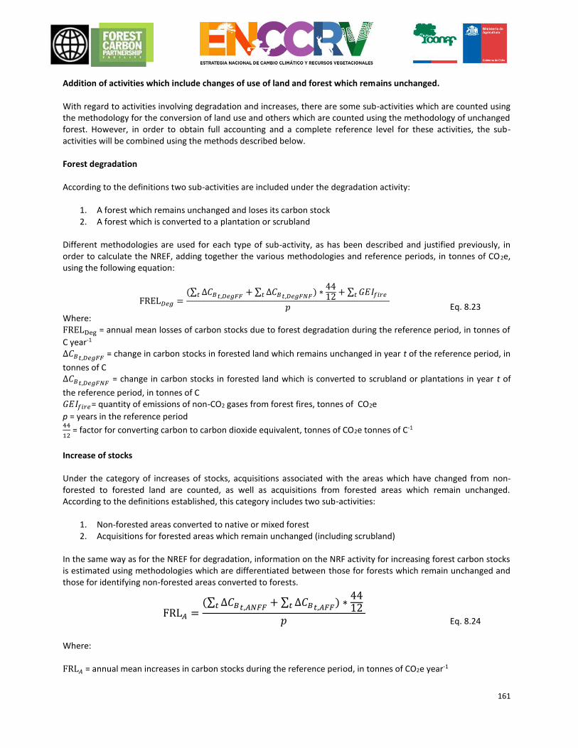
161
Addition of activities which include changes of use of land and forest which remains unchanged. With regard to activities involving degradation and increases, there are some sub-activities which are counted using the methodology for the conversion of land use and others which are counted using the methodology of unchanged forest. However, in order to obtain full accounting and a complete reference level for these activities, the sub-activities will be combined using the methods described below. Forest degradation According to the definitions two sub-activities are included under the degradation activity:
1. A forest which remains unchanged and loses its carbon stock 2. A forest which is converted to a plantation or scrubland
Different methodologies are used for each type of sub-activity, as has been described and justified previously, in order to calculate the NREF, adding together the various methodologies and reference periods, in tonnes of CO2e, using the following equation:
FREL𝐷𝑒𝑔 =(∑ Δ𝐶𝐵𝑡,𝐷𝑒𝑔𝐹𝐹
+ ∑ Δ𝐶𝐵𝑡,𝐷𝑒𝑔𝐹𝑁𝐹𝑡 ) ∗4412
+ ∑ 𝐺𝐸𝐼𝑓𝑖𝑟𝑒𝑡 𝑡
𝑝
Eq. 8.23 Where: FRELDeg = annual mean losses of carbon stocks due to forest degradation during the reference period, in tonnes of
C year-1
Δ𝐶𝐵𝑡,𝐷𝑒𝑔𝐹𝐹 = change in carbon stocks in forested land which remains unchanged in year t of the reference period, in
tonnes of C Δ𝐶𝐵𝑡,𝐷𝑒𝑔𝐹𝑁𝐹
= change in carbon stocks in forested land which is converted to scrubland or plantations in year t of
the reference period, in tonnes of C 𝐺𝐸𝐼𝑓𝑖𝑟𝑒= quantity of emissions of non-CO2 gases from forest fires, tonnes of CO2e
p = years in the reference period 44
12 = factor for converting carbon to carbon dioxide equivalent, tonnes of CO2e tonnes of C-1
Increase of stocks Under the category of increases of stocks, acquisitions associated with the areas which have changed from non-forested to forested land are counted, as well as acquisitions from forested areas which remain unchanged. According to the definitions established, this category includes two sub-activities:
1. Non-forested areas converted to native or mixed forest 2. Acquisitions for forested areas which remain unchanged (including scrubland)
In the same way as for the NREF for degradation, information on the NRF activity for increasing forest carbon stocks is estimated using methodologies which are differentiated between those for forests which remain unchanged and those for identifying non-forested areas converted to forests.
FRL𝐴 =(∑ Δ𝐶𝐵𝑡,𝐴𝑁𝐹𝐹
+ ∑ Δ𝐶𝐵𝑡,𝐴𝐹𝐹𝑡 ) ∗4412 𝑡
𝑝
Eq. 8.24
Where: FRL𝐴 = annual mean increases in carbon stocks during the reference period, in tonnes of CO2e year-1
162
Δ𝐶𝐵𝑡,𝐴𝑁𝐹𝐹 = change in carbon stocks in year t, which comes from non-forested land converted to forests during the
reference period, under the activity of stock increases (A), in tonnes of C Δ𝐶𝐵𝑡,𝐴𝐹𝐹
= annual change of carbon stocks in forest areas which remain unchanged, taking into consideration the
total area, in tonnes of C year-1 p = years in the reference period
8.4 Positive or negative adjustments of the historic mean annual emissions during the reference period (if applicable)
The RE Programme for Chile does not propose any adjustments to the Reference Level.
8.5 Estimation of the Reference Level 8.5.1 Activity Data As explained above, the activity data were calculated using the various sources of information available with the aim of applying the most accurate and complete methodologies. A description of the methods for estimating activity data for each of the REDD+ activities in the sub-national NREF/NRF for Chile is provided below. Deforestation The area of forested land converted to other uses (agricultural land, meadows and/or settlements), was estimated using the land-use change matrices calculated using the Land Registry. Only the two most recent maps were used for La Araucanía, the only region with maps with three land covers, , for the sake of consistency with other regions, but mainly due to the accuracy and exactness of the mapping of land cover classifications. The total area covered by forested land converted to another use was divided by the extension in years of the period between the two land cover maps in order to estimate the annual rate of change. In Table8.5.1.a the information about the deforested area is broken down per year and region. The deforested areas are represented in Figure 8.5.1.a. We should point out that the deforested surface area over the whole of the reference period for Los Lagos Sur, 1997-2012, corresponds to 14,164 hectares, of which 10,711 hectares correspond to forests which were converted to land without any vegetation and forests which were converted to meadows and scrubland, as a result of the eruption of the volcano Chaitén in May 2008 and the potential post eruption recovery.
Region Deforested area (ha/year-1)
Maule 225
Biobío 775
Araucanía 232
Los Ríos 467
Los Lagos Sur 943
Los Lagos Norte 321
Total 2,963
Table 8.5.1.a. Deforested surface area per year and region.
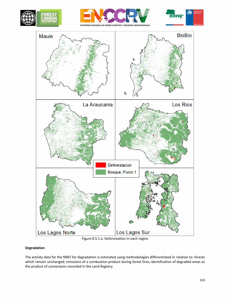
163
Figure 8.5.1.a. Deforestation in each region
Degradation The activity data for the NREF for degradation is estimated using methodologies differentiated in relation to: forests which remain unchanged; emissions of a combustion product during forest fires; identification of degraded areas as the product of conversions recorded in the Land Registry.
164
Forests which remain unchanged
In order to estimate the surface area affected by degradation in forests which remain unchanged a methodology based on data relating to the number of trees and the basal area of plots recorded in the Continuous Forest Inventory is used. Graphs on density are produced on the basis of this information and these allow us to identify those plots which are in a situation of degradation (Bahamondez, 2009). The plots identified as degraded are located on satellite images and are used as training areas for application of the algorithm K-nn, which determines the distance between the spectral response of each pixel of the image with respect to the set of pixels or training plots (Bahamondez, 2009). The result obtained is an image providing an estimate of the number of trees and the basal area for each pixel in the image, allowing us to identify its location and movement on the density graph, thus determining whether or not the plot is in a situation of degradation. This process is repeated for the years corresponding to updates of information about land in the Continuous Forest Inventory, 2001 and 2010, which allows us to estimate the direction of movement of each pixel on the graph, identifying whether or not the land is in a process of degradation. In Table 8.5.1.b. the information about the surface area of the degraded region is broken down for the complete reference period, 2001-2010. Figure 8.5.1.b shows the areas affected by forest degradation.
Region Area (ha)
Maule 21,184
Biobío 57,988
Araucanía 28,849
Los Ríos 40,853
Los Lagos 261,028
Total 409,902
Table 8.5.1.b. Surface area of unchanged forest which has become degraded per region between 2001 and 2010.
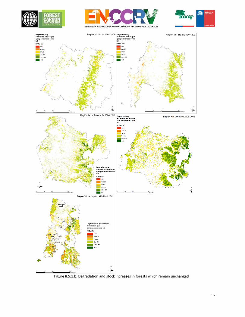
165
Figure 8.5.1.b. Degradation and stock increases in forests which remain unchanged
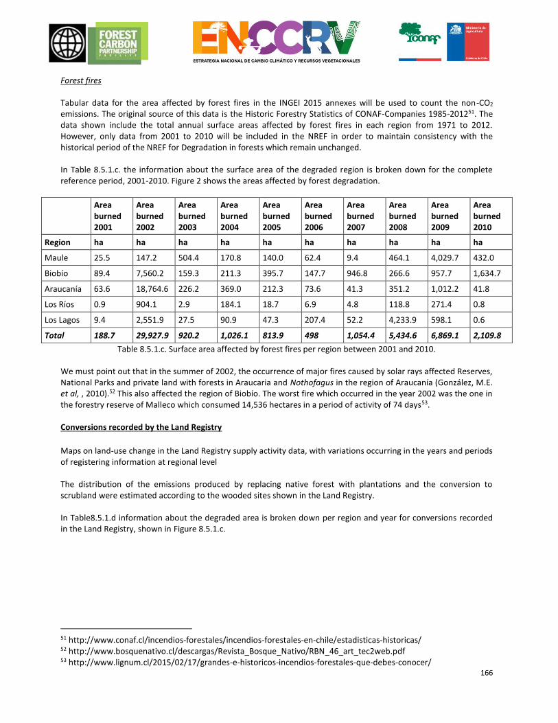
166
Forest fires Tabular data for the area affected by forest fires in the INGEI 2015 annexes will be used to count the non-CO2
emissions. The original source of this data is the Historic Forestry Statistics of CONAF-Companies 1985-201251. The data shown include the total annual surface areas affected by forest fires in each region from 1971 to 2012. However, only data from 2001 to 2010 will be included in the NREF in order to maintain consistency with the historical period of the NREF for Degradation in forests which remain unchanged. In Table 8.5.1.c. the information about the surface area of the degraded region is broken down for the complete reference period, 2001-2010. Figure 2 shows the areas affected by forest degradation.
Area burned 2001
Area burned 2002
Area burned 2003
Area burned 2004
Area burned 2005
Area burned 2006
Area burned 2007
Area burned 2008
Area burned 2009
Area burned 2010
Region ha ha ha ha ha ha ha ha ha ha
Maule 25.5 147.2 504.4 170.8 140.0 62.4 9.4 464.1 4,029.7 432.0
Biobío 89.4 7,560.2 159.3 211.3 395.7 147.7 946.8 266.6 957.7 1,634.7
Araucanía 63.6 18,764.6 226.2 369.0 212.3 73.6 41.3 351.2 1,012.2 41.8
Los Ríos 0.9 904.1 2.9 184.1 18.7 6.9 4.8 118.8 271.4 0.8
Los Lagos 9.4 2,551.9 27.5 90.9 47.3 207.4 52.2 4,233.9 598.1 0.6
Total 188.7 29,927.9 920.2 1,026.1 813.9 498 1,054.4 5,434.6 6,869.1 2,109.8
Table 8.5.1.c. Surface area affected by forest fires per region between 2001 and 2010. We must point out that in the summer of 2002, the occurrence of major fires caused by solar rays affected Reserves, National Parks and private land with forests in Araucaria and Nothofagus in the region of Araucanía (González, M.E. et al, , 2010).52 This also affected the region of Biobío. The worst fire which occurred in the year 2002 was the one in the forestry reserve of Malleco which consumed 14,536 hectares in a period of activity of 74 days53. Conversions recorded by the Land Registry
Maps on land-use change in the Land Registry supply activity data, with variations occurring in the years and periods of registering information at regional level The distribution of the emissions produced by replacing native forest with plantations and the conversion to scrubland were estimated according to the wooded sites shown in the Land Registry. In Table8.5.1.d information about the degraded area is broken down per region and year for conversions recorded in the Land Registry, shown in Figure 8.5.1.c.
51 http://www.conaf.cl/incendios-forestales/incendios-forestales-en-chile/estadisticas-historicas/ 52 http://www.bosquenativo.cl/descargas/Revista_Bosque_Nativo/RBN_46_art_tec2web.pdf 53 http://www.lignum.cl/2015/02/17/grandes-e-historicos-incendios-forestales-que-debes-conocer/
167
Region Replacement (ha year-1)
Conversion to Scrubland (ha year-1)
Total (ha year-
1)
Maule 3,112 175 3,287
Biobío 5,272 248 5,520
La Araucanía 1,633 54 1,687
Los Ríos 390 40 430
Los Lagos Sur 296 544 850
Los Lagos Norte 431 82 513
Total 11,132 1,142 12,274
Table 8.5.1.d. Surface area degraded per year and region according to conversions recorded in the Land Registry
168
Figure 8.51.1.c. Degradation on account of land registry conversions.
169
Increase of stocks In the same way as for the NREF on Degradation, NRF activity data relating to an Increase in forest carbon stocks is estimated using methodologies which are differentiated for Forests which remain unchanged and for the identification of degraded areas produced as a result of conversions recorded in the Land Registry. Forests which remain unchanged
Using the same methodology as in the case of degradation, and based on information about plots in the Continuous Forest Inventory and satellite images, those pixels which over the period from 2001 to 2010 moved on the density graph in a direction which indicates an increase in carbon content based on the increase in the number of trees and basal area are defined. In Table 8.5.1.e. information about the surface area of forest which remains unchanged, in which an increase of forest carbon stocks has taken place during the complete reference period, 2001-2010, is broken down, and these areas are shown in Figure 8.5.1.c.
Region Area (ha)
Maule 50,152
Biobío 94,861
Araucanía 59,456
Los Ríos 77,141
Los Lagos 263,055
Total 544,665
Table 8.5.1.e Surface area of forest that remains unchanged with Increase of stocks per region between 2001 and 2010.
Conversions recorded by the Land Registry
The activity data come from the land cover transition matrices, taken from the Land Registry and consequently the duration of the period varies according to region, depending on the irregular intervals when the Land Registry is updated. In Table8.5.1.f. The information about the surface area where there is an increase of stocks is broken down according to 1) Forestation, changes in land-use from forested to non-forested; 2) Recovery, changes of use from plantation to forest; and 3) Natural growth, the conversion of scrubland to native forest, per region and year, which are shown in 8.5.1.c.
Region Recovery (ha year-1)
Forestation (ha year-1)
Natural Growth (ha year-1)
Total (ha year-1)
Maule 82 465 1201 1748
Biobío 707 561 574 1842
La Araucanía 3 821 962 1786
Los Ríos 86 332 528 946
Los Lagos Sur 0 66 84 151
Los Lagos Norte 0 60 23 83
Total 879 2304 3372 6555
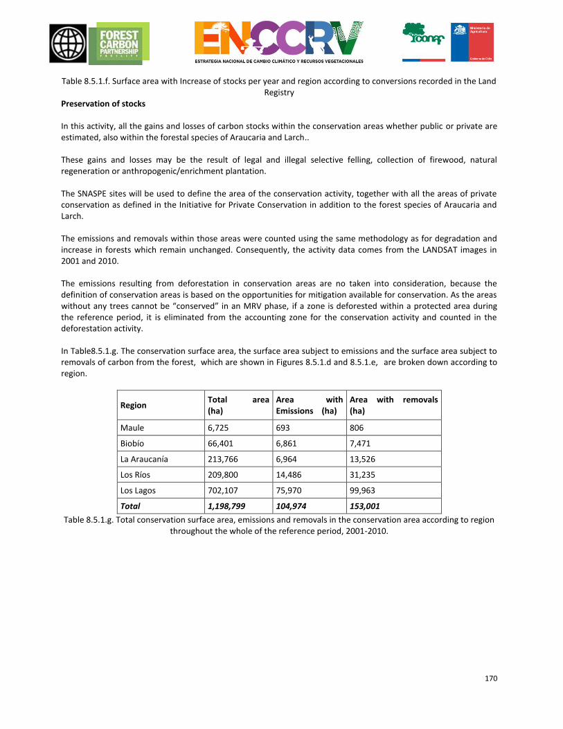
170
Table 8.5.1.f. Surface area with Increase of stocks per year and region according to conversions recorded in the Land Registry
Preservation of stocks In this activity, all the gains and losses of carbon stocks within the conservation areas whether public or private are estimated, also within the forestal species of Araucaria and Larch.. These gains and losses may be the result of legal and illegal selective felling, collection of firewood, natural regeneration or anthropogenic/enrichment plantation. The SNASPE sites will be used to define the area of the conservation activity, together with all the areas of private conservation as defined in the Initiative for Private Conservation in addition to the forest species of Araucaria and Larch. The emissions and removals within those areas were counted using the same methodology as for degradation and increase in forests which remain unchanged. Consequently, the activity data comes from the LANDSAT images in 2001 and 2010. The emissions resulting from deforestation in conservation areas are no taken into consideration, because the definition of conservation areas is based on the opportunities for mitigation available for conservation. As the areas without any trees cannot be “conserved” in an MRV phase, if a zone is deforested within a protected area during the reference period, it is eliminated from the accounting zone for the conservation activity and counted in the deforestation activity. In Table8.5.1.g. The conservation surface area, the surface area subject to emissions and the surface area subject to removals of carbon from the forest, which are shown in Figures 8.5.1.d and 8.5.1.e, are broken down according to region.
Region Total area (ha)
Area with Emissions (ha)
Area with removals (ha)
Maule 6,725 693 806
Biobío 66,401 6,861 7,471
La Araucanía 213,766 6,964 13,526
Los Ríos 209,800 14,486 31,235
Los Lagos 702,107 75,970 99,963
Total 1,198,799 104,974 153,001
Table 8.5.1.g. Total conservation surface area, emissions and removals in the conservation area according to region throughout the whole of the reference period, 2001-2010.
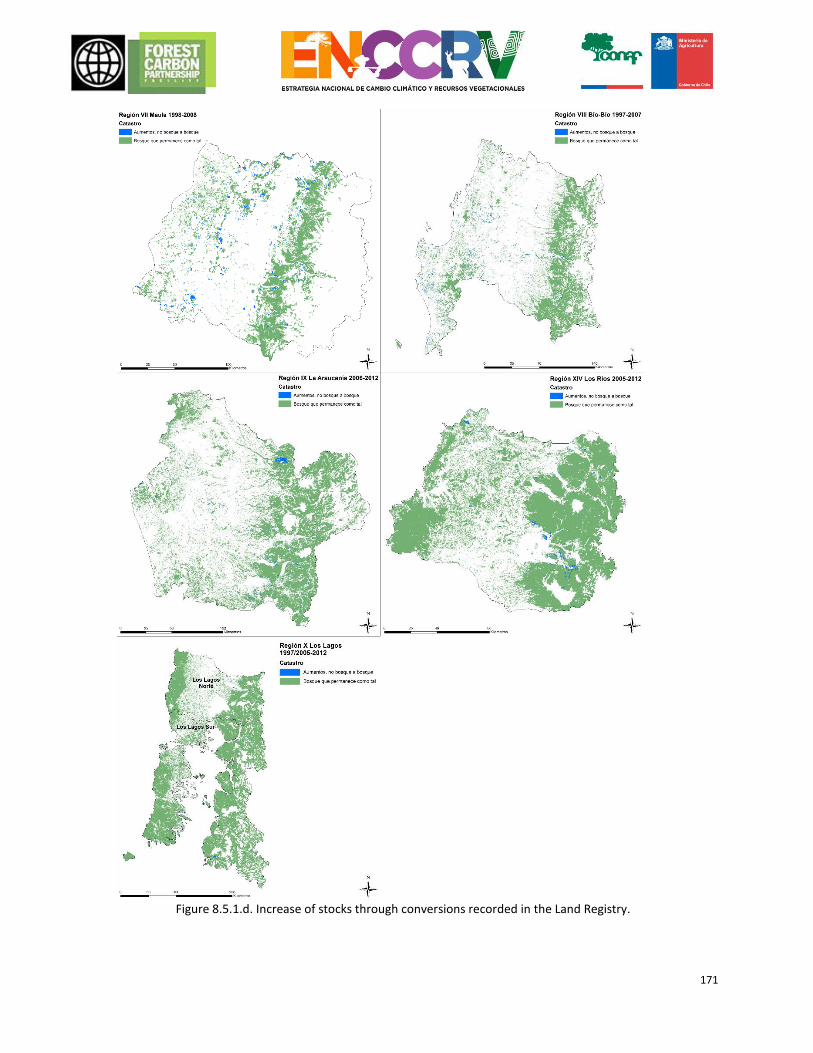
171
Figure 8.5.1.d. Increase of stocks through conversions recorded in the Land Registry.
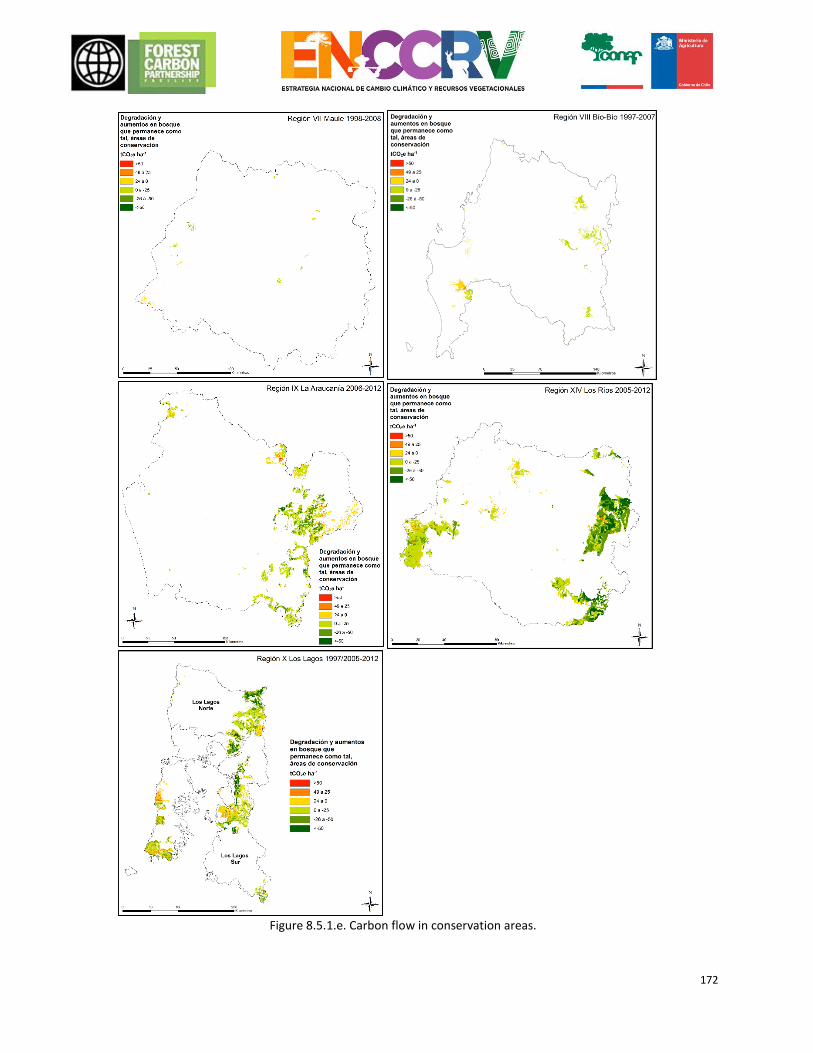
172
Figure 8.5.1.e. Carbon flow in conservation areas.
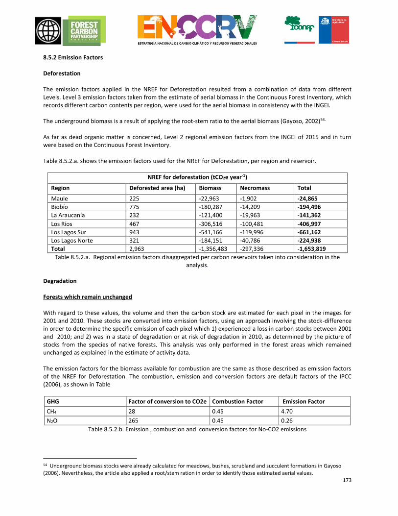
173
8.5.2 Emission Factors Deforestation The emission factors applied in the NREF for Deforestation resulted from a combination of data from different Levels. Level 3 emission factors taken from the estimate of aerial biomass in the Continuous Forest Inventory, which records different carbon contents per region, were used for the aerial biomass in consistency with the INGEI. The underground biomass is a result of applying the root-stem ratio to the aerial biomass (Gayoso, 2002)54. As far as dead organic matter is concerned, Level 2 regional emission factors from the INGEI of 2015 and in turn were based on the Continuous Forest Inventory. Table 8.5.2.a. shows the emission factors used for the NREF for Deforestation, per region and reservoir.
NREF for deforestation (tCO2e year-1)
Region Deforested area (ha) Biomass Necromass Total
Maule 225 -22,963 -1,902 -24,865
Biobío 775 -180,287 -14,209 -194,496
La Araucanía 232 -121,400 -19,963 -141,362
Los Ríos 467 -306,516 -100,481 -406,997
Los Lagos Sur 943 -541,166 -119,996 -661,162
Los Lagos Norte 321 -184,151 -40,786 -224,938
Total 2,963 -1,356,483 -297,336 -1,653,819
Table 8.5.2.a. Regional emission factors disaggregated per carbon reservoirs taken into consideration in the analysis.
Degradation Forests which remain unchanged With regard to these values, the volume and then the carbon stock are estimated for each pixel in the images for 2001 and 2010. These stocks are converted into emission factors, using an approach involving the stock-difference in order to determine the specific emission of each pixel which 1) experienced a loss in carbon stocks between 2001 and 2010; and 2) was in a state of degradation or at risk of degradation in 2010, as determined by the picture of stocks from the species of native forests. This analysis was only performed in the forest areas which remained unchanged as explained in the estimate of activity data. The emission factors for the biomass available for combustion are the same as those described as emission factors of the NREF for Deforestation. The combustion, emission and conversion factors are default factors of the IPCC (2006), as shown in Table
GHG Factor of conversion to CO2e Combustion Factor Emission Factor
CH4 28 0.45 4.70
N2O 265 0.45 0.26
Table 8.5.2.b. Emission , combustion and conversion factors for No-CO2 emissions
54 Underground biomass stocks were already calculated for meadows, bushes, scrubland and succulent formations in Gayoso (2006). Nevertheless, the article also applied a root/stem ration in order to identify those estimated aerial values.
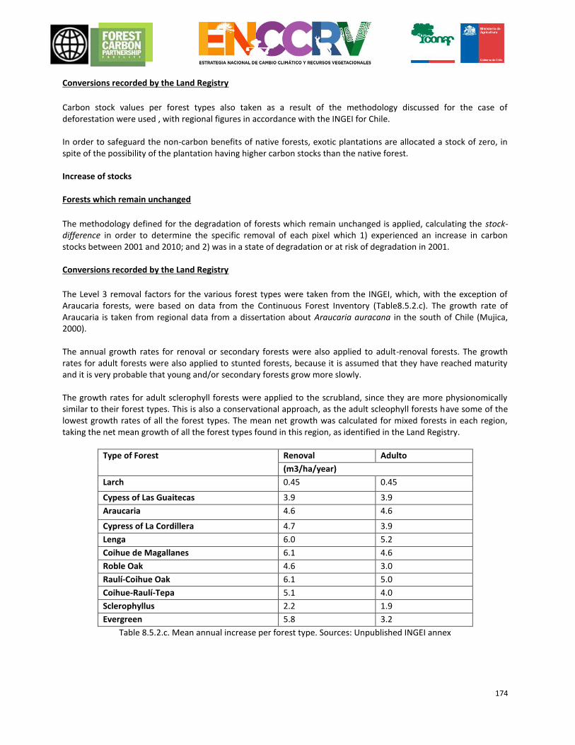
174
Conversions recorded by the Land Registry
Carbon stock values per forest types also taken as a result of the methodology discussed for the case of deforestation were used , with regional figures in accordance with the INGEI for Chile. In order to safeguard the non-carbon benefits of native forests, exotic plantations are allocated a stock of zero, in spite of the possibility of the plantation having higher carbon stocks than the native forest. Increase of stocks Forests which remain unchanged
The methodology defined for the degradation of forests which remain unchanged is applied, calculating the stock-difference in order to determine the specific removal of each pixel which 1) experienced an increase in carbon stocks between 2001 and 2010; and 2) was in a state of degradation or at risk of degradation in 2001. Conversions recorded by the Land Registry
The Level 3 removal factors for the various forest types were taken from the INGEI, which, with the exception of Araucaria forests, were based on data from the Continuous Forest Inventory (Table8.5.2.c). The growth rate of Araucaria is taken from regional data from a dissertation about Araucaria auracana in the south of Chile (Mujica, 2000). The annual growth rates for renoval or secondary forests were also applied to adult-renoval forests. The growth rates for adult forests were also applied to stunted forests, because it is assumed that they have reached maturity and it is very probable that young and/or secondary forests grow more slowly. The growth rates for adult sclerophyll forests were applied to the scrubland, since they are more physionomically similar to their forest types. This is also a conservational approach, as the adult scleophyll forests have some of the lowest growth rates of all the forest types. The mean net growth was calculated for mixed forests in each region, taking the net mean growth of all the forest types found in this region, as identified in the Land Registry.
Type of Forest Renoval Adulto
(m3/ha/year)
Larch 0.45 0.45
Cypess of Las Guaitecas 3.9 3.9
Araucaria 4.6 4.6
Cypress of La Cordillera 4.7 3.9
Lenga 6.0 5.2
Coihue de Magallanes 6.1 4.6
Roble Oak 4.6 3.0
Raulí-Coihue Oak 6.1 5.0
Coihue-Raulí-Tepa 5.1 4.0
Sclerophyllus 2.2 1.9
Evergreen 5.8 3.2
Table 8.5.2.c. Mean annual increase per forest type. Sources: Unpublished INGEI annex
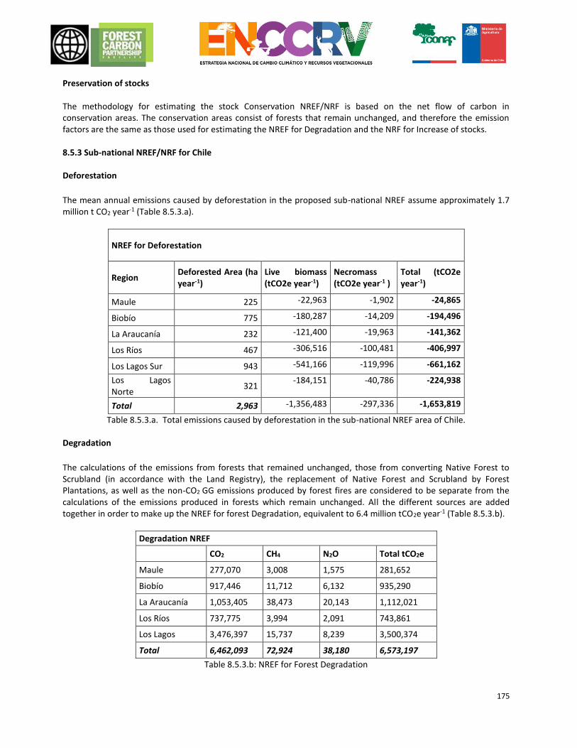
175
Preservation of stocks The methodology for estimating the stock Conservation NREF/NRF is based on the net flow of carbon in conservation areas. The conservation areas consist of forests that remain unchanged, and therefore the emission factors are the same as those used for estimating the NREF for Degradation and the NRF for Increase of stocks. 8.5.3 Sub-national NREF/NRF for Chile Deforestation
The mean annual emissions caused by deforestation in the proposed sub-national NREF assume approximately 1.7 million t CO2 year-1 (Table 8.5.3.a).
NREF for Deforestation
Region Deforested Area (ha year-1)
Live biomass (tCO2e year-1)
Necromass (tCO2e year-1 )
Total (tCO2e year-1)
Maule 225 -22,963 -1,902 -24,865
Biobío 775 -180,287 -14,209 -194,496
La Araucanía 232 -121,400 -19,963 -141,362
Los Ríos 467 -306,516 -100,481 -406,997
Los Lagos Sur 943 -541,166 -119,996 -661,162
Los Lagos Norte
321 -184,151 -40,786 -224,938
Total 2,963 -1,356,483 -297,336 -1,653,819
Table 8.5.3.a. Total emissions caused by deforestation in the sub-national NREF area of Chile. Degradation
The calculations of the emissions from forests that remained unchanged, those from converting Native Forest to Scrubland (in accordance with the Land Registry), the replacement of Native Forest and Scrubland by Forest Plantations, as well as the non-CO2 GG emissions produced by forest fires are considered to be separate from the calculations of the emissions produced in forests which remain unchanged. All the different sources are added together in order to make up the NREF for forest Degradation, equivalent to 6.4 million tCO2e year-1 (Table 8.5.3.b).
Degradation NREF
CO2 CH4 N2O Total tCO2e
Maule 277,070 3,008 1,575 281,652
Biobío 917,446 11,712 6,132 935,290
La Araucanía 1,053,405 38,473 20,143 1,112,021
Los Ríos 737,775 3,994 2,091 743,861
Los Lagos 3,476,397 15,737 8,239 3,500,374
Total 6,462,093 72,924 38,180 6,573,197
Table 8.5.3.b: NREF for Forest Degradation
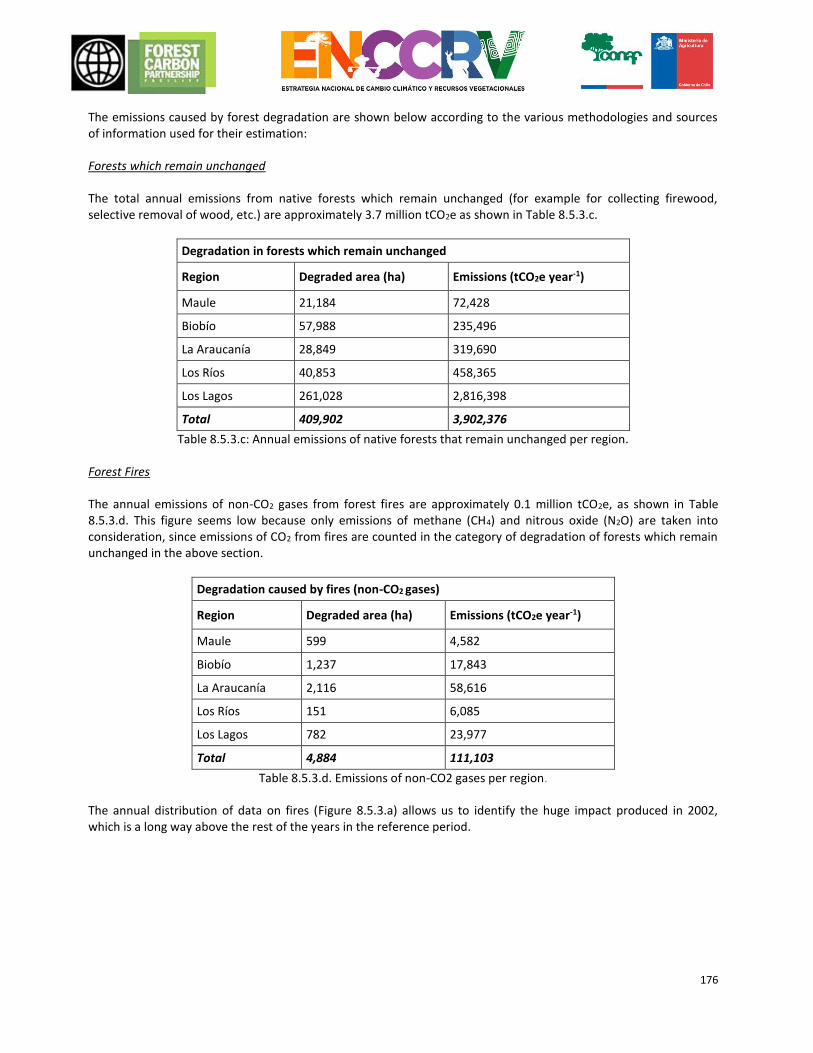
176
The emissions caused by forest degradation are shown below according to the various methodologies and sources of information used for their estimation: Forests which remain unchanged The total annual emissions from native forests which remain unchanged (for example for collecting firewood, selective removal of wood, etc.) are approximately 3.7 million tCO2e as shown in Table 8.5.3.c.
Degradation in forests which remain unchanged
Region Degraded area (ha) Emissions (tCO2e year-1)
Maule 21,184 72,428
Biobío 57,988 235,496
La Araucanía 28,849 319,690
Los Ríos 40,853 458,365
Los Lagos 261,028 2,816,398
Total 409,902 3,902,376
Table 8.5.3.c: Annual emissions of native forests that remain unchanged per region. Forest Fires The annual emissions of non-CO2 gases from forest fires are approximately 0.1 million tCO2e, as shown in Table 8.5.3.d. This figure seems low because only emissions of methane (CH4) and nitrous oxide (N2O) are taken into consideration, since emissions of CO2 from fires are counted in the category of degradation of forests which remain unchanged in the above section.
Degradation caused by fires (non-CO2 gases)
Region Degraded area (ha) Emissions (tCO2e year-1)
Maule 599 4,582
Biobío 1,237 17,843
La Araucanía 2,116 58,616
Los Ríos 151 6,085
Los Lagos 782 23,977
Total 4,884 111,103
Table 8.5.3.d. Emissions of non-CO2 gases per region. The annual distribution of data on fires (Figure 8.5.3.a) allows us to identify the huge impact produced in 2002, which is a long way above the rest of the years in the reference period.
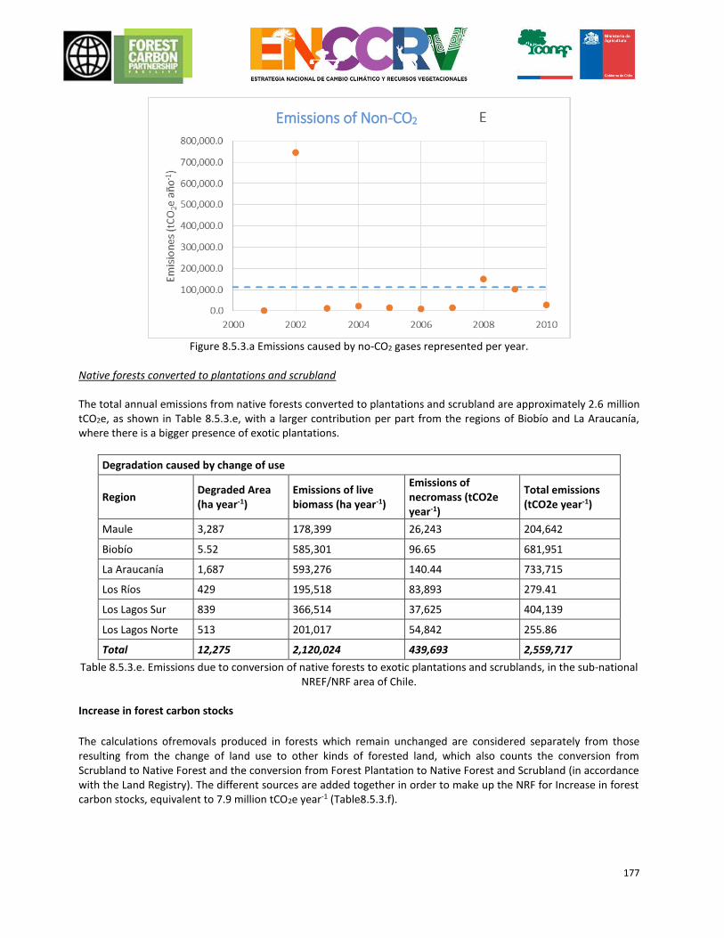
177
Figure 8.5.3.a Emissions caused by no-CO2 gases represented per year.
Native forests converted to plantations and scrubland The total annual emissions from native forests converted to plantations and scrubland are approximately 2.6 million tCO2e, as shown in Table 8.5.3.e, with a larger contribution per part from the regions of Biobío and La Araucanía, where there is a bigger presence of exotic plantations.
Degradation caused by change of use
Region Degraded Area (ha year-1)
Emissions of live biomass (ha year-1)
Emissions of necromass (tCO2e year-1)
Total emissions (tCO2e year-1)
Maule 3,287 178,399 26,243 204,642
Biobío 5.52 585,301 96.65 681,951
La Araucanía 1,687 593,276 140.44 733,715
Los Ríos 429 195,518 83,893 279.41
Los Lagos Sur 839 366,514 37,625 404,139
Los Lagos Norte 513 201,017 54,842 255.86
Total 12,275 2,120,024 439,693 2,559,717
Table 8.5.3.e. Emissions due to conversion of native forests to exotic plantations and scrublands, in the sub-national NREF/NRF area of Chile.
Increase in forest carbon stocks
The calculations ofremovals produced in forests which remain unchanged are considered separately from those resulting from the change of land use to other kinds of forested land, which also counts the conversion from Scrubland to Native Forest and the conversion from Forest Plantation to Native Forest and Scrubland (in accordance with the Land Registry). The different sources are added together in order to make up the NRF for Increase in forest carbon stocks, equivalent to 7.9 million tCO2e year-1 (Table8.5.3.f).
Emissions of Non-CO2
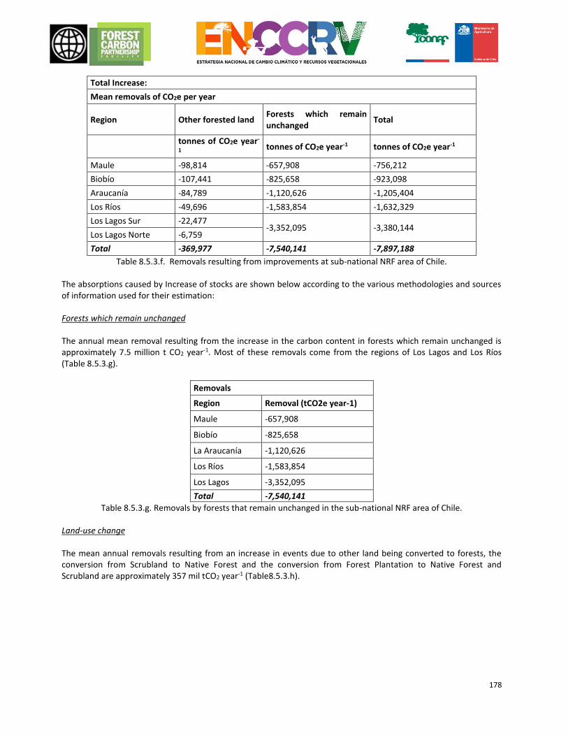
178
Total Increase:
Mean removals of CO2e per year
Region Other forested land Forests which remain unchanged
Total
tonnes of CO2e year-
1 tonnes of CO2e year-1 tonnes of CO2e year-1
Maule -98,814 -657,908 -756,212
Biobío -107,441 -825,658 -923,098
Araucanía -84,789 -1,120,626 -1,205,404
Los Ríos -49,696 -1,583,854 -1,632,329
Los Lagos Sur -22,477 -3,352,095 -3,380,144
Los Lagos Norte -6,759
Total -369,977 -7,540,141 -7,897,188
Table 8.5.3.f. Removals resulting from improvements at sub-national NRF area of Chile. The absorptions caused by Increase of stocks are shown below according to the various methodologies and sources of information used for their estimation: Forests which remain unchanged The annual mean removal resulting from the increase in the carbon content in forests which remain unchanged is approximately 7.5 million t CO2 year-1. Most of these removals come from the regions of Los Lagos and Los Ríos (Table 8.5.3.g).
Removals
Region Removal (tCO2e year-1)
Maule -657,908
Biobío -825,658
La Araucanía -1,120,626
Los Ríos -1,583,854
Los Lagos -3,352,095
Total -7,540,141
Table 8.5.3.g. Removals by forests that remain unchanged in the sub-national NRF area of Chile. Land-use change The mean annual removals resulting from an increase in events due to other land being converted to forests, the conversion from Scrubland to Native Forest and the conversion from Forest Plantation to Native Forest and Scrubland are approximately 357 mil tCO2 year-1 (Table8.5.3.h).
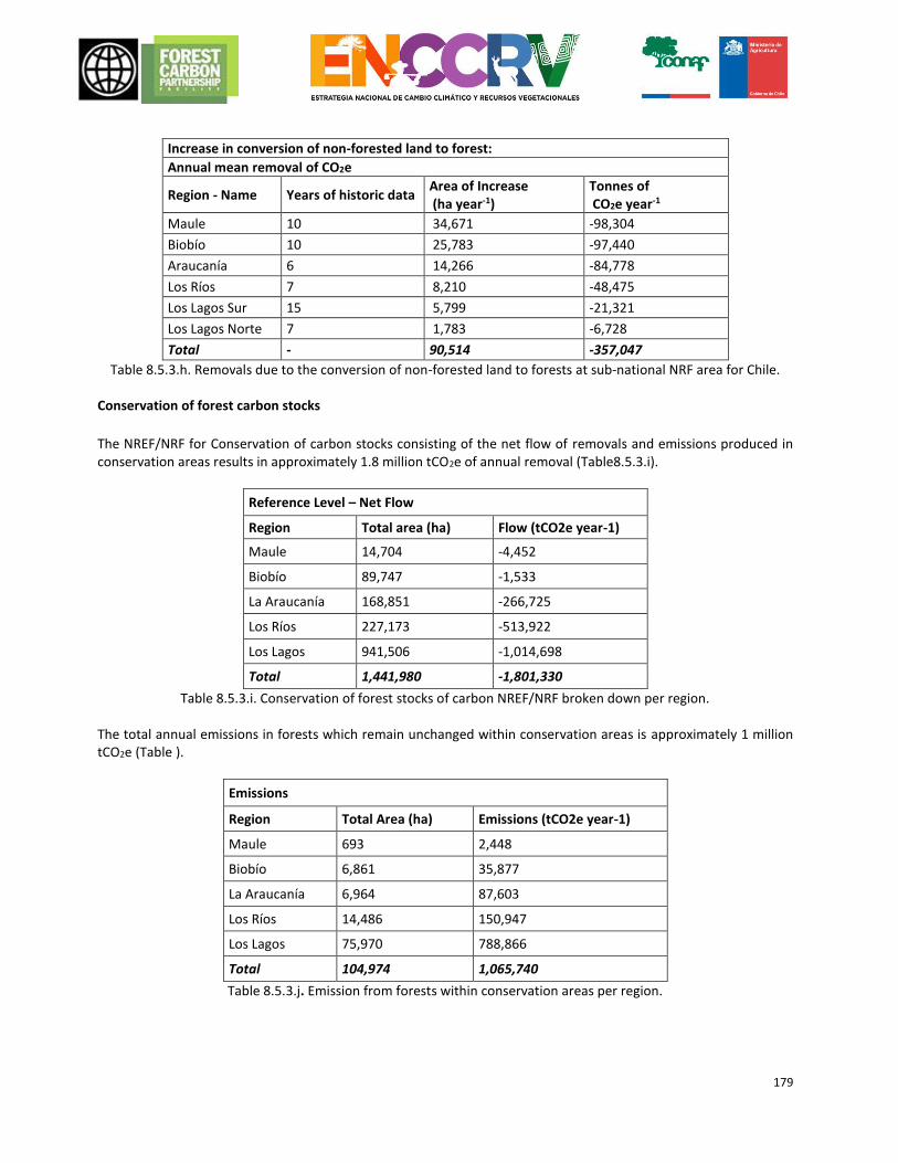
179
Increase in conversion of non-forested land to forest:
Annual mean removal of CO2e
Region - Name Years of historic data Area of Increase (ha year-1)
Tonnes of CO2e year-1
Maule 10 34,671 -98,304
Biobío 10 25,783 -97,440
Araucanía 6 14,266 -84,778
Los Ríos 7 8,210 -48,475
Los Lagos Sur 15 5,799 -21,321
Los Lagos Norte 7 1,783 -6,728
Total - 90,514 -357,047
Table 8.5.3.h. Removals due to the conversion of non-forested land to forests at sub-national NRF area for Chile. Conservation of forest carbon stocks
The NREF/NRF for Conservation of carbon stocks consisting of the net flow of removals and emissions produced in conservation areas results in approximately 1.8 million tCO2e of annual removal (Table8.5.3.i).
Reference Level – Net Flow
Region Total area (ha) Flow (tCO2e year-1)
Maule 14,704 -4,452
Biobío 89,747 -1,533
La Araucanía 168,851 -266,725
Los Ríos 227,173 -513,922
Los Lagos 941,506 -1,014,698
Total 1,441,980 -1,801,330
Table 8.5.3.i. Conservation of forest stocks of carbon NREF/NRF broken down per region. The total annual emissions in forests which remain unchanged within conservation areas is approximately 1 million tCO2e (Table ).
Emissions
Region Total Area (ha) Emissions (tCO2e year-1)
Maule 693 2,448
Biobío 6,861 35,877
La Araucanía 6,964 87,603
Los Ríos 14,486 150,947
Los Lagos 75,970 788,866
Total 104,974 1,065,740
Table 8.5.3.j. Emission from forests within conservation areas per region.
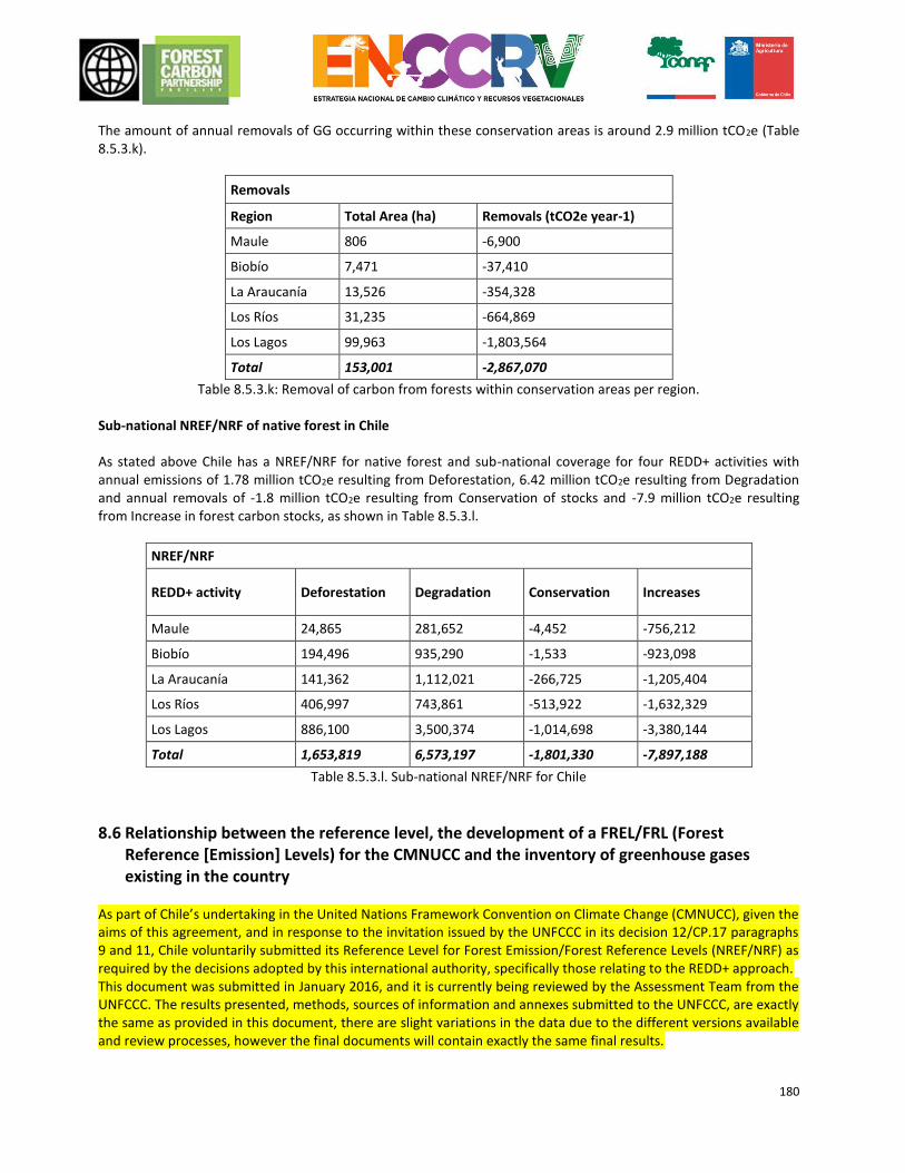
180
The amount of annual removals of GG occurring within these conservation areas is around 2.9 million tCO2e (Table 8.5.3.k).
Removals
Region Total Area (ha) Removals (tCO2e year-1)
Maule 806 -6,900
Biobío 7,471 -37,410
La Araucanía 13,526 -354,328
Los Ríos 31,235 -664,869
Los Lagos 99,963 -1,803,564
Total 153,001 -2,867,070
Table 8.5.3.k: Removal of carbon from forests within conservation areas per region. Sub-national NREF/NRF of native forest in Chile As stated above Chile has a NREF/NRF for native forest and sub-national coverage for four REDD+ activities with annual emissions of 1.78 million tCO2e resulting from Deforestation, 6.42 million tCO2e resulting from Degradation and annual removals of -1.8 million tCO2e resulting from Conservation of stocks and -7.9 million tCO2e resulting from Increase in forest carbon stocks, as shown in Table 8.5.3.l.
NREF/NRF
REDD+ activity Deforestation Degradation Conservation Increases
Maule 24,865 281,652 -4,452 -756,212
Biobío 194,496 935,290 -1,533 -923,098
La Araucanía 141,362 1,112,021 -266,725 -1,205,404
Los Ríos 406,997 743,861 -513,922 -1,632,329
Los Lagos 886,100 3,500,374 -1,014,698 -3,380,144
Total 1,653,819 6,573,197 -1,801,330 -7,897,188
Table 8.5.3.l. Sub-national NREF/NRF for Chile
8.6 Relationship between the reference level, the development of a FREL/FRL (Forest Reference [Emission] Levels) for the CMNUCC and the inventory of greenhouse gases existing in the country
As part of Chile’s undertaking in the United Nations Framework Convention on Climate Change (CMNUCC), given the aims of this agreement, and in response to the invitation issued by the UNFCCC in its decision 12/CP.17 paragraphs 9 and 11, Chile voluntarily submitted its Reference Level for Forest Emission/Forest Reference Levels (NREF/NRF) as required by the decisions adopted by this international authority, specifically those relating to the REDD+ approach. This document was submitted in January 2016, and it is currently being reviewed by the Assessment Team from the UNFCCC. The results presented, methods, sources of information and annexes submitted to the UNFCCC, are exactly the same as provided in this document, there are slight variations in the data due to the different versions available and review processes, however the final documents will contain exactly the same final results.
181
There is strong consistency between the NREF/NRF of the native forest in Chile as presented in this document and the INGEI for Chile. Nevertheless, it is important to take into account the intrinsic differences in existence between a reference level and a GEI (GG) inventory. The authority responsible for the AFOLU (Agriculture, Forestry and Other Land Use) sector for the INGEI for Chile is in fact the Ministry of Agriculture and those in charge of producing the specific calculation for the UTCUTS sector are CONAF and INFOR, both entities with responsibilities for compiling the NREF/NRF of the native forest in Chile. The variations presented in the NREF/NRF are improvements resulting from better data availability and the use of more accurate methods to be incorporated in the 2018 biennial report for updating the INGEI. The points of consistency and the variations in existence between the INGEI and the NREF/NRF are listed below per activity. The estimated mean historic emissions/removals per REDD+ activity are also presented so that the NREF/NRF and INGEI results can be compared. The fact that the activity of Degradation and some of the Increase in stocks would be incorporated in the calculation of emissions and removals produced in unchanged forest in the INGEI and that the activity of Deforestation and the remaining part of the Increase of stocks would be linked to the change of land use from Forest Use to Other Uses and from Other Uses to Forest Use, respectively, must be taken into consideration. The same criteria and data as those used as for the above activities are used for the activity of stock Conservation and so a special section is not included for this.
Since the NREF/NRF only includes estimates for the five regions in the RE Programme, the INGEI database was used to take comparable values from the INGEI. The mean annual emissions/removals from the INGEI from 2001 to 2010 were calculated.
a. Deforestation
In the INGEI, deforestation activity includes the following categories: forestland converted to agricultural land, forest land converted to grazing land, forest land converted to settlements, and forest land converted to other land (including areas without vegetation, and areas of snow and glaciers, bodies of water, and unrecognized areas). The same source of information as in the INGEI, the Land Registry, is used to calculate the Activity Data. However, the dates on some of the Land Registry maps were different when the INGEI was produced from the dates used for the same maps in the NREF. This produces a difference in annual emissions when the conversion area is divided up between all the years in the period between Land Registry updates. This difference is due to the confusion created by the oldest maps in the Land Registry, which used a mosaic of aerial images from various years. Between the most recent update of the INGEI and compilation of the NREF, the decision was taken to change the dates of the maps, so the dates in the next update of the INGEI will not be inconsistent with those in the NREF. With regard to the Emission Factors:
The same data as for the INGEI was used to determine the forest carbon stocks prior to deforestation.
The INGEI and the NREF use certain IPCC default values in order to determine carbon stocks after deforestation caused by some methods of using non-forested land. However, the NREF uses values specific to Chile from Gayoso (2006) for undergrowth, scrubland, meadow, and succulent formations in order to obtain more emission factors specific to the country.
With regard to the estimate of Changes of carbon stocks other than those resulting from the event of deforestation, both in the INGEI and in the NREF the losses due to harvesting wood, collection of firewood, and disturbances are considered zero in areas that have undergone deforestation.
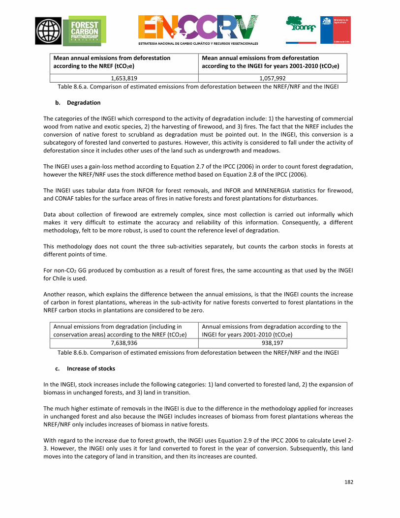
182
Mean annual emissions from deforestation according to the NREF (tCO2e)
Mean annual emissions from deforestation according to the INGEI for years 2001-2010 (tCO2e)
1,653,819 1,057,992
Table 8.6.a. Comparison of estimated emissions from deforestation between the NREF/NRF and the INGEI
b. Degradation The categories of the INGEI which correspond to the activity of degradation include: 1) the harvesting of commercial wood from native and exotic species, 2) the harvesting of firewood, and 3) fires. The fact that the NREF includes the conversion of native forest to scrubland as degradation must be pointed out. In the INGEI, this conversion is a subcategory of forested land converted to pastures. However, this activity is considered to fall under the activity of deforestation since it includes other uses of the land such as undergrowth and meadows. The INGEI uses a gain-loss method according to Equation 2.7 of the IPCC (2006) in order to count forest degradation, however the NREF/NRF uses the stock difference method based on Equation 2.8 of the IPCC (2006). The INGEI uses tabular data from INFOR for forest removals, and INFOR and MINENERGIA statistics for firewood, and CONAF tables for the surface areas of fires in native forests and forest plantations for disturbances. Data about collection of firewood are extremely complex, since most collection is carried out informally which makes it very difficult to estimate the accuracy and reliability of this information. Consequently, a different methodology, felt to be more robust, is used to count the reference level of degradation. This methodology does not count the three sub-activities separately, but counts the carbon stocks in forests at different points of time. For non-CO2 GG produced by combustion as a result of forest fires, the same accounting as that used by the INGEI for Chile is used. Another reason, which explains the difference between the annual emissions, is that the INGEI counts the increase of carbon in forest plantations, whereas in the sub-activity for native forests converted to forest plantations in the NREF carbon stocks in plantations are considered to be zero.
Annual emissions from degradation (including in conservation areas) according to the NREF (tCO2e)
Annual emissions from degradation according to the INGEI for years 2001-2010 (tCO2e)
7,638,936 938,197
Table 8.6.b. Comparison of estimated emissions from deforestation between the NREF/NRF and the INGEI
c. Increase of stocks In the INGEI, stock increases include the following categories: 1) land converted to forested land, 2) the expansion of biomass in unchanged forests, and 3) land in transition. The much higher estimate of removals in the INGEI is due to the difference in the methodology applied for increases in unchanged forest and also because the INGEI includes increases of biomass from forest plantations whereas the NREF/NRF only includes increases of biomass in native forests. With regard to the increase due to forest growth, the INGEI uses Equation 2.9 of the IPCC 2006 to calculate Level 2-3. However, the INGEI only uses it for land converted to forest in the year of conversion. Subsequently, this land moves into the category of land in transition, and then its increases are counted.
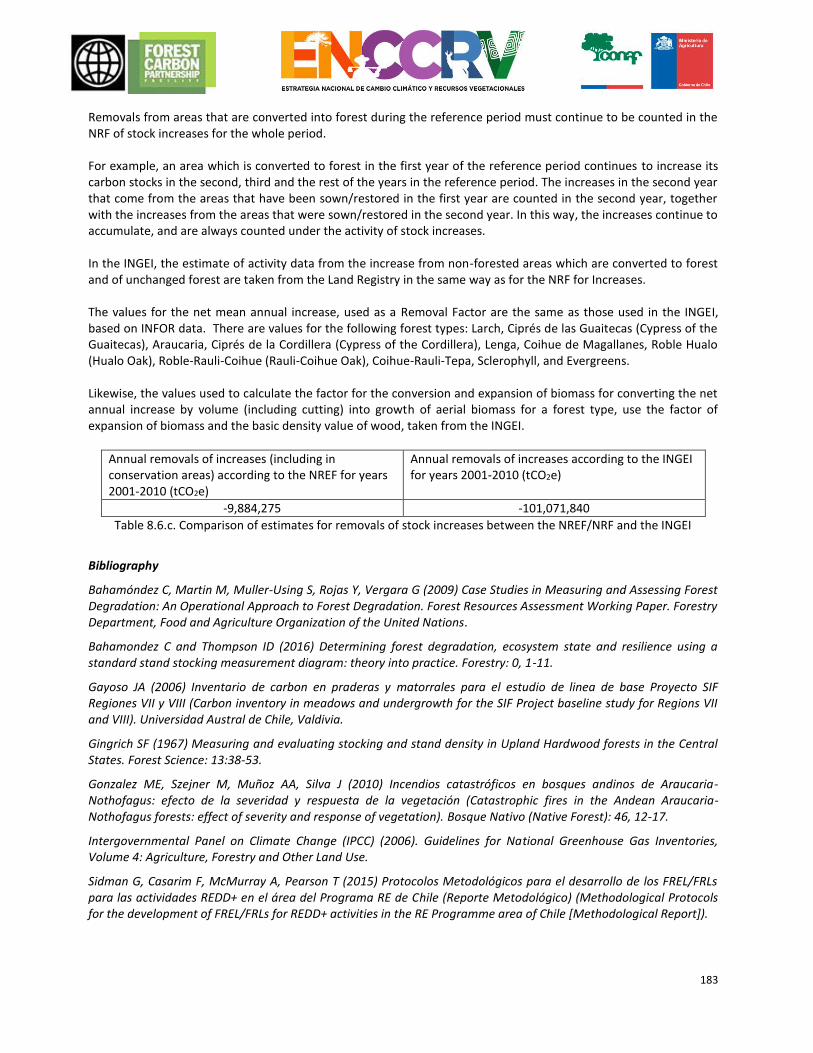
183
Removals from areas that are converted into forest during the reference period must continue to be counted in the NRF of stock increases for the whole period. For example, an area which is converted to forest in the first year of the reference period continues to increase its carbon stocks in the second, third and the rest of the years in the reference period. The increases in the second year that come from the areas that have been sown/restored in the first year are counted in the second year, together with the increases from the areas that were sown/restored in the second year. In this way, the increases continue to accumulate, and are always counted under the activity of stock increases. In the INGEI, the estimate of activity data from the increase from non-forested areas which are converted to forest and of unchanged forest are taken from the Land Registry in the same way as for the NRF for Increases. The values for the net mean annual increase, used as a Removal Factor are the same as those used in the INGEI, based on INFOR data. There are values for the following forest types: Larch, Ciprés de las Guaitecas (Cypress of the Guaitecas), Araucaria, Ciprés de la Cordillera (Cypress of the Cordillera), Lenga, Coihue de Magallanes, Roble Hualo (Hualo Oak), Roble-Rauli-Coihue (Rauli-Coihue Oak), Coihue-Rauli-Tepa, Sclerophyll, and Evergreens. Likewise, the values used to calculate the factor for the conversion and expansion of biomass for converting the net annual increase by volume (including cutting) into growth of aerial biomass for a forest type, use the factor of expansion of biomass and the basic density value of wood, taken from the INGEI.
Annual removals of increases (including in conservation areas) according to the NREF for years 2001-2010 (tCO2e)
Annual removals of increases according to the INGEI for years 2001-2010 (tCO2e)
-9,884,275 -101,071,840
Table 8.6.c. Comparison of estimates for removals of stock increases between the NREF/NRF and the INGEI
Bibliography
Bahamóndez C, Martin M, Muller-Using S, Rojas Y, Vergara G (2009) Case Studies in Measuring and Assessing Forest Degradation: An Operational Approach to Forest Degradation. Forest Resources Assessment Working Paper. Forestry Department, Food and Agriculture Organization of the United Nations.
Bahamondez C and Thompson ID (2016) Determining forest degradation, ecosystem state and resilience using a standard stand stocking measurement diagram: theory into practice. Forestry: 0, 1-11.
Gayoso JA (2006) Inventario de carbon en praderas y matorrales para el estudio de linea de base Proyecto SIF Regiones VII y VIII (Carbon inventory in meadows and undergrowth for the SIF Project baseline study for Regions VII and VIII). Universidad Austral de Chile, Valdivia.
Gingrich SF (1967) Measuring and evaluating stocking and stand density in Upland Hardwood forests in the Central States. Forest Science: 13:38-53.
Gonzalez ME, Szejner M, Muñoz AA, Silva J (2010) Incendios catastróficos en bosques andinos de Araucaria-Nothofagus: efecto de la severidad y respuesta de la vegetación (Catastrophic fires in the Andean Araucaria-Nothofagus forests: effect of severity and response of vegetation). Bosque Nativo (Native Forest): 46, 12-17.
Intergovernmental Panel on Climate Change (IPCC) (2006). Guidelines for National Greenhouse Gas Inventories, Volume 4: Agriculture, Forestry and Other Land Use.
Sidman G, Casarim F, McMurray A, Pearson T (2015) Protocolos Metodológicos para el desarrollo de los FREL/FRLs para las actividades REDD+ en el área del Programa RE de Chile (Reporte Metodológico) (Methodological Protocols for the development of FREL/FRLs for REDD+ activities in the RE Programme area of Chile [Methodological Report]).
184
9. APPROACH FOR MONITORING, REPORTING AND VERIFICATION
9.1 Approach for Monitoring, Reporting and Verification in order to estimate the emissions produced within the framework of the RE Programme in the Accounting Area
The MRV system is based on a monitoring plan which must provide transparent data and information, consistent over time, and capable of measuring, reporting and allowing checks to be carried out on emissions from the sources and removals by the sinks taken into consideration in the RE Programme for Chile. The methods of the MRV system must be consistent with the NREF/NRF (indicator 14.1 mm FCPF), taking into consideration the same sinks and sources, in order to guarantee that the estimates between the reference historic period and the performance period can be compared. The frequency of monitoring and the consequent generation of data for each MRV event must be uniform. The activity data, or surface area subject to anthropogenic action, which delimits each of the REDD+ activities, will be calculated using information from official sources, and must be determined regularly, at least twice in the course of the ERPA and at a date near the beginning of the ERPA. The emission factors or methods to determine them are the same as those used to establish the reference level. Estimates of the emission factors can be improved using new data, but this must be shown to be consistent with the NREF/NRF factors. In terms of ordering and generating data the MRV system monitoring plan must be divided between: 1) change of land-use, and 2) unchanged forest. Change of land-use This category includes activities of deforestation, stock increase resulting from restoration, establishment of forests and forestation, degradation caused by replacement, and definition of forest carbon conservation areas based on the existence of emblematic species (Chilean palm, larch and araucaria). At the moment, the official source of information at national level, from which changes of land-use can be taken, is the system for monitoring changes in the use of the land and plants, the Land Registry. This is the source of information used for the NREF/NRF, and it is also the source of information used by the INGEI. The timeline for updating the Land Registry, between 5 and 10 years, is not adequate for meeting the need to measure the activity data at least twice during the ERPA period, as required by the FCPF methodological context. In order to solve this problem, CONAF is designing a system to support the Land Registry, which allows these changes in land-use at national level to be estimated twice a year. Alternatives compatible with the Land Registry will be analysed, focusing on the Landsat and Sentinel systems, as they are free and are updated continuously. In the initial or implementation stage, the costs of the alternatives will include acquisition of equipment and improvements in networks and human resources. A team of GIS (Geographical Information System) experts will be needed, as well as equipment to carry out measurements in the field, and updated software for analysing spatial data. It is hoped that these costs will be financed by international sources, including financing from the FCPF. Subsequently costs will include maintenance as well as hiring professionals to carry out operations. These will be financed by the national Land Registry budget. New sources of financing involving payment for performance are also anticipated, and these may include the RE Programme, national budgets for continuous improvement of INGEI and other international funds. The desired result is to carry out monitoring events in 2017, 2019, 2021 and 2023, due to the fact that in these years the system for supporting the Land Registry is expected to be updated in all regions. Updates from the Continuous Forest Inventory will be used to improve the estimates of emission factors, in each monitoring event and, if possible, the results from this inventory will be harmonized with the results of the Dendro-
185
energy and Forest Carbon Inventory. The Continuous Forest Inventory presents its updated results annually. These are taken from re-measurements on the land, screening plots and calibrating the estimate. Each complete cycle of the continuous forest inventory, which lasts 5 years, costs approximately USD 1.6 million (320 thousand per year), and is financed by the Ministry of Agriculture. The use of supplementary international funds for expanding the Continuous Forest Inventory is also envisaged, one of which is the GEF “SIMEF” Project www.simef.cl The Dendro-energy and Forest Carbon Inventory is still being set up for the period 2012-2018. Consequently, this inventory is not expected to contribute any results or data before the monitoring event in 2019. Nor has the amount that a complete cycle of measurements for this inventory will cost been determined. For the first cycle of the inventory, the source of financing came from internal funds from the CONAF, but subsequently the project and the potential sources of financing will be evaluated. We must point out that a study for harmonizing both inventories is being conducted, using financing from the GEF “SIMEF” Project. Forests which remain unchanged This category includes activities of degradation in unchanged forests (solely emissions of CO2), conservation of carbon in forests, sustainable forest management, and carbon stock increases in unchanged forests. In order to be consistent with changes of land-use, monitoring events in unchanged forests will also be carried out in 2017, 2019, 2021 and 2023. The activity data for each event will be taken from Landsat 8 images for these years, or from compatible satellites in the future. The estimated cost is approximately 210 thousand dollars for each monitoring event for carrying out the complete analysis of degradation from Maule to Los Lagos. Although it would be possible to apply the k-nn algorithm (the algorithm which forms the basis for the methodology of unchanged forest activities) without having a Continuous Forest Inventory cycle, updating this inventory would give us data to improve the stock charter per forest type, and also improve the localization of the threshold values required. Consequently, the aim is to incorporate the new data from updating the inventory into each monitoring event. As in the case of changes of land use, there is additional financing (CONAF Native Forest Research Fund and the SIMEF Project) which is allowing us to determine the B and C thresholds for forest types. In all cases, the methodology applied for calculating emissions will be based on the difference in carbon reserves between the year of the initial measurement and the year of the final measurement. We should mention that the forest carbon conservation areas that fall under the System of State Protected Forest Areas (SNASPE) will be updated annually via an agreement with the management of the CONAF protected forest areas (GASP) to pass on official information. In relation to private conservation areas attempts will be made to establish an agreement between Así Conserva Chile (ACCH), Parques Para Chile (PPCH) and CONAF, which allows the changes in the private surface areas of conservation forest, registered for these two organizations to be recorded on an annual basis. Surface area affected by forest fires In order to count the surface area affected by forest fires the CONAF annual data on the historical statistics for forest fires will be used, which list the surface areas affected by forest fires at municipal level, with this being the same source of information as that used by the INGEI when establishing the NREF/NRF. This information is the country’s official source and records the number of fires, the surface area affected, the time frame and the reasons. In order to optimize conveyance of information a mechanism for transferring information will be generated. This will allow the fire prevention department and the UCCSA (Unit of Climate Change and Environmental Services), which are both part of CONAF, to record the data on an annual basis. In order to improve
186
the emission factors, CONAF will seek to include requirements to characterize the severity of major forest fires, exceeding 200 hectares. Sustainable forest management Sustainable forest management activity data corresponds to those surface areas subject to formal management processes, taking into account that the term formal management processes will include those activities conducted under the heading of sustainable management plans and instruments and possibly forestry planning projects (Chilean legislation does not make it obligatory for all forest estates to be subject to forest planning). At the moment there is no complete official information allowing forests subject to sustainable management to be defined, so this activity was not included in a spatially explicit way in the NREF/NRF submitted to the CMNUCC in January 2016. Nevertheless, CONAF has begun the process for generating the information needed for constructing the reference level for sustainable forest management, differentiated between the other activities and spatially explicit, in a study led by the UCCSA together with the Department of Monitoring Forest Ecosystems, which is charge of the integration and compatibility of the results with the CONAF territorial information system; the Native Forest Department, contributing by identifying tools aimed at sustainable management and new prospects for amendments under Law 20.283; the Department of Standards and Procedures, contributing official instruments for sustainable native forest management; and the Department of Administration and Development of Systems contributing forms for recording information and checking fulfilment of management activities. In the course of 2016 the Reference Level for sustainable forest Management is scheduled to be integrated in the sub-national NREF/NRF. In order to monitor this activity, in the course of the second half of 2016, the Mapping Module for the Sistema de Administración y Fiscalización Forestal (Forestry Administration and Control System) was used in the CONAF. This will allow activity data to be gathered for the surface area subject to sustainable management. In the course of 2015, the Gerencia de Fiscalización y Evaluación Ambiental (Management Office of Inspection and Environmental Assessment) by the Departamento de Administración y Desarrollo de Sistemas (Department of Administration and Development of Systems) together with the Gerencia de Desarrollo y Fomento Forestal (Management Office on Forest Support and Development) via the Departamento de Bosque Nativo (Department of Native Forests), will be carrying out the projects entitled “Diseño Lógico de Sistema para la Gestión de Cartografía Digital” (Logical Design of a System for Administering Digital Mapping) and “Desarrollo de Software para la Validación y Almacenamiento de Información Georreferenciada” (Development of Software for the Validation and Storage of Geo-referenced Data). The result of both projects has been embodied in the construction of prototype software known as “Mapping Module (MM)”, which is integrated with the main application for managing requests received by the CONAF, the Sistema de Administración y Fiscalización, SAFF. The main aim of this prototype was to evaluate and demonstrate the technical feasibility of constructing an IT solution, based on a series of aims identified in the study referred to above; including identification and validation of the status of digital mapping, storage in a geo database, the application of validation rules, and, of course, integration with SAFF technology, among other things. A positive result was obtained for all the points evaluated in the feasibility assessment. So, the decision has been taken to put the module into production this year, using a cautious strategy allowing evaluation to take place in the field under actual operating conditions, adjustments to be made using updateable prototypes which will generate a version of the software, and finally progressive integration of regional offices subject to the integrity of the data being permanently monitored.

187
Measuring the result of direct mitigation measures The measures of direct mitigation, defined as action measures implemented within the region whose direct aim is to reduce emissions and/or increase removals, could be successful and yet not be recorded using the measurement methods described above, since the scale of the monitoring method applied in the NREF/NRF is at countryside level and is not applied per activity, and is not therefore able to determine the specific activities which cause the carbon flows detected. The following measures are considered to be on a regional or national spatial scale, so the reduction of emissions and/or increase of removals must be recorded by the general monitoring system.
Incorporating forest conservation variables in Law 18.450 for irrigation and drainage development
Limiting the application of law 20.412 on APF (Paramount Suitability for Forestry) land, establishing a system of incentives for the agroenvironmental sustainability of agricultural land.
Reinforcing Control in order to reduce replacement
Amending Law 19.561 which releases land for agricultural clearing from reforestation
Forestation programme in municipalities prioritized by the ENCCRV
Programme for Preventive Forestry measures in the Urban-Rural Interface.
Programme for alternative treatments for managing and using forestry, farming and livestock waste
An operational tool will be generated to allow the GG emissions produced by forest fires to be estimated, and to determine the GG emissions avoided by implementing the mitigation methods described.
In the case of specific measures applied on a local or focal level within the country, which cannot be monitored using the monitoring system described above, CONAF proposes monitoring at focal level to ensure that each measure is being conducted properly and, consequently, reducing the expected amount of emissions (see section 4.3). The indicators scheduled to be monitored include:
Percentage of funds reserved for each measure carried out in each year, compared with the budget
Percentage of activities carried out each year, compared with the working plan
Number of people included in training workshops
Number of people affected by activities and installations produced as a result of the mitigation measures
The measures which are scheduled to be monitored in detail include:
Programme for the recovery of ecosystems affected by forest fires.
Ecological recovery programme in municipalities prioritised by the ENCCRV
Permanent programme for forestry planning on public land
Extension focused on management plans with a forestry planning criterion
Buffer strips for livestock farming Monitoring the Joint benefits The joint benefits of implementing the RE Programme are analysed in Section 16, which will explain that the definition of the monitoring variables of the non-carbon benefits of the ENCCRV is still in the process of being developed, before they can be incorporated in the MRV. These variables will be incorporated in the Safeguards Implementation System (SIS), which is explained in detail in Section 14.1.6. MRV events The MRV events will measure the performance of REDD+ activities in the years 2017, 2019, 2021 and 2023 since the events for monitoring the system for supporting the Land Registry will exist for those years as discussed in the section about methods and tools for monitoring and estimating activity data and emission factors. The corresponding reports will be created with a year’s gap (2018, 2020, 2022 and 2024).
188
Community participation in complaints about forest fires and illegal logging. On fire prevention, CONAF holds the Management Office on Forest Fire Protection (GEPRIF, acronym in Spanish) and its Department on Prevention of Forest Fires. This Department is organized in three sections, setting technical tools to prevent forest fires. The objectives set for the Department are: to reduce occurrence of forest fires (Education and Awareness), and; to minimize damage from forest fires (Preventive Forestry and Administration of the Legislation on Use of Fire). In the country, use of fire as a tool in agriculture and forestry is ruled by Decree No. 276 from the Ministry of Agriculture enacted on 1980. This decree regulates and set standards on technical and administrative procedures for using fire, mainly for disposal of harvest residues from agriculture or forestry. This decree was issued considering that about 45% of forest fires in the country were generated by the practice of using fire to eliminate agricultural and forestry residues without proper planning or safeguarding control measures. Currently, only 6% of fires are generated by agricultural and / or forestry burning. Application of Decree N° 276 is carried out under the following procedures: 1) users have to attend CONAF or Police offices to submit a notice on the date and location where fire will be used, reporting on planning and control measures to prevent or fight potential fires that could be arise; 2) users should proceed in accordance to a pre-established calendar for burning set by CONAF disaggregated by counties, with a time-schedule for using fire under appropriate conditions in order to keep fire under control; 3) users have to adopt guidelines on proper use of fire as a tool for habilitation of agricultural and forest lands, including matters on controlled-burning techniques and environmental considerations to keep fire under control. Currently, about 15,000 farmers and foresters presented annually their notices for burning and reported planning and control measures they carried out for a total area over 245 thousand hectares nationwide. More than 86 % of this area is related to land clearance for agriculture. CONAF facilitates procedures to the users of the fire under its legal mandate and modernization of its services that include an on-line platform for submission of the notice of burning (www.avisoenlinea.conaf.cl), where the fire user can get a receipt for its notice of burning without needing to visit a CONAF´s office. Meanwhile, enforcement on using fire has been intensified annually through a joint effort between CONAF and Police (Carabineros de Chile), which included training and induction on using the Assistance System for Burning (SAQ, acronym in Spanish) easing its use in most of the districts from Atacama Region to Magallanes Region. Since January to May 2016 a total of 9,940 farmers and foresters came to CONAF´s offices to submit their notices of burning for a total area of 232,692 ha. Currently, 92 CONAF´s offices notices have been implemented nationwide for receiving notices of burning, as well as delivery of educational material on management practices for management of post-harvest residues. Concerning notification of occurrence of forest fires, about 20% (1,382 fires during season 2015/2016) of the forest fires were reported by citizens through Phone-Number 130 for Emergencies of CONAF. The remaining fires were reported by the forest fires detection system of CONAF. Regarding illegal logging, CONAF has mechanisms to receive complaints from citizens on violations of the forest law. CONAF has communication channels to this effect by post mail and email. CONAF verifies veracity of the facts through site inspection and reports to the complainant the outcome of the enforcement. As a final verifier of the process, in addition to the legal actions that may arise against an alleged offender, an official letter is sent to the complainant address with the results of the law enforcement carried out by CONAF, informing whether there was infringement to the forest legislation in force and legal measures adopted by CONAF in case required. Infringements may be related to:
Logging. Felling of riparian vegtation. Other situations affecting national forest resources.
The beneficiary of this mechanism is the community, who fulfills:
To sue complaints formally using appropriate procedures. To provide identification of the complaintnant, facts and identification of an alleged offender.
During the period 2013-2015, a total of 3,310 complaints were received from third-parties, involving forest plantations, native forests and xerophytic formations.
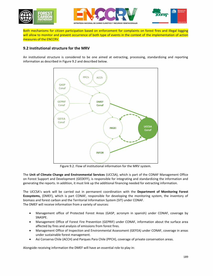
189
Both mechanisms for citizen participation based on enforcement for complaints on forest fires and illegal logging will allow to monitor and prevent occurrence of both type of events in the context of the implementation of action measures of the ENCCRV.
9.2 Institutional structure for the MRV An institutional structure is considered to be one aimed at extracting, processing, standardizing and reporting information as described in Figure 9.2 and described below.
Figure 9.2. Flow of institutional information for the MRV system.
The Unit of Climate Change and Environmental Services (UCCSA), which is part of the CONAF Management Office on Forest Support and Development (GEDEFF), is responsible for integrating and standardizing the information and generating the reports. In addition, it must link up the additional financing needed for extracting information. The UCCSA’s work will be carried out in permanent coordination with the Department of Monitoring Forest Ecosystems, (DMEF), which is part CONAF, responsible for developing the monitoring system, the inventory of biomass and forest carbon and the Territorial Information System (SIT) under CONAF. The DMEF will receive information from a variety of sources:
Management office of Protected Forest Areas (GASP, acronym in spanish) under CONAF, coverage by SNASPE.
Management Office of Forest Fire Prevention (GEPRIF) under CONAF, information about the surface area affected by fires and analysis of emissions from forest fires.
Management Office of Inspection and Environmental Assessment (GEFEA) under CONAF, coverage in areas under sustainable forest management.
Así Conserva Chile (ACCH) and Parques Para Chile (PPCH), coverage of private conservation areas. Alongside receiving information the DMEF will have an essential role to play in:
190
Standardisation and integration of spatial information
Monitoring activity data
Management of the system for circulating information via the SIT
The Forestry Institute (INFOR), is responsible for the continuous forest inventory, a tool whereby it is possible to update emission factors. In addition, this authority will be in charge of implementing the methodology for estimating carbon flows in unchanged forests. The DMEF and the INFOR are responsible for extracting information about activity data and emission factors, for the INGEI and its Biannual Update Reports (IBA), respectively, in the land-use, change of land-use and forestry sector. The MRV system will retain the same institutional structure as the INGEI, generating a route of feedback between both of them, ensuring consistency and optimizing institutional efforts. All the activities linking up with the INGEI will be coordinated with the Sectorial AFOLU team which is composed of ODEPA, INIA, SAG, INFOR, FIA and CONAF and which ultimately allows the final integration of data with the rest of the sectors through the coordination and leadership of the Ministry of the Environment.
9.3 Relationship and consistency with the National Forest Monitoring System Chile already has tools and systems for collecting information, which are used as a basis for its Forest Monitoring System (NFMS in English). These are: the Land Registry of Vegetation Resources in Chile, the Continuous Forest Inventory, the National Dendro-energy and Forest Carbon Inventory, the Forestry Administration and Control System (SAFF)55, and the Territorial Information System (SIT). Overall, these systems allow information associated with land use in Chile to be extracted, displayed, consulted and maintained. The MRV approach for the RE Programme consists of the integration and interoperability of the aforementioned existing systems, as explained in sections 9.1 and 9.2, therefore, the relationship between both of them is direct and consistency is guaranteed.
55 https://saf.conaf.cl/login.php?basura_3f47517c76f16ed34f921079e4837824=1
191
10. MOVEMENT
10.1 Identification of risks of movement Since the RE Programme Area is sub-national, there is always the risk that emissions will move to other regions in the country due to the Programme’s mitigation measures. The border region to the north of the RE Programme Area is the O’Higgins Region (VI). The forest in this region extends over ~0.46 million hectares, covering 28% of the total regional surface area. In its section bordering the RE Programme Area, VII Región del Maule, there are ~0.57 million hectares of forest, representing 28% of the region’s total surface area. In this sense there is sufficient potential area for movement to take place towards the north. Chile has compiled a reference level for the Mediterranean zone of the country, which includes the O’Higgins Region (VI). All the emissions from deforestation, degradation and removals through increases are counted in this reference level, although it does not come under the FCPF’s RE Programme. Towards the south, the region bordering the RE Programme Area is the Aysén Region (XI). Aysén has ~4.9 million hectares of forest, which covers 46% of the total surface area of the region. Los Lagos Region (X), bordering on Aysén, it is included in the RE Programme it has ~3.0 million hectares of forest which covers 61% of the total surface area of the region. Monitoring of movements of emissions to north or south regions in the accounting area under the RE Programme would require replication of the accounting of emissions carried out in the RE Programme throughout the forested area of the country. In the O’Higgins region, work for harmonization between the reference levels that are already completed is planned to be finished in 2016. In this way in the future MRV events may removals a change in the historical patterns of emissions in this region. Currently there is no reference level for Aysén, but there are plans to produce one in 2017/18. Due to the large expanse of forest in Aysén, movements are possible. However, it is an area with a small population and it is difficult to access. Many of its areas are protected, so there is not much anthropogenic pressure. There is also a possibility of international movements to Argentina, which borders on the whole of the East part of the RE Programme Area. On the border with the RE Programme Area, Argentina has considerable forested surface areas in the Cordillera de los Andes which, at a lower altitude, moves into an ecosystem dominated by meadows. However, the Andean zone is characterised by a small population and is difficult to access, because of its high altitude, and so there is not much likelihood of international movement occurring..
Table Error! Reference source not found.10.1 shows the reasons for deforestation and degradation, based on the preliminary results of the analysis of reasons in Chile, which was described in Section 4. The level of risk of movement and the explanation for this is identified for each reason.
Driver of deforestation or
degradation
Risk of Displacement.
(Categorize as High, Medium
or Low)
Explanation / justification of risk assessment
Expansion due to agricultural
and livestock farming
Low Given that there are plans to carry out measures of
mitigation at national level under the ENRRCV, there are no
high risks of emissions from deforestation moving to other
regions of Chile. There may be movements to Argentina, but
there is not a great deal of anthropogenic deforestation in
the border region, so the risk is low.
With regard to internal movement, it is possible that the
Urban expansion Low
192
mitigation measures that deter and rule out development of
sections of laws 19.561 and 20.412 cause a movement of
activities more than that caused by location. That is to say
that if the farmer or livestock owner is discouraged from his
former livelihood (which involved deforestation due to
agricultural and livestock farming expansion), it is possible
that he will look for another similar livelihood such as
collection of firewood, which may generate emissions due to
degradation. However, the risk remains low given that the
agricultural and livestock farms expansion is not a reason
that generates many emissions and any national movement
may be collected using the MRV system.
Unsustainable use of
vegetation resources
Medium It is possible that an approach involving mitigation measures
for degradation caused by ”floreo” (collection of the best
specimens of a population), collection of valuable timber
and harvesting of firewood may lead to movements to other
regions of Chile, given the strong economy in timber
products and the high demand for firewood in Chile. It is
more likely that movements will occur due to the harvesting
of logs, given that the market is national, while the firewood
market is regional. There are plans to apply the mitigation
methods at national level in order to avoid this type of
movement.
Within regions, there is a possibility of displacement if the
incorporation of Management Plans subject to Forest
Classification Criteria (PMCOF) leads to a reduction in timber
and firewood removed from forests. The risk stems from the
high demand for products, causing people to search for
other (illegal) areas, potentially without management plans,
from which to take timber and saturate the market.
Forest fires Medium In the main, forest fires of anthropogenic causes in Chile are
not intended to degrade forests but are usually the result of
accidents or crime. It is therefore not very likely that a forest
fire would spread from one region to another, particularly in
light of national mitigation measures being devised.
However, displacement of emissions could occur as a result
of certain mitigation strategies that can cause emissions. For
example, in order to prepare a community against fires, it is
necessary to clear biomass from around residential areas.
This can involve small-scale forest degradation or
deforestation. Controlled burn also produces emissions.
Expansion of monoculture
forests
Medium This situation could spread to regions in the north of the ER Programme Area due to strong economic returns from plantations in there. Maps from the Land Registry indicate that this is a relatively common transition in these regions, particularly the substitution of tree-filled scrubland, which is now considered a native forest. However, national mitigation measures, such as improved auditing of the CONAF, environmental awareness and the recognition of
193
native forests, should avoid this type of displacement.
Focusing on mitigation in terms of planning and territorial
legislation with a view to prohibiting such substitution in
certain areas could cause displacement to other areas within
the ER Programme Area. However, planning also involves
designating optimal areas for establishing new exotic
plantations where substitution would cause less
environmental damage, thus diminishing the potential for
displacement.
Use of forests for livestock Medium This is the most common cause of deforestation in
Mediterranean areas of the country, though this also occurs
in the Maule region, which is part of the ER Programme
Area. As a result, displacement could spread to the north if
mitigation focuses solely on the ER Programme Area.
However, the CONAF also plans to direct mitigation at
overgrazing in Mediterranean areas, meaning that there is
only a small risk of displacement.
Within the ER Programme Area, the measure of establishing
graze-free strips could displace livestock, leading them to
forage and graze in other areas, causing degradation.
Effects of climate change, desertification and drought
Low No displacement is expected as part of the strategy to combat the effects of climate change, as it is a natural phenomenon that cannot be “displaced” to another location when efforts are focused in one location, as is the case with anthropogenic causes.
Table 10.1. Causes of degradation and the risks of displacement.
10.2 Elements of the ER Programme to prevent and minimise the potential for displacement The most effective means of the ENCCRV avoiding displacement is by executing national mitigation levels. Although the ER Programme is subnational, it constitutes just one part of the ENCCRV aimed at mitigating emissions and encouraging the removal of GHGs. As a result of this national approach, the possibility of national displacement is significantly reduced. Nevertheless, there is still a possibility that local displacement could occur within the ER Programme Area. Although any displacement will be monitored and recorded via the MRV system, Chile plans to address this issue by implementing measures to mitigate this risk. In order to mitigate displacement within the ER
Programme Area, it is expected that measures devised for each cause will be implemented (Error! Reference
source not found.). Causes of emissions/non-removal
Displacement mitigation plan
Expansion of agriculture and livestock
In order to mitigate the possibility of emissions – caused by deforestation due to the expansion of agriculture and livestock – being displaced to cause forest degradation, it is expected that funding will be put in place to support the conservation of native forests. This will be achieved by incorporating the forest conservation variables outlined in Law 18.450. This would mean that if farmers are dissuaded from expanding their farmland by the changes outlined in Laws 18.450 and 20.412 in favour or forest conservation, they will be given access to a sustainable source of funding to replace any potential loss to their livelihood. Since this plan is linked to overall changes in national forest legislation, it will reduce the risk of reversals both during and after the Term of the ERPA.
Urban and industrial expansion
This cause produces few emissions. Emphasis has therefore been placed on the mitigation of displacement caused by other factors.
Unsustainable use of Plans are being developed to combat the risk of displacing emissions by reducing the amount of
194
vegetation resources timber removed from areas with PMCOF while seeking a better price for sustainably felled timber. This way, plantation owners can remove less timber and sell it for a higher price. Better organisation of the supply chain would make it more feasible to certify sustainable timber and give it a fair price. Furthermore, the ENCCRV will seek to lower the costs of landowners, lower taxes and improve auditing so as to encourage the option of subscribing to a PMCOF. Whether or not this plan continues to reduce the risk of reversals after the Term of the ERPA depends upon the success of the PMCOF program.
Forest fires In order to prevent emissions caused by mitigation measures aimed at reducing the amount of biomass close to vulnerable areas, each mitigating activity will be planned in detail to determine how to remove the least amount of biomass with the greatest impact on reducing the risk of fires. Options include using dried biomass as a timber-yielding product and planting new trees. Plans are in place to use this strategy very restrictedly as a means of reducing emissions caused by controlled burn. Weather conditions will also be monitored to ensure that burning only begins during the rainy season when temperatures are low and there is little wind, so as to avoid spread. The post-ERPA success of this strategy will depend upon public and political interest in maintaining it and the financial resources available.
Expansion of monoculture forests
As part of measures concerning planning and territorial legislation, priority areas are expected to be set aside for plantations of exotic plants where this would cause the least environmental damage. This prioritisation should compensate for the prohibition on substitution in areas of native forest where greater environmental damage would be caused. Whether this strategy extends into the post-ERPA period will depend upon public and political interest in maintaining it and the financial resources available.
Use of forests for livestock As part of mitigation measures, plans are in place to provide technical support to facilitate the overall management of livestock. This will allow for better forest management and more efficient use of small areaa in order to minimise the necessity of using more area for grazing. By maximising small areas, it will be possible to establish strips of protected at-risk areas without the need to replace these areas with other terrain. The strategy for managing summer pastures will also allow grazing without long-term degradation, as a better managed area can grow and replace biomass lost to grazing, creating a balanced system whereby the amount of biomass remains stable. The post-ERPA success of this strategy will depend upon public and political interest in maintaining it and the financial resources available.
Effects of climate change, desertification and drought
Displacement of the effects of climate change is very unlikely and it is therefore not necessary to take displacement mitigation measures in this regard.
Table 10.2. Displacement mitigation plan according by each cause.
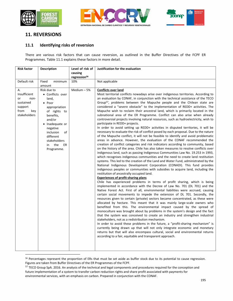
195
11. REVERSIONS
11.1 Identifying risks of reversion There are various risk factors that can cause reversion, as outlined in the Buffer Directives of the FCPF ER Programmes. Table 11.1 explains these factors in more detail.
Risk factor Description Level of risk of causing regression56
Justification for the evaluation
Default risk Fixed minimum amount
10% Not applicable
A. Insufficient or non-sustained support from key stakeholders
Risk due to
Conflicts over land,
Poor appropriation of rights to benefits, and/or
Inadequate or negative inclusion of different stakeholders in the ER Programme.
Medium – 5% Conflicts over land Most territorial conflicts nowadays arise over indigenous territories. According to an evaluation by CONAF, in conjunction with the technical assistance of the TECO Group57, problems between the Mapuche people and the Chilean state are considered a “severe obstacle” to the implementation of REDD+ activities. The Mapuche wish to reclaim their ancestral land, which is primarily located in the subnational area of the ER Programme. Conflict can also arise when already controversial projects involving natural resources, such as hydroelectricity, wish to participate in REDD+ projects. In order to avoid setting up REDD+ activities in disputed territories, it will be necessary to evaluate the risk of conflict posed by each proposal. Due to the nature of the Mapuche conflict, it will not be feasible to identify and avoid problematic areas in advance. However, the evaluation of the CONAF recommended the creation of conflict categories and risk indicators according to community, based on the history of the area. Chile has also taken measures to resolve conflicts over indigenous land, such as passing Indigenous Communities Law No. 19.253 in 1993, which recognises indigenous communities and the need to create land restitution systems. This led to the creation of the Land and Water Fund, administrated by the National Indigenous Development Corporation (CONADI). This fund provides indigenous peoples or communities with subsidies to acquire land, including the restitution of ancestrally occupied land. Experiences of profit-sharing plans Chile has experienced problems in terms of profit sharing, which is being implemented in accordance with the Decree of Law No. 701 (DL 701) and the Native Forest Act. First of all, environmental liabilities were accrued, causing certain social movements to impede the extension of DL 701. Secondly, the resources given to certain (private) sectors became concentrated, as these were allocated by hectare. This meant that it was mainly large-scale owners who benefited from this. The environmental impact caused by the spread of monoculture was brought about by problems in the system’s design and the fact that the system was conceived to create an industry and strengthen industrial stakeholders, not as a redistribution mechanism. In order to avoid these problems in the future, a “profit-sharing mechanism” is currently being drawn up that will not only integrate economic and monetary returns but that will also encompass cultural, social and environmental returns according to a fair, equitable and transparent approach.
56 Percentages represent the proportion of ERs that must be set aside as buffer stock due to its potential to cause regression. Figures are taken from Buffer Directives of the ER Programmes of the FCPF. 57 TECO Group SpA. 2016. An analysis of the technical and legal components and procedures required for the conception and future implementation of a system to transfer carbon reduction rights and share profit associated with payments for environmental services, with an emphasis on carbon. Prepared in conjunction with the CONAF.
196
Participation of key stakeholders Chile hopes to involve a large number of key stakeholders by means of the Social and Environmental Safeguards Implementation Plan. Within the Social and Environmental Safeguards (SESA) framework being devised in Chile, the Public and Indigenous Consultation and Self-Evaluation system has been developed, which includes a participatory process involving a group of key stakeholders (see Chapter 5 for more details on this process). Through the MGAS, Chile hopes to continue this participatory process throughout the ER Programme implementation phase so as to reduce the possibility of any negative impacts and regression.
B. Lack of institutional capacity and/or ineffective vertical/cross-sector coordination
Risk due to the insufficient knowledge and skills of the various institutions involved and the lack of coordination between them
Low – 0% Chile has taken various measures to ensure that the several governmental institutions involved in the subject of climate change concerning land use are included. According to the UNFCCC, the REDD+ focuses on the CONAF, which is answerable to the Ministry of Agriculture (MINAGRI); more specifically the Climate Change and Vegetation Resources Unit (UNCCRV), a sub-department of the CONAF, which has taken on the role of coordinating the various other institutions and leading the implementation of the ENCRRV. In order to improve institutional coordination, the Intra-Ministerial Technical Committee on Climate Change (CTICC) was founded. This committee is coordinated by the Office of Agricultural Studies and Policies (ODEPA), which will be represented in all 15 regions of the country. The Forestry Institute (INFOR) and the Natural Resources Information Centre (CIREN) have also played a part in defining technical aspects of the REDD+ and will continue providing support throughout the MRV phase.
B. Lack of long-term effectiveness in confronting underlying factors
Risk due to inadequate laws, legislative changes, the design of the ER Programme, which does not sufficiently address the causes and agents of deforestation and degradation, corruption and ineffective governance, lack of execution and a lack of continuous funding.
Medium – 3% Chile receives a fair amount of political backing for the ENCCRV, including by virtue of Law 20.283 and Decree 259, which encourage activities conducive to the reduction of deforestation and the sustainable management of forests. There are confirmed plans to pass another act on forest development, which will act to extend this support. However, there is currently a distinct lack of legal instruments being implemented to enforce the prevention of forest degradation. There is a project concerned with the traceability of firewood and other projects, which will be integrated into the CONAF audit plan. This project will help differentiate between products from deforested or degraded areas and those from sustainably managed forests. In terms of the lack of permanence of this legislative framework, there is always the possibility of a change in government, leading to less of an emphasis on emission mitigation. Nevertheless, the political environment is conducive to REDD+ objectives, given that there is a certain charge on parliamentary and ministerial commissions to prevent any drastic changes in the future. Action measures developed in the ENCRRV framework have been carefully drawn up by experts. Those experts know well the country’s situation and the causes and agents of deforestation and degradation. These measures aim to address the underlying causes of deforestation and degradation to provoke permanent change in the way forests are used, without the risk of reversion once the ER Programme period comes to an end. One way in which the measures hope to directly tackle the underlying causes is by valuating forests and organising the firewood market, as this is the main product associated with degradation. In this way, the measures will create new opportunities and regularise subsistence for agents of deforestation and degradation instead of simply blocking subsistence with bans on the extraction of the product. Chile is currently in the process of seeking funding to maintain mitigation measures following the ER Programme in order to preserve the sustainability of emission reduction and removal. Although there is no fixed funding for the future, there are various other potential sources, including the Green Climate Fund of the UNFCCC, World Bank funds, a domestic system created through the EFF and private company funds, among others.
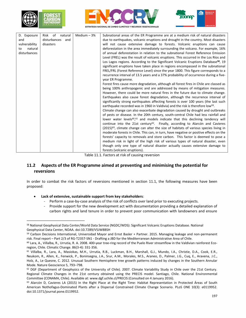
197
D. Exposure and vulnerability to natural disturbances
Risk of natural disturbances and disasters
Medium – 3% Subnational areas of the ER Programme are at a medium risk of natural disasters due to earthquakes, volcanic eruptions and drought in the country. Most disasters will not cause extensive damage to forests. Volcanic eruptions can cause deforestation in the area immediately surrounding the volcano. For example, 16% of annual deforestation in relation to the subnational Forest Reference Emission Level (FREL) was the result of volcanic eruptions. This occurred in the Los Ríos and Los Lagos regions. According to the Significant Volcanic Eruptions Database58, 19 significant eruptions have taken place in regions encompassed in the subnational FREL/FRL (Forest Reference Level) since the year 1800. This figure corresponds to a recurrence interval of 13.5 years and a 37% probability of occurrence during a five-year ER Programme. Forest fires cause more degradation, although all forest fires in Chile are classed as being 100% anthropogenic and are addressed by means of mitigation measures. However, there could be more natural fires in the future due to climate change. Earthquakes also cause forest degradation, although the recurrence interval of significantly strong earthquakes affecting forests is over 100 years (the last such earthquake recorded was in 1960 in Valdivia) and the risk is therefore low59. Climate change can also exacerbate degradation caused by drought and outbreaks of pests or disease. In the 20th century, south-central Chile had less rainfall and lower water levels60,61 and models indicate that this declining tendency will continue into the 21st century62. Finally, according to Alarcón and Cavieres (2015)63, climate change can alter the size of habitats of various species living in moderate forests in Chile. This can, in turn, have negative or positive effects on the forests’ capacity to removals and store carbon. This factor is deemed to pose a medium risk in light of the high risk of various types of natural disaster, even though only one type of natural disaster actually causes extensive damage to forests (volcanic eruptions).
Table 11.1. Factors at risk of causing reversion
11.2 Aspects of the ER Programme aimed at preventing and minimising the potential for reversions
In order to combat the risk factors of reversions mentioned in section 11.1, the following measures have been proposed:
Lack of extensive, sustainable support from key stakeholders: - Perform a case-by-case analysis of the risk of conflicts over land prior to executing projects. - Provide support for the new development act with documentation providing a detailed explanation of
carbon rights and land tenure in order to prevent poor communication with landowners and ensure
58 National Geophysical Data Center/World Data Service (NGDC/WDS): Significant Volcanic Eruptions Database. National Geophysical Data Center, NOAA. doi:10.7289/V5JW8BSH 59 Carbon Decisions International, Universidad Mayor and Ernst Basler + Partner. 2015. Managing leakage and non-permanent risk. Final report – Part 2/3 of RG-T2357-SN1 - Drafting a JBD for the Mediterranean Administrative Area of Chile. 60 Lara, A., Villalba, R., Urrutia, R. A. 2008. 400-year tree-ring record of the Puelo River streamflow in the Valdivian rainforest Eco-region, Chile. Climatic Change. 86(3-4): 331-356. 61 Villalba, R., Lara, A., Masiokas, M.H., Urrutia, R.B., Luckman, B.H., Marshall, G.J., Mundo, I.A., Christie, D.A., Cook, E.R., Neukom, R., Allen, K., Fenwick, P., Boninsegna, J.A., Srur, A.M., Morales, M.S., Araneo, D., Palmer, J.G., Cuq, E., Aravena, J.C., Holz, A., Le Quesne, C. 2012. Unusual Southern Hemisphere tree growth patterns induced by changes in the Southern Annular Mode. Nature Geoscience 5, 793–798. 62 DGF (Department of Geophysics of the University of Chile). 2007. Climate Variability Study in Chile over the 21st Century. Regional Climate Changes in the 21st century obtained using the PRECIS model. Santiago, Chile. National Environmental Committee (CONAMA, Chile). Available at: www.dgf.uchile.cl/PRECIS (Consulted on 4 January 2016). 63 Alarcón D, Cavieres LA (2015) In the Right Place at the Right Time: Habitat Representation in Protected Áreas of South American Nothofagus-Dominated Plants after a Dispersal Constrained Climate Change Scenario. PLoS ONE 10(3): e0119952. doi:10.1371/journal.pone.0119952.
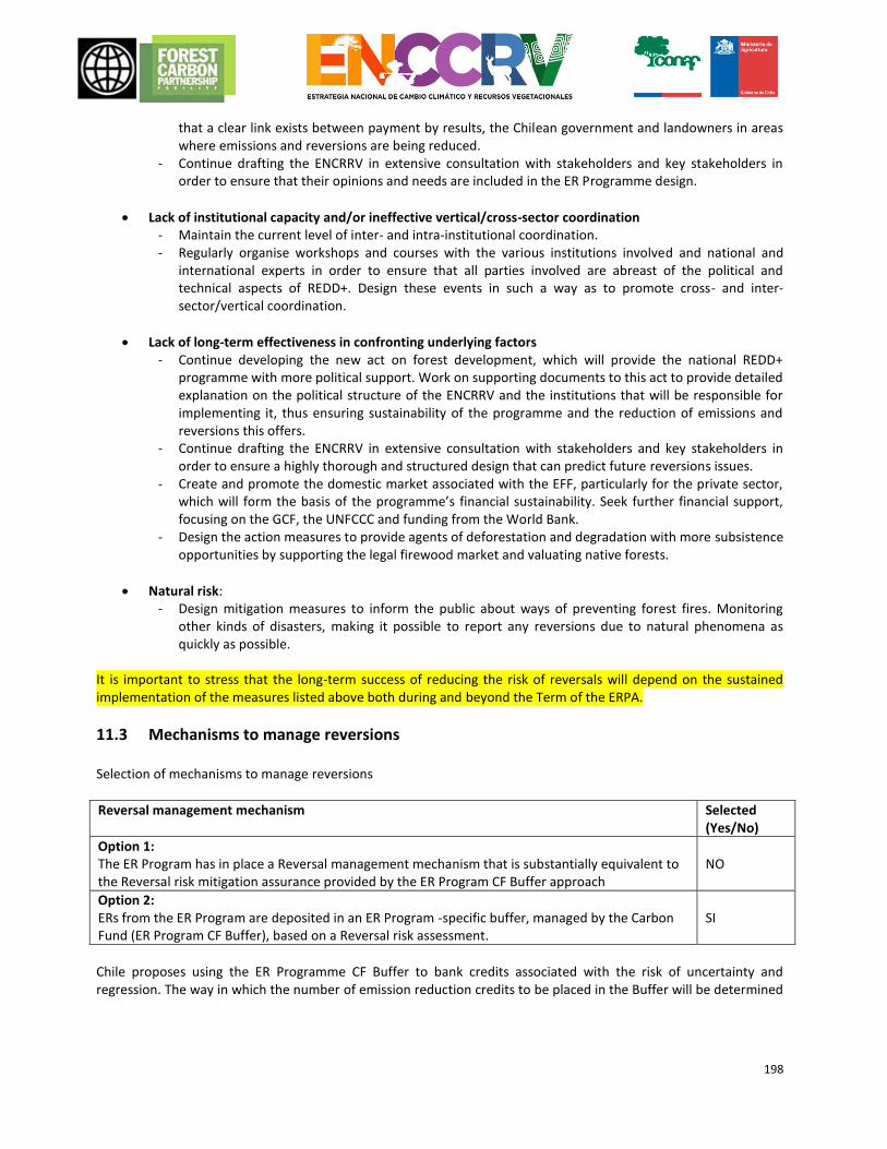
198
that a clear link exists between payment by results, the Chilean government and landowners in areas where emissions and reversions are being reduced.
- Continue drafting the ENCRRV in extensive consultation with stakeholders and key stakeholders in order to ensure that their opinions and needs are included in the ER Programme design.
Lack of institutional capacity and/or ineffective vertical/cross-sector coordination - Maintain the current level of inter- and intra-institutional coordination. - Regularly organise workshops and courses with the various institutions involved and national and
international experts in order to ensure that all parties involved are abreast of the political and technical aspects of REDD+. Design these events in such a way as to promote cross- and inter-sector/vertical coordination.
Lack of long-term effectiveness in confronting underlying factors - Continue developing the new act on forest development, which will provide the national REDD+
programme with more political support. Work on supporting documents to this act to provide detailed explanation on the political structure of the ENCRRV and the institutions that will be responsible for implementing it, thus ensuring sustainability of the programme and the reduction of emissions and reversions this offers.
- Continue drafting the ENCRRV in extensive consultation with stakeholders and key stakeholders in order to ensure a highly thorough and structured design that can predict future reversions issues.
- Create and promote the domestic market associated with the EFF, particularly for the private sector, which will form the basis of the programme’s financial sustainability. Seek further financial support, focusing on the GCF, the UNFCCC and funding from the World Bank.
- Design the action measures to provide agents of deforestation and degradation with more subsistence opportunities by supporting the legal firewood market and valuating native forests.
Natural risk: - Design mitigation measures to inform the public about ways of preventing forest fires. Monitoring
other kinds of disasters, making it possible to report any reversions due to natural phenomena as quickly as possible.
It is important to stress that the long-term success of reducing the risk of reversals will depend on the sustained implementation of the measures listed above both during and beyond the Term of the ERPA.
11.3 Mechanisms to manage reversions Selection of mechanisms to manage reversions
Reversal management mechanism Selected (Yes/No)
Option 1: The ER Program has in place a Reversal management mechanism that is substantially equivalent to the Reversal risk mitigation assurance provided by the ER Program CF Buffer approach
NO
Option 2: ERs from the ER Program are deposited in an ER Program -specific buffer, managed by the Carbon Fund (ER Program CF Buffer), based on a Reversal risk assessment.
SI
Chile proposes using the ER Programme CF Buffer to bank credits associated with the risk of uncertainty and regression. The way in which the number of emission reduction credits to be placed in the Buffer will be determined
199
is explained in the document “ER Programme Buffer Guidelines”64 drawn up by the FCPF. Specifically in terms of regression, an evaluation tool of the risk of reversions is expected to be used, which requires a specific number of credits to be placed in the buffer for each risk factor. Table 11.1 provides more details on these factors and the proposed proportion according to an internal risk assessment. Chile will also maintain its own record of credits associated with emission reductions and other ecosystem benefits. This national register will be used to integrate all environmental services in the country and thus avoid double entries across various development and payment by results schemes and programmes. This will ensure that credits placed in the Carbon Fund Buffer have not been allocated to another programme.
11.4 Monitoring and reporting emissions associated with reversions It has been proposed to monitor emissions caused by reversions in the same way as any other emissions, that is by using the methodologies described in sections 8 and 9 (reference levels and the MRV system). Monitoring is planned to take place on a biannual basis so as to allow reversions to be detected at an early stage. With regard to forest fires, which represent one of the greatest risks of regression, the CONAF performs annual monitoring, meaning this kind of reversion is fairly quickly resolved. Regarding definition of an emissions buffer associated with risk of reversals, an 11% discount was estimated to the projected reductions in the area of accounting. This figure is equivalent to the sum of the risks identified in Table 11.1. The reductions set as a buffer will be generated in units belonging to the SNASPE, since in these units CONAF has full administrative control and formal protection, which will facilitate management, monitoring and maintenance of these buffers. The accounting area has 42 units of the SNASPE, totaling more than 1.3 million ha as a whole. Specifically, the measure action MT.8 described in Chapter 4.3., establishes incorporation of elements and actions associated with the ENCCRV in the Management Plans of the SNASPE, serving as a buffer for emission reductions that will counteract risks of reversals.
64 Forest Carbon Partnership Facility. 2015. ER Program Buffer Guidelines. https://www.forestcarbonpartnership.org/fcpf-templates-and-materials
200
12. UNCERTAINTY CONCERNING THE CALCULATION OF EMISSIONS REDUCTION
12.1 Identifying and evaluating sources of uncertainty Uncertainty is an essential element of FRELs/FRLs, since projections of emissions and removal differ from the real underlying value. Some causes of uncertainty, such as sampling errors, instrument precision and the statistical variance of models, are well defined and relatively easy to characterise for inclusion in the quantification of uncertainty. Other causes, such as bias, are more complicated. 12.1.1. Activity data
Changes in land usage The REDD+ activities and sub-activities in this category are: - Deforestation - Degradation due to substitution - Increases in forest carbon and the conversion of non-forest land to forest land Activity data on changes in land usage are taken from the land registry. Errors in relation to usage and sub-usage (sub-usage is important since it is necessary to distinguish between the type of forest being deforested and increases in the conversion of non-forest areas to forest areas), taken from the land registry, are calculated as a Cohen’s kappa coefficient. This coefficient is used to measure agreement between the model and reality by taking into account the chance or randomness of such agreements. It is therefore deemed to be more robust than a simple confusion matrix. Throughout the digital cartography mapping and drafting process, layers are updated in the land register. Mapping is updated using Spot 6 and 7 with a five-metre resolution, Landsat 8 images with OLI sensor and a resolution of 30 metres, and RapidEye imaging of the Los Lagos region with a resolution of ten metres. The imaging equipment then goes on to verify the terrain if image interpretation is correct. During each update, 30% of all-usage ground surface polygons are verified. Of the 30% verified, 90% are primarily used to verify the areas of native forest located in polygons with changes and polygons extrapolated or corrected in comparison with the original. The remaining 10% is used to verify the quality of visual interpretation of other types of land usage. This verification process allows data extrapolated from the final mapping procedure to be corrected and final maps to be reconstituted. Validation of the final mapping process as part of updates to the land registry is performed post-processing using a confusion matrix (3% of final mapping polygons). As part of this validation process, Cohen’s kappa coefficients are calculated in order to determine the visual interpretation error for usage, sub-usage and cover, though only usage and sub-usage values are used to forecast uncertainty. Given that the Cohen’s kappa coefficient for updates of the Los Ríos region is approximately 20 times lower than those of the La Araucanía and Los Lagos regions, and no coefficients are available for the Maule or Biobío regions, the Cohen’s kappa coefficients for La Araucanía and Los Lagos were used for the propagation of errors as part of a more conservative approach (a high Cohen’s kappa coefficient indicates greater error).
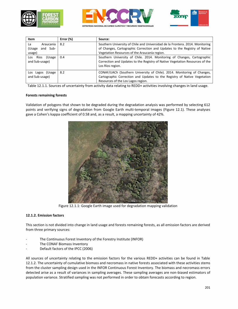
201
Item Error (%) Source:
La Araucanía (Usage and Sub-usage)
8.2 Southern University of Chile and Universidad de la Frontera. 2014. Monitoring of Changes, Cartographic Correction and Updates to the Registry of Native Vegetation Resources of the Araucanía region.
Los Ríos (Usage and Sub-usage)
0.4 Southern University of Chile. 2014. Monitoring of Changes, Cartographic Correction and Updates to the Registry of Native Vegetation Resources of the Los Ríos region.
Los Lagos (Usage and Sub-usage)
8.2 CONAF/UACh (Southern University of Chile). 2014. Monitoring of Changes, Cartographic Correction and Updates to the Registry of Native Vegetation Resources of the Los Lagos region.
Table 12.1.1. Sources of uncertainty from activity data relating to REDD+ activities involving changes in land usage. Forests remaining forests Validation of polygons that shown to be degraded during the degradation analysis was performed by selecting 612 points and verifying signs of degradation from Google Earth multi-temporal images (Figure 12.1). These analyses gave a Cohen’s kappa coefficient of 0.58 and, as a result, a mapping uncertainty of 42%.
Figure 12.1.1: Google Earth image used for degradation mapping validation
12.1.2. Emission factors This section is not divided into change in land usage and forests remaining forests, as all emission factors are derived from three primary sources: - The Continuous Forest Inventory of the Forestry Institute (INFOR) - The CONAF Biomass Inventory - Default factors of the IPCC (2006) All sources of uncertainty relating to the emission factors for the various REDD+ activities can be found in Table 12.1.2. The uncertainty of cumulative biomass and necromass in native forests associated with these activities stems from the cluster sampling design used in the INFOR Continuous Forest Inventory. The biomass and necromass errors detected arise as a result of variances in sampling averages. These sampling averages are non-biased estimators of population variance. Stratified sampling was not performed in order to obtain forecasts according to region.
202
R factor error is a result of the type sampling design of the CONAF Biomass Inventory. Sampling was performed proportional to the surface area of each stratum with a random distribution of plots measuring 500 m2. The stratum used was subpopulation of forest type and sub-type and structure of forests in each region. The error calculation includes stratum variances in biomass and carbon, the Student’s t-test to obtain 90% statistical certainty and, as a denominator, the number of stratum plots.
Item Error (%) Source:
Cumulative biomass of native forest
10 Forecast error of permanent plots from the INFOR Continuous Forest Inventory.
Necromass (standing dead biomass)
28 Forecast error of permanent plots from the INFOR Continuous Forest Inventory.
Necromass (residues on the ground)
24 Forecast error of permanent plots from the INFOR Continuous Forest Inventory.
R factor of native forest 40 Error calculation based on statistical data from the Biomass Inventory and Carbon Accountancy of the UACh.
Estimated basal area 47.2 Calculation based on the average basal area (29.0 m2) and error of the estimated basal area (13.7 m2).
Combustion factor, Regions 36.0 Error forecast using the standard deviation and median default combustion factor of GL-2006.
CH4 emission factor 29.0 Error forecast using the standard deviation and median default emission factor of the IPCC (2006).
N20 emission factor 43.8 Error forecast using the standard deviation and median default emission factor of the IPCC (2006).
Table 12.1.2: Sources of uncertainty relating to the emission factors for the various REDD+ activities.
12.1.3. Quality Assuarance In order to minimize systematic errors during the generation of the reference level, it has implemented a number of operational protocols designed for the generation of the main sources of information. The main sources of information used were:
Cadastre and Evaluation of Native Plant Resources of Chile: Is aimed to characterize and localize the various existing natural vegetation in the country and implement a computerized database that allows management and updating of information. The Cadastre Manual (1995) is available on the Anexo_Manual_Catastro_1995, where concepts, methodological foundations, ground instructional procedures and instructive of office procedures implemented are described.
National Inventory of Forest Ecosystems: It is one of the most important information sources, both for estimating emission factors and for the application of the methodology of forest degradation in forests remaining forests. The public access document "Forest Resources in Chile. Final Inventory Continuous
Updates native forests and forest plantations Report"65 describes in detail the processes and methodological aspects of data collection, variables measured in the field, data processing and results, processing trees level, plots and conglomerates, processing for estimating stocks in biomass and carbon and updates methods.
NGGI66: LULUCF Sector is compiled in conjunction with the AFOLU Sector, as indicated by the IPCC 2006
methodological guidelines and late reported according to the IPCC 1998 methological gidelines as it corresponds to Non-Annex I Parties. Emisions factors, conversion factors and constants (information from NGGI used in the construction of the Reference Level) are grouped into a single spredsheet kinked to the worksheets in order to centralize information fo quick review and update when appropriate. As a process of quality assurance, the AFOLU Sector (Agriculture and LULUCF) was subject of a process of rewiew by
65 http://mapaforestal.infor.cl/phocadownload/Informe_Inventario_Continuo_2014.pdf 66 http://www.snichile.cl/sites/default/files/documentos/2014_iin_cl.pdf
203
two qualified experts as reviewer of inventories of UNFCCC Anexx I Parties. The review was conducted in a desk process for two mounths and then field work was done in the sectorial team headquarters at Ministry of Agriculture.
The integration of information sources was made based on Excel tools designed to systematize information with a structure created on the basis of the specific needs of each REDD + activity considered in this document. The equations used for estimating emissions have been integrated into the system and subject to cross-check which enables quantification automation, minimizing human intervention and reducing the risk of error. At present, in order to minimize possible sources of systematic errors the country is implementing improvements in operational protocols of information sources. CONAF Department of Monitoring of Forest Ecosystems, are developing updates to the methodological protocols and systems of quality control for the "Cadastre and Evaluation of Native Plant Resources of Chile", INFOR implements improvements in the methodological protocols for each Forest Inventory update, which are reported in the annual reports of inventory. The NGGI, meanwhile keeps operating protocols that enable reliable integration of data from primary information sources (Cadastre and Inventory). 12.1.4. Uncertainly Minimization Plan The Uncertainly Minimization Plan aims to reduce uncertainty random errors and other uncertainties as far as practical from the evaluation of their relative contribution to the overall uncertainty regarding the captures and emissions. As was stated in the Techinical Advisory Panel review, in the coming months, deep revision will be conducted to uncertainty analysis to disaggregate the uncertainty of each factor involved in the overall uncertainty estimation involving activity data and emissions factor. Activity data While uncertainty reported map of land is very low, it is necessary to donduct a detailed analysis to estimate the uncertainty of change detection maps rather than static land use maps reported previously. To do this, and considering the low area subject to change, it is particularly relevant generate a categories stratification, which will be based on the methodology described by Cochran (1977). After de sample design, two differents tools for the analysis of precision and accuracy of maps will be discussed:
Collect-Earth, is a tool developed by FAO and openaccess via OpenForis, allowing analysis of historical series of satellite imagery by GoogleEngine.
BEEODA, is a freely available sortware designed by Boston University that enables time series analysis and drive to estimate accuracy and precision of maps.
Emission Factors To deepen the accuracy analysis of emission factors, errors from fiel measurements in inventory plots, specific errors of the Allemetric functions, and other errors in information used will be disaggregated and reported. Combustion factors and CH4 N2O emission factors, used to estimate non-CO2 gases emission have a low precision rate, however the total emissions from this sector is very low. Today it is conducting a pilot project to estimate emission in relation to the forest fire severity that can serve as a starting point to segmentation and creation of country specific combustions factors. Emmision and Removal in forests remaining forests
204
The sample will be stratificated to determine the accuracy and precision in different carbon stock, basal area and number of trees per hectares ranges. The results of measurement errors from inventory and volume functions will be integrated by propagation of uncertainty, allowing more detailed definition of accuracy which will set the steps to minimize uncertainty.
12.2 Calculating the uncertainty of adjustments to the reference level 12.2.1 Projection of uncertainty
Uncertainties regarding the FRELs/FRLs of deforestation, degradation and increases in carbon content were forecast according to the propagation of error method described in equations 3.1 and 3.2 of the IPCC (2006) (equations 12.1 and 12.2 respectively).
𝑈𝑡𝑜𝑡𝑎𝑙 = √𝑈12 + 𝑈2
2 + ⋯ + 𝑈𝑛2
Eq. 12.1 (Eq. 3.1 of the IPCC (2006))
Where: 𝑈𝑡𝑜𝑡𝑎𝑙 = percentage uncertainty of the product of quantities (half the 90% confidence interval, divided by the total and expressed as a percentage); 𝑈𝑖 = percentage uncertainty associated with each of the quantities.
𝑈𝑡𝑜𝑡𝑎𝑙 = √(𝑈1 ∗ 𝑥1)2 + (𝑈2 ∗ 𝑥2)2 + ⋯ + (𝑈𝑛 ∗ 𝑥𝑛)2
|𝑥1 + 𝑥2 + ⋯ + 𝑥𝑛|
Eq. 12.2 (Eq. 3.2 of the IPCC (2006))
Where: 𝑈𝑡𝑜𝑡𝑎𝑙 = percentage uncertainty of the sum of quantities (half the 95% confidence interval, divided by the total (i.e. the median) and expressed as a percentage). The term “uncertainty” is based on the 95% confidence interval 𝑥𝑖 𝑦 𝑈𝑖 = absolute uncertainty and associated percentage uncertainties, respectively. Non-weighted error propagation (equation 12.1) was used where parameters were directly multiplied in order to forecast the final result (e.g. to forecast emissions due to deforestation, forest loss was directly multiplied by the emission factor resulting from the change of usage and ground coverage). Conversely, weighted error propagation was used where parameters were added together to forecast the final result (e.g. removals due to increases in forest carbon resulting from the direct sum of increases caused by the conversion of non-forests into forests and increases in forests remaining forests). This method was used because uncertainty in emission and removal levels reported in the FREL/FRL for Chile can be propagated from uncertainties in activity data and emission factors. Furthermore, ranges of uncertainty of these parameters remain stable throughout the historical reference period. It is hoped that the same will be true for the performance period. Uncertainty was forecast for each source or sink of emissions contained in the FRELs/FRLs according to each individual REDD+ activity. Similarly, errors were propagated for different activities before finally being integrated into the total uncertainty. Deforestation
205
The first step in the error propagation for deforestation involved estimating the uncertainty of total live biomass. For this process, the uncertainties of aerial biomass and subterranean biomass were combined using equation 1 (non-weighted). The uncertainties of necromass (both standing and on the ground) were then calculated using equation 2. This was done for each region, since, despite its high degree of uncertainty, necromass contributes to the forecast value of total final emissions to a lesser degree. In terms of activity data, a conservative forecast of the uncertainty of the La Araucania and Los Lagos regions was included in the analysis (Table 12.), which was assumed to be approximately 20 times greater than the uncertainty of the Los Ríos region (0.4%).
Factor Symbol Partial uncertainty (%)
Aerial and subterranean biomass UEF_Deforestation-EF 11.8
Maule UEF_Deforestation-Maule 11.4
Biobío UEF_Deforestation-BioBio 11.3
La Araucanía UEF_Deforestation-Araucania 10.6
Los Ríos UEF_Deforestation-LosRios 10.1
Los Lagos UEF_Deforestation-LosLagos 10.3
ER Programme Area UEF_Deforestation 5.7
ER Programme Area UAD_Deforestation 8.2
Table 12.2.1.a: Forecast of partial uncertainty of parameters used to project emissions caused by deforestation. By combining the non-weighted uncertainty of emission factors (5.7%) with the uncertainty of activity data (8.2%), the total uncertainty of deforestation was found to be 10.0%. Forest degradation The total uncertainty of forest degradation was forecast to be 23.5% by combining the partial uncertainties of three sub-activities, which were calculated prior to being combined, as described below.
Biomass extraction
For this activity, the (non-weighted) uncertainty of the estimated basal area (47.2%), which was used to obtain the emission factor, was combined with the uncertainty of the mapping of degraded areas (42%), producing a partial uncertainty of degradation due to biomass extraction of 63.2%.
Substitution
In order to forecast the uncertainty of degradation due to substitution, it was first necessary to forecast the uncertainty associated with the carbon content in each region of the Chile ER Programme Area, as the value for cumulative biomass in native forests is calculated on a national basis (Table 12.).
Factor Symbol Partial uncertainty (%)
Emission Factor Maule UEF_Substitution-Maule 11.3
Emission Factor Biobío UEF_Substitution-BioBio 11.3
Emission Factor La Araucanía UEF_Substitution-Araucania 10.6
Emission Factor Los Ríos UEF_Substitution-LosRios 10.1
Emission Factor Los Lagos UEF_Substitution-LosLagos 10.3
Activity Data UAD_Substitution 8.2
206
Table 12.2.1.b: The partial uncertainty of factors used to forecast uncertainty due to substitution For activity data, similar to the forecast uncertainty of deforestation, the uncertainty of usage and sub-usage in La Araucanía and Los Lagos (8.2%) was used. The combined value of the uncertainty of emission factors and that of activity data was weighted according to the emissions caused by the substitution of native forests in each region. The resulting partial uncertainty of degradation due to substitution was 5.2%.
Forest fires For forest fires, the uncertainty of combustion factors and emission factors were combined to forecast the uncertainty of the mass available for combustion. As mentioned above, regional forecasts of biomass differ, which is why it is also necessary to forecast the uncertainty of the mass available for combustion at regional level. These forecasts are then weighted due to the presence of existing live biomass (aerial and subterranean) and necromass in each region. The uncertainty (non-weighted) associated with each forecast of GHGs for each region can subsequently be forecast. Next, the partial uncertainty of degradation due to forest fires can then be forecast, which should be weighted according to the amount of CH4 and N2O emissions (it is assumed that CO2 emissions are recorded according to the k-nn algorithm, which is not concerned with the cause of degradation, under the sub-activity of degradation due to biomass extraction). This should also be performed at regional level, weighting the amount of emissions for each gas in the relevant region. Finally, the uncertainty of the mass of combustible available to burn was combined with the emissions factor to generate forecasts of the uncertainty of regional combustion factors (Table ).
Factor Region Symbol Partial uncertainty (%)
Mass of Combustible Maule UMB_Fires-Maule 16.0
Biobío UMB_Fires-BioBio 15.9
La Araucanía UMB_Fires-Araucania 15.0
Los Ríos UMB_Fires-LosRios 14.3
Los Lagos UMB_Fires-LosLagos 14.6
Emission Factor Maule UEF_Fires-Maule 24.3
Biobío UEF_Fires-BioBio 24.3
La Araucanía UEF_Fires-Araucania 24.3
Los Ríos UEF_Fires-LosRios 24.3
Los Lagos UEF_Fires-LosLagos 24.3
Combustion Factor Maule UCF_Fires-Maule 46.3
Biobío UCF_Fires-BioBio 46.2
La Araucanía UCF_Fires-Araucania 45.9
Los Ríos UCF_Fires-LosRios 45.7
Los Lagos UCF_Fires-LosLagos 45.8
Table 12.2.1.c: Partial regional uncertainties used to forecast the uncertainty of forest fires The partial uncertainty of degradation due to forest fires, which was calculated by weighting according to the amount of CH4 and N2O emissions per region, was forecast at 27.4%. The area of burnt forests reported by the CONAF is expressed in tabular form without any forecast of the associated uncertainty. Thus, the partial uncertainty of degradation due to forest fires is not combined with the uncertainty of activity data. Conservation of Forest Carbon Given that the calculation method is the same, similar to degradation due to biomass extraction, there is only one post-calculation division for emissions or removals in areas subject to formal conservation procedures. Thus, the (non-weighted) uncertainty of the estimated basal area (47.2%), which was used to obtain the emission factor, was
207
combined with the uncertainty of the mapping of degraded areas (42%), producing a total uncertainty for forest carbon conservation of 63.2%. Increases in Forest Carbon Stocks The total uncertainty of activities leading to an increase in forest carbon stocks is 60%, resulting from the sum of the uncertainties of two sub-activities that were calculated prior to being combined, as described below.
Increases in transitions from non-forest to forest
For this sub-activity, the uncertainty of the removal factor was first of all calculated by combining the uncertainty of cumulative aerial and subterranean biomass with the expansion factor for native forests. The uncertainty of cumulative biomass in native forests was used because there is no forecast of uncertainty for the rate of growth used in the FREL/FRL or the National Greenhouse Gas Inventory (INGEI). Given that cumulative biomass represents the variability of young forests (renewal) and adult forests, this value was considered conservative. It was then combined with the uncertainty of the expansion factor for native forests. This uncertainty was combined with the uncertainty of the land registry (both usage and sub-usage to differentiate between forest types) to forecast the partial uncertainty for increases in carbon content due to the conversion of non-forests to forests. This was forecast at 21.7%.
Increases in forests remaining forests
Given that the calculation method is the same, similar to degradation due to biomass extraction and the conservation of forest carbon, the uncertainty of the estimated basal area (47.2%), which was used to obtain the removal factor, was combined with the uncertainty associated with the mapping of areas showing increases in carbon stock (42%). This gave a partial uncertainty for increases in carbon stock in forests remaining forests of 63.2%. Total uncertainty The total uncertainty consists of the propagation of errors of uncertainties from the FREL for deforestation, the FREL for degradation, the FREL/FRL for conservation and the FRL for increases in forest carbon stock. Error propagation was weighted according to the total emission/removal caused by each activity (Table 12.2.1.d).
Total uncertainty
Parameter Uncertainty Weighting (absolute value)
Deforestation Udeforestation 10.0% 1,653,819
Degradation Udegradation 23.5% 6,573,197
Conservation Uconservation 63.2% 1,801,330
Increases Uincreases 60.0% 7,897,188
TOTAL UTOTAL 28.5% N/A
Table 12.2.1d. Total uncertainty of the subnational proposal of the FREL/FRL for Chile. The forecast of total uncertainty for the proposal of the subnational FREL/FRL of Chile is 28.5%.
208
13. EMISSIONS REDUCTION CALCULATION
13.1 Ex-ante forecast of emission reductions under the programme In order to perform an ex-ante forecast of emission reductions under the ER Programme, a technical analysis was carried out to determine the reduction objectives over the term of the ERPA. This analysis included the following elements:
A forecast of the reduction potential of direct mitigation measures and facilitation measures. These forecasts were performed as part of the study of causes and strategic options. The final report is available at the following link: www.xxx.
An account of the reduction objectives pledged by Chile at the UNFCCC in its INDCs. Using this analysis, the following reduction objectives were defined for each REDD+ activity:
Reductions at regional level due to
REDD+ activity
Emissions reduction due to
deforestation
Emissions reduction due to
degradation
Emission reductions and increased stock in
conservation areas Increases in stock
ERPA objective 20% 15% 5% 20%
Table 13.1.a. Ex-ante emissions reduction objectives Thus, the projections for expected emissions according to REDD+ activity, for each year of the ERPA term, are as follows:
FREL/FRL Deforestation Degradation Conservation Increases Total FREL
1,653,820 6,573,198 1,801,330 7,897,187 1,471,499
Expected emissions
ERPA objective 20%
ERPA objective 15%
ERPA objective 5%
ERPA objective 20%
ERPA objective
2017 1,488,438 6,244,538 -1,837,357 -8,686,906 -2,791,286
2018 1,488,438 6,244,538 -1,837,357 -8,686,906 -2,791,286
2019 1,488,438 6,244,538 -1,855,370 -8,686,906 -2,809,300
2020 1,405,747 5,915,878 -1,855,370 -9,081,765 -3,615,510
2021 1,405,747 5,915,878 -1,873,383 -9,081,765 -3,633,523
2022 1,405,747 5,915,878 -1,873,383 -9,081,765 -3,633,523
2023 1,323,056 5,587,218 -1,891,397 -9,476,624 -4,457,747
2024 1,323,056 5,587,218 -1,891,397 -9,476,624 -4,457,747
2025 1,323,056 5,587,218 -1,891,397 -9,476,624 -4,457,747
Table 13.1.b. Expected reductions for the ERPA term.
209
Furthermore, in order to forecast reductions, the following criteria were established, in accordance with FREL results:
The estimated total uncertainty for the subnational FREL/FRL proposal of Chile is 28.5%. A discount of 4% was therefore applied, in accordance with Criterion 22 of the methodological framework (MF).
A buffer against reversion of 11% was established, in accordance with the risks identified in Chapter 11.
An ex-ante forecast of emission reductions under the ER Programme for the accounting area is outlined in the following table:
ERPA term year t
Reference level
Estimation of expected emissions
under the ER Program
Estimation of expected
Emission Reductions
under the ER Program
Uncertainty buffer set-aside (4%)
Estimation of expected Emission
Reductions under the ER
Program net of uncertainty
Reversal Buffer set-aside (11%)
Estimation of expected Emission
Reductions under the ER
Program to be transferred
(tCO2-e/yr) (tCO2-e/yr) (tCO2-e/yr) (tCO2-e/yr) (tCO2-e/yr) (tCO2-e/yr) (tCO2-e/yr)
2017 -1,471,499 -2,791,286 -1,319,787 52,791 -1,266,996 139,370 -1,127,626
2018 -1,471,499 -2,791,286 -1,319,787 52,791 -1,266,996 139,370 -1,127,626
2019 -1,471,499 -2,809,300 -1,337,801 53,512 -1,284,288 141,272 -1,143,017
2020 -1,471,499 -3,615,510 -2,144,011 85,760 -2,058,250 226,408 -1,831,843
2021 -1,471,499 -3,633,523 -2,162,024 86,481 -2,075,543 228,310 -1,847,233
2022 -1,471,499 -3,633,523 -2,162,024 86,481 -2,075,543 228,310 -1,847,233
2023 -1,471,499 -4,457,747 -2,986,248 119,450 -2,866,798 315,348 -2,551,450
2024 -1,471,499 -4,457,747 -2,986,248 119,450 -2,866,798 315,348 -2,551,450
2025 -1,471,499 -4,457,747 -2,986,248 119,450 -2,866,798 315,348 -2,551,450
TOTAL -13,243,491 -32,647,668 -19,404,177 776,167 -18,628,009 2,049,081 -16,578,928
Table 13.1.c. Ex-ante forecast of emission reductions under the programme.
210
14. SAFEGUARDS
14.1 Description of how the ER Programme complies with the social and environmental safeguards of the World Bank and promotes and supports the safeguards associated with REDD+ contained in the Framework Convention
In order to comply with the social and environmental safeguards of the World Bank, Chile relies on its robust environmental and forestry institutions as well as a participatory process being implemented throughout the country with the support of actively collaborating national and international agents. In addition to this process, directives were considered and implemented in order to facilitate effective social participation in a framework of ethical considerations that would allow a direct link to be formed with representatives from different Focus Groups (FGs). These groups would use their empirical and technical knowledge to provide relevant, appropriate information to support the preparation of the ENCCRV and, by doing so, create a public policy instrument on long-term environmental and social sustainability to tackle the effects of climate change. To support monitoring, follow-up and reporting of compliance with the environmental and social safeguards associated with the ENCCRV, a framework of indicators applicable to the national reality is expected to be drawn up. These indicators will be considered during the ENCCRV drafting phase with a view to being included as a specific field in the design of the Safeguard Information System. Details of the whole process, from design, to implementation and monitoring of the environmental and social safeguards of the ENCCRV in Chile, will be submitted in the respective documents accompanying the ERPD, namely the Strategic Environmental and Social Assessment (SESA) and the Environmental and Social Management Framework (ESMF). 14.1.1. Scope of the Strategic Environmental and Social Assessment (SESA) of the ENCCRV.
Chile developed its Strategic Environmental and Social Assessment to identify and assess risks and potential impacts of the action measures, specifics to the strategic activities, through participation of key stakeholders as part of the political context of the ENCCRV. Thereafter, this assessment set mechanisms to avoid or mitigate such risks and adverse impacts as part of the Environmental and Social Management Framework of the ENCCRV. Methodologically, SESA started with identification of key stakeholders (people interested, depended or linked to forest and vegetation resources), who provided information and inputs through a participatory process on: drivers of deforestation, forest degradation and no-enhancement of carbon stocks; related proposals for action measures; risks and adverse impacts; potential benefits from of each action measure, and; proposals for maintenance and / or enhancement of biodiversity. This participatory process is described in full in the document on SESA accompanying this ERPD. The process was designed and led by CONAF, and it joined 1,248 people belonging to different social groups (key actors or stakeholders). The multi-sector, multi-level, multi-actor approach covers an ample and representative sample of the national character. Also, methodology for this participatory process is duly explained in: the Plan for Implementation of the Social and Environmental Safeguards; Public Consultation, Dialogue and Indigenous Participation, and; ENCCRV´s Self-Assessment (http: / /www.conaf.cl/cms/editorweb/institucional/Plan-Salvaguardas-Sociales-ENCCRV.pdf).
211
The methodology for the participatory process is the cornerstone for assurance of social and environmental safeguards to the ENCCRV, as well as the fundamental basis for elaboration of the Strategic Environmental and Social Assessment. As a result of SESA process, 44 risks were determined through the participatory process. These risks were linked to adverse impacts to the environment and benefits to the society with probability of occurrence during execution of the action measures specifics to the implementation phase of the ENCCRV. Similarly, several proposals were obtained to maintain and / or increase biodiversity during implementation of the ENCCRV.The assessment method considered comprenhensive technical inputs to classify, weigh and prioritize potential risks and adverse impacts identified for the action measures on each strategic activity. The assessment method was carried out in coordination with the participatory process, taking its inputs from it. The assessment process was full aligned with: UNFCCC safeguards for REDD+; operational policies of The World Bank, and; environmental and social safeguards of national character that apply to the ENCCRV. Those risks most often mentioned and prioritized by key stakeholders were; i) inarticulted planning and implementation of the State policies; ii) development of public policies with scarce financial resources, and; iii) design of public policies without social validation. Those benefits with more mentions were: i) access to support instruments; ii) access to educational programs, and; iii) technical advice on forestry and forest management activities. Meanwhile, those proposals with more mentions during the participatory process were: to maintain and / or increase biodiversity; environmental education, and; sustainable forest management. 14.1.2. Scope of the Environmental and Social Management Framework (ESMF). The Environmental and Social Management Framework (ESMF) of the ENCCRV provides a set of legal, technical, methodological and procedural measures necessary to mitigate environmental and social risks identified and prioritized during the Strategic Assessment of the action measures of the Strategy. These mitigation measures were formulated and analyzed according to the type of risks, in order to facilitate its implementation and operation. A previous analysis included alignment between these mitigation measures and operational policies of the World Bank, Cancun safeguards, and national regulations in force in Chile on complementary safeguards mandatory to fulfill. The ESMF as a tool, provides protocols and instructions needed to implement action measures, projects and programmes resulting from the ENCCRV. The ESMF ensures a responsible implementation and a clear institutional management on how to proceed whenever forsee possibilities that a potential social or environmental risk may occur. Regarding these protocols, procedures and methodological instructives considered by the ESMF, most of them correspond to existing instruments in the State structure (policies, programmes, projects, etc.) that need to be targeted or implemented to encourage mitigation of the potential risks identified in the SESA. However, another part of these protocols has been formulated specifically for implementation of ENCCRV in order to minimize or ensure involvement in potential courses of action to people dependent, linked or related to forest and vegetation resources. 14.1.3 Legal framework of Chile pertinent to compliance with the Cancun safeguards Decision 1/CP.16 in Appendix I of the CMNUCC outlines guidance and safeguards in relation to political approaches and positive incentives concerning issues regarding the reduction of emissions due to deforestation and forest degradation in developing countries. It goes on to deal with the purpose of conservation, the sustainable development of forests and the increase in forest carbon stocks. It also states that, by adding the measures mentioned in paragraph no. 70 of this decision67, the following safeguards should be promoted and backed. For the
67 70. Parties classed as developing countries are encouraged to contribute to the task of mitigation in the forestry sector by adopting the following measures at their discretion, in accordance with their respective capacity and national circumstances: a) the reduction of emissions caused by deforestation; b) the reduction of emissions caused by forest degradation; c) the conservation of forest carbon stocks; d) the sustainable management of forests; and e) the increase of forest carbon stocks.
212
purposes of this document, these safeguards will be associated with applicable national and international regulations68. a) Safeguard: Consistency or compatibility of the measures with the objectives of national forest programmes and international conventions and agreements on the issue In terms of the first safeguard, it should be noted that Chile has ratified and enacted three key conventions on the environment as Acts of the Republic into its internal statutory law to become mandatory legislation. These are: the UNFCCC, the Convention on Biological Diversity (CBD) and the UNCCD. In addition to this, Chile also has a national regulatory framework governing the forestry industry, which contains the following regulations69:
Law No. 19.300 on General Environmental Rules, which would only be applicable to projects and activities under the Environmental Impact Assessment System (SEIA) that may later be provided for during the execution phase of the ENCCRV, though not during the design and drafting phase, during which it will have been subject to a strategic social and environmental evaluation.
Law No. 20.283 on Recovery of Native Forests and Forest Development, a piece of legislation that is directly linked with the ENCCRV insofar as its objectives are to protect, recover and improve native forests in order to guarantee forest sustainability and environmental policy. This act is one of many pieces of legislation to define and regulate forest types, usage plans, environmental protection regulations, the Conservation, Recovery and Sustainable Usage Fund for Native Forests and, naturally, procedures and sanctions in the event of regulatory infringement.
Decree No. 4.363 of the Ministry of Land and Colonisation, which is responsible for the final text of the Forest Act, which also has direct implications for the ENCCRV. In effect, it stipulates that all land that may or may not be covered with plants and must not be permanently ploughed due to climate and ground conditions shall be considered land preferably suited to forestry. This excludes non-degraded land that may be used for agriculture, fruit farming or intensive livestock farming. It goes on to state that land classed as being preferably suited to forestry, as well as both natural and artificial forests, shall be subject to the usage plans approved by the National Forestry Corporation. In addition to prohibiting the felling of native trees and shrubs in specific places, it stipulates that the State may establish tree reserves and national parks (nowadays called national Reserves and National Parks respectively) on public land in order to guarantee the survival of certain species of tree and conserve the beauty of the landscape or on particular land acquired via purchase or expropriation.
Decree-Law No. 2565/1979, which supersedes Decree-Law 701 of 1974, which places the forested land outlined at the disposal of the beneficiaries outlined. The purpose of this law is to regulate forestry activities on land preferably suited to forestry and degraded land and to incentivise forestation, particularly to small forest owners and where necessary to prevent degradation, or protect and recover land in Chile.
Law No. 20.488, which extends the operation of Decree-Law (DL) 701 of 1974 and increases forestation incentives70.
In addition to the statutory regulations mentioned above, there is an abundance of regulatory legislation aimed at regulating specific aspects of these regulations, such as incentive mechanisms for forest plantations, the Native Forest Conservation Fund and the declaration of certain species classed as natural monuments, which benefit from a special protection status. These include:
69 To view the full regulations governing the forestry sector and the CONAF, the public service responsible for administering national regulations, visit the following addresses: http://www.conaf.cl/nuestros-bosques/normativas-y-reglamento/ and http://www.conaf.cl/cms/editorweb/transparencia/marconormativo.html 70 On 31 December 2012, the term of the incentive system, provided for under article 12 of Decree-Law No. 701 of 1974, expired. For this reason, any forestation or other subsidised activities performed from 1 January 2013 will not be eligible for subsidies, in accordance with current legislation.
213
Decree No. 259/1980 of the Ministry of Agriculture, Regulations of DL 701 of 1974 on Forest Development. Decree No. 95/2008 of the Ministry of Agriculture, concerning the Regulations of the Fund of Conservation,
Recovery and Sustainable Usage of Native Forests. Decree No. 96/2009 and Decree No. 28/2013, both of the Ministry of Agriculture, which regulate the
resources allocated to native forest research. Decree No. 192/1998 of the Ministry of Agriculture, which approves the Regulations on the Payment of
Forest Subsidies. Decree No. 193/1998 of the Ministry of Agriculture, which sanctions the General Regulations of DL 701 of
1974 on Forest Development. Decree No. 80/2008 of the Ministry of Agriculture on the Regulations of the Native Forest Advisory Board. Decree No. 93/2009 and Decree No. 26/2011, both of the Ministry of Agriculture, on the General
Regulations of the Act on the Recovery of Native Forests and Forest Development. Decree No. 13/1995 of the Ministry of Agriculture, which declares the tree species Gomortega keule,
Pitavia punctata, Beilschmiedia berteroana and Beilschmiedia miersii to be natural monuments. Decree No. 490/1976 of the Ministry of Agriculture, which declares the tree species Fitzroya cupressoides
to be a natural monument. Decree No. 43 of the Ministry of Agriculture, which declares Araucaria araucana to be a natural monument. Decree No. 427/1941 of the Ministry of Land and Colonisation (nowadays the Ministry of National Assets),
which regulates the use of Azorella compacta. Decree No. 366/1944 of the Ministry of Land and Colonisation (nowadays the Ministry of National Assets),
which regulates the use of Quillaja saponaria and other tree species. Furthermore, Chile is a signatory of the Universal Declaration of Human Rights of 10 December 1948. Although not binding, in due course, Chile entered into this Universal Declaration, as well as the International Covenant on Economic, Social and Cultural Rights, adopted at the General Assembly of the United Nations on 19 December 1966 and ratified by Chile on 16 September 1969, the International Convention on the Elimination of All Forms of Racial Discrimination, ratified in 1989, and Convention No. 169 of the International Labour Organization (ILO) on Indigenous and Tribal Peoples in Independent Countries. In terms of gender equality, Chile is party to the Convention on the Elimination of All Forms of Discrimination against Women, which it ratified in 1989. Similarly, in order to achieve transversalisation of the gender approach within the scope of the ENCCRV, the following are being consulted: i) the 2011 General Assembly resolution on the political participation of women (A/RES/66/130), which reaffirms “that the active participation of women, on equal terms with men, at all levels of decision-making is essential to the achievement of equality, sustainable development, peace and democracy” 16, and ii) the Guide for the Evaluation of Programmes and Projects with a Gender, Human Rights and Interculturality Perspective of UN Women and the Beijing Declaration and Platform for Action of the Fourth World Conference on Women. b) Safeguard: Transparency and effectiveness of national forestry governance structures in light of national legislation and sovereignty.
Chile has ratified a series of international conventions in relation to the transparency of governance structures. These are outlined below:
With regard to transparency, Article 19 (2) of the International Covenant on Civil and Political Rights stipulates that “Everyone shall have the right to freedom of expression; this right shall include freedom to seek, receive and impart information and ideas of all kinds, regardless of frontiers, either orally, in writing or in print, in the form of art, or through any other media of his choice.”
The Rio Declaration on Environment and Development which, in Principle 10, stipulates that: “At the national level, each individual shall have appropriate access to information concerning the environment that is held by public authorities... States shall facilitate and encourage public awareness and participation by making information widely available.”
214
The United Nations Convention against Corruption (UNCAC) which, in Article 5, states that: “Each State Party shall, in accordance with the fundamental principles of its legal system, develop and implement or maintain effective, coordinated anti-corruption policies that promote the participation of society and reflect the principles of the rule of law, proper management of public affairs and public property, integrity, transparency and accountability.”
Chile has also ratified international conventions that serve to increase integrity, such as the Inter-American Convention against Corruption of the OAS (1998) and the United Nations Convention against Corruption (2006).
In terms of effectiveness of governance structures, the following are pertinent:
Agenda 21, United Nations Conference on Environment and Development which, in Article 11.3 (a) stipulates that States must “Rationalise and strengthen administrative structures and mechanisms, including provision of adequate levels of staff and allocation of responsibilities, decentralization of decision-making, provision of infrastructural facilities and equipment, intersectoral coordination and an effective system of communication,” and in Article 8.15 states that “The enactment and enforcement of laws and regulations (at the regional, national, state/provincial or local/municipal level) are also essential for the implementation of most international agreements in the field of environment and development.”
The Rio Declaration on Environment and Development which, in Principle 10, stipulates that: “Effective access to judicial and administrative proceedings, including redress and remedy, shall be provided.“
With regard to internal legislation, the following bodies of law are pertinent:
Article 8 of the Political State Constitution establishes the principles of integrity and transparency at a constitutional level and binds those occupying public office to conduct themselves in strict compliance with the principle of transparency at all times. Similarly, Law No. 20.285 on access to administrative information, which has been in effect since 20 April 2009, provides for two mechanisms of citizen scrutiny based on the principles of transparency contained in acts promulgated by the Administration: active transparency and passive transparency.
The principle of integrity is established in the Political Constitution of the Republic and developed in Law No. 18.575, amended by Law No. 19.653 on Administrative Integrity Applicable to State Administration Bodies. This Law obliges authorities and civil servants of the Public Administration to ensure that their conduct is irreproachable and they fulfil their role or position honestly and faithfully, putting collective interest ahead of personal interest. In Article 8, the Political State Constitution stipulates that by exercising public office, civil servants are bound by the obligation to conduct themselves in strict compliance with the principle of integrity at all times.
The Administrative Statute regulates the way in which administrative responsibility is established and pursued and stipulates the administrative procedures and sanctions applicable to civil servants.
Another relevant area associated with integrity is regulation of Administrative Procedure, as stipulated in Law No. 19.880 of 2003. The purpose of this act is to regulate the conditions governing administrative procedures of Public Administration bodies. In this act, the principle of integrity is reflected in compliance with a series of principles by which administrative procedure should be guided and that demonstrate the pre-eminence of the collective interest over personal interest. Of these principles, impartiality and abstention, in particular, are intended to protect administrative integrity and should therefore be observed.
Law No. 20.205 of July 2007 is also especially important in terms of promoting integrity. This act incorporated the obligation to report crimes and irregularities into the Administrative Statute. Finally, Law No. 19.886 regulates administrative contracting. It governs the contracts of goods and services sought by Public Administration bodies, including special contracting restrictions in cases where there are links to civil servants.
Included in Chile’s national legislation is Transparency Act No. 20.285 on public access to public information. It confers on citizens the right to access information of State bodies and stipulates the procedures necessary to exercise this right via a public information access system via the Office for
215
Information, Complaints and Suggestions (OIRS). These offices were founded pursuant to Decree no. 680 of the Ministry of Internal Affairs and are operative in every State institution. With regard to the forestry sector, the CONAF, the entity responsible for implementing the ENCCRB, has an OIRS, as stipulated in current regulations.
Improving the effectiveness and efficiency of State governance is included in the design and implementation of the ENCCRV. Some of the tools used to achieve this are as follows:
Strategic definitions: these are a tool to provide information on the core guiding concepts governing the role of an organisation and are devised via a Strategic Planning process or a simpler process of diagnosis, analysis, reflection and collective decision-making around its current role.
Performance indicators: This is a tool to provide quantitative information on the benefits or outcomes of products (goods or services) provided by institutions and may cover quantitative or qualitative aspects of these benefits. It is an expression linking two or more variables that, when compared with previous periods, similar products, objectives, or commitments allow performance to be evaluated.
Evaluation programme for programmes and institutions: This is an important part of the Evaluation System and Management Regulation of the Budget Department, which provides information on performance, thus facilitating decision-making during the budget cycle. This leads to more efficient allocation and use of public resources, better quality spending and improved management of public institutions. Various lines of ex-post evaluation have been put in place: A Government Programmes Evaluation (EPG), a Programme Impact Evaluation (IE), an Institutional Spending Evaluation (EGI) and a New Programme Evaluation (EPN).
The purpose of the Complete Management Evaluation (BGI) is to report on the objectives, targets and outcomes of service management in the form of a public account to National Congress.
Financial Incentive Mechanisms are sanctioned in accordance with various acts and regulations and refer to systems to support the management of Public Services. Their objective is to improve the management of institutions by providing higher financial incentives where objectives and goals are met. Some of these principal systems include the Management Improvement Programme (PMG), the Institutional Efficiency Goals (IEG) and the Medical Act:
Management Improvement Programmes (PMGs) in the public services were sanctioned in Law No. 19.553 of 1998 and combine the attainment of management objectives with financial incentives for civil servants. Since 2014, PMGs have been implemented in a total of 194 institutions, involving more than 87,000 civil servants. Thus, it constitutes one of the most widely applied institutional financial incentive systems in Chilean public administration. Since 2012, financial incentives have been paid at 7.6% of remunerations if the institution has attained 90% or more of the annual objectives pledged, or 3.8% if attainment is between 75% and 90%.
Article 9 of Law No. 20.212, published on 29 August 2007, provides for a Performance Allowance for institutions with the right to receive the allowance provided for in Article 17 of Law 18.091. This allowance is allocated for the attainment of Institutional Efficiency Goals, which are proposed by each Department Director to the Minister to which he is accountable or linked and based on a Framework Programme approved by the relevant sectoral Minister and the Treasury. These goals are collaboratively devised between the Minister mentioned above and the Treasury.
As the agency responsible for forestry governance, the CONAF takes strategic decisions regarding the sector by means of an Executive Committee, presided over by the Minister of Agriculture and composed of various representatives from the public and private spheres. It is also the public institution responsible for presiding over the Forest Policy Council, whose function is to propose adaptations to national forest policy between the period 2015–2035 and was founded by the Ministry of Agriculture in response to a presidential mandate.
216
The CONAF also participates in the Intraministerial Committee on Climate Change of the Ministry of Agriculture, the coordinating ministerial agency in charge of ensuring that services offered by the MINAGRI can, via a technical committee, coordinate national and international proposals and plans relating to climate change, which is affecting the performance of management being implemented at a national level. The agency has committed to continuous communication regarding the design and implementation of the ENCCRV via the Office of Agricultural Studies and Policies (ODEPA), which steers the agency. Regarding regulatory and institutional gaps and voids existing in Chile, a comparative analysis on gaps and voids between the safeguards arising from UNFCCC and the national legal framework that applies to the ENCCRV is presented in Chapter III, section 1.5. of the document on Strategic Environmental and Social Assessment. c) Safeguard: Respect for the knowledge and rights of Indigenous Peoples and local community members, in light of relevant international obligations and national circumstances and legislation and bearing in mind that the General Assembly of the United Nations has approved the United Nations Declaration on the Rights of Indigenous Peoples. In relation to this safeguard, on 15 September 2008, Chile ratified Convention No. 169 of the International Labour Organization (ILO) on Indigenous and Tribal Peoples in Independent Countries and entered into the United Nations Declaration on the Rights of Indigenous Peoples. The country’s own legislation includes Indigenous Law No. 19.253, effective since 1993, and Law No. 20.249, which creates and protects the coastal marine space of Native Peoples, effective since 2008. In addition, Chile ratified the Convention on Biological Diversity (CBD) on 9 September 1994, which was enacted pursuant to Supreme Decree No. 1.963/1995 of the Ministry of Foreign Affairs and is one of several pieces of legislation to afford rights to indigenous peoples. Indigenous peoples in Chile benefit from formal recognition and legal protection under Law No. 19.253. Similarly, Convention No. 169 is explicit in recognising “indigenous peoples” instead of the indigenous ethnic groups and communities recognised previously and affords them the following:
i. Collective rights ii. The right to be consulted and to participate in decisions taken by the State concerning its development iii. Common law rights regarding the administration of justice iv. Rights relating to property and possession of the land they inhabit v. Rights to access, use and administer the natural resources of their territories vi. The right not to be moved from the lands and territories they occupy vii. The right to benefit from social security and health, among other recognitions and rights that come under
culture, worldview and their relationship with nature.
Furthermore, Law 20.249, which sanctions the Coastal Marine Space of Native Peoples, expressly stipulates in Article 3 that “Coastal marine space of native peoples shall be created with the purpose of protecting the customary use of these spaces in order to preserve the traditions and use of natural resources by communities occupying coastal areas.” It also states the scope of delimitation, administration, access and use of these spaces via a clear procedure so as to ensure that it is recognised by the State. Similarly, Article 28 of the United Nations Declaration on the Rights of Indigenous Peoples stipulates that: “Indigenous peoples have the right to redress, by means that can include restitution or, when this is not possible, just, fair and equitable compensation, for the lands, territories and resources which they have traditionally owned or otherwise occupied or used, and which have been confiscated, taken, occupied, used or damaged without their free, prior and informed consent.” In order to execute the Indigenous Peoples Plan contained in the ENCCRV, the guidelines of World Bank Operational Policy 4.10 on Indigenous Peoples will be incorporated. These guidelines apply to countries developing REDD+ strategies and, in the case of Chile, will be countersigned by the World Bank. The guidelines of the UN-REDD
217
Programme will also be used as a reference in terms of collecting free, prior and informed consent. Laws and administrative measures that may be drawn up and implemented by the ENCCRV in the future and are likely to directly affect indigenous peoples will be consulted under Supreme Decree No. 66/2013 of the Ministry of Social Development (MDS), which regulates the indigenous consultation procedure, pursuant to Article 6 No. 1 and No. 2 of Convention No. 169 of the ILO. The Emission Reductions Programme in five regions of southern Chile (Maule Region to Los Lagos Region) considers respect to the knowledge and traditions of existing Mapuche people. The worldview of these communities will be considered, especially their holistic vision for "Ad Mapu" (Codes of life), in which all beings are interconnected through “newen”, the force life, like an animal, a tree or a plant, a “menoko”71(a spring) or a mountain. This interconection among all living beings constitutes the “Wallmapu” or Mapuche ancestral territory as currently conceived by Lafquenche, Pehuenche, Wenteche and Nagche people that inhabit Biobío and Araucania regions and also the Mapuche-Huilliche people (people of the south) in Los Rios and Los Lagos regions. In the past, this vision of the ancestral territory was conceived also by Mapuche-Picunche people (people of the north), who lived between Aconcagua and Itata rivers (Bengoa, 1996). In addition, “Mapu” (Earth) will be considered as a physical and spiritual holistic approach to spaces or specific dimensions (environment, flora and fauna, etc.) that provide transcendence to the daily life of Mapuche people. The Plan for Indigenous Peoples constitutes part of the ESMF as set in OP 4.10 of the World Bank. This Plan considers essential elements of the Mapuche worldview and it respects spaces, traditions and knowledge associated with land, territory and nature in the area covered by the Emission Reductions Programme. This Plan will apply the Mapuche Intercultural Forest Model (MOFIM), which its main objective is "To contribute for development of the Mapuche people, enhancing biodiversity, income, productivity and ancestral knowledge on natural resources in the territories through public and private investment". The specific objectives for this Model are: i) To develop a Land Planning of the territory of the communities with a cultural approach; ii) To improve traditional “Itrofil mongen” (biodiversity) in Mapuche lands; iii) To preserve traditional eco-cultural spaces; iv) To restore “Kimün” (traditional knowledge) on natural resources; v) To generate income, assets and services for Mapuche people, and; vi) To improve health and education through transfer of ancestral knowledge about nature to new generations; among others. d) Safeguard: Full, effective participation of stakeholders, particularly indigenous peoples and local communities, in the measures mentioned in paragraphs 70 and 72 of this decision72. Chile enacted ILO Convention N°169 that have been fully considered through participation of key stakeholders for elaboration and further implementation of the ENCCRV. Provisions in Articles 6 and 7 of this Convention are legally-binding instruments that establish in favor of Indigenous People the right to be informed and participation “in the formulation, implementation and evaluation of plans and programmes for national and regional development which may affect them directly”. In addition, Chile considered instruments from other non llegally-binding agreements on elaboration and further implementation of the ENCCRV, such as: Operational Policy (OP) 4.10 on Indigenous Peoples of The World Bank; Guidelines on Free, Prior and Informed Consent of the UN-REDD Programme, and; Guidelines on Evaluation of Programmes and Projects with a Gender Perspective, Human Rights and Interculturality of UN-Women. Both instruments, OP 4.10 on Indigenous Peoples of the World Bank and the UN-REDD Guidelines Program, propose specific tools to ensure full and effective participation of Indigenous Peoples.
71 “Menoko” is an example of a site with cultural significance associated to water and its living spirit in a specific geographical area. 72 72. This Decision also asks Parties that constitute developing countries, when drafting and implementing their national strategies or action plans, to address, among other things, the indirect factors of deforestation and forest degradation, land tenure issues, forest governance, gender considerations and the safeguards outlined in paragraph 2 of Annex I to this Decision, ensuring the full and effective participation of relevant stakeholders such as indigenous peoples and local communities.
218
Also, Chile issued Decree No. 66 of the Ministry for Social Development that regulates procedures for consultation to indigenous people when legal or administrative measures may affect them, in accordance to Article 6 of the ILO Convention N°169. This decree establish mandatory administrative acts such as deadlines and a joint planning process with the indigenous people to be consulted. Furthermore, Official Letter Nº 1,604 dated on 9 June 2016, addressed to CONAF from the Secretariat of Social Services of the Ministry for Social Development, stated "(…), at this stage of the Strategy (formulation) it corresponds to carry out a process for indigenous participation", and adding “(…) it may be said that in the event the implementation of the ENCCRV requires enactment of administrative or legislative measures, a request should be submitted to this Secretariat in order to issue a report of pertinency for an indigenous consultation”. This official statement set floor to fulfill provisions of paragraph 1, Article 7 of the ILO Convention N°169. Thus, a process of dialogue and indigenous participation has been implemented in the context of the formulation of the ENCCRV. The objectives of this process includes to inform, discuss and involve continental Indigenous Peoples of the country in the formulation of the National Strategy on Change Climate and Vegetation Resources. Since the elements of vision, suggestions, opinions and proposals they provided,“action measures” were proposed for further implementation to address degradation, deforestation and enhancement of forest and vegetation resources. So, Indigenous Peoples contributed to strenghthen this initiative with their support, identifying the risks and benefits that could potentially be generated in their territories. Chile enacted its Law N°20,500 on Association and Citizen Participation in Public Administration. Article 69 declares that "the State recognizes the right of people to participate in their policies, plans, programmess and actions, and that is contrary to the rules established in this law, any conduct aimed at excluding or discriminating without a valid reason, the exercise of the right of citizen participation". Meanwhile, Article 70 of the same Act states that the bodies of the State Administration, ex officio or upon request, should indicate those matters of public interest when is required to know the opinion of people. Consultations shall be made in an informed, pluralistic and representative manner, and the opinions collected will be evaluated and weighted by the respective body in a way prescribed by the rule of general procedures. In addition, Presidential Instruction No. 007 on Citizen Participation issued on August 2004 for the full implementation of Law No. 20.500, provided the creation of Units for Public Participation in all services of the State administration. In compliance with the Presidential Instruction referred above, in February 2015 CONAF created the Participation Unit by Resolution Nº104 on March 20, 2015. The standard on Citizen Participation establishes that it will be the instrument for regulation of the formal and specific modalities in which people can participate and influence development of the entire management cycle of those public policies under the mandate of the Corporation. Also, it establishes as foundations for participation in the institution: i) participation as a right guaranteed and promoted by the State; ii) participation in CONAF as the main mechanism to fulfill the institutional mission, and; iii) different mechanisms for citizen participation can be used to carry out this right. Resolution N°104/2015 also stablishes that mechanisms for citizen participation are: processes of social cooperation between citizens and the agencies of the State; they are constituted by a variable number of stages that present objectives, eligibility criteria, working procedures and operating frequency previously defined; they are intended to strengthen and improve governance, thus contributing to the efficient functioning of CONAF in fulfilling its mission, policies, plans, programs and actions. Resolution N°104/2015 in accordance with Article 70 of Law N° 18,575, amended by Law No. 20,500 on Citizen Participation, and as mandated in Title II, number 5, letters a), b), c), d), and e) of the Presidential Instruction Nº 007/2014, establishes that are mechanisms of citizen participation for the National Forestry Corporation the following:
a) Access to Relevant Information: enshrined in Article 71 of Law No. 18,575 Law, amended by Law No. 20,500 Law, which states that every agency of the State Administration shall make of public knowledge all relevant
219
information about their policies, plans , programmes, actions and budgets, ensuring that it is timely, complete and widely accessible. Also, this information will be published in electronic or other means.
b) Participatory Public Accountability: as established in Article 72 of Law 18,575 and amended by Law No. 20,500, which states that bodies of the State Administration annually will give a participatory public account to the citizenship about management policies, plans, programmes, actions and budget execution.
c) Citizen Consultations: as considered in provisions of Article 73 of Law 18,575 and amended by Law No. 20,500 Law, which states that the bodies of the State Administration, ex officio or upon request, should indicate those matters of citizen interest required to know the opinion of people. Consultation indicated must be made in an informed, pluralistic and representative manner and the views collected will be evaluated and weighted by the respective body in the manner prescribed for the rule of general procedure.
d) Council of The Civil Society: as included under provisions of Article 74 of Law No. 18,575 Law, amended by Law No. 20,500 Law, which states : "The bodies of the State Administration shall establish councils of civil society with advisory character, which will be composed of diverse, representative and pluralistic manner by members of non-profit associations related to the mandate of the respective public service”73.
e) Participatory Digital Platforms: in addition to the above mandatory mechanisms for full implementation of Law N° 20,500, the National Forestry Corporation considered participatory digital platforms in the terms established in the Presidential Instruction, as additional mechanism set out in Title III on "Implementation of new measures", paragraph 6, subparagraph e), and the above mentioned Presidential Instruction No. 007/2014.
f) As stated in Presidential Instruction No. 007, Title III on "Implementation of new measures", paragraph 6, subparagraphs a) on Public Hearings, b) on Participatory Budget, c) on Territorial and Sectoral Citizen Councils, and d) concerning Participatory Meetings Dialogues. CONAF may also implement at its own will other instances or modalities for citizen participation.
In compliance with Law N° 20,500 CONAF also has a Council of Civil Society (COSOC). The consultative status of the mechanism for citizen participation relates the institution with representatives of civil society in order to receive feedback in the decision-making process at the highest authority level of the institution. Also, under Decree No. 8 of 2015, the Ministry of Agriculture also created the Forestry Policy Council of the Ministry of Agriculture. This Council is a consultative body of permanent nature, whose main function is to advise the authority on forestry matters. Among other functions, the Council has been responsible for proposing to the Minister of Agriculture the Forestry Policy of Chile period 2015-2035, and proposals on instruments of forest policy and further modifications Thus, under provisions of Law N°20,500 the ENCCRV´s document is under consultation to citizenship through website platform http://www.enccrv-chile.cl/participacion/consulta-ciudadana/consultas-abiertas.html (accessed on July 11, 2016). This process of citizen participation is complementary with respect to the participatory process carried out in the context of the Strategic Environmental and Social Assessment (SESA). Methodology and results of the SESA assessment can be retrieved in http://www.conaf.cl/nuestros-bosques/ forest-in-chile / change-climate / enccrv /. The principles of free, prior and informed consent (FPIC) is based on the collective right of communities to participate in decision-making and to give or refuse their consent to activities that affect their lands, territories and resources or general rights. Consent must be given freely, obtained prior to the implementation of any activities and written in such a way so as to facilitate the comprehension of the full range of topics involved in the activity or decision in question, hence the formula: free, prior and informed consent.
73 CONAF through Resolution Nº292 issued on 22 July 2015 adopted the Statutes of the Council of the Civil Society of CONAF.
220
FPIC applies to discussions on REDD+ relating to potential changes in the management of resources that could impact the livelihood of indigenous populations and other communities that depend on forests and other vegetation resources. Under these circumstances, in accordance with instruments on human rights and other treaty obligations, the communities that will be potentially affected have the right to participate by giving or refusing their consent for a proposed action. FPIC applies to proposed actions (such as decisions, activities or projects) that have the potential to affect the lands, territories and resources on which indigenous peoples depend for their cultural, spiritual and physical sustenance, wellbeing and existence. The specific mandate and obligation of States, the UN and its programmes to respect, protect and promote the right to FPIC, particularly in the case of indigenous peoples, is ratified by several international and regional instruments, both explicitly in texts and as a result of State obligations concerning other rights, as expressed in the decisions of the human rights bodies authorised to interpret these instruments74. Within the context of REDD+, although the term “free, prior and informed consent”, or “FPIC”, is not explicitly mentioned in the body of the REDD+ decision in the Cancun Agreements of the UNFCCC or in the Appendix containing the safeguards, this principle is indirectly addressed insofar as the text on safeguards acknowledges that the General Assembly has adopted the United Nations Declaration on the Rights of Indigenous Peoples (UNDRIP), which establishes the right to FPIC. Furthermore, the implementation of FPIC is a means of fulfilling the requirement of the Cancun Agreements of the UNFCCC by countries, in a bid to foster and support “respect for the knowledge and rights of indigenous communities and members of local communities” and guarantee “full and effective participation of relevant stakeholders, in particular, indigenous peoples and local communities” (Cancun Agreements of the UNFCCC, paragraphs 69 and 72; and Appendix I, paragraphs 2(a), (c) and (d)). Thus, in recognition of the fundamental role of indigenous peoples and other communities that depend on forests, to ensure long-term sustainability and effectiveness of REDD+, following a series of in-depth consultations with representative of indigenous peoples and civil society, the UN-REDD Programme developed the Directives on Free, Prior and Informed Consent. These describe the regulatory, political and operative framework for member countries of the UN-REDD Programme to try to apply the principle of FPIC. The following principles should guide the development, implementation, monitoring and evaluation of activities of the UN-REDD Programme that could affect the rights of indigenous communities and other forest-dependent communities:
1. All activities of the UN-REDD Programme, particularly those that could affect indigenous peoples, should follow a human rights-based approach and adhere to the United Nations Declaration on the Rights of
Indigenous Peoples75, the directives of the United Nations Development Group (UNDG) on issues
concerning indigenous communities and Convention No. 169 of the International Labour Organization (Indigenous and Tribal Peoples Convention).
2. Free, prior and informed consent must be respected and is essential for ensuring the full and effective participation of indigenous peoples and other forest-dependent communities in the preparation of
74 These include: The Convention on Indigenous and Tribal Peoples in Independent Countries (ILO, No. 169); the Convention on Biological Diversity (CBD); the International Covenant on Civil and Political Rights (ICCPR); the International Covenant on Economic, Social and Cultural Rights (ICESCR); the International Convention on the Elimination of All Forms of Racial Discrimination (ICERD); the United Nations Declaration on the Rights of Indigenous Peoples (UNDRIP); the American Convention on Human Rights and the American Declaration on the Rights and Duties of Man, among others.
75 Approved by the 61st session of the United Nations General Assembly on 13 September 2007.
221
decision-making policies and processes as part of activities of the UN-REDD Programme. The following box describes the common elements of free, prior and informed consent.
Of its safeguards or Operational Policies, the World Bank, as the only executor of the ENCCRV, requires the implementation of OP 4.10 on indigenous peoples where initiative have the potential to affect this sector of society. OP 4.10 states that: “Bank-financed projects include measures to (a) avoid potentially adverse effects on the Indigenous Peoples’ communities; or (b) when avoidance is not feasible, minimize, mitigate, or compensate for such effects. Bank-financed projects are also designed to ensure that the Indigenous Peoples receive social and economic benefits that are culturally appropriate and gender and intergenerationally inclusive.” The implementation of this safeguard is a response to the fact that the World Bank “recognises that the identities and cultures of Indigenous Peoples are inextricably linked to the lands on which they live and the natural resources on which they depend. These distinct circumstances expose Indigenous Peoples to different types of risks and levels of impacts from development projects, including loss of identity, culture, and customary livelihoods”. It goes on to state that: “Gender and intergenerational issues among Indigenous Peoples also are complex. As social groups with identities that are often distinct from dominant groups in their national societies, Indigenous Peoples are frequently among the most marginalised and vulnerable segments of the population. As a result, their economic, social, and legal status often limits their capacity to defend their interests in and rights to lands, territories, and other productive resources, and/or restricts their ability to participate in and benefit from development. At the same time, the Bank recognises that Indigenous Peoples play a vital role in sustainable development and that their rights are increasingly being addressed under both domestic and international law.” Item 6 of OP 4.10 specifically states that “A project proposed for Bank financing that affects Indigenous Peoples requires”, among other things, “a process of free, prior, and informed consultation with the affected Indigenous Peoples’ communities at each stage of the project, and particularly during project preparation, to fully identify their views and ascertain their broad community support for the project.” This is the context within which the process of dialogue and participation of indigenous populations of Chile will be implemented, with a view to informing indigenous peoples of the National Strategy for Climate Change and Vegetation Resources, engaging with them in dialogue and making them party to the strategy. The Plan for Indigenous Peoples will also be prepared within the framework of the ENCCRV in order to ensure that the rights of indigenous populations continue to be respected. Another relevant instrument that applies particularly to the ENCCRV is the Guide for the Evaluation of Programmes and Projects with a Gender, Human Rights and Intercultural Perspective of UN Women (2014). This guide is a practical tool for anybody launching, managing or using evaluations. It is intended for professionals implementing or managing programmes and projects, particularly those in which human rights, gender equality and interculturality are transversally included. Part of its premise is that it is advisable for all interventions, whose ultimate purpose is to improve the living conditions of the population, as in the case of the ENCCRV, to include an integrated approach (i.e. human rights/gender equality/interculturality). From this perspective, this guide is a continuous account of previous efforts and aims to provide an in-depth study of concrete tools for evaluative processes. At the same time, it intends to contribute knowledge to the volume of corporate guides that UN Women has produced in previous years (UN Women Handbook on evaluations with a gender equality and human rights approach; Integrating Human Rights with Gender Equality in Evaluation – Towards UNEG Guidance and Broadening Perspectives: Integrating Gender Equality, Interculturality and Human Rights Approaches in Development Planning). In particular, this guide hopes to contribute to the integration of gender equality, human rights and interculturality approaches so that complex problems may become more visible and the diversity of our societies rescued by means of evaluation.
222
From a methodological point of view, this guide is not intended to be prescriptive in terms of giving instructions, but hopes to emphasise key elements when considering the three approaching during evaluation in an integrated way, by identifying main aspects from the three phases of evaluation. According to UN Women, these phases are preparation, execution and use of the evaluation. In this context, the participation of those directly involved in the design and subsequent implementation of the ENCCRV (whether executors, duty-bearers, rights-bearers or beneficiaries) at the start of an evaluation process is key. That is why it was stipulated that, when addressing the “Gender Equality Approach or Perspective” during the Strategic Environmental and Social Assessment participatory process, at least 30% of all attendees should be women. However, in the specific case of “Indigenous Peoples” and “Small- and Medium-Sized Owners” commonly known as non-indigenous local communities, from the women who attended both groups, another group was formed solely of women, comprising 30% of both focus groups. This group was called “Indigenous Women and Small- and Medium-Sized Women Owners”. Thus, peasant and indigenous women directly associated with vegetation resources received different treatment in order to reliably obtain the perceptions, opinions and proposals of those participants who could be affected by the presence of a male figure. In order to ensure adequate representation of the different social sectors, Indigenous Peoples and local communities in the workshops for the participatory process of the Strategic Environmental and Social Assessment, a multi-level multi-sector, multi-stakeholder approach was designed. In this approach, conceptual maps of regional stakeholders were prepared by each regional officer of the Climate Change and Environmental Services Unit, gathering information in each region from key stakeholders who depend on or were related to the vegetation resources of the country. Stakeholders who qualify for being considered in this approach, meet the following criteria:
i. Sectors of society: this criterion is based upon the call to those actors representing organizations from the various focus groups76 prioritized by the region.
ii. Territory: stakeholders representative from different levels of the territories, i.e., equity in the call for representatives of the various provinces and counties of a Region.
iii. Cultural pertinence: this criterion is focused on inclusión of local and indigenous communities of a region. iv. Inclusion of the gender perspective: As mentioned before, a call at regional level have to guarantee and
ensure at least attendance of 30% of women. Two Focus Groups of women were assembled with representatives of women´s organizations, and with representatives of indigenous women as medium or small landowners. Both groups of women and also women representatives in other related focus groups guaranteed provision of background for inclusion of the gender perspective.
e) Safeguard: Compatibility of measures with the conservation of natural forests and biological diversity, ensuring that the measures outlined in paragraph 70 of this decision are not used to convert natural forests, but instead to incentivise the protection and conservation of these forests and the services derived from their ecosystems and promote other social and environmental benefits. Being a country with a high percentage of endemic species, Chile has drawn up policies, plans and programmes relating to this safeguard to conserve biodiversity and ecosystems services. In the same vein, it has also drafted and signed legislative instruments on the matter. For example, Chile is Party to the Convention on Biological Diversity
76 Focus groups are formed by relevant stakeholders repreresenting a particular social sector with similar interests, visions and / or rights and culture. Focus groups generate a deliberative and analytic participation. Their outcomes include an idea of the thoughts, feelings, perceptions, opinions and collective proposals who will affect them directly or indirectly as a result of implementation of the ENCCRV. These elements were obtained not necessarily as a consensus. Representatives of 16 focus groups participate during the formulation phase of the ENCCRV. These groups were as following: Indigenous Peoples, academics, public servants, consultants and extensionists, NGOs, women's organizations, private sector, small and medium landowners, indigenous women, indigenous women small/medium landowners, Colla indigenous women, Diaguitas indigenous women, CONAF officers, farmer associations in irrigated lands and regional water boards, political stakeholders, guild associations, private protected wildlife areas, charcoal producers and breeders' associations.
223
pursuant to Decree No. 1.963 of 28 December 1994, both of which were consolidated to form a National Act. Some of Chile’s public policies include the updated National Biodiversity Strategy consisting in an Action Plan and a Plan of Biodiversity Adaptation to Climate Change in Chile. The country has also set up institutions such as the Ministry of Environment, which is charged with protecting biodiversity, with which the CONAF maintains a permanent, fluid and synergic relationship. It does so in order to ensure its management tools pertinent to the forestry sector are up-to-date and to receive support during strategic decision-making when preparing and implementing the ENCCRV. Chile also officially reports biological diversity and forestry issues to various international authorities, such as the Convention on Biological Diversity, as well as via National Reports. The Fifth National Report on Biodiversity in Chile provides a panorama of the country and any changes, tendencies or threats to biodiversity between 2009 and 2013. The country also reports to the FAO77 and the Montreal Process78, which back the importance Chile places on these areas. It should be noted that Decision XI/19 of COP 12 is contained within the guidelines set out in the core of the Convention. This Decision concerns issues associated with climate change, including advice on the application of relevant safeguards for biological diversity with respect to policy approaches and positive incentives relating to emission reductions caused by deforestation and forest degradation in developing countries; and the function of conservation, sustainable development of forests and increasing forest carbon stocks in developing countries. This is used as a basis to protect the Cancun Agreement safeguards within the framework of the ENCCRV. Furthermore, during the ENCCRV participatory process, participants were asked about ways of maintaining and/or increasing flora, fauna and services derived from vegetation resources over the course of the ENCCRV implementation phase. The purpose of this was to obtain involvement to guarantee an Integrated Strategy document that protects the conservation of endemic biodiversity during future implementation. f) Safeguard: Adoption of measures to combat the risk of regression. The measures associated with this safeguard are being addressed via the involvement offered during the participatory process of preparing the ENCCRV, during which relevant information on how to approach them is obtained. These measures are then subsequently addressed via the Monitoring, Reporting and Verification (MRV) system being designed within the framework of the ENCCRV, by means of which strategic activities and their respective action measures will be monitored to detect any possible shifts that could take place while these are being implemented. In order to achieve this, the potential risks that could cause reversion must be identified, such as the insufficient and non-sustained support from key stakeholders, the lack of institutional capacity and/or ineffective intersectorial/vertical coordination, the lack of long-term effectiveness to tackle underlying factors and exposure and vulnerability to natural disturbances. In order to prevent and combat regression, the following measures have been designed for implementation within the framework of the ENCCRV:
Extensive and sustainable support from key stakeholders: - Perform a case-by-case analysis of the risk of conflicts over land prior to executing projects. - Provide support for the new development act with documentation providing a detailed explanation of
carbon rights and land tenure in order to prevent poor communication with landowners and ensure that a clear link exists between payment by results, the Chilean government and landowners in areas where emissions and reversion are being reduced.
- Continue drafting the ENCCRV with considerable participation of and consultations with stakeholders and key stakeholders in order to ensure that their opinions, visions, proposals and requests are sufficiently included in the design of the Emissions Reduction Programme (ER Programme).
Strengthen institutional capacities and/or effective intersectorial/vertical coordination
77 http://www.fao.org/3/a-az185s.pdf
78 http://www.conaf.cl/Proceso-Montreal/INFORME%20FINAL%20P.MONTREAL.pdf
224
- Maintain the current level of inter- and intra-institutional coordination. - Regularly and continually organise workshops, meetings and courses with the institutions involved
and national and international experts in order to ensure that all are informed of strategic political and technical issues of the ENCCRV, while simultaneously promoting transversal and intersectorial/vertical coordination.
Improve long-term effectiveness in confronting underlying factors - Continue driving the preparation of the new forest development act, which will provide the ENCCRV
with technical and political support for the implementation of the action measures that will be included in this piece of legislation. Documents will also be provided in support of this act, such as information from the ENCCRV, so that the authorities responsible for drafting this initiative never lose sight of the need to strive towards emission reductions.
- Continue drafting the ENCCRV with an emphasis on the participatory process of stakeholders and key stakeholders in order to ensure a robust design that will allow potential future risks of unwanted reversion to be anticipated.
- Create and promote the domestic market associated with the Environmental Forestry Fund, particularly for the private sector, which will form the basis of the programme’s financial sustainability, as well as seeking other support funds, such as the Green Climate Fund of the UNFCCC and funds of the World Bank.
- Design and promote action measures in order to provide local development opportunities and economic income for landowners responsible for the agents and drivers of the causes of deforestation and degradation. This should be achieved by, for example, promoting the legal timber market and valuating native forests.
Minimising the risk of natural disturbance: - Design mitigation measures to inform the public about ways of preventing forest fires. Monitoring
other kinds of disasters, making it possible to report any reversion due to natural phenomena as quickly as possible. Relevant legislation in terms of prevention and control of fires includes Article No. 22 of Decree No. 4363/1931 (the text sanctioning the Forest Act) of the Ministry of Land and Colonisation, which stipulates the penalties for those who cause forest fires, and Act No. 20.653 of 2013, which amends Article No. 22 of the Forest Act. In this regard, the CONAF is coordinating with Chilean civil and national police forces to provide them with the information they require in order to support their work. In order to prevent forest fires, Supreme Decree 276/1980 of the Ministry of Agriculture states that the use of fire to eliminate plant waste on farm and forest land shall only be permitted in the form of controlled burn, while Supreme Decree 100/1990 of the Ministry of Agriculture prohibits the use of fire to destroy vegetation during the winter.
- Design and implement mitigation measures to control and eradicate pests with the support of significant national legislation enforced by the competent authorities. In effect, the Agriculture and Livestock Service (SAG) is responsible for phytosanitary surveillance of Chile's forest resources and is charged with protecting, maintaining or improving the condition of commercial plantations, native forests and urban woodland. Also, by intercepting infected and/or contaminated products at border controls, it carries out surveillance in order to detect pests and apply effective phytosanitary measures. The SAG seeks to avoid allowing harmful organisms to enter, establish themselves or disperse, and reduce their impact, since they can cause severe economic and/or environmental damage to the country. The following instruments are some of the legislation that addresses pest control: The Health Code; Decree-Law 3557/1980, which contains clauses on agricultural protection; International Regulation No. 15 on phytosanitary measures, Regulations on wooden packaging used in international trade; Exempt Resolution No. 133/2005 of the SAG, which stipulates the Quarantine Regulations for the Entry of Wooden Packaging and Resolution No. 3.301/2006, which sanctions the Specific Regulation for the Accreditation of Third Parties in the Execution of Wooden Treatments and Stamps and Wooden Packaging for Export.
It has been proposed that the same methodology as was used to forecast reference levels in the ENCCRV be used to monitor and track emissions associated with regression. This safeguard will therefore be addressed via the Monitoring, Reporting and Verification system as part of the National Strategy.
225
g) Safeguard: Adoption of measures to reduce emissions displacement With regard to this safeguard, it should be noted that the risks associated with emissions displacement are linked to reducing and tackling the causes and agents of deforestation and forest degradation. This issue has already been covered in Chapters 10 and 11. Like the previous safeguard, the causes and their respective measures were addressed by means of input during the participatory process of drafting the ENCCRV, during which relevant information was obtained regarding how to tackle these. This safeguard was then protected via the Monitoring, Reporting and Verification (MRV) system. In addition to Decision 1.CP 16, two decisions should be highlighted as having a particular implication for the ENCCRV: one the one hand, Decision 5/CP.17 concerning National Adaptation Plans shows the transparent, participatory nature of the Strategy, which takes into account the traditional knowledge of the indigenous peoples required for the process; and on the other, Decision 12/CP.19 on the reporting of information concerning safeguard compliance. In effect, pursuant to Decision 5/CP.17 on the Durban Platform, adopted on 11 December 2011, concerning National Adaptation Plans, State Parties substantively agree that the objectives of the national adaptation plan process shall be as follows:
To reduce vulnerability in light of the effects of climate change by encouraging resilience and the ability to adapt.
To coherently facilitate the integration of adaptation to climate change into policies, activities and relevant new programmes, as well as existing ones. This particularly applies to the processes and strategies involved in planning development, across all relevant sectors and to varying degrees, as applicable.
Parties also agree that planning in terms of national adaptation is a continuous, progressive and iterative process that must be performed in accordance with nationally-established priorities, including those appearing in relevant national documents, plans and strategies. Furthermore, this planning process must be coordinated with sustainable development objectives, plans, policies and national programmes.
Furthermore, it is agreed that efforts relating to adaptation must be intensified in accordance with the Convention, by means of an approach that allows countries to make their own decisions, takes into consideration gender issues and is participatory and completely transparent. It must also take into account vulnerable groups, communities and ecosystems, being based on and inspired by the most reliable scientific data available, traditional and indigenous knowledge, where relevant, and criteria encompassing gender issues. This is necessary so as to integrate adaptation into policy and relevant social, economic and environmental measures, where applicable.
These considerations associated with the preparation of National Adaptation Plans are also taken into account during the ENCCRV preparation phase, which integrates elements of adaptation from an integrative, participatory, transparent and dialogue-based perspective. The input from key actors forms the basis for including elements of adaptation at the heart of this Strategy. 14.1.4 Operational Policies of the World Bank applicable to the ENCCRV Operational Policies of The World Bank that apply to the Emission Reductions Programme, are an integral part of the whole process of the ENCCRV. These operational policies safeguard the action measures proposed, and ensure thereby that non negative impacts may affect vulnerable groups, especially on indigenous peoples and local communities. OP 4.01 on Environmental Assessment. The World Bank requires environmental assessment (EA) of projects proposed for Bank financing to help ensure that they are environmentally sound and sustainable, and thus to improve decision making. EA is a process whose breadth, depth, and type of analysis depend on the nature, scale,
226
and potential environmental impact of the proposed project. EA evaluates a project's potential environmental risks and impacts in its area of influence; examines project alternatives; identifies ways of improving project selection, siting, planning, design, and implementation by preventing, minimising, mitigating, or compensating for adverse environmental impacts and enhancing positive impacts; and includes the process of mitigating and managing adverse environmental impacts throughout project implementation. The Bank favours preventative measures over mitigatory or compensatory measures, whenever feasible. It is the first safeguard of the World Bank that seeks to identify potential environmental repercussions early and select appropriate tools to diagnose, minimise and mitigate potential negative impacts. It also aims to ensure that projects are ecologically rational and sustainable and thus improve decision-making. Operational Policies of The World Bank OP 4.09 on Pest and Disease Management and OP 4.11 on Physical and Cultural Resources were also included during the process of the Strategic Environmental and Social Assessment (SESA) of the ENCCRV, as detailed further in this section. It would be pertinent to explain the national role of the Environmental Assessment Department (SEA). It is responsible for administrating the Environmental Impact Assessment System (SEIA), which is comprised of the CONAF and other authorities of the Public Administration with environmental competence whose function is to give their technical opinion on projects or activities undergoing an environmental impact assessment. It should be noted that, pursuant to Article 10 of Act No. 19.300 on General Environmental Conditions, the SEIA could potentially apply to projects or activities in the implementation stage of the ENCCRV, though not during preparation. In compliance with this safeguard, the Strategic Social and Environmental Assessment was introduced to analyse potential risks and impacts and maximise the benefits produced by strategic ENCCRV activities. Environmental Impact Assessment as a tool for environmental management under Articles 8 and next of Law N°19.300 on General Bases for Environment, applies only to projects or activities, but not to strategies, policies, programmes or plans. Indeed, article 8 explicitly provides: "The projects or activities listed in Article 10 may only be executed or modified prior assessment of their environmental impact, according to the provisions of this law”. Next, Article 10 provides: "The projects or activities likely to cause environmental impact in any of its phases that will be subject to the system of environmental impact assessment are as follows: (...)". This article enumerates an exhaustive list of these projects, including mining projects, industrial-sized agribusinesses, industrial-sized forestry development and exploitation projects, industrial-sized manufacturing plants, power plants greater than 3 MW, electric transmission lines and their high voltage substations, etc. Consequently, the environmental impact assessment is only applicable to specific projects and activities that eventually contemplate the ENCCRV in its implementation phase, for example, forest projects of industrial dimensions, which of course, be determined and evaluated case by case, but not in the design phase and formulation where it has been subject to a Strategic Environmental and Social Assessment to analyze the potential risks and impacts and maximize the potential benefits, which have a high relevance for detecting ex - ante all the positive and negative aspects of the Strategy. A Mechanism for Citizen Participation (PAC, acronym in Spanish) as a mitigation measure was determined to ensure public participation, as established and further beyond mandatory national legislation (see paragraph d), point 14.1.3 of this chapter). This mechanism resulting from the Strategic Environmental and Social Assessment (ESMF) is similar to the mechanism defined by the Environmental Impact Assessment System (SEIA, acronym in Spanish) for investment projects in order to address risks such as public policies without social validation. Social safeguards
a) OP 4.10 on Indigenous Peoples The purpose of this OP is to ensure that projects being executed in
collaboration with the World Bank respect the dignity and the human, economic and cultural rights of indigenous peoples, while avoiding any potential negative impacts of projects and providing culturally appropriate social and economic benefits.
Furthermore, for all projects proposed for Bank financing that affect indigenous peoples, the Bank requires borrowers to conduct a free, prior and informed consultation process. The Bank will only finance projects that have extensive support of the indigenous community affected following free, prior and informed consultations.
227
Bank-financed projects include measures to i) avoid potentially adverse effects on the Indigenous Peoples’ communities; or ii) when avoidance is not feasible, minimise, mitigate, or compensate for such effects. Bank-financed projects are also designed to ensure that Indigenous Peoples receive social and economic benefits that are culturally-appropriate and gender- and intergenerationally inclusive. For the purposes of this policy, the expression "Indigenous Peoples" is used in the generic sense to refer to vulnerable groups that have a distinct social and cultural identity and, to some degree or another, possess the following characteristics: i) they identify as being members of a distinct group of indigenous culture whose identity is recognised by others; ii) they are collectively attached to geographically-defined habitats or ancestral lands in the project area and the natural resources of these habitats or territories; iii) they constitute customary cultural, economic, social or political institutions that differ from dominant society and culture, and iv) they use an indigenous language that is often different from the official language of the country or region. A Planning Framework for Indigenous Peoples will be elaborated to assure safeguards in relation to Indigenous People, fulfilling assurance of safeguards for OP 4.10 (Indigenous People). This framework will contain a Plan for Indigenous People for in the area extended between regions Biobío and Los Lagos, both regions included. These documents will be part of the Envionmental and Social Management Framework.
In Chile, ILO Convention Nº 169 and its regulations on indigenous consulltations apply for safeguards in the enactment of legislative and administrative measures that may affect to Indigenous Peoples. The ENCCRV is not a legislative nor administrative measure that may affect Indigenous Peoples. Nevertheless, a process on dialogue and indigenous participation have been carried out for elaboration of the ENCCRV, based on Article 7, paragraph 1 of the ILO Convention Nº169. The process of dialogue and indigenous participation fulfills guidelines OP 4.10 of The World Bank and its objectives on a broad support from Indigenous Peoples eventually affected by measures of action of the ENCCRV. Its is also worthly mention that the process has included the UN-REDD Guidelines on Free, Previous and Informed Consent. This guidelines define consent as “a decision collectively taken by rightholders and it come to terms through the normal decision-making processes of peoples or affected communities” 79.
b) OP 4.12 on Involuntary Resettlement The general objectives of Bank policy on involuntary resettlement are as follows: i) Involuntary resettlement should be avoided where feasible or minimised, exploring all viable alternative project designs; ii) Where it is not feasible to avoid resettlement, resettlement activities should be conceived and executed as sustainable development programmes, providing sufficient investment resources to enable the persons displaced by the project to share in project benefits. Displaced persons should be meaningfully consulted and should have opportunities to participate in planning and implementing resettlement programmes, and iii) Displaced persons should be assisted in their efforts to improve their livelihoods and standards of living or at least to restore them, in real terms, to pre-displacement levels or to levels prevailing prior to the beginning of project implementation, whichever is higher. In short, the Bank seeks to assist resettled persons in their efforts to improve their livelihood and standards of living, or at least restore them to pre-resettlement levels. This policy covers direct economic and social impacts that both result from Bank-assisted investment projects and are caused by i) the involuntary taking of land resulting in i.1) relocation or loss of shelter; i.2) loss of assets or access to assets; or i.3) loss of income sources or means of livelihood, whether or not the affected persons must move to another location; or ii) the involuntary restriction of access to legally designated parks and protected areas resulting in adverse impacts on the livelihoods of the displaced persons.
The objectives of the Bank is to assist resettled persons in their efforts to improve their livelihood and standards of living, or at least restore them to pre-resettlement levels. It is important to note that one of the objectives of this OP is to guarantee that resettlement is planned by means of sustainable development programmes in which displaced persons must be significantly consulted and have the opportunity to participate in the planning and execution of resettlement programmes. Under no circumstances has the implementation of involuntary resettlement actions affecting the beneficiaries been considered as part of the objectives and activities of the
79 UN-REDD Programme. Guidelines on Free, Prior and Informed Consent. Available at: www.un-redd.org
228
ENCCRV. Involuntary resettlement actions refer to displacement or loss of land, shelter, property or physical assets. The Strategic Environmental and Social Assessment did not detect any kind of physical resettlement. Nonetheless, the ESMF included Operational Policy on Involuntary Resettlement, considering current land use and potential changes in land use derived from implementation of the measures for action of the ENCCRV that may generate eventual resettlements. The ESMF will include a Framework for Involuntary Resettlement providing relevant tools to address these potential risks. Especial consideration will be given to indigenous and local communities, dependent and / or linked to forests and other vegetation resources.
Environmental safeguards
In light of the forest-centred approach of the ENCCRV, certain relevant aspects concerning environmental management that are applicable to this Strategy should be considered within the SESA process, including consideration of the following Operational Policies: a) OP 4.04 on Natural Habitats The Bank supports the protection, conservation and restoration of natural habitats
and their functions. It is in favour of applying (and also expects borrowers to apply) a preventative criterion relating to the management of natural resources in order to guarantee sustainable development opportunities from an environmental perspective. The Bank promotes and supports the conservation of natural habitats and better land use by financing projects aimed at integrating the conservation of natural habitats and the ecological functions performed by these habitats into regional and national development policies. It also encourages the restoration of degraded natural habitats. This policy protects the prohibition of financing for projects that degrade or disturb critical natural habitats and supports those that do not affect such habitats but adhere to viable, appropriate alternative mitigation measures.
b) OP 4.36 on Forests The objective of this policy is to assist borrowers to harness the potential of forests to reduce poverty in a sustainable manner, integrate forests effectively into sustainable economic development, and protect the vital local and global environmental services and values of forests. Where forest restoration and plantation development are necessary to meet these objectives, the Bank assists borrowers with forest restoration activities that maintain or enhance biodiversity and ecosystem functionality. The Bank also assists borrowers with the establishment and sustainable management of environmentally appropriate, socially beneficial, and economically viable forest plantations to help meet growing demands for forest goods and services. This policy applies to the following types of Bank-financed investment projects: i) projects that have or may have impacts on the health and quality of forests; ii) projects that affect the rights and welfare of people and their level of dependence upon or interaction with forests; and iii) projects that aim to bring about changes in the management, protection, or utilisation of natural forests or plantations, whether they are publicly, privately, or communally owned. In short, its objective is to support the conservation and sustainable development of forests and ensure that forests are exploited in accordance with international standards on social and environmental sustainability.
c) OP 4.09 on Pest Management The Bank supports a strategy that promotes the use of biological or environmental control methods and reduces reliance on synthetic chemical pesticides. In Bank-financed projects, the borrower addresses pest management issues in the context of the project's environmental assessment. In appraising a project that will involve pest management, the Bank assesses the capacity of the country's regulatory framework and institutions to promote and support safe, effective and environmentally sound pest management. In this regard, Chile has significant legislation in place on pest management and an authority responsible for phytosanitary surveillance, namely the SAG.
d) OP 4.11 on Physical Cultural Resources In general terms, this OP contains guidelines to assist countries running
projects financed by the World Bank to prevent and/or mitigate the adverse effects of Bank-financed projects on physical cultural resources.
229
Mitigation measures should be implemented to combat the impacts on physical cultural resources resulting from project activities so as not to contravene national legislation or legislation or obligations of the borrower, in accordance with relevant international environmental agreements and treaties. The physical cultural resources addressed in this policy are defined as movable or immovable objects, sites, structures, groups of structures and natural features and landscapes that have archaeological, paleontological, historical, architectural, religious, aesthetic or other cultural significance. Physical cultural resources may be located in urban or rural settings and may be above or below ground or under water. Their cultural interest may be at the local, provincial or national level or within the international community. Physical cultural resources are important as sources of valuable scientific and historical information, as assets for economic and social development and as integral parts of a people’s cultural identity and practices.
Although the Bank will not finance activities involving the elimination or disturbance of physical cultural resource, it was also deemed necessary to address this aspect, which is addressed by the Bank in safeguard OP 4.11. This is a preventative measure to protect any potential discoveries or findings of cultural goods or assets, since measures and procedures guaranteeing that these are identified and protected must be devised, in accordance with internal regulations and procedures. This is relevant to the design and execution of physical activities that are proposed or implemented as part of the ENCCRV and affect tangible or intangible heritage resources during development. In Chilean legislation, the protection of cultural and archaeological heritage is regulated under Act No. 17.288 on National Monuments and complementary legislation.
During the ENCCRV participatory process of relevant actors, risks to national cultural heritage were identified, which are associated with the implementation of some of the Strategy's action measures. This has led to the activation of OP 4.11.
In the process of preparing the Environmental and Social Management Framework (MGAS) of the ENCCRV, a comparative analysis was performed of the national and international regulatory framework supporting the application of World Bank operational policies (OP 4.01 Environmental Assessment; OP 4.36 Forests; OP 4.04 Natural Habitats; OP 4.09 Pest Management; OP 4.10 Indigenous Peoples; OP 4.11 Physical Cultural Resources and OP 4.12 Involuntary Resettlement) devised for the implementation of the REDD+ National Strategy. The purpose of this analysis is to identify any areas of opportunity to strengthen national legislation and institutions. For the specific case of OP 4.11 on Physical and Cultural Heritage, the Environmental and Social Management Framework will include Standard Procedures on Physical and Cultural Heritage. This standard will also incorporate existing national legislation on the matter. The procedures will provide adequate treatment for eventual cases that could result in the discovery of some kind of resource with value as physical or cultural heritage in the context of the implementation of the measures of action of the ENCCRV. The purpose of this standard is to mitigate, avoid or minimize those risks and negative impacts that may be generated at expense of the condition, conservation and protection of such resources or assets. 14.1.5 Plan for the implementation of Social and Environmental Safeguards, Public Consultation, Indigenous Dialogue and Participation and Self-Evaluation of the ENCCRV
The primary objective of this Plan is to design and implement the process of participation and protection of social and environmental safeguards for the preparation of the ENCCRV and its consequent consultation phase, while satisfying relevant national and international social and environmental requirements. The process of safeguard analysis and implementation is comprised of four phases:
1. An analysis of the national and international state of the art 2. Development of the ENCCRV consultation and self-evaluation process 3. Development of the ENCCRV dialogue and indigenous participation process 4. Development and preparation of documents contained in the ENCCRV
230
It is important to note that the Plan for the implementation of Social and Environmental Safeguards, Public Consultation, Indigenous Dialogue and Participation and Self-Evaluation of the ENCCRV is a framework document for the ENCCRV preparation phase that adopts an integrative and participatory approach and has therefore constituted a cornerstone of the safeguards from the outset of the Strategy.
14.1.6 Institutional framework
Although at the national level it is the Ministry of Environment that is legally charged with issues pertaining to climate change, it is through the Ministry of Agriculture, or more specifically through the CONAF, a subordinate sector-specific authority, that everything associated with projections, actions and proposals relating to mitigation against and adaptation to climate change affecting the forestry sector is planned and implemented. It is for this reason that the ENCCRV is being drafted by the CONAF. Aside from the formal state institutions interacting to prepare the ENCCRV, the CONAF has drawn up its own institutional agreements in order to ensure the National Strategy is sustainable both during the preparation stage and when implemented in the future. As part of this, the CONAF has Regional Climate Change and Environmental Service Coordinators80 in all 15 regions. These interact directly with the Climate Change and Environmental Services Unit (UCCSA) to support local activities. The Board of Directors of the CONAF has appointed Regional Representatives of Indigenous and Social Affairs in the nine regions where there is a rural indigenous population. The role of these representatives is to support Regional Climate Change and Environmental Service Coordinators in securing indigenous participation in all cases where this is necessary. Similarly, the National Team of Experts on Social and Environmental Safeguards of the National Strategy for Climate Change and Vegetation Resources was formed in May 2015 to implement socio-environmental aspects. This team composes members of different disciplines and is responsible for defining the technical, methodological and operative requirements necessary to comply with the social and environmental safeguards put in place by the ENCCRV. In order to ensure institutional competence, the CONAF created the Forest Policy Council, which has met regularly since March 2015. Being an agency responsible for public policy strategy, it will be regularly consulted on technical issues and safeguard compliance throughout preparation and implementation of the ENCCRV. In 2015, the Forest Policy Council requested the creation of a Commission on Forests, Water and Plantations, given that these are Chile's most topical issues in light of the recurring episodes of drought and social criticism on the loss of water availability caused by plantations of exotic species. Given the proximity of these issues to climate change, the Head of the UCCSA - a department of the CONAF responsible for the ENCCRV - was asked to act as the Technical Secretary for this Commission, thus making this initiative an important role of the Commission. The initiative should be proposed in the document on Chilean Forest Policy which will be published in 2016 once approved by the Ministry of Agriculture. This Commission was created under Decree No. 8 of 11 March 2015 of the Ministry of Agriculture22 and is composed of the following members: The Executive Director of the National Forestry Corporation (CONAF) The Executive Director of the Office of Agricultural Studies and Policies (ODEPA) in representation of public agricultural policy The Executive Director of the Forestry Institute in representation of forestry research conducted in the public sphere One member in representation of the Production Development Corporation
80 As implemented by Chile's Territorial Policy division, a coordinator has been assigned to every region of the country in order to drive local and territorial monitoring and supervision of all phases and areas of the Strategy, among other things.
22 http://www.conaf.cl/wp-content/files_mf/1436545972Decreto08deCreaci%C3%B3ndelCPF11032015.pdf
231
Two members in representation of universities One member in representation of associated scientific communities One member in representation of the corporate forestry-industry sector One member in representation of small- and medium-sized timber enterprises One member in representation of small-scale forest and forest plantation owners One member in representation of the Chilean College of Forest Engineers One member in representation of forestry sector unions One member in representation of native peoples One member in representation of farmers Two members in representation of non-governmental organisations (NGOs) of the forestry sector Various regional-level platforms for dialogue will be used during the ENCCRV preparation and consultation processes. Such platforms include the National Committee for Native Forests81 and the Advisory Committee mentioned in Act No. 20.283 on the restoration of native forests and forest development82. 14.1.7 Description of the means available for providing more information on safeguards during execution of the ER Programme The Plan for Implementation of the Social and Environmental Safeguards of ENCCRV include analysis of technical, legal, and institutional elements necessary to establish a Safeguards Information System (SIS). The system will be based mainly monitoring the Environmental and Social Management Framework and the implementation of its operational tools. The SIS is currently under design and is expected to have available a pilot version at the end of 2016. The SIS as a tool for monitoring social and environmental safeguards, will also include a Framework on Environmental and Social Indicators, wich aims to evaluate from a baseline, compliance and evolution of social and environmental aspects of the ER Program to the extent implemented. In addition, the SIS system will monitor implementation of operational instruments to address risk management designed in the context of the ESMF. Moreover, the SIS system will account co-benefits generated from the Strategic Activities and their respective measures of action. According to baseline and monitoring results of the Indicator Framework, full attention will be given to those indicators that may show a negative trend to reverse and / or strengthen social or environmental aspects at risk, either activating mitigation measures included in ESMF, or implementing additional measures in case necessary. Monitoring safeguards and social and environmental risks will be include as a part and a complement of a Grievance Redress Mechanism for complaints and suggestions. This mechanism will provide information on conditions and / or potential risks in real-time and through citizen participation. Those risks and conditions that may arise due to implementation of action measures of the Strategy on forests and vegetation resources, and indirectly affect to vulnerable population dependent or related to them. It may be of importance to highlight that information reported through the SIS system will be public, easily accessible and understandable for all stakeholders. Access to information will include especially to key stakeholders who have been involved in the formulation process, as well as for those who will be partakers in the implementation steps of the ENCCRV. The SIS system will ensure real and effective participation and social control during the implementation of the strategic activities of the ER Program. 14.1.8 Safeguards Information System (SIS)
81 http://www.conaf.cl/nuestros-bosques/bosque-nativo/mesa-nacional-del-bosque-nativo/
82 http://www.conaf.cl/nuestros-bosques/bosque-nativo/consejo-consultivo-de-la-ley-del-bosque-nativo/
232
a) Key aspects of the design of a safeguards information system In practice, development of the SIS system in REDD+ countries is incipient. Also, there are certain considerations that are recommended to address during design of the system. Chile have already incorporated the following elements in the ToR prepared to address its design and implementation:
Development of the SIS system does not necessarily require establishment of a completely new system. Indeed, the SIS system will be develop from a combination of information systems, information sources and existing institutional mechanisms in the country to achieve its objectives.
Design and operation of the SIS should be different in each country because of different national circumstances among countries, existing legal and institutional frameworks, and choice of REDD+ actions; consequently, there are no models or unic recipes. Therefore, the design features of a SIS will be specific for each country, and particularly it may be built based on systems and information sources that are already in operation.
Design of the SIS should consider definition of objectives, functions and necessary institutional arrangements.
Design of an SIS should consider a safeguard approach at the country level, including:
The results of the Strategic Environmental and Social Assessment, regarding the risks and benefits identified in strategic activities and their action measures,
Alignment of the Cancun safeguards to national circumstances, Identification, evaluation and strengthening of existing mechanisms for governance and, The objectives, scope and scale of the implementation of safeguards.
As the questions should be answered and the objectives to be met by the SIS in relation with the above mentioned considerations, we have identified a number of key elements that must be addressed in its development:
What the SIS should achieve? What will be the functions of the SIS? What is required for the SIS inorder to achieve its objectives and fulfill the functions defined?, and Under the UNFCCC, to demonstrate through the SIS that Cancun safeguards will be addressed and
respected during implementation of REDD+ activities. Regarding the functions of the SIS, we have identified key functions that will be considered in the design stage, as summarized below:
Compilation and management of information. What information have to be included in the SIS? Where comes that information? How it should be organized? And, how it should be compiled and managed?
Analysis and interpretation of information. What does information should report regarding how safeguards are being addressed and respected? And, Are results attributed to REDD+?
Quality control and information assurance. Is information correct? And, Is interpretation of information acceptable to the different stakeholders?
Dissemination and use of information. How information will be communicated to the various stakeholders to make use of it and satisfy their different needs?
Reporting for the Framework on Social and Environmental Indicators, especially monitoring and implementation of mitigation measures that apply depending on the nature of the risks identified, ad-hoc to national reality.
The SIS according to the Decision 1 / CP.16, paragraph 71, of the Cancun CoP. The SIS will be created with effective design, implementation, monitoring and evaluation of activities to comply with the Environmental and Social Safeguards of the ENCCRV. The SIS will be created, according to the provisions of Decision 1 / CP.16, paragraph 71, of the Cancun CoP. This decision stablishes in letter d) "a system to report on how how to serve and respect environmental and social safeguards", among other general requirements for countries wishing to implement REDD+ strategies.
233
Decision 1 / CP.16 states that systems to provide information on how environmental and social safeguards are being addressed and respected (i.e. the SIS), should take into account national circumstances and respective capabilities, recognizing sovereignty and national legislation, obligations and relevant international agreements, and respecting gender considerations. So, SIS have to consider the following conditions:
To be consistent with the guidance set forth in paragraph 1 of Appendix I of decision 1 / CP.16. To provide clear and coherent information to which all stakeholders can access and update it regularly. To be transparent and flexible to allow for improvements over the time being. To provide information on how all the safeguards are being addressed and respected as outlined in
appendix I to decision 1 / CP.16. To oversee countries and strive for implementation at national level. Building on existing systems, if any. To provide information on how the safeguards contained in the World Bank Operational Policies are
addressed and respected, namely:
OP 4.01 on Environmental Assessment: Requires that all projects proposed for financing to The World Bank are subject to an environmental assessment in order to ensure its robustness and environmental sustainability, and therefore improving decision-making processes.
OP 4.04 on Natural Habitats: Promotes conservation of natural habitats and a better land use.
OP 4.09 on Pest and Disease Management: Promotes the use of methods for biological or environmental controls and reduces reliance on synthetic chemical pesticides.
OP 4.10 on Indigenous Peoples: Requires safeguards to all projects proposed for funding to the World Bank that may affect Indigenous Peoples. The borrower must carry out a process of free, prior and informed consent. The Bank will provide financing where as a result of that consultation, the project get broad support from the indigenous community affected.
OP 4.11 on Physical and Cultural Resources. It contains guidelines to help countries to avoid and / or mitigate adverse impacts on physical and cultural heritage in projects funded by The World Bank.
OP 4.12. on Involuntary Resettlement: Establishes that, as far as possible, involuntary resettlement should be avoided or minimized. In case resettlement is unavoidable, resettlement activities should be conceived and executed as sustainable development programmes. Also, this activities should help displaced people in their efforts to improve their livelihoods and standards of living, or at least restore, in real terms, the levels they had before being displaced or before the start of project implementation, whenever they had the highest level.
OP 4.36 on Forests: Promotes harness the potential of forests to reduce poverty in a sustainable way. Also, it promotes effective integration of forests in the process of sustainable economic development and to protect their values and environmental services, locally and globally.
Also, Decision 1 / CP.16 indicates that the Parties to carry out the activities mentioned in paragraph 70, provide a periodic summary of information about how safeguards are being addressed and respected during all phases of execution of the ENCCRV activities, which will be included in national communications, ensuring transparency, consistency, completeness and effectiveness when reporting. a) Considerations for addressing the Cancun safeguards through the SIS The framework of safeguards that Chile has decided to apply to the ENCCRV should define first the objectives of the SIS from the perspective of the implementation of the action measures, and based on them. These objectives should be oriented also on application of safeguards and information to be included in the SIS. The SIS should have a national-level configuration as a system. Configuration of the SIS should consider appropriate scales as for farms, projects, municipalities, provinces or regions scales. The SIS can address deforestation, degradation and no enhance in carbon stock in a more relevant way and with specific programmes, such as ER Programme, which covers only some regions of the country. Also, reports from SIS also should consider aggregation or disaggregation of information to respond appropriately to each requirement for scales and the type of clients that will require information.
234
The SIS should be able to generate strategic and useful information for decision-making and activation of the respective mitigation measures to be implemented as part of the ESMF. It is considered that field information should be incorporated into the SIS as regarding identification of risks, impacts and co-benefits that could be generated with the implementation of the measures of action of the ENCCRV, and already planned by the Strategic Environmental and Social Assessment. It should be decided the different type of information systems (including the platform) to use for processing, having in consideration the different fields for reporting through the SIS, such as governance, institutional arrangements, transparency, land tenure, indigenous peoples, local communities, etc. Also, other key considerations are selection of the sources of information to be used, as well as the roles and responsibilities of these sources. Regarding how Cancun safeguards are being addressed and respected the during the implementation of the ENCCRV, there are no explicit requirements in instances of the UNFCCC for information summaries to be produced with the SIS. Design of the SIS should consider reporting to the UNFCCC as a priority, but not the only one, as already indicated before. Design of the SIS should consider the conditions given by the country, in the sense that this should be a system that allows reporting at different levels and for different national and international bodies. Although there is still no explicit requirements for summaries of information as mentioned before, it is an international consensus that a SIS should be able to provide all kinds of summaries on required information. Thus, UNFCCC during the twenty-first Conference of the Parties (November-December 2015), has already established that might require or encourage reporting on issues such as: type of REDD+ activities covered; description of each safeguard in accordance with national circumstances; description of existing systems and processes, including SIS, and; information account on how each safeguards has been addressed and respected. It should be stated that the SIS will be the official means by which Chile will report in an integrated manner all issues related to safeguards concerning the forestry sector. Reporting will include periodic summaries to the UNFCCC and other related conventions. Thus, the main product of the SIS to be consider is national and periodic reporting. b) The SIS within the Warsaw Framework. Decision 12 / CP.19 of the COP 19, held in Warsaw in 2013, addresses a "Timing and frequency of submission of the summary of information about how all the safeguards are being addressed and respected as set out in decision 1 / CP.16, Appendix I ". This decision is part of the Warsaw Framework for REDD+. It should be especially considered from the perspective of the design and implementation of a safeguard information system (SIS), which includes, among others, the following agreements of the State Parties:
Reiterates that developing countries Parties, to carry out the activities referred to in decision 1 / CP.16, paragraph 7083, should provide a summary of information about how they are being addressed and respected all the safeguards set out in decision 1 / CP.16, appendix I, during all phases of the implementation of activities.
Reiterates that a summary of such information should be provided regularly and included in national communications, or be provided by the communication channels agreed by the Conference of the Parties.
83 70. Encourages Parties that are developing countries, to contribute to mitigation actions in the forest sector by undertaking the following measures, at its discretion and in accordance with their respective capabilities and national circumstances: a) emission reductions from deforestation; b) emissions reductions from forest degradation; c) conservation of forest carbon stocks; d) sustainable forest management, and; e) enhancement of forest carbon stocks;
235
Decides that Parties that are developing countries begin to provide a summary of the information referred to above in their national communications or a communication channel, such as website platform of the UNFCCC, once they have begun to implement the activities mentioned in decision 1 / CP.16, paragraph 70.
c) Institutional Mechanisms on SIS
In this context the question is about, Who will be responsible for executing the chosen functions of SIS?. Thus, in the event that countries choose start from existing information systems, it will need to review institutional mandates thereof, in terms of bodies and powers to cover the functions of the SIS. Also, it may need to consider creation of institutional mechanisms, such as new agreements to access and also to share and distribute information to multiple collaborating institutions and demanders of SIS products. The framework of policies, laws and regulations of a country can help to define the mandates and functions of government institutions that contribute to the SIS. The role of non-State actors, including civil society, indigenous and local communities and the private sector, can complement institutional mandates of the governments and improve performance capacities of the different responsibilities for operation that will have the SIS. Nonetheless, there will be information needs that can not be achieved based on what exists in the various institutions of the State or society. This fact will involve finding new information solutions to close those gaps. d) Information contained in the Safeguard Information System (SIS) The SIS contains information associated with the MRV of those projects implemented based on strategic activities and their respective action measures prioritized by the ENCCRV. The purpose of the SIS is to contain information associated with such projects measuring performance of each project in social and environmental areas. In general terms, this social and environmental information is summarized below:
Social and environmental safeguards (UNFCCC, CBD, UNCCD, Operational Policies of the World Bank, UN-REDD Programme, national legislation, among others) and the respective legal, juridical and institutional analysis of each safeguard.
inputs generated in the participatory process of the ENCCRV. Strategic Environmental and Social Assessment (SESA). Environmental and Social Management Framework (ESMF). Grievance Redress Mechanism. Social and Environmental Framework for Monitoring Safeguard Indicators. Baseline for social and environmental indicators for monitoring safeguards. Other information that may be required and / or defined as necessary in the design phase of the SIS.
It is noteworthy mention that the SIS must report from multi-level, multi-actor and multi-sector areas, therefore, the indicators selected should reflect the processes in these three areas. In addition, it should consider generation of international reports, both, the UNFCCC and other relevant national and international bodies. SIS as a system for multi-level reporting implies that in its design, tracking and monitoring of safeguards should consider project level and / or local, regional and national levels. Additionally, public access nature of the system implies that the information it contains will be available to all stakeholders in accordance with national laws. e) Considerations in the design of the SIS with relation to the participatory process. The design of the SIS will be consistent with inputs obtained during the participatory process of the SESA (regional workshops, national workshop and expert workshops). The topics and proposals risen in these instances for monitoring social and environmental aspects that should be analyzed and considered when relevant. In other words, it should be important for design the proposals and opinions that emerged within the participatory process that can contribute to strengthen the role, functions, administration and other aspects concerning detection and mitigation of risks, activating the safeguards that are in the system. For example, the participatory process
236
generated a wide range of proposals to improve the Grievance Redress Mechanism, which in the case of Chile it will be part of the SIS under the utility to monitor risk occurrence and activation of the mitigation measures of the ESMF. Importantly, the participatory process allowed to have the first approach to safeguards and operational policies of the World Bank that should be monitored and reported by the SIS. Final definition was carried out by a legal, juridical and institutional analysis. Independent that the participatory process in the formulation phase of the ENCCRV is a finite instance, it is expected that different future opportunities for dissemination, communication and participation will be generated within the framework of the implementation of the action measures, as for example, indigenous consultations based on ILO Convention N°169 and citizen participation based on Law N° 20,500. The SIS will continue to be strengthened and adjusted to the gaps detected, and by the way, to the needs and demands arising from requests of information. f) Setting of indicators for monitoring environmental and social impacts. The assurance and compliance with social and environmental safeguards requires demonstration of efficiency to which this approach is being carried out, along with ongoing monitoring and reporting of its approach. To this end, the SIS will incorporate a "Framework on social and environmental indicators" that will foster the implementation phase of the ENCCRV. Also, this framework will measure evolution of key elements related to safeguards, allowing on the one hand, measuring the benefits that are generated. On the other, the framework have warning signals on negative aspects that need to be addressed and / or require activation of the mitigation measures considered in the ESMF. Regarding formulation of the indicator framework, it considers at least four stages;
i. Analysis and definition of a general framework on indicators: Analysis and prioritization for a wide range of possible indicators that could be part of a monitoring system on all safeguards considered applicable to ENCCRV during SESA process.
ii. Consultation and validation of the framework on indicators. It corresponds to specific workshops on the general framework of priority indicators that in a first stage should be submitted for consultation, analysis and strengthening of key actors, in order to receive opinions and proposals to define the "Framework on Social and Environmental Indicators" that will be integrated to the SIS.
iii. Generation socio-environmental baseline: Creation of a baseline for the framework on social and environmental indicators by specific consultations and from information of activities, projects and initiatives, complemented by new and specific information to be generated for those cases where detected gaps and voids.
iv. Tracking and Monitoring: Step for tracking and full monitoring of social and environmental indicators in the SIS, including a trial period, adjustments and innovations.
The stages of formulating the framework on social and environmental indicators bears the advice of the "National Team of Experts on Environmental and Social Indicators", a multidisciplinary staff and professionals responsible for gathering information that has specialized support from the Climate, Community & Biodiversity Alliance (CCBA) for his extensive knowledge in the field in proposals for social and environmental indicators, such as the case of Standard REDD+ SES. In a preliminary step, the National Team of Experts on Social and Environmental Indicators agreed attributes or criteria for indicators that will be part of the framework, among which are:
a) measurable and quantifiable (possible to express in number or percentage) b) Comparable (it should be possible to establish a baseline for measuring) c) Verifiable (in which the measurement methodology can be replicated) d) Reportable (which are possible to explain) e) Simple (it is compound by one or two variables) f) Sensitive (in which variation can be measured)
237
g) Scalable (local, sub-national) (The sum of local values of an indicator allows to infer other levels, such as community, national and subnational
h) Low cost. (That the sum of costs measure and report on the operation phase, does not generate infeasibility of the indicator framework)
i) Independent (not dependent on external factors or other indicators, since a synergistic effect could lead to erroneous readings, or variation)
j) Useful (to measure efficiency with respect to what matters) k) Relevant (coherent with REDD+ approach. For example, measure the percentage of population with
access to health care provided by the State or whether or not sewage potential beneficiaries has no direct relationship with the REDD+ approach, and therefore, not try as relevant indicators)
l) Representatives (who have sufficient breadth to encompass different conceptual realities, for example, Indigenous Peoples, local communities, women's organizations)
m) Linearity (aligned with the requirements of the instances to which must be reported, especially with the 7 safeguards of the UNFCCC, along with the World Bank safeguards and / or the requirements or commitments to the UNCCD and the CBD)
n) Comprehensive (which are easy to understand by all types of stakeholders interested in tracking and monitoring of social and environmental aspects)
g) The SIS and the Grievance Redress Mechanism. The Grievance Redress Mechanism (GRM) fo complaints and suggestions is one of the main components for feedback and strengthening of the SIS. The GRM also allow to monitor respect of social and environmental safeguards from local level and during the implementation phase of the ENCCRV. The GRM has been funded with resources from the FCPF in its design. In the case of Chile, the GRM will be aligned and compatible with the existing system of "Offices for Information, Complaints and Suggestions” (OIRS, acronym in Spanish). OIRS system currently includes 100% of the Public Service and whose operation and regulation responds to compliance with Law 20,285 on access to public information. 14.1.9 Description of the existing consultation and complaint resolution system and possible actions for improvement. In the formulation phase of the ENCCRV, it was carried out information gathering on mechanisms to present opinions and settling claims, which in the case of ENCCRV is called Grievance Redress Mechanism as described below: a) Office for Information, Complaints and Suggestions(OIRS) Legal background of the OIRS Concernig design and implementation of the Grievance Redress Mechanism applicable to ENCCRV has been considered relevant to analyze previously performance and operability on the current system. The current system are the Office on Information, Complaints and Suggestions (OIRS, acronym in Spanish). OIRS were created by Decree N° 680 enacted on 1990 by the Ministry of the Interior (Secretary of the State). OIRS operates in public services under provisions of Law N° 18,575, the Constitutional Organic Law on Bases for State Administration, Law on Bases for Administrative Procedures N° 19,880, and also Law N°20,285 on access to Public Information. OIRS operates in all regional offices of CONAF. It should be noted that OIRS are an integral part of a larger system created by the State of Chile called “Integrated System of Citizen Information” (SIAC, acronym in Spanish) articulated and coordinated by the Ministry General Secretariat of Government. The SIAC system aims to coordinate spaces for citizen, deliverying information and reception of different requirements, whether general inquiries (Law N°19,880) or requests for access to public information (Law N°20,285). This system is based on a participatory and non-discriminatory communicational perspective.
238
The Integrated System for Citizen Information in its design and implementation is ruled by the following reglamentation:
Law N°19,553, issued on February 1998. It grants allocation for modernization and other benefits. Ministry of the Treasury.
Decree N° 475 that contains Regulations of Law N° 19,553 on implementation of increase in institutional performance under Article 6 of the same Act. Law N° 20,212, published in the Official Journal on August 29, 2007, amending Laws No. 19,553, No. 19,882, and other legal bodies, in order to encourage performance of public servants.
Methodological Guide in force to the Integrated System on Citizen Information (SIAC), which describes the system model. The guide was prepared by the General Secretariat of Government and published on the website http: //siac.msgg.gov.cl. This Guide incorporates definitions established by the Council for Transparency and the General Secretariat of the Presidency of the Republic (SEGPRES), regarding transparency and access to public information.
Citizen Participation Policy 2010-2014. Decree No. 680 issued of September 21, 1990. Ministry of the Interior. Law N° 19,880, published in the Official Journal on May 29, 2003, which establishes Bases of Administrative
Procedures and rules actions of the bodies of the State Administration. Presidential Instruction N° 04 issued on June 19, 2003 on the application of the Law on Basic for
Administrative Procedures. Law N°20,285, published in the Official Journal on August 20, 2008. Transparency on Public Functions and
Access to Information on Administration of the State. Regulation of Law N°20,285 enacted on March 2 , 2009, by Decree N°13 of the Ministry General Secretariat
of the Presidency and published on April 13, 2009. The SIAC is the system that coordinates all areas of public attention in public services by managing a modern methodology, expedited bypass procedures, registration systems, plan for dissemination and systematization of information for feedback to the Service. The system is based on a participatory and non-discriminatory communicational perspective between government and citizens. The objective of the SIAC is to provide spaces for citizen in public services, facilitating interaction between them and the people, through institutional instruments that meet the same communicational logic, and it represents an own form transparent , participatory and non-discriminatory for distinctive attention of the Government. In a first step and as a result of Decree No. 680 of 21 September 1990, the SIAC, is focused on the areas of direct attention. However, Law No. 19,880 published on May 29, 2003, on Bases of Administrative Procedures, rules the acts of the organs of the state administration, regulating in this way the relationship of public institutions with citizens by means of traditional or electronic means, promoting their rights, ensuring their defense and safeguarding their interests. It also establishes the procedures, deadlines and procedures for dealing with citizens' requests, ensuring citizens equal opportunities and non-discriminatory access to public services. Complementary to Law Nº 19,880, that joined the SIAC on 2004, a constitutional reform instituted by Law No. 20,050 of 26 August 2005, created a new regulatory framework on dissemination and access to administrative information, stating that "are public acts and decisions of state bodies, and the grounds and procedures they use." Subsequently, in August 2008 was published Law No. 20.285 on Transparency and access to the Information of Administration of the State, creating a specific legal body where not only the publicity of acts of public administration is noted, but also facilitating access of any person to such information. This reinforces the challenge for attention areas in public services, having to change practices institutional and culturally rooted, in order to implement systematic processes for attention to citizenship, so that effectively ensure transparency and publicity of the acts and resolutions of State bodies. This is one of the key elements in the implementation of the SIAC.
239
Methodological Guide defines SIAC Attention Spaces as "All those access points or communication channels through which people can participate in the work of public services. The regulatory framework governing attention spaces, guarantees the right of access to information and timely attentio without discrimination of any kind. This participation involves the exercise of citizens' rights, fulfilling their duties, access to products and services provided by institutions, receiving information about social programs and the expression of their expectations and interests through complaints, suggestions, consultations and opinions. These access points may be in person, telephone or electronic, or include other less conventional attention spaces, as they are, for example, mobile offices or the reception offices. Attention spaces in public services constitute a fundamental instrument in the modernization of public administration, increasing its coverage and encouraging more and better mechanisms for citizen with access to information and the exercise of the rights of people. Public institutions before demands from citizens, should significantly improve its management, in a process of continuous improvement, streamlining procedures and performance they provide. What are the Office on Information, Complaints and Suggestions?
The offices are administrative units which are designed to facilitate the attention of every person to make arrangements in public entities, whether in the exercise of their civil rights or fulfilling their duties. Offices should guide, inform and address the complaints and suggestions of citizens in order to receiving services provided by institutions under the best conditions of efficiency and opportunity. Who are obliged in Chile to count on OIRS?
The D.S. 680, from 1990, in the Article 1 ° establishes that the Ministries, Municipalities, governors and other public services as well as public companies created by law should establish information offices to the public, in order to assist them in their right to petition; suggestions or complaints to the State Administration. This provision may determine how fully applies to the National Forestry Corporation (CONAF), an entity whose operating a O.I.R.S. in compliance with the provisions of the legislation.. Which are the functions of OIRS?
In accordance to the provisions of S.D. No. 680 and Circular No. 011, 1990, to O.I.R.S. it belongs:
Inform users about the organization, competence and functioning of the Agency, service or company in which such distribution is attached; requirements, formalities and deadlines for submissions or requests addressed to them; and background documentation to be delivered; and its processing procedures; and other information necessary to ensure that the public has an expeditious and timely access to its several features. Also, O.I.R.S have to report the location, competence and schedules of units of the State Administration belonging to other agencies, services or companies related to the services required;
Support the user in case of facing difficulties in handling their affairs with the agency, service or company to which that office belongs;
Receive and consider the suggestions presented by users, which aim to improve the operation of the agency, service or company to which that office belongs.
Receive complaints submitted by users about the agency, service or company or any of its officials belonging to the office. These complaints may be related to deficiencies, abuse, errors, omissions or other irregularities affecting the legitimate personal interest of the citizen.Conduct surveys and measurements.
Duties of agencies, services and public companies regarding the O.I.R.S.
The S.D. No. 680, 1990, states that agencies, services and public enterprises must prepare and update manuals, newsletters, brochures or other useful means to provide managed a complete, simple and clear information The S.D. also adds that the place functioning information offices will be easily accessible and be provided with the necessary resources for a dignified attention of users also it stipulates that the opening hours should be the same
240
for the respective unit of the Administration State where the office works. CONAF has within its institutional structure, OIRS 15 regional, 35 provincial offices, 16 offices and communal area. In addition, CONAF has O.I.R.S in Central Office, which in total there are 67 OIRS throughout the national territory where citizens can send their requests. Also, agencies and services of the state administration as well as public companies, must have procedures complaints regarding decisions and actions taken by the authorities, which are approved by the respective decrees and resolutions. How to submit suggestions and complaints in O.I.R.S.?
The suggestions and complaints should preferably be submitted in written form with the identification, address and signature of the person concerned.. In case of incapacity the person concerned, the corresponding official must draft statement user directly performing a transcription instantly. The person concerned can sign or stamp his fingerprint or, as appropriate, the declaration must be signed by the employee. There will be special forms for such presentations, in duplicate, having delivered a copy to the petitioner. Response procedure Suggestions and Complaints.
The Information Office forwarded to the chief of the affected unit the claims submitted by users at least monthly, the principal of the unit must submit its response to that office within ten working days. If the claim precisely affects the principal of the unit concerned, the claim is also made to his superior. The person concerned will be informed of the response to the complaint promptly and in writing. Information offices should be located in a place easily accessible and equipped with the necessary resources for a worthy service to users. The competent authority shall take appropriate measures to that end. For a better understanding of the process, the following flow chart and matrix outline the deadlines and interlinkages;
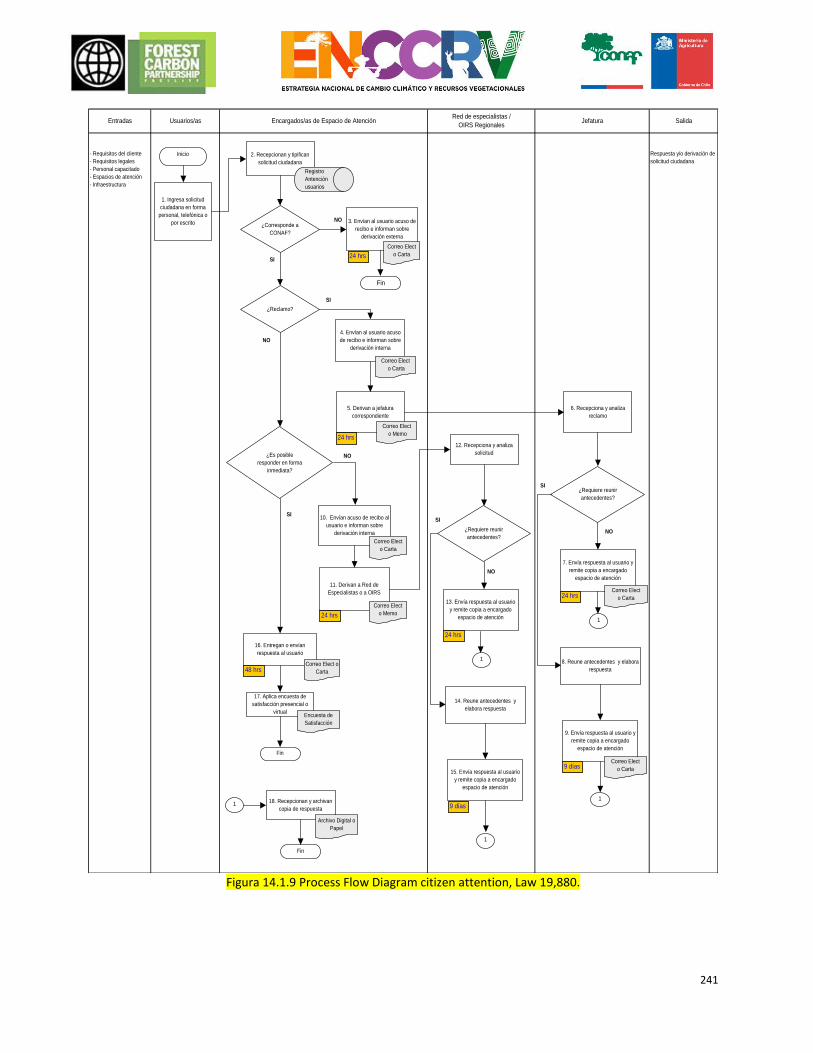
241
Figura 14.1.9 Process Flow Diagram citizen attention, Law 19,880.
Red de especialistas /
OIRS RegionalesEncargados/as de Espacio de Atención Entradas JefaturaUsuarios/as Salida
- Requisitos del cliente
- Requisitos legales
- Personal capacitado
- Espacios de atención
- Infraestructura
Respuesta y/o derivación de
solicitud ciudadana2. Recepcionan y tipifican
solicitud ciudadana
1. Ingresa solicitud
ciudadana en forma
personal, telefónica o
por escrito
Inicio
¿Es posible
responder en forma
inmediata?
10. Envían acuso de recibo al
usuario e informan sobre
derivación interna
18. Recepcionan y archivan
copia de respuesta
Registro
Antención
usuarios
¿Corresponde a
CONAF?
SI
6. Recepciona y analiza
reclamo
4. Envían al usuario acuso
de recibo e informan sobre
derivación interna
Correo Elect
o Carta
7. Envía respuesta al usuario y
remite copia a encargado
espacio de atención
Correo Elect
o Carta
5. Derivan a jefatura
correspondiente
Correo Elect
o Carta
¿Requiere reunir
antecedentes?
NO
SI
24 hrs
1
1
9 días
11. Derivan a Red de
Especialistas o a OIRS
Correo Elect
o Memo
12. Recepciona y analiza
solicitud
24 hrs
Archivo Digital o
Papel
Fin
24 hrs
3. Envían al usuario acuso de
recibo e informan sobre
derivación externa
Correo Elect
o Carta
¿Reclamo?
NO
NO
16. Entregan o envían
respuesta al usuario
Correo Elect o
Carta
Fin
17. Aplica encuesta de
satisfacción presencial o
virtualEncuesta de
Satisfacción
SI
NO
Correo Elect
o Memo
SI
Fin
8. Reune antecedentes y elabora
respuesta
9. Envía respuesta al usuario y
remite copia a encargado
espacio de atención
Correo Elect
o Carta
1
13. Envía respuesta al usuario
y remite copia a encargado
espacio de atención
¿Requiere reunir
antecedentes?
1
14. Reune antecedentes y
elabora respuesta
15. Envía respuesta al usuario
y remite copia a encargado
espacio de atención
24 hrs
9 días
1
24 hrs
48 hrs
SI
NO
242
N° Who What When Registry work
guideline
1 Users
Citizenship request which can be personal, telephone or written (letter, fax, complaints and suggestions form the OIRS or email)
When the request is made
- letter - Fax - Complaints and suggestions form the OIRS - Email - By Phone
Not apply
2 Attention Managers
Reception and classification of citizen request
When the request is made
electronica Electronic document “the registration system user service ” SC-OI-7.5-P1-R2
Not apply
3 Attention Managers
Sending the user confirmation of receipt and information about external bypass.
Within a maximum period of 24 hours of receiving the request.
- email - Letter
Not apply
4 Attention Managers
Sending the user confirmation of receipt and information about internal bypass.
Classification of citizen request as a complaint
- email - Letter
Not apply
5 Attention Managers
The claim is sent to the appropriate Chief
Within a maximum period of 24 hours of receiving the request
- email - Memorandum
Not apply
6 Chiefs Receives and analyzes claim
at the moment when the request is received
Not apply Not apply
7 Chiefs Send response to the user and sends a copy to attention manager
If it does not require gathering backgrounds, within a maximum period of 24 hours of receipt of the claim
- email - Letter
Not apply
8 Chiefs Collect background and prepares response
Analyzing the complaint and detect need to gather backgrounds for a response
Not apply Not apply
9 Chiefs Send response to the user and sends a copy to attention manager
In a period of 9 days of receiving the claim.
- email - Letter
Not apply
10 Attention Managers
Sending the user confirmation of receipt and information about internal bypass.
To establish citizenship application as internal bypass and a maximum of 24 hours of receiving the request
- email - Memorandum
Not apply
11 Attention Managers
The request is sent to specialists or regional OIRS.
If the request can not be answered directly in the space of attention and a maximum of 24 hours of receiving the request.
Email - Memorandum
Not apply
12 Network Specialist or regional OIRS.
Receives and analyzes claim
The request is received from the area of public attention.
Not apply Not apply
13 Network Specialist or regional OIRS.
Send response to the user and sends a copy to attention manager
If it is not required gather background and within a maximum period of 24 hrs.
Not apply Not apply
14 Network Specialist or regional OIRS.
Collect background and prepares response
When assessing the request and detect need to gather background for the response
-Letter -Email
Not apply
15 Network Send response to the user and In a period of 9 days of Email or oficial letter Not apply
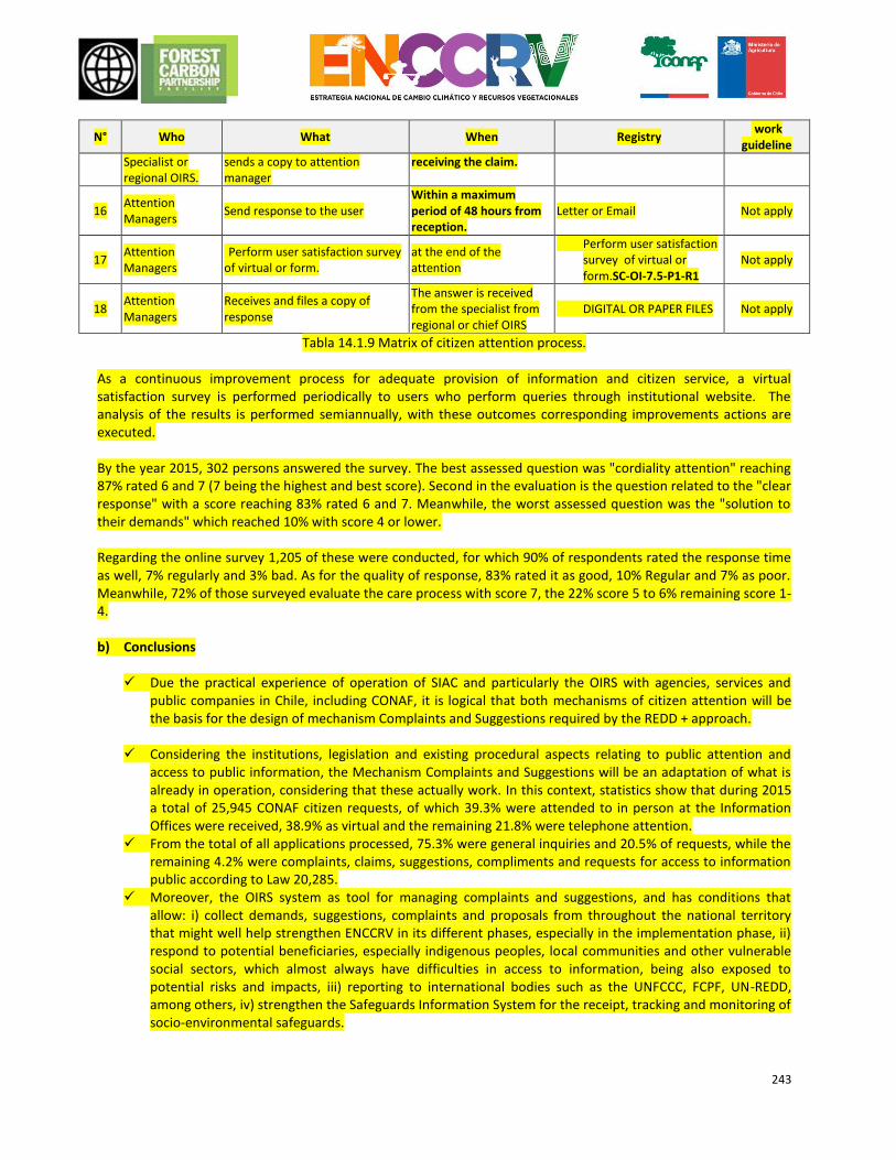
243
N° Who What When Registry work
guideline
Specialist or regional OIRS.
sends a copy to attention manager
receiving the claim.
16 Attention Managers
Send response to the user Within a maximum period of 48 hours from reception.
Letter or Email Not apply
17 Attention Managers
Perform user satisfaction survey of virtual or form.
at the end of the attention
Perform user satisfaction survey of virtual or form.SC-OI-7.5-P1-R1
Not apply
18 Attention Managers
Receives and files a copy of response
The answer is received from the specialist from regional or chief OIRS
DIGITAL OR PAPER FILES Not apply
Tabla 14.1.9 Matrix of citizen attention process.
As a continuous improvement process for adequate provision of information and citizen service, a virtual satisfaction survey is performed periodically to users who perform queries through institutional website. The analysis of the results is performed semiannually, with these outcomes corresponding improvements actions are executed. By the year 2015, 302 persons answered the survey. The best assessed question was "cordiality attention" reaching 87% rated 6 and 7 (7 being the highest and best score). Second in the evaluation is the question related to the "clear response" with a score reaching 83% rated 6 and 7. Meanwhile, the worst assessed question was the "solution to their demands" which reached 10% with score 4 or lower. Regarding the online survey 1,205 of these were conducted, for which 90% of respondents rated the response time as well, 7% regularly and 3% bad. As for the quality of response, 83% rated it as good, 10% Regular and 7% as poor. Meanwhile, 72% of those surveyed evaluate the care process with score 7, the 22% score 5 to 6% remaining score 1-4. b) Conclusions
Due the practical experience of operation of SIAC and particularly the OIRS with agencies, services and
public companies in Chile, including CONAF, it is logical that both mechanisms of citizen attention will be the basis for the design of mechanism Complaints and Suggestions required by the REDD + approach.
Considering the institutions, legislation and existing procedural aspects relating to public attention and access to public information, the Mechanism Complaints and Suggestions will be an adaptation of what is already in operation, considering that these actually work. In this context, statistics show that during 2015 a total of 25,945 CONAF citizen requests, of which 39.3% were attended to in person at the Information Offices were received, 38.9% as virtual and the remaining 21.8% were telephone attention.
From the total of all applications processed, 75.3% were general inquiries and 20.5% of requests, while the remaining 4.2% were complaints, claims, suggestions, compliments and requests for access to information public according to Law 20,285.
Moreover, the OIRS system as tool for managing complaints and suggestions, and has conditions that allow: i) collect demands, suggestions, complaints and proposals from throughout the national territory that might well help strengthen ENCCRV in its different phases, especially in the implementation phase, ii) respond to potential beneficiaries, especially indigenous peoples, local communities and other vulnerable social sectors, which almost always have difficulties in access to information, being also exposed to potential risks and impacts, iii) reporting to international bodies such as the UNFCCC, FCPF, UN-REDD, among others, iv) strengthen the Safeguards Information System for the receipt, tracking and monitoring of socio-environmental safeguards.
244
The design of the mechanism of complaints and suggestions have to include the proposals developed by the stakeholders in the SESA participatory process.
Specifically, in the regional workshops it was incorporated a question related to the suggestions and proposals in order that the mechanism considered the elements necessary for access to more and better information. The above should consider the experience and needs at local level
The design of the mechanism of Complaints and Suggestions beyond national requirements should be incorporated in correlation with the SIAC and OIRS, should also incorporate an assessment of the requirements and minimum international standards that are required.
The design and operation of the Mechanism Complaints and Suggestions must be operationally complementary to the SIS, since Mechanism will be part of the SIS and its operation will depend largely from the alerts in relation to the protection of social and environmental safeguards.
As an initial step, a consultancy for diagnosis and operational design Mechanism Complaints and
Suggestions in order to analyze and incorporate all the already mentioned elements, including the institutional, national legislation, international requirements, complementarity with the SIS conduct auditions, participatory process inputs of the SESA, adaptation to OIRS and SIAC, operation platform, etc.
245
15. BENEFIT-SHARING ARRANGEMENTS
15.1 Description of benefit-sharing arrangements As part of the ER Programme, Chile has developed a Benefit-Sharing Scheme (BSS) that is based on the following basic principles:
There will be financial and non-financial benefits which will be shared in an equitable, transparent way that adheres to the regulatory framework in place.
The BSS will use existing schemes and instruments, as well as those proposed in the ER Programme action measures, as a means of distribution.
The distribution of financial benefits associated with Payment by Results is dependent on prior transfer of carbon rights.
Below is a table outlining the schemes for sharing benefits associated with direct mitigation action measures supporting the ER Programme, which will act as instruments of the BSS. The table indicates whether these schemes are financial or non-financial, if the beneficiary must have transferred carbon rights in order to receive the benefit and what type of owners can opt for this benefit-sharing scheme.
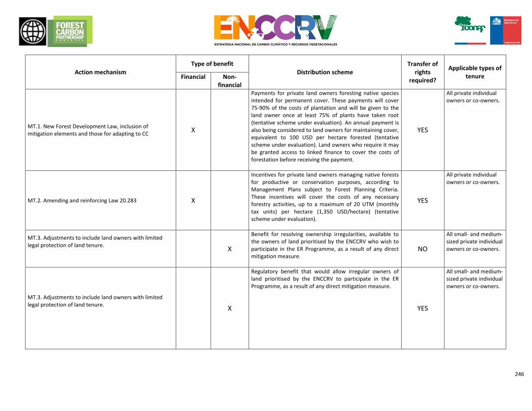
246
Action mechanism
Type of benefit
Distribution scheme Transfer of
rights required?
Applicable types of tenure Financial Non-
financial
MT.1. New Forest Development Law, inclusion of mitigation elements and those for adapting to CC
X
Payments for private land owners foresting native species intended for permanent cover. These payments will cover 75-90% of the costs of plantation and will be given to the land owner once at least 75% of plants have taken root (tentative scheme under evaluation). An annual payment is also being considered to land owners for maintaining cover, equivalent to 100 USD per hectare forested (tentative scheme under evaluation). Land owners who require it may be granted access to linked finance to cover the costs of forestation before receiving the payment.
YES
All private individual owners or co-owners.
MT.2. Amending and reinforcing Law 20.283 X
Incentives for private land owners managing native forests for productive or conservation purposes, according to Management Plans subject to Forest Planning Criteria. These incentives will cover the costs of any necessary forestry activities, up to a maximum of 20 UTM (monthly tax units) per hectare (1,350 USD/hectare) (tentative scheme under evaluation).
YES
All private individual owners or co-owners.
MT.3. Adjustments to include land owners with limited legal protection of land tenure.
X
Benefit for resolving ownership irregularities, available to the owners of land prioritised by the ENCCRV who wish to participate in the ER Programme, as a result of any direct mitigation measure.
NO
All small- and medium-sized private individual owners or co-owners.
MT.3. Adjustments to include land owners with limited legal protection of land tenure.
X
Regulatory benefit that would allow irregular owners of land prioritised by the ENCCRV to participate in the ER Programme, as a result of any direct mitigation measure.
YES
All small- and medium-sized private individual owners or co-owners.
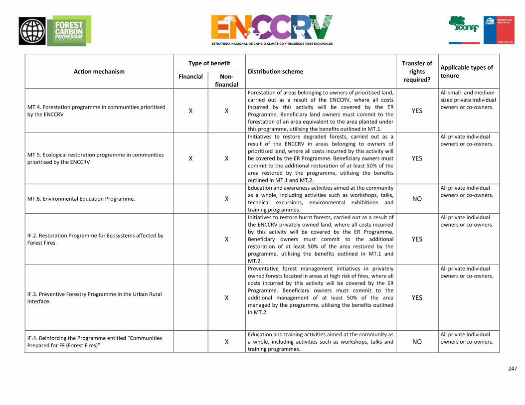
247
Action mechanism
Type of benefit
Distribution scheme Transfer of
rights required?
Applicable types of tenure Financial Non-
financial
MT.4. Forestation programme in communities prioritised by the ENCCRV
X X
Forestation of areas belonging to owners of prioritised land, carried out as a result of the ENCCRV, where all costs incurred by this activity will be covered by the ER Programme. Beneficiary land owners must commit to the forestation of an area equivalent to the area planted under this programme, utilising the benefits outlined in MT.1.
YES
All small- and medium-sized private individual owners or co-owners.
MT.5. Ecological restoration programme in communities prioritised by the ENCCRV
X X
Initiatives to restore degraded forests, carried out as a result of the ENCCRV in areas belonging to owners of prioritised land, where all costs incurred by this activity will be covered by the ER Programme. Beneficiary owners must commit to the additional restoration of at least 50% of the area restored by the programme, utilising the benefits outlined in MT.1 and MT.2.
YES
All private individual owners or co-owners.
MT.6. Environmental Education Programme.
X
Education and awareness activities aimed at the community as a whole, including activities such as workshops, talks, technical excursions, environmental exhibitions and training programmes.
NO
All private individual owners or co-owners.
IF.2. Restoration Programme for Ecosystems affected by Forest Fires.
X
Initiatives to restore burnt forests, carried out as a result of the ENCCRV privately owned land, where all costs incurred by this activity will be covered by the ER Programme. Beneficiary owners must commit to the additional restoration of at least 50% of the area restored by the programme, utilising the benefits outlined in MT.1 and MT.2.
YES
All private individual owners or co-owners.
IF.3. Preventive Forestry Programme in the Urban Rural Interface.
X
Preventative forest management initiatives in privately owned forests located in areas at high risk of fires, where all costs incurred by this activity will be covered by the ER Programme. Beneficiary owners must commit to the additional management of at least 50% of the area managed by the programme, utilising the benefits outlined in MT.2.
YES
All private individual owners or co-owners.
IF.4. Reinforcing the Programme entitled “Communities Prepared for FF (Forest Fires)”
X Education and training activities aimed at the community as a whole, including activities such as workshops, talks and training programmes.
NO All private individual owners or co-owners.
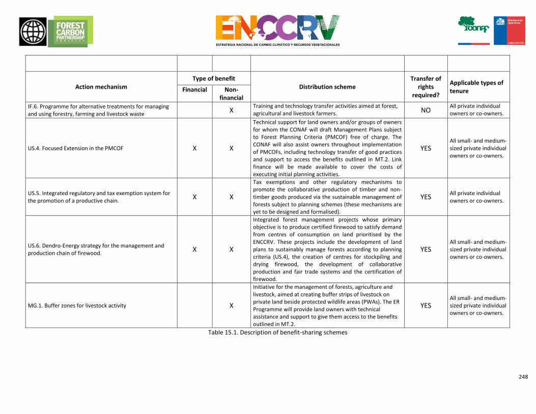
248
Action mechanism Type of benefit
Distribution scheme Transfer of
rights required?
Applicable types of tenure Financial Non-
financial
IF.6. Programme for alternative treatments for managing and using forestry, farming and livestock waste X
Training and technology transfer activities aimed at forest, agricultural and livestock farmers. NO
All private individual owners or co-owners.
US.4. Focused Extension in the PMCOF X X
Technical support for land owners and/or groups of owners for whom the CONAF will draft Management Plans subject to Forest Planning Criteria (PMCOF) free of charge. The CONAF will also assist owners throughout implementation of PMCOFs, including technology transfer of good practices and support to access the benefits outlined in MT.2. Link finance will be made available to cover the costs of executing initial planning activities.
YES All small- and medium-sized private individual owners or co-owners.
US.5. Integrated regulatory and tax exemption system for the promotion of a productive chain.
X X
Tax exemptions and other regulatory mechanisms to promote the collaborative production of timber and non-timber goods produced via the sustainable management of forests subject to planning schemes (these mechanisms are yet to be designed and formalised).
YES All private individual owners or co-owners.
US.6. Dendro-Energy strategy for the management and production chain of firewood.
X X
Integrated forest management projects whose primary objective is to produce certified firewood to satisfy demand from centres of consumption on land prioritised by the ENCCRV. These projects include the development of land plans to sustainably manage forests according to planning criteria (US.4), the creation of centres for stockpiling and drying firewood, the development of collaborative production and fair trade systems and the certification of firewood.
YES All small- and medium-sized private individual owners or co-owners.
MG.1. Buffer zones for livestock activity
X
Initiative for the management of forests, agriculture and livestock, aimed at creating buffer strips of livestock on private land beside protected wildlife areas (PWAs). The ER Programme will provide land owners with technical assistance and support to give them access to the benefits outlined in MT.2.
YES All small- and medium-sized private individual owners or co-owners.
Table 15.1. Description of benefit-sharing schemes
249
250
As shown in the previous table, the BSS distinguishes between financial and non-financial benefits. The latter is considered to be indirect payment for the implementation of measures to facilitate the application of actions and practices that translate not only into emissions reduction goals but also into other results, such as land tenancy and increased capacity. Participation is sought from the greatest number of stakeholders possible, who will be able to manage the benefits collectively and sustainably. In the long-term, this will allow communities to develop their capacity. The BSS proposed is also inclusive, meaning that participation is open not only owners with land rights, but also other types of administrators (MT.3). However, special care and consideration will be required in situations where property rights or other rights of third parties could be affected. It is hugely important that Convention 169 and the United Nations Declaration on the Rights of Indigenous Peoples are taken into account, since these require the interests of indigenous populations to be protected during implementation of the ER Programme. With this in mind, the procedure for implementing the BSS will take into consideration the following aspects: 1. Inclusion of an ethnic variable, providing the option of an additional benefit. This will increase the participation of indigenous peoples with regard to their own development priorities and in accordance with their own conception of natural resources. In this regard, it is important that the participation of indigenous peoples in ER Programmes is joint and not imposed, with due consideration for their timings, language and system of organisation. 2. Widespread circulation of the ENCCRV by distributing written information in indigenous language and Spanish and verbal information outlining the benefits and requirements of the ER Programme and explaining that the programme will be implemented together with the community. 3. In order to build confidence, it has been proposed that presentations be delivered which, in addition to addressing the objectives of the ER Programme, explain the purpose of the CONAF in terms of its functions and authority. 4. Provide training for professionals administering action measures, particularly on aspects such as territory, world view, sites of cultural significance, genealogy, language, toponymy and ancestral religious practices. 5. In light of the potential impacts on indigenous peoples, the various pieces of forest development legislation, administrative measures, programmes, plans and any other instruments, including the ENCCRV, may be subject to a mandatory regional or national consultation process, as applicable. 6. Should any activities of the action measures involve any type of prospecting, collection and/or excavation, authorisation must be sought from the National Monuments Committee.
15.2 Summary of the design process for benefit-sharing arrangements
Designing the BSS represented an opportunity to involve the various sectoral actors and promote an inclusive dialogue so as to permit national characterisation. The various sectoral actors were involved by developing multiple workshops run by the CONAF Indigenous and Social Affairs Unit, within the framework of the Strategic Environmental and Social Assessment (Chapter 5). As mentioned in previous chapters, the participatory process included different focus groups, with the participation of around 1,000 national actors. Their involvement was considerable, allowing key elements of the ENCCRV to be defined, including schemes and channels for sharing the financial and non-financial benefits of the ER Programme.
251
Using all the information generated during the participatory process, specialists from a technical consortium formed by TECO, Sud Austral Consulting and Climate Focus worked on developing and defining the BSS, combining bibliographical sources, regulatory information and the professional experiences of each expert of the team with proposed strategic activities and action measures of the ER Programme. Once the technical team had come up with a preliminary proposal, the measures were validated and adjusted by a technical policy team of the UCCSA, a department of the CONAF. The Benefit Sharing System will be made public through the wesite of the ENCCRV, once a final proposal become clear. This version will have a didactic format and understable language to key stakeholders.
15.3 Description of the legal context of the benefit-sharing arrangements The design of the benefit-sharing scheme is compliant with international treaties ratified by Chile and existing national legislation. Within this context, it is important to remember that the ultimate objective of the BSS is to incentivise the recovery and protection of forests as a means of mitigating the effects of climate change while simultaneously ensuring complete and utter respect for the human rights of all stakeholders, in particular indigenous peoples, during the development of these activities. In a bid to take on board the social and environmental safeguards contained in national law and Appendix 1 to Decision 1/COP.16 of the United Nations Framework Convention on Climate Change, the BSS combines social, environmental and governance principles. In order to achieve this, among the action measures of the programme, relevant arrangements and necessary legal amendments were considered in order to guarantee a scheme that would avoid provoking conflict among communities and ensure that individuals' human rights would be respected. National legislation and the existing institutional framework provide the basis for the BSS which, in any case, hopes to become more robust via capacity building and the organisation and allocation of resources. This will strengthen forestry governance and increase the transparency and effectiveness of the organisations executing the programme. Legal amendments and future plans to create an Environmental Forestry Fund were devised in an attempt to attain these objectives. The Environmental Forestry Fund will operate as a financial mechanism with the ability to administer resources from different sources, such as the State, individuals and international organisations. In any case, Chile already has a network of environmental institutions, and in 2016, it will create and new and improved institutional structure for the forestry sector, making it possible to connect/join elements of the scheme. This can be achieved simply by assigning new functions and resources to the relevant authorities intended to administer the new regulatory framework for executing the ER Programme on a national scale. Similarly, various reforms are being considered so as to eliminate perverse incentives and provisions that are incompatible with the ENCCRV. This would prevent legal confusion, ambiguity and legal disputes. This situation applies to the Act on forest development, which is being amended to replace the old Decree-Law 701 with a piece of legislation that places significant emphasis on the production of environmental services. In brief, attempts are being made to reinforce the legal framework and the existing network of institutions as a way of making it easier for institutions and mechanisms to share benefits, from the international level to the national and/or subnational level. This is being done by introducing national provisions applicable to public authorities and contractual safeguards to ensure resources are allocated to individuals (a description of these amendments was presented in Chapters 4.5 and 4.3).
252
16. NON-CARBON BENEFITS (CO-BENEFITS)
16.1 Potential non-carbon benefits scheme and identifying priority benefits for the ER Programme
The participatory process of the Strategic Environmental and Social Assessment identified co-benefits that could be generated by the implementation of each of the action measures proposed by the ER Programme. The results obtained by each action measure are: MT1: Key stakeholders expressed as very important co-benefits: the approach and institutional linkages with different stakeholders, with an emphasis on consultation and work with indigenous communities and women; State inter-institutional coordination; increase and / or maintenance biodiversity; control of desertification, land degradation and drought; safeguarding ancestral practices of indigenous peoples (i.e. collecting medicinal plants) and the valorization and effective use of knowledge of women in relation to environmental issues. MT2: Attendees weighted as very important as the co-benefits that could be generated with the modification and strengthening of Law N°20,283: increase in forest area; approach and institutional linkages with different stakeholders, with an emphasis on consultation and work with indigenous communities and women; control of desertification, land degradation and drought; sustainable forest management, and; a better understanding of the territorial reality. MT3: Participants weighted as very important the co-benefits that could be generated with the afforestation programme: sharing of knowledge; safeguarding the environmental and / or sociocultural heritage; increasing forest area; control desertification, land degradation and drought; safeguarding ancestral practices of indigenous peoples (i.e. collectiing medicinal plants) and the assessment and effective use of knowledge of women in relation to environmental issues; technical advice on forestry and forest management, and; promotion of research. MT4: Attendees weighted as very important the co-benefits that could be generated with the restoration programme: increase in forest area; approach and institutional articulation with different key stakeholders, with an emphasis on consultation and work with indigenous communities and women; increasing and / or maintaining biodiversity; improvement of environmental services; mitigating climate change; activities that respect the planet (Ñuke Mapu, Pachamama84) - respect for ancestral beliefs linked to Earth; safeguarding ancestral practices of indigenous peoples (i.e. collecting medicinal plants), and; assessment and effective use of knowledge of women in relation to environmental issues. MT5: Participants weighted as very important the co-benefits that could be generated with the extended educational programme: safeguarding the environmental and / or socio-cultural heritage; greater ecological awareness, and; knowledge sharing. MT6: Attendees weighted as very important the co-benefits that could be generated with the programme on regularization of land tenure: improvement in administrative procedures; State inter-institutional articulation; economically sustainable activities; regularization of land tenure; access to support instruments, and; rural development. MG1: Particpants weighted as very important the co-benefits that could be generated by implementing buffer strips: approach and institutional linkages with different stakeholders, with an emphasis on consultation and work with indigenous communities and women; better control and enforcement, and; access to support instruments.
84 Terms from Indigenous Peoples to refer to the "Mother Earth", understood as the habitat / ecosystem that sustain traditional life.
253
MG2: Attendees weighted as very important the co-benefits that could be generated with strengthening and expanding initiatives on “veranadas” (Highland pastures) management: approach and institutional linkages with different stakeholders, with an emphasis on consultation and work with indigenous communities and women; sense of belonging to the territory (cultural rooting), and; economically sustainable activities. MG3: Attendees weighted as very important the co-benefits that could be generated with the implementation of this action measure: approach and institutional linkages with different stakeholders, with an emphasis on consultation and work with indigenous communities and women; best knowledge of the territorial reality, and; promotion of research. IF1: Participants weighted as very important the co-benefits that could be generated with the implementation of this measure action: technical support for forest fires control; promoting research; knowledge sharing, and; improvent of information. IF2: Attendees weighted as very important co-benefits that could be generated with the implementation of this measure action: approach and institutional linkages with different stakeholders, with an emphasis on consultation and work with indigenous communities and women; control of desertification, land degradation and drought; mitigation of climate change; safeguarding the environmental and / or socio-cultural heritage, and; technical assistance in forestry activities and forest management, and; greater ecological awareness. IF3: Attendees weighted as very important the co-benefits that could be generated with the implementation of this measure action: approach and institutional linkages with different stakeholders, with an emphasis on consultation and work with indigenous communities and women; control of desertification, land degradation and drought; declining natural hazards; fostering associativity, and; greater ecological awareness. IF4: Attendees weighted as very important the co-benefits that could be generated with the implementation of this measure action: delivery of inputs; water as a common good, and; control of of desertification, land degradation and drought. IF5: Attendees weighted as very important the co-benefits that could be generated with the implementation of this action measure: delivery of inputs; control of desertification, land degradation and drought; improvement of environmental services, and; rural development. IF6: Attendees weighted as very important the co-benefits that could be generated with the implementation of this measure action: generating sources of employment; sustainable economic activities; technical assistance in forestry activities and forest management, and knowledge sharing. RH1: Participants weighted as very important the co-benefits that could be generated with the implementation of this measure action: increase in forest area; control of desertification, land degradation and drought, and; improvement of service environmental. RH2: Attendees weighted as very important the co-benefits that could be generated with the implementation of this action measure: increase in forest area; control of desertification, land degradation and drought, and; improvement of service environmental. RH3: Attendees weighted as very important the co-benefits that could be generated with the implementation of this action measure: State inter-institutional coordination; control of of desertification, land degradation and drought, and; optimal use of economic resources. US1: Participants weighted as very important the co-benefits that could be generated with the implementation of this action measure: approach and institutional articulation with different key stakeholders, with an emphasis on consultation and work with indigenous communities and women; State inter-institutional articulation, and; access to promotion instruments.
254
US2: Attendees weighted as very important the co-benefits that could be generated with the implementation of this action measure: rural development; better understanding of the territorial reality, and; improving information. US3: Attendees weighted as very important In the co-benefits that could be generated with the implementation of this action measure: sense of belonging to the territory; rural development, and; better understanding of the territorial reality. US4: Attendees weighted as very important the co-benefits that could be generated with the implementation of this action measure: control of desertification, land degradation and drought; safeguarding the environmental and / or socio-cultural heritage, and; economically sustainable activities. US5: Attendees weighted as very important the co-benefits that could be generated with the implementation of this action measure; improvement of the quality of life and social welfare; sustainable economic activities, and; optimal use of economic resources. US6: Attendees weighted as very important the co-benefits that could be generated with the implementation of this measure for action: interagency coordination for the development of educational programs; better understanding of the territorial reality, and; revalorization of the professional forester and its management. GA1: Participants weighted as very important the co-benefits that could be generated with the implementation of this measure for action: approach and institutional articulation with different key stakeholders, with an emphasis on consultation and work with indigenous communities and women; increasing resilience of ecosystems, and; improving quality of life and social welfare. RS1: Participants weighted as very important the co-benefits that could be generated with the implementation of this measure for action: increased resilience of ecosystems and activities that respect the planet (Ñuke Mapu, Pachamama) - respect for ancestral beliefs bound to Earth, and; technical advice in forestry activities and forest management. RS2: Participants weighted as very important improvement of environmental services as a co-benefit that could be generated with the implementation of this action measure. Adittionally, as part of the ENCCRV, a consortium led by the private climate exchange SCX - Bolsa de Clima de Santiago is developing a territorial methodological framework that will be integrated into the MRV system and SIS. It will become a vital component as regards determining the degree of reduction of vulnerability to climate change, which is driving implementation of the ER Programme action measures. This framework is being used to define which attributes can be measured simply and effectively in the territory when implementing measures to reduce vulnerability and strengthen resilience wherever they are implemented. One source of input utilised during the consultation process to define and validate the scope of the framework was the participatory consultation process set in motion in 2015 (see Chapter 5), which was considerate of gender, culture and generational inclusion. Based on this input, the technical team identified two priority areas of co-benefits associated with the ENCCRV: one concerns the Biophysical which, unlike carbon removals, encompasses the elements connected with ecosystem services that provide vegetation resources and can be observed and monitored within a territory. The other area was defined as Mainstream and incorporates the elements relating to the social and cultural benefits of the ER Programme. For each area, a total of six priority aspects were then established. A definition of territorial variables is currently being developed for each area, which will allow these aspects to be monitored and incorporated into the MRV and SIS.
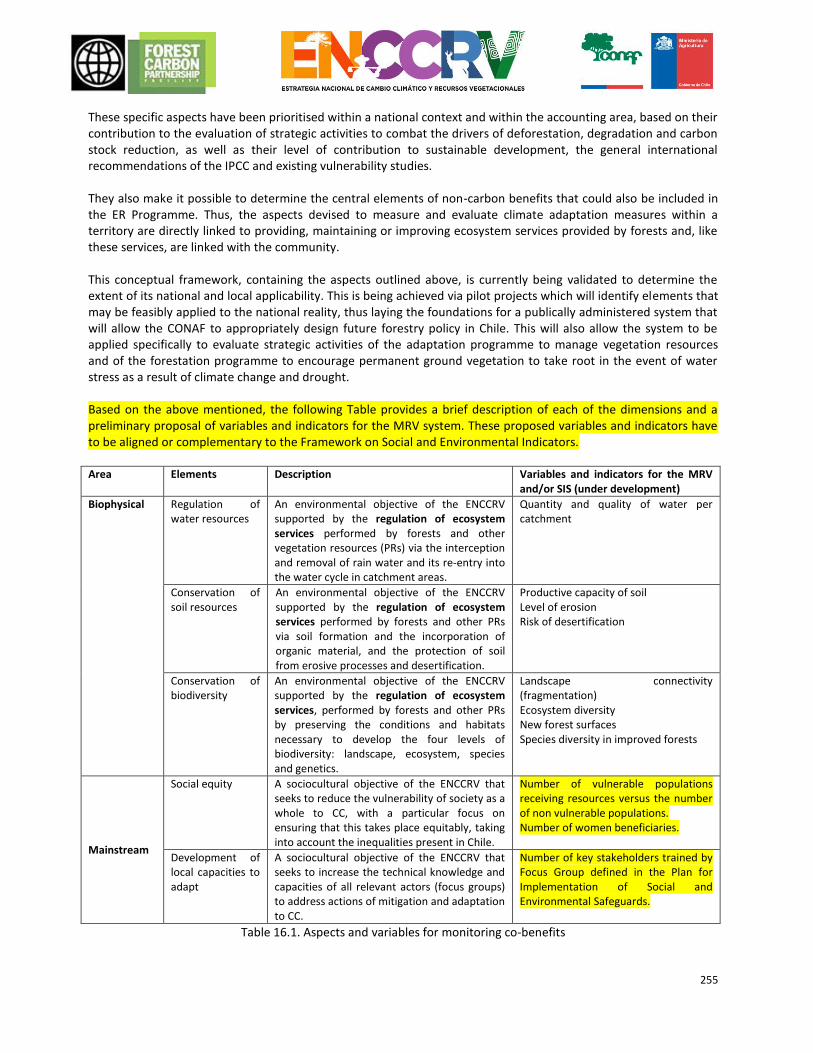
255
These specific aspects have been prioritised within a national context and within the accounting area, based on their contribution to the evaluation of strategic activities to combat the drivers of deforestation, degradation and carbon stock reduction, as well as their level of contribution to sustainable development, the general international recommendations of the IPCC and existing vulnerability studies. They also make it possible to determine the central elements of non-carbon benefits that could also be included in the ER Programme. Thus, the aspects devised to measure and evaluate climate adaptation measures within a territory are directly linked to providing, maintaining or improving ecosystem services provided by forests and, like these services, are linked with the community. This conceptual framework, containing the aspects outlined above, is currently being validated to determine the extent of its national and local applicability. This is being achieved via pilot projects which will identify elements that may be feasibly applied to the national reality, thus laying the foundations for a publically administered system that will allow the CONAF to appropriately design future forestry policy in Chile. This will also allow the system to be applied specifically to evaluate strategic activities of the adaptation programme to manage vegetation resources and of the forestation programme to encourage permanent ground vegetation to take root in the event of water stress as a result of climate change and drought. Based on the above mentioned, the following Table provides a brief description of each of the dimensions and a preliminary proposal of variables and indicators for the MRV system. These proposed variables and indicators have to be aligned or complementary to the Framework on Social and Environmental Indicators. Area
Elements Description Variables and indicators for the MRV and/or SIS (under development)
Biophysical Regulation of water resources
An environmental objective of the ENCCRV supported by the regulation of ecosystem services performed by forests and other vegetation resources (PRs) via the interception and removal of rain water and its re-entry into the water cycle in catchment areas.
Quantity and quality of water per catchment
Conservation of soil resources
An environmental objective of the ENCCRV supported by the regulation of ecosystem services performed by forests and other PRs via soil formation and the incorporation of organic material, and the protection of soil from erosive processes and desertification.
Productive capacity of soil Level of erosion Risk of desertification
Conservation of biodiversity
An environmental objective of the ENCCRV supported by the regulation of ecosystem services, performed by forests and other PRs by preserving the conditions and habitats necessary to develop the four levels of biodiversity: landscape, ecosystem, species and genetics.
Landscape connectivity (fragmentation) Ecosystem diversity New forest surfaces Species diversity in improved forests
Mainstream
Social equity
A sociocultural objective of the ENCCRV that seeks to reduce the vulnerability of society as a whole to CC, with a particular focus on ensuring that this takes place equitably, taking into account the inequalities present in Chile.
Number of vulnerable populations receiving resources versus the number of non vulnerable populations. Number of women beneficiaries.
Development of local capacities to adapt
A sociocultural objective of the ENCCRV that seeks to increase the technical knowledge and capacities of all relevant actors (focus groups) to address actions of mitigation and adaptation to CC.
Number of key stakeholders trained by Focus Group defined in the Plan for Implementation of Social and Environmental Safeguards.
Table 16.1. Aspects and variables for monitoring co-benefits
256
16.2 Approach for providing information on prioritised non-carbon benefits As proposed in Indicator 35.1 of the Methodological Framework, and as explained in Chapter 14.1.6, the ENCCRV has included in the Safeguards Information System (SIS) framework ofindicators elements to evaluate attainment of non-carbon benefits produced by Strategic Activities and Action Measures proposed as part of the ER Programme. Information on improvements in the reduction of vulnerability to CC, identified by these indicators, will be included as a separate appendix to all surveillance reports issued by the MRV system as part of the ER Programme and placed in the public domain.
As mentioned above, the indicators for the SIS and the direct territorial variables of the MRV system for monitoring co-benefits are still being determined by the ENCCRV. It is expected that these will have been determined and validated by the middle of 2016.
257
17. OWNERSHIP OF EMISSIONS REDUCTIONS Chile's capacity to transfer emissions reductions under the ERPA (indicators 28.3, 36.1 and 36.2 MM), the evaluation of land and tenure frameworks (C indicator 28.1), the prevention of double-entry bookkeeping (indicator C23) and removal and emission reductions MRV systems in terms of FREL are closely linked. Although the regulations of the FCPF apply equally to all participating countries, each country is also subject to particular conditions and criteria, making its legal and political situation unique. These must be taken into account in order to understand the strategy adopted by the country to address underlying legal issues concerning property of carbon emissions reductions and the legal nature of emissions reductions. One particular fundamental characteristic of Chile's legal context places natural resources, including forest resources, under private ownership and encompasses strict rules on the protection of private property. In light of this, any restriction of property rights requires sound legal justification. However, the country's liberal capitalist legal order does not obstruct the government's obligation to manage and regulate the environment for the benefit of the Chilean people as a whole.
17.1 ER Programme Authorisation The Chilean government has a constitutional mandate to protect the environment, which includes the protection of forests and mitigation of climate change resulting from human activity. The CONAF represents the government making decisions regarding forest management and protection. This allows the agency to subscribe to international agreements and fundraise for the protection of forests by selling emissions permits. Article 19, number 8 of the Constitution of the Republic charges the Chilean government with providing all Chileans with the right to live in a pollution-free environment. The same article outlines the State's duty to ensure that this right is not compromised and to conserve nature. This is a subjective fundamental right, since it focuses on the protection of humans, and manifests as the right of each individual, as an actor and as a beneficiary, to demand protection of the environment. However, it also has implications for and impacts on the State's obligation to fulfil this right. In accordance with this mandate, positive action measures must be developed to regulate this right, consisting of the removal of material and economic obstacles that would prevent individuals from being able to exercise and enjoy this right. In light of this legal obligation, Chile is subscribing to international agreements aimed at protecting the environment, including the UNFCCC. The government is also authorised to take the necessary measures under existing legislation to guarantee the protection and conservation of a healthy environment. This constitutional mandate charges the State with two different obligations:
1. To adopt legislative and political measures aimed at protecting the environment 2. Promote the conservation of nature, resulting in the creation of institutions specially intended for this
purpose.
It follows that the State has the right and the constitutional obligation to regulate and environment and, in doing so, ensure that it is conserved and protected. The right of every citizen to live in a pollution-free environment must be protected by enacting suitable regulations and adopting international agreements, such as the UNFCCC to protect the atmosphere and prevent the dangers of climate change. In this way, Chile has the right and authorisation to ratify international agreements with the purpose of addressing the impacts and mitigation of climate change. Chile is a signatory to the UNFCCC, the Kyoto Protocol and the recently adopted Paris Agreement. In accordance with the rights and mechanisms provided for under the Kyoto Protocol, the country has also entered into bilateral agreements with the World Bank and other institutions as a way
258
of transferring carbon credits to energy-related CDM projects (Chacabuquito)85. These are important antecedents for the sale of emission permits. CONAF es la entidad a cargo de la ENCCRV, lo que permite integrar y dejar plasmado en este instrumento diversas medidas públicas formuladas con arreglo a los acuerdos internacionales adoptados en estas materias.En el seno de los compromisos nacionales e internacionales adquiridos por Chile, CONAF se encuentra en proceso de formular e implementar medidas orientadas a la reducción de emisiones de GEI, mediante el uso de los recursos vegetacionales del país en su rol de capturador/almacenador de GEI. The fact that it is the CONAF that is the authority responsible for the ENCCRV means that various public measures, formulated in accordance with international agreements adopted in this regard, may be integrated into and reflected in this instrument. The CONAF also participates in several collaborative agreements with international organisations supporting REDD+ activities such as the UN-REDD Programme, the Global Environment Facility (GEF), the Swiss Agency for Development and Cooperation (SDE), the United Nations Convention to Combat Desertification (UNCCD) and other alliances established to date. Similarly, it has also established technical collaboration with both public and private national organisations such as the National Indigenous Development Corporation (CONADI), the National Resources Information Centre (CIREN) and the National Institute of Agricultural Development (INDAP). In accordance with the official communication from the Chilean Ministry of Foreign Affairs to the secretary of the UNFCCC in January 2014, the CONAF is the national agency appointed as the focal point for REDD+ activities. Pursuant to decision 10/CP.19 of the UNFCCC, adopted at the Conference of the Parties in Warsaw in 2013, the CONAF is to serve as a link with the secretary as regards the coordination of support to fully realise REDD+ activities. It also has the power to designate which organisations will receive payments by results, according to the specific operational methods of the organisations funding these activities. The legal authority of the CONAF is in line with regulations and the functions it performs and is sufficient to drive forestry development, particularly as an administrative agency of the The National System of Protected Wild Areas of the State (SNASPE). The CONAF also has offices in almost every part of the country. According to its statutes, its assets are comprised of initial contributions from the public institutions that played a role in its formation, the annual contribution dictated in the national budget act applicable to the public sector, and the institution’s own income authorised by law. Although the regulations governing the CONAF are spread across several pieces of legislation, the Corporation has the power to execute certain activities and enter into agreements so as to fulfil its mission, which, in broad terms, seeks to improve the administration of SNASPE assets. Since becoming established, it has been party to a series of conventions in order to fulfil the aims and objectives set out in its statutes. Article 3 of the statutes governing the CONAF states that the general purpose of the Corporation is to contribute to the conservation, development, management and exploitation of forest resources and protected wildlife areas of the country. Item h) of the same statute confers extensive powers to execute any kind of act and enter into any kind of convention or agreement with that is associated with or will contribute to its aims, where other contractual parties may be national, international, natural or legal persons subject to public or private law. Furthermore, article 10 of the Forest Act vests the CONAF with the authority to enter into any type of contract and execute any acts necessary to allow better exploitation of National Parks and Forest Reserves. Therefore, CONAF can subscribe contracts with public and private organizations, as well as national and international agencies, in order to fulfill their mandate. Such agreements have to be fully consistent with the objectives of conservation and preservation of protected wildlife areas.
85 The Guardia Vieja Hydroelectric Project, Chacabuquito run-of-the-river plant developed by the company Colbún. Quilleco de Chile hydroelectric energy project.
259
On this matter, CONAF have to request resolution from the General Comptroller of the Republic of Chile (Contralor General de la República) for enabling CONAF without any caveat to subscribe the ERPA with the World Bank in its capacity as trustee of the FCPF. Depending on the progress of negotiations on ERPA with the World Bank, this legal resolution will be previously requested, at stage of "Term Sheet", or included as condition precedent to the ERPA. The General Comptroller of the Republic is the highest instance for enforcement within Central Government and aims to defend the principle of legality, i.e., it verify that the services of the State acting within its mandate and subject to the procedures the law provides. The Constitutional Act regulates this institution granting powers to interpret the legal rules that affect governmental administration, resulting in the issuance of mandatory legal reports, which become an administrative doctrine. Under the provisions of Article 5 and 33 letter b) of the Organic Constitutional Law N°10,336, any Director of Public Service can request legal advice to the General Comptroller of the Republic. Consultations are concerning the interpretation of the rules governing the organ, as well as the legality of their actions and performance. The verdict of the General Comptroller of the Republic grants legal certainty regarding the powers of CONAF to act as a legal party before the ERPA. However, in case that body may consider that according to the regulatory framework of CONAF has not sufficient legal authority, it will be granted the necessary powers to the Ministry of Agriculture. It should be noted that the CONAF is a subsidiary body to the Ministry of Agriculture and it is in charge of implementing the ENCCRV, and therefore, all measures related to forests and forest management. At this time, CONAF is working on two pieces of legislation that are part of the action steps referred to in the ENCCRV. On the one hand, the inclusion of elements of climate change in the draft new law on forestry development, and on the other hand, the inclusion of relevant legal amendments to the Native Forest Law (Law N°20.283). Therefore, specific powers and functions can be established in any of these instruments for CONAF higher legal support to act, if necessary. The ENCCRV set a formal link between national forest objectives and goals of international climate treaties. In this sense, the ENCCRV goes beyond traditional national environmental strategies, as it clearly expresses its international commitment in its role in the implementation of REDD+ and other international environmental (biodiversity, combating desertification) and climate (UNFCCC, Paris Agreement) objectives. In fact, compliance with technical and political UNFCCC, UNCCD and certification standards of environmental services requirements are some of the main strategic pillars of the ENCCRV. The successful implementation of the ENCCRV depends on technical assistance and international financial support. Adoption of international agreements is consequently a sine-qua-non condition for CONAF's ability to fulfill its function of implementing the ENCCRV and contribute meeting the objectives on climate change of Chile. Reducing emissions is defined by the Carbon Fund as a result of mitigation measured in tons of CO2 with respect to a jurisdictional reference level. Mitigation results reflect the net benefit of all measures and activities implemented in the reference area for a defined period. This includes emission reductions and removals generated by public programmes and private activities. CONAF compensates any effort by those involved in the Programme on Payment for Environmental Services (PES) under the proposed Benefit Sharing system (see Chapter 15 of this document). To avoid double counting, the transfer of titles shall ensure emissions reductions at local level, in exchange for a payment (as described in Chapter 17, Section 2). Transactions with the Carbon Fund require important decision- making about use and allocation of ERs titles for the fulfillment of the objectives set in the Nationally Determined Contributions of Chile.
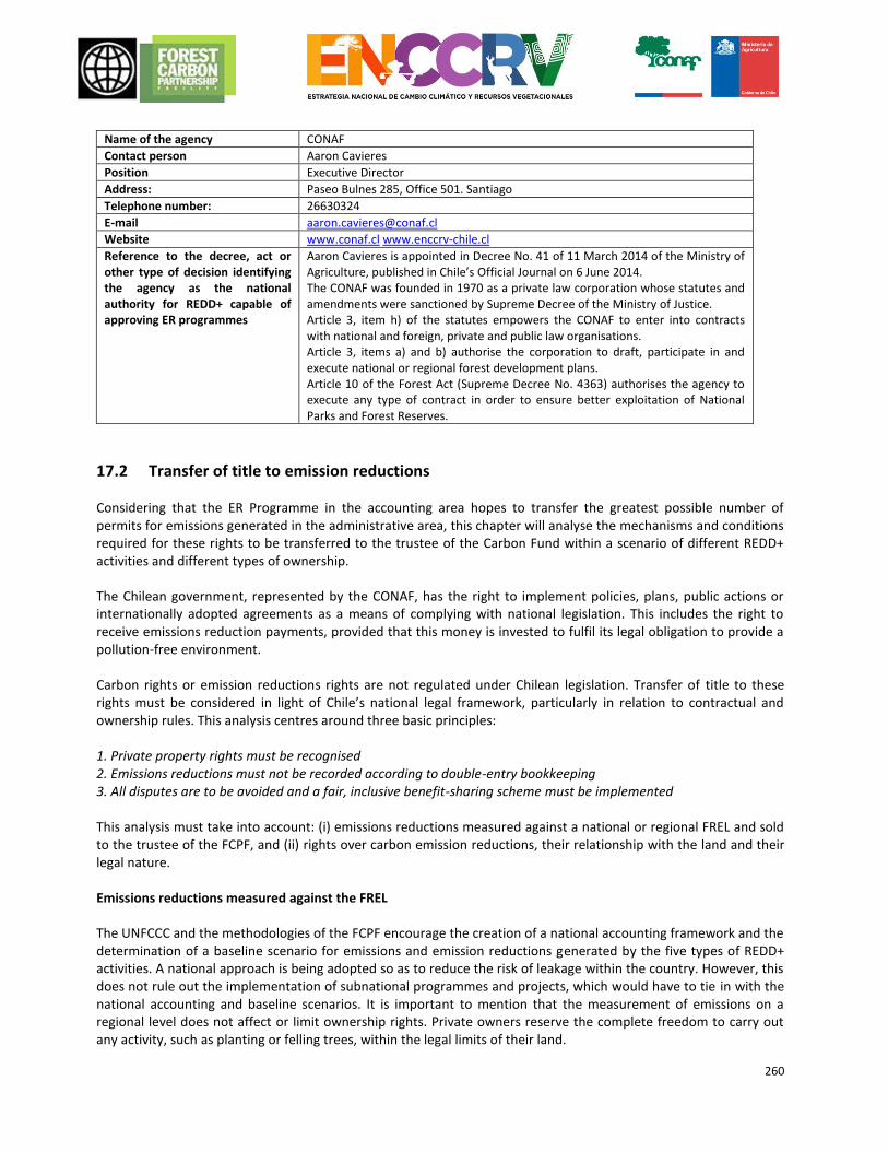
260
17.2 Transfer of title to emission reductions
Considering that the ER Programme in the accounting area hopes to transfer the greatest possible number of permits for emissions generated in the administrative area, this chapter will analyse the mechanisms and conditions required for these rights to be transferred to the trustee of the Carbon Fund within a scenario of different REDD+ activities and different types of ownership.
The Chilean government, represented by the CONAF, has the right to implement policies, plans, public actions or internationally adopted agreements as a means of complying with national legislation. This includes the right to receive emissions reduction payments, provided that this money is invested to fulfil its legal obligation to provide a pollution-free environment. Carbon rights or emission reductions rights are not regulated under Chilean legislation. Transfer of title to these rights must be considered in light of Chile’s national legal framework, particularly in relation to contractual and ownership rules. This analysis centres around three basic principles: 1. Private property rights must be recognised 2. Emissions reductions must not be recorded according to double-entry bookkeeping 3. All disputes are to be avoided and a fair, inclusive benefit-sharing scheme must be implemented This analysis must take into account: (i) emissions reductions measured against a national or regional FREL and sold to the trustee of the FCPF, and (ii) rights over carbon emission reductions, their relationship with the land and their legal nature. Emissions reductions measured against the FREL
The UNFCCC and the methodologies of the FCPF encourage the creation of a national accounting framework and the determination of a baseline scenario for emissions and emission reductions generated by the five types of REDD+ activities. A national approach is being adopted so as to reduce the risk of leakage within the country. However, this does not rule out the implementation of subnational programmes and projects, which would have to tie in with the national accounting and baseline scenarios. It is important to mention that the measurement of emissions on a regional level does not affect or limit ownership rights. Private owners reserve the complete freedom to carry out any activity, such as planting or felling trees, within the legal limits of their land.
Name of the agency CONAF
Contact person Aaron Cavieres
Position Executive Director
Address: Paseo Bulnes 285, Office 501. Santiago
Telephone number: 26630324
E-mail [email protected]
Website www.conaf.cl www.enccrv-chile.cl
Reference to the decree, act or other type of decision identifying the agency as the national authority for REDD+ capable of approving ER programmes
Aaron Cavieres is appointed in Decree No. 41 of 11 March 2014 of the Ministry of Agriculture, published in Chile’s Official Journal on 6 June 2014. The CONAF was founded in 1970 as a private law corporation whose statutes and amendments were sanctioned by Supreme Decree of the Ministry of Justice. Article 3, item h) of the statutes empowers the CONAF to enter into contracts with national and foreign, private and public law organisations. Article 3, items a) and b) authorise the corporation to draft, participate in and execute national or regional forest development plans. Article 10 of the Forest Act (Supreme Decree No. 4363) authorises the agency to execute any type of contract in order to ensure better exploitation of National Parks and Forest Reserves.
261
The definition of emissions reduction rights is contractually established in the ERPA, in accordance with international law. They are measured and recorded at the territorial level. In order to avoid duplicate entries and disputes, all rights and benefits derived from emissions reductions must be associated with the area covered by the FREL.
Carbon, emission and emissions reduction rights of individuals, communities and other private entities
In order to comply with the programme and local requirements of the FCPF, Chile must provide evidence to demonstrate that it can transfer full rights to the trustee without any difficulties. By developing a programme whose territorial baseline is applied nationally, registers will record not only emissions reductions generated as a result of the ER Programme but also carbon removed due to activities involving the reduction of carbon from the atmosphere.
If legal principles are to be applied to carbon rights, a distinction must be drawn between carbon rights (real right) and the law on “emissions reductions” (legal obligations).
A carbon right includes the right to the physical biomass stored in carbon (land, trees, etc.). Ownership of carbon stored in land belongs to the owner of the land.
The right over emissions reductions (removal of GHGs) involves the generation and measuring of emissions reductions in relation to a baseline. “Business-as-usual” forest management activities (regardless of whether or not they generate or emit carbon) do not count as emissions reductions. Emissions reductions/removals rights include the right to benefit from mitigation actions by generating carbon units.
As we will see in the next section, land ownership under Chilean law includes the right to appropriate of the land resources. In terms of Chile’s ER Programme, this means that:
1. If the ER Programme restricts the rights of landowners or if owners voluntarily allow such restriction (for example, through incentive programmes or in exchange for Payment for Environmental Services), compensation must be provided. In this case, the land owner will transfer all rights to carbon or emissionreductions to the CONAF via the execution of an agreement (see below).
2. In the event that the owner or possessor of the land is not participating in any incentive programmes or programmes involving compensation in exchange for emission reductions, he has the right to freely carry out any activity on this land, including conservation and reforestation activities. Owners may also trade on voluntary or compliance carbon markets, in which case they may trade their emissions reduction rights and carbon credits. However, in this last instance, the CONAF must ensure that owners report the sale of ERs so that these may be deducted from the national count and therefore avoid double entry (the importance of the register).
3. In cases where ownership rights are not clear or belong to communities, certain trading activities will be permitted and benefits may be claimed (see the section on benefit sharing). Beneficiaries participating in incentive programmes must contractually undertake (like in point 1) not to voluntarily trade emissions reduction permits on the carbon market.
Finally, within the context of Chile’s legal system, private owners contributing to the development of the above activities on their land must be compensated while respecting their rights to the land and, as a result, to the carbon. It is also important that local actors transfer rights to ERs so as to avoid the risks that may arise as a result of double-entry bookkeeping.
17.2.1 Legal considerations for the transfer of emission reductions and removals permits and the implications for land tenure types
262
Chilean legislation does not give a legal definition of ‘carbon rights’, nor is there any national policy to encourage a system to legally create or trade these rights or an institutional structure in place for this purpose. Despite this regulatory vacuum, carbon removals projects have been developed in Chile within the framework of the Kyoto Protocol under the CDM, while other have been traded on the Voluntary Carbon Market, subject to international standards, meaning that Chile has some experience in this regard. In view of this, national legislation permits the implementation of these types of projects via the application of general contractual rules.
The next section outlines the legal nature of property rights associated with emissions and emissions reductions for the various systems of ownership, possession and use. The purpose of this analysis is to establish how rights will be transferred to the CONAF before, in turn, being transferred to the trustee.
1) Emissions reductions generated on privately owned land
Rights to property of sequestered carbon in biomass (carbon right, real right): Carbon is a chemical element found in nature and is one component of air (as part of CO2). In gas form, it is considered to be a public good with cross-border dimensions that transcends country peripheries and even the peripheries of property, given its free global circulation86. If obtained from biomass, the carbon is owned by the entity to which the biomass belongs (e.g. the tree). Having a real essence that can be perceived by the senses, carbon as an element found in nature is a tangible good and, what is more, can be measured by its fixation in, for example, the ground and trees. Since it is considered to be a physical good, the owner of removed carbon possesses the property right to the carbon itself and, consequentially, may enjoy and use it in accordance with the provisions of article 582 of the Civil Code. Rights to emissions reductions property (legal obligations): Most transactions governing REDD+ activities are defined by underlying contracts, including the “property” for sale or acquisition. These contracts agree that one of the Parties pays for the right to use the economic benefits derived from emissions reductions generated by the other Party. Organisations participating in ER (or VER, verified emissions reduction) transactions undertake to carry out activities that provide an environmental service and lead to a measurable reduction in greenhouse gas emissions. Therefore, it can be concluded that carbon is a tangible good to which property rights may be claimed, while emissions reductions are a right and an intangible movable good (a credit that may or may not be certified, in accordance with the stipulations of the contract or standard) that entails legal obligations, since it produces benefits and involves legal restrictions for the owner. Right to enjoy the resources of property: Given that carbon is removed by trees located on property, article 643 of the Civil Code states that in Chile the owner of the land also has the right to appropriate the land resources via accession. According to this article, the owner of the property also owns anything produced by the property, which may be natural fruits (produced by nature) or civil ‘fruits’ (utility of something once granted use or enjoyment). This simply constitutes exercise of the right to enjoyment contained in property law, according to which the owner of a thing also becomes the owner of the products and fruits it produces. The reduction and removals of emissions is an asset that may be transferred individually and independently of other rights. Thus, in Chile, land belongs to whoever is the owner of the trees and, therefore, the carbon stored in the trees. Carbon attached to a tree is an immovable asset since it cannot be moved from one place to another. However, with foresight, it can become a movable asset for the purpose of executing an act or contract, in which case it is separated from the forest. Emissions reductions caused by the strategic measures contained in the ER Programme have this same quality87. The owner of the carbon may therefore trade it separately from the forest by means of an agreement executed to that effect without the need to transfer ownership of the land.
86ENCCRV. Initial proposals about forest carbon rights in Chile, Santiago, Chile, 2014, p. 12. 87Hervé, D. and Claro, E. Characterizing sequestration rights legally in Chile, in: Legal Aspects in the Implementation of CDM Forestry Projects, IUCN Environmental Policy & Law Paper No. 59, 2005, p. 6.
263
a. Properties involved in CONAF programmes If a private owner participates in a CONAF programme and receives financial or non-financial incentives (see Chapter 15.1), the owner agrees to transfer rights to the reduction and removals of carbon and/or environmental services provided. This transfer from the private owner provides the State with emissions reductions, which it may then commit to the FCPF (though this does not mean that the source may be identifiable). This above has become very important insofar as private owners investing technical and financial resources, with or without State subsidies, in order to perform certain activities that generate emissions reductions or removals, may trade on the international carbon market by transferring this right to Chile, which will pay for it. Such a transfer of rights prevents double-entry bookkeeping of emissions reductions and represents a form of compensation in exchange for the owner’s rights to any carbon stored on his land. Once rights associated with emissions reductions have been transferred to the State, the landowner may no longer trade on the voluntary carbon market. Rights may be transferred from land owners to the CONAF (the authority in charge of the ER Programme) in two ways: first, by executing an agreement containing a special transfer clause, as compared experience has shown, or second, by legal obligation via a legislative instrument that stipulates transfer of the right to opt for a programme, subsidy or incentive. This last element constitutes an opportunity for the ENCCRV, given the redrafting and improvements currently being applied to Chilean forestry laws. It is important to outline that such rules cannot be imposed erga omnes, but continue to be a voluntary or opt-in activity. In effect, the State cannot limit such property rights of private owners by enacting a generic rule (unless its social function is shown to be limited). As a result, this constitutes a legal obligation for those who wish to voluntarily participate in the programme provided for under this rule. The agreement between the owner of the ERs and the CONAF establishes a link between the parties, which is necessary to implement certain strategic measures that require concrete timings. This contract includes an explicit clause by which rights to emissions reductions or removals are transferred, in such a way that any commercial and environmental exploitation associated with this right remains in the hands of the State. Consequently, the landowner is no longer in a position to enter into an agreement with third parties in order to commercialise the reduction or removals of emissions. CONAF, or the competent authority, in turn, compensates for this transfer in the form of payment. This constitutes a benefit in exchange for the provision of environmental services and/or the reduction and removals of emissions. b. Properties not involved in CONAF programmes It is important to bear in mind that land owners who do not participate in CONAF programmes or incentive programmes have full rights to their property. The policies and programmes of REDD+ Chile cannot and do not constrict private property itself. This means that private property owners may participate in emissions reduction projects developed in accordance with voluntary carbon market standards. In order to ensure the environmental integrity of the ER Programme, the CONAF requires landowners to report their intention to generate (verified) emissions reductions or removals as well as any emissions reductions issued or transferred. The CONAF will ensure that any emissions reductions generated, issued and transferred in this way are being recorded in the country’s register of greenhouse gases and deducted from national or territorial figures. By way of providing some background, it is pertinent to mention that only three forest initiatives involving trading on the voluntary market (VCS) and one CDM project have been implemented in the accounting area. In total, these
264
projects do not cover more than 6,000 ha, equivalent to 0.05% of the territorial area, and we therefore must not expect these deductions to be significant (see Chapter 18.1). c. Existing mechanisms to prevent conflicts over land and resources rights. Conflicts may arise during implementation of the action measures of the ENCCRV, such as related claims or opposed or questioned rights linked to the tenure of land and resources. In this regard, the Environmental and Social Management Framework (ESMF) will include a "Guide to Conflict Resolution" to address those significant cases generated under actions prompted by the ENCCRV. This guide address potential conflicts both indigenous and local communities in a preventive manner. Concerning Indigenous Peoples, this instrument will also be part of the Planning Framework for Indigenous Peoples (MPPI). The ENCCRV includes the Comprehensive Action Measure MT.3. “Settings for inclusion of small landowners with unsecure land tenancy”. This measure address tenancy regularization to those landowners having intention to join any of the programmes on forest management, afforestation and / or restoration associated with the ENCCRV, while they may be in an irregular tenure of the property. This type of producers can access support instruments and programmes promoted by the strategy, using two possible ways:
Adjustments to the rules and regulations in force: It involves an analysis of the different conditions of irregularity in tenure, design of regulatory changes and its technical and regulatory feasibility , and also proceeding with this proposed amendments before appropriate authorities.Ajustes en la normativa y reglamentación vigente: Implica un análisis de las diferentes condiciones de irregularidad, el diseño de las modificaciones reglamentarias y su factibilidad técnico normativa, y el proceso de propuesta de modificación en las instancias correspondientes.
Programme focused on regularization of tenure titles: Small forest landowners will receive free legal support for regularization of tenure titles. Technical assistance will be provided by CONAF in municipalities prioritized by the ENCCRV to those tenants in irregular tenancy, who intend to join any of the programmes on forest management, afforestation and / or restoration in association with the ENCCRV.. This support is conditional upon specific requirements from landowners and technical criteria to be defined by the Strategy, assuring commitment of the landowner once regularized land tenure, and therefore permanence and continuity of the mitigation actions.
Moreover, the Redress Grievance Mechanism for complaints and suggestions will be an instance but not the only one, for identifying potential conflicts, detection of the conflict itself, or the identification of areas at risk of triggering one . As already indicated, this mechanism will focus on addressing conflicts that may arise in a preventive manner, so they do not escalate in magnitude nor severity. Nevertheless, this mechanism do not aims to resolve these conflicts as an obligation under no circumstances.In any case this mechanism consider application of existing institutional mechanisms, which are specified below (more details on the design and applicability of the mechanisma is indicated in the ESMF).
i. Resolution mechanisms for significant conflicts related to communities and / or indigenous lands Mecanismos de solución para conflictos significativos relacionados a comunidades y/o tierras indígenas
In the case of Indigenous Peoples, CONADI is the institution that is responsible for the defense and legal protection of people and indigenous communities. The overall work is given in the areas of Conciliation and Arbitration (conciliatory lawyer), Legal Defense Indigenous Land and Water (defense lawyers) and the preparation of court reports and preliminary subpoenas in the field.
265
• Conciliation Offices Law N° 19,253 created these offices as a previous instance to the Courts for addressing land conflicts. This mechanism responds to people and indigenous communities that previously had to resolve their disputes through the Courts, involving lengthy and costly processes. This specialized instance for allegation allows people involved to resolve directly and peacefully their differences. The mechanism considers reconciliation in conflicts among indigenous person or community with another indigenous person or not, in matters related to occupations, boundaries, easements, roads, inheritance, inheritance subdivisions, purchase agreements, leases, etc. Parties must appear in person or through a representative to the offices of CONADI To begin the formal process. • Legal Assistance Programme. CONADI provides guidance, legal advice and legal defense on Indigenous Rights through this programme. Scope of the programme includes proceedings at Courts (Law No. 19,253), extrajudicial proceedings, mediation and conciliation related to the use, enjoyment and exploitation of indigenous lands or other interests of the Indigenous People and their communities. It is considered as an attendance area for users to resolve and clarify direct consultations on issues concerning inheritance, easements, boundaries, land disputes, indigenous subdivisions, land tenure or other matters of interest. The programme also delivers sponsorship and free defense when appropriate, in order to represent their rights before the Civil Courts of Justice in the areas listed above, as well as counseling and informed referral if conflicts do not have a judicial resolution, or are not the competence of the Courts. This programme works in coordination with CONADI units or other public bodies such as the Corporation for Legal Assistance, The Public Ministry, The Public Defender, Civil Registry, among others. The programme has highly qualified and specialized professionals in indigenous legislation to deal with judgments and reconciliations. • Indigenous Land and Water Fund Land Fund managed by CONADI as stated in Law N°19,253 address lack of land and conflicts generated in this area, allowing purchase, subsidy and transfer of land to indigenous communities in all country. Indigenous Land and Water Fund was established in accordance to Article 20 of the Indigenous Act. CONADI through this mechanism developed a series of support instruments to meet various demands from indigenous peoples associated with land resources and water. This mechanism has been vital to promote development policies aligned with the mandate of CONADI. The Land and Water Fund strieves to achieve the following objectives:
To provide subsidies for land acquisition of indigenous people and communities, or part of it, when the land area for a respective community is insufficient;
To fund mechanisms to solve land problems, particularly concerning execution of resolutions or transactions related to indigenous land, judicial or extrajudicial,. These mechanisms include situations when there are solutions to the issue of indigenous lands, or transferences to the indigenous people from titles of mercy recognized by commissioners, or other assignments or allocations made by the State in favor of indigenous people, and;
To fund constitution, regularization or purchase of water rights and finance works to obtain this resource. A regulation will establish modalities of operation of the Indigenous Land and Water Fund.
ii. Mechanisms for conflict resolution regarding local communities and land in general.Mecanismos de
solución para conflictos relacionados a comunidades locales y tierras en general.
266
The land tenure is the relationship between people (individuals or groups) with respect to land and associated natural resources. Rules on tenure set how can be assigned within societies the rights for land tenure. Also these rules define how access land rights to use, control and transfer, as well as relevant responsibilities and limitations. In other words, systems of land tenure determine who can use what resources, for how long and under what conditions. The rights to land tenure and to live on it are treated in international law as elements of human rights through Conventions such as the International Covenant on Economic, Social and Cultural Rights (1966), the International Covenant on Civil and Political Rights (1966), the international Convention on elimination of all forms of racial discrimination (1969) and the international Convention on elimination of all forms of discrimination against women (1981). In this regard, security of tenure is the certainty that the land rights of a person will be recognized by others and protected in cases of specific challenges. There are extrajudicial and judicial instances to solve conflicts associated with land domain or tenure. However, in the case of Chile the experiences of alternative systems for dispute resolution regarding domain or land tenure are rather scarce. Certainly, predominant mechanisms to resolve these conflicts are judicial, either through Ordinary Courts (civil or criminal judges) or arbitral tribunals appointed by mutual agreement by the parties or by a third party. This judicial mechanisms resolve judgments on rightful claim, possessory actions, easements, etc. These arbitral tribunals resolve also in case of expropriation under the procedure laid down in the 2186 Decree Law 1979, Law on Expropriation Procedure. Criminal Courts resolve offences of usurpation. Mediation has been defined in different ways by different authors and legislation. However, in the case of Chile, the best known case derives from Article 103 of Law N° 19,968, which do not apply to disputes over land tenure but as an example. This law creates the Family Courts and it states that mediation is "that system of conflict resolution in which a neutral third party without decision-making power, called a mediator, helps parties themselves to seek a solution to the conflict and its effects through agreements". Mediation is usually grouped with other mechanisms of conflict resolution, such as conciliation, negotiation and some forms of arbitration, commonly applied in family law. The common denominator of these four non-conflictual means is that they allow treating the problem of direct and participatory manner, giving the parties a leading role in the relation of the facts, determining bases for agreement settlement, and finally in building agreements Given the above mentioned, it represents a challenge for the national regulatory framework, the definition of mediation as a tool for resolving conflicts over land tenure for cases that occur in the context of the implementation of the measures of action the ENCCRV. This matter could be addressed through a new Forestry Development Act. Also, this matter may be addressed through other ad hoc legislation such as an amendment to the Native Forest Law. For example, you could generate this discussion to forward the following measures transversal action:
MT.1: New Forestry Development Act, including elements of mitigation and adaptation to climate change.. MT.2. Modification and strengthening of the Law on Native Forest Restoration and Forestry Support N°
20,283. MT.3. Settings for the inclusion of landowners with legal insecurity of tenancy. .
These measures could create an enabling scenario to develop legal instruments aimed at resolving potential and significant conflicts related to alleged claims, or opposed rights, or questioned rights at the project level or potential beneficiaries. However, in the short term there is a possibility that contracts for transfer rights between private and State include clauses for mediation and / or arbitration to solve potential conflicts and consider national jurisprudence for addressing cases related to this matter. Regarding the World Bank OP 4.12 on Involuntary Resettlement, in item 15 establishes the criteria for determining eligibility, indicating that displaced persons can be classified into one of the following three groups:
267
a) Those landowners who have formal legal rights with respect to land (including customary and traditional rights recognized under the laws of the country);
b) Those tenants who have formal legal rights with respect to land at the time the census begins but have a claim to such land or assets, provided that their claims are recognized by the law of the country or recognized by a process indicated in the Resettlement Plan, and;
c) Those land users who lack a legal right or a recognizable claim with respect to the land they occupy The Framework for Involuntary Resettlement will be part of the ESMF and it will be designed by hiring a specialist. A Resettlement Plan will be developed considering regulatory, institutional and financial aspects for safeguarding. The Plan will include among others, programmes and existing tools in the country to resolve conflicts arising by land tenure that could occur. However, it is noted that the ENCCRV will not support any project or initiative that may result in potential physical resettlement of indigenous or local communities, in the context of the implementation of its action measures. 2) Emissions reductions generated on public land This situation is different in cases where programmes are being executed on public land, which is classed as a national good for the use of all citizens. All land within national boundaries that has no other owner (such as local authorities or public establishments) is State-owned property88. Public land belongs exclusively to the State, which means that the State is the only institution with the legitimacy to enter into private property relationships. With this in mind, the transfer of emissions reduction permits is not necessary since the Treasury is the administrator of and has the right to use this property. The legal system governing this property is regulated by several special laws, while the Ministry of National Assets is the principal administrator of public property.89 A significant area of forestland is concentrated in protected areas subject to the regulatory framework of the SNASPE administered by the CONAF. The units comprising this system are National Parks, National Reserves, Natural Monuments and Virgin Land Reserves, which belong to the State and are administrated by the CONAF. Decree-Law 1939 contains rules on the acquisition, administration and use of State Property. Article 21 states that, following consultation with or at the request of services and organisations responsible for the care and protection of forests and the environment, the conservation of animal and vegetation species and the general protection of ecological balance, the Ministry of National Assets may declare any public land as Forest Reserves or National Parks if necessary to achieve these purposes. This land will remain under the care and aegis of the competent organisations. On this point, it is important to remember that, although these areas are recognised as being covered by a degree of protection, and protective measures are therefore implemented so that projects may be implemented in these areas, the scope of this limitation is not determinant. The Convention on International Trade in Endangered Species of Wild Fauna and Flora (CITES), ratified by Chile in 1967, prohibits activities involving the exploitation of the richness of National Parks for commercial purposes. However, no other legislation absolutely inhibits the execution of commercial activities in National Parks. Decree-Law 1939 on the acquisition, administration and use of State property imposes a restriction on the activities that may be conducted in forest reserves, National Parks and on public land; activity is permitted provided that it does not compromise the ecological balance. In short, if we consider the various decisions of both State administration authorities and the courts of law, the tendency has been to allow the execution of activities in National Parks to the extent that they are appropriate to fulfil the objectives of protecting these areas.90.
88 Subparagraph three, article 589 and article 590 of the Civil Code 89 Peñalillo, D. Los bienes. La propiedad y otros derechos reales [Property and other real rights], Editorial Jurídica de Chile [Legal Publishing House of Chile], fourth edition, Santiago, p. 37. 90Ferrada, N. Análisis de la institucionalidad, la regulación y los sistemas de gestión y ordenamiento del territorio en Chile [Analysis of institutional structures, regulation and national management and planning systems in Chile], Santiago, Chile, 2011, pp. 56-58.
268
Similarly, questions are also being asked of how it is possible for State authorities, as legal persons, to receive payment in exchange for implementing REDD+ activities, it being understood that this activity would be commercial, since it involves the profitability of property. According to article 19, no. 21, subparagraph 2, the Chilean State operates according to the concept of subsidiarity. This article requires a law to be accepted by an absolute majority before the State and its agencies may undertake commercial activities. However, it is thought that, under certain circumstances and out of essential environmental necessity, the State, which represents the collective interest, could initiate a payment system for environmental services. Nevertheless, the legal basis of these options is found in the power conferred on the State by the Constitution to “protect the conservation of nature”. From an international perspective, the Convention of Biological Diversity is one of various treaties, which, in article 11, authorises States to adopt economically and socially appropriate measures, such as incentives for the conservation and sustainable use of the aspects of biological diversity. The Ministry of National Assets has the power to acquire, administer and use State or public property91. This property may be allocated to State authorities for a particular use, licensed for use, used as Patrimony of Affectation or leased. In accordance with the provisions of article 57 of Decree-Law 1939, the Ministry of National Assets may grant licences on public property for a pre-established purpose, provided that, in each case, the leaseholder is a legal person of Chilean nationality. Furthermore, the same ministry may grant restricted licences, in accordance with article 15 of Decree-Law 1939. This article states that forest reserves, National Parks and public land, whose use or activities may in any way compromise the ecological balance, may only be used or licensed for use by State bodies or legal persons, for the purposes of conservation and protection of the environment. With regard to the allocation of public property to public authorities to achieve their purposes, article 56 of Decree-Law 1939 stipulates that allocation constitutes the allotment of one or more State assets by the Ministry of National Assets to the petitioner institution, for the petitioner to use in order to achieve its own purposes. In previous cases, the CONAF could enter into collaborative agreements with these institutions or legal persons, allowing them to implement ER Programme activities. This was subject to authorisation from the Ministry of National Assets, which would leave the administration of ERs to the CONAF. The CONAF could also enter into agreements with the Ministry of National Assets, allowing the execution of REDD+ activities on public land it managed, provided that the legal instruments outlined in Decree-Law 1939 were taken into account. In summary, from a legal perspective, the ER Programme may transfer almost all verified emission reductions in the accounting area, regardless of whether they have been generated on public or private land, while being mindful of any applicable deductions via the national registry system (Chapter 18).
91Article 1, DL 1939.
269
18. DATA MANAGEMENT AND REGISTRY SYSTEMS
18.1 Participation in other GHG initiatives Within the accounting area, four forest carbon mitigation initiatives have transferred or are in the process of transferring emissions or removals permits within the CDM framework or subject to the VCS on the voluntary carbon market. One such initiative is the Carbon Forests SIF forest securitisation programme by Fundación Chile, which involves the forestation of almost 3,000 hectares of plantations on dry lands in the Maule and Biobío regions. Through this programme, a pre-contract was secured with the World Bank in 2013 for the trade of carbon credits amounting to 400,000 tonnes of CO2 with the option of a further 200,000 tonnes during the same period. http://cdm.unfccc.int/filestorage/P/0/E/P0ESTYZJFRA94NW7H1CKL8BUXMD53G/PDD%20SIF.pdf?t=Nmp8bzcyb2d0fDAlYIEbGnVvG67-HTG6kUn- The Nature Conservancy (TNC) runs other important initiative in the Valdivia Coastal Reserve (in the Los Lagos region), which had 1,200 hectares of VCS-validated and verified forests during the period 2003-2011. It also started the process of expanding validation and certification under the VCS to include CCB certification. This involves not only climate-related aspects, but also variables associated with community work and biodiversity conservation. http://www.vcsprojectdatabase.org/#/project_details/1175 There is also a CDM initiative set up by the Canadian company Mikro-Tek, which is generating carbon credits from forest plantations in the Maule region. http://cdm.unfccc.int/Projects/DB/TUEV-SUED1265018764.54/view Finally, there is a project being run in South Patagonia called SNP. The initial project activity instance is located in an area known as Valle California, in the Palena Province of Region X of Los Lagos, Chile. The proposed project will be a VCS registered Afforestation/Reforestation (ARR) grouped project, utilizing the CDM methodology “Consolidated afforestation and reforestation baseline and monitoring methodology AR-ACM0001”. The initial project activity instance will be made up of many small plots of land, all of which are parts of larger parcels of land that are currently under ownership of SNP Patagonia Sur. SNP: http://www.vcsprojectdatabase.org/#/project_details/886 All of these projects are located within regions of the accounting area and are distributed spatially explicitly, meaning that excluding them from the accounting area and future monitoring do not pose a problem. Below is a map locating these initiatives. These projects, along with any voluntary initiatives taking place in the accounting area, must be correctly recorded on a national registry system to ensure they are not accounted for twice.
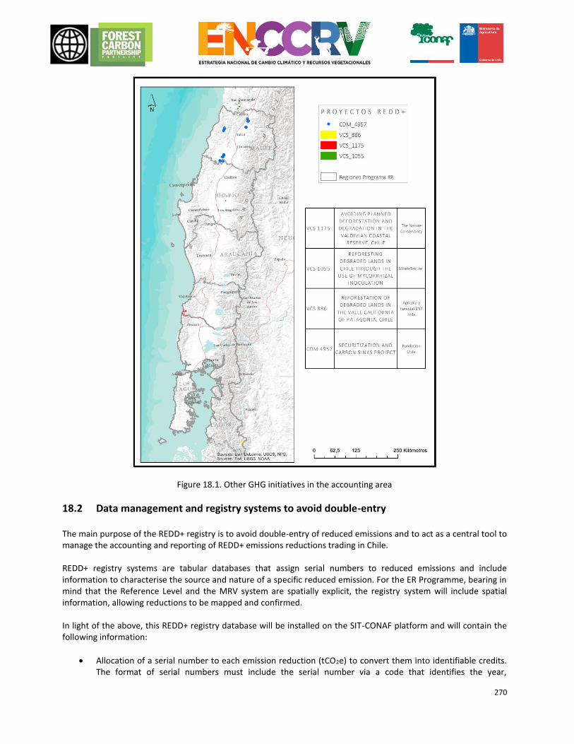
270
Figure 18.1. Other GHG initiatives in the accounting area
18.2 Data management and registry systems to avoid double-entry The main purpose of the REDD+ registry is to avoid double-entry of reduced emissions and to act as a central tool to manage the accounting and reporting of REDD+ emissions reductions trading in Chile. REDD+ registry systems are tabular databases that assign serial numbers to reduced emissions and include information to characterise the source and nature of a specific reduced emission. For the ER Programme, bearing in mind that the Reference Level and the MRV system are spatially explicit, the registry system will include spatial information, allowing reductions to be mapped and confirmed. In light of the above, this REDD+ registry database will be installed on the SIT-CONAF platform and will contain the following information:
Allocation of a serial number to each emission reduction (tCO2e) to convert them into identifiable credits. The format of serial numbers must include the serial number via a code that identifies the year,
271
location/region and municipality in which the reduced emissions were generated, as well as the activity and quantity/number of reduced emissions (for example: 2018-LR-VA-SFM-00001: credit 00001 for sustainable forest management in the Los Ríos region, municipality of Valdivia, generated in 2018)
Geolocation of detailed emissions reductions Used when it is necessary to specify the specific point where reduced emissions were generated so as to avoid double-entry with other emissions reduction projects, primarily VCS and CDM projects. The location is determined, delimited and registered in the necessary detail so as to extract reduced emissions from ER Programme accounts.
The status of the reduced emission will fall into one of the following categories: o Sold
Buyer Date of transaction
o In the buffer account o Available for transaction
Note that each line of the database will represent a reduced emission with its allotted serial number. It is essential that the registry system is able to summarise information and produce reports (in summary tables or graphs) to inform decision-makers. Information will be summarised by applying filters to the database, such as:
o Quantity of emissions generated per year o Quantity of emissions reductions generated per region o Quantity of emissions reductions generated per activity (e.g. prevented deforestation, sustainable
forest management, increased forest carbon content, etc.) o Summary of emissions reduced according to status: sold, in the buffer account or available for
transaction Complementary to the SIT, the official website of the ENCCRV in Spanish (www.enccrv-chile.cl) was launched since June 20, 2016. The website includes spatial location and detailed description of all REDD + projects under implementation on the national territory, including the area of accounting. In addition, the Administration System of Forest Enforcement (SAFF, acronym in Spanish) defines administrative procedures for the operation and permanent record of the management plans approved by the institution. The system will include those Management Plans that consider REDD+ activities. The procedures to conduct audits by third-parties to these registration systems will be agreed timely with the Carbon Fund.
272
ANNEX 1: SUMMARY OF FINANCIAL PLAN
Expected uses of funds Breakdown per year (M US)
Description 2017 2018 2019 2020 2021 2022 2023 2024 2025 Total
Cost of implementing strategic activities
TRANSVERSAL ACTIONS
MT.1. 150,500
-
-
-
-
-
- -
-
150,500
MT.2. 150,500
-
-
-
-
-
- -
-
150,500
MT.3. 50,000
100,000
100,000
100,000
100,000
-
- -
-
450,000
MT.4. 150,000
12,000,000
16,800,000
16,800,000
16,800,000
16,800,000
4,800,000 4,800,000
4,800,000
93,750,000
MT.5. 960,000
10,000,000
10,000,000
10,000,000
10,000,000
45,120
45,120 45,120
45,120
41,140,480
MT.6. 230,000
490,000
410,000
370,000
370,000
170,000
- -
-
2,040,000
MT.7 340,000
60,000
70,000
100,000
100,000
100,000
100,000
100,000
100,000
1,070,000
MT.8 370,000
200,000
200,000
200,000
200,000
200,000
200,000
200,000
200,000
1,970,000
REINFORCEMENT OF PUBLIC MANAGEMENT IN THE PREVENTION OF FOREST FIRES AND THE RESTORATION OF BURNT AREAS
IF.1. 37,950
46,770
60,000
68,820
82,050
104,100
148,200
148,200
148,200
844,290
IF.2. 400,000
350,000
22,500
22,500
22,500
-
- -
-
817,500
IF.3. 377,000
1,881,000
1,881,000
1,881,000
1,881,000
231,000
231,000
231,000
231,000
8,825,000
IF.4. 236,250
236,250
231,000
231,000
231,000
231,000
231,000
231,000
231,000
2,089,500
IF.6. 77,000
154,000
154,000
154,000
154,000
154,000
154,000
154,000
154,000
1,309,000
IMPLEMENTATION OF A PUBLIC MANAGEMENT MODEL FOR THE SUSTAINABLE USE OF FORESTS
US.1. 500,000
223,680
559,200
894,720
1,230,240
1,677,600
1,677,600 1,677,600
1,677,600
10,118,240
US.3. -
89,552
119,403
119,403
119,403
149,254
149,254
149,254
149,254
1,044,776
US.4. -
89,552
119,403
119,403
119,403
149,254
149,254
149,254
149,254
1,044,776
273
US.5. 150,000
-
-
-
-
-
- -
-
150,000
US.6. 854,000
410,000
140,000
140,000
140,000
140,000
140,000
140,000
140,000
2,244,000
IMPLEMENTATION OF MODEL AREAS OF PUBLIC-PRIVATE MANAGEMENT TO ENSURE COMPATIBILITY WITH FOREST AND LIVESTOCK MANAGEMENT
MG.1. -
129,800
129,800
129,800
129,800
129,800
129,800
129,800
129,800
1,038,400
MG.2. -
-
20,000
20,000
-
-
- -
-
40,000
MG.3. 5,250
100,000
100,000
-
-
-
- -
-
205,250
ADAPTIVE MANAGEMENT OF VEGETATION RESOURCES GA.1.
434,000
185,430
1,258,690
258,690
258,690
258,690
258,690
258,690
258,690
3,430,260
REGULATORY ADJUSTMENTS FOR PROGRESSION TOWARDS THE DEVELOPMENT OF AGRICULTURE AND LIVESTOCK FARMING COMPATIBLE WITH NATIVE VEGETATION RESOURCES
RH.1. 50,000
-
-
-
-
-
- -
-
50,000
RH.2. 50,000
-
-
-
-
-
- -
-
50,000
RH.3. 50,000
-
-
-
-
-
- -
-
50,000
Total uses 5,622,450 26,746,034 32,374,996 31,609,336 31,938,086 20,539,817 8,413,917 8,413,917 8,413,917 174,072,472
Expected sources of funds -
Government budget 1,119,950
1,244,562
6,193,553
6,340,733
6,462,323
6,581,324
3,000,000
3,000,000 3,000,000
36,942,445
Donations 4,132,500
25,301,472
8,981,443
25,068,603
25,275,763
-
- -
88,759,781
Loans -
-
-
-
-
-
-
- -
-
Income from the sale of Emissions Reductions (subject to a contract)
-
-
17,000,000
-
-
27,000,000
-
- 16,000,000
60,000,000
Total sources (before taxes) 5,252,450
26,546,034
32,174,996
31,409,336
31,738,086
33,581,324
3,000,000
3,000,000 19,000,000
185,702,226
Net revenue before taxes (=total sources – total uses)
0 0 0 0 0 13,241,506 -5,213,917 -5,213,917 10,786,083 13.599.754*
* The net revenue of 13.6 m in 2015 will be invested in ongoing action measures until 2030.
274
APPENDIX 2. COMPLETE LIST OF INSTITUTIONS SUPPORTING THE ER PROGRAMME
No. Name of partner Contact name,
telephone and email Core capacity and role in the ER Program
1 Swiss Agency for Development and Cooperation (COSUDE)
Jürgen Blasser, Global Advisor
Support of the ENCCRV via technical and financial support from the Forestry NAMA with the Swiss Government.
2 Swiss Agency for Development and Cooperation (SDE)
Jocelyn Ostolaza, Programme Officer
Assisted with the ENCCRV, providing technical and financial support for forest NAMAs along with the Swiss government.
3
International Cooperation and Development Agencies (AGICD), Ministry of Foreign Affairs
Ricardo Herrera, Director of International Cooperation and Development Agencies (AGICD)
Organisation providing various partnerships managed within the National Strategy for Climate Change and Vegetation Resources (ENCCRV) framework with financial assistance, accounting services and bilateral and multilateral international cooperation.
4 Inter-American Development Bank
Francisco Arango, Infrastructure and Environment Sector
Support of the ENCCRV via technical and financial support.
5 World Bank Peter Jipp, Support of the ENCCRV via technical and financial support from the UN REDD Programme.
6 Bolsa del Clima de Santiago (SCX)
Aldo Cerda, General Manager.
Consultant for the ENCCRV Adaptation Line, leader of the Consortium made up of Winrock International, CQC Capital, Global Adaptation Institute Notre Dame. Member of the Technical Group for the Forests and Climate Change Board.
7
Tropical Agriculture Research and Teaching Centre (CATIE)
Research centre affiliated with the consortium responsible for developing an advanced training programme within the ENCCRV framework.
8 Climate Focus Charlotte Streck International Consultant responsible for providing support in the development of the Benefits Distribution System (BDS) within the ENCCRV framework.
9 Mapuche de Quín-Quen community
Joaquin Meliñir Mapuche – Pehuenche Quin-Quen indigenous community. Assisted with the review of the R-PP and participated in FCPF meetings.
10
Department of Environment and Maritime Affairs (DIMA), Ministry of Foreign Affairs.
Waldemar Coutts, Director of Environment and Maritime Affairs (DIMA).
Chile’s political point person at the UNFCCC.
11 Ernst Basler + Partner, Chile
Sergio Saez, Head of Natural Resources and Climate Change Projects
International advisor responsible for assisting with the early implementation of pilot projects and the preparation of preliminary information for FRELs/FRLs within the ENCCRV framework.
12 Ernst Basler + Partner, Switzerland
Joachim Sell, Head of Climate Change Projects
International Consultant in charge of providing support in the early implementation of Pilot Projects and the preparation of preliminary supplies for the FREL/FRL within the ENCCRV framework.
13 Regional FAO Lucio Santos, Technical Advisor
Support of the ENCCRV via technical and financial support from the UN REDD Programme.
14
Foundation for Agricultural Innovation (FIA), Ministry of Agriculture
Aquiles Neueschwander Institution of the Ministry of Agriculture, in charge of delivering developments to projects in the agricultural, livestock and forestry sector.
15
Institute for Agricultural and Livestock Development (INDAP), Ministry of Agriculture
Katherine Schuster, Professional
Institution under the Ministry of Agriculture, responsible for agricultural promotion and development in Chile. Member of the Inter-ministerial Committee on Climate Change for the MINAGRI
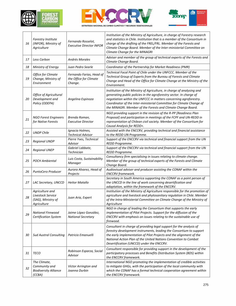
275
16 Forestry Institute (INFOR), Ministry of Agriculture
Fernando Rosselot, Executive Director INFOR
Institution of the Ministry of Agriculture, in charge of Forestry research and statistics in Chile. Institution that is a member of the Consortium in charge of the drafting of the FREL/FRL. Member of the Forests and Climate Change Board. Member of the Inter-ministerial Committee on Climate Change for the MINAGRI
17 Less Carbon Andrés Morales Adviser and member of the group of technical experts of the Forests and Climate Change Board.
18 Ministry of Energy Juan Pedro Searle Coordinator of the Partnership for Market Readiness (PMR)
19 Office for Climate Change, Ministry of Environment
Fernando Farias, Head of the Office for Climate Change.
Technical Focal Point of Chile under the UNFCCC. Member of the Technical Group of Experts from the Bureau of Forests and Climate Change and Head of the Office for Climate Change at the Ministry of the Environment.
20 Office of Agricultural Development and Policy (ODEPA)
Angelina Espinoza
Institution of the Ministry of Agriculture, in charge of analysing and generating public policies in the agroforestry sector. In charge of negotiation within the UNFCCC in matters concerning agroforestry. Coordinator of the Inter-ministerial Committee for Climate Change of the MINAGRI. Member of the Forests and Climate Change Board.
21 NGO Forest Engineers for Native Forests
Brenda Roman, Executive Director
NGO providing support in the revision of the R-PP [Readiness Plan Proposal] and participation in meetings of the FCPF and UN-REDD in representation of Chilean civil society. Member of the Consortium for Causal Analysis for REDD+.
22 UNDP Chile Ignacia Holmes, Technical Advisor
Assisted with the ENCCRV, providing technical and financial assistance to the REDD UN Programme.
23 Regional UNDP Pierre Yves, Technical Advisor
Support of the ENCCRV via technical and financial support from the UN REDD Programme.
24 Regional UNEP Gabriel Labbate, Technician
Support of the ENCCRV via technical and financial support from the UN REDD Programme.
25 POCH Ambiental Luis Costa, Sustainability Manager
Consultancy firm specialising in issues relating to climate change. Member of the group of technical experts of the Forests and Climate Change Board.
26 PuntoCero Producer Aurora Alvarez, Head of Projects
Audiovisual adviser and producer assisting the CONAF within the ENCCRV framework.
27 LAC Secretary, UNCCD Heitor Matallo Secretary in South America supporting the CONAF as a point person of the UNCCD in the line of work concerning desertification and adaptation, within the framework of the ENCCRV.
28
Agriculture and Livestock Service (SAG), Ministry of Agriculture
Juan Aria, Expert
Institution of the Ministry of Agriculture responsible for the promotion of agriculture and livestock and phytosanitary regulation in Chile. Member of the Intra-Ministerial Committee on Climate Change of the Ministry of Agriculture
29 National Firewood Certification System
Jaime López González, National Secretary
NGO in charge of leading the Consortium that supports the early implementation of Pilot Projects. Support for the diffusion of the ENCCRV with emphasis on issues relating to the sustainable use of firewood.
30 Sud Austral Consulting Patricio Emanuelli
Consultant in charge of providing legal support for the analysis of forestry development instruments, leading the Consortium to support the early implementation of Pilot Projects and the alignment of the National Action Plan of the United Nations Convention to Combat Desertification (UNCCD) under the ENCCRV.
31 TECO Robinson Esparza, Social Advisor
Consultant responsible for providing support in the development of the participatory processes and Benefits Distribution System (BDS) within the ENCCRV framework.
32
The Climate, Community and Biodiversity Alliance (CCBA)
Víctor Arrington and Joanna Durbin
International NGO promoting the implementation of credible activities to mitigate GHGs, with the participation of the local community with which the CONAF has a formal technical cooperation agreement within the ENCCRV framework.
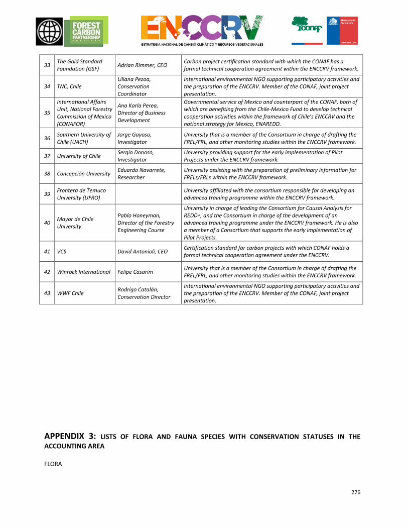
276
33 The Gold Standard Foundation (GSF)
Adrian Rimmer, CEO Carbon project certification standard with which the CONAF has a formal technical cooperation agreement within the ENCCRV framework.
34 TNC, Chile Liliana Pezoa, Conservation Coordinator
International environmental NGO supporting participatory activities and the preparation of the ENCCRV. Member of the CONAF, joint project presentation.
35
International Affairs Unit, National Forestry Commission of Mexico (CONAFOR)
Ana Karla Perea, Director of Business Development
Governmental service of Mexico and counterpart of the CONAF, both of which are benefiting from the Chile-Mexico Fund to develop technical cooperation activities within the framework of Chile’s ENCCRV and the national strategy for Mexico, ENAREDD.
36 Southern University of Chile (UACH)
Jorge Gayoso, Investigator
University that is a member of the Consortium in charge of drafting the FREL/FRL, and other monitoring studies within the ENCCRV framework.
37 University of Chile Sergio Donoso, Investigator
University providing support for the early implementation of Pilot Projects under the ENCCRV framework.
38 Concepción University Eduardo Navarrete, Researcher
University assisting with the preparation of preliminary information for FRELs/FRLs within the ENCCRV framework.
39 Frontera de Temuco University (UFRO)
University affiliated with the consortium responsible for developing an advanced training programme within the ENCCRV framework.
40 Mayor de Chile University
Pablo Honeyman, Director of the Forestry Engineering Course
University in charge of leading the Consortium for Causal Analysis for REDD+, and the Consortium in charge of the development of an advanced training programme under the ENCCRV framework. He is also a member of a Consortium that supports the early implementation of Pilot Projects.
41 VCS David Antonioli, CEO Certification standard for carbon projects with which CONAF holds a formal technical cooperation agreement under the ENCCRV.
42 Winrock International Felipe Casarim University that is a member of the Consortium in charge of drafting the FREL/FRL, and other monitoring studies within the ENCCRV framework.
43 WWF Chile Rodrigo Catalán, Conservation Director
International environmental NGO supporting participatory activities and the preparation of the ENCCRV. Member of the CONAF, joint project presentation.
APPENDIX 3: LISTS OF FLORA AND FAUNA SPECIES WITH CONSERVATION STATUSES IN THE
ACCOUNTING AREA
FLORA
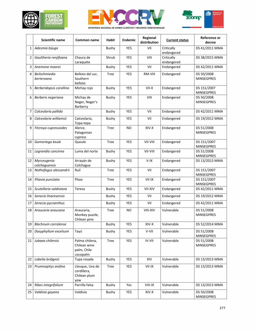
277
Scientific name Common name Habit Endemic
Regional distribution
Current status Reference or
decree
1 Adesmia bijuga Bushy YES VII Critically endangered
DS 41/2011 MMA
2 Gaultheria renjifoana Chaura de Laraquete
Shrub YES VIII Critically endangered
DS 38/2015 MMA
3 Anemone moorei Bushy YES VII Endangered DS 42/2011 MMA
4 Beilschmiedia berteroana
Belloto del sur, Southern belloto
Tree YES RM-VIII Endangered DS 50/2008 MINSEGPRES
5 Berberidopsis corallina Michay rojo Bushy YES VII-X Endangered DS 151/2007 MINSEGPRES
6 Berberis negeriana Michay de Neger, Neger’s Barberry
Bushy YES VIII Endangered DS 50/2008 MINSEGPRES
7 Calceolaria pallida Bushy YES VII Endangered DS 42/2011 MMA
8 Calceolaria williamsii Calceolaria, Topa-topa
Bushy YES VII Endangered DS 19/2012 MMA
9 Fitzroya cupressoides Alerce, Patagonian cypress
Tree NO XIV-X Endangered DS 51/2008 MINSEGPRES
10 Gomortega keule Queule Tree YES VII-VIII Endangered DS 151/2007 MINSEGPRES
11 Legrandia concinna Luma del norte Bushy YES VII-VIII Endangered DS 51/2008 MINSEGPRES
12 Myrceugenia colchaguensis
Arrayán de Colchagua
Bushy YES V-IX Endangered DS 13/2013 MMA
13 Nothofagus alessandrii Ruil Tree YES VII Endangered DS 151/2007 MINSEGPRES
14 Pitavia punctata Pitao Tree YES VII-IX Endangered DS 151/2007 MINSEGPRES
15 Scutellaria valdiviana Teresa Bushy YES VII-XIV Endangered DS 42/2011 MMA
16 Senecio linaresensis Bushy YES VII Endangered DS 19/2012 MMA
17 Senecio pycnanthus Bushy YES VII Endangered DS 42/2011 MMA
18 Araucaria araucana Araucaria, Monkey puzzle, Chilean pine
Tree NO VIII-XIV Vulnerable DS 51/2008 MINSEGPRES
19 Blechnum corralense Bushy YES XIV-X Vulnerable DS 52/2014 MMA
20 Dasyphyllum excelsum Tayú Bushy YES V-VII Vulnerable DS 51/2008 MINSEGPRES
21 Jubaea chilensis Palma chilena, Chilean wine palm, Chile cocopalm
Tree YES IV-VII Vulnerable DS 51/2008 MINSEGPRES
22 Lobelia bridgesii Tupa rosada Bushy YES XIV Vulnerable DS 13/2013 MMA
23 Prumnopitys andina Lleuque, Uva de cordillera, Chilean plum yew
Tree YES VII-IX Vulnerable DS 13/2013 MMA
24 Ribes integrifolium Parrilla falsa Bushy Yes VIII-IX Vulnerable DS 13/2013 MMA
25 Valdivia gayana Valdivia Bushy YES XIV-X Vulnerable DS 50/2008 MINSEGPRES
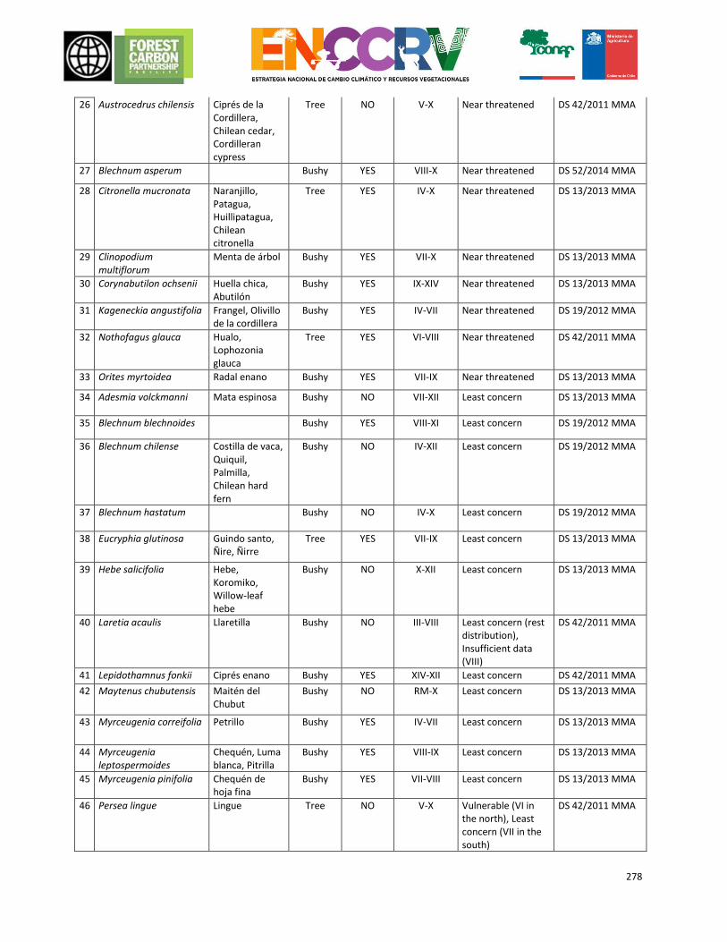
278
26 Austrocedrus chilensis Ciprés de la Cordillera, Chilean cedar, Cordilleran cypress
Tree NO V-X Near threatened DS 42/2011 MMA
27 Blechnum asperum Bushy YES VIII-X Near threatened DS 52/2014 MMA
28 Citronella mucronata Naranjillo, Patagua, Huillipatagua, Chilean citronella
Tree YES IV-X Near threatened DS 13/2013 MMA
29 Clinopodium multiflorum
Menta de árbol Bushy YES VII-X Near threatened DS 13/2013 MMA
30 Corynabutilon ochsenii Huella chica, Abutilón
Bushy YES IX-XIV Near threatened DS 13/2013 MMA
31 Kageneckia angustifolia Frangel, Olivillo de la cordillera
Bushy YES IV-VII Near threatened DS 19/2012 MMA
32 Nothofagus glauca Hualo, Lophozonia glauca
Tree YES VI-VIII Near threatened DS 42/2011 MMA
33 Orites myrtoidea Radal enano Bushy YES VII-IX Near threatened DS 13/2013 MMA
34 Adesmia volckmanni Mata espinosa Bushy NO VII-XII Least concern DS 13/2013 MMA
35 Blechnum blechnoides Bushy YES VIII-XI Least concern DS 19/2012 MMA
36 Blechnum chilense Costilla de vaca, Quiquil, Palmilla, Chilean hard fern
Bushy NO IV-XII Least concern DS 19/2012 MMA
37 Blechnum hastatum Bushy NO IV-X Least concern DS 19/2012 MMA
38 Eucryphia glutinosa Guindo santo, Ñire, Ñirre
Tree YES VII-IX Least concern DS 13/2013 MMA
39 Hebe salicifolia Hebe, Koromiko, Willow-leaf hebe
Bushy NO X-XII Least concern DS 13/2013 MMA
40 Laretia acaulis Llaretilla Bushy NO III-VIII Least concern (rest distribution), Insufficient data (VIII)
DS 42/2011 MMA
41 Lepidothamnus fonkii Ciprés enano Bushy YES XIV-XII Least concern DS 42/2011 MMA
42 Maytenus chubutensis Maitén del Chubut
Bushy NO RM-X Least concern DS 13/2013 MMA
43 Myrceugenia correifolia Petrillo Bushy YES IV-VII Least concern DS 13/2013 MMA
44 Myrceugenia leptospermoides
Chequén, Luma blanca, Pitrilla
Bushy YES VIII-IX Least concern DS 13/2013 MMA
45 Myrceugenia pinifolia Chequén de hoja fina
Bushy YES VII-VIII Least concern DS 13/2013 MMA
46 Persea lingue Lingue Tree NO V-X Vulnerable (VI in the north), Least concern (VII in the south)
DS 42/2011 MMA
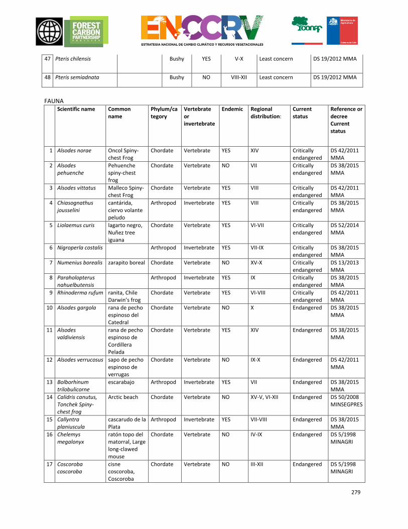
279
47 Pteris chilensis Bushy YES V-X Least concern DS 19/2012 MMA
48 Pteris semiadnata Bushy NO VIII-XII Least concern DS 19/2012 MMA
FAUNA Scientific name Common
name Phylum/category
Vertebrate or invertebrate
Endemic Regional distribution:
Current status
Reference or decree Current status
1 Alsodes norae Oncol Spiny-chest Frog
Chordate Vertebrate YES XIV Critically endangered
DS 42/2011 MMA
2 Alsodes pehuenche
Pehuenche spiny-chest frog
Chordate Vertebrate NO VII Critically endangered
DS 38/2015 MMA
3 Alsodes vittatus Malleco Spiny-chest Frog
Chordate Vertebrate YES VIII Critically endangered
DS 42/2011 MMA
4 Chiasognathus jousselini
cantárida, ciervo volante peludo
Arthropod Invertebrate YES VIII Critically endangered
DS 38/2015 MMA
5 Liolaemus curis lagarto negro, Nuñez tree iguana
Chordate Vertebrate YES VI-VII Critically endangered
DS 52/2014 MMA
6 Nigroperla costalis Arthropod Invertebrate YES VII-IX Critically endangered
DS 38/2015 MMA
7 Numenius borealis zarapito boreal Chordate Vertebrate NO XV-X Critically endangered
DS 13/2013 MMA
8 Paraholopterus nahuelbutensis
Arthropod Invertebrate YES IX Critically endangered
DS 38/2015 MMA
9 Rhinoderma rufum ranita, Chile Darwin’s frog
Chordate Vertebrate YES VI-VIII Critically endangered
DS 42/2011 MMA
10 Alsodes gargola rana de pecho espinoso del Catedral
Chordate Vertebrate NO X Endangered DS 38/2015 MMA
11 Alsodes valdiviensis
rana de pecho espinoso de Cordillera Pelada
Chordate Vertebrate YES XIV Endangered DS 38/2015 MMA
12 Alsodes verrucosus sapo de pecho espinoso de verrugas
Chordate Vertebrate NO IX-X Endangered DS 42/2011 MMA
13 Bolborhinum trilobulicorne
escarabajo Arthropod Invertebrate YES VII Endangered DS 38/2015 MMA
14 Calidris canutus, Tonchek Spiny-chest frog
Arctic beach Chordate Vertebrate NO XV-V, VI-XII Endangered DS 50/2008 MINSEGPRES
15 Callyntra planiuscula
cascarudo de la Plata
Arthropod Invertebrate YES VII-VIII Endangered DS 38/2015 MMA
16 Chelemys megalonyx
ratón topo del matorral, Large long-clawed mouse
Chordate Vertebrate NO IV-IX Endangered DS 5/1998 MINAGRI
17 Coscoroba coscoroba
cisne coscoroba, Coscoroba
Chordate Vertebrate NO III-XII Endangered DS 5/1998 MINAGRI
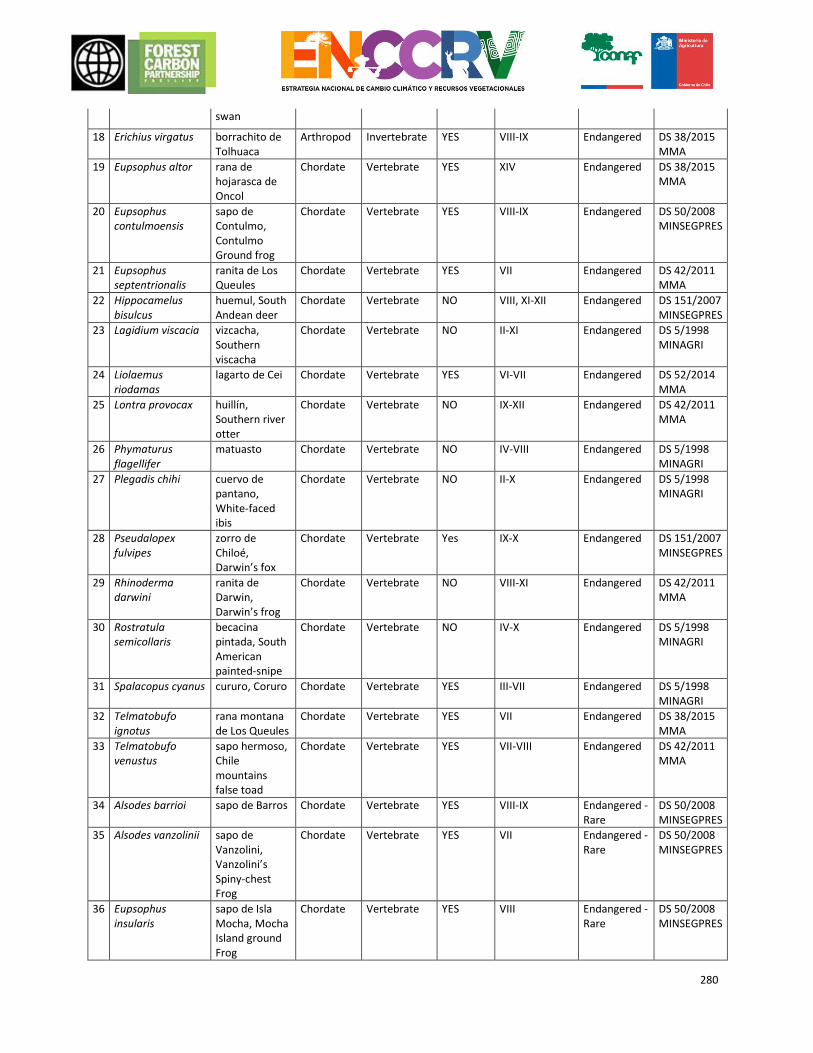
280
swan
18 Erichius virgatus borrachito de Tolhuaca
Arthropod Invertebrate YES VIII-IX Endangered DS 38/2015 MMA
19 Eupsophus altor rana de hojarasca de Oncol
Chordate Vertebrate YES XIV Endangered DS 38/2015 MMA
20 Eupsophus contulmoensis
sapo de Contulmo, Contulmo Ground frog
Chordate Vertebrate YES VIII-IX Endangered DS 50/2008 MINSEGPRES
21 Eupsophus septentrionalis
ranita de Los Queules
Chordate Vertebrate YES VII Endangered DS 42/2011 MMA
22 Hippocamelus bisulcus
huemul, South Andean deer
Chordate Vertebrate NO VIII, XI-XII Endangered DS 151/2007 MINSEGPRES
23 Lagidium viscacia vizcacha, Southern viscacha
Chordate Vertebrate NO II-XI Endangered DS 5/1998 MINAGRI
24 Liolaemus riodamas
lagarto de Cei Chordate Vertebrate YES VI-VII Endangered DS 52/2014 MMA
25 Lontra provocax huillín, Southern river otter
Chordate Vertebrate NO IX-XII Endangered DS 42/2011 MMA
26 Phymaturus flagellifer
matuasto Chordate Vertebrate NO IV-VIII Endangered DS 5/1998 MINAGRI
27 Plegadis chihi cuervo de pantano, White-faced ibis
Chordate Vertebrate NO II-X Endangered DS 5/1998 MINAGRI
28 Pseudalopex fulvipes
zorro de Chiloé, Darwin’s fox
Chordate Vertebrate Yes IX-X Endangered DS 151/2007 MINSEGPRES
29 Rhinoderma darwini
ranita de Darwin, Darwin’s frog
Chordate Vertebrate NO VIII-XI Endangered DS 42/2011 MMA
30 Rostratula semicollaris
becacina pintada, South American painted-snipe
Chordate Vertebrate NO IV-X Endangered DS 5/1998 MINAGRI
31 Spalacopus cyanus cururo, Coruro Chordate Vertebrate YES III-VII Endangered DS 5/1998 MINAGRI
32 Telmatobufo ignotus
rana montana de Los Queules
Chordate Vertebrate YES VII Endangered DS 38/2015 MMA
33 Telmatobufo venustus
sapo hermoso, Chile mountains false toad
Chordate Vertebrate YES VII-VIII Endangered DS 42/2011 MMA
34 Alsodes barrioi sapo de Barros Chordate Vertebrate YES VIII-IX Endangered - Rare
DS 50/2008 MINSEGPRES
35 Alsodes vanzolinii sapo de Vanzolini, Vanzolini’s Spiny-chest Frog
Chordate Vertebrate YES VII Endangered - Rare
DS 50/2008 MINSEGPRES
36 Eupsophus insularis
sapo de Isla Mocha, Mocha Island ground Frog
Chordate Vertebrate YES VIII Endangered - Rare
DS 50/2008 MINSEGPRES
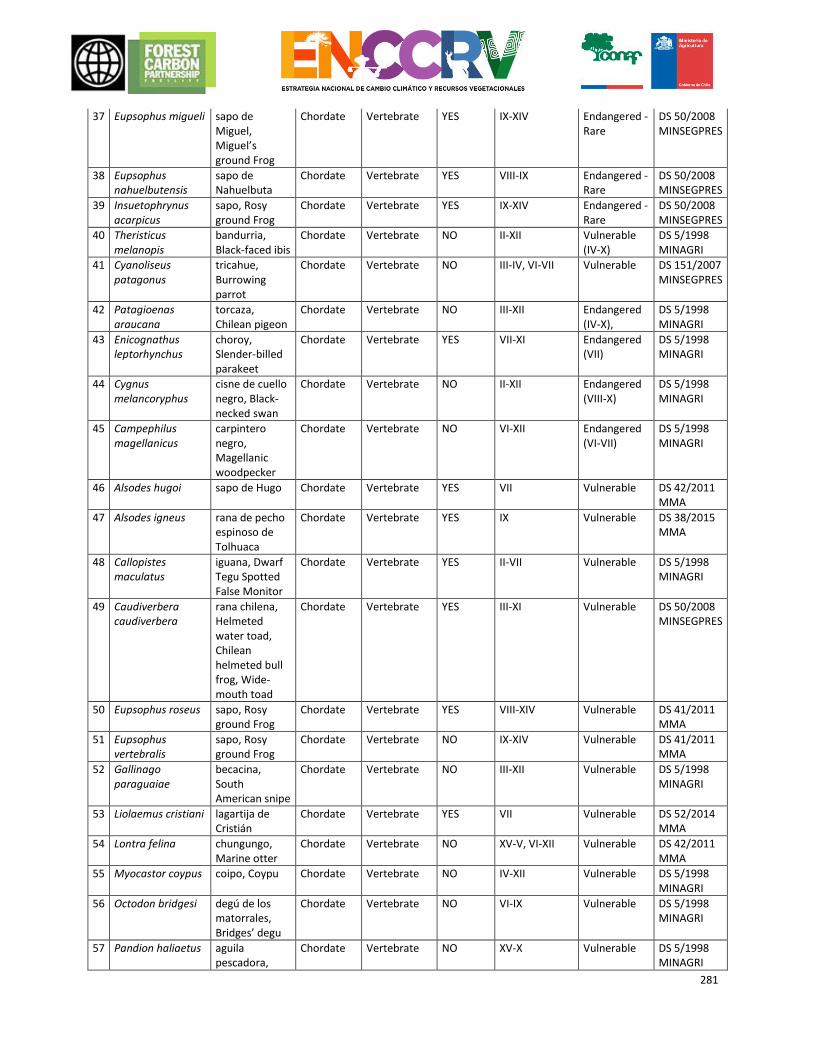
281
37 Eupsophus migueli sapo de Miguel, Miguel’s ground Frog
Chordate Vertebrate YES IX-XIV Endangered - Rare
DS 50/2008 MINSEGPRES
38 Eupsophus nahuelbutensis
sapo de Nahuelbuta
Chordate Vertebrate YES VIII-IX Endangered - Rare
DS 50/2008 MINSEGPRES
39 Insuetophrynus acarpicus
sapo, Rosy ground Frog
Chordate Vertebrate YES IX-XIV Endangered - Rare
DS 50/2008 MINSEGPRES
40 Theristicus melanopis
bandurria, Black-faced ibis
Chordate Vertebrate NO II-XII Vulnerable (IV-X)
DS 5/1998 MINAGRI
41 Cyanoliseus patagonus
tricahue, Burrowing parrot
Chordate Vertebrate NO III-IV, VI-VII Vulnerable DS 151/2007 MINSEGPRES
42 Patagioenas araucana
torcaza, Chilean pigeon
Chordate Vertebrate NO III-XII Endangered (IV-X),
DS 5/1998 MINAGRI
43 Enicognathus leptorhynchus
choroy, Slender-billed parakeet
Chordate Vertebrate YES VII-XI Endangered (VII)
DS 5/1998 MINAGRI
44 Cygnus melancoryphus
cisne de cuello negro, Black-necked swan
Chordate Vertebrate NO II-XII Endangered (VIII-X)
DS 5/1998 MINAGRI
45 Campephilus magellanicus
carpintero negro, Magellanic woodpecker
Chordate Vertebrate NO VI-XII Endangered (VI-VII)
DS 5/1998 MINAGRI
46 Alsodes hugoi sapo de Hugo Chordate Vertebrate YES VII Vulnerable DS 42/2011 MMA
47 Alsodes igneus rana de pecho espinoso de Tolhuaca
Chordate Vertebrate YES IX Vulnerable DS 38/2015 MMA
48 Callopistes maculatus
iguana, Dwarf Tegu Spotted False Monitor
Chordate Vertebrate YES II-VII Vulnerable DS 5/1998 MINAGRI
49 Caudiverbera caudiverbera
rana chilena, Helmeted water toad, Chilean helmeted bull frog, Wide-mouth toad
Chordate Vertebrate YES III-XI Vulnerable DS 50/2008 MINSEGPRES
50 Eupsophus roseus sapo, Rosy ground Frog
Chordate Vertebrate YES VIII-XIV Vulnerable DS 41/2011 MMA
51 Eupsophus vertebralis
sapo, Rosy ground Frog
Chordate Vertebrate NO IX-XIV Vulnerable DS 41/2011 MMA
52 Gallinago paraguaiae
becacina, South American snipe
Chordate Vertebrate NO III-XII Vulnerable DS 5/1998 MINAGRI
53 Liolaemus cristiani lagartija de Cristián
Chordate Vertebrate YES VII Vulnerable DS 52/2014 MMA
54 Lontra felina chungungo, Marine otter
Chordate Vertebrate NO XV-V, VI-XII Vulnerable DS 42/2011 MMA
55 Myocastor coypus coipo, Coypu Chordate Vertebrate NO IV-XII Vulnerable DS 5/1998 MINAGRI
56 Octodon bridgesi degú de los matorrales, Bridges’ degu
Chordate Vertebrate NO VI-IX Vulnerable DS 5/1998 MINAGRI
57 Pandion haliaetus aguila pescadora,
Chordate Vertebrate NO XV-X Vulnerable DS 5/1998 MINAGRI
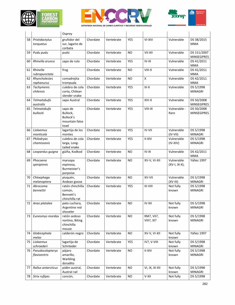
282
Osprey
58 Pristidactylus torquatus
gruñidor del sur, lagarto de corbata
Chordate Vertebrate YES VI-XIV Vulnerable DS 38/2015 MMA
59 Pudu pudu pudú Chordate Vertebrate NO VII-XII Vulnerable DS 151/2007 MINSEGPRES
60 Rhinella arunco sapo de rulo Chordate Vertebrate YES IV-IX Vulnerable DS 41/2011 MMA
61 Rhinella rubropunctata
frog Chordate Vertebrate NO VIII-X Vulnerable DS 41/2011 MMA
62 Rhyncholestes raphanurus
comadrejita trompuda
Chordate Vertebrate NO X Vulnerable DS 42/2011 MMA
63 Tachymenis chilensis
culebra de cola corta, Chilean slender snake
Chordate Vertebrate YES III-X Vulnerable DS 5/1998 MINAGRI
64 Telmatobufo australis
sapo Austral Chordate Vertebrate YES XIV-X Vulnerable DS 50/2008 MINSEGPRES
65 Telmatobufo bullocki
sapo de Bullock, Bullock’s mountain false toad
Chordate Vertebrate YES VIII-IX Vulnerable - Rare
DS 50/2008 MINSEGPRES
66 Liolaemus monticola
lagartija de los montes
Chordate Vertebrate YES IV-VII Vulnerable (IV-VII)
DS 5/1998 MINAGRI
67 Philodryas chamissonis
culebra de cola larga, Long-tailed snake
Chordate Vertebrate YES II-XIV Vulnerable (IV-XIV)
DS 5/1998 MINAGRI
68 Leopardus guigna güiña, Kodkod Chordate Vertebrate NO IV-XI Vulnerable DS 42/2011 MMA
69 Phocoena spinipinnis
marsopa espinosa, Burmeister’s porpoise
Chordate Vertebrate NO XV-V, VI-XII Vulnerable (XV-I, IX-X),
Yáñez 1997
70 Chloephaga melanoptera
piuquén, Andean goose
Chordate Vertebrate NO XV-VII Vulnerable (XV-III)
DS 5/1998 MINAGRI
71 Abrocoma bennettii
ratón chinchilla común, Bennett’s chinchilla rat
Chordate Vertebrate YES III-VIII Not fully known
DS 5/1998 MINAGRI
72 Anas platalea pato cuchara, Argentine red shoveler
Chordate Vertebrate NO IV-XII Not fully known
DS 5/1998 MINAGRI
73 Euneomys mordax ratón sedoso nortino, Biting chinchilla mouse
Chordate Vertebrate NO RM?, VII?, VIII?, IX?
Not fully known
DS 5/1998 MINAGRI
74 Globicephala melas
calderón negro Chordate Vertebrate NO XV-V, VI-XII Not fully known
Yáñez 1997
75 Liolaemus schroederi
lagartija de Schröeder
Chordate Vertebrate YES IV?, V-VIII Not fully known
DS 5/1998 MINAGRI
76 Pseudocolopteryx flaviventris
pájaro amarillo, Warbling doradito
Chordate Vertebrate NO II-XIV Not fully known
DS 5/1998 MINAGRI
77 Rallus antarcticus pidén austral, Austral rail
Chordate Vertebrate NO VI, IX, XI-XII Not fully known
DS 5/1998 MINAGRI
78 Strix rufipes concón, Chordate Vertebrate NO V-XII Not fully DS 5/1998
283
Rufous-legged owl
known MINAGRI
79 Tachyeres patagonicus
quetru volador, Flying steamer-duck
Chordate Vertebrate NO VII-XII Not fully known
DS 5/1998 MINAGRI
80 Accipiter chilensis peuquito, Chilean hawk
Chordate Vertebrate NO IV-XII Rare DS 5/1998 MINAGRI
81 Ardea cocoi garza cuca, Cocoi heron
Chordate Vertebrate NO I-XII Rare DS 5/1998 MINAGRI
82 Buteo albigula aguilucho chico, White-throated hawk
Chordate Vertebrate NO III-XI Rare DS 5/1998 MINAGRI
83 Buteo ventralis aguilucho de cola rojiza, Rufous-tailed hawk
Chordate Vertebrate NO VII-XII Rare DS 5/1998 MINAGRI
84 Conepatus chinga chingue común, Molina’s Hog-Nosed Skunk
Chordate Vertebrate NO IV-X Rare DS 5/1998 MINAGRI
85 Heteronetta atricapilla
pato rinconero, Black-headed duck
Chordate Vertebrate NO V-X Rare DS 5/1998 MINAGRI
86 Ixobrychus involucris
huairavillo, Stripe-backed bittern
Chordate Vertebrate NO III-X Rare DS 5/1998 MINAGRI
87 Liolaemus buergeri
lagartija de Bürger
Chordate Vertebrate NO VI?, VII, VIII? Rare DS 5/1998 MINAGRI
88 Liolaemus kriegi lagarto de Krieg, Krieg’s tree iguana
Chordate Vertebrate NO VI-VIII Rare DS 5/1998 MINAGRI
89 Thylamys elegans llaca o Marmosa, Elegant fat-tailed mouse opossum
Chordate Vertebrate YES II-VIII Rare DS 5/1998 MINAGRI
APPENDIX 4. METHODOLOGY FOR THE CHARACTERISATION OF THE CAUSES OF DEFORESTATION,
DEGRADATION AND NON-INCREASES OF FOREST STOCK, AND ACTION MEASURE PROPOSALS
In order to develop this process, a specific study was conducted as part of the ENCCRV following a year of consultations. It was developed by a technical consortium which included an academic institution (Mayor University), an international consultancy firm (EBP) with experience in the subject area, a department of the
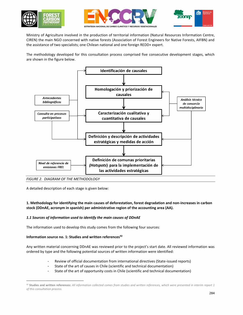
284
Ministry of Agriculture involved in the production of territorial information (Natural Resources Information Centre, CIREN) the main NGO concerned with native forests (Association of Forest Engineers for Native Forests, AIFBN) and the assistance of two specialists; one Chilean national and one foreign REDD+ expert. The methodology developed for this consultation process comprised five consecutive development stages, which are shown in the figure below.
FIGURE 2. DIAGRAM OF THE METHODOLOGY
A detailed description of each stage is given below: 1. Methodology for identifying the main causes of deforestation, forest degradation and non-increases in carbon stock (DDnAE, acronym in spanish) per administrative region of the accounting area (AA). 1.1 Sources of information used to identify the main causes of DDnAE The information used to develop this study comes from the following four sources: Information source no. 1: Studies and written references92 Any written material concerning DDnAE was reviewed prior to the project’s start date. All reviewed information was ordered by type and the following potential sources of written information were identified:
- Review of official documentation from international directives (State-issued reports) - State of the art of causes in Chile (scientific and technical documentation) - State of the art of opportunity costs in Chile (scientific and technical documentation)
92 Studies and written references: All information collected comes from studies and written references, which were presented in interim report 1 of this consultation process.
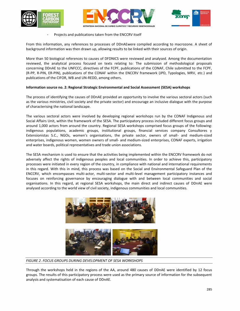
285
- Projects and publications taken from the ENCCRV itself
From this information, any references to processes of DDnAEwere compiled according to macrozone. A sheet of background information was then drawn up, allowing results to be linked with their sources of origin. More than 50 biological references to causes of DFDNICS were reviewed and analysed. Among the documentation reviewed, the analytical process focused on texts relating to: The submission of methodological proposals concerning DDnAE to the UNFCCC, directives of the FCPF, publications of the CONAF, Chile submitted to the FCPF, (R-PP, R-PIN, ER-PIN), publications of the CONAF within the ENCCRV framework (JPD, Typologies, MRV, etc.) and publications of the CIFOR, WB and UN-REDD, among others. Information source no. 2: Regional Strategic Environmental and Social Assessment (SESA) workshops The process of identifying the causes of DDnAE provided an opportunity to involve the various sectoral actors (such as the various ministries, civil society and the private sector) and encourage an inclusive dialogue with the purpose of characterising the national landscape. The various sectoral actors were involved by developing regional workshops run by the CONAF Indigenous and Social Affairs Unit, within the framework of the SESA. The participatory process included different focus groups and around 1,000 actors from around the country. Regional SESA workshops comprised focus groups of the following: indigenous populations, academic groups, institutional groups, financial services company Consultores y Extensionistas S.C., NGOs, women’s organisations, the private sector, owners of small- and medium-sized enterprises, indigenous women, women owners of small- and medium-sized enterprises, CONAF experts, irrigation and water boards, political representatives and trade union associations. The SESA mechanism is used to ensure that the activities being implemented within the ENCCRV framework do not adversely affect the rights of indigenous peoples and local communities. In order to achieve this, participatory processes were initiated in every region of the country, in compliance with national and international requirements in this regard. With this in mind, this process was based on the Social and Environmental Safeguard Plan of the ENCCRV, which encompasses multi-actor, multi-sector and multi-level management participatory instances and focuses on reinforcing governance by encouraging dialogue with and between local communities and social organisations. In this regard, at regional SESA workshops, the main direct and indirect causes of DDnAE were analysed according to the world view of civil society, indigenous communities and local communities.
FIGURE 2. FOCUS GROUPS DURING DEVELOPMENT OF SESA WORKSHOPS
Through the workshops held in the regions of the AA, around 480 causes of DDnAE were identified by 12 focus groups. The results of this participatory process were used as the primary source of information for the subsequent analysis and systematisation of each cause of DDnAE.
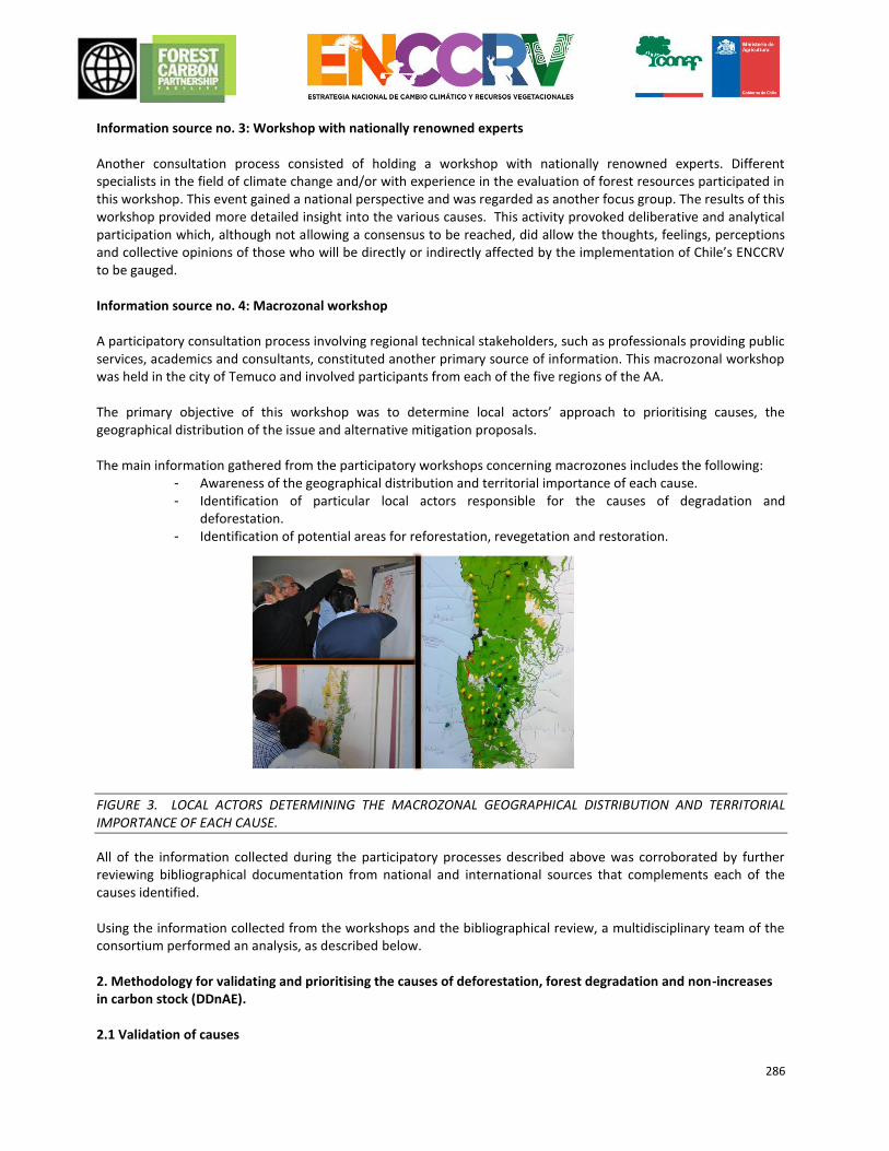
286
Information source no. 3: Workshop with nationally renowned experts Another consultation process consisted of holding a workshop with nationally renowned experts. Different specialists in the field of climate change and/or with experience in the evaluation of forest resources participated in this workshop. This event gained a national perspective and was regarded as another focus group. The results of this workshop provided more detailed insight into the various causes. This activity provoked deliberative and analytical participation which, although not allowing a consensus to be reached, did allow the thoughts, feelings, perceptions and collective opinions of those who will be directly or indirectly affected by the implementation of Chile’s ENCCRV to be gauged. Information source no. 4: Macrozonal workshop A participatory consultation process involving regional technical stakeholders, such as professionals providing public services, academics and consultants, constituted another primary source of information. This macrozonal workshop was held in the city of Temuco and involved participants from each of the five regions of the AA. The primary objective of this workshop was to determine local actors’ approach to prioritising causes, the geographical distribution of the issue and alternative mitigation proposals. The main information gathered from the participatory workshops concerning macrozones includes the following:
- Awareness of the geographical distribution and territorial importance of each cause. - Identification of particular local actors responsible for the causes of degradation and
deforestation. - Identification of potential areas for reforestation, revegetation and restoration.
FIGURE 3. LOCAL ACTORS DETERMINING THE MACROZONAL GEOGRAPHICAL DISTRIBUTION AND TERRITORIAL IMPORTANCE OF EACH CAUSE.
All of the information collected during the participatory processes described above was corroborated by further reviewing bibliographical documentation from national and international sources that complements each of the causes identified. Using the information collected from the workshops and the bibliographical review, a multidisciplinary team of the consortium performed an analysis, as described below.
2. Methodology for validating and prioritising the causes of deforestation, forest degradation and non-increases in carbon stock (DDnAE). 2.1 Validation of causes
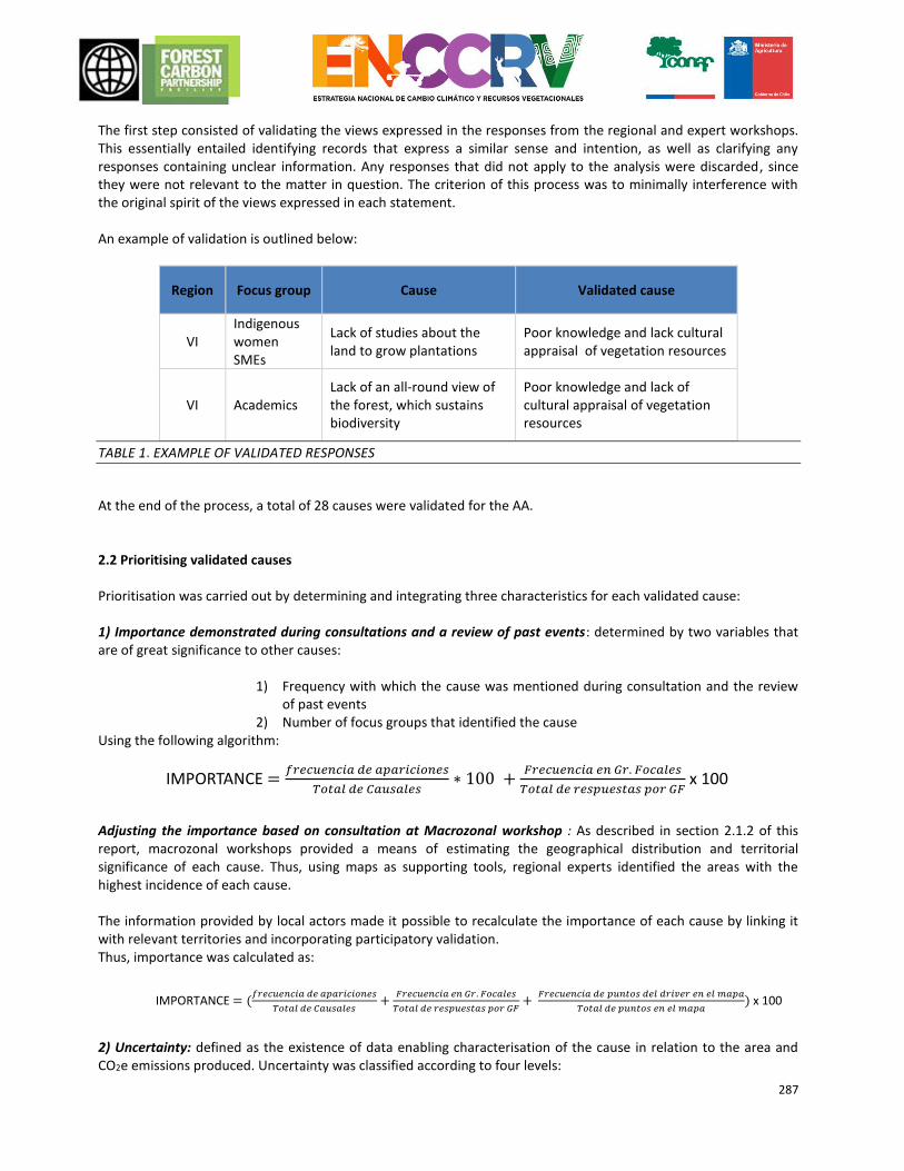
287
The first step consisted of validating the views expressed in the responses from the regional and expert workshops. This essentially entailed identifying records that express a similar sense and intention, as well as clarifying any responses containing unclear information. Any responses that did not apply to the analysis were discarded, since they were not relevant to the matter in question. The criterion of this process was to minimally interference with the original spirit of the views expressed in each statement. An example of validation is outlined below:
Region Focus group Cause Validated cause
VI Indigenous women SMEs
Lack of studies about the land to grow plantations
Poor knowledge and lack cultural appraisal of vegetation resources
VI Academics Lack of an all-round view of the forest, which sustains biodiversity
Poor knowledge and lack of cultural appraisal of vegetation resources
TABLE 1. EXAMPLE OF VALIDATED RESPONSES
At the end of the process, a total of 28 causes were validated for the AA. 2.2 Prioritising validated causes
Prioritisation was carried out by determining and integrating three characteristics for each validated cause: 1) Importance demonstrated during consultations and a review of past events: determined by two variables that are of great significance to other causes:
1) Frequency with which the cause was mentioned during consultation and the review of past events
2) Number of focus groups that identified the cause Using the following algorithm: Adjusting the importance based on consultation at Macrozonal workshop : As described in section 2.1.2 of this report, macrozonal workshops provided a means of estimating the geographical distribution and territorial significance of each cause. Thus, using maps as supporting tools, regional experts identified the areas with the highest incidence of each cause. The information provided by local actors made it possible to recalculate the importance of each cause by linking it with relevant territories and incorporating participatory validation. Thus, importance was calculated as: 2) Uncertainty: defined as the existence of data enabling characterisation of the cause in relation to the area and CO2e emissions produced. Uncertainty was classified according to four levels:
IMPORTANCE =𝑓𝑟𝑒𝑐𝑢𝑒𝑛𝑐𝑖𝑎 𝑑𝑒 𝑎𝑝𝑎𝑟𝑖𝑐𝑖𝑜𝑛𝑒𝑠
𝑇𝑜𝑡𝑎𝑙 𝑑𝑒 𝐶𝑎𝑢𝑠𝑎𝑙𝑒𝑠∗ 100 +
𝐹𝑟𝑒𝑐𝑢𝑒𝑛𝑐𝑖𝑎 𝑒𝑛 𝐺𝑟. 𝐹𝑜𝑐𝑎𝑙𝑒𝑠
𝑇𝑜𝑡𝑎𝑙 𝑑𝑒 𝑟𝑒𝑠𝑝𝑢𝑒𝑠𝑡𝑎𝑠 𝑝𝑜𝑟 𝐺𝐹 x 100
IMPORTANCE = (𝑓𝑟𝑒𝑐𝑢𝑒𝑛𝑐𝑖𝑎 𝑑𝑒 𝑎𝑝𝑎𝑟𝑖𝑐𝑖𝑜𝑛𝑒𝑠
𝑇𝑜𝑡𝑎𝑙 𝑑𝑒 𝐶𝑎𝑢𝑠𝑎𝑙𝑒𝑠+
𝐹𝑟𝑒𝑐𝑢𝑒𝑛𝑐𝑖𝑎 𝑒𝑛 𝐺𝑟. 𝐹𝑜𝑐𝑎𝑙𝑒𝑠
𝑇𝑜𝑡𝑎𝑙 𝑑𝑒 𝑟𝑒𝑠𝑝𝑢𝑒𝑠𝑡𝑎𝑠 𝑝𝑜𝑟 𝐺𝐹+
𝐹𝑟𝑒𝑐𝑢𝑒𝑛𝑐𝑖𝑎 𝑑𝑒 𝑝𝑢𝑛𝑡𝑜𝑠 𝑑𝑒𝑙 𝑑𝑟𝑖𝑣𝑒𝑟 𝑒𝑛 𝑒𝑙 𝑚𝑎𝑝𝑎
𝑇𝑜𝑡𝑎𝑙 𝑑𝑒 𝑝𝑢𝑛𝑡𝑜𝑠 𝑒𝑛 𝑒𝑙 𝑚𝑎𝑝𝑎) x 100
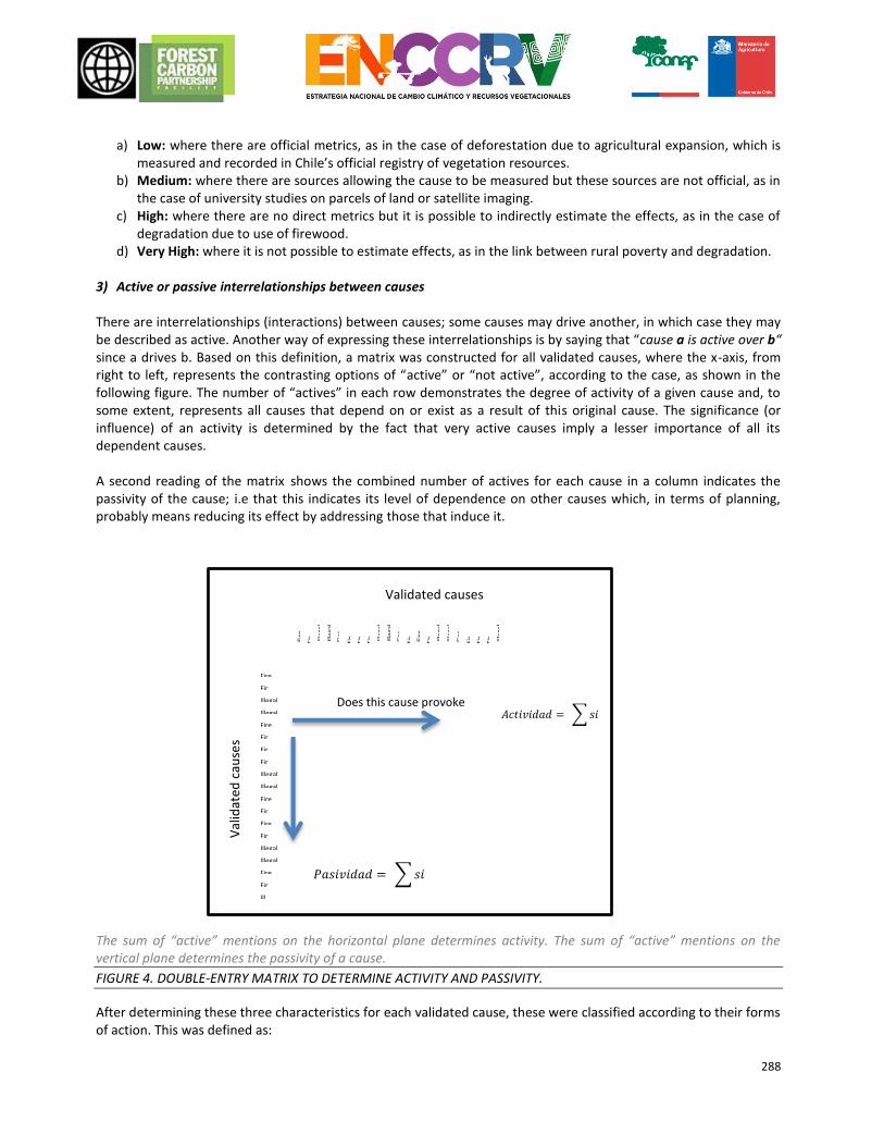
288
a) Low: where there are official metrics, as in the case of deforestation due to agricultural expansion, which is
measured and recorded in Chile’s official registry of vegetation resources. b) Medium: where there are sources allowing the cause to be measured but these sources are not official, as in
the case of university studies on parcels of land or satellite imaging. c) High: where there are no direct metrics but it is possible to indirectly estimate the effects, as in the case of
degradation due to use of firewood. d) Very High: where it is not possible to estimate effects, as in the link between rural poverty and degradation.
3) Active or passive interrelationships between causes
There are interrelationships (interactions) between causes; some causes may drive another, in which case they may be described as active. Another way of expressing these interrelationships is by saying that “cause a is active over b“ since a drives b. Based on this definition, a matrix was constructed for all validated causes, where the x-axis, from right to left, represents the contrasting options of “active” or “not active”, according to the case, as shown in the following figure. The number of “actives” in each row demonstrates the degree of activity of a given cause and, to some extent, represents all causes that depend on or exist as a result of this original cause. The significance (or influence) of an activity is determined by the fact that very active causes imply a lesser importance of all its dependent causes. A second reading of the matrix shows the combined number of actives for each cause in a column indicates the passivity of the cause; i.e that this indicates its level of dependence on other causes which, in terms of planning, probably means reducing its effect by addressing those that induce it. The sum of “active” mentions on the horizontal plane determines activity. The sum of “active” mentions on the vertical plane determines the passivity of a cause.
FIGURE 4. DOUBLE-ENTRY MATRIX TO DETERMINE ACTIVITY AND PASSIVITY.
After determining these three characteristics for each validated cause, these were classified according to their forms of action. This was defined as:
𝐴𝑐𝑡𝑖𝑣𝑖𝑑𝑎𝑑 = ∑ 𝑠𝑖
𝑃𝑎𝑠𝑖𝑣𝑖𝑑𝑎𝑑 = ∑ 𝑠𝑖
Validated causes
Fire
FireIllegal
Illegal felling Fire
FireFireFir
Illegal Illegal Fire
Fir
Fire
FireIllegal felling Illegal felling Fire
FireIll
Fire
Fir Illeg
al
Illeg
al
Fire
Fir
Fir
Fir Illeg
al
Illeg
al
Fire
Fir Fire
Fir Ille
gal
Ille
gal
Fire
Fir
Fir
Fir Illeg
al
Does this cause provoke another?
Val
idat
ed c
ause
s
289
Direct cause: (also called an “immediate cause”): human activities or actions that have a direct impact on vegetation resources and generate carbon emissions.
Indirect cause (also called an “underlying cause”): social, economic, political and/or cultural processes that generate or drive a direct cause.
Finally, using the characteristics mentioned above, a national and macrozonal hierarchy of direct and indirect causes was established, prioritising the most relevant causes and enabling the analysis to proceed. 2.3 Methodology for the characterisation of prioritised causes Specialists from the consortium used all of the above information to describe each cause, while drawing on bibliographical references, quantitative information, prioritisation characteristics and the professional experience of each expert from the team. The information generated was translated into tree diagrams, which link each direct cause with the indirect causes acting upon it and represent the characteristics of each cause in graphic form. Structures were also devised to systematise and complement information according to cause. 2.4 Methodology for defining and describing strategic activities and action measures During this stage, the technical team of the consortium worked to define and describe action measures to mitigate the effects of each of the direct causes characterised above while also defining and describing transversal mitigation actions for all causes. To do this, the technical team used the following relevant sources: characterisation of the causes described above, the results of participatory workshops (including regional, national expert and macrozonal workshops), in which consultation was also sought on action measures and new, specific technical and bibliographical information on past events, collected for these proposals. The consortium initially worked the proposals for each cause separately, according to the expertise of each institution and professional, to then conduct a number of joint work sessions, where each of the proposed measures were discussed, adjusted, supplemented and validated, seeking integrity, efficiency and greater impact of the ER Programme. After the technical team made the preliminary proposal, the measures were validated in technical political consultancies by MINAGRI via the UCCSA. This unit sent the proposals to different departments, management bodies and other specific CONAF units or other services, which have an impact on one or more of the proposed measures. For instance, the proposed measures related to the Forest Fires cause, were validated with the Gerencia de Protection contra Incendios Forestal (GEPRIF) [Managment office of Forest Fire Protection ] within the strategic political sphere, and with the Forest Fire Analysis and Prediction Service, for the technical operational sphere. This logic was replicated for all the proposed measures. This process was concluded by devising a proposal of national strategic activities and action measures, which encompasses the ER Programme for the AA. Actions were devised according to the following structure: Strategic Activities: Initiatives promoted by the State with the objective of tackling and mitigating the main direct causes of DDnAE via public-private management, within the ENCCRV framework. Each strategic activity is formed by a number of action measures affecting different spheres, from the political legislative sphere to the operational sphere.
290
Action measures: Actions consistent with local realities that seek to improve the status of vegetation resources and practices. These measures may have a specific impact on one cause or transversally affect various or all causes. Action measures could include:
Direct mitigation measures: Those that generate reductions of emissions or direct removals in the territory.
Facilitative measures: Implementing measures that facilitate or encourage the implementation of direct mitigation measures.
Devised measures must relate to one or several of the following areas:
Institutional management: Coordination and interaction of the public services to facilitate implementation.
Operative: Implementation of actions in the field under established practices and schemes.
Legislation:: Improvements, modifications and inclusions in regulation that is in force and under development.
Enforcements:: Improvements, modifications and inclusions in the public enforcement instruments.
Development:: Improvements, modifications and inclusions in the public development instruments.
Land Planning: Improvements in the management of landscapes and territories.
Training and/or transfer of skills: Decreased gaps in technical and technological skills.
Environmental Education and Awareness: Decreased gaps in information and uncertainty, change in attitude and perceptions.
Investigation: Generation of knowledge and decrease in information and uncertainty gaps.
Once action measures had been defined, a budget was drawn up for the implementation of each measure in light of the term of the ERPA. Then, using national forest emissions reductions commitments expressed in the NDC as a baseline reference, emissions reduction targets were set for the overall ER Programme and for each REDD+ activity under the programme. With the budget for implementation and the reduction targets, it was possible to estimate the cost/benefit ratio of each REDD+ activity (USD/tCO2e reduced). 2.5 Methodology for determining hotspots for the implementation of strategic activities to mitigate the causes of DDnAE 2.5.1 General aspects Objective and baseline inputs The purpose of this stage was to prioritise districts based on the cost/benefit ratio of implementing the primary action measures for direct mitigation devised for the ENCCRV. To do this, it used existing FRELs for Chile, set by the ENCCRV and reported to the UNFCCC, as a base input.
The specific inputs used from this source were as follows:
Map of carbon stock per polygon for areas of forest within the AA.
Map of degradation per polygon and their respective emissions measurements.
Map of land lost to deforestation and respective emissions measurements.
To complement this, updated regional cover from the Registry of Native Forests were also used to create other variables of prioritisation.
291
Any additional input used was the results of macrozonal workshops, which were used to determine cover in hotspots for forestation and restoration actions. Districts with partial data or inadequate information were labelled No data. Thus, for the AA, 137 of a total of 158 districts were analysed. Defining actions for prioritisation As described in the objective of this stage, prioritisation was performed on a differentiated basis according to the type of direct mitigation action measure, namely: 1) Management: Forest-related actions whose primary objective is to ensure sustainable production and the low, sustainable output of timber and non-timber products from forests or other types of plantation with productive potential.
2) Management/restoration: Forest-related and other complementary actions whose primary objective is to restore forests or other types of plantation in the initial stages of degradation as well as ensuring the sustainable production of timber and non-timber projects from forests. The outline of this action measure involves expanding forests with supplementary plantations of up to 200 plants/ha. 3) Restoration: Forest-related and other complementary actions whose primary objective is to restore forests or other types of plantation in advanced stages of degradation, where it is hoped that ecosystem functionality and the capacity for the production of goods and services can be restored. The outline of this action measure involves expanding forests with supplementary plantations of up to 600 plants/ha. 4) Forestation: Forest-related and other complementary actions whose primary objective is to establish permanent native vegetation cover in areas with no vegetation or low levels of cover, including clearings in fragmented forests. This measure also includes revegetation activities with bushy species in xerophytic formations or other bushy formations.
It should be noted that a combination of these measures may be implemented on the same land or property if managed. 2.5.2 Communal Prioritization Determining communal capabilities for proposed actions As the first step of the process, three fields of information were created for each district:
Emission levels: The level of carbon emissions was determined for each district using reference level data (FREL/JBD). Districts with no information
Level of degeneration: For each polygon of a district, the current level of degradation was determined using the temporary change in carbon content during the reference period. This analysis is explained in the following table:
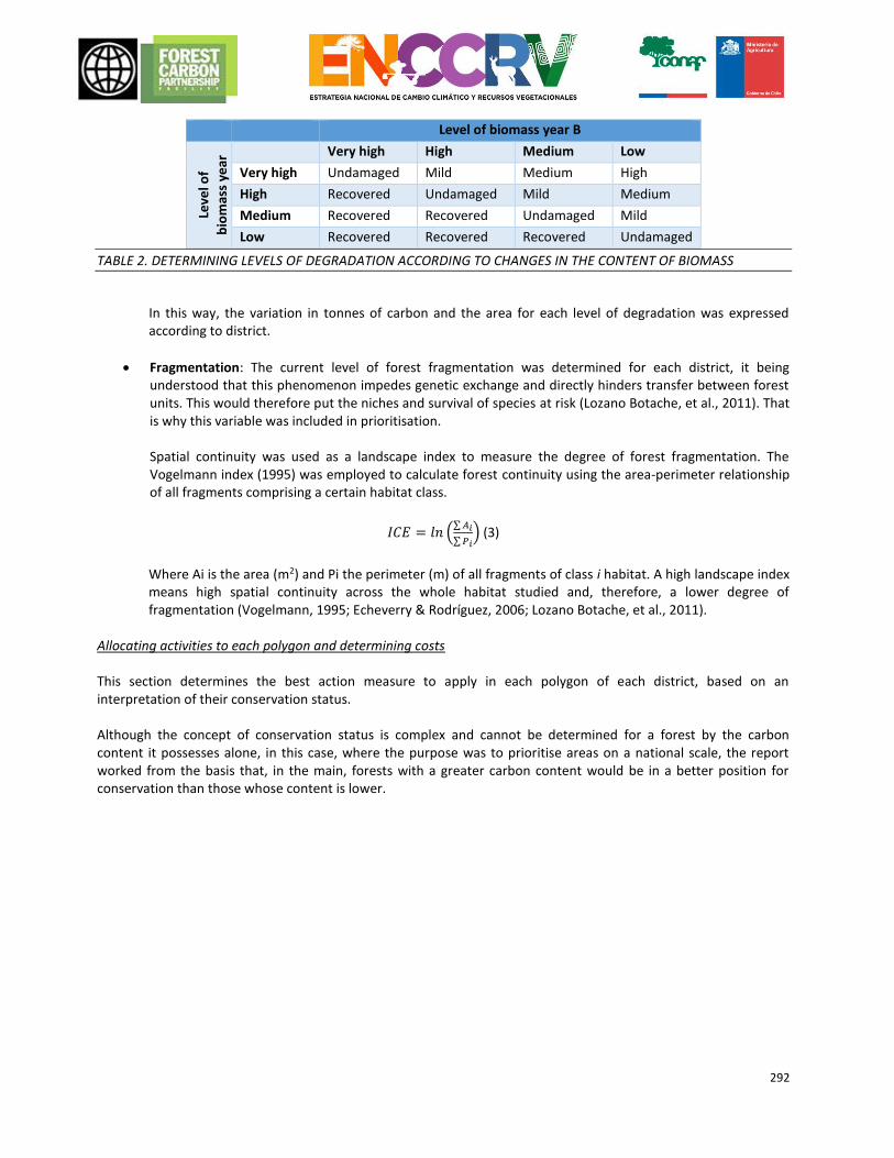
292
Level of biomass year B
Leve
l of
bio
mas
s ye
ar
A
Very high High Medium Low
Very high Undamaged Mild Medium High
High Recovered Undamaged Mild Medium
Medium Recovered Recovered Undamaged Mild
Low Recovered Recovered Recovered Undamaged
TABLE 2. DETERMINING LEVELS OF DEGRADATION ACCORDING TO CHANGES IN THE CONTENT OF BIOMASS
In this way, the variation in tonnes of carbon and the area for each level of degradation was expressed according to district.
Fragmentation: The current level of forest fragmentation was determined for each district, it being understood that this phenomenon impedes genetic exchange and directly hinders transfer between forest units. This would therefore put the niches and survival of species at risk (Lozano Botache, et al., 2011). That is why this variable was included in prioritisation. Spatial continuity was used as a landscape index to measure the degree of forest fragmentation. The Vogelmann index (1995) was employed to calculate forest continuity using the area-perimeter relationship of all fragments comprising a certain habitat class.
𝐼𝐶𝐸 = 𝑙𝑛 (∑ 𝐴𝑖
∑ 𝑃𝑖) (3)
Where Ai is the area (m2) and Pi the perimeter (m) of all fragments of class i habitat. A high landscape index means high spatial continuity across the whole habitat studied and, therefore, a lower degree of fragmentation (Vogelmann, 1995; Echeverry & Rodríguez, 2006; Lozano Botache, et al., 2011).
Allocating activities to each polygon and determining costs This section determines the best action measure to apply in each polygon of each district, based on an interpretation of their conservation status. Although the concept of conservation status is complex and cannot be determined for a forest by the carbon content it possesses alone, in this case, where the purpose was to prioritise areas on a national scale, the report worked from the basis that, in the main, forests with a greater carbon content would be in a better position for conservation than those whose content is lower.
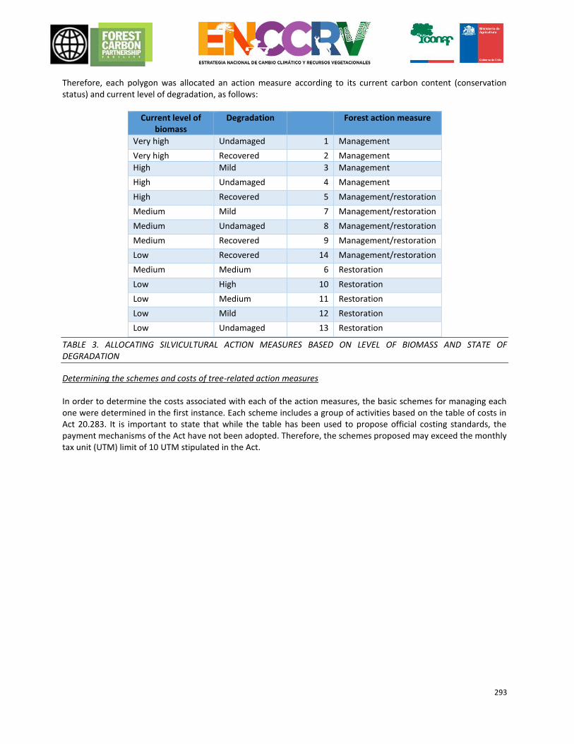
293
Therefore, each polygon was allocated an action measure according to its current carbon content (conservation status) and current level of degradation, as follows:
Current level of biomass
Degradation Forest action measure
Very high Undamaged 1 Management
Very high Recovered 2 Management
High Mild 3 Management
High Undamaged 4 Management
High Recovered 5 Management/restoration
Medium Mild 7 Management/restoration
Medium Undamaged 8 Management/restoration
Medium Recovered 9 Management/restoration
Low Recovered 14 Management/restoration
Medium Medium 6 Restoration
Low High 10 Restoration
Low Medium 11 Restoration
Low Mild 12 Restoration
Low Undamaged 13 Restoration
TABLE 3. ALLOCATING SILVICULTURAL ACTION MEASURES BASED ON LEVEL OF BIOMASS AND STATE OF DEGRADATION
Determining the schemes and costs of tree-related action measures
In order to determine the costs associated with each of the action measures, the basic schemes for managing each one were determined in the first instance. Each scheme includes a group of activities based on the table of costs in Act 20.283. It is important to state that while the table has been used to propose official costing standards, the payment mechanisms of the Act have not been adopted. Therefore, the schemes proposed may exceed the monthly tax unit (UTM) limit of 10 UTM stipulated in the Act.
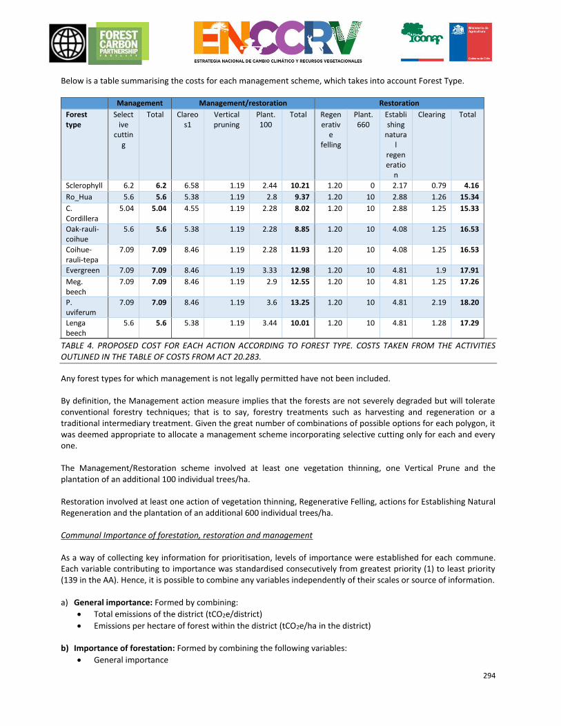
294
Below is a table summarising the costs for each management scheme, which takes into account Forest Type.
Management Management/restoration Restoration
Forest type
Selective
cutting
Total Clareos1
Vertical pruning
Plant. 100
Total Regenerativ
e felling
Plant. 660
Establishing
natural
regeneratio
n
Clearing Total
Sclerophyll 6.2 6.2 6.58 1.19 2.44 10.21 1.20 0 2.17 0.79 4.16
Ro_Hua 5.6 5.6 5.38 1.19 2.8 9.37 1.20 10 2.88 1.26 15.34
C. Cordillera
5.04 5.04 4.55 1.19 2.28 8.02 1.20 10 2.88 1.25 15.33
Oak-rauli-coihue
5.6 5.6 5.38 1.19 2.28 8.85 1.20 10 4.08 1.25 16.53
Coihue-rauli-tepa
7.09 7.09 8.46 1.19 2.28 11.93 1.20 10 4.08 1.25 16.53
Evergreen 7.09 7.09 8.46 1.19 3.33 12.98 1.20 10 4.81 1.9 17.91
Meg. beech
7.09 7.09 8.46 1.19 2.9 12.55 1.20 10 4.81 1.25 17.26
P. uviferum
7.09 7.09 8.46 1.19 3.6 13.25 1.20 10 4.81 2.19 18.20
Lenga beech
5.6 5.6 5.38 1.19 3.44 10.01 1.20 10 4.81 1.28 17.29
TABLE 4. PROPOSED COST FOR EACH ACTION ACCORDING TO FOREST TYPE. COSTS TAKEN FROM THE ACTIVITIES OUTLINED IN THE TABLE OF COSTS FROM ACT 20.283.
Any forest types for which management is not legally permitted have not been included. By definition, the Management action measure implies that the forests are not severely degraded but will tolerate conventional forestry techniques; that is to say, forestry treatments such as harvesting and regeneration or a traditional intermediary treatment. Given the great number of combinations of possible options for each polygon, it was deemed appropriate to allocate a management scheme incorporating selective cutting only for each and every one. The Management/Restoration scheme involved at least one vegetation thinning, one Vertical Prune and the plantation of an additional 100 individual trees/ha. Restoration involved at least one action of vegetation thinning, Regenerative Felling, actions for Establishing Natural Regeneration and the plantation of an additional 600 individual trees/ha. Communal Importance of forestation, restoration and management As a way of collecting key information for prioritisation, levels of importance were established for each commune. Each variable contributing to importance was standardised consecutively from greatest priority (1) to least priority (139 in the AA). Hence, it is possible to combine any variables independently of their scales or source of information. a) General importance: Formed by combining:
Total emissions of the district (tCO2e/district)
Emissions per hectare of forest within the district (tCO2e/ha in the district)
b) Importance of forestation: Formed by combining the following variables:
General importance
295
Level of fragmentation: greater priority is given to districts with greater fragmentation.
Macrozonal workshop forestation proposal: Given that the response to the need for forestation is comprised of a modest variable operating on four levels, the total allocated prioritisation score was divided by four.
c) Importance of restoration: Formed by combining the following variables:
General importance
Emissions in areas requiring restoration: Emissions were combined from polygons to which restoration/management and restoration actions were assigned.
Macrozonal workshop restoration proposal: Idem forestation.
d) Importance of management: Formed by combining the following variables:
General importance
Emissions in areas requiring management: Emissions were combined from polygons to which management actions were assigned.
Cost-effectiveness of mitigation via management/restoration/forestation actions Cost-effectiveness is deduced by determining the lost of carbon content due to degradation, using the classification of degradation which would be AVOIDED if the proposals were implemented. The costs of all action proposals for each district were then combined (note that these cost is related to according to the type of forest found in each polygon). Thus, it was possible to determine the value of each tonne of CO2e for each district, according to whether management, management/restoration, restoration or forestation actions were implemented. Prioritisation Finally, districts were prioritised for each of the four action measures indicated, i.e. forestation, management, restoration/management and restoration, though with an emphasis on mitigation effectiveness under new models. These new models are as follows:
Management priority = importance of management + importance of effectiveness of management.
Priority of management/restoration = importance of management/restoration + importance due to effectiveness of management/restoration.
Restoration priority = importance of restoration + importance due to effectiveness of mitigation.
Priority of forestation = importance of forestation + importance due to effectiveness of forestation.
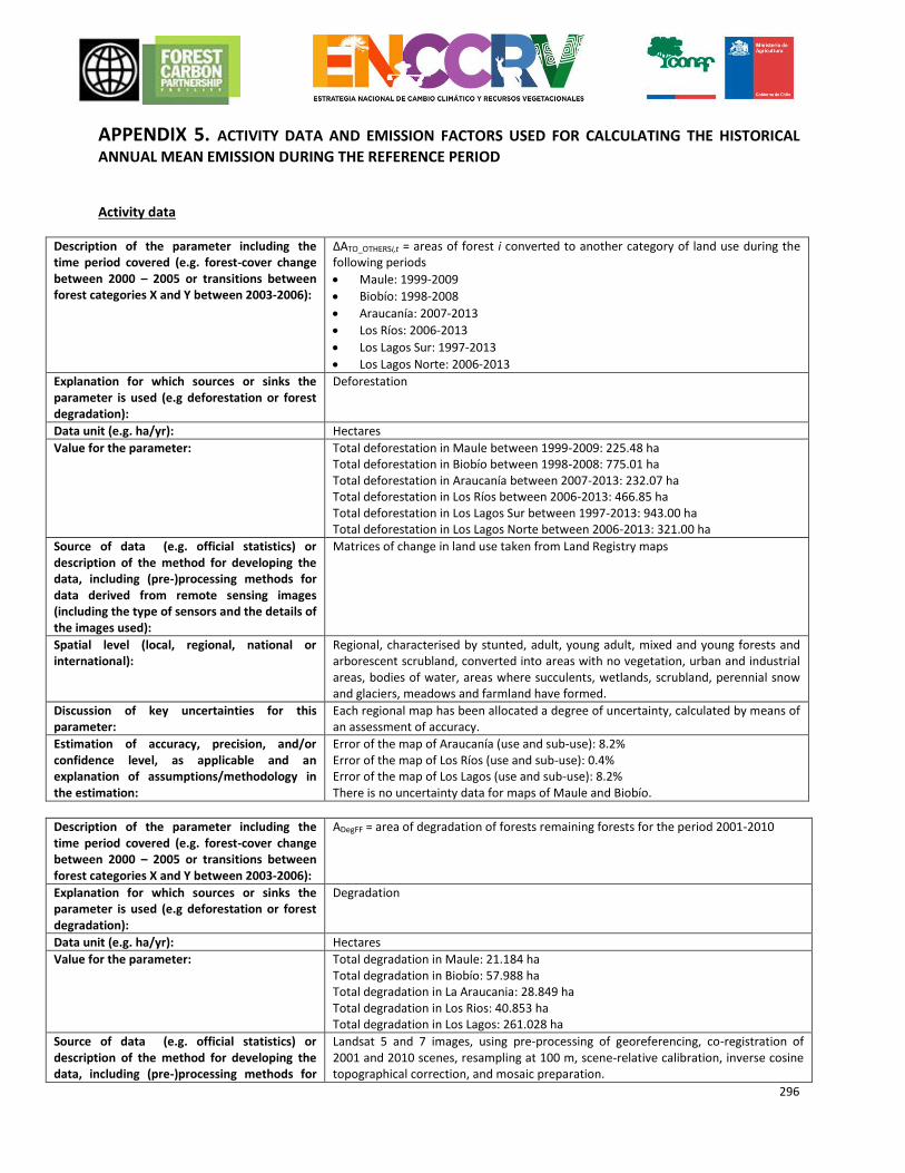
296
APPENDIX 5. ACTIVITY DATA AND EMISSION FACTORS USED FOR CALCULATING THE HISTORICAL
ANNUAL MEAN EMISSION DURING THE REFERENCE PERIOD Activity data
Description of the parameter including the time period covered (e.g. forest-cover change between 2000 – 2005 or transitions between forest categories X and Y between 2003-2006):
ΔATO_OTHERSi,t = areas of forest i converted to another category of land use during the following periods
Maule: 1999-2009
Biobío: 1998-2008
Araucanía: 2007-2013
Los Ríos: 2006-2013
Los Lagos Sur: 1997-2013
Los Lagos Norte: 2006-2013
Explanation for which sources or sinks the parameter is used (e.g deforestation or forest degradation):
Deforestation
Data unit (e.g. ha/yr): Hectares
Value for the parameter: Total deforestation in Maule between 1999-2009: 225.48 ha Total deforestation in Biobío between 1998-2008: 775.01 ha Total deforestation in Araucanía between 2007-2013: 232.07 ha Total deforestation in Los Ríos between 2006-2013: 466.85 ha Total deforestation in Los Lagos Sur between 1997-2013: 943.00 ha Total deforestation in Los Lagos Norte between 2006-2013: 321.00 ha
Source of data (e.g. official statistics) or description of the method for developing the data, including (pre-)processing methods for data derived from remote sensing images (including the type of sensors and the details of the images used):
Matrices of change in land use taken from Land Registry maps
Spatial level (local, regional, national or international):
Regional, characterised by stunted, adult, young adult, mixed and young forests and arborescent scrubland, converted into areas with no vegetation, urban and industrial areas, bodies of water, areas where succulents, wetlands, scrubland, perennial snow and glaciers, meadows and farmland have formed.
Discussion of key uncertainties for this parameter:
Each regional map has been allocated a degree of uncertainty, calculated by means of an assessment of accuracy.
Estimation of accuracy, precision, and/or confidence level, as applicable and an explanation of assumptions/methodology in the estimation:
Error of the map of Araucanía (use and sub-use): 8.2% Error of the map of Los Ríos (use and sub-use): 0.4% Error of the map of Los Lagos (use and sub-use): 8.2% There is no uncertainty data for maps of Maule and Biobío.
Description of the parameter including the time period covered (e.g. forest-cover change between 2000 – 2005 or transitions between forest categories X and Y between 2003-2006):
ADegFF = area of degradation of forests remaining forests for the period 2001-2010
Explanation for which sources or sinks the parameter is used (e.g deforestation or forest degradation):
Degradation
Data unit (e.g. ha/yr): Hectares
Value for the parameter: Total degradation in Maule: 21.184 ha Total degradation in Biobío: 57.988 ha Total degradation in La Araucania: 28.849 ha Total degradation in Los Rios: 40.853 ha Total degradation in Los Lagos: 261.028 ha
Source of data (e.g. official statistics) or description of the method for developing the data, including (pre-)processing methods for
Landsat 5 and 7 images, using pre-processing of georeferencing, co-registration of 2001 and 2010 scenes, resampling at 100 m, scene-relative calibration, inverse cosine topographical correction, and mosaic preparation.
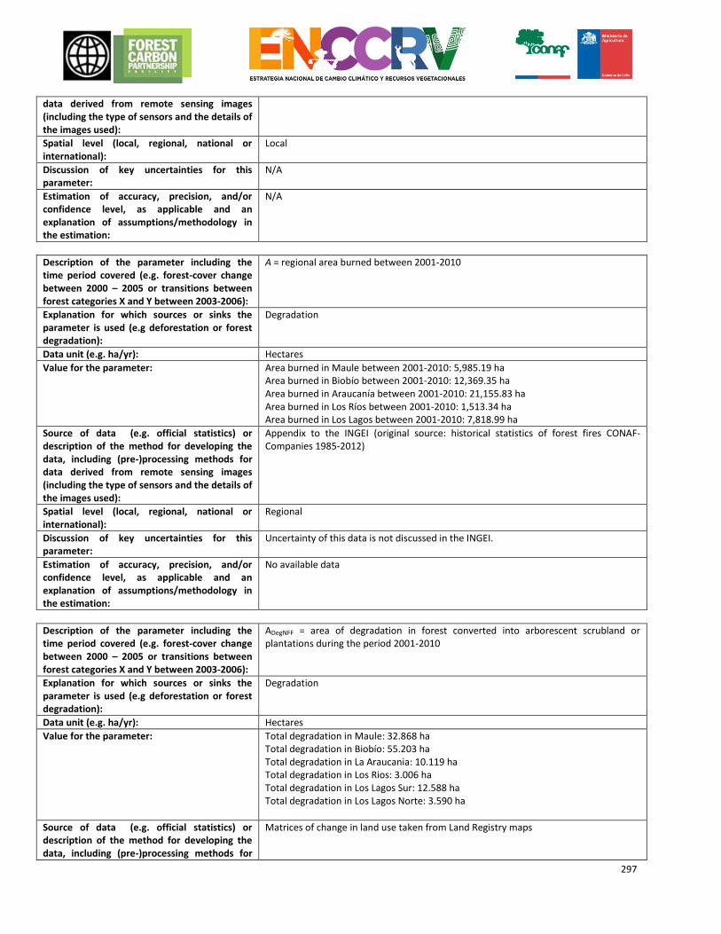
297
data derived from remote sensing images (including the type of sensors and the details of the images used):
Spatial level (local, regional, national or international):
Local
Discussion of key uncertainties for this parameter:
N/A
Estimation of accuracy, precision, and/or confidence level, as applicable and an explanation of assumptions/methodology in the estimation:
N/A
Description of the parameter including the time period covered (e.g. forest-cover change between 2000 – 2005 or transitions between forest categories X and Y between 2003-2006):
A = regional area burned between 2001-2010
Explanation for which sources or sinks the parameter is used (e.g deforestation or forest degradation):
Degradation
Data unit (e.g. ha/yr): Hectares
Value for the parameter: Area burned in Maule between 2001-2010: 5,985.19 ha Area burned in Biobío between 2001-2010: 12,369.35 ha Area burned in Araucanía between 2001-2010: 21,155.83 ha Area burned in Los Ríos between 2001-2010: 1,513.34 ha Area burned in Los Lagos between 2001-2010: 7,818.99 ha
Source of data (e.g. official statistics) or description of the method for developing the data, including (pre-)processing methods for data derived from remote sensing images (including the type of sensors and the details of the images used):
Appendix to the INGEI (original source: historical statistics of forest fires CONAF-Companies 1985-2012)
Spatial level (local, regional, national or international):
Regional
Discussion of key uncertainties for this parameter:
Uncertainty of this data is not discussed in the INGEI.
Estimation of accuracy, precision, and/or confidence level, as applicable and an explanation of assumptions/methodology in the estimation:
No available data
Description of the parameter including the time period covered (e.g. forest-cover change between 2000 – 2005 or transitions between forest categories X and Y between 2003-2006):
ADegNFF = area of degradation in forest converted into arborescent scrubland or plantations during the period 2001-2010
Explanation for which sources or sinks the parameter is used (e.g deforestation or forest degradation):
Degradation
Data unit (e.g. ha/yr): Hectares
Value for the parameter: Total degradation in Maule: 32.868 ha Total degradation in Biobío: 55.203 ha Total degradation in La Araucania: 10.119 ha Total degradation in Los Rios: 3.006 ha Total degradation in Los Lagos Sur: 12.588 ha Total degradation in Los Lagos Norte: 3.590 ha
Source of data (e.g. official statistics) or description of the method for developing the data, including (pre-)processing methods for
Matrices of change in land use taken from Land Registry maps
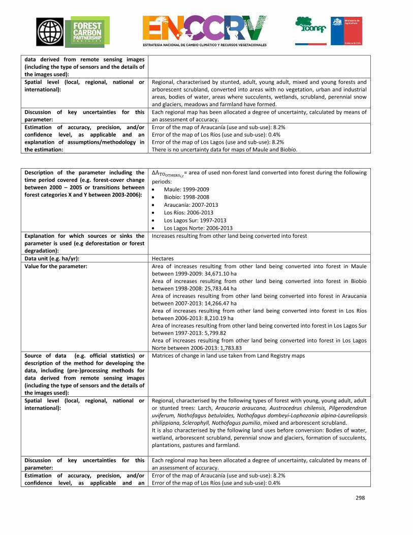
298
data derived from remote sensing images (including the type of sensors and the details of the images used):
Spatial level (local, regional, national or international):
Regional, characterised by stunted, adult, young adult, mixed and young forests and arborescent scrubland, converted into areas with no vegetation, urban and industrial areas, bodies of water, areas where succulents, wetlands, scrubland, perennial snow and glaciers, meadows and farmland have formed.
Discussion of key uncertainties for this parameter:
Each regional map has been allocated a degree of uncertainty, calculated by means of an assessment of accuracy.
Estimation of accuracy, precision, and/or confidence level, as applicable and an explanation of assumptions/methodology in the estimation:
Error of the map of Araucanía (use and sub-use): 8.2% Error of the map of Los Ríos (use and sub-use): 0.4% Error of the map of Los Lagos (use and sub-use): 8.2% There is no uncertainty data for maps of Maule and Biobío.
Description of the parameter including the time period covered (e.g. forest-cover change between 2000 – 2005 or transitions between forest categories X and Y between 2003-2006):
ΔATOOTHERS𝑖,𝑡= area of used non-forest land converted into forest during the following
periods:
Maule: 1999-2009
Biobío: 1998-2008
Araucanía: 2007-2013
Los Ríos: 2006-2013
Los Lagos Sur: 1997-2013
Los Lagos Norte: 2006-2013
Explanation for which sources or sinks the parameter is used (e.g deforestation or forest degradation):
Increases resulting from other land being converted into forest
Data unit (e.g. ha/yr): Hectares
Value for the parameter: Area of increases resulting from other land being converted into forest in Maule between 1999-2009: 34,671.10 ha Area of increases resulting from other land being converted into forest in Biobío between 1998-2008: 25,783.44 ha Area of increases resulting from other land being converted into forest in Araucania between 2007-2013: 14,266.47 ha Area of increases resulting from other land being converted into forest in Los Ríos between 2006-2013: 8,210.19 ha Area of increases resulting from other land being converted into forest in Los Lagos Sur between 1997-2013: 5,799.82 Area of increases resulting from other land being converted into forest in Los Lagos Norte between 2006-2013: 1,783.83
Source of data (e.g. official statistics) or description of the method for developing the data, including (pre-)processing methods for data derived from remote sensing images (including the type of sensors and the details of the images used):
Matrices of change in land use taken from Land Registry maps
Spatial level (local, regional, national or international):
Regional, characterised by the following types of forest with young, young adult, adult or stunted trees: Larch, Araucaria araucana, Austrocedrus chilensis, Pilgerodendron uviferum, Nothofagus betuloides, Nothofagus dombeyi-Lophozonia alpina-Laureliopsis philippiana, Sclerophyll, Nothofagus pumilio, mixed and arborescent scrubland. It is also characterised by the following land uses before conversion: Bodies of water, wetland, arborescent scrubland, perennial snow and glaciers, formation of succulents, plantations, pastures and farmland.
Discussion of key uncertainties for this parameter:
Each regional map has been allocated a degree of uncertainty, calculated by means of an assessment of accuracy.
Estimation of accuracy, precision, and/or confidence level, as applicable and an
Error of the map of Araucanía (use and sub-use): 8.2% Error of the map of Los Ríos (use and sub-use): 0.4%
299
explanation of assumptions/methodology in the estimation:
Error of the map of Los Lagos (use and sub-use): 8.2% There is no uncertainty data for maps of Maule and Biobío.
Description of the parameter including the time period covered (e.g. forest-cover change between 2000 – 2005 or transitions between forest categories X and Y between 2003-2006):
ΔATOOTHERS𝑖,𝑡= area of arborescent scrubland remaining as such over the following
periods:
Maule: 1999-2009
Biobío: 1998-2008
Araucanía: 2007-2013
Los Ríos: 2006-2013
Los Lagos Sur: 1997-2013
Los Lagos Norte: 2006-2013
Explanation for which sources or sinks the parameter is used (e.g deforestation or forest degradation):
Increases in arborescent scrubland remaining as such
Data unit (e.g. ha/yr): Hectares
Value for the parameter: Area of increased arborescent scrubland remaining as such in Maule between 1999-2009: 143,781.50 ha Area of increased arborescent scrubland remaining as such in Biobío between 1998-2008: 81,517.04 ha Area of increased arborescent scrubland remaining as such in Araucanía between 2007-2013: 44,710.01 ha Area of increased arborescent scrubland remaining as such in Los Ríos between 2006-2013: 29,673.73 ha Area of increased arborescent scrubland remaining as such in Los Lagos Sur between 1997-2013: 84,549.14 ha Area of increased arborescent scrubland remaining as such in Los Lagos Sur between 2006-2013: 24,569.22 ha
Source of data (e.g. official statistics) or description of the method for developing the data, including (pre-)processing methods for data derived from remote sensing images (including the type of sensors and the details of the images used):
Matrices of change in land use taken from Land Registry maps
Spatial level (local, regional, national or international):
Regional
Discussion of key uncertainties for this parameter:
Each regional map has been allocated a degree of uncertainty, calculated by means of an assessment of accuracy.
Estimation of accuracy, precision, and/or confidence level, as applicable and an explanation of assumptions/methodology in the estimation:
Error of the map of Araucanía (use and sub-use): 8.2% Error of the map of Los Ríos (use and sub-use): 0.4% Error of the map of Los Lagos (use and sub-use): 8.2% There is no uncertainty data for maps of Maule and Biobío.
Description of the parameter including the time period covered (e.g. forest-cover change between 2000 – 2005 or transitions between forest categories X and Y between 2003-2006):
AIncFF = area of increased forest remaining as such for the period 2001-2010
Explanation for which sources or sinks the parameter is used (e.g deforestation or forest degradation):
Increases in forest stock remaining as such
Data unit (e.g. ha/yr): Hectares
Value for the parameter: Total increased area in Maule: 50.152 ha Total increased area in Biobío: 94.861 ha
300
Total increased area in La Araucania: 59.456 ha Total increased area in Los Rios: 77.141 ha Total increased area in Los Lagos: 263.055 ha
Source of data (e.g. official statistics) or description of the method for developing the data, including (pre-)processing methods for data derived from remote sensing images (including the type of sensors and the details of the images used):
Landsat 5 and 7 images, using pre-processing of georeferencing, co-registration of 2001 and 2010 scenes, resampling at 100 m, scene-relative calibration, inverse cosine topographical correction, and mosaic preparation.
Spatial level (local, regional, national or international):
Local
Discussion of key uncertainties for this parameter:
N/A
Estimation of accuracy, precision, and/or confidence level, as applicable and an explanation of assumptions/methodology in the estimation:
N/A
Description of the parameter including the time period covered (e.g. forest-cover change between 2000 – 2005 or transitions between forest categories X and Y between 2003-2006):
ADegFFConservation = area of forest degradation remaining as such between the period 2001-2010 in conservation areas
Explanation for which sources or sinks the parameter is used (e.g deforestation or forest degradation):
Conservation
Data unit (e.g. ha/yr):
Hectares
Value for the parameter: Total degradation in Maule: 693 ha Total degradation in Biobío: 6.861 ha Total degradation in La Araucania: 6.964 ha Total degradation in Los Rios: 14.486 ha Total degradation in Los Lagos: 75.970 ha
Source of data (e.g. official statistics) or description of the method for developing the data, including (pre-)processing methods for data derived from remote sensing images (including the type of sensors and the details of the images used):
Landsat 5 and 7 images, using pre-processing of georeferencing, co-registration of 2001 and 2010 scenes, resampling at 100 m, scene-relative calibration, inverse cosine topographical correction, and mosaic preparation.
Spatial level (local, regional, national or international):
Local
Discussion of key uncertainties for this parameter:
N/A
Estimation of accuracy, precision, and/or confidence level, as applicable and an explanation of assumptions/methodology in the estimation:
N/A
Description of the parameter including the time period covered (e.g. forest-cover change between 2000 – 2005 or transitions between forest categories X and Y between 2003-2006):
AIncFConservatioF = area of increased forest remaining as such between the period 2001-2010 in conservation areas
Explanation for which sources or sinks the parameter is used (e.g deforestation or forest degradation):
Conservation
Data unit (e.g. ha/yr): Hectares
Value for the parameter: Total increased area in Maule: 806 ha Total increased area in Biobío: 7.471 ha
301
Total increased area in La Araucania: 13.526 ha Total increased area in Los Rios: 31.235 ha Total increased area in Los Lagos: 99.963 ha
Source of data (e.g. official statistics) or description of the method for developing the data, including (pre-)processing methods for data derived from remote sensing images (including the type of sensors and the details of the images used):
Landsat 5 and 7 images, using pre-processing of georeferencing, co-registration of 2001 and 2010 scenes, resampling at 100 m, scene-relative calibration, inverse cosine topographical correction, and mosaic preparation.
Spatial level (local, regional, national or international):
Local
Discussion of key uncertainties for this parameter:
N/A
Estimation of accuracy, precision, and/or confidence level, as applicable and an explanation of assumptions/methodology in the estimation:
N/A
Emission factors Deforestation
Description of the parameter including the forest class if applicable:
Emission factor for deforestation:
Aerial biomass of forest per region (component of BBefore)
Data unit (e.g. t CO2/ha): t dry biomass/hectare
Value for the parameter: Forests in Maule: 80.4 t biomass/ha Forests in Biobío: 149.9 t biomass/ha Forests in La Araucanía: 260.2 t biomass/ha Forests in Los Ríos: 328.4 t biomass/ha Forests in Los Lagos: 270.5 t biomass/ha Arborescent scrubland: 21.78 t biomass/ha
Source of data (e.g. official statistics, IPCC, scientific literature) or description of the assumptions, methods and results of any underlying studies that have been used to determine the parameter:
Regional forest values: INGEI appendices (originally from the Continuous Inventory) Value of arborescent scrubland: Gayoso, J. 2006. Inventory of Carbon in Meadows and Scrublands for Studying Baselines in the SIF Sociedad Inversora Forestal S.A. Project in Regions VII and VIII. Sudaustral University.
Outlines carbon stock in meadows and scrublands according to the level of crown cover. For arborescent scrubland, a value of 40-60% cover was multiplied by two to calculate dry biomass.
Spatial level (local, regional, national or international):
Regional
Discussion of key uncertainties for this parameter:
Forecast error of permanent plots from the INFOR Continuous Forest Inventory. Arborescent scrubland: Random sampling error
Estimation of accuracy, precision, and/or confidence level, as applicable and an explanation of assumptions/methodology in the estimation:
Regional forest value error 10% Arborescent scrubland: Random sampling error reached 11.13%
Description of the parameter including the forest class if applicable:
Emission factor for deforestation:
Subterranean biomass of biomass according to region (component of BBefore)
Data unit (e.g. t CO2/ha): t dry biomass/hectare
Value for the parameter: Maule: 23.1 t biomass/ha Biobío: 43.0 t biomass/ha La Araucanía: 74.6 t biomass/ha Los Ríos: 94.2 t biomass/ha Los Lagos: 77.6 t biomass/ha Arborescent scrubland: 35.25 t biomass/ha
302
Source of data (e.g. official statistics, IPCC, scientific literature) or description of the assumptions, methods and results of any underlying studies that have been used to determine the parameter:
Regional forest values: Aerial biomass from INGEI appendices (originally from the Continuous Inventory) multiplied by R-Factor (the relationship between subterranean and aerial biomass), 0.2869. This factor originally comes from the document by the Southern University of Chile (UACH). 2002. Measure of the carbon removal capacity in forests in Chile. Value of arborescent scrubland: Gayoso, J. 2006. Inventory of Carbon in Grassland and Scrublands for Studying Baselines in the SIF Sociedad Inversora Forestal S.A. Project in Regions VII and VIII. Sudaustral University.
Outlines carbon stock in meadows and scrublands according to the level of crown cover. For arborescent scrubland, a value of 40-60% cover was multiplied by two to calculate dry biomass.
Spatial level (local, regional, national or international):
Regional
Discussion of key uncertainties for this parameter:
Aerial biomass of forests according to region: Forecast error of permanent plots from the INFOR Continuous Forest Inventory. R factor of native forest: Error calculation based on statistical data from the Biomass Inventory and Carbon Accountancy of the UACh. Arborescent scrubland: Random sampling error
Estimation of accuracy, precision, and/or confidence level, as applicable and an explanation of assumptions/methodology in the estimation:
Error of aerial biomass of forests according to region: 10% R Factor error: 40% Arborescent scrubland: random sampling error reached 11.13%.
Description of the parameter including the forest class if applicable:
Emission factor for deforestation:
Biomass after conversion (BAFTER)
Data unit (e.g. t CO2/ha): t biomass/ha
Value for the parameter: 0
Source of data (e.g. official statistics, IPCC, scientific literature) or description of the assumptions, methods and results of any underlying studies that have been used to determine the parameter:
Assumption
Spatial level (local, regional, national or international):
International
Discussion of key uncertainties for this parameter:
Not applicable
Estimation of accuracy, precision, and/or confidence level, as applicable and an explanation of assumptions/methodology in the estimation:
Not applicable
Description of the parameter including the forest class if applicable:
Emission factor for deforestation:
Carbon fraction (CF)
Data unit (e.g. t CO2/ha): tC t biomass-1
Value for the parameter: 0.5
Source of data (e.g. official statistics, IPCC, scientific literature) or description of the assumptions, methods and results of any underlying studies that have been used to determine the parameter:
Appendices of the INGEI (originally from the IPCC (2006))
Spatial level (local, regional, national or international):
International
Discussion of key uncertainties for this parameter:
No available information
303
Estimation of accuracy, precision, and/or confidence level, as applicable and an explanation of assumptions/methodology in the estimation:
No available information
Description of the parameter including the forest class if applicable:
Emission factor for deforestation:
Aerial biomass of non-forest land use after deforestation (BAfter)
Data unit (e.g. t CO2/ha): T dry biomass/ha
Value for the parameter: Areas without vegetation: 0 t dry biomass/ha Urban and industrial areas: 2 t dry biomass/ha Water bodies: 0 t biomass/ha Formation of succulents: 4.73 t biomass/ha Wetlands: 0 t biomass/ha Scrubland: 9.04 t biomass/ha Perennial snow and glaciers: 0 t biomass/ha Grassland: 4.73 t biomass/ha Farmland: 10 t biomass/ha
Source of data (e.g. official statistics, IPCC, scientific literature) or description of the assumptions, methods and results of any underlying studies that have been used to determine the parameter:
Areas without vegetation: Assumption Urban and industrial areas: Appendices of the INGEI Water bodies: Assumption Formation of succulents: Assumption, like Meadows Wetlands: Assumption: wetlands were assigned a biomass value of 0 since the proportion of forest converted into wetlands was so small. Scrubland: Gayoso, J. 2006. Inventory of Carbon in Meadows and Scrublands for Studying Baselines in the SIF Sociedad Inversora Forestal S.A. Project in Regions VII and VIII. Sudaustral University.
Outlines carbon stock in meadows and scrublands according to the level of crown cover. For scrubland, average carbon values for 5-20% and 20-40% cover were multiplied by two to calculate dry biomass.
Perennial snow and glaciers: Assumption Meadows: Gayoso, J. 2006. Inventory of Carbon in Meadows and Scrublands for Studying Baselines in the SIF Sociedad Inversora Forestal S.A. Project in Regions VII and VIII. Sudaustral University.
Outlines carbon stock in meadows and scrublands according to the level of crown cover. For meadows, average carbon values for 0-5% and 5-20% cover were multiplied by two to calculate dry biomass.
Farmland: Appendices of the INGEI (originally from the IPCC (2006))
Spatial level (local, regional, national or international):
Areas without vegetation: International Urban and industrial areas: International Water bodies: International Formation of succulents: National Wetlands: International Scrubland: National Perennial snow and glaciers: International Meadows: National Farmland: International
Discussion of key uncertainties for this parameter:
Scrubland and meadows: Random sampling error No information on the uncertainty of other land uses
Estimation of accuracy, precision, and/or confidence level, as applicable and an explanation of assumptions/methodology in the estimation:
Farmland: 75% (nominal estimation of error, equivalent to twice the standard deviation, as a percentage of the median.) Scrubland and meadows: Random sampling error reached 11.13%
304
Description of the parameter including the forest class if applicable:
Emission factor for deforestation:
Subterranean biomass of non-forest land use after deforestation
Data unit (e.g. t CO2/ha): T dry biomass/ha
Value for the parameter: Areas without vegetation: 0 t dry biomass/ha Urban and industrial areas: 0 t dry biomass/ha Water bodies: 0 t biomass/ha Formation of succulents: 8.13 t biomass/ha Wetlands: 0 t biomass/ha Scrubland: 14.99 t biomass/ha Perennial snow and glaciers: 0 t biomass/ha Grassland: 8.13 t biomass/ha Farmland: 2.00 t biomass/ha
Source of data (e.g. official statistics, IPCC, scientific literature) or description of the assumptions, methods and results of any underlying studies that have been used to determine the parameter:
Areas without vegetation: Assumption Urban and industrial areas: Appendices of the INGEI Water bodies: Assumption Formation of succulents: Assumption, like Grassland Wetlands: Assumption: wetlands were assigned a biomass value of 0 since the proportion of forest converted into wetlands was so small. Scrubland: Gayoso, J. 2006. Inventory of Carbon in Grassland and Scrublands for Studying Baselines in the SIF Sociedad Inversora Forestal S.A. Project in Regions VII and VIII. Sudaustral University.
Outlines carbon stock in Grassland and scrublands according to the level of crown cover. For scrubland, average carbon values for 5-20% and 20-40% cover were multiplied by two to calculate dry biomass.
Perennial snow and glaciers: Assumption Grassland: Gayoso, J. 2006. Inventory of Carbon in Grassland and Scrublands for Studying Baselines in the SIF Sociedad Inversora Forestal S.A. Project in Regions VII and VIII. Sudaustral University.
Outlines carbon stock in meadows and scrublands according to the level of crown cover. For meadows, average carbon values for 0-5% and 5-20% cover were multiplied by two to calculate dry biomass.
Farmland: 10 t biomass/ha
Spatial level (local, regional, national or international):
Areas without vegetation: International Urban and industrial areas: International Water bodies: International Formation of succulents: National Wetlands: International Scrubland: National Perennial snow and glaciers: International Meadows: National Farmland: International
Discussion of key uncertainties for this parameter:
Scrubland and meadows: Random sampling error No information on the uncertainty of other land uses
Estimation of accuracy, precision, and/or confidence level, as applicable and an explanation of assumptions/methodology in the estimation:
Farmland: 75% (nominal estimation of error, equivalent to twice the standard deviation, as a percentage of the median.) Scrubland and Grassland: Random sampling error reached 11.13%
Description of the parameter including the forest class if applicable:
Emission factor for deforestation:
Carbon loss (ΔCL) after deforestation
Data unit (e.g. t CO2/ha): tC
Value for the parameter: 0
Source of data (e.g. official statistics, IPCC, scientific literature) or description of the assumptions, methods and results of any underlying studies that have been used to
Assumption
305
determine the parameter:
Spatial level (local, regional, national or international):
International
Discussion of key uncertainties for this parameter:
Not applicable
Estimation of accuracy, precision, and/or confidence level, as applicable and an explanation of assumptions/methodology in the estimation:
Not applicable
Description of the parameter including the forest class if applicable:
Emission factor for deforestation:
Necromass carbon (standing and on the ground) in forests according to region (C0) pre-deforestation
Data unit (e.g. t CO2/ha): tC/hectare
Value for the parameter: Maule: 2.3 tC/ha Biobío: 5 tC/ha La Araucanía: 23.46 tC/ha Los Ríos: 58.70 tC/ha Los Lagos: 34.70 tC/ha
Source of data (e.g. official statistics, IPCC, scientific literature) or description of the assumptions, methods and results of any underlying studies that have been used to determine the parameter:
Appendices of the INGEI (produced using the database of permanent plots of the Continuous Inventory)
Spatial level (local, regional, national or international):
Regional
Discussion of key uncertainties for this parameter:
Estimated errors of permanent plots from the INFOR Continuous Forest Inventory.
Estimation of accuracy, precision, and/or confidence level, as applicable and an explanation of assumptions/methodology in the estimation:
Necromass error (standing dead biomass): 28% Necromass error (residues on the ground): 24%
Description of the parameter including the forest class if applicable:
Emission factor for deforestation:
Necromass carbon (standing and on the ground) in forests according to region (Cn) post-deforestation
Data unit (e.g. t CO2/ha): tC/hectare
Value for the parameter: 0
Source of data (e.g. official statistics, IPCC, scientific literature) or description of the assumptions, methods and results of any underlying studies that have been used to determine the parameter:
Assumption
Spatial level (local, regional, national or international):
International
Discussion of key uncertainties for this parameter:
Not applicable
Estimation of accuracy, precision, and/or confidence level, as applicable and an explanation of assumptions/methodology in the estimation:
Not applicable

306
Degradation
Description of the parameter including the forest class if applicable:
Emission factor for degradation in forests remaining as such
BA, basal area
Data unit (e.g. t CO2/ha): Cubic metres per hectare
Value for the parameter: Varies according to each hectare throughout forest area
Source of data (e.g. official statistics, IPCC, scientific literature) or description of the assumptions, methods and results of any underlying studies that have been used to determine the parameter:
Plots from the INFOR Continuous Inventory
Spatial level (local, regional, national or international):
Local
Discussion of key uncertainties for this parameter:
Forecast error of permanent plots from the INFOR Continuous Forest Inventory.
Estimation of accuracy, precision, and/or confidence level, as applicable and an explanation of assumptions/methodology in the estimation:
Error: 47.2%
Description of the parameter including the forest class if applicable:
Emission factor for degradation in forests remaining as such:
Basic density value of the wood (D)
Data unit (e.g. t CO2/ha): Ton/m3
Value for the parameter: 0.4962
Source of data (e.g. official statistics, IPCC, scientific literature) or description of the assumptions, methods and results of any underlying studies that have been used to determine the parameter:
Appendices of the INGEI (produced from a review of various bibliographical sources)
Spatial level (local, regional, national or international):
National for native species
Discussion of key uncertainties for this parameter:
Calculated using basic density data collected from native species growing in Chile.
Estimation of accuracy, precision, and/or confidence level, as applicable and an explanation of assumptions/methodology in the estimation:
Error: 6%
Description of the parameter including the forest class if applicable:
Emission factor for degradation in forests remaining as such:
Biomass expansion factor (BEF) of a forest type. This factor expands the total volume of aerial biomass to compensate for non-marketable aspects of the increase.
Data unit (e.g. t CO2/ha): Non-dimensional
Value for the parameter: 1.75
Source of data (e.g. official statistics, IPCC, scientific literature) or description of the assumptions, methods and results of any underlying studies that have been used to determine the parameter:
Spatial level (local, regional, national or international):
Appendices of the INGEI (based on Gayoso (2002)). Measure of the carbon removal capacity in forests in Chile.
Discussion of key uncertainties for this parameter:
Error calculation based on statistical data from the Biomass Inventory and Carbon Accountancy of the UACh.
Estimation of accuracy, precision, and/or confidence level, as applicable and an explanation of assumptions/methodology in the estimation:
Error: 18%
307
Description of the parameter including the forest class if applicable:
Emission factor for degradation resulting from the conversion of forests into plantations and arborescent scrubland:
Aerial biomass of forests according to region
Data unit (e.g. t CO2/ha): T dry biomass/ha
Value for the parameter: Maule: 80.4 t biomass/ha Biobío: 149.9 t biomass/ha La Araucanía: 260.2 t biomass/ha Los Ríos: 328.4 t biomass/ha Los Lagos: 270.5 t biomass/ha
Source of data (e.g. official statistics, IPCC, scientific literature) or description of the assumptions, methods and results of any underlying studies that have been used to determine the parameter:
INGEI appendices (originally from the Continuous Inventory)
Spatial level (local, regional, national or international):
Regional
Discussion of key uncertainties for this parameter:
Forecast error of permanent plots from the INFOR Continuous Forest Inventory.
Estimation of accuracy, precision, and/or confidence level, as applicable and an explanation of assumptions/methodology in the estimation:
Error: 10%
Description of the parameter including the forest class if applicable:
Emission factor for degradation resulting from the conversion of forests into plantations and arborescent scrubland
Subterranean biomass of biomass according to region
Data unit (e.g. t CO2/ha): t dry biomass/hectare
Value for the parameter: Maule: 23.1 t biomass/ha Biobío: 43.0 t biomass/ha La Araucanía: 74.6 t biomass/ha Los Ríos: 94.2 t biomass/ha Los Lagos: 77.6 t biomass/ha
Source of data (e.g. official statistics, IPCC, scientific literature) or description of the assumptions, methods and results of any underlying studies that have been used to determine the parameter:
Aerial biomass from INGEI appendices (originally from the Continuous Inventory) multiplied by R-Factor (the relationship between subterranean and aerial biomass), 0.2869. This factor originally comes from the document by the Southern University of Chile (UACH). 2002. Measure of the carbon removal capacity in forests in Chile.
Spatial level (local, regional, national or international):
Regional
Discussion of key uncertainties for this parameter:
Aerial biomass: Forecast error of permanent plots from the INFOR Continuous Forest Inventory. R Factor of native forest: error calculation based on statistical data from the Biomass Inventory and Carbon Accountancy of the UACh.
Estimation of accuracy, precision, and/or confidence level, as applicable and an explanation of assumptions/methodology in the estimation:
Aerial biomass error: 10% R Factor error: 40%
Description of the parameter including the forest class if applicable:
Emission factor for degradation resulting from the conversion of forests into plantations and arborescent scrubland:
Necromass carbon (standing and on the ground) in forests according to region
Data unit (e.g. t CO2/ha): tC/hectare
Value for the parameter: Maule: 2.3 tC/ha Biobío: 5 tC/ha La Araucanía: 23.46 tC/ha Los Ríos: 58.70 tC/ha
308
Los Lagos: 34.70 tC/ha
Source of data (e.g. official statistics, IPCC, scientific literature) or description of the assumptions, methods and results of any underlying studies that have been used to determine the parameter:
Appendices of the INGEI (produced using the database of permanent plots of the Continuous Inventory)
Spatial level (local, regional, national or international):
Regional
Discussion of key uncertainties for this parameter:
Estimated errors of permanent plots from the INFOR Continuous Forest Inventory.
Estimation of accuracy, precision, and/or confidence level, as applicable and an explanation of assumptions/methodology in the estimation:
Necromass error (standing dead biomass): 28% Necromass error (residues on the ground): 24%
Description of the parameter including the forest class if applicable:
Emission factor for degradation due to forest fires:
Aerial biomass available for combustion
Data unit (e.g. t CO2/ha): t dry biomass/hectare
Value for the parameter: Maule: 80.4 t biomass/ha Biobío: 149.9 t biomass/ha La Araucanía: 260.2 t biomass/ha Los Ríos: 328.4 t biomass/ha Los Lagos: 270.5 t biomass/ha
Source of data (e.g. official statistics, IPCC, scientific literature) or description of the assumptions, methods and results of any underlying studies that have been used to determine the parameter:
INGEI appendices (originally from the Continuous Inventory)
Spatial level (local, regional, national or international):
Regional
Discussion of key uncertainties for this parameter:
Forecast error of permanent plots from the INFOR Continuous Forest Inventory.
Estimation of accuracy, precision, and/or confidence level, as applicable and an explanation of assumptions/methodology in the estimation:
Error: 10%
Description of the parameter including the forest class if applicable:
Emission factor for degradation due to forest fires:
Subterranean biomass available for combustion
Data unit (e.g. t CO2/ha): t dry biomass/hectare
Value for the parameter: Maule: 23.1 t biomass/ha Biobío: 43.0 t biomass/ha La Araucanía: 74.6 t biomass/ha Los Ríos: 94.2 t biomass/ha Los Lagos: 77.6 t biomass/ha
Source of data or description of the assumptions, methods and results of any underlying studies that have been used to determine the parameter:
Aerial biomass from INGEI appendices (originally from the Continuous Inventory) multiplied by R-Factor (the relationship between subterranean and aerial biomass), 0.2869. This factor originally comes from the document by the Southern University of Chile (UACH). 2002. Measure of the carbon removal capacity in forests in Chile.
Spatial level (local, regional, national or international):
Regional
Discussion of key uncertainties for this parameter:
Aerial biomass: Forecast error of permanent plots from the INFOR Continuous Forest Inventory. R Factor of native forest: error calculation based on statistical data from the Biomass
309
Inventory and Carbon Accountancy of the UACh.
Estimation of accuracy, precision, and/or confidence level, as applicable and an explanation of assumptions/methodology in the estimation:
Aerial biomass error: 10% R Factor error: 40%
Description of the parameter including the forest class if applicable:
Emission factor for degradation due to forest fires:
Necromass (standing and on the ground) available for combustion
Data unit (e.g. t CO2/ha): t biomass/hectare
Value for the parameter: Maule: 4.5 tC/ha Biobío: 10 tC/ha La Araucanía: 46.9 tC/ha Los Ríos: 117.30 tC/ha Los Lagos: 69.40 tC/ha
Source of data (e.g. official statistics, IPCC, scientific literature) or description of the assumptions, methods and results of any underlying studies that have been used to determine the parameter:
Appendices of the INGEI (produced using the database of permanent plots of the Continuous Inventory)
Spatial level (local, regional, national or international):
Regional
Discussion of key uncertainties for this parameter:
Estimated errors of permanent plots from the INFOR Continuous Forest Inventory.
Estimation of accuracy, precision, and/or confidence level, as applicable and an explanation of assumptions/methodology in the estimation:
Necromass error (standing dead biomass): 28% Necromass error (residues on the ground): 24%
Description of the parameter including the forest class if applicable:
Emission factor for degradation due to forest fires:
Combustion factor
Data unit (e.g. t CO2/ha): Non-dimensional
Value for the parameter: 0.45
Source of data (e.g. official statistics, IPCC, scientific literature) or description of the assumptions, methods and results of any underlying studies that have been used to determine the parameter:
Directives of the IPCC, 2006, for national inventories of greenhouse gases (IPCC 2006), Volume 4, Chapter 2, Table 2.6
Spatial level (local, regional, national or international):
International - forests of temperate zones
Discussion of key uncertainties for this parameter:
Error estimated using the standard deviation and median default combustion factor of the IPCC 2006.
Estimation of accuracy, precision, and/or confidence level, as applicable and an explanation of assumptions/methodology in the estimation:
Error: 36%
Description of the parameter including the forest class if applicable:
Emission factor for degradation due to forest fires:
CH4 emission factor
Data unit (e.g. t CO2/ha): g kg-1 of burned dry material
Value for the parameter:
4.7
Source of data (e.g. official statistics, IPCC, scientific literature) or description of the assumptions, methods and results of any underlying studies that have been used to
Directives of the IPCC, 2006, for national inventories of greenhouse gases (IPCC 2006), Volume 4, Chapter 2, Table 2.5
310
determine the parameter:
Spatial level (local, regional, national or international):
International - Extra tropical forest
Discussion of key uncertainties for this parameter:
Error estimated using the standard deviation and median default emission factor of the IPCC 2006.
Estimation of accuracy, precision, and/or confidence level, as applicable and an explanation of assumptions/methodology in the estimation:
Error: 29.0%
Description of the parameter including the forest class if applicable:
Emission factor for degradation due to forest fires:
Emission factor for N2O
Data unit (e.g. t CO2/ha): g kg-1 of burned dry material
Value for the parameter: 0.26
Source of data (e.g. official statistics, IPCC, scientific literature) or description of the assumptions, methods and results of any underlying studies that have been used to determine the parameter:
Directives of the IPCC, 2006, for national inventories of greenhouse gases (IPCC 2006), Volume 4, Chapter 2, Table 2.5
Spatial level (local, regional, national or international):
International - Extra tropical forest
Discussion of key uncertainties for this parameter:
Error estimated using the standard deviation and median default emission factor of the IPCC 2006.
Estimation of accuracy, precision, and/or confidence level, as applicable and an explanation of assumptions/methodology in the estimation:
Error: 43.8%
Increases in stock
Description of the parameter including the forest class if applicable:
Removal factor for increases in forest remaining as such:
BA, basal area
Data unit (e.g. t CO2/ha): Cubic metres per hectare
Value for the parameter: Varies according to each hectare throughout forest area
Source of data (e.g. official statistics, IPCC, scientific literature) or description of the assumptions, methods and results of any underlying studies that have been used to determine the parameter:
Plots from the INFOR Continuous Inventory
Spatial level (local, regional, national or international):
Local
Discussion of key uncertainties for this parameter:
Forecast error of permanent plots from the INFOR Continuous Forest Inventory.
Estimation of accuracy, precision, and/or confidence level, as applicable and an explanation of assumptions/methodology in the estimation:
Error: 10%
Description of the parameter including the forest class if applicable:
Removal factor for increases in forest remaining as such:
Basic density value of the wood (D)
Data unit (e.g. t CO2/ha): Ton/m3
Value for the parameter: 0.4962
Source of data (e.g. official statistics, IPCC, scientific literature) or description of the assumptions, methods and results of any underlying studies that have been used to
Appendices of the INGEI (produced from a review of various bibliographical sources)
311
determine the parameter:
Spatial level (local, regional, national or international):
National for native species
Discussion of key uncertainties for this parameter:
Calculated using basic density data collected from native species growing in Chile.
Estimation of accuracy, precision, and/or confidence level, as applicable and an explanation of assumptions/methodology in the estimation:
Error: 6%
Description of the parameter including the forest class if applicable:
Removal factor for increases in forests remaining as such:
Biomass expansion factor (BEF) of a forest type. This factor expands the total volume of aerial biomass to compensate for non-marketable aspects of the increase.
Data unit (e.g. t CO2/ha): Non-dimensional
Value for the parameter:
1.75
Source of data (e.g. official statistics, IPCC, scientific literature) or description of the assumptions, methods and results of any underlying studies that have been used to determine the parameter:
Spatial level (local, regional, national or international):
Appendices of the INGEI (based on Gayoso (2002)). Measure of the carbon removals capacity in forests in Chile.
Discussion of key uncertainties for this parameter:
Error calculation based on statistical data from the Biomass Inventory and Carbon Accountancy of the UACh.
Estimation of accuracy, precision, and/or confidence level, as applicable and an explanation of assumptions/methodology in the estimation:
Error: 18%
Description of the parameter including the forest class if applicable:
Removal factor for increases resulting from other land converted into forest
Periodic annual increment (PAI) according to forest type
Data unit (e.g. t CO2/ha): m3/ha/year
Value for the parameter: Young fitzroya cupressoides/young adults: 0.45 m3/ha/year Adult/stunted Fitzroya cupressoides: 0.45 m3/ha/year Young Pilgerodendron uviferum/young adults: 3.9 Adult/stunted Pilgerodendron uviferum: 3.9 m3/ha/year Young Araucaria araucana/young adults: 4.6 m3/ha/year Adult/stunted Araucaria araucana: 4.6 m3/ha/year Young Austrocedrus chilensis/young adults: 4.7 m3/ha/year Adult/stunted Austrocedrus chilensis: 3.9 m3/ha/year Young Nothofagus pumilio/young adults: 6.0 m3/ha/year Adult/stunted Nothofagus pumilio: 5.2 m3/ha/year Young Nothofagus betuloides/young adults: 6.1 m3/ha/year Adult/stunted Nothofagus betuloides: 4.6 m3/ha/year Young Nothofagus glauca/young adults: 4.6 m3/ha/year Adult/stunted Nothofagus glauca: 3.0 m3/ha/year Young Lophozonia obliqua-Lophozonia alpina-Nothofagus dombeyi/young adults: 6.1 m3/ha/year Adult/stunted Lophozonia obliqua-Lophozonia alpina-Nothofagus dombeyi: 5.0 m3/ha/year Young Nothofagus dombeyi-Lophozonia alpina-Laureliopsis philippiana/young adults: 5.1 m3/ha/year Adult/stunted Nothofagus dombeyi-Lophozonia alpina-Laureliopsis philippiana: 4.0 m3/ha/year
312
Young Sclerophyll/young adults: 2.2 m3/ha/year Adult/stunted Sclerophyll: 1.9 m3/ha/year Young Evergreen/young adult: 5.8 m3/ha/year Adult/stunted Evergreen: 3.2 m3/ha/year Mixed forest – Maule: 3.70 m3/ha/year Mixed forest – Biobío: 3.85 m3/ha/year Mixed forest – Araucania: 3.97 m3/ha/year Mixed forest – Los Ríos: 3.61 m3/ha/year Mixed forest – Los Lagos: 3.52 m3/ha/year Arborescent scrubland: 1.90 m3/ha/year
Source of data (e.g. official statistics, IPCC, scientific literature) or description of the assumptions, methods and results of any underlying studies that have been used to determine the parameter:
Values for young and adult forest types Fitzroya cupressoides, Pilgerodendron uviferum, Araucaria araucana, Austrocedrus chilensis, Nothofagus pumilio, Nothofagus betuloides, Lophozonia obliqua-Nothofagus glauca, Lophozonia obliqua-Lophozonia alpina-Nothofagus dombeyi, Nothofagus dombeyi-Lophozonia alpina-Laureliopsis philippiana, Sclerophyll and Evergreen are from the appendices of the INGEI. These values are taken from the Continuous Inventory, with the exception of the value for Araurcaria. The value for Araucaria comes from regional data contained in a dissertation on Araucaria auracana in southern Chile (Mujica, R., 2000). Untersuchungen zur waldbaulichen Behandlung von Araucaria araucana Wäldern in Südchile.) Values for the increase in the types of forest with adult-young trees were assumed to be the same as forests with young trees. Values for the increase in the types of forest with stunted trees were also assumed to be the same as forests with adult trees. Values for the increase in mixed forests for each region are average values for the increase in the types of forest with adult trees located in each region, as outlined in Land Registry maps. Values for the increase in forests with adult trees were used, since these values were more conservative than those for forests of young trees. For arborescent scrubland, the values for Sclerophyll forests were used, since this is the most similar type of forest to arborescent scrubland. Additionally, Sclerophyll has a low value and is therefore a conservative estimate.
Spatial level (local, regional, national or international):
National - characterised by forest types with different structures.
Discussion of key uncertainties for this parameter:
No available information
Estimation of accuracy, precision, and/or confidence level, as applicable and an explanation of assumptions/methodology in the estimation:
No available information
Description of the parameter including the forest class if applicable:
Removal factor for increases resulting from other land converted into forest:
Biomass expansion factor (BEF) of a forest type. This factor expands the total volume of aerial biomass to compensate for non-marketable aspects of the increase.
Data unit (e.g. t CO2/ha): Non-dimensional
Value for the parameter: 1.75
Source of data (e.g. official statistics, IPCC, scientific literature) or description of the assumptions, methods and results of any underlying studies that have been used to determine the parameter:
Appendices of the INGEI (based on Gayoso (2002)). Measure of the carbon removals capacity in forests in Chile.
Spatial level (local, regional, national or international):
National
Discussion of key uncertainties for this parameter:
Error calculation based on statistical data from the Biomass Inventory and Carbon Accountancy of the UACh.
Estimation of accuracy, precision, and/or Error: 18%
313
confidence level, as applicable and an explanation of assumptions/methodology in the estimation:
Description of the parameter including the forest class if applicable:
Removal factor for increases resulting from other land converted into forest:
Basic density value of the wood (D)
Data unit (e.g. t CO2/ha): Ton/m3
Value for the parameter: 0.4962
Source of data (e.g. official statistics, IPCC, scientific literature) or description of the assumptions, methods and results of any underlying studies that have been used to determine the parameter:
Appendices of the INGEI (produced from a review of various bibliographical sources)
Spatial level (local, regional, national or international):
National for native species
Discussion of key uncertainties for this parameter:
Calculated using basic density data collected from native and exotic species growing in Chile.
Estimation of accuracy, precision, and/or confidence level, as applicable and an explanation of assumptions/methodology in the estimation:
Error: 6%
Description of the parameter including the forest class if applicable:
Removal factor for increases resulting from other land converted into forest:
Relationship between subterranean and aerial biomass
Data unit (e.g. t CO2/ha): (T dry biomass)-1
Value for the parameter: 0.2869
Source of data (e.g. official statistics, IPCC, scientific literature) or description of the assumptions, methods and results of any underlying studies that have been used to determine the parameter:
Appendices of the INGEI
Spatial level (local, regional, national or international):
National
Discussion of key uncertainties for this parameter:
Error calculation based on statistical data from the Biomass Inventory and Carbon Accountancy of the UACh.
Estimation of accuracy, precision, and/or confidence level, as applicable and an explanation of assumptions/methodology in the estimation:
Error: 40%
Description of the parameter including the forest class if applicable:
Removal factor for increases resulting from other land converted into forest:
Carbon fraction (CF)
Data unit (e.g. t CO2/ha): tC t biomass-1
Value for the parameter: 0.5
Source of data or description of the assumptions, methods and results of any underlying studies that have been used to determine the parameter:
Appendices of the INGEI (originally from the IPCC (2006))
Spatial level : International
Discussion of key uncertainties for this parameter:
No information
Estimation of accuracy, precision, and/or confidence level, as applicable and an explanation of assumptions/methodology in the estimation:
No information
314
Description of the parameter including the forest class if applicable:
Removal factor for increases resulting from other land converted into forest:
Aerial biomass of land use before conversion into forest (component of BBefore)
Data unit (e.g. t CO2/ha): T dry biomass/ha
Value for the parameter: Areas without vegetation: 0 t dry biomass/ha Urban and industrial areas: 2 t dry biomass/ha Water bodies: 0 t biomass/ha Formation of succulents: 4.73 t biomass/ha Wetlands: 0 t biomass/ha Scrubland: 9.04 t biomass/ha Perennial snow and glaciers: 0 t biomass/ha Grassland: 4.73 t biomass/ha Farmland: 10 t biomass/ha
Source of data (e.g. official statistics, IPCC, scientific literature) or description of the assumptions, methods and results of any underlying studies that have been used to determine the parameter:
Areas without vegetation: Assumption Urban and industrial areas: Appendices of the INGEI Water bodies: Assumption Formation of succulents: Assumption, like Grassland Wetlands: Assumption: wetlands were assigned a biomass value of 0 since the proportion of forest converted into wetlands was insignificant. Scrubland: Gayoso, J. 2006. Inventory of Carbon in Grassland and Scrublands for Studying Baselines in the SIF Sociedad Inversora Forestal S.A. Project in Regions VII and VIII. Sudaustral University.
Outlines carbon stock in Grassland and scrublands according to the level of crown cover. For scrubland, average carbon values for 5-20% and 20-40% cover were multiplied by two to calculate dry biomass.
Perennial snow and glaciers: Assumption Grassland: Gayoso, J. 2006. Inventory of Carbon in Grassland and Scrublands for Studying Baselines in the SIF Sociedad Inversora Forestal S.A. Project in Regions VII and VIII. Sudaustral University.
Outlines carbon stock in Grassland and scrublands according to the level of crown cover. For Grassland, average carbon values for 0-5% and 5-20% cover were multiplied by two to calculate dry biomass.
Farmland: 10 t biomass/ha
Spatial level (local, regional, national or international):
Areas without vegetation: International Urban and industrial areas: International Water bodies: International Formation of succulents: National Wetlands: International Scrubland: National Perennial snow and glaciers: International Grassland: National Farmland: International
Discussion of key uncertainties for this parameter:
Arborescent scrubland: Random sampling error No information on the uncertainty of other land uses
Estimation of accuracy, precision, and/or confidence level, as applicable and an explanation of assumptions/methodology in the estimation:
Farmland: 75% (nominal estimation of error, equivalent to twice the standard deviation, as a percentage of the median.) Arborescent scrubland: Random sampling error reached 11.13%
Description of the parameter including the forest class if applicable:
Removal factor for increases resulting from other land converted into forest:
Subterranean biomass of land use before conversion into forest (component of BBefore)
Data unit (e.g. t CO2/ha): T dry biomass/ha
Value for the parameter: Areas without vegetation: 0 t dry biomass/ha Urban and industrial areas: 0 t dry biomass/ha Water bodies: 0 t biomass/ha Formation of succulents: 8.13 t biomass/ha
315
Wetlands: 0 t biomass/ha Scrubland: 14.99 t biomass/ha Perennial snow and glaciers: 0 t biomass/ha Grassland: 8.13 t biomass/ha Farmland: 2.00 t biomass/ha
Source of data (e.g. official statistics, IPCC, scientific literature) or description of the assumptions, methods and results of any underlying studies that have been used to determine the parameter:
Areas without vegetation: Assumption Urban and industrial areas: Appendices of the INGEI Water bodies: Assumption Formation of succulents: Assumption, like Grassland Wetlands: Assumption: wetlands were assigned a biomass value of 0 since the proportion of forest converted into wetlands was so small. Scrubland: Gayoso, J. 2006. Inventory of Carbon in Grassland and Scrublands for Studying Baselines in the SIF Sociedad Inversora Forestal S.A. Project in Regions VII and VIII. Sudaustral University.
Outlines carbon stock in Grassland and scrublands according to the level of crown cover. For scrubland, average carbon values for 5-20% and 20-40% cover were multiplied by two to calculate dry biomass.
Perennial snow and glaciers: Assumption Grassland: Gayoso, J. 2006. Inventory of Carbon in Grassland and Scrublands for Studying Baselines in the SIF Sociedad Inversora Forestal S.A. Project in Regions VII and VIII. Sudaustral University.
Outlines carbon stock in Grassland and scrublands according to the level of crown cover. For Grassland, average carbon values for 0-5% and 5-20% cover were multiplied by two to calculate dry biomass.
Farmland: 10 t biomass/ha
Spatial level (local, regional, national or international):
Areas without vegetation: International Urban and industrial areas: International Water bodies: International Formation of succulents: National Wetlands: International Scrubland: National Perennial snow and glaciers: International Grassland: National Farmland: International
Discussion of key uncertainties for this parameter:
Scrubland and Grassland: Random sampling error No information on the uncertainty of other land uses
Estimation of accuracy, precision, and/or confidence level, as applicable and an explanation of assumptions/methodology in the estimation:
Farmland: 75% (nominal estimation of error, equivalent to twice the standard deviation, as a percentage of the median.) Scrubland and Grassland: Random sampling error reached 11.13%
Description of the parameter including the forest class if applicable:
Removal factor for increases resulting from other land converted into forest:
Aerial biomass of land use after conversion into forest (component of BAfter)
Data unit (e.g. t CO2/ha): T dry biomass/ha
Value for the parameter: Areas without vegetation: 0 t dry biomass/ha Urban and industrial areas: 0 t dry biomass/ha Water bodies: 0 t biomass/ha Formation of succulents: 4.73 t biomass/ha Wetlands: 0 t biomass/ha Scrubland: 9.04 t biomass/ha Perennial snow and glaciers: 0 t biomass/ha Grassland: 4.73 t biomass/ha Farmland: 0 t biomass/ha
Source of data (e.g. official statistics, IPCC, scientific literature) or description of the assumptions, methods and results of any underlying studies that have been used to
For all land uses except urban and industrial areas and farmland, forest is assumed to grow on above existing biomass. BAfter values are therefore equal to BBefore values. For urban and industrial areas and farmland, biomass is supposed to be removed before the forest grows. It therefore has a value of 0.
316
determine the parameter:
Spatial level (local, regional, national or international):
Areas without vegetation: International Urban and industrial areas: International Water bodies: International Formation of succulents: National Wetlands: International Scrubland: National Perennial snow and glaciers: International Grassland: National Farmland: International
Discussion of key uncertainties for this parameter:
Scrubland and Grassland: Random sampling error No information on the uncertainty of other land uses
Estimation of accuracy, precision, and/or confidence level, as applicable and an explanation of assumptions/methodology in the estimation:
Farmland: 75% (nominal estimation of error, equivalent to twice the standard deviation, as a percentage of the median.) Scrubland and Grassland: Random sampling error reached 11.13%
Description of the parameter including the forest class if applicable:
Removal factor for increases resulting from other land converted into forest:
Subterranean biomass of land use after conversion into forest (component of BAfter)
Data unit (e.g. t CO2/ha): T dry biomass/ha
Value for the parameter: Areas without vegetation: 0 t dry biomass/ha Urban and industrial areas: 0 t dry biomass/ha Water bodies: 0 t biomass/ha Formation of succulents: 8.13 t biomass/ha Wetlands: 0 t biomass/ha Scrubland: 14.99 t biomass/ha Perennial snow and glaciers: 0 t biomass/ha Grassland: 8.13 t biomass/ha Farmland: 0 t biomass/ha
Source of data (e.g. official statistics, IPCC, scientific literature) or description of the assumptions, methods and results of any underlying studies that have been used to determine the parameter:
For all land uses except urban and industrial areas and farmland, forest is assumed to grow on above existing biomass. BAfter values are therefore equal to BBefore values. For urban and industrial areas and farmland, biomass is supposed to be removed before the forest grows. It therefore has a value of 0.
Spatial level (local, regional, national or international):
Areas without vegetation: International Urban and industrial areas: Assumption Water bodies: International Formation of succulents: National Wetlands: International Scrubland: National Perennial snow and glaciers: International Grassland: National Farmland: Assumption
Discussion of key uncertainties for this parameter:
Scrubland and Grassland: Random sampling error No information on the uncertainty of other land uses
Estimation of accuracy, precision, and/or confidence level, as applicable and an explanation of assumptions/methodology in the estimation:
Scrubland and Grassland: Random sampling error reached 11.13% No information on the uncertainty of other land uses
317
Description of the parameter including the forest class if applicable:
Removal factor for increases resulting from other land converted into forest:
Carbon loss (ΔCL) after conversion into forest
Data unit (e.g. t CO2/ha): tC
Value for the parameter: 0
Source of data or description of the assumptions, methods and results of any underlying studies that have been used to determine the parameter:
Assumption
Spatial level International
Discussion of key uncertainties for this parameter:
Not applicable
Estimation of accuracy, precision, and/or confidence level, as applicable and an explanation of assumptions/methodology in the estimation:
Not applicable
Description of the parameter including the forest class if applicable:
Removal factor for increases in scrubland remaining as such:
Periodic annual increment (PAI) according to forest type
Data unit (e.g. t CO2/ha): m3/ha/year
Value for the parameter: Arborescent scrubland: 1.90 m3/ha/year
Source of data (e.g. official statistics, IPCC, scientific literature) or description of the assumptions, methods and results of any underlying studies that have been used to determine the parameter:
The value for Sclerophyll forests were used here, since this is the most similar type of forest to arborescent scrubland. Additionally, Sclerophyll has a low value and is therefore a conservative estimate.
Spatial level (local, regional, national or international):
National
Discussion of key uncertainties for this parameter:
No available information
Estimation of accuracy, precision, and/or confidence level, as applicable and an explanation of assumptions/methodology in the estimation:
No available information
Description of the parameter including the forest class if applicable:
Removal factor for increases in scrubland remaining as such:
Biomass expansion factor (BEF) of a forest type. This factor expands the total volume of aerial biomass to compensate for non-marketable aspects of the increase.
Data unit (e.g. t CO2/ha): Non-dimensional
Value for the parameter: 1.75
Source of data (e.g. official statistics, IPCC, scientific literature) or description of the assumptions, methods and results of any underlying studies that have been used to determine the parameter:
Appendices of the INGEI (based on Gayoso (2002)). Measure of the carbon removals capacity in forests in Chile.
Spatial level (local, regional, national or international):
National
Discussion of key uncertainties for this parameter:
Error calculation based on statistical data from the Biomass Inventory and Carbon Accountancy of the UACh.
Estimation of accuracy, precision, and/or confidence level, as applicable and an explanation of assumptions/methodology in the estimation:
Error: 18%
318
Description of the parameter including the forest class if applicable:
Removal factor for increases in scrubland remaining as such:
Basic density value of the wood (D)
Data unit (e.g. t CO2/ha): Ton/m3
Value for the parameter: 0.4962
Source of data (e.g. official statistics, IPCC, scientific literature) or description of the assumptions, methods and results of any underlying studies that have been used to determine the parameter:
Appendices of the INGEI (produced from a review of various bibliographical sources)
Spatial level (local, regional, national or international):
National for native species
Discussion of key uncertainties for this parameter:
Calculated using basic density data collected from native and exotic species growing in Chile.
Estimation of accuracy, precision, and/or confidence level, as applicable and an explanation of assumptions/methodology in the estimation:
Error: 6%
Description of the parameter including the forest class if applicable:
Removal factor for increases resulting from other land converted into forest:
Relationship between subterranean and aerial biomass
Data unit (e.g. t CO2/ha): (T dry biomass)-1
Value for the parameter: 0.2869
Source of data (e.g. official statistics, IPCC, scientific literature) or description of the assumptions, methods and results of any underlying studies that have been used to determine the parameter:
Appendices of the INGEI
Spatial level (local, regional, national or international):
National
Discussion of key uncertainties for this parameter:
R factor of native forest: Error calculation based on statistical data from the Biomass Inventory and Carbon Accountancy of the UACh.
Estimation of accuracy, precision, and/or confidence level, as applicable and an explanation of assumptions/methodology in the estimation:
Error: 40%
Description of the parameter including the forest class if applicable:
Removal factor for increases in scrubland remaining as such:
Carbon fraction (CF)
Data unit (e.g. t CO2/ha): tC t biomass-1
Value for the parameter: 0.5
Source of data (e.g. official statistics, IPCC, scientific literature) or description of the assumptions, methods and results of any underlying studies that have been used to determine the parameter:
Appendices of the INGEI (originally from the IPCC (2006))
Spatial level (local, regional, national or international):
International
Discussion of key uncertainties for this parameter:
No available information
Estimation of accuracy, precision, and/or confidence level, as applicable and an explanation of assumptions/methodology in the estimation:
No available information
319
Description of the parameter including the forest class if applicable:
Removal factor for increases in scrubland remaining as such:
Aerial biomass of arborescent scrubland (component of BBefore and BAfter)
Data unit (e.g. t CO2/ha): T dry biomass/ha
Value for the parameter: 21.78
Source of data (e.g. official statistics, IPCC, scientific literature) or description of the assumptions, methods and results of any underlying studies that have been used to determine the parameter:
Gayoso, J. 2006. Inventory of Carbon in Grassland and Scrublands for Studying Baselines in the SIF Sociedad Inversora Forestal S.A. Project in Regions VII and VIII. Sudaustral University. Forest is expected to grow above existing arborescent scrubland biomass. BBefore and BAfter values are therefore the same.
Spatial level (local, regional, national or international):
National
Discussion of key uncertainties for this parameter:
Arborescent scrubland: Random sampling error
Estimation of accuracy, precision, and/or confidence level, as applicable and an explanation of assumptions/methodology in the estimation:
Arborescent scrubland: Random sampling error reached 11.13%
Description of the parameter including the forest class if applicable:
Removal factor for increases in scrubland remaining as such:
Subterranean biomass of arborescent scrubland (component of BBefore and BAfter)
Data unit (e.g. t CO2/ha): T dry biomass/ha
Value for the parameter: 35.25
Source of data (e.g. official statistics, IPCC, scientific literature) or description of the assumptions, methods and results of any underlying studies that have been used to determine the parameter:
Gayoso, J. 2006. Inventory of Carbon in Grassland and Scrublands for Studying Baselines in the SIF Sociedad Inversora Forestal S.A. Project in Regions VII and VIII. Sudaustral University. Forest is expected to grow above existing arborescent scrubland biomass. BBefore and BAfter values are therefore the same.
Spatial level (local, regional, national or international):
National
Discussion of key uncertainties for this parameter:
Arborescent scrubland: Random sampling error
Estimation of accuracy, precision, and/or confidence level, as applicable and an explanation of assumptions/methodology in the estimation:
Arborescent scrubland: Random sampling error reached 11.13%
Conservation
Description of the parameter including the forest class if applicable:
Emission/removal factor for degradation and increases in conservation areas:
BA, basal area
Data unit (e.g. t CO2/ha): Cubic metres per hectare
Value for the parameter: Varies according to each hectare throughout forest area
Source of data (e.g. official statistics, IPCC, scientific literature) or description of the assumptions, methods and results of any underlying studies that have been used to determine the parameter:
Plots from the INFOR Continuous Inventory
Spatial level (local, regional, national or international):
Local
Discussion of key uncertainties for this Forecast error of permanent plots from the INFOR Continuous Forest Inventory.
320
parameter:
Estimation of accuracy, precision, and/or confidence level, as applicable and an explanation of assumptions/methodology in the estimation:
Error: 10%
Description of the parameter including the forest class if applicable:
Emission/removal factor for degradation and increases in conservation areas:
Basic density value of the wood (D)
Data unit (e.g. t CO2/ha): Ton/m3
Value for the parameter: 0.4962
Source of data (e.g. official statistics, IPCC, scientific literature) or description of the assumptions, methods and results of any underlying studies that have been used to determine the parameter:
Appendices of the INGEI (produced from a review of various bibliographical sources)
Spatial level (local, regional, national or international):
National for native species
Discussion of key uncertainties for this parameter:
Calculated using basic density data collected from native and exotic species growing in Chile.
Estimation of accuracy, precision, and/or confidence level, as applicable and an explanation of assumptions/methodology in the estimation:
Error: 6%
Description of the parameter including the forest class if applicable:
Emission/removal factor for degradation and increases in conservation areas:
Biomass expansion factor (BEF) of a forest type. This factor expands the total volume of aerial biomass to compensate for non-marketable aspects of the increase.
Data unit (e.g. t CO2/ha): Non-dimensional
Value for the parameter:
1.75
Source of data (e.g. official statistics, IPCC, scientific literature) or description of the assumptions, methods and results of any underlying studies that have been used to determine the parameter:
Spatial level (local, regional, national or international):
Appendices of the INGEI (based on Gayoso (2002)). Measure of the carbon removals capacity in forests in Chile.
Discussion of key uncertainties for this parameter:
Error calculation based on statistical data from the Biomass Inventory and Carbon Accountancy of the UACh.
Estimation of accuracy, precision, and/or confidence level, as applicable and an explanation of assumptions/methodology in the estimation:
Error: 18%
321
APPENDIX 6. PLAN TO IMPROVE CHILE’S SUBNATIONAL FREL/FRL Activities altering land use For activities altering land use, the reference periods for five regions included in the ER Programme will be aligned. There are currently not enough consistent Land Registry maps (the source of activity data for emissions accounting of all REDD+ activities associated with the alteration of land use) to form a single reference period for all regions. In order to rectify this problem, Land Registry base maps are being corrected so that they are consistent and comparable with the most recent updates to the Land Registry. Work was also under way to create new maps for two regions by the year 2015. This work has resulted in a single reference period between 1997 and 2013 for all change land use activities (Table 1). Base maps from the Land Registry (1997) must be corrected due to differences in the methodologies and sources used between the base registry and its updates. Aerial photos were initially used, whereas subsequent maps have used satellite imaging with an increasingly high spatial resolution. Three regions had maps for the final year of the period, 2013, while further updates to the Land Registry were being made for regions VII and VIII and hoped to be finished by 2015. Interpolation will be necessary for the two regions with maps updated in 2015 and not 2013 in order to obtain estimates for 2013.
Region Years of Land Registry maps in the current reference level*
Years of Land Registry maps in the improvement plan
Maule 1999/2009 1997/2009/2015
Biobío 1998/2008 1997/2008/2015
La Araucanía 2007/2013 1997/2007/2013
Los Ríos 2006/2013 1997/2006/2013
Los Lagos Norte 2006/2013 1997/2006/2013
Los Lagos Sur 1997/2013 1997/2013
Table 3: Comparison between Land Registry maps constituting part of the current reference level and maps to be added under the improvement plan (in red) in order to produce a single reference period for 1997-2013. Estimates
for 2013 may be interpolated from intermediate values between maps prior to 2013 and 2015 maps.
For regions where interpolation is necessary, the new reference level is calculated using the following equation:
FREL =Δ𝐶𝐵𝑝1
+ Δ𝐶𝐵𝑝2− Δ𝐶𝐵𝑝2
(𝑎𝑝2
)
𝑝1 + 𝑝2 − 𝑎∗
44
12
Eq. 1
Where: FREL = reference level Δ𝐶𝐵𝑝1
= the change in carbon stock during the period p
𝑎 = interpolated years (e.g. if interpolation is between 2013 and 2015, a = 2) The provisional dates for the execution of improvements associated with the integration of new base maps of altered land use are as follows: 15 July 2016: Integration of base maps of all regions from 1997, which would involve using activity data and adjusting to the FREL/FRL with a reference period for the activities linked with changes to joint land use for the Araucanía, Los Ríos and Los Lagos regions.
322
10 September 2016: Integration of base maps from 2015 and interpolation of values for the year 2013 for the Maule and Biobío regions, which involves using a definite adjustment for the full ER Programme area.
Activities in forests remaining forests During its initial production between 1993 and 1997, the Land Registry stipulated that the minimum mappable unit on maps with a scale of 1:50,000 would be 6.25 ha (equivalent to 0.25 cm2 on the base map of the topographical map of Chile, the Carta Regular, of the country’s official institute of topography, the IGM) and 156.25 ha (equivalent to 0.25 cm2 on maps with a scale of 1:250,000). As a result, in the area primarily covered with forest between the Valparaíso and Magallanes regions, forests were represented if they measured 6.25 ha or 156.25 ha and upwards, depending on the scale of the base map. Forests covering smaller areas were inserted into the main use matrix. The Manual for the Land Registry of Native Vegetation Resources of Chile gives the following definition of a native forest: An ecosystem in which the tree stratum, formed by native tree species, is >o= 2 m high and has > 25% crown cover. The minimum value of tree cover in arid and semi-arid regions is 10%. Thus, arborescent scrubland was described as: Scrubland with trees > 2 m in height, where biological tree cover is 10-25%, biological shrub cover is 10-100% and biological herb cover is 0-100%. In 2008, the Native Forest Recovery and Forest Development Act was enacted, which contained a different definition for forest and native forest:
Forest: a site populated with vegetation formations, predominated by trees and occupying an area of at least 5,000 square metres, with a minimum width of 40 metres and a tree crown cover of more than 10% of the total area under arid and semi-arid conditions or 25% under more favourable conditions.
Native forest: a forest formed of native species as a result of natural production, natural regeneration or plantation below a canopy with the same species existing in the original distribution area, which may be characterised by the accidental presence of randomly distributed exotic species.
In order for an area to qualify as native forest, it may measure as little as 5,000 m2 (½ ha) and be 40 m wide; thus, that the minimum area considered to be native forest is ½ ha. With the emergence of digital technology, GISs, satellite imaging and other advances, the resolution of minimum area is given by spatial resolution or pixel size which, in the case of free imaging such as Landsat 8, is 900 m2 (1/9 ha). It is therefore possible to reduce the minimum mappable area to 6.25 ha. This digital technology has been used to update regional land registries since 2000. However, Act 20.283 does not place a limit on the height of trees required in order to constitute a forest, while the crown cover stipulated is similar to that outlined in the Land Registry. In 2015, following several consultations with the units responsible for administering Act 20.283, led by the CONAF Department of Forest Ecosystem Monitoring, a reminder was issued to represent forests and, in particular, native forests, according to their legal definition using the updates made to the Land Registry that same year. In light of this, it was reiterated that where arborescent scrubland contains tree-like species and the combined crown cover of all species, regardless of height, is <10% in arid and semi-arid areas or >25% under more favourable conditions these formations shall qualify as forests. Analyses carried out by the Department of Forest Ecosystem Monitoring after this have shown that virtually all areas classed as arborescent scrubland in the Reference Level area prior to this resolution contain tree-like species and
323
that the combined crown cover of all species, regardless of height, is < 25%. It has therefore been established that these should be considered native forest. In order to improve the Reference Level outlined, it is proposed that the methodology applied for forests remaining forests be used to estimate the emissions and removals that have been recorded on this occasion, by means of the method employed to determine emissions resulting from changes to land use. Such an adjustment will maintain consistency during monitoring events recording arborescent scrubland as forest and protect national decisions in this regard. The provisional dates for the implementation of improvements to the methodology based on forest inventories and satellite imaging are as follows: 30 July 2016: Application of the methodology in areas classed as arborescent scrubland. 15 August 2016: Adjustments to and recalculation of the Reference Level for relevant activities and/or sub-activities.