ADEQ - Arizona Department of Environmental Quality
118
ARIZONA DEPARTMENT OF ENVIRONMENTAL QUALITY Aquifer Protection Program (APP) SUMMARY and RESPONSE to PUBLIC COMMENTS Energy Fuels Resources (USA) Inc. (EFRI) Pinyon Plain Mine Permit # 100333 LTF # 84446 Public Comment Period: June 23, 2021 to August 7, 2021 Public Hearing: August 9, 2021 Prepared by: Arizona Department of Environmental Quality (ADEQ) Groundwater Protection Value Stream (GPVS) April 28, 2022
-
Upload
khangminh22 -
Category
Documents
-
view
1 -
download
0
Transcript of ADEQ - Arizona Department of Environmental Quality
ARIZONA DEPARTMENT OF ENVIRONMENTAL QUALITY
Aquifer Protection Program (APP)
SUMMARY and RESPONSE
to
PUBLIC COMMENTS
Energy Fuels Resources (USA) Inc. (EFRI)
Pinyon Plain Mine
Permit # 100333
LTF # 84446
Public Comment Period: June 23, 2021 to August 7, 2021
Public Hearing: August 9, 2021
Prepared by:
Arizona Department of Environmental Quality (ADEQ)
Groundwater Protection Value Stream (GPVS)
April 28, 2022
Permit No. 100333
LTF No. 84446
P a g e 2 | 118
TABLE OF CONTENTS 1.0 INTRODUCTION ........................................................................................................................... 4
1.1. SUMMARY ...................................................................................................................................................4
1.2. PUBLIC NOTICE COMMENTS .......................................................................................................................4
2.0 DESCRIPTION OF CHANGES TO THE INDIVIDUAL APP PERMIT ...................................... 4
3.0 RESPONSES TO COMMENTS ..................................................................................................... 7
3.1. PHYSICAL AND BIOLOGICAL ISSUES ...........................................................................................................7
3.1.1. GEOLOGY AND HYDROGEOLOGY ....................................................................................................................... 7
3.1.1.1. Water Balance ............................................................................................................................8
3.1.1.2. Groundwater Divide ...................................................................................................................9
3.1.1.3. Groundwater Movement ........................................................................................................... 12
3.1.1.4. Groundwater Quantity .............................................................................................................. 25
3.1.1.5. Groundwater Quality ................................................................................................................ 25
3.1.1.6. Groundwater Monitoring .......................................................................................................... 29
3.1.2. MINE SUBSIDENCE ........................................................................................................................................... 35
3.1.3. DROUGHT AND CLIMATE CHANGE ................................................................................................................... 36
3.1.4. NON-WATER QUALITY ENVIRONMENTAL IMPACTS TO SPRINGS ECOSYSTEMS................................................. 37
3.2. SOCIAL AND CULTURAL ISSUES ............................................................................................................... 38
3.2.1. ENVIRONMENTAL JUSTICE ............................................................................................................................... 38
3.2.1.1. Tribal Values and Concerns ..................................................................................................... 40
3.2.1.2. CONTAMINATION OF GROUNDWATER, CREEK, AND SPRINGS ON TRIBAL LANDS ............. 41
3.2.2. PUBLIC HEALTH AND SAFETY .......................................................................................................................... 42
3.2.2.1. Uranium Contamination ........................................................................................................... 42
3.2.3. RECREATION AND TOURISM ............................................................................................................................. 43
3.2.3.1. Grand Canyon ........................................................................................................................... 43
3.2.4. SOCIOECONOMICS ............................................................................................................................................ 43
3.2.4.1. Foreign Company ..................................................................................................................... 43
3.2.4.2. Economic Viability ................................................................................................................... 44
3.2.4.3. Mineral Rights .......................................................................................................................... 44
3.2.5. TRANSPORTATION AND ACCESS ....................................................................................................................... 44
3.2.6. COMPLAINTS ABOUT ADEQ PROCESS .............................................................................................................. 45
3.2.6.1. General Permit .......................................................................................................................... 45
3.2.6.2. Public Comment Period ............................................................................................................ 46
3.2.6.3. Transparency ............................................................................................................................ 46
3.3. LIST OF DISCHARGING FACILITIES ........................................................................................................... 48
Permit No. 100333
LTF No. 84446
P a g e 3 | 118
3.3.1. BADCT INSUFFICIENT ..................................................................................................................................... 49
3.4. OPERATIONAL CONCERNS ........................................................................................................................ 51
3.4.1. ENHANCED EVAPORATION SYSTEM ................................................................................................................. 51
3.4.2. USE OF NON-STORMWATER IMPOUNDMENT WATER FOR DUST CONTROL ....................................................... 51
3.4.3. WILDLIFE ......................................................................................................................................................... 51
3.4.4. WATER MANAGEMENT .................................................................................................................................... 52
3.4.5. MINE FLOODING ............................................................................................................................................... 52
3.5. CONTINGENCY PLAN ................................................................................................................................ 52
3.6. CLOSURE PLAN / CLEAN CLOSURE PLAN ................................................................................................. 53
3.7. FINANCIAL ASSURANCE / BOND ............................................................................................................... 54
3.7.1. ENTITY HOLDING FINANCIAL ASSURANCE MECHANISM (FAM) ...................................................................... 54
3.7.2. REQUIRE GROUNDWATER REMEDIATION COSTS IN BOND ............................................................................... 54
3.8. DRAFT PERMIT CRITICISMS AND SUGGESTIONS ....................................................................................... 55
3.9. GENERAL OPPOSITION .............................................................................................................................. 71
3.10. GENERAL SUPPORT ............................................................................................................................... 71
3.11. USFS .................................................................................................................................................... 71
3.11.1. EIS ................................................................................................................................................................... 71
3.12. FORM LETTERS ..................................................................................................................................... 72
4.0 APPENDIX: LIST OF ACRONYMS ........................................................................................... 75
5.0 APPENDIX: LIST OF COMMENTERS ...................................................................................... 77
Permit No. 100333
LTF No. 84446
P a g e 4 | 118
1.0 INTRODUCTION
1.1. SUMMARY
The Pinyon Plain Mine (“the Mine”) is an underground uranium mine currently being developed by Energy
Fuels Resources (USA) Inc. (EFRI), hereafter referred to as “the Permittee”, in Coconino County, Arizona, on
mining claims on U.S. Forest Service (USFS) land within the Tusayan Ranger District of the Kaibab National
Forest. The Mine operation encompasses approximately 17 acres located 150 miles north of Phoenix, 45
miles north of the Town of Williams, and 6 miles south of the community of Tusayan.
This Individual APP Permit consolidates the existing General APP Permits, one Type 3.04 for the Non-
Stormwater Impoundment and two Type 2.02 for the Development Rock Stockpile and the Intermediate Ore
Stockpile, for the Mine. In addition to this Individual APP Permit, numerous existing groundwater protections
are contained in the USFS-approved Plan of Operations, Record of Decision and Clean Closure Plan for the
Mine.
1.2. PUBLIC NOTICE COMMENTS
The public comment period began on June 23, 2021 and ended August 9, 2021. The preliminary decision to
issue an Individual APP Permit and the associated public hearing was published in the Arizona Daily Sun
Newspaper on June 23, 2021. A public hearing was held virtually on August 9, 2021. This summary of public
comments received and associated ADEQ responses is prepared in accordance with the Arizona
Administrative Code (A.A.C.) R18-9-109.
Everyone who commented during the public comment period has the right to file an appeal and request a
hearing on the final decision as an appealable agency action under A.R.S. § 41-1092.03 by filing a written
Request for Hearing or Notice of Appeal within 30 days of issuance of the final decision. A Request for
Hearing or Notice of Appeal is filed when it is received by ADEQ’s Hearing Administrator as follows:
Hearing Administrator
Office of Administrative Counsel
Arizona Department of Environmental Quality
1110 W. Washington Street
Phoenix, AZ 85007
The Request for Hearing or Notice of Appeal shall identify the party, the party’s address, the agency and the
action being appealed and shall contain a concise statement of the reasons for the appeal. Upon proper filing
of a Request for Hearing or Notice of Appeal, ADEQ will serve a Notice of Hearing on all parties to the
appeal. If you file a timely Request for Hearing or Notice of Appeal you have a right to request an informal
settlement conference with ADEQ under A.R.S. § 41-1092.06. This request must be made in writing no later
than 20 days before a scheduled hearing and must be filed with the Hearing Administrator at the above
address.
2.0 DESCRIPTION OF CHANGES TO THE INDIVIDUAL APP PERMIT
A number of typographic errors were corrected and clarifying language edits made in the amended Individual
APP Permit that are not reviewed in detail here. Substantive changes to the Individual APP Permit include:
1. Section 2.1 Facility / Site Description: Language updated to include “Groundwater harvested from the
mine shaft for dust control may be used if treated using a water treatment system, which is designed to a
treatment standard of to 0.05 mg/l for arsenic and to 0.03 mg/l for uranium.”
Permit No. 100333
LTF No. 84446
P a g e 5 | 118
2. Section 2.1.1 Operational Limitations
a. Mining shall not occur above 5340 feet above mean sea level and below 4508 feet above mean
sea level.
b. Groundwater harvested from the mine shaft for on-site dust control may be used if treated using a
water treatment system, which is designed to treat 0.05 mg/l for arsenic and to 0.03 mg/l for
uranium.
3. Section 2.1.3 Financial Capability: The estimated dollar amount for facility closure and post-closure was
updated to $1,539,816.
4. Section 2.3 Discharge Limitations: Removed language “Liner failure in a single-lined impoundment is
any condition that would result in leakage exceeding 550 gallons per day per acre.”
5. Section 2.4 Point of Compliance: Table 2: Points of Compliance (POC) updated to include the three
Coconino Aquifer Wells as POC wells. Language updated to include, “Once ambient groundwater flow
direction in the Coconino Aquifer is determined, which may not occur until after mining activities have
ceased, the Permittee may submit an application to amend the APP Permit to designate one of the three
Coconino POC Wells as the downgradient POC Well and the other two wells as non-POC monitoring
wells” and “the Director may amend this permit to designate additional POCs and/or monitoring
parameters, if information on groundwater gradients or groundwater usage indicates the need.”
6. Section 2.5.3.7 Coconino Groundwater Monitoring Wells: Section deleted because the three Coconino
wells were added as POC wells in Section 2.4: Point of Compliance.
7. Section 2.9.1 Closure Plan: Language updated to include, “The Mine currently has in place a Clean
Closure Plan, which has been approved by the USFS under the Mine’s approved Plan of Operations,
which has formed the basis of the surety for the Mine, and which ADEQ has reviewed. Within 90 days
following notification of closure, the Permittee shall submit for approval to the Groundwater Protection
Value Stream, an updated closure plan which meets the requirements of A.R.S. § 49-252 and A.A.C.
R18-9-A209(B)(3), which may be the existing Clean Closure Plan with any amendments or additions
thereto that may be needed to ensure that those requirements are satisfied at the time of submission. The
updated closure plan shall provide an estimate of the material removed from the ore body using 3-D
mapping where accessible which shall include plan and cross-sectional views showing the void spaces
and geologic structures in place in the ore body. The updated closure plan shall include an evaluation of
the mapping results as it relates to stability. The updated closure plan shall provide a summary of the
primary sources and amount of water pumped from the mine workings as a monthly average and the
water quality of the water pumped from the mine sump to the lined Non-Stormwater Impoundment using
the information collected pursuant to the routine discharge monitoring requirements for the mine sump in
the Individual APP Permit Section 2.5.1.1 and Section 4.2, Table 7: Routine Discharge Monitoring.
Regardless of whether the updated closure plan achieves clean-closure immediately, the Permittee shall
continue to conduct post-closure groundwater monitoring and reporting at the POCs, including SMRF
submittals for a period of 30 years in accordance with the conditions of the permit. If the closure plan
contains a schedule for bringing the facility to a clean-closure configuration at a future date, ADEQ may
incorporate any part of the schedule as an amendment to this permit.”

Permit No. 100333
LTF No. 84446
P a g e 6 | 118
8. Section 2.9.2 Closure Completion: Language updated to include “Upon completion of closure activities,
the Permittee shall give written notice to the Groundwater Protection Value Stream indicating that the
approved closure plan has been implemented fully and providing supporting documentation to
demonstrate that clean-closure has been achieved (soil sample results, verification sampling results,
groundwater data, as applicable). Regardless of whether clean-closure has been achieved, the Permittee
shall continue to conduct post-closure compliance groundwater monitoring and reporting at the POCs,
including SMRF submittals, as outlined in the Individual APP Permit Section 2.9.1. If any of the
following conditions apply, the Permittee shall follow any additional terms of post-closure stated in this
permit:
1. Clean-closure cannot be achieved at the time of closure notification or within one year
under a diligent schedule of closure actions;
2. Further action is necessary to keep the facility in compliance with the AWQS at the
applicable POC or, for any pollutant for which the AWQS was exceeded at the time this
permit was issued, further action is necessary to prevent the facility from further
degrading the aquifer at the applicable POC with respect to that pollutant;
3. Remedial, mitigative or corrective actions or controls are necessary to comply with
A.R.S. § 49-201(30) and Title 49, Chapter 2, Article 3;
4. Further action is necessary to meet property use restrictions.”
9. Section 2.10 Post-Closure: Language updated to include: “Post-closure requirements shall be established
based on a review of facility closure actions and will be subject to review and approval by the
Groundwater Protection Value Stream but consistent with the Individual APP Permit Section 2.9.1 shall
include at a minimum a requirement to conduct post-closure groundwater monitoring and reporting at the
POCs, including SMRF submittals, for a period of 30 years in accordance with the conditions of the
permit.
The Permittee shall submit for approval to the Groundwater Protection Value Stream a 30-year post-
closure plan that addresses post-closure maintenance and monitoring actions at the facility. The post-
closure plan shall meet all requirements of A.R.S. § 49-201(36) and 49-252 and A.A.C. R18-9-A209(C).
Upon approval of the post-closure plan, this permit shall be amended or a new permit shall be issued to
incorporate all post-closure controls and monitoring activities of the post-closure plan.”
10. Section 3.0 Compliance Schedule, Table 5: Compliance Schedule Items:
Deletion of Draft Permit CSI No. 4: “Begin ambient groundwater monitoring in POC for Redwall-Muav
aquifer and monitoring wells for ten (10) quarters, as required under Section 4.2, Table 8: AMBIENT
GROUNDWATER MONITORING.”
Addition of Final Individual APP Permit CSI No. 4: “The permittee shall submit an APP Permit “Minor”
amendment application which includes an ambient groundwater monitoring report to establish (Alert
Levels (ALs) and Aquifer Quality Limits (AQLs) for POC #4 (Redwall-Muav aquifer). At a minimum the
report shall contain analysis of background sampling data, statistical approach to setting an AL and AQL
for arsenic and an AQL for uranium, copies of all ADWR documents related to the wells, as-built
diagrams of wells, and latitude and longitude of each well. The report shall be sealed by an Arizona
Registered Geologist or other qualified registrant. Due within 90 days following permit issuance”

Permit No. 100333
LTF No. 84446
P a g e 7 | 118
Adjustment to Language in Final Individual APP Permit CSI No. 5: “The permittee shall submit an APP
Permit “Minor” amendment application which includes an ambient groundwater monitoring report to
establish ALs and AQLs for the selected POCs for the perched Coconino aquifer and any remaining
parameters for the Redwall-Muav aquifer where limits have not been previously established. At a
minimum the report shall contain analysis of background sampling data, statistical approach to setting
ALs and AQLs, copies of all ADWR documents related to the wells, as-built diagrams of wells, and
latitude and longitude of each well. The report shall be sealed by an Arizona Registered Geologist or
other qualified registrant. Due within 90 days of completion of ambient groundwater monitoring under
Section 4.2, Table 8: AMBIENT GROUNDWATER MONITORING.”
Deletion of Draft Permit CSI No. 6: “Delay mining within the breccia pipe at the Coconino level until
background water quality is established by the three wells that were installed within the Coconino
Formation.”
Addition of Final Individual APP Permit CSI No. 11: “Permittee shall submit a supplemental financial
assurance mechanism to include updated post-closure costs of $132,581. Due within 180 days following
permit issuance.”
11. Section 4.2:
Table 9 Compliance Groundwater Monitoring: Addition of the three Coconino Aquifer Wells as POC
wells.
Table 10: Facility Inspectional and Operational Monitoring: Added Dust Control Operational
Requirement to maintain records of water treatment system maintenance on a monthly inspection
frequency.
Draft Permit Table 11 Groundwater Monitoring: Table removed because the three Coconino Aquifer
Wells were added as POC wells in Table 9.
3.0 RESPONSES TO COMMENTS
Comments received during the public comment period are summarized below. The comments are followed by
ADEQ’s response shown in italics.
Comments may have been shortened or paraphrased for presentation in this document; a copy of the unabridged
comments is available upon written request from the ADEQ Records Center, [email protected].
Written comments received on the official record were received during the formal Public Comment period and
verbal comments received on the official record were received during the Public Hearing.
3.1. PHYSICAL AND BIOLOGICAL ISSUES
3.1.1. GEOLOGY AND HYDROGEOLOGY
ADEQ received comments regarding a number of geological, hydrogeological, geochemical, and water
quality concerns for the draft Individual APP Permit. The general topic categories are:
1. Water Balance
2. Groundwater Divide

Permit No. 100333
LTF No. 84446
P a g e 8 | 118
3. Groundwater Movement
4. Groundwater Quantity
5. Groundwater Quality
6. Groundwater Monitoring
The following six sections address these topics in this order.
3.1.1.1. WATER BALANCE
NEED FOR HYDROGEOLOGIC FRAMEWORK MODEL (HFM)
Commenters stated a concern that there is not a basic water balance or hydrogeologic framework
established for the project. Comments suggested that a “Hydrogeologic Framework Model,” or HFM,
should be developed. An HFM would have a number of components describing the geologic units,
formations, geologic structure, and other geologic properties derived from available mapping and
publications. An HFM, as described in the comments, would identify the aquifers that exist at the Mine
and the basic properties of those aquifers including transmissivity, storage, and yield. Comments
suggested that various numerical methods are available to define the surfaces of hydrologic units and
the stratigraphic and structural relationships. The comments emphasized that an HFM is not a predictive
numerical model but a fundamental quantitative first step. The comments also suggested that an HFM
could be used to support a numerical groundwater model to further understand flow at a regional level.
ADEQ Response
The elements and output of the HFM as proposed in the comments, have been developed and are
well understood. “HFM” is one term for such a model, and ADEQ utilizes the term Conceptual
Site Model (“CSM”), which is functionally the same as the HFM discussed in the comments.
From the geologic and hydraulic observations in the shaft, plus the logging of the monitoring
wells and exploration boreholes, the stratigraphy of the Mine is well defined, as is the thickness
and character of the water bearing zones. The various numerical methods suggested in the
comments for discerning geologic structure can be valuable tools: however, in this case, there is
direct geological observation of the structure and saturation of the aquifer units.
One commenter expressed that ADEQ’s analysis was insufficient to properly identify the aquifers
that exist at the Mine and the basic properties of those aquifers including transmissivity, storage,
and yield. ADEQ has reviewed measured data at the USGS monitoring well in the Coconino
aquifer (C-aquifer). The monitoring well water levels surrounding the shaft allow calculation of
the aquifer storage and the shaft pumping gives the yield. Water levels at the nearby USGS
monitoring well have exhibited both increases and decreases while the shaft is being pumped.
Based on a conservative review of the data to date, the C-aquifer has declined by a maximum of
4-5 feet since pumping the shaft began, (based on the USGS monitoring well water levels), which
is approximately 2-3% of the C-aquifer thickness. These data suggest the USGS well, located just
off-site, helps define the cone of influence of the shaft (and thus the transmissivity).
Since 2020, water levels appear to be stabilizing, suggesting the shaft pumping is nearing
equilibrium with the C-aquifer. ADEQ notes that, qualitatively, a fully-penetrating well in the C-
aquifer producing 19 gallons per minute (gpm) would be considered a low yield. As these data
show, ADEQ has demonstrated an understanding of the aquifer that goes beyond the basics of an
HFM described in the comments and is monitoring the aquifer response.
Permit No. 100333
LTF No. 84446
P a g e 9 | 118
The pumping of the shaft comprises a multi-year, quantitative pumping test of the C-aquifer.
Ongoing monitoring of drawdown over time will continue to refine the understanding of these
properties. These measurements together provide an ongoing measurement of the water balance
at the Mine (one purpose of the HFM) both for the current conditions and as the Mine is
developed. Continued monitoring will refine the understanding. Numerical modeling is not
needed at this time given the ongoing direct and continuous measurement of aquifer hydraulic
properties and responses. Regional numerical modeling was completed by the USGS and was
considered in the ADEQ evaluation of the Individual APP application. This modeling includes the
CARAMP0F
1 flow model (based on the USGS NARGFM1F
2) which ADEQ considered in its
evaluation of the application and Individual APP Permit. This model predicted groundwater
heads out to 100 years, which is the practical limit of what current models, and the underlying
data, can support. The NARGFM report includes a "hydrogeologic framework and a conceptual
groundwater-flow model". ADEQ will continue to monitor regional work by USGS and others, as
this area is actively being studied. Additional discussion of the modeling and related comments
are presented under other comment topics.
ADEQ’s CSM provides the understanding of the water balance and the elements of the water
balance concerns raised in these comments. The CSM functionally addresses all the relevant
features of an HFM.
3.1.1.2. GROUNDWATER DIVIDE
ROLE OF REGIONAL STRATIGRAPHIC TILT
Commenters expressed concerns about horizontal movement of groundwater from the Mine.
Commenters asserted that the permit application and draft permit rely on an unsupported assumption
that because the stratigraphic tilt (tilted rock layers) is to the southwest, the groundwater flow is also to
the southwest.
Commenters stated that a “hypothetical” barrier from the stratigraphic tilt, which the application and
draft permit rely on, is likely inferred from an anticlinal 2F
3 feature mapped north of Mine, but has not
been confirmed with coring or geophysics. Moreover, the comment asserts that this assumption does not
factor in the consideration that an anticlinal fold is usually associated with extensive fracturing due to
tectonic pressures, which, if present, would be incompatible with any anticlinal feature or postulated
groundwater divide being assigned status as an impenetrable barrier to horizontal groundwater flow.”
1 Matrix New World Engineering, Southwest Groundwater, 2020. Coconino And Redwall-Muav Aquifer Modeling Project
(CARAMP), Northern Arizona, Prepared for Coconino Plateau Watershed Partnership, Matrix Project No.: 19-493, 72 p.,
February, sealed by William Greenslade, PE, RG (AZ PE NO. 10313)
http://www.cpwac.org/generalfiles/C%20R%20Aquifer%20Modeling%20Final%20Report.pdf
2 Pool, D.R., Blasch, K.W., Callegary, J.B., Leake, S.A., and Graser, L.F., 2011, Regional groundwater-flow model of the
Redwall-Muav, Coconino, and alluvial basin aquifer systems of northern and central Arizona: U.S. Geological Survey
Scientific Investigations Report 2010-5180, v. 1.1, 101 p., Northern Arizona Regional Groundwater Flow Model
(NARGFM). https://pubs.usgs.gov/sir/2010/5180/
3An anticline is a structural geologic feature formed by the folding of rock strata into an arch-like shape. The rock layers in
an anticline were originally laid down horizontally and then earth movement caused it to fold into an arch-like shape called
an anticline.

Permit No. 100333
LTF No. 84446
P a g e 10 | 118
In short, comments stated that the idea in the permit application of a stratigraphic tilt outweighing the
major influence of groundwater inputs (sources) and outflows (sinks), is unsupported by any rigorous
field measures of subsurface hydraulic parameters near the “hypothetical groundwater divide.”
ROLE OF AIRPORT GRABEN AND VISHNU FAULT
Commenters further asserted that this assumption does not account for the documented monocline 3F
4 near
the Mine, which tilts in several directions, including toward the Airport Graben, and the Vishnu fault
was not considered, yet these faults “are recognized to transport groundwater northward to the Grand
Canyon.” Thus, even if groundwater hypothetically moved southwest from the Mine, it would still
encounter the Grand Canyon through the upper reaches of Cataract (Havasu) Canyon.
ADEQ Response
Role of Regional Stratigraphic Tilt
ADEQ relied on multiple lines of evidence in evaluating the role of stratigraphic tilt. ADEQ
concurs with the following hydrogeologic report conclusions:
• The groundwater divide present between the Mine and the Grand Canyon acts as
hydrogeologic control and provides an element of natural protection by preventing direct
northward migration of groundwater.
• Hydrogeologic principles that control groundwater flow dictate that the southwesterly
regional dip of the layered geologic section directs groundwater flow away from the
portion of the Grand Canyon located a distance of approximately 12 miles north of the
Mine.
• Dr. Errol Montgomery, of Montgomery and Associates (ELMA), concluded based on his
investigations that no principal structural features were present within the project
area.4F
5,5F
6
Uncertainties in regional structural geology and its effect on flow are recognized in ADEQ's
review of the Individual APP application. These regional scale questions are addressed by
required, ongoing, site-specific monitoring. Importantly, during operation of pumping of the
shaft, the groundwater flow gradient is radially inward toward the Mine and serves as a robust,
long-term pumping test of the aquifer system. Monitoring the response of the system over the life
of the project and after dewatering stops will provide data necessary to confirm or refine the
regional flow direction.
Structural dip is only part of the evidence supporting the evaluation of groundwater flow
direction. Regional groundwater levels, peer-reviewed modeling and geologic structure
4 A monocline is a step-like fold in rock strata consisting of a zone of steeper dip within an otherwise horizontal or gently-
dipping sequence.
5 Earl L. Montgomery and Associates, Inc. (ELMA), 1993. Final report; Aquifer Protection Permit Application, Energy Fuels
Nuclear, Inc., Canyon Mine, Coconino County, Arizona, December 1993.
6 Carlock, George Read and Michael J. Brophy; Ryley, Carlock and Applewhite, 1992. Responding
Brief of Energy Fuels Nuclear, Inc. Docket no. D-19-88. November 16, 1992. [Includes Dr. Errol Montgomery testimony.
The testimony is summarized in the Responding Brief of EFN provided in Appendix A of the Application.]

Permit No. 100333
LTF No. 84446
P a g e 11 | 118
mapping6F
7 form the basis for this evaluation. These comments mischaracterize ADEQ’s analysis
of the flow regime. ADEQ’s analysis is supported by the USGS mapping 7F
8 that suggests an
inferred groundwater divide and stratigraphic dip between the Mine and the south rim of the
Grand Canyon, which together indicate that groundwater flow is to the south.
USGS modeling8F
9 of the Coconino Plateau9F
10 and subsequent models10F
11 built upon it, suggest a
general southerly groundwater flow direction from a groundwater mound at Tusayan to the Mine
away from the Grand Canyon. The directional gradients as seen in the contour mapping show the
potential horizontal groundwater flow paths from the Mine towards the southwest suggest the
groundwater flow may eventually encounter the Grand Canyon. If extrapolated beyond the
USGS11F
12 contour mapping data, following a conceptual flow path through the upper reaches of
Cataract (Havasu) Canyon, there is a significant flow path distance of approximately 40-50 miles
from the Mine and toward Havasupai tribal lands. At this distance from the Mine it is extremely
unlikely that the mining activities could impact water quality. The Individual APP Permit
requires that groundwater quality standards are met at the POC monitoring wells located on-site.
In the event any groundwater standard is exceeded at a POC well, mitigation measures will be
implemented to stop any migration of pollutants.
Role of Airport Graben and Vishnu Fault
ADEQ recognizes the potential for vertical connectivity between aquifers along the faults and
features mentioned in this comment (Vishnu Fault, and Airport Graben) and the potential for
eventual flow into the Grand Canyon, but these structures are 2 or more miles from the Mine.
7 Billingsley, George H., Felger, Tracey J., and Priest, Susan S., 2006. Geologic Map of the Valle 30’ x 60’ Quadrangle,
Coconino County, Northern Arizona, 23 p., 1 map plate.
8 Bills, D.J., Flynn, M.E., and Monroe, S.A., 2007, Hydrogeology of the Coconino Plateau and adjacent areas, Coconino and
Yavapai Counties, Arizona (ver. 1.1, March 2016): U.S. Geological Survey Scientific Investigations Report 2005– 5222, 101
p., 4 plates, http://dx.doi.org/10.3133/sir20055222.
See cross-section A-A’ on Plate 1 entitled: Surface Geology, Geologic Structure and Sections of The Coconino Plateau
and Adjacent Areas, Coconino and Yavapai Counties, Arizona.
See potentiometric surface map on Plate 4 entitled: Water-Chemistry, Tritium, And Carbon-Age Data for Selected
Wells And Springs That Issue From The C Aquifer And Redwall-Muav Aquifer And For Selected Surface-Water Sites,
Coconino Plateau And Adjacent Areas, Coconino And Yavapai Counties, Arizona.
9 Pool, D.R., Blasch, K.W., Callegary, J.B., Leake, S.A., and Graser, L.F., 2011, Regional groundwater-flow model of the
Redwall-Muav, Coconino, and alluvial basin aquifer systems of northern and central Arizona: U.S. Geological Survey
Scientific Investigations Report 2010-5180, v. 1.1, 101 p., Northern Arizona Regional Groundwater Flow Model
(NARGFM). https://pubs.usgs.gov/sir/2010/5180/
10Southwest Ground-water Consultants, Inc., 2015. Red Gap Ranch – Leupp Water Resources Environmental Assessment
Groundwater Flow Model (RGRLGFM), Prepared for City of Flagstaff Utilities Division, SGWC Job No. B1985, December.
30 p., sealed by William Greenslade, PE, RG (AZ PE NO. 10313)
http://www.cpwac.org/generalfiles/RGRL%20Groundwater%20Flow%20Model.pdf
11 Matrix New World Engineering, Southwest Groundwater, 2020. Coconino And Redwall-Muav Aquifer Modeling Project
(CARAMP), Northern Arizona, Prepared for Coconino Plateau Watershed Partnership, Matrix Project No.: 19-493, 72 p.,
February, sealed by William Greenslade, PE, RG (AZ PE NO. 10313)
http://www.cpwac.org/generalfiles/C%20R%20Aquifer%20Modeling%20Final%20Report.pdf
12 Bills, et al., 2007.
Permit No. 100333
LTF No. 84446
P a g e 12 | 118
USGS geophysical evaluation and mapping12F
13 suggest no significant geologic structure adjacent
to the breccia pipe or the hydraulic influence of the shaft. Movement of groundwater and, more
importantly, any potential contamination, will be identified at the POC and corrected before any
potential contamination can reach these features.
The hydrogeologic report in the Individual APP application summarizes ELMA findings, which
remain valid and consistent with USGS findings. The report includes excerpts from the ELMA
report:
“Structural analyses for the project area and the … Mine site included three
levels of investigation: analyses of aerial photographs; inspection of the
project area from the air during overflights; and field investigations including
observations made on foot and in vehicles, analysis of geologic and
geophysical logs for exploration boreholes and for the … Mine water
supply/monitor well, and analysis of results from pumping tests for the …
Mine well. Results of these investigations indicate that the … Mine site is
located about 2 miles from any fracture zones capable of transmitting
groundwater downward through confining units (Huntoon, in May Pascoe
Davis & Associates, 1991, p. 131) and that principal structural features are
not present in the project area.”
3.1.1.3. GROUNDWATER MOVEMENT
VERTICAL GROUNDWATER MOVEMENT
Comments and ADEQ responses related to vertical groundwater movement are addressed in the
following subsections.
VERTICAL FRACTURES ASSOCIATED WITH BRECCIA PIPES (PRE-EXISTING)
A number of commenters expressed concern that vertical fractures associated with the breccia pipe, and
the local rock structure in general, present pathways for groundwater leakage to the Redwall-Muav
aquifer (R-aquifer). Comments cited observations of unhealed fractures and faults, some at a high angle
(i.e., near vertical), in exploratory boreholes. Commenters noted that fractures were observed in
boreholes as deep as 2,200 feet below surface. Commenters proposed the use of seismic tomography as
a tool to further delineate the geologic structure of the Mine.
Commenters discussed how the breccia pipes in the Grand Canyon area generally formed as collapse
features in the bedrock, which were later filled with secondary mineralization. The collapsed area that
formed the breccia pipes is subsequently surrounded by a series of near vertical ring fractures in the
broken transition area to the surrounding flat-lying rock. One commenter noted that there are other
breccia pipes in the region which have not been characterized. Overall, the commenters stated that the
draft permit does not account for vertical flow at the Mine and relies on an inaccurate conclusion that
the bedrock under the ore zone and above the R-aquifer is impermeable.
13 Gettings, Mark E. and Bultman, Mark W., 2005. Candidate-Penetrative-Fracture Mapping of the Grand Canyon Area,
Arizona, from Spatial Correlation of Deep Geophysical Features and Surficial Lineaments, U.S. Geological Survey Data
Series 121, 26 p., poster, presentation, and 8 Plates. https://pubs.usgs.gov/ds/121/
Permit No. 100333
LTF No. 84446
P a g e 13 | 118
A related comment noted that in situ leaching is not used at breccia pipe mines because of concerns
about leakage to the aquifer. While not fully explained in the comment, the assumption appears to be
that this may apply to potential vertical leakage to the R-aquifer.
ADEQ Response
The geology of breccia pipes in the region is well understood to be a source of dissolved uranium
to groundwater and springs in the region of the Grand Canyon13F
14. The uranium was deposited by
the movement and dissolution of uranium minerals by groundwater over geologic time. Potential
migration of groundwater along the ring fractures associated with breccia pipes from the
mineralized zones to deeper horizons is a natural process that has contributed to the overall
background concentrations of uranium across the region. In the specific case of the Mine, this
geologic understanding is the basis for requiring characterization and monitoring during Mine
development and operation.
ADEQ recognizes that there are aquifers within the region, including the South Rim of the Grand
Canyon, which may be susceptible to pollution from surface sources. Tracer testing of karst
features north of the Grand Canyon, noted in some comments, shows this concern is valid. ADEQ
agrees with the need to continue research of the regional groundwater systems, and is therefore
requiring controls, monitoring, and characterization of the site-specific conditions, and not
limiting evaluation to the CSM, submittals from the Permittee, or regional groundwater models to
demonstrate compliance.
Commenters were concerned with the presence of high angle fractures observed in exploration
boreholes as potential conduits for flow. Fractures do exist in the formation and it is not possible
to trace every feature. However, the overall hydrology and geology does not suggest these
features are continuous or, en masse, create enough flow to create a release that will impact
groundwater above the standards. The fact that the R-aquifer is presently not impacted above
standards shows that the millennia of potential leakage through the breccia pipe, associate ring
fractures, and other features has not caused an exceedance of water quality standards in the R-
aquifer. The Individual APP Permit includes a monitoring program designed to detect if an
unlikely release does occur by utilizing monitoring wells in both the C-aquifer and R-aquifer.
One comment noted that in situ leaching is not used at breccia pipe mines because of concerns
about leakage to the aquifer. In situ leaching, by design, increases permeability of the rock using
acid or another solute to remove minerals for recovery. This method could greatly increase local
permeability and allow migration in a variety of geologic settings. This method is not under
consideration at the Mine. The choice of mining methods is a highly site-specific decision, made
by the Permittee, based on a number of economic, engineering, and environmental
considerations. At this Mine, the data suggest that vertical leakage is not likely because there is a
thick, competent aquitard with 1,580 feet of head difference between the formations.
USE OF TOMOGRAPHY TO MAP FRACTURES
Commenters suggested that tomography, a 3-D exploration method using seismic methods to discern
fracture and other structure architecture in the subsurface, should be used to define the geologic
structure at the Mine. Commenters suggested this tool should have been used in existing coreholes to
14 Alpine, Andrea E., ed., 2010, Hydrological, geological, and biological site characterization of breccia pipe uranium
deposits in northern Arizona: U.S. Geological Survey Scientific Investigations Report 2010–5025, 353 p., 1 pl., scale
1:375,000. https://pubs.usgs.gov/sir/2010/5025/
Permit No. 100333
LTF No. 84446
P a g e 14 | 118
map orientation, aperture, and length of fractures and that tomography would be helpful in assessing the
permeability of the aquitard.
ADEQ Response
Tomography, a broad term for various tools most commonly used in oil exploration, would not be
practical or particularly illuminating for this Mine. The seismic properties of rock types are likely
very similar to each other and tomography relies on a contrast between the seismic velocities,
which would not provide the resolution the comments suggest for small-scale features of interest.
The geology is well understood because of the density of data from logs of wells and exploratory
boreholes. EFRI and its predecessors completed a total of 150 holes (45-surface and 105-
underground) totaling 92,724 linear feet from 1978 to 2017. 14F
1515F
16 In addition to the data from
exploratory boreholes, boreholes for five wells, and the production shaft were logged in detail
and the geology defined at a level beyond what tomography could achieve, and most importantly
sufficient to scope the control and monitoring program. Critically, tomography is used to define
structure (when correlated with boreholes) and is not a quantitative tool for measuring hydraulic
properties of an aquifer or aquitard.
Geologic and hydrogeologic studies referenced in the Individual APP application have shown no
evidence of macro-scale features (e.g., karst) creating significant downward drainage at the
Mine. Tomography would not be useful in mapping the small-scale fractures and geologic details
suggested in the comments and would not yield quantitative information on permeability of
groundwater flow. In contrast, the groundwater monitoring system and shaft itself allow for
direct measurement and observation of the geology, the saturated aquifers, and the aquitard.
Monitoring groundwater levels accurately defines the gradient and flow direction and shaft
pumping defines the aquifer yield.
POST MINING COLLAPSE FRACTURING
In addition to historical and present-day fracturing, commenters expressed concern that the cavities
created and the potential for collapse after Mine closure may enhance fracturing and create or enhance
the potential for vertical flow.
ADEQ Response
ADEQ finds that the probability of post-closure collapse of the production voids left by mining is
remote because of the mining methods that leave pillars in place and rock strength. Refer to the
Mine Subsidence section for further details. However, to address the concern that the cavities
created and the potential for collapse after Mine closure may enhance fracturing and create or
enhance the potential for vertical flow, ADEQ is requiring a 30-year post-closure monitoring
period. For additional information on this matter refer to the Description of Draft Changes to the
Permit section of this Responsiveness Summary.
15 Roscoe Postle Associates Inc. (RPA), 2017. Technical Report on the Canyon Mine, Coconino County, Arizona, USA.
Prepared for Energy Fuels Resources (USA) Inc. NI 43-101 Report. Qualified Persons: Mark B. Mathisen, C.P.G., Valerie
Wilson, M.Sc., P.Geo., Jeffrey L. Woods, QPMMSA, SME, Page 10-1,
16Table 1 “Records for Mineral Exploration Boreholes, Pinyon Plain Project Area”, Hydrogeologic Report, individual APP
permit application Volume II, Appendix A.

Permit No. 100333
LTF No. 84446
P a g e 15 | 118
DOWNWARD VERTICAL GRADIENT
Comments noted the presence of a vertical downward hydraulic gradient between the C-aquifer and the
underlying R-aquifer and believe that this is evidence of groundwater flow downward to the R-aquifer.
In related comments, it was discussed that the C-aquifer discharges into the R-aquifer on a regional
scale along the South Rim, as discussed in a variety of literature sources. Several commenters took issue
with the characterization of the aquitard separating the R-aquifer and the C-aquifer as “impermeable”.
ADEQ Response
The presence of a downward vertical gradient from the C-aquifer to the R-aquifer does not
establish vertical flow. The vertical gradient, by definition, is simply the head difference between
the C-aquifer and R-aquifer divided by the thickness of the intervening formations. In other
words, it is simply a potential, (roughly analogous to the pressure) and by itself does not mean
there is flow. For flow to occur, both a vertical gradient and a permeable formation are needed.
The amount of flow is a function proportional to both the gradient and the permeability of the
rock formations.
The vertical gradient is more accurately evidence of the hydraulic separation of the aquifers. The
large head difference between the R- and C-aquifers of 1,580 feet shows the intervening material
is low enough permeability to support the existence of the water table in the C-aquifer. A low
permeability aquitard would allow the C-aquifer to drain and not remain saturated. The C-
aquifer is thus perched on the underlying aquitard and is not draining into the R-aquifer at the
Mine at a rate that would create a contamination concern. Moreover, measurements of the R-
aquifer level indicate over 300 feet of artesian head pressure16F
17, further demonstrating the
presence and competence of the low permeability formation overlying it.
The low permeability (resistance to flow) of the geologic material between the C-aquifer and R-
aquifer is quantitatively supported by hydraulic conductivity testing of these materials.
Laboratory test results on core samples17F
18 from the exploration drill holes show that hydraulic
conductivity of the intervening geologic units ranges from a maximum of 6.18 x10⁻⁷ cm/sec in the
Upper Supai, to consistently below 1 x10⁻⁸ cm/sec in Lower Supai and Redwall. For comparison
purposes, the hydraulic conductivity of a typical geosynthetic clay liner used in a landfill ranges
from 1x10⁻⁹ to 1x10⁻⁷ cm/sec. The measured hydraulic conductivity of the intervening geologic
units is on the order of a geosynthetic clay liner system and is hundreds of feet thick.
The various regional studies cited in the comments are part of the overall CSM ADEQ developed
for the Mine. Observations and measurements at the Mine demonstrate that the R-aquifer and C-
aquifer are separated at the Mine by a significant layer of low permeability material and a
significant head difference of approximately 1,580 feet. ADEQ understands that no formation is
100 percent impermeable and site-specific data and ongoing monitoring are needed to
demonstrate the hydraulic separation of the C-aquifer and deeper R-aquifer.
17 Artesian pressure means water pressure in an aquifer sufficient enough to cause the groundwater level in a well to rise
above the level at which it was encountered in the well whether or not the water flows at the ground surface. Artesian
pressure means groundwater under sufficient hydrostatic head to rise above the rock unit containing the aquifer. Source:
https://www.lawinsider.com/dictionary/artesian-pressure
18 Table 2, Summary of Results for Laboratory Core Permeability Tests, Pinyon Plain Mine Site, Pinyon Plain Hydrogeologic
Report, Kaibab National Forest, Coconino County, Arizona.
Permit No. 100333
LTF No. 84446
P a g e 16 | 118
Many commenters suggested that ADEQ considers the formations below the C-aquifer perfectly
impermeable based on a superficial reading of the permit and supporting documents. As
discussed previously, no rock formation is 100 percent impermeable as is recognized in
hydrogeological literature. The correct term for the formations between the C-aquifer and R-
aquifer is “aquitard” and ADEQ has reviewed the data as to the competence of the aquitard as it
relates to the risk of contamination leakage.
The data show the aquitard is sufficiently low permeability and thick enough to create confined
conditions in the R-aquifer and a head difference of 1,580 feet between the R-aquifer and the C-
aquifer. Age differences between the C-aquifer and R-aquifer and geologic observations in
boreholes further support this conclusion. If other features such as the ring fractures were
historically or currently active flow conduits to the R-aquifer, groundwater quality samples
would show impact in the R-aquifer monitoring well. These observed conditions at the Mine
provide a high degree of scientific certainty that the R-aquifer is protected at the Mine. However,
ADEQ is requiring controls and monitoring of the R-aquifer to identify potential leakage.
EXPLORATION BOREHOLES
Commenters expressed concern that the exploration boreholes completed by the Permittee are not sealed
and are potential conduits for vertical flow to deeper aquifers.
ADEQ Response
The exploration boreholes were completed and closed according to the applicable rules at the
time they were drilled. The Individual APP Permit does not regulate exploration boreholes as
they are not considered discharging sources. However, any potential impact of these boreholes
will be captured by the groundwater monitoring program. The fact that many of the boreholes
were completed decades ago suggests that the historical boreholes are not causing impacts to the
aquifers.
INFILTRATION FROM LAND SURFACE AND RECHARGE AREA
Commenters discussed infiltration from land surface to the C-aquifer (the vadose zone) and stated that
the permeability, primary and secondary porosity, and dispersivity of the overlying soil and bedrock
(Moenkopi Formation or Moenkopi) has not been characterized adequately to conclude surface
infiltration is not an issue for carrying dissolved contaminants to groundwater. Commenters asserted
that there are high levels of surface water recharge, greater than at the Mine, based on the presence of
topographic depressions associated with breccia pipes (in general). Some suggested that features such as
alluvial channels may create downward pathways for precipitation.
Commenters discussed the size of the potential recharge area contributing to the Mine area and
suggested the past estimates underestimate the area and amount of recharge and that current data would
benefit a more current understanding.
ADEQ Response
The characteristics of the vadose zone (including the Moenkopi) have been characterized based
on textural classification and observation by qualified geologists. Exploration boreholes and the
new monitoring well borings at the Mine defined the thickness and geology of the unsaturated
zone, including the Moenkopi. This level of characterization is appropriate for the Individual
APP Permit needs because it shows that the C-aquifer is protected from ground surface releases
by the 900ft thick vadose zone above the C-aquifer. This thick vadose zone affords a high level of
Permit No. 100333
LTF No. 84446
P a g e 17 | 118
protection to the aquifer from any surface contamination. These processes are well understood
and the large thickness of the vadose zone compensates for any uncertainty. The Mine life is finite
and since any surface soil contamination will be addressed at closure, surface contamination will
not be left in place as a source of potential leaching into the vadose zone.
There are no springs, sinkholes, closed depressions, buried alluvial channels, or other karst
features on site, as evidenced by exploratory boreholes, aerial photography, logging of the shaft,
and topography. These tools of exploration and evaluation are the standard geologic approach
for determining if a karst system, buried alluvial channels, or preferential flow features exist. The
Mine occupies a shallow topographic drainage feature with storm water flow entering and
exiting the area outside the Mine berm. The Mine is bermed and separated from the local alluvial
drainage features adjacent to the Mine. The berm prevents any runoff from the Mine facilities
from discharging to the local drainage or any alluvial channels or other features outside the
Mine footprint. The catchment area of the local drainage has been characterized as
approximately 2.3 square miles18F
19. There is no evidence to suggest that there are areas of rapid
infiltration existing on the Mine or in the immediate area of the breccia pipe itself. These areas
would manifest as closed depressions where water would accumulate and rapidly infiltrate. While
such features are known to exist in some areas of the plateau, particularly along major faults and
north of the Grand Canyon, they are not observed at the Mine.
Precipitation infiltration occurs through the primary porosity of the overburden soils and
Moenkopi and the upper Coconino formation. On-site storm water is directed to the lined Non-
Stormwater Impoundment, reducing the time for any infiltration, and preventing off-site
migration into the natural local drainage. From an operational standpoint, the storm water
patterns suggest nearly all the storm water enters the pond and very little infiltrates.
Precipitation tends to pond on the surface and the Permittee has graded the Mine to promote
drainage to the lined Non-Stormwater Impoundment. If there were any macro features such as
buried alluvial channels that create areas of high infiltration, it would be evident in the storm
water drainage patterns.
Based on the Mine geology, infiltration estimates, and transport characteristics of uranium, the
finite life of the Mine (est. 10 years) is not sufficient for significant leaching of contaminants from
ground surface to the C-aquifer. However, based on these concerns and out of an abundance of
caution, ADEQ is requiring surface controls and monitoring of the C-aquifer and then removal of
any contaminated surface soils upon closure.
GEOCHEMICAL SIMILARITY OF C-AQUIFER AND R-AQUIFER
Commenters noted certain geochemical similarities between the C-aquifer and the R-aquifer
groundwater at the Mine and cited this as evidence for a hydrogeologic connection at the Mine between
the C-aquifer and R-aquifer. Commenters referenced a study by Solder et al., 2020 to support this
assertion.
A commenter asked ADEQ to provide data to support the contention that the age of the perched
groundwater encountered within the Coconino aquifer is more than 10,000 years old. The commenter
19 Hydro Geo Chem, Inc., 2020. Pinyon Plain Mine Hydrogeologic Report, Kaibab National Forest, Coconino County,
Arizona, prepared for: Energy Fuels Resources (USA) Inc, sealed by Abra J. Bentley, Arizona Registered Geologist (No.
54327), dated November 11, 2020. 760 p., the report includes 7 Tables, 10 Figures, and appendices A through G.

Permit No. 100333
LTF No. 84446
P a g e 18 | 118
cites regional USGS studies of the groundwater and springs of the Coconino Plateau and surrounding
areas (Bills et al., 200719F
20) that states:
“Tritium and carbon-14 results indicate that groundwater discharging at most
springs and streams is a mixture of young and old ground waters, likely resulting
from multiple flow paths and multiple recharge areas.”
ADEQ Response
ADEQ acknowledges the regional USGS studies that discuss mixing of young and old waters in
the region at springs along the South Rim. However, the regional comparison of geochemical
“fingerprints” between the C-aquifer and R-aquifer, offered in a number of comments, is not a
basis to conclude there is significant vertical flow from the C-aquifer to the R-aquifer at the local
Mine scale. Multiple lines of evidence measured at the Mine show this is not the case, and any
geochemical similarity may be related simply to the chemical similarity in rock type or other
factors unrelated to flow across the thick aquitard present at the Mine.
Although the Solder et al. (2020)20F
21 report suggests there is a hydrologic connection between the
C-aquifer and R-aquifer based on "similarity" of groundwater age between the two aquifers at
the Canyon Mine Observation Well and "nearby Redwall-Muav aquifer wells", the findings in the
report suggest either “...a hydrologic connection in the area of Canyon Mine or [emphasis
added] similar recharge sources and groundwater velocities to that hydrologic position in the
two systems" (pg. 1604).
The mean age dating data are not adequate to conclude an interconnection and the multiple lines
of evidence available must be considered. A connection between the Coconino and Redwall-Muav
aquifers in the vicinity of the Mine is not supported based on multiple lines of evidence presented
in Solder et al. (2020) and other documents, including:
• Site setting - geology, hydrogeology
• Mean groundwater age
• Groundwater tritium content
• Groundwater geochemistry
• Stable isotopes of water
These lines of evidence are presented in the following sections:
Site Setting – Geology
Review of these lines of evidence suggests the site geology does not support connection between
aquifers:
• The R-aquifer is approximately 3,000 ft beneath the Mine’s surface.
20 Bills, D.J., Flynn, M.E., and Monroe, S.A., 2007, Hydrogeology of the Coconino Plateau and adjacent areas, Coconino and
Yavapai Counties, Arizona (ver. 1.1, March 2016): U.S. Geological Survey Scientific Investigations Report 2005– 5222, 101
p., 4 plates, http://dx.doi.org/10.3133/sir20055222
21 Solder et al., 2020. Rethinking groundwater flow on the South Rim of the Grand Canyon, USA: characterizing recharge
sources and flow paths with environmental tracers. Hydrogeology Journal 28: 1593- 1613.
https://link.springer.com/article/10.1007/s10040-020-02193-z

Permit No. 100333
LTF No. 84446
P a g e 19 | 118
• The C-aquifer is approximately 800 to 1,000 feet beneath the Mine’s surface.
• Approximately 2,000 feet of bedrock separates the C- and R-aquifers.
• Groundwater in the Coconino Sandstone is "perched" above the R-aquifer.
• The C-aquifer is perched because the very low permeability of underlying rock
restricts downward migration of water.
• Breccia pipe-related fractures are generally "well healed" (mineralized or cemented).
• Permeability of the mineralized brecciated rock is very low and restricts downward
migration of the C-aquifer.
Site Setting – Hydrogeology
Review of these lines of evidence suggests the site hydrogeology does not support connection
between aquifers:
• C-aquifer is discontinuous in the study area.
• Numerous wells drilled to C-aquifer in the study area are dry.
• R-aquifer water beneath the Mine does not flow towards the Grand Canyon South Rim.
• C-aquifer flows radially from groundwater high at the South Rim. 21F
22
Mean Groundwater Age
Review of these lines of evidence suggests the mean groundwater ages do not support connection
between aquifers:
• Mean carbon-14 ages of groundwater from monitoring wells are (Solder et al. 2020 22F
23,
Table 2):
o Coconino Aquifer:
▪ Pinyon Plain Mine Observation Well (C-Aquifer) - 10,644 years.
o Redwall-Muav Aquifer:
▪ Pinyon Plain Mine Well (R-aquifer) - 12,040 years.
• Mean groundwater age in the C-aquifer well at the Mine is almost 1,400 years younger
than in the R-aquifer well.
o This is a substantial difference in age that does not infer a connection between
the two aquifers.
• There are no other wells in the study near the Mine completed in either aquifer.
o Closest well is Patch Karr Well approximately 30 kilometers from the Mine.
Groundwater Tritium Content
22 Bills, D.J., Flynn, M.E., and Monroe, S.A., 2007, Hydrogeology of the Coconino Plateau and adjacent areas, Coconino and
Yavapai Counties, Arizona: U.S. Geological Survey Scientific Investigations Report 2005–5222, version 1.1, 101 p., 4 plates,
https://dx.doi.org/10.3133/sir20055222v1.1.
23 Solder et al., 2020. Rethinking groundwater flow on the South Rim of the Grand Canyon, USA: characterizing recharge
sources and flow paths with environmental tracers. Hydrogeology Journal 28: 1593- 1613.
https://link.springer.com/article/10.1007/s10040-020-02193-z
Permit No. 100333
LTF No. 84446
P a g e 20 | 118
Review of these lines of evidence suggests the mean tritium content does not support connection
between aquifers:
• Tritium activity is lower in Coconino groundwater than in Redwall-Muav groundwater.
Mean tritium content of the groundwater from monitoring wells are (Solder et al., 2020,
Table 2):
o Coconino Aquifer:
▪ Canyon Mine Observation Well (referred to in this document as USGS
C-aquifer well at the Mine) - "0.03" tritium units (TU).
o Redwall-Muav Aquifer:
▪ Canyon Mine Well (referred to in this document as R-aquifer well on
Mine) - "0.08" TU.
• The tritium activity values would be expected to be higher in the C-aquifer if there was
connection between aquifers because the C-aquifer is more closely connected to surface
infiltration, which is the source of atmospheric tritium.
• The low reported average tritium activities for groundwater below the detection limit (C-
aquifer "0.03" TU, R-aquifer "0.08" TU) indicate that these data are not reliable. The
Solder et al. (2020) paper does not include discussion of tritium detection limits, and only
refers to “detectable amounts of tritium”. ADEQ understands, from conversations with
the authors, that the samples were run at the USGS Menlo Park tritium lab which reports
a 0.5 pCi/L detection limit, which is approximately equal to 0.16 TU23F
24.
• The possible presence of terrigenic tritium (derived from natural earth materials) has not
been ruled out as a tritium source to groundwater in addition to atmospheric tritium.
This adds additional uncertainty in drawing conclusions from the tritium data as it will
be measured along with the atmospheric tritium and reduces the ability to use tritium to
determine connectivity between the aquifers.
Groundwater Geochemistry
Review of these lines of evidence suggests that groundwater geochemistry data do not support
connection between aquifers:
• Major Ions - Water Type
o Beisner et al. (2020)24F
25 presented a trilinear Piper plot for groundwater in the
South Rim area.
o The Canyon Mine Well (R-aquifer) is characterized as a magnesium-bicarbonate
type groundwater.
o Data for the C-aquifer well were not presented - data downloaded from USGS
also indicate magnesium-bicarbonate type groundwater; however, Coconino
groundwater has relatively more sulfate than Redwall-Muav groundwater.
• Dissolved Oxygen
o Redwall-Muav groundwater is oxygenated with dissolved oxygen ~5 mg/L.
o Coconino groundwater is anoxic and dissolved oxygen generally not detected.
• Reduction-oxidation (redox) sensitive constituents
24 USGS Menlo Park Laboratory Tritium Detection limit: https://water.usgs.gov/nrp/menlo-park-tritium-laboratory/
25 Beisner, K. R., Solder, J. E., Tillman, F. D., Anderson, J. R. & Antweiler, R. C. Geochemical characterization of
groundwater evolution south of Grand Canyon, Arizona (USA). Hydrogeol. J. 28, 1615–1633.
https://doi.org/10.1007/s10040-020-02192-0 (2020)

Permit No. 100333
LTF No. 84446
P a g e 21 | 118
o Orders of magnitude differences in iron (Fe) and manganese (Mn)
concentrations (units μg/L):
▪ Coconino: Fe ~3,000 Mn ~100
▪ Redwall-Muav: Fe 14 Mn 4
Stable Isotopes of Water25F
26
Review of these lines of evidence suggests that stable isotope data do not support connection
between aquifers:
• Stable O and H isotopes of water can be used to infer origin of recharge and differences
in water from different groundwater sources.
• Isotopic compositions consistent for each location over multiple sampling events.
• Stable O and H isotopes of groundwater for the C-aquifer and R-aquifer wells are
distinctly different.
• Difference is sufficient to infer C-aquifer and R-aquifer well water is derived from
different recharge sources.
C-AQUIFER PRODUCTIVITY AND TESTING
Commenters expressed concern that the presence of appreciable water in the C-aquifer was not
considered as part of the Individual APP Permit. Furthermore, commenters expressed concerns that
ADEQ has not considered the USGS information collected since the 1993 APP Permit and 1986 EIS,
which has further defined the C-aquifer. The comments also state that rigorous pumping tests of the C-
aquifer have not been conducted.
ADEQ Response
The Individual APP Permit recognizes the presence and importance of the C-aquifer at the Mine.
The monitoring program required in the Individual APP Permit includes three new C-aquifer
monitoring wells. ADEQ required these wells due to the presence of the thicker and more
productive C-aquifer (compared to the 1993 findings). The C-aquifer is likely continuous beyond
the immediate vicinity of the Mine and ADEQ recognizes that the full extent of the C-aquifer in
the vicinity of the Mine is not defined. The previous characterizations of the C-aquifer from the
1980’s and 90’s, discussed in the comments, are no longer relevant.
Pumping the shaft and monitoring the response of the C-aquifer at monitoring wells serves as a
long-term pumping test of the aquifer and allows for calculating transmissivity and storage in the
aquifer. The new monitoring wells at the Mine will refine the understanding of the groundwater
flow direction in the C-aquifer. The Individual APP Permit increases understanding of the C-
aquifer hydrogeology by requiring controls and groundwater monitoring at the Mine during and
after Mine operations. This monitoring will create a database of C-aquifer chemistry and flow
patterns that will be evaluated during operation and post-closure monitoring.
HORIZONTAL GROUNDWATER MOVEMENT
Comments and ADEQ responses related to horizontal groundwater movement are addressed in the
following subsections.
26 Solder, J.E., Beisner, K.R. Critical evaluation of stable isotope mixing end-members for estimating groundwater recharge
sources: case study from the South Rim of the Grand Canyon, Arizona, USA. Hydrogeol J 28, 1575–1591 (2020).
https://doi.org/10.1007/s10040-020-02194-y

Permit No. 100333
LTF No. 84446
P a g e 22 | 118
HYDRAULIC CONNECTION TO SPRINGS IN THE GRAND CANYON
Commenters expressed concern that there is a hydraulic connection between the aquifers at the Mine
and springs in the Grand Canyon. Many comments discuss the geochemical similarity of water in
springs at the Grand Canyon and groundwater at the Mine and other south rim locations. Many
commenters take issue with assessment of groundwater flow direction and point out that major faults
and structures such as the Vishnu Fault, the Bright Angel Fault, and Mckee Fault are major features
affecting groundwater flow in the Grand Canyon area.
ADEQ Response
Geochemical fingerprints of the springs and groundwater in the area do not indicate flow or
direct hydraulic connection between the C-aquifer and the R-aquifer and springs in the Grand
Canyon, or the time scale of the connection. Determining a hydraulic connection between
groundwater and a spring requires multiple lines of evidence, including groundwater hydraulics,
structure, travel times, as well as geochemical data. The springs in the Grand Canyon are fed by
the adjacent areas of the C- and R- aquifers as the geochemistry and hydrogeology of the region
shows. The modeling and papers that ADEQ cites, in this responsiveness summary, show the
flow is away from the Grand Canyon in the vicinity of the Mine. This is consistent with
geochemical fingerprinting because the fingerprinting alone is not sufficient to establish a
hydraulic connection.
Importantly, ADEQ’s evaluation of groundwater flow at the Mine does not mean ADEQ assumes
the springs in the Grand Canyon are not connected to the C-aquifer and R-aquifer. The age
dating of the groundwater shows the groundwaters at the Mine is in the range of 10,000 years old
(“age” meaning when last exposed to the atmosphere) 26F
27. Even allowing for uncertainties in
dating, this shows that any flow to the springs in the Grand Canyon would occur over millennia.
The Individual APP Permit is designed to monitor for potential releases to groundwater from the
Mine itself and establishes compliance points where groundwater must meet aquifer quality
standards at the Mine. This monitoring program allows sufficient time to address any releases
well in advance of any potential impacts to Grand Canyon springs or other receptors toward or
away from the Grand Canyon.
ADEQ’s interpretation of USGS studies (CARAMP; NARGFM, Solder et al, 2020) are part of the
CSM ADEQ developed. Importantly, the flow direction in these aquifers did not reduce the need
or the scope of controls and monitoring required in the Individual APP Permit. The Individual
APP Permit, including the controls and monitoring required, are designed to protect
groundwater regardless of its discharge location or flow direction. Presently, C-aquifer flow at
the Mine is toward the shaft, due to the influence of pumping. The pre-pumping flow direction is
not known, as recognized by ADEQ and the Permittee27F
28, and determining the precise flow
direction when pumping stops at closure will require monitoring during post-closure as the C-
27 Solder, J.E., Beisner, K.R., Anderson, J. et al. Rethinking groundwater flow on the South Rim of the Grand Canyon, USA:
characterizing recharge sources and flow paths with environmental tracers. Hydrogeol J 28, 1593–1613 (2020).
https://doi.org/10.1007/s10040-020-02193-z
28 Hydro Geo Chem, Inc., 2020. Pinyon Plain Mine Hydrogeologic Report, Kaibab National Forest, Coconino County,
Arizona, prepared by (Volume II: Appendix A - Hydrogeologic Report in the application submittal), sealed by Abra J.
Bentley, Arizona Registered Geologist (No. 54327), dated November 11, 2020. The report includes appendices A through G.
Permit No. 100333
LTF No. 84446
P a g e 23 | 118
aquifer recovers. Based on this monitoring data, ADEQ has the authority to require additional
monitoring wells to assure the downgradient flow is monitored during post-closure.
TRACER TESTS
Commenters suggest tracer tests should be conducted as part of characterizing the groundwater flow
system.
ADEQ Response
There are different types of tracers used in hydrologic investigations. It is important to
distinguish between two types: natural and artificial. Some tracers occur naturally in the
environment and others are introduced experimentally (artificial). In evaluating the Individual
APP application, ADEQ reviewed regional USGS reports using atmospheric tracers and natural
environmental tracers such as stable isotopes. Those methods are differentiated from artificial
experimental hydrologic dye or chemical tracers added by investigators to a groundwater system
to evaluate flow paths and travel times and distances. There are no springs or other features at
the Mine in which to conduct experimental dye or chemical tracer tests. ADEQ is aware that
these types of tests have been performed in the regions around the Grand Canyon and in other
states where karst features exist. Comparisons of the Mine to the well-known karst regions of
Minnesota, Kentucky and other areas discussed in comments are not appropriate or applicable to
this area of the plateau since they are different geologic, hydrologic, and climatic settings.
The nearest springs are on the order of 10 miles away in the Grand Canyon, and based on
groundwater travel time, conducting an experimental (artificial) tracer study would not be
practical as the tracer would require decades or longer to measure. Moreover, if an experimental
tracer was injected into the C-aquifer at the Mine, through a well for example, it would be
captured by the pumping of the shaft and provide no meaningful information.
Many commenters discussed faults, karst features and geologic structure in areas distant from
the Mine. In general, ADEQ acknowledges that there are areas of the plateau where these
features are important to understanding regional hydrogeology. Many of the observations in
comments are general in nature and do not apply to the specific hydrogeology of the Mine. No
major faults or karst features have been found at the Mine based on extensive exploratory
drilling, regional studies, and the installation of new monitoring wells.
POTENTIAL FOR NORTHWARD GROUNDWATER FLOW
One commenter presented a series of figures (labeled 7a through 7c) showing modeling results for a real
estate development near the Grand Canyon as evidence of northward groundwater flow at the Mine.
These figures show a simulated drawdown from a proposed pumping well for the proposed
development.
ADEQ Response
The figures presented by Dr. Kreamer (pages 20-22), in his written public comment depicting
modeling results for a development near the Grand Canyon, show simulated drawdown from a
proposed pumping well for the development. The figures lack scale or details, but the proposed
pumping well appears to be located on the Vishnu Fault north of Tusayan. The aquifers are not
labeled on the figures but the comment suggests it is the R-aquifer. The figures do not clarify
what the pumping rate is, or what the ambient flow pattern was prior to pumping. This modeling
does not accurately represent or simulate conditions at the Mine or show flow toward the Grand
Permit No. 100333
LTF No. 84446
P a g e 24 | 118
Canyon springs. The pumping well shown appears significantly closer to the Grand Canyon and
in a geologic fault not present at the Mine. This model was prepared to focus on water resource
availability for a master-planned development. The model was not peer reviewed or published
(ADEQ understands it was done by a consultant), and its calibration, sensitivity analysis, and
limitations are not referenced in the comment or published and thus carry little scientific weight
and are not technically useful for ADEQ’s consideration.
Many comments noted that a previous estimate of recharge prepared in the 1980’s has been
demonstrated to underestimate the inflow into the Mine. ADEQ did not rely on the 1980’s
estimates of Mine in-flow in preparing the draft Individual APP Permit. The actual pumping for
mine dewatering has demonstrated a flow of approximately 19 gpm, as compared to the past
estimates of approximately 2.5 gpm. This difference is significant but not unexpected due to the
data available and uncertainties at the time of the original estimate. ADEQ is not relying on the
previous estimates of Mine flow and instead has appropriately based the monitoring program and
APP Permit on the actual pumping rates. As discussed above, the current CSM shows that the C-
aquifer is present at the Mine and that its horizontal extent extends well beyond the Mine.
FUTURE GROUNDWATER RESOURCE DEVELOPMENT
One commenter expressed concern that future groundwater use within the Tusayan area could result in a
reduction of the hydraulic head of the R-Aquifer below the hydraulic heads in the C-Aquifer, allowing
contaminants in the C-Aquifer to migrate to the R-Aquifer and eventually to the Supai Village water
supply. The commenter explains that the concern is increased in the period of time after closure. The
commenter asserts that the Permittee places emphasis on the respective hydraulic heads of the two
aquifers as being a naturally-occurring barrier to prevent pollutant migration between the aquifers, but
that this scenario demonstrates that it may not always be the case and represents an unconsidered event
where pollutants discharged will cause or contribute to a violation.
The commenter refers to a current proposal (the “Stilo Project”) to develop areas around Tusayan and
other locations to validate this concern. The commenter expressed an additional concern over the
potential that groundwater pumping occurring around Tusayan could shift the groundwater divide south
of the Mine at some point in time, reversing the direction of groundwater flow within the R-Aquifer
underneath the Mine toward springs on the South Rim of the Grand Canyon.
The commenter acknowledges that while ADEQ mandates safeguards at the Mine, nothing that EFRI
can do will affect or prevent future increases in groundwater withdrawals from the R-Aquifer. The
commenter asserts that measures intended to mitigate these hydraulic effects on the breccia pipe and
groundwater flow paths are absent from the APP Permit.
ADEQ Response
ADEQ disagrees that a hypothetical lowering of the head in the R-aquifer will increase the rate
of leakage from the C-aquifer. The R-aquifer and C-aquifer are separated by a thick unsaturated
zone, so any leakage is controlled by gravity and the low permeability of the aquitard, not the
head difference between the aquifers. The head difference and artesian pressure in the R-aquifer
are not a “hydraulic barrier” as the comment suggests, but rather evidence of the low
permeability of the aquitard.
Permit No. 100333
LTF No. 84446
P a g e 25 | 118
3.1.1.4. GROUNDWATER QUANTITY
Commenters expressed concern over the potential for depletion of groundwater supplies during periods
of drought. The concerns raised were focused on the quantity of water pumped from the Mine shaft that
penetrates the C-aquifer allowing seeps of about 20 gpm to collect in the lined Mine shaft sump, which
are pumped to the surface and discharged to the lined Non-Stormwater Impoundment. Commenters
expressed concern that the removal of water seeping into the Mine shaft from the C-aquifer can deplete
the water resources that feed groundwater-dependent ecosystems (“GDEs”) such as seeps and springs
along the south rim of the Grand Canyon.
ADEQ Response
The APP solely regulates discharges of pollutants to Arizona’s groundwater to protect
groundwater quality. As such, ADEQ does not have the legal authority to address concerns
regarding groundwater depletion in the Individual APP Permit.
3.1.1.5. GROUNDWATER QUALITY
Commenters expressed a range of potential groundwater quality concerns:
POTENTIAL FOR POST MINING COLLAPSE
Commenters expressed a concern regarding the potential for post-mining collapse of the shaft and Mine
workings, including the possibility that water filling the Mine workings would increase permeability and
change the oxidation-reduction (redox) conditions leading to solubilization of uranium.
ADEQ Response
ADEQ finds that the probability of post-closure collapse of the production voids left by mining is
remote because of the mining methods that leave pillars in place and rock strength. Refer to the
Mine Subsidence section for further details. However, the Individual APP Permit addresses these
concerns by requiring monitoring and evaluation of geochemical data collected during operation
and during a 30-year post-closure period.
In addition, future chemical conditions in the Mine voids (pH, Eh, redox, dissolved oxygen,
alkalinity, major ions, temperature, etc.) cannot presently be known and therefore will be
monitored during operation of the Mine. Water quality and geochemistry in both monitoring
wells and dewatering from the Mine will be monitored during Mine operations and this data will
be used to evaluate the potential for uranium dissolution and transport.
POTENTIAL CHANGES IN GEOCHEMISTRY
Commenters expressed the concern that mining, by creating void space and subsequent increased
exposure of rock within the ore zone to oxygen, will change the geochemistry and potentially mobilize
uranium (and other constituents) into groundwater. One comment notes:
“...high oxygen subsurface environments can promote dissolution of uranium
(U+6) into groundwater, whereas reducing environments foster precipitation of
dissolved uranium (U+4) to solid form.”
Commenters emphasize that these processes were part of the mechanisms that led to the deposition of
uranium in the breccia pipes.

Permit No. 100333
LTF No. 84446
P a g e 26 | 118
Commenters also observed that the chemistry of the water pumped from the shaft shows an increase in
uranium and arsenic since 2015 coincident with the deepening of the shaft in 2016-17. Comments
attribute this to increased oxygenation as the shaft was deepend.
Commenters presented details on the range of uranium solubility under changing redox conditions and
stated that ADEQ considered only pH changes and not other key geochemical indicators, in particular
redox potential (also known as oxidation / reduction potential, ORP or Eh)28F
29, which is a measure of the
redox potential of a solution. Commenters emphasize that phase diagrams are useful in understanding
uranium geochemistry. Commenters state that changes in geochemistry due to these factors “... are not
monitored nor accounted for in the Draft Aquifer Protection Permit or post-closure plans.”
ADEQ Response
In the Individual APP Permit application, the Permittee presented information concerning
dissolved oxygen conditions and the geochemical behavior of uranium under various reduction-
oxidation conditions (redox). ADEQ considered this information in preparing the Individual APP
Permit.
During closure, the main shaft and the ventilation shaft will be backfilled and sealed-off from
water bearing zones. This closure will also reduce the availability of oxygen in the mined zone
and oxidation-related chemistry is not expected to persist after the shaft is sealed.
As the comments and ADEQ’s evaluation show, uranium geochemistry may follow different
geochemical processes whereby uranium may exist in a variety of oxidation states with different
solubilities and transport characteristics. The monitoring program includes a full suite of
geochemical parameters to characterize the geochemistry, including pH, oxygen, and Eh. The
water pumped from the Mine will provide an ongoing database of geochemistry behavior in the
Mine and will inform ADEQ decisions on future and post-closure monitoring.
One commenter suggested the increases in uranium concentrations in the shaft pumping water to
date show uranium is being mobilized due to oxidation. Data do not support this hypothesis; the
uranium concentration increased when the shaft was deepened into the lower portions of the C-
aquifer and, since then, has been a stable variable. Figure 1 shows that when the shaft extended
only into the upper C-aquifer, concentrations were low, which is consistent with other samples
from the C-aquifer. When the shaft reached 1,400 feet, concentration increased to higher levels
as deeper groundwater was encountered. Subsequent concentrations were variable but did not
show an increasing trend and the recent samples shown on the graph are lower than the samples
immediately after the shaft reached 1,400 feet. The uranium sample from third quarter 2016, the
first peak after the shaft was deepened, was 130 ug/L. The subsequent peaks were similar at 126
29Redox potential is a measure of the tendency of a chemical species to acquire electrons from or lose electrons to an
electrode and thereby be reduced or oxidized respectively. Redox potential is measured in volts (V), or millivolts. Each
species has its own intrinsic redox potential; for example, the more positive the reduction potential, the greater the species'
affinity for electrons and tendency to be reduced.
In the field of environmental chemistry, the reduction potential is used to determine if oxidizing or reducing conditions are
prevalent in water or soil, and to predict the states of different chemical species in the water, such as dissolved metals. The
reduction potentials in natural systems often lie comparatively near one of the boundaries of the stability region of water.
Aerated surface water, rivers, lakes, oceans, rainwater and acid mine water, usually have oxidizing conditions (positive
potentials). In places with limitations in air supply, such as submerged soils, swamps and marine sediments, reducing
conditions (negative potentials) are the norm.
Source: https://en.wikipedia.org/wiki/Reduction_potential

Permit No. 100333
LTF No. 84446
P a g e 27 | 118
ug/l and 132 ug/l, and not significantly different. Since the samples are composites from the two
water rings in the shaft, and since the relative contributions from each isn’t known for each
sampling period, the conclusions made by the commenter are not supported.
The graph (Figure 1) does not support the comment that deepening the shaft increased the rate of
uranium and arsenic dissolution. The shaft does not intersect the breccia pipe and so does not
represent geochemistry during future mining operations. Rather, it is important to recognize that
these concentrations reflect natural metal concentrations in the formations. Moreover, this water
is being pumped out to the lined Non-Stormwater Impoundment at the surface and does not re-
enter the aquifer system.
POTENTIAL FOR ACID GENERATION IN MINE WORKINGS
Commenters expressed concern regarding the potential for acid generation due to the exposure of
sulfide mineralization to groundwater during mining and the potential for increasing uranium mobility.
ADEQ Response
The potential for acid generation or neutralization within the Mine depends on several factors:
• the chemistry of the rock (acid generation or neutralization potential and buffering
capacity),
• the absence (dry) or quantity of water moving through it, and
• the presence or absence and persistence of exposure to oxygen.
Figure 1 Kreamer graph for upper C-aquifer concentrations.

Permit No. 100333
LTF No. 84446
P a g e 28 | 118
Exposure to oxygen is necessary to generate acid through the oxidation of the rock chemistry.
These factors can be measured directly and accurately during the operational period. Such
quantification supports a geochemical assessment of actual acid generation and neutralization of
the Mine voids, as a required part of the closure plan.
During the operational period, the mine workings will be exposed to oxygen (oxidizing
conditions). After closure, when the mine shaft is sealed, the oxygen exposure ceases and any
remaining oxygen will be quickly consumed and depleted (reducing conditions). Uranium is
generally mobile under oxidizing conditions and immobile under reducing conditions. With no
persistent exposure to oxygen in post-closure, acid generation potential ceases to be an issue. In
addition, the buffering capacity of the carbonates in the rock found in the geology of this site will
have a substantial neutralizing effect on any acid generated.
ADEQ considered the potential for increasing uranium mobility and potential for acid generation
in the event of Mine collapse. The Individual APP Permit requires a 30-year post-closure
monitoring period and adds the limitation on mining within the C-aquifer zone. Although 30-year
post-closure monitoring was not originally required, the Permittee has agreed to conduct 30-year
post-closure monitoring to provide assurances that the operational life of the facility does not
result in degradation of the C and R aquifers. Additionally, the Permittee has agreed that mining
is not to occur above 5340 ft AMSL, reflecting the Permittee’s acknowledgment that it does not
plan to mine in that zone. The mine shaft will be backfilled and sealed off from the surface,
eliminating exposure to oxygen. Plugs and seals will be placed in the shaft adjacent to water
bearing zones to isolate mine workings and maintain dry separation, preventing contact with
backfilled material within the shaft below the C-aquifer zone. This effectively mitigates the
potential for acid generation.
Monitoring over the life of the Mine and after closure will assess the potential from a
geotechnical, structural, and chemical perspective. Monitoring during mining of the breccia pipe
will provide data on both quantities of infiltration and the geochemistry of the Mine void. Based
on these data, ADEQ has the authority to require additional monitoring, testing, and mitigation
of any groundwater contamination. For additional information on this matter, refer to the Mine
Subsidence Section of this Responsiveness Summary.
BASELINE AND AMBIENT BACKGROUND GROUNDWATER CONDITIONS
Commenters expressed concern that baseline or ambient background groundwater conditions have not
been established. Related comments expressed concern that monitoring wells hydraulically upgradient
have not been established.
ADEQ Response
Since mining of the breccia pipe has not started, groundwater data collected to date by both the
Permittee and USGS represent baseline and thus ambient groundwater conditions. The general
purpose of monitoring upgradient is to determine the groundwater quality as it flows into a
(typical) site to distinguish any impacts from the Mine in question.
This baseline data set includes a full geochemical profile of both the C-aquifer and R-aquifer.
USGS recognizes that baseline conditions are defined. As Tillman et al. 29F
30 states:
30 Tillman, F.D., Beisner, K.R., Anderson, J.R. et al. An assessment of uranium in groundwater in the Grand Canyon region.
Sci Rep 11, 22157 (2021). https://doi.org/10.1038/s41598-021-01621-8

Permit No. 100333
LTF No. 84446
P a g e 29 | 118
“Having established baseline water chemistry conditions in both the
shallow and deeper groundwater systems [ed. C-aquifer and R-aquifer] at
the Mine prior to commencement of ore production, continued monitoring
throughout the Mine’s lifecycle and after reclamation will allow for the
assessment of changes that may result from mining activities”.
Future monitoring data will need to be compared to this pre-mining data set to assess whether
there has been a potential release from the Mine. The present (i.e., background) chemistry of both
the C -aquifer (at the USGS well) and R-aquifer includes detectable concentrations of uranium
below the MCL for uranium in drinking water. Utilizing pre-mining baseline data for future
compliance comparison will be protective of the aquifers when the POC Alert Levels (ALs) are
established.
The shaft pumping also creates an inward flow direction towards the shaft so all the C-aquifer
monitoring wells are upgradient of the shaft at the present time. The initial goal of the monitoring
program is to detect any potential release. The direction of groundwater flow during mining and
during post-closure will be measured in the field as the conditions evolve. ADEQ expects the flow
direction to return to pre-mining conditions during the post-closure period. As this occurs, it will
become clear which C-aquifer well is upgradient under these conditions. If the flow direction is
not adequately monitored, either vertically or horizontally, ADEQ can require a new monitoring
well at the time this is determined. This may include the need for further upgradient wells if such
wells would help characterize a potential release.
The sampling results collected by the Permittee from the R-aquifer well represent background
(pre-mining conditions). The R-aquifer well will serve as a sentry well for any releases. The R-
aquifer well location immediately under the mining area makes it a sentry point for potential
releases vertically downward from the Mine. In the unlikely event that a release is detected,
ADEQ has the authority to require additional R-aquifer wells and mitigation of any groundwater
contamination.
ADEQ knows from the shaft pumping samples that dissolved uranium is present in the
groundwater entering the shaft. Thus, any infiltration via natural features at the Mine has been
ongoing over geologic time. This evidence (in addition to the age dating, geological, and
hydrogeological evidence) strongly indicates that there are no macro features (ring fractures,
faults, karst features, or other “conduit-flow” features) that act as discreet flow paths from the C-
aquifer to the R-aquifer to create a dissolved uranium concern above the MCL in the R-aquifer.
This evidence also supports the understanding that the system behaves as an equivalent porous
medium (EPM) at the scale of interest applicable to the Individual APP Permit and supports
ADEQ’s position that the R-aquifer monitoring well provides background conditions and
represents the pre-mining groundwater quality. For additional information on this matter, refer
to the Groundwater Monitoring Section of this Responsiveness Summary, specifically the
discussion of the R-aquifer pumping test and zone of capture, which considers the aquifer an
EPM.
3.1.1.6. GROUNDWATER MONITORING
Commenters questioned the adequacy of the proposed monitoring. Commenters state there are design
inadequacies in the groundwater monitoring system at the Mine. Commenters’ questions relating to the
Permit No. 100333
LTF No. 84446
P a g e 30 | 118
design of the groundwater monitoring array included a range of topics covered below. Aspects of many
of the monitoring comments are also addressed in previous sections.
C-AQUIFER POC WELL(S) ARE “TO BE DETERMINED.”
Several commenters expressed concern that the C-aquifer POC well(s) are “to be determined.”
Commenters expressed the view that this is not technically appropriate and cannot be reviewed by the
public.
ADEQ Response
The objective of groundwater monitoring under the Individual APP Permit is to demonstrate and
verify compliance with specified requirements, and to identify potential releases to groundwater
from the Mine and require corrective action if necessary. There are three wells in the C-aquifer
that will be monitored for releases to the C-aquifer. In addition, the water in the Mine shaft will
be monitored during operations. Presently, the local flow direction in the C-aquifer is radially
inward toward the shaft due to the cone of depression created by the shaft. Thus, there is no
meaningful downgradient POC well in the C-aquifer while the Mine is dewatering. Until a
downgradient-POC well can be established once dewatering ceases, the Permittee will monitor
all three wells in the C-aquifer as POC wells. With shaft pumping, the flow direction in the C-
aquifer is inward toward the shaft based on constant pumping and the measured heads in the
aquifer. This flow regime will likely return to a pre-mining condition after the Mine closes, the
shaft is backfilled and sealed, it ceases to collect water, and the local gradient once again
reaches an equilibrium, pre-mining, condition. At that time, ADEQ will determine which well(s)
are downgradient of the Mine and determine the POC. If no wells are correctly located, ADEQ
will require the Permittee to install a new well. In the interim, ambient groundwater quality in the
C-aquifer will be determined prior to mining as per CSI #5.
The general direction of groundwater movement in the perched aquifers in the Mine area is
expected to be the same as the dip of the confining strata, which is mainly south to southwest.
While the flow direction in the perched C-aquifer is uncertain, it is presumed to be similar to the
R-aquifer: south to southwest.
All data and decisions regarding the location of the C-aquifer POC well(s) are public records
that are available for review per ADEQ’s records policies.
The monitoring requirements in the Individual APP Permit will demonstrate compliance with the
established ALs and AQLs at the POC including:
• Quarterly well sampling of the both the C-aquifer and the R-aquifer during operation
and post-closure monitoring period,
• A suite of water quality parameters including: metals including uranium, pH, alkalinity,
sulfate, dissolved oxygen (DO), and redox potential (also known as oxidation / reduction
potential, ORP or Eh)30F
31 to develop data for evaluating the geochemical stability and
31 Redox potential is a measure of the tendency of a chemical species to acquire electrons from or lose electrons to an
electrode and thereby be reduced or oxidized respectively. Redox potential is measured in volts (V), or millivolts. Each
species has its own intrinsic redox potential; for example, the more positive the reduction potential, the greater the species'
affinity for electrons and tendency to be reduced.
In the field of environmental chemistry, the reduction potential is used to determine if oxidizing or reducing conditions are
prevalent in water or soil, and to predict the states of different chemical species in the water, such as dissolved metals. The

Permit No. 100333
LTF No. 84446
P a g e 31 | 118
effectiveness of the monitoring network to evaluate aquifer properties to assist in closure
plan monitoring design,
• Annual reports of operating, mining information, sampling of groundwater and
discharge monitoring, and
• Biennial groundwater monitoring demonstration report.
The APP authorizing statutes allow ADEQ to require additional measures at any time ADEQ
determines more monitoring is warranted.
R-AQUIFER MONITORING WELL
Commenters asserted that the R-aquifer well on-Mine is not adequate for monitoring the R-aquifer for a
variety of reasons including its location relative to the Mine. Several commenters expressed concern
that the R-aquifer monitoring well is not adequate because the groundwater flow direction is not known.
ADEQ Response
From a hydrogeologic standpoint, the R-aquifer monitoring well at the Mine is essentially
immediately below and downgradient of any potential release from the shaft or workings. The
thickness, age difference, and hydraulic separation of the C-aquifer and R-aquifer, at the Mine,
make the R-aquifer monitoring well an appropriate monitoring point for the low probability
potential of leakage and impact above the AWQS. Additionally, the proximity of the R-aquifer
monitoring/supply well to the breccia pipe makes it an appropriate monitoring point for detection
of a potential release.
The POC well for the R-aquifer will be the existing on-site R-aquifer well, which is also the well
required by the USFS. This multi-purpose well is used for both water supply and water quality
monitoring. The R-aquifer monitoring well is located north of the discharging facilities, and
approximately 450 feet away from the Mine shaft. This well is proposed based on the criteria of
A.R.S. § 49-244(2)(b), which allows for an alternative POC that is substantially less costly based
on an analysis of the volume and characteristics of the pollutants that may be discharged and the
ability of the vadose zone to attenuate the particular pollutants that may be discharged, including
such factors as climate, hydrology, geology and soil chemistry. ADEQ has determined that this
POC well location is allowable under A.R.S. § 49-244(2)(b) for the following reasons:
• The operational controls and natural protections as summarized in Section 12 of the
Hydrogeology Report, and as detailed in the body of the report.
• With regard to the location of the POC well location for the R-aquifer, ADEQ notes that
(Application, Appendix A Hydrogeology Report, pages 37-39; Responding Brief
testimony of Dr. Errol Montgomery), any potential downward seepage from the Mine
shaft would disperse downward and outward in the shape of a cone. The Mine shaft
would be the apex of this “cone of dispersion”. Any seepage would slowly migrate
vertically through over 500 feet of impermeable rock and disperse outward. The base of
reduction potentials in natural systems often lie comparatively near one of the boundaries of the stability region of water.
Aerated surface water, rivers, lakes, oceans, rainwater and acid mine water, usually have oxidizing conditions (positive
potentials). In places with limitations in air supply, such as submerged soils, swamps and marine sediments, reducing
conditions (negative potentials) are the norm.
Source: https://en.wikipedia.org/wiki/Reduction_potential

Permit No. 100333
LTF No. 84446
P a g e 32 | 118
the cone of dispersion would be larger than the 17.4 acre Mine, so that the R-aquifer well
will be within this cone of dispersion. While the on-site well may not be directly
downgradient from the discharging facilities (regional groundwater elevation contours
mapped by the USGS, suggest the flow direction in the R-aquifer is south to
southwest.)31F
32, it will be located sufficiently close to the facilities to detect contamination
in the R-aquifer resulting from any seepage from the Mine shaft.
• Given the technical acceptability of the existing R-aquifer well, ADEQ finds it meets the
alternate POC requirements of the statute and is substantially less costly than installing a
new well.
• Because the R-aquifer monitoring well will also serve as a water supply well, a radially-
inward groundwater gradient will be created around the well by pumping operations.
Therefore, the monitoring well will continually capture groundwater at the Mine during
mining operations and will serve as a downgradient monitoring point.
Based on regional groundwater elevation contours mapped by the USGS, the groundwater flow
direction in the R-aquifer is south to southwest.32F
33
DIRECTION AND VELOCITY OF GROUNDWATER FLOW
Commenters expressed concerns about the uncertainty of direction and velocity of groundwater flow in
establishing POC well locations.
ADEQ Response
With shaft pumping, the flow direction in the C-aquifer is inward toward the shaft based on
constant pumping and the measured heads in the aquifer. The groundwater velocity is also thus
controlled by the pumping. ADEQ acknowledges that the background C-aquifer flow direction
and velocity cannot be measured while the pumping is active. The water levels do not indicate
significant response behavior to any heterogeneities (faults, fractures etc.) at the scale of interest
(see also Groundwater Movement responses). Therefore, the water levels in the C-aquifer allow
ADEQ to accurately measure groundwater flow direction and velocity. Based on these
observations, the C-aquifer can be considered an EPM)33F
34 at the Mine.
The R-aquifer is monitored by the existing monitoring and production well located within the
expected influence of any vertical leakage from the C-aquifer to the R-aquifer.
AQUIFER CHARACTERISTICS
Commenters had concerns over aspects of aquifer characteristics described in the application and
permit. Suggesting ADEQ considers it simple and nearly homogeneous and isotropic, when it could be
complicated by heterogeneities, faults, fractures, breccia pipes, or leaky aquitards.
32 Bills, D.J., Flynn, M.E., and Monroe, S.A., 2007, Hydrogeology of the Coconino Plateau and adjacent areas, Coconino and
Yavapai Counties, Arizona (ver. 1.1, March 2016): U.S. Geological Survey Scientific Investigations Report 2005– 5222, 101
p., 4 plates, http://dx.doi.org/10.3133/sir20055222. See potentiometric surface map on Plate 4.
33 Id.
34 EPM (equivalent porous medium) refers to the scale at which a fractured rock aquifer behaves as a typical porous or
granular aquifer.

Permit No. 100333
LTF No. 84446
P a g e 33 | 118
ADEQ Response
Discussed under groundwater movement and groundwater quantity, the aquifer characteristics of
the C-aquifer are well understood based on the ongoing pumping of the shaft which comprised a
long-term pumping test of the entire thickness of the C-aquifer. A pumping test on the R-aquifer
was used to calculate its transmissivity. These tests provided the aquifer characteristics necessary
to design the monitoring system.
AQUIFER THICKNESS
Commenters expressed concern about the uncertainty of aquifer thickness.
ADEQ Response
The thickness of the R-aquifer and the C-aquifer at the Mine have been measured. The R-aquifer
is defined by the R-aquifer monitoring well and the well-documented stratigraphy of the region.
The deep regional groundwater flow system occurs within the Redwall-Muav limestone at a depth
of 2,242 to 2,980 feet below ground. The Redwall-Muav is approximately 738 feet thick beneath
the Mine, with an estimated saturated thickness of approximately 110 feet.
The C-aquifer is fully exposed in the shaft itself and verified by the borings and wells installed to
date. The Coconino Formation is approximately 575 feet thick with a saturated thickness of about
184 feet at the Mine. Lesser amounts of perched groundwater occur within the Kaibab and
Coconino formations. The Kaibab extends to a depth of approximately 340 feet below land
surface (bls). A reportedly small amount of seepage into the Mine shaft has been noted at the
Kaibab level near the contact with the Toroweap formation.
PROPERTIES OF POTENTIAL CONTAMINANTS
Commenters expressed concern about properties of potential contaminants.
ADEQ Response
The properties of the contaminants of concern (uranium, arsenic etc.), which exist naturally in
the soil, rock and groundwater, are documented in literature. These include solubility, adsorption
characteristics, oxidation states, and stability under a range of underlying conditions. Collecting
additional water chemistry as the Mine is opened and material is exposed will refine the
understanding of these properties at the site-specific setting. Future geochemical conditions are
highly dependent on factors that cannot be measured at this time. The Individual APP Permit-
requires data to be collected during operational life and post-closure monitoring to inform the
understanding of the geochemical conditions. For additional information on this matter, refer to
the Groundwater Quality Section of this Responsiveness Summary.
ADEQUACY OF THE MONITORING PLAN
Commenters stated that the proposed monitoring system inadequately monitors the geochemistry of the
system and will not detect the changes in redox necessary to assess solubility and migration of uranium
and other inorganic constituents.

Permit No. 100333
LTF No. 84446
P a g e 34 | 118
ADEQ Response
The groundwater monitoring required by the Individual APP Permit is designed to provide early
detection if groundwater contamination occurs that exceeds the permitted standards at the POC.
The monitoring system is also designed to monitor the changes in redox and other geochemical
properties in the groundwater system. If ADEQ discovers changes in geochemistry that could
lead to the potential for mobilizing pollutants, the agency has the legal authority to require
additional measures to address these changes, order installation of additional monitoring wells,
and require appropriate corrective actions and closure designs to stabilize the geochemical
conditions. The Individual APP Permit monitoring is designed to address the uncertainties
inherent in the hydrogeological setting of the Mine and the changes mining may have on
groundwater quality.
SAMPLING SCHEDULE
Commenters expressed concern about the insufficiency of the sampling schedule.
ADEQ Response
The required groundwater monitoring sampling schedule in this Individual APP Permit is
quarterly, which is sufficient for potential release detection and compliance monitoring, as
changes in groundwater occur slowly over time.
If an exceedance of an AL or AQL is identified as a result of a sampling event, accelerated
monitoring will be enacted, which, in this instance, will require an increase in sampling
frequency to monthly. To return to the quarterly routine sampling frequency, the Permittee must
demonstrate four consecutive monthly sample results less than the AL or AQL. ADEQ has the
authority to amend the Individual APP Permit to require changes to the monitoring frequency, if
warranted.
USING ALTERNATIVE, INNOVATIVE, GROUNDWATER MONITORING METHODS
Commenters expressed the potential for using alternative, innovative, groundwater monitoring methods
to bring a greater understanding of potential contaminant movement and distribution.
ADEQ Response
References in the comments to EPA procedures, and the need for multi-level monitoring, are not
applicable at the present time given there is no release to track or characterize. Such measures
would become appropriate if a release were identified, and the scope of such measures would
depend on the location of the release, which aquifer system is impacted, and the direction of
groundwater flow at the time.
POST-CLOSURE MONITORING PERIOD LENGTH IN THE PERMIT
Commenters expressed concern that the post closure monitoring period required in the permit may not
be long enough to detect potential releases or impacts to aquifers.
Permit No. 100333
LTF No. 84446
P a g e 35 | 118
ADEQ Response
In response to public comment, ADEQ has revised the Individual APP Permit to include a 30-
year post closure monitoring period. The Permittee will monitor for all contaminants in Table 9
in the Individual APP Permit. If a contaminant is detected in the POC well at a concentration
above an AL or AQL, the Permittee must implement the approved Contingency Plan. If after 30-
years ADEQ determines there remains a reasonable chance that a pollutant exceeding the AQL
will reach an aquifer, ADEQ has the authority to require the Permittee to extend the post-closure
monitoring period beyond 30 years.
3.1.2. MINE SUBSIDENCE
Commenters expressed concerns that the Mine workings and breccia pipe may collapse and develop
fractures as a result of subsidence creating the potential for groundwater and possibly surface water to
seep into the lower level carrying Mine-impacted water. Concerns were also raised that subsidence could
increase the potential for sulfide oxidation that could result in formation of acidic conditions within the
Mine workings and the potential for leaching and migration of pollutants.
ADEQ Response
ADEQ finds that the probability of post-closure collapse of the production voids left by mining is
remote. However, to address concerns regarding the potential for breccia pipe collapse due to
subsidence, including leaching and migration of pollutants, ADEQ is adding permit provisions
that include monitoring and reporting of these subsurface conditions as well as an extended post-
closure monitoring period of 30 years.
Upon closure under Section 2.9.1 of the Individual APP Permit, the Permittee is required to
provide an updated closure plan. The updated closure plan must provide an estimate of the
material removed from the ore body, using three-dimensional (3D) mapping where accessible.
The 3D mapping must include plan views and cross-sectional views showing the void spaces and
geologic structures in the ore body. The updated closure plan must also include an evaluation of
the stability. Additionally, the Permittee must document the water quality of the water pumped
from the shaft which will support a geochemical characterization of the seepage.
Location of Mining Zones Within the Breccia Pipe
The spatial distribution and grade of uranium ore varies vertically and laterally within the
breccia pipe. Uranium mineralization is concentrated in an annular ring within the breccia pipe.
For purposes of mining the ore, the vertical distribution of uranium ore within the breccia pipe
has been organized into six stratigraphic levels or zones (Cap, Upper, Main, Main-Lower,
Juniper I and Juniper II).34F
35 Note that ore zones at the level of the C-aquifer will not be mined.
35Clarification Submittal – Pinyon Plain Mine Aquifer Protection Permit Application, Inventory No. 100333 and LTF No.
84446, signed by Scott Baaken, co-sealed by Abra J. Bentley, Arizona Registered Geologist (No. 54327), and James G. Peck,
Arizona Registered Engineer (No. 37554), dated May 28, 2021 (PDF, 17 pages; 3 figures).

Permit No. 100333
LTF No. 84446
P a g e 36 | 118
Mining Method
The mining method is a key stability factor. The ore deposit within the breccia pipe will be
accessed through lateral drifts and or sprial declines from the Mine shaft at different levels to the
target zones described above. From these drifts and declines, stopes (a term meaning irregularly
shaped production opening in a metal mine) will be excavated to extract the high-grade ore.
Structural support within the mined stopes in the breccia pipe is provided by natural pillars of
mineralized rock that are left standing to distribute the vertical load on the mined area. Roof
support will be enhanced by roof bolting and localized support measures where necessary. This
type of mining method is generally associated with strong ore and surrounding rock. 35F
36 This hard
rock mining method will leave natural rock pillars in place within the breccia pipe to provide
structural support to the stopes. At the Mine, the area supported by rock pillars will be much
greater than the volume of the stopes, which is a factor that will increase stability. Because the
ore is concentrated in an annular ring within the breccia pipe, the central core of the breccia
pipe will remain intact as a pillar to provide structural support.
Rock Strength and Confining Pressure
The strength of the breccia deposit cementation is another key stability factor. The natural silica
cementation of the breccia pipe provides compressive strength equal to or greater than typical
concrete. In addition, it's important to consider the effects of confining pressure on the strength of
rock at depth. Pressure exists in the subsurface from the weight of the soil and rock above. This
pressure compresses the material in the subsurface more and more the further down you go. This
pressure is called ‘confining pressure’. Confining pressure increases with depth below the
ground surface. An increase in confining pressure usually results in an increase in the strength of
the rock. The pillars of natural rock are left in place to transfer and distribute these compressive
forces from the roof around the stopes and back into the surrounding rock. The support of
confining pressures in the rock mass will further suppress growth of microfractures and promote
stability of the mined voids within the breccia pipe.
Closure Considerations
No mining will occur within the breccia pipe adjacent to the C-aquifer. During closure, the main
shaft and the ventilation shaft will be backfilled and sealed-off from water bearing zones (Figure
5). This will seal off the C-aquifer water from the Mine workings below the level of the Hermit
Shale aquitard at the base of the C-aquifer and prevent migration of water into the lower zones.
This closure will also reduce the availability of oxygen in the mined zone and oxidation-related
chemistry is not expected to persist after the shaft is sealed.
Conclusion
Based on this analysis, ADEQ finds that the probability of post-closure collapse of the production
voids left by mining is remote.
3.1.3. DROUGHT AND CLIMATE CHANGE
Commenters expressed concerns relating to climate change, specifically the extended drought in the State
of Arizona and the preservation of water resources.
36 Hartman, H. L., Mutmansky, J. M. (2002). Introductory Mining Engineering. United Kingdom: Wiley. Page 12.

Permit No. 100333
LTF No. 84446
P a g e 37 | 118
ADEQ Response
The APP, as designed by state law, solely regulates discharges of pollutants to groundwater to
protect water quality. The program does not have the legal authority to address climate change
or water usage concerns. For additional information on this matter, refer to the Groundwater
Quantity Section of the Responsiveness Summary.
3.1.4. NON-WATER QUALITY ENVIRONMENTAL IMPACTS TO SPRINGS ECOSYSTEMS
Commenters expressed concern about the potential environmental impacts of the Mine’s withdrawal of
millions of gallons of groundwater from the Mine shaft, including potential depletion of the C-aquifer and
impact to spring ecosystems. Assertions included how the Individual APP application and draft permit did
not consider “non water quality environmental impacts” as required under A.R.S. § 49-243(B)(1)(g) and
referenced the clause related to “other terms and conditions as the director deems necessary” under A.R.S.
§ 49-243(K)(8).
ADEQ Response
A.R.S. § 49-243(B)(1)(g) requires ADEQ to consider “non-water quality environmental impacts”
(NWQEI) when determining BADCT for existing facilities. The last sentence in § 49-243(B)(1)
states: “In addition, the Director shall consider the following factors for existing facilities:”
[which includes (g) Non-water quality environmental impacts]. Defined in A.R.S. § 49-201(18),
an:
“Existing facility means a facility on which construction began before
August 13,1986 and that is neither a new facility nor a closed facility. For
the purposes of this definition, construction on a facility has begun if the
facility owner or operator has either:
• Begun, or caused to begin, as part of a continuous on-site construction
program any placement, assembly or installation of a building,
structure or equipment.
• Entered into a binding contractual obligation to purchase a building,
structure or equipment that is intended to be used in its operation
within a reasonable time. Options to purchase or contracts that can be
terminated or modified without substantial loss, and contracts for
feasibility engineering and design studies, do not constitute a
contractual obligation for purposes of this definition.”
Since the construction of Mine’s applicable discharging facilities began after August 13, 1986,
the facilities do not meet the definition of an existing facility. Additionally, in response to the
comment concerning the applicability of A.R.S. § 49-243(K), this citation is inapplicable to
groundwater depletion because groundwater resource quantity is outside the scope of the APP.
Additional permit terms related to groundwater conservation are not necessary to ensure
compliance with A.R.S. Title 49, Chapter 2, Article 3.
Consideration of the Potential for C-Aquifer Depletion and Impact on Springs
Although regulating groundwater quantity is beyond the scope of ADEQ’s authorizing statutes
for the APP, ADEQ evaluated potential for C-aquifer and/or spring depletion to address public
comments.

Permit No. 100333
LTF No. 84446
P a g e 38 | 118
ADEQ reviewed the potential for depletion of the C-aquifer and seeps and springs at the south
rim of the Grand Canyon. Comparing mine shaft dewatering outflows with natural aquifer
discharges36F
37 gives perspective in evaluating the potential for spring depletion. The amount of
water seeping into the mine shaft and pumped to the lined Non-Stormwater Impoundment is
approximately 20 gallons per minute, or roughly the rate of flow from a typical garden hose. This
amount of seepage is insignificant in comparison with other groundwater discharges, unrelated
to the Mine, such as water supply wells or springs. For example, Havasu Creek constantly
discharges a steady flow of approximately 28,000 gallons per minute from the C-aquifer.37F
38
The mine dewatering activity volume is orders of magnitude less than the sum of other
extractions, both natural and anthropogenic. Moreover, as discussed in the Water Quantity
Section in this Responsiveness Summary, pumping from the Mine will not impact the C-aquifer
beyond the Mine area. Since the operational mine life is finite, the pumping from the dewatering
activity is temporary, from a long-term water budget perspective, and the water level at the Mine
will recover after plugging, sealing, and backfilling of the mine shaft.
3.2. SOCIAL AND CULTURAL ISSUES
3.2.1. ENVIRONMENTAL JUSTICE
Comments expressed environmental justice (“EJ”) concerns related to uranium mining at the Mine.
ADEQ Response
EPA’s website states that:
Environmental justice (EJ) is the fair treatment and meaningful
involvement of all people regardless of race, color, national origin or
income with respect to the development, implementation and enforcement
of environmental laws, regulations and policies.
Fair treatment means no group of people should bear a disproportionate
share of the negative environmental consequences resulting from
industrial, governmental and commercial operations or policies.
Meaningful involvement means:
• People have an opportunity to participate in decisions about activities
that may affect their environment and/or health;
• The public's contribution can influence the regulatory agency's
decision;
37 Pool, D.R., Blasch, K.W., Callegary, J.B., Leake, S.A., and Graser, L.F., 2011, Regional groundwater-flow model of the
Redwall-Muav, Coconino, and alluvial basin aquifer systems of northern and central Arizona: U.S. Geological Survey
Scientific Investigations Report 2010-5180, v. 1.1, 101 p., Northern Arizona Regional Groundwater Flow Model
(NARGFM). https://pubs.usgs.gov/sir/2010/5180/
38 Rapid Watershed Assessment Report June, 2010. Havasu Canyon Watershed. Prepared by: USDA Natural Resources
Conservation Service.

Permit No. 100333
LTF No. 84446
P a g e 39 | 118
• Community concerns will be considered in the decision-making
process; and
• Decision makers will seek out and facilitate the involvement of those
potentially affected.38F
39
ADEQ carefully considered and took actions to ensure both fair treatment and meaningful
involvement was part of the permitting process. Both before and during the permitting process,
ADEQ consulted with Tribes and stakeholders as follows:
• ADEQ held a Leader to Leader meeting with the Havasupai Tribal Council on August 28,
2018.
• ADEQ reached out to all 22 Arizona Federally recognized Tribes in a letter dated May
19, 2021 requesting formal Consultation.
• ADEQ held formal Consultation with the Havasupai Tribe virtually on July 12, 2021, in-
person August 5, 2021 at Red Butte, and virtually on April 1, 2022.
In addition to Tribal outreach, public outreach about the permitting process was also provided to
the following constituencies:
• City of Flagstaff
• National Park Service - Grand Canyon
• Town of Tusayan
• Coconino Plateau Water Advisory Council
• Coconino County BOS (including County Manager)
• Grand Canyon Trust
As part of the public participation process for an Individual APP Permit, ADEQ is required to
hold a 30-day public comment period. For this permit, ADEQ extended the minimum public
comment period to 45 days and held a public hearing on August 9, 2021.
While conducting the listening / outreach activities, ADEQ professionals also spent hundreds of
hours conducting a comprehensive review of the extensive legal and technical record associated
with this facility, including:
• Environmental studies and permits, (e.g. the USFS EIS and ROD, USFS-approved
facility Plan of Operations),
• Engineering and hydrogeological reports,
• Facility operations and inspections,
• Prior ADEQ decisions,
• Legal proceedings and challenges
• Public comments generated over the last 30 years.
The record demonstrates, and ADEQ agrees, that adverse impacts to groundwater from the Mine
are extremely unlikely. Further, site-specific characteristics demonstrate the low permeability of
the geologic formations underlying all surface features as well as an 873-foot separation of
impermeable rock between the proposed final depth of the Mine workings and the R-aquifer. The
39 https://www.epa.gov/environmentaljustice/learn-about-environmental-justice
Permit No. 100333
LTF No. 84446
P a g e 40 | 118
record supports the conclusion that the potential for negative environmental consequences is very
unlikely.
Of particular note, the Mine is currently permitted under three groundwater general permits. The
general permits are protective, lawful, and originally issued in 2009 for the Non-stormwater
Impoundment (Type 3.04) and 2011 for the Development Rock and Intermediate Ore Stockpiles
(Type 2.02). Notwithstanding the Mine’s existing permits, as a direct result of Tribal
Consultation, public comments received, and out of an abundance of caution, ADEQ decided to
require an Individual APP permit that includes additional, enforceable protections. Through the
Final Individual APP Permit, ADEQ is requiring the Permittee implement numerous
environmental protections and engineering controls, which include:
• A prohibition on mining activity in the zone of the C-aquifer
• Lining the Non-Stormwater Impoundment
• Lining the bottom 12 feet of the Mine shaft where water that collects in the Mine
workings is required to be pumped back to the surface.
• Identification of and monitoring at a POC well(s) in accordance with A.R.S. § 49-244.
The monitoring strategy, which is detailed in Section 2.5 of the Individual APP Permit, is
designed such that in the unlikely event of a discharge, early detection can be achieved,
and the Permittee can implement contingency measures to isolate and remedy the cause.
• Installation of at least three additional groundwater monitoring wells in the C-aquifer, a
• A requirement to conduct 30 years of post-closure monitoring, a
• A requirement that any water collected from the Mine shaft be treated to specific,
protective standards before being used as dust control, and
• A requirement to assess the stability and geochemistry of mined areas to determine the
risk of subsidence or long-term contamination.
In conclusion, ADEQ determined that the combination of environmental protections, stakeholder
engagement, and public involvement opportunities ensures fair treatment of people in
surrounding communities and no disparate impacts. In addition, community concerns have not
only been considered, they have also been acted upon in the decision-making process.
3.2.1.1. TRIBAL VALUES AND CONCERNS
Commenters expressed concerns that tribal historical and cultural resources are at risk of contamination
from Mine operations.
ADEQ Response
ADEQ respects the Tribes’ concerns for protecting their historical and cultural resources. To this
end, before and during ADEQ’s review of the Individual APP Permit application, it was
important to ADEQ to dedicate and invest the time necessary to reach out to and offer formal
Consultation with tribal leaders. This effort included:
• ADEQ held a Leader to Leader meeting with the Havasupai Tribal Council at ADEQ on
August 28, 2018.
• ADEQ reached out to all 22 Arizona Federally recognized Tribes in a letter dated May
19, 2021 requesting formal Consultation.
• ADEQ held a formal Consultation with the Havasupai Tribe virtually on July 12, 2021.

Permit No. 100333
LTF No. 84446
P a g e 41 | 118
• ADEQ held another in-person Consultation on August 5, 2021 at Red Butte.
• ADEQ held a virtual Consultation on April 1, 2022.
Based on ADEQ’s discussions with tribal leaders, ADEQ conducted additional analysis and
review. In addition, and out of an abundance of caution, permitting requirements were added in
the Individual APP Permit, as well as additional requirements in the air quality permit for the
Mine. These additional permit conditions and requirements work together to remove any
reasonable probability of impacts beyond the Mine boundary.
The Forest Service record regarding cultural resources indicates that no cultural resources will
be impacted by the construction and operation of the Mine. 39F
40 Additional information about the
status of cultural resources can be found on the Forest Service website, including the Court of
Appeals opinion which addresses subsequent cultural resource issues that have been raised since
the Final Environmental Impact Statement (EIS) was issued in 1986. 40F
41
ADEQ acknowledges that Red Butte has been identified as a potential eligible property for the
national registry of historic places. Red Butte is 4 miles away from the edge of the facility
boundary. The Individual APP Permit conditions require controls and operational practices that
will ensure that any impacts are limited to the Mine boundary.
ADEQ’s authority regarding cultural resources is limited to determining if any historic property
will be substantially altered or diminished in the ADEQ permitted area, and then assuring that
documentation and recordation is completed in that area.41F
42 As stated in the Forest Service
information, no cultural resources will be impacted in the area ADEQ is permitting. As part of
the Forest Service review, documentation and recordation was previously completed for that
area, because this is Forest Service land subject to federal historic preservation requirements.
3.2.1.2. CONTAMINATION OF GROUNDWATER, CREEK, AND SPRINGS ON
TRIBAL LANDS
Commenters expressed concerns that Havasu Canyon and Supai Village will be contaminated by
uranium from mining operations at the Mine. A commenter stated the Mine, located less than 10 miles
from the rim of the Grand Canyon, represents a serious threat to groundwater in the region and to the
health and way of life of members of the Havasupai tribe.
ADEQ Response:
As part of the consideration of the Individual APP Permit, ADEQ conducted an extensive,
comprehensive review of related environmental studies and permits, including the USFS EIS and
ROD, USFS-approved facility Plan of Operations, engineering and hydrogeological reports,
facility operations and inspections, ADEQ decisions, legal proceedings and public comments
generated over the last 30 years. ADEQ professionals spent hundreds of hours conducting this
comprehensive review. ADEQ reviewed these records and agrees with key conclusions that
adverse impacts to groundwater from the Mine are extremely unlikely.
40 See page 4.7 of https://www.fs.usda.gov/Internet/FSE_DOCUMENTS/stelprdb5346657.pdf
41 https://www.fs.usda.gov/detail/kaibab/home/?cid=fsm91_050263
42 See A.R.S. § 41-863
Permit No. 100333
LTF No. 84446
P a g e 42 | 118
In addition, the Individual APP Permit is designed to provide early detection of any potential
groundwater contamination exceeding the permitted standards at the POCs. If ADEQ finds
evidence that groundwater contamination is (or could be) occurring, the agency has the legal
authority to require the installation of additional monitoring wells and corrective action.
3.2.2. PUBLIC HEALTH AND SAFETY
3.2.2.1. URANIUM CONTAMINATION
Commenters expressed concerns regarding public health and safety from uranium contamination in the
following areas: the Grand Canyon, Utah, the surrounding area of the Mine, and areas beyond the Mine.
Additionally, commenters made general comments with regards to uranium contamination.
Commenters expressed the concern that mining activities at the Mine will result in uranium
contamination to the Grand Canyon. Commenters mentioned there are already water sources in the
Grand Canyon that cannot be used due to uranium contamination. Commenters referred to a 2010 USGS
Report indicating fifteen springs and five wells in the region contain concentrations of dissolved
uranium that exceed the U.S. Environmental Protection Agency maximum contaminant level for
drinking water.
Commenters expressed concerns for the communities surrounding the White Mesa Mill near Blanding,
Utah being exposed to uranium contamination during the processing of uranium ore.
Commenters expressed concerns of detrimental impacts to landowners and potential contamination to
groundwater in the surrounding area of the Mine. Additionally, commenters expressed concerns of
uranium contamination to groundwater and safe drinking water in northern, central and southern
Arizona. Commenters expressed concerns that major metropolitan areas of Phoenix and Tucson would
be impacted by mining activities. Additionally, a commenter is concerned the water supply in Paulden,
Chino Valley, and Prescott will be impacted by uranium contamination from the mining activities.
Commenters are concerned that radioactive materials will pollute groundwater, springs, and drinking
water. Commenters mentioned the Gold King Mine release and the impact it had on three rivers.
Commenters emphasized that water pollution is easier to prevent than to remediate. Commenters are
concerned of mobilization of natural uranium and arsenic that otherwise would not be disturbed if left
unmined.
Finally, commenters are concerned about the health effects from exposure to radon gas, long term
ingestion of uranium in drinking water, and bioaccumulation of uranium in humans.
ADEQ Response:
Many of the commenters expressed concerns that are outside of the authority of the APP, such as
radon gas exposure, bioaccumulation of uranium, and events that occurred outside of Arizona.
As designed by Arizona Law, the APP regulates discharges of pollutants to Arizona’s
groundwater to protect groundwater quality. Regarding uranium in other areas of the Grand
Canyon region being above drinking water MCLs, ADEQ notes that this Individual APP Permit
is specific to the Mine. ADEQ recognizes that the Grand Canyon region is a naturally
mineralized area, as noted by the USGS findings.
As part of the consideration of this Individual APP Permit, ADEQ initiated an extensive,
comprehensive review of related environmental studies and permits, including the USFS EIS and
Permit No. 100333
LTF No. 84446
P a g e 43 | 118
ROD, USFS-approved facility Plan of Operations, engineering and hydrogeological reports,
facility operations and inspections, ADEQ decisions, legal proceedings and public comments
generated over the last 30 years. ADEQ professionals spent hundreds of hours conducting this
comprehensive review. ADEQ reviewed these records and agrees with key conclusions that
adverse impacts to groundwater from the Mine are extremely unlikely.
In addition, the Individual APP Permit is designed to provide early detection of any potential
groundwater contamination exceeding the permitted standards at the points of compliance. If
ADEQ finds evidence that groundwater contamination is (or could be) occurring, the agency has
the legal authority to require the installation of additional monitoring wells and corrective
action.
3.2.3. RECREATION AND TOURISM
3.2.3.1. GRAND CANYON
Commenters expressed concerns of the location of the Mine in relation to the Grand Canyon.
Additionally, commenters are concerned of impacts to recreational uses of the Grand Canyon and the
availability of safe drinking water sources.
ADEQ Response
As designed by Arizona Law, the APP regulates discharges of pollutants to Arizona’s
groundwater to protect groundwater quality. As such, ADEQ does not have the legal authority to
base permitting decisions on recreational impacts.
As part of the consideration of this Individual APP Permit, ADEQ initiated an extensive,
comprehensive review of related environmental studies and permits, including the USFS EIS and
ROD, USFS-approved facility Plan of Operations, engineering and hydrogeological reports,
facility operations and inspections, ADEQ decisions, legal proceedings and public comments
generated over the last 30 years. ADEQ professionals spent hundreds of hours conducting this
comprehensive review. ADEQ reviewed these records and agreed with key conclusions that
adverse impacts to groundwater from the Mine are extremely unlikely and will not impact the
availability of safe drinking water sources in the region.
Furthermore, the Individual APP Permit is designed to provide early detection of any potential
groundwater contamination exceeding the permitted standards at the POCs. If ADEQ finds
evidence that groundwater contamination is (or could be) occurring, the agency has the legal
authority to require the installation of additional monitoring wells and corrective action.
3.2.4. SOCIOECONOMICS
3.2.4.1. FOREIGN COMPANY
Commenters raised concerns that the Mine will only benefit foreign companies. Additionally,
commenters are concerned that in the event of a spill or discharge a foreign corporation could declare
bankruptcy to avoid any financial responsibility and leave behind contamination without remediation.
ADEQ Response

Permit No. 100333
LTF No. 84446
P a g e 44 | 118
ADEQ does not have authority under the APP to make permitting decisions based on the
nationality of an applicant. In order for an Individual APP Permit application to be processed
from ADEQ, an applicant must be legally registered to do business in Arizona. The Permittee is
registered with the Arizona Corporation Commission to do business in Arizona.
Any company, foreign or domestic, permitted through an Individual APP Permit is required to
demonstrate that they have the financial capacity to operate and properly close the facility. Per
A.A.C. R18-9-A203, a person applying for an individual permit must demonstrate financial
capability to construct, operate, close, and ensure proper post-closure care of the facility in
compliance with A.R.S Title 49, Chapter 2, Article 3. ADEQ requires a Financial Assurance
Mechanism (FAM) in one of the forms listed in A.A.C. R18-9-A203(C) to cover the closure cost if
the Permittee can attain clean closure as defined by A.R.S. § 49-201(5). If clean closure cannot
be achieved, ADEQ requires the FAM to include the costs associated with post-closure activities
until clean closure can be achieved. Please refer to the Contingency Plan, Financial
Assurance/Bond, and Closure/Clean Closure Plan Sections for details.
The Mine FAM was demonstrated through A.A.C. R18-9-A203(C)(2) Performance Surety Bond,
in accordance with A.A.C. R18-9-A203(B)(1) and through an existing bond payable to the USFS.
The estimated dollar amount for facility closure and post-closure is $1,539,816.00. For
additional information, refer to the Closure Plan/Clean Closure Plan Section and the Financial
Assurance/ Bond Section.
3.2.4.2. ECONOMIC VIABILITY
Commenters expressed concerns that the Mine has not produced any uranium ore and has not been
profitable for 35 years. Additionally, commenters raised concerns regarding the number of employees
reported as 10 people in 2017 and 2 employees in 2019.
ADEQ Response
The APP solely regulates discharges of pollutants to groundwater to protect groundwater quality.
ADEQ does not have the legal authority under the APP to base permitting decisions on the
economic viability of mines or the number of employees hired by a company.
3.2.4.3. MINERAL RIGHTS
Commenters mentioned the 2012 Decision by the Secretary of the Interior for a 20-year temporary ban
on uranium mining near the Grand Canyon and stated that due to this ban the Mine should be closed.
ADEQ Response
The decision by the Secretary of the Interior to suspend new mining claims near the Grand
Canyon does not apply to valid existing mining claims. The Mine has a valid existing mining
claim and is, therefore, unaffected.
3.2.5. TRANSPORTATION AND ACCESS
Commenters stated concerns regarding the transportation of hazardous materials, specifically uranium ore
and radioactive water. A commenter expressed concern of the public being exposed to the dust from the
uranium ore in the haul trucks during transportation. Additionally, commenters expressed concerns of the
Permit No. 100333
LTF No. 84446
P a g e 45 | 118
haul trucks not being properly labeled or unmarked and that the public is not notified of transportation of
hazardous materials.
ADEQ Response
ADEQ does not have authority under the APP to evaluate or regulate materials transport,
including uranium ore. Comments related to transportation safety and emergency preparedness
may be addressed by the Arizona Department of Transportation (ADOT).
In the Mine’s air quality permit (Permit No. 88788), ADEQ included provisions to ensure the
haul trucks will be sufficiently sealed with a tarp. The tarp will be lapped over the sides of the
haul truck bed at least six inches and secured every four feet with a tiedown rope.
3.2.6. COMPLAINTS ABOUT ADEQ PROCESS
3.2.6.1. GENERAL PERMIT
Commenters stated the following concerns regarding the Mine’s General Permits:
• The Mine structure itself, constant water pumping and on-site storage, and the contamination of
the pumped water--preclude coverage under a General Permit and by the plain terms of General
Permits, this underground uranium Mine fails to meet any of the types of activities that fall
within this area of regulation. In moving forward with this Individual Permit process, ADEQ
has recognized that a general permit is not appropriate for the Mine, and in any event, the
Mine’s discharge facilities ultimately do not fit within the confines of the types of facilities for
which general permits are available.
• ADEQ cannot, as it has proposed in the draft permit, allow the unlawful General Permit to stay
in place for the Mine under any event, including if there may end up being administrative and/or
judicial appeals of the individual permit. In light of this, it is not clear how any activities are
allowed to operate at the Mine at all while proper permit coverage is outstanding.
• Additionally, commenters expressed concerns of violations against the General Permits and the
Permittee not being held accountable for violations.
ADEQ Response
ADEQ has determined that the existing General APP Permits meet all the applicable legal
requirements. In addition, the USFS EIS and ROD, and USFS-approved facility Plan of Operations
provide additional environmental protections. ADEQ is issuing this Individual APP Permit to:
• Address public and Tribal concerns by including abundantly protective enforceable
operating requirements,
• Consolidate the requirements of the three General APP Permits,
• Clarify the elevations at which mining activity will occur, and
• Specify the post-closure monitoring requirements.
Under A.R.S. § 41-1092.11.A, since the Permittee made a timely application for renewal of its
General APP Permit, that permit remains effective until a final determination is made by ADEQ on
the Individual APP Permit, or until any and all appeals from that decision are final.
Permit No. 100333
LTF No. 84446
P a g e 46 | 118
ADEQ has a compliance and enforcement function to ensure permit holders comply with all
environmental protection permits and regulations. ADEQ performs regular inspections of all
permitted facilities, as well as inspections in response to complaints. Additionally, permits require
the permit holder to monitor environmental parameters, keep appropriate records, and make
regular reports to ADEQ, which are reviewed to ensure compliance. The Mine was last inspected
on April 14, 2021, and the Permittee was in compliance with its General Permits at the time of
inspection.
3.2.6.2. PUBLIC COMMENT PERIOD
A commenter expressed concern that the public trying to comment on the permit have been receiving
error messages when submitting their comments through the ADEQ link and that given these issues
with the submission form, that ADEQ extend the public comment period one week.
ADEQ Response
ADEQ is required to hold a public comment period for a minimum of 30 days. The public
comment period on the proposed Individual APP Permit was 45 days from June 23, 2021 to
August 7, 2021. A virtual public hearing was held on August 9,2021 and ADEQ allowed any
participants, who did not state their entire verbal comments, to email their comments to
[email protected] by midnight of August 9, 2021.
ADEQ received only one notification about error messages and ADEQ staff emailed the
commenter to address this issue on August 9, 2021. ADEQ determined that an extension of the
public comment period beyond 45 days was not warranted.
3.2.6.3. TRANSPARENCY
Commenters expressed concerns regarding the transparency of the following:
TRANSPARENCY OF THE NAME OF THE MINE
Commenters asserted the name change of the Mine from Canyon Mine to Pinyon Plain Mine was a
public relations move and that ADEQ should refer to the Mine with its previous name.
ADEQ Response
ADEQ does not have authority under the APP to regulate facility names or name changes. The
name change has no impact on the scope of the Individual APP Permit.
TRANSPARENCY OF CONVERSATIONS
Commenters requested transparency for disclosure of conversations between ADEQ and the Permittee.
ADEQ Response
Arizona Revised Statutes Title 39, Chapter 1 and A.R.S. § 49-205 require ADEQ to maintain
public records and make them available for public inspection. Any member of the public may
submit a public records request through the Records Center at ADEQ
(https://www.azdeq.gov/records-center) to request any documents, data, communications or other
items relating to the Individual APP Permit.
Permit No. 100333
LTF No. 84446
P a g e 47 | 118
TRANSPARENCY OF DATA AND VIOLATIONS/ EXCEEDANCES
Commenters expressed concerns over the lack of transparency of sampling and monitoring data. A
commenter suggested the permit needs to require that any and all sampling and monitoring data,
including notification of violations and/or exceedances, are swiftly provided to ADEQ, and that it is not
enough that the draft permit requires the Permittee to merely maintain this data. The commenter asserted
that the Permittee is not required to provide this information to ADEQ.
ADEQ Response
Section 2.7.3- Permit Violation and Alert Level Status Reporting of the permit requires the
Permittee to report any AL exceedance, or violation of any permit condition, AQL, or DL within 5
days of becoming aware. This reporting requirement is standard for all Individual APP Permits
per A.A.C. R18-9-A207.A. In addition to notifying ADEQ of any exceedance or violation, the
Permittee must submit a written report per A.A.C. R18-9-A207.B that describes the cause of the
violation and the actions being taken to mitigate or eliminate the violation. Furthermore,
although it is not required for ambient groundwater monitoring data to be submitted until
completion of the ambient groundwater monitoring report, ADEQ has authority to request these
records at any time.
TRANSPARENCY OF REQUIREMENTS TO ISSUE AN INDIVIDUAL APP PERMIT
Commenters asserted that ADEQ cannot lawfully issue an Individual APP Permit because it will not be
possible for the Permittee to demonstrate that “pollutants discharged will in no event cause or contribute
to a violation of aquifer water quality standards” or that “no pollutants discharged will further degrade .
. . the quality of an aquifer that at the time of the issuance of the permit violates aquifer quality standard
for that pollutant.”
ADEQ Response
The Permittee has demonstrated under A.R.S § 49-243.B.1, that their facilities will be designed,
constructed and operated to ensure the greatest degree of discharge reduction achievable
through application of the best available demonstrated control technology (BADCT) and under
A.R.S. § 49-243.B.3, that no pollutants discharged will further degrade any aquifer at the
applicable POCs that at the time of the issuance of the permit violates the AWQS for that
pollutant.
TRANSPARENCY OF PERMIT REVOCATION
A commenter asked “if the department feels that there's no choice, but to issue the permit for the Mine,
could the department issue the permit, then revoke it under different standards?”
ADEQ Response
ADEQ’s authority to revoke an Individual APP Permit can be found in A.A.C R18-9-A21, which
detail the circumstances which allow ADEQ to take action resulting in revocation, denial, or
termination of the Individual APP Permit.
TRANSPARENCY OF CLAIMED MISSING INFORMATION IN THE DRAFT PERMIT THAT WOULD
NOT UNDERGO A PUBLIC COMMENT PERIOD
Commenters expressed concerns that the draft permit was missing information, ranging from ambient
groundwater data to numeric ALs and at least four discharging facilities beyond those identified in the
draft permit. “Some, like ambient groundwater data and numeric ALs, are proposed to be set at some

Permit No. 100333
LTF No. 84446
P a g e 48 | 118
later point in time and apparently would never undergo public review, the former of which would also
be the case for the enhanced evaporation system.” Commenters suggested that ADEQ has shielded this
information from public review and comment.
ADEQ Response
Arizona Revised Statutes Title 39, Chapter 1 and A.R.S. § 49-205 require ADEQ to maintain
public records and make them available for public inspection. Any member of the public may
submit a public records request through the Records Center at ADEQ,
https://www.azdeq.gov/records-center, to request any documents, data, communications or other
items relating to the Pinyon Plain Mine Individual APP Permit.
This permit requires ambient monitoring for the R-aquifer and the C-aquifer, with ALs and AQLs
to be established at the end of the ambient monitoring period. Per A.A.C. R18-9-A211.D.2.h, the
calculation of an AL, AQL, or other permit limit based on monitoring subsequent to permit
issuance constitutes an Other Amendment, which does not require public participation. However,
as mentioned above, the public may request the data through ADEQ’s Records Center. For
additional information on this matter, refer to the Groundwater Monitoring Section of this
Responsiveness Summary.
ADEQ’S MISSION
Commenters asserted that ADEQ is not fulfilling its mission “to protect and enhance public health and
the environment” if this permit is issued.
ADEQ Response
ADEQ’s mission is broad and important; ADEQ’s legal authorities, on the other hand, are
specific and limited in law. Use of ADEQ’s general mission language to critique a specific
decision without considering the relevant statutes that govern that decision is to misunderstand
the law and/or our representative form of government. The APP statute is designed to ensure that
groundwater exceeding permitted standards does not occur at or beyond the POC. The APP
binds a facility to permit requirements and requires that BADCT is implemented and monitoring
is conducted regularly. Furthermore, permitted facilities are necessarily inspected and required
to provide FAM to properly close a facility.
Lastly, the APP requires post-closure monitoring in certain cases. All these specific protections
included in the APP statute are how ADEQ is to fulfill its mission. The APP statute also states
clearly that ADEQ “shall” issue a permit when applicants meet specific criteria. Had the
legislature desired to make this discretionary for ADEQ, the statute would use “may” instead of
“shall”.
3.3. LIST OF DISCHARGING FACILITIES
Commenters opined that underground mine facilities were discharging facilities, that ADEQ was required to
regulate as such in the permit, which included: main shaft, ventilation shaft, breccia pipe, enhanced
evaporation system, and mine workings.
ADEQ Response
A.R.S. § 49-241(A) requires “...any person who discharges or who owns or operates a facility that
discharges shall obtain an aquifer protection permit from the director.”
Permit No. 100333
LTF No. 84446
P a g e 49 | 118
For purposes of the aquifer protection permit program, “discharge means the addition of a pollutant
from a facility either directly to an aquifer or to the land surface or the vadose zone in such a manner that
there is a reasonable probability that the pollutant will reach an aquifer”(A.R.S. § 49-201.12).
Proposed Mine Workings Between the C-Aquifer and the R-Aquifer
The final Individual APP Permit has been modified to clarify that mining activity in the zone of the C-
aquifer will not occur. As revised, the final Individual APP Permit limits the Permittee’s mining activity
to the area between the C-aquifer and the R-aquifer. The underground facilities at the Mine that will
operate below the C-aquifer and above the R-aquifer do not constitute discharging facilities as defined in
A.R.S. § 49-201.12. There is no reasonable probability that the Permittee’s mining activities will add a
pollutant directly to either the C-aquifer or the R-aquifer. Approximately 873 feet of separation exists
between the lowest proposed Mine workings and the top of the R-aquifer. This area of separation includes
multiple rock formations, including the Hermit Shale, the Upper Supai, the Lower Supai, the Redwall
Limestone and the Temple Butte Limestone, all of which provide a natural barrier that prevents
pollutants from reaching the R-aquifer below. In addition, the Permittee has lined the bottom 12 feet of
the Mine sump to provide an extra layer of protection for the R-aquifer. See section 3.1.1.3, subsection
Downward Vertical Gradient for a detailed discussion of the hydrology of the geologic materials
separating the C-aquifer and R-aquifer.
Enhanced Evaporation System
Due to its design, the Enhanced Evaporation System located within the lined Non-Stormwater
Impoundment does not meet the definition of a discharging facility. The Enhanced Evaporation System
directs mist downward toward the impoundment surface, which greatly limits the possibility that any
water droplets or mist will travel beyond the impoundment enclosure. Unlike traditional land based
systems, the Enhanced Evaporation System is installed near the center of the impoundment and takes into
consideration prevailing wind speeds and direction. Consequently, in the unlikely event that any mist or
droplets travel beyond the impoundment, the quantity would be so insignificant that it would not create a
reasonable probability of a pollutant reaching an aquifer.
3.3.1. BADCT INSUFFICIENT
TECHNICAL REQUIREMENTS FOR BADCT
Commenters stated that the permit does not meet the technical requirements for BADCT under A.A.C.
R18-9-A202, including properly defining the discharge impact area, because the breccia pipe, Mine shaft,
ventilation shaft, and enhanced evaporation system have not been identified as discharging sources in the
Individual APP Permit. Commenters further expressed concern that the BADCT is based on a false
premise that there is no connection between the C- and R-aquifer so cannot be achieved per statute which
requires “the facility will be so designed, constructed and operated as to ensure the greatest degree of
discharge reduction achievable through application of the best available demonstrated control technology,
processes, operating methods or other alternatives, including, where practicable, a technology permitting
no discharge of pollutants.”
ADEQ Response
As discussed in the Discharging Facilities Section of this Responsiveness Summary, the breccia
pipe, Mine shaft, ventilation shaft, and enhanced evaporation system are not discharging
facilities. As such, these facilities are not subject to the requirements under A.R.S. § 49-243 nor is
it applicable to A.R.S. § 49-244 or A.A.C. R18 9-A202. ADEQ disagrees with the assertion that
the Individual APP Permit is based on a false premise that there is no connection between the C

Permit No. 100333
LTF No. 84446
P a g e 50 | 118
and the R aquifers. For additional information on this matter refer to the Groundwater Movement
Section of this Responsiveness Summary.
MINE SHAFT UNLINED PORTION
Commenters raised concerns that the unlined portion of the Mine shaft is a discharging facility as it could
be exposed to water during an equipment failure or power outage.
ADEQ Response
As discussed, the Mine shaft, including the lined portion of the Mine sump, does not meet the
definition of discharge. However, in order to address commenters’ concerns regarding this issue,
the Permittee is required to have a backup pump available for replacement in the event of a
temporary pump malfunction to ensure that water levels in the shaft are maintained at the
appropriate level and will not exceed the lined portion of the sump. Additionally, a ball float
sensor connected to a visual and audible alarm will be set at the top of the lined sump to alert the
Permittee in the event of a pump system malfunction that causes the water level to reach the top
of the lined sump. Pump repairs will be made as soon as practicable to reduce the amount of time
the water may be in contact with the unlined portion of the shaft. Due to the low permeability of
the rock near the bottom of the shaft, and the hundreds of feet of low-permeability rock between
the C-aquifer and the R-aquifer, ADEQ has determined the probability of impacts to water
quality (in the event of a temporary pump failure) is remote.
REQUIREMENTS UNDER A.R.S. § 49-243(I)(1)
Commenters raised concerns that the draft permit does not address the requirements in A.R.S. § 49-
243(I)(1) which requires that the Mine “must limit discharges to the maximum extent practicable
regardless of cost: (1) for any organic substance listed by the secretary of the department of health and
human services pursuant to 42 [U.S.C.] § 241(b)(4), as known to be carcinogens or reasonably anticipated
to be carcinogens.” Commenters state that arsenic is subject to this section, which has been identified in
water samples pumped from the Mine shaft.
ADEQ Response
A.R.S. § 49-243(I)(1) is only applicable to organic substances. Arsenic is inorganic and therefore
not subject to this section.
EXTENT AND DEGREE OF KNOWN SOIL CONTAMINATION
Commenters raised concerns that the Permittee did not provide ADEQ with documentation of the extent
and degree of known soil contamination at the Mine (including within the Mine perimeter fence and just
outside the fence).
ADEQ Response
Under A.A.C. R18-9-A202(A)(8)(b)(vii), ADEQ may require documentation of the known extent
of soil contamination based on an assessment of the quantity and characteristics of pollutants
discharged, methods of disposal, and site conditions. As mining activities have not yet begun at
the Mine, and no discharges have occurred, ADEQ is not requiring the Permittee to provide
items detailed under A.A.C. R18-9-A202(A)(8)(b)(vii).
Permit No. 100333
LTF No. 84446
P a g e 51 | 118
3.4. OPERATIONAL CONCERNS
3.4.1. ENHANCED EVAPORATION SYSTEM
Commenters expressed concern that the mist generated by the enhanced evaporation system may drift
outside the lined Non-Stormwater Impoundment and impact the surrounding vegetation.
Additionally, commenters expressed concerns that the enhanced evaporation system should be required to
have wind speed monitoring and equipment maintenance for such monitoring and reporting to ADEQ,
and that the permit must impose a cap for persistent and wind gust speeds that, if met, requires immediate
cessation of the operation of the enhanced evaporation system.
ADEQ Response
The newly installed APEX 2.0 enhanced evaporation system currently authorized to operate in
the lined Non-Stormwater Impoundment is designed to ensure that mist droplets remain within
the Impoundment area and do not migrate beyond its footprint. This is accomplished through the
system design by which the targeted spray is emitted closer to the pond surface thus ensuring that
droplets do not travel beyond the lined Non-Stormwater Impoundment. Furthermore, in contrast
to land based enhanced evaporation systems, the APEX units are required to be installed within
the Non-Stormwater Impoundment, and anchored in place such that the likelihood of any droplet
traveling beyond the impoundment is very low. As part of the air quality permit renewal for the
Mine (Permit No. 88788), these APEX systems are required to be installed and operated in
accordance with the manufacturer's specifications. These specifications require the system to be
installed appropriately and maintained on an annual basis. Additionally, as an extra measure of
caution, the air quality permit requires the Mine to conduct soil sampling and gamma radiation
monitoring around the Mine.
3.4.2. USE OF NON-STORMWATER IMPOUNDMENT WATER FOR DUST CONTROL
Commenters raised concern over the use of water from the lined Non-Stormwater Impoundment as use
for dust control. A Commenter also noted that the Plan of Operations requires that all excess water be
retained in holding ponds and be treated on-site.
ADEQ Response
The Individual APP Permit requires that water from the lined Non-Stormwater Impoundment be
treated to meet 0.05 mg/L for arsenic and .03 mg/l for uranium prior to use as on-site dust
control. The Permittee is required to comply with both the Individual APP Permit as well as the
USFS Plan of Operations.
3.4.3. WILDLIFE
Commenters expressed concerns of wildlife accessing the Mine and the lined Non-Stormwater
Impoundment.
ADEQ Response
The APP, as designed by state law, solely regulates discharges of pollutants to groundwater to
protect water quality, and does not have the legal authority to require the Permittee to include
Permit No. 100333
LTF No. 84446
P a g e 52 | 118
measures to prevent access by wildlife. Furthermore, under A.R.S. § 41-1030(B), ADEQ shall not
base licensing (permitting) decisions on requirements or conditions that are not specifically
authorized by rule or statute. Nonetheless, the Permittee has taken steps to minimize the potential
for wildlife and the public to enter the Mine by constructing and maintaining fencing that
encompasses the entire Mine boundary.
3.4.4. WATER MANAGEMENT
Commenters raised concerns regarding the amount of water being pumped out of the Mine shaft.
ADEQ Response
As designed by state statute, ADEQ’s APP regulates the discharge of pollutants to aquifers to
protect groundwater quality. The program does not have authority to regulate groundwater
withdrawal or dewatering activities. For additional information on this matter, refer to the
Groundwater Quantity Section of this Responsiveness Summary.
3.4.5. MINE FLOODING
Commenters expressed concerns that water entering the Mine shaft may flood and potentially impact
groundwater. Commenters also stated that seeps into the Mine shaft should be sealed.
ADEQ Response
The Individual APP Permit requires the Permittee to ensure that any water entering the Mine
shaft collected in the lined sump to be pumped to the lined Non-Stormwater Impoundment or
water tank as applicable. In addition, the Permittee is required to have a backup pump available
for replacement in the event of a pump malfunction to ensure that water levels in the shaft are
maintained. A ball float sensor connected to a visual and audible alarm will be set at the top of
the lined sump to alert the Permittee in the event of a pump system malfunction that causes the
water level to reach the top of the lined sump. Due to the low permeability of rock near the
bottom of the shaft, the short periods of time duration of a possible overtopping of the lined sump,
and the hundreds of feet of low-permeability rock that overtop the R-aquifer, ADEQ has
determined that any impact to water quality is unlikely. Sealing seeps during active mining is not
practical and not required based upon the reasoning above.
3.5. CONTINGENCY PLAN
Commenters raised concerns that the draft permit’s contingency plan does not define the actions to be taken in
the event of a discharge, if a discharge results in any of the following:
1. A violation of an AWQS or an AQL,
2. A violation of a discharge limitation,
3. A violation of any other permit condition,
4. An AL is exceeded, or
5. An imminent and substantial endangerment to the public health or the environment.”.
Commenters also expressed concern that delays between ADEQ and the Permittee over approval
of a contingency action could create a delay in responding to a discharge event.
Permit No. 100333
LTF No. 84446
P a g e 53 | 118
ADEQ Response
The Individual APP Permit requires the Permittee to submit a contingency plan that meets the
requirements of A.A.C. R18-9-A204. The Contingency Plan submitted by the Permittee is located within
the Individual APP Permit application, Section 6, which can be viewed on ADEQ’s website at
https://azdeq.gov/PinyonPlainMineAZPermitting.
The contingency plan requirements under A.A.C. R18-9-A204 requires the Permittee to define the actions
to be taken in the event of a discharge that meets A.A.C. R18-9-A204(A)(1) through (5). ADEQ reviewed
the submitted contingency plan and determined that it meets all requirements set forth in A.A.C. R18-9-
A204, which includes actions required of the Permittee if triggered. The plan provides a framework for
corrective action measures to be implemented in the event that a discharge results in any violation
detailed in A.A.C. R18-9-A204(A)(1-5).
Despite any perceived delays associated with the implementation of corrective actions associated with
A.A.C. R18-9-204(B)(8), ADEQ ensures that responses and corrective action approvals associated with
permit violations and exceedances will be done in an expeditious manner.
3.6. CLOSURE PLAN / CLEAN CLOSURE PLAN
Commenters expressed concern regarding the efficacy of utilizing the existing clean closure plan approved by
the USFS for the Individual APP Permit. Commenters also raised concerns that the closure plan lacks long-
term post-closure monitoring and at the time of its development did not consider current conditions at the
Mine such as seepage rates in the Mine shaft and concerns for the potential of Mine subsidence.
ADEQ Response
Closure and Post-Closure Plan
To resolve the commenters’ concerns, ADEQ has determined that post-closure monitoring for 30 years
after mining operations have ceased is required in order to be protective of groundwater quality. The
Permittee is required to monitor water quality for all the parameters in Table 9 of the Individual APP
Permit to assess geochemical conditions at the POC wells during the 30-year post-closure monitoring
period. If during the post-closure period it is discovered that there is a potential for contamination from
the Mine, the Permittee is required to propose a plan for ADEQ’s review to remove or neutralize the
potential contamination source. If ADEQ cannot reach an agreement with the Permittee on the course of
action to remove or neutralize a potential source of contamination, the issue shall be referred to ADEQ’s
Compliance and Enforcement Section for further action. ADEQ’s Compliance and Enforcement Section
has the authority to implement a voluntary or mandatory course of action that ADEQ determines to be
necessary to protect public health and the environment.
Closure/Post-closure period
An APP-regulated facility cannot terminate (release) its permit, and be relieved of its obligations under
the Individual APP Permit until all potential sources of pollutants have been removed, mitigated, or
chemically stabilized. If during the post-closure monitoring period it is discovered that chemical
stabilization has not been achieved, ADEQ may require additional permanent closure actions, after
which a new post-closure monitoring period will commence. As noted, the Individual APP Permit
requires a 30-year post-closure monitoring period.
Permit No. 100333
LTF No. 84446
P a g e 54 | 118
BACKFILLING THE SHAFT WITH EXCAVATED DEVELOPMENT ROCK AT CLOSURE
Commenters expressed concern that the return of rock materials removed from the underground Mine may be
used as fill materials for the shafts.
ADEQ Response
Stockpiled rock material excavated from the main shaft and vent shaft will be backfilled as described in
the Clean Closure Plan in the Individual APP Permit application (Volume III, Appendix H). The rock
material excavated from the main shaft and vent shafts are exempt from APP permitting.
State law, A.R.S. § 49-250(B)(5), exempts “mining overburden returned to the excavation site including
any common material which has been excavated and removed from the excavation site and has not been
subjected to any chemical or leaching agent or process of any kind” from APP Permit requirements.
3.7. FINANCIAL ASSURANCE / BOND
3.7.1. ENTITY HOLDING FINANCIAL ASSURANCE MECHANISM (FAM)
Commenters expressed concern that the FAM is held by the Permittee and not ADEQ. Additionally,
commenters expressed concern that the costs were not calculated using USFS Guidance, and were not
based on third party estimates.
ADEQ Response
ADEQ’s authority under A.R.S. § 49-243(N)(3) requires an applicant to “...demonstrate financial
responsibility to cover the estimated costs to close the facility and, if necessary, to conduct post-
closure monitoring and maintenance…”. The FAM amount for the Mine is provided in the form
of a surety bond and is held by the USFS and ADEQ, and has been determined by ADEQ to be
adequate to conduct closure/post closure activities detailed in the approved closure/post-closure
plan. ADEQ and the USFS have access to the FAM amount if required.
In a March 10, 2021 letter from the USFS to the Permittee42F
43 , the USFS confirms that the “cost
estimate conforms to USFS guidance for reclamation bond estimation and is therefore
acceptable.”
3.7.2. REQUIRE GROUNDWATER REMEDIATION COSTS IN BOND
GROUNDWATER CONTAMINATION COST ESTIMATE
Commenters stated the FAM should also be able to cover the possibility of subsurface water
contamination.
ADEQ Response
Arizona law requires that cost estimates for the FAM be based on estimates for facility
construction, operation, maintenance, closure, and post-closure activities. This calculated
amount does not include costs to address the unlikely event that groundwater contamination
occurs. As such, ADEQ does not have the authority to require additional closure amounts beyond
what is anticipated to occur during the life cycle of the operation of the Mine. However, it is
43 Provencio, Heather, USFS Forest Supervisor, Letter to Scott Bakken (EFRI), 10 March 2021.
Permit No. 100333
LTF No. 84446
P a g e 55 | 118
worth noting that under the Individual APP Permit and Compliance Schedule Items 1 and 2, the
Permittee is required to update cost estimates of their FAM every six years to account for
inflation factors and any changes to Mine conditions impacting closure/post-closure plans.
3.8. DRAFT PERMIT CRITICISMS AND SUGGESTIONS
Commenters expressed the following criticisms and suggestions on the draft permit:
COMPLIANCE WITH AWQS
A commenter asserted ADEQ cannot issue the permit as it stands and be compliant with its duties and
requirements to protect the environment and ensure compliance with aquifer water quality standards.
ADEQ Response
Based on ADEQ’s review of the Individual APP Permit application, ADEQ determined that the Mine
meets the statutory and regulatory requirements under the APP and the Individual APP Permit includes
all legal requirements to ensure compliance with applicable AWQS.
HYDROLOGIC STUDY
A commenter asserts that the draft permit is not compliant with the law because it does not reflect the most
current science as to the hydrogeological connections of the area. According to A.A.C. R18-9-A202 “The
hydrologic study that defines the discharge impact area must accurately represent current hydrologic
conditions.”
ADEQ Response
ADEQ has reviewed the hydrogeologic report provided in the Individual APP application as well as
recent peer-reviewed scientific literature and data collected by the Permittee and USGS Reports.
Additional sources are cited in footnotes within the various topic sections and subsections in this
responsiveness summary document where they apply. Based upon this evaluation ADEQ has determined
the requirements under A.A.C. R18-9-A202 have been met.
DISCHARGE IMPACT AREA (DIA)
A commenter asserted that the permit application and the draft permit cannot properly identify the discharge
impact area of the Mine because it is based on inaccurate hydrogeologic conditions and thus cannot make the
required demonstration that the discharging facilities at the Mine “will not cause or contribute to a violation of
an Aquifer Water Quality Standard at the applicable point of compliance.”
ADEQ Response
The DIA is defined in statute (A.R.S. § 49-201) as “...the potential aerial extent of pollutant migration, as
projected on the land surface, as the result of a discharge from a facility.” For this Mine, there will be no
unauthorized aerial extent of pollution migration as the only discharging facilities on-site are the non-
stormwater impoundment, development rock stockpile, and intermediate ore stockpile. These facilities, as
part of BADCT, require liners to ensure there will be no reasonable potential to impact an aquifer. As a
result, the DIA in this case equals the pollution management area (PMA), which can be seen on the site
plan Figure 3.A within the Individual APP Application Volume II, Appendix A.
NOT RELYING ON CURRENT SCIENCE AND LACK OF PEER-REVIEWED CONSENSUS
A commenter expressed concerns of foundational errors in the permit have resulted in a cascade of analysis
and requirement shortfalls. These assertions of foundational errors include the underlying assumptions made
as to the site-characteristics and the subsequent failure of the application and draft permit to be reflective of,
and apply, peer-reviewed and scientific consensus.
Permit No. 100333
LTF No. 84446
P a g e 56 | 118
Additionally, a commenter stated that there appears to be a large body of evidence that would suggest
inaccuracies in the current available data regarding the Mine and its current permit, review of new data should
certainly be made before making a decision that could affect human & animal health, and the local and state
economy that could all be threatened if the Mine were allowed to proceed.
ADEQ Response
As part of the consideration of this Individual APP Permit, ADEQ initiated an extensive, comprehensive
review of related environmental studies and permits, including the USFS EIS and ROD, USFS-approved
facility Plan of Operations, engineering and hydrogeological reports, facility operations and inspections,
ADEQ decisions, legal proceedings and public comments generated over the last 30 years. ADEQ
professionals spent hundreds of hours conducting this comprehensive review. ADEQ reviewed these
records and agrees with key conclusions that adverse impacts to groundwater from the Mine are
extremely unlikely.
UNIDENTIFIED WELLS
A commenter expressed concerns that not all wells in the area have been previously identified, and that
impacts to these wells are not considered in ADEQs review.
ADEQ Response
ADEQ’s review of this application considered the updated well inventory within approximately 20 miles
of the Mine.43F
44 This information is included in the hydrogeologic report provided in the Individual APP
application Volume II, Appendix A. ADEQ considers the well dataset to be robust
The Individual APP Permit requires that AQLs must be met at the POC and demonstrate protection of
downgradient wells within the region. In addition, the permit enhancements include the installation of
three additional wells to monitor the C-aquifer.
ASSERTION THAT ARIZONA RULE AND STATUTE REQUIREMENTS ARE NOT MET
COMMENTS RELATED TO A.R.S § 49-104.A.1, 49-241, AND 49-252
A commenter asserted that to comply with its core statutory duty to “protect the environment” under A.R.S. §
49-104 (A)1 and A.R.S. § 49-241 to 49-252, ADEQ’s Pinyon Plain Mine Individual Aquifer Protection
Program Permit cannot be issued as proposed, but instead must: Transition this Individual APP Permit to
require immediate closure, remediation, mitigation, monitoring, and post-closure maintenance activities.
ADEQ Response
ADEQ disagrees. As part of the permitting process, ADEQ consults with counsel before making
permitting decisions when there are legal questions. Not only are the existing General Permits lawful and
protective, the Individual APP, which consolidates the existing General Permits, will provide additional
enhancements and is abundantly protective.
A.R.S. § 49-243.B states that “The director shall issue a permit to a person for a facility other than water
storage at a storage facility pursuant to title 45, chapter 3.1 if the person demonstrates that either
paragraphs 1 and 2 or paragraphs 1 and 3 of this subsection will be met…” Review of the Individual
APP permit application and the extensive historic hydrogeologic record coupled with the abundantly
protective permit conditions meet the requirements A.R.S. § 49-243.B.
A.R.S § 49-104.A.1 requires that ADEQ “Formulate policies, plans and programs to implement this title
to protect the environment.” ADEQ has fulfilled that statute in part by establishing the Aquifer Protection
44 The hydrogeologic report provided in the Individual APP application Volume II, Appendix A includes Figure 10 which is
a map of existing wells penetrating the C-aquifer sandstone. ADEQ’s review considered these well locations.

Permit No. 100333
LTF No. 84446
P a g e 57 | 118
Program in Arizona Administrative Code, Title 18, Chapter 9, Articles 1, 2 and 3. The Individual Permit
is consistent with both statute and rule. ADEQ has determined that the existing APP General Permits for
the Mine are lawful and protective. The Individual APP, which consolidates the existing General Permits
and includes additional enhancements, is also lawful and protective.
COMMENTS RELATED TO A.R.S. §49-243
A commenter stated that, according to A.R.S. § 49-243(K)(8), ADEQ “shall consider and may prescribe in
the permit . . . terms and conditions as the director deems necessary to ensure compliance with [the aquifer
protection program].” “Given that the water both above the mine shaft and underground is posing life
threatening conditions by exposing people and animals to radioactivity and heavy metals, and given that we
cannot know with absolute certainty that the underground water systems are not being contaminated, I
strongly support the immediate closure of Pinyon Plain Mine, and urge ADEQ to require remediate and
monitor the damage already done.”
ADEQ Response
ADEQ has determined that the Mine does not pose life threatening conditions to people and animals. The
commenter provided no evidence to support the assertion that the Mine is posing a life-threatening
condition. The APP is designed to meet ADEQ’s mission to protect public health and the environment by
ensuring that groundwater exceeding permitted standards does not occur at or beyond the POC in
accordance with applicable statute and rule. The APP, as designed by state law, regulates and imposes
requirements on discharges of pollutants to groundwater to protect water quality.
ADEQ is required by law to issue an Individual APP Permit to an applicant if all requirements in statute
and rule are met. “Absolute certainty” is not the threshold established in law. ADEQ has determined that
all statute and rule requirements have been met for the Mine.
A commenter stated, “the factual and legal problems with the draft permit are systemic and the risks to
aquifers too high for ADEQ to issue the draft permit. Moreover, from the information and data that is
currently available, even if the draft permit was modified, but would still permit mining to move forward,
such a permit would not meet all legal requirements necessary for issuance. As discussed extensively, if
mining operations were to move forward, it would result in further Mine shaft sinking and development,
including actual mining of the breccia pipe, and due to the serious discharge ramifications of such activities,
such a permit is foreclosed because it cannot be determined for such a permit that, pollutants discharged will
in no event cause or contribute to a violation of aquifer water quality standards at the applicable point of
compliance or, that no pollutants discharged will further degrade at the applicable point of compliance the
quality of any aquifer that at the time of issuance of the permit violates the aquifer quality standard for that
pollutant.”
Additionally, a commenter asserted that given the magnitude of problems with the draft permit and its
underlying analysis, including numerous fatal misrepresentations and omissions of relevant science and
information, ADEQ must subject any future iterations of a draft permit to renewed public comment and
review in order to ensure public transparency and satisfy relevant requirements in Arizona statute.
ADEQ Response
ADEQ is required by law to issue an Individual APP Permit to an applicant if all requirements in statute
and rule are met. ADEQ has determined that all statutory and regulatory requirements have been met to
issue an Individual APP Permit for the Mine.
Commenters asserted that the plain language of A.R.S. § 49-243(B) makes clear that the Permittee does not
meet the standard and issuance would be discretionary. In more detail, the commenters stated that “it is
Permit No. 100333
LTF No. 84446
P a g e 58 | 118
entirely untenable for the Permittee to suggest, or for ADEQ to affirm, that pollutants discharged will in no
event cause or contribute to a violation of aquifer water quality standards at the applicable point of
compliance.” Commenters stated that “ADEQ simply does not have enough data to make this finding.”
Commenters indicated that data is still outstanding to determine current water quality standards at the Mine,
and the science supporting the Permittee's assertions relating to hydrogeologic conditions underneath the
Mine have been questioned-if not refuted-in the scientific community. Commenters also allege that more
recent science is not wholly congruent with the data the Permittee directs ADEQ toward, or that there are real
possibilities that future activities related to the R-aquifer can have a substantial impact on groundwater flow
and hydrological connectivity of the C-aquifer and R-aquifer, is the precise reasons why Permittee falls well
short of meeting the standard laid out in statute.
ADEQ Response
Through the studies and documentation provided in the Individual APP Permit application, the Permittee
has demonstrated that any discharge will not cause or contribute to a violation of AWQS at the POC. The
applicable standard in 49-243(B) is not “zero release”. Rather, the statute requires that activities
undertaken will not result in a violation of the AWQS at a POC. The Permittee has made this
demonstration. This standard is further protected by the required, ongoing monitoring at the POC wells.
As discussed throughout this Responsiveness Summary, ADEQ has reviewed and considered the most
recent science and data available. ADEQ finds it has adequate data and is requiring controls and
monitoring sufficient to mitigate the identified risks. The Individual APP Permit requires the Mine to
gather a minimum of 10 rounds of ambient groundwater monitoring data to establish the current water
quality in the C- and R-aquifers, which is a standard requirement of Individual APP Permits, to ensure
that a baseline of water quality is known before mining activity occurs.
A commenter asserted that the Permittee’s permit application fails to meet the standards set forth in A.R.S. §
49-243(B)(2) and (B)(3), and that issuance of a permit to the Permittee is discretionary.
ADEQ Response
Through the studies and documentation provided in the Individual APP Permit application, the Permittee
has demonstrated that any discharge will not cause or contribute to a violation of AWQS at the POC. The
applicable standard in 49-243(B) is not “zero release”. Rather, the statute requires that activities
undertaken will not result in a violation of the AWQS at a POC. The Permittee has made this
demonstration. This standard is further protected by the required, ongoing monitoring at the POC wells
As discussed throughout this Responsiveness Summary, ADEQ has reviewed and considered the most
recent science and data available. ADEQ finds it has adequate data and is requiring controls and
monitoring sufficient to mitigate the identified risks. The Individual APP Permit requires the Permittee to
gather a minimum of 10 rounds of ambient groundwater monitoring data to establish the current water
quality in the C- and R-aquifers, which is a standard requirement of Individual APP Permits, to ensure
that a baseline of water quality is known before mining activity occurs.
A commenter claimed that the Permittee fails to understand the standard announced in A.R.S. § 49-
243(B)(2), the Permittee claims that "in the unlikely event of a release, the facility would not violate [Aquifer
Water Quality Standards ("AWQS")] at the [Point of Compliance ("POC")]." The commenter also claims, the
statue is clear that the standard is "in no event," not the Permittee's conjured standard of "in the unlikely
event." The commenter continues to state that “EFRI's misunderstanding is further evidenced by its belief that
a release from the Mine is permissible under the standard so long as it is not the sole cause of an AWQS
violation. The statute is more stringent and requires that such a release not "contribute" to a violation.
Furthermore, the word "contribute" is not tempered or modified by surrounding language; a release that
Permit No. 100333
LTF No. 84446
P a g e 59 | 118
contributes by the smallest degree to an AWQS fails to meet the standard. Even more alarming is that DEQ
also misstates this standard in the Permit.” The commenter concluded that it is difficult to meet a standard one
does not understand, and for the following reasons, the Permittee's application fails to meet A.R.S. §49-
243(B)(2).
ADEQ Response
The Permittee’s choice of words, specifically "in the unlikely event”, is not relevant to ADEQ’s analysis
of whether the Individual APP Permit meets the standards set forth in A.R.S § 49-243. ADEQ has
determined that the Individual APP Permit meets A.R.S. § 49- 243(B)(2) utilizing the presumptive
controls defined within A.R.S. § 49- 243(B)(1) and allowed under A.R.S. § 49- 243(D).
A commenter stated that “it could be argued that the plain statutory language in A.R.S. § 49-243(B) creates a
near unreachable standard for a uranium mine operator.” The commenter indicated that this alone is not a
permissible legal justification for approving a permit that does not comply with the statute. The commenter
stated that “this standard applies to all facilities, other than water storage facilities, who apply for an
individual aquifer protection permit. Other facilities have met this standard and have been issued individual
aquifer protection program permits, primarily because those facilities do not present the same dangers to an
underground water aquifer that a uranium mine does. There may be locations in Arizona where uranium ore
deposits do not rest above an aquifer that serves as the sole water source for thousands of Arizonans.
Although the standards set forth may be high, the legislature clearly desired to protect water resources and if
they wanted to make a different standard for uranium mine facilities, they would have done so.”
ADEQ Response
These comments present an overly narrow reading of A.R.S. § 49- 243(B) that errantly purports to
require a total elimination of any risk of discharge. A full reading of the statute shows that technical,
practical, and cost effectiveness considerations are balancing factors in determining the appropriate
standards for a facility. A.R.S. § 49- 243(D) states: "In assessing technology, processes, operating
methods and other alternatives for the purposes of this section, "practicable" means able to be
reasonably done from the standpoint of technical practicality and, except for pollutants addressed in
subsection I of this section, economically achievable on an industry-wide basis." Moreover, A.R.S. § 49-
243(C) stated that the ability to meet the requirements can be achieved either by demonstration or by
applying presumptive controls, which ADEQ has implemented in the Individual APP Permit. ADEQ’s
requirements in the Individual APP Permit for controls and monitoring fulfill the requirements of A.R.S. §
49- 243.
A commenter stated that “if the statutory standards are not met, the Director is not compelled to issue a permit
to the Permittee. If ADEQ moves forward and issues a permit to the Permittee to commence mining
operations at the Mine, it does so at its own discretion, and such an action would be arbitrary and capricious.
ADEQ will have chosen to permit a single mine operator, who has a history of submitting misleading
information, at the risk of putting thousands of people in peril; it would represent yet another dark chapter in
the brutal history of indigenous people of Arizona, who have disproportionately borne the consequences of
uranium mining.”
ADEQ Response
ADEQ is required by law to issue an Individual APP Permit to an applicant if all requirements in statute
and rule are met. ADEQ has determined that all statutory and regulatory requirements have been met to
issue an Individual APP Permit for the Mine.

Permit No. 100333
LTF No. 84446
P a g e 60 | 118
A commenter suggested that ADEQ cannot make the legal finding that the Permittee’s application meets
A.R.S. § 49-243(B)(3) because ADEQ currently does not know whether the R-aquifer and C-aquifer at the
POC already violate AWQS, as much of this information is listed as "TBD" in the Permit. The commenter
noted that water from the R-aquifer that emits from springs in Supai Village exceeds the Environmental
Protection Agency's (the "EPA") standard for arsenic in drinking water of 10 parts per billion, and does not
want to see levels of arsenic continue to rise in the aquifers that emit (sic) to seeps and springs near Supai
Village.
ADEQ Response
Since no discharges from the Mine to any aquifer have occurred, establishing standards based on
monitoring data collected before mining activity is technically and legally acceptable. As discussed in the
subsection Baseline and Ambient Background Groundwater Conditions, the current monitoring
constitutes ambient or background conditions for assessing and establishing ALs and AQLs. Whether or
not existing aquifers currently meet AWQS, ADEQ's ability to set appropriate standards to protect
groundwater quality is based on ambient monitoring.
The naturally occurring arsenic issues at Supai village are approximately 40 miles (straight line
distance) from the Mine and subject to different local geochemical and other conditions. These
observations are not germane to the Individual APP Permit. As ADEQ discussed in the subsection Role of
Stratigraphic Tilt , the estimated potential groundwater flowpath to springs in the vicinity of Supai is
approximately 50 miles. This represents centuries of travel time and any geochemical changes would not
persist over this distance and time. Moreover, the Individual APP Permit requires controls to minimize or
eliminate any discharge and action to be taken if data at the POC show migration is occurring, which is
protective of the entire aquifer.
APP PERMIT MUST INCLUDE THE FOLLOWING CONDITIONS
Commenters asserted the Individual APP Permit must contain the following items to be issued:
ABATEMENT OF ALL GROUNDWATER FLOODING THE MINE
Multiple commenters stated the permit should require immediate abatement of all groundwater flooding the
Mine.
ADEQ Response
ADEQ acknowledges that groundwater has been entering the Mine at around 19 gpm. However, the
Individual APP Permit requires the Permittee to pump water from the lined Mine shaft sump to prevent
groundwater seepage from accumulating. For additional information on this matter, refer to the Mine
Flooding Section of this Responsiveness Summary.
IMMEDIATE CLOSURE, REMEDIATION, AND MITIGATION
Multiple commenters stated the permit should require the immediate closure, remediation, mitigation,
monitoring, and post-closure maintenance activities.
ADEQ Response
ADEQ is required by law to issue an APP permit to an applicant if all requirements in statute and rule
are met. The Individual APP Permit requires a closure plan and post-closure monitoring to ensure there
is no existing or potential contamination at the Mine after mining is completed. If during post-closure
monitoring it is discovered that there is a potential for contamination from the Mine, the Permittee must
propose a plan for ADEQ’s review to remove or neutralize the potential contamination source. For
additional information on this matter, refer to the Closure Plan/Clean Closure Plan Section of this
Responsiveness Summary.
SUFFICIENT MONITORING
Permit No. 100333
LTF No. 84446
P a g e 61 | 118
Multiple commenters expressed “the permit should require sufficient monitoring wells based on outstanding
information on the geophysics and down hole tv logging to establish the fracture tomography. Multiple and
accurately placed monitoring wells will be critical given the heterogeneous and anisotropic nature of the
geology at and surrounding the Mine. Require them to be monitored in perpetuity.”
ADEQ Response
The Individual APP Permit requires monitoring of three wells installed in the C-aquifer as POC wells
until ambient groundwater flow conditions resume, then the Permittee may select one of the three wells to
remain as the POC well. There is one monitoring well located in the R-aquifer that has been accepted as
the POC well for the R-aquifer. ADEQ has determined that this monitoring plan is effective to detect any
potential groundwater contamination exceeding the permitted standards at POCs and that downhole TV
logging and geophysics are not necessary. For additional information on this matter, refer to the
Groundwater Movement and Groundwater Monitoring sections of this Responsiveness Summary.
DETAILED CLOSURE PLAN AND POST-CLOSURE MONITORING PLAN
Multiple commenters stated “the permit should require a detailed mitigation, remediation, and management
plan in the event that groundwater contamination is detected in monitoring well(s) before, during, and/or after
closure of the Mine. USGS and EPA should be engaged to devise these plans, especially given the significant
environmental and human health risks and values that are at stake.” Additionally, commenters stated “the
permit should require a detailed closure and post-closure monitoring plan now that does not repurpose the
outdated clean closure plan the Mine was required to develop for the USFS in the 1980s. These plans should
also be devised by the USGS and the EPA.”
Another commenter expressed the need for updated and well-developed closure and post-closure plans.
“These are greatly needed because of the changed hydrological condition of the Mine and the potential
impacts that future groundwater withdrawals on the R-Aquifer in the Tusayan area. With the increased water
volume accumulating in the Mine, and the interactive nature between the R-aquifer and the C-aquifer, the
original closure strategy is no longer valid. An updated closure and post-closure plan must be informed by
actual and more recently available data to ensure that it will be safe and not pose a public health and safety
threat to the many communities in northern Arizona that rely upon these aquifers to supply their drinking
water. We ask that terms and conditions be included in any closure or post-closure plan to prevent discharge
into and pollution of the R-aquifer from Mine workings; depletion of perched or other aquifers; and discharge
from perched or other aquifers into Mine workings. We also ask that material exceeding regulatory radiation
limitations not be left at the Mine or backfilled into the Mine shaft upon closure as these contaminants will
pose a long-term threat to groundwater.”
ADEQ Response
ADEQ reviewed and approved the closure plan submitted by the Permitted in its 2020 Individual APP
Permit application. ADEQ did not rely on the 1980s closure plan. The approved plan is not the final
closure plan and the final closure plan will be re-evaluated when the Permittee has the intent to cease
operations. As discussed in the Groundwater Movement section of this document, ADEQ has determined
that there is not an interactive nature between the C- and R-aquifers at the Mine. Although ADEQ is not
required to engage EPA or USGS in review of closure plans, ADEQ has reviewed data from USGS in
evaluating the Permittee’s Individual APP permit application and drafting this Individual APP Permit.
For additional information on this matter, refer to the Closure Plan/Clean Closure Plan Section of this
Responsiveness Summary.
FINANCIAL ASSURANCE AND BOND
Commenters stated “the permit should require that the Mine’s surety bond (insurance policy for cleanup) be
held by the ADEQ, not the company, and this bond must preemptively account for the possibility of
managing subsurface water contamination, not just when or if groundwater contamination is identified, which
Permit No. 100333
LTF No. 84446
P a g e 62 | 118
could be long after the Mine owner has performed surface reclamation activities and handed off
responsibility.”
Additionally, a commenter stated “the permit needs a meaningful demonstration that EFRI has the financial
capabilities to close and ensure proper post-closure care of the facility, pursuant to the requests listed here,
and in an amount far greater than the $1,539,816.00 currently proposed. This demonstration should be
through a performance surety bond held by DEQ, not EFRI. Such a bond must account for the possibility of
managing groundwater contamination.”
ADEQ Response
A.R.S. § 49-243(N)(3) requires an applicant to “...demonstrate financial responsibility to cover the
estimated costs to close the facility and, if necessary, to conduct post closure monitoring and
maintenance…” ADEQ does not have the authority to require additional closure amounts beyond what is
required in rule and statute. The combined financial assurance amount for the Mine is provided in the
form of a surety bond and is held by USFS and ADEQ. ADEQ and the USFS have access to the funds
when ADEQ needs to implement the closure/post-closure plan in the event the Permittee defaults on its
obligations or abandons the Mine. The closure and post-closure cost estimates change with time as
conditions at the Mine change. APP rules require frequent updates to the closure/post-closure estimate,
and continuous checks on the viability of the FAM. For additional information on this matter, refer to the
Financial Assurance/ Bond Section of this Responsiveness Summary.
NEW HYDROGEOLOGIC STUDY
A commenter stated “the applicant should provide a comprehensive assessment of the area and its water
systems, detailing all direct and indirect impacts that will be expected due to the Mine’s operations. Given
that the defense for the permit is based upon a faulty and weak analysis, this permit application should be
rejected, and ADEQ must call upon EFRI to provide more complex and detailed assessments that will provide
a complete and honest review of the Mine’s effects on the landscape, and the region’s precious water
resources and surrounding communities.”
Another commenter stated “there should be a development of a new hydrogeologic study to more accurately
define the discharge impact area for closure and post-closure periods.” The commenter added that, “given that
mists from enhanced evaporation system at the lined Non-Stormwater Impoundment are carrying beyond the
exterior fencing of the Mine, there is also need for documentation of the extent and degree of any known soil
contamination at and near the Mine, and an assessment of the potential for the discharge to cause leaching of
pollutants such as arsenic and uranium from surface soils or vadose materials. Most importantly to the Tribe,
there is also a need for an assessment of any changes in the groundwater quality expected because of
discharges from the Mine, as well as a description of any expected changes in the elevation or flow direction
of the groundwater expected to be caused by the facility. All of this information should have been contained
within a new hydrogeologic study that EFRI should have produced as part of their Individual APP Permit
application.”
ADEQ Response
ADEQ has determined that the current hydrogeologic study is sufficient. For additional information on
the matter, refer to the Geology, Hydrogeology and the Closure Plan/Clean Closure Plan sections of this
Responsiveness Summary.
AMBIENT GROUNDWATER DATA
Commenters stated “the permit should not be issued without ample data gathered through generation of
multiple rounds of ambient groundwater samples to ensure that AWQS exceedances will be monitored and
minimized through an Aquifer Quality Limit proposal for each pollutant that exceeds an AWQS.”
Additionally, the commenter stated “additional monitoring wells should be included based on outstanding
information on the geophysics and down hole tv logging to establish fracture tomography.”
Permit No. 100333
LTF No. 84446
P a g e 63 | 118
Another commenter stated, “based on site characteristics showing elevated contamination in soil for uranium,
arsenic, and other metals, within and surrounding the perimeter of the Mine, ADEQ must require EFRI to
provide additional information as outlined in A.A.C. § R18-9-A-202(8)(b). For example, the application and
draft permit contain no information about the existing quality of the water in the aquifers underlying the
Mine. It is not enough for ADEQ to have this information collected at some later point in time. This
information needs to be obtained prior to permit approval and be incorporated into the permit process in order
for the public to have meaningful public comment and for ADEQ to be able to make a reasoned decision. This
information is essential to understand the risks and impacts and to inform monitoring and remediation actions,
yet ADEQ has permitted it to remain outstanding until well after the permit would be issued.”
ADEQ Response
For additional information on this matter, refer to the Groundwater Quality and Baseline and Ambient
Background Groundwater Conditions sections of this Responsiveness Summary.
CONTINGENCY PLAN
Commenters stated “there needs to be development of a contingency plan to address future extraordinary high
flow incidents in the Mine shaft if the discharge therefrom results in a violation of an AWQS or Discharge
Limitation or an imminent and substantial endangerment to public health or environment. The occurrence of
any of these conditions should trigger a requirement in the contingency plan to undertake verification
sampling, provide notice to downstream or downgradient users, require more frequent and rigorous
monitoring, trigger an ADEQ inspection, require testing, assess the need for maintenance, provide for an
evaluation of effectiveness, and trigger an upgrade of the discharge control features at the Mine if necessary
to address the grave threat increased discharges pose to drinking water in the region. Contingency procedures
should also be developed to remediate water quantity and quality declines in groundwater, including the R-
Aquifer and connected wells, springs, and streams.”
ADEQ Response
For additional information on this matter, refer to the Contingency Plan section of this Responsiveness
Summary.
POST-CLOSURE MONITORING
A commenter stated, “cessation of operations at the Mine will require long-term monitoring to ensure no
contamination of underlying aquifers, such as the R-aquifer. In addition to the above elements that should be
incorporated into the closure permit, we request that DEQ, with technical assistance from USGS, implement
the following monitoring and sampling requirements to address the specific dangers to our people that arose
after mining operations pierced an underground aquifer: (i) multi point downgradient water quality
monitoring in the R-Aquifer; (ii) development of a long-term post-closure sampling program for at least 15
years; (iii) sampling in on-site water monitoring wells and springs at Havasu Springs, Indian Garden Springs,
and Blue Springs; and (iv) that dye tracers be used to determine flow rates, pathways, and connectivity
between perched and deep aquifers and connected seeps, springs, and streams. These costs should be borne by
EFRI pursuant to Section VII(12) in the Record of Decision (the "ROD") where it is required that
"[r]adiological surveys and appropriate cleanup measures" be taken "for all unplanned events, including . . .
failure of the surface water control structures," such as the failure of the impoundments to contain the full
amount of discharge from the Mine due to the perched aquifer piercing, and EFRI's desperate efforts to
contain associated excess discharges. Pursuant to the ROD, "[a]II [such] monitoring will be by independent
contractors and all costs shall be borne by the applicant."

Permit No. 100333
LTF No. 84446
P a g e 64 | 118
ADEQ Response
ADEQ has determined that the monitoring required in the Individual APP Permit, as revised, is sufficient.
The closure and post-closure plan have been modified to require post-closure monitoring be continued
for 30 years after mining operations on the Mine have ceased. The Permittee is required to monitor water
quality for all the parameters in Table 9 of the Individual APP Permit to assess geochemical conditions at
the POC wells. If during the post-closure period it is discovered that there is a potential for
contamination from the Mine, the Permittee is required to propose a plan for ADEQ’s review to remove
or neutralize the potential contamination source. For additional information on this matter, refer to the
Groundwater Movement Section and the Tracer Tests subsection of this Responsiveness Summary.
SOIL AND BIOLOGICAL MONITORING
A commenter stated “ADEQ groundwater quality standards are based upon drinking water standards, they are
not sufficiently protective of aquatic life and ecological health, which are much more sensitive to pollutants.
Therefore, in addition to the proposed groundwater quality monitoring, the permit should also require
biological monitoring of the adjacent forest land, as well as nearby springs and seeps. Human health and
domestic animal toxicity monitoring may also be warranted, given the potential impacts to the Havasupai
reservation."
A commenter stated “the “enhanced evaporation system” has succeeded in dispersing contaminants into the
air where it is carried by the wind to adjacent forest land. Due to the potential to contaminate adjacent soils
and waters, as well as to injure plants and animals living there, the permit must require soil and biological
sampling of the adjacent areas. In addition, the permit must require protection for any birds or wildlife coming
to drink out of these surface ponds. If these regulatory measures - necessary for the protection of the adjacent
public lands and environment are beyond the scope of the aquifer protection permit -- then the permit is
inadequate to protect the environment and must be denied."
ADEQ Response
The APP, as designed by state law, solely regulates discharges of pollutants to groundwater to protect
water quality, and does not have the legal authority to require the Permittee to do biological monitoring.
For additional information on this matter, refer to the Operational Concerns Section of this
Responsiveness Summary.
DISCHARGE MONITORING
A commenter suggested that ADEQ should require monitoring for Total Suspended Sediments [sic]. The
commenter asserts that mining operations universally generate sediment, and this should be addressed, and
that high sediment loads would likely indicate exceedance of other pollutant levels. In addition, the
commenter asserts that mining operations universally generate oil and grease pollutants, and these should be
included.
The commenter asked ADEQ to clarify the schedule for monitoring. The commenter states that “wording in
the draft permit implies that most monitoring would be conducted on a quarterly basis, but the permit
language itself is ambiguous. Conductance can be easily monitored on a daily basis, and exceedances and/or
irregularities should lead to sampling additional parameters."
ADEQ Response
The Individual APP Permit requires direct monitoring of pollutants in water collected from the lined
Mine shaft sump be characterized against the parameters listed in Table 7 Routine Discharging
Monitoring of the Individual APP Permit. Since analysis of the Table 9 parameters for groundwater
quality are required to determine permit compliance at the POC, measurement of TSS is not required.

Permit No. 100333
LTF No. 84446
P a g e 65 | 118
PUBLIC PROCESS
A commenter stated “there should be a public process to ensure that public awareness and engagement be
maximized with respect to the Mine's Individual APP Permit due to the level of threat that the contamination
of the perched aquifer at the Mine poses to surrounding aquifers and the public who rely upon those aquifers.”
ADEQ Response
ADEQ is required to hold a public comment period for a minimum of 30 days. The public comment period
for the Individual APP Permit for the Mine was extended to 45 days beginning June 23, 2021 and ending
August 7, 2021.
The Public Notice was made available in the Arizona Daily Sun newspaper and on the ADEQ website at
the following link: https://azdeq.gov/public-notice-public-hearing-preliminary-decision-issue-new-
aquifer-protection-permit-pinyon-plain.
A virtual public hearing was held on August 9,2021 and ADEQ allowed any participants that did not
state their entire verbal comments to email their comments in full to [email protected] by
midnight of August 9, 2021.
DEFICIENCIES IN THE DRAFT PERMIT
Commenters asserted the following items are deficiencies in the draft permit:
PERMIT SECTION 2.1 FACILITY DESCRIPTION
A commenter stated that the “draft permit describes the location of the uranium mine as encompassing
“approximately 17 acres located 150 miles north of Phoenix, 45 miles north of the Town of Williams, and 6
miles south of the community of Tusayan.” The proximity of the Mine to Phoenix is completely irrelevant.
However, identifying the Mine's proximity to the South Rim of the Grand Canyon National Park and the
Havasupai Tribal Reservation is critical. Just because the permit applicant decided to change the name of the
project to “Pinyon Plain Mine” instead of “Canyon Mine” does not make the Grand Canyon and its historical
and contemporary inhabitants disappear. The Mine is located within the Kaibab National Forest. It impacts
these public and tribal lands and residents, who are much closer than Phoenix or even Williams. Please
correct this egregious error."
Additionally, a commenter stated “a mine operations area of 17 acres is not indicative of the extent of
influence from this Mine. The effects of localized groundwater drawdown, propagation of those effects over
time, and the potential for off-site migration of contamination significantly increases the area impacted by
mine operations.”
ADEQ Response
The purpose of the facility description in the Individual APP Permit is to provide an exact location of the
Mine. Any additional information provided is not required by Rule. Supplemental information is meant to
provide regional context for the Mine location in proximity to towns or cities. The noted acreage of the
Mine in the facility description is a factual statement of the fenced off area of the Mine.
HARVESTED GROUNDWATER
A commenter stated that the “proposed permit states that “Groundwater seeping from the Kaibab and
Coconino formations harvested from the shaft collection rings will be used for dust control and other
beneficial uses such as stock watering for local ranchers.” The harvested groundwater has the potential to
contain multiple contaminants, including sediments, oil and grease, heavy metals, and uranium. This
groundwater should be tested before use, and particularly if it is going to be used to provide water to domestic
animals.”
Permit No. 100333
LTF No. 84446
P a g e 66 | 118
A commenter states “please amend the permit to require monitoring for this harvested groundwater and soil
sampling for the areas in which it is used. Any animals drinking this water should also be periodically tested
to ensure that they are not accumulating toxins and radiation in their bodies. If the water quality for these
proposed uses cannot be regulated under the aquifer protection program, then the permit should deny the
applicant the ability to use the harvested groundwater for these so-called “beneficial uses,” which are hardly
beneficial if they are going to further disperse contaminants and poison livestock."
Another commenter states that the “permit application registration fee flow rate is for 57,000 gallons per day.
The application states that the groundwater removed from the Coconino and Redwall-Muav aquifers will be
used for dust suppression and stock watering. As it is unlikely that such a volume is going to be utilized for
these purposes daily, there is no explanation of where the excess water is going to be directed or stored. If the
''water rings" continue to capture water from the Coconino aquifer before it approaches the ore body, we
would like to see some of this water used to recharge the Coconino aquifer (regular testing would still be
needed to make sure this water remains unimpacted). This could mitigate some potential impacts from the
current dewatering occurring around the Mine shaft. If the clean water from the Coconino Aquifer is stored in
the lined Non-Stormwater Impoundment (the only water storage facility known at the Mine) and evaporated
using fans, there will be additional health/environmental impacts from particulate matter generation. Water is
expected to remain unimpacted, but if impacted will be treated. Treatment of contaminated groundwater
would result in additional dewatering of the aquifer beyond that of normal mine operation at some unknown
rate.”
ADEQ Response
Water collected from the Mine sump and water rings will be pumped to the surface and stored in the lined
Non-Stormwater Impoundment or water tanks if collected by the water rings. Regardless of the source of
water being collected, the Individual APP Permit requires that any water being used for on-site dust
control be treated to meet AWQS prior to use. The Individual APP Permit, as designed by state law,
solely regulates discharges of pollutants to groundwater to protect water quality, and does not have the
legal authority to address use of this treated water if transported off-site. For additional information on
this matter, refer to the Operational Concerns Section of this Responsiveness Summary.
PERMIT SECTION 2.1.2 FINANCIAL CAPABILITY
A commenter stated that “the bond of $1.4M for facility closure may be sufficient for physical closure, but is
inadequate to properly close the Mine if there are groundwater impairments. There also does not appear to be
any money set aside to monitor the planned groundwater seal to prevent Coconino aquifer water from
dripping through the Mine shaft. This is a significant concern as a leak could have a large impact on the
Coconino aquifer and could also mobilize heavy metals from around the extracted ore body. We would like to
see money set aside for mitigation in the case of groundwater contamination as well as a plan for long-term
monitoring of the shaft to make sure it does not become a groundwater conduit after the mine is closed.”
ADEQ Response
For additional information on this matter, refer to the Financial Assurance Bond Section of this
Responsiveness Summary.
PERMIT SECTION 2.2.2 SITE-SPECIFIC CHARACTERISTICS
A commenter expressed the following concerns:
• “The extensive karst development and cave systems found within both the Redwall and Muav
limestones in the Grand Canyon region imparts a complex secondary porosity to these units and
should not be considered "simple layer cake" geology. Research from recent dye tracing studies in the
Redwall-Muav and Coconino aquifers on the Kaibab Plateau show that flow paths in these geologic
units can be incredibly complex and non-intuitive (Tobin and others, 2021). In one case, dye flow
paths traveled in opposite directions along a single fault without mixing. These results suggest that

Permit No. 100333
LTF No. 84446
P a g e 67 | 118
the karst in the same geologic formations on the Coconino Platform may also result in a complex
hydrological system not captured in simple ‘layer cake’ models.”
• “The gentle regional dip of stratigraphy in the area does not necessarily dictate groundwater flow
direction at the site scale. Low dip angles and groundwater mounding (which creates the groundwater
divide in this area) can result in gradients against regional dip, and secondary porosity in fractures and
solution features may result in flow directions other than dip direction. Finally, localized cones of
depression can alter gradients and shift the location of groundwater divides."
• “In the permit application, it is stated that there is a "demonstrated absence of large geologic
structures" but the evidence for this comes from only several small diameter core holes and wells.
This accounts for a miniscule sample of the entirety of the area potentially influenced by mine
activities. The applicant has improperly extrapolated surface observations to the full section nearly
3,000 feet below, and therefore can infer or assume the absence of geologic structures but has by no
means "demonstrated" an absence of them.”
• “Additionally, while carbon-14 age dating indicates that some component of regional groundwater
can be on the order of thousands of years old, this statement ignores that groundwaters have also been
found to contain contributions of more recent recharge (Solder and others, 2020).”
• “Past uranium exploration activities have shown links between spring chemistry and nearby pipe
mineralization (Wenrich and others, 1994) indicating groundwater interaction with ore bodies over
much more recent timescales.”
• “Iron is abundant within the Supai Group and Hermit Formation, but not throughout the entire zone of
uranium mineralization. Additionally, the ability to sorb dissolved metals will depend on redox
conditions and should not be considered a given to occur nor a means of sequestering all dissolved
metals potentially leaving the Mine.”
• “This statement is confusing; the applicant claims that the carbonate units that make up the Redwall-
Muav aquifer are themselves a confining unit. These units (Redwall, Temple Butte, and Muav) make
up the aquifer, which is a source of water to wells in Tusayan, Valle, Williams, and the applicant's
own supply well, as well as the discharge units of the region's largest springs, indicating these units
have the capacity of transmitting large amounts of groundwater through preferential pathways.
Because small diameter wells and core holes did not intersect any of these features at the Mine does
not preclude their existence.”
ADEQ Response
For additional information on this matter, refer to the Geology and Hydrogeology Section of this
Responsiveness Summary.
PERMIT SECTION 2.3 DISCHARGING LIMITATIONS
A commenter stated, “considering a liner failure is defined by any leakage that exceeds 550 gallons per day
per acre, this implies that a release of potentially contaminated water at a rate of 549 gallons per day is an
acceptable loss from the impoundment structures at the Mine. Please clarify the presumptions used to
determine that this volume would be considered an acceptable release.”
ADEQ Response
ADEQ acknowledges the comments and recognizes that the reference to a 550 gallons per day per acre
leakage rate was incorrectly applied and not relevant to this Individual APP Permit. The final Individual
APP Permit was modified to remove this reference.
The commenter also stated, “it appears that the Development Rock Stockpile will not require any lining or
monitoring. It is unlikely that this material will be completely devoid of any mineralization (just not

Permit No. 100333
LTF No. 84446
P a g e 68 | 118
economically viable). We would like to see mitigations to either prevent this material from interacting with
oxidized meteoric water and becoming mobile or capturing impacted runoff from the area similar to the
Intermediate Ore Stockpile.”
ADEQ Response
The Development Rock Stockpile is set on a 12-inch pad of screened native fill material and has drainage
to Lined Non-Stormwater Impoundment through an HDPE culvert. It is also protected by a 3-foot high
perimeter berm and graded to minimize ponding.
PERMIT SECTION 2.5.3 GROUNDWATER MONITORING AND SAMPLING PROTOCOLS
A commenter stated that the “water levels in both Coconino and Redwall-Muav aquifer wells should be
monitored continually, rather than just when sampling occurs. This will provide important information on the
effects of mine dewatering and how both shallow and deep groundwater respond to event and seasonal-scale
recharge.”
Additionally, the commenter added, “while downgradient monitoring points are located within the Coconino
aquifer, the only Redwall-Muav well in the area is on the north end of the Mine (upgradient according to
simple models). The heterogeneous nature of dissolution cavities in the Redwall-Muav makes it difficult to be
sure any single well is functionally downgradient of the Mine so multiple wells are needed to adequately
monitor for contaminants. In a rationale for approving the existing Redwall-Muav aquifer well location as a
POC, ADEQ states in its Draft Executive Summary document (Section VII) that because operation of the well
would induce a localized cone of depression that water will be drawn to the upgradient location. It
additionally states that groundwater will move horizontally towards an upgradient monitoring location as it
"migrates vertically through over 500 feet of impermeable rock". Not only is it a contradiction to state that
water is migrating through impermeable rock, especially at a time scale to allow for representative monitoring
at an upgradient site, it is also in conflict with previous claims that rocks of the Supai and Redwall are so
impermeable that no vertical movement of groundwater is possible. A reexamination of these statements and
the rationale used would help us better understand potential impacts to the groundwater system.”
ADEQ Response
For additional information on this matter, refer to the Groundwater Monitoring Section, specifically the
R=aquifer Monitoring Well Sub-section, of this Responsiveness Summary.
.
PERMIT SECTION 2.5.3.3 ALERT LEVELS FOR POINTS OF COMPLIANCE WELLS
A commenter stated that “considering the C-aquifer point of compliance wells have not been determined, a
strong justification needs to be made if a well other than the downgradient one is selected."
ADEQ Response
The Individual APP Permit has been updated to include all three monitoring wells in the C-aquifer as
POC wells. For additional information on this matter, refer to the Groundwater Monitoring Section of
this Responsiveness Summary.
PERMIT SECTION 2.5.3.5 AQL FOR URANIUM FOR POC WELLS
A commenter stated “if ambient conditions of groundwater are found in the POCs to contain less than 30 µg/L
uranium, setting an Aquifer Quality Limit at the EPA maximum contaminant level (30 µg/L uranium) equates
to allowable degradation of groundwater quality. For example, five samples collected from the adjacent
USGS monitoring well between 2017 and 2021 show uranium concentrations ranging from 0.86 to 5.0 µg/L
in the ambient groundwater."

Permit No. 100333
LTF No. 84446
P a g e 69 | 118
Another commenter stated that “it should not be up to EFRI to determine a “numeric AQL for Uranium in the
POC Wells” if ambient sampling results are higher than the EPA’s MCL."
ADEQ Response
After completion of the ambient groundwater monitoring for the C- and R-aquifer wells, the Permittee
will submit a permit amendment to set a numeric AQL for uranium in the POC wells. ADEQ’s process for
setting an AQL in a permit once ambient concentrations are determined is based on A.A.C. R18-9-A205,
which requires the AQL to be set at the AWQS if the ambient results are less than the AWQS. If the
ambient results are higher than the AWQS, ADEQ will set a higher AQL based on Statistical Analysis of
the ambient groundwater monitoring data. Although the uranium MCL has not been established as an
AWQS, ADEQ will follow the same process in setting the AQL for uranium and use the MCL as the
AWQS.
PERMIT SECTION 2.5.3.7 COCONINO GROUNDWATER MONITORING WELLS
A commenter stated that “the three monitoring wells drilled into the Coconino are all located within a few
hundred feet of each other at the Mine. This distribution is good for detecting potential contamination, but the
wells are likely too close together to assess groundwater flow direction or the extent of the cone of depression.
We would like to see a wider network of wells around the Mine to determine groundwater flow direction in
the Coconino and Redwall-Muav aquifers. This wider network would also be able to assess the cone of
depression around the Mine in the Coconino aquifer to see if its impact may be propagating towards springs
in GCNP.”
ADEQ Response
For additional information on this matter, refer to the Groundwater Monitoring Section of this
Responsiveness Summary.
PERMIT SECTION 2.6.4 AQUIFER QUALITY LIMIT EXCEEDANCES
A commenter noted that “almost everything in proposed Draft Permit No. P-100333 says the Permittee
“shall” do this (or that), or it says that the Department “shall” do this (or that). But when it comes to what
should be at least as major a concern as any other – which is “2.6.4 Aquifer Quality Limit Exceedances”, all
of a sudden “shall” changes to “may”.”
The commenter added, “Let’s examine “1.” Under 2.6.4. Aquifer Quality Limit Exceedances. Under “1.”, if a
pollutant is above the “Aquifer Quality Limit”, then “the Permittee may conduct verification sampling for
those pollutant(s) that were above their respective AQL(s) within five (5) days of becoming aware of the
exceedance.” So, the Permittee may sample such or not! The last sentence under “1.” says that “The Permittee
may use results of another sample taken between the date of the last sampling event and the date of receiving
the result as verification.” The paragraph is worded such that the Permittee will not have to do either option
just mentioned. Plus, the second option is ripe for abuse to substitute either a bogus sample or a sample from
another area which does not have the AQL exceedance that the one sample indicated. Thus, the first sentence
should read “the Permittee SHALL conduct verification sampling for these pollutant(s) that were above their
respective AQL(s) within five (5) days of becoming aware of the exceedance.” There is likely purposefully
vague wording in the longer third paragraph under “3.” Unless the Permittee has demonstrated that the
exceedance was not caused or contributed to by pollutants discharged from the Mine, the Permittee SHALL
consider and ADEQ may require corrective action that may include control of the source of discharge,
cleanup of affected soil, surface water, or groundwater, and mitigation of the impact of pollutants on existing
uses of the aquifer.”
The commenter also stated “demand corrective action by this disreputable party feeding all sort of
hydrological lies to involved agencies – do not allow them to “weasel out” by using the vague term “may”!
ADEQ should have action levels, and the Permittee must do more than “shall consider”! I also have concerns
about the use of the “may” word under “4.” of 2.6.4 Aquifer Quality Limit Exceedances the Draft Permit

Permit No. 100333
LTF No. 84446
P a g e 70 | 118
reads: “Upon review of the submitted report, the Department may amend the permit to require additional
monitoring, increased frequency of monitoring, amendments to permit conditions or other actions.” I call for
certain “Action Levels” under which the ADEQ would be required to help to remedy the Aquifer Quality
Limit Exceedance-- rather than give them an option to do nothing to address the serious pollutant issue -- thus
“shall” and not “may” is called for here.”
ADEQ Response
Within A.A.C. R18-9-A204(B), verification sampling is an action that a Permittee may perform within a
contingency plan if a discharge results in a violation of an AQL. As a result, ADEQ cannot require that
verification sampling be performed. In the event that the Permittee does not perform verification
sampling, the initial sample which resulted in an exceedance of an AQL would remain an exceedance
and, as such, the Permittee would be required to implement corrective actions.
GROUNDWATER MONITORING TABLES
A commenter noted that “most pollutants, including all radioactive pollutants that I saw mentioned, will only
be sampled on a “quarterly” basis. That is not being protective of groundwater resources even if we were not
in a historic drought. We need monthly sampling in various parts of the aquifer, with even more sampling if
there is an uptick in intensity of mining and shaft activities in a certain area.”
ADEQ Response
The required groundwater monitoring sampling schedule in this permit is quarterly, which is sufficient
for potential release detection and compliance monitoring, as changes in groundwater occur slowly over
time.
If an exceedance of an AL or AQL is identified as a result of a sampling event, accelerated monitoring
will be enacted, which in this instance will require an increase in sampling frequency to monthly. To
return to the quarterly routine sampling frequency, the Permittee must demonstrate four consecutive
monthly sample results less than the AL or AQL. ADEQ has the authority to amend the Individual APP
Permit to require changes to the monitoring frequency, if warranted.
CRITERIA FOR ISSUING A PERMIT
A commenter stated the “pervasive deficiencies in the draft permit would make ADEQ’s issuance of the
permit contrary to the law, unsupported by substantial evidence, arbitrary and capricious, or otherwise an
abuse of discretion. Because the criteria for issuing a permit are not met, ADEQ must, as it has done in the
past, deny the individual aquifer permit as proposed.”
Additionally, a commenter asserted the “draft permit lacks critical information for the public to provide
meaningful comment and to ensure that the director can make a decision as to whether issuing the permit
complies with the aquifer protection requirements. This includes, but is not limited to, the failure to: identify
alert levels, establish the current baselines of the Coconino and Redwall-Muav aquifers, identify all points of
compliance, include monitoring requirements that would capture extent and movement of contamination in
the aquifers before, during, and post-mining, and institute closure and contingency plans that account for
contamination and how such contamination would be mitigated.”
ADEQ Response
ADEQ has determined that all statute and rule requirements have been met for the Mine and disagrees
with the assertion that the Individual APP Permit contains deficiencies. ADEQ is required by law to issue
an Individual APP Permit to an applicant if all requirements in statute and rule are met.

Permit No. 100333
LTF No. 84446
P a g e 71 | 118
3.9. GENERAL OPPOSITION
Several commenters expressed strong opposition to the operation of the Mine and to mining in general
without specific comments on the Individual APP Permit.
ADEQ Response
ADEQ acknowledges the comments submitted in opposition.
3.10. GENERAL SUPPORT
Some commenters expressed support for the operation of the Mine.
ADEQ Response
ADEQ acknowledges the comments submitted in support.
3.11. USFS
3.11.1. EIS
Commenters stated the following concerns regarding the USFS Environmental Impact Statement (EIS):
IMPACTS TO WATER SUPPLY WELLS IN TUSAYAN ARE NOT ADDRESSED
Commenters assert that the Environmental Impact Statement (EIS) done for this Mine needs updating,
and both The Arizona Department of Environmental Quality (ADEQ) and The Kaibab National Forest
(KNFS) should consider the facts that need to be updated in that document. When the KNFS did the EIS
for the Mine in 1986 Tusayan, which is six miles from the Mine, did not have water wells. It now has
three deep water wells and more have been placed in other areas near the Mine.
THE MINE POSES A SIGNIFICANT RISK OF CONTAMINATING GROUNDWATER SUPPLY WELLS IN
TUSAYAN
Commenters disagree with ROD findings and assert that the USFS and ADEQ have for decades
incorrectly assumed that the Mine poses no significant risk to groundwater. Groundwater flooding at the
Mine, which is ongoing, now repudiates that assumption. When the USFS issued a Final Environmental
Impact Statement for the Canyon Mine in August of 1986, the agency concluded that: “The possibility of
significant groundwater contamination is remote. Groundwater flows, if they exist, are likely to be at least
1,000 feet below the lower extremities of the mine,” and that, “the low potential for encountering
groundwater in the mine effectively eliminates the possibility of contaminating the Redwall-Muav
aquifer.” A Record of Decision on September 26th of that same year approved the Mine.
COMMENTERS DISAGREE WITH USFS FINDINGS IN THE 2012 CANYON URANIUM MINE REVIEW
As part of the 2012 action, USFS prepared a “Mine Review,” as well as an assessment of the operators’
“valid existing right” and a review under the Endangered Species Act. Commenters allege that USFS did
not: 1) allow the public to comment during the review process; 2) adopt the conservation measures
proposed by the U.S. Fish and Wildlife Service to protect the California condor; or 3) prepare a
supplemental National Environmental Policy Act (NEPA) review. Commenters state USFS also did not
prepare an updated historical and cultural review under the National Historic Preservation Act, despite the
Permit No. 100333
LTF No. 84446
P a g e 72 | 118
designation of Red Butte as a Traditional Cultural Property and despite objections from the Advisory
Council on Historic Preservation and the Arizona State Historic Preservation Officer.
ADEQ Response
The USFS EIS was performed under the federal requirements of the National Environmental
Policy Act (NEPA) and the decision to issue the EIS was upheld in appeals and court cases.
ADEQ has no authority over the EIS or the Mine Plan of Operations (POO) approved by the
USFS. Questions about the validity of the EIS, Record of Decision (ROD), and POO can be
directed to USFS.
3.12. FORM LETTERS
Commenters stated the following concerns through the submission of form letters:
• Issue a permit for closure and cleanup: Commenters urged ADEQ to deny the "individual aquifer
protection permit" for the Mine and instead issue a permit only for the immediate closure and cleanup
of the Mine.
• Risks to water quantity: Commenters asserted the "Mine has threatened the Grand Canyon region's
precious water and wildlife, and the Havasupai Tribe's primary source of drinking water. Renewing
the Mine's permit further risks groundwater already stressed by long-term drought and changing
climate, and threatens water quantity for Grand Canyon's life-giving south rim springs and seeps,
including remarkably diverse and unique springs ecosystems.”
• Risks to water quality: Commenters asserted the aquifer protection permit "being proposed for the
Mine does not ensure that the aquifers in the region and the Grand Canyon's seeps and springs will be
protected from uranium contamination. The reason Arizona has an aquifer protection permit program
is because we recognize how precious water is and that it is imperative that we protect our
groundwater from contamination.”
• Risks to wildlife: Commenters stated the Mine is threatening aquifers and springs and the on-site
pond is attracting wildlife who are consuming the toxic water. The stakes are too high in this region
where humans and wildlife depend on limited water supplies and fragile springs.
Commenters suggested the permit should require the following:
• Increased monitoring: Commenters demand the installation of at least three monitoring wells up and
down gradient in both the shallower Coconino (C) aquifer and the deeper Redwall-Muav (R) aquifer
to monitor groundwater contamination.
• Groundwater monitoring after closure: Commenters suggested groundwater monitoring in
perpetuity, even after the Mine is closed. Plugging groundwater flow into the Mine to prevent the
spread of contaminants should not be assumed to be effective.
• Detailed contingency plan: Commenters requested a detailed plan for stopping and cleaning up any
groundwater contamination if contamination is detected in monitoring well(s) before, during, and/or
after the Mine is closed.
• An updated closure and post-closure plan: Commenters requested immediate preparation of a
detailed closure and post-closure monitoring plan to replace the outdated plan the Mine owner
developed in the 1980s.
• Require groundwater remediation costs in bond: Commenters insist on a surety bond (insurance
policy for cleanup) that accounts for the possibility of subsurface water contamination. Commenters

Permit No. 100333
LTF No. 84446
P a g e 73 | 118
assert that managing subsurface contamination can be the most expensive part of Mine cleanup and
should not fall on taxpayers.
ADEQ Response
Issue a Permit for Closure and Cleanup
ADEQ is required by law to issue an Individual APP Permit to an applicant if all requirements in statute
and rule are met. The Individual APP Permit requires a closure plan and post-closure monitoring to
ensure there is no existing or potential contamination at the Mine after mining is completed. If during
post-closure monitoring it is discovered that there is a potential for contamination from the Mine, the
Permittee must propose a plan for ADEQ’s review to remove or neutralize the potential contamination
source. For additional information on this matter, refer to the Closure Plan/Clean Closure Plan Section
of this Responsiveness Summary.
Risks to Water Quantity
Quantity of Arizona’s groundwater supplies is beyond the scope of ADEQ’s authorizing statutes for the
APP, which is focused on preserving groundwater quality. Please refer to the Groundwater Quantity,
Non-water Quality Environmental Impacts, and Drought and Climate Change Sections of this
Responsiveness Summary Document for details.
Risks to Water Quality
The Individual APP Permit is designed to ensure that no groundwater contamination exceeds the
permitted standards at the POCs. If ADEQ finds evidence that groundwater contamination is (or could
be) occurring, the agency has the legal authority to order the installation of additional monitoring wells
and corrective actions. For additional information on this matter, refer to the Groundwater Quality,
Groundwater Quantity and Groundwater Movements sections of this Responsiveness Summary.
Risks to Wildlife
The APP, as designed by state law, regulates discharges of pollutants to groundwater to protect
groundwater quality, and does not have the authority to require the Permittee to include measures to
prevent access by wildlife. Nonetheless, the Mine is completely surrounded by fencing to minimize the
potential for wildlife and the public to enter the Mine. For additional information on this matter, refer to
the Wildlife Section of this Responsiveness Summary.
Increased Monitoring
The Individual APP Permit has been updated to require monitoring of the three wells installed in the C-
aquifer as POC wells. Once the Mine’s dewatering operations have ceased and ambient groundwater
flow resumes, the Permittee may select one of the three C-aquifer wells as the downgradient POC well.
There is one monitoring well located in the R-aquifer that has been accepted as the POC well for the R-
aquifer. ADEQ believes this monitoring plan is effective to detect any potential groundwater
contamination at the POCS. For additional information on this matter, refer to the Groundwater
Monitoring Section of this Responsiveness Summary.
Groundwater Monitoring After Closure
The closure and post-closure plan were modified to require monitoring for 30 years after mining
operations at the Mine have ceased. The Permittee is required to monitor water quality at the POC wells
and monitor for stability and water quality in the underground Mine workings. If during the post-closure
period it is discovered that there is a potential for contamination from the Mine, the Permittee is required
to propose a plan for ADEQ’s review to remove or neutralize the potential contamination source. The
closure/post-closure cost for 30-years has been revised to reflect the new activities.
Permit No. 100333
LTF No. 84446
P a g e 74 | 118
An APP-regulated facility cannot terminate (release) its permit until all potential sources of pollutants
have been removed, mitigated, or chemically stabilized. If during the post-closure monitoring period it is
discovered that chemical stabilization has not been achieved, ADEQ may require additional permanent
closure actions, after which a new post-closure monitoring period will commence. As noted above the
Individual APP Permit will require a 30-year post closure monitoring period. For further information on
this matter, refer to the Closure Plan / Clean Closure Plan Section of this Responsiveness Summary.
Detailed Contingency Plan
The Contingency Plan, referenced in A.A.C. R18-9-A204, is a document that is prepared by the applicant,
reviewed and approved by ADEQ as part of the review of the project Individual APP application and
related documents. The Contingency Plan submitted by the Permittee is located within the Individual APP
Permit application, Section 6, which can be viewed on the website at
https://azdeq.gov/PinyonPlainMineAZPermitting.
The Contingency Plan must be kept on-site at all times and must be available for inspection by ADEQ
inspectors upon request. The Permittee is responsible for compliance with contingency plans relating to
the exceedance of an AL or violation of a DL, AQL or any other permit condition. The Permittee is
subject to enforcement action for the failure to comply with any contingency actions in this Individual
APP Permit. If any changes occur to the Contingency Plan, the Permittee must submit a permit
amendment to update the plan. For additional information on this matter, refer to the Contingency Plan
Section of this Responsiveness Summary.
Updated Closure and Post-Closure Plan
ADEQ reviewed and approved the closure plan submitted by the Permittee in its 2020 Individual APP
Permit application. ADEQ did not rely on the 1980s closure plan. The approved plan is not the final
closure plan and the final closure plan will be re-evaluated when the Permittee has the intent to cease
operations. For additional information on this matter, refer to the Closure Plan/Clean Closure Plan
Section of this Responsiveness Summary.
Require Groundwater Remediation Costs in Bond
ADEQ’s authority (A.R.S. § 49-243(N)(3)) requires an applicant to “...demonstrate financial
responsibility to cover the estimated costs to close the facility and, if necessary, to conduct post closure
monitoring and maintenance…” As such, ADEQ does not have the authority to require additional
closure amounts beyond what is required in rule and statute. The combined financial assurance amount
for the Mine is provided in the form of a surety bond and is held by USFS and ADEQ. ADEQ and USFS
have access to the funds if ADEQ needs to implement the closure/post-closure plan in the event the
Permittee defaults on its obligations or abandons the Mine. The closure and post-closure cost estimates
change with time as conditions at the Mine change. APP rules require frequent updates to the
closure/post-closure estimate, and continuous checks on the viability of the FAM. Based on ADEQ’s
review of the BADCT provided and the site conditions, ADEQ does not anticipate groundwater
contamination and cannot include the possibility of groundwater contamination and the potential need
for groundwater remediation in the closure/post-closure plan. For additional information on this matter,
refer to the Financial Assurance/ Bond and the BADCT sections of this Responsiveness Summary.

Permit No. 100333
LTF No. 84446
P a g e 75 | 118
4.0 APPENDIX: LIST OF ACRONYMS
A.A.C. Arizona Administrative Code
ACC Arizona Corporation Commission
ADEQ Arizona Department of Environmental Quality
ADOT Arizona Department of Transportation
AL Alert Level
APP Aquifer Protection Program
AQL Aquifer Quality Limit
ARD Acid Rock Drainage
A.R.S. Arizona Revised Statutes
AWQS Aquifer Water Quality Standards
AZ Arizona
BADCT Best Available Demonstrated Control Technology
bgs below ground surface
bls below land surface
C-aquifer Coconino aquifer
CARAMP Coconino Plateau Watershed Partnership Matrix Project
CFR Code of Federal Regulations
CSI Compliance Schedule Item
CSM Conceptual Site Model
DIA Discharge Impact Area
DL Discharge Limit
EFRI Energy Fuels Resources (USA), Inc.
EIS Environmental Impact Statement
ELMA Errol Montgomery and Associates
EPA Environmental Protection Agency
EPM Equivalent Porous Medium
FA Financial Assurance
FAM Financial Assurance Mechanism
ft feet
GCNP Grand Canyon National Park
gpd gallons per day
gpm gallons per minute
HFM Hydrogeologic Framework Model
HGC Hydro Geo Chem, Inc.
KNFA Kaibab National Forest
MCL Maximum Contaminant Level
mg/L milligrams per liter

Permit No. 100333
LTF No. 84446
P a g e 76 | 118
NARGFM Northern Arizona Regional Groundwater Flow Model
NEPA National Environmental Policy Act
NRC Nuclear Regulatory Commission
ORP Oxidation Reduction Potential
pCi/L picocuries per liter
PE Professional Engineer
PMA Pollutant Management Area
POC Point of Compliance
POO Plan of Operations
PPM Pinyon Plain Mine
R-aquifer Redwall-Muav aquifer
RG Registered Geologist
RGRLGFM Red Gap Ranch – Leupp Water Resources Environmental Assessment
Groundwater Flow Model
ROD Record of Decision
TSS Total Suspended Solids
TU Tritium Unit
ug/L micrograms per liter
USFS United States Forest Service
USGS United States Geological Survey
USFWS United States Fish and Wildlife Service
VOC Volatile Organic Compound
WQD Water Quality Division
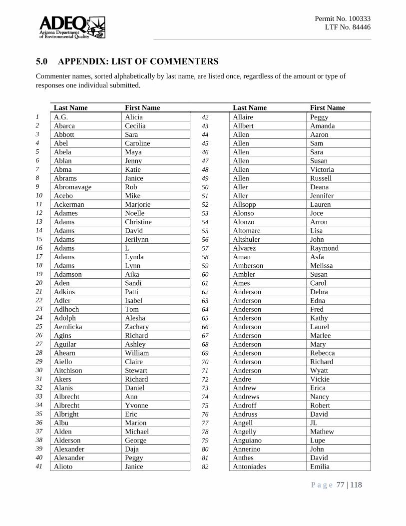
Permit No. 100333
LTF No. 84446
P a g e 77 | 118
5.0 APPENDIX: LIST OF COMMENTERS
Commenter names, sorted alphabetically by last name, are listed once, regardless of the amount or type of
responses one individual submitted.
Last Name First Name Last Name First Name
1 A.G. Alicia 42 Allaire Peggy 2 Abarca Cecilia 43 Allbert Amanda 3 Abbott Sara 44 Allen Aaron 4 Abel Caroline 45 Allen Sam 5 Abela Maya 46 Allen Sara 6 Ablan Jenny 47 Allen Susan 7 Abma Katie 48 Allen Victoria 8 Abrams Janice 49 Allen Russell 9 Abromavage Rob 50 Aller Deana 10 Acebo Mike 51 Aller Jennifer 11 Ackerman Marjorie 52 Allsopp Lauren 12 Adames Noelle 53 Alonso Joce 13 Adams Christine 54 Alonzo Arron 14 Adams David 55 Altomare Lisa 15 Adams Jerilynn 56 Altshuler John 16 Adams L 57 Alvarez Raymond 17 Adams Lynda 58 Aman Asfa 18 Adams Lynn 59 Amberson Melissa 19 Adamson Aika 60 Ambler Susan 20 Aden Sandi 61 Ames Carol 21 Adkins Patti 62 Anderson Debra 22 Adler Isabel 63 Anderson Edna 23 Adlhoch Tom 64 Anderson Fred 24 Adolph Alesha 65 Anderson Kathy 25 Aemlicka Zachary 66 Anderson Laurel 26 Agins Richard 67 Anderson Marlee 27 Aguilar Ashley 68 Anderson Mary 28 Ahearn William 69 Anderson Rebecca 29 Aiello Claire 70 Anderson Richard 30 Aitchison Stewart 71 Anderson Wyatt 31 Akers Richard 72 Andre Vickie 32 Alanis Daniel 73 Andrew Erica 33 Albrecht Ann 74 Andrews Nancy 34 Albrecht Yvonne 75 Androff Robert 35 Albright Eric 76 Andruss David 36 Albu Marion 77 Angell JL 37 Alden Michael 78 Angelly Mathew 38 Alderson George 79 Anguiano Lupe 39 Alexander Daja 80 Annerino John 40 Alexander Peggy 81 Anthes David 41 Alioto Janice 82 Antoniades Emilia

Permit No. 100333
LTF No. 84446
P a g e 78 | 118
Last Name First Name Last Name First Name 83 Appleby Brenda 130 Ba Sugar 84 Aprati Tyler 131 Babbitt Susan 85 Aragon Alicia 132 Babcock Reb 86 Arcabascio Debora 133 Bacharach Craig 87 Arcana Judith 134 Bacon Drue 88 Arch Greg 135 Bacon Scarlett 89 Archibald Jessica 136 Bacorn Christopher 90 Archuleta Bryon 137 Baehr Emily 91 Arden Ann 138 Baer Joshua 92 Ardzronni Juliette 139 Bahr Sandy 93 Arena Robyn 140 Baier Mary 94 Arends Joni 141 Bailery Rachel 95 Arias Carlos 142 Bailey Marie 96 Armao Fena 143 Bailey Nancy 97 Armbrust Shara 144 Bailie Janae 98 Armentrout Harley 145 Bain Thomas 99 Armstrong Dawn 146 Baka Abby 100 Arndorfer Mary 147 Baker Danette 101 Arnett Michael 148 Baker Judith 102 Arnold Aimee 149 Baker Micheal 103 Aronson CJ 150 Baker Nelson 104 Arrewdondo Teresa 151 Baker Scott 105 Arrington Karen 152 Baker Sharon 106 Arroyo Dorian 153 Baldwin Anne 107 Art David 154 Bales Clarice 108 Arth Amy 155 Balfour Jessica 109 Ash Susan 156 Balfour Joan 110 Ashby Lynn 157 Ball Rae 111 Ashmore Sandra 158 Ballard Brian 112 Ashu Kevin 159 Ballentine Wanda 113 Atell Chris 160 Bambauer Jennifer 114 Atherton Nancy 161 Bannan Brian 115 Athey Roger 162 Bansbach Lauren 116 Atkinson Ellen 163 Barbour Jackie 117 Attrep Kara 164 Barden Jesse 118 Atwood April 165 Bardsley Alta 119 Audas Mark 166 Barela Erin 120 Augustin Rebecca 167 Barelski Lauren 121 Austin Jana 168 Bargmann Brendan 122 Austring Dee 169 Barker Richard 123 Avilla Loretta 170 Barker Scott 124 Axelrod Alan 171 Barker Weldon 125 Axelrod Gene 172 Barkley Dan 126 Ayers Bob 173 Barlon Gabriella 127 Ayers Juana 174 Barnes Joel 128 B Debbie 175 Barnes Stan 129 B Jay 176 Barnette Renee

Permit No. 100333
LTF No. 84446
P a g e 79 | 118
Last Name First Name Last Name First Name 177 Barnhart Collene 224 Belew Lynette 178 Baron Hannah 225 Belka Talyne 179 Baron Michael 226 Bell Bridget 180 Barone Sharon 227 Bell Melinda 181 Barr Ford 228 Bell Sabrina 182 Barrett Pete 229 Bell Stephanie 183 Barry Stephanie 230 Bell T 184 Barry Thomas 231 Beloin Theodore 185 Bartlett Cormac 232 Belus Andrew 186 Barton Michael 233 Belus Mathew 187 Bash Randall 234 Ben Jordan 188 Basista Alexis 235 Ben Kathy 189 Bassett Susan 236 Benally Berta 190 Bastron Natasha 237 Benally John 191 Bates Donna 238 Benally Klee 192 Bates Lori 239 Bengtson-Wong Mary 193 Batjer Elle 240 Ben-Horin Jeri 194 Batjer Elli 241 Benjamin Dale 195 Batway Jewell 242 Benn Annette 196 Bauer Ernst 243 Bennekaa Cynthia 197 Baugh Chase 244 Bennett Jeb 198 Bautista Maria 245 Bennett River 199 Bautista Melvin 246 Benschoter John 200 Bayless Elvira 247 Benson Ashley 201 Bazz Hava 248 Benson Kimberly 202 Beach Hipp Jane 249 Benson Shanna 203 Beam Ryan 250 Bentley Don 204 Bean Susan 251 Benton Mary 205 Beatty Susanna 252 Berbergi Fio 206 Beavers John 253 Berg Mackenzie 207 Bechmann Elisabeth 254 Bergenthal Vanessa 208 Bechtel Troy 255 Bergman Don 209 Becker Elaine 256 Bergner Laura 210 Becker Julie 257 Berkheimer Nicole 211 Beckman Gerald 258 Berkowitz Henry 212 Becraft Randy 259 Berlin Anne 213 Bedolla Xena 260 Berliner Diana 214 Beebe Russ 261 Berliner Diane 215 Beers Paula 262 Berman Rachel 216 Begay Dan 263 Bermant Alison 217 Begler Lilly 264 Bernard Catherine 218 Behrhorst Amy 265 Berry Janet 219 Behrhorst David 266 Berry Nina 220 Behunin Ivy 267 Berry Patricia 221 Beiler Kristen 268 Bersson Jessica 222 Bein Ann 269 Bertolino Terry 223 Beiser Antoinette 270 Bertollino Terry
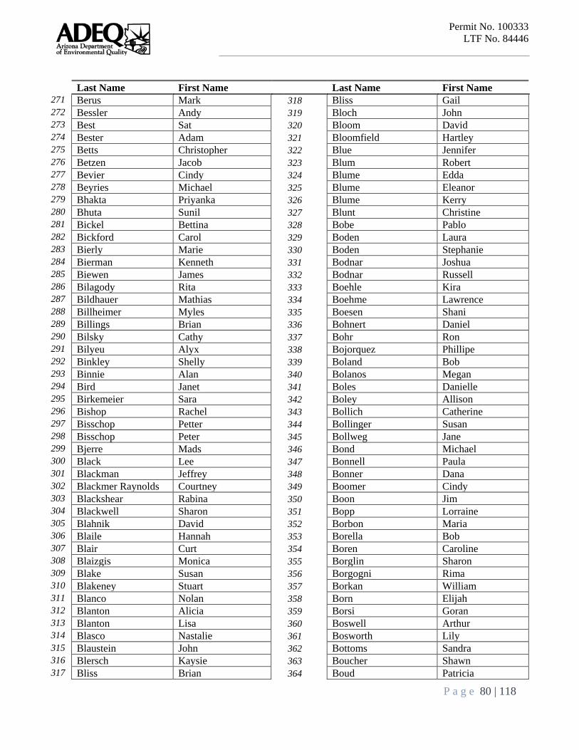
Permit No. 100333
LTF No. 84446
P a g e 80 | 118
Last Name First Name Last Name First Name 271 Berus Mark 318 Bliss Gail 272 Bessler Andy 319 Bloch John 273 Best Sat 320 Bloom David 274 Bester Adam 321 Bloomfield Hartley 275 Betts Christopher 322 Blue Jennifer 276 Betzen Jacob 323 Blum Robert 277 Bevier Cindy 324 Blume Edda 278 Beyries Michael 325 Blume Eleanor 279 Bhakta Priyanka 326 Blume Kerry 280 Bhuta Sunil 327 Blunt Christine 281 Bickel Bettina 328 Bobe Pablo 282 Bickford Carol 329 Boden Laura 283 Bierly Marie 330 Boden Stephanie 284 Bierman Kenneth 331 Bodnar Joshua 285 Biewen James 332 Bodnar Russell 286 Bilagody Rita 333 Boehle Kira 287 Bildhauer Mathias 334 Boehme Lawrence 288 Billheimer Myles 335 Boesen Shani 289 Billings Brian 336 Bohnert Daniel 290 Bilsky Cathy 337 Bohr Ron 291 Bilyeu Alyx 338 Bojorquez Phillipe 292 Binkley Shelly 339 Boland Bob 293 Binnie Alan 340 Bolanos Megan 294 Bird Janet 341 Boles Danielle 295 Birkemeier Sara 342 Boley Allison 296 Bishop Rachel 343 Bollich Catherine 297 Bisschop Petter 344 Bollinger Susan 298 Bisschop Peter 345 Bollweg Jane 299 Bjerre Mads 346 Bond Michael 300 Black Lee 347 Bonnell Paula 301 Blackman Jeffrey 348 Bonner Dana 302 Blackmer Raynolds Courtney 349 Boomer Cindy 303 Blackshear Rabina 350 Boon Jim 304 Blackwell Sharon 351 Bopp Lorraine 305 Blahnik David 352 Borbon Maria 306 Blaile Hannah 353 Borella Bob 307 Blair Curt 354 Boren Caroline 308 Blaizgis Monica 355 Borglin Sharon 309 Blake Susan 356 Borgogni Rima 310 Blakeney Stuart 357 Borkan William 311 Blanco Nolan 358 Born Elijah 312 Blanton Alicia 359 Borsi Goran 313 Blanton Lisa 360 Boswell Arthur 314 Blasco Nastalie 361 Bosworth Lily 315 Blaustein John 362 Bottoms Sandra 316 Blersch Kaysie 363 Boucher Shawn 317 Bliss Brian 364 Boud Patricia

Permit No. 100333
LTF No. 84446
P a g e 81 | 118
Last Name First Name Last Name First Name 365 Boutwell Richard 412 Broker Thomas 366 Bower C. 413 Bromley Jaime 367 Bowers Natalie 414 Brooke Devin 368 Bowman Jane 415 Brooke James 369 Bowman Kathleen 416 Brooke Michael 370 Boyd Amy 417 Brooker James 371 Boydston Lori 418 Brooker Jim 372 Boyer Julie 419 Brooks Shawn 373 Boyle Margaret 420 Brosnan Abigail 374 Boyle Michael 421 Brown Annie 375 Boyle Richard 422 Brown Chris 376 Brackett Mary 423 Brown Darcey 377 Bradi James 424 Brown Duncan 378 Bradley Kenn 425 Brown Linda 379 Brady Linda 426 Brown Loraine 380 Bragdon Elyse 427 Brown Mickey 381 Braithwaite Georgia 428 Brown Peter 382 Braley Bruce 429 Brown Sheena 383 Brand Charles 430 Browndog Lila 384 Brandes Susan 431 Brownell Mara 385 Brandis Debra 432 Browning Marjorie 386 Brandon Victoria 433 Bruce Terah 387 Brandwein Angel 434 Brundage Joan and Alan 388 Brannon Elizabeth 435 Brunner Thomas 389 Brasch Dorothy 436 Bruno Leila 390 Brashear Kathy 437 Bryan Lori 391 Braudt Thomas 438 Bryant Kathleen 392 Braun Clait E 439 Bryant Ned 393 Brazie Joe 440 Bryant Valarie 394 Breihan Lauren 441 Bucalo Becky 395 Brendemuhl Autumn 442 Buchan William 396 Brennan Tyler 443 Buchanan Trusdell Kathy 397 Brennenman Don 444 Bucher Ingrid 398 Brent Caroly 445 Buchheit Kim 399 Brescia Joseph 446 Buck Barbara 400 Breslin Jean 447 Buell Nancy 401 Breunig Robert 448 Buerge Melyssa 402 Brewer Anna 449 Buffington Carol 403 Brewer Lynn 450 Buila Terry 404 Brezan Barry 451 Bulla Terry 405 Brian Brian 452 Bumpus Amy 406 Briggs Sharon 453 Buntin Simmons 407 Brink Don 454 Burch Allison 408 Brizuela Sarah 455 Burch Anderson 409 Broan Andrew 456 Burchette Laura 410 Brogan Dan 457 Burd Lori Ann 411 Brogden Mette 458 Burg Melissa
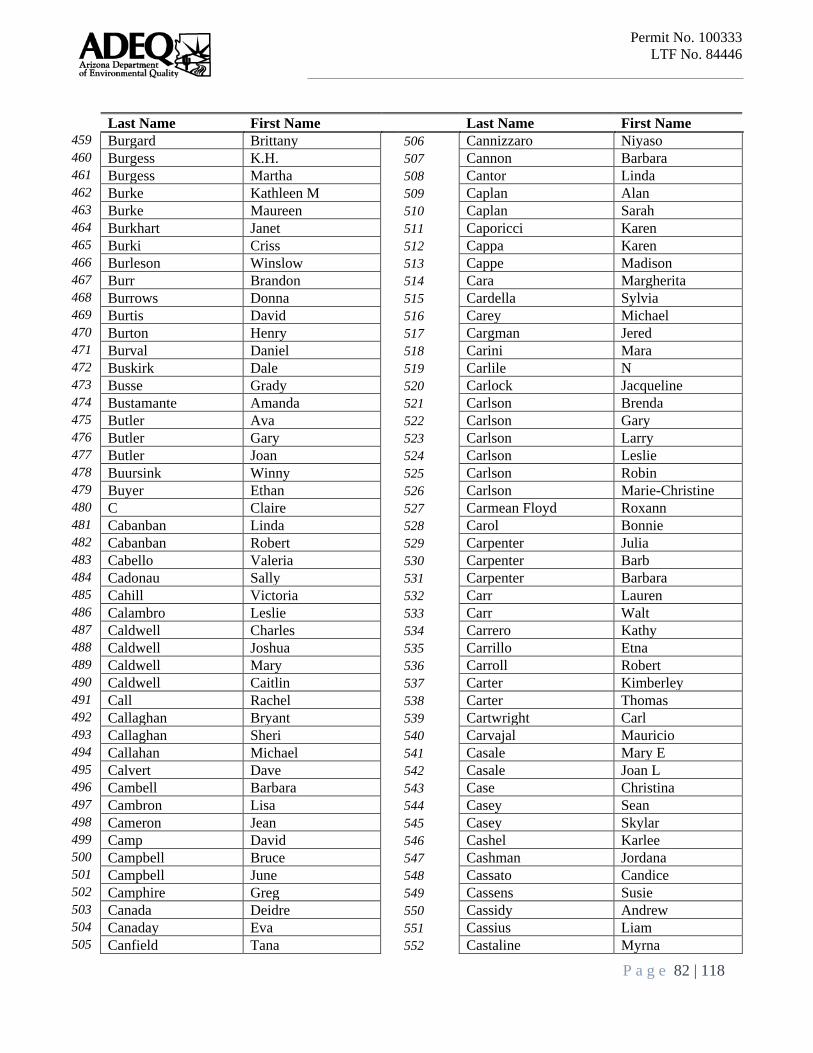
Permit No. 100333
LTF No. 84446
P a g e 82 | 118
Last Name First Name Last Name First Name 459 Burgard Brittany 506 Cannizzaro Niyaso 460 Burgess K.H. 507 Cannon Barbara 461 Burgess Martha 508 Cantor Linda 462 Burke Kathleen M 509 Caplan Alan 463 Burke Maureen 510 Caplan Sarah 464 Burkhart Janet 511 Caporicci Karen 465 Burki Criss 512 Cappa Karen 466 Burleson Winslow 513 Cappe Madison 467 Burr Brandon 514 Cara Margherita 468 Burrows Donna 515 Cardella Sylvia 469 Burtis David 516 Carey Michael 470 Burton Henry 517 Cargman Jered 471 Burval Daniel 518 Carini Mara 472 Buskirk Dale 519 Carlile N 473 Busse Grady 520 Carlock Jacqueline 474 Bustamante Amanda 521 Carlson Brenda 475 Butler Ava 522 Carlson Gary 476 Butler Gary 523 Carlson Larry 477 Butler Joan 524 Carlson Leslie 478 Buursink Winny 525 Carlson Robin 479 Buyer Ethan 526 Carlson Marie-Christine 480 C Claire 527 Carmean Floyd Roxann 481 Cabanban Linda 528 Carol Bonnie 482 Cabanban Robert 529 Carpenter Julia 483 Cabello Valeria 530 Carpenter Barb 484 Cadonau Sally 531 Carpenter Barbara 485 Cahill Victoria 532 Carr Lauren 486 Calambro Leslie 533 Carr Walt 487 Caldwell Charles 534 Carrero Kathy 488 Caldwell Joshua 535 Carrillo Etna 489 Caldwell Mary 536 Carroll Robert 490 Caldwell Caitlin 537 Carter Kimberley 491 Call Rachel 538 Carter Thomas 492 Callaghan Bryant 539 Cartwright Carl 493 Callaghan Sheri 540 Carvajal Mauricio 494 Callahan Michael 541 Casale Mary E 495 Calvert Dave 542 Casale Joan L 496 Cambell Barbara 543 Case Christina 497 Cambron Lisa 544 Casey Sean 498 Cameron Jean 545 Casey Skylar 499 Camp David 546 Cashel Karlee 500 Campbell Bruce 547 Cashman Jordana 501 Campbell June 548 Cassato Candice 502 Camphire Greg 549 Cassens Susie 503 Canada Deidre 550 Cassidy Andrew 504 Canaday Eva 551 Cassius Liam 505 Canfield Tana 552 Castaline Myrna
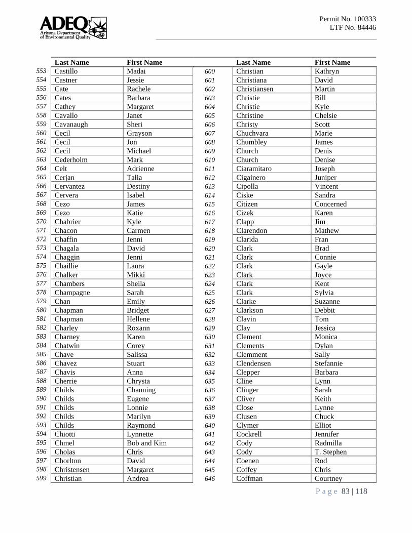
Permit No. 100333
LTF No. 84446
P a g e 83 | 118
Last Name First Name Last Name First Name 553 Castillo Madai 600 Christian Kathryn 554 Castner Jessie 601 Christiana David 555 Cate Rachele 602 Christiansen Martin 556 Cates Barbara 603 Christie Bill 557 Cathey Margaret 604 Christie Kyle 558 Cavallo Janet 605 Christine Chelsie 559 Cavanaugh Sheri 606 Christy Scott 560 Cecil Grayson 607 Chuchvara Marie 561 Cecil Jon 608 Chumbley James 562 Cecil Michael 609 Church Denis 563 Cederholm Mark 610 Church Denise 564 Celt Adrienne 611 Ciaramitaro Joseph 565 Cerjan Talia 612 Cigainero Juniper 566 Cervantez Destiny 613 Cipolla Vincent 567 Cervera Isabel 614 Ciske Sandra 568 Cezo James 615 Citizen Concerned 569 Cezo Katie 616 Cizek Karen 570 Chabrier Kyle 617 Clapp Jim 571 Chacon Carmen 618 Clarendon Mathew 572 Chaffin Jenni 619 Clarida Fran 573 Chagala David 620 Clark Brad 574 Chaggin Jenni 621 Clark Connie 575 Chaillie Laura 622 Clark Gayle 576 Chalker Mikki 623 Clark Joyce 577 Chambers Sheila 624 Clark Kent 578 Champagne Sarah 625 Clark Sylvia 579 Chan Emily 626 Clarke Suzanne 580 Chapman Bridget 627 Clarkson Debbit 581 Chapman Hellene 628 Clavin Tom 582 Charley Roxann 629 Clay Jessica 583 Charney Karen 630 Clement Monica 584 Chatwin Corey 631 Clements Dylan 585 Chave Salissa 632 Clemment Sally 586 Chavez Stuart 633 Clendensen Stefannie 587 Chavis Anna 634 Clepper Barbara 588 Cherrie Chrysta 635 Cline Lynn 589 Childs Channing 636 Clinger Sarah 590 Childs Eugene 637 Cliver Keith 591 Childs Lonnie 638 Close Lynne 592 Childs Marilyn 639 Clusen Chuck 593 Childs Raymond 640 Clymer Elliot 594 Chiotti Lynnette 641 Cockrell Jennifer 595 Chmel Bob and Kim 642 Cody Radmilla 596 Cholas Chris 643 Cody T. Stephen 597 Chorlton David 644 Coenen Rod 598 Christensen Margaret 645 Coffey Chris 599 Christian Andrea 646 Coffman Courtney
Permit No. 100333
LTF No. 84446
P a g e 84 | 118
Last Name First Name Last Name First Name 647 Coffman Kathy 694 Costa Margarida 648 Coghlan Patricia 695 Costa Michael 649 Coglaiti Carlene 696 Costion Joe 650 Cohen Harriet 697 Cotten Kelly 651 Cohen Howard 698 Cotter Justina 652 Cohen Jill 699 Cotts Laura 653 Cohen Peggy 700 Coughlin John 654 Cohn Charles 701 Coulter Alan 655 Cohn Janet 702 Councill D 656 Colangelo Annapoorne 703 Courtright Caroline 657 Colangelo Kim 704 Courtright Ryan 658 Colatosti Ryan 705 Cowan Edward 659 Cole Elena 706 Cowan Larry 660 Cole Martha 707 Cowden Sheila 661 Cole Tracy 708 Cowles Emily 662 Colebank Darryl 709 Cox Holly 663 Coles-Ritchie Marc 710 Cox Joel 664 Collazo Marie 711 Cox Nanci 665 Collett Merrill 712 Crabtree Summer 666 Colletti Kathy 713 Craig Ann 667 Collier Ken 714 Cranmer Julia 668 Collins Kathy 715 Crawford Chelsea 669 Coloos Brigitte 716 Crawford Jon 670 Colpas Marcie 717 Creswell Richard 671 Colten Lora 718 Crew Tammy 672 Colvin Ronnie 719 Crews Michael 673 Con Sal 720 Cribbins Judy 674 Condella Tess 721 Crider Nancy 675 Conklin Lu 722 Critchley Ian 676 Conley Michael 723 Crmkovich Stephen 677 Conley Patrick 724 Crnkovich Stephen 678 Conner Charles 725 Crockett Paula 679 Conners Marisa 726 Crockford Brian 680 Conway Robert 727 Croft Alan 681 Cook Nena 728 Croll Danielle 682 Cook Samuel 729 Cronin Elizabeth 683 Cooke Julie 730 Crook Dustin 684 Cooter Clifford 731 Crookston Terry 685 Cope Nate 732 Crookston Theresa 686 Coplen Randall 733 Crouch Michael 687 Coproon Hannah 734 Crowfoot Hilma 688 Corbin Linda 735 Cruz Benjamin 689 Corey William 736 Cruz Carolyn 690 Corley Bert 737 Cruz Marian 691 Cornell Linc 738 Cruz Mary 692 Cornely John 739 Csenge Debra 693 Corriere Sandra 740 Cucchi Jessica

Permit No. 100333
LTF No. 84446
P a g e 85 | 118
Last Name First Name Last Name First Name 741 Cucchiara Caroline 788 Davis Ansley 742 Cudd Steven 789 Davis Cooper 743 Cuellar Dolores 790 Davis Derrick 744 Cuen Gabriela 791 Davis Elizabeth 745 Cuozzo Alexander 792 Davis Helen 746 Curia Peter 793 Davis Jesica 747 Curlette Diana 794 Davis Leona 748 Currah Nancy 795 Davis Madeliaine 749 Curran Mar 796 Davis Richard 750 Currey Bonnie 797 Davis Rick 751 Curtis Christine 798 Davis Tom 752 Cushway Warren 799 Dawson Gerald 753 Cusick Katy 800 Day Joe 754 Cusick Robin 801 De Berge Suzanne 755 Cuttler Karen 802 de la Cerda Ian 756 Czapinski Victoria 803 De La Garza Jasmine 757 Czapp Ferencz 804 de la Vista Rio 758 Dahlgren Tess 805 de Leon Peria 759 Dahlman Jill 806 Deal Brandie 760 Dal Vera Anne 807 Dean Brandon 761 Dallman Erica 808 Deane Janelle 762 Dalton Sadie 809 Deasy Paul 763 Dalton-Nuvams Doris 810 DeBoer Natalie 764 Daly Dorcas 811 DeBoer Rachel 765 Dameron Logan 812 Deck Avis 766 Damus M 813 Decou Nermin 767 Dana Sewall 814 Dee Mike 768 Daniele Renate 815 Dehn Bill 769 Daniels Marilyn 816 Dehn William 770 Daniels Mark 817 Del Rossi Rachel 771 Danielson Sydney 818 Del Vecchio Cheryl 772 Dankwort Rudolf 819 Dell Patrica 773 Darby Renee 820 Della Penta Cathy 774 Dargen Evan 821 Deltognoarmanasco John 775 Darling Anna 822 DeLuca Theresa 776 Darling Carrie 823 Demars Sylvia 777 Darling Roxanne 824 DeMuth Lynn 778 Datcu Ioana 825 Dennis Kathryn 779 Daugherty James 826 Denniston Jay 780 Davenport Tamara 827 Denny Debby 781 David Cassalyn 828 DeNunzio Bruce 782 David Gary 829 Dep Christine 783 Davidson Barbara 830 Deppman Barbara 784 Davidson Catherin 831 Derby Alexandra 785 Davidson Joseph 832 DeRussy Glenn 786 Davidson Lori 833 Desch Samantha 787 Davies Callie 834 Deschner Ann Marie
Permit No. 100333
LTF No. 84446
P a g e 86 | 118
Last Name First Name Last Name First Name 835 Deshotel Shelley 882 Dow Patricia 836 Desmond Katie 883 Dowd Thomas 837 DesRosiers Ariane 884 Downey Judith 838 deVall Sue 885 Doyle Kathleen 839 DeVecchio Jacob 886 Drake Carol 840 Devine Jeanne 887 Draper Kathryn 841 Devito Mary 888 Dreste Arlene 842 Dexter Marie 889 Driscoll Maria 843 Diamondstone Esther 890 Driscoll Marie 844 Diana Duffy 891 Drozdoff Martin 845 Diaz Deanna 892 Duan Lynn 846 Dibble Steve 893 Dube David 847 Dickerson Danika 894 Dublinski Jim 848 Dickie Alexander 895 Dublinsli James 849 Dickinson Michael 896 DuBois Jeff 850 Dickson Lyle 897 DuCharme Christy 851 Diedrich Martin 898 Duda Tim 852 Dierking Lindsey 899 Dudenhoeffer Eileen 853 Diesman Laura 900 Duell Brad 854 Dietrich Cameron 901 Duesbery Teah 855 Dille Nancy 902 Duffy Diana 856 Dillingham Beth 903 Dugaw Anne 857 Diodato Amy 904 Duggan Eric 858 DiPillo Rachel 905 Dugi Augustina 859 Dixon John 906 Dukes Thomas 860 Dobroslavic B 907 Dunaetz Neil 861 Dodge Alex 908 Duncan Alice 862 Dodson Pamela 909 Duncan Teresa 863 Dolleman Sharon 910 Dunlop Patrick 864 Dolnick Cody 911 Dunn Angela 865 Doman Heidi 912 Dunn Josheph 866 Donaghy Howard 913 Dunne Harold 867 Donald John 914 Duran Sarah 868 Donaldson Leslie 915 Durrum Kathy 869 Donnell Bruce 916 Duster George 870 Donovan Stephan 917 DuVall Dennis 871 Donovan Stephan 918 Dworsky Harlan 872 Dorn Kathryn 919 Dyczko K 873 Dorsch Randall 920 Dyer Dawn 874 Dosland Britta 921 Dyer Elizabeth 875 Doss Summer 922 Eagle War 876 Dotson Virginia 923 Eames Cheryl 877 Doug Pilcher 924 Earl Michael 878 Dougherty Amy 925 Eastmead Drew 879 Douglas Diana 926 Eaton Pamela 880 Douglas Dianne 927 Eaton Sheryl 881 Douglass Amy 928 Ebarb Kayla
Permit No. 100333
LTF No. 84446
P a g e 87 | 118
Last Name First Name Last Name First Name 929 Ebbe Kris 976 Epstein Rob 930 Ebersole Jayne 977 Erickson Cami 931 Eccles Rita 978 Erickson Christopher 932 Eccleston William 979 Erickson Kathleen 933 Eck Jj 980 Escobar Nicolette 934 Eddings Justin 981 Esigner Stevie 935 Eddy Lukas 982 Esparza Grace 936 Edelstein Andrew 983 Esparza-Harris Janice 937 Edgar Sharon 984 Espinosa Gale 938 Edwards Allain 985 Esque Sandy 939 Edwards Catherine 986 Estacion Carlene 940 Edwards Cynthia 987 Estarrona Mikael 941 Egger Tricia 988 Estrada Christina 942 Egrie Joan 989 Estrada Jessica 943 Ehl Michael 990 Estrella Andrea 944 Ehmsen Ron 991 Estrella Marlena 945 Eich Elizabeth 992 Eudy Elaine 946 Eich Ronald 993 Evans Catherine 947 Eikenbary Susan 994 Evans Nick 948 Einhorn Janet 995 Evans Pamela 949 Eisenberg Dr. Amy 996 Evans Sandra 950 Eldracher Danielle 997 Evans Sarah 951 Eldridge Dustin 998 Evans Robert 952 Eldridge Jennifer 999 Everhart Noelle 953 Elise Lynn 1000 Evers Martha 954 Elizabeth Kate 1001 Eyles John 955 Elkenbary Susan 1002 F Julisa 956 Eller Aisling 1003 Fabry Michael 957 Ellett William & Kathleen 1004 Face Marcia 958 Elliott Marshall 1005 Fachet Patrick 959 Ellis David 1006 Fahring Rachel 960 Ellis Laura 1007 Faich Ron 961 Ellis Mary Carlisle 1008 Failey Arthur 962 Ellison Margery 1009 Failing Wayne 963 ElShwahyk Jalila 1010 Faith Sariah 964 Ely Sheridan 1011 Falcon Jenn 965 Emerson Anneliese 1012 Falk Larry 966 Emerson Jan 1013 Falsetto Charles 967 Emmer Mathew 1014 Falsken James 968 Emmert Wendy 1015 Farina Carol 969 Engdahl Rae 1016 Farkas Elizabeth 970 Englander Carl 1017 Farrar Valerie 971 Engle I. 1018 Farrell Chloe 972 Engler Lillian 1019 Farris Lawrence 973 English Melissa 1020 Farrow Rik 974 Enright E 1021 Fass Arline 975 Enright Elizabeth 1022 Faulkner Henry
Permit No. 100333
LTF No. 84446
P a g e 88 | 118
Last Name First Name Last Name First Name 1023 Faust John 1070 Fogleman Maxwell 1024 Favel Iktomi 1071 Foor Susan 1025 Fawcett Gay 1072 Forbes Jim 1026 Fay Alexa 1073 Ford Isaiah 1027 Fechtel Maggie 1074 Ford Julie 1028 Fedirko-Unde Taysia 1075 Forman Fay 1029 Fegadel Dr. 1076 Forman Janet 1030 Feldman Dr. 1077 Fornstrom Cindy 1031 Feldstein Stephanie 1078 Forsey Dayle 1032 Felts Terry 1079 Forster Wendy 1033 Fennell April 1080 Foster Gwen 1034 Fenzel Abigail 1081 Foster Stephanie 1035 Feraru Robert 1082 Fowler Theodore 1036 Fergus Jeri 1083 Fox Bayard 1037 Ferguson Alan 1084 Fox Devon 1038 Ferguson Linda 1085 Fox Joaquin 1039 Ferguson Tom 1086 Fox Preston 1040 Fernande Fournier 1087 Fox Randal 1041 Ferraro Monica 1088 Foxx Jaqueline 1042 Fiarkoski Paul 1089 Fraley Dan 1043 Fierro Morales Andres 1090 Franco Sophia 1044 Figueroa Alex 1091 Frank Harriette 1045 Figueroa Daniel 1092 Frank Peggy 1046 Filipic Randy 1093 Fraser Josslyn 1047 Filleaudeau Mrs. Andrienne 1094 Fraser Kathy 1048 Filosa Christine 1095 Fray Linley 1049 Finando Steve 1096 Frazier Maggie 1050 Findley Clarisa 1097 Frazier Margaret 1051 Fine Donna 1098 Frederick Jay 1052 Fine Jovita 1099 Frederiksen Chris 1053 Finkelstein Sheldon 1100 Freeman Adrianna 1054 Fischer Lise 1101 Freeman Ashley 1055 Fisher Taylor 1102 Freeman Gregory 1056 Fishgold James 1103 Freeman Joseph 1057 Fisk Cooper 1104 Freeman Kenneth 1058 Fitzgerald Anne 1105 Freer Elizabeth 1059 Fitzpatrick Sienna 1106 Freitas Jesse 1060 Flake Cheyenne 1107 Friedel Adele 1061 Fleischmann Paige 1108 Friedmann Michael 1062 Fleming John 1109 Friedrich Howard 1063 Fleming Susan 1110 Friel Michael 1064 Fletcher " 1111 Friesen Debbie 1065 Floor Mark 1112 Friestad John 1066 Flores George 1113 Frisby Edd 1067 Flores Joseph 1114 Frisby Lo 1068 Flynn Doug 1115 Frisella Michele 1069 Flynn Lois 1116 Frishman Andry
Permit No. 100333
LTF No. 84446
P a g e 89 | 118
Last Name First Name Last Name First Name 1117 Frizane Paul 1164 Gamache Mary 1118 Frodeman Annie 1165 Gamboa Melissa 1119 Frohardt Katharine 1166 Gannon Vicki 1120 Frohn Joyce 1167 Garber Pat 1121 Fromberg Jeff 1168 Garcia Alec 1122 Froning Clayton 1169 Garcia Andrea 1123 Frost Chris 1170 Garcia Cheyene 1124 Fry Lauren 1171 Garcia Maria 1125 Fuchs Eileen 1172 Garcia Ray 1126 Fugate Lu 1173 Garibaldi de Luna Maria 1127 Fuhrman David 1174 Garlick Kerrie-Ann 1128 Fuhst Paula 1175 Garoutte Claudia 1129 Fukuda Kristina 1176 Gartin Barbara 1130 Fukunaga Judy 1177 Garwood Georgie 1131 Fularczyk Margaret 1178 Gary Carol 1132 Fulgham Kirsten 1179 Gates Alan 1133 Fuller Katelyn 1180 Gatlin Mark 1134 Fuller Kylie 1181 Gatto Gina 1135 Fuller Lori 1182 Gatton Mike 1136 Funk Adam 1183 Gaude Kelsey 1137 Fuzman Virginia 1184 Gaudy Caroline 1138 G Jessica 1185 Gawne William 1139 G Sydney 1186 Gay Lauren 1140 Gabaldon Carlos 1187 Geelhoed Glenn 1141 Gacek Piotr 1188 Geer Susan 1142 Gaede Marnie 1189 Geffan Bruce 1143 Gaetz Sara 1190 Gehlen Patricia 1144 Gage Beth 1191 Geil Michelle 1145 Gagner Paul 1192 Geiser Melissa 1146 Gaiser Stephen 1193 Gemind Sara 1147 Gaither-Banch Kelli 1194 Gemmer Jessie 1148 Gaitis Dawn 1195 Gendvil Derek 1149 Galap Simon 1196 Gennaro Gina 1150 Galbavy P 1197 George Monika 1151 Galbraith Daisy 1198 George James 1152 Gale Lora 1199 Georgieva Anna 1153 Galiana Max 1200 Gerbus Rick 1154 Galla Kathryn 1201 Gerdin Marc 1155 Gallagher Barbara 1202 Gerhart Robert 1156 Gallagher David 1203 Gers Ryan 1157 Gallagher Margaret 1204 Gervasi Angela 1158 Gallant Helena 1205 Getty Joe 1159 Gallego Yolanda 1206 Giambruno Robert 1160 Gallo Kristy 1207 Giardina Mark 1161 Galloway Neal 1208 Gibbons Brian 1162 Galope Megan 1209 Gibbs Denise 1163 Galvez Michelle 1210 Gibbs Paul

Permit No. 100333
LTF No. 84446
P a g e 90 | 118
Last Name First Name Last Name First Name 1211 Gibbs William 1258 Golden Mike 1212 Gibson Duane 1259 Goldman Dawn 1213 Gibson Emily 1260 Goldman Donal 1214 Gibson Jody 1261 Goldsmith Ken 1215 Gibson Karen 1262 Goldstein Colin 1216 Gibson Kenneth 1263 Goldwater Ty 1217 Gifford Elizabeth 1264 Golser Wolfgang 1218 Gilardi Gary 1265 Goltz Lori 1219 Gilbert Liv 1266 Gomez Victoria 1220 Gilbert Pamela 1267 Gomez-Echegar Pablo 1221 Gill Samantha 1268 Gonder Gloriac 1222 Gillenwater Trol 1269 Gonzales Helen 1223 Gillenwater Troy 1270 Gonzales Norma 1224 Gillet Reyna 1271 Gonzalez Camille 1225 Gillis Patricia 1272 Gonzalez Cesar 1226 Giloth Greg 1273 Gonzalez Lori 1227 Gimm Phyllis 1274 Gonzalez Stephanie 1228 Gioia Tony 1275 Gonzalez Stevie 1229 Giovale Hilary 1276 Gonzalez Veronica 1230 Giovanni Dr. 1277 Good Sharon 1231 Giron Alex 1278 Goodberg Robert 1232 Girshick Lori B 1279 Goodman Quinn 1233 Gitlin Alicyn 1280 Goodrich Rebecca 1234 Giunta Liane 1281 Goodwin Kevin 1235 Glaccum Ellen 1282 Goodwin Shaun 1236 Glass Leslie 1283 Gordon Marcy 1237 Glassburn Carolyn 1284 Gorel Danya 1238 Glavina Vesna 1285 Gorman Catherine 1239 Glenn Caleb 1286 Gorostiza Lucia 1240 Glenn Rebecca 1287 Gorrin Eugen 1241 Glider Richard 1288 Gorski Ilene 1242 Glineburg Robert 1289 Gouvela Carmen 1243 Glover Janet 1290 Gowan Mark 1244 Glover Sydney 1291 Grady Patrick 1245 Glow Steve 1292 Graffagnino MaryAnn &Frank 1246 Go Suyen 1293 Graffanino Mary Ann & Frank 1247 Goddard Monica 1294 Grammatica Arlo 1248 Godwin Nancy K 1295 Granade Victoria 1249 Godwin Nancy 1296 Grange Gary 1250 Goerke Carol 1297 Granucci Thmas 1251 Goetschel Marissa 1298 Granville Martin 1252 Goetz Linda 1299 Graper Barbara 1253 Goff Elizabeth 1300 Grassel LB 1254 Golas Michael 1301 Graterol Alejandro 1255 Golba Tara 1302 Gray Cameron 1256 Gold Ilyse 1303 Gray James 1257 Gold Warren 1304 Gray Millicent
Permit No. 100333
LTF No. 84446
P a g e 91 | 118
Last Name First Name Last Name First Name 1305 Gray Monica 1352 Gurvich Susan 1306 Gray Tom 1353 Gustagson David 1307 Graziosa Sara 1354 Gutfleisch Ellen 1308 Greaves Jean 1355 Guthrie Elizabeth 1309 Green Julia 1356 Guthrie Shannon 1310 Green Katherine 1357 Gutierrez Gilberto 1311 Green Martha 1358 H Paige 1312 Green Rax 1359 Haarr Lars 1313 Greendorfer Susan 1360 Hackos JoAnn 1314 Greene Nancy 1361 Hadcock David 1315 Greenlee Rayven 1362 Haddock Sandy 1316 Green-Smith Cole 1363 Hadland Richardy 1317 Greenwood Shannon 1364 Hafner Amy 1318 Greer Jeff 1365 Hagan Krystel 1319 Greer Kelsi 1366 Hagood Christina 1320 Gregerson Gary 1367 Haldeman Katie 1321 Gregory Ben 1368 Hale Taylor 1322 Gregory Linda 1369 Halgren Samuel 1323 Greiner Susan 1370 Hall Carolyn 1324 Grenard Mark 1371 Hall Haley 1325 Grenard Mark Hayduke 1372 Hall Hannah 1326 Gricevich Anne 1373 Hall Holly 1327 Gricus Elizabeth 1374 Hall Matt 1328 Grider David 1375 Halliday Phyllis 1329 Gries Ashley 1376 Halpern Harvey 1330 Grieve Andrew 1377 Halter Janesa 1331 Grieves Kathy 1378 Halter Jenesa 1332 Griffith Sandra 1379 Halversen Susan 1333 Griggeory Kristen 1380 Halverson Joan 1334 Grimm Phyllis 1381 Halvorsen Peta 1335 Grimwood Jaime 1382 Hamilton Abby 1336 Grobelny Julie 1383 Hamilton Daniel 1337 Grosinger Paul 1384 Hamilton Dave 1338 Gross Rebecca 1385 Hamilton Irene 1339 Gross Todd 1386 Hamilton John 1340 Grove Stephen 1387 Hamilton Lynn 1341 Grubb Carol 1388 Hamilton Sarah 1342 Gruwell Darlene 1389 Hamm Cat 1343 Guarino Ann 1390 Hamm Chantel 1344 Guarnieri Tony 1391 Hamm Richard 1345 Guignard Robert 1392 Hammack David 1346 Gumerman Elizabeth 1393 Hammond Kelsey 1347 Gumerman George 1394 Hammond Sally 1348 Gunderson Margaret 1395 Hammond Stephanie 1349 Gunn David 1396 Hand Susan 1350 Gunn Shirley 1397 Handforth Michael 1351 Gupta Anuj 1398 Haneline William

Permit No. 100333
LTF No. 84446
P a g e 92 | 118
Last Name First Name Last Name First Name 1399 Hanna Sybil 1446 Hartman Sara 1400 Hanneke Anne 1447 Hartman Sarah 1401 Hanneman Paul 1448 Harvella-Tob Sherry 1402 Hannigan Bob 1449 Harvey Avaya 1403 Hanold Dena 1450 Harvey Deborah 1404 Hansen Dameon 1451 Harvey Jo 1405 Hansen Gina 1452 Harvey Kurt 1406 Hansen Julie 1453 Haskell Christopher 1407 Hansen Paige 1454 Haskell Sarah 1408 Hansen Sofia 1455 Hastings Elizabeth 1409 Hanson Art 1456 Hastings-Smi Sydney 1410 Hanson Barbara 1457 Hatchett James 1411 Hanson Ginger 1458 Hatfield Patricia 1412 Hanson Vickie 1459 Hathaway Peter 1413 Harbert Nancy 1460 Hausam Tom 1414 Hardebeck Larry 1461 Haverfield Tiffany 1415 Hardebeck Lawrence 1462 Haw Dorene 1416 Hardenbergh Sabrina 1463 Hawklee Kay 1417 Harding John 1464 Hawn Judy 1418 Harding Maggie 1465 Hawn Judy 1419 Hardt Elizabeth 1466 Hayduke George 1420 Hardy Michael 1467 Hayer Alisha 1421 Harman Nona 1468 Hayes Amy 1422 Harmon Dawn 1469 Hayes Kenneth 1423 Harned Jon 1470 Hayes Leanna 1424 Harper Kathryn 1471 Hayes Sara 1425 Harrington Sandra 1472 Hayes Time 1426 Harrington Susan 1473 Haynes Rebecca 1427 Harrington Susie 1474 Haywood Sloane 1428 Harris Brent 1475 Hazelton Judith 1429 Harris Carol 1476 Hazynski Chris 1430 Harris Freya 1477 Healy Clarice 1431 Harris Molly 1478 Heaning Rich 1432 Harrison James 1479 Heaps Lynell 1433 Harrison John 1480 Hearst Kiley 1434 Harrison Neil 1481 Heaton Timothy 1435 Harrison Vaughn 1482 Hebets Lexine 1436 Harry Sherry 1483 Heck McKenna 1437 Hart Beth 1484 Hed Scott 1438 Hart Dennis 1485 Heffernan Dan 1439 Hart Lyn 1486 Heflin Stella 1440 Hart Rob 1487 Heikens Barabara 1441 Hart Donna 1488 Heikens Barbara 1442 Hartgraves Paula 1489 Heisler Katharine 1443 Hartly Kevin 1490 Heitmann Germar 1444 Hartman Ashly 1491 Helin Bruce & Nancy 1445 Hartman Nancy 1492 Heller Olya
Permit No. 100333
LTF No. 84446
P a g e 93 | 118
Last Name First Name Last Name First Name 1493 Heller Terri 1540 Hinton Bill 1494 Hemmila Rodney 1541 Hirt Barbara 1495 Hemstreet Steven 1542 Hitt Amy 1496 Henderson Emily 1543 Hobbs Alexander 1497 Hendrick James 1544 Hoch James 1498 Hendricks Brent 1545 Hoch Jeffrey 1499 Hendricks Kim 1546 Hoch Lisa 1500 Hendricks Sandra 1547 Hock Louis 1501 Hendrickson Margaret 1548 Hodes David 1502 Henley Barbara 1549 Hodge Mark 1503 Henn Mark 1550 Hodges Sherri 1504 Hennigan Patricia 1551 Hoeflin Stephanie 1505 Henriksen James 1552 Hoener John 1506 Henry Remony 1553 Hoffman Char 1507 Hensel Beth 1554 Hoffman Susan 1508 Henson Lana 1555 Hoffmann Cristina 1509 Henzel William 1556 Hoge Christopher 1510 Herk Mary 1557 Hoh Erica 1511 Herman Brandon 1558 Holcombe Cassie 1512 Hermann Birgit 1559 Holland Ann 1513 Hernandez Anneliese 1560 Holland Kate 1514 Hernandez Francisca James 1561 Holloman Jennifer 1515 Hernandez Justin 1562 Holloway Jeffrey 1516 Hernández Gómez Davinia 1563 Holm Mary 1517 Hernesman John 1564 Holm Mary 1518 Herrera Daniel 1565 Holmes Jenny 1519 Herring Timothy 1566 Holst Mark 1520 Hershey-Lear Chandra 1567 Holtrop Hunter 1521 Herther James 1568 Homer Rona 1522 Hervatin Shirley 1569 Honer-Orton M. 1523 Herzog Adrianne 1570 Hong Celeste 1524 Heusinkyeld Dominika 1571 Honga Jewel 1525 Hibarger Mariah 1572 Honigfort Michael 1526 Hibben T 1573 Hoogs Lauren 1527 Hickerson James 1574 Hope Diane 1528 Hicks Cynthia 1575 Hopkins Teri 1529 Hicks Lacey 1576 Horn Jasmine 1530 Higgs Brad 1577 Horn Tara 1531 Hildebrandt Melanie 1578 Horner Christopher 1532 Hilkin Danielle 1579 Horner Zachary 1533 Hill Alice 1580 Horner Jenna 1534 Hill Pamela 1581 Horstman Patrice 1535 Hill Sammie 1582 Horton Dan 1536 Hill Vanessa 1583 Horton Daryl 1537 Hillman Melita 1584 Horton Deanna 1538 Hilton Bryan 1585 Horton Emma 1539 Hinson Katherine 1586 Horwitz Layne

Permit No. 100333
LTF No. 84446
P a g e 94 | 118
Last Name First Name Last Name First Name 1587 Hotham Sharon 1634 Huston Guy 1588 Houghton N 1635 Hutchins David 1589 Hougland Cynthia 1636 Hutchins Katherine 1590 Houser Dorothy 1637 Hutchinson Elizabeth 1591 Houshower Samuel 1638 Huth Graciela 1592 Houston Robert 1639 Hyer Robert 1593 Houy Charles 1640 Ianchiou Peter 1594 Howard Ashley 1641 Igard Jodi 1595 Howe Linda 1642 Imamura Lynne 1596 Howell Brittany 1643 Imbriano Gabriela 1597 Howell Shannon 1644 ImMasche Sonia 1598 Howell Virginia 1645 Incardone Ashley 1599 Howlett Debora 1646 Inderhees Katherine 1600 Hoyt Elizabeth 1647 Ingersoll Roger 1601 Hubbell Karen 1648 Inman Dorothy Reed 1602 Huber Kelsey 1649 Inzano Lauren 1603 Hubert Ron 1650 Irby Drew 1604 Hubert Ronald 1651 Ireland Kara 1605 Huckaby J 1652 Iris Coral 1606 Huddy Susan 1653 Isaacs Kelly 1607 Hudson Angela 1654 Ishikawa John 1608 Hudson Denise 1655 Ito Brandon 1609 Hudson Graylynn 1656 Ivich Marco 1610 Hueske Susan 1657 Ivy Jacob 1611 Hufford Carl 1658 Iyer Anand 1612 Huggins Barbara 1659 Jackson Ben 1613 Huggins Elizabeth 1660 Jackson Benjamin 1614 Hughes Aileen 1661 Jackson Carolyn 1615 Hughes Bill 1662 Jackson Christina 1616 Hughes Bonnie 1663 Jackson Jalen 1617 Hughes Candace 1664 Jackson Jane 1618 Hughes John 1665 Jackson Nicole 1619 Hughes Melvin 1666 Jackson Robin 1620 Hughes Michael 1667 Jackson Shawn 1621 Hughes Peggy 1668 Jackson Thomas 1622 Hughes Robert 1669 Jacob Frank 1623 Huisenga Pete 1670 Jacob Jill 1624 Hulka Kathryn 1671 Jacobs Joan 1625 Hull Lise 1672 Jacobsen Barbara 1626 Huls David 1673 Jacobson Kelly 1627 Hunt Donald 1674 Jacobson Lisa 1628 Hunt Myphon 1675 Jacobson Susan 1629 Hunt Tiffany 1676 Jaderborg Beverly 1630 Hunter Elizabeth 1677 Jajack John 1631 Hunter Tana 1678 James Charles 1632 Hupperts Connie 1679 James David 1633 Hurst Patricia 1680 James Ian
Permit No. 100333
LTF No. 84446
P a g e 95 | 118
Last Name First Name Last Name First Name 1681 James Peyton 1728 Jones Debbie 1682 James Phillip 1729 Jones Debra 1683 Janke Eilene 1730 Jones Denise 1684 Janke Susan 1731 Jones Gary 1685 Janowitz-Price Beverly 1732 Jones Jo 1686 January Geraldine 1733 Jones Joshua 1687 Jara Wendie 1734 Jones Ken 1688 Jarboe JoLynn 1735 Jones Lorraine 1689 Jarvis J. Brad 1736 Jones Mary Ann 1690 Jarvis Jon 1737 Jones Ola 1691 Jarvis Marsha 1738 Jones Richard 1692 Jason Eman 1739 Jones Sharon 1693 Jeffery Allison 1740 Jones Tevin 1694 Jenkins Andrew 1741 Joosten Anne 1695 Jenkins David 1742 Jordan Lois 1696 Jenkins Mark 1743 Jordan Mark 1697 Jenkins Teresa 1744 Jorling Jeff 1698 Jenkins Vince 1745 Joyce Caroline 1699 Jennings Dan 1746 Julien Judith 1700 Jennings Linda 1747 Julien Nicole 1701 Jensen Cornelia 1748 Julien Spencer 1702 Jensen Deborah 1749 Kaczmarek Anna 1703 Jensen Marietta 1750 Kadlubowska Aga 1704 Jensen Tiana 1751 Kadrich Peter 1705 Jepson Marcia 1752 Kaemerer Casey 1706 Jernigan Sally 1753 Kafer Norma 1707 Jespersen Elizabeth 1754 Kaffer Kathryn 1708 Jessup Sarah 1755 Kalen Vicki 1709 Jimenez Francesca 1756 Kalinowski Libby 1710 Johansen Bill 1757 Kalloch Terri 1711 Johanson Erica 1758 Kamm Dorothy 1712 Johanson Erika 1759 Kamper Ryan 1713 Johnson Ana 1760 Kanarish Lisa 1714 Johnson Godlind 1761 Kanno Tracy 1715 Johnson Holly 1762 Kapetanakis Voulel 1716 Johnson Howard 1763 Kaplan Peter 1717 Johnson Kyle 1764 Kapner Jamie 1718 Johnson Mark 1765 Karlen Karima 1719 Johnson Pamela 1766 Karluk Madeleine 1720 Johnson Philip 1767 Karner Mary 1721 Johnson Tina 1768 Karnia Judy 1722 Johnson Vicki 1769 Kasulka Hannah 1723 Johnson-Kerr Jenifier 1770 Kater Norma 1724 Johnston Erika 1771 Katten DC 1725 Johnston Olga 1772 Katten Jersey 1726 Jones Betti 1773 Katz David 1727 Jones Brian 1774 Katzmar Tyler

Permit No. 100333
LTF No. 84446
P a g e 96 | 118
Last Name First Name Last Name First Name 1775 Kauffman Jerry 1822 Kiernan Carley 1776 Kaufman Louise 1823 Kiholm Laura 1777 Kea Ruth 1824 Killian Karissa 1778 Keable Edward 1825 Kim Ji-Young 1779 Keafer Trina 1826 Kimble Paige 1780 Kearney Mary 1827 Kimes Leticia 1781 Kearns Deb 1828 Kinard Thom 1782 Kearsley Hailey 1829 King Brianna 1783 Kearsley Lisa 1830 King Eugenia 1784 Keegan Clarice 1831 King Jean 1785 Keenan JoAnn 1832 King Jeanette 1786 Keene Patrica 1833 King Kaye 1787 Keiley Lily 1834 King Sarah 1788 Keir Gary 1835 Kinne-Herman Karen 1789 Keller Annette 1836 Kinscherff Jonathan 1790 Keller Drew 1837 Kinsey Jeff 1791 Keller Mary Alice 1838 Kinslinger Elizabeth 1792 Kelley Megan 1839 Kirchner John 1793 Kelley Patrick 1840 Kirk Rebecca 1794 Kelly Tanya 1841 Kirkley John 1795 Kelso Kerry C. 1842 Kirsch Matt 1796 Kelzenberg Gary 1843 Kirschiling Karen 1797 Kemmerer Carol 1844 Kish Dawn 1798 Kendall Dr. M 1845 Kisner Al 1799 Kendall Mary 1846 Klaff Harry 1800 Kendrick Joanne 1847 Klass Laura 1801 Kennedy Nancy 1848 Klawiter Michelle 1802 Kennedy Richardy 1849 Kleber Keith 1803 Kennedy Ice Mary 1850 Klein Andrew 1804 Kenner Kate 1851 Klein Janice 1805 Kent Diana 1852 Klein Kelyn 1806 Kent Diane 1853 Klein Lucas 1807 Kentfield Maren 1854 Klein Mark 1808 Kerata Jan 1855 Klein Stuart 1809 Kerkhof Kara 1856 Klema Matthew 1810 Kershner Camille 1857 Klement Susan 1811 Kerstner Patricia 1858 Klemme Chyenne 1812 Kessler Tom 1859 Klett Lena 1813 Kester Lenore 1860 Klett Natalie 1814 Kewenvoyouma Kristie 1861 Kling Dianne 1815 Keyes Colleen 1862 Knapp Michael 1816 Khan Rosie 1863 Kneeland Suzanne 1817 Khazai Carol 1864 Knoll Kris 1818 Khurshid Marwa 1865 Knott Marion 1819 Kidston Martin 1866 Knous Rick 1820 Kieckhaefer Cindy 1867 Knowles Maya 1821 Kieffer Ramsay 1868 Knox Charlotte
Permit No. 100333
LTF No. 84446
P a g e 97 | 118
Last Name First Name Last Name First Name 1869 Knuth Lilly 1916 Krukowski Kira 1870 Knutsen Maureen 1917 Krznarich Cindy 1871 Kobak Janice 1918 Kuelper Carol 1872 Koch Brandon 1919 Kueth Changkuoth 1873 Koechner Donna 1920 Kueth Nyajuok 1874 Koehnlein Britt 1921 Kugler Rose 1875 Koeniger Zoe 1922 Kuhlenbeck Lena 1876 Koenitzer Marilyn 1923 Kuiper James 1877 Koff Marilyn 1924 Kukkonen Holly 1878 Kohany Patty 1925 Kulesza Grace 1879 Kohmann M 1926 Kulish Clement 1880 Koller Jed 1927 Kurek Tracy 1881 Komadina Marc 1928 Kurtz Ken 1882 Konuch Robert 1929 Kurucz Laszlo 1883 Koons Janet 1930 Kush Lynn 1884 Koopman Elizabeth 1931 Kuster Chris 1885 Kopanda Bill 1932 Kuwanisiwma Leigh 1886 Koritz Raleigh 1933 Kvaas Bob 1887 Korn Cynthia 1934 Kvaas Robert 1888 Kosmicki E 1935 Kwok Kelly 1889 Kotzin Joseph 1936 Kyriakopulos Jill 1890 Kovash Chris 1937 Laberge Lucie 1891 Kovshun Rita 1938 Labiner David and Janis 1892 Kracen Laurel 1939 LaChance Denise 1893 Krall Sarah 1940 Lachhman Rachel 1894 Kramer Ann 1941 Lachot Magali 1895 Krause Glenda 1942 Lacinak Juluie 1896 Krause Liana 1943 Lackey Mercedes 1897 Krause Monica 1944 Lackner Kristen 1898 Krause Sandra 1945 Lacome Michael 1899 Krause Glenda 1946 Laevey Susan 1900 Krauss Brian 1947 Laferriere Kenneth 1901 Kravcov Malcolm Karen 1948 LaGro Elizabeth 1902 Krch Pamela 1949 Lahr Jessica 1903 Kreamer David 1950 LaLond Sharon 1904 Kreifels Michele 1951 Lambertz Larry 1905 Kreuser Tom 1952 Lambeth Jennifer 1906 Kriebl Olivia 1953 Lambrechtse Rudolf 1907 Krinks Jerralynn 1954 Lameman Derrick 1908 Krok Kim 1955 Lamothe Susie 1909 Kroll Christian 1956 Lamson Kate 1910 Krone Timothy 1957 Landa Alana 1911 Kross Kevin 1958 Landabazo Carlos 1912 Krueger Juliane 1959 Landau Doug 1913 Krueger Nathan 1960 Lane Debra 1914 Krueger Richard 1961 Lane Paula 1915 Kruger Cynthia 1962 Lane-Pumphrey Brinda

Permit No. 100333
LTF No. 84446
P a g e 98 | 118
Last Name First Name Last Name First Name 1963 Lang Katarina 2010 Lee Mia 1964 Lang Rachael 2011 Lee Michael 1965 Lang Scott 2012 Lee Y 1966 Langmade Laurel 2013 Lee Kenneth 1967 Langstaff Larry 2014 Lee Virginia 1968 Lankford Matt 2015 Lee Steele Donna 1969 Lansing Amber 2016 Leeder Cynthia 1970 LaPlante Angelina 2017 Lees Walter 1971 LaPointe Drena 2018 Lefebvre Peter 1972 Lapointe Kenneth 2019 Lefler Susan 1973 Lara Martin 2020 Leggett Dee 1974 Lara Sarai 2021 Leggett Robert 1975 Largay John 2022 LeGoullon Laura 1976 Largo Shandiin 2023 Lehmann Tanja 1977 Larkin Arwyn 2024 Lehmer Robert 1978 Larkin Kim 2025 Leighton Sandra 1979 Larramendy Kate 2026 Lempicki David 1980 Larsen Nicholas 2027 Lenhart Terri 1981 Larson Ken 2028 Lennon Tim 1982 Larson-Whitta Cole 2029 Lenz Danielle 1983 LaSchiava Dona 2030 Leon Marjorie 1984 Lasiloo John 2031 Leon Peter 1985 Laspisa Cecilia 2032 Leonard Cami 1986 Lassandrello Noreen 2033 Leonard Fred 1987 Lassiter Carly 2034 Leone Juanita 1988 Latsch Mike 2035 Lepin Larry 1989 Lauren Nicole 2036 Lequient Magali 1990 Laurenitis Diana 2037 Leskovar Abby 1991 Lavinder Gary 2038 Leszcaynski M 1992 Lavoie Bruce 2039 Leszczynski M 1993 Lavoy Hannah 2040 Letourneau Philippe 1994 Lawerence Robert 2041 Letze Rachel 1995 Lawless Tamara 2042 Levandowski Michael 1996 Lawrence Ashley 2043 Leverett Pamela 1997 Lawrence Jay 2044 Levick Lainie 1998 Lawrence Karen 2045 Levin Beth 1999 Lawrence Rob 2046 Levin Debra 2000 Lazowick Alan 2047 Leviton Peggy 2001 Le Tourneau Alice 2048 Levstik Erin 2002 Lear Kirsten 2049 Levy Arthur 2003 Leas Rebecca 2050 Levy Ellen 2004 Leathers Catherine 2051 Levy Leslie 2005 Lebar Jon 2052 Lewis Catherine 2006 Lee Barbara 2053 Lewis Duane 2007 Lee Dana 2054 Lewis M 2008 Lee Dong 2055 Lewis Randy 2009 Lee Jayne 2056 Lieber Lori

Permit No. 100333
LTF No. 84446
P a g e 99 | 118
Last Name First Name Last Name First Name 2057 Lieber Lysbeth 2104 Lopez Marco 2058 Liebermann Jerry 2105 Loucks Cynthia 2059 Lierman Milly 2106 Loucks Tristan 2060 Lieurance Francelia 2107 Loughridge Bonnie 2061 Light Lori 2108 Loui Rachel 2062 Lill Nancy 2109 Lovatt Sarah 2063 Lillie Sarah 2110 Love Marigold 2064 Lillywhite Lesley 2111 Lovejoy David 2065 Lim Christine 2112 Lovelace Lanelle 2066 Lin Briana 2113 Loveland Jim 2067 Linda John 2114 Lowery Candice 2068 Link-New Virgene 2115 Lowery Karen 2069 Linton Cynthia 2116 Lowes Russell 2070 Lipp Alexandra 2117 Loy Janet 2071 Lipp Geraldine 2118 Lu Nianqin 2072 Lippert Timothy 2119 Lucchitta Dr. I 2073 Liscomb Ivy 2120 Luce Mark 2074 Lish Chris 2121 Lucore Bryan 2075 Lish Christopher 2122 Lueck-Mammen Rosalyn 2076 Lissner Sidney 2123 Luehrmann Paul 2077 Littith Ms 2124 Luepke John 2078 Littleman Lawrence 2125 Luetkemeier Kristen 2079 Littleman Tina 2126 Luevano Stacey 2080 Lloyd Mary 2127 Lujic Katarina 2081 Lobdell Sydney 2128 Lumley Harry 2082 Lobel Colleen 2129 Luna Bunny 2083 LoCicero-Walsh Jessica 2130 Lundin David 2084 Lock Roger 2131 Luong Cathy 2085 Lockwood Vicky 2132 Lupo Thomas 2086 Loechell Niels 2133 Lykins Jim 2087 Loehlein Kenneth 2134 Lyman Teresa 2088 Logan Joyce 2135 Lynn Andy 2089 Logsdon Vanessa 2136 Lyon Phil 2090 Logue Michaelyn 2137 Lytle Denise 2091 Lohr Margaret 2138 M Michelene-Mychel 2092 Lohr Mary 2139 Mac Nish Robert 2093 Lomeli Ben 2140 MacCalman Kirsty 2094 Long Bob 2141 MacCarthy Robert 2095 Long Larry 2142 MacDonald Joan 2096 Long Leland 2143 MacIntosh Chris 2097 Loomis Cindy 2144 Mackay Bonnie 2098 Loos Gary 2145 MacKenzie Susan 2099 Loosli Maureen 2146 Mackey Donald 2100 Lopez Audrey 2147 Mackiewicz Frances 2101 Lopez Dolores 2148 Maclasaac Zoe 2102 Lopez Jose 2149 MacNeil D'Anne 2103 Lopez Julio 2150 Madden Ed
Permit No. 100333
LTF No. 84446
P a g e 100 | 118
Last Name First Name Last Name First Name 2151 Mader Thomas 2198 Marsik George 2152 Madson James 2199 Marsis Elizabeth 2153 Maes Chrissy 2200 Martin Carolyn 2154 Maestro Betsy 2201 Martin Glen 2155 Magana Jesse 2202 Martin Ken 2156 Magana Maria 2203 Martin Riley 2157 Magda Stacey 2204 Martin Ruth 2158 Mager Nance 2205 Martin Shannon 2159 Maggs Robert 2206 Martin Theresa 2160 Magness Rose 2207 Martin Valerie 2161 Mahaffy Lorrence 2208 Martin III Robert 2162 Malcolm Karen 2209 Martines Joseph 2163 Mallon Claudia 2210 Martinez Emmaleigh 2164 Mallory Victor 2211 Martinez Jacqueline 2165 Malone Andree 2212 Martinez Johanna 2166 Malone Lindsay 2213 Martinez Laura 2167 Malven Tania 2214 Martinez Mathew 2168 Mamich Susan 2215 Martinez Ray 2169 Man Cave 2216 Martini Denise 2170 Manchester Maggie 2217 Martin-Jen Danielle 2171 Manchester Margaret 2218 Martz Kristen 2172 Mandler James 2219 Marx David 2173 Manek Michael 2220 Marx James 2174 Mangan Gary 2221 Mason Cynthia 2175 Manheimer Khalilah 2222 Mason Kathy 2176 Mann Clinton 2223 Mason Leslie 2177 Manning Kaitilin 2224 Masser Joel 2178 Mansfield Emily 2225 Massey Carolyn 2179 Manzer Marlene 2226 Massie Sherry 2180 Marc Beacuchamp 2227 Massman John 2181 Mardigian Sandra 2228 Mastikhina Sofia 2182 Marek Michael 2229 Masuoka Tami 2183 Marie Chris 2230 Mathes Barbara 2184 Marino Andrea 2231 Mathews Fulvia 2185 Marish Elka 2232 Mathews Mary 2186 Mark Mulligan 2233 Mathews Meredith 2187 Mark Robert 2234 Mathieson Scott 2188 Marks Christopher 2235 Matson Joanne 2189 Marks Jane 2236 Matter Margie 2190 Markwell Baylee 2237 Mattingly Georgia 2191 Marlatt Michael 2238 Maurilello Megan 2192 Marley Yvonne 2239 Maves Alena 2193 Marne Marielle 2240 Max Patricia 2194 Marquart Jane 2241 May Elizabeth 2195 Marrero Ana 2242 May Kalina 2196 Marriott Pat 2243 Mayer Paul 2197 Marsh Kathleen 2244 Maynard Paul
Permit No. 100333
LTF No. 84446
P a g e 101 | 118
Last Name First Name Last Name First Name 2245 Mayol Richard 2292 McKaskle Troy 2246 Maytum Shaina 2293 McKee Brian 2247 Mazuji Nasrin 2294 McKee Sarah 2248 Mazzola Lisa 2295 McKelvie Patricia 2249 Mcafner Dave 2296 McKenney Cherokee 2250 McAlarney Kelsey 2297 McKenzie Mary 2251 McAllister Laurel 2298 McKinnon Taylor 2252 McCabe Donna 2299 McLane Kathleen 2253 McCann Casey 2300 McLane Richard 2254 McCarter David 2301 McLellan Wayne 2255 McCarthy Elizabeth 2302 McMahon Annie 2256 McCarthy Erinn 2303 McMaster Melissa 2257 McCarthy Jim 2304 McMorrow Philip 2258 McCauley Sandra 2305 McMullan Cayla 2259 McCawley Mary 2306 McMullen Colleen 2260 McClure James 2307 McNamara Anita 2261 McCollum Sudi 2308 McPhee Gordon 2262 McCormick Gary 2309 McQueen Catherine 2263 McCormick Janelle 2310 McRae Theresa 2264 McCormick Suzanne 2311 McShane Mari 2265 McCown Lena 2312 McWright Matt 2266 Mccready Tami 2313 MD Jessica 2267 McCreedy Tamara 2314 MD Tom 2268 McCroskey Jeff 2315 Meade Alayn 2269 McCune Bonnie 2316 Means Andrew 2270 McCutchan Mary 2317 Medus Diane 2271 McDaniel Les 2318 Meek June 2272 McDaniel PJ 2319 Meeks Mark 2273 McDaniel Roy 2320 Mekertichyan David 2274 McDermott Bob 2321 Melgarejo Aurelio 2275 McDonald Charles 2322 Mello Phillip 2276 McDonald Hillary 2323 Mellor Paul 2277 McDonald Pat 2324 Melzer Dan 2278 McDonald Patricia 2325 Mencik Jitka 2279 McDonough-Means Sharon 2326 Mendenhall Barbara 2280 McDougall Patricia 2327 Mendes Ron 2281 McDowell Danny 2328 Menor " 2282 McDowell Hannah 2329 Mercer Leslie 2283 McDowell Helen 2330 Mergen David 2284 McFletcher Liselle 2331 Merin Lizzy 2285 McGee Brian 2332 Merrell Dean 2286 McGee Degs 2333 Merritt Jeri 2287 McGee Maureen 2334 Mers Mike 2288 McGinn Chris 2335 Merz Teresa 2289 McGrath Dominic 2336 Merz Terri 2290 McGuffin Pat 2337 Messina Patricia 2291 McGuffin Patrick 2338 Messing Luci

Permit No. 100333
LTF No. 84446
P a g e 102 | 118
Last Name First Name Last Name First Name 2339 Messinger David 2386 Miller-White Davida 2340 Metz Barb 2387 Millett Peg 2341 Metzinger Karen 2388 Milliken Gerry 2342 Meyer Eric 2389 Mills David 2343 Meyer Lisa 2390 Mills Pamela 2344 Meyer Marla 2391 Mills Shirly 2345 Meyers Jeffrey 2392 Milner Joan 2346 Meyers Lynn 2393 Milone Sophia 2347 Mezieres Linda 2394 Mineo Robert 2348 Miano Janice 2395 Mirarchi Melissa 2349 Michaels Joe 2396 Mirolli Gene 2350 Michaloski Joe 2397 Mitchel John 2351 Michaud Lizann 2398 Mitchell Marie 2352 Michaud Barbara 2399 Mitchell Pamela 2353 Michel Marina 2400 Mizar Robert 2354 Middaugh Linda 2401 Mobley Liisa 2355 Middleton Kent 2402 Moehlman Bruce 2356 Middleton Layne 2403 Mohr Elieen 2357 Midgley Jon 2404 Molinar Gerald 2358 Miele Mary 2405 Moll Jonathan 2359 Miiller Wayne 2406 Molloy Molly 2360 Mik Mo 2407 Molsberry Bailie 2361 Mikkelsen David 2408 Mondragon April 2362 Milam Haley 2409 Mondragon Michelle 2363 Milan Shea 2410 Monney Taylor 2364 Miles Julie 2411 Montalvo Monica 2365 Milich Lenard 2412 Montarelli Frank 2366 Milillo Michael 2413 Montgomery Lily 2367 Mililo Michael 2414 Moody Erin 2368 Millar Sue 2415 Mooney Linda 2369 Millemaci Mary 2416 Moonshadow Ms 2370 Miller Barbara 2417 Moor Judy 2371 Miller Carmen 2418 Moore Allison 2372 Miller David 2419 Moore Jennifer 2373 Miller Deanna 2420 Moore Jill 2374 Miller Emily 2421 Moore Michael 2375 Miller John E 2422 Moore Susan 2376 Miller Michael 2423 Morada Isabella 2377 Miller Norma 2424 Moran Kiera 2378 Miller Richard 2425 Moran Mary 2379 Miller Robert 2426 Moray Torin 2380 Miller Sara 2427 More Mary 2381 Miller Steven 2428 Morehead Mark 2382 Miller Sue 2429 Moreley Amanda 2383 Miller Valerie 2430 Morgan Alexa 2384 Miller Zoe 2431 Morgan Deidra 2385 Miller Moira 2432 Morgan Meredith
Permit No. 100333
LTF No. 84446
P a g e 103 | 118
Last Name First Name Last Name First Name 2433 Morgan Michael 2480 Murov Marilyn 2434 Morgan Robert 2481 Murphy Cynthia 2435 Morillo Kleys 2482 Murphy Lynn 2436 Morillo Sofia 2483 Murphy Dacia 2437 Morin Carla 2484 Murphy-Young Paige 2438 Morison Emily 2485 Murrary Fred 2439 Moritz Stefanie 2486 Musial Kathy 2440 Morley Bill 2487 Musta Emil 2441 Morris Andy 2488 Myers Alex 2442 Morrison Gloria 2489 Myers Allison 2443 Morrison Jeanne 2490 Myers Jon 2444 Morrow Peter 2491 Myers Sarah 2445 Moschopoulos Charity 2492 Myers Wanda 2446 Moser Amy 2493 Mylet Megan 2447 Moser Rich 2494 Myones Zachary 2448 Mospan John 2495 Myrtle Twizted 2449 Mospan Tara 2496 Nadauuld Daisy 2450 Moss Jim 2497 Nagel Dennis 2451 Moss Lee 2498 Nagy Kellie 2452 Mottl Henry 2499 Naiberg Dennis 2453 Moulton Jamie 2500 Nakhai Mandana 2454 Mouras Melanie 2501 Nally Steph 2455 Mowbray David 2502 Name No 2456 Mrray Larry 2503 Napoletano Denice 2457 Mudick Anni 2504 Nappa Steve 2458 Mueller Kiefer 2505 Nash Jordan 2459 Mueller Melinda 2506 Nasif Marcelo 2460 Mugglestone Lindsay 2507 Nasirulla Mohammad 2461 Mulcahy Lucas 2508 Nassar Crystal 2462 Mulcahy Susan 2509 Natiello Robert 2463 Mulcare James 2510 Natrop JoAnne 2464 Muldoon Christin 2511 Naughton Carrie 2465 Mulford Rosie 2512 Navarro Eleanor 2466 Mullaney Teresa 2513 Nazzaro Patricia 2467 Mullarkey T 2514 Neathammer Michelle 2468 Mullen Amy 2515 Nedeau James 2469 Mullen-Schultz Gary 2516 Neff Grace 2470 Mulligan Robin 2517 Neher Dan 2471 Mundee Jennifer 2518 Neils A. 2472 Mundy Jaye 2519 Nelsen George 2473 Munoz Aura 2520 Nelson Brenda 2474 Munoz Diana 2521 Nelson Brett 2475 Munsey Hampton 2522 Nelson David 2476 Munves Sol 2523 Nelson George 2477 Munz Carl 2524 Nelson Jake 2478 Murdock Kevin 2525 Nelson Jarrod 2479 Murillo Karmina 2526 Nelson Mathew

Permit No. 100333
LTF No. 84446
P a g e 104 | 118
Last Name First Name Last Name First Name 2527 Nelson Michael 2574 Nowak Robert 2528 Nelson-Turner Madison 2575 Nowell Anita 2529 Nequatewa Bryson 2576 Nowlan Donna 2530 Nerio Lisa 2577 Nuss Kathleen 2531 Netzky Jonathan 2578 Nuvayestewa Dawn 2532 Neu Kelly 2579 Nyberg Julie 2533 Neville Bruce 2580 Nyman Leslie 2534 Neville John 2581 Nyren Robert 2535 Nevins Laura 2582 Oaks Barry 2536 Newcomer Priscilla 2583 O'Brian Ashley 2537 Newman Jacomina 2584 Obrien John 2538 Newman-Osmon Jacomina 2585 OBrien Rachel 2539 Newton Dorothy 2586 O'Brien Lee 2540 Newton Eugenie 2587 O'Brien Rachel 2541 Newton Gabriel 2588 O'Connell Novy 2542 Ng Karen 2589 O'Connor Martha 2543 Nguyen Meggie 2590 O'Connor Robert 2544 Nichols David 2591 ODaniel Taylor 2545 Nichols Ella 2592 ODonnell J 2546 Nichols Kaden 2593 O'Donoghue James 2547 Nicholson Bruce 2594 Offringa Lauren 2548 Nicholson Stephen 2595 Ogonowski Mark 2549 Nickum John 2596 Ohanlon Thomas 2550 Nicolson Audrey 2597 OHara Kristen 2551 Nielsen Nancy 2598 Ohrman Sheena 2552 Nilsen Beate 2599 Okeefe Mary Louise 2553 Nistler Aubrey 2600 O'Kelly Christine 2554 Nock Jeff 2601 Oken Tom 2555 Noecker Ross 2602 Okmen Sophie 2556 Noel Bronc 2603 Okolowcz Sofia 2557 Noel Richard 2604 Okolowicz Sofia 2558 Noell Silvia 2605 Olave Rodriguez Maria 2559 Nolan Kate 2606 Oleson Evan 2560 Noll Sharon 2607 Olin Bonnie 2561 Noonan Ava 2608 Olivas Maria 2562 Noonan Marua 2609 Oliver Bonnie 2563 Noorzi Madina 2610 Oliver Shaina 2564 Nordgren Julia 2611 Olpin Maia 2565 Norman Gina 2612 Olsen Dr. 2566 Norman Sonya 2613 Olsen Rhesa 2567 Normand Jacqueline 2614 Olson Paula 2568 Notestine James 2615 Olson Ron 2569 Nottingham Lois 2616 Olson Sherry 2570 Nourse Jeanne 2617 Olsson Leslie 2571 Nowak Diana 2618 O'Neal Maureen 2572 Nowak Diane 2619 Ontiveros Corrina 2573 Nowak John 2620 Ordonez Rose

Permit No. 100333
LTF No. 84446
P a g e 105 | 118
Last Name First Name Last Name First Name 2621 Ordway Sue 2668 Palmer Patrick 2622 Orf Madeline 2669 Palmer Sherry 2623 Orinstein Bruce 2670 Palmer Tamara 2624 Orkney Garth 2671 Palmer Tim 2625 O'Rourke Melissa 2672 Pan Pinkyjain 2626 Orozco Zuhaila 2673 Panikker Mitesh 2627 Orr Andrew 2674 Pannoni Sarah 2628 Orr Christine 2675 Papermaster Cynthia 2629 Orr Duncan 2676 Pappin Judith 2630 Orr Nancy 2677 Parker Barbara 2631 Ortega Anette 2678 Parker Dixie 2632 Ortiz Carol 2679 Parker Judith 2633 Ortiz Robert 2680 Parker Lea 2634 Ortner Jonathan 2681 Parker Les 2635 Osawa Keeya 2682 Parker Mathew 2636 Osmer William 2683 Parker Theresa 2637 Ossana Sara 2684 Parker Wendy 2638 Osterday Tom 2685 Parks Durrie 2639 Ostlie Susan 2686 Parks Robert 2640 Oswald Fred 2687 Parnell Eve 2641 Otchy Zarouhi 2688 Parr Carmel 2642 Otoole Gabriela 2689 Parrino Adriana 2643 Otts Parker 2690 Parsons Don 2644 Ouenniche Nadia 2691 Pasch Katherin 2645 Overton Kathleen 2692 Pasion Humberto 2646 Oviatt Stephen 2693 Paszkiewicz Theresa 2647 Oviedo Myriam 2694 Patchen Barbara 2648 Owen Cheryl 2695 Paterson Alanna 2649 Owen Debra 2696 Patterson Janna 2650 Owens Christina 2697 Pauk George 2651 Ozturgut Bristol 2698 Paul Linda 2652 P Allison 2699 Paul Ron 2653 Pace-Duncanson Bonnie 2700 Paull David 2654 Pacheco Maria 2701 Pauls Chester 2655 Packer Irene 2702 Pauls Robert 2656 Padden Marianne 2703 Pawloski Linda 2657 Padelford Grace 2704 Peacock Cameron 2658 Page Richard 2705 Pearcy Elizabeth 2659 Paget Steven 2706 Peddy Jan 2660 Pakula Morgan 2707 Peed Michael 2661 Pal M 2708 Peirce Susan 2662 Palacky Tami 2709 Peloquin Kimberly 2663 Palit Tanya 2710 Pennell Dennis 2664 Palm Lowell 2711 Pennington Jennifer 2665 Palmer Debra 2712 Penta Brenda 2666 Palmer Dominique 2713 Perdue Elizabeth 2667 Palmer Kelleigh 2714 Perez Angelique

Permit No. 100333
LTF No. 84446
P a g e 106 | 118
Last Name First Name Last Name First Name 2715 Perez Janet 2762 Pluta Paula 2716 Perez Marciel 2763 Pochobradsky Mandy 2717 Perez Marli 2764 Pociengel Megan 2718 Perkins Karen 2765 Pockat Marissa 2719 Perry Charles 2766 Podhajsky Dea 2720 Perry Denielle 2767 Podmore Amanda 2721 Perry John 2768 Polayes Joanne 2722 Perry Richard 2769 Polczynski Eric 2723 Pershke Bruce 2770 Poley Thomas 2724 Peter Jonathan 2771 Pomeroy Christopher 2725 Peters Bruce 2772 Ponce Raphaël 2726 Peters Robert 2773 Ponder James 2727 Peters Stephanie 2774 Pongyesva Georgiana 2728 Peterson Kate 2775 Pope Gerard 2729 Peterson Lori 2776 Popowski Christine 2730 Peterson Maria 2777 Porcher Janeene 2731 Peterson Tracey 2778 Porter Candace 2732 Petertil Victor 2779 Porter Kenneth 2733 Petty Kevin 2780 Pospyhalla Shelley 2734 Pezzati Mark 2781 Posternak Alysha 2735 Phalon John 2782 Potts Gail 2736 Phelps Jesse 2783 Potzka Tedric 2737 Phelps Melanie 2784 Poupart Mike 2738 Phillips Mary 2785 Powers Tammy 2739 Phillips Paul 2786 Pradetto Joni 2740 Phillips Weslie 2787 Pradetto Thomas 2741 Picchetti Gloria 2788 Prater Thomas 2742 Piedra Peggy 2789 Prefontaine Joan 2743 Piehl Gina 2790 Prehn Tyler 2744 Pierce Ian 2791 Prescott Megan 2745 Pierce James 2792 Prestie Alisa 2746 Pierce Rebekah 2793 Price Kelley 2747 Pierce Virginia 2794 Price Rebecca 2748 Pierre Samira 2795 Prince Aaron 2749 Pignatti Marco 2796 Principe Clara 2750 Pilcher Doug 2797 Prior Steven 2751 Pimentel Karen 2798 Pritchard Adrienne 2752 Pinkus Walter 2799 Privitera Nora 2753 Pinque Meryl 2800 Procter Rebecca 2754 Pio C 2801 Przybysz Slowomir 2755 Pippel Doug 2802 Puglia Mary 2756 Pitman Lindsey 2803 Pultz Daniell 2757 Pittman Christian 2804 Punyon Ellen 2758 Place Taylor 2805 Purdum Robyn 2759 Placone Jeanne 2806 Putesoy Sr. Matthew 2760 Placone Richard 2807 Qalhashahi Lea 2761 Plato Stefanie 2808 Quale Cindy

Permit No. 100333
LTF No. 84446
P a g e 107 | 118
Last Name First Name Last Name First Name 2809 Quarry Steve 2856 Reese Mykel 2810 Quartaroli Richard 2857 Reeve Katherine 2811 Quattlebaum Russel 2858 Reeves Hailey 2812 Quick Zak 2859 Regalado Feoff 2813 Quinlisk Wendy 2860 Regan Barry 2814 Quinn David 2861 Regan Troy 2815 Quinn Nora 2862 Rehn Debra 2816 R Cynthia 2863 Reichert Charlotte 2817 R Sierra 2864 Reichert Robyn 2818 R Zoe 2865 Reichow Debbie 2819 Rabago Karen 2866 Reid Samantha 2820 Racine Robert 2867 Reilly Joseph 2821 Radarian Forrest 2868 Reimondo Amber 2822 Radford Etha 2869 Reindel Emily 2823 Radke Keith 2870 Reno Jeannine 2824 Radke Marcia 2871 Resnick Leslie 2825 Raffel Ann 2872 Reuter Barb 2826 Rahilly Margie 2873 Reuter Kurt 2827 Ramirez Hank 2874 Revuelta Julian 2828 Ramos-Aponti Janien 2875 Reyes Jennifer 2829 Ramsey Elizabeth 2876 Reyes Lisa 2830 Rancourt Shannon 2877 Reyes Nyssana 2831 Rankin Kayla 2878 Rey-Ibarra Adele 2832 Rankin Lee 2879 Reynolds Bryon 2833 Ranz Gary 2880 Reynolds Arthur 2834 Rasmussen Mary 2881 Rhiner Denise 2835 Rast Harold 2882 Rhodes Kirk 2836 Rathmann Pat 2883 Ricchiuti James 2837 Ratledge Earl 2884 Rice Brittney 2838 Ray Jeremy 2885 Rice Lisa 2839 Ray Kaitilin 2886 Rice Steve 2840 Reaber Doug 2887 Rich Brittany 2841 Recht Kerry 2888 Rich Thomas 2842 Rector Crystal 2889 Richaman Thomas 2843 Reda Patricia 2890 Richards Jacob 2844 Redding Patrick 2891 Richardson Caroline 2845 Redell Audrey 2892 Richardson Josh 2846 Reece Ellen 2893 Richardson Rebecca 2847 Reed Diana 2894 Richman Jana 2848 Reed Jennifer 2895 Richmond Ionna 2849 Reed Lisa 2896 Richmond Lonna 2850 Reed Mary 2897 Rickman Martin 2851 Reed Robin 2898 Ricks Linda 2852 Reed Tamara 2899 Riddell Catherine 2853 Reeder Carol 2900 Riddle Charles 2854 Reed-Inman Dorothy 2901 Riddle Dorothy 2855 Reeg Robert 2902 Ridenour Kourtney
Permit No. 100333
LTF No. 84446
P a g e 108 | 118
Last Name First Name Last Name First Name 2903 Rider Dara 2950 Rodriguez Edward 2904 Ridge Jim 2951 Rodriguez Simon 2905 Ridgeway William 2952 Rodriguez Susan 2906 Rigas Ashely 2953 Rodriguez Ruthanne 2907 Riley Kathlene 2954 Roe Derek 2908 Riley Kelly 2955 Roemmick Lane 2909 Rilling Fred 2956 Rogers Connie 2910 Rimsza Mary 2957 Rogers Regina 2911 Rinegar Margaret 2958 Rogers Sonali 2912 Rinegar Peggy 2959 Rognerud Sandra 2913 Ringoot Cyndi 2960 Rohde Tracee 2914 Rings Sally 2961 Rohn Douglas 2915 Riojas Maria 2962 Rolbin Elayne 2916 Rios Elisa 2963 Rolf-Jansen Bellinda 2917 Riser Marianna 2964 Rollins Susan 2918 Rist Samantha 2965 Roman Jacqueline 2919 Ritchie Marcelyn 2966 Romano Michael 2920 Ritter Philip 2967 Romero Katrina 2921 Rivas Andrew 2968 Romero Soledad 2922 Rivas Jared 2969 Romesburg Denise 2923 Rivas Mary 2970 Romkey Bryan 2924 Rivas Teresa 2971 Ronaldson Mitchell 2925 Rivas Will 2972 Rooke Daniel 2926 Rivera-Diaz Javier 2973 Rooney Peg 2927 Ro Jackei 2974 Root RoseMaria 2928 Robb Daniel 2975 Rosalen Maria 2929 Robbins Karee 2976 Rose Chris 2930 Robbins Megan 2977 Rose Denielle 2931 Roberson SaraBeth 2978 Rose Gary 2932 Roberto Giovanni 2979 Rose Hunter 2933 Roberts Amelia 2980 Rose Nikki 2934 Roberts Charles 2981 Rosen Laurence 2935 Roberts John 2982 Rosenberg Ellen 2936 Roberts Peggy 2983 Rosenberg Ellen 2937 Roberts Sally 2984 Rosenfield Lisa 2938 Robinson Denten 2985 Rosenthall Moran 2939 Robinson Janet 2986 Rosette Amy 2940 Robinson Kate 2987 Rosinski Ed 2941 Robinson Kay 2988 Rosinski Edwards 2942 Robinson Ralph 2989 Rosowicz Judith 2943 Robinson Richard 2990 Ross Alice 2944 Robison Anne 2991 Ross Douglas 2945 Robles Michael 2992 Ross Elizabeth 2946 Rocco Priscilla 2993 Ross Joy 2947 Roche Linda 2994 Ross Pat 2948 Rock Sharon 2995 Ross Patricia 2949 Rodrigues Pam 2996 Ross Tamera
Permit No. 100333
LTF No. 84446
P a g e 109 | 118
Last Name First Name Last Name First Name 2997 Rossetti James 3044 Salkic Diana 2998 Rossington Jennifer 3045 Salter Sarah 2999 Rosso Brit 3046 Samons Carol 3000 Roth Daniela 3047 Sample Edward 3001 Roth Jerome 3048 Sample Sam 3002 Rothweiler Tom 3049 San Souci Vicki 3003 Rowell Ann 3050 Sanborn Georgiann 3004 Rowland Basil 3051 Sanborn Paul 3005 Rowlette Catherine 3052 Sanchez Alex 3006 Royer Carol 3053 Sanchez Karla 3007 Ruben Ellie 3054 Sanchez Kelly 3008 Rubin Marilyn 3055 Sanchez Virginia 3009 Ruck West 3056 Sanchez Diana 3010 Rudd Tyler 3057 Sandell Todd 3011 Ruland Mikaela 3058 Sanders Peggy 3012 Rule Renee 3059 Sandford Ben 3013 Rullo Tony 3060 Sanford Robert 3014 Rummerfield Mike 3061 Sang Sara 3015 Rumney Abigail 3062 Sansone Marie 3016 Rush John 3063 Santangelo Roseann 3017 Rushbrook Dereka 3064 Santillo Rise 3018 Russell Candace 3065 Santori Nancy 3019 Russell Gina 3066 Sanzari Chelsea 3020 Russell Rhianna 3067 Sapio Christine 3021 Russell Douglas 3068 Sapp Robert 3022 Rutherford Lisa 3069 Sawyer Margaret 3023 Rutkowski Robert 3070 Saxton Hope 3024 Rutt Gloria 3071 Scanlon Peter 3025 Ryan Cheri 3072 Scantlebury E Shane 3026 Ryan Debra 3073 Schaaf Megan 3027 Ryan Tim 3074 Schaefer Steve 3028 Rydman Nate 3075 Schaible Emily 3029 Ryer Ashley 3076 Schali Rachel 3030 S. Collier Julia 3077 Schali Ronald 3031 Saad Alex 3078 Schallau Adam 3032 Saarinen Tanara 3079 Schauer Elizabeth 3033 Sabbara Serena 3080 Schechter Elizabeth 3034 Sadler Marie 3081 Schedler Karen 3035 Sadow Jeffrey 3082 Scheiber Janis 3036 Sahagun Sean 3083 Scheneman John 3037 Salamone Gabriella 3084 Schepp Angel 3038 Salazar Joe 3085 Schepper Angela 3039 Salazar Kathryn 3086 Scheps David 3040 Salazar Lisa 3087 Schermer Linda 3041 Salgado Luis 3088 Schiffman Lauren 3042 Salgado Tracie 3089 Schliesmayer Sally 3043 Salisbury Megan 3090 Schlum Dawn
Permit No. 100333
LTF No. 84446
P a g e 110 | 118
Last Name First Name Last Name First Name 3091 Schmidt Justin 3138 Senette Brent 3092 Schmidt Stephen 3139 Serlin Dr. Steve 3093 Schmierer Kyle 3140 Serrano Karen 3094 Schmittauer John 3141 Seus Melanie 3095 Schmonsees William 3142 Severson Marc 3096 Schneebeck Carol 3143 Sevilla Caroline 3097 Schneider Marilyn 3144 Seward Alma 3098 Schoene William 3145 Sewell Emma 3099 Scholl Florence 3146 Sgroi Jacqueline 3100 Scholten John 3147 Shafer Carolyn 3101 Schoppe Bruce 3148 Shaffer Nicole 3102 Schorr Claudia 3149 Shafroth Jane 3103 Schrauger Stewart 3150 Shamley Kendra 3104 Schreck James 3151 Shanholtzer Patricia 3105 Schroeder Zachary 3152 Shankel Georgia 3106 Schroeter Rogil 3153 Shannon Michelle 3107 Schuck Vicki 3154 Shapiro Aggie 3108 Schuhrke Nancy 3155 Shapiro Eva / Eve 3109 Schukle Amanda 3156 Sharp Merion 3110 Schulte David 3157 Shaughnessy-M Megan 3111 Schultz Heidi 3158 Shaw Harvey 3112 Schultz Penny 3159 Shaw Judith 3113 Schulz Laura 3160 Shaw Lauren 3114 Schumacher Benjamin 3161 Shaw Patrick 3115 Schumann Pat 3162 Shaw Tammy 3116 Schunck Toby 3163 Shaw William 3117 Schutkowski Joseph 3164 Shea Caitlin 3118 Schuyler Catherine 3165 Shearer Pete 3119 Schwartz Ivy 3166 Sheely Patricia 3120 Schwartz Justin 3167 Shelby Sarah 3121 Schwartz Peter 3168 Sheldan Vijay 3122 Scott Annie 3169 Sheldon Paulene 3123 Scott Gus 3170 Shelton Carole 3124 Scott Mary 3171 Shelton Dianne 3125 Scott Thomas 3172 Shelton Tyler 3126 Scott Foster 3173 Shelzam Lauren 3127 Scroggins Jeff 3174 Shepard Deborah 3128 Seamon John 3175 Shepherd Donna 3129 Sears Carol 3176 Shepherd Rick 3130 Secka Mariama 3177 Sheppard James 3131 Sedon Douglas 3178 Sherman Meghann 3132 Segal Idan 3179 Shiau Tiffany 3133 Segura Amanda 3180 Shields Ed 3134 Seiler Maryilyn 3181 Shiffrin Joyce 3135 Seltzer Rob 3182 Shimer Sue 3136 Seltzer Cherie 3183 Shipley Vickie 3137 Semerad Gretchen 3184 Shoemaker Sloan

Permit No. 100333
LTF No. 84446
P a g e 111 | 118
Last Name First Name Last Name First Name 3185 Shook Bruicie 3232 Smith Deanna 3186 Shook Philip 3233 Smith Douglas 3187 Shoop Karen 3234 Smith Elaine 3188 Shores Kathy 3235 Smith Ellen 3189 Shores Michael 3236 Smith Evan 3190 Short Kimberly 3237 Smith Jeffrey 3191 Shoup Susan 3238 Smith Jennifer 3192 Shrader Gregory 3239 Smith Joe 3193 Shrivastava Muskan 3240 Smith Judith 3194 Shuey Christopher 3241 Smith Julie 3195 Shuker Steven 3242 Smith Kelli 3196 Sicz Janice 3243 Smith Kimberly 3197 Siebens Heidi 3244 Smith Latimer 3198 Sifuentes D.G. 3245 Smith Lauren 3199 Sigler Ronald 3246 Smith Linda 3200 Siladke Mary 3247 Smith Michael 3201 Sills-Trausch Alec 3248 Smith Oliver 3202 Silodor Steven 3249 Smith Raymond 3203 Silverman Susan 3250 Smith Russell 3204 Silverthorn Amy 3251 Smith Samantha 3205 Simeth Jane 3252 Smith Stephanie 3206 Simone Beverly 3253 Smith Wade 3207 Simone David 3254 Smith-Baran. Marlene 3208 Simonson Richard 3255 Smith-Dowling Calla 3209 Sinclair L. 3256 Smyrl MJ 3210 Singer Christopher 3257 Snedeker Stephanie 3211 Singh Amaninder 3258 Snelson Jason 3212 Sippl Greg 3259 Snow Heather 3213 Sivak Stephanie 3260 Snyder Nancy 3214 Skarlot Lesa 3261 Snyder Sara 3215 Skelton Julia 3262 Snyder Theodore 3216 Skiles Dr. D 3263 Snyder Todd 3217 Skiles Duward 3264 Snyder Walker Robin 3218 Slaback Thomas 3265 Sobkowiak Michael 3219 Slade Annette 3266 Soda Michael 3220 Slason Armand 3267 Soine John 3221 Sloan Amy 3268 Sojourner Mary 3222 Smeaton James 3269 Soland Margaret 3223 Smith Allison 3270 Solangi Tash 3224 Smith Anita 3271 Solanky Anil 3225 Smith Anthony 3272 Solari Giuliana 3226 Smith April 3273 Solin Alana 3227 Smith Barbara 3274 Soll Hugo 3228 Smith Bob 3275 Soltis William 3229 Smith Chase 3276 Somoz Kathryn 3230 Smith Connor 3277 Song Claire 3231 Smith Daniel 3278 Song Wansun
Permit No. 100333
LTF No. 84446
P a g e 112 | 118
Last Name First Name Last Name First Name 3279 Sorenson Scott 3326 Steffy Stephen 3280 Sorrell JoAnn 3327 Steiger Margaret 3281 Sorrentino Lucius 3328 Steigerwald Claire 3282 Sortland Deana Z 3329 Stein M. 3283 Sotere Valerie 3330 Stein Margaret 3284 Soto Jesus 3331 Steinberg David 3285 Sowell Jenny 3332 Steiner Neal 3286 Sparks Kate 3333 Steiniger Bob 3287 Sparks Rick 3334 Steininger Lorenz 3288 Sparrow Deb 3335 Steinmetz Josh 3289 Spaulding Kate 3336 Stellar Joni 3290 Species Scott 3337 Stengel Tom 3291 Spence David 3338 Stent Mike 3292 Spence Skylar 3339 Stephens Laura 3293 Sperl Tpd 3340 Stephens Michelle 3294 Spillman Dave 3341 Stephens Sherman 3295 Spillman Katherine 3342 Stephens Steve-Anna 3296 Spilman Charles 3343 Stepnicka Sara 3297 Spilsbury Delaine 3344 Sterkel Mark 3298 Spoerl Tod 3345 Stern Neshama 3299 Sporborg Nancy 3346 Steuter Don 3300 Sporn Douglas 3347 Stevens Grant 3301 Spotts Richard 3348 Stevens Susie 3302 Spragett Cedra 3349 Stevenson Barry 3303 Sprecher Cindy 3350 Stewart Bob 3304 Sprecher Robert 3351 Stewart Jenifer 3305 Spryshak Jackie 3352 Stewart John 3306 Spurr Karen 3353 Stewart Loyette 3307 Squires Andrea 3354 Stewart Nancy 3308 Stabile Michael 3355 Stewart Robert 3309 Stahl Emily 3356 Stickles Brian 3310 Stahl Victoria 3357 Stidley Chris 3311 Stambaugh Alice 3358 Stineman Thomas 3312 Stander Tom 3359 Stites Henry 3313 Stangl Katherine 3360 Stitt Kirk 3314 Stankowitz Ryan 3361 Stob Nicole 3315 Stanley Willaim 3362 Stock Sandra 3316 Stannard Mark 3363 Stockslager Jack 3317 Stansill Sarah 3364 Stockton Bret 3318 Stanton Jeff 3365 Stockton Heather 3319 Stark Louise 3366 Stoffers Joyce 3320 Staron Maryann 3367 Stone Alyssa 3321 Statland Joyce 3368 Stone Judy 3322 Staton Carrie 3369 Stone-Meyer Virginia 3323 Stebbings Barrie 3370 Stoner Kristine 3324 Stedman Holly 3371 Storer Tim 3325 Steele Donna 3372 Storer Time
Permit No. 100333
LTF No. 84446
P a g e 113 | 118
Last Name First Name Last Name First Name 3373 Storm Stinne 3420 Sy Steven 3374 Stortz Libby 3421 Sylver Nenah 3375 Stover Andrew 3422 Syme Jim 3376 Stover Charry 3423 Symington Michele 3377 Stransky Diana 3424 Syz Mr. 3378 Stratton Torrence 3425 Szuzwalak Joe 3379 Straub Marcus 3426 Szwedko Jill 3380 Straus Anna 3427 Szyposzynski Halina 3381 Street Kerga 3428 T Francesco 3382 Street Kergan 3429 Tabor Douglas 3383 Streit Jon 3430 Tackett Cassidy 3384 Stringer Ben 3431 Tait Barbara 3385 Strogen Jim 3432 Talbot-Heindl Chris 3386 Strohacker Eric 3433 Tamarack Michael 3387 Struble Dan 3434 Tamayo Harrison 3388 Strupeck Anthony 3435 Taney Wilhelmina 3389 Stuart Hayley 3436 Tanis James 3390 Stuhaan Sandy 3437 Tankersley Jason 3391 Stukan Nancy 3438 Tanner Carran 3392 Stuller Craig 3439 Tanner Jeffrey 3393 Stumpf Lawrence 3440 Tarallo Mary 3394 Stumpff Linda Moon 3441 Tashima Fred 3395 Sturart Chelsey 3442 Tax Wilhelmina 3396 Stutzman Kerry 3443 Taylor Ellen 3397 Sullivan Alexandra 3444 Taylor Gigi 3398 Sullivan Daryl 3445 Taylor Janice 3399 Sumler James 3446 Taylor Josh 3400 Summers Harry 3447 Taylor Lilia 3401 Summers Jessica 3448 Taylor Mathew 3402 Summerville Logan 3449 Taylor Tom 3403 Sundari Julia 3450 Teal Louise 3404 Susan Meyer 3451 Tedesco Terry 3405 Susong Aram 3452 Tegner Ingrid 3406 Suster Kristina 3453 Tennyson Estella 3407 Sutherland Lawrence 3454 Terry Rita 3408 Sutton Russ 3455 Teunissen Christina 3409 Swadley Virgil 3456 Thalmann Lori 3410 Swanson Sue 3457 Thelen Elizabeth 3411 Swarts Carol 3458 Theurer Laura 3412 Swartz Martha 3459 Thiedmann Andreas 3413 Sweeney Dan 3460 Thiessen Derinda 3414 Sweeney Hikaru 3461 Thigpen Alice 3415 Sweeney Paul 3462 Thing Susan 3416 Sweet Timothy 3463 Thomas Kati 3417 Swift James 3464 Thomas Marcia 3418 Swift Marguerite 3465 Thomas Melody 3419 Swope Forrest 3466 Thomas Natahly

Permit No. 100333
LTF No. 84446
P a g e 114 | 118
Last Name First Name Last Name First Name 3467 Thomas Paul 3514 Tripp Barbara 3468 Thomas Stephen 3515 Tripp Tom 3469 Thomas Timothy 3516 Troche Laura 3470 Thomas-Kruse Connie 3517 Trollinger Mark 3471 Thompson Brian 3518 Tropp Rosanna 3472 Thompson Dana 3519 Trotter Russell 3473 Thompson Ginger 3520 Truckner Amy 3474 Thompson Linda 3521 Trudeau Lindsay 3475 Thompson Mary 3522 Truex Gina 3476 Thompson Michael 3523 Tryon Andrew 3477 Thompson Mrs. 3524 Tsosie Erik 3478 Thompson Natasha 3525 Tuber Jack 3479 Thompson Nathan 3526 Tuck Judith 3480 Thompson RC 3527 Tucker Karen 3481 Thompson Robert 3528 Tufenkjian Stephanie 3482 Thompson-Brooks Zoe 3529 Turhall Laura 3483 Thornton William 3530 Turiano Thomas 3484 Thorpe Samuel 3531 Turley Gail 3485 Thorson Kevin 3532 Turner Gina 3486 Thune Robert 3533 Turner Phyllis 3487 Tilousi Carletta 3534 Turner Virginia 3488 Tilton-Jones Carrie 3535 Turobiner Martha 3489 Tineo Francisco 3536 Tuttle Catherine 3490 Tippett Alec 3537 Tuttle Robert 3491 Tirion Kate 3538 Tuttle Stuart 3492 Tiritilli Debra 3539 Tuttle Grace 3493 Tissenbaum Mady 3540 Tyler Jill 3494 Todd Joan 3541 Tyler Steve 3495 Tomb Joanne 3542 Uchino Crystal 3496 Tomer Lavina 3543 Ufford Richard 3497 Tomkins Marissa 3544 Ulaszek John 3498 Toner Jean 3545 Ullian Barbara 3499 Tooze Jayme 3546 Ulreich-Power Siobhan 3500 Torget Marie 3547 Umphries Andrew 3501 Torre Sue 3548 Unger Felix 3502 Torrence Ian 3549 Unknown Dianne 3503 Torres Brady 3550 Upczak Emilie 3504 Tracey Sybil 3551 Uppgaard Heidi 3505 Tran Nanette 3552 U'Ren Stephen 3506 Tran Sheila 3553 Utter Sammy 3507 Traveller Evelyn 3554 Vaccaro Rachel 3508 Treanor-Brown Kyle 3555 Vail Clarinda 3509 Trecartin Constance 3556 Vail Mark 3510 Treschel Ann Louise 3557 Valle Nayda 3511 Trevethan Giselle 3558 van de Waarsen Mars 3512 Triassi Susan 3559 Van Fleet Michelle 3513 Trieshmann Scott 3560 Van Laere Patrick

Permit No. 100333
LTF No. 84446
P a g e 115 | 118
Last Name First Name Last Name First Name 3561 Van Osten Kathleen 3608 Vogler Michael 3562 Van Winkle Steve 3609 Vogt Shelly 3563 Van Zee Ali 3610 Voigt Jamie 3564 Vana Cheryl 3611 Voise Eric 3565 Vance Patricia 3612 Vollmer Alexander 3566 Vance Philo 3613 Vollmer Terry 3567 VanDenzen Elizabeth 3614 Volz Candace 3568 Vanderbilt Philip 3615 Vorreiter Clare 3569 VanHorsen David 3616 Voskoboynik Richard 3570 Vansteenkiste Brian 3617 Vosti Jessie 3571 Vanwells Alixe 3618 Vouroscallahan Pamela 3572 Varela Marco 3619 Voves Deborah 3573 Varga Dolores 3620 VrMeer Janice 3574 Vargo Gary 3621 W. Christin 3575 Varvoutis Anthony 3622 Wade Aaron 3576 Vasquez Christian 3623 Wade Elizabeth 3577 Vasquez Jeronimo 3624 Wager Joan 3578 Vassar Kristen 3625 Wagner Andie 3579 Vaughan Stephen 3626 Wagner Molly 3580 Vaughn Meghan 3627 Wagner Sara 3581 Vaughn Patrick 3628 Wakayuta Sonwai 3582 Verellen Margaret 3629 Wakefiel Jason 3583 Verplank Lana 3630 Wakerfield Marie 3584 Vesowate Anne 3631 Walas Dana 3585 Vessels Alex 3632 Waldmann Stephen 3586 Vicenti Arielle 3633 Wale Liisa 3587 Vickers James 3634 Walker David 3588 Vicuna Steve 3635 Walker Heather 3589 Villaman Sylvia 3636 Walker James 3590 Villarreal Carlos 3637 Walker Kathalin 3591 Villeco Elena 3638 Walker Luke 3592 Villegas Cynthia 3639 Wall Joy 3593 Villegas Joanna 3640 Wallace Michael 3594 Villodas Abigail 3641 Waller Arelene 3595 Vincent Joshua 3642 Walsh Dennis 3596 Vincent Peggie 3643 Walsh Justin 3597 Vincent Peggie Jo 3644 Walt Barbara 3598 Vincinet Joshua 3645 Waltasti Marilyn 3599 Vines David 3646 Walters Ernie 3600 Viramontes Christine 3647 Walters Riveraine 3601 Virzi Nichelle 3648 Walton Shannon 3602 Visconti Angela 3649 Wampler Shyann 3603 Vo Stephanie 3650 Wang Alice 3604 Voeller Estelle 3651 Wang Angela 3605 Vogel Sally 3652 Ward Nancy 3606 Vogele Arlene 3653 Ward Richard 3607 Vogle-McNew Ashleigh 3654 Ward Sarah

Permit No. 100333
LTF No. 84446
P a g e 116 | 118
Last Name First Name Last Name First Name 3655 Ward Sophie 3702 Welbourn Tyler 3656 Ward Whitney 3703 Welch Elizabeth 3657 Wardzinski Rachel 3704 Welch Randall 3658 Warner Dakota 3705 Wellborn Michael 3659 Warner Paula 3706 Welles Di 3660 Warner Pilar 3707 Wellington Mary 3661 Warnke Cheryl 3708 Wells Janette 3662 Warnock Karen 3709 Welsh Laurie 3663 Warren Barbara 3710 Welty Thomas 3664 Warren Craig 3711 Wendel Anne 3665 Warren Megan 3712 Wendelken Natalie 3666 Warren Sara 3713 Weng Michael 3667 Warwick ES 3714 Wenger David 3668 Warwick Shannon 3715 Wernette Tim 3669 Waser Shlomo 3716 Wesley Susan 3670 Washington Chris 3717 Wessner Michael 3671 Wasson Cynthia 3718 West David 3672 Watahomigie Damon 3719 West Samuel 3673 Watchempino Laura 3720 Westbrook Janet 3674 Watchepino L. 3721 Westfall Stephen 3675 Waters Anje' 3722 Wetzel Glen 3676 Waters Deborah 3723 Whale Rich 3677 Waters Jennifer 3724 Whaley Michael 3678 Watkins Jack 3725 Wheeler Barbara 3679 Watson Harold 3726 Wheeler Dorothy 3680 Watson Kathy 3727 Wheeler Mariko 3681 Watt Linda 3728 Wheeler Mark 3682 Wattler James 3729 Wheeler Tim 3683 Watts Elizabeth 3730 Whitaker Kathleen 3684 Waugh Wanda 3731 White Clare 3685 Wauschek Michael 3732 White Geneva 3686 Weaver Craig 3733 White Logan 3687 Webb Arthur 3734 White Mariah 3688 Webb Brad 3735 White Mary 3689 Webb Sandra 3736 White Nancy 3690 Weber Bethany 3737 White Nicholas 3691 Weber Kenneth 3738 White Rachel 3692 Weber Stuart 3739 White Riely 3693 Webster Catherine 3740 White Roberta 3694 Webster Judith 3741 Whitehouse Judy 3695 Webster Phyllis 3742 Whitley Sandy 3696 Weigel Kate 3743 Whitman Regina 3697 Weil George 3744 Whitme Betty 3698 Weis Erica 3745 Whitney Robert 3699 Weissmueller Bonnie 3746 Whittle Laurie 3700 Welborn Michael & Valerie 3747 Wholf Richard 3701 Welborn Thomas 3748 Wickham Ken
Permit No. 100333
LTF No. 84446
P a g e 117 | 118
Last Name First Name Last Name First Name 3749 Widener Markus 3796 Wilson Sarah 3750 Wieder Anna 3797 Wilson Sidonie 3751 Wiegand Jenny 3798 Wilson Sodonie 3752 Wiemer Wolfgang 3799 Wilson Will 3753 Wiener Wendy 3800 Wilwol Frank 3754 Wiggins Michael 3801 Winslow Lee 3755 Wikinson Diana 3802 Winter Lindsay 3756 Wilde Deena 3803 Winters Christopher 3757 Wilde Jacqueline 3804 Wisgirda Mary 3758 Wilder Megan 3805 Wist Rover & Ila 3759 Wiley Carol 3806 Withem Ryan 3760 Wilhelm Dave 3807 Wittenberg Cindy 3761 Wilhelm Lisa 3808 Wittenberger Sara 3762 Wilkening Betsy 3809 Witzeman Janet 3763 Wilkin Sue 3810 Witzerman Janet 3764 Wilkinson Diana 3811 Wojtazek Alyssa 3765 Wilkinson Marion 3812 Wolf Barry 3766 Willard Bonnie 3813 Wolf Rachel 3767 William Harris 3814 Wolf Tim 3768 Williams Alison 3815 Wolfe Jonathan 3769 Williams Ann 3816 Wolff Jennifer 3770 Williams Catherine 3817 Wolff Pat / Patt 3771 Williams Cathy 3818 Wollman Nan 3772 Williams Deborah 3819 Wolter Mary 3773 Williams Diana 3820 Wolter Mary & Jack 3774 Williams Donna 3821 Wolverton W 3775 Williams Edwin 3822 Womac Carl 3776 Williams Gail 3823 Womack Carl 3777 Williams Gayne 3824 Wong Marnie 3778 Williams Heather 3825 Wood Barbara 3779 Williams Janet 3826 Wood Margaret 3780 Williams Melissa 3827 Wood Nancee 3781 Williams Stefan 3828 Woodin Steve 3782 Williams Sue 3829 Woodley Jack 3783 Williams Tara 3830 Woods April 3784 Williams Terrie 3831 Woods Dana 3785 Williams Wendy 3832 Woods Jeanne 3786 Willie Diana 3833 Woodward Kelsey 3787 Willoughby Judith 3834 Woolever Phillip 3788 Wills Debra 3835 Wootton Sharon 3789 Wilson Alora 3836 Workinger Sarah 3790 Wilson Chris 3837 Workman Billy 3791 Wilson Ivalee 3838 Worthy Crista 3792 Wilson Judith 3839 Wright Debra 3793 Wilson Kendrick 3840 Wright Joan 3794 Wilson Marty 3841 Wright Michael 3795 Wilson Michael 3842 Wright Sally

Permit No. 100333
LTF No. 84446
P a g e 118 | 118
Last Name First Name Last Name First Name 3843 Wruck Dave 3890 Zappa Andrea 3844 Wuenker Bruce 3891 Zarnoch Joe 3845 Wukitsch Kimber 3892 Zastrow Lauren 3846 Wukitsch Kimberley 3893 Zato Lisa 3847 Wulbern Kristina 3894 Zelasko Sandy 3848 Wyberg Bryan 3895 Zelechowski Jamie 3849 Wymnberry Rachel 3896 Zelman Mark 3850 Wynne Judson 3897 Zibler Claire 3851 Yackley Mark 3898 Zierler Joan 3852 Yaffe Laurence 3899 Zilber Claire 3853 Yamauchi Saeko 3900 Zimmer Dr. 3854 Yarnell Susan 3901 Zimmerman Ashleigh 3855 Yates Robyn 3902 Zimmerman Richard 3856 Yazzie Cyle 3903 Zink Bryan 3857 Yeager Donald 3904 Zinkann Elizabeth 3858 Yeargain Peggy 3905 Zinter Yvonne 3859 Yee Dennis 3906 Zucker Izabella 3860 Yellowhair Veronica 3907 Zucker Randy 3861 Yelton Ron 3908 Zupan Franc 3862 Yerden Carol 3909 Zurcher Naomi 3863 Yerman Leslie 3910 Zwemer Jack 3864 Yeung Selina 3911 3865 Yomboro Zach 3912 3866 Yon Sharon 3913 3867 Yost Carol 3914 3868 Young Aria 3915 3869 Young Carolyn 3916 3870 Young Kelly 3917 3871 Young Landon 3918 3872 Young Michael 3919 3873 Young Miranda Allison 3920 3874 Young Neal 3921 3875 Young Danel 3922 3876 Younstrom Beverly 3923 3877 Yowell Kathryn 3924 3878 Yu Bonnie 3925 3879 Zabek Abe 3926 3880 Zabilski Julie 3927 3881 Zabonik Kerry 3928 3882 Zachary Nick 3929 3883 Zacsk Kim 3930 3884 Zagula Loraine 3931 3885 Zak Emma 3932 3886 Zamoch Joe 3933 3887 Zampieri Janet 3934 3888 Zamudio Oscar 3935 3889 Zanipatin Angelica 3936