Addressing climate extremes in Coastal Management: The case of the Uruguayan coast of the Rio de la...
17
Revista de Gestão Costeira Integrada / Journal of Integrated Coastal Zone Management, 15(1):91-107 (2015) http://www.aprh.pt/rgci/pdf/rgci-555_Verocai.pdf | DOI:10.5894/rgci555 Addressing climate extremes in Coastal Management: The case of the Uruguayan coast of the Rio de la Plata System * @, José E. Verocai @, a, b ; Monica Gómez-Erache a, c ; Gustavo J. Nagy a ; Mario Bidegain c, d Abstract This paper deals with current storm surges (extremes) in the Uruguayan coast of the Rio de la Plata system (Argen- tina-Uruguay), a large (38,000 km 2 ) microtidal (<0.5 m) river estuary. Extremes are associated with two synoptic situations able to increase water level above mean sea level (MSL) at Montevideo (≥102 cm): the passage of cold fronts and extra-tropical cyclones over Atlantic coast. The assessment of coastal hazards and the reduction of the associated risks can be embedded within Coastal Management (ICZM). Infrastructure frequently does not comply with the legal 250 m setback. Thus, possible impacts due to inundation and flooding related to sea-level rise (SLR) and extremes respectively are high. Also, rapid-onset high river inflow often associated with El Niño events, are relevant due to the positive water level anomaly (> 10 cm) related to them. The existence of differences in the monthly distribution of both MSL and extremes occurrence suggest that both wind climate and river inflow (Q RP ) explain them. The most severe extremes (≥ 350 cm) at Montevideo have occurred before 1935. The frequency of events ≥200, 250 and 280 cm has slightly increased over 2003-2012, which is not attributed neither to SLR nor to increased inflow, but to wind regime changes. Two extreme events (March 1998 and August 2005) are presented which serve to enhance our understanding of the causality and timing of extremes and as analogues to developing scenarios under a changing climate. Some impacts are as follows: coastal stormwater and sewage systems become useless affecting beach quality, artisanal fisheries income is reduced, and sandy beaches and bars are eroded. Among the several obstacles to achieving a comprehensive ICZM in regards to extreme events is the lack of an ef- fective monitoring network. This paper aims to increase awareness, research and application of the knowledge of extreme events on ICZM and risk-management in the face of SLR and flooding. Keywords: water level, storm surges, river flow, climate adaptation, ENSO, Montevideo. Resumo Sobre extremos climáticos em gestão costeira: o caso do sistema de Rio de la Plata na costa do Uruguai. Neste artigo analisam-se os extremos de maré meteorológica (elevação do nível do mar de índole meteorológica) na costa u- ruguaia do sistema de Rio de la Plata (Argentina-Uruguai), um grande (38.000 km 2 ) corpo estuarino com características de micro-maré (<0,5 m). Os extremos estão associados a duas situações sinóticas capazes de aumentar o nível de água acima do nível médio do mar (MSL) em Montevidéu (≥102 cm): a passagem de frentes frias e de ciclones extra-tropicais sobre a costa @ Corresponding author to whom correspondence should be addressed. a Universidad de la República, Grupo de Cambio Ambiental y Gestión Costero Marina, Oceanografía y Ecología Marina, Instituto de Ecología y Ciencias Ambientales (IECA), Montevideo, Uruguay. e-mails: Verocai <[email protected]>; Nagy <[email protected]>; Gómez-Erache <[email protected]> b Armada Nacional, Servicio de Oceanografía, Hidrografía y Meteorología (SOHMA), Departamento de Oceanografía, Montevideo, Uruguay c GEF Project “Implementing Pilot Adaptation Measures in Coastal Areas of Uruguay” d Instituto Uruguayo de Meteorología (INUMET), Montevideo, Uruguay. e-mail: Bidegain: <[email protected]> * Submission: 16 SEP 2014; Peer review: 16 OCT 2014; Revised: 17 NOV 2014; Accepted: 23 NOV 2014; Available on-line: 25 NOV 2014
Transcript of Addressing climate extremes in Coastal Management: The case of the Uruguayan coast of the Rio de la...
Revista de Gestão Costeira Integrada / Journal of Integrated Coastal Zone Management, 15(1):91-107 (2015)
http://www.aprh.pt/rgci/pdf/rgci-555_Verocai.pdf | DOI:10.5894/rgci555
Addressing climate extremes in Coastal Management: The case of the Uruguayan coast of the Rio de la Plata System*
@, José E. Verocai @, a, b; Monica Gómez-Erachea, c; Gustavo J. Nagya; Mario Bidegainc, d
Abstract This paper deals with current storm surges (extremes) in the Uruguayan coast of the Rio de la Plata system (Argen-tina-Uruguay), a large (38,000 km2) microtidal (<0.5 m) river estuary. Extremes are associated with two synoptic situations able to increase water level above mean sea level (MSL) at Montevideo (≥102 cm): the passage of cold fronts and extra-tropical cyclones over Atlantic coast. The assessment of coastal hazards and the reduction of the associated risks can be embedded within Coastal Management (ICZM). Infrastructure frequently does not comply with the legal 250 m setback. Thus, possible impacts due to inundation and flooding related to sea-level rise (SLR) and extremes respectively are high. Also, rapid-onset high river inflow often associated with El Niño events, are relevant due to the positive water level anomaly (> 10 cm) related to them. The existence of differences in the monthly distribution of both MSL and extremes occurrence suggest that both wind climate and river inflow (QRP) explain them. The most severe extremes (≥ 350 cm) at Montevideo have occurred before 1935. The frequency of events ≥200, 250 and 280 cm has slightly increased over 2003-2012, which is not attributed neither to SLR nor to increased inflow, but to wind regime changes. Two extreme events (March 1998 and August 2005) are presented which serve to enhance our understanding of the causality and timing of extremes and as analogues to developing scenarios under a changing climate. Some impacts are as follows: coastal stormwater and sewage systems become useless affecting beach quality, artisanal fisheries income is reduced, and sandy beaches and bars are eroded. Among the several obstacles to achieving a comprehensive ICZM in regards to extreme events is the lack of an ef-fective monitoring network. This paper aims to increase awareness, research and application of the knowledge of extreme events on ICZM and risk-management in the face of SLR and flooding. Keywords: water level, storm surges, river flow, climate adaptation, ENSO, Montevideo. Resumo Sobre extremos climáticos em gestão costeira: o caso do sistema de Rio de la Plata na costa do Uruguai. Neste artigo analisam-se os extremos de maré meteorológica (elevação do nível do mar de índole meteorológica) na costa u-ruguaia do sistema de Rio de la Plata (Argentina-Uruguai), um grande (38.000 km2) corpo estuarino com características de micro-maré (<0,5 m). Os extremos estão associados a duas situações sinóticas capazes de aumentar o nível de água acima do nível médio do mar (MSL) em Montevidéu (≥102 cm): a passagem de frentes frias e de ciclones extra-tropicais sobre a costa @ Corresponding author to whom correspondence should be addressed. a Universidad de la República, Grupo de Cambio Ambiental y Gestión Costero Marina, Oceanografía y Ecología Marina, Instituto de
Ecología y Ciencias Ambientales (IECA), Montevideo, Uruguay. e-mails: Verocai <[email protected]>; Nagy <[email protected]>; Gómez-Erache <[email protected]>
b Armada Nacional, Servicio de Oceanografía, Hidrografía y Meteorología (SOHMA), Departamento de Oceanografía, Montevideo, Uruguay
c GEF Project “Implementing Pilot Adaptation Measures in Coastal Areas of Uruguay” d Instituto Uruguayo de Meteorología (INUMET), Montevideo, Uruguay. e-mail: Bidegain: <[email protected]>
* Submission: 16 SEP 2014; Peer review: 16 OCT 2014; Revised: 17 NOV 2014; Accepted: 23 NOV 2014; Available on-line: 25 NOV 2014

Verocai et al. (2015)
92
atlântica. A avaliação de riscos costeiros e da redução dos riscos associados a tais eventos pode ser incorporado dentro de Gerenciamento Costeiro (GIZC). Com frequência, as infra-estruturas não cumprem os 250 m legais de afastamento da linha de costa. Assim, os possíveis impactos devidos a inundações relacionadas com a subida do nível do mar (SLR) e com extremos da maré meteorológica têm elevada magnitude. Além disso, há que ter em consideração as cheias fluviais relacionadas com eventos de El Niño, pois que provocam também anomalias positivas do nível de água (> 10 cm). A existência de diferenças na distribuição mensal de ambos (MSL e ocorrência de extremos de maré meteorológica) permite deduzir que tanto o vento como os fluxos fluviais (QRP) permitem explicá-las. Os maiores extremos (≥ 350 centímetros) registrados em Montevideo ocorreram antes de 1935. A freqüência de eventos ≥200, 250 e 280 centímetros aumentou ligeiramente no período 2003-2012, o que não é atribuído ao SLR nem ao aumento de fluxos fluviais, mas sim a mudanças no regime de ventos. São apresentados dois even-tos extremos (Março de 1998 e Agosto de 2005) que servem para melhorar a nossa compreensão da causalidade e da tempo-rização dos eventos extremos, constituindo bons análogos para o desenvolvimento de cenários num clima em mudança. Al-guns impactos são os seguintes: sistemas costeiros de águas pluviais e de esgotos tornam-se inúteis, o que afeta a qualidade das praias, redução da pesca artesanal, e erosão das praias e bares. Entre os vários obstáculos para alcançar uma GIZC a-brangente no que diz respeito a eventos extremos é a ausência de uma rede de monitoramento eficaz. Este trabalho tem como objetivo aumentar a conscientização, pesquisa e aplicação do conhecimento de eventos extremos na GIZC e da gestão de ris-cos perante as inundações e o aumento do nível médio do mar (SLR). Palavras-chave: nível da água, mare meteorological, fluxo fluvial, adaptação ao clima, ENSO, Montevideo.
1. Introduction
This article continues a series of five papers written by the Team of Environmental Change and Coastal-Marine Management of the School of Sciences (FC-UdelaR), Uruguay for the GEF project “Implementing Pilot Ad-aptation Measures to Climate Change in Coastal Areas of Uruguay”, from now on “the Project” (PRODOC, 2008). The four other works (Nagy et al. 2014a, 2014b, 2014c, in press), discuss the methodological evolution to cope with observed and current variability, to adapt to future climate change, and the development of alter-native future scenarios to better understand and manage the coastal areas of Uruguay focused on climate threats such as episodic extreme river flows and storm surges, and gradual sea level rise (SLR). The coast line can adopt a stable profile or shape when the processes for the input and removal of sediments are balanced. However, external factors such as storms of-ten induce morphodynamics changes which disrupt the state of balance. Climate change and the increase of the mean sea-level (MSL) affect the transfer of sediment in complex ways; non-linear and abrupt changes can occur when certain thresholds are exceeded. If the increase of the MSL is gradual and slow, the balance can be main-tained, even with morphological changes, but accelera-tion in the rate of increase can make it difficult to main-tain, particularly where sedimentary input is limited, such as in coastal lowlands with a tendency to flood (Solomon et al., 2007). According to ECLAC (2011) the 50-years return inun-dation level is greater in Chile, Argentina and Uruguay. The trends of coastal inundation levels in Latin America have increased to ≤ 0.5 cm over the last six decades due to SLR, waves and storm surges. The re-gion where this increase - excluding hurricanes -was the highest (> 1cm/year) is the Rio de la Plata (Argentina-
Uruguay). The impacts of coastal inundation related to storm surges are greater than those related to SLR. As SLR accelerates, it will become increasingly neces-sary and useful to distinguish coastal “flooding” from “inundation” (Flick et al., 2012). These authors propose that the term flooding” be used when dry areas become wet temporarily and that “inundation” be used to denote the process of a dry area being permanently drowned or submerged. Thus, the former is related to episodic ex-tremes and the latter to SLR. In most cases, the infrastructure in Uruguay does not comply with the 250 m setback established by the Water Code. Thus, current or possible territorial im-pacts due to flooding associated with SLR and/or wind storm surges are high. In view of this, sections have been identified for coastal management, in an attempt to set up a coastal management and planning unit in each section, in the light of current and applicable legislation (Medina, 2009; Medina & Gómez-Erache, 2014a, 2014b, 2014c). This article emphasizes on the occurrence of extreme events, mainly storm surges, in the Uruguayan coast of the Río de la Plata (RdlP) river estuary from 1983-2012, regardless of the associated flooding and inunda-tion. This period was chosen to analyze the current cli-mate baseline, including the reported changes in hydro-climatic variables, winds, and SLR observed in the RdlP basin, river estuary, and the coastal areas of Uru-guay (Escobar et al. 2004; Barros et al. 2005; Bidegain et al. 2005; Nagy et al. 2008a,b, in press). Extreme Events and Integrated Coastal Zone Man-
agement The assessment of coastal hazards and the mitigation of the risks in respect of those hazards can be embedded within the Integrated Coastal Zone Management (ICZM) (IOC, 2009).
Revista de Gestão Costeira Integrada / Journal of Integrated Coastal Zone Management, 15(1):91-107 (2015)
93
Of all the impacts from climate change, the projected rise in mean sea level is one of the most significant concerns for ICZM. In addition to projected higher fre-quency of storm surge and inundation levels, SLR will also result in shoreline recession of unconsolidated sandy shorelines (DECCW, 2010). ICZM is an acknowledged tool to deal with current and long-term coastal challenges, including climate change and its impacts (for instance SLR, changes in storm fre-quency, strength and patterns, and increased coastal erosion and flooding; Ballinger & Rhisiart, 2011). Notwithstanding, the increasing experience in coastal management education, research, policies and actions in Uruguay, the country still has to increase current and future climate and meteorological knowledge and threats. Recently, this approach has been conducted by “The Project” which has cooperated and developed common goals related to climate adaptation with Eco-Plata Program (Gómez-Erache et al. 2010; Echevarría et al. 2013; Nagy et al. 2014a, c, in press). The baseline of storm surges (1983-2012) is presented focusing on their occurrence and on examples of two events. A plausible increase in the frequency and/or in-tensity of extremes under projected SLR scenarios is expected to be the main threat to coastal stability until it reaches at least 20-30 cm plus, by around 2040-60 (Nagy et al., 2006). Thus, a better knowledge of the oc-currence, causality, timing, and impacts of storm surges is needed to planning current and near-future coastal management options. Storm surge is defined as an increase in coastal water level caused by the effects of storms. Storm surge con-sists of two components: an increase in water level caused by a reduction in barometric pressure (baromet-ric setup) and an increase in water level caused by the action of wind blowing over the sea surface (wind setup) (DECCW, 2010). The most common impacts due to storm surges are damages to the:
• Population, i.e., deaths, injuries, evacuated, tempo-ral loss of services such as electricity and drinking water, sewage;
• Real estate and infrastructures; • Coastal morphology, i.e., sandy beaches, barriers
and dunes erosion; • Ecosystems and biodiversity.
The goals of this article are to: i) Identify water level extremes defined as those exceeding 200 cm at Monte-video; ii) Explain the relationship between hydrocli-matic variability (river inflow to the RdlP) and surface wind behavior with water level, and iii) Present two ex-amples of observed storm surges, focused on the cli-matic system over the Rio de la Plata region.
2. The Rio de la Plata River Estuary and the Vul-nerability of the Uruguayan Coast
The complex geophysical environment of the RdlP ba-sin and river estuary is under stress from existing pres-sures such as changing hydro-climatic and wind re-gimes, sea-level rise, extreme events, growing popula-tion and associated increases in development over the last few decades (Barros et al. 2005; Nagy et al. 2008a, 2008b, in press). The coastal areas in Argentina and Uruguay are vulnerable to these trends over the last few decades, especially to storm surges (Escobar et al. 2004; Barros et al. 2005; Bischoff, 2005; Magrin et al. 2007; Nagy et al. 2007; 2008a, 2008b, 2013; ECLAC, 2011). The RdlP river estuary shared by Argentina and Uru-guay (Figure 1) is 290 km long, 40 to 220 km wide, has an average depth ≤10 m, and 38,000 km2, where it mixes the continental freshwater (see Figure 1 below) from the RdlP basin (Paraná and Uruguay rivers, which supply 75 and 25% of the total river inflow (25,000 m3/s) respectively, and the Atlantic sea waters (Nagy et al., 1997, 2008a; Lappo et al., 2005). Al-though the Uruguayan riverside of the RdlP is less ex-posed to winds than the Argentinean one, the shallow inner fluvial and the middle estuarine front regions suf-fer the effects of southern and southeastern winds which drag water into the system increasing water level by 100 to 300 cm (Balay, 1961; Escobar et al. 2004; Barros et al. 2005; Bidegain et al. 2005; Bischoff, 2005). Montevideo is located in the estuarine front. The Uruguayan coast has a mixed micro-tidal regime (< 0.5 m), semidiurnal with diurnal inequality. The tide wave comes from the Atlantic Ocean, being deformed within the estuary due to the shape, banks, channels, depth, and Coriolis deflection towards Montevideo, where a strong decrease of the cross-section occurs. Thus, an increase of isoamplitudes occurs towards the inner river (upstream the estuarine front) which facili-tates the occurrence of “storm surges”, that is to say the positive anomaly between the astronomic tide and the observed level, which is attributed to residual effects of winds, waves, atmospheric pressure, and the flood of freshwater (Balay, 1961; Nagy et al., 1997; Verocai et al., 2014). There are two typical weather development situations able to produce strong positive water level anomalies (+ 100 to 300 cm):
i) the strengthening of an extra tropical cyclone over Atlantic coast and
ii) the passage of cold fronts coming from the South. The development of cyclones near the Argentinean-Uruguayan coast is usually associated with strong southeastern winds (35 – 50 km/h) called “Sudestadas”
Verocai et al. (2014)
94
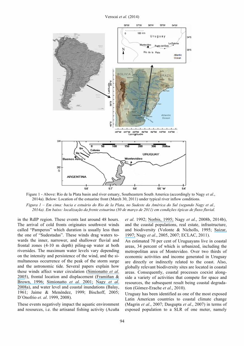
Figure 1 - Above: Rio de la Plata basin and river estuary, Southeastern South America (accordingly to Nagy et al.,
2014a). Below: Location of the estuarine front (March 30, 2011) under typical river inflow conditions. Figura 1 – Em cima: bacia e estuário do Rio de la Plata, no Sudeste da América do Sul (segundo Nagy et al.,
2014a). Em baixo: localização da frente estuarina (30 de março de 2011) em condições típicas de fluxo fluvial. in the RdlP region. These events last around 48 hours. The arrival of cold fronts originates southwest winds called “Pamperos” which duration is usually less than the one of “Sudestadas”. These winds drag waters to-wards the inner, narrower, and shallower fluvial and frontal zones (4-10 m depth) piling-up water at both riversides. The maximum water levels vary depending on the intensity and persistence of the wind, and the si-multaneous occurrence of the peak of the storm surge and the astronomic tide. Several papers explain how these winds affect water circulation (Simionatto et al. 2005), frontal location and displacement (Framiñan & Brown, 1996; Simionatto et al. 2001; Nagy et al. 2008a), and water level and coastal inundations (Balay, 1961; Jaime & Menéndez, 1999; Bischoff, 2005; D´Onofrio et. al. 1999, 2008). These events negatively impact the aquatic environment and resources, i.e. the artisanal fishing activity (Acuña
et al. 1992; Norbis, 1995; Nagy et al., 2008b, 2014b), and the coastal populations, real estate, infrastructure, and biodiversity (Volonte & Nicholls, 1995; Saizar, 1997; Nagy et al., 2005, 2007; ECLAC, 2011). An estimated 70 per cent of Uruguayans live in coastal areas, 34 percent of which is urbanized, including the metropolitan area of Montevideo. Over two thirds of economic activities and income generated in Uruguay are directly or indirectly related to the coast. Also, globally relevant biodiversity sites are located in coastal areas. Consequently, coastal processes coexist along-side a variety of activities that compete for space and resources, the subsequent result being coastal degrada-tion (Gómez-Erache et al., 2010). Uruguay has been identified as one of the most exposed Latin American countries to coastal climate change (Magrin et al., 2007; Dasgupta et al., 2007) in terms of exposed population to a SLR of one meter, namely

Revista de Gestão Costeira Integrada / Journal of Integrated Coastal Zone Management, 15(1):91-107 (2015)
95
30 per cent of the country’s population. The estimated cost of climate change on coastal resources for SLR and wind-induced flooding + 0.3, 0.5 and 1,0 meter repre-sents two, four and twelve per cent of 2008 GDP re-spectively (ECLAC, 2011; Nagy et al., in press). Usually, ICZM in Uruguay deals with current issues, including climatic variability and extremes, and vulner-ability (Nagy et al. 2014a, in press). Notwithstanding, there is a lack of a comprehensive study on the vulner-ability, the risks, and the overall impacts of storm surges and flooding in the RdlP region. This issue is increasingly considered by the climate adaptation ini-tiative “the Project”, but it needs yet to be fully inte-grated by both ICZM and Emergency plans. 3. Clarifying concepts on extreme events on coastal
areas Assuming that many readers are more familiar with In-tegrated Coastal Management than with weather and climate extremes, and because some terms have differ-ent meanings, some definitions and concepts based on recent literature and our experience used in this paper are presented here. A changing climate leads to changes in the frequency, intensity, spatial extent or duration of weather and cli-mate extremes, and can result in unprecedented ex-tremes (Field et al., 2012). Extreme weather includes unusual, severe or unseasonal weather phenomena at the extremes of the climatological or historical distribu-tion (the range that has been seen in the past) on a geo-graphical location (Solomon et al., 2007). Extreme weather occurs only 5 to 10 % or less (1 %) of the time. In recent years some extreme weather events have been attributed to human-induced global warming, and cli-mate models and observed trends show that with cli-mate change, the planet will experience more extreme weather (Hansen et al., 2012). According to Stephenson (2008), meteorological events can be classified according their rarity, rapidity and se-verity as:
• Rare events: are those that have a low probability of occurrence. Because of the rarity of these events, human societies and ecosystems are often not well adapted to them and so suffer large amounts of damage when they do occur. Hence, despite their rarity, the large vulnerability associ-ated with such events can often lead to large mean losses.
• Extreme events: are those that have extreme val-ues of certain important meteorological variables. Damage is often caused by extreme values of precipitation (e.g. floods), high wind speeds (e.g. cyclones), etc. Extreme is generally defined as ei-ther taking maximum values or exceedance
above pre-existing high thresholds. Such events are generally rare; for example, extreme wind speeds exceeding the 100-year return value, which have a probability of only 0.01 of occur-ring in any particular year.
• High-impact (severe) events: are those that can be either short-lived weather systems (e.g. severe storms) or longer-duration events such as block-ing episodes that can lead to prolonged heat waves and droughts.
Extreme events have attributes such as: • rate (probability per unit time) of occurrence • magnitude (intensity) • temporal duration and timing • spatial scale (footprint) • multivariate dependencies
Acute extremes are events that have a rapid onset and follow a short but severe course. Examples are short-lived weather systems such as tropical and extra tropi-cal cyclones, which are generally referred to as ‘‘wind-storms’’, and convective storms with extreme values of meteorological variables such as wind speed, precipita-tion, flash or coastal floods that can lead to devastating wind and flood damage. Here, the use of the term extreme event refers to storm surges measured as water/sea levels at Montevideo greater than 200 cm associated with cold frontal sys-tems passages and the strengthening of a cyclone over Atlantic coast, and strong values of wind speed. The 200 cm threshold was selected because this level is reached at least once a year since the beginning of wa-ter level records at Montevideo Harbor in 1902 (Pshen-nikov et al., 2003; Bidegain et al., 2005). Most years this value is exceeded several times. Thus, the op-erational definition is based on recurrence, regardless of flooding and damage. Usually this threshold is not as-sociated with risks or losses. However, the sedimentary balance of sandy beaches may be affected by water lev-els below the threshold, usually associated with south-ern wind anomalies (Gutiérrez et al., 2013, 2015; Or-tega et al., 2013). Also, acute rapid-onset river inflow - flash floods - or chronic climatic high precipitations in the La Plata basin, often associated with El Niño events, are relevant extreme events for the Uruguayan coast of the RdlP, due to the positive water level anomaly re-lated to the freshwater input exceedance (Nagy et al., 2013). 4. Methodological approach All the events exceeding 200 cm at Montevideo on hourly basis from 1983-2012 have been considered. Monthly and yearly frequencies were calculated for this period, computing the month of occurrence. Two case
Verocai et al. (2014)
96
studies were selected to compare storm surges at three sites of the Uruguayan coast of the RdlP: i) Colonia (tidal freshwater upper estuary, see Figure 1 below), ii) Montevideo (brackish waters within the middle es-tuarine front), and iii) Punta del Este (marine lower es-tuary). The event of March 24-26 1998 was selected because the water level reached 300 cm (over the zero reference) and the long duration - 3 days - of the storm surge. The event of August 23-24, 2005 was selected because the water level exceeded 300 cm at Montevi-deo due to an extremely rapid onset and the intensity of the storm surge, associated with an extra tropical cy-clone, as well as because it was the only hydro mete-orological disaster in Uruguay which caused a toll of 10 deaths (Magrin et al., 2007). Notwithstanding, none of deaths was attributed to the storm surge but to very strong winds. Cross correlations (r Pearson) between the monthly Paraná and Uruguay rivers inflows (measured at the ba-sin about 500 km to the northwest of Montevideo) to the RdlP and monthly freshwater/sea levels at Colonia (220 couples of data) and Montevideo (530 couples of data) were calculated. The selection of a monthly time window is due to the lag between river flows and their arrival into the RdlP, estimated as varying from 1 week for very high discharges to 2 months for very low dis-charges (Nagy, 2000). Thus, all moon phases were taken into account and a 5% error is accepted. More than 1000 couples of data were recorded for southern and southeastern winds and water level at Montevideo. Also, water/sea level at Colonia and Montevideo were related to the river inflow to the RdlP (QRP: Paraná River + Uruguay River) on monthly average basis. 5. Results
Wind, river flow and water/sea levels
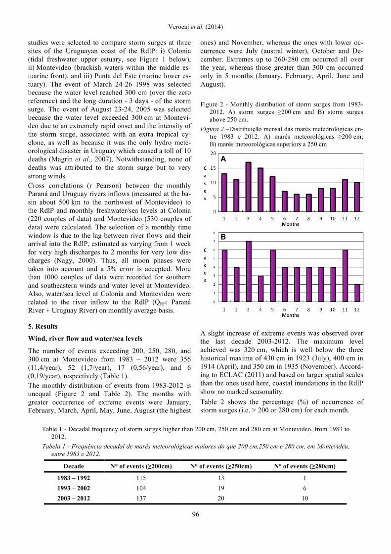
The number of events exceeding 200, 250, 280, and 300 cm at Montevideo from 1983 – 2012 were 356 (11,4/year), 52 (1,7/year), 17 (0,56/year), and 6 (0,19/year), respectively (Table 1). The monthly distribution of events from 1983-2012 is unequal (Figure 2 and Table 2). The months with greater occurrence of extreme events were January, February, March, April, May, June, August (the highest
ones) and November, whereas the ones with lower oc-currence were July (austral winter), October and De-cember. Extremes up to 260-280 cm occurred all over the year, whereas those greater than 300 cm occurred only in 5 months (January, February, April, June and August). Figure 2 - Monthly distribution of storm surges from 1983-
2012. A) storm surges ≥200 cm and B) storm surges above 250 cm.
Figura 2 –Distribuição mensal das marés meteorológicas en-tre 1983 e 2012. A) marés meteorológicas ≥200 cm; B) marés meteorológicas superiors a 250 cm
A slight increase of extreme events was observed over the last decade 2003-2012. The maximum level achieved was 320 cm, which is well below the three historical maxima of 430 cm in 1923 (July), 400 cm in 1914 (April), and 350 cm in 1935 (November). Accord-ing to ECLAC (2011) and based on larger spatial scales than the ones used here, coastal inundations in the RdlP show no marked seasonality. Table 2 shows the percentage (%) of occurrence of storm surges (i.e. > 200 or 280 cm) for each month.
Table 1 - Decadal frequency of storm surges higher than 200 cm, 250 cm and 280 cm at Montevideo, from 1983 to 2012.
Tabela 1 - Frequência decadal de marés meteorológicas maiores do que 200 cm,250 cm e 280 cm, em Montevidéu, entre 1983 e 2012.
Decade N° of events (≥200cm) N° of events (≥250cm) N° of events (≥280cm) 1983 – 1992 115 13 1 1993 – 2002 104 19 6 2003 – 2012 137 20 10
Revista de Gestão Costeira Integrada / Journal of Integrated Coastal Zone Management, 15(1):91-107 (2015)
97
Table 2 - Percentage (%) of occurrence of storm surges greater than a given freshwater/sea level (i.e. > 200 or
280 cm) for each month (January= 1; December= 12) from 1983-2012. The highest monthly occurrences are highlighted as follows: Higher monthly occurrence (dark grey), second higher occurrence (grey), and third higher monthly occurrence (light gray).
Tabela 2 - Percentual (%) de ocorrência de marés meteorológicas maiores do que um dado nível de água doce / mar (ou seja, > 200 ou 280 cm) para cada mês (janeiro = 1; dezembro = 12) entre 1983 e 2012. As maiores ocorrências mensais estão realçadas da forma seguinte: maior ocorrência mensal (cinza escuro), segunda maior ocorrência (cinza), e terceira ocorrência mensal mais elevada (cinza claro).
Months Level 200 Level 220 Level 240 Level 260 Level 280 Level 300
1 8,3 9,6 11,9 16,7 17,7 14,3 2 10,8 10,1 8,3 5,6 11,7 28,6 3 9,1 10,1 8,3 5,6 5,9 0,0 4 10,2 10,1 9,5 8,3 11,7 14,3 5 9,4 6,9 9,5 11,1 17,7 0,0 6 6,6 8,5 9,5 11,1 5,9 14,3 7 7,2 6,9 3,6 2,8 0,0 0,0 8 7,5 6,9 8,3 11,1 11,7 28,6 9 9,1 9,0 6,0 8,3 11,7 0,0
10 5,5 5,3 7,1 2,8 0,0 0,0 11 7,7 8,5 10,7 11,1 5,9 0,0 12 8,6 8,0 7,1 5,6 0,0 0,0
All the correlations (r Pearson) between river flow (River Uruguay-QU or the accumulated of Rivers Uru-guay and Paraná-QRP) against sea level at Montevideo were significant (r= p<0.05). The highest correlations were found for both Qu and QRP at yearly time-scale. The distribution of data is concentrated around the mean water level for Colonia (73 cm.) and QRP (22,500 m3/s). The lowest values at Colonia, < 60 cm were never observed for high QRP > 40,000 m3/s. A positive relationship between river inflow and water level was observed at Colonia (Table 3) and Montevi-deo respectively (Figure 3), showing that river flow is a climatic forcing of water/sea level. The unequal monthly distribution of sea-level at Mon-tevideo is related to prevailing winds (Nagy et al., 1997) and river inflow, especially the Paraná River (QP), the main input of freshwater (75% on average to the RdlP). The latter is shown in Figure 4, where a good agreement is found with this river. When the agreement is lower, this is due to low QP and wind effect, i.e. dur-ing December-January, or the periodic Uruguay River floods, during May-June and September-November. The relationship between winds and sea level at Monte-video shows that southern and southeastern winds have a positive and significant correlation when a strong positive level anomaly occurs (Figure 5). Table 4 summarizes the causes and the magnitude of water/sea level fluctuations at Montevideo around the current mean sea level (MSL) of ≥102 cm. The perma
nency of water levels higher than MSL is approxi-mately 50%, whereas it is less than 3, 1 and 0,5% for water levels higher than 200, 260 and 280 cm respec-tively. Most positive deviations are attributable to non-tidal or residual oscillations due to southern winds, low sea-level pressure (SLP), and high river flow.
Figure 3 - Observed monthly Rio de la Plata inflow (m3/s)
and water level at Colonia. Dispersion and linear regres-sion, with 95% confidence level limits of data adjusted for the correlation (lag 0) are shown.
Figura 3 - Fluxos mensais observados em Rio de la Plata (m3/s) e níveis da água em Colonia. Representou-se a dispersão e regressão lineares com 95% de intervalo de confiança dos dados ajustados à correlação (lag 0).

Verocai et al. (2014)
98
Table 3 - Cross correlations between monthly and yearly river discharges (Uruguay River and RdlP)
and freshwater level at Colonia and sea-level at Montevideo for lags 0 and -1 (month/year). All correlations are significant (p<0.05).
Tabela 3 - Correlações cruzadas entre as descargas fluviais mensais e anuais (Rio Uruguai e RdlP), níveis de água doce em Colonia e do nível do mar em Montevidéu para defasagens 0 e -1 (mês / ano). Todas as correlações são significativas (p <0,05).
Montevideo ( 0 ) Montevideo (-1 ) Colonia ( 0 ) Colonia (-1 ) Monthly River Uruguay 0.09 0.10 0.24 0.15
Monthly RdlP 0.22 0.23 0.34 0.25 Yearly river Uruguay 0.39 0.05 0.48 0.07
Yearly RdlP 0.42 0.20 0.47 0.16
Table 4 - Causes and magnitude of sea level fluctuations at Montevideo. Tabela 4 - Causas e magnitude das flutuações do nível do mar em Montevidéu.
Cause Level and approximate fluctuation (cm)
Current MSL ≥102 Typical yearly fluctuations 40 to 200 Tidal oscillation +/- 30 to 40 Residual oscillations Typically from 100 to 200 cm and up to 350 cm
River inflow +/- 0 to 25 Barometric setup +/- 0-30 Wind setup +/- 0-300
Figure 4 - Monthly Paraná River flow (light bar, right axis, m3/s) and sea level at Montevideo (green bar, left
axis, cm) since 1961. Figura 4 - Fluxos mensais do Rio Paraná (barras mais claras, eixo da direita, m3/s) e níveis do mar em Monte-
video (barra verde, eixo esquerdo, cm) desde 1961.
Revista de Gestão Costeira Integrada / Journal of Integrated Coastal Zone Management, 15(1):91-107 (2015)
99
Figure 5 - Relationship between southeastern (SE) winds and sea-level at Montevideo. Dispersion and linear re-
gression of 1294 couples of wind-water level data are shown. Water level for zero SE wind is very close to current mean sea-level (≥ 102 cm) and the interception wind speed 200 cm occurs around 38 knots (19 m/s).
Figura 5 - Relação entre ventos do sudeste (SE) e do nível do mar em Montevidéu, com base na dispersão e re-gressão linear de 1.294 pares de dados de nível de vento-água. O nível de água para vento zero de SE está muito perto do nível médio do mar atual (≥ 102 cm) e a intercepção do vento com 200 cm ocorre a cerca de 38 nós (19 m/s).
Case Studies
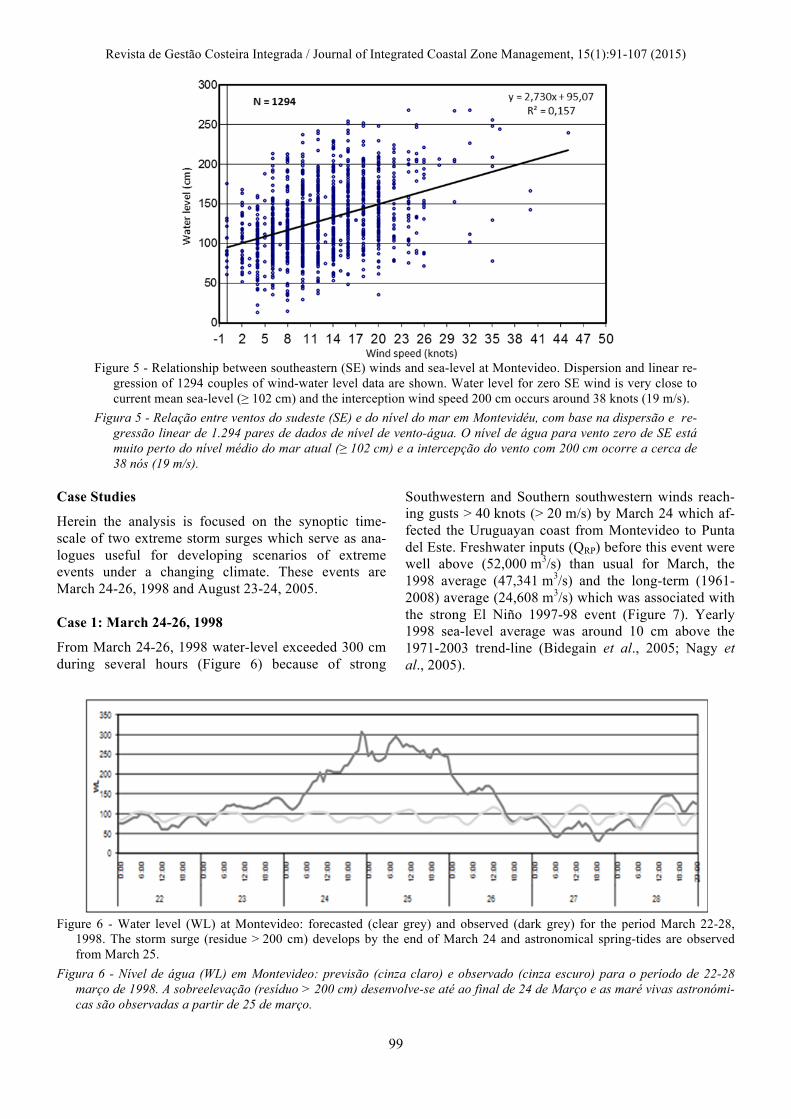
Herein the analysis is focused on the synoptic time-scale of two extreme storm surges which serve as ana-logues useful for developing scenarios of extreme events under a changing climate. These events are March 24-26, 1998 and August 23-24, 2005. Case 1: March 24-26, 1998
From March 24-26, 1998 water-level exceeded 300 cm during several hours (Figure 6) because of strong
Southwestern and Southern southwestern winds reach-ing gusts > 40 knots (> 20 m/s) by March 24 which af-fected the Uruguayan coast from Montevideo to Punta del Este. Freshwater inputs (QRP) before this event were well above (52,000 m3/s) than usual for March, the 1998 average (47,341 m3/s) and the long-term (1961-2008) average (24,608 m3/s) which was associated with the strong El Niño 1997-98 event (Figure 7). Yearly 1998 sea-level average was around 10 cm above the 1971-2003 trend-line (Bidegain et al., 2005; Nagy et al., 2005).
Figure 6 - Water level (WL) at Montevideo: forecasted (clear grey) and observed (dark grey) for the period March 22-28,
1998. The storm surge (residue > 200 cm) develops by the end of March 24 and astronomical spring-tides are observed from March 25.
Figura 6 - Nível de água (WL) em Montevideo: previsão (cinza claro) e observado (cinza escuro) para o período de 22-28 março de 1998. A sobreelevação (resíduo > 200 cm) desenvolve-se até ao final de 24 de Março e as maré vivas astronómi-cas são observadas a partir de 25 de março.

Verocai et al. (2014)
100
Figure 7 - Monthly River flows of the Paraná and Uruguay Rivers, and their combined inflow to the Rio de la Plata from
1983-2013. Part of the observed variability is ENSO-related, especially the extremes: La Niña low discharge and El Niño high discharge (i.e. 1997-98). Source: Instituto Nacional del Agua y el Ambiente, INAA, Argentina.
Figura 7 - Caudais fluviais mensais dos rios Paraná e Uruguai, e fluxos combinados debitados para o Rio de la Plata no perí-odo 1983-2013. Parte da variabilidade observada está relacionada com a ENSO, especialmente os extremos: La Niña - baixa descarga; El Niño - alta descarga (ou seja, 1997-1998). Fonte: Instituto Nacional del Agua y el Ambiente, INAA, Argentina
The forecasted astronomical high tides were greater than 100 cm over the zero reference at Montevideo (about 30 cm above MSL), which accounted for at least + 20 cm. The wind-induced sea-level increase happened to coincide with high astronomical tides and very high El Niño-related River flows. This case is an excellent analogy for likely near future threats due to the combi-nation of natural variability and increased climatic pres-sures. At Colonia, freshwater level reached a maximum of 225 cm on March 25, and the predicted astronomical high-tide was near 100 cm, thus a storm surge ≥ 125 cm. At Punta del Este sea-level showed two peaks ≥ 200 cm recorded on March 25 (separated by the astronomical low tide). When comparing the three sites, the storm surges, that is to say the observed minus fore-casted water/sea level, was greater at Montevideo and lower at Colonia.
An estimate of the impacts is not available, but at Mon-tevideo, the addition of strong winds, storm surge, and heavy rains impacted the coastal infrastructure and maintenance works of the seawall (BPL, 2009). Case 2: August 23-24, 2005 From August 23-24, 2005 the passage of a low pressure system or extra tropical cyclone with winds exceeding 170 km/h (up to 190-200 km/h) impacted the RP (Fig-ure 8), particularly the Uruguayan riverside (Magrin et al., 2007; Possia et al., 2011). Freshwater inputs (QRP) before this event were below average. The death toll was 10 and the physical losses were the highest ever recorded in Uruguay. For instance, at Mon-tevideo 30% of homes suffered electrical shutdowns for 2 days at least and the supply of drinking water was af-fected at several locations. All the harbors,
Figure 8 - Storm surge of August 23, 2005. Predicted heights (red line) and observed heights (blue line). The difference be-
tween the both is due to the barometric and wind set-up. Figura 8 – Sobreelevação de 23 de agosto de 2005. Linha vermelha: alturas previstas; Linha azul: alturas observadas. A dife-
rença entre os dois é devida ao vento barométrico e à distância de atuação.

Revista de Gestão Costeira Integrada / Journal of Integrated Coastal Zone Management, 15(1):91-107 (2015)
101
especially Montevideo, suffered physical losses, in-cluding damaged and sunk ships, and the services were affected for several days. The eastern coast of the RdlP, close to Punta del Este, suffered the loss of at least 160,000 tons of sand and the dunes retreated 3-5 meters. The quantified losses exceeded U$S 37 million (BPL, 2009), which seems to be highly un-derestimated. Synoptic situation: August 23, 2005.
The evolution of horizontal pressure fields gradients at sea level is a good estimate of the hourly mean surface wind velocities. A strong low atmospheric pressure or extra tropical cyclone developed on August 22 over Ar-gentina, which is usual in the region, especially during austral autumn and spring time. However, the atmos-pheric perturbation developed in August 2005 was rare due to its intensity. A cold atmospheric frontal system displaced over southern Uruguay on August 23, whereas another warm front evolved over the Atlantic Ocean at 39° south. After the passage of the cold one, a high pressure system entered the RdlP from the south-west. The surface pressure field (0600 Z) on August 23 showed the entrance of a low pressure ≤ 1002 hPa (Fig-ure 9).
Thus, a strong pressure gradient was observed to the southwest of the low pressure center, eastern and south-eastern winds blown over the Argentinean Riverside, and eastern winds blown over the RdlP increasing water level at the Argentinean coast, together with strong pre-cipitations (138 mm on August 23, for a monthly cli-matic normal 1961-90 = 70 mm). This precipitation was a daily record for August and the fourth daily maximum since 1882 (Bidegain et al. 2006). The atmospheric pressure decreased to < 993 hPa over the RdlP (1800 Z) whereas an anticyclone (1018 hPa) developed to the West over Argentina and southeastern winds blown over the RdlP. Finally, the atmospheric field pressure over the Atlantic ocean was < 992 (0000 Z, August 24), high pressure achieved 1018 hPa over Argentina, southwestern winds blown over the RdlP, the gradient pressure increased from the Atlantic, and very strong winds blown over the Uruguayan coast near Montevideo (gusts over 170 km/h reaching 190-200 km/h). Water level reached 316 cm. The lag between the observed storm surge at La Paloma (200 km to the East of Montevideo) and Montevideo from 1988-2008 showed the best cross correlation is 4,30-5,00 hours. Thus, when storm surges associated with eastern and southeastern winds develop, the in-
Figure 9 - Sea Level Pressure forecast for 00 Z August 24, 2005. Figura 9 - Previsão de pressão atmosférica ao nível do mar para 00 Z 24 de agosto de 2005.

Verocai et al. (2014)
102
crease in sea level is first observed at La Paloma (LP), then at Punta del Este (2 hours after LP), Montevideo (4-5 hours after LP) and Colonia (6-9 hours after LP). 6. Discussion
The analysis and monitoring of wave climate, wind and tides system, and the sedimentary transfer process over time are essential for the implementation of coastal cli-mate change adaptation measures (EcoPlata, 2000; Gómez-Erache, 2012, 2013). Unfortunately, the public institutions and local governments in charge of moni-toring, forecasting, early warning system, emergency management, and/or climate adaptation lack an effec-tive coordination of actions to reduce vulnerability, risks, and damages. In this regard, the occurrence of 356, 52 and 17 events exceeding 200, 250 and 280 cm (11,4, 1,7 and 0,56 /year) respectively at Montevideo, that is to say 109, 159 and 189 cm above the historical reference (91 cm) and 97, 147, and 177 cm above the current MSL (≥102 cm) respectively, are useful indi-cators of risk and are relevant to understand the coast line evolution. Due to the small tidal amplitude (< 0.5 m), the coast line should not be highly resilient to extremes within the range 200-250 cm. The distribution of the events exceeding 200, 250 and 280 cm was not uniform over the last three decades, reaching 13,7, 2 and < 1 events/year respectively over 2003-2012. This slight increase could be attributed to both the increase in southern winds and/or river inflow. Even if precipi-tations over the RdlP basin and river discharges have increased since early 1970s (García & Vargas, 1998; Barros et al., 2005), showing strong interannual fluctu-ations partly associated with ENSO variability (Barros et al., 2005; Nagy et al., 2002; 2008a), the yearly river inflow average stabilized over the last decade - not the variability -, whereas the frequency of southeastern winds increased (Bidegain et al., 2011; Nagy et al., 2013; Gutierrez et al., 2013; Ortega et al., 2013). Fur-thermore, the acceleration of SLR from 1971-2002 (Nagy et al., 2005; Magrin et al., 2007) almost stopped since 2004 which was attributed to less river inflow (Nagy et al., 2013, 2014a, b). The influence of river flow and ENSO-related variability on SLR in the Uru-guayan coast is explained by the local effect of a great river (Nicholls et al., 2011) such as the RdlP tributaries (Nagy et al., 2014a). Thus, it is plausible that during El Niño years, the positive anomalies of both freshwater inflow and southeastern winds lead to water/sea-level increases. Also, the higher frequency of extreme water levels from February-April can be partly associated with high QRP during March and April, which are the third and first higher recorded monthly QRP over the last 52 years
(26,798 and 27,846 m3/s respectively). Southern and southeastern winds exert a strong effect raising water level because they drag water, block or decrease river discharge, generate extraordinary high-tides, waves, and residual currents stronger than normal. If the events are grouped by season, 29,5% and 20,9% occurred during Summer and Winter respectively (see Figure 2). However, QRP is above the average in July, below the average in August, and well below in Sep-tember. Thus, river flow is not a driver in July but it may be in September. Monthly occurrence of severe extremes > 280 cm from 1983-2012 (< 0,5% of permanency) suggests risks are concentrated in February and August and in a less de-gree in January and April. This occurrence has in-creased over the last three decades from only 1 to 6 and 10. Extremes ≥ 300 cm have been only 6 and those events >320 cm have not occurred from 1983-2012. Notwithstanding, they were relatively frequent before 1935 (i.e., July 1923, April 1914 and November 1935). Two of these maxima occurred in July and November, which would not be expected from the current climatol-ogy. This observed seasonal pattern of storm surges is in disagreement with the lack of seasonality of coastal inundations reported by ECLAC (2011) which may be attributed to the large scale of their study. From the two case studies (March 1998 and August 2005), the former occurred during the peak of local im-pacts of the ENSO warm phase 1997-98, a strong El Niño event which caused strong positive anomalies in river discharges and wind regime changes. Thus, the water/sea level was increased depending on the site, more at the tidal river region (Colonia) and less at the marine one (Punta del Este). Previous works (Bidegain et al., 2005; Nagy et al., 2005, 2013) have stated that during extreme anomalies associated with strong El Niño events, sea level at Montevideo fluctuates around 110 cm and plus. During the event of August 2005 (almost neutral ENSO) river flows below the average did not account for an increase in water level. Nevertheless, the 300 cm level was reached at both case studies. During the event of August 2005 sea-level rose 171 cm sharply in 10 hours (see Figure 8) and lasted 23 hours to back to the initial level. Wind velocities were stronger on the previous day, August 23. Southern winds gusts exceeded 170 Km/h, with a maximum in the range 190-200 km (Possia et al. 2011). A one day lag between southern wind velocities and water level increase has been frequently observed, but it is not discussed here. This event was a clear evidence of the lack of prepared-ness of Uruguay against extreme events. The death toll was 10, which is considered a hydro meteorological

Revista de Gestão Costeira Integrada / Journal of Integrated Coastal Zone Management, 15(1):91-107 (2015)
103
disaster according to the United Nations International Strategy for Disaster Reduction (UNISDR) criteria. Despite the availability of abundant physical informa-tion and the improvement over the last few years (since 2009-11), there is no proper coordination between pub-lic institutions in charge of the survey, prognosis and early warning of extreme events in coastal areas. The expected impacts of storm surges were classified and an associated risk was assigned according to their proba-bility of occurrence and to the consequent sea level at Montevideo (Table 5).
Three questions emerge in regards to these coastal ex-treme events:
i) What would have happened on August 2005 if river flows had been twice or three times greater?
ii) Was the event of 1998 so strong mainly because the coincidence of very high river inflow and maximum spring-tide?
iii) What would be the impact if events in the range 350-430 cm occur again?
When storm surges occur at Montevideo, even the more frequent ones, in the range 200-250 cm, sewage outfalls are assisted by hydraulic pumps to redirect surplus water to overflow channels, and when water level ex-ceeds 250 cm, they become useless and sewage is dis-persed in the coastal waters and beaches, contaminating them with fecal coliforms. Since these events are more frequent during the austral summer (see Figure 2 and
Table 2), beach quality and tourism are impacted during 24-48 hours because the beaches are closed to bath (Nagy et al., 2014b). Existing coastal gravity drainage, storm water infra-structure and sewerage systems may become gradually affected over time as the mean sea level and/or storm surges increase. Some of the common impacts are as follows:
• The maritime channel signalization buoys can be re-leased from its anchorage, displaced, or may suffer light disconnection, becoming useless and even a threat for navigation instead of an aid.
• The artisanal fisheries located at Pajas Blancas to the west of Montevideo, which exploit the croaker Micropogonias furnieri during the spawning pe-riod from October to March, are affected by south-ern winds (Norbis, 1995; Nagy et al., 2008b, 2014b), and during an extreme event, the currents and waves drag their fishing nets. Thus, besides the economic and environmental impacts, fisher-men’s lives are at risk because they try to recover their nets before the storm becomes very strong.
• The sandy beaches, dunes and bars are highly vul-nerable and threaten by both storm surges and SLR (Panario & Gutiérrez, 2006; Gutierrez et al., 2013, 2015; Ortega et al., 2013; Nagy et al., 2014a). Storm surges ≥ 260-280 cm at Montevideo are able to flood most sandy beaches and bars.
Table 5 - Water/Sea Level (cm), consequences, and probability of occurrence of storm surges (> 200 cm). The extreme coastal events painted in light gray were observed in this study (modified from Verocai et al., 2014). Tabela 5 - Nível da água / do mar (cm), consequências e probabilidade de ocorrência de sobreelevações (> 200 cm). Os even-tos extremos costeiros destacados em cinza claro foram observados neste estudo (modificado de Verocai et al., 2014).
IMPACTS Sea Level (cm) Slightly harmful
(>200) Moderately harmful
(>250) Highly Harmful
(>300) Extremely Harmful
(>350)
High: 1 each 1 month Moderate Risk High Risk Very high Risk Intolerable Risk
Medium: 1 each 6 months Tolerable Risk Moderate Risk High Risk Very high Risk
Low: 1 each 5 years Trivial Risk Tolerable Risk Moderate Risk High Risk
P R O B A B I L I T Y
Very Low: 1 each > 30 years Negligible Risk Trivial Risk Tolerable Risk Moderate Risk

Verocai et al. (2014)
104
7. Conclusions
Main findings
Sea level rise (SLR) and storm surges are not strongly present in Uruguay’s public agenda. The main reasons for this are that
i) SLR does not represent a serious risk for human set-tlement and infrastructure (yet);
ii) the occurrence of storm surges which cause moder-ate to high impacts, i.e., > 250 and > 280 cm, and particularly > 300 cm are not very frequent; and
iii) those events able to harm many coastal services and built environment, i.e., > 350 cm, have not oc-curred over the last eight decades.
Notwithstanding, the high number of events > 200 cm and mainly those reaching > 250 and > 280 cm ob-served during the studied period (1983-2012) impact the coastal services, morphology, ecosystem resources, and even the infrastructure and housing. Thus, there is a need to include storm surges in coastal management, climate adaptation and risk-management initiatives, plans and programs. Case studies
Two case studies of storm surges which serve as ana-logues useful for developing scenarios of extreme events under a changing climate were presented. These examples show evidence supporting a plausible alter-native scenario of extreme wind storm, very high river discharge, spring high tide, and increasing SLR which could favour the occurrence of water levels ≥ 300 cm reaching ≥ 350 cm. The latter could be accepted as a rough estimation impact threshold based on observed impacts (i.e., > 400 cm in July 1923), and the recent ones (i.e., 300-320 cm). A scenario including SLR and/or – SLP + wind + river induced flooding - 20-30 cm and plus could reach this threshold at any time over the next few decades. Application of the knowledge on extreme events on
ICZM and Early Warning Systems
The coastal threats described in this paper call for coastal management and planning which take into ac-count the vulnerability of major systems and sectors in the face of climate change, SLR and wind-induced flooding. Emphasis is put on the plausible occurrence of extreme events greater (i.e., > 320-350 cm) than those usual over the last 30 years (i.e., 280-320 cm), under slow and gradual SLR, and especially strong El Niño years, when increased river flows and southeastern winds increase the magnitude and impact of flooding. One of the obstacles to achieving a comprehensive integrated coastal management in Uruguay and par
ticularly in regards to climatic and meteorological threats is the deficit of an effective and integrated hy-drological, meteorological and oceanographic, moni-toring network. The three of them exist, are not coordi-nated yet, resulting ineffective to prevent an eventual long (i.e., > 12 hours) > 320-350 cm event. The occurrence of extremes greater than 280 and 300 cm from 1983-2012 shows that risks are concen-trated in February, August, and less in January and April. Nevertheless, the historical maximum occurred in July 1923, which would not to be expected under current climate patterns. The public institutions and local governments in charge of monitoring, forecasting, modelling, early warning system (EWS), and emergency management lack an ef-fective coordination of actions to reduce vulnerability, risks, and damages. Despite a significant progress over the last few years (since 2009-11), there is a less than ideal coordination between monitoring, preparedness, alert, and reactive phases in order to face extremes greater than those usual. Recommendations
A few easy, low cost and viable useful improvements are to:
• Enhance coordination of all public institutions in charge of observing and monitoring climatic, hy-drological, and oceanographic variables, as well as those in charge of preparedness, disaster manage-ment, and EWS, such as the National System of Re-sponse to Climate Change and Variability (SNRCC).
• Concentrate monitoring and EWS efforts when the first signals are forecasted and observed, some of which have been identified in this article, including the analysis of past extreme weather causality, stat-istical occurrence, climatic forecasts, SST 3.4 evo-lution, modeling, hydrologic observations, and/or weather forecasts.
• Improve the tactics and procedures to achieving ef-fective preparedness for coastal extreme events based on past experience and failures. In this regard, a more detailed analysis of the causality and impacts of events > 280 cm over the last 30 years should serve to better understanding and simulate the extra-ordinary extremes > 350 cm which occurred before 1935. The frequency and permanency of events > 280 cm, which have increased over the last three decades should be closely followed as an indicator of change, impact and risk.
• To update the estimation of potential economic, human and environmental impacts associated with a long (> 12 hours) > 350 cm storm surge at Monte-video useful to be incorporated in coastal zone use, infrastructure, regulations and governance.

Revista de Gestão Costeira Integrada / Journal of Integrated Coastal Zone Management, 15(1):91-107 (2015)
105
References Acuña, A.; Verocai, J.E.; Márquez, S. (1992) - Aspectos biológicos
de Micropogonias furnieri (Desmarest, 1823) durante dos zafras en una pesquería artesanal al oeste de Montevideo. Revista de Biología Marina (ISSN: 0717-3326), 27(1):113-132, Val-paraíso, Chile. Available on-line at http://www.revbiolmar.cl/ escaneados/271-113.pdf, http://www.undp.adaptationlearning.net/ spa_uruguay.
Balay, M.A. (1961) - El Río de la Plata entre la atmósfera y el mar. 153p., Publicación H-621, Servicio de Hidrografía Naval (SHN), Secretaria de Argentina.Marina, Buenos Aires.
Ballinger, R.; Rhisiart, M. (2011) - Integrating ICZM and futures approaches in adapting to changing climates. MAST - Maritime Studies (ISSN: 2212-9790), 10(1):115-138, Amsterdam. Avail-able on-line at http://www.marecentre.nl/mast/documents/Pagesfrom MAST10.1_Ballinger_Rhisiart.pdf.
Barros, V.; Menéndez, A.; Nagy, G.J. (2005) - El Cambio Climático en el Río de la Plata. 200p., Project assessments of impacts and adaptation to climate change (AIACC), CIMA/CONICET, Bue-nos Aires, Argentina. Available on-line at http://www.cima.fcen.uba .ar/~lcr/libros/Cambio_Climatico-Texto.pdf.
Bidegain, M.; Caffera, R.M.; Blixen, F.; Pshennikov, V.; Lago-marsino, J.J.; Forbes, E.A.; Nagy, G.J. (2005) - Tendencias cli-máticas, hidrológicas, y oceanográficas en el Río de la Plata y Costa Uruguaya. In: V. Barros, Á. Menéndez, G.J. Nagy (Eds.), El Cambio Climático en el Río de la Plata, pp.137–143, Project assessments of impacts and adaptation to climate change (AIACC), CIMA/CONICET, Buenos Aires, Argentina. Available on-line at http://www.cima.fcen.uba.ar/~lcr/libros/Cambio_ Climatico-Texto.pdf.
Bidegain, M.; Caffera, R.M.; de los Santos, B.; Castellazzi, P.; Gómez-Rivera, J. (2006) – Performance of the WRF Regional Model over SouthEastern South America during an Extreme Event. In: Proceedings of 8 ICSHMO, pp.1655-1658, INPE, Foz do Iguaçu, Brazil. Available on-line at http://mtc-m15.sid.inpe .br/col/cptec.inpe.br/adm_conf/2005/11.01.19.21/doc/1655-1658.pdf.
Bidegain, M.; de los Santos, B.; Skusunosky, S.; Kitoh, A. (2011) - Escenarios Climáticos futuros con el modelo japonés MRI-CGCM2.3. In: Previsão e Modelação em Ciências Geofísicas, Meteorología e Tema, Anais do 7° Simpósio de Meteorologia e Geofísica da APMG and XIV Congresso Latino-Americano e Ibérico de Meteorologia, Setubal, Portugal. Available on-line at http://www.apmg.pt/?page_id=323.
Bischoff, S. (2005) – Sudestadas. In: V. Barros, Á. Menéndez, G.J. Nagy (Eds.), El Cambio Climático en el Río de la Plata, pp.55–67, Project assessments of impacts and adaptation to climate change (AIACC), CIMA/CONICET, Buenos Aires, Argentina. Available on-line at http://www.cima.fcen.uba.ar/~lcr/libros/Cambio_ Climatico-Texto.pdf.
BPL (2009) - Archivos de Prensa escrita (Diarios consultados: El País, La República, El Observador, Ultimas noticias, La Mañana, El Diario). Biblioteca del Palacio Legislativo, Mon-tevideo, Uruguay. Available on-line at http://biblioteca.parlamento. gub.uy:8080/
D'Onofrio, E.E.; Fiore, M.M.E.; Pousa, J.L. (2008) - Changes in the Regime of Storm Surges at Buenos Aires, Argentina. Journal of Coastal Research, 24(1A):260-265. DOI: 10.2112/05-0588.1
D’Onofrio, E.E.; Fiore, M.M.E., Romero, S.I., (1999) - Return peri-ods of extreme water levels estimated for some vulnerable areas of Buenos Aires. Continental Shelf Research, 19(13):1681-1693. DOI: 10.1016/S0278-4343(98)00115-0.
Dasgupta, S.; Laplante, B.; Meisner, C.; Wheeler, D.; Yan, J. (2007) - The impact of sea level rise on developing countries: A comparative analysis. Washington, DC: World Bank Policy Re-search Working Paper – WPS 4136, online. Available on-line at http://www-wds.worldbank.org/external/default/WDSContentServer/IW
3P/IB/2007/02/09/000016406_20070209161430/Rendered/PDF/wps4136.pdf
DECCW (2010) – Coastal Risk Management Guide. Incorporating sea level rise benchmarks in coastal risk assessments. 6p., De-partment of Environment, Climate Change and Water NSW. ISBN: 978-1742329222. Avaliable on-line at http://www. environ-ment.nsw .gov.au.
Echevarría, L.; Gómez, A.; Piriz, C.; Quintas, C.; Tejera, R.; Conde, D. (2013) - Capacity building for local coastal managers: a par-ticipatory approach for Integrated Coastal and Marine Zones Management in Uruguay. Journal of Integrated Coastal Zone Management, 13(4):445-456. DOI: 10.5894/rgci402
ECLAC (2011) - Effects of climate change on the coast of Latin America and the Caribbean: dynamics, trends and climate vari-ability. LC/W.447. Economic Commission for Latin America and the Caribbean (ECLAC), United Nations, Santiago de Chile, Chile. Available on-line at http://www.cepal.org/ publica-ciones/xml/2/45542/W.447.pdf.
ECOPLATA, (2000) - Diagnóstico Ambiental y Socio-Demográfico de la Zona Costera Uruguaya del Río de la Plata. Recopilación de informes técnicos. 991p., López Laborde, J., Perdomo, A., Gómez-Erache, M. (eds.) CIID/PNUD/MVOTMA/UNESCO /EcoPlata, Montevideo, Uruguay. Available on-line at http://www.pnuma. org/gobernanza/cd/Biblioteca/Zonas Costeras/3 Di-agnostico_Ambiental _y_Socio-Demografico_de_la_Zona_Costera.pdf
Escobar, G.; Vargas, W.; Bischoff, S. (2004) - Wind tides in the Rio de la Plata estuary: meteorological conditions. International Journal of Climatology, 24(9):1159–1169. DOI: 10.1002/ joc.1026.
Field, C.B.; Barros, V.; Stocker, T.F.; Qin, D.; Dokken, D.J.; Ebi, K.L.; Mastrandrea, M.D.; Mach, K.J.; Plattner, G.K.; Allen, S.H.; Tignor, M.; Midgley, P.M. (2012) - Managing the Risks of Extreme Events and Disasters to Advance Climate Change Ad-aptation. A Special Report of Working Groups I and II of the In-tergovernmental Panel on Climate Change. 582p., Cambridge University Press, Cambridge, UK, and New York, NY, USA. ISBN: 978-1-107-02506-6. Available on-line at https://www.ipcc-wg1. unibe.ch/srex/downloads/SREX-All_FINAL.pdf
Flick, R.E.; Chadwick, D.B.; Briscoe, J.; Harper, K.C. (2012) - Flooding” versus “inundation”. Eos, 93(38):365-366. American Geophysical Union. DOI: 10.1029/ 2012EO380009.
Framiñan, M.B.; Brown, O.B. (1996) – Study of the Río de la Plata turbidity front, Part I: spatial and temporal distribution. Conti-nental Shelf Research, 16(10):1259-1282. DOI: 10.1016/ 0278-4343(95)00071-2
García, N.O.; Vargas, W.M. (1998) - The temporal climatic vari-ability in the ‘Río De La Plata’ basin displayed by the river dis-charges. Climatic Change, 38(3):359-379. DOI: 10.1023/ A:1005386530866
Gómez-Erache, M. (2013) - Variabilidad y Cambio Climático en la Zona Costera. Evaluación de los impactos factibles y com-probados. Informe del Proyecto GEF URU/07/G32. Imple-mentación de Medidas de Adaptación al Cambio Climático en áreas costeras del Uruguay. Unidad de Cambio Climático, MVOTMA, 32p., Montevideo, Uruguay. Available on-line at http://www.undp.adaptationlearning.net/spa_uruguay
Gómez-Erache, M. (2012) - Análisis de la vulnerabilidad de la costa uruguaya ante el aumento del nivel medio del mar. Informe del Proyecto GEF URU/07/G32. Implementación de Medidas de Adaptación al Cambio Climático en áreas costeras del Uruguay. Unidad de Cambio Climático, MVOTMA, 43p., Montevideo, Uruguay. Available on-line at http://www.undp. adaptation learning.net/spa_uruguay
Gómez-Erache, M.; Conde, D.; Villarmarzo, R. (2010) - Sustain-ability of integrated management in the coastal zone of Uru-guay: Connecting knowledge to action. Programa EcoPlata /

Verocai et al. (2014)
106
IDRC-CRDI, Montevideo, Uruguay. ISBN: 978-9974-7646-8-2. Available on-line at http://www.ecoplata.org/wpcontent/files_mf/ 2010 ecoplata_thesustainabilityofimczingles.pdf.
Gutiérrez, O.; Panario, D.; Bidegain, M.; Montes, C. (2013) – Tele-conexiones El Niño - La Niña con retrocesos - avances de playas del estuario medio del Río de la Plata. In: XV Congreso Latinoamericano de Ciencias del Mar (COLACMAR), Resumen N° 2668-3, 27-31 october 2013, Punta del Este, Uruguay.
Gutiérrez, O.; Panario, D.; Nagy, G.J.; Piñeiro, G.; Montes, C. (2015) - Long-term morphological evolution of urban pocket beaches in Montevideo (Uruguay): impacts of coastal interven-tions and links to climate forcing. Journal of Integrated Coastal Zone Management, in press.
Hansen, J.; Sato, M.; Ruedy, R. (2012) - Perception of climate change. PNAS Plus_109(37): E2415-E2423. DOI: 10.1073/ pnas.1205276109.
IOC (2009) - The International Oceanogragaphic Commission (IOC) of UNESCO and its role in ICAM. 1-3 December 2009, Montevideo, Uruguay. Available on-line at http://www.unesco.org. uy/ci/fileadmin/ciencias%20naturales/COI/Seminario%202009/PDFs/ StephanoBelfiore.pdf.
Jaime, P.R.; Menéndez, A.N. (1999) - Modelo Hidrodinámico “Río de la Plata 2000”. Informe LHA 01-183-99, Instituto Nacional del Agua y el Ambiente (INA), Secretaría de Recursos Naturales y Desarrollo Sustentable, Ezeiza, Buenos Aires. Available on-line at http://www.ina.gov.ar/pdf/LH-Info%20RDP%20LHA-01-183-99%20-%20RioDeLaPlata-RP2000%20-%20Sep-1999.pdf.
Lappo, S.S.; Morozov, E.G.; Severov, D.N.; Sokov, A.V.; Klyuvit-kin, A.A.; Nagy, G. (2005) - Frontal mixing of river and sea wa-ters in Rio de La Plata. Doklady Earth Sciences C/C of Doklady - Akademiia Nauk (ISSN: 1028-334X), 401(2):226-228.
Magrin, G.; García, C.G.; Choque, D.C.; Giménez, J.C.; Moreno, A.R.; Nagy, G.J.; Nobre, C.; Villamizar, A. (2007) - Latin Ame-rica. Climate Change 2007: impacts, adaptation and vulnerabil-ity. In: Parry, M.L.; Canziani, O.F.; Palutikof, J.P.; van der Lin-den, P.J.; Hanson, C.E. (eds.), Contribution of Working Group II to the Fourth Assessment Report of the Intergovernmental Panel on Climate Change, pp. 581–615, Cambridge University Press, Cambridge. ISBN: 978-0521 88010-7. Available on-line at http://www. ipcc.ch/publications_and_data/ar4/wg2/en/ch13.html.
Medina, M. (2009) - Diagnóstico y evaluación de infraestructuras e la zona costera uruguaya (Colonia – Rocha). Segundo Informe: Estado de situación de la infraestructura existente en la zona costera. EcoPlata conectando el conocimiento con la acción para la gestión integrada de la zona costera uruguaya del Río de la Plata, Proyecto URU/06/016. August, Montevideo, Uruguay. Available on-line at http://www.ecoplata.org/adjuntos/2010/08/ Diag-nostico-y-Evaluacion-de-Infraestructuras-en-la-Zona-Costera-Uruguaya.pdf
Medina, M.; Gómez-Erache, M. (2014a) - Borrador inicial para la discusión en el Sistema Nacional de Respuesta al Cambio Cli-mático de la línea de base actualizada de acciones de las Inten-dencias y relevamiento de capacidades y necesidades de forta-lecimiento institucional para la adaptación costera al cambio climático. Informe técnico Nº 3 y Nº 4. 115p. Convenio espe-cífico entre la Universidad de la República y el Ministerio de Vivienda, Ordenamiento Territorial y Medio Ambiente. August, Montevideo, Uruguay.
Medina, M.; Gómez-Erache, M. (2014b) - Mapeo de infraes-tructuras urbanas vulnerables ante la variabilidad y el cambio climático en la franja costera. Identificación de sitios de vulne-rabilidad significativa por cada Departamento y formulación del conjunto de medidas que se deberían implementar en cada sitio para incrementar la resiliencia a los efectos del cambio climático. Informe técnico Nº 5. 235p. Convenio específico entre la Universidad de la República y el Ministerio de
Vivienda, Ordenamiento Territorial y Medio Ambiente. August, Montevideo, Uruguay.
Medina, M.; Gómez-Erache, M. (2014c) - Formulación integral del Programa Estratégico de Adaptación Costera. Informe técnico Nº 6. 85p. Convenio específico entre la Universidad de la República y el Ministerio de Vivienda, Ordenamiento Territorial y Medio Ambiente. August, Montevideo, Uruguay.
Nagy, G.J.; Gómez-Erache, M.; Kay, R. (In Press) - A risk-based and participatory approach to assessing climate vulnerability and improving governance in coastal Uruguay. In: B. Glavovic, R. Kay, M. Kelly, A. Travers (Eds.), Climate change and the coast. Building resilient communities. CRC Press / Taylor & Francis, London. ISBN: 978-0-415-46487-1
Nagy, G.J.; Seijo, L.; Verocai, J.E.; Bidegain, M. (2014a) - Stakeholders’ climate perception and adaptation in coastal Uru-guay. International Journal of Climate Change Strategies and Management, 6(1):63-84. DOI: 10.1108/IJCCSM-03-2013-0035.
Nagy, G.J.; Munoz, N.; Verocai, J.E.; Bidegain, M.; de los Santos, B.; Seijo, L.; Feola, G.; Brena, B.; Risso, J.; Martin, J. (2014b) - Integrating Climate Science, Monitoring, and Management in the Rio de la Plata Estuarine Front (Uruguay). In: Leal Filho,W.; Alves, F.; Azeiteiro, U.; Caeiro, S. (eds.), International perspec-tives on climate change: Latin America and Beyond, pp.79-91. Springer, Heidelberg. ISBN:978-3-319-04488-0. DOI: 10.1007/978-3-319-04489-7.
Nagy, G.J.; Muñoz, N.; Verocai, J.E.; Bidegain, M.; Seijo, L. (2014c) - Adjusting to current climate threats and building alter-native future scenarios for the Rio de la Plata coast and estuarine front, Uruguay. Journal of Integrated Coastal Zone Manage-ment, 14(4): published on-line at 20 June 2014. DOI: 10.5894/rgci472.
Nagy, G.J.; Seijo, L.; Verocai, J.E.; Brugnoli, E.; Bidegain, M. (2013) - Enfoque, conocimiento y medidas para enfrentar las amenazas del clima presente en la zona frontal del Río de la Plata, Uruguay. Costas, Revista Iberoamericana de Manejo Costero Integrado (ISNN: 2304-0963), 2(2):69-87, Montevideo, Uruguay. Available on-line at http://unesco.unesco.org/images/0022/ 002270/227017m.pdf - 227739
Nagy, G.J.; Severov, D.N.; Pshennikov, V.A.; De los Santos, M.; Lagomarsino, J.J.; Sans, K.; Morozov. E.G. (2008a) - Rio de la Plata estuarine system: Relationship between river flow and frontal variability. Advances in Space Research, 41(11):1876-1881. DOI: 10.1016/j.asr.2007.11.027.
Nagy, G.J.; Bidegain, M.; Norbis, W.; Ponce, A.; Pshennikov, V.; Severov, D.N. (2008b) - Fishing strategies for managing climate variability and change in the Estuarine Front of the Río de la Plata. In: N. Leary, J. Adejuwon, V. Barros, I. Burton, J. Kul-karni & R. Lasco, (eds.), Climate Change and Adaptation, Chapter 20, pp.353-370, Earthscan, London. ISBN: 978-1844074709.
Nagy, G.J.; Gomez-Erache, M.; Fernandez, V. (2007) - El aumento del nivel del mar en la costa uruguaya del Río de la Plata: Tendencias, vulnerabilidades y medidas para la adaptación. Medio Ambiente y Urbanizacion (ISSN: 0328-0306), 67(1):77-93, Bue-nos Aires, Argentina. Available on-line at http://www.ingentaconnect .com/content/iieal/meda/2007/00000067/00000001/art00006
Nagy, G.J.; Caffera, R.M.; Aparicio, P.; Barrenechea, P.; Bidegain, M.; Giménez, J.C.; Lentini, J.; Magrin, G.; Murgida, A.; Nobre, C.; Ponce, A.; Travasso, M.; Villamizar, A.; Wehbe, M. (2006) - Understanding the Potential Impacts of Climate Change and Variability in Latin America and the Caribbean. Report prepared for the Stern Review on the Economics of Climate Change. De-partment for International Development-DFID, HM Treasury, United Kingdom. Available on-line at http://www.dfld.de/ Presse/2006 /061030cA.pdf.
Revista de Gestão Costeira Integrada / Journal of Integrated Coastal Zone Management, 15(1):91-107 (2015)
107
Nagy, G.J.; Ponce, A.; Pshennikov, V.; Silva, R.; Forbes, E.A.; Kokot, R. (2005) - Desarrollo de la capacidad de evaluación de la vulnerabilidad costera al Cambio Climático: Zona Oeste de Montevideo como caso de estudio. In: B. Barros, A. Menéndez, G.J. Nagy, (eds.), El Cambio climático en el Río de la Plata, pp.173–180, Project assessments of impacts and adaptation to climate change (AIACC), CIMA/CONICET, Buenos Aires, Argentina. Available on-line at http://www.cima.fcen.uba.ar/ ~lcr/libros/ Cambio_Climatico-Texto.pdf.
Nagy, G.J.; Gómez-Erache, M.; López, C.H.; Perdomo, A.C. (2002) - Distribution patterns of nutrients and symptoms of eutrophica-tion in the Rio de la Plata river estuary system. Hydrobiología, 475/476:125-139. DOI: 10.1007/978-94-017-2464-7_10.
Nagy, G.J. (2000) - Uruguay estuarine systems: The frontal zone of the Río de la Plata system, Uruguay/Argentina. In: S. V. Smith, V. Dupra, J. I. Marshall-Crossland & C. J. Crossland, C. (eds.), Estuarine systems of the South American region: carbon, nitro-gen and phosphorus fluxes, pp.40-43, LOICZ Reports & Studies No. 15, LOICZ-UNEP, Texel, The Netherlands. ISSN: 1383-4304. Available on-line at http://www.loicz.org/imperia/md/content/ loicz/print/rsreports/15report.pdf.
Nagy, G.J.; Martínez, C.M.; Caffera, R.M.; Pedrosa, G.; Forbes, E.A.; Perdomo, A.C.; López Laborde, J. (1997) - Marco hidro-lógico y climático del Río de la Plata (The Hydrological and Climatic Setting of the Rio de la Plata). In: P.G. Wells & G. R. Daborn (eds.), The Río de la Plata: An Environmental Over-view. An EcoPlata Project Background Report. pp.17-70, Dal-housie University, Halifax, Nova Scotia, Canada. ISBN: 0770328520. Available on-line at http://www.ecoplata.org/wp-content/ files_mf/el_rio_de_la_plata_una_revision_ambiental78.pdf.
Nicholls, R.J.; Hanson, S.E.; Lowe, J.A.; Warrick, R.A.; Lu, X.; Long, A.J.; Carter, T.R. (2011) - Constructing Sea-Level Sce-narios for Impact and Adaptation Assessment of Coastal Area: A Guidance Document. Supporting Material, Intergovernmental Panel on Climate Change Task Group on Data and Scenario Support for Impact and Climate Analysis (TGICA), 47p., Avail-able on-line at http://www.ipcc-data.org/docs/Sea_Level_Scenario Guidance_Oct2011.pdf.
Norbis, W. (1995) – Influence of wind, behaviour and characteris-tics of the croaker (Micropogonias furnieri) artisanal fishery in the Rio de la Plata (Uruguay). Fisheries Research, 22(1-2):43-58. DOI: 10.1016/0165-7836(94)00310-S
Ortega, L.; Celentano, E.; Finkl, C.; Defeo, O. (2013) - Effects of climate variability on the morphodynamics of Uruguayan sandy beaches. Journal of Coastal Research, 29(4):747–755. DOI: 10.2112/JCOASTRES-D-13-00003.1
Panario, D.; Gutiérrez, O. (2006) - Dinámica y fuentes de sedi-mentos de las playas uruguayas. In: R. Menafra, L. Rodríguez-Gallego, F. Scarabino & D. Conde (Eds.), Bases para la con-servación y el manejo de la costa uruguaya, pp.21–34, Vida Sil-vestre, Montevideo, Uruguay. ISBN: 9974758920. Available on-line at http://vidasilvestre.org.uy/wp-content/uploads/2012/09/03_ Dinámicas-y-fuentes-de-sedimentos-de-las-playas-uruguayas-Panario .pdf
Possia, N.E.; Vidal, L.; Campetella, C.C. (2011) – Un temporal de viento en el Río de la Plata. Meteorologica (ISSN: 1850-468X),
36(2):95-110, Centro Argentino de Meteorólogos, Buenos Ai-res, Argentina. Available on-line at http://www.cenamet.org.ar/ ar-chivos/Met.Vol 36 N2 2011.pdf.
PRODOC (2008) - Pilot Sites of Adaptation Measures to Climate Change in the Uruguayan Coastal Areas. 131p., project docu-ment prepared for UNDP/GEF Trust Fund. Available on-line at http://www.undp.adaptationlearning.net/spa_uruguay
Pshennikov, V.; Bidegain, M.; Blixen, F.; Forbes, E.A.; Lagomars-ino, J.J.; Nagy, G.J. (2003) – Climate extremes and changes in precipitation and wind-patterns (1971-2002) in the vicinities of Montevideo, Uruguay. paper presented at the Session 3: Ob-served Climate Change and Climate Variability, in the First AIACC Regional Workshop for Latin America and Caribbean, José de Costa Rica, Available on-line at http://www.start. org/Projects/AIACC_Project/meetings/meetings.html
Saizar, A. (1997) - Assessment of impacts of a potential sea-level rise on the coast of Montevideo, Uruguay. Climate Research, 9(1-2):73–79. DOI: 10.3354/cr009073.
Simionatto, C.G.; Vera, C.S.; Siegismund, F. (2005) - Surface wind variability on seasonal and interannual scales over Río de la Plata area. Journal of Coastal Research, 21(4):770–783. DOI: 10.2112/008-NIS.1.
Simionatto, C.G.; Núñez, M.N.; Engel, M. (2001) – The salinity front of the Rio de la Plata - A numerical case study for Winter and summer conditions. Geophysical Research Letters, 28(13):2641-2644. DOI: 10.1029/2000GL012478.
Solomon, S.; Qin, D.; Manning, M.; Chen, Z.; Marquis, M.; Averyt, K.B.; Tignor, M.; Miller H.L. (2007) - Climate Change 2007: The Physical Science Basis. Contribution of Working Group I to the Fourth Assessment Report of the Intergovernmental Panel on Climate Change. Cambridge University Press, Cambridge, UK and New York, NY, USA. ISBN 978-0-521-88009-1. Avail-able on-line at http://www.ipcc.ch/pdf/assessment-report/ ar4/wg1/ar4 _wg1_full_report.pdf
Stephenson, D.B. (2008) - Definition, diagnosis, and origin of ex-treme weather and climate events. In: Diaz, H.F.; Murnane, R.J. (Eds.), Climate Extremes and Society, pp.11-23, Cambridge University Press, Cambridge, UK. ISBN: 978-0521870283. DOI: 10.1017/CBO9780511535840.00410.1017/CBO9780511 535840.004.
Verocai, J.; Bidegain, M.; Nagy, G.J. (2014) - Nivel del mar y eventos extremos en las aguas costeras del Río de la Plata y Costa Oceánica Uruguaya. In: Goso, C. (Ed.), Problemática de los Ambientes Costeros, Capítulo 6, pp.131-146, DIRAC, Facultad de Ciencias, Universidad de la República, Montevideo, Uruguay.
Volonte, C.R.; Nicholls, R.J. (1995) – Uruguay and sea level rise: potential impacts and responses. Journal of Coastal Research (ISSN: 0749-0208), SI14:262–284. Article Stable URL: http://www.jstor.org/stable/25735712