Accessing Heritage Documents according to Space Criteria within Digital Libraries
16
102 Journal of Digital Information Management Volume 6 Number 1 February 2008 Accessing Heritage Documents according to Space Criteria within Digital Libraries Christophe Marquesuzaà 1 , Patrick Etcheverry 1 , Christian Sallaberry 2 , Mustapha Baziz 2 1 LIUPPA IUT de Bayonne Château-Neuf, Place Paul Bert 64100 Bayonne - FRANCE [email protected] [email protected] 2 LIUPPA Université de Pau et des Pays de l’Adour Avenue de l’Université, B.P. 1155 64013 Pau Cedex - FRANCE [email protected] [email protected] The purpose of the Virtual Itineraries in the Pyrenees (PIV – Pyrénées Itinéraires Virtuels) project consists in managing a repository of electronic versions of books, newspapers, postcards, lithographs of the XIXth and XXth century. Information is mainly textual and presents many territorial aspects of the Pyrenees (a mountain range in the south west of France) [Casenave & al., 2004]. This corpus is still relatively unknown. It is accessible only in regional museums and library archives. This is why the local media library supporting this project aims at the diffusion of these resource collections: their added-value remains centred on local cultural heritage and, therefore, geographic characteristics. To complete statistical and full-text analysis approaches, we propose a more accurate semantic approach to analyze and interpret geographic information contained in such a corpus (or in a query) [Marquesuzaà & al., 2005], [Etcheverry & al., 2005], [Sallaberry & al., 2006]. Geographically related queries form nearly one fifth of all queries submitted to the Excite search engine, the terms occurring most frequently being place names [Sanderson and Kohler, 2004]. Our contribution focuses on digital libraries and proposes to extend the basic services of existing Library Management System with new ones dedicated to geographic information extraction and retrieval (PIV project [Lesbegueries & al., 2006]). Our contribution aims at better integrating the space dimension in the information retrieval systems. In a more accurate way, our contribution focuses on five proposals: – we both propose a space unified model allowing any space feature to be described as well as an indexing process adapted to space features presented within analyzed documents. – we describe how to use this indexing process in order to select documents in a more accurate way basing on the geographical areas described in these documents. – we specify the various criteria that can be considered in order to visualize the resulting documents of a space query in a more relevant way. – we concretely illustrate these proposals with a proto- type implementing these main ideas. – we detail our first evaluation results concerning both space information extraction and retrieval processes. We present related works in the next section and an overview of the PIV system in the third section. PIV space content-based ABSTRACT: Local cultural heritage document collections are characterized by contents strongly attached to a territory and its associated land history. Our contribution aims at enhancing such a content retrieval process efficiently each time a query includes geographic criteria. We propose a unified model for a formal representation of geographic information. This geographic model allows space features to be described independently of their representation mode (text, graphics) in the documents. We have developed a prototype implementing geographic Information Extraction (IE) and geographic Information Retrieval (IR) processes. We process geographic IE with semantic techniques combined to classic IE approaches. Then, we implement geographic IR with intersections researching algorithms: these algorithms search for all geocoded entities in the documents collections indexes which intersect any entity in the user’s query. This paper focuses on IR and Visualization proposals relying on the geospatial characteristics of cultural heritage corpora. Categories and Subject Descriptors H.3.7 [Digital Libraries] Collection; H.2.8 [Database Applications]: Spatial databases and GIS; H.3.3 [Information Search and Retrieval] General Terms Geographic information retrieval system, Digital document management Keywords: Geographic Model, Geographic Information Retrieval and Visualization, Non-Structured Documents, Digital Libraries, Cultural Heritage Received 17 June 2006; Revised and accepted 2 Aug. 2007 1. Introduction Smart space information retrieval and visualization is the main goal of the work presented in this paper. Generally, space information is either supported by RDBMS (Relational Data Base Management Systems) and GIS (Geographic Information Systems) for structured data management, or, by Electronic Document Management Systems (EDMS) and Library Management Systems (LMS) for semi-structured and non- structured data. All these systems aim to provide fast and effective content-based access to a large amount of information. Although GISs contain high-level space operators that are uncommon in conventional DBMSs, they are not sufficient for queries in which the semantics of the search criteria concerns space relations [Clementini & al., 1994]. The results are also unsatisfying if we consider EDMSs that usually implement statistical approaches to answer such queries.
Transcript of Accessing Heritage Documents according to Space Criteria within Digital Libraries

102 Journal of Digital Information Management � Volume 6 Number 1 � February 2008
Accessing Heritage Documents according to Space Criteria within Digital Libraries
Christophe Marquesuzaà1, Patrick Etcheverry1, Christian Sallaberry2, Mustapha Baziz2
1 LIUPPAIUT de BayonneChâteau-Neuf, Place Paul Bert64100 Bayonne - FRANCEpatrick.etcheverry@iutbayonne.univ-pau.frchristophe.marquesuzaa@iutbayonne.univ-pau.fr2 LIUPPAUniversité de Pau et des Pays de l’AdourAvenue de l’Université, B.P. 115564013 Pau Cedex - [email protected]@univ-pau.fr
The purpose of the Virtual Itineraries in the Pyrenees (PIV –Pyrénées Itinéraires Virtuels) project consists in managing arepository of electronic versions of books, newspapers,postcards, lithographs of the XIXth and XXth century.Information is mainly textual and presents many territorialaspects of the Pyrenees (a mountain range in the south westof France) [Casenave & al., 2004]. This corpus is still relativelyunknown. It is accessible only in regional museums and libraryarchives. This is why the local media library supporting thisproject aims at the diffusion of these resource collections:their added-value remains centred on local cultural heritageand, therefore, geographic characteristics. To completestatistical and full-text analysis approaches, we propose amore accurate semantic approach to analyze and interpretgeographic information contained in such a corpus (or in aquery) [Marquesuzaà & al., 2005], [Etcheverry & al., 2005],[Sallaberry & al., 2006].
Geographically related queries form nearly one fifth of allqueries submitted to the Excite search engine, the termsoccurring most frequently being place names [Sandersonand Kohler, 2004]. Our contribution focuses on digital librariesand proposes to extend the basic services of existing LibraryManagement System with new ones dedicated to geographicinformation extraction and retrieval (PIV project [Lesbegueries& al., 2006]).
Our contribution aims at better integrating the spacedimension in the information retrieval systems. In a moreaccurate way, our contribution focuses on five proposals:
– we both propose a space unified model allowing anyspace feature to be described as well as an indexingprocess adapted to space features presented withinanalyzed documents.
– we describe how to use this indexing process in orderto select documents in a more accurate way basing onthe geographical areas described in these documents.
– we specify the various criteria that can be considered inorder to visualize the resulting documents of a spacequery in a more relevant way.
– we concretely illustrate these proposals with a proto-type implementing these main ideas.
– we detail our first evaluation results concerning bothspace information extraction and retrieval processes.
We present related works in the next section and an overviewof the PIV system in the third section. PIV space content-based
ABSTRACT: Local cultural heritage document collections arecharacterized by contents strongly attached to a territory andits associated land history. Our contribution aims at enhancingsuch a content retrieval process efficiently each time a queryincludes geographic criteria. We propose a unified model fora formal representation of geographic information. Thisgeographic model allows space features to be describedindependently of their representation mode (text, graphics) inthe documents. We have developed a prototype implementinggeographic Information Extraction (IE) and geographicInformation Retrieval (IR) processes. We process geographicIE with semantic techniques combined to classic IEapproaches. Then, we implement geographic IR withintersections researching algorithms: these algorithms searchfor all geocoded entities in the documents collections indexeswhich intersect any entity in the user’s query. This paper focuseson IR and Visualization proposals relying on the geospatialcharacteristics of cultural heritage corpora.
Categories and Subject DescriptorsH.3.7 [Digital Libraries] Collection; H.2.8 [Database Applications]:Spatial databases and GIS; H.3.3 [Information Search and Retrieval]
General TermsGeographic information retrieval system, Digital document management
Keywords: Geographic Model, Geographic Information Retrievaland Visualization, Non-Structured Documents, Digital Libraries,Cultural HeritageReceived 17 June 2006; Revised and accepted 2 Aug. 2007
1. Introduction
Smart space information retrieval and visualization is the maingoal of the work presented in this paper. Generally, spaceinformation is either supported by RDBMS (Relational DataBase Management Systems) and GIS (Geographic InformationSystems) for structured data management, or, by ElectronicDocument Management Systems (EDMS) and LibraryManagement Systems (LMS) for semi-structured and non-structured data. All these systems aim to provide fast andeffective content-based access to a large amount of information.Although GISs contain high-level space operators that areuncommon in conventional DBMSs, they are not sufficient forqueries in which the semantics of the search criteria concernsspace relations [Clementini & al., 1994]. The results are alsounsatisfying if we consider EDMSs that usually implementstatistical approaches to answer such queries.
Journal of Digital Information Management � Volume 6 Number 1 � February 2008 103
information extraction, retrieval and visualization arerespectively presented in sections four, five and six. For eachchapter, we first present the related works, we then define themain principles and associated concepts in order to detailour proposal with both a conceptual and a technical aspect.
Section 7 discusses the PIV project evaluation first resultsand is followed by a section that is dedicated to conclusionand future work.
2. Space Information Management within Heterogeneous
Documents Collections
Information Extraction (IE) generally organizes indexes for abetter support Information Retrieval (IR). IE and IR usedtogether have the potential to create powerful new tools ininformation processing [Gaizauskas, 2002] [Gaizauskas andWilks, 1998]. This section describes the IE, IR and InformationVisualization (IV) approaches which are combined for specificgeographic requirements [Sallaberry & al., 2006].
2.1 Information Extraction
IE activity aims at building a structured information repositoryfrom an unstructured information source [Gaizauskas, 2002].In a collection of documents, the result of IE constitutes whatis called an index. It is generally made up of a list of termslinked to each document [Tebri, 2004]. These terms have todescribe the contents of the documents as precisely aspossible. Automatic IE processes extract either the wholeinformation in a document or, specific parts of it. For example,in the first case, text processes generally use statisticalapproaches (each term of a document is processed) [Zipf,1949] [Tebri, 2004] to associate a weight to each term while,in the second one, they use predefined rules in order to findspecific information [Gaizauskas, 2002].
2.2 Information Retrieval
Information Retrieval (IR) deals with models, techniques,procedures to extract information that has already beenprocessed, organized and stored (databases, files, XML files,etc.). [Baeza-Yates and Ribeiro-Neto, 1999] explain thatsatisfying the user information requirements is not trivial: “Theuser first specifies a user need which is then parsed andtransformed. Then, query operations might be applied beforethe actual query, which provides a system representation forthe user need, is generated. The query is then processed toobtain the retrieved documents. Fast query processing is madepossible by the index structure previously built.”. [Baeza-Yatesand Ribeiro-Neto, 1999] and [Torres and Parkes, 2000] stressthe importance of the query validation and/or reformulationstages to improve the interpretation of the user need.
2.3 Information Visualization
The retrieval of search engine results is a recurring problembecause it is important for the user to make use of and toefficiently visualize the retrieved information [Bonnel andMoreau, 2005]. We want to highlight that the restitution step isalways coupled with a calculation and a representation stepof the information relevance (according to relevance calculationmethods, restored information can differ for the same needexpressed). Here is a summary of the different retrievalmodes that presents the four most used approaches:
– List representation: A list presents a collection of ele-ments organized according to a relevance mode de-fined by the list manager. It is a representation method
used by most search engines like Google1 or Grokker2.[Hascoët and Beaudoin-Lafon, 2001] present a tax-onomy of the information visualization strategies rely-ing on techniques adapted to large size lists (e.g. theperspective wall technique of Mackinlay [Macinlay & al.,1991]). The relevance of an element is represented byits position in the list. Lists allow to present indefiniteresult numbers and also provide a simple access modeto the items. However, they do not offer a synthetic over-view of the results and the browsing is often limited tothe first results [Leuski and Allan, 2000] [Bonnel andMoreau, 2005].
– Topic representation: A topic gathers the elementsaround same concept. The Ujiko3 or Kartoo4 searchengines use this type of representation. [Kules andSchneiderman, 2004] showed that, in comparison witha non-hierarchical classification, such a classificationcould give better performances in terms of user satis-faction. This representation offers a synthetic overviewbut choosing the topics to be represented is subjectiveand difficult to computerize. The relevance is not explic-itly represented because it depends on the matchingdegree between the presented topics and the user re-quirements.
– Graph or Tree representation: It is close to topic classi-fication but it integrates the semantics carried by theedges connecting the vertices that can represent top-ics or documents. The Kartoo search engine or topicmaps [Cossanel & al., 2002] with tools such as TM4J5
use this form of representation. The semantic linksbetween concepts allow guided navigation betweentopics and documents. However, there are two limits tothe number of concepts that can be represented: thesize of the display for results presentation and the riskof cognitive overload for the user. As for topic represen-tation, the relevance is not explicitly represented, it de-pends on the matching between the user requirementsand the suggested thematic browsing links.
– Cartographic representation: The principle consists ofrepresenting a space (area, country, building, room,device layout) and associating the data elements re-lated to various points highlighted on this space. Anexample of geographical application is SPIRIT - Spa-tially-Aware Information Retrieval one the Internet6 -which proposes a search engine whose results areWeb pages geo-localized on a map. With this approach,the user reads the map looking for space referencemarks; the relevance is thus spatially represented bythe proximity of results with a space reference point ofinterest for the user. This form of representation inte-grates the space dimension but raises problems whenthe results are geo-localized on very close places, oron the same place.
– 2D-3D representation: A particular case of visualizationmodes deals with element representation in two orthree dimensions. All the previous representationmodes can be modeled either in 2D or 3D. 3D repre-sentations are frequent when the amount of documentsis significant [Jacquemin & al., 2005]. The choice of a
1 www.google.com2 www.grokker.com3 www.ujiko.com4 www.kartoo.com5 http://tm4j.org/6 www.geo-spirit.org

104 Journal of Digital Information Management � Volume 6 Number 1 � February 2008
3D representation is justified by the need to increasethe visualization space [Bonnel & al., 2005a] [Bonnel &al., 2005b]. However, the third dimension entails a morecomplex navigation.
Geographic contents management within heterogeneousdocuments collections is the main purpose of the paper. Wenow present the linguistic and GIS approaches to spaceinformation management.
2.4 Space Information
– Linguists’ works: They explain our specific manner ofrepresenting space information in written language. Ac-cording to [Borillo, 1998], we can link a place to a cat-egory and associate it with a natural or artificial bound-ary. We consider three main categories: plots of land,expanses of water, dwelling places. Referring to suchplaces involves several elements. In written language,one might define space information by referring to abetter known position. We thus understand sentence 1perfectly while sentence 2 sounds unusual to us:– sentence 1: “the car is near the house”– sentence 2: “the house is near the car”
[Vandeloise, 1986] studied this assumption for textualdocuments and explained the concept of the target/sitecouple. Our objective is to extend this hypothesis to anyother expression modes.
– GIS works: They present a Space Feature (SF) as a user-defined geographic phenomenon that can be modeledor represented using geographic data sets. Examplesof geographic features include streets, sewer lines,manhole covers, accidents, lot lines, parcels7. Importantrelated works address models of space relations[Clementini & al., 1994], qualitative space representa-tion and reasoning [Cohn, 1997] [Cohn and Hazarika,2001] [Muller, 2002] and space queries processing[Clementini & al., 1994]. Other interesting works [Hill,1999] [Hill, 2000] concern digital gazetteers (AlexandriaDigital Library8) which can be defined as geo-spatial[Zahn, 2001] and support important related dictionariesof geographic names. GIS literature mainly represents ageographic feature by its name and location. Locationcovers a large amount of different concepts:– topographical coordinates, with geometric possibili-
ties (the point or the polygon coordinates to locatethe building on a map);
– topological, direction or metric relations with otherSFs (a direction relation to detail the position of thebuilding within a village) [Bonnel and Moreau, 2005][Egenhofer, 2002] [Gotts and Goodday, 1996];
– conceptual links with topics of space theory within aspecific ontology [Cohn and Azarika, 2001][Hernandez, 2005].
As IE, IR and IV approaches are rather generic, spaceinformation accurate management still represents a greatchallenge. Moreover, Library Management Systems can neither
take into account the geographic semantics of heterogeneousdocuments nor the users’ specific geographic requirements.Semantic processing seems to be an interesting way of spaceinformation management within IE, IR and IV.
2.5 Semantic Processing
It allows specific information extraction; i.e., exploiting thelocalized property of a corpus in order to focus on the spaceinformation. In textual expression mode, the data processingsequence used for highlighting space markers is composedof four main steps [Abolhassini & al., 2003]:
– lemmatization carries out a segmentation of the words;– lexical and morphological analysis proceeds to a word
recognition;– syntactic analysis, based on grammars, allows to find
the links between words;– “semantic” analysis carries out a more specific analy-
sis allowing the extracted syntagms to be interpreted.
Some systems like Brill9, Cordial10 or Tree-Tagger11
morphosyntactical analysers are dedicated to a specific partof such sub-processes. Other systems like Linguastream12
[Widlocher and Bilhaut, 2005], SPIRIT13 or GATE14 [Gaizauskas& al., 1995] [Gaizauskas, 2002] support the whole process.
In the graphic expression mode, semantic processes considerthat an image is not represented in single pixels but inmeaningful image segments and their mutual relations.[Torres, 2002] and [Enjalbert and Gaio, 2006] propose asemantic definition to represent space data. [Benz & al., 2002]present fuzzy methods implementing expert space knowledgeand describe a workflow from remote sensing imagery toGIS. The eCognition system provides a new technology forimage analysis15.
3. Overview of the PIV System
3.1 Information Visualization Overview
The PIV prototype is a system focused on smart spaceinformation retrieval and visualization. With this system theuser can seek documents referring to a particular place orgeographical area.
The user query is expressed in natural language withgeographical criteria which can be more or less precise: itcan deal with seeking all documents describing a particularplace (the city of Pau for example) or a more or less definedgeographical area, for example (Fig. 1-top), seeking all thedocuments referring to the area between Pau and Lourdescities.
Since information retrieval is operated on space criteria, thePIV system restores its results using the same approach: amap of the area evoked in the user query is displayed and theresulting documents are presented as icons close to theplaces they evoke (Fig. 1).
At this stage, the user has an overview of the results accordingto a visualization mode which takes into account itsgeographical interests. The user can evaluate the number ofresulting documents, the kind of documents (texts,iconographic documents, etc. are presented by different icons)and especially the areas described by these documents.When the user points at a document, the system presents therelated geographical information in an information-bubble,as well as a thumbnail of the document (right side of thescreen). If the user considers the presented information asrelevant, he/she can access and consult the original
7 www.webgis.net/cms.php/glossary.htm8 www.alexandria.ucsb.edu, www.alexandria.ucsb.edu/gazetteer/9 www.cs.jhu.edu/brill/10 www.synapse.com11 www.ims.uni-stuttgart.de/projekte/corplex/TreeTagger/12 www.linguastream.org13 www.spiritengine.com14 http://gate.ac.uk/15 www.pcigeomatics.com/products/definiens.html

Journal of Digital Information Management � Volume 6 Number 1 � February 2008 105
document. On the contrary, he/she can explore the otherdocuments results.
To assist the user in exploring the set of results, the systemcan display additional information for each document (Fig. 1).This information is mainly of two kinds: geographical anddocumentary. Thus, on a document mouse over, the systemprovides additional information concerning the area evokedin this document (area displayed on the map, geographicalco-ordinates etc.). With a mouse click on the document, thesystem provides an overview of the document itself. Thisoverview takes the shape:
- of a thumbnail if it is about a graphic document.- of a paragraph if it is about a text document. The se-
lected paragraph always evokes the space featureswhich justify why this document was considered to berelevant compared to the initial query.
3.2 Information Extraction and Information Retrieval
Overview
Fig. 2 presents the PIV IE and IR processes. The IE processis composed of four main stages:
- First of all (stage (1)), each document is OCRized andclassified according to its nature (text, image, etc.).
- In stage (2), the linguistic and semantic analysis iscarried out in order to extract potential space features(SFs). Each potential SF is formally described accord-ing to a unified space model described in section 4.3.1.
- The third stage (3) parses geographic gazetteers (dis-tricts, named-places, roads, cliffs, valleys, …) in orderto validate each SF detected in the previous stage.
- In stage (4), the IE process computes the spacerepresentation and the georeferences of each vali-dated SF. This information (instance of the spacemodel and georeferences) is used to index eachdocument.
As the user query (stage (5)) is expressed in text form, this querymay be considered as a textual document. Hence, the querymay be processed (stage 6) with the same previous IE process.After this stage, each SF evoked in the user query is also spatiallydescribed as previously and in accordance with our space model.In stage 7, this same representation therefore allows to computeintersection surfaces between the space representations evokedin the query and in the indexes. Stage 8 selects the correspondingrelevant documents which are presented to the user in stage(9). This last stage corresponds to the Information Visualization(IV) part of the PIV project.
We will now detail in a more accurate way how the PIV systemimplements IE, IR and IV approaches to better manage spaceinformation in a cultural heritage corpus.
4. Information Extraction
4.1 Related Works
Most Information Extraction (IE) systems use statisticalapproaches. They are dedicated to large and repeatedly revisedcorpora (i.e. web). Slight statistic processing chains operate re-indexing processes. [Chen & al., 2006] give an overview ofindexing research works related to thematic and/or geographicinformation within web corpora. In the case of pure thematicinformation extraction, the most used methods are statistics-based and weigh the extracted terms according to both localand global term frequencies [Salton and McGill, 1984] [Robertson,1977]. The idea behind the document term local frequency (TF)is to estimate the importance of a term in the document; whereasthe document term global frequency (also known as inversedocument frequency or IDF) is used to estimate the discriminationpower of the term according to the whole collection. Let us notethat in most statistical IE approaches, the extracted terms arefirst stemmed according to [Porter, 1980] in order to reduce thelength of the index and then stop-words are removed accordingto a standard list [Salton and McGill, 1984].
Figure 1. The PIV system – Exploring the results
Figure 2. The PIV system – Information Extraction and Retrievalprocesses
106 Journal of Digital Information Management � Volume 6 Number 1 � February 2008
Other IE methods aim at Named Entity Recognition (NER).They consist in assigning a word or a word group to a set ofstandard entity types to extract: organization, person, location,date, time, money and percent entity types. The moststraightforward means of identifying named entities is throughmatching document contents to previously generated lists ofnames. Another approach aims to incorporate contextcharacteristics thanks to NE grammars in order to bettercapture external evidence. Rules for NE recognition can begenerated entirely by hand (knowledge-based) orautomatically using machine learning (or statistical)techniques. More sophisticated methods of NER make useof both lists and NE grammars. For instance, LaSIE16 is anintegrated information extraction system designed forresearch and benchmarking purposes. It supports theTRESTLE system [Gaizauskas, 2002].
Some IE systems complete NER approaches with anadditional semantic processing stage. They are dedicated todomain specific, stable and quite small corpora. As there isno or very little revision, a hard back-office semantic processseems to be suitable. [Lesbegueries & al., 2006] describe ageographic information markup process dedicated to localcultural heritage collections of documents. [Wildöcher & al.,2004] present multimodal indexing in geographicaldocuments.
The last step concerns indexing. For text information, [Baeza-Yates and Ribeiro-Neto, 1999] promote two main indexingtechniques: inverted files and suffix array. They emphasizeinverted files which are currently the best choice for mostkeyword-based search applications. Suffix trees and arraysare faster for phrase searches and other less commonqueries, but are more difficult to implement and to maintain.
4.2 Space Information Extraction Related Works
Most NER systems dedicated to space informationmanagement consist of at least three basic components: (1)a tokenizer, (2) gazetteer lists, and (3) a NE grammar. Thetokenizer segments text into tokens, e.g. words, numbers,and punctuation. The gazetteer contains lists of namedentities, e.g. towns, countries, cities, and lists of keywordssuch as titles and company designators (e.g. Plc and Ltd).The NE grammar consists of rules for NE recognition, whichtake the context into account.
The SPIRIT project [Jones & al., 2004] proposes a method ofNER using gazetteer lists in combination with grammars.The SPIRIT engine parses semi-structured web page textslooking for occurrences of text addresses and zip codes, placenames and telephone numbers… So, a web page isannotated with a geographic footprint and a full-text index [Vaid& al., 2005]. In the same way, [Sagara and Kitsuregawa, 2004]use Yellow Pages to generate key words to find documentson the web related to listed businesses. The SPIRIT projectand other works like the Geosearch system, the GEO-IRsystem, etc. are related to space information managementand are presented in [Chen & al., 2006]. The IE process laststep concerns indexing; [Baeza-Yates and Ribeiro-Neto, 1999]propose the R-tree indexing method in order to represent aspace object by its Minimum Bounding Rectangle (MBR). Datarectangles are grouped to form parent nodes, which arerecursively grouped to form grandparent nodes and, eventually,a tree hierarchy. Another way of indexing text and/or multimediadocuments is the ontological approach [Ihadjadene & al.,
2004a] [Ihadjadene & al., 2004b]. With this approach, adocument or a part of document can be marked up referringto a specific topic (space for footprints computation,architectural for historical period or artistic class deduction,etc.). A drawback of such metadata is that it is usually builtmanually, sometimes semi-automatically. Most of the time,ontologies are used to extend a query criteria rather thandocument indexing.
4.3 Space Information Extraction within the PIV
Prototype
We use a tokenizer, a NER method with gazetteers and aDefinite Clause Grammar (DCG) but we extend this analysisprocess with an additional semantic processing stagesupported by a space core model aiming at Space Features(SF) interpretation [Lesbegueries & al., 2006]. An SF might bea simple (absolute) named entity or a more complex (relative)one (cf. section 4.3.1).
A difference of our approach with others like SPIRIT [Jones &al., 2004] and GIPSY [Woodruff & al., 1994] relies on the back-office space reasoning mechanims used for both absoluteSFs (ASFs) and relative SFs (RSFs) interpretation andindexing. For instance, the SPIRIT system mainly tags ASFs.
Next, indexing principles are only applied on textual resources.The indexing of non textual resources (lithographies,postcards, etc.) is carried out on textual metadata provided bythe MIDR library management system. This metadatacorresponds to the usual index cards manually produced bythe MIDR archivists.
Other specificity concerns the granularity level of the managedinformation units: text paragraphs of our domain specificcorpora (the cultural heritage of the Pyrenees) and web pagesin the case of the SPIRIT system.
Moreover, in our proposal, the same refined space informationmarkup and interpretation process is applied both in theinformation units indexing stage and in the users’ queryinterpretation.
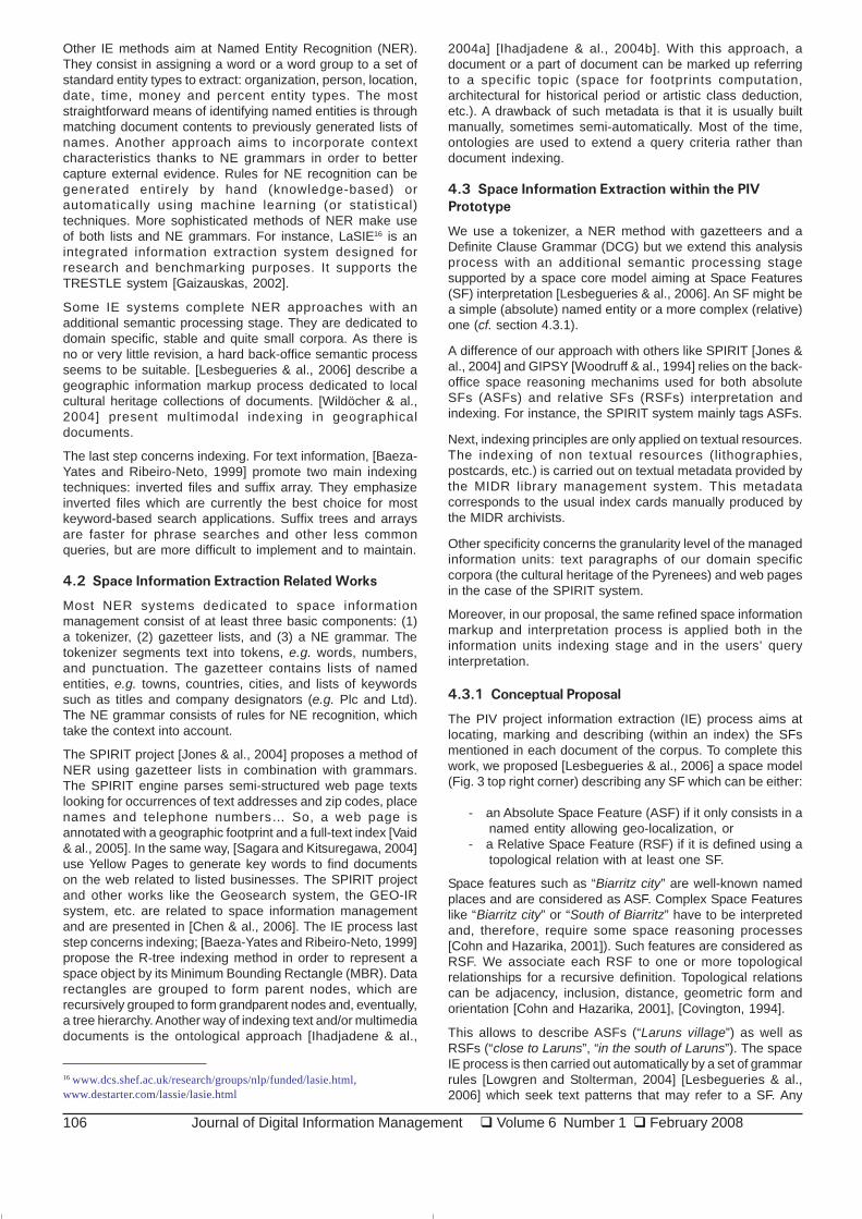
4.3.1 Conceptual Proposal
The PIV project information extraction (IE) process aims atlocating, marking and describing (within an index) the SFsmentioned in each document of the corpus. To complete thiswork, we proposed [Lesbegueries & al., 2006] a space model(Fig. 3 top right corner) describing any SF which can be either:
- an Absolute Space Feature (ASF) if it only consists in anamed entity allowing geo-localization, or
- a Relative Space Feature (RSF) if it is defined using atopological relation with at least one SF.
Space features such as “Biarritz city” are well-known namedplaces and are considered as ASF. Complex Space Featureslike “Biarritz city” or “South of Biarritz” have to be interpretedand, therefore, require some space reasoning processes[Cohn and Hazarika, 2001]). Such features are considered asRSF. We associate each RSF to one or more topologicalrelationships for a recursive definition. Topological relationscan be adjacency, inclusion, distance, geometric form andorientation [Cohn and Hazarika, 2001], [Covington, 1994].
This allows to describe ASFs (“Laruns village”) as well asRSFs (“close to Laruns”, “in the south of Laruns”). The spaceIE process is then carried out automatically by a set of grammarrules [Lowgren and Stolterman, 2004] [Lesbegueries & al.,2006] which seek text patterns that may refer to a SF. Any
16 www.dcs.shef.ac.uk/research/groups/nlp/funded/lasie.html,www.destarter.com/lassie/lasie.html
Journal of Digital Information Management � Volume 6 Number 1 � February 2008 107
potential SF is then compared with geographical resourcesand any validated SF is described within indexes inaccordance with the space model (Fig. 3).
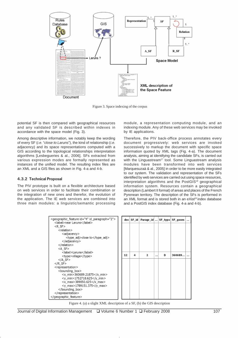
Among descriptive information, we notably keep the wordingof every SF (i.e. “close to Laruns”), the kind of relationship (i.e.adjacency) and its space representations computed with aGIS according to the topological relationships interpretationalgorithms [Lesbegueries & al., 2006]. SFs extracted fromvarious expression modes are formally represented asinstances of the unified model. The resulting index files arean XML and a GIS files as shown in Fig. 4-a and 4-b.
4.3.2 Technical Proposal
The PIV prototype is built on a flexible architecture basedon web services in order to facilitate their combination orthe integration of new ones and therefor, the evolution ofthe application. The IE web services are combined intothree main modules: a linguistic/semantic processing
module, a representation computing module, and anindexing module. Any of these web services may be invokedby IE applications.
Therefore, the PIV back-office process annotates everydocument progressively: web services are invokedsuccessively to markup the document with specific spaceinformation quoted by XML tags (Fig. 4-a). The documentanalysis, aiming at identifying the candidate SFs, is carried outwith the Linguastream17 tool. Some Linguastream analysismodules have been transformed into web services[Marquesuzaà & al., 2005] in order to be more easily integratedto our system. The validation and representation of the SFsidentified by web services are carried out using space resources,interpretation algorithms and the PostGIS18 geographicalinformation system. Resources contain a geographicaldescription (Lambert II format) of areas and places of the FrenchPyrenean territory. The description of the SFs is performed inan XML format and is stored both in an eXist19 index databaseand a PostGIS index database (Fig. 4-a and 4-b).
Figure 3. Space indexing of the corpus
Figure 4. (a) a slight XML description of a SF, (b) the GIS description
108 Journal of Digital Information Management � Volume 6 Number 1 � February 2008
5. Information Retrieval
5.1 Related Works
In a classic IR approach, a weight is assigned to each term ina document. [Robertson & al., 1998] introduced an enhancedTF.IDF formula to attenuate the negative impact of largedocuments in the searching stage. The same indexing processis applied to queries. A vector-based model is then used toretrieve documents: for a given query, the similarity betweenthe vector of the query and the vectors of each document in thecollection is carried out by computing the inner product betweenthe vectors [Boughanem & al., 2001]. This relevance score isused to determine the ranking of the document in the final list ofretrieved documents in response to the query.
5.2 Space Information Retrieval Related Works
A space IR involves indexes that represent every item of spaceinformation with one or more space geometries [Bressan & al.,2000] or hierarchies of quadrilateral cells defined by latitudeand longitude [McCurley, 2001]. Queries ask for documentswhich match some keywords or contain addresses within agiven radius of a specified target place.
The SPIRIT system is a research product combining boththematic and space IR [Vaid & al., 2005]. The SPIRIT engineuses two kinds of ontologies: one dedicated to locations andbasic geographic relations (north, south, etc.) and anotherone dedicated to business types within a location (e.g. hotels,train stations, touristic sites, etc). For instance, the SPIRITsystem proposes an approach integrating space indexingwith textual indexing by means of spatio-textual keys [Jones &al., 2004]: each document is associated with a geometricfootprint and a set of significant textual terms. Each footprintis associated with space cells with which it intersects (a space-directed indexing method using a regular grid) and each term
is associated with a list of the documents (inverted documentlist) in which it occurs.
Therefore, an element of a SPIRIT spatio-textual index lookslike:“spirit” – {R1(D1;D7);R2(D3;D11;D13);R3(D2);R4(D8;D9;D11)}.
Here, “spirit” is the indexed term, D = {D1,D2, …} is a collectionof documents, R = {R1,R2, …} is the document space dividedinto space cells. This means that the “spirit” term is employed indocuments D1 and D7 when associated to the R1 space area.
Such a structure is exploited to first search for a textual term andthen using the associated space index of documents to filter outthose meeting the space constraints [Jones & al., 2004].
Such a spatio-textual index parsing looks like pure text index(inverted files) parsing. In the initial prototype, the SPIRITspace relevance computing is based on measures of distancebetween the query footprint and the document footprint[Vaid & al., 2005].
5.3 Space Information Retrieval within the PIV
Prototype
As the PIV context concerns local cultural heritage documents,our approach proposes to consider space information as themost stable element of PIV’s geographic information; it mightbe the first research criteria, the temporal information couldbe the second one and the thematic the third one.
5.3.1 Conceptual Proposal
A free-text querying interface supports the IR stage (IR part, Fig.2). Any query or document in the corpus is analyzed with thesame process: the IE sequence is processed and the SFs of aquery are extracted. Then, the validated SFs are geo-localizedand a geometry is attached to each one of these SFs.
Our search technique is based on a space mapping betweenthe query’s SFs and the documents’ SFs. This mapping isdone thanks to the geometries created dynamically for thequery and the geographic representations stored in the index
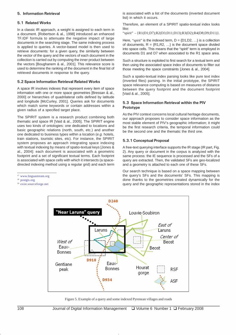
Figure 5. Example of a query and some indexed Pyrenean villages and roads
17 www.linguastream.org18 postgis.org19 exist.sourceforge.net
Journal of Digital Information Management � Volume 6 Number 1 � February 2008 109
files of the corpus.
For example, Fig. 5 illustrates a query (“I want documentsdealing with places which are near Laruns.”) and itscorresponding Multiple Bounding Rectangle (the biggestMBR). The other shapes represent SFs (extracted from thedocuments in our corpus) that may match the query. Indexeddocument RSFs are represented by MBRs whereas ASFs arerepresented by more precise geometric shapes. Therelevance of a document is computed from the intersectingsurface of its SF and that of the query.
We are therefore able to calculate the relevance of documentsby simply crossing index files and computing SFsrepresentations intersecting surface rates and their centroiddistances [Sallaberry & al., 2007b].
5.3.2 Technical Proposal
An XML DBMS (eXist) and a GIS (PostGIS) support thesesearching and relevance computing operations on the corpusindexes. Fig. 6 illustrates relevance computing via functionsand queries submitted to the GIS.
area(intersection(Q_geom, Df_geom)) I_surfacearea(Df_geom) Df_surface
distance(centroid(Q_geom), centroid(Df_geom)) d
distance(centroid(Q_geom), geomfromtext(‘corner coordinate’)) D
SELECT pi.gid, pi.doc_name, pi.par_id, pi.SF-name,(tq.isurf/tq.dfsurf + tq.isurf/tq.qsurf)/(2 + tq.d/tq.D) AS weightFROM piv_index pi,temp_query tqWHERE pi.gid=tq.gidORDER BY weight DESC;
Figure 6. Surfaces, distances and score computing.
The query in Fig. 6 returns the relevant documents andparagraphs identifiers. Then the original texts and the SFsdetails may be presented in a weighed order. A set of web
services implement three main modules. A first one parsesthe GIS indexes and selects all the relevant SFs. Then, thesecond module calls score computing (cf. Fig. 6) web servicesin order to associate a relevance score to each of the selectedSFs. A third module proposes XML index parsing services inorder to retrieve more details about the SFs (text, relationships,toponymic resource (city, river, mountain, etc.). This thirdmodule is dedicated to the information visualization stagedescribed hereafter.
6. Information Visualization
6.1 Related Works
The corpus we consider is strongly localized as defined inchapter 2.3. We thus use the cartographic representationmode in our PIV prototype.
Cartography can be defined as a set of techniques aiming atthe production of maps. It is used to support the presentationof information related to space in a clear and pleasant way. Itsprinciple consists in representing a space (area, country,building, room, device layout) and associating to it informationelements related to various points placed on this space. Forthis representation mode, the position of an element on themap as well as the distance between two elements on thismap has a significant meaning for the interpretation whichwill be made by a user.
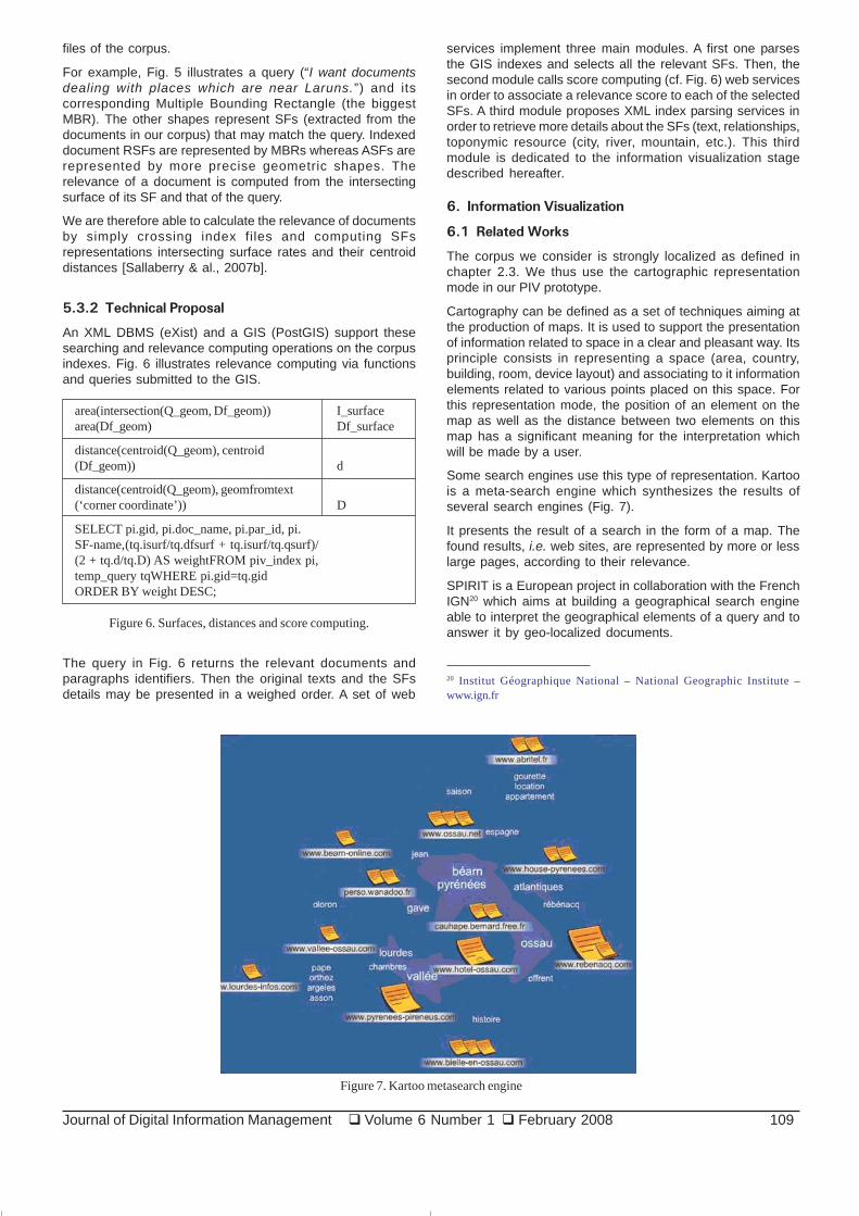
Some search engines use this type of representation. Kartoois a meta-search engine which synthesizes the results ofseveral search engines (Fig. 7).
It presents the result of a search in the form of a map. Thefound results, i.e. web sites, are represented by more or lesslarge pages, according to their relevance.
SPIRIT is a European project in collaboration with the FrenchIGN20 which aims at building a geographical search engineable to interpret the geographical elements of a query and toanswer it by geo-localized documents.
Figure 7. Kartoo metasearch engine
20 Institut Géographique National – National Geographic Institute –www.ign.fr

110 Journal of Digital Information Management � Volume 6 Number 1 � February 2008
Fig. 8 presents the interface of the SPIRIT prototype. Thesearch results are both presented on a geographical mapand on a list. On the map, different colours and sizes allow torepresent the relevance of a document compared to another.
6.2 Space Information Visualization Related Works
The map representation mode is the most appropriate todesign our visualization system. We have deeply studied theSPIRIT project which is the closest to our purpose. We havethen defined its limits in order to propose solutions.
Although it is intuitive and attractive for a user, the presentationof documents on a map brings out various problems whichmust be identified and solved. Hereafter, we first present theidentified problems with the cartographic representation mode.
6.2.1 Representation of documents evoking the same
place (stacks)
Presenting the documents according to the places they evokeis very adequate for the user interested in a specific area or inseveral different places; the documents are then distributedon the map and the user can therefore start navigation by firstselecting one place to explore.
The cartographic representation mode can however set aproblem when the space discriminator which allows to
distinguish two documents is null: all the documents evokingthe same place will be represented at the same place, thuscreating a “stack” of documents geo-localized on a singleplace (Fig. 9a).
The extreme case relates to the space queries stronglytargeted on a single place. For example, a user interested inthe documents describing the town of Pau will see a stack ofdocuments geo-localized on Pau.
For document stacks, the results remain geo-localizable andthus may be represented on maps. However the navigationmodes within these sets of documents have still to be defined.
6.2.2 Representation of documents evoking very close
places (conglomerates)
The problem of documents which are too close to each otherrelates to the documents which evoke distinct places but tooclose compared to the current scale to the map. This case isdisplayed with a conglomerate of icons located in adisordered way on a map (see Fig. 9b).
The documents belonging to conglomerates remaingeolocalizable and thus may be displayed on a map. However,two problems occur: on the one hand, a problem of legibilityand location for the user and, on the other hand, a problem ofaccess to the documents because it may result difficult toclick on some icons.
Figure 8. SPIRIT screenshot
Figure 9. SPIRIT – (a) Stack of geo-localized documents – (b) Conglomerate of geo-localized documents
Journal of Digital Information Management � Volume 6 Number 1 � February 2008 111
6.2.3 Representation of documents evoking several
precise places or areas (multi-representation)
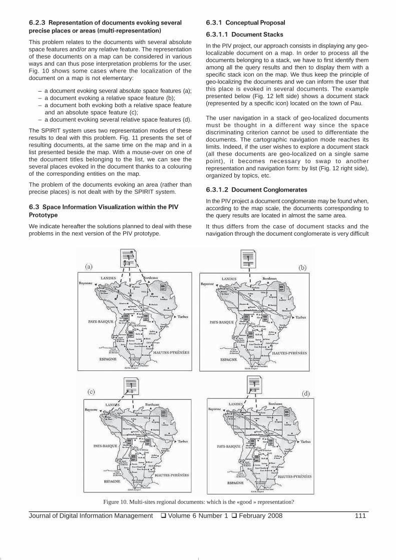
This problem relates to the documents with several absolutespace features and/or any relative feature. The representationof these documents on a map can be considered in variousways and can thus pose interpretation problems for the user.Fig. 10 shows some cases where the localization of thedocument on a map is not elementary:
– a document evoking several absolute space features (a);– a document evoking a relative space feature (b);– a document both evoking both a relative space feature
and an absolute space feature (c);– a document evoking several relative space features (d).
The SPIRIT system uses two representation modes of theseresults to deal with this problem. Fig. 11 presents the set ofresulting documents, at the same time on the map and in alist presented beside the map. With a mouse-over on one ofthe document titles belonging to the list, we can see theseveral places evoked in the document thanks to a colouringof the corresponding entities on the map.
The problem of the documents evoking an area (rather thanprecise places) is not dealt with by the SPIRIT system.
6.3 Space Information Visualization within the PIV
Prototype
We indicate hereafter the solutions planned to deal with theseproblems in the next version of the PIV prototype.
6.3.1 Conceptual Proposal
6.3.1.1 Document Stacks
In the PIV project, our approach consists in displaying any geo-localizable document on a map. In order to process all thedocuments belonging to a stack, we have to first identify themamong all the query results and then to display them with aspecific stack icon on the map. We thus keep the principle ofgeo-localizing the documents and we can inform the user thatthis place is evoked in several documents. The examplepresented below (Fig. 12 left side) shows a document stack(represented by a specific icon) located on the town of Pau.
The user navigation in a stack of geo-localized documentsmust be thought in a different way since the spacediscriminating criterion cannot be used to differentiate thedocuments. The cartographic navigation mode reaches itslimits. Indeed, if the user wishes to explore a document stack(all these documents are geo-localized on a single samepoint), it becomes necessary to swap to anotherrepresentation and navigation form: by list (Fig. 12 right side),organized by topics, etc.
6.3.1.2 Document Conglomerates
In the PIV project a document conglomerate may be found when,according to the map scale, the documents corresponding tothe query results are located in almost the same area.
It thus differs from the case of document stacks and thenavigation through the document conglomerate is very difficult
Figure 10. Multi-sites regional documents: which is the «good » representation?

112 Journal of Digital Information Management � Volume 6 Number 1 � February 2008
because the screen (in pixels) distance between thecorresponding icons is not sufficient to easily distinguish andaccess each document icon. This problem may be solvedwith a zoom on the concerned area. In the PIV project (Fig. 14),we are currently using the same principle as in the SPIRITproject. (Fig. 13).
6.3.1.3 Multi-sites and regional documents
In the PIV project, we use the following principles:
– a document evoking a relative space feature (region)will be displayed in the centre of this region. A mouse-over on this (document) icon will display the bound-aries of this region.
– a document evoking several (n) space features (eitherabsolute or relative) will be displayed several (n) timeson the map.
– all the instances of a same document will be high-lighted on a mouse-over on each (document) icon to
inform the user that all these icons are related to thesame document.
In Fig. 15, the user uses a mouse-over on a document iconlocated on the “Julos” village. The system automaticallydisplays (light red colour) the geographical boundaries of thevillage and an information-bubble with the name of the place,of the corresponding document and the number of itsparagraph, the latitude and longitude. Moreover the samedocument paragraph also deals with three other placeswhose corresponding icons are highlighted in pink.
6.3.2 Technical Proposal
As mentioned in sections 4.3.2 and 5.3.2, the PIV prototype isbuilt on a flexible architecture based on web services. Thereare two web services combined in the informationvisualization process.
The first web service aims at defining and displaying the mostsuitable map according to the area mentioned in the user query.
Figure 12. PIV – Stacks of geo-localized documents
Figure 11. SPIRIT – Multi-sites documents
Figure 13. SPIRIT - Navigation through document conglomerate

Journal of Digital Information Management � Volume 6 Number 1 � February 2008 113
Firstly, it computes the geographical coordinates of the centreof all the polygons corresponding to the set of areas evoked inthe user query. In a second step, it computes the geographicalcoordinates of the most distant space features concerned withthe query. Thanks to these results, a GoogleMaps function iscalled to display the corresponding best map.
The second web service first calculates the way ofrepresenting each resulting documents (stacks, texts, etc.)and then displays them near the evoked place. The detectionof document stacks is operated using our geographicaldatabase. PostGis provides a set of operations specializedin the processing of geographical entities. Since all thedocuments are indexed compared to the space entities theyevoke, it is possible to detect, among all the resultingdocuments, those which evoke the same area and which willthus constitute a document stack on the map. Thus, the PIVsystem calls the intersection function of PostGis in order tofind, among the resulting documents, those which evoke thesame space entity (same geographical co-ordinates). Adocument describing several places is represented by severalicons, each one located close to the evoked place. On amouse-over on such a document, the PIV system highlightsthe other occurrences of this document. Conglomeratemanagement is taken into account by scaling operations whichallow the user to zoom on the grouped set of documents.These scaling operations give access to a dispersed view of
the area and thus facilitate the access to each document. Theimplementation of the scaling operations required only littlework since the maps provided by GoogleMaps21 are alsoprovided with the operations allowing to handle them. Sincethe positioning of each document (on the map) is carried outusing the GoogleMaps functions, the GoogleMaps engineitself re-computes the position of each document after ascaling operation on the map.
7. PIV Evaluation First Results
This section briefly describes the results of twoexperimentations carried out to evaluate PIV IE and IRprocesses.
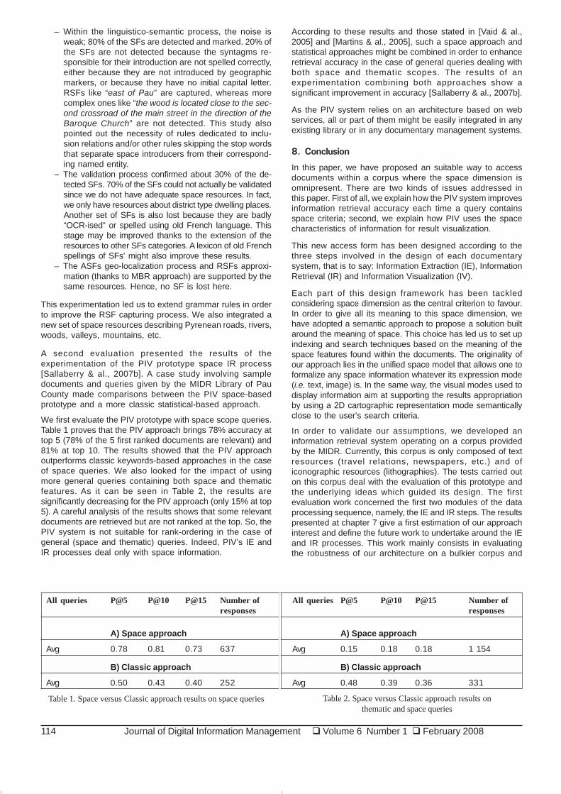
A first evaluation scanned the space IE process of the PIVprototype [Sallaberry & al., 2007a]. We carried out the scanningand the OCR processes with ten books of our corpora. Thenwe ran the PIV prototype automatic Information Extractionprocesses. The PIV prototype found 9835 candidate SFs inthese ten books. At the same time, we annotated geographicfeatures like in CLEF22 campaigns, where participants markSFs of the samples of all these books manually. Finally, wecompared these hand-written annotations to PIV results in orderto compute the recall and precision rates of PIV IE processes.This study focused the evaluation on space features restrictedto districts (towns and villages). Average recall and precisionrates respectively equal 49% and 73%. These rates areinteresting for Absolute SFs and quite bad for Relative SFs.
The stages of the IE process were analyzed and we obtainedthe following results:
Figure 14. PIV - Navigation through document conglomerate
Figure 15. PIV – Regional and multi-sites documents
21 www.google.com/apis/maps/22 www.clef-campaign.org
114 Journal of Digital Information Management � Volume 6 Number 1 � February 2008
All queries P@5 P@10 P@15 Number of All queries P@5 P@10 P@15 Number ofresponses responses
A) Space approach A) Space approach
Avg 0.78 0.81 0.73 637 Avg 0.15 0.18 0.18 1 154
B) Classic approach B) Classic approach
Avg 0.50 0.43 0.40 252 Avg 0.48 0.39 0.36 331
Table 1. Space versus Classic approach results on space queries Table 2. Space versus Classic approach results onthematic and space queries
– Within the linguistico-semantic process, the noise isweak; 80% of the SFs are detected and marked. 20% ofthe SFs are not detected because the syntagms re-sponsible for their introduction are not spelled correctly,either because they are not introduced by geographicmarkers, or because they have no initial capital letter.RSFs like “east of Pau” are captured, whereas morecomplex ones like “the wood is located close to the sec-ond crossroad of the main street in the direction of theBaroque Church” are not detected. This study alsopointed out the necessity of rules dedicated to inclu-sion relations and/or other rules skipping the stop wordsthat separate space introducers from their correspond-ing named entity.
– The validation process confirmed about 30% of the de-tected SFs. 70% of the SFs could not actually be validatedsince we do not have adequate space resources. In fact,we only have resources about district type dwelling places.Another set of SFs is also lost because they are badly“OCR-ised” or spelled using old French language. Thisstage may be improved thanks to the extension of theresources to other SFs categories. A lexicon of old Frenchspellings of SFs’ might also improve these results.
– The ASFs geo-localization process and RSFs approxi-mation (thanks to MBR approach) are supported by thesame resources. Hence, no SF is lost here.
This experimentation led us to extend grammar rules in orderto improve the RSF capturing process. We also integrated anew set of space resources describing Pyrenean roads, rivers,woods, valleys, mountains, etc.
A second evaluation presented the results of theexperimentation of the PIV prototype space IR process[Sallaberry & al., 2007b]. A case study involving sampledocuments and queries given by the MIDR Library of PauCounty made comparisons between the PIV space-basedprototype and a more classic statistical-based approach.
We first evaluate the PIV prototype with space scope queries.Table 1 proves that the PIV approach brings 78% accuracy attop 5 (78% of the 5 first ranked documents are relevant) and81% at top 10. The results showed that the PIV approachoutperforms classic keywords-based approaches in the caseof space queries. We also looked for the impact of usingmore general queries containing both space and thematicfeatures. As it can be seen in Table 2, the results aresignificantly decreasing for the PIV approach (only 15% at top5). A careful analysis of the results shows that some relevantdocuments are retrieved but are not ranked at the top. So, thePIV system is not suitable for rank-ordering in the case ofgeneral (space and thematic) queries. Indeed, PIV’s IE andIR processes deal only with space information.
According to these results and those stated in [Vaid & al.,2005] and [Martins & al., 2005], such a space approach andstatistical approaches might be combined in order to enhanceretrieval accuracy in the case of general queries dealing withboth space and thematic scopes. The results of anexperimentation combining both approaches show asignificant improvement in accuracy [Sallaberry & al., 2007b].
As the PIV system relies on an architecture based on webservices, all or part of them might be easily integrated in anyexisting library or in any documentary management systems.
8. Conclusion
In this paper, we have proposed an suitable way to accessdocuments within a corpus where the space dimension isomnipresent. There are two kinds of issues addressed inthis paper. First of all, we explain how the PIV system improvesinformation retrieval accuracy each time a query containsspace criteria; second, we explain how PIV uses the spacecharacteristics of information for result visualization.
This new access form has been designed according to thethree steps involved in the design of each documentarysystem, that is to say: Information Extraction (IE), InformationRetrieval (IR) and Information Visualization (IV).
Each part of this design framework has been tackledconsidering space dimension as the central criterion to favour.In order to give all its meaning to this space dimension, wehave adopted a semantic approach to propose a solution builtaround the meaning of space. This choice has led us to set upindexing and search techniques based on the meaning of thespace features found within the documents. The originality ofour approach lies in the unified space model that allows one toformalize any space information whatever its expression mode(i.e. text, image) is. In the same way, the visual modes used todisplay information aim at supporting the results appropriationby using a 2D cartographic representation mode semanticallyclose to the user’s search criteria.
In order to validate our assumptions, we developed aninformation retrieval system operating on a corpus providedby the MIDR. Currently, this corpus is only composed of textresources (travel relations, newspapers, etc.) and oficonographic resources (lithographies). The tests carried outon this corpus deal with the evaluation of this prototype andthe underlying ideas which guided its design. The firstevaluation work concerned the first two modules of the dataprocessing sequence, namely, the IE and IR steps. The resultspresented at chapter 7 give a first estimation of our approachinterest and define the future work to undertake around the IEand IR processes. This work mainly consists in evaluatingthe robustness of our architecture on a bulkier corpus and

Journal of Digital Information Management � Volume 6 Number 1 � February 2008 115
composed of a larger variety of documents (postcards, soundextracts but also old movies). If this test results are notconclusive because of the too important documentary volume,we are currently studying the opportunity of integrating a stepaiming to define the user expectations in a more accurateway. This stage should be performed before query processingand would aim at presenting the geographical areasconcerned with the user query on a map. He/she would thenhave the possibility to specify (using a dedicated toolbox) theareas on which he/she wishes to obtain related documentsin a more accurate way.
In addition to this work, we keep in mind the necessity to workon the issue of documents relevance, in particular about themeaning of this concept when a user specifies a querycomposed of space criteria.
With regard to visual aspects, we are currently working withthe definition of a test protocol allowing to evaluate therelevance of the modes used to restore the results.Considering a representative population of users, the goalconsists in identifying the conceptual choices which led to theimplementation of problematic interactions. So, it deals withvalidating the methods we used to take into account the spacedimension in the stage of result restitution.
This evaluation work remains necessary before consideringnew problems related to information visualization.Nevertheless, we keep in mind the problem of documentarynavigation, in particular when a bulky corpus is considered.Currently, the navigation problem is not taken into account inour proposal; no help is provided to the user in the activity ofexploring the set of resulting documents. Thus, in medium-term plans, we wish to study this browsing activity andparticularly the methods to be taken into account to navigatewithin documents resulting from a query with space criteria.The objective of this study will aim at defining the way to takeinto account the space dimension to facilitate the explorationof geo-localized documents.
With the growing development of technologies such asGoogleEarth and the growing interest of users for this kind oftools, we are studying the possibility of transposing resultpresentation on a three-dimension map. This visualizationmode would allow to increase the omnipresence of spacedimension and to combine the documentary exploration withterritory exploration.
Lastly, the prototype we have developed and the underlyingmodels focus on the space dimension of documents. Wekeep in mind that beyond these space features, thesedocuments, above all, contain a geographical dimensionwhich we are not yet able to fully manage. These documentsalso contain temporal references associated with thedescriptions of phenomena. To deal with this problem, weare currently working on a temporal model which presentssome similarities with our space model. These similaritieswill then allow to combine the two models to index and toretrieve as well space features as temporal ones. Due to thecomplexity of the phenomenon dimension, we are currentlyworking on the development of tools facilitating the manualannotation of text. These tools will be used when the tools forautomatic indexing and interpretation show their limits.
Acknowledgements
The PIV project is led in partnership with the community ofagglomeration of Pau and the multimedia library of Pau County(MIDR). We want to thank them for their help (by the provisionof the digitized corpus, notably) and their support.
Moreover this project is shared with the whole DESI researchteam. That is why we want to thank its members for worksperformed together.
References
[1] Abolhassini M. Abolhassani, Fuhr, N., Govert, N (2003).Information Extraction and Automatic Markup for XMLdocuments, Springer, p. 159–174.
[2] Baeza-Yates, R. A., Ribeiro-Neto, B. A (1999). ModernInformation Retrieval. ACM Press / Addison-Wesley.
[3]. Benz, U. C., Hofmann, P.. Willhauck., Lingenfelder,I., Heynen,M (2002). Multi-resolution, object-oriented fuzzy analysis ofremote sensing data for GIS ready information. InternationalWorkshop - Semantic Processing of Spatial Data-Geopro.
[4]. Bonnel, N., Moreau, F (2005). Quel avenir pour les moteursde recherche ? In: Proceedings of the workshop Manifestationdes Jeunes Chercheurs francophones dans les domaines desSTIC, MajecSTIC 2005, Rennes, France, p. 291-299, november.
[5] Bonnel, N.. Cotarmanac’h, A and Morin, A (2005).Gestionet visualisation des résultats d’une requête, Actes du 3e AtelierVisualisation et Extraction de Connaissances (associé àEGC’05), p. 37-47, Paris, France.
[6] Bonnel, N., Cotarmanac’h., Morin, A (2005).MeaningMetaphor for Visualizing Search Results, Proceedings of the9th International Conference on Information Visualisation(IV’05), p. 467-472, London, England.
[7] Borillo, A. (1998)L’espace et son expression en français.L’essentiel. Ophrys.
[8] Boughanem, M. Chrisment, C. Tmar, M.Mercure andMercureFiltre Applied for Web and Filtering Tasks at TREC-10. Proceeding of TREC, 2001.
[9] Bressan, S., Ooi, B.C., Lee., F (2000). Global Atlas:Calibrating and Indexing Documents from the Internet in theCartographic Paradigm. In: Proceedings of the 1stInternational Conference on Web Information SystemsEngineering, v. 1, p. 117-124.
10. Clementini, E. Sharma, J., Egenhofer, M (1994).Modelingtopological spatial relations: Strategies for query processing.Computers and Graphics 18 (6) 815-822.
[11] Casenave, J C., Marquesuzaà, P., Dagorret., Gaio, M(2004). La revitalisation numérique du patrimoine littéraireterritorialisé. In: Colloque International EBSI-ENSSIB, Montréal,Octobre 2004, http://babel.enssib.fr/sommaire.php?id=612
[12] Chen, Y-Y, Suel, T., Markowetz, A (2006). Efficient queryprocessing in geographic web search engines, In:Proceedings of the 2006 ACM SIGMOD internationalconference on Management of data, p. 277 – 288.
[13]. Cohn, A. G (1997). Qualitative spatial representation andreasoning techniques. In: KI ’97: Proceedings of the 21stAnnual German Conference on Artificial Intelligence, Springer-Verlag p. 1–30, London, UK.
[14] Cohn, A. G., Hazarika, S. M (2001). Qualitative spatialrepresentation and reasoning: An overview. FundamentaInformaticae, 46 (1-2)1–29.
[15] Cossanel, J., Cahier, J.P., Zacklad, M., Charlet, J (2002).LesTopic Maps sont-ils un bon candidat pour l’ingénierie du WebSémantique ? In: Proceedings of conférence Ingénierie desConnaissances IC2002, Rouen, Mai.
[16] Covington, M. A (1994). Gulp 3.1: An extension of prologfor unification-based grammar. Research report Ai-1994-06,University of Georgia Athens, 1994.
116 Journal of Digital Information Management � Volume 6 Number 1 � February 2008
[17] Egenhofer, M. J. (2002). Toward the semantic geospatialweb. In: GIS ’02: Proceedings of the 10th ACM internationalsymposium on Advances in geographic information systems,p. 1–4. ACM Press.
[18] Enjalbert, P., Gaio, M (2006). Traitements sémantiquespour l’information géographique, textes et cartes. RevueInternationale de Géomatique, to be published.
[19] Etcheverry, P.. Marquesuzaà, C., Lesbegueries, J(2005).Revitalisation de documents territorialisés: Principes,outils et premiers résultats. Workshop Met-SI INFORSID.
[20] Gaizauskas, R (2002). An information extractionperspective on text mining: Tasks, technologies and prototypeapplications. Euromap Text Mining Seminar, Sheffield.
[21] Gaizauskas, R., Wilks, Y (1998). Information extraction:Beyond document retrieval. Journal of Documentation, 54 (1)70–105.
[22] Gaizauskas., R., Gaizauskas, T., Wakao, K., Humphreys,Cunningham, H., Wilks, Y (1995). University of sheffield:Description of the lasie system as used for muc, http://acl.ldc.upenn.edu/M/M95/M95-1017.pdf
[23]. Gotts, N., Goodday, J (1996). A connection basedapproach to common-sense topological description andreasoning. The Monist. p. 51-75. citeseer.ifi.unizh.ch/gotts95connection.html
[24] Hernandez, N (2005).Ontologies pour l’aide à l’explorationd’une collection de documents. In Ingénierie des Systèmesd’Information, v. 10, p 11–31. Hermès Sciences.
[25]. Hill, L (1999). Indirect geospatial referencing throughplace names in the digital library: Alexandria digital libraryexperience with developing and implementing gazetteers.62nd Annual Meeting of the American Society for InformationScience, pp. 57-69. Medford, N.J.: ASIS.
[26] Hill, L (2000). Core elements of digital gazetteers: Placenames, categories, and footprints. In: ECDL ’00: Proceedingsof the 4th European Conference on Research and AdvancedTechnology for Digital Libraries, p. 280–290. Springer-Verlag.
[27] Ihadjadene, M (2004). Les systèmes de recherched’informations – modèles conceptuels. Hermes, Lavoisier,ISBN 2-7462-0821-0, www.hermes-science.com
[28] Ihadjadene, M (2004). Méthodes avancées pour lessystèmes de recherche d’informations. Hermes, Lavoisier,ISBN 2-7462-0846-6, www.hermes-science.com
[29] Jacquemin, C., Folch, H., Garcia, K., Nugier, S (2005).Visualisation interactive d’espaces documentaires, RevueInformation, Interaction, Intelligence, Revue en Sciences duTraitement de l’Information, Editions Cépaduès, Volume 5,n°1, 2005. http://www.revue-i3.org/volume05/numero01/revue_i3_05_01_03.pdf
[30] Jones, C.-B. Abdelmoty, A.-I. Finch, D., Fu, G. Vaid, S (2004).The Spirit Spatial Search Engine: Architecture, Ontologies andSpatial Indexing. Geographic Information Science. ThirdInternational Conference, GI Science. p. 125–139.
[31] Kules, B., Schneiderman, B (2004).Categorized graphicaloverviews for web search results: An exploratory study usingU.S. government agencies as a meaningful and stablestructure, In: Proceedings of the Third Annual Workshop onHCI Research in MIS, Washington, D.C., December 10-11,2004.
[32] Lesbegueries, J., Gaio, M., Loustau, P., Sallaberry, C(2006). Geographical information access for non-structureddata, ACM SAC Advances in Spatial and Image basedInformation Systems track.
[33] Leuski, A., Allan, J (2000). Lighthouse: Showing the wayto relevant information, In: Steven F. Roth and Daniel A. Keim,editors, Proceedings of IEEE Symposium on InformationVisualization (InfoVis’00), pp. 125-130, Salt Lake City, Utah,USA, October 9-10, IEEE Computer Society.
[34] Lowgren, J., Stolterman, E (2004). Thoughtful InteractionDesign: A Design Perspective On Information Technology, MITPress.
[35] Mackinlay, J., Robertson, G., Card, S (1991).ThePerspective Wall : Detail and Context Smoothly Integrated, In:Proc. ACM Human Factors in Computing Systems(SIGCHI’91), p. 173-179.
[36] Marquesuzaà, C., Etcheverry, P and Lesbegueries, J(2005). Exploiting geospatial markers to explore andresocialize localized documents. In: Proceedings of the firstInternational Conference on GeoSpatial Semantics, GeoS2005, Mexico City, november 29-30, Lecture Notes in ComputerScience, Vol. 3799, p. 153-165.
[37] Martins, B., Silva, M-J., Andrade, L (2005). Indexing andranking in Geo-IR systems. In: Proceedings of the 2ndInternational Workshop on Geographic Information Retrieval(GIR), pp. 31-34, ISBN:1-59593-165-1
[38] McCurley, K.S (2001). Geospatial Mapping and Navigationof the Web. In: Proceedings of Tenth International World WideWeb Conference, Session P7. ACM press, p. 221-229,www10.org/cdrom/papers/278/
[39] Muller, P (2002). Topological spatio-temporal reasoning andrepresentation. Computational Intelligence, 18 (3) 420–450.
[40] Porter, M (1980) An algorithm for suffix stripping. Program,14 (3)130-137.
[41] Robertson, S.E (1977). The probability ranking principlein IR, Journal of Documentation 33 (4) 294-304.
[42] Robertson, S.E., Walker, S., Hancock-Beaulieu, M (1998).Okapi at TREC-7: Automatic Ad Hoc, Filtering, VLC andInteractive. TREC 1998, p. 199-210.
[43] Sagara, T., Kitsuregawa, M (2004). Yellow Page drivenMethods of Collecting and Scoring Spatial Web Documents.SIGIR Workshop on Geographical Information Retrieval,www.geo.unizh.ch/~rsp/gir
[44] Sallaberry, C., Marquesuzaà, C., Etcheverry, P (2007).Implementing a Visualization System suited to LocalizedDocuments, Addendum Contributions to the fifth IEEEInternational Conference on Research, Innovation and Visionfor the Future, p. 13-18, Patrick BELLOT, Vu DUONG, MarcBUI, Bao HO Editors Editions SUGER, Collection InformatiqueISBN : 2-912590-4-0, Collection Informatique March 05-09.
[45] Sallaberry, C., Gaio, M., Lesbegueries, J., Loustau, P(2007). A Semantic Approach for Geospatial InformationExtraction from Unstructured Documents. In: The GeospatialWeb, Springer. ISBN 1-84628- 826-6. www.geospatialweb.com
[46] Sallaberry, C., Baziz, M. Lesbegueries, J., Gaio, M (2007).Towards an IE and IR system dealing with spatial informationin digital libraries – Evaluation Case Study, ICEIS, 9thInternational Conference on Enterprise Information Systems.
[47] Salton, G (1984). McGill, M.J Introduction to moderninformation retrieval. McGraw-Hill Int. Book Co.
[48] Sanderson, M., Kohler, J. Analyzing geographic queries.In: Proceedings of the Workshop on Geographic InformationRetrieval, SIGIR, www.geo.unizh.ch/~rsp/gir
[49] Tebri, H (2004). Formalisation et spécification d’unsystème de filtrage incrémental d’information. PhD thesis,Université Paul Sabatier de Toulouse.
Journal of Digital Information Management � Volume 6 Number 1 � February 2008 117
[50] Torres, M (2002).Semantics definition to represent spatialdata. International Workshop - Semantic Processing of SpatialData - Geopro.
[51] Torres, J.M., Parkes, A (2000). User modelling andadaptivity in visual information retrieval systems, Workshopon Computational Semiotics for New Media, University ofSurrey, UK, June 29-30, http://wwwscm. tees.ac.uk/users/p.c.fencott/ newMedia
[52] Vaid, S., Jones, C.-B., Joho, H., Sanderson, M (2005).Spatio-Textual Indexing for Geographical Search on the Web.9th International Symposium on Spatial and TemporalDatabases.
[53] Vandeloise, C (1986). L’espace en français. TravauxLinguistiques. Seuil.
[54] Wildöcher, A., Faurot, E., Bilhaut, F (2004). Multimodalindexation of contrastive structures in geographicaldocuments. In: RIAO, p.555–570.
[55] Widlocher, A., Bilhaut, F (2005). La plate-formelinguastream : un outil d’exploration linguistique sur corpus.In Actes de la 12e Conférence Traitement Automatique duLangage Naturel, 2005.
[56] Woodruff, A.G., Plaunt, C (1994). GIPSY: AutomatedGeographic Indexing of Text Documents, Journal of theAmerican Society for Information Science, 45 (9) 645-655.
[57]. Zhan, F. B (2001). How much is region q covering regionr, a little bit, somewhat, or nearly completely? M. Cristani andB. Bennett (Eds.), SVUG01: The First COSIT (Conference onSpatial Information Theory) Workshop on Spatial Vagueness,Uncertainty and Granularity, Morro Bay, CA, September.
[58] Zipf (1949). Human Behaviour and the Principle of LeastEffort. Addison Wesley.