Abstract ICC2013fv
22
The “ARPOA” GIS Religious Atlas: Its Use In Defining The Orthodox Architectural Heritage In The Eastern Mediterranean And The Gulf Region. Amal Iaaly*, Rola Jadayel*, Oussama Jadayel*, Michael Davie** * University of Balamand, Lebanon ** University of Tours, France Abstract. This paper describes the methods, tools and results implemented to produce “ARPOA”, an atlas of the places of worship of the Greek Orthodox Church of the Patriarchate of Antioch. This Atlas covers an area which extends over 300 km along the Eastern coast of the Mediterranean; it covers more than 1.000 sites: cathedrals, monasteries, parish churches, convents, funerary devotion chapels and pilgrimage shrines. These monuments are diverse in terms of periods, types and influences. They are present in Lebanon, Syria, Iraq, Turkey, Kuwait, Iran, Oman, UAE, and Bahrain. The main purpose of this Atlas is not only to locate the places of worship but also to create an extensive inventory of Orthodox monuments, detailing their archeology, models and architectural structures, their art styles and decorations from the Middle Ages onwards. This Atlas aimed to reflect the richness and variety of religious arts which evolved through the particular history of this Patriarchate, and to confirm both its cosmopolitanism as well as regional and local anchorages. A Geographic Information System was used to create a management platform for these monuments and to develop
Transcript of Abstract ICC2013fv
The “ARPOA” GIS Religious Atlas: Its Use In Defining The Orthodox Architectural Heritage In The Eastern Mediterranean And The Gulf Region.
Amal Iaaly*, Rola Jadayel*, Oussama Jadayel*, Michael Davie**
* University of Balamand, Lebanon** University of Tours, France
Abstract.
This paper describes the methods, tools and resultsimplemented to produce “ARPOA”, an atlas of the placesof worship of the Greek Orthodox Church of thePatriarchate of Antioch. This Atlas covers an areawhich extends over 300 km along the Eastern coast ofthe Mediterranean; it covers more than 1.000 sites:cathedrals, monasteries, parish churches, convents,funerary devotion chapels and pilgrimage shrines. Thesemonuments are diverse in terms of periods, types andinfluences. They are present in Lebanon, Syria, Iraq,Turkey, Kuwait, Iran, Oman, UAE, and Bahrain.
The main purpose of this Atlas is not only to locatethe places of worship but also to create an extensiveinventory of Orthodox monuments, detailing theirarcheology, models and architectural structures, theirart styles and decorations from the Middle Agesonwards. This Atlas aimed to reflect the richness andvariety of religious arts which evolved through theparticular history of this Patriarchate, and to confirmboth its cosmopolitanism as well as regional and localanchorages.
A Geographic Information System was used to create amanagement platform for these monuments and to develop

the ARPOA Geo-database. Detailed field surveys werecarried out by a professional historian helped byarchitects and archeologists from the University ofBalamand; consultants in a number of Universities inLebanon and in France were also brought in to produceall the detailed information about each and everymonument subject of study. The GIS work was carriedwithin the GIS Centre at the University of Balamand;part of the project was student based and went inparallel with the community service program at theuniversity. This paper will detail the processesimplemented in producing the Atlas and will illustratehow it revealed several hitherto unknown historical andarcheological patterns related to the architecture ofthese monuments.
Keywords: GIS, Religious Atlas, Service Learning
1. IntroductionNowadays, the interest for religious heritage is notspecific to any particular community; it now affectsmost of the Eastern Christian Churches as well as otherMiddle-Eastern religious groups. It challenges academicbodies, professional organizations and officialinstitutions up to now more interested inarchaeological sites and historical monuments than in“living” places of worship.
Founded in 2004, "ARPOA" is a research project launchedby the University of Balamand in Lebanon to identifyand locate the various expressions of the religiousarchitecture of the Orthodox Patriarchate of Antioch.Its acronym is derived from the French title of theproject: “Architecture Religieuse du Patriarct Orthodoxd’Antioche”. The project aims to produce acomprehensive E.atlas by inventorying, surveying anddocumenting all the churches of this Patriarchate whichcovers Lebanon, Syria, Omman, Iran,southern Turkey,Iraq and the Gulf States, in order to define theheritage values of these sites and hopefully to
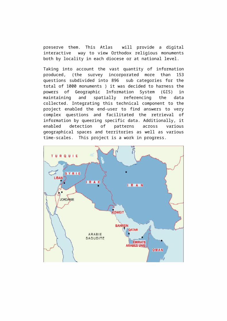
preserve them. This Atlas will provide a digitalinteractive way to view Orthodox religious monumentsboth by locality in each diocese or at national level.
Taking into account the vast quantity of informationproduced, (the survey incorporated more than 153questions subdivided into 896 sub categories for thetotal of 1000 monuments ) it was decided to harness thepowers of Geographic Information System (GIS) inmaintaining and spatially referencing the datacollected. Integrating this technical component to theproject enabled the end-user to find answers to verycomplex questions and facilitated the retrieval ofinformation by queering specific data. Additionally, itenabled detection of patterns across variousgeographical spaces and territories as well as varioustime-scales. This project is a work in progress.
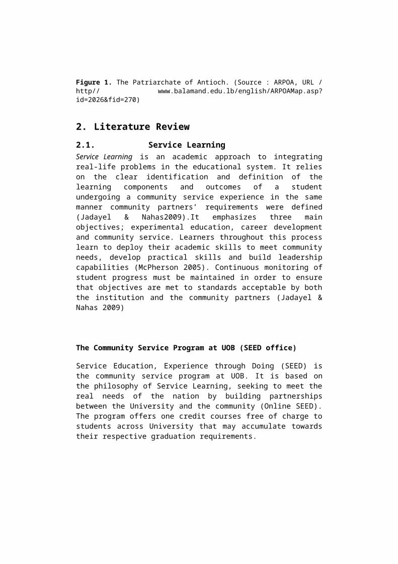
Figure 1. The Patriarchate of Antioch. (Source : ARPOA, URL /http// www.balamand.edu.lb/english/ARPOAMap.asp?id=2026&fid=270)
2. Literature Review2.1. Service LearningService Learning is an academic approach to integratingreal-life problems in the educational system. It relieson the clear identification and definition of thelearning components and outcomes of a studentundergoing a community service experience in the samemanner community partners’ requirements were defined(Jadayel & Nahas2009).It emphasizes three mainobjectives; experimental education, career developmentand community service. Learners throughout this processlearn to deploy their academic skills to meet communityneeds, develop practical skills and build leadershipcapabilities (McPherson 2005). Continuous monitoring ofstudent progress must be maintained in order to ensurethat objectives are met to standards acceptable by boththe institution and the community partners (Jadayel &Nahas 2009)
The Community Service Program at UOB (SEED office)
Service Education, Experience through Doing (SEED) isthe community service program at UOB. It is based onthe philosophy of Service Learning, seeking to meet thereal needs of the nation by building partnershipsbetween the University and the community (Online SEED).The program offers one credit courses free of charge tostudents across University that may accumulate towardstheir respective graduation requirements.
2.2. GIS In Religious Heritage andArcheology
Geographic Information Systems has over the last 10years become an important tool in archaeology or in anyother type of cultural or religious heritage study(Medbib, Online article). The bringing together of GISand archaeological, historical, and architecturalstudies constitutes a powerful tool to explore thespatial dimension of human activity over time. Thus,since the study of cultural and religious heritage andarchaeology looks at the unfolding of historical eventsthrough geography, time and culture, the results ofthese studies are rich in spatial information (Medbib,online article). GIS is perfectly adapted to processthese large volumes of data, especially to those, whichare geographically referenced; it’s a cost-effective,accurate and fast tool. The tools made availablethrough GIS help in data collection, its storage andretrieval, its manipulation for customized usage and,finally, the display of the data so that it is visuallycomprehensible by the end-user. The most importantaspect of GIS in cultural heritage and archaeologylies, however, not in its use as a pure map-makingtool, but in its capability to merge and analyzedifferent types of data in order to create newinformation. The use of GIS in this field has changednot only the way historians, architects orarchaeologists acquire and visualize data, but also theway in which they think about space itself (Medbib,Online article)
2.3 E-Atlas
An Atlas is, by definition, a set of maps with organic,accordant, supplemental and comparison relations for aunified form (Van, 2011). Its a map product with highscale and value (Lam, 2002). The value of an Atlasprevails over other types of maps due to its referral
to specific themes and geographical areas and thesystematic representation of features. Due to progress in digital technology and digitalmaps, the term “Electronic Atlas” (E.Atlas) emerged andwas first used by Eva Suekierska in 1984 and acceptedfor use by ICA World Map Association.
An E-Atlas must comply with classification principles of Atlases (Nguyen, 2007), including:
Coverage of territory Purpose of the Atlas Size & Scale
Additionally an E-Atlas can be further distinguished bythe level of interaction and analysis:
“View-Only” Atlas “Interactive” Atlas “Analytical” Atlas
An “Analytical” Atlas incorporates GIS analytical capabilities allowing ansewring powerful questions related to “How?” and”Why?” in addition to classicial question of “Where? And What?”.
Furthermore, the E-Atlas design must ensure a highinternal unified method in map production and infeatures’ consistency in term of symbologies, colours,size, and fonts for same or similar themes andsubjects.
3. Building The ARPOA GIS Platform3.1. Building the Geo-database
This phase constituted the most challenging part of thework leading to the development of a scalable databasemodel. It included the conceptual, logical andphysical design phases. It aimed at the creation of acomprehensive central data repository for both storingthe data collected during the field survey and forcentrally managing these data along with their spatiallocations. Moreover, it allowed the work within a
multi-user access and editing environment. Thiscomprehensive database model was implemented as aseries of entities comprising feature datasets,classes, and attributes.The design was an iterativeprocess flexible enough to accommodate modifications atany time. The ARPOA database model was initiated by sketching aconceptual design aiming at understanding the intentand meaning of the data that was needed to deriveinformation form the survey sheets. Hence, thebisection of survey sheet content was essential inorder to place this information in the context ofknowledge creation and to identify and categorize whatdata could effectively be stored in the geo-database.Without such a conceptual design planning stage, therewas a risk that the developed geo-database couldcontain design flaws.
The ARPOA geo-database conceptual design phaseincluded:
The identification of information in the surveysheet that was necessary for the project.
The categorization of information into attributetables under specific thematic topics.
The creation of the attributes data fields and thespecification of their types, properties andassociated domains.
The organization of the data sources into logicalsets of features.
The identification of key thematic layers andfeature classes.
The logical design phase was complementary to theconceptual design phase adding to it the definition ofa database structure and the proposition of a geo-database design.
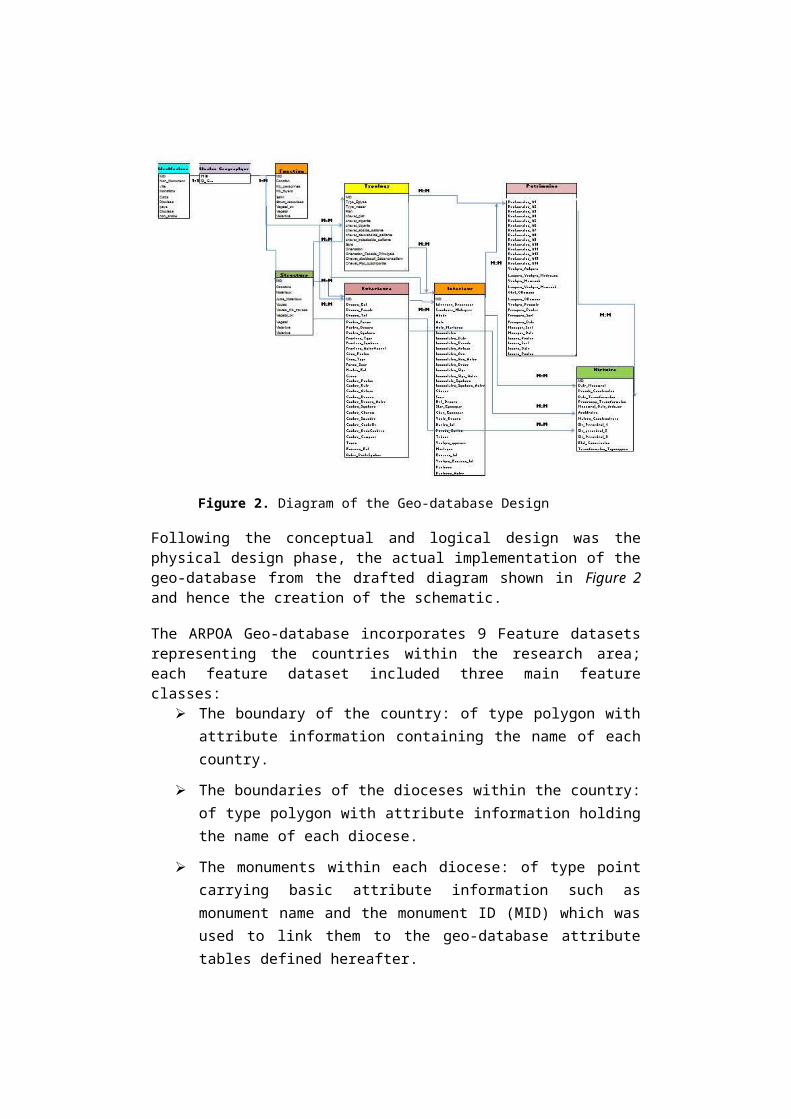
Figure 2. Diagram of the Geo-database Design
Following the conceptual and logical design was thephysical design phase, the actual implementation of thegeo-database from the drafted diagram shown in Figure 2and hence the creation of the schematic.
The ARPOA Geo-database incorporates 9 Feature datasetsrepresenting the countries within the research area;each feature dataset included three main featureclasses:
The boundary of the country: of type polygon withattribute information containing the name of eachcountry.
The boundaries of the dioceses within the country:of type polygon with attribute information holdingthe name of each diocese.
The monuments within each diocese: of type pointcarrying basic attribute information such asmonument name and the monument ID (MID) which wasused to link them to the geo-database attributetables defined hereafter.
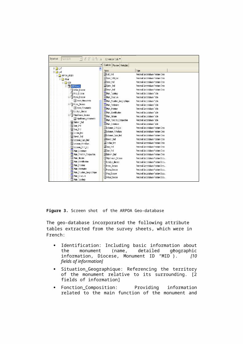
Figure 3. Screen shot of the ARPOA Geo-database
The geo-database incorporated the following attribute tables extracted from the survey sheets, which were in French:
Identification: Including basic information aboutthe monument (name, detailed geographicinformation, Diocese, Monument ID “MID”). [10fields of information]
Situation_Geographique: Referencing the territoryof the monument relative to its surrounding. [2fields of information]
Fonction_Composition: Providing informationrelated to the main function of the monument and
of associated composition and structure. [9 fields ofinformation]
Typology: Including detailed information about thearchitectural structure. [15 fields of information]
Structure: Describing detailed structuralinformation of the monuments. [10 fields of information]
Exterieure: Providing information about theexternal decoration and architectural design ofthe monuments. [29 fields of information]
Interieure: Providing information about theinternal decoration and architectural design ofthe monuments. [32 fields of information]
Histoire: Providing information about theconstruction date of the monument and therestoration phases and typologicaltransformations. [13 fields of information]
Patrimoine: Providing information about therestoration aspects, the materials used and thepainters who participated in the production oficons or wall paintings. [30 fields of information]
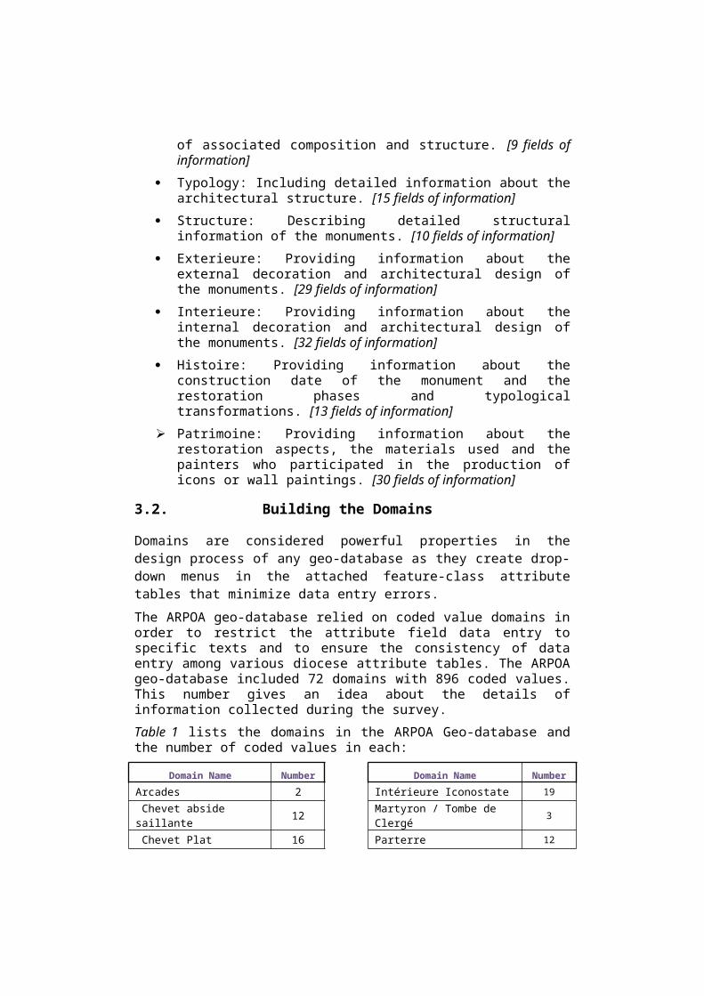
3.2. Building the Domains
Domains are considered powerful properties in thedesign process of any geo-database as they create drop-down menus in the attached feature-class attributetables that minimize data entry errors. The ARPOA geo-database relied on coded value domains inorder to restrict the attribute field data entry tospecific texts and to ensure the consistency of dataentry among various diocese attribute tables. The ARPOAgeo-database included 72 domains with 896 coded values.This number gives an idea about the details ofinformation collected during the survey.Table 1 lists the domains in the ARPOA Geo-database andthe number of coded values in each:
Domain Name Number Domain Name NumberArcades 2 Intérieure Iconostate 19 Chevet abside saillante 12 Martyron / Tombe de
Clergé 3
Chevet Plat 16 Parterre 12
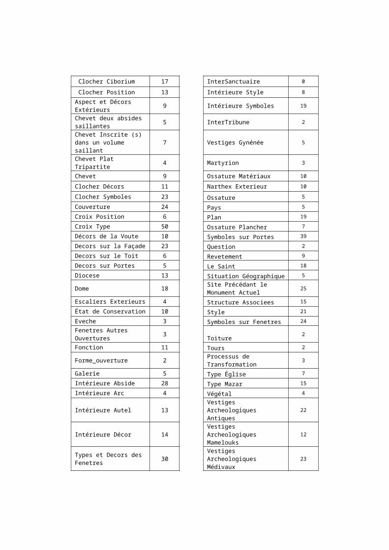
Clocher Ciborium 17 InterSanctuaire 0
Clocher Position 13 Intérieure Style 8Aspect et Décors Extérieurs 9 Intérieure Symboles 19
Chevet deux absides saillantes 5 InterTribune 2
Chevet Inscrite (s) dans un volume saillant
7 Vestiges Gynénée 5
Chevet Plat Tripartite 4 Martyrion 3
Chevet 9 Ossature Matériaux 10
Clocher Décors 11 Narthex Exterieur 10
Clocher Symboles 23 Ossature 5Couverture 24 Pays 5Croix Position 6 Plan 19Croix Type 50 Ossature Plancher 7Décors de la Voute 10 Symboles sur Portes 39Decors sur la Façade 23 Question 2Decors sur le Toit 6 Revetement 9Decors sur Portes 5 Le Saint 18Diocese 13 Situation Géographique 5
Dome 18 Site Précédant le Monument Actuel 25
Escaliers Exterieurs 4 Structure Associees 15État de Conservation 10 Style 21Eveche 3 Symboles sur Fenetres 24Fenetres Autres Ouvertures 3 Toiture 2
Fonction 11 Tours 2
Forme_ouverture 2 Processus de Transformation 3
Galerie 5 Type Église 7Intérieure Abside 28 Type Mazar 15Intérieure Arc 4 Végétal 4
Intérieure Autel 13Vestiges Archeologiques Antiques
22
Intérieure Décor 14Vestiges Archeologiques Mamelouks
12
Types et Decors des Fenetres 30
Vestiges Archeologiques Médivaux
23

Types et Decors des Portes 39
Vestiges Archeologiques Objet Ottomans Remarquable
15
Intérieure Décors dela Nef 15 Vestiges A Proximite 19
Intérieure Décors sur 16 Ossature Voûtes 7
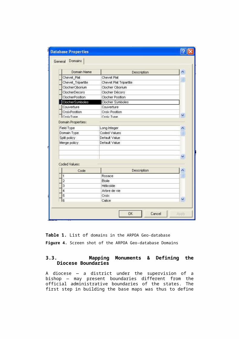
Table 1. List of domains in the ARPOA Geo-databaseFigure 4. Screen shot of the ARPOA Geo-database Domains
3.3. Mapping Monuments & Defining theDiocese Boundaries
A diocese — a district under the supervision of abishop — may present boundaries different from theofficial administrative boundaries of the states. Thefirst step in building the base maps was thus to define
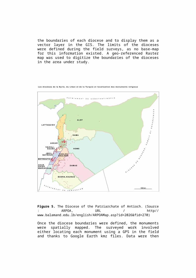
the boundaries of each diocese and to display them as avector layer in the GIS. The limits of the dioceseswere defined during the field surveys, as no base-mapfor this information existed. A geo-referenced Rastermap was used to digitize the boundaries of the diocesesin the area under study.
Figure 5. The Diocese of the Patriarchate of Antioch. (Source: ARPOA, URL / http//www.balamand.edu.lb/english/ARPOAMap.asp?id=2026&fid=270)
Once the diocese boundaries were defined, the monumentswere spatially mapped. The surveyed work involvedeither locating each monument using a GPS in the fieldand thanks to Google Earth kmz files. Data were then
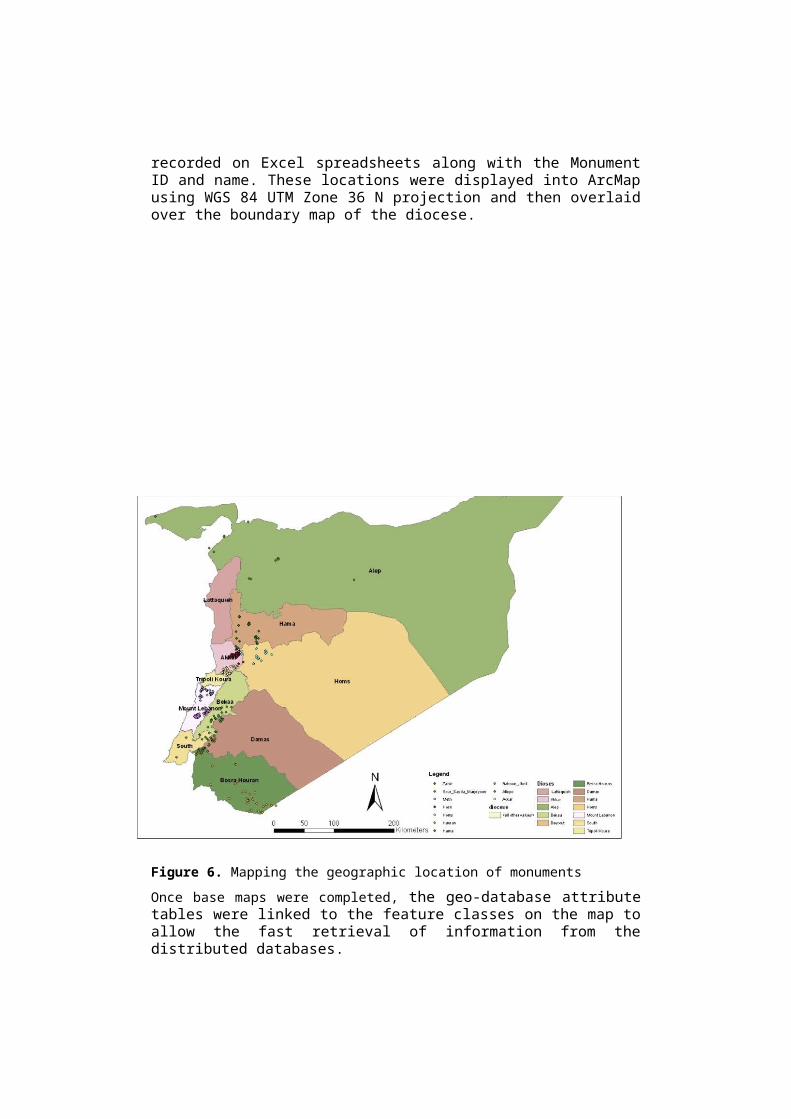
recorded on Excel spreadsheets along with the MonumentID and name. These locations were displayed into ArcMapusing WGS 84 UTM Zone 36 N projection and then overlaidover the boundary map of the diocese.
Figure 6. Mapping the geographic location of monumentsOnce base maps were completed, the geo-database attributetables were linked to the feature classes on the map toallow the fast retrieval of information from thedistributed databases.
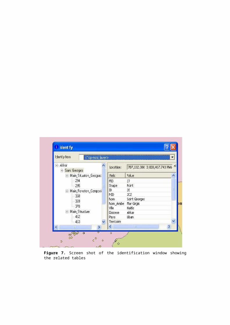
Figure 7. Screen shot of the identification window showingthe related tables
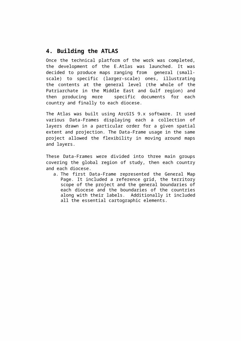
4. Building the ATLASOnce the technical platform of the work was completed,the development of the E.Atlas was launched. It wasdecided to produce maps ranging from general (small-scale) to specific (larger-scale) ones, illustratingthe contents at the general level (the whole of thePatriarchate in the Middle East and Gulf region) andthen producing more specific documents for eachcountry and finally to each diocese.
The Atlas was built using ArcGIS 9.x software. It usedvarious Data-Frames displaying each a collection oflayers drawn in a particular order for a given spatialextent and projection. The Data-Frame usage in the sameproject allowed the flexibility in moving around mapsand layers.
These Data-Frames were divided into three main groupscovering the global region of study, then each countryand each diocese.
a. The first Data-Frame represented the General MapPage. It included a reference grid, the territoryscope of the project and the general boundaries ofeach diocese and the boundaries of the countriesalong with their labels. Additionally it includedall the essential cartographic elements.
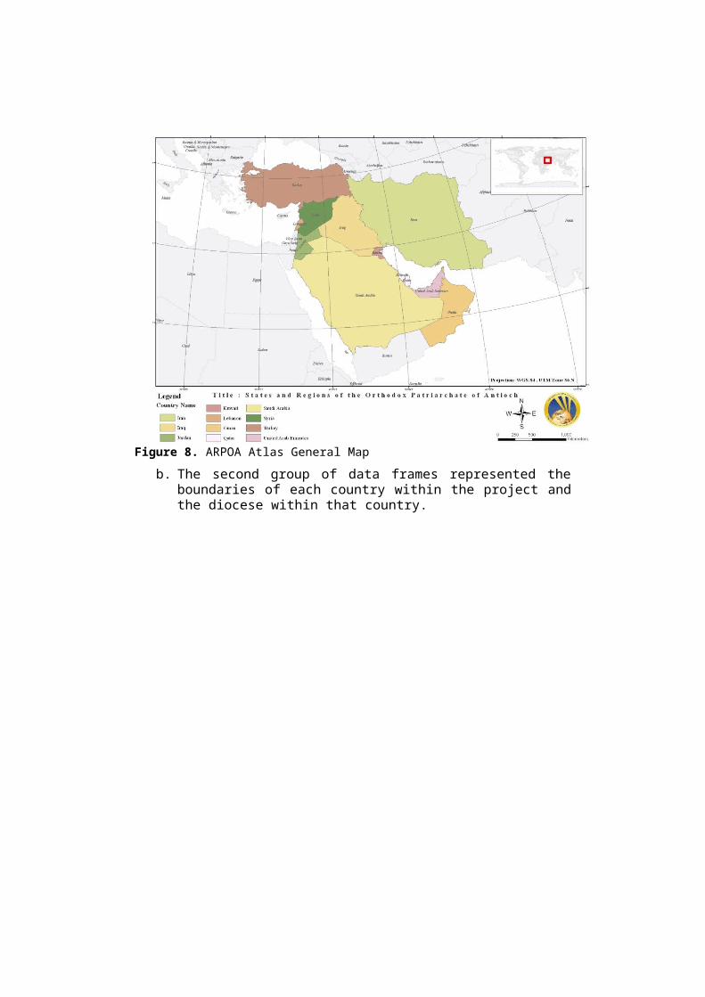
Figure 8. ARPOA Atlas General Mapb. The second group of data frames represented the
boundaries of each country within the project andthe diocese within that country.
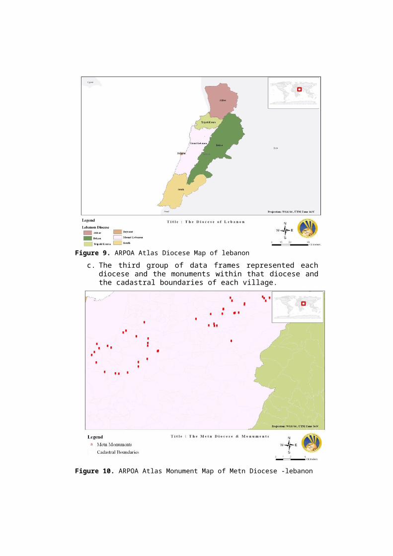
Figure 9. ARPOA Atlas Diocese Map of lebanon c. The third group of data frames represented each
diocese and the monuments within that diocese andthe cadastral boundaries of each village.
Figure 10. ARPOA Atlas Monument Map of Metn Diocese -lebanon
This E. Atlas complies with the general specificationsof Atlases.It does not reflect the complete work asmany diocese are not yet surveyed.
5. Student Role Considering the amount of work and time required forthe completion of the technical part of the ARPOAproject, the GIS center decided to open the door forstudents. Accordingly a SEED course was offered withinthe GIS center to student from the Faculty ofEngineering who completed the Introduction to GIScourse “GENG 310”. Specific tasks were assigned tothose who joined as part of the community serviceprogram at UOB. Students were divided mainly into three groups. Thefirst group was responsible for the map production:digitizing, GPS location mapping, and map production.The second group of students was responsible for thesurvey sheet data entry in the ARPOA Geo-database. Thethird group of students was responsible for the qualityassurance. Its main responsibility was to assure thatthe data entered is accurate and precise and that thelocation of the monuments is consistent with itscoordinates and within the geographical boundary of thevillage that is located within. ARPOA provided a rich learning experience for those whojoined it. The project constituted a good medium forstudents to enhance basic GIS skills and knowhow.Students working on the project sensed real outputs andcould link GIS to their surrounding and learnedtherefore through doing in a real life projectscenario ,the fact that is not achieved in a classicalteaching context.The impact of this experience translated positively onstudents as well as on the progress of the project.
6. ObstaclesThe main problem faced in this project isenvironmental, correlated to its dynamic and unstableaspects. In general the variation of historical maps
over time is relatively low. For example the historicalmap of Europe didn’t changed notably ever since WorldWar II. The challenge in the ARPOA project is that itcovered a critically unstable geographical region. Thecountries subject of study have been and are stillfacing civil wars targeting in extreme cases worshipplaces. This situation added an unexpected componentto the project; thus the need for a dynamic update ofthe ARPOA Geo-database and continuous follow up on thedata collected. Moreover, it became impossible to reachand survey many of the monuments and historical placeswithin the scope of the originated plan.
7. Conclusion & Recommendations
This project constituted a pioneering work in theregion. It is the first initiative in the world todocument the religious heritage in such anextensive and detailed manner. Not only mappingtheir location but also their archeology,architecture, history and characteristics to thefinest detail.Currently the ARPOA Atlas is available online onthe website of the University of Balamand as a“View Only” Atlas, while the GIS E. Atlas is onlyavailable for internal research within theuniversity. The work is recommended to integratea web-GIS service application in order tointeractively share all information gathered. Thisservice will allow the fast retrieval and analysisof information online and it will be made availableto the public.
ReferencesJadayel, Oussama, and Nahas, Georges. Community serviceand scholarship: prospects and challenges for Lebanese engineering institutions. Proceedings of the 38th IGIP-SEFI Annual Conference, Graz, Austria, 6-9 Sept., 2009.
Lam, Q.D. 2002. Theme Map. Vietnam Education PublishingHouse, pp. 200–209.
McPherson, Kate. Service Learning. In New Horizons 2005. [Online] 10. 2005 [cit. 2010 – 20-02]. At: < http://www.newhorizons.org/strategies/service_learning/front_service.htm>.
Nguyen, Q.T. 2007. Vietnam Geography Atlas. Vietnam EducationPublishing House, Hanoi.
The SEED Program, University of Balamand Web-Site, http://www.balamand.edu.lb/english/Seed.asp
The ARPOA Project, University of Balamand Web-Site, http://www.balamand.edu.lb/ARPOA.asp
The Medbib Websitem GIS In Archeology,http://medbib.com/GIS_in_archaeology?&lang=en_us&output=json
Van, T.H,2011 . Designing E- Geographic Atlas Of Thai Nguyen Province For School Geography Teaching. Proceeding of the ISPRS conference, Volume XXXVIII-6/W27, 2011. Online http://www.isprs.org/proceedings/XXXVIII/6-W27/pdf/P_694_9-13-18.pdf?&lang=en_us&output=jsonHoang Thanh Van