
CRC®-55t (R/PET/W) - Radioisotope Dose Calibrator - Capintec
Upload
khangminh22Category
view
4download
0
P.W. Woodgate
W.D. Peel
K.T. Ritman
j.E. Coram
A. Brady
A.j. Rule
j.C.G. Banks
()CONSERVATION &NATURAL RESOURCES
A STUDY OF
THE OLD-GROWTH FORESTSOF
EAST GIPPSLAND
P.W. Woodgate, W.D. Peel, K.T. Ritman, J.E. Coram,A. Brady, A.J. Rule and J.e.G. Banks
March 1994Department Of Conservation and Natural Resources, Victoria

© Crown (State of Victoria) 1994
Published by the Department of Conservation and Natural Resources, Victoria240 Victoria Parade, East Melbourne 3002
This publication is copyright. Apart from any fair dealing for private study, research,criticism or review as permitted under the Copyright Act 1968, no part of thispublication may be reproduced, stored in a retrieval system or transmitted in anyform or by any means, electronic, photocopying or otherwise, without the priorpermission of the copyright owner.
National Library of AustraliaCataloguing-in-Publication entry:
A study of the old-growth forests of East Gippsland.
BibliographyISBN 0 7306 4803 6.
1. Old-growth forests - Victoria - Gippsland.I. Woodgate, Peter. II. Victoria. Dept of Conservation and Natural Resources.
634.9
Editing, design and production by theScientific Publications Section,Arthur Rylah Institute for Environmental Research,123 Brown Street, Heidelberg, Victoria 3084
Copies of this publication are available from the Department's Sales and InformationCentre, 240 Victoria Parade, East Melbourne 3002 (tel. 412-4011).
ii
FOREWORD
The concept of old-growth forest has come to prominence in recent years asconservation and resource use issues have captured the attention of the public andgovernments; yet until very recently there has been no generally accepted definitionof what constitutes old-growth forest and therefore the extent and composition ofthese forests has never been quantified.The issue of old-growth forest was one of many addressed in 1992 by federal, state
and territory governments, in the process leading to the National Forest PolicyStatement, a strategy for the ecologically sustainable management of Australia'spublic and private forests. The policy statement outlines an agreed approach toconserving and managing old-growth forests, including the need to undertakeassessments as a prelude to developing strategies for their protection, and theformulation of appropriate management plans.In early 1991, however, Victoria had already begun a study of the age classes,
disturbance history and floristic composition of the forests of the East GippslandForest Management Area, comprising just over one million hectares. This Old-growthForest Study was undertaken by field surveys over 12 months (focusing on thoseprimary characteristics which could be measured objectively, consistently andefficiently) using remote sensing techniques, and building on existing informationcontained in maps, computer databases and archives.This document is the result of that study. Firstly, it develops a working. definition
of old-growth forest and a standard methodology for surveying, assessing andclassifying forest of different age classes and vegetation communities, an approachwhich can be applied to other forest areas of the state. Secondly, it provides detailedmaps of the old-growth forests of East Gippsland which will be used in the next stageof the regional assessment of national estate values in the East Gippsland ForestManagement Area being undertaken jointly by the Department of Conservation andNatural Resources and the Australian Heritage Commission.The results of the study will also be important in the preparation of the Forest
Management Plan that will document the actions to be taken within State forest toensure the maintenance of these and other important natural values whilst alsoproviding for the production of a range of goods and services for the benefit of thisand later generations.I wish to acknowledge the support of the Commonwealth in this study by way of
funding through the East Gippsland Forest Agreement and the National ForestInventory. This study is the first of its kind in Victoria and will provide the basis forfuture studies of old-growth forest elsewhere in Victoria.
1J\.------Alan ThompsonSecretary, Department of Conservation and Natural Resources
11l

SUMMARY
The concept of old-growth forest embraces both tangible and intangiblecharacteristics, and in recent years there has been considerable debate over itsdefinition. At the commencement of this study, there was no agreed definition at thenational level in Australia that could be readily used to physically delineate these old-growth forests.Old-growth forest was one of many issues addressed in 1992 by the federal, state
and territory governments, culminating in the National Forest Policy Statement whichis a strategy for the ecologically sustainable management of Australia's public andprivate forests ..The National Forest Policy Statement sets out an agreed approach to conserving
and managing old-growth forests, including the need to undertake assessments as aprelude to developing strategies for their protection, including the formulation ofappropriate management plans. This document describes the results of the study ofold-growth in East Gippsland, the first such assessment to be conducted in Victoria.The study area comprises the most easterly region of the state of Victoria, in
Australia's south-east. Of the total area of 1.22 million hectares, 87% is public landand 13% is private property. Forest extends over 977 802 hectares (81%) in the- studyarea, with 918833 hectares on public land and 58969 hectares on freehold land(Chapters 1 and 4).This study has examined the spectrum of characteristics of old-growth forest; from
the tangible (including growth stage, disturbance and species) to the intangible(including aesthetics and antiquity). The study concentrated on those primarycharacteristics that are most closely associated with the term old-growth forest, that is,forest age and disturbance. A range of existing definitions of old-growth forest wasalso examined (Chapter 2).The study determined that a practical approach was required to clearly delineate
old-growth forest. This approach should be applicable to all forests and form part ofa methodology that is consistent and repeatable. The study firstly defined forest as'all woody vegetation with potential height generally greater than 5 metres and crowncover projection generally greater than 10%'. The survey parameters used todelineate old-growth characteristics in this study were growth stage and crown coverof the upper stratum, forest type (dominant species, density and height), ecologicalvegetation class (reflecting floristics and ecological processes) and disturbance typeand level. Most were mapped using remote sensing techniques, field checking and thecollation of archival records (Chapter 3).Although forests are dynamic entities, the trees in these forests all pass through a
series of definable growth stages. For simplicity these are described as regeneration,regrowth, mature and senescing. In practice any forest stand may comprise one ormore of these growth stages. Each growth stage was identified and mapped by aerialphoto interpretation and ground checking. Growth stages were mapped for all forestareas, irrespective of land tenure. This study identified 218 combinations of growth
iv
stages within the study area and these are summarised to 32 combinations for the finalanalysis ,(Chapter 4).The morphological characteristics of the growth stages are dependent upon the
structural (height, density) and floristic properties of the forest. Thirty-one structuralforest types were described using earlier mapping from the 1970s (Chapter 5).Floristic properties (floristic vegetation communities), delineated by earlier studies,were significantly refined during this study by reference to the existing forest typemapping, floristic mapping, floristic databases, and maps of geology and climate, toproduce maps of ecological vegetation classes. This study has demonstrated clearrelationships between vegetation structure, floristics and the ecological processeswithin a particular environment, and in doing so has described and mapped 44ecological vegetation classes for all native vegetation on public land within the studyarea. Four ecological vegetation classes, Lowland Forest (245 131 ha), Damp Forest(238288 ha), Shrubby Dry Forest (209982 ha) and Wet Forest (90288 ha) togetheraccount for 76% of the public forest estate (Chapter 6).Eight disturbance types were comprehensively researched from existing records
and mapped for the study area. These were agricultural clearing, clear felling,selective logging, mining, grazing, dieback, wildfires, and fuel reduction burns. Areasfor which there is no disturbance record are described as undisturbed, although it isacknowledged that fire at least has probably affected all forests at some time in thepast. All disturbances were considered to be un-natural (human-induced in thecontext of post-European settlement) except wildfire (Chapter 7).Limited tree ageing (dendrochronology) studies were undertaken for eight trees
from the regrowth, mature and senescing growth stages of Damp Forest in the Cobonforest block. Damp Forest is the second most extensive ecological vegetation class inthe study area. Senescing trees in the oldest growth stage were found to be between260 and 311 years old, and approximately twice the age of the trees in the maturegrowth stage. The studies suggest that, in this vegetation class, senescence begins atabout 250 years of age. Even larger and older trees were present but were notsampled due to the risk of injury to the tree faller. The mature trees sampled werebetween 158 and 171 years of age, and the data suggest that these trees could beexpected to remain in the mature growth stage for about another 80 years. A 300year forest fire history was also derived and this indicated that 12 fires passed throughthe stand with an average frequency of 22 years. There was no conclusive evidence ofan increase in fire frequency at this site since European settlement (Chapter 8).From the outset it was assumed that old-growth forests are composed of the oldest
and least disturbed forest stands for a given ecological vegetation class. The twoprimary characteristics which were pre-eminent in delineating old-growth forests weregrowth stage and disturbance level (Chapter 9).Old-growth forest is therefore defined as:
Forest which contains significant amounts of its oldest growth stage in theupper stratum - usually senescing trees - and has been subjected to anydisturbance, the effect of which is now negligible.
The definition is accompanied by a set of important technical notes which expandand explain the definition to facilitate the mapping of old-growth forest. In generalterms it is a refinement of the National Forest Policy Statement definition of old-growth forest. In an ecological context, forests which have been subjected to eithernatural or un-natural disturbances some time in the past may once again beconsidered old-growth provided they meet the growth stage requirements and have
v

recovered their structural and floristic properties. However, from an intangibleperspective these same forests may be considered to have been significantly affectedby un-natural disturbance and could be excluded from consideration as old-growth.The importance of these intangible characteristics was recognised by the study,however they were not used to assist in the identification of old-growth forest. Furtherwork is needed to clarify the role of these intangible characteristics in assessing therange of values within the old-growth domain (Chapter 9).The information gathered during the study was entered into a geographic
information system and an analysis procedure was developed to assess, rank, classifyand describe forests according to their disturbance level, growth stage, ecologicalvegetation class and forest type. The disturbance levels comprised undisturbed,negligible natural, negligible un-natural, significant natural and significant un-naturaldisturbance. This allowed old-growth forest to be derived and mapped (Chapter 10).Old-growth forest was identified on 21.2% (224364 hectares) of public land,
occurring in 26 of the 33 forested ecological vegetation classes. About 75% of theidentified old-growth forest occurred in three ecological vegetation classes; ShrubbyDry Forest (88013 ha), Damp Forest (42749 ha) and Wet Forest (36585 ha). Only3.5% of all forest on public land was found to be undisturbed, 47% negligiblydisturbed and 49.5% significantly disturbed. No old-growth forest was mapped onfreehold land due to the assumed high levels of disturbance. The study found thatold-growth forests vary greatly in appearance from the cathedral-like Wet Forests tothe stunted and gnarled Coast Banksia Woodlands (Chapter 11).The old-growth forests identified in this way are a snapshot in time. Forests are a
dynamic entity and the distribution of old-growth forest will change as a result of theforces of nature and human management. Careful and active management will berequired to ensure that the old-growth forest domain is maintained on an ecologicallysustainable basis. This management will require an understanding of the essentialvalues of old-growth forest, including fauna values, naturalness values and intangiblevalues which have not been considered in detail in this study. Such values warrantfurther analysis in order to identify their position in the context of the broader old-growth domain (Chapter 12).The study has therefore addressed the key words in the term old-growth forest,
firstly by defining forest, secondly by assessing the relative age of forests throughanalysis of growth stages, and finally by considering the implications of disturbancethrough the examination of a range of disturbance types and levels. This approachhas lead to a definition of old-growth forest and, more importantly, has established amethod for both delineating these forests in practice and for describing their values.The old-growth survey has provided a comprehensive information base, including
maps, for the East Gippsland forests, which will enable the Department ofConservation and Natural Resources to meet its commitments under the NationalForest Policy Statement.
VI
CONTENTS
2 CONCEPTSAND DEFINITIONS OF OLD-GROWTH FOREST 52.1 Introduction 52.2 Characteristics of old-growth forest 52.3 Some definitions of old-growth forest 9
4 FOREST GROWTH STAGES - CONCEPTS, CLASSIFICATIONAND SURVEY 184.1 Concepts and definitions 184.2 Survey method 194.3 Results 29
vii
37
13
32
111
tV
x
xi
xii
1122
37374044
323434
6 ECOLOGICAL VEGETATION CLASSES6.1 Introduction6.2 Concepts and definitions6.3 Methods6.4 Results
3 SURVEY OF OLD-GROWTH ATTRffiUTES ANDINFLUENCES - AN OVERVIEW3.1 Introduction 133.2 Survey parameters 13
5 FOREST TYPE AND STRUCTURE5.1 Previous work5.2 Mapping revision5.3 Results
Foreword
List of Maps
List of Figures
List of Tables
Summary
1 INTRODUCTION1.1 Background1.2 Study objectives1.3 Study area
7 FOREST DISTURBANCE - IDENTIFICATION AND SURVEY 467.1 Introduction 467.2 Agricultural selection 467.3 Grazing 477.4 Mining 487.5 Dieback 487.6 Timber harvesting 497.7 Wildfire 507.8 Fuel reduction burning 517.9 Weed infestation 517.10 Roading and other cultural features 527.11 Freehold land 527.12 Undisturbed areas 527.13 Results 52
8 AGE OF FORESTS IN EAST GIPPSLAND 568.1 Background 568.2 Previous tree ageing studies 578.3 Further tree ageing studies 578.4 Implications for old-growth forest 59
9 A BASIS FOR DEFINING OLD-GROWTH FOREST 609.1 Defining old-growth forest 609.2 Definition of old-growth forest 649.3 National Forest Policy Statement 65
10 ANALYSIS OF OLD-GROWTH STATUS 6610.1 Introduction 6610.2 Construction of data-base 6610.3 Analysis procedure 67lOA Results 7310.5 Discussion on analysis, accuracy
and verification 78
11 ECOLOGICALLY SUSTAINABLE FOREST MANAGEMENTAND CONSIDERATIONS FOR OLD-GROWTH FOREST 8411.1 Introduction 8411.2 The concept of old-growth forest values 8411.3 Fauna values 8611.4 Contextual values (naturalness) 8711.5 Intangible values 8811.6 The dynamic nature of old-growth forest 89
12 CONCLUSIONS 9012.1 The definition of old-growth forest 9012.2 General conclusions 90
REFERENCES 93
viii

APPENDIXESA Project brief with schedule and budgetB Field technique for assessing crown cover projectionC Description of forest type classesD Relationship between the forest type mapping and ecological
vegetation class mappingE Descriptions of ecological vegetation classes in East GippslandF History of land use in East GippslandG Assignment of disturbance levels-specific detailsH Literature review of attributes of old-growth forest for fauna
in East GippslandI Dendrochronological study of regrowth, mature and senescing
Eucalyptus sieberi trees, Cobon Block
ACKNOWLEDGEMENTS
PROJECT TEAM
INDEX
106113115
123129162182
193
204
215
217
219
IX
LISTOF TABLES3.1 Relationship between old-growth characteristics, attributes, influences 14-5
and survey parameters.4.1 Crown cover projection classes. 204.2 Classification of growth stages from aerial photo interpretation. 224.3 The relationship between actual growth stages and the classification
made in Jacobs and non-Jacobs forests. 224.4 Crown cover proportions for each growth stage within
each mapped stand of forest. 224.5 Mapped growth stage classes broadly ranked in descending order of
relative proportions of oldest growth stages. 304.6 Forest growth stage classes (ha) on public and freehold land within the
study area as mapped through aerial photo interpretation. 315.1 Structural forms of vegetation as mapped for LCC land use studies. 335.2 Forest types of the East Gippsland Forest Management Area and area (ha)
on public land. 35-66.2 Ecological vegetation classes and area (ha) on public land of
the East Gippsland Forest Management Area. 457.1 Growth stages and disturbance type (ha) for all forested vegetation
on public land within the study area. 547.2 Ecological vegetation classes and disturbance type (ha) for all
forested vegetation on public land within the study area. 558.1 Morphological characteristics of the Eucalyptus sieberi trees sampled for
age in Cobon forest block. 5 88.2 Tree age estimate for regrowth, mature and senescing trees in Cobon
forest block. 5810.1 Defining old-growth forest by structure, floristics and disturbance. 6810.2 Classification of disturbance levels for forested vegeta!ion. 7010.3 Growth stages and disturbance level (ha) for all forested vegetation
on public land within the study area. 74-510.4 Old-growth forest growth stages (ha) for each forested ecological vegetation
class on public land within the study area. 7610.5 Old-growth forest area (ha) by forested ecological vegetation class
for public land in the study area. 7710.6 Old-growth forest area (ha) on public land by forest type in the study area. 7910.7 Summary statement of proportion of old-growth forest for each
ecological vegetation class on public land in the study area. 8011.1 Examples of the relationship between some of the values of old-growth
forests and their peak or optimum expression. 86
x

LIST OF FIGURES
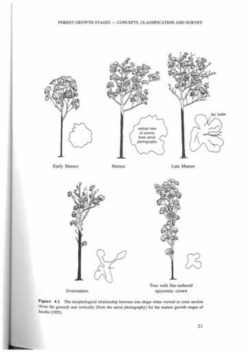
2.1 The spectrum of perceived old-growth forest characteristics. 124.1 The morphological relationship between tree shape when viewed in cross
section (from the ground) and vertically (from aerial photography) for themature growth stage of Jacobs (1955). 21
4.2 The relationship between the growth stage characteristicsapparent from aerial photo interpretation (API) and the growth stagesof both Jacobs and non-Jacobs trees. 23
4.3 Senescing and mature growth stages of Errinundra Shining Gum (Jacobsgrowth form) in Wet Forest (high environmental site quality).Gap Road 2 km east of the Bonang Highway south of Bonang. 25
4.4 Senescing and mature Mountain Gum (Jacobs growth form) with Snow Gum(non-Jacobs growth form) in the understorey of Montane Dry Woodland(medium environmental site quality). Bendoc-Bonang Road 2 km east ofDelegate River. 25
4.5 Senescing Red Ironbark, Red Box (Jacobs growth form) and matureGippsland Blue Gum (both Jacobs growth form) with an occasionalmid-storey of mallee-form senescing River Peppermint (non-Jacobs growthform) in Box-Ironbark Forest (low to medium environmental site quality).Scanlons CreekTrack 700m from Paradise Ridge Road,south of Goongerah. 26
4.6 Senescing Silvertop Ash and Bloodwood (with Jacobs growth form) over adiverse shrubby understorey in Lowland Forest (medium environmental sitequality). The corner of Rocky Ridge Track and Shipwreck Track west ofMallacoota. 26
4.7 Senescing mallee-form River Peppermint (non-Jacobs growth form)with a mid-storey of Red Wattle in Rocky Outcrop Scrub(low environmental site quality). Between Raymond Creek and West's Tracknorth-west of Orbost. 27
4.8 Senescing Nadgee Stringybark (non-Jacobs growth form) with Saw Banksia(non-Jacobs growth form) in Coast Banksia Woodland(low environmental site quality). Pearl Point Road south-west of Bemm RiverTownship. 27
4.9 Crown densities used to assist the aerial photo interpretation. 286.1 Illustration of the process oriented typology that was used during this
study and its relationship with other typologies which emphasise speciesstructure or life form. 38
6.2 An example of a diagrammatic representation of plant communitytypology for damp forests in East Gippsland. 42
9.1 A conceptual relationship between terms used to define stages offorest growth. 61
9.2 Schematic interaction between growth stage and disturbance level indefining old-growth forest. 62
10.1 The linkage between layers in the map library of theGeographic Information System. 67
11.1 Illustration of the concept of optimal or peak areas for particularold-growth forest values within the old-growth forest domain. 85
Xl
LIST OF MAPS
1 Location of the East Gippsland Forest Management Area.2 Land tenure.3 Extent of tree cover, 1990.4 Forest types on public land.5 Ecological vegetation classes on public land.6 Agricultural selections.7 Grazing leases.8 Historic mining sites and tracks.9 Forest dieback as at 1974.10 Timber harvesting - selective logging based on compartment.11 Timber harvesting - clearfell.12 Wildfire.13 Fuel reduction burning.14 Forest growth stage groupings.15 Levels of disturbance.16 Old-growth forest by growth stage grouping.17 Old-growth forest.
xii
4foll. p. 4foll. p. 16foll. p. 36foll. p. 44foll. p. 48foll. p. 48foll. p. 48foIL p. 48foIL p. 50foIL p. 50foll. p. 52foll. p. 52foll. p. 70foll. p. 70foIL p. 78foll. p. 78

1INTRODUCTION
1.1 BACKGROUND
In February 1990 the Victorian and Federal governments entered into an agreementto formalise a decision-making process to be used by the respective governments indeciding under what conditions timber harvesting would be undertaken in the forestsof East Gippsland, which were listed on the Register of the National Estate.This agreement, known as the East Gippsland Forest Agreement, was designed to
seek prudent and feasible alternatives to timber harvesting in National Estate forestswithin the East Gippsland Forest Management Area. Under the East Gippsland ForestAgreement the Commonwealth Government, through the Department of PrimaryIndustries and Energy, provided funding over two years for a number of projects, oneof which was this study of old-growth forests. Funding of this study was also assistedby the National Forest Inventory as part of its regional inventory program.In February 1991 the then Victorian Department of Conservation and
Environment (DCE) entered into an agreement with the Australian HeritageCommission to investigate, identify and assess national estate values in the forests ofEast Gippsland. The Agreement acknowledged that, because old-growth forests haveparticular value under the criteria for assessing national estate significance, it would benecessary to undertake a definitive study of these forests. To this end, a five-personstudy team was established in June 1991, along with a Technical Advisory Committee(TAC) to provide guidance and expert advice on the old-growth study. The TACcomprised scientists with relevant technical qualifications and included representativesof organisations with policy and management responsibilities.A national workshop on old-growth forest attributes held by the National Forest
Inventory in May 1991 discussed the key attributes of old-growth forest, and itsfindings significantly influenced the design of this study.At the time of commencement of the study, the Resource Assessment
Commission's (RAC) Forest and Timber Inquiry was well under way. In its finalreport in 1992, the RAC made specific recommendations about old-growth forest,recognising the need for appropriate definitions and consistent managementprinciples to be part of a national forest strategy which included the followingelements:• an acceptance of the urgent need for Commonwealth, State and Territory
governments to conduct a systematic and comprehensive survey and inventory ofunlogged and ecologically mature forests to identify old-growth attributes anddetermine the extent of old-growth forest; anda clarification of the distinction between ecologically mature forests, negligiblydisturbed forests, unlogged forests, and old-growth forests.
1
A STUDY OF THE OLD-GROWTH FORESTS OF EAST GIPPSLAND
Following the RAC inquiry, and after the completion of the field component ofthis survey, the National Forest Policy Statement was signed by the Commonwealth, allstates and territories in December 1992, with the exception of Tasmania. ThisStatement outlines an agreed approach to conserving and managing old-growthforests, a basic element of which was that the relevant state agencies would, as a matterof high priority, undertake an assessment of old-growth forest. The study is the firstof its kind in Victoria and possibly Australia. The early initiative taken by Victoria incommencing its survey in East Gippsland is consistent with the subsequent directionsof the National Forest Policy Statement.
1.2 STUDY OBJECTIVES
The primary purpose of the study was to describe the characteristics, attributes andvalues of the range of age classes in the forests of East Gippsland with a major focuson the older age classes.The specific objectives of the study were as follows:
• Undertake a field survey, using aerial photographs and satellite imagery and dataobtained from other sources, to determine the nature and extent of older forestson all classes of land in the study area. Gaps in the existing databases were to beidentified as a precursor to this study.
• Undertake research into, and analysis of, historical data and archival recordsrelevant to the use and utilisation of lands and forests in the study area.
• Define a set of age classes of forest that are ecologically significant and thatwould facilitate modelling of spatial and temporal changes in forest age structurefor management and research purposes in the future.
• Assess and map the nature and degree of human induced disturbance and itsimpact on the environment using quantitative measures such as weed indices,dendrochronology and growth staging.
• From this information, create a digital database and integrate this with other datalayers in the Department's Geographic Information System (GIS) for analysis at ascale of 1:100000. These layers were to include topography, logging and firehistory, forest type, floristic vegetation, land systems, land tenure and land use.
• Using overlay analysis techniques, identify and describe the attributes of oldgrowth forests in the study area as well as their natural and cultural values.
A detailed description of the original project brief, schedule and costings is givenin Appendix A.
1.3 STUDY AREA
The study area is the East Gippsland Forest Management Area (EGFMA), one offifteen forest management areas in Victoria identified in the Timber IndustryStrategy. It comprises the most easterly region of the state and is sparsely populated,with Orbost being its major population centre. It covers that part of Victoria south ofthe Black-Allan Line (the straight eastern section of the NSW-Victoria border). Thewestern margin is defined by various features, including the main ridge of the GreatDividing Range, the Timbarra River, and various forest roads and tracks. The southernand eastern boundaries are formed by the coastline from Gabo Island to LakesEntrance. The location of the study area is shown in Map 1.
2

IN1RODUCTION
Geomorphologically the study area has a wide variety of landforms that rangethrough coastal dunes and plains to dissected foothills and a hinterland that rises toover 1400 m with a variety of intermontane basins and montane plateaus. Unlike therest of Victoria the climate is subjected to a strong easterly influence. Rainfall isspread evenly throughout the year and ranges from less than 700 mm in the rainshadow country of the upper Snowy River to 2000 mm on the Errinundra Plateau.The average rainfall is in the range of 90G-1000 mm.Of the 1 216685 ha of land in the EGFMA, 87% (I 057760 ha) is public land
and 13% (158925 ha) is freehold land. The land-use recommendations for EastGippsland and parts of other Land Conservation Council (LCe) study areas (Alpineand Gippsland Lakes Hinterland) include the reservation of 415 000 ha (40% of thepublic land) as national park and other conservation reserves and 643000 ha (60% ofpublic land) as predominantly State forest. The relationship between public land andprivate land is shown in Map 2, together with a broad classification of public land use.A total of 443 000 ha of public land in the EGFMA is listed on the Register of the
National Estate. Of this, 83% is within national parks and other conservation reserves,16% (70 109 ha) is within State forest, with the remainder (2724 ha) being freeholdand Commonwealth land.
3

I " MT MISERY C?'-......_ >EAST GIPPSLAND < C/)
:::; §<
I!-0 ..................... Forest Management Area..
SOUTH...'" ><:
(0 ....... x... VICTORIA......
° ...... >003
.1 ::r:New
trl
C. ...... GIMT DECEPTION " I
.1 -....... -.r};
...... South....... 0.......
.............
Wales '"I10
C/)
( II>003C/)
•.::>\ 0<;i> - ...... _ .............'" 0
--' ...MT "ELLERY
'"I1trl>
MT!INNAK r C/)
§if i:[) \ GeROCi -...... ) I >0030
0/ I "'tiC/)
0
Bass Strait
Map 1 The location of the East Gippsland Forest Management Area.
wa:::zWl-ez«...I
I CHR. December 1993
- - SIld8 Boundaty
- - - Study Boundary
--- RMn
--- Other Roads
--- HIPtaYs
--- 1:100 000 MapsheetBoundary
nON ANDUftl'..... RESOURCES
Freehold Land
Legend
• Parks & Reserves(under National Park Act)
• Other Parks and Reserves
• State Forest
Public Land 0U18Ide the study area
Note: Other Parks and Reserves Includes areas recommended by theLCC and approved by the Government but not yet reserved.
Strait
30
Accuracy: Source scale 1:100 000
. KILOMETRES
10 20I ,
Bass
MAP 2 : LAND TENUREEAST GIPPSLAND OLD-GROWTH FOREST STUDY
Sources: Land Conservation Council Recommendations, Central Plan Office and Victorian Government Gazette.

2CONCEPTS AND DEfiNITIONS Of
OLD-GROWTH fOREST
2.1 INTRODUCTION
Over the past decade 'old-growth forests' have been the subject of debate amongstboth the scientific and the wider communities in Australia and overseas. Widespreadalteration of the world's forests has resulted in a reduction in total forest area and thefragmentation of remaining forests into progressively smaller patches isolated byagricultural, industrial or urban development or regrowth forests (Harris, 1984).The 'natural' environment in Australia has developed as the result of extensive
Aboriginal influence. Contemporary custodians of the Australian landscape areseeking to understand, manage and conserve this natural environment. It is in thiscontext that the impact of European occupation is generally viewed as having had an'un-natural' impact on the environment.Within Australia, extensive modification and loss of forest ecosystems since
European occupation has led to a perception that old forests are now rare anddiminishing (Humphries, 1990), yet there has been no generally accepted definitionof what constitutes an 'old-growth forest' and little is known of the extent anddistribution of remaining 'old-growth forests' (Resource Assessment Commission,1992). The concept of old-growth varies according to different viewpoints,encompassing a complex mixture of measurable ecological attributes of forestecosystems and intangible personal values associated with experience of the forestenvironment (Resource Assessment Commission, 1992). For some people, old-growthforests are significant for their antiquity and the sense of spirituality which theyinvoke. They can also be significant for the high-value timber they may contain.From an ecological perspective, old-growth forests are considered to be significant
for their diversity of structure (Resource Assessment Commission, 1992), low rates ofchange in composition and structure (Dyne, 1991), and complex ecologicalrelationships involving many wildlife species and other organisms (Franklin andForman, 1987). Whilst all these viewpoints are important, there is consensus that anydefinition of old-growth should have an ecological basis (Thomas et at., 1988; Early,1990; Scotts, 1991). The issue of defining old-growth is complicated, however, by thedifferent characteristics of old-growth evident in different forest types, and the varioustypes and degrees of disturbance which may preclude old age forest from beingconsidered 'old-growth' forest.
2.2 CHARACTERISTICS OF OLD-GROWTH FORESTS
it may be difficult to generate a single definition of 'old-growth' forests, a
5

A STUDY OF THE OLD-GROWTH FORESTS OF EAST GIPPSLAND
range of factors have been recognised as providing a quantitative description of theold-growth state (Dyne 1991). These CHARACTERISTICS may be described asATTRIBUTES that contribute to the description of the forest and DISTURBANCEINFLUENCES which either physically or metaphysically influence the state of old-growth forest. They can be summarised as:
.. structural and functional attributes, which are either measurable or inferred, andwhich directly contribute to a description of the old-growth state;
.. contextual attributes, partially measurable and partially a function of humanperceptions;
.. intangible attributes, difficult to measure and largely a function of humanperceptions; and
.. disturbance influences which diminish, or detract from, the old-growth state.
The correlation between various characteristics and old-growth forests can vary;some characteristics (PRIMARY old-growth characteristics such as age) have a highcorrelation with old-growth forest, whilst others (SECONDARY old-growthcharacteristics such as type, of habitat) have a weaker correlation and may also befound in younger forests.
Structural attributesPhysical structure is among the most recognisable features of old-growth forests.Aspects of tree morphology such as tree height, tree diameter, crown dimensions andpresence of hollows meet many of the commonly perceived attributes of old-growthforest and are frequently used in existing definitions.Age is often used as a criterion to define old-growth forests, and may be a measure
of the likely development of hollows in branches and boles (Humphries, 1990).Although strong correlations have been shown between morphological criteria andthe age of individual trees or stands (Mackowski, 1984), age mayor may not have adirect relation to the physical state of development of a tree or stand. Thomas et al.(1988) observe that the age of trees should not be the sole measure of the old-growthcondition, because structural characteristics develop over different lengths of timedepending on site conditions and stand history. From a practical point of view,assigning ages to south-eastern Australian forests is often difficult, because mostAustralian trees, with some exceptions, produce growth rings that are determined bythe vagaries of the growing seasons and ring counts do not necessarily correlate withdistinctive annual seasons, as they do in the cool temperate regions of the northernhemisphere (Banks, 1982).The developmental stages of a forest can also be included in definitions of old-
growth forest and are often referred to in terms of the growth stages of individualtrees (Early, 1990). These growth stages have been variously described by forestscientists as regrowth, mature and overmature (Jacobs, 1955), and by ecologists asregrowth, ecologically mature or old (Franklin et al., 1981).The typical growth stages of old-growth forests vary with floristic composition,
structural forest type and site quality, being influenced by aspect, altitude, soil type,geology and climate. The floristic composition of forests determines both themorphological properties of forest growth stages and the effect that variousdisturbances will induce. Lowland forests in East Gippsland experience frequent fires(Christenson and Maisey, 1987) and typically exhibit a multi-aged structure with avariety of growth stages because of the resilience of the dominant overstorey speciesto such fiJe regimes. In contrast the natural fire regime of damper forests is less
Ail
6
CONCEPTS AND DEFINITIONS
frequent, but the fire intensity may be much higher (Early, 1990). Occasionally, inthe Alpine Ash (Eucalyptus delegatensis) dominated Montane Wet Forests of EastGippsland, a severe wildfire will kill all the standing overstorey in a small area and aneven-aged forest will develop. Regeneration and recovery of mature trees of thedominant tree species is therefore dependent upon both the adaptations of the species,and the severity of disturbances such as wildfire or severe storms.
Functional attributesEcological functions of forest ecosystems include reproduction, energy flow,conservation and cycling of nutrients, and regulation of water flow (Franklin et al.,1981). The primary functional attributes of old-growth forests are closely related tostructural characteristics.Although old-growth forests are regarded as having low productivity because of
their low or negative net growth rates in standing (living) biomass (ResourceAssessment Commission, 1992), total organic matter (living and dead) continues toincrease in old-growth forests, mainly in the form of woody debris and fallen logswhich accumulate more rapidly than they decompose (Franklin et al., 1981; Ashton,1986).The slow decomposition of dead matter through the actions of micro-organisms,
plants and fungi through a 'closed-cycle, detrital-based system' (Odum, 1971) leadsto extremely conservative ecosystem functioning where energy and nutrients aretightly retained (Franklin et al., 1981).In old-growth forests in the USA, large accumulations of carbon and nutrients in
trunks and logs (biological legacies) are considered to be a significant source ofstored energy and nutrients and one which can bridge major disturbances such aswildfire, unlike more easily burned organic components such as leaves on the forestfloor (Franklin et al., 1981). In Australia research has shown that the amount ofnutrients in the trunks is concentrated in the sapwood or leaves which provide apotential buffer of nutrients from low-level fires. Nutrients may also be madeavailable to old-growth systems through biological activities; for example, the amountof nitrogen fixed by lichens and bacteria in old-growth Douglas-fir forests in theUSA is significantly higher than the amount fixed in young regrowth forests(Franklin et al., 1981).Organic debris and fallen trees also play an important functional role in streams in
older forests, creating a diversity of habitats and stabilising channels and sediment.Beside physically shaping small streams, large logs are rarely moved downstream andmust therefore be biologically broken down in situ, providing a major source ofenergy and nutrients for the stream ecosystem (Franklin et al., 1981).Other important functional attributes of old-growth forests include the
maintenance of gene pools, amongst them the range of species available forrecolonising an area after a severe disturbance; and the ability of the ecosystem tomaintain its integrity over the longer term (Dyne, 1991). These functional attributesare less closely associated with old-growth forests and may be seen as secondarycharacteristics.
Contextual attributesThe viability of a particular patch of old-growth forest depends on its structuralCh,lralctenst:ics (content), its size and shape (configuration), and may also depend on
matrix of forest age class and disturbance histories within which it occursPatches of old-growth forest fragmented by clearing or harvesting (or
may become so small and isolated that their continued existence is threatened
7

p
A STUDY OF THE OLD-GROWTH FORESTS OF EAST GIPPSLAND
by microclimatic change and by the lack of connectivity with similar patches, andthey may ultimately become at risk of ceasing to function as habitats for faunadependent on old-growth forests (Lindenmayer 1992a). Remnant old-growth'islands' could be degraded by edge effects and isolation and hence not maintaintheir complement of fauna and flora or the processes of evolutionary developmentwhich may characterise larger stands. There is, however, very little knowledge of thespecific role of contextual attributes in the long-term survival of old-growth foreststands.Naturalness of forests is an important issue in its own right, but it is also considered
to be an important contextual attribute of old-growth forests. Usher 1986 (cited inEarly, 1990) notes that 'the more natural an ecosystem, the more it tends to bevalued. This is not only because of the variety of plants and animals that it contains,but also because other features of the ecosystem may have been conserved'. Thesenaturalness qualities can be partially measured by biological surveys or indirectly byusing a measure of remoteness from access and settlement such as that used in theassessment of 'wilderness' values by Preece and Leslie (1987).
Intangible attributesOld-growth forests can have highly significant, non-scientific values, which are lesseasily defined than those with a scientific basis but which are no less important(Early, 1990). These 'intangible' values stem from personal experiences and includefeelings of a sense of beauty or wonder, or of spiritual uplifting (Resource AssessmentCommission, 1992). They may also include perceptions of aesthetic quality, antiquityand grandeur. The cultural and religious relationships of Aboriginal peoples to theland is an example of the influence of these values.There is a view that once the values associated with intangible attributes are known
to have been modified by disturbance, they can never be replaced.
Disturbance influences which affect old-growth attributesPart of the value placed on old-growth forests in Australia relates to the clearing andmodification of forests over the 200 years since European settlement (Early, 1990).Much of the remaining older forest has been changed by a number of disturbanceswhich vary greatly in their intensity, spatial extent, the time taken for theirconsequences to become apparent and the time needed to recover from thedisturbance. The effects of different disturbance types upon physical and biologicalcharacteristics also vary according to forest type and are not well-understood, as mostresearch on disturbances is both short-term and limited in its scope (ResourceAssessment Commission, 1992).The significance of disturbances on the intangible attributes of old-growth forests
can be perceived as varying according to whether they are human-induced(anthropogenic) or not human-induced (natural). Some types of natural disturbances(for example, wind and precipitation) are essential to the maturation processes offorests and are not normally regarded as disturbances which degrade old-growthattributes unless they rise above a significant level. Many disturbances, however, resultfrom human influence and their effects on the old-growth attributes of a forest standmay be regarded as long-lasting and even irreversible. This view, of course, supposesthat human-induced disturbances are not natural, an issue that is also highlycontentious given that the Australian environment has been significantly influencedby aboriginal Australians for many thousands of years.The selective logging of older forests practised in the past may have left the
original old-growth structure and composition reasonably intact (Early, 1990),
8

CONCEPTS AND DEFINITIONS
although tree species composition may have been modified through the depletion orremoval of species highly valued for timber. Nonetheless, the structural features andfloristic diversity of such selectively logged forests are regarded as being important towildlife when present in comparable proportions to those in undisturbed forests(Jenkins and Recher, 1990; cited in Humphries, 1990). Under current forestmanagement practices, some areas of older forest are removed and replaced byregeneration and retained areas are fragmented during the initial cycle of timberharvesting, for example, through clear-felling silvicultural systems. Subsequent forestmanagement, if its objective is to maximise further wood production, may prevent theforest from redeveloping into the older growth stages before the next logging cyclecommences (Early, 1990).Fires can have effects ranging from short-term to catastrophic and may arise from
anthropogenic or natural sources, and thus the issue of when they constitute adetrimental influence in the development of old-growth forests is highly contentious.In the view of the Resource Assessment Commission (1992), 'the occurrence of fires,either deliberately or accidentally lit by humans, does not necessarily reduce the old-growth characteristics of a forest. Intense wildfires may kill most trees and thusseverely modify any characteristics associated with maturity, but mild fires, includingoccasional prescribed burning, may have little impact on these same characteristics'.Other viewpoints contend that repeated prescribed burning which removes leaf litterand fallen logs or alters floristic composition and understorey structure reduceshabitat diversity (Catling, and Recher, cited in Lunney, 1991) and this may have asignificant impact on old-growth values.Very little research has been carried out on the biological effects of disturbance of
older forests in Australia. In East Gippsland the spread of dieback fungus (forexample, Phytophthora cinnamomi) is known to be promoted by movement of soiland gravel for road construction or on machinery, and by increased run-off due tosoil compaction from vehicles as well as rising water tables in logged forests withimpeded drainage (Purdie et at., 1990). The influence of exotic plant speciesintroduced by vehicular traffic on forest roads and by grazing varies according tofloristic community but may be extensive, particularly within the understorey and theherb layer.
2.3 SOME DEFINITIONS OF OLD-GROWTH FOREST
It can be seen from the foregoing discussion that the features that are perceived tocharacterise old-growth forests are many and varied. They range from the scientific tothe intangible, from being highly correlated with old forests to being only looselyassociated, and from being readily measurable to being almost impossible to quantify.This suite of characteristics can be summarised as a spectrum of perceptions of old-growth forest (Figure 2.1). The characteristics of old-growth forests.included inFigure 2.1 relate specifically to East Gippsland and may not be universally applicable;however, the framework of the figure should be relevant to most old-growth forestareas in the temperate environments of Australia.Many definitions of old-growth forest have been produced as a result of
contemporary debate about old-growth forests. In its review of these definitions theResource Assessment Commission (1992) noted the following frequently used phases, ." the absence of disturbance associated with European activity; the presence of oldtrees described as "overmature" or "senescent"; and high structural diversity'. Veryoften, however, these definitions are non-specific and use qualitative criteria such as
9
A STUDY OF THE OLD-GROWTH FORESTS OF EAST GIPPSLAND
'relatively free from disturbance', 'most of the original structure still present', and'largely unmodified'; whereas definitions which attempt to quantify attributes such astree age and size are rarely justified.A selectioJ;l of old-growth forest definitions is listed below. The list is by no means
exhaustive and is in no particular order:• 'Those communities which are the older developmental stages of the forests and
characterised, at least in part, by the following: low growth rates for trees in thehighest stratum, low to zero biomass production of trees in the tallest stratum, treesin the tallest stratum mature to senescent, very high biomass of individual trees inthe highest stratum, trees in the tallest stratum usually more than 100 years old.'(Australian Heritage Commission, 1990).
• ' ... primeval ... forest whose trees predate European settlement.' (Clark andBlakers, 1989).
• ' ... those forests in which most of the original diversity of species and structure isstill present which have not been subject to removal of more than 50% of theircanopy within the past 60 years, or subject to severe wildfire over the past 30years.' (Kestel Research, 1988).
• 'Forest units in which the continuity of natural ecological processes has beenmaintained for at least 200 years, exhibiting natural levels of biotic and structuraldiversity and in which low to zero biomass production is occurring in trees in thetallest stratum; with no or minimal introduced pathogens or weed species present.'(National Forest Inventory draft definition, 1990, cited in Dyne, 1991).
• ' ... forest in which the dominant tree species are beyond the age of maximumgrowth rate, and in which the understorey has developed relatively free ofdisturbance. This is commonly over 100 years old, beyond the age regarded asoptimum for wood production (usually about 80 years) and at or above the age atwhich hollows suitable for tree-dwelling fauna begin to form.' (Government ofVictoria, 1987).
• '... largely unmodified forest of whatever age or mixture of ages of trees.'(Kirkpatrick, 1990).
• ' ... forest dominated by trees which have passed the age where linear dimensionshave completed vertical and horizontal expansion and senescence is facilitatingthe development of hollows utilised by a range of hollow-dependent fauna.'(Gruen et al., 1989).
• '. .. unlogged forest, but may also include those logged forests that contain ahigh proportion of mature and overmature trees comparable to an unloggedforest of the same type.' (Jenkins and Recher, 1990).
• ' ... characterised by stands with a deep, multi-layered canopy often resultingfrom the presence of more than one tree age-class and/or dominant andsubdominant members of the major age-classes, individual live trees (present at abasal area comprising at least 50% of the total stand basal area) that are either old(well past the phase of maximum exponential growth, e.g 150 years) or large(>1.0 dbh), and contains stags and logs of large dimensions (>0.5 m diameter and>6 m length) present at significant levels (e.g 4/ha for stags and 10/ha for logs).'(Scotts, 1991).
• 'A stand well past the age of maximum growth, frequently showing a greathorizontal and vertical diversity of structure and plant species composition, andpossessing one or more features not seen in younger forests, such as snags, downwoody material or arboreal lichens.' (Nyberg et al., 1987).
• ' ... Forest with dominant trees older than a particular age. The age variesaccording to the species and the history of fire and logging, but it is often taken
10

CONCEPTS AND DEFINITIONS
to be older than the earliest period of logging in the area ... or older than one fullcommercial harvesting rotation ... ' (Meagher, 1991).
• ' ... forest in which we can reasonably expect that there will be no temporal hiatusin the continuing availability of old-growth attributes [such as] ... large trees,overmature trees, stags, logs, dependent fauna, biogeochemical cycling,hydrological features, etc.' (Gilmour, in Dyne, 1991).
• '... one in which the trees with old-growth characteristics would normallycontribute about 30% or more of the gross canopy area (including emergents)provided by all the tree species. At this level of canopy area contribution old-growth trees are considered to dominate the site. Other essential old-growthcharacteristics include: trees that have attained an old age and that are usually alarge diameter for the species and site; and, no obvious evidence of recent humandisturbance. Additional characteristics which are often present in an old-growthforest include: individual trees which often exhibit branch or trunk hollows, sparsecrown, epicormic growths, protruding dead limbs, evidence of decay processesand a low or negative net growth rate; trees that are normally more widely spacedthan in a younger forest; a considerable amount of woody debris, includingtrunks and branches on the forest floor; possibly large amounts of epiphytic andparasitic vegetation associated with the old trees; often suites of plants and animalsparticularly dependent upon old-growth forest; and, the forests may give animpression of grandeur and very old age.' (Institute of Foresters of Australia,1990).
• ' ... forest that has not been, or has been minimally, affected by timber harvestingand other exploitative activities by Australia's European colonisers.' (Australi<i.nConservation Foundation, 1991).
• ' ... forests that are both negligibly disturbed and ecologically mature and whichhave high conservation and intangible values.' (Resource AssessmentCommission, 1992).
• '... forest that is ecologically mature and has been subjected to negligibleunnatural disturbance such as logging, roading and clearing. The definitionfocuses on forest in which the upper stratum or overstorey is in the late mature toovermature growth phases.' (National Forest Policy Statement, Commonwealth ofAustralia, 1992).
This last definition, developed for the National Forest Policy Statement, was agreedto by Victoria. The definition developed during the current survey and recommendedfor use by the Department of Conservation and Natural Resources is consistent withthe National Forest Policy Statement, but provides more technical detail andexplanation. This is discussed in Chapter 11.
11

A STUDY OF THE OLD-GROWTH FORESTS OF EAST GIPPSLAND
Figure 2.1 The spectrum of some of the perceived old-growth forest characteristics.
CHARACTERISTICS
Scientific & Objective Quasi-scientifidIntangible Intangible & Subjective[Readily mappable, [partially quantifiable through [Difficult to quantify,measurable and quantifiable, indirect measurem,ents and descriptive only, and arecontain ecological values] assumptions] experiential; contain social
or human values]
PRIMARY CHARACTERISTICS - highly correlated with old forestsStructural and Functional Contextual Intangible• structural (height, density) • integrity • antiquitycomposition • connectivity • naturalness
• plant community species • viabilitycomposition • naturalness
• growth stage• age
Absence ofDisturbance Absence ofLocalisedInfluences Disturbance Influences
Anthropogenic: Anthropogenic• timber utilisation • cultural features such as urban• agricultural clearing settlement, roads, railways• mining and powerlines.• grazing• fuel reduction burning• weeds• diebackNatural• wildfire
SECONDARY CHARACTERISTICS -less strongly correlated with old forestsStructural and Functional Contextual Ilitangible• faunal values and habitat • wilderness • grandeur• other vegetative growth • remoteness • spiritualityforms (e.g. epiphytes) • aesthetics
• functional processesincluding biomass andproductivity, and nutrientcycles
Disturbance influences• broad biophysicaldisturbance includingclimate change, geologicand land form alteration
12

3SURVEYOF OLD-GROWTH ATIRIBUTESAND INFLUENCES-AN OVERVIEW
3.1 INTRODUCTION
The project began in the absence of an Australian precedent for defining andsurveying old-growth forests. A truly comprehensive study of old-growth forestswould have involved the assessment of all of the characteristics of old-growth forests,both primary and secondary characteristics, that were identified in the manydefinitions of old-growth (summarised in Figure 2.1, Chapter 2). This would havebeen impractical in the time frame of this project so priority was given to assessing theprimary attributes and influences that could be measured efficiently and objectivelyusing remote sensing techniques and archival research. The attributes and influenceswhich were measured in the survey are described as survey parameters. Table 3.1shows the relationships between old-growth characteristics, attributes, influences andsurvey parameters.
3.2 SURVEY PARAMETERS
ForestThe first stage of the study was to identify areas of 'forest' in the East GippslandForest Management Area. However, no standard definition of forest existed forAustralia at the commencement of the study. The National Forest Inventorysubsequently defined forest as 'woody vegetation usually with a single stem, having amature or potentially mature stand height exceeding 5 m with existing or potentialprojective foliage cover of overstorey strata about equal to or greater than 30% (orcrown separation ratio about equal to or less than 0.25)'. This definition does notinclude woodland categories, and thus a broader definition was adopted for thecurrent survey which defines forest as:
all woody vegetation with potential height generally greater than 5 metresand crown cover projection generally greater than 10%.
Using a similar definition (with density defined as crown cover foliage projection), aprevious study (Gilbee and Goodson, 1992) identified all patches of tree cover inVictoria more than 2 m tall and larger than one hectare through the digitalclassification of Landsat Thematic Mapper satellite imagery from March 1990. Thismapping, presented for all classes of land in the study area at a scale of 1: 100 000and entered into the Department's Geographic Information System, delineated theforest and woody vegetation outlines for the study area (see Map 3). Although over-
13

- ;».J::>. Table 3.1 Relationship between old-growth characteristics, attributes, influences and survey parameters. CIl
§Characteristics Attributes or Influences Survey Parameters Sources Used in this Study ><:Structural Attributes
Structural composition Growth stage and density Proportion of canopy by growth stage Aerial photos, 1990
Dominant overstorey Forest type - species and height Buntine (1974 unpubl.) maps 1:63 630 0bspecies, height I
Forest Woody vegetation Tree cover mapping using Landsat TM 1990 0
>5 m tall, and >10% density (CNR) ::c:Plant community and diversity Species composition Ecological vegetation class and Parkes et at. (1984), 1:250000; Geology, 'T.I
0biogeography 1970s 1:250 000 g;
CIlOldest trees Age (years) Selectively surveyed Existing studies >-3
CIl
Fauna habitat For example, number and Not surveyed, but linked to growth - 0'T.I
type of hollows stage tI1;»Other vegetative growth forms For example, epiphytes Not surveyed
CIl- >-30.....
Functional Attribuws "'t:i"'t:iCIl
Biomass production For example, gross Not surveyed - t"'";»biomass 8
Nutrient cycling for; hydrology, Not determined Not surveyedenergy flow, soil formationsuccession etc.
Proximity to other stands with Integrity, viability 'Naturalness' indices Data generated during old-growth forest studynegligible disturbance histories
Remoteness from roads and Wilderness values Wilderness indicessettlement (e.g: Preece and Leslie, 1987)

,.....VI
Table 3.1 (continued)
Intangible Attributes
Engenders feelings ofspirituality, wonder
Appearance ofgrandeur andantiquity
Disturbance Influences
Characterised by type andseverity
Aesthetic and awe-qualities
Apparent age or size oftrees
Agricultural clearing
Grazing
Mining
Weeds
Timber harvesting
Timber harvesting
Fire
Pathogen distribution
Not surveyed, although considered indescriptions of old-growth forest
Not surveyed, although considered indescriptions of old-growth forest
Extent of agricultural selection andclearing within selection
Intensity, duration and extent ofgrazing
Extent of timber getting andexcavation associated with mining
Weed type, influence and distribution
Selective logging (pre-1970s)
Clearfelliogging (last 25-30 years)
Fire type (wildfire or fuel reductionburning), extent
Historical pathogen distribution
Crown selection records, and growth stagemapping
Historical and contemporary records
Historical records
Literature and existing records
Historical log allocation licences, interpretationof 1940s and 1950s aerial photographs
Compilation of regional utilisation maps;interpretation of 1960s and 1970s aerial photos;interpretation of satellite imagery, 1970s on;interpretation of 1990 aerial photos
Historical records, regional records,interpretation of satellite images, 1970s on
Existing maps (Ward and McKimm (1982)
CI:l
CI:l
gCI:l

A STUDY OF THE OLD-GROWTH FORESTS OF EAST GIPPSLAND
estimating the extent of forest-only vegetation, the tree cover layer formed a basis forplanning mapping and field survey work by clearly depicting the likely extent .. of theentire forest estate and additional non-forest woody vegetation, on both public andfreehold land.
Growth stage and crown cover projectionThe ages of forest stands were assessed through the relative stage of growth of theconspicuous strata, usually the upper canopy of the overstorey. Although tree growthstages are considered to be primary old-growth attributes, the rate of development andresultant characteristics of any growth stage are likely to be specific to each ecologicalvegetation class and forest type and are dependent on site quality.The study thus initially identified the typical morphological expressions of growth
stages for each of the woody vegetation types within the study area by reference toliterature and through field inspection. These characteristics were then refined forinterpretation from aerial photos and mapped for the entire study area. Crown coverdensity was mapped simultaneously from the aerial photos. A discussion of this workis given in Chapter 4.
Forest typeAs part of Land Conservation Council's Alpine (1977), Gippsland Lakes Hinterland(1982) and East Gippsland (1974) studies, the public land vegetation of the studyarea was comprehensively mapped by the former Forests Commission of Victoria at ascale of 1:63 360 for dominant vegetation by species and height. This work produceda series of maps describing the structural vegetation of the area. Where the dominant·structural vegetation comprised forest species, it was described in terms of foresttypes. This forest type mapping was adopted for this survey, and is described in detailin Chapter 5 and Appendix C.
Ecological vegetation classesEcological vegetation classes are part of a hierarchy of floristic vegetationdescriptions that display correlations with certain quantifiable environmentalattributes. Ecological vegetation classes were mapped using a number of sourcesincluding the structural forest type mapping, previous floristic vegetation mapping, acomprehensive quadrat dataset, additional aerial photograph interpretation and otherdata sources. This work is described in detail in Chapter 6 and Appendix E.
Disturbance influencesResearch using historic and contemporary records was undertaken to delineate andmap the extent and severity of the major disturbances known to have altered theprimary attributes (floristics, structure or growth stages) of the forests in the studyarea. These disturbances were stratified according to their intensity, and wereidentified as either 'natural' or 'un-natural' (human-induced) disturbances. In thecontext of this study these un-natural disturbances are intended to refer to Europeandisturbances. Although Aboriginal influences were apparent prior to and during theearly years of European settlement, the absence of records of Aboriginal disturbancesprevent any useful mapping. It is also noted that Aboriginal influence is likely to havequite different effects on the intangible characteristics of old-growth forests fromEuropean influences, although it would be very difficult to qualify these effects.Chapter 7 and Appendix F provides a discussion of this work.
16

oenen
a:w>o(.)
wwa:I--LLoI--ZWI--><W
December 1993
-.- Sludy Bculdary
-- ou.Roeds
-- 1:100 000 Mapeheet8culdIry
Note: Tree cover Is defined 88 aD woody vegetationgreater than 2 metres tall and 10% crown coverfoliage projection (Glble and Goodson. 1992).
Legend
Public land tree cover
• Private land tree covero Private and Public land non-treed
Public Land outside the Study
Map prepared bY N
Strait
3020,KILOMETRES
10,
Bass
Accuracy: Source scale 1:100 000, minimum area shown is 25 hectares
MAP 3 : EXTENT OF TREE COVER, 1990EAST GIPPSLAND OLD-GROWTH FOREST STUDY
Marlo
Source: Landsat TM satellite imagery from 1990 supplied by the Australian Centrefor Remote Sensing, interpreted by the Remote Sensing Section, CNR.

SURVEY OF ATTRIBUTES AND INFLUENCES
Tree ageingLimited investigations into the ages of selected trees were undertaken throughdendrochronology studies. This work is discussed in Chapter 8 and Appendix I.
Spatial analysis of survey parametersA review of the primary characteristics and the survey parameters permitted thecreation of a workable definition of old-growth forest. Having mapped and enteredthis information into the Department's Geographic Information System, it waspossible to overlay (combine) and identify the forest type, ecological vegetation class,growth stage and disturbance history of individual forest stands. Thresholds were setfor the maximum levels of disturbance and youngest growth stages which could beconsidered as old-growth forest, and forest stands within these thresholds wereidentified as old-growth forest. This analysis is discussed in Chapters 9 and 10 andAppendix G.
Old-growth forest valuesThe concept of old-growth forest values and their role in the ecologically sustainablemanagement of forests is discussed in Chapter 11. Fauna values, contextual(naturalness) values, and intangible values are specifically considered.
FaunaAlthough faunal composition is regarded as an important secondary attribute of old-growth forests, time and resources did not allow the inclusion of a faunal survey inthis survey. However the results from this survey establish primary habitat variables,such as the growth stages, which are directly related to hollow development and bioticprocesses associated with old-growth forests. These could be the basis for anysubsequent analysis of faunal data. Further discussion of fauna and old-growth forestsis provided in Chapter 11 and Appendix H.
17

4FOREST GROWTH STAGES - CONCEPTS,
CLASSIFICATION AND SURVEY
4.1 CONCEPTS AND DEFINITIONS
Crown cover and growth stage are distinctive forest attributes which characterise thedevelopmental stages of different forest types. Areas that have been disturbed canhave an altered proportion of growth stages or crown cover compared to those ofundisturbed areas of the same forest type. This can be important in mapping theextent and degree of disturbances which are often only indicated imprecisely on mapsin historic records.
Crown coverCrown cover is used as a description of the amount of foliage in a given area ofvegetation. A number of definitions of crown or foliage cover have been developedfor vegetation, together with a variety of techniques for their measurement(McDonald et at. 1990):• Crown cover is the percentage of the sample site within the vertical projection of
the periphery of tree crowns; crowns are treated as opaque.• Foliage cover is the percentage of the sample site occupied by the vertical
projection of foliage and branches (if woody).• Projective foliage cover is the percentage of the sample site occupied by the
vertical projection of foliage only.
As crown cover is the simplest to measure and use, especially when mapping fromaerial photographs, it was adopted for this study.
Growth stagesAt different stages in their development, trees can exhibit different forms or growthstages. While the growth stages of some species are distinctive and well-documented,our understanding of the stages of other species is far from complete. Jacobs (1955)described typical eucalypt growth stages in terms of tree morphologies. These aresummarised below. (Jacobs did not identify the early or late mature growth stages;these have been interpreted by this study from the detailed descriptions in Jacobs[1955]).Initially, in the JUVENILE stage, all leaves have a juvenile form and grow on the
main stem. As the seedling exceeds around 60 cm in height, second and third orderbranches develop.At the SAPLING stage, competing branches vying for dominance form a crown of
small branches which is typically pointed in profile. The leaves may be a combinationof juvenile, intermediate and mature forms.
18

FOREST GROWTH STAGES - CONCEPTS, CLASSIFICATION AND SURVEY
The POLE stage is characterised by a strongly developed main stem. Semi-permanent branches growing on the main stem below the upper crown develop fromsome of the competing branches of the sapling stage, and the leaves are mostlymature. A young eucalypt enters this stage after it has gained a certain height, and theage at which it enters this stage is dependent on site quality.In the EARLY MATURE stage, large permanent 'shaping' branches develop and form
the framework of the crown. Semi-permanent branches grow not only from the mainstem but also from these permanent branches.The MATURE stage persists for a long time, and, although branches thicken, height
and crown spread may change very little over this time in dense stands. As branchesgrow further from the main trunk and lose their apical dominance, epicormic shootsdevelop from dormant buds on the top and sides of the shaping branches closer to themain trunk.In the LATE MATURE stage the tree may develop large numbers of 'bayonets', dead
branches from deceased leaf-bearing units, warts and burls, and some dead shapingbranches.The OVERMATURE stage is characterised by declining crown leaf area. As major
shaping branches are shed, epicormic growth develops from the trunk, to replace thelost leaf area, but which is never as persistent as the permanent shaping branches. Thetrunk and shaping branches are eventually weakened by fungal attack, causingshaping branches and often the top of the tree to fail and break. The trunk or treebole is characteristically covered in burls and bumps.The growth stages of some eucalypt and non-eucalypt species do not conform to
the typical growth habit described by Jacobs and are not well understood. Thesedifferences in growth habits may be due to genetic factors (e.g. mallee form trees) orenvironmental factors (such as poor sites). These species are assumed to pass throughthe same growth stages as described by Jacobs. However, there is a need for furtherwork to generate descriptions of the typical growth forms of these species.
4.2 SURVEY METHOD
The old-growth study mapped the forests of the East Gippsland Forest ManagementArea according to the primary attributes of growth stages and crown cover throughthe use of aerial photograph interpretation (API).Aerial photograph interpretation is performed by stereoscopically viewing pairs of
adjoining photographs and is a technique widely used in forest resource inventoryand also in surveys of land use, landform, geology and vegetation. Besides being ableto establish physical attributes of a particular forest stand such as the percentagecrown cover, API is capable of identifying different growth stages of eucalypt andsome non-eucalypt trees. The eucalypt growth stages described by Jacobs (1955) arediscernible from aerial photographs, although the level of detail varies with the scaleand quality of photographs used. A diagrammatic representation of the typical shapeof trees of the older growth stages, both in cross section and viewed vertically fromaerial photographs, is given in Figure 4.1.Aerial photograph interpretation was used to identify the crown cover projection
and relative proportion of growth stages in the upper stratum in each distinct stand(polygon) of forest. Complete air photo coverage of the study area was available froma combination of air photo projects from 1987, 1990 and 1992. All photos were at ascale of 1:40000.
19

A STUDY OF THE OLD-GROWTH FORESTS OF EAST GIPPSLAND
The crown cover projection percentage of each stand (polygon) of forest wasestimated according to the classes in Table 4.1.
20
Table 4.1 Crown cover projection classes
<1010-2930-4950-69>70
Crown cover (%)12345
Class
The growth stage categories used in this project were based on Jacobs (1955)description but were modified according to the detail evident from 1:40 000 scale airphotos (Table 4.2). Very young regeneration (juvenile trees) appeared flat in textureand individual crowns were not evident, whereas regrowth (saplings and poles)presented small, tight and discrete crowns. The mature growth stage was characterisedby full, rounded crowns, compared with late mature and overmature trees whichdisplayed a more open crown with large numbers of dead and dying branches andwhich appeared lighter in colour than younger trees of the same species. These latemature and overmature growth stages were combined for the purposes of this studyand re-named the SENESCING growth stage.All of the Jacobs growth stages were apparent from aerial photograph
interpretation in most vegetation classes. However, in non-Jacobs forest stands (that is,stands not exhibiting typical form as described by Jacobs (1955)) particularly onpoorer quality sites where crown size was small, senescing features were not apparentfrom air photos and the forest stands could only be classified as 'regrowth' or'mature'. Consequently eucalypt dominated non-Jacobs forest stands classified in thisway were of a more senescent growth stage than the classification suggested (forexample, a Shrubby Dry forest classified as 'mature' from air photos was actuallyfound to be 'senescing' through field inspection). Note that no growth stagemapping from aerial photo interpretation was undertaken for non-Jacobs forests thatdid not contain eucalypts (eg rainforest, callitris stands and some areas of blackthornscrub) because time did not permit the development of detailed growth stagemorphologies for these species. Thus, in this study, non-Jacobs forests were composedof two categories; eucalypt forests which produced senescing characteristics that werenot visible from air photos, and forest which did not produce any classic Jacobssenescing characteristics even when examined on the ground.However, for future studies it is recommended that the term non-Jacobs be
reserved specifically for those forests that do not produce any evidence of classicJacobs senescing characteristics.The relationship between the growth stages apparent from aerial photograph
interpretation and the actual growth stage present is shown for Jacobs, non-Jacobs andnon-eucalypt forest in Table 4.3 and Figure 4.2.For the purposes of this study the actual growth stages of senescing, mature,
regrowth and regeneration were adopted as the critical growth phases through whichall forest stands must pass in order to reach an old-growth state. For the oldestmapped growth stages of non-Jacobs forest stands, which were mapped as a matureclass, a reclassification to a senescing class was required. Vegetation classes whichexhibit non-Jacobs growth forms were identified in Table 6.2 (Chapter 6) and re-classified in Step 4, Chapter 8 (see also Appendix G for details).
FOREST GROWTH STAGES - CONCEPTS, CLASSIFICATION AND SURVEY
dry limbs
Tree with fire-inducedepicormic crown
Late Mature
vertical viewof crownsfrom aerialphotography
Mature
21
o
Overmature
Early Mature
4.1 The morphological relationship between tree shape when viewed in cross sectionthe ground) and vertically (from the aerial photography) for the mature growth stages of(1955).

A STUDY OF THE OLD-GROWTH FORESTS OF EAST GIPPSLAND
Table 4.2 Classification of growth stages from aerial photo interpretation
Jacobs (1955) Old-growth project Morphological characteristics identifiablefrom air photographs
22
Table 4.4 Crown cover proportions for each growth stage within each mapped stand of forest
Proportion of each growth stage within the stand(from an air photo perspective)
occupies larger crown area than other growth stages that may be present(approximately twice the area of any other growth stage present,generally >50%)
occupies equal crown area with other growth stage(s) (broadly rangingfrom 30-50%)
lesser crown area than other dominant growth stages that may be present(approximately half the area of dominant or codominant growth stage(s),maximum range 11-50%)
generally less than 10% of the total crown area
not apparent in the upper stratum
senescing some crown units dead and dying; crowns lessrounded and lighter in colour than in younger maturetrees of the same species
mature rounded crown view; well-foliated crown; may betaller than regrowth of the same species
regrowth narrow, conical crown
regeneration smooth, flat appearance(individual crowns not discernible)
Description1
sparse
absent
subdominant
codominant
dominant
c
s
d
overmaturelate mature
The use of the word dominant refers to the area occupied by the crowns of each growth stage in theupper stratum of each forest stand (or polygon). It does not refer to the vertical structure through theprofile of ,crowns.
matureearly mature
Actual growth Jacobs forest Classification for non-Jacobs forest as detected bystage aerial photo-interpretation
senescing senescing mature
mature mature mature
regrowth regrowth regrowth
regeneration regeneration regeneration
pole
saplingjuvenile
Class
Table 4.3 The relationship between actual growth stages and the classifications made inJacobs and non-Jacobs forests

en>-3
§::r:en
enIno
eneenen;en
fCharacteristics
detectable from aerialphotographs
API growth stages I I I Mature(non-Jacobs) c
0 .c
API growth stages I Q) e I Mature I Senescingc OJ(Jacobs) Q) Q)
OJ 0:Q)0:
Modified Jacobs I I I Early mature I Mature I Late mature I Overmature(1955)
ItvUJ Jacobs (1955) Ii I Q)
Igrowth stages "0 I Mature Overmature::l 0-J
Figure 4.2 The relationship between the growth stage characteristics apparent from aerial photo interpretation (API) and the growth stagesof both Jacobs and non-Jacobs trees.

A STUDY OF THE OLD-GROWTH FORESTS OF EAST GIPPSLAND
Morphological characteristics and stand structure for a broad range of typicalspecies in a variety of ecological vegetation classes are illustrated in Figures 4.3 to4.8. These figures contrast the features of both Jacobs and non-Jacobs treemorphologies for several growth stages.Most stands of forest contained more than one growth stage in the upper stratum
or canopy, and it was therefore necessary to estimate the relative proportion of eachgrowth stage present in the upper stratum of each patch of forest. This was donethrough aerial photo interpretation of the proportion of each growth stage (senescing,mature and regrowth or younger) present in the upper stratum of each stand that wasmapped as a discrete patch (or polygon) of forest cover. Categories used to assigncrown cover projection densities for each growth stage are shown in Table 4.4.The precise meaning of each crown cover projection class varied depending on
which other classes were also present. For example, when only one growth stage wasevident, 'dominant' signified 100% crown cover projection. However, 'dominant'could also signify only 50% in the context of two other subdominant (approximately25% crown cover projection) growth stages.Each stand (polygon) of forest identified on the aerial photograph, was described
with a four-character label axyz, where a represented the total crown cover percentageclass (classes 1 to 5), and x, y and z represented the relative proportions of thesenescing, mature and regrowth stages respectively (classes d,c,s,t,-). For example, apolygon label might be 4sd-, where:
4 indicates that the total crown cover projection class for that polygon is 50-69%s indicates that senescing crowns are subdominant in the upper stratum.d indicates that mature crowns dominate the upper stratum of the polygon.
indicates that no regrowth (or younger crowns) are present.
In some instances other more subjective features of individual polygons were alsonoted on the air photos with a fifth symbol; for example, the likelihood of firedisturbance was surmised from polygons with a high proportion of senescing treeswith dense regeneration or regrowth; and probable selective logging was surmisedfrom polygons dominated by mature and senescing trees but with a lower crowncover percentage than adjacent stands. These observations were not intended to bediagnostic but were included to provide some descriptive information for theinterpretation of the data during the analysis stage later in the project.No attempt was made to map emergent stags although it is recognised that these
form an important component of the habitat for old-growth dependent fauna.Surveys at larger scales than this one would be required to detect and adequately mapstags.
24

FOREST GROWTH STAGES - CONCEPTS, CLASSIFICATION AND SURVEY
80
70
60
50Height(m) 40
30
Mistletoes in the uppercanopy of senescingErrinundra ShiningGum (Jacobs growthform)
Dead wattle indicatingno recent disturbance
Treeferns
25
Figure 4.3 Senescing and mature growth stages of Errinundra Shining Gum E. denticulata(Jacobs growth form) in Wet Forest (high environmental site quality). (Gap Road 2 kIn east of theBonang Highway south of Bonang.)Forest type: Shining GumGrowth Stage: Senescing subdominant, mature dominant, no regrowth
Dead wattle indicatingno recent disturbance t
Understoreyofsenescing Snow Gum(non-Jacobs growthform) lUnderstorey of matureSnow Gum (non-Jacobsgrowth form)
Very old Tree Geebungindicating no recentdisturbance
80
50
70
60
Height(m)
Figure 4.4 Senescing and mature Mountain Gum Eucalyptus dalrympleana (Jacobs growth·form) with Snow Gum E. pauciflora (non-Jacobs growth form) in the understorey ofMontane DryWoodland (medium environmental site quality). (Bendoc-Bonang Road 2 km east of the DelegateRiver.)Forest type: Peppermint-GumGrowth stage: Senescing subdominant, mature dominant, no regrowth

A STUDY OF THE OLD-GROWTH FORESTS OF EAST GIPPSLAND
Senescing MaBee-formRiver Peppermint(non-Jacobs growthform)
Old Red Wattleindicating nodisturbance
Cherry BaBart $Understorey
Mistletoes in the uppercanopy on RedIronbark 1\
0--L._-J.:.:.Jl- .u... -L-
10
80
20
70
60
80 Mistletoe in the uppercanopy
70 1"60
50Height(m) 40
30
Height(m) 40
Figure 4.6 Senescing Silvertop Ash Eucalyptus sieberi and Bloodwood E. gummifera (withJacobs growth form) over a diverse shrubby understorey in Lowland Forest (medium environmentalsite quality). (The corner of Rocky Ridge Track and Shipwreck Track west ofMallacoota.)Forest type: Silvertop-BloodwoodGrowth Stage: Senescing subdominant, mature dominant, no regrowth
26
Figure 4.5 Senescing Red Ironbark Eucalyptus tricarpa, Red Box E. polyanthemos (Jacobsgrowth form) and mature Gippsland Blue Gum E. globulus ssp. pseudoglobulus (both Jacobsgrowth form) with an occasional mid-storey of maBee-form senescing River Peppermint E. elata(non-Jacobs growth form) in Box-Ironbark Forest (low to medium environmental site quality).(Scanlon's Creek Track 700 m from Paradise Ridge Road, south of Goongerah.)Forest type: StringybarkGrowth stage: Senescing subdominant, mature dominant, no regrowth

27
FOREST GROWTH STAGES - CONCEPTS, CLASSIFICATION AND SURVEY
Senescing MaBee-formRiver Peppermint(non-Jacobs growth
fo=)
Understorey ofRedWattle
Understorey
80Overstorey of
70 senescing NadgeeStringybark (non-
60 Jacobs growth form)0
50Height(m) 40 Overstorey of Saw
Banksia (non-Jacobs30 growth form)
20 ¥aJ10
0 Understorey
80
70
60
50Height(m) 40
30
20
10
0
Figure 4.8 Senescing Nadgee Stringybark Eucalyptus sp. aff. globoidea (non-Jacobs growthform) with Saw Banksia Banksia serrata (non-Jacobs growth form) in Coast Banksia Woodland(low site quality). (Pearl Point Road south-west of Bemm River Township.)Forest type: StringybarkGrowth Stage: Mature Only
Figure 4.7 Senescing mallee-form River Peppermint Eucalyptus elata (non-Jacobs growthform) with a mid-storey of Red Wattle Acacia silvestris in Rocky Outcrop Scrub (low sitequality). (Between Raymond Creek and West's Track north-west of Orbost.)Forest type: StringybarkGrowth Stage: Mature only

A STUDY OF THE OLD-GROWTH FORESTS OF EAST GIPPSLAND
II 1111II
II IIII II10% 50%
30% 70%
Figure 4.9 Crown densities used to assist the aerial photo interpretation. The black squaresrepresent tree crowns which are taken to be opaque when assessing crown cover.
Field checking was conducted throughout the survey to assess the accuracy ofgrowth stage identification and crown cover mapping. Prior to the mapping of crowncover, the air photo interpreters established ground trials to calibrate measurementsfrom the photographs. A series of diagrams (Figure 4.9) were also used as an aid tomaintain uniform assessments of crown density throughout the study. The crowncover mapping was further checked on selected stands through the application of thefield-based crown cover estimation technique of McDonald et at. (1990) and Walkeret at. (1988), which is described in Appendix B.
LimitationsThe API provides a valuable assessment of structural forest attributes in EastGippsland. For any and every given hectare of forest however, there are a number offactors which constrain the absolute accuracy of the information collected by API:• Although API was confirmed in the field, field checking was generally restricted
to areas accessible by road or track.• Field inspection indicated that senescing features apparent from the ground were
not always fully apparent from an aerial perspective and as a consequence theactual proportion of senescing trees was sometimes underestimated. Regrowthcrowns beneath the overstorey are difficult to detect from API and werespecifically excluded from the mapping.
• As the 'mature' class embraces a long period of forest development, 'oldermature' forests were not differentiated from 'young mature' forests.
• The relatively small scale of the air photos resulted in the API being most accuratein Jacobs forests with large crowned trees. In non-Jacobs forests with small crowns(for example, on fire-prone and low site quality locations in Shrubby DryForests), no differentiation between senescing and mature growth stages waspossible from the air photos. On-ground inspection revealed that senescingfeatures sensu Jacobs (1955) did not develop in the lower height classes of somespecies in these ecological vegetation classes (refer to discussion in Section 4.2).
• Some stands which were mapped as senescing were likely to have been of ayounger growth stage subject to the influence of recent wildfire. However,wherever possible the m1pping attempted to indicate recently fire affected crowns.
• No assessment of the growth stages of non-eucalypt forests was attempted.• There was no field checking of forest type or growth stages on private land.
28
FOREST GROWTH STAGES - CONCEPTS, CLASSIFICATION AND SURVEY
Despite the limitations discussed above, field checking and ground truthing hasconfirmed the value of API as a technique for mapping growth stages and crowncover. Given the scale of the maps and photographs, the time available, the large areasurveyed and the presentation scale of the results, the survey has produced acomprehensive and reliable database of forest growth stages and crown cover.
4.3 RESULTS
Approximately 700 aerial photographs at a scale of 1:40 000 were interpreted toproduce a map of the current growth stages and crown cover projection of all forestedareas, public and private, within the study area. The total number of distinct growthstage polygons in the study area was in excess of 11 000, representing 977 802 ha offorested vegetation. The total number of unique combinations of polygons by growthstage and crown cover projection was 218 or 68 if the crown cover projection classeswere disregarded. These were further reduced to 32 classes for the final analysis byaggregating those growth stages which were only a few hectares in size. The minimumpolygon size was approximately 10 ha; however, the average polygon size wasapproximately 80 ha.The 32 growth stage classes are shown in Table 4.5. They are ranked in
descending order of relative proportions of oldest growth stages. These growth stageclass rankings do not necessarily reflect absolute ages of individual stands. Forexample it is not known for certain if senescing trees from a Wet Forest class withinthe wet climate refuges at Errinundra Plateau are any older than senescing trees fromthe same vegetation class in gullies outside the Plateau.The area statements for the forest growth stage classes on public and freehold land
are presented in Table 4.6. Over 86% (918833 ha) of public land contains forest forwhich growth stage classes were identified compared with 37% (58 969 ha) forfreehold land.The area of senescing dominated, mature dominated and regrowth dominated
growth stages on public land as determined through aerial photo interpretation priorto any re-assignment of growth stage for non-Jacobs vegetation types was 25019 ha(3%), 791 459 ha (86%) and 102355 ha (11%) respectively. On freehold land thesefigures were 892 ha «2%), 50398 (85%) and 7679 ha (13%) respectively.As previously mentioned, the aerial photo interpretation underestimated the area of
senescing growth stages in those vegetation classes which did not show classic Jacobsgrowth form (Table 6.2, Chapter 6). This limitation was corrected later in the analysis(Chapter 10) following the identification of those vegetation classes. The growth stagemapping was captured digitally and added as a thematic layer to CNR's corporateGIS database.
29
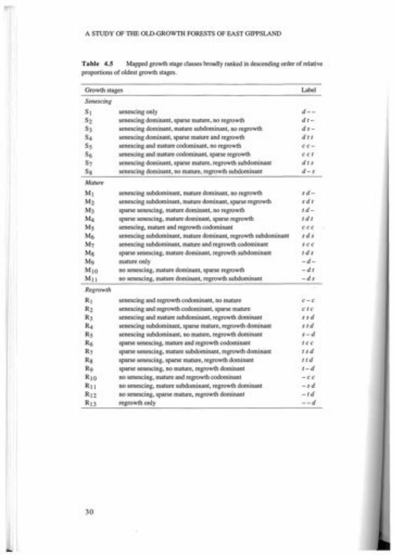
A STUDY OF THE OLD-GROWTH FORESTS OF EAST GIPPSLAND
Table 4.5 Mapped growth stage classes broadly ranked in descending order of relativeproportions of oldest growth stages.
Growth stages Label
SenescingSl senescing only d--S2 senescing dominant, sparse mature, no regrowth dt-S3 senescing dominant, mature subdominant, no regrowth ds-S4 senescing dominant, sparse mature and regrowth d t tSs senescing and mature codominant, no regrowth cc-S6 senescing and mature codominant, sparse regrowth cctS7 senescing dominant, sparse mature, regrowth subdominant d t sSg senescing dominant, no mature, regrowth subdominant d-sMatureMl senescing subdominant, mature dominant, no regrowth sd-M2 senescing subdominant, mature dominant, sparse regrowth sdtM3 sparse senescing, mature dominant, no regrowth td-M4 sparse senescing, mature dominant, sparse regrowth tdtMS senescing, mature and regrowth codominant cccM6 senescing subdominant, mature dominant, regrowth subdominant sdsM7 senescing subdominant, mature and regrowth codominant sccMg sparse senescing, mature dominant, regrowth subdominant tdsMg mature only -d-MIO no senescing, mature dominant, sparse regrowth -dtMll no senescing, mature dominant, regrowth subdominant -ds
RegrowthRl senescing and regrowth codominant, no mature c-cR2 senescing and regrowth codominant, sparse mature ctcR3 senescing and mature subdominant, regrowth dominant s s dR4 senescing subdominant, sparse mature, regrowth dominant stdRS senescing subdominant, no mature, regrowth dominant s-dR6 sparse senescing, mature and regrowth codominant t c cR7 sparse senescing, mature subdominant, regrowth dominant t s dRg sparse senescing, sparse mature, regrowth dominant t tdRg sparse senescing, no mature, regrowth dominant t-dRIO no senescing, mature and regrowth codominant -ccRll no senescing, mature subdominant, regrowth dominant -sdR12 no senescing, sparse mature, regrowth dominant -tdR13 regrowth only --d
30

FOREST GROWTH STAGES - CONCEPTS, CLASSIFICATION AND SURVEY
Table 4.6 Forest growth stage classes (ha) on public and freehold land within the study area as mappedthrough aerial photo interpretation. I,2
Public F'hold TotalGrowth Stages Land LandSenescing
Sl senescing only 6946 273 7219S2 senescing dominant, sparse mature, no regrowth 2597 47 2644S3 senescing dominant, mature subdominant, no regrowth 1 358 14 1372S4 senescing dominant, sparse mature and regrowth 1215 0 1 215Ss senescing and mature codominant, no regrowth 9431 513 9944S6 senescing and mature codominant, sparse regrowth 361 0 361S7 senescing dominant, sparse mature, regrowth subdominant 2357 45 2402Sg senescing dominant, no mature, regrowth subdominant 754 0 754Mature
Ml senescing subdominant, mature dominant, no regrowth 156721 4651 161 372M2 senescing subdominant, mature dominant, sparse regrowth 23402 1 104 24506M3 sparse senescing, mature dominant, no regrowth 235470 13 597 249067M4 sparse senescing, mature dominant, sparse regrowth 20322 816 21 138MS senescing, mature and regrowth codominant 1337 0 1 337M6 senescing subdominant, mature dominant, regrowth subdominant 14532 733 15265M7 senescing subdominant, mature and regrowth codominant 995 126 1 121Mg sparse senescing, mature dominant, regrowth subdominant 35978 1432 37410M9 mature only 244090 23 181 267271MIO no senescing, mature dominant, sparse regrowth 19292 1287 20579Mll no senescing, mature dominant, regrowth subdominant 39320 3471 42791Regrowth
Rl senescing and regrowth codominant, no mature 2744 82 2826R2 senescing and regrowth codominant, sparse mature 4494 93 4587R3 senescing and mature subdominant, regrowth dominant 5381 124 5505R4 senescing subdominant, sparse mature, regrowth dominant 2841 32 2873RS senescing subdominant, no mature, regrowth dominant 5009 342 5351R6 sparse senescing, mature and regrowth codominant 7003 723 7726R7 sparse senescing, mature subdominant, regrowth dominant 16652 1065 17717Rg sparse senescing, sparse mature, regrowth dominant 9015 1036 10051R9 sparse senescing, no mature, regrowth dominant 4736 112 4848RIO no senescing, mature and regrowth codominant 12359 702 13061Rll no senescing, mature subdominant, regrowth dominant 17602 1414 19016R12 no senescing, sparse mature, regrowth dominant 3382 118 3500R13 regrowth only 11 137 1836 12973
All Growth Stages Total 918 833 58969 977 802
Growth stage classes M I to M4, M9 and M10 contain some areas of non-Jacobs vegetation classes that wereknown to be of senescing dominated growth stages (see discussion Section 4.2). Only by examining thegrowth stages in combination with the vegetation mapping (Chapters Sand 6) could these growth stages berevised for public land (Chapter 10). The procedure for this revision is detailed in the 'GIS Analysis StagesTable' in Appendix G. However, as no vegetation class mapping was undertaken on freehold land growthstage class revisions could not be undertaken for freehold land.
2 Areas (ha) shown are reliable to the nearest S ha (approx.).
31

5fOREST TYPE AND STRUCTURE
5.1 PREVIOUS WORK
Forest type mapping is a form of structural vegetation mapping which combinescommon dominant overstorey assemblages with top height class categories and ismodified from Specht (1970). This form of forest vegetation mapping is common inAustralia, notably that of Baur (965) in New South Wales and many workers inVictoria. This form .of vegetation classification has been widely applied in Victoriaand provides a good guide to environmental site productivity and hence the locationquality and economic value of timber resources. It is also valuable for wildlife habitatresearch and planning. The forest type information is most reliable, being based onlarge scale mapping with intensive ground truthing.The vegetation of the public land in the study area had been thoroughly mapped
for dominant species, crown cover and height during the 1970s (Buntine, 1974,unpubl.) to provide vegetation maps for land use studies by the Land ConservationCouncil.The classification of the structural vegetation (Table 5.1) was based on four
primary characteristics; species type, life form and height of the tallest stratum, andprojective foliage cover as follows:
(i) Species type: For each density and height class three structural layers weredescribed:
major species of the tallest stratum,associated tree species,very sparse (<10%) tree species.
(ii) Life form and height of tallest stratum:trees (>40 m, 28-40 m, 15-28 m, and 5-15 m),shrubs (2-8 m, and 0-2 m),herbs, sedges, lichens, forbs and grasses.
(iii) Projective foliage cover (density of the tallest stratum) based on four classes:dense (70-100%),mid-dense (30-70%),sparse 00-30%),very sparse «10%).
Forest types were mapped onto 1:63 360 base maps from stereo air photointerpretation, extensive field work and by reference to existing assessments. Thisinformation was summarised in land use surveys published as a series of LandConservation Council reports (LCC 1974, 1977, 1982).
32

33
Notes:The symbols contained in brackets are Buntine's (1974, unpubl.) original descriptors. They are keyed inTable 5.2 to more detailed descriptions of each class, together with the overlapping codes of the LCCand former FCV mapping, and described at length in Appendix C. For those Buntine codes not containedin Appendix C there are no known original descriptions.I Isolated trees (emergents) may project from the canopy of some forest types. Heights are of mature
forest types.2 A tree is defined as a woody plant more than 5 m tall, usually with a single stem. A shrub is a woody
plant less than 8 m tall, frequently with many stems arising at or near the base.3 Closed forest included rainforest and blackthorn scrub (Rocky Outcrop Scrub). Small areas of Closed
Forest (Type 'a') were denoted Po, however most rainforest had no descriptor, instead it wasrepresented by a hatching, whilst blackthorn scrub had the symbol W or Ac.
Table 5.1 Structural forms of vegetation (modified from Specht, 1970) as mapped for LCCLand Use Studies by Buntine 1974 (unpublished).
Projective foliage cover of tallest stratumForm and Dense Mid dense Sparse Very Sparseheight of (70-100%) (30-70%) (10-30%) (<10%)talleststratum
Trees1,2 Open forest IV>40m (MI, M2, Wb, Ni,
A, F)
28-40 m Open forest ill Woodland ill(M3, S3, Rb3, As, (M3, S3, Rb3,P3) As, P3)
15-28 m Closed forest3 Open forest II Woodland II Open woodland II(W,Ac) (Y, S4, Rb, P4' B) (Y, S4' Rb, (Y, S4, Rb, P4,
P4, B, Ca, 6) B,Ca)
5-15 m Closed forest3 Open forest I Woodland I Open woodland I(W, Ac, Po) (B, Ca, Sng) (Po, B, Ca, 6, (Po, B, Ca, 6)
Y)
Shrubs2 Closed scrub Open scrub2-8 m (0) (0)
0-2m Closed heath Open heath(0) (0)
FOREST TYPE AND STRUCTURE
Herbland induding:tussock grassland,grassland, herbfield,sedgeland(0)
Closed herbland,including: .closed tussockgrassland, herbfield,sedgeland(0)
Herbs,includinggrasses,moss, ferns,lichens<2 m

A STUDY OF THE OLD-GROWTH FORESTS OF EAST GIPPSLAND
The line work for these forest type maps was manually combined with theecological vegetation class mapping (Chapter 6) and converted to a digital form usinga scanner for entry to the GIS at a nominal scale of 1:63 360. This digital databasewas registered to the 1:100 000 AMG base map.
5.2 MAPPING REVISION
In general the mapping of forest types was excellent and suitable for immediate use.Little updating of the original mapping was necessary. However, the mid elevations ofthe Alpine Study Area between 300-1000 m required some revision. In the area tothe south of Gelantipy and north of Buchan between the Timbarra and the Murrindalrivers more recent species mapping was used (Roberts, 1992, unpubl.). This mappingprovided detailed dominant eucalypt assemblages without height class information.The only other section of the Alpine Study Area that required revision was betweenthe Murrindal and Snowy Rivers (south of Gelantipy and North of Buchan). Aerialphotographic interpretation at the scale of 1:40 000 was used to overcomedeficiencies in the original information.
5.3 RESULTS
Table 5.2 details the forest type classes and their major tree species for the mappingof the East Gippsland, Gippsland Lakes Hinterland and Alpine study areas that are ofrelevance to the old-growth forest study for the East Gippsland Forest ManagementArea. Four different coding systems were used for the forest types of the study area.These disparate codes have been reconciled into a consolidated suite of areastatements by making some assumptions about the precise meaning of each code.For the purposes of this report 31 forest types on public land in the study area
have been described. The most extensive forest types were found to be Stringybark A(28-40 m height) with 258 184 ha, Messmate Gum B (28-40 m height) with231 216 ha and Red Stringybark-Yertchuk (15-28 m) with 57 199 ha. Box forestsalso occupy a significant area with 32 283 ha. A generalised version of the foresttypes for public land within the study area is shown in Map 4.
34

VJ Table 5.2 (continued)0\
Height Forest Type FCY! FCy2 FCy3 LCC4 Major SpeciesCode Code Code CodeALP GLH EG EG
Various Podocarpus Po Podocarpus lawrenceiWattle W Ac Yarious Acacia spp.Open 5d 0 7 Heath, tea-tree speciesAlpine Wet Heath 1 Heath, shrubs, grassesClosed Forest Hatched la,lb Numerous non eucalypt speciesOther (dunes, lakes etc.) Other
Total All Classes
Notes:1 Former FCV CODE ALP = Alpine study area mapping (circa 1977).2 Former FCV CODE GLH =Gippsland Lakes Hinterland study area mapping (circa 1982).3 Former FCV CODE EG =East Gippsland study area mapping (Buntine 1974 unpublished).4 LCC CODE EG = East Gippsland study area mapping (1974).5 Combined area statement for Box classes 3f, 4b and 6b.6 Areas (ha) reliable to nearest 5 ha (approx.)
>-CI.l
Area §(ha) >-<:
0"I1
57 >-33 10913 565 0129 G
I
49829 0
1057760 Ed"I10GiCI.l>-3CI.l0"I1trl>-CI.l>-30>-<'"tl'"tlCI.l:;S

czc:(-Io--ImQ.
ZoenwQ.>........enwa:
o
December 1993
- - - &udy 80tIldaIy
- - SIlIIe BoundaIy
--- AMra
--- Olher Roads
--- 1:100 000 MapeheetBculdIry
--- HIPaYs
• Unclass/fled
•Peppermint·Gum15-28m
• Snow Gum
• CaJlitris
• Other Vegetation
Note: These forest types are a summary of the 31original forest types listed In Table 5.2
Legend
Cut-tail>40m
•Silvertop28-40m
•Peppermint-Gum28-40m
•Stringybark28-40m
•Bloodwood15-40m
•Shining Gum, Mountain Ash Box>28m 15-28m
•Alpine Ash • Stringybarl<>28m 15-28m
Strait
30,20,KILOMETRES
10,
Bass
Accuracy: Source scale 1:63 360
MAP 4 : FOREST TYPES ON PUBLIC LANDEAST GIPPSLAND OLD-GROWTH FOREST STUDY
Source: Buntine, 1974 (unpublished)

6OLOGICAL VEGETATION CLASSES
ational Herbarium of Victoria conducted a vegetation survey of thees Catchment and East Gippsland. The analysis of 1312 vegetation
a vegetation classification which consisted of 23 plant(Forbes et at., 1981). In 1982 the Herbarium utilised this plantrmation to construct the floristic map of East Gippsland vegetation,(1984). Extensive field work was undertaken to delineate plantundaries on the ground, with aerial photography being employed toaries in remote or contentious areas. At the time of the map'sauthors discussed the existence of restricted or inaccessible plant
not been sampled adequately during the 1981 survey and thatdescribed or mapped.as a component of the current study, the original floristic
was reviewed. By the time of this study there were 4820 quadratse verification of community typology and mapping of these
These were derived from a range of surveys conducted by theand Natural Resources, its predecessors and consultants
ar8a .. The expanded database has thus enabled the inclusion ofworkers subsequent to Forbes et at. (1981) have described asGippsland. In areal extent the largest such community is DampBamp Sclerophyll Forest). Forbes et at. (1981) referred to DampcuITing in the Gippsland Lakes Catchment (at that time) and as aForests were not mapped by Parkes et at. (1984). Other importantommunities referred to by Parkes et at. (1984) which have beenubsequent floristic analysis. Hence the rocky cliffs of the Snowyw been mapped as Rocky Outcrop Shrubland, the coastal swampsre now mapped as Wet Swale Herbland and the lagoonal marginse now mapped as Coastal Lagoon Wetland.
AND DEFINITIONS
])ology.the complex relationship between the physical environment,dscape, an hierarchical system of classification of plant
communities was used by Forbes et at. (1981). This plantbeen refined and increasingly formalised over the last
37

A STUDY OF THE OLD-GROWTH FORESTS OF EAST GIPPSLAND
decade enabling the description of consistent floristic entities. The floristiccommunities so described display specific correlations with certain quantifiableenvironmental attributes as well as illustrating a biogeographical context. The refinedtypology used in this study is considered to be more process oriented than othersystems which place the emphasis on species or on structure. Figure 6.1 illustrates therelationships between these systems as well as providing the hierarchy for the process-oriented typology.
The entities described by Forbes et al (1981) as floristic commumtles are calledecological vegetation classes under today's typology. With a more contemporaryanalysis of the current database, it is apparent that most ecological vegetation classeshave more than one constituent floristic community whose distribution across thelandscape is related to geology in drier areas and climatic and biogeographicgradients more generally.
FormationFormations are defined on the basis of their structure and life form, without specificreference to their floristic composition. Generic references to life forms representedin the formation, such as palms, lianes and grasses, are usually given as part of thedescription of this structural entity. This enables biogeographers to compare thevegetation of different continents in a consistent way. Some Australian examplesinclude rainforest, heathland, grassland and open forest. This level of the hierarchywas not mapped during this study.
Formation(Structure and Life Form Pathway)
Association Alliance -----+----------- Forest Type(Species Dominance Pathway) (Structural Dominance Pathway)
Ecological Vegetation Class(Process Oriented Pathway)
Floristic Vegetation Community(Floristics Pathway)
Floristic Sub-community
Figure 6.1 Illustration of the process oriented typology that was used during this study andrelationship with other typologies which emphasise species structure or life form.
38
FOREST DISTURBANCE - IDENTIFICATION AND SURVEY
Ecological vegetation classEcological vegetation classes represent the highest level in the hierarchy of thevegetation typology developed and used across Victoria by the Department ofConservation and Natural Resources. They consist of one or a number of floristiccommunities that exist under a common regime of ecological processes within aparticular environment at a regional, state or continental scale. In addition to sharingthe features already outlined, it is expected that at the continental scale such floristicvegetation communities that occur in different biogeographic regions (but are unitedunder one ecological vegetation class) would have some of their species shared, withmany genera, families and life forms in common. Some floristic communities thatoccur in the same ecological vegetation class may however have very few species incommon. Nevertheless, these floristic communities are still united by the onevegetation class because they respond to a similar environmental regime that ismanifested in comparable life-forms, genera, families and similar vegetation structure.At the regional level a lack of shared species is related to geology. Several East
Gippsland examples are given in the description of Rocky Outcrop Shrubland(Appendix D), where they occur across a range of geologies. Where the vegetationclass is dependent on a particular geology such as the Limestone PomaderrisShrublands of East Gippsland, the stratigraphy of the geology may account forspecies differences between floristic communities of the vegetation class (Peel, 1993).Thus, in contrast to formations and floristic communities, ecological vegetation
classes are defined at a qualitative level by both their floristics and structure, but moreimportantly their description includes the ecological processes which characterisethem. Ecological vegetation classes include such well established entities as RiparianForest (high fertility sites with deep, well-watered soils replenished by periodicflooding with silt-laden fresh water), Rainshadow Woodland (well-drained soilsderived from fertile granodiorite geology under low «700 mm) and unreliablerainfall regimes) and Coastal Saltmarsh (anaerobic peaty muds inundated by saltwater one or more times daily, but less frequently in summer). Such classes illustratethe vegetation's specific ecological response to a particular environment which occursthroughout the landscape. As such, ecological vegetation classes permit the link to bemade between vegetation patterns and broad landscape features such as coasts, lakes,plains, dissected terrain, plateaus and mountains, and their respective climates.Ecological vegetation classes are usually floristically and structurally distinct fromeach other, whilst floristic vegetation communities are regional or sub-regionalvariants of ecological vegetation classes.This is the level of the hierarchy that was mapped by this study. Ecological
vegetation classes may be synonymous with sub-formations but are described in adifferent manner to them by including floristics and a qualitative consideration of theenvironmental processes operative for each class (see Figure 6.2).
Floristic vegetation communityFloristic vegetation communities sensu Forbes et al. (1981) are derived from floristicanalysis using the classificatory program 'NEAR' and a method outlined by Gullan(1978).The results of the analysis are presented in a two-way table which arranges species
and classified quadrats on two axes and contains the cover-abundance data in thebody of the table. Hand sorting this information involves the subjective arrangementof quadrats within small groups, small groups within large groups, large groups withrespect to each other and of species (which are not given a fixed order by theclassification). This is performed to permit the display of the floristic gradients within
39

A STUDY OF THE OLD-GROWTH FORESTS OF EAST GIPPSLAND
the data. Occasionally individual quadrats may be moved from one group to anotheron the basis of considering the importance of cover-abundance values rather that justpresence/absence data.The groups generated are then subjectively evaluated with respect to the floristic
gradient between groups, relative cover-abundance values (particularly of the moreecologically dominant species) between groups and the ecological sensibility ofgroups and aggregations of groups. Those sites which are close to the boundaries ofthese centroid clustered groups may then be moved according to the cover-abundance of their constituent species.Floristic communities consist of one or more sub-communities and typically relate
to the large groups derived from the preliminary classification. A floristic communityreflects the vegetation's response to environmental influences at the regional or sub-regional scale. These influences include geology, soils, minor altitudinal changes,landform, aspect and recurrent disturbances such as fire.Note that in this report the term plant community is taken to be a generic reference
that may include floristic vegetation community or ecological vegetation class.
Floristic sub-communitySub-communities are based on small groups or aggregations of quadrats (Mueck andPeacock, 1992). Sub-communities may relate to different temporal phases of thevegetation type or a single floristic community under different disturbance regimesand are somewhat arbitrary steps along a floristic continuum. A sub-communitygroups vegetation samples from one floristic community as a function of subtlefloristic differences that are mediated by microclimate variations across the localisedlandscape. Such variations include position on a slope, aspect, fire history, disturbanceor proximity to another community. A sub-community is synonymous with the term'nodum' of Poore (1955). Sub-communities typically occur over relatively smallareas and are difficult to map at the regional scale and so were not mapped in thiswork.Typologies operate most effectively on an extensive data set; the position of an
entity within the hierarchy is likely to change if the data set was small in geographicextent or small in sample size and scattered over a wide area when the initialdeterminations were made. In this way the development of the typology of the state'svegetation is analogous to the dynamic nature of plant taxonomy: both systems areseen to be evolving and must be updated as better information comes to hand. As thedata set used by Forbes et al. (1981) was relatively small (considering the geographicarea covered), some of the floristic entities initially described as sub-communities inthat study were found to require reclassification and have been redefined as floristicvegetation communities or ecological vegetation classes in this work. The vastlyimproved data set available for the study area has enabled the revision of the planttypology for East Gippsland. This revision is consistent with the state-wide vegetationtypology currently being developed by the Department.An example of this process-oriented typology is given in Figure 6.2.
6.3 METHODS
Mapping ecological vegetation classes as a part of the old-growth study wasundertaken in order to provide an ecological context for stands of old-growth forestidentified by forest mappers during this study. Vegetation classes exhibit differentstructural and floristic responses to their environment. The advantage of describing
40

FOREST DISTURBANCE - IDENTIFICATION AND SURVEY
old-growth forests in terms of their constituent vegetation classes is that it is possibleto circumscribe the particular environmental conditions which produce andperpetuate the old-growth state for that class. Because the typology is based anecological processes, disturbance regimes which may effect the old-growth status of astand can be consistently assessed. The major advantage of this approach is that it willallow a more refined and focused management response for areas of old-growthforest so defined.Forest type and structural vegetation mapping at a scale of 1:63 360 (Buntine
1974 unpubl.) covered all of the LCC East Gippsland Study Area and parts of theGippsland Lakes Hinterland and Alpine Study Areas (Chapter 5). Although the focusof this mapping was as a basis for land use determinations, including thediscrimination of commercially productive categories of forest, this mapping alsoreflects environmental site quality. Plant community maps are also a reflection of thevegetation's interaction with particular environmental site qualities, but are createdfrom a broader ecological perspective.Both approaches to mapping employ detailed analysis of remotely sensed
information and subsequent field checking. In East Gippsland, where accurate anddetailed forest type mapping was available but floristic mapping had only beencompleted at a broad scale, it was desirable to use the information of the former toassist in upgrading the latter. By also including data on geology, soils, climate,landform, biogeographic context and the currently available floristic quadrat data set,this approach modified the line work of forest types to produce ecological vegetationclass mapping.There are several advantages to linking forest type information and ecological
vegetation class information:• efficient use of existing information,• broader understanding and acceptance of improved mapping by management
staff, and• encouragement of the synthesis of silvicultural site quality parameters with
ecological considerations, which has profound implications and advantages forforest management.
The method for transforming forest type boundaries into ecological vegetation classboundaries is relatively straightforward provided there are good floristic, edaphic andbio-geographic data for the area. The strongest, most persistent and stable influenceswill define the distribution of an ecological vegetation class in the broad landscapecontext, while the floristic vegetation communities are regional variants.The ecological vegetation class was undertaken by overlaying information about
the physical environment, biogeography and existing floristic quadrat informationwith the forest type maps. The synthesised maps of vegetation classes were then field-checked to ensure that assumptions about the influence of abiotic and biogeographicfactors on vegetation in the landscape had been correct. Whilst field-checking theaccuracy of the revised mapping for vegetation class boundaries, more specificinformation about the ecological vegetation classes was collected.Maps were verified during eight months of field work by driving all the major
roads and tracks. Where necessary and as time permitted the field verification ofvegetation classes boundaries away from the track network was achieved throughbushwalking. Additional information was obtained from the work of field botanistswho had worked in the area or who were still engaged in biological survey in thestudy area.
41

A STUDY OF THE OLD-GROWTH FORESTS OF EAST GIPPSLAND
e.g.
FORMATION
Open Forest
.................................... FLORISTIC VEGETATION COMMUNITY .
Basaltic Damp Forest
Damp Forest
'Shrubby' Damp Forest'Ferny' Damp Forest
e.g .
Figure 6.2 An example of plant community typology for damp forests in East Gippsland.Notes:1 The name for this sub-community has been superseded by the new typology nomenclature(refer to Section 6.3) but is used here because it is the original name as cited by Forbes et at.(1981)
2 Peacock et at. (1992).
e.g.
VEGETATION CLASS······································
e.g. Damp Sclerophyll Forest (I) Damp Sclerophyll Forest (I) Basaltic Damp Forest (2)GLC 6.2, 6.3 GLC 6.1, 6.4 SAR 5.1
Lowland Forest EG 16.5
............................ ················FLORISTIC SUB-COMMUNITY .

FOREST DISTURBANCE IDENTIFICATION AND SURVEY
Aerial photography, geological boundaries and landform were used to interpretremote ecological vegetation class boundaries throughout the study area where timedid not permit on-the-spot verification of such boundaries.During the course of the field-checking it became obvious that certain vegetation
classes were not catered for by the structural classes in the forest type mapping. Theywere delineated by the use of aerial photo interpretation (API) where equivalentstructural classes were absent or inadequate. See Appendix D.
Data sourcesData sources used in the mapping procedure included:• vegetation maps at 1: 100 000, Land Conservation Council study area reports for;
East Gippsland (1974), Gippsland Lakes Hinterland (1982) and Alpine (1977);• forest type maps at 1:63 360, former Forests Commission of Victoria,Buntine
(1974, unpubl.);• logging history at 1:100000 (Chapter 7);• dieback caused mostly by Phytophthora cinnamomi Ward and McKimm (1982);• land systems at scale 1:100000 (east of the Snowy River), 1:250000 (west of the
Snowy River) Department of Conservation and Natural Resources (1993);• geology; Geological Survey of Victoria at 1:250000 - Mallacoota (1976),
Tallangatta (1976), and Baimsdale (1977); and 1:100000 - Bendoc (1990), andMurrindal (in prep.);
• the Geology of the Cann River Forest District; 1:100000 (Beams and Hough,1979b);
• Floristic Map of East Gippsland (Parkes et a!., 1984);• floristic analyses of the quadrat data set for East Gippsland using CNR's Flora
Information System; and• numerous floristic analyses from pre-logging flora and fauna survey reports in
the Ecological Survey Report Series (CNR) cited by author in the References.
Field reconnaissanceField work to check the revised mapping and to refine ecological vegetation classdescriptions was conducted from September 1990 to April 1991. Additional sitespecific data was collected as defined species lists from 77 locations across the studyarea (PIS quadrats U00601-U00677).
Plant taxonomyThe taxonomy follows Ross (1993) and the periodic taxonomic updates of theNational Herbarium of Victoria.
Vegetation class nomenclatureThe names for the ecological vegetation classes have been formulated throughreference to previous work in Victoria and Australia and are referrable to Census ofVictorian Plant Communities, CNR (in prep). The ecological vegetation class namesare designed to convey a simple picture of the vegetation and its context. They arenot intended to be detailed descriptions. Each name gives the usual structural formsuch as woodland, heathland, or sedgeland, although not all examples of ecologicalvegetation classes are restricted to the one structural category. For example, BanksiaWoodland may be a low open woodland on exposed near-coastal dunes or an openforest on more sheltered inland sites. A variety of adjectives are employed to describea particular and consistent feature about the vegetation class; for example, coastal,damp, vine-rich or grassy.
43

A STUDY OF THE OLD-GROWTH FORESTS OF EAST GIPPSLAND
After much careful consideration and consultation, the term sclerophyll has beenremoved from the Victorian plant community nomenclature. The change was madebecause 'sclerophyll' is a term that is not familiar to non-specialists, it is applicable tomany communities and thus adds little to discriminating between them. Furthermore,it was originally intended to be applied strictly to either the overstorey or theunderstorey, but this distinction has rarely been made.
LimitationsThe vegetation mapping of this study in some instances encapsulates severalecological vegetation classes across the study area that occur in patterns too complexto map at 1:100000. It is therefore reasonable to expect that a revision of thismapping at a finer scale in the future may lead to the delineation of more ecologicalvegetation classes.
6.4 RESULTS
The relationships between the forest type mapping (Chapter 5) and ecologicalvegetation classes are described in Appendix D. This table also provides descriptionsof landform, geology, rainfall and elevation for each forest type and ecologicalvegetation class.The complete revision of the floristics of East Gippsland produced 44 ecological
vegetation classes. These are listed in Table 6.2 along with their area (in hectares) onpublic land. Detailed class descriptions are given in Appendix E. These reviseddescriptions include 24 plant communities in addition to those recorded on theoriginal Floristic Map of East Gippsland (Parkes et ai., 1984). Note that thevegetation class mapping was not completed for freehold land.Over 98% of the public land in the study area was found to be vegetated. The
remainder of the area comprised water-bodies, inlets and bare areas such as blow-outson coastal sand dunes. Forested vegetation comprises 1 027377 ha (97%) of publicland (of which 918833 ha was mapped as forest by the more detailed growth stagemapping - see Chapter 4). The most extensive class is Lowland Forest (245 131 ha)which together with Damp Forest (238288 ha), Shrubby Dry Forest (209982 ha)and Wet Forest (90288 ha) account for 76% of the public forest estate. The fourrainforest classes together only occupy 9619 ha.A generalised map of the ecological vegetation classes is depicted as vegetation
groups in Map 5. The groups comprise: Coastal (ecological vegetation classes 1-4),Heathlands (classes 5-8), Saltmarsh (class 9), Wetlands (classes 10-13), Lowland(classes 14-16), Riparian (classes 17-19), Dry Forest (classes 20-25), RainshadowWoodland (class 26), Rocky Outcrops (classes 27-28), Moist Forests (29-30),Rainforests (classes 31-34), Tableland Damp Forest (class 35), Montane DryWoodlands (classes 36-37), Moist Montane Forests (classes 38-41), Sub-alpine(classes 42-43) and Treeless Sub-alpine Complex (class 44).
44

ECOLOGICAL VEGETATION CLASSES ON PUBLIC LANDEAST GIPPSLAND OLD-GROWTH FOREST STUDY
czet..J(,)..Jma.zoenwenenet..J(,)
Zo-....etI-WGw>..Jet(,)-Go-Jo(,)w
Study Boundary
Other Roads
State Boundary
1:100 000 MapsheetBoundary
Highways
--- Rivers
re"\ CONSERVATION ANDRESOURCES
Map prepared by Natural Resource Systems Branch, CNR. December 1993
Note: The 20 ecological vegetation class groupings shown on this mapare derived from 44 individual ecological vegetation classes.Detailed listings of classes within groups are given in Table 6.2
LegendCOastal • Rocky Outcrops
Heathlands • Moist Forests
• Saltmarsh • Rainforests
Wetlands • Tableland Damp Forest
Lowland • Dry Montane Woodlands• Riparian • Moist Montane Forests• Dry Forest Sub-alpine
Rainshadow Woodland • Treeless Sub-alpine Complex
Strait
30,20,KILOMETRES
10I
Bass
Accuracy: Input scale variable, ranging from 1:63 360 to 1:250 000
••MAP 5
Sources: Quadrat data from Flora Section, CNR. Forest typemapping (Map 4) and various Geological Survey maps.

FOREST DISTURBANCE - IDENTIFICATION AND SURVEY
45
Table 6.2 Ecological vegetation classes and area (ha) on public land of the East Gippsland ForestManagement Area 1,7.
26811
700048517482513 96213 50651636202
7310107113232
595471
2217950521606
2382889028825636777
Area(ha)
1 057760
24. Foothill Box Ironbark Forest3,525. Limestone Grassy Woodland2
26. Rainshadow Woodland 327. Rocky Outcrop Scrub 3,528. Rocky Outcrop Shrubland3,529. Damp Forest2
30. Wet Forest2
31. Cool Temperate Rainforest3,632. Warm Temperate Rainforest3,6
33. Cool/Warm TemperateRainforest Overlap3,6
34. Dry Rainforest3,635. Tableland Damp Forest2,536. Montane Dry Woodland2
37. Montane Grassy Woodland2,538. Montane Damp Forest2
39. Montane Wet Forest2
40. Montane Riparian Woodland3,541. Montane Riparian Thicket3,4,542. Sub-alpine Shrubland3, 543. Sub-alpine Woodland2
44. Treeless Sub-alpine Complex5
Other
Area (ha) Vegetation Class
3109339790122
68144
1 7819514904795718789195
369804658
2451311766412656659
2989209982169039724
Coastal Saltmarsh
Coastal Sand Heathland
Sand HeathlandClay Heathland
Wet Heathland
Vegetation class
Notes:1 Vegetation classes (in bold) which conform with the definition of 'forest' adopted for this study (classes
1-4, 14-18, & 20-43).2 Jacobs forest classes. These classes mostly show classic eucalypt growth form (classes 3-4, 15-16, 18,
22-23, 25, 29-30, 35-39 & 43).3 Non-Jacobs forest classes. These classes mostly exhibit atypical eucalypt growth form (classes 1-2, 14,
17,20-21,24,27-28 & 40-42).4 The revision of mapping for riparian classes was not completed because the structural mapping was unable
to adequately delineate these vegetation classes. As a consequence the area statements for these linearriparian vegetation classes -are- provisional.
5 Ecological vegetation classes that were not adequately delineated by forest type structural mapping. Thesewere mapped with the aid of aerial photography and other vegetation mapping techniques (see Appendix D).A complex comprises two or more ecological vegetation classes that are indivisible at this scale ofmapping.
6 The total area for rainforest vegetation classes is based on structural mapping not floristic mapping. Thepartition of the area of rainforest into four vegetation classes is based on floristic criteria. A floristic-basedmapping approach would see a revision of the area of these classes.
7 Areas (ha) are reliable to the nearest 5 ha (approx.).
10. Estuarine Wetland11. Coastal Lagoon Wetland12. Wet Swale Herbland
13. Brackish Sedgeland
14. Banksia Woodland3
15. Limestone Box Forest2,5
16. Lowland Forest2
17. Riparian Scrub Complex3,4,518. Riparian Forest2,4,519. Riparian Shrubland20. Heathy Dry Forest3, 521. Shrubby Dry ForestJ22. Grassy Dry Forest2,5
23. Herb-rich Forest2
Total all classes
1. Coastal Dune Scrub Complex3,5
2. Coast Banksia Woodland3
3. Coastal Grassy Forest2
4. Coastal Vine-rich Forest2,5
5.6.7.8.9.

7FOREST DISTURBANCE
IDENTIFICATION AND SURVEY
7.1 INTRODUCTION
A list of disturbances known to have altered the primary attributes (floristics, structureor growth stage) of the forests in the study area was prepared. These disturbanceswere described according to their cause; natural or un-natural (post-Europeanhuman-induced). Research using historical and contemporary records was undertakento delineate and map the extent and severity of these disturbances. The followingdiscussion indicates the most important of these disturbances and is a summary ofmore detailed histories and sources which are presented in Appendix F.
7.2 AGRICULTURAL SELECTION
Agriculture represents less than 15% of land use by land area in East Gippsland.Agricultural activities are concentrated in fertile country around Buchan, Gelantipyand Wulgulmerang; on the alluvial river flats, coastal plains and adjoining clearedfoothills around Orbost; in the north near Bendoc, Bonang and Tubbut; and in the fareast of the region at Combienbar, Cann River, Mallacoota and along the Genoa Rivervalley. The first settlements were established in the north and far east of the study areain the late 1830s and 1840s, mostly for grazing. Crown land selection, the process ofsub-division and forest clearance that led to closer settlement, had the greatest impacton the more marginally productive country of the region from the 1880s.Archival Crown Lands and Survey files show that, for the period generally between
the 1880s and 1930s, about 135 Crown Land selections within the study area weretaken up, partially or wholly ringbarked, later abandoned or forfeited, and reverted tothe Crown. Most of these selections are now within State forests or National Parks.Selection blocks were abandoned because of difficult access, remoteness frommarkets and the vigorous regrowth of native vegetation following clearing.Many .of these blocks were cleared and have subsequently revegetated. Clearing
was mostly done by ringbarking trees and later grubbing the stumps, and burning thedried and dead vegetation. Deforested areas were then sown with pasture grasses, whilethe more fertile alluvial flats were planted with cereal or vegetable crops. In someinstances agricultural blocks were cleared and farmed more than once before beingpermanently abandoned. As the average size of the selection blocks was 150 ha, thisrepresents approximately 20 000 ha of land that may have been affected by earlyagricultural activity (Table 7.2). Today, most of this land is forested.Data relating to agricultural clearing has been obtained from the archival files,
collated into a textual database and entered into the GIS. The database contains
46

FOREST DISTURBANCE - IDENTIFICATION AND SURVEY
information on the location, extent and approximate period of clearing for eachselection. Where clearing was undertaken on a portion of the allotment area, thepercentage is based upon data found in the. reports of Crown Bailiffs who inspectedthe selections for the Lands Department. Parish plans (historic and current) have beenused to situate allotments within the spatial database (GIS), with each receiving aunique number to link the allotment with the textual database. The current extent oftree clearing on freehold land has been determined from Landsat TM satelliteimagery (Goodson and Gilbee, 19Y2). Map 6 depicts the location of crown landselections which have reverted to public land. It also shows current freehold land.
7.3 GRAZING
Cattle grazing commenced in the study area in the 1830s and has continued to thepresent day, though within a much reduced geographical area. The first cattle weredepastured in the forests of East Gippsland by graziers from the Monaro district ofsouthern New South Wales, driven into the region through industry expansion and arun of dry seasons in the 1830s and 1840s. A series of nineteenth century land actsand amendments made provision for grazing on unoccupied Crown land in Victoria,recognising that extensive forested areas in East Gippsland were more suited tointermittent grazing than to intensive agricultural development. This regional land usehas continued through the current century, with grazing leases administered by theformer Department of Crown Lands and Survey, the former Forests Commission ofVictoria, the former Department of Conservation and Environment and more recentlythe Department of Conservation and Natural Resources.The current survey identified five categories of grazing licences and leases which
represent different forms of administration rather than different types of forestgrazing. Information on significant grazing leaseholds was researched from a varietyof sources including historic plans and maps, archival Crown Lands and Survey files,Forests Commission records and Victorian Government,Gazettes. A textual databasehas been compiled which holds information on the area of the leasehold, the periodof grazing, the relevant Government file numbers, and a unique number that links thisdata to the spatial database.There is some chronological overlap between the categories of grazing, and the
size and boundaries of individual leases could vary significantly over time. Leaseswere taken up intermittently, sometimes abandoned in good seasons, and notnecessarily held continuously over a given period. The date-range for a grazing areais therefore only an indication of the period of grazing. Information concerningstocking rates and stock numbers was not consistent nor of sufficient quality to beincluded in the textual database. Data relating to the earliest grazing leases, or PastoralRuns, have been excluded due to the inconsistency of available information,specifically the location of early leaseholds.The originaLmaps of grazing areas show the extent of the leaseholds, somewhere
within which grazing has occurred. During the construction of the GIS database it wasdecided that the grazing leaseholds be depicted within a matrix of 2 km gridscovering the entire study area. If a lease overlapped more than 50% of a grid squarethe grid was marked with the attributes of that lease. Data on leases greater than400 ha, excluding current licences which range down in size to 2 ha, were entered intothe GIS for presentation at a scale of 1: 100000. Map 7 depicts the extent of currentand historic grazing leases.
47

A STUDY OF THE OLD-GROWTH FORESTS OF EAST GIPPSLAND
7.4 MINING
Gold was discovered in the study area in the early 1850s, and copper and silver-leadfrom the 1870s onwards. The first gold fields of the region were situated near Bendocand Bonang, where alluvial gold, and later quartz, were mined throughout the 1850sand 1860s. In the 1880s and 1890s a new round of gold discoveries was made in theregion when mining tracks were opened up, providing access to the auriferous areas.The gold fields of East Gippsland tended to be short-lived, however, yielding poor tomoderate returns, and were not as geographically extensive nor productive as those ofcentral Victoria.Gold prospecting and extraction has occurred along many river and stream
systems in the region. In the Bendoc district payable gold was eventually found inmost streams flowing north from the Coast Range. In the south of the study areaprospecting tended to be concentrated at the heads of the river systems. Copper andsilver-lead were mined in the Deddick district in the 1870s and 1890s. Silver miningwas undertaken in the Buchan area in the early years of this century. Large areas ofthe region have in recent decades been subject to mineral exploration licences.Records indicate that large-scale forest clearance for mining was not commonplace
in the region, though forests in the immediate vicinity of mines and associatedsettlements were destroyed. Mining activity was, however, very destructive of the localenvironment, with trees felled for fuel and building purposes, and streams and streambanks heavily disturbed in the search for alluvial gold.Information was obtained from the records of the Geological Survey of Victoria,
reports of the former Department of Minerals and Energy, and a range of secondarysources. The significant mines and mineral extraction sites of the region were loadedinto a textual database which indicates the location (AMG to 1: 100 000 scaleaccuracy), the name, the type and the dates of operation of the mine. These data werethen directly entered into the GIS with the textual attributes linked with pointlocations. Some historic mining access tracks have also been entered. It was notpossible to determine the lqcation of all mines and mineral extraction sites in thestudy area. Map 8 depicts the location of historic mining sites and tracks.
7.5 DIEBACK
The major pathogen mapped in the study area is the root rot fungus Phytophthoracinnamomi. This fungus has profound effects on the structure and floristics of theforest communities within which it occurs, causing large scale crown defoliation anddeath of plants in both the overstorey and understorey in its most severe expression.The mapping was undertaken in 1973 by the former Forests Commission of Victoriausing aerial photography and field inspection. This mapping is still an accuratedescription of the likely extent of dieback following an epidemic event (pers. comm.Ian Smith). The origins of the disease are uncertain. Although Marks and Smith(1991) and others consider the fungus to be introduced, it is also acknowledged byBurbidge (1960), cited in Marks and Smith (1991), that there is evidence whichsuggests the fungus has been in Australia for many thousands of years. However forthe purposes of this study, the extent and severity of dieback caused by Phytophthoracinnamomi was considered to be anthropogenic (Ian Smith, pers comm.). Thismapping was entered into the GIS database and is depicted in Map 9.
48

MAP 6 : AGRICULTURAL SELECTIONSEAST GIPPSLAND OLD-GROWTH FOREST STUDY
enzoi=(.)W-JWen-J«a:t--J
(.)-a:«
Highways
Other Roads
Study Boundary
Rivers
- - State Boundary
....................
....................
1:100 000 MapsheetBoundary
re"'\ CONSERVATION ANDNATURAL RESOURCES
Legend
• Selections from circa 1880s to 1930sthat have reverted to Public Land andwhere some ringbarldng was recorded
Current freehold land
Note: Ringbarking for clearing purposes occurred withinthe boundaries of the former selections, notneceSSarily over the whole of the areas indicated.
Map prepared by Natural Resource Systems Branch, CNR. December 1993
Strait
30,KILOMETRES
10 20, ,
Bass
00 000 scale base mapAccuracy: Derived from Parish plans transferred to 1:1
Marlo
f?
Source: Archival records from former Crown Lands and Survey Department

CJ)WCJ)<Cw-I
CJzN<Ca:CJ
Study Boundary
Other Roads
State Boundary
Rivers
Highways
CONSERVATION ANDNATURAL RESOURCES
1:100 000 MapsheetBoundary
Grazing leases which ceasedprior to 1960
Grazing leases which have noconfirmed date of occurrence
Grazing leases ceased since 1960
Map prepared by Natural Resource Systems Branch, CNR. December 1993
Legend
Accuracy: The grazing information is generally presentedin a 2km x 2km grid. Grid cells were indicatedas containing a grazing lease only where theboundary of the lease extended by 50% or moreinto a grid. If the lease extended for less than50%, the cell was not indicated as having a lease.
• Current grazing leases
Strait
KILOMETRES
Bass
MAP 7 : GRAZING LEASESEAST GIPPSLAND OLD-GROWTH FOREST STUDY
Marlo"
Sources: Former Crown Lands and Survey records, former Forests Commission of Victoria records, VictorianGovernment Gazettes, and current records of the Department of Conservation and Natural Resources.

coQ.<C:E
en()<Cex:l-ez<Cenwt::enC'z-z-:E()-ex:oI-en-:x:
lJ
,..J'
- - State Boundary
- - - Study Boundary
--- Rivers
--- Highways
--- Other Roads
1:100 000 MapsheetBoundary
re"'\ CONSERVATION AND\.1 NATURAL RESOURCES
" Alluvial mine only
• Reef mine and or alluvial mining
Note: The mining tracks were copied from a mappublished by the former Victorian MinesDepartment in 1909. The areas or clusters ofmining indicate mining activity, not justindividual mines.
Legend
-- Mining tracks as at 1908
Map prepared by Natural Resource Systems Branch, CNR. December 1993
Strait
.s'
30,20,KILOMETRES
10,
Bass
Accuracy: Mine sites accurate to 1:100 000 scale
: HISTORIC MINING SITES AND TRACKSEAST GIPPSLAND OLD-GROWTH FOREST STUDY
MAP 8
"
I
"'--"
former Department of Minerals and Energy reports.Source: Geological Survey of Victoria records, and

MAP 9 : FOREST DIEBACK AS AT 1974EAST GIPPSLAND OLD-GROWTH FOREST STUDY
,,.J'
f?
Sources: Mapping undertaken in 1974 (Ward and McKimm, 1982)
10 20....,"'-------....:;3,0
KILOMETRES
Bass
Accuracy: Dieback accurate to 1:100 000 scale
Strait
Legend• Occurrence of dieback
Note: The mapping depicts dieback primarily caused byPhytophthora cinnamomi (Cinnamon Fungus),although some small mapped areas are the resultof lerp infestations or salt pruning along the coast.
--- Highways
--- Other Roads
State Boundary
--- Rivers
Study Boundary
1:100 000 MapsheetBoundary
(f"';\ CONSERVATION ANDNATURAL RESOURCES
Map prepared by Natural Resource Systems Branch, CNR. December 1993
l-e:(
ene:(
oe:(mw-CI-enWa:oLL
(J)
a.e:(::E

FOREST DISTURBANCE - IDENTIFICATION AND SURVEY
7.6 TIMBER HARVESTING
Extensive utilisation of timber has occurred throughout the forests of the study area.This begun in the 1840s with the early graziers felling trees for their immediate needs,such as huts, yards and fuel, and continued with the mining settlements of the 1850sand the agricultural settlements from the 1870s. During the 1880s and 1890s thedurable timbers of the area were selectively harvested and shipped by rail or sea tomarkets in Melbourne. Utilisation increased after the extension of the rail head fromBairnsdale to Orbost in 1916. Hardwood railway sleepers were hewn in the study areafor many decades during the 20th century, and piles, poles and beams cut andremoved from the forests.The primary customers for the durable species were the public utilities, the former
Victorian Railways Department (sleepers), State Electricity Commission (light poles),the former Public Works Department (heavy construction beams) and the formerMelbourne Harbour Trust (piles for piers and docks). Gippsland Grey Box wasespecially prized for wharf construction because of its resistance to Toredo Wormattack, whilst the abundance of Box and Red Ironbark made the Orbost district thepremier sleeper hewing area for Victoria from 1920 to the early 1930s. The hewnproducts of the Cann River and Mallacoota districts were used by the New SouthWales Railways or shipped out to New Zealand via the port at Eden in southern NewSouth Wales.Large scale timber harvesting began in the 1950s in response to a significant loss
of resources in the Victorian Central Highlands from the 1939 bushfires and theincreased demand associated with the post-war housing boom. With the merchantableforests of the coastal plain largely logged over, the attention of timber-getters movedto the foothills of the hinterlands around Buchan and to the north of Orbost and CannRiver. Access to this hilly country was facilitated by the improvement in roadingmachinery such as bulldozers and graders during the post-war period.Historically, timber utilisation tended to follow the easterly extension of the rail
into East Gippsland, though in the era after the Second World War increased roadconstruction assisted the expansion of the hardwood industry in the region. There wasa steady increase in sawlog output throughout the 1950s and 1960s through a systemof selective harvesting. A type of clearfelling system was introduced in the late 1960sand early 1970s and by 1974-75 the forests of the region were producing 40% of thestate's log output. This system was a modified form of clearfelling where some treeswere retained for environmental protection or conservation (DCE 1990).During the 1970s there was a reduction in the number of mills in East Gippsland
following amalgamation and take-overs with the issuing of larger individual logallocations against licences of three year duration. Hardwood log output returns forNowa Nowa, Orbost and Cann River districts declined slightly between 1970 and1974, then fluctuated with a trend of increased output by 1981, particularly in theOrbost forest district. Regional sustainable yield harvesting was introduced in the late1980s following the Victorian Government's (1986) Timber Industry Strategy.Accurate information on the areal extent of selective logging was difficult to find.
Air photos (black and white, scale 1:40000, large format) from the early 1940s wereavailable for parts of the study area. They provided clues as to the possible location ofdisturbed forest but precise boundaries were difficult to derive. A few contemporarymaps of these early logging activities were also found. What were available weredetailed log allocation records by licence area for the period 1945 to 1970approximately. These were reorganised to conform with current forest block andcompartment boundaries and together with information on species were entered into
49

A STUDY OF THE OLD-GROWTH FORESTS OF EAST GIPPSLAND
the GIS database. It should be noted that selective harvesting within a forestcompartment indicates only that this form of harvesting occurred, not its precisedistribution or intensity.A variety of forms of remote sensing and investigative techniques were employed
to assist with the mapping of the clearfelling history. Landsat TM imagery (bands 3, 4and 5) in transparency form at scale 1: 1 000 000 (March 1990) and 1:250 000 (April1992) was interpreted at scale 1:100000 using a Kartoflex photogrammetric maprevision instrument to map the clearfelling coupe boundaries from the late 1980s tothe present. Landsat MSS transparencies (band 1, 3 and 4) at scale 1:1 000000 fromAugust 1972 to February 1987 (with scenes from August and December 1972,February 1978, October and November 1980, March 1984, January and July 1986,and January and February 1987) were also interpreted on the Kartoflex in order tomap clear felling boundaries at a scale of 1:100000 back to the early 1970s.It was a fortunate coincidence that the advent of Landsat 1 in 1972 coincided with
the shift in logging practices from selective harvesting, which is difficult to identifyfrom either aerial photos or satellite imagery, to clearfelling and seedtree silviculturalsystems in the early 1970s, which are more readily detectable from remotely sensedimagery. Nevertheless some of the early satellite images suffered from severe linestriping and contrast deficiencies which significantly impaired the quality ofmapping. Despite these deficiencies the mapping was comparable with local regionalrecords that had been compiled over the years by interpretation of both small andlarge format aerial photos and associated field mapping. Prior to the study, theexisting regional records were incomplete and were substantially up-dated as a resultof the satellite image interpretation.The extent of selective logging and clearfell harvesting are shown on Maps 10 and
11 respectively.
7.7 WILDFIRE
Wildfire is a particularly important disturbance to the growth stage characteristics andfloristics of old-growth forest. Wildfires maintain the ecological dynamics ofregeneration and decline for most eucalypt communities (Gill 1981), whilst havingthe potential to physically affect the morphological characteristics of growth stages.Clearly the period of time taken to recover from such a disturbance is dependentupon the fire intensity and frequency and the vegetation class involved. Since theadvent of intensive wild-fire suppression techniques in recent decades, the truly'natural' characteristics of contemporary wildfires have been questioned. Even if awildfire has not been started by human forces, human intervention is usually used tohelp suppress the fire. Wildfires occur regularly in East Gippsland and major fires areknown to have occurred in 1923, 1938-39, 1943-44, 1945-46, 1951-52, 1958-59,1962-63, 1967-68, 1978-79, 1980-81, 1982-83 and 1987-88 (CFL, 1990, andFoley, 1947).The Department of Conservation and Natural Resources (CNR) and its
predecessors have routinely recorded the outer boundary of most wildfires for the lastthree decades on base maps for fire management planning. Prior to that only the1952 and 1939 fire boundaries were available in map form. Unfortunately, littleinformation on the severity of burn was available from historic records. These mapsformed the basis of the fire mapping for this study. The regional base maps ofwildfire history recorded by CNR (1960 to 1991) and the available historic maps(1939 and 1952 fires) were redrafted onto one complete map layer for the GIS
50
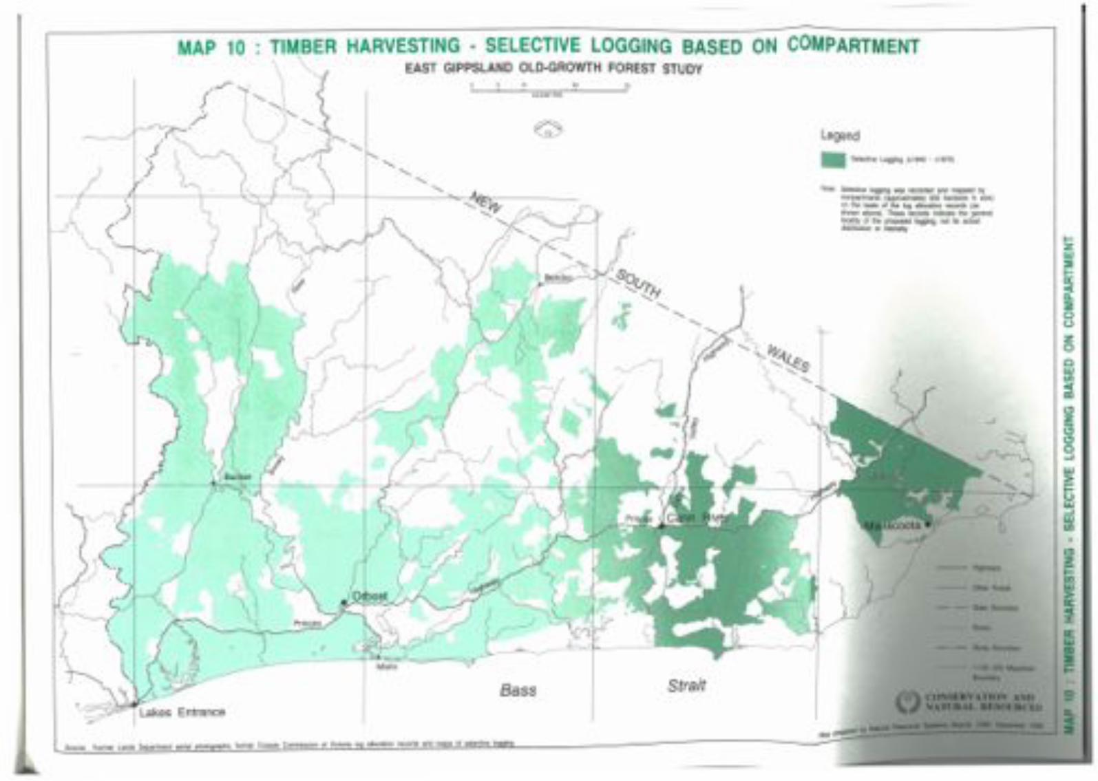
•
o
t-
t-ZW
t-a::«D..
oozocwCJ)«mCJz-CJCJo....w>tiw....wCJ)
00000""'''
Note: Selective logging was recorded and mapped bycompartments (approximately 500 hectares in size)on the basis of the log allocation records (asshown above). These records Indicate the generallocality of the proposed logging, not its actualdistribution or intensity.
Legend• Selective Logging (c1940 - c1970)
StraitBass
........._-'--_..... ....2,O ---'3,OKILOMETRESf
?
MAP 10 : TIMBER HARVESTING · SELECTIVE LOGGING BASED ON COMPARTMENTEAST GIPPSLAND OLD-GROWTH FOREST STUDY
Source: Former Lands Department aerial photographs, former Forests Commission of Victoria log allocation records and maps of selective logging.
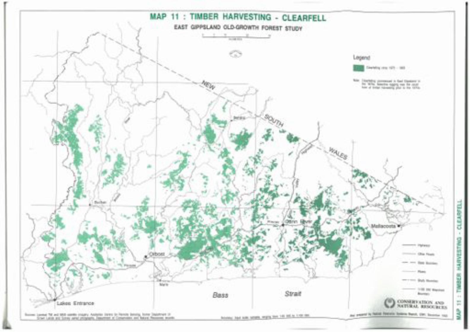
MAP 11 : TIMBER HARVESTING · CLEARFELLEAST GIPPSLAND OLD-GROWTH FOREST STUDY
Accuracy: Input scale variable, ranging from 1:25 000 to 1:100 000.
..J
..JWU.a:«w..J(.)
,...,...
CJzi=enw>a:«::I:a:w£Xl:Ei=1:100 000 Mapsheet
Boundary
- - State Boundary
- - - Study Boundary
--- Highways
--- Rivers
--- Other Roads
Legend
Note: Clearfelling commenced in East Gippsland inthe 1970s. Selective logging was the usualform of timber harvesting prior to the 1970s.
• Clearfelling circa 1970 - 1993
CONSERVATION ANDNATURAL RESOURCES
Map prepared by Natural Resource Systems Branch, CNR. December 1993
Strait
30,20,KILOMETRES
10,
Bass
)/
Sources: Landsat TM and MSS satellite imagery, Australian Centre for Remote Sensing, former Department ofCrown Lands and Survey aerial photgraphs, Department of Conservation and Natural Resources records.
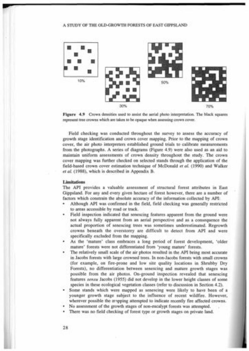
A STUDY OF THE OLD-GROWTH FORESTS OF EAST GIPPSLAND
II 1111II
II IIII II10% 50%
30% 70%
Figure 4.9 Crown densities used to assist the aerial photo interpretation. The black squaresrepresent tree crowns which are taken to be opaque when assessing crown cover.
Field checking was conducted throughout the survey to assess the accuracy ofgrowth stage identification and crown cover mapping. Prior to the mapping of crowncover, the air photo interpreters established ground trials to calibrate measurementsfrom the photographs. A series of diagrams (Figure 4.9) were also used as an aid tomaintain uniform assessments of crown density throughout the study. The crowncover mapping was further checked on selected stands through the application of thefield-based crown cover estimation technique of McDonald et at. (1990) and Walkeret at. (1988), which is described in Appendix B.
LimitationsThe API provides a valuable assessment of structural forest attributes in EastGippsland. For any and every given hectare of forest however, there are a number offactors which constrain the absolute accuracy of the information collected by API:• Although API was confirmed in the field, field checking was generally restricted
to areas accessible by road or track.• Field inspection indicated that senescing features apparent from the ground were
not always fully apparent from an aerial perspective and as a consequence theactual proportion of senescing trees was sometimes underestimated. Regrowthcrowns beneath the overstorey are difficult to detect from API and werespecifically excluded from the mapping.
• As the 'mature' class embraces a long period of forest development, 'oldermature' forests were not differentiated from 'young mature' forests.
• The relatively small scale of the air photos resulted in the API being most accuratein Jacobs forests with large crowned trees. In non-Jacobs forests with small crowns(for example, on fire-prone and low site quality locations in Shrubby DryForests), no differentiation between senescing and mature growth stages waspossible from the air photos. On-ground inspection revealed that senescingfeatures sensu Jacobs (1955) did not develop in the lower height classes of somespecies in these ecological vegetation classes (refer to discussion in Section 4.2).
• Some stands which were mapped as senescing were likely to have been of ayounger growth stage subject to the influence of recent wildfire. However,wherever possible the m1pping attempted to indicate recently fire affected crowns.
• No assessment of the growth stages of non-eucalypt forests was attempted.• There was no field checking of forest type or growth stages on private land.
28

FOREST GROWTH STAGES - CONCEPTS, CLASSIFICATION AND SURVEY
Despite the limitations discussed above, field checking and ground truthing hasconfirmed the value of API as a technique for mapping growth stages and crowncover. Given the scale of the maps and photographs, the time available, the large areasurveyed and the presentation scale of the results, the survey has produced acomprehensive and reliable database of forest growth stages and crown cover.
4.3 RESULTS
Approximately 700 aerial photographs at a scale of 1:40 000 were interpreted toproduce a map of the current growth stages and crown cover projection of all forestedareas, public and private, within the study area. The total number of distinct growthstage polygons in the study area was in excess of 11 000, representing 977 802 ha offorested vegetation. The total number of unique combinations of polygons by growthstage and crown cover projection was 218 or 68 if the crown cover projection classeswere disregarded. These were further reduced to 32 classes for the final analysis byaggregating those growth stages which were only a few hectares in size. The minimumpolygon size was approximately 10 ha; however, the average polygon size wasapproximately 80 ha.The 32 growth stage classes are shown in Table 4.5. They are ranked in
descending order of relative proportions of oldest growth stages. These growth stageclass rankings do not necessarily reflect absolute ages of individual stands. Forexample it is not known for certain if senescing trees from a Wet Forest class withinthe wet climate refuges at Errinundra Plateau are any older than senescing trees fromthe same vegetation class in gullies outside the Plateau.The area statements for the forest growth stage classes on public and freehold land
are presented in Table 4.6. Over 86% (918833 ha) of public land contains forest forwhich growth stage classes were identified compared with 37% (58 969 ha) forfreehold land.The area of senescing dominated, mature dominated and regrowth dominated
growth stages on public land as determined through aerial photo interpretation priorto any re-assignment of growth stage for non-Jacobs vegetation types was 25019 ha(3%), 791 459 ha (86%) and 102355 ha (11%) respectively. On freehold land thesefigures were 892 ha «2%), 50398 (85%) and 7679 ha (13%) respectively.As previously mentioned, the aerial photo interpretation underestimated the area of
senescing growth stages in those vegetation classes which did not show classic Jacobsgrowth form (Table 6.2, Chapter 6). This limitation was corrected later in the analysis(Chapter 10) following the identification of those vegetation classes. The growth stagemapping was captured digitally and added as a thematic layer to CNR's corporateGIS database.
29

A STUDY OF THE OLD-GROWTH FORESTS OF EAST GIPPSLAND
Table 4.5 Mapped growth stage classes broadly ranked in descending order of relativeproportions of oldest growth stages.
Growth stages Label
SenescingSl senescing only d--S2 senescing dominant, sparse mature, no regrowth dt-S3 senescing dominant, mature subdominant, no regrowth ds-S4 senescing dominant, sparse mature and regrowth d t tSs senescing and mature codominant, no regrowth cc-S6 senescing and mature codominant, sparse regrowth cctS7 senescing dominant, sparse mature, regrowth subdominant d t sSg senescing dominant, no mature, regrowth subdominant d-sMatureMl senescing subdominant, mature dominant, no regrowth sd-M2 senescing subdominant, mature dominant, sparse regrowth sdtM3 sparse senescing, mature dominant, no regrowth td-M4 sparse senescing, mature dominant, sparse regrowth tdtMS senescing, mature and regrowth codominant cccM6 senescing subdominant, mature dominant, regrowth subdominant sdsM7 senescing subdominant, mature and regrowth codominant sccMg sparse senescing, mature dominant, regrowth subdominant tdsMg mature only -d-MIO no senescing, mature dominant, sparse regrowth -dtMll no senescing, mature dominant, regrowth subdominant -ds
RegrowthRl senescing and regrowth codominant, no mature c-cR2 senescing and regrowth codominant, sparse mature ctcR3 senescing and mature subdominant, regrowth dominant s s dR4 senescing subdominant, sparse mature, regrowth dominant stdRS senescing subdominant, no mature, regrowth dominant s-dR6 sparse senescing, mature and regrowth codominant t c cR7 sparse senescing, mature subdominant, regrowth dominant t s dRg sparse senescing, sparse mature, regrowth dominant t tdRg sparse senescing, no mature, regrowth dominant t-dRIO no senescing, mature and regrowth codominant -ccRll no senescing, mature subdominant, regrowth dominant -sdR12 no senescing, sparse mature, regrowth dominant -tdR13 regrowth only --d
30

FOREST GROWTH STAGES - CONCEPTS, CLASSIFICATION AND SURVEY
Table 4.6 Forest growth stage classes (ha) on public and freehold land within the study area as mappedthrough aerial photo interpretation. I,2
Public F'hold TotalGrowth Stages Land LandSenescing
Sl senescing only 6946 273 7219S2 senescing dominant, sparse mature, no regrowth 2597 47 2644S3 senescing dominant, mature subdominant, no regrowth 1 358 14 1372S4 senescing dominant, sparse mature and regrowth 1215 0 1 215Ss senescing and mature codominant, no regrowth 9431 513 9944S6 senescing and mature codominant, sparse regrowth 361 0 361S7 senescing dominant, sparse mature, regrowth subdominant 2357 45 2402Sg senescing dominant, no mature, regrowth subdominant 754 0 754Mature
Ml senescing subdominant, mature dominant, no regrowth 156721 4651 161 372M2 senescing subdominant, mature dominant, sparse regrowth 23402 1 104 24506M3 sparse senescing, mature dominant, no regrowth 235470 13 597 249067M4 sparse senescing, mature dominant, sparse regrowth 20322 816 21 138MS senescing, mature and regrowth codominant 1337 0 1 337M6 senescing subdominant, mature dominant, regrowth subdominant 14532 733 15265M7 senescing subdominant, mature and regrowth codominant 995 126 1 121Mg sparse senescing, mature dominant, regrowth subdominant 35978 1432 37410M9 mature only 244090 23 181 267271MIO no senescing, mature dominant, sparse regrowth 19292 1287 20579Mll no senescing, mature dominant, regrowth subdominant 39320 3471 42791Regrowth
Rl senescing and regrowth codominant, no mature 2744 82 2826R2 senescing and regrowth codominant, sparse mature 4494 93 4587R3 senescing and mature subdominant, regrowth dominant 5381 124 5505R4 senescing subdominant, sparse mature, regrowth dominant 2841 32 2873RS senescing subdominant, no mature, regrowth dominant 5009 342 5351R6 sparse senescing, mature and regrowth codominant 7003 723 7726R7 sparse senescing, mature subdominant, regrowth dominant 16652 1065 17717Rg sparse senescing, sparse mature, regrowth dominant 9015 1036 10051R9 sparse senescing, no mature, regrowth dominant 4736 112 4848RIO no senescing, mature and regrowth codominant 12359 702 13061Rll no senescing, mature subdominant, regrowth dominant 17602 1414 19016R12 no senescing, sparse mature, regrowth dominant 3382 118 3500R13 regrowth only 11 137 1836 12973
All Growth Stages Total 918 833 58969 977 802
Growth stage classes M I to M4, M9 and M10 contain some areas of non-Jacobs vegetation classes that wereknown to be of senescing dominated growth stages (see discussion Section 4.2). Only by examining thegrowth stages in combination with the vegetation mapping (Chapters Sand 6) could these growth stages berevised for public land (Chapter 10). The procedure for this revision is detailed in the 'GIS Analysis StagesTable' in Appendix G. However, as no vegetation class mapping was undertaken on freehold land growthstage class revisions could not be undertaken for freehold land.
2 Areas (ha) shown are reliable to the nearest S ha (approx.).
31
5fOREST TYPE AND STRUCTURE
5.1 PREVIOUS WORK
Forest type mapping is a form of structural vegetation mapping which combinescommon dominant overstorey assemblages with top height class categories and ismodified from Specht (1970). This form of forest vegetation mapping is common inAustralia, notably that of Baur (965) in New South Wales and many workers inVictoria. This form .of vegetation classification has been widely applied in Victoriaand provides a good guide to environmental site productivity and hence the locationquality and economic value of timber resources. It is also valuable for wildlife habitatresearch and planning. The forest type information is most reliable, being based onlarge scale mapping with intensive ground truthing.The vegetation of the public land in the study area had been thoroughly mapped
for dominant species, crown cover and height during the 1970s (Buntine, 1974,unpubl.) to provide vegetation maps for land use studies by the Land ConservationCouncil.The classification of the structural vegetation (Table 5.1) was based on four
primary characteristics; species type, life form and height of the tallest stratum, andprojective foliage cover as follows:
(i) Species type: For each density and height class three structural layers weredescribed:
major species of the tallest stratum,associated tree species,very sparse (<10%) tree species.
(ii) Life form and height of tallest stratum:trees (>40 m, 28-40 m, 15-28 m, and 5-15 m),shrubs (2-8 m, and 0-2 m),herbs, sedges, lichens, forbs and grasses.
(iii) Projective foliage cover (density of the tallest stratum) based on four classes:dense (70-100%),mid-dense (30-70%),sparse 00-30%),very sparse «10%).
Forest types were mapped onto 1:63 360 base maps from stereo air photointerpretation, extensive field work and by reference to existing assessments. Thisinformation was summarised in land use surveys published as a series of LandConservation Council reports (LCC 1974, 1977, 1982).
32

33
Notes:The symbols contained in brackets are Buntine's (1974, unpubl.) original descriptors. They are keyed inTable 5.2 to more detailed descriptions of each class, together with the overlapping codes of the LCCand former FCV mapping, and described at length in Appendix C. For those Buntine codes not containedin Appendix C there are no known original descriptions.I Isolated trees (emergents) may project from the canopy of some forest types. Heights are of mature
forest types.2 A tree is defined as a woody plant more than 5 m tall, usually with a single stem. A shrub is a woody
plant less than 8 m tall, frequently with many stems arising at or near the base.3 Closed forest included rainforest and blackthorn scrub (Rocky Outcrop Scrub). Small areas of Closed
Forest (Type 'a') were denoted Po, however most rainforest had no descriptor, instead it wasrepresented by a hatching, whilst blackthorn scrub had the symbol W or Ac.
Table 5.1 Structural forms of vegetation (modified from Specht, 1970) as mapped for LCCLand Use Studies by Buntine 1974 (unpublished).
Projective foliage cover of tallest stratumForm and Dense Mid dense Sparse Very Sparseheight of (70-100%) (30-70%) (10-30%) (<10%)talleststratum
Trees1,2 Open forest IV>40m (MI, M2, Wb, Ni,
A, F)
28-40 m Open forest ill Woodland ill(M3, S3, Rb3, As, (M3, S3, Rb3,P3) As, P3)
15-28 m Closed forest3 Open forest II Woodland II Open woodland II(W,Ac) (Y, S4, Rb, P4' B) (Y, S4' Rb, (Y, S4, Rb, P4,
P4, B, Ca, 6) B,Ca)
5-15 m Closed forest3 Open forest I Woodland I Open woodland I(W, Ac, Po) (B, Ca, Sng) (Po, B, Ca, 6, (Po, B, Ca, 6)
Y)
Shrubs2 Closed scrub Open scrub2-8 m (0) (0)
0-2m Closed heath Open heath(0) (0)
FOREST TYPE AND STRUCTURE
Herbland induding:tussock grassland,grassland, herbfield,sedgeland(0)
Closed herbland,including: .closed tussockgrassland, herbfield,sedgeland(0)
Herbs,includinggrasses,moss, ferns,lichens<2 m
A STUDY OF THE OLD-GROWTH FORESTS OF EAST GIPPSLAND
The line work for these forest type maps was manually combined with theecological vegetation class mapping (Chapter 6) and converted to a digital form usinga scanner for entry to the GIS at a nominal scale of 1:63 360. This digital databasewas registered to the 1:100 000 AMG base map.
5.2 MAPPING REVISION
In general the mapping of forest types was excellent and suitable for immediate use.Little updating of the original mapping was necessary. However, the mid elevations ofthe Alpine Study Area between 300-1000 m required some revision. In the area tothe south of Gelantipy and north of Buchan between the Timbarra and the Murrindalrivers more recent species mapping was used (Roberts, 1992, unpubl.). This mappingprovided detailed dominant eucalypt assemblages without height class information.The only other section of the Alpine Study Area that required revision was betweenthe Murrindal and Snowy Rivers (south of Gelantipy and North of Buchan). Aerialphotographic interpretation at the scale of 1:40 000 was used to overcomedeficiencies in the original information.
5.3 RESULTS
Table 5.2 details the forest type classes and their major tree species for the mappingof the East Gippsland, Gippsland Lakes Hinterland and Alpine study areas that are ofrelevance to the old-growth forest study for the East Gippsland Forest ManagementArea. Four different coding systems were used for the forest types of the study area.These disparate codes have been reconciled into a consolidated suite of areastatements by making some assumptions about the precise meaning of each code.For the purposes of this report 31 forest types on public land in the study area
have been described. The most extensive forest types were found to be Stringybark A(28-40 m height) with 258 184 ha, Messmate Gum B (28-40 m height) with231 216 ha and Red Stringybark-Yertchuk (15-28 m) with 57 199 ha. Box forestsalso occupy a significant area with 32 283 ha. A generalised version of the foresttypes for public land within the study area is shown in Map 4.
34

VJ Table 5.2 (continued)0\
Height Forest Type FCY! FCy2 FCy3 LCC4 Major SpeciesCode Code Code CodeALP GLH EG EG
Various Podocarpus Po Podocarpus lawrenceiWattle W Ac Yarious Acacia spp.Open 5d 0 7 Heath, tea-tree speciesAlpine Wet Heath 1 Heath, shrubs, grassesClosed Forest Hatched la,lb Numerous non eucalypt speciesOther (dunes, lakes etc.) Other
Total All Classes
Notes:1 Former FCV CODE ALP = Alpine study area mapping (circa 1977).2 Former FCV CODE GLH =Gippsland Lakes Hinterland study area mapping (circa 1982).3 Former FCV CODE EG =East Gippsland study area mapping (Buntine 1974 unpublished).4 LCC CODE EG = East Gippsland study area mapping (1974).5 Combined area statement for Box classes 3f, 4b and 6b.6 Areas (ha) reliable to nearest 5 ha (approx.)
>-CI.l
Area §(ha) >-<:
0"I1
57 >-33 10913 565 0129 G
I
49829 0
1057760 Ed"I10GiCI.l>-3CI.l0"I1trl>-CI.l>-30>-<'"tl'"tlCI.l:;S
czc:(-Io--ImQ.
ZoenwQ.>........enwa:
o
December 1993
- - - &udy 80tIldaIy
- - SIlIIe BoundaIy
--- AMra
--- Olher Roads
--- 1:100 000 MapeheetBculdIry
--- HIPaYs
• Unclass/fled
•Peppermint·Gum15-28m
• Snow Gum
• CaJlitris
• Other Vegetation
Note: These forest types are a summary of the 31original forest types listed In Table 5.2
Legend
Cut-tail>40m
•Silvertop28-40m
•Peppermint-Gum28-40m
•Stringybark28-40m
•Bloodwood15-40m
•Shining Gum, Mountain Ash Box>28m 15-28m
•Alpine Ash • Stringybarl<>28m 15-28m
Strait
30,20,KILOMETRES
10,
Bass
Accuracy: Source scale 1:63 360
MAP 4 : FOREST TYPES ON PUBLIC LANDEAST GIPPSLAND OLD-GROWTH FOREST STUDY
Source: Buntine, 1974 (unpublished)

6OLOGICAL VEGETATION CLASSES
ational Herbarium of Victoria conducted a vegetation survey of thees Catchment and East Gippsland. The analysis of 1312 vegetation
a vegetation classification which consisted of 23 plant(Forbes et at., 1981). In 1982 the Herbarium utilised this plantrmation to construct the floristic map of East Gippsland vegetation,(1984). Extensive field work was undertaken to delineate plantundaries on the ground, with aerial photography being employed toaries in remote or contentious areas. At the time of the map'sauthors discussed the existence of restricted or inaccessible plant
not been sampled adequately during the 1981 survey and thatdescribed or mapped.as a component of the current study, the original floristic
was reviewed. By the time of this study there were 4820 quadratse verification of community typology and mapping of these
These were derived from a range of surveys conducted by theand Natural Resources, its predecessors and consultants
ar8a .. The expanded database has thus enabled the inclusion ofworkers subsequent to Forbes et at. (1981) have described asGippsland. In areal extent the largest such community is DampBamp Sclerophyll Forest). Forbes et at. (1981) referred to DampcuITing in the Gippsland Lakes Catchment (at that time) and as aForests were not mapped by Parkes et at. (1984). Other importantommunities referred to by Parkes et at. (1984) which have beenubsequent floristic analysis. Hence the rocky cliffs of the Snowyw been mapped as Rocky Outcrop Shrubland, the coastal swampsre now mapped as Wet Swale Herbland and the lagoonal marginse now mapped as Coastal Lagoon Wetland.
AND DEFINITIONS
])ology.the complex relationship between the physical environment,dscape, an hierarchical system of classification of plant
communities was used by Forbes et at. (1981). This plantbeen refined and increasingly formalised over the last
37

A STUDY OF THE OLD-GROWTH FORESTS OF EAST GIPPSLAND
decade enabling the description of consistent floristic entities. The floristiccommunities so described display specific correlations with certain quantifiableenvironmental attributes as well as illustrating a biogeographical context. The refinedtypology used in this study is considered to be more process oriented than othersystems which place the emphasis on species or on structure. Figure 6.1 illustrates therelationships between these systems as well as providing the hierarchy for the process-oriented typology.
The entities described by Forbes et al (1981) as floristic commumtles are calledecological vegetation classes under today's typology. With a more contemporaryanalysis of the current database, it is apparent that most ecological vegetation classeshave more than one constituent floristic community whose distribution across thelandscape is related to geology in drier areas and climatic and biogeographicgradients more generally.
FormationFormations are defined on the basis of their structure and life form, without specificreference to their floristic composition. Generic references to life forms representedin the formation, such as palms, lianes and grasses, are usually given as part of thedescription of this structural entity. This enables biogeographers to compare thevegetation of different continents in a consistent way. Some Australian examplesinclude rainforest, heathland, grassland and open forest. This level of the hierarchywas not mapped during this study.
Formation(Structure and Life Form Pathway)
Association Alliance -----+----------- Forest Type(Species Dominance Pathway) (Structural Dominance Pathway)
Ecological Vegetation Class(Process Oriented Pathway)
Floristic Vegetation Community(Floristics Pathway)
Floristic Sub-community
Figure 6.1 Illustration of the process oriented typology that was used during this study andrelationship with other typologies which emphasise species structure or life form.
38

FOREST DISTURBANCE - IDENTIFICATION AND SURVEY
Ecological vegetation classEcological vegetation classes represent the highest level in the hierarchy of thevegetation typology developed and used across Victoria by the Department ofConservation and Natural Resources. They consist of one or a number of floristiccommunities that exist under a common regime of ecological processes within aparticular environment at a regional, state or continental scale. In addition to sharingthe features already outlined, it is expected that at the continental scale such floristicvegetation communities that occur in different biogeographic regions (but are unitedunder one ecological vegetation class) would have some of their species shared, withmany genera, families and life forms in common. Some floristic communities thatoccur in the same ecological vegetation class may however have very few species incommon. Nevertheless, these floristic communities are still united by the onevegetation class because they respond to a similar environmental regime that ismanifested in comparable life-forms, genera, families and similar vegetation structure.At the regional level a lack of shared species is related to geology. Several East
Gippsland examples are given in the description of Rocky Outcrop Shrubland(Appendix D), where they occur across a range of geologies. Where the vegetationclass is dependent on a particular geology such as the Limestone PomaderrisShrublands of East Gippsland, the stratigraphy of the geology may account forspecies differences between floristic communities of the vegetation class (Peel, 1993).Thus, in contrast to formations and floristic communities, ecological vegetation
classes are defined at a qualitative level by both their floristics and structure, but moreimportantly their description includes the ecological processes which characterisethem. Ecological vegetation classes include such well established entities as RiparianForest (high fertility sites with deep, well-watered soils replenished by periodicflooding with silt-laden fresh water), Rainshadow Woodland (well-drained soilsderived from fertile granodiorite geology under low «700 mm) and unreliablerainfall regimes) and Coastal Saltmarsh (anaerobic peaty muds inundated by saltwater one or more times daily, but less frequently in summer). Such classes illustratethe vegetation's specific ecological response to a particular environment which occursthroughout the landscape. As such, ecological vegetation classes permit the link to bemade between vegetation patterns and broad landscape features such as coasts, lakes,plains, dissected terrain, plateaus and mountains, and their respective climates.Ecological vegetation classes are usually floristically and structurally distinct fromeach other, whilst floristic vegetation communities are regional or sub-regionalvariants of ecological vegetation classes.This is the level of the hierarchy that was mapped by this study. Ecological
vegetation classes may be synonymous with sub-formations but are described in adifferent manner to them by including floristics and a qualitative consideration of theenvironmental processes operative for each class (see Figure 6.2).
Floristic vegetation communityFloristic vegetation communities sensu Forbes et al. (1981) are derived from floristicanalysis using the classificatory program 'NEAR' and a method outlined by Gullan(1978).The results of the analysis are presented in a two-way table which arranges species
and classified quadrats on two axes and contains the cover-abundance data in thebody of the table. Hand sorting this information involves the subjective arrangementof quadrats within small groups, small groups within large groups, large groups withrespect to each other and of species (which are not given a fixed order by theclassification). This is performed to permit the display of the floristic gradients within
39

A STUDY OF THE OLD-GROWTH FORESTS OF EAST GIPPSLAND
the data. Occasionally individual quadrats may be moved from one group to anotheron the basis of considering the importance of cover-abundance values rather that justpresence/absence data.The groups generated are then subjectively evaluated with respect to the floristic
gradient between groups, relative cover-abundance values (particularly of the moreecologically dominant species) between groups and the ecological sensibility ofgroups and aggregations of groups. Those sites which are close to the boundaries ofthese centroid clustered groups may then be moved according to the cover-abundance of their constituent species.Floristic communities consist of one or more sub-communities and typically relate
to the large groups derived from the preliminary classification. A floristic communityreflects the vegetation's response to environmental influences at the regional or sub-regional scale. These influences include geology, soils, minor altitudinal changes,landform, aspect and recurrent disturbances such as fire.Note that in this report the term plant community is taken to be a generic reference
that may include floristic vegetation community or ecological vegetation class.
Floristic sub-communitySub-communities are based on small groups or aggregations of quadrats (Mueck andPeacock, 1992). Sub-communities may relate to different temporal phases of thevegetation type or a single floristic community under different disturbance regimesand are somewhat arbitrary steps along a floristic continuum. A sub-communitygroups vegetation samples from one floristic community as a function of subtlefloristic differences that are mediated by microclimate variations across the localisedlandscape. Such variations include position on a slope, aspect, fire history, disturbanceor proximity to another community. A sub-community is synonymous with the term'nodum' of Poore (1955). Sub-communities typically occur over relatively smallareas and are difficult to map at the regional scale and so were not mapped in thiswork.Typologies operate most effectively on an extensive data set; the position of an
entity within the hierarchy is likely to change if the data set was small in geographicextent or small in sample size and scattered over a wide area when the initialdeterminations were made. In this way the development of the typology of the state'svegetation is analogous to the dynamic nature of plant taxonomy: both systems areseen to be evolving and must be updated as better information comes to hand. As thedata set used by Forbes et al. (1981) was relatively small (considering the geographicarea covered), some of the floristic entities initially described as sub-communities inthat study were found to require reclassification and have been redefined as floristicvegetation communities or ecological vegetation classes in this work. The vastlyimproved data set available for the study area has enabled the revision of the planttypology for East Gippsland. This revision is consistent with the state-wide vegetationtypology currently being developed by the Department.An example of this process-oriented typology is given in Figure 6.2.
6.3 METHODS
Mapping ecological vegetation classes as a part of the old-growth study wasundertaken in order to provide an ecological context for stands of old-growth forestidentified by forest mappers during this study. Vegetation classes exhibit differentstructural and floristic responses to their environment. The advantage of describing
40

FOREST DISTURBANCE - IDENTIFICATION AND SURVEY
old-growth forests in terms of their constituent vegetation classes is that it is possibleto circumscribe the particular environmental conditions which produce andperpetuate the old-growth state for that class. Because the typology is based anecological processes, disturbance regimes which may effect the old-growth status of astand can be consistently assessed. The major advantage of this approach is that it willallow a more refined and focused management response for areas of old-growthforest so defined.Forest type and structural vegetation mapping at a scale of 1:63 360 (Buntine
1974 unpubl.) covered all of the LCC East Gippsland Study Area and parts of theGippsland Lakes Hinterland and Alpine Study Areas (Chapter 5). Although the focusof this mapping was as a basis for land use determinations, including thediscrimination of commercially productive categories of forest, this mapping alsoreflects environmental site quality. Plant community maps are also a reflection of thevegetation's interaction with particular environmental site qualities, but are createdfrom a broader ecological perspective.Both approaches to mapping employ detailed analysis of remotely sensed
information and subsequent field checking. In East Gippsland, where accurate anddetailed forest type mapping was available but floristic mapping had only beencompleted at a broad scale, it was desirable to use the information of the former toassist in upgrading the latter. By also including data on geology, soils, climate,landform, biogeographic context and the currently available floristic quadrat data set,this approach modified the line work of forest types to produce ecological vegetationclass mapping.There are several advantages to linking forest type information and ecological
vegetation class information:• efficient use of existing information,• broader understanding and acceptance of improved mapping by management
staff, and• encouragement of the synthesis of silvicultural site quality parameters with
ecological considerations, which has profound implications and advantages forforest management.
The method for transforming forest type boundaries into ecological vegetation classboundaries is relatively straightforward provided there are good floristic, edaphic andbio-geographic data for the area. The strongest, most persistent and stable influenceswill define the distribution of an ecological vegetation class in the broad landscapecontext, while the floristic vegetation communities are regional variants.The ecological vegetation class was undertaken by overlaying information about
the physical environment, biogeography and existing floristic quadrat informationwith the forest type maps. The synthesised maps of vegetation classes were then field-checked to ensure that assumptions about the influence of abiotic and biogeographicfactors on vegetation in the landscape had been correct. Whilst field-checking theaccuracy of the revised mapping for vegetation class boundaries, more specificinformation about the ecological vegetation classes was collected.Maps were verified during eight months of field work by driving all the major
roads and tracks. Where necessary and as time permitted the field verification ofvegetation classes boundaries away from the track network was achieved throughbushwalking. Additional information was obtained from the work of field botanistswho had worked in the area or who were still engaged in biological survey in thestudy area.
41
A STUDY OF THE OLD-GROWTH FORESTS OF EAST GIPPSLAND
e.g.
FORMATION
Open Forest
.................................... FLORISTIC VEGETATION COMMUNITY .
Basaltic Damp Forest
Damp Forest
'Shrubby' Damp Forest'Ferny' Damp Forest
e.g .
Figure 6.2 An example of plant community typology for damp forests in East Gippsland.Notes:1 The name for this sub-community has been superseded by the new typology nomenclature(refer to Section 6.3) but is used here because it is the original name as cited by Forbes et at.(1981)
2 Peacock et at. (1992).
e.g.
VEGETATION CLASS······································
e.g. Damp Sclerophyll Forest (I) Damp Sclerophyll Forest (I) Basaltic Damp Forest (2)GLC 6.2, 6.3 GLC 6.1, 6.4 SAR 5.1
Lowland Forest EG 16.5
............................ ················FLORISTIC SUB-COMMUNITY .

FOREST DISTURBANCE IDENTIFICATION AND SURVEY
Aerial photography, geological boundaries and landform were used to interpretremote ecological vegetation class boundaries throughout the study area where timedid not permit on-the-spot verification of such boundaries.During the course of the field-checking it became obvious that certain vegetation
classes were not catered for by the structural classes in the forest type mapping. Theywere delineated by the use of aerial photo interpretation (API) where equivalentstructural classes were absent or inadequate. See Appendix D.
Data sourcesData sources used in the mapping procedure included:• vegetation maps at 1: 100 000, Land Conservation Council study area reports for;
East Gippsland (1974), Gippsland Lakes Hinterland (1982) and Alpine (1977);• forest type maps at 1:63 360, former Forests Commission of Victoria,Buntine
(1974, unpubl.);• logging history at 1:100000 (Chapter 7);• dieback caused mostly by Phytophthora cinnamomi Ward and McKimm (1982);• land systems at scale 1:100000 (east of the Snowy River), 1:250000 (west of the
Snowy River) Department of Conservation and Natural Resources (1993);• geology; Geological Survey of Victoria at 1:250000 - Mallacoota (1976),
Tallangatta (1976), and Baimsdale (1977); and 1:100000 - Bendoc (1990), andMurrindal (in prep.);
• the Geology of the Cann River Forest District; 1:100000 (Beams and Hough,1979b);
• Floristic Map of East Gippsland (Parkes et a!., 1984);• floristic analyses of the quadrat data set for East Gippsland using CNR's Flora
Information System; and• numerous floristic analyses from pre-logging flora and fauna survey reports in
the Ecological Survey Report Series (CNR) cited by author in the References.
Field reconnaissanceField work to check the revised mapping and to refine ecological vegetation classdescriptions was conducted from September 1990 to April 1991. Additional sitespecific data was collected as defined species lists from 77 locations across the studyarea (PIS quadrats U00601-U00677).
Plant taxonomyThe taxonomy follows Ross (1993) and the periodic taxonomic updates of theNational Herbarium of Victoria.
Vegetation class nomenclatureThe names for the ecological vegetation classes have been formulated throughreference to previous work in Victoria and Australia and are referrable to Census ofVictorian Plant Communities, CNR (in prep). The ecological vegetation class namesare designed to convey a simple picture of the vegetation and its context. They arenot intended to be detailed descriptions. Each name gives the usual structural formsuch as woodland, heathland, or sedgeland, although not all examples of ecologicalvegetation classes are restricted to the one structural category. For example, BanksiaWoodland may be a low open woodland on exposed near-coastal dunes or an openforest on more sheltered inland sites. A variety of adjectives are employed to describea particular and consistent feature about the vegetation class; for example, coastal,damp, vine-rich or grassy.
43
A STUDY OF THE OLD-GROWTH FORESTS OF EAST GIPPSLAND
After much careful consideration and consultation, the term sclerophyll has beenremoved from the Victorian plant community nomenclature. The change was madebecause 'sclerophyll' is a term that is not familiar to non-specialists, it is applicable tomany communities and thus adds little to discriminating between them. Furthermore,it was originally intended to be applied strictly to either the overstorey or theunderstorey, but this distinction has rarely been made.
LimitationsThe vegetation mapping of this study in some instances encapsulates severalecological vegetation classes across the study area that occur in patterns too complexto map at 1:100000. It is therefore reasonable to expect that a revision of thismapping at a finer scale in the future may lead to the delineation of more ecologicalvegetation classes.
6.4 RESULTS
The relationships between the forest type mapping (Chapter 5) and ecologicalvegetation classes are described in Appendix D. This table also provides descriptionsof landform, geology, rainfall and elevation for each forest type and ecologicalvegetation class.The complete revision of the floristics of East Gippsland produced 44 ecological
vegetation classes. These are listed in Table 6.2 along with their area (in hectares) onpublic land. Detailed class descriptions are given in Appendix E. These reviseddescriptions include 24 plant communities in addition to those recorded on theoriginal Floristic Map of East Gippsland (Parkes et ai., 1984). Note that thevegetation class mapping was not completed for freehold land.Over 98% of the public land in the study area was found to be vegetated. The
remainder of the area comprised water-bodies, inlets and bare areas such as blow-outson coastal sand dunes. Forested vegetation comprises 1 027377 ha (97%) of publicland (of which 918833 ha was mapped as forest by the more detailed growth stagemapping - see Chapter 4). The most extensive class is Lowland Forest (245 131 ha)which together with Damp Forest (238288 ha), Shrubby Dry Forest (209982 ha)and Wet Forest (90288 ha) account for 76% of the public forest estate. The fourrainforest classes together only occupy 9619 ha.A generalised map of the ecological vegetation classes is depicted as vegetation
groups in Map 5. The groups comprise: Coastal (ecological vegetation classes 1-4),Heathlands (classes 5-8), Saltmarsh (class 9), Wetlands (classes 10-13), Lowland(classes 14-16), Riparian (classes 17-19), Dry Forest (classes 20-25), RainshadowWoodland (class 26), Rocky Outcrops (classes 27-28), Moist Forests (29-30),Rainforests (classes 31-34), Tableland Damp Forest (class 35), Montane DryWoodlands (classes 36-37), Moist Montane Forests (classes 38-41), Sub-alpine(classes 42-43) and Treeless Sub-alpine Complex (class 44).
44
ECOLOGICAL VEGETATION CLASSES ON PUBLIC LANDEAST GIPPSLAND OLD-GROWTH FOREST STUDY
czet..J(,)..Jma.zoenwenenet..J(,)
Zo-....etI-WGw>..Jet(,)-Go-Jo(,)w
Study Boundary
Other Roads
State Boundary
1:100 000 MapsheetBoundary
Highways
--- Rivers
re"\ CONSERVATION ANDRESOURCES
Map prepared by Natural Resource Systems Branch, CNR. December 1993
Note: The 20 ecological vegetation class groupings shown on this mapare derived from 44 individual ecological vegetation classes.Detailed listings of classes within groups are given in Table 6.2
LegendCOastal • Rocky Outcrops
Heathlands • Moist Forests
• Saltmarsh • Rainforests
Wetlands • Tableland Damp Forest
Lowland • Dry Montane Woodlands• Riparian • Moist Montane Forests• Dry Forest Sub-alpine
Rainshadow Woodland • Treeless Sub-alpine Complex
Strait
30,20,KILOMETRES
10I
Bass
Accuracy: Input scale variable, ranging from 1:63 360 to 1:250 000
••MAP 5
Sources: Quadrat data from Flora Section, CNR. Forest typemapping (Map 4) and various Geological Survey maps.

FOREST DISTURBANCE - IDENTIFICATION AND SURVEY
45
Table 6.2 Ecological vegetation classes and area (ha) on public land of the East Gippsland ForestManagement Area 1,7.
26811
700048517482513 96213 50651636202
7310107113232
595471
2217950521606
2382889028825636777
Area(ha)
1 057760
24. Foothill Box Ironbark Forest3,525. Limestone Grassy Woodland2
26. Rainshadow Woodland 327. Rocky Outcrop Scrub 3,528. Rocky Outcrop Shrubland3,529. Damp Forest2
30. Wet Forest2
31. Cool Temperate Rainforest3,632. Warm Temperate Rainforest3,6
33. Cool/Warm TemperateRainforest Overlap3,6
34. Dry Rainforest3,635. Tableland Damp Forest2,536. Montane Dry Woodland2
37. Montane Grassy Woodland2,538. Montane Damp Forest2
39. Montane Wet Forest2
40. Montane Riparian Woodland3,541. Montane Riparian Thicket3,4,542. Sub-alpine Shrubland3, 543. Sub-alpine Woodland2
44. Treeless Sub-alpine Complex5
Other
Area (ha) Vegetation Class
3109339790122
68144
1 7819514904795718789195
369804658
2451311766412656659
2989209982169039724
Coastal Saltmarsh
Coastal Sand Heathland
Sand HeathlandClay Heathland
Wet Heathland
Vegetation class
Notes:1 Vegetation classes (in bold) which conform with the definition of 'forest' adopted for this study (classes
1-4, 14-18, & 20-43).2 Jacobs forest classes. These classes mostly show classic eucalypt growth form (classes 3-4, 15-16, 18,
22-23, 25, 29-30, 35-39 & 43).3 Non-Jacobs forest classes. These classes mostly exhibit atypical eucalypt growth form (classes 1-2, 14,
17,20-21,24,27-28 & 40-42).4 The revision of mapping for riparian classes was not completed because the structural mapping was unable
to adequately delineate these vegetation classes. As a consequence the area statements for these linearriparian vegetation classes -are- provisional.
5 Ecological vegetation classes that were not adequately delineated by forest type structural mapping. Thesewere mapped with the aid of aerial photography and other vegetation mapping techniques (see Appendix D).A complex comprises two or more ecological vegetation classes that are indivisible at this scale ofmapping.
6 The total area for rainforest vegetation classes is based on structural mapping not floristic mapping. Thepartition of the area of rainforest into four vegetation classes is based on floristic criteria. A floristic-basedmapping approach would see a revision of the area of these classes.
7 Areas (ha) are reliable to the nearest 5 ha (approx.).
10. Estuarine Wetland11. Coastal Lagoon Wetland12. Wet Swale Herbland
13. Brackish Sedgeland
14. Banksia Woodland3
15. Limestone Box Forest2,5
16. Lowland Forest2
17. Riparian Scrub Complex3,4,518. Riparian Forest2,4,519. Riparian Shrubland20. Heathy Dry Forest3, 521. Shrubby Dry ForestJ22. Grassy Dry Forest2,5
23. Herb-rich Forest2
Total all classes
1. Coastal Dune Scrub Complex3,5
2. Coast Banksia Woodland3
3. Coastal Grassy Forest2
4. Coastal Vine-rich Forest2,5
5.6.7.8.9.

7FOREST DISTURBANCE
IDENTIFICATION AND SURVEY
7.1 INTRODUCTION
A list of disturbances known to have altered the primary attributes (floristics, structureor growth stage) of the forests in the study area was prepared. These disturbanceswere described according to their cause; natural or un-natural (post-Europeanhuman-induced). Research using historical and contemporary records was undertakento delineate and map the extent and severity of these disturbances. The followingdiscussion indicates the most important of these disturbances and is a summary ofmore detailed histories and sources which are presented in Appendix F.
7.2 AGRICULTURAL SELECTION
Agriculture represents less than 15% of land use by land area in East Gippsland.Agricultural activities are concentrated in fertile country around Buchan, Gelantipyand Wulgulmerang; on the alluvial river flats, coastal plains and adjoining clearedfoothills around Orbost; in the north near Bendoc, Bonang and Tubbut; and in the fareast of the region at Combienbar, Cann River, Mallacoota and along the Genoa Rivervalley. The first settlements were established in the north and far east of the study areain the late 1830s and 1840s, mostly for grazing. Crown land selection, the process ofsub-division and forest clearance that led to closer settlement, had the greatest impacton the more marginally productive country of the region from the 1880s.Archival Crown Lands and Survey files show that, for the period generally between
the 1880s and 1930s, about 135 Crown Land selections within the study area weretaken up, partially or wholly ringbarked, later abandoned or forfeited, and reverted tothe Crown. Most of these selections are now within State forests or National Parks.Selection blocks were abandoned because of difficult access, remoteness frommarkets and the vigorous regrowth of native vegetation following clearing.Many .of these blocks were cleared and have subsequently revegetated. Clearing
was mostly done by ringbarking trees and later grubbing the stumps, and burning thedried and dead vegetation. Deforested areas were then sown with pasture grasses, whilethe more fertile alluvial flats were planted with cereal or vegetable crops. In someinstances agricultural blocks were cleared and farmed more than once before beingpermanently abandoned. As the average size of the selection blocks was 150 ha, thisrepresents approximately 20 000 ha of land that may have been affected by earlyagricultural activity (Table 7.2). Today, most of this land is forested.Data relating to agricultural clearing has been obtained from the archival files,
collated into a textual database and entered into the GIS. The database contains
46

FOREST DISTURBANCE - IDENTIFICATION AND SURVEY
information on the location, extent and approximate period of clearing for eachselection. Where clearing was undertaken on a portion of the allotment area, thepercentage is based upon data found in the. reports of Crown Bailiffs who inspectedthe selections for the Lands Department. Parish plans (historic and current) have beenused to situate allotments within the spatial database (GIS), with each receiving aunique number to link the allotment with the textual database. The current extent oftree clearing on freehold land has been determined from Landsat TM satelliteimagery (Goodson and Gilbee, 19Y2). Map 6 depicts the location of crown landselections which have reverted to public land. It also shows current freehold land.
7.3 GRAZING
Cattle grazing commenced in the study area in the 1830s and has continued to thepresent day, though within a much reduced geographical area. The first cattle weredepastured in the forests of East Gippsland by graziers from the Monaro district ofsouthern New South Wales, driven into the region through industry expansion and arun of dry seasons in the 1830s and 1840s. A series of nineteenth century land actsand amendments made provision for grazing on unoccupied Crown land in Victoria,recognising that extensive forested areas in East Gippsland were more suited tointermittent grazing than to intensive agricultural development. This regional land usehas continued through the current century, with grazing leases administered by theformer Department of Crown Lands and Survey, the former Forests Commission ofVictoria, the former Department of Conservation and Environment and more recentlythe Department of Conservation and Natural Resources.The current survey identified five categories of grazing licences and leases which
represent different forms of administration rather than different types of forestgrazing. Information on significant grazing leaseholds was researched from a varietyof sources including historic plans and maps, archival Crown Lands and Survey files,Forests Commission records and Victorian Government,Gazettes. A textual databasehas been compiled which holds information on the area of the leasehold, the periodof grazing, the relevant Government file numbers, and a unique number that links thisdata to the spatial database.There is some chronological overlap between the categories of grazing, and the
size and boundaries of individual leases could vary significantly over time. Leaseswere taken up intermittently, sometimes abandoned in good seasons, and notnecessarily held continuously over a given period. The date-range for a grazing areais therefore only an indication of the period of grazing. Information concerningstocking rates and stock numbers was not consistent nor of sufficient quality to beincluded in the textual database. Data relating to the earliest grazing leases, or PastoralRuns, have been excluded due to the inconsistency of available information,specifically the location of early leaseholds.The originaLmaps of grazing areas show the extent of the leaseholds, somewhere
within which grazing has occurred. During the construction of the GIS database it wasdecided that the grazing leaseholds be depicted within a matrix of 2 km gridscovering the entire study area. If a lease overlapped more than 50% of a grid squarethe grid was marked with the attributes of that lease. Data on leases greater than400 ha, excluding current licences which range down in size to 2 ha, were entered intothe GIS for presentation at a scale of 1: 100000. Map 7 depicts the extent of currentand historic grazing leases.
47

A STUDY OF THE OLD-GROWTH FORESTS OF EAST GIPPSLAND
7.4 MINING
Gold was discovered in the study area in the early 1850s, and copper and silver-leadfrom the 1870s onwards. The first gold fields of the region were situated near Bendocand Bonang, where alluvial gold, and later quartz, were mined throughout the 1850sand 1860s. In the 1880s and 1890s a new round of gold discoveries was made in theregion when mining tracks were opened up, providing access to the auriferous areas.The gold fields of East Gippsland tended to be short-lived, however, yielding poor tomoderate returns, and were not as geographically extensive nor productive as those ofcentral Victoria.Gold prospecting and extraction has occurred along many river and stream
systems in the region. In the Bendoc district payable gold was eventually found inmost streams flowing north from the Coast Range. In the south of the study areaprospecting tended to be concentrated at the heads of the river systems. Copper andsilver-lead were mined in the Deddick district in the 1870s and 1890s. Silver miningwas undertaken in the Buchan area in the early years of this century. Large areas ofthe region have in recent decades been subject to mineral exploration licences.Records indicate that large-scale forest clearance for mining was not commonplace
in the region, though forests in the immediate vicinity of mines and associatedsettlements were destroyed. Mining activity was, however, very destructive of the localenvironment, with trees felled for fuel and building purposes, and streams and streambanks heavily disturbed in the search for alluvial gold.Information was obtained from the records of the Geological Survey of Victoria,
reports of the former Department of Minerals and Energy, and a range of secondarysources. The significant mines and mineral extraction sites of the region were loadedinto a textual database which indicates the location (AMG to 1: 100 000 scaleaccuracy), the name, the type and the dates of operation of the mine. These data werethen directly entered into the GIS with the textual attributes linked with pointlocations. Some historic mining access tracks have also been entered. It was notpossible to determine the lqcation of all mines and mineral extraction sites in thestudy area. Map 8 depicts the location of historic mining sites and tracks.
7.5 DIEBACK
The major pathogen mapped in the study area is the root rot fungus Phytophthoracinnamomi. This fungus has profound effects on the structure and floristics of theforest communities within which it occurs, causing large scale crown defoliation anddeath of plants in both the overstorey and understorey in its most severe expression.The mapping was undertaken in 1973 by the former Forests Commission of Victoriausing aerial photography and field inspection. This mapping is still an accuratedescription of the likely extent of dieback following an epidemic event (pers. comm.Ian Smith). The origins of the disease are uncertain. Although Marks and Smith(1991) and others consider the fungus to be introduced, it is also acknowledged byBurbidge (1960), cited in Marks and Smith (1991), that there is evidence whichsuggests the fungus has been in Australia for many thousands of years. However forthe purposes of this study, the extent and severity of dieback caused by Phytophthoracinnamomi was considered to be anthropogenic (Ian Smith, pers comm.). Thismapping was entered into the GIS database and is depicted in Map 9.
48

MAP 6 : AGRICULTURAL SELECTIONSEAST GIPPSLAND OLD-GROWTH FOREST STUDY
enzoi=(.)W-JWen-J«a:t--J
(.)-a:«
Highways
Other Roads
Study Boundary
Rivers
- - State Boundary
....................
....................
1:100 000 MapsheetBoundary
re"'\ CONSERVATION ANDNATURAL RESOURCES
Legend
• Selections from circa 1880s to 1930sthat have reverted to Public Land andwhere some ringbarldng was recorded
Current freehold land
Note: Ringbarking for clearing purposes occurred withinthe boundaries of the former selections, notneceSSarily over the whole of the areas indicated.
Map prepared by Natural Resource Systems Branch, CNR. December 1993
Strait
30,KILOMETRES
10 20, ,
Bass
00 000 scale base mapAccuracy: Derived from Parish plans transferred to 1:1
Marlo
f?
Source: Archival records from former Crown Lands and Survey Department

CJ)WCJ)<Cw-I
CJzN<Ca:CJ
Study Boundary
Other Roads
State Boundary
Rivers
Highways
CONSERVATION ANDNATURAL RESOURCES
1:100 000 MapsheetBoundary
Grazing leases which ceasedprior to 1960
Grazing leases which have noconfirmed date of occurrence
Grazing leases ceased since 1960
Map prepared by Natural Resource Systems Branch, CNR. December 1993
Legend
Accuracy: The grazing information is generally presentedin a 2km x 2km grid. Grid cells were indicatedas containing a grazing lease only where theboundary of the lease extended by 50% or moreinto a grid. If the lease extended for less than50%, the cell was not indicated as having a lease.
• Current grazing leases
Strait
KILOMETRES
Bass
MAP 7 : GRAZING LEASESEAST GIPPSLAND OLD-GROWTH FOREST STUDY
Marlo"
Sources: Former Crown Lands and Survey records, former Forests Commission of Victoria records, VictorianGovernment Gazettes, and current records of the Department of Conservation and Natural Resources.

coQ.<C:E
en()<Cex:l-ez<Cenwt::enC'z-z-:E()-ex:oI-en-:x:
lJ
,..J'
- - State Boundary
- - - Study Boundary
--- Rivers
--- Highways
--- Other Roads
1:100 000 MapsheetBoundary
re"'\ CONSERVATION AND\.1 NATURAL RESOURCES
" Alluvial mine only
• Reef mine and or alluvial mining
Note: The mining tracks were copied from a mappublished by the former Victorian MinesDepartment in 1909. The areas or clusters ofmining indicate mining activity, not justindividual mines.
Legend
-- Mining tracks as at 1908
Map prepared by Natural Resource Systems Branch, CNR. December 1993
Strait
.s'
30,20,KILOMETRES
10,
Bass
Accuracy: Mine sites accurate to 1:100 000 scale
: HISTORIC MINING SITES AND TRACKSEAST GIPPSLAND OLD-GROWTH FOREST STUDY
MAP 8
"
I
"'--"
former Department of Minerals and Energy reports.Source: Geological Survey of Victoria records, and

MAP 9 : FOREST DIEBACK AS AT 1974EAST GIPPSLAND OLD-GROWTH FOREST STUDY
,,.J'
f?
Sources: Mapping undertaken in 1974 (Ward and McKimm, 1982)
10 20....,"'-------....:;3,0
KILOMETRES
Bass
Accuracy: Dieback accurate to 1:100 000 scale
Strait
Legend• Occurrence of dieback
Note: The mapping depicts dieback primarily caused byPhytophthora cinnamomi (Cinnamon Fungus),although some small mapped areas are the resultof lerp infestations or salt pruning along the coast.
--- Highways
--- Other Roads
State Boundary
--- Rivers
Study Boundary
1:100 000 MapsheetBoundary
(f"';\ CONSERVATION ANDNATURAL RESOURCES
Map prepared by Natural Resource Systems Branch, CNR. December 1993
l-e:(
ene:(
oe:(mw-CI-enWa:oLL
(J)
a.e:(::E

FOREST DISTURBANCE - IDENTIFICATION AND SURVEY
7.6 TIMBER HARVESTING
Extensive utilisation of timber has occurred throughout the forests of the study area.This begun in the 1840s with the early graziers felling trees for their immediate needs,such as huts, yards and fuel, and continued with the mining settlements of the 1850sand the agricultural settlements from the 1870s. During the 1880s and 1890s thedurable timbers of the area were selectively harvested and shipped by rail or sea tomarkets in Melbourne. Utilisation increased after the extension of the rail head fromBairnsdale to Orbost in 1916. Hardwood railway sleepers were hewn in the study areafor many decades during the 20th century, and piles, poles and beams cut andremoved from the forests.The primary customers for the durable species were the public utilities, the former
Victorian Railways Department (sleepers), State Electricity Commission (light poles),the former Public Works Department (heavy construction beams) and the formerMelbourne Harbour Trust (piles for piers and docks). Gippsland Grey Box wasespecially prized for wharf construction because of its resistance to Toredo Wormattack, whilst the abundance of Box and Red Ironbark made the Orbost district thepremier sleeper hewing area for Victoria from 1920 to the early 1930s. The hewnproducts of the Cann River and Mallacoota districts were used by the New SouthWales Railways or shipped out to New Zealand via the port at Eden in southern NewSouth Wales.Large scale timber harvesting began in the 1950s in response to a significant loss
of resources in the Victorian Central Highlands from the 1939 bushfires and theincreased demand associated with the post-war housing boom. With the merchantableforests of the coastal plain largely logged over, the attention of timber-getters movedto the foothills of the hinterlands around Buchan and to the north of Orbost and CannRiver. Access to this hilly country was facilitated by the improvement in roadingmachinery such as bulldozers and graders during the post-war period.Historically, timber utilisation tended to follow the easterly extension of the rail
into East Gippsland, though in the era after the Second World War increased roadconstruction assisted the expansion of the hardwood industry in the region. There wasa steady increase in sawlog output throughout the 1950s and 1960s through a systemof selective harvesting. A type of clearfelling system was introduced in the late 1960sand early 1970s and by 1974-75 the forests of the region were producing 40% of thestate's log output. This system was a modified form of clearfelling where some treeswere retained for environmental protection or conservation (DCE 1990).During the 1970s there was a reduction in the number of mills in East Gippsland
following amalgamation and take-overs with the issuing of larger individual logallocations against licences of three year duration. Hardwood log output returns forNowa Nowa, Orbost and Cann River districts declined slightly between 1970 and1974, then fluctuated with a trend of increased output by 1981, particularly in theOrbost forest district. Regional sustainable yield harvesting was introduced in the late1980s following the Victorian Government's (1986) Timber Industry Strategy.Accurate information on the areal extent of selective logging was difficult to find.
Air photos (black and white, scale 1:40000, large format) from the early 1940s wereavailable for parts of the study area. They provided clues as to the possible location ofdisturbed forest but precise boundaries were difficult to derive. A few contemporarymaps of these early logging activities were also found. What were available weredetailed log allocation records by licence area for the period 1945 to 1970approximately. These were reorganised to conform with current forest block andcompartment boundaries and together with information on species were entered into
49

A STUDY OF THE OLD-GROWTH FORESTS OF EAST GIPPSLAND
the GIS database. It should be noted that selective harvesting within a forestcompartment indicates only that this form of harvesting occurred, not its precisedistribution or intensity.A variety of forms of remote sensing and investigative techniques were employed
to assist with the mapping of the clearfelling history. Landsat TM imagery (bands 3, 4and 5) in transparency form at scale 1: 1 000 000 (March 1990) and 1:250 000 (April1992) was interpreted at scale 1:100000 using a Kartoflex photogrammetric maprevision instrument to map the clearfelling coupe boundaries from the late 1980s tothe present. Landsat MSS transparencies (band 1, 3 and 4) at scale 1:1 000000 fromAugust 1972 to February 1987 (with scenes from August and December 1972,February 1978, October and November 1980, March 1984, January and July 1986,and January and February 1987) were also interpreted on the Kartoflex in order tomap clear felling boundaries at a scale of 1:100000 back to the early 1970s.It was a fortunate coincidence that the advent of Landsat 1 in 1972 coincided with
the shift in logging practices from selective harvesting, which is difficult to identifyfrom either aerial photos or satellite imagery, to clearfelling and seedtree silviculturalsystems in the early 1970s, which are more readily detectable from remotely sensedimagery. Nevertheless some of the early satellite images suffered from severe linestriping and contrast deficiencies which significantly impaired the quality ofmapping. Despite these deficiencies the mapping was comparable with local regionalrecords that had been compiled over the years by interpretation of both small andlarge format aerial photos and associated field mapping. Prior to the study, theexisting regional records were incomplete and were substantially up-dated as a resultof the satellite image interpretation.The extent of selective logging and clearfell harvesting are shown on Maps 10 and
11 respectively.
7.7 WILDFIRE
Wildfire is a particularly important disturbance to the growth stage characteristics andfloristics of old-growth forest. Wildfires maintain the ecological dynamics ofregeneration and decline for most eucalypt communities (Gill 1981), whilst havingthe potential to physically affect the morphological characteristics of growth stages.Clearly the period of time taken to recover from such a disturbance is dependentupon the fire intensity and frequency and the vegetation class involved. Since theadvent of intensive wild-fire suppression techniques in recent decades, the truly'natural' characteristics of contemporary wildfires have been questioned. Even if awildfire has not been started by human forces, human intervention is usually used tohelp suppress the fire. Wildfires occur regularly in East Gippsland and major fires areknown to have occurred in 1923, 1938-39, 1943-44, 1945-46, 1951-52, 1958-59,1962-63, 1967-68, 1978-79, 1980-81, 1982-83 and 1987-88 (CFL, 1990, andFoley, 1947).The Department of Conservation and Natural Resources (CNR) and its
predecessors have routinely recorded the outer boundary of most wildfires for the lastthree decades on base maps for fire management planning. Prior to that only the1952 and 1939 fire boundaries were available in map form. Unfortunately, littleinformation on the severity of burn was available from historic records. These mapsformed the basis of the fire mapping for this study. The regional base maps ofwildfire history recorded by CNR (1960 to 1991) and the available historic maps(1939 and 1952 fires) were redrafted onto one complete map layer for the GIS
50

•
o
t-
t-ZW
t-a::«D..
oozocwCJ)«mCJz-CJCJo....w>tiw....wCJ)
00000""'''
Note: Selective logging was recorded and mapped bycompartments (approximately 500 hectares in size)on the basis of the log allocation records (asshown above). These records Indicate the generallocality of the proposed logging, not its actualdistribution or intensity.
Legend• Selective Logging (c1940 - c1970)
StraitBass
........._-'--_..... ....2,O ---'3,OKILOMETRESf
?
MAP 10 : TIMBER HARVESTING · SELECTIVE LOGGING BASED ON COMPARTMENTEAST GIPPSLAND OLD-GROWTH FOREST STUDY
Source: Former Lands Department aerial photographs, former Forests Commission of Victoria log allocation records and maps of selective logging.

MAP 11 : TIMBER HARVESTING · CLEARFELLEAST GIPPSLAND OLD-GROWTH FOREST STUDY
Accuracy: Input scale variable, ranging from 1:25 000 to 1:100 000.
..J
..JWU.a:«w..J(.)
,...,...
CJzi=enw>a:«::I:a:w£Xl:Ei=1:100 000 Mapsheet
Boundary
- - State Boundary
- - - Study Boundary
--- Highways
--- Rivers
--- Other Roads
Legend
Note: Clearfelling commenced in East Gippsland inthe 1970s. Selective logging was the usualform of timber harvesting prior to the 1970s.
• Clearfelling circa 1970 - 1993
CONSERVATION ANDNATURAL RESOURCES
Map prepared by Natural Resource Systems Branch, CNR. December 1993
Strait
30,20,KILOMETRES
10,
Bass
)/
Sources: Landsat TM and MSS satellite imagery, Australian Centre for Remote Sensing, former Department ofCrown Lands and Survey aerial photgraphs, Department of Conservation and Natural Resources records.
FOREST DISTURBANCE - IDENTIFICATION AND SURVEY
database at a scale of 1: 100 000. This information was used as an outer boundaryonly with further data on the effect that might have occurred to vegetation beingderived directly from the growth stage and crown cover projection mapping describedearlier. Map 12 depicts the distribution of known wildfires since 1939.
7.8 FUEL REDUCTION BURNING
Fuel reduction burning is the controlled use of fire to reduce the amount offlammable material on the forest floor in order to reduce the potential risk of damagefrom a wildfire. Fuel reduction burns normally differ quite significantly fromwildfire. They are deliberately ignited on days designed to produce a cool burnthereby causing minimal damage to the crowns of trees, they may be more frequentthan wildfires, occur earlier or later in the season and produce a different mosaic ofburn. Fuel reduction burning of many thousands of hectares of forest has beenroutinely conducted in East Gippsland since the 1960s. Records of fuel reductionburning between 1970 and 1980 were kept on maps in different offices throughoutthe area at scales of 1:100000 to 1:126720. This mapping generally recorded theproposed burn areas rather than the actual area burnt. Frequently the burns cover amuch smaller part of the proposed bum area. Since 1980 a percentage estimate of thearea burnt has been added to the mapping. This estimate was generally derived fromfield reports and limited aerial observation.In order to reconcile these two disparate data sources into a consistent map, a hard
copy grid representing 2 km squares was prepared for the entire study area. Each gridsquare was coded with the cumulative count of the number of fuel reduction burnsthat were recorded as occurring in that area and the date of the most recent burn. The2 km grid was felt to be a fair representation of the spatial accuracy of the originalmapping. The greater the frequency of burning the higher the probability that someburning disturbance did take place. However, given the variable nature of fuelreduction burning, particularly with regard to intensity and area burnt and reliabilityof mapping, the most significant conclusion to be drawn was that areas outside thosedelineated as burnt would have the lowest probability of this type of disturbance. Thegridded location of fuel reduction bums since the 1960s is shown in Map 13.
7.9 WEED INFESTATIONS
In an ecological context there are many classes of environmental weeds. Only severeenvironmental weeds are relevant to old-growth forests in the study area.Severe environmental weeds are usually perennial and vigorous species that have
the potential to rapidly occupy large areas of undisturbed native vegetation, often byvegetative spread. Those that are shade tolerant are well adapted to invading thedenser and shadier vegetation classes such as Riparian Forest and Warm TemperateRainforest. Conversely light dependent species invade more open vegetationcommunities such as woodlands and heaths. Their presence drastically alters theecological processes operating within the host plant community, and may in time leadto its demise. The most significant shade-tolerant weeds of the study area areBlackberry (Rubus fruticosus spp. agg.), Periwinkle (Vinca major), Wandering Jew(Tradescantia fluminensis) and Bridle Vine (Myrsophyllum asparagoides). Some ofthe more significant light-dependant weeds of the study area are Kikuyu (Perinisetumclandestinum) and German Ivy (De/orea mikanioides). This class of weeds has the
51

A STUDY OF THE OLD-GROWTH FORESTS OF EAST GIPPSLAND
most significant impact on forested vegetation communities and their potential toattain the old-growth state.Although an extensive floristic data set exists for the study area, the collection of
such data is biased to avoid areas degraded by introduced weeds. In addition thequadrat data provides little opportunity to evaluate the suitability of the habitat for theweed species involved, nor does this information provide data on the advance ordecline of weeds, as each site is normally only visited once. As a consequence, nomapping of weeds or weed classes was undertaken and a weed index was notdeveloped for this study.
7.10 ROADING AND OTHER CULTURAL FEATURES
The disturbance effect of roading is likely to be determined by the size and type ofroad, the date of initial construction and the degree of subsequent maintenance. At ascale of 1: 100 000 primary and secondary roads are depicted in the GIS database, butminor forest access roads are not shown.Other cultural features include the small number of urban settlements, a single
railway line (the Bairnsdale to Orbost line), several fire spotting towers,communication towers, helipads, trig stations and recreation facilities includingwalking tracks, picnic areas and car parks. Only a selection of the more significant ofthese have been added to the GIS database.The impact of roading and other cultural features on old-growth attributes was not
evaluated in this study.
7.11 FREEHOLD LAND
Apart from the extensive disturbance records (such as historic grazing) which wereavailable from archives, no research into the history of land use on freehold land wasundertaken for this study. It is known through clearing records and anecdotalobservations that much of the freehold land has been disturbed through grazing,selective harvesting (such as post cutting) and burning. However, it was not feasible tobuild up a reliable picture of disturbance for the 58969 ha (3.7% of the study area)of forest on freehold land within the time-frame of the study.
7.12 UNDISTURBED AREAS
Undisturbed areas, for the purpose of this study, were identified where no otherverified form of disturbance was described. It is assumed that no area within the studyarea is truly undisturbed. Fire, at least, has probably affected all forests at some timein the past and weeds are also likely in many areas. It is also recognised that someareas described as undisturbed may have a contemporary un-natural disturbance thathas not been recorded in the past or that was not detected by this study.
7.13 RESULTS
A summary of the extent of the nine mapped disturbance types by growth stages andecological vegetation classes is given in Tables 7.1 and 7.2 respectively.
52

MAP 12 : WILDFIREEAST GIPPSLAND OLD-GROWTH FOREST STUDY
wa:u:::c....J3:
Study Boundary
Highways
Rivers
State Boundary
1:100 000 MapsheetBoundary
--- Other Roads
re"" CONSERVATION ANDNATURAL RESOURCES
Note: Areas are indicative only and do not show theprecise distribution or intensity of the fire.Known fires at Bemm River, Snowy River Valleyand Tlmbarra River to be added in due course.
Legend• major wildfires since 1939
Strait
30,KILOMETRES
10 20, ,
Bass
, "./'
f?
Source: Department of Conservation and Natural Resources records. Accuracy: Input scale generally 1:100 000. Map prepared by Natural Resource Systems Branch, CNR. December 1993

C").....
CJZza:mzot=ocwa:....JWLL1:100 000 Mapsheet
Boundary
Rivers
--- Other Roads
--- Highways
- - State Boundary
- - - Study Boundary
Legend
•Recorded fuel reductionbums since the 1960s
o SERVATION ANDTURAL RESOURCES
Map prepared by Natural Resource Systems Branch, CNR. December 1993
Strait
30I
20I
KILOMETRES
10I
Bass
Accuracy: At least 50% of each 2km x 2km grid has a fuel reduction burnrecord. Intensity, frequency and area burnt are not precisely known.
MAP 13 : FUEL REDUCTION BURNINGEAST GIPPSLAND OLD-GROWTH FOREST STUDY
Source: Department of Conservation and Natural Resources records.

FOREST DISTURBANCE - IDENTIFICATION AND SURVEY
Grazing (724709 ha), wildfire (498327 ha), fuel reduction burning (481 055 ha)and selective logging (444 796 ha) are the most extensive disturbances recorded onpublic land in the study area. These figures were derived from a variety of sources,some of which have substantially over-estimated the actual extent of the disturbance.For example, the selective harvesting area includes the total area of each compartmentwith a known selective harvesting record, even though many compartments were onlypartially affected by the logging. Similarly, the grazing record includes the total areafor each lease, not the area preferentially grazed. Refinements to the area actuallyaffected by these disturbances were undertaken during the analysis of disturbanceslevels (Chapter 8) by reference to information on growth stages, crown cover, foresttype and vegetation class.Agricultural clearing (19747 ha) refers only to selections which were abandoned
and have subsequently reverted to Crown land. The largest areas of clearings occurredin Shrubby Dry Forest with 5786 ha (29%), Lowland Forest with 4035 ha (20%),Damp Forest with 3357 ha (17%) and Wet Forest with 1766 ha (9%).The results for clearfelling (146 131 ha) indicate that this disturbance type is
concentrated on areas of medium to high environmental site quality which producehigh volumes of merchantable trees, particularly Lowland Forest with 49281 ha(34%), Damp Forest with 41 099 ha (28%) and Wet Forest with 21999 ha (15%). Thelogged areas of Shrubby Dry Forest with 17388 ha (12%) occur on the mediumenvironmental site quality localities where trees attain the JaCObS growth form.Selective harvesting (444796 ha) has occurred mainly in Lowland Forest with
150239 ha (34%), Damp Forest with 98069 ha (22%) and Wet Forest with 39221 ha(9%).Grazing has been centred on palatable vegetation classes, however the areal extent
of these leases means little in terms of the grazing activity that they contained. For thisreason only the figures for palatable classes are discussed. The most affected classesare Montane Grassy Woodland (93%), Montane Damp Forest (90%), Sub-alpineWoodland (90%), Grassy Dry Forest (84%), Montane Dry Woodland (81%),Rainshadow Woodland (80%), Herb-rich Forest (77%) and Montane RiparianWoodland (71%).Fuel reduction burning has occurred in the more flammable vegetation classes that
are used to provide strategic buffers to protect assets in the landscape. As aconsequence 40% of the Lowland Forest area has at least one fuel reduction burnrecord. Other classes with fuel reduction burn records include Banksia Woodland(30%), Shrubby Dry Forest (60%), Damp Forest (54%) and Montane Dry Woodland(48%).
53
Table 7.1 Growth stages and disturbance type (ha) for all forested vegetation on public land within the study area.
Disturbance TypeVl Growth Stages 1 2 3 4 5 6 7 8 9 >-.j::.. C/l
S\ senescing only 25 364 - 2232 11 5577 1660 6093 60 §S2 senescing dominant, sparse mature, no regrowth 21 0 - 835 0 2382 1 178 1075 0S3 senescing dominant, mature subdominant, no regrowth 18 0 - 943 0 859 488 258 77 -<S4 senescing dominant, sparse mature and regrowth 0 0 - 1 0 1215 369 1 166 0 0
"IjSs senescing and mature co-dominant, no regrowth 301 476 - 3659 4 7276 3065 6072 124 .-j
S6 senescing and mature co-dominant, sparse regrowth 0 0 - 325 0 324 219 63 0 ::t1tI1
S7 senescing dominant, sparse mature, regrowth subdominant 1 34 - 2105 0 815 2045 237 54 0Ss senescing dominant, no mature, regrowth subdominant 0 0 - 160 0 742 193 755 0 GM\ senescing subdominant, mature dominant, no regrowth 7263 1941 56877 498 115 150 75456 61095 434 I-M2 senescing subdominant, mature dominant, sparse regrowth 143 767 - 7172 25 19230 15848 15702 107M3 sparse senescing, mature dominant, no regrowth 8342 3882 - 88414 679 174769 116691 113 453 666M4 sparse senescing, mature dominant, sparse regrowth 298 569 - 9662 86 14142 11 179 11285 87 .-j:z:Ms senescing, mature and regrowth co-dominant 1 67 - 918 2 1077 638 463 90 "IjM6 senescing subdominant, mature dominant, regrowth subdominant 502 466 - 4363 13 12237 7993 7478 13 0M7 senescing subdominant, mature and regrowth co-dominant 1 0 - 301 0 972 517 671 0
C/lMs sparse senescing, mature dominant, regrowth subdominant 693 1 197 - 20530 60 23954 18000 19026 297 .-j
M9 mature only 10 293 4092 96379 531 169501 121063 103905 1928 C/l-MIO no senescing, mature dominant, sparse regrowth 790 1059 - 11 732 0 11 175 9828 11 010 111M ll no senescing, mature dominant, regrowth subdominant 1504 577 22350 75 21674 18308 16591 1 111 tI1- >-R\ senescing and regrowth co-dominant, sparse regrowth 0 375 - 17 0 2179 1 239 2729 0 C/l
.-jR2 senescing and regrowth co-dominant, sparse mature 0 218 - 933 0 2216 2750 3816 0 0R3 senescing and mature subdominant, regrowth dominant 153 46 - 2600 0 4355 2321 3517 20 :gR4 senescing subdominant, sparse mature, regrowth dominant 2 0 - 1043 0 2121 1856 2023 241 C/l
Rs senescing subdominant, no mature, regrowth dominant 830 26 - 278 14 3082 2002 3759 9R6 sparse senescing, mature and regrowth co-dominant 49 490 - 3723 49 4919 3829 3536 0R7 sparse senescing, mature subdominant, regrowth dominant 189 356 - 9757 46 10764 9984 9866 42Rs sparse senescing, sparse mature, regrowth dominant 291 253 - 5222 20 6480 3408 3925 17R9 sparse senescing, no mature, regrowth dominant 469 191 - 3326 0 l567 2004 2347 10RIO no senescing, mature and regrowth co-dominant 113 199 - 6074 14 9431 4810 7433 9R ll no senescing, mature subdominant, regrowth dominant 568 302 - 11988 11 8891 8350 9954 275R\2 no senescing, sparse mature, regrowth dominant 294 26 - 1454 0 1649 1 751 1086 0R13 regrowth only 595 246 - 4724 29 6727 4177 5430 45Unknown 4771 1528 - 64 699 339 77 257 27836 62508 761Total All Growth Stages 38520 19747 146131 444796 2506 724709 481 055 498327 6588
2 =Agricultural clearing 3 =Clearfelling 4 =Selective logging 5 =Mining 6 =Grazing 7 =Fuel reduction bum 8 =Wildfire 9 =Dieback,raphicextent, for example the same forest area can be both grazed and selectively logged and therefore a total area of disturbance for each growth stage is
. were not determined for allclearfelled areas. Refer to Section 10.5 for discussion on the reliability and accuracy of areas quoted in this table.

Table 7.2 Ecological vegetation classes and disturbance type (ha) for an forested vegetation on public land within the study area.
Disturbance TypeEcological Vegetation Class 1 2 3 4 5 6 7 8 91 Coastal Dune Scrub Complex 91 3 - 1403 0 1 857 297 1977 02 Coast Banksia Woodland 253 131 - I 337 0 1930 490 1490 03 Coastal Grassy Forest 0 0 - 90 0 6 0 6 04 Coastal Vine-rich Forest 0 0 - 49 0 35 50 19 014 BanksiaWoodland 372 251 1051 16601 0 31 117 10 979 28953 015 Limestone Box Forest 195 206 430 4619 0 18 1604 1064 7716 Lowland Forest 2425 4035 49281 150239 433 155 194 98827 173040 577517 Riparian Scrub Complex 680 129 1455 9178 7 12564 5502 13 194 30418 Riparian Forest 481 769 769 4724 23 8966 5050 8817 1520 Heathy Dry Forest 37 610 104 794 0 2375 1904 2068 0 'TJ21 Shrubby Dry Forest 8644 5786 17388 67747 494 157356 126393 85164 159 0
22 Grassy Dry Forest 70 830 312 7734 0 14264 9655 6870 0 CI:l23 Herb-rich Forest 226 1243 813 4908 0 7584 3958 2934 0 >-3
24 Foothill Box Ironbark Forest 169 0 2 250 0 251 7 58 0 "....CI:l25 Limestone Grassy Woodland 0 97 0 384 0 188 197 39 0 >-3
26 Rain ShadowWoodland 3765 0 - 280 105 17853 7138 2049 0 §27 Rocky Outcrop Scrub 328 66 42 1017 29 2821 2641 2195 028 Rocky Outcrop Shrubland 95 47 - 256 0 1290 765 678 258 n29 Damp Forest 6432 3357 41099 98069 807 173534 128892 115517 0 trl
30 Wet Forest 6842 1 766 21999 39221 352 52268 34036 26993 0 I....31 Cool Temperate Rainforest 618 1 496 681 14 836 662 653 0 "32 Warm Temperate Rainforest 216 89 1662 3223 36 5205 2651 3816 033 CoollWmmTemperate Rainforest Overlap 4 4 48 69 0 207 70 41 0 :j
:!l34 Dry Rainforest 0 0 1 5 0 6 6 0 0 n35 Tableland Damp Forest 1226 127 2227 4915 32 1 571 724 1028 0 ;J>
:j36 Montane Dry Woodland 3573 193 2312 10516 146 39438 23513 8198 0 037 Montane Grassy Woodland 237 0 313 1 189 1 4501 2087 685 0 Z38 Montane Damp Forest 408 0 1691 2523 0 12577 6610 3409 039 Montane Wet Forest 747 0 1697 3229 - 11 779 3 184 6287 0 "CI:l40 Montane Riparian Woodland 46 0 35 48 27 366 242 65 041 Montane Riparian Thicket 0 0 9 32 0 5 32 0 0 -<:
VI 42 Sub-alpine Shrubland 0 0 26 0 201 16 0 0 trlUl -<
43 Sub-alpine Woodland 340 7 31 353 0 6546 2873 1020 0Other 0 0 838 9113 0 0 0 0 0
Total 38520 19747 146131 444796 2506 724709 481055 498327 6588Disturbance Types: 1 = Undisturbed 2 = Agricultural clearing 3 = Clearfelling 4 = Selective logging 5 =Mining 6 = Grazing 7 = Fuel reduction bum 8 =Wildfire 9 = DiebackTypes can overlap in geographic extent; e.g. the same forest area can be both grazed and selectively logged, and so a total area of disturbance for each vegetation class is meaningless in practical tenus.Also note that these disturbance areas indicate the gross extent of the paper-based (map) record and do not necessarily imply that each disturbance type has actually occurred over the whole area. This isparticularly so with selective logging, grazing and fuel reduction burning. Refer to Section 10.5 for discussion on reliability and accuracy of areas quoted in this table.

8AGE OF FORESTS IN EAST GIPPSLAND
8.1 BACKGROUND
When considering the question of old-growth forest many observers focus on the ageof individual trees and/or stands. Many forest types mature at different ages, however,and the chronological age of trees is therefore not a universal and easily defined
of all old-growth forests. Nevertheless it is informative to define the age oftrees within a particular forest type or vegetation class, to give a precise measure to thecharacteristic of antiquity.Tree-ageing techniques are presently limited to ground-based measurements,
which often require the destruction of the tree. Remote sensing imagery such as aerialphoto interpretation or satellite imagery cannot ascertain tree ages, only growth stagesas discussed earlier in Chapter 4.The science of tree-ageing, known as dendrochronology, generally involves
counting tree growth rings. The growth ring is divided into two parts, earlywood andlatewood. Earlywood is formed at the beginning of each growing season. Latewood isformed later in the growing season and is generally denser and darker in colour.Normally the tree is aged by counting the latewood rings, each of which is assumed torepresent one growing season or year. Many Australian tree species, however, do notproduce annual growth rings that correlate with distinctive annual seasons, and it isnot always possible to estimate tree age by counting growth rings in these species.The method of the ageing involves selecting individual trees from which a sample
is taken. These samples are usually obtained by one of two techniques; using anincrement borer, or collecting a cross-section. An increment borer drills a small hole,usually less than one centimetre in diameter, radially from the outside of the tree to itscore. The core is removed for later analysis and the tree is preserved. Collecting across-section involves felling a tree and cutting a full disk, or part thereof, from thestump. Although it destroys the tree this technique produces a more reliable ringcount than the increment borer, particularly when the tree is large, old and solid.Unfortunately, old trees have a greater chance of being decayed, reducing theaccuracy of this technique. Both techniques are slow and time-consuming and inpractice permit only a very small number of samples. Increment core sampling isunsatisfactory in high density wood and this precludes non-destructive sampling fortree-ring analysis in most eucalypts.The dendrochronology studies for this project were undertaken in two parts. The
first part was reviewing existing studies of tree-ageing and their extrapolation torelevant forests within the study area. The second part involved collecting new treeageing data through additional field sampling.
56
AGE OF FORESTS IN EAST GIPPSLAND
8.2 PREVIOUS TREE AGEING STUDIES
Three studies were found to provide relevant tree ageing data.
(i) Silvertop forests of East Gippsland (Incon, 1974)This study involved, among other forest mensuration activities, the selection andageing of trees from 148 sites across Victoria representing the full range of growthstages from saplings to senescing stems and various ecological vegetation classesincluding Lowland Forest and Shrubby Dry Forest. Approximately 50 of these siteswere selected from East Gippsland. Each site occurred within a stand of Silvertop Ash(Eucalyptus sieberi) and each tree was felled and aged by ring counting a cross-section. The oldest tree was found to be 137 years of age (47 m tall, 176 cm diameterat breast height over bark (dbhob», and was located within the study area north-eastof Orbost in an area known as Towser Ridge in Lowland Forest. The growth stages ofthese trees were not known.
(ii) Wet Forests of Errinundra Plateau (Piercy and Woodgate, 1984 unpubl.)This study sought to determine the ages of both eucalypt and understorey species inrepresentative old-growth stands at selected sites in Wet Forest and Mixed Forest onthe Errinundra Plateau, well within the study area. Twenty-one trees from four siteswere aged through collection of cross-sections and subsequent ring counting. At eachsite the oldest trees were found to be Errinundra Shining Gum (Eucalyptusdenticulata) with ages ranging from 225 years (55 m tall, 147 cm dbhob) to 252years (53 m tall, 231 cm dbhob). Ages of understorey species ranged from 40 years(9 m tall, 15 cm dbhob) for Elderberry Panax (Tieghemopanax sambucifolius) to 207years (19 m tall, 62 cm dbhob) for Black Oliveberry (Elaeocarpus holopetalus) and208 years (25 m tall, 62 cm dbhob) for Sassafras (Atherosperma moschatum). Again,the growth stages of these trees were not determined at the time of the study.
(iii) Wet and Dry forest types, Glenbog, NSW (Banks, 1990)The most recent study of tree age prior to the current study was undertaken in theGlenbog State Forest of New South Wales, just north of the study area. Two sites wereselected representing different forest types: Wet Forest dominated by Cut-tail(Eucalyptus fastigata), and Dry Forest/Lowland Forest dominated by Silvertop Ash.At each site, 18 trees were sampled from the full range of growth stages. Multi-agedstands were revealed at each site with trees ranging from 40 to 400 years in the WetForest and 20 to 210 years in the dry forest generally or Lowland Forest specifically.The study also provided information about fire histories and frequencies by analysingthe date of occurrence of fire scars on the cross-sections. The long-term firefrequencies at the two sites were quite different, with a fire event occurring about onceevery 14 years in the Wet Forest and about once every eight years in the dry forest.Both sites also showed an increasing fire frequency from the 1830s and 1870s andagain during this century. Only in the last two decades had fire frequency fallen topre-European levels.
8.3 FURTHER TREE AGEING STUDIES
As part of this current study, tree ages in the Cobon block (north-west of Cann River)were assessed from recently felled individuals of Silvertop Ash in a forest stand whichhad been extensively studied as part of the Victorian Silvicultural Program's Value
57

A STUDY OF THE OLD-GROWTH FORESTS OF EAST GIPPSLAND
Added Utilisation System trials. The vegetation of the stand was classified as DampForest dominated by Silvertop Ash with some Messmate (E. obliqua) and MountainGrey Gum (E. cypellocarpa). The stand comprised a number of tree ages and hadbeen unlogged until the coupe was clearfelled in April 1992. Details of the eightsampled trees are given in Table 8.1.Tree age estimates were taken directly from radial cross sections cut from the
stumps of the eight trees, based on the assumption that tree growth was seasonal.Overall the tree rings were mostly clear and distinct, with few zones of incomplete orindistinct rings; however, it is possible that rings may not have been formed duringunfavourable growing years. In some of the older trees with hollow centres, ageestimates were based on ring counts of the sound wood plus an estimate of themissing centre. The results from the tree ring analysis are shown in Table 8.2. A thirdsenescing tree was also selected for sampling but was not included due to the riskinvolved in felling large trees with rotting centres. This tree had a diameter well inexcess of 1.4 m.Analyses of ring width increase per year indicate that trees M1 and M3 were in a
state of accelerating growth, M2 was experiencing constant growth, Sl in moderatedecline and S2 in accelerating decline.
Table 8.1 Morphological characteristics of the Eucalyptus sieberi trees sampled for age inCobon forest block.
Tree number Growth stage Height (m) DBHOB(cm) Crown diameter (m)
Rl Regrowth 25.8 37.5 6.5 3 6.5R2 23.1 28.0 8.0 3 3.8R3 " 25.0 33.5 5.5 3 6.5
M1 Mature 33.8 108.5 11.5 3 15.3M2 " 31.2 100.5 12.4 3 9.4M3 " 33.8 73.5 10.5 3 10.3
Sl Senescing 32.5 118.0 10.5 3 10.3S2 " 31.4 134.5 20.0 320.0
Table 8.2 Tree age estimate for regrowth, mature and senescing trees in Cobon forest block.
Tree number Tree ring count Hollow centre Number of Tree age estimateradius (cm) missing rings
R1 47 none 0 47R2 44 none 0 44R3 46 none 0 46
M1 170 none 0 170M2 169 none 0 169M3 137 8 31-44 158-171
Sl 201 15 59-75 260-277S2 237 15 59-75 296-311
58

AGE OF FORESTS IN EAST GIPPSLAND
The similarity in ages of the regrowth trees and of the mature trees suggests thateach of these growth stages may have been derived from a distinct regenerationepisode. As Silvertop Ash is known to regenerate in response to disturbances whichprovide a canopy gap and a suitable seed bed, it is likely that this regenerationepisode occurred after a fire. A 300 year forest fire history was derived from treeregeneration years and post-fire growth pulses indicating that 12 fires passed throughthe stand with a fire frequency of 22 years. There was no conclusive evidence of anincrease in fire frequency since European settlement. The fires appear to have had apatchy effect on the forest stand, as not all trees were equally affected by every fire.This work, undertaken as part of the old-growth survey, is discussed in greater
detail in Appendix I.
8.4 IMPLICATIONS FOR OLD-GROWTH FOREST
Although these studies are not representative of the entire study area, they provide aninteresting insight into the range of ages of each growth stage. Note that the CobonBlock study was performed in Damp Forest which is the second largest vegetationclass in the study area. For the senescing growth stage, given the larger girths ofunsampled trees on the site, it is likely that tree ages in excess of 311 years and up totwice the age of the trees in the mature growth stage may be found. The Cobon Blockstudy also suggests that the mature trees are quite old, ranging from 158 to 171 yearsof age.The dendrochronology work also showed that mature trees in the study forest
could be expected to remain in a mature condition for another 80 years or so but thisis dependent on favourable forest disturbance, fire for example, occurring at, say, 20to 50 year intervals and the crown remaining in good condition over this period. Theevidence also suggests that the transition from the mature growth stage to thesenescing growth stage takes place at about 250 years. While these studies give agesfor different growth stages of a small number of trees species, they are by no meansconclusive or representative. More detailed and statistically rigorous work needs to bedone on the question of the absolute ages of different growth stages in order todevelop a comprehensive picture of the age ranges of trees within the study area forall forested vegetation classes.
59

•
9THE BASIS FOR DEFININGOLD-GROWTH FORESTS
9.1 DEFINING OLD-GROWTH FOREST
The discussion of concepts and existing definitions (Chapter 2) demonstrates that thequestion of defining old-growth is not a simple one. While the characteristics of old-growth forests can be relatively easily identified, it is a more complex matter todetermine at what threshold these characteristics must be present for an area toconstitute old-growth forest.Four terms are commonly used to describe old forests:
(i) OVERMATURE - in relation to the growth stage of trees and in particulareucalypts. Overmature trees are characterised by declining crown leaf area, trunkand shaping branches weakened by pathogen attack and increasing developmentof dead branches and bayonet limbs (Jacobs, 1955, and further discussed inSection 4.1 of this report).
(ii) SENESCING - includes overmature trees (described above) and late-mature treeswhich exhibit a fuller crown than overmature trees although in mild decline, andsome dead branches and bayonets (adapted from Jacobs, 1955). The termssenescent and overmature are often used interchangeably. Furthermore, standswhich are described in these terms are readily mapped by their morphologicalcharacteristics (refer to Chapter 4).
(iii) ECOLOGICALLY MATURE - refers to stands with a small net biomass increment,often high structural and compositional diversity and a richness of animalhabitat such as hollows and dead stems (Commonwealth of Australia, 1991,Ecologically Sustainable Development Working Group-Forest Use). This termembraces a broad conceptual notion of forests that is hard to define and measurein practice although it appears to be aligned with Jacobs (1955) concept ofmature, late mature and overmature growth stages.
(iv) OLD-GROWTH - is a term which describes trees or forests that are both old fortheir type and relatively undisturbed, and which have a number of intangiblequalities. (A range of definitions is discussed in Chapter 2).
It is recognised that these terms are also difficult to define unambiguously and thatthey overlap considerably in scope (Figure 9.1).The failure in the past to depict an arbitrary area for 'old-growth' forest on the
growth curve (Figure 9.1) has reflected the inability of scientists to agree onthresholds for the universal characteristics that define old-growth forests. However, theobjective of the current study is to establish a practical procedure for defining anddelineating 'old-growth' forest for all forests in the study area. This has been
60

THE BASIS FOR DEFINING OLD-GROWTH FOREST
r---------I senescingII
mature
Forest/tree age
lecologi;;il"0natureIIIII
decreasing number of old-growth characteristics
Figure 9.1 A conceptual relationship between terms used to define stages of forest growth.
61
achieved firstly by defining forest (Chapter 3); secondly by quantifying growth stage(Chapter 4); and thirdly by examining the impact of natural and human-induceddisturbances on the structural and floristic attributes of the forests (Chapter 5, 6 and7). The question of secondary characteristics is also discussed in this and subsequentchapters. In doing so the study has addressed all the key words in the phrase 'old-growth forest' as well as many of the common perceptions of these forests asportrayed in Figure 2.1 (Chapter 2).Within the parameters of this study, it became evident that the most prominent old-
growth characteristics were represented by stands that comprised the oldest possiblegrowth stage (or combination of growth stages) and the least disturbed forest for agiven forested vegetation class. Some old-growth characteristics, however, may alsooccur in younger or more disturbed stands: generally, the younger the forest, thefewer of these characteristics will be present. The point at which a particular stand nolonger constitutes an old-growth forest, although subjective, can be delineatedthrough arbitrary and dual assignment of a growth stage threshold and a disturbancelevel threshold. These conclusions are diagrammatically represented in Figure 9.2.Figure 9.2 also illustrates the interaction between the structural characteristics of
old-growth forests as measured by both growth stage and disturbance characteristics.The presence, configuration and development of old-growth characteristics in a
forest stand are a function of its structure, ecological vegetation class and disturbancehistory. The definition of old-growth forest must have ecological meaning and bebased on thresholds that can be physically delineated, both on the ground and onmaps, so that old-growth values can be accommodated in on-ground management offorests. This study has consequently defined old-growth forest in a way that enablesthese forests to be clearly delineated. This definition together with importantexplanatory notes is presented in Section 9.2. An important component of thedefinition is the proportion of the senescing growth stage that is permitted in old-growth forest. It is considered that the senescing growth stage becomes a significantinfluence on the ecological processes of the stand (e,g. growth of younger trees,development of hollows, nutrient cycling) when present in at least subdominant crowncover proportions, that is, approximately half the area of dominant or co-dominantgrowth stage(s).
Disturbance Level
Negligible/ Negligible/ Significant SignificantUndisturbed natural unatural natural unatural
Senescing
Dominant.GrowthStage
Figure 9.2 Schematic interaction between growth stage and disturbance level in defining old-growth forest.
Regrowth
A STUDY OF THE OLD-GROWTH FORESTS OF EAST GIPPSLAND
Regeneration
Disturbance level thresholds
Mature If I
The question of disturbance is perhaps the more difficult part of the definition toaddress. All forests are assumed to have been subjected to some form of disturbance.Undisturbed forest (as described in this study) is forest for which there is no record ofdisturbance although wildfires, for example, almost certainly have occurred in thepast. Negligibly disturbed forest is forest for which a disturbance record exists, but,the disturbance is unlikely to have altered the structure (growth stage combination orcrown cover) or the usual floristic composition of species for that vegetation class; or,if the alteration did occur in the past it is no longer measurable. Disturbances may benatural (e.g. wildfire) or un-natural (e.g. anthropogenic or human-induceddisturbances such as agricultural clearing, logging, grazing and mining). Disturbancesinduced by indigenous people prior to European settlement are considered to be'natural' in the context of this study.Severe wildfire, the only 'significant natural' disturbance recorded in the study
area, alters the structure and floristic composition of forest. As the effects of fire areoften relatively short-term, once the resultant regrowth has matured, the fire-affectedforest should once more be eligible for consideration as old-growth forest, providedthe other elements of the definition are met. Eucalypt-dominated vegetation in thestudy area that depends on wildfire to facilitate regeneration and maintain ecologicalprocesses is known as fire disclimax vegetation, and most of the forested vegetation inthe study area is in that category.'Significant un-natural' disturbances, on the other hand, could cause long-term
changes to forest structure and floristic composition which may preclude forest fromqualifying ecologically as old-growth for several forest regeneration cycles. Evenwhen the resultant regrowth has matured to the senescing stage in the first
62
THE BASIS FOR DEFINING OLD-GROWTH FOREST
regeneration cycle, the forest may have only partly fulfilled the disturbancecomponent of the old-growth definition. Other criteria, such as overstorey speciesratios, floristic composition, intact ecological processes, dead standing or fallentimber, may not have returned to the pre-disturbance state. Although such forests maynot fulfil the old-growth definition after one cycle of regeneration and senescence,they may do so after several cycles, provided that they have not been significantlydisturbed by human influence in the meantime. The recovery of ecological processes(including structure and floristics) is likely to be linked to the ecological vegetationclass involved and the type and intensity of disturbance. This could be assessed bycomparing the floristic and structural attributes of the recovering stand to anundisturbed example of the same vegetation class.However, recovery measured in terms of these ecological characteristics alone may
not provide an appropriate measure of the recovery of the forest from the perspectiveof the intangible characteristics. Indeed there are two clearly opposing points of viewthat are highlighted as a result of the discussion on disturbances. The first point ofview suggests that once a forest has been subjected to significant human disturbance(such as agricultural clearing or intensive timber harvesting) it can never in theforeseeable future be eligible for consideration as old-growth forest irrespective of thedegree of recovery. The second point of view suggests that irrespective of the severityor type of disturbance, once a forest regains the physical and ecologicalcharacteristics of an old forest and exhibits minimal signs of human influence (e.g.absence of stumps or artefacts of settlement), it may become eligible forreconsideration as old-growth forest.In order to satisfy the first point of view the disturbance part of the definition
could read:
'forest ... which has been subject to either negligible un-natural disturbanceat any time in the past, or natural disturbances whose physical effect (onstructure and floristics) is now negligible.'
In order to satisfy the second point of view the disturbance clause could read:
'forest ... which has been subject to any disturbance whose physical effect(on structure and floristics) is now negligible'.
From an ecological perspective, the latter approach is preferred; that is, there is noarbitrary distinction between natural and un-natural disturbance only an assessment ofthe physical impact of the disturbance and the time taken for its effects to abate. Thisapproach also recognises that the intangible characteristics, rather than an integral partof the definition, are more appropriately regarded as characteristics affecting thehumanistic value of old-growth forest.The definition presented in Section 9.2 favours the latter approach, recognising the
dynamic nature of old-growth forest and allowing for forest to be recruited into, orexcluded from, the old-growth domain with time. Younger forests that are naturallydisturbed are a critical component of the old-growth cycle as are significantlydisturbed forests in vegetation classes where little or no old-growth forest currentlyexists. The definition does not preclude the assessment of some old-growthcharacteristics in forests of the oldest growth stage that have had some form of naturalor anthropogenic disturbance; nor does it preclude other pre-senescent growth stagesas also having some old-growth characteristics.
63

7
6
5
Old-growth dynamica12 Significant anthropogenic disturbances may cause long-term changes to forest structure and floristics. Although
such forests may not fulfil the old-growth definition after one cycle of regeneration and senescence, they may doso after several cycles provided they are not significantly disturbed in the meantime. The definition thusrecognises the dynamic nature of old-growth and allows for forests to be recruited into, or excluded from, the old-growth domain with time.
9.2 DEFINITION OF OLD-GROWTH FOREST
A STUDY OF THE OLD-GROWTH FORESTS OF EAST GIPPSLAND
A consideration of the foregoing guiding principles has led to the adoption of thefollowing definition:
IMPORTANT TECHNICAL REQUIREMENTS
Old-growth forest is forest which contains significant amounts of its oldestgrowth stage in the upper stratum - usually senescing trees - and has beensubjected to any disturbance, the effect of which is now negligible.
64
PrImary characteristics1 The definition is based on the two primary characteristics of old-growth forest; growth stage and disturbance
level. It has been developed so that oId-growth can be delineated and mapped in practice.
F9!'esti. Forest, for the purpose of this study, is defined as woody vegetation with a potential height generally greater than
5 m and with a crown cover projection generally greater than 10%.
Crown cover3 Crown cover is the percentage of the site (or stand of forest) covered by the vertical projection of the periphery of
the tree crowns in the upper stratum; crowns are considered to be opaque.
Growth stages4 It is assumed that oId-growth forests have attained their oldest, naturally achievable growth stage(s) combination
for a particular site under a contemporary regime of 'natural' disturbance which in East Gippsland is generallyfire disclimax.
More than one growth stage (senescing, mature or regrowth) may be present in the upper stratum. The oldestgrowth stage is the senescing growth stage and it must be present as a dominant, codominant or subdominantcomponent of the stand. When present in these proportions the senescing growth stage is considered tosignificantly influence the ecological processes of the stand (eg growth of younger trees, development of hollows,and nutrient cycling).The morphology of the senescing growth stage in many eucaJypts is characterised by declining crowns and deador dying brancli9s, although these and other characteristics may vary between species.
'Oominanf, 'codominanf and 'subdominanf refer to the area occupied by the crowns of a given growth stage inthe upper stratum of the stand. They do not refer to the vertical structure through the profile of the crown. (Theybroadly occupy >50"10, 30-00% and 11-50% respectively of the relative crown cover of the stand.)
8 If regrowth growth stages are present they must be 'sparse' (generally less than 10% of the crown cover) of theupper stratum for the stand to qUalify as old-growth. More regrowth than this probably indicates a greater thannegligible Qe. significant) disturbance.
Ecological vegetation classes and forest types9 The morphological (physical) characteristics that identify each growth stage vary with the ecological vegetation
class (floristic composition and environmental attributes) and forest type (dominant species and structure) bothof which are influenced by environmental site qUality. For this reason the old-growth condition manifests itself indifferent ways, so forest must be stratified by ecological vegetation class and forest type.
Disturbance10 All forests are assumed to have had some form of disturbance. Undisturbed forest is forest for which there is no
record of disturbance, although wildfires almost certainly occurred in the past. Negligibly disturbed forest isforest for which disturbance is known to have occurred, but, the disturbance is unlikely to have altered thestructure (growth stage combination or crown cover density) or the usual floristic composition of species for thatvegetation class; or, if the alteration did occur in the past it is no longer measurable. Disturbances may be natural(e.g. wildfire) or un-natural (e.g. anthropogenic or human-induced disturbances such as agricultural clearing,timber harvesting, grazing and mining). In the context of this study, andwithout records that enable a systematicsearch, disturbances induced by indigenous people before European settlement are also treated as being natural.
Intangibles11 Old-growth forests have considerable intangible characteristics which are not directly addressed by this
definition; they include grandeur, antiquity, naturalness, and aesthetics. The type of disturbanceinfluenoes the intangible characteristics of forest and determines their values within the oId-growth domain.
,.------------

THE BASIS FOR DEFINING OLD-GROWTH FOREST
9.3 THE NATIONAL FOREST POLICY STATEMENT
In its Report of the Forests and Timber Inquiry the Resource Assessment Commission(1992) concluded that old-growth forests were:
... forests that are both negligibly disturbed and ecologically mature andwhich have high conservation and intangible values.
Subsequent to the RAC findings, the Commonwealth, State and Territory Governmentconcluded in the National Forest Policy Statement (Commonwealth of Australia1992) that an old-growth forest was:
... forest that is ecologically mature and has been subjected to negligibleunnatural disturbance such as logging, roading and clearing. The definitionfocuses on forest in which the upper stratum or overstorey is in the latemature to overmature growth phases.
The definition adopted by CNR for the East Gippsland study is restated as follows:
...forest which contains significant amounts of its oldest growth stage in theupper stratum - usually senescing trees - and has been subject to anydisturbance, the effect of which is now negligible.
All three definitions are broadly consistent. They require that the forest be old('ecologically mature', 'upper stratum or overstorey in late mature to overmaturegrowth phases', 'significant amounts of its oldest growth stages') and little disturbed('negligibly disturbed', 'subject to negligible unnatural disturbance', 'subject to anydisturbance the effect of which is now negligible').The National Forest Policy Statement and CNR definitions are more explicit than
that of the Resource Assessment Commission on the question of age. The two formerqualify their definition by reference to growth phases or stages. This is an importantdistinction because, unlike 'ecological maturity', growth stages or phases can bemeasured in a quantitative and practical way over large areas using conventionalsurvey techniques.On the question of disturbance, the Policy Statement and CNR definitions are also
more explicit than the Commission's. The Policy Statement confines 'negligibledisturbance' to un-natural causal agents only. It is silent on the question of naturalforms of disturbance, although by inference it permits forest to be considered as old-growth even if its has been subject to recent significant natural disturbances such aswildfires or cyclones. The CNR definition provides for forests to be considered asold-growth that have been subject to any disturbance, natural or un-natural, providedthat the effects of that disturbance are currently negligible. Thus a recent wildfire thathas severely damaged the overstorey crown of a forest would remain as old-growthunder the Policy Statement but would not be considered as old-growth under CNR'sdefinition until it had recovered from the effects of the disturbance.CNR also recognises that old-growth forests carry significant intangible
characteristics (such as grandeur, antiquity and spirituality) and as these characteristicsbecome better understood it may be possible for them to be included as factors whichcould help define the range of values within the old-growth forest domain.
65

,.-----------10
ANALYSIS OF OLD-GROWTH STATUS
10.1 INTRODUCTION
The analysis procedure that was developed during the project was based on theassumption that every forest stand, irrespective of age or disturbance history, containsor potentially contains some of the characteristics used to assess old-growth forests.Having identified a core suite of characteristics (described as attributes anddisturbance influences in Figure 2.1, page 12) it was then possible to assess and ranktheir relative significance in each forest stand.
10.2 CONSTRUCTION OF DATABASE
The growth stages, crown cover projections, vegetation classes, structural forest typesand disturbances were all compiled in map form. Each map was entered into aGeographic Information System (GIS). A GIS is a computer system capable ofstoring maps, text and data about any point, or area, on the map. The GIS can alsomanipulate information, permitting any combination of information to be analysedefficiently and in a repeatable manner. For example by combining the land tenure,ecological vegetation classes and selective harvesting information in the GIS it ispossible to determine the location and extent in hectares of selectively harvested areasfor each vegetation class on public land and to prepare maps showing selectivelyharvested vegetation classes.Data was entered into the GIS by various techniques depending primarily on the
type of source data and resources available. These techniques included handdigitising or scanning of line-work, or file transfer from databases outside the GIS.Each map was registered to the appropriate 1: 100 000 scale Australian Map Grid(AMG) map sheet.The separate layers of spatial data, equivalent to maps, were overlayed on each
odier to produce composite maps for inquiry and analysis (Figure 10.1). The systemused to digitise, register and construct the databases was ARCINFO (ESRI, California)running on a SPARC II work station (SUN computers). The layers are stored in anelectronic map library within the GIS. Each is filed according to its geographiclocation and type of data.
66
ANALYSIS OF OLD-GROWTH STATUS
Rfm ervj dfvd Movvfdv fwmffof fgf. Esdfdf dvdm dm wmfefmd fdf. F fovkjddvdmdmvc f;vbvb,mfv.Rfm ervj dfvd fvfovvfdv fwmffof fgf. Esdfdf dvdm dm wmefmdfdf.
Rfm ervj dfvd Mov Is Rfm erv' dfvd Mov I
Rfm ervj dfvd Mov IR efrvi drr ss Rf ee vic d
_ sd Refr v:'-- s
e-
e.g.grazing licenceslog allocationsmining recordsburning records
Textual databasesLayers or themes of spatial data
Wildfires
Logging
Mining
Grazing
Cadastral
Land tenure
Topography
Growth stage
Floristic vegetation
Agricultural clearing
Structural vegetation
67
Step 1: Identification of forest vegetationThe first task was to identify the total extent of terrestrial vegetation within the studyarea. Existing maps of vegetation classes were revised to delineate forest type andstructural properties (overstorey species and height) and floristic properties(identification of ecological vegetation classes). From this work it was possible todelineate all forested ecological vegetation classes which are essentially a combinationof structural and floristic. vegetation data refined according to environmentalattributes. Of the 44 vegetation classes identified in Table 6.2, 33 were considered tofall within the definition of forest (Section 3.2).
Figure 10.1 The linkage between layers in the map library of the Geographic InformationSystem.
The following steps describe the procedure used to assess, rank, classify and describeforest stands according to their level of old-growth characteristics. The procedure issummarised in Table 10.1.
10.3 ANALYSIS PROCEDURE
Administration boundaries(shires, regions, forest blocks etc.)

rA STUDY OF THE OLD-GROWTH FORESTS OF EAST GIPPSLAND
Table 10.1 Defining old-growth forest by structure, floristics and disturbance.
Step Input Action OutputAll structural and ecological Define 'forested' vegetation OUTPUT Ivegetation class mapping. classes. Remove all water Forest areas identified by
bodies and inlets. vegetation classes and foresttype.
2 Crown cover projection and Summarise mapped growth OUTPUT 2growth stage mapping. stage classes and ordered by All forest areas mapped
dominance of oldest growth according to 32 growth stagestages. classes and ordered by
dominance of oldest growthstages.
3 Disturbance mapping. Assess type (natural or un- OUTPUT 3natural) and the level Growth stage classes(undisturbed, negligible and mapped by disturbance typesignificant) of disturbance. and level for each forested
class.
4 Growth stage classes Aggregate OUTPUT 3 into OUTPUT 4mapped by disturbance type a single summary table for Growth stage classes orderedand level for each forested all forested classes. by dominance of oldestvegetation class. growth stages and by levelOUTPUTS 1, 2 and 3. of disturbance for each
forested class. 'Old-growth'forest can then be derived.
Step 2: Review of growth stage and crown cover projection for Jacobs and non-Jacobs forested vegetationThe crown cover survey and growth stage mapping resulted in a large and complexarray of combinations describing the individually mapped forest stands. Combininggroups of similar growth stage classifications resulted in a reduction from 218 to 32distinct combinations of crown cover projection and growth stage classifications (referto Table 4.5, page 30).The growth stages in Table 4.5 are ranked in descending order of relative
proportions of oldest growth stages. The relative proportion of growth stages within aforest stand has also been used to assist in the ranking. Although not undertaken inthis analysis the crown cover projection factor for each polygon could be used tofurther organise the ranking of individual forest stands within each growth stage class.More complex assumptions could be applied to specific growth stage combinationswithin each vegetation class when better relationships between crown cover and old-growth values are developed through further field based research. Map 14 depicts theextent of forest growth stage groupings.The aerial photo interpretation growth stage classes M3, M4, Mg and MlO actually
contain non-Jacobs stands, which, although mapped through aerial photointerpretation as mature dominated, are senescing dominated in practice. These standsoccur on sites of low environmental quality and their senescing components wereidentified through their forest type and height class following strategic field checking.The statement of GIS analysis stages (Appendix G) used to derive old-growth forestindicated the procedure used to reclassify these stands into their correct senescingclass. This reclassification was undertaken in Step 4.
68

ANALYSIS OF OLD-GROWTH STATUS
Step 3: Assignment of disturbance levelsThe effect of disturbances can vary from one vegetation class to another, andconsequently uniform and robust assumptions about the distribution and degree ofimpact of disturbances which are mapped on a broad hectare basis can only be madefor each vegetation class. For example, grazing is unlikely to have an appreciableeffect on unpalatable vegetation classes, even if records indicate that the licensedgrazing area included these classes. Additionally, disturbance records were verified byaerial photograph interpretation; for example, parts of historic agricultural selectionswhich currently contain dense old trees were unlikely to have been cleared even ifhistorical records indicated that clearing occurred at that selection. Thus, it wasnecessary to evaluate the impact of recorded disturbances according to the vegetationclass, the forest type and the growth stage and crown cover projection present at eachsite.This process resulted in the development of a series of disturbance levels, based on
the effects of disturbances on forest stand structure and floristics. On the whole, unlessa recorded disturbance was correlated with an observed change in growth stage ratios,crown cover or floristic composition, it was considered to be negligible. In theabsence of flora quadrat data or ground knowledge of significant floristicdegradation, the presence of significant structural disturbance was considered areliable indication of floristic alteration from the undisturbed state for that vegetationclass. Ecological vegetation classes that are favoured for grazing by domestic stockand which had a grazing lease which post-dates 1960 were considered to besignificantly disturbed. The disturbances have been described by three criteria:• type and year or period of occurrence• nature - natural or un-natural (human-induced)• intensity - undisturbed, negligible disturbance, significant disturbance.
A summary statement of the area of each disturbance type is given in Table 7.1 forgrowth stages and in Table 7.2 for ecological vegetation classes. Having examined thetype of disturbance for each vegetation class it was then possible, using a combinationof known responses, to determine the significance of each disturbance in terms of thestructure and floristics. This resulted in three disturbance levels being described inTable 10.2 and depicted in Map 15.The following discussion provides a more detailed description of each disturbance
level. Details of the steps used to determine the disturbance level based on disturbancetype, ecological vegetation class, forest type, growth stage and crown cover are givenin Appendix G.
Disturbance Level 1Areas with no recorded disturbance history were described as UNDISTURBED, eventhough some environmental weed species may be present and wildfires have almostcertainly occurred at some time in the past.
Disturbance Level 2A NEGLIGIBLE disturbance was defined as:
a disturbance for which there is an authentic record and which is unlikely tohave altered the structure (growth stage ratios or crown cover projection) orthe usual floristic composition of species for that ecological vegetation class;or if a disturbance did occur in the past the effect is no longer significant.
69

A STUDY OF THE OLD-GROWTH FORESTS OF EAST GIPPSLAND
Table 10.2 Classification of disturbance levels for forested vegetation.
Areas with negligible disturbances were further identified according to whether thedisturbance records were natural (level 2n) or un-natural (level 2u). Areas withnegligible natural disturbances were considered to be structurally and floristicallyintact. Such cases involved ground or crown fires whose effect in the canopy haddeclined to undetectable levels. Areas with negligible un-natural disturbances were. considered to be structurally and floristically intact although slight and reversiblefloristic changes associated with such disturbances may have occurred. An assignmentof a negligible un-natural. disturbance level (2u) may fall into one of severalcategories which is dependent upon the disturbance type and in some cases theecological vegetation class involved.
Disturbance recorded: Clearfell logging, selective logging, agriculturalclearing, fuel reduction burning, grazingNotes: Comprised areas where an un-natural disturbance was recordedhowever examination of the crown cover and growth stage mapping, togetherwith the vegetation class mapping suggested the disturbance was negligibleor perhaps even non-existent.
Disturbance recorded: WildfIreNotes: Comprised areas where a wildfire was recorded and the growth stagemapping confirmed a significant growth stage or canopy disturbance hadtaken place. This indicated that a 'recent' crown or mid-canopy fire had takenplace.
Disturbance recorded: Clearfell logging, selective logging, agriculturalclearing, grazing, mining, pathogensNotes: Comprised areas where these disturbances had been individually orcollectively recorded and a significant un-natural disturbance was confirmedby the crown cover or growth stage mapping.
Disturbance recorded: NoneNotes: Comprised areas where a significant disturbance level was confirmedby the aerial photo interpretation, however no authentic disturbance recordwas available to assign the type of disturbance.
Disturbance recorded: Clearfell logging, selective logging, agriculturalclearing, grazing, wildfireNotes: A disturbance record was available but its level could not beconfirmed by the aerial photo interpretation or through other sources.
Explanation of disturbance level
Disturbance recorded: NoneNotes: Comprised areas with no record of disturbance and no disturbanceindicated by aerial photo interpretation, or non-flammable vegetation classeswith a fuel reduction bum record, and water-bodies.
Disturbance recorded: WildfireNotes: Wildfire was recorded, but no growth stage or canopy damage wasevident. Comprised areas where the aerial photo interpretation cannot confirmthe presence of the fire. This implies that either the record was incorrect, orthe fire only affected the understorey, or that the forest canopy had recoveredfrom the wildfire.
Disturbancelevel
1Undisturbed
2uNegligible'un-natural'disturbance
2nNegligible'natural'disturbance
3Significantdisturbance,type unknown
Unknowndisturbancerecorded, levelunknown
3nSignificant'natural'disturbance
3uSignificant'un-natural'disturbance
70

.....
ene"Z-Q.::loa:e"we"c(t-en
oa:e"t-enWa:
1.100 000 MllJlllheet
Senescing sub-dominant
• Mature dominant
• Regrowth dominant
Legend:• Senescing dominant
• Senescing co-dominant
Note: These growth stages reflect the correct assignments forboth Jacobs and non.Jacobs vegetetlon classes (refer toTable 6.2) and are shown Irrespective of disturbancelevel. These growth stage groups are a summary of the32 growth stage listed In Table 4.5 .
Strait
30,KILOMETRES
10 20, ,
Bass
Accuracy: 1:40 000 scale aerial photography interpreted to 1:100 000 base mapping.
MAP 14 : FOREST GROWTH STAGE GROUPINGSEAST GIPPSLAND OLD-GROWTH FOREST STUDY

MAP 15 : LEVELS OF DISTURBANCEEAST GIPPSLAND OLD-GROWTH FOREST STUDY
LEVEL 2u Negligible un-natural
w(.)Z<Cma:::)....CLLoen....JW>W....J
Other Roads
Highways
State Boundary
Rivers
Study Boundary
LEVEL 1 Undisturbed(no authentic record of disturbance)
LEVEL 2n Negligible natural
LEVEL 3u Significant un-natural(includes all freehold land)
LEVEL 3 Significantly disturbedcause unknown
UNKNOWN Disturbance level unknown(disturbance recorded, insufficientinformation to assign a level)
1:100 000 MapsheetBoundary
CONSERVATION ANDNATIJRAL RESOURCES
Note: 1. This map was prepared by assessing the combined impact of thefollowing disturbance types on the native vegetation (agriculturalselection, grazing, mining, dieback, timber harvesting, wildfireand fuel reduction burning).2. In many cases the sharp transition between different disturbancemay not be evident in the field. For example A,B,C,D in particularare artifacts of the grazing grid.
• LEVEL 3n Significant natural
Legend•••
Strait
30,20,KILOMETRES
10,
Bass
\
Sources: Maps 4 to 14 from the East Gippsland Old-Growth Forest Study. Accuracy: Refer to source Map& 4 to 14Map prepared by Natural Resource Systems Branch, CNR. December 1993
ANALYSIS OF OLD-GROWTH STATUS
Some of these disturbance records are spatially imprecise. For example, when thedisturbance type is recorded as clearfell logging, agricultural clearing or selectivelogging but the growth stage mapping shows no evidence of disturbance, disturbancelevel 2u is assigned. This indicates that an un-natural disturbance is recorded but isunlikely to have occurred. In the case of fuel reduction burning 2u is assignedbecause of inadequate and unreliable mapping records of this disturbance type. Thisnotation indicates that fuel reduction burning is recorded for some part of thepolygon, however whether it ever occurred, how frequently, or over what area is notknown. It is known with certainty that large areas that were recorded as ha\;ing beenfuel reduced, have definitely not been burnt or only burnt once. In such cases theforest is considered to be negligibly disturbed (level 2u). In the case of vegetationclasses with high year-round moisture levels, such as Wet Forest or Cool TemperateRainforest, a fuel-reduction burn record is considered erroneous and the disturbancelevel becomes undisturbed (level 1).A disturbance level of 2u may also be assigned where a grazing lease is recorded.
Grazing lease records are extensive data sets that have variable occupation andstocking densities. Where an ecological vegetation class is not palatable to domesticstock the disturbance level is assigned as negligible even when the grazing lease is stillcurrent (provided the growth stage does not indicate a disturbance has occurred). Inpalatable ecological vegetation classes, an arbitrary time period of thirty years freefrom grazing is considered to be necessary to permit recovery from the disturbance,but only where the attendant grazing and associated burning practices have notaltered the growth stage is the stand considered to be negligibly disturbed (level 2u).
Disturbance Level 3A SIGNIFICANT disturbance was defined as:
a disturbance which is likely to have altered the growth stage ratios, crowncover projection and the usual floristic composition of that vegetation classand which is detectable at the time of the survey, or is indicated in an existingand authentic record.
Areas with significant disturbances were further identified according to whether thedisturbances were natural (level 3n) or un-natural (level 3u). The different levelsrecognise different disturbance intensities. Whilst significant natural disturbances(major wildfires) can cause significant structural and floristic changes, the impact ofsignificant un-natural disturbances was considered to be greater and longer-lasting.The only significant natural disturbance identified and mappable was wildfire. Incontrast, other significant disturbances such as storm damage and landslides areknown to have occurred in the study area but were too small to map.The emphasis in these definitions is on the detectability of the disturbance in terms
of stand structure and floristics. Both growth stage and crown cover projection aredefined in terms of a class, with upper and lower limits. In practice a disturbance mayhave occurred, but if it does not result in a measurable change of growth stageproportions, crown cover or floristic composition then it is considered to benegligible. A significant disturbance is always indicated when the proportion ofregrowth in any stand is greater than 10% of the crown cover of the upper stratum.In areas with significant un-natural disturbances, structure, floristic composition (or
both) will be markedly altered. These sites may contain some old-growth attributessuch as tree hollows, whilst other attributes are significantly compromised or lostentirely. Weed invasion can be serious and may contain a high proportion of severeenvironmental weed species; however, sites that have low levels of weeds may
71

A STUDY OF THE OLD-GROWTH FORESTS OF EAST GIPPSLAND
ultimately recover and return to the undisturbed state after several cycles ofregeneration, maturation and senescence. Examples of this class of disturbanceinclude grazing in Riparian Forest and Montane Dry Woodland, detectable levels ofselective logging, recent grazing and forest dieback, agricultural clearance, clearfelllogging and slashed air fields that are surrounded by bushland. Normal ecologicalprocesses are significantly disrupted for many years following these disturbances butthe structural and floristic composition may ultimately recover after several cycles ofregeneration, maturation and senescence.Note that multiple disturbances were possible on anyone site. For example, an area
could be grazed, selectively logged and burnt by wildfire. Where this has occurred thedisturbance level was assigned on the basis of the most significant disturbance type.
Step 4: Assignment of old-growth statusStands of old-growth forest were identified according to the definition formulated inChapter 9; that is, stands with negligible disturbances (disturbance levels of 1, 2n and2u) which contained senescing trees present in dominant, codominant andsubdominant proportions (growth stages SI-6 and MI-2 for Jacob's forest vegetationclasses, or growth stages SI-6 and MI-4' M9-10 for selected non-Jacob's forestvegetation classes). Thus for Jacobs forest vegetation classes (identified in Table 6.2)the following growth stage classes as mapped through air photo interpretation (Table4.5) qualified for old-growth status:• senescing dominant (S I-S4)• senescing and mature co-dominant (S5-S6)• senescing subdominant and mature dominant (MI-M2)
For non-Jacobs forest vegetation (Table 6.2) the growth-stage mapping from airphoto interpretation (Table 4.5) was unable to adequately detect the senescing growthstages. Field inspection confirmed that this non-Jacobs growth form was common onpoorer sites (forest usually less than 28 m in height). The forest type mapping, incombination with certain vegetation classes, identified those forest types that usuallycontained non-Jacobs growth form stands. They were:• S4, S5, Y, P4, Ac, B, Ca, 0, Po, Rb, W (Table 5.1) with vegetation classes 1-2, 14, 17,20-21, 24, 27-28 and 40-42 (Table 6.2)
• for mature dominant/senescing subdominant or sparse/no regrowth stages derivedfrom API (M3 and M9). Therefore those became an actual growth stage ofsenescing only (SI)
• the mature dominant/senescing sparse or absent/sparse regrowth (M4 and MlO)became senescing dominant/sparse mature and regrowth (S4)
• and the same suite of actual growth stages (SI-S4, S5-S6 and MI-M2) as forJacobs forest vegetation classes, above, then qualified for old-growth status.
It is recognised that the assignment of M3 and M9 to SI could equally have been toS2 or S3 and may be revised in future as better techniques are developed todistinguish the differences between non-Jacobs senescing and mature. However, forthe purposes of identifying old-growth forest there is no significant differencebetween SI, S2 and S3. It is also recognised that the non-Jacobs mature componentsof other API-derived growth stage classes (including Ml and M2) could be reviewedto assess the actual components of senescing stands. However, this would also have noimpact on the determination of old-growth status. Any other forest stands with no ornegligible disturbances were identified as negligibly disturbed' forest provided theregrowth component was less than 10% of the crown cover of the upper stratum of
72

ANALYSIS OF OLD-GROWTH STATUS
the stand. All remaining stands were identified as 'significantly disturbed forest'.Further sub-divisions were made to identify natural and un-natural disturbances forboth negligibly and significantly disturbed forest.
10.4 RESULTS
The extent of disturbance levels by growth stages on forested public land is given inTable 10.3. Only 3.5% (32584 ha) of all forest (918833 ha) was found to beundisturbed, 47% (431 665 ha) was negligibly disturbed, and 49.5% (454584 ha)was significantly disturbed.The extent of old-growth forest growth stages for each vegetation class on public
land is given in Table lOA. Old-growth forest totals 224 364 ha and is found in eightgrowth stage classes. Senescing dominant growth stage classes (SI to S4) total108 360 ha, senescing codominant (S5 and S6) 3572 ha and senescing subdominant(Ml and M2) 112432 ha, or 48%, 2% and 50% respectively of all old-growth forest.Two growth stage classes, senescing dominant forest (99 555 ha) and senescingsubdominant/mature dominant (102761 ha) account for 90% of the area of old-growth forest. Senescing dominant Shrubby Dry Forest (74243 ha) alone accountsfor 33% of all old-growth forest.The extent of old-growth forest and other forest of varying disturbance levels for
each vegetation class is summarised in Table 10.5. Old-growth forest was found in 26of the 33 forested ecological vegetation classes. Shrubby Dry Forest (88013 ha),Damp Forest (42749 ha) and Wet Forest (36585 ha) together account for 75% of allold-growth forest. Other negligibly disturbed forest (204 330 ha) was found in 19%of forested public land in the study area.Of the seven forested ecological vegetation classes that did not contain old-growth
forest, four were rainforest, two were very small in total area (Sub-alpine Shrubland(202 ha) and Coastal Grassy Forest (90 ha)) and one, Montane Grassy Woodland, had95% (4573 ha) affected by significant un-:natural disturbances. Several ecologicalvegetation classes have been substantially affected by significant un-naturaldisturbances, including Limestone Box Forest (80%), Riparian Forest (72%), GrassyDry Forest (87%), Herb-rich Forest (86%), Rainshadow Woodland (63%), MontaneDry Woodland (83%), Montane Grassy Woodland (95%), Montane Damp Forest(90%), Montane Riparian Woodland (84%), Montane Riparian Thicket (89%), Sub-alpine Woodland (86%), Lowland Forest (45%) and Tableland Damp Forest (52%).The extent of old-growth forest and other forest of varying disturbance levels for
each structural forest type on public land is given in Table 10.6. Stringypark B (15 mto 28 m) with 48 560 ha, Messmate-Gum B (28 m to 40 m) with 35 486 ha and RedStringybark - Yertchuk (15 m to 28 m) with 34991 ha together comprise 53% of theold-growth forest. The other 26 forest types account for the remainder of the old-growth forest.A summary statement of the proportion of old-growth forest for each ecological
vegetation class on public 1<md is given in Table 10.7. Vegetation classes that stillretain a substantial proportion of old-growth forest include Foothill Box IronbarkForest (63%), Rocky Outcrop Scrub (52%), Banksia Woodland (49%), RockyOutcrop Shrubland (44%), Shrubby Dry Forest (42%), Wet Forest (41%), CoastBanksia Woodland (32%) and Tableland Damp Forest (31%). Old-growth forestcomprises 21.8% of all forested ecological vegetation classes and comprises 21.2% ofall public land in the study area. No old-growth forest was mapped on freehold landdue to the assumed high levels of disturbance. Finally, over 7000 stands of old-
73

>oj::. CIl...,Table 10.3 Growth stages and disturbance level (ha) for all forested vegetation on public land within the study area. §
-<Disturbance Type and Level (ha) 0
'T.I
Growth Stages 1 2n 2u 3n 3u 3 Total...,SSI senescing only 415 37 3 197 1083 2214 0 6946 0
Sz senescing dominant, sparse mature, no regrowth 21 37 1684 26 829 0 2597 bS3 senescing dominant, mature subdominant, no regrowth 31 0 797 53 477 0 1358 I
S4 senescing dominant, sparse mature and regrowth 0 0 1032 0 183 0 1 215 0S5 senescing and mature co-dominant, no regrowth 982 31 4657 1036 2725 0 9431S6 senescing and mature co-dominant, sparse regrowth 31 6 65 0 259 0 361 ...,
::z:::S7 senescing dominant, sparse mature, regrowth subdominant 0 0 0 971 1386 0 2357 'T.IS8 senescing dominant, no mature, regrowth subdominant 0 0 0 461 293 0 754 0M1 senescing subdominant, mature dominant, no regrowth 9992 4086 104310 2374 35959 0 156721 CIlMz senescing subdominant, mature dominant, sparse regrowth 224 640 10 730 7407 4401 0 23402
...,CIl
M3 sparse senescing, mature dominant, no regrowthZ 9931 8651 133945 4775 78 168 0 235470 0M4 sparse senescing, mature dominant, sparse regrowth3 753 981 11 886 50 6652 0 20322 'T.I
tr.IM5 senescing, mature and regrowth co-dominant 0 0 0 411 826 100 1 337 >CIlM6 senescing subdominant, mature dominant, regrowth subdominant 0 0 0 6802 7051 679 14532 ...,M7 senescing subdominant, mature and regrowth co-dominant 0 0 0 575 418 2 995 a..M8 sparse senescing, mature dominant, regrowth subdominant 0 0 0 10785 24021 1 172 35978 CIlM9 mature onlyZ 9474 6752 129889 1952 96023 0 244090 t""">M IO no senescing, mature dominant, sparse regrowth3 730 718 7534 190 10 120 0 19292 8M ll no senescing, mature dominant, regrowth subdominant 0 0 0 6247 31 143 1930 39320

Table 10.3 (continued)
Notes:These growth stage areas are for forested vegetation classes only. The growth stages are those derived from aerial photo interpretation (Table 4.6, Chapter 4). They exclude all low crowncover class 1 (<10 percent) stands. Growth stages M3 and M4, M9 and MIO contain some non-Jacobs stands which are senescing-dominated in practice, although only detected as maturedominated by the aerial photo interpretation. These were re-classified to senescing dominated classes (see Steps 3 and 4, Section 9.3 and Appendix G) for the determination of old-growth foreststatus. Areas are considered reliable to approximately the nearest 10 ha.
Growth Stages
R13 regrowth onlyR12 no senescing, sparse mature, regrowth dominant
CI.l.....CI.l
ob
CI.l
CI.l
Level 3: Significant, type unknownLevel 3n: Significant natural disturbanceLevel 3u: Significant un-natural disturbance (floristically disturbed)
Disturbance Type and Level (ha)1 2n 2u 3n 3u 3 Total0 0 0 2207 537 0 27440 0 0 3166 1286 42 44940 0 0 2671 2528 182 53810 0 0 1 163 1678 0 28410 0 0 4203 805 1 50090 0 0 2438 4366 199 70030 0 0 6425 9571 656 166520 0 0 2576 5533 906 90150 0 0 877 3464 395 47360 0 0 3545 8695 119 123590 0 0 3753 13302 547 176020 0 0 457 2630 295 33820 0 0 3674 6852 611 11 137
32584 21939 409726 82353 364395 7836 918 833
Level I: UndisturbedLevel 2n: Negligible natural disturbanceLevel 2u: Negligible un-natural disturbance
Disturbance Levels:
Total All Growth Stages
R1 senescing and regrowth co-dominant, no matureR2 senescing and regrowth co-dominant, sparse matureR3 senescing and mature subdominant, regrowth dominantR4 senescing subdominant, sparse mature, regrowth dominantRs senescing subdominant, no mature, regrowth dominantR6 sparse senescing, mature and regrowth co-dominantR7 sparse senescing, mature subdominant, regrowth dominantRs sparse senescing, sparse mature, regrowth dominantR9 sparse senescing, no mature, regrowth dominantRIo no senescing, mature and regrowth co-dominantR11 no senescing, mature subdominant, regrowth dominant
-....lV1

Ecological Vegetation Class SI S2 S3 S4 Subtotal S5 S6 Subtotal M( M2 Subtotal1 Coastal Dune Scrub Complex 305 0 0 0 305 0 0 0 0 0 0 3052 Coast BanksiaWoodland 1063 0 0 0 1063 0 0 0 24 0 24 10873 Coastal Grassy Forest 0 0 0 0 0 0 0 0 0 0 0 04 Coastal Vine-rich Forest 0 0 0 0 0 0 0 0 22 0 22 2214 BanksiaWoodland 14079 0 102 887 15068 0 0 0 2595 365 2960 1802815 Limestone Box Forest 0 0 0 0 0 0 0 0 270 53 323 32316 Lowland Forest 589 126 150 0 865 905 0 905 11245 3472 14717 1648717 Riparian Scrub Complex 2891 0 19 280 3 190 191 0 191 808 202 1010 439118 Riparian Forest 0 13 0 5 18 32 0 32 404 67 471 52120 Heathy Dry Forest 518 0 0 78 596 0 0 0 47 124 171 76721 Shrubby Dry Forest 74243 159 21 4710 79133 95 30 125 7625 1 130 8755 8801322 Grassy Dry Forest 0 0 0 0 0 0 0 0 55 0 55 5523 Herb-rich Forest 0 0 0 0 0 1 0 1 136 4 140 14124 Foothill Box lronbark Forest 312 0 0 0 312 0 0 0 65 0 65 37725 Limestone Grassy Woodland 0 0 0 0 0 3 0 3 5 0 5 826 Rain Shadow Woodland 2188 0 0 204 2392 0 0 0 0 0 0 239227 Rocky Outcrop Scrub 2397 30 0 55 2482 0 0 0 149 8 157 263928 Rocky Outcrop Shrubland 484 0 0 129 613 2 0 2 88 13 101 71629 Damp Forest 187 747 174 389 1497 558 26 584 37506 3 162 40668 4274930 Wet Forest 256 70 92 200 618 1028 1 1029 34107 831 34938 3658531 Cool Temperate Rainforest 0 0 0 0 0 0 0 0 0 0 0 032 Warm Temperate Rainforest 0 0 0 0 0 0 0 0 0 0 0 033 CoollWarm Temperate Rainforest Overlap 0 0 0 0 0 0 0 0 0 0 0 034 Dry Rainforest 0 0 0 0 0 0 0 0 0 0 0 035 Tableland Damp Forest 17 0 0 0 17 21 0 21 2141 0 2141 217936 Montane Dry Woodland 2 101 0 0 103 0 0 0 2783 0 2783 288637 Montane Grassy Woodland 0 0 0 0 0 0 0 0 0 0 0 038 Montane Damp Forest 0 3 0 0 3 0 0 0 273 0 273 27639 Montane Wet Forest 22 56 5 0 83 668 0 668 2337 240 2577 332840 Montane Riparian Woodland 0 0 0 0 0 0 0 0 31 0 31 3141 Montane Riparian Thicket 2 0 0 0 2 0 0 0 1 0 1 342 Sub-alpine Shrubland 0 0 0 0 0 0 0 0 0 0 043 Sub-alpineWoodland 0 0 0 0 0 11 0 11 44 0 44 55Total 99555 1305 563 6937 108360 3515 57 3572 102761 9 671 112432 2243641 Includes all stands identified as containing old-growth forest (including be
b
Table 10.4 Old-growth forest growth stages (ha) for each forested ecological vegetation class on public land within the study areal ,2.-.l0\
DominantStands containing senescing growth stages
Co-dominant Subdominant Total
;t>en
§>-<:
5
25§en>-:leno'"I1
en>-:l
ent""';t>
8

Table 10.5 Old-growth forest area (ha) by forested ecological vegetation class for public land in the study area.1,2
SignificantlyOld-growth Other negligibly disturbed forest
Ecological vegetation class forest disturbed forest Natural Un-natural Unknown Total1 Coastal Dune Scrub Complex 305 40 0 1 2763 31092 Coast BanksiaWoodland 1087 78 42 26 2164 33973 Coastal Grassy Forest 0 1 0 0 89 904 Coastal Vine-rich Forest 22 20 0 41 39 12214 Banksia Woodland 18028 4191 3308 3411 8042 3698015 Limestone Box Forest 323 231 31 3710 363 465816 Lowland Forest 16487 61 719 27187 110712 29026 245 13117 Riparian Scrub Complex 4391 1845 1865 1445 8118 1766418 Riparian Forest 521 1279 396 9057 1403 1265620 Heathy Dry Forest 767 135 1 110 915 62 298921 Shrubby Dry Forest 88013 34681 16095 53270 17923 20998222 Grassy Dry Forest 55 1 150 132 14753 813 1690323 Herb-rich Forest 141 520 133 8327 60'3 972424 Foothill Box lronbark Forest 377 53 0 125 40 59525 Limestone Grassy Woodland 8 58 0 213 192 47126 Rain Shadow Woodland 2392 93 0 14013 5681 2217927 Rocky Outcrop Scrub 2639 586 57 505 1265 5052 ;J>28 Rocky Outcrop Shrubland 716 141 68 159 522 1606 Z29 Damp Forest 42749 75029 21 750 88478 10282 238288 ;J>
30 Wet Forest 36585 13 803 3287 30580 6033 90288 CI:l31 Cool Temperate Rainforest 0 0 0 290 2273 2563 .....
CI:l32 Warm Temperate Rainforest 0 0 0 539 6238 6777 033 CoollWarm Temperate Rainforest Overlap 0 0 0 4 264 268 '"r1
034 Dry Rainforest 0 0 0 0 11 11 b35 Tableland Damp Forest 2179 696 97 3674 354 7000 Ia36 Montane Dry Woodland 2886 2670 110 40209 2642 48517 ::tl37 Montane Grassy Woodland 0 108 0 4573 144 4825 038 Montane Damp Forest 276 821 5 12618 242 13 96239 Montane Wet Forest 3328 3821 2110 4008 239 13 506 ::x::
CI:l40 Montane Riparian Woodland 31 9 0 436 40 516 >-j
;J>41 Montane Riparian Thicket 3 1 0 32 0 36 >-j-.l 42 Sub-alpine Shrubland 0 162 0 27 13 202 c::::
CI:l-.l 43 Sub-alpine Woodland 55 389 0 6321 545 7310Other 0 0 0 0 30383 30383
Total 224364 204 330 77 783 412472 138811 1057760The areas of all disturbance classes other than old-growth forest include the low crown cover density stands (crown cover class 1, < 10%). TheUnknown areas include areas for which no growth stage mapping was undertaken because forest was not apparent from the aerial photographs.
2 Areas considered reliable to approximately the nearest 10 ha.
A STUDY OF THE OLD-GROWTH FORESTS OF EAST GIPPSLAND
growth forest were found on public land within the study. These ranged in size fromjust a few hectares to over 10 000 ha. The extent of old-growth forest is depicted bygrowth stages in Map 16, and by disturbance levels in Map 17.
10.5 DISCUSSION ON ANALYSIS, ACCURACY AND VERIFICATION
The following sections deal with the most obvious results of this study, provide aframework for those who will have to use the large datasets which have beengenerated, and provide guidance on how to interpret the results as well as suggesting amechanism for systematically reviewing this work as new data becomes available.
Old-growth analysisThe analysis program that was developed to derive old-growth forests for the studyarea thoroughly reviewed all data before assigning disturbance levels (Appendix G).This was particularly important with respect to the un-natural disturbance types oftimber harvesting, grazing, and agricultural clearance. Anecdotal evidence indicqtesthat a majority of the old-growth mapped during this study has not been significantlydisturbed by fuel reduction burning, even though contemporary records areinsufficient to verify this beyond doubt.In general a precautionary principle of favouring the growth stage and crown
cover mapping over less reliable records was applied. For example, where a paperrecord indicated clearfelling and the growth stage mapping indicated dense, old treesthe paper record was rejected; similarly for logging and wildfires. This approachshould ensure that most stands identified as old-growth forest on public land areactually old-growth. The number of times these contradictions recurred were far toonumerous to check in the field for the entire study area and it does mean thatcomprehensive field verification of these anomalies in particular should beundertaken to confirm ,or revise the mapping.It is possible that some areas of older forests that have been assigned a significant
un-natural disturbance record may not be significantly disturbed. If this is so, suchforest stands could qualify as old-growth. For example, areas of damp and wet foreststhat have either a selective logging or agricultural clearance record and a crown coverclass of three or less were assigned a significant un-natural disturbance level on thebasis that the crown cover less dense as a result of the disturbance. Work byAshton (1976) in Wet Forests of Victoria's Central Highlands indicates that suchstands thin naturally to a crown cover of three or less as they senesce. In addition,vegetation classes that are sensitive to grazing and have a grazing record which post-dates 1960 have been assigned a significant un-natural disturbance level. The spatiallyimprecise nature of these records and the vagaries of grazing leasehold utilisationwould indicate that some areas of these forests could be negligibly rather thansignificantly disturbed. Such areas may therefore qualify as old-growth forest, subjectto the appropriate growth stage combinations.The analysis also excluded two other classes of vegetation: non-forested ecological
vegetation classes, and low crown cover areas (crown cover less than 10%) in forestedvegetation classes which do not conform to this study's definition of forest. Non-forested vegetation classes such as Clay Heathland sometimes have a sparse overstoreyof Swamp Stringybark (Eucalyptus conspicua), whilst the Sub-alpine Wet Heaths ofthe Treeless Sub-alpine Complex can have a scattered overstorey of Mountain SwampGum (E. camphora) or Black Sallee (E. stellulata). Sub-alpine Woodland andMontane Dry Woodland have low crown cover and this may be the normal
78

'Map prepared by Natural Resource Systems Branch. CNR. December 1993
OLD-GROWTH FOREST BY GROWTH STAGE GROUPINGEAST GIPPSLAND OLD-GROWTH FOREST STUDY
CJZ-0-;::)oa::CJwCJ«I-en::I:
oa::CJ>mI-enWa::oLL::I:
oa::CJ•C-Jo
Highways
Other Roads
State Boundary
Study Boundary
Rivers
Private Land
Other vegetation
1:100 000 MapsheetBoundary
re"'\ CONSERVATION AND'I NATURAL RESOURCES
Senescing dominant Old-growth (non-Jacobs)
LegendSenescing dominant Old-growth (Jacobs)
• Senescing co-dominant Old-growth (Jacobs)
Senescing sub-dominant Old-growth (Jacobs)
* Old-growth forest is defined as:-Forest which contains significant amou.nts of its oldest growth stagesin the upper stratum - usually senescmg trees - and has beensubject to any disturbance the e,flect ?f. which is now negligible-The technical requirements of this definition include:1. The senescing growth stages must be present as a dominant (>50%),
co-dominant (equal proportions) or sub-dominant (11-500/0) componentof the upper stratum (canopy) of the stand.
2. Measurable changes to the structure or floristics of each stand asa result of disturbance must be currently negligible.
Refer to Section 9.2 for full details of these technical requirements.
30,
Strait
2. For an explanation of Jacobs and non-Jacobsgrowth stages refer to Chapters 4 and 10.
KILOMETRES
10 20, ,
Bass
Note: 1. Old-growth forest was derived by extensive analysis ofgrowth stages, crown cover, disturbance types, disturbancelevels, ecological vegetation classes and forest types.
••MAP 16\
Sources: Maps 4 to 15 East Gippsland Old-Growth Forest StudyAccuracy: Refer to source Maps 4 to 14

MAP 17 : OLD-GROWTH FORESTEAST GIPPSLAND OLD-GROWTH FOREST STUDY
. d b xtensive analysis ofOld-growth forest was derive d' tYrbeance types disturbanceh crown cover, IS u ,vegetation classes and forest types.
.......,...
....enwIX:oLL
:I:
oIX:C)•o..,Jo
Highways
Other Roads
State Boundary
Rivers
StUdy Boundary
Rainforest
Freehold Land
Waterbodies
• Non-forest vegetation classes
•
1:100 000 MapsheetBoundary
Significantly Disturbed (unnatural) Forest
CONSERVATION ANDNATURAL RESOURCES
Includes significantly disturbed eucalypt-dominated forest (disturbance type unknown),and non-eucalypt areas (undisturbed,negligibly or significantly disturbed) inforested vegetation classes
Map prepared by Natural Resource Systems Branch, CNR. December 1993
Disturbance level unknown (disturbancerecorded, insufficient information toassign a level)
• Old-growth forest is defined as:-Forest which contains significant amounts of its oldest growth stagesin the upper stratum - usually senescing trees - and has beensubjected to any disturbance the effect of which is now negligible-The technical requirements of this definition include:1. The senescing growth stages must be present as a dominant (>50%),co-dominant
(equal proportions) or sub-dominant (11-500/0) component of the upper stratum(canopy) of the stand. .
2. Measurable changes to the structure or floristics of each stand as a result ofdisturbance must be currently negligible.
Refer to Section 9.2 for full details of these technical requirements.
Legend• Old-Growth Forest·
• Negligibly Disturbed Forest
Significantly Disturbed (natural) Forest
•
Strait
30,20I
KILOMETRES
Note:
10,
Bass
Accuracy: Refer to source Maps 4 to 16Sources: Maps 4 to 16 East Gippsland Old-Growth Forest Study.

Table 10.6 Old-growth forest area (ha) on public land by forest type in the study area?
Forest Type LCC Negligibly Significantlymature Code Code Code Code Old-growth disturbed disturbed forestheight Principal species ALP1 GLH2 EG3 EG4 forest forest Natural Un-natural Unknown Total>40 m Shining Gum, Mountain Ash 4a Ni 2a 2632 351 16 3301 558 6858
Mountain Ash A 2b 1921 880 0 74 141 3016Alpine Ash 3a Wb 2c 2778 1450 1872 2069 232 8401Cut-tail F 2d 19272 9495 5884 15834 6113 56598Messmate-Gum A MIl M j ,M2 2e 16790 9787 2558 15643 5134 49912
>28 m Alpine Ash 3b 1081 2535 198 3604 122 7540(not Shining Gum, Mountain Ash5 4b 357 0 0 811 29 1 197necessarily Messmate-Gum B 5a MIll M3 3a 35486 60651 16235 106447 12397 231216<40m) Peppermint-Gum A P3 3b 2622 1654 41 5486 849 10652
Silvertop As 3c 3567 13 612 4920 22998 6695 51 792Stringybark A SIll S3 3d 12407 68973 24104 126895 25805 258184Silvertop-Bloodwood Rb3 3e 7474 6019 1433 1939 764 17 629Box B 3f
<28 m Box B 4b 10144 444 59 16016 5620 632283(usually Box 6 6b> 15 m) Peppermint-Gum B P4 4a 8552 837 891 3362 472 14114
Stringybark B 5b SIV S4 4b 48560 12214 10 586 39726 12055 123 141Red Stringybark-Yertchuk Y Y 4c 34991 3653 5526 6724 6305 57199Bloodwood-Angophora Rb 4c 2583 2187 672 1 750 3930 11 122 ><::Snow Gum Candlebark 2b 278 1626 41 20348 1063 23356 C/).....
<15 m Brittle Gum, Red 5c 7567 646 349 7835 1405 17802 C/)
(generally Stringybark> 8 m) Swamp Stringybark S5 12 1 1 35 32 81 0
Snow Gum 2a Sv SnG 5 75 401 0 4 "759 499 5734 GI
Callitris Ca 6a 758 0 0 815 1671 3244Podocarpus Po 0 1 0 0 56 57Wattle W Ac 1333 262 33 205 1276 3109Open 5d a 3122 266 639 672 8556 13 255 ::t::
Various Alpine Wet Heath 1 0 65 1 49 14 129 C/)
Closed Forest Hatched la, Ib -Other 2 6320 1724 5075 37018 50139
-...) C/)\0 Total 224364 204330 77 783 412472 138811 1057760
Notes:1. Former FCY CODE ALP =Alpine study area mapping 4. LCC CODE EG =East Gippsland study area mapping 7. Areas considered reliable to approx. 10 ha.2. Former FCY CODE GLH =Gippsland Lakes Hinterland study area mapping 5. Regrowth.3. Former FCY CODE EG =East Gippsland study area mapping 6. Combined area statement for Box classes 3f, 4b and 6b.

A STUDY OF THE OLD-GROWTH FORESTS OF EAST GIPPSLAND
Table 10.7 Summary statement of proportion of old-growth forest for each ecologicalvegetation class (EVC) on public land in the study area. All values are percentages.
Area as % of Area as % of Area as % ofForested ecological vegetation class EVC old-growth total public forest
1 Coastal Dune Scrub Complex 10 <1 <12 Coast Banksia Woodland 32 <1 <13 Coastal Grassy Forest 0 0 04 Coastal Vine-rich Forest 18 <1 <114 BanksiaWoodland 49 8 1.715 Limestone Box Forest 7 <1 <116 Lowland Forest 7 7 1.617 Riparian Scrub Complex 25 2 <118 Riparian Forest 4 <1 <120 Heathy Dry Forest 26 <1 <121 Shrubby Dry Forest 42 39 8.522 Grassy Dry Forest <1 <1 <123 Herb-rich Forest 1 <1 <124 Foothill Box Ironbark Forest 63 <1 <125 Limestone Grassy Woodland 2 <1 <126 Rainshadow Woodland 11 1 <127 Rocky Outcrop Scrub 52 1 <128 Rocky Outcrop Shrubland 44 <1 <129 Damp Forest 18 19 430 Wet Forest 41 16 3.531 Cool Temperate Rainforest l 032 Warm Temperate Rainforest l 033 Cool/Warm Temperate Rainforest 0
Overlap134 Dry Rainforest1 035 Tableland Damp Forest 31 1 <136 Montane Dry Woodland 6 1 <137 Montane Grassy Woodland 0 0 038 Montane Damp Forest 2 <1 <139 Montane Wet Forest 25 1 <140 Montane Riparian Woodland 6 <1 <141 Montane Riparian Thicket 8 <1 <142 Sub-alpine Shrubland 0 0 043 Sub-alpine Woodland <1 <1 <1Total 21.82 100 21.23
Notes:1 The old-growth status of rainforest was not considered in this study (see explanation, Section 12.2).2 Old-growth forest as a percentage of all forested vegetation in the study area.3 Old-growth forest as a percentage of all public land in the study area.
80

ANALYSIS OF OLD-GROWTH STATUS
undisturbed condition. In these situations old woody vegetation may therefore qualifyas old-growth woodlands, crown cover notwithstanding.
Mapping accuracyThe spatial and attribute mapping accuracy of the old-growth maps generated by thisstudy are directly related to the reliability of the data used in their compilation. Themost reliable and up-to-date information was the crown cover and growth stagemapping (derived from 1:40 000 scale air photos) and the forest type mapping(existing 1:63360 scale mapping). Although the ecological vegetation class mapping(1 :100 000 scale) was more general it too was considered to be reliable at the scale atwhich it was collected. However, the disturbance records vary greatly in quality andreliability.The clearfelling (1:25 000 and 1:100 000 scale), dieback (1:100 000 scale) and
mining (point sources at 1:100 000 scale) records were considered to be thereliable, although the spatial extent of the mining records was depicted by an arbitrarybuffer indicating their likely area of influence. The compartment-based loggingallocation records (scale 1: 100 000) were indicative of the general locality ofproposed selective logging (to the nearest few hundred hectares) and likely loggingintensities. The historical records of agricultural clearance (from Parish plans) werealso broad in nature, providing indicative evidence of likely clearing or ring-barking.The wildfire mapping (generally 1: 100 000 scale) probably gave a good outerboundary of the fire but provided no information on intensity. The grazing and fuelreduction records were both 2 km X 2 km grids (at scale 1: 100 000) and are the leastspatially precise records. The grazing records gave little useful information aboutstocking rates and numbers, while the fuel reduction records had no information onburning intensities and gave limited reliable information on the actual extent of theburns.These differences in accuracy are intuitively well understood and were taken into
account through a series of validation steps in which the datasets were cross-referenced. If evidence from a high accuracy dataset contradicted that of a loweraccuracy dataset, the former was taken. Comprehensive descriptions of the data aregiven in the GIS records of the Department of Conservation and Natural Resources.The variable quality of the datasets also affects the precision of the area statements.
It would be desirable to quote confidence limits for each of the subtotals and totalsfor primary datasets (e.g. growth stage, forest type) and to accumulate theseconfidence limits for the derived datasets (e.g. disturbance levels, old-growth forest).Unfortunately, the complex series of assumptions that were used to prepare thederived datasets (Appendix G) make it difficult to determine the actual precision ofthese derived figures in each case. Thus for simplicity all datasets have been quoted tothe nearest whole hectare with primary datasets considered reliable to the nearest 5hectares (Tables 4.6, 5.2 and 6.2) and the derived datasets (Tables 10.3-10.6)considered reliable to the nearest 10 hectares. However, specific areas may be moreor less accurate and the users of this information should consider all variables.In summary, the mapping of old-growth forest (Maps 16 and 17) is intended for
use at scales from 1:100 000 to 1:250 000.
Roads and other cultural featuresRoads, interpretation facilities, camping and picnic grounds and other culturalfeatures can occur in old-growth forest stands. Because of their small size they werenot mapped during this study, but they clearly have a significant un-natural impact onthe immediate area of the old-growth forest stand in which they occur. This effect
81

E
A STUDY OF THE OLD-GROWTH FORESTS OF EAST GIPPSLAND \.
depends on the area occupied by the feature, the maintenance it receives and thestructural and floristic disturbance these factors have on the adjacent forest. Generalassumptions can be made as to these effects, but there has been no attempt todetermine their impact on the old-growth forest identified by this study. The impactsmay be better assessed by wilderness-type analyses conducted at an appropriate scale.
RainforestThe old-growth status of rainforest was not determined during this study. The reasonfor this was the lack of specific growth stages descriptions for rainforest species.Developing these descriptions would have been time consuming and not warranted asrainforest occupies less than 1% (9619 ha) of all forest in the study area.
Freehold landAll freehold land was considered to be affected by significant un-naturaldisturbances. This assumption was made on the basis that the lack of evidence to thecontrary would have necessitated a comprehensive and impractical on-groundchecking program.
Verification ofmappingComprehensive verification of the maps derived as a result of the old-growth analysiswas not possible over such a large area although substantial field work was undertakenduring the mapping of primary data (e.g. growth stages, ecological vegetation classesand forests types). The refinement of these maps is an on-going task for public landmanagers, particularly with respect to the on-ground disturbance characteristics of theold-growth stands.This study has expended considerable effort in collating and organising a large
array of disparate datasets. Many of these are routinely required for Departmentalactivities, irrespective of the issue of old-growth forests. In order for this informationto maintain its currency to assist with reviews of the old-growth forest mappingpresented in this study, and generally in the interests of efficiency, a set of mastermaps at scales of 1:100 000 (e.g. vegetation growth staging) and 1:25 000 (e.g.clearfelling) should be maintained at the major CNR work centres, so that authenticchanges and updates can be made onto those masters. New data should then be addedsystematically to the GIS and related textual databases for permanent storage andreference. Much of this updating will be usefully undertaken as part of Victoria'sState-wide Forest Resource Inventory, which will be undertaken from 1993 to 1996.Field inspection should concentrate on the following areas of old-growth forest:
1 Those old-growth stands with a selective logging or clearfelling record where theforest type exceeds 28 m in height. Stumps, logging tracks, landings and otherevidence of logging activity should be sufficient to indicate a change in crowncover, growth stage or floristic composition over at least a 10 hectare area before achange to the mapping is warranted.
2 The old-growth stands with a wildfire record from about the last 20 years, or atleast two fuel-reduction burns in about the last 10 years. Evidence of disturbanceto crown cover (recent epicormics), growth stage (presence of stags, regenerationor regrowth in the lower crown stratum) or floristic composition (presence of someobligate seeders and post-fire colonising herbs and forbs) should be sought. Inparticular, some obligate seeders such as wattles present as vigorous understoreyspecies in dry forests are good indicators of recent fire.
3 Areas of old-growth forest within one kilometre of private property. These areasmay be significantly unnaturally disturbed.
82

ANALYSIS OF OLD-GROWTH STATUS
as well as the following areas of forest not currently shown as old-growth:
4 Areas of Riparian Forests, Moist Forests, Tableland Damp Forest and MontaneMoist Forests with a crown cover of 3 or less in riverine situations with a grazingrecord or on steep slopes that have a record of selective logging or agriculturalclearance. These areas are currently shown as significantly disturbed because oftheir lower crown cover, but they might be negligibly disturbed and thus qualify asold-growth.In addition, it will be important to review the assumptions made in Appendix G
in calculating the disturbance levels. As a better understanding of the complexinteractions between disturbance types and vegetation classes is gained it will benecessary to reanalyse the datasets in order to improve the mapping of old-growthforests.
Relative ages of old-growth forest standsThe eight growth stage classes (51 to 56 and M1 to M2) that characterise the old-growth forest domain do not necessarily demonstrate a progression of increasingrelative age from M2 to 51. This suggests that all stands from all vegetation classes donot always logically progress through these growth stages classes as they age.Disturbance influences, particularly wildfire, have a profound effect on the growthstage composition. At anyone point in time, given the largely unpredictableoccurrence of wildfire in any given stand, certain growth stages may be moreextensive than at other times. For these reason it may be more advisable to examinethe broader groups of senescing dominant (51 to 54), senescing codominant (55 and56) and senescing subdominant (M1 and M2) growth stage classes when consideringissues of structural representation.
83
11ECOLOGICALLY SUSTAINABLE FOREST
MANAGEMENTAND CONSIDERATIONS FOROLD-GROWTH FORESTS
11.1 INTRODUCTION
This study has delineated the current extent of old-growth forests in East Gippsland.The results represent a snap-shot in time. These forests are a dynamic entity and theirdistribution and composition will change as a result of both the forces of nature andhuman management. One of the basic elements of the National Forest PolicyStatement on old-growth forests is that relevant management agencies will developmanagement plans to appropriately protect old-growth forests. This management willrequire an understanding of the range of conservation and intangible forest valueswithin the broader old-growth forest domain identified and quantified in Chapter 10.
11.2 THE CONCEPT OF OLD-GROWTH FOREST VALUES
The definition of old-growth forest is based on the premise that two primarycharacteristics of old-growth forests, growth stage and disturbance level, areuniversally pre-eminent in delineating these forests. This approach dictates thatconsideration of other characteristics such as fauna, biomass, biodiversity, andnaturalness will not alter the delineation of the old-growth forest domain, althoughthese characteristics may also be seen as old-growth forest values.For management purposes it may be desirable to delineate, within the old-growth
forest domain, the best expression of the area of old-growth forest for a whole rangeof old-growth forest values including fauna, flora, forest age, growth stage, height anddensity, biomass, biodiversity, timber and water production, naturalness, spiritualityand grandeur. This list is not exhaustive. The optimum or peak expression of some ofthese values, such as growth stage, height, density and some species of flora and fauna,in old-growth forest may be currently identified in East Gippsland. For others,however, further analysis, survey work and research is still required before the extentof the many values can be determined with confidence. In this context the full __domain of old-growth forest provides the framework for seeking and describing theextent and spatial arrangement of the value. Several examples of the relationshipbetween these values and their optimum, best or peak expression within the old-growth forest domain are given in Table 11.1, while the concept is depicted inFigure 11.1.
84

CONSIDERATIONS FOR ECOLOGICALLY SUSTAINABLE MANAGEMENT
Senescingcodominant
Senescingsubdominant
Disturbance Level
Senescingcodominant
Negligible/ Negligible/Growth Stage Un-disturbed natural un-natural
Senescingdominant
Disturbance LevelNegligible/ Negligible/
Growth Stage Un-disturbed natural un-naturalSenescingdominant
Senescingsubdominant
Illustrates the highest value habitat for an old-growthdependent species of fauna which relies upon abundanthollows and a range of growth stages and understoreyspecies that only result from disturbance.
VALUESUndisturbed (no un-natural disturbance recorded)old-growth forest
Illustrates natural forests, from the perspective ofintangible values
VALUEDUkely optimum habitat for a given fauna species inold-growth Wet Forest
Disturbance Level
Senescingsubdominant
Senescingcodominant
Negligible/ NegligibleGrowth Stage Un-disturbed natural/un-naturalSenescingdominant
Negligible/ Negligible/Growth Stage Un-disturbed natural un-natural
Senescingdominant
Figure 11.1 The concept of optimum or peak areas (illustrated by the darker tones) for particular old-growth forest values within the old-growth forest domain.
85
Disturbance Level
Senescingcodominant
Senescingsubdominant
VALUECPeak IIIIOOd production foroId-growth DaJll) Forest
Illustrates likely peak wood production in old-growthDamp Forest under a variable regime of negligibledisturbances
Illustrates the site specific nature and rarity in EastGippsland of stands which are only known from thewet climate refuges of the Errinundra Plateau andRodger River.
VALUE AHighest proportion of senescing growth stages inold-growthWet Forest

A STUDY OF THE OLD-GROWTH FORESTS OF EAST GIPPSLAND
11.3 FAUNA VALUES
86
Peak or optimum expression
optimum habitat for a given species of faunamost abundant suite of speciesmaximum quantity of biotic materialmaximum quantity of merchantable woodmaximum potable water yield
peak age (oldest forest)most advanced growth stageundisturbed (no un-natural disturbance)
Primaryagegrowth stagenaturalness
Value
Secondaryhabitatbio diversitybiomasswood productionwater production
One of the principal reasons for the perceived importance of old-growth forestecosystems is that certain fauna may be completely or substantially dependent onthem. These species are generally more abundant in old-growth forests, although theyare not usually restricted to them. The relationship between fauna and the forests inwhich they live is most easily understood in terms of the reliance of the fauna onparticular attributes which are usually most abundant in older forests. Although formany species these attributes are most common in old-growth forests, like the faunathat rely on them they are not restricted to such forests.It was beyond the brief of this study to map the secondary attributes that link
fauna to old-growth forests. Most secondary attributes are difficult to map by remotesensing methods, such as satellite imagery and aerial photo interpretation. Howeverthe old-growth forests described, delineated and mapped by this project provide theideal stratification for undertaking studies of the relationship between fauna and oldgrowth indeed, this mapping is an invaluable aid to these studies. Further
The terms peak, best expression, highest value and so on are meant to convey thenotion that a diverse range of old-growth forest values can exist within the old-growthdomain. For example peak may be used where the development of the value can bedetermined by a linear measure such as age, or height. In contrast the term optimumis invoked where the value concerned is determined from a more complex array ofold-growth forest characteristics, such as the optimum habitat for a particular species.Figure 11.1 suggests that the peak or optimum area may vary from value to value.
For example, the optimum habitat area for a species of old-growth dependent faunamay differ from the peak area for wood production. This is not surprising given thespecific requirements in each case.It should be noted that, almost without exception, the area for anyone of these
values will be a subset of the full old-growth forest domain. More-over some of thesevalues will have equal or greater expression outside the old-growth forest domain. Inthese instances they become broader forest values and not simply old-growth forestvalues.
Table 11.1 Examples of the relationship between some of the values of old-growth forests and their peak or optimum expression.

CONSIDERATIONS FOR ECOLOGICALLY SUSTAINABLE MANAGEMENT
research is required to map secondary attributes within and between vegetation classesand to determine their importance to the old-growth forest dependent fauna of thestudy area.A literature review of the fauna of the study area with respect to old-growth forest
was undertaken and is detailed in Appendix H. This knowledge, coupled with theinformation contained in this study, permits the development of conceptual models tobetter describe the relationship between old-growth forest and fauna. Theserelationships, based on the two primary characteristics of old-growth forest, growthstage and disturbance level, can be used to better determine the likely extent ofspecific fauna within the old-growth forest domain.
11.4 CONTEXTUAL VALUES (NATURALNESS)
Old-growth forest stands identified by this study exist in a landscape orneighbourhood which has been subject to various levels of disturbance. Thesedisturbance levels may be seen as indicators of the 'naturalness' of theneighbourhood surrounding old-growth forests. Consequently it is possible toconsider the level of context of old-growth stands based on the degree of naturalnessof their neighbourhood. Such considerations will be important in the development ofprescriptions in management plans. However, before a naturalness analysis of an old-growth neighbourhood can be of substantial use to land managers, the followingquestions need to be addressed:• Do old-growth stands retain their complement of biota irrespective of the size of
the stand, the shape of the stand or the severity of the edge effect?• Do old-growth stands retain their complement of biota irrespective of the
disturbance level of their neighbourhood? Is this dependent on the structure orfloristics of the stand?
• Are the neighbourhoods of old-growth forest stands likely to isolate thepopulations of old-growth dependent species if these stands are separated throughsignificant disturbance?
• What is the minimum distance between separate stands of old-growth which wouldfacilitate gene flow for old-growth dependent biota?
Furthermore, in any analysis of naturalness the following factors need to beconsidered:• scale of the analysis; strategic (regional) scales such as the full study area (over
one million hectares), or operational (local) scales where only a few stands areconsidered;
• overall size of an old-growth forest stand and its tendency to create its owncontext;
• convoluted boundaries of individual stands;• shape of stands, irrespective of whether they are narrow or broad;• proximity of nearby stands, whether they are contiguous or not;• unequal effect of different disturbance types which may have been given the same
disturbance level rating (see analysis Step 3 Chapter 10);• disproportionate effect created by stands of very large size; and• radius or area of consideration adjacent to the stand.
It should be recognised that the context analysis is likely to be dependent on theold-growth value under consideration.
87

A STUDY OF THE OLD-GROWTH FORESTS OF EAST GIPPSLAND
Analysis procedures that consider these factors begin to address the importantissues of forest connectivity, proximity and viability. Intuitively, the lower the level ofdisturbance in the neighbourhood surrounding the old-growth stand the more viablethat stand and its suite of values is likely to be. Nevertheless, given the dearth of dataon old-growth forest in particular and its neighbourhood interactions in general,naturalness analyses such as that suggested here require a considerable amount ofresearch.
11.5 INTANGIBLE VALUES
Old-growth forests embrace a range of characteristics that are not easily quantified byscientific formulae. Intangible and humanistic values such as antiquity, grandeur,naturalness, spirituality and aesthetics, were not measured in any quantitative way inthis study. Rather they can be portrayed by description. Four ecological vegetationclasses were chosen in order to illustrate and contrast these characteristics in a rangeof old-growth forests. These descriptions were intended to be expansive, broadeningthe stereotyped perception that all old-growth forests consist of very large old trees,thereby giving equal consideration to the forests of lower biomass or with othercharacteristics.
Wet ForestThese forests invoke the classic images of old-growth forests. They are frequentlyshrouded in mist, which lends an air of mystery to their antiquity and grandeur; theycontain the tallest flowering plants in the world, sometimes rising to over 80 m, andthey are usually cool and moist. Animal life is cryptic in these forests being hiddenby the dense vegetation or by the height of the canopy. The physical dimensions ofthe dominant trees humble the observer, who is left with the impression that timemoves more slowly within this cathedral-like atmosphere.
Coast Banksia WoodlandThese woodlands are diminutive by comparison with the other forests of EastGippsland. The old-growth Saw Banksias and Nadgee Stringybarks rise in twisted andgnarled forms to only 5 m or 10 m, their canopies pruned by the salt-laden galeswhich periodically sweep in off Bass Strait. In the lee of the dunes their densestructure provides a respite from the wind-swept beaches only metres away. The cropsof flowers produced by these woodlands attract huge flocks of lorikeets which feednoisily in the low canopy.
Rocky Outcrop ScrubClinging to steep rocky slopes, this form of old-growth forest has a structure whichcontradicts and challenges our perceptions of old forests. The overstorey of mallee-form River Peppermints with their sapling-like trunks belies the antiquity of theirenormous mallee roots. The understorey is dense with Red Wattle and Blackthorn,producing a closed canopy that traps moisture and restricts the senses of the humanvisitor. The soils are rich, and beneath the canopy where light is dim, the redolence ofthe earth, Red Wattles and Blackthorn is overpowering. Colours are muted greens andbrown broken only by the golden mantle of wattle blossom in spring and the flocksof Crimson Rosellas and King Parrots feeding in the Blackthorn of late summer.
88

CONSIDERATIONS FOR ECOLOGICALLY SUSTAINABLE MANAGEMENT
Shrubby Dry ForestSteep northern aspects are clothed in Shrubby Dry Forest where the soils have barelyprogressed beyond the rocks from which they are derived. The trees whose smallgirth and height would seem to the casual observer to have been only recentlyreforested, are proof of a harsh existence on some of nature's poorest soils. Nothingis lush in this forest, fire is frequent and the sunlight is unrelenting as it beats throughthe thin tree crowns onto the swards of blue-leaved bitter-peas below. Though light isplentiful, colours are subdued except for brief periods in spring when the wattles andpeas are in flower. On the forest floor the dappled mosaic of dry leaf litter crunchesbeneath the walker's feet in this old, but to most, unremarkable forest.
Descriptions such as these begin to address some of the qualities that are morehighly valued by a part of the community. These forests are managed for thecommunity good and measures of intangible characteristics need to be developed inorder to permit their use in describing the full range of values within old-growthforest. The development of such measures may involve social scientists seeking publicopinions.
11.6 THE DYNAMIC NATURE OF OLD-GROWTH FOREST
As with all forest, there are dynamic and cyclic properties to old-growth forests. Thisstudy has considered a number of the influences that are constantly at work shapingand re-shaping the extent and characteristics of these forests. Some of theseinfluences can be manipulated by forest managers. This manipulation will occur onthe basis of the perceived or known values of old-growth forest, and to the extent thatthis is possible the following considerations will be important for the development ofmanagement prescriptions for old-growth forests:o representing old-growth forest within each ecological vegetation class;o representing younger forest which is currently negligibly disturbed (this has the
potential to be old-growth forest some time in the future);o recognising that senescing dominated stands in significantly disturbed forest may
also be important, particularly where they belong to an ecological vegetation classwhich has a relatively small amount of extant old-growth forest;
o ensuring that negligibly disturbed vegetation classes, present in the overall mosaicof forest, are used to enhance the naturalness of the neighbourhood old-growthforest stands; and
o determining the adequacy and comprehensiveness of protection measures for old-growth forest on a biogeographic basis.
A rigid management system based on today's 'old-growth' stands that fails torecognise these considerations strongly runs the risk of becoming less useful at somefuture time. Moreover the small suite of mappable characteristics that scientists willuse over the next few years to delineate old-growth forest provide no certain measureof the many secondary characteristics (such as faunal attributes, functional processand intangible values) that may well warrant consideration as important managementvalues. It is these factors that underline the need to have an active and responsiveapproach to the long-term delineation and management of these forests in the contextof all forest values.
89

12CONCLUSIONS
12.1 THE DEFINITION OF OLD-GROWTH FOREST
This study of the forests of East Gippsland has produced a working definition of old-growth forests which encompasses the most important features of these forests. Thisworking definition is accompanied by an expanded series of technical explanatorynotes to ensure that these forests can be practically described and delineated. Thedefinition is based on the premise that two characteristics, growth stage anddisturbance level, are pre-eminent in defining old-growth forests.
12.2 GENERAL CONCLUSIONS
Effects of early European settlement and utilisationDetermining the history of disturbance in the study area was a major part of thestudy. The proportion of East Gippsland that was old-growth forest prior to Europeansettlement remains unknown. The new technologies and attitudes of the Europeanshave had a profound effect on the forests of the study area. The extent and impact oftheir imposed disturbance regime on these forests has been a function of the value ofthe forest resources and their accessibility.European impact on the East Gippsland landscape began with grazing from the
Monaro Tablelands of New South Wales via the Snowy River valley during the 1830sand 1840s. Large areas of Rainshadow Woodland, Montane Dry Woodland, MontaneGrassy Woodland and Montane Damp Forest were taken up for grazing leases. In all724709 ha (69%) of public land in the study area has been subject to grazing leases.The related burning practices, combined with grazing and rabbit plagues, causedsignificantly altered the structure and floristics of the vegetation. Today, about 20%of the area of these vegetation classes are old-growth forests.The pastoralists opened up the country and agricultural selection followed in the
1830s and 1840s. Initially the most fertile ecological vegetation classes such asRainshadow Woodland, Montane Grassy Woodland, Limestone Grassy Woodland,Grassy Dry Forest and Herb-rich Forest were selected and cleared.The relatively small remaining areas of these vegetation classes were adjacent to
farmland; their durable species were selectively logged for fencing and construction,while the vegetation itself continued to be grazed. As a consequence of these activities,the area of old-growth forest which remains in these vegetation classes is very low andranges from being non-existent for Montane Grassy Woodland to 2392 ha forRainshadow Woodland. A total 19747 ha of former agricultural selections werefound on public land, with a further 158 925 ha remaining as freehold today.
90

CONCLUSIONS
From the 1850s to the 1860s gold discoveries in East Gippsland led to anincreased population and the establishment of a large mining community. Timber wascut for both housing and mining during that period. However, only 2506 ha of thestudy area was assumed to be directly affected by mining disturbances.The next major wave of development began on the coastal plain where the rail
head was extended from Bairnsdale to Orbost in 1916 and the artificial entrance atLakes Entrance was opened in 1889. Various public utilities became primarycustomers for the region's durable species. In the 1920s and early 1930s the Orbostdistrict was Victoria's primary sleeper supply area.
Effects ofmodern settlement and utilisationBy the 1940s durable species were scarce and the public utilities were forced to acceptother species from the area such as White Stringybark and Mahogany, whichcontinues to be milled from the Lowland and Limestone Box Forests to the presentday. In all, 444 796 ha of public land was found to be covered by some form ofselective harvesting record. At the time of this study, 7% of Limestone Box Forest wasfound to be old-growth forest. Lowland Forest is the largest ecological vegetationclass in the study area (representing 24% or 245 131 ha of the public land forest), butonly 7% (16487 ha) exists as old-growth forest. Most of these stands are in theremote coastal country west of Mallacoota where durable species are not a feature ofthe vegetation class.By the early 1950s the demand for housing construction timber began to
accelerate due to increasing affluence, home ownership, and post-war migration. Withthe merchantable forests of the coastal plain largely logged over, the attention oftimber-getters moved to the foothills of the hinterland around Buchan and to thenorth of Orbost and Cann River. Access to hilly country was facilitated by theimprovement in road-building machinery after World War 2. The extensive stands ofDamp Forest provided the high timber volumes from trees with good form necessaryto supply the newly emerging markets. By 1974-75 the forests of the region wereproducing 40% of the State's log output. Damp Forest is the second largestecological vegetation class (23% of the public land forest estate), and 18% of its areahas been classified as old-growth forest. This is in contrast to the old-growth figuresfor the Wet Forests of the study area, which although occupying only 9% of thepublic forest area, sees 41% classified as old-growth forest. This may be partly areflection of the respective fire histories and seasonal restrictions on access to WetForests.Several forested vegetation classes have a relatively high proportion of their area as
old-growth forest despite being near to access and settlement: Coast BanksiaWoodland (32%), Shrubby Dry Forest (42%), Banksia Woodland (49%), and FoothillBox-Ironbark Forest (63%). These stands have probably survived as old-growthbecause on the whole they lack durable species, have poor form, are not sought afterfor grazing or have restricted distributions.Old-growth forest was identified on 21.2% (224364 ha) of public land, occurring
in 26 of the 33 forested ecological vegetation classes. About 75% of the identifiedold-growth forest occurred in three ecological vegetation classes: Shrubby Dry Forest(88013 ha), Damp Forest (42749 ha) and Wet Forest (36585 ha). Only 3.5% of allforest on public land was found to be undisturbed, 47% negligibly disturbed and49.5% significantly disturbed. Old-growth forest was not mapped on freehold landdue to the assumed high levels of disturbance.
91

A STUDY OF THE OLD-GROWTH FORESTS OF EAST GIPPSLAND
Limitations to the studyWith over a million hectares of native vegetation, over one fifth of which is consideredto be old-growth forest, it was not possible to field-check all of this area and ongoingverification is required. While the growth stage, forest type and ecological vegetationclass mapping were considered reliable, the existing records of disturbance were lessaccurate, particularly for selective logging, grazing and fuel reduction burning.Wildfire is also a disturbance that requires more research. It has a profound effect onthe extent, growth stage distribution and floristics of most vegetation types in thestudy area and its influence on old-growth forest characteristics is particularlyimportant.This study has acknowledged that old-growth forests contain significant intangible
characteristics such as antiquity, grandeur, naturalness and spirituality. However, thesecharacteristics have not been specifically used to delineate the old-growth forests ofthe study area, but rather have been more generally applied in describing thequalitative values of old-growth forest. Better measures of intangible characteristicsneed to be developed before they can be consistently applied to the assessment of thevarious values within the domain of old-growth forest stands.
The importance of the information obtained from this studyThe results of this study are a snapshot in time. Old-growth forests are a dynamicentity subject to both the forces of nature and human management. This study hasestablished the present location and context of all forests in the study area, includingthe old-growth forests. It has considered some of the more important old-growthforest values that need to be examined in the preparation of managementprescriptions. Importantly, the survey has provided a comprehensive information basefor the East Gippsland forests to enable the Department of Conservation and NaturalResources to meet its commitments under the National Forest Policy Statement.
92
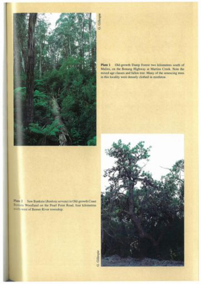
Plate 2 Saw Banksia (Banksia sermta) in Old-growth CoastBanksia Woodland on the Pearl Point Road, four kilometressouth-west ofBemm River township.
Plate 1 Old-growth Damp Forest two kilometres south ofMalins, on the Bonang Highway at Martins Creek. Note themixed age classes and fallen tree. Many of the senescing treesin this locality were densely clothed in mistletoe.

Plate 4 Late mature (Jacobs 1955) senescing (in the senseused in this study) Silvertop (Eucalyptus sieberi) in LowlandForest on the Towser Ridge Road, east of Murrungowar. Thisarea of old-growth Lowland Forest was the site for Incoll'sdendrochronology work.
Plate 3 This overmature (Jacobs 1955) senescing (in thesense used in this study) Mountain Gum (Eucalyptusdalrympleana) shows classic crown decline, bayonets, hollowsand burls. This tree grows in Montane Dry Woodland at theDelegate River crossing on the Bendoc-Bonang Road.

Plate 5 Old-growth Shrubby Dry Forest on the River Road,one kilometre north-east of the junction between the Tamboand Timbarra Rivers. This non-Jacobs forest has Red Ironbark(Eucalyptus tricarpa) which is senescing with a non-Jacobs mor-phology.
Plate 6 Old-growth Coast Banksia Woodland on the PearlPoint Road, four kilometres south-west of Bemm River town-ship. This non-Jacobs forest has salt-pruned GippslandStringybark (Eucalyptus sp.aff. globoidea East Gippsland)which show Jacobs senescing morphology.
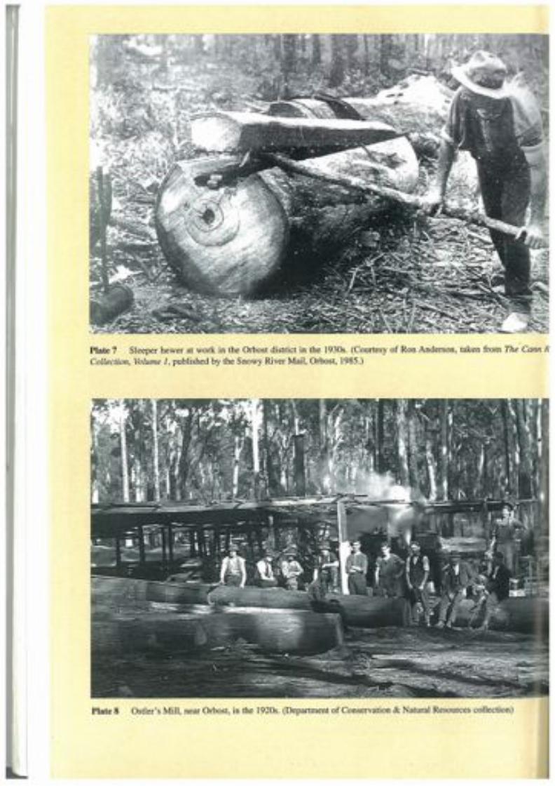
Plate 8 Ostler's Mill, near Orbost, in the 1920s. (Department of Conservation & Natural Resources collection)
· -Plate 7 Sleeper hewer at work in the Orbost district in the 1930s. (Courtesy of Ron Anderson, taken from The Cann RCollection, Volume 1, published by the Snowy River Mail, Orbost, 1985.)

REFERENCES
Ashton, D. H. (1976). The development of even-aged stands of Eucalyptus regnansF. Muell. in central Victoria. Aust. J. Bot. 24: 397-414.
Ashton, D. H. (1986). Ecology of bryophytic communities in mature Eucalyptusregnans F. Muell forest at Wallaby Creek, Victoria. Aust. J. Bot. 34:7-29.
Australian Biological Research Group (1985). The impacts of timber production andharvesting on native flora and fauna. Report of the Board of Inquiry into theTimber Industry in Victoria, Vol. 2. VGPO, Melbourne.
Australian Conservation Foundation (1991). Submission 322 to the ResourceAssessment Commission in Resource Assessment Commission (1992) Forest andTimber Inquiry Final Report.
AHC (1990). Forests and the National Estate Part 3. The National Estate value offorests: a submission to the Resource Assessment Commission inquiry intoAustralian forest and timber resources, April 1990. Australian HeritageCommission.
Australian Mining Standard (1894-97).Banks, J.C.G. (1982). The use of dendrochronology in the interpretation of the SnowGum forest. PhD. Thesis. Australian National University, Canberra.
Banks, J.e.G. (1990). The fire history for two forest types in Glenbog State Forest,New South Wales. Report to the Joint Scientific Committee on the South-EastForests. Australian National University, Canberra.
Banks, J.C.G. (1992). Bungywarr Road dendronchronology study: tree ages inregrowth, mature and senescent Eucalyptus sieberi (L. Johnson) trees, Cobonblock, Cann River District, East Gippsland Forest Management Area, Victoria(unpubl.).
Barnett, J. (1987). The effects of alpine grazing on conservation values: the researchbehind the debate. Victorian National Parks Association, Melbourne.
Barnett, J., Baker R. and Holland, V. (1987). Standing up for your local environment:an action guide. Public Town and Country Planning Association and ConservationCouncil of Victoria.
Baur, G. N. (1965). Forest types in New South Wales. Research Note 17, ForestryCommission of New South Wales.
Beams, S. D. and Hough, D. J. (1979a). The relationship between soil characteristicsand the occurrence of dieback in East Gippsland Report 3. Forests Commission ofVictoria (unpubl.).
Beams, S. D. and Hough, D. J. (1979b). The geology of the Cann River ForestsDistrict. Forests Commission of Victoria (unpubl.).
Beruldson, G. R. (1980). A field guide to Australian birds' nests and eggs. Rigby,Melbourne.
Billis, R. V. and Kenyon, A. S. (1974). Pastoral pioneers of Port Phillip. 2nd edn,Stockland Press, Melbourne.
93
A STUDY OF THE OLD-GROWTH FORESTS OF EAST GIPPSLAND
Braithwaite, L. W., Turner, J. and Kelly, J. (1984). Studies on the arboreal marsupialfauna of eucalypt forests being harvested for woodpulp at Eden, NSW. III.Relationships between faunal densities, eucalypt occurrence and foliage nutrients,and soil parent materials. Aust. Wildlife. Res. 11: 11-48.
Braithwaite, R. W. and Gullan, P. K. (1978). Habitat selection by small mammals in aVictorian heathland. Aust. J. Ecol. 3:109-27.
Bramwell, M. D., Downe, J. M., Hines, H. B., Kemp, J. E., Maser, T. M., O'Neill, G. C.and Trumball-Ward, A V. (in prep.). Flora and fauna of Yeerung Forest Block,including Sydenham Inlet - Cape Conran Coastal Park, East Gippsland, Victoria.Ecological Survey Report No. 43. Department of Conservation & NaturalResources, Victoria.
Brough Smyth, R. (1869). The goldfields and mineral districts of Victoria. Facsimileedition 1979-80. Melbourne University Press, Carlton.
Brown, A G. (1901) Digest of the Land Acts. VGPO, Melbourne.Brown, G. W. and Nelson, J. L. (1992). Habitat utilisation by heliothermic reptiles ofdifferent successional stages of Eucalyptus regnans (Mountain Ash) forest in theCentral Highlands, Victoria SSP Report No. 17. Department of Conservation &Natural Resources, Victoria.
Brown, G. W., Carr, K. A, Cherry, K. A, Craig, S. A, Horrocks, G. F. B., Menkhorst,K. A, Opie, A M. and Triggs, B. E. (1986). Flora and fauna of the Quadrat ForestBlock, East Gippsland, Victoria. Ecological Survey Report No.6. Department ofConservation, Forests & Lands, Victoria.
Brown, G. W., Horrocks, G. F. B., Lunt, I. D., Meggs, R. A and Sandifor, E. M.(1987). Flora and fauna of the Noorinbee Forest Block, East Gippsland, Victoria.Ecological Survey Report No. 18. Department of Conservation, Forests & Lands,Victoria.
Buntine, D. G. (1974). Orbost Shire forest land use report. Forests Commission ofVictoria, File No. 711530, (unpubl.).
Burbidge, N. T. (1960). Phytogeography of the Australian region. Aust. J. Bot. 8:75-211.
Butler, G. and Associates (1985). East Gippsland review: European history for theLand Conservation Council. Land Conservation Council, Melbourne.
Cabena, c., McRae, H. and Bladin, E. (1989) The lands manual: a finding guide toVictorian lands records 1836-1983. Royal Historical Society of Victoria.
Cameron, D. G. (1979). Ecological studies of the vegetation of Drummer, Reedy,Kaye and Cooaggalah management blocks, Cann River Forest District, EastGippsland. Forests Commission, Victoria.
Cameron D. G. (1991). Rainforest definition in Victoria. A discussion paper(prepared for the Rainforest Project Team). Flora Branch, Flora and FaunaDivision. Department of Conservation & Environment, (unpubl.).
Cameron, D. G. (1992). A portrait of Victoria's rainforests: distribution, diversity anddefinition. In: Victoria's rainforests: perspectives on definition, classification andmanagement. Gell, P. and Mercer, D. (eds) Monash Publications in GeographyNo.4!. Monash University, Melbourne.
Carlson, C. A., Oglesby, R. T. and McCann, J. A (1972). River ecology and man:proceedings of an international symposium on river ecology and the impact ofman. 1971 University of Massachusetts. Academic Press, USA
Carr, G. W., Horrocks, G. F. B., Cherry, K. A, Opie, A M., Triggs, B. E. and Schulz,M. (1984). Flora and fauna of the Coast Range Forest Block, East Gippsland,Victoria. Ecol. Surv. Rep. No.4. Department of Conservation, Forests & Lands,Victoria.
94

REFERENCES
Carr, S. G. M. and Turner, J. S. (1959). Ecology of the Bogong High Plains. CSIROAustralia.
Carron, L. T. (1985). A history of forestry in Australia. AND Press, Rushcutters Bay,NSW.
Carver, M. (n.d.) Forestry in Victoria 1838-1919. Five volumes, MS.Catling P. (1991). Ecological effects of prescribed burning practises on the mammalsof southeastern Australia. In: Conservation of Australia's forest fauna D. Lunney(ed.) Chapter 30.
Catling, P. C., (1986). Rattus lutreolus, coloniser of heathland after fire in the absenceof Pseudomys species. Aust. Wildl. Res. 13:127-39.
Catling, P. C., (1991). Ecological effects of prescribed burning practices on themammals of south-eastern Australia. In: Conservation of Australia's forest fauna.Lunney D. (ed.) Royal Zoological Society of New South Wales pp: 353-63.
CFL (1990) Fire Protection Plan, Orbost Region. Department of Conservation, Forests& Lands (unpubl.).
Cherry, K. A, Brown, G. W., Carr, G. W., Horrocks, G. F. B., Opie, A M. and Triggs,B. E. (1986). Flora and fauna of the Buldah Forest Block, East Gippsland,Victoria. Ecological Survey Report No.7. Department of Conservation, Forests &Lands, Victoria.
Chesterfield, E. A, Henry, S. R., Hurley, V. A. and Schulz, M. and Pyrke, A F.(1988). Flora and fauna of the Brodribb Forest Block, East Gippsland, Victoria.Ecological Survey Report No. 19, Department of Conservation, Forests & Lands,Victoria.
Chesterfield, E. A, MacFarlane, M. A, Allen, D., Hutchinson, M. N., Triggs, B. andBarley, R. H. (1983). Flora and fauna of the Rodger Forest Block East Gippsland,Victoria Ecological Survey Report No.!. Department of Conservation, Forests &Lands, Victoria.
Christenson, P. E. and Kimber, P. (1975). Effect of prescribed burning on the floraand fauna of south-west Australian forests. Proc. Ecol. Soc. Aust. 9:85-106.
Christenson, P. E. and Maisey K. (1987). The use of fire as a management tool infauna conservation reserves. In: Nature conservation: the role of remnants ofnative vegetation. Saunders, D. A., Arnold, G. W., Burbidge A A. and Hopkins AJ. M. (eds). Surry Beatty & Sons. Sydney. pp. 323-29.
Claridge, A., McNee, Tanton, M. and Davey, S. (1991). Ecology of bandicoots inundisturbed forests adjacent to recently felled logging coupes: a case study fromthe Eden Woodchip Agreement area. In: Conservation of Australia's forest faunaD. Lunney. (ed.) Chapter 28.
Clark, J. and Blakers, M. (1989). Forest conservation and wood supply - no need forconflict. Research paper No.7. Faculty of Environmental Design andConstruction, RMIT, Melbourne.
CNR (undated). Atlas of Victorian Wildlife. Wildlife Branch, Department ofConservation & Natural Resources, Victoria.
CNR (1993). GIS layer descriptions. Department of Conservation & NaturalResources, Victoria (unpubl.).
CNR (in prep.) Census of Victorian plant communities, Department of Conservation& Natural Resources, Victoria.
Commonwealth of Australia. (1991). Report of the Ecologically SustainableDevelopment Working Group - forest use. AGPS, Canberra.
Commonwealth of Australia. (1992). National forest policy statement: a new focus forAusatralia's forests. AGPS, Canberra.
95
A STUDY OF THE OLD-GROWTH FORESTS OF EAST GIPPSLAND
Cornaby, B. W. and Waide, J. B. (1973). Nitrogen fixation in decaying chestnut logs.Plant and Soil 39: 445-48.
Cornish, P. M. and Binns, D. (1987). Stream water quality following logging andwildfire in a dry sclerophyll forest in southeastern Australia. For. Ecol. Manag.22:1-28.
Costin, A. B. (1958). The grazing factor and the maintenance of catchment values inthe Australian alps. CSIRO, Melbourne.
Daley, C. (1960) The story of Gippsland. Whitcombe & Tombs, Melbourne.DCE (1990). Report on the progress of the Silvicultural Systems Project July 1986-June 1989. Department of Conservation & Environment.
Department of Agriculture (1985). Farming in East Gippsland - Past, Present andFuture. Proceedings of Seminar, Bairnsdale. Department of Agriculture, Victoria.
Dickman, C. (1991). Use of trees of ground-dwelling mammals: implications formanagement. In: Conservation of Australia's forest fauna D. Lunney (ed.) Ch. 12.
Dingle, T. (1984). Settling. Fairfax, Syme & Weld, McMahons Point, NSW.Doeg, T. J. (1990). The effects of forestry practises on fish, aquatic macro-invertebrates and water quality: a bibliography. SSP Technical Report No.3.Department of Conservation, Forests & Lands, Victoria.
Doeg, T. J; and Koehn, J. D. (1990). A review of Australian studies on the effects offorestry practices on aquatic values. SSP Technical Report No.5. Department ofConservation & Environment, Victoria.
Doeg, T. J. and Milledge, G. A. (1991). Effect of experimentally increasingconcentrations of suspended sediment on macro invertebrate drift. Aust. J. Mar.Freshwater Res. 42: 519-26.
Drake, F. R. (1969). Agriculture in East Gippsland Proceedings of the Royal Societyof Victoria. 82, 1. East Gippsland Symposium.
Duncan, S. and Peel, W. D. (1989) Significant biological values of National Estate inEast Gippsland (unpubl.).
Duncan, S., Peel, W. D. and Rich, C. J. (in prep). Flora and fauna of the Misery ForestBlock, East Gippsland, Victoria. Ecological Survey Report 32. Department ofConservation & Natural Resources, Victoria.
Dunn, E. J. (1907). The Gippsland Boulder Mine near Club Terrace, MinesDepartment of Victoria, unpublished report 856.
Dunn, E. J. (1907). The Glen Shiel Silver Lode, Gelantipy East, Eastern Gippsland.Records of the Geological Survey 2 (1).
Dunn, E. J. (1909). Reefs at Bendoc and Bonang Records of the Geological Survey 3.Dyne, G. R. (ed.) (1991). Attributes of old-growth forest in Australia: proceedings ofa workshop sponsored by the National Forest Inventory, 6-7 May 1991. Bureauof Rural Resources, Department of Primary Industries and Energy.
Early, G., (1990). Forests and the National Estate Part 3: The National Estate value offorests. Australian Heritage Commission.
East Gippsland Regional Planning Committee (1980) Sites and features of historicalsignificance in the East Gippsland Region. Melbourne.
Emison, W. B. Beardsell, C. M., Norman, F. I. and Loyn, R. H. (1987). Atlas ofVictorian birds. Department of Conservation, Forests & Lands and RAOU,Melbourne.
Featherston, G. R. (1985). Harvesting history of a coastal forest area in EastGippsland in relation to eucalypt species composition. State Forests and LandsService, Research Branch Report No. 290, Department of Conservation, Forests &Lands, Victoria.
96

REFERENCES
Flett, J.(1970). The History of Gold Discovery in Victoria. Poppet Head Press, GlenWaverley, Victoria.
Flora Information System, Flora Section, Department of Conservation & NaturalResources. Arthur Rylah Institute for Environmental Research, Victoria.
Foley, J. C. (1947). A study of meteorological conditions associated with bush andgrass fires and fire protection strategy in Australia. Bureau of Meteorology,Bulletin No. 38. Commonwealth of Australia.
Forbes, S. J., Gullan, P. K. and Walsh, N. G. (1981). Sites of botanical significance inEast Gippsland. Environmental Studies Series No. 322, Envir. Studies Div.,Ministry for Conservation, Victoria.
Foreshaw, J. M. (1969). Australian parrots. Lansdowne Press, Melbourne.Fox, A., (1978). The '72 Fire of Nadgee Nature Reserve. Parks and Wildlife 2: 5-24.Franklin, J. F., Cromack, K., Denison, W., McKee, A, Maser, c., Sedell, J., Swanson, F.,and Juday, G., (1981). Ecological characteristics of old-growth Douglas-Firforests. General Technical Report PNW-118. US Department of Agriculture.
Franklin, J. F. and Forman, R. T. (1987). Creating landscape patterns by forestcutting; ecological consequences and principles. Landscape Ecology 1 (1): 5-18.
Frawley, K. J. (1990). Historical survey of Australian logging technology and forestcutting practices. Department of Geography and Oceanography, UniversityCollege, Australian Defence Force Academy, Australian Capital Territory.
Friend, G. R., (1979). The response of small mammals to clearing and burning ofeucalypt forests in south-eastern Australia. Aust. Wildl. Res. 6:151-63.
Frood, D. (in prep). The vegetation of Victorian wetlands. Department ofConservation & Natural Resources.
Gell, P. A., and Stuart, 1. M. (1989). Human settlement history and environmentalimpact. the Delegate River Catchment, East Gippsland, Victoria. MonashPublications in Geography no. 36, Monash University, Melbourne.
Geological Survey of Victoria (1976a). Mallacoota map sheet. Geological Survey ofVictoria. Scale 1:250000. Department of Mines, New South Wales.
Geological Survey of Victoria (1976b). Tallangatta map sheet. Geological Survey ofVictoria. Scale 1:250000. Geological Survey of Victoria.
Geological Survey of Victoria (1977). Bairnsdale map sheet. Geological Survey ofVictoria. Scale 1:250 000. Geological Survey of Victoria.
Gilbee, A., and Goodson, P. N. (1992). Mapping tree cover in Victoria usingThematic Mapper digital data and a geographic information system. Proc. of 6thAustralasian Remote Sensing Conference, Wellington, New Zealand.
Gill, A M. (1981). Adaptive responses of Australian vascular plant species to fires. In:Fire and the Australian Biota Gill, A. M. et at. (eds.) Australian Academy ofScience, Canberra: 243-72.
Gillespie, G. R., Humphries, R, Horrocks, G. F. B., Lobert, B. O. and McLaughlin, J.(1992). Flora and fauna of the Stony Peak and Genoa Forest Blocks, EastGippsland, Victoria. Ecological Survey Report No. 33. Department ofConservation & Environment, Victoria.
Gillespie, G. R., Henry, S. R, Mueck, S. G., Scotts, D. and Westaway, J. (1990). Floraand fauna of the Pheasant Creek and Upper Buenba Forest Blocks, Alpine Area,Victoria. Ecological Survey Report No. 29. Department of Conservation &Environment, Victoria.
Government of Victoria (1987). Protecting the environment, a conservation strategyfor Victoria. VGPO.
Griffin, G. (1962). A utilisation plan for the development of the sawmilling industryon the Errinundra Plateau. Dipl. of Forestry thesis, Creswick School of Forestry.
97

A STUDY OF THE OLD-GROWTH FORESTS OF EAST GIPPSLAND
Griffiths, R. C. and Muir, A. M. (1991). Comparisons between the f.loristic.compositions of some regrowth and mature forests in East Gippsland.Management of eucalypt regrowth in East Gippsland Technical Report No. 17.Department of Conservation & Environment, Victoria.
Gruen, F. H., Leslie, A. and Smith, A. (1989). Inquiry into the proposed trial of theValue Adding Utilisation System, Central and East Gippsland Forest ManagementAreas under the Environment Effects Act. Panel Report.
Gullan, P. K. (1978). Vegetation of the Royal Botanic Gardens Annexe atCranbourne, Victoria. Proc. Roy. Soc. Vic. 70: 225--40.
Hamlyn, L. (1985). The legacies of agricultural development in East Gippsland. In:Farming in East Gippsland - Past, Present and Future. Proceedings of Seminar,Bairnsdale.
Hancock, W. K. (1972). Discovering Monaro: a study of man's impact on hisenvironment. Cambridge University Press, Melbourne. .
Harris, L. D. (1984). The fragmented forest: island biogeography theory and thepreservation of biotic diversity. The University of Chicago Press. Chicago.
Henry, S. R and Craig, S. A. (1984). Diet, ranging behaviour and social organisationof the Yellow-bellied Glider (Petaurus australis Shaw) in Victoria. pp 331--41. In:Possums and Gliders Smith, A. P. and 1. D. Hume 1.D. (eds). Surrey Beatty &Sons, Chipping Norton, NSW.
Henry, S. R, and Cherry, K. A., Hurley, V. A., Opie, A. M. and Schulz, M. (1988).Flora and fauna of the Tennyson Forest Block, East Gippsland, Victoria.Ecological Survey Report No. 21, Department of Conservation, Forests & Lands,Victoria.
Horrocks, G. F. B., Cherry, K. A., Hurley, V. A., Kevin, P. M., Norris, K. c., Opie, A.M. and Schulz, M. (1987). Flora and fauna of the Lockup Forest Block, EastGippsland, Victoria. Ecological Survey Report No. 16, Department ofConservation, Forests & Lands, Victoria.
Horrocks, G. F. B., Opie, A. M., Carr, G. W., Cherry, K. A., Browns, G. W., Craig, S. A.and Triggs, B. E. (1984). Flora and Fauna of the Ellery Forest Block, EastGippsland, Victoria. Ecological Survey Report No.3, Department of Conservation,Forests & Lands, Victoria.
How, R A., (1972). The ecology and management of Trichosurus spp. populations innorthern New South Wales. Ph. D. Thesis University of New England, Armidale,NSW.
Humphries, R. K., and Earl, G. E., Gillespie, G. R, Horrocks, G. F. B. and Lobert,B. O. (1991). Flora and fauna of the Stony Peak and Genoa Forest Blocks, EastGippsland, Victoria. Ecological Survey Report No. 33. Department ofConservation, Forests & Lands, Victoria.
Incoll, F. S. (1940). The classification of the forests of East Gippsland on ecologicallines and a brief discussion on two important aspects of future management. Vic.For., 2: 7-18.
Incoll, W. D. (1974). A tree and stand growth model for Eucalyptus sieberi F. Muell.M. Science (Forestry) Thesis, University of Melbourne.
Inions, G., Tanton, M. T. and Davey, S. M. (1989). The effect of fire on theavailability of hollows in trees used by the Common Brushtail Possum, Trichosorusvulpecula Kerr 1792, and the Ringtail Possum, Pseudocheirus peregrinusBoddaerts 1785. Aust. Wildlife Res. 16: 449-58.
Institute of Foresters (1991). IFA policy statement on old growth forests andwoodlands. Doc. Ref: 81712.
98
REFERENCES
Jaccard, P. (1908). Nouvelles recherches sur la distribution florale. Bull. Soc. Vaud.Sci. Nat. 44:223-70.
Jacobs, M. R., (1955). Growth habits of the eucalypts. Forestry and Timber Bureau.Jenkins, B. A. and Recher, H. F. (1990). Conservation in the eucalypt forests of theEden region in south-east New South Wales. Department of EcosystemManagement, University of New England, Armidale, NSW.
Kavenagh, R. P. and Lambert, M. J. (1990). Food selection by the Greater Glider,Petauroides volans: is foliar nitrogen a determinant for habitat quality. Aust.Wildlife Res. 17: 285-99.
Kenny, J. P. L. (1917). Manganese deposits at Jackson's Crossing. Snowy RiverRecords of the Geological Survey. 4: 4.
Kenny, J. P. L. (1937). Club Terrace gold-mining syndicate, Mining and GeologicalJournal 1:1.
Kestel Research (1989). National Estate survey of eucalyptus old growth forests: areport to the Australian Heritage Commission.
Kimber, P., (1974). Some effects of prescribed burning on Jarrah forest birds. Proc.third fire ecology symposium. Monash University, Melbourne, Victoria 49-59.
Kirkpatrick, J. (1990). Scientific critique of the Joint Scientific Committee's Report:The biological conservation of the south-east forests. Unpublished report preparedfor the Australian Conservation Foundation.
Koehn, J. D. and O'Connor, W. G. (1990b). Threats to Victorian native freshwaterfish. Victorian Naturalist 107 (1):
Koehn, J. D. and O'Connor, W. G., (1990a). Biological information for themanagement of native freshwater fish in Victoria. Freshwater Fish ManagementBranch. Department of Conservation & Environment, Victoria.
LCC (1974). East Gippsland study area report. Land Conservation Council, Victoria.LCC (1977). Alpine study area report. Land Conservation Council, Victoria.LeC (1982). Gippsland Lakes hinterland study area report. Land ConservationCouncil, Victoria.
LCC (1991). Melbourne Area (District 2) review and descriptive report. LandConservation Council, Victoria.
Legg, S. (1977). The location of the log-sawmilling industry in Victoria 1939-77,MA Preliminary Thesis, Department of Geography, Monash University.
Lindenmayer, D. (1992). The ecological and habitat requirements of aborealmarsuipials in the montane ash forest of the Central Highlands of Victoria: asummary of studies. VSP Internal Report No.6. Department of Conservation &Environment, Victoria (unpubl.).
Lindenmayer, D. B. (1992a). The presence and abundance of arboreal marsupials inretained linear strips (wildlife corridors) in timber production areas within themontane ash forests of the Central Highlands of Victoria. VSP Internal Report No.11. Department of Conservation & Environment, Victoria (unpubl.).
Lindenmayer, D. B., Tanton, M. T. and Norton, T. W. (1990a). Leadbeater's Possum:a test case for integrated forestry. Search 21(5): 156-59.
Lindenmayer, D. B., Cunningham, R. B., Tanton, M. J. Smith, A. P. and Nix, H. A.(1990b). The conservation of arboreal marsupials in the montane ash forests ofthe Central Highlands of Victoria, south-east Australia: 1. Factors influencing theoccupancy of trees with hollows. Biological Conservation 54.
Lindemayer, D. B., Cunningham, R. B., Tanton, M. T. and Smith, A. P. (1990c). Theconservation of aboreal marsupials in the montane ash forests of the CentralHighlands of Victoria, south-east Australia. II. The loss of trees with hollows andits implications for the conservation of Leadbeater's Possum Gymnobelideus
99

A STUDY OF THE OLD-GROWTH FORESTS OF EAST GIPPSLAND
leadbeateri McCoy (Marsupiallia: Petauridae) Biological Conservation 54: 133-45.
Lindenmayer, D. B., Cunningham, R. B., Tanton, M. T., Smith, A. P. and Nix, H. A(1990d). The habitat requirements of the Mountain Brushtail Possum and theGreater Glider in the montane ash-type eucalypt forests of the Central Highlandsof Victoria. Australian Wildlife Research 17: 467-78.
Lobert, B. 0., Gillespie, G. R., Peacock, R. J. and Robinson, D. (1991). Flora andfauna of the Goolongook Forest Block, East Gippsland, Victoria. EcologicalSurvey Report No. 35. Department of Conservation, Forests & Lands, Victoria.
Loyn, R. H. (1980). Bird populations in a mixed eucalypt forest used for productionof wood in Gippsland, Victoria Emu 80: 145-56.
Loyn, R. H., (1987). Effects of patch area and habitat on bird abundances, speciesnumbers and tree health in fragmented Victorian forests. In: Nature conservation:the role of remnants of native vegetation. Saunders, D. A, Arnold, G. W. Burbidge,A A and Hopkins A. Z. M. (eds). Surrey Beatty & Sons, Sydney. pp. 65-77.
Loyn, R. H., Fagg, P. c., Piggin, 1. E., Morton, A. G. and Tolhurst, K. G. (1983).Changes in the composition of understorey vegetation after harvesting eucalyptsfor sawlogs and pulpwood in East Gippsland. Aust. J. Ecol. 8:43-53.
Loyn, R. H., MacFarlane, M. A, Chesterfield, E. A and Harris, J. A. (1980). Forestutilisation and the flora and fauna in Boola Boola State Forest in south-easternVictoria. Bull. No. 28, Forests Commission Victoria.
Loyn, R. H. (1985). Ecology, distribution and density of birds in Victorian forests.In: Birds of eucalypt forests and woodlands; ecology, conservation, management.Keast, A., Recher, H. E, Ford, H. and Saunders, D. (eds) Surrey Beatty & Sons,Sydney. pp 33-46
Loyn, R. H. (1985). Strategies for conserving wildlife in commercial productioneucalypt forest. Aust. For. 48:95-101.
Loyn, R. H., Cameron, D. G., Traill, B. J., Sloan, J. F., Malone, B. S., Schulz, M., Earl,G. E. and Triggs, B. E. (1992). Flora and fauna of the Cooaggalah Forest Block,East Gippsland, Victoria. Ecological Survey Report No. 20, Department ofConservation & Environment, Victoria.
Lugg, A, Marsh, P., Bartlett, A and King, F. (comp.) (1993). Statement of Resources,Uses and Values for the East Gippsland Forest Management Area. Department ofConservation & Natural Resources, Victoria.
Lunney, D. (ed.) (1991). Conservation of Australia's forest fauna. Surrey Beatty &Sons Pty Ltd., Sydney.
Lunney, D., Barker, J., Priddel, D. and O'Connell, M. (1988). Roost selection byGould's Long-eared Bat, Nyctophylius gouldi Times (Chiroptera:Vespertilionidae), in logged forest on the south coast in New South Wales. Aust.Wildl. Res. 15: 375-84.
Lunney, D. and Leary, T. (1988). The impact on native mammals of land-usechanges and exotic species in the Bega district, New South Wales, since settlement.Aust. J. Ecol. 13: 67-92.
Lunney, D. and O'Connell, M. (1988). Habitat selection by the Swamp Wallaby,Wallabia bicolor and Red-necked Wallaby Macropus rufogriseus, and theCommon Wombat Vombatus ursinus, in logged and burnt forest near Bega, NewSouth Wales. Aust. Wildl. Res. 15: 695-706.
Lunney, D., (1987). Effects of logging, fire and drought on possums and gliders inthe coastal forests near Bega, NSW Aust. Wildl. Res. 14:263-74.
Lunney, D., Cullis, B. and Eby, P., (1987). Effects of logging and fire on smallmammals in Mumbulla State Forest, near Bega, NSW. Aust. Wildl. Res. 14:163-81.
100

REFERENCES
MacFarlane, M. A., Schulz, M., Parkes, D. M., Traill, B. J., and Triggs, B. E. (1987).Flora and Fauna of the Buckland Forest Block, East Gippsland, Victoria. Ecol.Surv. Rep. No.8. Department of Conservation, Forests & Lands, Victoria.
Mackay, S. M. and Cornish, P. M. (1982). 'Effects of wildfire and logging on thehydrology of small catchments near Eden, NSW.' In: The First NationalSymposium on Forest Hydrology. E. M. O'Laughlin and L. J. Bren (eds)pp 111-17. Inst. Eng. Aust., Canberra.
MacKowski, G. M. (1984). The ontogeny of hollows in Blackbutt (Eucalyptuspilularis) and its relevance to the management of forests for possums, gliders andtimber. In: Possums and Gliders. A. P Smith and 1. D. Hume (eds). pp 553-67.Surrey Beatty & Sons, Sydney.
Marks, G. C. and Smith, 1. W. (1991). The Cinnamon Fungus in Victorian Forests.Lands and Forests Bulletin No. 31, Department of Conservation & Environment.
Martin, T. E. and Roper, J. J (1988). Nest predation and nest site selection in a westernpopulation of hermit thrush. Condor 90: 51-57.
Maser, C. and Trappe, J. M. (1984). The fallen tree: a source of diversity. In: 'Newforests to a changing world: Proceedings, Society of American Foresters NationalConvention, October 16-20; Portland OR', Bethesda. pp 335-39.
Maser, c., Cline, S. P., Cromack, R. Jr., Trappe, J. M. and Hansen, E. (1988). What weknow about large trees that fall to the forest floor. In: From the Forest to the Sea:A story of Fallen Trees. C. Maser, R. F. Tarrant, J. M. Trappe and J. F. Franklin.(eds) U.S. For. Servo Gen. Tech. Rep. PNW. pp 153-229.
Maser, C., Tarrant, R. F., Trappe, J. M. and Franklin, J. F. (eds) (1988). From theForests to the Sea: A story of Fallen Trees U.S.D.A. Forest Service GeneralTechnical Report PNW-GTR-229, Portland, Oregon.
McCubbin, C. (1985). Australian Butterflies. Savvas Publishing.McDermott, G. E. and Pilgrim, D. M. (1982). Design flood estimation for smallcatchments in New South Wales. AGPS, Canberra.
McDonald, R. C., Isbell, R. F., Speight, J. G., Walker, J. and Hopkins, M. S. (1990).Australian Soil and Land Survey Field Handbook. 2nd edn. Inkata Press.
McKinty, J. A., (1969). 'Forestry in East Gippsland' Proceedings of the RoyalSociety of Victoria. 82. 1. East Gippsland Symposium.
McRae, C. F. (1976). Land to Pasture: Environment, Land Use and PrimaryProduction in East Gippsland. Bairnsdale.
Meagher, D. A. (1991). The Macmillan dictionary of the Australian environment.Macmillan, South Melbourne.
Meredith, C, W, Gilmore, A. M. and Isles, A. C., (1984). The Ground Parrot(Pezoporus wallicus Kerr) in south-easterp Australia. A fire adapted species? Aust.J. Eco!. 9: 367-80.
Milledge, D., Palmer, C. and Nelson, J. (1991). 'Barometers of change: Thedistribution of large owls and gliders in Mountain Ash forests of the VictorianCentral Highlands and their potential as management indicators.' In: Conservationof Australia's Forest Fauna. P. Lunney (ed.) Chapter 5.
Moulds, F. R. (1991). The dynamic forest: a history of forestry and forest industriesin Victoria. Lynedoch Publications, Richmond, Victoria.
Mueck, S. (1990). Floristic analyses of the plant communities of East Gippsland,Department of Conservation & Environment (unpubl.).
Mueck, S. G. and Peacock, R. J. (1992). Impacts of intensive timber harvesting on theforests of East Gippsland, Victoria, VSP Technical Report No. 15. Flora and FaunaBranch, Department of Conservation & Natural Resources, Victoria.
101

A STUDY OF THE OLD-GROWTH FORESTS OF EAST GIPPSLAND
Newsome, A. E. and Catling, P. c., (1983). 'Animal demography in relation to fireand shortage of food: some indicative models'. In: Mediterranean-typeecosystems. The role of nutrients. F. J. Kruger, D. T. Mitchell and J. U. M. Jarvis.(eds) Springerverlag: New York. pp. 490-508.
Newsome, A. E. and Catling, P. C. (1979). 'Habitat preferences of mammalsinhabiting Heathlands of warm temperate coastal, Montane and Alpine Regions ofsouth eastern Australia.' In: Heathlands and related shrublands of the world: adescriptive studies. R L. Specht (ed.) Elsevier publishing company Amsterdam,The Netherlands. pp 301-16.
Nyberg, J. B., Harested, A. S. and Blunnell, F. L. (1987). 'Old Growth' by design:Managing young forests for old growth wildlife. Trans. 52nd North Am. Wildlifeand Nat. Resources Conference 70-81.
O'Bryan, D. (1983). Pioneering East Gippsland. The author, Melbourne.Odum, E. P. (1971). Fundamentals of ecology. 3rd edn. W.B. Saunders Co.Philadelphia.
Opie, A. M., Cherry, K. A., Horrocks, G. F. B., Carr, G. W., Schulz, M. and Triggs, B.(1984). Flora and Fauna of the Yalmy Forest Block, East Gippsland, Victoria.Ecological Survey Report No.2, Department of Conservation, Forests & Lands,Victoria.
Opie, A. M., Gillespie, G. R., Henry, S. R, Lobert, B. O. and Pyrke, A. F. (1990).Flora and Fauna of the Coast Range Forest Block (Southern Part) East Gippsland,Victoria. Ecol. Surv. Rep. No. 24. Department of Conservation & Environment,Victoria.
Ough, K. and Ross, J. (1992). Floristics, fire and clear felling in Wet Forests of theCentral Highlands, Victoria. VSP Technical Report No. 11. Department ofConservation & Environment, Victoria.
Parkes, D., Moorrees, A. and Williams, J. (1984). A floristic vegetation map of EastGippsland (1 :250 000). Department of Conservation, Forests & Lands, Victoria.
Parnaby, H. (1991). 'A sound species taxonomy is crucial to the conservation offorest bats.' In: Conservation of Australia's Forest Fauna. D. Lunney. (ed) SurreyBeatty & Son, Sydney. Chapter 9.
Parsons, R. F. and Cameron, D. G. (1974). Maximum plant species diversity interrestrial communities. Biotropica 6(3):202-3.
Peacock, R, Brown, G. W., Gillespie, G. R., Robinson, D. and Scotts, D. J. (1992).Flora and Fauna of the Sardine Forest Block, East Gippsland, Victoria. EcologicalSurvey Report No. 34. Department of Conservation & Environment, Victoria.
Peacock, R J., Duncan, P. E., Gillespie, G. R. and Lobert, B. O. (in prep.). Flora andFauna of the Goongerah and Bowen Forest Blocks, East Gippsland, Victoria, Ecol.Surv. Rep. 37. Department of Conservation & Natural Resources, Victoria.
Peel, W. D. (1993). Limestone Pomaderris Shrubland: distribution and significance.Department of Conservation & Natural Resources, Victoria (unpubl.).
Peel, V;. D., Duncan, P. E., Gillespie, G. R, Lobert, B. 0., and Westaway, J. (in prep.).Flora and Fauna of the Tabby and Snowy Forest Blocks, East Gippsland, Victoria,Ecol. Surv. Rep. 36, Department of Conservation & Natural Resources, Victoria.
Piercy K. and Woodgate, P. W. (1984). Exploratory study of age of overstorey andunderstorey species, Errinundra Plateau. Forest Inventory Report No. 77, ForestsCommission Victoria (unpubl.).
Pizzey, G. (1983). A field guide to the birds of Australia. Collins, Sydney.Purdie, R W., Delahunt, A., Mednis, A., Miller, J., O'Brien, M., Wicks B., and Williams,J. (1990). Forests and the National Estate Part 4A: Protecting the natural NationalEstate value of forests, Australian Heritage Commission.
102
REFERENCES
Poore, M. E. D. (1955). The use of phytosociological methods in ecologicalinvestigations. II. Practical issues involved in an attempt to apply the Braun-Blanquet System. J. Ecol. 43: 245-69.
Preese, K. and Lesslie, R. (1987). A survey of wilderness quality in Victoria.Department of Conservation, Forests & Lands.
Priestley, S. (1984). The Victorians: making their mark. Fairfax, Syme & Weld,McMahons Point, NSW.
Pulsford, 1. F., Banks, J.C.G and Hodges, 1. (in press). 'Forest Change: The impact ofEuropean land use on the white cypress pine forests of the 'lower' Snowy River inKosciusko National Park, New South Wales.' In: Dargavel, J. and Feary, S. (eds)Australia Always Changing Forests, Proceedings of the second Nationalconference on Australian Forest History, Creswick, Victoria 3-5 Dec. 1992.
Recher, H. F. The conservation management of eucalypt forest birds: resourcerequirements for nesting and foraging, in Lunney, D. (1991). Conservation ofAustralia's forest fauna. Royal Zoological Society of New South Wales. pp 25-34.
Recher, H. F. and Christensen, P., (1980). Fire and the evolution of the Australianbiota. In: Ecological biogeography of Australia. A. Keast (ed.). Junk, The Hague.
Recher, H. F., (1972). Bird species diversity. A review of the relation between speciesnumber and environment. Proc. Ecol. Soc. Aust. 6: 135-52.
Recher, H. F., Rohan-Jones, W. and Smith, P., (1980). Effects of the Eden Woodchipindustry on terrestrial vertebrates with recommendations for management. ForComm. N. S. W. Res. Note No. 42 Sydney.
Recher, H. F. (1991). The conservation and management of eucalypt forest birds:Resource requirements for nesting and foraging. In: Conservation of Australia'sForest Fauna. D. Lunney. (ed.) Surrey Beatty & Son, Sydney. Chapter 2.
Rees, D. B. (in prep). Land inventory of East Gippsland. A reconnaissance survey.Department of Conservation & Natural Resources, Victoria, Scale 1:100000.
Resource Assessment Commission (1992). Forest and Timber Inquiry final report.Volumes 1, 2A and 2B, Canberra.
Richards, G. (1991). The Conservation of forest bats in Australia: do we really knowthe problems and solutions? In: Conservation of Australia's Forest Fauna. D.Lunney. (ed.) Surrey. Beatty & Son, Sydney. Chapter 7.
Ricklefs, R. E. (1969). An analysis of nesting mortality in birds. Smithson. Contrib.Zool. 9: 1-48.
Roberts, 1., Ashwell, D. and Rourke, D. (1987). Floristic vegetation (Mallee series).Department of Conservation, Forests & Lands, Victoria. (unpubl.).
Roberts, 1. (1992). Various forest vegetation maps for Department of Conservation &Environment (unpubl.).
Roberts, S. H. (1924-68). History of Australian land settlement 1788-1920.Melbourne University Press, Melbourne.
Robinson, R. W. (1990). The vegetation and management of selected limestoneReserves in the Buchan District. Bairnsdale office, Department of Conservation &Environment (unpubl.).
Ross, J. H. (ed.) (1993). A census of the vascular plants of Victoria. Royal BotanicGardens, Melbourne.
Rowan, J. (in press). Land systems of Victoria. Land Protection Division, (Scale1:250000). Department of Conservation & Environment,; Land ConservationCouncil.
Rowley, 1., Russell, E., Brown, R. and Brown, M. (1988). The ecology and breedingbiology of the Red-winged Fairy-wren, Malurus elegans. Emu 88 (3):161-76.
103

A STUDY OF THE OLD-GROWTH FORESTS OF EAST GIPPSLAND
Royal Commission on State Forests and Timber Reserves. (1899-1900). EighthProgress Report - Grazing lands in the Parishes of Wurrin, Wangarabell, Koolaand Derndang: Genoa River Forest, East Gippsland. Victoria.
Schodde, R and Mason, 1. J. (1980). Nocturnal birds of Australia. Landsdowne Press.Melbourne.
Scotts, D. J. and Seebeck, J. H. (1989). Ecology of Potorous longipes (Marsupialia:Potoroidae); and preliminary recommendations for management of its habitat inVictoria. ARI Tech. Rep. 62, Dept of Conservation & Environment, Victoria.
Scotts, D. J. (1991). Old-Growth forests: Their ecological characteristics and value toforest-dependent vertebrate fauna of South-east Australia. In: Conservation ofAustralia's Forest Fauna. D. Lunney. (ed.) Surrey Beatty & Son, Sydney.
Sedell, J. R, Bisson, P. A., Swanson, F. J. and Gregory, S. V. (1988). What we knowabout large trees that fall into streams and rivers. In: From the forest to the sea: astory of fallen trees. C. Maser, R F., Tarrant, J. M. Trappe and J. F. Franklin. (eds)US Forest Service Gen. Tech. Rep. PNW-229, pp 47-81.
Shillinglaw, A.W. (1951). Development of sawmilling in Victoria. (Manuscript).Silvester, W. B., Sollins, P., Verhoeven, T. and Cline, S. P. (1982). Nitrogen fixationand acetylene reduction in decaying conifer boles: effects of incubation time,aeration and moisture content. Can. J. For. Res. 12: 646-52.
Sinclair, E. K. (1991). The spreading tree - A history of APM and AMCOR 1844-1989. Allen & Unwin, North Sydney.
Smith, A. P. and Lindenmayer, D. (1988). Tree hollow requirements of Leadbeater'sPossum and other possums and gliders in timber production ash forests of theVictorian Central Highlands. Aust. Wildlife Res. 15: 347-62.
Smith, P. (1985). Effects of intensive logging on birds in eucalypt forest near Bega,New South Wales. Emu 85: 15-21.
Smith, P. (1985b). Woodchip logging and birds near Bega, New South Wales. pp 259-71 In: Birds of Eucalypt Forests and Woodlands: Ecology, Conservation andManagement, Keast, A., Recher, H. E, Ford, H. and Saunders, D. (eds) SurreyBetty and Son., Sydney.
Sollins, P., Cline, S. P., Verhoeven, T., Sachs, D. and Spycher, G. (1987). Patterns oflog decay in old-growth Douglas fir forests. Can J. For. 17: 1585-95.
Specht, R. L. (1970). Vegetation. In: The Australian Environment. 4th edn.Melbourne University Press, pp.44-67.
Spreadborough, R and Anderson, H. (1983). Victorian Squatters. Red Rooster Press,Ascot Vale.
Stretton, L.E.B. (1946). Report of the Royal Commission to Inquire into ForestGrazing, together with minutes of evidence. Parliamentary Papers 21, Victoria.
Thomas, J. W. (ed.) (1979). Wildlife habitats in managed forest: the Blue Mountainsof Oregon and Washington. USDA Forest Service Agriculture Handbook 553,Washington, DC.
Thomas, J. W., Ruggiero, L. F., Mannan, R. W., Schoen, J. W., and Lancia, R. A.(1988). Management and conservation of old-growth forests in the United States,Wildl. Soc. Bull. 16: 252-62.
Thompson, D. M. (1952). Forests fire prevention and control in the Cann ValleyForest District. Diploma of Forestry thesis, Creswick School of Foresty, Victoria.
Traill, B. (1991). Box-ironbark forests: tree hollows, wildlife and management. In:Conservation of Australia's forest fauna. D. Lunney. (ed.) Surrey Beatty & Son,Sydney. Chapter 11.
Turner, R. J. (1991). Mistletoe in Eucalypt Forest: A Resource for Birds. Aust.Forestry. 54 (3) 226-35.
104

REFERENCES
Tyndale-Biscoe, C. M. and Smith, R F. C. (1969). Studies on the marsupial glider,Schoinabates volans (Kerr) III. Response to habitat destruction J. Animal Eco!.38: 651-59.
Tyndale-Biscoe, C. H. and Calaby, J. H. (1975). Eucalypt forests as refuges forwildlife. Aust. For. 38(2): 117-33.
Tyson, N. (1978). The effects of grazing in the Alpine Study Area. In: Grazing thehigh country-a conservation report. Conservation Council of Victoria.
Usher M. B. (ed.) (1986). Wildlife Conservation Evaluation. (Chapman and Hall,London), cited in Humphries, R, 1990: A review of the criteria on which oldgrowth forest in Victoria may be based (a discussion paper prepared for the 'oldgrowth forest' working group, Department of Conservation & Environment).
Van Rees, H. (1984). Behaviour and diet of free-ranging cattle on the Bogong highPlains, Victoria. Department of Conservation Forests and Lands, Victoria.
Wakefield, N. A. (1970). Bushfire frequency and vegetational charge in South-easternAustralian Forests. Victorian Naturalist. 87 (6) 153-58.
Wakefield, N. A. (1969). Aspects of exploration and settlement of East Gippsland.Proceedings of the Royal Society of Victoria 82 (1) - East GippslandSymposium.
Walker, J., Crapper, P. F. and Penridge, L. K. (1988). The crown-gap ratio (C) andcrown cover: the field study. Aust. J.Ecol. 13: 101-08.
Walsh, N.G., Barley, R.H. and Gullan, P.K. (1983). Alpine vegetation: sites ofbotanical significance in the Victorian Alps, excluding the Bogong High Plains.National Herbarium of Victoria.
Ward, B. K. and McKimm, R J. (1982). A preliminary survey of severe dieback in thecoastal mixed species forests of East Gippsland. For. Tech. Pap. 29: 41-56.
Westaway, J., Henry, S.R, Gillespie, G.R., Lobert, B.O., Scotts, DJ., Mueck, S.G.(1990). Flora and Fauna of the West Errinundra and Delegate Forest Blocks, EastGippsland. Ecological Survey Report No. 31. Department of Conservation &Environment, Victoria.
Whelan, RJ. (1983). Hazard reduction burning and reserve management: a conflict inaims? Proceedings of the second Illawarra Bushfire Conference, Mt Keira August1983. The University of Wollongong. Australia 2-6.
Whitelaw, H.S. (1917). Some silver-lead and other deposits in East Gippsland.Records of the Geological Survey. 4:3.
Wilson, B. (1991). 'Conservation of forest fauna in Victoria.' In: Conservation ofAustralia's Forest Fauna. D. Lunney. (ed.) Surrey Beatty & Son, Sydney. Ch. 25.
PERSONAL COMMUNICATIONSAustin, M. (1993). Vegetation Modeller, CSIRO, Canberra.Cherry K.A. (1993). Senior zoologist, Fauna Section, Arthur Rylah Institute, CNR.Evans, P. (1992). Light Railways Research Society of Australia, Victoria.Frood, D. (1993). Senior botanist, Flora Section, Arthur Rylah Institute, CNR.Gilmore, S. (1992). Wildlife consultant, north-eastern New South Wales.Ingram, D. (1992). Park Ranger, Bendoc, CNRKoehn, J. (1993). Freshwater ecologist, Arthur Rylah Institute, CNR.Mueck, S. (1993). Senior Botanist, Flora Section, Arthur Rylah Institute, CNRSmith, I. (1993). Principal Forest Pathologist, Centre for Forest Tree Technology,CNR.
Twyford, K. (1992). Previously Park Planner, Orbost Office, CNR.
105

Appendix APROJECT BRIEF
WITH SCHEDULE AND BUDGET
PROJECT TITLE:CLASSIFICATION AND ASSESSMENT OF OLD GROWTH FORESTS INEAST GIPPSLANDDATE: JUNE 1991
1 BACKGROUND
Continuing debate about forest issues in East Gippsland often revolves around thequestion of old growth forest. Perceptions of old growth are as varied as they arenumerous. Useful and scientifically defensible debate cannot take place until more isunderstood about the character of old growth forest and in particular, its location,extent, composition and significance.Implementation of management practices to protect, maintain or enhance the
values of old growth forest, requires a greater understanding of the character of oldgrowth forest and importantly, changes in this character over time. The old growthstudy was initiated as one of nine projects approved for funding by theCommonwealth Government to seek prudent and feasible alternatives to logging ofNational Estate forests in the East Gippsland Forest Management Area (EGFMA).Further relevant background is the agreement between DCE and the Australian
Heritage Commission which makes reference to an objective study of the NationalEstate in the EGFMA. The first stage of the study will identify the national estatevalues and report on the extent of representation of those values in both NationalParks and State Forests. The agreement provides for a second stage of the projectwhich initially will be a survey of old growth forests and a survey/review of historic,archaeological and Aboriginal site data. This new information will be integrated withother data in DCE's Geographic Information System as part of a systematic study ofnational estate values.In parallel with this project a submission for a survey of old growth forests has
been accepted for funding (to the extent of $70 000) by the National ForestInventory (Bureau of Rural Resources).It should also be noted that the State Conservation Strategy for Victoria, under the
heading of 'protecting the forests', gives a commitment to locate, map and identifythe age classes of ecologically mature forests. The project outlined below will also bea significant step towards meeting this commitment.
106

APPENDIX A
2 AIM
The primary purpose of the study is to construct an objective and scientificallycredible array of spatially co-ordinated and integrated data describing thecharacteristics and values of the range of age classes in forests of East Gippsland witha major focus on the older age classes.
3 OBJECTIVES
Undertake a field survey, using aerial photographs and satellite imagery and dataobtained from other sources, to determine the nature and extent of older forestson all classes of land in the EGFMA. Gaps in the existing data bases will beidentified as a precursor to this study.
ii Undertake research into, and analysis of, historical data located within lands andforests archival resources.
111 Define a set of age classes of forest that are ecologically significant and willfacilitate modelling of spatial and temporal changes in forest age structure formanagement and research purposes.
IV Assess and map the nature and degree of human-induced disturbances and theirimpact on the environment using quantitative measures such as weed indexes anddendrochronology.
v From this information, erect a digital database and integrate with other data layersin the GIS including topography, logging and fire history, forest type, floristicvegetation, land systems, land tenure and land use.
vi Using overlay analysis techniques, identify and describe the natural and culturalvalues of older forests in the study area.
4 RELATED PROJECTS
The old growth study is linked to other projects, including some of those under theNational Estate Forest Agreement between the Victorian and CommonwealthGovernments. This study will be the first of its kind on old growth forests in Victoria.Consideration will given during the project design phase to the need to ensurecompatibility with future studies on old growth forests elsewhere in the state. The keyrelated projects are:• East Gippsland Forest Management Plan, and specifically the preparation of a
digital data base and Resources Statement.• Expansion of biological surveys (Commonwealth/State Agreement).• Surveys of historical, archaeological and Aboriginal cultural significance
(Commonwealth/State Agreement).• National Forest Inventory establishment of regional databases• Environmental monitoring studies under the VAUS and SSP projects.
5 OTHER CONSIDERATIONS
Project ManagementCo-ordination and oversight of the project is provided by the DCE ReferenceCommittee set up under the Steering Committee for the joint DCE-ARC review of therepresentation of National Estate in Parks and in State Forest of East Gippsland.
107

A STUDY OF THE OLD-GROWTH FORESTS OF EAST GIPPSLAND
A Technical Advisory Committee provides scientific and technical advice on allaspects of the study including the question of definitions. The Advisory Committeeincludes representatives (as either members or observers) from the Natural ResourcesSystems Division, Flora and Fauna Division, Regions, National Parks and Public LandDivision, Forest Products Management Division, Victorian Archaeological Survey andother representatives as required. The Advisory Committee also includes arepresentative of the Australian Heritage Commission (observer status) and theNational Forest Inventory Project Team (observer status). The Advisory Committeeprovides technical guidance for the Project Team.The Project Team comprises a project manager (SCI 4), a team leader (SCI 3), two
scientists (SCI 2 and SCI 1), a technical officer and an historian.
BUDGET, OLD GROWTH FOREST PROJECT
National Estate NFlBudgets 90/91 91/92 91/92
Salaries• Project Manager (SCI 4) 20% 8445• Team Leader (SCI 3) 100% 10 734 38414
Biologist (SCI 2) 100% 33705• Scientist (SCI 1) 100% 24750• Technical Officer (TO II) 100% 8568 29555
Historic Studies (ADM 5) 50% 20000• GIS Analyst 10 000• On Costs LLlPTIWC 11.65% 2248 8901 6809
LSL 2.8% 482 1910Super 2895 12 010Admin 13.57% 2620 10368Wage Case 2.5% 1910 1460
Subtotal 27547 141 513 66724
Vehicle And ExpensesVehicle Hire 722 23300• Travelling Expenses 2603 7800• Accommodation 5000
Subtotal 3325 36100
Materials And EquipmentEquipment 7902
• Map Consumables 313 4300• GIS Work Station (50%) 12000• Map Scanning 10 000
Subtotal 12313 22202
Consultancies 3276
Subtotal 3276Total 43 185 199 815 70000
108

APPENDIX A
TimingRecruitment of the Project Team will be completed as a matter of priority and will befully operational by 1 July 1991. It is proposed that all field work, analysis andmapping will be completed by 30 June 1992.
AttachmentsAttachment 1 BudgetAttachment 2 Work TargetsAttachment 3 Survey MethodologyAttachment 4 References
This considerable additional effort involved a substantial review of the analysisprocedures for old-growth characteristics, checking and extending the primary dataset as new data sources were revealed, devising new GIS analysis procedures, editingthe final manuscript and preparing the final maps. After allowing for publicationcosts it was estimated that an additional $80 000 was spent on the project.
These budgets and work estimates permitted the completion of the report to draftstage. Following comment on the draft the following additional commitments weremade to complete the report to publication stage:• Project Manager (SCI 4) 5 months• Biologist (SCI 2) 5 months• Remote Sensing Scientist (SCI 1) 3 months• GIS analyst (SCI 2) 3 months
109
654OLD GROWTH SURVEY - WORK TARGETSQuarterly Targets 1 2 31 Review key assessment parameters
2 Review existing data sources
3 Consolidate existing data sources onGIS (where appropriate)
4 Prepare map of suitable existinginformation
5 Identify areas for field survey andmapping
6 Design ground survey and mapstratification
7 Undertake API
8 Undertake field sampling for flora,fauna, forest and cultural parameters
9 Undertake dendrochronology studies
10 Data enter to GIS
11 Prepare draft maps for review
12 Undertake supplementary fieldsampling
13 Review 'old growth rating' criteriaand apply to data
14 Produce final maps and report

A STUDY OF THE OLD-GROWTH FORESTS OF EAST GIPPSLAND
SURVEY METHODOLOGY
1 PROCEDURE
Whilst a considerable body of relevant information already exists in various databases, the lack of information on tree and stand age, fire and logging, grazing andfarming history will require extensive field survey in conjunction with documentbased research. The survey procedure will be as follows:
1.1 Review the key parameters required for a comprehensive assessment andclassification of young, mature and old growth forest.
1.2 Undertake primary document based research to determine nature and extentof human induced disturbance.
1.3 Review data sources and existing maps.1.4 Determine those areas where further mapping is required either as up-dating
or new mapping. Review satellite imagery and aerial photography todetermine the optimum approach to further mapping. Prepare preliminarymap of available information.
1.5 Review existing data bases and determine those areas and parameters whichrequire further ground survey.
1.6 Undertake aerial photo interpretation and design the ground survey tocomplement the initial stratification.
1.7 Establish and measure ground sample plots. Parameters recorded above are tobe measured from a common sampling point, wherever possible.
1.8 Dendrochronology studies will be undertaken from exposed stumps on recentlogging coupes and elsewhere where appropriate.
1.9 Undertake primary data analysis by appropriate information systems. Inputresults to the GIS database.
2.0 By applying ground truth to remotely sensed data, prepare data layers for thekey parameters. These maps will be prepared for presentation at a scale of1:100000 (i.e. the standard GIS regional scale) with overview maps at a scaleof 1:250000. The minimum size of map units (or polygons) at this scale willbe about 5 hectares.
2 SPATIAL DATA
The key parameters to be presented as discrete map layers in GIS will be:• stand age/ages• forest type (overstorey species and growth phase)• floristic vegetation• crown cover• stand height (absolute or relative)• weed index• fire type, frequency, time since burn and extent• grazing intensity, duration and extent• clearing from agricultural purposes, period and extent• mining type, intensity and extent• timber harvesting type, intensity, year of origin and extent.
110

APPENDIX A
Additional information for consideration during the final analysis will include:.. soils.. topography (aspect, elevation and drainage).. climate ( temperature and rainfall).. land tenure and land use.. tree size, stand density - diameter distribution.. frequency of stag headed trees (with hollow frequency index).
Note that the study will examine all old growth values, irrespective of land tenure.
3 ANALYSIS AND OUTPUTSA list of criteria that categorises old growth forest will be prepared. It is unlikely thatall of these criteria will be capable of measurement through field surveyor archivalexamination, in the life of this project. The key parameters collected during theproject will be the practical measures of these criteria. Evaluation of these criteria maybe undertaken througlJ a simple 'threshold' approach or by assigning 'levels ofsignificance' within a criterion. For example, one criterion may be that the age of theforest overstorey must be greater than 100 years for it to be considered old growth.Subject to meeting other 'thresholds' / 'levels of significance' in the list of criteria,this forest area can be then classed as one of the categories of old growth forest.Data will also be collected on the size, shape and connectivity of both the existing
and future patches of old growth forest to facilitate any future analysis to determinethe significance of areas of younger age classes. This information will be mostvaluable for planning and management of old growth forests and recognises thedynamic nature of forest ecosystems. The Department's GIS will be used extensivelyfor data analysis and map production.A report of the study with maps will describe and quantify the growth stage,
condition and land-use status of old growth forests in East Gippsland.
4 LIMITATIONS TO THE STUDYAs a first priority the Project Team will review existing data sources. It is recognisedthat expansion of the survey will be constrained by the limited time and resourcesavailable for the study. The implications of these limitations will be a primaryconsideration for the Technical Advisory Committee.
REFERENCES
Australian Heritage Commission (1990) Forests and the National Estate Part 3. TheNational Estate Value of Forests. A submission to the Resource AssessmentCommission inquiry into Australian forest and timber resources. Draft, April1990. pp 26-33.
Humphries, Robert (1990) A review of Criteria on which Old Growth Forest inVictoria may be based. A discussion paper prepared for the 'Old-growth forest'working group, Department of Conservation and Environment, DCE, Victoria,October 1990.
Institute of Foresters (1990) IFA Policy Statement on Old Growth Forests andWoodlands. Draft, 17th December 1990.
111

A STUDY OF THE OLD-GROWTH FORESTS OF EAST GIPPSLAND
Jacobs, M. R. (1955) Growth Habits of the Eucalypts. Forestry and Timber Bureau,Department of the Interior Commonwealth Government Printer, Canberra.
Woodgate, P. W. and Ritman, K. T. (1991) Identifying Old Growth Forests: Startingthe Process in Victoria. A discussion paper prepared for the National ForestInventory workshop on old growth forests, Canberra 6,7 May 1991.
112
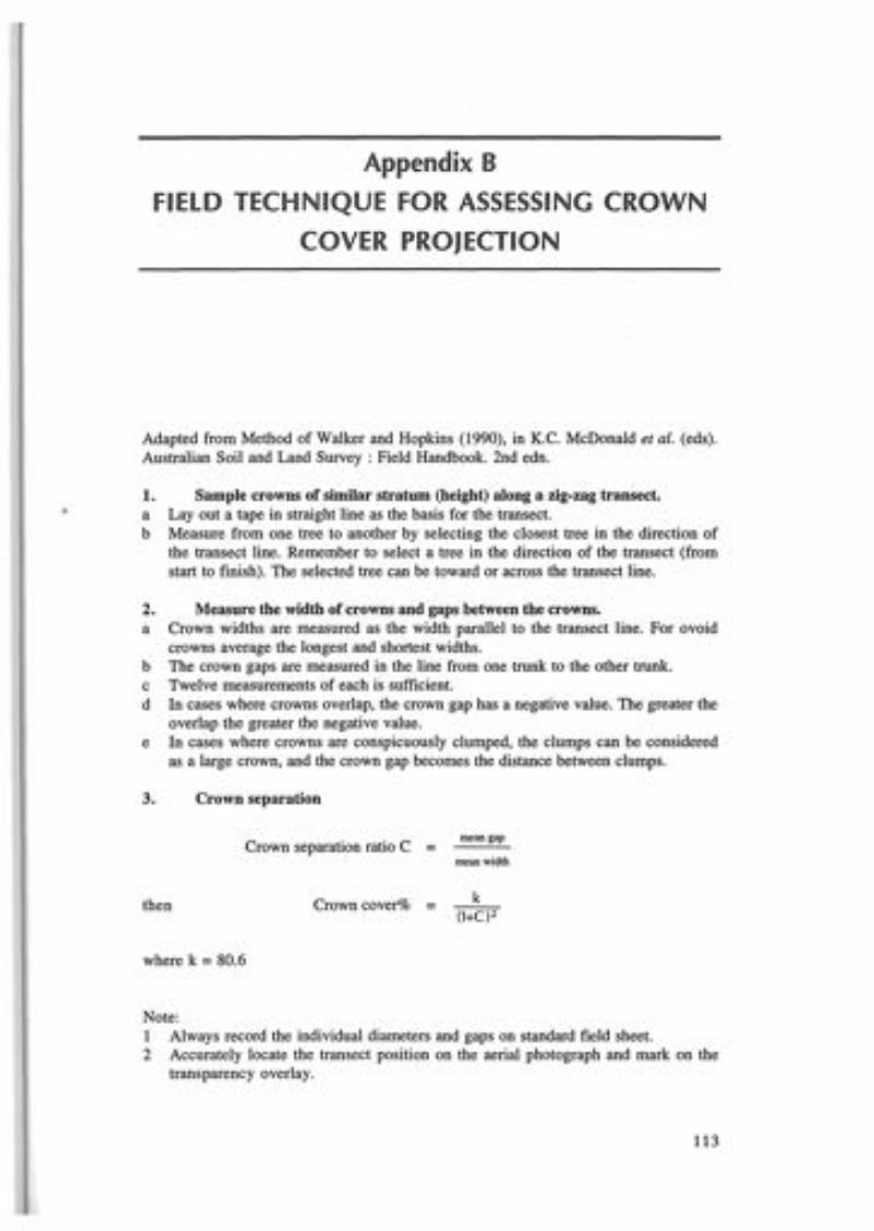
Appendix BfiELD TECHNIQUE fOR ASSESSING CROWN
COVER PROJECTION
Adapted from Method of Walker and Hopkins (1990), in K.C. McDonald et aI. (eds).Australian Soil and Land Survey : Field Handbook. 2nd edn.
1. Sample crowns of similar stratum (height) along a zig-zag transect.a Layout a tape in straight line as the basis for the transect.b Measure from one tree to another by selecting the closest tree in the direction of
the transect line. Remember to select a tree in the direction of the transect (fromstart to finish). The selected tree can be toward or across the transect line.
2. Measure the width of crowns and gaps between the crowns.a Crown widths are measured as the width parallel to the transect line. For ovoid
crowns average the longest and shortest widths.b The crown gaps are measured in the line from one trunk to the other trunk.c Twelve measurements of each is sufficient.d In cases where crowns overlap, the crown gap has a negative value. The greater the
overlap the greater the negative value.e In cases where crowns are conspicuously clumped, the clumps can be considered
as a large crown, and the crown gap becomes the distance between clumps.
3. Crown separation
then
Crown separation ratio C =
Crown cover% =
mean gap
mean width
k(l+C)2
where k =80.6
Note:I Always record the individual diameters and gaps on standard field sheet.2 Accurately locate the transect position on the aerial photograph and mark on the
transparency overlay.
113

A STUDY OF THE OLD-GROWTH FORESTS OF EAST GIPPSLAND
Aerial view of transect line for field estimation of crown cover projection
Start
Gx, Average GapI,Gl...n
= n
Dx, Average Gap I,Dl... n= n
Crown gap ratio Gx= Dx
o{)Trees with ovoidcrowns like No.4,average the longest andshortest diameter toobtain crown diameter.
Finish
114

Appendix CDESCRIPTION OF FOREST TYPE CLASSES
The descriptions in this appendix are taken largely from Buntine 1974 (unpubl). Thisstudy was undertaken to determine the location and quality of timber resources, so thedescriptions of forest type classes do not elaborate on their other values (such asfaunal, floristic and intangible attributes).
(N1) Shining GumThe typical forest type of the Errinundra plateau where E. nitens occurs as a purespecies often in excess of 60 m height. The understorey is commonly of a dense'jungle' type containing many of the Closed Forest species. Included in this class aresome of the higher elevation forests where E. nitens occurs in mixture with otherspecies such as E. fastigata and E. delegatensis. This mixture of species is foundmore commonly away from the Plateau in the dissected upper headwaters of the Ada,Errinundra, Bendoc, Delegate and Rodger Rivers.The forests appear to be even-aged, apparently having resulted from a catastrophic
fire over 200 years ago. Normally the understorey vegetation remains damp,especially in the gullies, thus excluding natural fires during all but exceptionally dryperiods.This is a most important commercial class of forest that is currently being utilised
by the Bendoc and Orbost sawmillers. The timber is valued for all grades of scantlingand is quite suitable for seasoning quality. The logging season is restricted to the driermonths of the year, being hindered at other times by snow fall and wet roads. Majoraccess roads have to be of a high standard to allow logging to be continued for aslong as possible.Very little detailed information is available on the fauna and flora of these forests
however representative samples of the vegetation are included in the reserves of theErrinundra Plateau.
(A) Mountain AshThese are not extensive forests in the Orbost Shire, being restricted to two regions.One is the upper headwaters of the Errinundra and Combienbar Rivers, and the otheris in the upper Rodger and Yalmy Rivers. The dominant species is E. regnans whichcan grow to over 75 m in height. This species does not occur at the higher elevationsand is found in protected gullies bordering E. nitens and E. delegatensis, associatedwith the typical wet sclerophyll type understorey of the higher foothill forests. Firesare very infrequent but play a most important part in the natural regeneration of theseforests.Because of the difficulties of access, utilisation has so far been restricted to the
portion of these forests in the upper Combienbar River. This type is not specificallyreserved anywhere in the Orbost Shire. .
115

A STUDY OF THE OLD-GROWTH FORESTS OF EAST GIPPSLAND
(Wb) Alpine AshThe dominant species is E. delegatensis, normally occurring as pure stands on or nearthe Errinundra Plateau, and in the upper portion of the Yalmy River. At the highestelevation on exposed sites around Monkey Top, the Bowen Range andMt Tingaringy, E. delegatensis assumes a stunted form and often adjoins areas ofE. pauciflora. For simplicity sake this stunted form has been included in this class.Alpine Ash is an important commercial species and is currently being logged on
the Errinundra Plateau in association with E. nitens. Regeneration in the natural stateis very dependent on severe fires, apparently occurring slightly more frequently thanin the Shining Gum forests, and results in forests that are even aged.
(F) Cut-tailThis is an extensive forest type of the foothill and mountain forests the major speciesbeing E. fastigata. Although E. fastigata occurs extensively in pure stands in thecatchments of the Delegate, Bendoc and Ada Rivers, and the Mt Tennyson locality, italso mixes with many other species, the most common of which are E. nitens,E. cypellocarpa and E. obliqua. E. fastigata covers a wide range in elevation from asmall near-coastal occurrence at Wingan Inlet, then extensively throughout the wetterfoothill forests to the forests of the Errinundra Plateau. Although preferring thesheltered slopes in the foothill zones, it extends onto the northern aspects aroundBendoc and Mt Tennyson.The understorey varies considerably depending on locality, containing many of
the Closed Forest species on or near the Errinundra Plateau but becoming very similarto that of the Messmate Gum forests at lower elevations.Severe fires are very infrequent with ring counts showing that much of the higher
elevation forests of this type were probably regenerated at about the same time as theShining Gum forests. In the foothill zone, some evidence of past fire damage is oftenpresent.It is a most important commercial forest type and represents a considerable portion
of the harvestable timber of the foothill and mountain forests. It has only beenextensively utilised in a few locations, mainly at Bendoc, Murrungowar, Club Terraceand Combienbar but forms the bulk of the sawlog resource of a number of theallocated logging units.Areas of E. fastigata are reserved in the Mount Alfred National Park.
(M1, M2, M3) Messmate-Gum A and BA very extensive forest type that occurs throughout the Orbost Shire, this forest typeis present in most land systems ranging from the gullies of the coastal plains toextensive stands in the foothill and mountain zones. It has been subdivided by heightinto two classes, those stands that are known to be greater than 40 m (MI , M2) beingseparated from the rest (M3).
E. cypellocarpa is normally present to various degrees with a wide range of otherspecies, the most common being E. obliqua. Other common species are E. viminalis,E. fastigata, E. pseudoglobulus, E. botryoides, E. muellerana and E. elata. In theHowe Range E. fraxinoides can be common, being the only occurrence of this speciesin Victoria. The actual species present in any particular area differ considerably,E. muellerana and E. pseudoglobulus preferring drier sites, E. fastigata the moistprotected gullies, while E. elata and E. botryoides are more common in stream-sideenvironments. The understorey varies considerably depending on location.This is a very valuable commercial forest type wherever it occurs. All of the species
are of value for sawlog timber and for a range of other types of produce including
116

APPENDIXC
poles and sleepers. At its best development tree height may exceed 60 m as on thewestern slopes of the Ellery Ridge where merchantable volumes can becorrespondingly high. It has been utilised for many years in the foothill forestsaround Orbost, Murrungowar, Bemm River, Cann River, Wingan Inlet and Genoa, andalso to a more limited extent at higher elevations near Bonang and Bendoc.Roading developments in more recent years have now extended logging operation
into the more inaccessible areas around Combienbar and the catchments of theGoolengook and Thurra Rivers. Even so huge virgin areas of this type still existaround Mt Kaye, Ellery Creek and west of the Bonang highway. At higher elevationsin the Delegate and Bendoc River catchments, this forest type often occurs on thenortherly slopes in association with E. fastigata and E. nitens on the protectedsoutherly slopes.The frequency and the severity of wildfire varies greatly depending on locality. At
lower elevations where it is commonly in association with the Stringybark forests, firesare relatively frequent, all stands showing some degree of fire damage. At higherelevations with higher rainfall and a less inflammable understorey fire is less frequent.Most of the species of this forest type are relatively resistant to fire and consequentlya range of age classes is usually present.
(P3) Peppermint Gum AThis is a restricted forest type of the Bendoc-Bonang region with E. radiata andE. rubida being the dominant species. Other species that may be present areE. dalrympleana, E. camphora and E. obliqua. The value of this type for hardwoodsawlog production is dependent on the quantity of E. obliqua present and the qualityof the E. radiata which is capable of producing high quality scantling timber. Insome localities suffers severely from rot and ant defect. E. radiata at its bestdevelopment commonly exceeds 50 m in heights (e.g. along the Delegate River).The understorey is generally open with a scattering of sclerophyll shrubs and
grasses. Fires are consequently usually mild and in the past, have been encouraged topromote grass growth for forest grazing. Natural regeneration is spasmodic resultingin an uneven aged forest.
(As) SilvertopThis forest type consists of all of the areas of pure E. sieberi that could be identifiedduring the study. Further areas that could not be identified will have been included inthe Stringybark type.At its best development for hardwood sawlog production, E. sieberi occurs as pure
stands in which tree heights exceed 60 m. These stands have an appearance similar tothat of the other related ash eucalypt species and are best represented on the ridgesaround Murrungowar, Genoa, Mount Ellery and Mount Future. Very high volumesper hectares are obtainable from such stands. Silvertop is an unusual speciescompared to the forest types already described, as it grows to its best development onridge tops and exposed northern and western slopes. In such locations it attainsgreater heights and straighter form than other species. On the drier and more exposedslopes, the tree height is much less but the species still usually occurs in pure standsexcept at the limit of its range where it borders on the Red Stringybark forests.These stands are normally even aged and are slightly more fire resistant than
stands of the other ash species. Fire susceptibility is high during the summer monthsdue to the light ground fuels which dry out readily and are very inflammable. Firedamage is common even after mild fires, and allows access for rot and termites.Intense fires. are particularly damaging, often causing tree death; however, Silvertop is
117

A STUDY OF THE OLD-GROWTH FORESTS OF EAST GIPPSLAND
naturally a heavy seeding species and usually regenerates prolifically following fire.E. sieberi produces valuable sawlog timber that has been utilised from the coastal
and foothill forests from Nowa Nowa to Cann River for many years. Currentlyconsiderable volumes are being removed from stands in the Murrungowar-Combienbar-Bemm River areas. Other high quality stands in the Harrisons Creekcatchment being utilised.
(83) 8tringybark AThis is an extensive forest type of the lower foothill forests and coastal plains. A largerange of species are recorded from this type but the dominant ones are alwaysSilvertop and/or one or more of the Stringybark group e.g. E. globoidea, E. baxteri,E. agglomerata, E. muellerana. Other species include E. botryoides (uncommon),E. bridgesiana, E. cypellocarpa (scattered), E. consideniana, E. polyanthemos (rare),E. mannifera (rare), E. sideroxylon (rare) and E. bosistoana (rare). These forests allbecome very dry and inflammable during summer and are very prone to severe wildfires which can cause extensive damage to the standing trees. In the absence of firethe fuel build-up in the understorey can be very high and further· increases theseverity and likelihood of fires. Most of the species present are, however, very resistantto fire and in the event of intense fire are capable of re-shooting from lignotubers anddormant buds in the stems.The stands are usually either uneven aged or have a very uneven size distribution.
This has resulted both from the effects of fire and the effects of past selectiveutilisation. Most of the species are highly valuable for sawlogs, with many being alsosuitable for sleepers, poles and honey production. The huge extent of these forestsplus their ease of access and location in relation to existing conversion centres, makethem very valuable for both present and future timber supplies. If correctly managed,relatively high volumes of timber per hectare can be obtained.These forests were the main source of timber supplies for the early development
around Nowa Nowa and Orbost, utilisation of the coastal forests now having extendedas far east as the Wingan River. Early sleeper cutting of selected species such asE. sideroxylon and E. bosistoana in these forests near Nowa Nowa, has now resultedin these two species being virtually eliminated from this forest type. Currentoperations around Orbost have concentrated on re-Iogging through cut-over areas butlarge areas of virgin stands are still located in the Genoa area.
(Rb3) 8ilvertop-BloodwoodThis forest type is restricted to the country east of the Wingan River and south of thePrinces Highway. It is probably a variant of the Stringybark type with theE. gummifera taking the place of the Stringybark species to form a mixture withE. sieberi. Apart from these two major species, E. cypellocarpa, E. consideniana andE. globoidea are occasionally common. Fires have not been as common as in the restof the Stringybark forests, probably because of the lack of agricultural developmentin the immediate surrounds.These forests have not been utilised but contain considerable volumes of virgin
E. sieberi and E. globoidea that is suitable for sawlogs. The volumes of sawlog timberavailable, however, are only a small portion of the total amount of wood available.The stands tend to be of a mature-overmature type with an understorey typical of thecoastal Stringybark and Silvertop forests.
118

APPENDIXC
(P4) Peppermint Gum BThis is the forest type that normally adjoins Snow Gum areas either on the opentableland country around Bonang and Dellicknora or at higher elevations on theBowen Ranges, Mt Tingaringy and the Monument Range. Tree heights are typicallyless than 28 m and may even be as low as 15 m on the very exposed slopes. At lowerelevations this type has, to a certain degree, been cleared for agriculture wheretopography is suitable.The dominant species is E. dives, usually in mixture with E. rubida. Other species
that may also be present include E. camphora (wetter areas), E. viminalis (gullies),E. stellulata (lower elevations), E. macrorhyncha, E. bridgesiana, E. gunnii (rare) andE. paudflora (on the margins of the type).The understorey is usually sparse, open and often grassy, making it susceptible to
fire as it dries off readily during the summer months. Lightning fires are common athigher elevations, especially in the Tubbut region.These forests currently have no commercial value although some of the lower
elevation areas may have some future for softwood conversion for other adjacentforest types which may be susceptible to fire damage.
(S4) Stringybark BThis subdivision includes a number of forest types that have been grouped togetherfor simplicity. It is meant to represent the lower height class areas of the stringybarkforests but the coastal belt also includes large areas of stunted E. botryoides. Themajor species are the stringybarks, predominantly E. globoidea with some patches ofstunted E. sieberi. East of the Wingan River E. muellerana can also be quite common.The most extensive areas are the low stringybark forests north of Orbost on the fall
into the Snowy River and in the drier areas of the Cann and Gen'oa Rivers. The type iseither non-commercial or of a low value for timber production depending on itslocation in relation to more productive stands. Some areas could be quite highlyproductive of pulpwood. These forests are very prone to fire, but recover quickly andare very valuable protection forests.
(Y) Red Stringybark-YertchukThis classification includes two forest types that have been grouped together forsimplicity, each of which have little, if any, commercial value.
Type (a) This is the E. consideniana E. cephalocarpa forest of the coastal belt.The understorey is typically very similar to the heaths, the type in factusually being in the zone between heaths and the coastal stringybarkforests.
Type (b) This is the bulk of the land that has been mapped under this classificationand includes most of the protection forests of the drier, more exposedslopes of the Snowy, Deddick and Genoa Rivers. The dominant species isE. macrorhyncha, but numerous other species may also be present and canform a wide variety of mixtures. They include E. goniocalyx (DeddickRiver,), E. consideniana (lower Snowy Valley), E. gunnii (Bowen Ranges),E. sideroxylon (rare), E. bridgesiana, E. polyanthemos, E. mannifera (rare),E. cypellocarpa (stunted), E. dives (higher elevations) andE. pseudoglobulus (rare).
The understorey is usually low and relatively open. It becomes very inflammableduring the summer months and in conjunction with the low tree height, often less than15 m, can pose a major fire hazard. Lightning fires are common, the steep slopes and
119
A STUDY OF THE OLD-GROWTH FORESTS OF EAST GIPPSLAND
limited access making control very difficult and hazardous. The species are however,extremely fire resistant and important for erosion control and water catchmentpurposes.
(Rb4) Bloodwood-AngophoraThis is an interesting and restricted coastal forest type of the Genoa region. The twomajor species, E. gummifera and Angophora floribunda, either occur pure, inmixtures with each other or other species such as E. globoidea. Angophorafloribunda is common in the coastal forests of southern New South Wales but isrestricted in Victoria to the Mallacoota region. Along the coast between LakeBarracoota and Wingan Inlet, Angophora is absent, the dominant species being a verystunted form of E. gummifera.Tree heights rarely exceed 28 m and may be as low as 10 m adjacent to the coast.
The type is largely uncommercial but could supply minor produce depending on thespecies present. Near the coast the understorey contains many of the heath speciestypical of the coastal stringybark forest elsewhere. Fuel build-up can be quite high inthe absence of fire.
(SnG) Snow GumSnow Gum (E. pauciflora) has only limited occurrences in the Orbost Shire butoccurs in two quite different sites. The first is as one of the dominant species of thetableland country around Bendoc and Bonang where severe frosts have probablyexcluded other species, and the second is on the upper portions of the dominantmountain peaks of the Shire at elevations over 1 200 m.Most of the plateau occurrences have been cleared for agriculture and only
scattered remnants remain at the edges of clearings and along the Delegate andBendoc Rivers. E. stellulata and E. camphora are common associated species. At thehigher elevation Snow Gum is more stunted and grows on extremely exposedsituations. Here it adjoins areas of stunted E. delegatensis. E. perriniana forms amixture with E. pauciflora on parts of the Bowen Ranges, but occurs pure at onelocation near Tower Bowen. Other occurrences of E. pauciflora are on the MonumentRange, Monkey Top, Mt Tingaringy and at Delegate Hill.The understorey is usually very grassy and poses little hazard for fires.
(B) BoxThis type includes all areas that were recognised as being dominated by one of thebox species. The most common are E. bosistoana, E. melliodora, E. polyanthemosand E. albens.
E. bosistoana is a most important species that has been sought after for manyyears for sleepers, beams and poles. It is now restricted to a few limited areas nearNowa Nowa (Lake Tyers), Orbost (Snowy River, Raymond Creek), Noorinbee andGenoa (Genoa and Wallagaraugh Rivers). Large areas have been cleared foragriculture in the early parts of the century. At its best development it can exceed70 m (Jones Creek).The other major occurrence of Box are the White Box (E. albens) forests of the
upper Snowy River. This species is restricted to this rain shadow area and occursnowhere else in the Shire. Although the timber is of high quality, tree height isusually not very great (20 m), growth slow and form poor. It is utilised to a limitedextent for local farm timbers and honey production. The understorey is very openand grassy but can be hazardous for fire protection because of the tendency for firesto stay alight in roots and stumps underground. In the McKillops Bridge region the
120

APPENDIXC
species often forms a mixture with Callitris collumellaris and at higher elevations maymix with E. goniocalyx or E. macrorhyncha. The upper limit of E. albens is about600 m.
(Ca) CallitrisThese forests only occur in the upper Snowy River area of the Orbost Shire. Thedominant species is Callitris collumellaris, which although often as pure stands alongthe Snowy River, always either adjoins or grows in mixture with E. albens.
Callitris produces very valuable timber but is slow growing and does not thin itself,resulting in dense stands of trees. Most of this type in the study area is thought to berelatively even aged, probably resulting from a past wild fire. Callitris does regeneratenaturally if the seasonal conditions are suitable. Grazing can prevent the establishmentof regeneration.
(Po) PodocarpusPodocarpus lawrencei, Mountain Plum Pine, occurs in the Goonmirk Range area ofthe Errinundra Plateau where it grows atypically in tree form rather than as ascrambling low shrub. An investigation was carried out by Forester J. Nankervis(File No. 65/3218) to delineate the limits of this species in this locality, the result ofwhich led to the increase in the size of the Goonmirk Rocks Scenic Reserve. The areasthat were delineated at that time have been included as a separate forest type.
(Ac) WattleThis forest type includes all areas of pure wattle. The most significant are the Acaciadealbata stands of the Errinundra Plateau region, and the Acacia mearnsii areas onthe exposed slopes of the Deddick River valley. At this latter locality the vegetationheight is often less than 6 m, with a number of other species, including Leptospermum,Goodenia and Westringia growing in close association and resulting in a dense, low,shrubby vegetation.
(0) OpenAll natural treeless areas have been mapped as this forest type, including swamps,coastal sands, tea-tree areas and the extensive coastal heaths which make up the bulkof the type. These heaths are very extensive throughout the complete coastal zonefrom Lake Tyers to Cape Howe. They contain an abundance of plant species andsupport a wide range of animal and bird life. Fire has been an important factor inmaintaining a diverse range of species and is a common feature of this environment.Fire has often been induced by man to increase the potential of this forest type forgrazing purposes.
Closed ForestThese are the non-eucalypt forest aSSOCIatiOns that are often referred to by thecommon names of 'rainforests', 'jungles' or 'gully forests'. Closed forests of thistype are restricted in Victoria to east of the Mitchell River with the best and mostextensive examples being located in the Orbost Shire. They are very rich in ferns,epiphytes, and climbers, very sensitive to fire and, especially the lowland type, needthe protection of the surrounding forest to survive.
121

A STUDY OF THE OLD-GROWTH FORESTS OF EAST GIPPSLAND
Type (a) The higher elevation montane variety of the Errinundra Plateau, whichoccurs both as an understorey to E. nitens and E. fastigata and as purestands, where it appears to have displaced the eucalypts over a long periodof fire exclusion. The identifying species of this association areAtherosperma moschatum (Sassafras), Elaeocarpus reticulatus (BlueOliveberry), Podocarpus lawrencei (Mountain Plum Pine), Drimyslanceolata (Mountain Pepper) and many ferns and epiphytes.
This variety occurs quite extensively in the Coast Range locality whereit appears to be a linking variety between the sub-tropical forests of NewSouth Wales and the temperate forests of Tasmania. Acacia dealbatausually occurs within or adjoining these areas.
Type (b) Commonly referred to as the lowland variety and in contrast is restrictedto the deep sheltered gullies of the foothill forests. It occurs throughoutthe foothill forests of the Orbost Shire but in only a few places, notablyMt Drummer and Jones Creek, does it cover large areas as a pure type.
The main representative species are Eugenia smithii (Lilly-pilly),Tristania laurina (Kanooka), Pittosporum undulatum (SweetPittosporum), Eucryphia moorei (Eastern Leather-wood), Bedfordiaarborescens (Blanket Leaf), plus many climbers, creepers, ferns andepiphytes that do not occur at higher elevations.
Note: For those other forest types listed in Appendix D, only summary descriptionsare available from map legends or LCC reports.
122

Appendix DRELATIONSHIP BETWEEN fOREST TYPE
MAPPING AND ECOLOGICAL VEGETATIONCLASS MAPPING
(Buntine, 1974; LCe, 1974, 1977, 1982)
Notes for this appendix:1 * indicates species added to the dominant tree species of each forest type as arefinement needed to map more restricted ecological vegetation classes during thisstudy.
2 'Mixed Forest' refers to Warm or Cool Temperate Rainforest with a eucalyptoverstorey. This structural form of those ecological vegetation classes was notmapped during the study.
123

:>
>-<:
8::t:
Cf.l>-3Cf.lo'"Ij
Cf.l>-3
Cf.l
Appendix D:l--FORESTTYPE RAINFALLANDHEIGHT (rom) LANDFORM & ECOLOGICAL VEGETATION CLASSCLASS DOMINANT TREE SPECIES1 ELEV.(m) GEOLOGY (and number)
USUAL OCCASIONAL USUAL OCCASIONAL RARE2a (EG) E. nitens E. cypellocapa* SOO-1000 Montane: Devonian granitoids 30. Wet Forest 29. Damp Forest -4a (ALP) E·fastigata* 700-900Ni (EG)>40m, E. denticulata E.fastigata* 1400-2000 Montane, plateau, intermontane 30. Wet Forest 31. Cool Temperate -4b (ALP) 900-1200 basin: Ordovician sediments Rainforest, Mixed(regrowth Devonian Snowy River Volcanics Forest28-40 m)A (EG) E. regnans E.fastigata* 1400-2000 Intermontane basins, plateau, 30. Wet Forest 31. Cool Temperate ->40m E.obliqua* 800-1100 dissected montane: Ordovician Rainforest, Mixed
sediments, Devonian Snowy River ForestVolcanics
Wb, (ALP) E. delegatensis E. regnans 1000-1400 Montane plateau, dissected 39. Montane Wet Forest 38. Montane Damp Forest 36. Montane Dry\3a, E.obliqua 1000-1200 montane: Devonian granitoids, Woodland>40m, Silurian sediments, Ordovician3b sediments(regrowth E. delegatensis Leptospermum 1000-1400 Montane creeks: Quaternary 41. Montane Riparian Thicket - -28-40 m) llirandifolium* 1000-1200 alluviums
E.fastigata E. cypellocarpa* 400-1400 Dissected foothills, plateau: 30. Wet Forest 29. Damp Forest, 32. Warm TemperateF E. denticulata E.obliqua* Ordovician sediments, Devonian 31. Cool Temperate Rainforest, Mixed>40m E. nitens granitoids Rainforest, Mixed Forest2
Forest2MIl (GLH) E. cypellocarpa E globulus ssp. 1200-2000 Dissected foothills, intermontane 30. Wet Forest 31. Cool TemperateM"M2 E.fastigata pseudoglobulus* 400-1000 basins, plateaus: Devonian, Snowy Rainforest, Mixed ->40m E.obliqua E. viminalis* River Volcanics and granodiorites Forest2
Ordovician sedimentsE. croajingalensis* E. delegatellSis* 900-1200 Dissected montane: Ordovician 38. Montane Damp Forest 36. Montane Dry -
Sa E.obliaua 900-1200 sediments, Devonian granitoids Woodland28-40m E. croajingalensis* - 900-1000 Dissected foothills, plateau: 23. Herb-rich Forest - -
E. viminalis* Tertiarv basaltsE. cypellacarpa E. globulus ssp. 1000-1200 Dissected foothills in gullies, 29. Damp Forest 32. Warm Temperate 31. CoollWarm TemperateE. muelleriana pseudoglobulus* 10-100 intermontane basins, tablelands Rainforest, Mixed Rainforest OverlapE. obliqua E. sieberi* and ridge tops of mountain ranges: Forest2E. viminalis E·fastigata* Ordovician granitoids Devonian
Snowy River VolcanicsM3(Mm) 1200-2000 30. Wet Forest 31. Cool Temperate28-40m 100-1000 " " Rainforest, Mixed-
Forest2E. bauerana* E. globaidea* 760-900 Rocky river valley slopes, shores 15. Limestone Box Forest 34. Dry RainforestE. bosistoana* E. globulus ssp. 0-100 of submerged river valleys: -E. tricarpa* pseudoglobulus* Tertiary limestones and marls
E. viminalisE. croajingalellSis* E.ovata* 750-1200 River and creek flats: Quaternary 18. Ripairan Forest 32. Warm Temperate 19. Riparian shrub1andE. elata* 5-S00 alluviums RainforestE. botryoides*E. viminalis*Tristaniopsis Laurina*
.....N.j::..

Appendix D:2
......NVI
FORESTTYPE RAINFALLANDHEIGHT (rom) LANDFORM & ECOLOGICAL VEGETATION CLASSCLASS DOMINANT TREE SPECIES! ELEV.(m) GEOLOGY (and number)
USUAL OCCASIONAL USUAL OCCASIONAL RAREE. pauciflora* E.ovata* 9DO-lOOO Dissected montane on broad 37. Montane Grassy
P3,Pm E. mbida / dalrympleana S50-1100 ridges and slopes: Devonian Woodland - -28-40m E. viminalis* granodiorites, Tertiary basalts
E. croajingalensis* E.obliqua l1DO-1300 Montane tableland: Ordovician 35. Tableland Damp Forest 35. Montane Dry 24. Damp ForestP3,Pm E. dalrympleana* S50-1200 sediments Woodland28-40m E. mannifera* SDO-lOOO Dissected montane: Ordovician 36. Montane Dry Woodland - -
E. radiata 9DO-1300 sedimentsE. sieberi E. consideniana* SDO-IOOO Dissected foothills and coastal 21. Shrubby Dry Forest 16. Lowland Forest -
lDO-SOO hills: Ordovician sedimentsAs E. globoidea* 9DO-l200 Coastal hills: Ordovician 16. Lowland Forest - 21. Shrubby Dry Forest28-40m 10-500 sediments
E. cype/locarpa lOOG-l100 Dissected foothills: Ordovician - 24. Damp Forest -E. mue/leriana 7DO-900 sediment
E. consideniana E. baxteri 9DO-1200 Coastal hills: Ordovician 21. Shrubby Dry Forest - 16. Lowland ForestE. globoidea E. maginlii* S0-500 sedimentsE. sieberi
E. manifera* SDO-900 Coastal hills: Ordovician 21. Shrubby Dry Forest - -E. tricarpa* 2DO-300 sediments
S3 (Sm) E. mlle/leriana* llDO-l200 Intermontane basin: Devonian 29. Damp Forest - -28-40m E.obliqua* SDO-llOO Snowy River Volcanics
E. tricarpa* SDO-900 Ridge tops: Ordovician sediments 24. Box Ironbark Forest - -E. Dolvanthemos* 20-250
E. pryoriana* Acacia mearllsii* 750-900 Tertiary dunes: Quaternary 3. Coastal Grassy Forest - -Banksia illlegrifolia* 5-20 aeolian sandsBanksia serrata*
E. gummifera Angophorajloribunda 9DO-l200 Coastal plains and hills: Devonian 16. Lowland Forest - -E. sieberi adamellites and granites
Rb3 E. globoidea Ordovician sediments28-40m E botryoides Angophorajloribunda lOOG-l200 Lower slopes around 4. Coastal Vine-rich Forest - -
E. gummifera coastal embayments:Quaternary colluviums
E. bauerana* E. globuills ssp. 760-900 Shores of submerged river 15. Limestone Box Forest - 34. Dry RainforestE. bosistoana pseudogloblllus* 0-100 valleys: Tertiary limestones and (peninsulas with northE. tricaroa* E. viminalis* marls west and east aspects)
B E. melliodora Acacia caemlescens, * 760-900 Dissected foothill karst: Devonian 25. Limestone Grassy 23. Herb-rich Forest 34. Dry Rainforest (rockyVarious E. viminalis* A. implexa. * 250-400 limestone Woodland (ridges, north, (south aspects) slopes with north
A. melanoxylon* east and west aspects) aspects)A/locasuarina vertici/lata* -Banksia marginata*E. mbida*
I:><o

-tv0\
Appendix D:3FORESTTYPE RAINFALLANDHEIGHT (rom) LANDFORM & ECOWGICAL VEGETATION CLASSCLASS DOMINANT TREE SPECIES} ELEV.(m) GEOLOGY (and number)
USUAL OCCASIONAL USUAL OCCASIONAL RAREE. albells Allocasllarilla verticillata* 750-900 Upper dissected slopes at foothills: 20. Heathy Dry Forest - -
600-900 Devonian granodiorites (north aspect)B E.llortOllii* - 750 Upper dissected slopes at foothills: 22. Grassy Dry Forest - -Various 600-900 Devonian granodiorites (south aspect)
E. bridgesialla* E. polyamhemos* 750-850 Dissected foothills: Devonian 22. Grassy Dry Forest - -200-400 I granodiorites (upper sloues)
Callitris glallcophylla* E. blakelyi 650-750 Dissected foothills: Devonian 26. Rainshadow WoodlandB.6. C. elldlicheri* E. melliodora 100-600 granodiorites - -Ca. E. albellsVarious E. albells Callitris endlicheri* 650-750 Dissected foothills: Ordovician 21. Shrubby Dry Forest - -
C. I!lallcoDhvlla* 100-600 sedimentsB E. melliodora Acacia silvestris* 760-800 River gorges: Devonian Snowy 27. Rocky Outcrop Scrub 34. Dry RainforestVarious E. tricarpa* Eriostemoll trachyphyllus* 40-150 River Volcanics. Ordovician (north aspects) - (north aspects)
sedimentsP4 E. dives E. ma1l1lifera* 800-1000 Dissected montane: Ordovician 36. Montane Dry Woodland 2 I. Shrubby Dry Forest -15-28m E. mbida 900-1200 sediments
E. polyamhemos - 700-800 Dissected foothills: Ordovician 24. Box Ironbark Forest - -S4 (SlY) 15-28 m E. tricarpa 10-900 sediments< 15 m E. tricarpa E.smithii 700-800 Dissected foothills: Ordovician 27. Rocky Outcrop Scrub - -
E. macrorhYllcha 100-900 sediments and hornfels (north or west aspects)E. globoidea Aliocasuarioo littoralis* 700-900 Dissected foothills: Devonian 21. Shrubby Dry Forest 22. Grassy Dry Forest 16. Lowland ForestE. sieberi 10-900 Snowy River Volcanics.E. botryoides Ordovician sediments
700-1200 Coastal plains: Tertiary outwash 16. Lowland Forest - -10-250 alluviums
S4 (SlY). 5b E. botryoides E. sieberi 900-1200 Coastal plains: Quaternary 14. Banksia Woodland 16. Lowland Forest -15-28 m 5-160 aeolian sands
Banksia imegrifolia* Ballksia serrata* 900-1100 Coastal dunes: Quaternary aeolian 2. Coast Banksia Woodland 5. Coastal Sand Heathland 14. Banksia WoodlandE. spp. aff. globoidea* 10-250 sandsLeptospermum laeviliatum*E. conspicua* - 800-900 Coastal plains: Tertiary outwash 7. Clay Heathland 8. Wet Heathland -
10-100 alluviumE. cOllsidellialla - 600-700 Dissected foothills: Devonian 28. Rocky Outcrop Shrubland 27. Rocky Outcrop Scrub -E. macrorhYllca 250-900 Snowv River Volcanics
y E. consideniana E. polyamhemos 700-900 Dissected foothills: Devonian 21. Shrubby Dry Forest15-28m E. macrorhYllca 100-900 Snowy River Volcanics. - -Ordovician sediments
E. cOllsidelliallO E. cOllspicua* 800-1000 Coastal plains: 7. Clay Heathland - -10-80 •Quaternary alluviums
y Melaleuca sqllarrosa E.ovata* 800-1000 Lowland creeks: 17. Riparian Scrub Complex - -< 15m 0-150 •Quaternary alluviums
E. cOllsidelliallO E. globoidea* 800-1000 Coastal plains: Tertiary 16. Lowland Forest 14. Banksia Woodland -10-250 outwash alluviums
E. cOllsidelliallO E. sieberi* 800-900 Coastal plains: Tertiary 14. Banksia Woodland 16. Lowland Forest -10-100 outwash alluviums
;J>en
§>-<:
G
en>-3eno'TJ
en>-3
en

Appendix D:4
-N-...l
FORESTTYPE RAINFALLANDHEIGHT (mm) LANDFORM & ECOLOGICAL VEGETATION CLASSCLASS DOMINANT 1REE SPECIES! ELEV.(m) GEOLOGY (and number)
USUAL OCCASIONAL USUAL OCCASIONAL RARERb Angophorafloribunda 900-1000 Coastal plain: Tertiary 16. Lowland Forest 7. Clay Heathland 21. Shrubby Dry Forest15-28m E. $!ummifera 5-200 outwash alluvium
E. sieberi E. gummifera 900-1000 Coastal plain: Quaternary aeolian 14. Banksia Woodland 2. Coast Banksia -5-100 sands woodland
2b (ALP) E. glaucescens* E. delegatensis* 900-1100 Montane ridges: Silurian 42. Sub-alpine Shrubland - -< 15m E. kvbeanensis* E. pauCiflora* 1100-1200 sediments2b (ALP) E. radiata E. pauciflora 900-1200 Dissected montane, montane 36. Montane Dry Woodland15-28m E. rubida/dalrymplealla 900-1200 Plateau: Devonian granites and - -Snowy River Volcanics
E. camphora* E. stellulata* 900-1000 Montane river and creek flats: 40. Montane Riparian - -5c, E. croaiin$!alensis* 900-1200 !Ouaternary alluvium Woodland< 15m E. dives, E. radiata 900-1000 Dissected montane: Silurian 36. Montane Dry Woodland 21. Shrubby Dry Forest 20. Heathy Dry Forest
E. manifera E. macrorhyncha 900-1000 sediments, Devonian Snowy River 22. Grassy DryVolcanics, Ordovician sediments Forest
S5 (Sy) E. conspicua 700-800 Coastal plains: Tertiary 7. Clay Heathland 8. Wet Heathland -<15m 10-100 outwash alluviumSnG, 2a (EG), Sy E. pauciflora E. dalrympleana* 900-1400 Sub-alpine peaks: Ordovician 43. Sub-alpine Woodland 44. Treeless Sub-alpine8-15m E. perriniana 1200-1400 sediments, Devonian Snowy River Complex -
E. rubida* VolcanicsPo Podocarpus laurenceii Tasmannia spp. 1400-2000 Montane slopes: Devonian 31. Cool Temperate - -Various 1150-1200 ! granodiorites Rainforest (thickets)
Acacia silvestris* E. smithii* 650-900 Dissected north and west aspects 27. Rocky Outcrop ScrubEriostemon trachyphyllus* E. polyanthemos* 200-1000 on upper slopes of river gorges: - -
Ac, W Devonian Snowy River Volcanics,Various Ordovician and Silurian hornfels
Acacia dealbata Dicksollia alltarctica* 1200-2000 Montane plateau: Ordovician 30. Wet Forest 31. Cool Temperatesediments, Devonian Snowy River - RainforestVolcanics
Banksia marginata E. botryoides 900-1000 Tertiary Dunes: Quaternary 5. Coastal Sand HeathlandBossiaea ensata E. spp. aff. globoidea 10-20 aeolian sandsEpacris impress - -Lepidosperma concavumRicinocarpus pinifolius
0,7,5dVarious Leptospennum laevigatum Banksia illtegrifolia 760-1000 Primary Dunes: Quaternary 1. Coastal Dune Complex 2. Coast Banksia
Myoporum insulare 5-100 aeolian sands Woodland -Spill'ifex hirsutusE. macrorhyncha Leptospermum brevipes 760-900 Ordovician sediments and 28. Rocky Outcrop Shrubland - -E. consideniana Ozathalllnus conditum 200-1ooom Devonian granitoid outcrops
Io

.....tv00
Appendix D:5FORESTTYPE RAINFALLANDHEIGHf (rnm) LANDFORM & ECOLOGICAL VEGETATION CLASSCLASS DOMINANT TREE SPECIES1 ELEV.(m) GEOLOGY (and number)
USUAL OCCASIONAL USUAL OCCASIONAL RAREJmzcus krausii Melaleuca ericifolia, 900-1000 Saline peat flats adjacent to 9. Coastal Salt MarshMimulus repens Phragmites australis -0.25-0.75 estuaries: Quaternary peats
Open Sarcocomia quinqueflora - -Suadea australis(0), (-) Triglochin striata<2m
Bolboschoenus caldwellii Melalueca ericifolia 800-1000 Estuarine mud terraces: 10. Estuarine WetlandJuncus kraussii o-D,4 Quaternary alluviums and peats - -Lycopus australisCladium procemm Melaleuca squarrosa 900-1000 Coastal lagoons: Quaternary I!. Coastal Lagoon WetlandBaumea articulata Ga/mia clarkei -0.5-0.0 aeolian sand and peats - -B. rubigitlOSa Gleichenia microphyllaPhraQmites australis
Open Pseudoraphis paradoxa Leptospermum lanigemm 760-800 Coastal dune swales: Quaternary 12. Wet Swale Herbland(0), (-) Baumea mbigitlOSa Melaleuca ericifolia -0.5-0.0 aeolian sands and peats<2m Hydrocotyl sibthorpiodes - -Asoerula subsimolex
Baumea jzltlcea Melaleuca amzillaris 900-1000 Coastal embayment infill: 13. Brackish SedgelandLeptocarpus brownii 0.0-0.5 Quaternary aeolian sands and - -IpeatsLeptospennum lanigemm E.ovata 750-1200 Lowland Creeks: Quaternary 17. Riparian Scrub ComplexMelaleuca squarrosa Gleichenia microphylla 5-150 alluviums - -M. ericifolia
Open Allocasuarina paludosa E. conspicua 800-1100 Lowland river & creek terraces: 8. Wet Heathland - -(0), (-) Epacris obtusifolia 10-150 Tertiary outwash alluviums and<2m Leptospermum continentale Quaternary alluviums
Melaleuca squarrosaXanthorr/lOea resinosa .Allocasuarina paludosa E. sieberi 900-1000 Near coastal plain: clayey 7. Clay Heathland - -
Angophorafloribunda 10-20 Ordovician sediments andTetrarrhena tu osa Tertiarv outwash alluviumsE. nitida* Xatzthorrhoea australis 750-800 New coastal plain: sandy Tertiary - - 6. Sand HeathlandBanksia marQinata* outwash alluviums
E. camphora 850-1500 Quaternary alluviums and peats,E. stellulata 800-1200 on perched soaks and stream side - -
I - flats 44. Sub-alpine Complex<2m Kzltlzea ericifolia 850-1500 Rock screes of Devonian Snowy
Podocarpus lawrencei 800-1200 River Volcanics or Ordoviciansediments
:>CI.l
§>-<:o"I1
oG
CI.l>-3CI.lo"I1
CI.l>-3
Appendix EDESCRIPTIONS Of ECOLOGICAL
VEGETATION CLASSES IN EAST GIPPSLAND
VEGETATION DESCRIPTION
For ease of description the ecological vegetation classes of the study area arepresented in groups that reflect broad landscape zones based on elevation andlandform. Many name changes have occurred since the original floristic mapping.The original or equivalent names are noted in the descriptions as synonyms. Thenomenclature follows the Census of Victoria's Plant Communities (CNR, in prep).Brief summaries are given of climate, soils, elevation range and floristics for eachvegetation class (* indicates introduced species). The area statements are for publicland only.
COASTAL VEGETATION
The vegetation of this landscape zone is confined to the Quaternary dunes of thecoast, coastal embayments, lakes and inlets. These occur between Lakes Entrance andthe New South Wales border. Geology is predominantly Quaternary aeoliancalcareous (coastal) and siliceous (sub-coastal) sands. These often form extensivedune fields. Minor outcrops of Devonian granitoids and Ordovician marine sedimentsform cliffs and headlands in the east of the study area. The geology of the lakes andembayments is a variety of Quaternary alluviums, colluviums and peats.
Ecological vegetation class 1. Coastal Dune Scrub ComplexSynonym: Primary Dune Scrub (Forbes et al. 1981)Area: 3109 ha
This complex covers the vegetation succession from the grasses and the halophytes onthe foredune to the closed scrubs of Coast Tea Tree Leptospermum laevigatum on thesecondary dunes along the ocean beaches and lake shores of the study area. This classis therefore widespread but restricted to the coast in the study area. The soils areaeolian calcareous sands that have very low humus contents. Rainfall is in the range of760-1000 mm with elevation being between 5 and 100 m.The most conspicuous plants of the foredune are the grasses Hairy Spinifex
Spinifex sericeus and Marram Grass *Ammophila arenaria, the herb Coast Sow-thistleActites megalocarpa. The shrub Cushion Bush Leucophyta brownii is also common.The halophytes most often present are Sea Rocket *Cakile maritima and KarkallaCarpobrotus rossi. In the lee of the primary dune the shrubby species Coast WattleAcacia sophorae and Coast Tea-tree Leptospermum laevigatum become dominant.
129

A STUDY OF THE OLD-GROWTH FORESTS OF EAST GIPPSLAND
Coast Daisy-bush Olearia axillaris, Common Boobialla Myoporum insulare and CoastEverlasting Ozothamnus turbinatus are also ubiquitous.
Examples: Ninety-mile Beach at Lake Bunga, Point Ricardo and Wingan Inlet.
Ecological vegetation Class: 2. Coast Banksia WoodlandSynonym: Coastal Banksia Woodland (Forbes et al. 1981)Area: 3397 ha
Coast Banksia Woodland is restricted to near coastal localities on secondary or tertiarydunes behind Primary Dune Scrub complex on calcareous sand. This class is notcommon in the study area. The upper levels of the soil profile show some evidence ofiron and calcium leaching (being noticeably paler than lower levels in the profile).The humus content of the soil profile is higher than for the soils of Coastal DuneScrub Complex. Annual rainfall is 800-1100 mm per annum. The elevation rangesfrom 10-250 m with the class occurring up to 5 km inland.The dominant tree is Coast Banksia Banksia integrifolia with Bangalay Eucalyptus
botryoides becoming more conspicuous further east in the study area. Theunderstorey comprises a tall shrub layer of Coast Tea-tree Leptospermum laevigatumof varying density. Where Coast Tea-tree does not predominate several shrub speciesfrequently occur. These include Coast Beard-heath Leucopogon parviflorus, Sea BoxAlyxia buxifolia, Large-leaf Bush-pea Pultenaea daphnoides and Tree Broom-heathMonotoca elliptica. Coast Sword-sedge Lepidosperma gladiatum may be a prominentfeature of the ground layer of this class. Scrambling life forms are common withBower Spinach Tetragonia implexicoma, Climbing Lignum Muehlenbeckia adpressaand Seaberry Saltbush Rhagodia candolleana being the most prominent.
Examples: Corringle Slips south of Orbost, the camping area on the Thurra River eastof Point Hicks.
Ecological Vegetation Class 3. Coastal Grassy ForestSynonym: Part of Coastal Sclerophyll Forest (Forbes et al. 1981)Area: 90 ha
This class grows on the most inland aeolian dunes in the west of the study area whererainfall is less than 900 mm and is very restricted in the study area. The upper part ofthe profile is moderately high in humus content and low in iron and calcium whichhas been leached to lower levels. This class grows on tertiary dunes within 2 km of thecoast. The elevation is from 5-15 m above sea level. This class is at its eastern limit inVictoria. Further east in the study area where rainfall exceeds 1000 mm it is replacedby Banksia Woodland on the same geology.Coastal Grassy Forest is a woodland or open forest in structure. The dominant tree
is Coast Manna Gum Eucalyptus pryoriana; Saw Banksia Banksia serrata, CoastBanksia Banksia integrifolia, Black Wattle Acacia mearnsii and Cherry BallartExocarpos cupressiformis are less common canopy or sub-canopy species. Thegroundlayer is rich in herbs and grasses, and orchids (especially greenhoodsPterostylis spp.) and Helmet Orchids Carybus spp. which arte a feature of this class.The prominent grasses are Common Tussock Grass Poa labillardieri and Blady GrassImperata cylindrica, and the fireweeds Senecio spp. are the most obvious herbs.
Examples: Lake Bunga Foreshore Reserve between the Lakes Entrance golf courseand Lake Bunga, a small occurrence at the end of Lake Tyers House Road and the
130
APPENDIXE
area surrounding the car parks immediately to the north of Sailors Grave on EastCape at Cape Conran. These are the only sites known in the study area.
Ecological Vegetation Class 4. Coastal Vine-rich ForestSynonym: Part of Coastal Sclerophyll Forest (Forbes et at. 1981)Area: 122 ha
Coastal Vine-rich Forest is an example of an ecological vegetation class at the end ofits biogeographic range in Victoria, being more common and better developed insouthern coastal New South Wales. This class develops either on sandy aeolian orcolluvial soils and is restricted in Victoria to the study area. The colluvial soils developat the foot of slopes (often in shallow coastal gullies) which spill out onto coastalinlets or on aeolian sands on the seaward side of coastal hills which have a dampsouthern aspect. Soils maintain their high moisture levels throughout the year eitherbecause of the vegetation's aspect or its proximity to gullies and their attendant watertables. Rainfall is in the range of 900-1000 mm. This vegetation class grows from sealevel to 40 m elevation.The overstorey is most commonly dominated by Bangalay Eucalyptus botryoides
with Rough-barked Apple Angophora floribunda whilst Red Bloodwood Eucalyptusgummifera may be more prevalent east of Wingan Inlet. The understorey has ascattered tall shrub layer of Black Wattle Acacia mearnsii and Blue Olive berryElaeocarpus reticulatus. These understorey shrubs are festooned with a diverse arrayof rainforest lianes such as Forest Clematis Clematis glycinoides, Mountain ClematisC. aristata, Jungle Grape Cissus hypoglauca, Wombat Berry Eustrephus latifolius andBearded Tylophora Tylophora barbata. The liane diversity may approach that ofWarm Temperate Rainforest. The groundlayer is dominated by Bracken Pteridiumesculentum, tussock grasses and a wide array of herbs. This vegetation is very speciesrich and may have in excess of 100 species in a 30 X 30 m area.In coastal New South Wales this class ultimately develops into littoral rainforest in
the absence of fire. In Victoria the ingress of what are often low intensity ground firesprevents this plant community from developing into littoral rainforest.
Examples: The northern shores of Lake Barracouta, areas adjacent and just north ofHowe Flat, Peach Tree Camp on Peach Tree Creek Tamboon Inlet and the gully to theeast of the Point Hicks Road crossing of the Thurra River mouth, several gullies inaround the Mallacoota township and the slope of the eastern shore near the mouth ofWingan Inlet where there is a fire protected south facing slope.
Ecological Vegetation Class 5. Coastal Sand HeathlandSynonym: Coastal Heathland (Forbes et al. 1981, LCC 1991)Area: 681 ha
The Coastal Sand Heathlands are restricted to the upper third of Quaternary aeoliandunes slopes or their ridges generally within 500 m of the sea. They are relativelyuncommon in Victoria. The soils are well drained siliceous sands low in organicmaterial. The elevation is from 10-20 m.Coastal Sand Heathland is dominated by a diverse shrub layer with such species as
Common Heath Epacris impressa, Silver Banksia Banksia marginata, Wedding BushRicinocarpos pinifolius, Common Aotus Aotus ericoides, Sword Bossiaea Bossiaeaensata and Blue Dampiera Dampiera stricta being the most common. This class has asubstantial representation of sedges, lilies and grasses. The sedges which are typical
131
A STUDY OF THE OLD-GROWTH FORESTS OF EAST GIPPSLAND
are Zig-zag Bog-sedge Schoenus brevifolius, Sandhill Sword-sedge Lepidospermaconcavum and Slender Twine-rush Leptocarpus tenax. The lilies Spiny-headed MatLily Lomandra longifolia and Milkmaids Burchardia umbellata are oftenencountered whilst Kangaroo Grass Themeda triandra occurs sporadically in thisclass.
Examples: West Cape Road, Cape Conran
Ecological Vegetation Class 6. Sand HeathlandSynonym: Not previously mapped Leptospermum myrsinoides Heathland (Forbes etal. 1981), Sand Heathland (LCC 1991)Area: 44 ha
Sand Heathland grows at only one locality in the study area on a broad slope withleached siliceous sands derived from Tertiary outwash alluviums about 40 km fromthe coast. The rainfall is about 800 mm per annum and the elevation is 120 m. This isin contrast to the bulk of its range where it is near coastal vegetation growing onQuaternary aeolian sands.The ecological vegetation class is an open low woodland of Shining Peppermint
Eucalyptus willisii, with an understorey dominated by Austral Bracken Pteridiumesculentum and Heath Tea-tree Leptospermum myrsinoides. The low shrubby groundlayer of Common Aotus Aotus ericoides, Silver Banksia Banksia marginata andPrickly Broom-heath Monotoca scoparia occupies the gaps between the Bracken.
Examples: Quire Track just east of its crossing of Boggy Creek. Outside of the studyarea good examples occur nearby at Old Mill Road just west of its crossing withBoggy Creek several kilometres south of Quire Track or on the Loch Sport-GoldenBeach Road.
Ecological Vegetation Class 7. Clay HeathlandSynonym: Coastal Heathland (Forbes et al. 1981)Area: 1781 ha
There are clearly two entities within this ecological vegetation class. The first, 'SeacliffClay Heathland', is restricted to the windswept salt spray drenched cliff tops of the fareastern coast of the study area. This sub-coastal entity is restricted in the study area towithin 500 m of the coast between Sandpatch Point and Mallacoota. The soils varyfrom shallow sand veneers over heavy sandy clays to pure sandy clays. The sourcegeologies for this community are Tertiary gravelly clays on a low coastal peneplainoverlying Ordovician marine sediments. The soils are frequently water-logged as aresult of the underlying geology although they may dry out significantly oversummer. Annual rainfall is in the order of 900-1000 mm. This vegetation class growsat an elevation of about 20 m above sea level but may be as high as 40 m in NewSouth Wales.This vegetation is, at a small scale, one of the richest heathland communities on
Earth (Parsons & Cameron 1974) and is well represented further north along thesouth coast of New South Wales in the Nadgee Nature Reserve. It is dominated by theshrubs Scrub Sheoke Allocasuarina paludosa, Heath Milkwort Comesperma ericinum,Hops Goodenia Goodenia ovata, Tangled Guinea-flower Hibbertia empetrifolia,Slender Platysace Platysace heterophylla, Shrubby Platysace P. lanceolata andPrickly Tea-tree Leptospermum continentale. Beneath these shrubs a rich suite of
132

APPENDIXE
and lilies grow. The grasses most often encountered include Peatyetrarrhena turfosa, Kangaroo Grass Themeda triandra, Velvet Wallabyhonia pilosa, Bordered Panic Eutolasia marginata, Veined Spear-grass
Fibrous Spear-grass Stipa semibarbata. Common sedges indicative ofI1age include Stiff Rapier-sedge Lepidosperma neesii, Zig-zag Bog-sedgevifolius, Slender Bog-sedge S. tenuissimus, Sheath Sedge Cyathochaetad Spreading Rope-rush Empodisma minus. Common lilies such asurchardia umbellata and Blue Squill Chamaescilla corymbasa are also
he coastal cliff tops between Sandpatch Point and Mallacoota withincoast.
entity, 'Lowland Clay Heathland' is widespread geographically, butithin the study area. Characteristically it occurs on sites with impeded\red from Tertiary outwash alluviums. The soil profile is usually a duplexfhorizon having a pale bone colour, being a silty or clayey sand whichled yellow sandy clays. The soils have a water impeding layer whichto the soil profile being sodden during winter and spring.
this community occupies broad slopes or ridges with gently()ccasionally shallow basins. The rainfall ranges from 800-100 mm per
st entity described in this ecological vegetation class, this vegetation cansrich. Swamp Stringy Bark Eucalyptus conspicua is usually present asoodland overstorey although this species also occurs in Wet Heathland.onsideniana may be present on the more elevated margins of thesederstorey is variably shrubby. Tall shrubs include Bushy Hakea Hakeasens lat.), Scrub Sheoke Allocasuarina paludosa, Crimson Bottlebrush'rinus, Silver Banksia Banksia marginata, Burgan Kunzea ericoides andeeLeptospermum continentale. Small shrubs which are commonon Heath Epacris impressa, Swamp Heath Epacris paludosa anda Flower Hibbertia empetrifolia. The ground layer is dense and diverseof life forms commonly represented. These include the sedges Thatchnia radula and commonly Rapier-sedge Lepidosperma filiforme.athland the common grass-tree of these heathlands is the Small Grass-ea minor. The orchid flora can also be diverse with species such as
Fchid Thelymitraflexuosa, Salmon Sun-orchid T. rubra, Wax-lip Orchid'or, Small Wax-lip Orchid G. minor, Parsons Bands Eriochilus cuculatusngue-orchid Cryptostylis subulata commonly represented in theseeiseasonally wet nature of these sites is exemplified by the abundancetive Screw Fern Lindsaea lineanis as part of the ground layer in thisy.
s. Creek Flora Reserve, Moresford Track north of Orbost, the Bruthen-t Kanni Creek near the Kanni Creek Racecourse and south of theowa Road intersection of the Bruthen-Buchan Road.
eta1:ion Class 8. Wet HeathlandHeathland (Forbes et al. 1981); Lowland Heathland (Bramwells et
133

A STUDY OF THE OLD-GROWTH FORESTS OF EAST GIPPSLAND
The swales between the coastal dunes and the margins of many small creeks are thefavoured sites for this ecological vegetation class. Wet Heathland is a commoncommunity within 50 km of the coast in the study area. Drainage is poor, with thewater table at or near the surface for most of the year. The soils often have a peatysurface layer overlying leached siliceous sands. Annual rainfall is around 900 mm.Along the coast Wet Heathland occupies the niche between Coast Sand Heathland
and the Riparian Scrub of drainage lines whereas further inland this vegetation classoccupies the zone between Banksia Woodland and the adjacent Riparian Scrub. Thecommunity has a lower species diversity than Coastal Sand Heathland and isdominated by the trunkless Spear Grass-tree Xanthorrhoea resinosa giving rise to thevernacular 'Grass tree plain'. Several shrub species which include Scented PaperbarkMelaleuca squarrosa, Scrub Sheoke Allocasuarina paludosa, Prickly Tea-treeLeptospermum continentale and Blunt-leaf Heath Epacris obtusifolia are usuallypresent. The sedge Spreading Rope-rush Empodisma minus is a feature of this class.
Examples: common throughout the lowland country within 40 km of the coast; easilyviewed sites include the Wingan River on the Princes Highway, along the Point Hicks-Cann River Road and many other areas in East Gippsland.
Ecological Vegetation Class 9. Coastal SaltmarshSynonym: Saltmarsh (Forbes et al. 1981)Area: 904 ha
Coastal Saltmarsh is restricted within the study area. It grows on the sheltered salineflats of coastal estuaries where its very specific niche requirements of twice dailyinundation with saline water can be fulfilled. Rainfall is generally less than 1000 mmper annum. As this community is tide affected the elevation ranges from 0.25 mbelow sea level to 0.75 m above sea level.Coastal Saltmarsh comprise several zones. The lowest and most frequently
inundated zones adjacent to the lake or inlet are dominated by Beaded GlasswortSarcocornia quinqueflora and Streaked Arrow-grass Triglochin striata. The nextmost landward zone is taller herbs represented by Austral Sea-blite Suaeda australis,Beaded Glasswort, Creeping Monkey Flower Mimulus repens, Rounded Noon-flowerDisphyma crassifolium and Creeping Brookweed Samolus repens. The most landwardzone is dominated by Sea Rush Juncus kraussi, with Common Reed Phragmitesaustralis occasionally present where freshwater infiltration occurs from surroundingland forms.
Examples: Lake Corringle south-east of Orbost, Frenchs Narrows west of Marlo andthe lake shores of Sydenam, Tamboon and Mallacoota Inlets near their seawardentrances. -
Ecological Vegetation Class 10. Estuarine WetlandSynonym: Not previously recognised therefore not mapped (Frood, in prep.)Area: 795 ha
This class occurs throughout the study area between the lower saline reaches and theupstream freshwater zones of coastal embayments. Here the inundating waters areusually salty, sometimes brackish and occasionally fresh over the period of a yeardepending upon river flooding regimes. The class is restricted in the study area to ashort length of narrow lake shores where the correct salinity and inundation regimes
134

APPENDIXE
exist. Estuarine Wetland is therefore restricted within the study area. Inundation maylast for many months whilst the coastal inlet is blocked before flooding breaks thecoastal barrier. Once the barrier is breached inundation occurs twice daily as a resultof exposure to tides. The community grows on anaerobic peat rich muds. Rainfall isgenerally between 800-1000 mm per annum. Elevation is 0-0.75 m above sea level.Estuarine Wetland is dominated by graminoids such as Sea Rush Juncus kraussii
and Sea Club-sedge Bolboschoenus caldwellii, with the herbs Sea Celery Apiumprostratum, Fat Hen *Chenopodium album and Glaucous Goosefoot C. glaucumcommon in the gaps between the sedges. The common Reed Phragmites australis,Australian Gypsywort Lycopus australis and Swamp Paperbark Melaleuca ericifoliaoccur at the landward edge of this plant community.
Examples: the vicinity of Burnt Bridge on Toorloo Arm Lake Tyers, Lake Wat Watwest of Marlo, the upper reaches of Tamboon Inlet north of Peach Tree Creek, andthe upper reaches of Wingan Inlet.
Ecological Vegetation Class 11. Coastal Lagoon WetlandSynonym: Not previously recognised therefore not mapped (Frood, in prep.)Area: 718 ha
Coastal Lagoon Wetland occupies the margins of coastal freshwater lagoons that haveformed behind the coastal dune barrier and the adjacent hills. This geomorphologicalfeature is uncommon and small in extent within the study area so that the class islikewise uncommon. Soils are humus rich sands and silts which remain inundated formost of the year, occasionally becoming exposed over summer. Rainfall is between900-1000 mm with the elevation being at or around sea level.This class has several zones dependant upon water depth and persistence of
inundation. Within the lagoon itself where exposure is rare, the dominant species areSoft Twig-rush Baumea rubiginosa and Water Ribbons Triglochin procera. On themore frequently exposed lagoon margin the species diversity increases and mayinclude such species as Jointed Twig-rush Baumea articulata, Leafy Twig-rushCladium procerum, Running Marsh-flower Villarsia reniformis, Swamp Club-sedgeIsolepus inundata, and Common Reed Phragmites australis. On the lagoon marginthe vegetation begins to merge into Riparian Scrub Complex as indicated by thepresence of Swamp Paperbark Melaleuca ericifolia, Scented Paperbark M. squarrosa,Tall Saw-sedge Gahnia clarkei and Forest Bindweed Calystegia marginata.Scrambling Coral-fern Gleichenia microphylla often scrambles through this scrub.
Examples: Lake Barracouta, Lake Wau Wauka east of Mallacoota and the lagoonssouth of the Marlo Aerodrome, as well as the swamps of the lower Snowy River andBrodribb River flats for example south of Lake Curlip.
Ecological Vegetation Class 12. Wet Swale HerblandSynonym: Not previously recognised therefore not mapped (Frood, in prep.)Area: 789 ha
Wet Swale Herbland occupies the swale which has formed between the coastal dunebarrier and the hinterland hills which extends from Lake Tyers in the west to thebeginning of Corringle Creek in the east. This particular class is not known to occuroutside the study area (Frood pers comm.). The landform is an old coastal lagoonthat has been infilled as organic deposits from wetlands accumulated over the
135

A STUDY OF THE OLD-GROWTH FORESTS OF EAST GIPPSLAND
millennia (McCrae and Williams 1981). The soils are therefore predominantly deeppeats with aeolian sand lenses occurring on the southern margin of the marsh wheredune blowouts have ingressed in the past. Inundation can be complete and may lastfor many months, however most of the marsh dries out over late summer. Rainfall isaround 760 mm per annum and the elevation is 0-0.5 m above sea level.The vegetation varies according to elevation and therefore the frequency of
inundation as well as the substrate. On more elevated peat soils the dominant speciesare the endangered Slender Mud-grass Pseudoraphis paradoxa, Mat GrassHemarthria uncinata, Soft Twig-sedge Baumea rubiginosa and a thick carpet ofherbs dominated by Shining Pennywort Hydrocotyl sibthorpioides, Water WoodruffAsperula subsimplex, and the small sedge Floating Club-sedge Isolepus fluitans. Onelevated aeolian sand lenses Slender Mud-grass P. paradoxa is dominant along withthe introduced herbs Hairy Hawkbit *Leontodon taraxicoides, Couch *Cynodondactylon and the native herbs Shining Pennywort H. sibthorpioides and CentellaCentella cordifolia. Floating Club-sedge I. fluitans may also be common. Morefrequently inundated lower elevation sites within the marsh are dominated by TallSpike-sedge Eleochaeris sphacelata and Slender Mud-grass P. paradoxa.
Examples: Ewings Marsh.
Ecological Vegetation Class 13. Brackish SedgelandSynonym: Not previously recognised therefore not mapped (Frood, in prep.)Area: 195 ha
The habitat of this vegetation class is restricted to Howe Flat, which is between LakeBarracoota to the east (freshwater) and Lake Mallacoota to the west (saline). The flatis a mosaic of aeolian and sand lenses and lacustrine-derived peats that are subject tointermittent and variable levels of inundation from the overflow of Lake Barracootaand the backup of Lake Mallacoota. Rainfall is 900-1000 mm per annum and theelevation is between 0 and 2 m ASL.Structurally, the most dominant species are moisture-dependent sedges: Bare Twig-
sedge Baumea juncea, Coarse Twine-rush Leptocarpus brownii, Common Bog-sedgeSchoenus apogon and Shiny Bog-sedge S. nitens. Moisture-dependent grassesherbs are well represented, but tend not to be dominant at a species level. Theyinclude Common Blown Grass Agrostis avenacea, Centella Centella cordifolia, HeathWallaby-grass Danthonia semiannularis, Heath Bent-grass Deyeuxia densa, TinySundew Drosera pygmaea, Creeping Raspwort Gonocarpus micranthus, Mat GrassHemarthria uncinata, Angled Lobelia Lobelia alata and Swamp SelaginellaSelaginella uliginosa. There are scattered copses of the tall shrub Bracelet PaperbarkMelaleuca armillaris along with other salt-tolerant species such as Bare Twig-sedgeBaumea juncea, Knobby Club-sedge Isolepus nodosa, Sea Rush Juncus krausti,Creeping Brookweed Samolus repens, Shining Bog-sedge Schoenus nitens, BeadedGlasswort Sarcocornia quinqueflora and Shiny Swamp-mat Selliera radicans, whichtogether attest to the brackish nature of the habitat of this ecological vegetation class.
Example: Howe Flat.
COASTAL PLAINS VEGETATION
The coastal plains of East Gippsland are a low relief landform consisting of plains andlow hills (20-100 m) between Lakes Entrance and the New South Wales border.
136
APPENDIXE
Precipitation varies from 760 mm in the west to 1100 mm in the east. Winds arefrequently gale force during autumn, winter and spring. The wind has profoundimpacts upon the composition and structure of vegetation within 500 m of the coast.The geology is mostly Tertiary outwash alluviums with small areas of low hills ofOrdovician marine sediments and Devonian granitoids. Quaternary aeolian sandsheets may extend as a thin veneer over. the Tertiary sediments many kilometresinland. A thin band of Tertiary Limestone outcrops around the coastal streams andlakes between Lakes Entrance and Orbost.
Ecological Vegetation Class 14. Banksia WoodlandSynonym: Banksia Woodland (Forbes et al. 1981)Area: 36 980 ha
Two floristic entities of Banksia Woodland are provisionally recognised in the studyarea. The first grows on the oldest Quaternary aeolian dunes in the study area whererainfall exceeds 900 mm. Below the 800 mm isohyet it also grows on the sandiestlenses of Tertiary outwash alluvium away from the coast in the west of the study area.Soils are invariably sandy loams which have been leached of iron and calcium in theupper horizons which are free draining. Humic pans may develop at one to severalmetres below the soil surface on old dunes (as can be seen on many of the roadcuttings on the Marlo Cape Conran Road). The elevation is in the order of 5-160 m.The community is generally an open woodland at maturity.The overstorey is usually dominated by Saw Banksia Banksia serrata with one of
several eucalypts sporadically present; Bangalay Eucalyptus botryoides, YertchukE. consideniana, Nadgee Stringybark E. sp. aff. globoidea, Silvertop Ash E. sieberior Red Bloodwood E. gummifera. The understorey is usually shrub rich although onfrequently burnt sites Austral Bracken Pteridium esculentum may predominate.Common shrubs include Wedding Bush Ricinocarpos pinifolius, Common HeathEpacris impressa, Broom Spurge Amperea xiphoclada, Sunshine Wattle Acaciaterminalis, Sweet Wattle A. suaveolens, Handsome Flat-pea Platylobium formosum,Common Aotus Aotus ericoides and Common Correa Correa reflexa. The ground-layer is dominated by Sand-hill Sword-sedge Lepidosperma concavum (whichappears to replace the Coast Sword-sedge L. gladiatum of Coast Banksia Woodland).Oat Spear-grass Anisopogon avenaceus may be common with Swamp SelaginellaSelaginella uliginosa a feature of damp spots in this vegetation.
Examples: Cape Conran Road between Frenchs Narrows and Cape Conran
The second floristic entity grows on Tertiary sands which occur east of the YeerungRiver on the coastal plains generally south of the Princes Highway. Itcharacteristically occurs near creeks between Wet Heathland (down slope) and thesurrounding Lowland Forest (up slope) and is visually very distinctive. It is relativelywidespread in the study area. Soils are coarse sands derived from Tertiary outwashalluviums. They are very well drained, leached of iron and are very low in organicmatter in marked contrast to the adjacent plant communities. Wet Heathland haspoorly drained peaty sands or silts whilst the adjacent Lowland Forest has a variety ofloams richer in clays and iron than the soils of the Banksia Woodland. Thevegetation's structure ranges from open scrub to open woodland. Rainfall is between900-1100 mm per annum. The elevation range is 40-220 m.The dominant overstorey species is Saw Banksia Banksia serrata with Yertchuk
Eucalyptus consideniana generally present. The understorey characteristically has a
137

A STUDY OF THE OLD-GROWTH FORESTS OF EAST GIPPSLAND
tall shrub layer of Paperbark Teatree Leptospermum trinervium and a dense mediumshrub layer of Acacia terminalis and other wattles, Handsome Flat-pea Platylobiumformosum and Wedding Bush Ricinocarpos pinifolius. The groundlayer has suchcommon shrubs as Common Heath Epacris impressa and Common Correa Correareflexa. One of the prominent species that grows in Banksia Woodland on Tertiarysands which distinguishes it from those which grow on Quaternary sands is ThickTwist-rush Caustis pentandra, which is often present. Other species which aredistinctive include Silvertop Ash Eucalyptus sieberi, Prickly Geebung Persooniajuniperina, Bundled Guinea-flower Hibbertia prostrata, Dagger Wattle A. oxycedrusand Lycopodium deuterodensum. Species generally absent from this floristic entitythat are present in the other which grows on Quaternary sands are BangalayEucalyptus botryoides and Oat Spear-grass Anisopogon avenaceus.
Examples: In the vicinity of Jones Creek Track and its intersection with Bens Track,around the junction of the Drummer Road and Horseshoe trail (both north of thePrinces Highway) and many locations along the Point Hicks Road to the south of thePrinces Highway.
Ecological Vegetation Class 15. Limestone Box ForestSynonym: Part of Coastal Sclerophyll Forest (Forbes et al. 1981)Area: 4 658 ha
The Tertiary limestones that outcrop around the coastal streams, gullies and lakesfrom Metung to Orbost are the locations for this very distinctive forested vegetationclass, which is the only known example of this vegetation in the state. Because suchoutcrops are only exposed along the lower slopes of gullies west of the Snowy Rivermouth, this class is restricted in the study area. The soils are generally well developedterra rossas. The rainfall is about 760 mm per annum and the elevation is 1-30 m.This tall open forest is dominated by Coast Grey Box Eucalyptus bosistoana, Blue
Box E. bauerana and Red Ironbark E. tricarpa. The understorey generally has a tallshrub-layer of Hazel Pomaderris Pomaderris aspera, Hakea eriantha the vulnerabletree Limestone Blue Wattle Acacia caerulescens, Snowy Daisy-bush Olearia lirata,Bootlace Bush Pimelea axiflora, Cherry Ballart Exocarpos cuppressiformis and SweetPittosporum Pittosporum undulatum. The ground-layer is generally grass and herb'rich on sheltered aspects but may be almost completely bare on drier aspects. Herbswhich are common in this vegetation class include Hairy Sheep's Burr Acaenaagnipila, Bidgee-widgee A. novae-zelandiae, Forest Buttercup Ranunculus plebius,Slender Mint Mentha diemenica, Shade Plantain, Plantago debilis, Forest NightshadeSolanum prinophyllum, Fireweed Groundsel Senecio linearifolius, Dwarf Skull-capScutellaria humilis and Slender Dock Rumex brownii. The Variable Sword-sedgeLepidosperma laterale and the grasses Common Tussock Grass Poa labillardieri andCommon Wheat-grass Elymus scabrus are also common and widespread in thisvegetation class. The abundance of herbs and grasses indicates this class occupiesmoderate to high site quality localities. This is consistent with its distribution onlimestone derived soils with a moderately low rainfall regime. This class often growsadjacent to the Warm Temperate Rainforests of nearby gully systems or sometimesabuts the rare, Limestone Pomaderris Shrubland community (not mapped) of Lakeshores in the Lake Tyers area.
Examples: Trident Arm and Burnt Bridge in Lake Tyers State Park and PartellisCrossing Hartland River north of the Princes Highway between Nowa Nowa andOrbost.
138

APPENDIXE
Ecological Vegetation Class 16. Lowland ForestSynonym: Lowland Sclerophyll Forest (Forbes et al. 1981)Area: 245 131 ha
The lowland plains and coastal hills are the province of Lowland Forest although itdoes sometimes extend up onto the dissected hinterland. The geology ispredominantly Tertiary. This is a variable lithology that ranges from conglomerateand coarse sands (river catchment deposits) to clays (levee deposits ephemeralwetlands or flood plains) and produces a wide range of soils from free draininginfertile sands over clays to more fertile deeper gradational clays. This ecologicalvegetation class also grows on a wide range of Devonian granitic geology (ademellitesand granites which produce free draining sandy loams) and Ordovician marinesediments which produce sandy clay loams. Rainfall is 760-1200 mm per annum.The elevation ranges from 10-500 m although the bulk of the Lowland Forestdistribution is below 250 m elevation.The overstorey is dominated by a great diversity of eucalypts with differing
environmental affinities. Probably the most widespread species is Silvertop AshEucalyptus sieberi which occurs on the heavier clay soils and sub-soils and prosperswhere logging disturbance has occurred. Other species on heavier soils in the lowerrainfall zones are Red Ironbark E. tricarpa (also on granitic geology), and MountainGrey Gum Eucalyptus cypellocarpa. Gippsland Peppermint E. croajingolensis growsin higher rainfall areas on heavy soils, as does Bloodwood E. gummifera further eastwhere rainfall exceeds 900 mm. Trees that are dominant in Lowland Forest on sandiersites include Nadgee Stringybark E. sp. aff. globoidea, White Stringybark E.globoidea, Yertchuk E. consideniana and Rough-barked Apple Angophorafloribunda. These sandier sites often have an understorey of Saw Banksia Banksiaserrata.The understorey is usually dense with a medium and low shrub layer well
represented. Shrubs which are common in Lowland Forest are Holly Lomatia Lomatiailicifolia, Blue Dampiera Dampiera stricta, Shrubby Platysace Platysace lanceolata,Broom Spurge Amperea xiphoclada, Hairy Pink-bells Tetratheca pilosa, HairpinBanksia Banksia spinulosa, Silver Banksia B. marginata, Bushy Hakea Hakea sp.(Hakea sericea s. I.), Sallow Wattle Acacia longifolia, Sunshine Wattle A. terminalis,and Myrtle Wattle A. myrtifolia. Sedges and lilies are common life forms on heavierclay soils where Thatch Saw-sedge Gahnia radula, Red-fruit Saw-sedge Gahniasieberiana, Curly-wig Caustis flexuosa, Spiny-headed Mat-lily Lomandra longifolia,Wattle Mat-lily L. filiformis, Small Grass-tree Xanthorrhoea minor and the irid LeafyPurple-flag Patersonia glabrata often present. Ferns are low in diversity, howeverAustral Bracken Pterideum esculentum may be dominant on sandy soils and wherefire frequency is high. The diversity and abundance of grasses is low, except whererecent disturbance has occurred. Such sites may have a high cover of Forest Wire-grass Tetrarrhena juncea.Herbs are low in diversity but are sometimes common. Such species include Hairy
Fan-flower Scaevola ramosissima, Stinking Pennywort Hydrocotyle laxiflora,Common Lagenifera Lagenifera stipitata and Ivy-leaved Violet Viola hederacea.Vines are generally absent.
Examples: This class occurs extensively along the Princes Highway between LakesEntrance and the New South Wales border.
139

A STUDY OF THE OLD-GROWTH FORESTS OF EAST GIPPSLAND
Ecological Vegetation Class 17. Riparian Scrub ComplexSynonym: Not previously recognised therefore not mapped (LCC 1991).Area: 17 664 ha
There are two ecological vegetation classes mapped as one in this complex. The firstof these are the Riparian Scrubs that occur along gullies and creeks on the lowlandplains and low hills where the streams are small, semi-permanent or permanentlyflowing and the gradient is gentle. This community is ubiquitous at low elevations eastof Orbost where the surrounding topography offers no protection from fire. Soils aregenerally silty or sandy, low in clay content, variable in organic content (but oftenhigh) and eutrophic in fertility. The class structure is generally an impenetrablethicket of shrubs and ferns with a eucalypt overstorey being rare.The dominant shrubs are Scented Paperbark Melaleuca squarrosa, Woolly Tea-
tree Leptospermum lanigerum or Smooth Tea-tree L. glabrescens. In more salinemargins of this environment the class may be dominated by Swamp Paperbark M.ericifolia. Beneath the dense shrub canopy Scrambling Coral Fern Gleicheniamicrophylla grows rampantly with Tall Saw-sedge Gahnia clarkei occurringthroughout. On the margins of such thickets, the shrub Rusty Velvet-bushLasiopetalum macrophyllum is common. Because the overstorey is so dense theground-layer only becomes diverse and evident after fire.
Examples: Newtons Creek, Princes Highway, Stony Creek crossing of Old ColquhounRoad west of Nowa Nowa, Stoney Creek crossing west of Red Knob on the BruthenNowa Nowa Road and the Smokey Creek crossing of the Princes Highway east ofBellbird.
The second ecological vegetation class mapped under this complex is referred to byMoorrees (1991) as Swampy Ripari<ln Forest. This community usually occupies theswampy areas of Quaternary alluviums on flood plains which are remote from themore elevated river levees occupied by Riparian Forest. This ecological vegetationclass also occurs where billabongs have gradually been infilled by silt and rottingvegetation. This class is likely to have been more extensive in the past, especially onthe margins of the Riparian Scrubs of the Lower Snowy and Brodribb River plains.Riparian Swampy Forest is dominated by Swamp Paperbark Melaleuca ericifolia,
with an intermittent overstorey of Swamp Gum Eucalyptus ovata or Manna Gum E.viminalis. The understorey has a diverse array of species that include Tree EverlastingOzothamnus ferrugineus, Common Reed Phragmites australis, Australian Gypsy WortLycopus australis, Water Pepper Pesicaria spp. and Fishbone Ferns Blechnum spp.
Examples: West of the Cabbage Tree Palms Reserve picnic area and the northern endof the Lake Curlip Wildlife Reserve west of the Tabbera Road.
Ecological Vegetation Class 18. Riparian ForestSynonym: Riparian Forest (Forbes et al. 1981)Area: 12 656 ha
Undisturbed Riparian Forest is now uncommon in the study area as a result ofagricultural clearance. Much of what remains is severely weed infested particularlyalong the watercourses. This class grows along the larger creeks and river flats wheresoils are usually Quaternary alluviums of various grades (sandy to silty), high in claycontent but somewhat variable in organic content. The soils are generally deep and
140

APPENDIXE
moderately well drained. Rainfall is of the order of 900-1200 mm with the elevationin the range 5-600 m.The overstorey is usually dominated by eucalypts where fire has occurred in the
past. Common species include: Gippsland Peppermint Eucalyptus croajingolensis,Manna Gum E. viminalis, River Peppermint E. elata, and Bangalay E. botryoides. Thefollowing species were once more common especially in the Cann and Genoa RiverValleys but have now been largely cleared; Blue Box E. bauerana and Coast GreyBox E. bosistoana. Where fire is less frequent or severe the understorey containseveral non-eucalypt species such as Kanooka Tristaniopsis laurina, Lilly PillyAcmena smithii or Muttonwood Rapanea howittiana. These species may develop intorainforest patches if fire frequency is sufficiently low. Riparian Forest generally has awell developed secondary tree-layer which is indicative of high site quality.Blackwood Acacia melanoxylon, Black Wattle A. mearnsii, Silver Wattle A. dealbataand Burgan Kunzea ericoides are some of the more ubiquitous species. The tall shrublayer is also well developed with Victorian Christmas-bush Prostanthera lasianthos,Sweet Bursaria Bursaria spinosa, Hazel Pomaderris Pomaderris aspera and WoollyTeatree Leptospermum lanigerum common. The groundlayer is generally rich inherbs, grasses and ferns. The most common ferns are Fishbone Water-fern Blechnumnudum, Downy Ground-fern Hypolepis glandulifera, Rough Tree-fern Cyatheaaustralis and Common Maidenhair Fern Adiantum aethiopicum. Common grassesinclude Weeping Grass Microlaena stipoides and Basket Grass Oplismenus hirtella.The most common and seriously invasive weeds of this community are White Willow*Salix alba, Blackberry *Rubus fruticosus spp. agg. and Kikuyu *Pennisetumclandestinum.
Examples: Cann River Bushland Reserve, the river flats of the Brodribb, Errinundra,Combienbar and Queensborough rivers.
DISSECTED FOOTHILLS AND INTERMONTANE BASIN VEGETATION
This land unit forms the bulk of the dissected country in the study area. The elevationranges between 100 to 1000 m. Rainfall varies considerably and is in the range of650-1700 mm. Snowfalls are rare and do not persist for more than a couple of daysat lower elevations but may persist for several weeks above 900 m. At elevations above700 m the influence of cloud cover and fog drip significantly augments the moistureavailable to vegetation growing there. This results in an expansion of more mesiccommunities such as Damp and Wet forests out of protected gullies onto ridges andnorthern and western slopes above these elevations.Geologies are predominantly Ordovician marine sediments, and a wide variety of
Ordovician and Devonian granitoids. Smaller areas of Devonian geology consistingof terrestrial sediments, Snowy River Volcanics and Buchan Limestone as well asTertiary basalts occur mostly in the west of the study area.
Ecological Vegetation Class 19. Riparian ShrublandSynonym: Not previously recognised therefore not mappedArea: 659 ha
The river beds of the major streams of the study area are the favoured habitat for thisecological vegetation class. The soils are generally infertile coarse sands and theenvironment remains in a state of periodic and severe disturbance as a result of
141

A STUDY OF THE OLD-GROWTH FORESTS OF EAST GIPPSLAND
frequent floods. Adult eucalypts only inhabit the margins of this vegetation althoughsaplings may be transitory in the river beds.The overstorey is dominated by a diverse array of shrubs able to withstand
frequent flooding or those able to regenerate rapidly after such disturbance.Ubiquitous species include: Burgan Kunzea ericoides, Black Wattle Acacia mearnsii,White Sallow Wattle A. floribunda, Silver Wattle A. dealbata, River BottlebrushCallistemon sieberi, Kanooka Tristaniopsis laurina and the common weed WhiteWillow *Salix alba. In the gaps on the bare sand a plethora of native and introducedherbs and grasses grow. Genera commonly represented are Knotweeds Persicariaspp., Love-grasses Eragrostis spp., Thorn-apple *Datura spp. and thistles of manygenera.
Examples: Snowy River at McKillops Bridge, Genoa River in the Genoa River Gorgeand Cann Valley Highway at the Cann River Crossing.
Ecological Vegetation Class 20. Heathy Dry ForestSynonym: Not previously recognised therefore not mapped (LCC 1991)Area: 2 989 ha
This forested ecological vegetation class grows on exposed aspects and ridge-topswith free-draining soils derived from fertile Silurian or Devonian granitoids. Soils are,however, relatively infertile due to leaching, poor colluvial soil development and loworganic matter levels compared with down slope sites of the same geology whichsupport the more fertility-dependent classes such as Herb-rich Forest. Rainfall isgenerally less than 1000 mm per annum.The overstorey is generally low (8-15 m) but may reach 30 m in higher rainfall
areas. Characteristic species include Yertchuk Eucalyptus consideniana, Broad-leavedPeppermint E. dives and Red Stringybark E. macrorhyncha. The understorey isnearly always low in height with Prickly Broom-heath Monotoca scoparia, DaphneHeath Brachyloma daphnoides, Urn Heath Melichrus urceolatus and Peach HeathLissanthe strigosa usually represented. Grasses are often present at low levels of coverwith Kangaroo Grass Themeda triandra being one of the more consistentlyrepresented species.
Examples: Diggers Hole Track between Bald Hills and the Buchan River to the north.
Ecological Vegetation Class 21. Shrubby Dry ForestSynonym: Not previously recognised therefore not mapped (LCC 1991)Area: 209 982 ha
This is the most widespread of the dry forest ecological vegetation classes. ShrubbyDry Forest is generally found on ridges and western or northern slopes in highrainfall zones, but may extend onto eastern and southern aspects and gullies in thelower rainfall zones. There is a considerable variation in height of the overstorey:between 8 and 45 m (even within species). This reflects the huge differences inrainfall between the driest «700 mm) and the wettest sites (1000 mm). However moststands in this vegetation class are less than 28 m high.The geologies are low to moderately fertile Devonian Snowy River Volcanics and
terrestrial sediments, with Silurian or Ordovician marine sediments also common. Thegenerally low rainfall in the major site quality limitation for this vegetation. Soils areskeletal sandy clay loams that are well drained as a result of the steep landforms upon
142
APPENDIXE
which Shrubby Dry Forests grows. Fire is a frequent and often intense plant selectionfactor in this class.The most common tree species are Red Stringybark Eucalyptus macrorhyncha,
Yertchuk E. consideniana, Red Box E. polyanthemos, Brittle Gum E. mannifera,Silvertop Ash E. sieberi and White Stringybark E. globoidea. The understorey lacks asecondary tree layer (a reflection of low site quality). There is a medium to low shrublayer that is characteristically low in diversity. Shining Cassinia Cassinia longifolia,Pale Hickory Wattle Acacia falciformis, Sunshine Wattle A. terminalis, Cluster-flowerGeebung Persoonia confertiflora, Hop Bitter-pea Daviesia latifolia, Gorse Bitter-peaD. ulicifolia and Common Heath Epacris impressa are the most frequent understoreyshrubs. Herbs are uncommon; the drought and fire tolerant lilies Cluster-headed Mat-lily Lomandra longifolia ssp exilis and Wattle Mat-lily L. fitiformis are frequentlypresent.
Examples: Yalmy Road north of Raymond Creek to the junction of Pinnak Road, theBuchan to Gelantipy Road north of the Murrindal River to W Tree Falls, along theBonang Highway on exposed western aspects and ridges north of Goongerah toMount Little Bill Track and along the Buldah Gap Road west of Buldah Gap.
Ecological Vegetation Class 22. Grassy Dry ForestSynonym: Not previously recognised therefore not mapped (LCC 1991)Area: 16 903
Grassy Dry Forests grow under low to moderate rainfall regimes (700-1000 mm).This vegetation class is usually restricted to ridges and upper slopes except onnorthern and western aspects or where rainfall is at the lower end of the range where itmay be more extensive on all aspects. Parent geologies are quite variable but areunited by the fact that the soils that develop from them are moderately fertile andusually relatively low in organic matter. For example, this vegetation class grows onOrdovician mudstones along Border Track north-east of Genoa, on Devonian feldsparignimbrites (rhyodacites), on BaIley Hooley Road east of Buchan, as well as TaraRange Track immediately to the south, and on Devonian granodiorites west ofGelantipy in the Buchan River valley along the Glenmore Road. Within the study areathe limited extent of such growing conditions means that this vegetation is notcommon. Grassy Dry Forest usually grades into Herb-rich Forest on moister aspectsand in major gullies whilst in drier areas this class grades into Heathy Dry Foresthigher up slope on the same geology. The resulting soils are generally welldeveloped, leached, moderately deep and structureless coarse and sandy or gravelsoverlying clay loams.The organic content is generally low reflecting the limited colluvial development
possible for soils which generally occur on ridges under low rainfall regimes. GrassyDry Forest is generally low in stature and at times becomes an open woodland.The dominant overstorey trees vary according to elevation and the geology
particularly the granitoid plutons involved. In the Buchan River Valley the overstoreytrees are Gippsland Blue Gum Eucalyptus globulus ssp pseudoglobulus (indicative ofthe moderately high soil fertility), But But E. bridgesiana, Yertchuk E. considenianaand Brittle Gum E. mannifera. In the Deddick Valley the dominant species is But But.In the Upper Snowy valley at elevations in the order of 650-800 m the dominantoverstorey species is Silver Bundy E. nortonii, But But and Yertchuk. The understoreyusually has a low diversity medium shrub-layer of Shining Cassinia Cassinialongifolia, Prickly Broom-heath Monotoca scoparia and Curved Rice-flower Pimelea
143
A STUDY OF THE OLD-GROWTH FORESTS OF EAST GIPPSLAND
curviflora. The groundlayer is dominated by drought tolerant herbs such as VariablePlantain Plantago varia, Stinking Pennywort Hydrocotyl laxiflora, Hairy Sheep'sBurr Acaena agnipila, Slender Tick-trefoil Desmodium varians, Common RaspwortGonocarpus tetragynus. The most frequently encountered grasses which give thisclass its name include Kangaroo Grass Themeda triandra, Weeping Grass Microlaenastipoides, Wallaby Grasses Danthonia spp. and Plume Grasses Dichelacne spp.
Examples: Glenmore Road between Blackfellows Creek and the Buchan River, theDeddick River Valley between Tubbut and Warm Corners.
Ecological Vegetation Class 23. Herb-rich ForestSynonym: Not previously recognised therefore not mapped (LCC 1991)Area: 9724
Very fertile well drained colluvial soils derived from Silurian and Devoniangranodiorites, tonalites and Tertiary basalts in low to moderate rainfall zones form thehub of this vegetation's distribution within the study area. Because of the fertile soilsand the grassy open understorey of this plant community it has suffered adisproportionate loss to agricultural clearing and is now rare within the study area incomparison to its original extent.With the exception of ridge-top occurrences on the basalt derived soils, Herb-rich
Forest grows on lower slopes and in gullies. This is because of the better soildevelopment on lower slopes which is partly the result of the colluvial movement oforganic matter from up slope and leaching of nutrients from the ridges which supportsuch communities as Grassy Dry Forest and Heathy Dry Forest. Hence soils for thiscommunity are well developed and gradational, generally brown in colour, rich inhumus and range in texture from friable loams to cracking clays, depending upon thesource geology. Rainfall is often relatively low for the study area and is generallybetween 800-1000 mm.The overstoreys of this class always have at least one of several box species which
may include Yellow Box Eucalyptus melliodora, Apple-top Box E. angophoroides orCoast Grey Box E. bosistoana. Often a good indicator species is Gippsland Blue-gumEucalyptus globulus ssp. pseudoglobulus with a variety of other eucalypts present butnot indicative of this plant community. Understorey trees are not common but areusually represented by a wattle such as Blackwood Acacia melanoxylon, LightwoodA. implexa or Black Wattle A. mearnsii.The understorey may be shrubby when recently disturbed, however the species
diversity for these life forms is usually low, with one to several of the followingrepresented; Common Cassinia Cassinia longifolia, Burgan Kunzea ericoides orAustral Indigo Indigofera australis. The understorey has a high cover of grasses butis more notable for its great diversity of herbs which gives rise to the name of thisclass. The grasses (a ubiquitous life form) may include such well known species asCommon Tussock Grass Poa labillardieri, Soft Tussock Grass P. morrisii, GreyTussock Grass P. sieberiana, Weeping Grass Microlaena stipoides and CommonWheat Grass Elymus scabrus.Common herbs include Austral Bear's-ears Cymbonotus preissianus, Solengyne
Solengyne gunnii, Trailing Speedwell Veronica plebia, Variable Plantain Plantagovaria, Shade Plantain P. debilis, Yellow Rush-lily Tricoryne elatior, Slender Tick-treefoil Desmodium varians, Twining Glycine Glycine clandestina, Crane's-billGeranium homeanum and Coarse Lagenifera Lagenifera stipitata. Several grass-likesedges are usually present with Short-stemmed Sedge Carex breviculmis and Common
144

APPENDIXE
Sedge C. inversa frequent, with Bergalia Sedge C. longebrachiata often encounteredin damper locations The small epacrids Cranberry Heath Astraloma humifusum andHoneypots Acrotriche serrulata are usually also present.
Examples: the junction of Glenmore Road and the Murrindal Gelantipy roads,Cemetery Track 3 km north of the Princes Highway north-east of Cann River andsouth of Goongerah to Ironbark Creek on the Bonang Highway.
Ecological Vegetation Class 24. Foothill Box Ironbark ForestSynonym: Box Ironbark Woodland (Forbes et al. 1981)Area: 595 ha
The actual distribution and status of Foothill Box Ironbark Forest in East Gippslandhas been poorly understood in the past. The floristic composition of this class wasoriginally described by Forbes et al. (1981). Subsequent mapping of the communityat 1:250,000 by Parkes et al. (1984), was not strictly on the basis of the community asdescribed by Forbes et al. (1981). This has for example, resulted in the mapping ofShrubby Dry Forest with Ironbark present in it as Box Ironbark Woodland. RedIronbark occurs sporadically over a wide area in East Gippsland occur within anumber of other communities which include; Shrubby Dry Forest, Lowland Forestand Limestone Box Forest. This has lead to the perception by the wider communitythat the presence of Ironbark automatically denotes the presence of the ecologicalvegetation class Foothill Box Ironbark Forest. In this project Foothill Box Ironbarkhas been remapped strictly on the basis of the plant community as originallydelineated by Forbes et al. (1981).Dry north and west facing slopes are the favoured locality for this unusual and
very restricted plant community. There are two disjunct occurrences of this vegetationclass within the study area. The most restricted occurs on Tertiary limestone cliffsaround Lake Tyers and Lake Bunga, whilst the more extensive (but still restricted)occurrence is around Martins Creek on Ordovician marine sediments. The Tertiarylimestone type was too small to map at the scale of this study. The vegetation classstructure varies from woodland to open forest.The dominant overstorey trees are Red Box Eucalyptus polyanthemos and Red
Ironbark E. tricarpa, which usually grow together. There is often a well-developedunderstorey tree layer with Red Wattle Acacia silvestris occasional, and Cherry BallartExocarpos cupressiformis scattered throughout. A tall shrub layer is usually presentwith Dusty Daisy-bush Olearia phlogopappa, Shiny Cassinia Cassinia longifolia, PaleHickory Wattle Acacia falciformis, Large Mock-olive Notelaea venosa and StickyHop-bush Dodonaea viscosa the most usual. The understorey groundlayer consists oflow shrubs and herbs. The characteristic shrubs are Hop Goodenia Goodenia ovataand Common Correa Correa reflexa.The vegetation class growing around Lake Tyres and Lake Bunga has a similar
structure and species complement, with interesting species substitutions. The Box isGippsland Grey Box Eucalyptus bosistoana, and the wattles are Limestone BlueWattle Acacia caerulescens, Lightwood A. implexa and Golden Wattle A. pycnantha.The Foothill Box Ironbark Forest growing on the limestones usually have a suite ofhalophytes or coastal species also present. These include Sea-box Alyxia buxifolia andSea-berry Saltbush Rhagodia candoleana.
Examples: Scanlons Creek Track several hundred metres north of Paradise RidgeRoad (southern junction), cliffs on lake shores around Lake Tyers and Lake Bunga.
145

A STUDY OF THE OLD-GROWTH FORESTS OF EAST GIPPSLAND
Ecological Vegetation Class 25. Limestone Grassy WoodlandSynonym: Grassy Woodland (Robinson 1991)Area: 471 ha
This class is restricted to the Devonian limestones of the Buchan and Murrindal rivervalleys. The structure of the vegetation varies from an open woodland to open forest.Limestone Grassy Woodland occurs on fertile terra rossa soils and has been largelycleared for agricultural development and grazing (Robinson 1990). The remainingintact vegetation is now restricted to small areas on caves reserves around Buchan andMurrindal. The largest single occurrence is at the southern end of Gillingal Stationwhich is private land.The dominant trees on ridges are Yellow Box Eucalyptus melliodora and Manna
Gum E. viminalis. Candle Bark E. rubida may be co-dominant in the valleys. Theunderstorey is characterised by a scattered tall shrub layer of low diversity with suchspecies as Blackwood Acacia melanoxylon, Lightwood A. implexa , Limestone BlueWattle A. caerulescens, Tree Violet Hymenathera dentata, Sweet Bursaria Bursariaspinosa and Drooping Sheoke Allocasuarina verticillata being typical. Thegroundlayer is dominated by grasses with Kangaroo Grass Themeda australis beingthe most common and Red-leg grass Bothriochloa macra, Common Tussock GrassPoa labillardieri, soft Tussock Grass P. morrissii and Blady Grass Imperata cylindricaalso represented. A wide variety of herbs may also be present and commonly includeCinquefoil Geranium potentilloides, Bidgee-widgee Acaena novae-zelandiae, Sheep'sBurr A. echinata, Solenogyne Solenogyne gunnii, Small-leaf Bramble Rubusparvijolius, Kidney Weed Dichondra repens, Grassland Wood-sorrel Oxalis perennansand Maori Bedstraw Galium propinquum.
Examples: The Pyramids, Murrindal, and Wyatts Reserve.
Ecological Vegetation Class 26. Rainshadow WoodlandSynonym: Rainshadow Woodland (Forbes et al. 1981)Area: 22 179 ha
Rainshadow Woodland is a very distinctive ecological vegetation class which isrestricted to Silurian granodiorites around Campbells Knob on the Snowy River andfurther north on the upper Snowy and lower Deddick and Suggan Buggan rivers. Theclass is restricted to elevations below 650 m in the rain shadow country where rainfallis generally less than 700 mm per annum. Above this (on the same geology) GrassyDry Forest begins to establish. Soils are coarse sandy to gravelly loams that arestructureless and usually orange in colour and low in humus content.The dominant tree is White Box Eucalyptus albens on all but the most exposed
aspects. On the steeper drier aspects White Cypress-pine Callitris glaucophylla andBlack Cypress-pine Callitris endlicheri form pure stands or occasionally mixed standswith White Box. The understorey consists of a range of shrubs which include thePeach Heath Lissanthe strigosa, Narrow-leaf Hop-bush Dodonaea ssp. angustifolia,Sticky Everlasting Ozathamnus thyrsoideus and Urn Heath Melichrus urceolatus. Theunderstorey is very rich in herbs and grasses such as Small-leaf Glycine Glycinemicrophylla, Large Tick-treefoil Desmodium brachypodum, Centuary *Centauriumspp., Fuzzy New Holland Daisy Vittadinia cuneata, Saloop Saltbush Enardia hastata,Nodding Saltbush Enardia nutans, Prickly Starwort Stellaria pungens and KidneyWeed Dichondra repens. The grasses are numerous and include Kangaroo GrassThemeda triandra, Common Wheat-grass Elymus scabrus, Barbwire Grass
146

APPENDIXE
Cymbopogan refractus Silky Blue-grass Dichanthium sericeum and Nigger-headsEnneapogan nigricans. The vine Small-leaved Clematis Clematis microphylla varleptoneura and the Purple Coral-pea Hardenbergia violacea are also common.
Examples: Along Deddick Road between Wheelers Saddle and Tubbut and SugganBuggan Road between Ballantyne Gap and the NSW border on the Snowy River.
Ecological vegetation class 27. Rocky Outcrop ScrubSynonym: Rocky Outcrop Open-shrubland (Forbes et al. 1981)Area: 5052 ha
The northern and western slopes of mountains and valleys of the Murrindal, Snowy,Suggan Buggan, Deddick and Brodribb Rivers are the favoured localities of thisunusual class. Soils are skeletal brown earths derived from a variety of geologiesincluding Devonian Snowy River Volcanics and Ordovician marine sediments. Theclass is conspicuously absent from sites of granitic geology. It is however oftenassociated with the contact metamorphic (hornfels) zone which mark the graniticpluton boundary with that of the adjacent sedimentary geology.The overstorey is nearly always dominated by Red Wattle Acacia silvestris, with
Rock Wax-flower Eriostemon trachyphyllus being either SUbordinate, codominant ordominant depending upon their age and fire history. Another variant of thiscommunity has mallee-form River Peppermint E. elata and Gully Gum E. smithii asthe dominant overstorey trees. When the overstorey is dense, the understorey is sparsewith only the occasional herbs such as Bedstraw Galium migrans and Saloop SaltbushEnardia hastata or the rare grass Feathery Wheat-grass Australopyrum retrofractumoccurring in the ground layer. When the overstorey is more open the understorey hasseveral shrubs which include Slender Tea-tree Leptospermum brevipes, Wallaby-bushBeyeria lasiocarpa Dusty Daisy-bush Olearia phlogopappa and Shrubby Velvet-bush Lasiopetalum macrophyllum often present. Where this community grows closeto rivers the tall shrub layer often has Sweet Bursaria Bursaria spinosa, Snowy Daisy-bush Olearia lirata and Tall Baeckea Baeckea virgata represented. Frequently theseedlings of adjacent communities such as Warm Temperate Rainforest like WongaVine Pandorea pandorana and Sweet Pittosporum Pittosporum undulatum germinatebeneath the closed canopy but rarely seem to develop although the drought tolerantWhite Milk-vine Marsdenia rostrata sometimes does.
Examples: Mt Bulla Bulla, Gorge Road South of Mt Nowa Nowa, North of MoonkanTrack opposite its intersection with the Rodger River Track and many remotelocalities along the Snowy River Valley.
Ecological Vegetation Class 28. Rocky Outcrop ShrublandSynonym: Rocky Outcrop Open-shrubland (Forbes et al. 1981)Area: 1606 ha
The geologies upon which this class grow are variable and range from DevonianSnowy Volcanics to Ordovician hornfels and granitic intrusions. Snowy RiverVolcanics carry the majority of Rocky Outcrop Shrubland and the plantcommunity's distribution is centred on the upper Snowy, Suggan Buggan and lowerDeddick rivers and is usually associated with tableland escarpments and river gorges.Rocky Outcrop Shrubland on granitoids are rare in the study area, however oneexample does occur on the Buchan River at Mount Stewart and several others in the
147

A STUDY OF THE OLD-GROWTH FORESTS OF EAST GIPPSLAND
far east around Mount Kaye and Genoa. Soils are always shallow and usually skeletalsandy clay loams (Snowy River Volcanics) or sandy loams (granodiorites). There is amoderate level of soil organic matter, perhaps due to the infrequency of fire. Fire isprobably uncommon in larger patches of this vegetation because of the discontinuousdistribution of fuels and the considerable areas of bare rock and ground thatcharacterises the open shrubland structure of Rocky Outcrop Shrubland. Rainfall islow and ranges between 700-900 mm and is usually less than 800 mm. Dry northernand western aspects are important in maintaining the dry habitat of this community.The elevation ranges from 100-1000 m.Eucalypts mayor may not be present in this ecological vegetation class. Common
species include Yertchuk Eucalyptus consideniana, Red StringybarkE. macrorhyncha, and occasionally Hill Red Gum E. blakelyi on the upper SnowyRiver. Some species such as Tingaringy Gum E. glaucescens and some ecotypeswhich have mallee growth forms such as Silvertop Ash E. sieberi and RiverPeppermint E. elata seem especially adapted to these environments. The most notablefeature of this vegetation is the diverse shrub layer. Species that are rocky outcropspecialists include Pepper Everlasting Ozothamnus conditum, Nunniong EverlastingO. rogersianius, Grey Everlasting, O. obcordatum, Violet Daisy-bush Oleariaiodochroa, Twiggy Lignum Muehlenbeckia dec/ina, Wedge-leaf Hop-bush Dodonaeaviscosa ssp. cuneata, Sticky Boronia Boronia anemonifolia, Slender Tea-treeLeptospermum brevipes, Heath Platysace Platysace ericoides, Spiked Mint-bushProstanthera phylicifolia, Burgan Kunzea ericoides Birch Pomaderris Pomaderrisbetulina, and Striped Pomaderris P. pilifera. Red Wattle Acacia silvestris may bepresent but is not as dominant as it is in Rocky Outcrop Scrub. Groundlayer plantsare low in diversity and are generally uncommon where soils are shallow.Where soils are better developed such as on Snowy River Volcanics, Shining
Everlasting Helichrysum viscosum and Tall Raspwort Gonocarpus elatus, Long-leafWallaby Grass Danthonia longifolia, Dense Spear-grass Stipa densiflora, NoddingSaltbush Enardia nutans and Saloop Saltbush E. hastata may be locally common. Ongranodioritic outcrops such as on Mount Stewart the shrub species diversity dropsconsiderably with Black Wattle Acacia mearnsii and Common Fringe Myrtle Calytrixtetragona the dominant shrubs whilst Nodding Blue-lily Stypandra glauca is alsoabundant. The very well drained sandy loams probably contribute to the greaterdiversity of seasonal geophytes on this rock type than is the case for similarenvironments for this vegetation class growing elsewhere on Snowy River Volcanics.The typical floristics of this class when growing on granites in the far east of the
study area are for the overstorey to be sparse with Silvertop Ash Eucalyptus sieberiand Mallee-form Gully Gum E. smithii and Blue-leaved Stringybark E. agglomeratapresent. The shrub layer is dominated by White Kunzea Kunzea ambigua, RustyPomaderris Pomaderris lannigera, Tangled Pseudanthus Pseudanthusdivaricatissimus and Sticky Hop-bush Dodonaea viscosa. Small shrubs includeCommon Correa Correa reflexa, Myrtle Wattle Acacia myrtifolia and Blunt Bush-peaPultenaea retusa. The groundlayer is sparse but typically has wallaby grassesDanthonia spp. present, Black-anther Flax-lily Dianella revoluta and Variable Sword-sedge Lepidosperma laterale also represented.
Examples: Mt Stewart, Mt Bulla Bulla, Maramingo Hill, Genoa Peak, Mt Kaye.
Ecological Vegetation Class 29. Damp ForestSynonym: Not previously mapped. Damp Sclerophyll Forest (Forbes et al. 1981)Area: 238 288 ha
148

APPENDIXE
Damp Forest is very widespread across the study area, favouring gullies or eastern andsouthern slopes in the lowlands and dissected country below 700 m. Above 700 mand in higher rainfall zones the effect of cloud cover at ground level and thesubsequent fog drip permits this class to expand out of the gullies onto broad ridgesand northern and western aspects. This ecological vegetation class forms an importantecotone with Warm Temperate Rainforest, helping to maintain moisture differentialsthat protect the latter plant community in the event of frequent or severe wildfire. Theclass grows on a very wide range of geologies which include Tertiary basalts andoutwash alluviums, Devonian Snowy River Volcanics and terrestrial sediments andOrdovician and Silurian granitoids and marine sediments. At least one floristiccommunity Basaltic Damp Sclerophyll Forest (Peacock et al. in press) has to datebeen recognised as restricted to one geology. The common features of the soils arethat they are usually colluvial, deep and well structured with moderate to high levelsof humus in the upper soil horizons. Rainfall ranges from 760-1400 mm annually.Snow falls are uncommon at lower altitudes but may be a yearly event around1000 m although they do not usually persist for more than a couple of days. Theelevation range is 2-1000 m. Damp Forest is structurally a tall open forest.There are many eucalypts that can dominate this ecological vegetation class and
their presence or absence is probably a function of rainfall, altitude andbiogeography. The very common species of lower elevations in gully occurrenceswhere rainfall is less than 1000 mm are; Mountain Grey Gum Eucalyptuscypellocarpa, Messmate E. obliqua, and Yellow Stringybark E. muellerana. Atmoderate elevations for this class Gippsland Peppermint E. croajingolensis iscommon along with Silvertop Ash E. sieberi and Messmate on more exposed ridges.At higher elevations with greater rainfall Cuttail E. fastigata predominates along withMessmate. In the far east of the state White Ash E. fraxinoides is a feature of thisvegetation. On more fertile geologies such as Tertiary limestones, basalts andOrdovician granodiorites Gippsland Blue Gum E. globulus ssp. pseudoglobulus ischaracteristic.There may be a small tree layer of Blackwood Acacia melanoxylon, with Frosted
Wattle A. frigescens often present at elevations above 900 m. On wetter sites there isusually a scattering of wiry vines such as Wait-a-while Smilax australis and WombatBerry Eustrephus latifolius present along with a tall shrub layer of Blanket-leafBedfordia arborescens, Musk Daisy-bush Olearia argophylla and Hazel PomaderrisPomaderris aspera. There is usually a dense groundlayer of ferns. The most commontree-fern is Rough Tree-fern Cyathea australis with False Bracken Culcita dubia andGristle Fern Blechnum cartilageneum being the most abundant ground fern. Wherethere is an adjacent stand of Warm Temperate Rainforest elements from thisecological vegetation class may invade Damp Forest in the absence of fire. Therampant Forest Wire-grass Tetrarrhena juncea is diagnostic in most forms of thisplant community.Herbs may be common where bare ground occurs with the ubiquitous species
including Shade Raspwort Gonocarpus humilis and Native Violet Viola hederacea. Indrier forms of this vegetation the structure and species composition changes so thatthere are no tree-ferns. Under such conditions Austral Bracken Pterideum esculentummay be the only fern present and the understorey is dominated by a mediumshrublayer. Shrubs in this form of the class include Narrow-leaf Wattle Acaciamucronata, Wedge-leaf Everlasting Helichrysum cuneifolium, Hop GoodeniaGoodenia ovata and Elderberry Panax Polyscias sambucifolia. The dominantgroundlayer species is usually Cane Holy Grass Hierochloe rariflora and the herbShade Raspwort Gonocarpus teucrioides.
149

A STUDY OF THE OLD-GROWTH FORESTS OF EAST GIPPSLAND
Examples: Gullies and protected slopes on the Bonang Highway north ofGooongerah south of Gap Road, Lind National Park and the slopes and low hills ofthe Deddick Trail between Rodger River and Moonkan Track.
A well known floristic vegetation community of this ecological vegetation class isBasaltic Damp Forest which is extremely restricted in the study area. It is known withcertainty from only two small outcrops of Tertiary olivine basalt on Paradise RidgeRoad north of Orbost. The community is a tall open forest with a dense shrublayer ofbroad-leaved shrubs and a herb rich groundlayer. This floristic community grows onbasalt caps on a ridge. The soils are well structured (if somewhat skeletal), friable siltyclay loams rich in organic material. These soils are very fertile. The elevation isbetween 440 and 460 m. The rainfall is around 1000 mm per annum.Basaltic Damp Forest is dominated by Gippsland Blue Gum Eucalyptus globulus
ssp. pseudoglobulus and Yellow Stringybark E. muellerana. The understorey has atall shrub layer of Blanket-leaf Bedfordia arborescens, Sweet PittosporumPittosporum undulatum, Banyalla P. bicolor and a medium shrublayer composed ofPrickly Coprosma Coprosma quadrifida, Fireweed Groundsel Senecio linearifolius,Shiny Cassinia Cassinia longifolia and Hop Bush Goodenia ovata. The groundlayerconsisted of a variety of herbs and ferns. These included such species as CommonMaidenhair Adiantum aethiopicum, Southern Tick-trefoil Desmodium gunni, Ivy-leafViolet Viola hederacea and Forest Starwort Stellaria flaccida. Several rainforest lianesare prominent and include Austral Sarsparilla Smilax australis and Forest ClematisClematis glycinoides.
Ecological Vegetation Class 30. Wet ForestSynonym: Wet Sclerophyll Forest (Forbes et al. 1981)Area: 90 288 ha
This is the tallest class in the study area and may attain heights of 80 m. Wet Forest isrelatively common at mid elevations in the study area and is characterised by a talleucalypt overstorey, a tall broad-leaved shrubby understorey and a fern rich groundlayer that is usually dominated by tree-ferns. Wet Forest grows on a variety oflandforms; gullies, south facing slopes, coastal ranges, escarpments, intermontanebasins and plateaus where rainfall is high and cloud cover at ground level is frequent.This floristically cool temperate vegetation forms an important ecotonal buffer withCool Temperate Rainforest, helping to maintain moisture differentials that can preventdirect incursion by fire into the adjacent rainforest. The geologies upon which WetForest grows are diverse and include Devonian Snowy River Volcanics, Devonianterrestrial sediments, Silurian granodiorites and Ordovician marine sediments. Soilsare deep gradational clay or sandy clay loams rich in organic matter. The rainfall ishigh 900-2000 mm per annum with the elevational range 300-1100 m but mostlybetween 600-1000 m.The dominant overstorey trees are Errinundra Shining Gum Eucalyptus
denticulata, Cuttail E. fastigata, Messmate E. obliqua, Mountain Ash E. regnans andManna Gum E. viminalis . There is usually an understorey of small trees such as SilverWattle Acacia dealbata, Blackwood A. melanoxylon and Frosted Wattle A. frigescens.Beneath this, the tall shrublayer is dominated Austral Mulberry Hedycaryaangustifolia, Musk Daisy-bush Olearia argophylla, Mountain Correa Correalawrenciana, Hazel Pomaderris Pomaderris aspera and Blanket Leaf Bedfordiaarborescens. Beneath these shrubs there is nearly always a dense layer of Soft Tree-ferns Dicksonia antarctica.
150

APPENDIXE
The groundlayer is dominated by ferns, with Hard Water Fern Blechnum wausii,Mother Shield Fern Polystichum proliferum, Mother Spleenwort Aspleniumbulbiferum and Bat's Wing Fern Histiopteris incisa the most usual. There may be ascattering of herbs where light can penetrate to the forest floor. Herbs which arerepresentative are Native Violet Viola hederacea, Shade Nettle Australina muelleri andPretty Grass-flag Libbertia pulchella on wetter sites near streams. The speciesdescribed thus far are common in undisturbed forests. After disturbance such as fire,roading or logging a thick profusion of pioneer species clothe the groundlayer.These species grow and reproduce quickly, then die out. Such species include theshrubs Common Cassinia Cassinia aculeata, Victorian Christmas-bush Prostantheralasianthos, the herbs Golden Everlasting Bracteantha bracteata, Fireweed GroundselSenecio linearifolius and Shade Raspwort Gonocarpus humilis.Where Cool Temperate Rainforest occurs in adjacent gullies the canopy species of
this class will invade Wet Forest by germinating on the trunks of Soft Tree-ferns.
Examples: Nunnet Road on the Nunniong Plateau, Coast Range Road in theErrinundra National Park, Gap Road between the Bonang Highway and Result Creekto the east.
Ecological Vegetation Class 31. Cool Temperate RainforestSynonym: Cool Temperate Rainforest (Forbes et al. 1981)Area: 2563 ha
Cool Temperate Rainforest grows on Devonian Snowy River Volcanics andgranodiorites as well as Ordovician marine sediments and is generally restricted todeeply incised gullies and gully-heads with southern aspects. On the ErrinundraPlateau one stand extends beyond the gully habitat to cover several ridges. Soils arewell developed gradational clay or sandy clay 10ams high in humus content. Rainfallis high and is in the order of 1000-2000 mm a year. Structurally this class is a closedforest.The most common canopy species are Southern Sassafras Atherosperma
moschatum, Black Oliveberry Elaeocarpus holopetalus, whilst the subsidiary speciesare Gippsland Waratah Telopea oreades and Privet Mock-olive Notelaea ligustrina.The understorey shrublayer is poorly developed with Prickly Coprosma Coprosmaquadrifida being the only commonly occurring species. The understorey isdominated by Soft Tree-fern Dicksonia antarctica and a dense sward of groundferns. Common ground ferns in Cool Temperate Rainforest are Mother SpleenwortAsplenium bulbiferum, Mother Shield Fern Polystichum proliferum, and Bat's wingFern Histiopteris incisa. The latter is especially common in canopy gaps. Herbs maybe common in places and include Shade Nettle Australina muelleri, Common NettleUrtica incisa whilst the lily Pretty Grass-flag Libbertia pulchella is frequent in well litgaps along streams. The vine flora is low in diversity and cover. Epiphytesparticularly ferns and germinating canopy species are very common on tree-ferns,whilst this vegetation class hosts the greatest diversity of bryophytes for anyvegetation class in the state. Bryophyte diversity commonly exceeds forty species in a30 m by 30 m area.
Examples: Coast Range Road Errinundra National Park, north of Gap Road runningalong Result Creek.
151

A STUDY OF THE OLD-GROWTH FORESTS OF EAST GIPPSLAND
Ecological Vegetation Class 32. Warm Temperate RainforestSynonym: Warm Temperate Rainforest (Forbes et al. 1981)Area: 6777 ha
Warm Temperate Rainforest is the most extensive of the three rainforest classes foundin the study area. It grows on a wide range of geologies in fire protected niches suchas gullies, south facing slopes and less commonly on seacliffs and islands. Onceextensive stands which grew on lowland river flats artJt now rare as the result ofagricultural clearing. Soils are usually colluvial, occasionally alluvial and usually welldeveloped with high levels of organic matter. Rainfall is between 630-1200 mm perannum. Structurally this community is a closed forest.The dominant canopy species is Lilly-pilly Acmena smithii, with as many as five
other trees being codominant or subdominant; Sweet Pittosporum Pittosporumundulatum, Muttonwood Rapanea howittiana, Yellow-wood Acronychia oblongifolia,Kanooka Tristaniopsis laurina or Eastern Leatherwood Eucryphia moorei. BlackwoodAcacia melanoxylon is often an' emergent above the closed canopy. This denseoverstorey is festooned with up to fifteen species of lianes. Common woody lianespecies include Jungle Grape Cissus hypoglauca, Forest Clematis Clematis glycinoides,Milk-vine Marsdenia rostrata, and Jasmine Morinda Morinda jasminoides.The understorey may have a low to medium shrublayer of Prickly Coprosma
Coprosma quadrifida and Large Mock-olive Notelaea venosa. There are generallyalso sub-canopy, wiry climbing vines such as Wait-a-while Smilax australis andWombat-berry Eustrephus latifolius present. The groundlayer is dominated by fernswhich include tree-ferns such as Soft Tree-fern Dicksonia antarctica and RoughTree-fern Cyathea australis as well as up to fourteen ground ferns. Some of the morecommon ground ferns are Shiny Shield-fern Lastreopsis acuminata, Jungle BrakePteris umbrosa, Downy Ground-fern Hypolepis glandulifera and Mother Shield FernPolystichum proliferum. Vascular epiphytes including ferns, orchids and germinatingcanopy species on tree-ferns may be common.
Examples: Princes Highway immediately south of Toorloo Arm and the BrodribbRiver at its crossing with the Princes Highway.
Ecological vegetation class 33. CoollWarm Temperate Rainforest OverlapSynonym: (not previously recognised or mapped)Area: 268 ha
The primary determinants for the development of this vegetation class are elevation,rainfall and topographic protection from fire. This vegetation is restricted to deeplyincised gullies and river valleys below the Errinundra Plateau the Howe Range and theMurrungowar Range. This vegetation has a restricted elevational range and has thusfar only been recorded between 400-800 m.CoollWarm Temperate Rainforest Overlap is transitional in nature. This is reflected
by the species complement which is shared between Cool Temperate and WarmTemperate Rainforest. Canopy species include Southern Sassafras Atherospermamoschatum, Lilly Pilly Acmena smithii, Leatherwood Eucryphia moorei (in the HoweRange), Blackwood Acacia melanoxylon and Frosted Wattle Acacia frigescens. Lianediversity is usually between that of Cool and Warm Temperate Rainforest with WhiteMilk-vine Marsdenia rostrata and Mountain Clematis Clematis aristata frequentlypresent. Other species which are occasionally present are Black Olive-berryElaeocarpus reticulatus, Mountain Pepper Tasmannia lanceolata and Gippsland
152

APPENDIXE
Waratah Telopea oreodes. Fern diversity like that of the Hanes is also more diversethan Cool Temperate Rainforest but less diverse than that of Warm TemperateRainforest.
Examples: Glen Arte Road Murrungowar, Errinundra River East Branch on theErrinundra Plateau escarpment, the headwaters of the Big River, Goolengook andLittle Goolengook Rivers and in the Howe Range.
Ecological Vegetation Class 34. Dry RainforestSynonym: Dry Rainforest (Cameron 1992, Robinson 1991)Area: 11 ha
Although an apparent contradiction in terms, Dry Rainforest has many structural andfloristic characteristics of rainforest despite growing in very dry situations. Thisecological vegetation class has a closed canopy of drought tolerant rainforest treesand Hanes. In Victoria this plant community is highly restricted, being confined toEast Gippsland in Victoria. Dry Rainforest is more common further north in NewSouth Wales and can therefore be considered in Victoria to be at its southernbiogeographic limit in Australia. It occurs in warm rain shadow river valleys atelevations of 80-400 m (Cameron 1992). The parent geology within the study areavaries from Devonian Limestones in the Murrindal River Valley to Devonian SnowyRiver Volcanics on the Snowy River to granitoids on the Genoa River. Soils areskeletal and well drained. Rainfall is 700-900 mm per annum. The overriding featuredictating the distribution of Dry Rainforest seems to be the nearly complete absenceof fire for very long periods of time.Dry Rainforest is unusual in that there is an almost complete absence of eucalypts.
The overstorey is usually dominated by Sweet Pittosporum Pittosporum undulatum,with Lilly Pilly Acmena smithii also present at some sites. The understorey may havespiney shrubs such as Prickly Coprosma Coprosma quadrifida but is generally poorlydeveloped. Ferns are notably low in cover and diversity with drought tolerant speciessuch as Sickle Fern Pellaea falcata and Necklace Fern Asplenium flabellifoliumrepresentative. Vine diversity is high (9-12 species) with woody and wiry types mostcommon DCE (1991). Typical vines are Wonga Vine Pandorea pandorana andMountain Clematis Clematis aristata. The groundlayer is dominated by droughttolerant species such as Danthonia longifolia Long-leaved Wallaby-grass andCockspur Flower Plectranthus parviflorus.
Examples: Anticline on the Murrindal River, Murrindal and at the Pyramids furthersouth on the Murrindal River, various localities along the mid-reaches of the SnowyRiver between Campbells Knob and the confluence with the Buchan River and onLonely Bay at Toorloo Arm Lake Tyers.
DISSECTED MONTANE AND MONTANE TABLELAND VEGETATION
The vegetation of these land units occurs between 900 and 1200 m. The landformsare the lower slopes of higher peaks and large (predominantly cleared) montanetablelands. Localities where these vegetation types occur include the Wulgulmerang,Gelantipy, and Monaro Tablelands and their surrounding hills. Precipitation rangesfrom 800-1000 mm. Snow falls every year and although heavy at times, rarelypersists for longer than two months. The effect of cold air drainage from surrounding
153
A STUDY OF THE OLD-GROWTH FORESTS OF EAST GIPPSLAND
elevated landforms onto the tablelands at the lower elevations is important inmaintaining a persistently cold environment especially at night. By contrast thedissected country of similar altitude to the tablelands does not support such vegetationbecause the pooled cold air drained from surrounding elevated areas is quicklydissipated. Isolated peaks that support this vegetation are several hundred metreshigher than the plateaus whose similar vegetation is maintained by cold air drainage.Geology ranges from Ordovician marine sediments through to Devonian Snowy RiverVolcanics. Granitoids are not a common feature of this landscape in the study area.
Ecological Vegetation Class 35. Tableland Damp ForestSynonym: Montane Damp Sclerophyll Forest BRO 3.1 Chesterfield et al. (1988)Area: 7000 ha
Tableland Damp Forest is an extremely picturesque ecological vegetation class thathas developed on the southern most extension of the Monaro Tablelands in Victoriaand is not known from New South Wales (Austin pers. comm.). It occupies the nichebetween Wet Forest and Dry Montane Woodland which may be characterised by atemperature and moisture regime that is intermediate between these two classes. It isrestricted to the Errinundra Plateau and the adjacent Cottonwood Range and is thusrestricted within the study area. This class occurs at elevations between 850 to1200 m. The topography is low in relief, the geology is marine sediments ofOrdovician age and the precipitation is between 1000 and 1400 mm annually. Frostsare frequent and snowfalls are a yearly event although these do not generally persistfor more than a few weeks at a time.The overstorey is characteristically tall with Gippsland Peppermint Eucalyptus
croajingolensis dominant with Mountain Gum E. dalrympleana and ErrinundraShining Gum E. denticulata being codominant or occasionally dominant. Theunderstorey is very distinctive and is dominated by a tall but patchy shrub layer ofbroad-leaved shrubs and heaths. Species most common include; Gippsland WaratahTelopea oreades, Forest Geebung Persoonia silvatica, Errinundra Pepper Tasmanniasp.(Errinundra Plateau), Mountain Pepper T. lanceolata, Blackwood Acaciamelanoxylon, Subalpine Beard-heath Leucopogon maccraei and Mountain Beard-heath L. hookeri. The ground layer is dominated by a diverse assemblage of herbssuch as Mountain Cotula Leptinella filicula, Rough Laganifera Laganifera stipitataIvy-leaf Violet Viola hederaceae, Matted Pratia Pratia pedunculata and Tasman Flax-lily Dianella tasmanica being the most conspicuous. The Mother Shield-fernPolystichum proliferum occurs sporadically.
Examples: From the junction of Gap Road and Gunmark Road to the intersectionwith Coast Range Road, west and south west of Bendoc, and the Playgrounds Tracknorth of its intersection with Gap Road.
Ecological Vegetation Class 36. Montane Dry WoodlandSynonym: Montane Sclerophyll Woodland (Forbes et al. 1981)Area: 48 517 ha
The driest and most exposed ranges and montane tablelands host this very widespreadecological vegetation class within the study area. Geologies are predominantlyDevonian Snowy River volcanics although there are also extensive areas of Silurianand Ordovician marine sediments. The community grows on soils of varyingdevelopment from very skeletal on spurs and northern aspects to quite deep at such
154

APPENDIXE
localities as the Wulgulmerang and Monaro Tablelands. Precipitation is in the orderof 800-1000 mm a year with substantial amounts of this falling as snow which maypersist for several months at a time. The altitude range is 900-1300 m. This class is anopen woodland structure to an open forest where disturbance by fire is frequent.The overstorey trees vary considerably according to altitude and precipitation. At
higher altitudes with lower precipitation Snow Gum Eucalyptus pauciflora andCandlebark E. rubida predominate whereas Broad-leaved Peppermint E. dives andBrittle Gum E. mannifera occur at lower altitudes under similar rainfall regimes. Onbetter watered lower altitude sites Narrow-leaved peppermint E. radiata and MountainGum E. dalrympleana are more common. The understorey varies considerablyaccording to fertility and elevation and should be the subject of further floristicanalysis. Generally though, the lower rainfall, less fertile geologies (Snowy Rivervolcanics and the marine sediments) have shrubby understoreys with a low overallspecies diversity (around 30 species). Typically the shrub understorey consists ofPrickly Bush-pea Pultenaea juniperina, Gorse Bitter-pea Daviesia ulicifolia, PricklyBroom-heath Monotoca scoparia, Rough Coprosma Coprosma hirtella and GreyGuinea-flower Hibbertia obtusifolia. Tussock grasses Poa sp. are the ubiquitousgrasses of this vegetation.
Examples: Wulgulmerang on the Black Mountain Benambra Road and west ofBendoc.
Ecological Vegetation Class 37. Montane Grassy WoodlandSynonym: Not previously recognised therefore not mappedArea: 4825 ha
Two distinctive floristic entities occur within the study area. The first is restricted tothe granodiorites that at lower elevations and rainfall give rise to RainshadowWoodland. These occur on rounded dissected ranges on all aspects. The geology isSilurian granodiorites which are moderately fertile. The resulting soils are relativelydeep, structureless, coarse sandy loams high in organic matter. The precipitation is inthe order of 900-1000 mm annually. Snowfalls are common and may persist formany months The elevation range is about 850-1100 m.The dominant eucalypts in this structurally simple class are Snow Gum Eucalyptus
pauciflora and Candlebark E. rubida - Mountain Gum E. dalrympleana, whilst atlower elevations Manna Gum E. viminalis can be the most prominent species. Theunderstorey has a very sparse shrublayer of Blackwood Acacia melanoxylon, PaleHickory Wattle A. falciformis, Shiny Cassinia Cassinia longifolia, and Pale-fruit BallartExocarpos strictus. The groundlayer is dominated by many species of herbs andgrasses. Some of the more common species are Kangaroo Grass Themeda triandra,Large Tussock Grass Poa labillardieri, P. labillardieri (Blue Form), Grey TussockGrass Poa sieberiana, Common Wheat-grass Elymus scabrus, Twin Flower KnawelScleranthus biflorus, Showy Violet Viola betonicifolia, Branching Daisy Brachyscomeaculeata, Grass Trigger Plant Stylidium graminifolium, Austral Bear's EarCymbonotus preissianus, Bidgee-widgee Acaena novae-zelandiae, Hairy Sheep's BurrA. agnipila, Rough Bedstraw Galium gaudichaudiana, Common RaspwortGonocarpus tetragynus, Hairy Speedwell Veronica calycina and Prickly StarwortStellaria pungens. Austral Bracken Pteridium esculentum may be sporadicallypresent.
155

A STUDY OF THE OLD-GROWTH FORESTS OF EAST GIPPSLAND
Examples: Suggan Buggan Road on the slopes of Mount Hamilton (at the head of theescarpment above Buchan Creek), the Ingeegoodbee Track beginning 3 km north ofits intersection with McFarlane Flat Track to the Victorian border.
The second floristic entity is restricted to the few remaining areas of basaltic lithogythat have survived agricultural clearing. This geologically specific floristic form ofMontane Grassy Woodland is thus very restricted within the study area. Soils are welldeveloped clay loams with occasional out-cropping basalt on the ridges. They arepoorly drained and very wet in winter and spring although they may dry outconsiderably over summer. Precipitation is 800-900 mm per year. The elevationrange is 800-850 m.The overstorey is dominated by Manna Gum Eucalyptus viminalis, Snow Gum E.
pauciflora, and Swamp Gum E. ovata. The understorey shrublayer is dominated bythe tall shrubs Silver Wattle Acacia dealbata and on wetter sites Lemon BottlebrushCallistemon pallidus. The low shrublayer has several heaths with Common HeathEpacris impressa, Cranberry Heath Astroloma humifusum, Honey Pots Acrotricheserrulata and Coral Heath Epacris microphylla present. The shrubs Prickly TeatreeLeptospermum continentale and the rare Dusky Bush-pea Pultenaea polifolia alsorepresented.Typically the grassy understoreys are dominated by Kangaroo Grass Themeda
triandra, Mat Grass Hemarthria uncinata, Spiney-headed Mat-lily Lomandralongifolia and many herbs such as Yam-daisy Microseris lanceolata, Self Heal*Prunella vulgaris, Kidney-weed Dichondra repens, Austral Bear's Ear Cymbonotuspreisianus, Yellow Bulbine-lily Bulbine bulbosa, Alpine Woodruff Asperula pusilla,Common Woodruff A. conferta, Austral Carraway Oreomyrrhis eriopoda and ShowyViolet Viola betonicafolia. Several moisture loving sedges Common Bog-sedgeSchoenus apogan and Finger Rush Juncus subsecundus attest to the seasonally wetnature of the soils in this form of Montane Grassy Woodland.
Examples: The Honeysuckle Range immediately east of the farmland on the Tubbut-Bonang Road.
Ecological Vegetation Class 38. Montane Damp ForestSynonym: Not previously recognised therefore not mapped (LCC 1991)Area: 13 962 ha
Montane Damp Forest occurs on Devonian Snowy River volcanics. It grows onsheltered slopes and in gully heads where cold air drainage has not had a chance topool and depress minimum temperatures for substantial periods. This class is notcommon in the study area. Soils are reasonably well formed sandy clay loams thathave a moderate organic content. The elevation is in the range 900-1100 m.Precipitation is the range of 900-100 mm per annum. Structurally this vegetationclass is a tall open forest.The flora of Montane Damp Forest reflects both the moist nature of the sites upon
which it grows as well as its elevation. The overstorey is dominated by GippslandPeppermint Eucalyptus croajingolensis, Alpine Ash E. delegatensis and Messmate E.obliqua. The understorey often has a small tree-layer of Silver Wattle Acaciadealbata and Blackwood A. melanoxylon. Below this a well developed medium shrub-layer of Rough Coprosma Coprosma hirtella, White Elderberry. Sambucusgaudichaudiana, Dusty Daisy-bush Olearia phlogopappa , Derwent SpeedwellParahebe delWentiana, Common Cassinia Cassinia aculeata, Bootlace Bush Pimelea
156

APPENDIXE
axiflora and River Lomatia Lomatia myricoides.The ground layer is dominated by grasses, herbs and ferns. The common grasses
are Tall Tussock-grass Poa helmsii and Sword Tussock-grass P. ensiformis. Some ofthe ubiquitous herbs include Bidgee-widgee Acaena novae-zelandiae, Forest StarwortStellaria flaccida, Mountain Buttercup Ranunculus scapiger and Mountain CotulaLeptinella filicula. The most abundant fern is Mother Shield-fern Polystichumproliferum. Sometimes Tasman Flax-lily Dianella tasmanica is also a prominentfeature of the groundlayer.
Examples: The Seldom Seen Track east of the fire tower.
Ecological Vegetation Class 39. Montane Wet ForestSynonym: Montane Forest (Forbes et al. 1981)Area: 13 506 ha
The Montane Wet Forests of the study area grow on the most sheltered wet sites suchas gully heads and south facing slopes at montane elevations (900-1200 m). Intactexamples of this forested ecological vegetation class are now uncommon in theproduction forests of the study area, especially on the Nunniong Plateau. Overall theclass is not common within the study area. Precipitation exceeds 1200 mm a year andsnow falls may be common in winter but generally do not persist for more thanseveral months at a time. This vegetation grows on Devonian Snowy River volcanicsand Ordovician granodiorites. The resultant krasnozemic soils are very deep,structureless clay loams that are characteristically a deep brick red in colour.Structurally this vegetation class is a tall open forest.The dominant overstorey tree is Alpine Ash Eucalyptus delegatensis, with a small
subsidiary tree-layer of Frosted Wattle Acacia frigescens and Silver Wattle Acaciadealbata. The understorey is dominated by a dense layer of Soft Tree-fern Dicksoniaantarctica, and Mother Shield Fern Polystichum proliferum , Bats-wing FernHistiopteris incisa and Hard Water-fern Blechnum wattsii.
Examples: The eastern and southern fall of the Gelantipy Plateau and the NunniongPlateau.
Ecological Vegetation Class 40. Montane Riparian WoodlandSynonym: Montane Wet Forest (Mueck and Peacock 1992 ), Alpine Wet HeathlandEG 1.1 Forbes et al. (1981)Area: 516 ha
Montane Riparian Woodland is associated with the meandering streams which flowthrough the Montane Dry Woodlands of the Wulgulmerang and Monaro Tablelands.The re-naming of the class reflects its structure, environment and altitudinaloccurrence. Within the study area this class is uncommon because of agriculturalclearing. The geology is Quaternary alluviums. Soils are peat rich silts and clays.Precipitation is above 1000 mm per annum. Structurally this vegetation is an openwoodland on smaller creeks but may be largely un-treed on the larger streams such asthe Buchan River near its crossing with the Benambra Black Mountain Road..Associated trees are Black Sallee Eucalyptus stellulata, Narrow-leaf Peppermint E.
radiata and Mountain Swamp Gum E. camphora. Beneath this open canopy a densesward of grasses, herbs and shrubs proliferate. The dominant grasses are LargeTussock Poa labillardieri, Common Wheat-grass Elymus scabrus and the introduced
157

A STUDY OF THE OLD-GROWTH FORESTS OF EAST GIPPSLAND
Yorkshire Fog *Holcus lanatus. The common sedges Tall Sedge Carex appressa andFen Sedge Carex gaudichaudiana add to the grassy park-like appearance of thisvegetation. This plant has a high diversity of herbs, a majority or which arecosmopolitan riparian species such as Self Heal *Prunella vulgaris, Matted St. John'sWort Hypericum japonicum, Gunn's Willow-herb Epilobium gunnianum, BrooklimeGratiola peruviana, and Australian Buttercup Ranunculus lapaceous as are thecommon ferns Alpine Water-fern Blechnum pennamarina and Soft Water-fernBlechnum minus.
Example: Boundary Creek and Pack Bullock Creek on the Gelantipy WulgulmerangRoad, the upper Buchan River catchment and Swede Creek upstream of its crossingwith Hepburn Road on the Monaro Tablelands east of Bendoc.
Ecological Vegetation Class 41. Montane Riparian ThicketSynonym: Montane Riparian Forest (Forbes et al. 1981)Area: 36 ha
Montane Riparian Thicket is found along the riparian zones in Montane Wet Forest.The restricted nature of habitat of this class means that it has a restricted occurrencewithin the study area. The soils are colluviums or alluviums and are generally siltyclay loams rich in organic matter which are generally waterlogged. Streams althoughsmall, are generally permanent. The elevation range is 900-1500 m. Rainfall is inexcess of 1200 mm per annum. Structurally this vegetation is a thicket.The overstorey trees (which are seldom rooted in this narrow vegetation class but
usually overhang it) are Alpine Ash Eucalyptus delegatensis and CandlebarkE. rubida. The thicket component of the understorey is dominated by Mountain Tea-tree Leptospermum grandifolium. The understorey is frequently shaded and many ofthe species which flourish there are shade tolerant. Such species include Tall SedgeCarex appressa, Mountain Cotula Leptinella filicula and Forest Mint Mentha laxifloraare some good examples. In the canopy gaps moisture loving shrubs grow with suchspecies as Wax-berry Gaultheria appressa, Dusty Daisy-bush Olearia phlogopappaand Mountain Pepper Tasmannia lanceolata being common. Along the stream flatsferns are the common life form with Alpine Water-fern Blechnum pennamarina,Fishbone Water-fern B. nudum, Soft Water-fern B. minus and Mother Shield FernPolystichum proliferum the most commonly encountered.
Examples: The headwaters of Mia Mia Creek upstream of its crossing with MellickMunje Track and the headwaters of Omeo Creek north of the Black MountainBenambra Road.
SUB-ALPINE VEGETATION
This vegetation occurs on the mountain peaks and high ranges of the Great Divide(above 1200 m) and occasionally as low as 800 m along streams where cold airdrainage maintains sub-zero temperatures for extended periods. The landforms arerounded peaks with occasional periglacial features such as rock rivers on theWombargo Range. Localities include Mounts Tingaringy, Cobberas and Wombargo.The environment is characterised by high precipitation (generally 1000-1400 mm), alarge proportion of which falls as snow. Snow cover is persistent and usually lasts forfour to five months. Cold air drainage along gullies may extend the range of these
158
APPENDIXE
vegetation classes below 1200 m in some cases. Winds are frequently gale forceduring autumn, winter and spring. Geology varies considerably. Silurian andesites,Ordovician marine sediments, Ordovician/Devonian granitoids to Devonian acidvolcanics of the Snowy River Volcanic Group are represented. The soils derived fromthe sub-alpine environment and their divergent lithologies are correspondinglydiverse. 'fhey range from rock screes, through skeletal clay loams low in organicmatter to the high organic content peats of the Treeless Sub-alpine Complexes.
Ecological Vegetation Class 42. Sub-alpine ShrublandSynonym: Alpine Mallee Shrubland (Walsh et al. 1984)Area: 202 ha
This class grows exclusively on Silurian sediments that have been folded so that thebedding layers are perpendicular to the horizontal and running at right angles to theridge lines. This unusual juxtaposition of geology and bedding orientation has a verylimited occurrence and the class is likewise restricted within the study area. Soils areskeletal and shallow sandy clay loams. The rainfall is around 900 mm a year. Thealtitude range for this vegetation class is 1200-1400 m.The Mallee-form eucalypts of Sub-alpine Shrubland are Mallee Ash Eucalyptus
kybeanensis, Black Sallee E. stellulata, Tingaringy Gum E. glaucescens and BrumbyPoint Sallee E. elaephloia. These species show a marked height difference accordingto aspect, ranging from 0.5-2.0 m on northern aspects to 3-6 m on southern aspects.The dominant feature of this vegetation are the shrubs. The understorey also varies inheight according to aspect. The dominant understorey shrubs are Mountain BanksiaBanksia canei and Leafy Bossiaea bossiaea foliosa. Tall Parsnip Trachymeneanisocarpa and Grass Trigger plant Stylidium graminfolium common shrubs include,Heath Platysace Platysace ericoides. Woolly-bear Wattle Acacia lucassii, Alpineboronia Boronia algida, Sticky Boronia Boronia anemonifolia, Daphne HeathBrachyloma daphnoides, Dwarf Sour-bush Choretrum pauciflorum, Lemon Bottle-brush Callistemon pallidus, Rough Coprosma Coprosma hitella, NunniongEverlasting Ozothamnus rogersianus, Slender Tea-tree Leptospermum brevipes,Drooping Beard-heath Leucopogon gelidus, Trailing Broom-heath Monotocarotundifolia, Violet Daisy-bush Olearia iodochroa, Leafless Sour-bushOmphacameria acerba Alpine Oxylobium Oxylobium alpestre. Herbs and grasses areuncommon or absent.
Example: Brumby Point at the eastern end of Bru.mby Point Track and along ReedyTrack several kilometres to the southeast. These are the only known localities for thisvegetation community.
Ecological Vegetation Class 43. Sub-alpine WoodlandSynonym: Snow Gum Woodland (Forbes et al. 1981)Area: 7310 ha
Sub-alpine Woodland grows on a wide range of geologies within the study area atelevations in excess of 1300 m above sea level. Because such elevations areuncommon in the study area this ecological vegetation class is likewise uncommon.Soils are generally skeletal sandy clay loams that have rich humus layer at or near thesoil surface in most instances (although this may be reduced on exposed ridges andnorthern or western aspects). Structurally this class is a woodland except whereburning is frequent.
159

A STUDY OF THE OLD-GROWTH FORESTS OF EAST GIPPSLAND
The overstorey is dominated by Snow Gum Eucalyptus pauciflora, with anunderstorey of low shrubs over a groundlayer of grasses and herbs. Shrub speciescommonly present are Mountain Heath Leucopogon hookeri, Prickly Bush-peaPultenaea juniperina, Gorse Bitter-pea Daviesia ulicifolia and less commonly AlpineOxylobium Oxylobium alpestre. The diverse herb flora are represented by PricklyStarwort Stellaria pungens, Common Billy-buttons Craspedia glauca, BranchingDaisy Brachyscome aculeata, Alpine Woodruff Asperula scoparia, Showy VioletViola betonicifolia, Variable Willow-herb Epilobium billardierianum ssp cinereum,Bidgee-widgee Acaena novae-zlandiae, Pale Vanilla Lily Arthropodium milliflorum,Variable Groundsel Senecio lautus and Grass Trigger-plant Stylidium graminifolium.
Examples: Mount Wombargo on the Black Mountain Benambra Road, Diggers HoleSpur, Diggers Hole Track between Reedy Track and Brumby Point Track.
Ecological Vegetation Class 44. Treeless Sub-alpine ComplexSynonym: (in part) Alpine Wet Heathland (Forbes et al. 1981)Area: 1071 ha
This complex consists of a number of floristic entItles which are often closelyassociated with the alluvial flats of many larger streams at sub-alpine levels as well ason the sub-alpine plains where cold air drainage is a regular occurrence and drainageis poor. Such habitats are very restricted and the area of these communities istherefore also restricted. The geology is diverse and ranges from Quaternaryalluviums to Devonian Snowy River Volcanics. The soils are consequently alsodiverse, ranging from peats or peat-rich silts and clay loams to rock screes. Theelevation range is 870-1500 m.There are five ecological vegetation classes represented in this complex within the
study area and their description is taken from the Alpine Vegetation of Victoria(Walsh et al. 1983). Two additional classes occur in the study area, however,Podocarpus Heathland ALP 1.1 and Sparse Rocky Alpine Heathland ALP 3.3 (Walshet. ai, 1984) are very small in area and are restricted to the Mt Cobberas area andwere not mapped. The other five, Alpine Heathland ALP 6.4, Alpine Grassland ALP7.3, Wet Alpine Heathland ALP 9.3, ALP 9.5 and Damp Alpine Heathland ALP 10.3were mapped during the study. Of these Alpine Heathland ALP 6.3, Alpine GrasslandALP 7.3 and Damp Alpine Heathland ALP 10.3 occupy the greatest proportion ofthe area mapped as Treeless Sub-alpine complex. As a consequence only the lattervegetation classes are described. Alpine Heathland APL 6.3 is widespread in theEastern Highlands and within the study area. It grows on dry shallow soils derivedfrom varied geologies which include igneous and sedimentary types. It occursbetween 1160-1760m.Alpine Heathland is dominated by a wide array of grasses and herbs. The
dominance of these life forms has resulted from grazing pressure and the associatedgrazier burning practices which have depleted the shrub layer. Areas within the studyarea which are not burnt (such as the eastern plains of the Nunniong Plateau) aredominated by Clustered Bush-pea Pultenaea fasciculata. Elsewhere the low shrubAlpine Rusty-pods Hovea montana may also be common. Frequently encounteredherbs in this community are Twin-flowered Knawel Scleranthus biflorus, ScalyButtons Leptorhynchus squamatus, Austral Bugle Ajuga australis, Spoon DaisyBrachyscome spathulata and Alpine Yam-daisy Microseis aff. lanceolata (Alps).
Examples: Nunniong High Plains and the Cobberas.
160

APPENDIXE
Alpine Grassland ALP 7.3 is extensively disturbed by grazing and has manyintroduced species as a result. It occurs on dry granite derived soils on flat or gentlysloping sites and grows in the altitude range of 1200-1620 m. Alpine Grassland ALP7.3 is a grassland or sedgeland dominated by Soft Tussock Grass Poa hiemata whichis otherwise species poor and weedy as a consequence of grazing. Common weedsinclude White Clover *Trifolium repens and Sheep Sorrel *Acetosella vulgaris.
Examples: Nunniong High Plains, Emu Flat.
Damp Alpine Heathland ALP 10.3 is dominated by a range of shrubs and a diverseassortment of herbs. The paucity of shrubs at many sites within the study area in thisheathland vegetation is attributable to repeated autumn burning by graziers. Thisvegetation class grows on broad shallow drainage lines and seepage platforms onhillsides. Soils are derived from basalts on the Nunniong Plateau and Snowy RiverVolcanics around the Cobberas.Species usually represented in Damp Alpine Heathland include the shrubs Coral
Heath Epacris microphylla, Small-fruit Hakea Hakea microcarpa Drumstick HeathEpacris breviflora, the grasses Prickly Tussock Grass Poa costeniana, Hookers FescueAustrofestuca hookeriana, Thick Bent Grass Deyeuxia crassiucula the graminoidsSpreading Rope-rush Empodisma minus, Mountain Cord-rush Restio australis, BogWoodrush Luzula australasica, Common Bog-sedge Schoenus apogon, Fen SedgeCarex gaudichaudiana and the herbs Mountain Woodruff Asperula gunnii, CreepingRaspwort Gonocarpus micranthus, Matted St. John's Wort Hypericum japonicum,Mountain Velleia Velleia montana, Grass Trigger-plant Stylidium graminifolium,Alpine Cotula Cotula alpina and Fringed Carraway Oreomyrrhis ciliata.
Examples: Native Dog Flat and Mundys Plain.
161
Appendix FHISTORY OF LAND USEIN EAST GIPPSLAND
AGRICULTURAL CLEARING
Agriculture currently represents less than 15% of land use by area in East Gippsland.In comparison with other regions in Victoria agriculture has largely failed to make alasting impression on the landscape, and in some instances has been little more than atemporary incursion into the forests.Agricultural communities are concentrated in the fertile land of the west around
Buchan, extending north to the plateau country and basalt derived soils of Gelantipyand Wulgulmerang; on the fertile limestones, river flats, coastal plains and adjoiningcleared foothills around Orbost; in the north near Bendoc, Bonang and Tubbut; andin the far east at Cann River, Mallacoota and along the Genoa River valley.The first settlements in the region were established in the 1840s, around Delegate
and Dellicknora, and in the south eastern corner near Mallacoota, Genoa andWangarabell. These were outlying stations of the southern New South Wales pastoralindustry and were among the first white communities in Victoria. Leases for pastoralruns in this period were administered by the colonial Government of New SouthWales.The Snowy River flats were settled in the 1870s, with the first township blocks sold
in Orbost in 1881. Crown land selection - the process of sub-division, forestclearance and closer settlement which began in Victoria in the 1860s - made littleimpact on East Gippsland until the 1880s. Then in the relatively short period beforethe end of the century the best farm land in the region was taken up - around Orbostand Buchan, in the north at Bendoc and Bonang, along the Cann River valley and insmall fertile pockets scattered throughout the region.All that remained after the first flurry of selection was marginal forested country,
'potential' agricultural land that eventually proved unsuited to farming. Turn of thecentury Crown land sub-divisions in the marginal districts of Murrungowar, Kuarkwere remote from markets and poorly served with roads. Despite the best efforts ofthe selectors, these settlements failed and were later abandoned. Many are now locatedwithin State Forests or National Parks.The former Victorian Department of Crown Lands and Survey persevered with
attempts to settle the marginal forested areas of East Gippsland right up until the1930s, and sometimes beyond this, despite an increasing number of forfeitures. TheForests Commission eventually claimed most of these areas for future timberproduction, though a history of ringbarking, grazing or crop cultivation sometimesled to weed infestation, coppicing of trees and disturbed vegetation communities.
162

APPENDIXF
Selection of Crown land in the forests of East Gippsland generally took placebetween 1880 and 1930. The Land Act of 1884 introduced the concept of leasingCrown Lands for agricultural purposes, including land of marginal quality in areasnot previously opened up for settlement. The East Gippsland forests tended to fallinto this category. The 1884 Act also provided for classification of lands according totheir perceived productive capability, and rents were aligned to this. In forested areasof East Gippsland agricultural allotments were generally deemed third class.Selection blocks in forested districts were typically 120-160 ha, with portions of
hilly land and river flats. Fertile stretches along river courses were more keenly soughtby settlers. In the rough and difficult country of the region's hinterland, selectorsfound the remote and inaccessible blocks almost impossible to farm successfully. Themajority of allotments surveyed and set aside in forest areas by the Lands Departmentwere never taken up, much less attempted and later abandoned.The Lands Department created correspondence files to administer the sale and
leasing of Crown lands under the requirements of various land acts, dating back to the1860s. For selection allotments in East Gippsland which later reverted to the Crown,more than 300 files have been retrieved and examined to determine the extent andperiod of forest clearance. Less than half contained evidence of ringbarking.Valuable and detailed descriptions of the local environment, for the periodimmediately prior to leasing or farming, can be found in some files.Selectors in forested areas, as elsewhere in the state, were required to make
'improvements' to their blocks, and clearing for pasture or crops was the most time-consuming and back-breaking task. Ringbarking (or 'ringing') trees was thepreferred method, usually done in spring when the sap had risen. A strip of bark wascut from around the circumference of the trunk, and the tree left to die. Eventuallythe branches dropped off, and the tree was cut, burnt or pulled down, and the stumpdug out ('grubbed') and burnt. The undergrowth and scrub were cleared or pushedover, and burnt off with the remains of the ringbarked trees. Selectors toiled to clearblocks with shovels, axes, saws, bullocks, horses and fire. Pasture grasses were sownonto the cleared, but not always ploughed fields. Clearing was a near constantoccupation in some districts, where bracken and suckers quickly returned.Hundreds of miles of post and rail, chock and log, barbed wire and netting fences
were built in East Gippsland forests. The Lands Department considered the fencing ofboundaries and paddocks to be an essential part of the settlement process. Itrepresented the mark of the settler, and a commitment to working the property.Selectors in East' Gippsland sometimes complained that this task was impossible ontheir allotments, where boundaries passed through impenetrable 'jungle', or oversteep terrain.Most settlers grazed cattle or sheep, and kept a few pigs. Some cultivated maize, an
important crop in East Gippsland, though it was not extensively grown in forest areaswhere agriculture eventually failed. Oats were also planted, vegetable and housegardens were common, and the more industrious settlers established small orchards.Fruit trees were regarded as an improvement by the Department, and added to the netvalue of the selector's input. Dairy farming was also attempted in coastal districts.Huts, outbuildings, pens and stock-yards, and dwellings of three to four rooms,
plus verandah, were built by the more able or successful selectors. Local timber wasused for these purposes - it was plentiful and cheap.When allotments were given up and abandoned, sometimes after occupation of
three or four years, but in some instances after 15-20 years, reversion to naturalconditions was surprisingly quick. Fires moved through and destroyed the settlers'improvements. Forfeited blocks were sometimes taken up by another selector, and the
163

A STUDY OF THE OLD-GROWTH FORESTS OF EAST GIPPSLAND
process of clearing and building began again. In the present Murrungowar StateForest, the first selections of the late 1880s and 1890s were followed by another phaseof clearing and farming in the 1910s and 1920s. Very few freehold allotments remainin this district.Data relating to agricultural clearing has been collated into a textual database,
which contains information on the location, extent and period of clearing(ringbarking) within a given Crown land allotment, and authenticated by historicalrecords. Where clearing was undertaken on a portion of the allotment area, thepercentage is based upon data provided by Crown Land Bailiffs and contained withinselection files. Parish plans have been used to situate allotments within the EGFMA,and to facilitate incorporation into the GIS.
Primary sources1 Public Records Office: Series 440, 444 and 5357, 'Crown Lands and SurveyFiles' for selection, occupation, survey data and general correspondence.
2 Central Plan Office, Survey and Mapping Division, Department of Finance : parish,township and county 'Record Plans' and 'Historical Plans'.
GRAZING
The first cattle were depastured in the forests of East Gippsland by graziers fromsouthern New South Wales, driven into the region by a run of dry seasons in the1830s and 1840s. They started a tradition in the region which continues today, wherecattle are depastured in State forests and on unoccupied public land, usually by localfarmers in need of extra pasture. Their licences are administered by the Departmentof Conservation and Natural Resources.This project has identified five categories of grazing licences/leases in East
Gippsland. The categories do not represent different types of forest grazing, ratheralternate forms of administration which generated discrete record collections. There isa deal of chronological overlap between the categories of grazing. Information aboutstock numbers is variable, unreliable in the early period and not consistently availablein recent records. The size of leases, and the boundaries, have also varied considerablyover time. The five categories are:1 Pastoral Runs, administered by the colonial governments of New South Wales and
Victoria, date range 1838-1883.2 Grazing leases/licences, administered by the former Victorian Department of
Crown Lands and Survey under various Land Acts, date range 1875-1978.3 Grazing Blocks, administered by the former Department of Crown Lands and
Survey, category 121 and 130 leases, date range 1920-1988.4 Forests Commission grazing licences, c1908-1983.5 Current licences, administered by the Department of Conservation and Natural
Resources, earliest date 1886.
Records relating to pastoral runs generally provide information on the names ofruns and run holders, date and size of holdings, grazing capacity and sometimes thenumber of stock depastured. The large size of some early runs (e.g. Yieldersley-Tildesley, 38 880 ha) and subsequent confusion over names (inconsistent spelling,duplication between parish and run names) can result in the incorrect identificationand placement of runs. Leases were also subject to frequent changes of ownership andtemporary transfers (Wakefield, 1969). They were often relinquished in good seasons,
164
APPENDIXF
and taken up again later. Run holders in remote areas could easily avoid paying rents,and escape the official net. The extent of grazing in East Gippsland is likely to beunder-represented in the official record for this period.Cattle runs were first established on the Monaro Plains of south-eastern New South
Wales in the 1820s and 1830s, though depasturing licences were not officially issueduntil 1837. As the industry expanded and stock numbers increased a run of dryseasons set in and the squatters of Monaro turned south in their search for new landon which to establish out stations. What is now East Gippsland became an integral partof the 'Squattage District' of Monaro, where future state boundaries were of littleconsequence (Hancock, 1972).In the period up to mid-century, runs were opened in the Snowy River district at
Suggan Buggan, Wulgulmerang and Orbost, and in the east at Wangrabelle, Genoa,Maramingo and Mallacoota. From 1847 run holders were required to obtain theirleases from the then Victorian Lands Department.The end of the squatting era had its genesis in the campaign to 'unlock the lands",
which began in the gold rush period in Victoria. The campaign was aimed at curbingthe growing political power of the squatters, and settling the thriving population ofVictoria on the land. The Land Act of 1862 (Duffy Act) introduced the system ofannual licensing for pastoral runs, and heralded the end of squatting tenure. Largegrazing runs continued to be licensed and occupied after this period, though by the1880s their number had halved in Victoria, and the area Of pastoral occupationreduced by two-thirds.The Land Act of 1884 identified grazing areas which could be made available
under lease. Subsequent land acts continued to make provision for grazing onunoccupied Crown land. In East Gippsland, where extensive forest areas wereavailable for grazing, the Lands Department administered leases right up until theearly 1980s when it was amalgamated with the new Department of Conservation,Forests and Lands. The Forests Commission and its predecessor in the LandsDepartment have also administered annual licences or seven year leases in reservedforest areas in the region since 1908. CFL assumed responsibility for theadministration of all grazing areas on public land in 1983, and licences are currentlyissued through the Land Information Management Systems Branch of theDepartment of Conservation and Natural Resources.In 1946 a Royal Commission into Forest Grazing investigated the fire lighting
practices of graziers. The custom of deliberate burning was considered to have beenwidespread prior to the 1920s, but had declined in the post-1939 period because ofincreased fire restrictions. Graziers reluctantly accepted the curtailment of the custom,though many continued to light fires in summer to provide autumn and winterherbage, and in autumn to ensure access for the next season. In 1945/46, 34% of allforest outbreaks in Victoria occurred east of the Snowy River, with 24% east of theBemm River. Many of these were started by graziers (Stretton, 1946).Graziers traditionally burnt large tracts of their leaseholds to encourage the growth
of sweeter pasture, to keep the forest open and 'clean', and to provide a measure ofsafety against wildfires. Fires were started along ridge lines, with low-level flamesmoving down into gullies. Tussocks and bracken on the forest floor were burnt off inan attempt to generate more succulent, but not necessarily nutritious herbage.Stringybark ridges have a particularly low carrying capacity for cattle (Hamlyn,1985).Two to three years after burning, palatable feed became scarce and graziers set fire
to another section of forest. Successful firing usually required several yearsaccumulation of debris and forest litter. Graziers worked different sections of their
165

A STUDY OF THE OLD-GROWTH FORESTS OF EAST GIPPSLAND
leaseholds on a rotating basis. Repeated burning caused chaotic regeneration,coppicing, overstocking and competition within vegetation communities. Theseconditions also led to increased disease and pest susceptibility (McKinty, 1969).Introduced grazing animals browse trees and shrubs, herbs and grasses. Their
hooves compact soils and damage vegetation, whilst the spread of weeds is acceleratedby the voiding of viable seed in their dung. They eat young seedlings and new shoots.Sheep are particularly close croppers and if allowed they will graze ground cover tothe roots and cause soil erosion. Grazing animals are selective feeders, preferringsucculents to unpalatable or spiky plants. Where both palatable and unpalatable plants.occur in a locality, selective grazing changes the relative abundance of these twogroups of species. This process may take many decades. Other adverse ecological.effects of grazing include stream bank erosion and increased stream siltation(Resource Assessment Commission, 1992).Rabbits were in plague proportions in East Gippsland in the first decades of this
century, and drove many selectors from their blocks. They crop closely, eating eventhe roots of herbage, and inhibit tree regeneration. Their burrowing and grazingerodes soils and reduces soil fertility. Many hundreds of miles of wire netting wasstrung around farms in East Gippsland forests in attempts to stop the spread of therabbit. Pockets of high rabbit infestation in the region today can be found aroundDeddick and Tubbut, in dry country near McKillops Bridge, and on the Marlo Plains.Information on grazing leases has been compiled into a textual database which
holds information on the extent, period of grazing and gridded location of theleasehold. Pastoral runs have been excluded due to the inconsistency of available data,specifically the location of early leaseholds. The four remaining categories of grazingrecords have been combined, and incorporated into the GIS. Leases were taken upirregularly and generally not held continuously over a given period. Only largegrazing tracts in forest areas have been included, the minimum being approximately1200 ha.
Primary sources1 Public Records Office: Series 5920 Pastoral Run papers (tpicrofiche, plus Index),Series 6467 'Depasturing Licences, Correspondence', and Series 440 and5357'Crown Lands and Survey Files' for grazing leases and correspondence.
2 Central Plan Office: 'Put Away' and 'Historical Plans' GB (grazing Blocks) andPR (Pre-emptive Rights).
3 Department of Conservation and Natural Resources: Forests Commission CountyPlans 'Grazing Leases', Lands Department Plans 'Grazing Blocks', ForestsCommission grazing licences/leases, Lands Department category 121 and 130grazing licences/leases (file index), and current LIMS licences.
4 Victorian Government Gazettes.
MINING
W.E. Clarke, clergyman and geologist, discovered gold bearing rocks at Bendoc andOmeo in the early 1850s. The first claim was registered at Bendoc in 1855, by EastGippsland pioneers Hamilton Reed and John Lock. In an attempt to stimulate moregold discoveries, the colonial Government sent prospecting parties into Gippsland in1860, and C.W. Nicholson's group succeeded in finding gold in streams near Bonangand Bendoc. By 1864, 200 Chinese diggers were reported to be active in the Bendoc-Delegate-Haydens Bog area, where fields remained busy throughout the 1860s and
166

APPENDIXF
1870s. Diggers were encouraged by the success of these operations to seek gold inother districts of East Gippsland.In the 1880s and 1890s mining tracks were opened up throughout the region.
Improved access brought a round of new discoveries and mining revivals. TheBendoc and Bonang fields were active again. Other busy fields during these yearswere Club Terrace, Clarkeville, McKenzie River, Combienbar and Delegate River. Inthe later 1890s diggers flocked to the fields at Brodribb River, B.A. Creek, CabbageTree Creek, Errinundra River and Boulder Creek.Gold prospecting and extraction has occurred along many river and stream
systems in East Gippsland. In the Bendoc district payable gold was eventually foundin most streams flowing north from the Coast Range (Griffin, 1962). In the south ofthe region prospecting tended to concentrate on the heads of the river systems.Small mining revivals took place on some East Gippsland fields in the
economically depressed 1930s, including Bendoc, Club Terrace and McKenzie River.From the middle of this century large areas of the region have been subject to mineralexploration licences. Investigations have been made into gold deposits in the Bendoc-Bonang district, silver-lead in Lower Devonian beds at Errinundra and Deddick, andcopper in the west of the The Accommodation Creek copper mine has beenworked in recent decades.Gold mining and mineral exploration and extraction are traditionally associated
with despoliation of the local environment, though related disturbance tended to beintensive rather than extensive. Trees in the locality of mines were felled for fuel andbuilding purposes, and streams and stream banks suffered greatly from the search foralluvial gold. Prospecting was a destructive forest activity which frequently involvedthe deliberate burning of the understorey to improve the digger's view of the terrainfor his assessment of the local geology.The gold fields of East Gippsland tended to be short lived, and yielded poor to
moderate returns for the efforts of the miners. They were not as geographicallyextensive nor financially rewarding as those of Central Victoria, where the scale ofgold extraction devastated the environment and changed the surface of the landscape.The extent of forest clearance, so remarked on by mid-nineteenth century visitors tothe fields of Bendigo, Ballarat and Daylesford, and evident in the pictorial record ofthis period, appears not to have been widespread in East Gippsland. There are fewanecdotal accounts or supporting records to indicate that large-scale forest clearancewas associated with mining in this region, though forests in the vicinity of mines andmining settlements were destroyed. Forest west of the Bonang Highway, between theGap and Rising Sun roads, still shows evidence of mining related disturbance (pers.comm. David Ingram).
Alluvial miningOn the early alluvial gold fields of Victoria mining claims were generally 2.5 to 3.5 msquare. Diggers removed the topsoil first to get at the alluvial gravel or clay, whichmay have been from 15 em to 9 m beneath the surface. Water was used to separate thegold from the dirt, either through panning by the stream side, or by sluicing orrepeated washing. A variety of sluice boxes could be seen on the alluvial fields.Where alluvial gold occurred at the deeper levels, mining required timbered shafts
and winches to bring up the 'paydirt' .. Horses were sometimes used to drive the moreelaborate whims, which raised and lowered buckets at deeper mines. The animals worea circular track around the head of the mine shaft. A similar effect could be observedat sites where horse-powered puddling machines were used to separate greaterquantities of gold from dirt. Puddlers were circular constructions, with iron or wooden
167
A STUDY OF THE OLD-GROWTH FORESTS OF EAST GIPPSLAND
laths lining the sides and base. A perpendicular shaft with harrows attached wasdragged through the water and alluvial dirt, as the horse moved around and aroundthe machine. After repeated washings the gold settled on the bottom of the puddler.Water was an essential element of gold mining operations. In mountainous country
elaborate earthworks were constructed to carry water from elevated streams or man-made dams to the mines. Shallow races followed the contours of the landscape tosluicing operations. Where water was taken over gullies or ravines, bush carpentersbuilt some spectacular flumes.Most alluvial mining occurred along natural water-courses. Sink holes were dug in
the banks of streams in the search for alluvial gold. Neat piles of rocks and stones canindicate where creek workings have occurred, placed there by prospectors in theirsearch for gold-bearing gravel. When creeks yielded good returns, miners builtchannels and dams to divert streams to get at the rich creek beds.Hydraulic sluicing was employed at mines where the water supply and gradient
permitted a build-up of pressure. The water was conducted into large hoses made ofcanvas or duck, often banded with metal rings for extra strength, which were powerfultools and difficult to control. Two men were sometimes required to direct the hose atthe terraced alluvial banks of gold-bearing creeks and streams. Miners could moreeasily dislodge huge quantities of clay, which was then washed repeatedly in largesluicing boxes or ground sluicing operations. Tailings, or left over dirt, was washedaway into gullies or tipped back into creeks.On many fields in Central Victoria, the first phase of alluvial mining was followed
by the more capital intensive but financially rewarding quartz reef mining. Thispattern was repeated in East Gippsland, on a smaller scale. While reef miningapparently ushered in the decline of the individual digger, it wo.uld be a mistake tobelieve that small-scale alluvial prospecting and mining died out. Itinerant diggerswere still common on the gold fields of Victoria until the 1930s and beyond. Veryoften farmers on Crown land selections in auriferous areas, including those of EastGippsland, tried to supplement incomes through prospecting.
Quartz-reef mining in VictoriaMining companies were formed all over Victoria to exploit the wealth of theunderground reefs, very often as public share companies. Huge capital investmentand large engineering works were required to mine the deep lodes. Refiningtechniques were also improved, as the companies endeavoured to extr.act ever finerquantities of gold.Excess water and foul air were just some of the hazards faced by miners in the
deeper shafts. Where quartz outcropped at the surface, open-cut mining methods wereused. Horizontal tunnels, or adits, were also driven into hillsides below the cut insearch of the quartz bearing rock.The relics of reef mining, such as crusher and boiler remains, can still be found on
abandoned fields all over Victoria. Quartz crushing batteries were driven by wood-fired boilers, which absorbed huge quantities of local timber. Others used hydropower, provided by water-wheels at the site and fed by races connected to elevatedwater storage areas. Water-wheels were more common at mountain sites. Batteries wereoften located near creeks where tailings could be washed away. Small mines tendednot to operate their own batteries, but carted ore to another site for crushing. Aspen'sBattery was located at the end of the track of the same name in the present ErrinundraNational Park, and was used by miners from the nearby Bonang field.Innovations associated with quartz reef mining in Victoria in the 1870s and 1880s
included the development of more efficient drills, safety cages, and the use of
168

APPENDIXF
dynamite for breaking up the ore. Cyanide processing was introduced at some mines,to extract finer quantities of gold after the crushing process was completed. Circularcorrugated iron (or later concrete) tanks were constructed at sites where acombination of potassium cyanide and zinc shavings was used to precipitate minuteparticles of gold from the crushed quartz.
East Gippsland gold fieldsBendoc was an alluvial and quartz reef gold field, where alluvial workings of the mid-1850s were followed by the discovery of the main reefs in the years after 1866. Thetownship of Wagra (later Bendoc) developed around the mine workings in the 1860s.Much alluvial prospecting took place in streams around Wagra at this time.Reefs were eventually worked for approximately four kilometres to the north, and
ten kilometres south of Bendoc (to Clarkeville). Prospectors found the reefs weresmall but rich, though sometimes difficult to mine because of the depth of the loam.Alfred Howitt, the Police Magistrate at Bairnsdale, visited the Bendoc field in 1868.He found a battery in operation, crushing quartz for the local mines, and powered bya sixteen-feet iron overshot wheel. It was supplied by a race from the Bendoc River(Brough Smyth, 1979/80).The Eclipse Mine opened in 1869. A primitive wooden-head battery and water-
wheel was installed at the site, fed by a race two and a half kilometres long. The ComeLove claim near Bendoc had a main shaft 170 feet deep (Griffin, 1962).Back Creek alluvial field was active in the late 1850s, and again in the 1870s and
1880s with puddling and sluicing operations. It was reworked in the 1930s withhydraulic sluicing. Craigie Bog Creek was also heavily prospected in the 1860s and1880s, when hydraulic sluicing was used to extract gold from the alluvial terraces. Bythe late 1880s nearly all the lower portion of the Queensborough River had beenprospected for gold, with Chinese diggers prominent on the field. In the 1890s aditswere driven into Delegate Hill in the search for quartz reefs.The Victoria Star reef gold mine did not open until 1911 but proved to be the
highest yielding mine in East Gippsland. Reefs were worked down to 300 feet, and acrusher, boiler and cyanide processing tanks were associated with the operation. Themine was still active in the 1930s though rising water levels eventually led to itsclosure (Griffin, 1962).Hydraulic sluicing was again used at the Craigie Bog and Little Bog fields in the
1930s, and at Black Forest Creek. The disturbance is still evident at these sites (perscomm Keith Twyford).The Clarkeville reef gold field was opened up in 1889, with a flurry of reef
discoveries and claims. Mines followed the long line of reef stretching south from thepresent Little River Road, through branches of the Bendoc River and Sassafras Creekto where Aspens Battery Track crossed the parish border. Several crushers and awater-wheel were brought onto the field. The quartz was removed through surfacework and shafts sent down to 300 feet (Butler, 1985).Situated some 12 km south of Bendoc, on the divide between the north-south
flowing streams, Clarkeville was a difficult field to work, and snow bound in winter.By 1899 reefs had been worked north from Clarkeville for approximately 10-12kilometres, many of them to water level. The field was very busy for most of the nextdecade, and a sizeable township developed around the workings. Clarkeville'spopulation of 200 was serviced with a school, hotel, post office, stores and otherfacilities (Griffin, 1962). By 1910 the field was deserted. In the 1930s there was somerenewed activity, at the New North Discovery and New South Discovery mines.
169
A STUDY OF THE OLD-GROWTH FORESTS OF EAST GIPPSLAND
Gold was taken from creeks in the Bonang area in the early 1860s. The DickTurpin-Blackfellows Creek alluvial field was active in the 1870s. Alluvial claimsranging from three to fourteen feet deep were worked for one and a half miles alongBlackfellows Creek from the Bonahg River. Dick Turpins Gully was similarly workedfor half a mile from the Bonang River in 1889 (Butler, 1985).Quartz reefs were discovered on the Bonang field after the alluvial phase declined,
leading to a revival in the 1880s and 1890s. Many well-known Bonang claims andmines date from this period. Reefs were mostly worked to water level on the field,where the Bonanza and Pioneer reef mines were important local operations. Claimsfollowed a line of reef known as the 'East Blue' which crossed the state borderbetween Delegate River and Mount Tingaringy (Butler, 1985). A battery at theBonanza mine and another crusher at Aspen's Battery served the miners on this fieldfor many years.In 1869 the Marriott brothers discovered a reef while prospecting for alluvial gold
at the head of the Rising Sun Creek. Their claim was situated about one and a quartermiles south-west of Bonang. Alfred Howitt visited the Rising Sun mine, and thoughtits prospects were good (Brough Smyth, 1979/80), but due to the difficult terrain themine was not developed at this time. It was re-opened in the late 1880s and becamethe second richest reef in East Gippsland, yielding 60,000 pounds worth of gold(Griffin, 1962). Shafts were sunk to 500 feet and 90 chains of tramway installed tocarry the ore from the shafts to a battery on the Bonang River. The crusher waspowered by a water-wheel 20 feet in diameter.Alluvial mining was taking place in the Delegate River area in the 1860s, when an
officer of the Geological Survey visited the district and reported that the vegetation onDelegate Hill had been cleared (Gell and Stuart, 1989). This may have been tofacilitate prospecting. Police Magistrate Howitt also visited the Upper Delegate Riverfield in this period. He found a party of Chinese diggers ' ...had constructed a flood-race of considerable length, calculated to carry all the Delegate River.' Howitt notedfurther prospecting activity in the Goongerah Creek locality (Brough Smyth,1979/80).In the 1880s there was hydraulic sluicing on the Delegate field, and hole sinking
for quartz reef exploration. Boland's workings were extensive at this time, andincluded the construction of water races. The field remained active into the 1890s.Most of the alluvial mining was undertaken within five kilometres of the source of theriver.Numerous auriferous reefs were discovered on the Club Terrace field, many of
which paid good returns. Gold was first found here in 1895, and by 1896 fivekilometres of gold-bearing reefs had been recorded, including the famous Ace ofClubs reef. Two reefs were worked by the Ace of Clubs mining operation, includingone for 150 feet along the surface (Aust. Mining Standard, 23 April 1896). Hillsidealluvial terraces were also profitably worked in the Pyramid Creek area. Another waveof prospecting, including the building of tunnels and shafts, occurred in the ClubTerrace district in the 1930s, in the Millionaire Gully-Euchre Creek locality (KenI].y,1937). More workings took place in 1948, but were largely unproductive..The alluvial terraces of the Errinundra district supported one of the richest reefs in
East Gippsland in the 1890s, operated by the Gippsland Boulder Mine. The mineopened in 1898 on the Bola Creek and proved to be the third richest in the region.After working the quartz at the surface, tunnels were driven into the hillside in thearea above the creek, and the ore was taken to Club Terrace for crushing. Alluvialmining on the Errinundra River about the turn of the century also yielded payableresults (Dunn, 1907).
170

APPENDIXF
B.A. Creek alluvial field was opened after gold was discovered in 1872, attractingpredominantly Chinese diggers to the area. Miners diverted watercourses and sankshallow tunnels and shafts to get at the alluvial dirt. Some reef mining was alsoundertaken, with two crushers located at each end of the creek valley. Another rush inthe 1890s brought 400 diggers to B.A. Creek (Butler, 1985).Panning around the shores of Mallacoota Inlet in 1894 led to a rush of claims in
the following year. Shallow excavations were made at the lake edge, and quartz lodeswere worked down to depths of 100 feet in places. The Spotted Dog mine was themost famous in the Mallacoota district, with several shafts driven into a reefapproximately 100 m long. The claim covered 90 acres and was worked steadily in1896-97. Other reef mines were dotted around the Inlet, and featured deep andshallow shafts, with some tunnelling into hillsides.Small rushes and periods of gold mining occurred elsewhere in East Gippsland.
On the Combienbar River alluvial and quartz workings of the 1870s were followed bynew discoveries in 1888, and more local activity in the 1890s. Tributaries of the river,including the Cobon, Farquhar and Boulder Creeks, also yielded some gold (Flett,1970).Gold was discovered in the upper Bemm River as early as 1859, but prospecting
activity was concentrated in reefs along the lower reaches of the stream in the 1890s.Poddy Creek was another comparatively low yielding reef field, where adits weredriven into the hillside overlooking the stream. To the south-east of the hill surfaceworkings, of up to 1.5 m deep, were made along a ridge for 30-40 m (Butler, 1985).The reefs were payable only over short distances.Alluvial workings on the McKenzie River and nearby creeks brought a short-lived
rush to the field in the late 1880s. It was reworked in the 1930s. Reef gold was knownto exist in Genoa as early as 1859, but most workings on this small field also tookplace in the late 1880s. Jones gold mine was located north of the town, 200 m fromthe Genoa River. Some small shafts were associated with this operation.Gold reefs were opened up at Mt Tara in 1896, and were worked through to the
1900s. Alluvial gold in the bed and side washes of the Brodribb River was taken outin 1888, and again in the 1890s. Small quantities of alluvial gold were won from theCabbage Tree Creek in the late 1890s.
Other mineralsCopper sinking was undertaken in the Deddick district in 1872, followed by a busyperiod of silver-lead prospecting in the 1890s. By 1897 mining syndicates hadapplied for leases covering 25 square miles, and were digging pot-holes, shallowopen-cuts, shafts and hillside tunnels, all over the field. Most lodes were located on theeastern bank of the Snowy River.. Much of this prospecting proved to be fruitless,however, though lodes were believed to carry lead, silver, copper and gold. Asettlement reputedly developed in association with the mining, but its location isunknown.H.S. Whitelaw, of the Geological Survey, visited Mt Deddick in 1917 and found
mining in operation again, but like the earlier rush, success was hampered bytransport and access difficulties (Whitelaw, 1917). Silver mining was popular in theBuchan district in the first decades of this century. The Glen Shiel silver mine wassituated between Butchers Creek and the Snowy River, east of the Buchan-Ge1antipyRd. In 1905 the mine featured shafts and an open cut 14 feet deep (Dunn, 1907).Lead ore has also been extracted from limestone at Murrindal.While still in the region, Whitelaw visited some 'old workings' of a silver lode at
Back Creek, four miles east-south-east of Buchan. He also noted new workings of the
171
A STUDY OF THE OLD-GROWTH FORESTS OF EAST GIPPSLAND
same lode nearby, from which more than eight tons of ore had been removed. TheBuchan Prospecting Syndicate formed in this period to exploit a lode originallyknown as the 'Tara Crown', five miles south-east of Buchan. The syndicate drove asoutherly tunnel for 325 feet, opened an easterly cross-cut, erected a ten-head batteryon the creek bank below the workings, and installed a balanced incline tramway totransport the ore for crushing. Further shafts and tunnels were built, and about 400tons of ore was extracted by 1917. Both gold and silver were won from this mine, butprofits were negligible (Whitelaw, 1917).Accommodation Creek copper mine was the site of silver-lead mining in the
1900s, and copper extraction in the 1930s and after. Another copper mine wasoperating at Cambell Knob about the turn of the century, with an associatedsettlement. Further mineral extraction in the region included a wolfram (tungsten)mine at Mt Bendoc in 1914-18. Manganese was known to exist in two outcrops nearJacksons Crossing on the Snowy River in the first decades of this century, but noreport of mining was associated with the finds at this time (Kenny, 1917).Mining and mineral extraction sites have been incorporated into the GIS via a
textual database, and should be interpreted in conjunction with the above informationto estimate the nature and extent of related disturbance. It has not been possible tospatially locate all mining sites in East Gippsland.
Primary sources1 Records and Progress Reports of the Geological Survey of Victoria.2 Department of Minerals and Energy: Mining Registrars' Quarterly Reports,
Progress Reports and Unpublished Reports.
TIMBER UTILISATION
For most of the 19th century in Victoria any person holding tenure over Crown land,including a Miners Right, pastoral run, selection purchase lease or a licence to split ormill timber, could cut down trees virtually unhindered and unsupervised. Forests inproximity to settlements were subjected to the greatest devastation.The first legislative power enabling the Government to reserve forest areas to
protect the timber resource was granted under the Amending Land Act of 1865. Atthis time a Commission of Inquiry recommended the establishment of forest reserves,though none were set aside in East Gippsland. Another Land Act of 1869 gave theGovernor the power to reserve from sale any Crown lands required for publicpurposes, including those needed for the growth and preservation of timber. In 1871local boards were set up to oversee the management of the reserves. They werefollowed shortly after by a Central Forest Board, but it too lacked the legislativeauthority to control forest utilisation and management across the State. Timberreserves differed from State forests in that they were intended for the temporarysupply of fuel and fencing for nearby settlements.A series of Forest Acts were brought unsuccessfully before the colonial
Government in the years leading up to the turn of the century. Beginning with the1879 Forest Bill, and followed by subsequent attempts in 1881 and 1887, concernedmembers of Parliament tried to introduce some constraint over the forest industry inVictoria, as well as the extension of the forest reserve system. The 1887 Bill wasespecially advanced for the period, recommending the establishment of fixed ratesand charges for timber products, and trained foresters to supervise the operations oftimber fellers.
172

APPENDIXF
The Land Act of 1884 (later embodied in an Act of 1890) eventually provided thelegislative power to forbid the alienation (for settlement) of State forests or timberreserves, though the provision was undermined by the Governor-in-Council's powerto alter the area of the reserves in question. Permanent State forest reserves wereeventually set aside in the county of Croajingo1ong in May 1896 (Carver, n.d., vol.E). The Forest Act of 1907 also resulted in the reservation of more than 370,000acres in the region for forest purposes (McKinty, 1969).
G.S. Perrin was appointed the first Conservator of Forests in 1888, in the ForestsBranch of the Victorian Department of Crown Lands and Survey. In this periodbefore the creation of a properly funded and independent Forests Department, Perrincould exercise only restricted power over utilisation of the total forest resource,though he was responsible for the management of existing reserves. His first report in1890 stressed the need for trained foresters to oversee timber utilisation, and theenforcement of stricter fire prevention regulations. The Government did not to act onthese recommendations at the time (Carron, 1985).The Forests Act of 1907 led to the establishment of a State Forests Department in
1908, extending the jurisdiction of the Conservator to plantations and Governmentnurseries as well as forest reserves. The jurisdiction of the new Department was stillrestricted to limited regulation of commercial timber extraction, and silvicultural workin regrowth forests which had been cut out under early utilisation.Management of Victorian forests in the modern sense did not begin until after
1918, when the Forests Department was empowered to frame and enforce planningcontrols for management and utilisation of the resource. The Forests Commission waseventually established in 1921, with adequate funding for replanting and forestsupervision. Three forest districts were set up in East Gippsland, with offices at NowaNowa, Orbost and Noorinbee (for the Cann Valley-Mallacoota district). In this earlyperiod Commission staff were mostly concerned with silvicultural operations. Until1925 improvement work was carried out in the forests of more durable species, suchas box, ironbark and red gum, which had suffered heavily under early, indiscriminateselective cutting operations. Mapping and inventory of forests across the State werealso early priorities.
Pre-1920Trees have been felled and timber removed from the forests of East Gippsland sincethe first settlers spread out across the landscape in the middle of last century. Graziers,cattlemen and shepherds used locally available timber for their immediate needs, suchas huts and yards. When people came seeking gold in the north of the region in the1850s and 1860s, local pit sawmills supplied the demand for building and miningtimbers. In the early days of settlement in Bendoc, palings were split and saplings cutdown for studs from forest in the Delegate River locality (Griffin, 1962).Timber splitters worked relatively unhindered in forests in this early period. For
the payment of a licence fee to a local official or police constable, their splitting andhalving operations went unsupervised, and few restrictions were placed on species, sizeor quantity. Sawmillers competed with splitters in forests, taking only the prime partsof sound trees in their haste to get to the next tree (Shillinglaw, 1951). Sawmills couldbe erected on Crown Jand for the payment of an annual licence fee, but no limit wasplaced on the quantities of logs obtained and the fee was not related to the volumeextracted. This was changed in 1893 when royalty rates for red gum sawlogs wererestructured from an 'area' to a 'volume' system. The new system was graduallyextended to all sawlogs and other forest products by 1905 (Moulds, 1991).Agricultural settlers moved into the region from the 1870s, selecting and leasing
173

A STUDY OF THE OLD-GROWTH FORESTS OF EAST GIPPSLAND
forested Crown land allotments from the Lands Department on which they attemptedto establish farms. The selectors cleared extensive areas of forest and were heavyconsumers of timber for fuel, building and fencing purposes. Settlements in the Cannand Genoa River districts in the 1880s made good use of local timbers forconstruction purposes. Ringbarked timber, the result of their extensive clearing, wasgenerally wasted.The coastal forests of East Gippsland have been exploited for timber since
settlement began in the region. The Lake Tyers district was noted for many years forthe quality of its Grey Box timber. Forest produce was taken to Melbourne by railafter the line was extended to Bairnsdale in 1888, or by schooner from the ports atMarlo and on the Gippsland Lakes. Barges carried timber across the lakes, and downthe Snowy River in the 1880s and 1890s. Gippsland Grey Box was used extensivelyfor engineering purposes in the city, as pylons for the port of Melbourne, and forstreet paving blocks (Moulds, 1991).Timber extraction in the late nineteenth century was boosted by the artificial
opening at Lakes Entrance in 1889. Local eucalypt species, including Red Ironbark,Grey Box, Forest Red Gum and Red Box, were sought after construction timbers. Thenearest and best trees were cut down under this kind of utilisation. Grey Box andironbark logs were taken out of forest on the eastern side of the Nowa Nowa Arm ofLake Tyers about the turn of the century. In the same period the Colquhoun foresteast of the lower Tambo River was extensively logged (Carver, n.d., vol. C). Forests inthe far east of the region escaped similar logging at this time because they were'practically inaccessible' (Royal Commission, 1899-1900).The spread of the railway network generated increased demand for sleeper timbers,
especially the hardwoods preferred by railway engineers - Red Ironbark, GippslandGrey Box and red gum. Sleeper and beam hewers worked to meet the demand inforests to the west of Lake Tyers and through to the Colquhoun area in the periodbefore 1900. Sleeper hewing was a very wasteful forest operation. Often only one ortwo sleepers were cut from a tree and the remaining timber left to rot. Hewers usedaxes, broad axes, mauls and wedges to finish the sleepers in the forest (Frawley,1990). The rail was extended/to Orbost in 1916, and local logging and sleeper hewingexpanded along the line. In the Colquhoun forest a network of tramways wasestablished to deliver timber to the Colquhoun railway siding (pers. comm. PeterEvans).Forests were administered by the Lands Department up until 1919. After this
period the Department and the Forests Commission were sometimes in dispute overCrown land alienation in East Gippsland. As the rate of failed and forfeited selectionsincreased in forested areas, it became obvious that extensive tracts originally set asidefor agricultural settlement were more suited to timber production. Many such areaswere eventually taken over by the Forests Commission, as timber reserves orpermanent forests. Minor adjustments were subsequently made to reserved forestboundaries on a regular basis, not only to expand the areas but also to excise sectionsfor agricultural settlement. From 1930 to 1969 approximately 10,500 acres ofreserved forest in East Gippsland were relinquished, removing areas of recognised lowtimber production potential (McKinty, 1969).In Victoria in 1962 'timber reserves' and 'permanent forests' became 'reserved
forest'; that is, forest reserved for forestry purposes. 'Protected forest' was chieflyunalienated Crown land, and not set aside for timber production. The two categoriesof reserved and protected forest are now combined under the term 'State forest'(Carron, 1985). Since 1983 however, State forest, as defined by the LandConservation Council, includes both public land in timber production areas and
174

APPENDIXF
uncommitted public land (LCC, 1986). Commercial timber is extracted from bothtimber production areas and uncommitted land within State forests. Two thirds of allpublic land in East Gippsland today is designated State Forest.
1920-1945Timber utilisation in East Gippsland in these years was dominated by sleeper andbeam hewing, with piles, poles and mill logs accounting for the remaining timberproduction. Public bodies in Melbourne were the chief consumers of East Gippslandtimber products, namely the Public Works and Victorian Railways Departments, StateElectricity Commission and Melbourne Harbour Trust. Gippsland Grey Box wasespecially prized by the Harbour Trust for its resistance to attack by the marineToredo Worm. The Forests Commission also undertook widespread silviculturaltreatment of forests in these years, particularly in the 1930s when gangs ofunemployed men were deployed in the region. The annual reports of the three forestdistricts in East Gippsland, as well as the Forests Commission, are the primary sourcesfor much of the following information.Native hardwoods began to be used more extensively for building from the 1920s.
Advances in seasoning techniques, including kiln drying, reconditioning of ashspecies, and improved preparation and grading of timber, brought about a decline inthe reliance on imported timbers. During the war the Government (via theCommonwealth Timber Controller) oversaw forest utilisation and timber production,and where necessary directed supplies to defence operations (Moulds, 1991).Sleeper and beam hewing continued to be important local industries in East
Gippsland. The Victorian Railways Department sought hardwood sleepers from theNowa Nowa and Orbost forest districts, the latter being the premier sleeper hewingarea in the State in this period. In the Cann Valley-Mallacoota district, sleepers werecut for the railways departments of New South Wales and New Zealand.Forest areas in the Nowa Nowa district containing suitable timbers and within
reasonable distance of the rail were cut-out before the Second World War. By themid-1930s accessible ironbark and box timber had become scarce, though hewerswere working in forests throughout the southern portion of the Nowa Nowa district, inthe west near the Tambo River, and in the north and north-west. In 1934 hewersmoved into the Lake Tyers Aboriginal Reserve, from where they removed 16,418sleepers in 22 months (Nowa Nowa Annual Reports, 1935-37).Shortages of suitable sleeper timbers led to pressure on the Railways Department to
accept other species. By the end of the decade hewers were working in mahoganygum and white stringybark stands, in the Tildesley, Boggy Creek, Stoney Creek andHospital Creek blocks. Sleepers continued to be an important forest product in NowaNowa throughout the war years.Sleeper and beam trees in the Orbost district were also heavily utilised in forest
areas close to the rail. In 1932-33, 90% of the district's revenue came from sleeperproduction for the Railways Department. By the mid-1930s hewn timbers were beingtaken from reserved forest in all parishes surrounding Orbost, in coastal districts andinland as far as Club Terrace. New cutting areas were opened up each year from 1931to 1938, but accessible timbers were nearly exhausted by the end of the decade.Forests Commission officers were concerned with the wasteful operations of the
hewers, who were very selective of the trees they felled. Sleeper production areas weremore often 'cut over' than 'cut out'. Logs were dragged to a 'sleeper landing'(cleared and levelled section of forest), cut into nine feet lengths, and squared with abroad axe. Hewers branded their sleepers, for later inspection and reimbursement, andwaste timber was generally left in the bush.
175
A STUDY OF THE OLD-GROWTH FORESTS OF EAST GIPPSLAND
The industry was also under scrutiny for the hewers' practice of carting their ownsleepers to the rail, encouraging them to work in accessible areas only. TheCommission believed that professional carters were better equipped to bring sleepersin from more difficult locations. Sleepers were taken to the stations at Orbost,Bairnsdale or Nowa Nowa, where the Railways Department 'passer' checked theirquality. Rejected sleepers were cast off or sold for less than their real value - aterrible waste of hardwood timbers. In an attempt to better control the industry,Commission staff began marking trees for sleeper and beam production in July 1939.In 1938 the sleeper quota was reduced to 66 sleepers per hewer per month. This
had the immediate effect of driving men out of the industry, and forcing others tosupplement meagre incomes with beam hewing. During the Depression years hewinglicences tended to be issued only to married men, and this led to a shortage ofexperienced hewers. By 1940 the industry had declined in the Orbost district.Contracts were going elsewhere, chiefly to the Cann Valley-Mallacoota district.Hewers left the area or the industry, some joined the armed forces, and few youngmen took up the trade.With contracts for sleepers going further east the Forests Commission opened up
new hewing areas in reserved forest adjacent to the State border. This included a largebelt of overmature stringybark for sleepers destined for the New Zealand and NewSouth Wales railways. Hewers from New South Wales came down to work in thedistrict, their produce taken out by road transport to the port at Eden. By 1945sleepers for export to New Zealand were being hewn from all the stringybark species,as well as Silvertop, Mountain Grey Gum and 'Spotted Blue Gum' (Blue Gum).Gippsland Grey Box in the Cann Valley district was heavily utilised throughout
this period. Beam cutters operated in the Noorinbee State forest for many years, andin reserved forest elsewhere in the district. Demand for the beams increasedthroughout the 1930s, resulting in a scarcity of suitable timber by 1940. TheMelbourne Harbour Trust and Victorian Railways were the main consumers of beams,and most of their requirements were met by East Gippsland timbers in these years.Reserved forest in Wangarabell also produced beam timbers.East Gippsland was a major producer of piles and poles in Victoria, particularly in
the early war years. As with other forest products, cutting operations were restrictedby inadequate access and the availability of suitable species. By the end of the 1930spile and pole timbers handy to the Princes Highway and tributary roads in the NowaNowa district were becoming scarce, and longer length timber increasingly difficult toobtain. The cutting of grey box piles in the Cann Valley district in the same periodalso led to a shortage of suitable trees, and the opening of Reserved forest inWangarabell. The State Electricity Commission let a contract for Yellow Stringybarkpoles in Orbost in 1939. With manpower shortages due to the war, Orbost ForestsCommission staff undertook to cut the power poles, of up to 110 feet in length. WhiteStringybark poles were also cut for the Electricity Commission in the Nowa Nowadistrict, beginning in 1941. The contracts were completed before the end of the war.Mill logs were cut on a selection basis in East Gippsland forests throughout this
period. Loggers felled trees with the least defects and left standing those of poor formor quality (McKinty, 1969). At Haydens Bog, Jamieson's sawmill drew logs from anarea of about 1500 acres of State forest lying between the Delegate and BendocRivers, in the parish of Kirkenong (Griffin, 1962). Sporadic logging was undertakenelsewhere "in the Orbost district, or concentrated in reserved forest in the parishes ofOrbost, Loongelaat and Curlip.In the 1930s sawmills in the Nowa Nowa district processed stringybark, Spotted
Gum, Mountain Grey Gum and E. eugenioides (E. globoidea) from cutting areas up
176
to 20 miles distant from the rail, including forests in the parishes of Buchan,Colquhoun East and Nowa Nowa. In the 1940s Silvertop, White Stringybark,Messmate and Blue Gum were taken out of the Stony Creek forest. By 1945 loggerswere working in the Boggy Creek, Tildesley, Mundic Creek and Ninnie localities, aswell as in the parish of Nowa Nowa.Annual Reports of the Cann Valley-Mallacoota district throughout these years
contain little information on the location of logging operations, but provide estimatesof its extent. Approximately 34,000 acres were logged in the years between 1936 and1945.To meet increased demand for construction timbers in the late 1930s the Forests
Commission allocated new logging areas in the parishes of Jirrah, Kirkenong andCabanandra. Commission officers marked the trees to be felled. Species were cut onan 'in the round' basis, and included Yellow Stringybark (for the Public WorksDepartment), Silvertop (for local consumption), Messmate and Cut-tail. In 1941-42,though public building was at a standstill, there was record consumption of sawntimber in Victoria for 'war purposes' (Forests Commission Annual Report, 1941-42).Silver Wattle was logged in the north of the region, beginning in parish of
Dellicknora in 1940. The timber was used for defence purposes, principally themanufacture of cases. By 1942 a sustained demand for this timber was coming fromSydney and Canberra. Four mills were working to capacity on Silver Wattle in theBendoc sub-district, and demand remained high until the last years of the war.With the onset of the depression the Forests Commission established an
Unemployed Relief Work program, setting teams of men to work in native forests andsoftwood plantations across the State. The gangs were generally limited to 25 men,ideally comprising two thirds from the city, and one third from the forest locality. Anexperienced forester or leading hand was appointed to supervise. Men from the citywere given work for two months, while those from the country gained employmentfor one month. The men were housed in camps in the forests.In 1930-31 alone, 5,295 unemployed men were deployed in Victorian forests
(Forests Commission Annual Report, 1930-31). They were set to work on liberationand thinning (ringbarking) in native stands, establishing softwood plantations, andclearing fire breaks, fire lines and communication tracks.In East Gippsland in the 1930s an extraordinary amount of silvicultural work was
completed with the aid of the unemployed labour teams, particularly ringbarking incut-over mixed hardwood forests. In the mid-1930s over 15,000 acres wereringbarked in the Orbost forest district, and 10,000 acres received similar treatment inNowa Nowa. Ringbarking for silvicultural purposes should not be confused with the'ringing' of forests on agricultural allotments. Similar methods were used but wherethe farmer's objective was to clear the forest for pasture or crops, the Commission wasmore selective, choosing to kill old cull trees in order to open up the forest and assistsapling growth. The teams worked in healthy regrowth stands of Red Ironbark,Gippsland Grey Box, Yellow and White Stringybark, Blue Gum, Mahogany Gum andSilvertop. Ringbarking was also used to reduce fire hazard trees.Si1vicultural work in forests declined in the war years, with labour shortages and a
new emphasis on forest road building in the wake of the 1939 bushfires. Veryrestricted areas of reserved forest were subjected to thinning or liberation treatment inthe decade of the 1940s.
Post-1945Wildfires raged through the ash forests of the eastern highlands of Victoria in thesummer of 1939, killing 71 people, including timber workers, and destroying 69
177

A STUDY OF THE OLD-GROWTH FORESTS OF EAST GIPPSLAND
mills. In the aftermath of this devastation, a salvage operation was launched whichlasted until the early 1950s. Judge L.E.B. Stretton chaired a Royal Commission intothe fires. One outcome of his findings was the Forests Act of 1939, whieh extendedthe Commission's powers and responsibilities for fire protection beyond the bordersof State forests and timber reserves, to include National Parks and land within onemile of these areas (Moulds, 1991).After the loss of the ash forests policy makers endeavoured to introduce greater
regulation of the timber industry in Victoria. Any illusion of a seemingly endlesssupply of timber in this State was now shattered. The post-war climate ofreconstruction was an ideal time in which to plan more sustainable forest usage. TheCommission was able to directly influence the location of timber extraction andsawmilling after this time, through the introduction of its log allocation system.Annual licences were granted to millers to remove specified volumes of timber fromdefined State forest areas.In 1939 there were only 60 miles of passable forestry roads in reserved forest in
East Gippsland. Historically this had restricted access into forests for timberextraction, and hampered fire fighting and prevention. Throughout the war years oldsleeper tracks, mining and coach roads were opened up and improved to the extent ofsome 200 miles per year (McKinty, 1969). In the post-war period the road buildingprogram was bolstered by the greater availability of motor trucks, a burgeoninglabour force and advances in earth moving equipment. More than 50 miles of entirelynew forest roads in East Gippsland were completed annually until the mid-1950s.Sawmilling firms were also involved in the road building program. Their costs wereaccounted for in the equated royalty system introduced in 1950. The roading schemewas aligned to the Commission's log allocation policy and planned development ofsawmilling centres.In the same period sawmillers increasingly looked to East Gippsland for log
allocations, and new logging ":areas were set aside in the years after 1945. Theexpansion of the timber industry in the region was assisted by the roading program,advances in motorised transport, lower costs and more efficient log-hauling (Legg,1977). Demand for sawn timber in Victoria was stimulated by an acceleratedimmigration program and post-war building boom. Favourable restrictions onimports also encouraged medium and large sawmilling firms to update and expand.New mills were established in East Gippsland on the fringes of logging areas and
in small towns which had previously served the isolated farming communities. Theconversion centres were provided with good roads, community facilities andeventually electric power to the mills. The new agglomeration of mills made goodeconomic sense, though some uncontrolled growth of mills occurred where timberwas cut from forests on private land (Legg, 1977). Sawmills were progressivelyestablished at Cabbage Tree, Buchan, Orbost, Bruthen, Club Terrace, Cann River,Waygara, Nowa Nowa, Bemm River, Gelantipy, Tostaree and Newmerella.By the end of the decade in the Orbost district millers were taking logs from newly
opened areas in the Murrungowar, Kuark, Curlip, West Bemm, Yerung and Waygaralogging units. The situation was similar in Nowa Nowa, where loggers were working inthe Stony Creek, Boggy Creek and Mundie Creek blocks, as well as in reserved forestin the parishes of Nowa Nowa, Colquhoun, Ninnie, Maneroo and Windarra. Orbost,Bruthen and Nowa Nowa were developing into major timber producing centres.Development was slower to reach the Cann Valley-Mallacoota district, frustrated
by labour and accommodation shortages, and poor forest access. The local timberindustry was described in 1947 as 'practically non-existent', and transport wasconsidered to be 'the major single limiting factor' to progress (Annual Report, 1946-
178

47). Log extraction was at the extreme end of the economic margin, but despite thismillers began to show an interest in the region. By 1950 several mills were operatingin private forests, and three more had applied for Crown land allocations.Hewn timbers, piles and poles continued to be a source of revenue for the
Commission in East Gippsland. Gippsland Grey Box areas in the Cann Valley districtwere closed to hewers in the late 1940s to allow for regeneration. The New ZealandRailways Department acceptance of Silvertop sleepers, together with a general increasein sleeper prices, rejuvenated the industry. Sleeper production in the Nowa Nowadistrict was healthy throughout the post-war years, when returned soldiers came backto the industry for the good financial returns. More than 130,000 sleepers wereproduced in the two years from 1947 to 1949 (Annual Reports, 1947-50).Pole cutting for the State Electricity Commission and Public Works Department
also bolstered the Commission's revenue in Nowa Nowa. The industry was littledeterred by the Commission's introduction of a more rigid tree marking policy. Toprotect healthy regrowth stands, diseased, butt-scarred or otherwise unwanted treeswere marked for felling. The Commission's intention was to eventually convert poleproduction forests to those more suited to mill logs.In 1951 the Commission began to let contracts for felling in cut-over areas. It was
recognised that forests would yield a further proportion of logs if previously rejected,or unsound, trees were felled. Contractors were paid on a piecework rate for all logsproduced, on the basis of a sliding scale according to the girth of the tree at fellingpoint. Growing and seed trees, marked by the forest overseer, were left untouched.Merchantable logs were sold to sawmillers at the stump, though some sawmillers alsofelled trees under this system (Shillinglaw, 1951).In 1950 the Forests Commission introduced an 'equated royalty system' for
hardwood logs, to assist with its program of sawmill decentralisation. The system wasintended to place all millers in the State on an equal basis, including those operatingat long distances from Melbourne. Royalty rates, for timber extracted from Stateforests, were fixed at levels which recognised the costs involved in placing a basegrade of sawn timber on a specified market. The system accounted for factors such aslog haulage costs to mills, sawn timber haulage costs to the rail, freight charges, gradesof sawn timber output, recovery of sawn timber from log volume and internal roadingcosts. Log and sawn timber haulage costs were determined on the basis of a roadhaulage schedule adopted by the Commission.Annual reports for the three forest districts show a steady increase in mill log
output throughout the 1950s, with some variation due to initial labour and equipmentshortages and an economic downturn in the early 1950s. The Bete Bolong loggingunit was cut out by 1955, and accessible areas in the Bendoc sub-district were alsoheavily utilised. New allocations were granted in the Falls Creek and Martins Creeklogging units. In Nowa Nowa in this period loggers were working in the coastalforests, foothill country north-west of Buchan and in messmate and ash forests west ofGelantipy. Box poles were again taken from the Noorinbee Reserve, and sawmills inClub Terrace were given Crown land allocations.Sleeper extraction continued to bring revenue to the region, though hewers were
increasingly employed as 'fallers' by the new mills. Swing-saws were introduced, andgradually replaced the old cutting methods. Sleeper production for the New SouthWales and New Zealand railways was maintained in the Cann Valley-Mallacootadistrict. In Orbost in the 1960s sleepers were a significant forest output. Timbers werehewn in the Bendoc area for New South Wales.Despite increasing Crown land allocations, sawmillers at Cann River were still
heavily reliant on logs from private property at the beginning of the 1960s. Forest
179

A STUDY OF THE OLD-GROWTH FORESTS OF EAST GIPPSLAND
assessment lagged behind other districts in the region, though by 1964-65 units atLower Bemm, Storey Creek, West Wingan, Thurra, Pyramid Creek, Mt Everard andeast of the Genoa River were being logged. At this time in the Orbost district, loggerswere working in the Errinundra forest and the Goongerah area, from where they weretaking Shining Gum, Cut-tail, Messmate and Mountain Grey Gum timbers. A highdemand for sawlogs in this district led to extra allocations for sawmillers, but theywere directed into areas of low volume or poor quality logs. In Nowa Nowa there wasalso increased utilisation of cut-out forest areas, and a trend to logging in the north ofthe district. Log output was high in the Nunnett locality.A technology boom accompanied the post-war development. As well as the
introduction of motor trucks, bull-dozers replaced inefficient bullock teams, andchainsaws took over from cross-cut saws, allowing loggers to cut greater volumes oftimber. In the period from 1950 to 1980 East Gippsland developed into the majorsupplier of hardwood logs in the State. Clearfelling replaced selective logging, andsilvicultural procedures were aimed at regenerating a uniform crop. In 1974-75 theforests of the region produced 40% of the State's log output (Legg, 1977).The post-war boom ended in the early 1970s, when the building industry entered a
long period of instability, and a trend to increased use of concrete and metal forbuilding purposes developed. Prices fluctuated and demand for native hardwoods fell.Pine plantations across the State began reaching maturity, and pine timber productsentered the market. The advantages of logging commercial softwood plantationsincluded high productivity and low extraction costs. The use of sawmilling residues inEast Gippsland was another development of this period. Woodchip production forexport from Eden in New South Wales began in the early 1970s, and continues today.Since the mid-1950s the dominant trend in the native hardwood sawmilling
industry in Australia has been a progressive decline in employment and the numberof operating mills (Resource Assessment Commission, 1992). During the 1970s,many mills in East Gippsland amalgamated or were taken over and large logallocations were let against licences of three years duration.Forest management in recent decades has undergone a major shift, from an
emphasis on log production to one which recognises other forest values. Theprotection of flora and fauna, water catchments, historic places and the expansion ofthe National Parks system, have developed in response to community expectations.A log allocation textual database, principally covering the period 1945 to 1970
(with some dates extending beyond this), has been created from non-current ForestsCommission files on (selective) logging in East Gippsland. The data has been re-organised into current forest block and compartment format, with fuller descriptionsof logging areas provided if available. Data on species logged and volumes of timberextracted have also been entered, where possible, though information across theEGFMA for this period is inconsistent. Some logging has been excluded due toinadequate or insufficient detail on allocated areas.
WOODPULP INDUSTRY
The first shipments of woodpulp arrived in Australia from Scandinavia in 1902-3,and were processed by Australian Paper Manufacturers at their Geelong mill. Within afew years scientists in Western Australia had devised a method to produce woodpulpfrom native eucalypt species and thereby ended Australia's dependence on expensiveimported pulp.An integrated pulp and paper mill was established in 1939 by Australian Paper
180

APPENDIXF
Manufacturers (APM) at Maryvale, on the Latrobe River in Gippsland. The WoodPulp Agreement Act of 1936, enshrined in legislation an agreement between APMand the Forests Commission, to have access to Mountain Ash and mixed eucalypts inEast Gippsland. The agreement provided that utilisation of wood pulp from Stateforests was in no way to hinder the output of saw logs and other forest products. APMwas to receive waste timber only, including cull trees left after logging, heads ofsawlog trees, and slash, off-cuts, sawmill waste and thinned trees (Moulds, 1991). TheAct granted APM a 50 year lease and access to 223,000 hectares of State Forest(Sinclair, 1991). The Commission considered woodpulp manufacture to be the mostimportant form of waste wood utilisation.APM began operating in the Orbost forest district in 1937-38 (Annual Report,
1937-38).
WattIebarkingWattlebark stripping began in East Gippsland in the 1870s, in the Bairnsdale districtand among stands on the Snowy River. J. Jackson opened a tannery in Bairnsdale andprocessed bark stripped from a range of acacia species, including golden, black andSilver Wattle. Blackwood was also used in the wattlebark industry in Gippsland.Settlers quickly learned of the natural tannins in many native acacias, and leathermakers used them extensively. The bark was brewed and the liquor dehydrated to afine powder, and then rolled into the hides. The preferred trees were usually six toseven years old, with trunks one foot in diameter. Stripping was carried out fromSeptember to May, and stripped trees eventually died.The Lands Department issued licences for wattlebark stripping on unoccupied
Crown land. There was little official supervision of the practice and strippers oftendestroyed immature wattle, including saplings of two to three inches across. Selectorsalso stripped wattle on their allotments to supplement incomes. Wattlebarking was animportant local industry in Mallacoota for many years. A team of fifty strippersreputedly arrived in the district in about 1880, and stripped bark from Mallacootathrough to Wangarabell. The bark was shipped out of the district from storagefacilities at Gipsy Point.The State Forest Department licensed strippers in the period up to 1919, with the
official season lasting from 1 September to 1 March (Carver, n.d., vol. B). Wattlecould also be removed from reserved forest grazing areas for the payment of a fee.The Forests Commission later granted allocations of Silver Wattle for barkingpurposes. Stripping was popular in the economically depressed 1930s throughoutEast Gippsland. Unemployed men stripped over 200 tons in the Nowa Nowa districtin 1930-31 (Annual Report, 1930-31). So extensive was the practice in Cann Valley-Mallacoota that suitable trees were scarce by the middle of the 1930s, and the industrydeclined for a decade. Strippers were allowed onto abandoned selections in theMurrungowar district in the 1950s, where Silver Wattle had invaded blocks which hadbeen ringbarked and cleared around the turn of the century.
Primary Sources1 Former Department of Conservation and Environment: Forest Products
Management Branch, Log Allocation records (microfiche), maps and recordsof Regional Offices, Drafting Services Section, former Forests Commissionmanagement and utilisation plans and files (various).
2 Public Records Office: Series 10568, 'Forest Commission Annual Reports'(includes reports of local districts), Series 7036 cancelled forest parish plansand Series 7037 cancelled forest county plans.
181
Appendix GASSIGNMENT OF DISTURBANCE LEVELS
BASED ON DISTURBANCE TYPE, EVC, FORESTTYPE, GROWTH STAGE AND CROWN COVER
NOTES
The following table explains the assignment of a disturbance level to each stand offorest (and non-forest vegetation) based on disturbance type, growth-stage and crowncover, ecological vegetation class (EVC) and structural forest type. The rationale foreach decision derives from discussion contained in Chapter 7 (Disturbances), Chapter9 (Definitions) and Chapter 10 (Analysis). Footnotes to the table are listed below. It isimportant to note that in this analysis only the ecological effect of the disturbancehas been taken into account, not the possible intangible effect.
1 Evidence of the effect of disturbances is available from three primary sources; theexisting disturbance record, the aerial photo interpretation (both growth stagemapping and additional API notation mapping) and the vegetation class (EVCand forest type). In general the following principles have been adopted for theanalysis. The growth stage (GS) and crown cover (CC) is considered to be themost reliable record. When these are unable to confirm or refute a disturbance,the disturbance record is accepted, but may be overridden by the ecologicalvegetation class. For example, the records may indicate selective-logging in aheathland vegetation class, an EVC which does not carry preferred species forselection logging. As the GS and CC cannot confirm or refute this disturbance,the ecological vegetation class mapping is assumed to be more accurate than thedisturbance record, and a negligible disturbance (level 2u) is assigned.
2 Disturbance levels are discussed in Chapter 9 and listed below:1 Undisturbed2n Negligible 'natural' disturbance2u Negligible 'un-natural' disturbance3n Significant 'natural' disturbance3u Significant 'un-natural' disturbance3 Significant disturbance, type unknownUnknown Disturbance recorded, level unknown
3 Disturbance types are discussed in Chapter 7.
182

APPENDIXG
183
API notation classes6 regeneration7 agricultural land
Crown covero none recorded1 < 10%2 10 - 29%3 30 - 49%4 50 - 69%5
11 The majority of the study area has been grazed at some time over the last150 years. The effects of grazing are variable. The magnitude of the effects aredependent upon the stock involved, stocking rates, grazing frequencies, theassociated management of the grazed area (particularly the burning practices), thetime since grazing ceased and the EVC involved. Information is scant with regardto grazing stock involved, stocking rates and grazing frequencies, but more
4 Crown cover projection classes and API notation classes are discussed in Chapter4 and listed below; see GIS layer description (CNR, unpubl.) for API notationclasses.
8 Analysis of disturbance levels has been undertaken in all ecological vegetationclasses, including rainforest and non-forest EVCs, in order to determine thedisturbance levels of the old-growth neighbdurhood. This information willprovide the basis for a 'naturalness' analysis of the old-growth neighbourhoodwhich surrounds old-growth forest stands discussed in Chapter 11. In addition, theanalysis of crown cover projection and growth stage mapping classes within non-forest EVCs has been done in the exceptional instances where a forestedoverstorey (usually of eucalypts) has occurred within a generally non-forestvegetation class.
10 Although mining records indicate only the point location of mines, associateddisturbances would have affected a larger area. The analysis therefore included anarbitrary zone of disturbance of 500 m around reef mines and 100 m either sideof streams within 500 m of alluvial mine records.
9 Due to the antiquity of the agricultural clearing records (back to the 1860s) agrowth stage label of mature dominance in forested Jacobs EVCs indicates adisturbance when assessed in conjunction with the agricultural clearing record. Insuch cases agricultural clearance is deemed to have occurred and such areas areassigned a significant un-natural (3u) disturbance level. For more advanced ageclasses (S1-6, M1-2) a low crown cover density (l, 2, 3) may indicate agriculturalclearing where little regeneration has occurred. In such cases a significantdisturbance level (3u) was assigned.
6 Table 4.1 in Chapter 4 lists all 32 growth stage combinations.
5 Ecological vegetation class (EVC) descriptions are given in Chapter 6 andAppendix E whilst forest types (FT) are described in Chapter 5 and Appendix C.
7 As clearfelling has only occurred since the late 1960s - early 1970s it is unlikelythat growth stages will have reached the mature or senescing category following aclear felling event.

A STUDY OF THE OLD-GROWTH FORESTS OF EAST GIPPSLAND
specific for the duration of the lease, the time since grazing ceased, the ecologicalvegetation classes involved and the burning practices of graziers.
Weed invasion and burning practices associated with grazing are assumed toconstitute a significant disturbance to forests, however the effects of grazing areassumed to have diminished if grazing ceased prior to 1960 (approximately 30years ago) for those forested grassy, non-gum-barked EVCs which grow atmedium to low site quality localities. Such areas have no API evidence ofdisturbance and are considered to have a negligible un-natural disturbance levelin the old-growth context. Similarly, unpalatable vegetation classes even withcurrent grazing leases, are considered to be negligibly disturbed (level 2u).
12 Frequent burning was used by graziers to promote 'green pick', and will havealtered EVCs with an overstorey which includes gum-barked species. Repeatedburning increases the structural damage to the base of these trees which are lessfire resistant than non gum-barked eucalypts. Veteran individuals that may havehad scarring due to natural fires in the past would have been especially vulnerableto this process. The net effect is likely to be the development of a younger ageclass structure for the overstorey. The absence of a senescing dominated growthstage in conjunction with an ecological vegetation class that is susceptible toburning which is associated with a grazing lease record indicates a significantdisturbance has occurred.
13 The effect of grazing has been researched in Rainshadow Woodland. The uniquecombination of soil structure associated with domestic stock and rabbit grazing,altered fire regimes, climate and vulnerability of plant species involved, has led tosevere degradation of this vegetation class. The degradation includes loss of old-growth trees (especially Callitris spp.) and severe gully and sheet erosion(Pulsford et al. in press). For these reasons the Rainshadow Woodland as a wholehas been assigned a significant un-natural disturbance level where a grazing leaseis recorded.
14 Due to the antiquity of the grazing records (back to 1875) a growth stage labelwithout senescing at least sub-dominant may indicate a disturbance associatedwith grazier burning when assessed in conjunction with a grazing lease record.Only senescing dominated areas are considered to be unaffected under thisdisturbance type.
15 Unpalatable EVCs are considered negligibly disturbed by stock (even whengrazing lease is current) because they provide little or no sustenance.
16 Selective logging records data back to the 1940s. Because selective logging at lowlevels can be difficult to detect using API, selective logging records are assigned adisturbance class of 3u where the crown cover is low (:::;3) even where there is nodetectable growth stage alteration. In such instances the thinning of the stand dueto selective logging is assumed to have occurred without any regrowthdeveloping.
17 Where the EVC has no merchantable species and the vegetation classes have anaturally low crown cover, a selective logging event is unlikely. These recordswere given a negligible disturbance (level 2u).
184
APPENDIXG
185
GIS ANALYSIS STAGES USED TO DERIVE OLD-GROWTH FOREST
Remove all non-forest EVCs and rainforest (see Table 6.2 for descriptionof EVCs).
Remove all public land growth stage polygons with a crown cover lessthan 10%. Indicate as NON-FOREST.
Re-examine private land and assign disturbance level of 3u (significantun-natural) to all freehold land. *
Remove all private land, water bodies (except where assigned an EVC)and inlets. Assign code.
Assign disturbance level, using Table in Appendix G.
All Jacobs and remaining non-Jacob's EVCs (see Table 6.2) with a growthstage of Sl-6, Ml-2 (see Table 4.5) and a disturbance level of 1, 2n, 2u(undisturbed and negligibly disturbed) are OLD-GROWTH.
* All forest on freehold land is considered to be significantly disturbed due to the inadequacy ofexisting records and the potential for repeated selective logging, grazing and agriculturalclearing.
19 Fuel reduction burning has significant effects on the structure and floristics offorests because of their frequency, intensity, and the time of year they started.Well documented effects include reduction in habitat diversity (Catling, 1991) andpoorer nesting success of native birds (Recher, 1991). However, existing recordsonly indicate the frequency and perimeter of the burn, not the actual intensity ortotal area burnt. Because the records do not indicate the area burnt within the fuelreduced area, frequency data is not accurate. As a result, generalised assumptionsabout the effect of fuel reduction burning have been made; although frequentfuel reduction burning can degrade old-growth forest values, inadequacies withthe data mean that only a negligible un-natural disturbance level (2u) can beassigned at this stage of our understanding.
Those EVCs which are considered to be less flammable (generally the wettercommunities) are considered to be unaffected, while the more flammableecological vegetation classes (generally the drier and grassier communities) areconsidered to be negligibly affected.
18 More detailed analyses of the effects of wildfire should be possible by developingrules which seek to explain the specific effect of wildfires on each EVC and foresttype. In particular, the rate (or time) of recovery of structural and floristicattributes following a wildfire of known intensity for given vegetation classescould be used to more accurately assign a distribution level.
Stage 3
Stage 5
Stage 4
Coverage required - composite coverage containing all disturbance types, vegetationcommunities, crown cover and growth stages, and land use.
Stage 6
Stage 2
Stage 1
A STUDY OF THE OLD-GROWTH FORESTS OF EAST GIPPSLAND
Stage 7
Stage 8
Stage 9
All remaining non-Jacobs forested EVCs with a growth stage of Sl-6,Ml-2 and M3-4!M9-1O (where the forest type (Ff) is SS/Sy, S4!SIY, Y, P4,5c, 5d, 1, 6, Ac, B, Ca, 0, Po, Rb, W) and a disturbance level ofundisturbed or negligibly disturbed (1, 2n, 2u) are OLD-GROWTH FORESTt.
All remaining forested EVCs with a disturbance level of areNEGLIGffiLY DISTURBED FOREST.
All remaining forested EVCs with disturbance levels of 3, 3n and 3u. Allforest with regrowth dominated growth stages (S7-8, MS-11 and R1-13)will be assigned as SIGNIFICANTLY DISTURBED FOREST.
t In non-Jacobs forested ecological vegetation classes, the oldest mapped growth stages that werenegigibly disturbed were senescing growth stages, despite being mapped initially as mature.This decision accommodates the inability of the aerial photo interpreter to actually see, or map,the senescing component. Therefore non-Jacobs stands M3 and M9 become Sl, and M4 andM10 become S4·
186

Appendix G:lCriteria for SelectionI
Crown Cover Ecological Vegetation Class DisturbanceDisturbance Type3 Projection Classes4 (EVC)/Forest Type (FT)S Growth Stage6 (GS) Comment Level2
All water bodies Not a relevant Not a relevant selection criterion Not a relevant Water bodies such as lakes, inlets, rivers and wetlands are 1selection criterion selection criterion considered to be on the whole negligibly disturbed within the
study area.All private land Not a relevant Not a relevant selection criterion Not a relevant Inadequate disturbance information exists for private land, butexcluding water selection criterion selection criterion there is a high likelihood of significant disturbances. 3ubodies
All classes 1-5 All forested EVCs: 1-4, 14-18, SI-6, MI-4, M9-IO Clearfelling indicated by records. Growth stage (GS) mapping20-30, 35-43 from 1990 does not indicate a disturbance has occurred due to the 2u
advanced age of growth stages. GS more accurate than Clearfellingrecords pre 1990. Negligible disturbance indicated.
All classes 1-7 All forested EVCs: 1-4, 14-18, S7-8, MS-8, Clearfelling is indicated by records. GS indicates a disturbance has20-30, 35-43 MlI,RI-13 occurred due to the presence of regrowth. Area photo
interpretation (API) also indicates a disturbance has occurred (see 3uGIS layer description, unpubl. for crown cover classes 6 and 7).
Clearfelling7 All Classes 1-5 Rainforest EVCs:8 31-34 SI-6, MI-4, M9-IO Clearfelling is indicated by records. GS does not indicate a 2uNon-forest EVCs:85-13, 19,44 disturbance has occurred due to ages of growth stages.
All classes 1-5 Rainforest EVCs: 31-34 S7-8, MS-8, MlI, Clearfelling indicated by records. GS indicates a disturbance has 3uNon-forest EVCs: 5-13,44 RI-13 occurred due to the presence of regrowth. API notation indicates a
disturbance.All classes 1-7 All forested EVCs: 1-4, 14-18, All growth stages All clear felling records from 1990 onwards will be more up-to-
20-30, 35-43 date than GS mapping. Significant disturbance indicated. 3u4,5 Forested non-Jacobs EVCs: SI-6, MI-4, M9-IO An agricultural selection is delineated and clearing is recorded. GS 2u
1-2, 14, 17, 20, 21, 24, 26-28, evidence indicates no disturbance has occurred.40-42 where FT is: Ss/Sv, S4/Sry,
Agricultural Y, P4, 5c, 5d, 1,6, Ac, B, Ca, 0,clearing9 Po, Rb, W
4, 5 Forested Non-Jacobs EVCs: S7-8, MS-8, MIl, An agricultural selection is delineated and clearing is GS 3u1-2, 14, 17, 20-21, 24, 26-28, RI-3 evidence indicates a disturbance has occurred.40-42 where FT is: Ss/Sy, S4/Sry,Y, P4, 5c, 5d, 1,6, Ac, B, Ca, 0,Po, Rb, W
......00-...l
ICl

.....0000
Appendix G:2Criteria for SelectionI
Crown Cover Ecological Vegetation Class DisturbanceDisturbance Type3 Projection Classes4 (EVC)/Forest Type (Ff)5 Growth Stage6 (GS) Comment Level2
4, 5 Forested Jacobs EVCs: 3-4, SI-6, MI-2 An agricultural selection is delineated and clearing is recorded. GS 2u15-16, 18, 22-23, 25, 29-30, evidence indicates no disturbance has occurred.35-39, 43 where Ff is: 2a, 2b,3a, 3b, 4a, 4b, 5a, 5b, A, B, As,F, MI, M2, M3, Ni, P3, Rb3,S3, Sng, Wb; and Forested Non-Jacobs EVCs: 1-2, 14, 17,20-21, 24, 27-28, 40-42 whereFf is: 2a, 2b, 3a, 3b, 4a, 4b, 5a,5b, A, B, As, F, MI, M2, M3, Ni,h Rb3' S3, SnG, Wb
4,5 Forested Jacobs EVCs: 3-4, S7-8, M3-11, RI-13 An agricultural selection is delineated and clearing is recorded. GS 3u15-16, 18, 22-23, 25, 29-30, evidence indicates a disturbance has occurred.
Agricultural 35-39, 43 where Ff is: 2a, 2b,clearing9 3a, 3b, 4a, 4b, 5a, 5b, A, B, As,(continued) F, MI, M2, M3, Ni, P3, Rb3, S3,
Sng, Wb; and Forested Non-Jacobs EVCs: 1-2, 14, 17, 20-21,24,27-28,40-42 whereFfis: 2a, 2b, 3a, 3b, 4a, 4b, 5a, 5b,A, B, As, F, MI, M2, M3, Ni, P3,Rb3, S3, SnG, Wb
1,2,3 All forested EVCs: 1-4, 14-18, Not a relevant An agricultural selection is delineated and clearing is recorded. 3u20-30, 35-43 selection criterion API crown cover evidence indicates a disturbance has occurred.
All classes 1-5 Rainforest EVCs: 31-34 SI-6, MI-2 Agricultural selection is delineated and clearing is recorded. GS 2uNon-forest EVCs: 5-13, 19, 44 does not indicate disturbance has occurred.
All classes 1-7 Rainforest EVCs: 31-34 S7-8, MI-ll, RI-13 Agricultural selection is delineated and clearing is recorded. GS 3uNon-forest EVCs: 5-13, 19, 44 indicates disturbance has occurred as does API notation.
None recorded Rainforest EVCs: 31-34 None recorded Agricultural selection is delineated and clearing is recorded. No 3uNon forest EVCs: 5-13, 19,44 API mapping is available.
Mining lO Not a relevant Not a relevant selection criterion Not a relevant Mining recorded. Likely severe localised impacts on native 3uselection criterion selection criterion vegetation and its structure.Classes 1-5 Jacobs EVCs with gum-barkedl2 SI-6, MI-2 Grazing lease ceased prior to 1960. GS evidence indicates no 2u
species: 18, 23, 25, 36-37, 43 disturbance has occurred.Grazing ll All classes 1-7 Jacobs EVCs with gum-barkedl2 S7-8, M3-11, Grazing lease recorded. Irrespective of date of cessation of lease, 3u
species: 18, 23, 25, 36-37, 43 RI-13 GS evidence indicates disturbance has occurred. API notation alsoindicates a disturbance.
>-C/.l
§>-<:
8
'TloGlC/.l>-3C/.l
C/.l>-3
C/.l
Grazing ll(continued)
Dieback
,....00\0
AU classes 1-7
All classes 1-7
Not a relevantselection criterion
Not a relevantselection criterionClasses 1-5Classes 1-5
None recordedNot a relevantselection criterionNot a relevantselection criterionNot a relevantselection criterion
Not a relevantselection criterion
Not a relevantselection criterionNot a relevantselection criterion
gum-barked species: 3,15, 22, 38Jacobs grassy EVCs generallywithout gum-barked species: 3,15, 22, 38Non-Jacobs gum-barked or grassyEVCs: 40Gum-barked EVCs: 18,23,25,36-37, 43; and grassy non-gum-barked EVCs: 3, 15, 22, 26EVC: 26
EVC: 26Rainforest EVCs: 31-34
Rainforest EVCs: 31-34Non-forest8 EVCs: 5-13
Palatable non-forest8 EVCs: 7, 9-13, 19Unpalatable forested l5 EVCs:1-2,4, 14, 16-17, 20-21, 24,27-35, 39, 41, 42; and Un-palat-able non-forest8 EVCs: 5-6, 8Palatable EVCs: 3,7,9-13, 15,18-19, 22-23, 25, 36-38, 40,43-44Non-forested EVC: 44
All EVCs: 1-44
S7-8, M3-ll,Rl-13
Not a relevantselection criterionNot a relevantselection criterion
Not a relevantselection criterionSl-6, MI-4, M9-IO
Sl-6,MI-2
None recordedNot a relevantselection criterionNot a relevantselection criterionNot a relevantselection criterion
Not a relevantselection criterion
Not a relevantselection criterionNot a relevantselection criterion
Grazing leases ceased prior to 1960. GS evidence indicates nodisturbance has occurred.
Grazing leases ceased prior to 1960;however GS evidence showsdisturbance has occurred, as does API evidence.
Grazing leases recorded. EVC strongly favoured for grazing.
Grazing lease recorded post 1960 or is still current, structure andfloristics degraded by grazing and associated burning practices.
Grazing lease recorded. Degradation is likely from grazing andburning in this EVC.No grazing lease recorded, but certainly grazed by rabbitsGrazing lease ceased prior to 1960. GS indicates no evidence ofdisturbance.Grazing lease recorded. No GS mapping available.Grazing lease ceased prior to 1960. Structure and floristicscapable of recovery since the cessation of the lease.Grazing lease recorded post 1960 or, still current.
Grazing lease recorded, still current.
Grazing lease post-dates 1960 or is still current. Floristic changesare likely as a result at grazing.
Grazing lease recorded. Structure and floristics severely degradedirrespective of data of cessation of lease.Cinnamon Fungus dieback recorded from API completed in 1973.
3u
-3u
-3u
-3u
-2u-2u
-3u2u
-3u-
2u
-3u
-3u
I3u
><Cl
Appendix G:4
..-\0o
Criteria for Selectionl
Crown Cover Ecological Vegetation Class DisturbanceDisturbance Type3 Projection Classes4 (EVC)/Forest Type (Ff)S Growth Stage6 (GS) Comment Level2
All classes Forested EVCs with no Not a relevant Selective logging is recorded within the forest compartment but1-5 merchantable species16: 1-4, 17, selection criterion these EVCs are not known to have been selectively logged. 2u
28,42All classes Forested Non-Jacobs EVCs that Not a relevant Selective logging is recorded within the forest compartment.1-5 are potentially durable species: selection criterion Because of their low stature and poor form (indicated by the forest 2u
14, 20-21, 24, 26-27, 40-41, types) these EVCs are not known to be selectively logged.where Ff is: SsISv, S4/Stv, Y, P4,5c, 5d, 1,6, Ac, B, Ca, 0, Po, Rb,W
Classes Forested Jacobs EVCs with SI-6, MI-2 Selective logging is recorded within the forest compartment. GS4,5 merchantable species: 15-16, 18, and dense crown cover indicates no disturbance has occurred. 2u
22-23, 25, 29-30, 35-39, 43where Ff is: 2a, 2b, 3a, 3b, 4a,4b, 5a, 5b, A, B, As, F, MI, M2,M3, Ni, P3,Rb3, S3, SnG, Wb; andNon-Jacobs forested EVCs withmerchantable species: 14, 20-21,24,27,40-41 where Ff is: 2a,
Selective 2b, 3a, 3b, 4a, 4b, 5a, 5b, A, B,Logging l6,17 As, F, MI, M2, M3, Ni, P3, Rb3,
S3, SnG, Wb.Classes 1-5 Forested Jacobs EVCs with S7-8, M3-1I, RI-13 Selective logging is recorded within the forest compartment. GS 3u
merchantable species: 15-16, 18, evidence indicates disturbance has occurred.22-23, 25, 29-30, 35-39, 43where Ff is: 2a, 2b, 3a, 3b, 4a,4b, 5a, 5b, A, B, As, F, MI, M2,M3, Ni, P3, Rb3, S3, SnG, Wb;and Non-Jacobs forested EVCswith merchantable species: 14,20-21, 24, 27,40-41 where Ffis: 2a, 2b, 3a, 3b, 4a, 4b, 5a, 5b,A, B, As, F, MI, M2, M3, Ni, P3,Rb3, S3, SnG, Wb.
>
><
ffi§
til
til
til
S

Appendix G:5Criteria for Selection l
Crown Cover Ecological Vegetation Class DisturbanceDisturbance Type3 Projection Classes4 (EVC)/Forest Type (FT)S Growth Stage6 (GS) Comment Level2
Classes 1, 2, 3 Forested Jacobs EVCs with SI-6, MI-2 Selective logging is recorded within the forest compartment. Low 3umerchantable species: 15-16, 18, crown cover density indicates disturbance may have occurred.22-23, 25, 29-30, 35-39, 43where FT is: 2a, 2b, 3a, 3b, 4a,4b, 5a, 5b, A, B, As, F, Ml, M2,M3, Ni, P3, Rb3, S3, SnG, Wb;and Non-Jacobs forested EVCs
Selective16,17 with merchantable species: 14,Logging 20-21,24, 27,40-41 where FT(continued) is: 2a, 2b, 3a, 3b, 4a, 4b, 5a, 5b,
A, B, As, F, Ml, M2, M3, Ni, P3,Rb3, S3, SnG, Wb.
Classes 1-5 Rainforest EVCs: 31-34 SI-6, Ml-2 Selective logging is indicated for the forest compartment. GS 2udoes not indicate disturbance.
All classes 1-7 Rainforest EVCs: 31-34 S7-8, M3-11, Rl-13 Selective logging is indicated for the forest compartment. GS 3uindicates a disturbance has occurred as does API notation.
All classes 1-7 Rainforest EVCs: 31-34 None recorded Selective logging is recorded for the forest compartment. No GSis available, but API notation indicates a disturbance. 3u
All classes 1-7 Non-forest EVCs: 5-13, 19,44 None recorded Selective logging is indicated for the forest compartment but is 2unot known for these vegetation classes.
Classes 1-5 Forested EVCs: 1-4, 14-18, Sl-6, MI-4, M9-10 Wildfire is recorded. GS indicates no disturbance at the canopy 2n20-30, 35-43 level. This may mean that no wildfire has occurred at this locality
or that wildfire has caused only negligible disturbance to theunderstorey.
All classes 1-7 Forested EVCs: 1-4, 14-18, S7-8, MS-8, M11, Wildfire is recorded. GS indicates a disturbance has occurred. 3n20-30, 35-43 Rl-13
Classes 1-5 Rainforest EVCs: 31-34 SI-6, MI-4, M9-IO Wildfire is recorded. GS indicates no disturbance has occurred. 2nWildfire18 All classes 1-7 Rainforest EVCs: 31-34 S7-8, MS-8, Mll, Wildfire is recorded. GS indicates disturbance has occurred. 3n
R1-13Not a relevant Rainforest EVCs: 31-34 Not recorded Wildfire is recorded. Because of the sensitivity of rainforest to fire 3nselection criterion disturbance, significant disturbance is assumed even in the
absence of eucalypt regeneration.Not a relevant Non forest EVCs: 5-8, 10-13, 19 Not recorded Wildfire is recorded. There is no GS verification available and 2nselection criterion these vegetation classes have short recovery periods following
wildfire.Not a relevant Non forest EVCs: 9, 44 Not recorded Wildfire is recorded. There is no GS verification available, butselection criterion these vegetation classes take a long time to recover from fire. 3n
.....\0.....
a

Appendix G:6
>-'\0N
Criteria for Selection1Crown Cover Ecological Vegetation Class Disturbance
Disturbance Type3 Projection Classes4 (EVC)/Forest Type (Fr)s Growth Stage6 (GS) Comment Level2
Not a relevant All EVCs: 1-44 Not a relevant Wildfire was recorded from API during this project. Wildfire was 3nselection criterion selection criterion the only disturbance recorded. All API classes (with significance
levels 2 and 6 - see CNR's GIS layer descriptions 1993[unpubl.]) indicate a measurable wildfire effect in the canopy.
Not a relevant Less flammable EVCs: 9-10, 18, Not a relevant One or more fuel reduction bums are recorded for the grid. Becauseselection criterion 30-35, 39 selection criterion these ecological vegetation classes are wet these sites are 1
Fuel Reduction unlikely to have been burnt.Burning19 Not a relevant More flammable EVCs: 1-8, Not a relevant One or more fuel reduction bums are recorded for the grid. These
selection criterion 11-17, 19-29, 36-38, 40-44 selection criterion ecological vegetation classes are more flammable but current 2urecords are not sufficient to indicate a significant disturbance.
Public land; no Not a relevant All forested EVCs: 1-4, 14-18, S7-8, MS-II, RI-13 Significant disturbance implied by GS mapping due to presence ofrecord of selection criterion 20-30, 35-43 and rainforest regrowth. No disturbance record available to assign cause for the 3disturbance EVCs: 31-34 regrowth and regeneration observed.Public land; record Not a relevant All forested EVCs: 1-4, 14-18, None recorded No GS mapping and therefore insufficient evidence to determine Unknownof disturbance selection criterion 20-30, 35-43 and rainforest the level of disturbance
EVCs: 31-34Not a relevant All forested EVCs: 1-4, 14-18, S7-8, MS-II, RI-13 A disturbance record is available and is considered to be 3uselection criterion 20-30, 35-43 and rainforest significant.
Public land; record EVCs: 31-34of disturbance Class 6 All forested EVCs: 1-4, 14-18, None recorded An un-natural disturbance record exists. Crown Cover class 6 3u
20-30, 35-43 and rainforest indicates regeneration.EVCs: 31-34 "
Public land; no Not a relevant All forested EVCs not already SI-6, Ml-4, M9-10 Older growth stages imply no disturbance and no disturbancerecord of selection criterion assigned a disturbance level: 1-4, record is available. 1disturbance 14-18, 20-30, 35-43, and
rainforest EVCs: 31-34Public land; no Not a relevant Rainforest EVCs: 31-34 and Not a relevant No disturbance recorded 1record of selection criterion non-forest EVCs: 5-13, 19, 44 selection criteriondisturbance with no record of disturbance
>-CIl
§>-<:
CIl
CIl>-3
CIl
Appendix HLITERATURE REVIEW OF ATTRIBUTES OF
OLD-GROWTH' FOREST FOR FAUNA IN EASTGIPPSLAND
SECONDARY ATTRIBUTES OF OLD-GROWTH FORESTS
There are many secondary attributes of old-growth forests which influence faunaldistribution and abundance. They are valuable descriptors because old-growth-dependent fauna rely on them to a greater or lesser degree to complete their lifecycles. The presence, configuration and development of these secondary attributes iscorrelated with the ecological vegetation class involved. As a consequence thesesecondary attributes enable zoologists to assess the habitat suitability of specific old-growth forests for particular species.All of the attributes listed are more common in older forests than in younger
forests of the same vegetation type. As a result, such old-growth-dependent fauna aremore common in old-growth forest, although to date no species in East Gippsland areknown to be entirely restricted to them. Secondary attributes can be grouped intobroad categories and some examples are given in the following discussion.
Structural attributesInclude: uneven height of overstorey canopy trees of old age, large canopy gaps,large sub-canopy gaps, abundance of advanced (large) hollows, large surface areas ofdecorticating bark, multiple strata, high level of strata development, relativelyadvanced understorey age and closure, abundant and diverse vascular and non-vascular epiphyte development, large numbers of fallen logs (on forest floor and instreams), large stags (above and below the canopy), and deep leaf litter.
Biotic attributesInclude: high nectar, pollen and exudate flows, high plant species diversity in somecommunities, high diversity and densities of many fauna species, species or faunalguilds mostly restricted to old-growth forests (indicator species), soil biota active forlong periods and very old fire disclimax plant communities such as Damp or WetForesM that develop into climax communities such as Warm or Cool TemperateRainforests.
Ecological attributesInclude: very well developed nutrient cycling, complex trophic (food web)development and stable or negative rates of biomass accumulation.
Edaphic attributesInclude: relatively uniform stream flows, higher water yields released more gradually,dry season stream flows, stable humidity regimes, reliable soil moisture and high soilfertility as a result of tight nutrient cycling.
193

A STUDY OF THE OLD-GROWTH FORESTS OF EAST GIPPSLAND
CURRENT KNOWLEDGE
From current knowledge it is increasingly evident that there is a high correlationbetween the abundance of old-growth dependent vertebrates and certain secondaryattributes of old-growth forests (Milledge et al. 1991, Traill 1991, Dickman 1991,Scotts 1991, Catling 1991). The relative diversity and abundance of invertebratefauna with respect to old-growth forests even at a general level is poorly understoodin Australia. Overseas, where research is more advanced, links between invertebratediversity and abundance and old-growth forests are well established (Franklin et al.1981, Odum 1971, Cornaby and Waide 1973, Silvester et al. 1982, Harris 1984,Sollins et al. 1987). There is evidence emerging in Australia which suggests that thesefactors are also strongly associated with old-growth forest (Scotts and Seebeck 1989,Dickman 1991).Invariably the secondary attributes upon which many species rely are more
commonly associated with older forests than regrowth forests. Those species most atrisk from the loss of old-growth forests are those dependent on particular secondaryattributes that are most common in old-growth forests. Jenkins and Recher (1990)give a lucid summary of the importance of these secondary attributes to old-growthdependent fauna, including the following species which occur in the study area:
1 Wide ranging species that are either dependent on multiple food sources or onparticular food sources which are patchily distributed over a wide area. Examplesinclude Rainbow Lorikeets Trichoglossus haematodus which require nectar fromlarge areas of old banksias (Emison et al. 1987), Glossy Black CockatoosCalyptorhynchus lathami which eat the seeds of casuarinas, and Yellow-tailedBlack Cockatoos C. funereus which require the seed of proteaceous shrubs andtrees as well as wood boring grubs (Emison et al. 1987) which attack mature orsenescing trees such as pomaderris and wattles.
2 Rare species, endangered species and species of special concern with smallpopulations and slow rates of population increase. An example is Glossy BlackCockatoos Calyptorhynchus lathami.
3 Predators at the top of food webs. Examples include the Powerful Owl Ninoxstrenua, Sooty Owl Tyto tenebricosa, Masked Owl T. novaehollandiae and Square-tailed Kite Lophoictinia isura.
4 Species which are central place foragers. Examples include Yellow-bellied GlidersPetaurus australis, breeding pairs of Powerful Owls Ninox strenua, Barking OwlsN. connivens and Grey Goshawks Accipter novaehollandiae (Emison et al. 1987).
5 Species whose (wider) habitats are altered by disturbances like clearfell or selectivelogging, such that critical food or habitat resources are significantly reduced orremoved. Examples include Musk Lorikeets Glossopsitta concinna and old treesof Red Ironbark Eucalyptus tricarpa (Emison et al. 1987). Other examples ofcritical food sources or structural components and their dependent species are:• a critical food source upon which a rare species is dependent. Examples includeloss of hollow dependent prey items (large gliders and possums) which are thestaple diet of the Powerful Owl Ninox strenua, and the loss of old DroopingSheoke Allocasuarina verticillata from coastal forests, upon which the GlossyBlack Cockatoo Calyptorhynchus lathami depends (Emison et al. (1987).
194
APPENDIXH
" a food source which is a critical component of the food web of a number ofspecies. Mistletoes are the prime example for coastal, lowland and foothill old-growth forests within East Gippsland (Cherry pers comm., Turner 1991).
" a structural component of habitat which is crucial as a refuge from predatorsand the elements. Examples include hollows and fallen logs.
" a structural component of habitat which is crucial for reproduction (courtship,nesting or breeding). Examples include hollows, dead wood, nest camouflagematerial, and decorticating bark for many mammal and bird species.
Some of the known links between secondary attributes of old-growth forests of thestudy area fauna are described in the following section. They are compiled from avariety of sources including Atlas of Victorian Wildlife, ABRG (1985), Smith (l985c)cited in Scotts (1991), Loyn (l985b) cited in Scotts (1991), Lunney (1991) and asummary of old-growth dependent fauna occurring in East Gippsland (Duncan andPeel unpubl.) which was sourced from the Ecological Survey Report Series(Department of Conservation and Natural Resources). Species specific informationhas been included when it is relevant to observations and data from the study area,and where information quoted in the literature is only available to the level of genus.
IMPORTANT OLD-GROWTH CHARACTERISTICS FOR VERTEBRATES INTHE STUDY AREA
Canopy heterogeneityThis feature of old multi-aged forest and old-growth forest provides important opencanopy feeding areas for birds that rely on hawking for their prey items. It also givesa heterogeneous canopy which provides abundant foraging opportunities for canopyforaging insectivores (Scotts 1991). Examples include:" LARGE CANOPY GAPS: Satin Flycatcher Myiagra cyanoleuca, Leaden Flycatcher
M. rubecula and Black-faced Monarch Monarchia melanopsis." HETEROGENEOUS CANOPY SURFACE: White-bellied Cuckoo-shrike Coracina
papuensis and Cicadabird C. tenuirostris.
Nectar yields, exudate flows, fruits and mistletoeThe rate of flowering and nectar or exudate flows are low in eucalypts which are inthe rapid regrowth and early mature growth stages. Once they attain the quiescentsenescing growth stages (as defined by this study) where biomass accumulation slowsor becomes negative, nectar and exudate flows increase. Animal species dependent onsuch food resources are therefore most abundant in these forests. Mistletoe densitiesincrease on older trees (Emison et al. 1987) and so the abundance of species relianton the nectar and the fruit of these plants is enhanced. Mistletoes are an importantforaging site for many species (Loyn 1985a, Recher 1991). Examples include:" HIGH NECTAR AND EXUDATE FLOWS: Yellow-bellied Glider Petaurus australis,
Crescent Honeyeater Phylidonyris pyrrhoptera, Lewin's Honeyeater Meliphagalewinii and Regent Honeyeater Xanthomyza phyrigia, old-growth banksias andRainbow Lorikeet Trichoglossus haematodus, old-growth Red IronbarkEucalyptus tricarpa and Musk Lorikeets Glossopsitta concinna.
" NECTAR AND FRUIT OF MISTLETOES: Crescent Honeyeater Phylidonyris pyrrhoptera,Lewin's Honeyeater Meliphaga lewinii, Mistletoebird Dicaeum hirundinaceum,Silvereye Zosterops lateralis and the Regent Honeyeater Xanthomyza phrygia andRed Wattlebird Anthochaera carunculata.
195

A STUDY OF THE OLD-GROWTH FORESTS OF EAST GIPPSLAND
• MISTLETOE AS A FORAGING SUBSTRATE: Thornbills Acanthiza spp.• FRUITS: Wonga Pigeon Leucosarcia melanoleuca, Lewin's Honeyeater Meliphaga
lewinii, Red Wattlebird Anthochaera carunculata, Olive-backed Oriole Oriolussagittatus and Mountain Brushtail Possum Trichosurus caninus.
HollowsThe necessity of hollows for the completion of the life cycles of many species haslong been recognised (Tyndale-Biscoe and Calaby 1975, Richards (Chapter 5) inLunney 1991, and Smith and Lindenmayer 1988, Lindenmayer et al. 1990a, b, ccited in Scotts 1991). Hollows may take at least 100 years to develop (Jacobs 1955)and can take 300-400 years for some species (Mackowski 1984, Inions, Tanton andDavey 1989 cited in Scotts 1991). Examples include:• species requiring larger nest hollows include Sooty Owl Tyto tenebricosa
(Schodde and Mason 1980 in Scotts 1990), Yellow-tailed Black CockatooCalyptorhynchus funereus (Foreshaw 1969 cited in Scotts 1990), roosting ormaternity colonies (or both) of some forest bats (Richards 1991; Lunney et al.1988 cited in Scotts 1991) and Yellow-bellied Glider Petaurus australis (Henryand Craig 1984, cited in Scotts 1991). All these species require large deep hollowsthat only develop in eucalypts greater than 200 years of age (Mackowski 1984,Smith and Lindenmayer 1988, Inions et at. 1989, Lindenmayer 1990a).
Denning, nesting, roosting and foragingHollows are used for nesting by many &pecies. Roosting sites may offer importantthermoregulatory benefits for certain species of birds (Recher 1991) and forest bats.Some bird species show a marked preference for nesting in the forks of horizontal ornear horizontal tree branches that are dead or behind loose bark (Recher 1991).These nest sites are primarily associated with large old trees (Recher 1991). Examplesinclude:• DENNING AND NESTING MAMMALS: Greater Glider Petauroides volans, Yellow-bellied
Glider Petaurus australis, Sugar Glider P. breviceps, Feathertail Glider Acrobatespygmaeus, Common Brushtail Possum Trichosurus vulpecula, Mountain BrushtailPossum T. caninus and Tuan Phascogale tapoatafa.
• ROOSTING AND NESTING BATS: Great Pipistrelle Falsistrellus tasmaniensis, Gould'sWattled Bat Chalinolobus gouldi, Chocolate Wattled Bat C. morio, Little MastiffBat Mormopterus planiceps, White-striped Mastiff Bat Tadarida australis, LesserLong-eared Bat Nyctophilus geoffroyi, Gould's Long-eared Bat N. gouldi, EasternBroad-nosed Bat Scotorepens orion, King River Eptesicus Eptesicus regulus,Large Forest Eptesicus E. darlingtoni and the Little Forest Eptesicus E. vulturnus.
• ROOSTING AND NESTING BIRDS: Powerful Owl Ninox strenua, Barking OwlN. connivens, Masked Owl Tyto novaehollandiae, Sooty Owl Tyto tenebricosa,Tawny Frogmouth Podargus strigoides Australian King Parrot Alisterusscapularis, Rainbow Lorikeet Trichoglossus haematodus, Little LorikeetGlossopsitta pusilla, Musk Lorikeet Glossopsitta concinna, Yellow-tailed Black-Cockatoo Calyptorhyncus funereus, Sulphur-crested Cockatoo Cacatua galerita,Galah C. roseicapilla Gang-gang Cockatoo Calocephalon fimbriatum, GlossyBlack-Cockatoo Calyptorhyncus lathami, Crimson Rosella Platycercus elegans,Eastern Rosella P. eximus, Turquoise Parrot Neophema pulchella, LaughingKookaburra Dacelo novaeguineae, Tree Martin Cecropis nigricans, SacredKingfisher Halcyon sancta, Red-browed Treecreeper Climacteris erythrops White-throated Treecreeper C. leucophaea, Brown Treecreeper C. picumnus, StriatedPardalote Pardalotus striatus, Sacred Kingfisher Halcyon sancta, Australian Owlet
196
APPENDIXH
Nightjar Aegotheles cristatus.DENNING AND NESTING REPTILES: Lace Monitor Varanus varius, Diamond PythonMorelia spilota.FORAGING SITES: Red-browed Treecreeper Climacteris erythrops (Loyn 1985 citedin Scotts 1991).OBLIGATE NESTERS ON DEAD WOOD: Varied SittellaDaphoenositta chrysopteraUSUAL NESTERS ON DEAD WOOD: Cicadabird Coracina tenuirostris, cuckoo shrikesCoracina spp., Satin Flycatcher Myiagra cyanoleuca, flycatchers Myiagra spp.
oose barkirds which usually nest behind decorticating bark found most often on mature ortrees are likely to have higher nestling survivorship than those that nest in moreosed sites (Ricklefs 1969; Martin and Roper 1988 cited in Recher 1991). Othercies utilise ribbon-bark piles at the base of trees for foraging or shelter. Exampleslude:LOOSE-BARK: Scarlet Robin Petroica multicolor, Grey Shrike Thrush Colluricinclaharmonica, Buff-rumped Thornbill Acanthiza reguloides.RIBBON-BARK PILES: Coventry's Skink Pseudemoia coventryi, Spencer's SkinkP spenceri, Grass Skink P. cryodroma, Leaf-green Tree-frog Littoria phyllochroa,Dendy's Toadlet Pseudophryne dendyi and Peron's Tree-frog L. peroni.
rge litter accumulationster accumulates on the forest floor and is broken down by a wide variety of micro-isms and invertebrates. High levels of litter accumulation are a feature of old-th forests because of a lack of disturbances such as wildfire and fuel reductions which may periodically remove this attribute. Fuel reduction burning may be aimportant negative influence on this attribute (Recher 1991; Catling 1991) in ther and lowland forests of the study area.
standing treese prominent structures of old-growth forest provide a variety of resources forna dependent on old-growth forests. Hollows for nesting and denning haveady been mentioned. The stages of decay of these stags provide different levels of'ty for different species of fauna (Smith and Lindenmayer 1988; Lindenmayer et1990c cited in Scotts 1991). Many stags in an advanced state of decay provideeased numbers of arthropods for insectivorous birds (Harris 1984 cited in Scotts1). When emergent above the canopy these stags are ideal for raptors as perchingfeeding trees (Thomas 1979, Maser et al. 1988 cited in Recher 1991), as well asiding basking sites for heliothermic reptiles especially in cool temperate wetonments such as Wet Forests (Brown and Nelson 1992).mergent stags are not shaded by surrounding vegetation, provide uninterruptedt path access for large forest birds as well as giving good visibility into theounding forest for predatory birds such as raptors and insectivores. Sub-canopys have living canopy over-topping them, are frequently in a more advanced stateecay than emergent stags and may have developed as a result of emergent stagsg their crowns and large limbs. It is therefore likely that they have largerlations of invertebrates. Sub-canopy stags also retain some of the hollows thatpresent when they were emergent stags. They are generally older than emergentand have been subjected to more fire events and longer periods of fungal decayh generate these cavities. These are preferred by some species for nesting (Recherand Pizzey 1983). Examples include:
197

A STUDY OF THE OLD-GROWTH FORESTS OF EAST GIPPSLAND
e EMERGENT STAGS AS PERCHING SITES: Square-tailed Kite Lophoictinia isura, White-bellied Sea-Eagle HaliaetlJ.s leucogaster, Grey Goshawk Accipiternovaehollandiae, Spangled Drongo Dicrurus hottentottus.
e EMERGENT STAGS AS BASKING AND FEEDING SITES FOR HELIOTHERMS: Spencer's TreeSkink Pseudemoia spenceri, Black Rock Skink Egernia saxatilis intermedia.
e SUB-CANOPY STAGS WITH OPEN CAVITIES AS NEST SITES: Scarlet Robin Petroicamulticolor, Hooded Robin Melanodryas cucculata, Grey Shrike-thrushColluricincla harmonica.
Fallen logs on the forest floorFallen logs are features of older forests that are not frequently burnt and as aconsequence are common in more mesic forests. They are an important long-termcarbohydrate source (Franklin et al. 1981) which provides a concentrated source ofenergy for arthropod species (Scotts 1991) which in tum are food for many terrestrialvertebrates and birds. They also provide important habitat for reptilian species (Brownand Nelson 1992) because of their high thermal capacity in what are often relativelycold shaded environments (Gilmore pers comm.) The high moisture content of logsalso provides important habitats for amphibians (Franklin et al. 1981 cited in Scotts,1991) and may be important refuges during fire (Scotts 1991). Logs also providetravel routes for small mammals in dense undergrowth, as well as nesting, feeding andbasking sites for a variety of species and are used as lookout positions (Maser andTrappe 1984 cited in Scotts 1991). The loss of logs in forests that are frequently fuelreduced is therefore likely to have a serious impact on species which need them forfeeding, shelter or reproduction (Recher 1991; Catling 1991). The decay of such logscreates an important substrate for the growth of hypogeal fungi, the fruiting bodies ofwhich are eaten by several mammals (Scotts 1991). One species, the Long-footedPotoroo Potorous longipes, which is largely restricted to the study area, is totallyreliant on this food source (Scotts and Seebeck 1989 cited in Scotts 1991). Someexamples of the way animals use fallen logs are:e FALLEN LOGS AS DENNING, HIBERNATION, NESTING OR INCUBATION SITES: Tiger Quoll
Dasyurus maculata, Small-eyed Snake Cryptophis nigrescens, Diamond PythonMorelia spilota, Gippsland Water Dragon Physignathus lesueurii howittii,Southern Water Skink Eulamprus tympanum and E. heatwolii, McCoy's SkinkNannoscinus maccoyi, Three-toed Skink Hemiergis decresiensis and Black RockSkink Egernia saxatilis intermedia, Haswell's Froglet Paracrinia haswelli,Dendy's Toadlet Pseudophryne dendyi, Martin's Toadlet Uperoliea martini andTyler's Toadlet U. tyleri.
e FALLEN LOGS PROVIDE A FOOD RESOURCE FOR MAMMALS: Long-footed PotorooPotorous longipes.
Nesting materialsSpider webs, lichens and mosses are critical nesting materials necessary for highbreeding success of some birds (Beruldsen 1980) and are identified by Recher (1991)as being more abundant on mature or dead trees. Spider webs are used as a nestbinding material as well as a means of securing the nest itself to a support and aremost commonly harvested from hollows and dead branches. Lichens are used bysome species as a means of camouflaging nests. The fruticose lichens most commonlyharvested for nest camouflage grow commonly on the bark of mature, old or deadnon-eucalypt understorey trees and shrubs. Growth of these epiphytes generallyoccurs on the exposed trunks, twigs and small branches of such trees and shrubs.
198

APPENDIXH
Examples include:• SPECIES REQUIRING NEST-BINDING MATERIALS: Grey Fantail Rhiphidurafuliginosa,
Rufous Fantail Rhiphidura rufifrons, Eastern Yellow Robin Eopsaltria australis,Flame Robin Petroica phoenicea, Rose Robin P. rosea, Pink RobinP. rodinogaster, Cicadabird Coracina tenuirostris, Lewin's Honeyeater Meliphagalewinii, Brown Warbler Gerygone mouki, White-naped Honeyeater Melithreptuslunatus, Brown-headed Honeyeater M. brevirostris, Brown Thornbill Acanthizapusilla, Buff-rumped Thornbill A. reguloides and Striated Thornbill A. lineata.
• SOURCE PLANTS: source plants include many rainforest trees such SouthernSassafras Atherosperma moschatum, in Cool Temperate Rainforest and Lilly-pillyAcmena smithii, Sweet Pittosporum Pittosporum undulatum and Large MockOlive Notolaea venosa in Warm Temperate Rainforest. Other species notnecessarily associated with rainforest that must however be old to have anabundant fruticose lichen flora include Hazel Pomaderris Pomaderris aspera,Silver Wattle Acacia dealbata, Blackwood A. melanoxylon and Swamp PaperbarkMelaleuca ericifolia.
• SPECIES USING NEST CAMOUFLAGE: flycatchers Myiagra spp., Satin FlycatcherM. cyanoleuca, Varied Sittella Daphoenositta chrysoptera, robins Petroica spp.,Eastern Yellow Robin Eopsaltria australis, Rose Robin P. rosea, Pink RobinP. rodinogaster and Brown Gerygone Gerygone mouki.
• SPECIES USING PLANT DOWN FROM SAW BANKSIA CONES: Tawny-crowned HoneyeaterPhylidonyris melanops.
Aquatic ecosystems and old-growth forestsThe effects of management in the forested catchments of streams has a profoundinfluence upon the health of the freshwater ecosystems that occur within such forests(Koehn and O'Connor 1990a). A stream is completely dependent on the surroundingland and vegetation in its catchment and is consequently subjected to the effects ofactions in the catchment (Koehn and O'Connor 1990b). Although little is understoodof the relationship between older forest and aquatic ecosystems within the study area,some evidence indicates that the removal of old forest from stream catchments hasdetrimental effects on the aquatic ecosystem. Some studies have shown thatdisturbance of the forest by past agricultural clearance or intensive forestry operationsdegrades stream values and threatens certain species of fish (Wilson 1991) whencompared to undisturbed catchments, despite management prescriptions whichsignificantly ameliorate these effects (Doeg and Koehn 1990).A major threat to aquatic fauna is increased sediment loadings in streams (Koehn
pers. comm.) The increased sedimentation initially leads to an increase in streamturbidity followed by increased sedimentation. Stream turbidity and the rate of streamsedimentation may be elevated by logging (Mackay and Cornish 1982, Cornish andBinns 1987, Doeg and Koehn 1990) but is especially influenced by the developmentand maintenance of the extensive unsealed forest road network (Koehn andO'Connor 1990a). Unnaturally induced stream turbidity has been found to facilitatemacro invertebrate drift (Doeg and Milledge 1991). Logging of catchments has alsobeen shown to increase the storm run-off rates, and may effect the conductivity ofcations in the water (Cornish and Binns 1985, McDermott and Pilgrim 1982).
199

A STUDY OF THE OLD-GROWTH FORESTS OF EAST GIPPSLAND
The loss or degradation of native vegetation associated with riparian environmentscannot be over-emphasised as a threatening process for aquatic ecosystems (Koehnand O'Connor 1990a). This loss comes about because of the accelerated invasion ofthe severe environmental weeds such as Blackberry Rubus fruticosus spp. agg. whichsometimes occurs as a result of its introduction along the forest logging road network(Duncan and Peel in prep.). This species has a demonstrated ability to affect theRiparian Forest within the study area, severely reducing the species diversity andstructural heterogeneity associated with streams.Fallen logs in streams are a common feature of older forests in the study area.
Logs that have fallen into streams aiter the physical and biological characteristics ofstreams by providing substrates for plants and animals, changing stream flow, alteringstream bed conformation and modifying stream chemistry (Seddel et at. 1988). InVictoria these phenomena are known to be important to the ecology of such aquaticecosystems by providing a diverse habitat (Koehn and O'Connor 1990a cited inScotts 1991). Hollow logs provide important habitat in streams (Koehn andO'Connor i990a cited in Scotts 1991, Koehn and O'Connor 1990b), offeringrefuges from predation, breeding sites, and shelter from the current in swiftly movingstreams as well as reducing stream-flow velocities. Some examples are:
• HOLLOWS LOGS IN STREAMS AS FISH BREEDING SITES: Freshwater Blackfish Gadopsismarmoratus.
• VULNERABLE AND ENDANGERED FISH SPECIES KNOWN TO BE THREATENED BYDISTURBANCE IN FORESTED CATCHMENTS: Freshwater Herring Potamalosarichmondia, Australian Grayling Prototroctes maraena (Wilson 1991).
IMPORTANT SECONDARY OLD-GROWTH ATTRIBUTES FORINVERTEBRATES IN THE STUDY AREA
Ribbon-bark pilesThe large accumulated heaps of decorticated bark from gum-barked species areimportant over-wintering sites for a high diversity and abundance of invertebrates(Dickman 1991). These species in turn are important food sources for vertebrates(Recher 1991; Dickman 1991).
MistletoesMany species of butterflies require mistletoes as food plants for their larvae(McCubbin 1985). Because of the increased incidence of mistletoe growth on oldereucalypts especially in lowland and foothill forests, it is likely that the larger foodsource helps sustain greater numbers of these invertebrates in such forests. The larvaeof the Olane Azure butterfly Ogyris oiane feed on the leaves of Box MistletoeAmyema miquelii (a species common in the Rainshadow Woodland country of theupper Snowy and lower Deddick rivers) and the larvae of the Imperial White Deliasharpolyce feed on the leaves of Drooping Mistletoe Amyema pendulum (a speciescommon in the older Wet Forests of the study area and also scattered in the LowlandForests closer to the coast). The Dark Purple Azure Ogyris obrata larvae feed on theleaves ofCreeping Mistletoe Muellerina eucalyptoides. This mistletoe is common inLimestone Box Forest and Coastal Grassy Forest. The larvae of several butterflyspecies that occur in the study area have non-species specific mistletoe requirements(McCubbin 1985) including Common Jezabel Delias nigrina and Nysa Jezabel andD. nysa nysa.
200

APPENDIXH
SedgesTwo sedges are commonly used as food plants by butterfly larvae. The Black-fruitSaw Sedge Gahnia melanocarpa, which is commonly associated with old-growthDamp Forest on northern aspects or the early seral stages of Warm TemperateRainforest, is used by Painted Skipper Hersperilla picta and H. chaostala chaostala.The Tall Saw-sedge Gahnia clarkei, which is also common in rainforest and old-growth Riparian Forest although by no means restricted to them, is used byH. chaostala chaostala as a food plant.
Southern SassafrasSouthern Sassafras Atherosperma moschatum is restricted to Cool TemperateRainforest and the early seral stages of this community in some older Wet Forest.Macleay's Swallowtail Graphium maclaeayanus feed on the leaves of this speciespreferring either the young leaves of young plants (that is in the early seral stages ofCool Temperate Rainforest in older Wet Forest), or the young shoots arising from thebases of old trees (McCubbin 1985).
DEFICIENCIES IN CURRENT KNOWLEDGE AND FUTURE SURVEY NEEDS
Although features such as the type of hollow, size, aspect, orientation and abundanceof food resources are now known to be important in the distribution and abundanceof the larger arboreal mammals of the old-growth Wet Forests of Central Victoria(e.g. Lindenmayer 1992; Lindenmayer et al. 1990 a, b, c), as yet no attempt has beenmade to link such secondary attributes to other old-growth ecological vegetationclasses. Milledge et al. (1991) have suggested using the large gliders and forest owlsas indicator species for old-growth forest that grow in localities of high environmentalsite productivity. Nutrient levels are known to limit the abundance of forest dependentfauna such as possums and gliders (Braithwaite et at. 1984, Kavanagh and Lambert1990 cited in Dickman 1991). The reduced number of such hollows and thenecessary food resources in Shrubby Dry Forests or Montane Dry Woodlands in thesame geographic region is probably related to lower environmental site productivity.These factors combine to limit the abundance of arboreal mammal prey species as
well as the large forest owls that feed on them. This reduces the usefulness of the largegliders and forest owls as indicator species of habitat quality for old-growth foreststhat grow in medium to low site productivity locations. Ecological vegetation classesthat occupy low to medium environmental site productivity locations constitute amajority of the study area.The correlation between fauna dependent on old-growth forest and the ecological
vegetation classes described in this study is yet to be researched. Because certainsecondary attributes and their configuration and development are restricted to one orseveral older ecological vegetation classes, it is likely that future research will establishthe relationships between these secondary attributes of old-growth vegetation classesand their dependent fauna. Nevertheless, the information contained in this studypermits the development of conceptual models to better describe the relationshipsbetween old-growth forest and fauna. For example, Figure HI illustrates the likelyoptimal habitat domains for some of the fauna dependent on old-growth Wet Forestin the study area. This relationship suggests that the two pre-eminent characteristics ofold-growth forest, growth stage and disturbance level, can be used to better determinethe likely extent of specific fauna in the old-growth forest domain.
201

A STUDY OF THE OLD-GROWTH FORESTS OF EAST GIPPSLAND
Table HI Environmental site productivity ratings for forested ecological vegetation classesbased on climate, soil fertility, plant physiognomy and life forms represented.
Because of the time and expense necessary for research to link secondaryattributes with old-growth dependent fauna, it may be necessary to concentrate surveyeffort on those indicator species such as the large forest owls and gliders as suggestedby Milledge et al. (1991), until more precise relationships between secondaryattributes and other species can be established. It is however important to note that thisapproach does not identify old-growth fauna from all vegetation classes (Claridge etat. 1991) and is presently only an interim measure for appraising medium to highenvironmental site productivity old-growth forests. Ecological vegetation classes thatgrow under low to medium productivity site conditions are not appropriately assessedfor habitat quality using large gliders and forest owls.Relative environmental site productivity for the range of forested vegetation classes
that occur within the study area are given in Table HI. These are presented as apreliminary means of stratifying any future fauna surveys focussed on old-growthforests within the study area which are likely to be threatened by disturbance forwhich little old-growth dependent fauna information is available.Environmental site productivity is an approximation derived from soil
development, parent geologies and climate regimes as well as the structuralcomplexity, physiognomic development and types of life-forms present in thevegetation class involved (Cameron 1979, unpubl.). In summary, species diversity incombination with eucalypt dominated vegetation classes which have many strata withbroad leaved shrubs beneath a tall overstorey are considered to have highenvironmental site productivity; sites with a scattered shrub layer and a dense, grassyfield layer beneath a moderate to tall overstorey are considered to have mediumenvironmental site productivity; 'whilst those with a low shrub layer and a sparse fieldlayer beneath a medium to low overstorey are considered to have the lowestenvironmental site productivity.
Site productivityratingLM-HHHHHL-MHL-MMMHHHLL
Rocky Outcrop ShrublandDamp ForestWet ForestCool Temperate RainforestWann Temperate RainforestCoollWann Temp. R'forest OverlapDry Rainforest \Tableland Damp ForestMontane Dry WoodlandMontane Grassy WoodlandMontane Damp ForestMontane Wet ForestMontane Riparian WoodlandMontane Riparian ThicketSub-alpine ShrublandSub-alpine Woodland
Forested ecologicalvegetation class28293031323334353637383940414243
Site productivityratingLLMMLML-ML-MHLLLML-MMML-M
Forested ecologicalvegetation class1 Coastal Dune Complex2 Coast Banksia Woodland3 Coastal Grassy Forest4 Coastal Vine-rich Forest14 Banksia Woodland15 Limestone Box Forest16 L'land Forest17 Riparian Scrub Complex18 Riparian Forest20 Heathy Dry Forest21 Shrubby Dry Forest22 Grassy Dry Forest23 Herb-rich Forest24 Foothill Box Ironbark Forest25 Limestone Grassy Woodland26 Rainshadow Woodland27 Rocky Outcrop Scrub
202
APPENDIXH
Figure HI Likely optimal habitat domains for some of the old-growth forest dependent faunaofWet Forest in the study area within the old-growth forest domain.
PredominantGrowth Stage
Senescingdominant
Codominant
Senescingsubdominant
Note: In the old-growth context, generalist species such as Bobucks have a broader optimalhabitat domain (than just old-growth forest) compared with specialist species such asYellow-bellied Gliders and Sooty Owls. The species used in this illustration are foundin lower numbers outside the old-growth domain. This is because the attributes theyrely on (which characterise old-growth forest) are found in lower proportions beyondthe old-growth forest domain.
203

Appendix IDENDROCHRONOLOGICAL STUDY OFREGROWTH, MATURE AND SENESCINGEucalyptus sieberi TREES, COBON BLOCK
SUMMARY
Estimates of tree ages were derived for regrowth, mature and senescent trees ofEucalyptus sieberi from basal disc ring counts. Age estimates to accommodate hollowcentres were made from sound trees. The mature trees were three times the age of theregrowth trees, and the senescent trees about half as old again as the mature trees.Regrowth trees were all of the same cohort regenerating in the period 1940-1 to1942-3 following a localised wildfire that was interpreted from a growth pulse in theadjacent tree Ml. All regrowth were at or about their final top height. Tree ringanalysis provided no evidence to support a fire in the study forest in the severe 1952fire year. The mature trees were interpreted as having a common age regeneratingc. 170 years ago. The senescent trees regenerated at different times between 260 and311 years ago. Senescence develops in mature trees when there is only limitedrecovery following a series of major stress periods. In the case of the study trees it wasestimated that senescence begins when trees reach 250 years and persists for 60 years.A 300 year forest fire history was derived from tree regeneration years and post-firegrowth pulses indicating that 12 fires passed through the stand with a fire frequencyof 22 years. There was no evidence of an increase in fire frequency since Europeansettlement.
INTRODUCTION
Dendrochronology provides a useful tool for aging trees and dating past forestdisturbances, however this is only possible in those species which lay downrecognisable seasonal tree rings. Conifers and deciduous hardwoods from coldclimates typically possess such rings which are distinct and datable. Evergreenhardwoods can have datable tree rings where growing conditions and growth rhythmsare seasonal. In southern Australia there are a number of eucalypt species includingE. sieberi, which characteristically produce datable tree rings, but in these species thedevelopment of absolute chronologies is often difficult because of the frequency ofmissing and false rings and the difficulty of identifying these anomalies. However, inmany ecological studies absolute chronologies are not always essential andapproximate tree ages can provide useful tree age data.Tree ring chronologies have been used for dating sub-alpine and montane
eucalypts, (Banks, 1982, 1990, Rhymer, 1991), for lowland coastal eucalypts (Banks1992) and white cypress pine in south-eastern NSW, (Pu1sford, 1991). In SilvertopAsh ring counts have proved to provide accurate tree ages for trees from regrowth
204

APPENDIX!
stands of known age in the Eden district of NSW (Banks, unpublished). In the presentstudy tree ages for typical regrowth, mature and senescent trees of Silvertop Ash,Eucalyptus sieberi, are derived for trees from one forest stand and their tree ringwidth patterns are used to interpret major events in the stand history.
MATERIALS AND METHODS
The forest stand description and history. The study forest stand was located at 148058'E longitude 370 23'S latitude at 700 m elevation, on a westerly aspect in coupe 03,compartment 513 in the Cobon Block of the Cann River District in the East GippslandForest management Area. The soils are a brown gradational soil with a high sandcontent with the A horizon varying from 25 to 45 cm deep and overlying Ordovicianshales and fine sandstones (Marsh 1991). The vegetation of the study area wasclassified as Damp Forest dominated by Silvertop Ash, Eucalyptus sieberi with someMessmate, E. obliqua, and Mountain Grey Gum, E. cypellocarpa, and with BrownBarrel, E. fastigata in adjacent moister gullies. Precipitation of about 1000 mm p.a.. isfairly uniformly distributed throughout the year with a winter-spring maximum. Thestand was assessed as comprising a number of different tree age classes, these havingregenerated after wildfires. Major wildfires occur sporadically in the region. Howeverthe fire history of the study forest was unknown except for anecdotal evidence that awildfire had occurred in the general area in 1952. The forest had remained unloggeduntil the present experimental coupes were established and logged in April 1992.
Sample treesCross-section biscuit samples were cut in spring 1992 from the stumps of eight treesharvested in April 1992. These provided three samples from each of regrowth andmature trees and two from senescent trees. Details of the eight sampled trees are givenin Table II.
Table II Eucalyptus sieberi sample trees in the Bungywarr Road Dendrochronology Study,Cann River District, Victoria.
Tree Height DBHOB Crown CommentStatus No. (m) (em) Diam. (m)Regrowth Rl 25.4 37.5 6.5 X 6.5 Late regrowth, close proximity to R2,
R3, MlRegrowth R2 23.1 28.0 8.0 X 3.8 Regrowth tree, close proximity to Rl,
R3, MlRegrowth R3 25.0 33.5 5.5 X 6.5 Regrowth tree, close proximity to Rl,
R2, Ml
Mature Ml 33.8 108.5 1l.5 X 15.3 Late mature, just off ridge topMature M2 31.2 100.5 12.4 X 9.4 Mature, close to S2Mature M3 33.8 73.5 10.5 X 10.3 Early mature, in vicinity of M2 and S1
Senescent SI 32.5 1l8.0 10.5 X 10.3 Late senescing, in vicinity of M2, M3Senescent *S3 31.4 134.5 20.0 X 20.0 Large low branches, westerly aspect* senescent tree S2 was identified but not sampled
205

A STUDY OF THE OLD-GROWTH FORESTS OF EAST GIPPSLAND
Tree sample preparationPrior to sub-sampling the discs, the diameters of the mlssmg decayed centres insample trees, M2, Sl, and S3, were estimated. Age estimates for the missing centreswhen added to the age ring counts provide ages for the samples. From- each disc twoor three radial sections were selected for tree ring analysis. Short radii were avoided asthese are often atypical having zones of narrow rings and a higher frequency ofmissing rings. The sub-samples were cut to approximately 5.0 X 2.0 cm for ease ofhandling and to provide an adequate tangential surface for tree ring analyses. Thesamples were then sanded with progressively finer grades of sand paper finishing offwith wet-dry paper to produce a glass-like surface from which the tree rings could beclearly recognised. Wet sanding ensures a clean sharp surface with water flushing thefine wood flour from the wood surface.
Tree ring identification and countsTree rings were identified and marked on the prepared samples using a 310 free-standing hand lens. In all trees the last xylem to be laid down was typical early wood,that is, only half a tree ring. This was in keeping with tree harvesting in April. Thedevelopment of the early wood was observed to vary between trees indicatingindependent seasonal growth rates (Banks, 1982). The youngest complete tree ring inall samples represented the 1990-91 growing season.To minimise errors, tree rings were identified on each sample along radial sections
having greatest clarity and typical rings, thus excluding as far as possible zones ofindistinct tree rings. This required occasionally shifting or 'side stepping' the studyaxis on radial sections to accommodate the best available field. Cross-matching ofdistinctive rings between the same and different trees was then attempted. Whensuccessful this provided useful internal marker rings from which the number of treerings per interval could be compared and checked between samples.
Tree age estimatesTree age estimates were taken directly from the complete radial cross sections, ie.cambium to the pith, equating tree ring counts to years, since radial growth is seasonalwith early wood laid down in spring and summer and the late wood in late autumnand early winter in response to lower temperatures. Where tree centres were hollow, asis often the case in older trees, age estimates were necessarily composites of the ringcount from the sound wood plus an estimate for the missing centre. These estimateswere derived from the numbers of tree rings laid down in complete cross sections foran equivalent radial interval, and where multiple tree data were available upper andlower estimates were made.Over and under estimates of tree ages can occur. Over estimates arise when false
rings are included in the age estimate. These are mostly produced in response tosummer moisture stress and usually appear as diffuse and less distinct rings. Underestimates arise when rings are absent from the study sample cross section. These occurwhen an incomplete ring or no ring at all is produced in the lower tree bole inresponse to unfavourable growing conditions. This is more likely to occur in oldertrees than younger vigorously growing individuals. While absolute tree ages weredesirable, in this study they were not essential as there was a major age differentialbetween the different tree categories being aged. Further, in the absence of a masterchronology 1 for the species in this forest, it was not possible to identify false and
1An absolute chronology for a locality, derived from a large tree sample from which false andmissing rings can be identified in individual tree chronologies.
206

missing rings, although some of these may be indicated by comparing data fromor more trees. Thus for the purpose of this study it was assumed that false and ml1;sirlgrings were relatively insignificant and indeed may tend to cancel each other out, andthat the tree ring counts provided a good estimate of the true ages of the sample trees.
Tree ring width patternsTree-ring widths were measured to 0.01 mm using a linear traversing microscope at360 magnification. From these data tree ring plots were produced for each radiisampled using software Kaleioda Graph. Graphed tree data sets were then visuallycross-matched by searching for common tree ring patterns and marker rings, andfinally these data were combined to produce a composite tree ring plot. The tree ringwidth data is reverse plotted to allow for the easy comparison of tree growth patternsfor trees of different ages.
RESULTS
Tree age estimatesOverall the tree rings were mostly clear and distinct with few zones of narrow and/orindistinct rings. This indicated that estimates of tree ages derived from tree ringcounts would be close to real tree ages, particularly for trees with sound centres.Reliable age estimates were obtained for the three regrowth trees as all had sound
centres and relatively clear and easily recognisable tree rings. Missing or false ringswere unlikely to be present. Tree ages were derived by adding two years to each treering count to accommodate an estimated time interval between the season of treeseedling establishment and sampling height. Thus tree age estimates for the regrowthtrees Rl, R2, and R3 were 49, 46 and 48 years respectively, Table 12. By assuming allthree trees had in fact regenerated at the same time, they regenerated following sitedisturbance, ego fire in 1942, Table 13.Tree age estimates derived from ring counts for mature trees Ml and M2 were 170
and 169 years respectively and estimated to be 158 to 171 years for tree M3. Thistree had a ring count of 127 to which was added a minimum of 31 or a maximum of44 rings to account for the decayed 8cm diameter centre (Figure 11).The senescent trees S1 and S3 had decayed centres estimated at 15cm for which an
age estimate of 59 to 75 years derived from Figure 11, was added to the ring count toprovide age estimates of 260-277 years for tree S1 and 296-311 years for tree S3(Table 12).
Tree ring width patternsThe tree ring width data for the regrowth trees were combined and mean valuesgraphed (Figure 11). This showed the regrowth trees to have gone through one cycleof accelerated growth with ring widths rising to a maximum of 5-6 mm in their 4thdecade and then falling to 1-2 mm in the 5th decade.The tree growth patterns expressed in both the mature and senescent tree ring
width plots did not follow the typical decay curve as might be expected for trees 150or more years old, with the possible exception of tree S3 (Figures I3 and 14). Theradial increment growth patterns consist of a series of cyclic growth pluses of 30 to 50years.
207

Table I2 Tree age estimates for regrowth, mature and senescent trees of Eucalyptus sieberiBungywarr Road Dendrochronology Study, Cann River District, Victoria.
504030
YEAR
2010oo
6
EUCALYPTUS SIEBERI MATURE TREES
EUCALYPTUS SIEBERI REGROWTH TREES
E 5g 4J:b 3
CJ 2Zcc 1
208
Tree Missing Radius (em) Number of Tree AgeCategory Count Tree Ring Hollow Centre Missing Rings* Estimate
Rl 47 none 0 49R2 44 none 0 46R3 46 none 0 48
Ml 170 none 0 170M2 169 none 0 169M3 137 8 31-44 158-171
SI 201 15 59-75 260-277S3 237 15 59-75 296-311
* estimates derived from sound trees Ml and M2 (see Figure II).
Figure 12 Plot of tree diameter against years for mature trees of Eucalyptus sieberi, CobonBlock, Compartment 513, Coupe 03, Cann River District, East Gippsland, Victoria.
A STUDY OF THE OLD-GROWTH FORESTS OF EAST GIPPSLAND
Figure 11 Plot of mean tree ring widths for three regrowth trees of Eucalyptus sieberi, CobonBlock, Compartment 513, Coupe 03, Cann River District, East Gippsland, Victoria.

209
MATURE TREE 1
250 200 100YEARS BEFORE PRESENT
300350
7
MATURETREE 287
E 65 5Ib 4
3<!J 2Z0: 1
0350 300 250 200 150 100 ro 0
YEARS BEFORE PRESENT
MATURE TREE 35
E 4
5I 3
b2 TREE
CENTRE<!JZ0:
0350 300 250 200
YEARS BEFORE PRESENT
Figure 13 Plot of tree ring widths for three mature trees of Eucalyptus sieberi, Cobon Block,Compartment 513, Coupe 03, Cann River District, East Gippsland, Victoria.

A STUDY OF THE OLD-GROWTH FORESTS OF EAST GIPPSLAND
210
SENESCENT TREE 16
5
E 4g:c 3b
2CJza:
0
YEARS BEFORE PRESENT
SENESCENTTREE 38
7E 6..s 5:cb 4
3CJ 2Za: 1
0350 300 250 200 150 100 50
YEARS BEFORE PRESENT
Figure 14 Plot of tree ring widths for two senescent trees of Eucalyptus sieberi, CabanBlock, Compartment 513, Coupe 03, Cann River District, East Gippsland, Victoria.
duration, with minimum tree ring widths of less than 1.0 mm persisting for severalyears to more than a decade in the troughs, and ring widths repeatedly exceeding 4-5mm and occasionally up to 7.0 mm in periods of maximum growth rates.The cyclic growth pulses in trees MI, M2, M3, Sl and S3 displayed only limited
synchronisation over the entire tree ring record. There was a strong indication of twoperiods of maximum ring width approximately 50 and 100 years ago withintervening troughs of narrow rings. Tree M1 had three clearly recognisable cycles ofvarying length (Figure 13). These may be fire related, if so suggested periods for firewould be 50, 125 and 145 years ago (that is, around 1940, 1865 and 1845). In treeM2 a zone of included decayed sapwood resulting from cambium death in the mid1960s, suggested fire damage. A growth response after this event further indicatedfire as the cause. Other fire events were indicated in periods around 1920 and 1845.Similarly for tree M3 fire its radial growth pattern indicates responses to fire about1920 and 1890 (Figure 13).The two senescent trees had quite different tree ring width patterns (Figure 14).
This indicated that local site histories had differed markedly. Tree Sl, displayed threevery strong and pronounced cyclic pulses in which ring widths fell to less than 2.0mm in periods of minimum growth and exceeded 5.0 mm in the three periods ofpeak growth. Tree S1 showed Silvertop Ash has the ability to respond vigorously tofavourable forest disturbances, with four recovery phases following an intervals ofnarrow rings. These indicate possible fire responses at 80, 90, 125, and 190 ringsfrom the cambium. Ignoring the possibility of missing rings fires may have occurred

in 1910, 1900, 1865 and 1800. In contrast the tree ringapproximated to a decay curve over the last 220 tree ringsinterrupted by two intervening growth pulses. One very weakbetween rings 150 and 140, and a second and stronger growthand 50 in which only one exceptionally wide ring, ring 61, appears.collapsed to less than 1 mm for the last 50 rings. Fire events were mdICa.teand 230 years ago, 1840 and 1760.A suggested forest fire history for the E. sieberi stand on Coupe
513, Cann River District, can now be derived from the tree age datagrowth pulses (Table B). Note the reliability of the data diminishessample size, e.g. pre-1822, and the regeneration dates for the senescentfrom the minimum tree age estimate. These results indicate aninterval of 22.4 years (minimum 10, maximum 40) between 1800 and1800 the fire frequency appears to have decreased, but this trend cannot be ide:ritifiwith confidence from a sample of two trees with missing cores and mayartefact of the data.
Table 13 A 300-year forest fire history for the E. sieberi stand on Coupe 03, Compartment513, Cann River District, East Gippsland, Victoria. Fire dates were derived from tree regenerationyears and post-fire growth pulses.
TreesRI-3 Ml M2 M3 SI S3 All Trees Fire-free
Intervala1992 27
1965 1965 23b1942 1940? 1942 22
1920 1920 1920 101910 1910 20
1890 1890 351865 1865 1865 201845 1845 ?1840 1845 231822 1822 ?1822 1822 22
1800 1800 401760 1760 30
c1730 1730 38CI692 1692
R=regrowth M=mature S = senescent treesa year of sampling b estimated fire years c earliest estimated fire regeneration year
DISCUSSION
Tree classification in the East Gippsland eucalypt forests has relied on treephysiognomy to characterise trees and hence stands as regrowth, mature or senescent.Mapping these entities provides information on their location, size and spatial array,all essential data for modern forest management planning. However, whenconsidering questions relevant to forest stand dynamics tree age data are essential forthe ecological interpretation of existing forest stands, the predictive modelling ofstand dynamics and forecasting the impacts of forest management.
211

A STUDY OF THE OLD-GROWTH FORESTS OF EAST GIPPSLAND
The aim of this study was to provide age estimates for a small number of treesrepresentative of regrowth, mature and senescent categories in 5ilvertop Ash. Whilstthis information is restricted to the one species from one site it provides useful treeage data which with care may be extrapolated to similar sites and perhaps to othereucalypt species. In addition the graphic representation of tree ring data is useful forcross matching tree ring series, for identifying zones of missing rings thus allowingfor the correction of tree age estimates and for elucidating stand histories byevaluating the timing, magnitude and duration of growth responses to disturbanceevents. The tree ring data also provides information on the capacity of individual treesto respond to environmental disturbances and whether such events were tree or standcentred.The three regrowth trees were as tall as the mature and senescent trees and had
therefore attained their maximum height for the site. Future increment would bedirected towards maintenance of bole structural strength and crown recoveryfollowing stress intervals. Tree ring derived ages for these trees were 49, 46 and 48years, indicating that they were most probably all derived from the same cohort whichhad regenerated following site disturbance about 50 years ago. This suggestedseedling establishment in the period 1940-1 to 1942-3. 5ilvertop Ash regenerates inresponse to a disturbance which provides a canopy gap and a suitable seed bed. Fire isthe most likely disturbance factor as it readily provides both of these pre-requisites.This is supported by the tree ring width pattern in the closest sample tree Ml whichlies within the area of the regrowth trees. It has a major growth pulse just after thisperiod, and such responses are known to be related to fire which provides the twoessential requirements for a growth pulse, ie. a flush of ash nutrients and reduction ofcompetition from neighbouring trees and/or understorey. This fire must have beenlocalised in its impact on the study forest stand as none of the other sampled treesshow a similar fire response. Anecdotal evidence indicates that 1952 was a bad fireyear in East Gippsland, however there is no evidence from the regrowth or othersample trees of a wildfire in the study forest at this time; indeed the 8 to 10 year oldregrowth trees in 1952 with their thin bark would have been readily killed by fire atthis time. Thus fires in that season almost certainly did not occur on the study site.The mature trees were all of similar age suggesting that they had also regenerated
following a single disturbance event in that part of the study forest. There was noevidence in the growth patterns in the senescent trees to suggest fire at this time butthis does not preclude a fire with a patch effect on the forest. The tree ring widthpatterns in the three mature trees support this interpretation as all possess uniquegrowth patterns indicating responds to past events specific to their micro-sites.The senescent trees were shown to have different ages, Tree 51 was estimated at
260-277 years and tree 53 at 296-311 years. Tree 53 could be older than 311 yearssince there may be unidentified missing rings in the outer rings which comprisedsome 50 very narrow rings. The distinctive growth patterns in these trees support theobservations made for the mature trees.This forest type is believed to experience frequent fire events, which anecdotal
evidence suggests occur about every 20 years. The derived fire history for the studysite indicates fires have occurred on average every 22.4 years from 1800 to 1992, butonly once every 30 to 40 years prior to 1800. This decrease in fire frequency isalmost certainly an artefact of the data. The post 1800 fires are most probably fromnatural ignition sources as the study site has remained remote from Europeandisturbance and there is no evidence of a change in fire frequency coinciding withincreasing European activity in Gippsland from around the 1880s as has been foundin other studies, (Banks 1982, 1990). Further the fire years for this stand prior to
212
1865 coincide well with fire years for a similar multi-aged E. sieberi and E. jU:J;llKarastands in Glenbog S.F. in NSW (Banks 1990), which recorded fire years in1800, 1760 and 1690. The commonality of fire years suggests that foresthave been more widespread across the south-eastern forest zone in these years.This regime of frequent fire causes butt scars and/or destroys the crowns of some
trees in a stand and not others, and also creates a patchwork of seed beds, some ofwhich will support a new cohort of trees. This phenomenon has been documented in asimilar multi-aged Silvertop Ash stand in Glenbog State Forest, in the south-easternforests of New South Wales, where new trees were added to the stand in almost half(11 of 24) of the fires over a 210 year period, Banks, 1990.Senescence begins in a mature eucalypt when the crown shaping branches begin to
fail. Failure results from structural weakening caused by internal decay which beginsin a mature tree via a broken branch stub or other damage (Jacobs, 1955). Periodicsevere moisture stress may also be a major factor triggering crown dieback (Bird et al.1975). Actual branch losses are triggered by environmental stresses such as a severewind storm. Replacement branches develop from dormant buds on the trunk, andform a secondary crown which is never as efficient as the primary crown. Thesecondary crown branches may persist for several decades but finally fail and are inturn replaced as the tree ages. As this process continues tree vigour declines andsenescence becomes established. From the tree ring width sequence for senescent treeS1 this tree has been declining for the last 70 years with a period of narrow ringsabout 20 years ago. Assuming the tree is 268 years old this places its transition intosenescence at about age 250 years. The evidence from tree S3 is more convincing.This tree was reckoned to have a mean age of 304 years. Its ring width collapsedaround 50 years ago, i.e. at about age 250 years. On this basis the mature trees in thestudy forest could be expected to remain in a mature condition for another 80 yearsmore so. However this is dependent on favourable forest disturbances, e.g. fire,occurring at say 20 to 50 year intervals and tree crowns remaining in good conditionover this period.
CONCLUSIONS
The study has shown that estimates of tree ages in Silvertop Ash can be made fromtree ring analyses. The data for the mature and senescent trees are likely to be underestimates of the true tree ages. With a larger tree sample it may have been possible toimprove these age estimates by identifying missing rings. Nevertheless, the resultshave shown that this species can live for more than 300 years and in that periodindividual trees typically undergo a series of growth pulses that persist for up to 50years. Fire is probably the most important factor in triggering off these growth pulsesthrough the release of ash nutrients in a generally nutrient poor environment,reducing competition for these resources and providing tree regeneration sites. A 300year forest fire history based on growth pulses and tree ages indicated an average firefrequency of 22.4 years, and that this was likely to be a natural fire regime persistingin this remote forest up to the present day. Senescence occurs when the tree looses itsability to fully recover its crown following a severe stress, drought, fire, windstorm,etc. On the evidence presented this occurs at around an age of 250 years, but once ina senescent state E. sieberi may persist for at least another 50 years beforesuccumbing to some environmental stress.
213

A STUDY OF THE OLD-GROWTH FORESTS OF EAST GIPPSLAND
REFERENCES
Banks, J.C.G. (1982) The use of dendrochronology in the interpretation of the SnowGum Forest. PhD Thesis, AND, Canberra.
Banks, J.c.G. (1990) Fire history for two forest types in Glenbog State Forest, NSW.Report to the Scientific Committee on the South-east Forests, Canberra. 18 pp.April 1990 (unpub!.).
Banks, J.C.G. (1992) Reforestation on the Tomago Sandbeds: an appraisal of threetree species 18 years after mining and rehabilitation. Paper to the 17th annualAMIC workshop, Yeppoon 5-9 Oct. 1992, 15 pp.
Bird, T., Kile, K. A. and Podger, F. D. (1975) Eucalypt crown diebacks - a growingproblem for forest managers. Aust. For. 37: 173-87.
Jacobs, M. R. (1955) Growth habits of the eucalypts. Forestry and Timber Bureau.Government Printer, Canberra.
Marsh, P. (1991) VADS experimental coupes - soil survey report to the VictorianDepartment of Conservation & Environment (unpub!.).
Pulsford, I. F. (1991) History of disturbance in the white cypress pine (Callitrisglaucophylla) forests of the lower Snowy River, Kosciusko National Park.M.Sc. Thesis, AND, Canberra.
Rhymer, A. (1991) Investigations into the environmental history of the Waratah Creekcatchment area, Coolangubra State Forest. Honours Thesis, AND, Canberra,
214

215
ACKNOWLEDGEMENTS
National Parks and Public Lands, CNRAustralian Heritage CommissionNative Forest Management Section, CNRNational Forest InventoryNational Forest InventoryOld-Growth Forest Study TeamAustralian Heritage Commission
Manager, Historic Places BranchRegional Manager, OrbostManager, Natural Resource Systems BranchActing Director, Forest Products Management Branch
Historic Places Branch, CNROrbost Region, CNRTimber Assessment Section, CNRWildlife Branch, CNRFlora Section, CNRVictoria Archaeological SurveyOffice of the EnvironmentGIS Section and Project Manager (Convener), CNR
Special acknowledgment is given to:• Dave Adams, Steve Farrell, and Milos Pelikan (CNR) for their vital contribution to
the GIS analysis, and Adam Lewis (CRES) for his original analysis of the'naturalness' information.
• Peter Baker (Forest Assessment Section, CNR) for his assistance with aerialphotography interpretation of forest crown cover and growth stages.
• Betty Leung (CNR) for her considerable patience and perpetual good humourwhile processing the manuscript.
• David Parkes (Manager, Flora Section) for his invaluable insight into ecologicalprocesses and concepts as well as his good natured advice on vegetation mapping.
• Roger Smith (formerly CNR) for his wise counsel from the inception of theproject to its conclusion, and for his typically thorough review of the final drafts.
CNR Steering CommitteeJane LennonGarry SquiresRoger SmithKevin Wareing
MembersAnita BradyStephen HenryBill IncollMalcolm MacfarlaneDavid ParkesJim RhoadsRoss ScottPeter Woodgate
The project team wish to acknowledge the contributions from the study's TechnicalAdvisory Committee:
ObserversEvan ChesterfieldAnne-Marie DelahuntJohn DrohanGeoff DyneJohn FryerKim RitmanBronwen Wicks

A STUDY OF THE OLD-GROWTH FORESTS OF EAST GIPPSLAND
The Old Growth project team also wish to acknowledge the professional assistanceprovided by the following people:
" David Ashton (University of Melbourne)" Tony Bartlett (CNR, Orbost)" Kylie Bizjak, Teresa Giansante and Renuka Goonetilleke (CNR)" Peter Black, Adam Choma, Adam Gilbee and the Remote Sensing Group (CNR)" Nigel Brennan and Maurice Roberts (CNR, Orbost)" Greg Cameron (CNR, Orbost)" Andrew Claridge, Department of Forestry AND, for transporting samples to AND,
and Sonja Hedenstrom for technical assistance" Mike Connell, CSIRO Forestry.. Moray Douglas" Meredith Fletcher (Centre for Gippsland Studies, Monash University College,
Gippsland)" Flora Section (CNR, Heidelberg) particularly David Cameron, Adrian Moorrees
and Steve Mueck" Keith Gidley" Graeme Gillespie (CNR, Orbost) for his advice on the herpetofauna of East
Gippsland and his photography" Ingrid Gleeson, Lisa Martin, Lynda McKenna and office support staff (CNR,
Orbost).. Lee Gleeson (CNR, Orbost ).. Ken Harrop" David Ingram (CNR, Bendoc) and family for their hospitality, David particularly
for his assistance in the field and local historical knowledge" Dave Kermond (CNR, Orbost).. Paul Kneale (CNR, Bairnsdale).. Greg Larkins (CNR, Bairnsdale)" Jane Lennon and staff of Historic Places Section (CNR)" . David Meagher, Jenny Missen and Ian Foletta, Scientific Publications Section
(CNR Heidelberg)" Sarah Pizzey (previously CNR, Orbost)" Tony Stevenson (CNR, Orbost)" Susanne Thulin (CNR)" James Turner (Victorian Field Naturalists Association)" Keith Twyford (previously CNR, Orbost)" WallyWest" Ron White" Bob Wilson, GIS Section (CNR).
216

PROJECT TEAM
John Banks, Dendrochronologist and Senior Lecturer, Department of Forestry, ANDJohn was responsible for undertaking the dendrochronology (tree-ageing) studies inthe Cobon Forest Block. He was co-author of Chapter 8 and lead author forAppendix 1.
Anita Brady, Project Historian, CNRAnita was responsible for the research and compilation of forest disturbance datafrom historic records, and for gathering anecdotal information about past land uses ofthe Forest Management Area. In the latter stages of the project, Anita was involved inwriting the report. She was the lead author for Chapter 7 and Appendix F.
Jane Coram, Project Scientist (Remote Sensing), CNRJane's main responsibility was the aerial photograph interpretation of forest growthstages and crown cover, and the preparation of this information for entry into GIS. Inthe latter stages of the project, Jane was involved in writing and editing the report andrefining the GIS analysis. She was the lead author for Chapters 2, 3, 4 and co-authorof Chapter 8 and Appendix G.
Bill Peel, Project Scientist (Ecology), CNRBill's main responsibility was to provide the ecological context for delineating andmapping old-growth forests in the study area. This was achieved by mapping theecological vegetation classes and assessing what impacts the various disturbanceinfluences had upon these classes. Bill was involved in writing and editing the reportand was instrumental in the development of GIS analysis procedure. He was the leadauthor of Chapters 5 and 6, and Appendixes C, D, E and H, and co-author of Chapters9, 10, 11 and 12 and Appendix G.
Kim Ritman, Project Team Leader, formerly CNR, now with the Department ofConservation and Land Management, NSWKim was involved in the project design, leading and coordinating the work of the restof the team, supervising the field work, overseeing the input of all data collected intoGIS, and formulating the data analysis steps. Kim represented the Project Team at allthe Technical Advisory Committee meetings and was co-author of Appendixes Band G.
Tony Rule, Project Scientist (Remote Sensing), CNRTony contributed during the early stages of the project in a support role to PeterWoodgate. He was later involved in interpreting satellite images for recent forestdisturbances, and aerial photographs of forest growth stages and crown cover, and incollating fire records and in the preparation of this information for entry into GIS.
217

A STUDY OF THE OLD-GROWTH FORESTS OF EAST GIPPSLAND
Peter Woodgate, Project Manager, CNRPeter was involved in the early stages of the project in developing the project designand establishing the project team and overviewing the management of the project.Throughout the project, he had an active role as convener of the Study's TechnicalAdvisory Committee. In the latter stages of the project, Peter was involved in writingand coordinating the editing of the report and refining the GIS analysis. He was thelead author for Chapter 1 and joint author for Chapters 9, 10, 11 and 12 andAppendix G.
Finally, the project would not have been completed without the support andunderstanding of the families of the study team, especially Margaret Brown, KevinLarkins, Paul Marsh, Gill Ritman, Edward Rule, Nikos Thomacos and Janet Woodgate.
218

Note: maps are indicated by the letter M followed by the map number
INDEX
Aboriginal influences, 16aerial photograph interpretation, 19-22,68aesthetic qualities, 8, 12age,see tree age and growth stages
agriculturearea of, 53disturbance levels and, 70, 183, 187-8effect of, 46-7history of, 162-4selections, M6
Alpine Ash (forest type), 116Alpine Mallee Shrublandsee Sub-alpine Shrubland
Alpine Wet Heathlandsee Treeless Sub-alpine Complex
analysis of datasee methodAngophorasee Bloodwood-Angophora
aquatic 199-200area of old-growth forest, 76-80, M17by ecological vegetation class, 76-7, 80by forest type, 77, 79attributes of old-growth forestsee characteristics of old-growth forestAustralian Conservation Foundationdefinition of old-growth forest, 11Australian Heritage Commission, 1,
107-8definition of old-growth forest, 10
Banksia Woodland" 137-8fuel reduction burning in, 53
batsuse of old-growth forest, 196-203passim
birdsuse of old-growth forests, 195-9 passim
Bloodwoodsee Bloodwood-Angophora and underSilvertop (forest type)Bloodwood-Angophora (forest type),122
Box (forest type), 120-2, 140, 145area of, 34see also Foothill Box-Ironbark Forest
Brackish Sedgeland, 136budget, 108see also fundingbutterflies, 200-1Callitris (forest type), 121characteristics of old growthassessment of, 67-71forest, 6, 12, 60-3influencing fauna, 193-203measured, 13, 14-15photography, 22see also values of old-growth forests
Cinnamon Fungussee Phytophthora cinnamomi,
Clay Heathland, 132-3clearfellingsee timber production
climate, 3Closed Forest (forest type), 121-2structure of, 33
Coast Banksia Woodland, 130intangible values of, 88morphology, 27
Coastal Dune Scrub Complex, 129Coastal Grassy Forest, 130-1Coastal Heathlandsee Clay Heathland, Coastal SandHeathland, Wet Heathland
219
A STUDY OF THE OLD-GROWTH FORESTS OF EAST GIPPSLAND
Coastal Lagoon Wetland, 135Coastal Saltmarsh, 134Coastal Sand Heathland, 131-2Coastal Sclerophyll Forestsee Coastal Grassy Woodland, CoastalVine-rich Forest, Limestone Box Forest
Coastal Vine-rich Forest, 131coastal plains vegetation, 136-41coastal vegetation, 129-41Cool Temperate Rainforest, 151overlap with Warm TemperateRainforest, 152-3crown cover, 18, 64assessment of 16, 113-4influence on fauna, 195projection classes, 20, 24
Cut-tail (forest type), 116Damp Forest, 148-50ageing studies in, 57-9area cleared, 53area logged, 53fuel reduction burning in, 53
Damp Sclerophyll Forestsee Damp Forest
dead standing trees, 197-8definitions of old-growth forest, 9-11, 64technical requirements, 64dendrochronologysee tree age
dieback, 9,48, 189, M9disturbance, 8-9, 12, 16, 62, 64, M15agricultural, 46-7, 53ecological vegetation class and, 55extent of, 73-5, 76grazing, 47, 53growth stages and, 54habitat and, 203mining, 48natural, 69, 70negligible, 62, 69-71levels of, 69-72, 87-8, 182-90recovery from, 62-3roading,52weeds, 51-2see also fire and timber production
Dry Forest ageing studies, 57Dry Rainforest, 153dynamics, 62-3, 64, 89East Gippsland Forest Agreement, 1East Gippsland Forest Management Plan,107
220
ecological functions, 7, 193ecological vegetation classes, 16, 39, 64areas of, 44-5area of old-growth, 76defining, 41-3, 92-3delineating, 67descriptions of, 129-61disturbance in, 55growth stages of, 74limitations of, 44nomenclature, 43-4relationship to floristic communities,38, 39
relationship to forest types, 41, 124-8ecologically mature forest, 60Errinundra Plateauageing studies in forest of, 57
Errinundra Shining Gumageing studies of, 57
Estuarine Wetland, 134-5fallen logs,faunal use of, 198
fauna, 17, 86-7attributes influencing, 193-203habitat domains, 203limitations in knowledge of, 201-3species using old-growth forest, 195-203 passim
fire,area of, 53, M12disturbance levels and, 70, 184, 184-5,191-2
effect of, 9, 62forest types and, 115-22 passimhistory of, 50-1regimes, 6-7see also fuel reduction burning
floristic communities, 37-8, 39-40sub-communities, 40
foliage cover, 18of forest types, 33
Foothill Box Ironbark Forest, 145morphology, 26
foothills vegetation, 141-53forestarea of, 13-6definition of, 13, 64ecological vegetation classes defined as,45
see also forest types

forest types, 16, 64, 115-22, M4area of, 34-6,classification of, 32-6major classes, 34major species, 36, 124-8relationship to ecological vegetationclasses, 41, 124-8
fragmentationeffect of, 7-8freehold land, 52, 82fuel reduction burning, 51area of, 53, Ml3disturbance levels and, 70, 185, 192
funding of the study, 1, 106see also budget
Geographic Information System, 66-7,185-6
geology, 2-3, 124-8gold mining, 48, 164-71grasslandstructure of, 33
Grassy Dry Forest, 143-4area grazed, 53Grassy Woodlandsee Limestone Grassy Woodland
grassy forest, 131-2, 143-4, 146grazingarea of, 53disturbance levels and, 70, 183-4 184,188-9forest types and, 115-22 passimhistory of, 47, 164-6leases, M7growth stages, 6-7, 64, M14area of, 29, 31assessment of, 16, 18-9, 68,classification of, 22, 25, 72disturbance in, 54, 73-4of ecological vegetation classes, 76, 83Old-growth forest, M16
habitatsee under fauna
heathlands, 33, 131-4Heathy Dry Forest, 142Herb-rich Forest, 144-5area grazed, 53
herblands, 33, 135-6hollows, 196-7Institute of Forestersdefinition of old-growth forest, 11
intangible values,effect of C1ls:turbaIlceintermontane basininvertebrates, 200-1Ironbarksee Box-Ironbark
Jacobs forest classesecological vegetation classesgrowth stages, 18-9,22
juvenile trees, 20land tenure, M2landform, 124-8levels of disturbancesee under disturbance
Limestone Box Forest, 138Limestone Grassy Woodland, 146limitations of study, 78-83,111,201-3loggingsee timber production
Lowland Forestageing studies in, 57area cleared, 53area logged, 53fuel reduction burning in, 53morphology, 26
Lowland Forest, 139Lowland Sclerophyll Forestsee Lowland Forestmammalsspecies using old-growth forest, 196-203 passim
management of old-growth forest, 84-9mature forest, 19area of, 30-1
Messmate Gum (forest type)area of, 34Messmate-Gum A, 116-7Messmate-Gum B, 116-7method, 19-24, 66-71, 110-1crown cover assessment, 113-4limitations of, 78-83, 111mining, 48disturbance levels and, 183, 188history of, 164-72, M8
Montane Damp Forest, 156-7area grazed, 53
Montane Damp.Sclerophyll Forestsee Tableland Damp Forest
221

A STUDY OF THE OLD-GROWTH FORESTS OF EAST GIPPSLAND
Montane Dry Woodland, 154-5morphology, 25area grazed, 53fuel reduction burning in, 53
Montane Forestsee Montane Wet Forest
Montane Grassy Woodland, 156-7area grazed, 53
Montane Riparian Forestsee Montane Riparian Thicket
Montane Riparian Thicket, 158Montane Riparian Woodland, 157-8area grazed, 53
Montane Sclerophyll Woodlandsee Montane Dry Woodland
Montane Wet Forest, 157see also Montane Riparian Woodlandmontane vegetation, 153-8morphology, 24-7Mountain Ash (forest type), 115National Estate valuesassessment of, 1
National Forest Inventory, 107-8definition of forest, 13definition of old-growth forest, 10
National Forest Policy Statement, 2definition of old-growth forest, 11, 65
naturalness, 8, 87-8see also disturbance
negligibly disturbed forest, 62, 69-71area of, 77habitat and, 203
nesting materials, 198-9non-scientific values, 8, 12objectives of the study, 2, 107Open (forest type), 33, 121overmature forest, 19, 60Peppermint-Gum (forest type)morphology, 25Peppermint Gum A, 117Peppermint Gum B, 119
Phytophthora cinnamomi, 9, 48, M9Podocarpus (forest type), 121Primary Dune Scrubsee Coastal Dune Scrub Complexprimary characteristics, 6, 12, 64,productivity, 7, 202project brief, 106-11project management, 107-8project team, 110, 217-8railways, 52
222
rainforest, 82, 151-3see also Closed Forest
Rainshadow Woodland, 146-7area grazed, 53
recreation facilities, 52Red Stringybark-Yertchuk (forest type),119-20area of, 34see also Stringybarkregrowth, 20area of, 30-1related projects, 107reptilesspecies using old-growth forest, 197-203 passim
Resource Assessment Commissiondefinitions of old-growth forest, 9-10,11,65forest and timber inquiry, 1-2ringbarking, 46Riparian Forest, 140-1Riparian Scrub Complex, 140Riparian Shrubland, 141-2riparian vegetation, 140-2, 157-8roading, 52, 81-2forest types and, 115-22 passim
Rocky Outcrop Open-shrublandsee Rocky Outcrop Scrub, RockyOutcrop ShrublandRocky Outcrop Scrub, 147intangible values of, 88morphology, 27
Rocky Outcrop Shrubland, '147-8saltmarsh, 134Sand Heathland, 132saplings, 20scrub,33secondary characteristics, 6, 12influence on fauna, 193-203sedgeland, 33, 136selective loggingsee timber productionsenescing forest, 20, 60area of, 30-1, 73-5settlement of East Gippsland, 52, 162-64Shining Gum (forest type), 115morphology, 25
Shrubby Dry Forestarea cleared, 53area logged, 53fuel reduction burning in, 53intangible values of, 88
Shrubby Dry Forest, 142-3significantly disturbed forest, 70, 71-2area of, 77
Silvertop (forest type), 117-8Silvertop-Bloodwood (forest type), 118morphology, 26
Silvertop Ashageing studies in, 57, 58-9, 204-14
Snow Gum Woodlandsee Sub-alpine Woodlandspiritual values, 8, 12see also intangible values
stagssee dead standing trees
stand agesee growth stage
Stringybark (forest type)area of, 34morphology, 26, 27Stringybark A, 118Stringybark B, 119see also Red Stringybark-Yertchukstructural attributes, 6, 12classification of, 32-3
study area, 2-4Old-growth forest in, M17
Sub-alpine Shrubland, 159Sub-alpine Woodland, 159-60area grazed, 53
sub-alpine vegetation, 158-61Tableland Damp Forest, 154tableland vegetation, 153-8Technical Advisory Committee, 108, 215timber production,area of clearfeIling, 50, 53, MIlarea of selective logging, 49, 53, MlOdisturbance levels and, 70, 184, 187,190-1
effect of current practices, 9effect of past practices, 9forest types and, 115-22 passimhistory of, 49-50, 172-81
timing, 109tracks, historic, M8
tree age, 6, 17determining, 56studies, 57-9, 204-14see also growth stages
tree cover, extent of, M3Treeless Sub-alpine Complex, 160-1undisturbed forest, 52, 62, 69habitat and, 203Value Added Utilisation Systemsee Victorian SilviculturalProgramvalues of old-growth forestfaunal, 86-7intangible, 8, 12, 64, 88-9optimum expression of, 84-6see also characteristics of old-growthforestvegetation groups, 44, M5see also ecological vegetation classes
Victorian Silvicultural Programtree ageing studies of, 57-9Warm Temperate Rainforest, 152overlap with Cool Temperate Rainforest,152-3
Wattle (forest type), 121wattlebarking, 181weeds, 51-2Wet Forest, 150-1ageing of, 57area cleared, 53area logged, 53intangible values of, 88morphology, 25
Wet Heathland, 133-4Wet Sclerophyll ForestseeWet Forest
Wet Swale Herbland, 135-6wetlands, 134-6wildfiresee firewoodlands, 33, 130, 137-8, 146-7, 154-6, 157-8, 159-60Yertchuksee Red Stringybark-Yertchuk
223
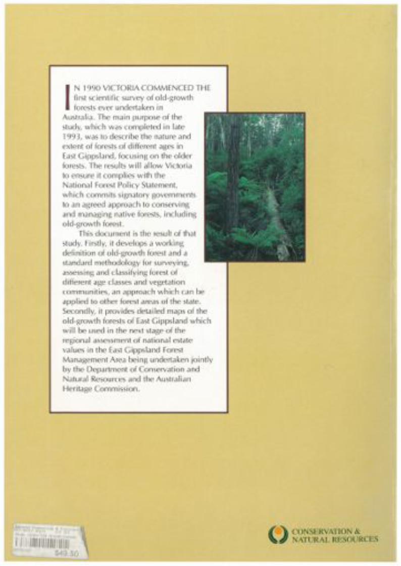
IN 1990 VICTORIA COMMENCED THEfirst scientific survey of old-growthforests ever undertaken in
Australia. The main purpose of thestudy, which was completed in late1993, was to describe the nature andextent of forests of different ages inEast Gippsland, focusing on the olderforests. The results will allow Victoriato ensure it complies with theNational Forest Pol icy Statement,which commits signatory governmentsto an agreed approach to conservingand managing native forests, includingold-growth forest.
This document is the result of thatstudy. Firstly, it develops a work)ingdefinition of old-growth forest and astandard methodology for surveying',assessing and classifying forest ofdifferent age classes and vegetationcommunities, an approach which can beappl ied to other forest areas of the state.Secondly, it provides detailed maps of theold-growth forests of East Gippsland whichwill be used in the next stage of theregional assessment of national estatevalues in the East Gippsland ForestManagement Area being undertaken jointlyby the Department of Conservation andNatural Resources and the AustralianHeritage Commission.
Environ,\:StUd of th 3 02Y e Old GrlM1h Forests I
1//11/1/ 1/1111/11 I'" 1/1 \IC22005 $49.50
()CONSERVATION &
J!J NATURAL RESOURCES
Copyright © 2022 FDOKUMEN