A rural medieval Settlement in Roxburghshire: excavations at Springwood Park, Kelso, 1985-6
81
Proc Soc Antiq Scot, 128(1998), 671-751 A rural medieval settlement in Roxburghshire: excavations at Springwood Park, Kelso, 1985-6 Piers Dixon* with contributions by J D Bateson, L Bown, B Ford, D Grove, S Nye, J Turner, A Welfare & C Wickham-Jones ABSTRACT Few medieval rural settlements have been identified or excavated in Scotland. The site at Springwood Park survived in a ploughed field and was identified by scatters of medieval pottery. Excavation revealed only part of the settlement, a row of buildings on a river terrace which was occupied from the late 12th to the 14th century. Three main periods were identified, followed by levelling and abandonment. The earliest period featured post-set structures and plots defined by ditches; the two later occupation periods featured cruck-framed buildings with clay walls on stone footings. These later periods were each marked by a major reorganization of the settlement, with the buildings in the second period arranged end-on to the old river terrace along which the settlement was built, and in the third period rebuilt in a rowfacing the terrace. The project was funded by the Manpower Services Commission and Historic Scotland. INTRODUCTION There have been few excavations on rural medieval settlements in Scotland. These have often been too small in scale to answer many questions (eg Dunagoil, Argyll: Marshall 1964), or inconclusive for other reasons such as lack of datable evidence (eg Dowglen in Eskdale: Cannel, unpubl; RCAHMS 1997, 234-5). Recent years have seen a spate of interest in rural medieval and post-medieval settlement, with excavations at Pitcarmick, for example, identifying buildings of the late first millennium (Barret & Downes, unpubl). As far as rural settlements of the 12th to 14th centuries are concerned, the Springwood Park excavation remains the most extensive example in mainland Scotland, though comparison may be made with the excavated settlement at Rattray in Aberdeenshire, a medieval burgh of distinctly rural character (Murray & Murray 1993). If our knowledge of rural medieval settlement is to improve, more excavations of this scale are needed. In southern and eastern Scotland increasing numbers of sites have been identified in recent years, either from the combined evidence of documentary sources and field survey (eg Southdean near Jedburgh: RCAHMS 1994), or from scatters of medieval pottery (eg Tents Muir, Fife [NGR: NO 488 229] and Bonjedward, Roxburghshire [NGR: NT 6555 2365], W Elliott, * Royal Comission on the Ancient and Historical Monuments of Scotland, John Sinclair House, 16 Bernard Terrace, Edinburgh EH8 9NX
-
Upload
historicenvironment -
Category
Documents
-
view
0 -
download
0
Transcript of A rural medieval Settlement in Roxburghshire: excavations at Springwood Park, Kelso, 1985-6

Proc Soc Antiq Scot, 128(1998), 671-751
A rural medieval settlement in Roxburghshire:excavations at Springwood Park, Kelso, 1985-6Piers Dixon*with contributions by J D Bateson, L Bown, B Ford, D Grove,S Nye, J Turner, A Welfare & C Wickham-Jones
ABSTRACT
Few medieval rural settlements have been identified or excavated in Scotland. The site at SpringwoodPark survived in a ploughed field and was identified by scatters of medieval pottery. Excavationrevealed only part of the settlement, a row of buildings on a river terrace which was occupied fromthe late 12th to the 14th century. Three main periods were identified, followed by levelling andabandonment. The earliest period featured post-set structures and plots defined by ditches; the twolater occupation periods featured cruck-framed buildings with clay walls on stone footings. Theselater periods were each marked by a major reorganization of the settlement, with the buildings in thesecond period arranged end-on to the old river terrace along which the settlement was built, and inthe third period rebuilt in a row facing the terrace. The project was funded by the Manpower ServicesCommission and Historic Scotland.
INTRODUCTION
There have been few excavations on rural medieval settlements in Scotland. These have oftenbeen too small in scale to answer many questions (eg Dunagoil, Argyll: Marshall 1964), orinconclusive for other reasons such as lack of datable evidence (eg Dowglen in Eskdale: Cannel,unpubl; RCAHMS 1997, 234-5). Recent years have seen a spate of interest in rural medieval andpost-medieval settlement, with excavations at Pitcarmick, for example, identifying buildings ofthe late first millennium (Barret & Downes, unpubl). As far as rural settlements of the 12th to14th centuries are concerned, the Springwood Park excavation remains the most extensiveexample in mainland Scotland, though comparison may be made with the excavated settlementat Rattray in Aberdeenshire, a medieval burgh of distinctly rural character (Murray & Murray1993). If our knowledge of rural medieval settlement is to improve, more excavations of this scaleare needed. In southern and eastern Scotland increasing numbers of sites have been identified inrecent years, either from the combined evidence of documentary sources and field survey (egSouthdean near Jedburgh: RCAHMS 1994), or from scatters of medieval pottery (eg Tents Muir,Fife [NGR: NO 488 229] and Bonjedward, Roxburghshire [NGR: NT 6555 2365], W Elliott,
* Royal Comission on the Ancient and Historical Monuments of Scotland, John Sinclair House, 16 BernardTerrace, Edinburgh EH8 9NX

672 | SOCIETY OF ANTIQUARIES OF SCOTLAND, 1998
SPRINGWOODPARK
-1985-86 -
ILLUS 1 Location map. (Based on the Ordnance Survey map © Crown copyright)
pers comm). Indeed it was the unearthing of medieval pottery by the plough that led eventuallyto the excavation at Springwood Park.
The excavation grew out of a Borders Burghs Archaeology Project designed to follow upthe research objectives identified by the Scottish Burgh Survey for Kelso and its environs(Simpson & Stevenson 1980). This survey not only identified priorities in the town and thegrounds of Floors Castle (Wester Kelso), but also summarized the wider problem of Roxburghand its related settlements, including the possibility of a settlement on the south side of themedieval bridge over the Teviot to Roxburgh. The genesis of the excavation, therefore, was theexamination of what might prove to be a suburban settlement of Roxburgh, but firmly outwiththe walls of the town and its jurisdiction in the township of Maxwell. The presence of Roxburghmust therefore colour our interpretation of the site, though there is no evidence for any localmarket functions on this side of the river, or burgh status to match Wester Kelso, the burgh of theAbbey of Kelso at the bridgehead over the Tweed to the north of Roxburgh. Thus the context ofthe site is partly rural and partly suburban. The benefits of a location so close to Roxburgh wouldhave lain in the ease of access to its markets and the improved opportunities for trading the ruralproducts that the inhabitants produced. The degree to which the lords of Maxwell benefited fromthis activity would have lain in the improved rents that they could charge.
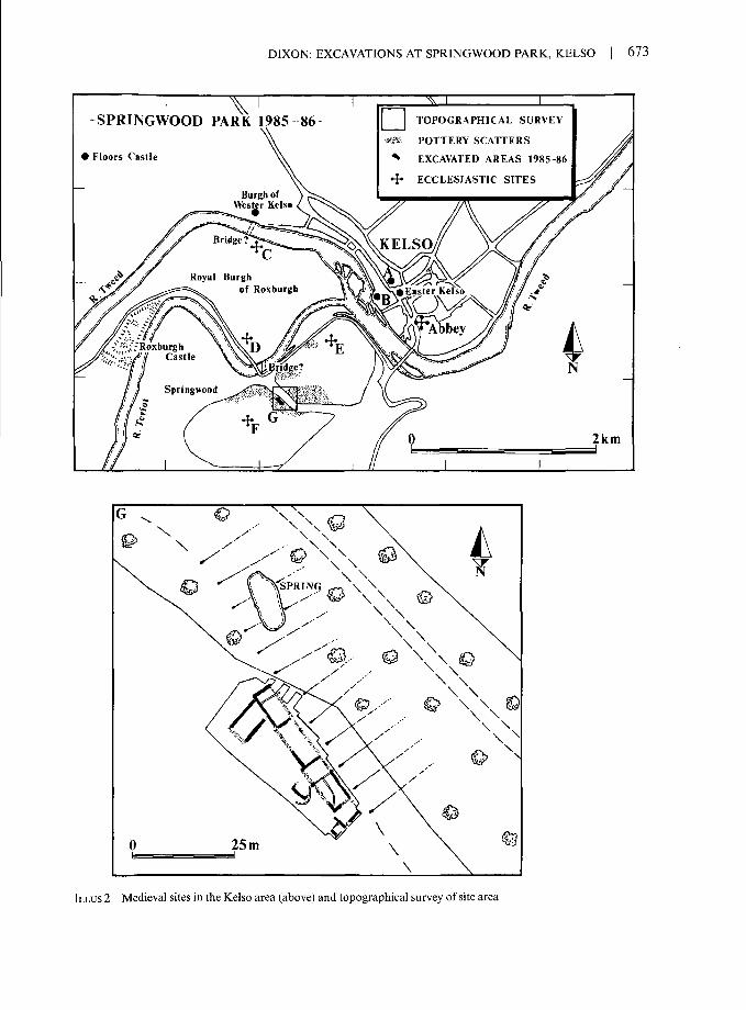
DIXON: EXCAVATIONS AT SPRINGWOOD PARK, KELSO | 673
SPRINGWOOD PARK 1985-86
> Floors Castle
TOPOGRAPHICAL SURVEY
» POTTERY SCATTERS
EXCAVATED AREAS 1985-86
4* ECCLESIASTIC SITESBurgh of
Wester Kelso
Royal Burghof Roxburgh
D /fe«» 'E'-T'"1;-RoxburghCas"e
2km
ILLUS 2 Medieval sites in the Kelso area (above) and topographical survey of site area

674 I SOCIETY OF ANTIQUARIES OF SCOTLAND, 1998
SITE LOCATION
The site lies 150 m south of the river Teviot (illus 1 & 2) on the edge of an east-facing woodedriver terrace in which are a number of springs (NGR: NT 7211 3338). The church of Maxwell layon the haugh land 900 m to the north-east and the oratory chapel of the lords of Maxwell wassituated on the hilltop 350 m to the south-west. There may have been a medieval bridge across theTeviot to the royal burgh of Roxburgh on its north bank, although this is dependent on theevidence of Font's map of c 1590 (Blaeu 1654), which shows a place called Bridgend on the southbank. Scatters of medieval pottery have been found in the ploughsoil both along the edge of theriver terrace for about 150 m from the bridgehead and on the haugh land below the terrace. Thus,the medieval settlement on this site was both a suburban development of the royal burgh and asettlement adjoining rich arable farmland.
ARCHAEOLOGICAL BACKGROUND
The impetus to excavate on this particular site came from Tony Robb who, with Colin Martin,excavated trial trenches on the site in 1966 to investigate the frequent finds of medieval potteryoccurring in the ploughsoil. Their trenches revealed clay-bonded stone walls with adjacentcobbled areas and associated medieval pottery (Simpson & Stevenson 1980). This presented theopportunity to investigate medieval building remains of some substance and relatively undis-turbed by post-medieval occupation or landscaping. The degree to which modern ploughing wasdisturbing the site could also be examined and inferences made about the likely survival ofarchaeological deposits at similar sites.
HISTORICAL NOTE
Direct documentation for the settlement at Springwood Park is limited to the post-medievalperiod, long after the site was abandoned, but some background information about the locality isrelevant nonetheless. The lands of the parish of Maxwell were the possession of the eponymouslords of Maxwell, whose ancestor Maccus, son of Unwain, is said to have received the baronyfrom David I. The lords of Maxwell were variously sheriffs of Roxburgh or Teviotdale andDumfriesshire, and were also chamberlains to Alexander II and Alexander III in the 13th century.Throughout the Wars of Independence the Maxwells managed to stay on the winning side at theright moments and continued to hold the barony until after 1619, when it passed into the handsof the Kers of Roxburgh.
Some light is shed on the arable economy of the area in the medieval period from thesurviving documents. In 1264, 20 chalders of barley were taken from Maxwell to supplyRoxburgh Castle at a cost of 20 marks, and in 1266 the Sheriff of Roxburgh accounted for thecarriage of 20 chalders of corn from Maxwell, thrashed and winnowed, again to supply the castle(ERS I, 17 & 28). In 1381-2, presumably during the English occupation, Thomas of Ilderton,chamberlain of Berwick, accounted for the grazing and profits of the vill of Maxwell and alsoseparately for the vill and mill (Bain 1888, Item 306). The arable bias of Maxwell is furtherdisplayed in the 1567 rental of Kelso Abbey in which the town of Maxwell with the Mains (manis)yielded six bolls of wheat, one chalder of bere (barley) and one chalder and four bolls of meal oroats (OPS 1851, 445-9).
Although not adjacent to the site, Redden, a grange of Kelso Abbey lying a few miles eastof the town, is the subject of a rental of c 1300 which gives an insight into both the local farmingeconomy and also the tenurial structure. Here, in addition to the demesne, there were eight

DIXON: EXCAVATIONS AT SPRINGWOOD PARK, KELSO | 675
husbandmen and 19 cottars, of whom the husbandmen were provided with two oxen, one horse,three chalders of oats, six bolls of barley and three bolls of wheat each, in return for a variety ofservices including the carriage of a horse-load of wheat, salt and coal to Berwick. This paymentin kind had recently been converted to a payment in silver of 12 shillings a year, while thecottagers had to pay 18 pence and do nine days' work, including help with sheepshearing andharvest. The grange also possessed two breweries and a mill (Liber de Calchou, 455-6).
The post-medieval history of the site area may be outlined from cartographic sources. Thesettlement of Brig End at the bridgehead over the Teviot is mapped by Pont c 1590 (Blaeu 1654),despite having been burnt by the English in 1545 (OPS 1851,445-9). By the time of Roy's surveyin the mid 18th century, the area had been enclosed within the fields of Chapelfarm; the settlementof Brig End had evidently ceased to be of any importance and is not named, although one or twobuildings are shown on the south side of the Teviot (Roy 1747-55, sheet 8/3). The enclosed fieldshad been converted to parkland by the 1860s, by which time Springwood House had been built,as had a new bridge over the Teviot (OS 1st edn, 1862-3, Roxburghshire, Sheet IX).
EXCAVATION
The excavation was designed to locate the site previously investigated in 1966, to record thecomplete structures, to investigate their economic and social base and to establish their period ofoccupation. The results of this exploration can also be viewed as a sample of a much largersettlement, since the pottery scatters which identified the site suggest that the settlement isconsiderably more extensive than the excavated area.
TOPOGRAPHY AND GEOLOGY
The site lies on the edge of an east-facing, river-cut terrace in a low-lying, arable field (c 45 mOD), formerly part of the parkland of Springwood House. The ground slopes gently from southto north and from west to east. Deciduous woodland occupies the slopes of the terrace.
The terrace itself comprises imbricated basalt with periglacial features, but little glacial driftmaterial, below a brown silty ploughsoil. The upper part of the bedrock shattered easily andweathered quickly when exposed. Overlying the bedrock was a variable depth of brash orweathered bedrock fragments (illus 3). There was a yellowish red clay-silt above the shatteredbedrock, often in natural declivities. The soils on the site were derived from these subsoils andwere predominantly brown or dark brown silts and loams, but with some yellowish-red or brownclay soils, especially in the earlier phases. There was a shallow depth (0.25 m) of ploughsoil at thewest side of the trench, over bedrock which was scoured by the plough, but at the east side, on theedge of the river terrace, about 1 m of topsoil had accumulated as a result of soil drift. About 25%of the soil layers had been visibly penetrated by worms and larger burrows for small mammalswere also visible in a few places, especially at the north-east of the site. Penetration by roots wasnoted in 10 instances, mostly in the later phases and at the north-east corner of the site next to thewoodland. Naturally, this has implications for any environmental analysis.
METHODS
The site was excavated by hand, including the ploughsoil, and recorded by context (though planswere in general composite rather than based on single contexts).The environmental samplingstrategy was designed so that well-stratified deposits were sampled (ie bulk soil samples), and

676 SOCIETY OF ANTIQUARIES OF SCOTLAND, 1998
Eo

WA
LL
S/IN
FER
RE
D
PHA
SE I
I
POST
HO
LE
DR
AIN
STO
NE
HE
AP
CO
BBLE
S
DIS
TU
RB
AN
CE
CR
UC
K S
ET
TIN
G
WA
LL
/IN
FER
RE
D
PAD
STO
NE
POST
HO
LE
CO
BB
LE
S
DIS
TUR
BAN
CE
TER
RA
CIN
G
010
m
o I o C/3 25 5 z o 8 70 C/5
O
ILLU
S 3
Gen
eral
pla
n sh
owin
g ge
olog
y w
ith si
te d
ivis
ions
Are
as 1
-4 (t
op le
ft), a
nd m
ain
feat
ures
of P
erio
d I (
top
righ
t), P
erio
d II
(low
er ri
ght)
and
Perio
d II
I (lo
wer
left)

678 | SOCIETY OF ANTIQUARIES OF SCOTLAND, 1998
suspect contexts rejected. Some seed samples were taken by hand from charcoal-rich contexts.Pollen samples were also taken from selected contexts. The soil was too acid for good preservationof bone and no attempt was made to sieve for fishbones. Animal bone was collected by hand andrecorded to context. Findspots of coins, copper-alloy and lead objects, worked stone (excludingflint), and selected iron objects were recorded three-dimensionally; other finds were simplyrecorded to context.
An electronic archive of the site records was begun in the field and a complete version hasbeen deposited with the National Monuments Record of Scotland and with the Scottish BordersCouncil's Museum Service. The finds are also deposited with the Scottish Borders Council'sMuseum Service and are held in storage at Kelso.
STRATIGRAPHY
For the purposes of describing the stratigraphy the site has been divided into four areas (Areas1-4), based on both natural and stratigraphic breaks (illus 3). The six stone-walled buildingshave been allocated letters (A-F). The structural sequence is divided into four main periods(Periods I-IV), further subdivided by phases (Phases I-IX). Many of the earliest features (iefeatures cut into the subsoil surface), pre-dating the stone walled structures, are simply groupedtogether in Period I, despite the evidence from Area 4 for considerable complexity in this period.In Area 4 there were at least four phases within Period I, though in other areas few features couldbe assigned confidently to these phases. Further interpretative difficulties were engendered by thecutting of house-platforms in Period III. These truncated the stratigraphic sequence to the pointthat in Area 3, for example, no features could be ascribed to Period II.
INTERPRETATION
A key element in the interpretation of the site is the recognition that the stone footings probablysupported clay walls and that the buildings were cruck-framed houses. This interpretation wasnot immediately evident from the walls themselves, since cruck-trusses do not require anystructural assistance from the walls. Therefore, it is useful at this stage to consider the generalinterpretation of the structural remains.
The walls
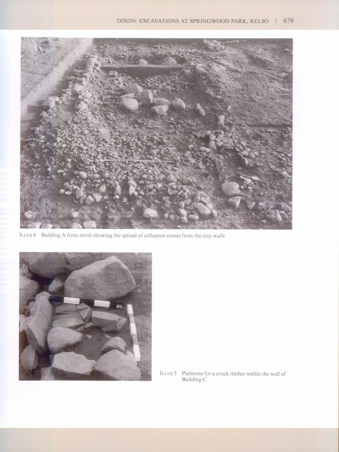
The evidence indicates that the walls of the Period II and III buildings (A-F) were formed of clayover stone footings. The walls of these buildings were all of a similar type, measuring 0.7-0.9 mthick, except for the walls of Building D, which were up to 1.2 m thick. They were faced withboulders and had cores of small to medium-sized stones, bonded with earth or clay. Except wherethe buildings were terraced into the ground the walls generally stood to a maximum of 0.4 m ortwo courses high. The highest remnant, in Building A, was 0.75 m or five courses high (illus 4).While a faced rubble wall of this kind may stand to the apex of a gable and support a roof, as inthe 16th-century 'pelehouses' of Southdean (RCAHMS 1994), this is unlikely to have been thecase here. Most of the walls appear to have been low footings as only a limited quantity of tumblewas recorded, including a few large stones that might have been used as facings (otherwise, highlyefficient stone robbing must be assumed to account for the dearth of fallen building rubble).Spreads of clay silt and small stones, most notably in Building A, indicated the nature of thestone-and-clay aggregate used to raise the walls over these stone footings. Walls of this type have

680 | SOCIETY OF ANTIQUARIES OF SCOTLAND, 1998
been found in rural buildings in many parts of Scotland, including Roxburghshire (Fenton &Walker 1981,76-83).
Crucks
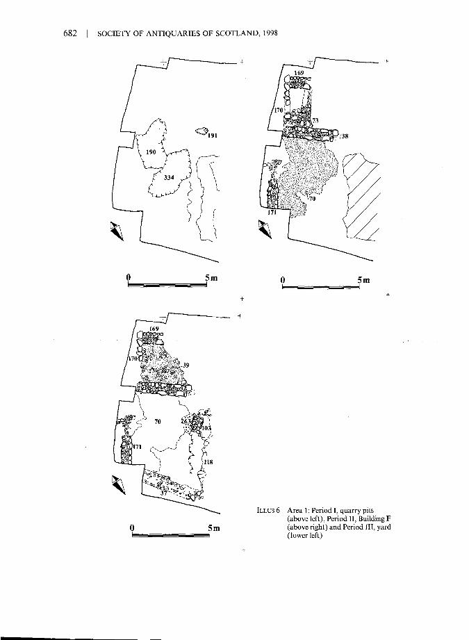
Crucks are known to have been used in rural buildings throughout Scotland in the post-medievalperiod, both from excavations (eg Glenochar, Lanarkshire: Ward 1992, 66-7) and from surveysof standing buildings (eg Prior Linn, Canonbie, Dumfriesshire: Stell 1972). They are alsorecognized in the excavations of medieval buildings in northern England (Wrathmell 1989; Dixon1981). The critical element in recognizing cruck-construction in the stratigraphic record is theevidence for a pad on which the cruck blade was footed. This was first observed at Springwood asa broken padstone set within the west wall of Building C (illus 5), about one-third of the wayfrom its south end. This feature triggered the interpretation and, in due course, a number of
TABLE 1Summary of stratigraphy, interpretation and dating in all periods
Periodl(c 1150-1250)
Period II (c 1250-1300)
Period III (c 1300-50)
Period IV (from late 1300s)
StratigraphyBoundary ditches and post-set structures (Phases I-IV)
Area 1pits
Area 2 Area 3 Area 4pits and gullies ditch and post-set ditches and post-set
structure structure
Dating evidenceLate 12th-century straight-sided Kelso Abbey Redware (Pottery, no 51) from a ditchbeneath the wall of Building D
StratigraphyCrack-framed houses, set end-on or east/west to the terrace (Phase V)
ArealBuilding F?
Area 2Building E
Area 3yard
Area 4Building D
Dating evidence13th-century copper-alloy casket key in surface of infill of Period I hollow in the floorof Building E
StratigraphyCruck-framed houses, re-planned side-on to terrace (Phases VI-VII)
Area 1yard
Area 2 Area 3 Area 4Building A Building B & yard Building C
Dating evidenceKing John halfpenny, c 1205-10, lost by 1220, found in the surface of a floor layer(263) in Area I, sealed by tumble of wall from Building ACut silver farthing of William the Lion, c 1174-95, lost by 1200, from below a floorlayer (261) in Building B
StratigraphyAbandonment, demolition and levelling in all areas (Phases VIII-IX)
Dating evidenceEdward I penny (SF AO), c 1282-9Edward I farthing (SF AR), c 1300-2Both from interstices of stone tumble in Building A

DIXON: EXCAVATIONS AT SPR1NGWOOD PARK, KELSO | 681
variations in the method of cruck-setting were located in the course of the excavations, includingpadstones on the ground and in post-pits, and possibly also shallow pits or ground-settings.
AREAl
Although three periods have been identified in this area of the site to match the main sitesequence, there is no easy division between Periods II and III. Only one floor or yard surface wasfound, which was probably in use in the earlier as well as the later period.
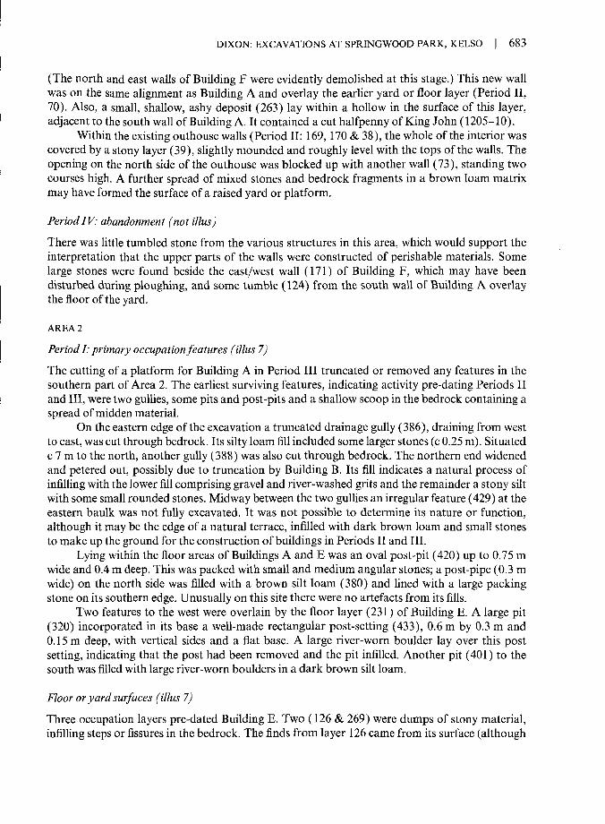
Period I: quarrying (illus6)
At the south end of the site the earliest evidence of activity comprised two irregularly shaped pits(190 & 334) of uncertain use, possibly quarry pits, which were cut into the bedrock. The earlierpit (190) contained a high proportion of bedrock fragments in its silty fill, with a preponderanceof larger stones towards the top of the fill and a concentration of gravelly material at the base,indicating that it may have been open for some time before infilling. Subsequent to its backfilling,another pit (334) was cut immediately to the north. This was filled with a loose, silty, clay loamand was much richer in artefacts, both pottery and animal bone. Close to the west side of thequarry pits was a smaller, irregular pit or post-pit (191), filled with silty loam, with no obviousrelationships to any other features.
Period II: Building F and outhouse (illus6)
At the southernmost end of the site were the remains of two low stone walls which may have beenpart of a building on an east/west axis, parallel to Buildings E and D. A north/south wall (38)formed the west end of the building with an east/west wall (171) at right angles to it forming thesouth wall (there was no physical tie between the two walls). The north wall of the building hadprobably been removed during construction of Building A; the east wall lay outside the limit ofthe excavation. The end wall (38) was 3.6 m long and in places stood to two courses (0.3 m high).Its base was built on a stony layer (311) which sealed a Period 1 quarry pit (190). Partly overlyingthe stony layer was a small thin spread of charcoal-rich silt (305), which suggests an intervalbetween the filling of the pit and the construction of the wall. The side wall (171) was built onnatural bedrock or gravel which had been terraced on its northern side. A maximum of threecourses of facing stones remained. A terrace was cut through natural bedrock and gravels, up to0.15m deep, to form a roughly levelled surface within the building. This levelled area wasoverspread to a maximum depth of 0.15 m by a silty loam with small stones, charcoal flecks andnumerous artefacts, forming a floor or yard surface (70).
To the west of this building a stone walled shed or outbuilding was built within the returnbetween the end wall of the building (38) and an adjoining wall (170) (possibly a remnant plotboundary). This structure was defined on the west by a short length of wall (169) of similarconstruction to the end wall of Building F. It measured 2.2 m by 1.5 m internally and may initiallyhave been open on the north side (at least, wall 73 appears to have been added in Period III,below).
Period III: enclosed yard and metalled platform (illus6)
Immediately to the south of Building A, the area defined by the walls of Building F (38 & 171)continued in use as a yard with the addition of a new wall (37) forming a quadrilateral enclosure.
682 | SOCIETY OF ANTIQUARIES OF SCOTLAND, 1998
5m 5m
5m
ILLUS 6 Area 1: Period I, quarry pits(above left), Period II, Building F(above right) and Period III, yard(lower left)
DIXON: EXCAVATIONS AT SPRINGWOOD PARK, KELSO | 683
(The north and east walls of Building F were evidently demolished at this stage.) This new wallwas on the same alignment as Building A and overlay the earlier yard or floor layer (Period II,70). Also, a small, shallow, ashy deposit (263) lay within a hollow in the surface of this layer,adjacent to the south wall of Building A. It contained a cut halfpenny of King John (1205-10).
Within the existing outhouse walls (Period II: 169, 170 & 38), the whole of the interior wascovered by a stony layer (39), slightly mounded and roughly level with the tops of the walls. Theopening on the north side of the outhouse was blocked up with another wall (73), standing twocourses high. A further spread of mixed stones and bedrock fragments in a brown loam matrixmay have formed the surface of a raised yard or platform.
PeriodIV: abandonment (not illus)
There was little tumbled stone from the various structures in this area, which would support theinterpretation that the upper parts of the walls were constructed of perishable materials. Somelarge stones were found beside the east/west wall (171) of Building F, which may have beendisturbed during ploughing, and some tumble (124) from the south wall of Building A overlaythe floor of the yard.
AREA 2
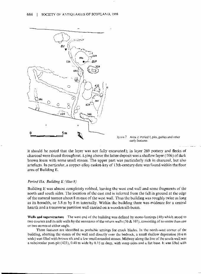
Period I: primary occupation features (illus 7)The cutting of a platform for Building A in Period III truncated or removed any features in thesouthern part of Area 2. The earliest surviving features, indicating activity pre-dating Periods IIand III, were two gullies, some pits and post-pits and a shallow scoop in the bedrock containing aspread of midden material.
On the eastern edge of the excavation a truncated drainage gully (386), draining from westto east, was cut through bedrock. Its silty loam fill included some larger stones (c 0.25 m). Situatedc 7 m to the north, another gully (388) was also cut through bedrock. The northern end widenedand petered out, possibly due to truncation by Building B. Its fill indicates a natural process ofinfilling with the lower fill comprising gravel and river-washed grits and the remainder a stony siltwith some small rounded stones. Midway between the two gullies an irregular feature (429) at theeastern baulk was not fully excavated. It was not possible to determine its nature or function,although it may be the edge of a natural terrace, infilled with dark brown loam and small stonesto make up the ground for the construction of buildings in Periods II and III.
Lying within the floor areas of Buildings A and E was an oval post-pit (420) up to 0.75 mwide and 0.4 m deep. This was packed with small and medium angular stones; a post-pipe (0.3 mwide) on the north side was filled with a brown silt loam (380) and lined with a large packingstone on its southern edge. Unusually on this site there were no artefacts from its fills.
Two features to the west were overlain by the floor layer (231) of Building E. A large pit(320) incorporated in its base a well-made rectangular post-setting (433), 0.6 m by 0.3 m and0.15 m deep, with vertical sides and a flat base. A large river-worn boulder lay over this postsetting, indicating that the post had been removed and the pit infilled. Another pit (401) to thesouth was filled with large river-worn boulders in a dark brown silt loam.
Floor or yard surfaces (illus 7)
Three occupation layers pre-dated Building E. Two (126 & 269) were dumps of stony material,infilling steps or fissures in the bedrock. The finds from layer 126 came from its surface (although
684 SOCIETY OF ANTIQUARIES OF SCOTLAND, 1998
ILLUS 7 Area 2: Period I, pits, guiiies and otherearly features
it should be noted that the layer was not fully excavated); in layer 269 pottery and flecks ofcharcoal were found throughout. Lying above the latter deposit was a shallow layer (106) of darkbrown loam with some small stones. The upper part was particularly rich in charcoal, but alsoartefacts. In particular, a copper-alloy casket-key of 13th-century date was found within the floorarea of Building E.
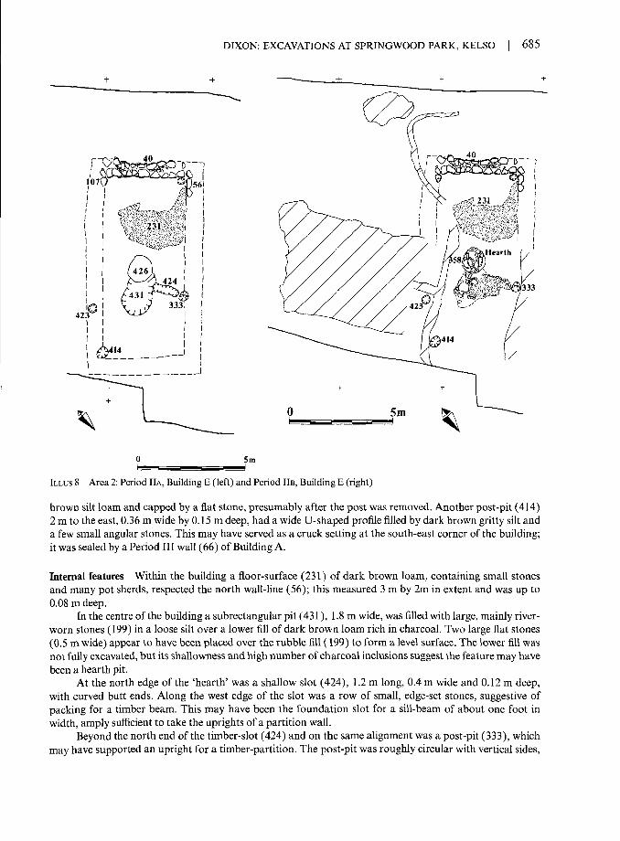
Period HA: Building E (illus 8)
Building E was almost completely robbed, leaving the west end wall and some fragments of thenorth and south sides. The location of the east end is inferred from the fall in ground at the edgeof the natural terrace about 8 m east of the west wall. Thus the building was roughly twice as longas its breadth, or 3.8 m by 8 m internally. Within the building there was evidence for a centralhearth and a transverse partition wall carried on a wooden sill-beam.
Walls and superstructure The west end of the building was defined by stone-footings (40) which stood totwo courses and its side walls by the remnants of the return walls (56 & 107), consisting of no more than oneor two stones at either angle.
Three features are identified as probable settings for cruck blades. In the north-west corner of thebuilding, abutting the stones of the wall and directly over the bedrock, a small shallow depression (0.4 mwide) was filled with brown silt and a few small rounded stones. Midway along the line of the south wall wasa subcircular post-pit (423), 0.48 m wide by 0.15 m deep, with steep sides and a flat base. It was filled with
DIXON: EXCAVATIONS AT SPRINGWOOD PARK, KELSO 685
0 5m
ILLUS 8 Area 2: Period HA, Building E (left) and Period HE, Building E (right)
brown silt loam and capped by a flat stone, presumably after the post was removed. Another post-pit (414)2 m to the east, 0.36 m wide by 0.15 m deep, had a wide U-shaped profile filled by dark brown gritty silt anda few small angular stones. This may have served as a cruck setting at the south-east corner of the building;it was sealed by a Period III wall (66) of Building A.
Internal features Within the building a floor-surface (231) of dark brown loam, containing small stonesand many pot sherds, respected the north wall-line (56); this measured 3 m by 2m in extent and was up to0.08 m deep.
In the centre of the building a subrectangular pit (431), 1.8 m wide, was filled with large, mainly river-worn stones (199) in a loose silt over a lower fill of dark brown loam rich in charcoal. Two large flat stones(0.5 m wide) appear to have been placed over the rubble fill (199) to form a level surface. The lower fill wasnot fully excavated, but its shallowness and high number of charcoal inclusions suggest the feature may havebeen a hearth pit.
At the north edge of the 'hearth' was a shallow slot (424), 1.2 m long, 0.4m wide and 0.12 m deep,with curved butt ends. Along the west edge of the slot was a row of small, edge-set stones, suggestive ofpacking for a timber beam. This may have been the foundation slot for a sill-beam of about one foot inwidth, amply sufficient to take the uprights of a partition wall.
Beyond the north end of the timber-slot (424) and on the same alignment was a post-pit (333), whichmay have supported an upright for a timber-partition. The post-pit was roughly circular with vertical sides,

686 | SOCIETY OF ANTIQUARIES OF SCOTLAND, 1998
and was 0.44 m wide by 0.25 m deep. It contained a post-pipe (0.4 m by 0.3m) with packing stones at theeast and west edges.
Period HB: internal rearrangements of Building E (illus 8)
Although there was no evidence of external change to the building, a sub-period in the internalarrangements of Building E is represented by the insertion of a new hearth, cut through the westside of the earlier pit (431), and by the removal of the partition. This new hearth consisted of apit (426) with a stone base (358) which incorporated a broken millstone and a large block ofdressed sandstone. The pit measured 1.2 m long by 0.25 m deep, with steep sides and a flat base.It was filled with river-worn boulders in its lower part, with the upper surface made level withlarge flat stones, set in a dark, reddish grey, silty loam. A shallow deposit of 'ashy' material (afine, dark grey silt) formed a slight mound covering most of the set stones.
It was probably in this sub-period that small stones (174) were packed into the beam-slot(424) after removal of the timber beam which had supported a partition wall. This packing wasin turn partly overlain by smaller, densely packed cobbles in a fine silt matrix (163).
Period III: Building A (illus 9)
Period III was marked by a realignment of the buildings, roughly at right angles to those in PeriodII, and the levelling of house-platforms. Thus in this area Building E is superseded by Building A.At the north end, a platform for this new building was created by levelling up the floor area ofBuilding E with a spread of compact, dark brown, silt loam (164); at the south end, the platformwas excavated from the bedrock to a maximum depth of 0.8 m. The overall result was a level areaof about 11 m by 4.8 m internally. The 'ashy' (silt?) infill of the hearth pit in Building E may beevidence of its abandonment and exposure, and thus of an interval between the two buildings. - -
Walls The east wall (66) was 11 m long and stood to two courses. Only a few stones of the outer facesurvived and towards the north end only traces of the core were to be seen (medium-sized boulders0.15-0.2 m in diameter). Of the west wall a few short sections survived, including a threshold (describedbelow). A section of the inner face (116), 3 m long, was set on a step in the bedrock and was composed oflarge boulders one course high. Four stones (101) midway along the west wall marked the inner and outerfaces of the wall at this point. North of the threshold a linear spread of loose silt (120) may indicate adisturbed area associated with the robbing of the wall. The south wall was only evident at the south-westcorner where a section of wall, 1.2 m long and 0.75m high, was built into a dip in the terraced bedrock;elsewhere, the line of this wall was inferred from the terracing. The north wall (42) survived to a maximumof two courses high and measured 5.6 m in length. It was partly supported on the outside by a foundationcourse of large boulders set in a trench (394), indicating that the platform for Building B was also levelled atthis time (see Area 3 below).
Drains A drainage system was required by the newly cut building platform and was incorporated in theconstruction of the building. Draining both the interior and exterior (upslope) of the building, the drain(195/357) started more than 5 m to the west and ran to the south for 2 m, then turned north-east around theremains of Building E before turning east to pass through Building A. On this course the drain was carriedbeneath the thresholds in the east and west walls of the building. A second drain, or branch drain (193), ranfrom the south-west corner of the interior to meet the main drain in a T-junction in the middle of thebuilding. In the south-west corner of the building a short section of drain (404), forming a tributary of the

DIXON: EXCAVATIONS AT SPRINGWOOD PARK, KELSO 687
ILLUS 9 Area 2: Period III,Building A
branch drain, appears to have gone out of use during the occupation of the building. The capstones hadcollapsed into the drain which was then infilled by a clay silt.
The drains varied slightly in size and construction. Where the drain was cut into bedrock there was noneed for lining stones; elsewhere a U-shaped trench was lined with stones. The drain was covered by flatcapstones for most of its length except for two short sections within the building. The branch drain wasslightly larger and deeper than the main drain (0.4 m wide and 0.2 m deep, compared with 0.3 m wide and0.15 m deep), probably because it was cut through solid bedrock. At the point where the drain emergedfrom the east wall of the building the capstones were covered by a mound of loosely packed stones (350).
Entrances There were two opposed entrances, in the east and west walls. In the west wall, a threshold wascomposed of three rounded stones (279) forming an edge in line with the inner face of the west wall andretaining a group of closely packed small, medium and large stones (278), including one large flag (280).Post-pits (398 & 399) on either side of the threshold indicated a wooden door frame about 1.3 m wide. Thepits were up to 0.4 m in diameter by 0.3 m deep and contained large packing stones. One of these (399) mayhave replaced another post-pit (400) immediately to its east; this was 0.5 m wide and also contained packingstones. The width of the door-posts was probably about 0.2 m.
The entrance to the east was represented by a pair of post-pits about 1.25 m apart, just inside the lineof the wall, but here there was no surviving stone threshold to match that in the western entrance. The post-pits (416 & 406) were up to 0.5 m wide by 0.2 m deep and again contained packing stones. A third, adjacentpost-pit (418) may have held a replacement for the southern post.
Internal features Two shallow post-pits (415 &417) were set 1.2 m apart in a position adjacent to the eastwall and south of the entrance. These were about 0.4 m wide by 0.35 m deep, with dark brown silty loam fills

I SOCIETY OF ANTIQUARIES OF SCOTLAND, 1998
containing a few small angular stones and a single packing stone (in 415). It is not known what type offixture is represented by these settings for upright timbers although they may have been cruck-blades. Athird post-pit (397) may indicate the line of a timber partition across the building, to the south of theentrances. This was 0.35 m wide by 0.4 m deep and was filled with dark brown silt loam and three possiblepacking stones. The fill was similar to the surrounding floor layer (132), suggesting that the post had beenremoved at abandonment.
Four floor surfaces were identified. A roughly rectangular area of cobbling (108) covered the T-junction of the drains and concealed the capstones. North of this an area of rubble (109) formed a roughsurface which may well be a disturbed area of cobbling. The southern two thirds of the building wereoverspread by a mottled layer of clay loam (132) with frequent charcoal and small grits, including crushedbedrock; the 'greasy' appearance of this layer suggests it was trampled. Finally, stony soil spreads withcharcoal flecks (155 & 375) were mounded over the capstones of the drain in the south-west corner of thebuilding. No definite hearth was identified.
Yard Outside the building to the west, the wall remnants of Building E were filled with dumps of mediumand large stones to form a yard surface. The lower levels (76) were rich in pottery in a matrix of brown loam,possibly representing rubbish from the occupation of Building E; above this was a compact layer of cobbling(41).
South of the yard and adjacent drain, a large oval pit (242) was cut into bedrock and natural gravels.Its lower fill was a soft, dark silt (243 & 127) with frequent grits which probably weathered from the sides.This was overlain by a dump of rubble in a matrix of silty loam (125), which contained many pot sherds andfragments of animal bone.
Period IV: abandonment and demolition (not illus)
When the site was abandoned there was some robbing of the stone wall footings, especially at thenorth end, but much of the masonry simply collapsed, so that quantities of tumble were foundwithin Building A. These were interleaved with thin silt layers which may also have derived fromcollapsed wall fabric.
At the south end of the site a distinction could be made between modern ploughsoil and thepost-occupation silting layers which lay beneath this. Two silver coins were found in the intersticesof tumbled rubble (83) at the base of a silt layer (51). These were a silver penny-of Edward I(1282-9) and an Edward I silver farthing (1300-2) (see Coins). Their location gives a terminuspost quern of c 1300 for the abandonment of the building.
Apart from collapsed masonry, some further rubble, including large field boulders, appearsto have been added as deliberate infilling at a later date. This may have occurred when the parkwas laid out in the 18th century, if not before.
AREA 3
Stratigraphic relationships between Area 3 and other parts of the site occur only in Period III.Furthermore, most of the interrelated stratigraphy in this area was restricted to the site ofBuilding B. The features to the west of this were largely isolated and are discussed in Period I as'unstratified'. There were no features that could be ascribed to Period II and it is assumed thatthere was no major structure here at that time.
Period I: early occupation evidence (illus 10)Boundary ditch The earliest feature in Area 4 may have been a boundary ditch (14). The ditch had a U--shaped profile up to 1 m wide and 0.15 m deep. It was filled by a variety of fills reflecting the nature of the

DIXON: EXCAVATIONS AT SPRINGWOOD PARK, KELSO | 689
ILLUS 10 Area 3: Period I, ditch, pits andother early features
subsoil through which it passed (mainly a friable silt loam with fragments of bedrock). This materialproduced some finds, indicative of disturbance by human activity. The ditch was probably coeval with oneor more of the ditches in Area 4 in Period I, forming some sort of plot boundary. Its east end was destroyedby the terrace for Building B (Period III).
Post-pits A number of post-pits occurred. These appeared to belong to at least one post-set structure, butterracing of the site has precluded any possibility of deriving a building plan. This may have been broadlycoeval with the Period ID structure described below, in Area IV, both because the structure is post-set andbecause they would have shared a similar alignment. One of these pits (12) cut the boundary ditch, after ithad been infilled. This was up to 1.1. m wide and 0.15 m deep. At its south edge was a post-setting (17)0.44 m wide and 0.16 m deep, surrounded by a group of six packing stones. No post-pipe was observed.Elsewhere, a group of four post-pits formed a row 5.5. m long (pits 392, 408, 409 & 413). These lay on themargin of the terrace for Building B and one of the pits (409) was overlain by make-up for its walls. The pitswere of similar size, being from 0.3 m to 0.5 m wide and about to 0.25 deep. One of these was cut by a fifthpost-pit (393), which was slightly larger and deeper, and probably contained a replacement post. Pit 389 atthe south end of the row may also belong to this group. The settings were big enough to take posts between0.15m and 0.2m thick.

690 | SOCIETY OF ANTIQUARIES OF SCOTLAND, 1998
Unstratified features There were six pits cut into the brash to the west of Area 3 which displayed noparticular pattern or function. Four lay in a group (6, 47, 48 & 198) to the south of the boundary ditch andone to the north (49). Of these one was a large shallow pit (6), 1.45 m wide and 0.22 m in depth, with a fillof silt and small stones. The sixth feature was a small post-pit (395) in the return between Buildings A and B.
Period HI: Building B (illus 11)
In preparation for the construction of Building B a rectangular platform was levelled betweenBuildings A and C, orientated on the same axis as these. This event is described in two parts,north and south, since the stratigraphy was split by the 19th-century drain which traversed thebuilding.
House stance Only the north part of the north-west quadrant was completely excavated. The primary fill(377) of the terrace was a loose silt, up to 0.2 m deep, with occasional small or medium stones. No findswere encountered in the portion excavated. To the south the terrace (434) cut through the natural graveldown to the fissured bedrock surface. Again this area was infilled with a friable silt loam (179/367), to amaximum thickness of 0.25 m. The absence of stone or shattered bedrock indicate that this material wasimported to level the building stance after it was terraced or quarried from the bedrock.
Walls and cruck-setting Building B was built between the end walls of Buildings A and E, on either end, tocomplete a row of three buildings on a north/south axis. A 5 m length of the west wall was preserved (62).This stood to two courses in places and was set on a shallow deposit of silt; the best-preserved portion wasbutted against the north wall of Building A. At the opposite end of the building, three stones added to thesouth wall (27) of Building C may have formed part of the north or end wall of Building B. Several largeboulders (111) indicate the line of the east wall. Together, these features indicate a building with internaldimensions of 11 m by 4.2 m.
A possible cruck-blade setting is defined by a dark brown, silt-filled oval pit (281), with a U-shapedprofile, measuring 0.6 m by 0.45 m, with a depth of 0.2 m. The pit cuts through a primary cobbled floorsurface (261) and lies within the line of the east wall of the building.
Eaves drip gully Immediately outwith the west wall (62) of the building was a shallow linear depressionwhich may have been created by eaves drip from the roof. It measured 5 m in length by 0.7 m in breadth andwas 0.1 m in depth. In its base were small thin patches of clay silt with charcoal flecking, but it was filledmainly by a brown sandy silt with some small stones, occasional medium-sized stones and charcoal flecks.
Entrance A paved entrance through the west wall of the building is defined by a shallow east/west slotwhich contained two large flat stones (307) set in a dark brown gravelly soil. Immediately to the south, fourmedium stones were laid on the same axis in a similar soil matrix. Another shallow slot was cut through thewest end of the threshold, but was aligned at right angles to it; this may have held more paving stones. Thesurface of this slot was covered by a thin, charcoal-rich deposit of silt.
Outshot To the south of the entrance was a pair of post-pits about 1 m apart and 0.5m from the west wallface. These may have supported a lean-to shed or store. The more northerly of the two (407) was later thanthe north/south slot (332) which lay outside the threshold of the building, and suggests a rearrangement ofthe entrance. The pits were c 0.5 m wide by 0.3 m deep, with fills of gravel, clay silt, or silty loam, occasionalcharcoal and small stones. The posts in both cases appear to have been removed.

DIXON: EXCAVATIONS AT SPRINGWOOD PARK, KELSO | 691
ILLUS 11 Area 3: Period III, Building B
Floor layers and hearth A number of cobbled floor layers were excavated in the north end of the building.In the north-east quadrant there appears to have been more than one phase of flooring, as successive cobbledlayers and silty make-up layers were laid down (240, 257-9 & 261), starting with a layer of small andmedium-sized stones set directly on the subsoil (261) and finishing with another cobbled surface (240). Atthe base of the primary cobbled layer a fragment of a cut farthing of William the Lion was recovered, givinga terminus post quern of c 1200 for the floor. In the north-west quadrant the silty make-up layer (377) wasoverlain by stone dumps (354 & 378), evidently make-up layers for a cobbled surface of small and mediumstones (29) which covered an area 3.2 m by 2.4 m in extent.
A group of four medium-sized stones (55) at the west edge of the modern drain stood proud of thecobbles and may have been part of a hearth.
In contrast to the cobbled layers in the northern part of the building, the surface in the southern halfof Building B (ie overlying the levelling layer on the bedrock surface) was a thin, somewhat patchy, brownsticky silt clay (128/149) which contained bedrock fragments and charcoal. Only the south-west quadrantof this floor layer (128) was excavated. Despite its patchiness it respected the projected east wall-line of thebuilding.
Period IV: abandonment and demolition (not illus)There was little tumble around Building B. Some was noted along the west wall and, in the south-west corner, a small mound of stones overlay a deposit of silt (as in Building A) and may have

692 | SOCIETY OF ANTIQUARIES OF SCOTLAND, 1998
been later field clearance. Below these deposits there was some evidence of destruction by fire. Adark brown silty loam (145), up to 0.15 m thick, contained some medium and large stones andmany flecks or larger pieces of charcoal, as well as one piece of burnt wood. This deposit,however, extended only to an area of 2.6 m by 1.14 m.
Robbing of the east wall was almost complete. A stone robber hole on this side was filledwith a dark, greyish brown, silt loam which was similar to that filling the possible cruck-setting(281), suggesting that both features were filled at the same time. Part of the cobbling was alsodisturbed and backfilled in this way.
AREA 4
All the features which are stratigraphically earlier than Buildings C and D at this end of the sitehave been assigned to Period I, which is further subdivided into sub-phases on the basis of thesurviving stratigraphy. (Features which could not be assigned to a sub-phase are described at theend of the section.) Worm action, animal burrowing and root penetration made the definition offeatures especially difficult in this part of the site, where the subsoil was soft. Thus the depth atwhich features were defined was often lower than that at which they were originally cut. Inaddition to these problems, in the final occupation (Period III) a platform was cut into the slopewhich truncated many of the earlier features, making it difficult to determine which featuresbelonged to Period I or II.
Period I'A-C: property boundaries (illus 12)
The early phases of Period I comprise a succession of ditches on a roughly similar alignment,roughly NNE/SSW. This suggests the maintenance of a boundary over a considerable length oftime, probably in conjunction with the shallow east/west ditch (14) in Area III (Period I). Thesewould have formed two sides of a property boundary, with a gap at the corner, where the ditchescome to a butt-end.
Boundary ditches Two ditches (326 & 315) have been assigned to the earliest period of activity on the site.However, it is most unlikely that they were both in use at the same time; indeed it is more likely that theywere in use successively. They were parallel to one another, about 1 m apart, and both appear to havedrained northwards over the edge of the terrace. The ditches both had U-shaped profiles and were up to0.5 m deep by 0.8 m wide. Their fills were generally similar, consisting of a brown or tan coloured silt or siltloam (though a grey silt with charcoal also occurred in the upper fill of one ditch (315) towards its northend). The characteristic tan colour reflects a high incidence of aerated subsoil in the fills, which may point tonatural weathering as a factor in their becoming infilled.
Subsequent to these ditches, a much shallower north/south ditch (312), 0.7 m wide by 0.1 m deep, wascut through the westerly of the two Period I ditches (326). It was filled with a stony brown silt interpreted asan intentional backfill rather than a result of weathering. Although it was on the same alignment as theearlier ditches, its profile, a shallow U-shape, was completely different and much more akin to that of theeast/west gully (14) in Area 3.
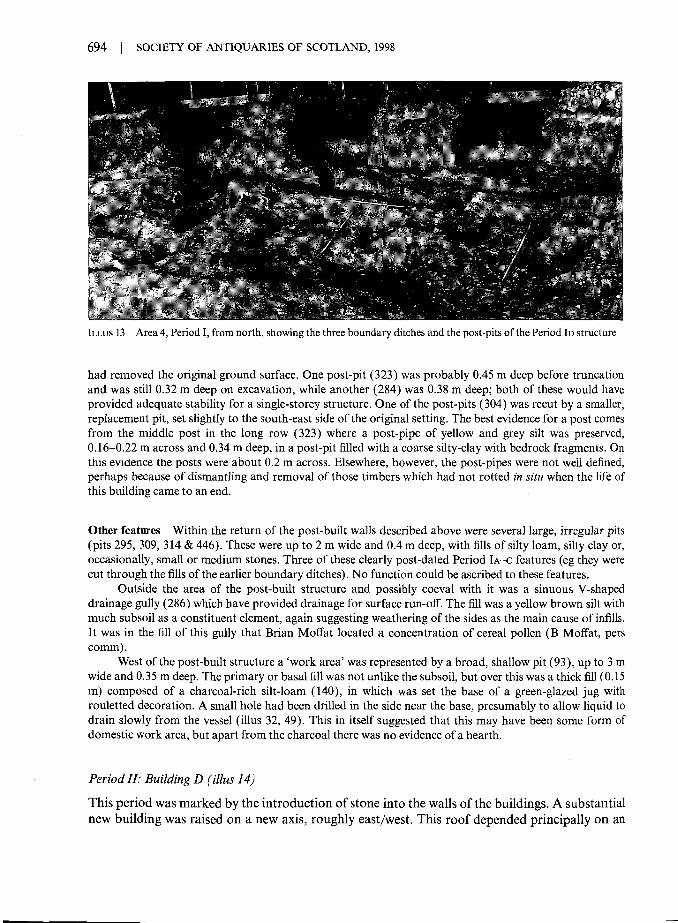
Period ID: post-built structure (illus 12 & 13)
Post-dating the sequence of ditches was a post-built structure. A row of five post-pits on a north/south axis, between 2 m and 2.5 m apart (post-pits 435, 299, 323, 439 & 208), formed one side ofan L-shaped structure, with an end wall in the north indicated by an adjoining row of post-pits

DIXON: EXCAVATIONS AT SPRINGWOOD PARK, KELSO 693
ILLUS 12 Area 4: Period I, post-set structure and boundary ditches
(284, 304 & 208; the last of these, being common to both rows, would have held a corner post).Post-pits forming the line of the second or eastern long wall were not immediately recorded, asthis lay beyond the limit of excavation on that side. It was for this reason that the three smallextensions to the east baulk of the site were made, but animal disturbance in this area was severeand no further post-pits were detected. In view of the limited nature of the evidence, it isimpossible to be certain about the overall nature of the structure. The two wall lines which wererecorded suggest a building with minimum dimensions of roughly 10 m by 4 m in plan, on astance which sloped from north to south with an overall fall of at least 0.7 m.
Post-pits The post-pits varied from 0.28 m to 0.5 m in width, often narrowing to as little as 0.15 m at thebase. The profiles were generally a flat U-shape. The original depths were difficult to gauge since truncation
694 I SOCIETY OF ANTIQUARIES OF SCOTLAND, 1998
ILLUS 13 Area 4, Period I, from north, showing the three boundary ditches and the post-pits of the Period ID structure
had removed the original ground surface. One post-pit (323) was probably 0.45 m deep before truncationand was still 0.32 m deep on excavation, while another (284) was 0.38 m deep; both of these would haveprovided adequate stability for a single-storey structure. One of the post-pits (304) was recut by a smaller,replacement pit, set slightly to the south-east side of the original setting. The best evidence for a post comesfrom the middle post in the long row (323) where a post-pipe of yellow and grey silt was preserved,0.16-0.22 m across and 0.34 m deep, in a post-pit filled with a coarse silty-clay with bedrock fragments. Onthis evidence the posts were about 0.2 m across. Elsewhere, however, the post-pipes were not well defined,perhaps because of dismantling and removal of those timbers which had not rotted in situ when the life ofthis building came to an end.
Other features Within the return of the post-built walls described above were several large, irregular pits(pits 295, 309, 314 & 446). These were up to 2 m wide and 0.4 m deep, with fills of silty loam, silty clay or,occasionally, small or medium stones. Three of these clearly post-dated Period IA-C features (eg they werecut through the fills of the earlier boundary ditches). No function could be ascribed to these features.
Outside the area of the post-built structure and possibly coeval with it was a sinuous V-shapeddrainage gully (286) which have provided drainage for surface run-off. The fill was a yellow brown silt withmuch subsoil as a constituent element, again suggesting weathering of the sides as the main cause of infills.It was in the fill of this gully that Brian Moffat located a concentration of cereal pollen (B Moffat, perscomm).
West of the post-built structure a 'work area' was represented by a broad, shallow pit (93), up to 3 mwide and 0.35 m deep. The primary or basal fill was not unlike the subsoil, but over this was a thick fill (0.15m) composed of a charcoal-rich silt-loam (140), in which was set the base of a green-glazed jug withrouletted decoration. A small hole had been drilled in the side near the base, presumably to allow liquid todrain slowly from the vessel (illus 32, 49). This in itself suggested that this may have been some form ofdomestic work area, but apart from the charcoal there was no evidence of a hearth.
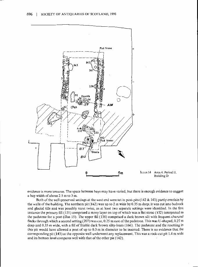
Period II: Building D (illus 14)
This period was marked by the introduction of stone into the walls of the buildings. A substantialnew building was raised on a new axis, roughly east/west. This roof depended principally on an

DIXON: EXCAVATIONS AT SPRINGWOOD PARK, KELSO | 695
opposed pair of large posts at either end of the building, and possibly three intermediate pairs ofposts in between, although the evidence for these is slight.
Walls The walls of Building D ( 3 & 4) were up to 1.2 m wide and survived to only a single course in height,faced with medium or large river-washed boulders and infilled with smaller stones of similar type. Thesurviving wall lengths terminated in the west where the bedrock outcrops across this part of the site and inthe east where the later Building C had truncated the present building. Since the bedrock 'stepped up' fromthe ground surface between the walls at the west end, there was some evidence for supposing that the end ofthe structure lay at this point. Indeed a few medium-sized stones were found on the step which could havebeen relict wall stones. On this basis the structure would have measured about 13m long by about 4.5 mwide, internally.
Floor layers & hearths An area of cobbling (233) was recorded in the north-east corner of the house. Therest of the ground surface within the building did not display any clear signs of flooring, and there was nodifferentiation between the soil matrix inside the building, beneath its walls or even outside. The surfacedeposits graded into subsoil and were designated 'subsoil interface layers' in the field record. Furthermore,it was difficult to associate features at the east end of the building with the west end, because the relationsbetween the two ends had been severed by the terracing for Building C (see below).
Two possible locations for a hearth were uncovered. One lay in the middle of the building andcomprised an area of paving (34) which was set in a brown silt, 0.1 m thick. This may have served as ahearth, or perhaps as a paved area, since the stones did not show any particular evidence of heat and no ashdeposit was present.
A second possible hearth location lay towards the east end of the building where a thin layer (232) ofash and charcoal overlay part of the cobble floor (233). However, there were no particular stones whichmight be identified as a hearth setting; if these existed they may have been robbed prior to the constructionof Building C.
Other internal features A short distance east of the possible hearth, a layer (276) of sticky, dark grey, siltclay (1 m by 0.9 m in extent and 0.1 m thick) had accumulated in an area of subsidence over the infill of aPeriod I pit (309/446). This deposit was penetrated by roots in antiquity, since they were not visible in thecobbled layer above. This suggests that there was a short period when the interior of the building was open,allowing the penetration of roots into the deposit. It contained two metal artefacts, as well as charcoal, andwas rich in other carbonized botanical remains, including abundant cereal grains.
The east end of the building was drained by a gully (277), 2 m long and 0.3 m wide by 0.15 m deep,and filled with pebbly stones in a dark brown silt matrix. On analogy with the drains in Buildings A and C,it is interpreted as a trench cut for a stone-lined drain which was robbed of stone prior to the construction ofBuilding C.
Parallel to the south wall was a slot (91), 1.5 m long by 0.6 m wide and 0.2 m deep, which was filledwith a red brown sandy silt with bedrock fragments, and may have served as a sump. This feature has noclear stratigraphic associations; its shared alignment with Building D suggests it may be associated with thisstructure, but no obvious function could be ascribed to it.
There were two post-pits within the floor area of the building (ie apart from those interpreted as cruck-post features). One small post-pit (89), 0.4 m wide by 0.08 m deep, lay on the same alignment as the slot(91), 0.5 m from the south wall face of the building. A second, large post-pit (438) contained within it adeeper setting for the post (291), with a charcoal-rich fill of dark brown silt and a post-pipe 0.3m indiameter by 0.16 m deep. Within the post-pipe, a fill of buff coloured silt and bedrock fragments suggestedthat the post had been removed and the hole deliberately backfilled prior to the construction of Building C.
Cruck settings There were several post-pits, padstones and shallow scoops which may have formed basesfor cruck-blades. The best preserved were a pair of post-pits at the west end of the building; elsewhere the
696 SOCIETY OF ANTIQUARIES OF SCOTLAND, 1998
ILLUS 14 Area 4: Period II,Building D
evidence is more tenuous. The space between bays may have varied, but there is enough evidence to suggesta bay width of about 2.5 m to 3 m.
Both of the well-preserved settings at the west end were set in post-pits (142 & 143) partly overlain bythe walls of the building. The northern pit (142) was up to 2 m wide by 0.35 m deep; it was cut into bedrockand glacial tills and was possibly recut twice, as at least two separate settings were identified. In the firstinstance the primary fill (151) comprised a stony layer on top of which was a flat stone (152) interpreted asthe padstone for a post (illus 15). The upper fill (136) comprised a dark brown silt with frequent charcoalflecks through which a second setting (207) was cut, 0.25 m east of the padstone. This was U-shaped, 0.27 mdeep and 0.35 m wide, with a fill of friable dark brown silty-loam (166). The padstone and the resetting inthis pit would have allowed a post of up to 0.3 m in diameter to be inserted. There is no evidence that thecorresponding pit (143) at the opposite wall underwent any replacement. This was a rock-cut pit 1.4 m wideand its bottom level compares well with that of the other pit (142).

DIXON: EXCAVATIONS AT SPRINGWOOD PARK, KELSO I 697
ILLUS 15 A padstone (152) for a cruck timber showing within a partly-excavated pit (142) in Building D
Other candidates for cruck settings include a padstone observed in the side of the later Period IIIterrace cut (441). This was a large rectangular slab of stone (182), 0.4 m wide by 0.2 m thick, which cappedan abandoned Period I post-pit (304), but which was overlain by the north wall of Building C. The padstonewas in a suitable location for a cruck setting at the north-east corner of Building D. A fourth candidate is ashallow oval pit (82), 0.66 m wide by 0.05 m deep, within the line of the south wall, in an area robbed ofstone-footings. Finally, about 3 m from the corner padstone (152) at the west end was a shallow circular pit,0.65 m wide by 0.12 m deep, which was partly overlain by the north wall of Building D. It was cut into anearlier and larger shallow oval pit (230), 1.3m wide by 0.12 m deep.
External pit A shallow pit (294) with an irregular, pock-marked base (indicating disturbance by smallmammals) contained a high proportion of carbonized material. It may have been a hearth-pit, but becauseof its position outside Building D and the lack of associated structural evidence, it may as easily have beenused to deposit burnt waste from a hearth inside the building. Its fill was a dark grey silt with a few medium-sized orthostatic stones on the edges of the feature and a few fragments of daub. The botanical sample fromthe pit was particularly productive of cereal grains and chaff (especially oats, but also barley), and heatherwas present in quantity.
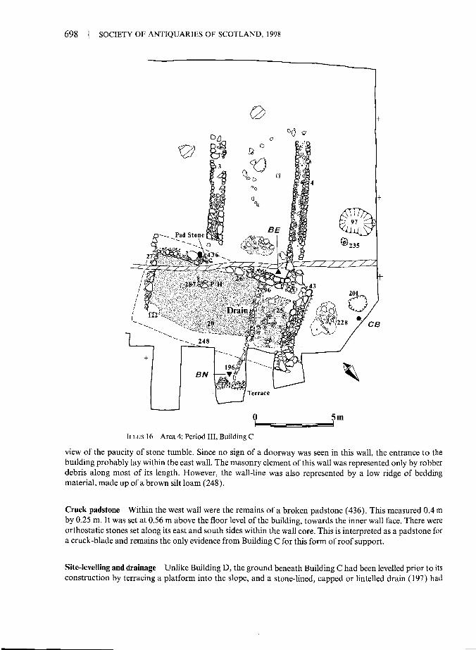
Period III: Building C (illus 16)
Building C clearly post-dated Building D, since it incorporated the north wall remnant (4) of thatstructure in its west side. The building was 11 m in length by 4 m in breadth, internally. LikeBuilding D, its walls were constructed with large boulders up to 0.75 m across, again with a smallstony core.
Walls Three walls survived on three sides of the building for almost their entire length. The width of thewalls was slightly narrower than in Building D at about 0.75 m. They generally survived to one course only,though in short sections a second course was observed, particularly at the angles or ends of the west wall(26). At its highest this wall stood to about 0.5 m. It is unlikely to have stood much higher as a stone wall, in
698 SOCIETY OF ANTIQUARIES OF SCOTLAND, 1998
ILLUS 16 Area 4: Period III, Building C
view of the paucity of stone tumble. Since no sign of a doorway was seen in this wall, the entrance to thebuilding probably lay within the east wall. The masonry element of this wall was represented only by robberdebris along most of its length. However, the wall-line was also represented by a low ridge of beddingmaterial, made up of a brown silt loam (248).
Cruck padstonc Within the west wall were the remains of a broken padstone (436). This measured 0.4 mby 0.25 m. It was set at 0.56 m above the floor level of the building, towards the inner wall face. There wereorthostatic stones set along its east and south sides within the wall core. This is interpreted as a padstone fora cruck-blade and remains the only evidence from Building C for this form of roof support.
Site-levelling and drainage Unlike Building D, the ground beneath Building C had been levelled prior to itsconstruction by terracing a platform into the slope, and a stone-lined, capped or lintelled drain (197) had

DIXON: EXCAVATIONS AT SPRINGWOOD PARK, KELSO | 699
been laid across the house stance. The drain was similar in construction to the example in Building A, being0.3 m wide by 0.15 m deep. It traversed the floor from beneath the west wall to run out over a stone-builtedging of the terrace by the opposite or east side of the building. Thus it is likely that the drain also ranbeneath the former east wall, cutting the wall make-up or bedding layer (248). Indeed it probably indicatesthe location of the entrance, for which no other evidence survived.
Floor The north end of the building, bordered by the drain, was occupied by a surface of small andmedium sized cobbled and flat stones (25). These covered the whole area within the walls except for a strip0.4m wide along the west wall. The cobbles were set in a dark, grey brown silt (153), not unlike the soil layer(20) which formed the floor surface throughout the rest of the building. There was one thick charcoal richlens (122) within this layer, in the south-east corner of the house, but no definitive sign of a hearth.
Partition A post-pit lay towards the south end of the building, at c 1 m from the west wall, where it maymark the line of an internal partition. The pit was up to 1 m wide and contained several packing stones andsome bedrock fragments. It was not immediately recognized in the dark, disturbed floor surface, but oncethis had been reduced by the excavation of several spits the pit could be seen to cut an earlier Period II pit(294), and probably does belong to this building.
Yard The yard to the north of the building was reduced by what may, in part at least, have been naturalweathering rather than human and animal action. The ground was scoured away along this edge of thebuilding, almost undermining the facing stones. This left a rough surface composed of a stony layer (228)set in a silt loam, extending over an area of about 2 m by 1.5 m. Over this yard-surface a brown silt layer(183) accumulated to a depth of 0.1 m. A small, stone-filled pit (201) was cut into this, suggesting that useof the yard had already ceased when the pit was dug. The upper fill of the pit contained an almost completejug (Pottery, no 54) with straight sides and a dark green glaze.
Other features Several other pits were recorded in the yard to the north of Building D. The most substantialof these was a deep, subrectangular pit (97), up to 2.2 m wide and 1.05 m deep. This was recognized onlywhen a spit of brown silt was removed from this area and it may, therefore, pre-date the buildings in thisperiod. The fills were a granular clay loam with blue subsoil fragments over a basal fill of dark brown clay-loam. This suggests that it was filled in two stages, an impression corroborated by the weathering of thesides in the upper part of the pit. It contained a few bones and sherds of pottery, but does not seem to havebeen a rubbish pit. Its function remains obscure as does its relationship to the rest of the site.
East of the larger pit described above was a small post-pit (235) which came to light after the removalof a further soil spit (0.2 m thick). This had a U-shaped profile, 0.3 m across and 0.1 m deep, with a shallowpost-setting within it, 0.06 m deep and 0.1 m across.
Period IV (not illus)
After Building C was abandoned and the superstructure presumably allowed to collapse, thestone footings of the east wall were removed for use elsewhere. The quantity of tumble from theremaining walls was minimal, consisting mainly of a small amount of stone along the inside of thewest wall and the outside of the north wall.
Following demolition, the site was covered with a layer of silt, completely filling the terracedplatform made for Building C, and by the time of excavation a considerable depth of topsoil hadaccumulated over the medieval house.
Two modern pits were cut into the bedrock on the west side of the site (not illus). Thesewere up to 0.9 m wide by 0.25 m deep and were filled with a brown silt containing iron nails, bolts

700 SOCIETY OF ANTIQUARIES OF SCOTLAND, 1998
and screws. The 19th century drain (45), already mentioned above, was formed with horseshoe-shaped ceramic tiles (ie a series of U-shaped tiles inverted within a narrow trench). It cut throughthe tumble and stonework of Building C to traverse the south-west corner of the structure, butthen ran beneath a particularly large stone within the north wall of Building D.
BOTANICAL MATERIAL
Sandra Nye & Judith TurnerA total of 16 bulk soil samples was submitted for analysis. They came from drain, pit anddestruction deposits. Except where otherwise stated 1 kg subsamples of these were wet sievedusing 1.7 mm, 0.5 mm and 0.2 mm sieves. The three fractions were then dried in a cool oven andscanned using a stereoscopic microscope at x 10 magnification.
The plant remains included carbonized seeds, many of which were poorly preserved ordamaged and could not be identified to species level. Charcoal was also present, both as fragmentsand twigs. Only charcoal fragments from the coarsest fraction were picked for identification sincethe many pieces in the finer fractions were too small for this.
A full list of the species identified is given by Tables 2 and 3 (below). The following is asummary of the main points.
RESULTS
Period IContext 325 (Area 4) This ditch sample was only found to contain indeterminate charcoal and thusprovided no significant information on the earliest phase of occupation.
Context 86 (Area 4) Cereals, oats (Avena spp), barley (Hordeum sp) and wheat (Triticum sp) were recoveredfrom this midden pit deposit. The wheat grains included some which could be bread wheat (Triticumaestivum), and the barley appeared to be of a hulled variety. The oat flower base recovered was too damagedto be identified to species. The remains of seeds of fat hen (Chenopodium sp), sedge (Carex sp), vetch(Lathyrus/Vicid), corn spurrey (Spergula arvensis) and wild radish (Raphenes mphanistrum) were found.Fragments of heather (Calluna vulgaris) and a minute piece of charcoal (2 mm), possibly oak (Quercus sp),were also recovered.
Context 92 (Area 4) This midden pit-fill produced three poorly preserved cereal grains and a fat hen seed.
Context 331 (Area 4) The largest piece of charcoal recovered from the subsample of this upper ditch fillwas a piece of birch (Betula sp), probably from a twig of c 11 mm diameter. The remaining charcoal wasbirch and hazel (Corylus avellana). There were also charred remains of heather, flowers, leaves, shoot tipsand stems. The only possible food debris elements were a few poorly preserved oat grains and dock seeds.
Context 449 (Area 4) A sample of this organic-rich pit fill from below the cobbles in Building D was foundto contain poorly preserved cereals, including oats, a piece of hazel nut shell, a possible piece of heather stemand some indeterminate charcoal.
DIXON: EXCAVATIONS AT SPRINGWOOD PARK, KELSO | 701
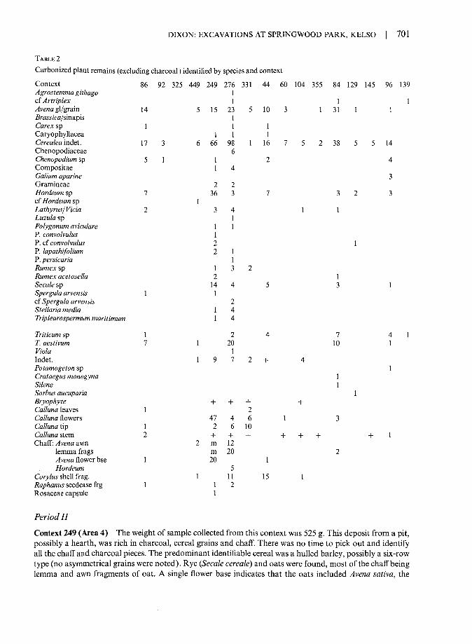
TABLE 2Carbonized plant remains (excluding charcoal) identified by species and context
Context 86 92 325 449 249 276 331 44 60 104 355 84 129 145 96 139Agrostemma githago 1cfArtriplex 1 1 1^venagl/grain 14 5 15 23 5 10 3 1 31 1 1Brawj'ca/sinapis 1Carexsp 1 1 1Caryophyllacea 1 1 1Cerealeaindel. 17 3 6 66 98 1 16 7 5 2 38 5 5 14Chenopodiaceae 6Chenopodium sp 5 1 1 2 4Compositae 1 4Galium aparine 3Gramineae 2 2Hordeum s p 7 3 6 3 7 3 2 3cf Hordeum sp 1Lathyrus/Vida 1 3 4 1 1Luzula sp 1Polygonum aviculare 1 1P. convolvulus 1P. cf convolvulus 2 1P. lapathifolium 2 1P. persicaria 1Rumexsp 1 3 2Rumex acetosella 2 1Seca/esp 14 4 5 3 lSpergula arvensis 1 1cf Spergula arvensis 2Stellaria media 1 4Tripleurospermum maritimum 1 4
Triticumsp 1 2 4 7 4 1r. aestivum 1 1 20 10 1Fio/a 1Indet. 1 9 7 2 + 4Potamogeton sp. 1Crataegus monogyna 1Sifene 1Sorbus aucuparia 1Bryophyte + + + +Calluna leaves 1 2Calluna flowers 47 4 6 1 3Calluna Up 1 2 6 10Calluna stem 2 + + + + + + +1Chaff:/4ve«a awn 2 m 12
lemma frags m 20 2/4vena flower bse 1 20 1Hordeum 5
Corylus shell frag. 1 11 15 1Raphanus seedcase f r g 1 1 2Rosaceae capsule 1
Period IIContext 249 (Area 4) The weight of sample collected from this context was 525 g. This deposit from a pit,possibly a hearth, was rich in charcoal, cereal grains and chaff. There was no time to pick out and identifyall the chaff and charcoal pieces. The predominant identifiable cereal was a hulled barley, possibly a six-rowtype (no asymmetrical grains were noted). Rye (Secale cereals) and oats were found, most of the chaff beinglemma and awn fragments of oat. A single flower base indicates that the oats included Avena sativa, the

702 | SOCIETY OF ANTIQUARIES OF SCOTLAND, 1998
TABLE 3Charcoal identified by species and contextContext 86 92 325 449 249 276 331 44 60 104 355 84 129 145 96 139Alnus glutinosa 2Alnus/Corylus 3Betula 15 2 2cfBetulasp 1Corylus avellana 8 5cf Corylus avellana 1Fraxinus excelsior 1 14Prunussp 12Quercus sp 1c f Quercus s p 1 5 1Salix 1 3 2 1Ulmus sp 2cfUlmussp 18Indet. + + + + + + + + +
common cultivated oat. Seeds of species (eg chickweed and corn spurrey) which could have been growing asweeds in the cereal crop were also recovered, although they might also have grown on any cultivated orwaste ground in the area. Leguminosae seeds of the Lathyrus/Vicia type were recovered. These were 2-3 mmin diameter and could be of species common in grassland and thickets; alternatively, the larger ones mighthave been collected or cultivated for food. A capsule of a species of the rose family was recovered. In size itcompares well with those of modern Alchemilla glabra, a common grassland species. There were manyheather flowers and stems (up to 5 mm diameter), also mosses and sheep's sorrel which could have beencollected accidentally with the heather from nearby heathland, or the former collected deliberately aspacking material and the latter as food.
A lot of the charcoal from this sample was difficult to identify since it readily broke into flakes, but itappeared to be elm. Other charcoal, including twigs, included a wild cherry type (Prunus sp), hazel, a littlealder (Alnus glutinosa), oak and willow (Salix sp).
Context 276 (Area 4) In contrast to the lower fill of pit 309 (Period I, 449; above), this upper depositcontained abundant cereal grains and herb seeds. The main identifiable cereals were bread wheat and oats.Barley and rye were also recovered and there were abundant indeterminate cereal pieces. The few chaffpieces included battered fragments of barley rachis. Vicia-type seeds and fragments of hazel nut shell werepresent. The remaining seeds were of species seen today as 'weeds of cultivation' (eg corn cockle andmayweed), grassland species (eg sedge and violet), and species indicative of enriched disturbed soils such asfat hen, docks, Polygonum spp and the Chenopodiaceae. The remains of heather and mosses were alsofound. The only identifiable charcoal was willow, which could have been used in baskets to store the grain.
Context 139 (Area 4) The only plant remains recovered from the fill of this post-pit in Building D were apoorly preserved wheat grain and a seed of orache.
Period IIIContext 44 (Area 4) This stone-covered drain in Building C contained the remains of hazel, rye, barley,oats and wheat. The oat grains could not be identified to species and were probably a mixture of wild andcultivated species. Two seeds of fat hen, a sedge nutlet and one seed of a member of the chickweed familywere also recovered. Charcoal was present, the largest piece was 12 mm x 6 mm x 3 mm and proved to beof willow; the remainder included pieces of hazel or alder, birch, heather (Calluna vulgaris) and possibly oak.Indeterminate pieces of charcoal and twigs of 5 mm diameter were also present.

DIXON: EXCAVATIONS AT SPRINGWOOD PARK, KELSO | 703
Context 60 (Area 2) Oats and indeterminate cereals were recovered from this covered drain. Also presentwere ash (Fraxinus excelsior) charcoal and the remains of heather.
Context 104 (Area 2) The plant remains from this stone-covered drain in Building A were poorly preservedand difficult to identify. The remains of food plants included hazel, cereals and legumes. Charcoal was alsopresent, possibly hazel and oak.
Context 355 (Area 3) The identifiable plant remains recovered from this drain were a few cereal grains,remains of heather and some birch charcoal.
Context 96 (Area 4) This lower fill of a pit within a yard (and possibly pre-dating it) was found to containcereal grains and 'weed' seeds (Potamogentori). There was also some indeterminate charcoal and a fragmentof heather stem.
Period IVContext 84 (Area 2) This post-occupation silt layer in Building A contained a mixture of cereals, oats,barley, rye and wheat. Some of the wheat grains appeared to be bread wheat (Triticum aestivum). Alsorecovered were seeds of orache, vetch, campion (Silene sp) and hawthorn (Crataegus monogyna). Orachecould have been growing as a 'weed' in the cereal crops while vetch, campion and hawthorn grew in thicketand woodland. Apart from campion, the seeds and fruits of these species could have been collected for food,but they could also have been collected accidentally with firewood. Heather flower, chaff and very smallcharcoal fragments of willow and birch were present.
Context 129 (Area 3) This silt layer beneath the tumble in Building B contained cereals, oat, barley andsome poorly preserved grains which could not be identified. Also present was rowan (Sorbus aucuparid) andblack bindweed (Polygonum convolvulus), both of which have been collected for food in the past.
Context 145 (Area 3) The large pieces of charcoal (average 35 mm max) recovered from this sample fromBuilding B proved to be fragments of ash, probably from large timbers. Also recovered were smaller piecesof ash, some heather stems, indeterminate charcoal and cereals.
SUMMARY
The deposits richest in identifiable botanical remains were from pits and hearths of Period II.There were the remains of cereals, including oats, barley, rye and wheat, many in a poor state ofpreservation. The oats present were probably a mixture of wild and cultivated varieties, possiblyincluding Avena saliva (identified from floret bases). The hulled barley was either a two- or six-rowed variety. The wheat grains included bread wheat (Triticum aestivum). It is not possible to becertain whether all of the cereals were grown as separate crops. The oats and rye may have been'weeds' in the main barley and wheat crops, or they may have been cultivated deliberately as partof a mixed cereals crop. The presence of so much oat chaff suggests that oats were threshed by thehearth and that, in contrast, the other cereals were threshed and perhaps even grown elsewhere(though the 'weeds' present do not suggest importation). Alternatively, oat chaff is abundantbecause it was used as kindling or as a packing material.
Of the herbs recovered, some could have been growing as 'weeds' of the cereal crops (egcorn cockle, corn spurrey) and some on the disturbed, enriched ground about the settlement (eg

704 | SOCIETY OF ANTIQUARIES OF SCOTLAND, 1998
fat hen, dock). Other species could have been collected for food (eg Polygonum spp, vetch), or forother household uses such as strewing (eg sedge), but it is also possible that they were gatheredaccidentally with food or firewood or even carried into the houses on the clothes or feet of theiroccupants.
Many remains of heather plants and many fragments of charcoal were also noted inPhase II, the more abundant charcoal being birch, hazel, elm and Prunus sp. Also present werealder, oak and willow. These are native species which could all have been collected for fuel fromnearby woodland. Heather is a very useful plant, providing fodder, dye and material forthatching, bedding and rope. Elm, alder, and oak could have been used in the construction ofbuildings and furniture making, with birch, hazel and willow providing finer, flexible twigs forbasket making and thatching. In the destruction layer from Building C there were many largepieces of ash (up to 50 mm) which suggests that ash was a timber used in the construction of thathouse. Timbers used for the construction of Period I houses could, of course, have been reused orused as fuel in the later phases.
A similar although smaller range of species was found in the remaining periods ofoccupation and this suggests that there was little change in economy or environment during thelife of the settlement overall.
ANIMAL BONE
Dick Grove
The faunal remains come from all the recognized phases of occupation (Period I-III) and post-occupation or abandonment (Period IV). A total of 578 bone fragments was recovered, 233 ofwhich could be identified to species and skeletal part from four species; 61% of the unidentifiedfragments were of ribs, vertebrae or longbones.
Unfortunately, preservation of the bone was exceedingly poor. Fragments were friable with"eroded surfaces, often making them impossible to identify, and in no instance could anymeasurements be taken. This is illustrated not only by the survival of the bones from a limitednumber of the larger mammals but also by their distribution by skeletal part. The sample contains174 (77%) teeth fragments, including all the pig and all but one of the horse remains; furthermore,the teeth themselves were frequently damaged, which has made it impossible to assess the degreeof wear. The faunal remains are of limited value, therefore, in terms of interpreting the economyof the site and this report must necessarily remain descriptive.
During the period of the site's occupation (Periods I-III) the majority of bone fragmentsappear to have been deposited haphazardly in floor levels, hearths, walls and miscellaneouslayers. The horse remains from a Period I pit fill (context 302, Area 2) included a fragment of atibia shaft (a horizontal cutmark across its posterior side may have occurred during skinning)
TABLE 4Bone Fragments identified to species by period
Period Cattle Sheep Pig Horse
I 26 10 1 9II 23 4
III 30 32 1 1IV 55 24 . 6 4
Totals 134 70 8 14

DIXON: EXCAVATIONS AT SPRINGWOOD PARK, KELSO | 705
and eight teeth, from a minimum number of four individuals. The remaining bones in the depositare solely from the shafts of longbones of cattle and sheep with no epiphyses .
The bones from the post-occupation layers (Period IV) appear to have suffered the samedegree of decay as those from earlier levels and were presumably subject to similar selectivepreservation. Furthermore, unless these levels received rubbish from other, still occupied, areasof the site, these bones must derive from secondary contexts.
COINS
J D Bateson
1 England, Edward I, silver penny, class IVc (1282-9), mint: Bury St Edmunds [Robert de Hadeleie],worn, weight 1.32 g [20.4 gr], die axis 130° (North 1991-4,1025). Context 51, Small Find AO; PeriodIV; Area 2.
Edwardian pennies came to Scotland in huge numbers and appear to have constituted over 90%of the coinage during the first half of the 14th century. Although some still appeared in hoardsdeposited as late as the 1370s, this piece, of an early class, was perhaps lost around 1300.
2 England, Edward I, silver farthing, class IX [1300-2], mint: London, slightly worn, weight 0.33 g[5.1 gr], die axis 0° (North 1991-4,1057). Context 51, Small Find AR; Period IV; Area 2.
Cut coinage ended with the introduction of round halfpennies and farthings in 1279. However, incontrast to the abundance of Edwardian pennies, finds of the smaller denominations are quiterare. This is probably due to trade and the invading armies bringing mainly the higher valuepenny northwards. Equally, though, finds of the round Scottish halfpennies and farthings arealso scarce. The slight amount of ware on this specimen suggests loss during the first decade ofthe 14th century.
3 England, John, silver cut halfpenny, from short cross silver penny, class Vbii [1205-10], mint: Londonmint, moneyer-uncertain Willelm, fairly worn, weight 0.73 g [11.3 gr], die axis 180° (North 1991-4,970). Context 263, Small Find BD; Period III; Area 1.
There is now an extensive list of finds of short cross pennies and cut halfpennies from throughoutScotland. The majority, as with this example, are English. It is uncertain whether this specimenarrived in Scotland as an official cut piece or was cut as a matter of convenience by the owner.The short cross coinage was replaced in Scotland in 1250 and while this example from SpringwoodPark could have circulated until then, its degree of wear would suggest loss probably by 1220.
4 Scotland, William the Lion, silver cut farthing, from crescent and pellet penny, type I [1174-1180],mint and moneyer uncertain, incomplete and broken in two, fairly worn, weight and die axis uncertain(Burns 1887, cf 29A). Context 261, Small Find BV; Period III; Area 3.
Finds of William's crescent and pellet coinage are rare, pennies having been recorded from Perthand from Fala, Midlothian, and a cut halfpenny from Hollywood Church, Dumfriesshire. A cutfarthing is therefore an important addition to the corpus of finds and shows the increasing use ofcoinage in the latter half of the 12th century. The crescent and pellet coinage was replaced in amajor recoinage in 1195 by the short cross penny and is unlikely to have circulated after that date.The cutting was probably carried out officially, at the mint, to provide smaller value coins.
706 | SOCIETY OF ANTIQUARIES OF SCOTLAND, 1998
METAL OBJECTS
Barbara A Ford
COPPER ALLOY (ILLUS 17)
Three buckles were recovered, numbers 2-4, and one brooch or buckle, no 1. Number 1 wasfound in a layer over wall tumble in Building A. Numbers 2-4 are unstratified. Number 1 is aplain annular ring which was fastened with an iron pin. This is a common form in use in the 13thand 14th. centuries and was often used to fasten cloaks or worn at the throat to secureundergarments (LMMC 1940). Similar types were also used to fasten leather boot straps.Examples have been found with leather attached on the pelvis of human skeletons at AustinFriar's, Leicester, which were originally probably used probably to fasten hose or a codpiece(Clay 1981, 133, fig 48). Numbers 2-4 are small, single-sided buckles: no 2 has lost its pin bar;nos 3 and 4, however, still have part of their copper-alloy pins attached. Buckles of this type wereused probably to secure narrow belts or leather straps on garments or harnesses. Number 4 issimilar to a late 14th-century example from Perth and also to one from Exeter (Ford 1987b, 122,fig 59, no 5; Goodall 1984, fig 190, M74).
Number 5 is a key of London Museum's type IV (ie following LMMC 1940). It wasrecovered from a floor layer in Building E. It has a moulded solid stem which does not projectbelow the bit. Shanks rarely projected below the bottom of the bit after the 13th century, but bythe 14th and 15th centuries they again lengthen. This key is roughly dated to the 13th century andwas probably used to open a small casket or box.
Number 7 is a horse harness pendant of London Museum's type IV(LMMC 1940; Griffiths1986, fig 5). These pendants hung from rectangular or circular fittings like those found at Perthand London which were riveted directly to the leather straps (Ford 1996, no 61; LMMC 1940;Griffiths 1986, fig 21, a-d). Number 7 is comparable with a circular pendant with attachmentfrom Lyveden, Northamptonshire, which has a slightly shorter arm (Bryant & Steane 1971, fig12n). Two further pendants from Northampton and Southampton, both like no 7, are gilded ontheir convex surfaces (Oakley & Webster 1971,250, fig 107, no 9; Harvey 1975, no 1749). Number6, which is also gilded on one surface, may well be part of another such pendant. Griffiths (1986)offers the following information on horse harness pendants: they may have originated as early asthe 12th century, but the majority date to the 14th century; they were usually from the trappingsof the horses of retainers, bailiffs or stewards, or perhaps were used on working animals toindicate ownership by an estate or manor; small pendants (like no 7) may well have been used inconjunction with bells as fringing on reins. Finally, a large number have been found onagricultural land and the incidence of examples at Springwood, along with the many examples ofhorseshoes, indicates that horses were important to the farming regime of this community.
Numbers 8 and 9 are both mounts. They could either have been decorative mounts for ahorse harness or were riveted to clothing, leather or wood. Number 8 is in open work: a centralfleur-de-lis is surrounded by a circle, decorated with stamped dots. Another mount decoratedwith stamped dots was found at Perth (Ford 1987b, 122, fig 59, No 11). The fleur-de-lis was acommon decorative motif in the 13th and 14th centuries and usually had no heraldic significance.Number 9 is made from an iron sheet, coated with copper alloy. One surface is scored withcrudely executed decoration.
Number 10 is a small fragment of folded sheet and probably part of a rivet of the sortcommonly used to repair vessels (Ford 1987b, 127); it was recovered from loose silt to the northof the threshold of Building A.
DIXON: EXCAVATIONS AT SPRINGWOOD PARK, KELSO 707
Other finds from the site include a needle (no 11) and a ring fragment (no 12) with ascalloped edge, possibly part of a brooch. It was recovered from a floor layer in Building C.
Five fragments of sheet or strips (nos 13-17) were also recovered: no 13 is a fragment ofiron sheet with a thin plate of copper alloy held in place with a copper-alloy rivet; no 14 wasfound on a floor layer in Building A; no 15 was from a pit cut into the surface of a yard, and no16 from the terraced platform of Building B. Numbers 18-20 are all fragments of sheet whichhave been rolled into tubes. Number 18 tapers to a point at one end and is probably a tag. Tagswere used to wrap around the ends of leather thongs or laces for shoes or clothing. Numbers 19and 20 are probably distorted or broken fragments of other tags.
Catalogue (illus 17)1 Brooch/buckle. Diameter 42 mm. Copper alloy, cast annular ring. The iron pin is looped around the
ring. Context 84; Small Find AS; Period IV; Area 2.
2 Buckle. Length 15 mm. Single sided buckle. Cast, the edges have then been slightly bevelled; file marksvisible. The frame is decorated with two incised grooves. Pin bar missing. Context 1; Small Find AB;topsoil.
3 Buckle. Length 23 mm. Single sided stirrup shaped buckle with nipple like projection. Cast with a flatback. File marks on surfaces. Rectangular cross-sectioned pin-bar with part of copper-alloy pinremaining. Context 1; Small Find AD; topsoil.
4 Buckle. Length 22 mm. Single sided D-shaped buckle. Cast with flat back and slightly rounded face.The slightly rounded sides terminate in a rectangular projection which is decorated with a centralincised notch flanked by two raised ridges. Rectangular cross-sectioned pin bar with part of copper-alloy pin remaining. Context 1; Small Find AJ, topsoil.
5 Key. Length 39 mm. Solid stem with circular cross-section and moulded decoration. The bit has threeward cuts. Circular bow. Context 106; Small Find BP; Period I; Area 2.
6 Harness pendant. Length 21 mm; width 22 mm. Crudely cut from a sheet. Traces of gilding on onesurface. Context 1; Small Find AC; topsoil.
7 Harness pendant. Length 46 mm; width of bowl 20 mm. Cast. Circular dome shaped with smallprojection, the end of which is flattened and pierced with suspension loop at right angles to the bowl.Traces of gilding remain on the convex surface. Context 83; Small Find AT; Period IV; Area 2.
8 Mount. Diameter 42 mm; thickness 1 mm. Openwork mount with an outer ring and central fleur-de-lis. Made from a thin domed sheet. The outer ring is decorated with stamped dots. Pierced with twoholes containing copper-alloy studs. Traces of gilding on the upper surface. Part of the outer ring ismissing. Context 1; Small Find AG; topsoil.
9 Mount. Length 60 mm; width 53 mm; thickness 1 mm. Copper-alloy plated iron disc. Pierced with fourholes. There is a scored pattern on the upper surface with some areas filled with zig-zag decoration.Context 1; Small Find AH; topsoil.
10 'Paperclip' rivet (not illus). Small fragments of folded sheet. Context 120; Small Find BC; Period III;Area 2.
11 Needle. Length 57 mm; width at eye 4 mm. Made from a rolled sheet. Broken across eye and at tip.Context 1; Small Find AA; topsoil.
12 Ring. Fragment of a flat cast ring with finely scalloped outer edge. Context 20; Small Find BK; PeriodIII; Area 4.

708 SOCIETY OF ANTIQUARIES OF SCOTLAND, 1998
1311
t14
12
17
16
19
1
20
-o
50mm
ILLUS 17 Copper-alloy objects 1-20

DIXON: EXCAVATIONS AT SPRINGWOOD PARK, KELSO | 709
13 Sheet. Length 20 mm. Fragment of copper-alloy sheet riveted to a fragment of iron sheet. Copperalloy rivet still in place. Context 1; Small Find AI; topsoil.
14 Sheet. Thickness 0.5 mm. Small triangular fragment. Context 132; Small Find AY; Period III; Area 2.
15 Sheet (not illus). Thickness 0.5 mm. Small fragments. Context 161; Period III; Area 4.
16 Sheet (not illus). Thickness 0.5 mm. Small fragment. Context 257; Small Find BL; Period III; Area 3.
17 Strip. Length 57 mm. Cut fragment of curved sheet. Tapered to a point at both ends. Context 50;Small Find AL; Period IV; Area 2.
18 Tag. Length 72 mm; thickness of sheet 0.75 mm. Length of sheet rolled into a tube tapering to a closedpoint at one end. Bent. Context 1; Small Find AE; topsoil.
19 Tube. Length 30 mm; thickness of sheet 0.75 mm. Length of sheet rolled into a tube. Broken at oneend. Context 1; Small Find AF; topsoil.
20 Tube. Length 86 mm; thickness of sheet 0.75 mm. Length of sheeting rolled into a tube, now bent andflattened at both ends. Context 1; Small Find AN; topsoil.
LEAD (ILLUS 18)
Only four objects of lead were recovered from the site. Number 1 is an irregularly shaped piece oflead which shows signs of having been pressed against a surface. It was possibly used to plug ahole (eg to repair a pot). Evidence of lead plugs being used to repair medieval ceramic vessels hasbeen noted at Perth where two lead patches or plugs were recovered; one was still attached to asherd of pottery (Ford 1987c, 130).
Numbers 2 and 3 are both small fragments of sheet of uncertain function; no 2 was foundin the wall tumble from Building E and no 3 was recovered from a pit cut into the surface of ayard.
Number 4 is a flat disc with a central perforation. It was found over wall tumble inBuilding A. It could have been used as either a spindle whorl or a weight. Similar lead objectshave been found at Threave Castle, Galloway; Perth; and at Wharram, Yorkshire (Caldwell 1981,111; Ford 1987c, 130; A R Goodall 1979, 115).1 Plug. Max diameter 41 mm. Oval fragment, centre missing. The back has been smoothed in places.
The upper surface is rough. Context 1; Small Find CG; topsoil.
0 50mm
ILLUS 18 Lead objects 1-4
710 | SOCIETY OF ANTIQUARIES OF SCOTLAND, 1998
2 Sheet. Thickness 2 mm. Small corroded fragment. Context 154; Small Find AZ; Period IV; Area 4.
3 Sheet. Thickness 2.5 mm. Small fragment, bent and corroded. Context 161; Small Find BF; Period III;Area 4.
4 Spindle whorl or weight. Diameter 29 mm; thickness 2.5 mm. Flat disc with central perforation.Diameter of hole 6 mm. Context 84; Small Find AU; Period IV; Area 2.
IRON
Belt equipment (illus 19)Number 1 is possibly a belt-slide for use with a narrow belt. It would have been used to hold thefree end of the belt in place. Numbers 2 and 3 are both buckles; no 2 is a rectangular buckle in avery corroded condition. Two similar buckles have been found at Seacourt, Berkshire, but hadthe addition of looped necks (Biddle 1962, 180, fig 30, nos 22 & 23). It is not possible to tell if no2 originally had a looped neck. Buckles of this type were mainly used for spur straps, although no2 seems rather large for this purpose and is probably from a horse harness. Number 3 is a smallbuckle, with a D-shaped frame, which was recovered from a floor layer in Building E. Asimilar buckle with pin still attached has been found at Llantrithyd, South Glamorgan, from acontext of the early or mid 12th century (Charlton et al 1977, 48, fig 2, no 40). Also, four verysimilar buckles were found in late 11th-century graves at Stockbridge Down, Hampshire (Hill1937, pi l,ld-f). They were found either at the hip or pelvis and are probably belt buckles.
1 Belt slide. Length 29 mm. Crudely made from a thin strip with pointed ends which overlap. Context54; Period IV; Area 3.
2 Buckle. Width 37 mm. Rectangular buckle with integral plate. The plate is fragmentary and is piercedwith a hole to take the pin. Context 1; topsoil.
3 Buckle. Width 37 mm. Very corroded, D-shaped buckle. The ring is broken at the pin bar, pin missing.Context 163; Period II; Area 2.
Heckles (illus 19)Three heckle teeth were recovered. One was unstratified; two come from Area 3 of which one wasrecovered from the floor of Building B. Heckle teeth are from combs used in preparing wool orflax for spinning. Heckle parts with the teeth in place have been found at Norwich (Margeson1985, 62, fig 46, nos 80-2,). It is more common, however, to find loose teeth, as often the rest ofthe comb is made of wood. Other examples of heckle teeth have been found at Castle Acre Castlein Norfolk, Wharram Percy in Yorkshire, and at Perth (Goodall 1982; I H Goodall 1979, 118;Ford 1987a, 141).
4 Heckle tooth. Length 149; diameter at head 6 mm. Circular in cross-section. Tapers towards one endwhich is missing. Context 54; Period IV; Area 3.
5 Heckle tooth (not illus). Length 101 mm, diameter at head 6 mm. Circular cross-section. Part of headand tip missing. Context 149; Period III; Area 3.
6 Heckle tooth (not illus). Length 112 mm. Circular cross-section. Bent at head. Tip missing.Unstratified.
DIXON: EXCAVATIONS AT SPRINGWOOD PARK, KELSO | 711
Horseshoes and horseshoe nails (illus 19)A total of nine horseshoes was recovered from the site. All are incomplete and in a veryfragmentary and corroded condition. In only two of the examples (nos 131 & 247) are any nailholes visible. In both examples they are rectangular and countersunk. The edges of the horseshoesare so fragmentary that it is no longer possible to discern the original shape of the shoe. Number15 does appear to have a plain outer edge, however, and nos 10, 12, 13 and 15 all have calkins ora thickening at the base of the heel. In addition, 16 horseshoe nails were recovered and can beclassified into three types by head shape:A Fiddle-headed nail with semicircular head. The width of the head is no wider than that of the
shank. 5 examples. Lengths range from 31 mm to 35 mm.B Nail with flat topped head with lobes or ears. The width and the thickness of the head are
greater than the shank. 6 examples. Lengths range from 25 mm to 33 mm.C Head expands in both front and side views to a flat top. 4 examples. Lengths range from
35 mm to 42 mm.It is not possible to say if any of the horseshoes are of the early types, with the distinctive
wavy edge common in the 11th to 13th centuries. However, five examples of horseshoe nails haveheads of the fiddle-key shape known to have been used with this type (Clark 1986). The latertransitional type of horseshoe of mid 13th to early 14th-century date, with a straighter edge andrectangular countersunk nail holes, seems to be represented by no 15; this was recovered from thefill of a pit (314) which pre-dated Buildings C and D. Also six horseshoe nails with the lobedheads which were introduced with this style of horseshoe (Clark 1986) have been found. Onlyfour examples of nails with expanded heads have been recovered. This type was used withhorseshoes with tapering nail holes, a type introduced before the middle of the 14th century(ibid).
The 16 horseshoe nails were found only in Areas 2 and 4, with 12 coming from Area 2. OneType B nail, from a subsoil 'interface' deposit, and two Type A examples come from contextsearlier than Period II. Of the remaining horseshoe nails, three were found in post-occupationlayers. Three came from Building A, two from Building D and seven from Building E. Therecovery of several of these nails from the floor layers in all three buildings suggests that horsescould have been brought into the buildings. No horseshoes were associated with the buildingfloors, however, and no other finds suggest smithing was taking place in the buildings. Thus it ismost likely that these are odd nails cast by horses while inside the buildings.
7 Horseshoe. Max. width of arm 25 mm. Fragment from the base of an arm. Context 51; Period IV;Area 2.
8 Horseshoe. Max. width 16 mm. Fragment of an arm. Context 53; Period IV; Area 3.9 Horseshoe. Max. width 25 mm. Fragment of an arm. Context 67; Period IV; Area 3.
10 Horseshoe. Max. width 23 mm. Fragment from the end of an arm with calkin. Context 76; Period III;Area 2.
11 Horseshoe. Now missing. Context 83; Period IV; Area 2.
12 Horseshoe. Max. width 20 mm. Fragment from the end of an arm with calkin. Context 124; Period IV;Area 1.
13 Horseshoe. Max. width 26 mm. Fragment from the end of an arm with calkin. Part of one rectangularnail hole remains. Context 131; Period IV; Area 2.
14 Horseshoe. Now missing. Context 156; Subsoil interface; Area 4.

712 I SOCIETY OF ANTIQUARIES OF SCOTLAND, 1998
50mm
ILLUS 19 Iron objects: belt equipment, 1-3; heckle, 4; horseshoes, 7-15
DIXON: EXCAVATIONS AT SPRINGWOOD PARK, KELSO | 713
15 Horseshoe. Max. width of arm 35 mm. Corroded fragment with plain edge. One rectangularcountersunk nail hole is still visible. Calkin at end of arm, one arm missing. Context 247; Period I;Area 4.
Knives (illus 20)
Five knives were recovered. All have whittle tangs which would have been inserted into a handleof bone or wood and are of common medieval types. Number 20 is of a form uncommon beforethe 13th century; it was found in a floor layer in Building D. The only other knife associated witha building was no 17, which came from the fill of a drain in Building A.
16 Knife. Length 98 mm; max. width of blade 12 mm. Whittle tang knife, both the blade and the backedge taper towards the tip. Tip missing. Context 75; subsoil interface; Area 3.
17 Knife. Length 70 mm; max. width of blade 16 mm. Whittle tang knife. The blade back and the cuttingedge are both straight, the blade back angles down towards the tip. The tang is broken. Context 104;Period III; Area 2.
18 Knife. Length 79 mm. Whittle tang knife, The blade back and edge are straight. Blade tip and part oftang missing. Context 260; Period III; Area 3.
19 Knife. Length 36 mm. Small fragment from a blade. Context 269; Period I; Area 2.
20 Knife. Length 95 mm. Whittle tang knife. The blade back is straight, the blade edge slopes up to meetthe back. Tip and part of tang missing. Context 276; Small Find BT; Period II; Area 4.
Locks and keys (illus 20)
Barrel padlocks like no 21 were most commonly used to lock chests, gates and doors. Number 21consists of a cylindrical barrel with a number of decorative longitudinal rods. It would originallyhave had a U-shaped bolt but this and all the internal mechanism of spines and springs is nowlost. A similar but smaller padlock has been found on excavations at Seacourt, Berkshire, anddates roughly from the mid 12th to 14th centuries; a further example of very similar proportionsto no 21 was found at Eynesford Castle, Kent, in a context dated to the 12th century (Biddle1962; Rigold & Fleming 1973). Number 21 was recovered from a floor layer in Building D.
The key (no 22) is of a type used with barrel padlocks. It has wards which are symmetricaland radiate from the base of the stem. It could have been inserted through a keyhole either on anend-plate or partly or completely on the underside of the barrel (Goodall 1980). It could thereforehave been used on the same type of barrel padlock as no 21. The shank thickens part way alongits length. This would have acted as a stop against the end-plate of the barrel padlock. Thecircular looped terminal would have acted both as a handle and for suspension. A similar keywith looped terminal and thickened stem but with a broken bit was found in a possible 12th-century context at Wroughton Copse, Fyfield Down, Wiltshire (Goodall 1980). A furtherexample, dated 1226-66, with similar six-ward bit, was found at Brandon Castle, Warwickshire(Chatwin 1955). Five examples of barrel padlock keys of this type were found on excavations atthe High Street, Perth (Perth & Kinross Museum & Art Gallery: A0612, A6336a, A04-0331,A040368 & A040580). Number 22 was recovered from a boundary wall of the yard south ofBuilding A and was probably from a lock used to secure a gate or door.
21 Barrel padlock. Length 76 mm; diameter of barrel 35 mm. Complete case with longitudinal rods.T-shaped keyhole cuts across end-plate and underside of case, now distorted. There are three

714 | SOCIETY OF ANTIQUARIES OF SCOTLAND, 1998
0 50mm
ILLUS 20 Iron objects: knives, 16-20; locks and keys, 21-2; structural ironwork, 23-4

DIXON: EXCAVATIONS AT SPRINGWOOD PARK, KELSO | 715
rectangular holes in the other end-plate for the spines of a bolt which is now missing. A rectangular finprojects from along the length of the case surmounted by a tapering tube, which is now broken. Atriangular plate is attached to the fin at the bolt housing end. Traces of copper-alloy plating. Context159/276; Period II/III; Area 4.
22 Barrel padlock key. Length 145 mm. Shank with rectangular cross-section and circular loopedterminal. The shank thins part way down its length. The symmetrical bit has six wards which radiatefrom the base of the shank. Context 37; Period III; Area 1.
Structural ironwork and miscellaneous fittings (illus 20 & 21)
Collars such as no 23 were used to bind and strengthen wood. It has been formed from a simplestrip of iron with crudely overlapping ends. It is probably now distorted, originally having beencircular. A similar collar was found at Waltham Abbey, Essex (Muggins 1972).
Hasps such as no 24 were used to secure doors, gates or chests. They were used inconjunction with staples such as nos 28-32. Number 24 is of a curved figure-of-eight shape,forming two loops, one for attachment the other to fit over a staple. It could then be secured witha stick or a padlock. It was found in the yard to the north of Building C and was probably used tofasten a door or gate. Other examples of angled hasps have been found at Winchester (Goodall1980). The fragmentary hinge pivot (No 25) would have been used to hinge either a door orwindow.
Numbers 26 and 27 are two hooks of unknown function which were recovered from thedemolition layers over Building B. Numbers 28-32 are all U-shaped staples recovered fromunstratified or disturbed contexts, except for no 31, which came from a post-pit related to earlyoccupation in Area 3. U-shaped staples are very common finds on medieval sites and manyexamples have been found at Perth (eg Ford 1987a 137-8, nos 110-13).
23 Collar. Length 46 mm. Oval ring made from bending a flat strip. The rounded ends are overlapped.Context 1; topsoil.
24 Hasp. Length 110 mm; max. width 31 mm. Very corroded. Angled figure-of-eight shaped hasp. Part ofhook remains at one end. Context 183; Period III; Area 4.
25 Hinge pivot (not illus). Length of shank 6 mm; length of arm 34 mm. Tapering shank with rectangularcross-section. The arm is fragmented. Unstratified.
26 Hook (not illus). Length 150 mm; diameter 6 mm. Rod with circular cross-section. Curved and pointedat one end. The other end is curved over and then twisted into a spiral. Context 53; Period IV; Area 3.
27 Hook (not illus). Length 145 mm; diameter 7 mm. Rod with circular cross-section. Curved and pointedat one end. The other end is curved over and then twisted into a spiral. Context 53; Period IV; Area 3.
28 Staple. Length 58 mm. U-shaped staple. Square cross-sectioned arms, one now broken. Context 19;Disturbed subsoil; Area 4.
29 Staple. Length 70 mm. U-shaped staple. Rectangular cross-sectioned arms, one now missing. Context51; Period IV; Area 2
30 Staple. Length 46 mm. U-shaped staple. Rectangular cross-sectioned arms. Unstratified.
31 Staple. Length 42 mm. U-shaped staple. Square cross-sectioned arms. Context 265; Period III; Area 3.
32 Staple. Length 48 mm. U-shaped staple. Rectangular cross-sectioned arms. Context 78; Period IV;Area 2.

716 | SOCIETY OF ANTIQUARIES OF SCOTLAND, 1998
28
50mm
ILLUS 21 Iron objects: structural ironwork, 28-32; tools, 33-5; miscellaneous 36-9

DIXON: EXCAVATIONS AT SPRINGWOOD PARK, KELSO | 717
Iron nails (not illus)
A total of 50 nails was recovered from stratified contexts. Most are in a very corroded conditionand only 13 had complete heads which could be classified. Three distinct types were noted. Theyhave been classified by head shape and the cross-section of the shank.A Circular, square or rectangular flat head with shank of square or rectangular cross-section. Nine
examples.B Flat T-shaped head with shank of square or rectangular cross-section. Three examples.C Square or rectangular flat head formed by flaring square or rectangular cross-sectioned shank. One
possible example.
Types A-C are all common woodworking nails often found on medieval sites (Ford & Walsh1987). There are no significant concentrations of nails on the site and all appear to be simplyrandom finds (though a large proportion of the nails comes from the Period IV silting layers andtopsoil). A full catalogue of the nails is available in the archive of the project records.
Tools (illus 21)
Claw hammers are general-purpose tools used by many types of craftsmen and are impossible toattribute to a specific trade. The gently curving claws of no 33 would have aided leverage forextracting nails. The eye has been extended by straps to help prevent the handle coming loose. Itwas found in a layer which forms the surface on which Building C was erected. A claw hammerwith straps was found at North Elmham Park, Norfolk, from a context broadly dated toc 1150-1600; another from Hen Bias, Clwyd, comes from a context of 13th to 14th-century date(Goodall 1980; Leech 1960).
Number 34 is a small fragment of a rectangular cross-sectioned bar with a bevelled end. Itis possibly the tip from a chisel. Number 35, a hook for cutting weeds, has a wedge-shaped bladesimilar to that on weedhooks from Woodperry and Copt Hay, Tetsworth, Oxfordshire (Wilson1846, 122; Robinson 1973,101, fig 23, no 8).33 Claw hammer. Length 139 mm. Gently curving claws and squared head. There are strap like extensions
below the rectangular eye, both of which are broken. Remains of wood on the inside of the straps.Context 248; Small Find BN; Period III; Area 4.
34 Tool. Length 32 mm, width 18 mm. Rectangular cress-section tapering to a flat point at one end, otherend broken. Context 92; Period I; Area 4.
35 Woodhook. Length of blade 44 mm; width of blade 22 mm. Wedge-shaped blade with almost straightcutting edge and back. Plain fragmentary tang. Context 78; Period IV; Area 2.
Miscellaneous ironwork (illus 21 & 22)
The remaining miscellany of fragments of sheets, rods and bars was found throughout the site ina variety of contexts. Notably, no 39 is probably a pin; nos 49 and 50 may be remnants of awls;and no 53 is a domed head stud.36 Bar. Length 68 mm. Fragment with rectangular cross-section. Context 233; Period II; Area 4.
37 Bar. Length 51 mm. Fragment with rectangular cross-section. Context 276; Period II; Are
38 Bar. Length 163 mm. Rectangular cross-section. Context 277; Small Find BU; Period II; Area 4.

718 SOCIETY OF ANTIQUARIES OF SCOTLAND, 1998
46
51 52
I
0 50mm
ILLUS 22 Iron objects: miscellaneous, 45-52
39 Pin. Length 85 mm; diameter 2 mm. Circular cross-section. Broken at both ends. Context 371;Period II; Area 2.
40 Rod (not illus). Length 138 mm; diameter 6 mm. Fragment with circular cross-section. Broken at bothends. Context 53; Period IV; Area 3.
41 Rod (not illus). Length 167 mm; diameter 5 mm. Fragment with circular cross-section. Broken at bothends. A second fragment is attached by having its end tightly wrapped around the rod Context5J^Period IV; Area 3.
42 Rod (not illus). Length 260 mm; diameter 7 mm. Fragment with circular cross-section. Bent andbroken at both ends. Context 53: Period IV; Area 3.
43 Rod (not illus). Length 97 mm; diameter 6 mm. Fragment with circular cross-section. Broken at bothends. Context 223; Period II; Area 1.
44 Sheet (not illus). Length 88 mm; width 71 mm; thickness 8 mm. Fragment of cast sheet, curved at oneend, broken at the other. At the curved end the sheet is flat, but dips into the middle towards the otherend. Context 36; Period IV; Area 4.
45 Sheet. Length 45 mm. Fragment of curved sheet with slag attached at one end. Context 247; Period I;Area 4.
46 Sheet. Length 66 mm; thickness 8 mm. Fragment with rectangular cross-section. Context 276; PeriodII; Area 4.
47 Sheet (not illus). Length 47 mm. Fragment of sheet with wood attached. Context 183; Period III;Area 4.
48 Sheet. Length 55 mm; thickness 3 mm. Fragment of a sheet pierced by two iron rivets. Traces of woodon the upper surface. Context 421; Period III; Area 3.
49 Spike (not illus). Length 110 mm. Square cross-section tapering to one end. Bent. Context 19;disturbed subsoil; Area 4.

DIXON: EXCAVATIONS AT SPRINGWOOD PARK, KELSO | 719
50 Spike (not illus). Length 106 mm. Circular cross-section, thickening towards one end which is verycorroded. Context 37 Period III; Area 1.
51 Strip. Length 33 mm. Rectangular cross-section. Context 78; Period IV; Area 2.
52 Strip. Length 56 mm; width 15 mm. Rectangular cross-section. Context 153; Period II; Area 4.
53 Stud (not illus). Length 10 mm. Domed head, square cross-sectioned shank. Context 183; Period III;Area 4.
MISCELLANEOUS STONE OBJECTS
Barbara A Fordwith geological identifications by D T Moore
The objects described here (illus 23 & 24) were all made from types of sandstone consistent withthe geology of the Southern Uplands and thus are likely to have come from areas local to the site.
One hone (no 2) and two possible hones (nos 3-4) have been found. Number 2 is pierced atone end, probably to take a leather thong by which it could be suspended from a belt. Numbers 3and 4 have both been worked, but neither shows any signs of use; no 2, however, shows signs ofwear from the sharpening of blades on all four faces.
Number 5, a loom weight, was recovered from a floor layer within Building E. It is oftriangular shape with rounded corners (two of which are broken off) and has been drilled fromboth sides to make a central perforation. One side is worn smooth and flat, probably due tofriction during suspension. The recovery of this object suggests weaving on site using a warpweighted loom. A possible loom or net weight was also recovered from excavations in Aberdeen(Trewin 1982, 184).
Numbers 6 and 8 are stone spindle whorls. Number 7 could possibly have been intended asa spindle whorl, but was evidently discarded because the drilled holes on either face weremisaligned. A similar partly drilled spindle whorl was found at excavations at Thetford (Rogerson& Dallas 1984, 111, no 3). Number 8 was found in a possible hearth in Building D. A furtherspindle whorl of unbaked clay and a possible spindle whorl or weight of lead have also beenfound on the site (Ceramic objects, no 2; Lead, no 4). Number 6 is biconical in shape, a typecommonly found on medieval sites; substantial groups have been recorded at King's Lynn andNorthampton (Clarke & Carter 1977, 315; Oakley & Hall 1979, 286-9). Number 8 is a flat discshape, a type more commonly made of baked clay than stone. Other examples like this have,however, been found at Threave Castle, Galloway; and in Perth (Good & Tabraham 1981, 126,no 193; Ford 1987d, 149, no 146).
Numbers 9 and 10 are two small flat pieces of worked sandstone. One surface of each hasbeen dressed and bears tooling marks. The other surface of both pieces is rough, but has beenscored with a number of lines. On no 10 the lines form a criss-cross pattern; on no 9 there are onlya few crossed lines. These lines could simply be keying for mortar (although there is no sign ofmortar on either fragment) or even idle doodlings; or perhaps these stones (especially no 9) werepart of a nine men's morris gaming board.
1 Architectural fragment. Length 108 mm. Semicircular curved rib, broken at one end and along theback. Micaceous silty sandstone. Context 1; Small Find CE; topsoil.
2 Hone. Length 86 mm; max width 22 mm; max thickness 13 mm. Pierced for suspension. Signs of wearon all four faces. Micaceous silty sandstone. Context 32; Small Find BE; Period IV; Area 4.
720 | SOCIETY OF ANTIQUARIES OF SCOTLAND, 1998
ILLUS 23 Stone objects 1 -8

DIXON: EXCAVATIONS AT SPRINGWOOD PARK, KELSO 721
10
50mm
10
ILLUS 24 Stone objects 9 & 10
?Hone. Length 83 mm; max width 41 mm; max thickness 28 mm. One face has been flattened andsmoothed, the other faces are rounded. Broken at both ends. Greywacke sandstone. Context 75; SmallFind CF; Subsoil Interface; Area 3.?Hone. Length 135 mm; max width 30 mm; max thickness 28 mm. All the faces are smoothed andpolished. Broken at one end. Ferruginous sandstone. Context 132; Small Find BM; Period III; Area 2.Loom weight. Length 93 mm; thickness 20 mm. Triangular shaped, with rounded corners. Two of thecorners are broken. Pierced at the centre with a hole partly drilled from both sides. Silty sandstone.Context 126; Small Find BI; Period II?; Area 2.Spindle whorl. Diameter 30 mm. Biconical. Diameter of central hole 10 mm. Broken around one endof hole. Fine grained sandstone. Context 51; Small Find AP; Period IV; Area 2.?Spindle whorl. Max diameter 34 mm. Partly drilled in each face. Holes unaligned. Micaceous siltysandstone. Context 110; Small Find CD; Period IV; Area 2.Spindle whorl. Diameter 34 mm. Disc-shaped. Diameter of central hole 9 mm. Micaceous sandstone.Context 140; Small Find AX; Period I; Area 4.Worked stone. Length 87 mm; thickness 19 mm. Series of scored lines on face. Micaceous siltysandstone. Context 33; Small Find AK; Period IV; Area 4.Worked stone. Length 96 mm; thickness 20 mm. Series of scored lines on one face. Micaceous siltysandstone. Context 159?; Small Find BS; Period I; Area 3.
CERAMIC OBJECTS
Barbara A Ford
Excluding pottery, only two ceramic objects were recovered (illus 25). Number 1, from topsoil, isa medieval floor tile fragment, coated with a green glaze. Other green-glaze floor tiles recovered
722 I SOCIETY OF ANTIQUARIES OF SCOTEAND, 1998
I
50mm=J
ILLUS 25 Ceramic objects 1 & 2
from Scottish sites are mainly associated with religious houses such as Friarscroft in Dunbar, StAndrews Cathedral, and the Blackfriars Monastery in Perth (Eames 1983; di Folco 1985; D Hall,perscomm).
Number 2 is a spindle whorl, probably made from unbaked clay. It is very soft and light. Asimilar spindle whorl in (possibly) unbaked clay was recovered at Northampton (Oakley & Hall1979, 288, no 15). It is believed that these lightweight whorls were used for spinning fine threads,whereas the heavier whorls, such as nos 6-8 in stone (above), were used for spinning strongeryarns (Macgregor 1974, 88-9).1 Floor tile. Thickness 24 mm. Abraded fragment in hard sandy oxidized fabric with brick red core and
orange margins and surfaces. The two edges have been cut with a downward bevel and smoothed. Thebase is fairly smooth and shows traces of sand on which the tile was formed or stacked before firing.The upper surface and one edge have been coated with a glaze varying from olive to dark green.Context 1; Small Find CH; topsoil.
2 Spindle whorl. Diameter 30 mm. Biconical. Diameter of hole 10 mm. Probably made from unbakedclay. Context 32; Small Find AW; Period IV; Area 4.
MILLING AND GRINDING STONES
Adam Welfare
Four millstones and a grindstone were recovered (illus 26 & 27). There seems little doubt thateach of these was recovered from a context in which it had been reused after breakage. In the caseof the millstones (nos 1-4), the preponderance of upper-stone fragments is typical of sites withsuch assemblages. They were probably made for use in some kind of geared mill, the only possibleexception being the smallest fragment (no 4) which, perhaps by virtue of its size alone, lacks thecharacteristics which would confirm this form of use. However, both its overall treatment and theraw material used suggest that it may have formed a pair with the fragmentary upper stonerecovered from a spoil tip (no 1). Two of the millstones exhibit remnants of a subrectangular,vertical socket (no 1) or perforation (no 2) in the upper surface. Neither shows obvious signs ofwear, and while it is possible that these features were intended for use in balancing the stones, itseems more likely that they once held metal fittings which allowed the stones to be raised orlowered for servicing. Poor maintenance during running was almost certainly responsible for thedevelopment of the concentric striae etched into the face of the most complete millstones (no 3).
DIXON: EXCAVATIONS AT SPRINGWOOD PARK, KELSO | 723
The consistency of the ground circumference about the circuit of this upper-stone is also of someinterest, for it contrasts sharply with the more random treatment of its upper surface. Thisdifference was probably functional rather than aesthetic and it may be that the stone was sofashioned to fit snugly within a close-fitting wooden box or tray. One of the millstones showedsigns of secondary wear (no 2), consistent with its use as a paving stone in Building D. Thesmoothing on the upper surface lacks the wavy irregularities, the variability in the incidence anddevelopment of the facets, and the incidence of grooving that are typical of reuse as a whetstone.All of these characteristics are found in some measure on the surfaces of the broken grindstone(no 5), though the condition of the latter indicates that it had long use and a correspondingdegree of wear in its original role also.
The fact that only millstones (rather than quernstones) are found within the assemblagesuggests that an edict forbidding the use of domestic handmills may have been in force duringtheir floruit.
1 Single fragment of an upper millstone. Estimated diameter c 680 mm; thickness at the circumference60 mm. The upper surface has been crudely dressed to shape with pickmarks and there are theremnants of a sub-rectangular socket distanced 90 mm from the circumference; this originallymeasured at least 40 mm. across and 50 mm deep. The vertical sides of the stone exhibit dressingsimilar to that upon the upper surface. The depressed concavo-convex face has been sharpened withpocking and the greatest degree of wear has taken place around the skirt. The stone is fashioned froma medium-grained, dull, orange-brown sandstone, blackened upon the face by contact with burntmaterial. The fragment was retrieved from a spoil-tip during the excavations of 1986; Small Find BQ;unstratified.
2 Single fragment of an upper millstone. Estimated diameter exceeding 540 mm; thickness 92 mm. Thegently convex upper surface is neatly dressed with pocking, but one sector has been rubbed smooth bysome secondary use. No trace of the original circumference of the stone survives. A remnant sub-rectangular perforation, more than 30 mm by 20 mm and 70 mm deep, is found within a fracture atthe periphery of the fragment; while part of the arc of a circular eye with an estimated diameter ofc 160 mm and a thickness of 90 mm is intact at the centre of the stone. The depressed concavo-convexface is sharpened with pocking and the wear appears evenly distributed. The stone is fashioned from amedium-grained, pale, buff sandstone. The fragment was discovered within the fill of a hearth/middenpit in Building D attributed to Period II (Phase VI); Small Find AM, Context 34, Area 4.
3 Single fragment of an upper millstone. Diameter 420 mm; thickness at the circumference 73 mm. Theupper surface has been partly dressed to shape with a pick, while part of the arc of a circular eye, withan estimated diameter of c 130 mm and a thickness of 75 mm, is found at the centre of the stone. Thestone was plainly narrower at the top than the bottom. The circumference is slightly convex and hasbeen evenly ground to a very smooth finish. Three remnant limbs of a massive X-shaped rynd-chaseare cut into the depressed, gently convex face, which has been sharpened with pocking. The bestsurviving arm measures 130 mm long, 44 mm wide and 40 mm deep; but overall, the chase spanned340 mm and c 220 mm in breadth. No trace of lead lies within it. Although the maximum wear to theface has occurred about the skirt, deep concentric striations linking individual pockmarks are foundin the breast. The stone is fashioned from a dense, very fine grained, pale, buff sandstone. Thefragment was discovered reused in a hearth in Building E, attributed to Period II (Phase VI); SmallFind BY, Context 358, Area 2.
4 Single fragment of a lower millstone, measuring 190 mm by 110 mm overall and up to 46 mm thick.The elevated, convexo-concave face has been sharpened with pocking and the wear appears to beevenly distributed. No traces of either the original circumference or the lower surface survives. Thestone is fashioned from a medium-grained, dull, orange-brown sandstone, which has been blackened

724 | SOCIETY OF ANTIQUARIES OF SCOTLAND, 1998
ILLUS 26 Millstones 1,2 & 3

DIXON: EXCAVATIONS AT SPRINGWOOD PARK, KELSO | 725
I
200mm i •ILLUS 27 Millstones/Grindstones 4 & 5
upon the face by contact with burnt material. The fragment was discovered within the wall tumble ofBuilding A in Period III; Small Find BR, Context 102, Area 2.
5 Single fragment of a rotary grindstone possessing a diameter of 260 mm and a thickness at thecircumference that varies between 94 mm and 90 mm. Part of the arc of a slanting, circular eye with anestimated diameter of 90 mm and a thickness of 90 mm. occurs at the centre of the stone. The sidesappear to have originally been dressed with pockmarks and subsequently smoothed in part; while inplaces there are zones that bear deep grooves. The grinding face has become smooth through use,although the pattern of wear has been uneven: the face is more worn on one side than on the other andmost worn in the centre of its track, where concentric striations can be detected. In addition, despitethe peripheries of the face remaining sharp, their overall circuits are irregular. The stone is fashionedfrom a very fine grained, pale, buff sandstone. The fragment was retrieved from the wall tumbleassociated with the last phase of occupation of Building B in Period IV; Small Find AQ, Context 67,Area 3.
ARCHITECTURAL FRAGMENTS
Piers Dixon
Two broken pieces of ashlar were recovered from the site (not illus), both of the yellow sandstonecommonly used for building in the Borders. Their broken state suggests that they were reusedfrom a demolished building in the Kelso area.
1 Large fragment of dressed sandstone with a slight curve on one face, finished on four sides includingone end. Length 440 mm long; width 160 mm, depth 155 mm. Context 358; Small Find BZ; Area 2;Period II.
2 Fragment of dressed sandstone, finished on three faces, two sides and one end. length 200 mm, width145 mm, thickness 140 mm. Context 57; Small Find AV; Area 2; Period IV.
FLAKED LITHIC ARTEFACTS
Caroline Wickham-Jones
A large assemblage of flaked lithic artefacts was recovered (not illus). These were all fromsecondary or 'redeposited' contexts. Nonetheless, it was possible to derive an amount of technicaland other detail.

726 SOCIETY OF ANTIQUARIES OF SCOTLAND, 1998
The assemblage appears to be of broadly Mesolithic date. A variety of local materials wasused, including flint, chert and chalcedony. Like many other Tweed Valley assemblages, itcontained both broad and narrow blade microliths. This has important implications as it suggestscultural connections with Mesolithic sites to the south, in England. There was no direct datingevidence, but the presence of broad blade artefacts tentatively indicates a terminus ante quern inthe late seventh millennium.
The assemblage is of great interest in view of the large number of other lithic scatters in thevicinity. Over 100 sites have been recorded from the Tweed Valley to date and, although there hasbeen little recent analysis of these assemblages, many have Mesolithic material and they aregenerally recognized as being important to the study of early settlement in Scotland. A moredetailed discussion of this assemblage has been submitted for publication in Mesolithic Miscellany.
TABLE 5Lithic assemblage
General typological breakdown
pebbles14
Retouched pieces
cores96
chunks554
debitageflakes
107
regularflakes1242
blades147
retouchedpieces
118
microlith28
scraper44
microburin4
edgeretouched
15
scalenetriangle
2
awl6
crescent1
burin2
total2278
rod1
notched1
obliquelyblunted
4
broken17
lamelleacran
2
misc.5
misc.12
POTTERY
Lucy Bown
The Springwood Park pottery assemblage comprises 5633 sherds dividing into 14 fabric typesand a total of at least 294 vessels (vessel counts are estimated on rim sherds only). Of thisassemblage, 99% is medieval, 0.4% imported and 0.1% post-medieval. The average sherd size is30 mm and surface abrasion is not particularly severe. The small number of cross-joins betweensherds from different contexts and the low amount of intrusive or residual pottery indicates thatthe stratigraphy of the site was not deeply disturbed and that little secondary deposition hasoccurred.
CATALOGUE
Please note that items nos 62, 63 and 64 in the following catalogue occur out of sequence, as thesewere late additions to the catalogue (under Fabrics 5, 7 & 9).
Fabric 1: Scottish East Coast White Gritty Ware (illus 28-30, 32)
This local medieval wheel-thrown pottery is at present encompassed by this blanket term (forfurther discussion see Crowdy 1986). Colour is predominantly very pale brown (10YR 8/3) orpinkish white (SYR 8/2) throughout, but with a smaller percentage (6%) of sherds in an iron richlight red fabric (2.5YR 6/8) with reduced core (2.5YR 4/0).
DIXON: EXCAVATIONS AT SPRINGWOOD PARK, KELSO | 727
There are an estimated 265 vessels in this fabric, comprising 195 large cooking pots/jars, 24smaller cooking pots/jars, 44 jugs and two ladles. Nearly all the forms are typical and localparallels occur at Eyemouth (Crowdy 1986), Kelso Abbey (Cox et al 1984) and Lindisfarne(Bown 1985). A summary of sherd count by period (ie Periods I-IV) shows that this fabric isdominant in every phase of the site. A late 12th- to 14th-century date is consistent with itsoccurrence on other sites in the region. There would appear to be no difference in date betweenthe rim form types, suggesting that all forms are contemporary. This parity of forms could eitherrepresent a relatively short period of occupation on the site or a conservative pottery industry.
Of the few large cooking pots/jars which could be reconstructed, both rounded andcylindrical forms are present, with 72% of base sherds sagging and 28% flat. Bases are frequentlyknife-trimmed on the exterior edge. These are quite finely thrown pots with wall thicknessesaveraging 5 mm and an average sherd weight of 6 g. Rims clearly divide into inturned clubbed(49%), everted (13%) and rolled/folded (38%) forms. The clubbed rims frequently have a cordonon the neck and occasionally a flange (eg illus 29, no 19). Ten examples have thumbed decoration(eg illus 28, nos 1 & 2). All rims range from 110 mm to 260 mm, regardless of form. One saggingbase, presumed to be from a cooking pot (though not sooted on the exterior) has holes drilledthrough it. The smaller cooking pots are of finer proportions and the rounded vessels, therefore,look more squat. Rims are either inturned or everted and range in size from 100 mm to 140 mm,with one exception of 200 mm. All the cooking pots are unglazed, but must have been fired in akiln which was also for glazed vessels, as there are occasional splashes and spots of lead glaze onthe vessels. Occasional sherds have trickles of white slip on the exterior or a white bloom, bothrelated to firing conditions.
Two ladles have everted rims with a pinched spout which was probably at right angles to apulled rod handle (illus 30, no 40). Rims range from 80 mm to 120 mm.
The 44 jugs divide into four rim types ranging from 90 to 140 mm: plain (7%), clubbed(57%), rolled (34%) and everted (2%). A cordon on the neck is most frequently associated withthe clubbed rims, but also occurs in association with everted and rolled rims. Two clubbed rimshave lid seatings on the top of the rim. Bases sherds are sagging and occasionally thumbed.Spouts are pinched with the exception of one tubular example and handles are either strap (87%)or rod (12%). Most vessels have zones of yellow or green lead glaze on the exterior lower half ofthe vessel extending up to the shoulder zone, where it is more splashed. Decoration is quitecommon and takes the form of rouletted square notches (illus 32, No 49), incised lines, appliediron-stained vertical strips, applied stamped and rouletted vertical strips, applied pinched pelletsand scales, and small cordons on the shoulder.
1 Rounded cooking pot with cordoned neck and square clubbed rim (170 mm) which is thumbed on theupper and external edge. The thickly slurried surface has retained the potter's finger impressions,particularly in the thumbed indentations. Vessel 1. Context 76, Period III, Area 2. Parallel examplesare found at Lindisfarne (Bown 1985, illus 20) and Kelso Abbey (Cox et al 1984, illus 33).
2 Cooking pot with square clubbed rim (220 mm), thumbed on the outer edge. Cordon on the neck.Slightly sooted on the external surface. Vessel 257. Context 78, Period IV, Area 2.
3 Cooking pot/storage jar with inturned clubbed rim (120 mm) and possible lid seating on the top edge.Probable cordon on the neck. Vessel 12. Context 39, Period III, Area 1.
4 Cooking pot/storage jar with inturned clubbed rim (220 mm) almost pulled into a flange on the lowerexternal edge. Cordoned neck. Vessel 14. Context 76, Period III, Area 2.
5 Cooking pot/storage jar with large inturned clubbed rim (220 mm). Undercut outer rim edge. Alsogrooved with a possible lid seating on the upper edge. Vessel 16. Context 302, Period I, Area 2.

728 I SOCIETY OF ANTIQUARIES OF SCOTLAND, 1998
10i?
11
13
15
16
^jl
17
ILLUS 28 Pottery 1-17 (scale 1:4)
14
23

DIXON: EXCAVATIONS AT SPRINGWOOD PARK, KELSO | 729
6 Finely thrown rounded cooking pot/storage jar with clubbed rim (180 mm) and small cordon at thebase of the neck. Internal flange at the base of the neck. Vessel 20. Context 44 and 153, Period III,Area 4. Parallel from Lindisfarne (Bown 1985, illus 10).
7 Fine cylindrical cooking pot with inturned clubbed rim (140 mm), undercut on the outer edge with acordon on the neck. Vessel 32. Contexts 247, 44, 32 & 136, Periods L-IV, Area 4. Paralleled fromLindisfarne (Bown 1985, illus 13 & 14).
8 Cooking pot with simple clubbed rim (180 mm). Sooted on the exterior. Vessel 37. Context 50, PeriodIV, Area 2. Paralleled from Lindisfarne (Bown 1985, illus 13).
9 Rounded cooking pot with inturned square clubbed rim (280 mm), thumbed on the outer edge withfinger imprints following the indentations. Small cordon on the neck and internal flange at the top ofthe rim. Vessel 59. Context 132, Period III, Area 2. Similar to example from Eyemouth (Crowdy 1986,illus 8).
10 Cylindrical cooking pot with clubbed rim, tooled on the outer edge (280 mm). Slight cordon on theshoulder. Sooted on the exterior surface. Vessel 62. Context 321, Period IV, Area 2. Similar to examplefrom Kelso Abbey (Cox et al 1984, illus 21, no 57).
11 Large rounded cooking pot with clubbed rim (400 mm). Sooted on the exterior surface. Vessel 64.Context 78, Period IV, Area 2. Similar to example from Eyemouth (Crowdy 1986, illus 32).
12 Rounded cooking pot with inturned clubbed rim (200 mm) and cordoned neck. Vessel 65. Context231, Period II, Area 2.
13 Cooking pot/bowl with inturned clubbed rim (140 mm). Vessel 67. Context 53, Period IV, Area 3.
14 Near complete profile of a rounded cooking pot with inturned clubbed rim (200 mm) and saggingbase. The base sherds are glazed on the interior with splashed yellow lead glaze, and while some sherdsare sooted only on the exterior others are sooted on both surfaces. Vessel 70. Contexts 161 and 5,Periods III and IV, Areas 3 & 4. Similar to one from Eyemouth (Crowdy 1986, illus 16).
15 Small cooking pot/storage jar with simple clubbed rim (120 mm), and pinched spout. Vessel 92.Context 260, Period III, Area 3.
16 Cooking pot/storage jar with large clubbed rim (260 mm). Sooted on part of the exterior. Vessel 83.Context 317, Period III, Area 2.
17 Cylindrical cooking pot with small simple clubbed rim (120 mm). Sooted on the exterior surface.Vessel 273. Context 76, Period III, Area 2.
18 Fine cooking pot with inturned clubbed rim (180 mm). Pinker fabric type. Vessel 190. Context 32,Period IV, Area 4.
19 Finely thrown cooking pot with bifid rim (220 mm) and slight cordon on the neck. Vessel 17. Context1 (Topsoil). Paralleled by example from Lindisfarne (Bown 1985, illus 11).
20 Cylindrical cooking pot with rolled rim and possible lid seating (180 mm). Vessel 76. Context 78,Period IV, Area 2.
21 Rounded cooking pot/jar with small rolled rim (140 mm). Vessel 80. Context 134, Period IV, Area 2.
22 Rounded cooking pot with small rolled rim (110 mm). Sooted on the exterior. Vessel 81. Context 39,Phase III, Area 1.
23 Cooking pot/storage jar with rolled rim (220 mm) and slight cordon on the neck. Vessel 90. Context50, Period IV, Area 2.
24 Cooking pot/jar with rolled rim (310 mm). Vessel 101. Context 53, Period IV, Area 3.

730 I SOCIETY OF ANTIQUARIES OF SCOTLAND, 1998
18
20
19
21
2223
24
25
27
26
29
28
30
31 32
ILLUS 29 Pottery 18-32 (scale 1:4)

DIXON: EXCAVATIONS AT SPRINGWOOD PARK, KELSO | 731
25 Cooking pot/jar with small everted clubbed rim (200 mm). Vessel 143. Context 151, Period II, Area 4.
26 Cylindrical cooking pot/jar with everted clubbed rim (180 mm). Vessel 149. Context 54, Period IV,Area 3. Similar to Kelso Abbey example (Cox et al 1984 illus 14, no 6).
27 Cooking pot/jar with everted rolled rim (240 mm) and rilled body surface. Vessel 131. Context 125,Period IV, Area 2. Similar to Eyemouth example (Crowdy 1986, illus 34).
28 Rounded cooking pot with everted rolled rim (270 mm). Vessel 133. Context 114 and 125, SubsoilInterface and Period IV, Area 2 and 4. Similar to Eyemouth example (Crowdy 1986, illus 34).
29 Rounded cooking pot/jar with everted rolled rim (210 mm). Vessel 137. Context 51, Period IV, Area2. Similar to Kelso Abbey examples (Cox et al 1984, illus 15, n!5; illus 35).
30 Rounded cooking pot/jar with everted rolled rim (270 mm). Vessel 148. Context 70 and 78, Periods IIand IV, Area 1 and 2. Similar to Eyemouth example (Crowdy 1986, illus 43).
31 Cooking pot/jar with everted rolled rim (160 mm). Vessel 155. Context 106, Period I, Area 1.
32 Finely thrown cooking pot with inturned rim (100 mm) and possible lid seating on the interior base ofthe neck. Vessel 194. Context 1 (topsoil).
33 Finely thrown cooking pot with inturned rim (120 mm) and internal lid seating on the neck. Vessel195. Context 25, Period III, Area 4.
34 Finely thrown rounded cooking pot with everted rim (200 mm). Vessel 197. Contexts 29 and 128,Period III, Area 3. Pinker fabric type.
35 Rounded cooking pot with everted rim (220 mm). Vessel 199. Context 183, Period III, Area 4. Pinkerfabric type.
36 Small cooking pot/jar with everted rolled rim (150 mm). Vessel 140. Context 92, Period I, Area 4.
37 Finely thrown cooking pot with everted rolled rim (140 mm) and internal lid seating. Sooted on theexterior. Vessel 172. Context 106, Period I, Area 2.
38 Finely thrown cooking pot with everted rolled rim (100 mm). Sooted on both interior and exteriorsurfaces. Vessel 184. Context 92, Period I, Area 4.
39 Finely thrown cooking pot with everted rolled rim (100 mm). Vessel 179. Context 51, Period IV, Area2.
40 Finely thrown rounded skillet/ladle with everted rolled rim (160 mm) and pinched spout. Vessel 169.Context 92, Period I, Area 4.
41 Jug with tall rilled neck and clubbed rim (100 mm). Vessel 265. Context 259, Period III, Area 3.
42 Jug with simple clubbed rim (85 mm) and splashed green glaze on the exterior surface. Vessel 238.Context 51, Period IV, Area 2.
43 Tall jug neck with cordon and clubbed rim (100 mm). Pinched spout. Splashed green glaze on the rim.Vessel 233. Context 126, Period II, Area 2.
44 Large rounded jug with cordoned neck and clubbed rim (100 mm). Pinched spout and strap handle.Rilled shoulder zone on the body. Zones of green lead glaze on the exterior. Vessel 299. Context 319,Period I, Area 2. Red fabric type.
45 Jug with simple rolled rim (100 mm). Vessel 280. Context 25, Period III, Area 4.
46 Large jug with short cordoned neck and rolled rim (140 mm). Scar from strap handle attached at therim. Vessel 260. Context 50, Period IV, Area 2.

732 I SOCIETY OF ANTIQUARIES OF SCOTLAND, 1998
34
35 36
52
ILLUS 30 Pottery 33-48, 51-2 (scale 1:4)

DIXON: EXCAVATIONS AT SPRINGWOOD PARK, KELSO | 733
47 Jug with tall cordoned neck, rolled rim (200 mm) and pinched spout. Yellow/green splashed lead glazeon the exterior. Vessel 252. Context 229, Period I, Area 4. Similar to Kelso Abbey example (Cox et al1984,illus20).
48 Jug with tall rilled neck, inturned rolled rim (120 mm) and pinched spout. Zones of green lead glazeon the exterior. Vessel 267. Context 26, Period III, Area 4.
49 Large rounded jug with inturned rim (90 mm), pinched spout and slight cordon on the neck. Thesingle strap handle comes off the rim and the base is slightly sagging. Decoration in the form of squarerouletted notches and splashed green lead glaze is confined to the exterior upper body zone of thevessel. Near the base a single small hole (4 mm) has been drilled through the wall of the vessel. Thebase was found in situ in the Period I work area 140. Vessel 279. Context 140 and 92, Small Find BB;Period I, Area 4.
50 Rounded jug (not illus) with cordoned neck and everted rim (150 mm). Unglazed. Vessel 251. Context172, Period IV, Area 1.
Fabric 2: Kelso Abbey Redware (illus 30 & 31)This highly fired, wheel-thrown earthenware features abundant quartz of less than 0.2 mm andmoderate subangular quartz of 0.3-0.5 mm, which blisters through the thickly slurried surfaces,and moderate red iron ore of less than 0.2 mm. Mica is also abundant. The surface colour can bevery pale brown (10YR 8/4) or reddish yellow (SYR 7/6) with a reduced grey core (7.SYR 5/0).There are an estimated nine cooking pots in this fabric, including two smaller examples.
Vessels in this fabric have been found at Lindisfarne (Bown 1985), Kelso Abbey (Cox et al1984, MEE 51), on excavations at Wester Kelso (P Dixon, pers comm), and is identified as 'KelsoAbbey Redware' in the medieval pottery reference collection of the National Museums ofScotland.
The majority of the sherds on the present site were found in Period I and III, with many ofthe sherds belonging to one vessel in Period I. The suggestion that the straight-sided cooking potwas a 12th-century innovation in Scotland (Cox et al 1984) would appear to hold true atSpringwood Park, where this fabric has a distribution pre-dating the earlier phase of stone walledbuilding (Period II).
The nine cooking pots are represented by rims ranging from 160 mm to 200 mm, with oneexception of 120 mm. The only complete vessel form (illus 30, no 51) shows the typical straight-sided body shape and everted rim. Base sherds are slightly sagging with sharply angled, knife-trimmed outer edges. Body sherds average 5 mm in thickness and 10 g in weight. In general thesherds are heavily sooted and occasionally splashed with lead glaze on the exterior. Two of thecooking pots (illus 30, no 52 and illus 31, no 53) are smaller vessels and therefore more squat androunded in form. The rims are more angular than the typical form (ie illus 30, no 51). There areno base sherds to suggest the rest of the vessel profile for these smaller vessels.
51 Cylindrical cooking pot with everted rolled rim (200 mm) and slightly sagging knife trimmed base,sooted on the lower part of the external surface. Splashed yellow/green lead glaze on the exterior.Vessel 284. Context 159 and 184, Periods I and III, Area 4.
52 Smaller squat cooking pot/jar with everted rim (180 mm). Wheel-thrown with wiped surfaces. Vessel287. Context 58, Period IV, Area 2.
53 Finely thrown rounded cooking pot with everted rim (120 mm). Sooted on both interior and exteriorsurfaces. Vessel 175. Context 231, Period II, Area 2.

734 SOCIETY OF ANTIQUARIES OF SCOTLAND, 1998
Fabric 3: Scarborough Ware Phase I & II (not illus)
One jug sherd in Scarborough Phase I fabric (following Fanner 1979) is decorated with verticalincised lines and applied vertical strips. Four sherds are of Scarborough Phase II fabric. With oneexception all have a continuous copper green glaze on the exterior. These sherds are scatteredbetween Periods I, II and IV and must represent the odd vessel being brought to the site atdifferent periods of its occupation. Their production dates are thought to lie in the late 12th to themid 14th century and are contemporary, therefore, with the occupation of the settlement atSpringwood Park.
Fabric 4: unknown provenance (illus 31)
This wheel-thrown pottery is finely tempered with subangular quartz sands, which are abundantat less than 0.2 mm, moderate at 0.5 mm and occur occasionally at 1 mm. Red iron ore isabundant at less than 0.2 mm and occurs moderately at 0.4-0.5 mm. Large red iron ore inclusionsbetween 3.5 mm and 5 mm cause occasional protrusions on the surface of the sherd. Theoccasional calcareous inclusion varies in size from 0.4 mm-1 mm. In colour it is reddish yellow(2.5YR 6/8) throughout with darker reddish brown surfaces (7.5YR 6/2).
The single vessel in this fabric (illus 31, No 54) is a tall, conical jug with a long strap handleand a flat base; it is distorted slightly in shape, producing a flatter side on the outer profile belowthe missing spout. There is a continuous copper green glaze all over the exterior. No parallels forthis are known to the writer. The sherds of this were found in a Period III pit in Area IV andcould possibly post-date the occupation of the buildings.54 Tall conical jug with single long strap? handle and flat base. Glazed on the exterior in a copper glaze
which covers most of the body and is splashed on the base as well. Vessel 292. Context 161, Small FindCB; Period III, Area 4.
Fabric 5: unknown provenance (illus 31)
This very finely tempered, wheel-thrown fabric has a fine matrix with abundant subangularquartz grains and red iron ore of less than 0.2 mm. Occasional larger inclusions are clear quartzgrains of 0.4 mm to 0.5 mm, red iron ore of 0.5 mm to 2 mm and calcareous inclusions of 0.5 mmto 1 mm. Fine mica is abundant. The surfaces are oxidized pink (7.5YR 8/4) or reduced light greywhere glazed (7.5 YR 7/0) with a darker grey reduced core (7.5YR 5/0).
One jar and one jug are represented (illus 31, nos 55 & 56). Other jugs are represented byrod handles (illus 31, no 63) and sherds decorated with vertical iron-stained strips. Most sherdshave zones of green lead glaze on the exterior surface and occasional splashes of white slip on theinterior. Sherds are finely thrown, averaging 4 mm in wall thickness and 3 g in weight.
No parallels are known to the writer and no assessment of date can be made on the basis ofstratification, as all of the sherds were recovered from topsoil or post-occupation layers(Period IV).55 Rounded jar with inturned clubbed rim (180 mm) and possible lid seating. Splashed green glaze on the
body exterior. Vessel 293. Context 1 (topsoil).
56 Jug with cordoned neck and inturned rim (100 mm). Splashed yellow glaze on the body. Vessel 294.Context 1 (topsoil).
63 Rod handle, topsoil.

DIXON: EXCAVATIONS AT SPRINGWOOD PARK, KELSO I 735
53 55
54
60
62
ILLUS 31 Pottery 53-64 (scale 1:4)
Fabric 6: unknown provenance (not illus)
This finely tempered wheel-thrown fabric has a fine matrix of abundant subangular quartz andred iron ore less than 0.2 mm. More moderately occurring larger inclusions are red iron ore of0.4mm to 0.7 mm. Other inclusions are sparse opaque quartz of 0.5mm and occasionalcalcareous inclusions of 0.5 mm. Colour is reddish yellow (5YR 7/6) throughout.
Sherds with copper green glaze on the exterior were found but no reconstruction waspossible. Other sherds, decorated with applied stamped vertical strips and the base pad for adummy handle, represent jugs. Sherds average 5 mm in thickness and 7.5 g in weight.

736 SOCIETY OF ANTIQUARIES OF SCOTLAND, 1998
59100mm
49
ILLUS 32 Pottery 49 & 59 (scale 1:5)
No parallels are known to the writer. Sherds were recovered both from the earliest (Phase I)and latest phase (Phase IV).
Fabric 7: Reduced Gritty Ware Type 1 (illus 31)
In colour this wheel-thrown pottery is dark grey throughout (7.5YR 4/0). Jugs were representedby small strap handles; decoration included iron stained vertical strips, square notch rouletting,stamped outpressed bosses and slight cordons on the shoulder. All sherds are glazed on theexterior and appear to be table wares. The sherds are finely thrown averaging 4 mm in thicknessand 4.5 gin weight.
This fabric can probably be equated with that of the same name found at Eyemouth(Crowdy 1986), and is possibly part of the Scottish East Coast White Gritty Ware tradition. Onthe present site sherds were most numerous in Period I, but also occurred in Periods II and III;sherds recovered from Period IV contexts were probably residual.
TABLE 6Distribution of Reduced Gritty Wares Type 1 and 2 by period
Period
TypelType 2Total
Subsoilinterface48
12
I
161430
II
66
12
III
4957
IV
94655
19th century Topsoil

DIXON: EXCAVATIONS AT SPRINGWOOD PARK, KELSO | 737
Fabric 7: Reduced Gritty Ware Type 2 (illus 31 & 32)
This wheel-thrown pottery is a reduced grey throughout (7.5YR 5/0) or reduced with oxidizedreddish/yellow surfaces (SYR 7/6).
At least one jug could be positively identified. The other sherds in this fabric are generallythick (5-10 mm), averaging 17 g in weight and indicative of large vessels such as jugs or cisterns.They are generally glazed and frequently decorated with iron stained and stamped vertical strips(illus 31, no 59), combed lines, applied pellets and a stamped grid pattern (illus 31, no 58). Threeslightly sagging base sherds have thumbed edges, which served to stabilize the vessel . Rodhandles and strap handles with grooved decoration (illus 31, no 64) are present.
Vessels in this fabric type are comparable with pottery found at Eyemouth (Crowdy 1986)and equated to the later medieval Reduced Greenware Tradition found in Newcastle upon Tyne(Type 4, Ellison 1981; Bown 1988) and Jedburgh Friary (Crowdy 1986). Though the reduced andoxidized vessels at Springwood Park appear to be of similar fabric, the same clay type, and followthe same distribution pattern, it was noted in the Newcastle upon Tyne Castle Ditch assemblagethat the oxidized fabrics occurred at a slightly later date (Ellison 1981). Again, there is noevidence for this at the present site. Perhaps this fabric is more closely linked to the Scottish EastCoast White Gritty tradition than to a later medieval/transitional tradition as was thought atJedburgh Friary (Crowdy forthcoming) or Eyemouth (Crowdy 1986), though this would appearto be inconsistent with the vessel forms.57 Large jug with tall neck and clubbed rim (120 mm). Scar from strap handle shows it was applied to
the top of the neck and rim. Vessel 297. Context 259, Period III, Area 3.
58 Jug sherd decorated with round grid stamps below a small cordon on the shoulder. The exteriorsurface has a continuous green lead glaze. Context 156, subsoil Interface, Area 4.
59 Large storage jar, or cistern, with rounded body decorated with iron-stained vertical strips and aslightly sagging, thumbed base (240 mm diameter); knife trimmed towards base. Contexts 20, 25 et al,Period III & IV, Area 4.
64 Strap handle with incised grooves; Context 46, modern field drain.
Fabric 8: North French (not illus)
This finely tempered wheel-thrown fabric has abundant subangular quartz of less than 0.2 mm,occasional red iron ore of 0.2-0.4 mm and abundant mica. Occasional larger inclusions areangular quartz of 0.5 mm. Colour is white (10YR 8/2) with pinkish white surfaces (7.SYR 8/2).Sherds were very finely thrown, averaging 4 mm thick and 3 g in weight, with a continuous greencopper stained glaze to the exterior. These sherds occur in Periods I and IV.
Fabric 9: Rouen-type Ware (illus 31)
Of two sherds of this wheel-thrown pottery, one was off-white (10YR 8/1-2) and one very palebrown (10YR 8/3) with light red slip on the external surface (2.5YR 6/6). These represented jugs.One had a typical tall ridged neck, clubbed rim and clear yellow lead glaze on the exterior (illus31, no 62). The second sherd was from a panelled jug with a red external slip and applied stampedvertical strip glazed in a clear lead glaze. These were finely thrown vessels, with sherds 2 mm thickand averaging 3.5 g in weight This ware was produced from the early 13th to 14th centuries andoccurred at Springwood in Periods II and III.62 Club-rimmed jug (100 mm); Context 311, Period II, Area 1.

738 SOCIETY OF ANTIQUARIES OF SCOTLAND, 1998
Fabric 10: unknown provenance (illus 31)
The fabric of this coarsely gritted, wheel-thrown pottery is a light brownish grey throughout(2.SYR 6/2). One rounded cooking pot with a large everted rim (240 mm) could be identified.The sherds were unglazed. It was a coarsely thrown vessel with wall sherds 6 mm thick. The vesselwas similar in form to Low Countries Greywares of mid 14th-century date (eg Scollar et al 1970,fig V, nos 6 & 7, from Lampernisse). At Springwood Park the sherds were found in Period Icontexts, where they may have been intrusive.
60 Rounded cooking pot with large everted rim (240 mm). Unglazed. Similar to Low Countries Greywarecooking pots. Vessel 296. Context 253, Period I, Area 4.
Fabric 11: unknown provenance (illus 31)
This fabric has a coarsely gritted, ill-sorted matrix with moderate angular quartz ranging from0.2-0.7 mm, iron ore of 0.2-0.4 mm and mica; occasional larger inclusions are composite quartzof 0.5-6 mm size. Colour is a very pale brown (10YR 8/3) external surface with pink margins(SYR 8/3) and reduced grey core (7.5YR 5/0).
Several of the sherds are from a quite roughly potted (strap?) handled storage vessel andaverage 4 mm thickness. The weight calculation is distorted by the handle. Sherds occurred incontexts of Periods I, III and IV.61 Strap handle from a storage jar. Contexts 46, 53, 257 & 260, Periods III & IV, Area 3.
Fabric 12: Cologne/Frechen (not illus)
Four sherds occur, two from bellarmines with stamped medallions. These were recovered onlyfrom topsoil.
Fabric 13: Post-Medieval Red Earthenware (not illus)
A single reddish-yellow (7.5YR 8/4) sherd with continuous clear lead glaze on both surfaces wasrecovered. This is probably 19th- or 20th-century in date and was found in a post-abandonmentcontext (Period IV).
Fabric 14: China (not illus)
Four sherds of this were recovered, again from post-abandonment contexts (Period IV).
CONCLUSIONS
The composition of this assemblage is comparable with other recently excavated domestic sites inthe Scottish Borders/Kelso area. The predominance of early medieval local wares is typical of12th- to 14th-century assemblages in this region. The majority of forms are cooking pots inScottish East Coast White Gritty Ware which form 94% of the assemblage, and also the morestraight-sided vessels in Fabric 2, which have a slightly earlier distribution predominantlyassociated with Period I. The limited range of vessel forms is not surprising considering the typeof dwelling excavated and the size of assemblage under examination. Fabric 7, Types 1 and 2,
DIXON: EXCAVATIONS AT SPRINGWOOD PARK, KELSO | 739
probably also a local fabric type, is distinctive in being only associated with table wares, or largejugs and cisterns. Type 1 has an earlier distribution than Type 2, which peaks in Periods III andIV and is consistent with the introduction of a later medieval transitional fabric type in the 14thcentury as found at Newcastle upon Tyne (Ellison 1981) and Eyemouth (Crowdy 1986). Anexplanation of the distribution of the oxidized vessels in the Fabric 7 Type 2 presents more of aproblem in the Springwood assemblage in that they follow the same pattern as White Gritty Wareand not that of the reduced vessels in the same fabric. Perhaps the problem can only be addressedby more detailed geological definition of the fabric types. Other occasional known and unknownmedieval wares and imports must represent isolated contacts with the site at Springwood andmimics the occurrence of imports at coastal Eyemouth to a surprising degree, which may be areflection of the closeness of the markets of Roxburgh.TABLE 7Pottery Types by Period of occupation (excluding Cologne/Frechen ware from the topsoil)
FabricType
PeriodSubsoil
III
IIIIV
19th century
1WGW
190775486
14682304
44
2KCG
949
825
80
3Scar II
111020
4UP
100100
5UP
000010
6UP
010031
7ROW
12301257552
8NthFr
100030
9Rouen
001100
10LC?
010000
11UP
050211
Total 5267 99 5 2 1 5 168 4 2 1 9
DISCUSSION
Piers Dixon
The location of this site so close to the royal burgh of Roxburgh must have provided opportunitiesnot available to more isolated settlements. Roxburgh was the chief market and administrativecentre in the central Borders, exceeding Jedburgh and Kelso in importance, until after its demisefollowing the siege of 1460. As a major entrepot there would have been a continual traffic of ruralproduce into the markets and fairs of Roxburgh and ample scope for the sale of craft goods.Furthermore the demands of supplying the garrison of Roxburgh Castle with the rural produceof the locality are indicated by the documentary sources. The site lies adjacent to prime arableland so that the agricultural element is immediately accessible, while, on the basis of the surfacescatters of pottery, which also extended across the excavation site, it forms part of a largersuburban settlement, possibly with more than one street, running up to the bridge to Roxburghover the River Teviot from the west, south and east. Indeed it may be conjectured that the BrigEnd of the 16th century was the name of the suburban settlement of which this site was a part.With these points in mind what may be concluded from the structures excavated and artefactualassemblage recovered?
ARTEFACTS
The overall assemblage is not rich in terms of the quality of the artefacts, but is rich enough intheir range. It is a more extensive assemblage than that from the fishing village of Eyemouth(Dixon 1986), but more comparable with urban sites such as Perth (Holdsworth 1987), except in
740 | SOCIETY OF ANTIQUARIES OF SCOTLAND, 1998
the poor preservation of organic artefacts, such as leather and wood. Few rural settlements of themedieval period have been excavated, and they have not been prodigious in the richness of theartefacts. The site at Dowglen in Eskdale, for example, did not produce a single artefact and thedating remains imprecise (Cannel unpubl), while the excavations at Pitcarmick, Perthshire, on arural settlement that admittedly starts somewhat earlier in date than that at Springwood,produced a very limited assemblage of pottery and other artefacts (Barret & Downes 1994).Medieval pottery has been found at shieling sites in Perthshire (Morrison & Atkinson 1996), andAyrshire (Fairbairn 1927), but there are few excavated settlements to compare with the lowlandlocation of Springwood, except perhaps at the medieval burgh of Rattray in Aberdeenshire(Murray & Murray 1993), where the assemblage is more comparable in scope, but richer becauseof the presence of a manorial centre and its burgh status.
SETTLEMENT LAYOUT
The site appears to have comprised at least two adjacent properties through Periods I and II andat least initially in Period III. It was divided into two parts by a boundary ditch in Period I and inthe later two occupation periods comprised two buildings and yards which may have frontedonto an open area or street on the slope of the old river terrace. The infilling of the space betweenthe two houses in Period III, suggests that there was pressure on space that is more typical ofurban environments. Such a row development suggests an ordered community, typical of ruralsettlement in the Merse and Teviotdale, where row settlements and adjacent tofts are documented(Dixon 1985). It is also typical of urban settlement, where adjacent burgage plots in a limitedspace may lead to infilling. Another urban aspect of the site is the number of pits scattered acrossthe site. Every yard area has at least one pit. Assuming that at least some of these were rubbish-pits, this does not suggest that there was easy access to open ground.
ECONOMY
The economic base of the settlement was essentially rural. The presence of cereals, wheat, barley,rye and oats, with oat and barley chaff, and weeds of cultivation are indicative of cereal cultivationin the vicinity and possibly of the threshing of oats and barley on site, in Period II in particular.Grain may have been stored on the stem as suggested by the charge for winnowing and threshingthe corn supplied to Roxburgh Castle from Maxwell in 1266. No querns were found, but millstonefragments in reused contexts indicate a local township mill for the use of the peasant farmers (thiswould preclude the grinding of grain on site.) The existence of which is confirmed in thedocumentary sources for the later 14th century (Bain 1888, Item 306).
Although bone was poorly preserved, bone distribution was weighted to cattle rather thansheep, not an uncommon feature of urban sites such as Perth, though not a feature of the fishingvillage of Eyemouth (Holdsworth 1987; Dixon 1986). Pig and horse bone were also present.Indeed the latter were also well represented in the quantity of horseshoes and nails found on site,particularly on the house sites of Areas 2 and 4 in the earlier periods, where nails were foundinside the houses, suggestive of the stabling of horses. Heckles, spindle whorls and a loom weightattest to the combing, spinning and weaving of wool for cloth, a traditional rural industry, butalso indicative of easy access to wool.
Curiously, few of the tools typical of farming practice were recovered: no sickle or scythe,no spade-shoe, plough-shoe or shears. Indeed, a better assemblage of rural tools has beenrecovered at Perth (A Cox, pers comm). Otherwise, a good assemblage of tools was present.
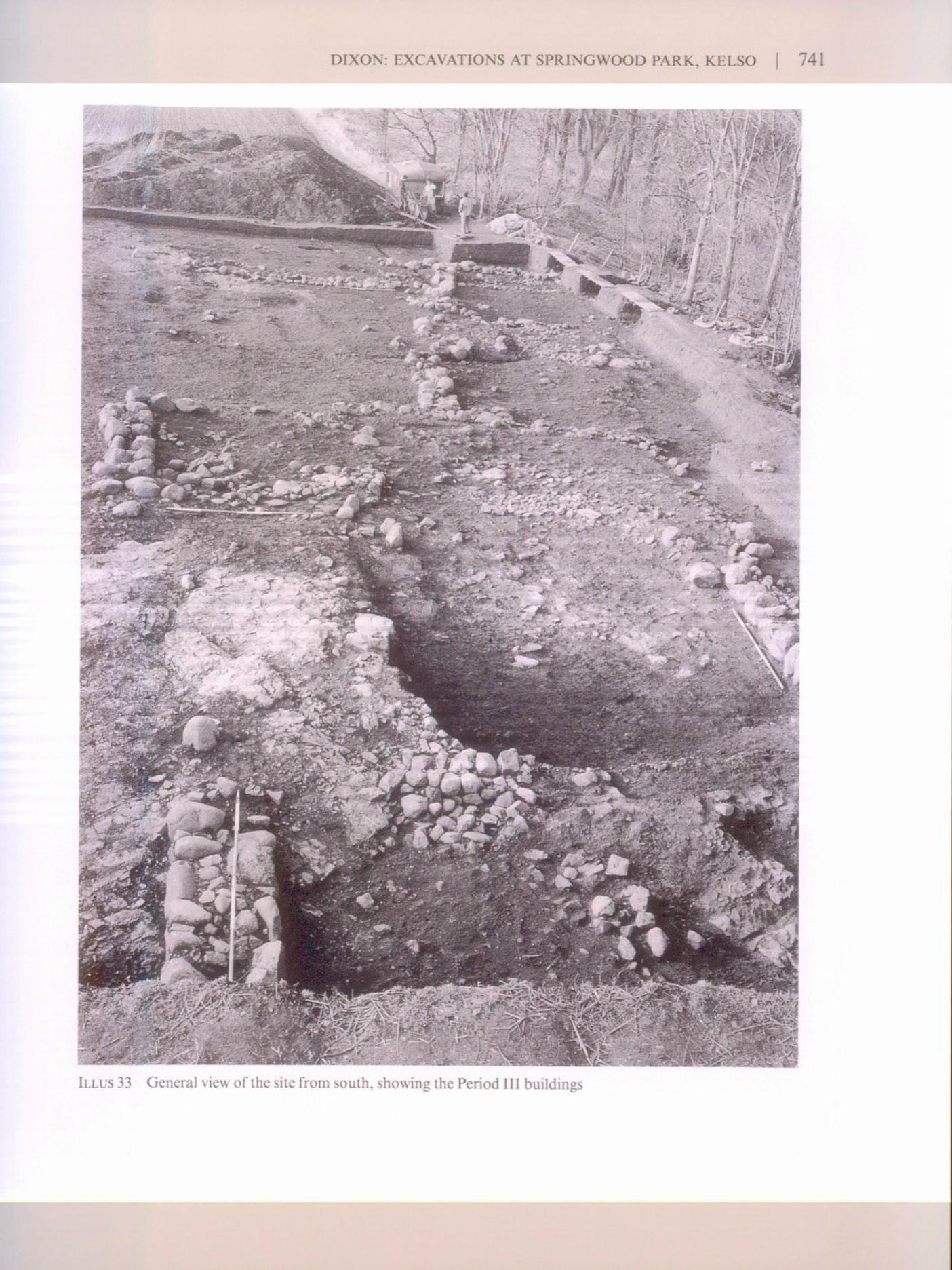

742 | SOCIETY OF ANTIQUARIES OF SCOTLAND, 1998
Knives, hones and grindstones are all indicative of frequent use of cutting implements, for avariety of household purposes at which we may only guess. Woodworking nails and a claw-hammer hint at the use of nails in timber building techniques. The production of cheese issuggested by the presence of a storage jar with holes in its base, which would have made anexcellent slow strainer, while the base of a jug which was set in the ground in the Period I middenwith a 4 mm hole drilled in its side near its base, may have served a similar purpose.
LIVING STANDARDS
The loss of four silver coins indicates the relative richness of the site and its inhabitants. Yet theconversion of rents to payments in silver of the order of 12 shillings at Redden is an indicationthat there was a silver currency in circulation amongst the rural population generally. The hingepivot for a door or window, hasps and staples for use in the securing of doors, a barrel-padlockto secure a door or gate, and a bronze key for a box or casket confirm that the householdersconsidered security important, presumably because they owned valuable items and feared theft.An improved standard of living may be inferred from the levelling and drainage of the buildingsin the final period of occupation, while the absence of a hearth in the Period III houses mayindicate the introduction of a brazier style of cooking and heating. The ubiquitous cooking potsand storage jars with sagging bases suggest that cooking on a open hearth and storage on unevensurfaces were common. Also, the paucity of ceramic tableware suggests that flat surfaces or tableswere rare. There were few decorative artefacts except for horse-brasses, two of them gilded.Buckles to secure narrow leather straps on clothing and an annular brooch with an iron pin wereof a type commonly in use in the 13th and 14th centuries in England and Scotland, for securingcloaks, undergarments or even leather bootstraps, and give some indication of habits of dress; atleast one brass tag-end for leather lacing was also found.
BUILDINGS
Period I: post-set structures
There was evidence for some sort of post-set structure in both Areas 3 and 4. Both structures werealigned on the same axis, but there was only one row of posts in Area 3, 5.6 m long, whereas thatin Area 4 was a right-angled arrangement of posts, measuring 10 m in length by 4 m in breadth.The excavation of the ground to make level platforms for Buildings A, B and C probably removedthe other side of the structures and their overall size and function can only be guessed. The postswere about 0.2 m thick with the greatest depth of post-pipe at c 0.5 m. Together with the middenscoops in Areas 2 and 4, this suggests that there was a 12th-century occupation phase in whichtimber-framed buildings were supported on earthfast, irregularly-spaced posts. Walls of aperishable material such as wattle-and-daub were probably hung on these and the whole wasroofed with thatch.
Periods II & III: cruck-framed buildings
The buildings from the two later periods of occupation (13th to early 14th century) appear tohave been cruck-framed structures with stone walls, bonded with earth or clay. The evidence forthe use of crucks comes from a number of post-settings which were found in, on, or just inside thewall lines of the structures. This was best shown by the setting of a flat stone (broken in use),

DIXON: EXCAVATIONS AT SPRINGWOOD PARK, KELSO 743
edged on two sides by orthostatic stones, which was situated one third of the way along the westwall of Building C. The location of the setting, if it is a cruck-setting, suggests a bay width of3.25 m and a total of three bays for the building. The setting was large enough to take a post upto 0.4 m in diameter, substantial enough for a roof truss on analogy with surviving examples.This setting was actually 0.56 m off the ground within the wall of the building, but virtually atground level on the outside due to the terracing of the house-site of Building C at this point. Sincefew walls survived this high it is perfectly possible that other such settings did not survive.
Some crucks were set in post-pits. Building D in Period II had one pair of posts which wereset in the ground in substantial post-pits, just inside the wall-line at the extreme west end of theBuilding. The primary setting of the pair on the north wall was set on a padstone 0.38 m long and0.25m wide about 0.15m below the ground surface in a pit dug for this purpose, and largeenough for a post of the dimensions given above for the cruck-setting in Building C. This settingwas replaced with another immediately to the east, set more deeply in the ground. On the southside of the building, the initial cruck-setting that formed the pair must have been set on thebedrock, but the replacement was set in a rock-cut post-pit.
The third variety of setting was represented by a ground-level padstone at the north-eastcorner of Building D in an area where its walls had been robbed. This stone was actually set intothe top of a post-pit from the previous phase (Period ID). Of the remainder it is surmised that theposts were set either on the bedrock, where this was available, as might be the case in Building A,or on the ground, resulting, it is suggested, in the shallow scoops which were found in Buildings Eand D. Naturally, the robbing of the buildings will have removed some of the padstones andplinths that supported cruck-timbers.
One unresolved question is how the ends of the buildings were roofed. Were they hipped orgabled? The squared ends and the juxtaposition of the Period III buildings, with Building Binserted between Buildings A and C, would favour a gable-end construction, since there wouldhave been problems with the run-off from the roof if they were hipped. This would either imply acruck-framed roof with a cruck truss at the ends of the buildings or a gable capable of supportingthe weight of the roof. The limited quantity of tumbled stone would appear to preclude the latter.This suggests that the gable was infilled with some more perishable material, such as wattle anddaub, clay, turf or timber planks. An end cruck, as in some Highland buildings, such as the barnat Corrimony (Hay 1973), is theoretically possible, but requires a high level of joinery and noconvincing end wall settings were identified. Evidence for a cruck-truss at the gable comes fromBuilding D, where a cruck- truss was set in post-pits just short of the west end, where the bedrockstepped up. The location of a padstone at the east end and an earth-based cruck-setting in thenorth-west corner of Building E lends weight to this interpretation.
The walls of the houses were constructed in clay on stone footings. The footings were facedwith large boulders and infilled with smaller stones and earth or clay. The footings generallystood two or three courses high, except where the building was terraced into the slope, facilitatinga higher footing for which no external wall was required. The clay walls would have been erectedon this base, infilling the gap between the footings and the wall-plate, over which the eave of theroof would have hung. The clay was composed of an aggregate of clay and small to medium-sizedrubble, although the proportions may have varied considerably. Such construction may be seenat Prior Linn, Canonbie, Dumfriesshire (Stell 1972), both with respect to the walls and the cruck-framed roof. It is, of course, possible that not all the buildings had the same walling. The spreadof rubble consonant with clay wall infill which was observed in Building A, E and possibly B, isnot evident to any degree in either Building C or D. The use of turf-walls cannot be ruled out,while timber-planking or wattles are well-attested forms of construction (Fenton & Walker 1981).

744 | SOCIETY OF ANTIQUARIES OF SCOTLAND, 1998
Cruck constructionA cruck is basically a type of A-frame. Recorded examples of surviving cruck buildings inScotland indicate a pair of slightly curved beams, joined at the apex of the A by a yoke beam, andstrengthened by a tie beam or collar (the cross-stroke of the A). The yoke supports the ridgebeam, which is connected to the next cruck, and, with the purlins takes the main weight of theroof. (The ridge beam would not run the length of the building, but would be a series of beams ofappropriate length for the width of each bay.) Lateral movement is checked by joining the purlinsto the crucks, although diagonal beams can also be used as necessary. Once the crucks are allstanding and the purlins and wall-plates are added, cabers are laid over, preparatory to thecovering of thatch. If the building is thatched, it requires a slope of at least 45 degrees for thewater to run off effectively.
In the present case, the width of the truss was about 4 m on site evidence, but the roof hadto cover the wall-tops to prevent the walls being washed away every time it rained. Thus it had tospan as much as 6 m, since the walls were up to about one metre wide. With the assumed angle ofthe roof and the width required to cover the walls, a height of about 5 m to the ridge would havebeen needed. This space could have been lofted, but this is less likely in a building that had openhearths with the smoke escaping slowly through the thatch, or perhaps through a woodenchimney or hanging lumb.
Roof-covering
Heather, which is not found within 14 km of Kelso today, was found in quantity in the Period IIsamples from Area 4, and may indicate the use of heather in roofing. A burnt deposit containinga large amount of heather, thought to be from a collapsed roof, was also found at Rattray(Murray & Murray 1993, 141), while it has also been proposed as a cheap method of roofing atWest Whelpington (Evans & Jarrett 1987). Alternatively, with the widespread growth of cerealsnearby, there was probably ready access to straw for thatch, and the heather here could also havebeen used for bedding and other purposes. However as has been suggested, corn may well havebeen stored or sold on the stem, in which case the use of heather may have been preferred.
Entrances
The evidence from Building A in Period III is the best preserved and suggests that it had opposedentrances about one third of the way from the north end. The door was hung on a framesupported by two posts on either side of a raised stone threshold. This would have helped reducedrafts and surface run-off getting into the house. There was similar but slighter evidence for theopposing entrance in the east wall. The evidence for entrances in the other two buildings of thisPeriod is less conclusive. A paved threshold is suggested in the middle of the west wall of BuildingB, with a outshot store immediately to the south; but Building C can only have had one entranceon the east side, since there is no suitable gap in the foundations on the west. There was no clear-cut evidence for an entrance in either of the Period II buildings.
Partitions and byre-stands
Partitions are suggested by post-pits within some of the buildings. The best example is a deep-setpost-pit in the interior of Building A which may have supported a post on which a party wall of

DIXON: EXCAVATIONS AT SPRINGWOOD PARK, KELSO | 745
BUILDING A 0 10m
ILLUS 34 Cut-away reconstruction of cruck-framed building, with sections showing the variations in thepadstone settings: A, on the ground; B, in the wall; c, in a post-pit. Note also the different wall-types with turf on stone footings in A, random rubble in B and clay on stone footings in C

746 | SOCIETY OF ANTIQUARIES OF SCOTLAND, 1998
D E r
B
Threshold
O Pit© o Pesthole/InferrediWffiv Cobbles****• Drain-̂" Wall/Inferreda Pad Stone
ILLUS 35 Comparative house plans
10 m
perishable material might be hung. This was positioned immediately south of the cross-passagebetween the opposed entrances, thus dividing the byre-stand (see below) from the living end. Thepost-pits in the interior of Buildings C and D may also support a partition, but that in Building Cis positioned away from the byre-end, providing a completely different internal division of space.All three of the Period III buildings had a stand of cobbling at the north-end, such as might beexpected in a byre. This is a notable feature of these buildings, but it was not as evident in thePeriod II houses, where the cobbled areas were much more limited zones associated with thehearth. Longhouses or peasant buildings with byres at one end and living quarters at the other, assuggested here for the Period III buildings, are a common feature of Scottish rural housing beforethe Improvements period. Their origins may lie in the late first millennium AD, with longhouses atPitcarmick being the earliest known examples of the type to date (Barret & Downes 1994).
Drains
The two primary Period III buildings, A and C, had stone-lined and capped drains, to help dealwith the water run-off which must have been a particular problem once the house-platforms had

DIXON: EXCAVATIONS AT SPR1NGWOOD PARK, KELSO | 747
been terraced into the slope. The drains were not large, with a cavity about 0.3 m wide and 0.15 mdeep, lined with small orthostatic stones and capped with flat stones. In both Buildings A and Cthey were planned from the start since they run under walls and are earlier than any otherstructural feature. That in Building A has two main branches as part of a system of drainagedesigned to channel the run-off both inside and outside the building. It does not appear to havebeen solely a byre-drain in concept. The simpler drain along the edge of the cobble stand inBuilding C, on the other hand, may have been designed essentially for such a purpose, but theabsence of a drain in Building B would suggest that it was not essential for the functioning of thebyre, although it may have been an improvement. A stone-packed drain, without any lining, wasfound in the north-east corner of the Period II Building D.
Hearths
Oddly enough no definite hearths were found in any of the Period III buildings. A well-madecircular stone hearth-base was set in a shallow pit in the centre of the Period II, Building E, itselfreplacing an earlier hearth. Two possible hearths were suggested on the basis of centrally placedgroups of flat stones in Buildings B and D, but neither displays any signs of heat or burning. Sincelarge flat stones may be desirable as hearth-bases and the buildings were robbed, it is possible thatthe hearth stones were taken for use elsewhere. Another alternative is that a brazier was used forheating and cooking in the Period III houses, thus raising the hearth off the floor. At the east endof Building D in Period II there was a layer of ash partly spread over a cobbled surface and anearby charcoal-rich deposit, but no hearth surface or base. This may indicate a nearby hearth,but if so the hearth stone had been robbed or perhaps here there was a bra/ier in use.
Building size
The number of complete or partial house sites available for discussion is small. Indeed, only thestone buildings from Period III are complete, while the size of the Period II buildings can only beestimated. These measurements compare well with those buildings recorded in Southdeanconsidered to be potentially late medieval in date, such as those at Martinlee Sike (RCAHMS1994), and also with the 13th-century and 14th- to 16th-century buildings at West Whelpington(Evans &Jarrett 1987).TABLE 8Comparative plans of buildings (illus 35)
Building Internal dimensions (m) Floor area (sq m) Periodlength width
D '13 4 54 IIE 8 4 32 IIA 10.5 4.5 47 IIIB 11 3.5 38.5 IIlAC 9 4 36 III
Building layout
One of the most intriguing aspects of the site was the layout of the buildings. There appear tohave been two major replanning episodes. The slight evidence for the Period I timber buildingsindicates that they were aligned north/south. This changed to an east/west alignment with the

748 | SOCIETY OF ANTIQUARIES OF SCOTLAND, 1998
construction of the cruck-framed buildings in Period II, and was followed by a return to a north/south axis for the Period III buildings. Although only a small part of the settlement wasexcavated, the evidence here is strong enough for two points to be made. First, that the terraceedge represents the line of a common or public way which the houses respected and, second, thatthe changes in the axis of the buildings between Periods II and III resulted from an act ofplanning. There was clearly a recognized delineation of public and private space, which wasmaintained throughout all three periods of occupation.
Communal acts of replanning are not easily achieved in an urban environment, where theburgage plots are freely held, or in a settlement where the tenants are freeholders with the right ofalienation of their land. Consequently it may be inferred that the type of occupant was not afreeholder, but a tenant-at-will such as a husbandman or cottar, dependent on the instructions ofthe Maxwells as barons of the lordship. However, the occasion of such an act needs explanation.A traumatic event such as devastation by war or an accidental disaster such as the plague wouldhave provided a suitable occasion for a reorganization to be effected. Such events are not difficultto seek. There were several sieges of Roxburgh during the 14th century (1314, 1342 & 1346), eachof which may have led to the wasting of settlements in the area. There was at least one outbreakof plague in 1349-50; its effects on southern Scotland are thought to have been severe (Grant1984) and may have led to a traumatic depopulation. These various events may have providedopportunities for reorganization of settlement. Indeed one of these may have been the reason forthe site's demise at the end of Period III and also of the abandonment of the buildings at the endof Period II. The demise of both periods may lie in the 14th century, since the dating from theartefacts provides a terminus post quern in the 13th-century and certainly after 1195 on coinevidence, which could be as late as the early 14th century. The evidence for an interval betweenPeriods II and III does not preclude this interpretation, indeed it need not have been more than asingle year. The Edward I coins in the collapsed rubble of Building A could have been droppedduring demolition or could have been placed in a wall-cavity during the occupation of Period IILfor safe-keeping (an example of this occurred at West Whelpington in a 13th century building:Evans & Jarret 1987, 237), only to be lost at desertion later in the 14th century. Why the site wasnot reoccupied must remain unclear, but the changes in population in the late medieval periodand the ever present threat of warfare so close to Roxburgh may have made it difficult to attracttenants after the mid 14th century.
The best parallels for the replanning of rural settlements at this period come from theEnglish side of the Border. At West Whelpington, for example, it has been argued that there wasa devastation of the site in the early 14th century and a subsequent replanning of the village in thelate medieval period (Evans & Jarrett 1987 & 1988). The tenants of West Whelpington were notfreeholders and there was ample scope for the landlord to redesign the village.
CONCLUSIONS
The importance of the excavations at Springwood Park lies in the almost unique examination ofa rural settlement of the 12th to 14th centuries. Clearly more rural settlements of this period needto be located and excavated from both lowland and upland contexts. The accumulated evidencesuggests that the settlement was firmly rural in its economic and social base, despite the closenessof Roxburgh. The buildings, in the final period at least, appear to have been longhouses or byre-dwellings, a tradition that is common to both Scotland and northern England. And lastly but notleast, the Period II and III buildings were cruck-framed, confirming that Scotland has medievalantecedents for this style of construction going back to the 13th century.

DIXON: EXCAVATIONS AT SPRINGWOOD PARK, KELSO | 749
ACKNOWLEDEGEMENTS
Thanks are extended to the following persons and organizations. The excavation was supervisedsuccessively by Paul Sharman (Feb-Sept 1985), Dick Grove (Oct-Nov 1985) and Julian Cotton(Mar-Oct 1986) under the direction of the author. The post-excavation work was carried out bythe author and Denise Drury, who also worked as a site assistant on the excavation. The SmallFinds were drawn by Lesley McLaren; the plans, sections, pottery and reconstructions by AlanBraby. Thanks are extended to Jim and Roger Elliot, farmers at Springwood Park, Kelso, forgiving permission to carry out the excavation and much practical support; to the sponsors of theBorders Burghs Archaeology Project — Borders Architects Group — who raised the fundingfrom the Manpower Services Commission; to the staff of Borders Regional Council who providedthe essential administrative resources; to Historic Scotland for the preparation of the publication;and to all the personnel who worked on the excavation. I should also thank Bruce Walker andOlwyn Owen for reading and providing helpful comments on the text. Finally I should like tothank the Royal Commission on the Ancient and Historical Monuments of Scotland forproviding the time and support in kind for the publication work to be carried out. The BordersBurghs Archaeology Project was established in July 1983 to carry out archaeological investi-gations of sites due to be developed in the historic burghs of the Borders.
REFERENCESBain, J (ed) 1888 Calendar of Documents Relating to Scotland, vol4, 1357-1509. Edinburgh.Barret, J C & Downes, J M 1994 North Pitcarmick: a radiocarbon dated chronology. An unpublished interim
report. University of Sheffield.Biddle, M 1962 'The deserted medieval village of Secourt, Berkshire', Oxoniensia. 26-7 (1961-2), 70-201.Blaeu, J 1654 Atlas Novus. AmsterdamSown, L 1985 'Pottery', in O'Sullivan, D M, 'Excavation in Holy Island Village 1977', Archaeologia Aeliana
(5ser)13,47-80.Bown, L 1988 'Queen Street pottery' in O'Brien, C The Origins of the Newcastle Quayside, 41-77. Newcastle
upon Tyne (= Soc Antiq Newcastle upon Tyne Monogr Ser, 3).Burns, E 1887 The Coinage of Scotland. Edinburgh.Bryant, G F & Steane, J M 1971 'Excavations in the deserted medieval settlement at Lyvesden', Northampton
Mus Art Gallery 7, 9 (1971), 1 -94.Caldwell, D H 1981 'Metalwork', in Good, G L & Tabraham, C J, 'Excavations at Threave Castle,
Galloway, 1974-78', Medieval Archaeol, 25 (1981), 90-140.Cannel, J unpubl Excavation archives of the National Monuments Record of Scotland, Ace no 1999/132.
Edinburgh.Charlton, P, Roberts, J & Vale, V 1977 Llantrithyd: a ring-work in South Glamorgan. Cardiff.Chatwin, P B 1955 'Brandon Castle, Warwickshire', Trans Birmingham Archaeol Soc, 73 (1955), 63-83.Clark, J 1986 Medieval Horseshoes (= Finds Research Group 700-1700. Datasheet 4).Clarke, H & Carter, A 1977 Excavations in King's Lynn 1963-1970 (= Medieval Archaeol Monogr Ser, 7).Clay, P 1981 'Small finds: non structural', in Mellor, J E & Pearce, T The Austin Friars, Leicester, 130-45.
London (= CBA Res Rep 35).Cox, E, Haggarty, G & Hurst, J G 1984 'Ceramic material', in Tabraham, C 'Excavations at Kelso Abbey',
Proc Soc Antiq Scot, 114(1984), 381-98.Crowdy, A 1986 'Pottery', in Dixon, P, Excavations in the Fishing Town of Eyemouth 1982-1984, 38-55.
Edinburgh (= Borders Burghs Archaeol Project Monogr Ser, 1).Crowdy, A forthcoming 'Pottery 1983-85', in Dixon, P Excavations at Jedburgh Friary, 1983-85 and
1991-92 (= Scottish Trust Archaeol Res Monogr Ser).

750 | SOCIETY OF ANTIQUARIES OF SCOTLAND, 1998
di Folco, J 1985 'A survey of medieval floor tiles in St Andrews Cathedral Museum and the Abbot's House,Arbroath Abbey', Proc Soc Antiq Scot, 115 (1985), 289-95.
Dixon, P J 1981 'Alnhamsheles', Medieval Village Research Group, 29 (1981), 18-19,Dixon, P J 1985 The Deserted Villages of North Northumberland, 2 vols. Unpubl PhD thesis, University of
Wales.Dixon P J 1986 Excavations in the Fishing Town of Eyemouth, 1982-4. Edinburgh (= Borders Burghs
Archaeol Project Monogr Ser, 1).Eames, E 1983 'Floor tiles', in Wordsworth, J, 'Friarscroft and the Trinitarians in Dunbar', Proc Soc Antiq
Scot, 113 (1983), 478-89.Ellison, M 1981 'Pottery', in B Harbottle & M Ellison, 'An excavation in the Castle Ditch, Newcastle,
1974-1976' Archaeol Aeliana (5 ser) 9, 95-164.ERS 1878 The Exchequer Rolls of Scotland, voll, 1264-1359. Edinburgh.Evans, D H & Jarrett, M G 1987 'The deserted village of West Whelpington, Northumberland: third report,
part one', Archaeol Aeliana ( 5 Ser) 15,199-308.Evans, D H & Jarrett, M G 1988 'The deserted village of West Whelpington, Northumberland: third report,
part two', Archaeol Aeliana (5 Ser) 16,139-92.Fairbairn, A 1927 'Notes on excavation of prehistoric and later sites at Muirkirk, Ayrshire, 1913-1927',
Proc Soc Antiq Scot, 61 (1926-7), 269-89.Farmer, P G 1979 An Introduction to Scarborough Ware and a Reassessment of Knight Jugs. Hove.Fenton, A & Walker, B 1981 The Rural Architecture of Scotland Edinburgh.Ford, B A 1987a 'Iron objects', in Holdsworth, P, 130-41.Ford, B A 1987b 'Copper-alloy objects', in Holdsworth, P, 121-30.Ford, B A 1987c 'Lead-alloy objects', in Holdsworth, P, 130.Ford, B A 1987d 'Stone objects', in Holdsworth, P, 147-50.Ford, B A 1996 'Copper-alloy objects', in Cox, A 'Buckland activities in medieval Perth: excavations at
Meal Vennel and Scott Street', Proc Soc Antiq Scot, 126 (1996), 733-821.Ford, B A & Walsh, A 1987 'Iron nails', in Holdsworth, P, 139.Good, G L & Tabraham, C J 1981 'Excavations at Threave Castle, Galloway 1974-1978', Medieval
Archaeol, 25 (1981), 90-140.Goodall, A R 1979 'Lead and lead-alloy objects', in Andrews, D & Milne G (eds), 'Domestic settlement
areas 10 and 6', in Hurst, J G (ed), Wharram: a study of settlement on the Yorkshire Wolds, 114-15.London (=Soc Medieval Archaeol Monogr Ser, 8).
Goodall, A R 1984 'Objects of non-ferrous metal', in Allan, J P, Medieval and Post-Medieval Finds fromExeter, 1971-1980, 337-48. Exeter (= Exeter Archaeol Rep, 3).
Goodall, I H 1979 'Iron objects', in Andrews, D & Milne, G (eds), 'Domestic Settlement areas 10 and 6', inHurst, J G (ed ) Wharram: a study of settlement on the Yorkshire Wolds, 115-23. London (=SocMedieval Archaeol Monogr Ser, 8).
Goodall, I H 1980 Ironwork in Medieval Britain: an archaeological study, 3 vols. Unpubl PhD thesis, CardiffUniversity.
Goodall, I H 1982 'Iron objects', in Coad, J G & Streeten, A D F, 'Excavations at Castle Acre Castle,Norfolk, 1972-77: country house and castle of the Norman earls of Surrey', Archaeol J, 139 (1982),138-301.
Grant, A 1984 Independence and Nationhood: Scotland 1306-1469. Edinburgh.Griffiths, N 1986 Horse Harness Pendants. (= Finds Research Group 700-1700. Datasheet 5.)Harvey, Y 1975 'Small finds', in Platt, C & Coleman-Smith, R (eds) Excavations in Medieval Southampton,
1953-1969. Vol2: the finds, 254-313. Leicester.Hay, D H 1973 'The cruck-building at Corrimony, Inverness-shire', Scott Stud, 17 (2) (1973), 127-34.Hill, N G 1937 'Excavations at Stockbridge Down, 1935-6', Proc Hampshire Field Club Archaeol Soc, 13
(1935-6), 246-59.Holdsworth, P 1987 Excavations in the Medieval Burgh of Perth 1979-1981. Edinburgh (=Soc Antiq Scot
Monogr Ser, 5).

DIXON: EXCAVATIONS AT SPRINGWOOD PARK, KELSO | 751
Huggins, P J 1972 'Monastic grange and outer close excavations, Waltham Abbey, Essex, 1970-2', EssexArchaeol& Hist, 4 (1972), 30-127.
Leech, G B 1960 'Excavations at Hen Bias, Coleshill Fawr, near Flint, second report', J Flintshire Hist Soc,18(1960), 13-48.
Liber de Calchou 1846 Liber de Calchou, 2 vols. Bannatyne Club. EdinburghLMMC 1940 Medieval Catalogue. London Museum Catalogue, 7. London.Macgregor, A 1974 'The Broch of Burrian, North Ronaldsay, Orkney', Proc Soc Antiq Scot, 105 (1972-5),
63-118.Margeson, S 1985 'Small finds', in Atkin, M, Carter, A & Evans, D H 'Excavations in Norwich 1977-1978,
Part IF, E Anglian Archaeol Rep, 26 (1985), 52-213.Marshall, D N 1964 'Report on excavations at Little Dunagoil', Trans Buteshire Natur Hist Soc, 16 (1964),
1-69.Morrison, A & Atkinson, J A 1996 'Ben Lawers historic landscape project, Perth & Kinross', Discovery
Excav Scot 1996, 85.Murray, H K & Murray, J C 1993 'Excavations at Rattray, Aberdeenshire. A Scottish deserted burgh',
Medieval Archaeol, 37 (1993), 109-218.North, J J 1991-4 The English Hammered Coinage, vols 1 & 2 (3rd edn). London.Oakley, G E & Hall, A D 1971 'Spindle whorls', in Williams, J H, St Peter's Street Northampton, Excavations
1973-1976, 286-9. Northampton.Oakley, G E & Webster L E 1971 'Copper-alloy objects', in Williams, J H, St Peter's Street Northampton,
Excavations 1973-1976, 248-64. Northampton.OPS 1851 Origines Parochiales Scotiae, vol 1. EdinburghRCAHMS 1994 Royal Commission on the Ancient and Historical Monuments of Scotland. Southdean
Borders: an archaeological survey. Edinburgh.RCAHMS 1997 Royal Commission on the Ancient and Historical Monuments of Scotland Eastern
Dumfriesshire: an archaeological landscape. Edinburgh.Rigold, S E & Fleming, A J 1973 'Eynsford Castle: the moat and bridge', Archaeol Cantiana, 88 (1973),
87-116.Robinson, M 1973 'Excavations at Copt Hay, Tetsworth, Oxon', Oxoniensia 38 (1973), 41-115.Rogerson, A & Dallas, C 1984 Excavations in Thetford 1948-59 and 1973- 80. Gressenhall (=E Anglian
Archaeol Rep, 56).Roy, Sir W 1747-55 Military Survey of Scotland. National Library of Scotland facsimile. Edinburgh.Scollar, I, Verhaeghe, F & Gautier, A 1970 'Medieval site (14th-century) at Lampernisse' [West Flanders,
Belgium]. Dissertationes Archaeologicae Condenses, vol 13. Bruges.Simpson, J & Stevenson, S 1980 The Burgh ofKelso. Scottish Burgh Survey. Edinburgh.Stell, G 1972 'Two cruck-framed buildings in Dumfriesshire', Trans Dumfriesshire Galloway Natur Hist
Antiq Soc, 49 (1972), 39-48.Trewin, N H 1982 'Stone objects', in Murray, J C, Excavations in the Medieval Burgh of Aberdeen, 1973-81,
184-5. Edinburgh (= Soc Antiq Scot Monogr Ser, 2).Ward, T 1992 'Glenochar, Clydesdale, Strathclyde', Discovery Excav Scot 1992, 66-7.Wilson, J 1846 'Antiquities found at Woodperry, Oxon', Archaeol J, 3 (1846), 116-28.Wrathmell, S 1989 'Peasant houses, farmsteads and villages in north-east England', in Aston, M, Austin, D,
Dyer, C (eds) Rural Settlements of Medieval England, 247-68. Oxford.
This paper is published with the aid of a grant from Historic Scotland