The rescue archaeological research on the site of Crkvine-Bare in Skobalj

A REPORT OF ARCHAEOLOGICAL INVESTIGATIONS AT THE HECKELMAN SITE (33Er14):
2013 SEASON
Brian G. Redmond, Ph.D. Principal Investigator
and Brian L. Scanlan
Supervisor of Archaeology Field Programs
Archaeological Research Reports, No. 164
April 2014
© Cleveland Museum of Natural History 2014

TABLE OF CONTENTS
ACKNOWLEDGEMENTS .............................................................................................2
INTRODUCTION ...........................................................................................................2
PURPOSE AND METHOD OF INVESTIGATION ......................................................3
RESULTS ........................................................................................................................5
Features ...............................................................................................................5
Post Molds and Alignments...............................................................................11
Structures............................................................................................................12
MATERIAL ANALYSES AND DESCRIPTIONS ........................................................14
Flaked and Ground Stone Artifacts .................................................................14
Ceramics .............................................................................................................17
Faunal Remains ..................................................................................................21
Floral Remains ...................................................................................................22
Bone Artifacts .....................................................................................................22
Radiocarbon Determinations ............................................................................24
DISCUSSION AND PRELIMINARY CONCLUSIONS ...............................................24
REFERENCES CITED ....................................................................................................26
APPENDIX 1: Botanical Inventory of the 2013 field season..........................................28
2
ACKNOWLEDGEMENTS
This project was made possible by the cooperation and support of the following
individuals and institutions. Land owners Richard and Terry Speer granted permission for
excavations on their property and supplied material and logistical support for the
excavations in the form of storage facilities, vegetation control, and other site preparation
and surveillance. The Speers also graciously provided water and allowed for flotation to
be conducted on-site. Their efforts are greatly appreciated. Howard P. Leber Excavating
ably carried out bulldozer stripping for the project area.
Partial funding for the 2013 excavation was provided by grants from the Albert G.
& Olive H. Schlink Foundation and the Laub Foundation. Additional support came from
the Cleveland Museum of Natural History (CMNH). CMNH field supervisors Brian
Scanlan and Jim Bowers admirably oversaw the day-to-day field operations. Special
thanks to our superb, all-volunteer field crew members including Brian Mickey, Sharon
Denslow, Char Shryock, Allison Shryock, Marsha Rine, Annie Boyle, Michelle Neudeck,
Lee Goodman, Glen Boatman, Amber Wallace, Mindy Bedrossian, Meghan Marley,
Chad Waffen, Avery Waffen, Angie Cascone, Jonathan Marcaly, Amy and Emily
Winnicki, Janice Pearson, Robert Koonce, and Josh Bardin.
In the laboratory, Ann DuFresne supervised the processing and cataloging of all
materials from the excavation with the help of Jim Bowers. Numerous volunteers
including: Jack Abbott, Natalie Andras, Jackie Artman, Joann Broadbrooks, Alex
Callina, Yvonne Carter, Tom Dalhausen, Evelyn Gelbke, John Harmon, Phil Kleinhenz,
Luane Lasky, Stuart MacDonnell, Ryan Oergel, Joe Petrulis, the late Abigail Pincus,
Daniel and Cathy Pugh, Ted Schvimer, Karl Smith, Nancy Somnitz, John St. John,
Ronald Vranich, and Gil Winer processed the artifacts from the field and carried out the
inventory. Meghan Marley analyzed the lithic and ceramic artifacts and worked on the
reconstruction of several vessels.
All the aforementioned individuals and institutions are thanked for contributions
to this project. Any errors or omissions in what follows are the sole responsibility of the
authors.
INTRODUCTION
This report describes the background, methods, procedures, and results of the
2013 excavation season at the Heckelman site (33Er14). Controlled excavations were
conducted as a joint project between the Department of Archaeology of The Cleveland
Museum of Natural History (CMNH) and the Firelands Archaeological Research Center
(FARC). Excavations began on June 10 and concluded on July 28, 2013. The
investigation was directed by Brian Redmond with the assistance of Brian Scanlan.

3
The Heckelman site is located in Milan Township, Erie County, Ohio and is
situated on a prehistoric beach remnant overlooking the Huron River floodplain to the
south, approximately 15 kilometers (9.5 miles) upriver from Lake Erie (Figure 1).
Detailed descriptions of the natural and cultural settings of the Heckelman site as well as
the history of archaeological research and the results of geophysical surveys conducted
on the site in 2008 can be found in the 2009 Report of Investigations (Redmond and
Scanlan 2010:4-10).
Figure 1: Location and topographic situation of the Heckelman site.
PURPOSE AND METHOD OF INVESTIGATION
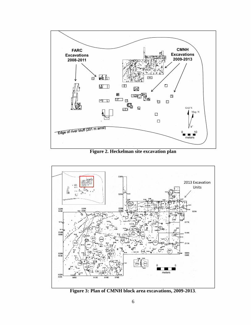
The work carried out by the CMNH from 2008 to 2012 provided a foundation for
the 2013 research design and for planning subsequent excavations (Figure 2). The 2013
field work was designed to address two specific research goals. The first goal was to
further identify and characterize cultural deposits associated with the Early Woodland
utilization of the site. CMNH excavations of the oval enclosure feature from 2009
through 2012 produced data that indicate its Early Woodland temporal affiliation. The
2013 excavations were designed to further investigate the nature of the Early Woodland
component by excavating inside the area bounded by the oval enclosure feature. The
second goal was to further investigate a semi-circular post mold outline designated as
Map showing exact site
location deleted in this web
version.

4
Structure 4 following the 2012 field season (Redmond and Scanlan 2013:1 9-22). It was
hypothesized that the side of this structure was to be found to the east and north of the
2012 excavation area. The methods of investigation employed at the Heckelman site in
2013 were, therefore, designed to systematically recover the kinds of archaeological data
most useful for addressing the following research questions:
1. What was the nature of the Early Woodland activity within the oval enclosure
ditch, including potential settlement data?
2. What was the spatial extent and temporal affiliation of prehistoric structure(s)
inside the oval (and possibly related to the oval enclosure ditch), specifically the
pattern of large posts identified as Structure 4?
Archaeological excavation of the Heckelman site began on June 10, 2013. In
order to expedite the identification of subsurface deposits a bulldozer was employed to
strip two perpendicular transects. The first, or “northern transect,” measured six meter-
wide (north to south) by fifteen long (east to west) and had its southwest corner at 520N
521E. The “eastern transect,” measured nine meters long (north to south) by 6 meters
wide (east to west) and had its southwest corner at 511N 530E. These two transects were
continuous and adjacent to areas excavated in 2010 and 2012 (Figure 3). Plow zone
deposits were removed by the bulldozer to approximately five centimeters above
subsurface interface (i.e., approximately 25 cm B.D.). Hand excavation then began in the
stripped area within individual 3 x 3 meter units. In addition, two 2 x 2 meter units were
excavated to the southwest of the bulldozed area. These units were adjacent to one
another and had their southwest corners located on the 504.5N line, at 523E and 525E
respectively. Each of these units was excavated fully by hand, removing and discarding
plow zone fill.
Staff archaeologists and crew members were then assigned to 3x3 m and 2x2 m
units. All units were aligned to the site grid and identified by the north and east
coordinates of their southwest corner stakes. Excavation took place by hand, using
straight-edged shovels and trowels. Remnants of plow zone fill were removed and
discarded unscreened until subsoil and intact subsurface feature fill were exposed. The
floors of excavation units were shovel-scraped or leveled with trowels, and obvious
cultural features were assigned feature numbers, whereas other areas of soil staining of
questionable cultural origin were identified as soil “zones” and assigned letter
designations. Possible post molds or “PPM”s were given individual numbers (sequential
numbers were assigned starting with “PPM 1” in each unit). Once a unit floor was
completed, it was digitally photographed, and all features and zones visible on the floor
were mapped in plan using metric tapes and recorded on standard CMNH excavation
plan forms.
All features, zones, and selected post molds were sectioned in half or by quarter.
For each PPM that was cross-sectioned, the diameter at the point of definition and the
maximum depth below datum were recorded. Selected possible post molds were cross-

5
sectioned to verify their cultural origin. The fill of each pit feature was removed either in
10 cm intervals or by cultural strata, if such could be discerned. All fill was dry-screened
through 6.35 mm (¼ inch) hardware cloth. In addition, five- to ten-liter samples of fill
from feature contexts were collected for water-flotation processing. Charcoal and other
carbonized botanicals were recovered by hand during excavation or collected during
sediment screening. All artifacts, and material samples from the 2013 excavations were
returned to the Department of Archaeology at CMNH for processing, cataloging, and
analysis. Artifacts were washed, sorted, inventoried, and labeled with catalog numbers
(CMNH Identification No. 3086A). Soil samples collected for water flotation were
processed at the Heckelman site during the 2013 excavations.
The identification and preliminary analyses of all diagnostic artifacts recovered
during the 2013 season have been completed and are reported herein. As of this writing,
expert analyses of floral remains have been completed; however, the faunal remains have
not been so examined. Two samples of nutshell were submitted to Beta Analytic Inc. for
AMS radiocarbon dating. The results of these assays are discussed below.
RESULTS
As described above, the strategy for the 2013 field season focused on: better
understanding the activities within the oval enclosure ditch, exploring the nature of
structure(s) within the oval enclosure, and the possible temporal and functional
connection of structures to the oval enclosure. To accomplish these goals, a total of
110.75 m2 of surface area was exposed through the excavation of fourteen excavation
units: ten 3x3 m; one 1.5x3 m; one 3x2 m; one 1.5x1.5 m, and two 2x2 m in size (Figure
3). Results of these excavations are described below.
Features
During the 2013 excavation season a total of 43 soil anomalies were identified
and recorded as “features” (Table 1). Forty-one of the cultural features were excavated
completely, two others were either partially excavated (sampled), because the remaining
portions extended beyond the limits of the excavation units or were not begun due to time
constraints. To facilitate description, the completely excavated features were grouped into
classes based on the morphological variables of orifice length (long-axis diameter) and
width, depth below datum, and profile form. These morphological classes follow criteria
devised during feature analysis in 2010 (Redmond and Scanlan 2011) and comprise:
Small (n=13), Medium (n=9), and Large Basins (n=5); Large Post Molds (n=13); and
Indeterminate (n=3). Two of the indeterminate features (13-24 and 13-43) were not
sectioned due to time constraints and the third (Feature 13-31) was too heavily disturbed
by rodent burrowing for assignment to a morphological class.
Small Basins (n=13)
Features 13-03, 13-05, 13-06, 13-08, 13-12, 13-17, 13-18, 13-19, 13-20, 13-22, 13-35,
13-36, 13-41
6
Figure 2. Heckelman site excavation plan
Figure 3: Plan of CMNH block area excavations, 2009-2013.

7
Table 1. Inventory of Features
Fea.
No.
Unit
Coordinates Type
Plan
Form
Degree of
Excavation
Max.
Length(cm)
Max.
Width(cm)
Max
Depth
(B.D.)
13-01 504.5N 525E Large Basin Ovoid Complete 112 98 35
13-02 504.5N 523E Large Basin Circular Complete 100 100 66
13-03 504.5N 523E Small Basin Ovoid Complete 40 40 19
13-04 504.5N 523E Large Post Circular Complete 27 27 29
13-05 504.5N 523E Small Basin Circular Complete 18 18 21
13-06 511N 530E Small Basin Ovoid Complete 40 24 21
13-07 511N 530E Medium
Basin Ovoid Complete 70 60 51
13-08 514N 533E Small Basin Circular Complete 29 29 29
13-09 514N 533E Medium
Basin Circular Complete 54 54 39
13-10 517N 533E Large Basin Ovoid Complete 130 85 11
13-11 517N 533E Large Post Circular Complete 19 19 43
13-12 511N 533E Small Basin Circular Complete 25 25 13
13-13 511N 533E Large Post Ovoid Complete 50 60 69
13-14 511N 533E Medium
Basin Ovoid Complete 60 46 24
13-15 517N 533E Large Post Circular Complete 18 18 43
13-16 520N 527E Large Post Circular Complete 28 28 38
13-17 520N 527E Small Basin Ovoid Complete 50 38 40
13-18 520N 527E Small Basin Circular Complete 45 45 37
13-19 520N 530E Small Basin / Circular Complete 30 30 38
13-20 520N 530E Small Basin Ovoid Complete 32 28 28
13-21 520N 521E Large Basin Ovoid Complete 160 80 33
13-22 520N 530E Small Basin Ovoid Complete 50 36 36
13-23 520N 533E Medium
Basin Circular Complete 95 95 21
13-24 520N 521E Indeterminate Ovoid Unexcavated 70 40 0
13-25 520N 527E Medium
Basin Circular Complete 56 56 53
13-26 520N 254E Medium
Basin Ovoid Complete 75 45 50
13-27 520N 530E Medium
Basin Ovoid Complete 75 66 50
13-28 520N 533E Large Post Circular Complete 30 30 47
13-29 520N 533E Medium
Basin Ovoid Complete 65 56 40
13-30 520N 533E Large Post Ovoid Complete 30 25 58
13-31 523N 533E Indeterminate Irregular Complete 0 0 0
13-32 523N 533E Large Post Circular Complete 25 25 46
13-33 523N 533E Large Post Circular Complete 25 25 35
13-34 520N 524E Large Post Circular Complete 26 26 35
13-35 523N 533E Small Basin Circular Complete 32 32 22
13-36 523N 533E Small Basin Ovoid Complete 30 26 18
13-37 523N 533E Medium
Basin Ovoid
Complete
75 60 32
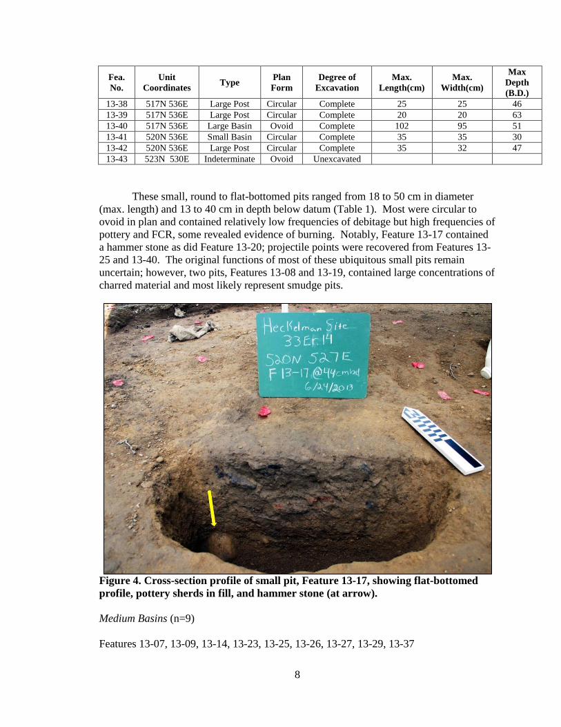
8
Fea.
No.
Unit
Coordinates Type
Plan
Form
Degree of
Excavation
Max.
Length(cm)
Max.
Width(cm)
Max
Depth
(B.D.)
13-38 517N 536E Large Post Circular Complete 25 25 46
13-39 517N 536E Large Post Circular Complete 20 20 63
13-40 517N 536E Large Basin Ovoid Complete 102 95 51
13-41 520N 536E Small Basin Circular Complete 35 35 30
13-42 520N 536E Large Post Circular Complete 35 32 47
13-43 523N 530E Indeterminate Ovoid Unexcavated
These small, round to flat-bottomed pits ranged from 18 to 50 cm in diameter
(max. length) and 13 to 40 cm in depth below datum (Table 1). Most were circular to
ovoid in plan and contained relatively low frequencies of debitage but high frequencies of
pottery and FCR, some revealed evidence of burning. Notably, Feature 13-17 contained
a hammer stone as did Feature 13-20; projectile points were recovered from Features 13-
25 and 13-40. The original functions of most of these ubiquitous small pits remain
uncertain; however, two pits, Features 13-08 and 13-19, contained large concentrations of
charred material and most likely represent smudge pits.
Figure 4. Cross-section profile of small pit, Feature 13-17, showing flat-bottomed
profile, pottery sherds in fill, and hammer stone (at arrow).
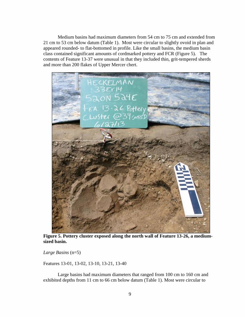
Medium Basins (n=9)
Features 13-07, 13-09, 13-14, 13-23, 13-25, 13-26, 13-27, 13-29, 13-37
9
Medium basins had maximum diameters from 54 cm to 75 cm and extended from
21 cm to 53 cm below datum (Table 1). Most were circular to slightly ovoid in plan and
appeared rounded- to flat-bottomed in profile. Like the small basins, the medium basin
class contained significant amounts of cordmarked pottery and FCR (Figure 5). The
contents of Feature 13-37 were unusual in that they included thin, grit-tempered sherds
and more than 200 flakes of Upper Mercer chert.
Figure 5. Pottery cluster exposed along the north wall of Feature 13-26, a medium-
sized basin.
Large Basins (n=5)
Features 13-01, 13-02, 13-10, 13-21, 13-40
Large basins had maximum diameters that ranged from 100 cm to 160 cm and
exhibited depths from 11 cm to 66 cm below datum (Table 1). Most were circular to
10
slightly ovoid in plan and were moderately rounded- to flat-bottomed in profile. Artifacts
recovered from large basins were more plentiful than with other feature types and
included varying amounts of charcoal and carbonized nutshell, burned and unburned
bone fragments, pottery fragments, chert flakes, and FCR. Most of these large basins
appear to have served as storage pits which were afterwards filled with refuse. Feature
13-01 contained deer mandible and maxilla fragments, a hammer stone, ground bone
fragments, and two pottery rims. One rim appeared cordmarked, while the other closely
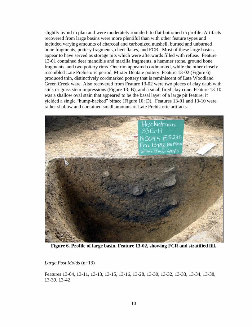
resembled Late Prehistoric period, Mixter Dentate pottery. Feature 13-02 (Figure 6)
produced thin, distinctively cordmarked pottery that is reminiscent of Late Woodland
Green Creek ware. Also recovered from Feature 13-02 were two pieces of clay daub with
stick or grass stem impressions (Figure 13: B), and a small fired clay cone. Feature 13-10
was a shallow oval stain that appeared to be the basal layer of a large pit feature; it
yielded a single “hump-backed” biface (Figure 10: D). Features 13-01 and 13-10 were
rather shallow and contained small amounts of Late Prehistoric artifacts.
Figure 6. Profile of large basin, Feature 13-02, showing FCR and stratified fill.
Large Post Molds (n=13)
Features 13-04, 13-11, 13-13, 13-15, 13-16, 13-28, 13-30, 13-32, 13-33, 13-34, 13-38,
13-39, 13-42

11
The largest post molds were assigned feature numbers and excavated using the
same methods applied to pit features. In plan, these features could not be distinguished
from small to medium basins, and, like the latter, had modest diameters which ranged
from 19 to 50 cm. Upon sectioning, these features revealed their deep profiles, slightly to
strongly-sloped walls, and rounded to slightly pointed bottoms which extended from 29
to 69 cm below datum (Table 1). With one exception, the large post molds contained
very modest frequencies of cultural materials such as small amounts of charcoal, burned
and calcined bone, pottery, chert flakes, and FCR. Notably, Feature 13-30 contained a
thin, cordmarked rimsherd that most closely matched Green Creek Cordmarked vessel
fragments found in association with Structure 2 (Redmond and Scanlan 2012) (Figure 13:
C). These large posts and their relation to specific cultural activity are discussed below.
Post Molds and Alignments
During the course of the 2013 field season, 307 PPMs were identified and
documented. Only a limited number of PPMs were sectioned due to time constraints, and,
of these, 50 PPMs proved to be of prehistoric origin. Post mold summary data are
provided in Table 2.
Table 2: Post Mold Summary Statistics
N=50 Diam.
(cm)
Depth
(cm)
Depth
(actual) (cm) Depth (masl)
Average 9.0 11.8 25.0 200.42
Std. Dev. 3.2 8.1 10.0 0.08
Maximum 19.0 30.0 56.0 200.54
Minimum 4.0 3.0 10.0 200.19
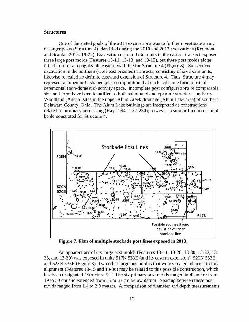
The 2013 excavations also exposed multiple lines of stockade posts, some of
which correspond with lines that were recorded previously. Posts representing stockade
lines (A and B), discovered during 2010 and subsequent excavations, were identified in
units of the northern bulldozer transect (i.e., on the 520N line) (Figure 7). These lines run
eastward from 521E for the entire 17 meter length of this transect. At least two and
possibly three discrete lines of stockade posts can be discerned; however, they overlap at
several points, somewhat obscuring a clear pattern. Nevertheless, this configuration does
appear to terminate just east of the 521N line, thereby confirming the formal opening or
gateway through the stockade line proposed after the 2012 excavations (Redmond and
Scanlan 2013: 15). On the eastern end, at least two of the stockade lines appear to
continue onward toward the eastern ravine for an unknown distance. But the end of a
possible third line of stockade posts seems to turn to the southeast and away from the
ravine (Figure 7). Such a deviation may indicate that the stockade enclosure for the Late
Prehistoric period village settlement closed short of this natural barrier.
12
Structures
One of the stated goals of the 2013 excavations was to further investigate an arc
of larger posts (Structure 4) identified during the 2010 and 2012 excavations (Redmond
and Scanlan 2013: 19-22). Excavation of four 3x3m units in the eastern transect exposed
three large post molds (Features 13-11, 13-13, and 13-15), but these post molds alone
failed to form a recognizable eastern wall line for Structure 4 (Figure 8). Subsequent
excavation in the northern (west-east oriented) transects, consisting of six 3x3m units,
likewise revealed no definite eastward extension of Structure 4. Thus, Structure 4 may
represent an open or C-shaped post configuration that enclosed some form of ritual-
ceremonial (non-domestic) activity space. Incomplete post configurations of comparable
size and form have been identified as both submound and open-air structures on Early
Woodland (Adena) sites in the upper Alum Creek drainage (Alum Lake area) of southern
Delaware County, Ohio. The Alum Lake buildings are interpreted as constructions
related to mortuary processing (Hay 1994: `137-230); however, a similar function cannot
be demonstrated for Structure 4.
Figure 7. Plan of multiple stockade post lines exposed in 2013.
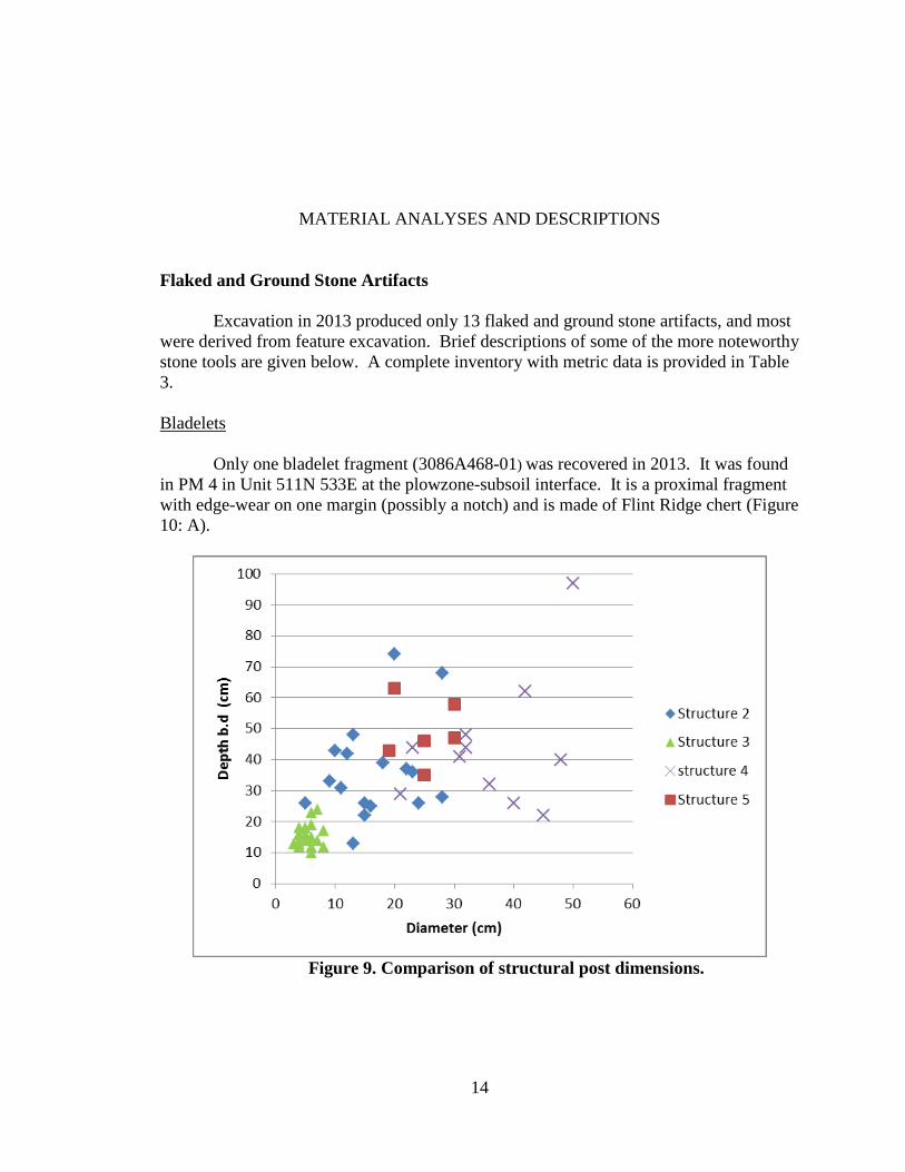
An apparent arc of six large post molds (Features 13-11, 13-28, 13-30, 13-32, 13-
33, and 13-39) was exposed in units 517N 533E (and its eastern extension), 520N 533E,
and 523N 533E (Figure 8). Two other large post molds that were situated adjacent to this
alignment (Features 13-15 and 13-38) may be related to this possible construction, which
has been designated “Structure 5.” The six primary post molds ranged in diameter from
19 to 30 cm and extended from 35 to 63 cm below datum. Spacing between these post
molds ranged from 1.4 to 2.0 meters. A comparison of diameter and depth measurements

13
for Structures 2, 3, 4, and 5 reveal that the posts of Structure 5 overlap in size the smaller
posts of Structure 4 and exceed most post dimensions recorded for Structures 2 and 3
(Figure 9). The Structure 5 posts had rounded to slightly pointed bases, and most
contained little or no cultural material. One notable exception is Feature 13-30, which
produced several fragments of a thin, finely cordmarked rimsherd that most closely
resembles Green Creek Cordmarked (Figure 13: C, see below). This is currently the only
available indicator of cultural affiliation for Structure 5. Pottery of this type was also
found in several features associated with Structure 2 (Redmond and Scanlan 2012) and in
Feature 12-36 (Redmond and Scanlan 2013: 30-31).
Figure 8. Proposed plans of Structures 4 and 5.
The nature of Structure 5 remains uncertain. If the post mold arc continues
eastward, then if might represent a circular configuration measuring as much as eleven or
twelve meters in diameter. This would approach the size previously estimated for
Structure 4, when its hypothesized eastern extension remained undocumented (Redmond
and Scanlan 2013: 20). This large diameter and the relatively wide spacing between the
recorded post molds suggest that this may have been an open, unroofed structure, such as
a post circle, rather than a dwelling of some kind. Little more can be said without
additional excavation in the area to the east of Structure 5.
14
MATERIAL ANALYSES AND DESCRIPTIONS
Flaked and Ground Stone Artifacts
Excavation in 2013 produced only 13 flaked and ground stone artifacts, and most
were derived from feature excavation. Brief descriptions of some of the more noteworthy
stone tools are given below. A complete inventory with metric data is provided in Table
3.
Bladelets
Only one bladelet fragment (3086A468-01) was recovered in 2013. It was found
in PM 4 in Unit 511N 533E at the plowzone-subsoil interface. It is a proximal fragment
with edge-wear on one margin (possibly a notch) and is made of Flint Ridge chert (Figure
10: A).
Figure 9. Comparison of structural post dimensions.

15
Projectile Points and Bifaces
The broken stem (3086A451-01) of a projectile point made from Wyandotte chert
was found in Feature 13-27. The stem has a rounded base, which supports the suspected
Early Woodland affiliation of this pit (Figure 10: C). The single triangular point
(3086A478-01) is of the Madison variety and is made of Columbus-Delaware chert
(Figure 10: B). It was recovered at the plowzone-subsoil interface near the north wall of
unit 511N 530E and is derived from the Late Prehistoric period occupation of the site.
Another projectile point (3086A449-05) is a complete specimen of a corner-notched
variety made of Pipe Creek chert. It was recovered from the margin of Feature 13-25,
and, consequently, its association with this pit is not unquestioned. It most closely
resembles a point from the Late Archaic, Brewerton series (Justice 1987: 115-116)
(Figure 10: E).
Table 3. Inventory of Stone Artifacts from 2013 Excavations
Catalog
No. Unit Feature Tool Type
Max.
Length
(mm)
Max.
Width
(mm)
Max.
Thick.
(mm)
Wt.
(g)
Lithic
Type
3086A426
-12
505.3N
523.6E 13-02 Anvil stone 86 65.1 53.2 472 Granitic
3086A450
-02
520N
524 E 13-26 Anvil stone 115 86.5 61.9
108
6 Granitic
3086A468
-01
513.6N
533.5E PM 4 Bladelet 12.6 11.7 2.3 1 Flint Ridge
3086A451
-04
521.98N
532.38E 13-27
Preform/Cache
Blade 61.8 44.2 10 30 Flint Ridge
3086A441
-02
520N
527E 13-17 Hammer stone 53.2 50.5 48.2 197 Granitic
3086A441
-04
521.7N
527.36E 13-17 Hammer stone 77.1 66.6 28.9 287 Granitic
3086A445
-02
520N
530E 13-20 Hammer stone 93.5 61.1 62.2 682 Sandstone
3086A434
-04
517.67N
534.33E 13-10
Humpback
Biface 33.3 16.6 10.2 5 Delaware
3086A451
-01
520N
530E 13-27
Projectile
point, base,
stemmed
14.8 12.3 5.8 1.5 Wyandotte
3086A449
-05
522.4N
527.87E 13-25
Projectile
point, corner-
notched
38.5 27.5 5.7 7 Pipe Creek
3086A478
-01
514N
531.5E
PZ/inter
face
Projectile
point,
triangular
26 14.5 5.8 2 Delaware
3086A431
-03
511N
530E 13-07 Siltstone Bar 99 30.3 7.4 39 Siltstone
3086A453
-02
520N
533E 13-29 Siltstone Bar 71.9 20.5 4.5 10 Siltstone

16
Figure 10. Selected flaked stone artifacts from excavation.
During flotation processing of sediment from Feature 13-40, a complete stemmed
point was found. Unfortunately, during packaging of the flotation residue, this point was
misplaced and has not yet been found. A single digital image of the point reveals it to be
a heavily reworked, knife or spear tip with a rounded stem (Figure 11). The form
resembles Early Woodland style points recovered from other contexts at the Heckelman
site.
A small, humpback biface (3086A434-04) made of
Columbus-Delaware chert was recovered from the fill of
Feature 13-10, the bottom remnant of a large pit (Figure
10: D). This tool was most likely used as a knife or
scraping implement and the form is most common in Late
Prehistoric midden and trash pit deposits. A much larger
biface is the large triangular preform with convex margins
found in Feature 13-27. It is made of a mottled variety of
Flint Ridge chert and resembles Robbins type cache blades
found—in more refined forms—in later Early Woodland
(Late Adena) contexts in the Middle Ohio Valley (Justice
1987: 188) (Figure 10: F). This temporal estimate matches
nicely with the late second to mid-fourth century B.C.
radiocarbon date estimate for this feature (see below).
Figure 11. Stemmed point
recovered from Feature
13-40 flotation sample.
(Image courtesy of Brian
Mickey)
17
Ground Stone Tools
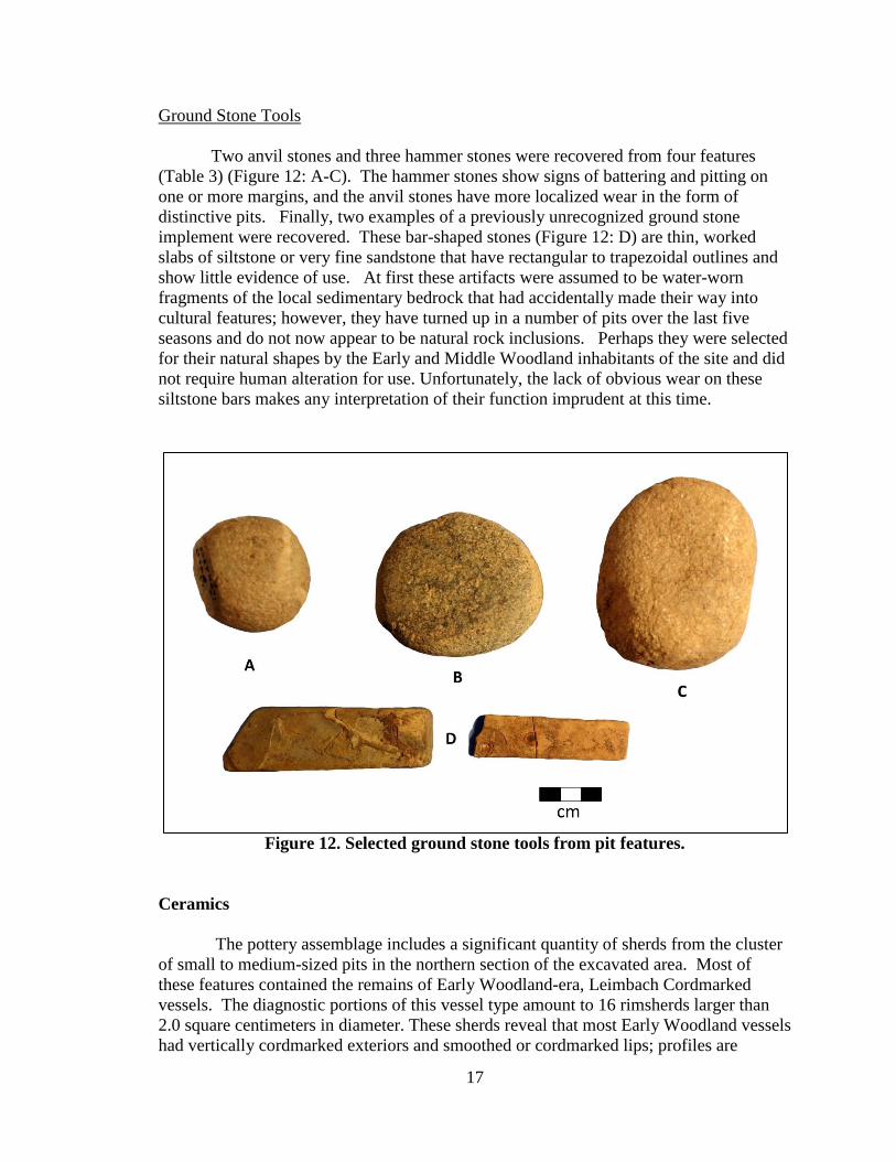
Two anvil stones and three hammer stones were recovered from four features
(Table 3) (Figure 12: A-C). The hammer stones show signs of battering and pitting on
one or more margins, and the anvil stones have more localized wear in the form of
distinctive pits. Finally, two examples of a previously unrecognized ground stone
implement were recovered. These bar-shaped stones (Figure 12: D) are thin, worked
slabs of siltstone or very fine sandstone that have rectangular to trapezoidal outlines and
show little evidence of use. At first these artifacts were assumed to be water-worn
fragments of the local sedimentary bedrock that had accidentally made their way into
cultural features; however, they have turned up in a number of pits over the last five
seasons and do not now appear to be natural rock inclusions. Perhaps they were selected
for their natural shapes by the Early and Middle Woodland inhabitants of the site and did
not require human alteration for use. Unfortunately, the lack of obvious wear on these
siltstone bars makes any interpretation of their function imprudent at this time.
Figure 12. Selected ground stone tools from pit features.
Ceramics
The pottery assemblage includes a significant quantity of sherds from the cluster
of small to medium-sized pits in the northern section of the excavated area. Most of
these features contained the remains of Early Woodland-era, Leimbach Cordmarked
vessels. The diagnostic portions of this vessel type amount to 16 rimsherds larger than
2.0 square centimeters in diameter. These sherds reveal that most Early Woodland vessels
had vertically cordmarked exteriors and smoothed or cordmarked lips; profiles are
18
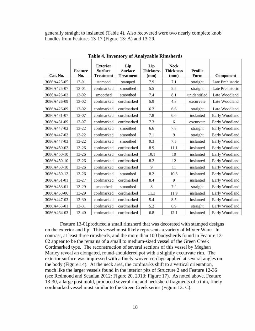
generally straight to inslanted (Table 4). Also recovered were two nearly complete knob
handles from Features 13-17 (Figure 13: A) and 13-29.
Table 4. Inventory of Analyzable Rimsherds
Cat. No.
Feature
No.
Exterior
Surface
Treatment
Lip
Surface
Treatment
Lip
Thickness
(mm)
Neck
Thickness
(mm)
Profile
Form Component
3086A425-05 13-01 stamped stamped 7.9 7.1 straight Late Prehistoric
3086A425-07 13-01 cordmarked smoothed 5.5 5.5 straight Late Prehistoric
3086A426-02 13-02 smoothed smoothed 7.4 8.1 unidentified Late Woodland
3086A426-09 13-02 cordmarked cordmarked 5.9 4.8 excurvate Late Woodland
3086A426-09 13-02 cordmarked cordmarked 6.2 6.6 straight Late Woodland
3086A431-07 13-07 cordmarked cordmarked 7.8 6.6 inslanted Early Woodland
3086A431-09 13-07 cordmarked cordmarked 7.3 6 excurvate Early Woodland
3086A447-02 13-22 cordmarked smoothed 6.6 7.8 straight Early Woodland
3086A447-02 13-22 cordmarked smoothed 7.1 9 straight Early Woodland
3086A447-03 13-22 cordmarked smoothed 9.3 7.5 inslanted Early Woodland
3086A450-02 13-26 cordmarked cordmarked 8.9 11.1 inslanted Early Woodland
3086A450-10 13-26 cordmarked cordmarked 10.1 10 inslanted Early Woodland
3086A450-10 13-26 cordmarked cordmarked 8.2 12 inslanted Early Woodland
3086A450-10 13-26 cordmarked cordmarked 9 11 inslanted Early Woodland
3086A450-12 13-26 cordmarked smoothed 8.2 10.8 inslanted Early Woodland
3086A451-01 13-27 cordmarked cordmarked 8.4 9 inslanted Early Woodland
3086A453-01 13-29 smoothed smoothed 8 7.2 straight Early Woodland
3086A453-06 13-29 cordmarked cordmarked 11.3 11.9 inslanted Early Woodland
3086A447-03 13-30 cordmarked cordmarked 5.4 8.5 inslanted Early Woodland
3086A455-01 13-31 cordmarked cordmarked 5.2 6.9 straight Early Woodland
3086A464-03 13-40 cordmarked cordmarked 6.8 12.1 inslanted Early Woodland
Feature 13-01produced a small rimsherd that was decorated with stamped designs
on the exterior and lip. This vessel most likely represents a variety of Mixter Ware. In
contrast, at least three rimsherds, and the more than 100 bodysherds found in Feature 13-
02 appear to be the remains of a small to medium-sized vessel of the Green Creek
Cordmarked type. The reconstruction of several sections of this vessel by Meghan
Marley reveal an elongated, round-shouldered pot with a slightly excurvate rim. The
exterior surface was impressed with a finely-woven cordage applied at several angles on
the body (Figure 14). At the neck area, the cordmarks shift to a vertical orientation,
much like the larger vessels found in the interior pits of Structure 2 and Feature 12-36
(see Redmond and Scanlan 2012: Figure 20, 2013: Figure 17). As noted above, Feature
13-30, a large post mold, produced several rim and necksherd fragments of a thin, finely
cordmarked vessel most similar to the Green Creek series (Figure 13: C).
19
Figure 13. Selected rimsherds, daub, and appendages from pit features.
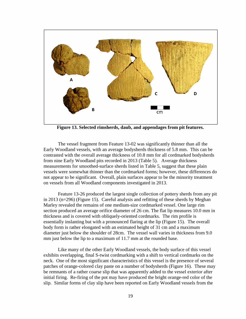
The vessel fragment from Feature 13-02 was significantly thinner than all the
Early Woodland vessels, with an average bodysherds thickness of 5.8 mm. This can be
contrasted with the overall average thickness of 10.8 mm for all cordmarked bodysherds
from nine Early Woodland pits recorded in 2013 (Table 5). Average thickness
measurements for smoothed-surface sherds listed in Table 5, suggest that these plain
vessels were somewhat thinner than the cordmarked forms; however, these differences do
not appear to be significant. Overall, plain surfaces appear to be the minority treatment
on vessels from all Woodland components investigated in 2013.
Feature 13-26 produced the largest single collection of pottery sherds from any pit
in 2013 (n=296) (Figure 15). Careful analysis and refitting of these sherds by Meghan
Marley revealed the remains of one medium-size cordmarked vessel. One large rim
section produced an average orifice diameter of 26 cm. The flat lip measures 10.0 mm in
thickness and is covered with obliquely-oriented cordmarks. The rim profile is
essentially inslanting but with a pronounced flaring at the lip (Figure 15). The overall
body form is rather elongated with an estimated height of 31 cm and a maximum
diameter just below the shoulder of 28cm. The vessel wall varies in thickness from 9.0
mm just below the lip to a maximum of 11.7 mm at the rounded base.
Like many of the other Early Woodland vessels, the body surface of this vessel
exhibits overlapping, final S-twist cordmarking with a shift to vertical cordmarks on the
neck. One of the most significant characteristics of this vessel is the presence of several
patches of orange-colored clay paste on a number of bodysherds (Figure 16). These may
be remnants of a rather coarse slip that was apparently added to the vessel exterior after
initial firing. Re-firing of the pot may have produced the bright orange-red color of the
slip. Similar forms of clay slip have been reported on Early Woodland vessels from the
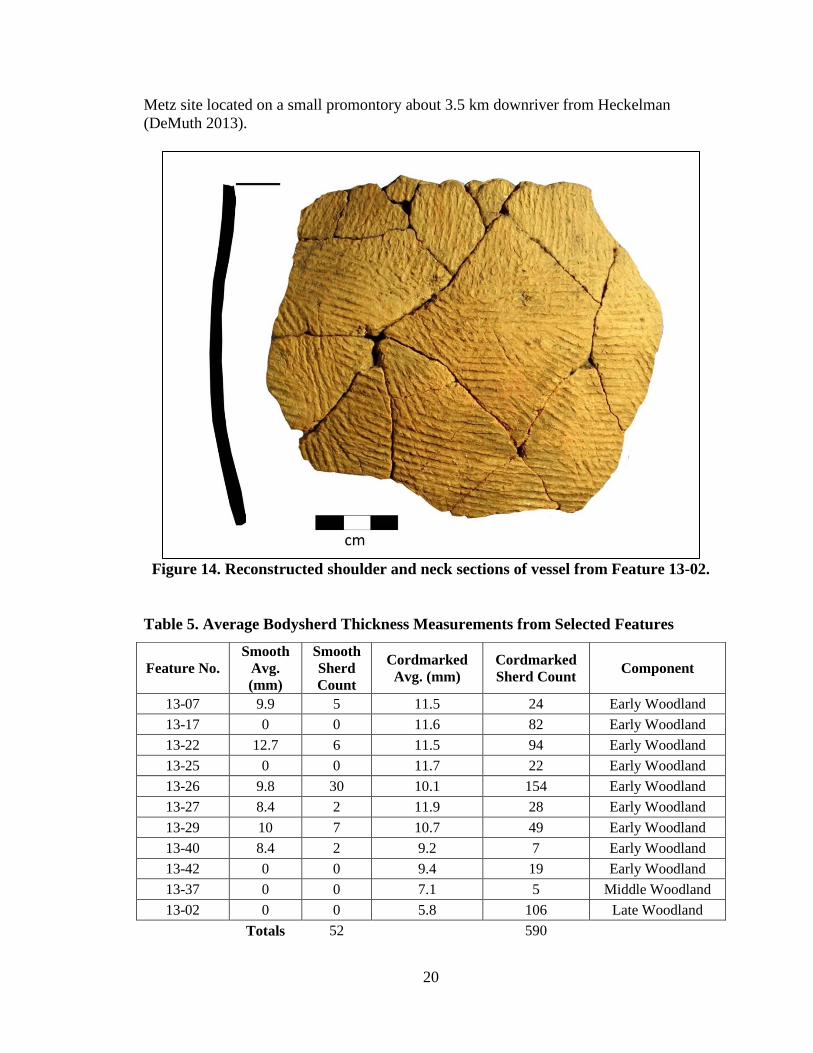
20
Metz site located on a small promontory about 3.5 km downriver from Heckelman
(DeMuth 2013).
Figure 14. Reconstructed shoulder and neck sections of vessel from Feature 13-02.
Table 5. Average Bodysherd Thickness Measurements from Selected Features
Feature No.
Smooth
Avg.
(mm)
Smooth
Sherd
Count
Cordmarked
Avg. (mm)
Cordmarked
Sherd Count Component
13-07 9.9 5 11.5 24 Early Woodland
13-17 0 0 11.6 82 Early Woodland
13-22 12.7 6 11.5 94 Early Woodland
13-25 0 0 11.7 22 Early Woodland
13-26 9.8 30 10.1 154 Early Woodland
13-27 8.4 2 11.9 28 Early Woodland
13-29 10 7 10.7 49 Early Woodland
13-40 8.4 2 9.2 7 Early Woodland
13-42 0 0 9.4 19 Early Woodland
13-37 0 0 7.1 5 Middle Woodland
13-02 0 0 5.8 106 Late Woodland
Totals 52
590
21
Figure 15. Partial reconstruction of vessel from Feature 13-26.
Bone Artifacts
The sole osseous artifact (3086A425-08) is a section of deer antler “stock” that
was scored and snapped at one end. This fragment was recovered from the Late
Prehistoric period pit, Feature 13-01.
Faunal Remains
As has been the case in earlier analyses, the vast majority of animal bone
fragments from features of Early Woodland through Late Woodland ages consist solely
of calcined fragments, which are essentially unidentifiable to even the most
comprehensive taxon. A few identifiable fragments of deer bone (mandible fragments
with teeth, antler fragments) and fish scales were collected from Feature 13-01, the much
younger Late Prehistoric pit.
22
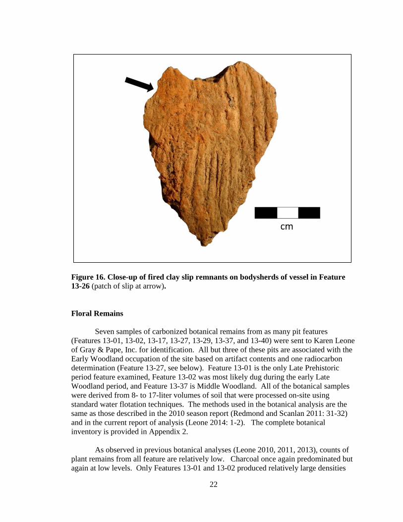
Figure 16. Close-up of fired clay slip remnants on bodysherds of vessel in Feature
13-26 (patch of slip at arrow).
Floral Remains
Seven samples of carbonized botanical remains from as many pit features
(Features 13-01, 13-02, 13-17, 13-27, 13-29, 13-37, and 13-40) were sent to Karen Leone
of Gray & Pape, Inc. for identification. All but three of these pits are associated with the
Early Woodland occupation of the site based on artifact contents and one radiocarbon
determination (Feature 13-27, see below). Feature 13-01 is the only Late Prehistoric
period feature examined, Feature 13-02 was most likely dug during the early Late
Woodland period, and Feature 13-37 is Middle Woodland. All of the botanical samples
were derived from 8- to 17-liter volumes of soil that were processed on-site using
standard water flotation techniques. The methods used in the botanical analysis are the
same as those described in the 2010 season report (Redmond and Scanlan 2011: 31-32)
and in the current report of analysis (Leone 2014: 1-2). The complete botanical
inventory is provided in Appendix 2.
As observed in previous botanical analyses (Leone 2010, 2011, 2013), counts of
plant remains from all feature are relatively low. Charcoal once again predominated but
again at low levels. Only Features 13-01 and 13-02 produced relatively large densities
23
(grams/liter) of oak and hickory remains, respectively (Leone 2014: Figure 1). Nut
densities were also low, except for Features 13-01 and 13-29, with hickory and black
walnut predominating. Native cultigens occurred in only one Early Woodland pit,
Feature 13-29, and included two squash rind fragments and two erect knotweed seeds.
Feature 13-37 produced one chenopod seed. One sunflower seed was found in Feature
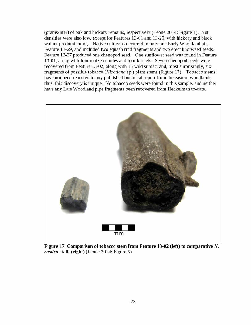
13-01, along with four maize cupules and four kernels. Seven chenopod seeds were
recovered from Feature 13-02, along with 15 wild sumac, and, most surprisingly, six
fragments of possible tobacco (Nicotiana sp.) plant stems (Figure 17). Tobacco stems
have not been reported in any published botanical report from the eastern woodlands,
thus, this discovery is unique. No tobacco seeds were found in this sample, and neither
have any Late Woodland pipe fragments been recovered from Heckelman to-date.
Figure 17. Comparison of tobacco stem from Feature 13-02 (left) to comparative N.
rustica stalk (right) (Leone 2014: Figure 5).

24
Radiocarbon Determinations
Following the 2013 field season, three samples of nutshell were submitted to Beta
Analytic, Inc. for radiocarbon assay. One sample (Beta-360246) was derived from the
fill of Feature 13-27, the medium basin which contained the triangular preform or cache
blade. The resulting two-sigma calibrated date range placed this feature in the late
second to mid-fourth centuries B.C. (Table 6), which correlates well with the proposed
Early Woodland period occupation of the site. The second sample (Beta-360245) came
from the fill of Feature 12-46: a large post mold excavated the previous field season and
found to contain a ceramic knob handle. The two-sigma calibrated date range that
resulted is somewhat late and suggests that the use of knob appendages continued up to
the end of the Early Woodland period at ca 1 B.C. (Stothers and Abel 2008: 92) (Table
6). The final sample of nutshell (Beta-378420) was recovered through flotation
processing of sediment from Feature 13-02. This assay produced a two-sigma calibrated
date range of A.D. 560 to 650, which correlates nicely with the early Late Woodland,
Green Creek phase occupation of the site.
Table 6: Heckelman site Radiocarbon Determinations – 2011
Feature
No.
Sample
No.
Sample
Material
13C/12C
Ratio
Conventional
Age
2 Sigma
Calibration
12-46
Beta-
360245
nutshell -26.4 ‰
2080+/-30 BP
180 to 1 BC
13-02 Beta-
378420 nutshell -24.1‰ 1450+/-30 BP AD 560 to 650
13-27
Beta-
360246
nutshell -24.2 ‰
2180+/-30 BP
360 to170 BC
DISCUSSION AND PRELIMINARY CONCLUSIONS
During the 2013 excavations, The Cleveland Museum of Natural History and
Firelands Archaeological Research Center tested 110.75 m2 of the Heckelman
archaeological site. The preliminary insights resulting from the 2013 season are as
follows.
The extension of the excavated interior of the oval enclosure to the northeast in
2013 provided important information that can be used to address the dual research
objectives. The narrower of the two focused on the nature of the proposed Structure 4.
Unfortunately, the existence of this construction within the oval enclosure was not
confirmed. Insufficient evidence for an eastern wall line indicates that—if a structure at
all—it was an open (semi-circular) configuration of large posts. A more conservative
interpretation may be that the several large post molds and post pits within the oval ditch

25
represent individual episodes of setting up and, in some cases, taking down of large
ceremonial poles. This area also includes the large fire pit, Feature 10-32, which
produced an Early Woodland date, as did several of the large post molds and the ditch
itself (Redmond and Scanlan 2011, 2012, 2013).
Additional information came to light during the 2013 field season that more
completely addresses the larger question of how the enclosed space was used during the
Early Woodland period. The possible post circle (Structure 5) at the extreme
northeastern corner of the excavation block (Figure 8) may represent further evidence for
ritual-ceremonial use of the enclosed space; however, its age and cultural affiliation
remain uncertain. More pertinent may be the cluster of pit features located to the north of
Structure 4 and among the younger stockade configuration. These small to medium-
sized, flat-bottomed basins contained large amounts of FCR and ceramic vessel
fragments, but little else. It is suspected that these features were created and used during
activities inside the enclosure that accompanied pole ceremonialism, such as the
preparation of ritual meals for the attendees, rather than persistent, domestic tasks. In
addition, the lack of any trace of Early Woodland dwellings within the enclosed space
likewise point to nondomestic behavior.
Thus, it now appears that the oval enclosure was one of the first constructions at
the site and served a ritual-ceremonial function during the Early Woodland era.
Eventually its use was discontinued (by about the Christian era) and the site remained
unoccupied for at least a few centuries until the arrival of the Hopewellian Middle
Woodland occupants, who appear to have practiced more domestic activities, possibly
centered on nuclear or extended family households. Evidence for this subsequent
occupation is most clearly seen in the small clusters of Middle Woodland pits which
include Features 10-21, 10-34, 12-33, 12-34, and 12-35. Feature 12-34, in particular
contained significant quantities of stone tool manufacturing debris, utilized bladelets,
nutshell, squash seeds, and preserved animal bone, in addition to FCR, pottery, and mica
fragments (Redmond and Scanlan 2013: 36); all of which point to active domestic
activity of the kind most often associated with Middle Woodland households (Prufer
Pacheco, Burks, and Wymer 2005; Prufer 1965).
Additional evidence for a continued shift to domestic use of the Heckelman site
can be seen in pits such as Feature 13-02. This early Late Woodland (Green Creek
phase) storage pit contained domestic refuse, including sumac seeds and tobacco plant
stems, as well as the remains of a probable storage vessel. As noted above, this vessel
reveals an affiliation with a more sedentary occupation of the blufftop featuring
substantial, communal dwellings like Structure 2 (Redmond and Scanlan 2012). Further,
the several large fragments of clay daub with stick (grass thatch?) impressions found in
Feature 13-02 may reveal the use of wattle and daub construction methods. Ultimately,
after a nearly 700-year hiatus, the site was re-occupied by a sedentary, Late Prehistoric,
maize-farming population that built semi-permanent dwellings enclosed by a substantial
stockade barrier. This final occupation closed out the long and diverse evolution of this
special location from an elaborate ceremonial center to a series of increasingly sedentary
village settlements.

26
REFERENCES CITED
DeMuth, George B.
2013 Radiocarbon Dating the Metz Site 33ER557. Unpublished report on file in the
Department of Archaeology, The Cleveland Museum of Natural History.
Justice, Noel D.
1987 Stone Age Spear and Arrow Points of the Midcontinental and Eastern United
States. Indiana University Press, Bloomington, Indiana.
Leone, Karen L.
2010 Paleoethnobotanical Analysis of the Heckelman site (33Er14) in Erie County,
Ohio. Unpublished report on file in the Dept. of Archaeology, The Cleveland
Museum of Natural History.
2011 Paleoethnobotanical Analysis of the Heckelman Site (33Er14); Results from the
2011 Field Season. Unpublished report on file in the Dept. of Archaeology, The
Cleveland Museum of Natural History, Cleveland, Ohio.
2013 Paleoethnobotanical Analysis of the Heckelman Site (33Er14): Results from the
2012 Field Season. Unpublished report on file in the Dept. of Archaeology, The
Cleveland Museum of Natural History, Cleveland, Ohio.
2014 Paleoethnobotanical Analysis of The Heckelman Site (33ER14) in Erie County,
Ohio; Results from the 2013 Field Season. Gray and Paper Cultural Resource
Consultants, Project No. 14-65301.001. Unpublished report of analysis on file in
the Dept. of Archaeology, The Cleveland Museum of Natural History.
Pacheco, Paul J., Jarrod Burks, and Dee Anne Wymer
2005 Investigating Ohio Hopewell Settlement Patterns in Central Ohio: A Preliminary
Report of Archaeology at Brown's Bottom #1 (33Ro21). Current Research in
Ohio Archaeology, 2005, http://www.ohioarchaeology.org/joomla/index.php?
Option =com_ content&task=view&id=103&Itemid=32 , accessed March 25,
2014.
Prufer, Olaf H.
1965 The McGraw Site: A Study in Hopewellian Dynamics. Scientific Publications of
The Cleveland Museum of Natural History, Cleveland, Ohio.
Redmond, Brian G. and Brian L. Scanlan
2010 A Report of Archaeological Investigations at the Heckelman Site (33Er14): 2009
Season. Cleveland Museum of Natural History, Archaeological Research Reports
No. 158.

27
2011 A Report of Archaeological Investigations at the Heckelman Site (33Er14): 2010
Season. Cleveland Museum of Natural History, Archaeological Research Reports
No. 159.
2012 A Report of Archaeological Investigations at the Heckelman Site (33Er14): 2011
Season. Cleveland Museum of Natural History, Archaeological Research Reports
No. 161.
2013 A Report of Archaeological Investigations at the Heckelman Site (33Er14): 2012
Season. Cleveland Museum of Natural History, Archaeological Research Reports
No. 162.
Stothers, David M. and Timothy J. Abel
2008 Early Woodland Prehistory (1000-1 BC) in the Western Lake Erie Drainage
Basin. In Transitions: Archaic and Early Woodland Research in the Ohio
Country, edited by Martha P. Otto and Brian G. Redmond, pp. 79-116. The Ohio
University Press, Athens, Ohio.
28
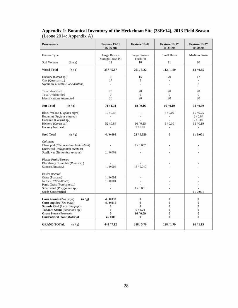
Appendix 1: Botanical Inventory of the Heckelman Site (33Er14), 2013 Field Season
(Leone 2014: Appendix A)
Provenience Feature 13-01
26-56 cm
Feature 13-02 Feature 13-17
11-31 cm
Feature 13-27
10-50 cm
Feature Type Large Basin –
Storage/Trash Pit
Large Basin –
Trash Pit
Small Basin Medium Basin
Soil Volume (liters) 11 10 11 10
Wood Total (n / g) 357 / 5.67 261 / 5.22 112 / 1.60 64 / 0.65
Hickory (Carya sp.) 3 15 20 17
Oak (Quercus sp.) 17 5 - - Sycamore (Platanus occidentalis) - - - 3
Total Identified 20 20 20 20 Total Unidentified 0 0 0 0
Identifications Attempted 20 20 20 20
Nut Total (n / g) 71 / 1.31 18 / 0.16 16 / 0.19 31 / 0.50
Black Walnut (Juglans nigra) 19 / 0.47 - 7 / 0.09 15 / 0.25
Butternut (Juglans cinerea) - - - 3 / 0.04 Hazelnut (Corylus sp.) - - - 2 / 0.02
Hickory (Carya sp.) 52 / 0.84 16 / 0.15 9 / 0.10 11 / 0.19 Hickory Nutmeat - 2 / 0.01 - -
Seed Total (n / g) 4 / 0.008 23 / 0.020 0 1 / 0.001
Cultigens
Chenopod (Chenopodium berlandieri) - 7 / 0.002 - -
Knotweed (Polygonum erectum) - - - - Sunflower (Helianthus annuus) 1 / 0.002 - - -
Fleshy Fruits/Berries Blackberry / Bramble (Rubus sp.) - - - -
Sumac (Rhus sp.) 1 / 0.004 15 / 0.017 - -
Environmental
Grass (Poaceae) 1 / 0.001 - - -
Nettle (Urtica dioica) 1 / 0.001 - - - Panic Grass (Panicum sp.) - - - -
Smartweed (Polygonum sp.) - 1 / 0.001 - -
Seeds Unidentified - - - 1 / 0.001
Corn kernels (Zea mays) (n / g) 4 / 0.032 0 0 0
Corn cupules (Zea mays) 4 / 0.015 0 0 0
Squash Rind (Cucurbita pepo) 0 0 0 0
Tobacco Stems (Nicotiana sp.) 0 6 / 0.21 0 0
Grass Stems (Poaceae) 0 10 / 0.09 0 0
Unidentified Plant Material 4 / 0.08 0 0 0
GRAND TOTAL (n / g) 444 / 7.12 318 / 5.70 128 / 1.79 96 / 1.15
29
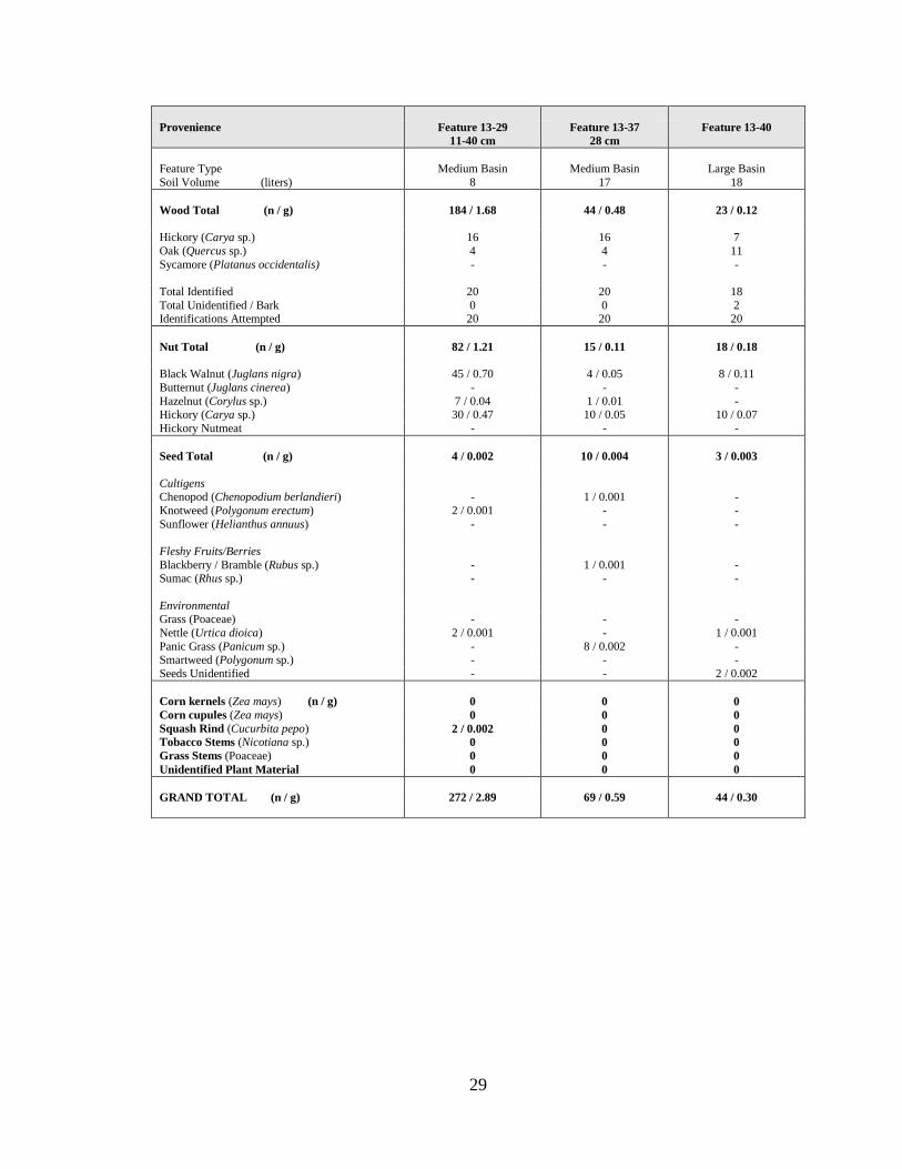
Provenience Feature 13-29
11-40 cm
Feature 13-37
28 cm
Feature 13-40
Feature Type Medium Basin Medium Basin Large Basin
Soil Volume (liters) 8 17 18
Wood Total (n / g) 184 / 1.68 44 / 0.48 23 / 0.12
Hickory (Carya sp.) 16 16 7
Oak (Quercus sp.) 4 4 11
Sycamore (Platanus occidentalis) - - -
Total Identified 20 20 18
Total Unidentified / Bark 0 0 2 Identifications Attempted 20 20 20
Nut Total (n / g) 82 / 1.21 15 / 0.11 18 / 0.18
Black Walnut (Juglans nigra) 45 / 0.70 4 / 0.05 8 / 0.11
Butternut (Juglans cinerea) - - -
Hazelnut (Corylus sp.) 7 / 0.04 1 / 0.01 - Hickory (Carya sp.) 30 / 0.47 10 / 0.05 10 / 0.07
Hickory Nutmeat - - -
Seed Total (n / g) 4 / 0.002 10 / 0.004 3 / 0.003
Cultigens Chenopod (Chenopodium berlandieri) - 1 / 0.001 -
Knotweed (Polygonum erectum) 2 / 0.001 - -
Sunflower (Helianthus annuus) - - -
Fleshy Fruits/Berries
Blackberry / Bramble (Rubus sp.) - 1 / 0.001 - Sumac (Rhus sp.) - - -
Environmental Grass (Poaceae) - - -
Nettle (Urtica dioica) 2 / 0.001 - 1 / 0.001
Panic Grass (Panicum sp.) - 8 / 0.002 - Smartweed (Polygonum sp.) - - -
Seeds Unidentified - - 2 / 0.002
Corn kernels (Zea mays) (n / g) 0 0 0
Corn cupules (Zea mays) 0 0 0
Squash Rind (Cucurbita pepo) 2 / 0.002 0 0
Tobacco Stems (Nicotiana sp.) 0 0 0
Grass Stems (Poaceae) 0 0 0
Unidentified Plant Material 0 0 0
GRAND TOTAL (n / g) 272 / 2.89 69 / 0.59 44 / 0.30
Copyright © 2022 FDOKUMEN